
Water Master Planning in Jordan: The Use of Interactive Digital Planning Tools for Integrated Water...
18
Geomatics for Land and Water management: Achievements and Challenges in the Euromed context - 23/25 June 2004, Joint Research Centre, Ispra, Italy Water Master Planning in Jordan: The Use of Interactive Digital Planning Tools for Integrated Water Resources Management Suzan TAHA National Water Master Plan Project Director Ministry of Water & Irrigation P.O. Box 2412 Amman-Jordan E-Mail: [email protected] 1. Introduction Jordan is one of the most water scarce countries in the world. Water supply deficiency is limiting the achievement of higher standards of living and constraining economic development associated with industry, tourism and agriculture. Shortages are more of a permanent nature. Demands for freshwater have been therefore met by developing renewable supplies, over-drafting renewable groundwater basins, and using irreplaceable fossil groundwater. But as the country faces rapidly increasing costs of supply expansion, it is becoming harder to manage the balance between the limited renewable supply and the increasing demand for water. The current gap is currently met by measures that threaten the sustainability of water resources. The government is hence concerned that a more integrated approach to national water resources planning and management will be necessary to guarantee an adequate water supply to all users in the future. 2. Background Since the completion of the first National Water Master Plan for Jordan, in 1977, dramatic changes have taken place with respect to water availability and water demand. Increased urbanization has had a strong impact on water use patterns. Deviations from the recommendations expressed in the first Master Plan have resulted in partial deterioration of groundwater quality in many parts of the Kingdom. The influx of more than 350,000 Abstract: The Government of Jordan recognizes the need for a more integrated approach to national water resources planning and management in order to meet new challenges in the water sector and the increasing gap between demand and supply. Hence, with the assistance of the GTZ, the Ministry of Water and Irrigation (MWI) started the Water Sector Planning Support Project (WSPSP). The key objective of this project is to establish a Digital National Water Master Plan (NWMP) based on an extensive Water Information System (WIS) including a Geographic Information System (GIS). The Digital Water Master Planning tools, currently deployed at the MWI can be used to continuously monitor and analyze the current water management situation and assess water resources and demand projections. These tools assist in evaluating reasonable options and strategies to reverse water imbalances, and in managing and developing Jordan’s water resources. Other uses for the tools include the performance and evaluation of daily water management tasks.
-
Upload
independent -
Category
Documents
-
view
0 -
download
0
Transcript of Water Master Planning in Jordan: The Use of Interactive Digital Planning Tools for Integrated Water...

Geomatics for Land and Water management: Achievements and Challenges in the Euromed context - 23/25 June 2004, Joint Research Centre, Ispra, Italy
Water Master Planning in Jordan: The Use of Interactive Digital Planning Tools for Integrated Water Resources
Management
Suzan TAHA National Water Master Plan Project Director
Ministry of Water & Irrigation P.O. Box 2412 Amman-Jordan
E-Mail: [email protected] 1. Introduction Jordan is one of the most water scarce countries in the world. Water supply deficiency is limiting the achievement of higher standards of living and constraining economic development associated with industry, tourism and agriculture. Shortages are more of a permanent nature. Demands for freshwater have been therefore met by developing renewable supplies, over-drafting renewable groundwater basins, and using irreplaceable fossil groundwater. But as the country faces rapidly increasing costs of supply expansion, it is becoming harder to manage the balance between the limited renewable supply and the increasing demand for water. The current gap is currently met by measures that threaten the sustainability of water resources. The government is hence concerned that a more integrated approach to national water resources planning and management will be necessary to guarantee an adequate water supply to all users in the future. 2. Background Since the completion of the first National Water Master Plan for Jordan, in 1977, dramatic changes have taken place with respect to water availability and water demand. Increased urbanization has had a strong impact on water use patterns. Deviations from the recommendations expressed in the first Master Plan have resulted in partial deterioration of groundwater quality in many parts of the Kingdom. The influx of more than 350,000
Abstract: The Government of Jordan recognizes the need for a more integrated approach to national water resources planning and management in order to meet new challenges in the water sector and the increasing gap between demand and supply. Hence, with the assistance of the GTZ, the Ministry of Water and Irrigation (MWI) started the Water Sector Planning Support Project (WSPSP). The key objective of this project is to establish a Digital National Water Master Plan (NWMP) based on an extensive Water Information System (WIS) including a Geographic Information System (GIS). The Digital Water Master Planning tools, currently deployed at the MWI can be used to continuously monitor and analyze the current water management situation and assess water resources and demand projections. These tools assist in evaluating reasonable options and strategies to reverse water imbalances, and in managing and developing Jordan’s water resources. Other uses for the tools include the performance and evaluation of daily water management tasks.
Geomatics for Land and Water management: Achievements and Challenges in the Euromed context - 23/25 June 2004, Joint Research Centre, Ispra, Italy
people from the Gulf States in 1991 increased the demand on the already over-stretched water resources. While the first Master Plan is still in use as an official reference document, serious consideration have been made to set up a “digital water master plan” that can be updated easily as new information becomes available, and which permits a flexible response to new questions and challenges. Consequently, in 1994, the Jordanian Ministry of Water and Irrigation (MWI) started the Water Sector Planning Support Project (WSPSP) in cooperation with the Deutsche Gesellschaft Fur Technische Zusammenarbeit (GTZ) GmbH. One of the key objectives of this project is to build up a National Water Master Plan which is based on a water information system (WIS) for providing a ranking of alternative strategies and action plans to improve water resources management and secure long-term water supply. 3. Objectives In order to guarantee the required water supply to all users and safeguard the resources for future generations a common planning framework is needed. This framework is given by the Water Master Plan. According to the United Nations1, the primary objective of a Water Master Plan is to establish a basic framework for: Orderly and integrated planning and implementation of water resources programs and projects; and A rational water resources management consistent with overall national socio-economic development objectives. By using the interactive tools, the new Masterplan will not be a static printed document but a Digital Water Master Plan based on an extensive Water Information System (WIS). In close cooperation with the Ministry of Water and Irrigation and GTZ, the German consulting company AHT International has developed the Digital Planning Tools. These software tools are database applications with a GIS (digital mapping) interface that are applied to: Assess the present availability, withdrawals, losses and uses of the water resources; Formulate alternative development scenarios for water resources and demand/use at various planning horizons; Perform the balancing of resources versus demands for the recent past as well as for the alternative development options and Identify technical and operational options in order to bridge the gap between resources and demands. 4. Components of the Digital National Water Master Plan 4.0 Water Information System (WIS) The Digital Water Master Plan receives its data from the Water Information System (WIS). This is the central information system at the Ministry of Water and Irrigation, serving the
1 Guidelines for the preparation of National Water Master Plans, Water Resources Series No. 65, UN, N.Y. 1989

Geomatics for Land and Water management: Achievements and Challenges in the Euromed context - 23/25 June 2004, Joint Research Centre, Ispra, Italy
Ministry as well as WAJ (Water Authority of Jordan) and JVA (Jordan Valley Authority). In addition, it is the authorized source for data on water monitoring, management, and planning for external users like research institutions or international donors. The WIS is a complex system of hard and software, data and tools as well as people for its operation and maintenance. It can be accessed from all computer workplaces within the Ministry’s network. The majority of data is either stored in ORACLE data base tables or in GIS files. These two data systems are linked, thus permitting both the data selection by inter-active maps and cartographic representation of results. The WIS contains monitoring data collected in the field either by operators of the water supply and wastewater disposal systems (namely WAJ and JVA), the hydrological service of the Ministry and/or external institutions like the Department of Statistics and the Ministry of Agriculture. In addition to the monitoring data the WIS holds the results of water demand and resources projections. The two primary user interfaces of the WIS are the Data Entry and Visualization Application (DEVA) and the Digital Visualization System (DVS). The DEVA (written under Oracle developer) is both used for data entry and the production of reports in a fixed format. The DVS is specially made for the master plan allowing producing standard information products in an automated way. It is an MS-Access application with integrated MapObjects GIS modules for spatial selection and cartographic outputs. The DVS is applied to monitoring and forecasted data to produce standardized tables, charts and maps under Excel. Thus, its results can be easily post-processed with MS Office software. 4.1 Digital Planning Tools The Digital Planning Tools are a set of interactive software modules applied to forecasted water resources and demands for future development scenarios. These forecasts are always using recent monitoring data as a starting point. The results are stored into the so-called Scenario Tables Pool (STP), which is part of the central ORACLE database administered under the WIS. From there, the information on future resources and demands is taken for nation-wide water balancing. The Digital Planning Tools have been developed under MS-Access 2000 in VBA (Visual basic for Applications), the most common programming language under the Windows operating system. The Digital Planning Tools have a modular structure and the software code is open to the IT personnel in the Ministry. This will allow future modifications and extensions with the Ministry’s own resources. 4.1.0 Structure of the Digital Planning Tools The Digital Planning tool incorporates modules for evaluating various water demands as well as water supplies including wastewater resources and water losses. The transport of water from deficit to surplus areas is considered in the Transfer System Module. The tool (Appendix 1) consists of: Eleven GIS linked interactive pre-processing modules for the assessment of the present water management situation and projection of water resources and demand in Jordan. Predictions over a period of 40 years are intended and thus cover the time span until the

Geomatics for Land and Water management: Achievements and Challenges in the Euromed context - 23/25 June 2004, Joint Research Centre, Ispra, Italy
year 2040. A database (Scenario Tables Pool) for storing the projected demand and resources data for three different scenarios. Balancing module to balance the resources and the demand for the entire Kingdom or selected parts of it.

Geomatics for Land and Water management: Achievements and Challenges in the Euromed context - 23/25 June 2004, Joint Research Centre, Ispra, Italy
4.1.1 Demand Modules The PreProcessing Modules are used to generate data on water resources and demands and store them in the STP (Scenario Tables Pool). This refers both to historical data (uploading monitoring data to STP) and for projections data. Figure 1 shows the main menu of the pre-processing modules.
Figure 1: Pre-processing Module Main Menu
The pre-processing demand modules include the following: • Irrigation Demand Module • Municipal Demand Module which consists of domestic demand, light industries
demand, and commercial or services sector demand • Industrial Demand Module • Touristic Demand Module • Water Losses Module Each demand pre-processing module requires data input from various databases; production and/or water use data. Water use and demand data are aggregated to demand centres such as towns and villages, developed irrigated areas and project areas, which are geographically represented via point information in GIS.
Except for the Irrigation Demand pre-processing module, all the modules are similar in structure and the underlying algorithms are rather simple General features of the modules include:
• Selection based on spatial units • Selection based on criteria • Demand projection with pre-defined parameters for 3 development scenarios
Spatial Selection and Selection Criteria: each time a demand pre-processing module is

Geomatics for Land and Water management: Achievements and Challenges in the Euromed context - 23/25 June 2004, Joint Research Centre, Ispra, Italy
started; selection of a set of individual water demand centers or balancing unit is done using MapObjects LT. The spatial selection window offers several powerful options for spatial selection (Figure 2).
Figure 2: Municipal Demand Module Interface
Figure 3: Spatial Selection Interface

Geomatics for Land and Water management: Achievements and Challenges in the Euromed context - 23/25 June 2004, Joint Research Centre, Ispra, Italy
The selection of demand centers also is possible according to the selection criteria of the balancing module under consideration, such as selection based on the agroclimatic zone or governorate. Typical selection criteria for all modules include demand centers, balancing unit, year of reference (the year based on which demand projections are started and for which data are available), and amounts of water used or demanded. Other selection criteria distinguish between historical assessment of water use and future demand development or projections. For the analysis of the present water use/demand situation only one year needs to be selected. The module, which is linked to WIS then will display monthly use values for the required sector and the selected spatial unit. Results can be exported to external tables for further analysis and processing. It is believed that this feature of the demand modules will facilitate daily water management tasks. Spatial analysis of water use data also allows for regular data processing and analysis and provides such information as per capita water use, irrigation water use/demand and the total amounts of water used by each demand sector, etc. Total water demand then can be compared later with existing resources and hence allow for the examination of the current water management situation. Demand Projection Parameters and Development Scenarios For the projection of demands, the interval or the balancing years for which demand development is calculated should be selected. The parameters relevant to the sector demand projection also should be selected. Three scenarios are considered for demand projections (high, medium and low) and one value for each parameter has to be assumed for each scenario. Taking the municipal demand as an example, the projection parameters are: • Reference Year Data: Population and Water Use Data (Litres/Capita/Day) • Population Growth rate • Migration (in or out) • Sudden Increase or Decrease in Water Demand (Litres/Capita/Day) It should be noted that the values to be attached to the projection parameters should be realistic and based on national and sector policies. Review of these parameters can be made in the future to account for changes in factors affecting the sector demand. These include socio-economic development, changes in standards of living and degree of urbanization, actual progress in birth planning schemes, demographic distribution, as well as the progress in the introduction of water saving methods. Irrigation Demand Module The irrigation demand module predicts irrigation water demand in the future based on information provided for a given reference year. Hence, proceeding with assumptions regarding the future is only possible after the reference year demand computations is completed and evaluated. The module requires entry of various parameters for the year of reference and data input from several database tables. These include crops areas tables, distribution of irrigation methods, leaching requirements for every crop group and water salinity class, application

Geomatics for Land and Water management: Achievements and Challenges in the Euromed context - 23/25 June 2004, Joint Research Centre, Ispra, Italy
efficiency, and year type2 Net Crops Irrigation Requirements (NIR) tables. Other Parameters required for input by the module include the salinity class of the water currently used for irrigation, the reference year and the type of hydrological conditions prevailing during that year, in addition to the delivery system efficiency. Irrigation demand related data and results are aggregated to irrigation centers which are geographically represented via point information in ArcView GIS . The monthly NIR tables are filled following some pre-processing of rainfall and climatic data, calculation of Eto using FAO Penman, and subsequent computation of monthly net irrigation requirements, using three different MS access based applications (Figure 4). The NIR_calculator developed for the computation of monthly net irrigation demand, considers the different hydrological conditions (wet, dry or median) for the agroclimatic zone in which the crops are grown, as well as knowledge on individual crop factors3 in the various growing stages and reported cropping calendars. Innovation in this system includes the computation of crop evapotranspiration under different application and cultivation methods (surface or drip, in addition to greenhouse crops and crops having plastic mulches).
Spatial Selectionselect irrigation centers
Calculation of historical dem andsfor a reference year
ORACLE STP
ORACLE NIR + agricultural statistics
GIS data
Calculation ofdem ands for future scenarios
relative to this reference year
M S Applicationfor Preprocessing of
Rainfall Data
M S Application for theCalculation of Net Irrigation
Requirements (NIR_Calculator)
M S Applicationfor Preprocessing of Clim atic Data & ETo
Figure 4: General Layout of the Irrigation Module The input parameters required for the assessment of future demand are 1) Changes in irrigated areas with respect to the reference year. 2) Changes in the distribution of irrigation methods. 3) Projected gains in conveyance and application efficiency and 4) Projected irrigation water salinity class. Formulation of future scenarios can be carried out in an iterative manner to examine the impact of changing the above parameters on total demand,
2 Year type depends on the hydrological conditions (wet, dry or median conditions) under which irrigation demand assessment is considered. 3 FAO-24 and FAO-56 reference ET - crop coefficient approach is programmed using a visual basic interface (4)

Geomatics for Land and Water management: Achievements and Challenges in the Euromed context - 23/25 June 2004, Joint Research Centre, Ispra, Italy
or using information on planned development and sector strategies. Up to three developments scenarios can be considered covering the time span until the year 2040 and in five-year interval.
4.1.1.0 4.2.1.2 Resources Modules Surface Water Module The Surface Water Resources Module includes a rainfall/runoff model, and is used to assess flood flow volumes and deep infiltration, as well as the regionalization of base-flow volumes to river or wadi sections. It is based on the parameters and functions involved in the “Curve-Number (CN) Method”. These include the soil type (depth, porosity, vegetation cover), terrain slopes, and antecedent moisture condition [2 & 3]. Inputs for the surface water resources model include time independent data (hydrological soil classification) and time dependent data available in the ORACLE databases at the Ministry of Water and Irrigation. These include daily monitoring data from rainfall, meteorological and base flow gauge stations. Regionalization of the rainfall/runoff model is performed on a regular 1 km2 raster cell, thus permitting a realistic reference of the calculated resources to any form of spatial unit (administrative, hydrological, etc.). Regionalization of input data such as rainfall, temperature and evapotranspiration is executed in daily intervals. Where needed, the regionalization is linked with a digital terrain model. Regionalization of evapotranspiration data (which play an important role in the rainfall/runoff model and in the determination of water stored in the upper soil) is linked with such a model. This linkage is needed in the absence of abundant evaporation stations in the country in order to account for the effect of dramatic changes in altitude (such as that witnessed between the Jordan Valley and the bordering mountain ranges) on the spatial variation of evapotranspiration. Using the Surface Water Resources Module, water resources can be calculated for any given year, and for a certain hydrological year (e.g., dry, wet or median). Because the module is linked to the ORACLE databases, modeling the effect of actual changes in meteorological conditions and rainfall patterns on runoff is possible and hence, subsequent refinement of the module is practicable. Ground Water Module A numerical flow model was developed for the simulation of groundwater both by the Ministry of Water and Irrigation and the Federal Institute for Geosciences and Natural Resources (Germany). The model makes it possible to simulate the groundwater flow and calculate the groundwater budget for the whole or parts of the country. Furthermore the model can be used for the prediction of future demands. The transient 3D – multi-layered flow model is based on a finite volume approach; it covers the whole area of Jordan and includes all of the major aquifers. Thus this model is unique all over the world.
Geomatics for Land and Water management: Achievements and Challenges in the Euromed context - 23/25 June 2004, Joint Research Centre, Ispra, Italy
Dams Safe Yield Module The model simulates, on a monthly time scale, the performance of a reservoir given a certain scenario with respect to resources and demands under wet, dry and median conditions. Resources include net wastewater and base flow reaching the dam, flood flow, additional inflows generated from non-utilized releases from upstream reservoirs, if any. The model simulation results show how the reservoir would behave under a future development scenario given historical (observed or estimated) data with respect to the resources. An additional estimate of the simulation results are the long term annual and monthly expected yields with their respective reliabilities. The results are used to determine monthly safe yield figures, which is the principal purpose and outcome of the model. 4.2.1.3 Other Modules Other water resources modules include the Wastewater Module, and the Non-conventional Water Resources Module. The Non-conventional Water Resources Module considers groundwater resources that are of marginal quality, including brackish water with total dissolved solids greater than 10,000 parts per million (ppm). The Wastewater Module builds on the municipal, touristic and industrial demand projections generated from the respective demands modules and assesses the amounts of wastewater produced based on scenarios for the percentage of population served. 4.2.1.4 Scenario Tables Pool Projected demand and resources data are stored in the Scenario Tables Pool (STP) using an ORACLE database format. The demand projections are performed for three different demand scenarios (high, medium and low) and those for the resources for three hydrological conditions (dry, median, and wet years) 4.2 4.3 4.2.1.5 Balancing The balancing integrates the spatially distributed resources with the demand values, which are attributed to point demand centers. In order to compare between the projected water demand and the resources, a balancing run is required and the following steps are needed [7]: • Selection of balancing parameters (e.g., balancing unit, scenario, time step) • Selection of units (e.g., governorates to be balanced) • Running the balance • Saving the results (optional) • Generation of maps from results (optional) 4.4 4.2.2 Balancing Results Balancing results can be viewed in a variety of histograms as well as in tabular form. Generation of map layouts and printout on any Windows printer/plotter is supported. The results can be stored externally on any storage media. The display of results from earlier balancing runs can be reloaded to the application, for example, to efficiently

Geomatics for Land and Water management: Achievements and Challenges in the Euromed context - 23/25 June 2004, Joint Research Centre, Ispra, Italy
compare different assumptions. The number of balancing results loaded into the result viewer is limited by MS Windows system capability [7]. 4.2.3 Planning
The results of the modeling may be used as one of several elements to determine the necessary political and socio-economic decisions for further water planning and development. A Transfer Module is used in this regard as a planning tool and considers all reservoirs or surface water storage facilities and the main pipelines existing in the country. The module simulates inter-regional transfer and investigates its effect on water balance after transfer from surplus to deficit areas is considered. Suitable measures then can be formulated and development alternatives can be considered. Such measures include: a. Enhancement of water use efficiency
• Reduction of losses from the supply networks • Introduction of water saving technologies • Public awareness campaigns on water consumption • Adaptation of different cropping patterns
b. Mobilization of additional water resources
• Artificial groundwater recharge • Surface water reservoirs • Increased re-use of treated waste water • Use of non-conventional water resources • Desalination • Transfer of water
The effects of the proposed measures can be further investigated using the model. Ranking
of alternative management scenarios using multi-criteria analysis (Financial, socio-
economic, environmental, political, etc.) can hence be carried out.
4.2.4 Years of Balancing & Temporal Discretion Water balancing for the Master Plan is performed for different spatial layers: Natural regions (surface water basins) Administrative regions (Governorates) and Water-use related regions (socio-economic zones). These units divide the nation into 15 regions as follows: 2 Urban regions (Amman/Zarqa and Irbid, with together almost 70% of the total population in Jordan), 1 Industrial region (particularly mining industries), 1 “Aqaba Special Economic Zone” (ASEZ / Aqaba), 3 Irrigation zones Jordan Valley,

Geomatics for Land and Water management: Achievements and Challenges in the Euromed context - 23/25 June 2004, Joint Research Centre, Ispra, Italy
Southern Ghors, 2 Irrigation zones Jordan Highlands, 4 Irrigation zones in Desert areas (including Wadi Araba), 1 Western Desert, 1 Desert. The temporal discretion of the water management balancing extends to the month, season, and hydrological or calendar year. Balancing can be performed for a current year in order to analyze the present water resources management situation in terms of water availability (resources and supply), water quality, and water demand, and/or use. Balancing also can be made for historical years to depict historical trends and to obtain information about changes in water demand/use patterns and water supply and resources. Balancing for future years will cover the time span until the year 2040 and will be performed in five-year intervals for the period 2005 to 2040.
4.3 Digital NWMP A Water Master Plan as a document is consisting of the following principal parts: The description of the water resources (surface and ground water plus alternative resources) in quantity and quality The description of the present and likely future development of water demands by different user sectors; The presentation of the technical (physical) and operational water management measures to fulfil the demands in their temporal and spatial distribution under consideration of social, environmental and economic aspects. Due to the complexity of the task, a master plan is structured in several layers like executive summary, main report (in several volumes) and various technical annexes and appendices.
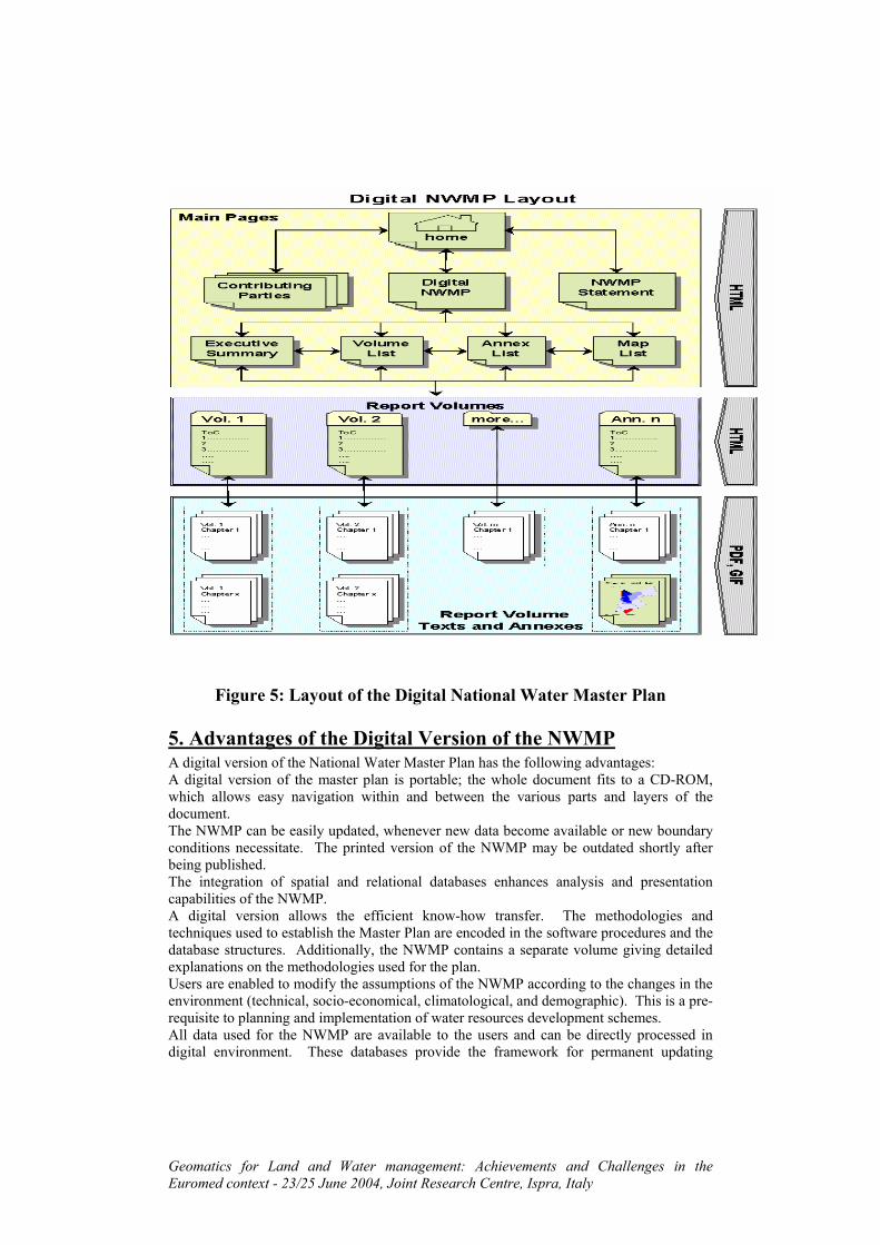
Geomatics for Land and Water management: Achievements and Challenges in the Euromed context - 23/25 June 2004, Joint Research Centre, Ispra, Italy
Figure 5: Layout of the Digital National Water Master Plan
5. Advantages of the Digital Version of the NWMP A digital version of the National Water Master Plan has the following advantages: A digital version of the master plan is portable; the whole document fits to a CD-ROM, which allows easy navigation within and between the various parts and layers of the document. The NWMP can be easily updated, whenever new data become available or new boundary conditions necessitate. The printed version of the NWMP may be outdated shortly after being published. The integration of spatial and relational databases enhances analysis and presentation capabilities of the NWMP. A digital version allows the efficient know-how transfer. The methodologies and techniques used to establish the Master Plan are encoded in the software procedures and the database structures. Additionally, the NWMP contains a separate volume giving detailed explanations on the methodologies used for the plan. Users are enabled to modify the assumptions of the NWMP according to the changes in the environment (technical, socio-economical, climatological, and demographic). This is a pre-requisite to planning and implementation of water resources development schemes. All data used for the NWMP are available to the users and can be directly processed in digital environment. These databases provide the framework for permanent updating

Geomatics for Land and Water management: Achievements and Challenges in the Euromed context - 23/25 June 2004, Joint Research Centre, Ispra, Italy
activities of the NWMP.
Summary and Conclusions This time the “National Water Master Plan” is more than a traditional master-planning document, since it is mainly developed as a tool that can be used to continuously monitor and analyze the current water management situation and to assess Jordan’s water supply and demand projections. Being digital (database dependent) and GIS based, the tool can be easily updated whenever new data become available or new boundary conditions necessitate, thus allowing for a regular update of the NWMP. These conditions permit more flexible responses to new water sector challenges and to spatial variation in development. In addition, the use of GIS as a basis for the NWMP permits easy display, visualization and analysis of the spatially related data. The implementation of a Digital Planning tools as a planning instrument allows testing of development scenarios and hence the optimization of water resources and demand management strategies. Other uses for the tool include the performance of daily water management tasks. The tool reporting flexibility also helps in this regard as it allows digital output of various types of data for additional processing. The interactive and modular features of the Digital Water Balancing System enable the development and refinement of the modules by the user, thus ensuring sustainable use of the planning tool. Other advantages include: Transparency in water balancing through separate data tables linked to each module. Improved acceptance for the digital water master-planning tool, because the conceptual design of the modules and the underlying algorithms have been developed and implemented locally. The possibility for permanent enhancement of the digital planning tools, because new modules and algorithms can be incorporated/integrated into the tool. Definition of responsibilities in data acquisition and processing. Provision of know-how to process demand and resources data Finally, the modular structure of the tool allows for the adaptation of the modules to the specific situations of other countries, since the users can be familiarized with the internal procedures of the system.

Geomatics for Land and Water management: Achievements and Challenges in the Euromed context - 23/25 June 2004, Joint Research Centre, Ispra, Italy
6. References AHT International GMBH (1998). Strengthening of the National capacity in Water Resources Planning Project, UNDP Project No. JOR/92/007. Support for the Development of the Conceptual Design of Oracle Database. Mission Report, November 1998. AHT International GMBH (1997). Water Sector Planning Support at the Ministry of Water and Irrigation, Digital Balancing Model for Water Resources Management, 2nd Phase. First Progress Report, March 1997. 1. AHT International GMBH (1997). Water Sector Planning Support at the Ministry of
Water and Irrigation, Digital Balancing Model for Water Resources Management, 2nd Phase. Second Progress Report, June 1997.
2. AHT International GMBH (1998). Water Sector Planning Support at the Ministry of Water and Irrigation, Digital Balancing Model for Water Resources Management, 2nd Phase. First Quarterly Report, June 1998.
3. AHT International GMBH (1998). Water Sector Planning Support at the Ministry of Water and Irrigation, Digital Balancing Model for Water Resources Management, 2nd Phase. Second Quarterly Report, Sep. 1998.
4. AHT International GMBH (1998). Water Sector Planning Support at the Ministry of Water and Irrigation, Digital Balancing Model for Water Resources Management, 2nd Phase. Third Quarterly Report, Dec. 1998.
5. AHT International GMBH (1999). Water Sector Planning Support at the Ministry of Water and Irrigation, Digital Balancing Model for Water Resources Management, 2nd Phase. Fourth Quarterly Report, March 1999.
6. Hazim El-Naser (1999). Water Resources Management Policy Reforms for the Hashemite Kingdom of Jordan. Country Case Study: Presented to the Second Regional Seminar on Policy Reform in Water Resources Management, Middle East/North Africa/Mediterranean (MENA/MED) Water Initiative, the World Bank, May 1999, Amman, Jordan.
7. Ministry of Water & Irrigation and Deutsche Gesellschaft Fur Technische Zusammenarbeit (GTZ) GmbH (1996). The Jordanian-German "Water Sector Support Project" at the Ministry of Water and Irrigation, September 1996, Unpublished Report.

Geomatics for Land and Water management: Achievements and Challenges in the Euromed context - 23/25 June 2004, Joint Research Centre, Ispra, Italy
8. Suzan Taha & Hazim El-Naser; Irrigation Demand and Use in Jordan: Prospects for research Paper presented to the International Symposium on Arid Regions Monitored by Satellites, Nov. 2001, Marrakech, Morocco.
9. Suzan Taha and Hazim El-Naser; Projection of Irrigation Demand in Jordan: Introduction to GIS-based Model for the projection and Management of Irrigation Demand. Paper presented to MEDAQUA Conference, June 2001, Amman, Jordan.
10. Suzan Taha and Hazim El-Naser: Water Resources Management in Jordan: The Use of Interactive Digital Planning Tools based on GIS applications. Paper presented to the EURO-MED Workshop on IT Applied to Natural Resources Management, May 1999. Petra, Jordan
11. Suzan Taha, Richard G. Allen, Klaus Jacobi & Edward Qunqar; Evapotranspiration and Irrigation Water Requirements for Jordan’s National Water Master Plan: GIS-based ET Calculations. Paper presented to the International USCID Conference, July 2002, Luis Obispo, California, USA
12. Water Quality Improvement and Conservation Project (1998). Water Information System (WIS) Databases Design Update Document, Ministry of water and Irrigation, July 1998.
13. Work Group Industrial Demand (1998). National Water Master Plan Project, Ministry of Water and Irrigation, Conceptual Design of the Industrial Demand Pre-processing Module, 1998.
14. Work Group Irrigation Demand (1998). National Water Master Plan Project, Ministry of Water and Irrigation, Conceptual Design of the Irrigation Demand Pre-processing Module, 1998.
15. Work Group Municipal Demand (1998). National Water Master Plan Project, Ministry of Water and Irrigation, Conceptual Design of the Municipal Demand Pre-processing Module, 1998
16. Work Group Non-conventional Water Resources (1998). National Water Master Plan Project, Ministry of Water and Irrigation, Conceptual Design of the Non-conventional Water Pre-processing Module, 1998.
Geomatics for Land and Water management: Achievements and Challenges in the Euromed context - 23/25 June 2004, Joint Research Centre, Ispra, Italy
17. Work Group Touristic Demand (1998). National Water Master Plan Project, Ministry of Water and Irrigation, Conceptual Design of the Touristic Demand Pre-processing Module, 1998.
18. Work Group Wastewater (1998). National Water Master Plan Project, Ministry of Water and Irrigation, Conceptual Design of the Wastewater Pre-processing Module, 1998.

Geomatics for Land and Water management: Achievements and Challenges in the Euromed context - 23/25 June 2004, Joint Research Centre, Ispra, Italy
4.4.0 Appendix 1: Structure of the Digital Planning tools