Water Levels and Artesian Pressures in Observation Wells in ...
177
Water Levels and Artesian Pressures in Observation Wells in the United States 1953 Part 5. Northwestern States Prepared under the direction of A. N. SAYRE, Chief, Ground Water Branch GEOLOGICAL SURVEY WATER-SUPPLY PAPER 1269 Prepared in cooperation with the States of Colorado, Idaho, Oregon, Utah, Washington, and Wyoming, and with other agencies UNITED STATES GOVERNMENT PRINTING OFFICE, WASHINGTON : 1956
-
Upload
khangminh22 -
Category
Documents
-
view
15 -
download
0
Transcript of Water Levels and Artesian Pressures in Observation Wells in ...
Water Levels and Artesian Pressures in Observation Wells in the United States 1953Part 5. Northwestern States
Prepared under the direction of A. N. SAYRE, Chief, Ground Water Branch
GEOLOGICAL SURVEY WATER-SUPPLY PAPER 1269
Prepared in cooperation with the States of Colorado, Idaho, Oregon, Utah, Washington, and Wyoming, and with other agencies
UNITED STATES GOVERNMENT PRINTING OFFICE, WASHINGTON : 1956
UNITED STATES DEPARTMENT OF THE INTERIOR
Douglas McKay, Secretary
GEOLOGICAL SURVEY
Thomas B. Nolan, Director
For sale by the Superintendent of Documents, U. S. Government Printing Office Washington 25, D. C. - Price 65 cents (paper cover)
PREFACE
This report was prepared by the Geological Survey in cooperation with the States of Colorado, Idaho, Oregon, Utah, Washington, and Wyoming, and with other agencies, by personnel of the Water Re sources Division under the direction of:
C. G. Paulsen___________________Chief Hydraulic Engineer A. N. Sayre_________________Chief, Ground Water Branch Thad G. McLaughlin_District Geologist (Ground Water), Denver, Colo. R. L. Nace________District Geologist (Ground Water), Boise, Idaho F. A. Swenson____District Geologist (Ground Water), Billings, Mont. R. C. Newcomb__District Geologist (Ground Water), Portland, Oreg. H. A. Waite_District Geologist (Ground Water), Salt Lake City, Utah M. J. Mundorff___District Geologist (Ground Water), Tacoma, Wash.
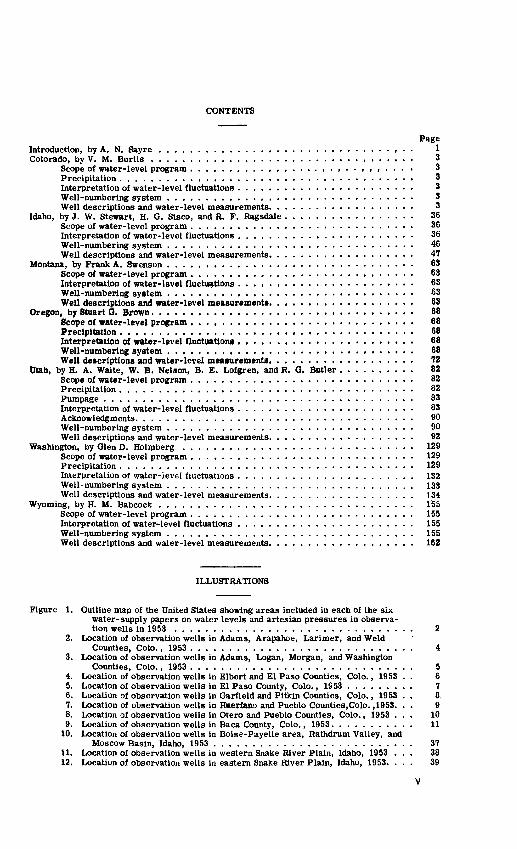
CONTENTS
PageIntroduction, by A. N. Sayre ................................. 1Colorado, by V. M. Burtis .................................. 3
Scope of water-level program ,....,..,.,,,....... ,,,. 3Precipitation ...........,........,,... .. . 3Interpretation of water-level fluctuations ..,.......... . . 3Well-numbering system .......,....... 3Well descriptions and water-level measurements. .................. 3
Idaho, by J. W. Stewart, H. G. Sisco, and R. F. Ragsdale ................. 36Scope of water-level program ............................. 36Interpretation of water-level fluctuations .............. ..- 36Well-numbering system ................................ 46Well descriptions and water-level measurements. .................. 47
Montana, by Frank A. Swenson ................................ 63Scope of water-level program ....,,.,...,,,........,...... 63Interpretation of water-Isvel fluctuations ....................... 63Well-numbering system ............ . . .................. 63Well descriptions and water-level measurements. .................. 63
Oregon, by Stuart G. Brown.................................. 68Scope of water-level program ............................. 68Precipitation .........,................. .. .. 68Interpretation of water-level fluctuations ....................... 68Well-numbering system ................................ 68Well descriptions and water-level measurements. .................. 72
Utah, by H. A. Waite, W. B. Nelson, B. E. Lofgren, and R. G. Butler .......... 82Scope of water-level program ............................. 82Precipitation ...................................... 82Pumpage ........................................ 83Interpretation of water-level fluctuations ....................... 83Acknowledgments. ............,............ 90Well-numbering system ................................ 90Well descriptions and water-level measurements. .................. 92
Washington, by Glen D. Holmberg .............................. 129Scope of water-level program ............................. 129Precipitation ...................................... 129Interpretation of water-ievel fluctuations ....................... 132Well-numbering system ................................ 133Well descriptions and water-level measurements. .................. 134
Wyoming, by H. M. Babcock ................................. 155Scope of water-level program ............................. 155Interpretation of water-level fluctuations ....................... 155Well-numbering system ................................ 155Well descriptions and water-level measurements. .................. 162
ILLUSTRATIONS
Figure 1. Outline map of the United States showing areas included in each of the six water-supply papers on water levels and artesian pressures in observa tion wells in 1953 ............................... 2
2. Location of observation wells in Adams, Arapahoe, Larimer, and WeldCounties, Colo., 1953 ............................. 4
3. Location of observation wells in Adams, Logan, Morgan, and WashingtonCounties, Colo., 1953 ............................. 5
4. Location of observation wells in Elbert and El Paso Counties, Colo., 1953 . . 65. Location of observation wells in El Paso County, Colo., 1953 ......... 76. Location of observation wells in Garfield and Pitkin Counties, Colo., 1953 . . 8,7. Location of observation wells in Huerfano and Pueblo Counties,Colo. ,1953. . . 98. Location of observation wells in Otero and Pueblo Counties, Colo., 1953 ... 109. Location of observation wells in Baca County, Colo., 1953........... 11
10. Location of observation wells in Boise-Payette area, Rathdrum Valley, andMoscow Basin, Idaho, 1953 .......................... 37
11. Location of observation wells in western Snake River Plain, Idaho, 1953 ... 3812. Location of observation wells in eastern Snake River Plain, Idaho, 1953. ... 39
VI ILLUSTRATIONS
Page Figure 13. Location of observation wells in Raft River Valley, Cassia County,
and Malad Valley, Oneida County, Idaho, 1953 ............... 4014. Water levels in wells 4N lW-36dal and 3N 2W-25aal in Boise Valley, Ada
and Canyon Counties, Idaho, 1915-53 .................... 4115. Water level in well 3N 41E-6cbl, Bonneville County, Idaho, 1942-53 ..... 4216. Water level in well 53N 4W-24bbl, Kootenai County, Idaho, 1930-53 ..... 4317. Location of observation wells in Montana, 1953. ................ 6418. Location of observation wells in western Oregon, 1953. ............ 6919. Location of observation wells in central Oregon, 1953 ............. 7020. Location of observation wells in eastern Oregon, 1953............. 7121. Annual pumpage in acre-feet in the Milford and Beryl-Enterprise districts,
Utah, 1944-53 ................................. 8422. Water levels in wells (B-8-2)23cdb-l, (B-5-2)4cdd-l, and (A-2-l)19dbc-l
in northern Utah. ............................... 8523. Water levels in wells (A-12-l)29bdd-l, (C-2-4)33add-l, and (D-2-l)4dbd-4
in northern Utah ......................... 8624. Water levels in wells (D-16-3)32ddc-2 and (C-29-10)6ddc-l in northern Utah. 8725. Water levels in wells (D-5-1) 14adb-l, (C-21-5)21aba-l, and
(C-23-2)19dab-l in central Utah ....................... 8826. Water levels in wells (C-33-9)34dcd-l, (C-35-ll)33aac-l, and
(C-35-17)25cdd-l in central Utah. ...................... 8927. Location of observation wells in Washington, 1953 ............... 13028. Hydrographs of wells 19/29-34D1 and 20/25-15Q1 in the Columbia Basin
project area showing the effect of recharge from irrigation, 1949-53 . . . 13129. Location of observation wells in northwestern Wyoming, 1953......... 15630. Location of observation wells in north-central Wyoming, 1953. ........ 15731. Location of observation wells in northeastern Wyoming, 1953 ......... 15832. Location of observation wells in southeastern Wyoming, 1953 ......... 15933. Location of observation wells in south-central Wyomirig, 1953. ........ 16034. Location of observation wells in southwestern Wyoming, 1953......... 161
WATER LEVELS AND ARTESIAN PRESSURES
IN OBSERVATION WELLS IN THE UNITED STATES
IN 1953
Part 5. NORTHWESTERN STATES
INTRODUCTION
By A. N. Sayre
The publication of records of water levels and artesian pressures annually in the United States was begun by the Geological Survey in 1935. Prior to 1940 the records for each year were published in a single volume 1935, 777; 1936, 817; 1937, 840; 1938, 845; 1939, 886. Since 1940 records have been published in six annual volumes, covering the northeastern, southeastern, north-central, south-central, northwestern, and southwestern sections of the country. Hawaii is included In the southwestern section. The following table gives the numbers of Water-Supply Papers from 1940 through 1953.
Year
19401941194219431944194519461947194819491950195119521953
North eastern
(1)
9069369449861016102310711096112611561165119112211265
South eastern
(2)
9079379459871017102410721097112711571166119212221266
North- central
(3)
9089389469881018102510731098112811581167119312231267
South- central
(4)
9099399479891019102610741099112911591168119412241268
North western
(5)
9109409489901020102710751100113011601169119512251269
South western
(6)
9119419499911021102810761101113111611170119612261270
The objectives of the observation-well program are to provide a day-to-day evaluation of available ground-water supplies, to facilitate the prediction of trends in ground-water levels that will indicate the probable status of important ground-water supplies in the future, to delineate present or potential areas of detrimentally high or low ground-water levels, to aid in the predic tion of the base flow of streams, to determine the several forces that act on a ground-water body, and to demonstrate the interplay of those forces in the ground-water regimen, to furnish infor mation for use in basic research, and to provide long-term continuous records of fluctuations of water levels in representative wells. These selected records serve as a framework to which many short-term records collected during an intensive investigation may be related.
Water levels in wells are seldom stationary but move up or down a fraction of an inch or many feet within a short time. Water-table wells may be influenced by direct recharge from precipitation, withdrawals from wells or springs, evapotranspiration by vegetation, evaporation from the soil, and changes in atmospheric pressure. Artesian wells are influenced over large areas by changes in the rate of pumping from other wells, changes in atmospheric pressure, earthquakes, ocean tides, earth tides, and recharge from precipitation, although the recharge may not be noticeable immediately. When accurate comparisons of water levels are made it is desirable to apply corrections for these influences, several of which may be compensating or additive according to the conditions at those particular times.
WATER LEVELS AND ARTESIAN PRESSURES, 1953, NORTHWESTERN STATES
Water-level measurements are given in feet with reference to land-surface datum or sea- level datum. Land-surf ace datum is a precise datum plane that is approximately at land surface at each well. Mean sea level (msl) is the datum plane on which the national network of precise levels is based. When some measurements in a table are above and others are below the plane of reference, a plus (+) or minus (-) sign is placed immediately preceding the first entry in each column. Readings between minus signs are below the plane of reference and those between plus signs are above the plane of reference.
For the most part, discussions of precipitation in this report are based on data furnished by the United States Weather Bureau.
Measurements of water levels and artesian pressures in wells were made under the direc tion of the district supervisors of the Ground Water Branch in the several States.
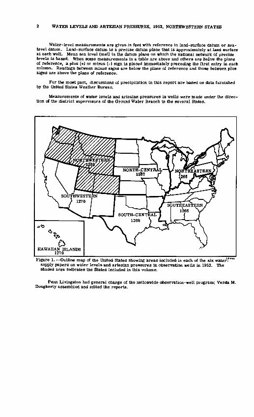
Figure 1. Outline map of the United States showing areas included in each of the six water-""* supply papers on water levels and artesian pressures in observation wells in 1953. The shaded area indicates the States included in this volume.
Penn Livingston had general charge of the nationwide observation-well program; Verda M. Dougherty assembled and edited the reports.
COLORADO
By V. M. Burtis
Scope of Water-Level Program
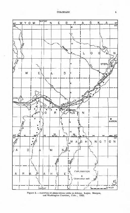
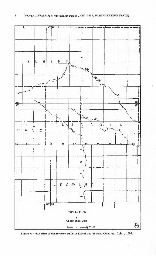
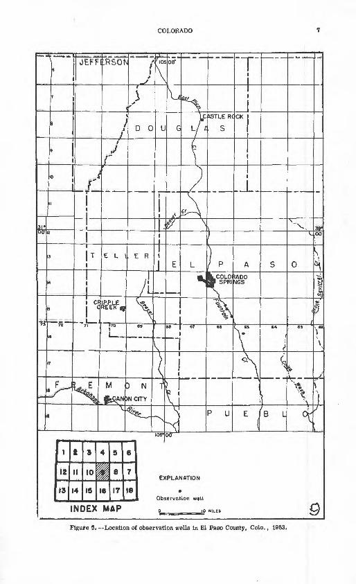
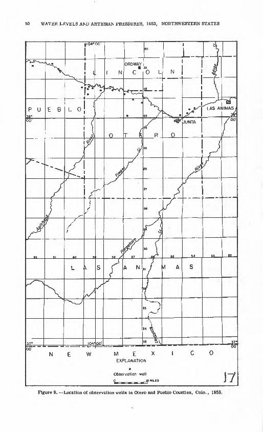
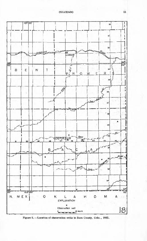
The observation-well program in Colorado was continued in 1953 in cooperation with the Colorado Water Conservation Board and the Colorado Agricultural Experiment Station. In 1953, measurements were made in 245 wells, 4 of which were equipped with recording gages. Water levels in 141 wells were measured by W. E. Code of the Agricultural Experiment Station. (See figs. 2-9.)
Precipitation
Precipitation in Colorado was slightly above normal in May, July, August, and November but was below normal during the remainder of the year. The weighted average precipitation In Colorado during the year was 14.15 Inches which is 3.12 inches below normal. The drought con tinued in southeastern Colorado, although there were local heavy storms during July and August.
Interpretation of Water-Level Fluctuations
Water levels remained about normal In .the South Platte, Arkansas, and San Luis Valleys and in the High Plains. Water levels continued to decline at a serious rate In the heavily pumped valleys tributary to the South Platte. There were local declines of several feet in Beaver, Bijou, Kiowa, and Boxelder Valleys.
Well-Numbering System
Wells are numbered in accordance with the Bureau of Land Management system of land subdivision. The first letter in a well number gives the quadrant of the meridian and base-line system, beginning in the northeast quadrant (A) and proceeding counterclockwise. All wells in Colorado lie in the northwest (B) and southwest (C) quadrants of the sixth principal meridian and fortieth parallel base-line system. The first numeral of a well number indicates the township, the second the range, and the third the section. The lowercase letters a, b, c, and d following the section number locate the well within the section. The first letter denotes the quarter section, the second letter the quarter-quarter section, and the third letter the quarter-quarter-quarter section.
Well Descriptions and Water-Level Measurements
(Water levels are in feet below land-surface datum unless otherwise indicated.)
Adams County
C-l-60-4ccc. W. L. Freeman. Drilled irrigation water-table well in alluvium, diameter 18 inches, depth 86 feet. Land-surface datum is 4, 800.9 feet above msl. Highest water level 18. 00 below Isd, Nov. 29, 1940; lowest 29.49 below Isd, Oct. 23, 1953. Records available: 1940-53. Apr. 16, 26. 50; Oct. 23, 29.49.
C-l-60-17dcc. Carl Sanden. Drilled irrigation water-table well in alluvium, diameter 18 inches, depth 87 feet. Land-surface datum is 4, 830. ( feet above msl. Highest water level 25.09 below Isd, Nov. 19, 1942; lowest 39.40 below Isd, Oct. 16, 1952. Records available: 1S42-53. Apr. 16, 33.25; Oct. 23, 37.49.
C-l-60-29cbd. J. D. Singleton. Drilled irrigation water-table well in alluvium, diameter 24 inches, depth 87 feet. Land-surface datum is 4, 867.4 feet above msl. Highest water level 29.42 below Isd, Nov. 18, 1943; lowest 37.90 below Isd, Oct. 16, 1952. Records available: 1934, 1941-53. Apr. 16, 31.67; Oct. 23, 35.77.
C-l-62-22dac. Charles B. Nordloh. Drilled irrigation water-table well in alluvium, diameter 18 inches, depth 82 feet. Highest water level 44.21 below Isd, Nov. 25, 1949; lowest 47.08 below Isd, Oct. 30, 1946. Records available: 1946-52. No measurement made in 1953.

4 WATER LEVELS AND ARTESIAN PRESSURES, 1953, NORTHWESTERN STATES
W Y 0 M I
Figure 2. --Location of observation wells in Adams, Arapahoe, Larimer, and Weld Counties, Colo., 1953.
COLORADO
NEBRASKA 4i
Figure 3. Location of observation wells in Adams, Logan, Morgan, and Washington Counties, Colo., 1953.
6 WATER LEVELS AND ARTESIAN PRESSURES, 1953, NORTHWESTERN STATES
_ __104° 00
L B R T
N X!X L,[v?*'** '
o N C
94
R C W I.
EXPLANATION
Observotion well
O 10 MILES 8Figure 4. --Location of observation wells in Elbert and El Paso Counties, Colo., 1953.
COLORADO
Figure 5. --Location of observation wells in El Paso County, Colo., 1953.

8 WATER LEVELS AND ARTESIAN PRESSURES, 1953, NORTHWESTERN STATES
Figure 6. Location of observation wells in Garfield and Pitkin Counties, Colo., 1953.

COLORADO
Figure 7. --Location of observation wells in Huerfano and Pueblo Countiss, Colo. , 1953.
10 WATER LEVELS AND ARTESIAN PRESSURES, 1953, NORTHWESTERN STATES
Figure 8. Location of observation wells in Otero and Pueblo Counties, Colo., 1953.
COLORADO
Figure 9. --Location of observation wells in Baca County, Colo., 1953.

12 WATER LEVELS AND ARTESIAN PRESSURES, 1953, NORTHWESTERN STATES
C-l-62-34cd. John H. Nordloh. Drilled irrigation water-table well in alluvium, diameter 24 inches, depth 85 feet. Highest water level 33.22 below Isd, Oct. 30, 1946; lowest 45. 52 below Isd, Nov. 6, 1952. Records available: 1946, 1948-49, 1951-52. No measurement made in 1953.
C-l-65-llcd. David Patton. Drilled irrigation water-table well in alluvium, diameter 30 inches, depth 42 feet. Highest water level 12. 70 below Isd, Nov. 16, 1948; lowest 17.70 below Isd, Nov. 18, 1953. Records available: 1947-53. Mar. 26, 16. 93; Nov. 18, 17.70.
C-l-66-7cc. C. Hose. Dug irrigation water-table well in alluvium, diameter 5 feet, depth 28 feet. Highest water level 15. 90 below Isd, Sept. 17, 1930; lowest 22.67 below Isd, May 8, 1941. Records available: 1929-53. Mar. 26, 19.95; Nov. 16, 18.41.
C-l-66-19dc. A. B. Perry. Drilled irrigation water-table well in alluvium, diameter 4 feet, depth 44 feet. Highest water level 26. 35 below Isd, Nov. 9, 1949; lowest 34. 82 below Isd, May 1, 1951. Records available: 1941-53. Mar. 26, 32.17; Nov. 18, 30.59.
Ol-67-13db. Edward Schnute. Dug irrigation water-table well in alluvium, diameter 8 feet, depth 32 feet. Highest water level 16.21 below Isd, Sept. 17, 1930; lowest 25. 65 below Isd, May 8, 1941. Records available: 1929-53. Mar. 26, 22. 45; Nov. 18, 20. 80.
C-l-67-35cda. L. A. Ernst. Drilled irrigation water-teble well in alluvium, diameter 4 feet, depth 36 feet. Highest water level 17.00 below Isd, Oct. 28, 1947; lowest 23. 40 below Isd, May 6, 1941. Records available: 1941-53. Mar. 26, 20.94. Measurement discontinued.
C-2-60-19bcc. Oscar Helgeson. Dug unused water-table well in alluvium, diameter 10 feet, depth 20 feet. Highest water level 14. 50 below Isd, Sept. 4, 1930; lowest 18. 93 below Isd, F«-b. 7, 194S. Records available: 1930, 1940-50. Measurement discontinued.
C-2-65-lldcd. Box Elder Farms. Drilled irrigation water-table well in alluvium, diameter 24 inches. Highest water level 26. 99 below Isd, Nov. 16, 1S48; lowest 30. 44 below Isd, Nov. 18, 1953. Records available: 1938-53. Mar. 26, 29.49; Nov. 18, 30.44.
C-2-65-14dcb. Box Elder Farms. Drilled irrigation water-table well in alluvium, diam eter 4 feet. Highest water level 12. 70 below Isd, Nov. 16, 1948; lowest 17. 32 below Isd, Nov. 18, 1953. Records available: 1933-53. Mar. 26, 15.98; Nov. 18, 17.32.
C-2-65-23dab. Box Elder Farms. Drilled irrigation water-table well in alluvium, diam eter 4 feet, depth 58 feet. Highest water level 13. 7£ below Isd, Apr. 21. 1949; lowest 23. 97 below Isd, Nov. 18, 1953. Records available: 1933-53. Mar. 26, 18.85; Nov. 18, 23.97.
C-2-65-26dba. Box Elder Farms. Drilled irrigation water-table well in alluvium, diam eter 24 inches. Highest water level 16.67 below Isd, Apr. 22, 1948; lowest 27.65 below Isd, Nov. 18, 1953. Records available: 1934, 1941-53. Mar. 26, 23.44; Nov. 18, 27.65.
C-2-65-35dbb. Box Elder Farms. Drilled irrigation water-table well in alluvium, diameter 4 feet. Highest water level 14. 04 below Isd, May 13, 1942; lowest 26.82 below Isd, Nov. 18, 1953. Records available: 1933-53. Mar. 26, 21.00; Nov. 18, 26.82.
C-2-65-35dcd. Box Elder Farms. Drilled irrigation water-table well in alluvium, diam eter 4 feet, depth 47 feet. Highest water level 12.04 below Isd, May 13, 1942; lowest 21. 50 below Isd, NOV. 6, 1952. Records available: 1933-53. Mar. 26, 19.10.
C-2-67-10dcd. Cora Wall. Drilled irrigation water-table well in alluvium, diameter 4feet, depth 41 feet. Highest water level 22. 27 below Isd, Oct. 28, 1947; lowest 30. 09 below Isd, May 1, 1951. Records available: 1937-53. Nov. 18, 26.88.
C-2-67-20dcd. Charles Fadden. Dug irrigation water-table well in alluvium, diameter 10 feet, depth 40 feet. Highest water level 22.95 below Isd, Oct. 28, 1947; lowest 25.90 below Isd, Nov. 28, 1950, Nov. 18, 1953. Records available: 1936-53. Nov. 18, 25. GO.
C-3-65-23aal. Jeff Drohan. Drilled irrigation water-table well in alluvium, diameter 4 feet, depth 51 feet. Highest water level 16.07 below Isd, Nov. 29, 1G49; lowest 25.44 below Isd, Nov. 18, 1953. Records available: 1949-53.
Date
Nov. 29, 1949 Apr. 12, 1950
Water level
16.07 16.53
Date
Nov. 28, 1950 May 1, 1951
Water level
18.46 18.72
Date
Dec. 3, 1951 Apr. 17, 1952
Water | Date level ||
20. 14 I Mar. 26, 1953 20.38 | Nov. 18
Water level
22.63 25.44

COLORADO, BACA COUNTY 13
C-3-65-23ddd. Jeff Drohan. Drilled irrigation water-table well in alluvium, diameter 24 inches, depth 49 feet. Highest water level 14. 20 below Isd, Apr. 22, 1948; lowest 26. 85 below Isd, Nov. 18, 1953. Records available: 1941-53. Mar. 26, 23.25; Nov. 18, 26.85.
C-3-67-6dd. H. L. Swanson. Drilled irrigation water-table well in alluvium, diameter 4 feet, depth 29 feet. Highest water level 16. 80 below Lsd, Apr. 22, 1948; lowest 22. 43 below Isd, Sept. 15, 1941. Records available: 1941-53. Mar. 26, 18.76; Nov. IB, 19.03.
Arapahoe County
C-4-68-33cd. Frank Hornbuckle. Driven observation water-table well in alluvium, diameter 1^ inches, depth 23 feet. Highest water level 4. 60 below Isd, June 27, 1947; lowest 12.33 below Isd, Mar. 17, 1953. Records available: 1942-53.
Date
Jan. 26 Feb. 19 Mar. 17
Water level7.88
12.07 12.33
Date
Apr. 30 May 19 June 23
Waterlevel11.50 10.78 9.43
Date
July 29 Aug. 18 Sept. 15
Water level9.75
10.16 10.64
Date
Oct. 20 Dec. 4
17
Water level
11.38 12.29 11.95
Baca County
C-29-42-llbcd. Harold Walker. Drilled unused water-table well in alluvium, diameter 5 inches, depth 26 feet. Highest water level, 22. 65 below Isd, May 24, 1952; lowest 24.17 below Isd, Oct. 21, 1953. Records available: 1952-53.
Date
Jan. 18, 1952Feb. 15Mar. 14Apr. 18May 24June 20
Water level
23.7023.2823.2522.9522.6523.03
Date
July 10, 1952Aug. 11Sept. 16Oct. 17Nov. 20Dec. 30
Water level
23.7323.6424.0223.7723.8923.60
Date
Jan. 20, 1953Feb. 27Mar. 21Apr. 23May 21
Water level
23.6023. 5S23.5023.5822.77
Date
June 25,1953July 23Aug. 20Sept. 30Oct. 21
Waterlevel
23.3323.4023.7024.0724.17
C-30-45-34ccc. C. J. Alfrey. Drilled stock water-table well in Dakota sandstone and Ogallala formation, diameter 6 inches, depth 137 feet. Land-surface datum is 4,188. 4 feet above msl. Highest water level 86.32 below Isd, Mar. 20, 1953; lowest 88.28 below Isd, Sept. 7, 1947. Records available: 1947-53.
Date
Jan. 19 Mar. 20 Apr. 23
Water level
86. 52 86.32 86.50
Date
May 21 June 25
Water level
86.55 86.41
Date
July 23 Aug. 20
Water level
86.44 86.52
Date
Sept. 30 Oct. 21
Water level
86.40 86.50
C-30-46-17bc. Maud A. Rarex. Dug unused stock water-table well in alluvium, diameter 10 feet, depth 15 feet. Highest water level 8. 73 below Isd, May 18, 1951; lowest 12. 99 below Isd, Oct. 1, 1948. Records available: 1947 H52.Jan. 20 Feb. 23 Mar. 21
10.50 10.29 10.23
Apr. 22 May 21 June 25
10.27 10.34 11.14
July 23 Aug. 20
10.98 10.97
Sept. 30 Oct. 21
11.73 11.88
C-32-43-20aaa. H. F. Koelsch. Drilled unused artesian well in Dakota sandstone, diameter 6 inches, depth 171 feet. Land-surface datum is 3, 927. 3 feet above msl. Highest water level 84. 28 below Isd, June 25, 1953; lowest 86. 58 below Isd, Aug. 16, 194S. Records available: 1947-53.Jan. 20 Feb. 23 Mar. 20
84.93 84.78 84.35
Apr. 23 May 21 June 25
84.68 84.58 84.28
July 23 Aug. 20
84.59 84.60
Sept. 30 Oct. 21
84.82 84.56
14 WATER LEVELS AND ARTESIAN PRESSURES, 1953, NORTHWESTERN STATES
C-32-48-8cbb. S. D. Huff. Drilled unused water-table well in Dakota sandstone, diameter 6 inches, depth 247 feet. Land-surface datum is 4, 798. 5 feet above msl. Highest water level 191.14 below Isd, Mar. 20, 1953; lowest 194. 32 below Isd, Aug. 7, 1947. Records available: 1947-53.
Date
Jan. 19 Feb. 23 Mar. 20
Water level
191.68 191.71 191.14
Date
Apr. 23 May 20 June 24
Water level
191.87 191.25 191.17
Date
July 23 Aug. 19
Waterlevel
191.42 191.36
Date
Sept. 30 Oct. 22
Water level
191.62 191.51
C-33-45-13dad. J. A. and M. W. Davis. Drilled unused water-table well in Dakota sandstone, diameter 6 inches, depth 186 feet. Land-surface datum is 4,150. 8 feet above ms Highest water level 75.33 below Lsd, Mar. 20, 1953; lowest 80.09 below Isd, Dee. 21, 1B47. Records available: 1947-53.Jan. 20 Feb. 23 Mar. 20
75.69 75.58 75.33
Apr. 23 May 21 June 25
75.53 |j July 23 75.55 Aug. 20 75.35
75.40 75.45
Sept. 30 Oct. 21
75.46 75.43
C-35-45-7db. G. S. Shaw. Drilled unused artesian well in Purgatoire'formation, diamster 6 inches, depth 231 feet. Land-surface datum is 4, 098.2 feet above msl. Highest water level 166. 85 below Isd, Jan. 18, 1952; lowest 170. 00 below Isd, July 13, 1948. Records available: 1947-53.Jan. 20 Feb. 23 Mar. 20
168. 58 168. 72 168.30
Apr. 23 May 21 June 24
168.72 168.77 168. 50
July 23 Aug. 20
168.72 168.96
Sept. 30 Oct. 21
169,06 168, 86
Elbert County
C-9-57-8abb. J. C. Mattson. Drilled unused water-table well in alluvium, diameter 6 inches, depth 28 feet. Highest water level 5. 00 below Isd, July 2, 1947; lowest 7.46 beltW Udj Sept. 29, 1953. Records available: 1945-53.Jan. 2
16Feb. 18
6.606.466.32
Mar. 18Apr. 21May 19
5.886.075.82
June 23July 21Aug. IB
6.4B6.78t.at
Sept, 30Oct. 20
1417.28
C-9-58-34ccb. Heber Ellsworth. Drilled irrigation water-table well in alluvium, diameter 24 inches, depth 55 feet. Highest water level 10.48 below Isd, July 2, 1947; lowest 16.27 below Isd, July 12, 1950. Records available: 1945-53. Jan. 2, 14.03; Jan. 16, 13.93; Feb. 1B> 13.74; Mar. 18, 13.69; Apr. 21, 13.58; May 19, 13.57.
C-10-59-22ab. William Groff. Drilled irrigation water-table wellin alluvium, diameter 24 to 1C inches, depth 55 feet. Land-surface datum is 5,600.1 feet above msl. Highest water level 10. 52 below Isd, May 3, 1947; lowest 14.65 below Isd, July 31, 1053. Records available: 1945-53.Jan. 2
18Feb. 18
12.5012.4512.30
Mar. 18Apr. 21
12.2312. OB
May 19June 23
11.9912.90
July 21Oct. 20
cl4. 6514,24
c Nearby well being pumped.
C-10-60-26cd. Simla Cemetery. Drilled irrigation water-table well in alluvium, diameter 6 inches, depth 40 feet. Highest water level 23.30 below Isd, July 2, 1947; lowest 26.60 below Isd. Oct. 18, 1950. Records available: 1945-53.Jan. 2
16Feb. 18
24.8824.7924.59
Mar. 18Apr. 21
24.4724.40
May 19June 23
24.3524.78
July IflAug. IS
28,1324.92
._..._ -
El Paso County
C-ll-62-22ad. Anthony Eurich. Drilled irrigation water-table well in alluvium, diameter 24 inches, depth 44 feet. Land-surface datum is 6,364.8 feet above msl, Highest Water level 5.49 below Isd, Aug. 9, 1947; lowest 8.48 below Isd. July 1U 1962. Records available: j948-lSiJan. 2
16Feb. 18
7.977.887.83
Mar. 18Apr. 21May 19
7.787.727.65
June 23July 21Aug. 18
8.188.378.21
Sept. 29Oct. 20
8.01B.31
_ . _. _ t
COLORADO, HUERFANO COUNTY 15
C-15-66-llcbd. Venetucci Bros. Drilled irrigation water-table well in alluvium, depth 80 feet. Highest water level 36. 57 below Isd, Nov. 4, 1948; lowest 39.99 below Isd, Nov. 11 1953. Records available: 1944-53. Mar. 17, 39.76; Nov. 11, 39.99.
C-15-66- 14abd-2. T. L. Bender. Drilled irrigation water-table well in alluvium, diameter 24 inches, depth 53 feet. Highest water level 23. 50 below Isd, Apr. 5, 1950; lowest 25.69 below Isd, Nov. 11, 1953. Records available: 1948-53. Nov. 11, 25.69.
C-15-66-25aaa. W. E. Busch. Drilled irrigation water-table well in alluvium, diameter 24 inches, depth 43 feet. Highest water level 28.65 below Isd, Nov. 6, 1947; lowest 32. 72 below Isd, Nov. 11, 1953. Records available: 1944-53. Mar. 17, 31.65; Nov. 11, 32.72.
C-16-65-16bb. L. F. Oldenstaadt. Drilled irrigation water-table well in alluvium, diameter 24 inches, depth 60 feet. Highest water level 27.47 below Isd, Nov. 16, 1947; lowest 39.34 below Isd, Nov. 15, 1951. Records available: 1944-51. No measurement made in 1953.
C-16-65-l7aa. John Wilson. Drilled irrigation water-table well in alluvium, diameter 24 inches, depth 58 feet. Highest water level 36.01 below Isd, Mar. 17, 1953; lowest 37. 51 below Isd, Nov. 11, 1953. Records available: 1953. Mar. 17, 36.01; Nov. 11, 37. 51.
Garfield County
C-7-88-29ab. J. F. Smith. Dug domestic water-table well in terrace deposits, diameter 36 inches, depth 42 feet. Highest water level 22.31 below Isd, June 14, 1947; lowest 38.90 below lad, Dec. IB, 1947. Records available: 1942-53.
Date
Jan. 19 Feb. 17 Mar. 19
Water level
34.61 34.82 34.91
Date
Apr. 19 May 13 June 19
Water level
35.02 32.62 27.63
Date
July 11 Aug. 17 Sept. 13
Water level
28.49 28.72 29.74
Date
Oct. 18 Nov. 20 Dec. 9
Water level
31.04 33.47 34.07
Huerfano County
C-25-67-25bcd. C. H. Money. Dug stock water-table well in alluvium, diameter 4 feet, depth 26 feet. Highest water level 14.49 below Isd, July 8, 1952; lowest 17.70 below Isd, Sept. 29, 1953. Records available: 1951-53.Jan. 19 Feb. 18 Mar. 18
16.18 16.25 16.34
Apr. 21 May 19 June 23
16.46 16.12 16.49
July 21 Aug. 18
16.80 17.07
Sept. 29 Oct. 22
17.70 17.64
C-26-67-25cad. Eugene Ellis. Drilled stock water-table well in alluvium, diameter 7 inches, depth 22 feet. Highest water level 6.94 below Isd, Aug. 19, 1953; lowest 9. 53 below Isd, Sept. 12, Oct. 16, 1951. Records available: 1950-53.Jan. 19Feb. 20Mar. 18
8.238.158.15
Apr. 21May 20June 24
7.637.897.08
July 22Aug. 19
7.206.94
Oct. 122
9.488.80
C-27-66-36acc. Charles Corsentino. Drilled unused water-table well in alluvium, diameter 6 inches, depth 22 feet. Highest water level 13. 53 below Isd, Aug. 12, 1952; lowest 19.33 below Isd, Feb. 14, 1952. Records available: 1950-53. Measurement discontinued.Jan. 19Feb. 20Mar. 19
17.2017.4917.35
Apr. 22May 20June 24
16.2816.2916.90
July 22Aug. 19
17.4317.84
Oct. 122
17.1316.47
C-27-67-36aca. Mr. Faris. Drilled stock water-table well in Trinidad sandstone, diameter 7 inches, depth 62 feet. Highest water level 44.15 below Isd, Feb. 7, 1950; lowest 47.38 below Isd, Oct. 1, 1953. Records available: 1950-53.Jan. 19Feb. 20Mar. 19
46.5346.8246.84
Apr. 21May 20June 24
46.9447.3048.15
July 22Aug. 19
47.2747.26
Oct. 123
47.3847.10
C-27-68-4cbc. Mrs. Thorn. Dug domestic and stock water-table well in alluvium, diameter 36 inches, depth 28 feet. Highest water level 11.32 below Isd, June 12, 1953; lowest 22.80 below Isd, Jan. 8, 1951. Records available: 1950-53.Jan. 6
23Feb. 10
26Mar. 10
25
17.7417.5919.2719.6519.4319.98
Apr. 823
May 521
June 12
18.6917.6016.3214.7511.32
July 24Aug. 6
26Sept. 11
24
14.1314.9017.1419.6519.80
Oct. 7Nov. 3
19Dec. 9
31
20.8721.5321.9021.6520.70
16 WATER LEVELS AND ARTESIAN PRESSURES, 1953, NORTHWESTERN STATES
C-28-66-15bcc. Henry Meyer. Drilled unused water-table well in alluvium, diameter 6 inches, depth 67 feet. Highest water level 11.22 below Isd, Aug. 19, 1953; lowest 25.21 below lad, June 24, 1953. Records available: 1950-53.
Date
Jan. 19 Feb. 20 Mar. 19
Water level
24.79 24.79 24.82
Date
Apr. 22 May 20 June 24
Water level
25.08 24.95 25.21
Date
July 22 Aug. 19
Water level
21.74 11.22
Date
Oct. 1 22
Water level
25.12 25.00
C-28-67-24dac. Dug artesian well in Raton formation, size 12 by 20 feet, depth 646 feet. Highest water level 106. 56 below Isd, Sept. 18, 1952; lowest 110.63 below Isd, Feb. 14, 1952. Records available: 1952-53.
Date
Jan. 16, 1952 Feb. 14 Mar. 13 Apr. 16 May 22 June 19
Water level
110. 57 110. 63 110. 57 110.54 110.28 109.79
Date
July 8, 1952 Aug. 12 Sept. 18 Oct. 16 Nov. 19 Dec. 29
Water level
109. 08 107. 42 106. 56 106. 73 107.28 107.84
Date
Jan. 19, 1953 Feb. 20 Mar. 19 Apr. 22 May 20
Water level
108.23 108.85 109.15 109. 38 109. 05
Date
June 24,1953 July 22 Aug. 19 Oct. 1
23
Water level
108. 56 109. 59 110.05 110. 33 110. 55
C-29-67-19acb. Ewell Woodring. Drilled unused water-table well in sandstone, diameter 7 inches, depth 142 feet. Highest water level 34. 54 below Isd, May 22, 1952; lowest 35.76 below Isd, Nov. 19, 1952. Records available: 1951-53.
Date
Jan. 19 Feb. 20 Mar. 19
Water level
35.42 35.22 35.03
Date
Apr. 22 May 20 June 24
Water level
35.43 35.24 35.28
Date
July 22 Aug. 19
Water level
35.53 35.64
Date
Oct. 1 23
Water level
35.08 35.05
Larimer County
B-5-68-17abb. George Peak. Drilled irrigation water-table well in alluvium, diameter 4 feet, depth 24 feet. Highest water level 5.43 below Isd, Oct. 27, 1947; lowest 14.45 below Isd, Apr. 20, 1949. Records available: 1941-53. Mar. 25, 10.49; Nov. 17, 8.64.
B-6-68-lba. M. J. Warner. Dug irrigation water-table well in alluvium, diameter 4 feet. Highest water level 9.19 below Isd, Oct. 4, 1943; lowest 12.74 below Isd, May 2, 1941. Records available: 1941-53. Apr. 22, 11.33; Nov. 24, 11.29.
B-7-68-5cb. Milton E. Payne. Drilled irrigation water-table well in alluvium, diameter 16 inches, depth 76 feet. Highest water level 26. 78 below Isd, Nov. 29, 1951; lowest 28.62 below Isd, Apr. 23, 1953. Records available: 1950-53. Apr. 23,28.62; Nov. 27, 28v45.
B-7-68-10cbb. Drake Estate. Drilled irrigation water-table well in alluvium, diameter 12 inches. Highest water level 2.66 below Isd, July 6, 1929; lowest 7.60 below Isd, May 21, 1938. Records available: 1929-30, 1932-53. Apr. 24, 5.93; Nov. 27, 6.26.
B-7-68-22bbb. Ray Pitcher. Dug irrigation water-table well in alluvium, diameter 6 feet,) depth 25 feet. Highest water level 1. 58 below Isd, July 6, 1929; lowest 8.33 below Isd, Aug. 6, 1934. Records available: 1928-30, 1932-53. Apr. 22, 5.84; Nov. 24, 5.10.
B-7-68-23cbb. W. A. Scott. Drilled unused water-table well in alluvium, diameter 4 feet. Highest water level 6.30 below Isd, Nov. 16, 1942; lowest 9. 50 below Isd, May 2, 1941. Records available: 1941-53. Apr. 22, 6.79; Nov. 24, 6.54.
B-8-68-4bba. A. Heckman. Drilled irrigation water-table well in alluvium, diameter 22 inches, depth 67 feet. Highest water level 16.30 below Isd, Nov. 24, 1944; lowest 32. 05 below Isd, Nov. 27, 1953. Records available: 1943-53. Apr. 24, 31.47; Nov. 27, 32.05.
B-8-68-10cbb. A. L. Bee. Dug irrigation water-table well in alluvium, diameter 11 feet, depth 28 feet. Highest water level 5.08 below Isd, July 6, 1929; lowest 24.11 below Isd, Nov. 27, 1953. Records available: 1929, 1932-53. Apr. 24, 21.38; Nov. 27, 24.11.
B-8-68-16aa. R, E. Nutter. Drilled irrigation water-table well iu alluvium, diameter 12 inches. Highest water level 15.30 below Isd, Sept. 18, 1929; lowest 28.42 below Isd, Dec. 9, 1952. Records available: 1929-30, 1932-52. Measurement discontinued.

COLORADO, LOGAN COUNTY 17
B-8-68-16aal. R. E. Nutter. Drilled irrigation water-table well in alluvium, diameter 20 inches, depth 57 feet. Highest water level 29. 32 below Isd, Apr. 24, 1953; lowest 32.84 below Isd, Nov. 27, 1953. Records available: 1952-53. May 5, 1952, 29.42; Dec. 9, 1952, 30.45; Apr. 24, 1953, 29.32; Nov. 27, 32.84.
B-8-68-22cbbl. J. E. Swansen. Drilled irrigation water-table well in alluvium, diameter 24 inches, depth 38 feet. Highest water level 12.60 beldw Isd, May 1, 1950; lowest 15.93 below Isd, Nov. 27, 1953. Records available: 1929-30, 1932-53. Apr. 24, 13.22; Nov. 27, 15.93.
B-8-68-27cbb. A. L. Seamans. Dug irrigation water-table well in alluvium, diameter 8 feet, depth 32 feet. Highest water level 8.94 below Isd, July 6, 1929; lowest 15.68 below Isd, Nov. 27, 1953. Records available: 1929-53. Apr. 24, 13.79; Nov. 27, 15.68.
B-8-88-28aab. F. L. Bartels. Drilled Irrigation water-table well in alluvium, diameter 12 inches, depth 30 feet. Highest water level 2. 98 below Isd, Sept. 18, 1929; lowest 13.49 below Isd, Nov. 27, 1953. Records available: 1929-30, 1932-34, 1937-53. Apr. 24, 10.58; Nov. 27, 13.49.
B-8-88-33ccc. F. C. Kluver. Drilled irrigation water-table well in alluvium, diameter12 inches, depth 33 feet. Highest water level 11.80 below Isd, Sept. 18, 1929; lowest 15.88below Isd, Oct. 5, 1934. Records available: 1929-30, 1932-53. Apr. 23, 14.78; Nov. 27, 15.45.
B-9-68-17ab. Harlan Seaworth. Drilled irrigation water-table well in alluvium, diameter 20 Inches, depth 92 feet. Highest water level 29.08 below Isd, May 9, 1944; lowest 53.10 below Isd, May 1, 1941. Records available: 1939-53. Apr. 24, 44.99; Nov. 27, 46.14.
B-9-68-27ba. John Wagner. Dug unused water-table well in alluvium, diameter 14 feet, depth 30 feet. Highest water level 24.08 below Isd, Nov. 27, 1953; lowest 28.40 below Isd, Apr. 17, 1951. Records available: 1949-53. Apr. 24, 27.00; Nov. 27, 24.08.
B-9-88-28bbb. E. F. Meedel. Dug and drilled irrigation water-table well in alluvium, depth 42 feet. Highest water level 13.17 below Isd, Nov. 13, 1943; lowest 24.71 below Isd, May 1, 1941. Records available: 1938-53. Nov. 27, 23.80.
B-9-68-33bdc. J. Weisshaar. Dug irrigation water-table well in alluvium, diameter 10 feet, depth 35 feet. Highest water level 13. 95 below Isd, Sept. 18, 1929; lowest 34. 20 below Isd, Nov. 13, 1942. Records available: 1929-33, 1935-53. Apr. 24, 33.06; Nov. 27, 31.56.
Logan County
B-6-53-16ddl. H. E. Ballin. Drilled irrigation water-table well in alluvium, diameter 16 inches, depth 80 feet. Highest water level 20.82 below Isd, Oct. 7, 1948; lowest 24.99 below Isd, Apr. 9, 1952. Records available: 1947-53.
Date
Aug. 22, 1947Sept. 12Oct. 6Nov. 4Dec. 10Jan. 2, 1948Feb. 6Mar. 8Apr. 16June 7
Water level
22.8022.1022.1022.5222.5823.3223.6423.7423.7022.71
Date
July 12, 1948Aug. 6Sept. 10Oct. 7Nov. 1Dec. 6Mar. 3, 1949Apr. 8May 4
Water level
22.2521.7921.1520.8221.6322.3623.4023.6823.77
Date
May 31, 1949July 8Aug. 10Oct. 19Dec. 1Feb. 7, 1950Apr. 12May 26Aug. 4
Water level
24.5022.9722.1821.8422.8523.0523.7422.5421.67
Date
Oct. 20, 1950Dec. 7Feb. 8, 1951Apr. 3Oct. 31Apr. 9, 1952Oct. 20Apr. 22,1953Oct. 21
Water level
22.2223.3723.3523.9322.6524.9922.0523.8822.25
B-6-53-30bcl. C. E. Gaines. Drilled irrigation water-table well in alluvium, diameter 18 inches, depth 110 feet. Highest water level 11. 47 below Isd, July 8, 1949; lowest 13. 83 below Isd, Apr. 3, 1951. Records available: 1947-53.Aug. 21, 1947Oct. 6Nov. 4Dec. 10Jan. 2, 1948Feb. 6Mar. 8Apr. 16June 7Aug. 6
12.2012.4812.7413.0813.0712.6912.5712.8311.5113.27
Sept. 10, 1948Oct. 7Nov. 1Dec. 6Jan. 20, 1949Feb. 8Mar. 3Apr. 8May 4
11.9712.0012.7713.2712.9413.0913.3513.3312.38
May 31, 1949July 8Aug. 10Oct. 19Dec. 1Feb. 7, 1950Apr. 12May 26Aug. 4
12.5711.4711.7612.4013.2613.5813.3612.5512.19
Oct. 20, 1950Dec. 7Feb. 8, 1951Apr. 3Oct. 31Apr. 9, 1952Oct. 20Apr. 22,1953Oct. 21
12.7313.5513.7313.8313.5213.4512.4813.2012.71
18 WATER LEVELS AND ARTESIAN PRESSURES, 1953, NORTHWESTERN STATES
B-6-54-24bcl. N. A. Nelson. Drilled irrigation water-table well in alluvium, depth 78 feet. Highest water level 9.70 below Isd, Aug. 19, 1947; lowest 14.17 below Isd, Apr. 25, 1953. Records available: 1947-53.
Date
Aug. 19, 1947Oct. 6Nov. 4Dec. 10Jan. 2, 1948Feb. 6Mar. 8Apr. 16June 7
Water level
9.7011.4712.4511.5213.3513.4012.8312.4011.09
Date
July 12, 1948Aug. 2Sept. 10Oct. 7Nov. 1Dec. 6Apr. 8, 1949May 4June 6
Water level
10.5511.2011.5511.2011.9012.9814.0012.1011.16
Date
July 8, 1949Aug. 10Oct. 19Dec. 1Feb. 7, 1950Apr. 13May 26Aug. 4Oct. 18
Water level
10.3310.4411.4912.8913.6313.1311.3911.0512.57
Date
Dec. 7, 1950Feb. 8, 1951Apr. 10Nov. 6Apr. 10,1952Oct. 6Apr. 25,1953Oct. 21
Water level
13.4413.9013.2813.5014.1012.6814.1713.14
B-7-53-18bd. John Price. Drilled irrigation water-table well in alluvium, diameter 18 inches, depth 48 feet. Highest water level 16.53 below Isd, Dec. 11, 1947; lowest 21. 52 below Isd. Sept. 10. 1948. Records available: 1947-53.
Dec. 11, 1947May 5, 1948Sept. 10Nov. 1Dec. 8Feb. 8, 1949Mar. 2
16.5316.7521.5218.3218.0417.9017.77
Apr. 7, 1949May 4
31July 8Oct. 13Dec. 1
17.2817.1017.0816.7917.7117.58
Feb. 7, 1950Apr. 12May 26Oct. 18Dec. 2Feb. 8, 1951
16.8017.2718.8719.9718.8818.09
Apr. 3, 1951Oct. 31Apr. 9, 1952Oct. 20Apr. 25,1953Oct. 22
17.7718.6817.9521.3418.1321.' 02
B-7-53-21bcc. Hessler Bros. .Drilled irrigation water-table well in alluvium, diameter 16 inches, depth 75 feet. Land-surface datum is 4,041.9 feet above msl. Highest water level 11.88 below Isd, July 8, 1949; lowest 17.15 below Isd, Aug. 28, 1947. Records available: 1943-53. Apr. 25, 14.59; Oct. 22, 14.24.
B-7-53-23bbb. William Nisson. Drilled irrigation water-table well in alluvium, diameter 16 inches, depth 102 feet. Land-surface datum is 4,012. 0 feet above msl. Highest water level 24. 35 below Isd, Oct. 14, 1949; lowest 33.60 below Isd, May 6, 1941. Records available: 1940-53. Apr. 25, 30.60; Oct. 22, 28.30.
B-7-53-26ab. Ben Fish. Drilled irrigation water-table well in alluvium, diameter 12 inches. Land-surface datum is 3,997.4 feet above msl. Highest water level 8.45 below Isd, Oct. 8, 1948, Aug. 10, 1949; lowest 10.62 below Isd, Apr. 3, 1951. Records available: 1928-29, 1935, 1940-53. Apr. 25, 10.19; Oct. 22, 9.23.
B-7-54-12bc. John Amen. Drilled irrigation water-table well in alluvium, diameter 12 inches, depth 40 feet. Land-surface datum is 4,102. 8 feet above msl. Highest water level 11.11 below Isd, Apr. 12, 1950; lowest 14.97 below Isd, Oct. 6, 1952. Records available: 1950-53. Apr. 25, 12.83; Oct. 22, 14.05.
B-8-52-10acc. G. A. Henderson. Drilled irrigation water-table well in alluvium, diameter 12 inches, depth 90 feet. Land-surface datum is 3,904.0 feet above msl. Highest water level 2. 30 below Isd, Apr. 28, 1929; lowest 5. 84 below Isd, Apr. 10, 1952. Records available: 1929-30, 1935, 1940-53. Apr. 22, 5.45; Oct. 22, 5.53.
B-8-52-17cbb. Joseph Willson. Drilled irrigation water-table well in alluvium, diameter )8 inches, depth 72 feet. Land-surface datum is 3,984.9 feet above msl. Highest water level 15.91 below Isd, Oct. 8, 1948, Oct. 13, 1949; lowest 20.40 below Isd, May 6, 1941. Records available: 1940-53. Apr. 22, 19.53; Oct. 22, .17.05.
Morgan County
B-l-55-18bcc. R. H. Awmiller. Drilled irrigation water-table well in alluvium, diameter 24 inches, depth 68 feet. Land-surface datum is 4, 396.3 feet above msl. Highest water level 33.16 below Isd, Apr. 17, 1942; lowest 49. 23 below Isd, Oct. 20, 1953. Records available: 1940-53. Apr. 8, 44.78; Oct. 20, 49.23.
B-l-55-31dac. James Bolinger. Dug and drilled irrigation water-table well in alluvium, diameter 12 inches, depth 62 feet. Land-surface datum is 4,437. 9 feet above msl. Highest water level 30. 91 below Isd, Apr. 17, 1942; lowest 48, 50 below Isd, Apr. 8, 1953. Records available: 1940-53. Apr. 8, 48. 50; Nov. 30, 40. 67.
B-l-56-ldc. Mrs. W. Shaw. Drilled irrigation water-table well in alluvium, diameter 4 feet, depth 70 feet. Highest water level 31. 30 below Isd, Apr. 17, 1942; lowest 48. 87 below Isd, Oct. 20, 1953. Records available: 1940-53. Apr. 8, 44.09; Oct. 20, 48.87.
COLORADO, MORGAN COUNTY 19
B-l-56-13ccl. Max Peterson. Drilled stock water-table well in alluvium, diameter 6 inches, depth 56 feet. Land-surf ace datum is 4,404.07 feet above msl. Highest water level 42.40 below Isd, May 14, 1948; lowest 49.72 below Isd, Oct. 20, 1953. Records available: 1948-53.
Date
Mar. 30, 1948 May 14 June 2 Sept. 1 Oct. 7 Nov. 2 Dec. 8
Water level
42.55 42.40 42.61 43.66 43.88 43.57 44.82
Date
Feb. 7, 1949 Mar. 8 Apr. 11 May 3 July 4 Aug. 4 Oct. 11
Water level
42.60 45.27 43.54 43.26 43.69 43.89 44.66
Date
Dec. 1, 1949 Feb. 6, 1950 Apr. 6 May 31 Aug. 17 Oct. 16 Dec. 4
Water level
45.17 44.31 44.11 44.83 45.85 46.16 46.14
Date
Feb. 9, 1951 Apr. 3 Oct. 30 Apr. 1, 1952 Oct. 3 Apr. 8, 1953 Oct. 20
Water level
45.84 45.74 46.98 45.80 47.95 47.75 49.72
B-l-60-2ddl. F. Harshman. Drilled irrigation water-table well in alluvium, diameter 16 inches, depth 86 feet. Highest water level 36.47 below Isd, Apr. 13, 1948; lowest 48.34 below Isd, Oct. 24, 1952. Records available: 1947-53.July 17, 1647Aug. 26Oct. 3Nov. 4Dec. 4Jan. 8, 1948Feb. 3Mar. 3
37.7438.8038.8037.8037.1236.9038.7438.54
Apr. 13, 1948June 4Sept. 8Oct. 4Nov. 4Dec. 6Jan. 14, 1949Feb. 14
36.4739.4141.8940.1339.9739.2938.8437.73
Apr. 14, 1949June 6Aug. 3Oct. 12Dec. 12Feb. 1, 1950Apr. 10Aug. 2
38.6938.7039.3942.1439.7439.1839.0841.32
Dec. 14, 1950Feb. 6, 1951Apr. 12Oct. 29Apr. 4, 1952Oct. 24Apr. 16,1953Oct. 23
42.2541.3740.9842.7741.7348.3443.8746.48
B-l-80-12cc. Anna Hogan. Drilled irrigation water-table well in alluvium, diameter 18 inches, depth 116 feet. Land-surface datum is 4,711.3 feet above msl. Highest water level 30.16 below Isd, Apr. 30, 1947; lowest 49.17 below Isd, Oct. 23, 1953. Records available: 1946-53. Apr. 16, 41.25; Oct. 23, 49.17.
B-l-60-23bcc. Louis Westhoff. Drilled irrigation water-table well in alluvium, diameter 30 inches, depth 89 feet. Land-surface datum is 4,731.0 feet above msl. Highest water level 14.29 below Isd, Apr. 1, 1943; lowest 23. 40 below Isd, Oct. 21, 1952. Records available: 1942-53. Apr. 16, 20.07; Oct. 23, 22.35.
B-l-60-23da. Louis Westhoff. Drilled unused water-table well in alluvium, diameter 6 inches, depth 84 feet. Highest water level 32.61 below Isd, June 22, 1953; lowest 34.81 below Isd, Oct. 14, 15, 1953. Records available: 1953.
Daily lowest water level from recorder graphDay
1 2 34 56 7 8 9
1011 12 13 14 1516 17 18 19 2021 22 23 24 2526 27 28 29 30 31
May
.....
.....
32.61 32.64 32.75 32.8332.92 32.94 32.94 32.95 33.02 33.04
June33.07 33.07 33.04 33.10 33.1233.07 33.10 33.16 33.21 33.2533.28 33.32 33.37 33.39 33.4033.40 33.40 33.36 33.43 33.3833.30 33.27 33.26 33.29 33.3733.44 33.49 33.49 33.49 33.55
July33.61 33.63 33.68 33.71 33.7333.75 33.79 33.83 33.84 33.8733.87 33.92 33.92 33.92 33.9433.95 33.95 33.95 33.96 34.0034.05 34.09 34.11 34.13 34.1534.16 34.16 34.21 34.19 34.15 34.09
Aug.34.06 34.06 34.10 34.14 34.1834.21 34.23 34.24 34.25 34.2834.32 34.35 34.39 34.42 34.4434.46 34.45 34.36 34.33 34.3134.31 34.31 34.30 34.30 34.3034.30 34.30 34.30 34.33 34.33 34.33
Sept.34.35 34.38 34.38 34.42 34.4634.46 34.48 34.48 34.53 34.5434.57 34.59 34.59 34.60 34.6134.65 34.66 34.66 34.66 34.6634.67 34.70 34.76 34.80 34.8034.75 34.77 34.77 34.76 34.75
Oct.34.74 34.77 34.77 34.75 34.7434.74 34.73 34.73 34.74 34.7634.77 34.79 34.81 34.81 34.8034.77 34.77 34.77 34.77 34.7734.76 34.76 34.76 34.76 34.7634.76 34.75 34.75 34.75 34.75 34.75
Nov.34.75 34.75 34.75 34.75 34.7534.74 34.75 34.74 34.74 34.7434.74 34.74 34.74 34.74 34.7434.73 34.73 34.72 34.72 34.7234.72 34.72 34.72 34.72 34.7234.70 34.70 34.70 34.70 34.70
Dec.34.70 34.70 34.70 34.70 34.6734.67 34.67 34.67 34.67 34.6634.65 34.65 34.65 34.65 34.6434.64 34.64 34.64 34.63 34.6234.63 34.63 34.63 34.62 34.6234.62 34.60 34.60 34.60 34.60 34.60
20 /ATER LEVELS AND ARTESIAN PRESSURES, 1953, NORTHWESTERN STATES
B-l-60-27dd. Paul Wells. Drilled irrigation water-table well in alluvium, diameter 18 inches, depth 107 feet. Land-surface datum is 4,761.6 feet above msl. Highest water level 19.03 below Isd, Jan. 8, 1948; lowest 27.22 below Isd, Oct. 23, 1953. Records available: 1947-53. Apr. 16, 23.46; Oct. 23, 27.22.
B-l-60-34ccl. E. Watson. Drilled irrigation water-table well in alluvium, diameter 18 inches. Highest water level 25.63 below Isd, Jan. 8, 1948; lowest 33.79 below Isd, Aug. 2, 1950. Records available: 1947-53. ___
Date
Oct. 8, 1947Nov. 4Dec. 3Jan. 8, 1948Feb. 3Mar. 3Apr. 13June 30Oct. 4
Water level
27.0326.0625.8325.6325.6925.6625.8028.0627.78
Date
Nov. 4, 1948Dec. 6
.Jan. 14, 1949Feb. 7Mar. 15Apr. 14May 4June 17
Water level
26.5226.4026.5226.7126.8326.8927.0026.63
Date
July 11, 1949Oct. 17Dec. 12Feb. 3, 1950Apr. 10May 22Aug. 2Oct. 17
Water level
29.5828.7927.9827.6727.4629.1033.7930.51
Date
Dec. 14,1950Feb. 6, 1951Apr. 12Oct. 29Apr. 4, 1952Oct. 16Apr. 16,1953Oct. 23
Water level
28.9928.5728.4629.8028.6331.3529.7230.90
B-2-55-30bc-l. Jacob Bickert. Drilled irrigation water-table well in alluvium, diameter 36 inches, depth 64 feet. Land-surface datum is 4, 343.4 feet above msl. Highest water level 20.40 below Isd, Apr. 25, 1946; lowest 30.94 below Isd, Oct. 20, 1953. Records available: 1944-53. Apr. 8, 27. 55; Oct. 20, 30.94.
B-2-56-13aa-2. J. L. Hunt. Dug and drilled irrigation water-table well in alluvium, diameter 18 inches. Land-surface datum is 4,308.3 feet above msl. Highest water level 8.89 below Isd, Feb. 6, 1950; lowest 17.45 below Isd, Oct. 9, 1952. Records available: 1949-53. Apr. 8, 12.14; Oct. 20, 15.79.
B-2-56-24dd-2. Max Peterson. Drilled irrigation water-table well in alluvium, diameter 4 feet, depth 58 feet. Land-surface datum is 4,331.5 feet above msl. Highest water level 18.68 below Isd, Apr. 11, 1949; lowest 26.04 below Isd, Oct. 20, 1953. Records available: 1949-53. Apr. 8, 23.73; Oct. 20, 26.04.
B-2-57-6dcl. W. E. Moore. Drilled irrigation water-table well in alluvium, diameter 18 inches, depth 96 feet. Highest water level 20. 40 below Isd, Apr. 13, 1948; lowest 31.04 below Isd, Oct. 23, 1953. Records available: 1947-53.June 9, 1947Oct. 1Nov. 3Dec. 2Jan. 5, 1948Feb. 5Mar. 3Apr. 13
21.7123.0622.1721.8521.6821.6021.5320:40
May 17, 1948June 1Sept. 10Oct. 1Nov. 4Dec. 2Mar. 15, 1949Apr. 13
22.2521.9024.0224.2523.1022.7122.1721.94
June 17, 1949July 12Aug. 3Oct. 17Dec. 12Feb. 2, 1950Apr. 7May 25
22.4123.5026.1923.6922.4522.1821.9922.99
Dec. 14,1950Feb. 6, 1951Apr. 18Oct. 23Apr. 7, 1952Nov. 20Apr. 15,1953Oct. 23
24.6024.1823.9026.6024.7823.9026.5731.04
B-2-57-29adl. Pete Hellmuth. Drilled irrigation water-table well in alluvium, diameter 18 inches, depth 80 feet. Highest water level 42.12 below Isd, Apr. 7, 1952; lowest 59.05 below Isd, Oct. 23, 1953. Records available: 1947-53.July 14, 1947Aug. 18Oct. 1Nov. 3Dec. 2Jan. 5, 1948Feb. 5Mar. 3Apr. 13May 17
46.2147.1848.0045.8745.2845.0444.9944.7544.5444.75
June 1, 1948July 2Aug. 9Sept. 9Oct. 1Nov. 4Dec. 2Mar. 15, 1949May 3
45.8246.6548.8147.7547.5746.7846.4445.6645.97
June 17, 1949July 12Aug. 3Oct. 17Dec. 12Feb. 2, 1950Apr. 7May 25Aug. 1
45.9549.0649.9848.6947.7547.04-46.5948.4851.19
Oct. 16,1950Dec. 14Feb. 6, 1951Apr. 18Oct. 23Apr. 7, 1952Oct. 21Apr. 15,1953Oct. 23
50.6049.9549.0348.7352.9542.1257.6553.7659.05
B-2-60-4ddd. William Reck. Drilled irrigation water-table well in alluvium, diameter 18 inches, depth 80 feet. Land-surface datum is 4,603.4 feet above msl. Highest water level 53.28 below Isd, May 1, 1944; lowest 62.44 below Isd, Oct. 21, 1952. Records available: 1944-53. Apr. 16, 59. 82; Oct. 23, 61.55.
B-2-60-13dd. C. A. Bresnahan. Drilled irrigation water-table well in alluvium, diameter 24 inches, depth 185 feet. Land-surface datum is 4,633.6 feet above msl. Highest water level 44.47 below Isd, Apr. 25, 1940; lowest 62.14 below Isd, Oct. 23, 1953. Records available: 1940-53. Apr. 16, 56.75; Oct. 23, 62.14.

COLORADO, MORGAN COUNTY 21
B-2-60-26dd. R. A. Baer. Drilled irrigation water-table well in alluvium, diameter 16 to 10 inches, depth 125 feet. Land-surface datum is 4,664.2 feet above msl. Highest water level 50.32 below Isd, May 7, 1941; lowest 76.70 below Isd, Oct. 23, 1953. Records available: 1940-53. Apr. 16, 70. 55; Oct. 23, 76.70.
B-3-56-7cb. Jacob Lenhardt. Drilled irrigation water-table well in alluvium, diameter 16 inches, depth 96 feet. Land-surface datum is 4,274.1 feet above msl. Highest water level 23.90 below Isd, Nov. 7, 1947; lowest 32.35 below Isd, May 7, 1941. Records available: 1940-51, 1953. Apr. 24, 28.59; Oct. 20, 29.96.
B-3-56-24bb. Charles Henry. Dug and drilled irrigation water-table well in alluvium, diameter 14 inches, depth 54 feet. Land-surface datum is 4,254.3 feet above msl. Highest water level 4.50 below Isd, Dec. 5, 1949; lowest 9.09 below Isd, Oct. 3, 1952. Records available: 1928-30, 1932-53. Apr. 8, 5.60. Measurement discontinued.
B-3-57-6dc. City of Fort Morgan, Dug and drilled unused water-table well in alluvium, diameter 15 inches, depth 180 feet. Land-surface datum is 4,325.6 feet above msl. Highest water level 41.70 below Isd, Dec. 13, 20, 28, 1943; lowest 48.19 below Isd, Sept. 1, 1951. Records available: 1940-53.
Daily lowest water level from recorder graphDay
1 2 3 4 56 7 8 9
1011 12 13 14 1516 17 18 19 2021 22 23 24 2526 27 28 29 30 31
Jan.46.14 46.13 46.12 46. 10 46.10
.....
45! 96 45.9745.97 45.96 45.96 45.98 45.9845.99 45.99 45.99 46.00 46.00 46.03
Feb.46.04 46.05 46.06 46.08 46.0846.09 46.10 46.11 46.14 46.1346.12 46.13 46.14 46.15 46.1746.18 46.18 46.17 46.18 46.2046.22 46.22 46.23 46.23 46.2446: 2 S 46.28 46.28
Mar.46.30 46.30 46.31 46.32 46.3446.35 46.36 46.36 46. 39 46.3946.40 46.40 46.42 46.44 46.4546.45 46.48 46.47 46.47 46.5246.52 46.53 46.58 46.56 46.6046.62 46.68 46.67 46.70 46.70 46.69
Apr.46.68 46.70 46.70 46.72 46.7346.76 46.76 46.77 46.76 46.7646.77 46.78 46.78 46.79 46.8046.80 46.78
46^98 47.0047.00 47.04 47.08 47.08 47.03
May47.05 47.06 47.05 47,05 47,1047. 14 47.19 47.20 47.26 47.2747.30 47.30 47.29 47.30 47.3747.37 47.35 47.30 47.30 47.30
47! 45 47.45 47.4547.55 47.58 47.54 47.51 47.55
June
47! 64 47.68 47.6747.60 47.58 47.55 47.60 47.-6047.60 47.69 47.70
47'. 6747.70 47.70 47.69 47.69 47.7047.73 47.73 47^75 47.77 47.7947.78 47.70 47.68 47.70 47.70
July47.71 47.76 47.78 47.80 47. 8247.65 47.86 47.90 47.92 47.9748.00 48.00 48.01 48.03 48.0748.06 48.04 47.98 47.96 47.9848.00 48.00 48.07 48.09 48.1148.13 48.10 48.05 48.06 47.98 47.90
Aug.47.90 47.90 47.90 47.84 47.8547.69 47.90 47.90 47.90 47.9047.90 47.90 47.97 48.00 48.0348.02 48.00 47.94 47.90 47.9047.92 47.92 47.91 47.83 47.8347.85 47.91 47.91 47.91 47.93 47.97
Sept.47.99 48.03 47.97 47.98 48.0048.02 48.02 48.02 48.05 48.0448.06 48.09 48.10 48.12
48.15 48.1848.18 48.17 48.12 48.12
Oct.
.....
.....
48.05 48.0348.03 48.01 48.00 47.97 47.9547.87 47.83 47.79 47.75 47.7247.67 47.65 47.62 47.58 47.55 47.52
Nov.47.51 47.48 47.44 47.40 47.3647.33
.....
46! 92
46.92
46^92
"Dec.
.....
.....
46i92 46.92 46.9246.92 46.92 46.91 46.92 46.9246.92
46! 9246.94 46.94 46.95 46.95 46.94 46.95
B-3-57-7cc. Fred Kembel, Sr. Drilled irrigation water-table well in alluvium, diameter 16 inches, depth 146 feet. Land-surface datum is 4, 340.1 feet above msl. Highest water level 44.15 below Isd, Nov. 19, 1942; lowest 53. 58 below Isd, Aug. 3, 1949. Records available. 1939-53. Apr. 24, 49.87; Oct. 23, 53.25.
B-3-57-30bb. Hanna & Gelroth. Drilled irrigation water-table well in alluvium, diameter 18 inches, depth 121 feet. Land-surface datum is 4, 345. 5 feet above msl. Highest water level 10. 60 below Isd, Oct. 24, 1949; lowest 18. 51 below Isd, Nov. 6, 1941. Records available: 1940-51. Measurement discontinued.
B-3-58-8cb. H. W. Clatworthy. Drilled irrigation water-table well in alluvium, diam eter 18 inches, depth 146 feet. Land-surface datum is 4, 407. 8 feet above msl. Highest water level 47.08 below Isd, Oct. 14, 1949; lowest 56.28 below Isd, May 1, 1941. Records available: 1940-53. Apr. 20, 555.67; Oct. 27, 53.07.
B-3-58-llbc. Alix Stark. Drilled irrigation water-table well in alluvium, diameter 16 inches, depth 145 feet. Land-surface datum is 4, 366.2 feet above msl. Highest water level 51.85 below Isd, Nov. 19, 1942; lowest 60.18 below Isd, Oct. 21, 1952. Records available: 1939-53. Apr. 15, 57.00; Oct. 27, 58.93.
22 WATER LEVELS AND ARTESIAN PRESSURES, 1953, NORTHWESTERN STATES
B-3-59-10adl. John Salter. Drilled irrigation water-table well in alluvium, diameter 6 inches, depth 100 feet. Highest water level 25.63 below Isd, Oct. 14, 1949; lowest 36.45 below Isd, Aug. 3, 1950. Records available: 1947-53.
Date
July 9, 1947Aug. 18Oct. 1Nov. 3Dec. 2Jan. 6, 1948Feb. 3Mar. 2Apr. 13May 13
Water level
31.2232.2526.5025.8926.3726.8627.1527.5728.0029.10
Date
June 1, 1948July 14Aug. 11Sept. 8Oct. 1Nov. 3Dec. 3Jan. 13, 1949Feb. 11Mar. 11
Water level
30.3533.0831.2929.0229.2627.0126.9527.2827.6728.81
Date
Apr. 14, 1949May 2June 6July 13Aug. 3Oct. 14Dec. 9Feb. 2, 1950Apr. 10May 24
Water level
28.1829.5028.7929.3729.6125.6326.2527.0027.8632.03
Date
Aug. 3, 1950Oct. 12Dec. 9Feb. 6, 1951Apr. 4Oct. 29Apr. 4, 1952Oct. 21Apr. 20,1953Oct. 26
Water level
36.4529.0027.7028.4329.7227.0028.5027.8529.0430.09
B-3-60-4dc. Carl Bretheuer. Drilled irrigation water-table well in alluvium, diameter 18 inches. Land-surface datum is 5,335.3 feet above msl. Highest water level 64.15 below Isd, Apr. 4, 1951; lowest 71.60 below Isd, Oct. 9, 1952. Records available: 1948-53. Apr. 16, 66.85; Oct. 26, 71.36.
B-3-60-13cd. Kroh Bros. Drilled Irrigation water-table well in alluvium, diameter 18 inches, depth 165 feet. Land-surface datum is 4,557.7 feet above msl. Highest water level 54.93 below Isd, Apr. 30, 1G47; lowest 63. 54 below Isd, Oct. 23, 1953. Recorde available: 1946-53. Apr. 16, 60.47; Oct. 23, 63.54.
B-3-60-22cc. B. A. Holden. Drilled irrigation water-table well in alluvium, diameter 24 inches, depth 120 feet. Land-surface datum ie 4,568.4 feet above msl. Highest water level 53.79 below Isd, Apr. 30, 1947; lowest 64.02 below Isd, Oct. 26, 1953. Recorde available: 1936-53. Apr. 16, 58.82; Oct. 26, 64.02.
B-3-60-32cba. L. W. Elstun. Drilled irrigation water-table well in alluvium, diameter 24 inches, depth 84 feet. Land-surface datum is 4, 599. 5 feet above msl. Highest water level 39.76 below Isd, Nov. 19, 1942; lowest 45.80 below Isd, Oct. 26, 1953. Records available: 1940-53. Apr. 20, 44. 45; Oct. 26, 45. 80.
B-4-55-9dcc. Rudolph & Schooley. Dug and drilled irrigation water-table well in alluvium, diameter 14 inches, depth 88 feet. Land-surface datum is 4,175. 2 feet above msl. Highest water level 14,75 below Isd, Oct. 19, 1949; lowest 19. 22 below Isd, Nov. 28, 1940. Records available: 1930, 1932-53. Apr. 22, 17.59; Oct. 22, 17.92.
B-4-55-18cc. H. Baumgardner. Dug and drilled irrigation water-table well in alluvium, diameter 14 inches, depth 80 feet. Land-surface datum is 4,194.9 feet above msl. Highest water level 17. 53 below Isd, Oct. 19, 1949; lowest 21.78 below Isd, May 6, 1941. Records available: 1939-50. Measurement discontinued.
B-4-56-23dc. Hansen Bros. Drilled unused water-table well in alluvium, diameter 18 inches, depth 98 feet. Land-surface datum is 4, 209.1 feet above msl. Highest water level 17.99 below Isd, Oct. 6, 1947; lowest 21. 05 below Isd, Apr. 22, 1953. Records available: 1933-35, 1941-53. Apr. 22, 21.05; Oct. 22, 19.71.
B-4-57-28bdl. J. B. Coulter. Drilled water-table well in alluvium, diameter 4 inches, depth 33 feet. Highest water level 23. 62 below Isd, Oct. 20, 1949; lowest 30. 50 below Isd, Oct. 27, 1953. Records available: 1947-53.May 31, 1947July 11Aug. 18Oct. 1Nov. 3Dec. 2Jan. 5, 1948Feb. 4Mar. 2May 13
27.9826.0224.5323.9224.1524.7025.4526.0426.3626.61
June 1, 1948Aug. 9Sept. 9Oct. 1Nov. 5Dec. 2Jan. 13, 1949Feb. 8Mar. 15Apr. 6
26.2125.2225.3825.5525.9526.3526.8027.0627.4527.74
May 3, 1949June 14July 13Aug. 3Oct. 20Dec. 15Feb. 2, 1950Apr. 7May 24Aug. 2
27.9727.3125.9125.3423.6224.5725.0026.9427.6127.22
Oct. 16, 1950Dec. 16Feb. 6, 1951Apr. 4Oct. 24Apr. 7, 1952Oct. 9Apr. 20,1953Oct. 27
29.6028.9129.0229.4629.4929.0029.4128.1330.50
B-4-58-18dc. Angelo Covelli. Drilled water-table well in alluvium, diameter 1| inchee, depth 60 feet. Highest water level 39.23 below Isd, Oct. 12, 1949, lowest 42. 52 below Isd, Oct. 27, 1953. Records available: 1949-53.June 3, 1949July 13Aug. 2Oct. 12Dec. 8
40.5039.8639.6939.2339.78
Feb. 2, 1950Apr. 11May 24Aug. 1Oct. 12
40.3540.7940.5340.5641.20
Dec. 15, 1950Feb. 3, 1951Apr. 4Oct. 23
40.9041.3041.6240.78
Apr. 7, 1952Oct. 9Apr. 15,1953Oct. 27
41.5241.1141.5342.52

COLORADO, MORGAN COUNTY 23
B-4-58-19bc. N. B. Crouch-Work. Drilled irrigation water-table well in alluvium, diameter 18 inches, depth 116 feet. Highest water level 47.48 below Isd, Dec. 8, 1949; lowest
Date
June 13, 1949 Oct. 12 Dec. 8 Feb. 2, 1950
Water level
49.50 47.52 47.48 47.79
Date
Apr. 11, 1950 Oct. 12 Dec. 15 Feb. 3, 1951
Water level
47.49 50.66 49.22 49.25
Date
Apr. 4, 1951 Oct. 23 Apr. 7, 1952
Water level
49.65 49.50 49.45
Date
Oct. 9, 1952 Apr. 15,1953 Oct. 27
Water level
50.90 49.82 51.84
B-4-59-31bcl. Marion Pugh. Drilled irrigation water-table well in alluvium, diameter 18 inches, depth 210 feet. Highest water level 73. 95 below Isd, July 10, 1947; lowest 87. 10 below Isd, Oct. 26, 1953. Records available: 1947-53.July 10, 1947 Sept. 29 Nov. 4 Dec. 8 Jan. 5, 1948 Feb. 3 Mar. 2 May 13 June 3
73.95 76.80 76.17 75.47 76.22 74.97 74.40 74.45 74.76
July 7, 1948 Sept. 8 Oct. 4 Nov. 5 Dec. 6 Jan. 14, 1949 Feb. 14 Mar. 11
74.86 77.73 77.41 76.78 76.39 75.95 75.71 75.72
Apr. 6, 1949 May 4 June 16 Oct. 14 Dec. 12 Feb. 3, 1950 Apr. 11 May 24
75.39 75.33 75.15 77.33 76.65 76.09 75.64 75.76
Dec. 9, 1950 Feb. 7, 1951 Apr. 4 Oct. 30 Apr. 4, 1952 Oct. 9 Apr. 16,1953 Oct. 26
78.64 77.86 77.15 80.48 78.06 85.10 79.60 87.10
B-4-59-36ccl. Dr. Firest. Irrigation water-table well in alluvium. Highest water level 64. 94 below Isd, Nov. 3, 1947; lowest 70.26 below Isd, Oct. 21, 1952. Records available: 1947-53.Sept. 29, 1947Nov. 3Dec. 4Jan. 6, 1948Feb. 3Mar. 2Apr. 15May 13
66.1064.9465.2065.4365.4265.8365.7766.55
June 1, 1948July 6Aug. 11Oct. 1Nov. 3Dec. 3Jan. 13, 1949Feb. 11
65.5965.9166.6365.5965.3165.1165.3465.61
Mar. 11, 1949Apr. 18June 17Dec. 8Feb. 2, 1950Apr. 11Dec. 9
65.8966.0365.8565.0065.6967.5067.15
Feb. 3, 1951Apr. 4Oct. 23Apr. 7, 1952Oct. 21Apr. 15,1953Oct. 27
67.0268.2867.2066.8070.2667.4369.28
B-4-60-2aal. Goodrich. Drilled water-table well in alluvium, 18 feet. Highest water level 5.89 below Isd, June 14, 1949; lowest 9. Records available: 1947-53.
diameter 8 inches, depth 74 below Isd, Apr. 4, 1951.
Sept. 15, 1947Oct. 9Nov. 3Dec. 6Jan. 5, 1948Feb. 4Mar. 2Apr. 15May 13June 3
7.507.187.778.338.448.458.158.527.907.76
July 7, 1948Aug. 12Sept. 9Oct. 1Nov. 5Dec. 6Feb. 11, 1949Mar. 11\pr. 6May 4
8.017.777.917.698.398.849.099.208.980.02
June 14, 1949July 13Aug. 1Oct. 14Dec. 8Feb. 3, 1950Apr. 10May 24Aug. 3
5.896.507.508.098.729.239.428.767.87
Oct. 17,1950Dec. 15Feb. 3, 1951Apr. 4Oct. 30Apr. 7, 1952Oct. 9Apr. 20,1953Oct. 27
8.529.189.249.748.659.277.559.208.49
B-4-80-9abl. Racchio and Bowen. Drilled irrigation water-table well in alluvium, depth 45 feet. Highest water level 6.63 below Isd, July 7, 1948; lowest 11.70 below Isd, Apr. 15, 194ft. Records available: 1947-53.Sept. 15, 1947Oct. 9Nov. 3Dec. 6Jan. 6, 1948Feb. 4Mar. 2Apr. 15June 3July 7
8.709.659.94
10.2010.3610.6010.5211.707.306.63
Aug. 11, 1948Sept. 9Oct. 1Nov. 5Dec. 6Jan. 13, 1949Feb. 11Mar. 11Apr. 6May 4
7.737.399.359.84
10.3210.3410.7410.609.91
10.05
June 14, 1949July 13Aug. 1Oct. 14Dec. 8Feb. 3, 1950Apr. 10May 24Aug. 3
7.867.897.307.948.10
10.7611.098.858.20
Oct. 17, 1950Dec. 15Feb. 3, 1951Apr. 4Oct. 30Apr. 7, 1952Oct. 9Apr. 20,1953Oct. 27
10.1210.9911.4511.6710.9310.5710.4511.2610.68
B-4-60-12ccl. Barton & Burchstead. Drilled irrigation water-table well in alluvium, depth 180 feet. Highest water level 67.91 below Isd, Nov 4, 1947; lowest 75.20 below Isd, Oct. 26, 1953. Records available: 1947-53.

24 WATER LEVELS AND ARTESIAN PRESSURES, 1953, NORTHWESTERN STATES
B-4-60-12ccl Continued.
Date
Oct. 3, 1947Nov. 4Dec. 8Jan. 5, 1948Feb. 4Mar. 2Apr. 15May 13
Water level
68.8067.9168.1968.4968.7869.0269.5069.60
Date
June 3, 1948July 7Aug. 11Sept. 8Oct. 4Nov. 5Dec. 6Jan. 13, 1949
Water level
70.1069.6770.6369.4368.7768.5968.6969.16
Date
Feb. 14, 1949Mar. 11Apr. 6May 4June 16Dec. 12Feb. 3, 1950Apr. 11
Water level
69.5069.9769.2970.6170.2870.2269.4969.82
Date
Dec. 9, 1950Feb. 3, 1951Apr. 4Oct. 30Apr. 4, 1952Oct. 9Apr. 16,1953Oct. 26
Water level
70.7171.0971.5570.7071.5272.4571.9575.20
B-4-60-23cdl. W. W. Walker. Drilled irrigation water-table well in alluvium, diameter 24 inches, depth 212 feet. Highest water level 72.65 below Isd, Apr. 15, 1948; lowest 86.45 below Isd, Oct. 9, 1952. Records available: 1947-53.Oct. 3, 1947Nov. 4Dec. 8Jan. 6, 1948Feb. 4Mar. 2Apr. 15
78.6475.7774.6973.5673.9273.6172.65
Nov. 5, 1948Dec. 6Jan. 14, 1949Feb. 14Mar. 11Apr. 6June 16
77.1275.5774.7574.2974.4174.19
Oct. 14, 1949Dec. 12Feb. 3, 1950Apr. 11Aug. 1Oct. 12
75.26 || Dec. 9
79.7675.6974.6774.2285.5981.9077.95
Feb. 3, 1951Apr. 4Oct. 30Apr. 4, 1952Oct. 9Apr. 16,1953Oct. -26
76.1675.3281.6576.5086.4576.4984.36
B-4-60-34dc. M. J. Bauprez. Drilled irrigation water-table well in alluvium, diameter 18 inches, depth 220 feet. Land-surface datum is 4, 519. 6 feet above msl. Highest water level 67.16 below Isd, Apr. 26, 1946; lowest 81.26 below Isd, Oct. 26, 1953. Records available: 1946-50, 1953. Apr. 16, 72.49; Oct. 26, 81.26.
B-5-55-35dd. John Pabst. Dug and drilled irrigation water-table well in alluvium, diam- ster 18 inches, depth 89 feet. Land-surface datum is 4,143.8 feet above msl. Highest water level 16. 35 below Isd, Oct. 19, 1949; lowest 20.60 below Isd, Nov. 8, 1940. Records available: 1935-40, 1943-53. Apr. 25, 18.72; Oct. 22, 17.61.
B-5-59-34cdl. G. Williams. Dug domestic and stock water-table well in alluvium, depth 20 feet. Highest water level 7.16 below Isd, Sept. 9, 1948; lowest 15.17 below Isd, Apr. 20, 1953. Records available: 1947-53.Sept. 10, 1947Oct. 10Nov. 3Dec. 6Jan. 5, 1948Feb. 4Mar. 2Apr. 18May 13June 3
7.359.109.91
11.9212.7313.4514.0614.8514.8012.94
July 7, 1948Aug. 12Sept. 9Oct. 1Nov. 5Dec. 3Feb. 11, 1949Mar. 11Apr. 6May 4
11.848.767.167.529.57
11.2113.6413.5613.9814.33
June 14, 1949July 13Aug. 1Oct. 14Dec. 8Feb. 3, 1950Apr. 10May 24Aug. 3
13.9910.699.689.85
12.0513.5414.9113.688.08
Oct. 17,1950Dec. 15Feb. 3, 1951Apr. 4Oct. 30Apr. 7, 1952Oct. 9Apr. 20,1953Oct. 27
8.9411.1912.6414.099.79
14.208.95
15.179.90
Otero County
C-22-57-30cb. John Beaty. Drilled irrigation water-table well in alluvium, diameter 24 inches, depth 47 feet. Highest water level 27. 60 below Isd, Mar. 18, 1953; lowest 28. 06 below Isd, Nov. 10, 1953. Records available: 1953. Mar. 18, 27.60; Nov. 10, 28.06.
C-22-58-21bd. C. Meyer. Drilled irrigation water-table well in alluvium, diameter 24 inches, depth 56 feet. Highest water level 26. 25 below Isd, Aug. 1, 1928; lowest 34. 33 below Isd, Dec. 10, 1940. Records available: 1928-31, 1933-53. Mar. 18, 32.00; Nov. 10, 32.78.
C-22-59-16dcc. C. J. Stauder. Dug and drilled irrigation water-table well in alluvium, diameter 24 inches. Highest water level 19. 80 below Isd, Nov. 18, 1952; lowest 21. 29 below Isd, Mar. 28, 1951. Records available: 1951-53. Mar. 28, 1951, 21.29; Nov. 14, 1951, 19.96; Apr. 11, 1952, 20.95; Nov. 18, 1952, 19.80; Nov. 10, 1953, 20.10.
C-22-59-17bd. W. H. Sauer. Dug irrigation water-table well in alluvium, diameter 5 feet, depth 25 feet. Highest water level 11.42 below Isd, Aug. 5, 1930; lowest 15.98 below Isd, May 5, 1935. Records available: 1930, 1933-51, 1953. Mar. 18, 14.71.
C-22-59-17ccc. M. Simpson. Dug and drilled irrigation water-table well in alluvium, diameter 15 inches, depth 29 feet. Highest water level 13. 56 below Isd, Aug. 17, 1929; lowest 22.05 below Isd Apr. 10, 1940. Records available: 1929-31, 1933-53. Mar. 18, 20.50; Nov. 11, 19.71.
26 WATER LEVELS AND ARTESIAN PRESSURES, 1953, NORTHWESTERN STATES
Pueblo County
C-20-63-33aa. F. Van Galder. Drilled irrigation water-table well in alluvium, diameter 24 inches, depth 45 feet. Highest water level 18. 54 below Isd, Mar. 17, 1953; lowest 19.89 below Isd, Mar. 28, 1951. Records available: 1951-53. Mar. 28, 1951, 19.89; Nov. 13, 19.78; Apr. 12, 1952, 19.40; Nov. 18,19.20; Mar. 17, 1953, 18. 54; Nov. 10, 19.76.
C-20-63-34bcd. Excelsior Ranch. Drilled irrigation water-table well in alluvium. Highest water level 10. 57 below Isd, Mar. 30, 1948; lowest 12. 58 below Isd, Nov. 9, 1950. Records available: 1943-51. No measurement made in 1953.
C-21-61-9bb. J. A. Werme. Drilled irrigation water-table well in alluvium, diameter 22 inches, depth 40 feet. Highest water level 14.82 below Isd, Apr. 4, 1949; lowest 18.22 below Isd, Nov. 10, 1953. Records available: 1949, 1951-53. Mar. 17, 15.30; Nov. 10, 18.22.
C-21-61-23bbb-2. A. Grandbush. Drilled irrigation water-table well in alluvium, diam eter 24 inches, depth 40 feet. Highest water level 14.65 below Isd, Mar. 30, 1948; lowest 19. 54 below Isd, Oct. 18, 1934. Records available: 1929-49, 1951-53. Mar. 17, 16.13; Nov. 10, 17.03.
C-21-61-23db. tfalph Wright. Drilled irrigation water-table well in alluvium, diameter 20 inches, depth 38 feet. Highest water level 11.06 below Isd, Mar. 30, 1948; lowest 17. 50 below Isd, May 2, 1935. Records available: 1929-30, 1932-33, 1935-53. Mar. 17, 11.62; Nov. 10, 12.27.
C-21-62-3bb. J. A. Werme. Drilled irrigation water-table well in alluvium, diameter 24 inches. Highest water level 8.10 below Isd, Mar. 17, 1953; lowest 8. 34 below Isd, Nov. 10, 1953. Records available: 1952-53. Nov. 18, 1952, 8.19; Mar. 17, 1953, 8.10; Nov. 10, 8.34.
C-21-62-9cd-2. Bert Potestio. Drilled irrigation water-table well in alluvium. Highest water level 13.98 below Isd, Nov. 6, 1947; lowest 17.77 below Isd, Nov. 11, 1953. Records available: 1946-53. Nov. 11, 17.77.
C-21-63-3da. F. R. Alien. Drilled irrigation water-table well in alluvium, diameter 36 inches, depth 26 feet. Records available: 1953. Nov. 11, 16.63.
C-21-63-8ca. J. T. McCorkle. Drilled irrigation water-table well in alluvium, diameter 24 inches, depth 49 feet. Highest water level 26. 90 below Isd, Nov. 11, 1942; lowest 33.04 below Isd, Apr. 16, 1947. Records available: 1931, 1941-53. Mar. 17, 32.18; Nov. 11, 32.75.
C-21-63-9dc. Chas. V. Pullora. Drilled irrigation water-table well in alluvium, diametei 24 inches, depth 48 feet. Highest water level 25. 95 below Isd, Apr. 11, 1952; lowest 27. 39 below Isd, Mar. 17, 1953. Records available: 1952-53. Apr. 11, 1952, 25.95; Nov. 19, 26.52; Mar. 17, 1953, 27.39.
C-21-63-llcdc. C. A. Wilcox. Drilled irrigation water-table well in alluvium, diameter 24 inches, depth 35 feet. Highest water level 16.94 below Isd, Nov. 2, 1944; lowest 22.50 below Isd, Mar. 17, 1953. Records available: 1944-53. Mar. 17, 22. 50; Nov. 11, 22.40.
C-21-64-3dbd. Joseph Thomas. Drilled irrigation water-table well In alluvium, diameter 15 inches, depth 35 feet. Highest water level 12.20 below Isd, Nov. 11, 1942; lowest 22.08 below Isd, Oct. 18, 1934. Records available: 1934-53. Mar. 17, 18.05; Nov. 11, 19.13.
C-21-64-10bbc. Tony Morrello. Dug and drilled irrigation water-table well in alluvium, diameter 12 inches. Highest water level 8.87 below Isd, Nov. 2, 1944; lowest 12.95 below Isd, Nov. 11, 1953. Records available: 1941-53. Mar. 17, 11.75; Nov. 11, 12.95.
Washington County
B-5-54-2bdl. E. Repp. Drilled irrigation water-table well in alluvium, diameter 14 inches, depth 100 feet. Highest water level 10.15 below Isd, July 12, 1948; lowest 18.72 below Isd, Oct. 22, 1953. Records available: 1947-53.
Date
Aug. 28, 1947Oct. 6Nov. 4Dec. 10Jan. 2, 1948Feb. 6Mar. 8Apr. 16July 12
Water level
11.8014.8312.4012.8913.9612.5512.3012.6410.15
Date
Aug. 6, 1948Sept. 10Oct. 7Nov. 1Dec. 6Jan. 20, 1949Feb. 8Mar. 3Apr- 8
Water level
10.8513.9916.2515.9515.8615.4315.1914.9412.39
Date
May 4, 1949June 6Oct. 19Dec. 1Feb. 7, 1950Apr. 12May 31Oct. 18
Water level
12.0711.2515.3115.6613.2514.0513.9217.67
Date
Dec. 7, 1950Feb. 8, 1951Apr. 3Oct. 31Apr. 9, 1952Oct. 20Apr. 25,1953Oct. 22
Water level
17.2516.2714.5417.2512.6917.8411.5818.72

COLORADO, PITHN COUNTY
C-22-59-18ccc. M. C. Kesterson. Dug irrigation water-table well in alluvium, depth 35 feet. Highest water level 15. 84 below Isd, Nov. 11, 1942; lowest 26.00 below Isd, Dec. 10 1940. Records available: 1938-53. Mar. 18, 23.59; Nov. 11, 23.30.
C-22-59-24bc. H. I. Barnard. Dug and drilled irrigation water-table well in alluvium. Highest water level 18.18 below Isd, Nov. 7, 1945; lowest 24.20 below Isd, Apr. 10, 1940. Records available: 1934, 1937-53. Nov. 10, 21.79.
C-22-59-29cbb. M. Madson. Dug irrigation water-table well in alluvium, diameter 8 feet, depth 20 feet. Highest water level 9.40 below Isd, Nov. 11, 1942; lowest 15.08 below Isd, Dec. 10, 1940. Records available: 1929-31, 1933-53. Mar. 18, 13. 58; Nov. 11, 14. 80.
C-22-60-13bc. C. J. Sindig. Drilled irrigation water-table well in alluvium, diameter 4 feet, depth 39 feet. Highest water level 32.38 below Isd, Nov. 19,1952; lowest 33. 36 below Isd, Nov. 11, 1953. Records available: 1952-53. Apr. 11, 1952, 33.31; Nov. 19, 1952, 32.38; Mar. 18, 1953, 33.15: Nov. 11, 1953, 33.36.
C-23-54-21cb. Wunch Bros. Drilled irrigation water-table well in alluvium, diameter 24 inches, depth 50 feet. Highest water level 32.23 below Isd, Nov. 14, 1951; lowest 36.72 below Isd, Nov. 11, 1953. Records available: 1951, 1953. Nov. 14, 1951, 32.23; Nov. 11, 1953, 36.72.
C-23-54-22ba. Henry Wunch. Drilled irrigation water-table well in alluvium, diameter 24 inches. Records available: 1952. Nov. 19, 1952, 25.27. No measurement made in 1953.
C-23-54-27bdl. Chas. E. Sabin. Drilled irrigation water-table well in alluvium, diameter 24 inches, depth 49 feet. Highest water level 14. 39 below Isd, Nov. 14, 1951; lowest 14. 98 below Isd, Nov. 11, 1953. Records available:195L, 1953. Nov. 14, 1951,14.39; Nov. 11, 1953, 14.98.
C-23-54-29db. August Haupt. Drilled irrigation water-table well in alluvium, diameter 24 inches, depth 52 feet. Highest water level 23.66 below Isd, Apr. 11, 1952; lowest 26. 72 below Isd, Nov. 11, 1953. Records available: 1952-53. Apr. 11. 1952, 23.66; Mar. 18, 1953, 25.1Q; Nov. 11, 1953, 26. 72.
C-23-55-36bc. Fred Wunch. Drilled irrigation water-table well in alluvium, diameter 18 inches, depth 40 feet. Highest water level 17. 36 below Isd, Nov. 14, 1951; lowest 19.21 below Isd, Nov. 19, 1952. Records available: 1951-53. Nov. 14, 1951, 17.36; Nov. 19, 1952, 19.21; Mar. 18, 1953, 17.84.
C-23-57-4ab. A. B. Andrews. Drilled irrigation water-table well in alluvium, diameter 24 inches, depth 40 feet. Highest water level 22.20 below Isd, Nov. 18, 1952; lowest 24.86 below Isd, Nov. 10, 1953. Records available: 1951-53. Mar. 28, 1951, 22.27; Nov. 13, 24.25; Apr. 11, 1952, 23.19; Nov. 18, 22.20; Mar. 18, 1953, 22.74; Nov. 10, 24.86.
C-23-57-12daa. American Crystal Sugar Co. Drilled irrigation water-table well in alluvium, diameter 18 inches, depth 27 feet. Highest water level 8. 87 below Isd, Dec. 4, 1946; lowest 12.23 below Isd, Nov. 10, 1953. Records available: 1944-53. Mar. 18, 11.40; Nov. 10, 12.23.
C-23-57-32Mb. J. C. Vroman. Drilled irrigation water-table well in alluvium. Highest water level 9. 86 below Isd, Mar. 18, 1953; lowest 12. 99 below Isd, Nov. 10, 1953. Records available: 1944-53. Mar. 18, 9.86; Nov. 10, 12.99.
Pitkin County
C-8-88-27bc. R. O. Sewell. Dug domestic water-table well in alluvium, depth 37 feet. * Highest water level 8.21 below Isd, June 19, 1953; lowest dry, Jan. 13, 1950, Apr. 10, 1951, Mar. 18, 1952. Jan. 17, Feb. 14, Feb. 17, Mar. 16, 1953. Records available: 1942-53.
Date
Jan. 18 Feb. 14 Mar. 16
Water level
31.98 (f) (f)
Date
Apr. 15 May 13 June 19
Water level
27.59 29.16 8.21
Date
July 11 Aug. 17 Sept. 10
Water level15.44 19.33 24.72
Date
Oct. 18Nov. 19 Dec. 9
Water level
22.97 31.37 29.09
f Dry.

28 WATER LEVELS AND ARTESIAN PRESSURES, 1953, NORTHWESTERN STATES
B-l-63-2ccc Continued.
Daily lowest water level from recorder graphDay
1 2 34 56 7 8 9
1011121314 1516171819202122 2324 2526 27 28 293031
Jan.
60.6860.7060.7060.70 60.80 60.78 60.8160.86 60.84 60.90
Feb. Mar.
59.38 59.39 59.37 59.3359.33 59.30 59.28 59.2259.2559.25
Apr.
59.25 59.25 59.21 59.19 59.1659.12 59.17 59.14 59.13 59.1159.0759.0759.0359.05 59.0658.9959.0059.0159.0158.9258.91
58.80 58.79 58.79 58.7658.77
May58.81 58.80 58.80 58.79 58.7558.92 59.07 59.17 59.29 59.3059.1759.0759.01
58.8458.8159.0759.3459.3859.30 59.39 59.40 59.4959.57 59.40 59.25^014
59.0959.03
June59.02 59.08 59.25 59.63 59.5959.84 59.78 60.00 60.14 60.1060.0760.2860.4860.47 60.4360.6560.7560.6860.9361.0761.0060.74 60.71
July
62.80 63.00 63.2063.33 63.50 63.63 63.75 63.8563.9063.9064.0564.21 64.3864.5364.6964.8064.9064.9765.1065.21 65.32 65.45 65.5565.66 65.75
Aug.
66.4366.5166.6066.69 66.7766. 8266.8966.9567.0067.0967.1967.23 67. 23 67.21 67.1967.10 67.02
67.1167.1267.11
Sept.67.21 67.33 67.32 67.35 67.4667.51 67.59 67.64 67. 69 67.7167.7967.8867.9067.90 67.8967.9067.9968.0168.0268.0067.9067.89 67.97 68.05 68.1068.15 68.15 68.13 68.0567.99
Oct.67.90 67.94 67.93 67.86 67.8067.75 67.71 67.67 67.61 67.6067.5767.5367.4967.45 67.4367.3967.3867.3667.3367.3067.2767.25 67.20 67.17 67.1567.13 67.10 67.08 67.0367.0066.99
Nov.66.97 66.93 66.90 66.89 66.8466.80 66.80 66.80 66.77 66.7466.7066.6766.6366.61 66.6066.5766.5666.5466.5166.4666.4566.43 66.38 66.37
66.31 66.29 66.25 66.2366.20
Dec.66.15 66.14 66.11 66.06 66.0366.02 65.97 65.96 65.95 65.9065.8965.8565.8265.80 65.7665.7665.7265.6865.6565.6265.5765.57 65.57 65.52 65.4965.47 65.42 65.37 65.3565.3565.32
B-l-63-2dd. H. Scheid. Drilled domestic water-table well in alluvium, diameter 8 inches, depth 53 feet. Land-surface datum is 4, 831. 5 feet above msl. Highest water level 38.15 below Isd, Oct. 13, 1950; lowest 50. 27 below Isd, May 15, 1942. Records available: 1942-51. Measurement discontinued.
B-l-63-3cc. John Baumgardner. Drilled irrigation water-table well in alluvium, diameter 18 inches, depth 122 feet. Land-surface datum is 4, 843. 3 feet above msl. Highest water level 43. 97 below Isd, Feb. 1, 1950; lowest 60. 36 below Isd, May 14, 1942. Records available: 1942-53. Apr. 20, 49.96; Oct. 26, 59.77.
B-l-63-9dd. E. A. Ouster. Drilled irrigation water-table well in alluvium, diameter 18 inches, depth 120 feet. Land-surface datum is 4, 862. 3 feet above msl. Highest water level 45. 85 below Isd, Apr. 5, 1950; lowest 63. 08 below Isd, May 14, 1942. Records available: 1942-53. Apr. 20, 54.26; Oct. 26, 62.05.
B-l-63-22ddc. J. J. Suppes. Drilled irrigation water-table well in alluvium, diameter 18 inches, depth 176 feet. Land-surface datum is 4, 924. 2 feet above msl. Highest water level 75. 41 below Isd, June 4, 1948; lowest 97. 22 below Isd, Nov. 4, 1941. Records available: 1940-53. Apr. 20, 84.71; Oct. 26, 92.66.
B-l-63-27dc. William Vogt. Drilled irrigation water-table well in alluvium, diameter 18 inches, depth 173 feet. Land-surface datum is 4, 944. 8 feet above msl. Highest water level 90. 39 below Isd, May 16, 1949; lowest 105.10 below Isd, May 15,1942. Records available: 1942-53. Apr. 20, 95.02; Oct. 26, 100. 50.
B-l-63-28abb. Hudson Gardens Co. Drilled unused water-table well in alluvium, diameter 12 inches, Land-surface datum is 4, 926. 8 feet above msl. Highest water level 67.19 below Isd, June 4, 1948; lowest 84. 81 below Isd, Apr. 25, 1944. Records available: 1942-53. Apr. 20, 78. 30; Oct. 26, 78. 80.
B-l-64-18bbd. Joseph DeBall. Dug and drilled irrigation water-table well in alluvium, diameter 12 inches, depth 36 feet. Highest water level 11.16 below Isd, Nov. 9, 1949; lowest 19.10 below Isd, Dec. 5, 1940. Records available: 1940-53. Mar. 26, 16.41; Nov. 18, 19.60.

COLORADO, WELD COUNTY 27
B-5-54-20bcc. Mr. Palmer, pug and drilled irrigation water-table well in alluvium, diameter 14 inches, depth 90 feet. Land-surface datum is 4,114.8 feet above msl. Highest water level 11.36 below Isd, May 31, 1949; lowest 18.67 below Isd, Nov. 8, 1940. Records available: 1940-53. Apr. 25, 15.55; Oct. 22, 15.64.
B-5-54-21cal. C. Dailey. Drilled irrigation water-table well in alluvium, diameter 18 inches, depth 82 feet. Highest water level 10. 36 below Isd, June 6, 1949; lowest 14.17 below Isd, Apr. 3, 1951. Records available: 1947-53.
Date
Aug. 26, 1947Oct. 6Nov. 3Dec. 9Jan. 2, 1948Feb. 4Mar. 8Apr. 16June 7July 12
Water level
12.9010.5811.4011.7711.9212.8312.8513.7311.9911.15
Date
Sept. 10,1948Oct. 7Nov. 1Dec. 6Jan. 20, 1949Feb. 8Mar. 8Apr. 8May 3
Water level
11.7310.5211.2511.8012.6712.9913.2213.3113.22
Date
June 6, 1949July 8Aug. 4Oct. 19Dec. 1Feb. 7, 1950Apr. 12May 31Aug. 4
Water level
10.3611.0510.7010.7511.1511.3713.0511.6911.88
Date
Oct. 20,1950Dec. 7Feb. 8, 1951Apr. 3Oct. 31Apr. 10,1952Oct. 20Apr. 25,1953Oct. 22
Water level
11.8412.3913.4414.1711.6514.1011.0713.6812.10
B-5-54-30cbl. Morgan Investment Co. Drilled irrigation water-table well in alluvium, diameter 16 inches, depth 88 feet. Highest water level 14. 55 below Isd, Oct. 14, 1949; lowest 21.00 below Isd, Aug. 21, 1947. Records available: 1947-53.Aug. 21, 1947Nov. 3Dec. 9Jan. 2, 1948Feb. 4Mar. 8Apr. 16July 12
21.0015.7016.3516.6216.6916.7917.1015.69
Sept. 10, 1948Oct. 7Nov. 1Dec. 6Jan. 19, 1949Feb. 8Mar. 8Apr. 8
17.1316.2416.2316.5616.7416.6716.7816.99
May 3, 1949Aug. 4Oct. 14Dec. 1Feb. 6, 1950Apr. 6May 26Oct. 18
17.0516.2014.5515.5915.8516.9818.4916.82
Dec. 7, 1950Feb. 8, 1951Apr. 3Oct. 31Apr. 9, 1952Oct. 20Apr. 25,1953Oct. 22
18.7717.1917.9016.8017.5516.7017.4217.79
C-l-55-21bdl. A. Blake. Irrigation water-table well in alluvium, water level 11.93 below Isd, Dec. 31, 1947; lowest 13.77 below Isd, Oct. available: 1947-53.
depth 41 feet. Highest 20, 1953. Records
Aug. 14, 1947Oct. 29Dec. 9
31Feb. 3, 1948Mar. 8Apr. 14July 5
12.2011.9811.8311.9311.8411.9811.8912.33
Aug. 2, 1948Sept. 1Oct. 7Nov. 2Dec. 8Mar. 8, 1949Apr. 11May 30
12.2112.4212.4212.2312.2812.1211.9512.50
July 4, 1949Aug. 4Oct. 11Dec. 1Feb. 6, 1950Apr. 6May 31Aug. 7
11.9712.2512.3912.2412.1912.1112.7112.83
Oct. 16, 1950Dec. 4Feb. 9, 1951Oct. 30Apr. 1, 1952Oct. 3Apr. 8, 1953Oct. 20
12.8212.5912.3613.2212.7013.5812.9013.77
Weld County
B-l-61-5dc. Chas. Hlad. Drilled irrigation water-table well in alluvium, diameter 30 inches, depth 55 feet. Highest water level 15. 53 below Isd, June 9, 1953; lowest 16.93 below Isd, Nov. 17, 1953. Records available: 1953. June 9, 15. 53; Nov. 17, 16.93.
B-l-62-13adl. C. M. Roark. Drilled irrigation water-table well in alluvium, diameter 18 inches, depth 76 feet. Highest water level 18. 29 below Isd, Oct. 16, 1952; lowest 23. 07 below Isd, Sept. 19, 1947. Records available: 1947-53.Sept. 19, 1947 Oct. 8 Nov. 5 Dec. 4 Jan. 8, 1948 Mar. 11 Apr. 12 Aug. 4
23.07 22.23 21.65 21.44 21.32 20.98 20.46 20.94
Sept. 14, 1948 Oct. 4 Nov. 3 Dec. 7 Jan. 15, 1949 Feb. 14 Mar. 15 June 16
20.53 20.47 20.34 20.34 20.28 20.28 20.22 19.59
July 12, 1949 Aug. 2 Oct. 17 Dec. 7 Feb. 1, 1950 Apr. 10 Aug. 3 Oct. 14
19.32 19.68 20.14 18.65 19.50 19.48 20.88 20.43
Dec. 10,1950 Feb. 7, 1951 Apr. 18 Oct. 29 Apr. 3, 1952 Oct. 16 Oct. 26,1953
20.02 19.78 19.55 19.19 18.92 18.29 21.37
B-l-63-2ccc. D. Trupp. Drilled unused water-table well in alluvium, diameter 20 inches, depth 96 feet. Highest water level 51.70 below Isd, May 1, 1950; lowest 68.15 below Isd, Sept. 26, 27, 1953. Records available: 1944-53.

COLORADO, WELD COUNTY 29
B-l-65-4bbl. Paul Dawkins. Drilled irrigation water-table well in alluvium, diameter 24 inches, depth 62 feet. Highest water level 19. 62 below Isd, Nov. 18, 1953; lowest 21.09 below isd, Oct. 9, 1953. Records available: 1953. Oct. 9, 21. 09; Nov. 18, 19. 62.
B-l-65-12ccc. Joseph Wuertz. Drilled irrigation water-table well in alluvium, diameter 24 inches, depth 52 feet. Highest water level 10. 95 below Isd, June 22, 1949; lowest 24. 28 below Isd, Aug. 22, 1953. Records available: 1940-53.
Daily lowest water level from recorder graphDay
1 2 3 4 56 7 8 9
1011 12 13 14 1516 17 18 19 2021 22 23 24 2526 27 28 29 30 31
Jan.18.69
18.70 18.7018.70 18.70 18.69 18.70 18.6918.68 18.69 18.69 18.65 18.68 18.69
Feb.18.70 18.68 18.68 18.68 18.6618.69 18.69 18.68 18.70 18.7018.70 18.69 18.67 18.68 18.6918.69 18.69 18.66 18.65
is! 69 18.69 18.69 18.6918.66 18.66 18.66
Mar.18.65 18.67 18.70 18.70 18.6818.68 18.70 18.70 18.68 18.6718.65 18.65 18.63 18.67 18.6718.66 18.66 18.66 18.64 18.6118.66 18.67 18.69 18.69 18.6818.66 18.66 18.65 18.63 18.65 18.66
Apr.18.67 18.66 18.66 18.66 18.6618.63 18.67 18.67 18.67 18.6718.68 18.68 18.66 18.69 18.6918.66 18.67 18.70 18.70 18.6918.65 18.64 18.62 18.65 18.6718.67 18.63 18.62 18.62 18.62
May18.66 18.69 18.70 18.70 18.6918.68 18.63 18.61 18.62 18.6518.66 18.68 18.68 18.63 18.6218.67 18.67 18.67 18.66 18.6318.63 18.64 18.66 18.64 18.6618.68 18.67 18.64 18.63 18.68 18.70
June19.28
2l! 00 21>00 20.48 20.5220.73 20.80 20.80 20.75 20.9021.08 21.22 21.38 21.50 21.5021.50 21.27 21.50 21.51 21.3021.00 20.87 20.72 20.74 21.10
July21.52 21.82 21.91 21.96 22.0221.98 21.98 22.04 22.13 22.2322.35 22.52 22.63 22.70 22.7022.74 22.64 22.46 22.06 21.9322.24 22.63 22.80 22.95 23.0623.06 23.20 23.20 22.93 22.75 23.02
Aug.23.18 23.23 23.29 23.29 23.1323.07 23.17 23.34 23.38 23.3923.49 23.60 23.65 23.71 23.7823.89 24. 00'
24.05 24.11 24.1624.22 24.28 24.26 24.00 23.9824.12 24.12 23.92 23.82 23.69 23.46
Sept.23.27 23.10 22.92 22.79 22.6522.52 22.48 22.43 22.40 22.3722.32 22.30 22.30 22.29- 22.2922.29 24.00 22.29 22.30 22.3022.31 22.30 22.30 22.28 22.2822.29 22.30 22.30 22.31 22.31
Oct.22.28 22.20 22.12 22.09 22.0322.01 22.00 21.98 21.96 21.9421.94 21.93 21.92 21.92 21.9121.90 21.91 21.91 21.90 21.9021.90 21.90 21.90 21.89 21.8921.88 21.87 21.88 21.86 21.84 21.87
Nov.21.87 21.85 21.84 21.85 21.8421.82 21.88 21.88 21.85 21.8221.81 21.80 21.80 21.80 21.8121.80 21.79 21.78 21.79 21.78
21.78 21.79 21.81 21.8121.78 21.77 21.78 21.78 21.78
Dec.21.77 21.77 21.75 21.74 21.7821.78 21.76 21.79 21.79 21.7521.76 21.75 21.76 21.76 21.7721.78 21.77 21.73 21.73 21.7221.75 21.78 21.78 21.74 21.7221.72 21.72 21.71 21.73 21.75 21.73
B-l-65-24cdc. Joseph Wuertz. Drilled irrigation water-table well in alluvium, diameter 18 inches, depth 60 feet. Highest water level 12. 77 below Isd, Nov. 9, 1949; lowest 21. 21 below Isd, Nov. 18, 1953. Records available: 1940-53. Mar. 26, 18. 88; Nov. 18, 21.21.
B-l-65-25cd. Fred Haffner, Sr. Drilled irrigation water-table well in alluvium,, diameter 24 inches, depth 69 feet. Highest water level 30.29 below Isd, Apr. 12, 1950; lowest 37. 55 below Isd. Nov. 18, 1953. Records available: 1940-53. Mar. 26, 34. 99; Nov. 18, 37. 55.
B-l-66-7dd. W. A. Wallace. Drilled irrigation water-table well in alluvium, diameter 24 inches, depth 65 feet. Highest water level 14. 33 below Isd, Nov. 3, 1944; lowest 22. 00 below Isd, Apr. 23, 1946. Records available: 1937-53. Mar. 25, 19.22.
B-l-66-30ad. G. J. Mancini. Dug irrigation water-table well in alluvium, diameter 8 feet, depth 31 feet. Highest water level 10.29 below Isd, Oct. 12, 1933; lowest 17. 93 below Isd, Apr. 16, 1952. Records available: 1929-53. Mar. 25, 17.03; Nov. 18, 12.70.
B-l-66-31dcd. Carl Caranci. Dug irrigation water-table well in alluvium, diameter 10 feet, depth 36 feet. Highest water level 14.90 below Isd, Sept. 6, 1929; lowest 20. 80 below Isd, Oct. 27, 1939. Records available: 1929-53. Mar. 25, 19.05; Nov. 18, 18.74.
B-2-62-6cbl. Oliver Warden. Drilled irrigation water-table well in alluvium, diameter 6 inches, depth 72 feet. Highest water level 10.48 below Isd, Dec. 9, 1949, May 23, 1950; lowest 14. 05 below Isd, Oct. 26, 1953. Records available: 1947-53.

30 WATER LEVELS AND ARTESIAN PRESSURES, 1953, NORTHWESTERN STATES
B-2-62-6cbl--Continued.
Date
Nov. 6, 1947Dec. 8Jan. 9, 1948Feb. 2Mar. 11Apr. 12June 5July 1Aug. 5
Water level11.9811.9511.8011.8011.9611.9211.7912.2912.97
Date
Sept. 13, 1948Oct. 5Nov. 4Dec. 7Jan. 15, 1949Feb. 15Mar. 14Apr. 15May 9
Water level.
13.0813.1212.9012.4412.3712.7312.1911.9911.94
Date
June 6, 1949Oct. 18Dec. 9Feb. 1, 1950Apr. 5May 23Aug. 3Oct. 13
Water level10.9211.0910.4810.6810.7210.4811.9412.04
Date
Dec. 10,1950Feb. 7, 1951Apr. 18Oct. 24Apr. 3, 1952Oct. 16Apr. 20,1953Oct. 26
Water level12.0211.6811.5412.3611.7713.2512.3714.05
B-2-62-18cbc. Mrs. Sadie Knox. Drilled irrigation water-table well in alluvium, diameter 24 inches, depth 78 feet. Highest water level 17.90 below Isd, Apr. 23, 1936; lowest 28. 41 below Isd, Oct. 26, 1953. Records available: 1936-43, 1945-53. Apr. 20, 26.50; Oct. 26, 28.41.
B-2-62-19cdc2. M. A. Shoeneman. Dug and drilled irrigation water-table well in alluvium, diameter 18 inches, depth 87 feet. Highest water level 35.21 below Isd, Apr. 23, 1948; lowest 40. 62 below Isd, Oct. 16, 1952. Re cords available: 1947-53. Apr. 20, 37. 88; Oct. 26, 40.57.
B-2-63-15dcd. Mrs. Sadie Knpx. Drilled irrigation water-table well in alluvium, diam eter 18 inches, depth 93 feet. Land-surface datum is 4, 760.7 feet above msl. Highest water level 16. 48 below Isd, June 16, 1949; lowest 28. 48 below Isd, Oct. 5, 1948. Records available: 1941-53. Apr. 20, 21.96; Oct. 26, 25.34.
B-2-63-22cc. H. O. Milcap. Drilled irrigation water-table well in alluvium, diameter 18 inches, depth 87 feet. Land-surface datum is 4, 783. 8 feet above msl. Highest water level 28. 56 below Isd, Apr. 5, 1950; lowest 42. 08 below Isd, Oct. 26, 1953. Records available: 1942-53. Apr. 20, 33.96; Oct. 26, 42.08.
B-2-63-22dc. John Zimbleman. Drilled irrigation water-table well in alluvium, diameter 24 inches, depth 100 feet. Land-surface datum is 4, 784.7 feet above msl. Highest water level 22. 84 below Isd, June 2, 1933; lowest 43. 53 below Isd, Oct. 5, 1948. Records available: 1933-34, 1936, 1939-51. Measurement discontinued.
B-2-63-23dcc. Edward Weickum. Drilled irrigation water-table well in alluvium, diam eter 24 inches, depth 79 feet. Land-surface datum is 4, 786.3 feet above msl. Highest water level 43. 28 below Isd, Apr. 5, 1950; lowest 54.18 below Isd, Oct. 26, 1953. Records available: 1944-53. Apr. 20, 48.30; Oct. 26, 54.18.
B-2-63-28ddd. C. V. Maddux. Drilled irrigation water-table well in alluvium, diameter 48 to 40 Inches, depth 97 feet. Land-surface datum is 4, 800. 4 feet above msl. Highest water level 33.68 below Isd, Feb. 1, Apr. 5, 1950; lowest 48. 57 below Isd, Oct. 26, 1953. Records available: 1942-53. Apr. 20, 41.36; Oct. 26, 48.57.
B-2-63-32aa. Tony Batelli. Drilled irrigation water-table well in alluvium, diameter 36 inches, depth 41 feet. Land-surface datum Is 4,802.4 feet above msl. Highest water level 25.79 below Isd, Dec. 9, 1949; lowest 32.85 below Isd, Apr. 27, 1944. Records available:1934-53. Apr. 20, 30.76; Oct. 26, 30.91.
»B-2-63-34ccc. R. L. Martin. Drilled irrigation water-table well in alluvium, diameter
24 inches, depth 105 feet. Land-surface datum is 4,830.3 feet above msl. Highest water level, 41. 95 below Isd, Oct. 26, 1939; lowest 65. 43 below Isd, Oct. 26, 1953. Records available: 1938-53. Apr. 20, 55.63; Oct. 26, 65.43.
B-2-63-35dcc. William A. Carlson. Drilled irrigation water-table well in alluvium, diameter 24 inches, depth 91 feet. Land-surface datum is 4, 814. 2 feet above msl. Highest water level 35. 76 below Isd, Apr. 25, 1934; lowest 55.40 below Isd, Oct. 26, 1939. Records available: 1934-53. Apr. 20, 47.65; Oct. 26, 53.02.
B-2-63-36bcb. Martin Scheid. Drilled irrigation water-table well in alluvium, diameter 20 inches, depth 76 feet. Land-surface datum is 4, 797. 4 feet above msl. Highest water level 41. 27 below Isd, Apr. 29, 1937; lowest 56. 01 below Isd, Sept. 3, 1943. Records available: 1937-53. Apr. 20, 48. 28; Oct. 26, 52.28.
B-2-64-30cbc. Floyd Schroeder. Drilled irrigation water-table well in alluvium, diameter 24 inches. Highest water level 8. 54 below Isd, Oct. 9, 1942; lowest 12. 46 below Isd, Nov. 18, 1953. Records available: 1940-53. Mar. 26, 11.84; Nov. 18, 12.46.
COLORADO, WELD COUNTY 31
B-2-65-16bc. Herman Thomason. Drilled irrigation water-table well in alluvium, diam eter 18 inches, depth 81 feet. Records available: 1953. Nov. 18, 35. 01.
B-2-66-7ddd. A. L. Johnson. Drilled irrigation water-table well in alluvium, diameter 40 to 20 inches, depth 36 feet. Highest water level 7.96 below Isd, Sept. 6, 1929; lowest 14. 53 below Isd, May 8, 1941. Records available: 1929-53. Mar. 25, 13. 36; Nov. 24, 10.65.
B-2-66-20bc. E. F. Krause. Drilled irrigation water-table well in alluvium, diameter 18 inches, depth 52 feet. Highest water level 9.63 below Isd, Sept. 6, 1929; lowest 15. 84 below Isd, Apr. 4, 1951. Records available: 1929-53. Mar. 25, 15.14; Nov. 24, 12.08.
B-2-66-29cc. S. J. Rhode. Dug irrigation water-table well in alluvium, diameter 8 feet. Highest water level 15. 28 below Isd, Oct. 27, 1947; lowest 21, 20 below Isd, May 8, 1941. Records available: 1935-53. Mar. 25, 19.74; Nov. 24, 16.70.
B-3-64-17cc. E. D. Seldin. Drilled irrigation water-table well in alluvium, diameter 30 Inches, depth 60 feet. Highest water level 5.30 below Isd, Apr. 29, 1947; lowest 12. 51 below Isd, Dec. 5, 1940. Records available: 1940-53. Mar. 26, 8.64; Nov. 18, 11.42.
B-3-64-30ccc. Mrs. Maud C. Hanson. Drilled irrigation water-table well in alluvium, diameter 24 inches, depth 57 feet. Highest water level 5.14 below Isd, Apr. 17, 1952; lowest 9. 38 below Isd, Nov. 18, 1953. Records available: 1940-53. Mar. 26, 7.20; Nov. 18, 9.38.
B-3-66-18cbc. C. C. Oster. Drilled irrigation water-table well in alluvium, diameter 18 inches, depth 30 feet. Highest water level 10. 71 below Isd, Oct. 27, 1947; lowest 19.12 below Isd, Apr. 28, 1947. Records available: 1947-53. Mar. 25, 18.04; Nov. 24, 15.15.
B-4-61-28bbl. K. Mori. Drilled irrigation water-table well in alluvium, diameter 18 inches, depth 100 feet. Highest water level 21. 60 below Isd, Oct. 9, 1947; lowest 33. 09 below Isd, Apr. 20, 1953. Records available: 1947-53.
Date
Sept. 18, 1947Oct. 9Nov. 6Dec. 6Jan. 7, 1948Feb. 3Mar. 2Apr. 15June 5
Water level
22.4521.6023.7326.2228.6430.2230.3032.1729.32
Date
July 1, 1948Sept. 9Oct. 5Nov. 5Dec. 7Jan. 16, 1949Feb. 15Mar. 11Apr. 18
Water level
23.9423.7523.1323.9226.5029.2030.7831.9732.87
Date
May 2, 1949June 1July 4Aug. 1Oct. 14Dec. 8Feb. 2, 1950Apr. 5May 24
Water level
32.2229.7625.7524.9721.6526.6230.2730.7828.84
Date
Oct. 17, 1950Dec. 15Feb. 9, 1951Apr. 20Oct. 30Apr. 3, 1952Oct. 9Apr. 20,1953Oct. 27
Water level
23.9227.1430.7432.1725.7526.7222.1433.0925.87
B-4-64-lccc-2. Alice St. John. Drilled irrigation water-table well in alluvium, diameter 18 inches. Highest water level 7. 50 below Isd, Nov. 9, 1949; lowest 9.11 below Isd, Nov. 17, 1953. Records available: 1949-53. Mar. 25, 8.65; Nov. 17, 9.11.
B-4-64-10ddd. F. L. Chestnut. Drilled irrigation water-table well in alluvium, diameter 24 inches, depth 60 feet. Highest water level 6.43 below Isd, Nov. 9, 1949; lowest 13.07 below Isd, Nov. 13, 1941. Records available: 1940-53. Mar. 25, 8.56; Nov. 17, 10.84.
B-4-64-12cc. H. Duell. Drilled irrigation water-table well in alluvium, diameter 24 inches, depth 72 feet. Highest water level 12.20 below Isd, Nov. 9, 1949; lowest 22. 50 below Isd, Nov. 3, 1941. Records available: 1940-53. Mar. 25, 15.12; Nov. 17, 17.13.
B-4-65-6da-2. C. E. Goodner. Drilled irrigation water-table well in alluvium, diameter 18 inches, depth 83 feet. Highest water level 10. 21 below Isd, Nov. 8, 1949; lowest 16. 55 below Isd, Apr. 4, 1951. Records available: 1949-53. Mar. 25, 14.81; Nov. 17, 12.37.
B-4-65-18daa. Root Bros. Dug irrigation water-table well in alluvium, diameter 10 feet, depth 23 feet. Highest water level 4. 06 below Isd, May 12, 1942; lowest 13. 56 bebw Isd, Apr. 17, 1935. Records available: 1929-53. Mar. 25, 10.14; Nov. 17, 10.05.
B-4-66-9cdc. E. S. Linden. Drilled irrigation water-table well in alluvium, diameter 18 inches. Highest water level 17.40 below Isd, Oct. 27, 1947; lowest 26. 47 below Isd, Apr. 4, 1951. Records available: 1945-53. Mar. 25, 26.42; Nov. 17, 24.54.
B-4-66-13dd2. Paul Jewel. Drilled irrigation water-table well in alluvium, diameter 18 inches. Highest water level 16. 00 below Isd, Dec. 5, 1951; lowest 19. 00 below Isd, Apr. 4, 1951. Records available: 1951-53. Apr. 4, 1951, 19.00; Dec. 5, 16.00; Apr. 16, 1952, 17.38; Nov. 5, 16.44; Mar. 25, 1953, 17.63; Nov. 17, 17.01.

32 WATER LEVELS AND ARTESIAN PRESSURES, 1953, NORTHWESTERN STATES
B-4-66-14bab. W. H. Ewing. Dug and drilled irrigation water-taole well in alluvium, depth 76 feet. Highest water level 10.22 below Isd, Sept. 17, 1930; lowest 22. 57 below Isd, May8, 1941. Records available: 1929-53. Mar. 25, 20.82; Nov. 17, 18.04.
B-4-66-15ccc. H. G. Martin. Drilled irrigation water-table well in alluvium, diameter 24 inches, depth 75 feet. Highest water level 17. 30 below Isd, Oct. 27, 1947; lowest 29. 45 below Isd, Apr. 4, 1951. Records available: 1939-53. Mar. 25, 28.13; Nov. 17, 24.86.
B-4-66-15ddd. M. L. Winslow. Drilled unused water-table well in alluvium, diameter 10 to 4 inches, depth 51 feet. Highest water level 5. 54 below Isd, Nov. 8, 1949; lowest 13. 72 below Isd, Apr. 4, 1951. Records available: 1941-53. Mar. 25, 11. 85; Nov. 17, 9.47.
B-4-66-17bcc. R. O. Larsen. Drilled irrigation water-table well in alluvium, diameter 24 inches. Highest water level 4. 70 below Isd, May 12, 1942; lowest 8.01 below Isd, Apr. 11, 1950. Records available: 1942-53. Mar. 25, 7.76; Nov. 17, 6.71.
B-4-66-19ddd-2. J. C. Breckon. Drilled irrigation water-table well in alluvium, diam eter 18 inches, depth 62 feet. Highest water level 17. 43 below Isd, Nov. 5, 1952; lowest 21. 78 below Isd, Apr. 4, 1951. Records available: 1950-53. Mar. 25, 21. 52; Nov. 24, 18.57.
B-4-66-27add. John O. Lorenz. Drilled irrigation water-table well in alluvium, diameter 24 inches, depth 36 feet. Highest water level 2. 86 below Isd, May 12, 1942; lowest 8. 76 below Isd, Nov. 27, 1950: Records available: 1942-53. Mar. 25, 5. 93; Nov. 24, 7. 38.
B-4-66-28cc. Elbert Cogburn. Drilled irrigation water-table well in alluvium, diameter 24 inches, depth 87 feet. Highest water level 16.14 below Isd, Oct. 27, 1947; lowest 25. 78 below Isd, May 8, 1941. Records available: 1941-53. Mar. 25, 23. 98; Nov. 24, 22.32.
B-4-66-31dcc. W. D. Farr. Dug and drilled irrigation water-table well in alluvium, diameter 4 feet, depth 54 feet. Highest water level 13. 40 below Isd, Oct. 27, 1947; lowest 21.23 below Isd, Apr. 4, 1951. Records available: 1942-53. Nov. 24, 18.85.
B-4-67-13cd. E. H. Sappington. Drilled irrigation water-table well in alluvium, diameter 24 inches, depth 36 feet. Highest water level 3.65 below Isd, Oct. 27, 1947; lowest 10.07 below Isd, Apr 22, 1946. Records available: 1941-53. Mar. 25, 8. 07; Nov. 17, 4.55.
B-5-64-35ddd. P. Hoshiko. Drilled unused water-table well in alluvium, diameter 24 inches. Highest water level 5.19 below Isd, Nov. 9, 1949; lowest 10. 79 below Isd, Dec. 27, 1940. Records available: 1940-53. Nov. 17, 5.96.
B-5-64-36dcc. W. F. Rothe. Drilled irrigation water-table well in alluvium, diameter 16 inches, depth 72 feet. Highest water level 6.34 below Isd, Nov. 5, 1952; lowest 8.15 below Isd, Mar. 25, 1953. Records available: 1952-53. Nov. 5, 1952, 6.34; Mar. 25, 1953, 8.15; Nov. 17, 7.20.
B-5-65-13ddc. F. A. Plumb. Dug and drilled irrigation water-table well in alluvium, diameter 14 inches, depth 45 feet. Highest water level 7.41 below Isd, Oct. 4, 1943; lowest 22. 80 below Isd, Nov. 11, 1941. Records available: 1938-50. Measurement discontinued.
B-5-65-26bcc. George Alles, Sr. Drilled irrigation water-table well in alluvium, diameter 4 feet, depth 45 feet. Highest water level 5.04 below Isd, Oct. 14, 1935; lowest 11. 03 below Isd, Apr. 11, 1950. Records available: 1928-53. Mar. 25, 10.50; Nov. 17, 6.70.
B-5-65-27ccb. Henry A. Alles. Drilled irrigation water-table well in alluvium, diameter 4 feet, depth 50 feet. Highest water level 8. 50 below Isd, Aug. 12, 1941; lowest 14. 89 below Isd, Apr. 16, 1952. Records available: 1941-53. Mar. 25, 14.55; Nov. 17, 11.40.
B-6-63-29bbb. H. L. Wells. Drilled irrigation water-table well in alluvium, diameter 4 feet, depth 37 feet. Highest water level 7.19 below Isd, Aug. 11, 1932; lowest 16.88 below Isd, Nov. 25, 1953. Records available: 1932-53. Apr. 22, 14. 53; Nov. 25, 16.88.
B-6-64-24aaa. M. R. Leaver. Drilled irrigation water-table well in alluvium, diameter 4 feet. Highest water level 6. 30 below Isd, Sept. 1, 1933; lowest 12. 95 below Isd, rtec. 23, 1940. Records available: 1932-53. Apr. 22, 10.63; Nov. 25, 10.40.
B-6-64-25aad. Mrs. C. W. Bell. Drilled irrigation water-table well in alluvium, diameter 30 inches, depth 50 feet. Highest water level 15.05 below Isd, Nov. 30, 1951; lowest 19.07 below Isd, Nov. 25, 1953. Records available: 1949-53. Apr. 22, 16.14; Nov. 25, 19.07.
B-6-64-26da. Asa Jones. Drilled irrigation water-table well in alluvium, diameter 24 inches, depth 29 feet. Highest water level 7. 84 below Isd, No v. 30, 1951; lowest 11.02 below Isd, Dec. 23, 1940. Records available: 1938-53. Apr. 22, 8.72; Nov. 25, 9. 50.

COLORADO, WELD COUNTY 33
B-6-64-32bab. Charles Moore. Drilled irrigation water-table well in alluvium, diameter 4 feet, depth 60 feet. Highest water level 22.88 below Isd, Nov. 2, 1945; lowest 30.11 below Isd, Apr. 25, 1941. Records available: 1941-53. Apr. 22, 26.42; Nov. 25, 28.41.
B-6-65-3bb. T. H. Wilson. Drilled irrigation water-table well in alluvium, diameter 4 feet, depth 32 feet. Highest water level 7.20 below Isd, May 5, .1944; lowest 12.85 below Isd, Dec. 23, 1940. Records available: 1940-53. Apr. 22, 7.90; Nov. 25, 9.45.
B-6-65-10bbb. L. C. Roberts. Dug and drilled irrigation water-table well in alluvium, diameter 4 feet, depth 35 feet. Highest water level 4.77 below Isd, June 9, 1929; lowest 13.73 below Isd, Apr. 24, 1941. Records available: 1929-45, 1947-53. Apr. 22, 8.05; Nov. 25, 9.56.
B-6-65-13cd. Chas. Takahashi. Drilled irrigation water-table well in alluvium, diam eter 18 inches, depth 30 feet. Highest water level 13.03 below Isd, Nov. 25, 1953; lowest 13.17 below Isd, Apr. 22, 1953. Records available: 1953. Apr. 22, 13.17; Nov. 25, 13.03
B-6-65-15bbb. H. N. Huff. Drilled irrigation water-table well in alluvium, diameter 30 to 16 inches, depth 62 feet. Highest water level 9.60 below Isd, Nov. 6, 1945; lowest 16. 87 below Isd, Apr. 24, 1941. Records available: 1935-45, 1947-53. Apr. 22, 11.04; Nov. 25, 11.23.
B-6-65-17bbc. H. W. Farr. Drilled irrigation water-table well in alluvium, diameter 18 inches, depth 65 feet. Highest water level 21.22 below Isd, Aug. 1, 1932; lowest 40.68 below Isd, Sept. 7, 1940! Records available: 1932-53. Apr. 22, 27.11; Nov. 25, 29.34.
B-6-65-18bbb. James Milne. Drilled irrigation water-table well in alluvium, diameter 4 feet, depth 51 feet. Highest water level 24.15 below Isd, Nov 2, 1945; lowest 38.40 below Isd, Sept. 16, 1940. Records available: 1938-53. Apr. 22, 29.62; Nov. 25, 30. 53.
B-6-65-21aab. H. N. Bidding. Drilled irrigation water-table well in alluvium, diameter 4 feet, depth 64 feet. Highest water level 5. 32 below Isd, July 9, 1929; lowest 16.07 below Isd, Apr. 25, 1941. Records available: 1929-52. Measurement discontinued.
B-6-65-34bb. Ildo Williams. Drilled irrigation water-table well in alluvium, diameter 30 inches, depth 36 feet. Highest water level 9. 53 bebw Isd, Nov. 33, 1951; lowest 17.32 below Isd, Apr. 15, 1942. Records available: 1941-53. Apr. 22, 14.06; Nov. 25, 13.79.
B-6-66-lbab2. Gust Johnson. Drilled irrigation water-table well in alluvium, diameter 18 inches, depth 54 feet. Highest water level 29. 65 below Isd, Apr. 22, 1953; lowest 33.32 be low Isd, Nov. 25, 1953. Records available: 1952-53. Nov. 13, 1952, 32.33; Apr. 22, 1953, 29. 65; Nov. 25, 33. 32.
B-6-66-20ccd. J. K. Emerson. Drilled irrigation water-table well in alluvium, diameter 36 inches, depth 34 feet. Highest water level 11. 80 below Isd, Nov. 2, 1945; lowest 18. 80 below Isd, May 2, 1941. Records available: 1941-53. Apr. 22, 15.06; Nov. 24, 14.40.
B-6-67-12bb. Chris Felte. Drilled irrigation water-table well in alluvium, diameter 24 inches. Highest water level 5. 70 below Isd, Apr. 28, 1948; lowest 11.18 below Isd, Nov. 3, 1941. Records available: 1941-53. Apr. 22, 6.75; Nov. 24, 7. 80.
B-6-67-17dc. Henry Kraus. Drilled irrigation water-table well in alluvium, diameter 4 feet, depth 15 feet. Highest water level 3.90 below Isd, Aug. 7, 1929; lowest 9.40 below Isd, May8, 1935. Records available: 1928-30, 1932, 1934-35, 1941-53. Apr. 22, 6.80; Nov. 24, 8.89.
B-7-65-7bcc. A. B. Stewart. Drilled irrigation water-table well in alluvium, diameter 30 inches, depth 65 feet. Highest water level 31. 85 below Isd, May 5, 1944; lowest 43.96 below Isd, Nov. 3, 1941. Records available: 1939-45, 1947-53. Apr. 22, 35.60; Nov. 25, 38.20.
B-7-65-10bcb. M. H. Graham. Dug irrigation water-table well in alluvium, diameter 8 feet, depth 34 feet. Highest water level 4.95 below Isd, Apr. 25, 1929; lowest 18.03 below Isd, Dec. 23, 1940. Records available: 1929-45, 1947-53. Apr. 22, 12.10; Nov. 25, 14.35.
B-7-65-16bbb. K, Akahoshi. Drilled irrigation water-table well in alluvium, diameter 4 feet. Highest water level 4. 64 below Isd, Nov. 30, 1951; lowest 7. 42 below Isd, Apr. 29, 1946. Records available: 1942-48, 1950-53. Apr. 22, 5.64; Nov. 25, 5.64.
B-7-65-18cbd. Harry Clark. Drilled irrigation water-rtable well in alluvium, diameter 48 to 40 inches, depth 66 feet. Highest water level 2.93 below Isd, Sept. 10, 1929; lowest 35. 35 below l«d, Apr. 15, 1942: Records available: 1929-32, 1935, 1942-48, 1950-53. Apr. 22, 25.50; Nov. 25, 31.90.

34 WATER LEVELS AND ARTESIAN PRESSURES, 1953, NORTHWESTERN STATES
B-7-65-21aaa. H. G. Liebhardt. Drilled irrigation water-table well in alluvium, diameter 4 feet. Highest water level 5. 8d below Isd, May 5, 1944; lowest 9.16 below Isd, Apr. 24, 1941. Records available: 1941-45, 1947-53. Apr. 22, 7. 58; Nov. 25, 7.66.
B-7-65-28aa. R. F. Blandon. Drilled irrigation water-table well in alluvium, diameter 4 feet. Highest water level 13.67 below Isd, Sept. 17, 1930; lowest 18. 58 below Isd, Dec. 23, 1940. Records available: 1929-45, 1947-53. Apr. 22, 15.20; Nov. 25, 15.90.
B-7-65-30bbb. J. L. Nix. Drilled irrigation water-table well in alluvium, diameter 36 inches, depth 63 feet. Highest water level 14. 68 below Isd, Nov. 6, 1945; lowest 27. 57 below Isd, Apr. 15, 1942. Records available: 1942-48, 1950-53. Apr. 22, 20.25; Nov. 25, 23.36.
B-7-66-lab. C. A. Pettibone. Drilled irrigation water-table well in alluvium, diameter 4 feet, depth 27 feet. Highest water level 7.86 below Isd, Sept. 20, 1929; lowest 20.69 below Isd, Apr. 24, 1941. Records available: 1929-45, 1947-53. Apr. 22, 15.08; Nov. 25, 14.88.
B-7-66-2abb. L. Fletcher. Drilled irrigation water-table well in alluvium, diameter 4 feet, depth 44 feet. Highest water level 21.00 below Isd, Sept. 20, 1929; lowest 33.00 below Isd, Apr. 24, 1941. Records available: 1929-45, 1947-53. Apr. 22, 25.40; Nov. 25, 27.65.
B-7-66-14aba. Fred Hoffner. Dug irrigation water-table well in alluvium, diameter 12 feet, depth 39 feet. Highest water level 8.00 below Isd, Sept. 11, 1929; lowest 25.17 below Isd, Apr. 18, 1942. Records available: 1929-53. Apr. 22, 14.70; Nov. 25, 15.38.
B-7-66-14bcc. Mrs. Alice Elm. Drilled irrigation water-table well in alluvium, diameter 4 feet, depth 47 feet. Highest water level 14.02 below Isd, Nov. 13, 1952; lowest 22.35 below Isd, Apr. 15, 1942. Records available: 1942-53. Apr. 22, 14.31; Nov. 25, 14.54.
B-7-66-25bcc. Guy Clark. Drilled irrigation water-table well in alluvium, diameter 4 feet, depth 65 feet. Highest water level 24. 40 below Isd, Mar. 29, 1943; lowest 36. 81 below Isd, Nov. 3, 1941. Records available: 1935-53. Apr. 22, 29.60; Nov. 25, 31.94.
B-8-65-8bbb. H. L. Kramer. Drilled irrigation water-table well in alluvium, diameter 4 feet. Highest water level 18.62 below Isd, Nov. 6, 1945; lowest 23.10 below Isd, Nov. 13, 1952. Records available: 1941-53. Apr. 22, 22.21; Nov. 25, 22.42.
B-8-65-20dbb. Edward Vadeburg. Dug irrigation water-table well in alluvium, diameter 8 feet, depth 30 feet. Highest water level 11. 90 below Isd, Apr. 22, 1953; lowest 21. 08 below Isd, Dec. 23, 1940. Records available: 1928-45, 1947-53. Apr. 22, 11.90; Nov. 25, 13.95.
B-8-65-28bbb. W. T. Miller. Dug irrigation water-table well in alluvium, diameter 8 feet, depth 29 feet. Highest water level 8.43 below Isd, Sept. 20, 1929; lowest 17.06 below Isd, Dec. 23, 1940. Records available: 1929-45, 1947-53. Apr. 22, 11.16; Nov. 25, 12.46.
B-8-65-34abb. J. F. Duncan. Dug irrigation water-table well in alluvium, diameter 10 feet, depth 16 feet. Highest water level 3. 94 below Isd, Feb. 25, 1931; lowest 8.22 below Isd, Apr. 24, 1941. Records available: 1929-53. Apr. 22, 5.18; Nov. 25, 5.14.
B-8-65-34dcc. A. B. McClave. Drilled irrigation water-table well in alluvium, diameter 4 feet, depth 25 feet. Highest water level 1.15 below Isd, Apr. 25, 1929; lowest 8. 75 below Isd, May 2, 1938, Dec. 23, 1940, Apr. 24, 1941. Records available: 1928-53. Apr. 22, 5.51; Nov. 25, 6.15.
B-8-66-lbab. Herman Babb. Drilled irrigation water-table well in alluvium, diameter 4 feet, depth 25 feet. Highest water level 14. 29 below Isd, Dec. 3, 1942; lowest 22.28 below Isd, Nov. 30, 1951. Records available: 1931, 1940-53. Apr. 22, 20.31; Nov. 25, 21.99.
B-8-66-22aaa. Troy Jones. Dug irrigation water-table well in alluvium, diameter 12 feet, depth 31 feet. Highest water level 16.20 below Isd, Jan. 8, 1947; lowest 21. 98 below Isd, Nov. 25, 1953. Records available: 1929-53. Apr. 22, 21. 54; Nov. 25, 21.98.
B-8-66-26cbb-2. C. Fisk. Dug irrigation water-table well in alluvium, diameter 8 feet, depth 38 feet. Highest water lev el 22. 57 below Isd, Nov. 18, 1947; lowest 26. 22 below Isd, Nov. 17, 1948, Apr. 13, 1951. Records available: 1947-53. Apr. 22, 25.72; Nov. 25, 24.75.
B-8-66-26cbb3. C. Fisk. Drilled irrigation water-table well in alluvium, diameter 18 inches, depth 40 feet. Highest water level 24. 52 below Isd, Nov. 25, 1953; lowest 25.48 below Isd, Apr. 22, 1953. Records available: 1953. Apr. 22, 25.48; Nov. 25, 24.52.

COLORADO, WELD COUNTY 35
B-9-65-18cbb. U. S. Dept. of Agriculture. Dug unused water-table well in alluvium, diameter 8 feet. Highest water level 20.30 below Isd, Nov. 6, 1945; lowest 21. 35 below Isd, Apr. 14, 1942. Records available: 1942-52. No measurement made in 1953.
B-10-66-12dd. U. S. Dept. of Agriculture. Dug unused water-table well in alluvium, depth 27 feet. Highest water level 22. 88 below Isd, Apr. 14, 1942; lowest 24. 00 below Isd, Apr. 22, 1953. Records available: 1942-53. Apr. 22, 24.00.
B-10-66-22ccc. U. S. Dept. of Agriculture. Dug unused water-table well in alluvium, depth 45 feet. Highest water level 44. 03 below Isd, Apr. 14, Dec. 3, 1942; lowest 44.42 below Isd, May 17, 1945. Records available: 1942-53. Apr. 22, 44.37.
IDAHO
ByJ. W. Stewart, H. G. Sisco, and R. F. Ragsdale
Scope of Water-Level Program
The observation-weii program in Idaho has been continuous since 1946 in cooperation with the State Department of Reclamation. Measurements in observation wells in Ada and Canyon Counties were nude in collaboration with the Nampa-Meridian Irrigation District; in the Rathdrum Valley, Kootenai County, in collaboration with the Washington Water Power Company and the Idaho Department of Fish and Game; in the Snake River Plain in collaboration with the United States Bureau of Reclamation and the Atomic Energy Commission. Special investigations on behalf of the Atomic Energy Commission, begun in 1949, were continued in the central Snake River Plain. An areal study in the western Snake River Plain was continued as a noncooperative Federal Project. A study of the artesian ground-water conditions in the Bruneau-Grandview area was begun in cooperation with the State agency, and a special ground-water investigation in the Boise Valley of Ada and Canyon Counties was begun as a noncooperative Federal project. At the end of the year measurements were being made in 95 observation wells in 16 of the 44 counties in Idaho. Ten recording gages and two nonrecording gages were operated throughout the year. (See figs. 10-13.)
The following mimeographed reports containing well records and water-level measurements were released to the open file in 1953: Records of wells, ground-water levels, and ground-water withdrawals in the lower Goose Creek basin, Cassia County, Idaho, by R. W. Mower; Records of wells and ground-water levels in eastern Jerome County, Idaho, by R. W. Mower; Records of wells in western Jefferson County, Idaho, by J. T. Barraclough; Records of wells and water-level fluctuations in western Bingham County, Idaho, by Eugene Shuter.
Interpretation of Water-Level Fluctuations
Observation wells in the Boise Valley of Ada and Canyon Counties are in a heavily irrigated area of approximately 350 square miles. A principal source of ground-water recharge in the valley is seepage losses from the large quantity of surface water that is diverted for irrigation. The effects of local precipitation on water-level fluctuations in the valley are largely masked by the effects of recharge by seepage losses from irrigation. In addition, local complications in water-level fluctuations are introduced by drainage canals and pumped drainage wells. Water levels in 3 of 9 wells in the valley, for which long-term records are available, reached new high levels in 1953 during the latter part of the irrigation season. Eight of the wells showed rises dur ing the year ranging from 0. 05 foot to 3 feet, in contrast to 1952 when 7 wells showed small net declines. The net rise of water levels in wells is attributed partly to above-normal precipitation in the area during 1953. Figure 14 shows the long-term water-level records for wells 4N lW-36dal and 3N 2W-25aal in the Boise Valley. Well 7N 2E-34cal, in Boise County, fluctuated within its normal range and the year-end water level was 0. 2 foot above that of 1952. This well in a mountain valley area represents the natural ground-water storage available to maintain the dry-season flow of local streams. There was no appreciable change in the water level in well 3N 4lE-6cbl, in Bonneville County, near the edge of an extensive irrigated area in the eastern Snake River Plain. A hydrograph of the water level in this well is shown in figure 15. Wells in the Raft River valley, Cassia County, ranged slightly below normal and did not show appreciable net changes in storage, despite increased use of ground water for irrigation development. Irriga tion withdrawals in 1953 were estimated to be about 26, 000 acre-feet, an increase of 13 percent over 1952. In the Rathdrum Valley of Kootenai County, water levels were slightly below normal at the end of the year. In the northeastern part of the Rathdrum Valley, water levels in wells are influenced by underground seepage from Pend Oreille Lake and attain their highest water levels in late spring when the stage of the lake is at its maximum. Wells in the southwestern part are sufficiently distant from the lake so that their water levels are influenced chiefly by regional fac tors in ground-water recharge in the area. Figure 16 shows the long-term water-level record for well 53N 4W-24bbl, approximately 10 miles southwest of Pend Oreille Lake. The water level in the well declined about 4 feet during the year, and the net rise since 1941, the start of a wet cycle, was about 16 feet. Latah County well 39N 5W-7ddl, a nonflowing artesian well in the Moscow Basin, had a net decline of about 4. 5 feet, continuing the declining trend observed in pre vious years. In well 39N 5W-10acl, a shallow water-table well east of the Moscow Basin, the water level increased about 0. 5 foot, probably as a result of above-normal precipitation in the area. In the Malad Valley of Oneida County, 2 of 21 observed wells reached record high levels,
36

IBO
ISE
- P
AY
ET
TE
A
RE
A|
T. 52i
N. I
R.2
W.
1 1
K 0
0
Jld
al
11 >c
l ©
28ad
l i»
©
33bbl
PL^S
24 b
bl©
T E
*35dcL
07b
cl
lOc
Ol8
de
f 2
6b
al@
aal
^S
t
cl
/ /
03lL
l
A
1
iCoe
urd
1 Ale
ne
3bcl
©
9oal
®8c
cl
IRA
TH
DR
UM
V
AL
LE
Yl
EX
PLA
NA
TIO
N
o O
bser
vatio
n w
ell,
nonf
low
inc,
Obs
erva
tion
wel
l, flo
win
g
ddl
°IO
c
MO
SC
OW
B
AS
IN
Obs
erva
tion
wel
l, no
nflo
win
g w
ith p
umpi
ng p
lant
Obs
erva
tion
wel
l, eq
uipp
ed w
ith
reco
rdin
g ga
ge
Fig
ure
10.-
-Loc
atio
n of
obs
erva
tion
wel
ls i
n B
oise
-Pay
ette
are
a,
Rat
hdru
m V
alle
y,
and
Mos
cow
Bas
in,
Idah
o,
1953
.
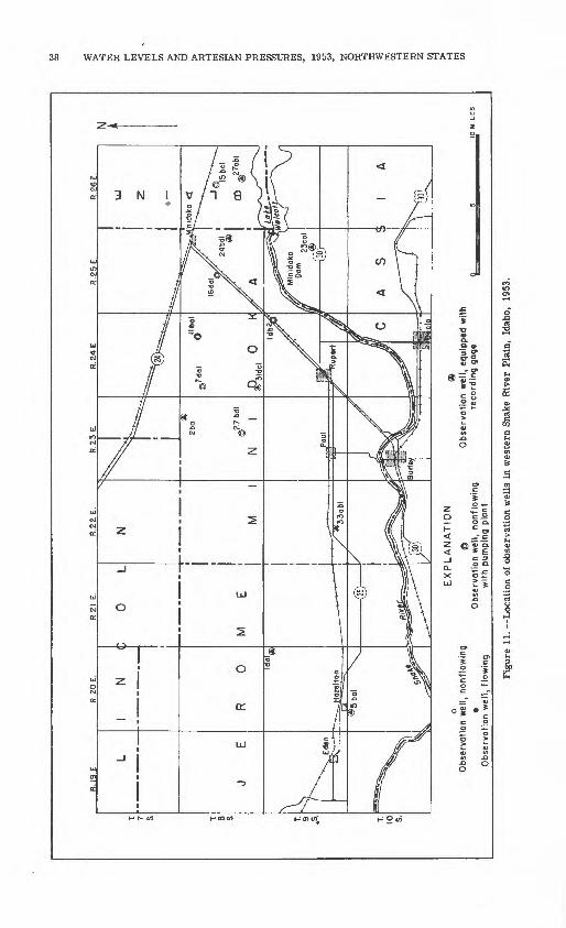
R.2
6E.
EX
PLA
NA
TIO
N
aO
"o
f
Obs
erva
tion
wel
l, no
nflo
win
g @
O
bser
vatio
n w
ell,
equi
pped
with
O
bser
vatio
n w
ell,
nonf
low
ing
reco
rdin
g ga
geO
bser
vatio
n w
ell,
flow
ing
with
pum
ping
pla
nt
Figu
re 1
1. -
-Loc
atio
n of
obs
erva
tion
wel
ls i
n w
este
rn S
nake
Riv
er P
lain
, Id
aho,
19
53.
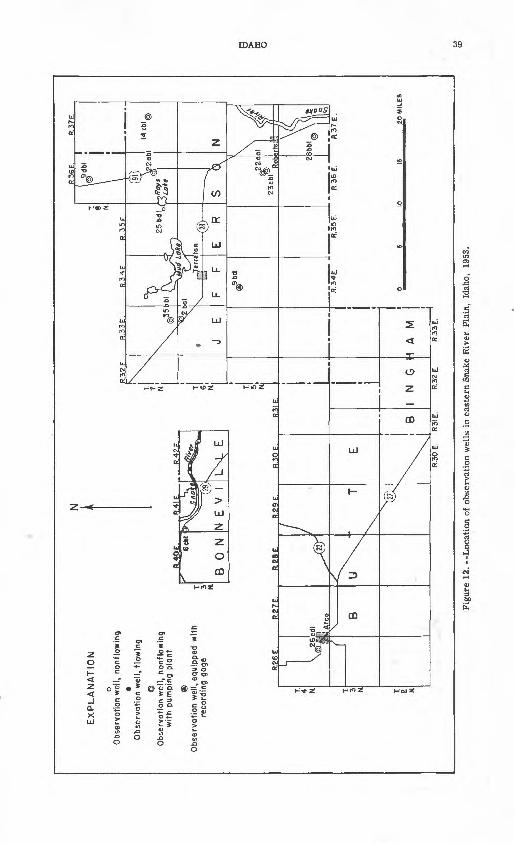
R.3
6E
.__
__
_R
.37
E.
EX
PLA
NA
TIO
N
o O
bser
votio
n w
ell,
nonf
low
ing
O
bser
vatio
n w
ell,
flow
ing
6O
bser
vatio
n w
ell,
nonf
low
ing
with
pum
ping
plo
nt
Obs
erva
tion
wel
l, eq
uipp
ed w
ith
reco
rdin
g go
ge
R.4
0E
. ,,R
-*'P
r R
.42
E
R.?
6£,
R.2
7E
R
.28
E.
R 2
9 E
R
30 E
R
3IF
R.3
0E
. R
3IE
. R
.32
E.
R.3
3E
.
i
I N
G
H
A
M
|
Figu
re 1
2. -
-Loc
atio
n of
obs
erva
tion
wel
ls i
n ea
ster
n Sn
ake
Riv
er P
lain
, Id
aho,
19
53.

EX
PLA
NA
TIO
N
0
N
o31
<""
«6
ob
l
30 c
bl
03l
ael
E
1
35ce
l 36cc
ln
O
0IO
obl
I3db
l@
27oo
l 2
36
bcl
_
35
bd
l*
W
6 bo
l ~
y
6o
c2
"^^^*
0
5
MIL
ES
30a
Obs
erva
tion
(Xbs
erva
tio
Obs
erva
tion
w th
pur
Obs
erva
tion
w
reco
rc
R.
36
F
..1 )
3CV >olo
d
)bol
o f||
32
oo
l. "V
P
32do
l»
\\*
5
oo
4\\
i 'B
aal
22
ob
l.30
abl
* .2
9c«
2
\
IRAF
T RI
VER
VALL
EYI
IMAL
AD V
ALLE
YI
Fig
ure
13. -
-Loc
atio
n of
obs
erva
tion
wel
ls i
n R
aft
Riv
er V
alle
y,
Cas
sia
Cou
nty,
and
Mal
ad V
alle
y,
One
ida
Cou
nty,
Id
aho,
19
53.
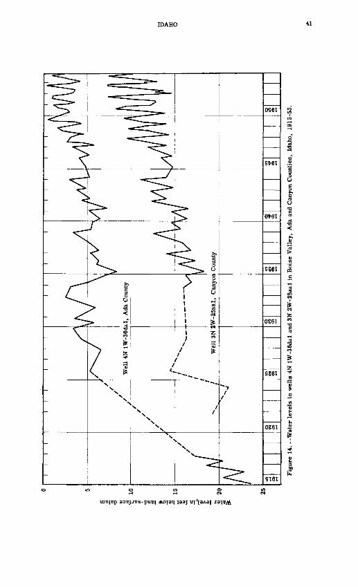
Water level,in feet below land-surface datum
It-OHVOI

42 WATER LEVELS AND ARTESIAN PRESSURES, 1953, NORTHWESTERN STATES
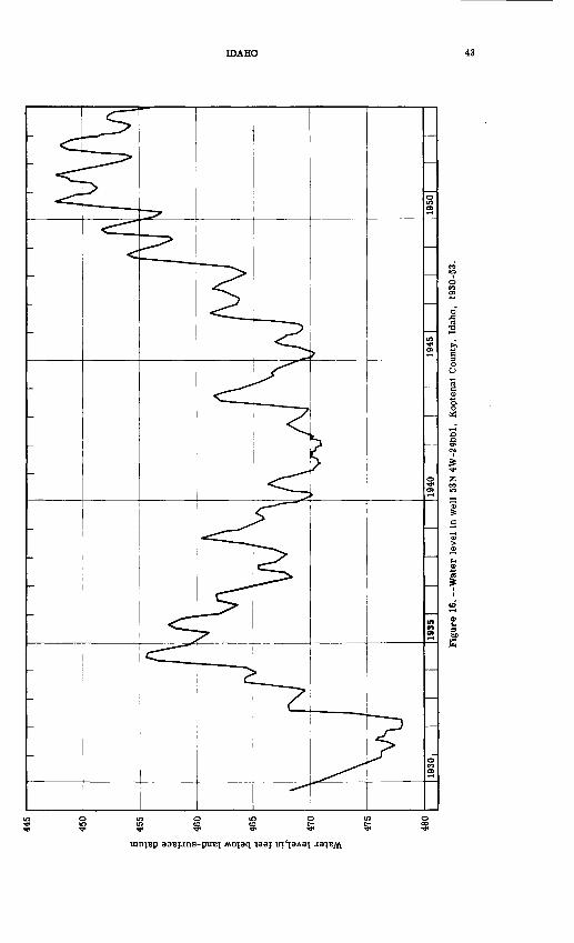
Water level, in feet below land-surface datum
OHVOI

44 WATER LEVELS AND ARTESIAN PRESSURES, 1953, NORTHWESTERN STATES
and in one well a new record low was established. In 11 of the wells water levels were 0. 6 foot to 7. 4 feet above the 1952 year-end levels; in other wells water levels were 0.1 foot to 6.1 feet below the 1952 year-end levels. Precipitation in the Malad Valley was below normal in 1953 and below that of 1952. Differences between wells in net changes of water levels and in departures from average are partly a result of local pumpage and discharge by flowing wells. The wells in this area characteristically reach their highest levels during the period February to April. Water levels in well 5N 34E-9bdl in Jefferson County fluctuate in response to changes in barometric pressure as well as to other factors. Although the barometric efficiency of the well is about 60 percent, the water levels reported have not been adjusted for the effects of barometric pressure. Water-level fluctuations in 1953 in most observation wells with 6 or more years of record are summarized in the following table:
Changes in water levels in observation wells and precipitation in Idaho, 1953
Water levels, in feet
County and
well number
Ada:4N lW-36dal3N 1W- Iccl
lOccl3N IE- 4bal
5aalllbbl
Boise:7N 2E-34cal
Bonneville:3N 4lE-6cbl
Canyon:3N 3W-25aal3N 2W-23dcl
25aal
Cassia:13S 26E-24aal16S 27E-26bal
Jefferson:7N 35E-25bdl
Kootenai:53N 4W-24bbl53N 2W- 3bcl
9aal51N 5W-33bblSON 5W- laal
Latah:39N 5W- 7ddl
lOacl
Oneida:14S 35E-10abl
13dbl27aal35bdl36bcl
14S 36E- Seal29bal32aal32dal
15S 35E- IdalIdbl
12ab212bbl14adl
Net change
+0.054-1.40+ 1.71+1.0-.80
+3.02
+.20
-.10
+.70+.33+.80
-.08-1.50
+.75
-4. TO
-2.7-3.6
-4.48+.46
-.10+.63
-6.14+1 50-1.85+6.95+1.51-.40+.70
+1.70-2.9-2.4-2.3-.6
Departure from
average
+2.87+1.30+1.09+9.02-.68
+3.14
+1.23
-2.39
+.47+.76
+1.55
-1.05-2.22
-.17
+ 10.20+1.36+1.04+5.83+8.37
-17.21-.80
-.02-2.48-3.68-7.35-1.14+2.92
-.78-1.49-.10
-3.94-2.68-1.60-5.44+.81
Precipitation, in inches, at nearest U. S. Weather Bureau Station
Station
Meridian
NampaBoise Airport
Emmett
Ririe
CaldwellNampa
Hamer
Coeur d'Alene RSCoeur d'Alene CAA
Moscow
MaladMalad Airport
Total precipitation
14.12
11.0913.80
17.71
closed
14.1211.09
4.66
24.19closed
24.86
10.588.81
Departure from
normal
+2.44
+3.65+.66
+8.20
+3.91+3.65
-3.14
-.16
+3.16
-4.43+L82
Net depar ture from 1952 total
+3.65+4.58
+7.23
+5.00+3.65
-4.43
+7.72
+10.12
-.40-1.82
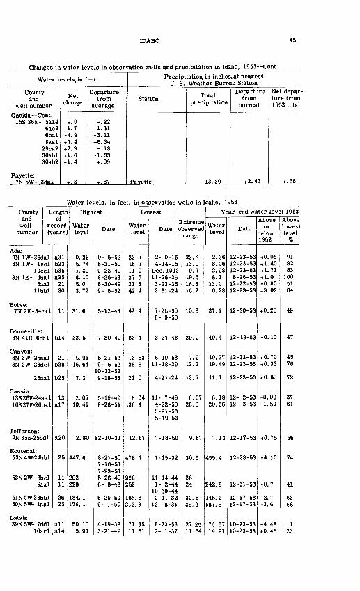
IDAHO 45
Changes in water levels in observation wells and precipitation in Idaho, 1953--Cont.
Water levels, in feet
County and
well number
Oneida Cont.15S 36E- 5aa4
6ac26bal8aal
29ca230abl30ab2
Payette:7N 5W- 3dal
Net change
±.0+1.7-4.9+7.4+2.9+1.6+ 1.4
+.3
Departure from
average
-.22+1.31-3.11+6.34-.18
-1.33+.09-
+.67
Precipitation, in inches, at nearest U. S. Weather Bureau Station
Station
Pavette
Total precipitation
13.30
Departure from
normal
+2.43
Net depar ture from 1952 total
+ .68
Water levels, in feet, in observation wells in Idaho, 1953
County Length and of
well record number (years]
Ada:4N lW-36dal3N 1\V- led
lOccl3N IE- 4bal
5aalllbbl
Boise:7N 2E-34cal
Bonneville:3N 41E-6cbl
Canyon:3N 3W-25aal3N 2W-23dcl
25aal
Cassia:13S 26E-24aal16S 27E-26bal
Jefferson:7N35E-25bdl
Kootenai:53N4W-24bbl
53N2W- 3bcl9aal
51N 5W33bblSON 5W- laal
Latah:39N5W- 7ddl
lOacl
a31b23b35a25
2130
11
b!4
21b28
b25
13a!7
a20
25
1111
2625
alla!4
Highest
Water level
0.285.741.308.105.03.72
31.6
33.5
5.9116.64
7.3
2.0710.41
2.80
447.6
202228
134.1176.1
50.105.97
Date
9- 5-528-31-509-22-498-26-538-30-499- B-52
5-12-43
7-30-49
8-21-539- 5-52
10-12-529-18-53
5-19-498-28-51
12-10-31
8-21-507-16-517-23-515-26-496- 8-48
6-29-509- 1-50
4-19-383-21-49
Lowest
Water level
23.718.711.027.621.342.4
42.4
63.4
13.8328.8
21.0
8.64.36.4
12.67
478.1
228252
166.6212.3
77.3517.61
Extreme Date observed
range
2- 9-154-14-15
Dec. 191311-26-263-23-353-31-24
7-26-508- 9-50
3-27-43
6-19-5311-18-29
4-21-24
11- 7-494-22-503-21-535-19-53
7-18-50
1-15-32
11-14-441- 2-44
10-30-442-11-32
12- 8-31
8-23-532- 1-37
23.413.09.7
19.516.316.2
10.8
29.9
7.912.2
13.7
6.5726.0
9.87
30.5
2624
32.536.2
27.2511.64
Year -end water level 1953
Water level
2.368.062.988.1
13.06.28
37.1
49.4
10.2719.49
11.1
6.1820.56
7.13
455.4
242.8
146.2187.6
76.6714.91
Date
12-23-5312-23-5312-23-538-26-53
12-22-5312-23-53
12-30-53
12-13-53
12-23-5312-23-53
12-23-53
12- 2-5312- 2-53
12-17-53
12-28-53
12-31-53
12-17-5312-17-53
10-23-5310-23-53
Above or
Delow 1952
+0.03+ 1.40+ 1.71+ 1.0-0.80+3.02
+0.20
-0.10
+0.70+0.33
+0.80
-0.08-1.50
+0.75
-4.10
-0.7
-2.7-3.6
-4.48+0.46
Above lowest level
%
918283
1005184
49
47
4576
72
3761
56
74
41
6368
123
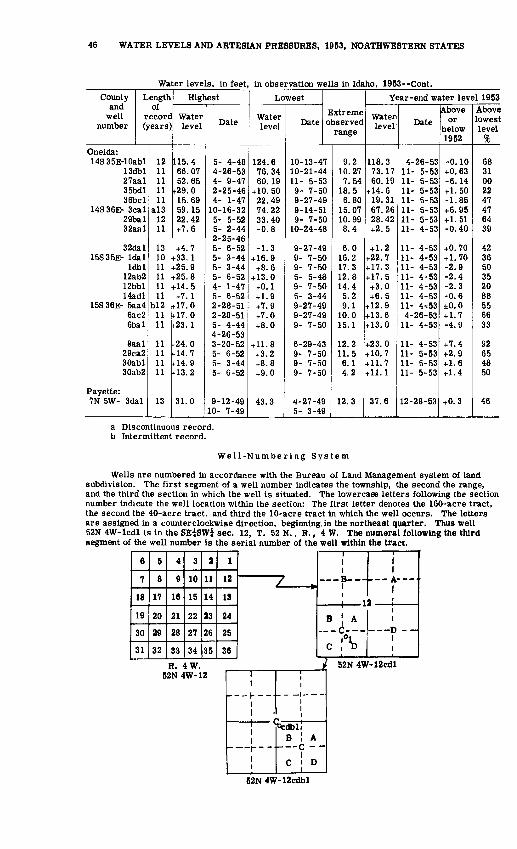
46 WATER LEVELS AND ARTESIAN PRESSURES, 1953, NOOTHWESTERN STATES
Water levels, in feet, in observation wells in Idaho, 1953--Cont.
County and
well number
Oneida:
Length of
recorc (years)
14S35E-10abl13dbl27aal35bdl36bcl
14S36E- Seal29bal32aal
32dal15S35E- Idal
Idbl12ab212bbl14adl
15S36E- 5aa46a c26bal
8aal29ca2SOabl30ab2
Payette:7N 5W- 3dal
1211111111
a!31211
131011111111
b!21111
11111111
13
Highest
Water level
115.466.0752.65
t-29.015.6959.1522.42+7.6
+4.7(-33. 1f25.9f25.8f-14. 5+7. 1
f!7.01-17.0t-23.1
(-24.0(-14.7(-14. 9f-13. 2
31.0
Date
5- 4-484-26-534- 9-472-25-464- 1-47
10-16-325- 5-525- 2-442-25-465- 6-525- 3-445- 3-445- 6-524- 1-475- 6-522-28-512-28-515- 4-444-26-533-20-525- 6-525- 3-445- 6-52
9-12-4910- 7-49
Lowest
Water level
124.676.3460.19
+10.5022.4974.2233.40-0.8
-1.3+ 16.9+8.6
+ 13.0+0.1+ 1.9+7.9+7.0+8.0
+11.8+3.2+8.8+9.0
43.3
DateExtreme observed
range
10-13-4710-21-4411- 5-539- 7-509-27-499-14-519- 7-50
10-24-48
9-27-499- 7-509- 7-505- 5-489- 7-505- 3-449-27-499-27-499- 7-50
6-29-439- 7-509- 7-509- 7-50
4-27-495- 3-49
9.210.277.54
18.56.80
15.0710.998.4
6.016.217.312.814.45.29.1
10.015.1
12.211.56.14.2
12.3
Year-end water level 1953
Water level
118.373.1760.19
+ 14.619.3167.2628.42+2.5
+ 1.2+22.7+ 17.3+ 17.5+3.0+6.5
+ 12.9+ 13.6+ 13.0
+23.0+ 10.7+ 11.7+ 11.1
37.6
Date
4-26-5311- 5-5311- 5-5311- 5-5311- 5-5311- 5-5311- 5-5311- 4-53
11- 4-5311- 4-5311- 4-5311- 4-5311- 4-5311- 4-5311- 4^534-26-53
11- 4-53
11- 4-5311- 5-5311- 5-5311- 5-53
12-28-53
Above or
below 1952
-0.10+0.63-6.14+ 1.50-1.85+6.95+ 1.51-0.40
+0.70+ 1.70-2.9-2.4-2.3-0.6±0.0+ 1.7-4.9
+7.4+2.9+1.6+ 1.4
+0.3
Above lowest level
%
6831002247476439
423650352088556633
92654850
46
a Discontinuous record, b Intermittent record.
Well-Numbering System
Wells are numbered in accordance with the Bureau of Land Management system of land subdivision. The first segment of a well number indicates the township, the second the range, and the third the section in which the well is situated. The lowercase letters following the section number indicate the well location within the section: The first letter denotes the 160-acre tract, the second the 40-acre tract, and third the 10-acre tract in which the well occurs. The letters are assigned in a counterclockwise direction, beginning, in the northeast quarter. Thus well 52N 4W-lcdl is in the SEfSWi sec. 12, T. 52 N., R., 4 W. The numeral following the third segment of the well number is the serial number of the well within the tract.
6
7
18
19
30
31
5
8
17
20
29
32
4
9
16
21
28
33
3
10
15
22
27
34
2
11
14
23
26
35
1
12
13
24
25
36
7 __1
B-
i
1 I
A---'
1
1
i"~o{~~
C \ D
i
1i
R. 4W. ^ 52N4W-12cdl52N 4W-12 1
1>---<- --
1 1
11_ r _ _.
1 i
B A c - -C D
52N 4W-12cdbl

IDAHO, ADA COUNTY 47
Well Descriptions and Water-Level Measurements
(Water levels are in feet below land-surface datum unless otherwise indicated.)
Ada County
4N lW-36dal. Harold Greason. Formerly Richard Foster. Drilled and dug domestic water-table well, diameter 3 inches, reported depth 184 feet, open bottom. Land-surface datum is 2, 584. 5 feet above msl datum of 1935 (preliminary). Water level influenced by local irrigation. Highest water level 0. 28 below Isd, Sept. 5, 1952; lowest 23. 7 below Isd, Feb. 9, 1915. Records available: 1915-17 1925. 1927-53.
Date
Jan. 19 Feb. 19 Mar. 19
Water level
2.84 3.274.19
Date
Apr. 19 May 22 June 19
Water level
4.70 3.50 3.33
Date
July 20 Aug. 21 Sept. 18
Water level
2.52 1.53 1.02
Date
Oct. 23 Nov. 20 Dec. 23
Water level
1.13 2.11 2.36
3N IW-lccl. Jerald Dunten. Drilled stock and domestic water-table well, diameter 3 inches, reported depth 180 feet. Land-surface datum is 2, 583.6 feet above msl datum of 1935 (preliminary). Highest water level 5.74 below Isd, Aug. 31, 1950; lowest 18.7 below Isd, Apr. 14, 1915. Records available: 1913-16. 1925. 1934-35, 1938-53.Jan. 19Feb. 19Mar. 4
19
9.809.68
10.0010.77
Apr. 19May 22June 19July 20
10.868.908.057.43
Aug. 21Sept. 17
18Oct. 20
6.396.506.467.47
Oct. 23Nov. 20Dec. 23
7.529.368.06
3N IW-lOccl. Arthur Keck. Dug domestic water-table well in shallow sediments of Quaternary age, reported depth 18 feet. Land-surface datum is 2, 542. 8 feet above msl datum of 1935 (preliminary). Highest water level 1. 30 below Isd, Sept. 22, 1949; lowest 11.0 below Isd, Dec., 1913. Records available: 1912-17, 1924-25, 1927-53.Jan. 19 Feb. 19 Mar. 19
4.79 4.65 4.78
Apr. 19 May 22 June 19
4.45 2.78 3.64
July 20 Aug. 21 Sept. 18
1.61 2.12 1.94
Oct. 23 Nov. 20 Dec. 23
3.03 4.05 2.98
3N lE-4bal. Ellen F. Beebe. Dug domestic water-table well in sand of Quaternary age, diameter 36 inches, reported depth 50 feet, open bottom. Land-surface datum is 2, 626. 8 feet above msl datum of 1935 (preliminary). Highest water level 8.1 below Isd, Aug. 26, 1953; lowest 27. 6 below Isd, Nov. 26, 1926. Records available: 1926-29, 1933-53. Mar. 9, 17. 6; Aug. 26, 8.1.
3N lE-5aal. J. E. Wingate. Dug domestic water-table well in sand and gravel of Quaternary age, diameter 36 inches, reported depth 60 feet. Land-surface datum is 2,620. 8 feet above msl datum of 1935 (preliminary). Highest water level 5.0 below Isd, Aug. 30, 1949; lowest 21.3 below Isd, Mar. 23, 1935. Records available: 1933-53. Water level ir^luenced by
Jan. 5142127
Feb. 3101724
Mar. 3112431
Apr. 7
12.913.213.413.613.713.913.914.214.514.715.215.515.5
Apr. 142128
May 5121926
June 29162330
July 7
16.015.515.515.314.013.613.213.213.613.613.613.411.1
July 152128
Aug. 4111925
Sept. 18152229
11.710.911.310.410.210.38.28.99.06.67.67.6
Oct. 6132028
Nov. 3101724
Dec. 18
1522
7.67.98.69.49.810.210.712.213.212.913.013.0
3N lE-llbbl. F. M. Wheaton. Dug stock and domestic water-table well in shallow gravel, reported depth 80 feet. Land-surface datum is 2, 664.6 feet above msl datum of 1935 (preliminary). Water level influenced by local irrigation. Highest water level 3. 72 below Isd, Sept. 5, 1952;
31, 1924.Jan. 19 Feb. 19 Mar. 19
8.70 9.69
10.56
Apr. 19 May 22 June 19
10.59 6.58 7.48
July 20 Aug. 21 Sept. 18
4.41 4.42 4.11
Oct. 23 Nov. 20 Dec. 23
5.96 8.07 6.28
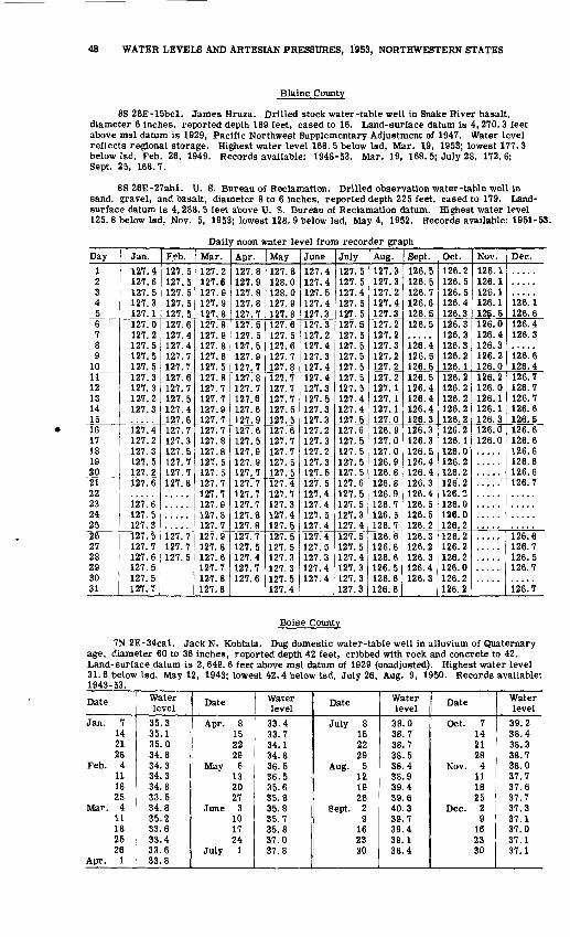
48 WATER LEVELS AND ARTESIAN PRESSURES, 1953, NORTHWESTERN STATES
Blaine County
8S 26E-15bcl. James Hruza. Drilled stock water-table well in Snake River basalt, diameter 6 inches, reported depth 189 feet, cased to 16. Land-surface datum is 4, 270. 3 feet above msl datum is 1929, Pacific Northwest Supplementary Adjustment of 1947. Water level reflects regional storage. Highest water level 168. 5 below Isd, Mar. 19, 1953; lowest 177. 3 below Isd, Feb. 26, 1949. Records available: 1948-53. Mar. 19, 168. 5; July 28, 172.6; Sept. 25, 168.7.
8S 26E-27abl. U. S. Bureau of Reclamation. Drilled observation water-table well in sand, gravel, and basalt, diameter 8 to 6 inches, reported depth 225 feet, cased to 179. Land- surface datum is 4, 288. 5 feet above U. S. Bureau of Reclamation datum. Highest water level 125. 8 below Isd, Nov. 5, 1953; lowest 128. 9 below Isd, May 4, 1952. Records available: 1951-53.
Daily noon water level from recorder graphDay
1 2 34 56 7 8 9
1011 12 13 14 1516 17 18 19 2021 22 23 24 2526 27 28 29 3031
Jan.
127.4 127.6 127.5 127.3 127.1127.0 127.2 127.5 127.5 127.5127.3 127.3 127.2 127.3
127.4 127.2 127.3 127.5 127.2127.6
127.6 127.5 127.3127.5 127.7 127.6 127.5 127.5127.7
Feb.127.5 127.5 127.5 127.5 127.5127.6 127.4 127.4 127.7 127.7127.6 127.7 127.5 127.4 127.6127.7 127.3 127.5 127.7 127.7127.8
127.7 127.7 127.5
Mar.
127.2 127.6 127.9 127.9 127.8127.8 127.9 127.8 127.6 127.5127.8 127.7 127.7 127.9 127.7127.7 127.8 127.8 127.5 127.5127.7 127.7 127.9 127.8 127.7127.9 127.8 127.6 127.7 127.8127.8
Apr.
127.8 127.9 127.8 127.8 127.7127.5 127.5 127.5 127.9 127.7127.8 127.7 127.6 127.6 127.9127.6 127.5 127.9 127.9 127.7127.7 127.7 127.7 127.8 127.8127.7 127.5 127.4 127.7 127.6
May
127.8 128.0 128.0 127.9 127.8127.6 127.5 127.6 127.7 127.8127.7 127.7 127.7 127.5 127.5127.6 127.7 127.7 127.5 127.5127.4 127.7 127.3 127.4 127.5127.5 127.5 127.3 127.31 97 ^
127.4
June
127.4 127.4 127.5 127.4 127.3127.3 127.2 127.4 127.3 127.4127.4 127.3 127.5 127.3 127.3127.2 127.3 127.2 127.3127.5127.5 127.4 127.4 127.5 127.4127.4 127.5 127.3 127.4 127.4
July
127.5 127.5 127.4 127.5 127.5127.5 127.5 127.5 127.5 127.5127.5 127.5 127.4 127.4 127.5127.6 127.5 127.5 127.5 127.5127.6 127.5 127.5 127.3 127.4127.5 127.5 127.4 127.3 127.3127.3
Aug.
127.3 127.3 127.2 127.4 127.3127.2 127.2 127.3 127.2127.2127.2 127.1 127.1 127.1 127.0126.9 127.0 127.0 126.9 126.8126.8 126.9 126.7 126.5 126.7126.6 126.6 126.6 126.5 126.6126.6
Sept.
126.5 126.5 126.7 126.6 126.5126.5
126! 4 126.5 126.5126.5 126.4 126.4 126.4 126.3126.3 126.3 126.5 126.4 126.4126.3 126.4 126.5 126.5 126.2126.3 126.2 126.3 126.4 126.3
Oct.
126.2 126.5 126.5 126.4 126.3126.3 126.3 126.3 126.2 126.1126.2 126.2 126.2 126.2 126.2126.2 126. 1 126.0 126.2 126.2126.2 126.2 126.0 126.0 126.2126.2 126.2 126.2 126.0 126.2126.2
Nov.
126.1 126.1 126.1 126.1 125.8126.0 126.4 126.3 126.2 126.0126.2 126.0 126.1 126.1 126.3126.0 126.0
Dec.
126. 1 126.6126.4 126.3
i2e!e126.4126.7 126.7 126.7 126.6 126.5126.6 126.6 126.6 126.6 126.6126.7
126.6 126.7 126.5 126.7
126.7
Boise County
7N 2E-34cal. Jack N. Kohtala. Dug domestic water-table well in alluvium of Quaternary age, diameter 60 to 36 inches, reported depth 42 feet, cribbed with rock and concrete to 42. Land-surface datum is 2, 649. 6 feet above msl datum of 1929 (unadjusted). Highest water level 31.6 below Isd, May 12, 1943; lowest 42. 4 below Isd, July 26, Aug. 9, 1950. Records available: 1943-53.
Date
Jan. 7142128
Feb. 4111825
Mar. 411182526
Apr. 1
Waterlevel
35.335.135.034.834.334.334.833.534.835.233.633.433.633.8
Date
Apr. 8152229
May 6132027
June 3101724
July 1
Water level
33.433.734.134.836.536.535.635.835.835.735.837.037.8
Date
July 8152229
Aug. 5121926
Sept. 29
162330
Water level
38.038.738.738.538.438.939.439.640.339.739.439.138.4
Date
Oct. 7142128
Nov. 4111825
Dec. 29
162330
Water level
39.238.438.338.738.037.737.637.737.337.137.037.137.1

IDAHO, CANYON COUNTY 49
Bonneville County
3N 41E-6cbl. Poplar Store. Dug domestic water-table well in gravel of Quaternary age, reported depth 86 feet. Land-surface datum is 5,024.6 feet above msl datum of 1929 (preliminary). Water level influenced by local irrigation. Highest water level 33. 5 below Isd, July 30, 1949;
Date
Jan. 42431
Feb. 9142228
Mar. 7152128
Water level
49.551.351.952.653.753.854.355.155.656.156.4
Date
Apr. 5111826
May 3101623
June 71420
Water level
56.656.757.056.956.556.555.554.151.650.148.1
Date
June 27July 6
111925
Aug. 18
152229
Waterlevel
45.142.942.441.340.539.338.938.137.537.2
Date
Sept. 19Oct. 18
2531
Nov. 82128
Dec. 131928
Water level
37.439.840.941.742.844.545.447.648.349.4
Butte County
4N 26E-26cdl. Inland Brick Co. Drilled industrial and domestic water-table well in sand of Quaternary age, diameter 8 inches, depth 143 feet, cased to 143. Land-surface datum is 5, 332. 2 feet above nisi datum of 1929 (preliminary). Highest water level 37.17 below Isd, Aug. 5, 1952; lowest 41. 35 below Isd, Mar. 8, 1951. Records available^ 1949-53. __Jan. 6Feb. 14Mar. 20Apr. 6
132129
May 4
38.7938.9939.5239.3539.4939.6539.6139.84
May 131825
June 313162229
39.7639.8039.6439.4839.4139.1838.6138.45
July 6162028
Aug. 31017
38.2338.0538.0237.9537.8237.8437.81
Aug. 24Sept. 11
1421
Oct. 7Nov. 24Dec. 16
37.7438.0438. 1038.1538.2738.7638.95
Canyon County
3N 3W-25aal. Charles Imberg. Drilled unused water-table well, diameter 6 inches, reported depth 145 feet. Land-surface datum is 2, 461.8 feet above msl datum of 1929, Pacific Northwest Supplementary Adjustment of 1947. Highest water level 5. 91 below Isd, Aug. 21, 1953; lowest 13. 83 below Isd, June 19, 1953. Records available: 1933-53.Feb. 19 Mar. 19 Apr. 19
10.90 12.16 12.52
May 22 June 19
12.23 13.83
July 20 Aug. 21
10.15 II Oct. 23 5.91 Dec. 23
11.62 10.27
3N 2W-23dcl. Mrs: A. J. Richards and others. Drilled stock and domestic water-table well, diameter 6 inches, reported depth 132 feet. Land-surface datum is 2, 511.8 feet above msl datum of 1929, Pacific Northwest Supplementary Adjustment of 1947. Highest water level 16. 64 below l£d, Sept. 5, Oct. 12, 1952; lowest 28. 8 below Isd, Nov. 18, 1929. Records available: 1921, 1925, 1928-53.Jan. 19 Feb. 19 Mar. 19
20.30 21.30 21.55
Apr. 19 May 22 June 19
21.82 19.53 19.17
July 20 Aug. 21 Sept. 18
19.12 17.94 16.92
Oct. 23 Nov. 20 Dec. 23
17.17 18.66 19.49
3N 2W-25aal. John Hubbard. Drilled stock and domestic water-table well in alluvium of Quaternary age, diam eter 6 inches, reported depth 34 feet, cased to 34, open bottom. Land- surface datum is 2, 525. 6 feet above msl datum of 1929, Pacific Northwest Supplementary Adjust ment of 1947. Highest water level 7. 3 below Isd, Sept. 18, 1953; lowest 21. 0 below Isd, Apr. 21, 1924. Records available: 1921, 1924-25, 1928, 1933-53.Jan. 19 Feb. 19 Mar. 19
11.8 11.5 13.0
Apr. 19 May 22 June 19
12.9 11.2 10.9
July 20 Aug. 21 Sept. 18
9.6 Oct. 238.2 Nov. 20 7.3 || Dec. 23
7.8 9.7
11.1
2N 2W-13bal. Jennings. Drilled unused water-table well in basalt and sand, diameter 6 inches, depth 93 feet, cased to 21. Land-surface datum is 2, 583. 7 feet above msl datum of 1929, Pacific Northwest Supplementary Adjustment of 1947. Highest water level 48. 37 below Isd, Sept. 10, 1948; lowest 57. 04 below Isd, Mar. 1, 1949. Records available: 1948-53.Jan. 19 Feb. 19 Mar. 19
50.33 54.76 54.35
May 22 June 19 Aug. 21
49.48 49.22 48.78
Sept. 18 Oct. 23
49.35 50.54
Nov. 20 Dec. 23
52.21 51.33
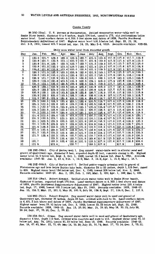
50 WATER LEVELS AND ARTESIAN PRESSURES, 1953, NORTHWESTERN STATES
Cassia County
9S 25E-23cal. U. S. Bureau of Reclamation. Drilled observation water-table well in Snake River basalt, diameter 8 to 6 inches, depth 174 feet, cased to 172, slot perforations below water level. Land-surface datum is 4, 266. 9 feet above msl datum of 1929, Pacific Northwest Supplementary Adjustment of 1947. Highest water level 116. 5 below Isd, Sept. 23, 25, 28, Oct. 1-3, 1951; lowest 123. 7 below Isd, Apr. 24, 25, May 2-4, 1953. Records available: 1951-53.
Daily noon water level from recorder graph
Day
1 2 3 4 56 7 8 9
1011 12 13 14 1516 17 18 19 2021 22 23 24 2526 27 28 29 30 31
Jan.
120.6 120.8 120.8 120.8 120,6120.5 120.6 120.9 120.9 121.0120.9 120.9 120.9 120.9 121.2121.2 121.1 121.1 121.3 121.2121.4 121.5121.5 121. 5 121.4121.5 121.7 121.7
121. 7 121.8
Feb.
121.7 121.7 121.8 121.8 121.8121.9 121.9 121.7 122.0 122.1122.1 122.2 122.1 122.2 122.2122.3 122.3 122.2 122.3 122.5122.6 122.5 122.5 122.5122.6122.6 122.6 122.4
Mar.
122.3 122.5 122.7 122.9 122.8122.9 123.0 122.9 122.8 122.9122.9 122.9 122.9 123.0 122.9122,9 123.0 123.0 122.9 122.9123.0 123.1 123.3 123.2 123.2123.3 123.3 123.2 123.3 123.3 123.4
Apr.
123.4 123.5 123.5 123.5 123.4123.3 123.3 123.3 123.5 123.5123.5 123.5 123.5 123.5 123.6123.4 123.4 123.6 123.3 123.6123.5 123.5 123.6 123.7 123.7123.6 123.4 123.4 123.4 123.4
May
123.5 123.7 123.7 123.7 123.6123.5 123.4 123.3 123.3 123.4123.4 123.4 123.3 123.2 123.1123.1 123.2 123.2 123.0 123.0123.0 123.1 122.9 122.9 122.9122.9 122.9 122.7 122.7 122.8 122.7
June
122.7 122.7 122.7 122.7 122.6122.6 122.5 122.6 122.5 122.6122. 8 122.5 122.6 122.4 122.4122.4 122.3 122.1 122.1 122.1122.1 122.0 121.9 121.9 121.8121.7 121.7 121.5 121.6 121.5
July
121.5 121.5 121.3 121.3 121.3121.3 121.2 121.1 121.1 121.0120.9 120.8 120.7 120.6 120.6120.5 120.5 120.4 120.3 120.2120.2 120.1 120.0 119.9 119.9119.8 119.8 119.7 119.6 119.5 119.5
Aug.
119.4 119.4 119.3 119.3 119.2119.1 119.1 119.1 119.0 119.0119.0 118.9 118.9 118.8 118.7118.7 118.6 118.6 118.5 118.4118.4 118.4 118.2 118.1 118.1118.1 118.1 118.0 117.9 117.9 117.9
Sept.
117.9 117.9 117.9 117.9 117.9117.8 117.8 117.8 117.8 117.7117.7 117.7 117.6 117.5 117.5117.4 117.5 117.6 117.5 117.5117.4 117.5 117.6 117.6 117.4117.5 117.4 117.4 117.5 117.4
Oct.
117.4 117.5 117.7 117.6 117.5117.5 117.5 117.5 117.5 117.4117.4 117.5 117.5 117.5 117.5117.5 117.4 117.3 117.4 117.4117.5 117.5 117.4 117.4 117.6117.6 117.7 117.6 117.6 117.7 117.8
Nov.
117.7 117.8 117.8 117.8 117.6117.8 118.1 118.1 118.1 118.0118.1 118.1 118.1 118.1 118.3118.2 118.2 118.3 118.5 118.4118.5 118.5 118.6 118.7 118.8118.8 118.8 119.0 119.0 118.8
Dec.
118.9 119.0 119.0 118.9 119.2119.1 119.2 119.5 119.5 119.4119.6 119.7 119.8 119.7 119.8119.8 119.9 119.9 119.9 119.9120.1 120.3 120.3 120.3 120.4120.3 120.3 120.3 120.4 120.6 120.5
10S 23E-20dcl. City of Burley well 1. Dug unused water-table well in alluvial sand and gravel of Quaternary age, diameter 6 feet, reported depth 42 feet, concrete casing to 42. Highest water level 10. 9 below Isd, Sept. 2, Oct. 1, 1952; lowest 19. 2 below Isd, June 4, 1951. Records available: 1947-53. Jan. 2, 13.4; Feb. 1, 14.0; Mar. 2, 14.0; Apr. 1, 15.9; May 1, 16.7.
10S 23E-20dc3. City of Burley well 5. Drilled public-supply artesian well in gravel of Pleistocene age and lava below Burley lake beds, diameter 24 to 15 inches, depth 1,115 feet, cased to 469. Highest water level 184 below Isd, Dec. 1, 1948; lowest 209 below Isd, Nov. 2, 1948. Records available: 1947-53. Jan. 2, 189; Feb. 1, 189; Mar. 2, 189; Apr. 1, 189; May 1, 189.
10S 25E-10bal. Robert Simplot. Drilled stock water-table well in Snake River basalt, diameter 6 inches, reported depth 175 feet. Land-surface datum is 4, 303.1 feet above msl datum of 1929, Pacific Northwest Supplementary Adjustment of 1947. Highest water level 153. 4 below Isd, Sept. 17, 1948; lowest 165. 2 below Isd, May 19, 1949. Records available: 1928, 1948-53. Jan. 15, 158. 3; Mar. 21, 161.0; May 18, 160. 5; July 29, 158. 9; Sept. 27, 154.6; Dec. 2, 157.9.
US 26E-26ccl. Robert Simplot. Dug unused water-table well in sand and gravel of Quaternary age, diameter 36 inches, depth 33 feet, cribbed with rock to 33. Land-surface datum is 4, 401. 2 feet above msl datum of 1929, Pacific Northwest Supplementary Adjustment of 1947. Highest water level 29.12 below Isd, Dec. 2, 1953; lowest 32. 22 below Isd, Sept. 25, 1948. Records available: 1928, 1948-53. Jan. 15, 29. 86; Mar. 21, 29. 83; May 18, 30.13; July 29, 29. 64; Sept. 27, 29. 36; Dec. 2, 29.12.
13S 22E-9dcl. Crane. Dug unused water-table well in sand and gravel of Quaternary age, diameter 4 feet, depth 112 feet, cribbed with concrete and rock to 112. Highest water level 63.10 below Isd, Aug. 28, 1951; lowest 81. 33 below Isd, June 10, 1949. Records available: 1948-53. Jan. 15, 67.45; Mar. 22, 71.49; May 14, 75.18; July 29, 70.74; Sept. 27, 73.14; Dec. 2, 73.21.

IDAHO, GEM COUNTY 51
13S 26E-24aal. John C. Hitt. Dug irrigation water-table well in alluvial gravel of Quaternary age. diameter 36 to 8 inches, depth 24 feet, corrugated iron casing to 24, perforations below water level. Land-surface datum is 4, 528.1 feet above msl datum of 1929, Pacific North west Supplementary Adjustment of 1947. Highest water level 2. 07 below Isd, May 19, 1949; lowest 8. 64 below Isd, Nov. 7, 1949. Records available: 1941-53. Jan. 15, 5. 78; Mar. 21, 5. 37; May 18, 3. 56; July 29, 4. 60; Sept. 27, 5. 48; Dec. 2, 6.18.
13S 27E-30bdl. A. D. Pierce. Dug irrigation water-table well in alluvial gravel of Quaternary age, diameter 6 feet, depth 27 feet, concrete casing to 27, perforations below water level. Land-surface datum is 4 541. 6 feet above msl datum of 1929, Pacific Northwest Supplementary Adjustment of 1947. Highest water level 3. 54 below Isd, June 8, 1949; lowest 7. 87 below Isd, July 1, 1948. Records available: 1947-53. Jan. 15, 5.07; Mar *?1, 5.00; May 18, 4.48; July 29, 12.43, pumping; Sept. 27, 13.74, pumping; Dec. 2, 5.83.
14S 27E-33cal. Harold Oman. Drilled irrigation water-table well, diameter 12 inches, reported depth 265 feet. Land-surface datum is 4, 690. 6 feet above msl datum of 1929, Pacific Northwest Supplementary Adjustment of 1947. Highest water level 15. 50 below Isd, May 19, 1953; lowest 21.60 below Isd, Sept. 10, 1948. Records available: 1948-53. Jan. 15, 20.72; Mar. 21, 15. 68; May 19, 15. 50; July 29, 16. 63; Sept. 27, 18. 00; Dec. 2, 19. 27.
15S 24E-26bcl. Wallace Taylor. Unused water-table well in alluvial gravel of Quaternary age, size 36 by 48 inches, depth 36 feet. Land-surface datum is 5, 327.4 feet above msl datum of 1929, Pacific Northwest Supplementary Adjustment of 1947. Highest water level 27.65 below Isd, June 27, 1951; lowest dry at 36 below Isd, Nov. 7, 1949. Records available: 1948-53. Jan. 15, 34.30. Measurement discontinued.
15S 25E-6abl. Jenny Wake. Dug domestic water-table well in alluvial gravel of Quaternary age, diameter 6 inches, depth 34 feet, cased to 34 with back-fill around casing. Land- surface datum is 5, 503. 7 feet above msl datum of 1929, Pacific Northwest Supplementary Adjust ment of 1947. Highest water level 13. 57 below Isd, June 27, 1951; lowest 31.09 below Isd, Mar. 21, 1950. Records available: 1948-53. Jan. 15, 28.75; Mar. 21, 29.99, May 19, 27.71; July 29, 14. 61; Sept. 27, 17. 87; Dec. 2, 26.53.
16S 27E-26bal. Cook. Dug stock water-table well in alluvium of Quaternary age, diameter 60 to 24 inches, depth 36 feet, cribbed with wood to 36. Land-surface datum is 5, 294. 0 feet above msl datum of 1929, Pacific Northwest Supplementary Adjustment of 1947. Highest water level 10.41 below Isd, Aug. 28, 1951; lowest dry at 36. 4 below Isd, Apr. 22, 1950; Mar. 21, May 19, 1953. Records available: 1936, 1938-53. Jan. 15, 29. 08; Jan. 28, 31. 79; Mar. 21, dry; May 19, dry; July 29, 14.76; Sept. 27, 12.90; Dec. 2, 20.56.
Elmore County
IN 4E-23aal. James O. 3ecK. Drilled irrigation water-table well in alluvial sand of Quaternary age, diameter 18 inches, depth 64 feet, cased to 64, perforated and gravel packed below water table. Highest water level 23.10 below Isd, Feb. 28, 1947; lowest 29. 08 below Isd, Jan. 24, 1950. Records available: 1947-51. No measurement made in 1953.
Gem County
7N 2W-35abl. R. J. Howard. Dug domestic water-table well in alluvial sand and gravel, diameter 36 inches, depth 99 feet, concrete casing. Water level influenced by local irrigation. Highest water level 67. 6 below Isd, Nov. 3, 1941; lowest 80. 5 below Isd, May 3, 1949. Records available: 1941-42, 1948-53.
Date
Jan. 61327
Feb. 101724
Mar. 3171924
Apr. 7
Water level
75.075.275.676.176.576.777.177.877.877.978.6
Date
Apr. 1430
May 5121926
June 92330
July 714
Water level
78.979.779.980.180.079.680.280.179.779.580.0
Date
July 2128
Aug. 41118
Sept. 8152229
Oct. 613
Water level
79.879.579.379.178.877.877.577.176.576.275.8
Date
Oct. 2027
Nov. 3101724
Dec. 18
1522
Water level
75.575.475.074.674.173.573.272.773.374.5
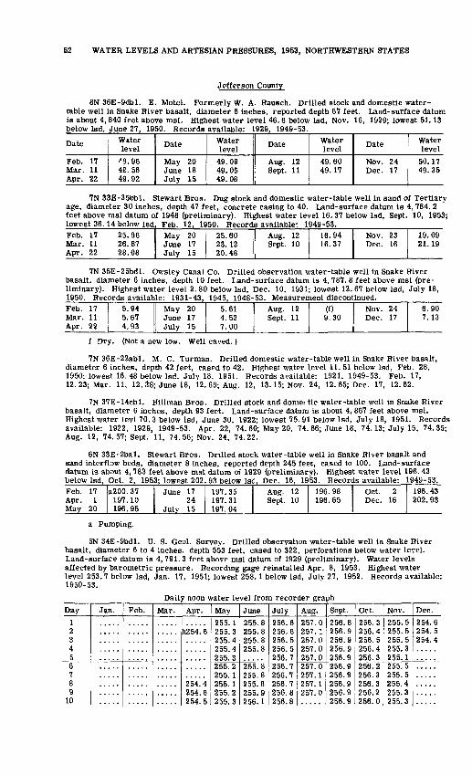
52 WATER LEVELS AND ARTESIAN PRESSURES, 1953, NORTHWESTERN STATES
Jefferson County
8N 36E-9dbl. E. Motel. Formerly W. A. Rausch. Drilled stock and domestic water- table well in Snake River basalt, diameter 6 inches, reported depth 67 feet. Land-surface datum is about 4, 840 feet above msl. Highest water level 46.6 below Isd, Nov. 16, 1929; lowest 51.13 below Isd, June 27, 1950. Records available: 1929, 1949-53.
Date
Feb. 17 Mar. 11 Apr. 22
Waterlevel
'8.96 49.56 49.92
Date
May 20 June 18 July 15
Water level
49.09 49.05 49.08
Date
Aug. 12 Sept. 11
Water level
49.60 49.17
Date
Nov. 24 Dec. 17
Water level
50.17 49.35
7N 33E-35bbl. Stewart Bros. Dug stock and domestic water-table well in sand of Tertiary age, diameter 30 inches, depth 47 feet, concrete casing to 40. Land-surface datum is 4, 784. 2 feet above msl datum of 1948 (preliminary). Highest water level 16. 37 below Isd, Sept. 10, 1953; lowest 36.14 below Isd, Feb. 12, 1950. Records available: 1949-53.Feb.Mar.Apr.
171122
25.9626.8728.08
MayJuneJuly
201715
25.6023.1220.48 I Aug.
Sept.1210
16.9416.37
Nov.Dec.
2316
19.0921.19
7N 35E-25bdl. Owsley Canal Co. Drilled observation water-table well in Snake River basalt, diameter 6 inches, depth 10 feet. Land-surface datum is 4, 787. 8 feet above msl (pre liminary). Highest water level 2.80 below Isd, Dec. 10, 1931; lowest 12.67 below Isd, July 18, 1950. Records available: 1931-43, 1945, 1948-53. Measurement discontinued.Feb. 17 Mar. 11 Apr. 22
5.94 5.67 4.93
May 20 June 17 July 15
5.61 4.52 7.00
Aug. 12 Sept. 11 9.30
Nov. 24 Dec. 17
6.90 7.13
f Dry. (Not a new low. Well caved.)
7N 36E-22abl. M. C. Turman. Drilled domestic water-table well in Snake River basalt, diameter 6 inches, depth 42 feet, cased to 42. Highest water level 11. 51 below Isd, Feb. 28, 1950; lowest 16. 48 below Isd, July 18, 1951. Records available: 1921, 1949-53. Feb. 17, 12. 23; Mar. 11, 12.1*8; June 18, 12. 69; Aug. 12, 13. 15; Nov. 24, 12. 65; Dec. 17, 12.62.
7N 37E-14cbl. HilLman Bros. Drilled stock and dome: tic water-table well in Snake River basalt, diameter 6 inches, depth 93 feet. Land-surface datum is about 4, 867 feet above msl. Highest water levl 70. 3 below Isd, June 30, 1922; lowest 75. 91 below Isd, July 18, 1951. Records available: 1922, 1929, 1949-53. Apr. 22, 74. 60; May 20, 74. 66; June 18, 74.13; July 15, 74.35; Aug. 12, 74. 57; Sept. 11, 74. 56; Nov. 24, 74.22.
6N 33E-2bal. Stewart Bros. Drilled stock water-table well in Snake River basalt and sand interflow beds, diameter 8 inches, reported depth 245 feet, cased to 100. Land-surface datum is about 4, 783 feet above msl datum of 1929 (preliminary). Highest water level 196. 43 below Isd, Oct. 2, 1953; lowest 202. 93 below Isd, Dec. 16, 1953. Records available: 1949-53.Feb. 17 Apr. 1 May 20
a200. 37 197.10 196.95
June 17 24
July 15
197.35 197.31 197.04
Aug. 12 Sept. 10
196.98 [I Oct. 2 196.65 Dec. 16
196.43 202.93
a Pumping.
5N 34E-9bdl. U. S. Geol. Survey. Drilled observation water-table well in Snake River basalt, diameter 6 to 4 inches, depth 553 feet, cased to 322, perforations below water level. Land-surface datum is 4, 791. 3 feet above msl datum of 1929 (preliminary). Water levels affected by barometric pressure. Recording gage reinstalled Apr. 8, 1953. Highest water level 253.7 below Isd, Jan. 17, 1951; lowest 258.1 below Isd, July 27, 1952. Records available: 1950-53.
Daily noon water level from recorder graph
Day
12345678 9
10
Jan. Feb. Mar. Apr.
h254. 6
254.4 254.6 254.5
May
255. 1255.3255.4255.4 255.3255.2OCC 1
255.1 255.2 255.3
June
255.8255.8255.8255.8
255.8 255.8255.8 255.9 256.1
July
256.6256.6256.5256.5 256.7256.7 256.7256.7 256.8 256.8
Aug.
257.0257. 1257.0257.0 257.0257.0 257.1257.1 257.0
Sept.
256.8256.9256.9256.9 256.9256.9 256.9256.9 256.9 256.9
Oct.
256.3256.4256.5256.4 256.3256.2 256.3256.3 256.2 256.0
Nov.
255.5255.5255.5255.3 255.1255.5 255.5255.4 255.3 255.3
Dec.
254.6254.5254.4
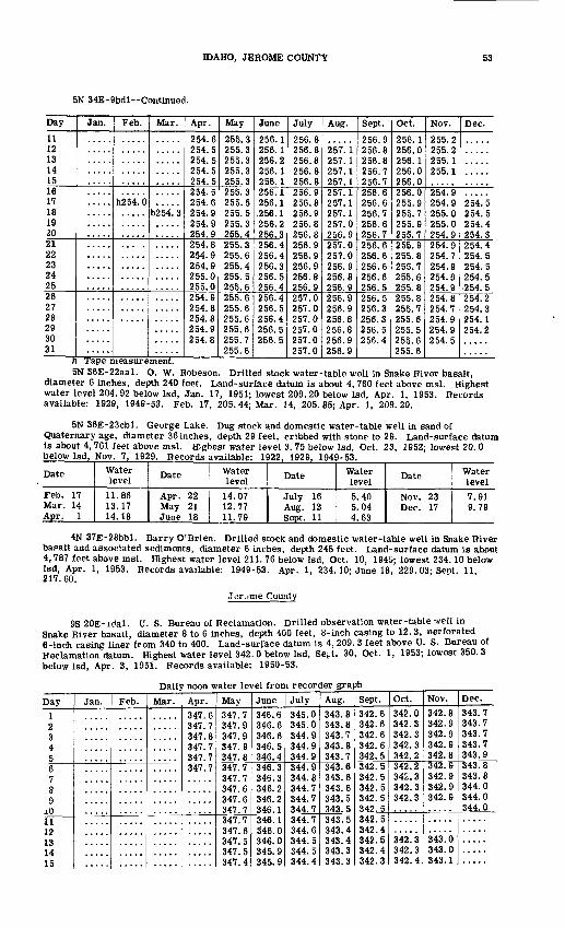
IDAHO, JEROME COUNTY 53
5N 34E-9bdl--Continued.
Day
11 12 13 14 1516 17 18 19 2021 22 23 24 2526 27 28 29 30 31
Jan. Feb.
h254. 0
Mar.
h254. 3
Apr.
254.6 254.5 254.5 254.5 254.5254.5 254.6 254.9 254.9 254.9254.8 254.9 254.9 255.0 255.0254.9 254.8 254.8 254.9 254.8
May
255.3 255.3 255.3 255.3 255.3255.3 255.5 255.5 255.3 255.4255.3 255.6 255.4 255.5 255.6255.6 255.6 255.6 255.6 255.7 255.6
June
256.1 256.1 256.2 256.1 256.1256.1 256.1 .256. 1 256.2 256.3256.4 256.4 256.3 256.5 256.4256.4 256.5 256.4 256.5 256.5
h Tape measurement.
July
256.8 256.8 256.8 256.8 256.8256.9 256.8 256.9 256.8 256.8256.9 256.9 256.9 256.8 256.9257.0 257.0 257.0 257.0 257.0 257.0
Aug.
257.1 257.1 257.1 257.1257.1 257.1 257.1 257.0 256.9257.0 257.0 256.9 256.8 256.9256.9 256.9 256.8 256.8 256.9 256.9
Sept.
256.9 256.8 256.8 256.7 256.7256.6 256.6 256.7 256.6 256.7256.6 256.6 256.6 256.6 256.5256.5 256.3 256.3 256.5 256.4
Oct.
256.1 256.0 256.1 256.0 256.0256.0 255.9 255.7 255.9 255.7255.9 255.8 255.7 255.6 255.8255.8 255.7 255.6 255.5 255.6 255.6
Nov.
255.2 255.2 255.1 255.1
254.9 254.9 255.0 255.0 254.9254.9 254.7 254.9 254.9 254.9254.8 254.7 254.9 254.9 254.5
Dec.
254.5 254.5 254.4 254.3254.4 254.5 254.5 254.5
254.5254.2 254.3 254.1254.2
5N 36E-22aal. O. W. Robeson. Drilled stock water-table well in Snake River basalt, diameter 6 inches, depth 240 feet. Land-surface datum is about 4, 760 feet above msl. Highest water level 204. 92 below Isd, Jan. 17, 1951; lowest 209. 20 below Isd, Apr. 1, 1953. Records available: 1929, 1949-53. Feb. 17, 205.44; Mar. 14, 205. 85; Apr. 1, 209.20.
5N 36E-23cbl. George Lake. Dug stock and domestic water-table well in sand of Quaternary age, diameter 36 inches, depth 29 feet, cribbed with stone to 29. Land-surface datum is about 4,761 feet above msl. Highest water Level 3. 75 below Isd, Oct. 23, 1952; lowest 20. 0 below Isd, Nov. 7, 1929. Records available: 1922, 1929, 1949-53.
Date
Feb. 17 Mar. 14 Apr. 1
Water level11.86 13.17 14.18
Date
Apr. 22 May 21 June 18
Water level
14.07 12.77 11.79
Date
July 16 Aug. 13 Sept. 11
Water level5.40 5.04 4.63
Date
Nov. 23 Dec. 17
Water level7.91 9.79
4N 37E-28bbl. Barry O'Brien. Drilled stock and domestic water-table well in Snake River bapalt and associated sediments, diameter 6 inches, depth 245 feet. Land-surface datum is about 4,787 feet above msl. Highest water level 211. 76 below Isd, Oct. 10, 194G; lowest 234.10 below Isd, Apr. 1, 1953. Records available: 1949-53. Apr. 1, 234.10; June 18, 229.03; Sept. 11, 217.60.
Jerome County
9S 20E-idal. U. S. Bureau of Reclamation. Drilled observation water-table-.veil in Snake River basalt, diameter 8 to 6 inches, depth 400 feet, 8-inch casing to 12. 3, perforated 6-inch casing liner from 340 to 400. Land-surface datum is 4,209. 3 feet above U. S. Bureau of Reclamation datum. Highest water level 342. 0 below Isd, Sept. 30, Oct. 1, 1953; lowest 350. 3 below Isd, Apr. 3, 1951. Records available: 1950-53.
Daily noon water level from recorder graph
Day1 2 34 56 7 8 9
iO11 12 13 14 15
Jan. Feb. Mar. Apr.347.6 347.7 347.8 347.7 347.7347.7
May347.7 347.9 347.9 347.9 347.8347.7 347.7 347.6 347.6 347.7347.7 347.6 347.5 347.5 347.4
June
346.6 346.6 346.6 346.5 346.4346.3 346.3 346.2 346.2 346.1346.1 346. 0 346.0 345.9 345.9
July345.0 345.0 344.9 344.9 344.9344.9 344.8 344.7 344.7 344.7344.7 344.6 344.5 344.5 344.4
Aug.343.8 343.8 343.7 343.8 343.7343.6 343.6 343.6 343.5 343.5343.5 343.4 343.4 343.3 343.3
Sept.342.6 342.6 342.6 342.6 342.5342.5 342.5 342.5 342.5 342.5342.5 342.4 342.5 342.4 342.3
Oct.342.0 342.3 342.3 342.3 342.2342.2 342.3 342.3 342.3
342.3 342.3 342.4
Nov.
342.8 342.9 342.9 342.9 342.8342.9 342.9 342.9 342.9
343.0 343.0 343.1
Dec.343.7 343.7 343.7 343.7 343.9343.8 343.8 344.0 344.0 344.0
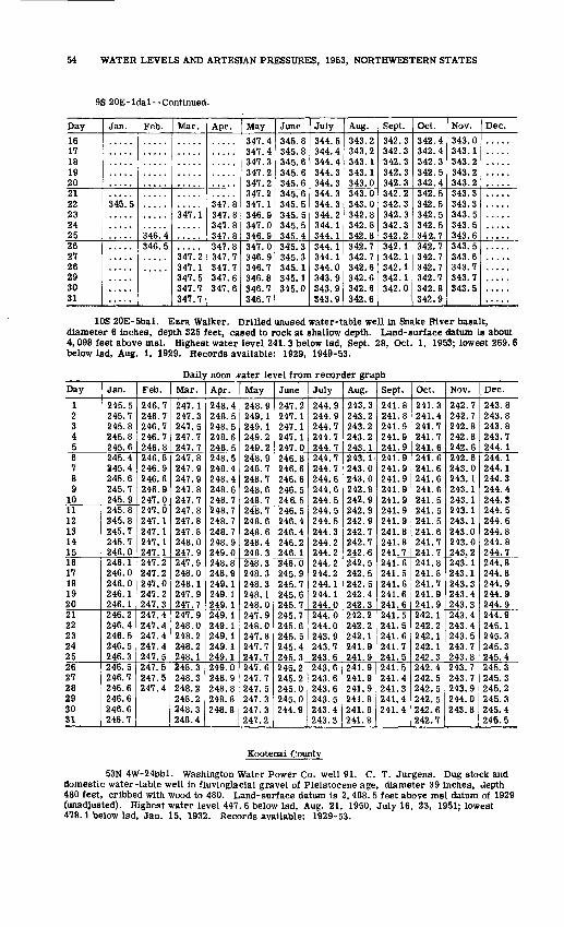
54 WATER LEVELS AND ARTESIAN PRESSURES, 1953, NORTHWESTERN STATES
9S 20E-ldal--Continued.
Day
16 17 18 192021 22 23 24 2526 27 26 293031
Jan.
345.5
Feb.
.....
346^4346.5
Mar.
347.1
347! 2 347.1 347.5347.7347.7
Apr.
347.8 347.8 347.8 347.8347.8 347.7 347.7 347.6347.6
May
347.4 347.4 347.3 347.2 347.2347.2 347.1 346.9 347.0 346.9347.0 346.9 346.7 346.8346.7346.7
June
345.8 345.8 345.6 345.6 345.6345.6 345.5 345.5 345.5 345.4345. 3 345.3 345.1 141; 1345.0
July
344.5 344.4 344.4 344.3 344.3344.3 344.3 344.2 344.1 344.1344.1 344.1 344.014? 0
343.9343.9
Aug.
343.2 343.2 343.1 343.1 343.0343.0 343.0 342.8 342.8 342.8342.7 342.7 342.6 342.6342.6342.6
Sept.
342.3 342.3 342.3 342.3 342.3342.2 342.3 342.3 342.3 342.2342.1 342.1 342.1 342.1342.0
Oct.
342.4 342.4 342.3 342.5 342.4342.5 342.5 342.5 342.5 342.7342.7 342.7 342.7 342.7342.8342.9
Nov.
343.0 343.1 343.2 343.2 343.2343.3 343.3 343.5 343.5 343.6343.5 343.6 343.7 343.7343.5
Dec.
.....
10S 20E-5bal. Ezra Walker. Drilled unused water-table well in Snake River basalt, diameter 6 inches, depth 325 feet, cased to rock at shallow depth. Land-surface datum is about 4,098 feet above msl. Highest water level 241.3 below Isd, Sept. 28, Oct. 1, 1953; lowest 269.6 below Isd, Aug. 1, 1929. Records available: 1929, 1949-53.
Daily noon vater level from recorder graph
Day
1 2 3 4 56 7 8 9
1011 12 13 14 1516 17 18 19 2021 22 23 24 2526 27 28 29 30 31
Jan.
245.5 245.7 245.8 245.8 245.6245.4 245.4 245.6 245.7 245.9245.8 245.8 245.7 245.7 246.0246.1 246.0 246.0 246.1 246.1246.2 246.4 246.5 246.5 246.3246.5 246.7 246.6 246.6 246.6 246.7
Feb.
246.7 246.7 246.7 246.7 246.8246.8 246.9 246.6 246.9 247.0247.0 247.1 247.1 247.1 247.1247.2 247.2 247.0 247.2 247.3247.4 247.4 247.4 247.4 247.5247.5 247.5 247.4
Mar.
247.1 247.3 247.5 247.7 247.7247.8 247.9 247.9 247.8 247.7247.8 247.8 247.8 248.0 247.9247.9 248.0 248.1 247.9 247.7247.9 248.0 248.2 248.2 248.1248.3 248.3 248.2 248.2 248.3 248.4
Apr.
248.4 248.5 248.5 248.6 248.5248.5 248.4 248.4 248.6 248.7248.7 248.7 248.7 248.9 249.0248.8 248.9 249.1 249.1 249.1249.1 249.1 249.1 249.1 249.1249.0 248.9 248.8 248.8 248.8
May
248.9 249.1 249.1 249.2 249.2248.9 248.7 248.7 248.6 248.7248.7 248.6 248.6 248.4 248.3248.3 248.3 248.3 248. 1 248.0247.9 248.0 247.8 247.7 247.7247.6 247.7 247.5 247.3 247.3 247.2
June
247.2 247.1 247.1 247.1 247.0246.8 246.6 246.6 246.5 246.5246.5 246.4 246.4 246.2 246.1246.0 245.9 245.7 245.6 245.7245.7 245.6 245.5 245.4 245.3245.2 245.2 245.0 245.0 244.9
July
244.9 244.9 244.7 244.7 244.7244.7 244.7 244.6 244.6 244.5244.5 244.5 244.3 244.2 244.2244.2 244.2 244.1 244.1 244.0244.0 244.0 243.9 243.7 243.6243.6 243.6 243.6 243.5 243.4 243.3
Aug.
243.3 243.2 243.2 243.2 243.1243.1 243.0 243.0 242.9 242.9242.9 242.9 242.7 242.7 242.6242.5 242.5 242.5 242.4 242.3242.2 242.2 242.1 241.9 241.9241.9 241.9 241.9 241.8 241.8 241.8
Sept.
241.8 241.8 241.9 241.9 241.9241.9 241.9 241.9 241.9 241.9241.9 241.9 241.8 241.8 241.7241.6 241.5 241.6 241.6 241.6241.5 241.5 241.6 241.7 241.5241.5 241.4 241.3 241.4 241.4
Oct. _!
241.3 241.4 241.7 241.7 241.6241.6 241.6 241.6 241.6 241.5241.5 241.5 241.6 241.7 241.7241.8 241.8 241.7 241.9 241.9242.1 242.2 242.1 242.1 242.3242.4 242.5 242.5 242.5 242.6 242.7
Nov.
242.7 242.7 242.8 242.8 242.6242.6 243.0 243. 1 243.1 243.1243.1 243.1 243.0 243.0 243.2243.1 243.1 243.3 243.4 243.3243.4 243.4 243.5 243.7 243.8243.7 243.7 243.9 244.0 243.8
Dec.
243.8 243.8 243.8 243.7 244.1244.1 244.1 244.3 244.4 244.3244.5 244.6 244.8 244.8 244.7244.8 244.8 244.9 244.9 244.9244.9 245.1 245.3 245.3 245.4245.3 245.3 245.2 245.3 245.4 245.5
Kootenai County
53N 4W-24bbl. Washington Water Power Co. well 91. C. T. Jurgens. Dug stock and domestic water-table well in fluvioglacial gravel of Pleistocene age, diameter 39 inches, Jepth 480 feet, cribbed with wood to 480. Land-surface datum is 2, 488. 5 feet above msl datum of 1929 (unadjusted). Highest water level 447. 6 below Isd, Aug. 21, 1950, July 16, 23, 1951; lowest 478.1 below Isd, Jan. 15, 1932. Records available: 1929-53.

IDAHO, KOOTENAI COUNTY 55
53N 4W-24bbl Continued.
Date
Jan. 51926
Feb. 29
1623
Mar. 29
162330
Apr. 6
Water level
452.0452.7453.0453.3453.5453.6453.7453.7453.7453.8453.9454.0454.1
Date
Apr. 132027
May 4111825
June 18
152229
July 6
Water level
454.2454.2454.2454.3454.3454.1454.0453.9453.5453.4453.2452.9452.7
Date
July 132027
Aug. 310172431
Sept. 7142128
Water level
452.5452.4452.3452.2452.2452.1452.1452.2452.2452.2452.2452.3
Date
Oct. 5121926
Nov. 28
2330
Dec. 8142228
Water level
452.3452.4452.7452.8453.0453.3453.8454.2454.5454.7455.3455.4
53N 3W-31aal. A. L. Famm. Dug and drilled unused water-table well in fluvioglacial gravel of Pleistocene age, diameter 36 to 6 inches, depth 395 feet, concrete casing to 367, open 6-inch hole below 367. Land-surface datum is 2, 383.4 feet above msl datum of 1929, Pacific Northwest Adjustment of 1947. Highest water level 346.1 below Isd, July 18, Aug. 12, 1950, June 4, JulyS, 1951; lowest 355. 4 below Isd, Mar. 29, 1950. Records available: 1948-53. Feb. 20, 351.7; Apr. 23, 351.8; Apr. 28, 351.9; June 17, 350.4.
53N2W-3bcl. Idaho Department of Fish and Game. Formerly U. S. Navy. Drilled public- supply water table well in fluvioglacial gravel of Pleistocene age, diameter 18 inches, depth 331 feet, cased to 331, perforations 266-326. Land-surface datum is 2, 269.1 feet above msl datum of 1929, Pacific Northwest Adjustment of 1947. Highest water level 202 below Isd, May 26, 1949; lowest 228 below Isd, Nov. 14, 1944. Records available: 1943-53.Jan. 4
111825
Feb. 29
16
223223223223223223223
Feb. 20Mar. 2
9162330
222223223223223223
Apr. 61320232728
224224224223224222
May 4111825
June 17Aug. 25
222222220220
a214a212
Pumping.53N 2W-8ccl. Idaho Department of Fish and Game. Drilled unused water-table well in
fluvioglacial gravel of Pleistocene age, diameter 12 inches. Land-surface datum is 2, 440. 5 feet above msl datum of 1929, Pacific Northwest Adjustment of 1947. Highest water level 383. 4 below Isd, Sept. 17, 1952; lowest 394. 7 below Isd, Apr. 23, 28, 1953. Records available: 1950-53. Feb. 20, 393.7; Apr. 23, 394.7; Apr. 28, 394. 7; June 17, 389.5.
53N 2W-9aal. Idaho Department of Fish and Game. Drilled unused water-table well in fluvioglacial gravel and sand of Pleistocene age, diameter 16 inches, depth 351 feet, cased to 351, perforations 280-345. Land-surface datum is 2,291. 5 feet above msl datum of 1929, Pacific Northwest Adjustment of 1947. Highest water level 228 below Isd, June 8, 1948; lowest 252 below Isd, Jan. 2, Oct. 30, 1944. Records available: 1943-53.
Daily noon water level from recorder graphDay
1 2 3 4 56 7 8 9
1011 12 13 14 1516 17 18 19 20
Jan.242.2 242.3 242.3 242.3 242.4242.5 242.5 242.5 242.5 242.5242.5 242.5 242.5 242.4 242.4242.4 242.4 242.4 242.4 242.3
Feb.242.3 242.3 242.2 242.1 242.1242.1 242.1 242.0 242.0 242.0242.1 242.1 242.1 242.1 242.1242.2 242.2 242.3 242.3 242.4
Mar.242.7 242.7 242.7 242.8 242.8242.9 242.9 242.9 243.0 243.0243.0 243.0 243.0 243.0 243.0243.1 243.1 243.1 243.1 243.1
Apr.243.0 243.0 243.0 243.1 243.1243.1 243.1 243.1 243.1 243.1243.1 243.1 243.2 243.2 243.2243.2 243.2 243.2 243.3 243.3
May242.4 242.2 242.1 241.9 241.8241.7 241.6 241.5 241.4 241.2241.1 240.9 240.7 240.6 240.5240.4 240.3 240.2 240.1 239.9
June238.7 238.5 238.3 238.1 237.8237.5 237.1 236.7 236.3 235.9235.5 235.2 234.9 234.7 234.4234.2 234.0 233.8 233.6 233.6
July232.7 232.6 232.6 232.5 232.5232.4 232.4 232.3 232.3 232.2232.2 232.2 232.1 232.1 232.1232.1 232.1 232.0 232.0 232.0
Aug.231.6 231.6 231.6 231.6 231.6231.5 231.5 231.5 231.5 231.5231.5 231.4 231.4 231.4 231.4231.3 231.3 231.3 231.3 231.3
Sept.231.2 231.2 231.2 231.2 231.1231.1 231.1 231.1 231.1 231.1231.1 231.1 231.1 231.1 231.1231.1 231.1 231.1 231.1 231.2
Oct.232.1 232.3 232.4 232.5 232.6232.7 232.8 232.9 233.0 233.1233.2 233.4 233.5 233.6 233.9234.0 234.2 234.3 234.5 234.6
Nov.237.1 237.3 237.5 237. 7 238.0238.2 238.5 238.7 238.9 239.0239.3 239.5 239.7 239.9 240.1240.2 240.4 240.5 240.6 240.7
Dec.241.6 241.7 241.8 241.8 241.9241.9 241.9 242.0 242.1 242.1242.1 242.1 242.2 242.2 242.3242.3 242.4 242.4 242.4 242.4
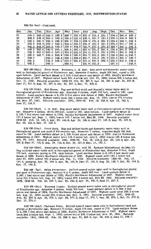
56 WATER LEVELS AND ARTESIAN PRESSURES, 1953, NORTHWESTERN STATES
53N 2W-9aal--Continued.
Day
21 22 23 24 2526 27 28 29 30 31
Jan.
242.3 242.3 242.3 242.3 242.3242.3 242.3 242.3 242.3 242.3 242.3
Feb.
242.4 242.4 242.5 242.5 242.6242.6 242.6 242.7
Mar.
243.0 243.0 243.0 243.0 243.0243.0 243.0 243.0 243.0 243.0 243.0
Apr.
243.3 243.3 243.3 243.2 243.2243.1 243.0 242.9 242.8 242.6
May
239.7 239.6 239.5 239.5 239.4239.3 239.3 239.2 239.1 239.0 238.9
June
233.5 233.3 233.3 233.2 233.2233.1 233.0 232.9 232.8 232.8
July
232.0 232.0 232.0 231.9 231.9231.8 231.8 231.7 231.7 231.6 231.6
Aug.
231.3 231.3 231.3 231.3 231.2231.2 231.2 231.2 231.2 231.2 231.2
Sept.
231.1 231.2 231.2 231.3 231.3231.4 231.5 231.7 231.9 232.0
Oct.
234.8 235.0 235.2 235.4 235.7235.9 236. 1 236.4 236.6 236.9 237.0
Nov.
240.8 240.9 241.0 241.1 241.1241.2 241.3 241.4 241.5 241.6
Dec.242.5 242.5 242.5 242.5 242.5242.5 242.6 242.7 242.7 242.8 242.8
52N 4W-35dcl. Elvin Wood. Formerly J. H. Dye. Dug stock and domestic water-table well in fluvioglacial gravel of Pleistocene age, diameter 6 inches, depth 305 feet, cased to 305, open bottom. Land-surface datum is 2, 314. 0 feet above msl datum of 1929, Pacific Northwest Adjustment of 1947. Highest water level 291. 4 below Isd, Oct. 25, 1950; lowest 305. 8 below Isd, Dec. 11, 1952. Records available: 1948-53. Feb. 20, 297. 0; Apr. 23, 297. 6; Apr. 28, 297.8; June 17, 301.8; Aug. 25, 297.4; Oct. 25, 297. 9; Dec. 17, 295.8.
51N 5W-21dal. Bob Bowen. Dug and drilled stock and domestic water-table well in fluvioglacial gravel of Pleistocene age, diameter 4 inches, depth 190 feet, cased to 190, open bottom. Land-surface datum is 2, 159. 5 feet above msl datum of 1929, Pacific Northwest Adjustment of 1947. Highest water level 154.1 below Isd, Aug. 15, 1951; lowest 175. 5 below Isd, Nov. 27, 1941. Records available: 1941, 1948-53. Feb. 19, 159.9; Apr. 23, 163.5; June 17, 158.3.
51N 5W-28adl. J. O. Self. Dug stock water-table well in fluvioglacial gravel of Pleistocene age, diameter 4 inches, depth 163 feet, cased to 163, open bottom. Land-surface datum is 2, 143. 7 feet above msl datum of 1929, Pacific Northwest Adjustment of 1947. Highest water level 137. 8 below Isd, Sept. 1, 1950; lowest 147. 7 below Isd, May 26, 1948. Records available: 1948-53. Feb. 19, 145. 1; Apr. 23, 145. 6; Apr. 28, 145. 6; June 17, 143. 3; Aug. 25, 143.9; Oct. 25, 145.4; Dec. 17, 147.5.
51N 5W-31bcl. Peter Beck. Dug and drilled stock and domestic water-table well in fluvioglacial gravel and sand of Pleistocene age, diameter 7 inches, reported depth 156 feet, cased to 152. Land-surface datum is 2, 105. 4 feet above msl datum of 1929, Pacific Northwest Adjustment of 1947. Highest water level 109. 8 below Isd, July 6, 1950; lowest 132. 6 below Isd, Nov. 29, 1941. Records available: 1941, 1948-53. Feb. 19, 119. 3; Apr. 23, 119.9; Apr. 28, 120. 2; June 17, 115. 6; Aug. 24, 119. 4; Oct. 25, 121.6; Dec. 17, 122.1.
51N 5W-33bbl. Washington Water Power Co. well 58. Spokane International Hallway Co. Dug railroad water-table well in fluvioglacial gravel of Pleistocene age, diameter 5 feet, depth 174 feet, concrete casing to 174, open bottom. Land-surface datum is 2, 137. 6 feet above msl datum of 1929, Pacific Northwest Adjustment of 1947. Highest water level 134. 1 below Isd, June 29, 1950; lowest 166. 6 below Isd, Feb. 11, 1932. Records available: 1928-53. Feb. 19, 144.4, pumping; Apr. 23, 144. 0; Apr. 28, 143.9; June 17, 141.0; Aug. 25, 142. 7; Oct. 25, 144.3; Dec. 17, 146.2.
51N 4W -Tbcl. Ralph Preuninger. Drilled unused water-table well in fluvioglacial gravel and sand of Pleistocene age, diamter 8 to 5 inches, depth 283 feet. Land-surface datum is 2, 267.1 feet above msl datum of 1929, Pacific Northwest Adjustment of 1947. Highest water level 251.6 below Isd, Aug. 16, 1951; lowest 272. 4 below Isd, July 22, 1942. Records available: 1942, 1948-53. Feb. 20, 257.7; Apr. 23, 258.4; Apr. 28, 258.5; June 17, 257.2.
51N 4W-10ccl. Kootenai County. Drilled unused water-table well in fluvioglacial gravel of Pleistocene age, diameter 4 inches, depth 305 feet. Land-surface datum is 2, 288. 0 feet above msl datum of 1929, Pacific Northwest Adjustment of 1947. Highest water level 269. 2 below Isd, Aug. 31, 1950; lowest 291. 5 below Isd, Nov. 5, 1941. Records available: 1941, 1948-53. Feb. 20, 276.5; Apr. 23, 276.1; Apr. 28, 277.2; June 17, 276.1; Aug. 25, 275.1; Oct. 25, 276.0; Dec. 17, 278.0.
51N 4W-18dcl. Clarence Feely. Drilled unused water-table well in fluvioglacial sand and gravel of Pleistocene age, diameter 6 inches, depth 275 feet, cased to 275. Land-surface datum is 2, 260. 7 feet above msl datum of 1929, Pacific Northwest Adjustment of 1947. Highest water level 244. 8 below Isd, Sept. 1, 1950; lowest dry at 278. 0 below Isd, Nov. 28, 1941. Records available: 1941, 1948-53. Feb. 20, 252. 3; Apr. 23, 252. 9; Apr. 28, 252. 9; June 17, 249.7.

IDAHO, MINTOOKA COUNTY 57
51N 4W-26bal. Rudolph. Drilled stock and domestic water-table well in fluvioglacial gravel of Pleistocene age, depth 283 feet, cased to 283, open bottom. Land-surface datum is 2, 277.1 feet above msl datum of 1929, Pacific Northwest Adjustment of 1947. Highest water level 246.2 below Isd, Aug. 31, 1950; lowest 271. 3 below Isd, July 22, 1942. Records available: 1942, 1948-53. Feb. 20, 260.9, pumping; Apr. 23, 255. 7; Apr. 28, 255. 8; June 17, 255.0; Aug. 25, 253.0; Oct. 25, 253. 8; Dec. 17, 255.8.
50N 5W-laal. Washington Water Power Co. well 96. Post Falls Irrigation District. Dug public-supply water-table well in fluvioglacial sand and gravel of Pleistocene age, diameter 30 inches, depth 231 feet, concrete tile casing, open bottom. Land-surface datum is 2,192. 5 feet above msl datum of 1929, Pacific Northwest Adjustment of 1947. Highest water level 176.1 below Isd, Sept. 1, 1950; lowest 212. 3 below Isd, Dec. 8, 1931. Records available: 1929-53. Feb. 20, 186.2, pumped recently; Apr. 23, 186.7, pumped recently; Apr. 28, 186.9, pumped recently; June 17, 185.4, pumped recently; Aug. 25, 182. 9; Oct. 25, 185.1, pumped recently; Dec. 17, 187.6, pumped recently.
Latah County
39N 5W-7ddl. Inland Motor Freight Co. Drilled unused artesian well in Moscow Basin, diameter 8 inches, depth 231 feet. Land-surface datum is 2, 560. 9 feet above msl datum of 1929. Highest water level 50. 10 below Isd, Apr. 19, 1938; lowest 77.35 below Isd, Aug. 23, 1953. Records available: 1937-40, 1947-53. Feb. 18, 72.14; Apr. 25, 72. 46; May 1, 72. 41; June 19, 70.35; Aug. 23, 77.35; Oct. 23, 76.67.
39N 5W-10acl. U. S. Geol. Survey. Driven observation water-table well in alluvial sand and gravel of Quaternary age, diameter li inches, depth 21 feet, cased to 21. Highest water level 5. 97 below Isd, Mar. 21, 1949; lowest 17. 61 below Isd, Feb. 1, 1937. Records available: 1934-40, 1947-53. Feb. 18, 12. 19; Apr. 25, 10.67; May 1, 11.11; June 19, 12. 60; Aug. 23, 13.92; Oct. 23, 14.91.
Minidoka County
8S 23E-2bal. U. S. Bureau of Reclamation. Drilled observation water-table well in Snake River basalt, diameter 8 to 6 inches, reported depth 254 feet, 8-inch casing to 18, perforated 6-inch casing from 194-254. Land-surface datum is 4, 313. 6 feet above U. S. Bureau of Reclamation datum. Highest water level 197. 6 below Isd, Dec. 4, 1953; lowest 201.7 below July 17-19, 1951. Records available: 1950-53.
Daily noon water level from recorder graph
Day
1 2 3 4 56 7 8 9
1011 12 13 14 1516 17 18 19 202122 23 24 2526 27 28 29 30 31
Jan.
198.7 198.9 198.9 198.7 198.5198.3 198.5
198.6 198.7 198.7 198.5198.5 198.7 198.7 198.6 198.5 198.7
Feb.
198.6 198.5 198.5 198.5 198.5198.5 198.4 198.3 198.5 198.7198.6 198.7 198.5 198.4
198.6 198.5 198.4
Mar.
198.1 198.1 198.4 198.5 198.5198.6 198.7 198.6 198.5 198.4198.2 198.4 198.3 198.5 198.4198.4 198.4 198.4 198.3 198.1198.2198.3 198.5 198.6 198.3198.5 198.5 198.4 198.4 198.4 198.5
Apr.
198.4 198.5 198.5 198.5 198.4198.3 198.4 198.3 198.5 198.5198.5 198.5 198.4 198.6 198.6198.4 198.5 198.7
198.5 198.5 198.6 198.6198.5 198.3 198.3 198.4 198.4
May
198.6 198.8 198.8
June
199! b
199.6
199.6 199.7
July
199.8 199.8 199.8 199.9 200.0200.0 200.0 200.1 200.1 200.2200.3 200.2 200.2 200.2 200.3200.4 200.4 200.4 200.4 200.5200.6200.5 200.5 200.5 200.5200.6 200.7 200.6 200.6 200.6 200.7
Aug.
200.7 200.7 200.6 200.7 200.7200.7 200.7 200.7 200.7 200.7
200.7
Sept.
2ob!3
Oct.
199! 1 199.2 199.2 199.1199.1 199.0 198.8 198.8 198.8198.8198.8 198.7 198.6 198.7198.7 198.7 198.6 198.6 198.6 198.6
Nov.
198.5 198.5 198.5 198.3 198.1198.5
198.1 198.0 198.1198.0 197.9 198.0 198.1 198.0198.1198.0 197.9 198. 1 198.2198.1 198.1 198.2 198.2 197.9
Dec.
197.9 197.9 197.9 197.6
198.0198.1 198.1 198.2 198.1 198.1198.1 198.1 198.1 198.0 197.9198.0

58 WATER LEVELS AND ARTESIAN PRESSURES, 1953, NORTHWESTERN STATES
8S 23E-27bdl. U. S. Bureau of Reclamation well C. Drilled irrigation water-table well in Snake River basalt, diameter 20 inches, depth 260 feet, cased to 21. Land-surface datum is 4, 284. 5 feet above U. S. Bureau of Reclamation datum. Highest water level 176. 2 below Isd, Dec. 20, 1950; lowest 185. 6 below Isd, June29, 1951. Records available: 1948-53. Mar. 19, 177. 2; Apr. 3, 177. 7; May 13, 181. 9; Sept. 26, 178.1; Dec. 1, 176.7
8S 24E-7dal. U. S. Bureau of Reclamation well B. Drilled irrigation water-table well in Snake River basalt, diameter 20 inches, depth 240 feet, cased to 31. Land-surface datum is 4, 288.1 feet above U. S. Bureau of Reclamation datum. Highest water level 166.0 below Isd, Mar. 19, 1953; lowest 169. 2 below Isd, June 16, 1952. Records available: 1948-53. Mar. 19, 166.0; Apr. 3, 166. 5; May 13, 166. 6; Sept. 25, 167. 0; Dec. 1, 165.6.
8S 24E-llbal. U. S. Bureau of Reclamation well A. Drilled irrigation water-table well in Snake River basalt, diameter 20 inches, depth 225 feet, cased to 50. Land-surf ace datum is 4, 300. 6 feet above U. S. Bureau of Reclamation datum. Highest water level 161. 8 below Isd, Oct. 28, 1953; lowest 164. 8 below Isd, Apr. 22, 1949. Records available: 1948-53. Mar. 19, 162. 5; Apr. 3, 162.6; May 13, 162.7, pumping; July 28, 163. 0; Sept. 25, 162.3, pumping; Oct. 28, 161.8; Dec. 1, 162.0.
8S 24E-31dcl. U. S. Bureau of Reclamation. Drilled observation water-table well in Snake River basalt, diameter 8 to 6 inches, reported depth 194 feet, cased to 188, perforations 158-188. Land-surface datum is 4, 276. 5 feet above U. S. Bureau of Reclamation datum. Highest water level 140. 5 below Isd, Oct. 18, 24, Nov. 5, 1953; lowest 144. 7 below Isd, Apr. 25-27, 1951. Records available: 1950-53.
Daily noon water level from recorder graph
Day
1 2 3 4 56 7 8 9
1011 12 13 14 1516 17 18 19 2021 22 23 24 2526 27 28 29 30 31
Jan.
142.3 142.4 142.5 142.4 142.1141.9 141.9 142.3 142.4 142.5142.3 142.2 142.2 142.0 142.5142.4 142.2 142.2 142.4 142.1142.4 142.6 142.6 142.5 142.3142.4 142.7 142.6
142.5 142.6
Feb.
142.5 142.5 142.5 142.5 142.5142.6 142.5 142.2 142.7 142.8142.7 142.9 142.7 142.7 142.7142.9 142.7 142.5 142.7 142.8142.8 142.9 142.9 142.9 142.9142.8 142.7 142.5
Mar.
142.3142.5 142.9 142.9 142.9142.9 143.0 142.9 142.7 142.6142.8 142.7 142.8 143.0 142.9142.7 143.0 143.0 142.7 142.7142.8 142.9 143.1 143.0 143.0143.1 143.1 142.8 142.9 143.0 143.1
Apr.
143.1 143.2 143.1 143.1 143.0142.9 142.9 142.9 143.2 143.1143.2 143.2 143.1 143.3 143.3143.1 143.0 143.3 143.3 143.2143.2 143.1 143.2 143.3 143.3143.1 143.0 143.0 143.0 143.0
May
143.2 143.4 143.4 143.4 143.3
143! b143.0 143.0 143.1143.0 143.0 142.9 142.9 142.8142.9 143.0 143.1 142.9 142.9142.8 143.0 142.7 142.5 142.7143.7 142.7 142.5 142.5 142.6 142.5
June
142.4 142.5 142.5 142.3 142.3142.3 142.2
142.5142.5 142.4 142.5
142.4 142.5 142.6142.7 142.7 142.6 142.7 142.6142.5 142.6 142.5 142.5
July
142.6 142.6 142.5 142.6 142.6142.6 142.5 142.6 142.6 142.5142.6 142.5 142.5 142.4 142.5142.5 142.5 142.4 142.4 142.3142.4 142.3 142.3 142.1 142.2142.3 142.2 142.2 142.1 142.1 142.1
Aug.
142.1 142.0 141.9 142.0 141.9141.9 141.9 141.9 141.8 141.8141.8 141.7 141.7 141.6 141.6141.5 141.4 141.5 141.5 141.4141.3 141.4 141.2 141.1 141.2141.2 141.2 141.1 141.1 141.1 141.1
Sept.
141.2 141.1 141.2 141.2 141.1141.1 141.0 141.0 141.0 141.0141.0 140.9 140.9 140.8 140.8140.7 140.8 140.9 140.9 140.9140.7 140.8 140.9 140.9140.7140.8 140.7 140.7 140.9 140.8
Oct.
140.8 141.1 141.2 141.1 140.9140.8 140.8 140.8 140.8 140.7140.7 140.7 140.7 140.7 140.7140.8 140.7 140.5 140.7 140.6140.7 140.7 140.6 140.5 140.7140.8
140! 7 140.6 140.7 140.8
Nov.
140.6 140.7 140.7 140.6 140.5140.8 141.1 141.1 141.1 141.0141.1 140.7 140.7 140.7 140.9140.8 140.8 140.9 141.0 140.9141.0 140.9 141.0 141.2 141.2141.2 141.2 141.3 141.3 141.0
Dec.
141.1 141.1 141.1 141.0 141.3141.2 141.2 141.5 141.4 141.3141.6 141.6 141.7 141.6 141.6141.6 141.6 141.6 141.5 141.6141.7 141.9 141.9 141.9 141.9141.7 141.8 141.5 141.7 141.9 141.9
8S 25E-16dal. V. Anderson. Drilled irrigation water-table well in Snake River basalt, diameter 20 inches, reported depth 230 feet. Land-surface datum is 4, 293. 4 feet above U. S. Bureau of Reclamation datum. Highest water level 148.4 below Isd, Dec. 1, 1953; lowest 151.0 below Isd, Aug. 4, 1953. Records available: 1949-53. Jan. 14, 148.8; Mar. 19, 148.9; Aug. 4, 151.0; Dec. 1, 148.4.
8S 25E-24bdl. U. S. Bureau of Reclamation. Drilled observation water-table well in Snake River basalt, diameter 8 to 6 inches, reported depth 180 feet, 8-inch casing to 15, 6-inch casing 120-180, perforations 160-180. Land-surface datum is 4, 282. 7 feet above U. S. Bureau of Reclamation datum. Highest water level 133. 5 below Isd, Oct. 24, Nov. 5, 6, 17, 1953; lowest 136. 2 below Isd, Mar. 12, 1951. Records available: 1950-53.

IDAHO, MINIDOKA COUNTY 59
8S 25E-24bdl Continued.
Daily noon water level from recorder graphDay
123 4 56 7 8 9
1011 1213 14 1516 17 18 19 2021 22 23 24 2526 27 28 293031
Jan.134.4134.6134.6 134.6 134.4134.3 134.3 134.4 134.4 134.5134.4 134.4 134.3 134.2 134.4134.4 134.3 134.3 134.3 134.3134.3 134.4 134.4 134.4 134.3134.3- 134.5 134.5
134.4
Feb.134.4134.4134.4 134.3 134.3134.3 134.4 134.2 134.4 134.5134.4 134.5 134.4 134.4 134.4134.4 134.4 134.3 134.4 134.5134.5 134.5 134.4 134.4 134.5134.5 134.4 134.3
Mar.134.2134.2134.4 134.5 134.5134.5 134.5 134.5 134.4 134.3134.3 134.3 134.3 134.4 134.4134.4 134.4 134.4 134.3 134.2134.3 134.3 134.5 134.5 134.4134.5 134.5 134.4 134.3134.3
Apr. May
134! 3 134.3 134.3 134.4134.4 134.4 134.3 134.3 134.2134. 2 134.2 134.3 134.3 134.2134.2 134.3 134.2 134.2 134.2134.2 134.3 134.2 134.2m o
134.2
June134.2134.2134.2 134.2 134.2134.2 134.1 134.1 134.1 134.1134.1 134.1 134.2 134.1 134.1134.1 134.1 134.1 134.0 134.1134.2 134.2 134.2 134.2 134.2134.2 134.2 134.2 134.2
July134.2134.2134.2 134.2 134.2134.2 134.2 134.2 134.2 134.2134.2 134.2 134.2 134.2 134.1134.1
134.2 134.2 134.1 134.1134.1 134.1 134.1 mi
134.1
Aug.134.1134.1134.1 134.1 134.1134.1 134.1 134.1 134.1 134.0134.0 134.0 134.0 134.0 134.0134.0 134.0 133.9 134.0 133.9133.9 133.9 133.9 133.8 133.8133.8 133.8 133.8 133.8133.8133.8
Sept.133.8133.8133.9 133.9 133.9133.9 133.9 133.9 133.9 133.9133.9 133.9 133.9 133.8 133.8
133^7 133.8 133.8 133.8133.8 133.8 133.9 133.9
133.7
Oct.133.7133.8
133! 8 133.8 133.8 133.8133.8 133.8 133.8 133.7 133.7
T33TT 133.7 133.6 133.6 133.6133.6 133.7 133.6 133.5 133.6133.6 133.7 133.7 133.6133.6133.6
Nov.133.6133.6133.6 133.6 133.5133.5 133.7 133.7 133.7 133.7133.7 133.6 133.6 133.6 133.6133.6 133.5 133.6 133.6 133.6133.6 133.6 133.6 133.6 133.8133.7 133.7 133.8 133.8133.7
Dec.133.7133.7133.7 133.6 133.7133.7 133.7 133.8
133. 9133.9 133.9 133.9 133.9 133.9134.0 134.0 134.1 134.1 134. 1134.0 134.0 133.9 133.9134.0134.0
9S 22E-33abl. U. S. Bureau of Reclamation. Drilled observation water-table well in Snake River basalt, diameter 12 inches, depth 257 feet, stove-pipe casing to basalt bedrock at shallow depth. Land-surface datum is 4,234.7 feet above U. S. Bureau of Reclamation datum. Highest water level 222.8 below Isd, Nov. 30, Dec. 4, 6, 1953; lowest 225. 7 bdow Isd, Sept. 7, 1950. Records available: 1944, 1947, 1950-53.
Daily noon water level from recorder graphDay
1 2 3 4 56 7 8 9
1011 12 13 14 1516 17 18 19 2021 22 23 24 25
Jan.223.3 223.4 223.3 223.2 223.0222.8 222.9 223.2 223.2 223.3223.0 223.1 223.0 223.0 223.4223.3 223.3 222.9 223.1 223.1223.2 223.2 223.2 223.4 223.6
Feb.223.4 223.4 223.4 223.5 223.4223.3 223.5 223.6 223.3 223.3223.3 223.2 223.4 223.4 223.2223.2 223.5 223.5 223.3 223.3223.2 223.1 223.4 223.2 223.2
Mar.222.7 223.0 223.3 223.3 223.2223.2 223.3 223.1 223.0 222.8223.1 222.9 223.1 223.1 223.0222.9 223.2 223.0 222.8 222.9222.9 223.0 223.2 223.1 223.1
Apr.223.1 223.2 223.1 223.2 223.0222.9 222.9 222.9 223.2 223.1223.1 223.1 223.0 223.2 223.3223.0 222.9 223.3 223.3 223.2223.2 223.2 223.3 223.4 223.4
May223.5 223.7 223.8 223.7 223.6223.4 223.4 223.4 223.4 223.7223.7 223.6 223.6 223.5 223.5223.6 223.7 223.7 223.5 223.6223.4 223.5 223.2 223.4 223.4
June223.5 223.6 223.6 223.5 223.5223.4 223.4 223.5 223.4 223.6223.7 223.6 223.8 223.6 223.7223.7 223.8 223.6 223.8 223.9223.9 223.9 223.9 224.0 223.9
July224.1 224.0 223.9 224.0 224.1224.1 224.0 224.1 224.1 224.1224.1 224.1 224.1 224.1 224.2224.2 224.2 224.2 224.3 224.3224.3 224.3 224.3 224.2 224.2
Aug.224.3 224.3 224.3 224.4 224.4224.4 224.4 224.5 224.4 224.4224.5 224.4 224.4 224.4 224.4224.4 224.4 224.4 224.4 224.2224.2 224.4 224.3 224.1 224.2
Sept.224.2 224.2 224.4 224.3 224.3224.3 224.3 224.3 224.4 224.4224.3 224.3 224.3 224.2 224.2224.1 224.2 224.3 224.2 224.2224.0 224.1 224.2 224.2 223.9
Oct.223.9 224.1 224.2 224.1 224.0223.9 224.0 224.0 223.8 223.7
223! 8 223.7 223.7223.7 223.6 223.5 223.7 223.5223.7 223.7 223.5 223.4 223.6
Nov.223.4 223.5 223.4 223.3 223.0223.3 223.5 223.4 223.4 223.2223.3 223.2 223.1 223.1 223.2223.0 223.0 223.1 223.2 223.0223.2 223.0 223.0 223.2 223.2
Dec.222.9 223.0 222.9 222.8 223.1222.8 222.9 223.2 223.1 223.0
.....
.....
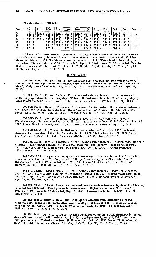
60 WATER LEVELS AND ARTESIAN PRESSURES, 1953, NORTHWESTERN STATES
9S 22E-33abl--Continued.
Day
26 27 28I CO CO CO |l-i O to
Jan.
223.4 223.2 223.3223.4 223.3 223.3
Feb.
223.2 223.1 222.8
Mar.
223.2 223.2 222.9223.0 223.1 223.2
Apr.
223.3 223.2 223.2223.3 223.2
May
223.5 223.6 223.3223.3 223.5 223.4
June
223.9 224.0 223.8223.9 224.0
July
224.3 224.3 224.3224.3 224.2 224.3
Aug.
224.2 224.2 224.1224.1 224.2 224.2
Sept.
224.0 223.9 223.9224.0 223.9
Oct.
223.6 223.6 223.6223.5 223.5 223.5
Nov.
223.1 223. 1 223.2223.2 222.8
Dec.
9S 24E-ldb2. Louis Madrid. Drilled domestic water-table well in Snake River basalt and interbedded sediments, diameter 6 inches, depth 87 feet. Land-surface datum is 4, 163. 7 feet above msl datum of 1929, Pacific Northwest Adjustment of 1947. Water level influenced by local irrigation. Highest water level 54.26 below Isd, Sept. 15, 1948; lowest 71.33 below Isd, Feb. 14, 1950. Records available: 1947-53. Jan. 14, 67.18; Mar. 19, 68. 78; May 13, 67. 41; July 28, 59. 36; Sept. 25, 57. 07; Dec. 1, 65. 50.
Oneida County
US 35E-30cbl. Russell Daniels. Drilled unused low pressure artesian well in alluvial sand of Pleistocene age, diameter 8 inches, depth 204 feet. Highest water level 25. 10 below Isd, May 5, 1952; lowest 28. 09 below Isd, Sept. 27, 1949. Records available: 1947-53. Apr. 26, 26.45.
US 35E-31acl. Russell Daniels. Drilled unused water-table well in river gravels of Quaternary age, diameter 6 inches, depth 92 feet. Highest water level 30. 34 below Isd, May 5, 1952; lowest 46. 07 below Isd, Nov. 1, 1952. Records available: 1947-53. Apr. 26, 33.92
13S 35E-33ccl. Mrs. K. T. Jones. Drilled unused water-table well in rocks of Paleozoic age, diameter 6 inches, depth 328 feet. Highest water level 293. 5 below Isd, Apr. 26, 1953; lowest 302.3 below Isd, Sept. 13, 1951. Records available: 1946-53. Apr. 26, 293.5.
13S 35E-36ccl. Dave Deschamps. Drilled unused water-table well in sediments of Pleistocene age, diameter 4 inches, depth 131 feet. Highest water level 80. 78 below Isd, Apr. 26, 1953; lowest 83.31 below Isd, Nov. 1, 1952. Records available: 1946-53. Apr. 26, 80.78.
14S 34E-31dal. Roy Davis. Drilled unused water-table well in rocks of Paleozoic age, diameter 4 inches, depth 399 feet. Highest water level 372. 6 below Isd, Apr. 26, 1953; lowest 389.4 below Isd, Sept. 14, 1951. Records available: 1947-53. Apr. 26, 372.6.
14S 35E-10abl. John W. Leavitt. Drilled irrigation water-table well in delta beds, diameter 4 inches. Land-surface datum is 4, 769. 4 feet above msl (preliminary). Highest water leve 1 115.4 below Isd, May 4, 1948; lowest 124. 6 below Isd, Oct. 13, 1947. Records available: 1931, 1943-53. Apr. 26, 118.3.
14S 35E-13dbl. Progressive Pump Co. Drilled irrigation water-table well in delta beds, diameter 14 inches, depth 289 feet, cased to 289, perforations opposite all gravels 114-289. Highest water level 66. 07 below Isd, Apr. 26, 1953; lowest 76. 34 below Isd, Oct. 21, 1944. Records available: 1943-53. Apr. 26, 66. 07; Nov. 5, 73.17.
14S 35E-27aal. Davis & Ipsen. Drilled irrigation water-table well, diameter 14 inches, depth 210 feet, cased to 210, perforations opposite all gravels 55-210. Highest water level 52. 65 below Isd, Apr. 9, 1947; lowest 60.19 below Isd, Nov. 5, 1953. Records available: 1943-53. Apr. 26, 54.19; Nov. 5, 60.19.
14S 35E-35bdl. John W. Price. Drilled stock and domestic artesian well, diameter 3 inches, reported depth 360 feet. Flowing prior to measurement. Highest water level 29.0 above Isd, Feb. 25, 1946; lowest 10.50 above Isd, Sept. 7, 1950. Records available: 1943-53. Apr. 26, +21.8; Nov. 5, +14.6.
148 35E-36bcl. Smith & Ilium. Drilled irrigation artesian well, diameter 14 inches, depth 301 feet, cased to 301, perforations opposite all gravel beds 72-301. Highest water level 15. 69 below Isd, Apr. 1, 1947; lowest 22. 49 below Isd, Sept. 27, 1949. Records available: 1943-53. Apr. 26, 16.78; Nov. 5, 19.31.
14S 36E-Seal. Walter K. Dastrup. Drilled irrigation water-table well, diameter 14 inches, depth 402 feet, cased to 402, perforations 89-122. Land-surface datum is 4, 850. 2 feet above msl (preliminary). Highest water level 59.15 below Isd, Oct. 16, 1932; lowest 74.22 below Isd, Sept. 14, 1951. Records available: 1931-32, 1943-53. Apr. 25, 67.07; Nov. 5, 67.26.
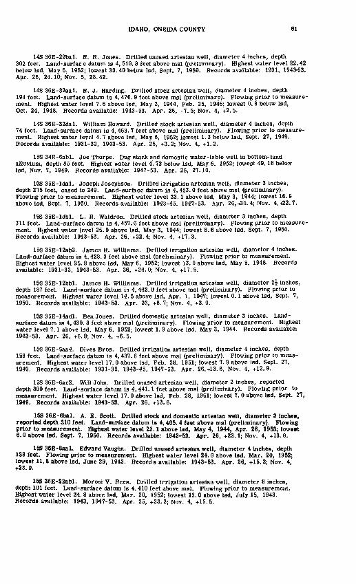
IDAHO, ONEIDA COUNTY 61
14S 36E-29bal. R. R. Jones. Drilled unused artesian well, diameter 4 inches, depth 302 feet. Land-surfac e datum is 4, 510. 8 feet above msl (preliminary). Highest water level 22.42 below Isd, May 5, 1952; lowest 33. 40 below Isd, Sept. 7, 1950. Records available: 1931, 1943-53. Apr. 26, 24.10; Nov. 5, 28.42.
14S 36E-32aal. R. J. Harding. Drilled stock artesian well, diameter 4 inches, depth 194 feet. Land-surface datum is 4, 476. 9 feet above msl (preliminary). Flowing prior to measure ment. Highest water level 7. 6 above Isd, May 2, 1944, Feb. 25, 1946; lowest 0. 8 below Isd, Oct. 24, 1948. Records available: 1943-53. Apr. 26, +7. 5; Nov. 4, +2.5.
14S 36E-32dal. William Howard. Drilled stock artesian well, diameter 4 inches, depth 74 feet. Land-surface datum is 4, 463. 7 feet above msl (preliminary). Flowing prior to measure ment. Highest water level 4. 7 above Isd, May 6, 1952; lowest 1. 3 below Isd, Sept. 27, 1949. Records available: 1931-32, 1943-53. Apr. 25, +3. 2; Nov. 4, +1.2.
15S 34E-6abl. Joe Thorpe. Dug stock and domestic water-table well in bottom-land alluvium, depth 85 feet. Highest water level 4.73 below Isd, May 6, 1952; lowest 49.18 below Isd, Nov. 7, 1949. Records available: 1947-53. Apr. 26, 27.10.
15S 35E-ldal. Joseph Josephson. Drilled irrigation artesian well, diameter 3 inches, depth 275 feet, cased to 249. Land-surface datum is 4, 453. 0 feet above msl (preliminary). Flowing prior to measurement. Highest water level 33.1 above Isd, May 3, 1944; lowest 16. 9 above Isd, Sept. 7, 1950. Records available: 1943-45, 1947-53. Apr. 26,+30. 4; Nov. 4,+22. 7.
15S 35E-ldbl. L. R. Waldron. Drilled stock artesian well, diameter 3 inches, depth 311 feet. Land-surface datum is 4, 457.6 feet above msl (preliminary). Flowing prior to measure ment. Hjghest water level 25.9 above Isd, May 3, 1944; lowest 8.6 above Isd, Sept. 7, 1950. Records available: 1943-53. Apr. 26, +22.4; Nov. 4, +17.3.
15S 35E-12ab2. James H. Williams. Drilled irrigation artesian well, diameter 4 inches. Land-surface datum is 4, 428. 3 feet above msl (preliminary). Flowing prior to measurement. Highest water level 25. 8 above Isd, May 6, 1952; lowest 13. 0 above Isd, May 5, 1948. Records available: 1931-32, 1943-53. Apr. 26, +24.0; Nov. 4, +17.5.
15S 35E-12bbl. James H. Williams. Drilled irrigation artesian well, diameter 2^ inches, depth 187 feet. Land-surface datum is 4, 442.0 feet above msl (preliminary). Flowing prior to measurement. Highest water level 14. 5 above Isd, Apr. 1, 1947; lowest 0.1 abbve Isd, Sept. 7, 1950. Records available: 1943-53. Apr. 26, +8. 7; Nov. 4, +3.0.
15S 35E-14adl. Ben Jones. Drilled domestic artesian well, diameter 3 inches. Land- surface datum is 4, 430. 3 feet above msl (preliminary). Flowing prior to measurement. Highest water level 7.1 above Isd, May 6, 1952; lowest 1. 9 above Isd, May 3, 1944. Records available: 1943-53. Apr. 26, +6.8; Nov. 4, +6.5.
15S 36E-5aa4. Dives Bros. Drilled irrigation artesian well, diameter 4 inches, depth 158 feet. Land-surface datum is 4, 437. 6 feet above msl (preliminary). Flowing prior to meas urement. Highest water level 17. 0 above Isd, Feb. 28, 1951; lowest 7. 9 above Isd, Sept. 27, 1949. Records available: 1931-32, 1943-45, 1947-53. Apr. 26,+13.6, Nov. 4, +12.9.
15S 36E-6ac2. Will John. Drilled unused artesian well, diameter 2 inches, reported depth 300 feet. Land-surface datum is 4, 441.1 feet above msl (preliminary). Flowing prior to measurement. JHighest water level 17.0 above Isd, Feb. 28, 1951; lowest 7. 0 above Isd, Sept. 27, 1949. Records available: 1943-53. Apr. 26, +13.6.
158 36£-6bal. A. E. Scott. Drilled stock and domestic artesian well, diameter 3 inches, reported depth 310 feet. Land-surface datum is 4,465.4 feet above msl (preliminary). Flowing prior to measurement. Highest water level 23.1 above Isd, May 4, 1944, Apr. 26, 1953; lowest 6.0 above Isd, Sept. 7, 1950. Records available: 1943-53. Apr. 26, +23.1; Nov. 4, +13.0.
15S 36E-8aal. Edward Vaughn. Drilled unused artesian well, diameter 4 inches, depth 138 feet. Flowing prior to measurement. Highest water level 24.0 above Isd, Mar. 20, 1952; lowest 11.8 above Isd, June 29, 1943. Records available: 1943-53. Apr. 26, +15.2; Nov. 4, +23.0.
15S 36E-22abl. Moroni V. Rees. Drilled irrigation artesian well, diameter 8 inches, depth 101 feet. Land-surface datum is 4, 410 feet above msl. Flowing prior to measurement. Highest water level 24. 8 above Isd, Mar. 20, 1952; lowest 13.0 above Isd, July 15, 1943. Records available: 1943, 1947-53. Apr. 25, +23. 2; Nov. 4, +15.5.

62 WATER LEVELS AND ARTESIAN PRESSURES, 1953, NORTHWESTERN STATES
15S 36E-29ca2. Tom Dudley. Drilled stock and domestic artesian well, diameter 3 inches, depth 270 feet. Land-surface datum is 4, 402. 6 feet above msl (preliminary). Flowing prior to measurement. Highest water level 14.7 above Isd, May 6, 1952; lowest 3.2 above Isd, Sept. 7, 1950. Records available: 1943-53. Apr. 26, +14.4; Nov. 5, +10.7.
15S 36E-30abl. John W. Jenkins. Drilled irrigation artesian well, diameter 4 inches, reported depth 229 feet. Land-surface datum is 4, 395. 8 feet above msl (preliminary). Flowing prior to measurement. Highest water level 14.9 above Isd, May 3, 1944; lowest 8.8 above Isd, Sept. 7, 1950. Records available: 1943-53. Apr. 25, +12. 5; Nov. 5, +11.7.
15S 36E-30ab2. John W. Jenkins. Drilled irrigation artesian well, diameter 4 inches, depth 196 feet. Land-surface datum is 4, 395.3 feet above msl (preliminary). Flowing prior to measurement. Highest water level 13.2 above Isd, May 6, 1952; lowest 9. 0 above Isd, Sept. 7, 1950. Records available: 1943-53. Apr. 26, +12. 2; Nov. 5, +11.1.
Payette County
7N 5W-3dal. Sim Watkins. Dug stock and domestic water-table well in alluvial sand and gravel, diameter 4 feet, depth 56 feet, concrete casing, open bottom. Water level influenced by local irrigation. Highest water level 31. 0 below Isd, Sept. 12, Oct. 7, 1949; lowest 43. 3 below Isd, Apr. 27, May 3, 1949. Records available: 1944-53.
Date
Jan. 5121926
Feb. 29
1623
Mar. 29
15192330
Water level
38.238.438.738.939.239.639.940.140.540.840.841.141.141.4
Date
Apr. 6132027
May 4111825
June 18
152229
Water level
41.541.741.942.141.941.841.541.140.840.740.740.540.5
Date
July 6132027
Aug. 310172431
Sept. 7142128
Water level
40.139.939.038.537.537.136.435.734.934.233.733.533.2
Date
Oct. 5111926
Nov. 29
162330
Dec. 7142128
Water level
32.933.133.133.833.934.535.334.535.936.437.137.237.6
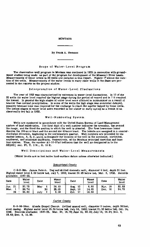
MONTANA
By Frank A. Swenson
Scope of Water-Level Program
The observation-well program in Montana was continued in 1953 in connection with ground- water studies being made as part of the program for development of the Missouri River basin. Measurements of water levels in 22 wells are included in this report. Figure 17 shows the loca tion of the wells. Measurements of the water levels in many other wells in the State are pre sented in the reports on the project studies.
Interpretation of Water-Level Fluctuations
The year of 1953 was characterized by extremes in water-level fluctuations. In 10 of the 22 wells the water level reached the highest stage during the period of record and in 7 it reached the lowest. In general the high stages of water level were attained in midsummer as a result of heavier than normal precipitation. In some of the wells the high stage was somewhat delayed, possibly because time was required for the recharge to reach the aquifer tapped by these wells. The lowest stages of water level were recorded in the winter or early spring as a result of an abnormally dry fall in 1952.
Well-Numbering System
Wells are numbered in accordance with the United States Bureau of Land Management system of land subdivision. The first digit of a well number indicates the township, the second the range, and the third the section in which the well is situated. The first lowercase letter denotes the 160-acre tract and the second the 40-acre tract. The letters are assigned in a counter clockwise direction, beginning in the northeastern quarter. Well numbers are preceded by the capital letters, A, B, C, andD, to designate the location of the well in the northeast, northwest, southwest, and southeast quadrants, respectively, of the Montana principal meridian and base line system. Thus, the number Al-10-27ad indicates that the well so designated is in theSEINE! sec. 27, T. IN., R. 10 E.
Well Descriptions and Water-Level Measurements
(Water levels are in feet below land-surface datum unless otherwise indicated.)
Beaverhead County
C-8-9-9bb. James Rebich. Dug and drilled domestic well, diameter 4 feet, depth 31 feet. Highest water level 2.09 below Isd, July 7, 1953; lowest 29. 65 below Isd, Mar. 3, 1952. Records available: 1947-53.
Date
Jan. 21 Mar. 1
26
Water level
27.72 28.74 26.62
Date
May 1 30
July 7
Water level
28.10 22.03 2.09
Date
Aug. 12 Sept. 16 Oct. 17
Water level
6.80 14.93 18.68
Date
Nov. 19 Dec. 16
Water level
22.52 24.72
Carter County
D-9-60-19cc. Alzada Gospel Church. Drilled unused well, diameter 6 inches, depth 26feet, steel casing. Highest water level 18.34 below lad, July 14, 1953; lowest 21.33 below Isd, Oct. 14, 1948. Records available: 1947-53. Mar. 26, 18.70; June 19, 20.02; July 14, 18.34; Nov. 9, 19.92; Dec. 8, 19.90.
63

iGfASSJ^! ^ jr
L.
fi
r'>
v-'r"'"} f
*
! jp
I .
C*
* r
1 M
fi
t /5
u
r\D
KI
* J
EX
PLA
NA
TIO
N
Obs
erva
tion
wel
o zs
so
n
100
MIL
ES
^J
o Vm
k--
AiV
-^""^ N
i W
ES
T O
F D
IVID
E
JX N
OR
TH
-CE
NT
RA
L
HIN
OR
TH
EA
ST
ER
N
GR
OU
ND
-WA
TER
A
RE
AS
JZ E
AS
T-C
EN
TR
AL
3Z1
CE
NT
RA
L
21
UP
PE
R M
ISS
OU
RI
2E
SO
UT
HW
ES
TE
RN
3fflE
SO
UT
H-C
EN
TR
AL
E S
OU
TH
EA
ST
ER
N
Fig
ure
17. L
oca
tion o
f ob
serv
atio
n w
ells
in
Mon
tana
, 19
53.
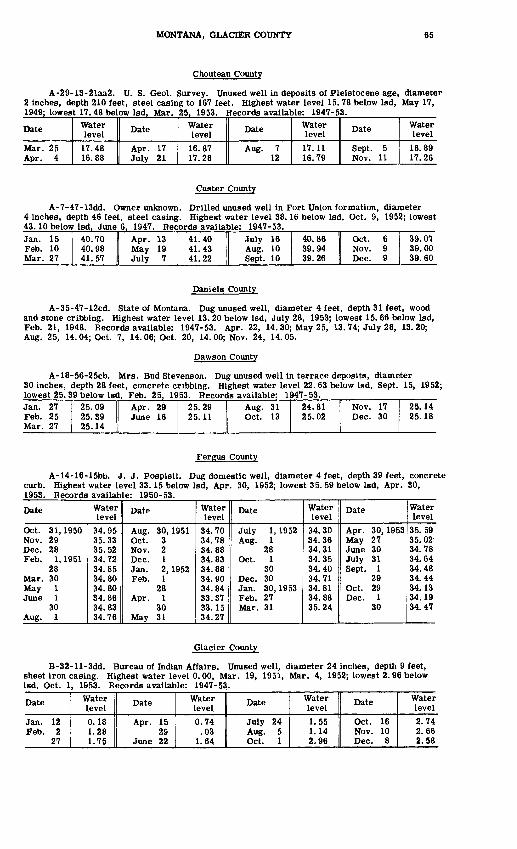
MONTANA, GLACIER COUNTY 65
Chouteau County
A-29-13-21aa2. U. S. Geol. Survey. Unused well in deposits of Pleistocene age, diameter 2 inches, depth 210 feet, steel casing to 167 feet. Highest water level 15.78 below Isd, May 17, 1949; lowest 17.48 below Isd, Mar. 25, 1953. Records ayailableL 1947-53.
Date
Mar. 25 Apr. 4
Water level17.48 16.88
Date
Apr. 17 July 21
Water level
16.87 17.28
Date
Aug. 7 12
Water level
17. 11 16.79
Date
Sept. 5 Nov. 11
Water level
16.89 17.26
Custer County
A-7-47-13dd. Owner unknown. Drilled unused well in Fort Union formation, diameter 4 inches, depth 46 feet, steel casing. Highest water level 38.16 below Isd, Oct. 9, 1952; lowest 43.10 below Isd, June 6, 1947. Records avaitable: 1947-53.Jan. 15 Feb. 10 Mar. 27
40.70 40.98 41.57
Apr. 13 May 19July 7
41.40 41.43 41.22
July 16 Aug. 10 Sept. 10
40.86 39.94 39.26
Oct. 6 Nov. 9 Dec. 9
39.07 39.00 39.60
Daniels County
A-35-47-12cd. State of Montana. Dug unused well, diameter 4 feet, depth 31 feet, wood and stone cribbing. Highest water level 13. 20 below Isd, July 28, 1953; lowest 15. 66 below Isd, Feb. 21, 1948. Records available: 1947-53. Apr. 22, 14. 30; May 25, 13.74; July 28, 13.20; Aug. 25, 14.04; Oct. 7, 14.06; Oct. 20, 14.00; Nov. 24, 14.05.
Dawson County
A-18-56-25cb. Mrs. Bud Stevenson. Dug unused well in terrace deposits, diameter 30 inches, depth 28 feet, concrete cribbing. Highest water level 22. 63 below Isd, Sept. 15, 1952; lowest 25. 39 below Isd, Feb. 25, 1953. Records available: 1947-53.Jan. 27 Feb. 25 Mar. 27
25.09 25.39 25.14
Apr. 29 June 16
25.29 25.11
Aug. 31 Oct. 13
24,81 25.02
Nov. 17 Dec. 30
25.14 25.18
Fergus County
A-14-16-15bb. J. J. Pospisil. Dug domestic well, diameter 4 feet, depth 39 feet, concrete curb. Highest water level 33. 15 below Isd, Apr. 30, 1952; lowest 35. 59 below Isd, Apr. 30, 1953. Records available: 1950-53.
Date
Oct. 31,1950 Nov. 29 Dec. 28 Feb. 1, 1951
28 Mar. 30 May 1 June 1
30 Aug. 1
Water level
34.95 35.33 35.52 34.72 34.85 34.80 34.80 34.86 34.83 34.76
Date
Aug. 30,1951 Oct. 3 Nov. 2 Dec. 1 Jan. 2, 1952 Feb. 1
28 Apr. 1
30 May 31
Water level
34.70 34.78 34.88 34.83 34.88 34.90 34.84 33.37 33.15 34.27
Date
July 1, 1952 Aug. 1
28 Oct. 1
30 Dec. 30 Jan. 30, 1953 Feb. 27 Mar. 31
Water level
34.30 34.36 34.31 34.35 34.40 34.71 34.81 34.88 35.24
Date
Apr. 30,1953 May 27 June 30 July 31 Sept. 1
29 Oct. 29 Dec. 1
30
Water level
35.59 35. 02 34.78 34.64 34.48 34.44 34.13 34.19 34.47
Glacier County
B-32-ll-3dd. Bureau of Indian Affairs. Unused well, diameter 24 inches, depth 9 feet, sheet iron casing. Highest water level 0.00, Mar. 19, 1951, Mar. 4, 1952; lowest 2. 96 below Isd, Oct. 1, 1953. Records available: 1947-53.
Date
Jan. 12 Feb. 2
27
Water level0.18 1.28 1.75
Date
Apr. 15 29
June 22
Water level0.74
.03 1.64
Date
July 24 Aug. 5 Oct. 1
Water level1.55 1.14 2.96
Date
Oct. 16 Nov. 10 Dec. 8
Water level2.74 2.66 2.58
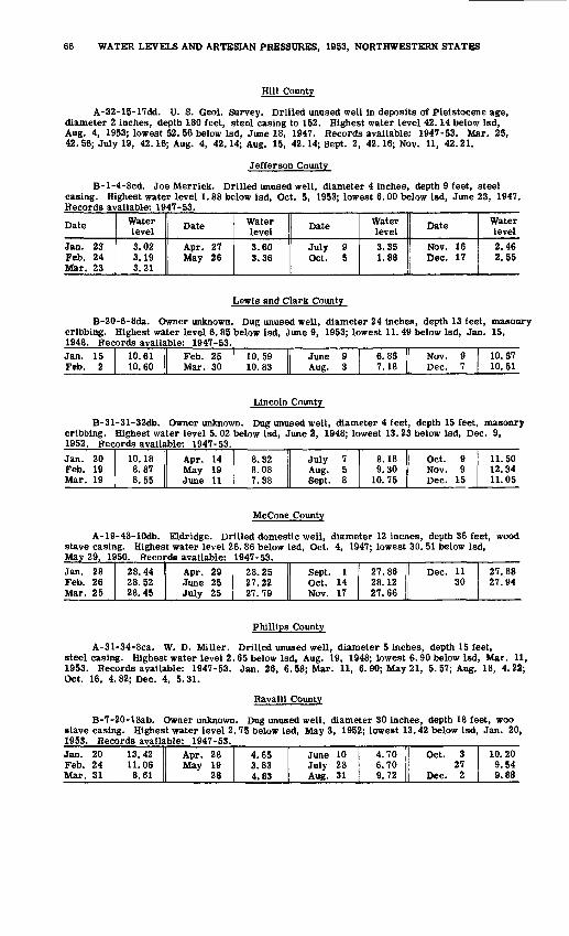
66 WATER LEVELS AND ARTESIAN PRESSURES, 1953, NORTHWESTERN STATES
mil County
A-32-15-17dd. U. S. Geol. Survey. Drilled unused well in deposits of Pleistocene age, diameter 2 inches, depth 180 feet, steel casing to 152. Highest water level 42.14 below Isd, Aug. 4, 1953; lowest 52. 56 below Isd, June 18, 1947. Records available: 1947-53. Mar. 25, 42.56; July 19, 42.16; Aug. 4, 42.14; Aug. 15, 42.14; Sept. 2, 42.16; Nov. 11, 42.21.
Jefferson County
B-l-4-8cd. Joe Merrick. Drilled unused well, diameter 4 inches, depth 9 feet, steel casing. Highest water level 1. 88 below Isd, Oct. 5, 1953; lowest 6.00 below Isd, June 23, 1947. Records available: 1947-53.
Date
Jan. 23 Feb. 24 Mar. 23
Water level3.02 3.19 3.21
Date
Apr. 27 May 26
Water level3.60 3.36
Date
July 9 Oct. 5
Water level3.35 1.88
Date
Nov. 16 Dec. 17
Water level2.46 2.55
Lewis and Clark County
B-20-6-8da. Owner unknown. Dug unused well, diameter 24 inches, depth 13 feet, masonry cribbing. Highest water level 6.85 below Isd, June 9, 1953; lowest 11.49 below Isd, Jan. 15, 1948. Records available: 1947-53.Jan. 15 Feb. 2
10.61 II Feb. 25 10.60 1 Mar. 30
10.59 10.83
June 9 Aug. 3
6.85 7.18
Nov. 9 Dec. 7
10.57 10.51
Lincoln County
B-31-31-32db. Owner unknown. Dug unused well, diameter 4 feet, depth 15 feet, masonry cribbing. Highest water level 5.02 below Isd, June 2, 1948; lowest 13. 23 below Isd, Dec. 9, 1952. Records available: 1947-53.Jan. 20 Feb. 19 Mar. 19
10.18 8.87 8.55
Apr. 14 May 19 June 11
8.32 8.08 7.38
July 7 Aug. 5 Sept. 8
8.18 9.30
10.75
Oct. 9 Nov. 9 Dec. 15
11.50 12.34 11.05
McCone County
A-19-48-10db. Eldridge. Drilled domestic well, diameter 12 incnes, depth 36 feet, wood stave casing. Highest water level 26.86 below Isd, Oct. 4, 1947; lowest 30. 51 below Isd, May 29, 1950. Records available: 1947-53.Jan. 28 Feb. 26Mar. 25
28.44 28.5228.45
Apr. 29 June 25July 25
28.25 27.2227.79
Sept. 1 Oct. 14Nov. 17
27.86 28.1227.66
Dec. 11 30
27.88 27.94
Phillips County
A-31-34-8ca. W. D. Miller. Drilled unused well, diameter 5 inches, depth 15 feet, steel casing. Highest water level 2.65 below Isd, Aug. 19, 1948; lowest 6.90 below Isd, Mar. 11, 1953. Records available: 1947-53. Jan. 26, 6. 58; Mar. 11, 6. 90; May 21, 5. 57; Aug. 18, 4.22; Oct. 16, 4.82; Dec. 4, 5.31.
Ravalli County
B-7-20-18ab. Owner unknown. Dug unused well, diameter 30 inches, depth 18 feet, woo stave casing. Highest water level 2.75 below Isd, May 3, 1952; lowest 13.42 below Isd, Jan. 20, 1953. Records available: 1947-53.Jan. 20Feb. 24Mar. 31
13.4211.068.61
Apr. 28May 19
28
4.653.834.83
June 10July 28Aug. 31
4.706.709.72
Oct. 327
Dec. 2
10.209.549.88

MONTANA, YELLOWSTONE COUNTY 67
Roosevelt County
A-28-49-35ca. Owner unknown. Drilled unused well, diameter 4 inches, depth 49 feet, steel casing. Highest water level 14.70 below Isd, May 1, 1947; lowest 28. 88 below Isd, Oct. 8, 1946. Records available: 1946-53.
Date
Jan. 8 Feb. 25 Mar. 27
Water level
18.68 18.69 18.57
Date
Apr. 21 May 21 June 16
Water level
17.45 16.74 17.67
Date
July 27 Aug. 10 Oct. 21
Water level
17.39 17.37 17.40
Date
Nov. 10 Dec. 16
Water level
17.12 17.09
A-28-57-28dd. Abandoned school. Drilled unused well in Fort Union formation, diameter 5 inches, depth 29 feet, steel casing. Highest water level 23. 92 below Isd, Dec. 26, 1953; lowest 27. 52 below Isd. Apr. 25. 1946. Records available: 1946-53.Jan. 8 Feb. 28 Mar. 9
24.89 24.92 24.92
Mar. 27 Apr. 14 May 20
25.11 25.14 25.04
June 16 July 27 Oct. 20
25.06 24.32 24.22
Nov. 10 Dec. 26
24.43 23.92
Stillwater County
D-2-23-29ba. Alvin South worth. Drilled domestic well, diameter 6 inches, depth 24 feet, steel casing. Highest water level 2. 73 below Isd, Sept. 23, 1949; lowest 12.23 below Isd, May 24, 1950. Records available: 1947-53.Jan. 20 Feb. 18 Mar. 20
9.26 10.16 10.87
Apr. 17 May 18
11.59 11.03
June 15 July 21
9.90 6.55
Aug. 8 Oct. 15
3.95 4.68
Sweet Grass County
A-4-14-14ba. Spike Van Cleave. Dug well in valley fill, diameter 30 inches, depth 16 feet, cribbed with stone. Measurement discontinued Aug. 6, 1951; reestablished with new measuring point Dec. 30, 1952. Highest water level 4. 73 below Isd, June 11, 1947; lowest 14. 67 below Isd, Mar. 24, 1953. Records available: 1947-53.
Date
Dec. 30,1952 Jan. 22,1953 Feb. 25
Water level
14.06 14.42 14.55
Date
Mar. 24,1953 Apr. 28 May 26
Water level
14.67 10.23 5.75
Date
July 3, 1953 Aug. 14 Sept. 28
Water level
6.66 11.76 10.10
Date
Oct. 27,1953 Dec. 1
Water level
9.78 12.97
Teton County
B-25-l-15ab. Don Meech. Dug domestic and stock well in alluvium, diameter 8 feet, depth 23 feet, concrete casing. Highest water level 5. 90 below Isd, June 26, 1953; lowest 17. 53 below Isd, Apr. 3, 1952. Records available: 1947-53. Jan. 7, 14.94; Feb. 8, 14.73, Feb. 25, 14. 77; Mar. 6, 14. 82; May 7, 14. 55; June 26, 5. 90; Aug. 24, 14. 08. Measurement discontinued.
Toole County
B-36-2-8cc. Cloyd Hannon. Dug domestic and stock well, diameter 4 1/3 feet, depth 17 feet, wood cribbing. Highest water level 1. 43 below Isd, June 6, 1953; lowest 10. 53 below Isd, Feb. 13, 1950. Records available: 1947-53.
Date
Jan. 8 Feb. 8
Water level8.60 8.82
Date
Apr. 9 May 7
Water level3.52 3.28
Date
June 6 Aug. 24
Water level1.43 4.68
Date
Oct. 22 Dec. 2
Water level6.93 7.16
Yellowstone County
A-4-33-laa. Cross Service Station. Drilled domestic well in irrigated alluvium, diameter 8 inches, depth 30 feet, steel casing. Highest water level 7.20 below Isd, Nov. 11, 1953; lowest 11.83 below Isd, May 16, 1949. Records available: 1947-53.Jan. 10 Mar. 7 Apr. 4
9.96 10.60 10.66
Apr. 23 June 29
10.90 9.03
Sept. 9 Oct. 5
9.48 9.60
Nov. 11 Dec. 11
7.20 10.03

OREGON
By Stuart G. Brown
Scope of Water-Level Program
The observation-well program in Oregon was continued in 1953 in cooperation with the State Engineer. Measurements were made in 93 wells; measurements were discontinued in 2 wells; 6 nonrecording gages were in operation during the year. Figures 18, 19, and 20 show the location of observation wells in western, central, and eastern Oregon, respectively.
Precipitation
Precipitation for the State as a whole was 112 percent of the 50-year average at the 17 stations for which it was computed. Values ranged from 90 percent at Harney Experimental Station at Burns to 131 percent of normal at LaGrande. West of the Cascades the highest precipi tation was 130 percent of normal at Grants Pass.and the lowest was 92 percent at Falls City. East of the Cascades the highest and lowest precipitation were those reported above for the State as a whole at LaGrande and the Harney Experimental Station. West of the Cascades precipitation was 108 percent of the 50-year average, while east of the Cascades it was 115 percent of the 50-year average. Snowfall was slightly above normal.
Interpretation of Water-Level Fluctuations
September-end water levels in the Willamette Valley subprovince in 1953 were on an average 0. 58 foot above those for 1952. In the Deschutes River subprovince well 14/15-15Q1 in the Prineville area and outside the area of heavy withdrawals from the artesian aquifer was 3 feet lower in September 1953 than in September 1952. Well 14/16-32N1 in the area of heavy pumpage at Prineville was 4. 82 feet higher in October 1953 than in September 1952. Water level in well 14/16-19H1, drawing its water from the shallower unconfined zone, was substantially at the same level in October 1953 as in September 1952. Well 15/16-5D1, which also draws from the shallow unconfined zone, was 0. 59 foot lower in October 1953 than in September 1952. In the Fort Rock area of the Summer Lake subprovince there was a general rise of about 0. 35 foot in the water levels of wells with water-table aquifers; however, one well, 28/14-23D1, showed a water-level drop of 0. 74 foot. Artesian wells in that area showed an average general rise of 0. 41 foot; well 27/15-4G1 rose 0. 73 foot. In the Chewaucan River valley, September-end water levels were 0.66 foot higher in October 1953 than in September 1952. Well 29/23-3J1 in the Alkali Lake area was 0.13 foot lower than it was in September 1952. Water levels in three of the four wells in the northern part of the Owyhee subprovince were on the average 0.62 foot higher in October 1953 than in September 1952, although well 18/47-17D1 showed a drop of 1. 99 feet at year's end. In the southern part of the Owyhee subprovince the net change was 0. 27 foot down from the level of September 1952, In the Burns area of the Harney Basin subprovince water levels at the year's end were 0.18 foot higher than in September 1952. In the Warner Valley area of the Harney Basin subprovince,the levels of the water table fell o.n an average of 1. 58 foot, while artesian wells fell 0. 28 foot from the levels of September 1952. Water levels in the Walla Walla subprovince at the year-end were on an average 0.49 foot lower than in September 1952. In well 6N/35-36H1 the yearly high occurred in May and was 4. 81 feet lower than the high of 1952, which occurred in June. Observation wells in the Grand Ronde subprovince are located in both the Powder River and Grande Ronde valleys. In the Baker area of Powder River valley, September-end water levels were on the average 0. 48 foot lower than those of 1952. The highest water level of the year occurred in January 1953 and was only 0. 05 foot lower than the highest level-of 1952 which occurred in March. In the Grande Ronde valley September-end water levels were on the average 0. 57 foot above the levels of September 1952.
Well- Numbering System
Wells are numbered in accordance with the Bureau of Land Management system of land subdivision. The part preceding the hyphen indicates township and range; the one or two digits immediately following the hyphen Indicate the section; the letter following indicates the 40-acre

OREGON 69
wells at indicated location
Artesian observation well A Figure represents number of
2 wells at indicated location
Figure 18. --Location of observation wells in western Oregon, 1953.

70 WATER LEVELS AND ARTESIAN PRESSURES, 1953, NORTHWESTERN STATES
(5) Figure represents number of wells at indicated location
Figure 19. --Location of observation wells in central Oregon, 1953.
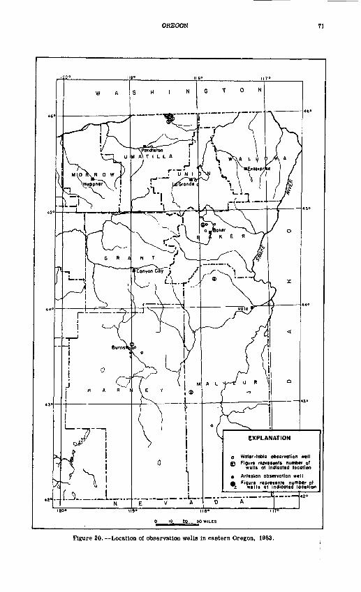
OREGON 71
Figure represents number at wells at indicated location
0 10 20 30 MILES
Figure 20. Location of observation wells in eastern Oregon, 1953.

72 WATER LEVELS AND ARTESIAN PRESSURES, 1953, NORTHWESTERN STATES
subdivision of the section, as shown in the accompanying diagram; and the final digit indicates the serial number of the well within the 40-acre tract. Locations in Oregon are referred to the Willamette base line and meridian. If no letter appears after the township, the township lies south of the base line, if no letter appears after the range number, the range lies east of the meridian. Thus, well 3/38-25B1 is in the NWjNEj sec. 25, T. 3 S., R. 38 E., and is the first well listed in this tract.
D
E
M
N
C
F 2
L
P... ____
B
G
K
8
A
H
J
R
Well Descriptions and Water-Level Measurements
(Water levels are in feet below land-surface datum unless otherwise indicated.)
Baker County
7/39-20N1. City of Baker. Dug observation water-table well in alluvium, size 18 by 18 inches, depth 9 feet, cribbed with wood to bottom, perforated 12-inch steel casing 3 to 7. Land-surface datum is 3, 373. 8 feet above msl. Highest water level 1. 33 below Isd, June 22, 1952; lowest 7. 02 below Isd, Oct. 9, 1945. Records available: 1936, 1938-53. Mar. 26, 3.66; Aug. 5, 4.79; Oct. 13, 6.87.
8/39-22F1. Baker County. Dug observation water-table well in alluvium, size 18 by 18 inches, depth 11 feet, cribbed with wood to 9, perforated 12-inch steel casing 7 to 11. Land- surface datum is 3, 385. 78 feet above msl. Highest water level 2. 75 below Isd, Mar. 8, 1949; lowest 9. 87 below Isd, Sept. 29, 1939. Records available: 1936, 1938-53. Mar. 26, 3.05; Aug. 5, 4.69; Oct. 13, 3.88.
8/39-22G1. Florence Rohner. Dug unused water-table well in sand and gravel, diameter 12 inches, depth 11 feet. Land-surface datum is about 3, 383 feet above msl. Highest water level 1. 20 below Isd, Mar. 23, 1952; lowest 4. 95 below Isd, Sept. 11, 1950. Records available: 1949-53.
Daily water level from nonrecording gageDay
123456 789
1011 1213 141516 1718 1920212223 24252627 2890
30 31
Jan.3.143.143.143.133.113.08 3.062.001.25 1.501.60 1.781.80 1.601.612.04 2.081.95 1.901.822.052.252.28 2.282.342.452.50 2.542.562.58 2.58
Feb.2.582 502 4n2 152.322.40 2.852 Q5
2.80 2.482.52 2.592.60 2.612.622.652 fi7
2.68 2.692.702.782 75
2.782 7Q
2.752 70
2.60 2.58
Mar.2 592.632.732 752.742.732 79
2 7O
2.70 2.752.80 2.822.84 2.862.842.892 no
2.95 2 on2.882 49
2 45
2.32 2.382.522 en
2.682 79
2.802.85 2.89
Apr.2.852.892 QQ
3 ft1
3.033.05 3.083 1 O
3.09 3.083.07 3143.14 3.133.123.123 1°*
3.143 1 <\3.153.183 99
3.283 on
3.303 00
3.353 0.7
3 00
3.39
May3 A(\
3 4.1
3 AO.
3 A.A
3.463.48 3503 59
3.55 3.583.603 on
3.643 CQ
3.693.703 79
3.67S CO
.3.553 5ft
3 45
3.403 95
3.153 no3.09 3 no2 fid2.54 2.35
June2.842 402 592 fid2.782.50 2.802 OK
2.36 2.412.592 70
2.80 2.852.892.95 3.003.173 99
3.283 QC
3 A(\
3.43 3 443.493 55
3.573 CO
3 ^Q
3.60
July3.633.663 RQ
3 74
3.793.80 3.813.823.83 3.843.85 3.853.87 3.894.004.19 4 on4.224 94
4.274 ^.04 00
4.354 <47
4.384 10
4.40 4.414 49
4.44 4.46
Aug.4.554.564.604 R9
4.654.69 4.714.744.77 4.794.82 4.854.88 4.904.914.973 0.0.
3.453 40
3.543.603.633.703 79
3.743 77
3.80 3.823.833.84 3.85
Sept.3.853.853.823.803.793.77 3.753 74
3.75 3.763.77 3.783.79 3.803.813.81 3.823.82 3.823.833.843.853.853 R4
3.843.833.83 3.843 R4
3.82
Oct.
3.82
3.69
3.58
3.28
3.20
Nov.
3.15
3.10
....
2.95
2.31
Dec.
2.42
....
2. 55
1.94
2.60

OREGON, HARNEY COUNTY 73
8/40-19D1. Baker County. Dug observation water-table well in alluvium, size 18 by 18 inches, depth 9 feet, cribbed with wood to bottom, perforated 12-inch steel casing 3-7. Land-surface datum is 3, 341. 95 feet above msl. Highest water level 0. 74 below Isd, June 14, 1941; lowest 7. 20 below Isd, Oct. 27, 1950. Records available: 1936, 1938-53. Mar. 26, 0.98; Aug. 5, 4.81; Oct. 13, 5.92.
8/40-23A1. Baker County. Driven observation water-table well in alluvium, diameter l| inches, depth 8 feet, screen 6-8. Land-surface datum is 3,347.28 feet above msl. Highest water level 0. 00, June 22, 1952; lowest 5. 90 below Isd, Dec. 8, 1939. Records available: 1936, 1938-47, 1949-53. Mar. 26, 2. 72; Aug. 5, 3.84; Oct. 13, 4.13.
9/39-2N1. Chris Lee. Drilled unused water-table well, diameter 12 inches, depth 321 feet, perforations 0-321. Land-surface datum is about 3, 417 feet above msl. Highest water level 4.97 below Isd, Apr. 25, 1950; lowest 13.61 below Isd, Jan. 5, 15, 1950. Records avail able: 1949-53. Mar. 26, 8. 76; Aug. 5, 7. 51; Oct. 13, 10.59.
Benton County
14/5W-10R1. Chris Lindseth. Driven unused water-table well in alluvium, diameter lj inches, depth 19 feet. Land-surface datum is 267. 49 feet above msl. Highest water level 0.21 above Isd, Feb. 26, 1936; lowest 16.23 below Isd, Sept. 27, 1945. Records available: 1929-30, 1935-36, 1938-53. June 2, 12. 31; Dec. 22, 5.69.
Crook County
14/15-15Q1. M. D. Colahan. Drilled domestic and stock artesian well, diameter 4 inches, depth 210 feet. Land-surface datum is 2, 846. 8 feet above msl. Highest water level 73. 5 above Isd, May 27. 1953; lowest 46. 5 above Isd. July 23, 1946. Records available: 1944-53.
Date
Feb. 91526
Mar. 41231
Apr. 16
Water level
+66.567.567.567.568.568.568.568.5
Date
Apr. 14May 15
182127
June 125
July 7
Water level
+69.571.571.568.073.564.572.565.0
Date
July 1320
Aug. 1925
Sept. 2128
Oct. 6
Water level
+71.070.563.564.564.565.564.5
Date
Oct. 1516
Nov. 81618
Dec. 1426
Water level
+66.566.567.567.567.567.567.5
14/16-19H1. Floyd Bailey. Drilled domestic water-table well in sandy lacustrine sediments of Pleistocene age, diameter 6 inches, depth 47 feet. Land-surface datum is about 2, 970 feet above msl. Highest water level 2. 74 below Isd, Aug. 26, 1949; lowest 17. 51 below Isd, Mar. 19, 1948. Records available: 1944, 1947-53. Mar. 31, 15. 72; July 13, 6. 23; Oct. 16, 4.55.
14/16-32N1. E. E. Wagoner. Dunham and Sixth Sts., Prineville. Drilled unused artesian well, diameter 5 inches, depth 160 feet. Land-surface datum is 2, 865. 90 feet above msl. Highest water level 1. 82 above Isd, Dec. 8, 1945; lowest 18. 93 below Isd, Aug. 26, 1949. Records available: 1944-53. Mar. 31, 6.21; July 13, 13. 58; Oct. 16, 8.95.
15/16-5D1. Pacific Power & Light Co. Court Ave. and Fourth St., Prineville. Driven public-supply water-table well in alluvium along Ochoco Creek, diameter 2 inches, depth 40 feet. Land-surface datum is about 2, 865 feet above msl. Highest water level 5.20 below Isd, Apr. 15, 1952; lowest 8.11 below Isd, Oct. 18, 1953. Records available: 1943,1947-53. Mar. 31, 7.06; Oct. 16, 6.11.
Harney County
22/31-34N1. L. F. Lazaus. Drilled stock artesian well in Danforth formation, diameter 18 to 8 inches, depth 288 feet. Land-surface datum is 4,153.17 feet above msl. Highest water level 1.50 below Isd, Apr. 21, 1936; lowest 13.70 below Isd, Oct. 29, 1950. Records available: 1936-53. Mar. 29, 9.23; July 16, 9.19; Oct. 14, 11.67.
23/31-3D2. Harney County. Dug observation water-table well in alluvium, size 18 by 18 inches, depth 14 feet, cribbed with wood to 12, perforated 12-inch steel casing 10-14. Land- surface datum is 4,153.12 feet above msl. Highest water level 3.00 below Isd, June 11, 1945; lowest 9. 32 below Isd, Feb. 18, 1936. Records available: 1936, 1938-53. Mar. 29, 3.70; July 16, 4. 86; Oct. 14, 8. 01.
23/31-14A3. Harney County. Dug observation water-table well in alluvium, size 18 by 18 inches, depth 17 feet, cribbed with wood to 14, perforated 12-inch steel casing 13-17. Land-surface datum is 4,142. 55 feet above msl. Highest water level 1. 50 below Isd, Apr. 16, 1952; lowest 13.20 below Isd, Jan. 15, 1936. Records available: 1936, 1938-53. Mar. 29, 3.50; July 16, 4.85; Oct. 14, 8.81.
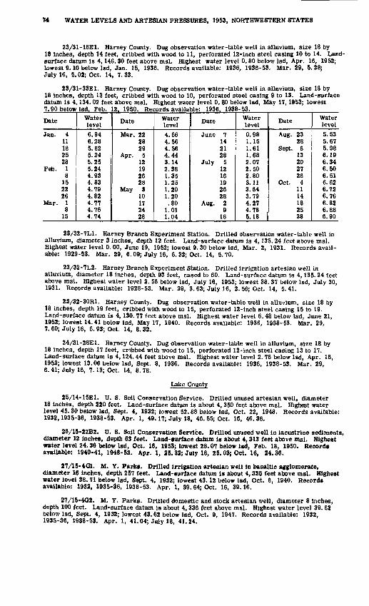
74 WATER LEVELS AND ARTESIAN PRESSURES, 1953, NORTHWESTERN STATES
23/31-16E1. Harney County. Dug observation water-table well in alluvium, size 18 by 18 inches, depth 14 feet, cribbed with wood to 11, perforated 12-inch steel casing 10 to 14. Land- surface datum is 4,146.30 feet above msl. Highest water level 0.80 below Isd, Apr. 16, 1952; lowest 9.10 below Isd, Jan. 15, 1936. Records available: 1936, 1936-53. Mar. 29, 5.28; July 16, 5.02; Oct. 14, 7.33.
23/31-33E1. Harney County. Dug observation water-table well in alluvium, size 18 by 18 inches, depth 13 feet, cribbed with wood to 10, perforated steel casing 9 to 13. Land-surface datum is 4,134.02 feet above msl. Highest water level 0. 80 below Isd, May 17,1953; lowest 7.90 below Isd. Feb. 12, 1950. Records available: 1936, 1938-53.
Date
Jan. 411182528
Feb. 18
152226
Mar. 18
15
Water level6.946.285.625.245.255.244.934.834.794.824.774.764.74
Date
Mar. 222829
Apr. 512192628
May 310172428
Water level4.664.564.564.443.142.381.351.251.201.20.80
1.011.04
Date
June 7142128
July 51216192628
Aug. 29
16
Water level0.981.151.611.682.072.502.803.113.643.794.274.785.18
Date
Aug. 2328
Sept. 613202726
Oct. 41114182528
Water level5.535.675.986.196.346.506.516.626.726.766.826.886.90
23/32-7L1. Harney Branch Experiment Station. Drilled observation water-table well in alluvium, diameter 3 inches, depth 12 feet. Land-surface datum is 4,135.24 feet above msl. Highest water level 0.00, June 19, 1952; lowest 9.30 below Isd, Mar. 2, 1931. Records avail able: 1929-53. Mar. 29, 6.09; July 16, 6. 32; Oct. 14, 5.70.
23/32-7L2. Harney Branch Experiment Station. Drilled irrigation artesian well in alluvium, diameter 18 inches, depth 93 feet, cased to 60. Land-surface datum is 4,135.24 feet above msl. Highest water level 2. 56 below Isd, July 16, 1953; lowest 38. 37 below Isd, July 30, 1931. Records available: 1928-53. Mar. 29, 3. 63; July 16, 2. 56; Oct. 14, 5.41.
23/32-30R1. Harney County. Dug observation water-table well in alluvium, size 18 by 18 inches, depth 19 feet, cribbed with wood to 15, perforated 12-inch steel casing 15 to 19. Land-surface datum is 4,130. 77 feet above msl. Highest water level 6.48 below Isd, June 21, 1952; lowest 14.41 below Isd, May 17, 1940. Records available: 1936,1938-53. Mar. 29, 7. 60; July 16, 6.93; Oct. 14, 8.32.
24/31-28E1. Harney County. Dug observation water-table well in alluvium, size 18 by 18 inches, depth 17 feet, cribbed with wood to 15, perforated 12-inch steel casing 13 to 17. Land-surface datum is 4,124.44 feet above msl. Highest water level 2.76 below Isd, Apr. 16, 1952; lowest 13.06 below Isd, Sept. 8, 1936. Records available: 1936,1938-53. Mar. 29, 6. 41; July 16, 7.13; Oct. 14, 8. 78.
Lake County
25/14-15E1. U. S. Soil Conservation Service. Drilled unused artesian well, diameter 18 inches, depth 220 feet. Land-surface datum is about 4,350 feet above msl. Highest water level 45.30 below Isd, Sept. 4, 1932; lowest 52.88 below Isd, Oct. 22, 1948. Records available: 1932,1935-36, 1938-53. Apr. 1, 49.17; July 18, 46. 55; Oct. 16, 46. 36.
26/15-22B2. U. S. Soil Conservation Service. Drilled unused well in lacustrine sediments, diameter 12 inches, depth 63 feet. Land-surface datum is about 4,313 feet above msl. Highest water level 24.36 below Isd, Oct. 16, 1953; lowest 28.07 below Isd, Feb. 18, 1950. Records available: 1940-41, 1948-53. Apr. 1, 25.32; July 18, 25.03; Oct. 16, 24.36.
27/15-4G1. M. Y. Parka. Drilled irrigation artesian well in basaltic agglomerate, diameter 16 inches, depth 257 feet. Land-surface datum is about 4,335 feet above msl. Highest water level 38.71 below Isd, Sept. 4, 1932; lowest 43.12 below Isd, Oct. 6, 1940. Records available: 1932, 1935-36, 1938-53. Apr. 1, 39.64; Oct. 16, 39.16.
27/15-4G2. M. Y. Parks. Drilled domestic and stock artesian well, diameter 8 inches, depth 100 feet. Land-surface datum is about 4,336 feet above msl. Highest water level 39.62 below Isd, Sept. 4, 1932; lowest 43.62 below Isd, Oct. 9, 1947. Records available: 1932, 1935-36, 1938-53. Apr. 1, 41.04; July 18, 41.24.
OREGON, LAKE COUNTY 75
27/17-22R2. W. D. Collins. Drilled unused water-table well in sand, diameter 8 inches, depth 54 feet. Land-surface datum is about 4,325 feet above msl. Highest water level 25.13 below Isd, May 25, 1941; lowest 28.28 below Isd, Aug. 5, 1948. Records available: 1938, 1940-44, 1946-53. Apr. 1, 26. 62; July 18, 26. 38; Oct. 16, 26. 23.
27/18-6E2. Roy Moorehouse. Drilled unused water-table well, diameter 8 inches, depth 83 feet. Land-surface datum is about 4, 317 feet above msl. Highest water level 22. 57 below Isd, Sept. 15, 1943; lowest 25.19 below Isd, Apr. 1, 1953. Records available: 1940-53. Apr. 1, 25.19; July 18, 25.09; Oct. 16, 25.12.
27/18-7N1. Roily Hardin. Dug unused water-table well in sand, size 4 by 4 feet, depth 40 feet. Land-surface datum is about' 4, 316 feet above msl. Highest water level 20. 59 below lad, Apr. 15, 1952; lowest 34. 96 below Isd, July 4, 1949. Records available: 1938-53. Apt. 1, 26.00; July 18, 24. 54; Oct. 16, 24.57.
28/14-23D1. Dudleys. Long. Dug unused water-table well in lake deposits, size 4 by 4 feet, depth 26 feet. Land-surf ace datum is about 4, 343 feet above msl. Highest water level 6.29 below Isd, June 18, 1952; lowest 15. 97 below Isd, Feb. 17, 1950. Records available: 1949-53. Apr. 1, 14. 50; July 18, 6. 85; Oct. 16, 10. 20.
29/16-9D1. Sid Harris. Drilled stock artesian well in sand, diameter 6 inches, depth 320 feet. Land-surface datum is about 4, 302 feet above msl. Highest water level 7.65 below Isd, Oct. 16, 1953; lowest 10.01 below Isd, Feb. 17, 1950. Records available: 1949-53. Apr. 15, 8.03; Oct. 16, 7.65.
29/16-9D2. Sid Harris. Drilled stock water well in sand, diameter 8 inches, depth 55 feet. Land-surface datum is about 4,302 feet above msl. Highest water level 0. 90 below Isd, June 18, 1952; lowest 14. 00 below Isd, July 12, 1950. Records available: 1949-53. Apr. 1, 5.53; . Oct. 16, 4.85.
29/23-3J1. U. S. Soil Conservation Service. Drilled unused well in playa sediments of Pleistocene age, diameter 8 inches, depth 177 feet. Land-surface datum is about 4,225 feet above msl. Highest water level 18.43 below Isd, Oct. 11, 1945; lowest 19.11 below Isd, Sept. 5, 1951, Oct. 15, 1953. Records available: 1945, 1947-53. Apr. 1, 19.08; July 18, 19.06; Oct. 15, 19.11.
33/17-5M1. W. H. Harvey. Drilled unused artesian well in-valley fill, diameter 6 inches, depth 560 feet. Land-surface datum is about 4, 295 feet above msl. Highest water level 15. 00 below Isd, July 19, 1953; lowest 25. 95 below Isd, Feb. 17, 1950. Records available: 1948-53. Apr. 1, 23. 85; July 19, 15. 00; Oct. 16, 21.06.
35/21-21P1. Del Overton. Drilled domestic and stock water-table well, diameter 3 inches. Land-surface datum is about 4, 280 feet above msl. Highest water level 19.12 below Isd, June 20, 1952; lowest 21. 85 below Isd, Mar. 22, 1951. Records available: 1948, 1950-53. Apr. 1, 24. 79, pumping; July 19, 19. 44; Oct. 16, 20.18.
35/24-9J1. U. S. Bureau of Land Management. Drilled unused artesian well in basalt, diameter 8 inches, depth 376 feet. Land-surface datum is about 4, 525 feet above msl. Highest water level 7. 53 below Isd, Apr. 1, 1953; lowest 8. 77 below Isd, July 9, 1950. Records avail able: 1949-53. Apr. 1, 7. 53; July 20, 7. 63; Oct. 15, 7.89.
36/21-6B1. S. V. Carroll. Dug unused water-table well in sand, size 8 by 8 feet, depth 21 feet. Land-surface datum is 4, 321. 6 feet above msl. Highest water level 11.08 below Isd, July 18, 1953; lowest 17. 21 below Isd, Aug. 27, 1938. Records available: 1938-53. Apr. 1, 11.36; July 18, 11. 08; Oct. 16, 11.32.
36/24-28M1. J. p. Eagan. Drilled domestic water-table well in gravel, diameter 6 inches, depth 40 feet. Land-surface datum is about 4, 512 feet above msl. Highest water level 17.95 below Isd, June 19, 1952; lowest 28.06 below Isd, Jan. 5, 1952. Records available: 1948-53. Apr. 1, 18.39; July 20, 18. 58; Oct. 15, 23.46.
36/24-32A1. Thomas J. Murphy. Dug stock and irrigation water-table well in gravel, size 4 by 4 feet, depth 23 feet. Land-surface datum is about 4, 512 feet above msl. Highest water level 10. 79 below lad, June 19, 1952; lowest 19.75 below Isd, Oct. 29, 1940. Records- available: 1940, 1948-53. Apr. 1, 11. 94; July 20, 11. 83; Oct. 15, 15.84.
36/25-19A1. U. S. Fish and Wildlife Service. Dug unused water-table well in sand, gravel, and cobbles, diameter 24 inches, depth 6 feet. Land-surface datum is about 4,474 feet above msl. Highest water level 1. 38 below Isd, Apr. 16, 1952; lowest 3.47 below Isd, Feb. 13, 1950. Records available: 1948-53. Apr. 1, 2.15; July 20, 1. 98; Oct. 15, 2. 53.

76 WATER LEVELS AND ARTESIAN PRESSURES, 1953, NORTHWESTERN STATES
38/24-27M1. Charles Crump. Drilled unused artesian well in gravel, diameter 6 inches, depth 81 feet. Land-surface datum is about 4, 495 feet above msL Highest water level 0. 00, Apr. 16, June 19, Sept. 5, 1952, Apr. 1, 1953; lowest 0. 64 below Isd, Nov. 13, 1949. Records available: 1948-53. Apr. 1, 0. 00; July 20, +0. 02; Oct. 15, 0.01.
39/24-21F2. J. G. Dyke. Drilled domestic water-table well in gravel, diameter 12 inches, depth 165 feet. Land-surface datum is about 4, 542 feet above msl. Highest water level 10. 84 below Isd, July 9, 1950; lowest 18. 76 below Isd, Feb. 13, 1950. Records available: 1948-52. Apr. 1, 18. 55; July 20, 15. 96; Oct. 15, 16.07.
39/24-21F3. J. G. Dyke. Dug domestic water-table well in gravel, size 6 by 6 feet, depth 16 feet. Land-surface datum is about 4, 540 feet above msl. Highest water level 10.28 below Isd, July 9, 1950; lowest 16. 64 below Isd, Feb. 13, 1950. Records available: 1948-53. Apr. 1, 16. 43; July 20, 13. 30; Oct. 15, 13.86.
39/24-35D1. Ellen Cahill. Drilled domestic artesian well in valley fill, diameter 4 inches, depth 26 feet. Land-surface datum is about.4, 475 feet above msl. Highest water level 1. 49 below Isd, June 19, 1952; lowest 6.21 below Isd, Nov. 13, 1949. Records available: 1948-53. Apr. 1, 3.93; July 20, 1.92; Oct. 15, 5.74.
Lane County
15/4W-32M1. Junction City. Dug water-table well in gravel, diameter 8 feet, depth 20 feet, cribbed with brick to bottom. Land-surface datum is 323.4 feet above msl. Highest water level 3. 36 below Isd, Dec. 22, 1953; lowest 11.18 below Isd, Sept. 29, 1951. Records available: 1928-30, 1935-36, 1938-53. June 2, 5.97; Oct. 8, 10.47; Dec. 22, 3.36.
16/3W-32G1. Leo Sidwell. Dug irrigation water-table well in young alluvium, diameter 4 feet, depth 19 feet, cribbed with concrete tile. Land-surface datum is 388. 98 feet above msl. Highest water level 6. 53 below Isd, Jan. 16, 1936; lowest 12. 98 below Isd, Oct. 31, 1935. Records available: 1928-30, 1935-36, 1938-53. June 2, 9. 96; Oct. 8, 12. 47; Dec. 22, 6.74.
Linn County
10/4W-12F1. Henry Hoefer. Dug domestic water-table well in gravel, diameter 24 inches, depth 25 feet, cribbed with concrete tile to bottom. Land-surface datum is 185. 74 feet above msl. Highest water level 7. 62 below Isd, Jan. 14, 1936; lowest 24. 34 below Isd, Sept. 11, 1952. Records available: 1928-30, 1935-36, 1938-53. June 2, 19.30; Oct. 8, 23. 33; Dec. 22, 11.50.
11/5W-36Q1. E. L. Beach. Drilled unused water-table well in alluvium, diameter 3 inches, depth 42 feet. Land-surface datum is 218. 27 feet above msl. Highest water level 7. 78 below Isd, Dec. 21, 1929; lowest 26. 03 below Isd, Aug. 19, 1935. Records available: 1929-30, 1935-36, 1938-53. June 2, 17. 75; Dec. 22, 8.55.
12/2W-14B1. Sigurd H. Lanstrom. Dug irrigation water-table well in alluvium, size 5 by 5 feet, depth 16 feet, concrete wall to bottom. Land-surface datum is about 346 feet above msl. Highest water level 3. 99 below Isd, Dec. 22, 1953; lowest 11. 22 below Isd, Oct. 27, 1942. Records available: 1941-53. June 2, 6. 56; Oct. 8, 10. 02; Dec. 22, 3.99.
12/3W-9R1, J. H. Swatzka. Dug domestic water-table well in alluvium, diameter 30 inches, depth 19 feet, cribbed with concrete to bottom. Land-surface datum is 272. 79 feet above msl. Highest water level 1. 70 below Isd, Feb. 23, 1930; lowest 17. 89 below Isd, Sept. 24, 1946. Records available: 1928-30, 1935-36,1938-53. June 2, 3.28.
1S/3W-34N1. Keeney School, District 51. Driven unused water-table well in alluvium, diameter If inches, depth 12 fset, screen 10-12. Land-surface datum is 285.0 feet above msl. Highest water level 0.67 below Isd, Jan. 10, 1936; lowest 9.43 below Isd, Dec. 6, 1938. Records available: 1928-30, 1935-3?, 1938-46, 1960-53. June 2, 2.35; Oct. 8, 6. 71; Dec. 22, 2.02.
Malheur County
l5/40r2Ht. Max Holloway. Drilled irrigation well in gravel, diameter 12 inches, depth 421 feet. Land-surface datum is about 3,900 feet above msl. Highest water level 18.28 below lsdr Mar. 18, 1951; lowest 24.30 below Isd, Sept. 9, 1952. Records available: 1950-53. Mar. 27, 21.05; Aug. 4, 23.16; Oct. 13, 23.64.
15/40-2N1. Rankin Crow. Drilled irrigation well in gravel, diameter 10 inches, depth , 1.78 feet, Lund-surface datum is about 3,900 feet above, msl. Highest water level 31. 06 below
lS.d, Mar, £8, 1951; lowest 38.29 below Isd, Aug. 14, 1951. Records available: 1950-53. Mar. 2T, 36.07; Aug. 4, 62.08, pumping; Oct. 13, 37.98.
OREGON, MARION COUNTY 77
18/47-17D1. Earl Weaver. Drilled domestic water well, diameter 3 inches, depth 135 feet. Land-surface datum is about 2,160 feet above msl. Highest water level 6.91 below Isd, Sept. 9, 1952; lowest 11.09 below Isd, Mar. 27, 1953. Records available: 1950-53. Mar. 27, 11.09; Aug. 5, 8.31; Oct. 13, 8.90.
21/38-17Q1. Charles Wilson. Dug irrigation water-table well in gravel, diameter 12 inches, depth 14 feet, cribbed with concrete tile to bottom. Land-surface datum is about 2, 960 feet above msl. Highest water level 3. 07 below Isd, June 23, 1952; lowest 11.14 below Isd, Feb. 12, 1950. Records available: 1945-53. Mar. 27, 10. 68; Aug. 4, 6. 23; Oct. 14, 5.02.
28/37-23R1. Earl Obenchain. Dug domestic water-table well in gravel, diameter 4 feet, depth 30 feet, cribbed with rock to bottom. Land-surface datum is about 4,060 feet above msl. Highest water level 3. 30 below Isd, Apr. 17, 1952; lowest 14.14 below Isd, Oct. 28, 1950. Records available: 1950-53. Mar. 28, 7. 52; July 17, 8. 38; Oct. 14, 10.93.
28/37-25F1. Earl Obenchain. Drilled stock water-table well in gravel, diameter 4 inches, depth 96 feet, cased to 70. Land-surface datum is about 4,060 feet above msl. Highest water level 55. 29 below Isd, Mar. 28, 1953; lowest 57. 73 below Isd, Aug. 15, 1951. Records avail able: 1950-53. Mar. 28, 55. 29; July 17, 55. 49; Oct. 14, 55.52.
29/37-19A1. George Renick. Drilled unused well, diameter 6 inches, depth 201 feet. Land-surface datum is about 4,067 feet above msl. Highest water level 85.23 below Isd, Dec. 30, 1952; lowest 85.84 below Isd, Apr. 17, 1952. Records available: 1950-53. Mar. 28, 85.36; July 17, 85. 69; Oct. 14, 85.60.
32/40-18K1. Keith Wallace. Drilled domestic and public-supply artesian well in volcanic rock, diameter 6 inches, depth 358 feet, cased to 160. Land-surface datum is about 4,000 feet above msl. Highest water level 235. 22 below Isd, Dec. 30, 1952; lowest 237. 55 below Isd, July 17, 1953. Records available: 1950-53. Mar. 28, 235. 95; July 17, 237. 55; Oct. 14, 235.31.
Marion County
4/1W-2C1. W. F. Keil. Drilled domestic water-table well in valley fill, diameter 10 inches, depth 26 feet. Land-surface datum is 186. 69 feet above msl. Highest water level 0. 65 below Isd, Dec. 9, 1948; lowest 21. 66 below Isd, Mar. 20, 1939. Records available: 1928-30, 1935-36, 1938-53. June 3, 3.10; Oct. 7, 16. 90; Dec. 21, 0.99.
4/1W-23G1. Julius Sather. Dug unused water-table well in alluvium, diameter 4 feet, depth 60 feet, cribbed with brick to bottom. Land-surface datum is about 175 feet above msl. Highest water level 44. 78 below Isd, June 7, 1951; lowest 57. 82 below Isd, Sept. 28, 1945. Records available: 1945-53. June 3, 52. 55; Oct. 7, 53.18; Dec. 21, 53. 50.
4/2W-4C1. W. J. Gering. Dug domestic water-table well in alluvium, diameter 36 inches, depth 23 feet, cribbed with concrete tile to bottom. Land-surface datum is 123. 57 feet above msl. Highest water level 7.46 below Isd, Mar. 26, 1951; lowest 19. 90 below Isd, Dec. 5, 1939. Records available: 1928-30, 1935-36, 1938-53. June 3, 10. 94; Oct. 7, 14. 54; Dec. 21, 9.00.
4/2W-34R1. Johnson School. Dug unused water-table well in alluvium, diameter 18 inches, depth 20 feet, cribbed with concrete fill to bottom. Land-surface datum is 172. 86 feet above msl. Highest water level 0. 71 below Isd, Dec. 9, 1948; lowest 18. 52 below Isd, Dec. 5, 1939. Records available: 1928-30, 1935-36, 1938-53. June 3, 8. 06; Oct. 7, 17.04; Dec. 21, 0.96.
5/2W-25M1. Agricultural Research Corp. (Sam H. Brown). Drilled irrigation artesian well in sand and gravel, diameter 18 to 6 inches, depth 252 feet, casing perforated 117-147 and 215-245. Land-surface datum is 180.31 feet above msl. Highest water level 13.74 below Isd, Mar. 11, 1948; lowest 25.04 below Isd, Sept. 10, 1952. Records available: 1930, 1935-36, 1938-53. June3, 17.66; Oct. 7, 24.20; Dec. 21, 15.80.
6/3W-33R1. Gideon E. Stolz. Drilled unused water-table well in gravel and cobbles, diameter 8 to 6 inches, depth 57 feet, perforated at bottom. Land-surface datum is 133.14 feet above msl. Highest water level 17.19 below Isd, Mar. 26, 1951; lowest 28.28 below Isd, Oct. 16, 1935. Records available: 1929-30, 1935-36, 1938-53. June 3, 21. 50; Oct. 7, 27.33; Dec. 21, 18.06.
6/1-7M1. Fred Lucht. Dug unused water-table well in gravel, diameter 36 inches, depth 21 feet, cribbed with brick. Land-surface datum is 260. 38 feet above msl. Highest water level 0. 25 below Isd, Feb. 2, 1930; lowest 17. 50 below Isd, Dec. 5, 1939. Records available: 1928-30, 1935-36, 1938-53. June 3, 2. 76; Oct. 7, 11.42; Dec. 21, 0.34.
78 WATER LEVELS AND ARTESIAN PRESSURES, 1953, NORTHWESTERN STATES
7/3W-11D2. F. G. Kurtz. Drilled public-supply water-table well in sand and gravel, diameter 8 inches, depth 67 feet, perforated 45-50 and 60-67. Land surface datum is about 140 feet above msl. Highest water level 10.07 below Isd, Mar. 26, 1951; lowest 19.35 below Isd, Sept. 10, Dec. 23, 1952. Records available: 1947-53. June 3, 13.42; Oct. 7, 18.00.
7/3W-11G1. Frank Parkhurst. 1170 Candlewood Drive, North Salem. Drilled domestic water-table well in sand and gravel, diameter 4 inches, depth 44 feet. Land-surface datum is 144.19 feet above msl. Highest water level 12. 56 below Isd, Mar. 11, 1948; lowest 19. 50 below Isd, Dec. 23, 1952. Records available: 1947-53. June 3, 14.74; Oct. 7, 18.36.
7/3W-11H7. Sam James. 1415 Candlewood Drive, North Salem. Driven domestic water- table well in sand and gravel, diameter 2 Inches, depth 27 feet. Land-surface datum is 138.11 feet above msl. Highest water level 6.15 below Isd, Mar. 11, 1948; lowest 11. 79 below Isd, Nov. 25, 1949. Records available: 1948-52. Measurement discontinued.
Multnomah County
1N/1-34N1. Weisfield & Goldberg. SW. Sixth Ave. and Washington St., Portland. Drilled Industrial water-table well in alluvium, diameter 8 inches, depth 155 feet. Land-surface datum is 37.20 feet above msl. Highest water level 24. 24 below Isd, June 30, 1943; lowest 37. 43 below Isd, Aug. 31, 1950. Records available: 1940-53.
Date
Jan. 2 30
Mar. 2 Apr. 2
Water level
31.11 28.14 29.03 28.07
Date
May 4 June 1
30
Water level
a35. 59 27.49
a28.42
Date
July 31 Aug. 31 Oct. 2
Water level
a31.33 a32. 84 30.43
Date
Nov. 2 Dec. 2
31
Water level
30.73 30.24 29.18
a Pumping.
Umatilla County
2N/32-1Q1. E. C. Rails. Dug unused water-table well in alluvium, size 4 by 4 feet, depth 8 feet, cribbed with wood to bottom. Land-surface datum is about 1,117 feet above msl. Highest water level 5. 86 below Isd, June 25, 1952; lowest 6.47 below Isd, Sept. 10, 1952, Mar. 26, 1953. Records available: 1945, 1947-53. Mar. 26, 6.47; Aug. 6, 6.05; Oct. 12,5.90.
5N/35-lcl. John Clark. Dug irrigation water-table well in gravel, size 6 by 8 feet, depth 37 feet. Land-surface datum is 995. 60 feet above msl. Highest water level 13. 22 below Isd. Dec. 19, 1946; lowest 35.43 below Isd. Feb. 16, 1937. Records available: 1933-53._Jan. 10Feb. 9Apr. 2
26.8222.3723.15
Apr. 23May 27June 27
22.3022.7724.53
Aug. 131
Sept. 3
25.5224.7624.59
Oct. 31Dec. 5
30
26.1625.2626.26
5N/35-2C1. E. J. McSherry. Dug irrigation water-table well in alluvium, size 5 by 5feet, depth 23 feet. Land-surface datum is 975. 82 feet above msl. Highest water level 9. 91 below Isd, Nov. 28, 1949; lowest 26.01 below Isd. Jan. 25, 1951. Records available: 1933-53.Jan. 10 Feb. 9 Apr. 12
18.99 | Apr. 23 18.09 May 27 18.85 1 June 27
18.32 || Aug. 1 16.15 31 15.09 || Sept. 3
13.32 14.67 15.14
Oct. 31 Dec. 5
30
17.38 18.46 19.91
5N/35-3H1. Walter Miller. Dug domestic water-table well in alluvium, size 42 by 42 inches, depth 37 feet, cribbed with concrete to bottom. Land-surface datum is 958.20 feet above msl. Highest water level 15.00 below Isd, Aug. 21, 1950; lowest dry, Mar. 7, 1952, Jan. 10, Apr. 2, Dec. 5. 30. 1953. Records available; 1933-53.Jan. 10Feb. 9Apr. 2
(f)37.24
(f)
Apr. 23May 27June 27
36.6322.9617.39
Aug. 131
Sept. 3
15.8417.7419.20
Dec. 530
(f)(f)
f Dry.
6N/34-13R1. ill. O. Beauchamp. Dug domestic water-table well in alluvium, diameter 18 inches, depth 11 feet, cribbed with concrete tile. Land-surface datum is 646.87 feet above msl. Highest water level 3.47 below Isd, Aug. 8, 1933; lowest 9.88 below Isd, Sept. 26, 1952. Records available: 1933-53. Measurement discontinued.
6N/35-14L1. Conrad Miller. Dug unused water-table well in alluvium, diameter 7 feet,depth 15 feet, cribbed with concrete to 8. Land-surfaci j datum is 789. 76 feet above msl. Highestwater level 3. 48 below Isd, Mar. 12, 1940; lowest 10. 97 below Isd, Aug. 11, 1945. Records available: 1933-53.Jan. 10Feb. 9Apr. 2
8.90 1 Apr. 239.45 May 299.16 1 June 27
10. 16j 8.511 8.62
AugSepi
. 1. 3
OctJ 31
8.259.258.94
Dec. 530
9.359.30
OREGON, UMATILLA COUNTY 79
6N/35-20G1. McBride. Dug irrigation water-table well in gravel, size 5 by 5 feet, depth 18 feet. Land-surface datum is 736. 32 feet above msl. Highest water level 1.08 below Isd, July 5. 1933; lowest 11. 60 below Isd, Aug. 21, 1950. Records available: 1933-53.
Date
Jan. 10 Feb. 9 Apr. 2
Water level
4.89 6.20 6.99
Date
Apr. 23 May 27 June 27
Water level
a22. 40 5.54 7.47
Date
Aug. 1 31
Sept. 3
Water level
a20. 34 a21.24
11.17
Date
Oct. 31 Dec. 5
30
Water level
7.96 4.67 .4.52
a Pumping.
6N/35-20Q1. R. P. Lile. Dug irrigation water-table well in gravel, size 5 by 5 feet, depth 38 feet. Land-surface datum is 762.89 feet above msl. Highest water level 22.18 below Isd. Aug. 7. 1951; lowest dry. Aug. 31. Sept. 3. 1953. Records available: 1933-53.Jan. 10Feb. 10Apr. 2
34.6033.7035.74
Apr. 23May 27June 27
35.2532.1432.78
Aug. 131
Sept. 3
35.89(f)(f)
Oct. 31Dec. 5
30
35.9731.4031.94
f Dry.
6N/35-24Q1. Everett Miller. Dug and drilled irrigation water-table well in gravel, size 6 by 6 feet to 10-inch diameter, depth 165 feet. Land-surface datum is 864.30 feet above msl. Highest water level 7. 65 below Isd, July 29, 1948; lowest 24.10 below Isd, Aug. 11, 1936. Records available: 1933-53.Jan. 10Feb. 9Apr. 2
11.399.74
10.11
Apr. 23May 27June 27
10.049.97
14.84
Aug. 1Sept. 3Oct. 31
13.7613.9312.20
Dec. 530
10.6510,50
6N/35-26C2. Earl Ransom. Dug and drilled irrigation water-table well in gravel, size 6 by 6 feet to 8-inch diameter, depth 46 feet. Land-surface datum is 867.12 feet above msl. Highest water level 7. 81 below Isd, May 25,1939; lowest 28. 75 below Isd, Apr. 26, 1941. Rec ords available: 1933-53.Jan. 10Feb. 9Apr. 2
18.8121.0922.27
Apr. 23May 28June 27
23.0015.5714.84
Aug. 131
Sept. 3
15.2913.9115.19
Oct. 31Dec. 5
30
18.4722.9423.86
6N/35-28H1. W. J. Rand. Dug irrigation water-table well in gravel, size 4 by 4 feet, depth 16 feet, cribbed with wood to 12. Land-surface datum is 829. 06 feet above msl. Highest water level 8.47 below Isd, June 5, 1945; lowest 17.21 below Isd, Feb. 10, 1942. Records avail able: 1933-53.Jan. 10Feb. 9Apr. 2
12.9913.3914.00
Apr. 23May 27June 27
12.8510.649.74
Aug. 1Sept. 3Oct. 31
9.410.510.13
Dec. 530
11.0512.73
6N/35-28N1. Lottie McKnight. Dug unused water-table well in alluvium, size 7 by 7 feet, depth 37 feet, cribbed with concrete to 16. Land-surface datum is 817.01 feet above msl. Highest water level 5. 20 below Isd, June 23, 1952; lowest 29. 08 below Isd, Mar. 2, 1949. Records available: 1933 53.Jan. 10 Feb. 9 Apr. 2
22.49 1 Apr. 23 23.87 May 27 23.35 | June 27
21.35 15.14 9.83
Aug. 1 Sept. 3 Oct. 31
22.85 18.94 9.82
Dec. 5 30
17.16 20.55
6N/35-30M1. Thad Shepherd. Dug domestic water-table well in gravel, size 5 by 5 feet, depth 30 feet, cribbed with concrete to 10. Land-surface datum is 687.21 feet above msl. Highest water level 11.10 below Isd, June 25, 1946; lowest 36.19 below Isd, Apr. 2, 1953. Records available: 1933-53.Jan. 10Feb. 9Apr. 2
22.5825.8936.19
Apr. 23May 27June 27
33.7320.1416.35
Aug. 131
Sept. 3
24.8426.7627.08
Oct. 31Dec. 5
30
25.9121.3118.55
6N/35-34C1. Alpha Reese Estate. Dug irrigation water-table well in gravel, size 8 by 8 feet, depth 54 feet, cribbed with concrete to 20. Land-surface datum is 881. 55 feet above msl. Highest water level 13.65 below Isd, May 24, 1939; lowest 52.63 below Isd, Jan. 31, 1952. Records available; 1933-53.Jan. 10Feb. 9Apr. 2
50.2451.2349.60
Apr. 23May 27June 27
46.4029.8624.24
Aug. 131
Sept. 3
39.1035.0035.00
Oct. 31Dec. 5
30
40.6547.8650.76
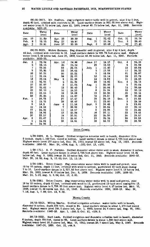
80 WATER LEVELS AND ARTESIAN PRESSURES, 1953, NORTHWESTERN STATES
6N/35-36C1. Mr. Redfern. Dug irrigation water-table well in gravel, size 5 by 5 feet, depth 40 feet, cribbed with concrete to 25. Land-surface datum is 925. 95 feet above msl. High est water level 8. 75 below Isd, June 12, 1950; lowest 40. 75 below Isd, Apr. 11, 1942. Records available: 1933-53.
Date
Jan. 10 Feb. 9 Apr. 2
Water level
31.69 19.15 20.81
Date
Apr. 23 May 27 June 27
Water level
20.39 19.97 23.95
Date
Aug. 1 31
Sept. 3
Water level
32.62 31.34 33.63
Date
Oct. 31 Dec. 5
30
Water level
31.74 29.40 27.46
6N/35-36H1. Walter Herman. 44 feet, cribbed with concrete to 18. water level 5. 88 below Isd, June 20, available: 1933-53.
Dug domestic well in gravel, size 4 by 4 feet, depth ' Land-surface datum is 929. 75 feet above msl. Highest
1933; lowest 42. 80 below Isd, Apr. 11, 1941. Records
Jan. 2579
101113151720232528
Feb. 159
10172226
Apr. 28
14
32.8433.1533.2533.3633.2133.0432.6432.3132.9733.6233.1032.6629.2526.7825.7524.524.2424.0624.9225.5725.4724.6924.86
Apr. 162022232628
May 258
121619252728
June 47
1113182126
24.9625.2825.0124.6223.2122.0721.2621.3321.0520.4018.3316.0816.2717.4718.4721.1420.9219.6719.9420.0119.8119.61
June 2729
July 159
131928
Aug. 138
12192931
Sept. 358
16222528
19.5319.0317.9017.0818.0418.1418.9219.8220.5620.9421.2422.2624.9125.1923.9024.4523.9424.9827.1126.5025.5524.73
Oct. 48
1217212931
Nov. 49
15232628
Dec. 259
131822262830
24.3624.6923.8424.3225.8727.7928.2329.1330.0430.8930.1230.1630.2829.8829.5929.8130. 1029.9629.4228.5728.5328.76
Union County
1/38-24R1. H. L. Wagner. Drilled irrigation artesian well in basalt, diameter 12 to 8 inches, depth 1,150 feet, cased to bottom. Land-surface datum is about 2, 735 feet above msl. Highest water level 107 above Isd, Dec. 30, 1951; lowest 53 above Isd, Aug. 13, 1951. Records available: 1950-53. Mar. 26, +104; Aug. 5, +102; Oct. 13, +100.
1/39-17L1. A. F. Furman. Drilled domestic water-table well in sand, diameter 4 inches, depth 46 feet. Land-surface datum is about 2, 735 feet above msl. Highest water level 12. 49 below Isd, Aug. 5, 1953; lowest 25. 55 below Isd, Oct. 21, 1942. Records available: 1940-53. Mar. 26, 14. 05; Aug. 5, 12. 49; Oct. 13, 13.18.
3/38-10B1. Union County. Dug observation water-table well in sand and gravel, size 18 by 18 inches, depth 11 feet, cribbed with wood to bottom, perforated 12-inch steel casing 7 to 10. Land-surface datum is 2, 727. 88 feet above msl. Highest water level 5.13 below Isd, Mar. 26, 1953; lowest 8.15 below Isd, Dec. 8, 1939. Records available: 1936, 1938-53. Mar. 26, 5.13; Aug. 5, 6. 64; Oct. 13, 6. 60.
3/38-25B1. Union County. Dug observation water-table well in sand and gravel, size 18 by 18 inches, depth 13 feet, cribbed with wood to 12, perforated 12-inch steel casing 9 to 13. Land-surface datum is 2, 706. 83 feet above msl. Highest water level 6.07 below Isd, Mar. 16, 1948; lowest 11. 49 below Isd, Oct. 10, 1940. Records available: 1936, 1938-53. Mar. 26, 7.14; Aug. 5, 7. 98; Oct. 13, 9.02.
Wasco County
1N/13-32G1. Milton Martin. Drilled irrigation artesian water-table well in basalt, diameter 8 inches, depth 338 feet, cased to 44. Land-surface datum is about 1,170 feet above msl. Highest water level 186. 5 above Isd, Apr. 1, 1953; lowest 24. 5 above Isd, Aug. 18, 1951. Records available: 1946-53. Apr. 1, +186. 5; Oct. 12, +126. 5.
IN/13-32H1. Earl Lash. Drilled irrigation and domestic artesian well in basalt, diameter 6 inches, depth 179 feet, cased to 65. Land-surface datum is about 1,200 feet above msl. Highest water level 57.8 above Isd, Mar. 16, 1951; lowest 29.7 above Isd, May 5, 1947. Records available: 1947-51, 1953. Oct. 12, +44.8.
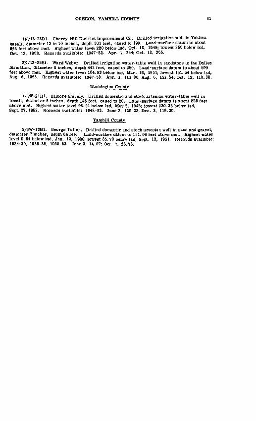
OREGON, YAMHILL COUNTY 81
1N/13-23D1. Cherry Hill District Improvement Co. Drilled irrigation well in Yakima basalt, diameter 12 to 10 inches, depth 301 feet, cased to 193. Land-surface datura is about 623 feet above msl. Highest water level 220 below Isd, Oct. 10, 1948; lowest 255 below Isd, Oct. 12, 1953. Records available: 1947-53- Apr. 1, 244; Oct. 12, 255.
2N/12-25R1. Ward Weber. Drilled irrigation water-table well in sandstone in the Dalles formation, diameter 8 inches, depth 443 feet, cased to 250. Land-surface datum is about 500 feet above msl. Highest water level 104.93 below Isd, Mar. 16, 1951; lowest 151. 54 below Isd, Aug. 6, 1953. Records available: 1947-53. Apr. 1, 111. 80; Aug. 6, 151. 54; Oct. 12, 118.30.
Washington County
1/1W-21R1. Elinore Shively. Drilled domestic and stock artesian water-table well in basalt, diameter 6 inches, depth 145 feet, cased to 20. Land-surface datum is about 285 feet above msl. Highest water level 98. 91 below Isd, May 5, 1948; lowest 130.36 below Isd, Sept. 27, 1952. Records available: 1948-53. June 2, 129. 23; Dec. 3, 116.30.
Yamhill County
5/1>W-13Bl. George Fuller. Drilled domestic and stock artesian well in sand and gravel, diameter 7 inches, depth 64 feet. Land-surface datum is 151. 09 feet above msl. Highest water level 9. 54 below Isd, Jan. 13, 1936; lowest 35. 78 below Isd, Sept. 13, 1951. Records available: 1928-30, 1935-36, 1938-53. June 3, 14. 07; Oct. 7, 26.73.
UTAH
By H. A. Waite, W. B. Nelson, B. E. Lofgren, and R. G. Butler
Scope of Water-Level Program
The observation-well program in Utah, begun in 1935, was continued during 1953 in coop eration with the State Engineer. Investigations were continued and expanded in the principal irri gation districts of southern Utah, namely, the Beryl-Enterprise and Milford districts of Escalante Valley, Cedar City Valley, Pavant Valley, Sevier Desert, and Beaver Valley. A detailed ground- water study of the East Shore area in connection with the Weber Basin project was begun in March 1953 in cooperation with the Bureau of Reclamation. The field investigation of the geology and ground-water occurrence of Ogden Valley was essentially completed during the year as a part of a cooperative program with the Utah Water and Power Board. The geologic and geophysical phases of a comprehensive ground-water study of the eastern part of the Dugway Proving Ground in Tooele County were completed, and plans were formulated for the test-drilling program to follow. As part of a "consumptive-use" study being conducted in the Milford-Minersville district, Beaver County, the contract drilling of 16 new observation wells was completed in December, comprising a combined total footage drilled of 2,195 feet. A preliminary investigation of the ground-water occurrence in southeastern Utah was begun, including the measuring of several "bedrock" wells which have some of the highest artesian pressure heads thus far reported in the State. During 1953 a total of 2,696 measurements were made in 874 selected observation wells scattered through 42 ground-water areas of the State. In addition, recording gages were main tained in 39 wells. The records of 277 of these observation wells, including 27 recording gages, are given in this report. The records for the other observation wells listed in previous annual reports may be examined in the open file at the Utah district office of the Ground Water Branch, U. S. Geological Survey, 503 Federal Building, Salt Lake City. In addition, some records of water-level measurements are included in special project reports that are published separately.
A report entitled "Geology of the recharge area, Weber County, Utah," by J. H. Feth.was prepared in cooperation with the Bureau of Reclamation, and is in open file in the district office of the Survey, 503 Federal Building, Salt Lake City. Two ground-water papers, entitled "Geologic interpretations based on recent test drilling in Ogden Valley, Utah;1 and "Ground water developed from bedrock aquifers in Utah;' by B. E. Lofgren,were presented at the annual meetings of the Utah Academy of Science, Arts, and Letters and are being printed in abstract form in the Pro ceedings of the Academy. A tabular report of discharge measurements of flowing artesian wells in the East Shore area was prepared, and is in open file in the district office of the Survey. A report entitled "Lake Bonneville: Geology of northern Utah Valley, Utah," by C. B. Hunt, H. E. Thomas, and H. D. Varnes, U. S. Geological Survey Professional Paper 257-A,includes a section on ground water.
Precipitation
In general, the weather in Utah during 1953 was relatively warm and dry. A few unusual storms and an extended cold period in May interrupted the predominantly fair weather. Below - normal precipitation during the year was detrimental to rangelands and dry farms, but most irrigated crops were adequately supplied from surface reservoirs and from wells. The winter, ending in February 1953, was one of the mildest and driest of record and resulted in below-normal spring runoff. The mild, dry winter and cold spring were followed by the warmest summer in 13 years. Autumn, also, was unusually warm and one of the driest since 1891. Numerous summer showers and thunderstorms augmented the total precipitation considerably. According to records of the U. S. Weather Bureau, the State average of 10.79 inches for the year was 2.39 inches below normal for the period of record. The warm, dry weather during the irrigation season, especially in the southern part of the State, was responsible for heavy pumping in many of the principal ground-water districts, and resulted in a general decline in ground-water levels.
82
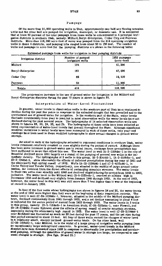
UTAH 83
Pumpage
Of the more than 31,000 operating wells in Utah, approximately one-half are flowing artesian wells and the other half are pumped for irrigation, municipal, or domestic use. It is estimated that at least 80 percent of the total pumpage from these wells is concentrated in 4 principal irri gation districts in southern Utah, namely: Milford, Beryl-Enterprise, Cedar City, and Parowan districts. More than 116,000 acre-feet of water was pumped from the 414 operating irrigation wells in these 4 districts, and pumping lifts ranged from about 50 to 150 feet. The number of wells and pumpage in acre-feet for the pumping districts are shown in the following table:
Estimated pumpage from wells for irrigation in four pumping districts
Irrigation district
Milford
Beryl-Enterprise
Cedar City
Parowan
Totals
Number of pumped irrigation wells
134
161
66
53
414
1953 pumpage (acre -feet)41,200
47, 500
16, 100
11,200
116,000
The progressive increase in the use of ground water for irrigation in the Milford and Beryl-Enterprise districts during the past 10 years is shown in figure 21.
Interpretation of Water-Level Fluctuations
In general, water levels in observation wells in the southern part of Utah have continued to decline during the past few years in response to the extended drought that has prevailed and to the accelerated use of ground water for irrigation. In the northern part of the State, water levels fluctuate considerably from year to year, but in most observation wells the water levels have not declined during the past several years. The hydrographs of 14 selected observation wells are shown in figures 22, 23, 24, 25, and 26. The hydrographs of these wells have been selected as being representative of water-level trends that prevail throughout the State. Although significant seasonal variations in water levels have been measured in each of these wells, only year-end readings have been used in these modified hydrographs to show annual changes in ground-water storage.
As noted in each of the hydrographs selected to represent conditions in northern Utah, water levels remained relatively constant or rose slightly during the period of record. Although there has been some increase in ground-water use in recent years, recharge from precipitation has been sufficient to more than offset this use. The water level in well (A-2-l)19dbc-l in the city of Bountiful declined since 1951 largely as a result of the pumping of several new wells in the im mediate vicinity. The hydrographs of 3 wells in this group, (B-5-2)4cdd-l, (A-2-l)19dbc-l, and (D-2-l)4dbd-4, show alternately the effects of deficient precipitation during the year of 1951 and the abnormally high spring runoff of 1952. Wells (A-12-l)29bdd-l and (C-2-4)33add-l, in Cache Valley and Tooele Valley, respectively, are situated in the middle of large ground-water basins, far removed from the direct effects of recharging mountain streams. The water levels in these two wells rose steadily until 1948 and declined slightly during the period from 1948 to 1953 inclusive. The water level in the Willard well (B-8-2)23cdb-l, reached an alltime high in ' December 1945 and declined very slightly from January 1946 through 1953. At the end of 1953, however, the water level in this well was still more than 7 feet higher than it was at the beginning of record in January 1936.
In four of the five wells whose hydrographs are shown in figures 24 and 25, the water levels at the end of 1953 were higher than they were at the beginning of their respective records. The water level in well (C-29-10)6ddc-l, however, situated in the middle of the Milford pumping dis trict, declined continuously from 1941 through 1953, and a net decline amounting to about 4 feet is indicated for the entire period of record from 1932 through 1953. The water levels in 3 wells in this group, namely (D-5-l)14adb-l in American Fork; (C-21-5)21aba-l, near Flowell; and (D-16-3)32ddc-2 near Ephraim show the effects of spring runoff of nearby mountain streams, especially during the abnormally high runoff in 1952. The water level in well (C-23-2)19dab-l near Richfield has fluctuated as much as 20 feet during the past 17 years, and the net rise during this period amounted to about 15 feet. All four of these wells record the changes of water level In a relatively small, steeply inclined ground-water basin. On the other hand, well (C-29-10)6ddc-l, near Milford, is in the midst of a large group of irrigation wells pumping from an exceptionally large underground reservoir. In general, water-level trends in the Milford district have been downward since 1939 in response to abnormally low precipitation and acceler ated pumping, although the quantities of ground water in storage are large, as compared to sea sonal changes in storage. (See figs. 24 and 25.)
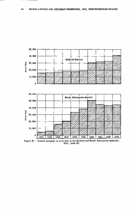
84 WATER LEVELS AND ARTESIAN PRESSURES, 1953, NORTHWESTERN STATES
1947 1948 1949 1950 1951 1952 1953
Figure 21. --Annual pumpage in acre-feet in the Milford and Beryl-Enterprise districts,Utah, 1944-53.

Water level, in feet with reference to land-surface datum
en en to co co 4* ik tn tn tn jt 4* c« co tn O tn O tn o tn O tn o tn O tn o
98Hvxn
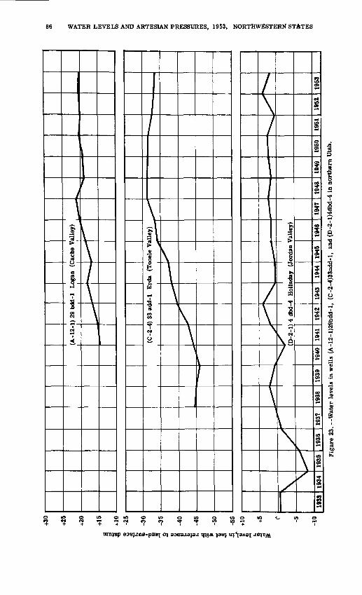
86 WATER LEVELS AND ARTESIAN PRESSURES, 1953, NORTHWESTERN STATES
tnnvep aoEjjms-

(D-1
6-3)
32
ddc-
2 E
phra
im
(San
pete
Val
ley)
£
-15
-20
? 1u £
-25
e |
-30
(H I'" -4
0
-45
-50
(C-2
9-10
) 6
dd
c-lM
ilfo
rd D
istr
ict,
E
scal
ante
Val
ley
1933
19
34
1935
19
36
1937
19
38
1939
19
40
1941
19
42
1943
19
44
1945
19
46
1947
19
48
1949
19
50
1951
19
52
1953
Fig
ure
24. W
ater
lev
els
in w
ells
(D
-16-
3)32
ddc-
2 an
d (C
-29-
10)6
ddc-
l in
nor
ther
n U
tah.
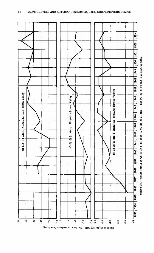
I I
I I I
(D-5
-1)
14 a
db-1
A
mer
ican
For
k (U
tah
Val
ley)
(C-2
3-2)
19
dab-
1 R
ichf
ield
(C
entr
al S
evie
r V
alle
y)
Fig
ure
25. -
Wat
er l
evel
s in
wel
ls (
D-5
-l)1
4adb
-l,
(C-2
1-5)
21
aba-
1,
and
(C-2
3-2)
19
dab-
1 in
cen
tral
Uta
h.
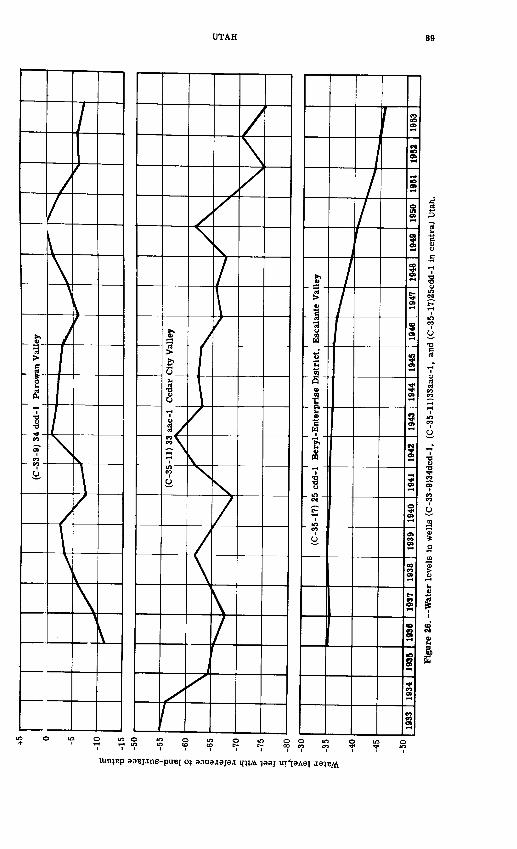
Water level,in feet with reference to land-surface datum
il >U >£ OO OO CO -q -J O> O> Ol Oll-'l-' O OlO OlOO OlO OlO en OO1O
\
\
t
H
^
t*\/
"o
oo
£oo
a21 1-1 0
£.m <
90 WATER LEVELS AND ARTESIAN PRESSURES, 1953, NORTHWESTERN STATES
The water levels in well (C-35-ll)33aac-l in Cedar City Valley and in well (C-35-17)25cdd-l in the Beryl-Enterprise district (figure 26) declined during their respective periods of records. The net decline in well (C-35-ll)33aac-l amounted to about 21 feet from January 1933 to December 1953, and the net decline in well (C-35-17)25cdd-l amounted to about 11 feet from January 1936 to December 1953. The water levels in other wells in both valleys are reported to be at record- low stages because of intense drought conditions, especially in the southwest part of the State. The hydrograph of well (C-35-ll)33aac-l can be correlated with the runoff from Coal Creek. This stream is one of the principal sources of ground-water recharge to this valley, and it is believed that a few years of normal precipitation in this area could result in the underground reservoir being refilled to near-capacity levels. Water levels in the Beryl-Enterprise district, on the other hand, reflect the gradual un water ing of an exceptionally large underground reservoir. The hydrograph of well (C-35-17)25cdd-l, situated in the center of this extensive district, shows only minor-fluctuations from one year to the next, and indicates a general downward trend that has been in effect since pumping began. This trend has been accelerated during recent years of increased irrigation. Parowan Valley, as suggested by the hydrograph of well (C-33-9)34dcd-l, has not suffered from the deficiency of precipitation of recent years as have many of the other valleys. Although many new wells have been drilled recently in this district, recharge from streams entering the valley replenishes the underground reservoir every few years,and a large tract of waterlogged waste land is created in the valley trough. As the irrigation season pro gresses, the water levels in wells situated within the district are affected more and more by pumping. However, the ground-water levels are now higher than in the earlier years of record.
Acknowledgments
Witer-level records from several observation wells in Salt Lake Valley were furnished through informal cooperation with the Salt Lake City Corporation. Records of 151 observation wells, including 11 recording gages, in the East Shore area of Weber and Davis Counties and 3 recording gages in Wasatch County were furnished by the Bureau of Reclamation.
Well-Numbering System
The well number assigned to each water well in the State indicates the location of the well with reference to land subdivision, according to a system adopted by the State Engineer and de scribed in his 20th Biennial Report (1936) page 87. By this system the State is divided into four quadrants by the Salt Lake base and meridian. These quadrants are designated by capital letters, thus: A for the northeast quadrant, representing townships north, ranges east; B_ for the northwest quadrant; C for the southwest; and D for the southeast. The designation of the township is enclosed in parentheses, and includes one of these letters, the number of the township, and the number of the range. Thus, in the number of well (C-26-10)32cad-l in Beaver County, the portion within parentheses indicates that the well is in T. 26 S., R. 10 W. The number following the parentheses designates the section, and the lowercase letters give the location of the well within the section, the first letter indicating the quarter section and succeeding letters showing the location within the quarter-section down to a 10-acre tract. Thus, number (C-26-10)32cad-l represents well number 1 in the SEiNEiSW^ sec. 32, T. 26 S., R. 10 W. In the area surveyed from the Uinta special base and meridian (in Duchesne and Uintah Counties) the well numbers are derived in the same manner, and are preceded by the letter U. The State claim or application number given is that used in records of the State Engineer; claim numbers refer to wells that were in existence when the State ground-water law went into effect in March 1935, and the application numbers refer to wells completed since that date.
Well Descriptions and Water-Level Measurements
Water levels are in feet below land-surface datum unless otherwise indicated. When some measurements in a table are above and others below the plane of reference a plus (+) or minus (-) sign is placed immediately preceding the first entry in each column of each mixed table. Readings between minus (-) signs are below the plane of reference; those between plus (+) signs are above the plane of reference.
Beaver County
Beaver Valley
(C-2B-7)21daa-l. E. F. Baldwin. Dug domestic water-table well in alluvium, diameter 48 to 36 inches, depth 30 feet. Land-surface datum is 6,149.1 feet above msl. Highest water level 6.75 below Isd, June 24, 1952; lowest 27.97 below Isd, Apr. 27, 1939. Records available: 1935-53. Mar. 11, 20.25; Dec. 4, 24.49.
(C-29-7)21baa-l. State application 21717. John R. and J. Ellis Yardley. Drilled irrigation artesian well in alluvium, diameter 12 to 6 inches, depth 415 feet, cased to 380. Land-surface datum is 5, 865. 2 feet above msl. Highest water level 0. 08 below Isd, June 24, 1952; lowest 25.84 below Isd, Feb. 4, 1936. Records available: 1935-53. Mar. 11, 25. 07; Apr. 10, 20. 90; May 13, 13.80; Dec. 8, 25.51.
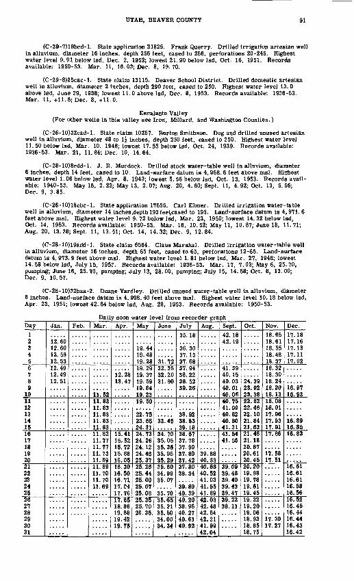
UTAH, BEAVER COUNTY 91
(C-29-7)19bcd-l. State application 21825. Frank Querry. Drilled irrigation artesian well in alluvium, diameter 16 inches, depth 256 feet, cased to 256, perforations 20-245. Highest water level 9. 91 below Isd, Dec. 2, 1952; lowest 21. 90 below Isd, Oct. 16, 1951. Records available: 1950-53. Mar. 11, 16.03; Dec. 8, 19.70.
(C-29-8)25cac-l. State claim 13115. Beaver School District. Drilled domestic artesian well in alluvium, diameter 2 inches, depth 290 feet, cased to 250. Highest water level 13. 0 above Isd, June 29, 1938; lowest 11. 0 above Isd, Dec. 8, 1953. Records available: 1936-53. Mar. 11, +11. 6; Dec. 8, +11.0.
Escalante Valley (For other wells in this valley see Iron, Millard, and Washington Counties.)
(C-26-10)32cad-l. State claim 10257. Burton Smithson. Dug and drilled unused artesian well in alluvium, diameter 48 to li inches, depth 250 feet, cased to 250. Highest water level 11. 50 below Isd, Mar. 10. 1948; lowest 17. 55 below Isd, Oct. 24, 1939. Records available: 1936-53. Mar. 21, 11. 84; Dec. 10, 14.64.
(C-28-10)8cdd-l. J. R. Murdock. Drilled stock water-table well in alluvium, diameter 6 inches, depth 14 feet, cased to 10. Land-surface datum is 4, 958. 6 feet above msl. Highest water level 1.06 below Isd, Apr. 8, 1943; lowest 5. 56 below Isd, Oct. 13, 1953. Records avail able: 1940-53. May 16, 2. 22; May 13, 2. 07; Aug. 20, 4. 60; Sept. 11, 4. 92; Oct. 13, 5.56; Dec. 9, 3.85.
(C-26-10)18cbc-l. State application 17555. Carl Elmer. Drilled irrigation water-table well in alluvium, diameter 14 inches.depth 193 feet,cased to 193. Land-surface datum is 4, 971. 6 feet above msl. Highest water level 9. 72 below Isd, Mar. 23, 1950; lowest 14. 32 below Isd, Oct. 14, 1953. Records available: 1950-53. Mar. 16, 10. 52; May 11, 10.87; June 18, 11.71; Aug. 20, 13. 38; Sept. 11, 13. 51; Oct. 14, 14.32; Dec. 9, 12.84.
(C-28-10)19add-l. State claim 6564. Claus Marshal. Drilled irrigation water-table well in alluvium, diameter 16 inches, depth 65 feet, cased to 65, perforations 12-65. Land-surface datum Ls 4, 973. 9 feet above msl. Highest water level 1. 81 below Isd, Mar. 27, 1948; lowest 14. 58 below Isd, July 15, 195?. Records available: 1936-53. Mar. 17, 7.03; May 6, 25.70, pumping; June 16, 25. 70, pumping; July 13, 28. 00, pumping; July 15, 14. 58; Oct. 8, 13. 00; Dec. 9, 10.57.
(C-28-10)32baa-2. Duane Yardley. Drilled unused water-table well in alluvium, diameter 6 inches. Land-surface datum is 4, 998. 40 feet above msl. Highest water level 10.18 below Isd, Apr. 23, 1951; lowest 42. 64 below Isd, Aug. 28, 1953. Records available: 1950-53.
Daily noon water level from recorder graphDay
1 2S4 56 7 8 9
1011 12 13 14 1516 17 18 19 2021 22 23 24 2526 27 28 29 30 31
Jan.
12! 6012.60 12.59 12.5312.49 12.49 12.51
Feb.
.....
Mar.
ii!s211.83 11.83 11.83 11.83 1.1. 8311.82 11.77 11.77 11.73 11.6911.69 11.70 11.70 11.69
Apr.
12.28 13.47
15.41 15.52 15.72 15.88 16.0516.30 16.50 16.71 17.04 17.7617.85 18.86 19.68 19.42 19.75
May
19.44 19.48 19.2819.29 19.37 19.59 19.84 19.2319.50
22.75 23.65 24.3124.73 24.26 24.12 24.46 25.3725.26 25.44 25.00 25.07 25.0825.35 25.70 26. 35.
June.....
31.7232.35 32.20 31.90
S3! 45
34.70 35.05 35.36 35.95 35.2935.60 34.99 35.07
35.7035.65 35.21 35.50 34.00 34.34
July35.18
36.30 37.15 37.6837.94 38.22 38.52 39.26
38.92 38.83 39.1838.67 37.78 37.90 37.80 37.4237.80 38.34
39.80 40.3940.20 38.96 40.27 40.61 40.92
Aug.
.....
39.88 40.3340.68 40.52 41.03 41.55 41.8942.03 42.48 42.64 42.21 41.99 42.04
Sept.42.18 42.19
41.39 40.15 40.03 40.01 40.0640.75 41.09 40.82 40.80 41.3141.54 41.56
39.09 39.48 39.40 39.43 39.4739.22 38.11
Oct.
24! 39 23.92 23.3822.82 22.46 22.10 21.84 21.6321.46 21.18 20.87 20.61 20.4520.20 19.98 19.78 19.61 19.4519.32 19.20 19.06 18.93 18.85 18.75
Nov.18.65 18.6118.55 18.48 18.3718.32 18.30 18.24 18.20 18.1318.08 18.01 17.96 17.93 17.9117.86
17.58 17.51
.....
17.30 17.27
Dec.17.18 17.1617.13 17.11 17.02
16.97 16.93
16.89 16.8516.83
16. 61 16.61 16.61 16.58 16.5616.52 16.45 16.44 16.44 16.43 16.42
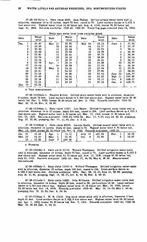
92 WATER LEVELS AND ARTESIAN PRESSURES, 1953, NORTHWESTERN STATES
(C-28-10) 32ccc-l. State claim 2040. Jack Hadley. Drilled unused water-table well in alluvium, diameter 14 to 12 inches, depth 72 feet, cased to 72. Land-surface datum is 5, 013. 5 feet above msl. Highest water level 14. 93 below Isd, Aug. 8, 1939; lowest 36. 00 below Isd, Sept. 11, 1953. Records available: 1938-42, 1950-53. Recording gage removed June 13, 1953.
Daily noon water level from recorder graph
Date
Uan. 12345678
17181920212223
Mar. 10
Water level
23.8723.8623.8523.8223.8323.7623.7523.7723.6423.6223.6123.5823.5923.5823.5622.62
Date
Mar. 11121314151617
Apr. 116
May 269
101112
Water level
22.6022.5922.5922.6222.6122.5922.5722.7122.9924.5724.8024.8624.8524.8924.93
Date
May 131415162022232425262728293031
V/ater level
25.1025.2125.6125.8826.7326.8326.9127.0827.2027.4427.6327.6527.5527.1127.04
Date
June 1256789
10111213
July 20Sept. 11Oct. 8Dec. 9
Water level
27.0027.1828. 1128.3028.4028.6529.1628.7729.1029.0228.69
h34.27h36. 00h32.97h28. 75
h Tape measurement.
(C-28-ll)22dab-l. Houston & Goff. Drilled stock water-table well in alluvium, diameter 8 inches, depth 72 feet. Land-surface datum is 5, 004 feet above msl. Highest water level 29. 90 below Isd, Dec. 7, 1951; lowest 38. 86 below Isd, Dec. 9, 1953. Records available: 1941-53. Mar. 18, 33.44; Dec. 9, 33.86.
(C-28-ll)24daa-l. State claim 11221. Leo Mayer. Drilled irrigation water-table well in alluvium, diameter 14 to 12 inches, depth 204 feet, cased to 204. Land-surface datum is 4, 973. 2 feet above msl. Highest water level 5. 55 below Isd, Mar. 12, 1944; lowest 11. 30 below Isd, Oct. 23, 1953. Records available: 1938-45; 1950-53. Mar. 17, 7.47; July 14, 21.30, pumping; Aug. 27, 22.00, pumping; Oct. 23, 11.30; Dec. 9, 9.25.
(C-28-ll)36add-l. State claim 20233. George Smith. Drilled unused water-table well in alluvium, diameter 14 inches, depth 62 feet, cased to 62, Highest water level 6. 74 below Isd, Mar. 12, 1944; lowest 25. 74 below Isd. Oct. 8, 1953. Records available: 1938-53.Jan. 31Mar. 10
18
14.23 I! Apr. 113.47 May 112. 98 || June 9
13. 1514.70
a30. 50
July 15Oct. 8
a32.5025.74
Dec. 18
20.0219.67
a Pumping.
(C-29-10)6ddc-l. State claim 13116. Wilford Thompson. Drilled irrigation water-table well in alluvium, diameter 14 inches, depth 73 feet, cased to 73. Land-surface datum is 5, 033.0 feet above msl. Highest water level 25. 72 below Isd, Nov. 11, 1938; lowest 40. 99 below Isd, July 31, 1936. Records available: 1932-53. May 17, 34. 90; May 8, 36.92. Measurement discontinued.
(C-29-10)6ddc-2. State claim 13116-R. Wilford Thompson. Drilled irrigation water-table well in alluvium, diameter 16 inches, depth 154 feet, cased to 154. Land-surface datum is 5, 033. 0 feet above msl. Records available: 1953. Mar. 16, 34.10; June 12, 50. 50, pumping; July 18, 51.00, pumping; Sept. 11, 45. 37; Oct. 9, 44. 58; Dec. 9, 40.53.
(C-29-ll)ladd-l. State claim 10290. Orin Williams. Drilled irrigation water-table well in alluvium, diameter 14 inches, depth 58 feet, cased to 58, perforations 18-58. Land-surface datum is 5, 014 feet above msl. Highest water level 17. 62 below Isd, Mar. 10, 1943; lowest 32. 85 below Isd, Oct. 14, 1953. Records available: 1935-53. Mar. 18, 24. 02; May 7, 40.40, pumping; Oct. 14, 32. 85; Dec. 8, 29. 50.
(C-29-ll)4baa-l. W. H. Child. Dug stock water-table well in alluvium, diameter 4 feet, depth 41 feet. Land-surface datum is 5, 022. 8 feet above msl. Highest water level 34.10 below Isd, Apr. 1, 1952; lowest 35. 60 below Isd, Dec. 7, 1951. Records available: 1941-46, 1948-53. Mar. 18, 34. 84; Dec. 9, 35. 32.

UTAH, BOX ELDEP COUNTY 93
(C-29-ll)llcdd-2. State claim 7540. J. L. Shepherd. Drilled irrigation water-table well in alluvium, diameter 16 inches, depth 90 feet, cased to 90, perforations 56-62, 65-69, 78-90. Land-surface datum is 5,018.16 feet above msl. Highest water level 17.10 below Isd, Mar. 23, 1950; lowest 22. 79 below Isd, Oct. 13, 1953. Records available: 1937-53. Mar. 17, 20.26; May 11, 36.80, pumping; June 11, 36.90, pumping; July 18, 38.20, pumping; Sept. 2, 39.20, pumping; Oct. 13, 22. 79; Dec. 9, 22.35.
(C-29-ll)13add-l. State application 18004. Don Olmstead. Drilled irrigation water-table well in alluvium, diameter 14 inches, depth 276 feet, cased to 276. Land-surface datum is 5, 042. 8 feet above msl. Highest water level 33.15 below Isd, Apr. 28, 1948; lowest 45. 54 below Isd, Oct. 9, 1953. Records available: 1947-53. Mar. 17, 39. 26; June 12, 68.00, pumping; July 23, 67.60, pumping; Sept. 2, 67.50, pumping; Oct. 9, 45. 54; Dec. 8, 43.80.
(C-29-ll)22ddd-l. State claim 10667. P. V. Haworth. Drilled unused water-table well in alluvium, diameter 14 to 12 inches, depth 50 feet, wood-casing to 50. Land-surface datum is 5, 035.2 feet above msl. Highest water level 24. 88 below Isd, Mar. 19, 1947; lowest 30.62 below Isd, Oct. 13, 1953. Records available: 1935-53. Mar. 17, 26. 85; June 15, 29.28; Aug. 21, 29.67; Oct. 13, 30.62; Dec. 9, 28.20.
(C-30-ll)4cdd-l. Minersville Livestock Co. Drilled unused water-table well in alluvium, diameter 4 inches, depth 33 feet. Land-surface datum is 5,040. 2 feet above msl. Highest water level 25. 64 below Isd, Mar. 19, 1947; lowest 27. 55 bebw Isd, Sept. 29, 1937. Records available: 1935-53. Mar. 17, 26. 24; July 15, 26.48; Nov. 11, 26.80.
(C-30-13)34bbb-l. Cook Bros. Drilled unused water-table well in alluvium, diameter 14 inches, depth 69 feet. Land-surface datum is 5, 087.80 feet above msl. Highest water level 45. 64 below Isd, Apr. 23, 1949; lowest 46. 03 below Isd, Nov. 26, 1944. Records available: 1940-50, 1952-53. Oct. 28, 45.78.
Box Elder County
East Shore area (For other wells in the area see Davis and Weber Counties.)
(B-7-2)llbaa-3. State claim 6409. Jack White. Drilled unused water-table well in alluvium, diameter 10 inches, depth 365 feet, cased to 365. Highest water level 25. 50 below Isd, Aug. 29, 1949; lowest 37.42 below Isd. May 27, 1948. Records available: 1947-51.
Date
Jan. 21 Feb. 24 Mar. 24
Water level
31.00 32.41 33.36
Date
Apr. 22 May 25 June 24
Water level
34.30 33.26 34.70
Date
July 28 Aug. 25 Sept. 29
Water level
34.28 33.33 31.82
Date
Oct. 26 Dec. 8
Water level
31.81 33.53
(B-8-2) 23cdb-l. State claims 1284 and 8126. Willard Water Co. Drilled irrigation artesian well in coarse gravel, diameter 13 to 10 inches, depth 255 feet, cased to 225, perforations 97-172, 180-197. Land-surface datum is 4, 328. 8 feet above msl. Highest water level 27.18 be low Isd. June 14. 1946; lowest 50.44 below Isd. Oct. 29. 1935. Records available: 1935-51.Jan. 21 Feb. 24 Mar. 24
40.78 40.86 41.43
Apr. 22 May 25 June 24
41.08 38.41 28.39
July 27 Aug. 25 Sept. 28
32.34 35.53 37.95
Oct. 26 Dec. 8
38.81 40.64
(B-8-2)26cac-l. State claim 99. Geo. L. Braegger. Driven irrigation artesian well in alluvium, diameter 3 inches, depth 235 feet, cased to 230. Highest water level 37. 5 above Isd, June 24. 1953; lowest 16.15 above Isd. Oct. 3. 1935. Records available: 1935-45. 1951-53.Jan. 21 Feb. 24 Mar. 24
+30.0 +30.6 +29.6
Apr. 22 May 25 June 24
+30.0 +31.4 +37.5
July 27 Aug. 25 Sept. 28
+29.7 +32.8 +32.4
Oct. 26 Dec. 8
+32.2+30.7
(B-9-2)35dcd-l. State claim 477. H. F. Hansen. Dug and drilled unused water-table well in alluvium, diameter 6 feet, depth 70 feet, concrete-lined to 55, 4-inch casing 55-70. Land- surface datum is 4, 353. 9 feet above msl. Highest water level 29. 73 below Isd, Sept. 17, 1953; lowest 46.85 below Isd, Aug. 13, 1936. Records available: 1935-53.
Daily noon water level from recorder graphDay
1 2 3 4 5
Jan.40.13 40.17 40.21 40.24 40.27
Feb.40.99 41.01 41.03 41.04 41.06
Mar.41.40 41.40 41.41 41.44 41.45
Apr.41.99 42.00 42.03 42.04 42.04
May42.26 42.27 42.29 42.30 42.32
June42.25 42.22 42.19 42.13 42.06
July38.20 37.96 37.62 37.43 37.33
Aug.32.84 32.70 32.72 32.68 32.40
Sept.30.42 30.37 30.33 30.30 30.26
Oct.31.07 31.21 31.38 31.41 31.50
Nov.35.04 35.14 35.24 35.35 35.43
Dec.e34.00 e33.94 e33.88 e33.82 e33.76

94 WATER LEVELS AND ARTESIAN PRESSURES, 1953, NORTHWESTERN STATES
(B-9-2)35dcd-l~ Continued.
Day
67 8 9
1011 12 13 14 1516 17 18 19 2021 22 23 24 2526 27 28 29 30 31
Jan.
40.31 40.35 40.37 40.42 40.4540.48 40.52 40.54 40.57 40.6240.65 40.68 40.71 40.74 40.7540.82 40.83 40.85 40.87 40.8840.90 40.92 40.93 40.94 40.96 40.97
Feb.
41.07 41.09 41.11 41.13 41.1441.16 41.17 41.18 41.20 41.2241.23 41.24 41.26 41.27 41.2941.30 41.31 41.33 41.34 41.3541.36 41.38
Mar.
41.46 41.48 41.50 41.51 41.5341.54 41.55 41.56 41.57 41.5941.62 41.64 41.65 41.66 41.6741.68 41.74 41.79 41.84 41.8541.86 41.87 41.88 41.90 41.90 41.98
Apr.
42.06 42.07 42.07 42.08 42.1042.12 42.13 42.14 42.14 42.1542.15 42.1642.17 42. 17 42.1842.19 42.19 42.19 42.20 42.2142.22 42.23 42.23 42.25 42.25
May
42.33 42.36 42.36 42.35 42.3542.37 42.37 42.32 42.27 42.2442.22 42.22 42.22 42.23 42.2342.23 42.23 42.24 42.24 42.2442.24 42.24 42.24 42.24 42.24 42.24
June
42.01 41.98 41.93 41.90 41.8741.85 41.73 41.56 41.45 41.3441.17 41.01 40.84 40.55 40.4140.34 40.13 39.97 39.85 39.6739.45 39.35 39.15 38.57 38.35
July
37.25 37.17 37.02 36.78 36.5836.26 36.05 35.87 35.78 35.6235.43 35.32 35.12 34.96 34.8034.69 34.52 34.31 33.98 33.9033.84 33.79 33.75 33.55 33.34 33.13
Aug.
32.23 32.05 31.78 31.71 31.5831.50 31.32 31.22 31.14 30.9730.89 30.92 30.78 30.76 30.7530.74 30.72 30.71 30.71 30.6830.64 30.60 30.56 30.52 30.48 30.44
Sept.
30.23 30.18 30.15 30.10 30.0430.00 29.96 29.92 29.86 29.8229.77 29.73 29.88 30.06 30.2530.50 30.73 30.97 31.08 31.0531.20 31.19 31.00 31.16 31.34
Oct.
31.51 31.63 31.78 31.93 32.0432.24 32.44 32.51 32.76 32.9533.13 33.25 33.26 33.35 33.4633.58 33.71 33.82 33.95 34.0834.23 34.49 34.60 34.70 34.82 34.93
Nov.
35.51 35.62 35.76 35.70 35.6235.52 35.42 35.32 35.23 35.1435.05 34.95 34.88 34.78 34.75
e34. 68 e34. 61 e34. 54 e34. 48 e34. 42e34. 36 e34. 30 e34. 24 e34. 18 e34. 11
Dec.
e33. 72 e33. 67 e33.62 e33.89 e34. 16e34.43 e34. 70 e34. 97 e35.24 e35. 51e35. 78 e36.05 e36. 32 e36. 59 e36.86e37. 13 e37.40 e37.67 e37. 94 e38.21e38. 48 e38.75 e39. 02 e39.29 e39. 56 e39. 83
Lower Bear River Valley
(B-12-4)llcb. State claim 14152. Adolph Harris. Drilled unused water-table well in alluvium, diameter 4 inches, depth 150 feet, cased to 150. Highest water level 112. 90 below Isd, Aug. 27, 1951; lowest 130. 75 below Isd, Oct. 8, 1936. Records available: 1936-53. Mar. 31, 115.08; Nov. 5, 113.09.
Blue Springs Valley
(B-13-5)17bca-l. State claim 3776. Boss A. Miller. Driven domestic and stock artesian well in alluvium, diameter 6 inches, depth 135 feet, cased to 135. Highest water level 59. 75 be low Isd, Aug. 27, 1951; lowest 94. 50 below Isd, May 27, 1952. Records available: 1935-53. Mar. 31, 60. 42; Nov. 5, 64.07.
Curlew Valley
(B-12-ll)16cdc-l. U. S. Bureau of Land Management. Drilled unused artesian well in gravel, diameter 8 inches, depth 126 feet, cased to 126. Highest water level 8. 24 below Isd, Oct. 25, 1945; lowest 9.95 below Isd, Oct. 10, 1936. Records available: 1935-36, 1938-53. Nov. 5, 8.98.
(B-14-8)llab. Bealy S. Cutler. Jetted stock artesian well in alluvium, diameter 4 inches, depth 73 feet. Highest water level 39. 55 below Isd, Oct. 31, 1951; lowest 48.00 below Isd, Apr. 1, 1940. Records available: 1936-53. Nov. 5, 42.76.
(B-14-9)10ada-l. Abe Rose. Driven domestic artesian well in alluvium, diameter 6 inches, depth 171 feet, cased to 135. Highest water level 96.00 below Isd, Nov. 15, 1950; lowest 100. 50 below Isd, Apr. 6, 1939. Records available: 1936-42, 1944-53. Nov. 5, 97.19.
Grouse Creek Valley
(B-10-18)28dcd-l. State application 13796. U. S. Bureau of Land Management. Drilled stock artesian well in alluvium, diameter 6 inches, depth 252 feet, cased to 210. Highest water level 118.27 below Isd, Nov. 5, 1953; lowest 120.66 below Isd, Oct. 23, 1944. Records available: 1939-53. Nov. 5, 118.27.
(B-ll-18)23bb. Central Pacific Railroad. Dug unused water-table well in coarse gravel, diameter 4 feet, depth 27 feet. Highest water level 2.16 below Isd, June 9, 1952; lowest 23.68 below Isd, Oct. 10, 1936. Records available: 1936, 1939-53.
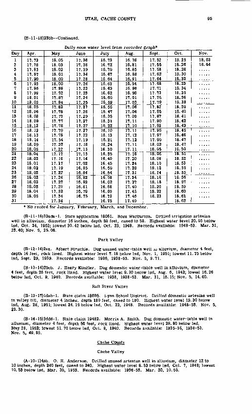
UTAH, CACHE COUNTY 95
(B-ll-18)23bb--Continued.
Daily noon water level from recorder graph*Day
1 2 345678
101112131415161718192021 ?,2232425262728293031
Apr.
17.73 17.78 17.8317.8717.901 7 911 7 Qft
1 7 QQ
18.0118.0318.0518.0618.0818.0918.1218.12 18.1318.1418.0918.0518.04 18.0218.0118.0218.0318.02 18.0318.0318.0418.05
May18.05 18.03 18.0218.0118.0018.0017.98n Q9
n orr
17.8417.82n rro
17.7717.7717.7817.79 17.781 7 "id
n i7
17. 2217.17 17.1617.1717 1Q
17.2217.241 7 97
17.2917.321 7 ^4
17.34
June
17.36 17.38n iQ
1 7 HA
17.28n <)A
n 9^
n 93
n 94
17.2517 271 rj OQ
1 7 9Q
1797
17.2717.271 7 9917 1 Q
17.1817.1517.15 17.1417.0216.8516.8416.82 16.8216.8116.7916.75
July16.73 16.72 16.7016.6716.6416.6316.6316.6216.6016.5916.5616.4716.3516.3116.2216.10 16.1316.2116.2416.3016.35 16.4016.4516.5016.5416.58 16.6216.6616.6916.7216.75
Aug.16.78 16.81 16.8516.8816.9116.9416.9616.9817.0117.0317.0617.0617 0917.1117.1017.1117 19
17 19
17.1117.1117.16 17.201 7 94
17.2817.3117.341 7 17
17.40n il17.4617.49
Sept.17.52 17.55 17.5817.6217.6417.6817.7117.7317.7617.7917.8217.8517.871 7 Qfi
17.9217.95 17.9717.9918.0218.0518.06 18.0818.1018.1218.1418.16 18.1818.2018.2218.23
Oct.18.25 18.26 18.2818.3018.3218.3318.3418.3518.3618.3818.3918.4018.4118.4218.4318.45 18.4618.4718.4718.5018.51 18.5218.5318.5518.5518.56 18.5718.5918.6018.6118.62
Nov.18.63 18.64
* No record for January, February, March, and December.
(B-ll-18)33ada-l. State application 18061. Boss Warburton. Drilled irrigation artesian well in alluvium, diameter 16 inches, depth 59 feet, cased to 59. Highest water level 20. 05 below Isd, Oct. 24, 1952; lowest 30.42 below Isd, Oct. 23, 1948. Records available: 1948-53. Mar. 31, 23.40; Nov. 5, 25.06.
Park Valley
(B-12-14)2aa. Albert Hirschie. Dug unused water-table well m alluvium, diameter 4 feet, depth 16 feet, rock lined. Highest water level 7.18 below Isd, Nov. 1, 1951; lowest 11.75 below Isd, Sept. 29, 1939. Records available: 1936, 1938-53. Nov. 5, 9.71.
(B-l3-14)25cb. J. Henry Kunzler. Dug domestic water-table well in alluvium, diameter 4 feet, depth 28 feet, rock lined. Highest water level 9. 30 below Isd, Aug. 6, 1942; lowest 16. 26 below Isd, Oct. 9, 1940. Records available: 1936, 1938-53. Mar. 31, 16.15; Nov. 5, 14.60.
Raft River Valley
(B-13-17)ldab-l. State claim 18695. Lynn School District. Drilled domestic artesian well in valley fill, diameter 4 inches, depth 180 feet, cased to 180. Highest water level 19. 30 below Isd, Aug. 28, 1951; lowest 24. 15 below Isd, Oct. 22, 1948. Records available: 1948-53. Nov. 5, 22. 30.
(B-14-15)3ddd-l. State claim 19482. Morris A. Smith. Dug domestic water-table well in alluvium, diameter 4 feet, depth 56 feet, rock lined. Highest water level 28. 80 below Isd, May 28, 1952; lowest 51. 70 below Isd, Oct. 9, 1940. Records available: 1935-36, 1938-53. Nov. 5, 49.89.
Cache County
Cache Valley
(A-10-l)4ab. O. H. Anderson. Drilled unused artesian well in alluvium, diameter 12 to 10 inches, depth 240 feet, cased to 240. Highest water level 8. 53 below Isd, Oct. 7, 1948; lowest 10. 53 below Isd, Mar. 30, 1953. Records available: 1936-53. Mar. 30, 10.53.

96 WATER LEVELS AND ARTESIAN PRESSURES, 1953, NORTHWESTERN STATES
(A-ll-l)30bbd-2. State claim 18191. Wilford Ward. Jetted domestic artesian well in alluvium, diameter 2 inches, depth 200 feet. Highest water level 6. 2 above Isd, Oct. 22, 1952; lowest 6. 45 below Isd, June 24, 1940. Records available: 1936-53. Mar. 30, + 1.4.
(A-12-l)29bdd-l. Arnold Nielsen. Drilled unused artesian well in alluvium, diameter 2 inches, depth 43 feet. Highest water level 22. 9 above Isd, Sept. 25, 1950; lowest 13. 6 above Isd, Aug. 24, 1940. Records available: 1940-53.
Daily noon water level above Isd from recorder graph*
Day
1 2 3 4 56 7 8 9 1011 12 13 14 1516 17 18 19 2021 22 23 24 2526 27 28 29 30 31
Jan.
19.7 19.7 19.6 19.6 19.719.7 19.5 19.6 19.6 19.519.5 19.6 19.5 19.4 19.419.5 19.3 19.3 19.4 19.319.1
19.419.5 19.3 19.1 19.2 19.3 19.1
Feb.
19.1 19.2 19.2 19.0
19.1 19.1 19.019.0 19.0 19.0 18.9 19.019.0 18.9 18.9
Mar.
18.9 18.9 18.7 18.7 18.818.8 18.7 18.8 18.9 18.818.7 18.8 18.8 18.7 18.618.6 18.8
18.2
May
17.8 17.617.7 17.5 17.5 17.5 17.517.6 17.6 17.7 17.6 17.5 17.5
June
17.5 17.5 17.5 17.7 17.617.5 17.5 17.5 17.5 17.717.7 17.9 17.9 17.7 17.817.9 17.9 17.9 17.8 17.717.7 17.6 17.7 17.7
July
17.8 17.917.9 18.0 17.9 17.9 17.917.8 18.0 17.9 18.0 18.118.3 18.4 18.5 18.6 18.718.7
18.8 18.8 19.1 19.0
Aug.
18.9 18.9 18.9 19.0 19.119.2 19.0
Nov.
19.3
* No record for April, September, October, and December.
(A-12-l)31dab-l. State claim 2537. R. S. Painter. Drilled scoc.c irrigation artesian well in alluvium, diameter 3 inches, depth 132 feet, cased to 132. Land-surface datum is 4, 431.1 feet above msl. Highest water level 42. 4 above Isd, Oct. 23, 1952; lowest 27. 4 above Isd, Sept. 30, 1937. Records available: 1936-47, 1949-53. Mar. 30, +38. 1.
(A-13-l)29bdb-l. State claim 1682. J. C. Cannell. Jetted stock artesian well in alluvium diameter 2 inches, depth 106 feet, cased to 106. Highest water level 9. 9 above Isd, Aug 14 1936; lowest 5. 40 below Isd, Feb. 20, 1942. Records available: 1936-53. Mar. 30, 2.35.
(A-14-l)22bad-l. State claim 17652. C. B. Stoddard. Jetted stock artesian well in alluvium, diameter 3 inches, depth 114 feet. Land-surface datum is 4, 467. 36 feet above msl Highest water level 13. 5 above Isd, May 14, 1942; lowest 2. 88 above Isd, Dec. 27, 1939. Records available: 1938-53. Mar. 30, +6.6.
(A-14-l)34adb-l. State claim 1373. Crockett Well Co. Drilled irrigation artesian well in alluvium, diameter 12 to 8 inches, depth 150 feet, cased to 100, perforations 10-68. Highest water level 3. 76 below Isd, June 24, 1940; lowest 17. 99 below Isd, Dec. 27, 1939. Records available: 1935-53. Mar. 30, 14.00.
(B-13-l)30acc-l. State claim 2757. E. R. Ballard. Jetted stock artesian well in fine gravel, diameter 2 inches, depth 90 feet, cased to 90. Highest water level 23. 4 above Isd, Aug. 9, 1949; lowest 15. 7 above Isd, Mar. 6, 1936. Records available: 1936-53. Mar. 30, +22. 2.

UTAH, DAVIS COUNTY 97
Davis County
East Shore area (For other wells in this area see Box Elder and Weber Counties.)
Bountiful district
(A-2-l)6dcd-2. State claim 188. Zions Aid Society. Jetted domestic artesian well in alluvium, diameter If inches, depth 60 feet, cased to 60. Land-surfacedatumis4,292.0 feet above msl. Highest water level 17. 4 above Isd, June 10, 1947; lowest 10. 0 above Isd, Dec. 13, 1948. Records available: 1946-53.
Date
Jan. 23 Mar. 3
30
Water level
+12.3 + 12. 1 +12.0
Date
Apr. 29 May 26 July 2
Water level
+12.7 + 14.6 +15.4
Date
Aug. 6 Sept. 9 Oct. 7
Water level
+14.0 + 12.1 + 11.3
Date
Oct. 30 Dec. 11
Water level
+11.0 +10.1
(A-2-l)7aba-4. State claim 14688. Kate M. Chase. Jetted domestic artesian well in alluvium, diameter 3 inches, depth 450 feet, cased to 450. Land-surface datum is 4, 279. 5 feet above msl. Highest water level 33. 6 above Isd, June 10, 1947; lowest 19.1 above Isd, Dec. 13, 1948. Records available: 1946-51. No measurement made in 1953.
(A-2-l)7ddc-l. State claims 4989 and 8155. CentervilLe City Corp. Drilled municipal artesian well in alluvium, diameter 12 inches, depth 370 feet. Land-surface datum is 4, 322. 5 feet above msl. Highest water level 4. 43 below Isd, June 17, 1947; lowest 13.16 below Isd,Apr. 4, 1946. Records available: 1939. 1945-53.Jan. 23 Mar. 3
30
9.17 9.01 8.98
Apr. 29 May 26 July 2
8.17 5.32 6.21
Aug. 6 28
Oct. 7
7.94 10.77 10.48
Oct. 30 Dec. 11
10.65 11.44
(A-2-l)17ccb-l. State claim 11318. Will Holbrook. Dug unused water-table well in alluvium, diameter 6 feet, depth 45 feet, cased to 45. Land-surface datum is 4,372. 6 feet above msl. Highest water level 20. 86 below Isd, Aug. 28, 1953; lowest 37.15 below Isd, Mar.10, 1941. Records available: 1937-53.Jan. 23Mar. 3
30
27.6229.9428.88
Apr. 29May 27July 2
28.4026.0522.01
Aug. 628
Oct. 7
21.0220.8622.53
Oct. 30Dec. 11
24.4526.54
(A-2-l)18abd. T. Q. Williams. Jetted unused artesian well in alluvium, diameter 2 inches, depth 90 feet, cased to 90. Highest water level 31.6 above Isd, June 9, 1944; lowest 10.2 above Isd, Aug. 16, 1940. Records available: 1938-53.
Daily noon water level above Isd from recorder graphDay
1 2 34 56 7 8 9
1011 12 13 14 1516 17 18 19 2021 22 2324 25
Jan.
23.8 23.7 23.6 23.6 23.723.8 23.7 23.7 23.7 23.623.7 23.7 23.8 23.8 23.723.7 23.6 23.7 23.7 23.723.7 23.8 23.8 23.7 23.8
Feb.
23.8 23.8 23.8 23.9 23.923.8 23.8 23.9 23.9 23.823.8 23.8 23.8 23.8 23.823.8 23.9 23.8 23.8 23.823.7 23.8 23.8 23.8 23.8
Mar.
23.9 23.8 23.8 23.8 24.024.0 24.0 24.1 24.1 24.424.3 24.4 24.1 24.0 24.224.3 24.2 24.3 24.4 24.224.0 24.0 24.0 24.2 24.4
Apr.
24.0 24.0 24.1 23.5 23.222.5 22.4 22.4 22.4 22.322.3 22.3 22.4 22.4 22.823.8 23.8 23.6 23.9 24.124.1 24.2 24.4 24.4 24.3
May
24.6 24.7 24.8 24.9 25.125.3 25.5 25.3 24.9 24.825.3 25.5 25.6 25.8 25.125.4 25.3 25.4 25.6 25.225.9 26.2 26.3 25.8 26.4
June
27.3 26.6 27.2 27.4 26.626.6 25.6 25.9 26.3 26.225.9 25.9 24.9 24.9 25.725.9 26.7 25.8 25.2 23.523.8 23.8 23.5 24.5 25.0
July
24.8 25.7 24.6 24.0 24.424.1 22.7 23.6 23.9 23.824.6 23.8 24.1 23.7 24.223.6 23.3 21.3 21.6 22.421.6 22.2 22.4 21.4 22.4
Aug.
22.7 23.3 23.6 24.3 24.122.2 22.6 22.8 23.3 22.123.3 23.3 22.3 21.6 22.422.4 22.4 22.3 22.5 22.422.1 20.1 19.6 19.9 19.6
Sept.
19.6 19.8 20.0 20.1 20.220,1 21,2 21.7 21,2 21,221.6 20.5 21,2 22.1 22.221.5 22.2 22.4 22.2 21.022.0 22.0 21.4 22.4 22.2
Oct.
22.0 21.9 22.1 22.2 22.322.1 22.3 22.4 21.7 22.221.9 21.9 21.8 22.0 22.222.0 22.1 21.7 21.9 21.821.6 21.8 21.5 21.2 21.4
Nov.
21.9 22.1 22.0 21.7 22.321.7 21.5 21.6 21.8 21.922.3 22.4 22.4 22.4 22.222.0 21.6 21.4 21.4 21.421.2 21.3 21.6 21.3 21.4
Dec.
21.1 21.0 21.1 21.1 20.921.0 21.1 21.0 21.0 21.020.9 20.8 20.9 20.8 20.820.7 20.7 20.8 20.7 20.820.8 20.7 20.8 20.8 20.7

98 WATER LEVELS AND ARTESIAN PRESSURES, 1953, NORTHWESTERN STATES
(A-2-l)18abd Continued.
Day26 27 28 29 30 31
Jan.23.8 23.8 23.8 23.9 23.9 23.8
Feb.23.8 23.8 24.0
Mar.24.3 24.3 23.7 24.1 23.9 23.9
Apr.24.5 24.524.4 24.4 24.3
May26.9 26.9 27.1 26.5 26.8 27.3
June26.4 26.8 26.5 26.3 24.6
July21.8 23.4 23.5 23.4 22.6 23.0
Aug.20.3 20.8 20.3 19.6 19.0 19.4
Sept.22.5 22.3 21.8 22.4 22.6
Oct.21.4 21.6 21.7 21.9 21.9 21.9
Nov.21.5 21.1 21.2 21.0 21.0
Dec.20.8 20.9 20.9 20.9 20.7 20.8
(A-2-l)19dbc-l. State claim 1447. Bountiful City Corp. Drilled municipal artesian well in alluvium, diameter 12 to 8 inches, depth 380 feet, cased to 380. Land-surface datum is 4, 367.8 feet above msl. Highest water level 57.12 below Isd, May 31, 1938; lowest 74. 01 below Isd, Nov. 28, 1940. Records available: 1937-53. Jan. 23, 67. 30; Mar. 2, 67.12; Mar. 30, 66.36; Apr. 29, 65. 39; Oct. 7, 66.78; Nov. 3, 67.61; Dec. 15, 68.62.
(B-2-l)24bad-3. State claim 2677. Clyde Jeppson. Jetted irrigation artesian well in alluvium, diameter 3 inches, depth 386 feet, cased to 386. Land-surface datum is 4, 247. 6 feet above msl. Highest water level 51. 5 above Isd, June 6, 1949, May 12-13, 1950; lowest 40.2 above Isd, Aug. 4, 7, 22, 1946. Records available: 1945-53.
Daily noon water level above Isd from recorder graphDay1 2 3 4 56 7 8 9
1011 12131415161718 19 2021 22 2324 2526 27 2829 30 31
Jan.
47! i47.147.247.146.8 46.9 47.046.8 46.7 46.9 46.8 46.747.0 47.0 46.946.8 47.0 46.9
Feb.47.0 47.0 47.1 47.0 46.947.1 47.0 46.9 47.0 47.147.0 47.047.0 46.946.947.047.047.1
Mar.
46^8 46.8 46.546.5 46.5 46.5 46.6 46.746.8
Apr.
47.1 47.247.3 47.3 46.5 46.5 46.447.1 47.2 47.247.2 47.3
May47.5 47.6 47.7 47.6 47.747.9 47.8 48.0 47.9 47.547.5 48.048.0 48.048.248.047.847.6 48.0 48.148.5 48.8 48.9 49.0 49.249.4 49.5 49.649.4 49.4 49.4
June49.4 49.4 49.2 49.5 49.549.5 49.6 49.8 50.0 50.0
48.5
48.0
48.8 48.8 49.1
48.7 49.3 48.4 47.948.2 47.9
July47.0
47.0 46.9 46.9
46.446.5
47.0
Aug.
46.9
46.4
45.5
Sept.
45.9 45.9 45.9
45.8 45.5 45.2 45.345.3 45.1 45.245.4 45.4
Oct.45.6 45.7 45.4 45.4 45.445.6 45.6 45.7 44.9 44.744.3 44.144.1 44.044.144.144.144.0 44.3 44.244.544.4 44.6 45.1 45.045.1 45.3 45.145.0 45.3 45.3
Nov.45.345.4 45.5 45.245.445.5 45.3 45.1 45.4 45.545.4 45.545.7 45.545.545.845.645.6 45.6 45.745.5 45.4 45.6 45.6 45.445.4 45.4 45.445.1 45.4
Dec.45.4 45.1 45.0 45.3 44.944.7 44.9 45.0 44.7 44.845.1 44.744.7 44.845.044.744.744.9 44.7 44.544.5 44.7 44.4 44.3 44.544.3 44.5 44.444.6 44.4 44.3
(B-2-l)24bad-5. State claim 11382. George Mann. Jetted unused artesian well in alluvium, diameter 2 inches. Land-surface datum is 4,250. 6 feet above msl. Highest water level 32. 9 above Isd, Apr. 5-7, 13, 15-16, 1950; lowest 16.1 above Isd, July 23, 1946. Records available: 1946-53. Recording gage removed July 18, 1953. Measurement discontinued.
Daily noon water level above Isd from recorder gra>h*Day
1 2 34 56 7 8 9
10
Jan.28.4 28.3 28.4 28.3 28.628.7 28.6 28.4 28.6 28.6
Feb.29.0 29.1 29.4 29.3 29.229.5 29.6 30.1 29.9 29.8
Mar.30.2 30.0 29.8 29.9 30.030.1 30.1 30.1 30.1 30.3
Apr.30.5 30.4 30.5 30.4 30.129.9 29.6 29.9 29.7 29.6
May29.7 29.8 29.9 29.9 30.430.2 30.2 29.9 30.1 30.0
June31.4 31.1 30.8 30.5 29.429.8 29.8 29.9 29.8 28.6
July20.1 19.9 20.6 20.1 19.819.4 18.7 18.4 19.2 19.3
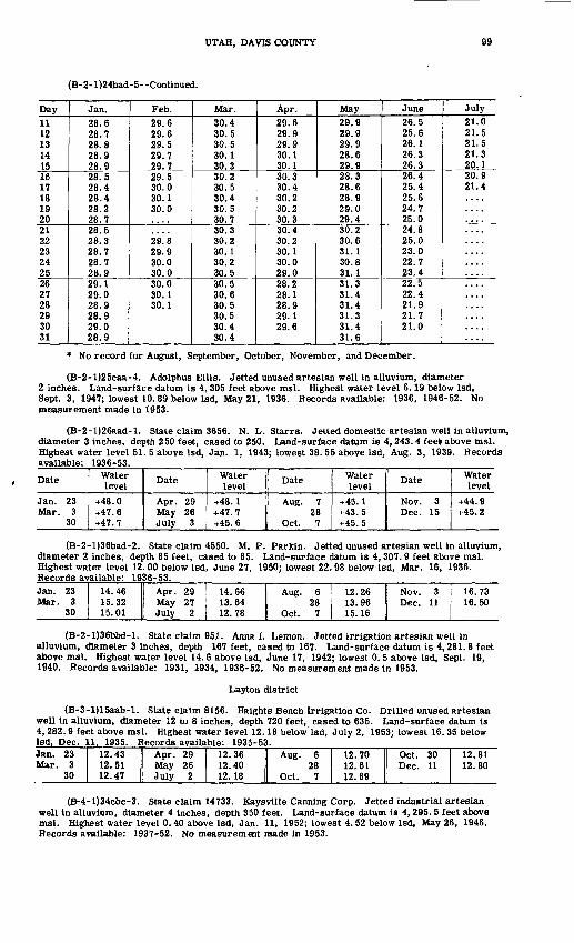
UTAH, DAVIS COUNTY 99
(B-2-l)24bad-5--Continued.
Day11 12 1314 1516 17 18 19 2021 22 23 24 2526 27 28 29 30 31
Jan.28.6 28.7 28.8 28.9 28.928.5 28.4 28.4 28.2 28.728.5 28.3 28.7 28.7 28.929.1 29.0 28.9 28.9 29.0 28.9
Feb.29.6 29.6 29.5 29.7 29.729.5 30.0 30.1 30.0
29.8 29.9 30.0 30.030.0 30.1 30.1
Mar.30.4 30.5 30.5 30.1 30.330.2 30.5 30.4 30.5 30.730.3 30.2 30.1 30.2 30.530.5 30.6 30.5 30.5 30.4 30.4
Apr.29.6 29.9 29.9 30.1 30.130.3 30.4 30.2 30.2 30.330.4 30.2 30.1 30.0 29.028.2 28.1 28.9 29.1 29.6
May29.9 29.9 29.9 28.6 29.928.3 28.6 28.9 29.0 29.430.2 30.6 31.1 30.8 31.131.3 31.4 31.4 31.3 31.4 31.6
June26.5 25.6 26.1 26.3 26.326.4 25.4 25.624.7 25.024.8 25.0 23.0 22.7 23.422.5 22.4 21.9 21.7 21.0
July21.0 21.5 21.5 21.3 20.120.9 21.4
* No record for August, September, October, November, and December.
(B-2-l)25caa-4. Adolphus Ellis. Jetted unused artesian well in alluvium, diameter 2 inches. Land-surface datum is 4, 305 feet above msl. Highest water level 6.19 below Isd, Sept. 3, 1947; lowest 10.89 below Isd, May 21, 1936. Records available: 1936, 1946-52. No measurement made in 1953.
(B-2-l)26aad-l. State claim 3656. N. L. Starrs. Jetted domestic artesian well in alluvium, diameter 3 inches, depth 250 feet, cased to 250. Land-surface datum is 4, 243. 4 feel above msl. Highest water level 51. 5 above Isd, Jan. 1, 1943; lowest 38. 55 above Isd, Aug. 3, 1939. Records available: 1936-53.
Date
Jan. 23 Mar. 3
30
Water level
+48.0 +47.6 +47.7
Date
Apr. 29 May 26 July 3
Water level
+48.1 +47.7 +45.6
Date
Aug. 7 28
Oct. 7
Water level
+45.1 +43.5 +45.5
Date
Nov. 3 Dec. 15
Water level
+44.9 +45.2
(B-2-l)36bad-2. State claim 4550. M. P. Parkin. Jetted unused artesian well in alluvium, diameter 2 inches, depth 85 feet, cased to 85. Land-surface datum is 4, 307. 9 feet above msl. Highest water level 12. 00 below Isd, June 27, 1950; lowest 22. 98 below Isd, Mar. 16, 1936. Records available: 1936-53.Jan. 23Mar. 3
30
14.4615.3215.01
Apr. 29May 27July 2
14.6613.6412.78
Aug. 628
Oct. 7
12.26 Nov. 313.96 Dec. 1115. 16 I
16.7316.50
(B-2-l)36bbd-l. State claim 951. Anna I. Lemon. Jetted irrigation artesian well in alluvium, diameter 3 inches, depth 167 feet, cased to 167. Land-surface datum is 4,281.8 feet above msl. Highest water level 14.6 above Isd, June 17, 1942; lowest 0. 5 above Isd, Sept. 19, 1940. Records available: 1931, 1934, 1936-52. No measurement made in 1953.
Layton district
(B-3-1)1 Saab-1. State claim 8156. Haights Bench Irrigation Co. Drilled unused artesian well in alluvium, diameter 12 to 8 inches, depth 720 feet, cased to 635. Land-surface datum is 4, 282. 9 feet above msl. Highest water level 12.18 below Isd, July 2, 1953; lowest 16.35 below Isd, Dec. 11. 1935. Records available: 1935-53.Jan. 23Mar. 3
30
12.4312.5112.47
Apr. 29May 26July 2
12.3612.4012.18
Aug. 628
Oct. 7
12.7012.6112.89
Oct. 30Dec. 11
12.8112.80
(B-4-l)34cbc-3. State claim 14733. Kaysville Canning Corp. Jetted industrial artesian well in alluvium, diameter 4 inches, depth 350 feet. Land-surface datum is 4, 295. 5 feet above msl. Highest water level 0.40 above Isd, Jan. 11, 1952; lowest 4.52 below Isd, May 26, 1946. Records available: 1937-52. No measurement made in 1953.
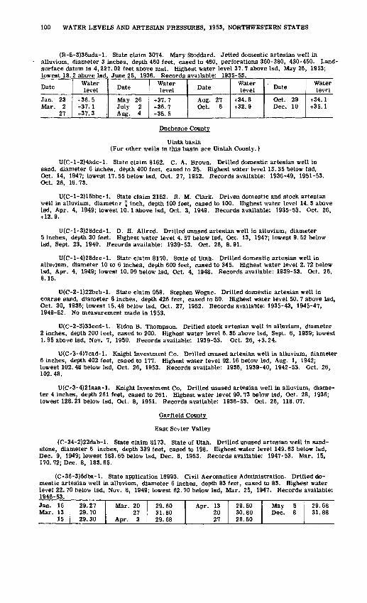
100 WATER LEVELS AND ARTESIAN PRESSURES, 1953, NORTHWESTERN STATES
(B-5-3)36ada-l. State claim 3074. Mary Stoddard. Jetted domestic artesian well in alluvium, diameter 3 inches, depth 460 feet, cased to 460, perforations 360-380, 430-450. Land- surface datum is 4,227. 02 feet above msl. Highest water level 37. 7 above Isd, May 26, 1953;
1935-53.
Date
Jan. 23 Mar. 2
27
Waterlevel
+36.5 +37.1 +37.3
Date
May 26 July 2 Aug. 4
Water level
+37.7 +36.7 +35.5
Date
Aug. 27 Oct. 6
Water level
+34.8 +32.9
Date
Oct. 29 Dec. 10
Water level
+34.1 +35.1
Duchesne County
ULnta basin (For other wells in this basin see Uintah County.)
U(C-l-2)4adc-l. State claim 8162. C. A. Brown. Drilled domestic artesian well in sand, diameter 6 inches, depth 400 feet, cased to 25. Highest water level 13. 35 below Isd, Oct. 14, 1947; lowest 17. 55 below Isd, Oct. 27, 1952. Records available: 1936-49, 1951-53. Oct. 26, 16.73.
U(C-l-2)15bbc-l. State claim 2152. R. M. Clark. Driven domestic and stock artesian well in alluvium, diamete r f inch, depth 100 feet, cased to 100. Highest water level 14. 3 above Isd, Apr. 4, 1949; lowest 10.1 above Isd, Oct. 3, 1949. Records available: 1935-53. Oct. 26, +12.9.
U(C-l-3)28dcd-l. D. H. Allred. Drilled unused artesian well in alluvium, diameter 5 inches, depth 30 feet. Highest water level 4. 57 below Isd, Oct. 13, 1947; lowest 9. 52 below Isd, Sept. 23, 1940. Records available: 1939-53. Oct. 26, 8.91.
U(C-l-4)28dcc-l. State claim 8170. State of Utah. Drilled domestic artesian well in alluvium, diameter 10 to 6 inches, depth 600 feet, cased to 345. Highest water level 2. 72 below Isd, Apr. 4, 1949; lowest 10. 09 below Isd, Oct. 4, 1948. Records available: 1939-53. Oct. 26, 8.15.
U(C-2-l)22bcb-l. State claim 958. Stephen Wogac. Drilled domestic artesian well in coarse sand, diameter 6 inches, depth 426 feet, cased to 80. Highest water level 50. 7 above Isd, Oct. 30, 1936; lowest 15.48 below Isd, Oct. 27, 1952. Records available: 1935-43, 1945-47, 1949-52. No measurement made in 1953.
U(C-2-3)33ccd-l. Eldon B. Thompson. Drilled stock artesian well in alluvium, diameter 2 inches, depth 200 feet, cased to 200. Highest water level 6. 35 above Isd, Sept. 6, 1939; lowest 1.95 above Isd, Nov. 7, 1950. Records available: 1939-53. Oct. 26, +3.24.
U(C-3-4)7cad-l. Knight Investment Co. Drilled unused artesian well in alluvium, diameter 6 inches, depth 402 feet, cased to 177. Highest water level 92.16 below Isd, Aug. 1, 1942; lowest 102.48 below Isd, Oct. 26, 1953. Records available: 1936, 1939-40, 1942-53. Oct. 26, 102.48.
U(C-3-4)21aaa-l. Knight Investment Co, Drilled unused artesian well in alluvium, diame ter 4 inches, depth 261 feet, cased to 261. Highest water level 90. 73 below Isd, Oct. 28, 1936; lowest 128. 21 below Isd, Oct. 8, 1951. Records available: 1936-53. Oct. 26, 118.07.
Garfield County
East Sevier Valley
(C-34-2)22dab-l. State claim 8173. State of Utah. Drilled unused artesian well in sand stone, diameter 6 inches, depth 339 feet, cased to 198. Highest water level 149.63 below Isd, Dec. 9, 1949; lowest 183. 65 below Isd, Dec. 8, 1953. Records available: 1947-53. Mar. 15, 170. 72; Dec. 8, 183.65.
(C-36-3)6dba-l. State application 16993. Civil Aeronautics Administration. Drilled do mestic artesian well in alluvium, diameter 6 inches, depth 83 feet, cased to 83. Highest water level 22. 70 below Isd, Nov. 8, 1949; lowest 62. 70 below Isd, Mar. 25, 1947. Records available: 1946-53.Jan. 16Mar. 13
15
29.2729.7029.30
Mar. 2027
Apr. 3
29.60 Apr. 1331.80 2029. 68 f 27
29.5030.8028.50
May 5Dec. 8
29.6831.88

UTAH, IRON COUNTY 101
(C-36-3)7aac-l. Lillie Stead. Dug domestic water-table well in alluvium, diameter 6 feet, depth 13 feet, lined with rock. Highest water level 1. 69 below Isd, Mar. 17, 1942; lowest 10. 54 below Isd, Mar. 25, 1951. Records available: 1938-53. Mar. 15, 6.09; Dec. 8, 7.85.
Upper Sevier Valley
(C-33-5)28bcd-l. State application 11739. Annie Wilcock. Drilled domestic artesian well in alluvium, diameter 6 inches, depth 200 feet. Highest water level 42. 60 below Isd, July 20, 1948; lowest 52. 30 below Isd, Dec. 9, 1951. Records available: 1937-53. Mar. 16, 49.15.
(C-34-5)8adb-2. D. W. Woodard. Driven unused artesian well in alluvium, diameter 5 inches, depth 93 feet, cased to 93, perforations 77-93. Highest water level 9. 95 below Isd, Aug 24, 1937; lowest 20.15 below Isd, Feb. 9, 1937. Records available: 1935-53. Mar. 16, 16.67; Dec. 10, 17.01.
Grand County
Colorado River area-Courthouse Syncline
(D-24-20)22bac-l. State application 13068. U. S. Bureau of Land Management. Drilled unused water-table well in alluvium, diameter 6 inches, depth 52 feet, cased to 41, perforations 19. Highest water level 10. 97 below Isd, Dec. 1, 1943; lowest 12. 84 below Isd, Aug. 7, 1951. Records available: 1942-44, 1946-53. Oct. 30, 12. 73.
Green River Desert
(D-22-24)29cbc-l. State application 13068. U. S. Bureau of Land Management. Drilled unused water-table well in Morrison formation, diameter 8 inches, depth 160 feet, cased to 30. Highest water level 16.80 below Isd, Mar. 31, 1949; lowest 23.11 below Isd, Nov. 1, 1951. Records available: 1946-53. Jan. 30, 21.05; Feb. 21, 20. 89; Mar. 30, 20.58; Apr. 22, 20.37; May 29, 20. 34; June 26, 21. 53; July 31, 21. 50.
Moab-Spanish Valley (For other wells in this valley see San Juan County.)
(D-25-21)28add-l. State application 13068. U. S. Bureau of Land Management. Drilled unused water-table well in alluvium, diameter 8 inches, depth 67 feet. Highest water level 34. 95 below Isd, June 28, 1952; lowest 38. 68 below Isd, Jan. 30, 1953. Records available: 1946-53.
Date
Jan. 30 Feb. 26
Water level
38.68 3'. . 80
Date
Mar. 31 Apr. 22
Water level
37.92 37.94
Date
May 31 June 23
Water level
36.68 36.58
Date
Aug. 5 Sept. 22
Water level
36.32 37.61
Iron County
Cedar City Valley
(C-34-ll)36cbc-2. State claim 10820. George D. Grimshaw. Drilled unused water-table well in alluvium, diameter 8 inches, depth 195 feet, cased to 195, perforations 18-160. Land- surface datum is 5,448.1 feet above msl. Highest water level 16. 38 below Isd, June 17, 1938; lowest 22. 65 below Isd, Dec. 4, 1952. Records available: 1937-52. No measurement made in 1953.
(C-34-ll)9cdc-l. D. C. Evans. Jetted unused water-table well in alluvium, diameter 4 inches, depth 61 feet. Land-surface datum is 5,402.3 feet above msl. Highest water level 21. 53 below Isd, May 9, 1939; lowest 22.91 below Isd, Mar. 24, 1941. Records available: 1938-53. Mar. 12, 22.19; Dec. 7, 22.22.
(C-35-10)18cbb-l. Richard Williams. Drilled unused water-table well in alluvium, diameter 10 indies, depth 112 feet. Land-surface datum is 5, 550. 22 feet above msl. Highest waier level 41. 95 below Isd, Mar. 22, 1943; lowest 80. 89 below Isd, Oct. 5, 1953. Records available: 1937-53.Jan. 3Feb. 7Mar. 5
13
53.1751.3650.4950.39
Apr. 10May 7June 5
54.8364.4574.78
July 3Aug. 1Sept. 2
77.4780.0280.50
Oct. 5Nov. 2Dec. 3
80.8969.2061.87

102 WATER LEVELS AND ARTESIAN PRESSURES, 1953, NORTHWESTERN STATES
(C-35-ll)8cdd-l. State claim 13703. Charles L. Corry. Drilled unused artesian well in alluvium, diameter 6 inches, depth 130 feet, cased to 130, perforations 115-130. Land-surface datum is 5, 489. 5 feet above msl. Highest water level 8. 26 below Isd, Mar. 23, 1943; lowest 29. 48 below Isd, Aug. 1, 1953. Records available^ 1937-53.
Date
Jan. 3 Feb. 7 Mar. 5
13
Water level
14.79 13.98 13.65 13.47
Date
Apr. 10 May 7 June 5 July 3
Water level
18.24 24.06 28.26 28.26
Date
Aug. 1 Sept. 2 Oct. 5
Water level
29.48 25.33 25.11
Date
Nov. 2 Dec. 3
7
Water level
21.63 18.39 17.99
(C-35-ll)15aac-l. State claim 1220. H. D. Haight. Drilled stock artesian well in alluvium, diameter 7 inches, depth 145 feet, cased to 145. Land-surface datum is 5, 502. 7 feet above msl. Highest water level 5.27 below Isd, June 28, 1938; lowest 10. 54 below Isd, Dec. 3, 1953. Records available: 1937-53.Jan. 3Feb. 7Mar. 5
13
8.578.738.778.75
Apr. 10May 7June 5July 3
8.458.588.718.82
Aug. 1Sept. 2Oct. 5
6.979.799.84
Nov. 2Dec. 3
7
10.3610.5410.39
(C-35-ll)21dbd-l. State claim 1222. Ezra Rollo. Drilled unused water-table well in alluvium, diameter 12 to 10 inches, depth 228 feet. Land-surface datum is 5, 533.25 feet above msl. Highest water level 20. 48 below Isd, Oct. 19, 1943; lowest 33.40 below Isd, Nov. 2, 27, Dec. 3. 1953. Records available: 1939-53.Jan. 3Feb. 7Mar. 5
1326
29.4029.0026.3827.5127.56
Apr. 1028
May 726
27.8030.6229.2232.66
July 7Aug. 28Sept. 28Oct. 25
32.1332.7232.5733.66
Nov. 227
Dec. 37
33.4033.4033.4033.27
(C-35-ll)21dcc-l. State claim 11599. Wilford R. Fife. Drilled irrigation artesian well in alluvium, diameter 12 inches, depth 180 feet, cased to 95. Land-surface datum is 5, 538. 56 feet above msl. Highest water level 22. 90 below Isd, Dec. 15, 1943; lowest 40. 60 below Isd, Aug. 23, 1951. Records available: 1931-53. Mar. 13, 31. 55; June 22, 52.50, pumping; Dec. 7, 38.18.
(C-35-ll)27acc-l. State claim 382. Fernleigh Gardner. Drilled irrigation artesian well in coarse gravel, diameter 12 inches, depth 114 feet, cased to 113, perforations 47-54, 74-76, 89-113. Land-surface datum is 5, 553. 00 feet above msl. Highest water level 30. 14 below Isd, June 25, 1942; lowest 54. 54 below Isd, Nov. 2, 1953. Records available: 1931-53.Jan. 3Feb. 7Mar. 5
13
45.0544.1643.6643.46
Apr. 10May 7June 5
15
43.1348.20
a60. 03a61. 30
June 23July 3Aug. 1Sept. 2
a61.50a61.82a63. 18a63.56
Oct. 5Nov. 2Dec. 3
7
a64. 1054.5452.3852.07
a Pumping.
(C-35-ll)31acd-l. State claim 13498. Heber C. Jenson. Drilled unused artesian well in alluvium, diameter 12 inches, depth 248 feet, cased to 248, perforations 81-87, 168-175, 200-202, 222-227, 242-248. Highest water level 15. 3 below Isd, Mar. 30, 1933; lowest 45.12 below Isd, Oct. 5, 1953. Records available: 1930-53.Jan. 3Feb. 7Mar. 5
13
26.6425.6525.3425.19
Apr. 10May 7June 5July 3
28.2530.6640.9241.31
Aug. 1Sept. 2Oct. 5
41.7244.8245.12
Nov. 2Dec. 3
7
38.7533.1132.62
(C-35-ll)33aac-l. State claim 5126. Cottonwood Pump & Irrigation Co. Drilled irrigation water-table well, diameter 16 inches, depth 138 feet, cased to 136, perforations 52-136. Land- surface datum is 5, 576. 65 feet above msl. Highest water level 55. 70 below Isd, Mar. 22, 1943; lowest 80. 91 below Isd. Oct. 5. 1953. Records available: 1930-53.Jan. 3Feb. 7Mar. 5
69.0367.4666.59
Apr. 10June 17July 3
68.93a87.40a88. 03
Aug. 1Sept. 2Oct. 5
a92. 60a93. 00
80.91
Nov. 2Dec. 3
7
79.1476.7675.88
(C-35-12)34dcd-l. State claim 4873. R. J. and W. M. Shay. Drilled unused artesian well in alluvium, diameter 12 inches, depth 120 feet, casing to 120, perforations 12-120. Land- surface datum is 5,485. 38 feet above msl. Highest water level 15.00 below Isd, Apr. 17, 1937; lowest 18.62 below Isd, Dec. 7, 1953. Records available: 1936-53. Mar. 13, 17.00; Dec. 7, 18.62.
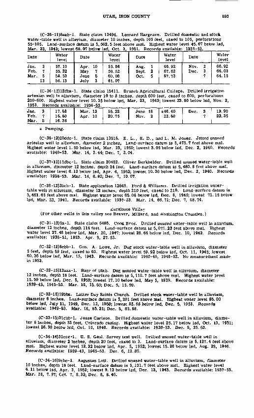
UTAH, IRON COUNTY 103
(C-36-ll)8aab-l. State claim 13494. Leonard Hargrave. Drilled domestic and stock water-table well in alluvium, diameter 10 inches, depth 105 feet, cased to 105, perforations 55-105. Land-surface datum is 5, 562. 5 feet above msl. Highest water level 45. 67 beow Isd, Mar. 23, 1943; lowest 68. 07 below Isd, Oct. 3. 1951. Records available: 1935-53.
Date
Jan. 3 Feb. 7 Mar. 5
13
Water level
57.10 55.32 54.50 54.13
Date
Apr. 10 May 7 June 5 July 3
Water level
55.86 59.52 60.08 61.07
Date
Aug. 1 Sept. 2 Oct. 5
Water level
66.92 67.83 67.73
Date
Nov. 2 Dec. 3
7
Water level
66.92 66.03 64.15
(C-36-12)12dba-l. State claim 15411. Branch Agricultural College. Drilled irrigation artesian well in alluvium, diameter 10 to 8 inches, depth 600 feet, cased to 600, perforations 200-600. Highest water level 10. 35 below Isd, Mar. 23, 1943; lowest 23.60 below Isd, Nov. 2, 1953. Records available: 1936-53.Jan. 3Feb. 7Mar. 5
17.6816.8016.36
Mar. 13Apr. 10
16.2220.75
June 18Nov. 2
a46. 4023.60
Dec. 37
19.9022.35
a Pumping.
(C-36-12)20ddc-l. State claim 13516. E. L., H. D., and L. M. Jones. Jetted unused artesian well in alluvium, diameter 2 inches, Land-surface datum is 5, 475. 7 feet above msl. Highest water level 1. 50 below Isd, Mar. 23, 1950; lowest 3.05 below Isd, Dec. 2, 1940. Records available: 1940-53. Mar. 14, 2.44; Dec. 7, 3.04.
(C-37-12)lldbc-l. State claim 20452. Oliver Berkhelder. Drilled unused water-table well in alluvium, diameter 12 inches, depth 24 feet. Land-surface datum is 5, 480. 8 feet above msl. Highest water level 6.12 below Isd, Apr. 4, 1952; lowest 10. 30 below Isd, Dec. 2, 1940. Records available: 1938-53. Mar. 14, 8.82; Dec. 7, 10.07.
(C-38-12)3bcb-l. State application 12845. Ford & Williams. Drilled irrigation water- table well in alluvium, diameter 12 inches, depth 210 feet, cased to 210. Land-surface datum is 5, 481. 65 feet above msl. Highest water level 65.08 below Isd, Dec. 8, 1945; lowest 71.15 below Isd, Mar. 22, 1941. Records available: 1937-53. Mar. 14, 66.71; Dec. 7, 68.74.
£scalante Valley (For other wells in this valley see Beaver, Millard, and Washington Counties.)
(C-31-13)la-l. State claim 6486. Cook Bros. Drilled unused water-table well in alluvium, diameter 12 inches, depth 114 feet. Land-surface datum is 5,071.23 feet above msl. Highest water level 27. 48 below Isd, Mar. 20, 1947; lowest 28. 66 below Isd, Dec. 10, 1942. Records available: 1938-51, 1953. Apr. 9, 27.53.
(C-32-12)6cbb-l. Geo. A. Lowe, Jr. Dug stock water-table well in alluvium, diameter 5 feet, depth 69 feet, cased to 60. Highest water level 59. 92 below Isd, Oct. 11, 1945; lowest 60. 36 below Isd, Mar. 15, 1943. Records available: 1940-45, 1948-52. No measurement made in 1953.
(C-33-15)12aaa-l. State of Utah. Dug unused water-table well in alluvium, diameter 12 inches, depth 18 feet. Land-surface datum is 5,110. 7 feet above msl. Highest water level 15. 50 below Isd, Dec. 5, 1953; lowest 17.10 below Isd, May 5, 1939. Records available: 1939-43, 1945-53. Mar. 18, 15. 60; Dec. 5, 15. 50.
(C-33-15)19bba. Latter Day Saints Church. Drilled stock water-table well in alluvium, diameter 6 inches. Land-surface datum is 5,201 feet above msl. Highest water level 85.00 below Isd, July 11, 1949, Dec. 12, 1950; lowest 85.68 below Isd, Dec. 5, 1953. Records available: 1949-53. Mar. 18, 85.21; Dec. 5, 85.68.
(C-33-15)31cbb-l. Jesse Carlson. Drilled domestic water-table well in alluvium, diame ter 8 inches, depth 53 feet, Colorado casing. Highest water level 25.17 below Isd, Oct. 13, 1951; lowest 26.98 below Isd, Oct. 10, 1946. Records available: 1936-53. Dec. 5, 25.50.
(C-34-14)31ccc-l. U. S. Geol. Survey test well. Drilled unused water-table well in alluvium, diameter 2 inches, depth 20 feet, cased to 3. Land-surface datum is 5,127. 4 feet above msl. Highest water level 12. 32 below Isd, Apr. 5, 1952; lowest 15.26 below Isd, Aug. 29, 1946. Records available: 1939-43, 1945-53. Dec. 6, 13.87.
(C-34-16)9cbc-l. Augustus Lott. Drilled unused water-table well in alluvium, diameter 10 inches, depth 18 feet. Land-surface datum is 5,131. 7 feet above msl. Highest water level 6.11 below Isd, Apr. 3, 1952; lowest 9.12 below Isd, Dec. 13, 1943. Records available: 1937-53. Mar. 18, 7. 97; Cct. 7, 8. 32; Dec. 5, 8. 46.

104 WATER LEVELS AND ARTESIAN PRESSURES, 1953, NORTHWESTERN STATES
(C-34-16)28bcc-2. I. M. Matson. Drilled unused water-table well in alluvium, diameter 12 inches, depth 67 feet, perforations 0-67. Land-surface datum is 5,134. 4 feet above msl. Highest water level 8. 97 below Isd, May 25, 1937; lowest 13. 30 below Isd, Oct. 8, 1952. Records available: 1935-53. Mar. 18, 11.65; Oct. 7, 12.86; Dec. 5, 12.70.
(C-34-16)29ccc-l. State application 16524. Monte Miller. Drilled irrigation water-table well in alluvium, diameter 14 inches, depth 203 feet, cased to 203. Land-surface datum is 5,141.4 feet above msl. Highest water level 9.85 below Isd, Dec. 9, 1949; lowest 12.88 below Isd, Dec. 5, 1953. Records available: 1949-53. Mar. 19, 11. 59; July 10, 55.50, pumping; Aug. 20, 61.60, pumping; Dec. 5, 12.88.
(C-34-16)33cdc-2. Utah Land Security. Drilled unused water-table well in alluvium, diameter 6 inches, depth 37 feet. Land-surface datum is 5,141. 5 feet above msl. Highest water level 12.06 below Isd, Mar. 31, 1945; lowest 18.32 below Isd, Oct. 13, 1951. Records available: 1939-45, 1948-53. Mar. 18, 15.69; Dec. 6, 17.27.
(C-34-17)24cbb-l. State claim 6835. Marvin H. Hughes. Drilled unused water-table well in alluvium, diameter 8 inches, depth 40 feet, cased to 40, perforations 0-40. Land-surface datum is 5,150. 7 feet above msl. Highest water level 14.15 below Isd, Mar. 16, 1943; lowest 17.85 below Isd, Dec. 5, 1953. Records available: 1937-45, 1949-51, 1953. Mar. 19, 16.66; Dec. 5, 17.85.
(C-35-12)18ddd-2. State claim 11258.Columbia Steel Co. Drilled unused water-table well in alluvium, diameter 10 inches, depth 44 feet. Land-surface datum is 5, 385. 2 feet above msl. Highest water level 10. 57 below Isd, May 8, 1939; lowest 13. 90 below Isd, Dec. 6, 1953. Records available: 1935-53. Mar. 20, 11. 18; Dec. 6, 13.90.
(C-35-15)3dcc-2. State claim 3788. E. J. Graff. Drilled irrigation artesian well in alluvium, diameter 16 inches, depth 350 feet, cased to 350, perforations 60-136, 260-280, 285-308. Land-surface datum is 5,138. 37 feet above msl. Highest water level 10. 60 below Isd, Apr. 19, 1949; lowest 16.83 below Isd, Apr. 30, 1946. Records available: 1936-53. Mar. 19, 13. 45; July 10, 43. 30, pumping; Dec. 6, 15. 06.
(C-35-15)6cdd-l. Frank Bridel. Drilled unused water-table well in alluvium, diameter 12 inches, depth 170 feet, Colorado casing. Land-surface datum is 5, 139. 0 feet above msl. Highest water level 11.40 below Isd, May 23, 1937; lowest 15.36 below Isd, Dec. 6, 1953. Records available: 1936-53. Mar. 19, 14. 32; Dec. 6, 15.36.
(C-35-15)10bdc-2. State application 12134. Walter Martin. Drilled irrigation artesian well in alluvium, diameter 16 inches, depth 271 feet. Highest water level 13. 88 below Isd, Apr. 21, 1942; lowest 19. 33 below Isd, Aug. 25, 1938. Records available: 1936-45, 1949-53. Mar: 18, 14.92; July 10, 45.60, pumping; Aug. 25, 47.10, pumping; Dec. 6, 16.70.
(C-35-15)16ddd-l. State application 12838. Kumen Jones. Drilled irrigation water-table well in alluvium, diameter 16 inches, depth 315 feet, cased to 315, perforations 50-252. Land- surface datum is 5,156. 3 feet above msl. Highest water level 23. 96 below Isd, Mar. 28, 1950; lowest 27.15 below Isd, Aug. 8, 1950. Records available: 1949-53. Mar. 19, 25.02; Dec. 6, 26. 50.
(C-35-15)28bdc-l. State application 15593. E. J. Graff. Drilled irrigation water-table well in alluvium, diameter 14inches, depth 180 feet, cased to 180. Highest water level 31.30 below Isd, June 12, 1950; lowest 41. 77 below Isd, Dec. 6, 1953. Records available: 1949-53. Mar. 19, 40. 76; Dec. 6, 41. 77.
(C-35-16)6ccc-2. Emily Jones. Drilled unused water-table well in alluvium, diameter 8 inches, depth 60 feet, cased to 60. Land-surface datum is 5,154. 77 feet above msl. Highest water level* 17. 46 below Isd, Apr. 16, 1938; lowest 28. 92 below Isd, Dec. 5, 1953. Records available: 1937-39, 1949-53. Mar. 19, 26.15; Dec. 5, 28.92.
(C-35-16)14ddc-l. John McGary. Drilled irrigation water-table well in alluvium, diameter 14 inches, depth 100 feet. Land-surface datum is 5,155.19 feet above msl. Highest water level 20. 63 below Isd, Dec. 10, 1949; lowest 26. 40 below Isd, Dec. 5, 1953. Records available: 1948-53. Dec. 5, 26.40.
(C-35-16)15abb-l. H. G. Dewey. Drilled unused water-table well in alluvium, diameter 12 inches, depth 40 feet, cased to 40. Land-surface datum is 5,151. 4 feet above msl. Highest water level 17. 32 below Isd, May 28, 1937; lowest 26. 26 below Isd, Dec. 5, 1953. Records available: 1937, .1949-53. Mar. 19, 24.10; Dec. 5, 26.26.
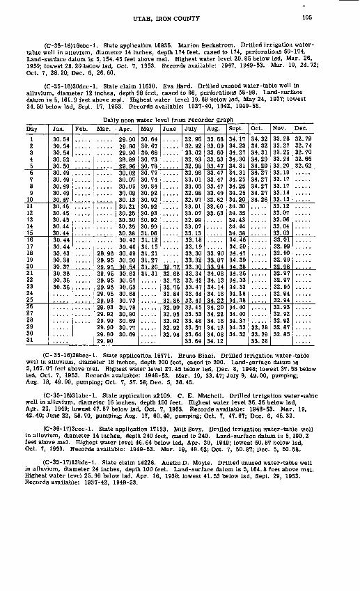
UTAH, IRON COUNTY 105
(C-35-16)16bbc-l. State application 16835. Marion Beckstrom. Drilled irrigation water- table well in alluvium, diameter 14 inches, depth 174 feet, cased to 174, perforations 50-174. Land-surface datum is 5,154. 45 feet above msl. Highest water level 20.85 below Isd, Mar. 26, 1950; lowest 28. 20 below Isd, Oct. 7, 1953. Records available: 1947, 1949-53. Mar. 19, 24.72; Oct. 7, 28. 20; Dec. 6, 26. 60.
(C-35-16)20dcc-l. State claim 11630. Eva Hard. Drilled unused water-table well in alluvium, diameter 12 inches, depth 98 feet, cased to 98, perforations 58-98. Land-surface datum is 5,161.9 feet above msl. Highest water level 19. 69 below Isd, May 24, 1937; lowest 34. 50 below Isd, Sept. 17, 1953. Records available: 1937-40, 1942, 1949-53.
Daily noon water level from recorder graphDay
1 2 34 56 7 8 9
101112 1314 1516 17 18 19 2021 22 23 24 2526 27 28 29 30 31
Jan.
30.54 30.54 30.54 30.52 30.5030.49 30.49 30.49 30.49 30.4730.46 30.45 30.45 30.44 30.4430.44 30.44 30.43 30.38 30.3730.36 30.36 30.36
Feb. Mar.
29.96 29.95 29.9^29.95 29.95 29.95 29.95 29.9329.93 29.92 29.90 29.90 29.90 29.90
Apr.
29.90 29.90 29.90 29.89 29.9630.02 30.07 30.05 30.08 30. 1330.21 30.25 30.30 30.35 30.3830.42 30.46 30.49 30.50 30,5430.63 30.67 30.63 30.68 30.7330.78 30.80 30.69 30.77 30.69
May
30.64 30.67 30.68 30.73 30.7830.77 30.74 30.84 30.92 30.9230.92 30.93 30.92 30.99 31.0631.12 31.15 31.21 31.27 31.2631.31
June
32! 7232.68 32.72 32.76 32.84 32.8632.90 32.95 32.92 32.92 32.94
July
32.96 32.92 33.02 32.93 32.9832.96 33.01 33.05 32.98 32.9733.01 33.07 32.99 33.07 33.1333.18 33.19 33.30 33.32 33.3033.34 33.42 33.47 33.44 33.4533.45 33.53 33.48 33.57 33.64 33.64
Aug.
33.68 33.69 33.60 33.53 33.4733.47 33.47 33.47 33.49 33.6233.60 33.63
33.90 33.87 33.9434.08 34.13 34.14 34.18 34.2234.20 34.22 34.18 34.13 34.08 34.12
Sept.
34.17 34.23 34.27 34.30 34.3134.31 34.25 34.25 34.25 34.2034.30 34.35 34.43 34.44 34.3834.46 34.50 34.47 34.39 34.3834.36 34.33 34.33 34.38 34.3834.40 34.40 34.37 34.33 34.32
Oct.
34.32 34.32 34.31 34.29 34.2934.27 34.27 34.27 34.27 34.26
33.28 33.29 33.28
Nov.
33.28 33.27 33.25 33.24 33.2033.19 33.17 33.17 33.14 33.1333.12 33.07 33.06 33.04 33.0333.01 32.99 32.99 32.99 32.9832.97 32.97 32.95 32.94 32.9432.93 32.92 32.92 32.87 32.85
Dec.
32.79 32.74 32.70 32.66 32.62
(C-35-16)28bcc-l. State application 15771. Bruno Biasi. Drilled irrigation water-table well in alluvium, diameter 18 inches, depth 200 feet, cased to 200. Land-surface datum is 5,167. 07 feet above msl. Highest water level 27.45 below Isd, Dec. 8, 1948; lowest 37. 58 below Isd, Oct. 7, 1953. Records available: 1948-53. Mar. 19, 33.47; July 9, 49.00, pumping; Aug. 18, 49.00, pumping; Oct. 7, 37. 58; Dec. 5, 36.45.
(C-35-16)31abc-l. State application a2109. C. E. Mitchell. Drilled irrigation water-table well in alluvium, diameter 16 inches, depth 150 feet. Highest water level 36. 36 below Isd, Apr. 21, 1949; lowest 47.67 below Isd, Oct. 7, 1953. Records available: 1948-53. Mar. 19, 42. 40; June 22, 58.70, pumping; Aug. 17, 60.40, pumping; Oct. 7, 47.67; Dec. 6, 45.32.
(C-35-17)3ccc-l. State application 17133. Milt Sevy. Drilled irrigation water-table well in alluvium, diameter 14 inches, depth 240 feet, cased to 240. Land-surface datum is 5,190.2 feet above msl. Highest water level 46. 64 below Isd, Apr. 20, 1949; lowest 50. 87 below Isd, Oct. 7, 1953. Records available: 1949-53. Mar. 19, 49.62; Oct. 7, 50.87; Dec. 5, 50.58.
(C-35-17)13bdc-l. State claim 14228. Austin D. Moyle. Drilled unused water-table well in alluvium, diameter 24 inches, depth 100 feet. Land-surface datum is 5,164.8 feet above msl. Highest water level 25. 99 below Isd, Apr. 16, 1938; lowest 41. 53 below Isd, Sept. 29, 1953. Records available: 1937-42, 1949-53.
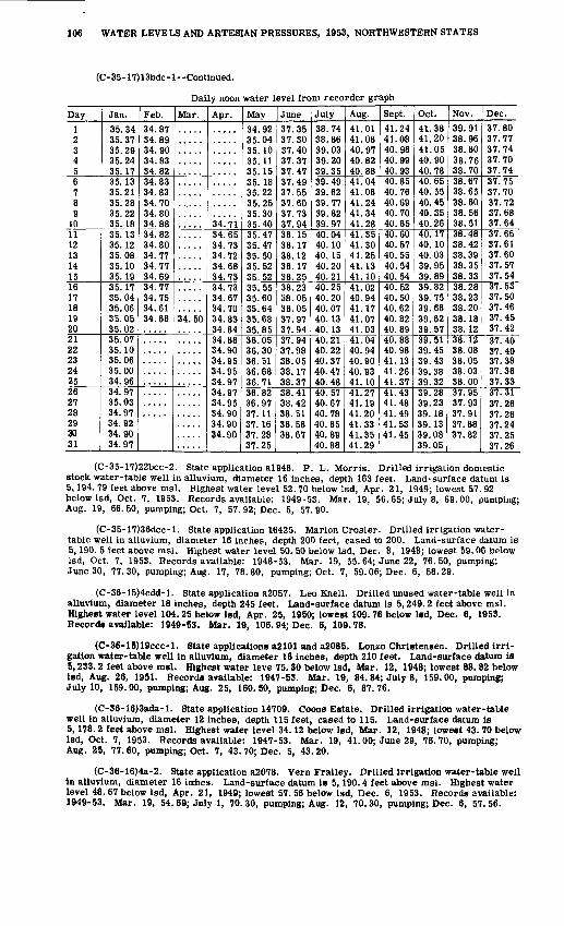
106 WATER LEVELS AND ARTESIAN PRESSURES, 1953, NORTHWESTERN STATES
(C-35-17)13bdc-l--Continued.
Daily noon water level from recorder graph
Day123456789
1011 12 13 14 1516 17 18 19 20212223242526 272829 30 31
Jan.35.3435.3735.2935.2435. 1735.1335.2135.2835.2235.1835.13 35.12 35.08 35.10 35.1935.17 35.04 35.06 35.05 35.0235.0735.1035.0635.0034.9634.97 35.0334.9734.92 34.90 34.97
Feb.34.8734.8934.9034.8334.8234.8334.8334.7034.8034.8834.82 34.80 34.77 34.77 34.6934.77 34.75 34.61 34.68
Mar.
34.50
Apr.
34.7134.65 34.73 34.72 34.68 34.7334.73 34.67 34.70 34.83 34.8434.8834.9034.95tA O^
34.9734.97 34.9534.9034.90 34.90
May34.9235.0435. 1035. 1135.1535.1835.2235.2535.3035.4035.47 35.47 35.50 35.52 35.5235.55 35.60 35.64 35.68 35.8536.0536.3036.5136.6836.7136.82Ifi Q707 1 i
37.16 37.28 37.25
June37.3537.3037.4037.3737.4737.4937.5537.6037.7337.9438.15 38.17 38.12 38.17 38.2538.23 38.05 38.05 37.97 37.9437.94O7 QQ
38.05OQ -I 7
38.3738.41°.ft d9OQ C1
38.58 38.67
July38.7438.8639.0339.2039.3539.4939.6239.7739.8239.9740.04 40.10 40.15 40.20 40.2140.25 40.20 40.07 40.13 40.1340.21Aft 99Aft O7
40.4740.4840.57 40.67Aft 7Q
40.85 40.89 40.88
Aug.41.0141.0840.9740.8240.8841.0441.0841.2441.3441.2841.35 41.30 41.25 41.13 41.1041.02 40.94 41.17 41.07 41.0341.0440 9440 90A(\ OO.
41.1041.27 41 1941.2041.33 41.35 41.29
Sept.41.2441.0840.9840.9940.9340.8540.7640.6940.7040.6540.60 40.57 40.55 40.54 40.5440.52 40.50 40.62 40.82 40.8940.8840.9841 11
41.2641.3741.43A 1 4fl
41 4941.53 41.45
Oct.41.3841.2041.0540.9040.7840.6540.5540.4540.3540.2640.17 40.10 40.03 39.95 39.8939.82 39.75 39.68 39.62 39.5739.51IQ A*\
1O 41On QQ
39.3239.28°.Q 9°.OQ 1 Q
39.13 39.08 39.05
Nov.39.9138.9638.8038.7638.7038.6738.6538.6038.5638.5138.48 38.42 38.39 38.35 38.3338.28 38.23 38.20 38.18 38.1238.1238.0838.0538.0338.0037.9507 no
°.7 Q1
37.88 37.82
Dec.37.8037.7737.7437.7037.7437.7537.7037.7237.6837.6437.65 37.61 37.60 37.57 37.5437.53 37.50 37.46 37.45 37.4237.40VI A(\
37.3837.3637.3337.31
37.24 37.25 37.26
(C-35-17)22bcc-2. State application a!946. P. L. Morris. Drilled irrigation domestic stock water-table well in alluvium, diameter 16 inches, depth 163 feet. Land-surface datum is 5,194. 79 feet above msl. Highest water level 52. 70 below Isd, Apr. 21, 1949; lowest 57. 92 below Isd, Oct. 7, 1953. Records available: 1949-53. Mar. 19,, 56. 65; July 8, 69.00, pumping; Aug. 19, 66. 50, pumping; Oct. 7, 57. 92; Dec. 5, 57. 90.
(C-35-17)36dcc-l. State application 16425. Marion Crosier. Drilled irrigation water- table well in alluvium, diameter 16 inches, depth 200 feet, cased to 200. Land-surface datum is 5,190. 5 feet above msl. Highest water level 50. 50 below Isd, Dec. 8, 1948; lowest 59.06 below Isd, Oct. 7, 1953. Records available: 1948-53. Mar. 19, 55.64; June 22, 76.50, pumping; June 30, 77.30, pumping; Aug. 17, 78.80, pumping; Oct. 7, 59.06; Dec. 6, 58.29.
(C-36-15)4cdd-l. State application a2057. Leo Knell. Drilled unused water-table well in alluvium, diameter 18 inches, depth 245 feet. Land-surface datum is 5,249.2 feet above msl. Highest water level 104.25 below Isd, Apr. 25, 1950; lowest 109.78 below Isd, Dec. 6, 1953. Records available: 1949-53. Mar. 19, 106.94; Dec. 6, 109.78.
(C-36-15)19ccc-l. State applications a2101 and a2085. Lonzo Christensen. Drilled irri gation water-table well in alluvium, diameter 16 inches, depth 210 feet. Land-surface datum is 5,233.2 feet above msl. Highest water leve 75.30 below Isd, Mar. 12, 1948; lowest 88.82 below Isd, Aug. 26, 1951. Records available: 1947-53. Mar. 19, 84.84; July 8, 159.00, pumping; July 10, 159.00, pumping; Aug. 25, 160.50, pumping; Dec. 6, 87.76.
(C-36-16)3ada-l. State application 14709. Coons Estate. Drilled irrigation water-table well in alluvium, diameter 12 inches, depth 115 feet, cased to 115. Land-surface datum is 5,178.2 feet above msl. Highest water level 34.12 below Isd, Mar. 12, 1948; lowest 43. 70 below Isd, Oct. 7, 1953. Records available: 1947-53. Mar. 19, 41.00; June 29, 76.70, pumping; Aug. 25, 77. 60, pumping; Oct. 7, 43. 70; Dec. 5, 43. 20.
(C-36-16)4a-2. State application a2078. Vern Frailey. Drilled irrigation water-table well in alluvium, diameter 16 inches. Land-surface datum is 5,190.4 feet above msl. Highest water level 48.67 below Isd, Apr. 21, 1949; lowest 57. 56 below Isd, Dec. 6, 1953. Records available: 1949-53. Mar. 19, 54. 69; July 1, 70.30, pumping; Aug. 12, 70.30, pumping; Dec. 6, 57.56.

UTAH, IRON COUNTY 107
(C-36-16)9bcd-l. State application 16253. Wilson Scott. Drilled irrigation water-table well in alluvium, diameter 14 inches, depth 272 feet, cased to 272. Land-surface datum is 5,191.1 feet above msl. Highest water level 51. 30 below Isd, Apr. 21, 1949; lowest 68. 97 below Isd, Oct. 7, 1953. Records available: 1948-53. Mar. 20, 58.23; June 29, 73.00, pumping; Aug. 12, 74. 20, pumping; Oct. 7, 68.97; Dec. 6, 64.14.
(C-36-16)19abb-l. State application 15511. T. W. Jones. Drilled irrigation water-table well in alluvium, diameter 16 inches, depth 352 feet, cased to 352, perforations 95-332. Land- surface datum is 5,226.3 feet above msl. Highest water level 75.36 below Isd, Dec. 11, 1945; lowest 91. 52 below Isd, Dec. 6, 1953. Records available: 1945-53. Mar. 20, 87. 72; July 7, 102. 20, pumping; Dec. 6, 91. 52.
(C-36-16)27dcd-l. State claim 19283. Ivins Investment Co. Drilled unused water-table well in alluvium, diameter 10 inches, depth 153 feet, cased to 153. Land-surface datum is 5,276.4 feet above msl. Highest water level 122. 54 below Isd, May 5, 1945; lowest 136. 50 below Isd, Dec. 6, 1953. Records available: 1945-53. June 22, 135.07; Dec. 6, 136.50.
(C-36-16)29daa-l. State application 16189. Weyl-Zuckerman Co. Drilled irrigation water-table well in alluvium, diameter 16 inches, depth 380 feet, cased to 380, perforations 100-350. Land-surface datum is 5,233. 4 feet above msl. Highest water level 85. 66 below Isd, Oct. 11, 1945; lowest 100. 28 below Isd, Dec. 6, 1953. Records available: 1945-53. Mar. 20, 96. 58; July 7, 138. 20, pumping; Dec. 6, 100.28.
(C-36-16)31ccc-l. State application 16153. Leland Huntsman. Drilled irrigation water- table well in alluvium, diameter 14 inches, depth 222 feet, cased to 222. Land-surface datum is 5,271.1 feet above msl. Highest water level 111. 75 below Isd, Mar. 31, 1948; lowest 128.90 below Isd, Oct. 14, 1951. Records available: 1947-53. Mar. 20, 121.14; June 22, 143.90, pumping; July 1, 144. 80, pumping; Aug. 13, 146. 60, pumping; Dec. 6, 126. 68.
Parowan Valley
(C-32-8)lada-l. Iron County. Drilled stock water-table well in alluvium, diameter 6 inches. Land-surface datum is 5, 746. 6 feet above msl. Highest water level 47. 80 below Isd, Mar. 20, 1951; lowest 49.04 below Isd, Feb. 5, 1940. Records available: 1939-53. Mar. 11, 48.15; Dec. 8, 48.37.
(C-33-8)28bbb-l. State claim 15133. Tom Abbott. Drilled stock and domestic artesian well in alluvium, diameter 4 inches, depth 350 feet, cased to 350. Land-surface datum is 5, 782. 2 feet above msl. Highest water level 9. 70 below Isd, Mar. 16, 1946; lowest 14. 20 below Isd, Apr. 26, 1953. Records available: 1940-53.
Date
Jan. 25 Feb. 22 Mar. 12
29
Water level
11.17 11.11 11.34 11.88
Date
Apr. 26 May 31 June 28
Water level14.20 13.05 12.29
Date
July 26 Aug. 30 Sept. 27
Water level
12.13 11.12 12.10
Date
Oct. 25 Nov. 29 Dec. 8
Water level
12.02 11.85 11.94
(C-33-9)34cbd-2. State claim 5694. Dee Robinson. Drilled unused artesian well in alluvium, diameter 4 to 2 inches, depth 500 feet, cased to 500, perforations 117-300. Land- surface datum is 5,736.6 feet above msl. Highest water level 17.65 below Isd, Mar. 14, 1943; lowest 57.34 below Isd, Aug. 30. 1953. Records available: 1935-53.Jan. 25Feb. 22Mar. 12
29
21.6420.9420.1220.86
Apr. 26May 31June 28
C43.00c53. 20C64.82
July 26Aug. 30Sept. 27
c65. 3557.3447.54
Oct. 25Nov. 29Dec. 8
42.2128.6527.68
c Nearby well pumping.
(C-33-9)36dcd-l. State claim 494. Hugh L. Adams. Drilled irrigation artesian well in alluvium, diameter 60 to 4 inches, depth 499 feet, cased to 490, perforations 75-490. Land- surface datum is 5,796. 76 feet above msl. Highest water level 29.72 below Isd, Mar. 14, 1943; lowest 51.77 below Isd, Dec. 8, 1953. Records available: 1933-53. Mar. 12, 44.69; June 25, 73.00, pumping; Aug. 7, 75.50, pumping; Sept. 16, 73.90, pumping; Dec. 8, 51.77.
(C-34-8)5bca-l. Drought Relief Administration. Drilled unused artesian well in alluvium, diameter 12 inches, depth 420 feet. Highest water level 14.05 below Isd, Aug. 28, 1949; lowest 28.95 below Isd, Nov. 21. 1936. Records available: 1935-53.Jan. 25Feb. 22Mar. 12
29
19.4519.6419.6619.85
Apr. 26May 31June 28
20.0020.2820.72
July 26Aug. 30Sept. 27
21.2321.9521.58
Oct. 25Nov. 29Dec. 8
22.3622.1822.40

108 WATER LEVELS AND ARTESIAN PRESSURES, 1953, NORTHWESTERN STATES
(C-34-9)8bdd-l. State claim 4868. Peter H. Gurr. Drilled stock artesian well in alluvium, diameter 6 inches, depth 100 feet. Land-surface datum is 5, 734. 7 feet above msl. Highest water level 13. 60 below Isd, May 28, 1950; lowest 28. 45 below Isd, Oct. 13, 1938. Records available: 1938-53.
Date
Jan. 25 Feb. 22 Mar. 12
29
Water level
18.66 18.79 18.82 18.80
Date
Apr. 26 May 31 June 28
Water level19.18 19.20 19.34
Date
July 26 Aug. 30 Sept. 27
Water level19.16 19.18 19.67
Date
Oct. 25 Nov. 29 Dec. 8
Water level
18.26 19.83 20.04
(C-34-9)10bdd-l. State claim 8801. Clair flowley. Drilled irrigation artesian well in alluvium, diameter 14 to 3 inches, depth 500 feet, cased to 500. Land-surface datum is 5, 817.12 feet above msl. Highest water level 42. 90 below 1st!, Mar. 14, 1943; lowest 69. 20 below Isd, Oct. 25, 1953. Records available: 1937-53.Jan. 25Feb. 22Mar. 12
29
59.3558.6457.9257.83
Apr. 26May 31June 28
a70. 60a72. 80a72. 96
July 26Aug. 30Sept. 27
a73. 07a72. 10a70. 95
Oct. 25Nov. 29Dec. 8
69.2067.7667.37
a Pumping.
(C-34-10)24aac-l. State application 16640. Lyle Farrow. Drilled irrigation water-table well in alluvium, diameter 12 inches, depth 195 feet, cased to 195. Highest water level 49. 75 below Isd, Mar. 22, 1950; lowest 58. 50 below Isd, July 30, 1952. Records available: 1948-53. Mar. 12, 54. 01; Dec. 8, 56. 72.
Juab County
Juab Valley
(C-15-l)12aba-l. State claim 10223. R. C. Mangelson. Drilled stock artesian well in gravel, diameter 6 inches, depth 117 feet, cased to 117. Land-surface datum is 5,196. 9 fee., above msl. Highest water level 48. 59 below Isd, Dec. 16, 1953; lowest 62.16 below Isd, June 2,, 1936. Records available: 1935-53. Mar. 10, 50. 33; Dec. 16, 48.59.
(D-ll-l)9bb-4. State claim 3099. J. L. and H. J. Fowkes. Jetted irrigation artesian well in alluvium, diameter 3 inches, depth 90 feet, cased to 75. Land-surface datum is 4,928.0 feet above msl. Highest water level 14. 9 above Isd, Dec. 26, 1942; lowest 4. 9 above Isd, May 6, 1952. Records available: 1935-53. Mar. 10, +11.6.
(D-12-l)31cdb-l. State application 15106. James H. Eager. Drilled stock artesian well in alluvium, diameter 6 inches, depth 450 feet, cased to 450. Highest water level 25. 88 below Isd, Mar. 10, 1953; lowest 34. 71 below Isd, Oct. 31, 1951. Records available: 1949-53. Mar. 10, 25.88.
(D-13-l)6cbc-l. State claim 8188. Nephi Irrigation Co. Drilled unused artesian well in alluvium, diameter 12 to 10 inches, depth 975 feet, cased to 952, perforations 55-95, plugged 150. Land-surface datum is 5, 022. 56 feet above msl. Highest water level 13.25 below Isd, June 2, 1942; lowest 30. 97 below Isd, Oct. 18, 1951. Records available: 1935-53. Mar. 10, 18.73; Dec. 16, 20.12.
(D-13-l)18bbc-l. State application 16108. Dee Jarrett. Drilled irrigation artesian well in alluvium, diameter 12 inches, depth 235 feet. Highest water level 18.22 below Isd, July 3, 1951; lowest 35.13 below Isd, Oct. 17, 1951. Records available: 1949-51, 1953. Mar. 10, 24.10.
Snake Valley (For other wells in this valley see Millard County.)
(C-ll-16)6ccc. J. H. Guilmette. Jetted unused artesian well in alluvium, diameter 4 feet. Highest water level 15. 67 below Isd, Nov. 18, 1938; lowest 23.04 below Isd, Oct. 17, 19.49. Records available: 1938-53. Oct. 19, 19.31.
(C-ll-17)lbdc-l. State claim 8190. Drought Relief Administration. Jetted unused artesian well in alluvium, diameter 4 inches, depth 221 feet. Highest water level 0. 51 below Isd. Sept. 18, 1941; lowest 3. 98 below Isd, Nov. 18, 1938. Records available: 1938-53. May 4, 3. 00.

UTAH, MILLARD COUNTY 109
(C-13-18)14ddc-l. Will Parker. Drilled unused artesian well in alluvium, diameter 20 to 8 inches, depth 33 feet, cased to 23, perforations 18-23. Highest water level 8.17 below Isd, Aug. 7, 1942; lowest 25. 75 below Isd, June 10, 1953. Records available: 1938-48, 1950-53.
Daily noon water level from recorder graphDay
123456789
10111213141516171819202122232425262728293031
Jan.15.9516.0016.0516.1016.1516.1916.2416.2916.3416.3816.4216.4716.5216.5616.6116.6516.7016.7416.7816.8216.8716.9216.9617.0317.0717.1217.1617.2117.2417.2917.33
Feb.17.3817.4217.4617.5017.5417.5817.6117.6517.7017.7317.7717.8117.8517.8817.9217.9618.0018.0418.0718.1018.1418.1818.2218.2518.2918.3318.3618.40
Mar.^18.4318.4618.5118,5418.5818.6118.6518.6818.7218.7518.7818.8118.8518.8718.9018.9318.9718.9919.0419.0719.0919.1019.0619.0419.0219.0018.9718.9618.9218.8418.75
Apr.18.4418.2218.2818.3518.4118.4818.5518.6218.7018.7618.8318.8818.9318.6518.4218.5018.6318.7418.8318.9018.9619.0219.0619.0819.0719.0519.0218.9618.9218.89
May18.8718.8318.8018.7618.7818.8118.8318.8518.9719.1419.2719.3719.4519.5019.5519.6419.7019.7619.8419.9420 0920.2120.5121.1121.6221.9522.0922.2022.3622.4122.55
June22.7722.8622.9323.0423.2823.7524.3625.2025.6825.75
July Aug. Sept.
H i ^14.1114.1314.18H 9R
14.3114.3814.4514.52
Oct.14.5714.6314.6814.7314.7814.8414.9014.9615.0115.0615.1015.1515. 1915.2315.2715.3115.3415.3815.4315.461 H 4Q
15.5011 ^11 f\ tt
15.5715.5815.5815.5815.5715.5715.56
Nov.15.5415.5515.5515.5615.5615.5815.6015.6115.6215.6315.6415.6515.6715.6915.7115.7215.7315.7415.7615.7815.8115.8415.8715.9015.9315.9616.0116.0516.0816.12
Dec.16.1616.2016.2316.2816.3216.3616.4116.4416.4916.5316.5816.6216.6616.7016.7416.7916.8316.8816.9116.9717.00n flK
17. OS17.1317.1817.2217.2617.3017.3517.3917.42
Millard County
Escalante Valley (For other wells in this valley see Beaver, Iron, and Washington Counties.)
(C-25-10)26caa-l. State of Utah. Dug unused water-table well in alluvium, diameter 5 feet. Highest water level 16.12 below Isd, Mar. 10, 1948; lowest 17. 76 below Isd, Mar. 11, 1943. Records available: 1941-53. Mar. 21, 16.85.
Pavant Valley
(C-19-4)31bcc-l. State claim 4263. Union Pacific Railroad Co. Drilled unused artesian Tell in alluvium, diameter 6 inches, depth 178 feet, cased to 163. Land-surface datum is 4, 778 *eet above msl. Highest water level 5.15 below Isd, Dec. 3, 1953; lowest 18.20 below Isd, Apr. 21, 1938. Records available: 1936-53. Mar. 10, 5.72; Dec. 3, 5.15.
(C-20-5)13dad-l. C. H. Day. Drilled unused artesian well in alluvium, diameter 5 inches, depth 175 feet. Highest water level 34. 88 below Isd, Dec. 3, 1953; lowest 47. 73 below Isd, Mar. 25, 1941. Records available: 1937-53. Mar. 10, 35.6P; Dec. 3, 34.88.
(C-20-5)22bcc-l. State claim 7671. Arnold Lesin. Drilled stock artesian well in alluvium, diameter 6 inches, depth 400 feet, cased to 245. Land-surface datum is 4,665. 97 feet above msl. "ighest water level 14. 5 above Isd, Dec. 3, 1953; lowest 5. 6 above Isd, Oct. 3, 1937. Records available: 1936-53. Mar. 10, -t-12.8;Dec. 3, +14.5.
(C-21-5)9cdc-l. State claim 6221. John Carling. Drilled stock artesian well in alluvium, diameter 7 inches, depth 300 feet. Land-surface datum is 4, 715. 2 feet above msl. Highest vater level 0. 2 above Isd, Dec. 5, 1947; lowest 11. 95 below Isd, May 31, 1943. Records available: 1943-48, 1950-53. Mar. 11, 3.63; Dec. 3, 4.03.
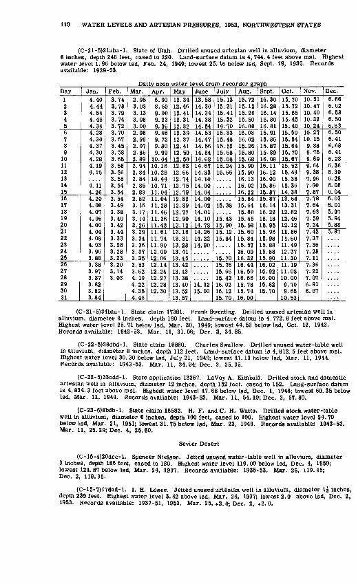
110 WATER LEVELS AND ARTESIAN PRESSURES, 1953, NORTHWESTERN STATES
(C-21-5)21aba-l. State of Utah. Drilled unused artesian well in alluvium, diameter 6 inches, depth 246 feet, cased to 220. Land-surface datum is 4, 744. 4 feet above msl. Highest water level 1.96 below Isd, Feb. 24, 1949; lowest 25.16 below Isd, Sept. 19, 1935. Records available: 1929-53.
Daily noon water level from recorder graphDay
1 2 3 4 56 7 8 9
1011 12 13 14 1516 17 18 19 2021 22 23 24 2526 27 28 29 30 31
Jan.4.40 4.44 4.54 4.46 4.344.28 4.30 4.37 4.30 4.284.19 4.15
4!il 4.264.20 4.08 4.07 4.06 4.004.04 4.08 4.03 3.96 3.883.88 3.97 3.87 3.82 3.82 3.84
Feb.3.74 3.78 3.79 3.74 3.723.70 3.67 3.45 3.58 3.653.58 3.56 3.55 3.54 3.543.54 3.49 3.38 3.40 3.423.44 3.33 3.28 3.28 3.233.20 3.14 3.03
Mar.2.95 3.03 3.13 3.08 3.002.98 2.99 2.97 2.86 2.892.94 2.84 2.84 2.85 2.832.82 3. 16 3.17 3.14 3.263.29 3.34 3.36 3.37 3.353.53 3.62 4.19 4.22 4.35 4.46
Apr.6.90 8.60 9.00 9.23 9.369.46 9.73 9.80 9.99
10.0410.16 10.26 10.44 10.71 11.0411.04 11.28 11.46 11.36 11.4311.61 11.74 11.90 12.00 12.0612.14 12.24 12.27 12.28 12.30
May12.34 12.46 12.41 12.31 12.3212.39 12.37 12.41 12.50 12.5012.63 12.66 12.74 12.75 12.7912.82 12.89 12.77 12.90 13.1213.16 13.31 13.28 13.41 13.4513.42 13.43 13.38 13.40 13.52 13.57
June13.58 14.30 14.34 14.38 14.5414.53 14.47 14.56 14.64 14.6814.67 14.83 14.10 14.00 14.0414.00 14.02 14.01 14.10 14.7814.26 14.22 14.90
14. 32 15.00
July15.13 15.31 15.41 15.32 14.7015.33 15.48 15.52 15.68 15.0815.24 15.66
15.38
15.43 15.9015. 12 15.84
is! 7015.76 15.66 15.42 16.02 16.12 15.70
Aug.15.72 15.12 15.26 15.50 16.0816.08 16.02 15.26 15.80 15.6815.90 15.90 16.13 16.02 16.2215.84 15.64 15.80 15.45 15.5815.60 15.84 15.57 16.00 16.3216.44 16.50 16.66 15.78 15.74 16.00
Sept.16.30 16.28 16.14 16.80 16.8115.91 15.86 15.87 15.89 16.0816.11 16. 12 16.00 15.86 15.8715.87 16.14 16.22 16.18 15.9515.96 15.98 15.88 15.88 15.9016.02 15.92 16.00 15.82 15.70
Oct.15.70 15.72 15.65 15.45 15.4015.50 15.54 15.64 15.70 15.6715.52 15.44 15.38 15.36 14.3813.64 13.31 12.82 12.46 12.1211.86 11.60 11.49 12.37 11.3011.19 11.08 10.00 9.70 9.65
10.53
Nov.10.51 10.47 10.40 10.32 10.2410.27 10.15 9.88 9.75 9.699.64 9.38 7.96 7.90 7.877.78 7.64 7.63 7.59 7.347.42 7.37 7.36 7.28 7.117.36 7.22 7.07 6.91 6.67
Dec.6.66 6.62 6.58 6.50 6.636.50 6.41 6.68 6.41 6.286.36 6.30 6.28 6.08 6.046.03 6.01 5.97 5.94 5.885.87
(C-21-5)34baa-l. State claim 17381. Frank Sweeting. Drilled unused artesian well in alluvium, diameter 8 inches, depth 190 feet. Land-surface datum is 4, 772. 8 feet above msl. Highest water level 25. 71 below Isd, Mar. 30, 1949; lowest 44. 53 below Isd, Oct. 12, 1943. Records available: 1942-53. Mar. 11, 31.06; Dec. 3, 34.85.
(C-22-5)28dbd-l. State claim 16860. Charles Swallow. Drilled unused water-table well in alluvium, diameter 8 inches, depth 112 feet. Land-surface datum is 4, 812. 5 feet above msl. Highest water level 30.30 below Isd, July 21, 1949; lowest 41. 13 below Isd, Mar. 11, 1944. Records available: 1943-53. Mar. 11, 34. 94; Dec. 3, 35.35.
(C-22-5)33cdd-l. State application 13367. LaVoy A. Kimball. Drilled stock and domestic artesian well in alluvium, diameter 12 inches, depth 152 feet, cased to 152. Land-surface datum is 4, 834. 3 feet above msl. Highest water level 47.68 below Isd, Dec. 1, 1948; lowest 60. 35 below Isd, Mar. 11, 1944. Records available: 1943-53. Mar. 11, 54.10; Dec. 3, 57.80.
(C-23-6)8bdb-l. State claim 16582. H. F. and C. H. Watts. Drilled stock water-table well in alluvium, diameter 6 inches, depth 100 feet, cased to 100. Highest water level 24.70 below Isd, Mar. 21, 1951; lowest 31.75 below Isd, Mar. 23, 1943. Records available: 1943-53. Mar. 11, 25. 29; Dec. 4, 25.60.
Sevier Desert
(C-15-4)20dcc-l. Spencer Nielson. Jetted unused water-table well in alluvium, diameter 3 inches, depth 186 feet, cased to 180. Highest water level 119. 00 below Isd, Dec. 4, 1950; lowest 124. 87 below Isd, Mar. 24, 1937. Records available: 1935-53. Mar. 26, 119.45; Dec. 2, 119.35.
(C-15-7)17dad-l. I. H. Losee. Jetted unused artesian well in alluvium, diameter \\ inches, depth 235 feet. Highest water level 3. 42 above Isd, Mar. 24, 1937; lowest 2.0 above Isd, Dec. 2, 1953. Records available: 1937-51, 1953. Mar. 25,+3.0; Dec. 2, +2.0.
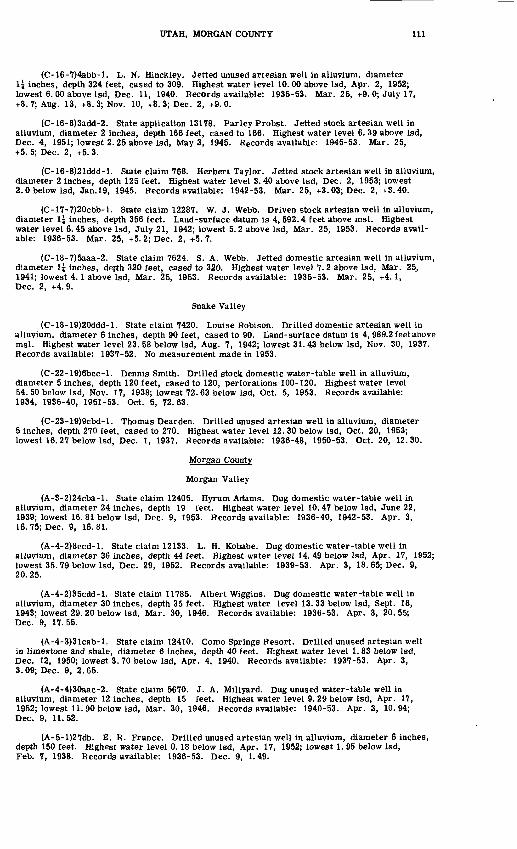
UTAH, MORGAN COUNTY 111
(C-16-7)4abb-l. L. N. Hinckley. Jetted unused artesian well in alluvium, diameter 1{ inches, depth 324 feet, cased to 309. Highest water level 10. 00 above Isd, Apr. 2, 1952; lowest 6. 00 above Isd, Dec. 11, 1940. Records available: 1935-53. Mar. 25, +9.0; July 17, +8. 7; Aug. 13, +8. 3; Nov. 10, +8. 3; Dec. 2, +9. 0.
(C-16-8)3add-2. State application 13178. Parley Probst. Jetted stock artesian well in alluvium, diameter 2 inches, depth 166 feet, cased to 166. Highest water level 6. 39 above Isd, Dec. 4, 1951; lowest 2. 25 above Isd, May 3, 1945. Records available: 1945-53. Mar. 25, -1-5. 5; Dec. 2, +5. 3.
(C-16-8)21ddd-l. State claim 768. Herbert Taylor. Jetted stock artesian well in alluvium, diameter 2 inches, depth 125 feet. Highest water level 3.40 above Isd, Dec. 2, 1953; lowest 2.0 below Isd, Jan.19, 1945. Records available: 1942-53. Mar. 25, +3.03; Dec. 2, +3.40.
(C-17-7)20cbb-l. State claim 12287. W. J. Webb. Driven stock artesian well in alluvium, diameter l\ inches, depth 356 feet. Land-surface datum is 4, 592.4 feet above msl. Highest water level 6.45 above Isd, July 21, 1942; lowest 5.2 above Isd, Mar. 25, 1953. Records avail able: 1936-53. Mar. 25, +5. 2; Dec. 2, +5.7.
(C-18-7)5aaa-2. State claim 7624. S. A. Webb. Jetted domestic artesian well in alluvium, diameter U inches, depth 320 feet, cased to 320. Highest water level 7. 2 above Isd, Mar. 25, 1941; lowest 4.1 above Isd, Mar. 25, 1953. Records available: 1935-53. Mar. 25, +4.1, Dec. 2, +4.9.
Snake Valley
(C-18-19)20ddd-l. State claim 7420. Louise Robison. Drilled domestic artesian well in alluvium, diameter 6 inches, depth 90 feet, cased to 90. Land-surface datum is 4, 989.2 feet above msl. Highest water level 23. 58 below Isd, Aug. 7, 1942; lowest 31. 43 below Isd, Nov. 30, 1937. Records available: 1937-52. No measurement made in 1953.
(C-22-19)6bcc-l. Dennis Smith. Drilled stock domestic water-table well in alluvium, diameter 5 inches, depth 120 feet, cased to 120, perforations 100-120. Highest water level 54. 50 below Isd, Nov. 17, 1938; lowest 72.63 below Isd, Oct. 5, 1953. Records available: 1934, 1936-40, 1951-53. Oct. 5, 72.63.
(C-23-19)9cbd-l. Thomas Dearden. Drilled unused artesian well in alluvium, diameter 5 inches, depth 270 feet, cased to 270. Highest water level 12. 30 below Isd, Oct. 20, 1953; lowest 16. 27 below Isd, Dec. 1, 1937. Records available: 1936-48, 1950-53. Oct. 20, 12. 30.
Morgan County
Morgan Valley
(A-3-2)24cba-l. State claim 12405. Hyrum Adams. Dug domestic water-table well in alluvium, diameter 24 inches, depth 19 feet. Highest water level 10. 47 below Isd, June 22, 1939; lowest 16. 81 below Isd, Dec. 9, 1953. Records available: 1936-40, 1942-53. Apr. 3, 16.75; Dec. 9, 16.81.
(A-4-2)8ccd-l. State claim 12133. L. H. Kobabe. Dug domestic water-table well in alluvium, diameter 36 inches, depth 44 feet. Highest water level 14. 49 below Isd, Apr. 17, 1952; lowest 35. 79 below Isd, Dec. 29, 1952. Records available: 1939-53. Apr. 3, 18. 65; Dec. 9, 20. 25.
(A-4-2)35cdd-l. State claim 11785. Albert Wiggins. Dug domestic water-table well in alluvium, diameter 30 inches, depth 35 feet. Highest water level 13. 33 below Isd, Sept. 18, 1943; lowest 29. 20 below Isd, Mar. 30, 1946. Records available: 1936-53. Apr. 3, 20.55; Dec. 9, 17.55.
(A-4-3)3lcab-l. State claim 12410. Como Springs Resort. Drilled unused artesian well in limestone and shale, diameter 6 inches, depth 40 feet. Highest water level 1. 83 below Isd, Dec. 12, 1950; lowest 3. 70 below Isd, Apr. 4, 1940. Records available: 1937-53. Apr. 3, 3.09; Dec. 9, 2.65.
(A-4-4)30aac-2. State claim 5670. J. A. Millyard. Dug unused water-table well in alluvium, diameter 12 inches, depth 15 feet. Highest water level 9. 29 below Isd, Apr. 17, 1952; lowest 11. 90 below Isd, Mar. 30, 1946. Records available: 1940-53. Apr. 3, 10.94; Dec. 9, 11.52.
(A-5-l)27db. E. R. France. Drilled unused artesian well in alluvium, diameter 6 inches, depth 150 feet. Highest water level 0.18 below Isd, Apr. 17, 1952; lowest 1. 95 below Isd, Feb. 7, 1938. Records available: 1936-53. Dec. 9, 1.49.
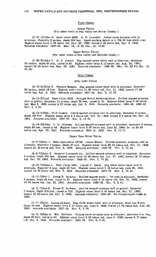
112 WATER LEVELS AND ARTESIAN PRESSURES, 1953, NORTHWESTERN STATES
Piute County
Grass Valley (For other wells in this valley see Sevier County.)
(C-27-l)27abc-2. State claim 2905. H. D. Crandall. Jetted stock artesian well in alluvium, diameter 2 inches, depth 260 feet. Land-surface datum is 6, 739. 26 feet above msl. Highest water level 5. 33 above Isd, Dec. 20, 1938; lowest 2. 69 above Isd, Apr. 6, 1952. Records available: 1937-53. Mar. 16, +3.22; Dec. 10, +3.93.
Upper Sevier Valley (For other wells in this valley see Garfield County.)
(C-30-3)15bba-l. O. P. Jessen. Dug unused water-table well in alluvium, diameter 24 inches, depth 40 feet, cased to 40. Highest water level 8. 13 below Isd, Aug. 24, 1937; lowest 28. 05 below Isd, Mar. 26, 1937. Records e-vailable: 1935-53. Mar. 16, 23. 87; Dec. 10, 20.92.
Rich County
Bear Lake Valley
(A-13-5)10bbb-2. Thomas Hodges. Dug unused water-table well in alluvium, diameter 36 inches, depth 19 feet. Highest water level 12. 96 below Isd, Oct. 21, 1952; lowest 17. 99 below Isd, Apr. 9, 1940. Records available: 1937-53. Nov. 3, 13.70.
(A-13-5)21ad. State claim 8222. Drought Relief Administration. Drilled unused artesian well in gravel, diameter 15 inches, depth 70 feet, cased to 70. Highest water level 0.40 below Isd, May 3, 1939; lowest 9. 25 below Isd, Oct. 8, 1940. Records available: 1936-48, 1950-53. Nov. 3, 5.36.
(A-13-6)30bb. Rich County. Jetted unused artesian well in alluvium, diameter 6 inches, depth 125 feet. Highest water level 8. 3 above Isd, Oct. 20, 1948; lowest 3. 8 above Isd, Oct. 10, 1941. Records available: 1936-53. Nov. 3, +6.81.
(A-14-5)21bda. J. W. Gibbons. Drilled unused artesian well in alluvium, diameter 6 inches, depth 40 feet, cased to 40. Highest water level 8. 07 below Isd, June 22, 1940; lo" --st 24. 93 below Isd, Apr. 23, 1941. Records available: 1936-51, 1953. Nov. 3, 15.77.
Upper Bear River Valley
(A-9-7)9cdc-l. State application 16733. James Stuart. Drilled domestic artesian well in alluvium, diameter 6 inches, depth 57 feet. Highest water level 24. 81 below Isd, Oct. 21, 1952; lowest 31.45 below Isd, Nov. 3, 1953. Records available: 1948-53. Nov. 3, 31.45.
(A-9-7)25cbc-2. Deseret Livestock Co. Drilled unused artesian well in alluvium, diameter 6 inches, depth 300 feet. Highest water level 14. 38 below Isd, Oct. 27, 1947; lowest 16. 70 below Isd, Oct. 19, 1948. Records available: 1946-53. Nov. 3, 16.28.
(A-10-7)20aaa-l. State claim 1886. Joseph E. Hatch. Dug stock water-table well in alluvium, diameter 5 feet, depth 22 feet. Highest water level 2.13 below Isd, June 26, 1941; lowest 10. 47 below Isd, Nov. 3, 1953. Records available: 1937-53. Nov. 3, 10.47.
(A-ll-7)9cd-l. Frank H. Jackson. Drilled unused water-1 Hle well in alluvium, diameter 6 inches, depth 25 feet, cased to 25. Highest water level 8.76 below Isd, Oct. 21, 1952; lowest 16. 55 below Isd, Jan. 22, 1941. Records available: 1936-53. Nov. 3, 9.41.
(A-ll-7)9cd-2. Frank H. Jackson. Drilled unused artesian well in gravel, diameter 2 inches, depth 310 feet, cased to 310. Highest water level 5.41 below Isd, Oct. 21, 1952; lowest 13. 80 below Isd, Oct. 6, 1942. Records available: 1936-52. No measurement made in 1953.
(A-ll-7)21bc. Lor en Jackson. Dug stock water-table well in alluvium, diamjter 6 feet, depth 15 feet. Highest water level 4.27 below Isd, June 6, 1939; lowest 11.34 below Isd, Feb. 28, 1940. Records available: 1937-53. Nov. 3, 7.70.
(A-12-7)26bb-2. Wm. Hoffman. Drilled stock artesian well in alluvium, diameter 6 in hes, depth 60 feet, caSed to 60. Highest water level 2. 95 below Isd, June 6, 1939; lowest 9. 77 below l",d, Oct. 8, 1940. Records available: 1936-53. Nov. 3, 8.81.

UTAH, SALT LAKE COUNTY 113
Salt Lake County
Jordan Valley
(B-l-2)36baa-l. State claim 18176. E. J. Jeremy. Jetted stock artesian well in alluvium, diameter 2 inches, depth 464 feet. Land-surface datum is 4, 223. 6 feet above msl. Highest water level 14.2 above Isd, Jan. 4, 1952; lowest 10.94 above Isd, Mar. 20, 1933. Records available: 1931-33, 1941-53. Apr. 20, +13.8.
* (C-l-l)33abb-l. State claim 7547. W. D. Hill. Jetted domestic stock artesian well in alluvium, diameter 2 inches, depth 425 feet, cased to 425. Land-surface datum is 4,250.7 feet above msl. Highest water level 22. 7 above Isd, Dec. 13, 1950; lowest 10. 30 above Isd, July 23, 1936. Records available: 1931, 1935-53. Apr. 20, +17. 6; Sept. 21, +16. 2; Dec. 7, +22.3.
(C-l-2)22cbb-l. F. E. Fowler. Jetted domestic artesian well in alluvium, diameter 2 inches, depth 110 feet. Land-surface datum is 4, 231. 61 feet above msl. Highest water level 17. 2 above Isd, Sept. 21, 1953; lowest 8. 7 above Isd, July 15, 1936. Records available: 1931-32, 1934-53. Apr. 20, +13.4; Sept. 21, +17.2; Dec. 7, +15.5.
(C-2-l)24adc-l. State claim 16012. J. D. Blain. Jetted unused artesian well in alluvium, diameter 2 inches, depth 127 feet. Land-surface datum is 4, 343. 8 feet above msl. Highest water level 19. 88 below Isd, Dec. 28, 1949; lowest 27.22 below Isd, Apr. 13, 1936. Records available: 1931-53. Apr. 20, 21.42; Dec. 7, 20.88.
(C-3-l)27cdd-l. J. R. Dansie and others. Jetted unused artesian well in alluvium, diam eter 3 inches, depth 220 feet. Land-surface datum is 4, 434.2 feet above msl. Highest water level 1.07 below Isd, Dec. 1, 1953; lowest 40. 91 below Isd, Apr. 13, 1936. Records available: 1931-53. Apr. 20, 7. 51; Dec. 1, 1.07.
(D-l-l)9aca-l. State claim 4836. Salt Lake City Corp. Drilled unused water-table well in alluvium, diameter 20 inches, depth 502 feet, cased to 502, perforations 180-485. Land-surface datum is 4, 658. 9 feet above msl. Highest water level 132. 20 below Isd, May 7, 1953; lowest 156. 26 below Isd, Jan. 20, 1935. Records available: 1934-53.
Daily noon water level from recorder graphDay1 234567 89
1011 12 1314 1516 17 18 19 202100
2394
252627 282930 31
Jan.
135.18135.07 135.04135.05 135.05 134. 80134. 94 134.87134. 75 134. 58
134. 15134. 32134. 26114 9n134. 05134. 05134. 07 133.97133.96133.96 133.97
Feb.133.83 133.81
133.70133.71133.75133.65 133.43133.62 133.60133.50 133.50 133.46133.95 133.51133.51 133.51 133.31
133.35133. 42133. 20133.19133.22133.29100 nrj
133.20 132.95
Mar.132. 981°.°. 17
133.28133.28133.16133.15133. 15 133.02132.97 132.90133.17 133.011H (14
133.08 132.96132. 92 133.05 132. 72 132. 75 132. 79132. 82m ft*>132.71132.67132.68132 70132.70 132. 52132.47132.61 132.61
Apr.132. 50 132. 57132.51132. 48132.42132.30132.27 132.44132. 52 132.38132.46 132.45m 4R
132. 56 132.50132.25 132.43 132.60 132.51 132.46m 49
m 49
1 19 Afi
132.46132.36132.27 132.28119 14
132.31
May132.41119 40
132.46132.43132.35132.21132.20 132.22132.31 132.37132.38 132. 34 132.28132. 24 132.27132. 32 132. 42 132.44 132.39 132. 48119 4h1 19 1O
132.30132. 52132. 50m co
132. 48119 HH
132.55132.58 132. 56
June132.53119 <V>
132.66132.63132.67132.60132.67 132.70132.73 132.84132.87 132.89119 RQ
132. 83 132. 88133.00 133.05 133.01 133. 08 133.21111 991 11 99
133.35m 9O
133.331 ^ AA
133.44m 4(l
133.48133.48
July133.57 133.58133.58133.67133.75133.77133.80 133.80133.93 134.00134. 00 134.01 134.05134.09 134. 10134. 19 134.22 134.27 134.31 134.36m 49
134. 46134. 4§1 <M 47
134. 58134.66134.67 134.68134.73134.75 134.82
Aug.134.84 134.88134.92134. 98135.06135.07135.14 135.12135.14 135.20135.25 135.2910C 00
135.32 135.32135. 33 135.40 135.43
135. 44135.50135. 57135. 53135. 54135.61135.64135.60 135.64135.68135.72 135.73
Sept.136.25 136.38136.36136.36136.36136.35
136.45 136.43136.40 136. 46 136.48136.51 136. 50136. 50
ise! 58136. 58136.58136.60136.62136.69136.67
136.70136.67136.73
Oct.
135! 82135.86135.87135.88135.90135.90 135.92135.97 135.95135.97 135.98 136.01136.00 135. 99135. 98 136.08 136. 17 136.09 136. 10136. 101 1fi 19
136.19136.22136. 13136.16136. 13 136.24136.23136.25
Nov.136.71 136.73136. 74136.70136.67136.81136.90 136.88136.83 136. 80136.85 136.80 136.82136.82 136.87136. 78 136.86 136.89 136.92 136.95136.91136.84136.94137.05136. 95136.96137.00 137.04137.04136.86
Dec.137.00 136.98137.00137.03137.16137. 03137.07 137.16137.19 137. 12137.22 137. 19
137.13 137.14137. 00
137.06 137.04
137.10
136.73
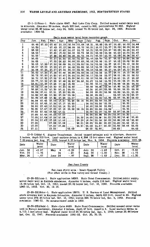
114 WATER LEVELS AND ARTESIAN PRESSURES, 1953, NORTHWESTERN STATES
(D-l-l)16caa-l. State claim 4847. Salt Lake City Corp. Drilled unused water-table well in alluvium, diameter 20 inches, depth 502 feet, cased to 502, perforations 90-486. Highest water level 48. 42 below Isd, July 24, 1938; lowest 70. 65 below Isd, Apr. 29, 1935. Records available: 1934-53.
Daily noon water level from recorder graphDay
1 2 3 4 56 7 8 9
1011 12 13 14 1516 17 18 19 2021 22 23 24 2526 27 28 29 30 31
Jan.
56.48 56.50 56.53 56.55 56.5956.62 56.62 56.63 56.57 56.5956.60 56.72 56.76 56.77 56.8156.82 56.86 56.88 56.89 56.9256.94 56.95 56.95 56.96 57.0257.05 57.05 57.04 57.08 57.09 57.11
Feb.
57.23
57.23 57.22 57.2457.26 57.30 57.32 57.33 57.3657.38 57.39 57.41 57.42 57.4357.45 57.46 57.46 57.47 57.4857.48 57.48 57.47
Mar.
57.46 57.43 57.43 57.42 57.3857.37 57.32 57.30 57.29 57.2757.28 57.28 57.28 57.28 57.2857.30 57.30 57.31 57.30 57.3057.29 57.26 57.25 57.23 57.2357.23 57.23 57.23 57.23 57.22 57.22
Apr.
57.19 57.13 57.03 57.00 56.9056.85 56.82 56.69 57.57 57.5457.46 57.47 57.41 57.40 57.3657.34 57.31 57.30 57.29 57.2657.21 57.17 57.14 57.13 57.0157.07 57.06 57.06 57.06 57.06
May
56.04 56.06 56.07 56.06 56.0956.09 56.09 56.12 56.09 56.1056.09 56.05 55.99 55.93 55.8855.80 55.70 55.65 55.58 55.5755.56 55.55 55.53 55.50
55.63
June
55.68 55.70 55.72 55.75 55.7855.80 55.83 55.85 55.88 55.9055.93 55.98 56.01 56.03
56.16
56.15
56.20 56.20 56.21 56.21
July
56.21 56.21 56.21 56.21 56.2156.16 56.16 56.16 56.16 56.1656.15 56.11 56.10 56.07 56.0656.06 56.06 56.05 56.06 56.0656.05 56.05 56.05 56.05 56.0656.06 56.05 56.04 56.04 56.03 56.03
Aug.
56.03 56.01 56.00 55.99 55.9955.99 55.99 55.99 55.98 55.9855.98 55.98 55.98 55.98 56.0156.00 56.00 56.00 55.99 55.9955.99 55.98 55.98 55.99 55.9955.99 55.99 55.98 55.98 55.97 55.96
Sept.
55.97 55.97 55.97 55.96 55.9655.97 55.97 55.97 55.97 55.9755.97 55.97 55.97 55.96 55.9655.96 55.95 55.96
55.9955.99 55.99 55.99 55.99 55.9956.00 56.02 56.02 56.02 56.02
Oct.
56.02 56.03 56.03 56.02 56.0056.02 56.02 56.01 55.99 56.0056.01 56.01 56.01 56.00 55.9856.00 55.99 55.99 55.99 55.97
55.9755.97 55.99 55.99 56.00 55.99 56.02
Nov.
56.03 56.05 56.06 56.05 56.0456.06 56.08 56.10 56.11 56.1256.12 56.15 56.16 56.19 56.2556.25 56.25 56.25 56.29 56.3056.34 56.35 56.35 56.36 56.3856.39 56.40 56.42 56.44 56.44
Dec.
56.44 56.45 56.47 56.47 56.4756.50 56.50 56.52 56.54 56.5456.53 56.53 56.53 56.53 56.5556.56 56.56 56.56 56.57 56.60
56.60 56.60 56.61 56.62 56.62
(D-2-l)4dbd-4. Eugene Templeman. Jetted unused artesian well in alluvium, diameter 3, inches, depth 310 feet. Land-surface datum is 4, 384.13 feet above msl. Highest water level 7. 00 above Isd, Aug. 27, 1952; lowest 9. 35 below Isd, Nov. 5, 1934. Records available: 1931-53.
Date
Jan. 28 Feb. 25 Mar. 26
Water level
-t-2.67 -1.75 -.67
Date
May 4 26
June 26
Water level
-0.28 -.33-.67
Date
July 28 Aug. 26 Sept. 30
Water level
-1.83 -1.20 -1.83
Date
Oct. 31 Nov. 30 Dec. 30
Water level
-2.42-1-1.75 + 1.30
San Juan County
San Juan flivpr area - Moab-Spanish Valley (For other wells in this valley see Grand County.)
(D-28-22)lcaa-l. State application 14265. State Road Commission. Drilled public supply water-table well in Entrada sandstone, diameter 6 inches, depth 114 feet. Highest water level 15. 65 below Isd, Oct. 12, 1951; lowest 20. 02 below Isd, Oct. 16, 1946. Records available: 1946-51, 1953. Oct. 30, 19.19.
(D-28-23)19dcc-l. State application 13070. U. S. Bureau of Land Management. Drilled stock artesian well in Kayenta formation, diameter 8 inches, depth 450 feet, cased to 42. Highest water level 279. 24 below Isd, Oct. 12,'1951; lowest 284. 75 below Isd, Oct. 6, 1949. Records available: 1946-51. No measurement made in 1953.
(D-30-23)10add-l. State claim 8429. State Road Commission. Drilled unused water-table well in Navajo sandstone, diameter 4 inches, depth 47 feet, cased to 4. Land-surface datum is 5, 712.1 feet above msl. Highest water level 29. 65 below Isd, Apr. 8, 1949; lowest 32.44 below Isd, Oct. 13, 1947. Records available: 1946-53. Oct. 30, 30.75.

UTAH, SAN JUAN COUNTY 115
(D-31-23)23add-l. State claim 8254. U. S. Bureau of Land Management. Drilled unused artesian well in Navajo sandstone, diameter 6 inches, depth 156 feet. Highest water level 100.0 below Isd, Get, 18, 1946; lowest 101. 33 below Isd, Oct. 15, 1947. Records available: 1946-53. Oct. 31, 101.22.
Sage Plain
(D-34-24)25aad-l. State application 16754. C.A.Frost. Drilled unused artesian well in Dakota sandstone, diameter 6 inches, depth 225 feet. Highest water level 171. 90 below Isd, Oct. 18, 1946; lowest 176. 93 below Isd, Nov. 10, 1950. Records available: 1946-51, 1953. Oct. 30, 176.14.
(D-34-26)4dad-l. State claim 8249. State Land Board. Drilled unused water-table well in Dakota sandstone, diameter 6 inches, depth 100 feet. Highest water level 41.63 below Isd, Apr. 9, 1949; lowest 45. 41 below Isd, Oct. 30, 1953. Records available: 1946-51, 1953. Oct. 30, 45.41.
(D-36-22)27ddb-l. M. F. Lyman. Drilled unused water-table well in alluvium, diameter 5 inches, depth 30 feet, cased to 20. Highest water level 12. 49 below Isd, Jan. 19, 1951; lowest 23. 90 below Isd. Jan. 2, 1944. Records available: 1942-53.
Date
Jan. 29
162330
Feb. 6132027
Mar. 61320
Water level
17.7417.7117.7717.3417.4017.4317.3417.6717.4717.7617.4217.22
Date
Mar. 27Apr. 3
10172428
May 18
152229
June 5
Water level
17.8018.0717.3517.2217.6416.9517.4216.9517.0017.0516.9716.80
Date
June 121926
July 310172429
Aug. 7142128
Water level17.0616.5816.5816.4016.6916.7015.2616.7616.8516.7917.0617.10
Date
Sept. 411182528
Oct. 29
1630
Nov. 61328
Water level
17.2017.4517.2017.6017.6117.6617.7117.7618.0417.9918.1018.09
(D-36-22)27ddb-2. M. F. Lyman. Drilled unused artesian well in alluvium, diameter 5 inches, depth 150 feet, cased to 34. Highest water level 49. 03 below Isd, Feb. 8, 1953; lowest 54. 90 below Isd, Sept. 25, 1946. Records available: 1942-53.
Daily noon water level from recorder graphDay
I 2 34 56 7 8 9
1011 12 13 14 1516 17 18 19 2021 22 23 24 25
CO t- CO OS O "- CM CM Oi CM CO CO
Jan.49.60 49.89 49.91 49.79 49.50
49.70
49.79
49.6049.29 49.74 49.79 49.85 49.7149.70 49.80 49.83 49.77 49.52 49.84
Feb.49.78 49.71 49.79 49.60 49.5249.54 49.71 49.03
49.64 49.53 49.54 49.70 49.5649.77 49.86 49.30 49.19 49.5249.75 49.80 49.56 49.47 49.6849.80 49.78 49.36
Mar.49. 18 49.24
49.7749.78 49.94 49.93 49.78 49.6449.73 49.71 49.55 49.74 49.6849.72 49.65 49.68 49.59 49.2849.46 49.75 49.87 49.95 49.8849.89
49! 59 49.52 49.44 49.62
Apr.
49. 62 49.72 49.62 49.6349.33
49.72 49.5049.58 49.73 49.73 49.72
49.72 49.43 49.82 49.96 49.9149.83 49.69 49.73 49.75 49.8649.83 49.64 49.30 49.49 49.40
May49.72 49.90
49.84 49.68 49.75 49.7449.73 49.75 49.84 49.70 49.59
49.77 49.71 49.83 49.6549.62 49.82 49.96 49.84 49.6349.81 49.83 49.86
June49.83 49.67 49.73 49.68 49.7349.68
50.10 50.02 49.80 49.8349.90 49.80 49.65 49.64 49.7949.85 49.86 49.83 49.72 49.7649.76 49.78 49.77 49.85 49.93
July49.79 49.73 49.73 49.89 49.9049.96 49.90 49.93 49.97 50.1550.08 50.06 50.08 49.95 49.9049.88
49.76 49.73 49.66 49.6649.80 49.81 49.72 49.68 49.73 49.73
Aug.
49.78 49.7749.78 49.85 49.84
49.8249.74 49.78
49^75 49.7049.78 49.86
49'. 69
Sept.49.71 49.67 49.71 49.81 49.8149.82 49.91 49.91 49.88 49.8849.92 49.92 49.78 49.78 49.7349.66 49.60 49.68 49.74 49.5849.70 49.79 49.80 49.74 49.6749.66 49.48 49.59 49.66 49.72
Oct.49.63 49.52 49.70 49.75 49.7449.68 49.70 49.74 49.74 49.6549.42 49.48 49.60
49! 6449.60 49.62 49.52 49.43
49.57 49.6249.80 49.79 49.94 49.83 49.73 49.84
Nov.
49! 80 49.78 49.4849.70 49.98 50.13 50.08 49.94
49.84 49.7649.76
49.56 49.78 49.78 49.87
50.03 50.03 49.86
Dec.49.47 49.34 49.46 49.34
49.84 49.48 49.68 49.88
49.30 49.87 49.95 49.95 49.8149.87 49.87 49.83 49.83 49.7149.66 49.90 50.07 50.01 50.0549.80 49.49 49.68 49.58

116 WATER LEVELS AND ARTESIAN PRESSURES, 1953, NORTHWESTERN STATES
Sanpete County
Central Sevier Valley (For other wells in this valley see Garfield, Piute, and Sevier Counties.)
(C-19-l)23bcc-l. State claim 1457. C. H. Beal. Drilled irrigation water-table well in alluvium, diameter 12 inches, depth 186 feet, cased to 186, perforations 50-186. Land-surface datum is 5, 500 feet above msl. Highest water level 29. 52 below Isd, Dec. 6, 1945; lowest 37. 58 below Isd, Sept. 5, 1935. Records available: 1935-53. Mar. 17, 30. 33; Dec. 10, 29.77.
(D-20-l)20aaa-l. State claim 6356. Federal Land Bank. Dug domestic stock water-table well in alluvium, diameter 4 feet, depth 66 feet. Highest water level 28.49 below Isd, Dec. 13, 1948; lowest 48. 52 below Isd, Apr. 22, 1936. Records available: 1935-53. Mar. 17, 34.53; Dec. 10, 32.85.
Sanpete Valley
(D-15-3)8cda-3. State claim 13671. William Prestwich. Jetted stock artesian well in alluvium, diameter ll inches, depth 75 feet. Land-surface datum is 5, 510. 72 feet above msl. Highest water level 3. 83 above Isd, Mar. 20, 1944; lowest 1. 25 above Isd, Oct. 14, 1939. Rec ords available: 1937-53. Mar. 18, +3. 52; Dec. 11, +3.43.
(D-15-4)4dda-l. State claim 3606. Twin Creek Irrigation Co. Drilled irrigation artesian well in alluvium, diameter 12 inches, depth 245 feet, perforations 18-240. Land-surface datum is 5, 820.05 feet above msl. Highest water level 4. 82 below Isd, Aug. 11, 1942; lowest 31. 31 below Isd, Mar. 2, 1936. Records available: 1935-53. Mar. 18, 10. 59.
(D-16-3)14dca-l. State claim 65. Chris Larsen. Drilled unused water-table well in alluvium, diameter 10 inches, depth 275 feet. Highest water level 10. 58 below Isd, July 23, 1948; lowest 14. 51 below Isd, Oct. 14, 1939. Records available: 1938-53. Mar. 18, 11.48; Dec. 11, 11.57.
(D-16-3)15aca-l. State claim 8492. Federal Land Bank. Jetted stock water-table well in alluvium, diameter 3 inches, depth 70 feet, cased to 70. Highest water level 25. 93 below Lsd, Dec. 9, 1952; lowest 38.96 below Isd, Feb. 7, 1940. Records available: 1937-53. Mar. 18, 25.88; Dec. 11, 25.03.
(D-16-3)32ddc-2. George L. Beal. Jetted unused artesian well in alluvinm, diameter li inches, depth 145 feet, cased to 130. Land-surface datum is 5,461. 5 feet above msl. Highest water level 27. 9 above Isd, Aug. 19, 1952; lowest 3. 57 below Isd, June 18, 1936. Records avail able: 1935-53.
Daily noon water level from recorder graph
Day
1 2 3 4 56 7 8 9
1011 12 13 14 15161718 19 2021 22 23 24 25
Jan.
2L120.9 20.5 20.6 20.4 20.520.5 20.3 20.4 20.2 20.320.920.520.3 20.1 20.220.1 20.1 20.0 20.0 20.2
Feb.
19.7 19.8 19.7 19.'6 19.519.6 19.4 19.5 19.6 19.719.3 19.3 19.3 19.3 19.419.219.018.8 18.9 19.019.1
18.8
Mar.
18.1
18.1 18.318.7 18.4 18.6 18.7 18.318.5
17.9 17.9 18.118.117.817.7 17.9
17.7 17.6 17.4 17.6 17.4
Apr.
17.2 16.8 16.8 17.117.2 17.2 17.3 17.1
16.816.716.7 16.7 16.716.7
16.9 17.0 17.1
May
16.6 16.3 16.8 16.9 17.017.1 16.8 16.5 16.5 16.016.5 16.5 16.8 16.8 16.616.4
16.5 16.7 16.416.7 16.7 16.4 16.6 17.1
June
17.0 16.7 16.8 17.0 16.716.7 17.0 17.2 17.4
17.1 17.1 17.3 17.7 17.8
18.6 18.5 18.719.0 19.3 19.5 19.2
July
20.1 20.3 20.4 20.2 20.120.4 20.2 20.3 19.8 19.919.2
19.720.0 20.0 20.5 20.6 19.7
Aug.
20.6 19.819.8 20.1 20.1 20.0 20.1
19.8 19.8 19.5 19.219.119.219.2
18.718.9 19.1 19.5 19.6 19.7
Sept.
18.3 18.4 18.7 18.6 18.919.1 19.1 19.2 18.6 19.019.1 18.9 19.0 18.9 19.019.018.818.9
18.818.8 18.6 18.5 18.7 18.8
Oct.
18.6 18.4 18.0 17.9 17.817.9 17.9 18.0 18.1 18.017.7 17.6 17.6 17.7 17.917.717.7
17.7 17.517.4 17.5 17.6 17.4 17 6
Nov.
17.6 17.3 17.5 17.3 17.517.2 17.1 17.3 17.4 17.317.2 17.4
leie16.816.716.816.5 16.5 16.816.3 16.3 16.5 16.6 16.4
Dec.16.4 16.4 16.4 16.3 16.216.2 16.2 16.5 16.3 16.2
16.4 15.9 16.015.915.915.9 . . .1
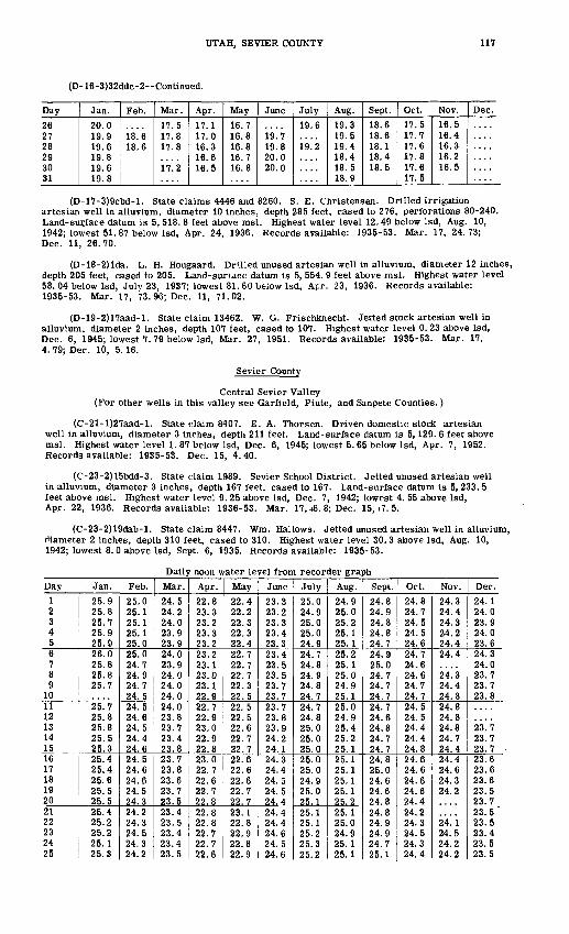
UTAH, SEVIER COUNTY 117
(D- 16-3)32ddc-2 Continued.
Day
26 27 28 29 30 31
Jan.
20.0 19.9 19.6 19.8 19.6 19.8
Feb.
18.6 18.6
Mar.
17.5 17.8 17.8
17.2
Apr.
17.1 17.0 16.3 16.6 16.5
May
16.7 16.8 16.8 16.7 16.8
June
19.7 19.8 20.0 20.0
July
19.6
19.2
Aug.
19.3 19.5 19.4 18.4 18.5 18.9
Sept.
18.6 18.6 18.1 18.4 18.5
Oct.
17.5 17.7 17.6 17.8 17.6 17.5
Nov.
16.5 16.4 16.3 16.2 16.5
Dec.
(D-17-3)9cbd-l. State claims 4446 and 8260. S. E. Christensen. Drilled irrigation artesian well in alluvium, diameter 10 inches, depth 285 feet, cased to 276, perforations 80-240. Land-surface datum is 5, 518. 8 feet above msl. Highest water level 12.49 below Isd, Aug. 10, 1942; lowest 51. 87 below Isd, Apr. 24, 1936. Records available: 1935-53. Mar. 17, 24.73; Dec. 11, 26.70.
(D-18-2)lda. L. H. Hougaard. DrUled unused artesian well in alluvium, diameter 12 inches, depth 205 feet, cased to 205. Land-suriace datum is 5, 554. 9 feet above msl. Highest water level 58. 04 below Isd, Julv 23, 1937; lowest 81. 60 below Isd, Apr. 23, 1936. Records available: 1935-53. Mar. 17, 73.96; Dec. 11, 71.02.
(D-19-2)17aad-l. State claim 13462. W. G. Frischknecht. Jetted stock artesian well in alluvium, diameter 2 inches, depth 107 feet, cased to 107. Highest water level 0. 23 above Isd, Dec. 6, 1945; lowest 7. 79 below Isd, Mar. 27, 1951. Records available: 1935-53. Mar. 17, 4. 79; Dec. 10, 5.16.
Sevier County
Central Sevier Valley (For other wells in this valley see Garfield, Piute, and Sanpete Counties.)
(C-21-l)27aad-l. State claim 8407. E. A. Thorsen. Driven domestic stock artesian well in alluvium, diameter 3 inches, depth 211 feet. Land-surface datum is 5,129. 6 feet above msl. Highest water level 1. 87 below Isd, Dec. 6, 1945; lowest 5. 65 below Isd, Apr. 7, 1952. Records available: 1935-53. Dec. 15, 4.40.
(C-23-2)15bdd-3. State claim 1989. Sevier School District. Jetted unused artesian well in alluvium, diameter 3 inches, depth 167 feet, cased to 167. Land-surface datum is 5,233. 5 feet above msl. Highest water level 9. 25 above Isd, Dec. 7, 1942; lowest 4. 55 above Isd, Apr. 22, 1936. Records available: 1936-53. Mar. 17,-16. 8; Dec. 15,+7. 5.
(C-23-2)19dab-l. State claim 8447. Wm. Hallows. Jetted unused artesian well in alluvium, diameter 2 inches, depth 310 feet, cased to 310. Highest water level 30.3 above Isd, Aug. 10, 1942; lowest 8. 0 above Isd, Sept. 6, 1935. Records available: 1935-53.
Daily noon water level from recorder graph
Day1 2 3 4 56 7 8 9
1011 12 13 14 1516 17 18 19 2021 22 23 24 25
Jan.
25.9 25.8 25.7 25.9 25.926.0 25.8 25.8 25.7
25.7 25.8 25.8 25.5 25.325.4 25.4 25.6 25.5 25.525.4 25.2 25.2 25. 1 25.3
Feb.
25.0 25.1 25.1 25.1 25.025.0 24.7 24.9 24.7 24.524.5 24.6 24.5 24.4 24.624.5 24.6 24.6 24.5 24.324.2 24.3 24.5 24.3 24.2
Mar.
24.5 24.2 24.0 23.9 23.924.0 23.9 24.0 24.0 24.024.0 23.8 23.7 23.4 23.823.7 23.8 23.6 23.7 23.523.4 23.5 23.4 23.4 23.5
Apr.
22.8 23.3 23.2 23.3 23.223.2 23.1 23.0 23.1 22.922.7 22.9 23.0 22.9 22.823.0 22.7 22.6 22.7 22.822.8 22.8 22.7 22.7 22.6
May
22.4 22.2 22.3 22.3 22.422.7 22.7 22.7 22.3 22.522.5 22.5 22.6 22.7 22.722.6 22.6 22.6 22.7 22.723.1 22.8 22.9 22.8 22.9
June
23.3 23.2 23.3 23.4 23.323.4 23.5 23.5 23.7 23.723.7 23.8 23.9 24.2 24.124.3 24.4 24.5 24.5 24.424.4 24.4 24.6 24.5 24.6
July
25.0 24.9 25.0 25.0 24.924.7 24.8 24.9 24.8 24.724.7 24.8 25.0 25.0 25.025.0 25.0 24.9 25.0 25.125.1 25.1 25.2 25.3 25.2
Aug.
24.9 25.0 25.2 25.1 25.125.2 25.1 25.0 24.9 25.125.0 24.9 25.4 25.2 25.125.1 25.1 25.1 25.1 25.225.1 25.0 24.9 25.1 25.1
Sept.
24.8 24.9 24.8 24.8 24.724.9 25.0 24.7 24.7 24,724.7 24.6 24.8 24.7 24.724.8 25.0 24.6 24.6 24.824.8 24.9 24.9 24.7 25.1
Oct.
24.8 24.7 24.5 24.5 24.624.7 24.6 24.6 24.7 24.724.5 24.5 24.4 24.4 24.824.6 24.6 24.6 24.6 24.424.2 24.3 24.5 24.3 24.4
Nov.
24.3 24.4 24.3 24.224.424.4
24! 324.4 24.824.8 24.8 24.8 24.7 24.424.4 24.6 24.3 24.2
24! i24.5 24.2 24.2
Dec.
24.1 24.0 23.9 24.0 23.624.3 24.0 23.7 23.7 23.8
23.7 23.7 23.723.6 23.6 23.6 23.5 23.723.5 23.5 23.4 23.5 23.5
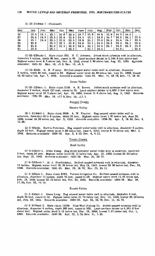
118 WATER LEVELS AND ARTESIAN PRESSURES, 1953, NORTHWESTERN STATES
(C-23-2)19dab-I Continued.
Day
262728293031
Jan.
25.525.225.125.225.225.0
Feb.
24.124.324.4
Mar.
23.723.523.523.523.223.1
Apr.
22.822.822.622.522.5
May
22.922.923.022.922.923.2
June
24.724.524.824.824.9
July
25.025.125.125.125.125.1
Aug.
24.824.825.024.924.924.9
Sept.
25.024.724.924.624.7
Oct.
24.524.324.424.524.324.3
Nov.
24.224.124.124.124.3
Dec.
23.523.423.423.323.4
(C-23-2)26cdb-l. State claim 323. N. C. Johnson. Jetted stock artesian well in alluvium, diameter 4 inches, depth 48 feet, cased to 48. Land-surface datum is 5, 249. 9 feet above msl. Highest water level 8. 5 above Isd, Dec. 8, 1952; lowest 2. 80 above Isd, Aug. 22, 1939. Records available: 1935-53. Mar. 16, +5. 3; Dec. 15, +6. 5.
(C-25-4)2db. R. W. Pinney. Drilled unused water-table well in alluvium, diameter 3 inches, depth 89 feet, cased to 89. Highest water level 44.86 below Isd, July 21, 1948; lowest 53. 63 below Isd, Apr. 7, 1952. Records available: 1939-53. Mar. 17, 50.10; Dec. 15, 50. 19.
Grass Valley
(C-26-l)25acc-l. State claim 3159. A. R. Brown. Jetted stock artesian well in alluvium, diameter 2 inches, depth 127 feet, cased to 50. Land-surface datum is 6, 862. 9 feet above msl. Highest water level 18. 5 above Isd, Apr. 18, 1939; lowest 11. 6 above Isd, Aug. 9, 1942. Records available: 1935-53. Mar. 16, +17.0; Dec. 10, +17.7.
Summit County
Rhodes Valley
(D-l-6)19dad-l. State claim 3699. A. W. Frazier. Dug unused water-table well in alluvium, diameter 60 to 8 inches, depth 35 feet. Highest water level 1. 87 below Isd, June 22, 1939; lowest 18. 30 below Isd, Apr. 3, 1953. Records available: 1938-53. Apr. 3, 18. 30; Dec. 9, 12.03.
(D-2-6)5dbb. Burtnn Peterson. Dug unused water-table well in alluvium, diameter 8 inches, depth 10 feet. Highest water level 2. 28 below Isd, June 4, 1941; lowest 8. 72 below Isd, Mar. 9, 1942. Records available: 1938-53. Apr. 3, 8. 23; Dec. 9, 6.51.
Tooele County
Rush Valley
(C-5-5)2bcb-l. Alma Young. Dug stock domestic water-table well in alluvium, diameter 5 feet, depth 34 feet. Highest water level 23.11 below Isd, Apr. 10, 1952; lowest 26. 95 below Isd, Sept. 13, 1940. Records available: 1935-53. Mar. 26, 23.70.
(C-8-5)31aad-l. D. J. Fredrickson. Drilled unused artesian well in alluvium, diameter 14 inches. Highest water level 18. 18 below Isd, May 13, 1941; lowest 20. 58 below Isd, Dec. 20, 1948. Records available: 1941-53. Mar. 26, 18.70; Nov. 25, 19.11.
(C-9-5)6bca-l. State claim 8285. Vernon Irrigation Co. Drilled unused artesian well in alluvium, diameter 15 inches, depth 75 feet, cased to 60. Highest water level 15. 66 below Isd, Feb. 18, 1939; lowest 20. 18 below Isd, Oct. 20, 1942. Records available: 1936-53. Mar. 26, 17. 09; Nov. 25, 17. 15.
Tooele Valley
(C-2-4)lbcc-l. Jesse Long. Dug unused water-table well in alluvium, diameter 4 feet, depth 50 feet, cased to 50. Highest water level 31.74 below Isd, Dec. 15, 1940; lowest 36. 99 below Isd, Feb. 24, 1941. Records available: 1940-53. Apr. 22, 34.79; Dec. 11, 34.78.
(C-2-4)16aad-2. State claim 14209. Utah Wool Pulling Co. Jetted unused artesian well in alluvium, diameter 4 inches, depth 300 feet, cased to 300. Land-surface datum is 4, 261. 8 feet above msl. Highest water level 5.13 below Isd, Dec. 28, 1949; lowest 7. 07 below Isd, Oct. 1, 1940. Records available: 1940-53. Apr. 22, 5.70; Dec. 11, 5.92.

UTAH, TOOELE. COUNTY 119
(C-2-4)33add-l. State claim 899. Ida Clegg. Drilled unused artesian well in alluvium, diameter 6 inches, depth 165 feet, cased to 160, perforations 60-100. Land-surface datum is 4, 417. 92 feet above msl. Highest water level 30. 16 below Isd, Apr. 9, 1950; lowest 46. 90 below Isd, Oct. 9, 1939. Records available: 1937-53.
Daily noon water level above Isd from recorder graphDay
1 2 34 56 7 8 9
1011 12 13 14 1516 17 18 19 2021 22 23 24 2526 27 28 29 30 31
Jan.
33.48 33.51 33.48 33.46 33.3833.30 33.35 33.40 33.40 33.3933.33 33.31 33.28 33.24 33.3633.32 33.23 33.22 33.23 33.2233.23 33.26 33.27 33.25 33.1533.17 33.23 33. 17 33.15 33.07 33.10
Feb.
33.04 33.03 33.02 33.02 33.0032.99 32.94 32.83 32.90 32.9532.95 32.92 32.92 32.88 32.8932.89 32.89 32.85 32.79 32.8232.86 32.83 32.77 32.78 32.8232.81 32.77 32.70
Mar.
32.61 32.73 32.80 32.80 32.7832.77 32.79 32.74 32.69 32.6532.71 32.66 32.68 32.71 32.6832.64 32.66 32.63 32.56 32.5332.57 32.61 32.64 32.60 32.5732.61 32.61 32.54 32.53 32.57 32.60
Apr.
32.56 32.59 32.57 32.54 32.5832.54 32.57 32.53 32.65 32.5932.63 32.64 32.61 32.66 32.6832.59 32.56 32.66 32.64 32.5932.58 32.58 32.58 32.61 32.7932.78 32.74 32.80 32.88 32.88
May
32.96 33.04 33.04 33.04 33.0333.00 32.97 33.00 33.08 33.1133.12 33.12 33.14 33.11 33.1133.16 33.24 33.27 33.21 33.2333.17 33.28 33.41 33.46 33.4633.52 33.56 33.58 33.63 33.86 33.83
June
33.84 33.89 33.95 33.95 33.9633.98 33.97 34.04 34.03 34.1434.22 34.20 34.28 34.22 34.2334.29 34.25 34.38 34.40 34.4434.49 34.51 34.60 34.68 34.7034.68 34.74 34.69 34.70 34.70
July
34.77 34.85 34.83 34.83 34.8334.82 34.87 35.00 35.06 35.0835.03 35.03 35.03 35.03 35.1135.13 35. 13 35.14 35.15 35.1035.08 35.04 35.02 34.89 34.9034.89 34.84 34.86 34.84 34.85 34.88
Aug.
34.82 34.75 34.77 34.82 34.8334.80 34.85 34.83 34.79 34.7534.86 34.88 34.89 34.89 34.8934.87 34.88 35.02 35.11 35.0935.08 35.14 35.13 35.07 35.1135.14 35.14 35.14 35.13 35.14 35.06
Sept.
35.09 35.07 35.09 35.09 35.0535.04 34.98 35.04 35.06 35.0635.03 35.05 35.05 35.07 35.0735.05 35.04 35,08 35.06 35.0235.01 34.95 35.02 35.01 34.9834.99 35.02 35.04 35.05 35.06
Oct.
35.04 35.08 35.12 35.07 35.0835.06 35.07 35.07 35.06 35.0334.98 34.99 34.99 35.01 34.9734.97 34.96 34.86 34.84 34.9735.01 35.03 35.00 34.99 35.0435.04 35.00 34.99 34.92 34.83 34.78
Nov.
34.68 34.65 34.63 34.60 34.5134.54 34.63 34.60 34.57 34.5134.50 34.47 34.45 34.45 34.4834.43 34.43 34.40 34.43 34.4334.36 34.30 34.29 34.28 34.2134.17 34.14 34.10 34.10 33.97
Dec.
33.98 33.97 33.94 33.85 33.9733.89 33.85 33.92 33.72 33.6133.64 33.62 33.61 33.56 33.5233.49 33.47 33.44 33.41 33.3833.36 33.38 33.34 33.32 33.2433.24 33.22 33.22 33.25 33.22 33.20
(C-2-5)5acc-3. A. Searle. Jetted unused artesian well in alluvium, diameter 3 inches, depth 153 feet. Highest water level 0.19 below Isd, Apr. 10, 1952; lowest 1.42 below Isd, Oct. 4, 1940. Records available: 1940-42, 1944-53. Mar. 31, 1.01; Dec. 11, 1.29.
(C-2-5)25aab-l. State of Utah. Jetted stock artesian well in alluvium, diameter 2 inches, depth 300 feet. Highest water level 12. 20 above Isd, Apr. 10, 1952; lowest 9. 2 above Isd, Dec. 22, 1952. Records available: 1935-47, 1949-53. Apr. 22, 4-11.4.
(C-2-5)36caa-l. State claim 13692. J. A. and S. W. Smith. Drilled unused artesian well in alluvium, diameter 6 inches, depth 145 feet. Land-surface datum is 4, 318.8 feet above msl. Highest water level 30. 35 below Isd, Mar. 21, 1950; lowest 33. 49 below Isd, Aug. 10, 1939. Records available: 1937-53. Apr. 22, 31.28; Dec. 11, 31.76.
(C-2-6)36bac-l. State application 12189. J. R. Clark. Drilled unused artesian well in alluvium, diameter 6 inches, depth 302 feet, cased to 302. Land-surface datum is 4,321. 5 feet above msl. Highest water level 19. 07 below Isd, Dec. 22, 1952; lowest 23.15 below Isd, Aug. 5, 1940. Records available: 1940-53. Mar. 31, 19. 70; Dec. 11, 20.97.
(C-2-6)36cdd-l. E. C. Walk. Drilled unused artesian well in alluvium, diameter 6 inches, depth 176 feet, cased to 166. Land-surface datum is 4, 373. 7 feet above msl. Highest water level 72.82 below Isd, June 11, 1952; lowest 81.23 below Isd, Nov. 23, 1940. Records available: 1937, 1940-53.
Daily noon water level from recorder graph
Day
1 2 34 5
Jan.77.05 77.07 77.04 76.98 76.93
Feb.76.86 76.88 76.90 76.93 76.98
Mar.76.97 77.08 77.15 77.15 77. 14
Apr.77.26 77.29 77.30 77.32 77.32
May June76.53 76.53 76.48 76.41 76.49
July75.59 75.59 75.58 75.59 75.59
Aug.76.52 76.57 76.64 76.68 76.73
Sept.77.45 77.46 77.50 77.52 77.55
Oct.78.12 78.18 78.19 78.21 78.22
Nov.78.54 78.54 78.53 78.56 78.56
Dec.78.69 78.71 78.72 78.70 78.75

120 WATER LEVELS AND ARTESIAN PRESSURES, 1953, NORTHWESTERN STATES
(C-2-6)36cdd-l-Continued.
Day
6 7 8 9
1011 12 13 14 1516 17 18 19 2021 22 23 24 2526 27 28 29 30 31
Jan.
76.95 77.00 76.99 76.99 76.9976.97 76.99 76.94 76.96 77.0276.98 76.93 76.96 76.98 76.9176.96 76.96 76.92 76.87 76.8376.84 76.86 76.83 76.81 76.82 76.85
Feb.
76.96 76.92 76.92 77.00 77.0377.03 77.06 77.05 77.06 77.0977.11 77.07 77.06 77.09 77.1177.14 77.04 77.04 77.04 77.0677.05 77.02 76.96
Mar.
77.15 77.16 77.15 77.13 77.1377.18 77.15 77.20 77.21 77.2077.19 77.25 77.22 77.20 77.2277.23 77.24 77.27 77.23 77.2477.24 77.24 77. 18 77.21
Apr.
77.31 77.34 77.37 77.38 77.3777.40 77.41 77.42 77.44 77.4477.43 77.44
May
77.19 77.11 77.06 77.08 77.0577.04 76.97 76.96 76.93 76.9276.92 76.93 76.94 76.88 76.8976.87 76.86 76.80 76.85 76.8576.86 76.84 76.79 76.71 76.67 76.60
June
76.28 76.12 76.04 75.95 75.9175.85 75.80 75.78 75.75 75.7975.78 75.73 75.57 75.54 75.5375.51 75.48 75.47 75.51 75.4575.48 75.52 75.50 75.54 75.56
July
75.57 75.58 75.59 75.65 75.7075.70 75.72 75.75 75.79 75.8475.87 75.89 75.90 75.94 75.9476.00 76.01 76.16 76.10
76.24 76.31 76.34 76.40 76.45 76.50
Aug.
76.77 76.81 76.83 76.85
76.94 76.98 76.99 77.03 77.0477.06 77.10 77.12 77.14 77.1577.18 77.23 77.25
77.42
Sept.77.58
77.62 77.64 77.6777.68 77.70 77.72 77.72 77.7477.75 77.79 77.84 77.84
77.90 77.92 77.95 77.97 77.9878.00 78.01 78.07 78.08 78.10
Oct.78.22 78.24 78.26 78.27 78.2678.29 78.31 78.32 78.31 78.3378.34 78.35 78.32
78.54 78.54 78.5378.56
Nov.
78.56 78.56 78.60 78.62 78.6478.65 78.64 78.65 78.66 78.6778.61 78.64 78.62 78.61 78.5878.60 78.59 78.64
Dec.78.72 78.74 78.76 78.74 78.7378.75 78.74 78.75 78.74 78.7678.76 78.77 78.77 78.77 78.7778.78 78.80 78.80 78.80 78.8178.80 78.82
(C-3-5)6dda-l. State application 9952. Federal Land Bank. Jetted unused water-table well in alluvium, diameter 3 inches, depth 120 feet, cased to 120, perforations 110-120, Land- surface datum is 4, 362. 4 feet above msl. Highest water level 50. 32 below Isd, May 15, 1949; lowest 56. 82 below Isd, Feb. 24, 1941. Records available: 1940-53. Mar. 31, 51.13; Dec. 11, 53.57.
Uintah County
Uinta Basin (For other wells in this basin see Duchesne County.)
U(B-l-l)2caa-2. Ralph Redfoot. Drilled unused water-table well in alluvium, diameter 8 inches, depth 50 feet, cased to 50. Highest water level 5. 70 below Isd, June 29, 1937; lowest 34. 42 below Isd, Oct. 23, 1946. Records available: 1936-52. No measurement made in 1953.
U(D-l-l)23abb-l. Albert Daniels. Drilled domestic artesian well in alluvium, diameter 5 inches, depth 250 feet, cased to 75. Highest water level 10. 80 below Isd, Aug. 2, 1942; lowest 19. 11 below Isd, Oct. 8, 1942. Records available: 1935-46, 1949-53. Oct. 26, 17.01.
(D-4-21)12acc-l. Lonzo Me Carrel. Dug unused water-table well in alluvium, diameter 4 feet, depth 16 feet. Land-surface datum is 5, 256. 7 feet above msl. Highest water level 1.43 below Isd, July 6, 1950; lowest 15. 54 below Isd, Apr. 30, 1948. Records available: 1939-53. Oct. 27, 8.82.
(D-4-21)16bba-l. Wm. Schaefermeyer. Dug unused water-table well in alluvium, diameter 6 inches, depth 25 feet. Land-surface datum is 5, 529. 5 feet above msl. Highest water level 8. 62 below Isd, July 6, 1950; lowest 20. 42 below Isd, Feb. 3, 1949. Records available: 1948-53. Oct. 27, 18.18.
(D-4-21)23dbb-2. State application 16752. Ella Preas. Drilled unused water-table well in alluvium, diameter 4 inches, depth 18 feet. Land-surface datum is 5, 319.1 feet above msl. Highest water level 7. 48 below Isd, June 7, 1948; Lowest 10. 44 below Isd, Jan. 16, 1953. Records available: 1948-53.
Date
Jan. 71630
Feb. 71624
Mar. 49
16
Water level
10. 1910.4410.3410.3110.2810.2710.2710.2710.26
Date
Mar. 25Apr. 1
61624
May 18
15
Water level
10.2410.2110.1710.1210.119.959.809.01
Date
May 25June 8
22July 8
24Aug. 3
17Sept. 17
Water level
9.089.048.318.248.618.779.019.33
Date
Sept. 29Oct. 6
23Nov. 19
25Dec. 7
1922
Water level
9.529.659.90
10.2710.3010.3310.3410.36
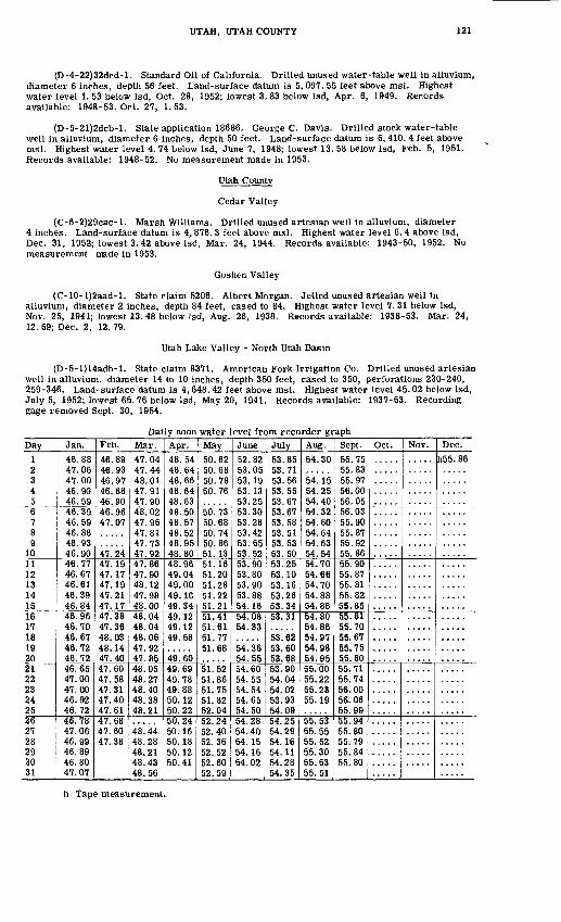
UTAH, UTAH COUNTY 121
(D-4-22)32dcd-l. Standard Oil of California. Drilled unused water-table well in alluvium, diameter 6 inches, depth 56 feet. Land-surface datum is 5, 097. 55 feet above msl. Highest water level 1. 53 below Isd, Oct. 28, 1952; lowest 3. 83 below Isd, Apr. 6, 1949. Records available: 1948-53. Oct. 27, 1.53.
(D-5-21)2dcb-l. State application 18686. George C. Davis. Drilled stock water-table well in alluvium, diameter 6 inches, depth 50 feet. Land-surface datum is 5, 410. 4 feet above msl. Highest water level 4. 74 below Isd, June 7, 1948; lowest 13. 58 below Isd, Feb. 5, 1951. Records available: 1948-52. No measurement made in 1953.
Utah County
Cedar Valley
(C-6-2)29cac-l. Marsh Williams. Drilled unused artesian well in alluvium, diameter 4 inches. Land-surface datum is 4, 876. 3 feet above msl. Highest water level 6.4 above Isd, Dec. 31, 1952; lowest 3.42 above Isd, Mar. 24, 1944. Records available: 1943-50, 1952. No measurement made in 1953.
Goshen Valley
(C-10-l)2aad-l. State claim 5206. Albert Morgan. Jetted unused artesian well in alluvium, diameter 2 inches, depth 84 feet, cased to 84. Highest water level 7. 31 below Isd, Nov. 25, 1941; lowest 13. 48 below Isd, Aug. 26, 1938. Records available: 1938-53. Mar. 24, 12. 59; Dec. 2, 12. 79.
Utah Lake ValLey - North Utah Basin
(D-5-l)14adb-l. State claim 8371. American Fork Irrigation Co. Drilled unused artesian well in alluvium, diameter 14 to 10 inches, depth 350 feet, cased to 350, perforations 230-240, 259-346. Land-surface datum is 4, 648.42 feet above msl. Highest water level 45.02 below Isd, July 5, 1952; lowest 65. 76 below Isd, May 20, 1941. Records available: 1937-53. Recording gage removed Sept. 30, 1954.
Daily noon water level from recorder graphDay
12
456789
101119
1 1
141516 17 18 19 202122232425262728293031
Jan.
46.8847.06 47.0046.9046.5946.3946.5946.8846.93 46.9046.7746.6746.6146.3946.8446.96 46.70 46.67 46.72 46.7246.6547.0047.0046.9246.7246.7847.0646.9946.8946.8047.07
Feb.
46.8946.93AC Q7
46.8846.9046.9647.07
47.2447 1Q
47.1747 1Q
47.2147.1747.38 47.36 48.03 48.14 47.4047.6047.5847.3147.4047.6147.6847.6047.38
Mar.
47.0447.44 48.0147 9147.9048.0247 QF.
47.8147.73 47.9247.8647.9048.1247 9848.0048.04 48.04 48.06 47.92 47.8548.054R 97
48.4048.3848.21
48.4448.2848.2148.4348.56
Apr.
48.5448.64 48.6648.6448.63AO Cft
48.5748.5248.95 48.8048.9649.0449.0049.1649.3449.12 49.12 49.58
49.604Q RQ
49.7849.8850.1250.2250.2450.1650.1850.1250.41
May
50.6250.68 50.7850.76
50.7350.68RO 74
50.86 51.1351.1651.2051.2851 2251.2151.41 51.61 51.77 51.68
51.5251.86R1 7S
51.8252.0459 94
52.4052.36S9 V)
52.6052.59
June
52.8253.05co i n
53.1353.25CO Oft
53.28m 49
53.55 53.52si QO53.80R°. Qfi
53.8854.1654.08 54.33
54.3654.5554.60S4 S^
54 S4
54.6554.5054.28S4 40
54.1554.16S4 09
July
53.8553.71 53.5653.5553.6753.6753.58w R153.53 53.5053.2553.1053.1653.2653.3453.31
53.62 53.60 53.68SI QO
S4 04
54.0253.9354.0954 95
S4 9Q
54.16S4 1 1
54.2854.35
Aug.
54.30
54 1554.2554.40R4 ^9
54.6054.6454.63 54.54S4 70
54.66S4 7O
54.8854.8854.80 54.86 54.97 54.98 54.9555.0055.2255.2355.19
55.5355.5555.5255.3055.5355.51
Sept.
55.7555.83cc Q7
56.0056.0556.0355.9055.8755.92 55.8655.9055.8755.8155.8255.8555.81 55.70 55.67 55.75 55.8055.7155.7456.0056.0655.9955.9455.8055.7955.8455.80
Oct. Nov. Dec.
h55. 86
h Tape measurement.
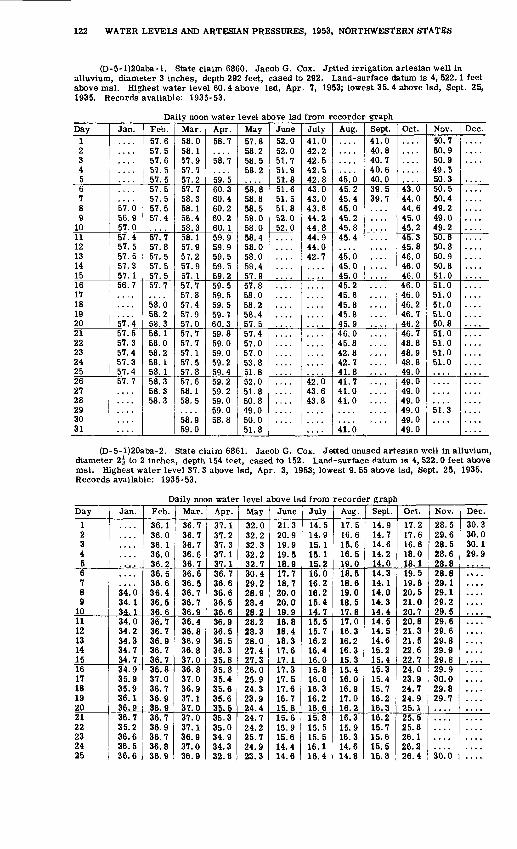
122 WATER LEVELS AND ARTESIAN PRESSURES, 1953, NORTHWESTERN STATES
(D-5-l)20aba-l. State claim 6860. Jacob G. Cox. J_etted irrigation artesian well in alluvium, diameter 3 inches, depth 292 feet, cased to 292. Land-surface datum is 4, 522.1 feet above msl. Highest water level 60. 4 above Isd, Apr. 7, 1953; lowest 35. 4 above Isd, Sept. 25, 1935. Records available: 1935-53.
Daily noon water level above Isd from recorder graphDay
1 2 3 4 56 7 8 9
1011 12 13 14 1516 17 18 19 2021 22 23 24 2526 27 28 29 3031
Jan.
57.0 56.9 57.057.4 57.5 57.5 57.3 57.156.7
57! 457.5 57.3 57.4 57.3 57.457.7
Feb.57.6 57.5 57.6 57.5 57.557.5 57.5 57.5 57.4
57.7 57.8 57.5 57. 5 57.557.7
58.0 58.2 58.358.1 58.0 58.2 58.1 58.158.3 58.3 58.3
Mar.58.0 58.1 57.9 57.7 57.257.7 58.3 58.1 58.4 58.358. 1 57.9 57.2 57.9 57.157.7 57.8 57.4 57.9 57.057.7 57.7 57.1 57.5 57.857.6 58.1 58.5
58.959.0
Apr.58.7
se!?59.560.3 60.4 60.2 60.2 60.159.9 59.9 59.5 59.5 59.259.5 59.5 59.5 59.7 60.359.8 59.0 59.0 59.2 59.459.2 59.2 59.0 59.0 58.8
May57.8 58.2 58.5 58.2
58.8 58.8 58.5 58.0 58.058.4 58.0 58.0 58.4 57.957.8 58.0 58.2 58.4 57.557.4 57.0 57.0 53.8 51.852.0 51.8 50.8 49.0 50.051.8
June52.0 52.0 51.7 51.9 51.851.6 51.5 51.8 52.0 52.0
July41.0 42.2 42.5 42.5 42.843.0 43.0 43.6 44.2 44.844.9 44.0 42.7
42.0 43.6 43.8
Aug.
45.045.2 45.4 45.0 45.2 45.845.4
45.0 45.0 45.045.2 45.6 45.8 45.8 45.946.0 45.8 42.8 42.7 41.841.7 41.0 41.0
41.0
Sept.41.0 40.8 40.7 40.6 40.039.5 39.7
Oct.
43.0 44.0 44.6 45.0 45.245.3 45.8 46.0 46.0 46.046.0 46.0 46.2 46.7 46.246.7 48.8 48.9 48.8 49.049.0 49.0 49.0 49.0 49.049.0
Nov.50.7 50.9 50.9 49.5 50.350.5 50.4 49.2 49.0 49.250.8 50.8 50.9 50.8 51.051.0 51.0 51.0 51.0 50.851.0 51.0 51.0 51.0
51.3
Dec.
(D-5-l)20aba-2. State claim 6861. Jacob G. Cox. Jetted unused artesian well in alluvium, diameter 2| to 2 inches, depth 154 feet, cased to 152. Land-surface datum is 4, 522. 0 feet above msl. Highest water level 37. 3 above Isd, Apr. 3, 1953; lowest 9. 55 above Lsd, Sept. 25, 1935. Records available: 1935-53.
Daily noon water level above Isd from recorder graphDay
1 2 3 4 56 7 8 9
1011 12 13 14 1516 17 18 19 2021 22232425
Jan.
34! o34.1 34.134.0 34.2 34.3 34.7 34.734.9 35.9 35.9 36.1 36.936.7 35.236.636.536.6
Feb.
36.1 36.0 36.1 36.0 36.236.5 36.6 36.4 36.5 36.636.7 36.7 36.9 36.7 36.736.8 37.0 36.7 36.9 36.936.7 36.936.736.836.9
Mar.
36.7 36.7 36.7 36.6 36.736.6 36.5 36.7 36.7 36.936.4 36.8 36.9 36.8 37.036.8 37.0 36.9 37.1 37.037.0 37.136.937 n36.9
Apr.
37.1 37.2 37.3 37.1 37.136.7 36.6 36.6 36.5 36.636.9 36.5 36.5 36.3 35.835.8 35.4 35.6 35.6 35.535.3 m n14 0
34.332.8
May
32.0 32.2 32.3 32.2 32.730.4 29.2 28.9 28.4 28.228.2 28.3 28.0 27.4 27.326.0 25.9 24.3 23.9 24.424.7 24 26c 7
94 O
23.3
June
21.3 20.9 19.9 19.5 18.917.7 18.7 20.0 20.0 19.918.8 18.4 18.3 17.6 17.117.3 17.5 17.6 16.7 15.815.6 15 915.614.414.6
July
14.5 14.9 15.1 15.1 15.216.0 16.2 16.2 15.4 14.715.5 15.7 16.2 16.4 16.015.8 16.0 16.3 16.2 16.615.8 15.515.516.116.4
Aug.
17.5 16.6 15.6 16.5 19.018.5 18.6 19.0 18.5 17.817.0 16.3 16.2 16.3 15.315.4 16.0 16.9 17.0 16.216.3IRQ
16.314.614.8
Sept.
14.9 14.7 14.6 14.2 14.014.3 14.1 14.0 14.3 14.414.5 14.5 14.6 15.2 15.415.3 15.4 15.7 16.2 16.316.2157
15.615.515.8
Oct.
17.2 17.6 16.8 18.0 18.119.5 19.8 20.5 21.0 20.720.8 21.3 21.5 22.6 22.724.0 23.9 24.7 24.9 25.125.5 25.826.126.226.4
Nov.
28.5 29.6 28.5 28.6 28.828.8 29.1 29.1 29.2 29.529.6 29.6 29.8 29.9 29.829.9 30.0 29.8 29.7
30.0
Dec.
30.3 30.0 30.1 29.9
....
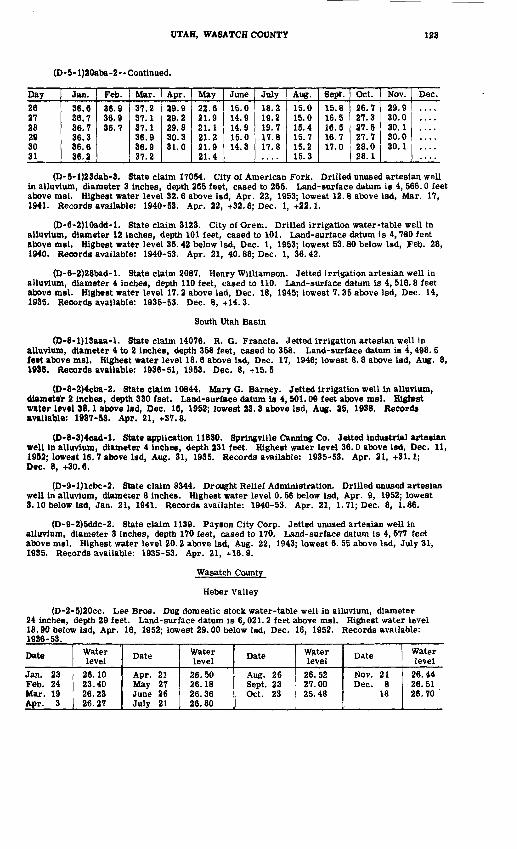
UTAH, WASATCH COUNTY 123
(D-5-l)20aba-2 Continued,
Day26 27 28 29 30 31
Jan.
36.6 36.7 36.7 36.3 36.6 36.2
Feb.
36.9 36.9 36.7
Mar.37.2 37.1 37.1 36.9 36.9 37.2
Apr.29.9 29.2 29.8 30.3 31.0
May22.6 21.9 21.1 21.2 21.9 21.4
June15.0 14.9 14.9 15.0 14.3
July18.2 19.2 19.7 17.8 17.8
Aug.15.0 15.0 15.4 15.7 15.2 15.3
Sept.15.8 16.5 16.5 16.7 17.0
Oct.
26.7 27.3 27.5 27.7 28.0 28.1
Nov.29.9 30.0 30.1 30.0 30.1
Dec.
(D-5-l)23dab-3. State claim 17054. City of American Fork. Drilled unused artesian well in alluvium, diameter 3 inches, depth 265 feet, cased to 265. Land-surface datum is 4, 566.0 feet above msl. Highest water level 32.6 above Isd, Apr. 22, 1953; lowest 12.8 above Isd, Mar. 17, 1941. Records available: 1940-53. Apr. 22, +32.6; Dec. 1, +22.1.
(D-6-2)10add-l. State claim 3123. CityofOrem. Drilled irrigation water-table well in alluvium, diameter 12 inches, depth 101 feet, cased to 101. Land-surface datum is 4,780 feet above msl. Highest water level 36.42 below Isd, Dec. 1, 1953; lowest 53.80 below Isd, Feb. 28, 1940. Records available: 1940-53. Apr. 21, 40.88; Dec. 1, 36.42.
(D-6-2)28bad-l. State claim 2087. Henry Williamson. Jetted irrigation artesian well in alluvium, diameter 4 inches, depth 110 feet, cased to 110. Land-surface datum is 4,516.8 feet above msl. Highest water level 17.2 above Isd, Dec. 18, 1945; lowest 7.35 above Isd, Dec. 14,1935. Records available: 1935-53. Dec. 8, +14.3.
South Utah Basin
(D-8-l)13aaa-l, State claim 14076. R.G.Francis. Jetted irrigation artesian well in alluvium, diameter 4 to 2 inches, depth 358 feet, cased to 358. Land-surface datum is 4,498. 5 feet above msl. Highest water levsl 18.6 above Isd, Dec. 17, 1946; lowest 8.8 above lad, Aug. 8,1936. Records available: 1936-51, 1953. Dec. 8, +15.5
(D-8-2)4cba-2, State claim 10844. Mary G. Barney. Jetted irrigation well in alluvium, diameter 2 inches, depth 330 fset. Land-surface datum is 4, SOI. 09 feet above msl. Highest water level 38.1 above Isd, Dec. 16, 1952; lowest 23.3 above Isd, Aug. 25, 1938. Records available: 1937-53. Apr. 21, +37.8.
(D-8-3)4cad-l. State application 11830. Springville Canning Co. Jetted industrial artesian well in alluvium, diameter 4 inches, depth 231 feet. Highest water level 36.0 above Isd, Dec. 11, 1952; lowest 16.7 above Isd, Aug. 31, 1935. Records available: 1935-53. Apr. 21, +31.1; Dec. 8, +30.6.
(D-9-l)lcbc-2. State claim 8344. Drought Relief Administration. Drilled unused artesian well in alluvium, diameter 8 inches. Highest water level 0.56 below Isd, Apr. 9, 1952; lowest 3.10 below Isd, Jan. 21, 1941. Records available: 1940-53. Apr. 21, 1.71; Dec. 8, 1.86.
(D-9-2)5ddc-2. State claim 1139. Payson City Corp. Jetted unused artesian well in alluvium, diameter 3 inches, depth 170 feet, cased to 170. Land-surface datum is 4,577 feet above msl. Highest water level 20.2 above Isd, Aug. 22, 1943; lowest 6. 55 above Isd, July 31, 1935. Records available: 1935-53. Apr. 21, +16.9.
Wasatch County
Heber Valley
(D-2-5)20cc. Lee Bros. Dug domestic stock water-table well in alluvium, diameter 24 inches, depth 29 feet. Land-surface datum is 6,021.2 feet above msl. Highest water level 18.90 below Isd, Apr. 16, 1952; lowest 29.00 below Isd, Dec. 16, 1952. Records available: 1936-53.
Date
Jan. 23 Feb. 24 Mar. 19 Apr. 3
Water level
26.10 23.40 26.23 26.27
Date
Apr. 21 May 27 June 26 July 21
Water level
26.50 26.18 26.36 26.80
Date
Aug. 26 Sept, 23 Oct. 23
Water level
26.52 27.00 25.48
Date
Nov. 21 Dec. 8
18
Water level
26.44 26.51 26. 70

124 WATER LEVELS AND ARTESIAN PRESSURES, 1953, NORTHWESTERN STATES
(D-3-5)29cac-l. Miles Clyde. Dug domestic water-table well in alluvium, diameter 4 feet, depth 15 feet. Highest water level 0.80 below Isd, June 24, 1949; lowest 10. 82 below Isd, Mar. 9, 1942. Records available: 1936-53. Apr. 3, 10.15; Dec. 9, 6.95.
Washington County
Escalante Valley (For other wells in this valley see Beaver, Iron, and Millard Counties.)
(C-37-18)6ccc-l. State application a2298. LeRoy Adams. Drilled irrigation well in alluvium, diameter 14 inches, depth 200 feet, cased to 200. Land-surface datum is 5,285.2 feet above msl. Highest water level 76.60 below Isd, May 19, 1952; lowest 105.34 below Isd, Oct. 14, 1951. Records available: 1945, 1947-53. Mar. 20, 86. 52; June 22, 114.00, pumping; July 1, 116.20, pumping; Aug. 14, 125.20, pumping; Oct. 7, 102.70; Dec. 6, 100.45.
(C-37-17)12bdc-l. (Formerly 12cbc-l.) Charles Sides. Drilled irrigation artssian well in alluvium, diameter 14 inches. Land-surface datum is 5,300 feet above msl. Highest water level 17. 50 below Isd, May 8, 1952;-lowest 37. 85 below Isd, Oct. 14, 1951. Rscords available: 1941-53. Mar. 20, 31.36; June 21, 36. 40; July 2, 48.50, pumping; Aug. 14, 51.50, pumping; Dec. 6, 34.16.
(C-37-17)14adc-l. John C. Bosshardt. Dug stock water-tabls well in alluvium, diameter 4 feet, dspth 60 feet. Highest water level 31.84 bslow Isd, Mar. 21, 1947; lowest 47.25 below Isd, Oct. 16, 1951. Rscords available: 1941-53. Mar. 20, 41.68; Dec. 6, 46.00.
Virgin River Valley
(C-38-12)20bba-l. State application 16635. E. G. Graft. Drilled irrigation artesian well in alluvium, diameter 12 inches, depth 220 feet. Highest water level 40.26 below Isd, Mar. 27, 1950; lowest 44. 65 below Isd, Dec. 7, 1951. Records available: 1947-53. Mar. 14, 42.59.
(C-41-13)7dba-l. State application 17859. Clair Sterling. Drilled unused artesian well in alluvium, diameter 12 inches, depth 98 feet. Highest water level 0.14 below Isd, June 2, 1952; lowest 8. 29 below Isd, Dec. 7, 1951, Records available: 1947-53.
Daily noon water level from recorder graphDay
123456789
1011121314 15161718192091
99
232425no
272829 3031
Jan. Feb. Mar.
2.36
Apr.
1.902.251.872.16 2.152 97
2.342.489 <»Q
2.672.732.362.642.742.822.832.852.862.86 2.89
May
2.892.271.902.282.312 <M
2 m2.652.782.842.892.702.502.64 2.642.772.872.962.562.432.472 ^4
2 70
2.772.893 14
3.223.213.27 3.30 3.37
June
3.133.303.433 49
3.473.563.613.683.743.773.863.963.863.84 3.803 01
4.014.104.144.234.354 49
4.444 HI
4.554 >»n4.474.604.72 4.79
July
4.884 <175.065 115.145.205.245.285 17
5.225.365.475.495. 56 5.635.665.695.735.765.775 7Q
5.845.885 Q9
5.966.016.066.096.05 5.94 5.98
Aug.
6.006.016.026.056.206.256.316.366.376.396.426.456.476.51 6.516.556.566.596.636.666.716.746.776.816.736.636.726.806.85 6.89 6.93 ,
Sept.
6.967.007.067.137.167.217.247.287.337.367.407.447.497.53 7.557.577.557.917.927.857.777.677.577.507.497.767.617.457.47 7.78
Oct.
7.817.707.577.457.377.297.347.387.417.367.327.287.557.78 7.717.577.447.337.287.247.287.437.457.407.308.157.917.707.55 7.52 7.37
Nov.7.307.207.157.107.067.036.987.347.587.647.707.807.877.95 8.038.058.068.078.088.108.127.786.636.957.127.307.437.587.67 7.73
Dec.7.777.837.887.948.038.008.038.058.128.057.627.257 ^n7.64 7.707.717.747.737.557.577 57
7.056 en
6.626.396,466.366.276.31 6.41 6.35

UTAH, WEBER COUNTY 125
(C-42-ll)3ac. Drought Relief Administration. Drilled domestic stock water-table well in alluvium, diameter 6 to 5 inches, c'epth 62 feet, cased to 62, perforations 40-62. Highest water level 17. 09 below Isd, Dec. 6, 1937; lowest 19.12 below Isd, Mar. 24, 1940. Records available: 1934, 1936-53. Mar. 15, 19.04.
(C-42-16)22cba-l. State application 18001. Clyde Graff. Drilled irrigation artesian well in alluvium, diameter 16 inches, depth 92 feet. Highest water level 20. 08 below Isd, Mar. 28, 1950; lowest 21.76 below Isd, Dec. 7, 1950. Records available: 1947-53. Mar. 14, 21.36.
(C-42-16)24bba-l. State application 20557. Bryon Thornton. Drilled industrial artesian well in alluvium, diameter 4 inches, depth 185 feet. Highest water level 24. 68 below Isd, Mar. 25, 1951; lowest 35. 07 below Isd, Dec. 7, 1951. Records available: 1949-53. Mar. 14, 24.83; Dec. 7, 30.64.
Wayne County
Fremont Valley
(D-28-4)36cdb-l. V. A. Lee. Drilled unused water-table well in alluvium, diameter 6 inches, depth 112 feet, cased to 112. Highest water level 8. 14 below Isd, June 8, 1937; lowest 14. 96 below Isd, Dec. 9, 1950. Records available: 1936-53. Mar. 16, 14. 08; Dec. 15, 14.91.
(D-29-4)6bbd-l. State claim 19179. Reed Maxfield. Drilled domestic artesian well in alluvium, diameter 6 inches, depth 92 feet, cased to 92. Highest water level 15.47 below Isd, Dec. 10, 1951; lowest 20. 33 below Isd, Mar. 16, 1953. Records available: 1948-53. Mar. 16, 20. 33; Dec. 15, 15.80.
(D-29-4)15cbd. W. P. Coleman. Drilled stock artesian well in alluvium, diameter 3 inches, depth 192 feet, cased to 100. Highest water level 1. 45 above Isd, Dec. 5, 1944; lowest 22.22 below Isd, Sept. 29, 1936. Records available: 1936-53. Mar. 16, 2.23.
Weber County
East Shore Area (For other wells in this area see Box Elder and Davis Counties.)
(B-5-2)4aaa-2. State claim 5523. Florian Prevedel. Jetted domestic artesian well in alluvium, diameter It inches, depth 263 feet. Land-surface datum is 4,258.8 feet above msl. Highest water ievei 7. 45 above Isd, Apr. 28, 1953; lowest 0. 02 beiow Isd, Oct. 10, 1948. Records available: 1944-53.
Date
Jan. 23 Mar. 2
Water level
+6.05 +7.25
Date '
Mar. 27 Apr. 28
Water level
-t-7. 15 +7.45
Date
May 26 July 1
Water level
+6.95 +4.65
Date
Aug. 4 Dec. 10
Water level
+3.11 +3.55
(B-5-2)4cdd-l. State application 11889. Donas Ward. Jetted domestic stock artesian well In alluvium, diameter 3 Inches, depth 640 feet, perforations 622-640. Land-surface datum Is 4,259 feet above msl. Highest water level 42.3 above Isd, May 26, 1953; lowest 28.8 above led, Aug. 8. 1945. Records available; 1936-53.Jan. 23Mar. 2
27
+40.9+41.2+42.2
Apr. 28May 26July 1
+42.0+42.3+39.1
Aug. 427
Oct. 1
+36.0 | Oct. 29+37.4 Dec. 10+37. 6 1
+38.2+38.4
(B-5-3)13ddc-l. State claim 1298. J. D. Hooper. Jetted domestic artesian well in alluvium, diameter 2 to U inches, depth 615 feet, cased to 615. Land-surface datum is 4, 242. 02 feet above msl. Highest water level 40. 0 above Isd, May 26, 1953; lowest 26. 7 above Isd, July 2. 1948: Records available: 1937-53.Jan. 23Mar. 2
27
+38.1+39.1+39.1
Apr. 28May 26July 1
+39.7+40.0+36.8
Aug. 426
Oct. 6
+37.0+34.2+35.4
Oct. 29Dec. 10
+36.8+35.9
(B-6-l)21add-l. State claim 8389. Drought Relief Administration. Drilled unused artesian well in alluvium, diameter 12 to 10 inches, depth 270 feet, cased to 210, perforations 126-157, 170-210. Land -surface datum is 4, 346. 7 feet above msl. Highest water level 42. 47 below Isd, May 26, 1953; lowest 49. 62 below isd. Sept. 7, 1948. Records available: 1938-53.Jan. 22 Feb. 25 Mar. 25
43.96 43.87 43.49
Apr. 23 May 26 June 2 5
43.09 42.47 42.57
July 29 Aug. 25 Sept. 30
44.43 45.79 46.66
Oct. 27 Dec. 8
46.00 45.33

126 WATER LEVELS AND ARTESIAN PRESSURES, 1953, NORTHWESTERN STATES
(B-6-l)29atab-l. State application 13003. Beeker Products Co. Drilled unused artesian well in alluvium, diameter 10 to 8 inches, depth 464 feet, cased to 464. Land-surface datum is 4,292 feet above mal. Highest water level 22. 7 above Isd, Dec. 31, 1953; lowest 9. 3 above Isd, Sept. 16, 1948. Records available: 1943-53.
Daily noon water level above Isd from recorder graphDay1 2 3 4 56 7 8 9
1011 12 13 14 1516 17 18 192021 22 23 24 2526 27 28 29 30 31
Jan. Feb.
19.4 19.4 19.419.4 19.4 19.4 19.1 18.519.2 19.0 19.1 19.2 18.718.9 19.2 19.3
18.9 20.9 21.2
Mar.21.0 20.5 20.6 20.8 21.020.9 20.8 20.9 21.0 21.121.0 21.2 21.1 20.7 21.021.1 21.1 21.191 1
21.121.2 21.2 21.2 21.4 21.421.4 21.4 21.5 21.4 21.3 21.4
Apr.21.4 21.5 21.4 21.4 21.421.4 21.3 21.4 21.3 21.220.7 21.0 21.4 21.4 21.421.6 21.6 21.491 A.
21.421.4 21.4 21.4 21.4 21.421.6 21.5 21.5 21.5 21.5
May21.521.4 21.5 21.5 21.821.4 21.4 21.4 21.4 21.321.4 21.4 21.4 21.6 21.621.5 21.4 21.6 21.521.321.5 21.5
21.7
June21.8 22.0 22.1 22.2 21.822.0 21.9 21.9 21.9 22.422.4 22.4 22.3 22.3 22.022.1 22.1 22.1OO 1
21.721.7 21.8 22.0 21.1 20.620.4 20.1 20.2 20.0 20.4
July19.8 19.6 19.7 19.8 20.120.2 19.8 19.7 19.6 19.920.2 20.4 20.6 20.2 19.919.8 19.7 19.2 19 219.219.1 19.1 18.6 18.6 18.618.5 18.4 18.4
Aug.
20.020.0 19.8 19.4 20.8 20.521.7 21.2 21.8 22.2 22.021.8 20.8 20.8 20.820.720.7 20.2 20.2 20.0 19.719.7 19.6 19.6 19.7 19.9 20.0
Sept.19.5 19.5 19.5 19.5 19.419.5 19.5 19.8 19.9 19.719.8 19.9 19.9 19.8 19.819.6 19.6 19.4 19.319.419.5 19.2 19.1 19.1 19.019.1 19.2 19.2 19.2 19.2
Oct.19.2 19.1 19.1 19.0 18.819.0 19.0 19.1 18.7 18.918.9 18.5 18.8 19.4 19.619.7 20.0 20.1 9n d20.520.5 20.6 20.6 20.7 20.921.0 21.0 21.0 21.1 21.2 21.3
Nov.21.4 21.5 21.5 21.6 21.721.7 21.7 21.7 21.8 21.922.0 22.1 22.1 22.1 22.222.2 22.1 22.299 9
22.322.3 22.3 22.3 21.8 21.621.4 21.0 21.0 21.3 21.4
Dec.21.4 21.4 21.5 21.6 21.621.8 22.1 22.1 22.2 22.422.3 22.3 22.3 22.3 22.422.5 22.5 22.5 22.522.522.5 22.5 22.5 22.6 22.622.6 22.6 22.6 22.6 22.6 22.7
(B-6-l)30cca-l. State claim 1030. California Packing Corp. Drilled unused artesian well in alluvium, diameter 10 inches, depth 756 feet, cased to 756, perforations 224-250, 526-535. Land-surface datum is 4, 317. 12 feet above msl. Highest water level 26. 90 below Isd, June 8, 1953; lowest 31.86 be low Isd, Oct. 3, 1947. Records available: 1943-53.
Daily noon water level from recorder graphDay
123456789
10111213141516 17 18 19 202122 23 24 25
Jan. Feb. Mar.28.0728.1328.2128.2528.2128.22
28.08
27.93 27.9027.8927.88 27.87 27.84 27.99
Apr.27.6627.6827.6527.6327.5997 17
27.5697 19
27.5627.5127.5397 1197 4197 4Q
27.5027.41 27.37 27.40 27.35 27.2827.2827.28 27.25 27.28 27.27
May97 9f)
27.26nn t)Q
97 90,
27.2127.1627.1027 1197 19
27.1897 9fl97 9n97 1Q97 11
27.1327.13 27.14 27.17 27.09 27.029fi Q7
27.03 26.98 26.93 26.93
June9fi 049fi Q79A Q7
26.9226.949R Q7OA QO
26 909fi Q1
26.969fi Q79fi Q79fi QQoft QO
27.0526.97 27.02 26.97 27.00 26.92OR Q4
26.95 27.00 27.09 27.18
July27.6327.7627.8797 Q7
28.0728.1628.2028.26OQ QO
28.4428.4528.4928.4528.5128.5828.63 28.64 28.72 28.81 28.8428.8828.89 28.90 28.92 28.97
Aug.29.0429.039Q ni29.0028.9928.98OQ no29.0429 0729.119Q 97
29.319Q dl90 4Q
29.5429.57 29.62 29.68 29.83 29.909£J 07
30.06 30.10 30.06 30.06
Sept.30.2130.27in 90in 1430.3530.42in 4730.5030.5830.6330.6830.709f\ rt*t
Qft rjA
30.7630.79 30.78 30.83 30.81 30.78in 7930.70 30.74 30.75 30.67
Oct.30.8630.8530.9030.8530.8230.8130.86in 04in 0130.8830.8430.91in onin 0130.9530.99 30.95 30.88 30.79 30.7830.7730.77 30.71 30.54 30.49
Nov.30.2530.2130.1930.1530.0830.0930.1230.10in nn29.9929.9429.939Q Q990 Qfi
29.9229.85 29.77 29.80 29.89 29.8529.8929.81 29.80 29.81 29.78
Dec.29.6729.6729.6590 11
29.6090 1ft9Q 41OQ 40
29 4829.3529.4029.37OQ 11
9Q 9n
29.10
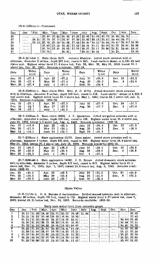
UTAH, WEBER COUNTY 127
(B-6- l)30cca-l--Continued.
Day26 27 28 293031
Jan. Feb.
28.21 28. 13
Mar.27.80 27.79 27.72 27.6827.7027.71
Apr.27.25 27.15 27.15 27. 1927. 16
May26.98 26.97 26.92 26.9226.9226.91
June27.26 27.38 27.45 27.5227.55
July29.02 29.02 29.06 29.0929.0729.00
Aug.30.09 30.12 30.11 30.1130.1730.18
Sept.30.75 30.81 30.84 30.9030.90
Oct.30.48 30.44 30.41 30.3330.3130.29
Nov.29.76 29.77 29.81 29.8129.66
Dec.
28.95 28.9629,0128.94
(B-6-2)lldad-l. State claim 5613. Jerome Wheeler. Jetted stock artesian well in alluvium, diameter 2 inches, depth 285 feet, cased to 285. Land-surface datum is 4,241.62 feet above msl. Highest water level 27. 4 above Isd, Feb. 26, Mar. 26, May 26, 1953; lowest 18. 0 above Isd, Oct. 29, 1947. Records available: 1937-53.
Date
Jan. 22 Feb. 26 Mar. 26
Water level
+27.3 +27.4 +27.4
Date
Apr. 23 May 26 July 1
Water level
+27.2 +27.4 +27.0
Date
July 31 Aug. 26 Sept. 30
Water level
+25.8 +25.3 +24.4
Date
Oct. 28 Dec. 9
Water level
+25.2 +25.6
(B-6-3)26bbb-l. State claim 7505. Mrs. F. G. Kelly. Jetted domestic stock artesian well in alluvium, diameter 2 inches, depth 512 feet, cased to 512. Land-surfac~ datum is 4, 219. 3 feet above msl. Highest water level 33. 5 above Isd, May 1, 1940; lowest 24.1 above Isd, Jan. 2, 1952. Records available: 1935-53.Jan. 23 Feb. 26 Mar. 26
+27.1 +24.7 +27.1
Apr. 26 May 27 July 1
+27.3 +27.5 +28.2
July 31 Aug. 26
+27.6 +27.7
Oct. 28 Dec. 9
+27.7 +27.8
(B-7-l)33baa-5. State claim 16832. J. P. Spackman. Jetted irrigation artesian well in alluvium, diameter 4 inches, depth 126 feet, cased to 126. Highest water level 36. 4 above Isd, July 28, 1952; lowest 5.0 above Isd, Aug. 4, 1943. Records available: 1943-53.Jan. 21 Feb. 25 Mar. 24
+18.8 +17.0 +14.1
Apr. 22 May 25 June 24
+22.5 +24.5 +22.7
July 28 Aug. 25 Sept. 29
+24.4 +24.7 +31.3
Oct. 27 Dec. 8
+31.5 +16.3
(B-7-2)32aca-l. State application 15170. Dean baker. Jetted stock artesian well in alluvium, diameter 2 inches, depth 630 feet, cased to 630. Highest water level 39. 9 above Isd, May 27. 1953; lowest 27.2 above Isd. July 12. 1945. Records available: 1945-53^Jan. 22 Feb. 26 Mar. 26
+34.2 +33.9 +35.3
Apr. 23 May 27 July 1
+36.0 +39.9 +38.1
July 31 Aug. 26 Oct. 1
+35.4 +36.6 +37.1
Oct. 28 Dec. 9
+32.9 +36.8
(B-7-2)36cdd-l. State application 14082. J. D. Brown, J etted domestic stock artesian well in alluvium, diameter 2 inches, depth 617 feet, cased to 617. Highest water level 41. 0 above Isd, Dec. 11, 1943, Apr. 7, 1947; lowest 24. 9 above Isd, Aug. 6, 1943. Records avail able: 1943-53.Jan. 22 Feb. 25 Mar. 25
+35.1 +34.3 +35.3
Apr. 22 May 26 June 25
+35.5 +35.8 +32.1
July 29 Aug. 25Sept. 30
+31.2 +31.6 +32.9
Oct. 27 Dec. 8
+36.9 +36.3
Ogden Valley
(A-6-l)lldc-l. U. S. Bureau of Reclamation. Drilled unused artesian well in alluvium, diameter 10 inches, depth 152 feet, cased to 152. Highest water level 4.27 below Isd, June 7, 1945; lowest 43.11 below Isd, Nov. 24, 1935. Records available: 1935-53.
Daily noon water level from recorder graphDay
123456789
10
Jan.31.3131.3131.3131.3031.3031.2931.2931.2931.2931.28
Feb.31.3031.3231.3231.3331.3331.3331.0430.5030.2430.00
Mar.26.3026.4626.6026.7226.8226.9026.9797 ni27.0727.10
Apr.26.7126.5326.3626.2026.0625.9325.7625.6225.5025.37
May20.0319.8419.7019.6119.5219.4119.2519.0018.7318.54
June16.8616.8316.8116.8516.9717 OQ17.2117.3017.3817.47
July91 QA
Aug. Sept. Oct. Nov.
34.8434.8934.9635.0335.1235.2235.2235.45
Dec.37.4237.4537.4837.5137.5337.5637.5837.5937.6137.63
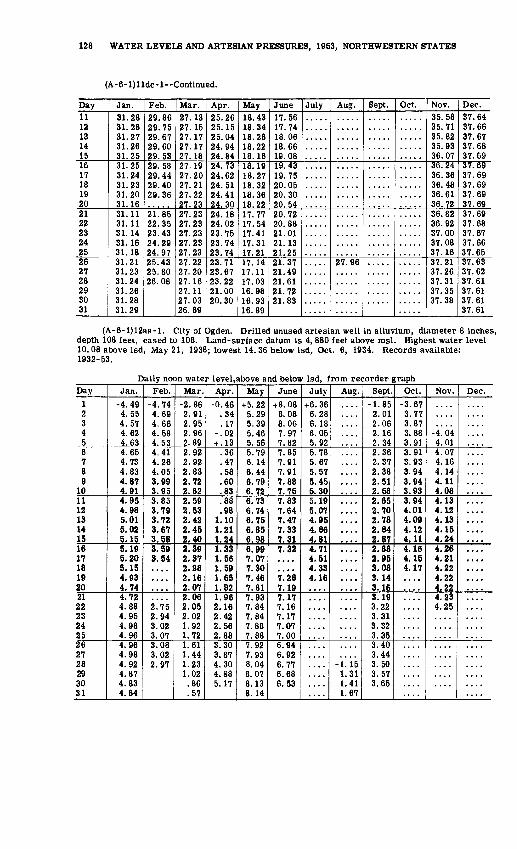
128 WATER LEVELS AND ARTESIAN PRESSURES, 1953, NORTHWESTERN STATES
(A-6-l)lldc-l--Continued.
Day11121314151617181920212223242526 2728293031
Jan.31.2831.28*?1 97
31.2631.2531.2531.2431.2331.2031.1631.1131.1131.1431.1631.1831.21 31.2331.2431.2631.2831.29
Feb.29.869Q 75
9Q R7
29.6029.5329.589Q 44
90 4H
29.36
21.8522.3523.4394 9Q
24.9725.4325.8026.08
Mar.27.1397 15
27.1727.1727.1827.1997 90
97 91
97 99
27.2327.2327.2327.2327.2327.2327.2297 9n
27.1627.1127.0326.89
Apr.25.269515
25.0424.9424.8424.7394 R9
94 R1
94 41
24.3024.1894 09
23.7523.7423.7423.71 23.6723.2221.0020.30
May18.4318.3418.2818.2218.1618.1918.2718.3218.3618.2217.771 7 54
17.4117.3117.2117.14 17.1117.0316.9816.9316.89
June17.5617.7418.0618.6619.0819.431Q 7R
20.0520.3020.5490 79
20.8821.0121.1321.2521.3791 4Q
21.6121.7221.83
July Aug.
27.96
Sept. Oct.. Nov.35.5835.7135.8235.9336.0736.2436.3636.4836.6136.7236.8236.9237.0037.0837.1637.21 37.2637.3137.3537.38
Dec.37.6437.6637.6737.6837.6937.6937.6937.6937.6937.6937.6937.6837.6737.6637.6537.63 37.6237.6137.6137.6137.61
(A-6-l)12aa-l. City of Ogden. Drilled unused artesian well in alluvium, diameter 8 inches, depth 108 feet, cased to 108. Land-surface datum is 4, 880 feet above msl. Highest water level 10.08 above Isd, May 21, 1938; lowest 14.36 below Isd, Oct. 6, 1934. Records available: 1932-53.
Daily noon water level.above and below Isd, from recorder graphDay
1 2 3 4 56 7 8 9
1011 12 13 14 1516 17 18 19 2021 22 232425262728 29 30 31
Jan.-4.49 4.55 4.57 4.62 4.634.65 4.73 4.83 4.87 4.914.95 4.98 5.01 5.02 5.155.19 5.20 5.15 4.93 4.74
.72
.88
.95
.98
.96
.96
.98
.92
.87 4.83 4.84
Feb.-4.74 4.69 4.66 4.58 4.534.41 4.26 4.05 3.99 3.953.85 3.79 3.72 3.67 3.583.59 3.54
2.75 2.943.023.073.083.022.97
Mar.-2.86 2.91 2.95 2.96 2.892.92 2.92 2.83 2.72 2.622.59 2.53 2.42 2,45 2.402.39 2.37 2.28 2.16 2.072.06 2.05 2.021.921.721.611.441.23 1.02 .86 .57
Apr.-0.46
.34 . 17
-.02 + .13
.36
.47
.58
.60
.83
.88
.98 1.10 1.21 .24.33 .56 .59 .65
1.821.96 2.16 2.422.562.883.303.874.30 4.88 5.17
May+5.22
5.29 5.39 5.46 5.565.79 6.14 6.44 6.79 6.726.73 6.74 6.75 6.85 6.986.99 7.07 7.30 7.46 7.817.93 7.84 7.847.887.887 Q9
7.938.04 8.07 8.13 8.14
June+8.08
8.08 8.06 7.97 7.827.85 7.91 7.91 7.88 7.757.83 7.64 7.47 7.33 7.317.32
1. 28 7.197.17 7.16 7.177.077.006.946.926.77 6.68 6.53
July+6.36 6.28 6.18 6.05 5.925.78 5.67 5.57 5.45 5.305.19 5.07 4.95 4.86 4.814.71 4.51 4.33 4.16
....
Aug.
....
....
-1.15 1.31 1.41 1.67
Sept.-1.85 2.01 2.06 2.16 2.342.36 2.37 2.38 2.51 2.582.65 2.70 2.78 2.84 2.872.88 2.95 3.08 3.14 3.163.19 3.22 3.313.323.353.403.443.50 3.57 3.65
Oct.-3.67 3.77 3.87 3.88 3.913.91 3.93 3.94 3.94 3.933.94 4.01 4,09 4.12 4.114.16 4.15 4.17
Nov.
-4. 04 4.014.07 4.16 4.14 4.11 4.084.13 4.12 4.13 4.15 4.244.26 4.21 4.22 4.22 4.224.234.25
Dec.
....
....
....
....

WASHINGTON
By Glen D. Holmberg
Scope of Water-Level Program
The observation-well program in Washington was continued in 1953 In cooperation with the State Department of Conservation and Development, Water Resources Division. Included in this report are measurements of one lake and 112 wells, 23 of which are included for the first time. Nine recording and eight nonrecording gages were operated during the year. Additional wells, not included in the report, were measured periodically in several areas in connection with inves tigations of the ground-water resources of counties or other areas. Investigational projects in clude the Seattle metropolitan area in King County, Tacoma-Central Pierce County area, Lewis County, Whitman County, and the Columbia Basin area. Ground-water investigations completed include those in the Sammamish Lake area of King County and the Ahtanum Valley area of Yakima County. Two reports, "Ground water in the lower Ahtanum Valley, Washington,and possible effects of increased withdrawal in that area", and "Ground water in the Yelm area, Thurston and Pierce Counties", were released to open file. Water-Supply Paper 1135, "Ground-water resources of Snohomish County, Washington," was published. (See fig. 27 for location of observation wells.)
Pr ecipitation
The Cascade Range divides the State into eastern and western parts which have distinctly different climatic conditions. Annual precipitation in most of the eastern part of the State gener ally ranges from 7 to 15 inches except along the eastern border and in the southeastern corner. Average precipitation in these two areas ranges from 20 to 25 inches and 20 to 40 inches, respectively. In western Washington, average annual precipitation for most of the central part of the area ranges from 40 to 60 inches. Along the west slope of the Cascades and also along the Pacific Coast average annual precipitation at many places is as much as 100 inches.
The first of the following tables shows monthly distribution of precipitation at three repre sentative stations. The normal precipitation is shown in comparison with the precipitation for 1953. Records of the Olympia station are representative of western Washington and the records of the Ellensburg and the Spokane stations are representative of eastern Washington. The second table shows precipitation for the year ending December 31, 1953, at 10 representative stations; and also the ratio, in percent, of the 1953 precipitation to the normal annual precipitation for each of those stations. Precipitation data were obtained from the U. S. Weather Bureau.
Monthly precipitation at three selected stations
Month
JanuaryFebruaryMarchAprilMayJuneJulyAugustSeptemberOctoberNovemberDecember
Annual
OlympiaNormal(inches)
6.696.164.502.341.661.28.72.66
1.804.506.778.66
45.74
Percent of normal
1953(inches)
19.845.123.552.582.721.50.27
1.632.686.857.799.42
63.95
139.81
EllensburgNormal(inches)
1.20.82.56.42.49.70.14.22.47.67
1.351.47
8.51
1953(Inches)
3.01.43.22
1.391.19.62.01
1.60.07.15.84
1.21
10.74
126.20
SpokaneNormal(inches)
1.721.461.34.99
1.041.17.36.49.93
1.331.882.21
14.92
1953(inches)
4.561.071.771.481.59.81T
1.36.50.19
2.001.90
17.23
115. 48
129

130 WATER LEVELS AND ARTESIAN PRESSURES, 1953, NORTHWESTERN STATES
s '1 T~~

WASHINGTON 131
10
20
30
40
50
60
70
80
a 909
rt 100 o <uS n°
«tH
t-l
n 120 oI 13°o 140<B A^ 150 <u(U
e 16°
"w 170> v
M 180V
f 190
200
210
110
120
130
140
150
160
19/29-34D1 Basalt
20/25-15Q1 Sand
1949 1950 1951 1952 1953
Figure 28. --Hydrographs of wells 19/29-34D1 and 20/25-15Q1 in the Columbia Basin project area showing the effect of recharge from irrigation, 1949-53.
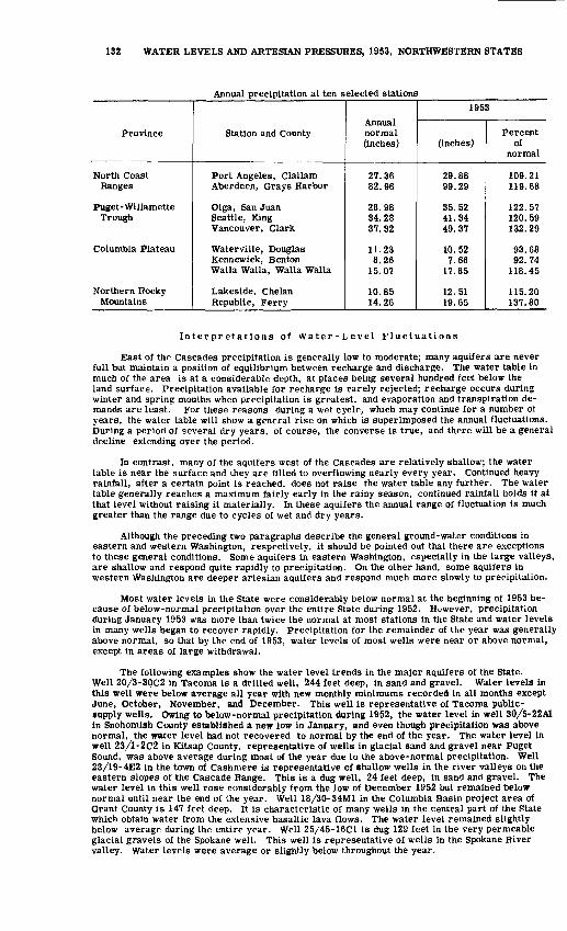
132 WATER LEVELS AND ARTESIAN PRESSURES, 1953, NORTHWESTERN STATES
Annual precipitation aMen selected stations
Province
North Coast Ranges
Puget- Willamette Trough
Columbia Plateau
Northern Rocky Mountains
Station and County
Port Angeles, Clallam Aberdeen, Grays Harbor
Olga, San Juan Seattle, King Vancouver, Clark
Waterville, Douglas Kennewick, Benton Walla Walla, Walla Walla
Lakeside, Chelan Republic, Ferry
Annual normal (inches)
27.36 82.96
28.98 34.28 37.32
11.23 8.26
15.07
10.85 14.26
1953
(inches)
29.88 99.29
35.52 41.34 49.37
10.52 7.66
17.85
12.51 19.65
Percent of
normal
109.21 119.68
122.57 120. 59 132.29
93.68 92.74
118.45
115.20 137.80
Interpretations of Water-Level Fluctuations
East of the Cascades precipitation is generally low to moderate; many aquifers are never full but maintain a position of equilibrium between recharge and discharge. The water table in much of the area is at a considerable depth, at places being several hundred feet below the land surface. Precipitation available for recharge is rarely rejected; recharge occurs during winter and spring months when precipitation is greatest, and evaporation and transpiration de mands are least. For these reasons during a wet cycle, which may continue for a number of years, the water table will show a general rise on which is superimposed the annual fluctuations. During a period of several dry years, of course, the converse is true, and there will be a general decline extending over the period.
In contrast, many of the aquifers west of the Cascades are relatively shallow; the water table is near the surface and they are filled to overflowing nearly every year. Continued heavy rainfall, after a certain point is reached, does not raise the water table any further. The water table generally reaches a maximum fairly early in the rainy season, continued rainfall holds it at that level without raising it materially. In these aquifers the annual range of fluctuation is much greater than the range due to cycles of wet and dry years.
Although the preceding two paragraphs describe the general ground-water conditions in eastern and western Washington, respectively, it should be pointed out that there are exceptions to these general conditions. Some aquifers in eastern Washington, especially in the large valleys, are shallow and respond quite rapidly to precipitation. On the other hand, some aquifers in western Washington are deeper artesian aquifers and respond much more slowly to precipitation.
Most water levels in the State were considerably below normal at the beginning of 1953 be cause of below-normal precipitation over the entire State during 1952. However, precipitation during January 1953 was more than twice the normal at most stations in the State and water levels in many wells began to recover rapidly. Precipitation for the remainder of the year was generally above normal, so that by the end of 1953, water levels of most wells were near or above normal, except in areas of large withdrawal.
The following examples show the water level trends in the major aquifers of the State. Well 20/3-30C2 in Tacoma is a drilled well, 244 feet deep, in sand and gravel. Water levels in this well were below average all year with new monthly minimums recorded in all months except June, October, November, and December. This well is representative of Tacoma public- supply wells. Owing to below-normal precipitation during 1952, the water level in well 30/5-22A1 in Snohomish County established a new low in January, and even though precipitation was above normal, the water level had not recovered to normal by the end of the year. The water level in well 23/1-2C2 in Kitsap County, representative of wells in glacial sand and gravel near Puget Sound, was above average during most of the year due to the above-normal precipitation. Well 23/19-4E2 in the town of Cashmere is representative of shallow wells in the river valleys on the eastern slopes of the Cascade Range. This is a dug well, 24 feet deep, in sand and gravel. The water level in this well rose considerably from the low of December 1952 but remained below normal until near the end of the year. Well 18/30-34M1 in the Columbia Basin project area of Grant County is 147 feet deep. It is characteristic of many wells in the central part of the State which obtain water from the extensive basaltic lava flows. The water level remained slightly below average during the entire year. Well 25/45-16C1 is dug 129 feet in the very permeable glacial gravels of the Spokane well. This well is representative of wells in the Spokane River valley. Water levels were average or slightly below throughout the year.

WASHINGTON 133
Water levels in those parts of the Columbia Basin project receiving irrigation water con tinued the very pronounced rise which started in 1952 when irrigation began. Significant rises in water level were observed in 25 observation wells in the Columbia Basin project. Of these, 17 showed rises of more than 20 feet directly attributable to the application of water. Figure 28 shows hydrographs of two wells, one in basalt and one in sand, showing the rising water level due to recharge from irrigation.
Water levels in selected wells, 1953
County and well
number
Adams19/31-19B1
Benton9/27-19G1
Chelan23/19-4E2
Franklin9/29-25D1
Grant19/26-34D119/27-16NI21/28-34AI
Kitsap23/1-2C2
Lincoln25/37- 14M1
Okanogan34/26-28A140/27-28G1
Pierce19/4-7A120/3-35G1
Spokane25/42-14L125/45-16C1
What com40/1 -4J1
Whitman14/45-11N1
Average yearly
Highest
184.21
13.87
14.35
31.69
92.4466.8385.80
50.87
16.51
30.9814.93
17.47179.31
89.7896.74
66.65
4.30
Lowest
184. 43
15.14
18.39
36.15
92.8068.1891.41
54.64
19.29
32.8418.02
35.71181.17
97.98106. 62
68.86
7.76
All time
Highest
183. 97
11.47
12.58
28.03
92.2064.7733.12
43.20
2.90
28.8613.35
13.30178. 57
81.7384.56
64.92
2.39
Lowest
187.00
17.83
19.22
38.17
94.2570.6596.91
60.32
22.91
33.3818.61
36.90182. 27
101.24114. 53
75.23
9.48
1953
Highest
184. 01
15.77
15.72
29.97
93.4265.0533.12
49.92
12.14
31.2815.02
15.68180.75
90.2184.56
66.75
2.90
Lowest
184. 17
16.84
18.87
34.29
93.8370.6562.01
53.65
14.22
32.7218.50
33.20181.50
98.78103. 44
70.10
6.90
Lowest 1953
Above + below -
1953 lowest
+.13
+.99
-.12
+.85
-.13-4.95
+17.05
-.84
+.41
-1.02-.37
-.03-.33
-.66-.26
+4.93
-.30
Above + below - average yearly lowest
+.26
-1.70
-.48
+1.86
-1.03-2.47
+29. 40
+.99
+5.07
-.06-.48
-.49-.33
-.80+3.18
-1.24
+.86
Well-Numbering System
Wells are numbered in accordance with the Bureau of Land Management system of land subdivision. For example, in the well number 25/43-15P1, the part preceding the hyphen in dicates township and range (T. 25 N., R. 43 E.) north and east of the Willamette base line and meridian. (Because all townships in Washington are north of the Willamette base line the letter N, indicating north, is omitted; and because most of the State is east of the Willamette meridian the letter E is omitted for those ranges east of the Willamette meridian, but W is included when the range lies west of the Willamette meridian.) The first digit following the hyphen indicates the section (sec. 15) and the letter (P) give the 40-acre subdivision of the section as shown in the diagram. The last digit (1) is the serial of the well in that particular 40-acre tract. Thus, the first well recorded in the SEjSW? sec. 15, T. 25 N., R. 43 E., would have the number 25/43-15P1, and the second well would have the number 25/43-15P2.
D
E
M
N
C
F
L
P
B
G
K
Q
A
H
J
R

134 WATER LEVELS AND ARTESIAN PRESSURES, 1953, NORTHWESTERN STATES
Well Descriptions and tfater-Level Measurements
'Water levels are in feet below land-surface datum unless otherwise indicated.)
Adams County
19/31-19B1. Barbara Dormaier. Drilled unused water table well in Yakima basalt, diameter 6 inches, depth 218 feet. Land-surface datum is about 1, 454 feet above msl. Highest water level 183. 97 below Isd, July 18, 1947; lowest 187. 00 below Isd, Mar. 22, 1939. Records available: 1939-53. Feb. 25, 184.17; Apr. 29, 184. 02; June 25, 184. 06; Nov. 4, 184.01.
Benton County
8/29-1D1. Garber Dairy. Kennewick. Dug domestic and stock water-table well in gravel, diameter 4 feet, depth 75-feet, lined with concrete. Land-surface datum is about 402 feet above msl. Highest water level 61. 87 below Isd, Aug. 10, 1948; lowest 67. 78 below Isd, Mar. 9, 1949, Apr. 6, 1950, Apr. 20, 1952. Records available: 1948-53. Feb. 17, 68.24, pumping; Apr. 30, 67.19; Aug. 22, 65.55; Oct. 22, 65.27; Dec. 15, 64.84.
8/30-9E1. E. Dague. Dug and drilled domestic water-table well in sand and gravel, diameter 8 inches, depth 33 feet, cased to 33 feet. Land-surface datum is about 350 feet above msl. Highest water level 18. 22 below Isd, Oct. 5, 1950; lowest 25. 67 below Isd, Feb. 17, 1953. Records available: 1948-53. Feb. 17, 25.67; Apr. 30, 24.69; Aug. 22, 25.07, pumping; Oct. 22, 23.42; Dec. 15, 23:27.
9/27-19G1. Harold Egbert. Kiona. Dug domestic water-table well in gravel, diameter 4 feet, depth 27 feet, lined with concrete to 27 feet. Land-surface datum is about 502 feet above msl. Highest water level 11. 47 below Isd, June 30, 1950; lowest 17. 83 below Isd, June 13, 1952. Records available: 1940-53. Feb. 17, 15. 77; Apr. 30, 18.47, pumping; Aug. 22, 16. 84; Oct. 22, 16.58; Dec. 15, 15.88.
Chelan County
23/19-4E2. City of Cashmere natatorium well. Near Sunset Ave. and Paton St., Cashmere. Dug public-supply water-table well in sand and gravel, diameter 6 feet, depth 24 feet, concrete lining to 24 feet. Land-surface datum is about 784 feet above msl. Highest water level 12. 58 below Isd, Apr. 7, 1951; lowest 19. 22 below Isd, Nov. 30, 1948. Records available: 1945-53.
Daily water level from nonrecording gage
Day
1 2 34 56 7 8 9
1011 12 13 14 1516 17 18 19 2021 22 2324 2526 27 28 29 30 31
Jan.
18.80 18.79 18.85 18.87 18.8518.85 18.84 18.82 18.79 18.1918.16 18.10 18.00 17.87 17.8717.84 17.80 17.76 17.72 17.6817.66 17.61 17.56 17.30 17.0916.98 16.94 16.92 16.88 16.80 16.50
Feb.
16.20 16.03 15.93 15.91 15.9015.90 15.90 15.89 15.90 15.9415.99 16.04 16.09 16.18 16.2216.24 16.29 16.36 16.42 16.4216.52 16.57 16.63 16.64 16.7216.74 16.80 16.85
Mar.
16.86 16.89 16.96 17.00 17.0317.05 17.06 17.09 17.09 17.1317.15 17.17 17.18 17.22 17.2517.30 17.33 17.35 17.37 17.3217.15 17.10 17.05 16.98 16.9116.87 16.85 16.85 16.84 16.84 16.83
Apr.
16.86 16.97 17.00 16.99 17.0016.93 16.87 16.85 16.83 16.7816.78 16.77 16.77 16.81 16.8016.82 16.78 16.52 16.45 16.3816.10 16.00 16.01 15.98 15.9215.89 15.85 15.77 15.83 15.88
May
15.95 16.00 15.98 15.98 15.9615.98 15.96 15.72 15.85 15.9416.14 16.24 16.29 16.32 16.3816.43 16.55 16.67 16.72 16.7316.80 16.81 16.70 16.75 16.6016.56 16.39 16.20 16.10 16.04 16.02
June
16.00 15.98 16.02 16.04 16.0415.96 15.92 15.88
a!6.25 16.0716.00 15.94 15.85 15.83 15.7815.84 15.86
116.85 16.18 16.1516.10 16.00 16.05 16.07 16! 1116.17 16.22 16.13 16.05
117.75
July
16.46 16.28 16.19 16.15 16.0816.02 16.08 16.14 16.21 16.2016.18 16.16 16.14 16.14 16.1616.18
16.20 16.2416.28 16.24 16.32 16.38 16.3716.60 16.45 16.52 16.47 16.51 16.56
Aug.
16.64 16.72 16.67 16.58 16.5516.44 16.45 16.48 16.54 16.5816.69 16.70 16.72 16.84 16.8216.67 16.68 16.65 16.64 16.6016.62 16.61 16.75 16.65 16.6316.53 16.55 16.58 16.54 16.51 16.48
Sept.
16.49 16.62 16.77 16.82 16.7516.70 16.70 16.69 16.78 16.8916.95 16.85 16.80 16.77 16.9816.92 16.99 17.00 16.98 16.9716.95 16.95 16.97 16.94 17.0017.06 17.12 17.19 17.20 17.20
Oct.
17.20 17.18 17.10 17.08 17.0616.98 17.04 17.07 17.07 17.0517.04 17.03 17.01 17.02 17.0617.10 17.12 17.14 17.15 17.1817.22 17.26 17.29 17.32 17.3617.38 17.40 17.42 17.43 17.44 17.48
Nov.
17.52 17.52 17.58 17.60 17.6017.62 17.63 17.64 17.64 17.6217.60 17.59 17.58 17.51 17.5417.54 17.50 17.52 17.54 17.5417.55 17.55 17.53 17.51 17.5217.53 17.54 17.47 17.50 17.60
Dec.
17.59 17.62 17.65 17.68 17.7017.72 17.73 17.76 17.80 17.6917.72 17.70 17.60 17.58 17.6017.61 17.64 17.67 17.67 17.6717.66 17.68 17.73 17.75 17.7517.76 17.76 17.78
a Pumping.
WASHINGTON, GRANT COUNTY 135
Douglas County
23/23-36H1. Palisades Irrigation District. Dug unused water-table well in gravel, diameter 40 to 72 inches, depth 152 feet, lined with concrete to 152. Land-surface datum is about 1, 035 feet above msl. Highest water level 138. 54 below Isd, June 21, 1953; lowest 139. 65 below Isd, Oct. 27, 1953. Records available: 1943, 1953. Apr. 27, 1943, 139.61; Apr. 27, 1953, 138. 55; June 21, 138. 54; Aug. 26, 139. 59; Oct. 27, 139. 65; Nov. 30, 139. 36.
25/22-22C1. City of Waterville. Dug sump and gallery in basalt. Land-surface datum is about 2, 605 feet above msl. Highest water level 2. 66 below Isd, Mar. 10, 1949; lowest 16. 67 below Isd, July 22, 1947. Records available: 1945-53. Feb. 26, 3. 52; May 1, 3. 52; June 21, 3. 92; Aug. 26, 9. 75; Oct. 27, 6. 67; Nov. 25, 5.17.
Franklin County
9/29-25D1. E. T. Lindar. Road 36 and Court St., about 2 miles northwest of Pasco. Dug unused water-table well in terrace gravel of the Columbia River, diameter 5 feet, depth 45 feet, lined with concrete to 45. Land-surface datum is about 369 feet above msl. Highest water level 28. 03 below Isd, July 8, 1950; lowest 38.17 below Isd, Apr. 7, 1942. Records available: 1940-53. Feb. 25, 34. 29; Apr. 30, 33. 51; June 26, 30.70; Aug. 22, 29.97; Oct. 22, 30. 05; Dec. 15, 30. 70.
13/30-26G2. M. M. Poe. Mesa. Dug stock water-table well in glacial-outwash gravel, diameter 6 feet, depth 35 feet, cribbed with wood to 35. Land-surface datum is about 674 feet above msl. Highest water level 26.65 below Isd, Feb. 2, 1951; lowest 30. 61 below Isd, Oct. 24, 1852. Records available: 1940-53. Feb. 25, 28.40; Apr. 30, 28,90; Aug. 11, 33,73, nearby well being pumped,Sept. 22,30.22, nearby well being pumped; Dec. 2, 28.86.
13/34-4G1. City of Kahlotus. State Highway 11B and Kahlotus Lind Rd. Dug public- supply water-table well in gravel deposit in Washtucna Coulee, diameter 4 feet, depth 53 feet, lined with concrete to 53. Land-surface datum is about 900 feet above insl. Highest water level 41.09 below Isd, Feb. 25, 1953; lowest 52.48 below Isd, Oct. 27, 1948. Records available: 1938-53. Feb. 25, 41.09; Apr. 30, 42.11, pumping; Aug. 11, 45.27, pumping. Sept. 22, 45.fO, pumping; Dec. 2, 43. 97.
Garfield County
12/42-34Q1. W. E. Greatorex. Pat aha. Dug domestic water-table well in alluvial deposit in Pataha Creek valley, diameter 4 feet, depth 25 feet. Land-surface datum is about 2, 050 feet above msl. Highest water level 20. 59 below Isd, Apr. 3, 1951; lowest 25.02 below Isd, Oct. 23, 1948. Records available: 1946-53. Feb. 18, 21.78; Apr. 25, 21.88; June 19, 21.20; Aug. 23, 22. 89; Oct. 23, 22.89.
Grant County
17/26-34D2. James P. Needham. Drilled unused water-table well in basalt, diameter 6 inches, depth 161 feet. Land-surface datum is about 1, 085 feet above msl. Highest water level 150. 24 below Isd, Dec. 1, 1953; lowest 154.45 below Isd, Oct. 3, 1949. Records available: 1949-53. Feb. 23, 150. 52; Apr. 27, 150. 31; June 24, 150. 37; Aug. 7, 150.40; Sept. 25, 150.36; Dec. 1, 150.24.
18/30-34M1. Andrew and Adeline Cruden. Drilled unused water-table well in basalt, diameter 6 inches, depth 147 feet. Land-surface datum is about 1,175 feet above msl. Highest water level 102.31 below Isd, Aug. 15, 1943; lowest 108.70 below Isd, Oct. 29, 1947. Records available: 1943-53. Feb. 28, 104.14; Apr. 30, 103. 40; June 26, 103. 43; Aug. 11, 103.67; Sept. 22, 103. 91; Dec. 2, 103. 51; Dec. 16, 103.29.
19/23-34R1. John Kuder. Drilled unused water-table well in basalt, diameter 6 inches, depth 243 feet. Land-surface datum is about 1, 302 feet above msl. Highest water level 221. 93 below Isd, Dec. 18, 1951; lowest 223.46 below Isd, Aug. 19, 1952. Records available: 1949-53. Feb. 23, 222.85; Apr. 27, 222. 34; June 24, 222.65; Aug. 25, 222.37; Sept. 25, 222.60; Oct. 28, 222. 66; Dec. 1, 222. 49.
19/24-24M1. G. W. Saager. Drilled unused water-table well in basalt, diameter 5 inches, depth 175 feet. Land-surface datum is about 1,216 feet above msl. Highest water level 107.83 below Isd, Dec. 18, 1953; lowest 141.02 below Isd, June 29, 1951. Records available: 1949-53.
136 WATER LEVELS AND ARTESIAN PRESSURES, 1953, NORTHWESTERN STATES
19/24-24Ml--Continued.
Date
Aug. 26,1949Nov. 2Dec. 5Jan. 10, 1950Mar. 15Apr. 27June 2July 2
Water level
136. 80137. 08136. 80137. 67136.99136. 90137.29137. 14
Date
Aug. 8, 1950Sept. 18Oct. 16Nov. 28Dec. 17Jan. 29,1951Feb. 28Apr. 7
Water level
137.27137. 49137. 32137.88137.93138. 37137. 69137. 41
Date
June 29,1951Aug. 29Oct. 24Dec. 18Apr. 12,1952Aug. 19Oct. 25Dec. 15
Water level
141. 02139. 56137. 98137. 58139.64139.65121. 87117.00
Date
Apr. 27,1953June 23July 17Aug. 25Oct. 7
28Dec. 1
18
Water level
112. 63111.54113.03111.12111.58111.07109. 01107. 83
19/26-9C1. Big Bend Land Co. Drilled unused water-table well in basalt, diameter 8 inches, depth 429 feet. Land-surface datum is about 1,241 feet above msl. Highest water level 166.82 below Isd, June 23, 1953; lowest 183.41 below Isd, Sept. 18, 1950. Records available: 1949-53.Nov. 3, 1949Dec. 7Jan. 12, 1950Feb. 9Mar. 14Apr. 26June 3July 3Aug. 8
181.13178. 34176.65175. 46173. 29173. 80173.23175.41180. 29
Sept. 18,1950Oct. 18Nov. 29Dec. 20Feb. 3, 1951Mar. 3Apr. 7May 11June 30
183.41181. 14178. 62177. 52175.84172. 94172. 97171.94173. 03
Aug. 29,1951Oct. 27Dec. 18Feb. 19,1952Apr. 11June 8Aug. 23Oct. 22Dec. 13
178. 86176. 62173i 89171.95171.00170. 12174. 87176. 15172. 99
Feb. 22,1953Apr. 29June 23July 23Aug. 26Oct. 7Nov. 5
30Dec. 17
170.40169. 54166. 82168. 36171.92172. 95171.22169. 89169. 27
19/26- 34D1. E. B. Cole. Drilled unused water-table well in sand, diameter 6 inches, depth 96 feet. Land-surface datum is about 1, 172 feet above msl. Highest water level 92. 20 below Isd, Dec. 20, 1939; lowest 94. 25 below Isd, Sept. 18, 1950. Records available: 1939-53.June 23, 93.42; July 23, 93.46; Aug. 26, 93. 83; Oct. 7, 93. 73; Oct. 28, 93.63, Dec. 3, 93.43;
. 18, 94. 55>, pumping.Dec.19/27- 16N1. John H. Dills, Jr. Dug irrigation water-table well in glacial outwash gravel,
diameter 6 feet, depth 77 feet, lined with concrete to 77. Land-surface datum is about 1, 094 feet above msl. Highest water level 64. 77 below Isd, Apr. 11, 1952; lowest 70. 65 below Isd, June 23, 1953. Records available: 1942-53.
Feb. 22 Apr. 29 June 23
Water level
65.05 a67. 74 70.65
July 22 Aug. 26
Water level
a67. 80 a67. 86
Oct. 7 Nov. 5
Water level
65.72 a67. 68
Dec. 317
Water level
65.44 65.40
a Pumping.
19/28-15L1. Mattson & Reisner. Dug irrigation and domestic water-table well in gravel, size 4 by 4 feet, depth 63 feet, cribbed with wood to 63. Land-surface datum is about 1,104 feet above msl. Highest water level 56. 68 below Isd, Feb. 11, 1950; lowest 62. 00 below Isd, Sept. 8, 1939. Records available: 1939-53.Feb. 27 Apr. 29 June 25
57.76 a59.26 a60.78
July 28 Aug. 18
a6l.01 a60. 87
Sept. 29 Nov. 4
58.70 Nov. 25 b59. 29 Dec. 17
6U. 37 61.01
a Pumping.b Pumped recently.
16/28-25L1. Bill Hattori. Drilled unused water-table well in basalt, diameter 12 inches, depth 500 feet. Land-surface datum is about 1, 192 feet above msl. Highest water level 82. 00 K«,ir.,,, i=ri Mr, s 1 ess- inwest iRO so hf>inw isd. Seot. 19. 1950. Records available: 1949-53.
Date
Oct. 31, 1949Dec. 8Feb. 11,1950Mar. 16May 1June 3July 3Sept. 19
Water level151.14147. 35144. 57143.70142. 86149. 86162. 57180.30
Date
Oct. 19, 1950Dec. 20Jan. 31, 1951Mar. 2Apr. 6May 7June 27Oct. 27
Water level
165. 30152.65148. 65146. 58145.34148. 60169. 39166. 80
Date
Apr. 13,1952June 10Aug. 20Oct. 22Dec. 18Feb. 25,1953Apr. 28
Water level
148.20150.26145. 72106.05102.04100. 5497.88
Date
June 25,1953Aug. 5
27Sept. 25Nov. 5Dec. 1
16
Water level94.14S&.2286.0383.5682.0082.6182.80
WASHINGTON, GRANT COUNTY 137
19/29-34D1. Fred Radach. Drilled unused water-table well in basalt, diameter 4 inches, depth 250 feet. Land-surface datum is about 1, 254 feet above msl. Highest water level 16. 03 below Isd, Aug. 27. 1953: lowest 204. 40 below Isd, May 7, 1951. Records available: 1949-53.
Date
Dec. 8, 1949Feb. 10, 1950Mar. 17May 1June 3July 1Aug. 10Sept. 19
Water level
201.59201.76201.70201.70201.75201.72201.72201.68
Date
Oct. 17, 1950Nov. 27Dec. 20Jan. 31,1951Mar. 3Apr. 8May 7June 29
Water level
201.72201.75201.73201.73201.69201.73204.40201.71
Date
Sept. 1,1951Oct. 27Apr. 15, 1&52June 10Aug. 22Oct. 24Dec. 18Feb. 25,1953
Water level
200. 99201.70201.72166.4445. 7'231.6235.0937.66
Date
Apr. 28, 1953June 25Aug. 5
27Oct. 8Nov. 6Dec. 3
16
Water level
37.6327.2516. 5516.0318.0320.3222.2723.56
20/23-28J1. George Weber. Drillec domestic and stock water-table well in basalt, diam eter 6 inches, depth 322 feet. Lane-surface datum is about 1, 380 feet above msl. Highest water level 229. 04 below Isd, Mar. 15, 1950; lowest 245. &0 below Isd, June 24, 1953. Records avail able: 1949-53. Feb. 27, 239. 98; Apr. 29, 240. 75; June 24, 245. 90; Aug. 24, 242. 59.
20/25-7L1. William Ragless. Drilled unused water-table well in basalt, diameter 14 inches, depth 432 feet, cased to 40. Land-surface datum is about 1, 246 feet above msl. Highest water level 115. 32 below Isd, Dec. 17, 1953; lowest 1S2. 25 below Isd, July 2, 1950. Records available: 1949-53.Nov. 4, 1949Dec. 5Jan. 10, 1950Feb. 9Mar. 15Apr. 27June 2July 2
ISO. 19190.30190.42190.27190.23190.23190.29192.25
Aug. 8, 1950Sept. 18Oct. 18Nov. 28Dec. 17Jan. 29, 1951Mar. 4Apr. 8
190.23190.21160.21190.19190. 17190. 16190.74190. 17
May 10, 1951June 30Sept. 1Oct. 24Dec. 18Feb. 19,1952Apr. 11June 8
190.47190.24190. 19191.38190.58190. 16190. 17190.28
Aug. It, 11.52Oct. 25Dec. 15Feb. 22,1953Aug. 24 .Nov. 5
30Dec. 17
1&1.36172.42169.62167.23137.27118.86116.24115.32
20/25-15Q1. W. E. Hardy. Drilled unused water-table well in sand, diameter 5 inches, depth 175 feet. Land-surface datum is about 1, 219 feet above msl. Highest water level 115. 91 below Isd, Dec. 17, 1953; lowest 151. 54 below Isd, Sept. 1, 1951. Records available^ 1949-53.Nov. 10, 1949Dec. 5Jan. 10, 1S50Feb. £Mar. 14Apr. 26June 3July 3Aug. 9
148.92148.85148. 57148.68148.55148.60149.17149.44150. 17
Sept. 18,1950Oct. 18Nov. 28Dec. 17Jan. 30, 1951Mar. 4Apr. 8May 11
150.74150.79150.45150.40149.93148.78148. 53149. 07
June 30, 1951Sept. 1Oct. 24Dec. 18Apr. 11,1952June 8Aug. 19Oct. 25
149. 84151.54150.80146.22148.74147. SI144.47138. &1
Dec. 15, 1952Feb. 22,1953Apr. 29June 24Aug. 26Oct. 28Nov. 30Dec. 17
134.35131.17129.45127.69123.28117.43116.01115.91
20/26-18R1. D. J. Law. Drilled unused water-table well in basalt, diameter 6 inches, depth 178 feet. Land-surface datum is about 1, 246 feet above msl. Highest water level 118. 35 below Isd, Aug. 26, 1953; lowest 163. 09 below Isd, Oct. 18, 1950, Feb. 19, 1952. Records available: 1939-53.
Date
Feb. 22 Apr. 29
Water level
120.99 122.42
Date
June 24 Aug. 6
Water level
120. 87 118.58
Date
Aug. 26 Nov. 5
Water level
118.35 118.52
Date
Nov. 30 Dec. 17
Water level
119.02 119.37
21/28-34A1. Ethel A. Bunnell. Drilled unused water-table well in basalt, diameter 12 inches, depth 118 feet. Land-surface datum is 1,256.69 feet above msl. Highest water level 33.12 below Isd, Aug. 20, 1053; lowest 96. 91 below Isd, Sept. 11, 1946. Records available: 1939-53.Feb. 24Apr. 28June 22
31.3962.0144.44
Aug. 4-20
34.5233.12
Sept. 25Oct. 30
35.5338.70
Nov. 19Dec. 16
42.4447.80
22/27-30P1. L. G. and E. B. Fretwell. Drilled irrigation water-table well in basalt, diameter 10 inches, depth 304 feet. Land-surface datum is about 1,154 feet above msl. Highest water level 37.10 below Isd, Nov. 19, 1953; lowest 52. 41 below Isd, Oct. 29, 1947. Records available: 1939-53.Feb. 24 Apr. 28
42.62 44.60
June 24 July 28
a52.90 II Aug. 19 a43.76 I) Oct. 27
a37.94 § Nov. 19 37.12 I Dec. 16
37.10 39.49
a Pumping.

138 WATER LEVELS AND ARTESIAN PRESSURES, 1953, NORTHWESTERN STATES
22/^8-6Rl. Charles A. Kennedy. Dug domestic and irrigation water-table well in glacial outwash gravel, diameter 36 inches, depth 177 feet. Land-surface datum is about 1,282 feet above msl. Highest water level 150.82 below Isd, Aug. 13, 1948; lowest 171.00 below Isd, Mar. 15, 1939. Records available: 1939-53. Apr. 28, 156.97; Aug. 19, 158.88; Sept. 29, 158.68; Oct. 27, 159.02; Nov. 19, 159.55.
22/30-18M1. Chris Larsen. Dug unused water-table well in sand and gravel, diameter 24 inches, depth 20 feet, lined with concrete to 20. Land-surface datum is about 1,346 feet above msl. Highest water level 15.68 below Isd, Apr. 5, 1951; lowest 18.00 below Isd, Mar. 18, 1939. Records available: 1939-53. Feb. 24, 17.08; Apr. 28, 17.17; June 22, 17.17; July 30, 17.18; Aug. 19, 17.18; Sept. 25, 17.17; Nov. 19, 17.16.
Grays Harbor County
16/11W-18N4. City of Westport. Drilled observation water-table well in coarse sand pea gravel, diameter 4 inches, depth 48 feet, cased to 48. Land-surface datum is 13.00 feet above msl. Highest water level 3.61 below Isd, Feb. 15, 1952; lowest 8. 81 below Isd, Oct. 15, 1952. Records available: 1949-53- Measurement by City Water Dept.
Date
Jan. 7 Mar. 2
Water level6.01 4.31
Date
Apr. 8 July 12
Water level5.51 7.51
Date
Aug. 10 Oct. 2
Water level
8.11 7.51
Date
Nov. 2 Dec. 2
Water level6.71 5.61
King County
21/5-6P1. U. S. Geol. Survey. Driven observation well in sand, diameter l| inches, depth 16 feet, cased to 14, screen 14-16. Land-surface datum is about 50 feet above msl. Highest water level 3. 50 below Isd, Dec. 7, 1953; lowest 8. 83 below Isd, Nov. 7, 1952. Records available: 1952-53.
Date
Jan. 15, 1952 Feb. 29 Apr. 30 Joly 1
Water level5.37 4.44 5.13 7.07
Date
Aug. 28,1952 Nov. 7 Jan. 8, 1953 Mar. 26
Water level8.48 8.83 8.37 4.70
Date
June 11,1953 July 29 Aug. 29
Water level7.43 6.19 7.97
Date
Sept. 16,1953 Oct. 23 Dec. 7
Water level8.24 6.81 3.5&
24-5-4D1. City of Bellevue. Drilled unused artesiatt well in sand and gravel, diameter 12 to 8 inches, depth 610 feet, cased to 600, perforations 205-230, 545-600. Land-surface datum ia about 58 feet above msl. Highest water level 5.24 below Isd, Mar. 19, 1946; lowest 19.60 below Isd. Aug. 27, 1951. Records available: 1944, 1946. 1951-53.Feb. 6, 1944
29Mar. 8
13July 8
20Aug. 2Sept. 26Mar. 19,1946May 21,1951
28June 11
7.977.888.048.098.458.558.778.555.24
13.6013.6214.42
June 26,1951July 9
23Aug. 6
27Sept. 10
24Oct. 8
22Nov. 5
26Dec. 17
16. 5217.5918.5819.2219.6018.0717.8516.1215.2814.8314.0313.35
Jan. 7, 195228
Feb. 28Mar. 31Apr. 29May 28June 24Aug. 29Sept. 29Oct. 30Dec. 1
31
12.8112.8511.9211.8112.9015.4116.8518.6518.9318.9816.9715.75
Jan. 29,1953Apr. 6May 25June 11July 8
29Aug. 28Sept. 15Oct. 23Dec. 7
22
13.6113.5114.8215.4613.3712.1511.1110.8910.139.339.30
26/4-10D1. U. S. Geol. Survey. Driven observation water-table well in sand, diameter l| inches, depth 13 feet, cased to 11, screen 11-13. Land-surface datum is about 100 feet above msl. Highest water level 4.19 below Isd, Dec. 7, 1953; lowest 11. 39 below Isd, Nov. 7, 1952. Records available: 1952-53.Feb. 7, 1952
29Apr. 30July 1
6.706.396.388.65
Aug. 28,1952Nov. 7Jan. 8, 1953Mar. 26
10.5911.3911.149.54
June 11,1953July 29Aug. 28Sept. 16
6.607.79
10.1110.43
Sept. 17,1653Oct. 23Dec. 7
22
10.4410.504.199.00
Kitsap County
23/1-2C2. W. A. Hiersch. Dug domestic water-table well in fluvioglacial sand, diameter 36 inches, depth 61 feet, cased to 60. Land-surface datum is about 280 feet above msl. Highest water level 43.20 below Isd, June 10, 1951; lowest 60.32 below Isd, Mar. 26, 1945. Records available: 1932-53.
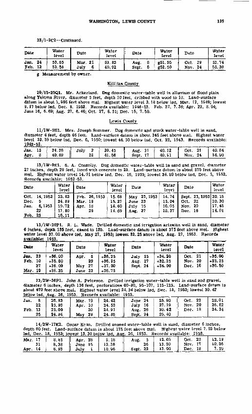
WASHINGTON, LEWIS COUNTY 139
23/1-2C2-- Continued.
Date
Jan. 24 Feb. 12
Water level
53.65 53.58
Date
Mar. 21 July 6
Water level
51.83 49.92
Date
Aug. 8 Sept. 6
Water level
g51.55 g52.50
Date
Oct. 29 Nov. 24
Water level
52.74 53.38
g Measurement by owner.
Kittitas County
20/15-25Q1. Mr. Ackerlund. Dug domestic water-table well in alluvium of flood plain along Yakima River, diameter 5 feet, depth 10 feet, cribbed with wood to 10. Land-surface datum is about 1, 905 feet above msl. Highest water level 3.18 below Isd, Mar. 12, 1949; lowest 9.17 below Isd, Dec. 8. 1952. Records available: 1S46-5.3. Feb. 27, 7. 36; Apr. 22, 8.04; June 16, 6.69; Aug. 27, 6.46; Oct. 27, 8.51; Dec. 15, 7.50.
Lewis County
11/1W-5H1. Mrs. Joseph Sommer. Dug domestic and stock water-table well in sand, diameter 4 feet, depth 46 feet. Land-surface datum is about 345 feet above msi. Highest water level 32. 59 below Isd, Dec. 6, 1950; lowest 44. 50 below Isd, Oct. 22, 1943. Records available: 1942-53.Jan. 15 Apr. 8
34.38 | July 2 40. 89 | 28
39.45 41.56
Aug. 31 Sept. 17
40.12 40. SI
Oct. 21 Nov. 24
40.84 34.90
13/1W-9E1. S. A. Connolly. Dug domestic water-table well in sand and gravel, diameter 27 inches, depth 29 feet, lined with concrete to 29. Land-surface datum is about 575 feet above msl. Highest water level 14. 01 below Isd, Dec. 16, 1953; lowest 24. 89 below Isd, Dec. 5, 1952. Records available: 1952-53.
Date
Oct. 14, 1952 Dec. 5 Jau. 8, 1953
22 Feb. 23
Water level
23.62 24.89 19.72 17.80 16.11
Date
Feb. 26,1953 Mar. 19 Apr. 18
29
Water level
15.68 15.27 14.60 14.69
Date
May 27,1953 June 23 July 15 Aug. 27
Water level14.74 15.04 16.05 18.37
Date
Sept. 23,1953 Oct. 22 Nov. 20 Dec. 16
Waterlevel
20.18 20.30 17.48 14.01
13/1W-28P1. R. L. Wade. Drilled domestic and irrigation artesian well in sand, diameter 6 inches, depth 135 feet, cased to 135. Land-surface datum is about 375 feet above msl. Highest water level 37.00 above Isd, May 27, 1953; lowest 32.25 above Isd, Aug. 27, 1953. Records available: 1953.
Date
Jan. 23 Feb. 10
27 Mar. 19
Water level
+36. 00 +35. 50 +36. 00 +36.25
Dats
Apr. 8 29
May 27 June 23
Water level
+36.25 +36.25 +37.00 +36.75
Date
July 15 Aug. 27 Sept. 24
Water level
+34.20 +32.25 +34. 00
Date
Oct. 21Nov. 20 Dec. 16
Water level
+35.00 +35.25 +36.50
13/2W-36P1. John A. Peterson. Drilled irrigation water-table well in sand and gravel, diameter 6 inches, depth 136 feet, perforations 60-80, 95-107, 115-123. Land-surface datum is about 470 feet above msl. Highest water level 24. 34 below Isd, Dec. 18, 1953; lowest 30. 42 below Isd, Aug. 26, 1953. Records available: 1953.Jan. 8
22Feb. 13
25
26.83 I! Mar. 1925.93 Apr. 1025.00 3024.86 1 May 29
24.42 I! June 2424.53 July 1624.91 Aug. 2624.88 1 Sept. 24
25.9027.1930.4229.40
Oct. 23Nov. 20Dec. 18
28.0126.6224.34
14/2W-17K2. Oscar Keto. Drilled unused water-table well in sand, diameter 6 inches, depth 80 feet. Land-surface datum is about 175 feet above msl. Highest water level 7. 59 below Isd, Dec. 18, 1953; lowest 13. 30 below Isd. Aug. 26. 1953. Records available: 1953.Mar. 17
31Apr. 14
8.858.388.93
Apr. 28June 1 5July 1
S. 1810.3610.96
Aug. 526
Sept. 22
12.69 Oct. 2313.30 Nov. 1713.00 1 Dec. 18
12.1910.367.59
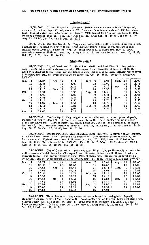
140 WATER LEVELS AND ARTESIAN PRESSURES, 1953, NORTHWESTERN STATES
Lincoln County
21/38-24G2. Clifford Daweritz. Sprague. Driven unused water-table well in gravel, diameter 1^ inches, depth 22 feet, cased to 22. Land-surface datum is about 1, 890 feet above msl. Highest water level 5. 55 below Isd, Apr. 7, 1950; lowest 19. 07 below Isd, Nov. 2, 1947. Records available: 1946-53. Feb. 16, 7. 48; Feb. 21, 8. 45; Apr. 25, 10. 75; June 19, 13.49; Aug. 23, 15. 92; Oct. 23, 15. 84; Dec. 16, 16.57.
25/37-14M1. Charles Straub, Sr. Dug unused water-table well in basalt, diameter 4 feet, depth 27 feet, cribbed with brick to 27. Land-surface datum is about 2, 400 feet above msl. Highest water level 2. 90 below Isd, Apr. 16, 1952; lowest 22. 91 below Isd, Nov. 1, 1947. Records available: 1941-53. Feb. 21, 12. 36; Apr. 22, 12.14; June 16, 12. 51; Aug. 26, 12.89; Oct. 26, 13.68; Dec. 18, 14.22.
Okanogan County
34/26-26Q1. City of Omak well 1. First Ave. North, and East First St. Dug public- supply water-table well in stream gravel of Okanogan River, diameter 12 feet, depth 30 feet, lined with concrete to 30. Land-surface datum is about 850 feet above msl. Highest water level 5.10 below Isd, May 16, 1949; lowest 20. 59 below Isd, Oct. 28, 1648. Records available: 1939-53.Jan. 4
111825
Feb. 18
15Mar. 8
152229
Apr. 5
14.2514.3114.1514.1513.9413.9913.8514.1914.2114.1714.1114.08
Apr. 121926
May 310172431
June 7142128
14.1114.0813.3212.3810.206.859.879. 779.528.318.078.16
July 6121928
Aug. 29
162330
Sept. 613
8.9710.9012.1612.9013.5013.4513.5713.7513.7813.8313.88
Sept. 2027
Oct. 4111825
Nov. 18152229
13.9013.8513.5513.6013.7013.6313.5013.5313.5513.6013.58
34/26-28A1. Charles Byrd. Dug irrigation water-table well in terrace gravel deposit, diameter 36 inches, depth 43 feet, lined with concrete to 43. Land-surface'datum is about 1, 300 feet above msl. Highest water level 28. 86 below Isd, June 26, 1950; lowest 33. 38 below Isd, May 9, 1940. Records available: 1939-53. Feb. 26, 32. 20; May 1, 32. 72; June 21, 31-28; Aug. 26, 31.90; Oct. 26, 32. 85; Dec. 19, 32.70.
34/26-28P1. Samuel Peterson. Dug irrigation water-table well in terrace gravel deposit, size 4 by 4 feet, depth 21 feet, cribbed with wood to 21. Land-surface datum is about 1, 270 feet above msl. Highest water level 9. 51 below Isd, Aug. 20, 1951; lowest 17.15 below Isd, Dec. 30, 1940. Records available: 1939-53. Feb. 26, 14. 07; May 1, 13. 51; June 21, 12.93; Aug. 26, 11. 88; Oct. 26, 13.06; Dec. 19, 13.93.
34/26-35R1. City of Omak well 4. South end East 4th St. Dug public-supply water-table well in coarse alluvial deposit of Okanogan River, diameter 14 feet, depth 37 feet, lined with concrete to 37. Land-surface datum is about 350 feet above msl. Highest water level 17. 95 below Lsd, June 16, 1S48: lowest 28. 28 below Isd. Sept. 27, 1947. Records available: 1944-53.Jan. 4
111825
Feb. 18
1622
Mar. 18
15
27.7127.6927.6527.6627.5527.5027.5227.5627.5827.6027.62
Mar. 2229
Apr. 5121926
May 310172431
27.6427.6227.7227.7427.7727.7227.4826.9226.4026.2126.42
June 7142128
July 6121927
Aug. 29
16
26.0525.6225.1225.0825.1225.1825.2226.3026.6026.9227.03
Aug. 2330
Sept. 6132027
Oct. 4111825
27.0527.2027.3227.5827.6027.6227.6527.6627.6527.62
36/26-13K1. Victor Lesamiz. Dug unused water-table well in fluvioglacial deposit, diameter 6 inches, depth 49 feet, cased to 49. Land-surface datum is about 1, 050 feet above msl. Highest water level 0.15 above Isd, Mar. 11, 1949; lowest 35. 30 below Isd, Aug. 14, 1942. Records available: 1S42-53. Feb. 26, 21. 59; May 1, 21. 44; June 21, 21, 33; Aug. 26, 21.24; Oct. 26, 21. 08; Dec. 19, 20.72.
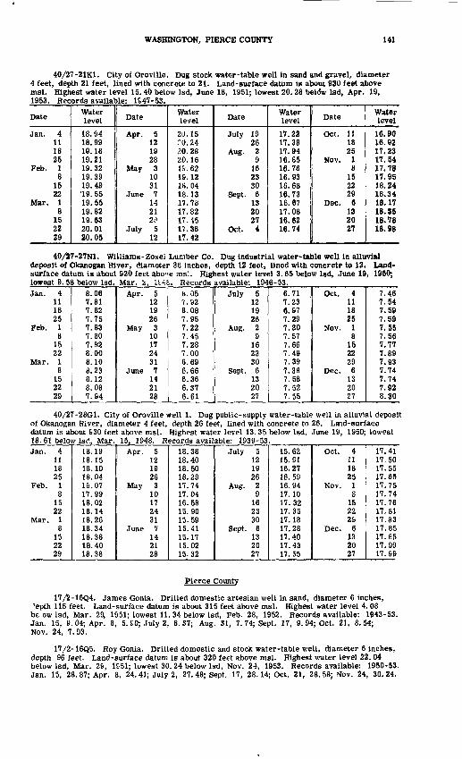
WASHINGTON, PIERCE COUNTY 141
40/27-21K1. Ctty of Oroville. Dug stock water-table well in sand and gravel, diameter 4 feet, depth 21 feet, lined with concrete to 21. Land-surface datum is about 930 feet above msl. Highest water level 15.40 below Isd, June 18, 1951; lowest 20.28 beldw Isd, Apr. 19, 1953. Records available: 1S47-53.
Date
Jan. 4111825
Feb. 18
1522
Mar. 18
152229
Water level
18.9418.9919.1819.2119.3219.3919.4919. 5519.5519.8219.6320.0120.05
Date
Apr. 5121928
May 31031
June 7142128
July 512
Waterlevel
20.1520.2420.2820.161&. 6219.1218.0418.1317.7817.8217.4517.3817.42
Date
July 1926
Aug. 29
162330
Sept. 6132027
Oct. 4
Water level
17.2217.3817.9416.6516.7616.9316.6816.7316.6717.0816.6216.74
Date
Oct. 111825
Nov. 18
152229
Dec. 6132027
Water level
16.9016.9217.2317.5417.7817.9518.2418.3418.1718.3518.7818.98
40/27-27N1. Williams-Zosei Lumber Co. Dug industrial water-table well in alluvial deposit of Okanogan River, diameter 36 inches, depth 12 feet, lined with concrete to 12. Land- surface datum is about 920 feet abo"e ms5. Highest water level 3.65 below Isd, June 19, 1950; lowest 9. 58 below Isd, Mar. 2, H4£. Records available: 1946-53.Jan. 4
111825
Feb. 181522
Mar. 18
152229
8.067.817.827.757.837.807.928.008.108.238.128.087.94
Apr. 5121926
May 310172431
June 7142128
b. 057.928.087.957.227.457.287.006.696.666.366.376.61
July 5121926
Aug. 29
162330
Sept. 6132027
6.717.236.977.297.307.577.667.497.397.387.587.527.55
Oct. 4111825
Nov. 18152229
Dec. 6132027
7.467.547.597.597.557.567.777.897.937.747.747.928.30
40/27-28G1. City of Oroville well 1. Dug public-supply water-table well in alluvial deposit of Okanogan River, diameter 4 feet, depth 26 feet, lined with concrete to 26. Laid-surface datum is about 630 feet above msl. Highest water level 13. 35 below Isd, June 19, 1950; lowest 18. 61 below Isd, Mar. 15, 1948. Records available: 1939-53.Jan. 4
111825
Feb. 18
1522
Mar. 18
152229
18.1918.1518.1018.0418.0717.9918.0218.1418.2618.3418.3818.4018.38
Apr. 5121926
May 310172431
June 7142128
18.3818.4018.5018.2917.7417.0416.5815.9015.5915.4115.1715.0215.32
July 5121926
Aug. 29162330
Sept. 6132027
15.6215.9116.2716.5916.9417.1017.3217.3517.1817.2817.4017.4317.55
Oct. 4111825
Nov. 18
152229
Dec. 6132027
17.4117.5017.5517.6517.7517.7417.7617,8117.8317.8517.8517.9917.99
Pierce County
17/2-16Q4. James Gonia. Drilled domestic artesian well in sand, diameter 6 inches, Jepth 115 feet. Land-surface datum is about 315 feet above msl. Highest water level 4.08 be ow Isd, Mar. 2$ 1951; lowest 11. 34 below Isd, Feb. 28, 1952. Records available: 1943-53. Jan. 15, 9. 04; Apr. 8, 5. £0; July 2, 8. 37; Aug. 31, 7. 74; Sept. 17, 9. 94; Oct. 21, 8. 54; Nov. 24, 7.93.
17/2-16Q5. Roy Gonia. Drilled domestic and stock water-table well, diameter 6 inches, depth 96 feet. Land-surface datum is about 320 feet above msl. Highest water level 22. 04 below Isd, Mar. 2S, 1&51; lowest 30. 24 below Isd, Nov. 24, 1953. Records available: 1950-53. Jan. 15, 28. 87; Apr. 8, 24. 41; July 2, 27. 48; Sept. 17, 28.14; Oct. 21, 28.58; Nov. 24, 30.24.

142 WATER LEVELS AND ARTESIAN PRESSURES, 1953, NORTHWESTERN STATES
18/2-34N1. Frank Betchard. Roy. Dug domestic water-table well in sand and gravel, diameter 36 inches, depth 15 feet, lined with concrete to 15. Land-surface datum is about 310 feet above msl. Highest water level 3. 38 below Isd, Dec. 6, 1950; lowest 12. 47 below Isd,
"-- ' - ' 1945-53.
Date
Jan. 15 Apr. 8
Water level
10.51 5.57
Date
July 2 28
Water level6.46 7.19
Date
A«*5?«-J* Sepfci.-.^S
Water level
, T. 95 . '}<vHM3.
Date
Oct. 21- Nov. 24
Water level10.06 7.98
19/2-10F1. Lakewoort Water District. Gravelly Lake fjoad and Lake City Road. Drilled unused water-table well in gravel, diameter 12 inches, depth 174 feet. Land-surface datum is 262. 64 feet above msl. Recor's available: 1940-53. No measurement made in 1953.
19/3-3Q1. D.Stuart. Lakcview-Puyallup Highway and Portland Ave. Dug unused water- table well in gravel, diameter 4 feet, depth 158 feet, lined with concrete to 158 feet. Land- surface datum is about 408 feet above msl. Highest water level 146.18 below Isd, June 13, 1951; lowest 156. 80 below Isd, Dec. 29, 1944. Records available: 1940-53. Jan. 5, 154. 80; Mar. 25, 153. 93; May 12, 152. 42; June 30, 152. 71; Aug. 17, 153.10; Oct. 30, 154.65.
19/4-7A1. Ada Lilja. Lakeview-Puyallup Highway and Woodland Rd. Dug unused water- table well in cemented gravel, diameter 4 feet, depth 37 feet. Land-surface datum ia about 423 feet above msl. Highest water level 13.30 below Isd, Mar. 19, 1951; lowest 36.90 below
1940-53.
Jan. 6121926
Feb. 29
1824
Mar. 29162430
36.2034.0630.1324.1616.8115.6918.0518.7019.3820.0821.1621.5621.55
Apr. 6132028
May 4111826
June 18
152224
^20.7721.1421.8222.0222.3623.1223.5824.5725.2425.6226.4427.3028.02
July 6142027
Aug. 310182431
Sept. 7142228
28.8029.7830.5631.3631.9832.5832.9233.1533.4534.0234.2334.4634.57
Oct. 5121926
Nov. 210162330
Dec. 7142228
34.4034.5534.6734.8234.6234.7034.6433.9727.9024.7017.9315.6816.58
20/2-13H1. City of Tacoma well 4-A. South 38th St. and South Tacoma Way. Drilled public-supply water-table well in sand and gravel, diameter 38 to 26 inches, depth 204 feet. Land-surface datum is 244. 80 feet above msl. Highest water level 10. 58 below Isd, Feb. 8, 1938; lowest 19. 46 below Isd, Feb. 26, 1953. Records available: 1930, 1932, 1934-53.
Jan. 27
Feb. 26
17.5917 4419.46
Apr. 1May 8June 2
18.0117.5218.24
June 24Aug. 10Sept. 3
17.6718. &819.08
Sept. 10Oct. 10
18.3418.27
20/2-13J1. City of Tacoma well 6-A. South 45th St. (extended) and South Tacoma Way. Drilled public-supply water-table well in gravel, diameter 38 to 26 inches, depth 179 feet. Land- surface datum is 266. 39 feet above msl. Highest water level 31.28 below Isd, Apr. 10, 1950; lowest 40. 69 below Isd, Feb. 25, 1£53. Records available: 1939-53. Measurements furnished by City Water Department.Jan. 2
3Feb. 25
38.1837.9540.69
Apr. 1May 8June 2
38.3437.8939.23
June 25Aug. 10Sept. 3
as. oo40.3739.96
Oct. 10Nov. 12Dec. 28
39.7438.96
d43. 54d Nearby well pumped recently.
20/3-1SC1. City of Tacoma T-10. Drilled observation water-table well in sand and gravel, diameter 12 inches, depth 185 feet, cased to 185, perforations 152-175. Land-surface datum is 321. f4 feet above msl. Highest water level 89.16 below Isd, June 9, 1952; lowest 95. 54 below 1st1 , Feb. 18, 1953. Records available: 1952-53. Measurements furnished by City Water Department.
Daily mean water level from recorder graph, 1952Dav
1 2 3 4 5
Jan. Feb. Mar. Apr.89.77 89.80 89.93 89.34 89.78
May June
89.36 89.38 89.31
July89.63 89.60 89.50 89.55 89.63
Aug. Sept.91.86 91.76 91.71 91.82 91.84
Oct.91.96 91.94 92.02 91.99 91.94
Nov.S2.07 92.00 91.97
Dec.91.88 92.08 92.10
92.04

WASHINGTON, PIERCE COUNTY 143
20/3-18Cl--Continued.
Day
6 7 8 9
101112 13141516 17 18 192021 222324 2526 27 28 293031
Jan. Feb. Mar.
90.1090.11 89.9689.79 89.83 89.8989.86 89.63 89.75 89.7189.7690.04
Apr.
(.. .86 fa^.65 89.77 89.87 89.7989.8789.80 89.80 89.9990.0289.62 89.86 89.82 90.0290.0189.92 89.9989.90 89.91 89.9389.93 89.85 90.00 89.8289.95
May
89.45 89.66 89.50 89.4889.5989.56 89.82 89.6889.6689.57 89.58 89.66 89.5489.5889.71 89.6989.64 89.62 89.6789.66
June
89.36 89.39 89.33
89.3689.42 89.39 89.4189.59
89.3689.3989.41 89.3989.38 89.46 89.4789.43 89.41 89.49 89.5789.62
July
89.62 89.57 89.54 89.54 89.5889.6989.81 89.83 89.78
89. £6
90.27 90.2690.22 90.30 90.3490.3290.02 90.44 90.4090.4290.47
Aug.
91.8691.78 91.81 90.8491.8491.83 91.82 91.87 91.8391.7891.81
91.82 91.80 91.88
91.8691.86
Sept.
91.85 91.82 91.73 91.81 91.7791.7991.85 91.87 91.7591.7491.82 91.80 91.80 91.7991.7691.79 91.77
91.88 91.94 91.89 92.0192.04
Oct.
91.91
92.05 92.09 62.1292.1092.07 92.07 92.2592.0092.09 92.07 92.07 92.0492.02
92.0192.02 92.10 91.9892.02 92.03 91.99 91.6792.0392.04
Nov.
91.98 92.00 91.99 91.94 91.9491.9691.86 91.79 91.8692.0792.11 92.12 92.06 91.9992.0392.03 92.0191.94 91.93 91.9791.96 91.95
91.9251.80
Dec.
91.85 92.04
92.13
92.2092.2192.27 92.20 92.17 92.2792.2392.27 92.3492.22 92.18 92.1892.08 92.14 92.10 92.0392.2292.18
Daily mean water level from recorder graph, 1953
Day1 2 3 4 56 7 8 9
1011 12 13 14 1516 17 18 19 2021 22 23 24 2526 27 28 29 30 31
Jan.92.28 92.18 92.27 92.03 91.9191.82 91.89 92.04
92.88 93.1192.96
d94. 78
c96. 82 c97. 09c97. 57
d95. 48
c97.28
Feb.C98.09 c98. 19 d98.49
d96.41 c96. 32 C98.63 c!68.13 d98. 01d98.01 d95.68 d95. 56 95.38 95.4785.38 S5.34 95.49 95.38 95.2895.18 95.15 95.07 95.02 95.0494.94 94.85 94.78
Mar.
94.66 94.76 94.00 94.4194. 45 94.60 94.35 94.26 94.3894.53 94.55
94.38 94.5194.37 94.49 94.35 95.31 95.23
Apr.94.24
94.15 94.1394.1294.03 S3.S8 94.09 64. 14 94.0994.07 93.94 S3. 96 94.17 63.9793.82 94.00 93.98 93.94 93.9793.92 93.87 94.03 93.91 93.8393.72 93.74 93.91
May
93.6993.68 93.79 93.92 93.97 93.9693.86 93.71 93.74 93.80 93.7793.82 93.82 93.67
93.82 93.86 93.68 93.82 93.8693.78 93.87
93.94 93.95
June
93.92 93.8393.78 63.88 93.95 93.97
93.93 S3. 96 94.03 93.93 93.9093.92 93.92 93.88 93.89 93.9693.95
93.92
July93.93 93.88 93.92 93.92 93.9393.81 93.84 93.94 93.93 93.9693.93 93.88 93.91 93.96 94.0894.00 93.92 94.02
93.97 64.04 94.03 93.98 94.0894.11 94.14 94.08 94.12 94.18
Aug.94.16 94.17 94.25 94.31 94.3094.32 94.41 94.40 94.43 94.4194.35 94.43 94.46 94.44 94.5094.54 94.55 94.57 94.54 94.6194.66 94.64 94.59 94.59 94.6094.68 94.72 94.68
Sept.
64.77 94.67 94.63 94.6794.69 94.76 94.75 94.70 94.6394.62 94.74 94.72 94.62 94.6494.60 94.74 94.72
94! 5794.57 94.70 94.77 94.66 94.6394.58 94.51 64.68 94.57 94.58
Oct.94.74 94.80 94.63 94.57 64.5094.60 94.53 94.59 64. 49 94.6294.63 84. 52 64.58 94.58 94.5794.58 94.43 94.58 94.69 94.6994.73 94.52 94.40 94.52 94.5794.52 94.44 94.44 94.52 64.47
Nov.94.51 64.58 94.47 94.36 94.3694.62 94.64 94.52 64.56 94.4494.47 94.47 94.37 94.43 94.6294.46 64.60 94.50 94.37 94.3694.23 94.26 S4. 48 94.52 64.4294.26 94.39 94.42 94.32
Dec.64.33 64.23 54.07 64.26 64.19E4.23 94.38 94.43
- rt^artr well being Bumped, d Nearby well pumped recently.
20/3-18D1. City of Tacoma well 2-A. South 35th-aB£iawrence Sts. Drilled public - supply well in sane and gravel, diameter 3fl to 26 inches; depth 161 feet. Land-surface datum is 244.01 feet above msl. Highest water level If .62 below Isd, Feb. 8, 1938; lowest 35. 98 below Isd, Jan. 31, 1947. Records available: 1930, 1934, 1937-53. Measurements furnished by City Water Department.

144 WATER LEVELS AND ARTESIAN PRESSURES, 1953, NORTHWESTERN STATE
20/3-18Dl--Continued.
Date
Jan. 2 7
Feb. 25 Apr. 1
Water level
31.38 30.98 31.05 30.60
Date
May 8 June 2
18
Water level
30.44 31.91
c34. 13
Date
June 25 Aug. 10 Sept. 3
Water level
32.41 32.73 32.72
Date
Sept. 10 Nov. 10 Dec. 28
Water level
32.71 31.33 29.27
c Nearby well being pumped.
20/3-19P1. City of Tacoma well 1-A. South 64th St. and Clement Ave. Drilled public - supply water-table well in sand and gravel, diameter 38 to 26 inches, depth 305 feet. Land- surface datum is 260. 99 feet above msl. Highest water level 25.00 below Isd, Aug. 7, 1937; lowest 34. 81 below Isd, July 30, 1941. Records available: 1930, 1932, 1934-53. Measurements furnished by City Water Department.Jan. 2
7Feb. 26
33.5633.2732.26
Apr. 1May 8June 2
32.8732.7733.49
June 24Aug. 10Sept. 3
33.3033.8733.99
Oct. 10Nov. 10Dec. 28
33.9833.5633.04
20/3-19P4. City of Tacoma well 11. South 62d St. and Clement Ave. Drilled observation water-table well in sand and gravel, diameter 14 to 12 inches, depth 240 feet. Land-surface datum is 263. 98 feet above msl. Highest water level 30. 65 below Isd, Feb. 8, 1938; lowest 36. 76 below Isd, Sept. 3, 1953. Records available: 1908-09, 1925-31, 1937-40, 1945-53. Measurements furnished by City Water Department.Jan. 2Feb. 26Apr. 1
36.3334.9735.64
June 24Aug. 10
36.1136.67
Sept. 310
36.7636.75
Nov. 10Dec. 28
36.3535.87
2Q/3-30C2. City of Tacoma well 5. South 64th St. and Clement Ave. Drilled observation water-table well in sand and gravel, diameter 12 to 10 inches, depth 244 feet. Land-surface datum is 267.38 feet above msl. Highest water level 33. 72 below Isd, Mar. 31, 1938; lowest 41. 22 below Isd, Oct. 31, 1949. Records available: 1908-09, 1925-31, 1937-53. Measurements furnished by City Water Department.Jan. 2Feb, 26Mar. 2Apr, 1May 4
39.5338.5538.5338.8238.68
June 12429
July 31Aug. 10
39.6539.6339.2439.8839.85
Sept. 13
10Oct. 29
39.9639.9539.9239.98
Nov. 10Dec. 1
2830
38.5538.97
d39. 04d39. 80
d Nearby well pumped recently.
20/3-30C4. City of Tacoma well 8-A. South 66th and Clement Ave. Drilled public-supply water-table well in gravel, diameter 38 to 26 inches, depth 307 feet. Land-surface datum is 267. 80 feet above msl. Highest water level 33. 50 below Isd, Mar. 31, 1947; lowest 40. 94 below Isd, June 27, 1&52. Records available: 1939-53. Measurements furnished by City Water Department.Jan. 8
6Feb. 26
39. 27 Apr. 139. 13 May 838.21 26
38.5238.5338.30
June 24Aug. 10Sept. 3
39.1539.7039.83
Sept. 10Nov. 10Dec. 28
39.8039.3138.77
20/3-30L5. City of Tacoma well 7-A. South 74th St. and Clement Ave. Drilled public- supply water-table well in gravel, diameter 38 to 26 inches, depth 307 feet. Land-surface datum is 255. 68 feet above msl. Highest water level 18. 85 below Isd, Mar. S, 1951; lowest 27. 41 below Isd, Nov. 3, 1942. Records available: 1939-53. Measurements furnished by City Water Department.Jan. 2
3Feb. 26
23.4623.3422.03
Apr. 1May 7'26
22.5522.6423.17
June 24Aug. 10Sept. 3
23.2523.6723.78
Sept. 10Nov. 10Dec. 28
23.6523.40'22. 42
20/3-30N1. City of Tacoma well 3-A. South 78th St. (extended) and South Warner St. Drilled public-supply water-table well in gravel, diameter 38 to 26 inches, depth 313 feet. Land- surface datum is 271. 63 feet above msl. Highest water level 38. 00 below Isd, Apr. 24, 1935; lowest 43.10 below Isd, Nov. 22, 1932. Records available: 1931-53. Measurements furnished by City Water Department.Jan. 2
6Feb. 26
41.16 Mar. 3140. 09 May 741. 16 June 2
39.7140.0440.61
June 24Aug. 10Sept. 3
40.2540.9640.16
Oct. 9Nov. 10Dec. 28
40.0640.9739.65

WASHINGTON, PIERCE COUNTY 145
20/3-35G1. L. S. Broxson. East 84th St. and Waller Rd. Dug domestic water-table well in sand and gravel below Vashon till, diameter 27 inches, depth 185 feet, lined with concrete to 185. Land-surface datum is about 428 feet above msl. Highest water level 178. 57 below Isd, Mar. 18, 1951; lowest 182.27 below Isd. Mar. 18, 1S45. Records available: 1940-53.
Date
Jan. 4111821
Feb. 18
1522
Mar. 18
152429
Water level
181.10181.13181.20181.21181.26181.30181.33181.22181.34181.36181.35181.37181.30
Date
Apr. 512IS26
May 312172431
June 7142228
Waterlevel
181.30181.19181.15181.10181.10181.05180. 98180.98180.95180.90180.86180.78180. £0
Date
July 5121926
Aug. 29
162330
Sept. 7132027
Water level
180.78180.75180.83180. 83180.80180. 83180.85180.85180.90180.95180.97181.00181.03
Dite
Oct. 4111825
Nov. 18
152230
Dec. 6132027
Water level
181.08181.10181.12181.17181.17181.17181.27181.33181.33181.30181.41181.41181.50
20/4-36H2. Frank Chervenka. Pioneer Way and Sumner-Orting Rd. Drilled irrigation water-table well, diameter 6 inches, depth 77 feet. Land-surface datum is about 82 feet above msl. Highest water level 3.73 below Isd, Dec. 8, 1950; lowest 8.79 below Isd, Oct. 13, 1939. Records available: 1938-53. Jan. 5, 7.82; Mar. 25, 6.22; May 12, 6.43; June 30, 6.71; Sept. 16, 8.04; Oct. 30, 7.91; Nov. 23, 6.73.
American Lake. Staff gage installed Oct. 10, 1951 at west end of U. S. Army boathouse on south end of lake in NEjNEi sec. 30, T. 19 N., R. 2 E. Highest water level 236. 85 above msl, Mar. 26, 1951; lowest 228. 00 above msl, Sept. 27, 1944. Records available: 1938, 1940-53.
Lake stages in feet above msl
Date
Mar. 2, 1949Sept. 7Dec. 27Apr. 19,1950June 30Dec. 8Mar. 26,1951Apr. 13
24June 13July 10Aug. 17Sept. 10
24Oct. 10
2231
Nov. 6142028
Dec. 61926
Jan. 2, 19528
162330
Feb. 71219
Water level
233.94231.15231.50235.26233.77232.69236.85236.32236. 00234. 48233.51232.31231.79231.37231.48231.44231.40231.38231.46231.42231.43231.62231.70231.74231.80231.83231.89232. 00232. 10232.35232.46232. 53
Date
Feb. 26,1952Mar. 4
121825
Apr. 18
1623
May 5132027
June 31030
July 916222329
Aug. 56
121926
Sept. 238
162329
Water level
232.64232.66232.73232.76232.80232.79232.78232.74232. 66232.60232.50232.40232.27232.11231.62231.63231.42231.24231.06231.04230.92230.74230. 12230. 58230. 40230.27230.11230.09229. 99229.81229. 68229. 52
Date
Oct. 7, 1952132228
Nov. 3101724
Dec. 15
222S
Jan. 5, 1953141926
Fpb. 29
1624
Mar. 211162330
Apr. 6132021
May 41118
Water level
229.42229.32229.20229.11229.04228.83228.87228.77228. 67228.72228.78228.73228.81229, 11229.35229.62230.09230. 50230.70230.82230. 89230. 96231.05231.10231.19231.22231.24231.22231.23231.25231.21231.13
Date
May 25,195328
June 19
1529
July 613202128
Aug. 3101731
Sept. 18
1425
Oct. 111928
Nov. 29
1623
Dec. 18
142130
Water level
231.24231.20231.13231.12231.08230.95230. 87230.74230.62230. 59230.45230.30230.21230.05229. 92229.82229.70229.66229.38229.46229.44229.22229.44229. 51229. 57229. 67229.24230.00230.37230. 66230. 88

146 WATER LEVELS AND ARTESIAN PRESSURES, 1953, NORTHWESTERN STATES
Skagit County
34/4-18D1. Michael Fortin. Jetted irrigation water-table well in sand and gravel, diameter 6 inches, depth 33 feet, cased to 33, perforations 25 to 33. Land-surface datum is 26. 92 feet above msl. Highest water level 8. 50 below Isd, June 27, 1950; lowest 17.23 below Isd, Nov. 7, 1952. Records available: 1949-53.
Date
Sept. 27, 1949Oct. 17
1819
Nov. 18Apr. 20,1950June 27
Water level14.7414.3314.3714.4213.5910.908.50
Date
Sept. 18,1950Dec. 7Mar. 27,1951June 14Aug. 16Oct. 12Feb. 29,1952
Water level14.3111.3411.7311.8814.8515.4614.62
Date
Apr. 30, 1952July 1Aug. 28Nov. 7Jan. 8, 1953Mar. 26
Waterlevel14.1712.9415.6517.2314.9013.42
Date
June 11,1953July 29Aug. 28Sept. 16Oct. 20Nov. 30
Water level12.3911.8013.9215.3014.4112.31
Snohomish County
27/4-30A2. Don Schaffer. State Highway No. 1 and 212th St. South Everett. Drilled unused water-table well in Pleistocene sand (pre-Vashon), diameter 5 inches, depth 180 feet. Land-surface datum is about 410 feet above msl. Highest water level 133. 84 below Isd, Aug. 16, 1951; lowest 144. 20 below Isd, May 18, 1945. Records available: 1945-53. Jan. 8, 135. 73; Mar. 26, 136. 14; June 11, 136. 28; July 29, 136. 35; Aug. 28, 136. 42; Oct. 20, 136. 86; Nov. 30, 136. 89.
28/4-13H1. Oscar Eberhard. Beverly Park. Mukilteo Rd. and State Highway No. 1. Dug domestic water-table well in sand and gravel interbedded in Vashon till, diameter 40 inches, depth 22 feet, lined with concrete to 22. Land-surface datum is about 530 feet above msl. Highest water level 3.11 below Isd, Feb. 27, 1946; lowest 10. 61 below Isd, Nov. 7, 1952. Records available: 1945-53.
Date
Jan. 8 Mar. 26
Waterlevel6.23 5.58
Date
June 11 July 29
Water level5.82 7.51
Date
Aug. 28 Sept. 16
Water level8.14 8.62
Date
Oct. 20 Nov. 30
Water level6.90 3.93
29/5-2F1. L. Falkner. Dug domestic water-table well in Pleistocene gravel (pre-Vashon), diameter 6 feet, depth 115 feet, lined with concrete to 115. Land-surface datum is about 275 feet above msl. Highest water level 109. 54 below Isd, May 6, 1948; lowest 112. 50 below Isd, Aug. 15, 1944. Records available: 1944-53.Jan. 8 Mar. 26
112111
12 67 I june
July11 29
111.30 111.43
1 Aug. | Sept.
28 16
111.39 111.67
1 Oct. | Nov.
20 30
112.07 111.79
30/5-22A1. G. Torie. Dug domestic water-table well in Vashon outwash sand and gravel, diameter 36 inches, depth 42 feet, lined with concrete to 42. Land-surface datum is about 75 feet above msl. Highest water level 15.18 below Isd, Mar. 27, 1951; lowest 25. 98 below Isd, Jan. 8. 1953. Records available: 1944-53.Jan. Mar.
8 26
25.98 20.00
| June1 July
1129
20.08 a21.77
1 Aug. ] Sept.
28 16
22.36 22.84 I Oct.
Nov.20 30
23.37 22.62
a Pumping.
31/5-10J3. J. W. Monigar. Drilled domestic water-table well in Pleistocene sand (pre-Vashon), diameter 6 inches, depth 120 feet. Land-surface datum is about 75 feet above msl. Highest water level 21. 85 below Isd, May 6, 1948; lowest 30.17 below Isd, Aug. 28, 1953. Records available: 1945-53.Jan. Mar.
8 26
29.95 29.84 I june
July11 29
29.55 29.79
Aug. | Sept.
28 16
30.17 29.38
( Oct. | Nov.
20 30
29.37 28.97
32/4-5Q1. Elmer Norgaard. Drilled unused water-table well in sub-till sand and gravel, diameter 6 inches, depth 149 feet. Land-surface datum is about 235 feet above msl. Highest water level 127. 08 below Isd, Aug. 28, 1953; lowest 133. 93 below Isd, Nov. 18, 1949. Records available: 1946-53. Jan. 8, 127. 20; Aug. 28, 127.08; Sept. 16, 127.24; Oct. 20, 127. 70; Nov. 30, 127.22.

WASHINGTON, PIERCE COUNTY 147
Spokane County
25/42-13B1. Empire Cold Storage Co. Sinto Ave. and Oak St., Spokane. Dug industria water-table well in fluvtoglacial gravel, diameter 41 inches, depth 200 feet, lined with conoret to 200. Land-surface datum is 1, 883.37 feet above msl. Highest water level 179.17 below Isd June 13, 1950; lowest 193.42 below Isd, Nov. 4, 1946. Records available: 1930-53. Pumping at time of measurement. Feb. 18, 185. 39; Apr. 24, 187.11; June 16, 182.24; Aug. 24, 192.21 Oct. 24, ISO. 96; Dec. 18, 190.25.
25/42-14L1. Riverside Park Cemetery Association. Dug irrigation water-table well in fluvioglacial outwash gravel, diameter 6 feet, depth 110 feet, lined with concrete to 82, perfora tions 82-100. Land-surface datum is about 1,787 feet above msl. Highest water level 81.73 below Isd, June 7, 1948; lowest 101.24 below Isd, Sept. 20, 1942. Records available: 1941-53. Measurements furnished by Cemetery Association.
Date
Jan. 269
131619222629
Feb. 57
101316182125
Mar. 37
101417
Water level
97.7997.8497.8997.7697.6397.4396.9596.0695.4694.3894.0093.4292.9792.6992.5992.6692.9093.3093.5583.6793.8994.00
Date
Mar. 2430
Apr. 249
1420242729
May 27
132129
June 25
1617202326
Water level
94.0394.0194.0093.9894.0094.0894.3396.4693.9893.6592.9391.9491.0590.7590.2290.2190.2492.2490.4490.6590.7591.07
Date
June 29July 1
69
1316202529
Aug. 47
1013151922242729
Sept. 25
11
Water level
91.3092.0292.6393.6094.0094.7394.9796.0096.4196.9197.3197.1597.6497.7697.9998.2198.0298.0998.0398.2898.4598.72
Date
Sept. 152128
Oct. 369
162023
Nov. 214182326
Dec. 259
1218212628
Water level
98.7898.5498.3798.1898.1198.1598.0797.9297.8597.7797.8897.9197.8797.8497.7397.6997.5997.5497.2797.1596.9696.89
25/43-1103. City of Spokane well 3. At Up-river pump station. Dug public-supply water-table well in fluvioglacial gravel, diameter 24 to 29 feet, depth 41 feet, lined with concrete to 41. Land-surface datum is I, 902.11 feet above msl. Highest water level 9. 31 below Isd, May 31, 1948; lowest 30.11 below Isd, Sept. 2, 1946. Records available: 1938-53. Measure- ments furnished by City Water Department.Jan. 5
121926
Feb. 29
1623
Mar. 29
162330
27.4426.9124.1420.6820.8319.2820.5323.8324.0724.3524.4423.5323.43
Apr. 6132027
May 4111825
June 18
152229
23.2823.4024.1119.8216.9316.7917.8817.6417.9218.3018.8819.0224.84
July 6132027
Aug. 310172431
Sept. 7142128
26.5326.9227.2827.7628.7127.7328.4728.8728.4228.6727.6227.5327.04
Oct. 5121926
Nov. 29
162330
Dec. 7142128
26.9329.9026.8026.6226.7227.1627.3627.7325.9025.8125.2025.6325.23
25/43-11G6. City of Spokane gage well 1. At Up-river pump station. Dug observation water-table well in fluvioglacial gravel, diameter 30 inches, depth 64 feet, lined with concrete to 64. Highest water level 39. 07 below Isd, Dec. 26, 1933; lowest 60. 87 below Isd, July 9, 1931. Records available: 1926-53. Measurements furnished by City Water Department. Feb. 19, 53. 20; Apr. 24, 53. 50; June 18, 50. 02; Aug. 24, 59. 48; Oct. 24, 57. 71; Dec. 18, 56.22.
25/43-11K1. City of Spokane gage well 2. Mrport St. and Rutter Ave. Dug observation water-table well in fluvioglacial gravel, diameter 36 to 18 inches, depth 70 feet, lined with concrete to 70 t Land-surface datum is 1, 945. 37 feet above msl. Highest water level 51. 53 below Isd, Dec. 27, 1933; Lowest 70. 33 below Isd, Dec. 20, 1930. Records available: 1929-53. Measurements furnished by City Water Department. Feb. 19, 63. 03; Apr. 24, 63. 72; June 18, 60. 55; Oct. 24, 69. 38; Dec. 18, 68.99.

148 WATER LEVELS AND ARTESIAN PRESSURES, 1953, NORTHWESTERN STATES
25/43-14K1. Ohio Match Co. Broadway and Yardley Sts., Spokane. Dug unused water- table well in fluvioglacial gravel, diameter 41 inches, depth 83 feet, lined with concrete to 83. Land-surface datum is 1,927.40 feet above msl. Highest water level 35.17 below Isd, May 25, 1948; lowest 50.67 below Isd, Jan. 28, 1931. Records available: 1920,1928-53. Feb. 19, 42. 82; Apr. 24, 44. 50; June 18, 40. 69; Aug. 24, 48. 91; Dec. 18, 45. 96.'
25/43-17D1. New Method Laundry. Mission Ave. and Pearl St., Spokane. Dug industrial water-table well in fluvioglacial gravel, diameter 30 'nches, depth 63 feet, cribbed with brick to 63. Land-surface datum is 1,909.22 feet above msl. Highest water level 40.42 below led, May 25, 1948; lowest 51.22 below Isd, Feb. 7, 1931. Records available: 1928-53. Feb. 18, 44.17.
25/44-2B1. Trentwood irrigation district. Dug public-supply water-table well in fluvio glacial gravel, diameter 6 feet, depth 127 feet, lined with concrete to 127. Land-surface datum is 2,035. 30 feet above msl. Highest water level 86.05 below Isd, June 13, 1950; lowest 109.73 below Isd, Dec. 23, 1930. Records available: 1928-53. Feb. 19, 95.24, pumping; Apr. 24, 96.80, pumped recently; June 18, 91.07, pumped recently.
25/44-19D1. Edgecllff Sanitarium. U. S. Highway 10 and Park Rd. Dug public-supply water-table well in fluvioglacial gravel, diameter 60 to 29 inches, depth 88 f^et. Land-surface datum is 1,969. 57 feet above msl. Highest water level 67.97 below Isd, June S, 1950; lowest 82.82 below Isd, Dec. 8, 1931. Records available: 1920, 1928-53. Feb. 19, 74.77, pumping; Apr. 24, 76. 71; June 18, 72. 54, pumping.
25/44-23D1. E. E. Gooding. U. S. Highway 10 and Evergreen Rd. Dug irrigation water- table well in fluvioglacial gravel, diameter 48 to 18 inches, depth 97 feet, lined with concrete to 97. Land-surface datum is 2,016. 74 feet above msl. Highest water level 77.85 below Isd, Apr. 8, 1S50; lowest 95.40 below Isd, Dec. 8, 1931. Records available: 1931-53. Feb. 20, 84. 93; Apr. 23, 85. 87; June 17, 81.29; Aug. 24, 88. 82; Oct. 24, 89.27; Dec. 17, 88.85.
25/45-10C1. Mrs. George Clark. Dug unused water-table well in fluvioglacial gravel, diameter 36 inches, depth 67 feet. Land-surface datum is 2, 019. 54 feet above msl. Highest water level 45.12 below Isd, June 29, 1950; lowest 68. 73 below Isd, Sept. 20, 1930. Records available: 1928-53. Feb. 19, 56. 36; Apr. 23, 57. 32; June 17, 52. 08; Aug. 24, 58. 59; Oct. 24, 60.48; Dec. 17, 60.79.
25/45-16C1. Inland Empire Paper Co. Dug domestic and irrigation water-table well in fluvioglacial gravel, diameter 8 feet, depth 129 feet. Land-surface datum is 2, 055. 88 feet above msl. Highest water level 84. 56 below Isd, June 17, 1953; lowest 114. 53 below Isd, Dec. 8, 1931. Records a\ailable: 1920, 1929-53. Feb. 19, 98.82; Apr. 23, 100.06, pumping; June 17, 84.56; Aug. 24, 101.43, Oct. 24, 102. 06; Dec. 17, 103.44.
26/43-7Q1. C. E. Marr. Dug unused water table well in fluvioglacial gravel, diameter 6 feet, depth 87 feet, cribbed with brick to 87. Land-surface datum is about 1, 795 feet above msl. Highest water level 74. 35 below Isd, July 28, 1949; lowest 79. 63 below Isd, Apr. 7, 1948. Records available: 1942-53. Feb. 19, 76. 99; Apr. 24, 77. 24; June 16, 75. 72; Aug. 24, 76.02; Oct. 24, 77.29; Dec. 18, 77.46.
26/43-16D1. Permanente Metals Corp. test well. Drilled observation water-table well in fluvioglacial gravel, diameter 8 inches, depth 247 feet. Land-surface datum is about 1, 937 feet above msl. Highest water level 155. 40 below Isd, May 19, 1948; lowest 163. 02 below Isd, Nov. 11, 1953. Records available: 1943-53. Nearby well pumping at time of measurement.
Date
Feb. 4111825
Mar. 4111825
Apr. 18
1522
Water level
161.77161.88162.01161.09161.09161.09161.11161.91161.73161.07161.07161.11
Date
Apr. 29May 6
132027
June 3101725
July 18
15
Water level
161.83161.08161.74161.09161.64161.64161.06161.85161.76161.78161.76161.80
Date
July 2229
Aug. 5121926
Sept. 29
162330
Oct. 7
Water level
161.71161.81161.38161.15161.09162.16162.23162.07162. 09162.42162.05162.08
Date
Oct. 142128
Nov. 4111825
Dec. 29
162330
Water level
162. 50162. 11162.39162.93163.02162.84162. 56162.53162.75162. 58162. 59162.58
26/43-19A1. Country Homes Estates. Holland and Ivanhoe Rds. Dug public-supply and irrigation water-table well in fluvioglacial gravel, diameter 65 feet, depth 161 feet, lined with concrete to 161. Land-surface datum is 1, 935. 91 feet above msl. Highest water level 133. 72 below Isd, Mar. 15, 1934; lowest 138. 50 below Isd, Jan. 29, 1931. Records available: 1930-53. Feb. 19, 137.11, pumping; Apr. 24, 135. 97; June 16, 137.37, pumping; Aug. 24, 137.90, pumping; Oct. 24, 139.77, pumping; Dec. 18, 139.71, pumping.

WASHINGTON, THURSTON COUNTY 149
26/43-34P1. Great Northern Railway Co. Hillyard. Dug railroad water-table well in fluvioglacial gravel, diameter 6 to 10 feet, depth 240 feet, cribbed with brick to 164 and steel casing to 240. Land-surface datum is 2, 035.98 feet above msl. Highest water level 163.12 below Isd, May 15, 1926; lowest 179. 85 below Isd, Oct. 5, 1945. Records available: 1928-51, 1953. Apr. 24, 175.07, pumping.
26/44-32R1. Button Settlement. Dug institutional and irrigation water-table well in fluvioglacial gravel, diameter 6 to 4 feet, depth 113 feet. Land-surface datum is 2,002.08 feet above msl. Highest water level 87. 47 below Isd, June 13, 1950; lowest 104.60 below Isd, Dec. 12, 1947. Records available: 1928-53. Feb. 19, 98.19.
27/42-8H1. Mr. Hall. Dug irrigation water-table well in sand, 48 to 27 inches, depth 30 feet, lined with concrete to 18, cased 18-30, perforations 20-30. Land-surface datum is about 2,120 feet above msl. Highest water level 5.03 below Isd, June 3, 1952; lowest 16.86 below Isd, Oct. 5. 1947. Records available: 1947-53.
Date
June 30,1947 Oct. 5 Mar. 5, 1948 Aug. 13 Oct. 25 June 24,1949
Water level16.00 16.86 16.44 13.62 13.19 16.66
Date
June 28, 1950 Oct. 9 Dec. 13 Mar. 31,1951 June 19 Aug. 21
Water level
10.48 8.01 8.67 7.46
11.75 8.14
Date
Oct. 17, 1951 Dec. 12 Apr. 17,1952 June 3 Oct. 19
Water level8.16 8.68 6.12 5.03 6.66
Date
Feb. 19,1953 Apr. 24 Aug. 24 Oct. 24 Dec. 18
Water level7.90 8.68
11.65 11.84 12.13
Thurston County
16/2-17D1. Roy C. Hansen. Dug unused water-table well in till, size 4 by 4 feet. Land- surface datum is about 465 feet above msl. Highest water level 24. 00 below Isd, May 29, 1951; lowest 42.32 below Isd, Nov. 7, 1952. Records available: 1951-53.May 29,1951June 11July 3
1731
Aug. 1428
Sept. 1125
24.0026.4430.0631.4133.7135.1336.2337.4138.38
Oct. 4, 195123
Nov. 620
Dec. 418
Jan. 2, 19521529
39.3640.1040.8041.5740.2838.9637.1035.8034. 11
Feb. 12,195226
Mar. 1225
Apr. 822
May 620
Nov. 7
28.4526.6024.8425.2526.0627.1528.6829.9642.32
Jan. 15,1956Apr. 8July 2
28Aug. 31Sept. 17Oct. 21Nov. 24
40.5525.6733.3935.3338.3738.8131.5842.13
17/1-14A1. W. R. Simcox. Drilled domestic water-table well in gravel and clay, diameter 4 inches, depth 110 feet. Land-surface datum is about 320 feet above msl. Highest water level 81.26 below Isd, Apr. 8, 1953; lowest 94.98 below Isd, Nov. 20, 1951. Records available: 1951-53. ___June 11,1951July 3
1731
Aug. 1428
Sept. 1125
Oct. 4
87.8889.1890.4190.5691.2692.4992.5493.1893.47
Oct. 23,1951Nov. 6
20Dec. 4
18Jan. 2, 1952
1529
Feb. 12
94.1494.5194.9494.8894.1493.9593.6083.4390.31
Feb. 26,1952Mar. 12
25Apr. 8
22May 6
20Nov. 7
90.0490.4791.0991.7792.4593.1793.9089.34
Jan. 15,1953Apr. 8July 2
28Aug. 31Sept. 17Oct. 21Nov. 24
90.2781.2686.3387.4588.6789.6989.6890.03
16/1W-19C1. Town of Tenino. Garfield and Sheridan Sts. Dug unused water-table well in fluvioglacial gravel, diameter 12 inches, depth 42 feet. Land-surface datum is about 138 feet above msl. Highest water level 3.27 below Isd, Dec. 6, 1950; lowest 13.67 below Isd, Nov. 6, 1952. Records available: 1941-53. Jan. 15, 6. 22; Apr. 8, 6. 40; July 2, 7. 97; July 28, 8. 88; Aug. 31, 10.18; Oct. 21, 9. 40; Nov. 24, 5.52.
16/2W-29E1. E. J. Poore. Drilled domestic water-table well in sand and gravel, diameter 8 inches, depth 61 feet. Land-surface datum is about 209 feet above msl. Highest water level 14.22 below Isd, Mar. 29, 1951; lowest 33. 90 below Isd, Nov. 6, 1952. Records available: 1947-53. Jan. 15, 29. 49; Apr. 8, 20. 95; July 2, 24. 99; July 28, 26.35. Measurement discontinued.
16/3W-29N1. Charles F. Norrie. Drilled unused water-table well in gravel, diameter 6 inches, depth 58 feet. Land-surface datum is about 138 feet above msl. Highest water level 33. 26 below Isd, Mar. 1, 1949; lowest 40.95 below Isd, Sept. 6, 1949. Records available: 1947-53. Apr. 8, 38. 36; July 2, 39.40.

150 WATER LEVELS AND ARTESIAN PRESSURES, 1953, NORTHWESTERN STATES
17/1W-4C2. W. R. Rowe. Drilled domestic water-table well in sand and gravel, diameter 8 inches, depth 36 feet, cased to 36. Land-surface datum is about 200 feet above msl. Highest water level 17.72 below Isd, Mar. 29, 1951; lowest 33. 14 below Isd, Nov. 6, 1952. Records available: 1949-53.
Date
Jan. 15 Apr. 8
Water level
31.48 24.91
Date
July 2 28
Water level
a36. 66 a31.45
Date
Aug. 31 Sept. 17
Water level
30.25 27.89
Date
Oct. 21Nov. 24
Water level
30.17 29.33
a Pumping.
17/2-19M2. Town of Yelm. Northern Pacific Railway tracks and State Highway 5-1. Drilled unused water-table well in glacial sand and gravel, diameter 8 inches, depth 97 feet, cased to 97. Land-surface datum is about 350 feet above msl. Highest water level 22. 22 below Isd, Feb. 10, 1953; lowest 32. 86 below Isd, Dec. 5, 1952. Records available: 1951-53.Jan. 6
92023
Feb. 1024
Mar. 17Apr. 4
1528
May 26June 25July 14Aug. 5
6789
10Aug. 11
12131415161718
32.7032.4328.5327.2022.2222.7724.1425.5426.0126.7928.0028.4229.5030.2030.2230.2530.2830.3130.3330.3630.3930.4230.4430.4630.4830.5030.53
Aug. 19202122232425262728293031
Sept. 1234
1522
Oct. 20222324252627
30.5630.5930.6330.6630.6830.7030.7530.7730.7830.7930.8030.8130.8230.8430.8630.8730.8931.1231.2331.4931.5031.5231.5331.5431.5531.57
Oct. 28293031
Nov. 123456789
10111213141516171819202122
31.5831.5931.6031.6131.6231.6331.6431.6531.6631.6531.6231.6031.5731.5731.5631.5631.5631.5531.5431.5131.4431.3731.3031.2531.1831.08
Nov. 2324252627282930
Dec. 123456789
101112131415161718
30.9530.8130.6830.5330.4030.2830.1530.0529.9329.8229.6929.5829.4729.3129.0128.6028.0927.3226.6626.1125.5625.1124.7424.4624.2424.09
Walla Walla County
7/36-20N1. Marcus Whitman Hotel Association. North 2nd Ave. and Rose St., Walla Walla. Drilled unused artesian well in basalt, diameter 18 to 12 inches, depth 700 feet, perfora tions 86-106 and 170-230. Land-surface datum is about 940 feet above msl. Highest water level 74. 99 below Isd, May 26-27, 1948; lowest 84.28 below Isd, Sept. 6, 1952. Records available: 1948-49, 1952-53.
Daily mean water level from recorder graph, 1948Day
1 2 3 4 56 7 8 9
1011 12 13 14 15
Jan. Feb.
76.20 76.35 76.23 76.21 76.3476.50 76.48 76.60 77.02 77.1376.88 76.50
Mar.
75.80 75.86 76.07 76.04 75.9175.94 75.86 75.76 75.88 76.0375.85
75! 87
Apr.
7e!i4
7e! 15
76.0175.98
7s! 88 75.89
May
75.89 75.92 75.86 76.01 75.9875.81 75.76 75.76 75.74 75.6875.63 75.44 75.48 75.57 75.37
June
75.28 75.38 75.61 75.70 75.7475.86 76.00 76.14 76.28 76.4976.64 76.68 76.67 76.81
July
78.63 78.74 78.72 78.84
79.10 79.15 79.28 79.38 79.3879.5179.74
Aug. Sept. Oct. Nov.
82.94 82.79 82.87
83.0782.98 83.03 83.05 82.85 82.6682.57 82.58 82.67 82.46 82.70
Dec.
82.60 82.57 82.51 82.6882.51 82.67 82.33 82.61 82.7682.87 82.83 82.74 82.65 82.48
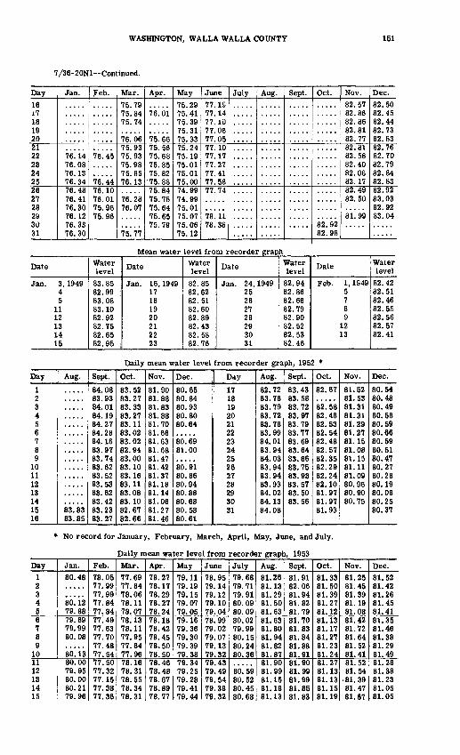
WASHINGTON, WALLA WALLA COUNTY 151
7/36-20N1 Continued.
Day1617 18 19 2021 222324 2526 272829 30 31
Jan.
7e! 1476.08 76.13 76.3476.48 76.4176.3076.12 76.33 76.30
Feb.
76.45
76^4476.10 76.017R Qfi
75.96
Mar.75.7975.84 75.74
76.0675.93 75.9375.98 75.85 76.13
76.2876.07
75.77
Apr.
76.01
75.6675.56 75.6875.85 75.82
75.8875.84 75.7875.6475.65 75.79
May75.2975.41 75.39 75.31 75.3375.247^ 1Q75.01 75.01 75.0074.9974 QQ75.0175.07 75.06 75.12
June77. IS77.14 77.10 77.06 77.0577.10 77.1777.27 77.41 77.5877.74
78.11 78.38
July Aug. Sept. Oct.
82.92 82.98
Nov.82.5782.86 82.86 82.81 82.7782.81 82.5882.40 82.06 82.1782.49 82.50
81.99
Dec.82.5082.45 82.44 82.73 82.8382.76 82.7082.79 82.84 82.8382.92 83.0382.9283.04
Mean water level from recorder graph
Date
Jan. 3, 194945
1112131415
Water level
83.8582.9983.0883.1082.9282.7582.6582.95
Date
Jan. 16, 194917181920212223
Water level
82.8582.6282.5182.6082.8982.4382.5882.76
Date
Jan. 24,194925262728293031
Water level
82.9482.8682.6682.7982.9082.5282.5382.46
Date
Feb. 1, 1S495789
1213
Water level
82.4282.5182.4682.5582.5682.5782.41
Daily mean water level from recorder graph, 1952 *
Day
123456789
10111213141516
Aug.
83^8383.85
Sept.
84.0883.9384.0184.1984.2784.2884.1683.9783.7483.6283.5283.5383.6283.4283.2383.27
Oct.
83.5283.2783.3383.2783.1183.0283.0282.9483.0083.1083.1683.1183.0883.1082.6782.66
Nov.
81.9081.8881.8381.8881.7081.6681.6381.6881.4781.4281.3781.1881.1481.0681.2781.46
Dec.
80.6580.8480.9380.8080.64
80.6981.00
80. 9180.8680.9480.8880.6880.5880.61
Day
171819202122232425262728293031
Aug.
82.7283.7883.7983.7283.7883.9984.0183.9484.0383.9483.9483.9384.0284.1384.08
Sept.
83.4383.5883.7283.9783.7983.7783.6983.6483.6683.7583.9383.5783.5083.56
Oct.
82.67
82.5882.4882.5382.5482.4882.5782.3582.2982.2482.1081.9781.9781.93
Nov.
81.5281.5381.3181.3181.2981.2781.1581.0881.1581.1181.0980.9680.9080.75
Dec.
80.5480.4880.4980.5880.5980.6680.5980.5180.4780.2780.2880.1980.0880.2580.37
* No record for January, February, March, April, May, June, and July.
Daily mean water level from recorder graph, 1953Day
1 2 3 4 567 8 9
1011 12 13 14 15
Jan.80.48
sb! 12 79.8879.69 79.99 80.08
80. 1380.00 79.95 80.00 80.21 79.96
Feb.78.05 77.99 77.99 77.84 77.8477.49 77.63 77.70 77.48 77.5477.50 77.32 77.15 77.38 77.36
Mar.77.69 77.84 78.06 78.11 78.0778.13 78.11 77.95 77.84 77.9678.16 78.31 78.55 78.34 78.31
Apr.78.27 78.17 78.29 78.27 78.2478.18 78.42 78.45 78.50 78.5078.46 78.48 78.67 78.89 78.77
May79.11 79.19 79.15 79.07 79.0579.16 79.36 79.30 79.39 79.3879.34 79.25 79.28 79.41 79.44
June78.95 79.14 79.12 79.10 79.0478.99 79.02 79.07 79.13 79.3279.43 79.49 79. 54 79.38 79.32
July79.68 79.71 79.91 80.09 80.0980.02 79.99 80.15 80.24 80.36
80.59 80.52 80.45 80.68
Aug.81.26 81.13 81.29 81.50 81.6381.63 81.80 81.94 81.82 81.8781.90 81.99 81.15 81.18 81.13
Sept.81.91 82.06 81.94 81.82 81.7981.70 81.83 81.84 81.88 81.9181.90 81.99 81.99 81.85 81.83
Oct.81.33 81.50 81.39 81.27 81.1281.13 81.17 81.27 81.23 81.2481.27 81.13 81.13 81.15 81.19
Nov.81.25 81.45 81.39 81.19 81.0881.42 81.72 81.64 81.52 81.4181.52 81.54
81.39 81.47 81.67
Dec.81.52 81.42 81.26 81.45 81.4181.35 81.46 81,38 81.29 81.4981.28 81.38 81.23 81.05 81.05

152 WATER LEVELS AND ARTESIAN PRESSURES, 1953, NORTHWESTERN STATES
7/26-20Nl--Continued.
Day16 17 18 19 2021 22 23 24 2526 27 28 29 30 31
Jan.79.68 79.52 79.48 79.20 79.3679.28 79.05 78.78 78.51 78.6678.76 78.54 78.41 78.40 78.26 78.30
Feb.
77! 49 77.65 77.5977.63 77.58 77.69 77.65 76.8377.69 77.64 77.70
Mar.78.32 78.54 78.34 78.16 78.4278.64 78.75 78.60 78.42 78.5678.35 78.10 78.16 78.13 78.17 78.26
Apr.78.65 78.92 78.86 78.78 78.9878.99 79.01 79.01 78.98
78.58 78.85 78.75 78.88
May79.54 79.71 79.68 79.49 79.3679.27 79.26 78.91 78.92 78.9678.93 78.96 78.84 78.86 79.00 78.90
June79.29 79.22 79.29 79.23
79.21 79.24 79.25 79.21 79.1579.29 79.44 79.34 79.37 79.52
July80.65 80.62 80.69 80.70 80.7380.75 81.63 80.90 80.84 81.0380.95 81.05 81.02 81.08 81.27 81.38
Aug.81.14 81.20 81.24 81.23 81.3881.49 81.43 81.19 81.06 81.0381.23 81.14 81.17 81.18 81.12
Sept.81.93 81.91 81.82 81.84 81.6981.35 81.44 81.50 81.52 81.3081.23 81.14 81.17 81.18 81.12
Oct.81.09 81.02 81.02 81.28 81.2281.35 81.23
81.07 81. 2381.21 81.21 81.13 81.24 81.29 81.26
Nov.81.53 81.59 81.81 81.56 81.6681.48 81.36 81.68 81.85 81.7981.73 81.74 81.74 81.48 81.46
Dec.
8/35-16B1. Claude Winn. Dug and drilled irrigation water-table well in alluvial gravel, diameter 48 to 8 inches, depth 74 feet. Land-surface datum is 730. 81 feet above msl. Highest water level 0. 64 below Isd, Jan. 15, 1937; lowest 9. 28 below Isd, July 7, 1949. Records avail-able: 1933 1935-51, 1953.
Date
Jan. 10 Feb. 10
17 Apr. 2
23
Waterlevel3.19 3.41 3.60 4.16 4.19
Date
Apr. 25 May 29 June 20
27 Aug. 1
Water level4.28 3.89 3.80 4.00 4.67
Date
Aug. 23 31
Sept. 3 Oct. 23
Water level4.39 4.12 3.80 3.37
Date
Oct. 31 Dec. 5
1630
Water level3.19 3.43 3.75 3.99
Whatcom County
39/2-25R1. J. W. Elsbree. Smith and Meridian Rds. Dug domestic water-table well in sand and gravel, diameter 24 inches, depth 57 feet, lined with concrete to 57. Land-surface datum is about 165 feet above msl. Highest water level 54.06 below Isd, Apr. 20, 1950; lowest 58.60 below Isd. Aug. 14. 1947. Records available: 1946-53.Jan. 8 Mar. 26
56.09 | June 11 56.20 1 July 29
56.41 56.51
Aug. 28 Sept. 16
56.63 56.49
Oct. 20 Nov. 30
56.48 aS7. 16
a Pumping.
40/1-4J1, City of Blaine. Drilled public-supply water-table well in fluvioglacial sand and gravel, diameter 12 inches, depth 746 feet. Land-surface datum is about 175 feet above msl. Highest water level 64.92 below lad, May 11, 1940; lowest 75.23 below Isd, July 3, 1946. Records available: 1938-53. Jan. 8, 67.27; Mar. 26, 66.75; June 11, 66.75; July 29, 68.81; Aug. 28, 72.46, pumped recently; Oct. 20, 70.10; Nov. 30, 68.32.
40/2-19M1. U. 8. Geol. Survey. Intersection State Highway 1A and IB. Driven observa tion water-table well in sand, diameter l£ Inches, depth 22 feet, cased to 20, screen 20-22. Land-surface datum is about 90 feet above msl. Highest water level 16.06 below Isd, Mar. 26, 1953; lowest 19.23 below Isd, Nov. 7, 1952. Records available: 1952-53.
Date
Feb. 7, 1952 29
Apr. 30 July 1
Water level
17.75 16.95 16.88 17.48
Date
Aug. 28,1952 Nov. 7 Jan. 8, 1953 Mar. 26
Water level
18.27 19.23 18.72 16.06
Date
June 11, 1953 July 29 Aug. 28
Water level
16.77 17.41 17.93
Date
Sept. 16,1953 Oct. 20Nov. 30
Water level
18.27 18.54 18.00
40/4-5D1. John C. Loreen. Van Buren and Hoverstick Rds. Dug domestic and stock water-table well in gravel, size 20 by 30 inches, depth 61 feet, lined with concrete to 61. Land- surface datum is about 170 feet above msl. Highest water level 48. 86 below Isd, Apr. 7, 1951; lowest 57.18 below Isd, Jan. 8, 1953. Records available: 1940-53.
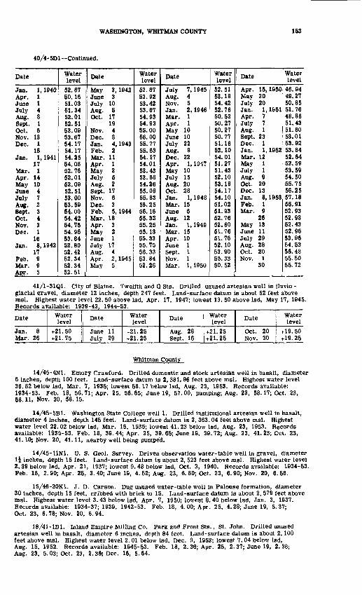
WASHINGTON, WHITMAN COUNTY 153
40/4-5D1 Continued.
Date
Jan. 1, 1940Apr. 1June 1July 4Aug. 8Sept. 1Oct. 6Nov. 13Dec. 1
16Jan. 1, 1941
17Mar. 1Apr. 14May 10June 4July 7Aug. 2Sept. 3Oct. 4Nov. 3Dec. 1
16Jan. 8, 1942
17Feb. 9Mar. 9Apr. 5
Waterlevel
52.6750.1651.0351.3452.0152.5153.0953.6754.1754.1754.2554.0852.7652.0152.0952.5153.0053.5954.0054.4254.7554.9653.6452.6052.4252.3452.3452.51
Date
May 3, 1942June 3July 10Aug. 5Oct. 17
19Nov. 4Dec. 8Jan. 4, 1943Feb. 2Mar. 11Apr. 1May 2July 5Aug. 2Sept. 17Nov. 6Dec. 3Feb. 5, 1944Mar. 18Apr. 3May 2June 1July 17Aug. 4Apr. 2, 1945May 5
Waterlevel
52.6752.9253.4253.6754.9354.9355.0056.0055.7755.6354.1754.0153.4353.6854.2655.0855.8356.2556.1655.3355.2555.1355.3355.7556.3353.6452.26
Date
July 7, 1945Aug. 4Nov. 5Jan. 2, 1946Mar. 1Apr. 1May 10June 10July 22Aug. 8Dec. 22Apr. 1, 1047May 10July 15Aug. 20Oct. 28Jan. 1, 1948Mar. 15June 6Aug. 12Jan. 1, 1949Mar. 15Apr. 10June 1Sept. 1Nov. 1Mar. 1, 1950
Water level
52.5153.1854.4252.7650.5250.2750.2750.7751.1652.1054.0151.2751.4352.1053.1854.1754.1051.0251.9352.7652.6051.7651.7652.1053.9055.3350.52
Date
Apr. 15,1950May 20July 20Jan. 1, 1951Apr. 7July 7Aug. 1Sept. 23Dec. 1Jan. 1, 1952Mar. 12May 1July 1Aug. 9Oct. 20Dec. 13Jan. 8, 1953Feb. 1Mar. 9
26May 13June 11July 29Aug. 28Oct. 20Nov. 1
30
Water level
46.9449.2750.8551.7648.8651.4351.6053.0153.9253.8452.6452.5953.5954.5055.7556.2557.1855.9152.9352.9352.4352.9653.9654.5356.4355.5055.72
41/1-31Q1. City of Blaine. Twelfth and G Sts. Drilled unused artesian well in fluvio - glacial gravel, diameter 12 inches, depth 247 feet. Land-surface datum is about 52 feet above msl. Highest water level 22. 50 above Isd, Apr. 17, 1947; lowest 13. 50 above Isd, May 17, 1945. Records available: 1939-42, 1944-53.
Date
Jan. 8 Mar. 26
Water level
+21.50 -t-21.75
Date
June 11 July 29
Water level
+21.25 +21.25
Date
Aug. 28 Sept. 16
Water level
+21.25 +21.25
Date
Oct. 20Nov. 30
Water level
+19. 50 +19.25
Whitman County
14/45-4N1. Emory Crawford. Drilled domestic and stock artesian well in basalt, diameter 6 Inches, depth 100 feet. Land-surface datum is 2, 381. 96 feet above msl. Highest water level 36. 82 below Isd, Mar. 7, 1935; lowest 58.17 below Isd, Aug. 23, 1953. Records available: 1934-53. Feb. 18, 56.71; Apr. 25, 56.65; June 19, 57.00, pumping; Aug. 23, 58.17; Oct. 23, 58.11, Nov. 20, 58.15.
14/45-5B1. Washington State College well 1. Drilled institutional artesian well in basalt, diameter 4 inches, depth 145 feet. Land-surface datum is 2, 363.04 feet above msl. Highest water level 22. 02 below Isd, Mar. 15, 1935; lowest 41.23 below Isd, Aug. 23, 1953. Records available: 1935-53. Feb. 18, 39. 44; Apr. 25, 39. 65; June 19, 39. 72; Aug. 23, 41. 23; Oct. 23, 41.10; Nov. 20, 41.11, nearby well being pumped.
14/45-11N1. U. S. Geol. Survey. Driven observation water-table well in gravel, diameter l£ inches, depth 15 feet. Land-surface datum is about 2, 523 feet above msl. Highest water level 2.39 below Isd, Apr. 21, 1937; lowest 9. 48 below Isd, Oct. 3, 1940. Records available: 1934-53. Feb. 18, 2.90; Apr. 25, 3.40; June 19, 4.52; Aug. 23, 6.80; Oct. 23, 6.90; Nov. 20, 6.56.
15/46-20K1. J. D. Carson. Dug unused water-table well in Falouse formation, diameter 30 inches, depth 15 feet, cribbed with brick to 15. Land-surface datum is about 2, 579 feet above msl. Highest water level 3.43 below Isd, Apr. 7, 1950; lowest 8. 40 below Isd, Jan. 3, 1937. Records available: 1934-37; 1939, 1942-53. Feb. 18, 4. 00; Apr. 25, 4. 28; June 19, 5.37; Oct. 23, 6. 78; Nov. 20, 6. 94.
18/41-lBl. Inland Empire Milling Co. Park and Front Sts., St. John. Drilled unused artesian well in basalt, diameter 6 inches, depth 84 feet. Land-surface datum is about 2,100 feet above msl. Highest water level 2. 01 below Isd, Dec. 9, 1952; lowest 7.04 below Isd, Aug. 15, 1952. Records available: 1945-53. Feb. 18, 2. 36; Apr. 25, 2. 37; June 19, 2.38; Aug. 23, 5.03; Oct. 23, 2.36; Dec. 16, 5.64.

154 WATER LEVELS AND ARTESIAN PRESSURES, 1953, NORTHWESTERN STATES
18/43-35P1. G. H. Noe. Drilled unused water-table well in basalt, diameter 6 inches, depth 132 feet. Land-surface datum is about 2, 320 feet above msl. Highest water level 5.10 below Isd, Mar. 20, 1949; lowest 16. 23 below Isd, Oct. 7, 1945. Records available: 1940-53. Feb. 18, 7, 93; Apr. 25, 8. 81; June 1&, 9. 79; Aug. 23, 12. 29; Oct. 23, 12. 75, Dec. 16, 10.70.
Yakima County
12/18-1R1. U. S. Geological Survey. Driven observation water-table well in gravel, diameter l£ inches, depth 9 feet, cased to 7, screen to 9. Land-surface datum is about 995 feet above msl. Highest water level 2. 70 below Isd, Jan. 19, 1953; lowest 5.34 below Isd, Apr. 7, 1953. Records available^ 1952-53.
Date
Dec. 17,1952 Jan. IS, 1S53 Feb. 16
Water level5.16 2.70 3.94
Date
Apr. 7, 1953 May 2 June 26
Waler level5.34 3.19 3.15
Date
July 20,1953 Aug. 14 Sept. 4
Water level3.00 3.12 4.01
Date
Oct. 6, 1953 30
Dec. 3
Waterlevel2.98 2.90 4.11
WYOMING
By H. M. Babcock
Scope of Water-Level Program
The observation-well program in Wyoming was continued in 1953 in cooperation with the State Engineer, the city of Cheyenne, and as part of the program for the development of the water resources of the Missouri River basin. Measurements of water levels were made in 106 wells. In addition to the water-level measurements given in this report, many measurements of water levels were made during project studies and have been or will be published in the project reports. The following reports containing tabulations of water-level measurements were issued during 1953: Geology and ground-water resources of the Egbert-Pine Bluffs-Carpenter area, Laramie County, Wyo. (U. S. Geol. Survey Water-Supply Paper 1140); Reconnaissance of the geology and ground-water resources of the Glendo-Wendover area, Platte County, Wyo. (U. S. Geol. Survey Circular 163); Ground-water conditions in the Soil and Moisture Conservation Demonstration area near Torrington, Goshen County, Wyo. (U. S. Geol. Survey.Circular 238); Reconnaissance of the geology and ground-water resources of the La Prele area, Converse County, Wyo. (U. S. Geol. Survey Circular £43). (See figs. 29-34 for location of observation wells.)
Interpretation of Water-Level Fluctuations
Water levels fluctuate in response to precipitation, surface runoff in streams, the amount of water used in irrigated areas, the amount pumped from wella, and the amount of ground water withdrawn by plants. Water levels in the alluvium along the stream valleys generally were lower in 1953 than they were in 1952, the average depth to water being about 0.4 foot lower in September 1953. Water levels in the Cheyenne municipal well field continued to decline during 1953. The average decline in water levels was 7.6 feet with the largest decline occurring in the part of the well field that was brought into production during the latter part of 1952 The withdrawal of ground water in the area was unusually large during the year. In the irrigated area along the North Platte River in Goshen County, the use of water for irrigation causes an appreciable fluctuation of the water levels. Water levels begin to rise in the spring*and continue to rise until irrigation is discontinued in the fall, reaching their peak level about the end of September. In September 1953, the average water level was about 0. 8 foot lower than in September 1952, and about 0.3 foot lower than in September 1951. In the Wheatland Flats area, Platte County, the water levels rose rapidly as soon as irrigation water was applied in the spring and continued to rise until fall, when irrigation was discontinued. The average peak water level reached during 1953 was about 2.9 feet lower than the peak reached during the previous year. Water levels in the Riverton Project, Fremont County, rose an average of about 0. 5 foot during the year. During the past year water levels declined in the Glendo area, Platte County, and the Owl Creek Project, Hot Springs County; and remained about the same in the Pass Creek area, Carbon County, and the Pine Bluffs area, Laramie County.
Well-Numbering System
Wells are numbered in accordance with the Bureau of Land Management system of land subdivision. The first segment of a well number indicates the township, the second the range, and the third the section. The lowercase letters, a, b, c, and d, following the section number indicate the location of the well within the section, the first letter denotes the 160-acre tract; the second the 40-acre tract; and the third the 10-acre tract. When more than one well is in the smallest significant tract, consecutive numbers beginning with 1 are added as suffixes. Below is a graphical illustration of this method of well numbering within a section of 640 acres. Well numbers preceded by the capital letters A, B, C, and D designate wells in the northeast, north west, southwest, and southeast quadrants, respectively, of the Wind River meridian and base line system. Well numbers not preceded by a capital letter designate wells in the sixth principal meridian and base line system.
155

156 WATER LEVELS AND ARTESIAN PRESSURES, 1953, NORTHWESTERN STATES
Figure 29. Location of observation wells in northwestern Wyoming, 1953.

WYOMING 157
Figure 30. Location of observation wells in north-central Wyoming, 1953.
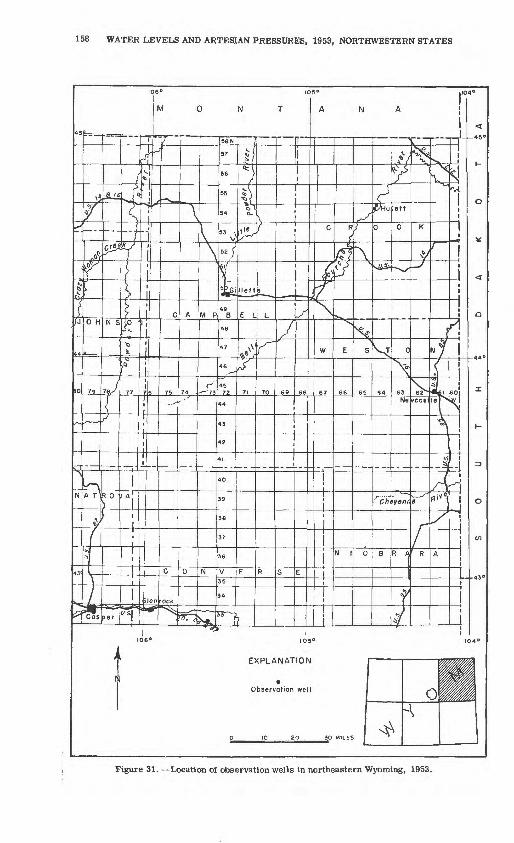
158 WATER LEVELS AND ARTESIAN PRESSURES, 1953, NORTHWESTERN STATES
Figure 31. Location of observation wells in northeastern Wyoming, 1953.

WYOMING 159
Two or more observation wells (Numeraldenotes ihe number of wells)
Figure 32. --Location of observation wells in southeastern Wyoming, 1953.
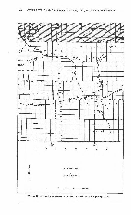
160 WATER LEVELS AND ARTESIAN PRESSURES, 1S53, NORTHWESTERN STATES
Figure 33. Location of observation wells in south-central Wyoming, 1953.
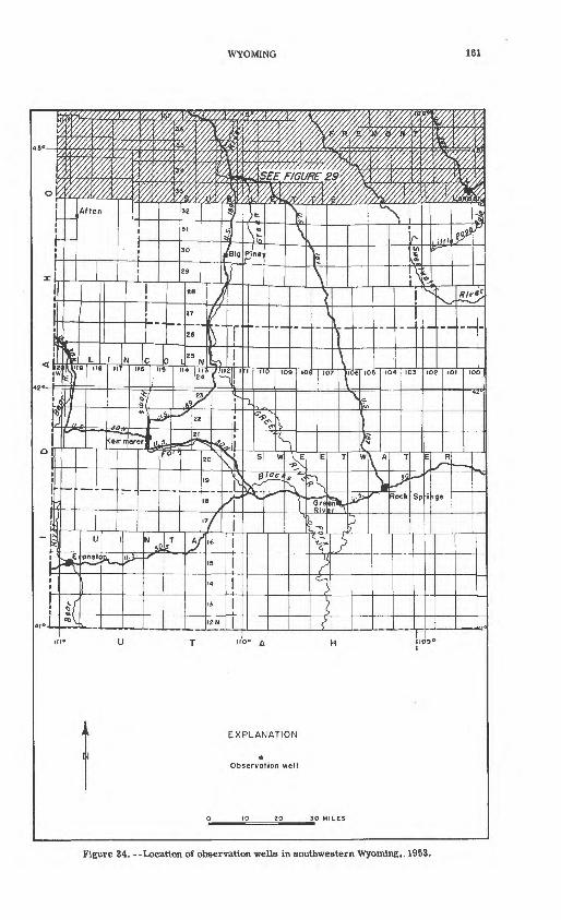
WYOMING 161
Figure 34. --Location of observation wells in southwestern Wyoming,. 1953.
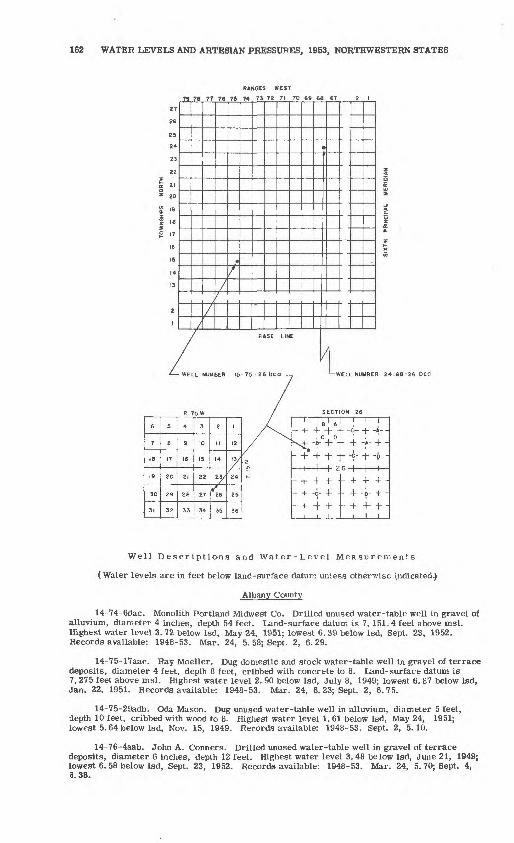
162 WATER LEVELS AND ARTESIAN PRESSURES, 1953, NORTHWESTERN STATES
RANGES WEST
79 76 77 76 7S 74 73 72 71 70 69 66 67
WELL NUMBER 24-68-26 tea
Well Descriptions and Water-Level Measurements
(Water levels are in feet below land-surface datum unless otherwise indicated.)
Albany County
14-74-6dac. Monolith Portland Midwest Co. Drilled unused water-table well in gravel of alluvium, diameter 4 inches, depth 54 feet. Land-surface datum is 7, 151. 4 feet above msl. Highest water level 3. 72 below Isd, May 24, 1951; lowest 6. 39 below Isd, Sept. 23, 1952. Records available: 1948-53. Mar. 24, 5. 58; Sept. 2, 6.29.
14-75-17aac. Ray Moeller. Dug domestic and stock water-table well in gravel of terrace deposits, diameter 4 feet, depth 8 feet, cribbed with concrete to 8. Land-surface datum is 7, 275 feet above msl. Highest water level 2. 90 below Isd, July 8. 1949; lowest 6. 87 below Isd, Jan. 22, 1951. Records available: 1948-53. Mar. 24, 6.23; Sept. 2, 6.75.
14-75-29adb. Oda Mason. Dug unused water-table well in alluvium, diameter 5 feet, depth 10 feet, cribbed with wood to 8. Highest water level 1. 61 below Isd, May 24, 1951; lowest 5.64 below Isd, Nov. 15, 1949. Records available: 1948-53. Sept. 2, 5.10.
14-76-4aab. John A. Conners. Drilled unused water-table well in gravel of terrace deposits, diameter 6 inches, depth 12 feet. Highest water level 3.48 below Isd, June 21, 1949; lowest 6. 58 below Isd, Sept. 23, 1952. Records available: 1948-53. Mar. 24, 5. 70; Sept. 4, 3.38.

WYOMING, CARBON COUNTY 163
14-77-25dcd. Mr. Embree. Drilled stock water-table well in gravel of terrace deposits, diameter 8 inches, depth 75 feet. Land-surface datum is 7,417.1 feet above msl. Highest water level 24.92 below Isd, Sept. 21, 1951; lowest 32.77 below Isd, July 20, 1950. Records available: 1948-53. Mar. 24, 29.61; Sept. 2, 25.42, pumping.
15-74-laaa. Maurice Laycock. Dug stock water-table well in alluvium, diameter 24 inches, depth 11 feet, cribbed with brick. Land-surface datum is 7,079. 5 feet above msl. Highest water level 2.61 below Isd, Mar. 27, 1950; lowest 8.67 below Isd, Mar. 22, 1951. Records available: 1948-53. Mar. 24, 6. 58; Sept. 2, 4.56, pumping.
16-78-18dbb. Dr. Markley. Drilled unused water-table well in alluvium, diameter 6 inches, reported depth 15 feet. Land-surface datum is 7,329.4 feet above msl. Highest water level 0.00? July 8, 1949, May 24, July 23, 1951; lowest 6.02 below Isd, Sept. 23, 1952. Records available: 1948-53. Mar. 24, 4. 74; Sept. 2, 5.43. *Water at land surface in adjacent field.
17-75-34cdd. Ralph May. Dug unused water-table well in alluvium, diameter 4 feet, depth 10 feet, cribbed with wood to 10. Highest water level 0. 87 below Isd, June 21, 1949; lowest 6. 42 below Isd, Dec. 14, 1948. Records available: 1948-53. Sept. 2, 5.10.
Big Horn County
49-90- Idaal. Owner unknown. Dug unused water-table well in sand artd gravel of alluvium, diameter 4 feet, depth 14 feet, cribbed with rock to 14. Land-surface datum is 4,456. 4 feet above msl. Highest water level 3.00 below Isd, June 29, 1949; lowest 9.43*below Isd, Apr. 3, 1952. Records available: 1947-53. Apr. 8, 9.34; July 7, 6.13.
49-91-24bba. U. S. Geol. Survey. Jetted unused water-table well in alluvium, diameter \ inch, depth 11 feet, screen 10-11. Land-surface datum is 4,110. 8 feet above msl. Highest water level 7.32 below Isd, June 28, 1951; lowest dry at 11.00, May 29, July 31, 1951. Records available: 1951-53. Apr. 8, 8. 88; July 7, 7. 92.
50-92-31bbal. Manderson Hotel (Johnson). Drilled unused artesian well in Fort Union formation, diameter 5 inches, depth 48 feet. Land-surface datum is 3, 893.2 feet above msl. Highest water level 8. 88 below Isd, July 26, 1948; lowest 19. 04 below Isd, Aug. 31, 1950. Records available: 1947-53. Apr. 8, 11. 92; July 7, 10.89.
50-92-35adc. U. S. Geol. Survey. Jetted unused water-table well in alluvium, diameter I inch, depth 22 feet, screen 21-22. Land-surface datum is 3, 970. 8 feet above msl. Highest water level 12. 63 below Isd, July 31, 1951; lowest 17.59 below Isd, Apr. 27, 1951. Records available: 1951-53. May 5, 17.22; July 7, 14.52.
Campbell County
50-72-20add. State of Wyoming. Drilled observation artesian well in sandstone of Wasatch formation, diameter 3 inches, depth 320 feet, cased to 180. Land-surface datum is 4, 567.14 feet above msl. Highest water level 76. 21 below Isd, Sept. 4, 1951; lowest 79. 54 below Isd, July 21, 1953. Records available- 1949-53.
Date
Jan. 19 Feb. 4 Mar. 16
Water level
77.41 78.22 78.18
Date
May 4 June 8
Water level
78.55 78.39
Date
July 21 Sept. 3
Water level
79.54 78.56
Date
Nov. 19 Dec. 16
Water level
78.60 78.70
Carbon County
18-84-7dad. H. G. Carpening. Dug domestic water-table well in sand and gravel of alluvium, diameter 6 feet, depth 12 feet, cribbed with wood to 12. Highest water level 6.47 below Isd, June 25, 1951; lowest 9. 83 below Isd, Oct. 27, 1950. Records available: 1950-53. Mar. 25, 9. 52; Sept. 3, 9.18.
19-83-4dda. A. L. Welton. Drilled domestic water-table well in sand and gravel of alluvium, diameter 8 inches, depth 17 feet, cased to 17. Highest water level 3. 91 below Isd, May 23, 1951; lowest 8. 20 below Isd, Sept. 3, 1953. Records available: 1950-53. Mar. 25, 6. 77; Sept. 3, 8.20.
19-83-26cad. R. Welton. Dug stock water-table well in sand and gravel of alluvium, diameter 6 feet, depth 10 feet, cribbed with wood to 10. Highest water level 0. 23 below Isd, July 31, 1951; lowest 3.47 below Isd, Sept. 3, 1953. Records available: 1950-53. Sept. 3, 3.47.
164 WATER LEVELS AND ARTESIAN PRESSURES, 1953, NORTHWESTERN STATES
19-84-15dbd. Rocky Mountain Sheep Co. Drilled unused water-table well in sand of North Park formation, diameter 4 inches, reported depth 600 feet. Highest water level 114.98 below Isd, Mar. 25, 1953; lowest 116.23 below Isd, Nov. 17, 1950. Records available: 1950-53. Mar. 25, 114.98; Sept. 3, 115.20.
20-83-28bab. State of Wyoming. Drilled unused water-table well in sand of North Park formation, diameter 3 inches, depth 33 feet. Highest water level 16.16 below Isd, Sept. 3, 1953; lowest 18.35 below Isd, Aug. 1, 1950. Records available: 1950-53. Mar. 25, 17.64; Sept. 3, 16.16.
Converse County
32-71-7dcd. Town of Douglas. Drilled unused water-table well in sand and gravel of alluvium, diameter 12 inches, depth 51 feet. Highest water level 6.96 below Isd, Mar. 13, 1952; lowest 13.96 below Isd, June 26, 1951. Records available: 1950-52. No measurement made in 1953.
32-71-31aaa. Mrs. Sallie Edwards. Drilled domestic water-table well in siltstone of White River group, diameter 6 inches, depth 84 feet, cased to 84. Highest water level 13.34 below Isd, Feb. 9, 1951; lowest 20.32 below Isd, July 10, 1950. Records available: 1950-53. Mar. 19, 13.77; Sept. 4, 13.80.
33-73-27abc. U. 8. Geol. Survey. Drilled observation water-table well in silt of slope wash, diameter f inch, depth 14 feet. Highest water level 2.73 below Isd, Apr. 4, 1952; lowest 6.86 below Isd, Sept. 4, 1953. Records available: 1950-53. Mar. 19, 4.60; Sept. 4, 6.86.
Crook County
54-64-7bcc. Charles Martin. Dug observation water-table well in alluvium, diameter 5 feet, depth 20 feet. Highest water level 13. 50 below Isd, Apr. 7, 1949; lowest 16.13 below Isd, Mar. 25, 1946. Kecorfls available: 1942-53.
Date
Jan. 23 Feb. 24 Mar. 20
Water level
14.76 14.70 14.42
Date
Apr. 27 May 20 June 23
Water level
14.52 13.98 13.74
Date
July 20 Aug. 20 Sept. 22
Water level
14.29 14.31 14.61
Date
Oct. 22Nov. 20 Dec. 21
Wate level
14.90 15.27 15.27
Fremont County
A-l-3-7ad3. U. S. Geol. Survey, jetted unused water-table well in alluvium, diameter 1 inch, depth 29 feet, screen 28-29, Land-surface datum is 5,163. 5 feet above msl. Highest water level 8. 29 below Isd, Aug. 30, 1952; lowest 21.23 below Isd, May 14, 1952. Records available: 1951-53. Apr. 23, 20.22; Sept. 26, 9.55.
A-l-3-27bb. U. S. Geol. Survey. Jetted unused water-table well in alluvium, diameter | inch, depth 25 feet, screen 24-25. Land-surface datum is 5,080. 7 feet above msl. Highest water level 3.14 below Isd, Sept. 26, 1953; lowest 6.49 below Isd, May 14, 1952. Records available: 1951-53. Apr. 23, 5.60; Sept. 26, 3.14.
A-l-4-15dd3. U. S. Geol. Survey. Jetted unused water-table well in terrace deposits, diameter f inch, depth 26 feet, screen 25-26. Land-surface datum is 4,957. 9 feet above msl. Highest water level 3.72 below ted, July 30, 1951; lowest 6.00 below Isd, Jan. 28, 1952. Records available: 1951-53. Apr. 24, 5. 32; Sept. 28, 3.79.
A-l-4-29bd2. City of Riverton. Drilled unused artesian well in sandstone of Wind River formation, diameter 12 inches, depth 578 feet, cased to 578. Land-surface datum is 5,184.6 feet above msl. Highest water level 170. 50 below Isd, Mar. 27, 1950; lowest 203.97 below Isd, Oct. 28, 1949. Records available: 1949-53. Apr. 23, 183.06; May 8, 183.13; Sept. 28, 190.44.
A-2-4-17da. U. S. Bureau of Reclamation. Drilled unused water-table well in alluvium, diameter 3 inches, depth 8 feet, perforations 0-8. Land-surface datum is 5,262.0 feet above msl. Highest water level 1.97 below Isd, Aug. 27, 1951;" lowest 5.18 below Isd, Feb. 29,' 1952. Records available: 1951-53. Apr. 24, 3.69; Sect. 26, 3.05.
A-2-5-5aab. U. S. Bureau of Reclamation. Drilled unused water-table well in alluvium, diameter 3 inches, depth 29 feet, perforations 0-29. Land-surface datum is 4, 916.0 feet above msl. Highest water level 1. 96 below Isd, Sept. 26, 1953; lowest 8. 88 below Isd, Aug. 29, 1952. Records available: 1951-53. Apr. 24, 5.35; Sept. 26, 1.96.
WYOMING, GOSHEN COUNTY 165
A-2-5-28ca. U. S. Geol. Survey. Jetted unused water-table well in terrace deposits, diameter | inch, depth 18 feet, screen 17-18. Land-surface datum is 4,860.1 feet above msl. Highest water level 1.79 below Isd, Aug. 29, 1952; lowest 14.27 below Isd, Apr. 24, 1953. Records available: 1951-53. Apr. 24, 14.27; Sept. 26, 6.15.
A-2-6-18da. U. S. Geol. Survey. Jetted unused water-table well in terrace deposits, diameter | inch, depth 22 feet, screen 21-22. Land-surface datum is 4,814.6 feet above msl. Highest water level 6.11 below Isd, Sept. 26, 1953; lowest 15.74 below Isd, Apr. 28, 1951. Records available: 1951-53. Apr. 24, 14.12; Sept. 26, 6.11.
A-3-2-20cd. Joe Eiseman. Drilled unused water-table well in alluvium, diameter 8 inches, depth 48 feet. Land surface datum is 5,348.8 feet above msl. Highest water level 16.49 below Isd, Aug. 26, 1949; lowest 26. 31 below Isd, Apr. 30, 1950. Records available: 1948-53. Apr. 24, 25. 85; Sept. 26, 18.46.
A-3-3-21ad2. H. W. Roland. Drilled unused artesian well in sandstone of Wind River formation, diameter 6 inches, depth 425 feet, cased to 403. Land-surface datum is 5,272.8 feet above msl. Highest water level 146.29 below Isd, Dec. 1, 1950; lowest 149.87 below Isd, Aug. 3, 1949. Records available: 1948-53. Apr. 24, 147.88; Sept. 26, 147.98.
A-3-3-25bb. U.S. Bureau of Reclamation. Drilled unused water-table well in alluvium, diameter 3 inches, depth 28 feet, perforations 0-28. Land-surface datum is 5,150,8 feetabove-msl. Highest water level 0.40 below Isd, Sept. 26, 1953; lowest 13.67 below Isd, Apr. 24, 1053. Records available: 1951-53. Apr, 24, 13.67; Sept. 26, 9.40.
A-4-2-35cc. U. S. Bureau of Reclamation. Drilled unused water-table well in alluvium, diameter 3 inches, depth 20 feet, perforation 0-20. Land-surface datum is 5,393.7 feet above msl. Highest water Level 5.95 below Isd, Oct. 1, 1951; lowest 13.20 below Isd, Apr. 28, 1951. Records available: 1951-53. Apr. 24, 9. 56; Sept. 26, 7.65.
A-4-3-llab. U. S. Bureau of Indian Affairs. Drilled unused artesian well in sandstone of Wind River formation, diameter 5 inches, depth 102 feet. Highest water level 59.43 below Isd, Sept. 28, 1951; lowest 73. 23 below Isd, June 26, 1951. Records available: 1947-53. Apr. 24, 66.67. Measurement discontinued.
A-4-3-18cb. U. S. Bureau of Reclamation. Drilled unused water-table well in alluvium, diameter 3 inches, depth 27 feet, perforations 0-27. Land-surface datum is 5,340.0 feet above msl. Highest water level 4.47 below Isd, Aug. 27, 1951; lowest 22.16 below Isd, Nov. 27, 1951. Records available: 1951-53. Apr. 24, 1937; Sept. 26, 6.40.
A-4-5-18dc. U. S. Bureau of Indian Affairs. Drilled unused artesian well in sandstone of Wind River formation, diameter 5 inches, depth 168 feet. Land-surface datum is 4,935.8 feet above msl. Highest water level 69. 43 below Isd, Apr. 24, 1953; lowest 80.15 below Isd, Sept. 26, 1953. Records available: 1947-53. Apr. 24, 69.43; Sept. 26, 80.15.
B-3-l-15dc. T. P. Haslin. Dug unused water-table well in alluvium, diameter 36 inches, depth 17 feet, cased to 17. Land-surface datum is 5,490.29 feet above msl. Higtest water level 5.76 below Isd, July 31, 1951; lowest 15.48 below Isd, Feb. 28, 1952. Records available: 1949-53.
Date
Dec. 28, 1949Jan. 27, 1950Feb. 28Mar. 27Apr. 26May 29July 6Aug. 15
Water level13.1313.7914.1414.3214.6213.608.427.17
Date
Aug. 28, 1950Sept. 25Oct. 30Dec. 6Jan. 3, 1951Feb. 2Apr. 28June 1
Water level8.456.229.98
11.9812.7413.3313.8913.74
Date
June 26, 1951July 31Aug. 29Oct. 1
29Nov. 28Dec. 27
Water level7.705.767.988.11
10.3511.6512.56
Date
Jan. 29, 1952Feb. 28Mar. 28May 13Aug. 29Apr. 23, 1953Sept. 26
Water level12.2315.4814. 1C14.2412.5714.717.60
Goshen County
19-61-2ccd. City of Lagrange. Drilled unused water-table well in sand and gravel of alluvium, diameter 4 inches, depth 30 feet. Land-surface datum is 4, 577.2 feet above msl. Highest water level 13.77 below Isd, Apr. 1, 1949; lowest 19.90 below Isd, Mar. 23, 1951. Records available: 1943, 1949-53. Mar. 13, 16.88; Sept. 10, 16.89.
l9-61-4cdd. Hugh Stemler. Drilled irrigation water-table well in alluvium, diameter 4 feet, depth 33 feet, cased to 33 feet. Land-surface datum is 4, 557. 3 feet above msl. Highest water level 4.07 below Isd, June 4, 11*49; lowest 9. U3 below Isd, Mar. 23* 1951. Records available: 1943, 1948-53. Mar. 13, 8.34; Sept. 10, 21.09, nearby well being pumped.
166 WATER LEVELS AND ARTESIAN PRESSURES, 1953, NORTHWESTERN STATES
19-62-2add. Edward Krohn. Drilled unused water-table well in siltstone of Brule forma tion, diameter 4 inches, depth 92 feet. Land-surface datum is 4,683.6 feet above msl. Highest water level 57.23 below Isd, Mar. 28, 1952; lowest 58. 58 below Isd, May 3, 1943. Records available: 1943, 1949-53. Mar. 13, 57.24; Sept. 10, 57.53.
19-62-26dba. F. E. Jones. Drilled stock water-table well in siltstone of Brule formation, diameter 5 Inches, depth 42 feet. Highest water level 22. 54 below Isd, Apr. 1, 1949; lowest 28.61 below Isd, Jan. 30, 1952. Records available: 1948-53. Mar. 13, 26.27; Sept. 10, 25.77.
20-61-27ddc. Curtis Templin. Drilled unused water-table well in gravel of alluvium, diameter 6 inches, depth 86 feet. Land-surface datum is 4, 527. 9 feet above msl. Highest water level 28. 57 below Isd, July 27, 1943; lowest 31. 55 below Isd, Mar. 13, 1953. Records avail able: 1943, 1949-53. Mar. 13, 31. 55; Sept. 10, 30.29.
24-60-19bad. Frank Graham. Drilled irrigation water-table well in alluvium, diameter 18 inches, depth 32 feet. Land-surface datum is 4,071.2 feet above msl. Highest water level 10.19 below Isd, July 21, 1950; lowest 14. 82 below Isd, Feb. 20, 1951. Records available: 1948-53. Mar. 16, 13.95; Sept. 10, 11.16.
24-60-27cdd. Edgar Ginter. Drilled domestic and stock water-table well in sandstone of Chadron formation, diameter 6 inches, depth 73 feet, cased to 35. Land-surface datum is 4,185.1 feet above msl. Highest water level 7.90 below Isd, Sept. 22, 1952; lowest 22. 59 below Isd, Mar. 23, 1951. Records available: 1948-53. Mar. 16, 18.30; Sept. 10, 14.89.
24-61-5cbb. University of Wyoming. Drilled irrigation water-table well in sand and gravel of alluvium, diameter 18 Inches, depth 93 feet. Land-surface datum is 4,124. 4 feet above msl. Highest water level 18.23 below Isd, Sept. 26, 1952; lowest 24. 32 below Isd, Apr. 17, 1951. Records available: 1948-53. Mar. 13, 23.17; Sept. 9, 19.68.
24-61-lOcdc. St. Joseph's Orphanage. Dug irrigation water-table well in sand and gravel of alluvium, diameter 7 feet, depth 36 feet, cribbed with concrete. Land-surface datum is 4, 098.1 feet above msl. Highest water level 18. 45 below Isd, Sept. 25, 1952; lowest 20. 93 below Isd, Apr. 17, 1951. Records available: 1948-53. Mar. 13, 20.64; Sept. 9, 18.94.
24-61-15cdb. Yellowstone Potato Co. Drilled industrial water-table well in sand and gravel of alluvium, diameter 18 to 14 inches, depth 38 feet. Land-surface datum is 4, 083. 7 feet above msl. Highest water level 8.18 below Isd, Oct. 17, 1951; lowest 14. 60 below Isd, Nov. 29, 1950. Records available: 1948-53. Mar. 13, 11.04; Sept. 9, 9.35.
25-61-28dbc. M. W. Berry. Drilled irrigation water-table well in gravel of terrace deposits, diameter 24 inches, depth 10S feet. Land-surface datum is 4, 223.1 feet above msl. Highest water level 37. 48 below Isd, Oct. 16, 1951; lowest 49. 39 below Isd, May 5, 1943. Records available: 1943, 1948-52, Measurement discontinued.
25-62-19aac. Lester C. Stroud. Drilled irrigation water-table well in gravel of alluvium, diameter 18 inches, depth 83 feet, cased to 83. Land-surface datum is 4,172. 4 feet above msl. Highest water level 18. 07 below Isd, Sept. 26, 1952; lowest 25. 48 below Isd, May 22, 1951. Records available: 1948-53. Mar. 13, 24.25; Sept. 9, 19.85.
25-62-36cad. W. W. Weckwerth. Driven irrigation water-table well in sand and gravel of alluvium, diameter l| inches, depth 10 feet. Land-surface datum is 4,116. 3 feet above msl. Highest water level 2.'77 below Isd, Sept. 26, 1952; lowest 7.74 below Isd, Apr. 17, 1951. Rec ords available: 1948-53. Mar. 13, 5.02.
25-63-9ccb. Emery Bright. Drilled irrigation water-table well in alluvium, diameter 24 inches, depth 61 feet. Land-surface datum is 4,196. 8 feet above msl. Highest water level 16.34 below Isd, Sept. 26, 1952; lowest 23. 82 below Isd, May 30, 1950. Records available: 1943, 1948-53. Mar. 13, 22.70; Sept. 9, 17.73.
25-63-22aab. Greenwald Estate. Drilled irrigation water-table well in sand and gravel of alluvium, diameter 18 inches, depth 60 feet. Land-surface datum is 4,177.2 feet above msl. Highest water level 13.96 below Isd, Sept. 26, 1952; lowest 20.65 below Isd, Apr. 17, 1951. Records available: 1948-53. Mar. 13, 19.06.
26-62-14bba. Arthur Damrow. Drilled irrigation water-table well in gravel of alluvium, diameter 18 inches, depth 62 feet, cased to 62. Highest water level 12. 09 below Isd, Sept. 26, 1952, Sept. 9, 1953; lowest 13.63 below Isd, Dec. 8, 1948. Records available: 1948-53. Mar. 13, 12.13; Sept. 9, 12. 09.
26-63-32dac. Joseph Spikner. Drilled irrigation water-table well in gravel of alluvium, diameter 18 inches, depth 80 feet, cased to 80. Land-surface datum is 4, 204.6 feet above msl. Highest water level 17.97 below Isd, Sept. 26, 1952; lowest 24.64 below Isd, Apr. 17, 1951. Records available: 1948-53. Mar. 13, 24.02; Sept. 9, 19.26.
WYOMING, LARAMIE COUNTY 167
26-64-8cdb. W. H. McDonald. Dug and drilled irrigation water-table well in sand and gravel of alluvium, diameter 24 inches, depth 45 feet, cribbed with galvanized iron. Highest water level 17.48 below Isd, Aug. 30, 1949; lowest 26.40 below Isd, Mar. 22, 1951. Records available: 1948-52. Measurement discontinued.
26-64-28bbb. National Park Service. Drilled domestic water-table well in gravel of alluvium, diameter 18 inches, depth 29 feet, cased to 29. Highest water level 13. 99 below Isd, June 21, 1952; lowest 17.10 below Isd, Nov. 29. 1949. Records available: 1948-53.
Date
Jan. 20 Feb. 20 Mar. 30
Water level
16.28 16.44 16.50
Date
Apr. 21 May 23 June 20
Water level
16.07 16.10 15.69
Date
July 21 Aug. 20 Sept. 22
Water level
15.37 15.6315.57
Date
Oct. 21 Nov. 20 Dec. 19
Water level
16.01 16.16 16.49
26-64-29ada. National Park Service. Dug observation water-table well in sand and gravel of alluvium, diameter 36 inches, depth 43 feet, cribbed with rock. Highest water level 16.12 below Isd, July 10, 1947; lowest 18.86 below Isd, Jan. 22, 1952. Records available: 1942-43, 1946-53.Jan. 20 Feb. 20 Mar. 30
18.41 18.58 18.65
Apr. 21 May 23 June 20
17.60 16.34 17.40
July 21 Aug. 20 Sept. 22
18.18 17.97 18.24
Oct. 21 Nov. 20 Dec. 19
18.22 18.09 18.60
26-65-llbaa. U. S. Bureau of Reclamation. Drilled domestic water-table well in gravel of alluvium, diameter 6 inches, depth 28 feet. Land-surface datum is 4,270. 8 feet above msl. Highest water level 12.19 below Isd, July 21, 1950; lowest 20.17 below Isd, Jan. 29, 1952. Records available: 1948-53. Mar. 13, 18.89; Sept. 9, 15.19.
Hot Springs County
43-96-7ccc. U. S. Geol. Survey. Jetted unused water-table well in terrace deposits, diameter f inch, depth 12 feet, screen 11-12. Land-surface datum is 4, 921. 9 feet above msl. Highest water level 2. 44 below Isd, June 29, 1951; lowest 10. 44 below Isd, May 8, 1953. Records available: 1951-53. May 8, 10. 44; July 7, 7. 61.
43-96- 14bda. Leonard Thornton. Drilled unused artesian well, diameter 6 inches, depth 44 feet. Land-surface datum is 4, 698. 6 feet above msl. Highest water level 15. 53 below Isd, July 30, 1947; lowest 28. 65 below Isd, Mar. 29, 1950. Records available: 1946-53. Apr. 1, 26. 96; July 7, 22. 44.
A-8-4-10dcc. U. S. Geol. Survey. Jetted unused water-table well in alluvium, diameter finch, depth 15 feet, screen 14-15. Land-surface datum is 4, 780.2 feet above msl. Highest water level 9. 23 below Isd, May 31, 1951; lowest 10. 38 below Isd, Apr. 1, 1953. Records available: 1951-52. Apr. 1, 10. 38; July 7, 9.74.
A-9-l-36ccc. D. B. Whetstone. Drilled unused water-table well in alluvium, diameter 28 inches, depth 21 feet, cased to 21. Land-surface datum is 5, 764. 6 feet above msl. Highest water Level 6. 30 below Isd, May 13, 1947; lowest 8. 24 below Isd, Mar. 12, 1947. Records available: 1946-53. Apr. 1, 7'. 88; July 7, 7.20.
A-9-2-35aab. U. S. Geol. Survey. Jetted unused water-table well in alluvium, diameter \ inch, depth 13 feet, screen 12-13. Land-surface datum is 5,384.2 feet above msl. Highest water level 3. 86 below Isd, June 29, 1951; lowest 10. 93 below Isd, Apr. 1, 1953. Records available: 1951-53. Apr. 1, 10. 93; July 7, 7. 52.
Laramie County
12-61-3abb. H. E. Anderson. Drilled irrigation water-table well in gravel of terrace deposits, diameter 24 inches, depth 110 feet, cased to 110. Highest water level 31. 08 below Isd, Dec. 4, 1950; lowest 35. 20 below Isd, Apr. 3, 1953. Records available: 1945-53. Apr. 3, 35.20; Oct. 25, 31.57.
12-63-3baa. Roy L. Gasurant. Dug unused water-table well in siltstone of Brule forma tion, diameter 8 feet, depth 49 feet, cribbed partly with wood. Land-surface datum is 5, 411.6 feet above msl. Highest water level 40. 31 below Isd, May 31, 1950; lowest 47. 92 below Isd, Aug. 28, 1942. Records available: 1942-53. Apr. 3, 44. 57; Oct. 25, 45.30.
168 WATER LEVELS AND ARTESIAN PRESSURES, 1953, NORTHWESTERN STATES
13-60-8cbb. Herbert Campbell. Drilled irrigation water-table well in siltstone of Brule formation, diameter 20 inches, depth 78 feet. Land-surface datum is 5,126.4 feet above msl. Highest water level 25. 88 below Isd, Apr. 1, 1952; lowest 47.62 below Isd, Nov. 1, 1948. Records available: 1940-53.
Date
Nov. 25, 1940Dec. 17Jan. 16, 1941Feb. 18Mar. 21Apr. 22May 22June 6
20July 21Sept. 26Oct. 20Nov. 28Dec. 23Jan. 19, 1942Feb. 26Mar. 24Apr. 28
Water level
44.3144.3944.47.44. 2643.4240.6339.4839.9433.7037.3542.6442.8743.0443.0243.0042.3838.4333.34
Date
May 21, 1942June 19July 20Sept. 21Oct. 23Nov. 29Dec. 29Jan. 30, 1943Mar. 15Apr. 15May 21June 9
10Nov. 19Dec. 22
28Jan. 28, 1944Feb. 25
Water level
31.1732.9934.7839.2539.4139.2037.7837.1135.6533.9131.2531.2331.2541.0041.0240.9140.9640.03
Date
Apr. 28, 1944June 28Oct. 2
31Jan. 6, 1945Feb. 12Sept. 27Oct. 30Nov. 28Dec. 28Jan. 30, 1946Mar. 6Apr. 12
25July 11Dec. 17May 1, 1947June 26
Water level
33.0135.4943.9342.4742.8540.9541.3142.1441.5641.3840.0538.8336.4036.8838.3542.7741.9736.02
Date
Nov. 1, 1948Apr. 11, 1949July 1May 3, 1950
31June 25July 30Oct. 9Nov. 1Dec. 4May 1, 1951
28July 30Sept. 19Apr. 1, 1952Sept. 8Apr. 3, 1953Oct. 25
Water level
47.6236.6435.7740.1940.7042.7546.5743.2144.0337.5629.6032.1535.8732.3225.8837.0330.2937.80
13-60-31aa. W. T. Young, Jr. Drilled irrigation water-table well <n siltstone of Brule formation, diameter 20 inches, depth 100 feet. Land-surface datum is 5,184.8 feet above msl. Highest water level 35. 56 below Isd, May 21, 1942; lowest 43. 62 below Isd, Aug. 2, 1949. Records available: 1940-53. Apr. 3, 37. 00; Oct. 25, 38.98.
13-68-3bba. City of Cheyenne. Drilled municipal water-table well in sano and gravel of Ogallala formation, diameter 10 to 8 inches, depth 187 feet, cased to 181. Land-surface datum is 6, 555. 5 feet above msl. Highest water level 77. 59 below Isd, June 27, 1945; lowest 94.10 below Isd, Mar. 26, 1953. Records available: 1944-53. Feb. 4, 92.56; Feb. 27, 92.77; I"ar. 29, 94. 10; May 1, 93. 22; June 2, 93. 51.
13-S8-4aad. City of Cheyenne. Drilled unused water-table well in sand and gravel of Ogallala formation, diameter 10 to 8 inches, depth 202 feet, cased to 202. Land-surface datum is 6, 569.1 feet above msl. Highest water level 71. 79 below Isd, May 29, 1944; lowest 101. 60 below Isd, Dec. 4, 1953. Records available: 1944-53.
Date
Mar. 29 May 1 June 2
Water level
93.30 92.75 91.91
Date
June 30 July 29
Water level
96.45 97.74
Date
Sept. 4 28
Water level
100. 70 100.60
Date
Dec. 4 29
Water level
101.60 99.80
13-68-4acd. City of Cheyenne. Drilled municipal water-table well in sand and gravel of Ogallala formation, diameter 10 to 8 inches, depth 255 feet, cased to 248. Land-surface datum is 6, 596. 0 feet above msl. Highest water level 98. 23 below Isd, Mar. 23, 1945; lowest 122. 50 below Isd, Dec. 4, 1953. Records available: 1944-53. Jan. 6, 113.19; Feb. 4, 113.67; Feb. 27, 113. 61; Mar. 29, 114. 30; June 2, 115. 42; Sept. 4, 120. 69; Dec. 4, 122.50.
13-68-4cbd. City of Cheyenne. Drilled municipal water-table well in gravel of Ogallala formation, diameter 12 inches, depth 230 feet. Land-surface datum is 6, 673. 81 feet above msl. Highest water level 169. 28 below Isd, Feb. 26, 1946; lowest 195. 86 below Isd, Dec. 29, 1953. Records available: 1945-48, 1S50-53. Jan. 6, 179. 50; Feb. 4, 180.28; Feb. 27, 185.27; Mar. 29, 185. 90; June 2, 187. 80; Nov. 29, 194. 85; Dec. 29, 195. 86.
13-68-4dcc. City of Cheyenne. Drilled municipal water-table well in sand and gravel of Ogallala formation, diameter 10 to 8 inches, depth 200 feet, cased to 184. Land-surface datum is 6, 623. 8 feet above msl. Highest water level 117. 70 below Isd, Mar. 23, 1945; lowest 140. 49 below Isd, Dec. 29, 1S53. Records available: 1644-48, 1950-53. Jan. 6, 131.18; Feb. 4, 131.97; Feb. 27, 132. 25; Mar. 29, 132. 90; June 2, 134. 60; Nov. 29, 138. 75; Dec. 29, 140.49.
13-68-14cbd. City of Cheyenne. Drilled municipal water-table well in sand and gravel of Ogallala formation, diameter 10 inches, depth 210 feet. Land-surface datum is 6, 560. 8 feet above msl. Highest water level 41. 89 below Isd, Sept. 17, 1945; lowest 58. 68 below Isd, Aug. 1, 1945. Records available: 1945-53. Jan. 28, 49. 85; Feb. 27, 49. 88; May 8, 50. 55; June 9, 52.18; July 24, 55. 08; Sept. 28, 53. 09; Dec. 4, 54. 46; Dec. 22, 55.06.

WYOMING, LARAMIE COUNTY 169
13-68-16dbd. City of Cheyenne. Drilled observation water-table well in gravel of Ogallala formation, diameter 10 to 8 inches, depth 300 feet. Land-surface datum is 6, 641. 9 feet above msl. Highest water level 104.16 below Isd, Nov. 30, 1949; lowest 117. 49 below Isd, Dec. 22, 1953. Records available: 1949-53. Jan. 28, 112. 76; Feb. 27, 111. 80; May 8, 114.35; June 9, 115.77; July 24, 115. 72; Sept. 28, 116. 55; Dec. 4, 116. 80; Dec. 22, 117.49.
14-60-5bcc. C. C. Gross. Drilled irrigation water-table well in siltstone of Brule for mation, diameter 20 inches, depth 100 feet. Highest water level 23. 83 below Isd, June 16, 1949; lowest 36. 44 below Isd, Sept. 4, 1950. Records available: 1943-53. Apr. 3, 32. 08; Oct. 25, 35.26.
14-60-llbccl. M. L. Larson. Drilled irrigation water-table well in sand and gravel of alluvium, diameter 24 inches, reported depth 60 feet, cased to 60. Highest water level 8. 47 below Isd, Oct. 29, 1945; lowest 26. 65 below Lsd, May 31, 1950. Records available: 1943-53. Apr. 3, 18.20; Oct. 25, 16.78.
14-60-28bb. Herbert Campbell. Drilled irrigation water-table well in siltstone of Brule formation, diameter 20 inches, depth 96 feet. Land-surface datum is 5, 092. 4 feet above msl. Highest water level 20. 08 below Isd, June 10, 1943; lowest 28. 72 below Isd, Oct. 9, 1950. Records available: 1940-53.
Date
Nov. 28, 1940Dec. 17Jan. 16, 1941Feb. 18Mar. 21Apr. 22May 22June 6
20July 10Oct. 20Nov. 28Dec. 23Jan. 19, 1942Feb. 26Mar. 24Apr. 28May 21June 19July 20
Water level
24.6724.6524.6024.5924.5824.4924.2524.4722.9622.8124.5724.2724.0823.9823.8223.7023.3622.7221.9422.15
Date
Sept. 21, 1942Oct. 23Nov. 29Dec. 29Jan. 30, 1943Mar. 12Apr. 15May 21June 10Sept. 11Oct. 6Nov. 18Dec. 22Jan. 24, 1944Feb. 24Apr. 28June 27July 29Aug. 31Oct. 2
Water level
23.6922.6022.0621.7321.4821.0920.7620.4620.0822.3022.4021.2721.0820.9620.9020.4920.8421.0323.2023.60
Date
Oct. 31, 1944Dec. 4Jan. 6, 1945Feb. 12Mar. 8Apr. 7May 7July 26Sept. 27Oct. 30Nov. 28Dec. 28Jan. 30, 1946Mar. 6Apr. 12Oct. 5Dec. 17May 1, 1947June 27Nov. 1, 1948
Water level
22.4322.2522.2523.1722.3221.7721.5621.9824.9022.6522.6922.2522.0821.8821.6325.1524.1423.0922.3126.34
Date
Dec. 1, 1941>Apr. 8, 1949Oct. 7Nov. 2
28Jan. 4, 1950Feb. 6Apr. 2May 3
31Oct. 9Nov. 1,Dec. 4Jan. 3, 1951Feb. 8Mar. 10May 1
28Apr. 1, 1952Apr. 3, 1953
Water level
24.9824.9027.4826.3726.2025.8928.3125.6925.5126.0728.7228.2127.2426.5427.1925.9325.1425.1421.4926.24
14-62-24ad. Union Pacific Railroad Co. Dug industrial water-table well in siltstone of Brule formation, diameter 16 feet, depth 36 feet, cribbed with rock to 36. Land-surface datum is 5, 285. 2 feet above msl. Highest water level 27. 80 below Isd, July 20, 1942; lowest 32. 34 below Isd, Oct. 9, 1950. Records available: 1940-53. Apr. 3, 31.20; Sept. 17, 31.27.
14-66-31bdd. City of Cheyenne. Drilled observation water-table well in sand and gravel of Ogallala formation, diameter 12 inches, depth 258 feet. Land-surface datum is 6, 089 feet above msl. Highest water level 9.43 below Isd, July 2, 1950; lowest 13.76 below Isd, Nov. 27, 1943. Records available: 1942-45, 1950-53.
Date
Feb. 4 2.7
Mar. 29
Water level
12.20 12.17 12.17
Date
May 1 June 2
30
Water level
11.71 10.79 11.08
Date
July 29 Sept. 4
28
Water level11.32 11.48 11.23
Date
Dec. 4 29
Water level
11.18 11.60
14-68-14cba. City of Cheyenne. Drilled observation water-table well in sand and gravel of alluvium, diameter 12 inches, depth 188 feet. Land-surface datum is 6,300 feet above msl. Highest water level 7.09 below Isd, Feb. 26, 1944; lowest 10. 64 below Isd, Nov. 28, 1953. Records available: 1941-48, 1950-53.Jan. 28Feb. 27Mar. 29
9.229.149.23
May 1June 2
30
8.869.679.72
July 24Sept. 4
28
9.9410.1110.55
Nov. 28Dec. 29
10.6410.60
170 WATER LEVELS AND ARTESIAN PRESSURES, 1953, NORTHWESTERN STATES
14-68-23ddc. City of Cheyenne. Drilled municipal water-table well in sand and gravel of Og- allala formation, diameter 10 inches, depth 248 feet. Land-surface datum is 6, 389. 2 feet above msl. Highest water level 23. 63 below Isd, Sept. 4, 1941; lowest 71. 66 below Isd, Sept. 28, 1953. Records available: 1940-47, 1949-53.
Date
Jan. 6 Feb. 4
27
Water level
66.30 67.05 63.20
Date
Mar. 29 May 8
Water level
62.64 62.64
Date
June 9 Sept. 28
Water level
67.69 71.66
Date
Nov. 29 Dec. 22
Water level
64.09 66.15
14-68-25dda. City of Cheyenne. Drilled municipal water-table well in gravel of Ogallala formation, diameter 12 inches, depth 368 feet. Land-surface datum is 6, 376. 4 feet above msl. Highest water level 32.10 below Isd, Jan. 28, 1946; lowest 53. 58 below Isd, Sept. 1, 1952. Records available: 1941-53.Jan. 28 Feb. 27
42.90 45.08
Mar. 29 May 1
41.69 41.79
June 9 Sept. 28
43.90 43.91
Nov. 28 Dec. 22
44.70 44.10
14-68-26cbcl. City of Cheyenne. Drilled municipal water-table well in sand and gravel of OgaLlala formation, diameter 10 inches, depth 220 feet. Land-surface datum is 6, 438. 0 feet above msl. Highest water level 10. 58 below Isd, Nov. 11, 1940; lowest 43. 85 below Isd, Dec. 22, 1953. Records available: 1940-53. Jan. 28, 40. 14; Mar. 4, 41. 02; Mar. 29, 40. 60; May 1, 40. 07; June 2, 39.10; Nov. 29, 43. 35; Dec. 22, 43.85.
14-68-27dcc. City of Cheyenne. Drilled municipal water-table well in sand and gravel of Ogallala formation, diameter 10 inches, depth 250 feet. Land-surface datum is 6, 482. 9 feet above msl. Highest water level 29. 81 below Isd, Nov. 11, 1940; lowest 64. 66 below Isd, Oct. 3, 1951. Records available: 1940, 1942-53.Feb. 4 Mar. 4
58.62 58.49
Apr. 4May 1
56. 85 I June 9 56.71 1 Sept. 28
58.80 1 Nov. 29 63.62 || Dec. 29
62.95 63.95
14-68-33abc. City of Cheyenne. Drilled municipal water-table well in gravel of Ogallala formation, diameter 10 inches, depth 230 feet. Land-surface datum is 6, 569. 8 feet above msl. Highest water level 120.16 below Lsd, Feb. 11, 1950; lowest 142. 02 below Isd, Dec. 29, 1953. Records available: 1947-53.
Jan. 28 Feb. 27
134.38 135.25
Mar. 29 May 1
135.08 134.38
June 9 Sept. 28
135.89 141.91
Nov. 29 Dec. 29
141.21 142. 02
14-68-33dcc. City of Cheyenne. Drilled municipal water-table well in gravel of Ogallala formation, diameter 10 inches, depth 225 feet. Land-surface datum is 6, 634. 0 feet above msl. Highest water level 139.34 below Isd, Apr. 28, 1947; Lowest 168. 39 below Isd, Dec. 29, 1953. Records available: 1945-48, 1950-53.Jan. 6Feb. 4Mar. 4
155.89157.69157.79
Apr. 4May 1June 2
159. 92159. 11158.89
Sept. 428
165. 50167. 14
Dec. 429
167. 55168.39
14-68-34aab. City of Cheyenne. Drilled municipal water-table well in gravel of Ogallala formation, diameter 10 inches, depth 233 feet. Land-surface datum is 6, 469.1 feet above msl. Highest water level 19. 79 below Isd, Nov. 14, 1940; lowest 57. 40 below Isd, Sept. 28, 1953. Records available: 1940, 1942-53.
Feb. 4 Mar. 4
47.15 46.85
Apr. 4May 1
44.54 45.51
June 9 Sept. 28
48.99 57.40
Nov. 29 Dec. 29
50.75 54.39
14-68-34ddd. City of Cheyenne. Drilled municipal water-table well in gravel of Ogallala formation, diameter 10 inches, depth 230 feet, cased to 224. Land-surface datum is 6, 542. 0 feet above msl. Highest water level 84. 64 below Isd, Apr. 1, 1950; lowest 113. 35 below Isd, Sept. 4, 1953. Records available: 1944-48, 1950-53.
Feb. 4 27
104.07 104. 12
Apr. 4 May 1
98.78 103. 59
June 2 Sept. 4
101. 57 113.35
Sept. 28 Dec. 29
111.81 113.00
14-68-35cac. City of Cheyenne. Drilled municipal water-table well in gravel of Ogallala formation, diameter 12 inches, depth 235 feet. Land-surface datum is 6, 516. 8 feet above msl. Highest water level 74.18 below Isd, Sept. 24, 1945; lowest 101. 80 below Isd, July 29, 1953. Records available: 1945-53. Jan. 28, 90.90; Feb. 27, 92. 98; Mar. 29, 95. 97; May 8, 101.10; June 2, 90. 35; July 29, 101. 80; Dec. 4, 97.47.
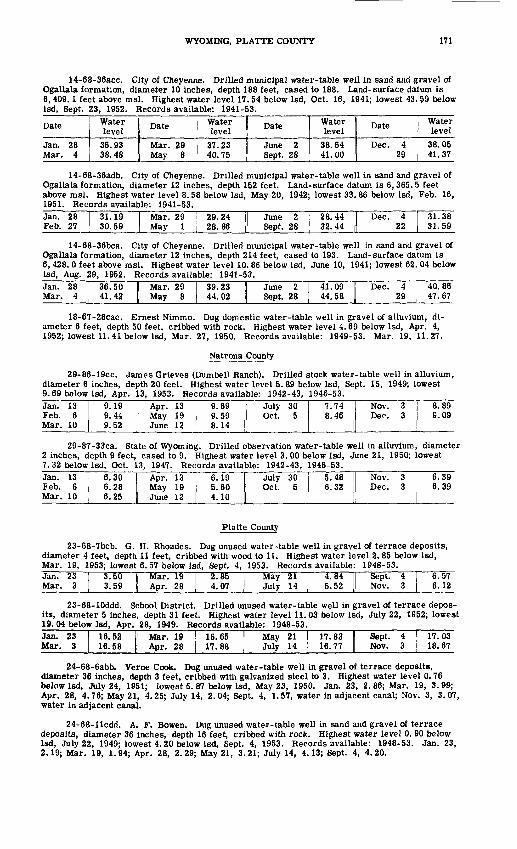
WYOMING, PLATTE COUNTY 171
14-68-36acc. City of Cheyenne. Drilled municipal water-table well in sand and gravel of Ogallala formation, diameter 10 inches, depth 188 feet, cased to 188. Land-surface datum is 6, 409.1 feet above msl. Highest water level 17. 54 below Isd, Oct. 16, 1941; lowest 43. 59 below Isd, Sept. 23, 1952. Records available: 1941-53.
Date
Jan. 28 Mar. 4
Water level
36.93 38.48
Date
Mar. 29 May 8
Water level
37.23 40.75
Date
June 2 Sept. 28
Water level
38.64 41.00
Date
Dec. 4 29
Water level
38.05 41.37
14-68-36adb. City of Cheyenne. Drilled municipal water-table well in sand and gravel of Ogallala formation, diameter 12 inches, depth 152 feet. Land-surface datum is 6,365.5 feet above msl. Highest water level 8. 58 below Isd, May 20, 1942; lowest 33. 86 below Isd, Feb. 16, 1951. Records available: 1941-53.Jan. 28 Feb. 27
31.19 30.59
Mar. 29 May 1
29.24 28.86
June 2 Sept. 28
28.44 32.44
Dec. 4 22
31.38 31.59
14-68-36bca. City of Cheyenne. Drilled municipal water-table well in sand and gravel of Ogallala formation, diameter 12 inches, depth 214 feet, cased to 193. Land-surface datum is 6, 428. 0 feet above msl. Highest water level 10. 86 below Isd, June 10, 1941; lowest 62. 04 below Isd, Aug. 29, 1952. Records available: 1941-53.Jan. 28 Mar. 4
36.50 41.42
Mar. 29 May 8
39.23 44.02
June 2 Sept. 28
41.09 44.58
Dec. 4 29
40.86 47.67
18-67-28cac. Ernest Nimmo. Dug domestic water-table well in gravel of alluvium, di ameter 6 feet, depth 50 feet, cribbed with rock. Highest water level 4.69 below Isd, Apr. 4, 1952; lowest 11.41 below Isd, Mar. 27, 1950. Records available: 1949-53. Mar. 19, 11.27.
Natrona County
29-86-19cc. James Grieves (Dumbell Ranch). Drilled stock water-table well in alluvium, diameter 6 inches, depth 20 feet. Highest water level 5. 89 below Isd, Sept. 15, 1949; lowest 9.69 below Isd, Apr. 13, 1953. Records available: 1942-43, 1946-53.Jan. 13 Feb. 6 Mar. 10
9.19 9.44 9.52
Apr. 13 May 19 June 12
9.69 9.59 8.14
July 30 Oct. 5
7.74 8.46
Nov. 3 Dec. 3
8.89 9.09
29-87-33ca. State of Wyoming. Drilled observation water-table well in alluvium, diameter 2 inches, depth 9 feet, cased to 9. Highest water level 3. 00 below Isd, June 21, 1950; lowest 7. 32 below Isd, Oct. 13, 1947. Records available: 1942-43, 1946-53.Jan. 13 Feb. 6 Mar. 10
6.30 Apr. 13 6.28 May 19 6.25 June 12
6.19 5.60 4.10
July 30 Oct. 5
5.48 6.32
Nov. 3 Dec. 3
6.39 6.39
Platte County
23-68-7bcb. G. H. Rhoades. Dug unused water-table well in gravel of terrace deposits, diameter 4 feet, depth 11 feet, cribbed with wood to 11. Highest water level 2. 85 below Isd, Mar. 19, 1953; lowest 6. 57 below Isd, Sept. 4, 1953. Records available: 1948-53.Jan. 23 Mar. 3
3.50 3.59
Mar. 19 Apr. 28
2.85 I! May 21 4.07 | July 14
4.84 5.52
Sept. 4 Nov. 3
6.57 6.12
23-68-10ddd. School District. Drilled unused water-table well in gravel of terrace depos its, diameter 5 inches, depth 31 feet. Highest water level 11.03 below Isd, July 22, 1952; lowest 19.04 below Isd, Apr. 28, 1949. Records available: 1948-53.Jan. 23 Mar. 3
16.52 16.58
Mar. 19 Apr. 28
16.65 17.88
May 21 July 14
17.83 1 Sept. 4 16.77 1 Nov. 3
17.03 18.67
24-68-6abb. Verne Cook. Dug unused water-table well in gravel of terrace deposits, diameter 36 inches, depth 3 feet, cribbed with galvanized steel to 3. Highest water level 0. 76 below Isd, July 24, 1951; lowest 5. 87 below Isd, May 23, 1950. Jan. 23, 2.86; Mar. 19, 3.99; Apr. 28, 4.76; May 21, 4.25; July 14, 2.04; Sept. 4, 1.57, water in adjacent canal; Nov. 3, 3.07, water in adjacent canal.
24-68-llcdd. A. F. Bowen. Dug unused water-table well in sand and gravel of terrace deposits, diameter 36 inches, depth 16 feet, cribbed with rock. Highest water level 0. 90 below Isd, July 22, 1949; lowest 4.20 below Isd, Sept. 4, 1953. Records available: 1948-53. Jan. 23, 2.19; Mar. 19, 1.94; Apr. 28, 2.29; May 21, 3.21; July 14, 4.13; Sept. 4, 4.20.
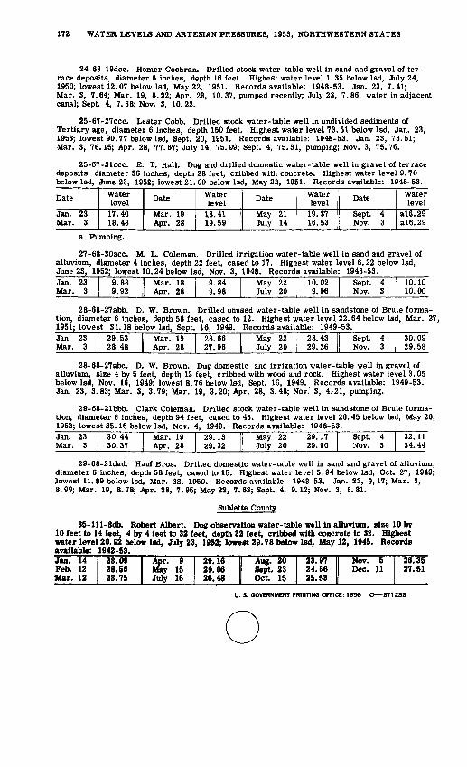
172 WATER LEVELS AND ARTESIAN PRESSURES, 1953, NORTHWESTERN STATES
24-68-19dcc. Homer Cochran. Drilled stock water-table well in sand and gravel of ter race deposits, diameter 6 inches, depth 16 feet. Highest water level 1.35 below Isd, July 24, 1950; lowest 12.07 below Isd, May 22, 1951. Records available: 1948-53. Jan. 23, 7.41; Mar. 3, 7.64; Mar. 19, 8.22; Apr. 28, 10.37, pumped recently; July 23, 7.86, water in adjacent canal; Sept. 4, 7.68; Nov. 3, 10.22.
25-67-27ccc. Lester Cobb. Drilled stock water-table well in undivided sediments of Tertiary age, diameter 6 inches, depth 150 feet. Highest water level 73.51 below Igd, Jan. 23, 1953; lowest 90.77 below Isd, Sept. 20, 1951. Records available: 1948-53. Jan. 23, 73.51; Mar. 3, 76.15; Apr. 28, 77.67; July 14, 75.09; Sept. 4, 75.31, pumping; Nov. 3, 75.76.
25-67-31ccc. E. T. Hall. Dug and drilled domestic water-table well in gravel of terrace deposits, diameter 36 inches, depth 28 feet, cribbed with concrete. Highest water level 9.70 below Isd, June 23, 1952; lowest 21.00 below Isd, May 22, 1951. Records available: 1948-53.
Date
Jan. 23 Mar. 3
Water level
17.40 18.48
Date
Mar. 19 Apr. 28
Water level
18.41 19.59
Date
May 21 July 14
Water level
19.37 16.53
Date
Sept. 4 Nov. 3
Water level
a!6.29 a!6.29
a Pumping.
27-68-30acc. M. L. Coleman. Drilled irrigation water-table well in sand and gravel of alluvium, diameter 4 inches, depth 22 feet, cased to 17. Highest water level 6.22 below Isd, June 23, 1952; lowest 10.24 below Isd, Nov. 3, 1948. Records available: 1948-53.Jan. 23 Mar. 3
9.88 9.92
Mar. 18 Apr. 28
9.84 9.98
May 22 July 20
10.02 9.96
Sept. 4 Nov. 3
10.10 10.00
28-68-27abb. D. W. Brown. Drilled unused water-table well in sandstone of Brule forma tion, diameter 6 inches, depth 58 feet, cased to 12. Highest water level 22.64 below Isd, Mar. 27, 1951; lowest 31.18 below Isd, Sept. 16, 1949. Records available: 1949-53.Jan. 23 Mar. 3
29.53 28.48
Mar. 19 Apr. 28
28.66 27.96
May 22 July 20
28.43 II Sept. 4 29.26 || Nov. 3
30.09 29.58
28-68-27abc. D. W. Brown. Dug domestic and irrigation water-table well in gravel of alluvium, size 4 by 5 feet, depth 12 feet, cribbed with wood and rock. Highest water level 3.05 below Isd, Nov. 16, 1949; lowest 8.76 below Isd, Sept. 16, 1949. Records available: 1949-53. Jan. 23, 3.83; Mar. 3, 3.79; Mar. 19, 3.20; Apr. 28, 3.48; Nov.' 3, 4.21, pumping.
29-68-21bbb. Clark Coleman. Drilled stock water-table well in sandstone of Brule forma tion, diameter 6 inches, depth 94 feet, cased to 45. Highest water level 26.45 below Isd, May 26, 1952; lowest 35.16 below Isd, Nov. 4, 1948. Records available: 1948-53.Jan. 23 Mar. 3
30.44 30.37
Mar. 19 Apr. 28
29.13 29.32
May 22 July 20
29.17 29.90
Sept. 4 Nov. 3
32.11 34.44
29-68-21dad. Hauf Bros. Drilled domestic water-table well in sand and gravel of alluvium, diameter 6 inches, depth 58 feet, cased to 15. Highest water level 5.94 below Isd, Oct. 27, 1949; lowest 11. 89 below Isd, Mar. 28, 1950. Records available: 1948-53. Jan. 23, 9,17; Mar. 3, 8.99; Mar. 19, 8.78; Apr. 28, 7.95; May 22, 7.63; Sept. 4, 9.12; Nov. 3, 8.81.
Sublette County
35-lll-8db. Robert Albert. Dug observation water-table well in alluvium, size 10 by 10 feet to 14 feet, 4 by 4 feet to 32 feet, depth 32 feet, cribbed with concrete to 32. Highest water level 20.92 below Isd, July 23, 1952; lowest 29.78 below Isd, May 12, 1945. Records available: 1942-53.Jan, 14 Feb. 12 Mar. 12
28.09 28.56 28.75
Apr. 9 May 15 July 16
29.16 29.06 26.48
Aug. 20 Sept. 23 Oct. 15
23.97 II Nov. 5 24.66 Dec. 11 25.53 ||
26.35 27.51
U. S. GOVERNMENT PRINTING OFFICE: 1956 O 371233