Walker Corporation Submision 151118 Redacted.pdf
420
Walker Corporation Pty Ltd ABN 95 001 176 263 Walker Group Constructions Pty Ltd ABN 59 097 303 716 Walker Group Constructions (QLD) Pty Ltd ABN 71 114 375 745 Walker Group Holdings Pty Ltd ABN 81 001 215 069 H:\LAW\Appin\Cover Letter_18.11.15.docx 18 November 2015 The Secretary NSW Department of Planning and Environment Housing Land Release GPO Box 39 SYDNEY NSW 2001 [email protected] Dear Ms McNally SUBMISSION ON THE GREATER MACARTHUR LAND RELEASE INVESTIGATION (GMLRI) Walker has been assembling land in the West Appin area for 15 years with a long term vision of creating a new town as first envisioned in the Three Cities Structure Plan in 1973. We are committed to creating a master planned community which provides a range of housing, employment, leisure and community opportunities consistent with our vision for a new urban ‐ rural lifestyle. This vision includes respect for the environmental and Aboriginal features of the area and for the amenity and heritage of the adjoining Appin village. Our vision also includes the delivery of infrastructure at no additional cost to government and a practical approach to delivering affordable housing as we previously exhibited in our smaller Appin Valley project which was highly sought after by local first and second home buyers. I attach herewith our submission to the Greater Macarthur Land Release Investigation and I hope you will forgive a few criticisms in our submission. We are passionate about our vision and will continue to promote what we believe in despite the fact it may not always match the prevailing planning orthodoxy. Thank you for allowing us to present our views. Yours sincerely LANG WALKER Executive Chairman Walker Corporation GPO Box 4073 Sydney NSW 2001 Australia Level 21 Governor Macquarie Tower 1 Farrer Place Sydney NSW 2000 Australia Telephone: + 61 2 8273 9600 Mobile: +61 411454752 Direct Line: + 61 2 8273 9627 Facsimile: + 61 2 9252 7400 Email: gerry.beasley@walkercorp.com.au
-
Upload
khangminh22 -
Category
Documents
-
view
3 -
download
0
Transcript of Walker Corporation Submision 151118 Redacted.pdf

Walker Corporation Pty Ltd ABN 95 001 176 263 Walker Group Constructions Pty Ltd ABN 59 097 303 716
Walker Group Constructions (QLD) Pty Ltd ABN 71 114 375 745 Walker Group Holdings Pty Ltd ABN 81 001 215 069 H:\LAW\Appin\Cover Letter_18.11.15.docx
18 November 2015 The Secretary NSW Department of Planning and Environment Housing Land Release GPO Box 39 SYDNEY NSW 2001 [email protected] Dear Ms McNally SUBMISSION ON THE GREATER MACARTHUR LAND RELEASE INVESTIGATION (GMLRI) Walker has been assembling land in the West Appin area for 15 years with a long term vision of creating a new town as first envisioned in the Three Cities Structure Plan in 1973. We are committed to creating a master planned community which provides a range of housing, employment, leisure and community opportunities consistent with our vision for a new urban ‐ rural lifestyle. This vision includes respect for the environmental and Aboriginal features of the area and for the amenity and heritage of the adjoining Appin village. Our vision also includes the delivery of infrastructure at no additional cost to government and a practical approach to delivering affordable housing as we previously exhibited in our smaller Appin Valley project which was highly sought after by local first and second home buyers. I attach herewith our submission to the Greater Macarthur Land Release Investigation and I hope you will forgive a few criticisms in our submission. We are passionate about our vision and will continue to promote what we believe in despite the fact it may not always match the prevailing planning orthodoxy. Thank you for allowing us to present our views. Yours sincerely
LANG WALKER Executive Chairman Walker Corporation
GPO Box 4073 Sydney NSW 2001 Australia
Level 21 Governor Macquarie Tower 1 Farrer Place Sydney NSW 2000 Australia
Telephone: + 61 2 8273 9600 Mobile: +61 411454752 Direct Line: + 61 2 8273 9627 Facsimile: + 61 2 9252 7400 Email: [email protected]

Page 1 of 16
Submission on the Greater Macarthur Land Release Investigation (GMLRI) This submission is prepared in relation to the recently‐exhibited Greater Macarthur Land Release Investigation Preliminary Strategy and Action Plan (the GMLRI Strategy) and proposed amendments to the State Environmental Planning Policy (Sydney Growth Centres) 2006 (the Growth Centres SEPP). The submission outlines Walker Corporation’s view of past land releases in South West Sydney including the GMLRI and submits a solution that focuses on the release of additional land specifically at West Appin in conjunction with the staged development of new infrastructure starting with Appin Road and eventually an arterial road connecting the Hume Motorway with the Appin‐Bulli Road diverting traffic away from Campbelltown and Narellan Road.
History West Appin was first identified as a possible growth area in the Sydney Region Outline Plan (1968) (the SROP). In 1973 the government released the “Three Cities Structure Plan” which specifically identified Appin as a new town. 1991 the South Macarthur Regional Environmental Study found Appin, Mt Gilead and Wilton were suitable as future urban areas In 2005 the government extended development north of Narellan in what was first called “South Creek” and later became known as the South West Growth Centre. In 2009 South Macarthur was deferred by the government due to concerns about coal mining. In 2014 coal mining was largely completed in West Appin. In 2015 West Appin was assessed as suitable for release in the draft GMLRI but deferral has been suggested because of land supply and infrastructure reasons.
The South West Growth Centre The SW Growth Centre was planned to deliver 65% of the 155,000 additional homes that the government predicted would be needed in SW Sydney to 2031 (Department of Planning: 2005; South West Subregional Draft Regional Strategy p75). Much was written by the government about the benefits of the SW Growth Centre especially the fact it would produce 110,000 lots providing the region with enough land for housing to ensure an affordable housing supply for over 20 years. However most of the SW Growth Centre had previously been disregarded by planning authorities because it contained 4,500 SMALL RURAL LOTS that made cost effective and planned development virtually impossible (Department of Planning, 1988; Urban Development Programme 1988/1989 – 1992/1993). Also 50% of NSW vegetable farms are in the Sydney Basin and 50% of these are in areas designated for urban expansion such as the Growth Centres (NSW Food Summit 2009).

Map 1: SW Gr
The South developers subsequent The GovernCamden Va Ten years oboth slow aservices buEnvironmen The governmall works in for all of Ora
rowth Centre
West Growand the NSWtly released f
nment then slley Way hop
on and the fand costly. Ft there is nnt: October 2
ment througOran Park foan Park (Sou
th Centre dW Governmefor developm
spent $1.8 bping it would
fragmented lor example Sno commitm2015; Leppin
gh its developor the first 2,rce: Urban G
did however ent through ment.
illion buildin result in mo
ands remainStage 1 at Leent to servigton Stage 1
pment arm U,700 lots withGrowth webs
include somits developm
g a rail way ore affordabl
n a problem eppington is ice or rezon1 Finalisation
Urban Growth potential tsite accessed
me large homent arm Ur
line to Leppie land being
because cobeing rezonne the rema Report).
th NSW decio play a roled 17.11.15).
oldings owneban Growth
ington and $ developed.
nsolidating sed because oaining 4 stag
ded to help in the coord
ed by a smNSW. These
$280 million
so many smof existing oges (Source:
developmendination of in
Page 2 of 16
all group ofe lands were
to complete
all parcels isr committedPlanning &
nt by fundingnfrastructure
6
f e
e
s d &
g e

Page 3 of 16
In June this year after 10 years of planning and investment of public money the SW Growth Centre had produced approximately 4,500 registered lots (Source: Growth Centre website accessed June 2015) plus a further 1,000 lots under construction or registered since June. It is argued that despite the investments in the rail line, the planning and the funding of the joint venture at Oran Park and the completion of infrastructure the greatest achievement from the SW Growth Centre is that the restricted supply and the infrastructure investment has increased the undeveloped value of land within its boundaries so much that it is arguably impossible to now develop residential land at an affordable price. Despite the government planning and infrastructure the SW Growth Centre will never deliver 110,000 lots because of land fragmentation. The last 10 years have produced around 5‐6,000 lots so if production averages 3,000 lots per year for the next 15 years it will reach only 50,000 lots but not 110,000 lots. It is suggested the Growth Centres approach has produced some of the most expensive residential land ever developed in Australia. For example between 2010 and 2015 the median green field lot price in SW Sydney was $250,000. At the same time in Melbourne the price was $196,000. Five years later the median price in SW Sydney is $364,500 while in Melbourne it remains much the same at $212,000 (Appendix 1). The government attempted to address affordability problems in 2014 but instead of releasing more land to create competition to drive down prices it decided to allow existing growth centre developers plus Urban Growth NSW to subdivide lots as small as 200 square metres in low density zones and 125 square metres in medium density zones (Planning & Environment: Growth Centres Amending Development Control Plan No. 1, August 2014). The result is smaller and smaller lots making increasing profits for land owners and the Government with buyers having no choice but to accept accommodation that is sub optimal for families living on Sydney’s fringe. Recently a research paper was released that found a growing deficit of accommodation suitable for families (Birrell; 2015) and this trend is going to continue unless the government releases more land and creates more opportunities for master planned communities that provide what families are wanting at a price that they can afford. The past 10 years of Growth Centre planning should lead the public to ask the following questions:
WAS IT NECESSARY FOR URBAN GROWTH NSW TO INVEST IN ORAN PARK IN ORDER TO SUPPORT THE ESTABLISHMENT OF THE SW GROWTH CENTRE? HAS THERE BEEN ANY MEASURABLE IMPROVEMENT IN HOUSING SUPPLY OR HOUSING AFFORDABILITY AS A RESULT OF THE NSW GROWTH CENTRE AND THE GOVERNMENT INVESTMENTS THAT WERE MADE? WHY DOES’NT THE GOVERNMENT OPEN UP COMPETITION BY RELEASING LAND OUTSIDE THE GROWTH CENTRES TO PUT DOWNWARD PRESSURE ON LAND PRICES?

Page 4 of 16
Metropolitan Strategy Submissions In 2010 and 2013 Walker Corporation responded to requests for submissions on the Sydney Metropolitan Strategy. These submissions were well researched reports prepared by qualified professionals. Copies of these submissions are attached at Appendix 2. No reply was ever received other than a pro forma acknowledgement.
Walker Part 3A Application In 2010 Walker Corporation submitted an application under Part 3A of the Environmental Planning and Assessment Act requesting the government consider a new town proposal at Appin. The proposal presented a regional approach that was well researched and included detailed studies including a regional traffic model, a public transport study, a services strategy and various environmental assessments. The application was never acknowledged. A letter was received 18 months later advising Part 3A had been repealed and the application could no longer be considered.
The Potential Home Sites Program Due to the rising cost of land the then Minister for Planning decided in late 2011 to call for land holdings outside the SW Growth Centre greater than 100 hectares that were “shovel ready” to be submitted for investigation by the government. This was called the Potential Home Sites Program. In 2011 Walker Corporation submitted an application supporting new land releases at Appin and Wilton. The submission was acknowledged but again the government did nothing. However, Wollondilly Council did take action and subsequently co‐ordinated three Proposals into the Wilton Junction master plan. The Government subsequently allowed an investigation into Wilton Junction by the land owners. This has still not been determined.
The West Appin Strategic Infrastructure Investigation The government then decided in 2013 to lead an investigation into infrastructure requirements for West Appin. This investigation was completed and submitted in March 2015 by the landowners. The completed investigation has never been acknowledged and no feedback has ever been provided. The investigation was carried out under the leadership of the Department of Planning and Environment with support from Transport for NSW and in accordance with Terms of Reference issued by the Department 20 December 2013. The work was delayed by 6 months because Transport for NSW were unable to decide on appropriate assumptions to use for the required Transport Model.

Page 5 of 16
The final submission contained the following reports:
Preliminary Traffic and Transport Model (prepared by WSP Parsons Brinkerhoff)
Infrastructure Servicing Strategy (prepared by civil engineering firm BG&E)
Social Infrastructure Assessment (prepared by Elton Consulting)
Business case (prepared by Elton Consulting)
Copies of these reports are included within this submission (Appendix 3). The business case concluded that:
the legacy of past urban growth in south west Sydney and the growing economic importance of the Illawarra region has created a need for government investment in roads infrastructure in the region;
the development at West Appin would add an additional $384 million to the cost of building this new regional road network; and
the government could cover this additional cost through the imposition of an infrastructure levy of $30,000/lot (raising between $450 and 540 million) to provide the infrastructure that is needed now and into the future AT NO ADDITIONAL COST TO GOVERNMENT.
These reports sat with government for 6 months without comment or feedback to the landowners until the government released the GMLRI in October.
The Greater Macarthur Land Release Investigation The GMLRI was made available for community comment in October 2015. The GMLRI concluded West Appin was not needed for 20 years. It also concluded Mt Gilead/Menangle Park and Wilton could be released for urban expansion. The reasons given why West Appin was not needed were:
1. There would be 35,000 lots produced in Mt Gilead/Menangle Park and Wilton so no more land was required; and
2. The delivery of infrastructure such as road upgrades for West Appin was not cost effective. Let’s examine whether these reasons can be sustained.
Can Mt Gilead/Menangle Park and Wilton deliver 35,000 homes in 20 years? Mt Gilead/Menangle Park is assessed as having capacity to deliver 18,100 homes while Wilton is assessed at 16,600 homes. However actual capacity is below what is promised because of the following constraints:
1. High value agricultural land;
2. Coal seam gas wells;
3. Approved coal mining operations; and
4. Land fragmentation. These constraints are explained below.

1. Agricultu Map 2 comp The brown operations. GMLRI as an Map 2: Agricul
Mt Gilead/Mwater licensBowl and al The presencdeliver hom West Appinrelease is idbefore 2019
2. Coal Sea Map 3 below The governCompany Dkilometres o Coal seam ggrowing urboperations w
ural land
pares Mt Gile
and red a High valuen “encumbra
ltural Constrain
Menangle Pases for irrigaso provide h
ce of high vames.
n has no highdentified as 9 so is not a c
m Gas
w shows app
nment has rDahua Groupof existing ga
gas wells elicban area at with compla
ead/Menang
reas are hige agriculturalance”.
nts – Source GM
ark have a nation. These istoric and s
lue agricultu
h value agrichigh value. constraint.
proved coal s
ecently soldp (Source: Uas wells and a
cit strong coMenangle Pints about im
gle Park with
gh value ag land should
MLRI
umber of arareas are ofcenic values
ural land at M
cultural land.West Appin
seam gas (CS
d land at MeUrban Growta gas produc
mmunity opPark and Mtmpacts on gro
Mt Gilea
We
West Appin
gricultural lad not be dev
reas identifief potential imappreciated
Mt Gilead/Me
. Some land n does conta
SG) wells as y
enangle Parth NSW wection facility.
position andt Gilead can ound water,
ad/Menangle
st Appin
.
ands. The yeveloped for
ed as high vamportance a by the local
enangle Park
east of Appain a poultry
yellow and or
rk for residebsite access
d while this mbe expecteair quality a
e Park
ellow areas housing and
alue agricultas part of Sycommunity.
will reduce t
in village ouy operation b
range circles
ential develoed 17.11.15
may have bed to raise cond noise to b
define exisd this is iden
ure includingdney’s dimin.
the ability of
utside the prbut this will
.
opment to d5). This land
en avoided ioncerns withbe expected.
Page 6 of 16
ting poultryntified in the
g areas withnishing Food
f this area to
oposed landclose on or
development is within 2
in the past ah these CSG
6
y e
h d
o
d r
t 2
a G

Placing urbathe rezoninregions.
MT GILEAD
THE GOVERPOLICY IS VAAROUND TH
3. Coal Min Map 3 show Future mini The governmurban devesubsidence completed a Wilton has a Map 3: Coal m
Wilton
Fragmen
an areas adjg of the hom
AND MENAN
RNMENT APPARIED WHATHE STATE?
ning
ws approved
ng is identifi
ment previoelopment. Tas long walat West App
approximate
mining and coal
nted land
acent to eximes and or
NGLE PARK H
PLIES A 2 KILT IMPACT WI
coal mining
ed in yellow,
usly deferredThis avoids ils collapse fin.
ely 6000 hom
seam gas wells
Coa
sting gas extset a preced
AVE A LARGE
LOMETRE SETLL THIS HAVE
in Wilton an
, red and ora
d developmeimpacts sucollowing the
mes located a
– Source GMLR
al mine longwal
traction will dent that un
E NUMBER O
TBACK BETWE ON GOVER
d completed
ange and com
ent in South ch as drillinge completion
above approv
RI
CSG wells
ls
lead to comdermines th
OF CSG WELLS
WEEN URBANNMENT CON
d mining at W
mpleted mini
Macarthur tg for explorn of mining.
ved future lo
mmunity oppohe governme
S PLUS A CSG
N AREAS ANDNTROL OVER O
West Appin.
ing in grey.
o allow for mration and As a result
ng wall mini
Mt
osition whicent’s CSG po
G PROCESSING
D CSG WELLOTHER CSG O
mining to occgas drainagmining has
ng operation
t Gilead/Men
West Appin
Page 7 of 16
h may delayolicy in other
G PLANT.
S SO IF THISOPERATIONS
cur ahead ofge and thenlargely been
ns.
nangle Park
n
6
y r
S S
f n n

Page 8 of 16
Mining of the Bulli seam can produce subsidence of about 1 metre (Pell Consulting: 2012). Development can be designed to reduce impacts from subsidence but it cannot be eliminated and homes will be damaged as long walls collapse. As a result government warnings will be needed to ensure future owners are aware of the potential for damage from subsidence. These difficulties mean the development of significant areas in Wilton may be delayed until either mining is completed or a satisfactory planning framework is imposed. It is therefore unlikely 16,000 homes will be developed in Wilton by 2036.
4. Land Fragmentation West Wilton contains approximately 50 small rural allotments. The GMLRI assumes these lots can be developed producing approximately 4,000 additional lots. These lots are remote from existing and proposed services and are highly valued because of their amenity and improvements. While subdivision into smaller rural allotments may be feasible normal urban development is unlikely because it will be unviable because of the cost to consolidate lots and the expense of delivering full urban services. THE GMLRI APPEARS TO BE FOLLOWING A COMMON THEME OBSERVED IN THE GROWTH CENTRES:
MAJOR CONSTRAINTS ARE IGNORED INCLUDING FRAGMENTED LAND OWNERSHIP,
POLICIES PROCLAIMED TO DELIVER LARGE VOLUMES OF AFFORDABLE HOUSING ACTUALLY END UP RESTRICTING LAND SUPPLY BECAUSE RELEASE AREAS OUTSIDE THE POLICY AREA ARE PROHIBITED.
It is no surprise that Melbourne growth areas sold 15,650 lots in 2014 while Sydney struggled to sell 7,860 lots in the biggest boom in decades (Appendix 1).
BECAUSE OF CSG, MINING, LAND FRAGMENTATION AND AGRICULTURAL LAND CONSTRAINTS MT GILEAD/MENANGLE PARK AND WILTON CANNOT DELIVER 35,000 HOMES BY 2036. AS A RESULT WEST APPIN NEEDS TO BE INCLUDED WITHIN THE GROWTH CENTRE SEPP.
Why did the GMLRI decide the cost of delivering infrastructure at West Appin was not cost effective? Roads The GMLRI concludes for West Appin that large scale land releases would trigger the need for a new east west connection to the Hume Highway and the cost of these works would be significant and not currently cost effective. However there is no evidence within the work provided to show how this conclusion was reached. There are no costings of the east west link and no traffic modelling to show when it is needed. The Strategic Transport Plan provided for the GMLRI was written without first considering the benefits and costs of different development strategies. Instead it was required to focus on a pre‐determined land release scenario given to it by NSW Planning and Environment.
“The particular focus of this report is to identify the trunk transport infrastructure proposed to support the land use scenario identified in DP&E’s Preliminary Strategy and Action Plan for Greater Macarthur” (AECOM: 2015; Strategic Transport Investigation: Page 1).
Interestingly THE GMLRI report on infrastructure did report that West Appin should be developed before Wilton:

Page 9 of 16
“Overall it makes sense that the northern precincts of GMLRI (Stages 1 and 3) [Menangle Park and Mt Gilead] are developed first followed by Stages 4 and 5 [West Appin, Menangle and Douglas Park]. Stage 2 [Wilton] would require significant regional infrastructure upgrades and therefore significant cost is expected to be associated with the development of this precinct before the development of most of the other precincts in GMLRI”. (AECOM in a memorandum to Planning & Environment dated 10 June 2015 at Appendix I of the GMLRI High Level Services Infrastructure Strategy).
It is assumed the transport investigations for the GMLRI never investigated the impacts of including or excluding West Appin because the GMLRI does not provide evidence into the potential advantages or disadvantages of West Appin in terms of the cost effective delivery of infrastructure. However the West Appin landowners did submit this work in March this year and further work on both traffic impacts and the costs of including or excluding West Appin is provided at Appendices 4 and 5. This work began with traffic modelling by WSP Parsons Brinkerhoff using previous research undertaken in the preparation of the Wilton Junction TMap (2014), the West Appin Preliminary Transport and Traffic Assessment (2015) using the Sydney Strategic Transport Model (STM) in collaboration with TfNSW (BTS), and earlier work undertaken by Gabittes Porter using the Roads and Maritime’s Illawarra Transport Model. Results from the transport modelling were then costed by Civil Engineers BG&E adopting standard industry estimating practice. These studies are provided for review at Appendix 4 and 5 and support various conclusions including:
1. The GMLRI Strategic Transport Plan is based upon an incorrect assumption that minimal traffic flow occurs between Macarthur and the Illawarra. In previous studies endorsed by Transport for NSW 15% of total traffic generated by developments in the GMLRI were assigned to travel to and from the Illawarra region. The 2011 BTS Journey to Work Survey found 37% of workers in the GMIA reside in, and travel to and from the Illawarra;
2. Appin Road has a significant road safety problem with the government commissioning a Safety Review in 2014 after years of vocal representations from local residents especially those living in Appin Village (TfNSW: 2014). The Review found there had been 5 fatalities in the last five years and 119 casualty accidents;
3. The Appin ‐ Hume east west connector is not required until AFTER 2040 provided the internal Mt Gilead / West Appin road network is designed with a new north south arterial and bus corridor;
4. Appin Road will need to be fully upgraded past Appin Village after 800 lots in Mt Gilead resulting in a considerable cost burden either to government or the developers in this precinct;
5. A sequenced land release that includes releases along the entire length of Appin Road including the proposed By Pass would ensure Appin Road was delivered in a timely and cost effective way (see Map 5);
6. The total cost of road upgrades (including upgrades to the Hume Motorway ‐ potentially a Federal responsibility) to service Mt Gilead/Menangle Park and Wilton amounts to $863 million equating to an equivalent Special Infrastructure Contribution of $25,384 / lot; and
7. The total cost of road upgrades (including Hume Motorway) to service Mt Gilead/Menangle Park, Wilton PLUS West Appin amounts to $1,346 million equating to an equivalent Special Infrastructure Contribution of $25,887 / lot.
The investigation reveals the cost to deliver road infrastructure is only marginally higher if West Appin were included. Moreover minor cost variations at this level are meaningless as final costs will be influenced by staging, rates of growth, cost apportionment (backlog costs vs growth costs) and opportunities for leveraging funding from Federal and State programs. These conclusions give rise to the following questions:

Page 10 of 16
WHY DID’NT THE GMLRI EXAMINE THE IMPACT OF WEST APPIN IN ITS STRATEGIC TRANSPORT STUDY?
WHY DID’NT THE GMLRI INVESTIGATE TRAFFIC FLOW BETWEEN MACARTHUR AND THE ILLAWARA?
WHY DIDN’T THE GMLRI TRANSPORT STRATEGY RECOGNISE THE SAFETY ISSUES ALONG APPIN ROAD?
WHERE WAS THE EVIDENCE BASE TO JUSTIFY THE EXCLUSION OF WEST APPIN ON GROUNDS THAT INFRASTRUCTURE WAS NOT “COST EFFEECTIIVE”?
Why did the GMLRI decide West Appin was not needed to provide adequate land supply for SW Sydney out to 2036? The GMLRI states the Priority Precincts in Mt Gilead / Menangle Park and Wilton can deliver 35,000 new homes through to 2036 and concludes this is sufficient to meet unmet demand from within the NW and SW Growth Centres. This is misleading because Mt Gilead / Menangle Park and Wilton are not physically able to produce anywhere near 35,000 new homes by 2036 for various reasons as described below: Production Over the lifecycle of a residential estates production will average around 250 lots per year (Appendix 1). This is caused by a number of factors including the capacity of council’s to assess proposals, constraints caused by access and fragmentation/site consolidation, delays with completion of trunk sewer, water and power, delays caused by state authorities not granting approvals, market fluctuations, availability of financing, and so on. Some estates will produce at higher levels for a short time during market peaks and or because of owner ability to manage high rates of production. However a survey of sale rates per estate from a sample of over 80 estates in Sydney between 2008 and 2015 found that:
1. Sale rates are directly proportional to project size; and 2. Large estates (1000+ lots) had a median of 21 lots sold per calendar month or 250 lots per year.
If this production rate is applied to Mt Gilead, Menangle Park and Wilton with potential development fronts based upon current developer holdings and starting dates based upon reasonable assumptions around rezonings and availability of services you will get the following results: Development Estates
Commencing Dwellings/year(years of
production)
Dwellings by 2036
Potential Constraint
Mt Gilead 1 2018 250 (18) 4500 9000 CSG
Mt Gilead 2 2022 250 (14) 3500 9000
M’ Park 2018 250 (18) 4500 3400 CSG
Wilton 1 2018 250 (18) 4500 5400 Coal
Wilton 2 2018 250 (18) 4500 2750
Wilton 3 2018 250 (5) 1000 1000 Coal
Wilton 4 2016 120 (10) 1200 1800 Coal
Wilton 2022 50 (14) 700 4000 Fragmentation
TOTAL 24400 36350
The estimate reveals Mt Gilead/Menangle Park and Wilton may deliver 25,000 homes over the life of the Plan. This is 10,000 homes short of the 35,000 homes the GMLRI suggests are “immediate opportunities”. If production is reduced due to delays caused by mining, agricultural land and coal seam gas disputes plus market cycles, THAN EVEN 25,000 HOMES IS UNACHIEVABLE.

Page 11 of 16
WHY IS THE GOVERNMENT REPEATING THE MISTAKES OF THE SW GROWTH CENTRE BY OVER ESTIMATING THE NUMBER OF HOMES THAT CAN BE PRODUCED? WHY DID GMRLI CONCLUDE THERE WOULD BE IMMEDIATE OPPORTUNITIES FOR 35,000 HOMES WHEN IN FACT THE GMLRI WILL STRUGGLE TO PRODUCE 25,000 HOMES?
Housing demand 2015 draft UDIA lot production statistics for SW Sydney green field projects suggest average production will increase to over 7,000 new green field lots per year over the next 5 years in Liverpool, Camden, Campbelltown and Wollondilly. Assuming a long term average of 5,000 lots / year there would be demand for 100,000 green field housing lots over 20 years. This is similar to what the Department of Planning predicted in its draft SW Sub‐Regional Strategy in 2007 (Department of Planning: 2007; p75). The West Appin landowners investigated each planned and proposed land release within the SW Growth Centre in 2014 (See Table at Appendix 6). The West Appin landowners concluded current and planned SW Growth Centre green field projects will only deliver around 48,000 – 50,000 lots over the next 20 years so there could be a shortfall of 50,000 lots. The GMLRI found there is current unmet demand of between 11,056 and 25,666 dwellings and this may increase ALSO to 55,684 dwellings if a high growth scenario occurs (AEC Group: GMLRI: Housing Market Needs Analysis; September 2015, page 48). The GMLRI should be addressing a shortfall of 50,000 new green field lots over the life of the Plan. This is not to disregard the significance of in ‐ fill housing (such as the Glenfield to Macarthur corridor). However the long term projection is for 100,000 green field lots plus 55,000 homes in existing areas (Department of Planning: 2007; p75). The GMLRI proposes to deliver 35,000 lots leaving a short fall of 15,000. BUT if the GMLRI only delivers 25,000 lots due to production constraints there will be a shortfall of 25,000 lots. If the GMLRI delivers fewer lots again due to land constraints such as mining, coal seam gas, agricultural land and fragmentation, the shortfall in SW Sydney over the next 20 years could easily be 35,000 lots. This will put continuing upward pressure on prices and affordability.
WHY IS THE GOVERNMENT PROPOSING A LAND RELEASE POLICY THAT ENSURES GREEN FIELD HOUSING REMAINS OUT OF REACH TO MANY BUYERS IN SW SYDNEY FORCING FAMILIES TO ACCEPT A LIFE TIME OF LIVING IN FLATS ON SYDNEY’S FRINGE?
PLANNING The GMLRI exhibits the worst kind of planning with development leap frogging over West Appin and Menangle, with development occurring on constrained land, and with no clear vision for a regional road network or a plan to deliver infrastructure. Despite the historical connections between the villages and towns of Macarthur and the Illawarra there is no clear vision in the plan that would ensure the planning of this region is co‐ordinated and that the interrelationships between the precincts are used to best advantage for the local community.

Map 4: Propos
For exampleRoad – yet West Appin There are coplan to upgr The developcannot be r A long termSydney Orb The GMLRI Appin yet Wthe land aro If the propodevelopmencosts in a w
sed Priority Prec
e the Wiltonthis cannot .
onsiderable rade road co
pment of Mtesolved with
m plan to conital cannot b
envisages a West Appin isound it is not
osed releasent is unlikelyay that meet
cincts – Source
n Priority Prebe planned
linkages betwonnections su
t Gilead will hout a plan fo
nnect the Illbe resolved w
sewer netws not includet going to be
e precincts oy to occur ots communit
GMLRI
ecinct will hafor unless y
ween Macartuch as Appin
generate traor a future ro
awarra throuwithout a pla
ork includinged in the Grodeveloped.
f Mt Gilead/r will occur ty expectatio
ave impacts you have a v
thur and the ‐ Bulli.
affic on Appoad network
ugh to westen for West A
g a Waste Wowth Centre
/Menangle Pin such a wons.
on traffic flovision for the
e Illawarra be
in Road caus through We
ern Sydney aAppin.
Water Treatme so the plan
Park and Wilay as to avo
AP
ow via Brouge future roa
eaches and u
sing decreasest Appin.
and the seco
ment Plant ont is unlikely
ton are requoid dealing w
PPIN “The hol
ghton Pass ad network t
universities; y
sed levels of
ond airport v
n land identito be delive
uired to fundwith these in
le in the don
Page 12 of 16
nd up Appinhat includes
yet no visible
service that
via an Outer
fied in Westred because
d everythingnfrastructure
ut”
6
n s
e
t
r
t e
g e

Page 13 of 16
CONCLUSION It is concluded that West Appin was not identified for release in the GMLRI because of an incomplete understanding of:
1. The associated infrastructure costs;
2. The offer by West Appin landowners to guarantee no additional cost to government;
3. The likely slow rate of production and sale from the proposed Priority Precincts;
4. The high overall demand for more housing in SW Sydney; and
5. The lack of potential supply over the next 20 years from the SW Growth Centre.
It is submitted there is much to gain from including West Appin into the draft Growth Centre SEPP particularly the opportunity to increase land supply for affordable housing and fast tracking the delivery of needed infrastructure such as the upgrade of Appin Road.
RELEASING LAND AND EVEN REZONING LAND DOES NOT AUTOMATICALLY LEAD TO LAND PRODUCTION.
WHERE “NO ADDITIONAL COST TO GOVERNMENT” RULES APPLY THE RISKS OF RELEASING ADDITIONAL LAND ARE MINIMISED AND OPPORTUNITIES FOR INVESTMENT AND AFFORDABILITY ARE MAXIMISED.
THIS ALLOWS PLANNING TO FOCUS ON WHAT IT DOES BEST ‐ ASSESSING IMPACTS AND MANAGING CHANGE.
In order to specify how West Appin might be included the following steps are suggested.
PROCESS STEPS STEP 1 The Map associated with the draft Growth Centre State Environmental Planning Policy amendment is modified to include West Appin (Appendix 7). STEP 2 The existing planned releases at both Menangle Park and Mt Gilead proceed to gazettal as “Priority Precincts” as quickly as possible. STEP 3 The existing planned release at Wilton Junction (within the Wilton Priority Precinct) advance to exhibition as quickly as possible. STEP 4 NSW Planning & Environment prepare and exhibit a Special Infrastructure Contribution (SIC) framework using the work provided by the West Appin landowners and the other developers in the region. The SIC provides infrastructure that matches growth plus the outcomes required for a sustainable new town including jobs, community and recreation facilities and environmental sustainability in a way that is practical for land developers, Government, Council and community. STEP 5 New projects from Mt Gilead, Wilton and West Appin proceed to submit Voluntary Planning Agreements prepared under the SIC framework. These VPA’s are exhibited along with the planning assessment work prepared by the land owners at their cost.

STEP 6 These new overall benalong Appin
DELIVERY S STEP 1 Identify andreconstruct An example Map 5: Staging
projects areeficial infrasn Road from
STEPS
d size releaseion of a port
e of what this
g the reconstru
e allowed to tructure tesRosemeadow
e areas alongtion of Appin
s might look
ction of Appin R
proceed to t is met inclw to the App
g Appin Road Road as a d
like is provid
Road to match d
gazettal whluding the epin Bulli Road
d so each relual carriagew
ded in the pla
development
here a “No arly deliveryd.
ease area is way divided r
an below and
additional coy of a dual la
sufficiently lroad.
d at Appendix
ost to goverane divided
arge enough
x 8.
Page 14 of 16
rnment” andcarriageway
h to fund the
6
d y
e

STEP 2 Determine twhether the This sequenoutlined in t Map 6: Concep
STEP 3 Accept Planany sequengovernment STEP 4 Where satis STEP 5 HOUSING D INFRASTRUCALONG WIN
the impact oere is a need
ncing will rethe work by
ptual arterial Ro
nning Proposncing requiret”.
sfactory to go
ELIVERY COM
CTURE WORKNDSOR ROAD
of these relead to “sequenc
equire an unWSP Parsons
oad network
als from landements, env
overnment p
MMENCES.
KS COMMEN)
ase areas once” release a
nderstandings Brinkerhoff
d holders aloironmental i
proceed to ex
NCE UNDER V
n traffic and sareas or whet
g of the timf at Appendix
ong Appin Roimpacts and
xhibit, finalis
VOLUNTARY P
safety conditther they can
ing and layox 4 and show
oad and assed ability to d
e assessmen
PLANNING A
tions along An be develop
out of the awn below:
ess them agadeliver infras
nt and ultima
GREEMENTS
Appin Road tped independ
arterial road
ainst the SIC structure at
ately gazette
S (SIMILAR TO
Page 15 of 16
o determinedently.
network as
Framework,“no cost to
rezonings.
O UPGRADES
6
e
s
, o
S

Page 16 of 16
REFERENCES AEC Group: GMLRI: Housing Market Needs Analysis; September 2015.
Bob Birrell and David McCloskey: The housing affordability crisis in Sydney and Melbourne; Australian Population Research Institute, October 2015.
Department of Planning: 1988; Urban Development Programme 1988/1989 – 1992/1993.
Department of Planning: 2007; South West Subregional Draft Regional Strategy.
Pell Consulting: 2012; Working Paper No. 10; Sydney Region Aviation Capacity Study – Wilton Site.
Planning & Environment: Growth Centres Amending Development Control Plan No. 1, August 2014.
Transport for NSW: Appin Road Safety Review; March 2014

APPENDIX 1 Charter Keck and Cramer letter dated 17 November 2015

Thomson Maloney
& Partners Pty Ltd
T/A Charter Keck Cramer
ABN 98 318 420 369
16 November 2015
Mr Grerry Beasley
Walker Corporation
Dear Gerry
Re: South-West Sydney Greenfields Market Assessment.
Further to your instruction, the following letter provides an outline of some key metrics
about the South-West and metropolitan Sydney greenfield land market with reference to
data from National Land Survey Program (NLSP). For the purpose of relativity, these
metrics have been benchmarked to the metropolitan Melbourne greenfield market.
Sales Activity
Metropolitan Sydney
Sales activity across the metropolitan Sydney’s greenfield market peaked at almost 9,300
lot sales in the year ending June 2014 and has fallen by 15% to 7,860 over the year ending
June 2015.
Over this same period the number of trading estates has been approximately 40 and 50
trading estates as compared to a peak of 77 trading estates in early 2013.
South-West Sydney
Sales activity across South-West Sydney has been much more resilient as compared to the
rest of Sydney with the peak of annual sales remaining consistent between approximately
3,500 - 3,600 lots since early 2014.
There was a rapid pick-up in sales activity since early 2013 with approximately 20 trading
estates although this level of completion has more recently fallen to 13 estates in the June
2015 quarter.
Metropolitan Melbourne
The annual number of greenfield lot sales reached a new peak in the June 2015 quarter with
15,650 sales which is slighly above the level achieved in mid 2010 when first home owner
incentives were significantly higher than the prevailing level.
The increase in sales has been driven by both competitive pricing as well as substantially
greater competiton with 168 trading estates being recently observed as compared to 95
estates at the previous peak.

PAGE 2
Sales Rate Per Estate
Metropolitan Sydney
The average number of lot sales per active estate, expressed as a per calendar month (p.c.m.) ratio, has moved between
12 and 18 lots p.c.m. per estate since late 2013 with a rapid escalation in 2013 from the prevailing rate of 4 – 8 lot sales
p.c.m. per estate through 2009 – 2013.
In a sample of over 80 estates that have traded for at least 6 months between 2008 and 2015, it is observed that there
has been a median of 7.0 lot sales p.c.m. per estate ovr their trading history (to date for still active projects) across
metropolitan Sydney.
Significantly however, sales propensity has been directly related to project size. The largest estates, defined as
containing a yield of more than 1,000 lots, indicated a median of 21 lots p.c.m. per estate. The smallest estates, defined
as having yields of less than 500 lots, achieved a median of only 3.2 lots p.c.m. per estate.
South-West Sydney
The average number of lot sales has moved between 18 and 23 lots p.c.m. since late 2013 with a rapid escalation in 2013
from the prevailing rate of 5 – 8 lot sales p.c.m. through 2009 – 2012. In the June 2015 quarter, the average jumped to 30
lots p.c.m. per estate.
In a sample of over 30 estates in South-West Sydney, the same pattern of sales propensity relative to project scale was
also observed. The largest estates demonstrated a median sales rate of 17 lots p.c.m. per estate compared to only 4.6
lots p.c.m. per estate for the small sub-500 lot projects.
Metropolitan Melbourne
At the previous sales peak, Melbourne’s market achieved an average of 16 lot sales p.c.m. per estate. Currently, under
the more competitive environment, this ratio has fallen to 10 sales p.c.m. per estate.
Lot Prices
Metropolitan Sydney
The median lot price for a greenfield lot in Sydney has escalated from $295,000 in the June 2010 quarter to $412,750 in
the June 2015 quarter which represents an annual increase of 7.0% p.a.
Significantly, as the sales rate has slowed across Sydney in 2014-15, the median lot price has grown by 29% over the
year. In this same period the number of new lots released for sale have diminished by 8% to 7,750 over 2014-15.
South-West Sydney
The median greenfield lot price across the South-West Sydney region has moved from $250,000 in the June 2010 quarter
to $364,500 in the June 2015 quarter at an average annual growth rate of 7.9% p.a.
There has been a spike of price growth to 19% over 2014-15 although this is less than observed across the broader
Sydney market given that the number of new lots released for sale has increased by 8% in 2014-15 relative to the
preceding year which suggests that the higher supply has capped price growth (to some extent).
In the Local Government Areas (LGAs) surrounding the greenfield markets it is observed that the median house prices in
year ending September 2015 vary between $533,000 in Campbelltown LGA and $675,000 in Liverpool LGA. Wollondilly
LGA and Camden LGA had median house prices of $610,000 and $630,000 respectively.
Metropolitan Melbourne
In comparison, the median greenfield lot price across metropolitan Melbourne has increased from $196,000 in the June
2010 auarter to $212,000 in the June 2015 quarter which represents average annual growth of 1.6% p.a. and a real fall a
peak of $220,000 in the June 2011 quarter.
Notwithstanding the strength of underlying housing demand and the historic low level of prevailing interests rates and a
spike in new sales activity, Melbourne’s lot price has only increased by 6% across 2014-15.
In 2014-15 the number of new lots released for sale peaked at over 15,000 lots which was a 47% increase over 2013-14.
This evidenced elasticity of supply to meet changes in demand,and the inherent level of competiton across the multiple
submarkets, has allowed Melbourne’s price growth to remain under significant downward pressure.

PAGE 3
The established housing markets in the LGAs surrounding the greenfield region demonstrate median house prices of
$360,000 - $380,000 in year ending September 2015 which are substantially less than observed even in South-West
Sydney. Melbourne’s most expensive outer suburban LGA (Casey) had a median house price of $420,000.
Further Information
I trust that this brief analysis is instructive. If you have further enquiries please call the undersigned on 03 8102 8811 or
I will be pleased to arrange a time to meet with you to further discuss any specific requirements.
Please visit our web site: www.charterkc.com.au
Yours sincerely
Charter Keck Cramer
Robert Papaleo
National Executive Director – Research
B.P.D. (Planning) , B.Bus. (Property)
Z:\JOBS\WALKER CORP APPIN SW SYDNEY NLSP CUSTOMISED NOV 2015\SW SYDNEY GREENFIELDS LETTER NOV 15.DOC

APPENDIX 2 Submissions by Walker Corporation to Sydney Metropolitan Strategy 2010 and 2013

METROPOLITAN STRATEGY REVIEW
SUBMISSION
MAY 2010 Prepared by :
Walker Corporation Pty Ltd GPO Box 4073 Sydney NSW 2001 Level 21, Governor Macquarie Tower 1 Farrer Place, Sydney NSW 2000 T : (02) 8273 9600 F : (02) 9252 7400 www.walkercorp.com.au


CONTENTS
1. INTRODUCTION ................................................................................................. 1
1.1 Metropolitan Sydney’s South West Region ............................................................... 4
2. HOUSE LOTS ARE NOT BEING PRODUCED FAST ENOUGH.................... 6
2.1 Years of Expensive Planning Has Not Produced Lots ................................................. 6
2.2 Government Production Targets Will Not Be Met..................................................... 9
2.3 The Metro Strategy Curtails Lot Production ............................................................ 12
3. WHY IS LOT PRODUCTION SO SLOW?....................................................... 14
3.1 It’s Not Developers or Banks .................................................................................... 14
3.1.1 Developers are not ‘land banking’ outside of the Growth Centres......................... 14
3.1.2 Banks Are Not Withholding Finance........................................................................ 16
3.1.3 Developers are not ‘land banking’ in the Growth Centres. ..................................... 17
3.2 It’s Not Lack of Demand ............................................................................................ 18
3.3 It’s Not Existing Land Owners Waiting for Higher Prices ......................................... 21
3.3.1 Owners Make Decisions for Their Families and Businesses .................................... 21
3.3.2 Land Must be Identified Where Owners Want to Produce Lots ............................. 21
3.3.3 Land is being used for horticulture.......................................................................... 22
3.3.4 Rural residential lots are a scarce and desirable resource ...................................... 24
3.4 The Growth Centres Cannot Support Efficient Lot Production ............................... 24
3.5 The Underlying Value of Raw Land is Too High........................................................ 26
3.6 Planned Release Areas are Inefficient...................................................................... 38
3.6.1 Kellyville ................................................................................................................... 39
3.6.2 Riverstone................................................................................................................ 40
3.6.3 Edmondson Park...................................................................................................... 41
3.6.4 Menangle Park......................................................................................................... 44
3.6.5 Area 20..................................................................................................................... 45

3.6.6 Austral and North Leppington ................................................................................. 46
3.6.7 Oran Park ................................................................................................................. 48
3.6.8 Turner Road ............................................................................................................. 50
3.6.9 Camden Lakeside ..................................................................................................... 52
3.6.10 El Caballo Blanco ................................................................................................. 53
4. WHAT DOES PRODUCE LOTS?.................................................................... 54
5. WHAT DOES THIS MEAN?............................................................................. 57
5.1 Supply will become increasingly restricted .............................................................. 57
5.2 Lots will be become increasingly unaffordable........................................................ 57
5.3 The costs of bringing essential infrastructure will increase .................................... 59
6. WHO DOES THIS AFFECT? ........................................................................... 60
7. CONCLUSION .................................................................................................. 63
7.1 Should we continue to concentrate greenfields development in the Growth
Centres? ..................................................................................................................... 63
7.2 Can the process of greenfield land release be improved? ...................................... 66
STEP 1: REGIONAL PLANNING ‐ NEW GROWTH AREAS IN THE METRO STRATEGY......... 67
STEP 2: MINISTER FORMS OPINION PROPOSALS ARE SIGNIFICANT................................ 68
STEP 3: PUBLIC CONSULTATION....................................................................................... 69
STEP 4: DETAILED PROPOSAL ASSESSMENT .................................................................... 69
STEP 5: MINISTER’S DETERMINATION ............................................................................. 69
STEP 6: CONSTRUCTION DOCUMENTATION AND SERVICING CLEARANCES ................... 70
STEP 7: LOTS ARE PRODUCED AND SERVICED ................................................................. 70
STEP 8: LOTS ARE SOLD AND PEOPLE BUILD NEW HOMES.............................................. 70
STEP 9: THE LOT PRODUCTION CYCLE MOVES ON .......................................................... 70

FIGURES
Figure 1: DWELLING PRODUCTION IS AT ALL TIME LOWS (1981/82 TO 2007/2008)...................... 3
Figure 2: GREENFIELD DWELLING PRODUCTION IS AT ALL TIME LOWS (1981/82 TO 2007/2008) 3
Figure 3: LAND RELEASES IN SOUTH WEST SYDNEY ................................................................. 5
Figure 4: LOT PRODUCTION IN THE SOUTH WEST REGION WILL NOT REACH TARGETS ......... 10
Figure 5: LOT PRODUCTION IN THE SOUTH WEST LGAS WILL NOT REACH TARGETS ............. 11
Figure 6: THE METRO STRATEGY LIMITS PRODUCTION OUTSIDE THE GROWTH CENTRE ...... 15
Figure 7: BUYERS CAMP OUT TO SECURE NEW LOTS.............................................................. 19
Figure 8: DWELLING PRODUCTION WELL BELOW THE METRO’S TARGETS ............................. 20
Figure 9: ROSSMORE PRECINCT FARMERS HAVE NO WHERE TO GO...................................... 23
Figure 10: THE GROWTH CENTRE COMPRISES THOUSANDS OF SMALL LAND HOLDINGS ........ 25
Figure 11: HOUSING & AGRICULTURE IN AUSTRAL & NORTH LEPPINGTON ............................... 28
Figure 12: HOUSING & AGRICULTURE IN AUSTRAL & NORTH LEPPINGTON ............................... 28
Figure 13: AUSTRAL IS DIVIDED INTO SMALL LANDHOLDINGS ................................................... 29
Figure 14: NORTH LEPPINGTON IS DIVIDED INTO SMALL LANDHOLDINGS................................. 29
Figure 15: THE GROWTH CENTRE’S PROMISES ARE HOLLOW ................................................... 31
Figure 16: DEVELOPING FRAGMENTED LAND – A BLACKTOWN CASE STUDY ........................... 34
Figure 17: FRAGMENTED LAND IS A WELL KNOWN PROBLEM.................................................... 35
Figure 18: FRAGMENTED LAND ADDS TO SERVICING COSTS .................................................... 36
Figure 19: NORTH KELLYVILLE.................................................................................................... 39
Figure 21: EDMONDSON PARK - 1983.......................................................................................... 43
Figure 22: EDMONDSON PARK - 2010.......................................................................................... 43
Figure 23: MENANGLE PARK – 1983 ........................................................................................... 44
Figure 24: AREA 20 ...................................................................................................................... 45
Figure 25: AUSTRAL AND NORTH LEPPINGTON .......................................................................... 47

Figure 26: ORAN PARK ................................................................................................................ 49
Figure 27: TURNER ROAD ........................................................................................................... 51
Figure 28: CAMDEN LAKESIDE .................................................................................................... 52
Figure 29: EL CABALO BLANCO ................................................................................................... 53
Figure 30: GOOD PLANNING CAN HAPPEN OUTSIDE THE GROWTH CENTRES .......................... 55
Figure 31: VACANT LAND AND HOUSE & LAND PACKAGES ARE GETTING MORE EXPENSIVE ... 58
Figure 32: NEW GROWTH AREAS IN SYDNEY’S SOUTH WEST REGION ...................................... 65
TABLES Table One: SYDNEY WILL CONTINUE TO GROW STRONGLY
Table Two: GROWTH CENTRES COMMISSION’S EXPENSES
Table Three: ACTUAL GROWTH CENTRE LOT PRODUCTION
ANNEXURES
ANNEXURE ONE: WALKER CORPORATION

MAY 2010
SUBMISSION TO METRO STRATEGY REVIEW - 1 -
1. INTRODUCTION
The State Government has requested submissions to the Metropolitan Strategy 5 year review. This submission has been prepared by Walker Corporation. Walker is a large, well resourced and experienced development company. For 40 years, Walker has been involved in all property sectors, in every Australian state and territory. Walker manages all aspects of its projects, from sourcing the sites, obtaining planning approvals, design, construction of estates and buildings, and providing the end user with tailored facilities. In many of its projects, Walker continues with ongoing ownership and management. Annexure 1: Information on Walker projects. In 2005, Walker had 19 major projects in NSW, and 3 major projects in other states. Now, Walker has 1 minor project in NSW, and 15 major projects in other states. Anecdotal evidence from other property industry members would suggest Walker is not alone in finding its work concentrated outside of NSW. This submission addresses the questions: “Should we continue to concentrate greenfields development in the
Growth Centres?” “How can the process of greenfield land release be improved?”
It considers only outer Sydney, where 121,110 households are in housing stress. That’s 51% all of Sydney’s households in housing stress (Metropolitan Strategy Review – Discussion Paper page 21).

MAY 2010
SUBMISSION TO METRO STRATEGY REVIEW - 2 -
Sydney’s population will grow significantly in coming decades, and new homes will be needed for those people to live in. This growth is necessary to support ongoing economic prosperity. Table One: SYDNEY WILL CONTINUE TO GROW STRONGLY
YEAR TOTAL POPULATION
2006 4,300,000 2020 5,000,000 2036 6,000,000
TOTAL GROWTH 1,700,000
YEAR ‘NATURAL’ GROWTH
2006 to 2036 1,173,000
(69% of total growth)
YEAR NET MIGRATION
2006 to 2036 527,000
(31% of total growth)
YEAR RATE OF GROWTH 1986 to 2006 38,000
people per year (average) By 2035/2036 59,000
people per year Source: MDP Report February 2010, Department of Planning page 62
Even without migration into the city, housing the 1.173 million people added to the city as a result of births and longevity will be a challenge. How are we facing this challenge? Sydney has more ‘planning’ than ever before. We have ‘housing targets’, corridors, centres and ‘Growth Centres’. And that’s not counting the plethora of statutory planning controls and Environmental Planning and Assessment Act amendments. Yet housing production is at all time lows.

MAY 2010
SUBMISSION TO METRO STRATEGY REVIEW - 3 -
Figure 1: DWELLING PRODUCTION IS AT ALL TIME LOWS (1981/82 TO 2007/2008) Source: MDP Report February 2010, Department of Planning
Figure 2: GREENFIELD DWELLING PRODUCTION IS AT ALL TIME LOWS (1981/82 TO 2007/2008) Source: MDP Report February 2010, Department of Planning
The MDP projects a growth in annual housing production in coming years. However, this growth will not bring housing production to the levels achieved in years when the rate of population growth was much lower. In addition, the projected increases in housing production cannot be sustained, as much of the land in the MDP pipeline is unsuitable for large scale efficient lot production. People need affordable homes, whether to rent or buy. Without affordable homes, people will leave Sydney and NSW.

MAY 2010
SUBMISSION TO METRO STRATEGY REVIEW - 4 -
The gap between demand and supply is affecting affordability, with economic and social impacts. The construction of homes generates economic benefits. The construction sector is an important employer. Many large and small businesses rely on construction activity, from mining companies to neighbourhood plumbers. The Metro Strategy’s objective is to see lot production reach ambitious targets has not, and will not be achieved. The government has instead focused on ‘planning’, which results in coloured ‘Plans’ and announcements that land supply is increased. The planning framework created by the Metro Strategy, NSW’s statutory controls, the MDP’s application as a quasi environmental planning instrument and ‘protocols’ and ‘processes’ is compounding the failure. ‘Planning’ has actually become the problem, blocking achievement of Strategy objectives. Walker believes lot production can be increased, if ‘planning’ is used as it should be, to solve problems, balance competing factors and achieve desired objectives. Planning needs to be put back in perspective, it is only one part of the lot production process. 1.1 Metropolitan Sydney’s South West Region This submission focuses on metropolitan Sydney’s south west region in particular, as Walker Corporation has land interests there. Walker is concerned the Metro Strategy’s principle of curtailing lot production outside of MDP release areas and the South West Growth Centre, is stifling the supply of new housing land, with impacts on Sydney’s economic and social health. The unsuitability of MDP areas and the Growth Centre to actually accommodate growth is exacerbating the shortfall of new housing land already evident in the region. In metropolitan Sydney’s south west region there are many land release areas at various stages of the planning process, however, there is actually very little land with both the right planning and environmental conditions to actually facilitate lot production.

MAY 2010
SUBMISSION TO METRO STRATEGY REVIEW - 5 -
Figure 3: LAND RELEASES IN SOUTH WEST SYDNEY

MAY 2010
SUBMISSION TO METRO STRATEGY REVIEW - 6 -
2. HOUSE LOTS ARE NOT BEING PRODUCED FAST ENOUGH
The city is a series of sub markets. This discussion focuses on the Growth Centres and metropolitan Sydney’s south west sub market. 2.1 Years of Expensive Planning Has Not Produced Lots By 2036, the Metro Strategy targets 70,000 new homes in the North West Growth Centre, and 110,000 homes in the South West Growth Centre. On 17th May 2010 Minister Kelly said, “We have been planning for sustainable growth on Sydney’s fringes since 2005” However Growth Centre planning actually commenced in 2000/2001 with workshops and studies culminating in a decision to prepare a Bringelly structure plan (MDP 2008/2009:18). The first background reports were finalised in early 2003, and the Growth Centres were officially gazetted on July 2006. Table Two: GROWTH CENTRES COMMISSION’S EXPENSES
YEAR AMOUNT REFERENCE
2005/2006 $5,155 total Growth Centres Commission Annual Report 2006 – 2007: page 45.
$8,831 total Growth Centres Commission Annual Report 2006 – 2007: page 45.
2006/2007 (including $2.444 million for consultants doing ‘Precinct
Planning’)
Growth Centres Commission Annual Report 2006 – 2007: page 55.
$9,579 million Growth Centres Commission Annual Report 2007 – 2008: page 33.
2007/2008 (including $4.996 million for consultants doing ‘Precinct
Planning’)
Growth Centres Commission Annual Report 2007 – 2008: page 39.
$5,421 million Department of Planning Annual Report 2008 – 2009:page 248
2008/2009 (including $3.952 million for consultants doing ‘Precinct
Planning’)
Department of Planning Annual Report 2008 – 2009:page 258
TOTAL $28,986 MILLION
Note: Excludes Department of Planning’s expenditure on Growth Centre planning between 2000/2001 and mid 2006 when the Growth Centres Commission was established.

MAY 2010
SUBMISSION TO METRO STRATEGY REVIEW - 7 -
Table Three: ACTUAL GROWTH CENTRE LOT PRODUCTION
NORTH WEST
RELEASED BOUNDARY
REVIEW PROCESS
DRAFT PRECINCT
PLAN
REZONED PRECINCT
LOTS BEING BUILT
LOTS PRODUCED
2036 LOT
TARGET
NORTH KELLYVILLE
04/12/06 Nov 2008 0 0
MARSDEN PARK 09/06/08 Exhibited 01/02/10
0 0
ALEX AVENUE 04/12/06 Exhibited 6/02/09
May 2010 0 0
RIVERSTONE 04/12/06 Exhibited 6/02/09
May 2010 0 0
RIVERSTONE WEST 04/12/06 07/08/09 0 0
COLEBEE** NA** May 05** 100** 97**
AREA 20 04/12/06 07/01/09 0 0
SCHOFIELDS 17/10/09 Exhibited 01/02/10
0 0
BOX HILL 17/10/09 Exhibited 01/02/10
0 0
BOX HILL INDUSTRIAL
17/10/09 Exhibited 01/02/10
0 0
TOTAL (PRECINCTS) 100** 97**
TOTAL (GROWTH CENTRE) 80,000
SOUTH WEST
RELEASED BOUNDARY
REVIEW PROCESS
DRAFT PRECINCT
PLAN
REZONED PRECINCTS
LOTS BEING BUILT
LOTS PRODUCED
2036 LOT
TARGET
AUSTRAL 17/10/09 Exhibited 01/02/10
0 0
LEPPINGTON NORTH
17/10/09 Exhibited 01/02/10
0 0
EDMONDSON PARK**
NA** March 2006**
190 0
TURNER ROAD 04/12/06 Dec 2007 350 0
ORAN PARK 04/12/06 Dec 2007 300 0
TOTAL (PRECINCTS) 840 0
TOTAL (GROWTH CENTRE) 110,000
** Precinct rezoned prior to Growth Centre’s creation

MAY 2010
SUBMISSION TO METRO STRATEGY REVIEW - 8 -
There has been nearly 10 years of ‘planning’. Millions of dollars of the NSW’s community’s money has been spent on:
Years of Department of Planning staff time.
Volumes of background consultant reports
Consultation with the community and government agencies
Information brochures, CDs, fact sheets, media releases, web pages and animations
Growth Centre structure plans – and amendments
State Environmental Planning Policy Sydney Region Growth Centres.
A short lived Growth Centres Commission, with a Board, staff and offices
Growth Centre management and business plans
Biodiversity Certification
Boundary review processes
Precinct Acceleration Protocol processes
Precinct Planning processes – with more consultant reports
Development Code
Infrastructure Plans
Even with the government’s investment of time and money in ‘planning’ not a single lot has been produced in the Growth Centres. The exception is Colebee, which was actually rezoned before the Growth Centre were created, using the old fashioned Council driven process.

MAY 2010
SUBMISSION TO METRO STRATEGY REVIEW - 9 -
2.2 Government Production Targets Will Not Be Met The Metropolitan Development Programme projects a shortfall between Metro Strategy’s targeted number of new dwellings in Sydney’s south west, and actual production. These projections assume Growth Centre precincts will produce lots in accordance with their planning controls. However, lot production in those precincts is likely to be slower than projected. The shortfall in dwelling supply will therefore be greater than already predicted.

MAY 2010
SUBMISSION TO METRO STRATEGY REVIEW - 10 -
Figure 4: LOT PRODUCTION IN THE SOUTH WEST REGION WILL NOT REACH TARGETS Source: Department of Planning ‘MDP2008/2009’ May 2010

MAY 2010
SUBMISSION TO METRO STRATEGY REVIEW - 11 -
Figure 5: LOT PRODUCTION IN THE SOUTH WEST LGAS WILL NOT REACH TARGETS
Source: Department of Planning ‘MDP2008/2009’ May 2010

MAY 2010
SUBMISSION TO METRO STRATEGY REVIEW - 12 -
2.3 The Metro Strategy Curtails Lot Production Obstacles to lot production are implicit in the Metro Strategy. At a regional level, planning for lot production, let alone actual lot production, cannot commence outside of the Growth Centres, until the Growth Centres have reached their full development potential (Department of Planning City of Cities: 224). This obstacle is based on flawed strategic planning which failed to identify all the constraints and opportunities evident in metropolitan Sydney’s south west.
The Metro Strategy fails to identify the Growth Centres are not greenfield, but are actually established housing and horticultural areas unsuitable for large scale efficient lot production.
The Metro Strategy fails to identify true greenfield areas within the region, where large scale efficient lot production can occur, and where there is existing infrastructure and previous government planning in place.
The Metro Strategy erroneously concluded these true greenfield areas are constrained by the presence of coal and agricultural resources.
The Metro Strategy fails to consider the strategic economic, social and transport connections between Sydney’s south west and west, and Wollongong Regional City and Port Kembla employment area.
Most land within the Growth Centre will take decades to develop and will be highly inefficient and expensive, given existing constraints. Therefore it will be 30 to 40 years before true greenfield areas elsewhere in the region will commence producing lots. Obstacles to lot production are explicit within the Growth Centres. Planning for lot production, let alone actual lot production, is prohibited except in those Precincts which have been ‘released’ under Clause 267 of the Regulations. Most released Precincts are highly constrained and will take decades to develop. Therefore, commencement of planning, let alone production, in other precincts will also be delayed for decades.

MAY 2010
SUBMISSION TO METRO STRATEGY REVIEW - 13 -
Growth Centre Precincts are being ‘released’ in accordance with a government adopted ‘sequence’. The ‘sequence’ has not been published, nor the factors which were considered by the Growth Centres Commission when they established the ‘sequence’. Where well resourced private developers wish to produce lots on their land they must follow the ‘Precinct Acceleration Protocol’ operating outside the bounds of the Environmental Planning and Assessment Act 1979. Needless to say, no residential precincts have been ‘approved’ through the Protocol. The Metro Strategy’s implicit and explicit obstacles to lot production, in tandem with NSW’s long planning lead times, will delay lot production in Sydney for decades to come, while slow, inefficient, and expensive development occurs, resulting in sub optimal residential areas within released MDP areas and Growth Centre Precincts. The shortfalls between metropolitan Sydney’s south west region’s housing targets and actual production will be greater than those already predicted by the MDP.

MAY 2010
SUBMISSION TO METRO STRATEGY REVIEW - 14 -
3. WHY IS LOT PRODUCTION SO SLOW?
3.1 It’s Not Developers or Banks Developers respond to demand by producing lots. That’s all they do. Given the evident demand, if it is at all possible developers will produce lots. The MDP shows the Metro Strategy’s targets for housing south west Sydney’s residents are not being met.
3.1.1 Developers are not ‘land banking’ outside of the Growth Centres.
In September 2007, Walker requested its south west region landholdings be investigated for lot production by inclusion on the Metropolitan Development Programme. Inclusion on the MDP is the first ‘step’ in the lot production process, although it is not included in the Environmental Planning and Assessment Act, and the MDP is not an Environmental Planning Instrument with associated transparent and accountable process. (MDP 2008/2009:23) The MDP is indeed, only an information tool. These landholdings are outside of the Growth Centre. Government has long considered the area, known as ‘Macarthur South’ for urban development. In accordance with written advice from the Department of Planning, the submission considered the area as whole and provided strategies for infrastructure provision and addressing environmental issues. It is understood other well resourced proponents, ready to produce lots in the south west region have made similar submissions, but these have also not been progressed by government. In July 2009, then Minister Keneally announced the area would not be considered as infrastructure costs were thought to be too high. This was based on minimal planning investigation of the area’s potential by APP Consulting on behalf of government, and infrastructure cost estimates based on minimal, and incorrect infrastructure concepts.

MAY 2010
SUBMISSION TO METRO STRATEGY REVIEW - 15 -
Figure 6: THE METRO STRATEGY LIMITS PRODUCTION OUTSIDE THE GROWTH CENTRE Source: Department of Planning ‘City of Cities’ December 2005: 224

MAY 2010
SUBMISSION TO METRO STRATEGY REVIEW - 16 -
The Metropolitan Strategy considers the potential of this area. However, it wrongly notes coal mining will be active there for 30 years. In fact, mining is substantially complete in the area’s central part. It wrongly implies the area is needed for agriculture, while the Growth Centres are not. In fact, the area is relatively poor agricultural land with negligible investment in supporting infrastructure, and there is much more productive land within the Growth Centres, complemented by investment in horticulture infrastructure. The Metropolitan Strategy has blocked lot production in the south west region, by ‘sequencing’ lot production so areas outside the Growth Centres must wait until ‘the full development potential of the North West and South West growth centres’ is realized. If the government maintains this approach in Sydney’s south west region, lot production will be well below targets for decades to come, with the shortfall increasingly exacerbated as the Growth Centre fails to produce the lots targeted, and takes much longer than projected.
3.1.2 Banks Are Not Withholding Finance
The government is planning for lot production on land that cannot support efficient, economic lot production. Therefore well resourced developers are not considering lot production, and are therefore not seeking project finance. Therefore banks are neither withholding project finance, nor approving finance with unacceptable conditions.

MAY 2010
SUBMISSION TO METRO STRATEGY REVIEW - 17 -
3.1.3 Developers are not ‘land banking’ in the Growth Centres.
In Oran Park and Turner Road Precincts, Development Applications for subdivision were lodged immediately upon those Precincts being rezoned. In four other Precincts, where there are large land holdings with committed land owners and well resourced developers, ‘Precinct Acceleration Protocol’ applications have been lodged, seeking ‘approval’ for their land’s formal release. Formal release does not allow lot production, but only signals the commencement of Precinct Planning. It is understood PAP applications have been lodged for:
East Leppington (Growth Centres Commission Website accessed 12 May 2010).
Lowes Creek (Growth Centres Commission Annual Report 2007/2008:24) Marsden Park Residential (no information). Catherine Fields South (no information).
East Leppington and Lowes Creek were lodged on 16th November 2006 and have therefore been under consideration for over 3 years. It is unknown when Marsden Park Residential and Catherine Fields South were lodged. These Precincts are not released, let alone planned and are therefore still years from lot production. The ‘Precinct Acceleration Protocol’ has no basis in the Environmental Planning and Assessment Act or any other Australian planning statutory framework. The PAP is therefore not transparent, and the following aspects cannot be challenged, nor scrutinized by Land and Environment Court:
Requirements for money and works in kind contributions to infrastructure over above those sought for other, similar land releases.
‘Applications’ and ‘approvals’. Needless to say, no potential residential land has been released under the PAP.

MAY 2010
SUBMISSION TO METRO STRATEGY REVIEW - 18 -
3.2 It’s Not Lack of Demand There is solid underlying demand for new houses in new suburbs (Metropolitan Development Programme 2008/09 Dept. of Planning: 81). People camped out to buy lots at Oran Park’s recent marketing release. The median family incomes in Sydney’s south west and Melbourne’s north west growth corridors are identical at $1,165 and $1,175/week respectively. However, in Sydney’s south west growth corridor, new lots are much less affordable than in Melbourne’s growth corridor:
In Sydney only 13% of new lots are sold at $200,000 or less. In Melbourne 65% of new lots are sold at $200,000 or less.
(Charter Keck and Cramer ‘National Land Survey Program’ December 2009). Consequently, Melbourne’s growth corridors are selling, then producing many more lots. Same incomes, both large Australian cities, but Sydney is failing to provide the housing families with moderate incomes need. Only 31% of the expected demand for greenfield lots can actually be met with lots being offered for sale. (Charter, Keck and Cramer “National Greenfield
Residential Land Market – Sydney South West March 2010:12). Entry level households have a yearly income of $70,000 a year, which, with the first home buyers grant allows them to purchase:
House and land packages to $320,000
New lot to $170,000. (Charter, Keck and Cramer “National Land Survey Program
– Sydney South West March 2010:12).
The south west region has both a high proportion of entry level households, and households who move from one part of the region to another, preserving connections to their communities and families.
55% (68,286) of the region’s households earn under $70,000/year.
69% of households moving to the region, come from the region (Andrew Jackson, Executive Director, Strategy and Infrastructure – presentation to the
UDIA 12 May 2010).

MAY 2010
SUBMISSION TO METRO STRATEGY REVIEW - 19 -
Figure 7: BUYERS CAMP OUT TO SECURE NEW LOTS
Source: Sydney Morning Herald 28th April 2010

MAY 2010
SUBMISSION TO METRO STRATEGY REVIEW - 20 -
However, the median price for a greenfield dwelling is out of reach for most of these households:
Camden and Campbelltown $470,000
Liverpool $435,000 (MDP 2008/2009:91)
Therefore, by 2013, the supply of affordable lots in Sydney’s south west will be gone (Charter, Keck and Cramer “National Greenfield Residential Land Market –
Strategic Overview April 2010:slide 37). The Metro Strategy targets total of 125,000 new houses, 15,000 outside the Growth Centre, and 110,000 in the Growth Centre in response to predicted demand from a growing population (Department of Planning draft ‘South
West Subregional Strategy’ December 2007: 74) (Growth Centre web site – accessed 12 May 2010).
That’s an average of 5,000 new greenfield dwellings each year, until 2036. Nowhere near the required amount of lots is being produced, or will be produced to meet this target. Only 709 new greenfield dwellings were produced on average per annum between June 2003 and June 2009. While production is projected to increase over the next 10 years, it will still not meet targets. An average of 1,845, then 2,271 dwellings per annum is projected.
Figure 8: DWELLING PRODUCTION WELL BELOW THE METRO’S TARGETS
Source: Department of Planning ‘MDP 2008/2009’: 205 – adapted by Walker

MAY 2010
SUBMISSION TO METRO STRATEGY REVIEW - 21 -
Even this improved production will not be sustained, as supply in Spring Farm, Harrington Park, Oran Park and Turner Road becomes depleted, and Edmonson Park struggles and suitable new areas are not planned for. Even if all goes well, dwelling production in Sydney’s south west will not meet government targets. 3.3 It’s Not Existing Land Owners Waiting for Higher Prices
3.3.1 Owners Make Decisions for Their Families and Businesses
Land which has appropriate planning conditions to facilitate lot production is held in thousands of individual ownerships. The MDP 2008/09 notes residential land acquisition costs are high relative to retail lots, “due to englobo land holders being unwilling to sell their land below the price benchmarks set at the market peak.” However it is perfectly appropriate in Australia for vendors to offer their homes and businesses to the market at any price they choose. They can then choose to wait until their price is met, or lower their price. Owners value their properties based on a range of logical and reasonable reasons, for example, lifecycle phase, lifestyle value, sentimental value, cost of obtaining a similar property elsewhere, or the value of investment they have made on the property. It is not the responsibility of existing land owners to ensure Metro Strategy’s goals are met or Sydney’s growing population housed. It is only their responsibility to make the best decisions for their families and businesses.
3.3.2 Land Must be Identified Where Owners Want to Produce Lots
The reviewed Metro Strategy must identify new growth areas where there are land owners and well resourced proponents with a commitment to producing lots. This will encourage lot production at minimal cost to the NSW Community, and with minimal disruption to existing homes and businesses. If this does not occur, within the current Metro Strategy’s planning framework, the only solutions are:

MAY 2010
SUBMISSION TO METRO STRATEGY REVIEW - 22 -
Government compulsorily acquires land. This is not a satisfactory
solution. The cost to the NSW community will be huge, and it is a questionable approach to a solving a planning problem.
Government pays for servicing the land in the hope that this will
make lot production feasible given the asking price. This is not a satisfactory solution. This cost to the NSW community will be huge, and inefficiently spent, as services will be idle while lot production occurs slowly, and in a haphazard pattern over the serviced area. This approach has been taken in the past, resulting in the Metropolitan Water, Sewerage and Drainage Board carrying $millions of unused infrastructure.
3.3.3 Land is being used for horticulture
52% of Sydney’s farms are located within the North and South West Growth Centres, comprising 60% devoted to intensive growing in green houses (Sydney Morning Herald- 12 October 2009). While this is a small amount of Sydney’s total food consumption, it has an impact on the value of that land. Some businesses within the South West Growth Centre are substantial enterprises, with heavy investment in machinery, sheds and buildings, and employing people. Some are supported by infrastructure, for example B-double access. The government could:
Rezone other land in the region for intensive agriculture on small rural land holdings.
Produce those rural landholdings. Assist and encourage horticultural businesses to move, with
subsequent disruption and expensive new investment. This is an inefficient, costly solution, which will take decades to achieve. It is also unnecessary, given the horticultural small rural landholdings is already there, with investment already made.

MAY 2010
SUBMISSION TO METRO STRATEGY REVIEW - 23 -
The only realistic efficient solution is inclusion of new growth areas in the Metro Strategy which are not constrained by horticultural activity. This will not impose additional costs on the NSW community, while ensuring lot supply.
Figure 9: ROSSMORE PRECINCT FARMERS HAVE NO WHERE TO GO
Source: Sydney Morning Herald 15th May 2010

MAY 2010
SUBMISSION TO METRO STRATEGY REVIEW - 24 -
3.3.4 Rural residential lots are a scarce and desirable resource
Land for higher value housing is a scarce and desirable resource in metropolitan Sydney’s south west region. Land within the Growth Centre provides this housing and lifestyle resource. This contributes to the high underlying value of Growth Centre land, contributing to high land prices and difficulty amalgamating sites for development. The region’s economic prosperity depends in part on being able to attract people employed in the management and professional sectors, and those operating successful businesses. Rural residential land is important in retaining these people in the region. The government could:
Rezone other land in the region for rural residential uses. Produce those rural residential allotments. Assist and encourage existing residents to move, with subsequent disruption and
expensive new homes. This is an inefficient, costly solution, which will take decades to achieve. It is also unnecessary, given the rural residential allotments are already there, with homes and lifestyles established. The only realistic efficient solution is inclusion of new growth areas in the Metro Strategy which are not constrained by existing housing. This will not impose additional costs on the NSW community, while ensuring lot supply. 3.4 The Growth Centres Cannot Support Efficient Lot
Production Most of the Growth Centres are established residential and horticultural areas. They are not ‘greenfield’, ready for the new suburbs. Over eighty five percent of the properties within the Growth Centres are small lots less than 3 hectares. There are 10,000 property owners.

MAY 2010
SUBMISSION TO METRO STRATEGY REVIEW - 25 -
Figure 10: THE GROWTH CENTRE COMPRISES THOUSANDS OF SMALL LAND HOLDINGS Source: Growth Centres Commission 2007

MAY 2010
SUBMISSION TO METRO STRATEGY REVIEW - 26 -
3.5 The Underlying Value of Raw Land is Too High The Austral and North Leppington Precincts have been released, and the Department of Planning has commenced ‘planning’ new urban areas, which in theory will eventually be available for lot production. However, their inclusion on the MDP 2008/2009 falsely inflates statistics of land with lot production potential. Unfortunately, they are already developed into approximately 1,600 small lots, many are only 1 and 2 hectares. These lots can cost over $1 million each, up to $2 million for larger lots with executive quality homes (variety of sources – including RPData). Therefore the cost of raw land in Austral and North Leppington would be one of the highest in Australia. The raw land cost could reach $100,000 per newly produced house lot. This must be added to other costs associated with producing new lots:
Building roads and services. Contributions to state and local governments. Holding charges. Marketing and sales costs.
Based on Walker’s experience, these costs amount to approximately $150,000 per new lot. So a new house lot will cost $250,000 to produce. To provide a return to the developer a new lot must be offered to the market at a price higher than it cost to produce. New house lots in Sydney’s south west will certainly be priced at over $250,000, and that’s before you build a house.

MAY 2010
SUBMISSION TO METRO STRATEGY REVIEW - 27 -
This places new homes out of first home buyers’ reach. They may be forced not to buy a home at all, or buy a home unsuitable for them, such as an apartment, or something out of their area, such as the Central Coast, or Brisbane. Home prices in Sydney’s established areas are actually lower than a new home in a new suburb. This is a peculiarly Sydney phenomenon. Raw residential land costs are more reasonable in Melbourne, making the cost of a new house lot also more reasonable (Going Nowhere 2010 BisShrapnel &
Urban Taskforce: 31). Consequently, more new housing is being produced in Melbourne than in Sydney.

MAY 2010
SUBMISSION TO METRO STRATEGY REVIEW - 28 -
Figure 11: HOUSING & AGRICULTURE IN AUSTRAL & NORTH LEPPINGTON
Figure 12: HOUSING & AGRICULTURE IN AUSTRAL & NORTH LEPPINGTON

MAY 2010
SUBMISSION TO METRO STRATEGY REVIEW - 29 -
Figure 13: AUSTRAL IS DIVIDED INTO SMALL LANDHOLDINGS
Figure 14: NORTH LEPPINGTON IS DIVIDED INTO SMALL LANDHOLDINGS

MAY 2010
SUBMISSION TO METRO STRATEGY REVIEW - 30 -
Fragmented lands delay, if not stop lot production, and push up the price of new lots.
There is heavy investment in expensive executive housing, or agricultural enterprises, involving sheds and equipment.
The scarcity and desirability of this type of land in south west Sydney
pushes up the underlying land value.
These uses are not ‘obsolete’ and ready for redevelopment for a high and better use. Unlike say, a disused factory in the inner city.
Therefore it may be many decades before the value of land for new
housing is high enough to make these areas economically suitable for redevelopment.
By defining a ‘Growth Centre’, the government has actually reduced the possibility of new suburbs being created! Existing owners put their selling prices up even higher, because they believe being in the Growth Centre increases its value. However, higher land acquisition costs will actually make the creation of new suburbs even more unlikely.
This effect is exacerbated by the scarcity of new release areas in the pipeline outside the Growth Centres.
Many expensive small sites must be purchased and amalgamated to
create a project site. This is impossibly expensive and time consuming.
Then there will always be owners who hold out, with the price of their
land escalating as their neighbourhoods sell out.
Agreements from owners on how land is developed must be negotiated and this can take many years. For example, who pays for services? Who gives up land for roads, stormwater and parks?
Existing residents face years of uncertainty, they cannot improve
their homes or businesses. Owners within the Growth Centres have already been through 10 years of such uncertainty, including endless exhibitions and consultation, and raised then lowered then raised expectations. Within Edmondson Park it has gone on 16 years.

MAY 2010
SUBMISSION TO METRO STRATEGY REVIEW - 31 -
Figure 15: THE GROWTH CENTRE’S PROMISES ARE HOLLOW

MAY 2010
SUBMISSION TO METRO STRATEGY REVIEW - 32 -
When the process of creating new suburbs finally commences, there will be construction impacts, and afterwards their new neighbours will not appreciate the impacts of their activities.
When new suburbs are eventually created, their quality and amenity
is compromised by: - Disjointed streets and roads. - Poor bus routing. - Adjoining decaying horticultural activities, which are noisy, smelly
and generate heavy traffic. - Illogical placement, and or delayed provision of centres and
parkland. - Temporary roads and stormwater management works.
There are additional costs to government and developers associated with providing infrastructure to disjointed, smaller, project sites at different times, and managing multiple construction sites.
The government incurs additional costs associated with administering development over fragmented and disjointed sites, including: - Additional development assessment. - Compulsory and voluntary land acquisitions. - The implementation of precinct wide road networks and
stormwater management schemes must be managed by Council over a long period of time, with temporary and disjointed facilities provided in the short to medium term.
- The implementation of open space, stormwater and road facilities will involve land swaps, or hefty Section 94 contributions to ensure all owners are treated equitably in the redevelopment process.
The areas being planned for lot production are not capable of producing lots in a manner which is consistent with the Growth Centres Commission’s own stated aims.

MAY 2010
SUBMISSION TO METRO STRATEGY REVIEW - 33 -
The Growth Centres Commission has examined the process of developing fragmented land. Their case study shows the process of creating new suburbs on highly fragmented land is lengthy and painstaking. After decades, in this case study only approximately 100 lots were produced. The issues seen in this case study will be magnified many fold in the Growth Centre, where precincts are large, held by thousands of different owners, and are targeted to produce tens of thousands of new house lots each.

MAY 2010
SUBMISSION TO METRO STRATEGY REVIEW - 34 -
Figure 16: DEVELOPING FRAGMENTED LAND – A BLACKTOWN CASE STUDY Source: Growth Centres Commission ‘Planning for the Development of Greenfields Land in
Fragmented Ownership’ 12 December 2007

MAY 2010
SUBMISSION TO METRO STRATEGY REVIEW - 35 -
Turning fragmented land into new suburbs is not a new issue. The Department of Planning has always been aware of the problems.
Figure 17: FRAGMENTED LAND IS A WELL KNOWN PROBLEM Source: Department of Planning ‘Urban Development Programme 1998/1989 – 1992/1993

MAY 2010
SUBMISSION TO METRO STRATEGY REVIEW - 36 -
Figure 18: FRAGMENTED LAND ADDS TO SERVICING COSTS Source: Department of Planning ‘Urban Development Programme 1998/1989 – 1992/1993

MAY 2010
SUBMISSION TO METRO STRATEGY REVIEW - 37 -
Servicing agencies will not repeat the past’s mistakes. They will not service areas that are clearly going to grow haphazardly, be inefficient and uneconomical. If they do proceed to service these areas in accordance with plans, it will be an expensive process, funded by the NSW community. To solve this problem in Riverstone Precinct’s northern area, held in hundreds of small parcels, the Department of Planning is negotiating with Sydney Water to service the land (Mr Ian Reynolds, Deputy Director General, Land Release and Strategy – Presentation to the UDIA 12 May 2010). There is no well resource development company interested in developing the area, although for years the NSW community has been funding consultation and coordination of land owners through Landcom and the Department of Planning. Should Sydney Water proceed with the Department’s request, the NSW community will also have to fund huge infrastructure works. This infrastructure will be inefficiently used as capacity will lie idle for decades while the process of producing residential house lots on hundreds on small parcels takes place. To solve this new problem, the NSW Community will then be forced to fund:
Intensive coordination of land sales and development site amalgamations by Landcom on behalf of NSW community over many years.
Compulsory land acquisition. Inefficient lot production undertaken by Landcom on behalf of
government.

MAY 2010
SUBMISSION TO METRO STRATEGY REVIEW - 38 -
3.6 Planned Release Areas are Inefficient Inside the Growth Centres, the Edmondson Park, North Kellyville, Marsden Park, Alex Avenue, Riverstone, Riverstone West, Area 20, and Box Hill Growth Centre Precincts are not working. They have been planned for since 2000/2001. They have been released, and in some cases rezoned, for years. These Precincts are held in small parcels by thousands individual owners. No well resourced, private developers are partnering government in progressing these Precincts. These Precincts are yet to produce a single lot, despite huge public investment in ‘planning’ over 10 years by the Department of Planning, Growth Centres Commission, and in the case of Riverstone, Landcom. Recently released Austral and North Leppington Precincts have the same characteristics as these other precincts. Outside the Growth Centres the Menangle Park greenfield site is not working. It has been on the MDP for decades. It has flooding, and biodiversity issues which require resolution. No well resourced private developer is involved in its evolution to a productive area.

MAY 2010
SUBMISSION TO METRO STRATEGY REVIEW - 39 -
3.6.1 Kellyville
North Kellyville was zoned in November 2008. North Kellyville is made up of 207 individual properties. 10 years after the commencement of planning, and 12 months after zoning, no Development Application for subdivision has been lodged to Blacktown Council.
Figure 19: NORTH KELLYVILLE

MAY 2010
SUBMISSION TO METRO STRATEGY REVIEW - 40 -
3.6.2 Riverstone
In December 2006, Riverstone was released in accordance with Clause 276 of the Regulations. In May 2010, Riverstone was rezoned, 3.5 years after its release, and after nearly 10 years of growth centres planning. It has hundreds of small parcels and owners. The NSW Government is spending time and money coordinating owners and planning Riverstone, through the Department of Planning and Landcom. The NSW Government is proposing spending more time and money on servicing the area with water utilities prior to any development interest. This will result in areas being serviced but without new lots to use those services. To solve this new problem, the NSW Community will then have to subsidise lot production in Riverstone, to ensure its original up front investment in servicing is not wasted. On 17th May 2010, the Minister for Planning noted, “These Precincts will have capacity for more than 15,000 new homes for 45,000 people, six new schools, parks, playing fields and two large conservation reserves to protect native vegetation.” However, that ‘capacity’ is only a ‘plan’. Riverstone’s established uses, and highly fragmented land holdings will prevent efficient lot production. Indeed, any lot production at all will only be achieved with tremendous expenditure of the NSW Community’s resources. Lot production will be slow and painstaking, and the new suburb created will not be optimal.

MAY 2010
SUBMISSION TO METRO STRATEGY REVIEW - 41 -
Figure 20: RIVERSTONE
3.6.3 Edmondson Park
In 1983 Edmondson Park Precinct was made a release area. The Precinct was zoned in March 2006, and in July 2006 it was incorporated into the Growth Centre. In 2006 the Department of Planning predicted Edmondson Park would have 7,730 lots available and serviced by mid 2008 (Department of Planning
‘Metropolitan Strategy – Supporting Greater Sydney’s Land Supply’ August 2006: 4). In 2008 the Growth Centres Commission told us, “Over 6,000 lots were fast tracked for development in Edmondson Park...” and this will “…help address Sydney’s housing supply needs.” (GCC Annual Report 2007/2008:22)

MAY 2010
SUBMISSION TO METRO STRATEGY REVIEW - 42 -
However, these predictions were not met, and no new house lots have been actually produced. Landcom has recently commenced construction of an estate in Edmondson Park’s north west corner (Mr James Damearmos, Landcom personal communication 26 May 2010). This first subdivision may produce around 190 lots in 2011. Lot production in Edmondson Park will have a lead time of 16 years. It has 167 individual land owners. The commonwealth government, and state government own the only large parcels. Local and state government resources have been invested in Edmondson Park’s planning and very thick, comprehensive Local Environmental and Development Control Plans were adopted. Unfortunately, as neither the LEP nor DCP considered the established road and land ownership pattern, more community resources then had to be invested in their subsequent amendment. Also, the LEP is rendered inoperable over a large part of the Precinct owned by the federal government until biodiversity land is vested with the state government. (Clause 7.21 of Liverpool LEP 2008 and Clause 64 of Campbelltown
LEP 2002). Despite the Growth Centre’s receiving state Biodiversity Certification in December 2007, the Commonwealth Government tied sale of its land to compliance with the federal Environmental Protection and Biodiversity Conservation Act. More state government resources have been expended addressing this issue with the federal government, culminating in a Conservation Agreement signed in August 2009. The government developer, Landcom, is the only large developer with interests in Edmondson Park. Their efforts to create housing are potentially unviable, creating more costs for the NSW community. The Department of Planning now projects Edmonson Park will yield 2,294 lots in the short to medium term (2008 – 2018) (MDP 2008/2009:208).
Given its constraints, and slow start it is considered unlikely that this projection will be met, and if it is, at what cost to the NSW Community?

MAY 2010
SUBMISSION TO METRO STRATEGY REVIEW - 43 -
Figure 21: EDMONDSON PARK - 1983 Source: Urban Development Programme 1983
Figure 22: EDMONDSON PARK - 2010

MAY 2010
SUBMISSION TO METRO STRATEGY REVIEW - 44 -
3.6.4 Menangle Park
Menangle Park has been a nominated release area since 1983. However, it has a problem with managing flood impacts. Despite the significant resources being directed to its planning by Campbelltown Council and Landcom, also the major land holders, Menangle Park is still not rezoned. Its draft LEP is due for exhibition in late 2010, with a rezoning gazetted next year. Landcom and Council will then finally to turn their minds to lot production. After 30 years of planning, lots may finally be produced in Menangle Park.
Figure 23: MENANGLE PARK – 1983

MAY 2010
SUBMISSION TO METRO STRATEGY REVIEW - 45 -
3.6.5 Area 20
Area 20 was formally released in December 2006, after nearly 6 years of Growth Centres’ planning. It is still not rezoned. While not required by the Environmental Planning and Assessment Act, a ‘Boundary Review Process’ was completed in January 2009, resulting in Area 20 growing in size, by ‘annexing’ part of the Riverstone East Precinct. The draft Precinct Plan can now be exhibited, and this is expected ‘soon’ (GGC ‘Area 20 Community Newsletter’ February 2010) There are approximately 95 owners within Area 20, which has a total area of only 245 hectares. That’s an average land holding of 2.7 hectares. The Department of Planning predicts Area 20 will produce 2,500 lots, and this potential is repeated in MDP projections for Sydney’s future land supply.
Figure 24: AREA 20

MAY 2010
SUBMISSION TO METRO STRATEGY REVIEW - 46 -
Whether this achievable, given the requirement to coordinate so many owners is questionable. Significant costs and time will be required to achieve lot production. It is unclear why the ‘Boundary Review Process’ is required. This is a process undertaken outside the bounds of the Environmental Planning and Assessment Act. Outside of the Growth Centres where ‘Precincts’ have not been created, the boundaries of a proposed rezoning can be reviewed and exhibited during the environmental investigations and consultation processes associated with the Local Environmental Plan making process. This is transparent, allows application of planning principles and is within the bounds of the Act. It is also more efficient and timely, as all planning issues are considered in one coordinated process, rather than two consecutive processes.
3.6.6 Austral and North Leppington
Austral and North Leppington Precincts were released in October 2009, after nearly 9 years of Growth Centre planning. However, they are existing, established housing and horticultural areas with investment in infrastructure and substantial executive homes. There are 1,600 existing lots in Austral and North Leppington Precincts. The NSW Community alone is funding expensive planning for Austral and North Leppington. It is understood there is no well resourced private developer interested in actually creating the suburbs being planned. The result will be the same as North Kellyville and Riverstone. Expensive government planning and coordination of owners will occur over a long period of time, resulting in ‘plans’ which will be difficult to achieve. The Growth Centre’s ‘Boundary Review Process’, not required by the Environmental Planning and Assessment Act, will be undertaken, adding time to the planning process (GCC Website accessed 14 May 2010).

MAY 2010
SUBMISSION TO METRO STRATEGY REVIEW - 47 -
Figure 25: AUSTRAL AND NORTH LEPPINGTON Source: South West Growth Centre Structure Plan adapted by Walker Corporation

MAY 2010
SUBMISSION TO METRO STRATEGY REVIEW - 48 -
This process could easily be combined with the environmental investigations carried out to support the rezoning. The Department of Planning predicts a yield of 20,000 lots in Austral and North Leppington. However, when creation of new suburbs commences, it will be in small disjointed pockets, uncoordinated and expensive, with poor amenity and design outcomes. North Leppington is planned to accommodate the Growth Centre’s major Town Centre. This will be extremely difficult to achieve as the Town Centre location is held in hundreds of small holdings. It is understood no major retail developer is interested in commencing work on the Town Centre. Nevertheless, the government is investing in detailed Town Centre planning.
3.6.7 Oran Park
Oran Park’s planning took an unacceptable 10 years, contrary to GCC’s claim it was achieved “a record time for a rezoning of this size” (GGC website, accessed 12 May 2010). Planning for the Growth Centres commenced in 2001. Oran Park was released in July 2006, and rezoned in December 2007. It will produce its first lots in mid 2010. One must also wonder at the resources the state government invested in this planning, and Camden Council’s significant contribution. It is understood Camden Council devoted time and planning resources to planning and coordinating the provision of road infrastructure with Harrington Park release area immediately to the south. Oran Park is held in 3 major ownerships. Well resourced development companies, including Landcom, pursued the rezoning and subsequent production of lots. Immediately after rezoning, development applications for subdivisions were lodged and approved by Camden Council.

MAY 2010
SUBMISSION TO METRO STRATEGY REVIEW - 49 -
Thee Oran Park example demonstrates how government planning can result in lot production were there are large land holdings and a partnership with committed, well resourced developers. It is possible planning lead times would have been reduced if Oran Park had been considered as an integrated extension of Camden’s urban area, which indeed, it is. Rezoning could then have been undertaken concurrently with Harrington Park to Oran Park’s immediate south. Instead it was planned as part of the ‘Growth Centre’, which includes unrelated areas west of Liverpool.
Figure 26: ORAN PARK

MAY 2010
SUBMISSION TO METRO STRATEGY REVIEW - 50 -
3.6.8 Turner Road Turner Road’s planning took an unacceptable 10 years, contrary to GCC’s claim it was achieved “a record time for a rezoning of this size” (GGC website, accessed 12 May 2010). One must also wonder at the resources the state government invested in this planning, and Camden Council’s significant contribution. It is understood Camden Council devoted time and planning resources to planning, and consultation and coordination of the 27 owners of the smaller allotments in the Precinct’s southern area. Planning for the Growth Centres commenced in 2001. Turner Road was released in July 2006, and rezoned in December 2007. It will produce its first lots in mid 2010. Turner Road is held in 3 major ownerships. Well resourced development companies pursued the rezoning and subsequent production of lots. The Turner Road example demonstrates how government planning can result in lot production were there are large land holdings and a partnership with committed, well resourced developers. It is possible planning lead times would have been reduced if Turner Road had been considered as an integrated extension to Camden’s urban area which indeed it is. Rezoning could then have been commenced much sooner and integrated with Smeaton Grange to Turner Road’s immediate south. Instead it was planned as part of the ‘Growth Centre’, which includes unrelated areas west of Liverpool.

MAY 2010
SUBMISSION TO METRO STRATEGY REVIEW - 51 -
Figure 27: TURNER ROAD

MAY 2010
SUBMISSION TO METRO STRATEGY REVIEW - 52 -
3.6.9 Camden Lakeside
Camden Lakeside is outside of the Growth Centre, but adjoins its western boundary. After earlier approaches, the owner of Camden Lakeside approached Camden Council in September 2006 with a rezoning proposal which Council supported and progressed. After the rezoning process had progressed, Camden Lakeside was ‘released’ by placement on the MDP in 2007 as a major site. It was rezoned in May 2009. It is held in 1 ownership.
Figure 28: CAMDEN LAKESIDE

MAY 2010
SUBMISSION TO METRO STRATEGY REVIEW - 53 -
3.6.10 El Caballo Blanco
El Caballo Blanco is outside of the Growth Centre, but adjoins its western boundary. After earlier approaches, the owner of El Caballo Blanco approached Camden Council in June 2007 with a rezoning proposal which Council supported and progressed. After the rezoning process had progressed, it was ‘released’ by placement on the MDP in 2007 as a major site. Its draft rezoning was exhibited in early 2009, and is expected to be finalised in late 2010. It is held in 3 ownerships.
Figure 29: EL CABALO BLANCO

MAY 2010
SUBMISSION TO METRO STRATEGY REVIEW - 54 -
4. WHAT DOES PRODUCE LOTS?
Lots are being produced in Oran Park and Turner Road Precincts. Well resourced and committed developers have been involved right from the inception of these Precincts. They have interests in the land, and have worked in close partnership with Camden Councils, and the Department of Planning and Growth Centres Commission. Oran Park and Turner Road comprise a limited number of large landholdings. Colebee Precinct’s rezoning was achieved as an amendment to Blacktown Council’s Local Environmental Plan, prior to the Growth Centres creation. It is held in only 12 ownerships. The planning work associated with that rezoning would have been undertaken by the proponent, a developer, and Blacktown Council. Oran Park, Turner Road and Colebee were rezoned in accordance with a process set out in the Environmental Planning and Assessment Act. Therefore, they were required to pass through a ‘Boundary Review Process’ or ‘Precinct Acceleration Process’ prior to their rezoning. Contributions to state infrastructure enshrined in a ‘Voluntary’ Planning Agreement, in accordance with the Environmental Planning and Assessment Act. Contributions were based on infrastructure required as a consequence of the development. This infrastructure was designed and costed. Land releases outside the Growth Centre are working. El Caballo Blanco will shortly be rezoned, with a rezoning process which will take approximately 4 years. Camden Lakeside has been rezoned, with a rezoning process which took approximately 3 years. Neither El Caballo Blanco nor Camden Lakeside were subject to years of Growth Centre planning, nor to “Precinct Acceleration Protocol’ applications or the ‘Boundary Review Process’. Good urban design outcomes are being ensured by Camden Council and the release areas’ owners.

MAY 2010
SUBMISSION TO METRO STRATEGY REVIEW - 55 -
Preparation of draft LEPs and DCPs has coordinated roads, public transport, open space and centres across Camden Lakeside, El Calballo Blanco and Turner Road release area boundaries. Camden Lakeside and El Caballo Blanco were considered as extensions to the Camden urban area, which indeed they are. They were planned considering availability of existing infrastructure, particularly an upgraded Camden Valley Way.
Figure 30: GOOD PLANNING CAN HAPPEN OUTSIDE THE GROWTH CENTRES Source: draft Camden LEP 2009 and SEPP Sydney Region Growth Centres adapted by Walker

MAY 2010
SUBMISSION TO METRO STRATEGY REVIEW - 56 -
The Harrington Park, Mater Dei, Spring Farm and Elderslie release areas are working. Camden Council has worked with Harrington Park’s developer and the Growth Centres Commission to ensure infrastructure upgrades shared with Oran Park, particularly Camden Valley Way and Cobbity Road, are coordinated and achieved. Each of these land release areas have well resourced private and public development companies involved in producing lots. They were also involved in the planning and rezoning processes. The common features of each of these land releases are:
Large land holdings. A small number of committed land owners or well resourced
proponents.
Cooperation between those land owners/developers and Council and state government to achieve a shared desired outcome.
Effective use of the NSW Community’s funding for planning.
Cooperation between those land owners/developers and Council
and state government to achieve a shared desired outcome.
A straightforward assessment process which focused on planning and environment issues, undertaken within the bounds of the Environmental Planning and Assessment Act.

MAY 2010
SUBMISSION TO METRO STRATEGY REVIEW - 57 -
5. WHAT DOES THIS MEAN?
5.1 Supply will become increasingly restricted Sydney is already experiencing the impacts associated with restricted supply. There will be a shortfall between the dwelling production in Sydney’s south west region required to meet growth, and the lots produced (MDP
2008/2009:108). This shortfall will be more severe than the MDP predicts as locations identified in the Metro Strategy to accommodate growth are unsuitable for large scale efficient and economic lot production. Simultaneously, the Metro Strategy curtails lot production in locations were efficient and economic production could occur. 5.2 Lots will be become increasingly unaffordable Sydney’s housing affordability will be eroded, as demand grows while supply is restricted.
When lots are produced in the medium and long term their price will be increased by:
High underlying land values.
Additional construction and servicing costs.
Local and State Government will have to fund:
Up front infrastructure provision.
Subsidised infrastructure operation at below capacity while lot production catches up.
Landcom’s and the Department of Planning’s involvement in coordinating existing owners, infrastructure agencies and additional planning.
Compulsory land acquisitions.
These costs will be reflected in lot sale’s prices, as higher Section 94 contributions or State Infrastructure Contributions.

MAY 2010
SUBMISSION TO METRO STRATEGY REVIEW - 58 -
Figure 31: VACANT LAND AND HOUSE & LAND PACKAGES ARE GETTING MORE EXPENSIVE

MAY 2010
SUBMISSION TO METRO STRATEGY REVIEW - 59 -
Lack of competition between a limited number of release areas under production, with a decreasing number of produced lots available to the market will result in higher new lot prices. We are seeing this already. 5.3 The costs of bringing essential infrastructure will increase The cost of providing infrastructure to service new and existing areas will be shared between fewer lots, increasing the cost per lot, and reducing the efficient use of new infrastructure actually provided.

MAY 2010
SUBMISSION TO METRO STRATEGY REVIEW - 60 -
6. WHO DOES THIS AFFECT?
In outer Sydney, there are 121,110 households in housing stress, or 51% of Sydney’s households in housing stress (Metropolitan Strategy Review – Discussion Paper page 21).
The median family incomes in Sydney’s south west and Melbourne’s north west growth corridors are identical at $1,165 and $1,175/week respectively. However, in Sydney’s growth corridors, new lots are much less affordable than in Melbourne’s growth corridors:
In Sydney only 13% of new lots are sold at $200,000 or less. In Melbourne 65% of new lots are sold at $200,000 or less.
(Charter Keck and Cramer ‘National Land Survey Program’ December 2009). Same incomes, both large Australian cities, same market characteristics but Sydney is failing to provide the housing families with moderate incomes need. Consequently, many more lots are being produced and sold in Melbourne than in Sydney. “National Greenfield Residential Land Market – Strategic Overview April 2010:slide 9) 69% of households moving into south west Sydney, come from south west Sydney. They are either upgrading their home, or grew up there - ‘natural growth’ (Andrew Jackson, Executive Director, Strategy and Infrastructure – presentation to the
UDIA 12 May 2010). Generally, households with lower skills and earning capacity can only borrow to meet an ‘affordable entry level’:
For house and land packages - to $320,000
For a new lot - to $170,000. (Charter, Keck and Cramer “National Land Survey Program – Sydney South West
March 2010:12).

MAY 2010
SUBMISSION TO METRO STRATEGY REVIEW - 61 -
In Sydney’s south west there are a high proportion of households at the entry level.
71.5% (209,804) of the population over 15 have no qualifications or vocational qualifications only.
55% (68,286) households earn less than $70,000 a year. (ABS 2006 Census, accessed from Liverpool Council’s and MACROC’s websites on 14 May 2010)
However, the median price for a greenfield dwelling is out of reach for most of these households:
Camden and Campbelltown $470,000
Liverpool $435,000 (MDP 2008/2009:91)
Only 31% of the expected greenfield demand can actually afford to buy house. (Charter, Keck and Cramer “National Greenfield Residential Land Market – Sydney
South West March 2010:12). By 2013, the supply of affordable lots in Sydney’s south west will be gone (Charter, Keck and Cramer “National Greenfield Residential Land Market – Strategic Overview
April 2010:slide 37). It is therefore entry level home buyers, mostly young people who will be affected. These people will either:
Stay in the family home, with financial and social impacts.
Move to housing they don’t want, such as apartments.
Move somewhere they don’t want to be, such as the Central Coast or Queensland.
Stretch financially, becoming a household in housing stress, risking foreclosure and depriving their families of other things.
Young families in metropolitan Sydney’s existing south west suburbs will not be able to offer their children the same lifestyle their parents provided for them. They will not wake up one morning and think, “I think I’ll go live in a Green Square apartment!”

MAY 2010
SUBMISSION TO METRO STRATEGY REVIEW - 62 -
The whole community will feel the economic effects of reduced activity in the construction sector. Why is demand not being met? Demand is not being met because the limited number of lots being produced are too expensive for the people who want to buy them. Lots are too expensive because the supply of land which can effectively support large scale, economic lot production is limited, reducing efficiency and competition.

MAY 2010
SUBMISSION TO METRO STRATEGY REVIEW - 63 -
7. CONCLUSION
7.1 Should we continue to concentrate greenfields
development in the Growth Centres? No, it is imperative new growth areas are included in the reviewed Metro Strategy. Lot production within the South West Growth Centre has been much slower than projected. Overall, lot production in Sydney’s south west region has been well below the Metro Strategy’s targets. Not enough lots will be produced in the coming decade to meet targets, even though the MDP predicts production rates will increase. The shortfall will be exacerbated as Sydney’s population is now projected to grow by 1.7 million, up from 1.1 million when the Metro Strategy’s targets were set. The shortfall will be exacerbated by the unsuitability of Growth Centre land for effective lot production at an economic scale:
Land costs are high. Community disruption is high. Infrastructure provision costs are high. Construction costs are high. Planning costs are high. Competition between residential estates is low.
The NSW Community will have to invest significant resources to address these Growth Centre problems, and even then, lot production will never be large scale and economically efficient. The community’s investment will not be well spent. The cost of new lots will be higher, as local and state government seek to recoup the community’s investment through Special Infrastructure Contributions and Section 94 Contributions. Concurrently, in south west Sydney demand for affordable entry level housing is strong and unmet.

MAY 2010
SUBMISSION TO METRO STRATEGY REVIEW - 64 -
This demand will not translate into lot sales, as there will only be a limited number of lots on the market, and those lots will be too expensive. While there are no sales, there will be no lot production. While there is no lot production, the Metro Strategy’s objective of housing Sydney’s growing population will not be achieved. There are social and economic consequences associated with the disparity between the price and quantity of lots being supplied and those demanded. The lot production cycle goes:
Economic lot production. Good lot sales as price meet the market. More economic lot production. And around again.
In Sydney’s south west it is stalled. The lot production cycle must be kick started by the reviewed Metro Strategy. This is essential if housing is going to be produced to house south west Sydney’s growing population, meeting Metro Strategy’s targets and achieving the desired planning objectives. Walker has submitted Preliminary Assessments for two new growth centres in Sydney’s south west to the Director General. It is requested these growth areas, at Appin and Wilton, be included in the reviewed Metro Strategy. The proposed Appin and Wilton growth areas are capable of:
Efficiently and economically producing lots in the short to medium term.
Servicing with head works, and internal reticulation in an efficient and financially responsible manner.
Providing true greenfield areas, held in large land holdings, with owners and proponents committed to producing lots.
Utilising existing private and public transport infrastructure, and supporting enhancements.

MAY 2010
SUBMISSION TO METRO STRATEGY REVIEW - 65 -
Figure 32: NEW GROWTH AREAS IN SYDNEY’S SOUTH WEST REGION

MAY 2010
SUBMISSION TO METRO STRATEGY REVIEW - 66 -
Accommodating new estates which enjoy high residential amenity.
Orderly development with the provision of Town and local centres, public transport, parks, roads and stormwater management facilities occurring efficiently and on time.
Efficient environmental and planning and assessment, with minimal use of the community’s resources.
Responding to constraints and minimizing environmental impacts, if not, actually generating environmental benefits.
Responsibly protecting natural and agricultural resources.
Accommodating new estates without causing significant disruption to people and businesses.
Creation of economic benefits to their locality and the NSW economy.
Benefiting from a strategic relationship with:
- Campbelltown Major Centre.
- Wollongong and Liverpool Regional Cities.
- Employment areas in Sydney’s west and south west.
- Employment areas in Port Kembla.
Supporting and strengthening of these centres and employment areas.
7.2 Can the process of greenfield land release be improved? Yes. If the Metro Strategy’s housing targets are to be met the lot production planning process must be improved, not just the ‘release’ step. ‘Greenfield land release’ is only one small step, it does not produce lots, particularly if the released areas are unsuitable, as is the case in south west Sydney. Strategic planning must identify new growth areas which are ‘true’ greenfield. The government must ‘release’ and plan growth areas in tandem with well resourced and committed proponents.

MAY 2010
SUBMISSION TO METRO STRATEGY REVIEW - 67 -
This will ensure ‘planning’ results in good plans that can be implemented, achieving the objective of meeting targets for new dwellings. Costs associated with planning will be reduced, as committed proponents prepare applications and investigations, and the NSW community’s contribution is well spent. Walker proposes the following process for releasing, planning and implementing the Wilton and Appin growth areas.
STEP 1: REGIONAL PLANNING - NEW GROWTH AREAS IN THE METRO STRATEGY
The Metro Strategy must identify new areas which can be assessed for lot production and the creation of new suburbs. This does not require the government to undertake years of new planning assessment. Sydney’s south west region has been investigated since the 1970’s for growth. The land use pattern, transport links and location of existing urban areas, and constrained areas are identified in existing planning. Government agencies, like Sydney Water and RTA have designed infrastructure to service new urban areas in the region’s south, and indeed have built facilities and acquired land for that infrastructure. The direction of the region’s growth and investment, and its relationship with Wollongong Regional City and Port Kembla employment indicate the region’s south is strategically located to accommodate sustainable growth. It is clear new growth areas in Sydney’s south west should be located south of Campbelltown, and west of Wollongong. In this area the strategic and physical conditions are suitable. The statutory planning framework needs to acknowledge this reality. Walker has prepared planning and environmental assessment for two potential growth areas at Wilton and Appin which provide further justification for including these areas in the reviewed Metro Strategy for investigations for growth.

MAY 2010
SUBMISSION TO METRO STRATEGY REVIEW - 68 -
STEP 2: MINISTER FORMS OPINION PROPOSALS ARE SIGNIFICANT
Lot production rezoning and development proposals must be assessed and consultation undertaken. Proponents can lodge Preliminary Assessments in accordance with Part 3A of the Act, and SEPP Major Development. The Minister can consider those assessments, and if the view is formed the proposals have state or regional significance, authorize lodgment of applications for:
Inclusion of the growth area in SEPP Major Developments - Schedule 3.
Concept Plan approval for proposal stages/precincts which are planned to produce lots in the short to medium term.
Project approval for proposal stages/precincts which are designed to produce lots in the short term.
Walker Corporation has submitted Preliminary Assessments for two proposals in Appin and Wilton, which include strategic consideration of the localities as new growth areas. The Minister can therefore commence consideration of these proposals, concurrently with the Metro Strategy’s review. The Director General then prepares investigation requirements. During this process the Department can consult with agencies and Council, obtaining their requirements for the detailed assessment. The Department would provide information to the agencies and Council, then convene a short planning focus meeting, or provide a limited time frame for response. The Department would prepare a list of relevant requirements for the Proponent. Proposals would then be prepared to meet the requirements and lodged with the Director General.

MAY 2010
SUBMISSION TO METRO STRATEGY REVIEW - 69 -
STEP 3: PUBLIC CONSULTATION
The Metro Strategy review has been exhibited for 2 months, and the Minister will consider submissions and finalise the reviewed Strategy, with provision for new growth areas in Sydney’s south west if he forms the view these are required. Consultation of regional strategic directions is therefore complete. The Department of Planning publicly exhibit specific proposals, and consult with agencies again, in accordance with the Act. Exhibition and consultation material would comprise:
Structure Plans and zoning controls for the new growth area for inclusion in Schedule 3, which will guide development within the growth area over time.
Infrastructure proposals and arrangements.
Concept Plans with the development controls for proposal stages planned to produce lots in the short to medium term.
Project subdivisions plans for proposal stages where construction is to commence immediately.
STEP 4: DETAILED PROPOSAL ASSESSMENT
In accordance with the Act and SEPP Major Development, the Director General will assess all aspects of the proposal, and consider submissions. The Director General will then recommend a determination to the Minister. A determination could be approval, approval with amendments and/or conditions, or refusal.
STEP 5: MINISTER’S DETERMINATION
Should the Minister approve the proposal, Structure Plans and zoning controls will be included in SEPP Major Development - Schedule 3, guiding the growth areas development over time, and allowing all owners to have detailed proposals considered for their land.

MAY 2010
SUBMISSION TO METRO STRATEGY REVIEW - 70 -
Concept Plan approval would set out the development controls applicable to the early stages, so these could be designed in detail. The Project Approval would give consent to subdivision of the first stage, with conditions appropriate for construction. The subdivision would comply with the Concept Plan’s controls. Simultaneously, information on the proposals is included in the Metropolitan Development Programme, allowing infrastructure agencies to plan with confidence.
STEP 6: CONSTRUCTION DOCUMENTATION AND SERVICING CLEARANCES
The Proponents and agencies can undertake this work. Councils can certify construction documentation for a fee, as is standard.
STEP 7: LOTS ARE PRODUCED AND SERVICED
The Proponent, Councils and agencies are responsible for this Step. It culminates in registration of the new lot.
STEP 8: LOTS ARE SOLD AND PEOPLE BUILD NEW HOMES
STEP 9: THE LOT PRODUCTION CYCLE MOVES ON

MAY 2010
SUBMISSION TO METRO STRATEGY REVIEW - 71 -


ANNEXURE ONE WALKER CORPORATION


WALKER AT WORKISSUE 1 WINTER 2009
IN THIS EDITION
WORK STARTS ON MAJOR NEW DISTRIBUTION CENTRE FOR API On 15 April 2009, Walker commenced construction of a new 19,000sqm Distribution Centre for Australian Pharmaceutical Industries at the 335HA CITISWICH Business Park in south-east Queensland.
The $1bn CITISWICH estate has also attracted major businesses The Reject Shop, Capral Aluminium, Hume Masterpanel and Australian Hardboards.
FOCUS ON INDUSTRIAL

Left to Right: CR Paul Pisasale (Mayor of Ipswich City Council), Lang Walker (Executive Chairman, Walker Corporation), Peter Robinson (Chairman, API) and Stephen Roche (CEO, API) at the sod-turning for API’s new 19,000sqm Distribution Centre.
A MESSAGE FROM LANG WALKER
Welcome to the maiden issue of Walker at Work, where we aim to keep our clients, business partners and staff informed about the group’s latest projects across Australia.
This issue we focus on industrial, as Walker currently has over $2 billion of industrial projects under development making the company one of the most active developers in the Australian industrial market.
Our four estates have been carefully selected in areas designated by government as key growth corridors, benefiting from major government investment in transport and services infrastructure, as well as significant population and economic growth.
This month, we commenced construction of major distribution centres for Australian Pharmaceutical Industries and The Reject Shop at CITISWICH Business Park in QLD, and a 7,000sqm distribution centre for Kimberly Clark at Vicninty Industrial Estate north of Adelaide.
Businesses like API, The Reject Shop and Kimberly Clark have recognised the opportunity to capitalise on the growth opportunities these regions offer, and to work with Walker to help relocate their operations and corporate headquarters into purpose-built new facilities.
Walker Corporation continues to go forward with our expanding range of projects and I am delighted you are sharing the journey with us through this newsletter!
APT LOGISTICS MAKE THE SWITCHQueensland-based national transport company, APT Logistics, are making the move to CITISWICH Business Park through the development of a purpose-built 15,000sqm facility at the new estate.
APT Logistics operate over 35 trucks and 70 trailers, predominantly moving freight for earthmoving, equipment and truck manufacturers. The privately-owned company has been in operation for over 16 years at Sumner Park, however strong growth has meant the business needed to expand.
APT Logistics chose CITISWICH Business Park as the destination for their new headquarters due to it’s location on the Cunningham and Warrego Highways – transport corridors APT Logistics sees as vital for their western freight business.
General Manager of APT, Peter Kinsella, said that CITISWICH Business Park will become “mini transport hub” for businesses utilizing western freight corridors from south-east Queensland.
“ We are growing our business in freight corridors connecting south-east Queensland to Perth, Adelaide and Melbourne, and we require convenient access to our customers based predominantly along the Ipswich Motorway. The location of CITISWICH on the junction of the Ipswich Motorway, Warrego Highway and Cunningham Highway made it the logical choice for our business,” he said.
The company needed a ‘blank sheet of paper’ to build their new facility and enough space to ensure that any future growth of their business could be successfully catered for.
“ There’s very little cleanskin development land left in south-east Queensland – Rocklea and Loganlea are basically finished and done. CITISWICH provides one of the only opportunities to develop a purpose-built facility in south-east Queensland.”
APT Logistics will commence building their facility mid-year, and expect to be moved into their new headquarters by November of this year.
“ The location of CITISWICH on the junction of the Ipswich Motorway, Warrego Highway and Cunningham Highway made it the logical choice for our business.”
APT’s Logistics General Manager
© N
ewsp
ix /
Rene
e No
wyta
rger
CITISWICH BUSINESS PARK, QLD

NEW DISTRIBUTION CENTRE FOR API UNDER CONSTRUCTIONOn 15 April 2009, Walker officially commenced construction on the new Australian Pharmaceutical Industries (API) Distribution Centre at CITISWICH Business Park, marked with a groundbreaking ceremony attended by over 100 people.
The leased centre forms a key element in Walker’s flagship project – the $1 billion CITISWICH Business Park – which has also attracted The Reject Shop, Capral Aluminium, Australian Hardboards and Hume Masterpanel.
API’s Chief Executive Officer & Managing Director, Stephen Roche said “This new development will be one of Australia’s best distribution centres, helping to facilitate the growing demand for our services across Queensland and Northern NSW.”
API distributes more than 18,000 different products to more than 4,000 of Australia’s retail pharmacies and owns the Priceline, Soul Pattinson and Pharmacist Advill retail brands.
The company is working with supply chain experts XAct Solutions to integrate their retail and wholesale supply chain networks to help achieve their long-term growth aspirations. The 19,000sqm new distribution centre at CITISWICH Business Park is the second new purpose built DC for API and will be almost triple the size of their existing Richlands facility. Part of the move to CITISWICH involves merging API’s retail and wholesale operations under one roof.
Mr Roche said “Despite the economic slowdown, we are confident of continued growth in our Priceline retail brand and in wholesale distribution. Our new distribution centre will ensure we have the capacity to meet the growing demand for our services across Queensland and Northern NSW.
“ The move to CITISWICH Business Park was a logical choice – working with Walker, Ipswich City Council and XAct Solutions was a marriage meant to happen – we have a skilled, professional team working on the job to deliver a great outcome for API,” he added.
The new API facility, to be operational late this year, will service over 900 pharmacies and Priceline stores across Queensland and Northern NSW, employing 180 staff, many of whom attended the ground-breaking ceremony.
The new facility will feature advanced technology systems from Dematic, including automatic carton erectors and applicators, voice-picking systems and high speed automated dispensing technology.
API has signed a 15 year lease at the estate and Walker is on-schedule to hand over the new facility to API in November this year.
“ The move to CITISWICH Business Park was a logical choice – working with Walker, Ipswich City Council and XAct Solutions was a marriage meant to happen.”
API’s Chief Executive Officer & Managing Director
Artist’s impression of the new API Distribution Centre
AUSTRALIAN WOOD PANELS SIGN 10 YEAR LEASEOne of Australia’s largest distributors and manufacturers of plywood and wood based panel products, Australian Wood Panels, have signed a 10 year lease at an existing warehouse at CITISWICH Business Park.
Since coming under new management in 2006, AWP have experienced significant growth in their business, requiring the company to move from their existing nearby Sumner Park facility.
The 6,500sqm facility is a bigger footprint than the company originally required, however, now provides sufficient space for the company to continue to expand and provide further opportunity for their ongoing growth.
The new AWP headquarters will combine their importing and distribution business with their national and state offices, centralising the business down into one space.
Business Manager (QLD), Ian McDonald said he searched across a 15km radius of their Sumner Park location, and committed to CITISWICH due to the proximity of the estate to their customer base, excellent transport connectivity and price.
“ I also like the fact that this is a new development - we know we are going into a business park that has been designed with quality at front of mind.
“ The move west has been an easy one, the region is booming and will continue to provide opportunities for our business over the coming years,” said Mr McDonald.
The 10 year lease was negotiated by Corey Bott of Wright Property. AWP move into their new facility in July this year.

MAJOR MULTI-NATIONAL COMPANY COMMITS TO VICINITY INDUSTRIAL ESTATE
SOUTH AUSTRALIA’S LARGEST INDUSTRIAL DEVELOPMENT UNDERWAY
Walker Corporation has signed the first tenant at its landmark $400 million Vicinity Industrial Estate in Adelaide, committing major multi-national paper and hygiene products company, Kimberly-Clark, to a 10 year lease for a 7,000sqm purpose-built distribution and storage facility at the new estate.
Kimberly-Clark will distribute its vast range of Consumer and Professional products, including Kleenex and Scott bath and facial products, Viva and Scott paper towels and Huggies Nappies, throughout South Australia and the Northern Territory from the new centre, making the estates location close to northern freight routes an important factor in the decision-making process.
Ms Ramona Prescott, Projects Manager Corporate Supply Chain said “We looked at a wide range of sites across Adelaide and were especially attracted to Vicinity’s great access to major road transport routes, which will enable Kimberly-Clark to improve our supply chain logistics and help secure our long-term growth aspirations.
“ The major infrastructure works underway in the region are also a big plus for our business, creating improved freight routes north and into key centres around Adelaide helping to service our wide range of customers more efficiently and effectively,” Ms Prescott added.
Over $750million has been invested in major arterials around the estate, directly benefiting the businesses that locate there.
“ Vicinity’s great access to major road transport routes, will enable Kimberly-Clark to improve our supply chain logistics and help secure our long-term growth aspirations.”
Project Manager Corporate Supply Chain Kimberly Clark
Walker Corporation has this month finished major infrastructure works in the first stage of South Australia’s largest industrial development – the 100 hectare Vicinity Industrial Estate.
The estate is positioned on the corner of Edinburgh and Heaslip Roads north of Adelaide, with links to all the major arterials running north including the Northern Expressway (NEXY), the Port River Expressway (PREXY) and Port Wakefield Road.
Over $750 million has been invested by the State Government in these three major arterials as part of the State Government’s plan to encourage transport and logistics businesses to locate in the region, and to provide necessary strategic employment lands for South Australia’s growing population.
The $400million project is being developed as part of a $3bn portfolio of development currently underway by Walker in the state, which includes the 1,300HA Buckland Park Township and an 800 home residential subdivision in the Adelaide Hills.
Executive Chairman of Walker Corporation, Lang Walker, said “I am very confident about the company’s developments in Adelaide. South Australia is primed to ride out the financial storm – there’s a heck of a lot of long-term growth in South Australia, particularly with the resources industry over the next five to 10 years.
“ We selected this site for the strong economic and employment growth happening in the Salisbury Region, and recognition of the major infrastructure investments both federal and state governments are making to the area.
“ Businesses in growing sectors like defense, electronics, manufacturing and technology are aligning themselves in this region to ensure the future viability and sustainability of their businesses, recognizing the opportunity to capitalize on the northern corridor’s growth opportunities,” Mr Walker added.
Kimberly Clark are relocating from an existing facility at Pooraka, to the new centre at Vicinity.
Construction of the new centre commences this month, with completion expected in October 2009.
VICINITY INDUSTRIAL ESTATE, SA
The new estate is located next to the Edinburgh RAAF Base, which Prime Minister Kevin Rudd visited in April to turn first sod on the construction of a new $46 million Combined Mess Facility, which will allow for the continued growth of the defense base. The investment in Edinburgh forms an important component of the recent Federal Government Defense White Paper, which identifies South Australia as the country’s most significant region for growth in the defense sector.
Vicinity Industrial Estate will be developed over three stages in the next three to five years and provide over 4,000 jobs for Adelaide’s growing northern suburbs. The first 24 lots in the development are currently available for sale or lease.
Artist’s impression of the new Kimberly Clark facility

WORK UNDERWAY IN CANBERRA’S FIRST INDUSTRIAL BUSINESS PARK
WALKER WINS $40 MILLION GOVERNMENT FITOUT CONTRACT
Walker has commenced major demolition and infrastructure works at Monaro Industrial Park, kicking off Walker’s first industrial project in Canberra and the first ever industrial business park for the nation’s capital.
The 30 hectare subdivision is located on the Monaro Highway in Hume in a growing industrial area earmarked as the next major industrial growth centre in the ACT.
The new estate was a former timber mill site - Walker is currently undertaking works to demolish and restore a number of existing buildings on the site, as well as starting major infrastructure and road works on the estate. All works, including the building restorations, are due for completion in early 2010.
Colliers International has been appointed as the marketing agent on the estate and State Chief Executive Paul Powderly says that due to pent up demand for quality industrial land in Canberra, enquiry in the estate has already been strong.
In addition to winning the highly-sought after tender to build the state-of-the-art new headquarters for the Federal Government Department of Education, Employment and Workplace Relations, Walker Corporation has also recently been awarded the $40million fit-out contract for the building.
Located at 50 Marcus-Clarke Street on the former QEII site in Canberra, the 40,000square metre A-Grade facility is targeting for the base building a 5 star NABERS rating, a 5 Green Star Office Design and As Built rating, as well as a 5 Green Star Office interiors rating, making the Department’s new headquarters one of the greenest buildings in the nation’s capital.
The 12 storey building will set a new standard for sustainability in premium office space in Canberra, with the base building also targeting a 5 AGBR specification and incorporating advanced technologies.
The 30 hectare subdivision is located on the Monaro Highway in Hume in a growing industrial area earmarked as the next major industrial growth centre in the ACT.
Mr Powderly said “Established industrial areas like Fyshwick and Mitchell are basically out of supply, so Hume is the next growth prospect for industrial business to create purpose-built new facilities in Canberra. Given it’s location on the Monaro Highway and that it’s the first industrial estate of its kind in Canberra, this will be an attractive development for businesses from the transport, logistics, manufacturing, construction and storage industries.
“ It’s great to see a national developer forging ahead with projects in Canberra. Walker’s development of this estate, teamed with their development of the Department of Education, Employment and Workplace Relations headquarters shows that the company is making a long-term commitment to development in the region, and that gives local developers and businesses confidence in the Canberra market,” he added.
Walker is currently negotiating a number of transactions with major tenants. Blocks at Monaro Industrial Park start from 5,000sqm and are available for sale or lease.
DEEWR HEADQUARTERS, ACT
The integrated fitout features interconnecting stairs, state-of-the-art ergonomic workstation design including the use of low VOC paints and materials, setting a new benchmark in workspace efficiency. A unique component of the fitout is a Bio-Filtration or ‘living’ wall covered with specially selected plants that will act as a natural filter for indoor air, removing airborne contaminants.
The 12 storey building will set a new standard for sustainability in premium office space in Canberra, with the base building also incorporating advanced technologies including tri-generation of power and heating & cooling for air conditioning, heat recovery of tri-generation water for domestic hot water (effectively giving the building quad-generation), grey water treatment, high speed destination control lifts, and energy efficient lighting in conjunction with maximisation of natural light to the working floor plate.
The highly efficient building achieves floorplate efficiency of in excess of 90%, compared with similar buildings averaging only 80%.
The design of building has been specifically tailored to create a workspace conducive to a collaborative and balanced work environment, featuring a combination of conventional office space with open plan meeting areas, both formal and informal, as well as extensive bike storage, recreation and health amenities.
Construction of the base building commenced March 2008, with the building including integrated fitout on target for completion in June 2010. The Department have committed to a 15 + 5 year lease with Walker, who will hold the building long-term.
MONARO INDUSTRIAL PARK, ACT
SOUTH AUSTRALIA’S LARGEST INDUSTRIAL DEVELOPMENT UNDERWAY
Artist’s impression of the new headquarters for DEEWR

Walker Corporation has this month opened a new Sales and Display Centre at Bluestone Mt Barker, the company’s popular residential development in the Adelaide Hills.
The new Sales and Display Centre forms the entry point into the estate’s Display Village, which will feature over 30 homes from prominent South Australian Builders including Scott Salisbury and Hickinbotham Homes.
Bluestone will eventually house over 830 families, making it one of South Australia’s most significant
Walker has recently purchased a greenfield 30 hectare industrial business park site at Petrie, 25 kilometres north of Brisbane.
The estate is positioned on a busy arterial road connecting to the Pacific Highway - the major highway linking Brisbane’s northern suburbs, the Sunshine Coast and North Queensland to Brisbane, the airport and Port of Brisbane.
The site was selected due to it’s proximity to the national highway network, key transport infrastructure, and fast growing population.
Walker is currently undertaking masterplanning works, and is already negotiating transactions with a number of clients. The estate will suit both large industrial users, and smaller commercial businesses seeking strata units.
Construction of the major infrastructure on the estate is expected to commence in early 2010, and the estate will be developed over a two year period.
For more information, call 1800 WALKER.
BLUESTONE MT BARKER OPENS SALES & DISPLAY CENTRE
WALKER PURCHASES NEW NORTH BRISBANE INDUSTRIAL SITE
OTHER WALKER PROJECTS
residential developments. Set amongst the picturesque Adelaide Hills, the site is sprinkled with massive mature Red Gums, a heritage railway track, and Parkindula Homestead which will be refurbished by Walker.
Over 32,000 trees, native grasses and shrubs will be planted as part of the major landscaping and creek revitalization works being undertaken at the estate.
The first stage of the estate is almost sold out, and to keep up with demand Walker will release the second stage of Bluestone mid-year.

Banksia Grove has experienced strong sales as first home buyers hurry to secure a homesite in WA’s most affordable masterplanned community.
Over 250 homesites have been sold for the financial year and approximately 150 homes are completed or under construction. Planning is also well advanced for the estates main entry boulevard, magnificent linear park and district shopping centre.
Another milestone for the development is the advanced planning of the Banksia Grove high school and shared playing fields which are planned to be open before the end of 2012.
The innovative masterplanned community was recently awarded WA Waterwise Land Developer in recognition of initiatives designed to reduce water consumption including the retention of existing vegetation for parklands and waterwise irrigation packages as part of block purchases.
Banksia Grove general manager Tony Naughtin said the development would also benefit from a 14 home builders display village and sustainable demonstration home which would be open to the public in late 2009 and used as the projects sales office.
BANKSIA GROVE PROVES POPULAR WITH FIRST HOME BUYERS
CONSTRUCTION UNDERWAY ON TOWN CENTRE’S SECOND STAGEConstruction of the second stage of the Point Cook Town Centre is now well under way, with the project on schedule to be finished by late 2009.
Being developed at an estimated $45million, stage two of the centre commenced construction earlier this year following the successful opening of the first stage of the centre in August 2008, which features anchor tenants Coles, Aldi and Target.
The second stage of Point Cook Town Centre will be anchored by a new concept Harris Scarfe department store and house over 40 specialty retail stores including a 450 seat food court, on-street retail facilties and a purpose-built Town Square offering an abundance of safe and accessible outdoor space for the growing local community.
Point Cook Town Centre has been designed by architects The Buchan Group, and features a mix of retail, commercial, community and open space. As part of the second phase of construction, Walker is also completing the $5.4million Point Cook Community Learning Centre, which is one of the biggest community infrastructure projects ever undertaken in Wyndham Council.
The new centre provides important retail and social amenity to the rapidly growing Point Cook population.
Main Drive Kew, Walker Corporation’s luxury residential development in Melbourne’s north, has been awarded the prestigious 2008 Judges Award for Best Overall Development in the Urban Development Institute of Australia Awards for Excellence.
The Judges’ Award is for Walker’s transformation of the former Kew Cottages in Melbourne to become one of Australia’s most successful residential developments in recent years.
The development is an integrated community of houses, apartments and community facilities on a 27 hectare site in Kew, east of Melbourne’s CBD. The property is being developed to feature 360 high quality, luxury, sustainable homes and apartments, as well as incorporating large open spaces.
KEW WINS PRESTIGIOUS “BEST DEVELOPMENT” AWARD
Cutting edge architecture has been used to create new homes that are sympathetic to the botanic nature of the site.
Still under construction, Main Drive Kew has proven to be a solid investment for purchasers and existing residents, evidenced by the very strong re-sale values being achieved by Stage One purchasers. Of four recent re-sales of properties on the site, the returns to original purchasers have averaged 29 per cent, with one re-sale delivering a 40 per cent profit.
The second stage of the development is on the verge of being released - 10 exclusive homes will initially be available for sale from mid-year.
Artist’s impression of the second stage of Point Cook Town Centre

NEW SOUTH WALESLevel 50 Governor Phillip Tower 1 Farrer Place Sydney NSW 2000 Tel: (02) 8273 9600 Fax: (02) 9252 7400
QUEENSLANDSuite 1, Harbour Point Marina Shopping Village Santa Barbara Road Hope Island QLD 4212 Tel: (07) 5530 9700 Fax: (07) 5530 9799
AUSTRALIAN CAPITAL TERRITORY Suite 2, Level 1 97 Northbourne Avenue Turner ACT 2612 Tel: (02) 6218 5000 Fax: (02) 6249 8088
VICTORIA32 Pine Court Kew VIC 3101 Tel: (03) 9661 0100 Fax: (03) 9639 7466
SOUTH AUSTRALIALevel 1, 104 Frome Street Adelaide South Australia 5000 Tel: (08) 8100 3900 Fax: (08) 8331 2544
www.walkercorp.com.au
www.citiswich.com.au
www.vicinityindustrial.com.au
www.monaroindustrial.com.au
ALL ENQUIRIES: 1800 WALKER

June 2009
In This Issue
Display village open for business as builders add finishing touches
Couple hooked the moment they entered Bluestone
Scott Salisbury Manor home opens the doors to Bluestone
New life for creek that meanders through Bluestone development
Bluestone suits growing family who love living local
Newsletter
STOP PRESS!!! Stage Two of Bluestone Mt Barker approvedBluestone Mt Barker continues to expand after the Mt Barker Council’s Development Assessment Panel recently approved plans for Stage 2 of the project.Bluestone Mt Barker spokesman Don Carvalho said Stage 2 would see 110 new housing allotments created as well as an 8hectare allotment for a retirement village.
The second stage is one of the most picturesque in the entire estate, with a large number of mature trees sprinkled throughout the valley, as well as a creek which is currently the subject of a major landscaping and restoration program.
The Steamranger Heritage Railway track also runs through the second stage, giving Bluestone a touch of nostalgia from the early 1900’s when the tourist train travels between Mt Barker, Mount Lofty Ranges, Strathalbyn, Goolwa and Port Elliot on selected days throughout the year.
Updates on the release of Stage 2 at Bluestone Mt Barker will soon appear on the project’s new website:
www.bluestonemtbarker.com.au
The completion of homes by South Australia’s best builders along Greenfield Drive mark a major step forward for Bluestone Mt Barker, which offers lots for as little as $166,000.
Buyers can now inspect the wide array of display homes along Mt Barker’s best address after the developer of the $150 million residential development opened Bluestone Mt Barker’s new sales and information centre.
A stunning Scott Salisbury Home has been built at the gateway to the display village for Bluestone Mt Barker, the Adelaide Hills’ new premium address offering high quality sustainable homes in a rural setting on the southern edge of one of Australia’s fastest growing communities. This marks the first home in the Mt Barker region for one of Adelaide’s finest and most sought after builders.
Display village open for business as builders add finishing touches
Bluestone Mt Barker spokesman Don Carvalho said buyers had already responded to Bluestone Mt Barker with great enthusiasm with 90 per cent of allotments across Stages 1A and 1B sold.
“ We’re finding that many of our purchasers are searching for the affordable and modern living in a rural location,” Mr Carvalho said.
“ But they also want the convenience of reticulated LPG gas and the connectivity that comes with technology such as Fibre to the Home digital technology.”
The completion of homes by South Australia’s best builders along Greenfield Street mark a major step forward for Bluestone Mt Barker, which offers lots for as little as $166,000.
Buyers are also showing strong interest in the Red Gum precinct which is located on the hill overlooking the Bluestone estate and features blocks as large as 1600 sq metres prices starting at $177,500.
“ With South Australia’s best and brightest builders available this precinct represents a stunning opportunity to build a dream home overlooking the State’s most picturesque residential developments,” Mr Carvalho said.
Bluestone Mt Barker developer Walker Corporation have ensured buyers have a full range of housing options.
“ At Bluestone, we know buyers will find the right environment for their new home and the best place to raise a family,” Mr Carvalho said.
Wendy and Michael Foster grew up in Mt Barker and believe there is no better community to raise a family.
“ We currently live in Mountain Glen Estate in Mt Barker and we need a big new home,” Wendy says. “We wanted to stay in the area and when we found Bluestone we loved the family friendly feel to it.”
Finding the right living environment was the highest priority for the Fosters who love taking their children Alex, Tanner and Lilly on bike rides or walks around their neighbourhood. Bluestone Mt Barker provided the right setting and perfect surroundings for a growing family.
“ There has obviously been a lot of planning that has gone into it - the play grounds, the landscaping and the convenience are just fantastic,” Wendy says. “It’s so close to everything but still with a lovely rural outlook.”
“ The gardens are beautiful and the playgrounds are great and modern with so much to entertain the kids. The fitness parks are encouraging people to be active which is great.”
Mt Barker is home to both Michael’s and Wendy’s extended families and most of their friends.
“ It is great to be able to share this experience with so many people around us. A few of our friends are also building at Bluestone so we can really get excited talking about it with them too,” Michael said.
The Fosters are an active family. Michael builds retaining walls around the Adelaide Hills and also manages to fit in time to play football for nearby Macclesfield. Wendy’s work commitments include working at the local swimming school and teaching fitness classes in Adelaide.
Their lives will soon be busier. Wendy is pregnant with the couple’s fourth child and planning will soon get underway on their new home at Bluestone Mt Barker.
“ We are planning on living in this house for the next 20 odd years so we want it to perfect,” Wendy says.
Bluestone suits growing family who love living local
“ There has obviously been a lot of planning that has gone into it - the play grounds, the landscaping and the convenience are just fantastic. It’s so close to everything but still with a lovely rural outlook.”

South Australia’s largest and longest established builder Hickinbotham has teamed up with award winning architect Max Pritchard to design a range of sustainable homes and is displaying an exciting new family home at Bluestone estate.Cleverly designed around a northern orientation, the stunning new Family 11 design is on display with two other Hickinbotham designs, the company’s flagship San Marino home, and a new Hickinbotham floor plan, the Heysen.
“ Max is best known for designing the luxury resort Southern Ocean Lodge on Kangaroo Island, so it is fantastic that an architect of his calibre is designing for our volume market as well as our upmarket brand,” said Hickinbotham Design Director Ruth Vagnarelli.
“ He brings a fresh, practical and innovative approach to home design, and with our enormous buying power and cost effective construction methods the result is affordable quality housing offering exceptional value for money.”
New bike paths established along Hurling Drive will link up with cycling corridors around Mt Barker ensuring safe riding for residents in the surrounding area.The two way bike paths include safety rails at each road crossing and easy to use ramps which help riders stay on their bikes while crossing streets that run into Hurling Drive.
Bluestone Mt Barker site manager Brett Butler said the bike paths would enable cyclists to ride safely, particularly school children travelling to Mt Barker South Primary School or Mt Barker Waldorf School.
“ Bluestone is a walkable community that encourages pedestrian traffic so we’ve created a bike path we expect will be well used by cyclists living in the development and cyclists across Mt Barker,” Mr Butler said.
Importantly, the new bike path will enable cyclists to ride safely towards Keith Stephenson Park and streets running between Hurling Drive and Wellington Road.
“ Bluestone is a walkable community that encourages pedestrian traffic so we’ve created a bike path we expect will be well used by cyclists living in the development and cyclists across Mt Barker.”
“ Max brings a fresh, practical and innovative approach to home design, and with our enormous buying power and cost effective construction methods the result is affordable quality housing offering exceptional value for money.”
“ The Red Gum precinct provides a perfect location to build a Scott Salisbury Home with sweeping views over the development towards the Adelaide Polo Club and the Bugle Ranges,”
Bluestone Mt Barker was a proud supporter of the Mt Barker JAZZfest last month as thousands flocked to the township to hear 40 jazz bands and a line up of Australian jazz greats.The Mt Barker JAZZfest is fast becoming recognized as one of Australia’s top jazz festivals and this year attracted top talents, including jazz icon Don Burrows.
The three day festival included bands and entertainment at locations across the Mt Barker area including Mt Barker Central, Mt Barker Village, historic Gawler Street, Barker Plaza, Adelaide Hills Homemaker Centre, Millies Bakery, hotels, cafes, restaurants, as well as Auchendarroch House – (Wallis Theatres Cinema and Entertainment complex) where the main stage (the Bluestone stage) was located.
The popular festival jazz train also ran through the Bluestone Mt Barker estate on its way to and from the Bugle Ranges.
Auchendarroch House and the Wallis Tavern also provided a wide variety of food and wines, showcasing the Adelaide Hills Region to enhance the experience of jazz festival visitors.
Bluestone Mt Barker spokesman Don Carvalho said developer Walker Corporation was committed to supporting events and activities across the Mt Barker community.
“ These events attract huge audiences, often from all over the country, and Bluestone was very please to be involved,” Mr Carvalho said.
“ We applaud the approach of the Mt Barker District Council and jazz festival director Barry Wilkins for the great work in arranging this year’s jazz festival.
“ It was a sensational event.”
Bluestone Mt Barker also sponsored the highly successful Carols in the Park and Fireworks at Mt Barker in December.
The outstanding home is designed around a focal courtyard and features four bedrooms including a fabulous master bedroom suite at the back, wide hallways, a home theatre/living, and a large light-filled open-plan kitchen/family/meals with glass on both sides.
The contemporary façade features stack stone pillars and designer corner windows that let the light stream in.
The home is part of Hickinbotham’s Affordable Architect Series featuring 48 designs.
Mr Pritchard believes in the whole concept of useable outdoor space, which if designed to relate to the home, encourages people to live outside away from airconditioning.
Good cross flow ventilation is also important.
“ I felt it is important to get the living areas of the homes working well, family efficient and relating to an outdoor space,” said Mr Pritchard.
Hickinbotham has a proud tradition of environmental innovation.
“ We are passionate about leading the way in new housing that achieves the highest standard in energy efficiency to save people money and help the environment,” said Mrs Vagnarelli.
The display village on Greenfield Street Mt Barker will be open from mid May. Contact Gary Stout on 0414 220 685 or 8366 0000 for details
www.hickinbotham.com.au
Award winning architect designs at Bluestone
New bike paths ensure safer cycling for the community
Bluestone backs JAZZfest
Award winning builder Scott Salisbury Homes leads a group of Adelaide’s best building companies who have already built homes on the Bluestone Mt Barker site as part of the project’s display village.
Scott Salisbury Homes Sales Manager Kristin Jeffrey said the company’s display homes would be open to the public in early May.
“ We came in on the ground floor of this project and had no hesitation in being part of the Adelaide Hills’ largest and most prestigious residential development,” Ms Jeffrey said.
Scott Salisbury Manor home opens the doors to Bluestone
“ Mt Barker is a new and exciting place for our company to be and we couldn’t dream of anywhere better than Bluestone.”
Scott Salisbury Homes has built its Manor style home just beyond the attractive entry statement at Bluestone Mt Barker.
This beautifully finished home will serve as the project’s sales and information office. Across Greenfield Street, Scott Salisbury Homes has built a stunning double storey display home that offers commanding views of the area and vast living areas across both levels.
Ms Jeffrey said Scott Salisbury Homes had been recognised nationally for designing and constructing homes on locations similar to Red Gum, winning the Housing Industry Association (HIA) award for the best use of a sloping site.
“ The Red Gum precinct provides a perfect location to build a Scott Salisbury Home with sweeping views over the development towards the Adelaide Polo Club and the Bugle Ranges,” she said.
“ Buyers should simply contact us if they are looking for a custom designed home to sit amongst the beautiful red gum trees that shape this precinct.”
“ We have current designs for buyers to look at and dedicated site supervisors who can assist with various aspects of design and style.”
www.scottsalisburyhomes.com.au

Bluestone backs JAZZfest
Extensive landscaping will soon commence along the creek corridor running through the Bluestone Mt Barker precinct as part of plans to rehabilitate the area ahead of the project’s second stage.Outerspace Landscape Architects have begun planning for the project which will help define the shape and character of the meandering creek which takes its water from the south west and south east.
Outerspace director Patrick Graham said a number of measures would ensure the creek bed and banks would remain safe once water begins to flow.
“ We will undertake measures to minimise erosion such as planting local sedges and reed and we’re also looking to retain and enhance existing pools along the creek bed,” says Patrick (above left with Site Manager Brett Butler).
It is no surprise to Bernard Clifford that the developer of the Bluestone Mt Barker project chose the bluish grey sandstone as the signature branding for the Adelaide Hills’ largest residential development.Bernard has spent the last 32 years making bluestone synonymous with the Adelaide Hills by shipping it all over the nation from his Kanmantoo quarry, 41km from the Adelaide CBD.
“ We are known far and wide,” Bernard says. “We have customers in Perth, Sydney and up in Darwin and, of course, in Adelaide where we do a lot of restoration work and big jobs such as the law courts and Adelaide University.”
The Kanmantoo Stone Quarry was started in the 19th century to supply stone to local fences and farmhouses. Bluestone has been drawn from the site for the construction of numerous homesteads in the Adelaide Hills district. Bernard says the many of these homes remain standing today despite decades of exposure to the elements.
“There is no tougher building material you can use,” Bernard says.
Bernard says providing the signature product to the Bluestone Mt Barker site presented little trouble for his experienced crew.
“ It wasn’t a difficult job,” he says, adding that there is nearly 400 tonnes of bluestone across the entry statement and along the East Parkway.
This includes the “walling stone” that runs along the edge of the Red Gum precinct.
“ We have to drill and blast that off the face of our quarry,” Bernard says. “Its amazing to think that is has been sitting there for more than 600 million years.”
Fitness stations help residents put best foot forwardDeveloper Walker Corporation has constructed a number of exercise stations on the Bluestone Mt Barker site for use by residents.
The first exercise stations – one in the North Maple precinct and a second in the Red Gum precinct – incorporate the latest in outdoor self guided systems and are located along the linear path that travels through the Bluestone precinct towards the creek corridor.
Bluestone Mt Barker site manager Brett Butler said the equipment encouraged regular exercise and interaction.
“ Equipment at each station provides a challenge for the fitness enthusiast as well as those seeking to improve their general wellbeing,” Mr Butler said.
“ We encourage residents and visitors to safely use the equipment as part of their fitness or walking regimen.”
Weed control will be undertaken to remove competition for local indigenous plants and assist in a process of revegetating the creek area. Native plants in the area include large Red Gums, Kangaroo Grass, Spear Grass and some local sedge grass.
“ These plants have survived many years when the land was used for agricultural purposes and it’s important they be retained to ensure the biodiversity of the creek is not only protected but enhanced,” Mr Graham said.
He says buffer plantings of indigenous plants will be provided along the length of the creek in combination with opening up the channel to enable access by the community at key points.
Seedlings will be planted before winter rains to maximise survival. The plantings will include species such as River Red Gums, native sedges and grasses throughout the area will enhance the Riverine environment.
“ It will also create an open woodland character to the area around the creek bed,” Mr Graham said.
New life for creek that meanders through Bluestone development
A chip off the old block: Hills icon digs deep for Bluestone Mt Barker
“ These plants have survived many years when the land was used for agricultural purposes and it’s important they be retained to ensure the biodiversity of the creek is not only protected but enhanced.”
Couple hooked the moment they entered BluestoneTim Kirtland says he and partner Linda Stuart knew Bluestone Mt Barker was the right place to settle the moment they turned into Hurling Drive.
“ We were instantly impressed when we first arrived at Bluestone,” Tim says. “The large entrance and the East Park Way immediately had us hooked.
But it wasn’t just the stunning Bluestone entry statement or green parkway that attracted Tim and Linda to Bluestone. The Adelaide couple had clearly done their research when it came to finding the best residential development in the Adelaide Hills.
“ There are large blocks at affordable prices, there is high speed broadband and the layout of the estate makes it special,” Tim says.
“ Bluestone has more parks, reserves, BBQ areas and it’s also got kilometres of walking tracks along creeks and surrounding landscape.”
“ The quality of the development - the trees, fencing and landscaping - show that a lot more dollars have been invested into Bluestone compared with other developments.”
Tim says the couple will live in the property once it is designed and built and, like many purchasers at Bluestone, they are looking forward to the planning process.
“ What we find exciting about the purchase of our first home is the option of designing a home to your tastes and being the first to live in it.”
“ What we find exciting about the purchase of our first home is the option of designing a home to your tastes and being the first to live in it,” Linda says.
“ The house we would like to live in is a three bedroom home with a large open plan living, kitchen and dining area plus an outdoor entertaining area.”
Tim and Linda are looking forward to spending time with relatives who live in the nearby towns and love the lifestyle of the Adelaide Hills.
“ Mt Barker is a town with all you need and it shows by the large variety of shops and amenities available,” Tim says.
“ It is also close to nearby towns such as Littlehampton, Hahndorf and is only a 20 minute drive on the freeway to Adelaide”
The couple will continue to commute each day to work in Adelaide.
“ At a later date there is a possibility to work in Mt Barker or the surrounding areas,” he says.

DISPLAYVILLAGE
SALESOFFICE
CARPARK
HURLING DRIVE
WELLIN
GTO
N RO
AD
HURLING DRIVE
GREENFIELD STREET GREENFIELD STREET
GRIFFIN CT
MA
JEST
IC D
RIV
E
PO
LLA
RD
STR
EET
PIN
NA
CLE
C
OU
RT
MIL
ESC
OU
RT
CARLSON STREET
BRADFORD STREET
LAWSON STREET
HALLMARK COURT
PAR
KER
RO
AD
MAJESTIC DRIVE
JORDAN STREET
EAST
PA
RK
WA
Y
HALLM
AR
K
CO
UR
T
EAST
PA
RK
WA
Y
SILHOUETE STR
EET
BBQ
PLAYGROUND
RIGHT OF WAY
FUTUREDEVELOPMENT
FUTUREDEVELOPMENT
FUTUREDEVELOPMENT
EXISTINGRESIDENTIAL
HURLING DRIVEHURLING DRIVE
WELLIN
GTO
N RO
AD
WELLIN
GTO
N RO
AD
HURLING DRIVEHURLING DRIVE
GREENFIELD STREETGREENFIELD STREET GREENFIELD STREETGREENFIELD STREET
GRIFFIN CTGRIFFIN CT
MA
JEST
IC D
RIV
EM
AJE
STIC
DR
IVE
PO
LLA
RD
STR
EET
PO
LLA
RD
STR
EET
PIN
NA
CLE
C
OU
RT
PIN
NA
CLE
C
OU
RT
MIL
ESC
OU
RT
MIL
ESC
OU
RT
CARLSON STREETCARLSON STREET
BRADFORD STREETBRADFORD STREET
LAWSON STREETLAWSON STREET
HALLMARK COURTHALLMARK COURT
PAR
KER
RO
AD
PAR
KER
RO
AD
MAJESTIC DRIVEMAJESTIC DRIVE
JORDAN STREET JORDAN STREET
EAST
PAPPAAR
KW
AW
AAY
AYY
AAY
EAST
PA
RK
WA
Y
HALLM
AR
KC
OU
RT
HALLM
AR
K
CO
UR
T
EAST
PAPPAAR
KW
AW
AAY
AYY
AAY
EAST
PA
RK
WA
Y
SILHOUETE
STREETEETTEET
SILHOUETE STR
EET
Shade across the precinct provided by new shelters and mammoth red gumsLook across the Bluestone Mt Barker precinct and you will see wonderful corrugated iron shelters that enable residents and visitors to enjoy a barbeque or picnic rain hail or shine.Look at little closer at each shelter and you will see metalwork within the shelter structure depicting ears of wheat, perhaps harking back to the early agricultural history of the Bluestone Mt Barker precinct when the land was managed by farming families.
To get the most out of the land – whether it be for grazing or sewing a crop - these farmers were forced to remove trees from across the precinct. Happily, these families left a number of large red gum trees in place across the precinct, possibly to provide shade for livestock during the hot summer months.
Bluestone Mt Barker developer Walker Corporation has recognised the inherent value these red gums bring to the project site. Indeed, a red gum is depicted on the project’s logo and it could easily be one of many trees located on the site.
Today most of these red gums remain. They provide shelter at various sites across the precinct and are incorporated into large precincts of open space. Alongside these sparkling new shelters they enable Bluestone Mt Barker to stand out from other residential projects around the Mt Barker region.
Playground a real hit with childrenDrive past Bluestone Mt Barker any day of the week and you will see cars lined along streets. A number belong to builders working on housing sites but some actually belong to families visiting the site.While Mum or Dad wander around the display village and relax on the furniture along the linear path, their children are to be found in the secure and highly visible playground located on the edge of Stage One.
The playground contains some of the latest equipment on offer for kids to explore and enjoy. It’s non toxic and keeps the children amused for hours. Children love to explore the new equipment and often run up to the exercise machines at a nearby fitness station to see how adults can keep in shape.
Located beside a wonderful red gum and a stunning picnic shelter, the Bluestone playground is a favourite destination for many Mt Barker families.
Red Gum lifts Bluestone Mt Barker development to new heightsThe developer of the $150 million Bluestone Mt Barker project has released 36 new allotments in a precinct to be known as Red Gum. Capital works have been completed on the new allotments. The majority of lots will have views over the surrounding countryside and will back on to the hill top reserve. The lot size will range between 700sqm and 1200sqm.
“ One of the many things that make Bluestone Mt Barker special is its Red Gum trees and the trees on the hill overlooking the development are simply awesome,” said Bluestone Mt Barker spokesman Don Carvalho.
“ There are limited opportunities to live in such a spectacular setting with views looking out over the Bluestone precinct. Buyers will need to get in quick to secure land while it is available.”
Scott Salisbury Homes leads a group of Adelaide’s best builders who have already built homes on the Bluestone Mt Barker site as part of the project’s display village.
Scott Salisbury Homes Sales Manager Kristin Jeffrey said the company had been recognised nationally for designing and constructing homes on sloping sites similar to those around Red Gum.
“ The Red Gum precinct provides a perfect location to build a Scott Salisbury Home with sweeping views over the development and towards the Bugle Ranges,” she said.
“ Buyers should simply contact us if they are looking for a stunning custom designed home to sit amongst the beautiful red gum trees.”
Twelve hectares of the Bluestone Mt Barker precinct will be dedicated to native vegetation and open space. The project will retain and protect 100 mature red gum trees. More than 30,000 shrubs, 400 mature trees, 2000 native plants and grasses will also be planted.
Ninety per cent of homes across Stages 1A and 1B of Bluestone Mt Barker are sold - off the plan - and construction of homes within the display village is nearing completion.
Builders on the Bluestone Mt Barker site*
Scott Salisbury Homes www.scottsalisburyhomes.com.au
Hickinbotham www.hickinbotham.com.au
Statesman Homes www.statesman-homes.com.au
Rossdale www.rossdalehomes.com.au
Marshall Thompson www.marshallthompson.com.au
Format Homes www.formathomes.com.au
AV Jennings www.avjennings.com.au
Rendition Homes www.renditionhomes.com.au
* Each builder is currently constructing a display home in Stage 1A of Bluestone Mt Barker
LocationMap
For all enquiries please call
www.bluestonemtbarker.com.au1800 790 700
Developer:
For more information:
The material printed in this newsletter is provided for general information only, and on the understanding that Bluestone Mt Barker,
its joint venture partners and agents are not providing professional advice on a particular matter. The material may include the views
or recommendations of third parties, and does not necessarily reflect the views of Bluestone Mt Barker, its joint venture partners and
agents, or indicate a commitment to a particular course of action. Before relying on the material in this newsletter, readers should
independently verify its accuracy, completeness, relevance for their purposes. Before any action or decision is taken on the basis
of material in this newsletter the reader should obtain appropriate independent professional advice.


SUBMISSION TO THE DRAFT METROPOLITAN STRATEGY
AN APPIN URBAN RELEASE AREA 28 JUNE 2013 PREPARED BY WALKER CORPORATION GPO BOX 4073
SYDNEY NSW 2001
AUSTRALIA
LEVEL 21
GOVERNOR MACQUARIE TOWER
1 FARRER PLACE
SYDNEY NSW 2000
AUSTRALIA


i
CONTENTS 1.0 Introduction ......................................................................................... 1
2.0 The Macarthur Region ........................................................................ 3
3.0 An Appin Urban Release Area ........................................................... 6
3.1 Appin’s strategic context ....................................................................... 7
3.2 Appin’s existing land uses and natural resources ............................... 11
3.3 Appin’s large land holdings ................................................................. 12
3.4 A sense of character, location and identity ......................................... 13
3.5 Commitment to housing delivery ......................................................... 14
3.6 An Appin Structure Plan...................................................................... 14
3.7 Existing and Prospective Infrastructure............................................... 16
4.0 Housing Targets ............................................................................... 19
5.0 Market Demand and Consumer Preferences .................................. 21
6.0 New Land Release Policy ................................................................. 22
7.0 The Metropolitan Vision ................................................................... 24
8.0 South West Subregion ..................................................................... 26
9.0 South West Subregion: Objectives, Policies and Actions ............ 28
10.0 Conclusion ........................................................................................ 29
References ........................................................................................................... i FIGURES Figure 1: Appin ................................................................................................. 1
Figure 2: The Macarthur identity ....................................................................... 3
Figure 3: 1973 – Planning for Appin, Camden and Campbelltown ................... 5
Figure 4: Appin’s regional and interstate connections ...................................... 8
Figure 5: Prospective transport infrastructure................................................... 9
Figure 6: Appin’s regional and local connections ........................................... 10
Figure 7: Consolidated land holdings and/or owners committed to planning .. 12
Figure 8: The Macarthur Region and an Appin urban release area................ 13
Figure 9: Appin urban release area structure plan ......................................... 15
Figure 10: Appin’s existing infrastructure ......................................................... 17
Figure 11: Growth Centre pattern of land ownership ........................................ 20
Figure 12: Vision for Sydney 2031 ................................................................... 25
Figure 13: South West Subregion Strategy 2031 ............................................. 27
Figure 14: Growth Centre Structure Plan (Edition 2) ........................................... i Figure 15: Camden/Narellan urban release areas .............................................. ii Figure 16: Edmondson Park is part of west Liverpool ....................................... iii Figure 17: Horticulture and Rural/Residential district ........................................ iv
Figure 18: Release area development stage by production ................................ i Figure 19: Balmoral Road Release Area Lot production 2008 - 2011 ............... iii Figure 20: North Kellyville Indicative Layout Plan.............................................. iv
Figure 21: Edmondson Park Projects ................................................................. v
Figure 22: Developing Fragmented Land – A Blacktown Case Study ............... vi Figure 23: Fragmented Land is a well known problem ..................................... vii Figure 24: Fragmented land adds to servicing costs ........................................ vii Figure 25: North West Growth Centre Precincts ............................................... iii Figure 26: South West Growth Centre Precincts ............................................... iii

ii
TABLES Table 1: The South West Subregion’s Ancestors in 2011 .................................. 4
Table 2: Existing and Planned Inter-regional Transport Infrastructure ............... 8
Table 3: Appin’s Connections ........................................................................... 10
Table 4: Appin Urban Release Area - Yield ...................................................... 14
Table 5: Appin Urban Release Area - Existing and Augmented Infrastructure . 16
Table 6: Dwelling Targets for SW Subregion .................................................... 19
Table 7: Released Growth Centre Precinct Targets ......................................... 19
Table 8: South West Subregion Growth Plan ................................................... 28
Table 9: Progress in the South and North West Growth Centres ....................... ii ANNEXURES Annexure 1: A Camden/Narellan Urban Growth Area and south west Sydney’s
Horticulture Rural/Residential Area Annexure 2: Sydney Experiences: Converting Fragmented Land to Urban Annexure 3: Recent Approaches to Urban Land Release in Sydney

JUNE 2013
SUBMISSION TO THE DRAFT METRO STRATEGY 1
1.0 Introduction
Despite Sydney and the South West Subregion experiencing low rates of housing production over the last 13 years, the exhibited draft Metropolitan Strategy continues the unsuccessful approach to planning taken in metropolitan planning over that period. Planned and zoned areas have not delivered the anticipated housing (DPI, 2013:12). If the draft Strategy’s commitment to increasing housing production in new residential areas is to be achieved, the approach to Sydney’s metropolitan planning must be reviewed and revised. Walker believes inclusion of an Appin urban release area in the final Strategy will contribute to the supply of new housing Sydney needs for its social and economic health. Accordingly, this submission examines the draft Strategy’s planning for new residential areas and housing, particularly the strategic context applied to South West Subregion where Appin is located. The Subregion’s history, character, linkages, key issues, challenges and assets are considered, in accordance with the White Paper’s strategic planning requirements.
Figure 1: Appin

JUNE 2013
SUBMISSION TO THE DRAFT METRO STRATEGY 2
1.1 Background The NSW government released two documents which will work together as the planning framework for Sydney over coming decades:
• The Planning Act White Paper, April 2013
• The draft Metropolitan Strategy for Sydney to 2031, March 2013
The White Paper has identified a hierarchy of strategic plans, noting the Metro Strategy will be the first ‘Regional Growth Plan’ (NSW Govt, 2013: 74). The final Strategy must therefore be robust as it will provide the framework for subsequent ‘Subregional Delivery Plans’ and ‘Local Plans’, foreshadowed in the White Paper. However, the draft Strategy does not address all the matters the White Paper recommends for a Regional Growth Plan (NSW Govt, 2013: 78, 79). The final Strategy’s Vision must be based on an analysis of all the evidence necessary to understand the South West Subregion’s:
• history, character;
• broader context and linkages to regional areas beyond metropolitan Sydney and interstate;
• key issues, challenges and assets;
• population growth, accounting for 3 growth scenarios which identify actual locations for housing;
• factors affecting housing demand and supply, including feasibility and consumer preferences;
• existing and prospective infrastructure;
• environmental and economic resources;
• employment objectives; and
• federal initiatives.
This analysis is required to identify actual locations for new urban areas, and provide robust direction for infrastructure and local planning. Without it, increasing the supply of new housing will continue to be difficult. Therefore, this submission addresses the White Paper’s recommendations for the information and analysis required to support ‘Regional Growth Plans’, particularly in relation to housing and infrastructure provision in the South West Subregion.

JUNE 2013
SUBMISSION TO THE DRAFT METRO STRATEGY 3
2.0 The Macarthur Region
Wollondilly Shire, Camden, Campbelltown LGAs form the Macarthur Region. John and Elizabeth Macarthur farmed there in the 19th century, and the family has had ties with the region ever since. Lady Dorothy Onslow-Macarthur died only in May, and the family retains their home at Gilead, just south of Campbelltown.
Figure 2: The Macarthur identity

JUNE 2013
SUBMISSION TO THE DRAFT METRO STRATEGY 4
While Macarthur is defined by its history, it is a clear geographic location with a character distinctly contrasting with other parts of metropolitan Sydney. It is bounded by the Georges River, national parks, bush land and rural areas. The Macarthur Region is strongly identified by its residents as home. Macarthur has its own regional organisation of councils, MACROC, who uses the wide recognition of the name and location in its call to business investors – ‘Make it in Macarthur!’ While the draft Strategy incorporates Macarthur into the South West Subregion, its community and physical environment is vastly different from Liverpool, Fairfield and Bankstown, which are more commonly identified as ‘south west Sydney’. A rough indicator of these differences is the ancestry of each area’s residents. The four most common ancestor countries for Macarthur’s residents are Australia, England, Ireland and Scotland, and only 16.2% originate from other places. By contrast, a much higher proportion of Liverpool, Fairfield and Bankstown’s residents originate from non-English speaking countries or ‘other places’. Table 1: The South West Subregion’s Ancestors in 2011
AREA ANCESTRY
(% of Residents)
1 2 3 4 Other
MACARTHUR
LGAs
Australia 36.4%
England 31.8%
Ireland 8.5%
Scotland 7.1%
16.2%
LIVERPOOL LGA
Australia 18.3%
England 15.0%
Italy 7.2%
India 2.9%
56.6%
FAIRFIELD LGA
Vietnam 16.6%
China 13.3%
Australia 9.8%
England 8.4%
51.9%
BANKSTOWN LGA
Australia 17.9%
Lebanon 17.5%
England 14.7%
Vietnam 8.5%
41.4%
Source: ABS, compiled by .id and accessed from MACROC and Council websites 6 June 2013
In the 1970s the NSW and federal government planned for new urban areas in the Macarthur Region, constructed important infrastructure, and established corridors for future transport links. The 1973 Three Cities Structure Plan envisaged Appin, Campbelltown and Camden as three interconnected urban areas, defined by bush land to east and south, and a rural and mountain hinterland to the west, connected by new freeway and rail links, and supported by a major regional Macarthur/Campbelltown centre. Delivery of the Three Cities Structure Plan progressed successfully. During the 1970s and 80s Campbelltown’s new suburbs grew rapidly. In the 2000s, Camden grew, and this will continue into the future.

JUNE 2013
SUBMISSION TO THE DRAFT METRO STRATEGY 5
The Campbelltown/Macarthur Centre, located centrally to Camden, Campbelltown and Appin has developed over the last 3 decades, with the Macarthur Railway Station, regional level shopping centre, art gallery, Mt Annan Botanic Gardens, the University of Western Sydney, TAFE college, Court, and Campbelltown Hospital locating there. In recent years, other commercial and retail buildings, hotels, clubs and apartment buildings have been completed. The Campbelltown urban area is substantially complete. Camden is planned and its delivery is well on its way. An Appin urban release area is the logical next component of the Macarthur Region’s urban growth.
Figure 3: 1973 – Planning for Appin, Camden and Campbelltown Source: SPA, 1973: 65

JUNE 2013
SUBMISSION TO THE DRAFT METRO STRATEGY 6
3.0 An Appin Urban Release Area
Detailed planning for Appin was deferred as a result of relatively low projections for housing demand in the 1988 strategic plan, ‘Sydney into its 21st Century’. Since then, planning and housing delivery has focused on redevelopment of sites within existing urban areas, and later, in 2005, ‘City of Cities’ identified coal resources as a factor. These issues are no longer relevant today. Projections for Sydney’s population growth are robust, significant sites in existing areas are largely redeveloped, new housing production has slumped and coal mining in the Appin locality is substantially completed. Planning for an Appin urban release area is long overdue. An expanded Camden/Narrellan urban area will grow over the coming decade as existing and new release areas produce housing. These areas will be successful as they comprise large land holdings, owned by committed global, national, state and, in particular, local, family owned development companies, the Vittocos, Perich (Greenfield), Cornish Group and Mir Brothers (see Annexure 1). Successful urban release areas like Camden/Narellan have the following features:
1. Large land holdings, facilitating:
• Reduced site acquisition costs, complexity and disruption.
• Neighbourhood designs which integrate across boundaries to form a cohesive urban area.
• A logical and orderly roll out of new neighbourhoods, so new residents have access to parks, services, centres, roads and bus routes as they move into their homes, and will not experience periods with temporary or uncompleted facilities before other neighbourhoods are delivered.
• Coordinated planning, management and protection of biodiversity assets and natural water quality over large areas.
• Straightforward provision of new infrastructure, reducing costs to local and state government, and therefore subsequent infrastructure contributions.
• Reduced requirements for local and state government to administer, fund and provide ‘stranded’, temporary or idle infrastructure assets, and therefore subsequent infrastructure contributions.
2. Existing uses which are obsolete or low intensity, reducing:
• Site acquisition costs, complexity and disruption.
• Impacts on food production within the metropolitan area.
• Expenditure on demolition and relocation of business infrastructure or quality housing.

JUNE 2013
SUBMISSION TO THE DRAFT METRO STRATEGY 7
• Impacts and conflicts between new and existing neighbours in terms of noise, visual impact, chemical use, or truck movements.
3. A strong sense of identity, and unique character and location, important to fostering a real community.
4. Committed, capable and responsible development interests, ensuring public investment in infrastructure cost effectively complements private investment in housing.
5. Existing infrastructure with excess capacity, or which can be augmented to
support urban release, so new housing is delivered in the most cost effective manner for both the public and private sector.
An Appin release area meets these criteria, and is the logical third component of the Macarthur Region’s planned urban area. Its inclusion in the final Strategy will guide detailed land use and infrastructure planning in subsequent Subregional Delivery and Local Plans. 3.1 Appin’s strategic context The draft Strategy identifies corridors within metropolitan Sydney, and considers connections to cities, centres and areas beyond its boundaries. These strategic corridors and connections are key to Sydney and NSW’s ongoing economic prosperity (DPI, 2013). The White Paper notes Regional Growth Plans must consider a region’s, ‘broader context and linkages across the state’ (NSW Govt, 2012:78). The final Strategy must therefore show all the key corridors which link the metropolitan area, the South West Subregion and the Macarthur Region to NSW’s most important regional centres and interstate capitals. The Newcastle-Hunter, western Sydney and Wollongong-Port Kembla corridor passes through Appin. Newcastle-Hunter, and Wollongong-Port Kembla are important centres for economic activity, particularly transport and freight activities. Road and rail connections to these major regional centres will foster western Sydney’s economic and employment success, particularly in the future Western Sydney Employment Area. The nationally significant Brisbane-Sydney-Canberra-Melbourne economic corridor also passes through Appin.

JUNE 2013
SUBMISSION TO THE DRAFT METRO STRATEGY 8
Figure 4: Appin’s regional and interstate connections
The Newcastle-Western Sydney-Wollongong Port Kembla corridor is served by Sydney’s freeway system, and the Picton Road – Hume Highway link. The Maldon Dombarton line and Western Sydney Orbital M9 are strategic state and federal projects. The concept M9 alignment is directed at RMS land at Appin, reserved for a Hume Highway interchange. The Brisbane-Sydney-Canberra-Melbourne is served by the Hume Highway, and Main Southern Line. The federal government is investigating a High Speed Rail Link within the corridor. Table 2: Existing and Planned Inter-regional Transport Infrastructure
STRATEGIC CORRIDOR EXISTING PLANNED
Newcastle-Western Sydney-Wollongong Port Kembla
Hume Highway/M5/M7/M2
Picton Road
Sydney Orbital M9
M9-Hume Highway Interchange
Maldon Dombarton Line
Brisbane-Sydney-Canberra-Melbourne
Hume Highway/M5
Main Southern Railway
High Speed Rail Link

JUNE 2013
SUBMISSION TO THE DRAFT METRO STRATEGY 9
Figure 5: Prospective transport infrastructure Source: Transport for NSW, 2012: Figure 5.13, 210, AECOM for DIT, 2013: 201
A site’s regional and local context and connections must also be considered. Appin is strategically connected to a range of regional centres and cities by the existing road and rail network. The future Spring Farm Parkway will also connect it to Camden/Narellan. These connections will provide Appin’s new residents with access to high quality education, health, cultural, employment, retailing and recreational facilities. Within 20 minutes there are beaches, universities and hospitals at Wollongong for example. A Wilton urban release area is also being planned, directly to Appin’s south.

JUNE 2013
SUBMISSION TO THE DRAFT METRO STRATEGY 10
Figure 6: Appin’s regional and local connections
Table 3: Appin’s Connections
CENTRE DISTANCE SERVICES
ROSEMEADOW/ AMBARVALE
Neighbourhood Centres
10/12 km 2 x High schools (Ambarvale & John Terry)
Fire Brigade
Neighbourhood retailing
PICTON Rural Town Centre
17 km Supermarket & speciality shops
Some employment
Community, religious & recreation facilities
Fire, police & ambulance service
State & local government administration
Hotel
2 x primary schools
High school
Railway Station

JUNE 2013
SUBMISSION TO THE DRAFT METRO STRATEGY 11
CENTRE DISTANCE SERVICES
CAMPBELLTOWN Major Centre
9 km TAFE & University of Western Sydney
Regional government administration
Police & Ambulance
Employment & commercial - all sectors
Regional health facilities - public hospital
Full range of retail businesses
Regional Arts Centre
Mt Annan Botanic Garden
WOLLONGONG Regional City
30 km Regional recreation – including beaches
TAFE & Wollongong University
Regional government administration
Employment & commercial - all sectors
Regional health facilities - public hospital
Full range of retail businesses
LIVERPOOL Regional City
35 km Regional recreation facilities
TAFE
Regional government administration
Employment & commercial activities
Regional health facilities - public hospital
Full range of retail businesses
3.2 Appin’s existing land uses and natural resources Land in Appin urban release area is generally used for low intensity grazing. There has been little or no investment in infrastructure to support this activity. There are 2 regional recreation facilities, a greyhound track and motor cycle club. New residential areas will not be impacted by decaying horticultural activities, as the only activity of this kind is Inghams Chickens, which is in the process of closing its operation. Inghams is participating in Appin urban release area planning, and anticipates converting its land for housing. Therefore the volume of food produced in metropolitan Sydney would not be reduced. The low intensity grazing activities currently undertaken are small scale by Australian standards, and there are more viable grazing farms with supporting infrastructure elsewhere in NSW. Coal mining is complete in the area, and is no longer a constraint to development.

JUNE 2013
SUBMISSION TO THE DRAFT METRO STRATEGY 12
3.3 Appin’s large land holdings Within the Appin urban release area’s 3,300 hectares, there are 21 owners with substantial landholdings. Some may contain several titles or lots, but they are consolidated into one land holding, under one ownership. There will be little need for land acquisition to create viable project sites. Delivery of neighbourhoods and supporting infrastructure can be realistically planned, staged and coordinated through a release area structure plan, resulting in a cohesive completed urban area. The urban release area is bounded by the Nepean and Cataract Rivers and their associated tributaries, gorges and bush land corridors. These areas can be planned for, managed and protected in a coordinated way over the entire urban release area, and required management provisions implemented progressively. Requirements for Wollondilly Council to forward fund, manage, coordinate, design, administer and construct new local infrastructure will be minimized as these items will generally be provided as works in kind by developers, simultaneously with new housing delivery, subject to final arrangements.
Figure 7: Consolidated land holdings and/or owners committed to planning

JUNE 2013
SUBMISSION TO THE DRAFT METRO STRATEGY 13
3.4 A sense of character, location and identity Appin is a locality with a strong sense of identity. It is part of the Macarthur Region, it is a physically defined location, surrounded by bushland to the east and south, and the Hume Highway and Razorback Ridge to the west, which provides separation to larger farms in the Region’s western part. There is a greenbelt to the north, providing the locality with separation from the Campbelltown urban area. The Beulah and Gilead Homesteads are significant heritage items in the greenbelt area.
An attractive new residential area will enjoy and/or support the historic Appin township, bushland setting, beautiful views to a rural hinterland, and connections to other Macarthur Region communities in Campbelltown and Camden, and Wollongong’s beaches. This will foster a strong sense of community among Appin’s new residents, not just with their Appin home, but also within the larger Macarthur Region.
Figure 8: The Macarthur Region and an Appin urban release area

JUNE 2013
SUBMISSION TO THE DRAFT METRO STRATEGY 14
3.5 Commitment to housing delivery 18 owners of large land holdings have given their support to planning for new housing on their land. This represents a significant proportion of the total land within the Appin urban release area. Walker owns 1,465.7 hectares, or 44% of the total release area. It is an experienced and capable developer willing to work with other land holders, Wollondilly Council, the Appin community and state government agency planners to deliver new housing. Inghams were a successful food production business, with origins in south west Sydney. The Inghams family are now experienced residential developers, focused on their land holdings in the region. They have completed projects in Hoxton, west Liverpool, and are planning a similar project on their large Appin land holding. Mir Brothers, are a locally based family development company with decades of experience delivering housing in Macarthur and Liverpool. Together, Walker, Mir Brothers and Inghams own 65% of the land within the Appin urban release area. Investment by the NSW government in infrastructure and services to support the release area will therefore be matched by actual delivery of housing by three experienced and committed land development companies. This is important to minimize the risk of ineffectual public investment in new infrastructure assets which are not used to their capacity, or are ‘stranded’. 3.6 An Appin Structure Plan To demonstrate the Appin urban release area’s capability to deliver housing, a structure plan has been prepared, supported by initial technical studies. It demonstrates potential for an indicative 18,300 new housing lots, delivered in stages over 25 years, supported by centres and public transport and including biodiversity and water quality areas and protection. Table 4: Appin Urban Release Area - Yield
STRUCTURE PLAN
Standard Residential 1,543.7 hectares 16,800 lots
Environmental Living 224.2 hectares 1,500 lots
Residential 1,767.9 hectares 18,300 lots
Employment land 253.4 hectares
Centres 7.1 hectares
Open Space/Biodiversity 1,275.0 hectares
TOTAL 3,303.4 HECTARES 18,300 LOTS

JUNE 2013
SUBMISSION TO THE DRAFT METRO STRATEGY 15
Figure 9: Appin urban release area structure plan

JUNE 2013
SUBMISSION TO THE DRAFT METRO STRATEGY 16
3.7 Existing and Prospective Infrastructure Three cities structure planning in the 1970s, and its subsequent implementation, has left a legacy of infrastructure to support the Appin urban release area. The Spring Farm Parkway is an important regional road link and asset. Appin will be connected to Camden/Narellan and Campbelltown by its eastern length, which is zoned in the Campbelltown LEP 2002, with the land is in public ownership. Its western length will be delivered with Camden/Narellan urban release areas. Some infrastructure has excess capacity, specifically provided in the 1980s to serve an Appin release area. Other infrastructure can be augmented in a cost effective manner by the public sector, or developers as works in kind against Local or Regional Infrastructure Contributions.
• The Hume Highway (Freeway 5).
• RMS owned land for a future Hume Highway interchange.
• Macarthur Water Filtration Plant and Appin Reservoir.
• Douglas Park Zone Substation, and 33 kV high voltage power line.
• Appin Gas Break in and Alinta gas main.
• Main Southern Railway Line.
• Existing sewer pump station and rising main to Glenfield Sewer Treatment Plant via Rosemeadow connection.
• Bus service –Macarthur/Campbelltown – Appin – Wollongong
Table 5: Appin Urban Release Area - Existing and Augmented Infrastructure
COMPONENT COST AGENCY
WATER
Existing 10ML Reservoir - spare capacity 4,500 dwellings.
Existing Macarthur Water Filtration Plant, with spare capacity for 48,000 dwelling.
$1,800/dwg Sydney Water
SEWER
Existing Appin transfer main and pumping station - spare capacity 1,600 dwellings (including Appin and North Appin estate under construction).
Existing Glenfield STP - spare capacity 11,000 dwellings.
Urban release area requires expansion/duplication of the transfer main.
$10,000/ dwg
Sydney Water

JUNE 2013
SUBMISSION TO THE DRAFT METRO STRATEGY 17
Figure 10: Appin’s existing infrastructure

JUNE 2013
SUBMISSION TO THE DRAFT METRO STRATEGY 18
COMPONENT COST AGENCY
GAS
Existing main and Wilton off-take.
Urban release area requires an upgrade.
The timing and scope will depend on housing roll out, which is yet to be determined.
NIL Jemena
SCHOOLS
Spare capacity for 2,000 homes with additional class rooms to existing Appin Primary School.
NA Education Department
PUBLIC TRANSPORT
Existing bus service connects Appin to Campbelltown/Macarthur and Wollongong.
Services will increase in frequency as resident population grows.
There is a light rail corridor reserved and acquired through Rosemeadow and Ambervale. It could accommodate bus services.
UNKNOWN Transport NSW
ELECTRICITY
Existing Douglas Park 5MVA substation.
Urban release area requires upgrade to Brooks Point Zone Substation.
The timing and scope will depend on housing roll out, which is yet to be determined.
Cost to government $18 million but reclaimed from revenue.
NIL Endeavour Energy
ROADS
Without urban release area, Appin Road requires a $25 million widening by 2021.
With the urban release area required widening will be bought forward, at a cost of $6 million.
Large scale housing production after 2023 will require Appin Road duplication, or bypass to link it with the Hume Highway.
$333 million of road upgrades are required by 2036, without the Urban release area.
With the urban release area an additional $275 million of road upgrades will be required by 2036.
(Gabities Porter, 2010)
$15,000/ dwg
RMS

JUNE 2013
SUBMISSION TO THE DRAFT METRO STRATEGY 19
4.0 Housing Targets
The draft Strategy targets the provision of 141,000 new homes in the South West Subregion over the Strategy’s 18 year horizon (DPI, 2013: 30). Table 6: Dwelling Targets for SW Subregion
STRATEGY STAGE TARGET DWGS
First 8 years 2014 – 2021 60,000
Last 10 years 2021 – 2031 81,000
TOTAL 141,000
Source: DPI, 2013: 30
It is a ‘Metropolitan Priority’ to, ‘plan for at least 64,000….new dwellings over the next 20 years..’, in the South West Growth Centre (DPI, 2013: 96). This is a significant proportion (45%) of 141,000 new dwellings targeted for the South West Subregion. However, it is highly unlikely the Growth Centre will produce a total of 64,000 new dwellings within the Strategy’s 18 year life. Firstly, currently ‘released’ and planned Growth Centre Precincts are targeted to accommodate only 56,210 dwellings. Table 7: Released Growth Centre Precinct Targets
PRECINCT Likely
2031 Yield
Growth Centre Target1
Growth Centre
Shortfall
Metro Strategy Target2
Metro Strategy Shortfall
Austral 0 8,000 8,000
Catherine Fields 3,000 3,000 0
Edmondson Park 6,000 6,000 0
Leppington 0 9,000 9,000
Leppington East 3,300 3,300 0
Leppington North 0 9,350 9,350
Lowes Creek & Bringelly
6,000 6,000 0
Oran Park 7,540 7,540 0
Turner Road 4,020 4,020 0
TOTAL 29,860 56,210 26,350 64,000 34,320
Source: 1
NSW GC Website, accessed 22 May 2013 2
DPI, 2013: 96
Secondly, of these ‘released’ Precincts, Austral, Leppington, and Leppington North, are unlikely to produce lots prior to 2031. They comprise thousands of relatively small allotments, held in highly fragmented ownerships, where there has been significant investment in intensive horticulture and rural residential lifestyles on many of the properties. Most of the remaining ‘unreleased’ Growth Centre Precincts also have similar patterns of land use and ownership (see Annexure 2)

JUNE 2013
SUBMISSION TO THE DRAFT METRO STRATEGY 20
Figure 11: Growth Centre pattern of land ownership Source: DIPNR, 2004b
There will be a planning shortfall of 34,320 lots, or 24% of the draft Strategy’s target for the South West Subregion. This conclusion is supported by the 2010/11 MDP, which adopted a conservative approach to these fragmented Growth Centre Precincts, concluding they would not produce housing until beyond 2025 (DPI, 2010a: 18, 19). The draft Strategy accounts for this slow production, by acknowledging there will be higher levels of production in the Strategy’s last 10 years, noting the 8 year target:
‘…. reflects where development is expected to be viable in the short to medium term, whereas, longer-term targets may only become viable for development later on, perhaps after the construction of new infrastructure.” (DPI, 2013: 30)
However, evidence and experience indicates fragmented and intensively developed areas may not produce steady and worthwhile volumes of new dwellings, even after 2025, or after the construction of new infrastructure (see Annexure 2).

JUNE 2013
SUBMISSION TO THE DRAFT METRO STRATEGY 21
The NSW community will incur significant costs to overcome this ‘housing supply blockage’, artificially created by previous Metropolitan Strategies which included unfeasible areas in ‘Growth Centres’. The intensive and expensive involvement of Urban Growth NSW, and regional and local infrastructure provision will be required to facilitate conversion of fragmented and developed Growth Centre Precincts from horticulture/rural residential to urban by 2031. Infrastructure contributions will be higher as a consequence, and the neighbourhoods created will have compromised amenity (see Annexure 2). An Appin urban release area will contribute to overcoming the housing supply shortfall that will be experienced in the South West Subregion. The NSW community’s investment in infrastructure will be minimised given existing and planned infrastructure in the locality. Finally, any public investment will be effectively and efficiently used as developer commitment and large land holdings will facilitate the orderly rollout of neighbourhoods and housing, coordinated with infrastructure provision.
5.0 Market Demand and Consumer Preferences
The Macarthur region is a strongly local, and self-contained housing submarket relative to other metropolitan submarkets. Between 2001 and 2006, 54.3% of new residents in Camden/Narellan’s release areas came from either Camden or Campbelltown, 4.3% came from Wollondilly (probably reflecting the Shire’s small population base) and 15.8% from the other Subregion LGAs of Fairfield, Liverpool or Bankstown (DoP, 2010: 125). However, the region has experienced a sharp decline in population growth, and a concurrent increase in out migration to elsewhere in NSW, or interstate, particularly Queensland. The DoP notes that reduced numbers of people moving to Camden from Campbelltown can be attributed, in part, to lower volumes of housing production in Camden since the early 2000s (2010: 126). Housing preferences, household budgets and the location of housing all drive demand (DoP, 2010: 1). The final Strategy must understand that a short supply of preferred housing types, or homes in a preferred location or price range cannot be readily redressed by other housing types, or housing in another location, or more expensive homes. So for example, a young couple who grew up in Bradbury may not want to establish their family in a Bankstown apartment, irrespective of whether it fits their budget. They may therefore look interstate for the type of home they prefer within their budget. The preferred type of housing, within the right price range must therefore be provided within Macarthur submarket. While production in the Camden/Narellan release areas is likely to increase now additional land releases are planned, alternate locations are required to provide a variety of price points and a choice of residential locations.

JUNE 2013
SUBMISSION TO THE DRAFT METRO STRATEGY 22
An Appin urban release area is ideally placed to provide the type of family homes Macarthur residents want, at a lower price than other projects in the submarket. Walker is currently constructing a residential estate at North Appin. 450m2 lots are being offered at $180,000. 26 lots were sold within 2 days of the marketing launch on 22 June 2013. At Oran Park, also within the Macarthur submarket, demand is outpacing supply, although 450m2 lots are $230,000, 25% higher than North Appin. The speed of sales at North Appin is evidence of demand for new family housing at a different, lower price than other similar housing offered elsewhere in the submarket. Increasing the supply of reasonably priced family homes in Macarthur will stimulate demand, which will in turn, stimulate additional production.
6.0 New Land Release Policy
‘Balanced Growth - Objective One’ is the implementation of a new land release policy for Sydney (DPI, 2013: 12). This is a crucial action to address the low levels of new housing production experienced in NSW since 2004. The existing land release processes is one factor contributing to Sydney’s slow housing production. Planning and infrastructure resources have been focused on land releases which are unlikely to produce housing, but are in a planned ‘sequence’ within the Growth Centre or the Metropolitan Development Program (see Annexure 3). Simultaneously, feasible housing projects have not received planning resources, nor have they been provided with infrastructure (see Annexure 3). To ensure the effective use of planning resources and public infrastructure investment, a new land release process must reverse this ineffectual approach. The White Paper’s planning framework is a good guide.
1. A NSW Planning Policy must be implemented which provides scope for potential new land release areas to be identified and assessed in any location within the Sydney metropolitan area, rather than areas previously identified in Metro Strategies, but which are not suitable.
2. Delivery of new housing in land release areas must be an objective of the final Strategy, which is intended to be Sydney’s Regional Growth Plan.

JUNE 2013
SUBMISSION TO THE DRAFT METRO STRATEGY 23
3. Supply of land to accommodate a high, medium and low scenarios for new housing requirements must be a goal in each Subregional Delivery Plan. This will ensure Councils and the Department are open to projects which could contribute to achieving those goals, whether they are initiated by developers, land owners, Councils or the Department. Planning and infrastructure resources must be prioritized to sites, such as the Appin urban release area, which meet market demand, reflect consumer preferences and are feasible. Development industry interest and strong sales is a good indication these factors are in place. Planners must be cautious when considering ‘market demand’, ‘consumer preferences’ and ‘feasibility’ included in the White Paper’s methodology (NSW Govt. 2013: 79, 85). These can change faster than plans, as they are subject to the wide range of factors which influence housing markets. New projects may stimulate demand which is currently not evident, or influence consumer preferences.
4. To ensure transparency, planning proposals for sites must be considered against planning principles, whether they are initiated by developers, land owners, Councils or the Department. These are laid out in the White Paper:
• The site and its locality’s context, history, defining character and linkages.
• The site and its locality’s key issues, challenges and assets, for example environmental or economic resources.
• The region’s strategic context and linkages within Sydney and to regional areas and interstate.
• Existing and prospective infrastructure.
As seen in Section 3, the Appin urban release area performs well when analysed against the White Paper’s planning principles.
5. Detailed site planning which identifies yields and infrastructure requirements can then be incorporated into Local Plans, and considered in Local and Growth Infrastructure Plans.
6. Local and Growth Infrastructure Plans must prioritise infrastructure provision to urban release areas which are capable of producing housing within the Metropolitan Growth Plan’s time frame.
Inclusion in the MDP is currently an obstacle to the consideration of potential urban land releases against proper planning principles (see Annexure 3). On the other hand it is a source of excellent information. This should be its only role.

JUNE 2013
SUBMISSION TO THE DRAFT METRO STRATEGY 24
7.0 The Metropolitan Vision
One of the draft Strategy’s key objectives is boosting the supply of a diverse range of new housing (DPI, 2013:30). Yet its ‘Vision’ for metropolitan Sydney does not provide a comprehensive guide for the future policies and actions required to achieve this objective.
1. State and federal governments have acknowledged the importance of the Newcastle Hunter – western Sydney – Wollongong Port Kembla, and Brisbane - Sydney – Canberra – Melbourne corridors. These corridors already contain ‘transformative’ transport infrastructure and new major projects are being planned, which will change the urban structure and form (NSW Govt, 2012: 77). In accordance with the White Paper guidelines, the Metropolitan Vision must acknowledge both the ‘transformative’ ability of these corridors and the new strategic locations they create. Appin is one area which is strategically located on the intersection of two transformative transport corridors.
2. A range of urban release areas must be nominated in the Vision, where new housing can realistically be supplied, particularly where public and private sector investment can be cost effectively coordinated.
3. The White Paper guidelines require Regional Growth Plans to identify actual locations with sufficient area to accommodate high, medium and low scenarios for housing targets. An Appin urban release area must therefore be included in the Vision, given its strategic location, feasibility and ability to support good quality new neighbourhoods.
4. The Vision must acknowledge important horticultural and rural residential
areas, which provide the close Sydney market with food, and lifestyle options for the managers and business people who establish and/or operate employment generating businesses in western Sydney. This is critical to ensure employment opportunities are generated, particularly in the future Western Sydney Employment Area

JUNE 2013
SUBMISSION TO THE DRAFT METRO STRATEGY 25
Figure 12: Vision for Sydney 2031

JUNE 2013
SUBMISSION TO THE DRAFT METRO STRATEGY 26
8.0 South West Subregion
The White Paper guidelines for Regional Growth Plans require actual locations to be identified to accommodate high, medium and low housing target scenarios. One of the draft Strategy’s ‘Metropolitan Priorities’ is encouragement ‘greenfield housing growth and new local employment growth’ to support a strong Subregional economy (DPI, 2013: 95). However, the South West Subregion’s ‘Metropolitan Priorities’ only identifies the ‘Growth Centre’ as a new housing location (DPI, 2013: 94). Even if the NSW community invests heavily to ‘fast track’ housing production in the Centre, this would only satisfy the ‘low’ housing target scenario. The draft ‘Priorities’ must acknowledge the different character, history and communities in the Macarthur Region and other parts of the Subregion. The Macarthur Region is a location identified by its residents as home, and is physically defined by its rural and natural surrounds, which is a sound basis for fostering new communities. It is a particular and highly localized housing submarket, and providing housing in other locations, or of different types, may not satisfy consumer demand generated within Macarthur. A new community at Appin will provide housing at an alternate price point within the submarket, supported by, and supporting existing infrastructure and connections, with the capacity or the ability to be augmented efficiently and cost effectively. It meets the criteria for the creation of feasible and high amenity residential areas, which will actually deliver the housing and economic activity Sydney, the Subregion and Macarthur needs. The ‘Metropolitan Priorities’ must clearly identify Appin/Wilton as an urban release area, ensuring its land use and infrastructure planning is prioritized in subsequent Subregional Delivery and Local Plans.

JUNE 2013
SUBMISSION TO THE DRAFT METRO STRATEGY 27
Figure 13: South West Subregion Strategy 2031

JUNE 2013
SUBMISSION TO THE DRAFT METRO STRATEGY 28
9.0 South West Subregion: Objectives, Policies and Actions
The White Paper’s outline for Regional Growth Plans requires inclusion of objectives, policies and actions across key urban themes (NSW Govt, 2013: 75). The draft Strategy includes ‘Metropolitan Priorities’ for the South West Subregion (DPI, 2013:95), but not in the format foreshadowed by the White Paper. To ensure the Metropolitan Strategy provides a robust framework for Subregional Delivery and Local Plans, it must include objectives, policies and actions to support the provision of new housing. Table 8: South West Subregion Growth Plan
SPATIAL FORM AND STRUCTURE
1. Support the creation of new or expanded urban areas at Appin/Wilton and Camden/Narellan.
HOUSING
2. Plan and deliver urban release areas in Appin/Wilton and Camden/Narellan which are strategic locations capable of delivering high quality residential areas.
EMPLOYMENT AND ECONOMY
3. Support the delivery of new housing, industry, business and services as contributors to the Subregion’s economic and employment base.
ENVIRONMENTAL AND NATURAL RESOURCES
4. Plan new release areas where environmental and natural resources are can be managed and protected.
INFRASTRUCTURE
5. Identify and protect major road and rail corridors, and intermodal terminal sites.
6. Plan and deliver new urban areas in locations which support and benefit from major new transport infrastructure.
7. Deliver infrastructure required to support new housing, in feasible and attractive locations.

JUNE 2013
SUBMISSION TO THE DRAFT METRO STRATEGY 29
10.0 Conclusion
The draft Metropolitan Strategy, particularly in relation to the South West Subregion, does not address:
• The White Paper’s guidelines for a Regional Growth Plan; nor
• The low levels of new housing production experienced over the last decade.
This submission took a fresh approach to the Subregion’s planning context, particularly the land identified for new housing. The Subregion’s character and history create two separate communities, south west Sydney and the Macarthur Region. In the 1980s infrastructure was provided or planned to create three connected urban areas within Macarthur, each with its own character and identity, Campbelltown, Camden and Appin. Campbelltown is now largely complete, Camden is well commenced. Planning can now commence for the Appin urban release area:
• Appin, within the Macarthur Region, is strategically located on corridors created by existing and prospective transport infrastructure linking Sydney, western Sydney, Wollongong, Canberra and Melbourne.
• Its 3,303 hectares largely comprises only 21 large land holdings. 65% of the release area is held by committed and experienced housing developers. 18 of the owners are committed to planning for housing on their land.
• A preliminary Appin release area structure plan has been prepared, which will guide neighbourhood creation ensuring infrastructure is provided with new homes, and a coordinated approach is taken to biodiversity management and protection.
• There is existing infrastructure and utilities with the capacity to support new communities, or which can be augmented at reasonable cost.
• It enjoys an attractive and unique environment which will foster a new community.
• Appin is connected to south west Sydney, Campbelltown/Macarthur and Wollongong/Port Kembla.
In accordance with the White Paper guidelines, the final Strategy must identify actual sites, capable of supporting enough housing to meet high, medium and low projections. Yet the draft Strategy only identifies existing land releases, and much of this land will not produce housing for many decades, or requires significant investment by the NSW community, which will potentially be inefficiently used, and generate neighbourhoods with compromised amenity.

JUNE 2013
SUBMISSION TO THE DRAFT METRO STRATEGY 30
A fresh approach to planning for new housing and coordinating infrastructure is required, which focuses on sites and locations which can deliver new housing. These sites must be clearly identified in the final Strategy to ensure robust direction for subsequent Subregional Delivery, Local and Growth Infrastructure Plans. In the South West Subregion, Appin is a feasible and attractive location for new housing, strategically located and with an infrastructure framework. Sydney’s Metropolitan Vision map must include an Appin urban release area.

APPENDIX ONE A CAMDEN/NARELLAN URBAN GROWTH AREA AND SOUTH WEST SYDNEY’S HORTICULTURE RURAL/RESIDENTIAL AREA


JUNE 2013
i
A CAMDEN/NARELLAN URBAN GROWTH AREA AND SOUTH WEST SYDNEY’S HORTICULTURE RURAL/RESIDENTIAL AREA The draft Strategy notes Growth Centre Precincts ‘will be well integrated into neighbouring suburbs’ and refers to the Growth Centre Structure Plan (DPI, 2013: 96).
Figure 14: Growth Centre Structure Plan (Edition 2)
However, the Structure Plan ignores the context within which the Growth Centre is located. It does not acknowledge the established pattern of urban areas and identifiable communities in the Subregion. It is shown ‘floating in space’, with its neighbourhoods relating only to each other, through a diagrammatic grid of roads and centres, which only loosely reference actual roads and properties.

JUNE 2013
ii
In reality, the Oran Park, Turner Road, Catherine Fields and Leppington East Growth Centre Precincts are part of the Camden/Narellan urban area. Camden/Narrellan’s community will thrive and grow over the coming decade because its release areas:
1. Comprise large land holdings, owned by committed global, national, state and, in particular, local, family owned development companies, the Vittocos, Perich (Greenfield), Cornish Group and Mir Brothers.
2. Are based on real road networks, centres and communities, which will
integrate with existing neighbourhoods, and the new Emerald Hills, El Cabalo Blanco, Camden Lakeside and Raby Road urban release areas.
Figure 15: Camden/Narellan urban release areas Source: DPI 2013b, website, Housing Delivery Overview

JUNE 2013
iii
EDMONDSON PARK
In reality, the Growth Centre’s Edmondson Park Precinct is physically part of newer suburbs in western Liverpool LGA.
Figure 16: Edmondson Park is part of west Liverpool
A HORTICULTURAL/RURAL RESIDENTIAL DISTRICT Horticulture and rural residential land uses incorporated into the Growth Centre ‘boundary’ are in reality physically part of a larger district which incorporates parts of the Liverpool, Penrith and Fairfield LGAs. The final Strategy must ensure the district is protected and supported, acknowledging it produces food strategically close to Sydney markets, and supports an important rural/residential lifestyle option to the Subregion. These land uses are not obsolete, awaiting redevelopment to a higher land use. They are scarce and desirable, providing Sydney with food, and the South West Subregion with executive housing, an important life style resource (Edge for DIPNR, 2003: 13 – 21). The South West Rail Line is nearing completion. In the mid-1990s it was planned and designed specifically to connect the metropolitan rail network with the Badgerys Creek Airport site, now subsumed into the future Western Sydney Employment Area (DIPNR, 2005: 10).

JUNE 2013
iv
The SW Rail Line is an infrastructure asset, which will increase stabling and capacity for the metropolitan rail network. Completing the rail link as originally proposed and designed will also provide an effective public transport service into the Western Sydney Employment Area.
Figure 17: Horticulture and Rural/Residential district

ANNEXURE TWO SYDNEY EXPERIENCES: CONVERTING FRAGMENTED LAND TO URBAN


JUNE 2013
i
ANNEXURE TWO SYDNEY EXPERIENCES: CONVERTING FRAGMENTED LAND TO URBAN Evidence and experience indicates fragmented and intensively developed areas within the South West Growth Centre may not produce steady and worthwhile volumes of new dwellings, even after 2025, or after the construction of new infrastructure.
1. Coordinating more than 5 or 6 land owners to create a project site is impossible for a private sector developer. Owners rightly make decisions based on what is best for their families and businesses, and are unconcerned with achieving ‘Metropolitan Priorities’.
2. Underlying land values are high as these properties are a scarce, valued and
in some cases, investment in houses and horticultural buildings and plant is high. The provision of infrastructure will inflate land owners’ price expectations further. High land values make conversion from horticulture or rural residential to urban unviable and unattractive for private sector developers, and government infrastructure providers (Edge for DIPNR, 2003: 20, 21).
3. Release area production is typically slower in the early years, so even if these
Precincts commence after 2025, it will be some years before production ramps up to a significant volume.
Figure 18: Release area development stage by production Source: DoP, 2007: 11
4. Development in similar areas is slow as has been seen historically in Sydney,
and more recently in the Balmoral Road land release in north west Sydney, where provision of lead in infrastructure has not resulted in good levels of housing production.

JUNE 2013
ii
The NSW community will incur significant costs to overcome this ‘housing supply blockage’, artificially created by previous Metropolitan Strategies which included unfeasible areas in ‘Growth Centres’. The intensive and expensive involvement of Urban Growth NSW, and regional and local infrastructure provision will be required to facilitate conversion of fragmented and developed Growth Centre Precincts from horticulture/rural residential to urban by 2031. This would be inefficient and ineffective use of the NSW Community’s scarce resources for urban growth.
1. Housing production and neighbourhood growth is inefficient, uncoordinated and haphazard. Infrastructure will be inefficiently used as stranded assets and capacity lies idle for perhaps many years while the process of producing residential house lots on hundreds on small parcels takes place. This has been the experience in older Sydney release areas, and more recently in the North Kellyville and Balmoral Road and Edmondson Park release areas.
2. Any projects able to commence will experience low amenity, being served by
temporary or disjointed roads, centres, parks and stormwater infrastructure, and located near horticultural activities, potentially decaying given their new status as prohibited uses, as happened historically and in Quakers Hill release area.
3. State and local government will be required to impose high infrastructure
contributions to fund the coordination and provision of ‘stranded’ regional and local infrastructure over many dispersed project sites, developed at different times, perhaps years apart as has been seen in the Balmoral Road and North Kellyville release areas.
4. Coordination of land purchases and project site amalgamations is an intensive
process, which will take many years.
5. Many acquisitions will be compulsory, which is both highly disruptive to the existing community, and adds to the expense associated with these already valuable allotments.
6. New locations will need to be found for horticulture and rural residential
properties, requiring additional community and private expense in replicating homes, and horticulture investment, and supporting infrastructure, which has already been made in the existing area.
The cost to the NSW Community will be significantly increased if planners and Urban Growth NSW attempt to ‘fast-track’ housing in these zoned but unfeasible areas, in accordance with ‘A Liveable City- Policy (e)’ (DPI, 2013: 30). To address either the shortfall in housing production within the Growth Centre, or the expensive development of its unfeasible Precincts, new locations for urban release areas must be identified within the South West Subregion.

JUNE 2013
iii
This is particularly crucial given the White Paper’s guidelines for preparing housing targets in Regional Growth Plans:
• “market demand and consumer preferences, including an understanding of house and land prices and the feasibility of different housing options.
• an assessment of different scenarios for low, medium and high growth forecasts” (NSW Govt, 2013: 79)
BALMORAL ROAD LAND RELEASE There are 195 individual land holdings within the Balmoral Road release area. Its MDP potential is 6,035 lots. In April 2006 it was rezoned for urban purposes. By 2007 it was serviced with lead in infrastructure (DoP, 2009:17). By December 2012, only 200 lots had been produced. This represents only 3% of the potential yield, 5.5 years after provision of lead in infrastructure. New lots are isolated from each other within the release area.
Figure 19: Balmoral Road Release Area Lot production 2008 - 2011

JUNE 2013
iv
NORTH KELLYVILLE There are 207 individual land holdings in the North Kellyville Precinct. Its Growth Centre potential is 4,500 residential lots. In November 2008 it was rezoned for urban purposes. By July 2010, 3,981 potential lots had trunk infrastructure, and 517 potential lots had lead in infrastructure. By December 2012, only 84 lots had been produced. This represents only 2% of the potential yield, 2.5 years after provision of lead in and trunk infrastructure.
Figure 20: North Kellyville Indicative Layout Plan Source: Growth Centre website, adapted by Walker

JUNE 2013
v
EDMONDSON PARK There are approximately 140 individual land holdings in the Edmondson Park Precinct, and one or two large parcels in government ownership. Its Growth Centre potential is 6,000 lots. In 1983 Edmondson Park was released for urban purposes (DE&P, 1983). In March 2006 it was zoned for urban purposes. By July 2008, 5,450 potential lots had trunk infrastructure (DoP, 2010c: 209). By July 2010, 2,000 potential lots had lead in infrastructure (DPI, 2011: 214). By December 2012, only 284 actual lots had been produced. This is only 5% of its potential yield, 4.5 years after provision of trunk infrastructure. Only Landcom has been progressing lot production in Edmondson Park, and significant lot production will occur only from its larger, consolidated parcels. The smaller Landcom project is isolated from the larger project.
Figure 21: Edmondson Park Projects Source: JBA (2010): 69, adapted by Walker

JUNE 2013
vi
QUAKERS HILL In 2007, the Growth Centres Commission examined the process of redeveloping fragmented land. Their case study shows the process of creating new suburbs on highly fragmented land is lengthy and painstaking.
Figure 22: Developing Fragmented Land – A Blacktown Case Study Source: Growth Centres Commission ‘Planning for the Development of Greenfields Land in Fragmented Ownership’ 12 December 2007
After decades, only approximately 100 lots were produced in this case study. The issues of temporary roads, residue lots etc, seen in this case study will be magnified many fold in the Growth Centre, where planning Precincts are large, held by thousands of different owners, and are targeted to produce tens of thousands of new house lots each.

JUNE 2013
vii
THE 1980S Turning fragmented land into new suburbs is not a new issue. The Department of Planning has always been aware of the problems.
Figure 23: Fragmented Land is a well known problem
Source: DoP, 1988:
Figure 24: Fragmented land adds to servicing costs
Source: DoP, 1988:

JUNE 2013
viii

ANNEXURE THREE RECENT APPROACHES TO URBAN LAND RELEASE IN SYDNEY


JUNE 2013
i
ANNEXURE THREE RECENT APPROACHES TO URBAN LAND RELEASE IN SYDNEY Very little housing has been produced in the Growth Centres, despite time consuming, extensive and expensive planning, and significant investment in regional infrastructure such as water utilities in the North West Growth Centre, and the South West Rail Line. Results have been poor, even accounting for the global economic downturn’s effect on consumer confidence. The exceptions are ‘released’ Precincts which:
• Were planned and rezoned separately and prior to the Growth Centres (Colebee and Edmondson Park).
• Have committed developers and/or land owners, with large holdings, where there had been little or no investment in agriculture, horticulture or housing (Oran Park and Turner Road).
The imposition of the Precinct Acceleration Protocol on other Precincts with developer commitment and large landholdings has blocked housing production in the Growth Centres. Table 9 shows the PAP process has delayed planning in affected Precincts for up to six and half years. It is unclear whether the PAP process will contribute to better housing outcomes, as no housing has been produced in those Precincts to date. The PAP was intended to recoup additional costs to the NSW community associated with Growth Centre Precincts being developed for housing earlier than the Department’s ‘sequence’ for release, planning and development. Problems occurred in the PAP process as those costs were up to hundreds of millions of dollars, but could not be firmly established as neither detailed scopes for the infrastructure, nor final yields from planning were available at the time developers were required to commit to payment. The ‘sequence’ of release was never published (Applied Economics, 2010: 52 - 55). Once PAP requirements were removed from Precincts, planning progressed. However, the PAP remains on the Growth Centre website, and presumably would still be applied to housing projects which are not in ‘sequence’. The second blockage is the ‘Boundary Review Process’, although this has not slowed supply, as it has only been applied to Precincts which are highly fragmented and already developed, so there is no developer commitment to delivering housing, in any case.

JUNE 2013
ii
Table 9: Progress in the South and North West Growth Centres

JUNE 2013
iii
Figure 25: North West Growth Centre Precincts Source: Growth Centres Website accessed 22 May 2013
Figure 26: South West Growth Centre Precincts Source: Growth Centres Website accessed 22 May 2013

JUNE 2013
iv
Neither the PAP nor Boundary Review Process are included in the Environmental Planning and Assessment Act, or SEPP (Sydney Region Growth Centres), creating transparency and probity concerns, particularly as the PAP sought to impose significant infrastructure contributions on effected projects, while simultaneously influencing the ‘Precinct release’ and ‘Precinct planning’ processes which are in the Act and SEPP. Outside of the Growth Centres, the land release process starts with inclusion of a site on the Metropolitan Development Program (DPI, 2011b: 44). However, some sites have been on the MDP for decades, and are yet to deliver any, or significant amounts of housing. For example, in the Macarthur Region, Gilead and Menangle Park have been on the program since 1983. Edmondson Park is only producing housing now, despite also being on the program since 1983 (DE&P, 1983). Again, there is no transparent, statutory process for including a site on the MDP.

JUNE 2013
i
References
AECOM for Department of Infrastructure and Transport (DIT) (2013) High Speed Rail Study: Phase 2 Report April Applied Economics 2010. Residential Building Activity in Sydney: An Overview and Seven Case Studies. Sydney Department of Environment and Planning (DE&P), 1983 Urban Development Programme: Summary Sydney Region 1984-85 to 1988-89 Department of Infrastructure, Planning & Natural Resources (DIPNR), 2004a Planning for a Better Future: A Discussion Paper Sydney Greater Metropolitan Region September Department of Infrastructure, Planning & Natural Resources (DIPNR), 2004b Metropolitan Strategy; Land Release December Department of Infrastructure, Planning & Natural Resources (DIPNR), 2005 South West Rail Link Overview Report May Department of Planning, 1988 Urban Development Programme 1988/1989 – 1992/1993 Department of Planning (DoP), 2007, 2007 MDP Update Report Department of Planning (DoP), 2009 MDP 2006/07 Report: Residential Forecasts 2006/07 - 2015/16, February Department of Planning (DoP), 2010, 2008/09 MDP: Migration Report into Sydney Region Greenfield Release Areas Department of Planning (DoP), 2010c, 2008/09 Metropolitan Development Program Report: Residential Forecasts 2008/09 - 2017/18 Department of Planning and Infrastructure (DPI), 2011a 2010/11 Metropolitan Development Program Report: Residential Forecasts 2010/11 - 2019/20, August Department of Planning and Infrastructure (DPI), 2011b 2009/10 Metropolitan Development Program Report: Residential Forecasts 2009/10 - 2018/19, July Department of Planning and Infrastructure (DPI), 2013a Draft Metropolitan Strategy for Sydney to 2031, March

JUNE 2013
ii
Department of Planning and Infrastructure (DPI), 2013b, http://www.planning.nsw.gov.au/LinkClick.aspx?fileticket=0D20Ug20E_U%3d&tabid=561&language=en-US (accessed 22 May 2013) Edge Land Planning (Edge) for Department of Planning and Natural Resources, 2003 South West Sydney Regional Structure Planning: Land Use and Fragmentation Study, May Gabites Porter for Walker, 2010, Illawarra-South West Sydney Regional Transportation Model Appin And Wilton Development Modelling Growth Centres Commission, 2007 Planning for the Development of Greenfields Land in Fragmented Ownership
JBA Planning on behalf of Landcom (2010) State Significant Site Study and Environmental Assessment Report: Edmondson Park Concept Plan and State Significant Site Listing September Minister for Planning, 2013 Government and Landowners Unlock Supply Minister for Planning, 2013 Almost 40,000 homes for Growth Centres NSW Growth Centres http://www.gcc.nsw.gov.au/south+west-22.html (accessed 22 May 2013) NSW Government, 2013 White Paper: A New Planning System for NSW, April State Planning Authority of NSW (SPA), 1973 The New Cities of Campbelltown, Camden and Appin: Structure Plan Transport for NSW (2012) NSW Long Term Transport Master Plan December

APPENDIX 3 West Appin Strategic Infrastructure Investigation Reports as follows:
Preliminary Traffic and Transport Model (prepared by WSP Parsons Brinkerhoff)
Infrastructure Servicing Strategy (prepared by civil engineering firm BG&E)
Social Infrastructure Assessment (prepared by Elton Consulting)
Business case (prepared by Elton Consulting)

West Appin—
Infrastructure Servicing High Level Investigation
FOR / Civil Engineering Services
CLIENT / Elton Consulting
DOCUMENT NO / S14041-REP-A-001 REV / D DATE 18/03/2015
bgeeng.com—

WEST APPIN West Appin Draft Infrastructure 150318 final.docx / Rev D / Date 22/03/15 / Page i
CONTENTS
EXECUTIVE SUMMARY 4
1 INTRODUCTION 8
1.1 Objective of this report 8
1.2 Staging objectives 10
1.2.1 Development Yield 10
2 EXISTING INFRASTRUCTURE 13
2.1 Water 13
2.2 Wastewater 16
2.3 Electricity 17
2.4 Gas 17
2.5 Telecommunications 17
2.6 Stormwater 17
3 FUTURE INFRASTRUCTURE REQUIREMENTS 18
3.1 Water 18
3.2 Recycled Water 20
3.3 Wastewater 22
3.3.1 Stage 1 The Glenfield Malabar System 22
3.3.2 Stage 2 – Option 1 22
3.3.3 Stage 2 – Option 2 22
3.4 Electricity 24
3.5 Gas 24
3.6 Telecommunications 24
3.7 Stormwater 24
4 STAGING AND COST OF DELIVERY 25
4.1 Potable Water 25
4.2 Recycled Water 26
4.3 WasteWater 26
4.4 Electricity 27
4.5 Gas 27
4.6 Telecommunications 27
4.7 Stormwater 28

WEST APPIN West Appin Draft Infrastructure 150318 final.docx / Rev D / Date 22/03/15 / Page ii
5 TRANSPORT INFRASTRUCTURE 29
5.1 Road network 30
5.1.1 Existing arrangements 30
5.1.2 Proposed Road Network 30
5.1.3 Strategic cost estimates 36
5.1.4 Road network staging 39
5.1.5 Strategic cost estimates Error! Bookmark not defined.
5.1.6 Proposed Approach to funding Error! Bookmark not defined.
6 CONCLUSION 40
Table of Figures Figure 1 West Appin – Regional Context (Source:Walker Corporation) ......................................................... 11 Figure 2 West Appin – Indicative Structure Plan (Source:Walker Corporation) ............................................. 12 Figure 3 Existing water delivery systems surrounding West Appin (Source:SWC) ......................................... 15 Figure 4 Jemena’s NSW Gas Network (Source:Jemena).................................................................................. 17 Figure 5 Potable Water Distribution Network (Source:AECOM) ..................................................................... 19 Figure 6 Recycled Water Network (Source:AECOM) ....................................................................................... 21 Figure 7 Outer Sydney Orbital Context (Source: A Plan for Growing Sydney 2036, DPE) ............................... 29 Figure 8 2036 Road Infrastructure Requirments exluding West Appin and M9 (Source:Parsons Brinckerhoff) ......................................................................................................................................................................... 31 Figure 9 2036 Road Infrastructure Requirments including West Appin, and M9 (Source:Parsons Brinckerhoff) .................................................................................................................................................... 33 Figure 10 2036 Road Infrastructure Requirments exluding West Appin and M9 (Source:Parsons Brinckerhoff) .................................................................................................................................................... 35
Appendices
List of Technical Reports
Authority Engagement
Terms of Reference

WEST APPIN West Appin Draft Infrastructure 150318 final.docx / Rev D / Date 22/03/15 / Page iii
Document Control
Revision Date Description Prepared Reviewed Approved
C 17/12/14 Draft PH PH
D 18/03/15 Preliminary Issue PH PH
A person using BG&E Pty Ltd documents or data accepts the risks of:
a) Using the documents or data in electronic form without requesting and checking them for accuracy against the original hard copy version; and
b) Using the documents or data for any purpose not agreed to in writing by BG&E.
This report has been prepared based on the information available at the time of production. The costs provided are indicative and are subject to review as more detailed design information becomes available.

WEST APPIN West Appin Draft Infrastructure 150318 final.docx / Rev D / Date 22/03/15 / Page 4
EXECUTIVE SUMMARY
The West Appin Investigation Area lies between the villages of Appin and Douglas Park and comprises land currently used for rural or rural residential purposes. West Appin forms part of the Macarthur South Investigation Area for a future Growth Centre.The proposed West Appin development represents an opportunity to create an estimated 15,500 to 18,000 new dwellings over the next 40 years Initial transport modelling (Parson Brinkerhoff) suggests 15,500 additional dwellings could be accommodated within the West Appin development area. Further investigations of the Macarthur South Area for a future Growth Centre should refine the ultimate number of additional lots that could be developed at West Appin. The proponent has consulted with Sydney Water Corporation (SWC), Endeavour Energy (EE) and Sydney Catchment Authority, copies of correspondence received from SWC and EE are attached at Appendix B. It is evident that whilst there is limited capacity in the existing infrastructure networks, sufficient for only the early stages, there are no identified physical constraints to the amplification or augmentation of existing infrastructure or the implementation of new infrastructure. Opportunity exists for the orderly development of infrastructure services to meet the needs of the development. Appropriately, the funding for the additional infrastructure capacity is not currently budgeted, however, the funding of infrastructure could be resolved with the release of West Appin land in isolation or as part of a future Macarthur South Growth Centre for development. The issue of funding infrastructure within current five year budget programs can be dealt with under the mechanism of Commercial Agreements. Opportunities exist for service authorities to deal with wider sub regional infrastructure issues in conjunction with the West Appin project as part of the investigation of the future Macarthur Growth Centre. An outline of the existing and required infrastructure for West Appin is:
Infrastructure Existing Required
Water Limited capacity in existing system
Initial minor upgrades to distribution systems. Staged upgrades to existing Filtration plant and augmentation of existing reservoir system
Recycled Water None Utilisation of recycled water to reduce potable demand and reduce surplus of treated water requiring disposal. Creation of new distribution system
Waste Water Some existing capacity requires construction of a transfer main to Glenfield-Malabar system
New STP either Sydney Water or WICA
Electricity Capacity for up to 800 lots Additional infrastructure required staged over life of the development, no physical impediments
Gas Available in Appin Augmentation required to meet staged and ultimate needs
Telecommunications NBN available in Appin Augmentation required to meet staged and ultimate needs
Table 1 –Existing and Required Service Infrastructure

WEST APPIN West Appin Draft Infrastructure 150318 final.docx / Rev D / Date 22/03/15 / Page 5
The costs associated with the service infrastructure upgrades for West Appin are:
Stage Total
Development Yield
Timing Potable Water
Recycled Water
Waste water
Electricity Gas Stormwater TOTAL
Stage 1 & 2
4,000 dwellings
2016-2021
$22m $21m $8m $60m
Commercial Arrangement
with Gas provider
Developer funded –
Directly with development or under s94
plan
$111m
Stage 3 & 4
+ 6,000 dw
(10,000 dw)
2022-2031
$13m $44m $30m $50m $137m
Stage 5 & 6
+ 5,000 dw
(15,000 dw)
2032-2041
$15m $25m $30m $10m $80m
Stage 7 & 8
+ 3,000 dw
(18,300 dw)
2042-2051
$13m $21m $10m $0m $44m
TOTAL 18,000
dwellings $63m $111m $78m $120m* $372m
Trunk Cost Per Dwelling
$3,500 $6,167 $4,333 $6,667 $20,667
Table 2 –Infrastructure Upgrade Costs
*$120m is the estimated headworks costs to be funded by Endeavour Energy for the Bulk supply of Electricity in the establishment of Trunk mains and zone substations
Further development in the vicinity of the West Appin land, part of a future Macarthur South Growth Centre would face similar start up infrastructure constraints. Notwithstanding, a future Macarthur South Growth Centre would provide the critical mass to establish a regional Wastewater Treatment facility with economy of scale and the opportunity to potentially release capacity, or delay upgrades at the Glenfield Wastewater Treatment Facility, which has around 11,000 dwellings of remaining capacity in its current configuration. With respect to road infrastructure, the existing network has been assessed as operating at Levels of Service D or better. However, implementing the State Government population and employment forecasts only, and assessing the road network in 2036 the following road are found to require upgrades or new construction: Upgrades
Appin Road between Narellan Road and Appin Village.
Appin-Bulli Road between the M1 Motorway and Appin Village.
Wilton Road between Picton Road and Appin village.
Picton Road east of the Hume Motorway.
Narellan Road.
Camden Valley Way.
The Northern Road.
Hume Motorway / Picton Road interchange. New Construction:
Spring Farm Parkway:

WEST APPIN West Appin Draft Infrastructure 150318 final.docx / Rev D / Date 22/03/15 / Page 6
o Construct interchange with Hume Motorway. o Construct arterial road to/from west of Hume Motorway. o Construct arterial road between Hume Motorway and Appin Road.
M9 Outer Sydney Orbital o Construct interchange with Hume Motorway. o Construct motorway to/from west of Hume Motorway. o Construct motorway between Hume Motorway and Appin-Bulli Road.
Development of the West Appin site, in isolation or in conjunction with a future Macarthur South Growth Centre, creates the need for further road upgrades. The ultimate road network requirements for a future Macarthur South Growth Centre, Parsons Brinckerhoff have assessed the following roads, in addition to those outlined above, to require upgrades or new construction:
North-South Link Road, located between and parallel to Hume Motorway and Appin Road, linking West Appin and Spring Farm Parkway.
The estimated costs of the required road upgrades are outlined in table 72 below, costs have been separated into two categories:
infrastructure that is identified as required to deal with background growth, National route significance and having a significant benefit to the existing users and road network
infrastructure that is only required because of the development of West Appin, and a future Macarthur South Growth Centre
Further refinement of the infrastructure requirements scope and staging should be undertaken with the investigations into the future Macarthur South Growth Centre. The required road infrastructure will be able to be staged to occur as demand increases over time. Based on the development related works, it is anticipated that a cost of road infrastructure per dwelling of between $20,000 and $25,000 would be required, which could be levied under a similar arrangement as currently applies in the Western Sydney Growth Centres.

WEST APPIN West Appin Draft Infrastructure 150318 final.docx / Rev D / Date 22/03/15 / Page 7
Road Infrastructure Requirements
2036 (Background Growth, Existing Development Benefit and National
Highway) Cost of Works
2036 (With West Appin and Macarthur South)
Cost of Works
Hume Highway $225,880,000 $0
Spring Farm Parkway Interchange and upgrade between Spring Farm Parkway and Narellan Road
$65,650,000 $0
Moreton Park Road Interchange and upgrade between Moreton Park Road to Spring Farm Parkway
$93,670,000 $0
M9 Interchange and upgrade M9 between M9 and Moreton Park Road
$66,560,000 $0
Appin Road $63,250,000 $66,550,000
Spring Farm Parkway Intersection and upgrade between Spring Farm Parkway and Narellan Road
$6,000,000 $24,100,000
Appin Bypass Intersection and upgrade between Appin Bypass and Spring Farm Parkway
$25,900,000 $42,450,000
Between Appin-Bulli Road Interchange with M9 and Appin Bypass
$31,350,000 $0
Appin Bypass $54,600,000 $0
M9 to Appin Road Bypass Interchange $54,600,000 $0
M9 - Outer Sydney Orbital $199,600,000 $83,600,000
Hume Highway to Appin-Bulli Road $199,600,000 $83,600,000
Wilton Road $48,262,500 $128,667,500
Appin-Bulli Road Intersection to Almond Street $48,262,500 $128,667,500
Spring Farm Parkway $76,959,000 $0
Between Hume Highway and Appin Road $76,959,000 $0
North South Link Road $0 $166,207,000
Between Spring Farm Parkway and LGA Boundary $0 $166,207,000
Between LGA Boundary and M9 $0 $46,259,000
Moreton Park Link Road $0 $102,608,000
Between Moreton Park Road Interchange and Appin Road
$0 $102,608,000
$668,551,500 $593,891,500
Assuming 24,000 lots in a future Macarthur South Growth Centre
Rate per lot (dwelling) $24,745
Table 3 –Road Infrastructure Upgrade Costs

WEST APPIN West Appin Draft Infrastructure 150318 final.docx / Rev D / Date 22/03/15 / Page 8
1 INTRODUCTION
1.1 Objective of this report
This report has been prepared for a landowner group comprising Walker Corporation, Mir Group and Ingham Rural Property Group, which is seeking to initiate high level assessment to inform the strategic infrastructure strategy for land at West Appin. The report presents the outcomes of a high level investigation into essential services infrastructure requirements for West Appin, based upon a potential yield of up to 18,000 dwellings and associated employment lands. This investigation has been undertaken in accordance with the Terms of Reference issued by the Department of Planning and Infrastructure, now NSW Department of Planning and Environment (DP&E), which is seeking to ensure that there are no threshold issues that would prevent the development of West Appin, prior to committing to a joint master planning process. DP&E has issued Terms of Reference for the Strategic Infrastructure Investigation. This report is one of three reports:
Infrastructure Servicing High Level Investigation;
Strategic Investigation of Social Infrastructure Requirements;
Transport Assessment,
that inform the business case and are submitted in accordance with the Terms of Reference. The Terms of Reference state: 1. The Proponent will prepare a High Level Investigation & Business Case to determine, at a
strategic level the required infrastructure, servicing, staging and cost. The proponent investigation may be considered as an input into a broader infrastructure investigation for West Appin and surrounds to by lead by the DP&I. The investigation is required prior to any further consideration of a proposed rezoning of land for urban purposes at West Appin.
Appendix A outlines the items addressed in each of the reports, this report addresses the following elements from the Terms of Reference 2. The proponent investigation will document the existing infrastructure services and condition at
West Appin including:
Transport conditions on the surrounding road network (including but not limited to the State Roads with a particular focus on intersections, important local council roads, and bus and rail services, stations and interchanges);
Stormwater detention and treatment for water quality (including infrastructure maintenance for future Council assets);
Public and private school services (primary and secondary);
Community health and hospital services;
Emergency services infrastructure including Fire, Rural Fire Service, Ambulance, Police and SES;
Recreational and sporting needs; and

WEST APPIN West Appin Draft Infrastructure 150318 final.docx / Rev D / Date 22/03/15 / Page 9
Essential services (potable water; Sewage treatment and disposal of effluent; Recycled water and water reuse if proposed; Electricity; Gas; and telecommunications).
3. The proponent investigation will detail the infrastructure required to service the ultimate development, including:
Road upgrades and augmentation for access and capacity generated by the development with due regard to the need for the maintenance of higher speed key freight routes through the area;
Public transport;
Stormwater detention and treatment for water quality (including infrastructure maintenance for future Council assets);
Public and private school services (primary and secondary);
Community health and hospital services;
Emergency services infrastructure including Fim, Rural Fire Service, Ambulance, Police and SES;
Recreational and sporting needs;
Essential services (Potable water; Sewage treatment and disposal of effluent; Recycled water and water reuse if proposed; Electricity; Gas; and telecommunications)
6. The investigation will broadly outline an infrastructure delivery strategy identifying major infrastructure requirements and the related development thresholds which trigger their delivery, provide details of proposed staging of works, costs and Net Present Value cash flows for the life of the release area.
9. The Proponent will consult with Wollondilly Council, the relevant public authorities and service providers as necessary to inform its investigation and confirm the specific scope requirements of each agency. The relevant public authorities and service providers are listed as follows:
Transport for NSW
Roads and Maritime Services
Sydney Water Corporation
Department of Education and Communities
NSW Ministry of Health
Housing NSW
Fire & Rescue NSW
Rural Fire Service
Police Property Group
Ambulance Service of NSW
Department of Justice & Attorney General
State Emergency Service
Endeavour Energy & Transgid

WEST APPIN West Appin Draft Infrastructure 150318 final.docx / Rev D / Date 22/03/15 / Page 10
1.2 Staging objectives
The following objectives have underpinned the preparation of a staging plan for development at West Appin to ensure the efficient roll out of infrastructure and to maximise the delivery of housing and jobs:
Coordinated delivery. The Landowners Group will work together and with Government (State and Local) to bring forward integrated land development and coordinated infrastructure delivery.
Realistic lot and dwelling production. Of a potential total of 2500 dwellings per year in South West Sydney, lot and dwelling production in West Appin will be able to deliver 20% of this market, or produce a maximum of 550 lots per annum.
Equal opportunity for market entry. The Landowners Group proposes to allow equal and coordinated opportunity for market entry across the development to stimulate competition and to ensure integrated infrastructure delivery (e.g. road access and connections).
Best used of pre-existing and committed investment in infrastructure. Enabling infrastructure at Appin will support development to between 2,300 and 4,000 dwellings, (in approximately 2021) and various utilities can be augmented to support considerable additional development at minimal cost.
Efficient roll out of infrastructure for Government. The trunk infrastructure staging has been completed in what we believe to be the most efficient manner. The provision of multiple development fronts allows the lead in costs to be borne by the developers with no additional cost to Government.
1.2.1 Development Yield
The development and construction of housing is proposed to be staged over the next 40 years as set out in the table below. Based on preliminary investigations infrastructure is able to support up to 18,000 dwellings on the West Appin land, preliminary transport modelling indicates, when West Appin is considered in isolation up to 15,500 dwellings could be accommodated.
It is noted that investigation of Macarthur South as a future Growth Centre, will allow the overall regional road network to be considered in a coordinated manner. The Macarthur South investigations will provide refinement to the analysis of the capacity of the regional road infrastructure to support and funded where required by development.
Stage Total Development Yield Timing
Stage 1 & 2 2,300-4,000 dwellings (dw) 2021
Stage 3 & 4 + 6,000 -6,350 dw (8,650-10,000 dw) 2031
Stage 5 & 6 + 5,000 - 5,850 dw (14,000-15,000 dw) 2041
Stage 7 & 8 + 1,000-3,500 dw (15,500-18,000 dw) 2051
TOTAL 15,500-18,000 dwellings
Table 4 -Dwelling and Population Growth
For the purpose of this Infrastructure Servicing High Level Investigation, the upper limit development yield has been adopted, as a worst case infrastructure provision requirement. Any reduction in the infrastructure requirements would have create an overall reduction in the infrastructure funding requirements.

WEST APPIN West Appin Draft Infrastructure 150318 final.docx / Rev D / Date 22/03/15 / Page 11
With respect to Transport and Road Infrastructure, the transport models and infrastructure requirements were becoming inefficient when considering West Appin in isolation beyond 15,500 dwellings. It is expected that further refinement of the Transport Infrastructure models will occur as part of the investigation of the Macarthur South area as a future Growth Centre. Further modelling may find that infrastructure upgrades to support 18,000 dwellings become efficient when considered in the context of the broader future Growth Centre.
Figure 1 West Appin – Regional Context (Source:Walker Corporation)

WEST APPIN West Appin Draft Infrastructure 150318 final.docx / Rev D / Date 22/03/15 / Page 12
Figure 2 West Appin – Indicative Structure Plan (Source:Walker Corporation)

WEST APPIN West Appin Draft Infrastructure 150318 final.docx / Rev D / Date 22/03/15 / Page 13
2 EXISTING INFRASTRUCTURE
Substantial work has been undertaken on investigations of services for the West Appin Investigation Area. Previous studies include:
Appin Sewage Treatment Plant and Recycled Water Proposal – Review of Environmental Factors prepared for Sydney Water by Planning Workshop Australia, August 2006
Macarthur South Water, Wastewater & Recycled Water Integrated Servicing Strategy prepared for Walker Corporation by Maunsell/AECOM October 2007
Appin and Wilton Review of Water Servicing Strategy prepared for Walker Corporation 2010 by AECOM Australia Pty Ltd
2.1 Water
The following information has been extracted from the Appin and Wilton Review of Water Servicing Strategy prepared by AECOM Australia Pty Ltd for Walker Corporation 2010, which reviewed the Water, Wastewater & Recycled Water Integrated Servicing Strategy prepared for Walker Corporation by Maunsell/AECOM in October 2007 for the revised urban development areas of Appin and Wilton.
Headworks - Water Filtration Plants (WFP)
Two Water Filtration Plants (WFP) are currently located in the vicinity of the Macarthur South Region, the Macarthur WFP and Nepean WFP. These are part of a network of nine WFPs which supply water within the Sydney Water area.
Macarthur WFP
The Macarthur Water Filtration Plant (WFP) provides potable water to the Macarthur Delivery Area and services developments in the Campbelltown, Camden and Wollondilly LGA’s, is located on Appin Road, between Brighton’s Pass and Appin about 20 km south of the Campbelltown Central Business District.
It is operated by Macarthur Water Pty Ltd, which is owned by Trility*. The plant began operating in 1996. The plant treats raw water from Broughton’s Pass Weir, sourced from Cataract, Cordeaux or Nepean Dams and supplies filtered water to the Campbelltown, Camden and Appin regions south-west of Sydney.
Sydney Water has indicated that the Macarthur plant has spare capacity. (Confirmed by Sydney Water, April 2010). The latest Sydney Water Asset Management Plan states that the plant has:
a Maximum Day capacity ~ 160 MLD
a Design Maximum Day Capacity = 265 MLD
a 2030 projected Maximum Day Demand ~ 210 MLD
No major amplification works are identified at this stage at the Macarthur WFP in the future, due to the spare capacity available at the plant.
Nepean WFP
The Nepean WFP is located near Bargo in the Southern Highlands and treats water from the Nepean Dam. The plant was upgraded in 1993, and at this time the maximum operating capacity was of 36 ML/day, with an average flow of 25ML/day. This plant does not currently supply potable water to any of the Macarthur South region.

WEST APPIN West Appin Draft Infrastructure 150318 final.docx / Rev D / Date 22/03/15 / Page 14
Water Distribution - Pipelines and Reservoirs
Within the Macarthur South region, the Macarthur WFP currently supplies potable water to the towns of Appin, Wilton and Douglas Park. Potable water is pumped from the Macarthur WFP to Appin Reservoir (WS412, 10ML storage capacity) via a 300mm pipeline. When the pumps at the Macarthur WFP are not operating, the villages of Appin, Wilton and Douglas Park are supplied with water from a gravity supply from Appin Reservoir (Appin Wilton Douglas Park Integrated Servicing Plan, Sydney Water, June 2006, p12).
The pipeline from Appin Reservoir runs in a south-west direction along Appin Road to supply Appin. This pipeline has a 200 to 300mm diameter, and branches off to supply Douglas Park, running northerly along Douglas Park Drive.
A 1200mm pipeline also travels north from the Macarthur WFP to supply Narellan Reservoir and Campbelltown South Water Supply Systems.
In accordance with the Terms of Reference, consultation has occurred with Sydney Water Corporation.
Sydney Water (July 2014) has advised that West Appin study area is located within the Macarthur Water Delivery System.
Raw water from Nepean, Avon, Cordeaux and Cataract Dams flows into the Broughtons Pass Weir. The water is then pumped to Macarthur Water Filtration Plant (WFP).
Macarthur WFP is situated within the vicinity of the study area. It services the Local Government Areas (LGA) of Wollondilly, Camden, Campbelltown and Liverpool. The WFP has a design rating of 265 ML/d.
Sydney Water went on to say,
However, the treatment capacity is limited to around 130 ML/d due to the raw water quality. The existing customers within Macarthur system uses around 70 ML/d on average, with a maximum daily demand of 128 ML/d. There is no spare capacity to service additional growth from this system.
It is understood and further confirmation should be sought from Sydney Water and the Macarthur WFP operator, in the context of the investigation into the future Macarthur South Growth Centre, that the WFP is able to increase potable water treatment and service not only West Appin but also Macarthur South.
Sydney Catchment Authority in a meeting on 27 June 2014 advised that:
there is adequate bulk raw water available
The extraction site would be from Broughton Crossing, in the same location as the Macarthur Water Treatment Plant draws water
It would make sense to utilise the capacity of the existing Macarthur Water Treatment Plant (the spare capacity is questioned, see advice from Sydney Water)
Bulk water could be provided for a private plant to be constructed to supply potable water to West Appin
The Macarthur Filtration Plant fact sheet published by the owner Trility* espouses the plants additional capacity and advises that the plants modular configuration allows for capacity to be doubled (additional 265ML/Day) over the life of the plant, refer Appendix B.
It is evident that resolution of the actual capacity of the Macarthur Plant in its current configuration and expanded configuration is required and should be ascertained as step 1 in a more detailed assessment of infrastructure provision.
* Trility is a division of Brookfield Multiplex

WEST APPIN West Appin Draft Infrastructure 150318 final.docx / Rev D / Date 22/03/15 / Page 15
Figure 3 Existing water delivery systems surrounding West Appin (Source:SWC)
West Appin study area

WEST APPIN West Appin Draft Infrastructure 150318 final.docx / Rev D / Date 22/03/15 / Page 16
2.2 Wastewater
The existing wastewater infrastructure was investigated as part of the Appin and Wilton Review of Water Servicing Strategy prepared by AECOM Australia Pty Ltd for Walker Corporation 2010. The following is extracted from that report:
Wastewater Services
The village of Appin within the Macarthur South region was serviced under Stage 2 of the NSW Government’s Priority Sewerage Program (PSP).
The Appin Priority Sewerage Scheme
The scheme provides a reticulated sewerage service to approximately 550 existing and 1100 future lots in Appin. An allowance has also been made in the design of the transfer system for growth in the vicinity of Appin, including the North Appin development area.
The scheme includes a subsidised pressure sewerage collection system for the existing village, a new transfer sewage pumping station (SPS) and a 300mm main (approx 11km long) to transfer flows from Appin to Rosemeadow. An SPS at Rosemeadow will pump flows to the existing Glenfield system.
The scheme is designed to service flows from an estimated EP of 4800 (1600 lots) which is equivalent to 0.9MLD based on 180L/EP/day.
Existing Capacity of Glenfield STP
Glenfield STP services Campbelltown, Minto, Ingleburn, Macquarie Fields and Glenfield. Sydney Water has advised that the Glenfield STP has a rating of 46ML/day ADWF, and a current gauged inflow of 40ML/day ADWF. Treated effluent from the STP is pumped to Liverpool STP and then to the North Georges River Submain discharging at Malabar Ocean Outfall. However, during periods of wet weather, when the capacity of the system is exceeded, treated sewage from this plant may be discharged into the Georges River. Recently treated effluent was made available via the Liverpool/Ashfield pipeline for a reuse scheme. It is also planned that the STP will be the source for treated non potable water for the Hoxton Park Recycled Water Scheme.
Based on 180L/EP/day, Glenfield has the capacity to service a further 11,000 dwellings approximately before upgrades are required. Malabar STP downstream treats and discharges 430MLD.
Sydney Water previously advised that the modelled wet weather overflow frequency for the downstream Glenfield sewage collection system at several points exceed the wet weather performance of 40 overflows in 10 years stipulated in the DECCW license.
In accordance with the Terms of Reference, consultation has occurred with Sydney Water Corporation.
Sydney Water (July 2014) has advised that there are three existing wastewater systems around the proposed West Appin development area. They are Glenfield-Malabar system, West Camden system and Picton system.
Glenfield Water Recycling Plant (WRP) and its trunk system has short-term spare capacity to service the forecast growth until 2020. How the West Appin initial customers potentially connected up to 2020, are serviced beyond 2020, will need to be considered.
Glenfield WRP has short term (until 2020) spare capacity to service West Appin growth along with other growth developments considered in Growth Servicing Strategy. Continuation of the potential initial development from West Appin will need to be considered by 2020.

WEST APPIN West Appin Draft Infrastructure 150318 final.docx / Rev D / Date 22/03/15 / Page 17
2.3 Electricity
In accordance with the Terms of Reference, consultation has occurred with Endeavour Energy. Endeavour Energy has advised that:
The existing zone substation at Appin is of a rural standard and can only supply an additional 800 residential lots.
2.4 Gas
Jemena has a policy to extend gas mains into all new residential areas wherever possible, depending upon economic viability.
Jemena has installed an off take station off their main trunk line (near Appin Village) and reticulated mains to supply natural gas to Bingara Gorge Estate and the township of Appin in 2010.
The West Appin study Area is located within the Jemena AGN supply area, as outlined in the Jemena NSW Gas Networks DEVELOPER GUIDE (JDG-000) DEVELOPER GUIDE TO NATURAL GAS Revision 1 – 24/08/2007.
Figure 4 Jemena’s NSW Gas Network (Source:Jemena)
2.5 Telecommunications
NBN are currently working on the Appin Gateway project and have existing infrastructure in the area.
2.6 Stormwater
There is no Stormwater infrastructure, quantity and quality, in place to cater for urban development in the West Appin Investigation Area.

WEST APPIN West Appin Draft Infrastructure 150318 final.docx / Rev D / Date 22/03/15 / Page 18
3 FUTURE INFRASTRUCTURE REQUIREMENTS
This section sets out the need for infrastructure in terms of that which is already present in the area, the quantum of development proposed for West Appin, proposed staging, and the approach to infrastructure provision and funding.
3.1 Water
Whilst limited capacity exists in the existing infrastructure in its current configuration, upgrades to the infrastructure can be undertaken to service the development area.
It is noted that Sydney Water Corporation have no provision for upgrades to service the West Appin development in its current forward budget. The proponents propose that a Commercial arrangement could be entered into with Sydney Water Corporation to manage the funding gap in the intervening period.
The Macarthur Water Filtration Plant on the outskirts of Sydney was designed to filter 265 megalitres of water per day. A feature of the modular design is the capability to double this capacity during the 25-year life of the operation
Within the Macarthur Water Delivery System, West Appin study area can be supplied from Appin Water Supply Zone. Water from Macarthur WFP is pumped to Appin Reservoir (WS0412) and then distributed to the villages of Appin, Douglas Park and Appin.
Even though there is no current spare capacity to service West Appin, the Appin zone can potentially be amplified further to include new trunk infrastructure.
Another potential supply is the DN1200 trunk main from Macarthur WFP to Sugarloaf, which runs through the West Appin study area (refer to Appendix C). This trunk main is the single supply feed to the northern part of Macarthur Water Delivery System and has not been assessed as part of this study. Capacity of this main can be assessed in subsequent planning studies to determine its feasibility to service West Appin.
The total Maximum Day Demand for the Appin area is estimated to be 15 ML/day for potable water and 34 ML/day for recycled water. Refer to Table 7 below.
Water Demands Potable Water Recycled Water
Average Day Demand [MLD] 10 10
Max Day Demand [MLD] 15 34
Table 5 Summary of Potable Water and Recycled Water Demands
The West Appin site can be serviced from two new reservoirs (a potable and a recycled water reservoir) to the south of Appin in the vicinity of an unnamed hill (adjacent to Myrtle Gully) at approximately 260m AHD in addition to utilising the existing 10ML Appin Potable Reservoir. The total additional storage size required is 5ML for potable and 25ML for recycled water. Refer Figures 3 and 4.
The potable water will be sourced from the Macarthur WFP, where additional pumping capacity will need to be added in order to supply the additional demand to Myrtle Hill Reservoir.
The existing 10ML potable reservoir at Appin can service up to 16,700 residential dwellings before the additional 5ML reservoir is required. This means that the new 5ML potable reservoir is not required to be commissioned until 2031 approximately.
Recycled water for Appin zone will be supplied from the Appin STP, from where it will be pumped through approximately 5km of 750mm rising main to the 25ML Myrtle Hill RW Reservoir.

WEST APPIN West Appin Draft Infrastructure 150318 final.docx / Rev D / Date 22/03/15 / Page 19
Figure 5 Potable Water Distribution Network (Source:AECOM)

WEST APPIN West Appin Draft Infrastructure 150318 final.docx / Rev D / Date 22/03/15 / Page 20
Table 5 outlines the anticipated potable water trunk infrastructure required to service the West Appin Investigation Area.
Stage Total Development Yield
Timing Potable Water Infrastructure
Stage 1 & 2 4,000 dwellings (dw)
2021 Utilise existing 10ML potable water reservoir at Appin. Maximum day demand assuming potable top up is 8MLD.
Resolution of upgrades to MFP to be sought to increase capacity.
Stage 3 & 4 + 6,000 dw
(10,000 dw)
2031 Maximum day demand = 6.4MLD. Utilise existing Appin 10ML PW reservoir
Stage 5 & 6 + 5,000 dw
(15,000 dw)
2041 Maximum day demand = 12.3MLD. Utilise existing Appin 10ML PW reservoir plus construct a new 5ML PW reservoir at Myrtle Hill including pumps.
Stage 7 & 8 + 3,300 dw
(18,000 dw)
2051 Maximum day = 15.4MLD. Utilise 15ML of total potable storage at Appin and Myrtle Hill.
TOTAL 18,000 dwellings
Table 6 Proposed Potable Water Upgrades
3.2 Recycled Water
Table 6 outlines the anticipated recycled water trunk infrastructure required to service the West Appin Investigation Area.
Stage Total Development Yield
Timing Potable Water Infrastructure
Stage 1 & 2 4,000 dwellings (dw)
2021 Dual Reticulation serving new development will need to be supplied by potable top up. If SWC does not support potable top up for this length of time, rainwater tanks will also need to be considered initially.
Stage 3 & 4 + 6,000 dw
(10,000 dw)
2031 Maximum day demand = 14.4MLD. Construct 15ML RW reservoir at Myrtle Hill and RWPS and RM at STP
Stage 5 & 6 + 5,000 dw
(15,000 dw)
2041 Maximum day demand = 26MLD. Construct second 15ML RW reservoir at Myrtle Hill.
Stage 7 & 8 + 3,300 dw
(18,000 dw)
2051 Maximum day demand = 34MLD. Utilise 30 ML RW water storage reservoirs at Myrtle Hill.
TOTAL 18,000 dwellings
Table 7 Proposed Recycled Water Upgrades

WEST APPIN West Appin Draft Infrastructure 150318 final.docx / Rev D / Date 22/03/15 / Page 21
Figure 6 Recycled Water Network (Source:AECOM)

WEST APPIN West Appin Draft Infrastructure 150318 final.docx / Rev D / Date 22/03/15 / Page 22
3.3 Wastewater
Whilst Sydney Water Corporation has no provision for upgrades to service the West Appin development in its current forward budget, there are a number of potential options to service the proposed development in both the short and long term. Wastewater servicing can be provided by: 3.3.1 Stage 1 The Glenfield Malabar System
There is potential short-term spare capacity until 2020 for approximately 8,000 EP adequate to service initial development within West Appin. This would require construction of an 11km transfer main to Rosemeadow. There is limitation as the Glenfield system is forecasted to reach capacity by 2021. How the West Appin initial customers potentially connected up to 2020, are serviced beyond 2020, will need to be considered. There is potential to explore the amplification of the Glenfield plant to cater for additional flows from West Appin, or alternatively utilise capacity that may exist as slower than expected uptake rates in the balnce of the existing catchment. 3.3.2 Stage 2 – Option 1
New Sydney Water Treatment Plant at West Appin In 2010 Sydney Water Corporation prepared an REF for a Sewage Treatment Plant at West Appin that could service the entire South Macarthur Release area. Following Stage 1, this plant could be constructed with recycled water to homes for toilet flushing and garden use. In later years once the capacity of the recycled system has reached its maximum potential the initial transfer main could be used to transfer excess recycled water from an MBR plant to the Glenfield system. Alternatively water quality could be managed to enable discharge in accordance with environmental requirements and licencing to the Nepean River to provide environmental flows. A Commercial arrangement could be entered into with Sydney Water Corporation to manage the funding gap in the intervening period to allow this system to be funded by Sydney Water in future years.
3.3.3 Stage 2 – Option 2
New WICA Licenced Treatment Plant at West Appin Under the current regulatory framework it is possible for a private Sewage Treatment Plant at West Appin to be constructed to service the development.

WEST APPIN West Appin Draft Infrastructure 150318 final.docx / Rev D / Date 22/03/15 / Page 23
Following Stage 1, this plant could be constructed with recycled water to homes for toilet flushing and garden use. In later years once the capacity of the recycled system has reached its maximum potential the initial transfer main could be used to transfer excess recycled water from an MBR plant to the Glenfield system. Alternatively water quality could be managed to enable discharge in accordance with environmental requirements and licencing to the Nepean River to provide environmental flows. A Commercial arrangement could be entered into with Sydney Water Corporation to manage the funding gap in the intervening period to allow this system to be funded by Sydney Water in future years.
In all cases there are two options for the collection of effluent prior to transfer to the treatment plant:
A conventional gravity wastewater collection system; or;
Low pressure sewer system (LPSS) The benefit of utilisation of a LPSS is greatly reduced peak flows through the plant and reduced volumes of treated effluent for disposal. For the purposes of this assessment LPSS has been assumed.
Table 7 outlines the anticipated waste water trunk infrastructure required to service the West Appin Investigation Area. Note trunk mains internal to development have not been included.
Stage Total Development Yield
Timing Wastewater Infrastructure
Stage 1 4,000 dwellings (dw)
Up to 2021
Service the first 4,000 lots (includes existing Appin township) via the proposed Appin to the Glenfield system via a 300mm diameter transfer main.
Stage 2 + 6,000 dw
(10,000 dw)
Up to 2031
Construct the first stage of Appin STP (either SWC or WICA) as an MBR plant with a capacity of 5MLD.
Transfer excess treated water to Glenfield Sewerage System via the 300mm transfer main estimated to be 2MLD. ADWF estimated to be 2MLD.
Stage 3 + 5,000 dw
(15,000 dw)
Up to 2041
Construct Stage 2 of Appin STP (either SWC or WICA) + RO plant with a capacity of 7MLD.
Stage 4 + 3,000 dw
(18,000 dw)
Up to 2051
Construct Stage 3 (additional 5MLD) of STP + RO add on bringing total capacity to 10 MLD. Transfer brine concentrate to Glenfield STP via 300mm main. Estimated flow of 3MLD.
TOTAL 18,000 dwellings
Table 8 Waste Water Upgrades

WEST APPIN West Appin Draft Infrastructure 150318 final.docx / Rev D / Date 22/03/15 / Page 24
3.4 Electricity
Initial advice on the ability to service the ultimate development has been received from Endeavour Energy.
The proposed development would result in significant step change in electrical infrastructure as it represents an ultimate load of 90MVA. There are constraints on the upstream sub-transmission network and preliminary studies indicate supply to West Appin would ultimately require:
Establishment of a new 132kV/66kVTransmission Substation at Douglas Park
Major augmentation and establishment of new 132kV transmission lines to Douglas Park from Nepean Transmission Substation.
Two new 66/11 kV Zone Substations plus associated 66kV feeders from the Douglas Park Transmission Substation.
3.5 Gas
Preliminary advice has been received from Jemena for development in the Appin area. Jemena have infrastructure in the area including an off take that services the existing Walker Corporation development at Appin.
The most likely avenue to provide supply to these new proposed developments would be reinforcements to the existing network. Natural gas is available in the vicinity and can be made available to any sized developments in the area.
On developments of this size, early involvement of Jemena in the process is important to ensure a timely and cost effective outcome is achieved for all parties. I look forward to assisting you in this endeavour.
3.6 Telecommunications
NBN has advised that the proposed development can be serviced.
A formal application will need to be submitted and an agreement entered into with NBN Co., including in relation to pit and pipe infrastructure at the development.
NBN will agree to procure the installation of fibre infrastructure at the development.
3.7 Stormwater
Stormwater infrastructure, quantity and quality, for the site can be provided by:
Direct provision by individual developers, conditioned under Development Consent; or;
Establishment of a section 94 contribution plan.
There would be no capital costs to Government, State or Local as a result of the development of the West Appin Investigation Area.

WEST APPIN West Appin Draft Infrastructure 150318 final.docx / Rev D / Date 22/03/15 / Page 25
4 STAGING AND COST OF DELIVERY
As outlined above there are no physical or geographical impediments to the provision of infrastructure to service development within the West Appin Investigation Area. The capital costs of providing infrastructure to service development has been determined on the basis of a high level assessment and should be further refined in consultation with the relevant service authorities.
4.1 Potable Water
Stage Total Development Yield
Timing Potable Water Infrastructure Cost Estimate*
Stage 1 & 2 4,000 dwellings (dw)
2021 Macarthur Filtration Plant Upgrade to Increase treatment capacity for raw water. Installation of Pipe Mains
$10m#
$12m
Stage 3 & 4 + 6,000 dw
(10,000 dw)
2031 Maximum day demand = 6.4MLD. Utilise existing Appin 10ML PW reservoir Installation of Pipe Mains
$13m
Stage 5 & 6 + 5,000 dw
(15,000 dw)
2041 Construct a new 5ML PW reservoir at Myrtle Hill
Installation of Pipe Mains
$2.5m
$12.5m
Stage 7 & 8 + 3,000 dw
(18,000 dw)
2051 Maximum day = 15.4MLD. Utilise 15ML of total potable storage at Appin and Myrtle Hill. Installation of Pipe Mains
$13m
TOTAL 18,000 dwellings
$63m
* Cost Estimate based derived from:
AECOM Appin Wilton Review of Water Servicing Strategy - Part 3A Application May 2010
Macarthur South Water, Wastewater & Recycled Water Integrated Servicing Strategy prepared for Walker Corporation by Maunsell/AECOM October 2007
(Costs escalated at 3% per annum) # Allowance only, AECOM reports do not identify any upgrade requirements
Table 9 Proposed Potable Water Upgrade Costs

WEST APPIN West Appin Draft Infrastructure 150318 final.docx / Rev D / Date 22/03/15 / Page 26
4.2 Recycled Water
Stage Total Development Yield
Timing Potable Water Infrastructure Cost Estimate*
Stage 1 & 2 4,000 dwellings (dw)
2021 Installation of Pipe Mains $21m
Stage 3 & 4 + 6,000 dw
(10,000 dw)
2031 Construct 15ML RW reservoir at Myrtle Hill and RWPS and RM at STP Installation of Pipe Mains
$44m
Stage 5 & 6 + 5,000 dw
(15,000 dw)
2041 Construct second 15ML RW reservoir at Myrtle Hill.
Installation of Pipe Mains
$3.5m
$21.5m
Stage 7 & 8 + 3,000 dw
(18,000 dw)
2051 Utilise 30 ML RW water storage reservoirs at Myrtle Hill.
Installation of Pipe Mains
$21m
TOTAL 18,000 dwellings
$111m
* Cost Estimate based derived from:
AECOM Appin Wilton Review of Water Servicing Strategy - Part 3A Application May 2010
Macarthur South Water, Wastewater & Recycled Water Integrated Servicing Strategy prepared for Walker Corporation by Maunsell/AECOM October 2007
(Costs escalated at 3% per annum)
Table 10 Proposed Recycled Water Upgrade Costs
4.3 WasteWater
Stage Total Development Yield
Timing Waste Water Infrastructure Cost Estimate
Stage 1 & 2 4,000 dwellings (dw)
2021 Appin to Glenfield system via a 300mm diameter transfer main. SPS and Rising Main
$8m
Stage 3 & 4 + 6,000 dw
(10,000 dw)
2031 Construct the first stage of Appin STP (either SWC or WICA) as an MBR plant with a capacity of 5MLD.
$30m
Stage 5 & 6 + 5,000 dw
(15,000 dw)
2041 Construct Stage 3 Appin STP (additional 2MLD) of STP + RO
$30m
Stage 7 & 8 + 3,000 dw
(18,000 dw)
2051 Construct Stage 3 Appin STP (additional 3MLD) of STP + RO
$10m
TOTAL 18,000 dwellings
$78m
* Cost Estimate based on sewer treatment plant costs treating effluent collected via LPSS
Table 11 Proposed Waste Water Upgrade Costs

WEST APPIN West Appin Draft Infrastructure 150318 final.docx / Rev D / Date 22/03/15 / Page 27
4.4 Electricity
The works outlined in section 3.4 would require an investment of $120 million by Endeavour Energy and exclude distribution reticulation (11 kV and Low Voltage) which are contestable works funded by the developer.
Endeavour Energy has advised that there is no funding provision for any of the works required to service the West Appin Investigation Area in the current 10 year forward capital works program.
The development may also bring forward augmentation requirements to Transgrid's network, in particular the Macarthur Bulk Supply Point. This has not been allowed for in these preliminary estimates.
The requirements for each phase of upgrade will need to be considered as part of a detailed investigation to ensure that infrastructure provision best matches development and housing production and minimises ultimate and staged infrastructure costs.
Stage Total Development Yield
Timing Electricity Cost Estimate
Stage 1 & 2 4,000 dwellings (dw)
2021 Establishment of a new 132kV/66kVTransmission Substation at Douglas Park
Construction of Substation 1 – Stage 1
$60m
Stage 3 & 4 + 6,000 dw
(10,000 dw)
2031 Construction of Substation 1 – Stage 2
Construction of Substation 2 – Stage 1
$50m
Stage 5 & 6 + 5,000 dw
(15,000 dw)
2041 Construction of Substation 2 – Stage 1
$10m
Stage 7 & 8 + 3,000 dw
(18,000 dw)
2051
TOTAL 18,000 dwellings
$120m
Table 12 Proposed Electricity Upgrade Costs
4.5 Gas
The proponents will need to enter into a Commercial Agreement with Jemena for the provision of gas to the development.
There is no cost to Government.
4.6 Telecommunications
The proponents will need to enter into an Agreement with NBN Co. for the provision of telecommunications to the development.
There is no cost to the NSW Government.

WEST APPIN West Appin Draft Infrastructure 150318 final.docx / Rev D / Date 22/03/15 / Page 28
4.7 Stormwater
Stormwater infrastructure, quantity and quality, for the site can be provided by:
Direct provision by individual developers, conditioned under Development Consent; or;
Establishment of a section 94 contribution plan.
There would be no capital costs to Government, State or Local as a result of the development of the West Appin Investigation Area.

WEST APPIN West Appin Draft Infrastructure 150318 final.docx / Rev D / Date 22/03/15 / Page 29
5 TRANSPORT INFRASTRUCTURE
This section sets out the key transport improvements proposed to service the development in terms of roads, public transport and walking and cycling.
Parsons Brinckerhoff have prepared a report, West Appin Strategic Infrastructure Investigation Preliminary traffic and transport assessment,31 March 2015, that analyses:
Existing 2013 Traffic – Current Road Network
Future 2036 Traffic (without West Appin) – Road Network augmented to maintain satisfactory Levels of Service.
Future 2036 Traffic (including West Appin) – Road Network further augmented to maintain satisfactory Level of Service
o Two options: With an M9 Outer Sydney Orbital Without the Outer Sydney Orbital
The Outer Sydney Orbital is identified in A PLAN FOR GROWING SYDNEY, December 2014. Refer figure below:
Figure 7 Outer Sydney Orbital Context (Source: A Plan for Growing Sydney 2036, DPE)

WEST APPIN West Appin Draft Infrastructure 150318 final.docx / Rev D / Date 22/03/15 / Page 30
5.1 Road network
5.1.1 Existing arrangements
The proposed site for West Appin is located in the northern section of the Wollondilly LGA immediately south of the LGA boundary with the City of Campbelltown. The site lies between two north south Arterial roads the Hume Highway (Motorway) and Appin Road.
The functionality of the existing road network is described in Section 2 of the West Appin Strategic Infrastructure Investigation Preliminary traffic and transport assessment, Parsons Brinckerhoff, 31 March 2015.
Parsons Brinckerhoff have analysed the performance of the existing road network based on current conditions and concluded that the current network is operating at varying Level of Service ranging from LoS A through to LoS E, as shown below:
Existing Mid-block LoS on key roads (2013 weekday)
Route / Location / Direction
Configuration(1)
AM peak
Road type Number of
lanes Total PCUs PCU/ lane LoS
Hume Motorway (M31)
North of Narellan Road NB
Motorway 3 4,145 1,380 C
SB 3 2,610 870 B
South of Narellan Road NB
Motorway 2 2,175 1,090 B
SB 2 1,870 935 B
South of Picton Road NB
Motorway 2 1,350 675 A
SB 2 1,370 685 A
Appin Road / Appin Bulli Road
North of Appin village NB
2-lane, 2-way 2 1,305 655 D SB
East of Appin Village WB
2-lane, 2-way 2 1,265 635 D EB
Wilton Road
South of Appin Village NB
2-lane, 2-way 2 220 110 A SB
Narellan Road
East of Hume Motorway WB
Multi-lane arterial 2 2,010 1,005 C
EB 2 2,475 1,240 C
West of Hume Motorway WB
Multi-lane arterial 3 2,005 670 B
EB 2 3,720 1,860 E
Picton Road
East of Hume Motorway WB
2-lane, 2-way 2 2,230 1,115 E EB
Table 13 –Existing Traffic Conditions 2013 (Source: Parsons Brinckerhoff)
5.1.2 Proposed Road Network
Parsons Brinckerhoff have modelled the requirements and prepared the following table based on the road network requirements to meet the background growth on the regional roads.
It is noted that the following table excludes any Traffic from the West Appin Investigation Area

WEST APPIN West Appin Draft Infrastructure 150318 final.docx / Rev D / Date 22/03/15 / Page 31
Figure 8 2036 Road Infrastructure Requirments exluding West Appin and M9 (Source:Parsons Brinckerhoff)

WEST APPIN West Appin Draft Infrastructure 150318 final.docx / Rev D / Date 22/03/15 / Page 32
Mid-block LoS on key roads (2036 weekday, excluding West Appin, including M9)
Route / Location / Direction
Configuration(1)
AM peak PM peak
Road type Number of lanes
Total PCUs PCU/ lane
LoS Total PCUs
PCU/ lane
LoS
Hume Motorway (M31)
North of Narellan Road NB
Motorway 3 5,000 1,665 C 3,100 1,035 B
SB 3 3,300 1,100 B 3,700 1,235 C
South of Narellan Road NB
Motorway 2 3,400 1,700 C 2,400 1,200 B
SB 2 2,100 1,050 B 3,600 1,800 D
South of Spring Farm Parkway NB
Motorway 2 3,100 1,550 C 2,100 1,050 B
SB 2 1,800 900 B 2,600 1,300 C
South of M9 Motorway NB
Motorway 2 3,000 1,500 C 2,400 1,200 B
SB 2 2,100 1,050 B 2,500 1,250 C
South of Picton Road NB
Motorway 2 1,800 900 B 2,100 1,050 B
SB 2 1,800 900 B 1,700 850 B
Appin Road / Appin Bulli Road
North of Spring Farm Parkway NB 2-lane, 2-
way 2 1,600 800 D 1,000 500 C
SB
South of Spring Farm Parkway NB 2-lane, 2-
way 2 1,500 750 D 1,000 500 C
SB
East of AppinVillage WB Multi-lane
arterial
2 1,100 550 A 1,000 500 A
EB 2 1,300 650 B 1,500 750 B
Wilton Road
South of Appin Village NB Multi-lane
arterial
2 100 50 A 100 50 A
SB 2 100 50 A 200 100 A
Narellan Road
East of Hume Motorway WB Multi-lane
arterial
3 2,900 965 C 4,900 1,635 D
EB 3 4,200 1,400 D 3,300 1,100 C
West of Hume Motorway WB Multi-lane
arterial
3 2,600 865 B 4,200 1,400 D
EB 3 5,000 1,665 D 3,200 1,065 C
Picton Road
East of Hume Motorway WB Multi-lane
arterial
2 1,100 550 A 700 350 A
EB 2 700 350 A 700 350 A
M9 Outer Orbital Motorway
East of Hume Motorway WB
Motorway 2 1,200 600 A 1,000 500 A
EB 2 900 450 A 1,300 650 A
West of Hume Motorway WB
Motorway 2 900 450 A 1,000 500 A
EB 2 1,100 550 A 900 450 A
Spring Farm Parkway
East of Hume Motorway NB Multi-lane
arterial 2 0 0 A 200 100 A
SB 2 200 100 A 200 100 A
West of Hume Motorway NB Multi-lane
arterial
2 200 100 A 800 400 A
SB 2 400 200 A 100 50 A
New North South Link Road
South of Spring Farm Parkway NB
- - - - - - - -
SB - - - - - - -
Table 14 – Mid Block Level of Service (Source: Parsons Brinckerhoff)
The data shown shaded orange indicates the road network upgrades and new links that are required to service the background growth.
In addition further modelling has reviewed the regional road network requirements in two scenarios:

WEST APPIN West Appin Draft Infrastructure 150318 final.docx / Rev D / Date 22/03/15 / Page 33
1. Including the proposed Outer Sydney Orbital:
Figure 9 2036 Road Infrastructure Requirments including West Appin, and M9 (Source:Parsons Brinckerhoff)

WEST APPIN West Appin Draft Infrastructure 150318 final.docx / Rev D / Date 22/03/15 / Page 34
Mid-block LoS on key roads (2036 weekday, including West Appin, including M9)
Route / Location / Direction
Configuration(1)
AM peak PM peak
Road type
Number of lanes
Total PCUs PCU/ lane
LoS Total PCUs
PCU/ lane
LoS
Hume Motorway (M31)
North of Narellan Road NB
Motorway 3 5,100 1,700 C 3,300 1,100 B
SB 3 3,700 1,235 C 4,100 1,365 C
South of Narellan Road NB
Motorway 3 4,500 1,500 C 3,900 1,300 C
SB 3 3,900 1,300 C 4,400 1,465 C
South of Spring Farm Parkway NB
Motorway 3 4,300 1,435 C 3,000 1,000 B
SB 3 3,400 1,135 B 3,400 1,135 B
South of M9 Motorway NB
Motorway 2 3,000 1,500 C 2,300 1,150 B
SB 2 2,300 1,150 B 2,400 1,200 B
South of Picton Road NB
Motorway 2 1,700 850 B 2,100 1,050 B
SB 2 1,900 950 B 1,700 850 B
Appin Road / Appin Bulli Road
North of Spring Farm Parkway NB Multi-lane
arterial 2 2,700 1,350 D 1,900 950 C
SB 2 1,500 750 B 2,100 1,050 C
South of Spring Farm Parkway NB Multi-lane
arterial
2 2,300 1,150 C 1,800 900 C
SB 2 1,700 850 B 2,700 1,350 D
East of Wilton Village WB Multi-lane
arterial
2 1,700 850 B 1,400 700 B
EB 2 1,700 850 B 1,800 900 C
Wilton Road
South of Wilton village NB Multi-lane
arterial
2 300 150 A 400 200 A
SB 2 300 150 A 500 250 A
Narellan Road
East of Hume Motorway WB Multi-lane
arterial
3 2,900 965 C 4,700 1,565 D
EB 3 4,100 1,365 D 2,900 965 C
West of Hume Motorway WB Multi-lane
arterial
3 2,500 835 B 4,600 1,535 D
EB 3 4,600 1,535 D 2,500 835 B
Picton Road
East of Hume Motorway WB Multi-lane
arterial
2 900 450 A 800 400 A
EB 2 600 300 A 800 400 A
M9 Outer Orbital Motorway
East of Hume Motorway WB
Motorway 3 4,700 1,565 C 4,300 1,435 C
EB 3 4,400 1,465 C 3,900 1,300 C
West of Hume Motorway WB
Motorway 2 1,600 800 B 1,700 850 B
EB 2 1,800 900 B 1,500 750 A
Spring Farm Parkway
East of Hume Motorway NB Multi-lane
arterial 2 300 150 A 400 200 A
SB 2 400 200 A 1,300 650 B
West of Hume Motorway NB Multi-lane
arterial
2 300 150 A 500 250 A
SB 2 300 150 A 800 400 A
New North South Link Road
South of Spring Farm Parkway NB Multi-lane
arterial 2 600 300 A 100 50 A
SB 2 200 100 A 300 150 A
Table 15 – Mid Block Level of Service (Source: Parsons Brinckerhoff)
The data shown shaded orange indicates the road network upgrades and new links that are required to service the new development and background growth.

WEST APPIN West Appin Draft Infrastructure 150318 final.docx / Rev D / Date 22/03/15 / Page 35
2. Excluding the Outer Sydney Orbital:
Figure 10 2036 Road Infrastructure Requirments exluding West Appin and M9 (Source:Parsons Brinckerhoff)

WEST APPIN West Appin Draft Infrastructure 150318 final.docx / Rev D / Date 22/03/15 / Page 36
Mid-block LoS on key roads (2036 weekday, including West Appin, excluding M9 Motorway west of Hume Highway)
Route / Location / Direction
Configuration(1)
AM peak PM peak
Road type Number of lanes
Total PCUs
PCU/ lane
LoS Total PCUs
PCU/ lane
LoS
Hume Motorway (M31)
North of Narellan Road NB
Motorway 3 5,300 1,765 D 3,400 1,135 B
SB 3 4,000 1,335 C 4,400 1,465 C
South of Narellan Road NB
Motorway 3 4,700 1,565 C 4,100 1,365 C
SB 3 4,200 1,400 C 5,200 1,735 C
South of Spring Farm Parkway NB
Motorway 3 5,200 1,735 C 3,800 1,265 C
SB 3 3,800 1,265 C 4,500 1,500 C
South of M9 Motorway NB
Motorway 2 2,900 1,450 C 2,200 1,100 B
SB 2 2,100 1,050 B 2,400 1,200 B
South of Picton Road NB
Motorway 2 1,700 850 B 2,100 1,050 B
SB 2 2,000 1,000 B 1,600 800 B
Appin Road / Appin Bulli Road
North of Spring Farm Parkway NB Multi-lane
arterial
3 3,600 1,200 C 2,500 835 B
SB 2 1,400 700 B 2,200 1,100 C
South of Spring Farm Parkway NB Multi-lane
arterial
2 2,700 1,350 D 2,700 1,350 D
SB 2 2,300 1,150 C 2,700 1,350 D
East of Wilton Village WB Multi-lane
arterial 2 1,700 850 B 1,600 800 B
EB 2 1,900 950 C 1,800 900 C
Wilton Road
South of Wilton village NB Multi-lane
arterial
2 400 200 A 300 150 A
SB 2 300 150 A 700 350 A
Narellan Road
East of Hume Motorway WB Multi-lane
arterial
3 3,000 1,000 C 4,800 1,600 D
EB 3 3,200 1,065 C 2,300 765 B
West of Hume Motorway WB Multi-lane
arterial
3 3,000 1,000 C 4,900 1,635 D
EB 3 4,300 1,435 D 2,600 865 B
Picton Road
East of Hume Motorway WB Multi-lane
arterial 2 900 450 A 800 400 A
EB 2 500 250 A 700 350 A
M9 Outer Orbital Motorway
East of Hume Motorway WB
Motorway 3 4,000 1,335 C 3,200 1,065 B
EB 3 3,400 1,135 B 3,500 1,165 B
West of Hume Motorway WB
- - - - - - - -
EB - - - - - - -
Spring Farm Parkway
East of Hume Motorway NB Multi-lane
arterial
2 700 350 A 1,400 700 B
SB 2 2,500 1,250 C 1,700 850 B
West of Hume Motorway NB Multi-lane
arterial
2 600 300 A 1,500 750 B
SB 2 1,900 950 C 1,600 800 B
New North South Link Road
South of Spring Farm Parkway NB Multi-lane
arterial
2 1,600 800 B 700 350 A
SB 2 700 350 A 600 300 A
Table 16 – Mid Block Level of Service (Source: Parsons Brinckerhoff)
The data shown shaded orange indicates the road network upgrades and new links that are required to service the new development and background growth.
Both scenarios consider a development yield of 15,500 dwellings and associated employment within the West Appin lands. It is noted that further modelling is being undertaken to review the regional road network requirements when West Appin is considered in the broader context of a future Macarthur South Growth Centre.
5.1.3 Strategic cost estimates
A summary of the cost estimate is shown in Error! Reference source not found. below. These cost estimates provided preliminary and based only on preconcept designs.
Based on the modelling undertaken by Parsons Brinckerhoff the required road upgrades have been costed at a strategic level based on:
RMS indicative costings for new motorway works

WEST APPIN West Appin Draft Infrastructure 150318 final.docx / Rev D / Date 22/03/15 / Page 37
o $3,500/lane/m where augmenting existing roads (includes allowance for traffic management)
o $3,000/lane/m for new motorway works
SIC Practice note costings for arterial Road links, NorthWest and SouthWest Growth Centres o $2,500/lane/m where augmenting existing roads (includes allowance for traffic
management) o $2,200/lane/m for new roads
The following road upgrades should be considered for implementation under a SIC arrangement for a future Macarthur South Growth Centre.
WEST APPIN - Major Roads
TOTAL COSTS
EXISTING REQUIREMENT*
NATIONAL ROAD COST
DEVELOPMENT ATTRIBUTABLE
COST NOTES
Road Description
Length (m)
Identifier MS Sector
MS1 Hume Highway 22160 $ 225,880,000
$ 225,880,000
National Highway
MS2 Appin Road 15860 $ 129,800,000 $ 63,250,000 $ $ 66,550,000 Existing upgrade requirements and apportionable to development
MS3 Appin Bypass 3900 $ 81,400,000 $ 81,400,000
$ Existing upgrade requirements
MS4 M9 7800 $ 256,400,000 $ 172,800,000
$ 83,600,000 Base provision of 4 lanes State Cost , additional 2 lanes apportionable to development
MS5 Wilton Road 9785 $ 176,930,000 $ 48,262,500
$ 128,667,500 Existing upgrade requirements and apportionable to development
MS6 North South Link Road 11070 $ 212,466,000 $
$ 212,466,000 West Appin and Macarthur South GC
MS7 Spring Farm Parkway 3905 $ 76,959,000 $ 76,959,000
$ Provides Relief to Narellan Road, services Spring Farm and Menangle South
MS8 Moreton Park Link Road 4910 $ 102,608,000 $
$ 102,608,000 Macarthur South GC Cost not related to West Appin
Miscellaneous -off site road and upgrades
Total 127960 $ 1,262,443,000 $ 442,671,500 $ 225,880,000 $ 593,891,500
Existing Requirements relate to either an upgrade that is required to meet background growth or infrastructure that services other release areas
Table 17 - Transport Infrastructure Cost Estimate Summary
A more detailed breakdown of costs is shown in the following table:

WEST APPIN West Appin Draft Infrastructure 150318 final.docx / Rev D / Date 22/03/15 / Page 38
Length
Existing Lanes
2036 No West Appin Lanes
Total Cost to Govt. Based on Background
Growth
Utlimate Lanes
Total Cost
Fully Developed Fully Developed
Govt. Cost Cost to
Development
Item
Hume Highway 22,160 $76,420,000 $225,880,000 $225,880,000 $0
North of Narellan Road 6 6 $0 6 $0 $0 $0
Narellan Road Interchange $0 $0 $0 $0
Spring Farm Parkway to Narellan Road 4370 4 4 $0 6 $30,590,000 $30,590,000 $0
Spring Farm Parkway Interchange $35,060,000 $35,060,000 $35,060,000 $0
Nepean River to Spring Farm Parkway 2640 4 4 $0 6 $18,480,000 $18,480,000 $0
Nepean River Crossing $0 $34,650,000 $34,650,000 $0
Moreton Park Road to Nepean River 2780 4 4 $0 6 $19,460,000 $19,460,000 $0
Moreton Park Road Interchange $0 $21,080,000 $21,080,000 $0
M9 to Moreton Park Road 3600 4 4 $0 6 $25,200,000 $25,200,000 $0
M9 Interchange $41,360,000 $41,360,000 $41,360,000 $0
Nepean River Bridge to M9 Interchange 2930 4 4 $0 4 $0 $0 $0
Nepean River Bridge $0 $0 $0 $0
Wilton Northern Ramps to Nepean River Bridge 5230 4 4 $0 4 $0 $0 $0
Wilton Northern Ramps $0 $0 $0 $0
Picton Road to Wilton Northern Ramps 610 4 4 $0 4 $0 $0 $0
Picton Road Interchange $0 $0 $0 $0
Appin Road 15,860 $63,250,000 $129,800,000 $63,250,000 $66,550,000
Spring Farm Parkway to Narellan Road 4820 2 2 $0 4 $24,100,000 $0 $24,100,000
Spring Farm Road Intersection 2 2 $6,000,000 4 $6,000,000 $6,000,000 $0
Moreton Park Link Road to Spring Farm Road 3000 2 2 $0 4 $15,000,000 $0 $15,000,000
Moreton Park Link Road Intersection 2 2 $0 4 $6,000,000 $0 $6,000,000
Appin Bypass to Moreton Park Link Road 4290 2 2 $0 4 $21,450,000 $0 $21,450,000
Appin Bypass Interchange 2 2 $25,900,000 4 $25,900,000 $25,900,000 $0
Appin Bulli Road to Appin Bypass 2500 2 2 $0 2 $0 $0 $0
Appin Bulli Road Intersection 2 2 $6,000,000 2 $6,000,000 $6,000,000 $0
M9 Interchange to Appin Bulli Road Intersection 1250 2 4 $6,250,000 4 $6,250,000 $6,250,000 $0
M9 Interchange 2 4 $19,100,000 4 $19,100,000 $19,100,000 $0
Appin Bypass 3,900 $81,400,000 $81,400,000 $81,400,000 $0
M9 to Appin Road 3900 0 4 $54,600,000 4 $54,600,000 $54,600,000 $0
M9 Interchange 0 2 $26,800,000 4 $26,800,000 $26,800,000 $0
M9 7,800 $172,800,000 $256,400,000 $172,800,000 $83,600,000
Hume Motorway to Employment Land Interchange 1170 0 4 $14,040,000 6 $21,060,000 $14,040,000 $7,020,000
Employment Land Interchange 0 4 $0 6 $9,200,000 $0 $9,200,000
Employment Land Interchange to Nepean Bridge 670 0 4 $8,040,000 6 $12,060,000 $8,040,000 $4,020,000
Nepean Bridge 0 4 $49,500,000 6 $49,500,000 $49,500,000 $0
Town Centre West Interchange to Nepean River 410 0 4 $4,920,000 6 $7,380,000 $4,920,000 $2,460,000
Town Centre West Interchange 0 4 $0 6 $9,200,000 $0 $9,200,000
Water Supply Crossing to Town Centre West Interchange 500 0 4 $6,000,000 6 $9,000,000 $6,000,000 $3,000,000
Water Supply Crossing 0 4 $13,860,000 6 $13,860,000 $13,860,000 $0
Town Centre East to Water Supply Crossing 1060 0 4 $12,720,000 6 $19,080,000 $12,720,000 $6,360,000
Town Centre East Interchange 0 4 $0 6 $9,200,000 $0 $9,200,000
Picton Bypass Interchange to Town Centre East Interchange 2170 0 4 $26,040,000 6 $39,060,000 $26,040,000 $13,020,000
Wilton Road to Picton Bypass Interchange 560 0 4 $6,720,000 6 $19,280,000 $6,720,000 $12,560,000
Wilton Road Flyover 0 4 $15,840,000 6 $15,840,000 $15,840,000 $0
Appin Bulli Road to Wilton Road Flyover 1260 0 4 $15,120,000 6 $22,680,000 $15,120,000 $7,560,000
Wilton Road 9,785 $48,262,500 $176,930,000 $48,262,500 $128,667,500
Appin Bulli Road Intersection to Intersection 1 1620 2 2 $0 4 $8,100,000 $0 $8,100,000
Intersection 1 2 2 $0 4 $6,400,000 $0 $6,400,000
Intersection 2 to Intersection 1 2650 2 2 $0 4 $13,250,000 $0 $13,250,000
Intersection 2 2 2 $0 4 $6,400,000 $0 $6,400,000
Intersection 2 to Broughton Pass Bridge 905 2 2 $0 4 $4,525,000 $0 $4,525,000
Broughton Pass Bridge 1 2 $48,262,500 4 $96,525,000 $48,262,500 $48,262,500
Broughton Pass Bridge to Douglas Park Drive 1460 2 2 $0 4 $7,300,000 $0 $7,300,000
Douglas Park Drive Intersection 2 2 $0 4 $3,400,000 $0 $3,400,000
Macarthur Drive to Douglas Park Drive Intersection 220 2 2 $0 4 $1,100,000 $0 $1,100,000
Macarthur Drive Intersection 2 2 $0 4 $3,400,000 $0 $3,400,000
Clements Creek to Maracthur drive 290 2 2 $0 4 $1,450,000 $0 $1,450,000
Clements Creek Bridge 2 2 $0 4 $5,940,000 $0 $5,940,000
Third Point Creek to Clements Creek 1720 2 2 $0 4 $8,600,000 $0 $8,600,000
Third Point Creek Bridge 2 2 $0 4 $5,940,000 $0 $5,940,000
Almond Street to Third Point Creek 920 2 2 $0 4 $4,600,000 $0 $4,600,000
North South Link Road 11,070 $0 $212,466,000 $0 $212,466,000
Spring Farm Parkway Intersection 0 0 $0 4 $5,680,000 $0 $5,680,000
Spring Farm Parkway to Menangle Creek 2630 0 0 $0 4 $23,144,000 $0 $23,144,000
Menangle Creek Crossing 0 0 $0 4 $29,700,000 $0 $29,700,000
Moreton Park Link to Menangle Creek 1960 0 0 $0 4 $29,128,000 $0 $29,128,000
Moreton Park Link Intersection 0 0 $0 4 $5,680,000 $0 $5,680,000
Water Supply Crossing to Moreton Park Road Link 410 0 0 $0 4 $15,488,000 $0 $15,488,000
Water Supply Crossing 0 0 $0 4 $10,395,000 $0 $10,395,000
West Appin Boundary to Water supply Crossing 2640 0 0 $0 4 $46,992,000 $0 $46,992,000
Town Centre to West Appin Boundary 1850 0 0 $0 4 $16,280,000 $0 $16,280,000
Town Centre Intersection 0 0 $0 4 $5,680,000 $0 $5,680,000
Water Supply Channel to Town Centre Intersection 1030 0 0 $0 4 $9,064,000 $0 $9,064,000
Water Supply Crossing 0 0 $0 4 $10,395,000 $0 $10,395,000
M9 Interchsnge Town Centre West to Water Supply Crossing 550 0 0 $0 4 $4,840,000 $0 $4,840,000
Spring Farm Parkway 3,905 $76,959,000 $76,959,000 $76,959,000 $0
Spring Farm Interchange Hume Motorway 0 4 $0 4 $0 $0 $0
Menangle Road Interchange to Hume Motorway 275 0 4 $2,420,000 4 $2,420,000 $2,420,000 $0
Menangle Road Interchange 0 4 $20,840,000 4 $20,840,000 $20,840,000 $0
North South Link Road to Menangle Road 400 0 4 $3,520,000 4 $3,520,000 $3,520,000 $0
Water supply Crossing to North South Link Road 330 0 4 $2,904,000 4 $2,904,000 $2,904,000 $0
Water Supply Crossing 0 4 $10,395,000 4 $10,395,000 $10,395,000 $0
Englorie Park Drive to Water supply Crossing 310 0 4 $2,728,000 4 $2,728,000 $2,728,000 $0
Englorie Park Drive Intersection 0 4 $5,680,000 4 $5,680,000 $5,680,000 $0
Glendower Street to Englorie Park Drive 1320 0 4 $11,616,000 4 $11,616,000 $11,616,000 $0
Glendower Street Intersection 0 4 $5,680,000 4 $5,680,000 $5,680,000 $0
Appin Road to Glendower Street 1270 0 4 $11,176,000 4 $11,176,000 $11,176,000 $0
Moreton Park Link Road 4,910 $0 $102,608,000 $0 $102,608,000
Hume Highway Interchange to Nepean River 1760 0 0 $0 4 $15,488,000 $0 $15,488,000
Nepean River Bridge 0 0 $0 4 $59,400,000 $0 $59,400,000
North South Link Road to Nepean River 760 0 0 $0 4 $6,688,000 $0 $6,688,000
Appin Road to North South Link Road 2390 0 0 $0 4 $21,032,000 $0 $21,032,000
$0
Total $519,091,500 $1,262,443,000 $668,551,500 $593,891,500
Table 18 - Transport Infrastructure Cost Estimate Summary

WEST APPIN West Appin Draft Infrastructure 150318 final.docx / Rev D / Date 22/03/15 / Page 39
5.1.4 Road network staging
The proposed transport network will allow incremental staging over the project duration as new land development is released to market. An assessment of the proposed staging should be undertaken in conjunction with the investigation of a future Macarthur South Growth Centre.
Opportunities to utilise existing infrastructure should be explored where possible, the existing Moreton Park Road (North) overpass may present the opportunity for an early connection to the Hume Highway from West Appin which has lower capital costs.

WEST APPIN West Appin Draft Infrastructure 150318 final.docx / Rev D / Date 22/03/15 / Page 40
6 CONCLUSION
Any proposed development in the West Appin Investigation area site is likely to be outside of the current infrastructure planning for the relevant service Authorities.
This is not to say that the development cannot be serviced. There exists some limited capacity in critical services of water, wastewater and electricity, sufficient to service initial stages of development at West Appin.
Beyond the initial stages it is clear that an infrastructure delivery plan will need to be implemented.
It is right and proper management of funds and assets for Endeavour Energy and Sydney Water Corporation not to have surplus capacity in their existing systems to be able to service a development the size of West Appin with augmentation. Further, it is appropriate for funding to have not been set aside to fund capacity for yet to be released land.
It is however possible, with appropriate planning and land release strategy to utilise existing capacity and implement planning to service the proposed development at West Appin.
It is noted that, should there be a timing mismatch for funding of infrastructure with the delivery of early stages, within the first five years, of development, well established mechanisms exist for the implementation of Commercial Agreements.
The release of land to satisfy housing needs and the orderly growth within the Sydney basin should not be limited where feasible physical and technical solutions exist, on the basis of there not being a plan for the implementation of the required infrastructure.
If the land at West Appin were to be rezoned on the basis of sound environmental assessment then the respective service authorities would need to implement the necessary plans and allocate appropriate resources to cater for the infrastructure.
In the intervening period, should development proceed ahead of the implementation of appropriate budgets and programs, the use of Commercial Agreements is appropriate.
There are no physical impediments or limitations on the infrastructure that prohibits its expansion or augmentation to service the West Appin Investigation Area.
The consideration of West Appin as part of a broader future Macarthur South Growth Centre creates an opportunity to implement regional infrastructure solutions and amortise capital costs across a broader cost base.

WEST APPIN West Appin Draft Infrastructure 150318 final.docx / Rev D / Date 22/03/15 / Page 41
APPENDIX A
List of Technical Reports
Infrastructure category Item
Water Appin Sewage Treatment Plant and Recycled Water Proposal – Review of Environmental Factors prepared for Sydney Water by Planning Workshop Australia, August 2006
Macarthur South Water, Wastewater & Recycled Water Integrated Servicing Strategy prepared for Walker Corporation by Maunsell/AECOM October 2007
Appin and Wilton Review of Water Servicing Strategy prepared for Walker Corporation 2010 by AECOM Australia Pty Ltd
APPIN AND WILTON – PRELIMINARY WSUD PRINCIPLES, AECOM, May 2010
Transport West Appin Strategic Infrastructure Investigation
Preliminary traffic and transport Assessment, Parsons Brinckerhoff,
31 March 2015
Social infrastructure Social Infrastructure Rezoning Report, Elton Consulting , August 2014

APPENDIX B
Authority Engagement


APPENDIX C
Terms of Reference


West Appin Strategic InfrastructureInvestigation
Preliminary traffic and transport assessment
18 March 2015


Parsons Brinckerhoff | 2189717B-ITP-RPT-3793 i
West Appin Strategic Infrastructure Investigation - Preliminary traffic and transport assessment
ContentsPage number
1. Introduction 1
1.1 Project background 3
1.2 Study area 3
1.3 Study objectives and requirements 6
1.4 Report structure 9
2. Existing conditions 11
2.1 Travel behaviour 11
2.2 Road network 15
2.3 Traffic volumes 17
2.4 Network performance 19
2.5 Public transport 22
2.6 Walking and cycling 26
3. West Appin development 29
3.1 Land owners 29
3.2 Project description 31
3.3 Development yield 34
3.4 Development staging 35
4. Project context 37
4.1 State planning context 37
4.2 Local planning context 46
4.3 Government population and employment forecasts 49
5. Traffic modelling overview 51
5.1 Scenarios 51
5.2 Modelling methodology overview 55
5.3 Base year model development 55
5.4 Future year model development 57

ii 2189717B-ITP-RPT-3793 | Parsons Brinckerhoff
West Appin Strategic Infrastructure Investigation - Preliminary traffic and transport assessment
Contents (Continued)
Page number
6. Traffic impact assessment 73
6.1 Base Case excluding West Appin and Other Developments 73
6.2 Base Case plus West Appin 82
7. Summary and next steps 93
7.1 Infrastructure requirements summary 93
7.2 Next steps 100

Parsons Brinckerhoff | 2189717B-ITP-RPT-3793 iii
West Appin Strategic Infrastructure Investigation - Preliminary traffic and transport assessment
List of tablesPage number
Table 1.1 Study requirements, outputs and outcomes 6Table 2.1 Population, trip generation, and trip purpose data (All modes, average weekday) 12Table 2.2 Vehicle ownership and transport mode share data (Average weekday) 13Table 2.3 Commuting trip origins and destinations (All modes, average weekday) 14Table 2.4 Existing key road network details 15Table 2.5 Traffic volumes on key roads (Vehicles per hour, 2013 weekday) 17Table 2.6 Austroads lane capacities (Passenger Car equivalent Units (PCUs)) 20Table 2.7 PCU equivalents used for analysis 20Table 2.8 Mid-block LoS on key roads (2013 weekday) 21Table 2.9 Bus service frequency and hours of operation (2015 weekday) 22Table 2.10 Train service frequency and hours of operation (2015 weekday) 24Table 2.11 Train station passenger entries and exits (2013 weekday) 25Table 3.1 West Appin land ownership summary 29Table 3.2 Traffic and transport planning key principles 31Table 3.3 West Appin residential yield (Full development) 34Table 3.4 West Appin commercial space and employment yield (Full development) 34Table 3.5 Preliminary staging plan 36Table 4.1 Targets for South West Subregion 39Table 4.2 Defined Strategy transport criteria and features of West Appin 40Table 4.3 Features of LTTMP relevant to the study area 41Table 4.4 Population, employment, and commercial area forecasts for surrounding
developments 46Table 4.5 State Government population and employment forecasts 50Table 5.1 Overview of key modelled scenarios 51Table 5.2 Key land use scenario details 52Table 5.3 Future transport network scenario details 53Table 5.4 Key features of STM modelling undertaken 58Table 5.5 Trip generation rates 60Table 5.6 Directional split assumptions 61Table 5.7 Trip end forecasts for West Appin (2026 Weekday, AM peak) 61Table 5.8 Trip end forecasts for West Appin (2026 Weekday, PM peak) 61Table 5.9 Trip end forecasts for West Appin (2036 Weekday, AM peak) 62Table 5.10 Trip end forecasts for West Appin (2036 Weekday, PM peak) 62Table 5.11 STM modelled internal containment and revised internal containment assumptions 63Table 5.12 West Appin traffic generation and distribution summary (2036 weekday, AM Peak
hour) 64Table 5.13 West Appin traffic generation and distribution summary (2036 weekday, PM Peak
hour) 64Table 5.14 STM modelled bus patronage and mode share for West Appin (TZ1446) 69Table 6.1 Summary of Base Case scenario assumptions 74Table 6.2 Mid-block LoS on key roads (2036 weekday, Base Case Scenario 1) 76Table 6.3 Mid-block LoS on key roads (2036 weekday, Base Case Scenario 2) 77Table 6.4 Interchange and intersection requirements summary (Base Case Scenario 1, 2036) 81Table 6.5 Interchange and intersection requirements summary (Base Case Scenario 2, 2036) 82Table 6.6 Summary of Base Case plus West Appin scenario assumptions 83Table 6.7 Mid-block LoS on key roads (2036 weekday, West Appin Scenario 3) 84Table 6.8 Mid-block LoS on key roads (2036 weekday, West Appin Scenario 4) 86Table 6.9 Interchange and intersection requirements summary (West Appin Scenario 3,
2036) 90Table 7.1 Mid-block upgrade requirements summary (2036) 93Table 7.2 Interchange and intersection requirements summary (2036) 95Table 7.3 Summary of upgrade requirements and triggers 98

iv 2189717B-ITP-RPT-3793 | Parsons Brinckerhoff
West Appin Strategic Infrastructure Investigation - Preliminary traffic and transport assessment
List of figuresPage number
Figure 1.1 West Appin study area and surrounds 2Figure 1.2 West Appin Strategic Infrastructure Investigation Area 4Figure 1.3 Regional context 5Figure 2.1 Existing key roads in study area 16Figure 2.2 Historic traffic growth on the Hume Motorway and Picton Road 18Figure 2.3 Existing bus service routes 23Figure 2.4 Sydney rail network map 25Figure 2.5 Proposed shared cycle pathways for Appin 27Figure 3.1 West Appin indicative proponent land ownership 30Figure 3.2 Proposed West Appin access strategy features 33Figure 4.1 South West Subregion and Macarthur South Investigation Area 38Figure 4.2 South West Subregion 39Figure 4.3 Regional connections to Sydney 41Figure 4.4 Overview of Narellan Road upgrade program 42Figure 4.5 Overview of Camden Valley Way upgrade program 43Figure 4.6 Protected corridors to support urban growth 44Figure 4.7 Committed network infrastructure tasks across NSW 45Figure 4.8 Location of West Appin and surrounding developments 48Figure 5.1 Key road network enhancements 54Figure 5.2 West Appin AIMSUN Model Base Year road network and zone system 56Figure 5.3 West Appin forecast trip distribution (2036 weekday, Peak hours, including M9
Motorway) 66Figure 5.4 West Appin forecast trip distribution (2036 weekday, Peak hours, excluding M9
Motorway) 67Figure 5.5 West Appin strategic bus network enhancements 70Figure 6.1 Mid-block lane requirements overview (Base Case Scenario 1, 2036) 79Figure 6.2 Mid-block lane requirements overview (Base Case Scenario 2, 2036) 80Figure 6.3 Mid-block lane requirements overview (West Appin Scenario 3, 2036) 88Figure 6.4 Mid-block lane requirements overview (West Appin Scenario 4, 2036) 89Figure 7.1 Identified key upgrade requirement locations 97

Parsons Brinckerhoff | 2189717B-ITP-RPT-3793 1
West Appin Strategic Infrastructure Investigation - Preliminary traffic and transport assessment
1. IntroductionThis report documents a preliminary traffic and transport assessment in support of the proposeddevelopment of the West Appin Precinct. The precinct comprises several land holdings located between theHume Motorway and Appin Road in south-west Sydney for a new community including around15,500 residential dwellings and creating over 15,500 jobs within a town centre, schools, enterpriseemployment areas, retail and light industrial areas. The West Appin Study Area, surrounding centres, andexisting road network is illustrated in Figure 1.1.
Parsons Brinckerhoff have been commissioned by the West Appin Landowners Group to assess thetransport impacts of the proposed new development and provide advice on traffic and transport measuresthat could be implemented to support the growth proposed.
The report has been prepared to provide a preliminary assessment of key road, traffic and transport-relatedissues raised in the West Appin High Level Strategic Infrastructure Investigation Draft Terms of Reference(Department of Planning & Environment (DP&E), 2013), summarised in section 1.4.
The assessment presented in this report has been undertaken based on indicative draft plans for theproposed development of West Appin. These plans will be refined and finalised through further investigationand appropriate planning and approval processes. Specifically, further detailed traffic and transportassessments will jointly consider and inform the detailed integrated land use and transport planning process.
Importantly this preliminary assessment investigates and addresses the most critical issues and fundamentalfeatures and requirements of the development. It is proposed that the ongoing traffic and transportassessment will continue to be developed and finalised in collaboration with Government to refine thepreliminary findings presented in this report. Following the finalisation of the fundamental features of thedevelopment, the final traffic and transport assessment will include the additional level detail required to fullysatisfy the draft terms of reference for the study.

2 2189717B-ITP-RPT-3793 | Parsons Brinckerhoff
West Appin Strategic Infrastructure Investigation - Preliminary traffic and transport assessment
Source: Parsons Brinckerhoff, adapted from Google Earth imagery (Google Earth, extracted March 2015)
Figure 1.1 West Appin study area and surrounds

Parsons Brinckerhoff | 2189717B-ITP-RPT-3793 3
West Appin Strategic Infrastructure Investigation - Preliminary traffic and transport assessment
1.1 Project background
In December 2013 the former Deputy Director General Planning (now Secretary) issued a letter to theProponents (Walker Corporation, Mir Group and Ingham Rural) regarding the landowner’s group proposal toinvestigate development at West Appin. This was as a result of the Department of Planning andInfrastructure (now Department of Planning and Environment) informing Wollondilly Council on 3 December2013 that the then Minister for Planning and Infrastructure wants to ensure there are no threshold issues, inparticular infrastructure requirements, to prevent West Appin from being developed, prior to committing to ajoint master planning process.
On 23 December 2013 the former Deputy Director General Planning issued the Proponents with ‘DraftTerms of Reference’ for the development of a high level investigation and Business case for a study area tobe known as West Appin (see section 1.2 and section 1.3).
The Plan for Growing Sydney released in December 2014 has identified, as a priority, to investigate ‘thesuitability of the Macarthur South Investigation Area for future Growth Area’. West Appin Investigation Areafalls within this future Growth Area, and will provide a substantial component into this priority action.
Due to the timeframe associated with the Macarthur South Investigation Area, this report informs theProponents’ initial response in relation to future traffic and transport infrastructure requirements.
1.2 Study area
West Appin is located within Wollondilly Shire Council Local Government Area (LGA) and is approximately70 km from Sydney’s Central Business District, and 35 km north-west of Wollongong. The development areais located west of the existing village of Appin and east of Douglas Park. The West Appin StrategicInfrastructure Investigation Area, as defined by the draft terms of reference, is illustrated in Figure 1.2.

4 2189717B-ITP-RPT-3793 | Parsons Brinckerhoff
West Appin Strategic Infrastructure Investigation - Preliminary traffic and transport assessment
Source: West Appin Strategic Infrastructure Investigation terms of reference (DP&E, December 2013)
Figure 1.2 West Appin Strategic Infrastructure Investigation Area
Figure 1.3 illustrates the wider regional planning context of the study area. West Appin is located south of theSouth West Growth Centre focussed around Leppington. The Precinct is traversed by the preferredalignment for the proposed east coast high-speed rail line between Melbourne, Canberra and Sydney. It isalso located in the approximate area of the proposed M9 Outer Orbital Motorway alignment illustrated in theNSW Long Term Transport Master Plan (Transport for NSW, December 2012).

Parsons Brinckerhoff | 2189717B-ITP-RPT-3793 5
West Appin Strategic Infrastructure Investigation - Preliminary traffic and transport assessment
Source: Walker Corporation (March 2015)
Figure 1.3 Regional context

6 2189717B-ITP-RPT-3793 | Parsons Brinckerhoff
West Appin Strategic Infrastructure Investigation - Preliminary traffic and transport assessment
1.3 Study objectives and requirements
This study has been undertaken to address the most critical issues and identify the fundamental features andtraffic and transport requirements of the development. The outputs and outcomes and study requirementsdefined in the draft terms of reference are summarised in Table 1.1. This table also provides a reference tothe relevant section of this report, and/or provides comments and indicates where further assessment isrequired and ongoing.
Table 1.1 Study requirements, outputs and outcomes
Details Reference/comments
Study requirements
Consultation/Governance
A transport working group should be formed with theproponent and including DP&E, TfNSW, Roads &Maritime Services (RMS), Wollondilly Council andpotentially NSW Treasury representatives.
A transport working group has been formed and workinggroup meetings including the proponent, DP&E, TfNSW,and Wollondilly Council have occurred throughout theduration of the assessment.
Base assumptions
Base assumptions and targets relating to population,employment, transport generation, degree of employmentself-containment and travel mode splits are to begenerally agreed by TfNSW prior to the commencementof the Study.
Base assumptions and targets have been extensivelydiscussed, revised, and agreed through the projectworking group process.
Modelling approach
The assessment will comprise a two part modelapproach, as follows:
Strategic transport modelling undertaken by TfNSWusing existing model resources to identify traveldemand and mode splits.
Section 5 – the required two-part modelling approach hasbeen adopted by the assessment.
Assignment and assessment of the transport networkat a mesoscopic level undertaken by the proponent (inconsultation with TfNSW).
(As above)
Strategic Transport Model
TfNSW will undertake the strategic modelling componentof the assessment with inputs developed by theproponent using the Sydney Strategic Transport Model(STM). The STM shall be used to determine the likelygrowth in travel demand and assist to refine the modesplit between vehicular trips and public transport trips.
Section 5.2 – STM modelling has been undertaken byTfNSW and incorporated as appropriate during themesoscopic traffic modelling process.
Prior to the use of the STM, the proponent will undertakehigh level calibration and validation of the base yearmatrices and review future year growth in the sub-regionin consultation with TfNSW.
Section 5 – this was also addressed through extensivediscussions as part of the working group process.
TfNSW will undertake the final model development withthe intent that base and future year matrices will beutilised in the next stage of mesoscopic modelling.
Section 5.2 – STM modelling has been undertaken byTfNSW and incorporated as appropriate during themesoscopic traffic modelling process.
TfNSW will define the study area for the assessment indiscussion with the proponent.
The Precinct Study Area has been defined by DP&E.The mesoscopic model area is illustrated in section 5.3.The modelled area was discussed at length as part of theworking group process.

Parsons Brinckerhoff | 2189717B-ITP-RPT-3793 7
West Appin Strategic Infrastructure Investigation - Preliminary traffic and transport assessment
Details Reference/comments
Mesoscopic modelling
The proponent will develop a transport model at amesoscopic level for the car mode to the satisfaction ofTransport for NSW.
Section 5.3 – the mesoscopic modelling undertaken willbe provided to TfNSW for review following finalisation.The modelling will be documented in a model calibrationand validation report.
The mesoscopic model shall be based on the output ofthe strategic transport modelling and used (amongstother things) for the purpose of determining routeassignment and identifying infrastructure upgrades as aresult of the impacts of the future development. For thehighway assignment component of the model, Transportfor NSW requests that this be undertaken using theAimsun modelling package.
Section 5.2 and section 5.4 – STM modelling has beenundertaken by TfNSW and incorporated as appropriateduring the mesoscopic traffic modelling process. Detailedassignment has been undertaken in AIMSUN.
The model area that should be examined should beagreed with TfNSW prior to model development.
The mesoscopic model area is illustrated in section 5.3.The modelled area was discussed at length as part of theworking group process.
The model should include, but not be limited to:
All relevant state roads (i.e. Freeways, motorways andarterial roads) in accordance with Transport for NSWrequirements.
Section 5.3 – all relevant major and local roads in thestudy area are included in the AIMSUN model.
All the sub-arterial road links and any road or streetthat carries over 12,000 vehicles per day (two-way).
(As above)
Any local road that could potentially be used to accessthe State Road network from the West Appindevelopment site should be included.
(As above)
Any new significant road or transport connections thatare established within the development area, oradjacent developments.
(As above)
The mesoscopic model must be able to demonstratethat due consideration has been given to a range offactors including weave movements andmerge/diverge lengths.
Section 6 – preliminary modelling has considered mergeand diverge movements and defined strategicinterchange requirements as a result. A detailed analysiswill be undertaken following finalisation of strategicaccess arrangements.
The mesoscopic model developed will be handed over toTfNSW to own and potentially:
The mesoscopic modelling undertaken will be provided toTfNSW following finalisation.
Add to; Note: The mesoscopic modelling has been undertakenon behalf of and for the sole use of the proponents.Parsons Brinckerhoff makes no representation,undertakes no duty and accepts no responsibility to anythird party who may use or rely upon the model provided.
Distribute to others (including other developers); and
Modify and change at the total discretion of TfNSW.
The handover to TfNSW must also includedocumentation of all model development and calibrationprocedures.
The final modelling will be documented in a modelcalibration and validation report.
Design Horizons
For modelling and infrastructure trigger purposes alldevelopment within West Appin (understood to be18,000 lots) will be presumed to have occurred by 2046.Potential design horizons for model scenarios include2016 (base), 2026 (mid) and 2036 (ultimate).
Section 5.1 – horizon years have been defined as 2013(Base), 2026 (Interim), and 2036 (Ultimate). It is notedthat full development is estimated at around15,500 dwellings, 15,600 employees, and 84,150m2 GFAof commercial floor space. This preliminary assessmentaddresses the Base and Ultimate scenarios. As theInterim scenario is dependent on the Ultimate yield, theInterim scenario will be assessed following finalisation ofdetails of the Ultimate scenario.

8 2189717B-ITP-RPT-3793 | Parsons Brinckerhoff
West Appin Strategic Infrastructure Investigation - Preliminary traffic and transport assessment
Details Reference/comments
Mapping
The proponent will prepare a study area map that showsthe key transport links including highways and arterialroads and interchanges as well as arterial and sub-arterial links into and out of the area. The map shouldalso show existing railway lines and any existing localand regional bus routes. The area of the mapping shouldbe discussed and agreed with TfNSW.
Relevant mapping of the study is presented throughoutthis report.
Outputs/outcomes
Document existing transport conditions on thesurrounding network (including, but not limited to StateRoads, important local council roads, and bus and railservices, stations and interchanges).
Section 2.
Outline the future development scenarios at the relevantdesign horizons including the cumulative yield of adjacentor nearby known or future development (within the regionof likely influence) including details of forecast lotnumbers and any mixed use or commercial development.
Section 3.3, section 3.4, section 4.2.
Identify the transport demands and travel patternsassociated with the subject development (and adjacentdevelopment) across transport modes.
Section 5.4 – forecast transport demands and patterns forWest Appin are detailed in this preliminary assessment.The final assessment will include equivalent informationfor adjacent developments, as required to finalise theAIMSUN modelling for these scenarios.
Identify the impact of the additional travel demandassociated with the proposal (and any other surroundingdevelopment) on the existing transport networks/servicesat the relevant design horizons.
Section 6, section 7 – impacts of future travel demandwith and without West Appin, and correspondinginfrastructure requirements are detailed in this preliminaryassessment. The final assessment will include additionalscenario testing including adjacent developments.
Develop staged infrastructure and servicing strategies forthe development and other proposals. This will require aconsidered approach that looks at the need for additionallinks in and augmentation of the transport network andappropriate triggers and staging of theconstruction/introduction of those works.
The staging of transport infrastructure requires themodelling of the Interim (2026) scenario.
This preliminary assessment addresses the Base andUltimate scenarios. As the Interim scenario is dependenton the Ultimate yield, the Interim scenario will beassessed, and staging strategy consequently developed,following finalisation of details of the Ultimate scenario.
Specific project proposals need to be discussed andagreed with Transport for NSW (TfNSW). At a minimumhigh level strategic/concept engineering plans need to bedeveloped in order to better understand the magnitude ofcosts involved.
Section 5.1 – core traffic and transport assumptions(e.g. Spring Farm Parkway) are consistent with thedirection provided by TfNSW.
Section 6, section 7 – additional upgrade requirementsproposed to achieve acceptable network performancepresented in this preliminary assessment have been usedto develop strategic engineering plans and cost estimatesfor consideration by TfNSW.
Source: West Appin High Level Strategic Infrastructure Investigation Draft Terms of Reference (DP&E, 2013)

Parsons Brinckerhoff | 2189717B-ITP-RPT-3793 9
West Appin Strategic Infrastructure Investigation - Preliminary traffic and transport assessment
1.4 Report structure
This report is structured as follows:
Section 2 presents existing traffic and transport conditions in the study area.
Section 3 details the proposed development of West Appin.
Section 4 provides an overview of the context of the study area.
Section 5 describes the modelling methodology used for the assessment.
Section 6 assesses the impacts and infrastructure requirements of alternative scenarios.
Section 7 summarises identified transport infrastructure requirements.


Parsons Brinckerhoff | 2189717B-ITP-RPT-3793 11
West Appin Strategic Infrastructure Investigation - Preliminary traffic and transport assessment
2. Existing conditionsThis section outlines the existing traffic and transport conditions and behaviours in the study area. It alsoanalyses other areas with similar characteristics with those proposed by development in West Appin, toprovide an indication of the potential travel behaviour of future residents and employees. It describes thecurrent transport capacity and performance of key elements of the existing road network, public transportnetworks and services, and the walking and cycling network.
2.1 Travel behaviour
Three existing datasets have been used to analyse weekday travel behaviour for the study area andsurrounds:
Raw Census Data (Australian Bureau of Statistics (ABS)).
Journey to Work Data (Bureau of Transport Statistics (BTS), TfNSW).
Household Travel Survey Data (BTS).
Key results of the above datasets are presented below. The existing travel behaviour of residents andemployees in and surrounding the study area provides an indication of how the residents and employees ofWest Appin, Wollondilly, and surrounding areas are likely to travel in the future.
2.1.1 Number of trips and trip purposes
Table 2.1 provides a summary of HTS population, trip generation, and trip purpose data for Wollondilly LGA,Camden LGA, Campbelltown LGA, and Sydney GMA. For the purposes of this assessment, these categorieshave been consolidated to those presented in Table 2.1. The results indicate that trip purposes in the studyarea differ significantly during different times of the day. For example:
Education/childcare related trips comprise approximately twice the proportion of total trips duringAM peak periods than they do during PM peak periods.
Social/recreation and other trips comprise approximately twice the proportion of total trips duringPM peak periods than they do during AM peak periods.

12 2189717B-ITP-RPT-3793 | Parsons Brinckerhoff
West Appin Strategic Infrastructure Investigation - Preliminary traffic and transport assessment
Table 2.1 Population, trip generation, and trip purpose data (All modes, average weekday)
AreaWollondilly
LGACamden
LGACampbelltown
LGASydney
GMA
Population data
Population 46,000 74,000 150,000 4,551,000
Households 16,000 25,000 51,000 1,689,000
Trip generation data
Daily trips per person 3.6 3.7 3.5 3.7
Daily trips per household 10.6 11.3 10.3 9.9
Trip purpose data – % of total daily trips(1)
Commute, work-related business 33% 32% 29% 30%
Education/childcare 17% 15% 14% 11%
Shopping, personal business 23% 24% 29% 27%
Social/recreation, other 28% 29% 28% 32%
Trip purpose data – % of total AM peak trips(1)
Commute, work-related business 33% 40% 39% 43%
Education/childcare 43% 31% 36% 28%
Shopping, personal business 10% 17% 14% 15%
Social/recreation, other 13% 11% 11% 14%
Trip purpose data – % of total PM peak trips(1)
Commute, work-related business 28% 29% 29% 31%
Education/childcare 18% 17% 18% 14%
Shopping, personal business 28% 24% 25% 25%
Social/recreation, other 26% 31% 28% 30%
Source: Household Travel Survey 2012/13 (BTS, September 2014)
(1) Trip purpose data calculated using 2011/12 HTS detailed trip data tables. Trips to serve passenger have been re-apportionedacross the trip purposes presented.

Parsons Brinckerhoff | 2189717B-ITP-RPT-3793 13
West Appin Strategic Infrastructure Investigation - Preliminary traffic and transport assessment
2.1.2 Vehicle ownership and transport mode share
Table 2.2 provides a summary of vehicle ownership data provided by the 2012/13 HTS, and priority travelmode data provided by the 2011 Journey to Work (JTW) dataset.
Table 2.2 Vehicle ownership and transport mode share data (Average weekday)
AreaWollondilly
LGACamden
LGACampbelltown
LGASydney
GMA
Vehicle ownership
Vehicles per household 2.3 2.1 1.7 1.6
Vehicles per person 0.78 0.70 0.58 0.59
Primary travel mode for commuting trips
Vehicle driver 85% 83% 70% 67%
Vehicle passenger 5% 5% 6% 5%
Train 4% 7% 18% 14%
Walk (Only) 2% 1% 2% 4%
Other 1% 1% 1% 2%
Bus 1% 1% 1% 6%
Unknown 2% 1% 2% 2%
Primary travel mode for all daily trips(1)
Vehicle driver 61% 60% 54% 48%
Vehicle passenger 25% 27% 26% 21%
Other modes 14% 13% 20% 31%
Source: Household Travel Survey 2012/13 (BTS, September 2014) and 2011 Journey to Work Data (BTS, 2013)
(1) Travel mode data for all daily trips calculated using 2011/12 HTS detailed trip data tables.
Vehicle ownership provides an indicator of the ability for residents to choose to travel modes other thanpublic or active transport. Many new land release areas have a high level of vehicle ownership, providinghouseholds with a greater ability to choose to drive. Car ownership is influenced by the number of people perdwelling as well as the level of alternative transport options, affluence, job type and the cost and availabilityof parking. The average number of cars per household for Wollondilly LGA measured in the 2012/2013 HTSsurvey was 2.3, over 40% higher than the Sydney GMA average of 1.6.
Travel mode choice is dependent on a range of factors including:
Availability of alternative transport options.
Relative performance and cost of alternative options.
Car ownership/availability.
Need for predictable arrival time.
Length of journey.
Trip purpose.

14 2189717B-ITP-RPT-3793 | Parsons Brinckerhoff
West Appin Strategic Infrastructure Investigation - Preliminary traffic and transport assessment
The modal splits for commuting trips from Wollondilly LGA, Camden LGA, Campbelltown LGA, and SydneyGMA extracted from 2011 JTW data are summarised in Table 2.2. In addition, estimated vehicle driver andvehicle passenger mode split percentages for all daily trips have been calculated using 2011/12 HTSdetailed trip data tables. This data indicates that non-commuting trips (for example education, shopping, andrecreational trips) have a significantly higher proportion of trips made by vehicle passengers when comparedto commuting trips, resulting in higher vehicle occupancy for non-commuting trip purposes.
2.1.3 Trip distribution
A summary of commuting trip distribution to and from Wollondilly LGA, Camden LGA, Campbelltown LGAprovided by the 2011 Journey to Work (JTW) dataset is provided in Table 2.3. The results indicate:
For all three LGAs analysed, the highest proportion of trips both start and end within the same LGA.
For residents of Wollondilly LGA:
33% commute to jobs within Wollondilly LGA.
5% and 2% commute to the Southern Highlands and Wollongong respectively.
The remaining 60% commute to other areas, almost entirely to and from areas north of WollondillyLGA.
Table 2.3 Commuting trip origins and destinations (All modes, average weekday)
AreaWollondilly
LGACamden
LGACampbelltown
LGASouthernHighlands
Commuting trip destinations (Place of work for outbound trips)
Wollondilly LGA 33% 3% <1% 2%
Campbelltown LGA 14% 19% 36% 3%
Camden LGA 13% 28% 5% 1%
Southern Highlands 5% <1% <1% 73%
Wollongong 2% <1% <1% 1%
Other 33% 48% 56% 20%
Commuting trip origins (Place of residence for inbound trips)
Wollondilly LGA 60% 14% 6% 5%
Campbelltown LGA 7% 18% 53% 1%
Camden LGA 8% 47% 11% 1%
Southern Highlands 4% 1% <1% 83%
Wollongong 7% 1% 2% 1%
Other 14% 19% 27% 9%
Source: 2011 Journey to Work Data (BTS, 2013)
The commuting trip origins, which indicate the place of residence for inbound trips, show that 60% of trips towork in Wollondilly LGA originate in Wollondilly LGA. The difference in proportions for inbound and outboundtrips indicates that there is a net surplus of workers in Wollondilly LGA, causing many to travel elsewhere foremployment. As noted above the majority of these trips travel north to and from Camden LGA,Campbelltown LGA and Liverpool LGA.

Parsons Brinckerhoff | 2189717B-ITP-RPT-3793 15
West Appin Strategic Infrastructure Investigation - Preliminary traffic and transport assessment
2.2 Road network
A summary of the details of key roads in and around the study area is provided in Table 2.4:
Appin Road and the Hume Motorway provide the primary links to and from areas north of the studyarea.
Appin Bulli Road provides the primary direct link to and from the east of the study area.
The Hume Motorway and Wilton Road provide the primary links to and from the south of the study area.
Table 2.4 Existing key road network details
Route Details
HumeMotorway(M31)
Posted speed limit of 110 km/h in vicinity of study area.
Part of the major interstate highway linking Sydney and Melbourne.
Designated B-double route with maximum vehicle height of 4.6 m.
Two traffic lanes per direction plus wide central median, paved shoulders, and grade-separated on-ramps, off-ramps, and road crossings in the vicinity of study area.
Closest grade-separated interchanges to study area are located at:
Narellan Road (approximately 14 km to the north)
Picton Road (approximately 8 km to the south).
Widens to three traffic lanes per direction north of Narellan Road.
Widens to four traffic lanes per direction north of Raby Road.
Appin Road/Appin BulliRoad (B69)
Posted speed limit varies between 60 km/h, 80 km/h and 100 km/h in vicinity of study area.
Part of the state road network connecting Campbelltown and Appin with the Southern(Princes) Motorway (M1).
Designated B-double route with maximum vehicle height of 4.6 m.
One traffic lane per direction (undivided), with overtaking lanes provided in some sections inthe vicinity of study area.
Wilton Road Posted speed limits of:
100 km/h between Appin Village and Broughton Pass (Cataract River crossing).
80 km/h between Broughton Pass and Wilton Village.
Regional route 610 from Picton Road (via Almond Street) at Wilton Village to Appin Village.
Designated B-double route for vehicles up to 19 m between Picton Road and Douglas ParkDrive. Other sections have a 12 tonne load limit and 15 m length limit.
Generally provides one traffic lane per direction (undivided).
Broughton Pass constitutes tight hairpin curves with a 15 km/h advisory speed limit onapproach to the Cataract River crossing, and a single bridge over the Cataract River with asingle-vehicle capacity at all times.
Narellan Road(A9/B69)
Posted speed limit varies between 60 km/h and 80 km/h in vicinity of study area.
Part of the national road network (A9) west of the Hume Motorway, and part of the state roadnetwork (B69) east of the Hume Motorway.
Designated B-double route with maximum vehicle height of 4.6 m.
Generally provides two traffic lanes per direction plus paved central median, with trafficsignals and localised widening at intersections in the vicinity of the study area.
Picton Road(B88)
Posted speed limit varies between 80 km/h and 100 km/h in vicinity of study area.
Part of the state road network connecting Picton with the Southern (Princes) Motorway (M1).
B-double route with maximum vehicle height of 4.6 m between Maldon and the M1.
Generally provides one traffic lane per direction (undivided), with overtaking lanes provided insome sections in the vicinity of study area.

16 2189717B-ITP-RPT-3793 | Parsons Brinckerhoff
West Appin Strategic Infrastructure Investigation - Preliminary traffic and transport assessment
Figure 2.1 illustrates the locations and alignment of existing key roads in the study area.
Source: Parsons Brinckerhoff, adapted from Google Earth imagery (Google Earth, extracted March 2015)
Figure 2.1 Existing key roads in study area

Parsons Brinckerhoff | 2189717B-ITP-RPT-3793 17
West Appin Strategic Infrastructure Investigation - Preliminary traffic and transport assessment
2.3 Traffic volumes
Traffic data from several sources have been used to develop an understanding of traffic conditions on keyroads in the study area including Roads and Maritime Services’ (RMS) data and traffic data from previousstudies and reports.
Vehicle classified intersection turn counts were undertaken during a weekday AM peak period (6.30–9.30)and PM peak period (15.30–18.30) at key locations around the network. The results of these surveys, withAM peak volumes for key locations presented in Table 2.5, have been used to calibrate the mesoscopictraffic model (refer to section 5 for details).
The Hume Motorway has been extensively upgraded to improve safety and travel efficiency since the 1970s.This has included 22 major bypasses and ultimately the completion of a continuous dual carriageway with aminimum of two lanes per direction in mid-2013. This continual improvement has resulted in a decrease intravel times (a saving totalling over three hours between Sydney and Melbourne).
The ongoing upgrades of the Hume Motorway and the introduction in 2007 of higher mass limits for heavygoods vehicles have directly contributed to the historic traffic growth on the Hume Motorway, and indirectly togrowth on Picton Road. Figure 2.2 indicates that:
Traffic on the Hume Motorway increased by an average of around 4–5% between 1988 and 2012.
Traffic on Picton Road increased by an average of between 5-6% between 1990 and 2012.
Table 2.5 Traffic volumes on key roads (Vehicles per hour, 2013 weekday)
Route/Location/DirectionAM peak
Light Heavy Total % Heavy
Hume Motorway (M31)
North of Narellan RoadNB 3,155 330 3,485 9%
SB 1,530 360 1,890 19%
South of Narellan RoadNB 1,380 265 1,645 16%
SB 985 295 1,280 23%
South of Picton RoadNB 840 170 1,010 17%
SB 815 185 1,000 19%
Appin Road/Appin Bulli Road
North of Appin VillageNB 755 35 790 4%
SB 325 40 365 11%
East of Appin VillageWB 595 60 655 9%
EB 310 60 370 16%
Wilton Road
South of Appin VillageNB 100 5 105 5%
SB 90 5 95 5%

18 2189717B-ITP-RPT-3793 | Parsons Brinckerhoff
West Appin Strategic Infrastructure Investigation - Preliminary traffic and transport assessment
Route/Location/DirectionAM peak
Light Heavy Total % Heavy
Narellan Road
East of Hume MotorwayWB 1,740 90 1,830 5%
EB 2,160 105 2,265 5%
West of Hume MotorwayWB 1,555 150 1,705 9%
EB 3,195 175 3,370 5%
Picton Road
East of Hume MotorwayWB 725 140 865 16%
EB 635 150 785 19%
Source: Permanent traffic count data (Roads and Maritime Services)
Figure 2.2 Historic traffic growth on the Hume Motorway and Picton Road

Parsons Brinckerhoff | 2189717B-ITP-RPT-3793 19
West Appin Strategic Infrastructure Investigation - Preliminary traffic and transport assessment
2.4 Network performance
2.4.1 Mid-block Level of Service
Mid-block Level of Service (LoS) indicators for key roads in the study have been calculated using surveyedtraffic volumes presented in section 2.3 and lane capacities provided by the Guide to Traffic ManagementPart 3: Traffic Studies and Analysis (Austroads, 2013), summarised in Table 2.6.
This analysis requires the application of Passenger Car equivalent Unit (PCU) values for heavy vehicles. Theuse of PCUs is essentially a method to represent the equivalent number of cars that would create the sameimpact on the road network as a single heavy vehicle. RMS’ Traffic Modelling Guidelines (RMS, 2013)provides PCU equivalents shown in Table 2.7.
Classified traffic counts supplied by RMS indicate an average of approximately 3.0 PCUs per heavy vehicleon both the Hume Motorway and Picton Road, with similar volumes of both rigid and articulated vehiclespresent on these routes. Based on this assumption, total traffic in PCUs, road configuration, and the resultingperformance for key locations in the study area are presented in Table 2.8, which shows that during thebusiest AM peak periods:
Traffic volumes on the Hume Motorway are within capacity, resulting in LoS C or better.
Traffic volumes on Appin Road/Appin Bulli Road are approaching capacity, resulting in LoS D duringpeak periods.
Wilton Road is currently operating at LoS E due to the network constraints at and approachingBroughton Pass.
Traffic volumes on Narellan Road exceed capacity in the eastbound direction west of theHume Motorway where only two lanes are provided, resulting in LoS E.

20 2189717B-ITP-RPT-3793 | Parsons Brinckerhoff
West Appin Strategic Infrastructure Investigation - Preliminary traffic and transport assessment
Table 2.6 Austroads lane capacities (Passenger Car equivalent Units (PCUs))
Level ofService(LoS)
2-lane, 2-way roads
(Combined, 2-way capacity)Multi-lane arterial Motorway
A
490 560 770
Condition of free flow in which individual drivers are virtually unaffected by others in the traffic stream.
Freedom to select desired speeds and to manoeuvre within the traffic stream is extremely high.
General level of comfort and convenience provided is excellent.
B
780 880 1,210
Stable flow; drivers have reasonable freedom to select speed and manoeuvre within the traffic stream.
General level of comfort and convenience is less than LoS A.
C
1,190 1,280 1,740
Stable flow; most drivers restricted to some extent in freedom to select speed and manoeuvre.
General level of comfort and convenience declines noticeably at this level.
D
1,830 1,705 2,135
Close to the limit of stable flow and approaching unstable flow.
Drivers severely restricted in freedom to select desired speed and manoeuvre.
General level of comfort and convenience is poor; and small increases in traffic will generally causeoperational problems.
E
3,200 2,000 2,350
Traffic volumes at or close to capacity and virtually no freedom to select desired speed or manoeuvre.
Flow is unstable and minor disturbances within the traffic stream will cause a traffic-jam.
F
>3,200 >2,000 >2,350
In the zone of forced flow.
Traffic volume exceeds capacity; flow break-down occurs and queuing and delays result.
Source: Lane capacities provided by Guide to Traffic Management Part 3: Traffic Studies and Analysis (Austroads, 2013); LoSdefinitions provided by Guide to Traffic Generating Developments (Roads and Traffic Authority, 2002)
Table 2.7 PCU equivalents used for analysis
Vehicle type PCU factor
Passenger car 1.0
Light Commercial Vehicle (LCV) 1.0
Rigid heavy vehicle/Bus 2.0
Articulated heavy vehicle 4.0
Source: Traffic Modelling Guidelines (RMS, 2013)

Parsons Brinckerhoff | 2189717B-ITP-RPT-3793 21
West Appin Strategic Infrastructure Investigation - Preliminary traffic and transport assessment
Table 2.8 Mid-block LoS on key roads (2013 weekday)
Route/Location/Direction
Configuration(1) AM peak
Road typeNumberof lanes Total PCUs PCU/ Lane LoS
Hume Motorway (M31)
North of Narellan RoadNB
Motorway3 4,145 1,380 C
SB 3 2,610 870 B
South of Narellan RoadNB
Motorway2 2,175 1,090 B
SB 2 1,870 935 B
South of Picton RoadNB
Motorway2 1,350 675 A
SB 2 1,370 685 A
Appin Road/Appin Bulli Road
North of Appin VillageNB
2-lane, 2-way 2 1,305 655 DSB
East of Appin VillageWB
2-lane, 2-way 2 1,265 635 DEB
Wilton Road
South of Appin VillageNB
2-lane, 2-way 2 220 110 E(2)
SB
Narellan Road
East of Hume MotorwayWB
Multi-lane arterial2 2,010 1,005 C
EB 2 2,475 1,240 C
West of Hume MotorwayWB
Multi-lane arterial3 2,005 670 B
EB 2 3,720 1,860 E
Picton Road
East of Hume MotorwayWB
2-lane, 2-way 2 2,230 1,115 EEB
(1) Indicates road configuration at point of lowest capacity where configuration varies.
(2) LoS for Wilton Road has been determined by simulating Broughton Pass as a set of traffic signals with an all-red period equal tothe clearance time for the 90 m long bridge.

22 2189717B-ITP-RPT-3793 | Parsons Brinckerhoff
West Appin Strategic Infrastructure Investigation - Preliminary traffic and transport assessment
2.5 Public transport
Existing public transport services in the area are limited, reflecting the small population currently living andworking in the area, and the dispersed, low density nature of development.
2.5.1 Bus
Bus services in the vicinity of the study area are focussed around Campbelltown, Camden, and Macarthur(operated by Busabout), and Picton (operated by Picton Buslines). The following existing services shown inFigure 2.3 travel to, from, and through the study area:
Route 887: Campbelltown to Wollongong via Appin.
Route 889: Campbelltown to Menangle (Moreton Park Road).
The operating hours and frequencies of bus services in the study area are summarised in Table 2.9,demonstrating the limited existing services provided.
Table 2.9 Bus service frequency and hours of operation (2015 weekday)
Route – Direction(Operating hours)
Weekday frequency (Buses/hr)
AM peak Off-peak PM peak
887 – To Wollongong
(7.30 am–5.30 pm)1 0.5 1
887 – To Campbelltown
(6.30 am–7.15 pm)1 0.5 1
889 – To Menangle
(7.00 am–7.00 pm)1 1 bus between 8.00 am
and 4.30 pm1
889 – To Campbelltown
(6.00 am–6.00 pm)1 1 bus between 8.00 am
and 4.30 pm1
Source: Busabout Bus Timetables (Busabout, effective 1 June 2014)

Parsons Brinckerhoff | 2189717B-ITP-RPT-3793 23
West Appin Strategic Infrastructure Investigation - Preliminary traffic and transport assessment
Source: Campbelltown and Camden bus network map (Busabout, accessed Feb 2015)
Figure 2.3 Existing bus service routes

24 2189717B-ITP-RPT-3793 | Parsons Brinckerhoff
West Appin Strategic Infrastructure Investigation - Preliminary traffic and transport assessment
2.5.2 Rail
There are no existing train stations within the study area, with Douglas Park and Menangle the closeststations located to the west on the Southern Highlands line. Macarthur and Campbelltown stations arelocated further away to the north of the study area. The operating hours and frequencies of train services toand from these stations are summarised in Table 2.10.
Table 2.10 Train service frequency and hours of operation (2015 weekday)
Station – Direction
(Operating hours)
Weekday frequency (Trains/hr)
AM peak Off-peak PM peak
Douglas Park/Menangle – toCampbelltown
(4.30 am–10.00 pm)
1 1 1
Douglas Park/Menangle –From Campbelltown
(5.30 am–11.00 pm)
1 1 2
Macarthur/Campbelltown –To Sydney
(4.00 am–12.00 am)
18 9 10
Macarthur/Campbelltown –From Sydney
(5.00 am–1.30 am)
10 9 15
Source: Sydney Trains Timetables (Sydney Trains, accessed Feb 2015)
Douglas Park and Menangle stations are serviced by the Southern Highlands line, which provides limitedinter-city services, with passengers required to change trains at Campbelltown from a diesel train to anelectric-powered train. More frequent services are available at Macarthur and Campbelltown Stations, whichare also serviced by the Inner West and South line and the Cumberland line, as shown in Figure 2.4. Thesestations also provide commuter car park facilities.
Table 2.11 summarises passenger entries and exits at stations close to the study area during a typicalweekday. This dataset illustrates that the vast majority of train passengers in the vicinity of the study areause the Macarthur and Campbelltown stations, due to the higher frequency of services to and from thesestations.

Parsons Brinckerhoff | 2189717B-ITP-RPT-3793 25
West Appin Strategic Infrastructure Investigation - Preliminary traffic and transport assessment
Source: Sydney Trains Network Map (Sydney Trains, accessed Feb 2015)
Figure 2.4 Sydney rail network map
Table 2.11 Train station passenger entries and exits (2013 weekday)
Time periodDouglas Park Menangle Macarthur Campbelltown
Entries Exits Entries Exits Entries Exits Entries Exits
2.00 am–6.00 am 10 0 0 0 50 20 110 50
6.00 am–9.30 am 40 0 10 0 1,030 420 3,180 890
9.30 am–3.00 pm 0 10 0 0 610 580 1,300 1,190
3.00 pm–6.30 pm 0 20 10 10 420 970 1,170 2,770
6.30 pm–2.00 am 0 20 0 0 190 310 300 1,150
TOTAL 50 50 20 10 2,300 2,300 6,060 6,060
Source: Rail station barrier counts (BTS, 2013)

26 2189717B-ITP-RPT-3793 | Parsons Brinckerhoff
West Appin Strategic Infrastructure Investigation - Preliminary traffic and transport assessment
2.6 Walking and cycling
Given the long distances between developments in the study area and limited facilities, walking and cyclingtrips comprise a low mode share and are typically restricted to short distances.
Within and surrounding the study area limited paved footpaths are provided on one side of major roads indeveloped areas (e.g. Appin Road within Appin). In other areas and on minor roads no paved footpaths aregenerally provided.
Although there is no formal cycling infrastructure in the study area, Wollondilly Shire Council recentlyadopted a Shared Cycleway Plan for the Shire. The principles applied in the development of these sharedcycleway routes included:
Connecting logical start and end points (e.g. schools to residential areas, towns to each other, etc.).
Maximising/using off road routes wherever feasible.
On road routes along major connecting roads may be considered in rural areas to reduce constructioncosts and increase useability.
Target known future land release areas for off road routes.
Link tourist and other places of interest to encourage visitors and residents into recreational cycling.
Cycleway and shared pathway routes within Appin Village are illustrated in Figure 2.5. In addition, thefollowing routes would provide cycleways to and from Appin Village and the wider study area:
Appin to Campbelltown via Appin Road.
Appin to Wilton (and beyond) via Wilton Road.
Appin to Douglas Park via Wilton Road and Douglas Park Drive.
Appin to Baden Powell Drive via Appin Bulli Road.
Douglas Park to Menangle via Moreton Park Road.

Parsons Brinckerhoff | 2189717B-ITP-RPT-3793 27
West Appin Strategic Infrastructure Investigation - Preliminary traffic and transport assessment
Source: Wollondilly Shire Council
Figure 2.5 Proposed shared cycle pathways for Appin


Parsons Brinckerhoff | 2189717B-ITP-RPT-3793 29
West Appin Strategic Infrastructure Investigation - Preliminary traffic and transport assessment
3. West Appin developmentWest Appin presents an opportunity to facilitate the creation of new housing and local employment,addressing significant housing supply shortages and affordability pressures in Sydney. The new town wouldprovide housing choice through a variety of dwelling sizes and locations and accommodate new business,supported by the provision of appropriate physical and social infrastructure.
The area is strategically located directly east of the Hume Motorway, supplemented by a direct connection toCampbelltown and beyond provided by Appin Road. The site also adjoins the Southern Highlands rail line,located to the east of Douglas Park station. Although electrification to Douglas Park is not proposed, thedevelopment of West Appin would make this a more viable option. Any decision would be subject toagreement with the Commonwealth owned Australian Rail Track Corporation (ARTC) who lease the line fromthe NSW government.
West Appin is also located in the approximate area of the proposed M9 Outer Orbital Motorway alignmentillustrated in the NSW Long Term Transport Master Plan (TfNSW, December 2012), and traversed by thepreferred alignment for the proposed east coast high-speed rail line between Melbourne, Canberra andSydney.
West Appin would deliver the next potential major centre along the Hume Motorway transport corridor southof Campbelltown-Macarthur. The proposed development would also benefit from consolidated landownership of around 2,000 hectares in the control of recognised developers, with the resources andcapability to expedite housing delivery, roll out enabling infrastructure, deliver social services and providelocal employment.
3.1 Land owners
The three proponents, who are the majority landowners at West Appin, are:
Walker Corporation.
Inghams.
Mir Group.
The proposed development includes the proponents’ land and other private landowners’ land, the details ofwhich are summarised in Table 3.1 and illustrated in Figure 3.1.
Table 3.1 West Appin land ownership summary
Landowner Gross land area (hectares)
Walker Corporation 1,362
Inghams 301
Mir Group 253
Others 378
Total 2,294
Source: (Walker Corporation, 2015)

30 2189717B-ITP-RPT-3793 | Parsons Brinckerhoff
West Appin Strategic Infrastructure Investigation - Preliminary traffic and transport assessment
Source: (Walker Corporation, March 2015)
Figure 3.1 West Appin indicative proponent land ownership

Parsons Brinckerhoff | 2189717B-ITP-RPT-3793 31
West Appin Strategic Infrastructure Investigation - Preliminary traffic and transport assessment
3.2 Project description
The project would create a new town with around 15,500 new homes and over 15,500 jobs. Residentialneighbourhoods would be created around green spaces providing a range of housing choice and facilitatinghealthy lifestyles options for all new residents.
A town centre of around 30–35 hectares would be established in the study area, complemented bysurrounding employment areas. Neighbourhood centres would be created within residential neighbourhoodsto provide local convenience retail and other services. Community facilities and physical infrastructure wouldbe provided to promote the creation of a self-sustaining community. The proposed master plan will be furtherdeveloped and informed by key planning principles and considerations. Specifically for traffic and transport,the key principles are summarised in Table 3.2.
Table 3.2 Traffic and transport planning key principles
Planning area Key principles
Integrated landuse planning
Development of a combination of residential, employment, and commercial land uses toachieve high internal trip containment.
Self-containment in services and employment to reduce trip numbers and length.
Integrate land uses to limit trip generation and vehicle movements.
Accommodate and promote work from home opportunities.
Public transport Provide for non-car travel modes, including early delivery of public transport infrastructureto establish and reinforce sustainable transport habits.
Facilitate a bus network comprising:
Local bus services to connect local residents within West Appin.
District and regional routes to provide external connections to major external centres.
Creation of higher density development and trip generators on bus routes.
Establishment of a centralised and accessible public transport interchange.
Establish opportunities for Kiss-and-Drop, Park-and-Ride/Park-and-Share.
Establish bus priority measures.
Ensure multi-modal integration with accessible bus routes and stops connected to thecycling and pedestrian network.
Road network/private vehicles
Providing strategic motorway and bus access to surrounding areas.
Develop an internal road network to support connectivity and facilitate legible movementthroughout the development.
Implementation of appropriate parking management practices.
Walking andcycling
Ensure a high level of connectivity within the development for non-vehicular movement.
From a traffic access and management perspective the provisional master plan proposes the followingfundamental features which have been informed by the preliminary traffic impact assessment presented insection 6.2:
A town centre located in proximity of a new high-capacity, motorway-standard link between the HumeMotorway and Appin-Bulli Road, including the following interchanges:
A full grade-separated interchange with the Hume Motorway.
Grade-separated interchanges at appropriate locations within West Appin to facilitate efficientmovement to, from, and within West Appin.
An eastbound left-in, left-out interchange with Appin-Bulli Road.
A bypass of Appin to the current western and southern boundaries of the village.

32 2189717B-ITP-RPT-3793 | Parsons Brinckerhoff
West Appin Strategic Infrastructure Investigation - Preliminary traffic and transport assessment
A new North-South Link Road between the proposed Spring Farm Parkway and West Appin.
Two new at-grade intersections with Appin Road to facilitate traffic movements between West Appinand Campbelltown.
Two new at-grade intersections with Wilton Road to facilitate access to and from southern residentialand employment areas for internal and external traffic.
An internal road network suitable for bus services and pedestrian/cycle links between major tripgenerating areas within West Appin.
Neighbourhood centres and primary schools in ‘villages’ within the development to minimise the impactsof local trips.
An illustration of strategic connections to, from, and through West Appin is provided in Figure 3.2. Theproposed internal road network would be further developed to separate and minimise the conflicts, andconsequent impacts of these conflicts, between local and regional traffic on the road network surrounding thedevelopment. The West Appin team will continue to participate in discussions with relevant authorities toinvestigate further opportunities to minimise conflicts between local and regional traffic, while also providingan appropriate level of access between the road networks within and external to the development.
Opportunities to further refine and optimise the proposed road network would also be possible at the detaileddesign/development application stage, as more detailed land use plans are defined.

Parsons Brinckerhoff | 2189717B-ITP-RPT-3793 33
West Appin Strategic Infrastructure Investigation - Preliminary traffic and transport assessment
Source: Parsons Brinckerhoff, adapted from Google Earth imagery (Google Earth, extracted March 2015)
Figure 3.2 Proposed West Appin access strategy features

34 2189717B-ITP-RPT-3793 | Parsons Brinckerhoff
West Appin Strategic Infrastructure Investigation - Preliminary traffic and transport assessment
3.3 Development yield
3.3.1 Residential yield
The proposed development would contribute a supply of affordable housing land to the Sydney andWollongong markets, critically required to support Sydney’s economic and social growth. A summary of theforecast dwelling yield and resultant population at full development is provided in Table 3.3.
Table 3.3 West Appin residential yield (Full development)
Parameter Description/assumptions Yield
Designated residentialland area
Total ha (Gross).
Excludes non-residential land uses and constrained land.1,735 ha
Net residential landarea
Total ha (Net).
Assumes 20% of designated area used for roads andservices infrastructure and open spaces.
1,390 ha
Dwelling yield Total dwellings.
Assumes average yield of 11 dwellings per ha of netresidential area.
15,500 dwellings
Population Total population.
Assumes 2.94 residents per dwelling.45,570 residents
Source: (Walker Corporation, 2015)
3.3.2 Commercial and industrial yield
The proposed development would provide a variety of commercial and industrial areas, resulting in theanticipated creation of over 84,000 m2 of commercial floor space and 15,500 jobs. A summary ofemployment areas and types, and resultant commercial area and employment yields is presented inTable 3.4.
Table 3.4 West Appin commercial space and employment yield (Full development)
Area/parameter Description/assumptions Yield
Town centre (B2 Zones – Local centres)
Designated land area Total ha (Gross).
Excludes constrained land.33 ha
Net land area Total ha (Net).
Assumes 20% of designated area used for roads andservices infrastructure and open spaces.
26.4 ha
Commercial floor space Gross Floor Area (GFA, m2).
Assumes 1,740 m2 GFA per ha of net land area.45,900 m2
Employees Assumes 1 employee per 12 m2 of commercial floor space. 3,910 employees
Neighbourhood centres (B1 Zones)
Designated land area Total ha (Gross).
Excludes constrained land.12.5 ha

Parsons Brinckerhoff | 2189717B-ITP-RPT-3793 35
West Appin Strategic Infrastructure Investigation - Preliminary traffic and transport assessment
Area/parameter Description/assumptions Yield
Net land area Total ha (Net).
Assumes 20% of designated area used for roads andservices infrastructure and open spaces.
10.0 ha
Commercial floor space Gross Floor Area (GFA, m2).
Assumes 3,825 m2 GFA per ha of net land area.38,250 m2
Employees Assumes 1 employee per 8 m2 of commercial floor space. 4,675 employees
Light industrial areas (East of Nepean River) (IN2 Zones – Light Industrial)
Designated land area Total ha (Gross).
Excludes constrained land.120 ha
Net land area Total ha (Net).
Assumes 20% of designated area used for roads andservices infrastructure and open spaces.
96 ha
Employees Assumes 42 employees per ha of net land area. 4,065 employees
Light industrial areas (West of Nepean River) (IN2 Zones – Light Industrial)
Designated land area Total ha (Gross).
Excludes constrained land.346 ha
Net land area Total ha (Net).
Assumes 20% of designated area used for roads andservices infrastructure and open spaces.
277 ha
Employees Assumes 10 employees per ha of net land area. 2,945 employees
Total commercial floor space and employees (All Zones)
Commercial floor space Gross Floor Area (GFA, m2). 84,150 m2
Employees Total employees. 15,595 employees
Source: (Walker Corporation, 2015)
3.4 Development staging
Land use development would be staged to align with the rollout of transport infrastructure and publictransport operations for the development:
During Stage 1, between 2017 and 2026, there would be no new connection to the Hume Motorway,and consequently development yield would focus around Appin Road and Wilton Road.
Around 2026 a new interchange with the Hume Motorway would provide an additional access point toand from West Appin, in combination with a major road corridor through the development, facilitating thedevelopment of other areas of the site.
Commercial and industrial land would be developed at the same time as residential land to provideemployment opportunities and commercial services for residents within West Appin throughout itsdevelopment. This approach would maximise internal travel containment and minimise the impacts of tripsgenerated by the development on external transport networks. While an approximately equal yield ofdwellings and employees is planned at full development to achieve this, during interim stages it has beenassumed that commercial floor space and employment yield development would lag residential developmentby approximately 5% and 10% respectively due to market conditions and other economic factors.

36 2189717B-ITP-RPT-3793 | Parsons Brinckerhoff
West Appin Strategic Infrastructure Investigation - Preliminary traffic and transport assessment
A summary of forecast development yield at the end of Stage 1 (2026) and at full development (around2046) is provided in Table 3.5. These estimates have been developed by the proponents based on theanticipated rate of development for various sub-areas within the West Appin precinct. The realisation ofthese forecasts would be dependent on market demand and other economic factors.
Table 3.5 Preliminary staging plan
Period Stage
Cumulative yield at end of stage
(% of full development yield)
DwellingsCommercialfloor space
(GFA)Employees
2017–2026 Stage 1 developmentcommences
4,550 (29%) 20,070 m2 (24%) 3,020 (19%)
2026–2046 Remaining Stage 1development continues; Stage2 development commences
15,500 (100%) 84,150 m2 (100%) 15,595 (100%)
Source: (Walker Corporation, 2015)
This preliminary assessment presents the modelling of impacts and resultant transport infrastructurerequirements relevant to the full development of West Appin. Following the consideration and finalisation ofthis full development scenario, the modelling of interim impacts and infrastructure requirements will beundertaken to develop a staged transport infrastructure and servicing strategy. This will include theidentification of triggers and staging requirements for ‘ultimate’ networks for relevant scenarios, as requiredby the terms of reference for the study.

Parsons Brinckerhoff | 2189717B-ITP-RPT-3793 37
West Appin Strategic Infrastructure Investigation - Preliminary traffic and transport assessment
4. Project contextThis section summarises State and Local Government planning policies, controls, and forecasts relevant tothe study area.
4.1 State planning context
Key State Government planning policies and schemes relevant to the study area include:
A Plan for Growing Sydney (NSW DP&E, December 2014)
Draft Metropolitan Strategy for Sydney to 2031 (NSW Government, March 2013)
NSW Long Term Transport Master Plan (TfNSW, December 2012)
NSW Freight and Ports Strategy (TfNSW, November 2013).
Key information relevant to the study area provided by these sources is summarised in the followingsections.
4.1.1 A Plan for Growing Sydney
A Plan for Growing Sydney (The Plan) includes an action item to develop a framework for the identification ofnew growth centres. Within this item The Plan states that Government will ‘identify potential locations for newgreenfield development giving particular attention to investigating the potential for greenfield developmentsouth and south-west of Campbelltown MacArthur’.
The Plan also details priorities for the South West subregion, including the investigation of the suitability ofthe Macarthur South Investigation Area for a future Growth Centre. This investigation area, illustrated inFigure 4.1, includes the area proposed for the development of West Appin.

38 2189717B-ITP-RPT-3793 | Parsons Brinckerhoff
West Appin Strategic Infrastructure Investigation - Preliminary traffic and transport assessment
Source: A Plan for Growing Sydney (NSW DP&E, December 2014)
Figure 4.1 South West Subregion and Macarthur South Investigation Area

Parsons Brinckerhoff | 2189717B-ITP-RPT-3793 39
West Appin Strategic Infrastructure Investigation - Preliminary traffic and transport assessment
4.1.2 Draft Metropolitan Strategy for Sydney to 2031
The Draft Metropolitan Strategy for Sydney to 2031 (The Strategy) is a long-term land use, urban, andtransport plan. The Strategy outlines total growth targets by subregion, with the distribution of that growthdetermined by Subregional Delivery Plans. West Appin is located within the area defined as the South WestSubregion, shown in Figure 4.2. Population, employment, and housing targets in this area are shown inTable 4.1.
Source: Draft Metropolitan Strategy for Sydney to 2031 (NSW Government, 2013)
Figure 4.2 South West Subregion
Table 4.1 Targets for South West Subregion
Measure Current Total by 2021 Total by 2031
Housing 286,000 346,000 (+60,000) 427,000 (+141,000)
Population 829,000 1,048,000 (+219,000) 1,298,000 (+469,000)
Employment 298,000 362,000 (+64,000) 432,000 (+134,000)
Source: Draft Metropolitan Strategy for Sydney to 2031 (NSW Government, 2013)
The primary proposed housing growth area in the South West Subregion is the South West Growth Centre,where approximately half of all new dwellings planned for development are located. The proposedemployment targets include significant increases in existing and planned centres, including Campbelltown–Macarthur (10,000 new jobs by 2031) and Leppington (13,000 new jobs by 2031). The development of WestAppin would contribute significantly to both the population and employment targets identified in The Strategy.

40 2189717B-ITP-RPT-3793 | Parsons Brinckerhoff
West Appin Strategic Infrastructure Investigation - Preliminary traffic and transport assessment
Based on the criteria identified for major centres in The Strategy, West Appin would satisfy many of the keycriteria defined for a major centre, including both dwelling and employment yields. It would also satisfy manyof the transport criteria, summarised in Table 4.2.
Table 4.2 Defined Strategy transport criteria and features of West Appin
Strategy transport criteria Features of West Appin
Transport catchment: subregional. Proposed bus network would include regional bus routes to provideconnections to major adjacent external centres.
Significant employment and commercial development would reinforceidentity of West Appin as a major business and commercial centre.
Linked to the metropolitan railnetwork directly or very highvolume trunk bus services.
Trunk bus services to and from Campbelltown-Macarthur area wouldprovide indirect access to the existing metropolitan rail network.
Focal point as a destination andorigin for subregional publictransport services (typically bus).
Proposed bus network would comprise local bus services within WestAppin and district and regional routes to provide connections to majoradjacent external centres.
Development would include establishment of a centralised andaccessible public transport interchange.
Focal point of subregional arterialand collector road network.
Direct road links to Hume Motorway, Picton Road, and potentially theproposed M9 Outer Orbital Motorway.
Freight access links with Sydneyfreight network.
Direct road links to Hume Motorway, Picton Road, and potentially theproposed M9 Outer Orbital Motorway.
Source: Parsons Brinckerhoff, adapted from Draft Metropolitan Strategy for Sydney to 2031 (NSW Government, 2013)
In addition, The Strategy makes reference to the priorities and planned transport improvements in the NSWLong Term Transport Master Plan (LTTMP – refer section 4.1.3). West Appin in the vicinity of some of themost significant proposed transport infrastructure in the LTTMP, including direct alignment with:
The approximate area of the southern end of M9 Outer Sydney Orbital Motorway.
The preferred alignment for the proposed east coast high-speed rail line between Melbourne, Canberraand Sydney.
The Strategy also builds upon the LTTMP strategies for Sydney’s Metropolitan Rural Areas, includingimproved capacity and service quality on major commuting corridors into Sydney, illustrated in Figure 4.3.The Strategy includes the M9 Outer Sydney Orbital as a key element of this network, and identifies theHume Motorway and a corridor between the Hume Motorway and Wollongong in the vicinity of Picton Roadand Appin Road as major connections.

Parsons Brinckerhoff | 2189717B-ITP-RPT-3793 41
West Appin Strategic Infrastructure Investigation - Preliminary traffic and transport assessment
Source: Draft Metropolitan Strategy for Sydney to 2031 (NSW Government, March 2013)
Figure 4.3 Regional connections to Sydney
4.1.3 NSW Long Term Transport Master Plan
The NSW Long Term Transport Master Plan (LTTMP) provides a framework for addressing transportchallenges over the next 20 years. The key features of the LTTMP are most relevant to the West Appin studyarea are summarised in Table 4.3.
Table 4.3 Features of LTTMP relevant to the study area
Feature Details
M9 Outer Orbital Identified as a future transport corridor for preservation.
Study area is in direct alignment with the illustrated southern end of this corridor, as shownin Figure 4.6.
East Coast highspeed rail
Corridor is identified for preservation in collaboration with the Federal Government.
Current preferred alignment traverses the study area.
Georges RiverParkway
Identified as a future transport corridor that is already protected, as shown in Figure 4.6.
Hume Motorway Identified as a key part of the National Road Network.
Identified as a corridor under pressure.
Picton Road Identified as a State Road.
Safety upgrades underway to support the Port Kembla Expansion (refer section 4.1.4).
Further capacity upgrades planned in the medium to long term; action item to seek toestablish connections between the Illawarra Region and the South West Growth Centrewith upgrade works to Picton Road.

42 2189717B-ITP-RPT-3793 | Parsons Brinckerhoff
West Appin Strategic Infrastructure Investigation - Preliminary traffic and transport assessment
Feature Details
Appin Road Identified as a State Road.
Wilton Road Identified as a Regional Road.
Source: Parsons Brinckerhoff, adapted from Long Term Transport Master Plan (TfNSW, December 2012)
Construction of road projects included in the LTTMP and relevant to the study area includes:
Narellan Road upgrade (Figure 4.4):
Construction of Stage 1 began in July 2014.
Stage 2 currently undergoing detailed design; construction scheduled to begin in early 2016.
Camden Valley Way upgrade (Figure 4.5):
Stage 1 and Stage 2 completed in November 2014.
Stage 3 is currently under construction with work expected to finish in late 2015.
M5 West widening:
Three lanes were opened to traffic in both directions in December 2014.
Minor landscaping, noise remediation, and other finishing works are scheduled to be completed inearly 2015.
Source: Roads and Maritime Services website (RMS, extracted March 2015)
Figure 4.4 Overview of Narellan Road upgrade program

Parsons Brinckerhoff | 2189717B-ITP-RPT-3793 43
West Appin Strategic Infrastructure Investigation - Preliminary traffic and transport assessment
Source: Roads and Maritime Services website (RMS, extracted March 2015)
Figure 4.5 Overview of Camden Valley Way upgrade program

44 2189717B-ITP-RPT-3793 | Parsons Brinckerhoff
West Appin Strategic Infrastructure Investigation - Preliminary traffic and transport assessment
Source: Long Term Transport Master Plan (TfNSW, December 2012)
Figure 4.6 Protected corridors to support urban growth

Parsons Brinckerhoff | 2189717B-ITP-RPT-3793 45
West Appin Strategic Infrastructure Investigation - Preliminary traffic and transport assessment
4.1.4 NSW Freight and Ports Strategy
The Freight and Ports Strategy is the 20 year road map that will ensure freight is at the forefront of the NSWeconomy. Identified commitments on network infrastructure tasks across NSW are illustrated in Figure 4.5.Within the study area the benefits of these projects are likely to include improvements road safety andcapacity and/or reduce road freight traffic demand.
Source: NSW Freight and Ports Strategy (Transport for NSW, November 2013)
Figure 4.7 Committed network infrastructure tasks across NSW

46 2189717B-ITP-RPT-3793 | Parsons Brinckerhoff
West Appin Strategic Infrastructure Investigation - Preliminary traffic and transport assessment
4.2 Local planning context
4.2.1 Other proposed developments surrounding the study area
A number of other currently proposed developments are located in the vicinity of West Appin, as illustrated inFigure 4.8. Details of the estimated residential, employment, and commercial yield for each of these areasare summarised in Table 4.5. These estimates have been created using publically available informationwhere possible and/or augmented with the industry knowledge of the proponent group.
Table 4.4 Population, employment, and commercial area forecasts for surrounding developments
Area/Population/Employment 2026 2036
West Appin
Population 13,375 45,570
Employment B1 Zones – Neighbourhood Centres 1,115 4,680
B2 Zones – Local Centres 935 3,910
IN2 Zones – Light Industrial 970 7,010
Commercial areas (GFA) B1 Zones – Neighbourhood Centres 9,120 m2 38,250 m2
B2 Zones – Local Centres 10,950 m2 45,900 m2
Menangle Park
Population 4,410 9,990
Employment B2 Zones – Local Centres 90 200
IN1 Zones – General Industrial 90 200
Commercial areas (GFA) B2 Zones – Local Centres 740 m2 1,630 m2
Mount Gilead
Population 3,970 4,410
Employment B1 Zones – Neighbourhood Centres 115 115
Commercial areas (GFA) B1 Zones – Neighbourhood Centres 940 m2 940 m2
South Campbelltown
Population 5,290 11,170
Employment B1 Zones – Neighbourhood Centres 350 950
B2 Zones – Local Centres 290 800
IN2 Zones – Light Industrial 310 830
Commercial areas (GFA) B1 Zones – Neighbourhood Centres 2,870 m2 7,760 m2
B2 Zones – Local Centres 3,410 m2 9,390 m2

Parsons Brinckerhoff | 2189717B-ITP-RPT-3793 47
West Appin Strategic Infrastructure Investigation - Preliminary traffic and transport assessment
Area/Population/Employment 2026 2036
Menangle (Moreton Park and Station Street)
Population 1,030 1,030
Employment B1 Zones – Neighbourhood Centres 110 110
IN2 Zones – Light Industrial 420 2,400
Commercial areas (GFA) B1 Zones – Neighbourhood Centres 900 m2 900 m2
Wilton Junction
Population 16,070 28,930
Employment (Consistent with Wilton Junction TMAPassumptions)
4,230 8,560
Commercial areas (GFA) 30,000 m2 57,300 m2
Total – West Appin and other developments
Population 44,145 101,100
Employment 9,025 29,765
Commercial areas (GFA) 58,930 m2 162,070 m2
Source: Proponent group (December 2014)

48 2189717B-ITP-RPT-3793 | Parsons Brinckerhoff
West Appin Strategic Infrastructure Investigation - Preliminary traffic and transport assessment
Source: Walker Corporation (March 2015)
Figure 4.8 Location of West Appin and surrounding developments

Parsons Brinckerhoff | 2189717B-ITP-RPT-3793 49
West Appin Strategic Infrastructure Investigation - Preliminary traffic and transport assessment
4.2.2 Wollondilly Shire planning controls
Wollondilly Shire Local Environment Plan 2011 (LEP) states an aim ‘to encourage development that providesfor an integrated transport and infrastructure system and adequate facilities and service provision for futuregrowth’.
The Wollondilly Development Control Plan 2011 (DCP) includes the objective ‘to encourage the integration ofland use and transport, and provide for environments that are highly accessible and conducive to walking,cycling and the use of public transport’. Various volumes of the DCP contain transport planning objectives forresidential, commercial, and industrial developments in Wollondilly Shire. Overarching transport andmovement objectives in the DCP are:
a) Create a hierarchy and network of publicly accessible roads, shared pathways and other links.
b) Provide links to public transport and opportunities to use public transport.
c) Create public spaces which allow the safe and practical movement of pedestrians, cyclists andvehicles.
d) Achieve permeability and connectivity for movement other than by private motor vehicles.
The details of the proposed development at West Appin would be developed and refined during subsequentplanning and design phases based on the objectives, principles, and controls defined by the LEP and DCP.
4.3 Government population and employment forecasts
State Government population and employment forecasts for the area are presented in Table 4.6. Theseforecasts were released by BTS in September 2014, and exclude the proposed development of West Appinand other proposed developments surrounding the study area. In summary, over the 25 years between 2011and 2036:
Wollondilly LGA’s population is forecast to increase by 16,500 (37%) and employment by 4,600 (39%).
The South West Subregion’s population is forecast to increase by 465,300 (56%) and employment by142,800 (50%).
Sydney LGA’s outside of the South West Subregion are forecast to experience a population increase ofover 1.4 million (42%) and employment increase of over 700,000 (38%).
The average for all areas is a population and employment increase of around 40%.
In the context of the State Government forecasts, West Appin would significantly increase future growthwithin Wollondilly LGA, providing dwellings for an additional 45,000 residents, and over 15,000 new jobs. Inthe context of the South West Subregion, West Appin would comprise approximately 10% of the populationand employment growth forecast for this area.

50 2189717B-ITP-RPT-3793 | Parsons Brinckerhoff
West Appin Strategic Infrastructure Investigation - Preliminary traffic and transport assessment
Table 4.5 State Government population and employment forecasts
Area/Population/Employment 2011 2026 2036
Wollondilly LGA
Population 44,100 53,400 60,600
Employment 11,800 14,400 16,400
Campbelltown LGA
Population 149,800 187,500 214,100
Employment 50,500 62,400 70,900
Camden LGA
Population 57,900 131,700 188,200
Employment 20,200 38,300 50,600
Liverpool LGA
Population 186,300 273,500 325,500
Employment 67,500 95,300 113,600
Fairfield LGA
Population 194,900 227,500 246,400
Employment 60,200 79,700 86,300
Bankstown LGA
Population 188,700 228,300 252,200
Employment 70,900 80,300 86,100
South West Subregion (Wollondilly, Campbelltown, Camden, Liverpool, Fairfield, Bankstown)
Population 821,700 1,101,900 1,287,000
Employment 281,100 370,500 423,900
Sydney LGAs (Non-South West Subregion)
Population 3,396,800 4,267,100 4,834,200
Employment 1,875,600 2,311,200 2,589,000
Other Non-Sydney LGAs
Population 1,274,500 1,461,000 1,563,900
Employment 521,100 629,300 707,700
Total
Population 5,493,000 6,830,000 7,685,100
Employment 2,677,800 3,311,000 3,720,600
Source: NSW Government population and employment forecasts (BTS, September 2014)

Parsons Brinckerhoff | 2189717B-ITP-RPT-3793 51
West Appin Strategic Infrastructure Investigation - Preliminary traffic and transport assessment
5. Traffic modelling overviewAs required by the terms of reference for the study, the traffic modelling methodology used to undertake thetraffic impact assessment presented in Section 6 comprises a two-part approach:
Strategic transport modelling undertaken by TfNSW (BTS) using the Sydney Strategic Transport Model(STM).
The assignment and assessment of the transport network at a mesoscopic level undertaken by ParsonsBrinckerhoff using AIMSUN modelling software.
The following sections provide a detailed description of the traffic modelling methodology adopted.
5.1 Scenarios
A variety of combinations of horizon years, land use, and transport network options have been assessed.The key scenarios which have been modelled and presented in Section 6 of this report are summarised inTable 5.1.
Table 5.1 Overview of key modelled scenarios
Land use/Transport network
Horizon year
Existingconditions
2026 2036
Land use: Base Case
Transportnetworks:
Base case
Base case + M9 Outer Orbital(East & West)
Land use: Base Case + West Appin
Transportnetworks:
Base case + Bus enhancements+ M9 (East only)
Base case + Bus enhancements+ M9 (East & West)
Key:
Modelled scenarios
Scenario not applicable

52 2189717B-ITP-RPT-3793 | Parsons Brinckerhoff
West Appin Strategic Infrastructure Investigation - Preliminary traffic and transport assessment
Details of the key land use assumptions for each scenario are presented in Table 5.2. All scenarios adopt theState Government population and employment forecasts for Sydney Greater Metropolitan Area (September2014 release). For scenarios which adjust these ‘Base Case’ forecasts to represent West Appin, thefollowing methodology has been applied:
Population and employment forecasts for West Appin have been added to Base Case forecasts,increasing control totals for relevant areas within the South West Subregion.
Areas within the South West Subregion which are not affected by West Appin maintain consistency withBase Case population and employment forecasts.
Overall population and employment control totals for non-South West Subregion Sydney LGAs reducedto balance increase within South West Subregion, maintaining overall control total for Sydney LGAs.Population and employment distribution across non-South West Subregion LGAs is consistent withBase Case distribution.
Importantly, Table 5.2 shows that for modelling purposes it has been assumed that West Appin would befully developed by 2036. This assumption has been applied to the modelling undertaken as required by theterms of reference for the study. However, as noted in section 3.4, the full development of West Appin is notexpected to be completed until around 2046. Consequently, the modelling of 2036 conditions including WestAppin effectively represents a worst-case scenario where the rate of development, traffic generated, andresulting impacts and infrastructure needs would be accelerated when compared to the currently anticipatedrate of development.
Table 5.2 Key land use scenario details
Land usescenario
Existingconditions
2026 2036
Base Case Existingpopulation,employment,andcommercialareas.
State Government population and employment forecasts for Sydney GreaterMetropolitan Area (September 2014 release).
Base Case
+ WestAppin
Notapplicable.
Base Case forecasts adjusted by:
Increasing population in West Appin(Wollondilly LGA) by 13,375.
Increasing employment in WestAppin by 3,020.
Increasing population in West Appin(Wollondilly LGA) by 45,570.
Increasing employment in WestAppin by 15,595.
Reducing population and employment in non-South West subregion LGAswithin Sydney to maintain population and employment control totals.
Details of the core transport network assumptions relevant to the study area for each scenario are presentedin Table 5.3:
Base Case assumptions are relevant to all scenarios in that Horizon Year.
Other assumptions are only relevant to the scenarios indicated in Table 5.1.
Indicative locations of the road network assumptions are illustrated in Figure 5.1. In addition to the corenetwork assumptions shown, the traffic impact assessment presented in Section 6 identifies additionalupgrades and enhancements relevant to each scenario.

Parsons Brinckerhoff | 2189717B-ITP-RPT-3793 53
West Appin Strategic Infrastructure Investigation - Preliminary traffic and transport assessment
Table 5.3 Future transport network scenario details
Transportnetworkscenario
2026 2036
Base Case Existing road network enhanced by theconstruction of:
Narellan Road upgrades:
– Widening to 3 lanes in each direction(minimum).
– Traffic signals at the Hume Motorway/Narellan Road (East) interchangeintersection.
Camden Valley Way upgrades:
– Widening allowing for up to three lanesin each direction.
– Traffic signal installation at variouslocations.
The Northern Road upgrades:
– Widening allowing for up to three lanesin each direction.
– Traffic signal installation at variouslocations.
Hume Motorway/Picton Road interchangeupgrade:
– Traffic signals at the east and westintersections.
Spring Farm Parkway:
– North-facing ramps on Hume Motorwayapproximately 4.5 km south ofNarellan Road interchange.
– Arterial road west of Hume Motorwayproviding connection between new north-facing ramps and Camden bypass.
2026 road network enhanced by theconstruction of:
Spring Farm Parkway:
– Arterial road east of Hume Motorwayproviding connection between new north-facing ramps and Appin Road.
Busenhance-ments
Existing bus operations enhanced byadditional services to, from, and through studyarea to provide public transport services toand from new developments:
Additional/modified services betweenWest Appin and Campbelltown–Macarthurarea via Appin Road.
2026 bus operations further enhanced byadditional services to, from, and through studyarea to provide public transport services toand from new developments:
New services between West Appin andCampbelltown-Macarthur area viaHume Motorway and M9 (East).
New services between West Appin andWilton via Wilton Road and Picton Road.
M9 OuterOrbital(East)
Base Case road network enhanced by the construction of:
North-facing and south-facing ramps on Hume Motorway approximately 9 km north ofPicton Road interchange.
Motorway connection east of Hume Motorway between Hume Motorway interchange andAppin-Bulli Road.
M9 OuterOrbital(West)
Not applicable. M9 Outer Orbital (East) extended by theconstruction of a motorway connection west ofHume Motorway, to and from Western SydneyEmployment Area and beyond.

54 2189717B-ITP-RPT-3793 | Parsons Brinckerhoff
West Appin Strategic Infrastructure Investigation - Preliminary traffic and transport assessment
Source: Parsons Brinckerhoff, adapted from Google Earth imagery (Google Earth, extracted March 2015)
Figure 5.1 Key road network enhancements

Parsons Brinckerhoff | 2189717B-ITP-RPT-3793 55
West Appin Strategic Infrastructure Investigation - Preliminary traffic and transport assessment
5.2 Modelling methodology overview
The traffic impact assessment presented in section 6 primarily uses the West Appin Mesoscopic Model (anAIMSUN-based mesoscopic model developed by Parsons Brinckerhoff for the purpose of this study) tosimultaneously forecast traffic and assess impacts and performance. However, the development of thismodel required and incorporated key inputs from the following sources:
Existing traffic survey/operational data.
First-principles modelling: Various first-principles assumptions and calculations have been developed toprovide inputs to the STM and West Appin Mesoscopic Model where appropriate.
Sydney Strategic Transport Model (STM): Emme-based Strategic Transport Modelling tool owned andmaintained by BTS.
The following sections provide a summary of the methodology used to develop the base year and future yearAIMSUN models used to undertake the traffic impact assessment.
5.3 Base year model development
The AIMSUN model has been developed to simulate AM and PM peak traffic conditions in the area. A 2-hourmodel for both peak periods has been developed, with the following 2-hour peak periods identified throughthe analysis of traffic surveys undertaken in the study area:
AM peak: 07.00–09.00
PM peak: 15.45–17.45
The modelled road network and zone system defined in the base year models accurately represent keyroads, intersections, and other access points in the study area. The modelled area, illustrated in Figure 5.2,is generally bounded by:
Narellan Road to the north.
Picton Road/Remembrance Drive to the south.
M1 Princes Motorway to the east.
Remembrance Drive/Old Hume Highway to the west.

56 2189717B-ITP-RPT-3793 | Parsons Brinckerhoff
West Appin Strategic Infrastructure Investigation - Preliminary traffic and transport assessment
Figure 5.2 West Appin AIMSUN Model Base Year road network and zone system
In the absence of surveyed Origin-Destination data, the development of base year vehicle demand matricesfor these AM and PM peak periods used a combination of the following sources:
STM demand matrices provided by BTS.
Classified intersection turning movement counts.
Traffic signal SCATS counts.
Mid-block movement counts.
During the model development process, estimation and adjustment functions in AIMSUN includingfurnessing have been used to refine the base year vehicle demand matrices. Following their development,the base year matrices have been assigned to the modelled road network using Dynamic User Equilibrium(DUE), as required by the Terms of Reference for the study.

Parsons Brinckerhoff | 2189717B-ITP-RPT-3793 57
West Appin Strategic Infrastructure Investigation - Preliminary traffic and transport assessment
5.4 Future year model development
The traffic modelling methodology for the various future horizon years and scenarios used to undertake thetraffic impact assessment adopted a standard 4-stage modelling approach, which involves:
Trip generation.
Trip distribution.
Mode choice.
Trip assignment.
These modelling stages, and key modelling tools/inputs used for each stage, are summarised in the followingsections. The STM modelling undertaken for the purpose of this assessment provides key outputs for each ofthe modelling stages, as summarised in Table 5.4. Further details of how the STM outputs have beenincorporated in the overall modelling process are provided in subsequent sections where relevant. Detailedtechnical documentation for the STM is available on the BTS website1.
1 Refer to http://www.bts.nsw.gov.au/Publications/Technical-documentation/default.aspx.

58 2189717B-ITP-RPT-3793 | Parsons Brinckerhoff
West Appin Strategic Infrastructure Investigation - Preliminary traffic and transport assessment
Table 5.4 Key features of STM modelling undertaken
Modelling stage Inputs/processes Key outputs
Trip generation The STM estimates total trips (all modes)generated to, from, and within Sydney.
STM trip generation is estimated usingland use assumptions including:
Population forecasts.
Employment forecasts.
Trip generation rates.
As an example, West Appin is representedwithin Travel Zone (TZ) 1446 of the STM.When calculating the impacts of thedevelopment of West Appin, additionalpopulation and employment yields areadded to TZ1446, and the STM calculatesthe additional trips generated by thedevelopment.
Trip generation outputs from the STM havenot been directly used for the purpose ofthis assessment. However, trip generationestimates are required to undertakesubsequent stages of STM modelling, andare therefore a fundamental part of themodelling process.
Trip distribution Following the creation of trip generationforecasts, trips are then distributedbetween TZs within the STM based on keyfactors and parameters, including:
Population demographics/socio-economics.
Travel purpose.
Travel time/distance.
The output of this process is an estimate ofthe origins and destinations of all trips forall TZs in the STM.
As an example, the trip distributionproduced by the STM for TZ1446 providesan estimate of:
The proportion of trips which would beinternally contained within West Appin(intra-zonal trips).
The proportion of trips which travelbetween West Appin and other areas(external/inter-zonal trips).
The areas which external trips to/fromWest Appin are likely to begenerated/attracted by.
Mode choice The STM estimates mode choice and tripdistribution simultaneously. The estimatesproduced during the simultaneous tripdistribution/mode choice process usetransport network assumptions including:
Transport availability (e.g. carownership, road network connections,public transport services, etc.).
Transport cost (e.g. car operating costs,parking costs, public transport fares,and travel and waiting times).
The output of this process is an estimate ofdemand for different travel modes betweenorigins and destinations for all TZs in theSTM.
As an example, the mode choice outputsproduced by the STM for TZ1446 providesan estimate of:
The proportion of trips which would usepublic transport to, from, and withinWest Appin.
The proportion of trips which would becar drivers and car passengers.
The areas which public transport tripsto/from West Appin are likely to begenerated/attracted by.
Trip assignment Following the preceding stages, roadvehicle trips are assigned to the roadnetwork. This process allows vehicles tomake route choices, and ultimately createstraffic forecasts, based on:
The alignment, speed, and capacity ofalternative routes.
Traffic demand and resulting congestionand delays on alternative routes.
The output of this process is the creation oftraffic forecasts on all roads included in theSTM.
As an example, the trip assignment outputsproduced by the STM in the study areaprovide an estimate of traffic demand onkey roads (e.g. Hume Motorway, NarellanRoad, Appin Road, M9 Motorway, etc.).

Parsons Brinckerhoff | 2189717B-ITP-RPT-3793 59
West Appin Strategic Infrastructure Investigation - Preliminary traffic and transport assessment
5.4.1 Trip generation
Increased trip end generation internal and external to the modelled study area have been developed from acombination of two key sources:
External zones (e.g. Hume Motorway, Camden Valley Way, The Northern Road, M1 Princes Motorway):Road vehicle trip end growth has generally been calculated using the relative growth between horizonyear and scenario outputs produced by the STM trip assignment process.
Internal zones (excluding West Appin): Road vehicle trip end growth has generally been calculatedusing the relative growth between horizon year and scenario outputs produced by the STM tripgeneration, distribution, mode choice, and assignment processes.
Internal zones (West Appin): Road vehicle generation for West Appin has been calculated using first-principles modelling.
The first principles modelling undertaken to develop trip end forecasts for West Appin uses the following keyinputs for proposed land uses:
Population, employment, and commercial area yield – summarised in Table 4.5 (section 4.2)).
Trip generation rates (summarised in Table 5.5).
Directional split assumptions (summarised in Table 5.6).
Summaries of resulting trip end forecasts for West Appin for 2026 AM and PM peak hours are provided inTable 5.7 and Table 5.8 respectively. 2036 AM and PM peak hour trip end forecasts are provided inTable 5.9 and Table 5.10 respectively.
Additional trip generation in the study area as a result of West Appin has been added to Base Case trafficgeneration forecasts for the area. As an example, referring to Table 5.9 and Table 5.10, in 2036 it isanticipated that West Appin would generate around 13,000 additional inbound and outbound trips in thestudy area during peak hours when compared to conditions without West Appin.
The forecasts presented in Table 5.9 and Table 5.10 represents peak hour traffic generation. The AIMSUNmodelling undertaken covers a 2-hour peak period, representing conditions during the busiest hour of theday combined with a similarly highly trafficked preceding or following hour. Based on the analysis of trafficdata for the study area, the following hours and factors are represented in the AIMSUN modelling:
AM peak period:
7.00–8.00 am: peak hour (100%).
8.00–9.00 am: 2nd highest hour (89% of peak hour demand).
PM peak period:
3.45–4.45 pm: 2nd highest hour (98% of peak hour demand).
4.45–5.45 pm: peak hour (100%).

60 2189717B-ITP-RPT-3793 | Parsons Brinckerhoff
West Appin Strategic Infrastructure Investigation - Preliminary traffic and transport assessment
Table 5.5 Trip generation rates
Land use ParameterVehicletrips/hour
Assumptions
AM peak
ResidentialVehicle trips/dwelling
0.78 Low density residential dwelling rate (Regionalareas)1.
EmploymentVehicle trips/employee
0.48
85% vehicle driver mode for commuting trips2.
56% of vehicle driver commuting trips occur in peakhour3.
Retail/commercial:0–10,000 m2
Vehicle trips/100m2 GFA
12.3
Peak hour generation rates1.
Retail/commercial:10,000–20,000 m2 7.6
Retail/commercial:20,000–30,000 m2 5.9
Retail/commercial:40,000–70,000 m2 4.4
PM peak
ResidentialVehicletrips/dwelling
0.84Low density residential dwelling rate (Regionalareas)1.
EmploymentVehicletrips/employee
0.4185% vehicle driver mode for commuting trips2.
48% of vehicle driver commuting trips occur in peakhour3.
Retail/commercial:0–10,000m2
Vehicle trips/100m2 GFA
12.5
Peak hour generation rates1.
Retail/commercial:10,000–20,000 m2 6.2
Retail/commercial:20,000–30,000 m2 5.6
Retail/commercial:40,000–70,000 m2 4.4
(1) Guide to Traffic Generating Developments: Updated traffic surveys (RMS, August 2013)
(2) Household Travel Survey 2012/13 (BTS, September 2014) and 2011 Journey to Work Data (BTS, 2013) – see Table 2.2(3) Parsons Brinckerhoff, based on Guide to Traffic Generating Developments: Updated traffic surveys (RMS, August 2013)

Parsons Brinckerhoff | 2189717B-ITP-RPT-3793 61
West Appin Strategic Infrastructure Investigation - Preliminary traffic and transport assessment
Table 5.6 Directional split assumptions
Land use Inbound trips (% total) Outbound trips (% total)
AM peak
Residential 30% 70%
Employment 85% 15%
Small retail (Neighbourhood centres) 50% 50%
Large retail (Town centres, mixed use, etc.) 60% 40%
PM peak
Residential 70% 30%
Employment 15% 85%
Small retail (Neighbourhood centres) 50% 50%
Large retail (Town centres, mixed use, etc.) 50% 50%
Table 5.7 Trip end forecasts for West Appin (2026 Weekday, AM peak)
Area/Population/Employment2026yield
Trip generationrate (vehicles)
Vehicle trip generation/hour1
Total InboundOut-
bound
West Appin
Residential Dwellings 4,550 0.78/dwelling 3,550 1,065 2,485
Employment Jobs 3,020 0.48/employee 1,450 1,235 215
Retail (Local centres) GFA (m2) 9,120 m2 12.3/100 m2 1,120 560 560
Retail (Town centre) GFA (m2) 10,950 m2 12.3/100 m2 1,345 805 540
Total - - 7,465 3,665
(1) Inbound/outbound trip ends calculated using directional splits shown in Table 5.5.
Table 5.8 Trip end forecasts for West Appin (2026 Weekday, PM peak)
Area/Population/Employment2026yield
Trip generationrate (vehicles)
Vehicle trip generation/hour1
Total InboundOut-
bound
West Appin
Residential Dwellings 4,550 0.84/dwelling 3,820 2,675 1,145
Employment Jobs 3,020 0.41/employee 1,240 185 1,055
Retail (Local centres) GFA (m2) 9,120 m2 12.5/100 m2 1,140 570 570
Retail (Town centre) GFA (m2) 10,950 m2 12.5/100 m2 1,370 685 685
Total - - 7,570 4,115
(1) Inbound/outbound trip ends calculated using directional splits shown in Table 5.5.

62 2189717B-ITP-RPT-3793 | Parsons Brinckerhoff
West Appin Strategic Infrastructure Investigation - Preliminary traffic and transport assessment
Table 5.9 Trip end forecasts for West Appin (2036 Weekday, AM peak)
Area/Population/Employment2036yield
Trip generationrate (vehicles)
Vehicle trip generation/hour1
Total Inbound Out-bound
West Appin
Residential Dwellings 15,500 0.78/dwelling 12,085 3,625 8,460
Employment Jobs 15,595 0.48/employee 7,465 6,345 1,120
Retail (Local centres) GFA (m2) 38,250 m2 12.3/100 m2 4,705 2,355 2,350
Retail (Town centre) GFA (m2) 45,900 m2 4.4/100 m2 2,020 1,210 810
Total - - 26,275 13,535 12,740
(1) Inbound/outbound trip ends calculated using directional splits shown in Table 5.5.
Table 5.10 Trip end forecasts for West Appin (2036 Weekday, PM peak)
Area/Population/Employment2036yield
Trip generationrate (vehicles)
Vehicle trip generation/hour1
Total InboundOut-
bound
West Appin
Residential Dwellings 15,500 0.84/dwelling 13,015 9,110 3,905
Employment Jobs 15,595 0.41/employee 6,370 955 5,415
Retail (Local centres) GFA (m2) 38,250 m2 12.5/100 m2 4,780 2,390 2,390
Retail (Town centre) GFA (m2) 45,900 m2 4.4/100 m2 2,020 1,010 1,010
Total - - 26,185 13,465 12,720
(1) Inbound/outbound trip ends calculated using directional splits shown in Table 5.5.
5.4.2 Trip distribution
Trip distribution, including the level of internal containment within areas, and the origins and destinations ofexternal trips, primarily use the following key outputs produced by the STM trip distribution process:
Proportion of total trips generated which are internally contained (intra-zonal trips as a proportion of totaltrips).
Relative proportions of external trips travelling to and from other areas.
A summary of modelled trip containment produced by the STM trip distribution process is provided inTable 5.11. The results of the Base Case STM modelling indicate internal trip containment of around 20% forWest Appin (TZ1446) in 2036. This is consistent with the Guide to Traffic Generating Developments (RMS,2002), which states that around 25% of trips are typically internally contained in predominantly residentialareas.

Parsons Brinckerhoff | 2189717B-ITP-RPT-3793 63
West Appin Strategic Infrastructure Investigation - Preliminary traffic and transport assessment
Conversely, the corresponding results of the STM modelling including West Appin indicate an internalcontainment figure of around 70% at full development, which is considered to be unrealistically high.Consequently, a revised internal containment proportion of 50% has been applied when developing tripmatrices for the AIMSUN modelling. Although the STM modelling estimates a higher proportion of trips wouldbe internally-contained, the lower proportion has been adopted to assess the potential worst-case impactson external road network links providing access to and from West Appin.
Table 5.11 STM modelled internal containment and revised internal containment assumptions
Area (STM TravelZone)
AM peak hour (2036) PM peak hour (2036)
STM outputsRevisedinternalcontain-
ment
STM outputsRevisedinternalcontain-
ment
Total trips(Car
driver)
Intra-zonaltrips
(% total)
Total trips(Car
driver)
Intra-zonaltrips
(% total)
Base Case
West Appin
(TZ1446)1,110 215 (19%)
(Noadjustment) 1,050 235 (22%)
(Noadjustment)
Including new developments
West Appin
(TZ1446)16,050 10,885
(68%)50% 16,750 12,030
(72%)50%
The process which has been used to develop future trip distribution models for the AIMSUN models hasgenerally applied the following methodology:
1. Initial (prior) trip matrices have been constructed incorporating forecast trip ends (see section 5.4.1),and estimated STM trip distribution.
2. Final trip matrices have been refined (furnessed) to balance the prior trip matrices through:
a) Factoring total origin and destination trip ends.
b) Adjusting relevant initial Origin-Destination (O-D) trip forecasts to correspond with factored tripends.
In addition to the above process, when forecasting trip distribution for West Appin an additional step hasbeen applied due to the relatively high level of detail (internal zones and road network) included in theAIMSUN model within West Appin. Given the mix of residential, employment, and commercial yieldproposed, and the high level of internal containment consequently expected, detailed internal trip distributionmatrices have been developed for West Appin to appropriately represent traffic movements to, from, andwithin the development. This process has been applied to ensure that the identification of strategicinfrastructure upgrades to the external road network have been developed in tandem with the developmentof an appropriate access strategy to, from, and within West Appin.

64 2189717B-ITP-RPT-3793 | Parsons Brinckerhoff
West Appin Strategic Infrastructure Investigation - Preliminary traffic and transport assessment
The detailed trip distribution forecasting methodology for West Appin incorporates the following stages:
1. Development of strategic, aggregated matrices representing all traffic movements generated by WestAppin.
2. Development of disaggregated matrices based on the proposed yields and locations of land uses withinWest Appin.
The first stage of this process involves the application of trip purpose data to trip end forecasts to estimatemovements between different land use types. As an example, the trip purpose data presented in Section2.1.1 indicates that 33% of AM peak trips made in Wollondilly LGA are commuting trips (e.g. typically tripsbetween residential and employment areas). These trip purpose proportions, internal containment factorsshown in Table 5.11, and ultimately a furnessing process have been used to develop the aggregated tripmatrices shown in Table 5.12 and Table 5.13.
Table 5.12 West Appin traffic generation and distribution summary (2036 weekday, AM Peak hour)
Tripgenerator
To Residential Employment Retail
Total
FromInternal/External
I E I E I E
ResidentialI 1,450 1,470 1,730 1,740 1,030 1,040 8,460
E 1,650 - 1,960 - 1,170 - 4,780
EmploymentI 120 120 300 300 140 140 1,120
E 130 - 340 - 160 - 630
RetailI 130 130 950 960 500 500 3,160
E 150 - 1,080 - 560 - 1,790
Total 3,630 1,720 6,350 3,000 3,560 1,690 19,940
Table 5.13 West Appin traffic generation and distribution summary (2036 weekday, PM Peak hour)
Tripgenerator
To Residential Employment Retail
Total
FromInternal/External
I E I E I E
ResidentialI 1,590 1,480 120 110 420 190 3,910
E 1,580 - 120 - 420 - 2,110
EmploymentI 1,740 1,600 230 210 770 850 5,420
E 1,860 - 240 - 830 - 2,920
RetailI 1,140 1,050 120 110 470 510 3,400
E 1,200 - 130 - 490 - 1,840
Total 9,110 4,140 960 430 3,400 1,550 19,590

Parsons Brinckerhoff | 2189717B-ITP-RPT-3793 65
West Appin Strategic Infrastructure Investigation - Preliminary traffic and transport assessment
Following the development of aggregated trip matrices, the second stage disaggregates these matrices toalign with the proposed land use plan (i.e. land use types, yields, and locations) and corresponding AIMSUNmodel zoning system within West Appin. During the disaggregation process:
O-D movements contained within Appin (i.e. internal to internal movements shown in Table 5.12 andTable 5.13) have been distributed using the relative gravity of O-D pairs.
O-D movements travelling externally to and from West Appin (i.e. internal to external/external to internalmovements) have been distributed, calibrated, and refined using outputs produced by the STM tripdistribution and assignment processes.
Matrix furnessing is again applied as a last step to re-balance the final AIMSUN matrices.
Overviews of forecast external trip distribution to and from West Appin at full development produced by thisprocess are presented in Figure 5.3 and Figure 5.4, for scenarios with and without the M9 Motorway linkwest of the Hume Motorway respectively. The figures illustrate:
The Campbelltown-MacArthur area is anticipated to generate and attract the greatest proportion(around 30%) of trips to and from West Appin.
Areas to the west of the Hume Motorway are expected to generate and attract around 25% of trips toand from West Appin:
Without the construction of the M9 Motorway, these trips would travel to and from these areas viaNarellan Road and Spring Farm Parkway only.
If the M9 Motorway were constructed, over half of the trips travelling to and from areas west of theHume Motorway are forecast to transfer from Narellan Road and Spring Farm Parkway to the newmotorway.

66 2189717B-ITP-RPT-3793 | Parsons Brinckerhoff
West Appin Strategic Infrastructure Investigation - Preliminary traffic and transport assessment
Source: Parsons Brinckerhoff, adapted from Google Earth imagery (Google Earth, extracted March 2015)
Figure 5.3 West Appin forecast trip distribution (2036 weekday, Peak hours, including M9 Motorway)

Parsons Brinckerhoff | 2189717B-ITP-RPT-3793 67
West Appin Strategic Infrastructure Investigation - Preliminary traffic and transport assessment
Source: Parsons Brinckerhoff, adapted from Google Earth imagery (Google Earth, extracted March 2015)
Figure 5.4 West Appin forecast trip distribution (2036 weekday, Peak hours, excluding M9 Motorway)

68 2189717B-ITP-RPT-3793 | Parsons Brinckerhoff
West Appin Strategic Infrastructure Investigation - Preliminary traffic and transport assessment
5.4.3 Mode choice
As noted in section 5.4, the STM estimates mode choice and trip distribution simultaneously using key roadnetwork and public transport assumptions as inputs, and producing public transport demand estimates as anoutput.
West Appin would be directly serviced by the following enhancements to public bus services, as described insection 5.1, and illustrated in Figure 5.5:
New services and increased frequency of existing services between West Appin and the Campbelltown-Macarthur area via Appin Road and the Hume Motorway (following construction of a new interchangebetween the Hume Motorway and the M9 Motorway).
Increased frequency of existing services between West Appin and Wollongong via Appin-Bulli Road.
New services between West Appin and Wilton via Wilton Road and Picton Road.
These proposed enhancements to existing bus services in the area have been provided as inputs into theSTM trip distribution and mode choice processes, with a summary of the results presented in Table 5.14,which illustrate that:
Modelled existing conditions indicate a relatively low bus mode share of around 5–7% of all trips to andfrom the study area. This is consistent with surveyed existing conditions (see section 2.1.2).
In the future bus mode shares are forecast to remain relatively constant both with and without thedevelopment of West Appin.
The provision of new bus services and increased bus frequencies is estimated to increase bus modeshare to up to 10% of total trips during peak periods.
Although the enhancement of bus networks to and from West Appin is estimated to increase bus patronage,bus mode share as a proportion of total trips is still expected to remain relatively low. The STM tripdistribution and assignment process outputs, and consequently the AIMSUN model inputs, reflect theseestimates.
In addition, the mode choice results produced by the STM have been used to validate the trip generationrates applied to generate the trip end forecasts presented in section 5.4.1. In areas of high public transportmode shares it can be appropriate to correspondingly reduce trip generation rates used to create privatevehicle forecasts. However, the results produced by the STM suggest that West Appin will have a reliance onprivate vehicle transport consistent with similar areas, and consequently no reduction to vehicle generationrates is required.

Parsons Brinckerhoff | 2189717B-ITP-RPT-3793 69
West Appin Strategic Infrastructure Investigation - Preliminary traffic and transport assessment
Table 5.14 STM modelled bus patronage and mode share for West Appin (TZ1446)
Year/Scenario
AM peak hour PM peak hour
STM outputs
Bus modeshare (%)
STM outputs
Bus modeshare (%)Total trips
Buspassenger
tripsTotal trips
Buspassenger
trips
2011 – Land use: Base Case
Existing bus network 770 55 7% 710 35 5%
2026 – Land use: Base Case
No enhancement toexisting bus network
1,130 75 7% 1,050 45 4%
2036 – Land use: Base Case
No enhancement toexisting bus network
1,180 70 6% 1,090 45 4%
2026 – Land use: Base Case + West Appin
No enhancement toexisting bus network
5,360
400 7%
5,320
255 5%
New services andincreased frequency
540 10% 350 7%
2036 – Land use: Base Case + West Appin
No enhancement toexisting bus network
17,710
1,200 7%
17,930
775 4%
New services andincreased frequency
1,600 9% 1,030 6%

70 2189717B-ITP-RPT-3793 | Parsons Brinckerhoff
West Appin Strategic Infrastructure Investigation - Preliminary traffic and transport assessment
Source: Parsons Brinckerhoff, adapted from Google Earth imagery (Google Earth, extracted March 2015)
Figure 5.5 West Appin strategic bus network enhancements

Parsons Brinckerhoff | 2189717B-ITP-RPT-3793 71
West Appin Strategic Infrastructure Investigation - Preliminary traffic and transport assessment
5.4.4 Traffic assignment
The STM assignment process incorporates outputs from the preceding STM processes, with correspondingassignment outputs used to calculate road vehicle trip end growth for external zones in the AIMSUN model,as described in section 5.4.1.
The STM assignment process ultimately provides an estimate of strategic route choice for routes which arenot entirely contained within the AIMSUN model boundaries. As an example, the STM assignment processprovides an indication of estimated route choice for traffic on alternative routes such as Appin Bulli Road/Picton Road to and from the east, or the Hume Motorway/M9 Motorway to and from the north of West Appin,which is outside of the capability of the AIMSUN model.
The STM assignment outputs and other relevant outputs from the STM modelling have been incorporatedwithin the AIMSUN model where appropriate. For each scenario, the AIMSUN model is then used to assignroad vehicle trips within the model limits of West Appin and the surrounding study area. In a similar way tothe STM assignment process, but with additional detail relevant to the study area, the AIMSUN assignmentprocess allows vehicles to make route choices, and ultimately creates traffic forecasts, based on:
The alignment, speed, and capacity of alternative routes.
Traffic demand and resulting congestion and delays on alternative routes.
The AIMSUN assignment process ultimately creates traffic forecasts for all roads included within the model.Generally the assignment process has been run multiple times for each scenario to refine road networkrequirements relevant to each scenario. The final, refined traffic forecasts for each scenario are presented insection 6, and have been used to determine strategic infrastructure needs.


Parsons Brinckerhoff | 2189717B-ITP-RPT-3793 73
West Appin Strategic Infrastructure Investigation - Preliminary traffic and transport assessment
6. Traffic impact assessmentThe traffic impact assessment presented within this section considers the scenarios detailed in section 5.1,and applies the modelling methodology described in section 5.2, section 5.3, and section 5.4.
As noted in section 5.4.4 the AIMSUN assignment process has been run multiple times for each scenario torefine road network requirements relevant to each scenario. The final, refined traffic forecasts for eachscenario are presented in relevant sections and have been used to determine strategic infrastructure needs.
This preliminary assessment considers and presents the impacts and proposed infrastructure requirementsfor the future ‘Base Case’ and ‘Base Case plus West Appin’ scenarios relevant to the full development ofWest Appin (2036). However, the following additional scenarios also require assessment to satisfy the termsof reference for the study:
‘Base Case plus West Appin plus Other Developments’ scenario.
2026 (interim) horizon year for all scenarios.
The additional scenario and interim year models are effectively iterations of, and therefore dependent on, the‘Base Case plus West Appin’ full development scenario. Consequently the additional models will beassessed following the finalisation of the details of the ‘Base Case plus West Appin’, full developmentscenario presented within this preliminary assessment.
6.1 Base Case excluding West Appin and OtherDevelopments
A summary of key assumptions and inputs relating to each Base Case scenario are presented in Table 6.1.The Base Case scenarios use State Government population and employment forecasts, and exclude theadditional development yield proposed by West Appin.
Ultimately the two Base Case Scenarios are differentiated by the following features of the modelled roadnetworks:
Base Case Scenario 1: Includes currently planned upgrades to the existing road network only.
Base Case Scenario 2: Includes currently planned upgrades to the existing road network plus theconstruction of the M9 Outer Orbital Motorway.

74 2189717B-ITP-RPT-3793 | Parsons Brinckerhoff
West Appin Strategic Infrastructure Investigation - Preliminary traffic and transport assessment
Table 6.1 Summary of Base Case scenario assumptions
Scenario/Assumptions
2026 2036
Base Case Scenario 1
Land useassumptions
State Government population and employment forecasts.
Major road networkupgrades
Upgrades to existing road network at:
Narellan Road.
Camden Valley Way.
The Northern Road.
Hume Motorway/Picton Roadinterchange.
Spring Farm Parkway:
– Construct interchange with HumeMotorway.
– Construct arterial road to/from westof Hume Motorway.
Further upgrades to existing road networkat:
Spring Farm Parkway: Constructarterial road between Hume Motorwayand Appin Road.
Bus serviceenhancements
No enhancements to existing bus services.
M9 Outer OrbitalMotorway
Not included.
Base Case Scenario 2
Land useassumptions
Consistent with Base Case Scenario 1.
Major road networkupgrades
Consistent with Base Case Scenario 1.
Bus serviceenhancements
Consistent with Base Case Scenario 1.
M9 Outer OrbitalMotorway
Not applicable. Construct interchange with HumeMotorway.
Construct motorway to/from west of HumeMotorway.
Construct motorway between HumeMotorway and Appin-Bulli Road.

Parsons Brinckerhoff | 2189717B-ITP-RPT-3793 75
West Appin Strategic Infrastructure Investigation - Preliminary traffic and transport assessment
6.1.1 Mid-block traffic forecasts and performance
Mid-block Level of Service (LoS) indicators for key roads in the study have been calculated using forecasttraffic volumes based on the lane capacities summarised in Table 2.6 (section 2.4.1). Mid-block performanceis governed by the type, number of lanes (capacity), and traffic volume on a particular section of road. Thefollowing process has been used to determine the road type and number of lanes required to achieve LoS Dor better:
AIMSUN mesoscopic modelling methodology:
Initial model runs have been undertaken based on the upgrades identified in Table 6.1 plus anyadditional anticipated road capacity upgrades required to accommodate forecast traffic demand.
Outputs of initial model runs are analysed and initial estimates of capacity upgrades refined tomatch capacity to forecast traffic demand.
Subsequent model runs are undertaken and further refined to ensure appropriate capacity hasbeen provided, resulting in acceptable volume/capacity ratios and levels of delay.
Mid-block LoS calculations:
Following the development and refinement of required capacity upgrades in AIMSUN, mid-blockLoS calculations have been undertaken using final forecast traffic volumes and modelled roadconfigurations.
Calculated mid-block LoS is used to verify the suitability of capacity upgrades developed during theAIMSUN modelling, ensuring that appropriate capacity has been provided.
Based on this approach, total traffic, proposed road configuration, and the resulting performance for keylocations in the study area are presented in Table 6.2 and Table 6.3, which show that to achieve LoS D orbetter during 2036 peak periods further upgrades would be required at the following locations:
Base Case Scenario 1:
Appin Road between Narellan Road and Appin Village.
Appin-Bulli Road between the M1 Motorway and Appin Village.
Wilton Road between Picton Road and Appin Village.
Picton Road east of the Hume Motorway.
Base Case Scenario 2:
Appin-Bulli Road between the M1 Motorway and Appin Village.
Wilton Road between Picton Road and Appin Village.
Picton Road east of the Hume Motorway.
Overview diagrams of anticipated mid-block lane requirements required to achieve LoS D or better forScenario 1 and Scenario 2 are shown in Figure 6.1 and Figure 6.2. The results indicate that the constructionof the M9 Motorway in Scenario 2 would potentially mitigate the need to upgrade Appin Road betweenNarellan Road and Appin Village.

76 2189717B-ITP-RPT-3793 | Parsons Brinckerhoff
West Appin Strategic Infrastructure Investigation - Preliminary traffic and transport assessment
Table 6.2 Mid-block LoS on key roads (2036 weekday, Base Case Scenario 1)
Route/Location/Direction
Configuration AM peak PM peak
Roadtype
Numberof lanes
TotalPCUs(1)
PCU/Lane
LoSTotal
PCUs(1)PCU/Lane
LoS
Hume Motorway (M31)
North ofNarellan Road
NBMotorway
3 5,400 1,800 D 4,200 1,400 C
SB 3 3,900 1,300 C 4,200 1,400 C
South ofNarellan Road
NBMotorway
2 3,700 1,850 D 2,800 1,400 C
SB 2 2,800 1,400 C 3,800 1,900 D
South of SpringFarm Parkway
NBMotorway
2 3,200 1,600 C 2,200 1,100 B
SB 2 2,200 1,100 B 2,600 1,300 C
South ofPicton Road
NBMotorway
2 1,700 850 B 2,000 1,000 B
SB 2 1,900 950 B 1,600 800 B
Appin Road/Appin Bulli Road
North of SpringFarm Parkway
NB Multi-lanearterial
2 1,700 850 B 500 250 A
SB 2 400 200 A 900 450 A
South of SpringFarm Parkway
NB Multi-lanearterial
2 2,000 1,000 C 1,000 500 A
SB 2 800 400 A 1,300 650 B
East ofAppin Village
WB Multi-lanearterial
2 900 450 A 900 450 A
EB 2 1,100 550 A 1,100 550 A
Wilton Road
South ofAppin Village
NB Multi-lanearterial
2 100 A 200 100 A 200
SB 2 100 A 200 100 A 200
Narellan Road
East ofHume Motorway
WB Multi-lanearterial
3 2,700 900 C 4,700 1,565 D
EB 3 4,100 1,365 D 3,100 1,035 C
West ofHume Motorway
WB Multi-lanearterial
3 2,800 935 C 4,500 1,500 D
EB 3 5,100 1,700 D 3,200 1,065 C
Picton Road
East ofHume Motorway
WB Multi-lanearterial
2 1,500 750 B 900 450 A
EB 2 900 450 A 1,100 550 A

Parsons Brinckerhoff | 2189717B-ITP-RPT-3793 77
West Appin Strategic Infrastructure Investigation - Preliminary traffic and transport assessment
Route/Location/Direction
Configuration AM peak PM peak
Roadtype
Numberof lanes
TotalPCUs(1)
PCU/Lane
LoSTotal
PCUs(1)PCU/Lane
LoS
Spring Farm Parkway
East ofHume Motorway
WB Multi-lanearterial
2 600 300 A 800 400 A
EB 2 600 300 A 800 400 A
West ofHume Motorway
WB Multi-lanearterial
2 400 200 A 900 450 A
EB 2 500 250 A 300 150 A
Key:
Existing/planned configuration
Upgrades required to existing/planned configuration
e.g. Narellan Road currently being upgraded to three lanes per direction; no upgrades to ‘planned’ configurationrequired.
(1) Assumes an average of three PCU per heavy vehicle.
Table 6.3 Mid-block LoS on key roads (2036 weekday, Base Case Scenario 2)
Route/Location/Direction
Configuration AM peak PM peak
Roadtype
Numberof lanes
TotalPCUs(1)
PCU/Lane
LoS TotalPCUs(1)
PCU/Lane
LoS
Hume Motorway (M31)
North ofNarellan Road
NBMotorway
3 5,000 1,665 C 3,100 1,035 B
SB 3 3,300 1,100 B 3,700 1,235 C
South ofNarellan Road
NBMotorway
2 3,400 1,700 C 2,400 1,200 B
SB 2 2,100 1,050 B 3,600 1,800 D
South of SpringFarm Parkway
NBMotorway
2 3,100 1,550 C 2,100 1,050 B
SB 2 1,800 900 B 2,600 1,300 C
South ofPicton Road
NBMotorway
2 3,000 1,500 C 2,400 1,200 B
SB 2 2,100 1,050 B 2,500 1,250 C
Appin Road/Appin Bulli Road
North of SpringFarm Parkway
NB 2-lane, 2-way 2 1,600 800 D 1,000 500 C
SB
South of SpringFarm Parkway
NB 2-lane, 2-way
2 1,500 750 D 1,000 500 CSB
East ofAppin Village
WB Multi-lanearterial
2 1,100 550 A 1,000 500 A
EB 2 1,300 650 B 1,500 750 B

78 2189717B-ITP-RPT-3793 | Parsons Brinckerhoff
West Appin Strategic Infrastructure Investigation - Preliminary traffic and transport assessment
Route/Location/Direction
Configuration AM peak PM peak
Roadtype
Numberof lanes
TotalPCUs(1)
PCU/Lane
LoSTotal
PCUs(1)PCU/Lane
LoS
Wilton Road
South ofAppin Village
NB Multi-lanearterial
2 100 50 A 100 50 A
SB 2 100 50 A 200 100 A
Narellan Road
East ofHume Motorway
WB Multi-lanearterial
3 2,900 965 C 4,900 1,635 D
EB 3 4,200 1,400 D 3,300 1,100 C
West ofHume Motorway
WB Multi-lanearterial
3 2,600 865 B 4,200 1,400 D
EB 3 5,000 1,665 D 3,200 1,065 C
Picton Road
East ofHume Motorway
WB Multi-lanearterial
2 1,100 550 A 700 350 A
EB 2 700 350 A 700 350 A
Spring Farm Parkway
East ofHume Motorway
WB Multi-lanearterial
2 100 50 A 200 100 A
EB 2 200 100 A 200 100 A
West ofHume Motorway
WB Multi-lanearterial
2 200 100 A 800 400 A
EB 2 400 200 A 100 50 A
M9 Outer Orbital Motorway
East of HumeMotorway
WBMotorway
2 1,200 600 A 1,000 500 A
EB 2 900 450 A 1,300 650 A
West of HumeMotorway
WBMotorway
2 900 450 A 1,000 500 A
EB 2 1,100 550 A 900 450 A
Key:
Existing/planned configuration
Upgrades required to existing/planned configuration
e.g. Narellan Road currently being upgraded to three lanes per direction; no upgrades to ‘planned’ configurationrequired.
(1) Assumes an average of three PCU per heavy vehicle.

Parsons Brinckerhoff | 2189717B-ITP-RPT-3793 79
West Appin Strategic Infrastructure Investigation - Preliminary traffic and transport assessment
Source: Parsons Brinckerhoff, adapted from Google Earth imagery (Google Earth, extracted March 2015)
Figure 6.1 Mid-block lane requirements overview (Base Case Scenario 1, 2036)

80 2189717B-ITP-RPT-3793 | Parsons Brinckerhoff
West Appin Strategic Infrastructure Investigation - Preliminary traffic and transport assessment
Source: Parsons Brinckerhoff, adapted from Google Earth imagery (Google Earth, extracted March 2015)
Figure 6.2 Mid-block lane requirements overview (Base Case Scenario 2, 2036)

Parsons Brinckerhoff | 2189717B-ITP-RPT-3793 81
West Appin Strategic Infrastructure Investigation - Preliminary traffic and transport assessment
6.1.2 Intersection and interchange requirements
In addition to the identification of mid-block lane requirements, AIMSUN modelling had also been used toidentify strategic upgrades to interchanges and intersections within the modelled road network. Theseupgrades have been identified in this preliminary assessment through the development of configurationsover a number of iterations:
Initial models have been processed using Base Case transport assumptions only; the outputs of thesemodels have been analysed to identify locations with unacceptable delays.
Localised upgrades have been added to the models to rectify performance issues, based on thefollowing hierarchy (e.g. intersection control upgrades have been investigated before increasing thenumber of lanes):
Upgrade intersection controls (e.g. provide signals at priority controlled-intersections; adjustexisting signal timings to match future demand, etc.).
Provide additional approach/exit lanes.
Eliminate unresolved conflicts through grade-separation of movements.
Models have then been processed iteratively through the above cycle until solutions have been reachedwhich match capacity to demand.
The above process has considered intersection performance at a mesoscopic level, with solutions developedto ensure overall approach delays are not excessive. This preliminary assessment has not been used todevelop or assess Level of Service (LoS) for detailed interchange or intersection layouts. LoS at a micro-level will be assessed following the finalisation of the fundamental details presented within this preliminaryassessment.
Summaries of anticipated upgrade requirements by 2036 for Scenario 1 and Scenario 2 are presented inTable 6.4 and Table 6.5 respectively.
Table 6.4 Interchange and intersection requirements summary (Base Case Scenario 1, 2036)
Location Upgrade requirements
Motorway interchanges
Hume Motorway/Narellan Road
Upgrade existing interchange capacity; likely to require local widening and signals atboth the east and west intersections.
Hume Motorway/Spring Farm Parkway
Construct Hume Motorway/Spring Farm Parkway interchange (north-facing rampsonly).
Major intersections
Narellan Road (General) Intersections on Narellan Road may require some upgrades (outside of existingscope of current upgrade works).
Appin Road/Spring Farm Parkway
Construct signalised intersection.

82 2189717B-ITP-RPT-3793 | Parsons Brinckerhoff
West Appin Strategic Infrastructure Investigation - Preliminary traffic and transport assessment
Table 6.5 Interchange and intersection requirements summary (Base Case Scenario 2, 2036)
Location Upgrade requirements
Motorway interchanges
Hume Motorway/Narellan Road
Consistent with Base Case Scenario 1.
Hume Motorway/Spring Farm Parkway
Consistent with Base Case Scenario 1.
Hume Motorway/M9 Motorway
Construct Hume Motorway/M9 Motorway interchange (full, free-flow interchange).
M9 Motorwayinterchanges
Construct interchanges on the M9 (East) to provide access to and from Appin bypass/ Wilton Road.
Major intersections
Narellan Road (General) Consistent with Base Case Scenario 1.
Appin Road/Spring Farm Parkway
Consistent with Base Case Scenario 1.
6.2 Base Case plus West Appin
A summary of key assumptions and inputs relating to each scenario are presented in Table 6.6. Base Casepopulation and employment forecasts have been adjusted by increasing population and employment inWest Appin as indicated in Table 5.2 (section 5.1).
Ultimately the 2 scenarios are differentiated by the following features of the modelled road networks:
West Appin Scenario 3: Includes currently planned upgrades to the existing road network consistentwith the Base Case modelling, plus key upgrades required to provide access to, from, and withinWest Appin.
West Appin Scenario 4: Consistent with West Appin Scenario 3, plus the construction of the M9 OuterOrbital Motorway to the west of the Hume Motorway.
For both scenarios a high-capacity motorway-standard road is included in the modelled road networktraversing the proposed development, with strategic connections provided via interchanges with theHume Motorway to the west and Appin Road/Wilton Road to the east:
For Scenario 3 this connection would effectively form a standalone link road linking between theHume Motorway and Appin-Bulli Road through West Appin.
For Scenario 4 this link would complete a continuous M9 Motorway corridor linking between areas westof the Hume Motorway and Appin-Bulli Road through West Appin.

Parsons Brinckerhoff | 2189717B-ITP-RPT-3793 83
West Appin Strategic Infrastructure Investigation - Preliminary traffic and transport assessment
Table 6.6 Summary of Base Case plus West Appin scenario assumptions
Scenario/Assumptions
2026 2036
West Appin Scenario 3
Land useassumptions
State Government population and employment forecasts plus proposed population andemployment increases within West Appin.
Major road networkupgrades
Upgrades to existing road network at:
Narellan Road.
Camden Valley Way.
The Northern Road.
Hume Motorway/Picton Roadinterchange.
Spring Farm Parkway:
– Construct interchange withHume Motorway.
– Construct arterial road to/from westof Hume Motorway.
Further upgrades to existing road networkat:
Spring Farm Parkway (arterial roadbetween Hume Motorway andAppin Road).
North-South Link Road, locatedbetween and parallel toHume Motorway and Appin Road,linking West Appin and Spring FarmParkway.
Bus serviceenhancements
Existing bus operations enhanced byadditional services to, from, and throughstudy area:
Additional/modified services betweenWest Appin and Campbelltown-Macarthur area via Appin Road.
2026 bus operations further enhanced byadditional services to, from, and throughstudy area:
New services between West Appin andCampbelltown–Macarthur area viaHume Motorway and M9 Motorway(East).
New services between West Appin andWilton area via Wilton Road andPicton Road.
M9 Outer OrbitalMotorway
N/A. Construct interchange with theHume Motorway.
Construct link road betweenHume Motorway and Appin-Bulli Road.
West Appin Scenario 4
Land useassumptions
Consistent with West Appin Scenario 3.
Major road networkupgrades
Consistent with West Appin Scenario 3.
Bus serviceenhancements
Consistent with West Appin Scenario 3.
M9 Outer OrbitalMotorway
Not applicable. Construct interchange withHume Motorway.
Construct motorway to/from west ofHume Motorway.
Construct motorway betweenHume Motorway and Appin-Bulli Road.

84 2189717B-ITP-RPT-3793 | Parsons Brinckerhoff
West Appin Strategic Infrastructure Investigation - Preliminary traffic and transport assessment
6.2.1 Mid-block traffic forecasts and performance
Mid-block Level of Service (LoS) indicators for key roads in the study have been calculated using themethodology described in section 6.1.1 to determine the road type and number of lanes required to achieveLoS D or better.
Based on this approach, total traffic, proposed road configuration, and the resulting performance for keylocations in the study area are presented in Table 6.7 and Table 6.8, which show that to achieve LoS D orbetter during peak periods further upgrades would be required at the following locations:
West Appin Scenario 3/Scenario 4 (2036):
Hume Motorway between Narellan Road and M9 Motorway interchanges.
Appin Road between Narellan Road and Appin Village.
Appin-Bulli Road between the M1 Motorway and Appin Village.
Wilton Road between Picton Road and Appin Village.
Picton Road east of the Hume Motorway.
North-South Link Road between West Appin and Spring Farm Parkway (New road).
Overview diagrams of anticipated mid-block lane requirements required to achieve LoS D or better forScenario 3 and Scenario 4 are shown in Figure 6.3 and Figure 6.4. The results indicate that the constructionof the M9 Motorway west of the Hume Motorway in Scenario 4 is estimated to reduce upgrade requirementson Appin Road to from three lanes to two lanes in the northbound direction between Narellan Road andSpring Farm Parkway.
Table 6.7 Mid-block LoS on key roads (2036 weekday, West Appin Scenario 3)
Route/Location/Direction
Configuration AM peak PM peak
Roadtype
Numberof lanes
TotalPCUs(1)
PCU/Lane
LoSTotal
PCUs(1)PCU/Lane
LoS
Hume Motorway (M31)
North ofNarellan Road
NBMotorway
3 5,300 1,765 D 3,400 1,135 B
SB 3 4,000 1,335 C 4,400 1,465 C
South ofNarellan Road
NBMotorway
3 4,700 1,565 C 4,100 1,365 C
SB 3 4,200 1,400 C 5,200 1,735 C
South of SpringFarm Parkway
NBMotorway
3 5,200 1,735 C 3,800 1,265 C
SB 3 3,800 1,265 C 4,500 1,500 C
South ofM9 Motorway
NBMotorway
2 2,900 1,450 C 2,200 1,100 B
SB 2 2,100 1,050 B 2,400 1,200 B
South ofPicton Road
NBMotorway
2 1,700 850 B 2,100 1,050 B
SB 2 2,000 1,000 B 1,600 800 B

Parsons Brinckerhoff | 2189717B-ITP-RPT-3793 85
West Appin Strategic Infrastructure Investigation - Preliminary traffic and transport assessment
Route/Location/Direction
Configuration AM peak PM peak
Roadtype
Numberof lanes
TotalPCUs(1)
PCU/Lane
LoSTotal
PCUs(1)PCU/Lane
LoS
Appin Road/Appin Bulli Road
North of SpringFarm Parkway
NB Multi-lanearterial
3 3,600 1,200 C 2,500 835 B
SB 2 1,400 700 B 2,200 1,100 C
South of SpringFarm Parkway
NB Multi-lanearterial
2 2,700 1,350 D 2,700 1,350 D
SB 2 2,300 1,150 C 2,700 1,350 D
East ofAppin Village
WB Multi-lanearterial
2 1,700 850 B 1,600 800 B
EB 2 1,900 950 C 1,800 900 C
Wilton Road
South ofAppin Village
NB Multi-lanearterial
2 400 200 A 300 150 A
SB 2 300 150 A 700 350 A
Narellan Road
East ofHume Motorway
WB Multi-lanearterial
3 3,000 1,000 C 4,800 1,600 D
EB 3 3,200 1,065 C 2,300 765 B
West ofHume Motorway
WB Multi-lanearterial
3 3,000 1,000 C 4,900 1,635 D
EB 3 4,300 1,435 D 2,600 865 B
Picton Road
East ofHume Motorway
WB Multi-lanearterial
2 900 450 A 800 400 A
EB 2 500 250 A 700 350 A
Spring Farm Parkway
East ofHume Motorway
WB Multi-lanearterial
2 700 350 A 1,400 700 B
EB 2 2,500 1,250 C 1,700 850 B
West ofHume Motorway
WB Multi-lanearterial
2 600 300 A 1,500 750 B
EB 2 1,900 950 C 1,600 800 B
M9 Outer Orbital Motorway
East ofHume Motorway
WBMotorway
3 4,000 1,335 C 3,200 1,065 B
EB 3 3,400 1,135 B 3,500 1,165 B
North-South Link Road
South of SpringFarm Parkway
NB Multi-lanearterial
2 1,600 800 B 700 350 A
SB 2 700 350 A 600 300 A
Key:
Existing/planned configuration

86 2189717B-ITP-RPT-3793 | Parsons Brinckerhoff
West Appin Strategic Infrastructure Investigation - Preliminary traffic and transport assessment
Route/Location/Direction
Configuration AM peak PM peak
Roadtype
Numberof lanes
TotalPCUs(1)
PCU/Lane
LoSTotal
PCUs(1)PCU/Lane
LoS
Upgrades required to existing/planned configuration
e.g. Narellan Road currently being upgraded to three lanes per direction; no upgrades to ‘planned’ configurationrequired.
(1) Assumes an average of three PCU per heavy vehicle.
Table 6.8 Mid-block LoS on key roads (2036 weekday, West Appin Scenario 4)
Route/Location/Direction
Configuration AM peak PM peak
Roadtype
Numberof lanes
TotalPCUs(1)
PCU/Lane
LoSTotal
PCUs(1)PCU/Lane
LoS
Hume Motorway (M31)
North ofNarellan Road
NBMotorway
3 5,100 1,700 C 3,300 1,100 B
SB 3 3,700 1,235 C 4,100 1,365 C
South ofNarellan Road
NBMotorway
3 4,500 1,500 C 3,900 1,300 C
SB 3 3,900 1,300 C 4,400 1,465 C
South of SpringFarm Parkway
NBMotorway
3 4,300 1,435 C 3,000 1,000 B
SB 3 3,400 1,135 B 3,400 1,135 B
South ofM9 Motorway
NBMotorway
2 3,000 1,500 C 2,300 1,150 B
SB 2 2,300 1,150 B 2,400 1,200 B
South ofPicton Road
NBMotorway
2 1,700 850 B 2,100 1,050 B
SB 2 1,900 950 B 1,700 850 B
Appin Road/Appin Bulli Road
North of SpringFarm Parkway
NB Multi-lanearterial
2 2,700 1,350 D 1,900 950 C
SB 2 1,500 750 B 2,100 1,050 C
South of SpringFarm Parkway
NB Multi-lanearterial
2 2,300 1,150 C 1,800 900 C
SB 2 1,700 850 B 2,700 1,350 D
East ofAppin Village
WB Multi-lanearterial
2 1,700 850 B 1,400 700 B
EB 2 1,700 850 B 1,800 900 C
Wilton Road
South ofAppin Village
NB Multi-lanearterial
2 300 150 A 400 200 A
SB 2 300 150 A 500 250 A

Parsons Brinckerhoff | 2189717B-ITP-RPT-3793 87
West Appin Strategic Infrastructure Investigation - Preliminary traffic and transport assessment
Route/Location/Direction
Configuration AM peak PM peak
Roadtype
Numberof lanes
TotalPCUs(1)
PCU/Lane
LoSTotal
PCUs(1)PCU/Lane
LoS
Narellan Road
East ofHume Motorway
WB Multi-lanearterial
3 2,900 965 C 4,700 1,565 D
EB 3 4,100 1,365 D 2,900 965 C
West ofHume Motorway
WB Multi-lanearterial
3 2,500 835 B 4,600 1,535 D
EB 3 4,600 1,535 D 2,500 835 B
Picton Road
East ofHume Motorway
WB Multi-lanearterial
2 900 450 A 800 400 A
EB 2 600 300 A 800 400 A
Spring Farm Parkway
East ofHume Motorway
WB Multi-lanearterial
2 300 150 A 400 200 A
EB 2 400 200 A 1,300 650 B
West ofHume Motorway
WB Multi-lanearterial
2 300 150 A 500 250 A
EB 2 300 150 A 800 400 A
M9 Outer Orbital Motorway
East ofHume Motorway
WBMotorway
3 4,700 1,565 C 4,300 1,435 C
EB 3 4,400 1,465 C 3,900 1,300 C
West ofHume Motorway
WBMotorway
2 1,600 800 B 1,700 850 B
EB 2 1,800 900 B 1,500 750 A
North-South Link Road
South of SpringFarm Parkway
NB Multi-lanearterial
2 600 300 A 100 50 A
SB 2 200 100 A 300 150 A
Key:
Existing/planned configuration
Upgrades required to existing/planned configuration
e.g. Narellan Road currently being upgraded to three lanes per direction; no upgrades to ‘planned’ configurationrequired.
(1) Assumes an average of three PCU per heavy vehicle.

88 2189717B-ITP-RPT-3793 | Parsons Brinckerhoff
West Appin Strategic Infrastructure Investigation - Preliminary traffic and transport assessment
Source: Parsons Brinckerhoff, adapted from Google Earth imagery (Google Earth, extracted March 2015)
Figure 6.3 Mid-block lane requirements overview (West Appin Scenario 3, 2036)
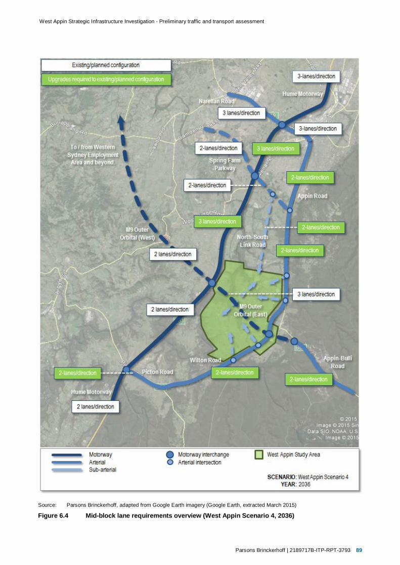
Parsons Brinckerhoff | 2189717B-ITP-RPT-3793 89
West Appin Strategic Infrastructure Investigation - Preliminary traffic and transport assessment
Source: Parsons Brinckerhoff, adapted from Google Earth imagery (Google Earth, extracted March 2015)
Figure 6.4 Mid-block lane requirements overview (West Appin Scenario 4, 2036)

90 2189717B-ITP-RPT-3793 | Parsons Brinckerhoff
West Appin Strategic Infrastructure Investigation - Preliminary traffic and transport assessment
6.2.2 Intersection and interchange requirements
In addition to the identification of mid-block lane requirements, AIMSUN modelling had also been used toidentify strategic upgrades to interchanges and intersections within the modelled road network. Theseupgrades have been identified in this preliminary assessment through the development of configurationsover a number of iterations, as described in section 6.1.2.
The preliminary modelling process has considered intersection performance at a mesoscopic level, withsolutions developed to ensure overall approach delays are not excessive. LoS at a micro-level will beassessed following the finalisation of the fundamental details presented within this preliminary assessment.
Summaries of anticipated upgrade requirements by 2036 for Scenario 3 and Scenario 4 are presented inTable 6.9 and Table 6.10 respectively.
Table 6.9 Interchange and intersection requirements summary (West Appin Scenario 3, 2036)
Location Upgrade requirements
Motorway interchanges
Hume Motorway/Narellan Road
Upgrade existing interchange capacity; likely to require local widening and signals atboth the east and west intersections.
Hume Motorway/Spring Farm Parkway
Construct Hume Motorway/Spring Farm Parkway interchange (north-facing rampsonly).
Hume Motorway/M9 Motorway
Construct Hume Motorway/M9 Motorway (link road) 3-arm interchange (full, free-flowinterchange).
M9 Motorwayinterchanges
Construct interchanges on the M9 (East) to provide access to and from West Appinand Appin bypass / Wilton Road.
Major intersections
Narellan Road (General) Most intersections on Narellan Road likely to require some upgrades (outside ofexisting scope of current upgrade works).
Grade separation on Narellan Road west of the Hume Motorway.
Appin Road/Spring Farm Parkway
Construct signalised intersection.
Appin Road/West Appinaccess roads
Construct 2x signalised intersections.
Wilton Road/West Appinaccess roads
Construct 2x signalised intersections.
Spring Farm Parkway/North-South Link Road
Construct signalised intersection.

Parsons Brinckerhoff | 2189717B-ITP-RPT-3793 91
West Appin Strategic Infrastructure Investigation - Preliminary traffic and transport assessment
Table 6.10 Interchange and intersection requirements summary (West Appin Scenario 4, 2036)
Location Upgrade requirements
Motorway interchanges
Hume Motorway/Narellan Road
Consistent with West Appin Scenario 3.
Hume Motorway/Spring Farm Parkway
Consistent with West Appin Scenario 3.
Hume Motorway/M9 Motorway
Construct Hume Motorway/M9 Motorway 4-arm interchange (full, free-flowinterchange).
M9 Motorwayinterchanges
Consistent with West Appin Scenario 3.
Major intersections
Narellan Road (General) Most intersections on Narellan Road likely to require some upgrades (outside ofexisting scope of current upgrade works).
Appin Road/Spring Farm Parkway
Consistent with West Appin Scenario 3.
Appin Road/West Appinaccess roads
Consistent with West Appin Scenario 3.
Wilton Road/West Appinaccess roads
Consistent with West Appin Scenario 3.
Spring Farm Parkway/North-South Link Road
Consistent with West Appin Scenario 3.


Parsons Brinckerhoff | 2189717B-ITP-RPT-3793 93
West Appin Strategic Infrastructure Investigation - Preliminary traffic and transport assessment
7. Summary and next steps
7.1 Infrastructure requirements summary
Summaries of identified mid-block upgrades and interchange and intersection upgrades for each of the preliminary scenarios tested are presented in Table 7.1 andTable 7.2 respectively.
Table 7.1 Mid-block upgrade requirements summary (2036)
Road
Current configuration
(At point of lowestcapacity)
Mid-block upgrade requirements
CommentsBase Case
Scenario 1
Base Case
Scenario 2
West Appin
Scenario 3
West Appin
Scenario 4
Hume Motorway Motorway: two lanes perdirection (south ofNarellan Road).
No upgrade. Upgrade to three lanes per direction betweenNarellan Road and M9 Motorway interchanges.
Appin Road 2-lane, 2-way. Upgrade to arterial(two lanes perdirection) betweenNarellan Road andAppin Village.
No upgrade. Upgrade to arterial(two lanes perdirection) betweenNarellan Road andAppin Village.
Upgrade to three lanesnorthbound betweenSpring Farm Parkwayand Narellan Road.
Upgrade to arterial(two lanes perdirection) betweenNarellan Road andAppin Village.
Construction ofM9 Motorway betweenHume Motorway andAppin-Bulli Roadexpected to reduceupgrade requirementsfor equivalentscenarios.
Appin-Bulli Road 2-lane, 2-way. Upgrade to arterial (two lanes per direction) between M1 Motorway and Appin Village.
Wilton Road 2-lane, 2-way; single lanebridge at Broughton Pass.
Upgrade to arterial (two lanes per direction) between Picton Road and Appin Village. Assumes that minimumupgrade to arterialstandard would involveconstruction of twolanes per direction.
Narellan Road Arterial: two lanes perdirection.
Upgrade to three lanes per direction between Camden Valley Way and Appin Road. Currently beingupgraded to threelanes per direction asrequired.

94 2189717B-ITP-RPT-3793 | Parsons Brinckerhoff
West Appin Strategic Infrastructure Investigation - Preliminary traffic and transport assessment
RoadCurrent configuration
(At point of lowestcapacity)
Mid-block upgrade requirements
CommentsBase Case
Scenario 1
Base Case
Scenario 2
West Appin
Scenario 3
West Appin
Scenario 4
Picton Road 2-lane, 2-way. Upgrade to two lanes per direction between Hume Motorway and Wilton Road (Almond Street).
Spring FarmParkway
N/A Construct arterial road (two lanes per direction) between Camden Bypass and Appin Road. Assumes that minimumupgrade to arterialstandard would involveconstruction of twolanes per direction.
M9 Motorway N/A N/A Construct motorway(two lanes perdirection) betweenHume Motorway andAppin-Bulli Road.
Construct motorway(two lanes perdirection) west ofHume Motorway.
Construct motorway(three lanes perdirection) betweenHume Motorway andAppin-Bulli Road.
Construct motorway(three lanes perdirection) betweenHume Motorway andAppin-Bulli Road.
Construct motorway(two lanes perdirection) west ofHume Motorway.
North-SouthLink Road
N/A N/A Construct arterial road (two lanes per direction)between Spring Farm Parkway and West Appin.
Assumes that minimumupgrade to arterialstandard would involveconstruction of twolanes per direction.

Parsons Brinckerhoff | 2189717B-ITP-RPT-3793 95
West Appin Strategic Infrastructure Investigation - Preliminary traffic and transport assessment
Table 7.2 Interchange and intersection requirements summary (2036)
Location
Upgrade requirements
CommentsBase Case
Scenario 1
Base Case
Scenario 2
West Appin
Scenario 3
West Appin
Scenario 4
Motorway interchanges
Hume Motorway/Narellan Road
Upgrade existing interchange capacity; likely to require local widening and signals at both the east and westintersections.
East intersection will be signalisedas part of current upgrade workson Narellan Road (see Figure 4.4).
Hume Motorway/ SpringFarm Parkway
Construct interchange (north-facing ramps only). Construction of M9 Motorway westof Hume Motorway expected toreduce upgrade requirements onSpring Farm Parkway forequivalent scenarios.
Hume Motorway/M9 Motorway
N/A Construct HumeMotorway/M9 Motorway4-arm interchange (full,free-flow interchange).
Construct HumeMotorway/M9 Motorway3-arm interchange (full,free-flow interchange).
Construct HumeMotorway/M9 Motorway4-arm interchange (full,free-flow interchange).
Interchange would generallyrequire 2-lane on-ramps and off-ramps and corresponding auxiliaryapproach and exit lanes for majormovements for Scenario 3 andScenario 4.
M9 Motorwayinterchanges
N/A Construct interchangeson the M9 (East) toprovide access to andfrom Appin bypass/Wilton Road.
Construct interchanges on the M9 (East) to provideaccess to and from Appin bypass/Wilton Road.
Construct interchanges on the M9 (East) to provideaccess to and from West Appin.
Interchanges would generallyrequire 2-lane on-ramps and off-ramps and corresponding auxiliaryapproach and exit lanes for majormovements for Scenario 3 andScenario 4.
Major intersections
Narellan Road (General) Some Intersections on Narellan Road may requirefuture upgrades.
Most intersections onNarellan Road likely torequire future upgrades.
Grade-separation ofintersections west ofHume Motorway.
Most intersections onNarellan Road likely torequire future upgrades.
Upgrades identified are outside ofscope of existing upgrade works.
Construction of M9 Motorway westof Hume Motorway would reduceupgrade requirements on NarellanRoad for equivalent scenarios.
Appin Road/Spring Farm Parkway
Construct signalised intersection.

96 2189717B-ITP-RPT-3793 | Parsons Brinckerhoff
West Appin Strategic Infrastructure Investigation - Preliminary traffic and transport assessment
Location
Upgrade requirements
CommentsBase Case
Scenario 1
Base Case
Scenario 2
West Appin
Scenario 3
West Appin
Scenario 4
Appin Road/West AppinAccess Roads
N/A Construct 2x signalised intersections.
Wilton Road/West AppinAccess Roads
N/A Construct 2x signalised intersections.
Spring Farm Parkway/North-South Link Road
N/A Construct signalised intersection.

Parsons Brinckerhoff | 2189717B-ITP-RPT-3793 97
West Appin Strategic Infrastructure Investigation - Preliminary traffic and transport assessment
The locations of mid-block, interchange, and intersection upgrades described are illustrated in Figure 7.1.
Source: Parsons Brinckerhoff, adapted from Google Earth imagery (Google Earth, extracted March 2015)
Figure 7.1 Identified key upgrade requirement locations

98 2189717B-ITP-RPT-3793 | Parsons Brinckerhoff
West Appin Strategic Infrastructure Investigation - Preliminary traffic and transport assessment
Upgrade requirements for the Base Case scenarios (triggered by existing issues and/or background growth),and additional requirements triggered by the development of West Appin, are summarised in Table 7.1.
Table 7.3 Summary of upgrade requirements and triggers
Scenario Upgrade requirements and triggers (2036)
Land use: Base Case
Scenario 1
(ExcludesM9)
Mid-block upgrades:
Hume Motorway: No upgrade required. Existing capacity will accommodate future trafficgrowth.
Appin Road: Requires upgrade to two lanes per direction to accommodate future traffic growth.
Appin-Bulli Road: Requires upgrade to two lanes per direction to accommodate traffic growth.
Wilton Road: Requires upgrade to remove existing single lane bridge and 15 km/h hairpincurves on approaches to Broughton Pass. Currently operating at LoS E during peak periods.Modelling has assumed minimum upgrade to arterial standard would involve construction oftwo lanes per direction, removing hairpin curves and bridge.
Narellan Road: Currently being upgraded to three lanes per direction. No further upgradesrequired to accommodate future traffic growth.
Picton Road: Requires upgrade to two lanes per direction to accommodate existing and futuretraffic volumes. Currently operating at LoS E during peak periods.
Spring Farm Parkway: Construction planned by Government. Modelling has assumedminimum upgrade to arterial standard would involve construction of two lanes per direction.
Interchange upgrades:
Hume Motorway/Narellan Road: Likely to require local widening and signals at both the eastand west intersections to accommodate future traffic growth. East intersection (only) will besignalised as part of current upgrade works.
Hume Motorway/Spring Farm Parkway: Construction of north-facing ramps planned byGovernment.
Intersection upgrades:
Narellan Road (General): Modelling indicates some intersections on Narellan Road mayrequire further upgrades outside of scope of existing upgrade works to accommodate futuretraffic growth.
Appin Road/Spring Farm Parkway: Modelling assumes a signalised intersection would beconstructed at this location to provide a connection to and from Spring Farm Parkway.
Scenario 2
(IncludesM9 East &West)
This scenario is consistent with the requirements and triggers shown for Scenario 1, with differencesnoted below.
Mid-block upgrades:
Appin Road: No upgrade required. Existing capacity will accommodate future traffic growth.Future traffic expected to transfer to M9 Motorway, reducing future traffic growth.
M9 Motorway: Currently being investigated by Government. Modelling has assumed minimumupgrade to Motorway standard would involve construction of two lanes per direction betweenareas west of the Hume Motorway and Appin-Bulli Road.
Interchange upgrades:
Hume Motorway/M9 Motorway: Modelling assumes a 4-arm interchange providing free-flow forall movements.
M9 Motorway interchanges: Modelling assumes the provision of a 4-arm interchange providingfree-flow for movements to and from the M9 Motorway at Appin Bypass, and the provision of a3-arm interchange providing free-flow for eastbound movements to and from the M9 Motorwayat Appin-Bulli Road.

Parsons Brinckerhoff | 2189717B-ITP-RPT-3793 99
West Appin Strategic Infrastructure Investigation - Preliminary traffic and transport assessment
Scenario Upgrade requirements and triggers (2036)
Land use: Base Case + West Appin
Scenario 3
(Includes M9East)
This scenario is consistent with the requirements and triggers shown for Scenario 1, withdifferences noted below.
Mid-block upgrades:
Hume Motorway: Requires the construction of an additional lane in each direction (threelanes total per direction), triggered by the additional traffic generated by West Appin.
Appin Road: Requires the construction of an additional northbound lane north of SpringFarm Parkway (three lanes total northbound), triggered by the additional traffic generatedby West Appin.
M9 Motorway (East): Modelling indicates that three lanes per direction would be requiredbetween the Hume Motorway and Appin-Bulli Road.
North-South Link Road: Construction proposed by proponents to reduce impacts of trafficgenerated by West Appin on the Hume Motorway and Appin Road. Modelling has assumedminimum upgrade to sub-arterial standard would involve construction of two lanes perdirection.
Interchange upgrades:
Hume Motorway/M9 Motorway (East): Modelling assumes a 3-arm interchange providingfree-flow for all movements.
M9 Motorway interchanges: Modelling assumes the provision of a 4-arm interchangeproviding free-flow for movements to and from the M9 Motorway at Appin Bypass, and theprovision of a 3-arm interchange providing free-flow for eastbound movements to and fromthe M9 Motorway at Appin-Bulli Road. Additional 4-arm interchanges providing free-flow formovements to and from the M9 Motorway would provide access to and from West Appin.
Intersection upgrades:
Narellan Road (General): Modelling indicates most intersections on Narellan Road arelikely to require further upgrades outside of scope of existing upgrade works, and thatgrade-separation of intersections west of the Hume Motorway may be required toaccommodate future traffic growth plus the additional traffic generated by West Appin.
Appin Road/West Appin Access Roads: Modelling assumes two signalised intersectionswould be constructed to provide access to and from West Appin.
Wilton Road/West Appin Access Roads: Modelling assumes two signalised intersectionswould be constructed to provide access to and from West Appin.
Spring Farm Parkway/North-South Link Road: Modelling assumes a signalisedintersection would be constructed at this location to provide a connection to and fromSpring Farm Parkway.
Scenario 4
(Includes M9East & West)
This scenario is consistent with the requirements and triggers shown for Scenario 3, withdifferences noted below.
Mid-block upgrades:
Appin Road: Requires upgrades consistent with Base Case Scenario 1. Construction ofadditional northbound lane north of Spring Farm Parkway not required. Future trafficexpected to transfer to M9 Motorway, reducing traffic growth on Appin Road.
M9 Motorway (West): Currently being investigated by Government. Modelling hasassumed minimum upgrade to Motorway standard would involve construction of two lanesper direction between areas west of the Hume Motorway and Hume Motorway interchange.
Interchange upgrades:
Hume Motorway/M9 Motorway: Modelling assumes a 4-arm interchange providing free-flow for all movements.
Narellan Road (General): Modelling indicates most intersections on Narellan Road arelikely to require further upgrades outside of scope of existing upgrade works toaccommodate future traffic growth. Future traffic anticipated to transfer to M9 Motorwaywest of Hume Motorway reducing future traffic growth and mitigating need for gradeseparation on Narellan Road west of Hume Motorway.

100 2189717B-ITP-RPT-3793 | Parsons Brinckerhoff
West Appin Strategic Infrastructure Investigation - Preliminary traffic and transport assessment
7.2 Next steps
This report provides a preliminary assessment of key traffic and transport-related issues raised in the WestAppin High Level Strategic Infrastructure Investigation Draft Terms of Reference (DP&E, 2013).It investigates and addresses the most critical traffic and transport issues and fundamental features andrequirements of the development.
The assessment presented in this report has been undertaken based on indicative draft plans for theproposed development of West Appin. These plans will be refined and finalised through further investigationand appropriate planning and approval processes. Specifically, further detailed traffic and transportassessments will jointly consider and inform the detailed integrated land use and transport planning process.
It is proposed that the ongoing traffic and transport assessment will continue to be developed, refined, andfinalised in collaboration with Government. Following the confirmation of the fundamental features of thedevelopment and accompanying traffic and transport infrastructure, the final traffic and transport assessmentwill develop and include the additional level detail required to fully satisfy the draft terms of reference for thestudy.
This assessment considers and presents the impacts and proposed strategic infrastructure requirements forthe future ‘Base Case’ and ‘Base Case plus West Appin’ scenarios relevant to the full development ofWest Appin (2036). However, the following additional scenarios also require assessment to satisfy the termsof reference for the study:
‘Base Case plus West Appin plus Other Developments’ scenario.
2026 (interim) horizon year for all scenarios.
The additional scenario and interim year models are effectively iterations of, and therefore dependent on, the‘Base Case plus West Appin’ full development scenario. Consequently the additional models will beassessed following the finalisation of the details of the ‘Base Case plus West Appin’, full developmentscenario presented within this preliminary assessment.
Considering the above, the proposed steps required to finalise the traffic and transport assessment andsatisfy the terms of reference are as follows:
1. Agree and finalise strategic infrastructure upgrade requirements for the ‘Base Case’ and ‘Base Caseplus West Appin’ scenarios for 2036.
2. Complete the detailed modelling for the ‘Base Case’ and ‘Base Case plus West Appin’ scenarios:
a) Finalise interchange and intersection concept plans and demonstrate acceptable performance.
b) Finalise interim (2026) year modelling to identify infrastructure triggers and develop transportinfrastructure staging strategy.
3. Complete the corresponding modelling for the ‘Base Case plus West Appin plus Other Developments’scenario for 2026 and 2036 to identify additional infrastructure requirements.

Strategic Investigation of Social Infrastructure Requirements
West Appin
Client: Walker Corporation, Mir Group, Ingham Rural Property Group
Date:
16 March 2015
Final Report

Contact: Chris Manning
93872600
Sydney
02 9387 2600
Level 6
332 – 342 Oxford Street
Bondi Junction NSW 2022
www.elton.com.au [email protected]
Sydney | Canberra | Darwin ABN 56 003 853 101
Prepared by Chris Manning
Reviewed by Steve Rossiter
Date 16 March 2015
Document name 14/3934 Final report
Version 3

1 INTRODUCTION 4
2 EXISTING SOCIAL INFRASTRUCTURE 5
2.1 Local social infrastructure 5
2.2 District and regional social infrastructure 5
2.3 Summing up 7
3 SOCIAL INFRASTRUCTURE REQUIREMENTS 9
3.1 Approach to planning social infrastructure 9
3.2 Local government social infrastructure 9
3.2.1 Community facilities 9
3.2.2 Recreational and sporting facilities 10
3.3 State government social infrastructure 11
3.3.1 Public schools 11
3.3.2 Tertiary education 12
3.3.3 Community health and hospital services 12
3.3.4 Welfare and support services 12
3.3.5 Emergency services 13
3.4 Private / non-government sector social infrastructure 13
3.5 Summing up 13
4 STAGING AND COST OF DELIVERY 15
4.1 Staging 15
4.2 Costs of delivery 15
4.3 Conclusion 16
Contents

4 Strategic Investigation of Social Infrastructure Requirements Elton Consulting
This report has been prepared for a landowner group comprising Walker Corporation, Mir Group
and Ingham Rural Property Group, which is seeking to initiate a master planning process for land
at West Appin. The West Appin site lies wholly within the Wollondilly local government area. The
report presents the outcomes of a high level investigation into social infrastructure requirements
for West Appin, based upon a potential yield of up to 15,500 dwellings.
This investigation has been undertaken at the request of the NSW Department of Planning and
Environment (DPE), which is seeking to ensure that there are no threshold issues that would
prevent the development of West Appin, prior to committing to a joint master planning process.
DPE has issued Terms of Reference for the Strategic Infrastructure Investigation.
Elements of the Terms of Reference relevant to social infrastructure include:
1. Prepare a High Level Investigation and Business Case to determine, at a strategic level, the
required infrastructure, servicing, staging and cost
2. Document the existing infrastructure services and condition at West Appin, including:
» Public and private schools
» Community health and hospital services
» Emergency services
» Recreational and sporting facilities
3. Detail the infrastructure required to service the development, including:
» Public and private schools
» Community health and hospital services
» Emergency services
» Recreational and sporting facilities
4. Provide details of area of influence of infrastructure associated with estimated housing
production
5. Outline an infrastructure delivery strategy and related development thresholds which trigger
delivery
6. Provide details of proposed funding for staging and cost of delivery of required infrastructure
7. Consult with Wollondilly Council and relevant public authorities and service providers.
1 Introduction

Strategic Investigation of Social Infrastructure Requirements Elton Consulting 5
2.1 Local social infrastructure
The West Appin Investigation Area is located in the eastern part of the Wollondilly Shire and
extends to the Local Government Area (LGA) boundary with Campbelltown City Council to the
north. It lies between the villages of Appin and Douglas Park and comprises land currently used for
rural or rural residential purposes. Consistent with these uses, there is no social infrastructure
currently within the precinct, apart from:
» The Macarthur Motorcycle Complex
» Delta Force Paintball
» Appin Greyhound Track
Social infrastructure within the existing village of Appin includes:
» Appin Public School – a small semi-rural school with around 217 students. The Department
of Education and Communities (DEC) has advised that this school is currently at 100%
utilisation
» Appin Community Hall – has some limited capacity for greater utilisation
» Appin Medical Centre – recently established practice with equivalent of one full time GP
» Bright Sparks Early Learning Centre, a 56 place long daycare centre
» Appin AIS sportsground (Gordon Lewis Oval, tennis and netball courts)
» Several local parks - Appin Park, Elizabeth Park and William Woods Reserve
» Wollongong Mountain Bike Club
» Appin Rural Fire Service
» Several churches.
Douglas Park is separated from the West Appin Precinct by the barriers of the Nepean River and
the Hume Highway. Douglas Park has a similar range of facilities, including:
» Douglas Park Public School. The DEC has advised that this school is currently at full capacity.
» Douglas Park Community Centre – a well utilised facility
» Fidgety Frogs Early Learning Centre (long daycare centre with some vacancies)
» Douglas Park Sportsground and several local parks
» Douglas Park Rural Fire Service
2.2 District and regional social infrastructure
District level facilities and services accessible from the West Appin area are located in
Campbelltown and its southern suburbs, and in Picton and Tahmoor, as outlined below.
Appin residents rely on district and regional level facilities in Campbelltown for:
2 Existing social infrastructure

6 Strategic Investigation of Social Infrastructure Requirements Elton Consulting
» Major shopping and commercial services, including Macarthur Square and Campbelltown
Mall
» Government high school – Appin is zoned within the catchment for Ambarvale High School.
This school has a current utilisation rate of 68%, with enrolments projected to decrease. It
occupies a large site, with potential for expansion. However, spare capacity may be taken up
by proposed development at Gilead and Menangle Park, and so may not be available to
absorb future demand from West Appin.
» Private schools – Broughton Anglican College, John Therry Catholic High School, Our Lady
help of Christians Primary School are all located in the southern suburbs of Campbelltown.
» Tertiary education – Macarthur Institute of TAFE, University of Western Sydney
Campbelltown campus
» Campbelltown Hospital, Rosemeadow Community Health Centre and medical specialty and
allied health services
» District sport and recreation facilities, including Noorumba Reserve, Georges River
Recreation Reserve, Rosemeadow Reserve and Mary Brookes Park playing fields
» Campbelltown Regional Arts Centre
» Most types of welfare and support services
» Cinemas and other leisure and entertainment facilities.
Residents of West Appin would also have access to a range of district level facilities located in
Picton and Tahmoor which serve the Wollondilly Shire. Key facilities include:
» Picton High School, which is already over capacity and is the only high school within
Wollondilly
» Private schools – Wollondilly Anglican College, a co-educational Kindergarten to Year 12
college at Tahmoor with 660 students and capacity to grow further, and St Anthony’s
Catholic Primary School at Picton, which is now at capacity
» Council civic and cultural facilities, including Wollondilly Shire Library, Wollondilly Shire Hall
and Picton School of Arts. These facilities are too small and outmoded to meet current needs
and Council has plans for their redevelopment. However proposed redevelopment has been
based on current population forecasts and will not provide sufficient capacity for a
Wollondilly population of 100,000+ people.
» Wollondilly Leisure Centre, a Council facility which provides a 50m outdoor swimming pool,
25m indoor pool gym and indoor sports court. This facility is heavily utilised and considered
to be at capacity.
» District level sporting fields and Botanical Gardens in Picton
» Adult and community education at Tahmoor
» Wollondilly Community Health Centre at Tahmoor. Services include baby health clinics,
counselling services, women’s health services, mental health, speech pathology and dental
services
» UnitingCare Burnside Family and Children’s Services in Tahmoor Community Centre
» Emergency services – Picton Police Station, Picton Fire and Rescue, Picton SES, Picton
ambulance base.
Appin residents also have access to a variety of facilities within Wollongong LGA, including:
» Wollongong TAFE and University of Wollongong

Strategic Investigation of Social Infrastructure Requirements Elton Consulting 7
» Cinemas and other entertainment facilities.
2.3 Summing up
Consistent with its small population, there is very little social infrastructure in and around the Appin
area currently. The limited range of facilities and services that do exist have been created to meet
the needs of the existing local population (around 1,800 people) and have no excess capacity with
which they might meet demand arising from future urban development. They do, however, provide
a platform from which additional facilities and services might be developed in the future.
At present a limited range of district level facilities and services are available to residents of
Wollondilly Shire and these are clustered in Picton and Tahmoor. Council facilities (library, leisure
centre, meeting and activity spaces, sporting facilities) are already at capacity, and in need of
augmentation to meet current needs. The West Appin area also has good access to a range of
district and regional level facilities and services in Campbelltown. However, as the site is located in
Wollondilly Shire, residents would be required to use Wollondilly-based services for those service
types where catchment boundaries are applied (eg Council services, community health services).
With regard to the range of social infrastructure itemised in the Terms of Reference for this study:
» Public and private schools:
> The local Appin Public School is already at capacity, although it occupies a 2.8 ha site and
so has room for some expansion
> Picton High School, the only high school within Wollondilly Shire, is already over capacity.
However Ambarvale High School, currently zoned to take students from Appin, has some
spare capacity
> Wollondilly has two private schools – a Catholic primary school, which is at capacity, and
the Wollondilly Anglican College at Tahmoor, which has scope for further expansion.
Private schools within the southern suburbs of Campbelltown are accessible from Appin,
although these are already close to capacity and will face increasing enrolments from
proposed development at Gilead and Menangle Park.
» Community health and hospital services:
> There is no hospital within Wollondilly and residents rely on public hospital services at
Campbelltown, Camden and Bowral and private hospitals in Campbelltown and Bowral
> The Wollondilly Community Health Centre in Tahmoor has no capacity to meet the needs
of a growing population without additional resources for staffing and programs.
» Emergency services:
> While there are bases for police, fire and rescue, ambulance and SES in Picton, these
services are limited by staffing restrictions and distance from meeting the needs of an
expanded urban area at Appin. Additional new or expanded services will be required.
» Recreational and sporting facilities: Council’s Open Space, Recreation and Community
Facilities Strategy has identified that:
> Existing open space provision does not consistently meet demand in either quantity or
quality. In particular, there is a need for a district level town park in Appin to match
population thresholds.
> Most outdoor sporting facilities in Wollondilly are at capacity. There is a need for future
expansion and redevelopment of the Appin Sportsground to accommodate more field

8 Strategic Investigation of Social Infrastructure Requirements Elton Consulting
training and sports. The sportsground at Douglas Park also requires reconfiguration to
permit a greater range of sports. These changes would address only current needs.
> Council’s indoor sporting facilities are already at capacity and will require expansion to
meet the needs of a growing population.
In summary, with the possible exception of Ambarvale High School, there is currently no social
infrastructure with capacity to meet demand generated by West Appin, and a range of new
facilities and services will be required. Some of these future needs may be met by facilities and
services that at this stage are proposed to be provided within Wilton Junction.

Strategic Investigation of Social Infrastructure Requirements Elton Consulting 9
This section identifies likely social infrastructure requirements for a future population of around
41,000 people at West Appin, based on a development scenario that envisages up to 15,500 new
dwellings.
Should development of this scale proceed at West Appin, this has potential to take the population
of Wollondilly Shire to around 140,000, when other current development opportunities are
included.
This high level assessment has relied upon standards and thresholds and advice on planning
approaches provided by agencies during detailed agency consultations for proposed development
at Wilton Junction.
3.1 Approach to planning social infrastructure
In social infrastructure planning, facilities and services are commonly considered at three levels:
» Neighbourhood level services, facilities and open space, available within about five - ten
minute walking or driving distance for most residents in order to meet their local everyday
neighbourhood needs.
» District level services, facilities and open space, with more specialist features designed to
meet the needs of a broader district catchment of around 20,000 – 50,000 people. These
types of facilities and services are generally best located in larger activity centres that are
well served by public transport, to maximise access for the whole catchment.
» Sub-regional and regional level services, comprising major facilities for a population of over
around 100,000 people, and usually located in a major activity centre.
West Appin, with up to 41,000 people, will be large enough to warrant a range of district level
facilities and services, in addition to comprising a number of neighbourhoods, each with their own
local facilities and services. West Appin will also contribute significantly to Wollondilly’s population
exceeding 100,000 and thereby justifying provision of some higher order regional facilities and
services.
3.2 Local government social infrastructure
As West Appin is located within Wollondilly Shire, the requirements and benchmarks of Wollondilly
Council would apply in identifying requirements for local government social infrastructure.
3.2.1 Community facilities
Wollondilly Shire Council has recently adopted an Open Space, Recreation and Community Facilities
Strategy (Clouston Associates with Elton Consulting 2013) which sets out Council’s strategic
framework for the planning and provision of its community facilities in response to forecast
3 Social infrastructure requirements

10 Strategic Investigation of Social Infrastructure Requirements Elton Consulting
population growth. It is understood that Wollondilly Council’s Section 94 Contributions Plan is likely
to be revised to reflect the adopted strategy.
This strategy proposes that:
» Community facilities be planned on the basis of a desired rate of provision of around 80
square metres per 1,000 people (to include both local and district community facilities)
» Libraries be planned according to the benchmarks contained in the NSW State Library
publication People Places: A Guide for Public Library Buildings in NSW. These include:
> 39 square metres of library floor space for every 1,000 people for populations between
20,000 and 35,000 people, plus 20% allowance for circulation and administrative space
> 35 square metres of library floor space for every 1,000 people for populations between
35,001 and 65,000 people, plus 20% allowance for circulation and administrative space.
On this basis, a population at West Appin of around 41,000 people would generate a
need for:
» Around 3,280 sqm of floorspace for community facilities. The distribution of this
will depend upon the geography of the development and hierarchy of centres, but
is likely to comprise one large district level community hub (1280 sqm) and up to
four local community centres (each of around 500 sqm)
» A district level library of around 1,722 sqm, co-located with the district
community hub.
While West Appin, by itself, will not be big enough to trigger a need for regional level civic and
cultural facilities, it will contribute significantly towards the population of Wollondilly Shire reaching
a level (100,000+ people) which justifies the provision of such facilities. West Appin may be
required to contribute in proportion to its population size to new cultural facilities such as a
performing / visual arts centre or civic auditorium.
3.2.2 Recreational and sporting facilities
The Wollondilly Open Space, Recreation and Community Facilities Strategy does not recommend
that a standard rate of provision be adopted in the planning of open space in growth areas.
Instead, it proposes that open space planning be based upon an analysis of needs of the future
population, a contextual analysis of the site, assessment of opportunities in the locality and
accessibility criteria.
While this is appropriate for detailed master planning processes, it does not provide guidance at
this high level strategic planning phase.
The Wollondilly Open Space, Recreation and Community Facilities Strategy also suggests that
open space be planned in line with the recommendations of the NSW Recreation and Open Space
Planning Guidelines for Local Government (2011). These propose that, as a default position, an
area equivalent to around 9% of the site area be allocated as local and district open space, with a
rough 50:50 split between sporting and recreational uses.
Again, this is not a helpful approach at this high level strategic planning phase, when site details
are not readily available.
For these reasons, this assessment has reverted to the approach adopted in precinct planning for
the South West and North West Growth Centres, in which the Growth Centres Development Code
(2006) proposes that open space be provided on the basis of 2.83 hectares per 1,000 people.
On this basis, a population of around 41,000 would generate a need for around 116 hectares
of public open space, to be owned and managed by Wollondilly Council. Despite the

Strategic Investigation of Social Infrastructure Requirements Elton Consulting 11
shortcomings of this benchmark, it provides a rough indication of the scale of open space likely to
be required, in the absence of site specific details.
The Wollondilly Open Space, Recreation and Community Facilities Strategy does not contain a
detailed planning strategy for sporting facilities. In our social infrastructure planning in the Growth
Centre precincts, we have commonly adopted a minimum standard of one double playing field
(around 5 ha) per 5,000 people. On this basis, a population of around 41,000 would generate a
need for a minimum of around 8-9 double playing fields, with additional sites for tennis and netball
complexes, and potentially also an indoor sports and aquatic centre.
All up, around 55 ha of the proposed 116 ha of open space would be used for sporting
facilities. The balance would be used for recreational open space.
The Wollondilly Open Space, Recreation and Community Facilities Strategy and Council’s
Development Contributions Plan propose that sporting open space be provided for district
catchments only, so as to cluster a number of sporting facilities to support sports competitions and
training. The extent to which all of the identified sporting open space would be provided within
West Appin, or would be required as contributions towards off-site facilities, would be a matter for
detailed planning. The extent to which West Appin would also be required to provide indoor and
aquatic facilities or any regional level sporting facilities will also depend upon the nature of sporting
facilities provided in Wilton Junction. It will be important that sporting facilities complement, rather
than duplicate, those provided elsewhere within Wollondilly.
3.3 State government social infrastructure
3.3.1 Public schools
The Department of Education and Communities (DEC) Advisory Notes for School Site Selection sets
out the following criteria for the provision of schools in areas of new residential development:
» One public primary school per 2,000 to 2,500 new dwellings
» One public high school per 6,000 to 7,500 dwellings (ie catchment of three primary schools)
» Provision and timing of new schools takes account of a number of other factors, including:
> Possible diversion of some students in new areas to existing schools
> The impact of existing or proposed non-government schools
> The type and speed to residential development
> Possible need for additional sites to cater for temporary enrolment peaks
> The nature of the population.
The DEC has advised that in practice in the growth areas it is starting to apply a higher threshold
of one primary school for every 3,000 dwellings, on the basis that it is more economical to provide
bigger, but fewer, primary schools. The threshold for a high school remains as outlined above.
On this basis, a yield of around 15,500 dwellings at West Appin would generate a need for:
> Five new primary schools
> Two new high schools.

12 Strategic Investigation of Social Infrastructure Requirements Elton Consulting
3.3.2 Tertiary education
South Western Sydney Institute of TAFE has advised that it has no plans to build new TAFE
facilities within Wollondilly Shire, even given the expected population growth.
Major changes to the TAFE funding model from 2015 will instead see greater competition for
course delivery, increasing specialisation amongst TAFE campuses, greater flexibility in where
courses are delivered (eg at workplaces) and changes to use of existing TAFE buildings and sites.
The need to deliver courses within workplaces and demand for outreach classes may increase the
need for rooms to be available within community facilities.
Given funding pressures on universities, it is unlikely that there will be any development of
university campuses within Wollondilly.
Accordingly, development at West Appin is unlikely to trigger any further development of
tertiary education facilities.
3.3.3 Community health and hospital services
In the light of the very substantial population growth forecasts for Wollondilly LGA over the next
two decades, the South West Sydney Local Health District is still considering how the future health
care needs of the local government area will be addressed. The Local Health District has adopted a
model of Integrated Primary and Community Care (IPCC) for South Western Sydney. The
catchment population for a Regional Integrated Primary Community Care Centre is around 75,000-
100,000 people. The proposed growth across the Shire will create demand for at least one such
new centre to be established within Wollondilly. This facility will co-locate community health,
general practice and on-site specialist care, and provide a hub for multidisciplinary primary health
care and potentially also day surgery and hospital outreach services.
Should there be only one regional IPCC centre established in Wollondilly, consultation undertaken
to date with the Local Health District has indicated that this facility would potentially be located at
Wilton Junction. This is considered to be a reasonably central location to serve the whole
Wollondilly Shire. Such a facility would also address demand generated by West Appin. However,
should approval be given for planning of West Appin to proceed, further consultation would need
to be undertaken with the South West Sydney Local Health District to confirm the number of IPCC
centres to be established in Wollondilly and their locations.
Wollondilly will continue to rely for in-patient services on Campbelltown, Camden, Bowral and
Liverpool Hospitals into the future. Given difficulties in staffing health facilities in South West
Sydney and the enormous cost of new hospitals, Wollondilly will still not be large enough to
justify a new hospital, and no new hospital is envisaged for Wollondilly. Both Liverpool and
Campbelltown Hospitals have plans for expansion to cope with forecast population growth in south
west Sydney, although these forecasts have not included growth at West Appin. At present there
are no plans for the expansion of Bowral Hospital.
Hospital expansion plans for South West Sydney will need to be reviewed in the light of the very
substantial growth forecast for Wollondilly Shire, of which West Appin represents a significant
component.
3.3.4 Welfare and support services
Welfare and support services are reliant on increases in funding through State and Commonwealth
Government programs to meet the needs of growing populations. Resources are provided through
budget allocation processes according to the resource allocation formulae of the various programs
and government departments. As the population of Wollondilly continues to grow, there will be a

Strategic Investigation of Social Infrastructure Requirements Elton Consulting 13
need for additional recurrent resources for staffing and programs to enable the establishment or
expansion of welfare and support services to meet the needs of Wollondilly residents. There will be
no need for capital facilities, as these types of services typically occupy leased commercial
premises.
3.3.5 Emergency services
Emergency services are planned on the basis of response times and distance to travel, rather than
population or dwelling thresholds.
As for health services, the State Government emergency services have been developing strategic
plans in response to the urban growth forecast to occur in Wollondilly. Plans developed to date
indicate that, on the basis that significant development will occur at Wilton Junction, including a
new town centre, new facilities will be developed at Wilton Junction by NSW Police, Fire and
Rescue, NSW Ambulance Service and the State Emergency Service. These services would cover the
whole of the Wollondilly Shire, and hence would include the proposed West Appin development.
Such facilities would be significantly closer to West Appin than the current bases in Picton, Camden
and Campbelltown.
These agencies would need to review their strategic plans for Wollondilly if approval is given for
West Appin to proceed. This may change the number and/or location of facilities proposed for
Wilton Junction.
3.4 Private / non-government sector social infrastructure
Social infrastructure provided by the private and non-government sectors includes childcare,
private schools, medical centres and allied health, places of worship, aged care facilities,
commercial gym and fitness facilities, entertainment and leisure facilities. These types of facilities
are not provided according to broad population thresholds, but instead are usually provided in
response to the specific needs and characteristics of the incoming population and as commercial
feasibility can be assessed. Sites for such facilities are usually acquired through the private market
and generally do not need to be identified at the rezoning or master planning stage, as most types
of these facilities can be provided in residential or mixed use zones.
Accordingly, this investigation has not identified requirements for facilities and services provided by
the non-government and private sectors.
Nor has it identified requirements for shopping centres and associated commercial services.
However, it is likely that a population of up to 41,000 would be large enough to support a large
district level shopping centre and associated commercial services.
3.5 Summing up
Potential development at West Appin of the scale proposed is likely to generate a need for:
Local government social infrastructure, based upon current benchmarks of Wollondilly Shire
Council to include:
» Around 3,280 sqm of floorspace for community facilities, likely to comprise one large district
level community hub (1,280 sqm) and up to four local community centres (each of around
500 sqm)
» A district level library of around 1,722 sqm co-located with the district community hub

14 Strategic Investigation of Social Infrastructure Requirements Elton Consulting
» Around 60 hectares of open space embellished for passive recreation (local and district
parks)
» Around 55 hectares of open space to provide 8-9 double playing fields (each of 5 ha), with
additional sites for tennis and netball complexes, and also an indoor sports and aquatic
centre
» Contributions towards Shire wide cultural and civic facilities.
State Government social infrastructure:
» Up to five new primary schools
» Up to two new high schools
» Contributions towards a Regional Integrated Primary Community Care Centre, (at this stage
likely to be located in Wilton Junction, but subject to further planning)
» Contributions towards new NSW Police, Fire and Rescue, NSW Ambulance Service and State
Emergency Service bases / stations, (also at this stage proposed to be located in Wilton
Junction but subject to further planning)
» Further expansion, yet to be determined, of hospital services at Liverpool / Campbelltown /
Bowral Hospitals.
» Recurrent funding for additional staff and programs for community health, emergency
services and welfare and support services.

Strategic Investigation of Social Infrastructure Requirements Elton Consulting 15
4.1 Staging
Schools need to be provided once there are around 200 children ready for enrolment and there is
no capacity available in nearby schools.
Other than for schools, there are no critical thresholds that will trigger the need for social
infrastructure delivery. Provision of social infrastructure needs to keep pace with population
growth and be provided on an incremental basis as the population in West Appin grows. Beyond
this, the staging of delivery will be influenced by the geographical spread of development and
number of development fronts. A detailed staging and delivery plan would need to be developed in
response to a master plan.
4.2 Costs of delivery
For State Government social infrastructure, costs would relate to:
» Provision of serviced sites, each of around 3 ha, for 5 primary schools
» Provision of serviced sites, each of around 6 ha, for 2 high schools
» Capital costs of construction of 5 primary and 2 high schools (noting that a primary school
costs in the order of $15 million and a high school $30 million)
» Share of costs towards land and capital construction for a new Regional Integrated Primary
Community Care Centre
» Share of costs towards land and capital construction for new Police Station, Fire and Rescue
Station, Ambulance Station and SES base.
For local government social infrastructure, costs to be recouped through the development
contribution system would include land and embellishments for recreational open space and
sporting facilities, and land and capital construction for the district community hub and library, and
up to four local neighbourhood community centres.
Initial cost estimates for the recommended local government social infrastructure are provided in
the table below. These cost estimates are based on February 2012 quantity surveying work
undertaken for similar community facilities, and the estimates used for calculating initial open
space embellishment costs for Wilton Junction. They are provided to give an initial indication of
costs and will require further testing, updating and confirmation through detailed quantity
surveying.
The costs for built facilities were based on generic building templates and include estimated site
areas, building sizes and specifications for each project. Costings include nominal allowances for
furniture, fixtures and equipment based on Group 3 allowances. They do not include costs for
daily operational items such as books, linens, toys, etc. The cost estimates are GST exclusive.
Overall project costs include construction, standard contingencies, professional fees, Council fees
and utilities provision.
4 Staging and cost of delivery

16 Strategic Investigation of Social Infrastructure Requirements Elton Consulting
It should be noted that no costs are included for cultural, aquatic or indoor sport and leisure
facilities in West Appin, on the basis that such facilities are likely to be required on a broader
district or LGA basis. West Appin will, at minimum, be required to contribute towards the provision
of such facilities in the wider district, or, at maximum, provide these facilities within West Appin.
Table 1: Preliminary cost estimates for local government social infrastructure.
Facility Area required Overall Project Rate ($/sqm)
Estimated overall project cost
District multipurpose community hub
1,280sqm $5,240 $6,707,200
District library 1,722 sqm $5,630 $9,694,860
4 x local community centres 4 x 500 sqm $5,109 $10,218,000
Sporting open space 55 ha $107 $58,850,000
Recreational open space 61 ha $65 $39,650,000
Total $125,120,060
4.3 Conclusion
Based on the findings of this study, it is concluded that there are no threshold issues relating to
social infrastructure that would prevent the development of West Appin. The development would
be large enough to be reasonably self-sufficient in terms of local neighbourhood and district social
infrastructure, and would be likely to generate sufficient funds to construct the facilities needed to
create a balanced and sustainable community.

Strategic Investigation of Social Infrastructure Requirements Elton Consulting 17
Summary of Agency Consultations
1. Department of Education and Communities
2 June 2014
Telephone discussion with Raphael Garcia, Statutory Planner
Phone 9561 8147
Discussion points:
Current capacity and potential for augmentation of Appin Public School and Douglas Park
Public School
Which high school is zoned for the Appin district and its capacity to absorb future growth
Capacity situation for Picton High School
DEC benchmarks and guidelines for new schools in growth areas
Application of the benchmarks to West Appin and the resultant numbers of primary and
high schools likely to be required (5 and 2 respectively).
2. Wollondilly Shire Council
10 June 2014
Telephone discussion with Adam Gray, Manager, Facilities and Recreation
Phone 4677-8250
Discussion points:
Progress in finalising Wollondilly Growth Management Strategy
Background / context to DPE request for information and Terms of Reference for Strategic
Infrastructure Investigation for West Appin
Current Council social infrastructure in the Appin / Douglas Park areas
Application of findings and recommendations of Wollondilly Open Space, Recreation and
Community Facilities Strategy 2013 to West Appin with regard to potential future
requirements for community and recreation facilities and open space.
3. Emergency Services
Have relied on agency input to Wilton Junction Community Planning Study
4. South West Sydney Local Health District
Have relied on agency input to Wilton Junction Community Planning Study and findings and
consultation outcomes for the Wollondilly Health Needs Assessment, currently being undertaken by
Elton Consulting for the Wollondilly Health Alliance. Have relied in particular on input from David
Lawrence, Manager, Planning, South West Sydney Local Health District, who is a member of the
Wollondilly Health Alliance.

18 Strategic Investigation of Social Infrastructure Requirements Elton Consulting

APPENDIX 4 WSP Parsons Brinkerhoff Traffic Assessment

Level 27 Ernst & Young Centre680 George StreetSydney NSW 2000GPO Box 5394Sydney NSW 2001AustraliaTel: +61 2 9272 5100Fax: +61 2 9272 5101
www.pbworld.com
Certified to ISO 9001, ISO 14001, OHSAS 18001
2189717B-ITP-MEM-001 Rev5 1/27
Parsons Brinckerhoff Australia Pty Limited
ABN 80 078 004 798
Memo
Date 18 November 2015
To West Appin Project Team
From David Bohm
Ref 2189717B-ITP-MEM-001 Rev5
Subject West Appin Strategic Traffic Analysis
1. Purpose
This memo documents the Strategic Traffic Analysis that Parsons Brinckerhoff undertook during October-November 2015 in relation to the planned and proposed developments at Mount Gilead and West Appin.
Appendix A of this memo also provides a summary of the findings of a review of the Greater Macarthur LandRelease Investigation Strategic Transport Plan (AECOM, 21 October 2015).
2. Methodology
The first-principles traffic analysis has been undertaken using:
1. Spreadsheet modelling of forecast future strategic traffic volumes
2. Volume/capacity analysis to identify upgrade requirements.
The analysis undertaken extends for a 25 year period to 2040.
2.1 Study area
The analysis has been undertaken considering the key elements of the road network immediatelysurrounding West Appin and Mount Gilead, illustrated in Figure 2.1. This road network comprises:
Existing roads:
Appin Road: a north-south connection between Appin Village and Campbelltown
Appin-Bulli Road: a northwest-southeast connection between Appin Village and the M1 motorway /Wollongong
Wilton Road: a northeast-southwest connection between Appin Village and Picton Road / WiltonVillage.

2189717B-ITP-MEM-001 Rev5 2/27
Future roads:
Appin bypass: an alternative route to Appin Road / Appin-Bulli Road to the west / south of AppinVillage
Spring Farm Parkway: a northwest-southeast connection between Appin Road and the HumeMotorway and beyond
Northern Arterial: a north-south connection parallel and to the west of Appin Road
Appin / Hume M9 Extension: a northwest-southeast connection between Appin-Bulli Road and theHume Motorway and beyond. This connection could form part of the alignment of the proposed M9Outer Sydney Orbital Motorway.
Figure 2.1 also illustrates:
The locations and estimated timeframes of traffic generating development starting to occur indevelopment precincts
The locations of screenlines which have been used during the traffic forecasting and volume-capacityanalysis processes.

2189717B-ITP-MEM-001 Rev5 3/27
Figure 2.1 Study area overview

2189717B-ITP-MEM-001 Rev5 4/27
2.2 Inputs and assumptions
The following key inputs and assumptions are presented in the following tables:
Table 2.1: Surveyed traffic volumes
Table 2.2: Forecast background traffic growth rates
Table 2.3: Development yield and timing estimates
Table 2.4: Development traffic generation rates
Table 2.5: Development traffic distribution assumptions
Table 2.6: Development traffic assignment assumptions
Table 2.7: Road capacity assumptions
Table 2.1 Surveyed traffic volumes (2013)
LocationRoadtype Direction
Volume (PCUs)1
AM peak hour PM peak hour
Appin Rd:
Screenlines 1-4N of Appin Village 2L2W
Northbound 860 485
Southbound 445 760
2-way 1,305 1,245
Appin-Bulli Rd E of Appin Village 2L2W
Northbound 775 370
Southbound 490 635
2-way 1,265 1,005
Wilton Road S of Appin Village 2L2W
Northbound 105 105
Southbound 115 115
2-way 220 220
Source: West Appin – Preliminary traffic and transport assessment (Parsons Brinckerhoff, 2015)
1. Assumes a heavy vehicle PCU factor of 3.0

2189717B-ITP-MEM-001 Rev5 5/27
Table 2.2 Forecast background traffic growth rates
Location DirectionForecast background growth (2011-2036 average, p/a)
AM peak hour PM peak hour
Appin Rd N of Appin VillageNorthbound 1.3% 2.3%
Southbound 2.4% 1.6%
Appin-Bulli Rd E of Appin VillageNorthbound 1.1% 2.2%
Southbound 2.1% 1.4%
Wilton Road S of Appin VillageNorthbound 0.6% 1.3%
Southbound 1.5% 0.8%
Source: Sydney Strategic Transport Model (STM) outputs (Transport for NSW, 2015)
Table 2.3 Development yield and timing estimates
Location Land use YieldFirst
dwellingsoccupied
Rate ofdevelopment
(p/a)
Development by year
2022 2030 2040
WestAppinPrecinct 1
Residential 2,500 dwellings
2020
150 dwellings 300 1,500 2,500
Employment 935 jobs Lags residentialdevelopment by
10%
20 470 935
Retail 7,650 m2 GFA 155 3,825 7,650
WestAppinPrecinct 2
Residential 4,000 dwellings
2018
150 dwellings 600 1,800 3,300
Employment 2,260 jobs Lags residentialdevelopment by
10%
115 790 1,640
Retail 7,650 m2 GFA 385 2,680 5,545
MountGileadPrecinct 1
Residential 4,400 dwellings
2018
150 dwellings 750 1,950 3,450
Employment 115 jobs Lags residentialdevelopment by
10%
10 40 80
Retail 940 m2 GFA 65 325 645
MountGileadPrecinct 2
Residential 7,000 dwellings
2022
150 dwellings 50 1,250 2,750
Employment 2,580 jobs Lags residentialdevelopment by
10%
0 205 755
Retail 17,150 m2 GFA 0 1,350 5,025
WiltonJunction
Residential 11,900 dwellings
2013
Varies1 2,380 6,545 10,590
Employment 935 jobs Lags residentialdevelopment by
10%
1,100 4,950 8,690
Retail 65,000 m2 GFA 6,500 29,250 51,350
Source: (Walker Corporation, 2015)
1. Rate of development consistent with the Wilton Junction TMAP (Parsons Brinckerhoff, 2014), assuming a 1-year lag when
compared to the yields presented in the TMAP.

2189717B-ITP-MEM-001 Rev5 6/27
Table 2.4 Development traffic generation rates
Land use MeasureTime period
AM peak hour PM peak hour
Residential Vehicles / dwelling 0.78 0.84
Employment Vehicles / employee 0.48 0.41
Retail Vehicles / 100m2 GFA 12.31 12.51
Source: West Appin – Preliminary traffic and transport assessment (Parsons Brinckerhoff, 2015)
1. Wilton Junction TMAP assumes rates of 7.6 / 6.2 for AM / PM peak hour retail traffic generation which have been applied to
development in Wilton Junction.
Table 2.5 Development traffic distribution assumptions
Land use DirectionProportion of traffic Internal
containmentAM peak hour PM peak hour
ResidentialInbound 30% 70%
25%
Outbound 70% 30%
EmploymentInbound 85% 15%
Outbound 15% 85%
RetailInbound 50%1 50%
Outbound 50%1 50%
Source: West Appin – Preliminary traffic and transport assessment (Parsons Brinckerhoff, 2015)
1. Wilton Junction TMAP assumes a split of 60% / 40% for inbound / outbound movements during AM peak hours for retail traffic
distribution which have been applied to traffic generated by Wilton Junction.
Table 2.6 Development traffic assignment assumptions
Direction Proportion of traffic
To/from north (Appin Road) 75%
To/from southeast (Appin-Bulli Road) 15%
To/from southwest (Wilton Road) 10%
Source: West Appin – Preliminary traffic and transport assessment (Parsons Brinckerhoff, 2015)

2189717B-ITP-MEM-001 Rev5 7/27
Table 2.7 Road capacity assumptions
Level of Service (LoS)
Road type and capacity (Passenger Car Units (PCUs) per hour)
2-lane, 2-way (2L2W) roads
(Combined, 2-way capacity)
Multi-lane arterial
(Capacity per lane)
A 490 560
B 780 880
C 1,190 1,280
D 1,830 1,705
E 3,200 2,000
F >3,200 >2,000
Source: Guide to Traffic Management (Austroads, 2013)
The volume/capacity analysis has adopted the capacity limits for LoS D as the threshold for acceptableperformance. As an example, a forecast traffic volume of 1,830 PCUs per hour on a two-lane, 2-way roadwould result in a V/C ratio of 1.0, indicating the maximum possible traffic volume before performancedeteriorates to LoS E.

2189717B-ITP-MEM-001 Rev5 8/27
3. Analysis
The following sections provide a summary of the results of the following scenarios:
Existing conditions (2015)
Future conditions:
Background traffic growth plus traffic generated by Mount Gilead and Wilton Junction
Background traffic growth plus traffic generated by West Appin, Mount Gilead, and WiltonJunction.
3.1 Existing conditions
Table 3.1 provides a summary of existing (2015) conditions, based on:
2013 surveyed traffic volumes
background traffic growth consistent with the rates shown in Table 2.2.
Table 3.1 Forecast traffic volumes and volume/capacity analysis (2015 conditions)
Location Roadtype
Direction
AM peak hour PM peak hour
Volume(PCUs)
Volume/capacity
Volume(PCUs)
Volume/capacity
Appin Rd:
Screenlines 1-4N of Appin Village 2L2W
Northbound - - - -
Southbound - - - -
2-way 1,350 0.75 1,290 0.70
Appin-Bulli Rd E of Appin Village 2L2W
Northbound - - - -
Southbound - - - -
2-way 1,300 0.70 1,035 0.55
Wilton Road S of Appin Village 2L2W1
Northbound - - - -
Southbound - - - -
2-way 225 >1.01 225 >1.01
1. The Wilton Junction TMAP (2014) and West Appin Preliminary traffic and transport assessment (2015) both estimate that Wilton
Road is currently operating at LoS E with severely restricted capacity due to its existing alignment and the single-lane river
crossing.
The results of this analysis indicate that:
Appin Road has capacity for less than 500 additional PCUs before performance would be unacceptable
Appin-Bulli Road has capacity for 500 additional PCUs before performance would be unacceptable
Performance on Wilton Road is currently unacceptable.
The following upgrades are recommended based on this analysis:
Upgrade Wilton Road at Broughton Pass to achieve a ‘standard’ 2-lane, 2-way configuration.

2189717B-ITP-MEM-001 Rev5 9/27
3.2 Future conditions – 2022: Mount Gilead and Wilton Junction only
Table 3.2 provides a summary of future conditions in 2022. This is the point where future traffic growth wouldresult in the existing capacity of Appin Road being exceeded, based on:
background traffic growth consistent with the rates shown in Table 2.2
traffic generated by the occupation of (see assumptions in Table 2.3):
800 dwellings in Mount Gilead
2,380 dwellings in Wilton Junction.
Table 3.2 Forecast traffic volumes and volume/capacity analysis(2022: Mount Gilead and Wilton Junction only)
LocationRoadtype Direction
AM peak hour PM peak hour
Volume(PCUs)
Volume/capacity
Volume(PCUs)
Volume/capacity
Appin Rd:
Screenlines1&2
N of Mount Gilead 2L2W
Northbound - - - -
Southbound - - - -
2-way 1,990 >1.0 2,200 >1.0
Appin Rd:
Screenline 4S of Mount Gilead 2L2W
Northbound - - - -
Southbound - - - -
2-way 1,760 0.95 1,850 >1.0
Appin-Bulli Rd E of Appin Village 2L2W
Northbound - - - -
Southbound - - - -
2-way 1,510 0.85 1,280 0.70
Wilton Road S of Appin Village 2L2W1
Northbound - - - -
Southbound - - - -
2-way 430 0.25 510 0.30
1. Wilton Road upgraded prior to 2022 to achieve a standard 2L2W configuration – see section 3.1.
The results of this analysis indicate that:
Performance on all sections of Appin Road would be unacceptable
Appin-Bulli Road has capacity for just over 300 additional PCUs before performance would beunacceptable
The assumed upgrade to Wilton Road would result in acceptable performance.
The following upgrades are recommended by 2022 based on this analysis, illustrated in Figure 3.1:
Upgrade Appin Road to achieve a minimum 2-lane per direction arterial standard between Appin andCampbelltown, potentially including the construction of a bypass route around Appin Village.

2189717B-ITP-MEM-001 Rev5 10/27
Figure 3.1 Recommended future network upgrades (2022: Mount Gilead and Wilton Junction only)(3,180 dwellings: 800 in Mount Gilead; 2,380 in Wilton Junction)

2189717B-ITP-MEM-001 Rev5 11/27
3.3 Future conditions – 2030: Mount Gilead, Wilton Junction, and West Appin
The development of West Appin, in addition to Mount Gilead and Wilton Junction, would not change thefundamental need to initially upgrade Appin Road and Wilton Road in the immediate future. Consequentlythese initial upgrades are included in the analysis of this scenario.
Table 3.3 provides a summary of future conditions in 2030. This is the point where future traffic growth wouldresult in the future upgraded capacity of Appin Road adjacent to Mount Gilead being exceeded, based on:
background traffic growth consistent with the rates shown in Table 2.2
traffic generated by the occupation of (see assumptions in Table 2.3):
3,200 dwellings in Mount Gilead
6,550 dwellings in Wilton Junction
3,300 dwellings in West Appin.
Table 3.3 Forecast traffic volumes and volume/capacity analysis(2030: Mount Gilead, Wilton Junction, and West Appin)
Location Roadtype
Direction
AM peak hour PM peak hour
Volume(PCUs)
Volume/capacity
Volume(PCUs)
Volume/capacity
Appin Rd:
Screenlines1&2
N of Mount GileadPrecinct 1
Arterial:4 lanes
Northbound 3,750 >1.0 2,230 0.65
Southbound 2,220 0.65 3,850 >1.0
2-way 5,970 - 6,080 -
Appin Rd:
Screenline 3N of Mount GileadPrecinct 2
Arterial:4 lanes
Northbound 3,350 1.0 2,170 0.65
Southbound 2,150 0.65 3,430 >1.0
2-way 5,500 - 5,600 -
Appin Rd:
Screenline 4S of Mount Gilead
Arterial:4 lanes
Northbound 2,760 0.80 2,180 0.65
Southbound 2,150 0.65 2,790 0.80
2-way 4,910 - 4,970 -
Appin-Bulli Rd E of Appin Village 2L2W
Northbound - - - -
Southbound - - - -
2-way 2,340 >1.0 2,090 >1.0
Wilton Road S of Appin Village 2L2W
Northbound - - - -
Southbound - - - -
2-way 1,240 0.70 1,240 0.70

2189717B-ITP-MEM-001 Rev5 12/27
The results of this analysis indicate that:
Performance on Appin Road north of Mount Gilead Precinct 2 would be unacceptable
Performance on Appin-Bulli Road would be unacceptable.
The following upgrades are recommended by 2030 based on this analysis, illustrated in Figure 3.2:
Construction of Spring Farm Parkway, assumed as a 2-lane per direction arterial standard road whenfully constructed
Construction of the northern sections of the Northern Arterial adjacent to the Mount Gilead Precincts,assumed as a 2-lane per direction arterial standard road when fully constructed
Construction of the Appin bypass, assumed as a 2-lane per direction arterial standard road when fullyconstructed
Upgrade Appin-Bulli Road to achieve a minimum 2-lane per direction arterial standard.

2189717B-ITP-MEM-001 Rev5 13/27
Figure 3.2 Recommended future network upgrades (2030: Mt Gilead, Wilton Junction, and West Appin)(13,050 dwellings: 3,200 in Mount Gilead; 6,550 in Wilton Junction; 3,300 in West Appin)

2189717B-ITP-MEM-001 Rev5 14/27
3.4 Future conditions – 2040: Mount Gilead, Wilton Junction, and West Appin
By 2040 it is assumed that the Northern Arterial road would need to be fully constructed between the SpringFarm Parkway and West Appin, as illustrated in Figure 3.3.
Table 3.4 provides a summary of future conditions in 2040 based on this network and traffic forecastsincluding:
background traffic growth consistent with the rates shown in Table 2.2
traffic generated by the occupation of (see assumptions in Table 2.3):
6,200 dwellings in Mount Gilead
10,590 dwellings in Wilton Junction
5,800 dwellings in West Appin.
Table 3.4 Forecast traffic volumes and volume/capacity analysis(2040: Mount Gilead, Wilton Junction, and West Appin)
Location Roadtype
Direction
AM peak hour PM peak hour
Volume(PCUs)
Volume/capacity
Volume(PCUs)
Volume/capacity
Appin Road &Spring FarmParkway:
Screenline 1
N of Mount GileadPrecinct 1
(2x)
Arterial:4 lanes
Northbound 6,230 0.90 3,910 0.55
Southbound 3,950 0.60 6,510 0.95
2-way 10,180 - 10,420 -
Appin Road &NorthernArterial:
Screenline 2
N of Mount GileadPrecinct 1
(2x)
Arterial:4 lanes
Northbound 6,230 0.90 3,910 0.55
Southbound 3,950 0.60 6,510 0.95
2-way 10,180 - 10,420 -
Appin Road &NorthernArterial:
Screenline 3
N of Mount GileadPrecinct 2
(2x)
Arterial:4 lanes
Northbound 5,350 0.80 3,660 0.55
Southbound 3,660 0.55 5,540 0.80
2-way 9,010 - 9,200 -
Appin Road &NorthernArterial:
Screenline 4
S of Mount Gilead
(2x)
Arterial:4 lanes
Northbound 4,290 0.65 3,660 0.55
Southbound 3,660 0.55 4,410 0.65
2-way 7,950 - 8,070 -
Appin-Bulli Rd E of Appin Village Arterial:4 lanes
Northbound 1,550 0.45 1,590 0.45
Southbound 1,720 0.50 1,430 0.40
2-way 3,270 - 3,020 -
Wilton Road S of Appin Village 2L2W
Northbound - - - -
Southbound - - - -
2-way 2,080 >1.0 2,080 >1.0

2189717B-ITP-MEM-001 Rev5 15/27
Figure 3.3 Assumed future network upgrades (2040: Mount Gilead, Wilton Junction, and West Appin)(22,590 dwellings: 6,200 in Mount Gilead; 10,590 in Wilton Junction; 5,800 in West Appin)

2189717B-ITP-MEM-001 Rev5 16/27
The results of this analysis indicate that by 2040, including the development of 6,200 dwellings in MountGilead and 5,800 dwellings in West Appin, based on the road network assumed in Figure 3.3:
Performance on Appin Road, Spring Farm Parkway, and the Northern Arterial would be acceptable withspare capacity
Performance on Appin-Bulli Road would be acceptable with significant spare capacity
Performance on Wilton Road would be unacceptable, with additional capacity upgrades required.
3.5 Future conditions – Beyond 2040: Mount Gilead, Wilton Junction, and West Appin
As development continues beyond 2040, the analysis indicates that further upgrades would be required.Further traffic growth would trigger the need to construct the Appin / Hume M9 Extension, which wouldprovide a new connection between Appin-Bulli Road and the Hume Motorway and beyond. This newconnection would:
Provide an alternative route for traffic travelling to and from the north of West Appin, significantlyreducing traffic on Appin Road, the Northern Arterial, and Spring Farm Parkway.
Provide an alternative route for traffic through the area which would otherwise use a combination ofAppin Road and Appin-Bulli Road, further reducing traffic on Appin Road and Spring Farm Parkway.
Provide an alternative route for traffic travelling to and from the southwest of West Appin, reducingtraffic on Wilton Road.
The future road network including the Appin / Hume M9 Extension is illustrated in Figure 3.4.

2189717B-ITP-MEM-001 Rev5 17/27
Figure 3.4 Assumed future network upgrades (Beyond 2040: Mt Gilead, Wilton Junction, and W Appin)(Development exceeding 22,590 dwellings)

2189717B-ITP-MEM-001 Rev5 18/27
3.6 Alternate network development strategy
As the Appin / Hume M9 Extension would provide a major new route to and from the area, it also enablesalternate network development options. The construction of the Appin / Hume M9 Extension would providean alternative route to, and consequently reduce traffic on:
Appin Road
Wilton Road
Appin bypass (west of Appin Village)
Spring Farm Parkway
The Northern Arterial.
As a result, the earlier construction of the Appin / Hume M9 Extension could delay, reduce, or negate theneed for upgrades to these routes.
As an example, if the Northern Arterial to the north of West Appin were delayed or not constructed, the Appin/ Hume M9 Extension could be constructed as an alternative. Preliminary analysis indicates that the alternatenetwork illustrated in Figure 3.5 could accommodate the same development yield by 2040 (22,590 dwellings)as the recommended network described in section 3.4 and illustrated in Figure 3.3.

2189717B-ITP-MEM-001 Rev5 19/27
Figure 3.5 Alternate future network option (2040: Mount Gilead, Wilton Junction, and West Appin)(22,590 dwellings: Alternate network utilising Appin / Hume M9 Extension)

2189717B-ITP-MEM-001 Rev5 20/27
4. Summary
The analysis presented in section 3 illustrates that:
The development of Mount Gilead and Wilton Junction will create a need to upgrade Appin Road andWilton Road in the short-term (by 2022). The development of West Appin will not change thisfundamental requirement. Around this time it is recommended that:
Appin Road would be upgraded to a 4-lane arterial standard
Wilton Road would be upgraded at Broughton Pass.
When including the development of Mount Gilead, Wilton Junction, and West Appin, the development ofa combined 13,000 dwellings (estimated around 2030) would result in the capacity of the upgraded roadnetwork being exceeded. Around this time it is recommended that:
Spring Farm Parkway would be constructed (to a 4-lane arterial standard when completed)
The Northern Arterial adjacent to Mount Gilead would be constructed (to a 4-lane arterial standardwhen completed)
Appin bypass would be constructed (to a 4-lane arterial standard when completed)
Appin-Bulli Road would be upgraded to a 4-lane arterial standard.
Beyond this time, the development of a combined 22,500 dwellings (estimated around 2040) wouldresult in the capacity of the upgraded road network being exceeded again. Around this time it isassumed that the Northern Arterial would be completed, providing a continuous 4-lane arterial routebetween Spring Farm Parkway and West Appin
Development of more than 22,500 dwellings (beyond 2040) would trigger the need to construct theAppin / Hume M9 Extension, which would provide a new primary route to and from the study area
Preliminary analysis also indicates that an alternate network development strategy incorporating theAppin / Hume M9 Extension at an earlier stage could delay, reduce, or negate the need for upgrades toother routes including the Northern Arterial.

2189717B-ITP-MEM-001 Rev5 21/27
Appendix A: Greater Macarthur Land Release Investigation Strategic Transport Plan Review
Executive summary
This memo appendix provides a summary of the key findings of Parson Brinckerhoff’s review of the GreaterMacarthur Land Release Investigation (GMLRI) Strategic Transport Plan (AECOM, 21 October 2015).
This review focuses on aspects most relevant to the Strategic Traffic Analysis presented in the main body ofthis memo, in relation to the planned and proposed developments at Mount Gilead and West Appin. Thereview finds that based on the magnitude and location of the development proposed in the GreaterMacarthur Investigation Area (GMIA):
The traffic forecasts presented in the GMLRI Strategic Transport Plan - which indicate little/no trafficgrowth on routes between the GMIA and Illawarra region - appear unrealistic.
The resulting absence of road upgrade recommendations for these routes - which are based on theseforecasts - is therefore also unrealistic.
In support of this view:
37% of existing workers in the GMIA reside in, and travel to and from Wollongong (19%), Kiama-Shellharbour (10%), or Dapto-Port Kembla (8%) (2011 Journey to Work Data, Bureau of TransportStatistics, TfNSW).
Various previous transport assessments, including the Wilton Junction TMAP (2014) and West AppinPreliminary traffic and transport assessment (2015), which were developed using the Sydney StrategicTransport Model (STM) in collaboration with TfNSW (BTS), estimated that around 15% of total trafficgenerated by developments in the GMIA would travel to and from the Illawarra region.
In addition, Appin and Wilton Development Modelling (2010) undertaken using Roads and Maritime’sIllawarra Transport Model also estimated that 20% of traffic generated by developments in the GMIAwould travel to and from the east.
Therefore, in contrast to the GMLRI Strategic Transport Plan, it is believed that upgrades to routes betweenthe GMIA and Illawarra region will be necessary to accommodate the traffic growth created by the significantlevel of development in the area. This would include upgrades to Appin Road south of Mount Gilead andAppin-Bulli Road, and a new Appin bypass.
GMLRI Strategic Transport Plan Inputs and assumptions
The Western Sydney Strategic Model (WSSM) was adopted as a tool to assess land use and transportnetwork proposals for the Greater Macarthur Investigation Area (GMIA). The following key inputs andassumptions are incorporated by the GMLRI Strategic Transport Plan, which ultimately providesrecommendations for the Strategic Transport Network requirements:
Existing road network:
“Appin Road and Appin-Bulli Road are identified as Class 4U roads…“General features of the routeinclude… generally one lane in each direction along the route with overtaking lanes provided insections and localised widening at intersections” 1
1 Class 4U roads are important State Roads... They are typified by moderately high traffic volumes including freight, public transport andcommercial vehicle travel. They provide a good standard of travel and serve strategic inter-regional and intra-regional functions withdirect access to abutting land controlled. Typically they have undivided carriageways with four or more lanes. Source: Network andCorridor Planning Practice Notes (NSW Roads and Maritime Services, November 2008)

2189717B-ITP-MEM-001 Rev5 22/27
“Picton Road is identified as a Class 5U road to the south of the M31 Hume Motorway. Picton Roadforms a majority of the B88 route that links Wollongong to Wilton…General features of the roadinclude…Four lanes between its interchange with the Hume Motorway and Pembroke Paradeotherwise generally one lane in each direction with overtaking lanes provided in sections andlocalised widening at intersections.” 2
Background traffic growth:
Not stated.
Future development yields (2036):
18,100 homes in Menangle Park and Mount Gilead, and 16,600 new homes in Wilton Junction.
90,000 new residents in these precincts.
20,000 new jobs in these precincts.
Traffic generation:
Existing and future public transport mode share estimated as 10% or less.
Residential development is estimated to generate around 30,000 trips per AM peak hour.
No traffic generation allowance appears to have been made for external non-residential trips whichwould travel to and from the GMIA (e.g. workers travelling to and from the GMIA for employment).
“This is a significant increase in travel demand in the area in the context of the existing transportnetwork, and will generate the need for a large investment in supporting transport infrastructure.”
Traffic distribution:
Existing conditions:
– Approximately 35-40% of existing workers in the GMIA travel to and from Wollongong, Kiama-Shellharbour, or Dapto-Port Kembla.
– “Overall the data suggests the predominant movements for people accessing employmentoutside of the GMIA are from the southeast and northeast.”
Future conditions:
– “Two key demand corridors have been defined…(this includes an) Eastern demand corridor -the need to connect potential centres to the east of the M31 Hume Motorway between Gileadand Wilton Junction lends itself to a north-south demand corridor. This would connect thepotential centres of Gilead, Appin, South Appin, Wilton and other centres in between.”
– “A low to moderate proportion of this demand will be self-contained within the GMIA, partiallyaccounting for the trips generated by… GMIA workers.”
– “The remainder of inbound worker trips will likely come from the Wollongong area as well asthe existing residential areas to the north / northeast.”
– “A relatively small portion of home-based work trips will be to the Illawarra area via Bulli-AppinRoad or Picton Road.”
2 Class 5U roads are significant State Roads…They are typified by high traffic volumes including freight, public transport andcommercial vehicle travel. In areas without motorways, they provide the major traffic function. They serve interstate, strategic inter-regional and regional functions with direct access to abutting land controlled. Typically they are undivided carriageways with four ormore lanes. Source: Network and Corridor Planning Practice Notes (NSW Roads and Maritime Services, November 2008)

2189717B-ITP-MEM-001 Rev5 23/27
Figure A.1 Transport demand corridors (AECOM, 2015)
Traffic volumes:
Appin Road (Rosemeadow to Gilead):
– Existing: 1,200 PCU/hr (AM peak); 1,150 PCU/hr (PM peak)
– Future: 3,600 vehicles/hour (V/C ratio: 0.6-0.8)
Appin Road (South of Gilead):
– Existing: 1,200 PCU/hr (AM peak); 1,150 PCU/hr (PM peak)
– Future: 1,250 vehicles/hour (V/C ratio: 0.6-0.8)
Appin-Bulli Road:
– Existing: 900 PCU/hr (AM peak); 1,050 PCU/hr (PM peak)
– Future: 800 vehicles/hour (V/C ratio: 0.4-0.6)
Picton Road (East of Almond St):
– Existing: 1,550 PCU/hr (AM peak); 1,350 PCU/hr (PM peak)
– Future: 1,550 vehicles/hour (V/C ratio: 0.4-0.6)
A heavy vehicle PCU factor of 2.0 was assumed.

2189717B-ITP-MEM-001 Rev5 24/27
GMLRI Strategic Transport Plan road network recommendations
Based on the above inputs, assumptions, and future traffic volume forecasts, the following key road networkupgrades (see Figure A.2) in proximity of West Appin are recommended by the GMLRI Strategic TransportPlan:
M31 Hume Motorway Upgrade:
2036:
– Widening of the M31 Hume Motorway to six lanes from Spring Farm Link Road and NarellanRoad.
Ultimate:
– Widening of the motorway to eight lanes between Spring Farm Link Road and Raby Roadinterchanges.
– Upgrade of the motorway to six lanes between Picton Road and Spring Farm Link Roadinterchanges.
Spring Farm Link Road:
2036 (Ultimate): Construction of the 4-lane arterial Spring Farm Link Road, including a newinterchange with the M31 Hume Motorway.
Appin Road:
2036: Widening of Appin Road to four lane arterial from Kellerman Drive to the southern extent ofthe Menangle Park and Mount Gilead Priority Precinct.
Ultimate: Upgrade to 4-lane arterial (to and from Appin Village).
Appin bypass:
2036: No upgrade.
Ultimate: Construct two-lane free flow bypass of Appin village.
Appin-Bulli Road:
2036:
– No upgrade.
Ultimate:
– Allowance for improvements such as additional over-taking lanes.
Macquariedale Road Upgrade:
2036: No upgrade.
Ultimate: New four lane arterial road in place of existing local road. Includes connection from Appinto Menangle Road, including full interchange with the M31 Hume Motorway and connection withMoreton Park Road.
North-south arterial / sub-arterial:
2036: A new arterial / sub-arterial road through the Menangle Park and Mount Gilead PriorityPrecinct.
Ultimate: A new arterial / sub-arterial road between Campbelltown and Wilton.

2189717B-ITP-MEM-001 Rev5 25/27
Figure A.2 Concept transport network (AECOM, 2015)

2189717B-ITP-MEM-001 Rev5 26/27
Parsons Brinckerhoff review comments/analysis
The following points are noted a result of the review of the GMLRI Strategic Transport Plan:
The 2036 road network proposed by the GMLRI Strategic Transport Plan would:
Develop capacity and connectivity between the GMIA and areas north of the GMIA.
Effectively exclude any major upgrades to links between the GMIA and the Illawarra region:
– No upgrades are proposed to Appin Road south of Mount Gilead.
– Construction of the Appin bypass is not included.
– No upgrades are proposed on Appin-Bulli Road
– No upgrades are proposed to Picton Road east of Wilton Junction.
– It is noted that all of these routes are Class 4U and 5U roads. These roads are typically“undivided carriageways with four or more lanes”.3
The traffic volumes presented in the GMLRI Strategic Transport Plan have been used as the basis forthese recommendations. Critically, the traffic forecasts presented appear to indicate very little/no growthon routes between the GMIA and the Illawarra region between 2013 and 2036:
Traffic volumes on Appin-Bulli Road would remain relatively unchanged at around 900-1,000PCU/hr.
Traffic volumes on Picton Road would grow from 1,550 PCU/hr to around 1,780 PCU/hr (0.6%P/A).4
Conflicting with these forecasts, the GMLRI Strategic Transport Plan indicates that over 30,000 newdwellings and 20,000 new jobs would have been created in the GMIA over this period. Consequently, itis suggested that the very low volume of forecast traffic growth between the GMIA and Wollongong ishighly unlikely, considering:
The estimated volume of overall traffic (30,000 trips per AM peak hour) generated by the GMIA.
That 35-40% of existing workers in the GMIA travel to and from Wollongong, Kiama-Shellharbour,or Dapto-Port Kembla, and that a high proportion of future worker trips are expected to continue totravel to and from the Illawarra region.
As an example, assuming a trip generation rate of 0.4 vehicle trips/employee/peak hour, and that25% of workers would travel to and from the Illawarra region, would result in 2,000 additionalvehicles (20,000 * 0.4 * 25%) combined on Appin-Bulli Road and Picton Road.
Various previous transport assessments, including the Wilton Junction TMAP (2014) and WestAppin Preliminary traffic and transport assessment (2015), which were developed using the SydneyStrategic Transport Model (STM) in collaboration with TfNSW (BTS), estimated that around 15% oftotal traffic generated by developments in the GMIA would travel to and from the Illawarra region.Based on an estimated 30,000 trips per hour, this would result in around 4,500 trips combined onAppin-Bulli Road and Picton Road.
Compounding the traffic forecasting anomaly, it also seems likely that the overall quantum of trafficgenerated by the proposed developments has been understated:
30,000 trips per AM peak hour would equate to around 0.86 trips per dwelling, based on theassumed 34,700 combined dwellings in the GMIA. This is a reasonable estimate based on the typeof residential development proposed.
3 Network and Corridor Planning Practice Notes (NSW Roads and Maritime Services, November 2008)
4 Using the GMLRI forecast of 1,550 vehicles/hour, and assuming 15% heavy vehicles and a PCU factor of 2.0.

2189717B-ITP-MEM-001 Rev5 27/27
However, no additional traffic generation allowance appears to have been made for external non-residential trips which would travel to and from the GMIA (e.g. workers travelling to and from theGMIA for employment, but who do not reside in the GMIA).
As an example, an assumption of 20,000 workers and 0.4 vehicle trips/employee/peak hour wouldgenerate 8,000 additional vehicle trips per hour. Assuming 50% of these trips to be self-contained(and accounted for within the residential traffic generation component) would result in an additional4,000 external trips travelling beyond the boundaries of the GMIA.
It is also noted that in the context of the GMLRI Strategic Transport Plan, self-containment has alsobeen defined to include trips within the GMIA between Wilton Junction and the Menangle Park/MountGilead precincts:
2,000 self-contained trips per hour are estimated to travel between Wilton Junction and MenanglePark/Mount Gilead precincts.
Previous advice provided by TfNSW noted that the Spring Farm Link Road interchange with theHume Motorway would comprise north-facing ramps only. Consequently it is likely that a significantproportion of these 2,000 trips travelling between Wilton Junction and the Menangle Park/MountGilead precincts would travel along the Appin Road-Wilton Road route. This is illustrated as the“Eastern demand corridor” by the GMLRI Strategic Transport Plan.
Parsons Brinckerhoff review summary
It is acknowledged that traffic forecasting outputs can vary significantly based on inputs, assumptions, andmethodologies. However, based on the magnitude and location of the development proposed in the GMIA:
The traffic forecasts presented in the GMLRI Strategic Transport Plan - which indicate little/no trafficgrowth on routes between the GMIA and Illawarra region - appear unrealistic.
The resulting road upgrade recommendations presented in the GMLRI Strategic Transport Plan arebased on these traffic forecasts, and are therefore also debatable.
In contrast to the GMLRI Strategic Transport Plan, and as noted in the assessment presented in the mainbody of this memo, it is proposed that upgrades to routes between the GMIA and Illawarra region will benecessary to maintain performance, including:
Appin Road south of Mount Gilead (including an Appin bypass)
Appin-Bulli Road
These roads are defined as Class 4U roads by the GMLRI Strategic Transport Plan. These routes:
Are important State Roads
Serve strategic inter-regional and intra-regional functions
Typically have four or more lanes.5
Consequently, it is noted that these roads (and Picton Road, which is a Class 5U road) require upgrading toachieve a ‘typical’ four lane configuration. This will become increasingly critical in the future to maintain thestrategic function of these routes as traffic increases.
5 Network and Corridor Planning Practice Notes (NSW Roads and Maritime Services, November 2008)

APPENDIX 5 BG&E Roads Infrastructure Table and Costings

Sydney Office—
Level 2, 8 Windmill Street, Sydney NSW 2000 P / +61 2 9770 3300 E / [email protected] BG&E Pty Limited bgeeng.com— ABN / 67 150 804 603
Medium Sized Firm of the Year Consult Australia Awards for Excellence 2012, 2013 & 2014
Project No: S14041
19 November 2015 Walker Corporation Level 21, Governor Macquarie Tower 1 Farrer Place Sydney NSW 2000 Attention: Mr Gerry Beasley Dear Mr Beasley GREATER MACARTHUR LAND RELEASE INVESTIGATION REVIEW OF STRATEGIC TRANSPORT PLAN
As requested we have undertaken a review of the documents released as part of the Greater Macarthur Land Release Investigation including:
Greater Macarthur Land Release Investigation Land Use and Infrastructure Analysis, Department Planning and Environment 2015 (LUIA)
Greater Macarthur Land Release Preliminary Strategy and Action Plan Revision D – 21-Oct-2015 Prepared for – Transport for New South Wales, AECOM (PSAP)
Greater Macarthur Land Release Investigation High Level Services Infrastructure Strategy (HLSIS)
We also refer to the:
West Appin— Infrastructure Servicing High Level Investigation, Prepared for Elton Consulting on behalf of the West Appin Land Owners, BGE – March 2015 (ISHLI)
West Appin Strategic Infrastructure Investigation, Preliminary traffic and transport assessment, Prepared for Elton Consulting on behalf of the West Appin Land Owners, BGE – March 2015 (PTTA)
The purpose of this review is focussed on the requirement for upgrades to the road infrastructure network and identifying whether there is a demonstrable basis on which West Appin has been excluded on the basis of Infrastructure Costs. The LUIA cites Action 2.4.2 (pp3) of A Plan for Growing Sydney aims as amongst other things the following two items, relevant to the delivery of roads, both relating to cost:
The cost of delivering roads, transport and services infrastructure;
The cost of infrastructure provision including roads, water, sewerage, public transport, schools and health facilities;
The LUIA presents a very high level precinct analysis, commencing on page 30 that steps through each of the precincts identified to proceed. Those precincts are identified as Menangle Park, Mount Gilead and in a new town at Wilton. Other precincts were dismissed, including West Appin, on the basis that:

S14041 West Appin Road Infrastructure.docx / Date 19/11/15 / Page 2
these precincts are not considered suitable within the next 20 years due to the need for infrastructure upgrades. We note that for each of the precincts there is a very high level assessment of the required road infrastructure, with no costings provided. There is a broad overarching statement that states: Infrastructure requirements will need to be delivered through an appropriate mechanism, which could take the form of a Special Infrastructure Contribution (SIC) at no cost to government or a series of planning agreements entered into between the Minister for Planning and the relevant proponents. None of the documents exhibited with the Greater Macarthur Land Release Investigation contain any detail regarding the costs of road infrastructure. It can only be assumed that the dismissal of West Appin on the basis of “the need for infrastructure upgrades” as HLSIS shows, service infrastructure costs as outlined below:
It is evident that Stage 4, West Appin is more efficient from an infrastructure servicing perspective than either, Menangle Park, Mount Gilead or Wilton. (Stages 1, 2 and 3) The conclusion must be drawn that the “need for infrastructure upgrades” that makes West Appin unsuitable must therefore relate to the need for road infrastructure. As neither the LUIA nor PSAP make any reference to the cost of road infrastructure relating to any of the Precincts it is difficult to establish a basis on which West Appin would be excluded. As part of the scope of work that BG&E undertook for Elton Consulting on behalf of the West Appin Landowners in conjunction with the Parsons Brinckerhoff, a range of road infrastructure upgrade requirements were investigated, these were outlined in the ISHLI and PTTA. BG&E has refined the scope of works as a result of the release of the Greater Macarthur Land Release Investigation documents. The PSAP does not identify any assessment of the costs associated with road infrastructure for any of the precincts. Based on the high level assessment of the required road infrastructure costings, the following assessment is made:

S14041 West Appin Road Infrastructure.docx / Date 19/11/15 / Page 3
The cost of providing road infrastructure to Mt Gilead, Menangle Park and Wilton equates to approximately $25,384 per new dwelling
The cost of providing road infrastructure to West Appin equates to approximately $26,837 per new dwelling
The cost of providing road infrastructure to Mt Gilead, Menangle Park, Wilton and West Appin equates to approximately $25,887 per new dwelling
The conclusions that can be drawn are:
The increase in costs associated with the provision of infrastructure that services West Appin in addition to Mt Gilead, Menangle Park and Wilton can be described as a marginal increase (around $500 per dwelling)
The additional infrastructure that can be funded through the inclusion of West Appin is approximately $480 million
The inclusion of West Appin funds new infrastructure and infrastructure upgrades of:
The Appin Bypass
The Macquariedale Road (M9 – Hume Hwy to Appin Road link)
Hume Hwy upgrade from Moreton Park Road to Spring Farm Link Road
All of this infrastructure is identified and unfunded in the PSAP and has the benefit of providing greater relief and capacity on the:
east west connectors, Narellan Road, Spring Farm Link Road and Picton Road
north south Connectors, Appin Road, Hume Highway, Menangle Road
further improved amenity through the villages / suburbs of Menangle, Menangle Park, Appin, Campbelltown and Rosemeadow. The table attached sets out an assessment of the costs associated with each piece of road infrastructure, in a format similar to the Western Sydney Growth Centres practice note. The costs associated with each piece of infrastructure have been determined based on high level assessments, which may be subject to some refinement as a result of concept and detailed designs, but nonetheless are considered appropriate for comparison of infrastructure elements. They draw on comparable road projects, growth centres estimates and RMS rates for the construction of road widening of major arterial roads. Further consideration of West Appin as an early stage (pre 2036) is warranted in the Greater Macarthur Land Release as the current assessment of the suitability of West Appin does not appear to have considered the true scope of works associated with the precinct nor the greater benefits that could be offered to the Greater Macarthur Land Release through its inclusion. We note that there are opportunities to stage infrastructure to occur in a timely manner and the strategic benefit of large contiguous land holdings in consolidated ownership make the West Appin precinct an attractive proposition for the construction of strategic of road infrastructure.

S14041 West Appin Road Infrastructure.docx / Date 19/11/15 / Page 4
We would be happy to discuss the matter further with yourself or the Department and would be happy to provide further detail of the assessment available as required. Should you require any additional information please do not hesitate to contact the undersigned. Yours faithfully for BG&E Pty Limited
PAUL HEDGE Principal Engineer

S14041 West Appin Road Infrastructure.docx / Date 19/11/15 / Page 5
Greater Macarthur Land Release Investigation - Major Roads Infrastructure Costs
Total Costs
TOTAL COSTS Mt Gilead +
Wilton
Mt Gilead + Wilton + West
Appin
West Appin in isolation
Road Description
Length (m) Identifier SW Sector
MS1 Hume Highway 27,560 $246,180,000 $220,980,000 $246,180,000 $25,200,000
MS1.1 Raby Road to Narellan Road 5,400 $37,800,000 $37,800,000 $37,800,000 $0
MS1.2 Narellan Road to Spring Farm Parkway 4,370 $30,590,000 $30,590,000 $30,590,000 $0
MS1.3 Spring Farm Parkway to Moreton Park Road
5,420 $72,590,000 $72,590,000 $72,590,000 $0
MS1.4 Moreton Park Road to M9 Interchange 3,600 $25,200,000 $25,200,000 $25,200,000
MS1.5 M9 to Picton Road 8,770 $80,000,000 $80,000,000 $80,000,000 $0
MS2 Appin Road and Bypass 39,260 $192,100,000 $51,100,000 $192,100,000 $141,000,000
MS2.1 Narellan Road to Rosemeadow 4,820 $30,100,000 $30,100,000 $30,100,000 $0
MS2.2 Rosemeadow to Moreton Park Road 7,290 $21,000,000 $21,000,000 $21,000,000 $0
MS2.3 Moreton Park to M9 Link 3,750 $59,600,000 $59,600,000 $59,600,000
MS2.4 M9 Link to Appin Road 1,250 $54,600,000 $54,600,000 $54,600,000
MS2.5 Appin Road Interchange $26,800,000 $26,800,000 $26,800,000
MS3 Wilton Road (Broughton Pass) $96,525,000 $96,525,000 $96,525,000 $0
MS3.1 Broughton Pass $96,525,000 $96,525,000 $96,525,000 $0
MS4 M9 - Outer Sydney Orbital 7,800 $316,860,000 $316,860,000 $316,860,000
MS5 Menangle Road 14,600 $75,000,000 $75,000,000 $75,000,000 $0
MS6 Spring Farm Parkway 3,905 $169,769,000 $169,769,000 $169,769,000 $0
MS7 Moreton Park Link Road 4,910 $123,688,000 $123,688,000 $123,688,000 $0
MS8 Picton Road 9,400 $126,000,000 $126,000,000 $126,000,000 $0
Picton to Hume Hwy 6,600 $85,000,000 $85,000,000 $85,000,000 $0
Hume Hwy to Almond Street 2,800 $25,600,000 $25,600,000 $25,600,000 $0
Picton Road Overpass $15,400,000 $15,400,000 $15,400,000 $0
Miscellaneous -off site road and upgrades
Total 107,435.00 $1,346,122,00
0 $863,062,000
$1,346,122,000
$483,060,000
Lots Costs per dwelling
Mt Gilead + Wilton
34,000 $25,384
Mt Gilead + Wilton + West Appin
52,000 $25,887
West Appin
18,000 $503 $26,837
Mt Gilead / Menangle Park
18,000
Wilton Junction
16,000

Paul Hedge
Text Box
MS3
Paul Hedge
Text Box
MS2.4
Paul Hedge
Text Box
MS4
Paul Hedge
Text Box
MS7
Paul Hedge
Text Box
MS1.5
Paul Hedge
Text Box
MS1.4
Paul Hedge
Text Box
MS1.3
Paul Hedge
Text Box
MS1.2
Paul Hedge
Text Box
MS1.1
Paul Hedge
Text Box
MS2.3
Paul Hedge
Text Box
MS2.2
Paul Hedge
Text Box
MS2.1
Paul Hedge
Polygonal Line
Paul Hedge
Text Box
MS5
Paul Hedge
Text Box
MS6
Paul Hedge
Text Box
MS8
Paul Hedge
Polygonal Line
Paul Hedge
Text Box
MS2.5

APPENDIX 6 West Appin Landowners SW Sydney Lot Projections

�WEST�AP
PIN�LAN
DOWNER
S�GRO
UP�–�SEPT
EMBE
R�20
14�
TABLE�2:�DWELLING�PRO
JECT
IONS�FO
R�SW
�SYD
NEY�
� 1.�Cam
den�Co
uncil�projections�(h
ttp://forecast.id.com
.au/camde
n)���roun
ding�app
lied�po
st�2036�
2.�W
est�A
ppin�Lando
wne
r�Group
�projections�–�slow
�rates�o
f�growth�caused�by�fragmen
ted�land
holdings�
3.�W
est�A
ppin�Lando
wne
r�Group
�projections���progress�of�P
AP�app
lication,�infrastructure�ann
ouncem
ents�and
�market�con
ditio
ns�
�
CAMDE
N��DWELLINGS�
Locality�(growth�com
men
ces)�
�2011�
2016�
2021�
2026�
2031�
2036�
2041�
2046�
Assumptions�
Camde
n��
3069
�31
05�
3292
�34
18�
3478
�35
53�
3600
�36
00�
1.�
Catherine�Fields�North�Precinct�(20
21)�
991�
1001
�10
00�
1500
�20
00�
3500
�40
00�
4500
�2.�100�dwellings�pa�
Catherine�Fields�Precinct�(2016)�
22�
22�
500�
1000
�15
00�
2000
�25
00�
3000
�2.�100
�dwellings�pa��
Currans�H
ill�
1723
�18
97�
2142
�21
53�
2168
�21
83�
2200
�22
00�
1.�
Elde
rslie
1609
�20
21�
2466
�25
11�
2529
�25
49�
2600
�26
00�
1.�
Grasmere,�Ellis�L
ane,�Caw
dor,�Bickley�
Vale,�Cob
bitty�Hills�
1323
�14
02�
1630
�16
66�
1686
�17
06�
1700
�17
00�
1.�
Harrington
�Park�&�Kirk
ham�
2565
�35
16�
4126
�42
11�
4221
�42
31�
4300
�43
00�
1.�
Lepp
ington
�Precincts�(2
016)�
480�
480�
1000
�15
00�
2000
�25
00�
3000
�35
00�
2.�100
�dwellings�pa��
Lowes�Creek�Precinct�(20
16)�
149�
149�
1150
�22
00�
3200
�40
00�
4000
�40
00�
3.��200
�dwellings�pa��
Marylands�Precinct�(2026)�
9�9�
9�9�
500�
1000
�15
00�
2000
�2.�100
�dwellings�pa��
Mou
nt�Ann
an�
3327
�37
01�
3813
�38
28�
3843
�38
58�
3900
�39
00�
1.�
Narellan�&�Smeaton�Grange�
1318
�13
59�
1443
�14
94�
1529
�15
69�
1600
�16
00�
1.�
Narellan�Va
le�
2338
�23
63�
2378
�23
89�
2399
�24
09�
2400
�24
00�
1.�
Oran�Park�Precinct�
5615
9449
9474
4476
6077
0077
0077
001.
Sprin
g�Farm
�55
3�17
59�
3106
�37
93�
3893
�39
00�
3900
�39
00�
1.�
Turner�Road�Precinct�&�Cen
tral�Hills�
56�
1975
�37
05�
4648
�47
16�
4700
�47
00�
4700
�1.�
TOTA
L�DW
ELLINGS�
19588�
26353�
36754�
43764�
47322�
51358�
53600�
55600�
�
Gree
nfield
lots
2016
-36 -
23,60
0
CatherineFields
North
Precinct(2021)
CatherineFields
Precinct(2016)
Lepp
ington
Precincts(2016)
Lowes
CreekPrecinct(2016)
Marylands
Precinct(2026)
OranPark
Precinct
Sprin
gFarm
Turner
Road
Precinct&Ce
ntralH
ills
Harrington
Park
&Kirkham
Elde
rslie
3500
2000
2549
4231
2500
4000
1000
7700
3900
4700
1110
01 22 3516
480
149 9
1594
1759
1975
2021
Gree
nfield
lots
2016
-36 -
23,60
0

�WEST�AP
PIN�LAN
DOWNER
S�GRO
UP�–�SEPT
EMBE
R�20
14�
� 1.�Cam
pbellto
wn�Co
uncil�projections�(h
ttp://forecast.id.com
.au/campb
ellto
wn)�with
�roun
ding�app
lied�po
st�2031�accept�were�no
ted�othe
rwise
�in�assum
ptions�colum
n�2.�W
est�A
ppin�Lando
wne
r�Group
�projections�assum
e�minim
al�change�po
st�2031�and�with
�roun
ding�app
lied�po
st�2031�
3.�W
est�A
ppin�Lando
wne
r�Group
�projections�(R
ef:�W
est�A
ppin�and
�adjoining�areas�yield�and
�growth�fo
recasts,�Ju
ly�2014)�
4.�Assum
e�1300�add
ition
al�dwellings�at�1
00dw
ellings�pa�commen
cing�2016�
CAMPB
ELLTOWN��DWELLINGS�
Locality�(growth�com
men
ces)�
2011�
2016�
2021�
2026�
2031�
2036�2.
2041�2.
2046�2.
Assumptions�
Airds�
1242�
1247�
1442�
1597�
1612�
1600�
1600�
1600�
1.�
Ambarvale�&�Englorie
�Park��
2592�
2612�
2632
�2652�
2672�
2700�
2700�
2700�
1.�
Blair�A
thol�
809�
814�
819�
824�
829�
800�
800�
800�
1.�
Bradbu
ry��
3287�
3345�
3565�
3615�
3665�
3700�
3700�
3700�
1.�
Campb
ellto
wn�(2016)�
4416�
5352�
5852�
6352�
6852�
7352�
7852�
8352�
100�dw
ellings�pa�
Claymore�
969�
974�
989�
1019�
1049�
1050�
1050�
1050�
1.�
Eagle�Va
le�
1834�
1854�
1994�
2042�
2062�
2100�
2100�
2100�
1.�
East�Lep
pington�(2016)�
��300�
1800�
3000�
3000�
3000�
3000�
3000�
300�dw
ellings�pa�
Eschol�Park�
917�
922�
927�
932�
937�
950�
950�
950�
1.�
Glen
�Alpine�
1420�
1435�
1450�
1465�
1480�
1500�
1500�
1500�
1.�
Glen
field�
2704�
3454�
3706�
3761�
3816�
3800�
3800�
3800�
1.�
Ingleb
urn�(2016)�
5333�
5593�
6093�
6593�
7093�
7593�
7600�
7600�
100�dw
ellings�pa��(incl.�Ed�Park)�
Kearns�
899�
909�
919�
929�
939�
900�
900�
900�
1.�
Leum
eah�
3794�
3834�
3899�
3964�
4029�
4000�
4000�
4000�
1.�
Macqu
arie�Fields�&
�Links�
5149�
5257�
5312�
5367�
5422�
5400�
5400�
5400�
1.�
Men
angle�Park�
����
750�
1500�
2250�
3000�
3400�
3400�
3.�
Minto�
3467�
3891�
4181�
4226�
4251�
4300�
4300�
4300�
1.�
Mt�G
ilead�
����
750�
1500�
1500�
1500�
1500�
1500�
3.�
Raby�
1992�
1997�
2002�
2007�
2012�
2000�
2000�
2000�
1.�
Rosemeado
w�
2525�
2530�
2535�
2540�
2545�
2550�
2550�
2550�
1.�
Rural�Residen
tial�
902�
1032�
1100�
1100�
1100�
1100�
1100�
1100�
No�grow
th�after�2016�
Ruse�
2029�
2039�
2047�
2052�
2057�
2060�
2060�
2060�
1.�
South�Campb
ellto
wn�
����
1000�
2000�
3000�
4000�
5000�
6000�
3.�
St�And
rews�&
�Bow
�Bow
ing�
2424�
2429�
2434�
2439�
2444�
2450�
2450�
2450�
1.�
St�Helen
s�Park�
2116�
2146�
2171�
2201�
2231�
2250�
2250�
2250�
1.�
Woo
dbine�&�Blairm
ont�
1049�
1099�
1699�
2199�
2400�
2400�
2400�
2400�
4.�
TOTA
L�DW
ELLINGS�
51869�
55065�
62068�
67876�
71247�
74055�
75962�
77462�
�
1247
1600
5352
7352
300
3000
EastLepp
ington
(2016)�
Campb
ellto
wn(2016)
Airds
4300
3891
Minto
1500
�MtG
ilead
Gree
nfield
lots
2016
-36 -
7,00
0Gr
eenfi
eld lo
ts 20
16-3
6 - 7,
000

�WEST�AP
PIN�LAN
DOWNER
S�GRO
UP�–�SEPT
EMBE
R�20
14�
� 1.�W
est�A
ppin�Lando
wne
r�Group
�projections�fo
r�Liverpo
ol�were�used
�com
men
cing�2016�(no�othe
r�projections�available).�Slow�ra
tes�o
f�growth�were�projected�for�fragm
ented�release�areas�
as�indicated�in�assum
ptions�colum
n.�
� 1.�Cou
ncil�projectio
ns�(h
ttp://forecast.id.com
.au/bankstow
n)�fo
r�2011�2031�(O
ctob
er�2012)�
2.�Post�2
031�projectio
ns�assum
e�annu
al�growth�con
tinue
s�at�sam
e�rate�(0
.67%
�and
�occ.�rate�2.93p�/�d
w).�Ro
unding�app
lied�po
st�2031�
� 1.�Cou
ncil�projectio
ns�(h
ttp://forecast.id.com
.au/fairfield)�for�2011�2031�(Sep
tembe
r�2012)�
2.�Post�2
031�projectio
ns�assum
e�annu
al�growth�con
tinue
s�at�sam
e�rate�(0
.48%
�and
�occ.�rate�3.09p�/�d
w).�Ro
unding�app
lied�po
st�2031�
LIVE
RPOOL��DWELLINGS�
Locality�(growth�com
men
ces)�
2011�
2016�
2021�
2026�
2031�
2036�
2041�
2046�
Assumptions�1.
Austral�(2016)�
��
500�
1000
�15
00�
2000
�25
00�
3000
�10
0�dw
ellings�pa�
Edmon
dson
�Park�(2013)�
�60
0�16
00�
2600
�36
00�
4600
�56
00�
6700
�20
0�dw
ellings�pa��
Kemps�Creek�(2
021)�
��
�25
0�50
0�75
0�10
00�
1250
�50
�dwellings�pa�
Lepp
ington
�East�(20
16�
��
500�
1000
�15
00�
1500
�15
00�
1500
�10
0�dw
ellings�pa�
Lepp
ington
�North�(2
016)�
��
250�
500�
750�
1000
�12
50�
1500
�50
�dwellings�pa�
North�Rossm
ore�(2026)�
��
��
250�
500�
750�
1000
�50
�dwellings�pa�
Bringelly�(2
026)�
��
��
250�
500�
750�
1000
�50
�dwellings�pa�
Liverpoo
l�(no
n��growth�cen
tre)�
�25
00�
5000
�75
00�
1000
0�12
500�
1500
0�17
500�
500�dw
ellings�pa�
TOTA
L�DW
ELLINGS�
62600�
65700�
70450�
75450�
80950�
85950�
90950�
96050�
�
BANKS
TOWN
�DWELLINGS�
�2011
�2016�
2021�
2026�
2031
2036
2.2041�
2046�
TOTA
L�DW
ELLINGS1
.63508�
66605�
69928�
73256�
75425�
78000�
79600�
82300�
FAIRFIELDDW
ELLINGS�
�2011�
2016�
2021�
2026�
2031
2.2036�
2041�
2046�
TOTA
L�DW
ELLINGS1
.61195�
63967�
67263�
69945�
71948�
73700�
75400�
77300�
Gree
nfield
lots
2016
-36 -
10,25
0
600
2000
4600
750
1000
500
500
Austral(2016)
Edmon
dson
Park
(2013)
1500
Lepp
ington
East(2016
Kemps
Creek(2021)
Lepp
ington
North
(201
6)North
Rossmore(2026)
Bringelly
(2026)
Gree
nfield
lots
2016
-36 -
10,25
0

�WEST�AP
PIN�LAN
DOWNER
S�GRO
UP�–�SEPT
EMBE
R�20
14�
� 1.�Cou
ncil�estim
ated
�growth�ra
te�
2.�Lando
wne
r�estim
ate�based�on
�high�level�m
aster�p
lan,�a�ded
uctio
n�of�20%
�for�roads�and
�ope
n�space�and�de
velopm
ent�fronts�p
rodu
cing�an�average�of�150�lots�/�year��
3.�2011�dw
ellings�and
�pop
ulation�based�on
�(http://forecast.id.com
.au/wollond
illy)�
4.�Assum
ed�occup
ancy�ra
te�of�2
.94�pe
rson
s�/�dwelling�and�roun
ding�app
lied�after�2
011��
�
WOLLONDILLY�
�DWELLINGS&�POPU
LATION
Locality�
2011
�20
16�
2021
�20
26�
2031
�20
36�
2041
�20
46�
Assumptions�
Bargo�
��
�30
0�60
0�90
0�16
50�
2200
�1.�
DouglasP
ark�
��
��
�25
�60
�10
0�1.�
Men
angle�Rd
��
�35
0��
350�
350�
350�
350�
350�
1.�
Oakdale
��
��
220�
260�
300�
350�
400�
1.�
Picton
��
��
600�
850�
1100
�12
00�
1300
�1.�
Silverdale�&�W
arragamba
��
�80
0�10
50�
1300
�15
00�
1700
�1.�
Tahm
oor�&
�Thirlm
ere
��
�60
0�12
00�
1800
�22
50�
2700
�1.�
The�Oaks�
��
�20
0�25
0�30
0�37
5�45
0�1.�
Bingarra�Gorge��
�80
0�16
00�
1800
�18
00�
1800
�18
00�
1800
�2.�160�dwellings�pa�
Wilton
�Junctio
n��
�13
50�
3665
�59
80�
8040
�10
100�
1010
0�2.�W
J�Master�P
lan�excl.�B
ingarra�
Gorge�
Other�Infill��
�50
�15
0�25
0�35
0�45
0�55
0�65
0�1.�
West�A
ppin��
��
500�
5000
�92
50�
1360
0�16
000�
1750
0�2.�
TOTA
L�DW
ELLINGS3
.15
609�
1645
9�19
559�
2939
4�37
549�
4557
4�51
794�
5485
9��
TOTA
L�PO
PULA
TION�4.
4438
2�48
389�
5750
3�86
418�
1103
94�
1339
88�
1522
74�
1612
85�
�
Gree
nfield
lots
2016
-36 -
7,10
0 (ex
cludin
g Wilto
n Jun
ction
and W
est A
ppin)
900
25 350
300
1100
1300
1800
300
1800
800
Bargo
DouglasP
ark
Men
angleRd
Oakdale
Picton
Silverdale&Warragamba
Tahm
oor&
Thirlmere
TheOaks
Bingarra
Gorge
Gree
nfield
lots
2016
-36 -
7,10
0 (ex
cludin
g Wilto
n Jun
ction
and W
est A
ppin)

APPENDIX 7 Amended Map for the Growth Centre SEPP

!
!
!
!
Menangle
TAFE UWS
Glen Alpine
Menangle Park
MOUNT GILEAD
SOUTHSPRING FARM
PARK
Woll 01
!
!
!
MOUNT ANNAN SOUTH
Glen Alpine
Blair Athol
APPIN
MORETONPARK
APPIN
SPRING FARM PARKWAY
SOUTHCAMPBELLTOWN
Menangle Park
Mt Gilead
West Appin

APPENDIX 8 Plan Showing Delivery of Upgraded Appin Road

NC
NC
PS
PS
PS
PS
PS
HS
NC
NC
NC
PSNC
NO
RT
HE
RN
AR
TE
RI A
L
A P P I N / H
U
M E M 9 E X T E N S I O N
M 9
POTENTIAL STAGING OF DEVELOPMENT TO DELIVER INFRASTRUCTURE
LENDLEASE
LENDLEASE
SOUTH CAMPBELLTOWN
SOUTH CAMPBELLTOWN
INGHAMS
INGHAMS
UNLIKELY TO BEDEVELOPED - APPINMOTORCYCLE PARK
FRAGMENTED OWNERSHIPS
WALKER