vulnerability of organic soils in - Defra, UK
151
1 VULNERABILITY OF ORGANIC SOILS IN ENGLAND AND WALES Final technical report to DEFRA and Countryside Council for Wales DEFRA Project SP0532 CCW contract FC 73-03-275 Joseph Holden 1 , Pippa Chapman 1 , Martin Evans 2 , Klaus Hubacek 3 , Paul Kay 1 , Jeff Warburton 4 1 School of Geography, University of Leeds, Leeds, LS2 9JT. 2 Upland Environments Research Unit, The School of Environment and Development, University of Manchester, Mansfield Cooper Building, Manchester, M13 9PL. 3 Sustainability Research Institute, School of Earth and Environment, University of Leeds, LS2 9JT. 4 Department of Geography, Durham University, Science Laboratories, South Road, Durham, DH1 3LE. February 2007
-
Upload
khangminh22 -
Category
Documents
-
view
2 -
download
0
Transcript of vulnerability of organic soils in - Defra, UK
1
VULNERABILITY OF ORGANIC SOILS IN ENGLAND AND WALES
Final technical report to DEFRA and Countryside
Council for Wales
DEFRA Project SP0532 CCW contract FC 73-03-275
Joseph Holden1, Pippa Chapman1, Martin Evans2,
Klaus Hubacek3, Paul Kay1, Jeff Warburton4
1School of Geography, University of Leeds, Leeds, LS2 9JT.
2Upland Environments Research Unit, The School of Environment and Development, University of Manchester, Mansfield Cooper Building, Manchester, M13 9PL.
3Sustainability Research Institute, School of Earth and Environment, University of Leeds, LS2 9JT.
4Department of Geography, Durham University, Science Laboratories, South Road, Durham, DH1 3LE.
February 2007

2
Contents 1. OBJECTIVES............................................................................................................................................................... 8 2. ORGANIC SOILS: CLASSIFICATION AND BASIC CHARACTERISTICS ................................................... 10
2.1 SUMMARY ................................................................................................................................................................. 10 2.2 METHODS USED ........................................................................................................................................................ 10 2.3. CLASSIFICATION, DEFINITIONS AND SPATIAL DISTRIBUTION........................................................................................ 10 2.4. PHYSICAL AND CHEMICAL PROPERTIES OF ORGANIC SOILS......................................................................................... 15
2.4.1. Physical properties ......................................................................................................................................... 15 2.4.2. Chemical properties........................................................................................................................................ 16
2.5 VEGETATION COVER AND LAND USE ........................................................................................................................... 16 2.6 IMPLICATIONS FOR THIS REPORT................................................................................................................................ 19
3. TYPES AND CAUSES OF DEGRADATION ......................................................................................................... 20 3.1 SUMMARY ................................................................................................................................................................. 20 3.2 METHODS ................................................................................................................................................................. 20 3.3 INTRODUCTION ......................................................................................................................................................... 20 3.4 VULNERABILITY OF ORGANIC SOILS ............................................................................................................................ 21 3.5 MONITORING OF EROSION AND ORGANIC SOIL LOSS BY WIND AND WATER .................................................................... 22 3.6. NATURAL AND ARTIFICIAL EROSION OF UPLAND ORGANIC SOILS................................................................................. 25 3.7 SIGNIFICANCE OF LANDSLIDES FOR ORGANIC SOIL DEGRADATION............................................................................... 27 3.8 ORGANIC SOIL SUBSIDENCE AND WASTAGE................................................................................................................. 29 3.9 DAMAGE TO ORGANIC SOILS CAUSED BY MINING......................................................................................................... 30 3.10 FOOTPATH EROSION AND RECREATIONAL IMPACTS ON ORGANIC SOILS ...................................................................... 30 3.11 SIGNIFICANCE OF CHANGING CLIMATE FOR THE DEGRADATION OF ORGANIC SOILS ................................................... 32
3.11.1 Summer drought............................................................................................................................................. 33 3.11.2 Increased summer and winter storminess ...................................................................................................... 33 3.11.3 Changes in the growing season and vegetation............................................................................................. 33
3.12 ATMOSPHERIC DEPOSITION ..................................................................................................................................... 35 3.13 THE IMPACTS OF LIVESTOCK PRODUCTION............................................................................................................... 36 3.14 EFFECTS OF ARABLE FARMING................................................................................................................................. 37
4. FUNCTIONS OF ORGANIC SOILS ....................................................................................................................... 41 4.1 SUMMARY ................................................................................................................................................................. 41 4.2 METHODS ................................................................................................................................................................. 41 4.3 OVERVIEW ................................................................................................................................................................ 41 4.4 HYDROLOGY ............................................................................................................................................................. 41
4.4.1 River flow......................................................................................................................................................... 42 4.4.2 Hillslope hydrology.......................................................................................................................................... 42 4.4.3 Sediment and pollutants................................................................................................................................... 44
4.5 AGRICULTURAL PRODUCTION .................................................................................................................................... 45 4.5.1 Livestock farming............................................................................................................................................. 45 4.5.2 Arable farming................................................................................................................................................. 46 4.5.3 Grouse ............................................................................................................................................................. 46 4.5.4 Forestry ........................................................................................................................................................... 46
4.6 BIODIVERSITY AND GEODIVERSITY RESERVOIRS .......................................................................................................... 47 4.7 ARCHAEOLOGICAL PRESERVATION ............................................................................................................................. 50 4.8 TOURISM, LEISURE AND EDUCATION .......................................................................................................................... 51
5. STATE OF ORGANIC SOILS IN ENGLAND AND WALES............................................................................... 52 5.1 SUMMARY ................................................................................................................................................................. 52 5.2 METHODS ................................................................................................................................................................. 52 5.3 INTRODUCTION ......................................................................................................................................................... 52 5.4 ESTIMATING THE TOTAL LOSS OF ORGANIC SOIL FROM UPLAND PEAT ENVIRONMENTS .................................................. 52 5.5 PEAT HARVESTING..................................................................................................................................................... 58 5.6 DRAINAGE ................................................................................................................................................................ 59 5.7 BURNING .................................................................................................................................................................. 60 5.8 LIVESTOCK GRAZING (INCLUDING LIMING)................................................................................................................. 63 5.9 AFFORESTATION ....................................................................................................................................................... 66 5.10 ATMOSPHERIC POLLUTION ...................................................................................................................................... 68
5.10.1 Heavy metals.................................................................................................................................................. 68 5.10.2 Sulphur deposition ......................................................................................................................................... 69

3
5.10.3 Nitrogen deposition........................................................................................................................................ 70 5.10.4 Radioactive deposition................................................................................................................................... 72
5.11 DEVELOPMENT PRESSURES...................................................................................................................................... 72 5.12 STAKEHOLDER VIEWS .............................................................................................................................................. 72
6. CARBON STORES AND LOSSES........................................................................................................................... 79 6.1 SUMMARY ................................................................................................................................................................. 79 6.2 METHODS ................................................................................................................................................................. 79 6.3 CARBON STORAGE IN ORGANIC SOILS ......................................................................................................................... 79 6.4 CARBON FLUX FROM ORGANIC SOILS ......................................................................................................................... 81 6.5 CARBON FLUX FROM PEAT SOILS................................................................................................................................ 82
6.5.1 Gaseous exchanges .......................................................................................................................................... 82 6.5.2 Dissolved organic carbon................................................................................................................................ 83 6.5.3 Dissolved inorganic carbon............................................................................................................................. 84 6.5.4 Particulate organic carbon.............................................................................................................................. 85
6.6 CARBON BALANCE IN ORGANO-MINERAL SOILS........................................................................................................... 85 6.7 CARBON BUDGETS AND NET CARBON LOSS FOR ORGANIC SOILS ................................................................................... 86
6.7.1 Carbon budgets at catchment scale ................................................................................................................. 86 6.7.2 Carbon flux at the national scale..................................................................................................................... 87
6.8 PEATLANDS AND ORGANIC CARBON; RISKS AND OPPORTUNITIES ................................................................................. 88 6.8.1 Risks................................................................................................................................................................. 88 6.8.2 Opportunities – restoration and carbon flux ................................................................................................... 91
6.9 TIMESCALES OF CHANGE .......................................................................................................................................... 93 6.10 POTENTIAL CONTRIBUTIONS TO CARBON TRADING QUOTAS ....................................................................................... 93 6.11 RESEARCH NEEDS ................................................................................................................................................... 94
7. ECONOMIC BENEFITS OF ORGANIC SOIL CONSERVATION; REVIEW OF RESEARCH NEEDS..... 95 7.1 SUMMARY ................................................................................................................................................................. 95 7.2 METHODS ................................................................................................................................................................. 95 7.3 PRINCIPLES OF SOIL CONSERVATION .......................................................................................................................... 95 7.4 MEASURES OF SOIL EROSION COSTS ........................................................................................................................... 96 7.5 METHODS FOR VALUING SOIL DEGRADATION ............................................................................................................. 96
7.5.1 Methods for valuing on-site costs .................................................................................................................... 97 7.5.2 Methods for valuing off-site costs .................................................................................................................... 98 7.5.3 Economic cost of carbon loss ........................................................................................................................ 100 7.5.4 Methods for valuing total costs of soil degradation....................................................................................... 100
7.6 COSTS OF SOIL CONSERVATION ................................................................................................................................ 102 7.7 COSTS TO YORKSHIRE WATER OF TREATING COLOUR: PRESENT AND FUTURE PREDICTIONS ....................................... 103
7.7.1 Treatment costs .............................................................................................................................................. 103 7.7.2 Land management costs................................................................................................................................. 105
8. GUIDANCE ON SOIL PROTECTION ................................................................................................................. 106 8.1 SUMMARY ............................................................................................................................................................... 106 8.2 METHODS ............................................................................................................................................................... 106 8.3 INTRODUCTION ....................................................................................................................................................... 106 8.4 REVEGETATING BARE SOILS ..................................................................................................................................... 106 8.5 FOOTPATH REPAIR .................................................................................................................................................. 108 8.6 GULLY BLOCKING ................................................................................................................................................... 108 8.7 DRAIN BLOCKING .................................................................................................................................................... 110 8.8 STOCKING LEVELS ................................................................................................................................................... 114 8.9 BURNING ................................................................................................................................................................ 114 8.10 LIMING ................................................................................................................................................................. 116 8.11 REHABILITATION FOLLOWING CLEARFELLING......................................................................................................... 116 8.12 STAGNOHUMIC GLEYS, GRASSLANDS AND VEGETATION CHANGE .............................................................................. 116 8.13 GOOD PRACTICE ON ARABLE ORGANIC SOILS .......................................................................................................... 117 8.14 AGRI-ENVIRONMENTAL SCHEMES AND LEGISLATION ............................................................................................... 117
9. CONCLUSIONS AND RECOMMENDATIONS.................................................................................................. 119 9.1. MAIN FINDINGS...................................................................................................................................................... 119 9.2. INFORMATION REQUIREMENTS................................................................................................................................ 119 9.3. RECOMMENDATIONS .............................................................................................................................................. 121
REFERENCES ............................................................................................................................................................. 122
4
EXECUTIVE SUMMARY The overall aim of this project is to describe the potential threats to organic soils in England and Wales, estimate their likely magnitude, occurrence and impact and to indicate the policy and management implications of these future threats and impacts. The project is a desk-based review of existing literature and practitioner techniques. The organic soils of England and Wales cover 11 % of the land area but are concentrated in the uplands where semi-natural vegetation dominates. Organic soils consist of raw peats and earthy peats and organo-mineral soils such as stagnopodzols, stagnohumic gleys, humic-alluvial gleys, humic sandy gley and humic gleys. Stagnohumic gleys soils cover the largest area (3.9 %) of England and Wales of any organic soil and yet very little is known about their function, degradation or role in carbon cycling. Organic soils, such as peats, are more prone than mineral soils to erosion and degradation. Important forms of degradation include: wind erosion, extraction, landslides, footpath erosion, fluvial erosion, atmospheric deposition of pollutants, climate change, land drainage, overgrazing, wildfire and burning, and fertiliser/liming application and use of heavy machinery on lowland arable sites where bare surfaces are often left after cropping. The principal threats to organic soils and the long-term sustainability of these soils come from: (1) agricultural and forestry practices, in particular those that lead to changes in soil hydrology, loss of carbon and soil erosion; (2) acid deposition, as a result of the sensitivity of organic soils to acidification and inputs of nitrogen, and their expected long recovery time; and (3) climate change, as a result of the fact that organic soils are a major store of terrestrial carbon and that predicted changes in rainfall and temperature are likely to lead to an increase in organic matter decomposition and possible destabilisation of these soils The organic soils of England and Wales act as important sources of water for water companies (and their degradation is resulting in increased significantly increased water treatment costs) and fisheries, support livestock and arable agriculture as well as the grouse and forestry industries. The tourist industry is also supported by a landscape dominated by organic soils. They are important biodiversity reservoirs and help maintain preservation of archaeological deposits and preserve pollen and plant remains vital four our understanding of the environmental history of England and Wales. Land management change on organic soils has impacted soil processes. One of the most important forms of degradation has been the drainage of the fens and the extraction of peat from lowland raised bogs. In the uplands the most important change has been the afforestation with conifers across around 13 % of upland Wales and 6 % of England. This afforestation has been associated with increased acidification of rivers and lakes. Overgrazing and land drainage accompanied by atmospheric pollution means that nearly all organic soils in England and Wales are degraded to some extent. Some areas are extremely degraded, particularly in the Southern Pennines where blanket peat moorlands are heavily desiccated by gullies and there are large areas of bare peat. The project has evaluated evidence on the carbon stored in the organic soils of England and Wales. The majority of carbon in organo-mineral soils is held within the top 30 cm compared to that in organic soils where the carbon is distributed evenly throughout the soil profile. Organic and organo-mineral soils represent a considerably larger proportion (37 %) of the total soil carbon stock in Wales than in England (27 %). Even though stagnohumic gleys are the most common organic soil in England and wales, peats are the most important for carbon cycling. This is because organo-mineral soils simply turnover carbon quickly in their upper layers whereas peat soils have the potential to i) lock away large quantities of carbon over time or ii) to release large quantities of carbon (into the atmosphere, as sediment or as dissolved carbon). While carbon loss is a natural

5
process, the amounts that are being lost are quite severe in many areas and have been exacerbated by human action. Estimates are provided as to the amount of carbon loss that could be prevented if effective management strategies are implemented. A number of management strategies for conserving organic soils are evaluated and some are extremely successful. For many schemes there is a lack of data (and often a lack of funding for data collection) so that full evaluation of the success of a scheme (e.g. in terms of hydrological function, ecology, soil and water chemistry or carbon cycling) is precluded. A list of data requirements has been determined and is presented including requirements for understanding impacts of climate and land management on carbon cycling and soil chemistry. Some example recommendations include:
• A long-term soil monitoring strategy should be developed and implemented that includes all types of organic soils.
• Short-term process research is required to better understand the carbon responses of organic soils to climatic, pollution and land use change.
• Existing legislation relevant to habitat protection should be integrated with legislation to protect soil.
• Stakeholder involvement is crucial in order to assess the current uses and status of organic soils and to assess whether potential soil restoration/protection measures are successful. This requires, further education of all stakeholders and the development of programmes to actively encourage their involvement in improved management of organic soils.
6
CRYNODEB GWEITHREDOL Nod cyffredinol y prosiect hwn yw disgrifio’r bygythiadau a allai wynebu priddoedd organig yng Nghymru a Lloegr, amcangyfrif eu maint, digwyddiad ac effaith tebygol, a dynodi goblygiadau hyn o ran polisi a rheoli. Mae’r prosiect yn golygu adolygu deunydd darllen a thechnegau ymarferwyr sy’n bodoli, a bydd y cyfan yn cael ei wneud yn y swyddfa. Mae priddoedd organig Cymru a Lloegr yn gorchuddio 11% o arwynebedd y tir, y rhan fwyaf yn yr ucheldiroedd lle ceir llystyfiant lled-naturiol yn bennaf. Mae priddoedd organig yn cynnwys mawn crai a mawn priddlyd a phriddoedd organo-mwynol fel stagnopodsolion, gleiau stagnohwmig, gleiau hwmig-llifwaddol, gleiau tywodlyd hwmig a gleiau hwmig. O blith yr holl bridd organig, priddoedd gleiau stagnohwmig sy’n gorchuddio'r arwynebedd mwyaf (3.9 %) o Gymru a Lloegr. Serch hynny, ychydig iawn a wyddys am eu swyddogaeth, eu diraddiant na’u rhan mewn cylchynu carbon. Mae priddoedd organig, fel mawn, yn fwy tueddol na phriddoedd mwynol o erydu a diraddio. Ymhlith y mathau pwysicaf o ddiraddiant mae: erydiad y gwynt, echdyniad, tirlithriadau, erydiad llwybrau cerdded, erydiad afonol, llygryddion o’r aer, newid yn yr hinsawdd, draenio tir, gorbori, tanau gwyllt a llosgi, a’r defnydd o wrteithiau/calch a pheiriannu trwm ar dir âr isel lle bydd yr arwynebedd yn cael ei adael yn foel yn aml ar ôl y cynhaeaf. Y prif fygythiadau i briddoedd organig a’u cynaladwyedd hirdymor yw: (1) gweithgareddau amaethyddol a choedwigol, yn enwedig y rhai sy'n arwain at newid hydroleg y pridd, colli carbon ac erydiad y pridd; (2) dyddodiad asid, fel canlyniad i sensitifrwydd priddoedd organig i asideiddio a mewnbynnau o nitrogen, a’r amser hir y mae’n ei gymryd iddynt adfer; a (3) newid yn yr hinsawdd, fel canlyniad i’r ffaith fod priddoedd organig yn storfa bwysig o garbon daearol a bod disgwyl i newid o ran glaw a thymheredd olygu cynnydd yn nadelfeniad defnydd organig ac efallai ansefydlogi’r priddoedd hyn. Mae priddoedd organig Cymru a Lloegr yn ffynonellau pwysig ar gyfer dŵr i gwmnïau dŵr (ac mae eu diraddiant yn golygu ei bod yn costio llawer mwy i drin y dŵr) a physgodfeydd. Hefyd, maent yn cynnal da byw a thir âr yn ogystal â grugieir a choedwigaeth. Ar ben hyn, mae’r diwydiant ymwelwyr yn cael ei gynnal gan dirwedd â phriddoedd organig yn bennaf. Maent yn gronfeydd bioamrywiaeth pwysig ac yn helpu i gynnal eitemau archeolegol a chadw paill a gweddillion planhigion sy’n hanfodol i’n dealltwriaeth o hanes amgylcheddol Cymru a Lloegr. Mae newidiadau mewn rheoli tir ar briddoedd organig wedi cael effaith ar brosesau’r pridd. Un o’r ffurfiau pwysicaf o ddiraddiant fu draenio’r ffeniau a chodi mawn o gyforgorsydd ar dir isel. Ar dir uchel, y newid pwysicaf fu plannu tua 13% o dir uchel Cymru a 6% o dir cyffelyb yn Lloegr â chonwydd. Cafodd y coedwigo hyn ei gysylltu ag asideiddio cynyddol afonydd a llynnoedd. Mae gorbori a draenio tir ynghyd â llygredd atmosfferig yn golygu bod bron y cyfan o’r priddoedd organig yng Nghymru a Lloegr yn dioddef o ddiraddiant i ryw raddau. Mae rhai ardaloedd yn dioddef o ddiraddiant difrifol, yn enwedig rhannau deheuol y Penwynion lle cafodd gweundiroedd mawn gorgors eu dysychu gan rigolau a lle mae rhannau helaeth o fawn moel. Mae’r prosiect wedi gwerthuso tystiolaeth ynglŷn â'r carbon sydd ym mhriddoedd organig Cymru a Lloegr. Mae’r rhan fwyaf o’r carbon mewn priddoedd organo-mwynol yn y 30 cm uchaf mewn cymhariaeth â phriddoedd organig lle cafodd y carbon ei ddosbarthu’n gyfartal trwy gydol y pridd. Mae priddoedd organig ac organo-mwynol yn gyfran uwch o lawer (37 %) o gyfanswm y priddoedd â charbon yng Nghymru nag yn Lloegr (27 %). Er taw gleiau stagnohwmig yw’r priddoedd organig mwyaf cyffredin yng Nghymru a Lloegr, mawn sydd bwysicaf o ran cylchynu carbon. Y rheswm am hyn yw bod priddoedd organo-mwynol yn trosi carbon yn gyflym yn eu haenau uchaf, ond mae priddoedd mawn yn gallu i) storio llawer iawn o garbon dros amser neu ii) gollwng llawer iawn o garbon (i’r atmosffer, yn waddod neu’n garbon toddedig). Er bod colli carbon yn broses naturiol, mae maint y golled yn eithaf difrifol mewn sawl ardal ac yn waeth

7
oherwydd gweithrediadau pobl. Rhoddir amcangyfrifon o faint o golledion carbon y gellid eu hatal pe bai strategaethau rheoli effeithiol yn cael eu gweithredu. Bydd nifer o strategaethau rheoli ar gyfer cadwraeth priddoedd organig yn cael eu gwerthuso, ac mae rhai yn eithriadol o lwyddiannus. Mae diffyg data ar gyfer llawer o gynlluniau (ac yn aml mae yna ddiffyg cyllid ar gyfer casglu data) fel nad oes modd gwneud gwerthusiad cyflawn o gynllun (e.e. yn nhermau swyddogaeth hydrolegol, ecoleg, cemeg pridd a dŵr neu gylchynu carbon). Cyflwynir rhestr o ofynion data, gan gynnwys gofynion am ddeall effaith hinsawdd a rheoli tir ar gylchynu carbon a chemeg y pridd. Mae’r argymhellion yn cynnwys: • Dylid datblygu a gweithredu strategaeth hirdymor ar gyfer monitro pridd, gan gynnwys pob
math o briddoedd organig. • Mae angen ymchwil byrdymor i brosesau er mwyn cael gwell dealltwriaeth o sut mae priddoedd
organig yn ymateb trwy garbon i newid yn yr hinsawdd, llygredd a defnydd tir. • Dylai’r ddeddfwriaeth sy’n bodoli ac sy’n berthnasol i warchod cynefinoedd fod yn rhan o’r
ddeddfwriaeth i warchod y pridd. • Mae’n hanfodol cael cyfranogiad budd-ddeiliaid er mwyn asesu statws priddoedd organig a sut
cânt eu defnyddio ar hyn o bryd ac i asesu a yw mesurau potensial i adfer/gwarchod pridd yn llwyddiannus. Mae hyn yn ymofyn addysg bellach i bob budd-ddeiliad a datblygu rhaglenni i ysgogi eu cyfranogiad wrth reoli priddoedd organig yn well.
8
1. Objectives The overall aim of this project is to describe the potential threats to organic soils in England and Wales, estimate their likely magnitude, occurrence and impact and to indicate the policy and management implications of these future threats and impacts. In 1996 the Royal Commission on Environmental Pollution (RCEP) published a report on the sustainable use of soil (RCEP, 1996). The report made 91 recommendations, the first of which was that a soil protection policy for the UK should be drawn up and implemented. Since then, a number of key documents have been produced including:
• The first soil action plan for England: 2004-2006 (DEFRA, 2004a).
• Critical appraisal of the state of soils and of pressures and controls on the sustainable use of soils in Wales (CEH, 2002).
• Identification and development of a set of national indicators for soil quality (Loveland and
Thompson, 2001).
• State of soils in England and Wales report (Environment Agency, 2004).
• Upland erosion data analysis (NSRI, 2002).
• Documenting soil erosion rates on agricultural land in England and Wales (Walling et al., 2005).
• Environment Strategy for Wales – first action plan (Welsh Assembly Government, 2005).
• Sustainable Development Action Plan 2004-2007 (Welsh Assembly Government, 2004).
• EC Soil Thematic Strategy and Proposal for a Soil Framework Directive (CEC, 2006a,
2006b). Through these documents it is clear that organic soils are an important national resource and are often more vulnerable than mineral soils to degradation. Indeed nine of the recommendations made by the RCEP report itself relate directly to the conservation of peat and peatlands. DEFRA and Countryside Council for Wales (CCW) identified the need to consider the pressures acting upon vulnerable soils and their sustainability with respect to management and climate change as a research priority. Previous UK monitoring programmes have not concentrated specifically on soils at risk or soils with a high organic matter content. A baseline for the state of organic soils is therefore necessary. DEFRA requested a report which identified potential threats to and vulnerabilities of organic soils in England and Wales and to identify implications for future management and policy. The report was asked to review existing R&D and land management practices (including peatland protection schemes) to determine the current state of organic soils, including trends of soil and carbon loss from previous available research; to identify and prioritise causes and types of degradation of organic soils and the most promising soil protection schemes used in the UK; and to identify organic soil functions. The report was asked to further consider:
• Views of practitioners; • A definition of organic soils; • Importance of organic soils for soil biodiversity, carbon balance and conservation value; • Driving forces of all peat forming and loss mechanisms;
9
• Adaptation of organic soils to pressures such as climate change, grazing, moorland burning, forestry, acidification, atmospheric nutrient deposition and peat extraction;
• Influence of organic soils upon hydrology; economic costs and benefits associated with degradation and conservation;
• Burning of moorlands and the Heather and Grass Burning regulations and code of good practice;
• Land use change under agricultural schemes. The objectives are as follows: 1. Identify and prioritise the causes (or threats) and types of degradation of organic soils in England and Wales. 2. Review what is known about the function of organic soils with particular reference to hydrology, biodiversity and ecosystems and how these functions vary with land use and location. 3. Review what is known about the current state of organic soils across England and Wales. 4. Demonstrate the relative importance of different types of organic soils for carbon stores and for potential particulate organic carbon (POC), dissolved organic carbon (DOC) and gaseous carbon (carbon dioxide (CO2) and methane (CH4)) loss under particular management and climate change scenarios. 5. Provide a preliminary estimate and prioritise the work required to more accurately estimate (i) the potential carbon that could be removed from the atmosphere and stored by the soil and (ii) the potential reduction in carbon loss from the soil, that could be achieved under particular management scenarios, while taking account of predicted climate change. 6. Describe current work underway to determine the economic benefits of organic soil conservation, list the potential techniques and data required to robustly perform this analysis and prioritise future research needs in this area. 7. Provide guidance on the most promising soil protection schemes in England and Wales. The above objectives have been fully met through the report provided below. Each of the following sections begins with a short summary of the main findings of that section and a brief description of the methodology adopted. Section 2 provides baseline data by outlining our current understanding of the types of organic soils in England and Wales, their basic characteristics and their location. This a crucial first step that aids the achievement of the objectives described above.

10
2. Organic Soils: Classification and basic characteristics 2.1 Summary Organic soils range from raw peats and earthy peats to organo-mineral soils such as stagnohumic gleys, humic gleys, humic sandy gleys and humic alluvial gley soils. Organic soils cover 15 719 km2 or just over 11 % of England and Wales and occur predominantly in upland areas (significant areas of land above 300 m; Atherden, 1992). Stagnohumic gley soils are the most abundant organic soil in England and Wales, with raw peats and stagnopodzols the next most important in terms of area covered. Organic soils are subject to high water contents and are subject to shrinkage upon drying. Organic soils tend to have a high carbon to nitrogen ratio with an average of 20:1 compared to 12:1 for mineral soils. Most organic soils in England and Wales are associated with semi-natural vegetation. Over the last century there have been large changes in the management of landscapes dominated by organic soils with increased drainage, grazing, liming and afforestation, which has lead to changes in the vegetation cover of these soils. 2.2 Methods used This section describes standard classifications for organic soils, provides maps to show the spatial distribution of the major organic soils and associated semi-natural vegetation, and presents definitions for some of the major terms commonly used to describe these habitats. 2.3. Classification, definitions and spatial distribution The main process of soil formation evident in organic soils is the accumulation of partially decomposed organic material under waterlogged conditions (Brady and Weil, 1999). Some organic soils, such as peat, may consist almost entirely of organic matter while others consist of a thick surface organic layer overlying mineral horizons and are referred to as organo-mineral soils. The distribution of organic soils in England and Wales is shown in Figure 1 and the soil types shown are described below. Soil classification systems define peat soils by two main methods, either mass composition or profile partition. The mass composition method designates peat soils as those that contain more than a certain minimum amount of organic matter (e.g. 65 % organic matter or conversely less than 35 % mineral content). Under profile partition schemes, peat soils are defined by their depth (e.g. soils that have 50 cm or more of organic matter within 100 cm). In England and Wales, peat soil is classified as an organic deposit at least 40 cm deep, although it will often be several meters deep, which contains greater than 50 % organic material (excluding fresh litter and moss) within the top 80 cm of the profile or with more than 30 cm of organic material over bedrock or very stony bedrock (Avery, 1980). Using this definition 4589 km2 or 3.3 % of England and Wales is covered by peat soils (Table 1). Other definitions have been used (e.g. Burton and Hodgson, 1987 – peat >50 % organic matter; Clayden and Hollis, 1984 – 35 % organic matter) and there have been some studies of peat thickness in Wales (e.g. Taylor, 1974; Slater and Wilkinson, 1993) which are useful for estimating total volumes of peat. Nevertheless each of the different definitions of peat will result in different estimates of peat cover. Rudeford et al. (1984), for example, estimated the total peat-covered area of Wales to be 706 km2 while Taylor and Tucker (1968) based on British Geological Survey and soil survey data supplemented by field survey and air photo analysis estimated the area of peat in Wales with a depth greater than 0.91 m to be 824 km2. Peat soils are further divided into two soil groups based on their hydrology. They are ‘raw’ peat soils which are undrained organic soils that have remained wet to within 20 cm of the surface since their formation and ‘earthy’ peat soils which are organic soils, normally drained, with a well aerated and structured, relatively firm surface horizon containing few or no recognizable plant remains (Avery, 1980). Raw peats are most common in upland areas, whereas earthy peat soils are found predominantly in lowland areas such as East Anglia (Figure 1).

11
Figure 1. Distribution of organic soils in England and Wales. There are a number of organo-mineral soil types. For example, stagnopodzols (e.g. Figure 2) have a thick organic layer (usually <40 cm) that overlies a bleached subsurface horizon overlying an iron-enriched horizon (Avery, 1980), and occur mainly in upland areas (Figure 1). The definition between peat and organo-mineral soils is somewhat arbitrary as there is no clear break between a highly organic mineral soil and an almost purely organic raw Sphagnum peat (Clymo, 1983). However, one key difference is that in stagnopodzols the organic layer overlies more well-drained mineral horizons, and is consequently only periodically wet (usually in the winter) and therefore more likely to be aerated, unlike peat soils which are saturated for most of the year. A thick organic layer (>15 cm) can also develop on gley soils, the most common of which is known as a

12
stagnohumic gley (Table 1). Unlike stagnopodzols, stagnohumic gley soils are not freely drained and are susceptible to seasonal saturation caused by high rainfall and low permeability, which causes the development of a gleyed mineral horizon (Avery, 1980) and they are found mainly in upland areas. Other major organo-gley soils include humic-alluvial gley soils, humic sandy gley soils and humic gley soils that are seasonally waterlogged soils affected by a shallow fluctuating water table. They develop mainly within or over permeable material and most occupy low-lying sites and hollows (Avery, 1980).
Figure 2. Photographs showing a typical stagnopodzol in the Upper Wye, Wales. Given the above definitions, organic soils cover 15 719 km2 or just over 11 % of England and Wales (Table 1), and occur predominantly in upland areas, where high rainfall, low evapotranspiration, impermeable substrate and level ground lead to prolonged periods of water logging and the accumulation of partially decomposed organic material (Figure 1). Stagnohumic gley soils are the most abundant organic soil in England and Wales, with raw peats and stagnopodzols the next most important in terms of area covered (Table 1). Together these three organic soils represent 80 % of the organic soils found in England and Wales and all are typically found in upland areas. The broad relationships between these organic soils in relation to climate and relief are shown in Figure 3. Blanket peat (mainly raw peats deposited over sloping ground where the water and nutrient supply is dominated by precipitation rather than groundwater) and stagnohumic gley soils cover the highest ground, while stagnopodzols predominate on the steeper slopes due to the improved drainage. In Wales, most soils above 300 m have a thick organic horizon, while thick peat is widespread above 600 m (Ruderforth et al., 1984). In England, the largest and thickest masses of peat are on found on the Pennine plateaux between 190 and 893 m above mean sea-level (Jarvis et al., 1984; Figure 1). Smaller areas of raw peat also occur on Dartmoor, Bodmin Moor, Exmoor, North York Moors and in the Lake District. Stagnopodzols have a wide climatic and altitudinal range, from sea level in the Isles of Scilly, with less than 850 mm rain, to over 600 m above sea level in Wales and the Pennines, with more than 2000 mm of rain. Table 1. The major organic soils of England and Wales. Soil Soil group Area
(km2) Proportion of England and Wales (%)
Soil carbon (kt)1
Soil carbon (% of total in organic soils)
Peat Raw Peat 3575 2.6 400 166 51.2 Earthy Peat 1014 0.7 74 144 9.6 Organo-mineral Stagnopodzol 3566 2.5 61 606 8.0 Stagnohumicgley 5420 3.9 164 020 21.2 Humic-alluvial gley 1076 0.8 46 696 6.0 Humic sandy gley 566 0.4 14 395 1.9 Humic gley 502 0.4 12 685 1.7 Total 15 719 11.3 773 712 1Soil carbon values determined by Milne and Brown (1997)
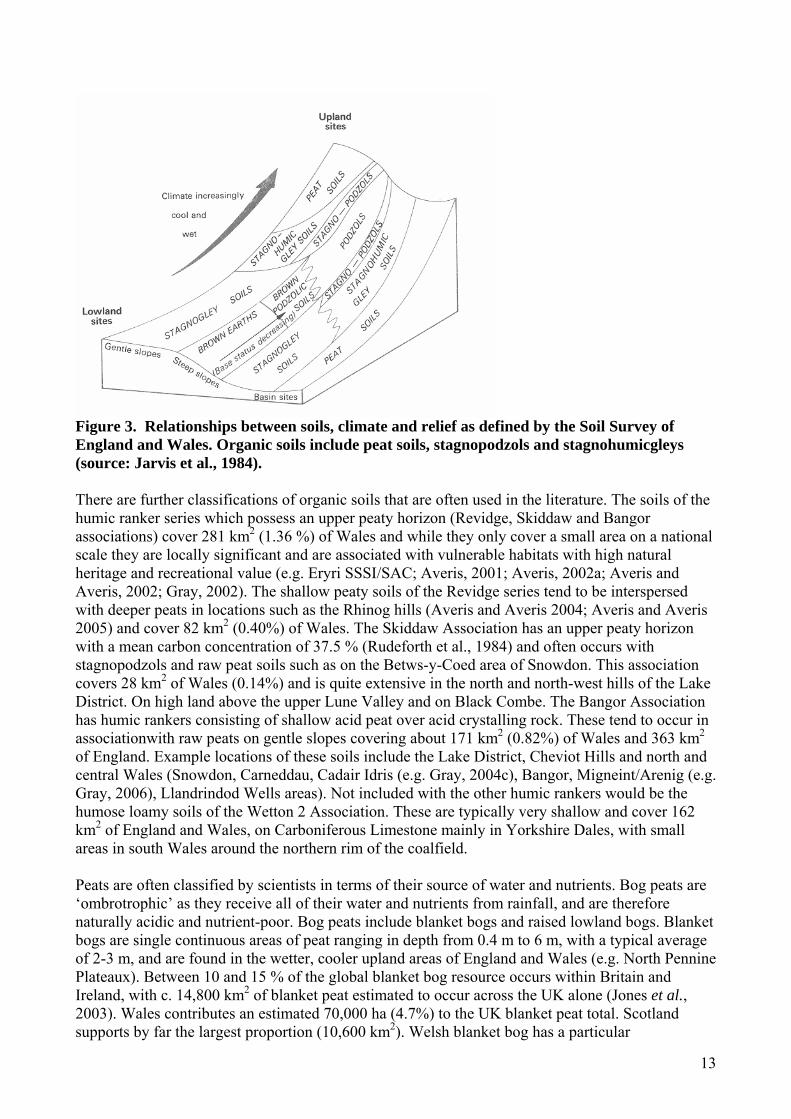
13
Figure 3. Relationships between soils, climate and relief as defined by the Soil Survey of England and Wales. Organic soils include peat soils, stagnopodzols and stagnohumicgleys (source: Jarvis et al., 1984). There are further classifications of organic soils that are often used in the literature. The soils of the humic ranker series which possess an upper peaty horizon (Revidge, Skiddaw and Bangor associations) cover 281 km2 (1.36 %) of Wales and while they only cover a small area on a national scale they are locally significant and are associated with vulnerable habitats with high natural heritage and recreational value (e.g. Eryri SSSI/SAC; Averis, 2001; Averis, 2002a; Averis and Averis, 2002; Gray, 2002). The shallow peaty soils of the Revidge series tend to be interspersed with deeper peats in locations such as the Rhinog hills (Averis and Averis 2004; Averis and Averis 2005) and cover 82 km2 (0.40%) of Wales. The Skiddaw Association has an upper peaty horizon with a mean carbon concentration of 37.5 % (Rudeforth et al., 1984) and often occurs with stagnopodzols and raw peat soils such as on the Betws-y-Coed area of Snowdon. This association covers 28 km2 of Wales (0.14%) and is quite extensive in the north and north-west hills of the Lake District. On high land above the upper Lune Valley and on Black Combe. The Bangor Association has humic rankers consisting of shallow acid peat over acid crystalling rock. These tend to occur in associationwith raw peats on gentle slopes covering about 171 km2 (0.82%) of Wales and 363 km2 of England. Example locations of these soils include the Lake District, Cheviot Hills and north and central Wales (Snowdon, Carneddau, Cadair Idris (e.g. Gray, 2004c), Bangor, Migneint/Arenig (e.g. Gray, 2006), Llandrindod Wells areas). Not included with the other humic rankers would be the humose loamy soils of the Wetton 2 Association. These are typically very shallow and cover 162 km2 of England and Wales, on Carboniferous Limestone mainly in Yorkshire Dales, with small areas in south Wales around the northern rim of the coalfield. Peats are often classified by scientists in terms of their source of water and nutrients. Bog peats are ‘ombrotrophic’ as they receive all of their water and nutrients from rainfall, and are therefore naturally acidic and nutrient-poor. Bog peats include blanket bogs and raised lowland bogs. Blanket bogs are single continuous areas of peat ranging in depth from 0.4 m to 6 m, with a typical average of 2-3 m, and are found in the wetter, cooler upland areas of England and Wales (e.g. North Pennine Plateaux). Between 10 and 15 % of the global blanket bog resource occurs within Britain and Ireland, with c. 14,800 km2 of blanket peat estimated to occur across the UK alone (Jones et al., 2003). Wales contributes an estimated 70,000 ha (4.7%) to the UK blanket peat total. Scotland supports by far the largest proportion (10,600 km2). Welsh blanket bog has a particular
14
biogeographical significance since blanket bog is absent across much of the equivalent altitudinal range in England. Effectively it disappears south of the Pennines until Dartmoor and Exmoor in the south-west. Welsh examples include much of the core range of ecological variation of this habitat in Great Britain, although Wales lacks the hyper-oceanic mires found in west of Ireland and northern Scotland. The quality of many Welsh blanket bogs contrast sharply with their nearest neighbours in the southern Pennines, which are severely degraded (Jones et al., 2003). Lowland raised bogs consist of a gently sloping, raised mound of saturated peat and are typically surrounded by farmland or woodland (e.g. Wedholme Flow, Cumbria). The peat is usually 3-10 m deep in the middle but shallower near the edges. The transition is often abrupt due to drainage at the margins. According to Lindsay and Immirzi (1996) only 20 of Great Britain’s 1045 original lowland raised bogs occured in Wales. Today, however, the 818 ha of surviving and least modified raised bog in Wales accounts for 20 % of the total in Great Britain (Jones et al., 2003). This is largely due to the fortuitous survival of two extensive areas of bog in Ceredigion (Cors Caron (Tregaron Bog) and Cors Fochno (Borth Bog) which despite suffering extensive damage still represent the best examples of this habitat type in the UK within the respective contexts of inland and coastal floodplain. Nearest bogs of equivalent quality are now found in the central Scottish lowlands and Ireland. In England within 50 miles of the Welsh border, lowland raised bogs used to be an extensive feature of parts of Cheshire and Lancashire but massive habitat loss has occurred and those sites that remain are mostly highly modified and fragmented. Likewise, raised bog used to occupy great swathes of poorly-drained land within the Somerset levels but these days only a tiny proportion of this retains a vestige of bog habitat (Jones et al., 2003). Raised bogs are also found in the uplands but usually in association with blanket bogs and so are not distinguished in classification or management practices from the surrounding blanket peat. Lowland raised bogs have been classified in terms of their condition by Lindsay and Immirzi (1996). No such classification exists for blanket bogs in England although English Nature has recently compiled an inventory of its blanket bog Sites of Special Scientific Interest (SSSI) into either favourable or unfavourable condition (English Nature, 2003). CCW has reported on the status of blanket bog in Wales (Jones et al., 2003) (see section 5). Fens receive their water and nutrients from surrounding land and are known as ‘minerotrophic’. Fens vary in their nutrient status depending on their position in relation to the surrounding land and local geology. They are typically found at the edge of lakes, on river floodplains and by springs and seepages and are often small since most of the large fens in England and Wales have now been lost to agriculture. Fens support a wide range of ecosystems with distinctive conservation value. The term ‘active bog’ is used in the European Union Habitats and Species Directive to describe bogs that are actively forming peat. However, peat accumulates too slowly (typically 1-2 mm per year) for this to be used as a practical means of deciding whether a peatland site is active. The definition of active in the Habitats Directive manual is that the site still supports significant areas of vegetation that are normally peat forming. The term ‘degraded bog’ is used for those bogs where widespread disruption, usually by humans, has occurred to the hydrology. Causes include drainage, peat removal, agricultural management, drying through tree growth or natural climatic variability. Change in hydrology will be reflected in the vegetation composition of these sites. Heathland is another term often associated with drier organo-mineral soils. Heathlands are characterised by biotic communities of ericaceous dwarf shrubs together with their associated flora and fauna. Heathlands are highly valued for a variety of reasons; these include their value as cultural landscapes, their historical associations, their characteristic and frequently endangered biodiversity and their value as subjects for ecological study and research. The EU Habitats Directive recognised heathlands as an important habitat in need of protection and conservation.

15
2.4. Physical and chemical properties of organic soils 2.4.1. Physical properties The parameters commonly used to describe the physical properties of organic soils are those related to bulk density, loss on ignition (organic matter content), porosity, wetting and drying processes, moisture relationships and hydrology. In particular, several peat description schemes have been developed. However, the von Post classification (von Post, 1924) is widely used to provide a semi-quantitative description of the physical, chemical and structural properties of peat deposits. Hobbs (Hobbs 1986, p78-79) provides a succinct description of the main method. In outline, the basic scheme describes:
1. The main plant remains e.g. Eriophorum, Sphagnum, etc. 2. Degree of humification graded on a scale of 1 to 10 varying from no decomposition (1) to
complete decomposition (10). 3. Water content estimated in the field on a scale of 1 (dry) to 5 (fully saturated). 4. Fine fibre (< 1 mm diameter) content graded on a scale of zero (nil present), 1 (low content),
2 (moderate content) and 3 (high content). 5. Coarse fibres consist of fibres stems and rootlets great than 1 mm diameter and are graded
on a scale of 0 to 3 as above. 6. Wood and shrub remnants: these are graded in the same fashion as in 4 and 5 above on a
scale of 0 to 3 and can be grouped collectively or independently. Several further extensions of the basic method have been developed but generally involve laboratory testing. Common additional tests include: organic content, tensile strength, smell, plasticity and acidity (pH). Organic soils are typically black to dark brown in colour due to their high organic matter content. As they are principally comprised of water, they are very lightweight when they are dry. Peat soil can hold a mass of water equal to 200-400 % of its dry weight (Brady and Weil, 1999). Large water contents are reflected in low bulk densities that range from 0.1 to 0.4 g cm-3 (Brady and Weil, 1999). Large water contents and flexible organic structure make peat soils very susceptible to structural change (i.e. shrinkage and swelling) as the moisture content varies. Hobbs (1986) is an excellent reference on the properties of peat soils and it describes detailed structural and engineering properties. Although peat soils have large water contents and high porosity, they have very low saturated hydraulic conductivities (rate at which water moves through the saturated soil), and so tend to retain large amounts of water, which help them maintain their saturated status. Since the mid 20th century Russian scientists have adopted a diplotelmic (two layered) system for understanding peats. This system has been widely adopted internationally and is commonly used to describe hydro-ecological processes in the peats of England and Wales (Bragg and Tallis, 2001; Holden and Burt, 2003a, 2003b, 2003c). The layering system comprises an upper ‘active’ peat layer with a high hydraulic conductivity and fluctuating water table, and a more ‘inert’ lower layer which corresponds to the permanently saturated main body of peat (Romanov, 1968). Ingram (1983) noted the distinction between the upper, periodically aerated, partly living soil layer (acrotelm) and the lower anaerobic layer (catotelm). According to Ingram’s definition, the acrotelm is affected by a fluctuating water table (the lowest water table depth is therefore the base of the acrotelm), has a high hydraulic conductivity and a variable water content, is rich in peat-forming aerobic bacteria and other micro-organisms and has a live matrix of growing plant material. The catotelm has water content invariable with time, a small hydraulic conductivity, is not subject to air entry and is devoid of peat-forming aerobic micro-organisms. The acrotelm-catotelm model implies that most runoff production and nutrient transfer will occur within the upper peat layer, close to or at the peat surface. This matches the findings of many catchment streamflow and water table studies in the UK uplands (e.g. Evans et al, 1999).
16
2.4.2. Chemical properties Upland organic soils in Wales, SW England and Cumbria have developed on base poor geology such as granites and metamorphic rocks. Hence they are acidic with a pH of around 4 and have a low base saturation status. In the Pennines, organic soils have developed over glacial drift but are still acidic with a low base saturation. Although they contain large quantities of nitrogen and phosphorus, they are present in organic forms, and because of the slow rates of mineralization, the soils are nutrient poor. Organic soils tend to have a high carbon to nitrogen ratio with an average of 20:1 compared to 12:1 for mineral soils (Brady and Weil, 1999). Peat soils are important sinks for organic and inorganic substances via adsorption, redox reactions, and the accumulation of organic matter. Soil organic matter has a negative charge and a greater number of cation exchange sites than mineral material, which increase as the pH of the soil increases (Rowell, 1994). In contrast, the anion adsorption capacity is small, although the stronger anions, sulphate and phosphate, are retained by adsorption. The saturated conditions of peat create a reducing environment, where soil microbes consume oxygen (or more specifically electrons) from oxidised compounds (in the order NO3
-, Mn4+, Fe3+, SO42- and CO2) during anaerobic respiration,
which transforms them to their reduced forms (NO2-, Mn2+, Fe2+, H2S and CH4) (Rowell, 1994).
These processes are important because degradation of peats can result in more aerobic conditions which can alter soil microbial and chemical processes and impact on soil water and stream water quality as well as gaseous carbon release. The impacts of land management and climate change on organic soil chemistry will be discussed in this report as the soil chemistry is an important indicator of its current state of degradation, and it affects stream water quality. 2.5 Vegetation cover and land use Lowland organic soils, such as raised bogs have distinctive raised moss floras dominated by Sphagnum, sedges and heathers, while fens are dominated by reeds (Phragmites communis), sedges (Carex) and graminoids, non-ericaceous shrubs. In upland areas, plant growth on organic soils is limited by soil acidity, low nutrient availability, low temperatures and short summers and the predominant vegetation tends to vary with soil type. Organo-mineral soils commonly carry heath-type vegetation dominated by Nardus or Molinia grasslands and blanket peat supports moorland vegetation dominated by Calluna, Erica, Eriophorum and Sphagnum spp. (Floate, 1977). These communities of native plants, though modified by human activity, are known as ‘semi-natural’ vegetation or ‘rough grazings’. This vegetation type is largely sustained by low density sheep, deer and cattle grazing, and in some areas periodic burning. Approximately 70 % of UK upland areas are classified as rough grazings; in Wales, 27 % of agricultural land is rough grazing, compared to only 12 % in England (SOAFD, 1995). Between 1950 and 1980, financial incentives encouraged farmers to increase productivity and fertility of upland soils so that large areas of semi-natural vegetation have been converted to improved pasture (Eadie, 1985). Methods of improvement varied but generally involved the addition of lime and fertilisers, often accompanied by drainage and ploughing and in some cases, the replacement of natural vegetation with alternative, more productive strains of grasses, such as rye grass, Lolium perenne L., and clover, Trifolium repens (Newbould, 1985). Although the primary aim of these changes is to increase the productivity of hill land, changes in the chemical and physical conditions of the treated soil will also occur. This affects soil-solution interactions within the soil and may lead to an increase in nutrient leaching and thus deterioration in upland water quality (Roberts et al., 1984). Since the 1980s it has been recognised that semi-natural vegetation provides valuable refuges for native plants and animals and hence some areas have been designated as National Nature Reserves or SSSI. Although current land use policy does not favour continued land improvement of upland areas due to increased concern about over production of agricultural commodities and the loss of semi-natural habitats, much of the existing improved pasture is still in

17
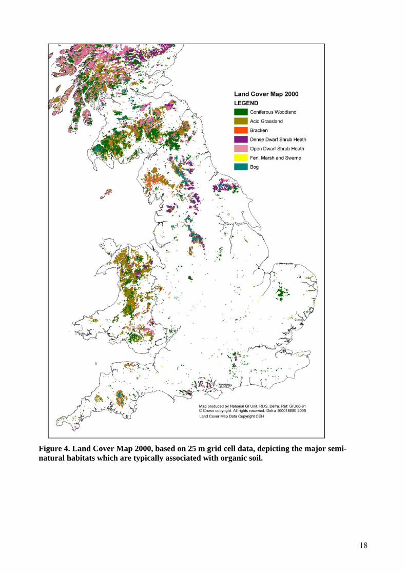
use today and sustained productivity is achieved by fertilisation and managed grazing. Even in areas where grazing has been reduced, the effects of fertilisation and liming on soil chemistry and drainage water can still be detected 40 years after treatments (Hornung et al., 1986). It is possible that other factors associated with upland farming (e.g. soil erosion) may also have impacts long after agricultural activities have ceased, potentially making restoration a difficult task, at least in the short-term. In organic soils, nitrogen (N) and phosphorus (P) are largely present in their organic forms and become available only through mineralization, which is slow under conditions of strong acidity and low temperatures (Floate, 1977). Therefore, grassland management factors which stimulate organic matter decomposition, such as liming, fertiliser application and ploughing will also increase N and P mineralization (Shah et al., 1990; Haynes and Swift, 1988), which may lead to a decrease in total soil N and P contents and an increase in nutrient leaching. For example, in mid-Wales, Roberts et al. (1989) observed an increase in losses of inorganic forms of N in stream water from 10 to 22 kg N ha-1 yr-1 following disc harrowing of previously undisturbed grassland, which they attributed to an increase in the mineralization of soil organic matter. Over the last eighty years, one of the major land use changes in upland areas of Britain has been the conversion of semi-natural vegetation to plantation forest dominated by coniferous species, particularly in upland areas of Wales and the North Pennines. Sitka spruce (Picea sitchensis) is the dominant species as it is well suited to the climate and soils, and gives good yields. However, Lodgepole pine competes better with heath vegetation and is grown above 600 masl (Rudeforth et al., 1984) Figure 4 displays the distribution of the major semi-natural habitat classes most commonly associated with organic soils. It is based on the 25 m grid cells taken from the Land Cover Map 2000 (LCM2000) which depicts land cover across the UK at the turn of the millennium. It provides a complete map of the land cover of Great Britain from satellite information, accurate to the field scale, and checked against ground survey. The area that each semi-natural ‘Broad Habitat’ occupies is presented in Table 2. Table 2. The major semi-natural habitats of England and Wales. (Numbers in brackets represent proportion of total land area.) Land Cover England
Area (km2) Wales Area (km2)
Coniferous Woodland 2989 (2.3 %) 1439 (1.1 %) Acid Grass 2787 (2.1 %) 3197 (2.5 %) Bracken 706 (0.5 %) 296 (0.2 %) Dense Dwarf Shrub Heath
1331 (1.0 %) 582 (0.4 %)
Open Dwarf Shrub Heath
1317 (1.0 %) 551 (0.4 %)
Fen, Marsh and Swamp
177 (0.13 %) 16 (0.01 %)
Bog 1056 (0.8 %) 58 (0.04 %)
18
Figure 4. Land Cover Map 2000, based on 25 m grid cell data, depicting the major semi-natural habitats which are typically associated with organic soil.
19
Table 2 shows that coniferous woodlands are the largest semi-natural habitat in England. However, a comparison of Figure 1 and 4 shows that the majority of coniferous woodland does not occur on organic soils in England other than at Kielder Forest in Northumberland where stagnohumic gley soils were initially planted with coniferous plantations in the 1920s, and which significantly expanded in the 1950s and 60s. In contrast in Wales, the vast majority of coniferous woodland occurs on the upland organo-mineral soils, the vast majority of which are plantations planted in the last century. Acid grassland represents the major habitat associated with organic soils in Wales and is closely associated with the stagnopodzols and stagnohumic gley soils. The major area of bog vegetation is associated with the raw peats of the Pennines, with areas of dwarf shrub heath often surrounding bog vegetation. Figure 4 also highlights that the majority of the humic alluvial gley soils in East Anglia are associated with agriculture, as only small areas of fen, marsh and swamp occur in this area. The UK extent of Molina-Juncus pasture habitat is uncertain, but Wales holds an estimated 350 km2, which is likely to be high proportion of total UK extent (Jones et al. 2003). Wales has a particularly important part to play in the conservation of Molinia – Cirsium dissectum fen-meadow. Lowland heath is strongly represented along the more oceanic western fringe of Wales. The sum of all forms of lowland heath recorded below the ‘ffridd’ level in Wales is c. 70 km2, which is approximately 10% of the estimated UK total. Wales holds a significant portion of the UK’s lowland wet heath resource which is particularly well represented in Swansea, Pembrokeshire, Snowdonia National Park, Gwynedd and Ceredigion LBAP areas. Upland heath has very limited European distribution beyond the UK. Upland heaths of Wales provide an important geographical link, bridging the gap between south-west England and the Pennines and Lake District. Within the latitudinal range of Wales there are very few English upland heathland sites. The total UK upland heath cover is between 20,000 and 30,000 km2 of which c. 790 km2 (3-4%) occurs on Wales (Jones, et al. 2003). Grazing pressure has resulted in the conversion of many upland Welsh heaths to grassland and is probably the main reason for the relatively low figure for Wales. 2.6 Implications for this report Most organic soils are found in the uplands (80.3 %). Therefore, while this report deals with all organic soils of England and Wales, the dominant upland nature of organic soils (and of the research into organic soils) inevitably means that a large proportion of the remainder of this report is weighted towards upland organic soil processes and vulnerability. It should also be noted that there is more research on raw peat soils than other organic soil types. Therefore this report is able to present more detailed evidence from peat soils than other soils, which will inevitably affect the balance of the report. Much upland research into organic soil functioning and processes deals more broadly with ‘moorland environments’ and while moorlands can contain many different soil types, including peat and organo-mineral soils, often research and management strategies lump these soils into one environmental context. Nevertheless, where information is available, the report deals with specific types of upland organic soils and with lowland organic soil processes and threats.
20
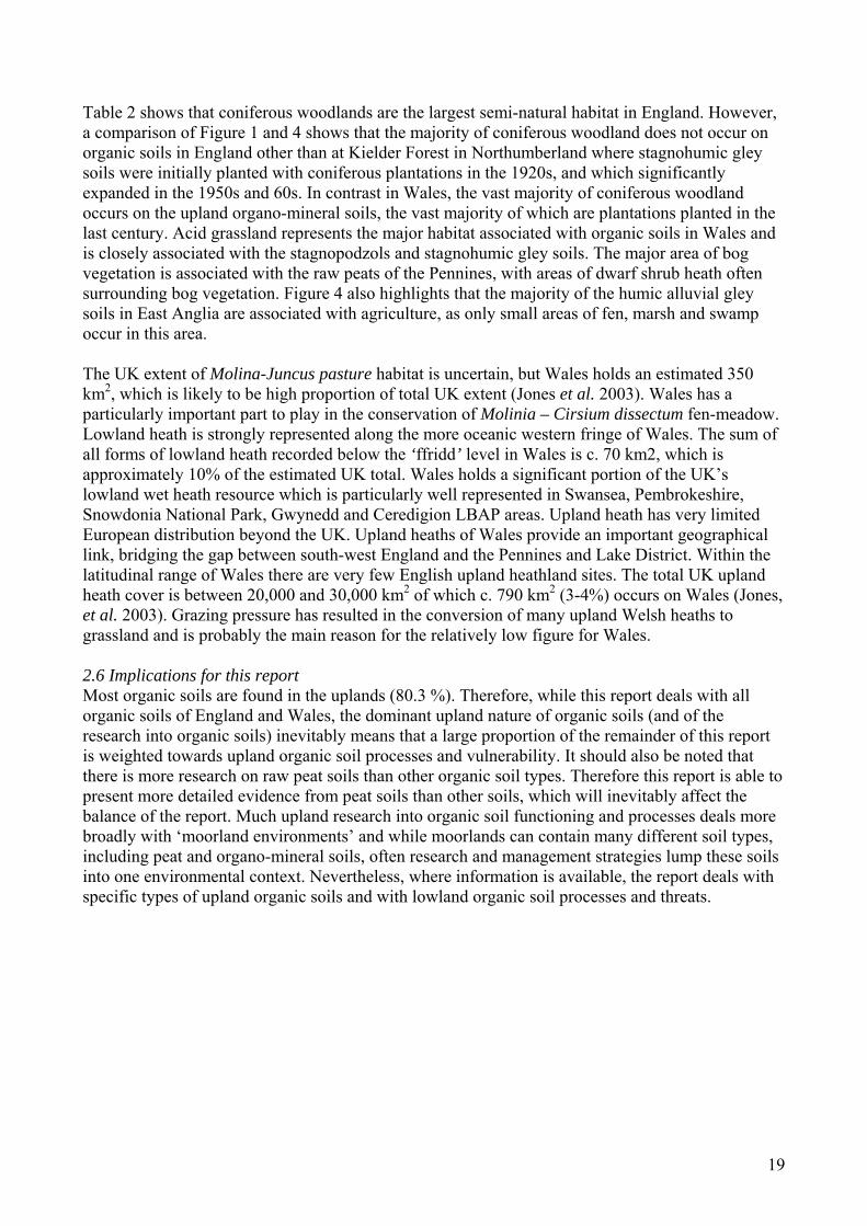
3. Types and causes of degradation 3.1 Summary Degradation of organic soils involves a number of interacting processes. Water and wind erosion are natural processes but can be exacerbated by human action. Chemical and physical degradation of the soil can result from management, atmospheric deposition or climate change. Climate change is a principal driver of many degradation processes and must therefore be included as a factor when predicting the future state of organic soils. Many of the causes of land degradation including overgrazing, land use change (e.g. land drainage and afforestation), agricultural activities (including burning) and over-exploitation by processes such as peat extraction are also extremely important. 3.2 Methods A review of the literature was conducted. Additionally, processes that have been observed and investigated by the project team were reported. A lack of direct evidence for the degradation of lowland organic soils has been identified and therefore the bulk of this section is devoted to the discussion of peat erosion mostly in upland environments. It is structured around the main themes identified in Figure 5 (processes and causes). 3.3 Introduction Organic soils are threatened by historic problems (e.g. pollutant deposition) and current land use management and climate change. There are a range of drivers producing different forms of organic soil degradation. Figure 5, although characterising soil degradation problems on a global scale, provides an excellent general framework for considering the principal causes of soil degradation and the key processes governing their impacts.
Figure 5. Processes and causes of soil erosion on a global scale (Source: FAO, 1984). This section uses a similar framework to examine the degradation of organic soils, considering both the processes of land degradation and the main causes. In the context of organic soils in England and Wales consideration must be given to water erosion (including erosion by runoff and gully development); wind erosion; landslides and the chemical and physical degradation of soils (including threats from atmospheric deposition chemistry). Climate change is a principal driver of some of these processes and must therefore be included as a factor when predicting the future state of organic soils. Many of the causes of land degradation including overgrazing, land use change

21
(e.g. land drainage and afforestation), agricultural activities (including burning) and over-exploitation by processes such as peat extraction are also extremely important. Examining these factors in isolation would be wrong because all are interrelated and, therefore, the discussion which follows inevitably involves some overlap between sections. 3.4 Vulnerability of organic soils The vulnerability of soils to certain pollutants, degradation processes or environmental change depend upon those characteristics that enable soils to resist alteration and which maintain the biological functions expected of a soil (Bridges, 1991). Hence, soil vulnerability is the capacity for the soil system to be harmed in one or more of its ecological functions. Vulnerability should be specified with respect to agents, causes and effects (Desaules, 1991). Soil degradation occurs when human-induced phenomena lower the current and/or future capacity of the soil to support vegetation and animal life. Soils are generally resilient to change within certain limits, but outside these limits the soil will not recover naturally even if the pressure is removed. Most organic soils support ecosystems that are sensitive to pollutant impacts and human activities; hence these soils are susceptible to degradation.
Figure 6. Pedogenic processes affecting soil organic content (SOC) (source: Lal et al., 1998). The dominant pedogenic processes affecting the soil organic content can be broadly divided into processes which enhance organic matter (organic carbon) content and those which degrade it (Lal et al., 1998) (Figure 6). Enhanced soil organic content is achieved through plant biomass production, humification, sediment deposition and aggregation. Conversely, soil erosion, leaching and decomposition are all processes which reduce the soil organic content. The balance between these two sets of processes is strongly influenced by natural and anthropogenic environmental processes. Organic matter combines with clay particles to form soil aggregates whose stability determines the resistance of the soil to erosion (Morgan, 2005). The organic content of a soil, together with its chemical constituents, determine aggregate stability. Evans (1980) suggested that soils with a less than 2 % organic carbon content (c. 3.5 % organic matter content) can be considered erodible. Voroney et al. (1981) suggested that soil erodibility decreases linearly with increasing organic content over the range 0-10 %. Ekwue (1990) showed that soil detachment by raindrop impact decreased with increasing organic content in the range 0-12 %. These ranges can not be extrapolated because some soils with very high organic contents, particularly peats, are highly susceptible to wind and water erosion. Furthermore, the role played by organic matter depends on

22
its origin. Organic matter from farmyard manure contributes to aggregate stability, while peat has very low aggregate stability. Soil organic matter supplies essential nutrients, holds water, and absorbs cations. However, its indirect effects on soil structure, aeration and temperature are probably more important (Brady and Weil, 1999). Maintaining soil organic matter in mineral soils is one of the greatest challenges in modern agriculture. Organic soils, although sharing some characteristics with their mineral counterparts, have unique properties that require a different management approach. When evaluating vulnerability of organic soils to erosion it is important to distinguish minimum organic matter contents for soil aggregate stability, and the bulk properties of organic soils, which make the total soil mass susceptible to erosion (e.g. susceptibility to scour by water erosion and light density of organic matter promoting high wind erosion potential). At the macroscopic scale, organic peat soils can be classified into: amorphous granular, coarse fibrous and fine fibrous peat (Radforth, 1952). These properties vary greatly within peat soils and produce large variations in hydrological properties and resistance to erosion. Therefore a ‘raw peat soil’ includes a large variety of soil types which are spatially heterogeneous. Humification involves the loss of organic matter, breakdown of physical structure and change in chemical state. Cellulose within plant tissues is degraded into finer detritus until the soil has an amorphous granular texture. These changes are non-uniform because the rates of change depend on the original vegetation present. Thus, as the quantity of humified peat increases, fibres are reduced in size and strength, although in an irregular manner (Bell, 2000). Fresher organic soils contain more fibrous material and, from an engineering perspective, have greater tensile and shear strength, void ratio and water content than more humified and older organic soils. However, the engineering properties of organic soils cannot be differentiated on the basis of organic content alone (O’Farrell et al., 1994). The environmental factors for optimum decay are for temperatures of 35-40°C, pH neutral to weakly alkaline (pH 7.0 to 7.5) and an accessible source of available nitrogen (Bell, 2000). The key issue in managing organic soils is maintaining soil volume rather than soil mass. In a practical sense, this means maintaining the water table as close to the surface as possible, thus retaining a good surface cover to prevent wind erosion, reducing decomposition of the peat and problems with subsidence (Brady and Weil, 1999). Biological mineralization of the carbon in situ is an important process and research suggests between 30 and 46 % of the carbon in eroded material may be mineralised (Jacinthe et al., 2002). 3.5 Monitoring of erosion and organic soil loss by wind and water Although there is a long history of erosion measurement on cultivated soils in England and Wales (Morgan, 1985), there is a lack of quantitative erosion monitoring of lowland organic soils (Brazier, 2004). While the threats to lowland organic soils are real, the impacts have not been properly measured and so evidence of the impacts of these threats is often limited to anecodotal material (Evans, 1993). Nevertheless, much of this ‘knowledge’ has become enshrined in conventional wisdom (DEFRA, 2005). Recent advice from DEFRA on controlling erosion suggests light peaty soils with soil particles of about 1 mm diameter are susceptible to wind erosion (DEFRA, 2005). This is particularly in soils with greater than 20-30 % organic matter content where the lower soil density and looser soil structure enhance the susceptibility to erosion. Evans (2005c) reviewed water erosion monitoring in lowland England and Wales and concluded that there was an urgent need for a systematic scheme to monitor water erosion of cultivated land and that the trends in extent and severity of erosion across all soil groups needed to be known. Unfortunately these measurements are not available and the extent of erosion is often greatly complicated by crop type and other tillage and management practices.
23
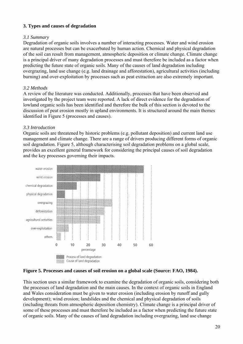
Areas susceptible to soil erosion in England and Wales have been classified by Morgan (1985). Morgan used a simple procedure based on a combination of data on land capability, rainfall erosivity, wind velocity and soil erosion susceptibility (Figure 7). The areas most susceptible to erosion are closely associated with many areas of organic soils. In particular, the lowland peat soils of the fens, which are susceptible to wind erosion, and extensive areas of upland peats, where both water and wind erosion is prevalent. On agricultural land the most obvious cases of organic soil erosion occur in lowland England and Wales, but significant problems can also occur in upland areas where over-grazing or recreational activities have removed the vegetation cover (MAFF, 1993). In terms of wind erosion, sandy and peaty soils are most at risk in exposed areas between March and June. Soils planted in spring are usually bare and dry during this period. The areas most at risk are parts of the East Midlands, Yorkshire and East Anglia (Radley and Simms, 1967; Robinson, 1968; Pollard and Miller, 1968; Wilkinson et al., 1969). However, MAFF (1993, p.17) also state ‘Wind erosion of exposed peaty soils can also occur in upland areas.’ The loss of resource through erosion has widespread consequences for upland agriculture and recreation. Although all costs are not known, it is estimated that up to £12,000 per hectare can be spent on revegetation of bare ground (Tallis, 1997a). One of the few studies to compare the erodibility of mineral and organic soils directly is that of Carling et al. (1997) who experimentally examined hydraulic thresholds for the erosion of 14 upland mineral and organic soils. It was discovered that organic content is pre-eminent in reducing erosion susceptibility in both organic and mineral soils, although other soil properties need to be considered in making a full assessment of the resistance of a particular soil to erosion.
Figure 7. Soil erosion susceptibility map for England and Wales (source: after Morgan, 1985).
24
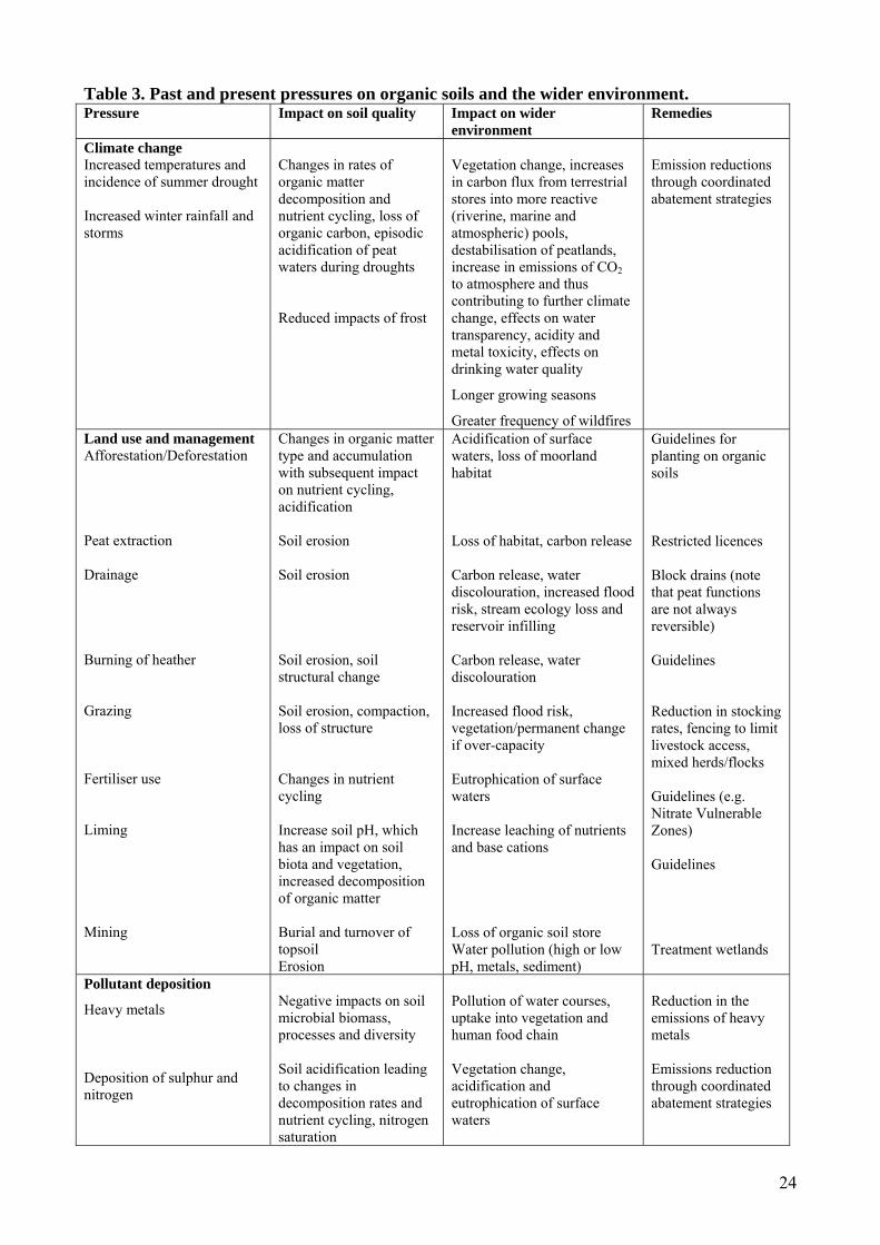
Table 3. Past and present pressures on organic soils and the wider environment. Pressure Impact on soil quality Impact on wider
environment Remedies
Climate change Increased temperatures and incidence of summer drought Increased winter rainfall and storms
Changes in rates of organic matter decomposition and nutrient cycling, loss of organic carbon, episodic acidification of peat waters during droughts Reduced impacts of frost
Vegetation change, increases in carbon flux from terrestrial stores into more reactive (riverine, marine and atmospheric) pools, destabilisation of peatlands, increase in emissions of CO2 to atmosphere and thus contributing to further climate change, effects on water transparency, acidity and metal toxicity, effects on drinking water quality
Longer growing seasons
Greater frequency of wildfires
Emission reductions through coordinated abatement strategies
Land use and management Afforestation/Deforestation Peat extraction Drainage Burning of heather Grazing Fertiliser use Liming Mining
Changes in organic matter type and accumulation with subsequent impact on nutrient cycling, acidification Soil erosion Soil erosion Soil erosion, soil structural change Soil erosion, compaction, loss of structure Changes in nutrient cycling Increase soil pH, which has an impact on soil biota and vegetation, increased decomposition of organic matter Burial and turnover of topsoil Erosion
Acidification of surface waters, loss of moorland habitat Loss of habitat, carbon release Carbon release, water discolouration, increased flood risk, stream ecology loss and reservoir infilling Carbon release, water discolouration Increased flood risk, vegetation/permanent change if over-capacity Eutrophication of surface waters Increase leaching of nutrients and base cations Loss of organic soil store Water pollution (high or low pH, metals, sediment)
Guidelines for planting on organic soils Restricted licences Block drains (note that peat functions are not always reversible) Guidelines Reduction in stocking rates, fencing to limit livestock access, mixed herds/flocks Guidelines (e.g. Nitrate Vulnerable Zones) Guidelines Treatment wetlands
Pollutant deposition
Heavy metals Deposition of sulphur and nitrogen
Negative impacts on soil microbial biomass, processes and diversity Soil acidification leading to changes in decomposition rates and nutrient cycling, nitrogen saturation
Pollution of water courses, uptake into vegetation and human food chain Vegetation change, acidification and eutrophication of surface waters
Reduction in the emissions of heavy metals Emissions reduction through coordinated abatement strategies

25
Table 3 illustrates some of the main pressures that organic soils in England and Wales have faced. These include a range of factors including climate change, pollutant deposition and changes to land use and management. Here we focus on some of the key processes driving organic soil degradation and the land use and management practices which have amplified them. The treatment is not exhaustive because insufficient information is available for organic soils across England and Wales to provide a comprehensive picture. Hence the bias is towards peat erosion in the uplands. It should also be noted that it is often very difficult to discuss processes independent of cause, therefore these are considered together. Further details on some processes and rates of erosion are also provided in Section 5, which deals with current state of organic soils in England and Wales. 3.6. Natural and artificial erosion of upland organic soils Upland peatlands are dissected by complex patterns of drainage. This includes a continuum of drainage forms from natural dissection patterns, found in pristine peatlands, to artificial drainage networks deliberately cut into the peat. This dissection is often associated with differing erosion processes and degrees of degradation. Research concerning this issue has been carried out in many upland areas of the British Isles (Bower, 1960a; Tomlinson, 1981; Francis, 1990; Stevenson et al., 1990; Birnie, 1993; Grieve et al., 1995; Tallis, 1997b, 1997c, 1998) and in 1997 the British Ecological Society organised a conference specifically to examine the ‘Causes, consequences and challenges’ associated with blanket mire degradation (Tallis et al., 1997). However, detailed studies of peat erosion processes in the UK are still relatively sparse and with a few exceptions (e.g. Mosley, 1972; Tallis, 1985a) much of the geomorphic analysis relies on descriptive frameworks established in the 1960s (Bower, 1959, 1960a, 1960b, 1961, 1962). Peat erosion creates a range of features characteristic of blanket mire degradation. Classification of such features has formed the basis of the most influential contributions to peat erosion (Bower, 1960a). Working in the Pennines, Bower (1959, 1960a, 1960b) identified five main types of erosion system, on the basis of morphology and pattern. These were considered to result from the operation of two main processes: water erosion and mass movements. Water erosion produced dissection systems which developed onto and into the peat mass; sheet erosion on the peat surface as vegetation breaks up; and erosion along marginal faces, at the edge of the peat mass where peat, once thinned at a break of slope, erodes back to form a steeply inclined peat face. On steeper slopes, mass movements may result and under very wet conditions bog bursts and peat slides can occur. Also, in peat overlying drift-covered limestone, sinkholes often develop producing erosion. Drainage dissection was considered by Bower (1960a) to be the most important erosive process both spatially and in terms of volume of peat removed. Bower defined two types of dissection system associated with water erosion, which differ in the pattern of gullying produced. These were defined as Type 1 and Type 2. Both were considered to form from one of three mechanisms:(i) within the peat mass originating along horizontal or vertical lines of seepage; (ii) as runnels on the surface encouraged by vegetation destruction, and (iii) by headward erosion of gullies from the margin of the peat. Type 1 dissection occurs in peat of 1.5 – 2.0 m depth on slopes less than 5o. Gullies advance headward, expand laterally and rapidly incise to the peat base. Gully frequency is high and these tend to branch and intersect. Ultimately, the peat mass is reduced to a large number of peat islands. Where lateral erosion continues but vertical erosion ceases, expanses of bare peat are produced. Type 2 dissection occurs on slopes exceeding 5o and the pattern is more extensive than Type 1 but gullies are more open. Individual gullies rarely branch and the pattern of gullies varies with slope angle. Steep slopes have linear gullies whereas shallower slopes tend to have more meandering gullies. The frequency of gullies is highest on the most exposed summits. These processes have operated with varying intensity since peat first formed but evidence suggests that they have intensified in recent millennia (Aaby, 1976; Tallis, 1973, 1985b; Higgitt et al., 2001).
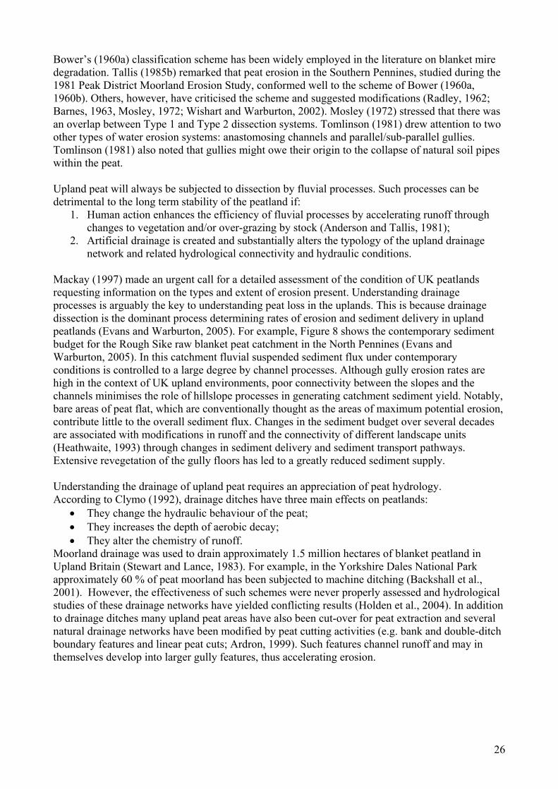
26
Bower’s (1960a) classification scheme has been widely employed in the literature on blanket mire degradation. Tallis (1985b) remarked that peat erosion in the Southern Pennines, studied during the 1981 Peak District Moorland Erosion Study, conformed well to the scheme of Bower (1960a, 1960b). Others, however, have criticised the scheme and suggested modifications (Radley, 1962; Barnes, 1963, Mosley, 1972; Wishart and Warburton, 2002). Mosley (1972) stressed that there was an overlap between Type 1 and Type 2 dissection systems. Tomlinson (1981) drew attention to two other types of water erosion systems: anastomosing channels and parallel/sub-parallel gullies. Tomlinson (1981) also noted that gullies might owe their origin to the collapse of natural soil pipes within the peat. Upland peat will always be subjected to dissection by fluvial processes. Such processes can be detrimental to the long term stability of the peatland if:
1. Human action enhances the efficiency of fluvial processes by accelerating runoff through changes to vegetation and/or over-grazing by stock (Anderson and Tallis, 1981);
2. Artificial drainage is created and substantially alters the typology of the upland drainage network and related hydrological connectivity and hydraulic conditions.
Mackay (1997) made an urgent call for a detailed assessment of the condition of UK peatlands requesting information on the types and extent of erosion present. Understanding drainage processes is arguably the key to understanding peat loss in the uplands. This is because drainage dissection is the dominant process determining rates of erosion and sediment delivery in upland peatlands (Evans and Warburton, 2005). For example, Figure 8 shows the contemporary sediment budget for the Rough Sike raw blanket peat catchment in the North Pennines (Evans and Warburton, 2005). In this catchment fluvial suspended sediment flux under contemporary conditions is controlled to a large degree by channel processes. Although gully erosion rates are high in the context of UK upland environments, poor connectivity between the slopes and the channels minimises the role of hillslope processes in generating catchment sediment yield. Notably, bare areas of peat flat, which are conventionally thought as the areas of maximum potential erosion, contribute little to the overall sediment flux. Changes in the sediment budget over several decades are associated with modifications in runoff and the connectivity of different landscape units (Heathwaite, 1993) through changes in sediment delivery and sediment transport pathways. Extensive revegetation of the gully floors has led to a greatly reduced sediment supply. Understanding the drainage of upland peat requires an appreciation of peat hydrology. According to Clymo (1992), drainage ditches have three main effects on peatlands:
• They change the hydraulic behaviour of the peat; • They increases the depth of aerobic decay; • They alter the chemistry of runoff.
Moorland drainage was used to drain approximately 1.5 million hectares of blanket peatland in Upland Britain (Stewart and Lance, 1983). For example, in the Yorkshire Dales National Park approximately 60 % of peat moorland has been subjected to machine ditching (Backshall et al., 2001). However, the effectiveness of such schemes were never properly assessed and hydrological studies of these drainage networks have yielded conflicting results (Holden et al., 2004). In addition to drainage ditches many upland peat areas have also been cut-over for peat extraction and several natural drainage networks have been modified by peat cutting activities (e.g. bank and double-ditch boundary features and linear peat cuts; Ardron, 1999). Such features channel runoff and may in themselves develop into larger gully features, thus accelerating erosion.
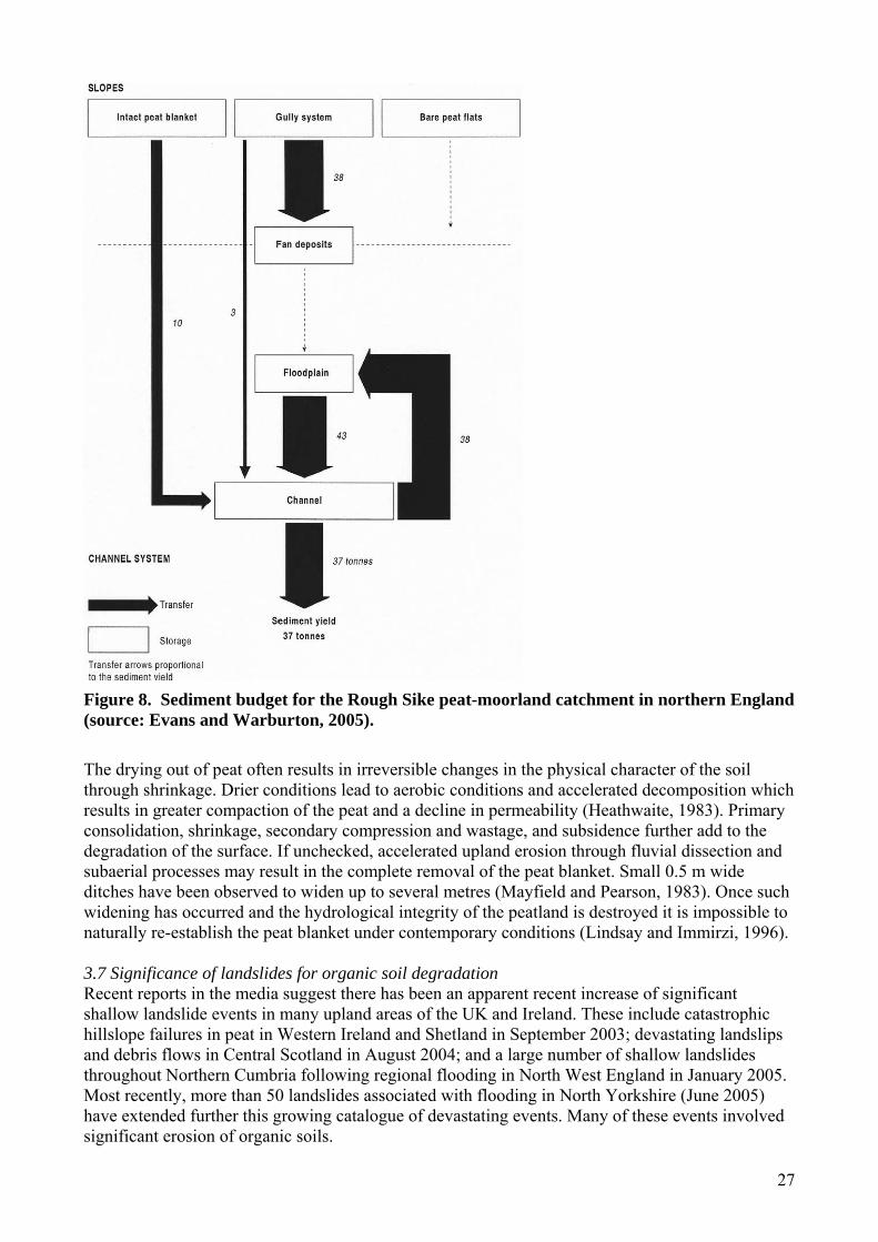
27
Figure 8. Sediment budget for the Rough Sike peat-moorland catchment in northern England (source: Evans and Warburton, 2005). The drying out of peat often results in irreversible changes in the physical character of the soil through shrinkage. Drier conditions lead to aerobic conditions and accelerated decomposition which results in greater compaction of the peat and a decline in permeability (Heathwaite, 1983). Primary consolidation, shrinkage, secondary compression and wastage, and subsidence further add to the degradation of the surface. If unchecked, accelerated upland erosion through fluvial dissection and subaerial processes may result in the complete removal of the peat blanket. Small 0.5 m wide ditches have been observed to widen up to several metres (Mayfield and Pearson, 1983). Once such widening has occurred and the hydrological integrity of the peatland is destroyed it is impossible to naturally re-establish the peat blanket under contemporary conditions (Lindsay and Immirzi, 1996). 3.7 Significance of landslides for organic soil degradation Recent reports in the media suggest there has been an apparent recent increase of significant shallow landslide events in many upland areas of the UK and Ireland. These include catastrophic hillslope failures in peat in Western Ireland and Shetland in September 2003; devastating landslips and debris flows in Central Scotland in August 2004; and a large number of shallow landslides throughout Northern Cumbria following regional flooding in North West England in January 2005. Most recently, more than 50 landslides associated with flooding in North Yorkshire (June 2005) have extended further this growing catalogue of devastating events. Many of these events involved significant erosion of organic soils.
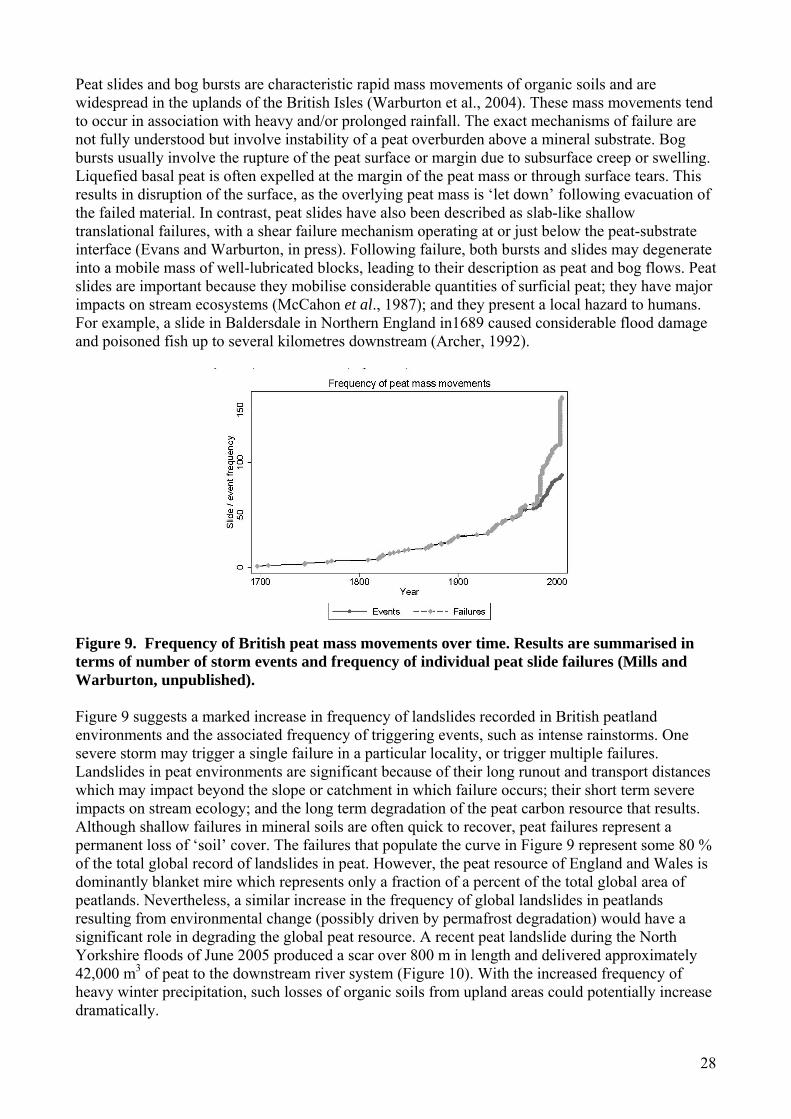
28
Peat slides and bog bursts are characteristic rapid mass movements of organic soils and are widespread in the uplands of the British Isles (Warburton et al., 2004). These mass movements tend to occur in association with heavy and/or prolonged rainfall. The exact mechanisms of failure are not fully understood but involve instability of a peat overburden above a mineral substrate. Bog bursts usually involve the rupture of the peat surface or margin due to subsurface creep or swelling. Liquefied basal peat is often expelled at the margin of the peat mass or through surface tears. This results in disruption of the surface, as the overlying peat mass is ‘let down’ following evacuation of the failed material. In contrast, peat slides have also been described as slab-like shallow translational failures, with a shear failure mechanism operating at or just below the peat-substrate interface (Evans and Warburton, in press). Following failure, both bursts and slides may degenerate into a mobile mass of well-lubricated blocks, leading to their description as peat and bog flows. Peat slides are important because they mobilise considerable quantities of surficial peat; they have major impacts on stream ecosystems (McCahon et al., 1987); and they present a local hazard to humans. For example, a slide in Baldersdale in Northern England in1689 caused considerable flood damage and poisoned fish up to several kilometres downstream (Archer, 1992).
Figure 9. Frequency of British peat mass movements over time. Results are summarised in terms of number of storm events and frequency of individual peat slide failures (Mills and Warburton, unpublished). Figure 9 suggests a marked increase in frequency of landslides recorded in British peatland environments and the associated frequency of triggering events, such as intense rainstorms. One severe storm may trigger a single failure in a particular locality, or trigger multiple failures. Landslides in peat environments are significant because of their long runout and transport distances which may impact beyond the slope or catchment in which failure occurs; their short term severe impacts on stream ecology; and the long term degradation of the peat carbon resource that results. Although shallow failures in mineral soils are often quick to recover, peat failures represent a permanent loss of ‘soil’ cover. The failures that populate the curve in Figure 9 represent some 80 % of the total global record of landslides in peat. However, the peat resource of England and Wales is dominantly blanket mire which represents only a fraction of a percent of the total global area of peatlands. Nevertheless, a similar increase in the frequency of global landslides in peatlands resulting from environmental change (possibly driven by permafrost degradation) would have a significant role in degrading the global peat resource. A recent peat landslide during the North Yorkshire floods of June 2005 produced a scar over 800 m in length and delivered approximately 42,000 m3 of peat to the downstream river system (Figure 10). With the increased frequency of heavy winter precipitation, such losses of organic soils from upland areas could potentially increase dramatically.
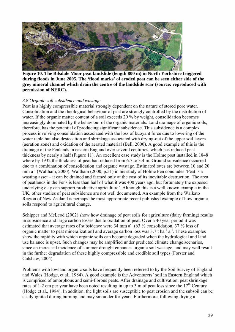
29
Figure 10. The Bilsdale Moor peat landslide (length 800 m) in North Yorkshire triggered during floods in June 2005. The ‘flood marks’ of eroded peat can be seen either side of the grey mineral channel which drain the centre of the landslide scar (source: reproduced with permission of NERC). 3.8 Organic soil subsidence and wastage Peat is a highly compressible material strongly dependent on the nature of stored pore water. Consolidation and the rheological behaviour of peat are strongly controlled by the distribution of water. If the organic matter content of a soil exceeds 20 % by weight, consolidation becomes increasingly dominated by the behaviour of the organic materials. Land drainage of organic soils, therefore, has the potential of producing significant subsidence. This subsidence is a complex process involving consolidation associated with the loss of buoyant force due to lowering of the water table but also desiccation and shrinkage associated with drying-out of the upper soil layers (aeration zone) and oxidation of the aerated material (Bell, 2000). A good example of this is the drainage of the Fenlands in eastern England over several centuries, which has reduced peat thickness by nearly a half (Figure 11). An excellent case study is the Holme post installed in 1848 where by 1932 the thickness of peat had reduced from 6.7 to 3.4 m. Ground subsidence occurred due to a combination of consolidation and organic wastage. Estimated rates are between 10 and 20 mm a-1 (Waltham, 2000). Waltham (2000, p.51) in his study of Holme Fen concludes ‘Peat is a wasting asset – it can be drained and farmed only at the cost of its inevitable destruction. The area of peatlands in the Fens is less than half of what it was 400 years ago, but fortunately the exposed underlying clay can support productive agriculture’. Although this is a well known example in the UK, other studies of peat subsidence are not well documented. An example from the Waikato Region of New Zealand is perhaps the most appropriate recent published example of how organic soils respond to agricultural change. Schipper and McLeod (2002) show how drainage of peat soils for agriculture (dairy farming) results in subsidence and large carbon losses due to oxidation of peat. Over a 40 year period it was estimated that average rates of subsidence were 34 mm a-1 (63 % consolidation, 37 % loss of organic matter to peat mineralization) and average carbon loss was 3.7 t ha-1 a-1. These examples show the rapidity with which organic soils can become degraded when the hydrological and land use balance is upset. Such changes may be amplified under predicted climate change scenarios, since an increased incidence of summer drought enhances organic soil wastage, and may well result in the further degradation of these highly compressible and erodible soil types (Forster and Culshaw, 2004). Problems with lowland organic soils have frequently been referred to by the Soil Survey of England and Wales (Hodge, et al., 1984). A good example is the Adventurers’ soil in Eastern England which is comprised of amorphous and semi-fibrous peats. After drainage and cultivation, peat shrinkage rates of 1-2 cm per year have been noted resulting in up to 3 m of peat loss since the 17th Century (Hodge et al., 1984). In addition, the light soils are susceptible to peat erosion and the subsoil can be easily ignited during burning and may smoulder for years. Furthermore, following drying a

30
‘drummy’ horizon of dried acid peat may develop which will not rewet. This results in hard blocky structures which are impenetrable to roots and can form impermeable layers.
Figure 11. Soil associations of the Fenland margins near Peterborough including the area around Holme Fen (source: Hodge et al., 1984). 3.9 Damage to organic soils caused by mining Organic soils are often the victim of industries which choose to exploit sub-surface mineral resources. This affects soils in terms of burial, contamination and structural deformation. Organic soils are particularly vulnerable to such changes. Today, lowland peat bog in England covers only 10 % of its original 38, 000 ha (English Nature, 2002). Peat is also extracted directly. Recommendations for organic soil (peat) extraction by RCEP (1996) essentially addressed two main concerns:
1. There should be closer control of the peat extraction industry with statutory conservation bodies to be consulted before granting, reviewing or extending planning permissions for peat extraction (Recommendations 29 to 31)
2. Development of a managed strategy to reduce peat consumption and promote alternative products (Recommendations 32 to 35).
Peat extraction alters the characteristics of a site considerably. The hydrological and ecological functions can be damaged. Where the extraction opens up the mineral substrate then the site may be drastically altered in terms of its habitat. Peat extraction sites tend not to have a high potential for food or biomass production (CEH, 2002). Restoration schemes are in operation at a number of former extraction sites and the RAMSAR Convention on Peatlands resolved that partner countries should actively restore degraded peatlands (Ramsar, 2002). 3.10 Footpath erosion and recreational impacts on organic soils Footpath erosion is defined as ‘where the vegetation and soil structure has been lost or substantially altered due to concentrated people pressure’(RCEP, 1996). Erosion due to recreational use of footpaths is a widespread problem in England and Wales. Since the 1960s, recreational pressures

31
have led to accelerated erosion and have threatened the character of the British Uplands (e.g. Summit visits per year: 350,000 Snowdon; 90, 000 Helvellyn, Lake District). Climate and weather contribute greatly to erosion and greater recreational pressures generally increase erosion. This depends on local site conditions such as slope (steeper paths have greater erosion), soils (shear strength, stoniness) and vegetation (grasses resistant to trampling, bracken and heath is not) (Bayfield and Aitken, 1992). Organic soils in the uplands are particularly at risk from this activity (Grieve et al., 1995). Figure 12 shows the condition of the Pennine Way between 1971 and 1983 and shows a doubling in path width over this period (Bayfield and Aitken, 1992). The widest paths are found on peaty ground where peat has been heavy degraded exposing the underlying mineral soil (Bayfield, 1987).
Figure 12. Increase in path width on the Pennine Way between 1971 and 1983 (source: Bayfield and Aitken, 1992). Organic soils are particularly at risk from this kind of erosion because they have low trafficability (resistance to wear) particularly in wet conditions and, as such, require special protection, including improved drainage, durable surfacing and reduced levels of use (Figure 13; Bayfield and Aitken 1992; Davies et al., 1996). While we now have well established management techniques for tackling footpath pressure (Bayfield and Aitken, 1992, Davies et al., 1996), considerable investment is needed to maintain footpaths and to improve techniques to ensure the economic viability of these measures. This is particularly true of paths in moorland and bog environments which require multiple remediation methods in order to restore soil stability (Figure 13). Although most research has focused on upland paths, many lowland fen and heath environments are susceptible to similar pressures, although the extent of erosion may be more subdued. The costs of repairing and maintaining eroded footpaths are extremely expensive (between £25 and £70 per metre) due to it being labour intensive and highly skilled. The present rate of upland path erosion far exceeds maintenance programmes. CEH (2002) recognised footpath repair as a major cost for the Welsh countryside management industry and Pardoe and Thomas (1992) estimated that £200 000 per year (at 1992 prices) was spent on footpath repair on Snowdon alone. The British Upland Footpath Trust noted that over £4 million has been spent on footpath repair on the Pennine Way over the last 8 years and approximately £4.2 million was required in 1998 for repairs needed in the Lake District. This problem is likely to get worse because climate change will potentially increase storm rainfall and therefore trigger more erosion. Based on 2080 scenarios from the UK Climate Impacts Programme (UKCIP), in Northern England there will have been a reduction in snowfall of between 40 and 90 %, while winter rainfall is predicted to increase by 14-27 % (Environment Times, 2006).
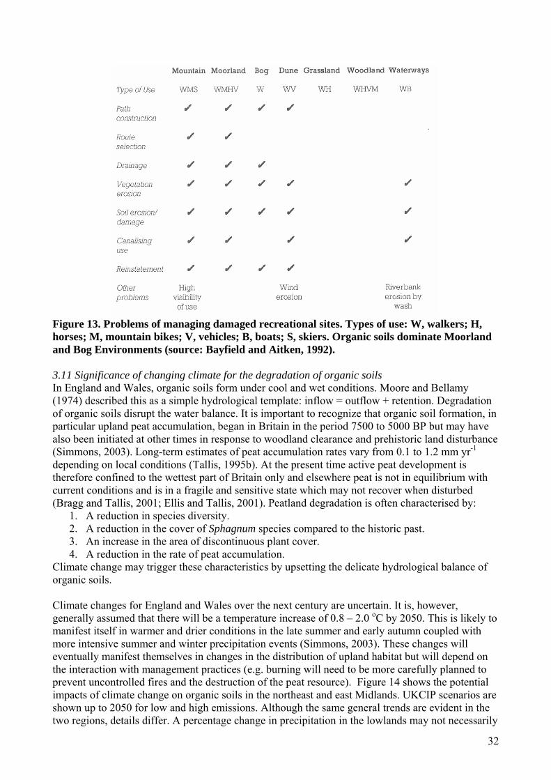
32
Figure 13. Problems of managing damaged recreational sites. Types of use: W, walkers; H, horses; M, mountain bikes; V, vehicles; B, boats; S, skiers. Organic soils dominate Moorland and Bog Environments (source: Bayfield and Aitken, 1992). 3.11 Significance of changing climate for the degradation of organic soils In England and Wales, organic soils form under cool and wet conditions. Moore and Bellamy (1974) described this as a simple hydrological template: inflow = outflow + retention. Degradation of organic soils disrupt the water balance. It is important to recognize that organic soil formation, in particular upland peat accumulation, began in Britain in the period 7500 to 5000 BP but may have also been initiated at other times in response to woodland clearance and prehistoric land disturbance (Simmons, 2003). Long-term estimates of peat accumulation rates vary from 0.1 to 1.2 mm yr-1 depending on local conditions (Tallis, 1995b). At the present time active peat development is therefore confined to the wettest part of Britain only and elsewhere peat is not in equilibrium with current conditions and is in a fragile and sensitive state which may not recover when disturbed (Bragg and Tallis, 2001; Ellis and Tallis, 2001). Peatland degradation is often characterised by:
1. A reduction in species diversity. 2. A reduction in the cover of Sphagnum species compared to the historic past. 3. An increase in the area of discontinuous plant cover. 4. A reduction in the rate of peat accumulation.
Climate change may trigger these characteristics by upsetting the delicate hydrological balance of organic soils. Climate changes for England and Wales over the next century are uncertain. It is, however, generally assumed that there will be a temperature increase of 0.8 – 2.0 oC by 2050. This is likely to manifest itself in warmer and drier conditions in the late summer and early autumn coupled with more intensive summer and winter precipitation events (Simmons, 2003). These changes will eventually manifest themselves in changes in the distribution of upland habitat but will depend on the interaction with management practices (e.g. burning will need to be more carefully planned to prevent uncontrolled fires and the destruction of the peat resource). Figure 14 shows the potential impacts of climate change on organic soils in the northeast and east Midlands. UKCIP scenarios are shown up to 2050 for low and high emissions. Although the same general trends are evident in the two regions, details differ. A percentage change in precipitation in the lowlands may not necessarily
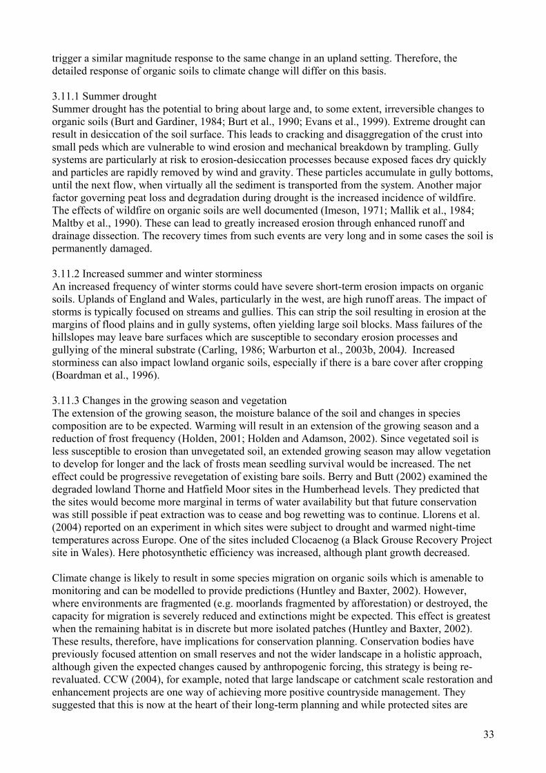
33
trigger a similar magnitude response to the same change in an upland setting. Therefore, the detailed response of organic soils to climate change will differ on this basis. 3.11.1 Summer drought Summer drought has the potential to bring about large and, to some extent, irreversible changes to organic soils (Burt and Gardiner, 1984; Burt et al., 1990; Evans et al., 1999). Extreme drought can result in desiccation of the soil surface. This leads to cracking and disaggregation of the crust into small peds which are vulnerable to wind erosion and mechanical breakdown by trampling. Gully systems are particularly at risk to erosion-desiccation processes because exposed faces dry quickly and particles are rapidly removed by wind and gravity. These particles accumulate in gully bottoms, until the next flow, when virtually all the sediment is transported from the system. Another major factor governing peat loss and degradation during drought is the increased incidence of wildfire. The effects of wildfire on organic soils are well documented (Imeson, 1971; Mallik et al., 1984; Maltby et al., 1990). These can lead to greatly increased erosion through enhanced runoff and drainage dissection. The recovery times from such events are very long and in some cases the soil is permanently damaged. 3.11.2 Increased summer and winter storminess An increased frequency of winter storms could have severe short-term erosion impacts on organic soils. Uplands of England and Wales, particularly in the west, are high runoff areas. The impact of storms is typically focused on streams and gullies. This can strip the soil resulting in erosion at the margins of flood plains and in gully systems, often yielding large soil blocks. Mass failures of the hillslopes may leave bare surfaces which are susceptible to secondary erosion processes and gullying of the mineral substrate (Carling, 1986; Warburton et al., 2003b, 2004). Increased storminess can also impact lowland organic soils, especially if there is a bare cover after cropping (Boardman et al., 1996). 3.11.3 Changes in the growing season and vegetation The extension of the growing season, the moisture balance of the soil and changes in species composition are to be expected. Warming will result in an extension of the growing season and a reduction of frost frequency (Holden, 2001; Holden and Adamson, 2002). Since vegetated soil is less susceptible to erosion than unvegetated soil, an extended growing season may allow vegetation to develop for longer and the lack of frosts mean seedling survival would be increased. The net effect could be progressive revegetation of existing bare soils. Berry and Butt (2002) examined the degraded lowland Thorne and Hatfield Moor sites in the Humberhead levels. They predicted that the sites would become more marginal in terms of water availability but that future conservation was still possible if peat extraction was to cease and bog rewetting was to continue. Llorens et al. (2004) reported on an experiment in which sites were subject to drought and warmed night-time temperatures across Europe. One of the sites included Clocaenog (a Black Grouse Recovery Project site in Wales). Here photosynthetic efficiency was increased, although plant growth decreased. Climate change is likely to result in some species migration on organic soils which is amenable to monitoring and can be modelled to provide predictions (Huntley and Baxter, 2002). However, where environments are fragmented (e.g. moorlands fragmented by afforestation) or destroyed, the capacity for migration is severely reduced and extinctions might be expected. This effect is greatest when the remaining habitat is in discrete but more isolated patches (Huntley and Baxter, 2002). These results, therefore, have implications for conservation planning. Conservation bodies have previously focused attention on small reserves and not the wider landscape in a holistic approach, although given the expected changes caused by anthropogenic forcing, this strategy is being re-revaluated. CCW (2004), for example, noted that large landscape or catchment scale restoration and enhancement projects are one way of achieving more positive countryside management. They suggested that this is now at the heart of their long-term planning and while protected sites are
34
important in their own right they also provide core areas for ‘re-seeding’ of new habitat, helping to counteract the limitations of a fragmented habitat landscape in the context of climate change. They have funded a number of studies to examine large-scale conservation approaches including Griffiths et al. (2002), Goodger and Toogood (2005) and Watts et al., (2005). Figure 14. Potential impacts of climate change on organic soils in the northeast and east Midlands. UKCIP scenarios are shown for up to 2050 for low and high emissions.
% change winter
% change summer precipitation
Change in average annual daily temperature
EAST MIDLANDS
NORTHEAST
Source: UKCIP02 Climate Change Scenarios (funded by Defra, produced by Tyndall and Hadley Centres for UKCIP)
Low emissions
High emissions
Low emissions
High emissions
35
3.11.4 Soil chemistry and water quality Increased frequency and severity of drought can also lead to changes in organic soil structure and chemistry with increased desiccation, cracking and acidification, and an increased risk of wildfire. We still lack an understanding about how soil organisms will respond to future climate and management and how this will affect carbon fluxes. Most soil carbon models are not applicable for organic soils. Schmidt et al (2004) monitored soil solution chemistry responses in a moorland soil at Clocaenog, Wales as part of the CLIMOOR project during and following a simulated drought and night time temperature increase. N mobilization increased during the first year but there were no significant effects on seepage water due to high retention rates by vegetation. In peat soils, large drops in water table associated with periods of drought lead to the oxidation of sulphur to sulphate which is an acidifying process. These episodic acidification events can lead to an increase in heavy metal release from peats (Tipping et al., 2003) and a decline in dissolved organic carbon (DOC) (Clark et al., 2005). Over the past 20 - 30 years there has been an increase in DOC concentrations in streams and lakes across the uplands of the UK (Freeman et al., 2001a; Worrall et al., 2003a; Evans et al., 2005c) with Plynlimon, Wales, being no exception. A range of hypotheses have been put forward as potential driving mechanisms for the increase in DOC, many of which have been linked to climate change (e.g. increase in temperature; Freeman et al., 2001a; Davidson and Janssens, 2006), changes in distribution and volume of rainfall (Tranvick and Jansson, 2002) and elevated atmospheric carbon dioxide, CO2 (Freeman et al., 2004). The interpretation of long-term freshwater DOC data is confounded by factors other than climate change, such as vegetation succession, management and acid deposition which can also alter the rate of carbon cycling in organic soils. For example, the solubility of DOC is controlled by pH and ionic strength, which has lead some to suggest that recovery from acidification may be the major factor driving the increase in DOC (Evans et al., 2005c; Clark et al., 2006). Changes in land management and nitrogen deposition can lead to changes in the dominant vegetation species; grass species cycle carbon much quicker that heather species. At present, the exact processes causing the increase in DOC export from peatlands is unclear. However, it does suggest that environmental change is having a significant impact on the cycling of carbon in these systems and requires further research. 3.12 Atmospheric deposition There have been significant changes to atmospheric deposition chemistry across the UK over the past 250 years. These have mainly been caused by industrial and vehicular emissions. The major atmospheric pollutants are acidifiers such as sulphur dioxide (SO2) and nitrogen oxides (NOx), toxic substances such as ozone, volatile organic compounds (VOCs) and heavy metals, and fertilising substances, ammonium and nitrogen oxides , all of which have been affected by industrial changes and the introduction of new legislation to reduce emissions (e.g. the 1999 Gothenburg Protocol which set emission ceilings for 2010 for sulphur, NOx, VOC’s and ammonia, and the Aarhus Protocol of 1998 which committed the UK to the reduction of heavy metal deposition to below 1990 levels). Nitrogen oxides also add nitrogen to organic soils and, like ammonia, lead to fertilisation. Ammonia emissions are primarily from agriculture, particularly livestock farming. Although it is difficult to quantify ammonia emissions, best estimates suggest they are currently relatively constant (NEGTAP, 2001). The impact of acidification on organic soils is highly variable, depending on the initial vegetation, soil buffering capacity and concurrent management practices. Increased SO2 deposition has been linked to major changes in species composition in moorland environments (e.g. Lee et al., 1993). Ombrotrophic Sphagnum mosses are among the most sensitive to changes in atmospheric deposition. Loss of Sphagnum cover through acid pollution combined with overgrazing has been blamed for initiating erosion in a number of locations, including the southern Pennines (Tallis, 1997c).
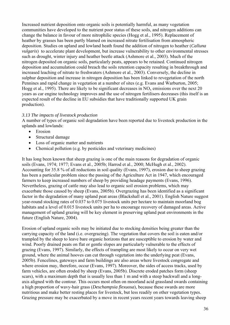
36
Increased nutrient deposition onto organic soils is potentially harmful, as many vegetation communities have developed to the nutrient poor status of these soils, and nitrogen additions can change the balance in favour of more nitrophilic species (Hogg et al., 1995). Replacement of heather by grasses has been partly blamed on increased nitrate fertilisation from atmospheric deposition. Studies on upland and lowland heath found the addition of nitrogen to heather (Calluna vulgaris) to accelerate plant development, but increase vulnerability to other environmental stresses such as drought, winter injury and heather beetle attack (Ashmore et al., 2003). Much of the nitrogen deposited on organic soils, particularly peats, appears to be retained. Continued nitrogen deposition and accumulation could breach the soils retention capacity resulting in breakthrough and increased leaching of nitrate to freshwaters (Ashmore et al., 2003). Conversely, the decline in sulphur deposition and increase in nitrogen deposition has been linked to revegetation of the north Pennines and rapid change in vegetation at a number of sites (e.g. Evans and Warburton, 2005; Hogg et al., 1995). There are likely to be significant decreases in NOx emissions over the next 20 years as car engine technology improves and the use of nitrogen fertilisers decreases (this itself is an expected result of the decline in EU subsidies that have traditionally supported UK grain production). 3.13 The impacts of livestock production A number of types of organic soil degradation have been reported due to livestock production in the uplands and lowlands:
• Erosion • Structural damage • Loss of organic matter and nutrients • Chemical pollution (e.g. by pesticides and veterinary medicines)
It has long been known that sheep grazing is one of the main reasons for degradation of organic soils (Evans, 1974; 1977; Evans et al., 2005b; Harrod et al., 2000; McHugh et al., 2002). Accounting for 35.8 % of all reductions in soil quality (Evans, 1997), erosion due to sheep grazing has been a particular problem since the passing of the Agriculture Act in 1947, which encouraged farmers to keep increased numbers of sheep by providing headage payments (Evans, 1996). Nevertheless, grazing of cattle may also lead to organic soil erosion problems, which may exacerbate those caused by sheep (Evans, 2005b). Overgrazing has been identified as a significant factor in the degradation of many upland peat areas (Blackshall et al., 2001). English Nature suggest year-round stocking rates of 0.037 to 0.075 livestock units per hectare to maintain moorland bog habitats and a level of 0.015 livestock units per ha to encourage recovery of damaged areas. Active management of upland grazing will be key element in preserving upland peat environments in the future (English Nature, 2004). Erosion of upland organic soils may be initiated due to stocking densities being greater than the carrying capacity of the land (i.e. overgrazing). The vegetation that covers the soil is eaten and/or trampled by the sheep to leave bare organic horizons that are susceptible to erosion by water and wind. Poorly drained peats on flat or gentle slopes are particularly vulnerable to the effects of grazing (Evans, 1997). Similarly, the effects of trampling are most likely to occur on very wet ground, where the animal hooves can cut through vegetation into the underlying peat (Evans, 2005b). Fencelines, gateways and farm buildings are also areas where livestock congregate and where erosion may, therefore, occur (Evans, 1997). Moreover, the sides of access tracks, used by farm vehicles, are often eroded by sheep (Evans, 2005b). Discrete eroded patches form (sheep scars), with a maximum depth that is usually less than 1 m and with a steep backwall and a long-axis aligned with the contour. This occurs most often on moorland acid grassland swards containing a high proportion of wavy-hair grass (Deschampsia flexuosa), because these swards are more nutritious and make better resting places for livestock, but less readily on other vegetation types. Grazing pressure may be exacerbated by a move in recent years recent years towards leaving sheep

37
on the hillside and providing supplementary feed, rather than grazing them in lower altitude pastures, as sheep that are over-wintered outdoors on the hillside are likely to selectively graze the heather present (Evans, 1997). Grazing intensities as low as 0.3-0.7 sheep/ha have been found to lead to heather degradation (Grant et al., 1985). Furthermore, sheep grazing can also be responsible for maintaining organic soil erosion once this process has been initiated. On eroded peat, maintenance of erosion by grazing animals may be even more important than that due to runoff (NSRI, 2002). Researchers in Ireland have attributed large increases in organic–rich sediments in lakes to increasing livestock numbers, particularly sheep. However, the debate over the impact of sheep on upland environments has been hampered by a dearth of quantitative information on the effects of grazing on the initiation and acceleration of erosion (Shimwell, 1974; Shaw et al., 1996). In addition to erosion, grazing livestock may also lead to damage to the structure of organic soils. The development of grazing tracks and poached areas is common in livestock production areas (e.g. SSLRC, 2000). Poaching will tend to occur predominantly around fence lines and feeding stations. The ratio of weight to hoof size is important, so larger animals (i.e. cattle) will cause more compaction than smaller livestock (i.e. sheep). As for erosion, wet soils are also particularly prone to poaching. Ultimately, the disruption of the physical structure of peat can lead to wastage and oxidation. In the long-term, grazing can lead to a reduction in soil fertility as nutrients leave the site in the vegetation eaten by livestock. These transfers of nutrients may be small though compared to those associated with fluvial transport. However, this is offset by deposition of dung which can increase nutrient concentrations.
Livestock production may also lead to the contamination of organic soils with veterinary medicines, which may subsequently affect soil functions. It has been proposed that microbial and protozoan communities may be affected by spent sheep dip (Boucard et al., 2004). For instance, sheep farmers use organophosphate and synthetic pyrethroid dips to control ectoparasites in their flocks and this results in the need to dispose of 175-220 million litres of spent dip in the UK each year (Maynard, 1997). The Environment Agency has identified the application of spent sheep dip to land as the most practical means of disposal (EA, 1999) even though the insecticide residues present in spent dip may pose a risk to soil organisms. Walker et al. (2004) showed that sheep dip disposal significantly reduced soil invertebrate density even six months after application with reductions greatest on long-term sheep dip disposal sites. It was also indicated that this could impact bird populations higher up the food chain. Similarly, other veterinary medicines given to sheep and cattle, including antibiotics and anthelmintics, may be released to soil systems, directly from treated animals or in manure/slurry spread on the land (Boxall et al., 2002) and effects on soil ecology are possible (Baguer et al., 2000). 3.14 Effects of arable farming The extent of effects of arable farming on organic soils is likely to be less than for livestock production because lowland organic soils, where conditions are suitable for growing crops, are much less extensive than those areas in the uplands where livestock are reared. Nevertheless, much of the area of lowland peat in England has been drained and is used for arable production. These sites are predominantly fenland areas in the east of England, particularly the Cambridge area. This part of the country is noted for its intensive arable production and a variety of arable crops are grown, including cereals, sugar beet, potatoes, peas and beans (DEFRA, 2004b). It should be noted, however, that many of the soils in this area are light sandy soils, rather than organic soils, offering good conditions for growing root crops (although they are inherently susceptible to wind erosion). The effects of the cultivation of organic soils in the lowlands have been poorly studied (Willison et al, 1998). Even though arable systems are, by definition, different to livestock farms, the same types of soil degradation, outlined above for livestock farming, can be anticipated. They may, however, be caused for different reasons. For example, soil compaction and loss of structure may be due to

38
trampling by animals on livestock farms or by the use of heavy machinery and regular trafficking on arable farms. Evans (2005c) has classified the risk of channel erosion occurring for different crop types (Table 4). Both cereals and root crops are grown on fenland farms (e.g. Willison et al., 1998; Pascual et al., 1999) where significant erosion is more likely. Some of the crops with the most significant associated erosion risk (e.g. sugar beet and potatoes) are grown on humic sandy gleys, earthy peats and humic alluvial gley soils (compare Figure 1 with Figure 15) (DEFRA, 2004b). Examination of Welsh Assembly Government statistics shows unsurprisingly that cropping is very limited in Wales and it is difficult to make out any significant association with organic soils. Table 4. Classification of the risk of channel erosion occurring under different crop covers (source: Evans, 2005c; modified Evans and Jaggard, 2003). Crop Risk Outdoor pigs 1 field in 3 Hops 1 field in 6 Sugar beet 1 field in 7 Maize 1 field in 7 Potatoes 1 field in 10 Other crops 1 field in 11 Field vegetables 1 field in 14 Bare soil 1 field in 21 Kale 1 field in 24 Ley grasses 1 field in 32 Spring barley 1 field in 34 Peas 1 field in 38 Winter wheat and barley 1 field in 42 Field beans 1 field in 71 Oilseed rape 1 field in 100 Superimposed upon erosion, caused by the cultivation of different crops, are the changes in farming practice that have taken place over the past 60 years, with intensification generally increasing erosion (Evans, 2005c). Key factors have been the move from livestock rearing on pasture and the growing of spring-sown crops to winter cereals, leaving soils relatively bare during the autumn and winter. This has been accompanied by the use of larger pieces of machinery, also affecting soil structure and organic carbon content (Harden et al, 1999), and increased inputs (e.g. fertilisers and pesticides; Evans, 2006). One of the key factors associated with increasing inputs has been the development of tramlines in fields, which encourage overland flow and erosion (Kay, 2005). Irrigation has also increased, which encourages soil erosion (Evans, 2005c). 3.15 Burning Many upland organic soils are managed as grouse moors that require a rotational burning scheme to ensure heather regeneration. Where this is mismanaged or burning is uncontrolled all surface vegetation can be removed, exposing the underlying soil which will then be susceptible to erosion (Radley, 1965; Mallik et al., 1984; Rhodes and Stevenson, 1997). The impact of burning closely relates to both drainage and climate. The level of the water table at the time of burning (drainage conditions) is crucial in determining the impact on the vegetation and soil. Where the water table is deeper than 50 cm or more the soil itself may ignite (Watson and Miller, 1976, Maltby et al. 1990). Glaves and Haycock (2005) have summarised the scientific evidence for the effects of heather and grass burning on soils. They conclude that peat soils in particular are susceptible to burning and this can limit rates of peat formation, reduce infiltration and enhance soil and stored carbon loss. Nutrient dynamics are also affected but there is a complex balance of losses and reincorporation.
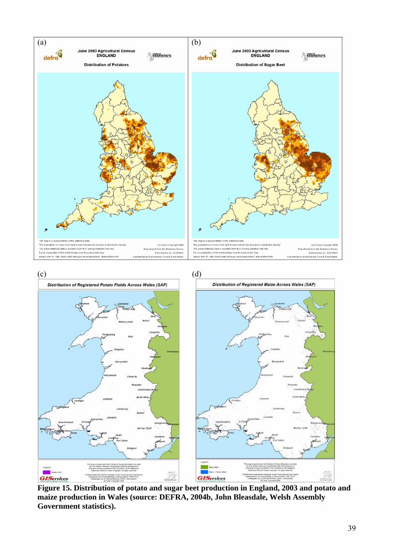
39
(a) (b)
(c) (d)
Figure 15. Distribution of potato and sugar beet production in England, 2003 and potato and maize production in Wales (source: DEFRA, 2004b, John Bleasdale, Welsh Assembly Government statistics).

40
3.16 Socio-economic change While there are conflicting land use demands on organic soils, there are also a series of other socio-economic drivers of change including rural depopulation, increase in second homes, and European and national policies that are moving away from an emphasis on agricultural production towards a more holistic approach incorporating environmental management as a key aim (Lowe et al., 2002). Some parts of England and Wales, such as the Pennines and the Welsh uplands, have changed significantly in demographic composition over the past two centuries. Currently, a depopulation trend is continuing as part of a broad-scale shift in the UK’s economic structure but also because incomes from land management activities and agriculture, particularly in uplands, are considered inadequate in relation to outgoings. Both farming and grouse-shooting activities operate at the margins of financial viability (Dougill et al., 2006). For example, some 93 % of the Peak District National Park qualifies for funding under the European Commission Directive for special assistance to Less Favoured Areas (75/268). With few opportunities for financially rewarding employment, younger, unskilled workers are increasingly choosing to leave moorland regions, having also been priced out of local housing markets due to increasingly affluent commuter populations and an influx of second home owners. The knock-on effects of this have been both social and environmental, as the remaining population is often older, causing shortages of suitable labour for traditional land management practices such as heather burning. These changes are not always viewed negatively. Shiel (2002) suggested that the sale of rural land to wealthy urban migrants could have positive environmental impacts because the ‘newcomers’ are likely to be more sensitive to the environmental impacts of farming. New funding and legislation is also helping to drive change. The 1992 Rio Summit resulted in a UK biodiversity action plan which outlined steps to redress historic wildlife losses, and aims to deliver and demonstrate socio-economic benefits to local people through wildlife conservation and economic incentives for wildlife-friendly farming. English Nature set targets for improvement in the ecological quality of many Sites of Special Scientific Interest (SSSI) and this has led to obligations for landowners who have SSSIs that are in unfavourable condition (English Nature, 2003). Similarly CCW sets objectives and targets for SSSIs in Wales (e.g. CCW, 2005; Jones et al., 2003). EU funding has also been made available for training, equal opportunities, social exclusion issues and combating unemployment (European Social Fund) and to support farmers to diversify into other areas such as tourism (European Agricultural Guidance and Guarantee Fund) (Arnold-Forster, 2002). This has taken place in parallel with shifts away from exclusively ‘agricultural’ development, towards a more holistic ‘rural development’ encompassing social and economic as well as agricultural needs. Changes to the farming subsidy system have also been made through reform of the EU CAP. Furthermore, catchment managers are assessing the implications of the EU Water Framework Directive (WFD). This requires inland waters to achieve ‘good ecological status’ by 2015 (i.e. good chemical, morphological and biological status). Significant change to land management practices will be required to deal with diffuse pollution (e.g. from fine organic sediment release, fertilisers and pesticides) on a catchment-wide basis. Landowners will be required to take action to prevent or control diffuse pollution of water to the extent necessary to comply with the WFD. For the organic soils of England and Wales, an additional issue to those identified above is water discoloration due to degraded organic soils, especially peats, which tend to produce more discoloured water with higher concentrations of dissolved organic carbon (Mitchell, 1990). This is not only a WFD problem but one for raw water treatment because chlorination of highly-coloured water releases trihalomethanes, which are potentially toxic and carcinogenic (Kneale and McDonald, 1999).
41
4. Functions of organic soils 4.1 Summary The organic soils of England and Wales serve a number of important functions. They:
• act to store water and provide runoff for water companies as well as many major river systems in England and Wales;
• provide agricultural production, not only on the lowland earthy peats and humic sandy gleys of East Anglia, but also in the uplands on the stagnogleys, earthy peats and raw peats, through livestock, grouse and coniferous woodland;
• host important and globally rare ecosystems (such as heather moorland and blanket bog); • act as important archaeological reservoirs maintaining in situ preservation; • serve as part of ecosystems that are valuable as an amenity resource; • act as important terrestrial carbon stores.
4.2 Methods This work package reviews existing research in the organic soil functions of England and Wales. It includes work presented at recent European conferences. DEFRA is currently funding Cranfield University to examine the impacts of climate change on soil function and therefore this section focuses more on land management or geographical variables. This work package also includes stakeholder opinions on the function of organic soils. However, greater detail from stakeholders, and on soil processes subject to degradation under different land management strategies is provided in Section 5. Carbon storage and sequestration will not be discussed in this section of the report as they are dealt with fully in Section 6. 4.3 Overview Generalised and simplified statements on the function of organic soils have been discouraged by a number of authors (e.g. Bullock and Acreman, 2003) because they often have little practical value. Instead, it should be noted that organic soils have a diverse and complex range of functions. Even within one soil type the functions can vary widely depending on the location of that soil within the catchment or hillslope context. 4.4 Hydrology The hydrological balance of organic soils is fundamental to their development and degradation. Most organic soil hydrology research has focused on the water budget (inputs and outputs) with relatively little attention given to hydrological processes such as overland flow, infiltration, or macropore flow. Until recently, few studies gave much attention to the hydrological processes generating or attenuating storm runoff. Peatland hydrology influences oxygen and gas diffusion rates, redox status, nutrient availability and cycling, and species composition and diversity; it is important for water resource management, flooding, and stream water quality. The accumulation of carbon over time means that organic soils are large stores of carbon. However, a decrease in water level (water table lowering) can convert organic soils into major sources of atmospheric carbon. In addition to gaseous carbon release, degraded organic soils also suffer from increased carbon losses in soluble and particulate forms. Alterations to water flowpaths and water fluxes across and through organic soils caused by environmental change may influence how soluble and particulate carbon is removed. Minor changes in climate or management can result in dramatic changes to flood magnitude and frequency, and water quality from catchments dominated by organic soils (Holden, 2005c). Therefore, in order to predict the consequences of environmental change on organic soils, whether the change is direct, such as drainage or restoration strategies, or inadvertent, such as climate change or chemical deposition, an understanding of the functioning of the temporal and spatial variability of hydrological processes is required.
42
4.4.1 River flow There has been some debate about whether organic soils such as peats act to increase or decrease flood risk. Bullock and Acreman (2003) produced a database of research on the role of wetland soils in the hydrological cycle and found that there was only very limited support for the idea that they acted to buffer floods. Peats and many organo-mineral soils store large quantities of water. Saturated peat tends to be 90-98 % water by mass. Even above the water table (maximum height of the saturated zone), peat can still hold large volumes of water (approximately 90-95 % water by mass). In most peatlands the water table is within just 40 cm of the surface for 80 % of the year at least. This has led to the mistaken inference that peatlands:
1. can act as a good source of baseflow during times of water shortage and; 2. act to attenuate the effects of flooding because they can soak up excess rain water.
Conversely, ombrotrophic peatland catchments tend to have very flashy hydrological regimes (e.g. Evans et al., 1999). Studies of various peatlands show that streamflows are dominated by high peak flows and discontinuous summer flow (Bragg, 2002; Holden and Burt, 2003a). Response to rainfall has been shown to be rapid, and peat streams tend to have hydrographs with steep recessional curves and minimal baseflow. Thus, in contradiction to an often expressed view (first expounded by Turner, 1757), peatlands do not always behave like a ‘sponge’. Rather, water is released rapidly following rainfall or snowmelt and baseflows are often poorly maintained as many small tributaries dry up completely after only a week without rain. This poor maintenance of baseflow is a problem for water companies reliant on streamflow to supply their intakes (e.g. Yorkshire Water, United Utilities and Welsh Water) despite high water tables for most of the year. Also, because only small amounts of rainfall are enough to raise the water table to the surface, many peatlands are not able to attenuate flood events, as there is little spare storage capacity for an influx of fresh rainwater. Therefore, many peats tend to be source areas for flooding. Activities such as grazing or drainage can increase the flood risk even further so that intact organic soils are preferred where possible. Some peatlands do contribute to baseflow but these tend to be ones that are connected to a much wider hydrological system (e.g. Roulet, 1990) where the peatland itself has little effect on the magnitude of the flux. Instead the water flow out of the peatland is often controlled by groundwater discharge into the peatland. In certain topographic locations, some peatlands will influence regional flow regimes by intercepting catchment runoff and storing some of the storm waters (some floodplain wetlands which are not saturated at the time of flood; Bullock and Acreman, 2003) and depends on the size and location of the peatland relative to the drainage network (Heathwaite, 1995). Peatlands with forests may behave in a more lagged way than other peats. 4.4.2 Hillslope hydrology Water flow processes control the speed of water movement and the nature of nutrient and sediment fluxes. The runoff processes range from overland flow to subsurface flow within the matrix (tiny pores between solid particles), within macropores and through natural pipes. The relative importance of the flow processes in any catchment varies with climate, topography, soil character, vegetation cover and land use, and may vary at one location (e.g. seasonally) with antecedent moisture and with precipitation intensity and duration. Infiltration-excess overland flow is produced when the rainfall intensity is greater than the infiltration rate and the overland flow therefore consists of water that has not been within the soil. Saturation-excess overland flow can occur at much lower rainfall intensities and is produced when the soil profile is completely saturated; the water at the surface is a mixture of water that has been within the soil mass that is returning to the surface from upslope and fresh rainwater. Many intact (i.e. not degraded) organic soils, especially peats, appear to be dominated by saturation-excess overland flow or throughflow in the upper peat layers. Table 5 provides data from an undisturbed blanket peatland hillslope in Upper Wharfedale, UK. Most runoff (74 %) measured from runoff troughs was produced from the surface of the peat and most of the rest from the upper
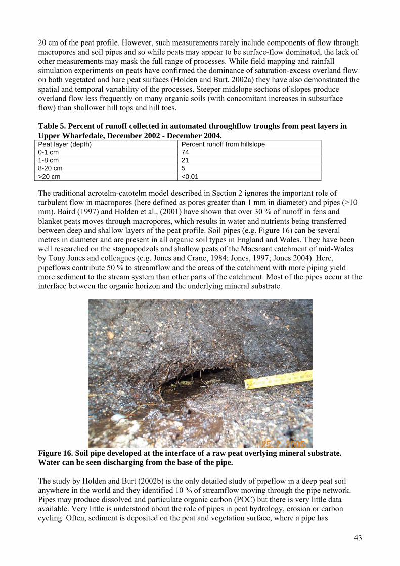
43
20 cm of the peat profile. However, such measurements rarely include components of flow through macropores and soil pipes and so while peats may appear to be surface-flow dominated, the lack of other measurements may mask the full range of processes. While field mapping and rainfall simulation experiments on peats have confirmed the dominance of saturation-excess overland flow on both vegetated and bare peat surfaces (Holden and Burt, 2002a) they have also demonstrated the spatial and temporal variability of the processes. Steeper midslope sections of slopes produce overland flow less frequently on many organic soils (with concomitant increases in subsurface flow) than shallower hill tops and hill toes. Table 5. Percent of runoff collected in automated throughflow troughs from peat layers in Upper Wharfedale, December 2002 - December 2004. Peat layer (depth) Percent runoff from hillslope 0-1 cm 74 1-8 cm 21 8-20 cm 5 >20 cm <0.01 The traditional acrotelm-catotelm model described in Section 2 ignores the important role of turbulent flow in macropores (here defined as pores greater than 1 mm in diameter) and pipes (>10 mm). Baird (1997) and Holden et al., (2001) have shown that over 30 % of runoff in fens and blanket peats moves through macropores, which results in water and nutrients being transferred between deep and shallow layers of the peat profile. Soil pipes (e.g. Figure 16) can be several metres in diameter and are present in all organic soil types in England and Wales. They have been well researched on the stagnopodzols and shallow peats of the Maesnant catchment of mid-Wales by Tony Jones and colleagues (e.g. Jones and Crane, 1984; Jones, 1997; Jones 2004). Here, pipeflows contribute 50 % to streamflow and the areas of the catchment with more piping yield more sediment to the stream system than other parts of the catchment. Most of the pipes occur at the interface between the organic horizon and the underlying mineral substrate.
Figure 16. Soil pipe developed at the interface of a raw peat overlying mineral substrate. Water can be seen discharging from the base of the pipe. The study by Holden and Burt (2002b) is the only detailed study of pipeflow in a deep peat soil anywhere in the world and they identified 10 % of streamflow moving through the pipe network. Pipes may produce dissolved and particulate organic carbon (POC) but there is very little data available. Very little is understood about the role of pipes in peat hydrology, erosion or carbon cycling. Often, sediment is deposited on the peat and vegetation surface, where a pipe has
44
overflowed during a storm event. This sediment can contain a large proportion of mineral material from the underlying substrate, as pipe networks undulate throughout the soil profile (unlike in the stagnopodzols investigated in mid-Wales). The existence of pipes and macropores therefore opens the way for the fluxes of water, sediment and nutrient contributions from deep within and below the organic soil rather than simply by rapid transfer through the upper organic soil layers. This is important, particularly in ombrotrophic peats, because even if some pipe networks are actually ‘dead-ends’ and have little effect on water delivery to streams, they will still act to provide vertical coupling of sediments and solutes and provide additional subsurface connectivity across peatlands. It is now possible, for the first time, to systematically examine piping and macroporosity in peatlands in order to determine what controls their location and frequency. Macropores can be measured through tension devices and dye staining, and recently it has been shown that pipes can be detected using ground-penetrating radar (Holden et al., 2002, Holden, 2004). Holden (2005a) performed a ground-penetrating radar survey of 160 peatlands in the UK and detected piping (when greater than 100 mm) in all catchments surveyed. Results showed that climate change and land management can dramatically increase piping. These results are discussed in more detail in Section 5, but it has been found that heather (Holden 2005b) and land drainage (Holden, 2005a) are both causative factors that increase the number and size of soil pipes in peat soils leading to enhanced carbon loss and changes in water flow pathways. A mean density of piping equivalent to 69 pipes per km of radar transect was determined. Topographic position (but not slope angle) was found to be a significant control both on soil pipe frequency and macroporosity (p < 0.001). Topslopes and toeslopes were found to have significantly higher densities of soil pipes and macropores than midslopes. Gully erosion (sometimes a product of pipe collapse) occurs in some peatlands and this appears to have the same topographic pattern. This suggests that there are links between small scale subsurface erosion and water transfer processes (< 1mm matrix pores, 1-10 mm macropores, 100 – 3000 mm pipes) and hillslope-scale surface geomorphology and particulate carbon loss. 4.4.3 Sediment and pollutants The underlying mineral soil is often protected from erosion by the overlying organic soil. However, many organic soils, such as raw peats, tend to be dominated by saturation-excess overland flow processes and this can promote surface erosion if vegetation cover is lost. Nevertheless from many intact, or active bogs, the amount of sediment yielded to rivers is actually negligible (Bragg, 2002). However, disturbance due to grazing and drainage are likely to significantly increase sediment yields (see Section 5). Most organic soils serve to store sediments and can act as a buffer to pollutants. However, degradation can result in severe sediment loss and enhanced pollution (e.g. through dissolved organic carbon release following soil decomposition). Degradation of the organic soil cover can also open up deeper mineral layers to erosion and weathering, which can alter stream water quality. The Environment Agency recognise the role of soils in mediating sediment and pollutant loads in freshwaters. They note that the soil has a large capacity to protect water from harmful contaminants. However, to maintain this, organic soil needs protection from pollutants from a range of sources. Soil must be protected in its own right, but meeting environmental objectives for water and air also depends on good soil management. The Environment Agency also note that sustainable land management practices are required that are economically viable and environmentally responsible – especially in agriculture (Environment Agency, 2004). They noted that eroded soil (particularly fine sediment from organic soils) can smother river-bed gravels, harming aquatic plants, invertebrates and the eggs of fish. English Nature have reported their concerns about overgrazing or poor management of organic soils and consequent release of diffuse pollution (nutrients and sediment particles) into stream systems (Dwyer et al., 2002).

45
4.5 Agricultural production 4.5.1 Livestock farming Livestock farming is widespread on the organic soils of England and Wales. England’s Less Favoured Areas (LFAs), containing significant areas of peatland, occupy 2.2 million ha of land, 17 % of the country’s agricultural land. Of England’s sheep population, 45 % is kept in the LFAs, along with a significant proportion of the cattle population. For example, 40 % of England’s beef cattle are reared in LFAs (DEFRA, 2002). For Wales, approximately 78 % of agricultural land lies within LFAs with 85 % of beef cows and 75 % of breeding sheep. Livestock farming also takes place on the organic soils in the lowlands of England and Wales. Although nowhere near as extensive as in the uplands, some areas of permanent and temporary grassland do exist in the fens (Figure 17) (DEFRA, 2004b). For, Wales, which is approximately 60 % grassland, there is an association with organic soils (c.f. Figure 17 c and d with Figure 2). Sheep are the dominant livestock type reared in the uplands, now more popular than cattle, or a mix of the two. However, it well known that upland organic soils cannot sustain large numbers of sheep (Evans, 1998). The income of many hill farmers has declined sharply in the last decade. The Peak District Rural Deprivation Forum (2004) found that farm incomes in the Peak District National Park were a quarter of what they were in 1992. The potential return from the market place had ceased to match the investment of time and capital. This, and potential changes to CAP, may mean that sheep numbers could continue to decline in the uplands. (a) (b)
Figure 17. The distribution of permanent (a) and temporary (b) grassland in England in 2003 (source: DEFRA, 2004b).
46
4.5.2 Arable farming Much of the area of lowland peat in England was drained over 100 years ago and has since been used for arable production (Willison, 1998). These sites are predominantly fenland areas in the east of England, particularly the Cambridge area. This part of the country is noted for its intensive arable production and a variety of arable crops are grown on the fenland soils, including a variety of cereals, sugar beet, potatoes, peas and beans (DEFRA, 2004b). It should be noted that the organic soils in this area are often humic sandy gleys but that most of the area is dominated by sandy mineral soils which are particularly good for growing root crops (see Figure 1). Despite arable farming in fenland areas potentially having significant impacts on soil quality, the effects of the cultivation of organic soils in the lowlands have been poorly studied (Willison et al, 1998), perhaps because of the relatively small area that they cover. Even though arable systems are, by definition, different to livestock farms similar types of degradation can be anticipated, such as soil erosion and compaction. The open terrain of many arable fen areas makes them susceptible to wind erosion, particularly when crop covers are absent. The extension of arable farming from the lowlands into the uplands could be seen as a threat to the organic soil functions that are served by moorland environments (Follett, 2001). After the Second World War, arable farming extended to greater altitudes in the uplands and many soils have been modified through liming, continued ploughing, and addition of fertiliser and pesticides. 4.5.3 Grouse Many upland areas of England are managed for grouse (Simmons, 2003) and the underlying organic soil therefore serves an important industry. In Wales, however, the area managed for grouse is limited (e.g. parts of the Berwyn and Radnorshire) and here the red grouse is population is low. Calluna vulgaris (ling heather) is managed so that there is a mixture of young new shoots providing more palatable food, and older shrubby heather for nesting. This mixture of heather stands is provided by rotational burning of patches (on a 7 to 20-year cycle depending on the site). However, it should be noted that on active raw peats the growth of new heather shoots can be maintained by growth of the peat itself which causes the heather plant to push out new shoots (the layering process). There are mixed views on whether upland organic soils should function for the grouse shooting industry. The Moorland Association and The Heather Trust argue that without burning many of the moorlands would undergo succession and become scrub land. The heather moorland of England and Wales supports many globally rare species such as golden plover, dunlin and peregrine. For a full review of burning and grouse management issues see Glaves and Haycock (2005) who provide a comprehensive review of the Heather and Grass Burning Code. Further details are also provided in Section 5. 4.5.4 Forestry Coniferous forestry is an important user of upland organic soils. Afforestation has been the main cause of the net loss of UK moorland habitat over the past century (Simmons, 2003). In 1919, the UK Government formed the Forestry Commission to reinstate and expand Britain’s forests. Between the 1940s and 1980s forestry development on organic soils became widespread (Forestry Commission, 2000) because drainage and ploughing technology together with fertiliser use made it possible to afforest large areas of deep peat in the UK. This led to substantial areas of upland organic soils being planted with dense, fast growing coniferous species (Table 6). Forestry was actually encouraged through the provision of grants, as many upland areas were perceived as low agricultural value. While Table 6 gives figures for the proportion of raw peat soils now used for forestry, Stevens et al (2000a) estimated that 150 km2 of Welsh blanket peats (equivalent to 17 % of the total) supported conifer.
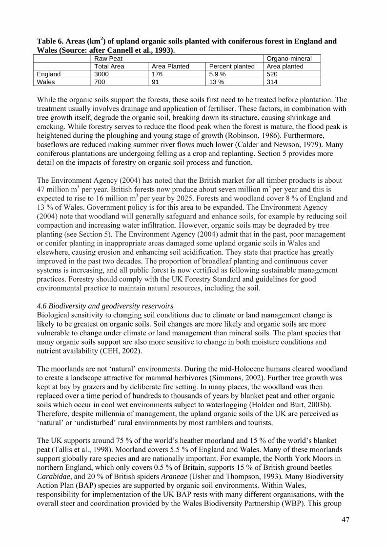
47
Table 6. Areas (km2) of upland organic soils planted with coniferous forest in England and Wales (Source: after Cannell et al., 1993). Raw Peat Organo-mineral Total Area Area Planted Percent planted Area planted England 3000 176 5.9 % 520 Wales 700 91 13 % 314 While the organic soils support the forests, these soils first need to be treated before plantation. The treatment usually involves drainage and application of fertiliser. These factors, in combination with tree growth itself, degrade the organic soil, breaking down its structure, causing shrinkage and cracking. While forestry serves to reduce the flood peak when the forest is mature, the flood peak is heightened during the ploughing and young stage of growth (Robinson, 1986). Furthermore, baseflows are reduced making summer river flows much lower (Calder and Newson, 1979). Many coniferous plantations are undergoing felling as a crop and replanting. Section 5 provides more detail on the impacts of forestry on organic soil process and function. The Environment Agency (2004) has noted that the British market for all timber products is about 47 million m3 per year. British forests now produce about seven million m3 per year and this is expected to rise to 16 million m3 per year by 2025. Forests and woodland cover 8 % of England and 13 % of Wales. Government policy is for this area to be expanded. The Environment Agency (2004) note that woodland will generally safeguard and enhance soils, for example by reducing soil compaction and increasing water infiltration. However, organic soils may be degraded by tree planting (see Section 5). The Environment Agency (2004) admit that in the past, poor management or conifer planting in inappropriate areas damaged some upland organic soils in Wales and elsewhere, causing erosion and enhancing soil acidification. They state that practice has greatly improved in the past two decades. The proportion of broadleaf planting and continuous cover systems is increasing, and all public forest is now certified as following sustainable management practices. Forestry should comply with the UK Forestry Standard and guidelines for good environmental practice to maintain natural resources, including the soil. 4.6 Biodiversity and geodiversity reservoirs Biological sensitivity to changing soil conditions due to climate or land management change is likely to be greatest on organic soils. Soil changes are more likely and organic soils are more vulnerable to change under climate or land management than mineral soils. The plant species that many organic soils support are also more sensitive to change in both moisture conditions and nutrient availability (CEH, 2002). The moorlands are not ‘natural’ environments. During the mid-Holocene humans cleared woodland to create a landscape attractive for mammal herbivores (Simmons, 2002). Further tree growth was kept at bay by grazers and by deliberate fire setting. In many places, the woodland was then replaced over a time period of hundreds to thousands of years by blanket peat and other organic soils which occur in cool wet environments subject to waterlogging (Holden and Burt, 2003b). Therefore, despite millennia of management, the upland organic soils of the UK are perceived as ‘natural’ or ‘undisturbed’ rural environments by most ramblers and tourists. The UK supports around 75 % of the world’s heather moorland and 15 % of the world’s blanket peat (Tallis et al., 1998). Moorland covers 5.5 % of England and Wales. Many of these moorlands support globally rare species and are nationally important. For example, the North York Moors in northern England, which only covers 0.5 % of Britain, supports 15 % of British ground beetles Carabidae, and 20 % of British spiders Araneae (Usher and Thompson, 1993). Many Biodiversity Action Plan (BAP) species are supported by organic soil environments. Within Wales, responsibility for implementation of the UK BAP rests with many different organisations, with the overall steer and coordination provided by the Wales Biodiversity Partnership (WBP). This group

48
brings together all sectors in a partnership supported by the work of people, groups and organisations locally and nationally. The WBP and CEH (2002) both note the important role of upland organic soils in Wales in providing a seed-bank, and acting as a foundation for important, but semi-natural, terrestrial ecosystems. Of the 1188 SSSIs in Wales, at least 668 are dominated by organic soils (CCW, 2005). These SSSIs contain 30 % of the heath, 38 % of mire and 38 % of other indundated (e.g. swamp) organic soil habitats of Wales. Many heather moorlands have been replaced by coarse grasses such as Molinia and Nardus (themselves important for several BAP priority moths and butterflies), sedge moors, bracken and coniferous plantations. For the Peak District and Cumbria, 36 % of heather has been lost since the early part of the 20th Century (Anderson and Yalden, 1981; Felton and Marsden, 1990). While the patterns are not uniform, there has been a general trend from more productive vegetation with variety to large areas dominated by less nutritive, less palatable, and more aggressive species such as Molinia and Nardus. Given that the 19 constituent plant communities found in UK heather moorlands represent 23 % of the total upland community and that five of these communities are confined almost exclusively to the UK, with another six being better represented in the UK than anywhere else (Thompson et al., 1995), some managers wish to reverse the loss of heather moorland. Heather moorlands support a number of notable bird species including hen harrier, merlin, red grouse and black grouse. Additionally a number of BAP priority invertebrates and flora are supported by upland heath including Ashworth’s rustic moth Xestia ashworthii which is restricted to the uplands of north Wales and the marsh clubmoss Lycopodiella inundata of upland wet heathland of Snowdonia National Park (Jones et al., 2003). Upland peats support many rare habitats including the Great Sundew (Britain’s largest carnivorous plant) and a breeding bird assemblage of international/national significance, including golden plover, dunlin, curlew, hen harrier, merlin, red grouse and the BAP Priority black grouse. Two Welsh sites, Elenydd and Berwyn, are designated as Special Protection Areas (SPAs) under the EC Birds Directive and the large heath butterfly Coenonympha tullia approaches its southerly UK limit in Wales (Jones et al., 2003). Areas of contiguous soligenous mire (including Denbighshire and Powys) support the BAP priority slender-green feather moss Hamatocaulis vernicosus. The nationally scare lichen Trapeliopsis glaucolepidea occurs on the edges of peat haggs and is fairly widespread in Wales. RSPB et al. (1997) note that mire systems can incorporate substantial biodiversity at ecosystem, habitat and species level and that mires with standing water are particularly important for breeding waders and other birds. Thirty-two of the Welsh SSSI blanket mire sites have been proposed by the UK Government as Special Areas of Conservation (SACs) under EC Habitats Directive. In addition some are either proposed or already designated as Ramsar sites. Active raised bog is a priority habitat under the EC Habitats Directive and is particularly scarce in England and Wales despite once being widespread (Lindsay and Immirzi, 1996). Given this, it will be important for appropriate classification schemes to designate active raised bog (and to differentiate it from blanket bog). Thus stratigraphic surveys are required to enable more precise classification of sites based on their origin and development (Chambers, 2000). There have been numerous studies into the biodiversity of organic soil habitats including Coulson and Butterfield (1980), Kirby (1994), and Orledge et al. (1998) who demonstrated regional variations in moorland invertebrates, Stevens et al. (1994, 1997) who examined soil plant interactions in Molinia, Juncus and mire communities in Wales, and Blackstock et al (1998) who studied interactions of wet grassland with humic gley soils. There are also a number of designated ‘wet woodlands’ on peaty soils, particularly in Wales, which support important communities (Wheeler and Shaw, 1999; Wheeler et al., 2001; Gilman 2000). Lowland raised bog supports BAP priority species drawn from a broad taxonomic range including otter Lutra lutra and water vole Arvicola terrestris, skylark Alauda arvensis; at least five BAP priority invertebrate species such as the argent and sable moth Rheumaptera hastate are known from Fenns, Whixhall and Bettisfield
49
Mosses (Wrexham) and both the waved carpet Hydrelia sylvata and double line Mythimna turca moths have been recorded at Cors Caron (Ceredigion). The black bog ant Formica candida occurs at Cors Goch Llanllwch in Carmarthenshire (Orledge and Gander, 2003). In lowland heath there are a number of priority species including nightjar, skylark and linnet, southern damselfly marsh fritillary and silver studded blue butterfly (wet heaths in Pembrokeshire, Snowdonia National Park and Gower (Jones et al., 2003; Prosser and Wallace, 1997, 1998; Rose, 1994). A number of CCW commissioned vegetation surveys demonstrate the significance to biodiversity of shallow ‘skeletal peat’ and ‘humic ranker’ soils in Wales (e.g. Prosser and Wallace, 1995; Prosser and Wallace, 2002). Peat profiles less than 0.3 m in depth may still support peat-forming vegetation as, for example, on hillslopes bordering deeper plateaux bog, on re-vegetating erosion features and at locations where factors such as climate, underlying geology or human interference are no-longer conducive to the development of deeper peats. Consequently, habitat action plans include thinning peats which define the margin of a deeper peat system (Jones et al. 2003). CEH (2002) noted that there was very little information about the biological properties of Welsh soils. Organic soils support many types of bacterial groups as well as actinomycetes, yeasts and fungi. Some of these occur in much lower numbers than in arable soils as their production is restricted by low pH and redox potential (e.g. Collins et al., 1978). Nevertheless the soil fauna biomass tends to be as least as high as that of many lowland mineral sols and some of the groups are rich in species. Below-ground herbivores (root feeders) and decomposers are the most important fractions of the fauna. There is a lack of research on impacts of organic soil management on aquatic ecosystems. The off-site effects of organic soil loss on water quality and resulting eutrophication and siltation of freshwater ecosystems could be very important. Many upland freshwater ecosystems tend to be poor in nutrients and are therefore particularly vulnerable to damage from nutrient and sediment losses from organic soil. This has been noted as a particular concern in Wales (CEH, 2002). With the recent introduction of the EU Water Framework Directive (WFD), surface waters are required to achieve ‘good’ ecological status (including invertebrates and algae) by 2015. Streams in heavily managed basins may be at risk of failing to meet this criterion with resultant implications for landowners. However, no data currently exist to test this hypothesis. A new three year project funded by NERC and Yorkshire Water is starting at the University of Leeds in October 2006 which aims to increase understanding of the relationships between hydrology, water quality and stream biota in upland peat catchments to produce guidelines for the effective management of peatland river basins. This will be achieved by gaining an understanding of the key habitat factors influencing algae and invertebrates in natural peat streams, and determining the extent to which land management influences flow regimes, water quality and habitat degradation and considering the implications of these for land owners given WFD requirements. Organic soils are also important for geodiversity which is the natural range (diversity) of geological (rocks, minerals, fossils), geomorphological (landform and processes), and soil features. It includes their assemblages, relationships, properties, interpretations and systems (Gray, 2004). While there are strong links between geology and biodiversity (English Nature, 2004; Stace and Larwood, 2006) soils often link underlying geology with surface habitats, species and land use. Stace and Larwood (2006) demonstrated the wide influence of geodiversity on nature and landscapes and explored the necessity and challenge of better understanding the geodiversity resource. Organic soils are associated with valued geological features such as fossil soils (palaeosols) and pingos. Palaeosols are recognised as scientifically important sources of Quaternary palaeoenvironmental data (e.g. see Gordon, 1994) such as that of the acid basin mire of Cors Y Llyn National Nature Reserve, which lies in an irregular glacial hollow. Ross et al. (2005) report on a CCW project examining the
50
remains of fossil pingos throughout Wales. The most famous of all the pingo sites are found in the Cledlyn and Cletwr valleys. The former is now notified as a SSSI. Pingos are not just geologically important but some also support a range of outstanding wetland habitat, in particular poor-fen communities classically associated with basin mire systems. Consequently, several pingo sites in Wales are notified as SSSI for their biological features. Historically, the peat in the basins was extracted for fuel and water-filled remains of excavated basins can be found in the Cletwr valley. More recently pingos have been subject to drainage for agriculture and in some cases their peaty basins have been excavated and rampart sediments used to level out the hollows, resulting in the total destruction of the features and palaeoenvironmental record. In response to these pressures CCW commissioned Cardiff University to undertake an inventory of relict pingo sites in Wales. Bradley (1980) described periglacial modification of the drift in the upper Hirwaun valley resulting in pingo scars, which form circular ridges, the ramparts of former ice-cored mounds. Bradley (1980) noted that the ramparts usually enclose small areas of stagnohumic gley Freni and Ynys soils and raw peat Crowdy soils, supporting bog vegetation with rushes, purple moor-grass and Sphagnum moss with drier areas supporting heather and gorse. The Regionally Important Geological/geomorphological Sites (RIGS) scheme has been proposed as a possible means to locate specific soil profiles of value for research and teaching purposes in England and Wales and establish an appropriate routine for their description, assessment and designation (Lascelles and Jenkins, 1995). CCW and Gwynedd and Mon RIGS group have funded the production of a field-guide to the study of soils in the landscapes of north Wales (Conway, 2006). The guide is intended to help students, farmers and landowners to understand the relationship between landscapes in north Wales, their variety of soils, and the factors which produce this variety and the best practice for managing the soils. The book provides sites where examples of the major soil groups in north Wales can be seen on coasts, river or lake banks and low quarry faces that should remain accessible. 4.7 Archaeological preservation Organic soils are important for their value as an archaeological and scientific resource. Peat contains a record of climatic and ecological change and of human history over the millennia Simmons, 2003). Peat preserves pollen and plant remains providing a valuable record of environmental change (Chambers 1982a,1982b, 1983, 1991, 2000; Chambers and Cloutman, 1999; Chambers et al., 2001, 2003) such as at Cors y llyn National Nature Reserve, mid-Wales; Moore and Beckett (1971). Organic soils preserve many human artefacts due to the slow decomposition rates and inhibition of certain enzymes. There are many archaeological resources that are stored in situ within organic soils of England and Wales. Almost every region of England and Wales has thousands of archaeological deposits that are known about and are preserved within the organic soils (Holden et al., 2006a). A register of historic landscapes has been produced by Cadw, CCW and ICOMOS UK and many of these are on (or within) organic soils (Caseldine, 1990; Cadw, 1998; Cadw, 2001). There are likely to be many thousands more which remain as yet undiscovered. The Environment Agency (2004) noted that in Wales, there are 3,400 ancient monuments scheduled as nationally important, of which 2,630 were surveyed between 1985 and 1996. Some 15 % had suffered deterioration due to natural decay, agriculture and other causes. In many countries, archaeology is now firmly embedded in the planning process when new building developments or changes to land management are considered (e.g. Goodburn-Brown and Panter, 2004). Often this is accompanied by the presumption of archaeological preservation where possible. Long term in situ preservation of the archaeological resource is a stated objective of agencies such as the Council of Europe in the Valetta Treaty (Willems, 1998), the United Nations International Council of Monuments and Sites (ICOMOS, 1996; Van de Noort et al., 2001), and it is formally asserted by many national governments too. In England, Planning Policy Guidance 16 (PPG 16) has proven a major driver of approaches to archaeological resource management (Sidell et al., 2001).

51
PPG 16 Clause 8 states that ‘where nationally important archaeological remains, whether scheduled or not, and their settings, are affected by the proposed development, there should be a presumption in favour of their physical preservation in situ’ (Department of Environment, 1990). This means that developers must include the cost of archaeological evaluation and mitigation measures aimed at preserving nationally important remains in situ. Additionally the cost of extracting archaeological remains and preserving them out of the ground has become prohibitive and so through PPG 16 and a series of EU directives such as the European Spatial Development Perspective (10 May 1999) and the Environmental Impact Assessment Directive it is envisaged that the archaeological resource is preserved in its ‘natural’ environment until a future point when the means for better excavation, analysis and storage could be guaranteed. However, if archaeological resources are left in situ there is often still a risk that those resources could be degraded, if the soil that contains it is degraded (e.g. by drainage, fertilisers or pesticides, burrowing animals, burning, animal trample, tree roots etc). English Heritage are therefore extremely keen on encouraging further research on the status of archaeological remains and on methods for determining whether they are at risk from any changes in land use or climate (Holden et al., 2006a). The Forestry Commission records all known historic features on its land. Management plans are drawn up for all scheduled ancient monuments and there are guidelines for managing archaeological features (Forestry Commission, 1995). In addition to archaeological features, organic soils are associated with landscapes of wider cultural and historical importance. Almost soils in the UK are a product of both natural and human activity. However, rather than deal with this topic in detail here we refer the reader to DEFRA project CTE0609 which is providing a current review of this topic. 4.8 Tourism, leisure and education The organic soils of England and Wales are part of important cultural and scenic landscapes. They support large tourist industries. The majority of upland organic soils in England and Wales fall within either National Parks or Areas of Outstanding Beauty and are visited by thousands of visitors for their remoteness. The Peak District National Park, for example, located in the south Pennines of England, lies between the urban hubs of Manchester, Sheffield and the Midlands. The park receives 22 million visitors per year (Peak District National Park Visitor Survey, 1998). In 1998 a tourism employment survey estimated that the overall business turnover arising from tourism in the Peak district National Park was £75 million. Within the National Park the estimate for visitor spending in 1998 was £185 million, which supports over 3400 jobs, representing 27 % of total employment and over half of all jobs are indirectly related to tourism. Tourism can act as a threat to organic soils, particularly in hotspot locations. The Yorkshire Dales National Park are particularly concerned about the Three Peaks area and ways of managing tourists to reduce soil degradation. In Wales, Hyde and Midmore (2006) estimated that £6 billion of GDP relied directly on the environment. The three National Parks of Wales support 12,000 jobs and produce an income of £177 million. Tourism is the most important employer in the Snowdonia National Park.
52
5. State of organic soils in England and Wales 5.1 Summary Many organic soils in England and Wales are severely degraded. Most organic soils in England and Wales are degraded in some way, even if not severely. Data on organic soil erosion are evaluated. The pattern of erosion varies regionally so cannot be easily characterised by a fixed rate through time. A better understanding of the erosional dynamics of individual regional peatland systems, defined by their topography, hydrology and vegetational characteristics, is required. A spatial approach is essential if understanding of the impacts of management activity (e.g. land drainage) on environmental processes is to be effective. Virtually nothing is known about whether burning influences soil hydrology, sediment release and water quality. Although a substantial amount of research has been published on the effect of burning on blanket bog and dwarf shrub heath communities, there is insufficient evidence to determine its effect on floristic diversity. These are all experimentally determinate factors that require scientific funding. Much urgent research is needed to develop spatial models for targeting appropriate areas for natural and assisted regeneration of native woodland. 5.2 Methods This section reviews available literature. Stakeholder views were obtained through a combination of personal contacts of the project team, through the network of stakeholders contributing to the DEFRA supported Rural Economy and Land Use project (based at the University of Leeds) which involves some of the project team. Internet-based literature searches were also carried out and documents and information produced by relevant stakeholders acquired 5.3 Introduction Organic soil management has been constantly changing during the period of human settlement due to economic and environmental drivers. Examples of such drivers include: (i) the switch from summer hill sheep grazing to hardier breeds able to over-winter in the hills in the 18th Century; (ii) the increase in management for sport based primarily on red grouse (Lagopus lagopus scoticus), from the 19th Century; (iii) government subsidies following the second world war for the cutting of drainage ditches (Holden et al., 2004); (iv) European Common Agricultural Policy (CAP) subsidies for sheep farming that resulted in a large increase in sheep numbers between the 1970s and 1990s; and (v) foot and mouth disease which suddenly saw the removal of sheep from large parts of the landscape for almost a year from February 2001. Hence, the organic soils of England and Wales are still changing and face both old and new drivers of change. However, some processes respond quickly to environmental change whereas others respond slowly. Today there are approximately 15 700 km2 of organic soils in England and Wales, which can be divided into 3600 km2 of blanket peat, 1000 km2 of fen peat, 9000 km2 of upland organo-mineral soils and 2100 km2 of lowland organo-mineral soils (see Table 1). Many organic soils in England and Wales are severely degraded. Most organic soils in England and Wales are degraded in some way, even if not severely. The area of peatland has declined throughout time and the rate of loss has increased in recent decades due to the negative impacts of humans, such that good quality lowland peat is especially rare. The most important human impacts on organic soils in England and Wales are harvesting of peat, drainage for forestry and agriculture, afforestation, burning, land improvement for agriculture, atmospheric pollution, and recreation. These impacts will now be reviewed. 5.4 Estimating the total loss of organic soil from upland peat environments The most extreme example of severe organic soil degradation is in the Peak District where vast areas have been desiccated by gully erosion (Figure 18). The raw peats in the Peak District National Park have suffered a sharp decline in habitat quality with an overall reduction in plant cover and the
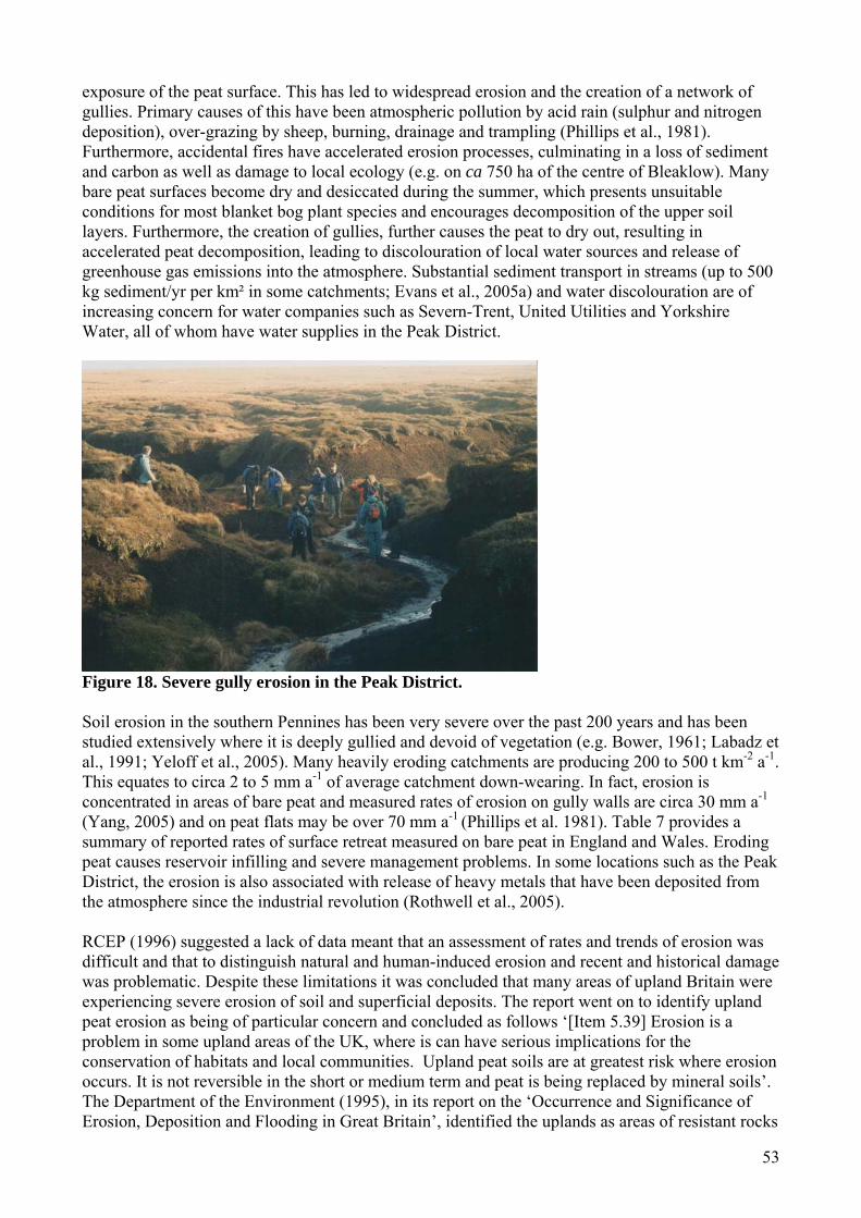
53
exposure of the peat surface. This has led to widespread erosion and the creation of a network of gullies. Primary causes of this have been atmospheric pollution by acid rain (sulphur and nitrogen deposition), over-grazing by sheep, burning, drainage and trampling (Phillips et al., 1981). Furthermore, accidental fires have accelerated erosion processes, culminating in a loss of sediment and carbon as well as damage to local ecology (e.g. on ca 750 ha of the centre of Bleaklow). Many bare peat surfaces become dry and desiccated during the summer, which presents unsuitable conditions for most blanket bog plant species and encourages decomposition of the upper soil layers. Furthermore, the creation of gullies, further causes the peat to dry out, resulting in accelerated peat decomposition, leading to discolouration of local water sources and release of greenhouse gas emissions into the atmosphere. Substantial sediment transport in streams (up to 500 kg sediment/yr per km² in some catchments; Evans et al., 2005a) and water discolouration are of increasing concern for water companies such as Severn-Trent, United Utilities and Yorkshire Water, all of whom have water supplies in the Peak District.
Figure 18. Severe gully erosion in the Peak District. Soil erosion in the southern Pennines has been very severe over the past 200 years and has been studied extensively where it is deeply gullied and devoid of vegetation (e.g. Bower, 1961; Labadz et al., 1991; Yeloff et al., 2005). Many heavily eroding catchments are producing 200 to 500 t km-2 a-1. This equates to circa 2 to 5 mm a-1 of average catchment down-wearing. In fact, erosion is concentrated in areas of bare peat and measured rates of erosion on gully walls are circa 30 mm a-1 (Yang, 2005) and on peat flats may be over 70 mm a-1
(Phillips et al. 1981). Table 7 provides a summary of reported rates of surface retreat measured on bare peat in England and Wales. Eroding peat causes reservoir infilling and severe management problems. In some locations such as the Peak District, the erosion is also associated with release of heavy metals that have been deposited from the atmosphere since the industrial revolution (Rothwell et al., 2005). RCEP (1996) suggested a lack of data meant that an assessment of rates and trends of erosion was difficult and that to distinguish natural and human-induced erosion and recent and historical damage was problematic. Despite these limitations it was concluded that many areas of upland Britain were experiencing severe erosion of soil and superficial deposits. The report went on to identify upland peat erosion as being of particular concern and concluded as follows ‘[Item 5.39] Erosion is a problem in some upland areas of the UK, where is can have serious implications for the conservation of habitats and local communities. Upland peat soils are at greatest risk where erosion occurs. It is not reversible in the short or medium term and peat is being replaced by mineral soils’. The Department of the Environment (1995), in its report on the ‘Occurrence and Significance of Erosion, Deposition and Flooding in Great Britain’, identified the uplands as areas of resistant rocks

54
where the erosion potential is only realised in very large storms or high intensity rainfall events. Large scale erosion events dominate the landscape. The uplands have the highest rainfall and therefore the greatest geomorphic activity potential. It is estimated that the stream power in upland rivers is 1000 times greater than in lowland streams. It is therefore not surprising that organic soils in these areas are potentially very vulnerable to erosion risk. Upland erosion is considered most severe on peat soils and steep slopes, where degraded vegetation covers take years to recover (DEFRA, 2005). Table 7. Reported rates of surface retreat measured on bare peat by erosion pins (Evans and Warburton, in press). Location Context Period Surface retreat
rate Reference
Moor House, North Pennines,England
Gully walls 4 years 19.3 mm a-1 (Evans and Warburton 2005)
Upper North Grain, South Pennines, England
Gully walls 3 years 14 mm a-1 Unpublished data
Plynlimon 30 mm a-1 Robinson and Newson, 1986
Gully walls 7.8 mm a-1 (Philips et al. 1981)
Moor House, North Pennines.
Gully walls 1 year 10.45 mm a-1 (Philips et al. 1981)
Holme Moss Low angled peat
margin 2 years 33.5 mm a-1 (Tallis and
Yalden 1983) Holme Moss Peat Margin 1 year 73.8 mm a-1 (Philips et al.
1981) Harrop Moss, Pennines
Bare peat surface
7 years 13.2 mm a-1 (Anderson et al. 1997)
Snake Pass Peat margin 1 year 5.4 mm a-1 (Philips et al. 1981)
Mid Wales Ditch walls 19 months 23.4 mm a-1 (Francis and Taylor 1989)
North York Moors, N. England
Low angled bare peat surfaces
2 years 40.9 mm a-1 (Imeson 1974)
South Pennines Low angled flats 18.4 – 24.2 mm a-1
(Anderson 1986)
Cabin Clough Low angled eroded face
2 years 18.5 mm a-1 (Tallis and Yalden 1983)
Doctors Gate Low angled eroded face
2 years 9.6 mm a-1 (Tallis and Yalden 1983)
Plynlimon, Wales Peat faces 2 years 16 mm a-1 (Francis 1990) Forest of Bowland 20.4 mm a-1 (Mackay 1993) Estimates of organic soil erosion can be derived from several sources. These include:
1. Direct measurements of particular erosion processes at specific sites (Francis, 1990). 2. Morphological survey of landforms assuming an initial surface or form (or even a dated
horizon; McHugh et al., 2002). 3. Measurement of catchment sediment yields at river gauging sites (Evans and Warburton,
2005). 4. Reconstruction of erosion rates from sediment storage sites typically involving lake or
reservoir stores (Yeloff et al., 2005). 5. Using environmental radionuclide (e.g. Cs-137) techniques (e.g. DEFRA funded research by
Walling et al., 2005).

55
What is often lacking in these approaches is an attempt to provide a national picture of peat loss. Tallis et al. (1997) tried to produce a countrywide synthesis of peatland degradation. Although much site specific information on factors controlling erosion and measured local rates of degradation were documented (e.g. Yeo, 1997 overviewed blanket mire degradation in Wales, stating that sites in South Wales tended to be more severely modified than those in North Wales) no reliable overall estimate of the extent of blanket mire degradation was given. Estimating the total amount of peat loss from the UK uplands is difficult to define for four main reasons:
1. The timescale over which erosion has taken place is difficult to establish with certainty (Tallis, 1997b).
2. A representative baseline survey of erosion does not exist or only fragmentary small-scale catchment studies have been reported (Warburton et al., 2003a; Evans and Warburton, 2005).
3. The extent of peat and hence extent of loss are subject to debate (Tallis et al., 1997). 4. Rates of peat erosion are spatially and temporally highly variable (Labadz et al.,1991;
Butcher et al., 1993). More recently, Harrod et al. (2000) and McHugh et al. (2002) reported on a MAFF sponsored research project that attempted to quantify upland erosion in England and Wales. This arose out of recommendations from RCEP (1996) who reported on the sustainable use of soil and identified upland soils, and peat in particular, as susceptible to accelerated soil erosion. The aim of the MAFF survey was to provide a robust and objective assessment of erosion from 399 upland sites in the UK. The survey suggested 24,566 hectares were affected by erosion (0.284 km3 erosion volume) in upland England and Wales. Within the survey, peat soils were most severely affected by erosion (Figure 19) but the response varied nationally with some areas of upland peat continuing to erode while other regions were revegetating. These results were analysed in more detail in a follow up project ‘Upland erosion data analysis’ funded by DEFRA (NSRI, 2002). The principal findings relating to the degradation of organic soils were:
• Water processes dominated the initiation and maintenance of erosion on peat soils but grazing and weather were important secondary factors maintaining the erosion (Figure 20A).
• On peaty topped soils (defined as having an unincorporated acid organic layer of 40 cm depth) the factors initiating and maintaining erosion were more varied but water and grazing were again dominant, however, other influences such as fire and foot traffic were also significant (Figure 20B).
• The differences between the two organic soil types reflect differences in the distribution of these soils: peat soils are dominated by large areas of degraded blanket bog whereas the peaty topped soils are found in more varied upland environments. Overall though, peaty top soils represent only about a third of the area of erosion of peat soils.
Production of national estimates such as these inevitably involves considerable simplification. Warburton et al. (2003) have questioned some of the assumptions and methodology of the McHugh et al. study and suggested the values quoted may not represent a true picture of erosion nationwide. However, the basic data on prevalence of erosion features (but not necessarily the magnitude of erosion) is useful. Jones et al. (2003) provided estimates of peat loss and peat state for all Priority Habitats in Wales while a number of authors have provided observations and data from specific Welsh sites (Averis 2002b, 2002c, Britton and Pearce, 2004, Slater and Wilkinson, 1993, Wisneiwski and Paul, 1980 (north-south trend in gully erosion across peatlands of central Wales)). Jones et al. (2003) reported that considerably more than half of the total Welsh resource of blanket bog mapped as bearing semi-natural vegetation cover (c. 56, 200 ha) exhibited symptoms of degradation. The figure for the

56
extent of semi-natural blanket bog habitat which represents the sum of four corresponding Phase 1 survey habitat categories (with peat deeper than 0.5 m) is considerably less than reported elsewhere for blanket peat soils in Wales (Yeo, 1997) and less than the figure of 70,000 ha that has been adopted for the purposes of target setting in the Habitat Action Plan. This reflects the extent to which this habitat has undergone gross modification (afforestation, improved pasture etc). One of the four categories of the Phase 1 habitat classification of Wales is bare peat, encompassing blanket peat devoid of vegetation cover. The classification actually includes all areas of bare peat whether derived from blanket bog, raised bog or fen, although the vast majority of bare peat recorded in Wales was from the uplands and thus generally relates to blanket bog. The total area for bare peat in Wales is c. 460 ha, excluding areas of bare peat which occur as fine-scale hagg/vegetated blanket bog mosaics (Jones et al., 2003). Approximately 500 ha of blanket bog was recorded during the Phase 1 survey of Wales at elevations below the general upper limit of agricultural enclosure in Wales. Significant areas of modified bog also occur in the lowlands and preliminary analysis of Phase 1 suggest that c. 1200 ha of this may be derived from blanket bog. Modified bog vegetation regarded as having arisen from the degradation of near-natural blanket bog occurs widely in the Welsh uplands (total area of c. 32,000 ha). Vegetation dominated by Molinia caerulea is especially prevalent, but impoverished vegetation dominated by Eriphorum vaginatum is also widespread, especially in the north (Jones et al., 2003). A ‘rapid review’ by CCW of the state of the Welsh SSSI series during the Autumn of 2003 found that all raised bogs were in the unfavourable class (CCW, 2005). The significance of peat soils as the most sensitive soil type to erosion is emphasised in the erosion classification survey undertaken by Grieve et al. (1995) in Upland Scotland. In their survey, 12 % of the upland area sampled (20 % of the Scottish uplands) were subject to some form of erosion. Half this erosion was attributed to the degradation of peat soils.
Figure 19. Erosion area (m2) and volume (m3) estimates of upland erosion in England and Wales determined by McHugh et al. (2002). While there are still sites at which peat erosion is severe (e.g. Berwyn SAC - Gray, 2005; Eryei SAC – Radford, 2005; Peak District), there is, however, considerable qualitative evidence indicating that in recent decades the rate of peat loss has declined for many UK upland sites. Evans and Warburton (2005) demonstrated this quantitatively for a small catchment in the Northern Pennines. They compared contemporary measurements with previous estimates of erosion (Crisp, 1966) and show a three-fold reduction in sediment loss. Similar patterns can be found in the Cheviots (Wishart and Warburton, 2001) and parts of the Peak District (Clement, 2005). Yeloff et al. (2005) presented an interesting temporal record of upland peat erosion from March Haigh reservoir in the South Pennines. Results based on reservoir sedimentation of organic sediment from
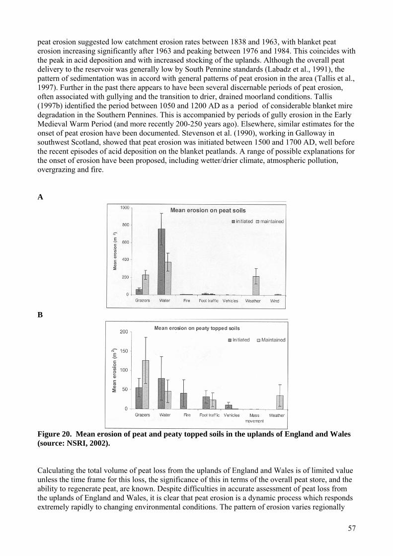
57
peat erosion suggested low catchment erosion rates between 1838 and 1963, with blanket peat erosion increasing significantly after 1963 and peaking between 1976 and 1984. This coincides with the peak in acid deposition and with increased stocking of the uplands. Although the overall peat delivery to the reservoir was generally low by South Pennine standards (Labadz et al., 1991), the pattern of sedimentation was in accord with general patterns of peat erosion in the area (Tallis et al., 1997). Further in the past there appears to have been several discernable periods of peat erosion, often associated with gullying and the transition to drier, drained moorland conditions. Tallis (1997b) identified the period between 1050 and 1200 AD as a period of considerable blanket mire degradation in the Southern Pennines. This is accompanied by periods of gully erosion in the Early Medieval Warm Period (and more recently 200-250 years ago). Elsewhere, similar estimates for the onset of peat erosion have been documented. Stevenson et al. (1990), working in Galloway in southwest Scotland, showed that peat erosion was initiated between 1500 and 1700 AD, well before the recent episodes of acid deposition on the blanket peatlands. A range of possible explanations for the onset of erosion have been proposed, including wetter/drier climate, atmospheric pollution, overgrazing and fire. A
B
Figure 20. Mean erosion of peat and peaty topped soils in the uplands of England and Wales (source: NSRI, 2002). Calculating the total volume of peat loss from the uplands of England and Wales is of limited value unless the time frame for this loss, the significance of this in terms of the overall peat store, and the ability to regenerate peat, are known. Despite difficulties in accurate assessment of peat loss from the uplands of England and Wales, it is clear that peat erosion is a dynamic process which responds extremely rapidly to changing environmental conditions. The pattern of erosion varies regionally

58
across the UK and so cannot be easily characterised by a fixed rate through time. A better understanding of the erosional dynamics of individual regional peatland systems, defined by their topography, hydrology and vegetational characteristics, is required. 5.5 Peat harvesting Consisting of largely organic plant remains, peat has a relatively high energy content and can therefore be used as a source of energy when combusted. Peat harvesting for fuel has been in operation throughout history and the traditional, sustainable method of hand-cutting turf and stacking blocks to dry is still in use today in some remote areas of Ireland and Scotland. However, the major way by which peat is commercially harvested today is milling. In this process, the surface vegetation is removed; the peat is then harrowed and dried before being sucked up by vacuum collectors. In Britain, about 94 % of lowland raised bogs have been severely damaged or destroyed by peat harvesting in the 20th Century (Gosselink and Maltby, 1990). Historically, peat was extracted in the uplands, particularly in Wales, through intensive community organised schemes (Owen, 1969, Gilman, 1995, Turner, 1996). However, this is now very rare and many sites are now protected. Nevertheless, small scale agricultural peat extraction is unregulated, except on farms with agri-environment or SSSI agreements (CEH, 2002). Indeed, there is nothing under the EIA (Uncultivated Land and Semi-Natural Areas) Regulations (2002) to stop someone from exercising their rights to extract peat (rights of turbary) provided the work is ‘routine operations that have been carried out regularly over a number of years’. However, we are not aware of it being a significant issue in Wales. Lowland raised bog is the main source of peat for extraction (higher pH and fertility than blanket peat) and only 13 km2 (3 %) remains in England and Wales (JNCC, 2003). Very little peat is extracted in Wales (although there is some small scale extraction in Carmarthenshire and Glamorgan) and there are no extensive commercial extraction operations in the Principality today. It is difficult to say how many former raised bogs might have been completely lost through extraction but this might apply toY Fawnog Fawr (‘the great turbary’) near Dinas Mawddwy (Meironydd). Its use as a major source of peat fuel was but a memory to the elder generation even in 1915 by which time it seems the peat had already been ‘cut away entirely down to the hard earth’ (Owen, 1975). There are also less extreme situations where the removal of ombrogenous peat has proceeded to a point where earlier fen-peat horizons are exposed for colonization, leaving little or no evidence of the original raised bog (Jones et al., 2003). Of course, over longer timescales, patterns of loss through more natural means can be identified. For example, the extensive peatlands that once occupied parts of the low-lying Newport coastline have succumbed to inundation by estuarine sediments (Smith & Morgan, 1989), whilst studies of peat stratigraphy at Crymlyn Bog appear to indicate an unusual and relatively recent switch from a raised bog to fen (Hughes and Dumayne-Peaty, 2002). Peat extraction continues on three of the five largest raised bogs in England (Thorne Moor and Hatfield Moor (Yorkshire) and Wedholme Flow (Cumbria)). Thorne Moor alone has 3000 species of invertebrates and about 150 of these are nationally scarce or endangered (Friends of the Earth, 1998). Thus, peat extraction is a major threat to the organic soil resource of England. In Wales, there remains a risk that some sites with old extraction consents could be reworked where they are not designated a SSSI (CEH, 2002). Some 3.4 million m3 of peat are used annually in the UK, two-thirds by amateur gardeners (Environment Agency, 2004). About 60 % of this is supplied by commercial companies harvesting peat from Britain’s rapidly disappearing lowland raised bogs; the rest comes from Ireland (Doar, 1997). The Environment Agency (2004) has recognised that the development and promotion of peat alternatives are needed to conserve peatlands, although the industry favours peat dilution. If demand is not reduced this may increase imports and transfer the problem to other countries. Initiatives are underway to actively buy-up peat extraction sites (to limit extraction), introduce alternatives to the market and generally reduce consumption. Developments of agriculture, land fill
59
and peat extraction have degraded the resource and the continuing demand for peat products from amateur gardening poses a continuing threat. Protection for lowland bogs is afforded through national Biodiversity Action Plans (UK BAP) and Local Biodiversity Action Plan (LBAP) schemes. In 2002 English Nature in co-operation with the government announced intent to buy-out the extraction rights of the largest peat producer in England thus ensuring the future of the Humber Peatlands and Wedholme Fen (English Nature, 2002). A further initiative ‘Peatering Out’ sponsored by English Nature and the RSPB aims to end commercial use of peat in the UK within 10 years. 5.6 Drainage In Britain, land drainage commenced before Roman times and there are records of it in Domesday (Darby, 1956). Britain is one of the most extensively drained lands in Europe (Baldock et al.,1984) and drainage expanded during the 17th Century, accompanying land tenure, enclosure and reclamation of the Anglian Fens. In the following few hundred years, peat shrinkage and subsidence became evident and this has been a major cause of loss of organic soils in the lowlands. Between 1947 and 1982 43 % of England and Wales’ freshwater marsh was destroyed. In the East Anglian fens less than 1 % of the resource remains. After the Second World War, government grants for expansion in drainage works were paid at 70 %, and were particularly common in the agricultural marginal uplands where organic soils dominate. In the 1960s and 1970s, 100 000 hectares of blanket peat per year were drained in Britain (Robinson and Armstrong, 1988). Often, drains were contoured or shaped like a ‘herring-bone’, with short lateral feeder ditches collecting into a central ditch. The drainage aimed to improve the quality of soils for sheep and grouse farming. However, Stewart and Lance (1983) demonstrated that there was no evidence that drainage fulfilled the claims made for it. Grouse populations did not seem to increase (in fact many grouse moor managers reported that grouse chicks and lambs became stranded in the drains and died) and upland organic soils cannot sustain large stocking densities anyway (see Section 5.7). Land drainage has been associated with environmental degradation. Drainage resulted in changes in water flow paths through and over organic soils (Gilman, 1994, 1995, 2000; Holden et al., 2006b) and in both increases and decreases in flood peaks (Holden et al., 2004). While water table lowering buffers (slightly) the impacts of a rainfall event by providing extra soil storage capacity for rainwater and reducing saturation-excess overland flow, the ditches themselves speed up the removal of water from the land into streams. Therefore the local impacts might depend on factors such as ditch network design, slope and local vegetation (e.g. Gilman, 2002 at Cors y Llyn NNR). Moreover, the position of the drainage within the catchment as a whole is important because even if drainage slowed and decreased the flood peak from a tributary, it may cause this peak to be delayed, to the extent that it occurs at the same time as the main channel flood peak (Holden et al., 2004). This could therefore cause flood peaks to increase overall. This is why a spatial approach is essential if understanding of the impacts of management activity on environmental processes is to be effective. Many drained peatland catchments exhibit increases in low flows (Baden and Eggelsmann, 1970; Robinson, 1985; Robinson and Newson, 1986). This has often been attributed to catchment ‘dewatering’ following drainage (Burke, 1975) and changes to soil structure (Holden, 2005a). Organic soils shrink, crack (Holden and Burt, 2002a; Holden and Burt, 2002c) and decompose when dried. This change in soil structure is important for hydrology, water quality and ecology.
Holden (2005a) found that peats that had been drained had significantly higher amounts of soil piping than other undrained peats. In blanket peats, Holden (2006) has shown across England, Wales and Scotland that, as the drain networks get older, the density of piping increases. This long-term pipeflow response to drainage (which can continue even 80 years after drainage) can result in long-term changes to river regime (Holden et al., 2006b). Because the pipes also get larger, this

60
means that there can be an exponential increase in sediment (or particulate carbon) release from soil pipes as the drains get older (Holden, 2006). This suggests that drain blocking should occur where drains are oldest, if sediment and carbon release is considered to be a problem worth tackling. In addition to sediment release from soil piping, the ditches themselves can be subject to severe scouring, widening and deepening often by several metres (Mayfield and Pearson, 1972). Site characteristics (e.g. steep slopes) often mean that even recently drained catchments may be significant sources of sediment and carbon. The erosion can become a hazard for stock and humans and the sediment can cover gravel bed spawning grounds downstream and infill reservoirs. However, little is known about impacts of this sediment on stream ecosystems. In a sediment survey (unpublished data from Joseph Holden, University of Leeds) of three basins in the North Pennines it was found that drains were responsible for over 60 % of the organic sediment in the stream system and yet only 8 % of the area was drained. This suggests that today, upland drains, not sheep, are the major source of soil erosion in many upland catchments.
Lowering of the water table in peat soils leads to an increase in the air-filled porosity. This in turn affects microbial processes and thus decomposition rates. The oxygen allows aerobic decomposition to take place, which occurs at a rate about fifty times faster than anaerobic decomposition (Clymo, 1983). The oxygen also enhances the mineralization of nutrients, particularly the carbon-bound nitrogen and sulphur and the organically bound phosphorus. Even an increase in mineralization of just one per cent per year has the potential to generate large losses of carbon, phosphorus, nitrogen and sulphur. The loss of nutrients may in turn affect the fertility of peat (e.g. potassium limitation). Many studies have observed that installation of drainage ditches usually increases the leaching of nutrients. For example, large increases in ammonium (NH4) concentrations have been observed following drainage (Lundin, 1999; Miller et al., 1996; Sallantaus, 1995) and lowering of water table (Adamson et al., 2000) in blanket peat, but only small changes in nitrate (NO3) concentrations. This suggests that while the organisms for ammonification benefited from drainage, those responsible for nitrification did not do so to the same extent. However, increased NO3 and base cation losses have been reported from less acidic peats (Burt et al., 1990; Freeman et al., 1993; Lundin, 1991). Sallantaus (1995) observed a net loss of calcium, magnesium and potassium from drained catchments compared to undrained catchments, where inputs and outputs of these nutrients were more or less balanced. In fen peats, water is often pumped from the land, which results in the rapid lowering of the water table and transfer of solutes from peat to ditch. In Somerset, UK, Heathwaite (1987) observed that SO4 concentrations were at least three times higher in pumped-drained ditches compared to watercourses and that Ca and Mg concentrations were at least twice as high in pumped ditches.
Drained peat soils have been found to have more humus compounds and substances which are readily hydrolysed and hence Mitchell and McDonald (1992) and Clausen (1980) found that drained catchments produced much more discoloured water than undrained catchments. While this presents a general picture, the effects can depend on catchment characteristics so that in some locations only minor changes or significantly lower concentrations of DOC (associated with water discolouration) have been observed in streams flowing from drained catchments compared to nearby undrained soils (e.g. Chapman et al., 1999; Moore, 1987). It should be noted that while the majority of studies that have investigated the impact of artificial ditching on water chemistry have observed changes in solute concentrations and fluxes in the short-term (within five years), there is a dearth of long-term data.
Most moorland stakeholders do not wish to degrade the upland landscape or cause flooding. There is therefore a general consensus that drain blocking should be pursued where it is necessary and where money is available to recover biodiversity or decrease flood risk.
5.7 Burning While a mosaic of woodland, scrub and dwarf-shrub heaths replaced much of the native woodland cleared by humans in the mid to late-Holocene, the advent of treeless, rotationally-burned grouse

61
moor was relatively recent (Simmons, 2003). Since the early 1800s in England and Wales, heather has been burned in rotation to produce very high densities of red grouse. The practice of patch burning seems to have originated following a report by Lovat (1911) who recommended that the area to be burned should depend on the time taken for the heather to recover and grow back to its desired height on typically 8 to 25 year rotation. Lovat advocated narrow strips but stressed the desire to burn small patches should not take precedence over burning sufficient areas to maintain the required burning rotation. In the 1960s and 1970s a series of other papers were produced examining optimum sizes and rotation periods for burn patches (e.g. Gimingham, 1971; Gimingham, 1972). It was shown that in some locations, if heather is left for too long then other dominant species such as Molinia start to take over, leading to an increased risk from natural or accidental wildfire, as the heather can burn too fiercely (Kenworthy, 1963). If burned too frequently, then the heather can be lost (Grant, 1968). Local factors were found to be important (Legg et al., 1992) and the length of time between burns was recommended to be longer on blanket bog (Miller et al., 1984). Sometimes burning does not encourage enhanced heather growth. For example, Ross et al. (2003) have shown that for moors where there is a combined heather and Molinia dominance, that burning increased Molinia cover at the expense of the heather. Since the 1970s, there has been a gradual decline in grouse populations despite continued burning and despite the feeding of medicated grit to grouse (Simmons, 2002). This illustrates how burning is only one of the many factors affecting wildlife populations on upland organic soils. Burning occurs not only in upland sites but also lowland heather dominated peat soils such as those in Gower and Pembrokeshire. Here the impacts of burning could be more severe because the burning tends to be more frequent and the peat less deep. Burning in England and Wales is currently regulated by the Heather and Grass Burning Code (MAFF, 1994). This codes provides legal dates between which burning is allowed (between 1st November and 31st March in lowland areas and between 1st October to 15th April in the uplands), and also guidelines on burning practice. There have been a number of recent and comprehensive reviews of the impacts of moor burning on environmental processes (Glaves and Haycock, 2005; Hobbs and Gimingham, 1987; Mowforth and Sydes, 1989; Shaw et al., 1996; Tucker, 2003) and so rather than repeat such a review we provide a discussion of the main points to arise from these reviews of relevance to organic soil degradation. The Glaves and Haycock (2005) review of the Heather and Grass Burning code for DEFRA noted that, because of a lack of scientific data it was difficult to provide evidence to support any major changes in the code. Virtually nothing is known about whether burning influences soil hydrology, sediment release and water quality. Although a substantial amount of research has been published on the effect of burning on blanket bog and dwarf shrub health communities, there is insufficient evidence to determine its effect on floristic diversity (Stewart et al., 2004a; Stewart et al., 2004b). These are all experimentally determinate factors that require scientific funding. Of the little research that has been done, the work by Holden (2005b) is notable because it has shown that heather is associated with more soil piping in organic soils and this may lead to changes in hydrological flowpaths and changes in water quality and carbon fluxes. In terms of more direct influences of burning on soils, wildfire (which often burns for longer and to hotter temperatures than managed burns) has been shown to result in the development of water-repellent compounds (Clymo, 1983). The removal of vegetation can make the soil surface susceptible to wind and fluvial erosion as well as to increased freeze-thaw action. In many organic soil fire erosion studies there has been a lack of careful experimental design so that results cannot be interpreted more widely. Some authors have attributed the onset of major erosion episodes to historic wildfire (Mackay and Tallis, 1996) or historic human-induced fire (Tallis, 1987). There is a dearth of data on infiltration following fire on organic soils but increases (Kinako, 1975) and decreases (Mallik et al., 1984) provide some evidence. Increases in pH (Allen, 1964; Stevenson et al., 1996) are also likely, and differences in pH have been noted between different burning regimes on blanket bog (Worrall et al.,

62
Submitted) as have some influences of ash on microbial populations (MacDonald, 2000). With increasing concern over carbon sinks and sources, the impact of burning on organic soils has come under increased scrutiny. Garnett et al. (2000) examined long-term experimental plots at Moor House, North Pennines, and found that burning reduces peat accumulation in comparison to no burning. It was suggested, in line with studies in Canada (Kuhry, 1994) and Finland (Pitkänen et al., 1999), that the cessation of burning on organic soils would be one mechanism for reducing carbon emissions and increasing carbon sequestration. Other soil nutrients are lost in the smoke during burning, as particulate matter, and through volatilisation (over 50 % of carbon, nitrogen and sulphur are lost from heather for example; Allen, 1964). Concentrations of soil nutrients tend to be high for the first two years after a burn, benefiting regeneration (Hansen, 1969). However, leaching may be significant, particularly after autumn burns. Losses of phosphorus and nitrogen may impact future vegetation growth and Kinako and Gimingham (1980) suggested that it may take 75 years for the P losses from one burn to be replaced. There are therefore questions about whether burning is leading to a long-term decline in soil productivity (Coulson et al., 1992) or whether it is actually preventing an accumulation that would otherwise lead to a change in vegetation community towards trees, grasses and bracken (Gimingham, 1995). It is generally accepted that some degree of management is usually required for the maintenance of dry heather moorlands, but appropriate measures must be carefully considered, as the balance between the main plant species is extremely sensitive, and much depends on the climate, soil type and drainage (Shaw et al., 1996). It is clear that for many sites burning is highly effective in keeping heather at a productive stage, where the seed bank and vegetative regeneration potential is at the highest. Indeed, the Heather Trust and the Moorland Association both strongly defend the role of moorland burning in maintaining a sustainable habitat. However, it should be noted that we do not sufficiently know enough about the historical burning practices that have produced different vegetation communities. This can make it difficult to establish modern ‘good management practice’. The prediction of the exact vegetation communities that would develop in the absence of regular burning is difficult because the pattern, speed and outcome of secondary succession processes varies greatly from place to place (Tucker, 2003). DEFRA’s ongoing review of the Heather & Grass Burning Code in England and Wales reflects calls from conservationists for a ban on managed burning of blanket bogs. Tighter controls (falling short of a ban) are being considered for other sites (e.g. ensuring smaller and cooler burns and a reduction in total burning). However, moves to tighten regulations are opposed by many stakeholders who wish to retain as much flexibility as possible (Reed et al., 2005). Although the ecological effects of wildfires on organic soils in the UK are reasonably well understood (Radley, 1965; Imeson, 1971; Maltby et al., 1990; and Anderson, 1997) little is known about the hydrological and geomorphological consequences of such events. The frequency of outdoor fires is often used as an indicator of climate change. The recent severe heatwave that hit at least 30 countries in the Northern Hemisphere during 2006 was partly responsible for the massive outdoor fires in Canada and France. In the UK, almost all outdoor fires are caused by the careless or deliberate actions of people (Radley, 1965, Anderson, 1997). Hot, dry conditions encourage people to be outside and are ideal for the spread of fires. Although there is no clear climate-related trend in the frequency of outdoor fires in the UK over recent decades, except for dry summers such as 1995 having many more, recent record-breaking dry years have prompted concern about this hazard. The potential implications of outdoor fires are significant in terms of threat to persons and property; costs to fire services; and long term damage to the natural environment. In upland areas in particular, the latter problem can be devastating to fauna, flora and organic soils, especially if

63
accelerated erosion processes become established (Maltby et al. 1990). This can lead to irreversible soil erosion, due to steep slopes, erodible organic soils and high rainfall. 5.8 Livestock grazing (including liming) Organic soils, particularly in the uplands, cannot often sustain stocking densities greater than 2 sheep ha-1 (Evans 2005b, 1998). CAP subsidies in the 1970s and 1980s resulted in increased stocking so that 29 % of upland organic soils were stocked above this level in 1977 and 71 % by 1987. The result of this overstocking is removal of vegetation and overtrampling which makes the soil susceptible to surface erosion. Rawes and Hobbs (1979) found that for North Pennine blanket bogs, grazing densities over 0.55 sheep ha-1 instigated erosion. Reductions in grazing pressure can sometimes result in rapid recolonisation of eroding slopes, except in many peat catchments where erosion can often continue if unchecked by human intervention (Evans, 2005a). The area of upland soil erosion induced by grazing has increased rapidly over the past three decades (Harrod et al., 2000). Considerable areas of organic soils throughout England and Wales have been degraded by grazing animals (Evans, 1997) and grazing induced erosion may indeed still be increasing throughout England and Wales (Huang and O’Connell, 2000). Severely eroded peat is found in all blanket bog regions of England and Wales, particularly above 450 m (Tallis, 1998), and overgrazing, particularly by sheep, is a major management issue in most LFAs (IGER, 2004). The most eroded sites are concentrated in the Pennines, particularly in the Peak District, Teesdale and Weardale.. Eroded sites have, nevertheless, been reported throughout Wales, SW England and the Lake District. Rudeforth et al. (1984) described the damage to humic ranker Bangor Association soils in Wales noting that summits like those of the Carneddau are very rocky with humic cryptopodzols and stony peat soils carrying Racometrium moss, alpine club-moss or viviparous fescue. Here the soil was being eroded in many places, which, according to Rudeforth et al. (1984), was partly due to the inevitable decline in the vigour of plant communities after centuries of sheep rearing with little or no replacement of plant nutrients. A limited number of eroded sites have been reported in the North York Moors and the Cheviots. The general impacts of livestock are prevalent throughout the entire of the uplands however (SSLRC, 2000). Where grazing pressure has been reduced, reductions in the number and severity of sheep scars have been seen (e.g. Coledale in the Lake District and Hey Clough, Derwent Edge and Lyme Park in the Peak District). In contrast, where grazing has not been reduced, the development of sheep scars and tracks continues to increase (e.g. Pen y Fan, and some areas in the central Lake District). Indeed, Grant et al. (1978) noted a tendency for sheep to graze near bare areas thereby enlarging them. The highest density of sheep scars has been recorded in the central Lake District and the northern and central Pennines. These areas were followed by the western Lake District fells, the Forest of Bowland and the western valleys of the southern Pennines. Generally, the predicted density of sheep scars in these areas is 0.38 per km2 or one scar per 2.63 km2. Results suggest that sheep scars are most likely to form in humic gleys, stagnogleys and peats. 48 % of scars were recorded in acid grassland, 38 % in dwarf shrub heath, 7 % in bracken and 7 % in improved grassland (SSLRC, 2000). Higher densities of scars have been reported by other researchers though. Carr (1990) reported a density of 1 scar per 2.2 ha in the Coledale Valley, while Evans (1974) found a density of 205 scars ha-1 in Hey Clough, Derbyshire. Three factors have been found to be required for the formation of sheep scars on peat soils (Evans, 1977): grazing intensities of greater than 0.5 sheep ha-1 on peat, grassy moorland vegetation over the peat, and irregular slopes. Revegetation of peat will be hampered by drying out of pool and hummock complexes. Even where grazing is not intense enough to cause the development of scars, soil degradation will still occur (e.g. through compaction) (SSLRC, 2000). The greatest number of sheep reared on organic soils in 1999 was in south-west England (4.2M), followed by the North-West (3.9M), Yorkshire and Humberside (2.6M) and the North-East (2.5M). South-west England also has the highest stocking density of sheep, but not the greatest amount of

64
upland erosion, suggesting that some organic soils (e.g. peats) are more vulnerable than others (e.g. humic sandy gleys). The area of eroded land in the uplands (not just organic soils) is reported to be increasing at an alarming rate of 500 ha a-1 and McHugh et al. (2002) estimated that 2.5 % of the total upland area is eroding. Upland soil erosion has been found to be greatest on peat soils rather than organo-mineral soils and mineral soils are least vulnerable. Between 1997 and 1999, McHugh (2000) found that 90 % of the increase in the area of bare soil and the volume eroded could be attributed to sheep or humans. The low sward induced by sheep grazing also creates a more suitable habitat for rabbits and it has been found that this can further the development of bare soil (Evans, 1997). Bare peat soils recolonise after a reduction in grazing pressure more slowly than organo-mineral soils, however (Evans, 2005b). A number of studies have examined the impacts of grazing impacts on upland invertebrates (Keiller et al., 1994a,1994b) and arthropods (Keiller et al., 1995a, 1995b) based in Snowdonia and mid-Wales showing that reduced grazing increases diversity and abundance of surface-active spiders and carabid beetles, associated with the vegetation change from grass to heath. When sheep grazing decreased subterranean arthropod numbers also declined, which was attributed to reduction in dung inputs. Hill et al (1992) studied results from exclosure plots on hill pasature in Snowdonia. Changes in plant communities were very rapid and in the intial few years vegetation altered markedly. Successional changes depended on the soil and initial vegetation. Compositional change in grasslands initially dominated by Agrostis capillaris was smaller than in vegetation initially dominated Nardus strica. Long-term changes in herbaceaous vegetation were few. Some suppressed shrubs like Calluna and Erica, coalesced to become dominant, although at one site they flourished for 20 and 12 years respectively before degenerating. Voles became the dominant herbivore with knock-on increases in some mosses among the mats of dead grasses. A number of models have been developed to determine sustainable levels of grazing on organic soils. They tend to calculate the seasonal and long-term food resource available (Armstrong et al., 1997; Grant and Armstrong, 1993; Sibbald et al., 1987). Most of the models have been applied to Scottish sites, but many of these can be operated in catchments of England and Wales. Research is now beginning to indicate the need for spatially distributed models of grazing. Key vegetation attracts sheep. Any neighbouring vegetation receives a higher impact than if it is associated with patches of less preferred vegetation (Palmer et al., 2004). A simple example of this is that heather near to areas of grass will tend to be grazed more heavily than more distant heather. This means that heather management decisions based on stocking density alone are insufficient because local differences in the availability of preferred vegetation so strongly influence the locations and patterns of critical impact upon heather. This complexity of animal processes is also why it is not possible to apply a universal stocking density to particular organic soil types. Furthermore, regulations and predictions regarding stocking levels have not yet taken account of the increasing trend towards the use of large sheep breeds and tend to be based solely on sheep numbers. Additionally, the predictive models do not take account of human action in grazing management. For example, the impacts of grazing have been influenced by a decline in the number of people employed in upland farming so that there has been a decline of shepherding. Shepherding makes better use of the grazing across the hillslopes and avoids local concentrations which can lead to overgrazing and reduces the need for supplementary grazing (IEEP, 2004). The impact of reducing or removing grazing on organic soils has been investigated in a number of enclosure studies. Broadly, the changes in vegetation structure and composition are greatest where grazing was previously more intense (Marrs and Welch, 1991). Often it is only when grazing is removed altogether that there are rapid increases in diversity. IEEP (2004) suggested that a combination of different management strategies involving grazing by different animals at different intensities and different times of the year is likely to maximise biodiversity. Grazing systems that maximise the production of just one animal are unlikely to maximise biodiversity.

65
Table 8. Mean summary hydrological characteristics for two sites with and without grazing during 2005 (unpublished data from Y. Zhao and J. Holden). Wharfedale Teesdale Grazing condition None
since 1960
None since 2000
2 ha-
1 Sheep track
None since 1954
None since 1997
0.5 ha-1
Sheep track
Mean infiltration rate, mm hr-1 (n=50)
22.7 20.3 16.3 9.6 22.0 16.3 10.2 5.9
Soil bulk density in upper 5 cm, g cm-3 (n=50)
0.033 0.037 0.040 0.088 0.030 0.031 0.037 0.012
Surface saturated hydraulic conductivity x 10-8 cm s-1 (n=25)
2753 1388
376
7
8937 4741 931 23
Saturated hydraulic conductivity at 10 cm depth x 10-8 cm s-1 (n=25)
11 13 3 1 44 56 13 2
% macropore flow at surface (n=25)
33 35 29 18 36 37 35 21
% macropore flow at 10 cm depth (n=25)
24 32 23 21 29 33 26 21
% occasions overland flow had occurred at 50 locations between bi-weekly visits during 2005
73.3 73.1 80.9 84.1 90.7 89.9 90.5 91.1
n is the number of samples per category There have been very few studies of the influence of grazing on organic soil hydrology but Carroll et al. (2004) demonstrated an increased bulk density with stocking density in Snowdonia, while the reverse was the case at ADAS Pwllpeiran plots in Cambrian Mountains. However, bulk density was not related to infiltration in a simple manner and the study showed peat soils need to be considered separately to mineral soils with further data required. Recent unpublished data from J. Holden and Y. Zhao at the University of Leeds have shown that sheep tracks are important hydrological agents, providing direct connectivity across slopes for water, sediment and pollutants. This is because sheep tracks are compacted and infiltration capacities reduced so that infiltration-excess overland flow becomes more common (Table 8). Some summary data on steady-state infiltration rates, hydraulic conductivity, bulk density and proportion of flow moving through macropores are presented in Table 7 for two blanket peatland sites where there are areas with and without grazing. Data were collected using techniques described in Holden and Burt (2003a; 2003b) and Holden et al., (2001). Where grazing occurs, the hydraulic conductivity and infiltration rate is much lower across the hillslope than where grazing has been restricted. It can be seen that just five years without grazing is enough to allow the system to recover towards that of a system that has had no grazing for over 40 years. These changes in hillslope hydrology could be manifest in changes in river flow and indicate that cessation of grazing may well be a useful tool in reducing flood risk. Meyles et al. (2006) have suggested that grazing on stagnohumic gleys on Dartmoor caused more rapid connectivity of hillslope water with streams and therefore contributes to enhanced flood peaks. This occurs even before vegetation has been removed as a result of soil structural changes, particularly in the topsoil. Hence, even where animal pressures are not immediately obvious in the landscape (i.e., through visible erosion or stripping of vegetation) there can still be marked effects of livestock on organic soil and catchment processes. Sansom (1999) noted that in the north Derwent catchment sheep numbers had doubled between 1944 and 1975 to 24,000 and in that time annual water yield had increased by 25 %. It is not known whether other factors contributed to this change but such an increase in grazing is likely to have had some hydrological impact. Therefore, there may be sensitive parts of the catchment where grazing will have a much greater impact on stream flow (e.g. by compacting valley bottoms) than in other parts of the catchment. The role of sheep tracks also reminds us that if we are to understand the environmental impacts (and make reliable predictions) of reductions in grazing then we need to use spatial modelling techniques that incorporate topographical processes rather than simply rely on lumped models. Although livestock numbers

66
have decreased in recent years, populations generally remain at around 75 % of what they were in 1990 (DEFRA, 2006) and so the impacts of livestock rearing on organic soils may still be significant. Liming has been used on organic soils to raise the pH of the soil in order to increase the productivity of grazing land, often in association with other agricultural treatments, and forestry plantations. In addition to raising soil pH and base saturation, liming can increase mineralization of organic carbon and nitrogen (Persson et al., 1989), resulting in a nitrification pulse and leaching of nitrate to surface waters. This can lead to temporary acidification of the soil and surface waters. Organic matter turnover is increased because higher soil pH stimulates microbial activity (Shah et al., 1990). For example, Marscher and Wilczynski (1991) observed a reduction of 7 t C ha-1 in the organic-C pool of a limed forest floor compared with untreated control sites during a 3-year period, which they attributed to an increase in microbial respiration. Liming has been observed to cause damage to plants, particularly Sphagnum spp (Clymo et al., 1992), although there are no reports of damage to other plants typically associated with organic soils. Ormerod and Buckton (1994) surveyed heath, mire and grassland vegetation, invertebrates, amphibians, birds and mammals in 20 catchments in acid-sensitive Welsh catchments. Limed catchments had significantly reduced cover of Sphagnum, particularly the most widespread species, Sphagnum recurvum. Most invertebrate orders, including carabid bettles, were reduced at limed sites and there was reduced capture of amphibians. Catchment liming has recently been used in the Netherlands to help restore acidified heathlands and moorland pools (Dorland et al., 2005). However, the response of heathlands species to liming was slow, with only a small number of endangered species increasing in abundance. Liming is a short-term solution (6-7 years) for raising soil pH. In addition, it introduces a labile carbon source that acts as a primer for increasing organic matter decomposition, resulting in a reduction in the carbon content of the soil and therefore the carbon balance. Hence, for organic soils, the negative impact of liming on the carbon balance does not warrant its continued use. A more appropriate and realistic method of raising the pH of organic soils may be by the introduction of calcium minerals that are slow weathering, such as calcium silicate. However, this requires further research. It should be noted that in some organic soil environments under-grazing is reported as being one of the activities most frequently having an impact on unfavourable features of mire, heath, grass and marsh SSSIs in Wales (CCW, 2005). The prominence of under-grazing may seem surprising, but it must be remembered that these figures reflect frequency of occurrence, and are weighted by a large number of small lowland sites where under-grazing is a problem. CCW analysis shows that, if we look at the area of features, then over-grazing is the primary issue in the uplands. The area figures should be interpreted cautiously. If a feature is recorded as being in unfavourable condition it does not follow that the whole of that feature is in a degraded state. It means only that the feature has failed to meet its conservation objective; it may have done so by either a small or a large amount. So, in theory, a very large feature (say a bog of several thousand ha) may be classified as unfavourable even if only a small amount of its area is actually degraded (CCW, 2005). Note that detrimental activities also affect a proportion of features in favourable condition. This may be expected to affect their condition in the longer term, since under the Habitats Directive, the condition of features needs to be assured into the foreseeable future if Favourable Conservation Status is to be attained. 5.9 Afforestation As stated in Section 4, one of the major changes in land cover on organic soils has been the expansion of coniferous plantations, particularly in Wales (see Figure 4). Coniferous plantations alter organic soil functioning. As the trees grow, the ground cover changes to that of a forest understorey with sparse Eriophorum vaginatum, occasional ferns, some mosses, liverworts and lichens. There is often a tendency for increased nutrient cycling in the upper half metre of the soil profile, and hence leaching to streams, while application of fertiliser tends to enhance the rate of
67
nutrient cycling by increasing nutrient concentrations in the litter layer (Finer, 1996). Indeed contamination by fertiliser application was blamed for habitat damage around plantations at Figyn Blaen Brefi in mid-Wales (Slater, 1984). Typically, associated with conifer plantations there will be increased earthworms (Makulec, 1991), beetles, moths, plant bugs and slugs with decreases in spiders and wasps (Coulson, 1990). Open ground birds (such as golden plover Pluvialis apricaria) are displaced and replaced by forest birds. Forest drains lower the water table in organic soils and result in associated subsidence of the soil surface due to compression and shrinkage (Anderson et al., 2000). The organic soil tends to dry out after canopy closure, but the furrows often continue to provide wetter hollows. Increased interception and transpiration causes a much greater lowering in the water table than drainage alone and enhanced surface subsidence (Pyatt et al., 1992; Shotbolt et al., 1998). The hydraulic conductivity increases significantly in the upper dried layers. There is often large-scale cracking in afforested peat soils. Hydrological studies in the 1970s showed that afforestation increased evaporative losses, leading to a reduction in runoff (e.g. Calder and Newson, 1979) and concerns about the sustainability of water supplies. At the same time, land preparation techniques, such as ploughing and drainage practices, were shown to increase peak flows (Robinson, 1986). A major water quality issue was the potential for afforestation operations such as road building, ploughing and drainage, to cause soil erosion and increase sediment delivery to streams and rivers (Farmer and Nisbett, 2004). Then in the 1980s it was found that coniferous forests exacerbate soil and water acidification process in areas receiving large amounts of acidic deposition and with base-poor soils. Acidification potential is greatest where there is low buffering capacity in the underlying geology. This is due to the fact that coniferous trees intercept and scavenge the pollutants more effectively than other vegetation (Fowler et al., 1989). Hence, streams draining forested catchments tend to be more acidic and contain higher aluminium concentrations than those draining nearby unforested catchments (Reynolds et al., 1988; Neal et al., 1992). As the plantations have reached maturity, numerous studies have been carried out to determine the impact of harvesting technique and soil type on stream water quality (Reynolds et al., 1988; Neal et al., 2004). All of these studies have shown that while there can be a deterioration in water quality (e.g. increase in nitrate leaching), they are short lived (1-3 years). Practical management prescriptions to minimise the acidification impacts of clearfelling have now been incorporated into the most recent edition of the Forest and Water Guidelines (Forestry Commission, 2003). Furthermore, even if the effect of sediment from harvesting is likely to be a short-term impact, this is serious if it impacts on a site of high ecological value such as Llyn Cwelln SAC. Good practice must be adopted to avoid sediment impacts. Forest managers now attempt to increase biodiversity through careful planting design (Anderson, 2001, Pyatt et al., 2001). Since 1990 there has been a steep decline in new plantings on deep peat soils and clear guidelines have been drawn up (Paterson and Anderson, 2000) which discourages new planting on: (i) active raised bog and degraded raised bog capable of restoration to active status, and (ii) extensive areas, greater than 25 ha, of active blanket bog of 1 m or more in depth or any associated peatland where afforestation could alter the hydrology of such areas. The Forestry Commission also encouraged the conservation of peatland habitats within forests as part of the design and management of open ground (which should form 10-20 % of woodlands). While it is good that afforestation on deep peat has declined, it inevitably means that organo-mineral soils are more likely to be afforested in the future, resulting in further loss of the semi-natural vegetation and habitats associated with these soils. While there are currently pressures to reduce coniferous afforestation in England and Wales, there are growing demands for organic soils to be planted with native tree species (Gimingham, 1995; Gimingham, 2002). The strategy document ‘Woodlands for Wales’ (NAW, 2000) encourages multi-functional forestry with mixed species and mixed-age crops and it is hoped that this will lessen the effects of acidification and other problems described above on the soil and river systems. Some
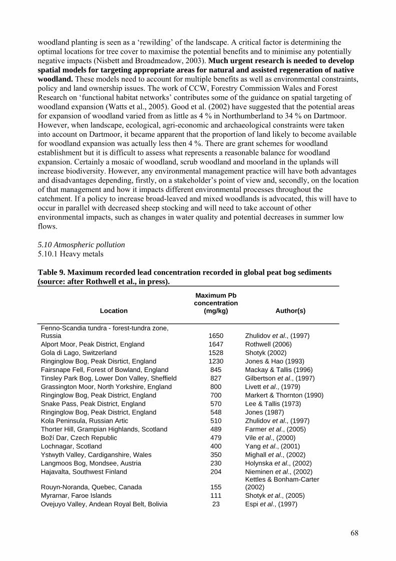
68
woodland planting is seen as a ‘rewilding’ of the landscape. A critical factor is determining the optimal locations for tree cover to maximise the potential benefits and to minimise any potentially negative impacts (Nisbett and Broadmeadow, 2003). Much urgent research is needed to develop spatial models for targeting appropriate areas for natural and assisted regeneration of native woodland. These models need to account for multiple benefits as well as environmental constraints, policy and land ownership issues. The work of CCW, Forestry Commission Wales and Forest Research on ‘functional habitat networks’ contributes some of the guidance on spatial targeting of woodland expansion (Watts et al., 2005). Good et al. (2002) have suggested that the potential areas for expansion of woodland varied from as little as 4 % in Northumberland to 34 % on Dartmoor. However, when landscape, ecological, agri-economic and archaeological constraints were taken into account on Dartmoor, it became apparent that the proportion of land likely to become available for woodland expansion was actually less then 4 %. There are grant schemes for woodland establishment but it is difficult to assess what represents a reasonable balance for woodland expansion. Certainly a mosaic of woodland, scrub woodland and moorland in the uplands will increase biodiversity. However, any environmental management practice will have both advantages and disadvantages depending, firstly, on a stakeholder’s point of view and, secondly, on the location of that management and how it impacts different environmental processes throughout the catchment. If a policy to increase broad-leaved and mixed woodlands is advocated, this will have to occur in parallel with decreased sheep stocking and will need to take account of other environmental impacts, such as changes in water quality and potential decreases in summer low flows. 5.10 Atmospheric pollution 5.10.1 Heavy metals Table 9. Maximum recorded lead concentration recorded in global peat bog sediments (source: after Rothwell et al., in press).
Location
Maximum Pb concentration
(mg/kg) Author(s)
Fenno-Scandia tundra - forest-tundra zone, Russia 1650 Zhulidov et al., (1997) Alport Moor, Peak District, England 1647 Rothwell (2006) Gola di Lago, Switzerland 1528 Shotyk (2002) Ringinglow Bog, Peak Disrtict, England 1230 Jones & Hao (1993) Fairsnape Fell, Forest of Bowland, England 845 Mackay & Tallis (1996) Tinsley Park Bog, Lower Don Valley, Sheffield 827 Gilbertson et al., (1997) Grassington Moor, North Yorkshire, England 800 Livett et al., (1979) Ringinglow Bog, Peak District, England 700 Markert & Thornton (1990) Snake Pass, Peak District, England 570 Lee & Tallis (1973) Ringinglow Bog, Peak District, England 548 Jones (1987) Kola Peninsula, Russian Artic 510 Zhulidov et al., (1997) Thorter Hill, Grampian Highlands, Scotland 489 Farmer et al., (2005) Boží Dar, Czech Republic 479 Vile et al., (2000) Lochnagar, Scotland 400 Yang et al., (2001) Ystwyth Valley, Cardiganshire, Wales 350 Mighall et al., (2002) Langmoos Bog, Mondsee, Austria 230 Holynska et al., (2002) Hajavalta, Southwest Finland 204 Nieminen et al., (2002)
Rouyn-Noranda, Quebec, Canada 155 Kettles & Bonham-Carter (2002)
Myrarnar, Faroe Islands 111 Shotyk et al., (2005) Ovejuyo Valley, Andean Royal Belt, Bolivia 23 Espi et al., (1997)

69
Heavy metals such as cadmium, chromium, copper, lead, mercury, nickel and zinc occur naturally in soil at levels dependent on the soil parent material. Many are essential to living organisms in trace amounts. However, human activities can cause elevated concentrations which have an impact on soil processes. Heavy metals are emitted to the atmosphere from a range of sources including coal combustion, transport, metal smelting and waster incineration. Atmospheric deposition represents the most extensive source of heavy metals to soils. Ombrotrophic peat bogs receive their inorganic element supply predominantly from the atmosphere, this makes them particularly susceptible to, and potentially important indictors of, the effects of air-borne pollutants. In England and Wales, the coincidence of the Pennine peatlands with the heartlands of the industrial revolution meant that very considerable concentrations of heavy metals have accumulated in surface peat (Livett et al. 1979, Rothwell et al. 2005 and in press, Table 9). Heavy metals are strongly bound to organic matter but under certain circumstances the stored metals which are a legacy of deposition during the industrial revolution are released into the fluvial system. Tipping et al. (2003) have demonstrated that increases in acidity due to oxidation of sulphur under conditions of lower water table leads to an order of magnitude increase in the rate of release of heavy metals in solution. Similarly, Rothwell et al. (2005) have demonstrated that high levels of sediment associated with heavy metals are exported to stream systems in eroding peatland catchments. Enhanced chemical and physical instability of peatland soils due to climatic change therefore has the potential to cause significant remobilisation of the organic soil store of heavy metals. 5.10.2 Sulphur deposition The term acid rain first used in the 19th Century, refers to the atmospheric deposition of sulphuric and nitric acids to the land surface. Acidic deposition, which peaked in the early 1980s, has had a wide range of impacts upon the environment, including soil, which have recently been comprehensively reviewed by NEGTAP (2001) and, hence, only the major points will be emphasised here with relation to organic soils. In parts of England and Wales where acidic deposition has been very high, such as the southern Pennines, Sphagnum mosses have been almost eliminated. Field experiments with Sphagnum have shown that it quickly succumbs to the application of sulphur dioxide in solution (Ferguson and Lee, 1983). Hence, organic soils in this area show signs of severe soil degradation and erosion. Soil pH is the most commonly quoted measure of soil acidity. Evidence of changes in the pH of organic soils is rare in England and Wales, as very few long-term monitoring studies of soil chemistry and biota exists. Of the five studies in the UK that have compared soil pH over time, only one (Kuylenstierna and Chadwick, 1991) included a peat soil. The other soil samples included one peat ranker, seven podzolic soils and four brown soils. All samples were under grassland in NW Wales and showed a decline in pH, ranging from 0.1 to 1.6 pH units, between 1957 and 1990. Another study at Moor House in the northern Pennines re-sampled 32 soil profiles from a range of soils including podzols and gleys (Adamson et al, 1996). All organic horizons displayed an increase in pH of between 0.4 and 1.0 units over the period 1963/73 to 1991, but no peat soils were sampled, which is surprising given the predominance of peat in the area. Skiba et al. (1989) examined the relationships between patterns of peat pH and base saturation (the proportion of exchange complex occupied by base cations – calcium, magnesium, sodium and potassium) at 123 sites across Scotland with modelled atmospheric deposition. They found a strong correlation between high deposition of acidity and low pH (<3.0 in CaCl2) and base saturation (< 10%) and concluded that this provided strong evidence for acid deposition having caused further acidification of peats in Scotland. White and Cresser (1995; 1998) carried out a similar study for stagnopodzols across a pollution gradient in Eastern Scotland and observed a strong positive relationship between soil pH and the mean pH of rainfall, and between soil pH and deposition flux of strong acid anions.

70
Acidic deposition has the effect of increasing the leaching of base cations, such as calcium and magnesium, which leads to a decline in the proportion of cation exchange sites occupied by base cations and hence a increase in exchange sites occupied by aluminium species and H+ ions. Over the long-term, this process leads to soil acidification. A decline in soil pH increases the solubility of heavy metals in the soil, such as aluminium, manganese, lead, cadmium and zinc, which can be toxic to plants. This may lead to decreased plant growth or changes in plant communities. Populations of soil organisms may also change, with a shift towards more acid tolerant species. As a result, a number of soil processes can slow down. For example, the decomposition of litter becomes slower, leading to surface accumulation (Sanger et al., 1994) and slower nutrient cycling. Soil acidification gradually leads to acidification of waters draining from them (Cresser and Edwards, 1987). Acidity and high concentrations of aluminium can lead to deterioration in aquatic life. For example, the diversity and size of invertebrates and fish populations decline (Weatherley and Ormerod, 1987; Weatherley et al., 1990). To help quantify effects of soil acidification and relate them to the acid deposited, an ‘effects based’ approach, known as critical loads, has been developed. A critical load is defined as ‘a quantitative estimate of exposure to one or more pollutants below which significant harmful effects on elements of the environment do not occur according to present knowledge’ (Nilsson and Grennfelt, 1988). Deposition above that limit may lead to harmful effects on the environment. Maps of critical loads and their exceedances (excess over the critical load) have been used to show the potential extent of damage over an area and as an aid to developing strategies for reducing pollution. For soil acidification, the critical load calculation was initially based on the rate of release of base cations from soil minerals by weathering, indicating the capacity of the receiving soil to buffer acid inputs. A separate methodology was developed for peat soils based on the relationship between the acidity of rainfall and the acidity of peat (Smith et al., 1993). Critical loads have also been developed for soil-plant systems on the basis of biological indicators which reflect the health of the whole system. Sketch and Bareham (1993a 1993b) identified terrestrial SSSIs at risk from soil acidification from atmospheric sulphur deposition in Wales. They predicted that 26% (218) of Welsh SSSIs (containing 65% of the total area of SSSIs in Wales) lie wholly or partially in 1 km squares where the soil’s critical load for acidification would still be exceeded due to sulphur deposition in 2005, after implementation of 60 % emission reduction by 2003 (1980 baseline) stipulated in the Large Combustion Plant Directive (1987). An 80 % emission reduction scenario was predicted to leave 86 Welsh SSSIs at risk. Over the last two decades, sulphur deposition in the UK has declined by 60 % (Fowler et al., 2005), making it perhaps the largest ‘environmental change’ across the UK in recent time. While the response of surface waters to this decline in sulphur deposition has been monitored via the Acid Water Monitoring Network (AWMN), there has been no systematic monitoring of how soil, soil biota and soil processes, such as decomposition and nutrient cycling, have responded to this large reduction in sulphur and H+ ion inputs. This has perhaps been a lost opportunity. 5.10.3 Nitrogen deposition It is estimated that global deposition of reactive nitrogen to the terrestrial environment have more then trebled since preindustrial times (Galloway et al., 2004). A large amount of research has been undertaken to determine the impacts of elevated nitrogen deposition on the environment, including soils and vegetation (INDITE, 1994; NEGTAP, 2001). Responses range from changes in plant community composition, altered patterns of plant growth, soil acidification, changes in carbon and nutrient cycling, and deterioration in the chemical and biological status of freshwaters. A summary of the main findings are presented here. Soil N availability is strongly associated with plant species composition in semi-natural systems (e.g. Pastor et al., 1984; Britton and Pearce, 2004) and evidence from competition experiments (e.g.
71
Aerts et al., 1990) show that increases in N deposition over the last few decades have led to the encroachment of grass species into areas once dominated by heather (NEGTAP, 2001), although inappropriate land management practices may also play a part. In addition, underlying soils may be acidified as a result of (i) the displacement of base cations by ammonium accumulation (White and Cresser, 1998), (ii) the loss of base cations from the soil through leaching with nitrite (INDITE, 1994) and (iii) increased uptake and accumulation of base cation in plant biomass due to increased N inputs stimulating plant growth with consequent increased demand for nutrients and base cations (INDITE, 1994). The fertilisation effect of nitrogen deposition also increases the N concentration of plant tissue and litter (Pilkington et al., 2005). Plant litter is the principal carbon resource reaching the soil surface and its N content and C:N ratio has been used as a guide to its quality and rate of decomposition (Heal et al., 1997). From measurements of increased N concentrations and reduced C:N ratios in tissues of mosses on peat bogs in Sweden, it has been predicted that decomposition of these materials will increase (Aerts et al., 1992). This will lead to an increase in available N for plant uptake or leaching. The impacts of direct additions of N on the decomposition of organic matter have been comprehensively reviewed by Fog (1988); both positive and negative correlations between N addition and rates of decomposition have been reported. The phosphorus (P) status and availability are important factors in determining the assimilation of N by the vegetation in organic soils where soil P levels are intrinsically low (Aerts et al., 1992). Until recently, the majority of research into the effects of N deposition on upland semi-natural systems has focused on coniferous forests, where an increase in nitrate leaching is observed in response to increased N inputs, which can lead to the eutrophication and acidification of waterbodies (Wilson and Emmett, 1999). Sustained long-term inputs of N lead to ‘nitrogen saturation’, defined as the point when N availability is greater than the combined plant and microbial demand (Aber et al., 1989) and is identified by an increase in nitrate leaching from the system. A review of input-output budgets for a number of UK upland catchments identifies that some peat systems have the ability to retain large amounts of atmospherically deposited N (Chapman and Edwards, 1999). Further research is required to determine exactly how much nitrogen these systems can retain and the effects that this retention of N have on soil processes. Recent data show that European emissions of oxidized nitrogen compounds have declined over the last decade (NEGTAP, 2001) and in the UK they have declined by 36 % over the period 1986-2001 (Fowler et al., 2005). Under the Gothenburg Protocol and EU National Emission Ceiling Directive (UNECE, 2004), a further reduction in emissions of oxidised nitrogen will occur by 2010, leading to a further reduction in atmospheric nitrogen inputs to terrestrial ecosystems. In the UK, terrestrial ecosystems have experienced over 50 years of atmospheric nitrogen deposition significantly above pre-industrial levels (Fowler et al., 2004), and have responded to the cumulative effects of this loading. There is very little information available to indicate the speed at which ecosystems might recover as rates of nitrogen deposition begin to fall. The accumulation of nitrogen stores in litter and soil layers of recent upland (Pilkington et al., 2005) and lowland (Power et al., 1998) heathland manipulation experiments suggests that, in the absence of management options targeted at removing these stores, the effects of elevated nitrogen inputs will persist for many years. Indeed, Power et al. (2006) found that Calluna canopy development, phenology and drought sensitivity were still affected by earlier nitrogen treatments, up to 8 years after nitrogen additions ceased at a lowland heathland and that management options, including burning, had only limited impact on the speed of recovery to pre-treatment conditions, which suggests that recovery will be a relatively slow process. In addition, changes in deposition chemistry are occurring at the same time as change in climate. Thus, future research needs to consider the impacts of changes in both these environmental factors on soil, soil processes, soil biota and associated vegetation. Given the missed opportunity in soil monitoring during a period of rapid sulphur deposition, it is crucial that we do not make the same mistake as nitrogen deposition declines over the coming decades.

72
5.10.4 Radioactive deposition The major sources of radioactivity to the land surface include fallout from weapons testing and nuclear accidents such as Chernobyl. Fallout from the Chernobyl nuclear accident was one of the most widespread sources of radioactivity to land. In England and Wales, highest deposition occurred in Cumbria and North Wales. Following the Chernobyl accident, vegetation growing on organic soils had much faster transfer rates from soil to plant than on mineral soils. Caesium-137 is more available for plant uptake on organic soil compared to minerals soils (Graham and Killion, 1962). In 1986 restrictions were placed on 5100 farms in North Wales and 1670 in Cumbria. By 2003 this had reduced to 359 farms in Wales with 180 000 sheep and 9 farms in Cumbria with 11 500 sheep. Recent observations have shown a decline in Cs-137 levels in soils is thought to be due to the fixation of Cs ions within the soil (Hird et al. 1996). Since the Chernobyl accident there have been many models developed to predict which environments would be vulnerable following a nuclear accident. The Spatial Analysis of Vulnerable Ecosystems (SAVE) model identified organic soils as being potentially the most vulnerable (Wright et al., 1998). 5.11 Development pressures Organic soils are always likely to be under threat from development pressures such as new roads, new building developments and infrastructure (pipelines). Recently windfarms have come under scrutiny for potential damage to organic soil function and landscape character. While construction and foundation of the turbine masts themselves have a direct influence on the hydrology of the surrounding peat, the largest impacts of wind farms on organic soil processes probably relates to the access tracks that are installed on site. While ‘floating tracks’ are advocated there is evidence to suggest that the peat can subside around tracks and the tracks and drainage systems installed interfere with natural runoff processes in their vicinity. There have been a limited number of studies into windfarm impacts on organic soil processes and function, but most of these remain confidential to windfarm developers and agencies (e.g. Gunn et al., 2002) and there is thus a need for more open research into windfarm impacts on soil and ecosystem processes. 5.12 Stakeholder views This section provides additional stakeholder views to those provided in the text above. This is not a comprehensive stakeholder survey and this should be something that DEFRA and CCW could consider funding in future research projects. Burning multi-stakeholder survey As an example, Reed et al. (2005) provided a multi-stakeholder response to DEFRA’s consultation on the review of the Heather and Grass Burning Code in England. It draws on a series of in-depth semi-structured interviews with people from the Peak District National Park representing a wide cross-section of interests in upland management (‘stakeholders’). It was possible to gain candid and in-depth responses that may not have been obtained through other techniques. These interviews were part of a broader one-year Scoping Study under the UK Research Councils’ Rural Economy and Land Use Programme (co-sponsored by DEFRA and SEERAD) that took place between August 2004 and July 2005. A summary of findings from this stakeholder consultation are given below: 1. The desire of grouse moor and farming stakeholders to retain as much management flexibility as possible provided a counterpoint to calls from conservation stakeholders for tighter burning regulation. The need for more effective communication, trust and collaboration between different stakeholder groups in order to develop shared understanding and practice also emerged as a recurrent theme. 2. A desire for flexibility explained the opposition of many grouse moor and farming stakeholders to burning plans and a shorter burning season. On the other hand, advances in burning technology

73
had increased flexibility by making it possible to burn during wetter conditions. This may reduce the necessity to burn during April. Individuals who accepted burning plans expressed a desire for more specific guidance on ‘no burn’ areas. A variety of suggestions were made about how to improve guidance, including better definitions of blanket bog, use of GPS, inclusion of supplementary material in the Code and formal training. Although most grouse moor stakeholders were against leaving any proportion of their land unburned, some noted that there was always a proportion that was never burned anyway, due to accessibility, labour and weather conditions. 3. Most stakeholders agreed that managed burning should continue in some form on dry heath, but conservation stakeholders in particular wanted to see burning cease on blanket bog. Having said this, there were concerns about the effect of ceasing burning on degraded blanket bog. In order to reduce the amount of SSSIs in unfavourable condition, some suggested that these areas should be prioritised as ‘no burn’ areas. However, to prevent these areas reverting to scrub, others suggested that intact bogs should be prioritised as ‘no burn’ areas. Complexities arose from confusion over definitions of blanket peat. 4. Water company stakeholders were particularly concerned about the possible link between managed burning, soil erosion and water colouration. This had led some to consider reducing or ceasing burning on water company land. However, it was recognized that this may increase the risk of accidental fires, which would significantly increase water colouration problems in the long-term. It would therefore be necessary to find alternatives to rotational burning (such as mechanical cutting) that could reduce accidental fire risk. One conservationist suggested that heather did not regenerate as well from cutting as it did from burning, leading to a lower proportion of heather in re-growth. One water company had experimented using heather cutting as an alternative to burning, to maintain suitable habitat for ground nesting birds. 5. Stakeholders listed a range of benefits and drawbacks of retaining long heather stands. The drive to retain more long heather to promote biodiversity needs to be balanced by the need to avoid increasing the risk of accidental fire. Suggestions to reduce fire risk were made by stakeholders at a technical and an institutional level. A number of technical suggestions were made, with associated uncertainties about costs and who should pay. On an institutional level, the Peak District National Park Fires Operations Group was held up as an example of good practice that could have wider application. The establishment of more fire protection groups that bring together fire services and land managers may facilitate the transfer of knowledge and skills between these groups, as well as providing opportunities to share equipment and resources in the event of an accidental fire. 6. The difficulty of monitoring and enforcing compulsory elements was used as an argument for a voluntary approach by some stakeholders. It was suggested that burners were self-regulating in order to avoid the negative socio-economic and environmental consequences of inappropriate burning. Although grouse moor and farming stakeholders were largely opposed to compulsory regulation, the need for accountability was recognised. A participatory approach that brings different stakeholders together in meaningful dialogue may help different groups identify shared ownership of best practice and accountability measures. 7. Two main approaches were suggested that may make it possible to combine flexibility with tighter regulation: formal training for burners; and the management of burning at a landscape scale, possibly through strategic moorland plans. 8. The need for training provision was raised initially during interviews by grouse moor owners and agents, and received conditional support from individuals in each stakeholder group. Through discussion with agents, owners, keepers, farmers and conservationists, a number of characteristics were identified that may optimise the benefits of training for keepers and other burners. For
74
example, it may be possible combine knowledge and experience from practitioners and researchers, and have a well-established ‘burner’ from each region delivering this material in collaboration with a conservation professional. Such a team may be perceived as more legitimate and acceptable to traditional burners. With Government accreditation, more agents and owners may send their staff for training, assuming it remained voluntary and took into consideration the values and needs of both burners and conservationists. 9. Although strategic moorland plans were not discussed explicitly, stakeholders recognised that land management needs and priorities vary from region to region, and cautioned the application of broad-brush approaches that may not match local contexts. Linked to this theme, it was suggested that the development of burning plans at a landscape scale may optimise biodiversity at the same time as offering increased management flexibility. This was, however, a contentious suggestion that would require further investigation. Yorkshire Water The state of the organic soils in Yorkshire Water’s (YW) catchments was reviewed in terms of YW’s own understanding of soil quality on the land that it owns and those of other stakeholders with an interest in the state of the soils in its catchments. YW’s views were obtained primarily through discussions with key people in the company (i.e. those in the Environment and Catchment and Land and Planning teams). Relevant documents (e.g. research reports) held by the businesses were also reviewed. YW sets out maintenance of soil quality as one of its key environmental commitments (Yorkshire Water, 2006). Understanding of the state of organic soils in YW was found to be limited (A. Walker and A. Sidebottom, pers. comm.). A general understanding exists that organic soil quality problems do exist in the catchments that YW owns for a number of reasons, although this knowledge is largely anecdotal. DEFRA (2006b) has commented that the thinner soils in many upland areas of the Yorkshire and Humber region (i.e. much of the land owned by YW) is at significant risk from erosion. Trampling by sheep and cattle, stocked at high densities, has been identified as one of the key reasons for erosion. English Nature has stated that some SSSI on YW owned land are in unfavourable condition and YW staff therefore assume that soil degradation must be part of the problem. No studies have been carried to specifically determine soil quality in these areas. Water colour, caused by the presence of dissolved organic carbon (DOC), in raw water has also increased in recent years and it is felt that the increasing loss of DOC from peat catchments is associated with degradation of these soils. United Utilities Water companies other than Yorkshire Water have commented that they suffer from peatland degradation problems. United Utilities, which is similar to YW, in that the company takes much of its water from the land that it owns, is currently undertaking the Sustainable Catchment Management Project (SCaMP). The project seeks to address the same problems that YW is currently trying to address, including increased levels of DOC in raw water and vast areas of bare eroded peat (McGrath, 2005; Dean, undated a). A number of reasons exist for this degradation, including water erosion of gullies and footpath erosion (Dean, undated b). United Utilities and Yorkshire Water both recognise that they have some responsibility for biodiversity management on their land. United Utilities have a biodiversity strategy and recognise that a quarter of their land falls on SSSIs. Their approach encompasses direct land management, working in partnership with others, minimising the impacts of their operation, taking account of biodiversity in planning and development, and management actions. Indeed, a number of target species have been identified by United Utilities that occur on their land that are impacted by core activities and are included in the UK biodiversity priority list and a local BAP.
75
Welsh Water Welsh Water (the only non profit-making UK water company) are concerned about the well-documented increase in water discolouration in many of their upland intake catchments which are dominated by organic soils. The increases may mean significant new capital will have to be invested in treatment works at significant cost to the customers. Increasing sedimentation, caused by soil erosion, has also been a cause for concern. English Nature English Nature (2003) has commented that 58 % of SSSI land throughout England is in unfavourable condition (66 % of SSSIs in upland peat bogs were in unfavourable condition) and that the causes include overgrazing, inappropriate moor burning and drainage. These three factors are the most important for SSSI degradation, accounting for 47 %, 24 % and 9 % of degraded SSSI land, respectively. These factors are also likely to be associated with the degradation of organic soils on the moors and English Nature believes that they must be dealt with if SSSIs are to reach favourable status. Thus, appropriate grazing regimes, burn management, and drain blocking are seen as key by English Nature to restoring the uplands to the state that they should be in. English Nature has commented that overgrazing has taken place within the Ingleborough National Nature Reserve (NNR), which has damaged some moorland vegetation. It could also be inferred that this overgrazing may have led to the soil degradation with which it is associated. However, English Nature has commented that the vegetation is now recovering (English Nature, 2006). Cattle are now being grazed at Ingleborough, replacing the sheep that were heavily stocked onto the land as a response to headage payments. The grazing of cattle now means that the vegetation is not cropped so closely and the soil is not left bare and more susceptible to degradation. Agri-environment schemes have been highlighted as one of the key reasons for changes to more sustainable farming practices (Daelnet, 2003). It has been highlighted that CAP reform, and the introduction of the SFP, may actually lead to a reduction in cattle numbers being grazed on organic soils. Other mechanisms, such as ELS and HLS, will, therefore, have to be adapted to incorporate appropriate grazing regimes that do not encourage soil degradation (Critchley, 2005). Moors for the Future Partnership Moors for the Future is a major corporate partnership project, funded by Heritage Lottery, to provide an integrated sustainable approach to moorland conservation, understanding and enjoyment in the Peak District National Park. The partners include the Peak District National Park Authority (PDNPA), English Nature (EN), National Trust (NT), DEFRA, Sheffield City Council, Severn Trent Water, United Utilities, Yorkshire Water, Country Landowners Association, National Farmers Union and Peak Park Moorland Owners & Tenants Association. Moors for the Future (2006) have identified moorland burning and subsequent peat erosion as the greatest threat to organic soil quality in moorland environments, although continuous footpath usage has also been seen to be a significant cause of erosion; one that is difficult to correct due to the relatively slow regeneration of moorland vegetation (Peak District National Park, 2006). Parts of the Pennine Bridleway route have been badly damaged by recreational motor vehicles to the extent that it has become hard to negotiate on foot, bike or horse. Restoration works have, however, now been carried out using a technique called ‘Grass Gravel’, whereby aggregate is mixed with soil and seeded before being laid on a geotextile (Daelnet, 2003). English Heritage Environmental change caused by land drainage, agriculture or climate change may result in accelerated decay of in situ archaeological remains. English Heritage believe that any activity that changes either source pathways or the dominant water input to a site may have an impact on archaeological preservation not just because of changes to the water balance or the water table, but because of changes to water chemistry. Therefore, efforts to manage threatened waterlogged
76
environments must consider the chemical nature of the water input into the system. Clearer methods of assessing the degree to which buried archaeological sites can withstand changing hydrological conditions are needed, in addition to research which helps us understand what triggers decay and what controls thresholds of response for different sediments and types of artefact. Holden et al (2006a) have worked with English Heritage to review the hydrological and organic soil controls on in situ preservation. One of the key factors to emerge from this review was that archaeological site protection must consider the full hydrological context of the site. Rather than focusing on the soil directly surrounding the archaeological deposit, the vulnerability must be assessed based on a wider context. Processes and factors operating at considerable distances away from archaeological sites can affect groundwater systems and therefore impact on their well-being. Both the surface topographic context and the subsurface geology must be taken into account when investigating risk of archaeological destruction. It is important to understand the main sources and pathways of water for a given site and this necessarily requires an understanding of the environment that is of much greater spatial extent than the archaeological resource itself. Agriculture poses a considerable threat to archaeological resources held in organic soils throughout England and Wales. Damage may be done through ploughing, fertiliser and pesticide inputs, changes to water abstraction rates and water chemistry, enhanced evapotranspiration and rooting, and improvements to subsurface and surface drainage. Van de Noort et al. (2001) summarised the risks posed to the wetland archaeological resource in England and Wales, recognising seven key causes of destruction (Table 10). The greatest impact on this resource is from the drainage of land for agriculture and peat wastage. When wetlands are drained, oxygen is reintroduced into the burial environment and the microbial activity will commence. In addition, the use of nitrate fertilisers alters the chemical balance of the site causing accelerated corrosion processes (English Heritage, 1996). There is, therefore, a land use conflict at many rural archaeological sites. At Sutton Common, UK, for example, the high water table required to achieve in situ preservation would result in widespread flooding of the surrounding agricultural land (Chapman and Cheetham, 2002). Table 10. Key threats to wetland archaeology in England and Wales described by Van de Noort et al., (2001). Drainage Arterial drainage systems and underdrainage for agricultural purposes results in
accelerated runoff. Environment Agency data shows a general lowering of the groundwater table by 2-3 m in alluvial lowland landscapes of Yorkshire, East Midlands and the East of England, and between 1 and 2 m in the alluvial lowlands of the North West and South West of England. Virtually no lowland peatlands or alluvial lowlands remain completely free from the effects of drainage.
Water abstraction This has caused significant lowering of groundwater tables, affecting the resource much the same as drainage. Archaeological needs are not considered in the allocation of abstraction licenses. Groundwater abstraction constitutes 30 % of the overall supply of public freshwater for England and Wales. Water abstraction is far greater in the South and East of England. The European Union’s Water Framework Directive, requiring sustainability of surface and groundwater use by 2015, will provide opportunities to address this threat.
Conversion of pasture into arable land
As much as 165 000 ha of pasture land in England's wetlands may have been converted into arable land over the last 50 years. The majority of these areas lie in the alluvial lowlands and peatlands in the North West, Yorkshire, East Midlands, East of England and the alluvial lowlands of the South West.
Peat wastage Subsidence following lowering of water tables Peat erosion in uplands
Large parts of upland England and Wales are degraded due to overgrazing, burning and atmospheric deposition.
Peat extraction Peat extraction was widespread until the 1980s. In some places it is still ongoing, although there has been a considerable reduction in extraction licensing.
Urban/industrial expansion onto wetlands
From data available, the total loss of wetlands to urban and industrial land between 1950-2000 was around 5 % of the total wetland (55,000 ha).

77
English Heritage has supported a long-term strategy of survey and research within the four main lowland wetland areas of England for over 30 years (Somerset Levels, the fenlands of East Anglia, the wetlands of North-West England, and the Humber wetlands; Darvill and Fulton, 1998). The primary aim was to identify and record the archaeological potential of each area. Throughout the survey period of the 1980s and 1990s, it became apparent that wetlands were under severe pressure of degradation and that reactive measures were required at many sites. It was estimated that 10,450 wetland monuments were destroyed by human impact between 1950 and 2000 amounting to 78 % of the total identified number in England (Van de Noort et al., 2001). For example, under immediate threat is the Flag Fen wooden palisade of 60,000 posts built between 1350 and 950 BC, where the water level is now below the upper parts of the late Bronze Age timber platform and avenue. The Somerset Levels and Moors contain a mass of organic archaeological remains that have been preserved in waterlogged conditions, including numerous prehistoric trackways and the Iron-Age lake villages at Glastonbury and Meare. The density of archaeological sites in the Somerset peatlands has been estimated at 3.4 sites per km2 (Van de Noort et al., 2001). The Iron-Age villages discovered in the 19th Century still remain the best preserved in Britain, although they have suffered some damage (Coles and Coles, 1986). A comparison of ground surface heights and subsurface stratigraphy established that part of the former landscape must have existed to a height of at least +5.5 to +6 m above Ordnance Datum instead of the present day ground surface levels of +1.8 to + 2 m: a 4 m peat loss since the Medieval period (Housley et al., 2000). This reduction in surface altitude due to peat shrinkage and desiccation has resulted in many of the archaeological remains being now very close to the ground surface and hence more prone to damage. A number of the waterlogged archaeological sites within the Somerset Levels and Moors, which are designated as Scheduled Ancient Monuments, exist within 90 cm of the ground surface. Predictions indicate that all known waterlogged sites of national importance in the area will be destroyed by desiccation and peat wastage by the end of the 21st Century (Van de Noort et al., 2001). Thus, at many of these sites in Somerset, hard management solutions, some of which are extremely costly, are being proposed in order to try to maintain preservation. For example, in the area around the Sweet Track, a wooden trackway built across the wetlands around 3806 BC, has been affected by recent drainage, enhanced tree growth and associated dewatering (Brunning et al., 2000). In an attempt to save the structure, water has been pumped onto a 500 m section of the track since 1983 and represents the longest running scheme for active preservation of waterlogged remains in the British Isles. Water levels, the movement of water through the peat and the degree of oxygen exclusion are monitored occasionally and this allows management refinement and determination of how much water table lowering is acceptable each summer to allow for harvesting of surrounding meadow grasslands. This monitoring suggests that occasional reduction of the water table below the Sweet Track is sustainable, as there is sufficient moisture in the peat to maintain preservation for short drawdown periods. Recent keyhole excavations have confirmed that the trackway is in a good state of preservation (broadly comparable to those encountered during 1983 when the pumping started) and that the conditions are highly reduced. However, the Sweet Track is the only site in the Somerset wetlands that appears secure from the threat of desiccation and destruction, as a direct result of the pumping regime. The Sweet Track demonstrates the need for quantifiable baseline data on conditions of a site and its associated archaeology; this information needs to be collected at the earliest possible opportunity so that subsequent monitoring can confirm the success, or otherwise, of any in situ management practices. Environment Agency The Environment Agency (2004) noted that: (i) the biodiversity of soil organisms plays a vital but poorly understood role in maintaining healthy soils; (ii) many semi-natural habitats on organic soils in England and Wales are suffering from soil-related problems, including nutrient enrichment,

78
acidification and erosion; (iii) better understanding is needed of the nature and importance of soil biodiversity for agriculture, nature conservation and environmental protection; (iv) soil needs to be seen as a valuable raw material, to be protected by the planning system; and (v) peat is essentially non-renewable and is a major store of carbon. Efforts to develop and market renewable alternatives should be accelerated. North Pennines Area of Outstanding Natural Beauty Partnership The NPAONB management plan 2004-2009 noted results of a consultation survey which suggested that farming and forestry should contribute to the conservation and enhancement of natural beauty. The plan also proposes a series of land management measures which would bring about an enhancement of landscape quality and biodiversity. Of relevance to organic soils, they suggest that farmers should be supported in:
• Changing grazing regimes to environmentally sustainable levels, using both cattle and sheep where possible. Appropriate grazing is a crucial factor in maintaining the landscape and wildlife value of the North Pennines AONB.
• The re-creation of wet grassland by raising water levels or creating shallow pools: if all pasture on the farm has been drained, selecting an uneven field and blocking field drains can create a mixture of wet ground for feeding by wading birds and drier ground for nesting. Even small wet field corners can provide important feeding areas for chicks. Any existing boggy areas should be retained.
• Reducing input of artificial fertiliser, herbicides and pesticides. • Avoiding grazing up to the edge of rivers and streams. • The conservation of archaeological features. • Entering into agri-environment schemes, and particularly the Higher Tier Agri-environment
Scheme. • The retention of a mosaic of moorland habitats in preference to an even-aged blanket
heather cover. • Blocking land drains and retaining wet areas. • Sensitive timing and location of heather burning using best practice guidance from relevant
agencies. • The eradication of remaining pockets of raptor persecution (which 99 % of moorland
managers wish to see come to an end). • The continued management of ground predators to benefit characteristic bird species. • Action to halt the spread of bracken and the gradual removal of isolated blocks of conifers,
where the latter do not act as refuges for red squirrels. The NPAONB have also developed a new initiative known as ‘Peatscapes’ funded by Northumbrian Water, Environment Agency, Countryside Agency and English Nature. This aims to secure a sustainable future for the peatlands of the North Pennines by ‘pushing to advance the science, thinking and land management practices’ to improve SSSI condition, reduce water discolouration and improve carbon storage while recognising that the habitat is also an important economic resource. Other AONBs Most AONBs consider landscape character, culture and soils in their management plans (e.g. Llyn AONB aims to ‘preserve, improve and record information on the quality of the air, water, seawater and soil for the benefit of the public and wildlife’).
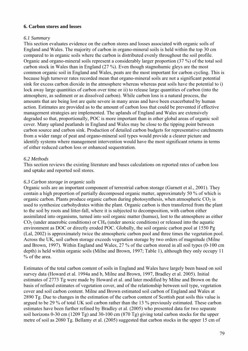
79
6. Carbon stores and losses 6.1 Summary This section evaluates evidence on the carbon stores and losses associated with organic soils of England and Wales. The majority of carbon in organo-mineral soils is held within the top 30 cm compared to in organic soils where the carbon is distributed evenly throughout the soil profile. Organic and organo-mineral soils represent a considerably larger proportion (37 %) of the total soil carbon stock in Wales than in England (27 %). Even though stagnohumic gleys are the most common organic soil in England and Wales, peats are the most important for carbon cycling. This is because high turnover rates recorded mean that organo-mineral soils are not a significant potential sink for excess carbon dioxide in the atmosphere whereas whereas peat soils have the potential to i) lock away large quantities of carbon over time or ii) to release large quantities of carbon (into the atmosphere, as sediment or as dissolved carbon). While carbon loss is a natural process, the amounts that are being lost are quite severe in many areas and have been exacerbated by human action. Estimates are provided as to the amount of carbon loss that could be prevented if effective management strategies are implemented. The uplands of England and Wales are extensively degraded so that, proportionally, POC is more important than in other global areas of organic soil cover. Many upland peatlands in England and Wales may be close to the tipping point between carbon source and carbon sink. Production of detailed carbon budgets for representative catchments from a wider range of peat and organo-mineral soil types would provide a clearer picture and identify systems where management intervention would have the most significant returns in terms of either reduced carbon loss or enhanced sequestration. 6.2 Methods This section reviews the existing literature and bases calculations on reported rates of carbon loss and uptake and reported soil stores. 6.3 Carbon storage in organic soils Organic soils are an important component of terrestrial carbon storage (Garnett et al., 2001). They contain a high proportion of partially decomposed organic matter, approximately 50 % of which is organic carbon. Plants produce organic carbon during photosynthesis, when atmospheric CO2 is used to synthesize carbohydrates within the plant. Organic carbon is then transferred from the plant to the soil by roots and litter-fall, where it is subjected to decomposition, with carbon either assimilated into organisms, turned into soil organic matter (humus), lost to the atmosphere as either CO2 (under anaerobic conditions) or CH4 (under anoxic conditions) or released into the aquatic environment as DOC or directly eroded POC. Globally, the soil organic carbon pool at 1550 Pg (Lal, 2002) is approximately twice the atmospheric carbon pool and three times the vegetation pool. Across the UK, soil carbon storage exceeds vegetation storage by two orders of magnitude (Milne and Brown, 1997). Within England and Wales, 27 % of the carbon stored in all soil types (0-100 cm depth) is held within organic soils (Milne and Brown, 1997; Table 1), although they only occupy 11 % of the area. Estimates of the total carbon content of soils in England and Wales have largely been based on soil survey data (Howard et al. 1994a and b, Milne and Brown, 1997, Bradley et al. 2005). Initial estimates of 2773 Tg were made by Howard et al. and later modified by Milne and Brown on the basis of refined estimates of vegetation cover, and of the relationship between soil type, vegetation cover and soil carbon content. Milne and Brown estimated soil carbon of England and Wales at 2890 Tg. Due to changes in the estimation of the carbon content of Scottish peat soils this value is argued to be 29 % of total UK soil carbon rather than the 13 % previously estimated. These carbon estimates have been further refined by Bradley et al. (2005) who presented data for two separate soil horizons 0-30 cm (1209 Tg) and 30-100 cm (870 Tg) giving total carbon stocks for the upper metre of soil as 2080 Tg. Bellamy et al. (2005) suggested that carbon stocks in the upper 15 cm of
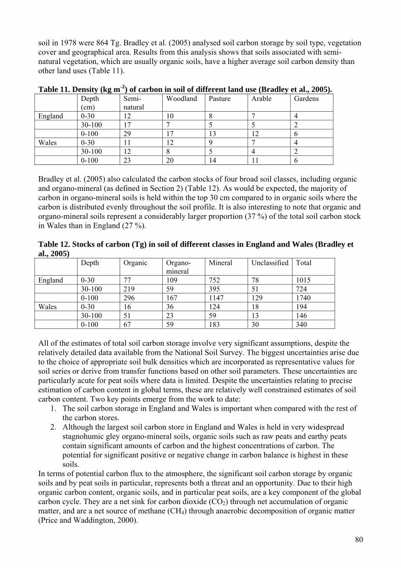
80
soil in 1978 were 864 Tg. Bradley et al. (2005) analysed soil carbon storage by soil type, vegetation cover and geographical area. Results from this analysis shows that soils associated with semi-natural vegetation, which are usually organic soils, have a higher average soil carbon density than other land uses (Table 11). Table 11. Density (kg m-2) of carbon in soil of different land use (Bradley et al., 2005). Depth
(cm) Semi-natural
Woodland Pasture Arable Gardens
England 0-30 12 10 8 7 4 30-100 17 7 5 5 2 0-100 29 17 13 12 6 Wales 0-30 11 12 9 7 4 30-100 12 8 5 4 2 0-100 23 20 14 11 6 Bradley et al. (2005) also calculated the carbon stocks of four broad soil classes, including organic and organo-mineral (as defined in Section 2) (Table 12). As would be expected, the majority of carbon in organo-mineral soils is held within the top 30 cm compared to in organic soils where the carbon is distributed evenly throughout the soil profile. It is also interesting to note that organic and organo-mineral soils represent a considerably larger proportion (37 %) of the total soil carbon stock in Wales than in England (27 %). Table 12. Stocks of carbon (Tg) in soil of different classes in England and Wales (Bradley et al., 2005) Depth Organic Organo-
mineral Mineral Unclassified Total
England 0-30 77 109 752 78 1015 30-100 219 59 395 51 724 0-100 296 167 1147 129 1740 Wales 0-30 16 36 124 18 194 30-100 51 23 59 13 146 0-100 67 59 183 30 340 All of the estimates of total soil carbon storage involve very significant assumptions, despite the relatively detailed data available from the National Soil Survey. The biggest uncertainties arise due to the choice of appropriate soil bulk densities which are incorporated as representative values for soil series or derive from transfer functions based on other soil parameters. These uncertainties are particularly acute for peat soils where data is limited. Despite the uncertainties relating to precise estimation of carbon content in global terms, these are relatively well constrained estimates of soil carbon content. Two key points emerge from the work to date:
1. The soil carbon storage in England and Wales is important when compared with the rest of the carbon stores.
2. Although the largest soil carbon store in England and Wales is held in very widespread stagnohumic gley organo-mineral soils, organic soils such as raw peats and earthy peats contain significant amounts of carbon and the highest concentrations of carbon. The potential for significant positive or negative change in carbon balance is highest in these soils.
In terms of potential carbon flux to the atmosphere, the significant soil carbon storage by organic soils and by peat soils in particular, represents both a threat and an opportunity. Due to their high organic carbon content, organic soils, and in particular peat soils, are a key component of the global carbon cycle. They are a net sink for carbon dioxide (CO2) through net accumulation of organic matter, and are a net source of methane (CH4) through anaerobic decomposition of organic matter (Price and Waddington, 2000).
81
The large amount of carbon tied up in organic soils means that preservation of these soils should be a priority. Under changing climatic conditions, preservation of these largely wetland soils will be challenging. The opportunity presented by the magnitude of soil carbon storage is that restoration and enhancement of the many degraded sites across England and Wales will enhance rates of carbon sequestration. Proper assessment of the risks and opportunities associated with the management of organic soils requires detailed understanding of mechanisms of carbon uptake and release from these systems. In the following sections, understanding of these processes is reviewed and the state of specific knowledge about the organic soils of England and Wales is assessed. 6.4 Carbon flux from organic soils Figure 21 is a representation of the carbon balance of a peat soil. Two principal modes of carbon exchange can be identified: gaseous exchange which is controlled by photosynthetic fixation of carbon from the atmosphere and by soil respiration losses of CO2 and by methanogenesis from saturated soils; and the fluvial carbon flux which can be subdivided into dissolved losses (dissolved organic carbon (DOC) and dissolved inorganic carbon (DIC)) and particulate losses (particulate organic carbon (POC)).
DOCDICPOC
GaseousCh4
Peatland Carbon Store
Weathering Input
Dissolved CO2
RainfallNet Gaseous CO
Exchange2
Figure 21. Principal carbon fluxes from organic soils (source: after Worrall et al. 2003a).
Figure 22. Components of the peat carbon cycle (source: from Holden, 2005c)

82
The apparent simplicity of Figure 21 hides very significant complexity in the processes controlling carbon flux in organic soils. Figure 22 summarises some of the key processes. Of the major organic carbon fluxes the gaseous flux and DOC flux are the most studied and particulate carbon fluxes are less well studied. The principal controls on each of the main fluxes are considered below. The nature of peat soils and organo-mineral soils are considered separately. 6.5 Carbon flux from peat soils 6.5.1 Gaseous exchanges Gaseous carbon flux from soils takes two forms, exchange of carbon dioxide and losses of methane, particularly from saturated soils. These are considered separately below. 6.5.1.1 CO2 exchange in peat soils CO2 release from peatlands is determined by the balance of carbon fixation by photosynthesis and carbon released through plant respiration and mineralization of soil organic carbon.. Estimates for primary productivity of bog surfaces vary from 42-1118 g m-2 a-1 (Bradbury and Grace 1983, Charman, 2002), although most reported values for raw peats are in a lower range of 100-500 g m-2 a-1 (Worrall et al. 2003a, Cannell et al., 1999, Clymo et al. 1998). In general in oligotrophic bogs primary productivity increases with higher water tables (Clymo 1983). Fixation of carbon through primary productivity is balanced by rates of decomposition in the litter and upper peat layers and slower decomposition at depth (Clymo et. al. 1998). The majority of decomposition is through microbial activity and is strongly controlled by water table and by temperature (Charman 2002). Under normal peat temperature ranges, CO2 production increases by three-fold for every 10oC increase, but this varies with depth and it is not clear what controls the temperature dependency of carbon mineralization rates (Blodau, 2002). The development of anaerobic conditions below the water table causes the suppression of microbial enzymatic decomposition (Freeman et al., 2001b). Since higher water table tends to promote higher productivity and lower decomposition, it is unsurprising that rates of peat growth and of CO2 flux from peatlands are well correlated with mean water table. Rates of carbon sequestration are known to vary in time and variable degrees of peat decomposition are one of the techniques used to reconstruct climatic wetness from peat stratigraphies (e.g. Blackford and Chambers, 1995). It is therefore unsurprising that direct measurement demonstrates a clear control of water table on CO2 flux (Silvola et. al. 1996) so that CO2 flux to the atmosphere increases with reductions in water table. 6.5.1.2 Methane flux from peat soils Methane is produced in anaerobic conditions by methanogenic bacteria in peat. Both temperature (Dise et al. 1993) and water table (Bubier et al. 1993) are key controls on methane production. Since water table fluctuations have opposite effects on methane production to CO2 production, the net effects of water table drawdown in peat soils are complex. Fluxes of CH4 may range from a minor uptake into the peat to emissions of 1000 mg m-2 d-1 (Klinger et al., 1994) with average emissions of 5-80 mg m-2 d-1 most common in northern peatlands (Blodau, 2002). The largest emissions are often restricted to lawns and hollows on bogs. Fens tend to have even greater emissions, as the anaerobic zone is closer to the surface. CH4 is released via diffusion, ebullition (bubbles released from saturated peat) and plant transport via root tissues to the atmosphere. 6.5.1.3 Net gaseous balance of organic soils in England and Wales Very little published data exists on gaseous carbon exchange for organic soils in England and Wales although there is a rapidly increasing amount of work ongoing. Most available data is on net carbon exchange based on carbon accumulation rates. Cannell et al. (1999) suggested typical rates of 40-70 g C m-2 a-1 for British peats suggesting that the peatlands are small net sinks of gaseous carbon. A particular issue for many organic soils in England and Wales is the extent of drainage (Holden et al. 2004) and this is an area which has received considerable attention in the international literature on gaseous carbon flux. Drainage of peat produces lowered water tables around the drains and
83
consequently increased CO2 production and reduced methane emission (Laine et al., 1996). Silvola (1996) showed that for drained and afforested peatlands in Finland, CO2 flux switched from a sink of 25 g m-2 a-1 to a source of 250 g m-2 a-1. Conversely, Van den Bos (2003) has shown that the rewetting of drained Dutch peatlands leads to an overall decrease in greenhouse gas emissions due to reduced CO2 flux and only slightly increased methane flux. Cannell et al. (1993) argued that for UK peatlands drainage for forestry is likely to lead to a net loss of carbon if CO2 losses exceed 200 gC m-2 a-1
. Modelling of the effects of peatland drainage by Van Huissteden et al. (2006) based on Dutch lowland peats shows increased CO2 flux due to drainage and a reduction on rewetting that is significantly offset by increased methane flux. Given the relative paucity of direct measurement of gaseous carbon flux in the peatlands of England and Wales, and the extent of both natural and artificial drainage, these results suggest that fixation of gaseous carbon in these systems may be somewhat below average values from the international literature. 6.5.2 Dissolved organic carbon Organic material is often leached as DOC and the export from temperate peatlands ranges between 1 and 50 g DOC m-2 a-1 (e.g. Dillon and Molot, 1997), which typically represents around 10 % of the carbon release. In downstream ecosystems, DOC exerts significant control over productivity, biogeochemical cycles and attenuation of visible and UV radiation (Pastor et al., 2003). In addition, DOC impacts water quality in terms of colour, taste, safety, and aesthetic value, as well as altering the acid-base and metal complexation characteristics of soil water and streamwater. Loss of organic carbon in dissolved form is one of the best studied carbon fluxes from peatland systems, in part because of the impact of associated water colour problems on the water supply industry. There is better information on DOC flux in England and Wales than any other component of the carbon balance (e.g. Hope et al., 1997a; Freeman et al. 2001a; Neal et al. 2005; Worrall et al., 2004a, b; Evans et al. 2005c). DOC is largely composed of humic and fulvic acids together with polysaccharides. DOC production is mediated by microbial action in the upper aerobic soil horizons. Radiocarbon measurements of DOC in peatland soils confirm that most production (Schiff et al. 1998; Chasar et al. 2000) occurs in the uppermost peat and vegetation horizons. DOC accumulates in soil solution and is flushed into stream systems by subsurface flow during and after rainfall events. Consequently, elevated DOC concentrations are commonly observed after drought periods when water tables have been drawn down, increasing the depth of the aerobic zone, and DOC concentrations in soil solutions have increased. Chow et al. (2006) have demonstrated that the aerobic zone of agriculturally drained peat soils in California is a significant source of DOC and that rates of carbon mineralization were proportional to DOC concentration in these surface soils, implying that DOC is a significant precursor to atmospheric carbon release. Long term trends in DOC production from peatlands in England and Wales are significantly up. Evans et al. (2005c) demonstrated an average increase of 91 % at Acid Waters Monitoring Network sites over the past 15 years. Similar results were presented by Freeman et al. (2001a), while Worrall et al. (2004a) have demonstrated that 77 % of 198 long term UK DOC records show positive trends and none show significant negative trends. The reasons for these long term trends are not firmly established although there are several hypotheses as to the main mechanisms including:
1. Mechanisms associated with the activity of phenol oxidase as a key regulator of decomposition rates in peat soils such as:
• Reduced water tables leading to more extensive aerobic conditions in the upper layers of the soils, increased phenol oxidase activity and accelerated decomposition (Freeman et al. 2001b). Periods of low water table followed by rewetting tend to produce maximum

84
DOC flux as DOC produced under aerobic conditions is flushed into stream systems (Mitchell and McDonald, 1992).
• Increased phenol oxidase activity under elevated CO2 concentrations (Freeman et. al. 2004).
• Increased phenol oxidase activity at higher temperatures (Freeman et al. 2001b). These mechanisms have been demonstrated in laboratory conditions in a series of papers by Freeman (2001a, b, 2004). Field evidence is strongest for the effect of water table and for temperature effects (Worrall et al., 2003b, Freeman, 2001a, Chapman et al. 1995), although Worrall et al. (2004b) suggest that that temperature alone is not sufficient to account for observed trends.
2. Mechanisms associated with acid deposition: It has been suggested that deposition of high levels of mineral acidity have the potential to suppress DOC production (Krug and Frink, 1983). It is therefore possible that the observed changes in long-term DOC production are associated with the well documented reduction in levels of acid deposition in upland areas of the UK (e.g. Skeffington et al., 1997). Clark et al. (2005) have demonstrated that reduced water tables and consequent oxidation of reduced sulphur stored in polluted upper layers of peat significantly reduce flux of DOC from deep peat catchments in the Northern Pennines.
Evans et al. (2005c) demonstrated statistically that the best predictor of observed trends in DOC flux across all UK acid water monitoring sites are temperature and acid deposition. It should be noted, however, that there is good evidence from single catchments of drought and drainage effects on long term DOC flux (Worrall et al. 2004b, 2006). Land use effects are of particular relevance to efforts to preserve soil carbon. Long-term increases in DOC flux driven by temperature or pollution mean that the potential to minimise DOC flux increases through land management may be more important. The upland peats of England and Wales are extensively drained, and the effect of these drains is to produce local reductions in water table, particularly downslope of the drains. It might be expected that some increase in DOC is associated with the cutting of drains. The observational evidence on this point is, however, equivocal (Holden et al. 2004). Efforts are now being made to block land drains in many peatland areas with the aim of raising water tables and restoring hydrological function to wetlands. In the short to medium-term this may also lead to elevated DOC flux. Effectively, the drainage and blocking simulates a long term drought and flooding cycle which tends to promote flushing of DOC. Aguilar and Thibodeaux (2005) have modelled significant release of DOC from flooded peat soils, assuming initial rapid release of DOC from soil pores, and Hughes et al. (1998) have demonstrated elevated DOC concentrations and changes in the nature of DOC towards higher molecular weight molecules associated with rewetting of a naturally drained peatland. The timescale of these effects needs further investigation. Holden et al. (2006) have demonstrated that changes in runoff regime in drained systems develop over periods in excess of 20 years and that major alteration to flow pathways may occur. The extent to which physical restoration and consequently hydro chemical recovery of drained peatlands is possible is unclear, although it should be noted that reductions in the gaseous carbon flux to the atmosphere are also expected due to restoration as noted above.. 6.5.3 Dissolved inorganic carbon DIC is the least studied component of the carbon flux and is a relatively small component of the overall flux (Worrall et al., 2003b). Detailed modelling of DIC flux by Worrall et al., (2003b) suggested that DIC production is a function of soil respiration and is largely controlled by temperature.
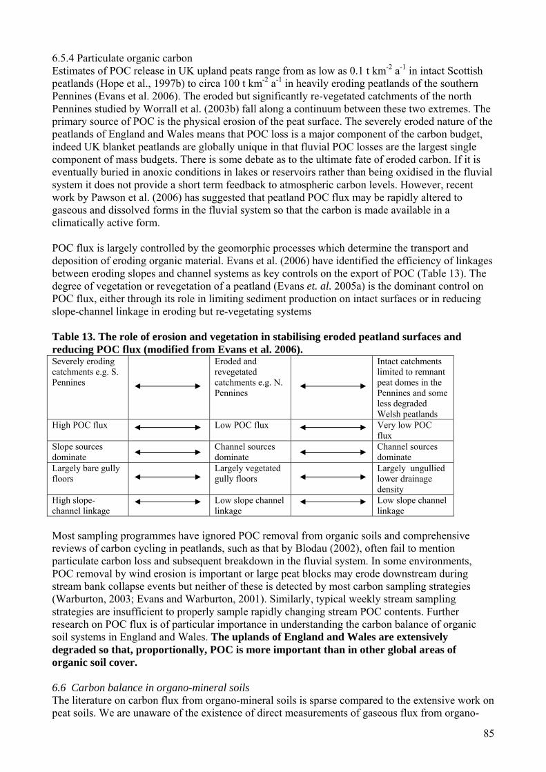
85
6.5.4 Particulate organic carbon Estimates of POC release in UK upland peats range from as low as 0.1 t km-2 a-1 in intact Scottish peatlands (Hope et al., 1997b) to circa 100 t km-2 a-1 in heavily eroding peatlands of the southern Pennines (Evans et al. 2006). The eroded but significantly re-vegetated catchments of the north Pennines studied by Worrall et al. (2003b) fall along a continuum between these two extremes. The primary source of POC is the physical erosion of the peat surface. The severely eroded nature of the peatlands of England and Wales means that POC loss is a major component of the carbon budget, indeed UK blanket peatlands are globally unique in that fluvial POC losses are the largest single component of mass budgets. There is some debate as to the ultimate fate of eroded carbon. If it is eventually buried in anoxic conditions in lakes or reservoirs rather than being oxidised in the fluvial system it does not provide a short term feedback to atmospheric carbon levels. However, recent work by Pawson et al. (2006) has suggested that peatland POC flux may be rapidly altered to gaseous and dissolved forms in the fluvial system so that the carbon is made available in a climatically active form. POC flux is largely controlled by the geomorphic processes which determine the transport and deposition of eroding organic material. Evans et al. (2006) have identified the efficiency of linkages between eroding slopes and channel systems as key controls on the export of POC (Table 13). The degree of vegetation or revegetation of a peatland (Evans et. al. 2005a) is the dominant control on POC flux, either through its role in limiting sediment production on intact surfaces or in reducing slope-channel linkage in eroding but re-vegetating systems Table 13. The role of erosion and vegetation in stabilising eroded peatland surfaces and reducing POC flux (modified from Evans et al. 2006). Severely eroding catchments e.g. S. Pennines
Eroded and revegetated catchments e.g. N. Pennines
Intact catchments limited to remnant peat domes in the Pennines and some less degraded Welsh peatlands
High POC flux Low POC flux Very low POC flux
Slope sources dominate
Channel sources dominate
Channel sources dominate
Largely bare gully floors
Largely vegetated gully floors
Largely ungullied lower drainage density
High slope-channel linkage
Low slope channel linkage
Low slope channel linkage
Most sampling programmes have ignored POC removal from organic soils and comprehensive reviews of carbon cycling in peatlands, such as that by Blodau (2002), often fail to mention particulate carbon loss and subsequent breakdown in the fluvial system. In some environments, POC removal by wind erosion is important or large peat blocks may erode downstream during stream bank collapse events but neither of these is detected by most carbon sampling strategies (Warburton, 2003; Evans and Warburton, 2001). Similarly, typical weekly stream sampling strategies are insufficient to properly sample rapidly changing stream POC contents. Further research on POC flux is of particular importance in understanding the carbon balance of organic soil systems in England and Wales. The uplands of England and Wales are extensively degraded so that, proportionally, POC is more important than in other global areas of organic soil cover. 6.6 Carbon balance in organo-mineral soils The literature on carbon flux from organo-mineral soils is sparse compared to the extensive work on peat soils. We are unaware of the existence of direct measurements of gaseous flux from organo-
86
mineral soils in England and Wales. There are estimates of carbon turnover from northern England. Bol et al. (1999) modelled carbon flux from organo-mineral soils (stagnopodzols and stagnohumic gleys) in the north Pennines based on carbon isotope measurements. They demonstrated that 80 % of the modelled carbon turnover is derived from the upper 5 cm of the soil, predominantly the Lf and Oh horizons. This implies that turnover of soil carbon in these soils is rapid. Estimated flux from the podzolic soils was significantly greater than from the gleys but the upper 28 cm of the gleys contained more than twice the average carbon content of the other soils. These observations are a function of the frequently saturated upper horizons of gleys. This implies that gley soil carbon stores are at risk from changes in hydroclimate as well as increases in respiration rates due to warming. The high turnover rates recorded also mean that organo-mineral soils are not a significant potential sink for excess carbon dioxide in the atmosphere. Significant DOC flux is commonly observed from stagnohumic gleys. Hagedorn et al. (2000) report DOC fluxes of 8.4 – 18.5 t km-2 a-1 from Swiss grassland and alpine catchments. These fluxes are of a similar order to reported DOC fluxes from peatland systems (e.g. Worrall et al. 2003b). DOC flux from organo-mineral soils in Wales is well documented in the Plynlimon experimental catchment and Neale et al. (2005) demonstrated that significant long term increases in DOC flux were observed over a 20-year period to 2003. The trends are similar to those observed for peat soils and may indicate the importance of temperature and water table variation in controlling DOC release from stagnohumic gleys and stagnopodzols. There is little specific information on POC flux from organo-mineral soils. McHugh et al. (2002) record that the area of ‘eroded wet peaty soils’ in England and Wales is little more than a third of the area of eroded peats. Organo-mineral soils are more widespread than raw peats so the implication is that POC production from organo-mineral soils is perhaps an order of magnitude less than that from peats. This is, however, a large assumption since there is no information in McHugh et al. (2002) concerning rates of erosion, and the dominant erosion mechanisms are likely to vary significantly between peatlands and other organic soils. 6.7 Carbon budgets and net carbon loss for organic soils The relative importance of carbon fluxes described above has typically been investigated in studies at relatively small spatial scales. At larger scales, net carbon flux determined from measured changes in carbon storage provides an opportunity to examine spatial variation in the net carbon flux. 6.7.1 Carbon budgets at catchment scale The controls on carbon flux from peatlands are much better studied than those for other organic soils. Table 14 represents the carbon budget of a small upland blanket peat catchment from the North Pennines (Trout Beck) (Worrall et al. 2003b). This study is relatively unusual in that it measures, or estimates, the complete carbon budget for a small upland catchment. The catchment, on the Moor House National Nature reserve in Upper Teesdale has been significantly affected by gully erosion, and parts of the catchment are affected by land drainage. Much of the eroded area is significantly re-vegetated. For Trout Beck, the largest single component of the budget is the fixation of carbon. This figure is the net balance of carbon dioxide fixed by photosynthesis and lost through soil respiration. The range of 40-70 g m-2 a-1 is taken from the work of Cannell et al. (1993) and is approximately consistent with a range of observations of bog carbon flux (Worrall et al. 2003b). The Trout Beck catchment in the North Pennines cannot be in any sense representative of upland peatlands in England and Wales. In the southern Pennines, more active erosion and lower water tables are likely to tilt the balance towards the peatland as a carbon source. Evans et al. (2006) for example, have recorded POC fluxes five times higher in a South Pennine system. For less impacted systems in Wales, net sequestration may be higher. For a headwater peatland stream in Wales,
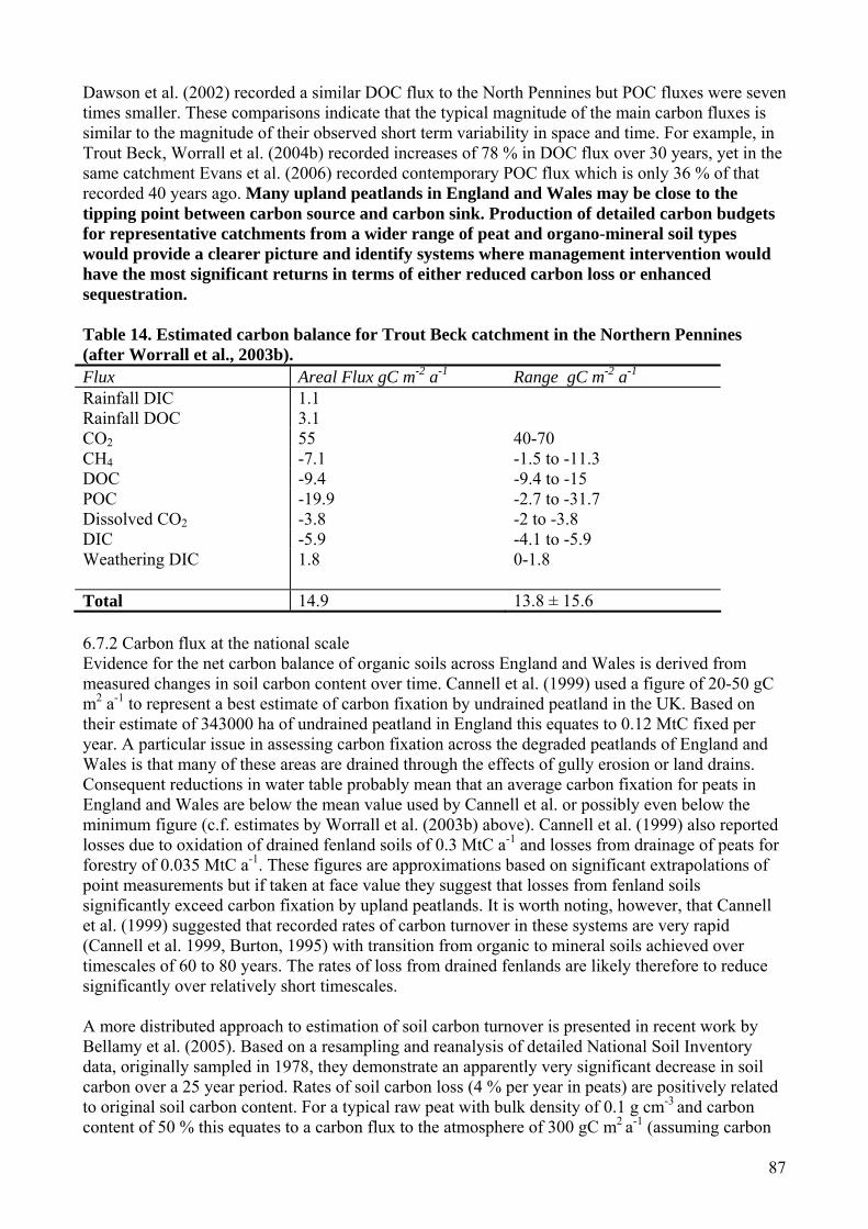
87
Dawson et al. (2002) recorded a similar DOC flux to the North Pennines but POC fluxes were seven times smaller. These comparisons indicate that the typical magnitude of the main carbon fluxes is similar to the magnitude of their observed short term variability in space and time. For example, in Trout Beck, Worrall et al. (2004b) recorded increases of 78 % in DOC flux over 30 years, yet in the same catchment Evans et al. (2006) recorded contemporary POC flux which is only 36 % of that recorded 40 years ago. Many upland peatlands in England and Wales may be close to the tipping point between carbon source and carbon sink. Production of detailed carbon budgets for representative catchments from a wider range of peat and organo-mineral soil types would provide a clearer picture and identify systems where management intervention would have the most significant returns in terms of either reduced carbon loss or enhanced sequestration. Table 14. Estimated carbon balance for Trout Beck catchment in the Northern Pennines (after Worrall et al., 2003b). Flux Areal Flux gC m-2 a-1 Range gC m-2 a-1 Rainfall DIC 1.1 Rainfall DOC 3.1 CO2 55 40-70 CH4 -7.1 -1.5 to -11.3 DOC -9.4 -9.4 to -15 POC -19.9 -2.7 to -31.7 Dissolved CO2 -3.8 -2 to -3.8 DIC -5.9 -4.1 to -5.9 Weathering DIC
1.8 0-1.8
Total 14.9 13.8 ± 15.6 6.7.2 Carbon flux at the national scale Evidence for the net carbon balance of organic soils across England and Wales is derived from measured changes in soil carbon content over time. Cannell et al. (1999) used a figure of 20-50 gC m2 a-1 to represent a best estimate of carbon fixation by undrained peatland in the UK. Based on their estimate of 343000 ha of undrained peatland in England this equates to 0.12 MtC fixed per year. A particular issue in assessing carbon fixation across the degraded peatlands of England and Wales is that many of these areas are drained through the effects of gully erosion or land drains. Consequent reductions in water table probably mean that an average carbon fixation for peats in England and Wales are below the mean value used by Cannell et al. or possibly even below the minimum figure (c.f. estimates by Worrall et al. (2003b) above). Cannell et al. (1999) also reported losses due to oxidation of drained fenland soils of 0.3 MtC a-1 and losses from drainage of peats for forestry of 0.035 MtC a-1. These figures are approximations based on significant extrapolations of point measurements but if taken at face value they suggest that losses from fenland soils significantly exceed carbon fixation by upland peatlands. It is worth noting, however, that Cannell et al. (1999) suggested that recorded rates of carbon turnover in these systems are very rapid (Cannell et al. 1999, Burton, 1995) with transition from organic to mineral soils achieved over timescales of 60 to 80 years. The rates of loss from drained fenlands are likely therefore to reduce significantly over relatively short timescales. A more distributed approach to estimation of soil carbon turnover is presented in recent work by Bellamy et al. (2005). Based on a resampling and reanalysis of detailed National Soil Inventory data, originally sampled in 1978, they demonstrate an apparently very significant decrease in soil carbon over a 25 year period. Rates of soil carbon loss (4 % per year in peats) are positively related to original soil carbon content. For a typical raw peat with bulk density of 0.1 g cm-3 and carbon content of 50 % this equates to a carbon flux to the atmosphere of 300 gC m2 a-1 (assuming carbon
88
loss from the upper 15 cm). This value is well below the 1200 g C m2 a-1 which Cannell et al. (1999) suggested as rates of loss for fenland soils but far exceeds measured rates of carbon loss from peatland systems (e.g. Worrall et al., 2003b) and contradicts the suggestion by Cannell et al. (1999) that undrained peatlands are a small net carbon sink. There are a range of reasons why the Bellamy et al. (2005) figures need verification:
1. Bellamy et al. (2005) use a regression equation to predict bulk density from carbon content which produces a density of 0.86 g cm-3 for soils with 50 % carbon content (i.e. peats) which is significantly different from typical dry bulk densities for peatlands described above.
2. In accumulating peatlands, circa 10 % of the measured soil will be newly formed within the 25-year period of the survey, precluding like for like comparison.
3. It is unclear why there should be a change in carbon content associated with decomposition of an entirely organic soil.
4. Carbon content of peat soils was estimated from loss on ignition measurements corrected by a standard carbon content. This method differs from that used for less organic soils. It is unfortunate that direct total carbon measurements are not available to rule out the possibility of systematic variation associated with this approach.
5. The inorganic components of upland peat soils are largely derived from atmospheric dust deposition so that the results could reflect variable dilution of organic content as well as oxidation of carbon.
The data of Bellamy et al. (2005) are very valuable and alarming. The apparent magnitude of soil carbon loss is such that verification of the results by independent means is urgently required. Confirmation that the results are representative requires comparison with representative sites where detailed process monitoring can confirm the apparent scale of carbon loss. 6.8 Peatlands and organic carbon; risks and opportunities It is clear from the analysis above that while considerable progress has been made in the understanding of carbon flux in organic soil systems, the ability to quantitatively model carbon response to changing environmental and land management conditions is some way off. Similarly, given the sensitivity of organic soil systems to changes in temperature and moisture regimes, predictions based on changes in average conditions are unlikely to be reliable. Key controls on carbon flux are likely to include drought and rainfall frequency parameters that are predicted with less certainty in climate models. Consequently in the following section rather than attempt detailed scenario modelling, the likely direction of change in the carbon balance associated with various land use and climate changes is suggested and the main carbon balance risks and opportunities associated with the management of organic soils are identified. 6.8.1 Risks 6.8.1.1 Drainage As noted previously, the peatlands of England and Wales are extensively drained. The available evidence, largely from Scandinavia, on the effects of drainage on carbon storage is equivocal. However, these catchments are largely drained for forestry so that increased carbon fixation by trees is a factor. It is probable that increased CO2 flux from catchments cut by land drains will significantly reduce carbon storage. The effects of drainage on DOC flux appear to be variable (Holden et al., 2004), although there is some evidence of increased water colour associated with drainage (Edwards et al. 1987; Wallage et al., 2006). The effect of drainage is to draw down the water table around the drains. One of the predicted effects of climate change is warmer, drier summers and consequently lower water tables. The combined effects are likely to significantly increase CO2 flux, potentially to increase DOC flux and in the extreme case potentially to threaten the physical stability of the mire surface leading to erosion and increased POC flux.

89
Landowners are currently given incentives to block drains rather than to cut them so it is unlikely that extensive new drain cutting will occur. From the perspective of carbon preservation, the precautionary approach should be a presumption against drain cutting. Given that the trend is against drain cutting, the extensively drained nature of the peatlands might be regarded as an opportunity to restore carbon sink status to large areas. This is discussed further below. 6.8.1.2 Fire Fire impacts on the soil carbon balance by burning litter and surface peat and by reducing the productivity of the vegetation layer. Pitkaenen et al. (1999) working in Finnish mires determined that carbon sequestration at regularly burned sites was half that at unburned sites. The average carbon loss associated with a single fire was loss of 2500 gC m-2. Similarly, Kuhry (1994) has used peat core data to demonstrate that rates of peat accumulation in Boreal Canada reduce with increased frequency of wildfires. Garnett et al. (2000) showed that decadal burning of organic soils in northern England led to significant reductions in carbon fixation. Regularly management burns and wildfires appear, therefore, to have a negative impact on carbon fixation. From a carbon management point of view, the preferred management approach is to avoid burning on organic soils. Wildfire has a second effect which is to trigger erosion. Wildfires burn deeper and hotter than well managed burns so that plant roots are killed leading to break up of the surface and physical erosion. There are many documented examples of extreme erosion associated with wildfire events (e.g. Tallis, 1997a, Maltby et al., 1990). Rapid erosion leads to very high POC export from the system. The major carbon flux risk associated with fire is increased frequency of wildfire associated with warmer, drier summers. Mitigation will involve increasingly sophisticated fire protection, public education in the risks of wildfire, and development of effective means of rapid revegetation of wildfire scars. 6.8.1.3 Erosion As discussed above, the peatlands of England and Wales are heavily eroded and POC flux from these systems is a significant part of the overall carbon budget. This suggests that there may be potential for mitigation of carbon loss through restoration. However, there is also a potential risk of new or accelerated erosion. Two particular risks are identified:
1. Expansion of present eroded area through headward erosion. The high drainage density associated with eroding upland peatlands generates a risk of relatively rapid headward extension of channels. The main risk to POC loss occurs where this headward extension occurs in the absence of revegetation in the lower channels (Evans and Warburton, 2005). Headward extension will also extend the area of naturally drained peat and impact on gaseous and dissolved carbon fluxes. Mitigation of headward extension will require active restoration of gully eroded systems.
2. Changes associated with climate change.
The most significant risk to the physical integrity of peatlands in England and Wales is posed by climate change. Peat bogs are climatically determined landforms and the major processes which cause physical erosion are climatically controlled. Identification of the direction of change from process understanding is difficult. Summer drought and increased storminess are liable to increase sediment production and export on bare peat surfaces but reduced frost frequency and an extended growing season should promote revegetation and reduce sediment supply (Table 15).
On this basis the net effect might be a more dynamic mosaic of eroding and re-vegetating peatland surfaces (Evans and Warburton, in press). There is a risk, however, that the combination of summer drought and winter storminess promotes very considerable physical instability. The work of Tallis (1994, 1995a, 1997b) has demonstrated an association between the onset of widespread erosion in

90
the southern Pennines and historic climate changes (both warming and increased storminess, historically separated in time). Although there are no local solutions to mitigate climate changes, practical conservation measures may have the potential to limit ongoing erosion (see Section 8). To give these approaches the maximum chance of success it is important that other extrinsic pressures on the peatland vegetation, which are to some extent controllable, particularly fire and grazing are minimised. Table 15. Hydrological and erosional consequences of climate change on upland peat in Britain (source: after Evans and Warburton, in press). Climatic change Hydrological change Erosional impact
Increased summer and autumn drought
Lower water tables (greater acrotelm depth)
Peat shrinkage and desiccation Aeolian (dry blow) erosion
Increased summer and winter storminess
Increased storm runoff Accelerated erosion of bare peat areas (rain splash and wash) and increased channel erosion and gullying. Increase in peat mass movements.
Extended growing season Greater evapotranspiration (minor)
Reduced erosion due to revegetation of bare peat areas and more mature vegetation blanket.
Reduced frost frequency Reduced impact of snowmelt events
Less frost heave disturbance Less disruption to newly established vegetation.
6.8.1.4 Climate change The potential effects of climate change on peatland systems are complex. There are direct temperature and CO2 concentration effects on fixation and decomposition in carbon, changes associated with potentially changing water tables and the potential effects of erosion as discussed above. Much of the work on climate change and peatland carbon flux assumes that water table changes are the key drivers (e.g. Moore et al., 1998) and uses the analogy of drained systems to identify potential changes (e.g. Laine et al. 1996.). This approach ignores the potential temperature and CO2 effects (Charman, 2002). The potential effects of physical instability of peatlands associated with desiccation are also commonly overlooked. Given the complexity of the system, the degree of spatial variability and the gaps in present understanding of the carbon dynamics of the peatlands of England and Wales, the best that can be achieved is prediction of direction of change. This was the approach adopted by Moore et al. (1998) dealing with northern peatland systems. Table 16 presents the estimates of Moore et al. (1998) with an added class of degraded upland peatlands intended as representative of typical conditions in upland England and Wales, and with consideration of potential POC changes. What the estimates of Table 16 suggest is that the effects of climate change will not be spatially uniform. However, the location of peatlands is climatically determined. Drying out of peatlands is likely to accelerate CO2 production and dissolved carbon losses and may promote physical instability. It may not be possible to preserve marginal peatlands in the long term. Minimising loss of carbon associated with the other risks here will at least slow the rate of carbon loss from these systems.

91
Table 16. Estimated direction of change in climate and carbon fluxes from peatlands (after Moore et al., 1998). Wetness Dry Moist Wet Dry Dry Peatland type Hummock/Plateau Lawn-swamp Floating mat-
pond Degraded upland peat
Degraded lowland organic soils
Environmental change
CO2 concentration Doubled+++ Doubled+++ Doubled+++ Doubled+++ Doubled+++ Peat Temperature Warmer+++ Warmer+++ Warmer+++ Warmer+++ Warmer++ Water table position Lower (hummock)++
Higher (plateau) Lower++ No change
(mat++) Lower (Pool++)
Lower ++ Lower +
Peatland response CO2 exchange Smaller sink or
source (hummock)+ Larger sink (Plateau)+
Smaller sink+ Larger sink+ Smaller sink or possible source++
Larger+
CH4 emission Smaller (hummock)++ Larger (plateau)+
Smaller++ Smaller++ Larger++ Larger+
DOC flux Smaller (hummock)+ Larger (plateau)+
Smaller ++ Smaller ++ Smaller+ Smaller or neutral+
POC Loss Larger+ Larger+ No Change+ Larger++ Slightly larger+ C storage Possibly net loss
(hummock)+ Larger (plateau)+
Smaller+ Larger+ Possibly net loss, (or increased magnitude of loss)++
Possibly net loss (variable across soil types)+
+++ Reasonably Confident, ++ moderately confident, + least confident 6.8.2 Opportunities – restoration and carbon flux Effective erosion control in organic soils involves limitation of grazing density, control of wildfires, and reduction of pollution such that natural revegetation occurs. Given appropriate conditions this process can be initiated and accelerated by restoration interventions. Two main approaches have been adopted to the restoration of degraded organic soils in the uplands. The first, stemming from the work of the Moorland Erosion Reports (Phillips et al. 1981; Tallis and Yalden, 1983; Anderson et al. 1997) involves the restoration of large areas through liming and application of a nurse grass crop to bare areas, followed by seeding with heather. This is the primary approach being adopted in current restoration in the Peak District by the Moors for the Future partnership. The second approach is the blocking of drains, and more recently of gullies which has developed from successful work on lowland raised mires (Holden et al. 2004). The probable effects of these approaches on carbon flux are outlined in Table 17. Table 17 demonstrates that the different approaches to moorland restoration have differential effects on the carbon budget. Reseeding, and to a smaller degree, gully blocking, focus on surface stabilisation and consequently have the most significant impact on POC flux. Drain blocking has as its primary aim water table manipulation and produces larger changes in gaseous and dissolved carbon flux. The indications of Table 17 are based on the process understanding outlined above but do not provide quantitative estimates of overall change. Appropriately implemented in combination, the moorland restoration approaches have the potential to significantly reduce carbon emissions but quantitative estimates of the total potential carbon preservation potential of moorland restoration work will require further research. There are several ongoing research projects in association with the current moorland restoration being undertaken in the Peak District Moorlands. It is important that well planned and properly funded monitoring and research is built into restoration plans.
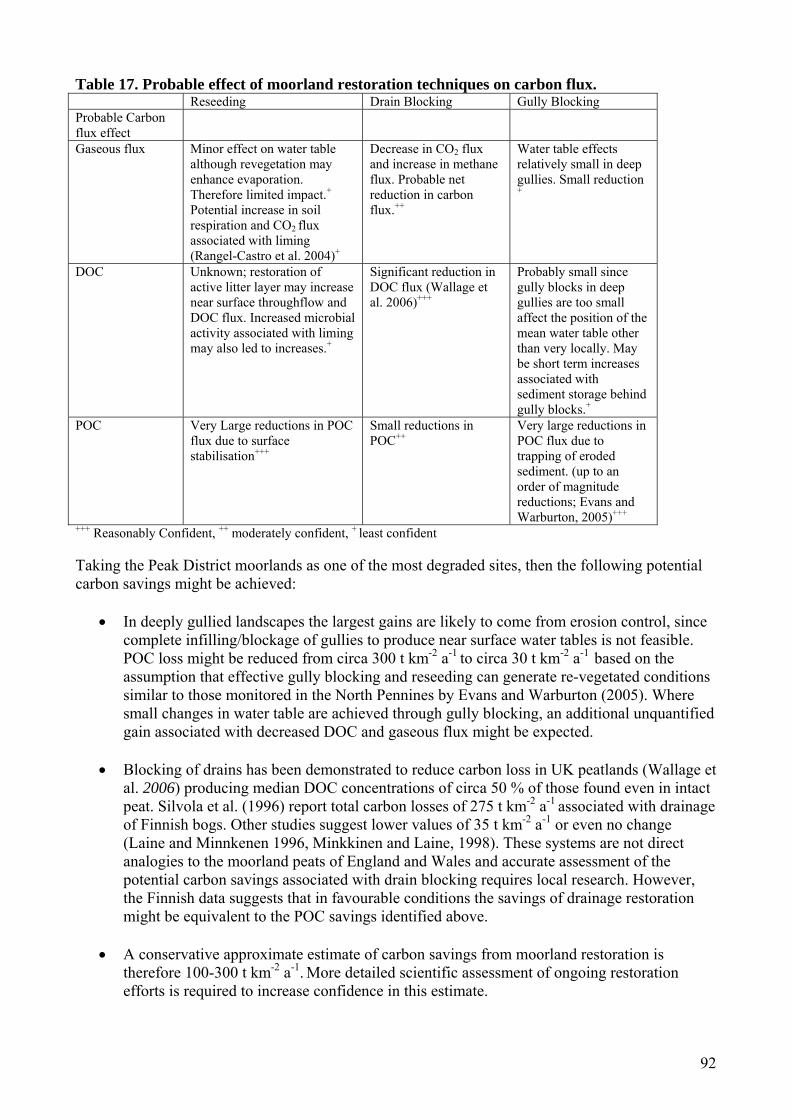
92
Table 17. Probable effect of moorland restoration techniques on carbon flux. Reseeding Drain Blocking Gully Blocking Probable Carbon flux effect
Gaseous flux Minor effect on water table although revegetation may enhance evaporation. Therefore limited impact.+ Potential increase in soil respiration and CO2 flux associated with liming (Rangel-Castro et al. 2004)+
Decrease in CO2 flux and increase in methane flux. Probable net reduction in carbon flux.++
Water table effects relatively small in deep gullies. Small reduction +
DOC Unknown; restoration of active litter layer may increase near surface throughflow and DOC flux. Increased microbial activity associated with liming may also led to increases.+
Significant reduction in DOC flux (Wallage et al. 2006)+++
Probably small since gully blocks in deep gullies are too small affect the position of the mean water table other than very locally. May be short term increases associated with sediment storage behind gully blocks.+
POC Very Large reductions in POC flux due to surface stabilisation+++
Small reductions in POC++
Very large reductions in POC flux due to trapping of eroded sediment. (up to an order of magnitude reductions; Evans and Warburton, 2005)+++
+++ Reasonably Confident, ++ moderately confident, + least confident Taking the Peak District moorlands as one of the most degraded sites, then the following potential carbon savings might be achieved:
• In deeply gullied landscapes the largest gains are likely to come from erosion control, since complete infilling/blockage of gullies to produce near surface water tables is not feasible. POC loss might be reduced from circa 300 t km-2 a-1
to circa 30 t km-2 a-1 based on the
assumption that effective gully blocking and reseeding can generate re-vegetated conditions similar to those monitored in the North Pennines by Evans and Warburton (2005). Where small changes in water table are achieved through gully blocking, an additional unquantified gain associated with decreased DOC and gaseous flux might be expected.
• Blocking of drains has been demonstrated to reduce carbon loss in UK peatlands (Wallage et
al. 2006) producing median DOC concentrations of circa 50 % of those found even in intact peat. Silvola et al. (1996) report total carbon losses of 275 t km-2 a-1
associated with drainage of Finnish bogs. Other studies suggest lower values of 35 t km-2 a-1 or even no change (Laine and Minnkenen 1996, Minkkinen and Laine, 1998). These systems are not direct analogies to the moorland peats of England and Wales and accurate assessment of the potential carbon savings associated with drain blocking requires local research. However, the Finnish data suggests that in favourable conditions the savings of drainage restoration might be equivalent to the POC savings identified above.
• A conservative approximate estimate of carbon savings from moorland restoration is
therefore 100-300 t km-2 a-1. More detailed scientific assessment of ongoing restoration efforts is required to increase confidence in this estimate.

93
6.9 Timescales of Change Post and Kwon (2000) suggested that there is typically a significant difference between maximum and average carbon fixation rates after a change in land use. The implication, also noted by Smith (2004), is that management changes which aim to increase soil carbon sequestration, produce carbon sinks with a limited lifespan as soils approach new equilibrium carbon contents. This may be the case for many mineral soils where the carbon sequestration effect is a change in the carbon storage in the active layer of the soil. In organic soils, particularly deep raw peats, however, the lifespan of the sink is much longer due to the burial of carbon in deeper anoxic layers. As an example, many of the upland peats in England and Wales date to 5000-8000 years BP. Continuous peat accumulation over this period demonstrates the importance of peat soils as stable long term sinks of terrestrial carbon. Chapman et al. (2001) provided a good review of turnover rates of organic carbon in soils to test the common view that gains in soil due to land management change are slow whereas losses are more rapid. Their data does not support this view and suggests that most systems will approach equilibrium changes in 10 to 100 years. These observations of relatively short timescales of soil carbon change further emphasise the role of forming peatland soils as a focus for soil carbon management because of their ability to provide long term storage. 6.10 Potential contributions to carbon trading quotas Under the Kyoto Protocol (Article 3.4) emission trading with respect to emission reductions with land management is in principle possible. However, the UK chose only forestry and not revegetation. To comply with EU legislation, land management projects must show additive effects – i.e. actual carbon sequestration (Lal, 1997), not only a reduction in carbon loss. Therefore, there has to be scientific evidence that (i) losses have decreased and (ii) gains in carbon storage have been made, if any land management practice is to contribute to Kyoto trading. Much more work needs to be done to provide good data, monitoring and verification. A number of research projects are already underway including:
• The instrumentation of ‘carbon catchments’ by the Environmental Change Network. • UKPopNet large scale upland manipulation experiment. • Soil respiration experiments and measurements by a number of UK scientists. • NERC funded studies into the role of atmospheric deposition on DOC production (Chapman
et al., University of Leeds), and gaseous release from peatlands (Billett, CEH Edinburgh). • Carbon flux models being developed by the Sustainable Uplands project funded by the
Rural Economy and Land Use programme. • Estimating Carbon in Organic Soils – Sequestration and Emissions (ECOSSE) project
sponsored by the Scottish Executive and Welsh Assembly Government will develop a new model to predict greenhouse gas emissions in organic soils in response to climate and land use change.
At the moment, the evidence suggests that linking organic soil restoration or protection to Kyoto emission trading might be very difficult. Carbon offsetting programmes would certainly not finance the restoration or protection schemes in themselves, as some have hoped, as £30 for 4t of carbon is less than the cost of an individual 3 m wide dam across a gully. The evidence and arguments are also insufficiently advanced to allow a business to claim soil restoration to be eligible for them to be claimed as part of a carbon neutral policy. This is odd given that tree planting (as a carbon sink) is considered a satisfactory offset mechanism to allow a business to be carbon neutral. Nevertheless, there is the potential for real and significant reductions in carbon loss to be made through the restoration of the eroded and drained organic soils of England and Wales. Carbon protection schemes should go ahead and be financed as part of a wider strategy of public and high level

94
communication of the importance of organic soils to the UK carbon stock and the role of management in reducing emission and sequestering carbon. 6.11 Research needs In the context of managing carbon flux from organic soils, the most urgent need is the development of integrated models to allow prediction of future carbon flux from soils under a range of climatic and management conditions. Some first steps have been taken towards modelling the best understood peatland systems but extrapolation of these approaches to a wider range of soils and environments will require new empirical data to further develop and calibrate the models. In general, the carbon balance of the organic soils of England and Wales is poorly understood. The basic processes controlling the principal fluxes are reasonably well defined by a range of UK and international studies, particularly for peats. However, the net effects on the carbon balance of organic soils in England and Wales are known only for a few well studied areas, such as the Moor House ECN site in the North Pennines. The peats and organo-mineral soils of England and Wales are variously drained, eroded, climatically stressed, burnt, and grazed. A large part of the understanding of carbon cycling in organic soils comes from relatively intact systems overseas. More research is required to quantify the impacts of land management and restoration techniques (both relatively and absolutely) on the carbon balance of terrestrial soils. The following particular needs are identified:
• There is a need to measure the complete carbon balance for a wider range of representative organic soil systems in England and Wales to allow model development and calibration. This needs to include gaseous measurements.
• There is a need for carefully designed experiments and monitoring to determine of the effects of land management and restoration techniques on soil carbon balance. There should be a presumption of scientific monitoring of major restoration works. This requires an appropriate funding stream for applied research.
• Understanding the delivery and processing of POC. This component of the carbon flux is more important in the degraded peatlands of England and Wales than it is in more pristine systems. However, quantifying POC flux and modelling its effect on atmospheric carbon flux requires more detailed process understanding.
• Organo-mineral soil systems are understudied in the context of carbon flux. More work is required.
95
7. Economic benefits of organic soil conservation; review of research needs 7.1 Summary Organic soils are an important strategic natural resource. The true economic costs and benefits of soil conservation are often very difficult to determine and there are many components, such as costs to the inland fishing industry (e.g. fine organic sediment can damage gravel-bed spawning grounds), cost to tourism and leisure etc. This section aims to summarise the latest techniques for economic environmental analysis and to recommend the best approaches for organic soil preservation cost-benefit analysis. This work highlights information required by which the economic benefits of organic soil conservation could be measured. Cost-benefit analysis, contingent valuation and choice experiments are some of the most frequently used methods but have been heavily criticized due to the underlying assumptions. However, alternative approaches such as multi-criteria decision aid have been proposed as alternatives. These allow the assessment to be performed in units that are most suitable for each criteria, which can be expressed in monetary terms, but also allows inclusion and evaluation of more qualitative terms. Multi-criteria evaluations or combinations of cost-benefit analysis with regional macro-economic models have been developed and variously combined with each other and embedded in participatory processes depending on the specific research questions at hand. It is concluded that simple cost-benefit analyses are not appropriate for organic soil evaluation. Instead multi-criteria decision aid frameworks should be used, as these incorporate measurements in different units which are more useful and sensitive to the environmental and social decision-making required for the organic soils of England and Wales. 7.2 Methods The literature and methods for evaluating the costs of soil degradation and soil conservation were outlined. Much of the literature on this subject is international rather than UK-based and this is reflected in the text below. However, the factors and techniques involved often cross international boundaries and so much of this work is relevant to the organic soils of England and Wales. 7.3 Principles of soil conservation Organic soil degradation has on-site and off-site impacts and the economics therefore need to be tackled both on and off-site. Reduction of soil depth and structure (e.g. removal of the acrotelm) can impair the land's stability and productivity, and the transport of sediments and DOC can degrade streams, lakes, and estuaries and cause problems for water supply companies. Considering the full range of impacts on ecosystem health, proper measures are needed for soil conservation. However, appropriate measures need to be cost effective for land owners. If not, then there will be no economic incentive for them to adopt soil conservation techniques. Cost-benefit analysis will aid such decision-making and also help policy makers account for off-farm impacts. They can then evaluate the overall costs and value of conservation measures to determine whether certain additional incentives are necessary for landowners to adopt conservation practices. Soil conservation involves two main components: soil retention (including maintenance of soil quality) and soil formation. Soil retention is often related to ensuring that there is an adequate vegetation cover and root system that can stabilize the soil and allow infiltration (de Groot et al. 2002). Soil formation, for organic soils, is mostly related to maintaining a waterlogged, or near waterlogged condition so that organic matter decomposition is minimized. However, the continued release of minerals for crop productivity on cultivated lands and the integrity and functioning of natural ecosystems are important concerns (de Groot et al. 2002). Soils are an important component in many biogeochemical cycles and soil conservation should focus on the above aspects. There are two main approaches for soil conservation and these are often used in tandem:
1. Biological approach: involves stimulation of plant growth over the denuded area such as re-seeding.
96
2. Mechanical approach: most of the mechanical methods are aimed at checking the rapid flow of air or water flow and increasing the soil water retention. Many of these focus on improved agricultural management, including bunding, gully and ditch blocking, contour terracing, erection of wind breaks and pumping of water (e.g. as in the Somerset Levels to preserve the Sweet Track Neolithic trackway; Holden et al., 2006a).
The problem of organic soil degradation and conservation can be examined from two perspectives: that of society as a whole and that of an individual land manager (Lutz et al. 1994). From the societal perspective, all costs and benefits of a given activity must be considered. For instance, heavy grazing on an upland peatland may lead to erosion which causes siltation of reservoirs, damage to riverine ecosystems, and degradation of an important tourist resource, and this represents a real cost to society that should be considered together with the value of the output obtained (i.e. economic benefit from grazing). As the conservation measures adopted have to be site specific and are mediated by the socio-economic context, land managers consider only the costs and benefits that are relevant to them for their decisions on how to use their resources. Nevertheless policy has often been designed, at least partly, to benefit the public and more recently the wider environment. Policy can sway farmers’ decisions, particularly if legislation or economic incentives are provided. The main focus of the following sections is to review methods for determining whether or not the benefits of a given conservation measure on organic soils are worth the costs to individual land managers and society as a whole. Examples will be given from a range of soil types around the world, as research into economic evaluation of organic soil degradation and conservation is generally sparse. 7.4 Measures of soil erosion costs While there have been a number of reports examining the costs of damage to soils in the UK (e.g. Environment Agency, 2002 considered costs of fertilisers, pesticides, organic wastes, faecal pathogens, flooding, fishery damage, atmospheric emissions, low flows and diseases and Environment Agency 2001 provided practical advice on tackling soil issues and examples of money savings for farmers) there are actually various ways of expressing the costs of organic soil degradation. Bojo (1996) illustrated the concepts of various measures that are used in valuing the cost of erosion, for example. Some of the critical choices of measures include:
1. Gross versus net costs, which depends on whether to take into account the mitigation effects on soil erosion or adjustment of farmer behaviour.
2. Financial versus economic cost: the former reflecting the perspectives of private planner (farmer and company) using market prices; the latter reflect the perspective of the social planner or government) using shadow prices reflecting social opportunity cost, i.e. including externalities.
3. Short-term versus long-term costs. 4. Annual versus cumulative costs. 5. On-site versus off-site costs. The on-site costs are the user costs that the farmer must face
for their choice of land management patterns. The off-site cost is the cost not borne by the farmer whose land may be the source of problems downstream (e.g. water discolouration treatment costs borne by a water company and its customers).
6. Discounted versus non-discounted costs, which implies the choice of a social soil discount rate.
7. Absolute versus relative cost, in which the latter one compares the losses from soil erosion with other losses due to environmental degradation.
7.5 Methods for valuing soil degradation The methods used for valuing soil degradation depend on the measures chosen (see above). Due to the constraints in data availability and appropriate techniques, most of the research focuses on the gross, on-site, economic costs, but some valuable attempts have been made to evaluate the holistic
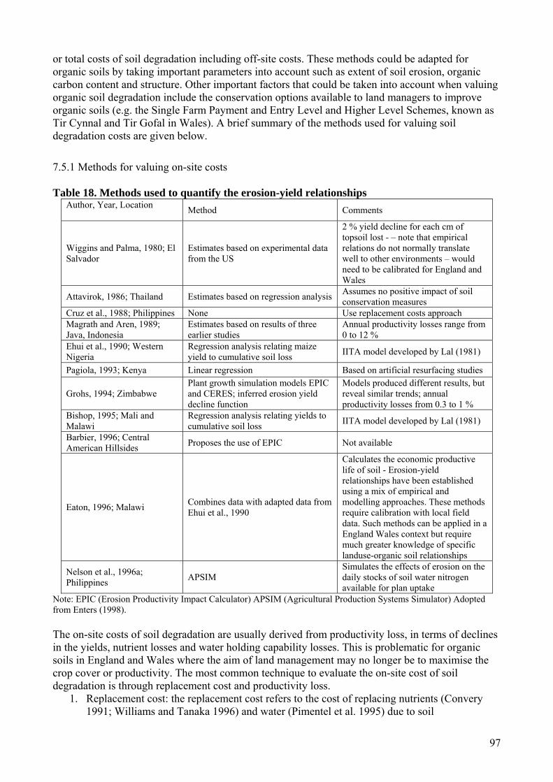
97
or total costs of soil degradation including off-site costs. These methods could be adapted for organic soils by taking important parameters into account such as extent of soil erosion, organic carbon content and structure. Other important factors that could be taken into account when valuing organic soil degradation include the conservation options available to land managers to improve organic soils (e.g. the Single Farm Payment and Entry Level and Higher Level Schemes, known as Tir Cynnal and Tir Gofal in Wales). A brief summary of the methods used for valuing soil degradation costs are given below.
7.5.1 Methods for valuing on-site costs Table 18. Methods used to quantify the erosion-yield relationships
Author, Year, Location Method Comments
Wiggins and Palma, 1980; El Salvador
Estimates based on experimental data from the US
2 % yield decline for each cm of topsoil lost - – note that empirical relations do not normally translate well to other environments – would need to be calibrated for England and Wales
Attavirok, 1986; Thailand Estimates based on regression analysis Assumes no positive impact of soil conservation measures
Cruz et al., 1988; Philippines None Use replacement costs approach Magrath and Aren, 1989; Java, Indonesia
Estimates based on results of three earlier studies
Annual productivity losses range from 0 to 12 %
Ehui et al., 1990; Western Nigeria
Regression analysis relating maize yield to cumulative soil loss IITA model developed by Lal (1981)
Pagiola, 1993; Kenya Linear regression Based on artificial resurfacing studies
Grohs, 1994; Zimbabwe Plant growth simulation models EPIC and CERES; inferred erosion yield decline function
Models produced different results, but reveal similar trends; annual productivity losses from 0.3 to 1 %
Bishop, 1995; Mali and Malawi
Regression analysis relating yields to cumulative soil loss IITA model developed by Lal (1981)
Barbier, 1996; Central American Hillsides Proposes the use of EPIC Not available
Eaton, 1996; Malawi Combines data with adapted data from Ehui et al., 1990
Calculates the economic productive life of soil - Erosion-yield relationships have been established using a mix of empirical and modelling approaches. These methods require calibration with local field data. Such methods can be applied in a England Wales context but require much greater knowledge of specific landuse-organic soil relationships
Nelson et al., 1996a; Philippines APSIM
Simulates the effects of erosion on the daily stocks of soil water nitrogen available for plan uptake
Note: EPIC (Erosion Productivity Impact Calculator) APSIM (Agricultural Production Systems Simulator) Adopted from Enters (1998). The on-site costs of soil degradation are usually derived from productivity loss, in terms of declines in the yields, nutrient losses and water holding capability losses. This is problematic for organic soils in England and Wales where the aim of land management may no longer be to maximise the crop cover or productivity. The most common technique to evaluate the on-site cost of soil degradation is through replacement cost and productivity loss.
1. Replacement cost: the replacement cost refers to the cost of replacing nutrients (Convery 1991; Williams and Tanaka 1996) and water (Pimentel et al. 1995) due to soil
98
erosion/degradation. This has been applied in a number of studies, but the cost estimates of degradation can vary significantly between different studies for the same site (e.g. Crosson et al., 1995; Pimentel et al., 1995).
2. Productivity loss: Adger and Grohs (1994) argued that productivity loss rather than replacement cost is the most correct theoretical approach to value resource depletion. Bojo (1996) classed studies into different categories for assessing productivity loss due to land degradation in Sub-Saharan Africa: expert judgment, relatively simple functions of declining soil yield, and models using more sophisticated equations. One of the equations that has been used widely is the Universal Soil Loss Equation (USLE) (Wischmeier and Smith, 1978). The USLE is, however, notoriously unreliable in many environments, including most of the UK, and will be particularly unreliable for organic soils. Table 18 provides an overview of the methods used for the estimation of yield declines caused by soil erosion.
3. Econometric approaches: These directly relate the agricultural profits and soil quality based on the changes in productivity and market prices. Pattanayak and Mercer (1998) developed a Cobb-Douglas profit function based on production input and output prices, and soil attributes. The value of soil conservation was then measured as a quasi-rent differential or the share of producer surplus brought by changes in soil quality. This framework was, for example, applied to estimate the benefits of agro-forestry in the Philippines. Pattanayak and Evan Mercer (1998) estimated that 5 to 10 % of current income (by increasing farm profit) came from the benefits associated with the soil protection measures.
7.5.2 Methods for valuing off-site costs The off-site impacts of organic soil degradation include effects such as deterioration in water quality, degradation of landscape and loss of wildlife habitat. A detailed categorisation of off-site costs of soil erosion was summarized by Jayasuriya (2003). Recommendation 19 by RCEP (1996) recommended that local authorities make greater use of their powers to recover the cost of damage caused by soil erosion. Some local authorities have been taking action and this is a way of encouraging land owners to be more responsible for soil protection on their land. However, most erosion tends to be manifest in diffuse pollution so that it is often difficult to determine where the upstream source of any downstream problem might have been. Research on the total external cost of UK agriculture calculated a £106 million loss per year from soil erosion in the UK (Pretty et al. 2000), while the annual on-farm costs of soil erosion were estimated to be £10-11 million (1996 prices) in England and Wales (Evans 1995; Evans 1996). Evans (1996) used data from local authorities to calculate the national external costs from soil erosion. The estimates accounted for £13.77 million from costs to property and roads alone, but not counting water company costs or losses to fisheries. Some studies have specialized in evaluating just one aspect of off-site or on-site costs of the soil degradation. For example, Midmore et al. (1996) estimated the value of problems for hydro-electric companies as a result of sedimentation in waterways and reservoirs, and Martinez-Casasnovas et al. (2005) estimated the on-site costs of concentrated flow erosion in fields as the costs of the operations necessary to redistribute the sediment/soil back over the field and to repair eroded drainage ditches. The methods for directly calculating the off-site costs are diverse and depend on the form of soil erosion causes. In an E&W context off-site soil erosion costs are probably best estimated in the uplands from reservoir sedimentation and for lowland soils using agricultural land flooding and soil erosion loss. More generally water quality, particularly colour, are also of merit. It is difficult for specific techniques to be recommended as appropriate for all cases. Table 19 suggests various techniques used for off-site soil erosion cost estimations.

99
Colombo et al. (2006) demonstrated a method for evaluating off-site costs with scarce market information. The economic benefits of controlling soil degradation through avoiding off-site costs of soil erosion were estimated using contingent valuation (CV) and choice experiments (CE). Both CV and CE are preferred approaches of environmental valuation techniques, which rely on the direct questioning of the respondents to reveal their willingness to pay (WTP) to changes in the environment, and thus estimate the economic value of environmental good. They are widely used in cost-benefit analysis of projects impacting the environment. In many cases the environmental goods bring benefit but do not have a market value (price) as they are not directly sold or the market value is difficult to evaluate. Contingent valuation studies are focused on valuing specific changes in environmental conditions, in which the respondents are directly questioned about their WTP or willingness to accept (WTA) compensation for an increment and decrement of an environmental good (Bateman and Willis, 1999; Bateman et al. 2006). Choice experiments are similar to CV, but assume that an environmental good is characterised as a collection of attributes and levels of attributes (Lancaster, 1966). The experiments construct the choice tasks through which respondents reveal the marginal value they place on each attribute. The summing over attribute values then estimates the value of an environmental feature recognized by the respondents. CV produces a single value for a change in environmental quality, whereas choice experiments provide independent values for the individual attributes of an environmental program. More details of the CE and CV techniques can be found in Bateman et al. (2002). Table 19. Estimating the off-site costs of soil erosion (source: adapted from Enters, 1998).
100
Colombo et al. (2006) compared the WTP estimates derived from CE and CV methods. The values for different attributes of soil conservation plans using the CE technique were used to provide useful inputs for policy design in an Andalusian catchment in Spain. The CV methods provided a validity test and helped to justify the estimate using CE techniques. The results were used to suggest an upper limit on per hectare payments for soil conservation programs. Colombo et al. (2006) argued that both CE and CV were suitable to evaluate the off-site effects of soil erosion. The WTP estimates did not differ significantly between these two approaches. 7.5.3 Economic cost of carbon loss Apart from the costs of soil erosion or degradation discussed above, the cost of the carbon loss might be important. However, the economic valuation of carbon losses through land degradation is rare. For example, Pretty et al. (2000) estimated the carbon loss (from all soils) in England and Wales to be 1.42 t ha-1 yr-1, resulting in an annual external cost of £82.3M (range £59-140M) based on a given external cost for CO2 of £63/ton (range £47-113). Although there is a need for improved economic estimations of the benefit of soil carbon sequestration, Lal (2002, 2003, 2004) claimed that soil carbon sequestration strategies would be extremely cost effective. 7.5.4 Methods for valuing total costs of soil degradation When valuing the economic costs of organic soil degradation we need to consider a number of factors. Many economic analyses of soil degradation have focused on erosion alone and so erosion is often referred to in the examples used. Other physical variables could usefully be included, however, such as organic carbon content and structure. The total costs of organic soil loss include both on-site and off-site costs; the cost of avoidance of soil degradation is an approximation for the value of the organic soil. Most techniques infer the value based on the service provided by the soil to other systems (Cohen et al. 2006). The total cost can be quantified either by summation of on-site and off-site costs, or through other techniques that can estimate the impact of soil degradation or the benefits of soil conservation on a larger economic scale. The following sections illustrate some of the latest technologies dealing with the latter. 7.5.4.1 Evaluating soil value using emergy synthesis A novel approach to evaluate the social value of soils is known as emergy synthesis (Odum, 1996). Emergy is defined as the energy required to directly or indirectly create a product or service (Odum, 1996). This technique therefore enumerates the value of an organic soil based on the environmental work required to produce it, rather than based on surveys or derived pricing techniques. Emergy synthesis integrates all the flows within the investigated economic and environmental system in a common biophysical unit (solar energy or Joules), to facilitate the direct comparison between natural and financial capital. It has been used to evaluate economic and ecological costs and benefits in numerous studies (Brown and McClanahan 1996; Prado-Jatar and Brown 1997; Howington, 1999; Odum et al. 2000; Buenfil 2001). This kind of framework enables direct comparison of natural and financial capitals. Cohen et al. (2006) used this method to evaluate the soil loss in Kenya in a qualitative framework with direct comparability to other aspects of the environment/economic system. In monetary units, the soil erosion in Kenya was estimated by this technique to be worth $390 million, or 3.8 % of total GDP. This is equivalent to the value of agricultural exports and only slightly smaller than the national tourist industry. 7.5.4.2 Macro-economic models: input-output analysis and Computable General Equilibrium Input-output models are the most frequently used economic framework for economic impact analysis. The extension of ecological-economic input-output analysis is increasingly used for evaluating economy-environment interactions and in lifecycle analysis (e.g. see Joshi, 2000). Input-output analysis (IOA) employs models of a local, regional or national economy to predict the extent of the costs and benefits caused by changes in the economy, technology or resource availability. It is therefore a useful tool in preparing information for cost-benefit analysis but has more often been
101
used as an evaluation and planning tool in its own right. For example, Miller and Everett (1975) used an IOA model to assess the economic impact of controlling sediment loss through changing forest management practices. They compared the income foregone to forestry firms and the regional loss of income as alternative measures of the cost of pollution control. Computable general equilibrium (CGE) models are a branch of theoretical microeconomics, which seeks to explain production, consumption and prices in a whole economy. General equilibrium approaches try to give an understanding of the whole economy using a bottom-up approach; and since the 1970s CGE was developed with advances in computing and input-output tables. One of the major virtues of the general equilibrium model is its ability to trace the consequences of large changes in a particular sector throughout the entire economy (Scarf and Shoven 1984). This provides a very useful tool for evaluating impacts of policy change on the economy, as well as the impacts caused by soil degradation on the agricultural sector (e.g. Alfsen et al., 1996). However, data availability has been problematic in these approaches (e.g. Somartne, 1998; Bandara et al., 2001). CGE models are based on economic input-output tables provided by statistical agencies. The disadvantage of using this type of data is that it often only provides for one, or very few, agricultural sectors and thus severely restricts its application for this type of analysis without using other data sources to disaggregate the agricultural sectors to provide more detailed information on that part of the economy. 7.5.4.3 Multi-criteria decision aid (MCDA) Cost-benefit analyses have been criticized due to difficulties in translating different and often incommensurable qualities into monetary values. The aggregation of different types of values into one ‘supernumeraire’ rather hides than reveals underlying values and can therefore be an obstacle rather than a tool to support decision-making (O'Neill, 1996). MCDA has been proposed as an alternative to cost-benefit analysis (or as a framework that incorporates some of the results derived from cost-benefit analysis). MCDA allows the assessment of a set of alternative options against a set of multiple and often conflicting criteria. This is done in units that are most suitable for each criteria which can be expressed in monetary terms but also allows inclusion and evaluation of more qualitative terms (e.g. Munda 1995). Once the various impacts have been specified in the best respective unit, a matrix of impacts is created. Each impact is weighted by a factor set by the analyst or involved participants (stakeholders or experts). The aggregation is carried out by multiplying each impact by its weight and aggregating across all impacts applying various functional forms. MCDA is being used in numerous studies taking advantage of the ability to include a wide variety of information. For example, in Australia MCDA was used to help prioritize State Environmental Programmes by evaluating factors and criteria such as agricultural profits, water use, threatened species, acidity, salinity, and number of historical, aboriginal and heritage sites without attempting to necessarily translate all these values into costs and benefits (Hajkovicz 2002). We see MCDA as the most appropriate tool for evaluating the ‘costs’ of degradation or conservation of organic soils within England and Wales 7.5.4.4 Participatory approaches Existing economic methods of capturing individuals’ values through their willingness to pay are insensitive to the ethical commitments and concerns about fairness that underlie many public attitudes towards the environment. Citizens can have values that cannot be captured adequately by willingness to pay. In addition, the participants in evaluation exercises are treated as individual consumers appraising various goods. Contingent valuation fails to allow people to judge value collectively as citizens rather than as consumers by treating political decisions as market decisions. Thus, a number of authors have argued that values that inform environmental choices are plural and incommensurable and cannot be captured by a single monetary measure (Jacobs 1997; O'Neill and Spash, 2000). Moreover, social values and perceptions have been considered as an important variable in determining the importance of natural ecosystem and their functions to human society
102
(English Nature, 1994). It has also been reported that social reasons are important in justifying the need of any conservation programmes from the user’s perspective. Thus participatory methods are important in convincing land owners who are to adopt conservation practices. A number of studies have also combined participatory methods with cost-benefit analysis or MCDA type methods as well as integrated hydrology and soil models to harness local knowledge and expertise. This helps develop conservation practices based on the local expertise so that in the long-term a local analytical capacity could be developed (see for example the ongoing DEFRA supported RELU project at the University of Leeds: Hubacek et al., 2005; Dougill et al., 2006). 7.6 Costs of soil conservation Most of the studies evaluating the costs of soil conservation rely on direct valuation of the conservation program, based on economic data from farmers or experts. Two basic sets of information are required for analyzing the costs associated with soil conservation measures: (i) biophysical data on the effect of activities on the soil and its degradation and (ii) economic data on costs and prices. Although economic data are often easily available, biophysical data sometimes pose problems as we need specific data to tackle the respective problem, which may vary for each case. Data such as the nature and rate of degradation caused by current practices, the effects of degradation on future soil function and on the effects of conservation practices are required. This report has gone some way to highlighting these data for organic soils in England and Wales, but it should be noted that there are still many processes and variables that remain poorly understood. Therefore, rather than using a single approach to perform economic analysis it is recommended that a combination of methods are used to understand both the bio-physical data and the economic data and that these are then fed into one model for evaluation. A financial analysis of soil conservation can be carried out from two perspectives: the project perspective, where all the expenditures and returns are covered by the project activities; and the land owner’s perspective, where financial costs and benefits accrue to the individual land manager. The analysis involves the construction of a budget for an enterprise or the farm unit and the calculation of net returns. The same variables can be used to evaluate the financial impacts of organic soil degradation to assess the financial viability and relative financial merits of different soil conservation scenarios. Of crucial importance in such exercises is the appropriate estimation of investment costs and labour requirements which are usually high. Especially the labour component is very difficult to establish as often a large proportion is based on family labour in production of outputs as well as soil conservation. Thus assumptions on labour input, wage rates and the accurate value of the opportunity cost of labour are absolutely crucial. Identifying the appropriate opportunity cost depends on the nature of the activity to be performed, on the characteristics of the farmer (age, wealth, and gender), the season (growing season or slack season) and the availability of non-farm and off-farm employment (Enters 1998). Variables that need to be considered are evaluation criteria, the discount rate and the time horizon. A number of studies have been performed using a variety of approaches. For example, Schuler and Kachele (2003) calculated the on-farm costs of implementing soil conservation programs through the Multiple Objective Decision Support Tool for Agro-ecosystem Management (MODAM) model using USLE. MODAM simulates agricultural land use at the farm level, calculates the economic returns and environmental impacts and runs farm optimizations with a linear programming tool. This research combined standard average data with regional characteristics through discussion with local stakeholders. This system comprised two parts: a bundle of large databases describing the regional agricultural practices in great detail, and a linear programming tool to simulate decision behaviour of farmers under soil conservation policies. After iterative discussion with stakeholders, the result was applied to a region (12,000 ha arable land) 100 km northeast of Berlin. The abatement cost ranged from 0 to 35 euros ha-1 when the percentage of erosion reduction increases from 0 to nearly 70 %.
103
Input-output analysis or CGE models (discussed above) go beyond the idea of soil conservation being a cost to society in that they see these investments as injections into the regional economy that trigger ripple effects throughout the economy and thus contribute to economic growth and provide employment. A classic example of this would be a pristine peatland acting as a landscape that attracted tourists to a region. 7.7 Costs to Yorkshire Water of treating colour: present and future predictions So far, this chapter has focused on the methods that are available for quantifying the costs of organic soil degradation, as well as the savings that can be made through soil conservation. We now focus on the specific costs of organic soil degradation to a water company and show how these influence the company’s business planning. 7.7.1 Treatment costs Over the past decade, water utility companies within England and Wales that take raw water from upland catchments which are dominated by organic soils (e.g. Yorkshire Water, United Utilities, Dwr Cymru Welsh Water) have generally experienced increasing colour in raw water and, therefore, higher treatment costs. Due to increases in colour, a number of water treatment works (WTWs) in Yorkshire and the north-west of England have experienced difficulty in meeting the standard of 100 µg l-1 for trihalomethanes (THMs) (Drinking Water Inspectorate UK, 1998), chemicals that are produced when raw water that is high in natural organic matter (NOM) is chlorinated (Fearing et al., 2004; Goslan et al., 2004). A host of other disinfection by-products may also be produced (e.g. Krasner et al., 1989), which have been associated with the development of cancers (Singer, 1999; Rodriguez et al., 2000). Management of the water industry is based around the Asset Management Planning (AMP) process, whereby the regulator, the Water Services Regulatory Authority (OFWAT), reviews the performance of each water company every five years and decides on those activities that should be pursued by a company over the following five years. The aim of this is to ensure that the water companies are providing high quality drinking water and waste-water treatment, as well as value for money for customers. Pertinent examples might include installing better treatment plants to remove more colour from raw water, or pursuing catchment management measures, such as grip blocking. Before the beginning of each AMP period, every water company submits its Periodic Review (PR) to OFWAT, stating those activities that it would like to spend money on during the coming period. Yorkshire Water draws most of its raw water from upland catchments and in recent years has experienced increasing difficulty in treating water colour to meet standards set by the Drinking Water Inspectorate (DWI) and make it suitable for sale to customers. During preparation for YW’s submission to OFWAT for AMP4 (2005-2010) (Periodic Review 04), a project was, therefore, undertaken within the business to quantify the costs to the company of increasingly high colour loadings from upland peat catchments. The aim of this exercise was to demonstrate the problem to OFWAT and, therefore, to gain permission to spend resources on addressing the problem, largely through the installation of improved treatment technologies. The calculations were based on treatment of raw water at a single WTW (Albert WTW). This WTW is often used by YW for research and business planning due to the extensive data sets that are available for the works and the fact that it is representative of many other WTW in Yorkshire. The most important parameters used in the model were ferric and lime dosing and sludge treatment costs. Significant problems have been experienced at Albert WTW in treating raw water colour (Wilson, unpublished). The works is a three-stage plant, treating 33-55 ML/day, and is located on the western side of Halifax, West Yorkshire. Raw water is taken from 8 different reservoirs (Wilson, unpublished) and treated using ferric coagulation, clarification (using 6 dissolved air
104
floatation units), primary filtration (using 6 rapid gravity filters), manganese removal (using 8 pressure filters) and chlorination (Fearing et al., 2004; Goslan et al., 2002). The work carried out for PR04 has been extended in Figure 23 up to the present day. It is evident that over the past 13 years there has been a general rise in colour levels and associated treatment costs at the Albert WTW. Prior to 1997, average colour levels were between 30 and 40 Hazen. After 1997, average colour increased to between 65 and 100 Hazen. The costs of treating raw water at the Albert WTW have increased similarly, with the expense of treating a megalitre (ML) (1 million litres) of water in 2006 standing at its highest value ever at more than £25. Bearing in mind that YW processes 1.24 billion litres of drinking water every day these increases in costs are highly significant to the business. Treating raw water is complicated by the fact that water quality varies significantly from season to season. DOC concentrations are in the range 7.12-8.36 mg l-1 in June and July and 10.9-12.1 mg l-1 in November-December. The respective colour values are 59-80 and 88-105 Hazen (Fearing et al., 2004). It is during periods of runoff production and NOM transport, particularly in the autumn, that the company is likely to experience difficulty in treating raw water colour (Goslan et al., 2002). The problematic seasonal pattern of colour levels in raw water has been associated primarily with an increase in the fulvic acid fraction (rise from 37 % of DOC to 61 %). The reactivity of this fraction has been found to increase trihalomethane formation potential (THM-FP) from 84 to 155 g mg C-1
(Goslan et al., 2004; Wilson, unpublished). Even though contemporary treatment processes can remove large amounts (90 %) of NOM from raw water, this still leaves significant quantities of these highly reactive compounds to produce harmful treatment by-products (Goslan et al., 2002).
0
20
40
60
80
100
120
1992
-93
1993
-94
1994
-95
1995
-96
1996
-97
1997
-98
1998
-99
1999
-00
2000
-01
2001
-02
2002
-03
2003
-04
2004
-05
2005
-06
Ave
rage
col
our (
Haz
en)
0.00
5.00
10.00
15.00
20.00
25.00
30.00
Trea
tmen
t cos
t (£/
ML)
Figure 23. Raw water colour and associated treatment costs at Yorkshire Water’s Albert water treatment works, 1992-2006. Water companies, such as Yorkshire Water, are now installing new treatment systems to deal with the colour problem. For instance, YW is required to install Magnetic Ion Exchange (MIEX) at the Albert WTW by 2009 in order to meet the demands of the DWI. Uncertainty about the colour problem is hampering its long-term management. Temporal variation in colour levels means that water companies always have to have the highest level of treatment (i.e. MIEX) working, thus, increasing costs. Moreover, it is almost entirely uncertain how colour levels will change in the

105
future. This is unsurprising given that we do not fully understand why colour levels have increased in recent years and so are unable to predict what might happen in the future. While treating increasingly high levels of colour in raw water is a major contemporary issue for the water industry, and one that is unlikely to go away for the foreseeable future, it is by no means the only economically significant consequence of organic soil degradation. Another pertinent problem, that has already been discussed, is that of sedimentation of reservoirs, which results in lost capacity. Sediments must ultimately be dredged from the reservoir (SSLRC, 2000) or released via the scour valve at the bottom of the dam, potentially having serious implications for stream ecology, which may limit our ability to meet the WFD. 7.7.2 Land management costs Land management that seeks to improve water quality is seen as a potentially viable option as a management tool for water companies that can be incorporated into their business plans. It is envisaged that land management can be used to control soil processes and thereby improve raw water quality and reduce the treatment costs. This is perhaps best exemplified by the Sustainable Catchment Management Project (SCaMP) that United Utilities is currently undertaking over the period 2005-2010, to measure the impact of a variety of land management techniques on raw water quality. Yorkshire Water has also recently formed the Strategic Research Partnership with a number of universities and the University of Leeds has been contracted specifically to investigate the effectiveness of catchment management (and its impact on organic soil processes) as a means of improving raw water quality. Despite the undoubted interest in catchment management from water companies, assessments of the relative costs of catchment management to water treatment are entirely lacking from the debate, although YW is now beginning to fund work in this area. Before any accurate costs can be placed upon the soil management actions that would be needed to reduce colour levels in raw water, it will be essential to determine what these measures are so that they can be costed. At present, a range of measures have been proposed to reduce colour in raw water (e.g. drain blocking, reductions in heather burning) but research is still ongoing to quantify the effects. Due to the uncertainty surrounding the land management options that are needed to consistently reduce colour levels to those required for use by water companies, without the need for treatment processes such as MIEX, it is not possible to assign a cost to catchment management without further research. It is, therefore, not possible to compare the costs of catchment management against water treatment at present.
106
8. Guidance on soil protection 8.1 Summary There has been substantial research into methods of conserving organic soil. However, many of these tests suffer from a lack of baseline data or long-term monitoring and experimental design so that a full assessment of methods is often difficult. Methods described in this section include those for revegetating bare and unstable surfaces, gully and drain blocking methods (for which there are often more cost-effective strategies involving simple topographic and GIS models and decision trees), impacts of reduced stocking, burning, liming and coniferous forestation. Good practice on arable soils and legislation and incentive schemes are also discussed. 8.2 Methods This section reviews some examples of organic soil protection and conservation measures that have been trialled by stakeholders. 8.3 Introduction There have been a number of publications on organic soil protection and conservation practices and there are a number of organisations that have produced guidelines. These should be referred to where appropriate. They include:
• RAMSAR Guidelines for global action on peatlands (a series of guidelines on wise use of peatlands and the need for knowledge, data on trends, education and public awareness, policies, research networks and international cooperation (Ramsar, 2002)).
• Europeat: a series of tools and scenarios for sustainable management of European peat soils (Europeat, 2006).
• English Nature Upland Management Handbook (English Nature, 2001). • Conserving Bogs (Brooks and Stoneman, 1987): a manual of good practice. • Guidance on understanding and managing soils for habitat restoration (Bradley et al., 2006).
The following sections review strategies that have been trialled for protecting or restoring organic soils. The work includes examples of case studies and reports the results of recent case studies and new methods that are being developed. 8.4 Revegetating bare soils As described in Section 5, there are large expanses of bare organic soil in many areas of England and Wales. Overstocking, wildfire, and atmospheric deposition chemistry are important causes of such degradation. Revegetation is necessary to stabilise the soils and protect them from further degradation. Experiments on revegetation of a heather moorland in the North York Moors were carried out following wildfire in the 1980s (Bridges, 1986). Reseeding and stock exclusion were trialled in experimental plots. The main conclusions were:
1. Grazing by sheep was the single most important factor restricting the survival and spread of self-seeded Calluna and Eriophorum and sown grasses.
2. There was widespread survival, despite the severity of wildfire, of Eriophorum rhizomes and buried Calluna seed. Both spread and flowered in fenced areas where sheep were excluded.
3. Without protection from grazing, substantial areas remained poorly vegetated and where vegetation returned it consisted of lichens and mosses, particularly low-growing Campylopus and Pohlia species.
4. Deschampsia Flexuosa was the most successful of the sown grasses.
5. Calluna and all sown grasses responded to fertiliser, but Eriophorum did not.
107
The success of many revegetation schemes has stemmed from many years of work in the uplands, under the Moorland Restoration Programme in the Peak District, for example. Early trials were typically unsuccessful, but now approaches have advanced so that obtaining a vegetation cover over large areas that were previously bare is now possible. Much pioneering work has been carried out by Moors for the Future and one of their partners, The National Trust, who have been restoring 3.5 km2 of the worst degraded areas of the Dark Peak area which have been caused by accidental fires and which now are extensive bare peat landscapes at risk from severe erosion. The main factor preventing natural revegetation of these sites is the mobility of the peat. Very few seedlings are able to establish and those that do are soon lost as the peat continues to erode. The restoration principle of the Moors for the Future restoration sites is to use a fast growing nurse crop of grasses and heather seed which will stabilize the peat over a period of 3-5 years and thereby give the natural vegetation time to establish in sufficient quantities to survive. The seed was placed in a mixture of clay and waste materials from the paper pulp industry, increasing the weight of the seed to allow spreading by helicopter. The nurse grasses used do not usually occur on peatland sites, and therefore an application of lime (at 300 kg ha-1) was used to raise the pH of the peat and NPK fertiliser (a water soluble phased release fertiliser at a rate of 5:26:13) to supply nutrients was also required. The remote location meant that a helicopter was used to deliver the materials evenly across the restoration plots.
Following seeding, materials were applied to stabilise the peat. Two methods were used depending on the angle of the surface. Flat areas are covered with heather brash, which protects the surface from wind and water erosion and also acts as a source of seeds and the fungi that heather needs to thrive. The heather was obtained locally and spread by hand. Steeper slopes have been covered with geojute-textiles which physically hold the peat down and inhibit erosion. They are made from natural fibres woven into a loose mesh pattern. They require fixing pegs in order to secure them to the mobile peat surface. They have an effective life of 18-24 months and, as they are manufactured from natural fibres, break down to harmless by-products.
These restoration techniques have been subject to field trials and, to date, an area of 3 km² has been treated. These revegetation techniques are applied in conjunction with stock removal to help recovery. A short vegetation cover has successfully established over many bare areas of the Dark Peak. Such techniques, along with gully blocking are also planned for the restoration of Waun Fignen-Felen mire in the Brecon Beacons National Park (Sinnadurai, 2004).
There are many examples of revegetation projects within the international literature. Many of these are in response to revegetating a peatland after peat extraction or other major disturbance. In summary, the approach adopted in North America to rehabilitate Sphagnum dominated peatlands (Rochefort et al., 2003) has been:
1. Field preparation (e.g. bunding an area to provide high water tables, and creation of an appropriate topography to allow pools to form etc).
2. Collection of diasporas: Sphagnum diaspores (fragments of Sphagnum plants) can be collected from the upper layers (best results obtained from the upper 5 cm of peat, and 10 cm should be the lower limit) of an active peat bog and then scattered over the peatland to be restored. Frozen conditions are often the best for collecting the Sphagnum.
3. Diaspore introduction: normally between 1:50 and 1:100 ratio can be expected of surface cover collected from a donor site to surface cover gained at degraded sites. Plant spreading can be done using a manure spreader which provides an even cover of plant application very quickly.
4. Diaspore protection: on bare soils, Sphagnum and other mosses benefit from an application of a thin protective mulch (straw has been used) to prevent drying out of the peat surface and desiccation of the plants (Price, 1997).

108
5. Fertilisation: phosphorus fertilisation increases the success of restoration by accelerating the establishment of bog plants that help nurse the Sphagnum growth, but suitable doses have yet to be determined.
8.5 Footpath repair CEH (2002) have recommended the use of hard materials (wood, concrete, stones etc) for restoring footpaths. On organic soils, care needs to be taken to ensure that the path does not become a channel for surface runoff and therefore careful water management on and around the footpath is needed. Among the many well-worked examples of best practice, examples of further useful details are provided in the English Nature upland management handbook (English Nature, 2001), the Lake District National Park Authority best practice guide (Davies et al., 1996), and the British Upland Footpath Trust guide (Barlow and Thomas, 1998). 8.6 Gully blocking Large-scale restoration works by blocking gullies have begun in a number of areas including the Peak District, Marsden Moor and the Brecon Beacons (Sinnadurai, 2004)(Figure 24). Restoration objectives for gully blocking stated by Moors for the Future are to control and stop gully erosion, to reduce water (peak) discharge and to prevent sediment loss from peatlands. The ultimate goal is to raise the water table, promote revegetation and reduce water discolouration of streams. For drain and gully blocking, it may not be possible to restore the water table to its original mean height or its natural range of fluctuation (both of which are important for sensitive plants) and so management practices may instead be aimed at reducing the rate of degradation and sediment loss, rather than total restoration of the ecosystems. Nevertheless, the goal of most blocking activity is to restore the water table and hydrological regime to that which most closely resembles the pre-drainage state.
Figure 24. Plastic piling used to dam gullies in the Peak District. The National Trust has pioneered this restoration approach and has ample experience with different gully blocking techniques. Since 2003 the National Trust High Peak Estates Team has employed dams of heather, wool, wood, stone and moulded plastic to block drainage gullies. Evans et al (2005a) report on a project in the Peak District in partnership with the Universities of Leeds and Manchester, which aimed to establish best methods for gully blocking and to determine where gullies should blocked, given that there are so many and that it would be too costly to block them all. Over the past few years most blocking has been done on an ad hoc and piecemeal basis and many blocking styles that have been trialled (e.g. using plastic piling, heather bails, wooden dams) have proved enormously expensive. Evans et al. (2005a), for example, suggested that a plastic dam
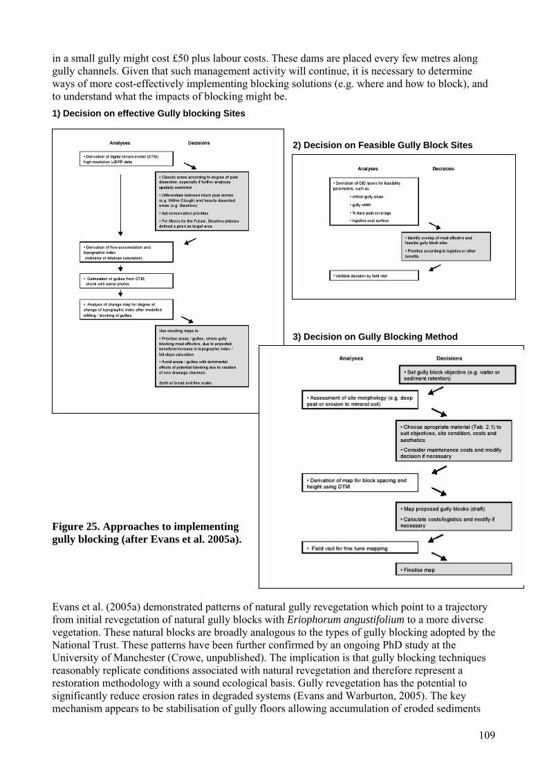
109
in a small gully might cost £50 plus labour costs. These dams are placed every few metres along gully channels. Given that such management activity will continue, it is necessary to determine ways of more cost-effectively implementing blocking solutions (e.g. where and how to block), and to understand what the impacts of blocking might be. 1) Decision on effective Gully blocking Sites
2) Decision on Feasible Gully Block Sites
3) Decision on Gully Blocking Method
Figure 25. Approaches to implementing gully blocking (after Evans et al. 2005a). Evans et al. (2005a) demonstrated patterns of natural gully revegetation which point to a trajectory from initial revegetation of natural gully blocks with Eriophorum angustifolium to a more diverse vegetation. These natural blocks are broadly analogous to the types of gully blocking adopted by the National Trust. These patterns have been further confirmed by an ongoing PhD study at the University of Manchester (Crowe, unpublished). The implication is that gully blocking techniques reasonably replicate conditions associated with natural revegetation and therefore represent a restoration methodology with a sound ecological basis. Gully revegetation has the potential to significantly reduce erosion rates in degraded systems (Evans and Warburton, 2005). The key mechanism appears to be stabilisation of gully floors allowing accumulation of eroded sediments

110
and subsequent revegetation of gully floors. Given the apparent benefits but potentially high costs of gully blocking, a rational approach to resource allocation is required. Sediment accumulation in the monitored gullies was found to be proportional to area of exposed peat and optimal gully block spacings of 4 metres are recommended as a balance between sufficient sediment accumulation and the requirement to stabilise the gully floor. Evans et al. (2005a) distinguished between headwater sites with incipient gullying where impermeable (plastic piling) gully blocks have the potential to raise water table and deeper gullies where more porous (wooden) blocks are appropriate to promote stabilisation, revegetation and erosion control. Current techniques are most appropriate to blocking headwater gullies of relatively low width and new techniques are required for dealing with large deep gully systems. Assessment of the extent of current erosion and slope information was combined with the application of LIDAR data and a GIS modelling of the impact of gully blocking (effectively gully removal) on downslope flow accumulation. This allowed identification hillslopes at risk from erosion and of individual gullies or areas of gullies which have the greatest hydrological effect on a hillslope system. The overall output is a decision tree approach (Figure 25) for the implementation of gully blocking. This approach was developed specifically for the Peak District work being undertaken by Moors for the Future but should have wider application. 8.7 Drain blocking Techniques for drain blocking have been applied at a wide variety of scales and costs, often without detailed monitoring to assess the effectiveness of the works. In areas where surface drains have been cut, many organisations are seeking resources to block them. However, this is an expensive strategy and there are a range of unresolved issues associated with drain blockage. The main issues are: (i) the very high cost of ditch blocking; (ii) determining the most effective methods of blockage; (iii) the longevity, success and maintenance of such schemes in still actively eroding systems; (iv) the uncertain impacts of blockage on river flow and water quality; and (v) the uncertain response of the peat and vegetation in the context of permanent structural and chemical changes that may have taken place following water table lowering. There are, therefore, a series of research requirements. These range from practical experiments on blockage design and conditions conducive to optimum vegetation recovery to the development of tools for helping practitioners determine which drains are more important to block so that resources could be efficiently targeted and drain blocking prioritised. Additionally, a modelling approach that would assist in examining the impacts of drain blocking on stream flow and water quality is also required. Natural revegetation of ditches in organic soils has been observed. If ditches are not maintained they can fill in with vegetation and sediment, losing their effectiveness in water removal (Fisher et al., 1996). Indeed, this benign neglect of ditches may be one of the simplest management strategies proposed to return peats towards a favourable condition. Infilling often starts where peat has slumped onto the drain floor and is colonised by mosses and later by rushes and sedges. If unshaded the floor could regrow with Sphagnum. The tendency of drains to infill depends on the type of material forming the floor, the slope angle and the drainage area feeding the drain. Conversely, some ditches may erode rapidly until the substrate is reached then strip the soil laterally resulting in enlarged drains sometimes 10 to 15 times the original width. Therefore, in most peatlands, artificial dams are required to block and revegetate ditches (Van Seters and Price, 2001). Often, peat and plastic ditch plugs are unsuitable for ditch blocking where slopes are steep. Here, ditch water can scour around and under the plugs. On steep slopes, ditch blocking can be very demanding on resources and Figure 26 shows where wooden stakes and dams

111
have been installed on an Irish peatland with only 3 m spacing. Calluna bails have been used in some upland peats (Candleseaves Bog and Geltsdale, Cumbria, UK; Figure 27) where the seed bank and nutrients are local (unlike the use of straw bails which have also been used in some areas). These allow water to flow through the bails, but slow the velocity and allow sediment to slowly accumulate. The aim is to avoid further scour erosion around the ditch plugs and allow the ditch to slowly infill with sediment and vegetation. However, the cheapest and most successful ditch blocking practice in blanket peats where the ditches have not scoured too deeply, is to scoop out some peat adjacent to the ditch and then very firmly pack the peat into the ditch. The scour hole thereby created from the removed scoop of peat allows water to leave the dam and rewet the adjacent peat via overland flow (Figure 28). This may only work, however, where a good thick contact can be maintained between the plug of peat and the ditch floor and walls and where slopes are not too steep. The additional caveat is that grazing and burning practice should also be minimised if investment for blocking is going to be worthwhile in terms of sediment, water quality and vegetation recovery.
Figure 26. Intensive ditch blocking on a peatland near Enniskillen, Ireland.
Figure 27. Drain blocking at Candleseaves Bog, Skiddaw, Cumbria using local cut heather bails.
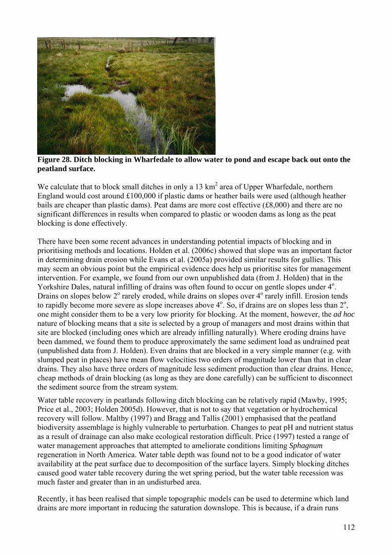
112
Figure 28. Ditch blocking in Wharfedale to allow water to pond and escape back out onto the peatland surface. We calculate that to block small ditches in only a 13 km2 area of Upper Wharfedale, northern England would cost around £100,000 if plastic dams or heather bails were used (although heather bails are cheaper than plastic dams). Peat dams are more cost effective (£8,000) and there are no significant differences in results when compared to plastic or wooden dams as long as the peat blocking is done effectively. There have been some recent advances in understanding potential impacts of blocking and in prioritising methods and locations. Holden et al. (2006c) showed that slope was an important factor in determining drain erosion while Evans et al. (2005a) provided similar results for gullies. This may seem an obvious point but the empirical evidence does help us prioritise sites for management intervention. For example, we found from our own unpublished data (from J. Holden) that in the Yorkshire Dales, natural infilling of drains was often found to occur on gentle slopes under 4o. Drains on slopes below 2o rarely eroded, while drains on slopes over 4o rarely infill. Erosion tends to rapidly become more severe as slope increases above 4o. So, if drains are on slopes less than 2o, one might consider them to be a very low priority for blocking. At the moment, however, the ad hoc nature of blocking means that a site is selected by a group of managers and most drains within that site are blocked (including ones which are already infilling naturally). Where eroding drains have been dammed, we found them to produce approximately the same sediment load as undrained peat (unpublished data from J. Holden). Even drains that are blocked in a very simple manner (e.g. with slumped peat in places) have mean flow velocities two orders of magnitude lower than that in clear drains. They also have three orders of magnitude less sediment production than clear drains. Hence, cheap methods of drain blocking (as long as they are done carefully) can be sufficient to disconnect the sediment source from the stream system.
Water table recovery in peatlands following ditch blocking can be relatively rapid (Mawby, 1995; Price et al., 2003; Holden 2005d). However, that is not to say that vegetation or hydrochemical recovery will follow. Maltby (1997) and Bragg and Tallis (2001) emphasised that the peatland biodiversity assemblage is highly vulnerable to perturbation. Changes to peat pH and nutrient status as a result of drainage can also make ecological restoration difficult. Price (1997) tested a range of water management approaches that attempted to ameliorate conditions limiting Sphagnum regeneration in North America. Water table depth was found not to be a good indicator of water availability at the peat surface due to decomposition of the surface layers. Simply blocking ditches caused good water table recovery during the wet spring period, but the water table recession was much faster and greater than in an undisturbed area. Recently, it has been realised that simple topographic models can be used to determine which land drains are more important in reducing the saturation downslope. This is because, if a drain runs
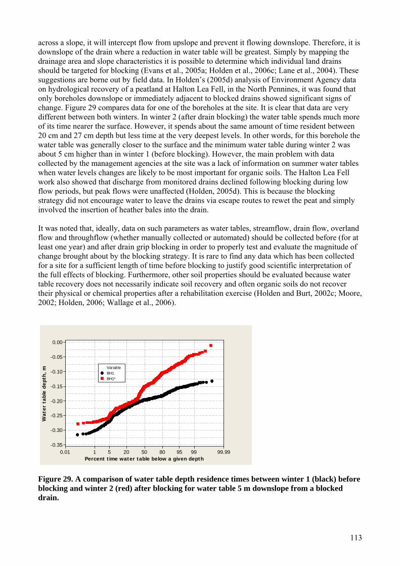
113
across a slope, it will intercept flow from upslope and prevent it flowing downslope. Therefore, it is downslope of the drain where a reduction in water table will be greatest. Simply by mapping the drainage area and slope characteristics it is possible to determine which individual land drains should be targeted for blocking (Evans et al., 2005a; Holden et al., 2006c; Lane et al., 2004). These suggestions are borne out by field data. In Holden’s (2005d) analysis of Environment Agency data on hydrological recovery of a peatland at Halton Lea Fell, in the North Pennines, it was found that only boreholes downslope or immediately adjacent to blocked drains showed significant signs of change. Figure 29 compares data for one of the boreholes at the site. It is clear that data are very different between both winters. In winter 2 (after drain blocking) the water table spends much more of its time nearer the surface. However, it spends about the same amount of time resident between 20 cm and 27 cm depth but less time at the very deepest levels. In other words, for this borehole the water table was generally closer to the surface and the minimum water table during winter 2 was about 5 cm higher than in winter 1 (before blocking). However, the main problem with data collected by the management agencies at the site was a lack of information on summer water tables when water levels changes are likely to be most important for organic soils. The Halton Lea Fell work also showed that discharge from monitored drains declined following blocking during low flow periods, but peak flows were unaffected (Holden, 2005d). This is because the blocking strategy did not encourage water to leave the drains via escape routes to rewet the peat and simply involved the insertion of heather bales into the drain. It was noted that, ideally, data on such parameters as water tables, streamflow, drain flow, overland flow and throughflow (whether manually collected or automated) should be collected before (for at least one year) and after drain grip blocking in order to properly test and evaluate the magnitude of change brought about by the blocking strategy. It is rare to find any data which has been collected for a site for a sufficient length of time before blocking to justify good scientific interpretation of the full effects of blocking. Furthermore, other soil properties should be evaluated because water table recovery does not necessarily indicate soil recovery and often organic soils do not recover their physical or chemical properties after a rehabilitation exercise (Holden and Burt, 2002c; Moore, 2002; Holden, 2006; Wallage et al., 2006).
Wat
er t
able
dep
th, m
Percent time water table below a given depth
0.00
-0.05
-0.10
-0.15
-0.20
-0.25
-0.30
-0.3599.999995805020510.01
VariableBH1BH1*
Figure 29. A comparison of water table depth residence times between winter 1 (black) before blocking and winter 2 (red) after blocking for water table 5 m downslope from a blocked drain.
114
8.8 Stocking levels Where organic soils are highly degraded, an immediate removal of livestock is recommended. Where erosion is occurring but not highly degrading then a reduction of stocking should be considered. Certainly, there should be limited access for livestock to eroded or vulnerable areas. Previously successful methods have included the exclusion of livestock with fencing, which reduces soil disruption and allows seedlings to grow. Following revegetation, grazing must be carefully controlled at recommended stocking densities (SSLRC, 2000). On the Kinder plateau, Derbyshire, restriction of access to grazing livestock through shepherding resulted in a 90 % recovery of vegetation within 5 to 8 years (Anderson and Radford, 1994). Unfortunately, the use of shepherding as a management technique has reduced in recent years. In the Hey Clough catchment in the Peak District, a reduction in sheep grazing pressure has had striking results in terms of revegetation of peat and reductions in erosion. Sheep grazing pressure in the catchment was reduced in the 1980s and many formerly eroding sheep scars were completely revegetated and only those scars that are still used by sheep remain. 80 % of the bare soil had revegetated within 5-10 years on the lower, more shallow, slopes (480masl, c. 11˚ slope). Recolonisation was, however, slower on the upper slopes (530masl, 30˚ slope) where it took two decades for vegetation to begin to invade the bare peat. Grasses are likely to re-establish themselves first, followed by heather and bilberry. Smaller sheep scars will be recolonised first and those on peat before those on mineral soils. It is imperative, however, that, for peat to be recolonised by vegetation, the soil surface is stable (Evans, 2005b). Some further erosion may, therefore, have to take place before revegetation can begin. 8.9 Burning DEFRA have recently reviewed the Heather and Grass burning code (Glaves and Haycock, 2005) and it was identified that there are many research gaps, particularly on the impacts of burning (or its alternatives such as cutting) on hydrology, water quality and soil processes. There are a number of alternatives to burning if the maintenance of the heather cycle is required. Heather cutting has been trialled in some locations. However, on Dartmoor in southwest England, regrowth rates of heather were slower after cutting than after burning, although in other locations there has been little observed difference (Brown, 1990). The additional benefits of cutting are that it can be done at any time of year, without impacting soil microbial processes very greatly and the cut material itself can be used to regenerate heather (or infill ditches and gullies) elsewhere. Milligan et al. (2004) found that repeated cutting (as opposed to burning) reduced Molinia cover and that was seen to be beneficial because Molinia is perceived to be a threat to heather moorland. Cutting may, however, be restricted on stony, very damp, or steep and remote terrain and is considered by many land managers to be uneconomical compared to burning (Reed et al., 2005). Jones et al. (2004b) investigated mowing versus burning trials on dry heath and blanket mire habitats in the Berwyn Mountains. The Berwyn Mountains are important from a conservation perspective as the area represents a Site of Special Scientific Interest (SSSI), National Nature Reserve (NNR) and a UK BAP Priority Habitat (HBAP). The area is designated for its dry heath and blanket mire habitats but also for many species of conservation concern and BAP priority species. A summary of results are provided below: Dry heath
• Burning tended to favour bryophyte colonisation while mowing favoured establishment of grasses, especially D. flexuosa, sedges and herbs;
• Regrowth of heather appeared to be similar in both burnt and mown heathland; • In the short-term, mowing may be better than burning for heather seedling establishment; • Differences in the regrowth of Vaccinium in both burnt and mown heathland were apparent.

115
Blanket mire • Burning increased the diversity of subshrub cover in comparison to mowing through
stimulation of growth of Empetrum nigrum and Erica tetralix; • Burning stimulated the growth of Vaccinium myrtillus and resulted in higher species
diversity than mowing; • Burning enhanced growth of Eriophorum vaginatum compared to Calluna vulgaris, a
disadvantage; • Generally, mowing resulted in a better balance in the ratio of Calluna to Eriophorum in the
blanket mire. Jones et al. (2004b) also showed that the relative impacts on soil were comparatively small. Importantly, the soils from the mown and burnt areas showed none of the properties of the grassland areas suggesting that neither management option showed a predilection towards grassland invasion. The authors concluded that done responsibly, both burning and mowing appear to be viable options for heathland management in the Berwyn Mountains, and that the ultimate choice of heathland management strategy will depend upon the practicalities of each (available manpower, site accessibility, weather conditions, cost) and the desired biodiversity outcomes of the site. They suggested that a mosaic of burning and mowing may ultimately be the best option. The investigations were undertaken four years after burning and mowing treatment but only long term monitoring of the site will allow the true impact of the management strategies to be evaluated. CCW have produced guidelines on burning and mowing of heath and note the presumption against burning on blanket bog (Sherry, 2005). They note that it may be considered when it is recognised that it is an essential component of habitat management for a bird species that is:
• A Welsh Assembly Government species of principal biodiversity importance (and therefore identified under the provisions of Section 74 of the Countryside and Rights of Way Act 2000); or
• Listed on the Welsh or UK red list of the Population Status of Birds; or • A qualifying feature of an SSSI or SPA; or • Listed on Annex 1 of the Birds Directive.
Any proposal to burn or cut blanket mire as part of the programme of management for any of the above species must be able to demonstrate that this management is an essential component of that management. Additionally they state that burning or cutting may be consented where it will lead to a demonstrable conservation gain for the blanket bog feature, for example by enabling access by grazing stock, or for the construction of fire breaks where these are proved to be necessary and effective. Consent should only be given where burning or cutting management does not result in further degradation of the vegetation or compromise future opportunities for restoration through measures such as grip blocking and stock reduction. Cutting should be considered as an alternative wherever possible. In all cases there must be a clear indication that the blanket bog will benefit from management. In Wales it is considered that vegetation on deep peat which no longer conforms to the core range of blanket mire types should be regarded as potentially restorable peatland. CCW recommend that burning or cutting should not normally be consented in these situations. CCWs guidance extends to minimising the impact of burning and cutting on blanket bog vegetation:
• Burns must be cool and quick – thus avoiding any impacts on the root mass, moss layer or surface peat layers.
• Long rotation burning/cutting regimes of 20 years or more should be employed. • Consents should be time limited (5 years) to enable changes to be made in the light of
experience and increased knowledge. • A burning/cutting plan should be produced in-line with the supplementary guidance.

116
Within the overall area where burning or cutting is to be consented the following areas should be included as no-burn zones and should be clearly defined on the burning plan.
• Wet hollows, bog pools, areas of bare peat, peat haggs and water courses should be avoided. • Areas where Sphagnum lawns are present. • Areas supporting fire-sensitive species, such as Sphagnum magellanicum and Andromeda
polifolia. • Areas with no prior history of fire management.
Grazing could also act as a control on a moorland landscape preventing scrub development. Gimingham (1995) suggested that management of heather moorland is essential for its maintenance because heather would otherwise be replaced by other dominants. However, Gimingham also noted that nature conservation may be better served by a mosaic of stands of different age, structure and composition. One possibility is that certain areas of the landscape could be taken out of burning to allow natural succession. This would increase scrub and woodland cover and habitat diversity. However, it is clear that there is a need to manage moorland burning from a spatial perspective and so it would be necessary to determine optimum locations for such low intensity management so that maximum biodiversity, hydrological, carbon and water quality benefits might be delivered without unnecessarily increasing fire risk. Much further research is urgently required. 8.10 Liming Spreading lime has been tested as a mechanism for restoring acidified heathlands (Dorland et al., 2005). Liming resulted in increased pH and base cation concentrations of the organic soils in the highest elevated limed parts, as well as in the lower non-limed heath areas and moorland pools. Generally, catchment liming created suitable conditions for the return of heathland target species, and the positive effects lasted for at least 6 years. The response of the heathland vegetation to the liming was, however, very slow and only a small number of endangered plant species increased in abundance. Liming is a short-term solution (6-7 years) for raising soil pH. In addition, it introduces a labile carbon source that acts as a primer for increasing organic matter decomposition resulting in a reduction in the carbon content of the soil and therefore the carbon balance. Hence for organic soils, the negative impact of liming on the carbon balance does not warrant its use in restoration projects. A more appropriate and realistic method of raising the pH of organic soils may be the introduction of calcium minerals that are slow weathering, such as calcium silicate. However, this requires further research. 8.11 Rehabilitation following clearfelling There is some research on restoring peats once coniferous clearfelling has taken place (Anderson, 2001). The Welsh Black Grouse Recovery Project has been doing felling on deep peats and has been successful at raising the water table. The costs of such restoration (which usually involves damming of drains and bunding of the area) are very high however, and restoration has yet to be deemed successful in all areas due to changes in soil physical and chemical properties caused by forest furrows and growth. For example, cracks in forested peat soils can form macropore and pipe networks which provide additional drainage. This has been reported to hamper attempts of restoration of the hydrological function of organic soils once deforestation has occurred (Anderson, 2001). Further research is required on methods and feasibility of bog restoration following clearfelling, the influence of bog restoration operations on nutrient cycling and release (e.g. dissolved organic carbon/water colour), and the influence of bog restoration practices on hydrological processes and streamflow. 8.12 Stagnohumic gleys, grasslands and vegetation change Unlike peats and peaty podzols, there are relatively few examples of good practice on stagnohumic gleys, including typical grassland habitats on these soils. Stevens et al. (2000b) recommended removal of topsoil prior to raising water levels in an acid basin mire where there was improved

117
grassland. A number of CCW funded studies have developed methodologies for wet grassland restoration (e.g. Walker, 2001; Adams and Young, 2003). At some sites vegetation change forms part of the soil protection strategy. Anderson et al. (2006), for example, have produced a management plan for restoring upland vegetation communities dominated by purple moor-grass (Molinia caerulea) on the Elenydd Estate (SSSI and SAC), to alternative and appropriate vegetation types, especially blanket bog. This is desirable as a contribution to the objectives in restoring blanket bog, in particular, to favourable condition, and in meeting the BAP and Special Areas of Conservation targets. They recommended mechanical works, reduction in sheep grazing and some use of cattle or ponies to remove Molinia, and some re-seeding. It was noted that long-term monitopring would be essential as the proposed strategy would be lagely experimental. 8.13 Good practice on arable organic soils A range of measures has been proposed for controlling the degradation of organic soils in the lowlands. On fenland soils, used for arable production, keeping soils vegetated during the autumn and winter is likely to reduce erosion significantly (Evans and Boardman, 2003). On arable land, the critical amount of vegetation cover needed to protect the soil from water erosion is 30 % (Evans, 1998). This may be done by sowing a cover crop after harvest, by leaving the stubble from the harvested crop and not cultivating again until spring, or by putting the land into set-aside. It is particularly important that tramlines do not provide conduits for runoff, which can lead to soil erosion. This may be achieved by working across the slope of the field or keeping tramlines vegetated. Conservation tillage techniques can also increase infiltration of runoff by around 43 % and reduce soil erosion by 68 % (SMI, 2001). Alternatively, arable land can be converted to pasture and grass grown or woodland planted (Evans, 2005a). Agricultural extensification is also taking place in degraded lowland peatlands outside of the UK in an attempt to restore degraded peat. In the Droemling fen area in Germany, an important drinking water supply area, significant land use change has been taking place since the early 1990s. For the past 200 years, intensive agricultural production has resulted in significant peat degradation. Little peat remains in many intensively used areas whereas those that have been used more extensively still have 40-60cm of peat cover. Unimproved pasture is replacing intensive crop production and agriculture is being abandoned completely in some areas. Cultivations and other inputs are also being reduced. This extensification will be expanded in the coming years (Kalbitz et al., 1999). Rewetting of fenland soils is often proposed as a measure for peat conservation, although this can lead to the release of dissolved organic matter (DOM) and nutrients to waterbodies (Martin et al, 1997). The DOM has also been identified as a carrier of pesticides applied to fenland soils used for intensive arable production (e.g. Worrall et al., 1995). It has been found on Dutch peat grasslands that rewetting (e.g. for nature conservation purposes) has reduced the production of carbon dioxide from the soil by 14 %, although the production of methane increased three-fold (Best and Jacobs, 1997). 8.14 Agri-environmental schemes and legislation In both the uplands and the lowlands, agri-environment schemes could be fundamental for restoring degraded organic soils. If agricultural measures are to be put in place that limit degradation of organic soils, whether in the uplands or lowlands, it is imperative that farmers are educated sufficiently and that they are still able to run viable businesses. The number of education initiatives aimed at farmers has increased significantly in recent years. Examples include the Environment Sensitive Farming (ESF) project being funded by DEFRA and carried out by ADAS UK Ltd, DEFRA’s Catchment Sensitive Farming initiative, the Voluntary Initiative, which aims to improve pesticide management, the Welsh Assembly Government’s Farming Connect service and the Welsh Assembly Government’s Catchment Sensitive Farming project. Agri-environment schemes (e.g. Environmentally Sensitive Areas and Countryside Stewardship schemes) have traditionally not been

118
taken up extensively enough to reduce livestock numbers to a sufficient level to reduce erosion (Evans, 1996). They are, however, absolutely critical to the successful environmental management of agricultural land. It is ironic that the Common Agricultural Policy (CAP) has been responsible for significant degradation of organic soils in the uplands and lowlands but that it may also, now, be instrumental in their recovery. Reform of the CAP and the development of the Entry Level (ELS) and Higher Level (HLS) schemes has offered a wider range of environmental management options that may help to improve the state of organic soils in England and Wales. Entry Level Schemes (Tir Cynnal in Wales) specifically include soil resource plans. While some have commented that the changes that will be brought about by CAP reform will need to be expanded in order to achieve the environmental improvements aimed for (Anon, 2006), one of the key management techniques required, buffer zones, could significantly reduce soil erosion by reducing the hydrological connectivity of fields (Evans, 2005c). It is essential that agri-environment schemes ensure that appropriate grazing regimes are implemented, given that overgrazing is one of the key reasons for degradation of organic soils (English Nature, 2003). It should not be assumed, however, that it is crucial to farmers themselves to reduce erosion on their land. In the short, or even medium, term, a farmer is still likely to be able to farm profitably with soil erosion problems occurring. Soil protection has not been specifically addressed by current environmental protection legislation, although the EC has recently released its Thematic Strategy for Soil Protection which included a proposal for a Soil Framework Directive (CEC, 2006a). The Welsh Assembly Government have also stated their intent to produce a soil action plan and provided a commitment to soil protection (Welsh Assembly Government, 2004, 2005). Until recently, soil protection was not viewed as a priority issue. RCEP (1996) recommended that a soil protection policy be drawn up and implemented for the UK and a number of reports have since been produced (see Section 1). However, some legislation does exist to protect peatlands including:
• Many lowland bogs and large areas of blanket bog are designated as SSSIs. • The 1992 Habitats and Species Directive recognises active raised bog and active blanket bog
as habitats of European Union interest requiring priority in application of conservation. A number of Special Areas of Conservation have been proposed to comply with the Directive.
• The UK Biodiversity Action Plan defines lowland raised bogs, blanket bogs and fens as well as other related habitats, which can include peat, as priority habitats requiring Habitats Action Plans. These plans deal with conserving and improving the quality of remaining bogs and restoring some areas that have been impacted through agriculture, peat extraction or forestry.
• Article 3 of the Kyoto Protocol requires each country to establish its level of carbon stock in soil and vegetation in 1990 so that changes in these stocks can be estimated in subsequent years. The first inventory of the organic carbon content of soil profiles in Great Britain was compiled in 1994 by Howard et al. (1994b). This was followed by Milne and Brown (1997).
• International pollutant emission control protocols have been successful in reducing emissions of sulphur and the Gothenburg Protocol signed in 1991, commits the UK to reducing sulphur dioxide and nitrogen oxides by 75 % and 50 %, respectively, from 1990 levels by 2010.

119
9. Conclusions and Recommendations 9.1. Main findings This report describes the main pressures and impacts on organic soils from human activities and associated environmental changes. There is evidence to suggest that all the pressures identified are affecting the quality of organic soils and their associated habitats to a greater or lesser extent. We believe that the principal threats to organic soils and the long-term sustainability of these soils come from:
1. Agricultural and forestry practices, in particular those that lead to changes in soil hydrology, loss of carbon and soil erosion.
2. Acid deposition, as a result of the sensitivity of organic soils to acidification and inputs of nitrogen, and their expected long recovery time.
3. Climate change, as a result of the fact that organic soils are a major store of terrestrial carbon and that predicted changes in rainfall and temperature are likely to lead to an increase in organic matter decomposition and possible erosion and destabilisation of these soils.
9.2. Information requirements There are many areas where further information is required, particularly regarding the quality of lowland organic soils in terms of their present state or future vulnerability due to environmental change. Although upland organic soils have been studied in more detail than lowland organic soils, very little is known about stagnohumic gley soils and their function and yet these are the most abundant organic soils in England and Wales. The specific areas where more information is required are described below. Agriculture and forestry
• Knowledge of the impacts of agri-environment measures (CAP reform, ELS and HLS) on the quality of organic soils.
• Gathering of information on farmer opinions on the need to improve the management of organic soils and identification of those factors that would help them to do this (e.g. agri-environment support for particular measures).
• Research focusing specifically on the impacts of agriculture on fenland soils. For example, there is a lack of information on soil and water quality problems that may result from rewetting of fenland peats that have been drained for agriculture and subjected to intensive agriculture, either for habitat recreation or as a means of sequestering atmospheric carbon. An example is a 350 ha drained fenland in Suffolk purchased in the late 1990s by the Royal Society for the Protection of Birds (RSPB), who converted this into a wetland. The fenland peat at the site (over 2m deep) had been in arable production for more than 80 years (Willison et al., 1998).
• There is an urgent need for a systematic examination of soil erosion that incorporates all organic soils types and land use combinations. A representative baseline survey of such erosion does not currently exist.
• Increases in sheep grazing have often been associated with upland soil erosion there is a dearth of quantitative information on the effects of sheep grazing on the initiation and acceleration of erosion. Impacts of other livestock also need to be investigated.
• Although organic soils are widely used for grazing, there is a need for quantitative information on the influence of grazing on organic soil hydrology.
• The impact of burning on moorlands has recently been debated, yet there is little available information on the effects of burning on floristic diversity or whether burning influences soil hydrology, sediment release and/or water quality.
120
• The pattern of erosion varies regionally across the UK and so cannot be easily characterised by a fixed rate through time. A better understanding of the erosional dynamics of individual regional soil systems, defined by their topography, hydrology and vegetational characteristics, is required.
• The development and promotion of peat alternatives are needed to conserve organic soils. Atmospheric deposition
• There is need for further research into the impact of reduction in nitrogen deposition on soil and vegetation recovery.
• Future research needs to consider the impacts of changes in recovery from sulphur and nitrogen deposition together with changes in climatic conditions, as all of these environmental factors influence the organic soil habitats.
Climate change and carbon flux
• Knowledge of carbon flux from organic soils, particularly peatland soils, is largely derived from intact sites or international locations. Very little is known about carbon flux from the degraded peatlands of England and Wales. Research into contemporary carbon flux to/from organic soils is required. The uplands of England and Wales are extensively degraded so that, proportionally, particulate organic carbon (POC) is more important than in other global areas of organic soil cover.
• There is a need for carefully designed experiments and monitoring to determine the effects of land management and restoration techniques on soil carbon balance. There should be a presumption of scientific monitoring of major restoration works. This requires an appropriate funding stream for applied research.
• There is a need to measure the complete carbon balance for a wider range of representative organic soil systems in England and Wales to allow model development and calibration. This needs to include gaseous measurements.
• Analysis of current soil carbon sinks and options for the identification of new and enhanced soil sinks is required.
• Further research on POC flux is of particular importance in understanding the carbon balance of organic soil systems in England and Wales.
• Evaluation of the impacts of climate change (increase in temperature, changes in rainfall amounts and patterns, increased carbon dioxide) on carbon cycling in all types of organic soils is required.
• There is a need to determine the relative importance of climate change versus recovery from acidification versus land management on the production of dissolved organic carbon (DOC). Until this has been completed, predictions of the future trajectory of DOC change, and its subsequent impact on the carbon cycle, freshwater biota, and water supply, will remain highly uncertain.
• Organo-mineral soil systems are understudied in the context of carbon flux. More work is required.
Restoration Schemes
• Very little is known about the efficacy and wider landscape effects of many practical conservation schemes. Funding for restoration schemes should include a requirement for suitable scientific monitoring of effectiveness.
• Many monitoring or restoration schemes are piecemeal. They measure progress from an unknown starting point towards an artificially defined target or run surveillance programmes to ‘see what will happen’. Most schemes are established during or after the completion of conservation management ruling out the possibility of gaining baseline data.
121
• Further research is required on methods and feasibility of peat bog restoration following clearfelling, the influence of bog restoration operations on nutrient cycling and release (e.g. dissolved organic carbon/water colour), and the influence of bog restoration practices on hydrological processes and streamflow.
• Research is required on the impact of introducing calcium silicate to organic soils, rather than using lime, to help raise the soil pH to provide suitable conditions for the return of heathland target species.
• Little information on the economic viability of maintaining footpaths is currently available. This should be reviewed nationally and best practice for the footpath management in organic soil terrain should be publicised.
• Improved understanding of the effects of sustainable methods of water colour reduction is needed (e.g. drain blocking, reduced heather burning).
• There is a need to determine the relative costs of catchment management and engineered solutions (i.e. water treatment) to improve water quality. This has implications for the Water Framework Directive.
Preservation of Archaeological Remains
• There is need for a better understanding of how individual land usage activities impact on specific types of archaeological deposits.
• Improvements in routine data collection from archaeological sites on soil and water parameters are needed.
• A structured programme of research is required to quantify decay in different soil and water environments on a range of key organic materials such as bone, pollen, plant macro-fossils, insects, wood and shell.
9.3. Recommendations A number of key recommendations arise from this review and they are outlined below.
• A long-term soil monitoring strategy should be developed and implemented that includes all types of organic soils. This could be incorporated into existing monitoring sites such as the Environmental Change Network (ECN) or Acid Waters Monitoring Network (AWMN). These sites contain a number of representative organic soils over a gradient of atmospheric N and S deposition.
• Short-term process research is required to better understand the carbon responses of organic soils to climatic, pollution and land use change.
• Existing legislation relevant to habitat protection should be integrated with legislation to protect soil.
• Stakeholder involvement is crucial in order to assess the current uses and status of organic soils and to assess whether potential soil restoration/protection measures are successful. This requires, as noted by CEH (2002) and Ramsar (2002), further education of all stakeholders and the development of programmes to actively encourage their involvement in improved management of organic soils.
• Use wider multi criteria decision aid frameworks when evaluating the ‘economic’ benefits of organic soil conservation methods so that measurements in both monetary and other units can be captured appropriately.
• If a policy to increase broad-leaved and mixed woodlands is advocated, this will have to occur in parallel with decreased sheep stocking and will need to take account of other environmental impacts such as changes in water quality and potential decreases in summer low flows. Much urgent research is needed to develop spatial models for targeting appropriate areas for natural and assisted regeneration of native woodland.
• If we want to effectively manage lowland raised bogs, it is crucial that the areas surrounding the site are also managed effectively.
122
References Aaby, B., 1976. Cyclic climatic variations in climate over the past 5500 years reflected in raised bogs. Nature, 265: 281-284. Abelson, P., 1979. Cost benefit analysis and environmental problems, Saxon House, Farnborough. Adamson, J.K. and Kahl, J., 2003. Changes in vegetation at Moor House within sheep exclosure plots established between 1953 and 1972. CEH Merlewood. Adamson, J.K., Rowland, A.P., Scott, W.A. and Hornung, M., 1996. Changes in soil acidity and related variables over 25 years in the North Pennine Uplands, UK. Soil Use and Management 12, 55-61. Adamson, J.K., Scott, W.A., Rowland, A.P. and Beard, G.R., 2000. Ionic concentrations in a blanket peat bog in northern England and correlations with deposition and climatic variables. European Journal of Soil Science 51, 1-15. Adger, W.N. and Grohs, F., 1994. Aggregate estimate of environmental degradation for Zimbabwe: Does sustainable national income ensure sustainability? Ecological Economics, 11: 93-104. Adams, W.A. and Young, R.J. 2003. An experimental study to re-establish molinia-juncus pasture from improved grassland at Rhos Llawr-cwrt national nature reserve : final report. (CCW Science Report; 563), Countryside Council for Wales, Bangor Aerts, R., Berendse, F., De Caluwe, H., Schmitz, M., 1990. Competition in heathland along an experimental gradient of nutrient availability. Oikios 57, 310-318. Aerts. R., Wallen, B. and Malmer, N., 1992. Growth limiting nutrients in Sphagnum dominated bogs subjected to low and high atmospheric nitrogen supply. Journal of Ecology, 80: 131-140. Aguilar, L. and Thibodeaux, L.J., 2005. Kinetics of peat soil dissolved organic carbon release from bed sediment to water. Part 1. Laboratory simulation. Chemosphere, 58: 1309-1318. Alfsen, K.H., De Franco, M.A., Glomsrod, S., and Johnsen, T., 1996. The cost of soil erosion in Nicaragua. Ecological Economics, 16: 129-45. Allen, S.E., 1964. Chemical aspects of heather burning. Journal of Applied Ecology, 1: 347-367. Anderson, A.R., Ray, D. and Pyatt, D.G., 2000. Physical and hydrological impacts of blanket bog afforestation at Bad a' Cheo, Caithness: the first 5 years. Forestry, 73: 467-478. Anderson, P., 1986. Accidental moorland fires in the Peak District. Peak Park Joint Planning Board, Bakewell. Anderson, P. and Radford, E., 1994. Changes in vegetation following reduction in grazing pressure on the National Trust’s Kinder Estate, Peak District, Derbyshire, England. Biological Conservation, 69: 55-63. Anderson, P. and Tallis, J.H., 1981. The nature and extent of soil and peat erosion in the Peak District. Peak District Moorland Erosion Study, Phase 1 Report. Phillips, J., Yalden, D. and Tallis, J.H. Peak District Joint Planning Board, Derbyshire, Bakewell, 52-64. Anderson, P. and Yalden, D.W., 1981. Increased sheep numbers and the loss of heather moorland in the Peak District, England. Biological Conservation, 20: 195-213. Anderson, P., Tallis, J. and Yalden, D. (Eds.), 1997. Restoring Moorland: Peak District Moorland Management Project Phase III report. Peak District Moorland Management Project, Bakewell. Anderson, P. Ross, S. Eyre, G. and Longden, K. 2006. Restoration of molinia-dominated blanket mire. (CCW Science Report; 742), Countryside Council for Wales, Bangor Anderson, R., 2001. Deforesting and restoring peat bogs: a review. Technical Report 32. Forestry Commission, Edinburgh. Anon. 2006. Unchecked diffuse pollution will put core natural resources in jeopardy. http://www.adas.co.uk/news/index.html?podlet_id=40&article_id=135. Last accessed: 10/05/2006.

123
Archer, D., 1992. Land of Singing Waters: Rivers and Great Floods of Northumbria. Spreddon Press, Northumbria, 217pp. Ardron, P.A., 1999. The impact of peat cutting on fauna and flora. In: Rotherham, I.D. (Ed.), Peatland Ecology and Archaeology: management of a cultural landscape. Landscape Archaeology and Ecology, Vol 4, Wildtrack Publishing, Sheffield, 10-27. Armstrong, H.M. et al., 1997. A model of the grazing of hill vegetation by sheep in the UK. I. The prediction of vegetation biomass. Journal of Applied Ecology, 34: 166-185. Atherden, M.A., 1992. Upland Britain: A Natural History. Manchester University Press, Manchester, 120 pp. Averis, A. 2001. Vegetation survey of selected proposed extensions to the Eryri SAC comprising parts of the Clyderiau and Carneddau SSSI, Gwynedd, Wales. (CCW Science Report; 448). Countryside Council for Wales, Bangor Averis, A. 2002a. Vegetation survey of the eastern part of the Carneddau SSSI and cSAC, Conwy, Summer 2001. (CCW Science Report; 535), Countryside Council for Wales, Bangor Averis, B. 2002a. Vegetation survey of parts of the Migneint-Dduallt area, North Wales 2001. (CCW Science Report; 533), Countryside Council for Wales, Bangor Averis, B. 2002c. Vegetation survey of two areas in Elenydd SSSI, Ceredigion Wales May 2002. (CCW Science Report; 541), Countryside Council for Wales, Bangor Averis, A. and Averis, B. 2002. Vegetation survey of the western part of the Carneddau, Eryri site of special scientific interest and candidate special area of conservation NW Wales 2002. (CCW Science Report; 577), Countryside Council for Wales, Bangor Averis, A. and Averis, B. 2004. Vegetation survey of Rhinog Site of Special Scientific Interest, 2003. (CCW Science Report; 654), Countryside Council for Wales, Bangor Averis, A. and Averis, B. 2005. Vegetation survey of land to the north and south of Rhinog Site of Special Scientific Interest, north Wales May 2004. (CCW Science Report; 654, Volume 2). Countryside Council for Wales, Bangor Avery, B.W., 1980. Soil classification for England and Wales. Soil Survey of England and Wales, Harpenden. Technical Monograph, 14: 67. Backshall, J., Manley, J. and Rebane, M., 2001. Upland Management Handbook. English Nature, Peterborough. Baden, W. and Eggelsmann, R., 1970. Hydrological budget of high peat bogs in the Atlantic region. Proceedings of the third international peat congress, 1968. Department of Energy, Mines and Resources, Ottawa, Quebec, 260-311. Baguer, A.J., Jensen, J. and Krogh, P.H., 2000. Effects of the antibiotics oxytetracycline and tylosin on soil fauna. Chemosphere, 40: 751-758. Baird, A.J., 1997. Field estimation of macropore functioning and surface hydraulic conductivity in a fen peat. Hydrological Processes, 11: 287-295. Baldock, D., Hermans, B., Kelly, P. and Mermet, L., 1984. Wetland drainage in Europe: the effects of agricultural policy in four EEC countries. International Institute for Environmental and Development and the Institute for European and Environmental Policy, Nottingham, 166 pp. Bandara, J.S., Chisholm, A., Ekanayake, A., and Jayasuriya, S., 2001. Environmental cost of soil erosion in Sri Lanka: tax/subsidy policy options. Environmental Modelling & Software, 16: 497-508. Barlow, J. and Thomas, M. 1998. Mending Our Ways: the quality approach to managing upland paths. British Upland Footpath Trust. Barnes, F. A., 1963. Peat erosion in the southern Pennies: problems of interpretation. East Midland Geographer, 3: 215-222.
124
Bateman, I., Carson, R., Day, B., Hanemann, M., Hanley, N., Hett, T., Jones-Lee, M., Loomes, G., Mourato, S., Ozdemiroglu, E., Pearce, D., Sugden, R., and Swanson, J., 2002. Economic Valuation with Stated Preference Techniques, A Manual. Edward Elgar, Cheltenham. Bateman, I.J. and Willis, K.G., 1999. Valuing Environmental Preferences: Theory and Practice of the Contingent Valuation Method in the US, EU, and Developing Countries. Oxford University Press, Oxford. Bateman, I.J., Cole, M.A., Georgiou S. and Hadley, D.J., 2006. Comparing contingent valuation and contingent ranking: a case study considering the benefits of urban river water quality improvements. Journal of Environmental Management, 79: 221-231. Bayfield, N.G., 1987. Approaches to reinstatement of damaged footpaths in the Three Peaks area of the Yorkshire Dales National Park. In: Bell, M. and Bunce, R.G.H. Agriculture and Conservation in the Hills and Uplands. Institute of Terrestrial Ecology, NERC, 78-88. Bayfield, N.G. and Aitken, R., 1992. Managing the impacts of recreation on vegetation and soils: a review of techniques. Institute of Terrestrial Ecology, NERC. Bell, F.G., 2000. Organic Soils: Peat. In: Engineering Properties of Soils and Rocks. Fourth Edition. Blackwell, Oxford, 202-222. Bellamy, P.H., Loveland, P.J., Bradley, R.I., Lark, R.M., and Kirk, G.J.D., 2005. Carbon losses from all soils across England and Wales 1978-2003. Nature, 437: 245-248. Berry, P.M. and Butt, N., 2002. Climate change impacts on raised peatbogs: a case study of Thorne, Crowle, Goole and Hatfield Moors. English Nature Research Reports 457, English Nature, Peterborough. Best, E.P.H. and Jacobs, F.H.H., 1997. The influence of raised water table levels on carbon dioxide and methane production in ditch-dissected peat grasslands in the Netherlands. Ecological Engineering, 8: 129-144. Birnie, R.V., 1993. Erosion rates on bare peat surfaces in Shetland. Scottish Geographical Magazine, 109: 12-17. Blackford, J.J. and Chambers, F.M., 1995. Proxy climate records for the last 1000 years from Irish blanket peat and a possible link to solar variability. Earth and Planetary Science Letters, 133: 145-150. Blackstock, T. H., Stevens, D. P., Stevens, P. A., Mockridge, C. P., Yeo, M. J. M. 1998. Edaphic relationships among Cirsio-Molinietum and related wet grassland communities in lowland Wales. Journal of Vegetation Science, 9: 431-444 Blodau, C., 2002. Carbon cycling in peatlands: a review of processes and controls. Environmental Reviews, 10: 111-134. Boardman, J., Burt, T.P., Evans, R., Slattery, M.C. and Shuttleworth, H., 1996. Soil erosion and flooding as a result of a summer thunderstorm in Oxfordshire and Berkshire, May 1993. Applied Geography, 16: 21-34. Bojo, J., 1991. The economics of land degradation: theory and applications to Lesotho. The Economic Research Institute, Stockholm School of Economics. Bojo, J., 1992. Cost-benefit analysis of soil and water conservation projects: a review of 20 empirical studies. In: Tato, K. and Humi, H. (Eds.), Soil Conservation for Survival. Soil and Water Conservation Society, 195-205. Bojo, J., 1996. The costs of land degradation in Sub-Saharan Africa. Ecological Economics, 16: 161-173. Bol, R.A., Harkness, D., Huang, Y., and Howard, D.M., 1999. The influence of soil processes on carbon isotope distribution and turnover in the British uplands. European Journal of Soil Science, 50: 41-51. Boucard, T.K., Parry, J., Jones, K. and Semple, K.T., 2004. Effects of organophosphate and synthetic pyrethroid sheep dip formulations on protozoan survival and bacterial survival and growth. FEMS Microbiology Ecology, 47: 121-127. Bower, M.M., 1959. A summary of available evidence and a further investigation of the causes, methods and results of erosion in blanket peat, Unpublished MSc Thesis. Bower, M.M., 1960a. Peat erosion in the Pennines. Advancement of Science, 64: 323-331.
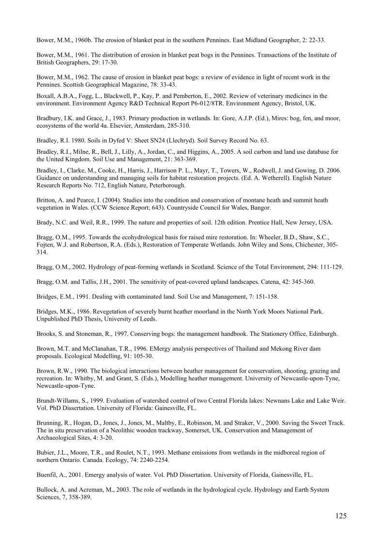
125
Bower, M.M., 1960b. The erosion of blanket peat in the southern Pennines. East Midland Geographer, 2: 22-33. Bower, M.M., 1961. The distribution of erosion in blanket peat bogs in the Pennines. Transactions of the Institute of British Geographers, 29: 17-30. Bower, M.M., 1962. The cause of erosion in blanket peat bogs: a review of evidence in light of recent work in the Pennines. Scottish Geographical Magazine, 78: 33-43.
Boxall, A.B.A., Fogg, L., Blackwell, P., Kay, P. and Pemberton, E., 2002. Review of veterinary medicines in the environment. Environment Agency R&D Technical Report P6-012/8TR. Environment Agency, Bristol, UK. Bradbury, I.K. and Grace, J., 1983. Primary production in wetlands. In: Gore, A.J.P. (Ed.), Mires: bog, fen, and moor, ecosystems of the world 4a. Elsevier, Amsterdam, 285-310. Bradley, R.I. 1980. Soils in Dyfed V: Sheet SN24 (Llechryd). Soil Survey Record No. 63.
Bradley, R.I., Milne, R., Bell, J., Lilly, A., Jordan, C., and Higgins, A., 2005. A soil carbon and land use database for the United Kingdom. Soil Use and Management, 21: 363-369.
Bradley, I., Clarke, M., Cooke, H., Harris, J., Harrison P. L., Mayr, T., Towers, W., Rodwell, J. and Gowing, D. 2006. Guidance on understanding and managing soils for habitat restoration projects. (Ed. A. Wetherell). English Nature Research Reports No. 712, English Nature, Peterborough. Britton, A. and Pearce, I. (2004). Studies into the condition and conservation of montane heath and summit heath vegetation in Wales. (CCW Science Report; 643). Countryside Council for Wales, Bangor. Brady, N.C. and Weil, R.R., 1999. The nature and properties of soil. 12th edition. Prentice Hall, New Jersey, USA. Bragg, O.M., 1995. Towards the ecohydrological basis for raised mire restoration. In: Wheeler, B.D., Shaw, S.C., Fojten, W.J. and Robertson, R.A. (Eds.), Restoration of Temperate Wetlands. John Wiley and Sons, Chichester, 305-314. Bragg, O.M., 2002. Hydrology of peat-forming wetlands in Scotland. Science of the Total Environment, 294: 111-129. Bragg, O.M. and Tallis, J.H., 2001. The sensitivity of peat-covered upland landscapes. Catena, 42: 345-360. Bridges, E.M., 1991. Dealing with contaminated land. Soil Use and Management, 7: 151-158. Bridges, M.K., 1986. Revegetation of severely burnt heather moorland in the North York Moors National Park. Unpublished PhD Thesis, University of Leeds. Brooks, S. and Stoneman, R., 1997. Conserving bogs: the management handbook. The Stationery Office, Edinburgh. Brown, M.T. and McClanahan, T.R., 1996. EMergy analysis perspectives of Thailand and Mekong River dam proposals. Ecological Modelling, 91: 105-30. Brown, R.W., 1990. The biological interactions between heather management for conservation, shooting, grazing and recreation. In: Whitby, M. and Grant, S. (Eds.), Modelling heather management. University of Newcastle-upon-Tyne, Newcastle-upon-Tyne. Brundt-Willams, S., 1999. Evaluation of watershed control of two Central Florida lakes: Newnans Lake and Lake Weir. Vol. PhD Dissertation. University of Florida: Gainesville, FL. Brunning, R., Hogan, D., Jones, J., Jones, M., Maltby, E., Robinson, M. and Straker, V., 2000. Saving the Sweet Track. The in situ preservation of a Neolithic wooden trackway, Somerset, UK. Conservation and Management of Archaeological Sites, 4: 3-20. Bubier, J.L., Moore, T.R., and Roulet, N.T., 1993. Methane emissions from wetlands in the midboreal region of northern Ontario. Canada. Ecology, 74: 2240-2254. Buenfil, A., 2001. Emergy analysis of water. Vol. PhD Dissertation. University of Florida, Gainesville, FL. Bullock, A. and Acreman, M., 2003. The role of wetlands in the hydrological cycle. Hydrology and Earth System Sciences, 7, 358-389.
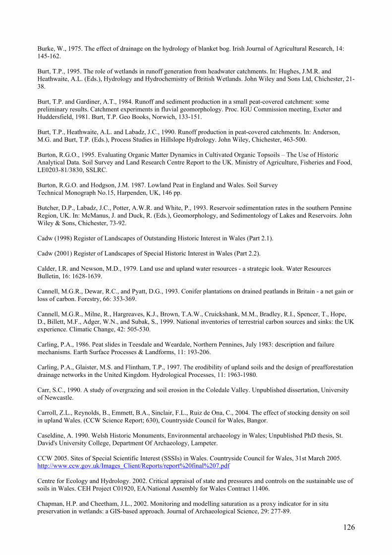
126
Burke, W., 1975. The effect of drainage on the hydrology of blanket bog. Irish Journal of Agricultural Research, 14: 145-162. Burt, T.P., 1995. The role of wetlands in runoff generation from headwater catchments. In: Hughes, J.M.R. and Heathwaite, A.L. (Eds.), Hydrology and Hydrochemistry of British Wetlands. John Wiley and Sons Ltd, Chichester, 21-38. Burt, T.P. and Gardiner, A.T., 1984. Runoff and sediment production in a small peat-covered catchment: some preliminary results. Catchment experiments in fluvial geomorphology. Proc. IGU Commission meeting, Exeter and Huddersfield, 1981. Burt, T.P. Geo Books, Norwich, 133-151. Burt, T.P., Heathwaite, A.L. and Labadz, J.C., 1990. Runoff production in peat-covered catchments. In: Anderson, M.G. and Burt, T.P. (Eds.), Process Studies in Hillslope Hydrology. John Wiley, Chichester, 463-500. Burton, R.G.O., 1995. Evaluating Organic Matter Dynamics in Cultivated Organic Topsoils – The Use of Historic Analytical Data. Soil Survey and Land Research Centre Report to the UK. Ministry of Agriculture, Fisheries and Food, LE0203-81/3830, SSLRC. Burton, R.G.O. and Hodgson, J.M. 1987. Lowland Peat in England and Wales. Soil Survey Technical Monograph No.15, Harpenden, UK, 146 pp. Butcher, D.P., Labadz, J.C., Potter, A.W.R. and White, P., 1993. Reservoir sedimentation rates in the southern Pennine Region, UK. In: McManus, J. and Duck, R. (Eds.), Geomorphology, and Sedimentology of Lakes and Reservoirs. John Wiley & Sons, Chichester, 73-92. Cadw (1998) Register of Landscapes of Outstanding Historic Interest in Wales (Part 2.1). Cadw (2001) Register of Landscapes of Special Historic Interest in Wales (Part 2.2). Calder, I.R. and Newson, M.D., 1979. Land use and upland water resources - a strategic look. Water Resources Bulletin, 16: 1628-1639. Cannell, M.G.R., Dewar, R.C., and Pyatt, D.G., 1993. Conifer plantations on drained peatlands in Britain - a net gain or loss of carbon. Forestry, 66: 353-369. Cannell, M.G.R., Milne, R., Hargreaves, K.J., Brown, T.A.W., Cruickshank, M.M., Bradley, R.I., Spencer, T., Hope, D., Billett, M.F., Adger, W.N., and Subak, S., 1999. National inventories of terrestrial carbon sources and sinks: the UK experience. Climatic Change, 42: 505-530. Carling, P.A., 1986. Peat slides in Teesdale and Weardale, Northern Pennines, July 1983: description and failure mechanisms. Earth Surface Processes & Landforms, 11: 193-206. Carling, P.A., Glaister, M.S. and Flintham, T.P., 1997. The erodibility of upland soils and the design of preafforestation drainage networks in the United Kingdom. Hydrological Processes, 11: 1963-1980. Carr, S.C., 1990. A study of overgrazing and soil erosion in the Coledale Valley. Unpublished dissertation, University of Newcastle. Carroll, Z.L., Reynolds, B., Emmett, B.A., Sinclair, F.L., Ruiz de Ona, C., 2004. The effect of stocking density on soil in upland Wales. (CCW Science Report; 630), Countryside Council for Wales, Bangor. Caseldine, A. 1990. Welsh Historic Monuments, Environmental archaeology in Wales; Unpublished PhD thesis, St. David's University College, Department Of Archaeology, Lampeter. CCW 2005. Sites of Special Scientific Interest (SSSIs) in Wales. Countryside Council for Wales, 31st March 2005. http://www.ccw.gov.uk/Images_Client/Reports/report%20final%207.pdf Centre for Ecology and Hydrology. 2002. Critical appraisal of state and pressures and controls on the sustainable use of soils in Wales. CEH Project C01920, EA/National Assembly for Wales Contract 11406. Chapman, H.P. and Cheetham, J.L., 2002. Monitoring and modelling saturation as a proxy indicator for in situ preservation in wetlands: a GIS-based approach. Journal of Archaeological Science, 29: 277-89.
127
Chapman, P.J. and Edwards, A.C., 1999. The impact of atmospheric N deposition on the behaviour of N in surface water. In: Langan, S.J. (Ed.), Impacts of Nitrogen Deposition on Natural and Semi-Natural Ecosystems. Kluwer Academic Publishers, The Netherlands, 153-212. Chapman, P.J., Edwards, A.C., Reynolds, B. and Neal, C., 1999. The nitrogen composition of streams draining grassland and forested catchments: influence of afforestation on the nitrogen cycle in upland ecosystems. In: Heathwaite, A.L. (Ed.), Impact of land-use change on nutrient loads from diffuse sources. IAHS publication, Wallingford, 17-26. Chapman, S.J., Towers, W., Williams, B.L., Coull, M.C. and Paterson, E., 2001. Review of the contribution to climate change of organic soils under different land uses. Scottish Central Research Unit, Edinburgh. Chambers, F.M. 1982a. Two radiocarbon-dated pollen diagrams from high-altitude blanket peats in South Wales. Journal of Ecology, 70: 445-459. Chambers, F.M. 1982b. Environmental History of Cefn Gwernffrwd, near Rhandirmwyn, Mid-Wales. New Phytologist, 92: 607-615. Chambers F.M. 1983. Three radiocarbon-dated pollen diagrams from upland peats noth-west of Merthyr Tydfil, South Wales. Journal of Ecology, 71: 475-487. Chambers, F.M. 1991. Peat humification: proxy-climatic record or indicator of land-use history?. Soils and Human Settlement, Report 26 (ed. S. Limbrey) pp. 27–44, Welsh Soils Discussion Group, Bangor Chambers, F.M. and Cloutman, W.E. 1999. Bryn y Gaer. Report on stratigraphic investigations September 1999. (CCW South Area Report; 6), Countryside Council for Wales (CCW), Cardiff. Chambers, F.M. 2000. Waen Rydd, Llanwrtyd wells : a preliminary peat-stratigraphic analysis. (CCW East Area Report; 13), Countryside Council for Wales, Bangor. Chambers, F.M., Mauquoy, D., Pearson, F., Daniell, J.R.G., Gent, A., and Cook, C. 2001. Recent vegetation change in Welsh blanket mires : a palaeoecological appraisal. (CCW Science Report; 420). Countryside Council for Wales, Bangor. Chambers, F.M., Hughes, P.D.M., Jones, P.S., Cloutman, E.W., 2003. Palaeoecological investigations at Cors Bryn-Gaer SSSI, Rhondda-Cynon-Taff, South Wales. (CCW Science Report; 594), Countryside Council for Wales, Bangor. Charman, D., 2002. Peatlands and environmental change. Wiley, Chichester. Chasar, L.S., Chanton, J.P., Glaser, P.H., Siegel D.I., and Rivers, J.S., 2000. Radiocarbon and stable carbon isotopic evidence for transport and transformation of dissolved organic carbon, dissolved inorganic carbon, and CH4 in a northern Minnesota peatland. Global Biogeochemical Cycles, 14: 1095-1108. Choo, L.P.D. and Baker, G.H., 1998. Influence of four commonly used pesticides on the survival, growth, and reproduction of the earthworm Aporrectodea trapezoids (Lumbricidae). Australian Journal of Agricultural Research, 49: 1297-1303. Chow, A.T., Tanji, K.K., Gao, S.D., and Dahlgren, R.A., 2006. Temperature, water content and wet-dry cycle effects on DOC production and carbon mineralization in agricultural peat soils. Soil Biology & Biochemistry, 38: 477-488. Clark, J.M., Chapman, P.J., Adamson J.K., and Lane, S.N., 2005. Influence of drought-induced acidification on the mobility of dissolved organic carbon in peat soils. Global Change Biology, 11: 791-809. Clark, R., 1996. Methodologies for the economic analysis of soil erosion and conservation. CSERGE Working Paper GEC 96-13. Clausen, J.C., 1980. The quality of runoff from natural and disturbed Minnesota peatlands. Proceedings 6th International Peat Congress, Duluth, Minnesota, 1976. Minnesota, 523-532. Clayden, B. and Hollis, JM 1984. Criteria for differentiating soil series. Soil Survey Technical Monograph No 17, Harpenden, UK, 159pp.

128
Clymo, R.S., 1983. Peat. In: Gore, A.S.P. (Ed.), Swamp, bog, fen and moor. General studies. Ecosystems of the world 4A. Elsevier, Amsterdam, 159-224. Clymo, R.S., 1992. Productivity and decomposition of peatland ecosystems. In: Bragg, O.M., Hulme, P.D., Ingram, H.A.M and Robertson, R.A. (Eds.), Peatland Ecosystems and man: an impact assessment. International Peat Society, Finland. Clymo, R.S., Foster, G.N., MacKay, J., Robertson, J., Shore, R. and Skidmore, D., 1992. Terrestrial biology in limed catchments. In: Howells, G. and Dalziel, T.R.K. (Eds.), Restoring Acid Waters: Loch Fleet 1984-90. Elsevier, London. Clymo, R.S., Turunen J., and Tolonen, K., 1998. Carbon accumulation in peatland. Oikos, 81: 368-388. Cohen, M.J., Brown, M.T. and Shepherd, K.D., 2006. Estimating the environmental costs of soil erosion at multiple scales in Kenya using emergy synthesis. Agriculture, Ecosystems & Environment, 114: 249-69. Cole, G., 1976. Land drainage in England and Wales. Journal of the Institute of Water Engineers, 30: 345-367. Coles, B. and Coles, J., 1986. Sweet Track to Glastonbury: the Somerset Levels in Prehistory. Thames and Hudson, London. Collins, V.G., D’Sylva, B.T. and Latter, P.M., 1978. Microbial populations in peat. In: Heal, O.W. and Perkins, D.F. (Eds.), Production ecology of British moors and montagne grasslands. Springer Verlag, Heidelberg. Colombo, S., Calatrava-Requena, J., and Hanley, N., 2006 (In Press, Corrected Proof). Analysing the social benefits of soil conservation measures using stated preference methods. Ecological Economics. Commission of European Communities (2006a) Thematic strategy for soil protection. Brussels, 12pp. Commission of European Communities (2006b) Proposal for a Directive of the European Parliament and of the Council establishing a framework for the protection of soil and amending Directive 2004/35/EC, 30pp. Convery, F.J., 1991. Constructed markets. In: Braden, J.B. and Kolstad, C.D. (Eds.), Measuring the Demand for Environmental Quality. Elsevier, North Holland, 227-70. Coulson, J.C., 1990. A preliminary investigation of the invertebrates of the Flows of northern Scotland. Nature Conservancy Council, Peterborough. Coulson, J.C., Butterfield, J.E.L.,1980. The geographical characterisation of moorland using invertebrates. Final report.. (CST Report; 285). University of Durham, Durham. Coulson, J.C., Fielding, C.A. and Goodyear, S.A., 1992. The management of moorland areas to enhance their nature conservation interest. 134, Joint Nature Conservation Committee, Peterborough. Cresser, M.S. and Edwards A.C., 1987. Acidification of freshwaters. Cambridge University Press, Cambridge. Crisp, D.T., 1966. Input and output of minerals for an area of Pennine moorland: the importance of precipitation, drainage, peat erosion and animals. Journal of Applied Ecology, 3: 327-347. Critchley, C.N.R., 2005. Sustainable moorland grazing project. In: Moors for the Future Partnership, 2005. Peak District Moorlands – Past, Present and Future, 20-21 September, 2005, Losehill Hall, Castleton, Derbyshire, UK. Crosson, P., Pimentel, D., Harvey, C., Resosudarmo, P., Sinclair, K., Kurz, D., McNair, M., Crist, S., Shpritz, L., Fitton, L., Saffouri, R., and Blair, R., 1995. Soil Erosion Estimates and Costs. Science, New Series, 269: 461-65. Daelnet. 2003. Return to the uplands: cattle back on Ingleborough. http://www.daelnet.co.uk/countrynews/archive/2003/country_news_24072003.cfm. Last accessed: 19/05/2006. Darby, H.C., 1956. The draining of the fens. Cambridge University Press, Cambridge. Darvill, T. and Fulton, A., 1998. MARS: The Monuments at Risk Survey of England, 1995: Main Report. Bournemouth and London, Bournemouth University and English Heritage.

129
Davidson, E.A. and Janssens, I.A., 2006. Temperature sensitivity if soil carbon decomposition and feedbacks to climate change. Nature, 440: 165-173. Davies, P., Loxham, J. and Huggon, G., 1996. Repairing upland path erosion: a best practice guide. Lake District National Park Authority, Publication Number 03 06 659, 160pp. Dawson, J.J.C., Billet, M.F., Neal, C. and Hill, S., 2002 A comparison of particulate, dissolved and gaseous carbon in two contrasting upland streams in the UK. Journal of Hydrology, 257: 226-246. de Groot, R.S., Wilson, M.A. and Boumans, R.M.J., 2002. A typology for the classification, description and valuation of ecosystem functions, goods and services. Ecological Economics, 41: 393-408. De Jong, E. and Kachanoski, R.G., 1988. The importance of erosion in the carbon balance of prairie soils. Canadian Journal of Soil Science, 68: 111-19. Dean, C., Undated a. Moors for the Future restoration monitoring. Moors for the Future, Castleton, UK. Dean, C., Undated b. Footpath monitoring and visitor surveys, Moors for the Future baseline research. Moors for the Future, Castleton, UK. DEFRA. 2002. Economic conditions on cattle and sheep farms in the hills and uplands of the United Kingdom. Department for Environment, Food and Rural Affairs, London. DEFRA. 2004a. The first soil action plan for England: 2004-2006. DEFRA, London. DEFRA. 2004b. The Agricultural Atlas – for the June Agricultural Census. Available at: http://farmstats.DEFRA.gov.uk/cs/farmstats_data/MAPS/agricultural_atlas/map_select.asp?year=2003&c_id=0&Submit3=Get+Map. Last accessed: 17/05/2006. DEFRA. 2005. Controlling erosion - Incorporating former advisory leaflets on grazing livestock, wind, outdoor pigs and the uplands. DEFRA, London. DEFRA. 2006a. Trends and Charts - from the June Agricultural Census. Available at: http://farmstats.DEFRA.gov.uk/cs/farmstats_data/trends/hist_trends.asp. Last accessed: 17/05/2006. DEFRA. 2006b. England Rural Development Programme, Yorkshire and Humberside, air, soil and water. Available at: http://www.DEFRA.gov.uk/erdp/docs/yhchapter/yhsection12/yh123.htm. Last accessed: 19/05/2006. Department of Environment. 1990. Planning Policy Guidance Note 16: Archaeology and Planning. HMSO, London. Desaules, A., 1991. The Soil Vulnerability Mapping Group for Europe (SOVEUR): Methodological considerations with reference to conditions on Switzerland. In: Batjes, N.H. and Bridges, E.M. (Eds.), Mapping of soil and terrain vulnerability to specified chemical compounds in Europe at a scale of 1:5M. Proceedings of an International Workshop held at Wageningen, The Netherlands (20-23 March 1991) ISRIC, Wageningen, 23-28. Dillon, P.J. and Molot, L.A., 1997. Effect of landscape form on export of dissolved organic carbon, iron, and phosphorus from forested stream catchments. Water Resources Research, 33: 2591-2600. Dise, N.B., Gorham, E., and Verry, E.S., 1993. Environmental-factors controlling methane emissions from peatlands in northern Minnesota. Journal of Geophysical Research – Atmosphere, 98: 10583-10594. Doar, N.R., 1997. Gardening without peat. In: Parkyn, L., Stoneman R.E. and Ingram, H.A.P. (Eds.), Conserving Peatlands. CAB International, Wallingford, UK, 255-261. Dorland, E., Leon, J., van der Berg, L., Brouwer, E., Roelofs, J.G.M. and Bobbink, R. (2005) Catchment liming to restore degraded acidified heathlands and moorland pools. Restoration Ecology, 13: 302-311. Dougill, A.J., Fraser, E.D.G., Holden, J., Hubacek, K., Prell, C., Reed, M.S., Stagl, S. T., and Stringer, L.C., Forthcoming 2006. Learning from doing participatory rural research: Lessons from the Peak District National Park. Journal of Agricultural Economics, special issue on the Rural Economy and Land Use (RELU) Programme. Drinking Water Inspectorate UK. 1998. New drinking water regulations in the UK. Drinking Water Inspectorate, London, UK.
130
Dwyer, J., Eaton, R., Farmer, A., Baldock, D., Withers, P. and Silcock, P., 2002. Policy mechanisms for the control of diffuse agricultural pollution, with particular reference to grant aid. English Nature Research Reports, 455, English Nature, Peterborough, 135 pp. Eadie, J., 1985. The hills and uplands of Britain: interactions in land use. Soil Use and Management, 1: 38-43. Edwards, A., Martin, D. and Mitchell, G. (Eds.), 1987. Colour in upland waters. Proceedings of Yorkshire Water/Water Research Centre Workshop. Ekwue, E.I., 1990. Effect of organic matter on splash detachment and the processes involved. Earth Surface Processes and Landforms, 15: 175-181. Ekwue, E.I., Ohu, J.O. and Wakawa, I.H., 1993. Effects of incorporating two organic materials at varying levels of splash detachment of some soils from Borneo State, Nigeria. Earth Surface Processes and Landforms, 18: 399-406. Ellis, C.J. and Tallis, J.H., 2001. Climatic control of peat erosion in a North Wales blanket mire. New Phytologist, 152: 313-324. English Heritage. 1996. Preservation of archaeological evidence in situ. Archaeological Review. English Heritage Annual Report, London. English Nature. 1994. Planning for environmental sustainability. In: Sustainability in Practice, Issue 1, June. English Nature, Peterborough, UK. English Nature. 2001. The upland management handbook. English Nature, Peterborough, UK. English Nature. 2002. Peat bog conservation: the importance of lowland raised bogs. English Nature, Peterborough, UK. English Nature. 2003. England’s best wildlife and geological sites, the condition of Sites of Special Scientific Interest in England in 2003. English Nature, Peterborough, UK. English Nature. 2004. Sustainable grazing in the English Uplands. English Nature, Peterborough, UK. English Nature. 2006. National Nature Reserves. Available at: http://www.english-nature.org.uk/special/nnr/nnr_details.asp?nnr_name=&C=0&Habitat=0&natural_area=&local_team=0&spotlight_reserve=0&X=&NNR_ID=92. Last accessed: 19/05/2006. Enters, T., 1998. Methods for the economic assessment of the on- and off-site impacts of soil erosion. International Board for Soil Research and Management, Bangkok. Environment Agency. 1999. Sheep dip strategy. Environment Agency R&D Technical Report P237. Environment Agency, Bristol, UK. Environment Agency. (2001). Best Farming Practices: Profiting from a good environment. Environment Agency, R&D Publication 23. ISBN 1 85 705541 1. http://www.environment-agency.gov.uk/business/444304/1224648/1224663/669460/797683/?version=1&lang=_e Environment Agency. (2002). Agriculture and natural resources: benefits, costs and potential solutions. Environment Agency. p.102. http://www.environment-agency.gov.uk/aboutus/512398/516810/516841/578627/?version=1&lang=_e Environment Agency. 2004. The state of soils in England and Wales. Environment Agency, Bristol, UK. Environment Times. 2006. England's North West predicts climate change on tourism. Beckhouse Media Limited. Posted 5 April, 2006. Europeat. 2006. Europeat. Available at: http://www.alterra-research.nl/pls/portal30/docs/folder/europeat/p_frameset_small.htm. Last accessed: 24/06/2006. Evans, C., Norris, D. and Rowe, E., 2005b. A regional water and soil quality survey of the North York Moors. CEH Report C02661 for DEFRA.
131
Evans, C.D., Monteith, D.T. and Cooper, D.M., 2005c. Long-term increases in surface water dissolved organic carbon: Observations, possible causes and environmental impacts. Environmental Pollution, 137: 55-71. Evans, M.G., and Warburton J., 2001. Transport and dispersal of organic debris (peat blocks) in upland fluvial systems. Earth Surface Processes and Landforms, 26: 1087-1102. Evans, M.G. and Warburton, J., 2005. Sediment budget for an eroding peat-moorland catchment in Northern England. Earth Surface Processes and Landforms, 30: 557-577. Evans, M.G. and Warburton, J., Forthcoming 2007. The geomorphology of upland peat: process form and landscape change. Blackwells, Oxford. Evans, M.G., Burt, T.P., Holden, J. and Adamson, J.K., 1999. Runoff generation and water table fluctuations in blanket peat: evidence from UK data spanning the dry summer of 1995. Journal of Hydrology, 221: 141-160. Evans, M.G., Allott, T., Holden, J., Flitcroft, C. and Bonn, A. (Eds.), 2005a. Understanding gully blocking in deep peat. Moors for the Future, Castleton. Evans, M.G., Warburton, J. and Yang, J., 2006 (In Press). Eroding blanket peat catchments: global and local implications of upland organic sediment budgets. Geomorphology. Evans, R., 1974. A study of selected slope erosion processes acting on slopes in a small drainage basin. PhD Thesis, University of Sheffield. Evans, R., 1977. Overgrazing and soil erosion on hill pastures with particular reference to the Peak District. Journal of the British Grassland Society, 32: 65-76. Evans, R., 1980. Mechanics of water erosion and their spatial and temporal controls: an empirical viewpoint. In: Kirkby, M.J. and Morgan, R.P.C. (Eds.), Soil erosion. Wiley, Chichester, 109-128. Evans, R., 1993. Sensitivity of the British Landscape to Erosion. In: Thomas, D.S.G. and Allison, R.J. (Eds.), Landscape Sensitivity. John Wiley, Chichester, 189-210. Evans, R., 1995. Soil Erosion and Land Use: Towards a Sustainable Policy. Cambridge Environmental Initiative: University of Cambridge, Cambridge. Evans, R., 1996. Soil Erosion and its impact in England and Wales. Friends of the Earth, London. Evans, R., 1997. Soil erosion in the UK initiated by grazing animals: a need for a national survey. Applied Geography, 17: 127-141. Evans, R., 1998. The erosional impacts of grazing animals. Progress in Physical Geography, 22: 251-268. Evans, R., 2005a. Reducing soil erosion and the loss of soil fertility for environmentally-sustainable agricultural cropping and livestock production systems. Annals of Applied Biology, 146: 137-146. Evans, R., 2005b. Curtailing grazing induced erosion in a small catchment and its environs, the Peak District, Central England. Applied Geography, 25: 81-95. Evans, R., 2005c. Monitoring water erosion in lowland England and Wales – a personal view of its history and outcomes. Catena, 64: 142-161. Evans, R., 2006. Land use, sediment delivery and yield in England and Wales. In: Owens, P.N. and Collins, A.J. (Eds.), Soil Erosion and Sediment Redistribution in River Catchments: Measurement, Modelling and Management. CAB International, Wallingford. Evans, R. and Boardman, J., 2003. Curtailment of muddy floods in the Sompting catchment, South Downs, West Sussex, southern England. Soil Use and Management, 19: 223-231. FAO. 1984. Land, food and people. Economic and Social Development Series No. 30. FAO, Rome. In: Steiner, K.G., Causes of Soil Degradation and Development Approaches to Sustainable Soil Management. Margraf Verlag, Weikersheim.
132
Farmer, R.A. and Nisbet, T.R., 2004. An overview of forest management and change with respect to environmental protection in the UK. Hydrology and Earth System Sciences, 8: 279-285. Farrell, E.R., O’Neill, C. and Morris, A., 1994. Changes in the mechanical properties of soils with variations in organic content. In: Den Haan, Termaat and Edil, (Eds.), Advances in understanding and modelling the Mechanical Behaviour of Peat. Balkema, Rotterdam, 19-25. Fearing, D.A., Goslan, E.H., Banks, J., Wilson, D., Hillis P., Campbell, A.T. and Parsons, S.A., 2004. Staged coagulation for treatment of refractory organics. Journal of Environmental Engineering, 130: 975-982. Felton, M. and Marsden, J.H., 1990. Heather regeneration in England and Wales. A feasibility study for the Department of the Environment, Nature Conservancy Council, Peterborough. Ferguson, N.P. and Lee, J.A., 1983. Past and present sulphur pollution in the southern Pennines. Atmospheric Environment, 17: 1131-7. Finer, L., 1996. Variation in the amount and quality of litterfall in a Pinus sylvestris L. stand growing on a bog. Forest Ecology and Management, 80: 1-11. Fisher, A.S., Podniesinski, G.S. and Leopold, D.J., 1996. Effects of drainage ditches on vegetation patterns in abandoned agricultural peatlands in central New York. Wetlands, 16: 397-409. Floate, M.J.S., 1977. British hill soil problems. Soil Science, 123: 325-331. Fog, K., 1988. The effect of added nitrogen on the rate of decomposition of organic matter. Biological Reviews, 63: 433-462. Follett, R.F., 2001. Soil management concepts and carbon sequestration in cropland soils. Soil and Tillage Research, 61: 77-92. Forestry Commission. 1995. Forests and Archaeology Guidelines. Forestry Commission, Edinburgh. Forestry Commission. 2000. Forests and Peatland Habitats: Guideline Note. Forestry Commission, Edinburgh.
Forestry Commission. 2003. Forest and Waters Guidelines - Fourth Edition. Forestry Commission, Edinburgh, 66 pp.
Forster, A. and Culshaw, M., 2004. Implications of climate change for hazardous ground conditions in the UK. Geology Today, 20: 61-67. Foss, P.J. and O’Connell, C.A., 1996. Irish Peatland Conservation Plan 2000. Irish Peatland Conservation Council, Dublin. Fowler, D., Cape, J.N. and Dunsworth, M.H., 1989. Deposition of atmospheric pollutants on forests. Philosophical Transactions of the Royal Society, London, B 324: 247-265. Fowler, D., O’Donoghue, M., Muller, J.B.A., Smith, R., Dragosits, U., Skiba, U., Sutton, M. and Brimblecombe P., 2004. A chronology of nitrogen deposition in the UK between 1900 and 2000. Water Air Soil and Pollution Focus, 4: 9-23. Fowler, D., Smith, R.I., Muller, J.B.A, Hayman, G. and Vincent K.J., 2005. Changes in the atmospheric deposition of acidifying compounds in the UK between 1986 and 2001. Environmental Pollution, 137: 15-25. Francis, I.S., 1990. Blanket peat erosion in a mid-Wales catchment during two drought years. Earth Surface Processes & Landforms, 15: 445-456. Freeman, C., Lock, M.A. and Reynolds, B., 1993. Impacts of climate change on peatland hydrochemistry: a laboratory based experiment. Chemistry and Ecology, 8: 49-59. Freeman, C., Evans, C.D., Monteith, D.T., Reynolds, B., and Fenner, N., 2001a. Export of organic carbon from peat soils. Nature, 412: 785-785.

133
Freeman, C., Ostle, N. and Kang, H., 2001b. An enzymic 'latch' on a global carbon store - a shortage of oxygen locks up carbon in peatlands by restraining a single enzyme. Nature, 409: 149-149. Freeman, C., Fenner, N., Ostle, N.J., Kang, H., Dowrick, D.J., Reynolds, B., Lock, M.A., Sleep, D., Hughes, S., and Hudson, J., 2004. Export of dissolved organic carbon from peatlands under elevated carbon dioxide levels. Nature, 430: 195-198. Friends of the Earth. 1998. Lowland raised bog SSSIs threatened by commercial peat extraction. Friends of the Earth, London. Galloway, J.N., Dentener, M., Capone, D.G., et al. 2004. Nitrogen cycles, past, present and future. Biogeochemistry, 70: 153-226. Garnett, M., Ineson, P. and Stevenson, A.C., 2000. Effects of burning and grazing on carbon sequestration in a Pennine blanket bog. Holocene, 10: 729-736. Garnett, M., Ineson, P., Stevenson, A., and Howard, D., 2001. Terrestrial organic carbon storage in a British moorland. Global Change Biology, 7: 375-388. Gimingham, C.H., 1971. British heathland ecosystems: the outcome of many years of management by fire. Proceedings of the 10th Annual Tall Timbers Fire Ecology Symposium, 293-321. Gimingham, C.H., 1972. Ecology of heathlands. Chapman & Hall, London. Gimingham, C.H., 1995. Heaths and moorland: an overview of ecological change. In: Thompson, D.B.A., Hester A.J. and Usher, M.B. (Eds.), Heaths and moorland: cultural landscapes. HMSO, Edinburgh. Gimingham, C.H., 2002. Foreward. A vision for the uplands. In: Burt, T.P, Thompson, D.B.A. and Warburton, J. (Eds.), The British Uplands: Dynamics of change. JNCC Report 319, Durham, 9-11. Gilman, K. 1994. Impact of proposed improvements to peripheral drains at Rhos Talgas SSSi, Dyfed. (CCW Science Report; 45a), Institute of Hydrology, Llanbrynmair. Gilman, K. 1995. Hydrological impacts of proposed drainage improvement at Arthog Bog SSSI, Gwynedd. (CCW Science Report; 45f). Countryside Council for Wales, Bangor. Gilman, K. 2000. Hydrological assessment of the implications of NNR management at Fenn's, Whixall and Bettisfield Mosses : summary. Report to English Nature and Countryside Council for Wales. (CCW Science Report; 505c). Llangurig, Powys. Gilman, K. 2002. A review of evapotranspiration rates from wetland and wetland catchment plant communities, with particular reference to Cors y Llyn NNR, Powys, Wales. (CCW Science Report; 504). Countryside Council for Wales, Bangor. Glaves, D.J. and Haycock, N.E. (Eds.), 2005. DEFRA review of the Heather and Grass Burning Regulations and Code: Science Panel Assessment of the Effects of Burning on Biodiversity, Soils and Hydrology. Final Report to DEFRA Conservation, Uplands and Rural Europe Division, Uplands Management Branch, 119pp. Good, J.E.G., et al. 2002. The potential for woodland expansion in the uplands of England and Wales. In: Burt, T.P, Thompson, D.B.A. and Warburton, J. (Eds.), The British uplands: The dynamics of change. JNCC Report 319, Durham, 161-162pp. Goode, D.A. and Ratcliffe, D.A., 1977. Peatlands. In: Ratcliffe, D.A. (Ed.), A nature conservation review, Volume 1, Chapter 8, Cambridge University Press, Cambridge. Goodburn-Brown D. and Panter, I., 2004. Reburial in the context of development: Approaches to reburial in the English planning process. Conservation and Management of Archaeological Sites, 6: 275-284. Gordon J.E. 1994. The Role of Designated Sites and the Assessment of the Soils Resource. In: Scotland’s soils: research issues in developing a soil sustainability strategy. (ed. JE Gordon). pp. 75-80. Scottish Natural Heritage Review No. 13.
134
Goslan, E.H., Fearing, D.A., Banks, J., Wilson, D., Hills, P., Campbell, A.T. and Parsons, S.A., 2002. Seasonal variations in the disinfection by-product precursor profile of a reservoir water. Journal of Water Supply: Research and Technology – AQUA, 51: 475-482. Goslan, E.H., Voros, S., Banks, J., Wilson, D., Hillis, P., Campbell, A.T. and Parsons, S.A., 2004. A model for predicting dissolved organic carbon distribution in a reservoir water using fluorescence spectroscopy. Water Research, 38: 783-791. Gosselink, J.G. and Maltby, E., 1990. Wetland gains and losses. In: Williams, M. (Ed.), Wetlands: a threatened landscape. Blackwell Science, Oxford, UK, 269-322. Graham, E.R. and Killion, D.D., 1962. Soil colloids as a factor in the uptake of cobalt, caesium and strontium in plants. Soil Science Society, 545-546. Grant, S.A., 1968. Heather regeneration following burning: a survey. Journal of the British Grassland Society, 23: 26-33. Grant, S.A. and Armstrong, H.M., 1993. Grazing ecology and the conservation of heather moorland: the development of models as aids to management. Biodiversity and Conservation, 2: 79-94. Grant, S.A., Bolton, G.R. and Torvell, L., 1985. The response of blanket bog vegetation to controlled grazing by sheep. Journal of Applied Ecology, 22: 739-751. Grant, S.A., Barthram, G.T., Lamb, W.I.C. and Milne, J.A. 1978. Effects of season and level of grazing on the utilisation of heather by sheep. I: Responses of the sward. Journal of the British Grassland Society, 33: 289-300. Gray, D. 2002. NVC survey of proposed extensions to Eryri cSAC (Glydeiau and Y Wyddfa). (CCW Science Report; 517). Countryside Council for Wales, Bangor. Gray, D. 2004. A condition assessment of the 'European Dry Heath', 'North Atlantic wet heath with erica tetralix'' and 'Blanket Bog' at the Cadair Idris cSAC. (CCW Environmental Monitoring Report; 11). Countryside Council for Wales, Bangor. Gray, D.D. (2006). A condition assessment of the European Dry Heath, Northern Atlantic Wet Heath and Blanket Bog Habitat at the Migneint-Arenig-Dduallt SAC. (CCW Environmental Monitoring Report; 29). Countryside Council for Wales, Bangor. Grieve, I.C., Davidson, D.A. and Gordon, J.E., 1995. Nature, extent and severity of soil erosion in upland Scotland. Land Degradation and Rehabilitation, 6: 41-55. Grootjans, A.P., Schipper, P.C. and van der Windt, H.J., 1985. Influence of drainage on N-Mineralisation and vegetation response in wet meadows I: Calthion palustris stands. Acta Oecologica, 6: 403-417. Grootjans, A.P., Schipper, P.C. and van der Windt, H.J., 1986. Influence of drainage on N-Mineralisation and vegetation response in wet meadows I: Cirsio-Molinietum stands. Acta Oecologica, 7: 3-14. Gunn, J., Labadz, J.C., Dykes, A.P., Kirk, K.J., Poulson, S.J., and Matthews, C. 2002. Blanket bog hydrology at Mynydd Hiraethog SSSI : an investigation of peat properties and hydrology and assessment of effects of proposed wind farm construction. (CCW Science Report; 501). Countryside Council for Wales, Bangor. Hagedorn, F., Schleppi, P., Wladner, P. and Fluhler, H., 2000. Export of dissolved organic carbon and nitrogen from Gleysol dominated catchments – the significance of water flow paths. Biogeochemistry, 50: 137-161. Hajkovicz, S., 2002. Regional priority setting in Queensland: a multi-criteria evaluation framework. Consultancy report for the Queensland department of natural resources and mines. SCIRO Land and Water. Hansen, K., 1969. Edaphic conditions of Danish heath vegetation and the response to burning-off. Botanical Tidsskrift, 64: 121-140. Harden, J.W., Sharpe, J.M., Parton, W.J., Ojima, D.S., Fries, T.L., Huntington, T.G., and Dabney, S.M., 1999. Dynamic replacement and loss of soil carbon on eroding cropland. Global Biogeochemical Cycles, 13: 885-901.

135
Harrod, T.R., McHugh, M., Appleby, P.G., Evans, R., George, D.G., Haworth, E.Y., Hewitt, D., Hornung, M., Housen, G., Leekes, G., Morgan, R.P.C. and Tipping, E., 2000. Research on the quantification and causes of upland erosion. Soil Survey and Land Research Centre report JX4118E to the Ministry of Agriculture, Fisheries and Food. Haynes, R.J. and Swift R.S., 1988. Effects of lime and phosphate additions on changes in enzyme-activities, microbial biomass and levels of extractable nitrogen, sulfur and phosphorus in an acid soil. Biology and Fertility of Soils, 6: 153-158. Heal, O.W., Andersen, J.M. and Swift, M.J., 1997. Plant litter quality and decomposition: An historical overview. In: Cadisch, G. and Giller, K.E. (Eds.), Driven by Nature: plant litter quality and decomposition. CAB International, Wallingford, UK, 3-30. Heathwaite, A.L., 1987. Chemical transformations in a drained fen peat. Unpublished PhD Thesis, University of Bristol. Heathwaite, A.L., 1993. Disappearing peat - regenerating peat? The impact of climate change on British peatlands. The Geographical Journal, 159: 203-208. Heathwaite, A.L., 1995. Overview of the hydrology of British wetlands. In: Hughes, J.M.R and Heathwaite, A.L. (Eds.), Hydrology and Hydrochemistry of British Wetlands. John Wiley, Chichester, 11-20. Higgitt, D.L., Warburton, J. and Evans, M.G., 2001. Sediment Transfer in Upland Environments. In: Higgitt, D.L. and Lee, E.M. (Eds.), Geomorphological Processes and Landscape Environments. Blackwell Publishers Ltd, Oxford, 190-214. Hill, M. O., Evans, D. F. and Bell, S. A. 1992. Long-term effects of excluding sheep from hill pastures in North Wales. Journal of Ecology, 80: 1-13. Hird, A.B., Rimmer, D.L. and Livens, F.R., 1996. Factors affecting the sorption and fixation of caesium in acid and organic soils. European Journal of Soil Science, 36: 1-34. Hobbs, R.J., 1984. Length of burning rotation and community composition in high-level Calluna-Eriophorum bog in N. England. Vegetatio, 57: 129-136. Hobbs, R.J., 1986. Mire morphology and the properties and behaviour of some British and foreign peats. Quarterly Journal of Engineering Hydrology, 19: 7-80. Hobbs, R.J. and Gimingham, C.H., 1987. Vegetation, fire and herbivore interactions in heathland. Advances in Ecological Research, 16: 87-193. Hodge, C.A.H., Burton, R.G.O., Corbett, W.M., Evans, R. and Seale, R.S., 1984. Soils and their use in Eastern England. Soil Survey of England and Wales Bulletin No. 13. Harpenden, 450pp. Holden, J., 2001. Recent reduction of frost in the North Pennines. Journal of Meteorology, 26: 369-374. Holden, J., 2004. Hydrological connectivity of soil pipes determined by ground penetrating radar tracer detection. Earth Surface Processes and Landforms, 29: 437-442. Holden, J., 2005a. Controls of soil pipe frequency in blanket peat. Journal of Geophysical Research, 110, doi:10.1029/2004JF000143. Holden, J., 2005b. Piping and woody plants in peatlands: cause or effect? Water Resources Research, 41: W06009, DOI: 10.1029/2004WR003909. Holden, J., 2005c. Peatland hydrology and carbon cycling: why small-scale process matters. Philosophical Transactions of the Royal Society A, 363: 2891-2913. Holden, J. 2005d. Analysis of Environment Agency hydrological monitoring data collected at Geltsdale in conjunction with grip-blocking works at Halton Lea Fell. Report for English Nature, 18pp. Holden, J., 2006. Sediment and particulate carbon removal by pipe erosion increase over time in blanket peatlands as a consequence of land drainage. Journal of Geophysical Research, 111: F02010, doi:10.1029/2005JF000386
136
Holden, J. and Adamson, J.K., 2002. The Moor House long-term upland temperature record - new evidence of recent warming. Weather, 57: 119-127. Holden, J. and Burt, T.P., 2002a. Infiltration, runoff and sediment production in blanket peat catchments: implications of field rainfall simulation experiments. Hydrological Processes, 16: 2537-2557. Holden, J. and Burt, T.P., 2002b. Piping and pipeflow in a deep peat catchment. Catena, 48: 163-199. Holden, J and Burt, T.P., 2002c. Laboratory experiments on drought and runoff in blanket peat. European Journal of Soil Science, 53: 1-15. Holden, J. and Burt, T.P., 2003a. Runoff production in blanket peat covered catchments. Water Resources Research, 39: 1191, DOI: 10.1029/2003WR002067. Holden, J. and Burt, T.P., 2003b. Hydrological studies on blanket peat: The significance of the acrotelm-catotelm model. Journal of Ecology, 91: 86-102 Holden, J. and Burt, T.P., 2003c. Hydraulic conductivity in upland blanket peat; measurement and variability. Hydrological Processes, 17: 1227-1237. Holden, J., Burt, T.P. and Cox, N.J., 2001 Macroporosity and infiltration in blanket peat: the implications of tension disc infiltrometer measurements. Hydrological Processes, 15: 289-303. Holden, J., Burt, T.P. and Vilas, M., 2002. Application of ground penetrating radar to the identification of subsurface piping in blanket peat. Earth Surface Processes and Landforms, 27: 235-249. Holden, J., Chapman P.J., and Labadz, J.C., 2004. Artificial drainage of peatlands: Hydrological and hydrochemical process and wetland restoration. Progress in Physical Geography, 28: 95-123. Holden, J., West, J., Howard, A.J. Maxfield, E., Panter, I., Oxley, J., 2006a. Hydrological controls of in situ preservation of waterlogged archaeological deposits. Earth-Science Reviews, 78: 59-83 Holden, J., Burt, T.P., Evans, M.G. and. Horton, M., 2006b. Impact of land drainage on peatland hydrology. Journal of Environmental Quality 35: 1764-1778, doi:10.2134/jeq2005.0477 Holden, J., Chapman, P.J., Lane, S.N. and Brookes, C.J., 2006c. Impacts of artificial drainage of peatlands on runoff production and water quality. In: Martini, I.P., Cortizas, A.M. and Chesworth, W. (Eds.), Peatlands: basin evolution and depository of records of global environmental and climatic changes. Elsevier, Amsterdam, 501-528. Hope, D., Billet, M.F., Milne, R. and Brown, T.A.W., 1997a. Exports of organic carbon in British rivers. Hydrological Processes, 11: 325-344 Hope, D., Billett, M.F. and Cresser, M.S., 1997b. Exports of organic carbon in two river systems in NE Scotland. Journal of Hydrology, 193: 61-82. Hornung, M., Stevens, P.A. and Reynolds, B., 1986. The impact of pasture improvment on the soil solution chemistry of some stagnopodzols in mid-Wales. Soil Use and Management, 1: 18-26. Housley, R., Straker, V. and Cope, D.W., 2000. The Holocene Stratigraphy of Queen's Sedgemoor, and its relationship to Godney Moor and Glastonbury Heath based on Soil Survey data of the 1980s. Archaeology in the Severn Estuary, 10: 11-23. Howard, P.J.A., Loveland, P.J., Bradley, R.I., Dry, F.T., Howard, D.M. and Howard, D.C., 1994a. The carbon content of soil and its geographical distribution in Great Britain. Soil Use and Management, 11: 9–15. Howard, P.J.A., Loveland, P.J., Bradley, R.I., Dry, F.T., Howard, D.M. and Howard, D.C., 1994b. The carbon content of soil and its geographical distribution in Great Britain. In: Carbon sequestration by soils in the UK. DOE report PECD 7/12/80, 1994. ITE, Grange-over-Sands. Howington, T.M., 1999. A Spatial analysis of emergy of an internationally shared drainage basin and the implications for policy decisions. Vol. PhD Dissertation. University of Florida: Gainesville, FL.
137
Huang, C.C. and O’Connell, M., 2000. Recent land-use and soil erosion history within a small catchment in Connemara, western Ireland: evidence from lake sediments and documentary sources. Catena, 41: 293-335. Hubacek, K., Burt, T., Chapman, P., Dougill, A., Fraser, E., Holden, J., Kirkby, M., McQuaid, J., Prell, C., Pitts, C., Reed, M., Stagl, S., Turner, A. and Worrall, F., 2005. Sustainable Uplands Mangement. Final Report for the Rural Economy and Land Use Programme (funded by ESRC, NERC, BBSRC): RES-224-25-0088. Hughes, S., Reynolds, B. and Hudson, J., 1998. Release of bromide following rewetting of a naturally drained acid gully mire. Soil Use and Management, 12: 62-66. Hughes, P.D.M. and Dumayne-Peaty, L. 2002. Testing theories of mire development using multiple successions at Crymlyn Bog, West Glamorgan, South Wales, UK. Journal of Ecology, 90: 456–471. Hyde, T. and Midmore, P. 2006. Valuing our Environment - Economic Impact of the National Parks of Wales. A report to Countryside Council for Wales on behalf of the Valuing our Environment Partnership. p.77. ICOMOS. 1996. The ICOMOS charter on the protection and management of underwater cultural heritage. 11th ICOMOS General Assembly, Sofia, Bulgaria, 5-9 October 1996. IEEP. 2004. An assessment of the impacts of hill farming in England on the economic, environmental and social sustainability of the uplands and more widely - literature review and consultations, DEFRA, London. IGER. 2004. Optimal grazing management systems for sheep and beef cattle in the hills and uplands. DEFRA project LS3402. DEFRA, London. INDITE. 1994. Impacts of nitrogen deposition in terrestrial ecosystems. UK Review Group on Impacts of Atmospheric Nitrogen, Department of the Environment. Imeson, A.C., 1971. Heather burning and soil erosion on the North Yorkshire Moors. Journal of Applied Ecology, 8: 537-542. Ingram, H.A.P., 1992. Introduction to the hydroecology of mires in the context of cultural perturbation. In: Bragg, O.M., Hulme, P.D., Ingram, H.A.P. and Robertson, R.A. (Eds.), Peatland Ecosystems and man: an Impact Assessment. International Peat Society, Finland, 67-93. Ivanov, K.E., 1981. Water Movement in Mirelands. Academic Press, New York. Jacinthe, P.A., Lal, R. and Kimble, J.M., 2002. Carbon dioxide evolution in runoff from simulated rainfall on long-term no till and plowed soils in southwestern Ohio. Soil and Tillage Research, 66: 22-33. Jacobs, M., 1997. Environmental valuation, deliberative democracy, and public decision-making institutions. In: Foster, J. (Ed.), Valuing Nature. Routledge, London. Jarvis, R.A., Bendelow, V.C., Bradley, R.I., Carroll, D.M., Furness, R.R., Kilgour, I.N.L. and King, S.J., 1984. Soils and their use in Northern England. Soil Survey of England and Wales Bulletin No 10. Harpenden, 411pp. Jayasuriya, R.T., 2003. Measurement of the scarcity of soil in agriculture. Resources Policy, 29: 119-29. Joint Nature Conservation Committee. 2003. UK biodiversity website. http://www.ukbap.org.uk Jones, D.L., Wallace, H., Atkinson, G., Carroll, Z., Sheriff, A.L., Packwood A., and Koerber G.R.2004. The comparison of the long term effects of burning and mowing on the soil characteristics, vegetation structure, species diversity and the regeneration capacity of blanket mire and European dry heath vegetation on the Berwyn Mountains. Contract No: FC 72-02-62. Countryside Council for Wales, Bangor. Jones, J.A.A., 1997. Pipeflow contributing areas and runoff response. Hydrological Processes, 11: 35-41. Jones, J.A.A., 2004. Implications of natural soil piping for basin management in upland Britain. Land Degradation & Development, 15: 325-349. Jones, J.A.A. and Crane, F.G., 1984. Pipeflow and pipe erosion in the Maesnant experimental catchment. In: Burt, T.P. and Walling, D.E. (Eds.), Catchment experiments in fluvial geomorphology. Geo Books, Norwich, 55-72.

138
Jones, P.S., Stevens, D.P., Blackstock, T.H., Burrows, C.R. and Howe, E.A.(eds.) 2003. Priority Habitats of Wales: A Technical Guide. Countryside Council for Wales, Bangor. Joshi, S., 2000. Product environmental life-cycle assessment using input-output techniques. Industrial Ecology, 2: 95-120. Kalbitz, K., Geyer, W. and Geyer, S., 1999. Spectroscopic properties of dissolved humic substances – a reflection of land use history in a fen area. Biogeochemistry, 47: 219-238. Kasimir-Klemedtsson, A., Klemedstsson, L., Berglund, K., Martikainen, P., Silvola, J. and Oenema, O., 1997. Greenhouse gas emissions from farmed organic soils: a review. Soil Use and Management, 13: 245-250. Kay, P., Blackwell, P. and Boxall, A.B.A., 2005. Transport of veterinary antibiotics in overland flow following the application of slurry to arable land. Chemosphere, 59: 951-959. Keiller, S.W.J., Buse, A., Cherrett, J.M.,1994a. Effects of grazing density on upland invertebrates in Snowdonia & Mid Wales. Report No.3. (CCW Science Report; 98). Countryside Council for Wales, Bangor. Keiller, S.W.J., Buse, A., Cherrett, J.M.,1994b. Effects of sheep grazing density on upland invertebrates in Snowdonia & Mid Wales. Report No.4. (CCW Science Report; 99). Countryside Council for Wales, Bangor. Keiller, S.W.J., Buse, A., Cherrett, J.M.,1995a. Effects of sheep grazing density on upland invertebrates in Snowdonia and Mid Wales. Report No.5. (CCW Science Report; 119). Countryside Council for Wales, Bangor. Keiller, S.W.J., Buse, A., Cherrett, J.M.,1995b. Effects of sheep grazing density on upland arthropods in Snowdonia and Mid Wales. Final Report No.6. (CCW Science Report; 120). Countryside Council for Wales, Bangor. Kenworthy, J.B., 1963. Temperatures in heather burning. Nature, 200: 1226. Kinako, P.D.S., 1975. Effects of heathland fires on the microhabitat and regeneration of vegetation. PhD Thesis, University of Aberdeen, Aberdeen. Kinako, P.D.S. and Gimingham, C.H., 1980. Heather burning and soil erosion on upland heaths in Scotland. Journal of Environmental Management, 10: 277-284. Kirby, P. (1994). Survey of invertebrates of South Carmarthenshire fens. (CCW Science Report; 97). Countryside Council for Wales, Bangor. Klinger, L.F., Zimmermann, P.R., Greenberg, J.P., Heidt, L.E. and Guenther, A.B., 1994. Carbon trace gas fluxes along a successional gradient in the Hudson Bay lowland. Journal of Geophysical Research, 99: 1469-1494. Krasner, S.W., McGuire, M.J., Jacangelo, J.G., Patania, N.L., Reagan, K.M. and Aieta, E.M., 1989. The occurrence of disinfection by-products in US drinking water. Journal of the American Water Works Association, 81: 41-53. Krug, E.C. and Frink, C.R., 1983. Effects of acid-rain on soil and water. Connecticut Agricultural Experiment Station Bulletin, 811: 1-45. Kuhry, P., 1994. The role of fire in the development of sphagnum-dominated peatlands in western boreal Canada. Journal of Ecology, 82: 899-910. Kuylenstierna, J.C.I. and Chadwick, M.J., 1991. Increases in soils acidity in North West Wales between 1957 and 1990. Ambio, 20: 118-119. Labadz, J.C., Burt, T.P. and Potter, A.W.R., 1991. Sediment Yield and Delivery in the Blanket Peat Moorlands of the Southern Pennines. Earth Surface Processes and Landforms, 16: 255-271. Laine, J. and Minnikinen, K., 1996. Effect of forest drainage on the carbon balance of a mire. Scandinavian Journal of Forest Research, 11: 307-312. Laine, J., Silvola, J., Tolonen, K., Alm, J. Nykanen, H., Vasander, H., Sallantaus, T., Savolainen, I., Sinisalo J. and Martikainen, P. J., 1996. Effect of water-level drawdown on global climatic warming: Northern peatlands. Ambio, 25: 179-184.
139
Lal, R., 1997. Residue management, conservation tillage and soil restoration for mitigating greenhouse effect by CO2-enrichment. Soil and Tillage Research, 43: 81-107. Lal, R., 2002. Soil carbon dynamics in cropland and rangeland. Environmental Pollution, 116: 353-62. Lal, R., 2003. Soil erosion and the global carbon budget. Environment International, 29: 437-450. Lal, R., 2004. Soil carbon sequestration to mitigate climate change. Geoderma, 123: 1-22. Lal, R., Kimble, J. and Follet, R.F., 1998. Pedospheric processes and the carbon cycle. In: Lal, R., Kimble, J.M., Follet, R.F. and Stewart, B.A. (Eds.), Soil Processes and the Carbon Cycle. Advances in Soil Science, CRC Press, Boca Raton, 1-8. Lancaster, K. J., 1966. A New Approach to Consumer Theory. The Journal of Political Economy, 74: 132-157. Lance, A.N., Baugh, I.D. and Love, J.A., 1989. Continued footpath widening in the Cairngorm Mountains, Scotland. Biological Conservation, 49: 201-214. Lane, S.N., Brookes, C.J., Kirkby, M.J. and Holden, J., 2004. A network-index-based version of TOPMODEL for use with high-resolution digital topographic data. Hydrological Processes, 18: 191-201. Lascelles, B., Jenkins, D., 1995. Conservation of soil profiles in Wales: the possible status of soils within RIGS. (CCW Science Report; 144). Countryside Council for Wales, Bangor. Legg, C.J., Maltby, E. and Proctor, M.C.F., 1992. The ecology of severe moorland fire on the North York Moors: seed distribution and seedling establishment of Calluna vulgaris. Journal of Ecology, 80: 737-752. Leifeld, J., Bassin, S. and Fuhrer, J., 2005. Carbon stocks in Swiss agricultural soils predicted by land-use, soil characteristics, and altitude. Agriculture, Ecosystems and Environment, 105: 255-266. Leinweber, P., Schulten, H-R., Kalbitz, K., MeiBner, R. and Jancke, H., 2001. Fulvic acid composition in degraded fenlands. Journal of Plant Nutrition and Soil Science, 164: 371-379. Lindsay, R., 1995. Bogs: The Ecology, Classification and Conservation of Ombrotrophic Mires. Scottish Natural Heritage, Perth, 120pp. Lindsay, R.A. and Immirzi, C.P., 1996. An inventory of lowland raised bogs in Great Britain. Scottish Natural Heritage, Battleby. Livett, E.A., Lee, J.A. and Tallis, J.H., 1979. Lead Zinc and Copper analyses of British Peats. Journal of Ecology, 67: 865-891. Llorens, L., Penuelas, J., Beier, C., Emmett, B., Estiarte, M., Tietema, A. 2004. effects of an experimental increase of temperature and drought on the photosyntheic performance of two Ericaceous shrub species along a north-south gradient. Ecosystems 7: 613-624. Lovat, L., 1911. Heather burning. In: Leslie, A.S. (Ed.), The grouse in health and disease. Smith, Elder & Co., London, 392-412. Loveland, P.J. and Thompson, T.R.E. (Eds.), 2001. Identification and development of a set of national indicators for soil quality. R&D Technical Report P5-053/2/TR, Environment Agency, Bristol. Lundin, L., 1991. Retention or loss of N in forest wetlands. Vatten, 47: 301-304. Lutz, E., Pagiola, S. and Reiche, C., 1994. The costs and benefits of soil conservation: The Farmers' Viewpoint. The World Bank Research Observer, 9: 273-295. MacDonald, A., 2000. Effects of grouse moor management on moorland plant diversity, proceedings of the grouse moor management and biodiversity workshop. (Unpublished), Napier University, Edinburgh. Mackay, A.W., 1997. Peat erosion: some implications for conservation and management of blanket mires and heather moorland in the UK. In: Parklyn, L., Stoneman, R.E. and Ingram, H.A.P., Conserving Peatlands. CAB International, Wallingford, 82-87.
140
Mackay, A.W. and Tallis, J.H., 1996. Summit-type blanket mire erosion in the forest of Bowland, Lancashire, UK: predisposing factors and implications for conservation. Biological Conservation, 76: 31-44. MAFF. 1994. The heather and grass burning code. MAFF, London. Magrath, W.B., 1990. Economic analysis of soil conservation technologies. Watershed development in Asia - strategies and technologies. Technical Paper No. 127. J. M. Doolette, W.B. Washington DC, World Bank: 71-96. Makulec, G., 1991. The effect of long term drainage of peat soil on earthworm communities (Oligochaete: Lumbricidea). Polish ecological studies, 17: 203-219. Maljanen, M., Komulainen, V-M., Hytönen, J., Martikainen, P.J. and Laine, J., 2004. Carbon dioxide, nitrous oxide and methane dynamics in boreal organic agricultural soils with different soil characteristics. Soil Biology and Biochemistry, 36: 1801-1808. Mallik, A.U., Gimingham, C.H. and Rahman, A.A., 1984. Ecological effects of heather burning: I. Water infiltration moisture retention and porosity of surface soil. Journal of Ecology, 72: 767-776. Maltby, E., 1997. Peatlands: the science case for conservation and sound management. In: Parkyn, L., Stoneman, R.E. and Ingram, H.A.P. (Eds.), Conserving Peatlands. Wallingford: CAB International, 121-131. Maltby, E., Legg, C.J. and Proctor, M.C.F., 1990. The ecology of severe moorland fire on the North York Moors - effects of the 1976 fires, and subsequent surface and vegetation development. Journal of Ecology, 78: 490-518. Marrs, R.H. and Welch, D., 1991. Moorland wilderness: The potential effects of removing domestic livestock, particularly sheep, ITE, Huntingdon. Marshner, B. and Wilczynski, W.A., 1991. The effect of liming on quantity and chemical composition of soil organic matter in a pine forest soil in Berlin, Germany. Plant and Soil, 137: 229-236. Martin, H.W., Ivanoff, D.B., Graetz, D.A. and Reddy, K.R., 1997. Water table effects on histosol drainage water carbon, nitrogen and phosphorus. Journal of Environmental Quality, 26: 1062-1071. Martinez-Casasnovas, J.A., Ramos, M.C., and Ribes-Dasi, M., 2005. On-site effects of concentrated flow erosion in vineyard fields: some economic implications. Catena, 60: 129-46. Mawby, F.J., 1995: Effects of Damming Peat Cuttings on Glasson Moss and Wedholme Flow, two Lowland Raised Bogs in North-West England. In: Wheeler, B.D., Shaw, S.C., Fojt, W.J. and Robertson, R.A. (Eds.), Restoration of Temperate Wetlands. John Wiley and Sons, Chichester, 349-358. Mayfield, B. and Pearson, M.C., 1972. Human interference with the north Derbyshire blanket peat. East Midland Geographer, 12: 245-251. Maynard, R., 1997. Sheep dip disposal: ‘no room for complacency’. Soil Association, Bristol, UK. McCahon, C.P., Carling, P.A. and Pascoe, D., 1987. Chemical and ecological effects of a Pennine peat slide. Environmental Pollution, 45: 275-289. McGrath, M., 2005. United Utilities Sustainable Catchment Management – Whitendale Trial Preliminary Results. In: Moors for the Future Partnership. (2005). Peak District Moorlands – Past, Present and Future, 20-21 September, 2005, Losehill Hall, Castleton, Derbyshire, UK. McHugh, M., 2000. Extent, causes and rates of upland soil erosion in England and Wales. PhD Thesis, Cranfield University at Silsoe. McHugh, M., Harrod, T. and Morgan, R., 2002. The extent of soil erosion in Upland England and Wales. Earth Surface Processes and Landforms, 27: 99-107. Meyles, E.W., Williams, A.G., Ternan, J.L., Anderson, J.M., and Dowd, J.F., 2006. The influence of grazing on vegetation, soil properties and stream discharge in a small Dartmoor catchment, southwest England, UK. Earth Surface Processes and Landforms, 31: 622-631.
141
Midmore, D.J., Jansen, H.G.P., and Dumsday, R.G., 1996. Soil erosion and environmental impact of vegetable production.in the Cameron Highlands, Malaysia. Agriculture, Ecosystems & Environment, 60: 29-46. Miller, G.R., Miles, J. and Heal, O.W., 1984. Moorland management: a study of Exmoor. Institute of Terrestrial Ecology, Cambridge. Miller, J.D., Anderson, H.A., Ray, D. and Anderson, A.R., 1996. Impacts of some initial forestry practices on drainage waters from blanket peat. Forestry, 69: 193-203. Miller, W. and Everett, H., 1975. The Economic Impact of Controlling Nonpoint Pollution in Hardwood Forestland. American Journal of Agricultural Economics, 57: 576-583. Milligan, A.L., Putwain, P.D., Cox, E.S., Ghorbani, J., Le Duc, M.G.and Marrs, R.H., 2004. Developing an integrated land management strategy for the restoration of moorland vegetation on Molinia caerulea-dominated vegetation for conservation purposes in upland Britain. Biological Conservation, 119: 371-385. Milne, R. and Brown, T.A., 1997. Carbon in the vegetation and soils of Great Britain. Journal of Environmental Management, 49: 413-433. Ministry of Agriculture, Fisheries and Food. 1993. Code of good agricultural practice for the protection of soil. MAFF Publications, London. Ministry of Agriculture, Fisheries and Food. 2000. Research on the quantification and causes of upland erosion. MAFF Research and Development Final Project Report SP0402. Minnkinen, K. and Laine, J., 1998. Long-term effect of forest drainage on the peat carbon stores of pine mires in Finland. Canadian Journal for Forest Research, 28: 1267-1295. Mitchell, G. and McDonald A.T., 1992. Discoloration of water by peat following induced drought and rainfall simulation. Water Research, 26: 321-326. Moore, P.D. and Beckett, P.J. 1971. Vegetation and development of Llyn, a Welsh mire. Nature, 231: 363–365. Moore, P.D. and Bellamy, D.J., 1974. Peatlands. Elek Science, London, 221pp. Moore, P.D. 2002. The future of cool temperate bogs. Environmental Conservation, 29: 3-20. Moore, T.R., 1987. A preliminary study of the effects of drainage and harvesting on water quality in an ombrotrophic bogs near Sept-Iles, Quebec. Water Resources Bulletin, 23: 785-791. Moore, T.R., Roulet, N.T., Waddington, J.M., 1998. Uncertainty in predicting the effect of climatic change on the carbon cycling of Canadian peatlands. Climatic Change, 40: 229-245. Moors for the Future. 2006. Upland path repair. Available at: http://www.moorsforthefuture.org.uk/mftf/restoration/footpath.htm. Last accessed: 19/05/2006. Morgan, R.P.C., 1985. Soil erosion measurement and soil conservation research in cultivated areas of the UK. The Geographical Journal, 151: 11-20. Morgan, R.P.C., 1985. Assessment of soil erosion risk in England and Wales. Soil Use and Management, 1: 127-131. Morgan, R.P.C., 2005. Soil erosion and conservation (Third Edition). Blackwell, Oxford, 304pp. Mosely, M.P., 1972. Gully systems in blanket peat, Bleaklow, North Derbyshire. East Midland Geographer, 5: 235-244. Moss, R., Marquiss, M. and Picozzi, N., 1996. Impacts of afforestation on predation of game and wildlife on adjacent open ground. ITE, Monks Wood. Mowforth, M.H. and Sydes, C., 1989. Moorland management: a literature review. 25, Nature Conservancy Council, Peterborough. Munda, G., 1995. Multicriteria Evaluation in a Fuzzy Environment - Theory and Applications in Ecological Economics. Heidelberg, Physika Verlag.

142
National Soil Resources Institute. 2002. Upland erosion data analysis. DEFRA Final Project Report SP0406. National Soil Resources Institute. 2006. Critical levels of soil organic carbon in surface soils in relation to soil stability, function and infiltration. http://www.silsoe.cranfield.ac.uk/nsri/projects/soil_carbon/risk.htm. Last accessed: 01/06/2006. Neal, C., Reynolds, B., Neal, M., Wickham, M., Hill, L. and Williams, B., 2004. The water quality of streams draining a plantation forest on gley soils: the Nant Tanllwyth, Plynlimon, mid-Wales. Hydrology and Earth Systems Science, 8: 485-502. Neal, C., Reynolds, B., Smith, C.J., Hill, S., Neal, M., Conway, T., Ryland, G.P., Jeffery, H.A., Robson, A.J. and Fisher, R., 1992. The impact of conifer harvesting on stream water pH, alkalinity and aluminium concentrations for the British uplands: an example for an acidic and acid-sensitive catchment in mid-Wales. Science of the Total Environment, 126: 75-87. Neal, C., Robson, A. J., Neal M., and Reynolds, B., 2005. Dissolved organic carbon for upland acidic and acid sensitive catchments in mid-wales. Journal of Hydrology, 304: 203-220. NEGTAP. 2001. Transboundary Air Pollution: Acidification, Eutrophication and Ground level ozone in the UK. Department for Environment, Food and Rural Affairs, London. NEGTAP. 2001. Transboundary air pollution: acidification, eutrophication and ground level ozone in the UK, Prepared by the expert group on transboundary air pollution, DEFRA Contract EPG 1/3/153. Newbould, P., 1985. Improvement of native grassland in the Uplands. Soil Use and Management, 1: 43-49. Nilsson, J. and Grennfelt, P. (Eds), 1988. Critical Loads for sulphur and nitrogen. Report 1988:15 UNECE/Nordic Council of Ministers, Copenhagen, Denmark. Nisbet, T.R. and Broadmeadow, S., 2003. Opportunity mapping for trees and floods. Forest Research, Farnham. NPAONB. 2004. NPAONB Management Plan 2004-2009. http://www.northpennines.org.uk/media/pdf/m/t/NPMP%20-%20Part%201.pdf NSRI. 2002. Upland erosion data analysis. DEFRA project SP0406. DEFRA, London. Odum, H.T., 1996. Environmental Accounting: Energy and Environmental Decision Making. New York: John Wiley and Sons Inc. Odum, H.T., Doherty, S.J., Scatena, F.N. and Kharecha, P.A., 2000. Emergy evaluation of reforestation alternatives in Puerto Rico. Forest Science, 46 521-30. O'Neill, J., 1996. Cost-benefit analysis, rationality and the plurality of values. The Ecologist, 26: 98-103. O'Neill, J. and Spash, C.L., 2000. Appendix: Policy Research Brief Conceptions of Value in Environmental Decision-Making. Environmental Values, 9: 521-36. Orledge, G.M. ; Nash, D.R. ; Blanchard, G.B. ; Conway, J.S. (1998). Distribution of the black bog ant Formica candida on Rhossili Down, Gower. (CCW Science Report; 266). Bangor : Countryside Council for Wales (CCW). Orledge, G.M. and Gander, L. 2003. A survey for the black bog ant formica candida at Beacon Bog SSSI in Carmarthenshire. (CCW Science Report; 595). Countryside Council for Wales, Bangor. Owen, T.M. 1969. Historical aspects of peat-cutting in Wales. In: Studies in Folk Life. (ed. G. Jenkins), pp. 123-155. Routledge & Kegan Paul, London. Owen, T.M. 1975. Historical aspects of peat cutting in Merioneth. Journal of the Merioneth Historical and Record Society, 7: 308-320. Palmer, S.C.F., Gordon, I.J., Hester, A.J. and Pakeman, R.J., 2004. Introducing spatial grazing impacts into the prediction of moorland vegetation dynamics. Landscape Ecology, 19: 817-827.
143
Pascual, J.A., Hart, A.D.M., Saunders, P.J., McKay, H.V., Kilpatrick, J. and Prosser, P., 1999. Agricultural methods to reduce the risk to birds from cereal treatments on fenlands in eastern England. I. Sowing depth manipulation. Agriculture, Ecosystems and Environment, 72: 59-73. Pastor, J., Aber, J.D., McClaugherty, C.A., Melillo, J.M., 1984. Above ground production and N and P cycling along a nitrogen mineralization gradient on Blackhawk Island, Wisconsin. Ecology, 65: 256-268. Pastor, J., Solin, J., Bridgham, S.D., Updegraff, K., Harth, C., Weishampel, P.and Dewey, B., 2003. Global warming and the export of dissolved organic carbon from boreal peatlands. Oikos, 100: 380-386. Paterson, G. and Anderson, R. 2000. Forests and Peatland Habitats. Guideline Note 1 (FCGN1). Forestry Commission, Edinburgh. Pattanayak, S. and Mercer, D.E., 1998. Valuing soil conservation benefits of agroforestry: contour hedgerows in the Eastern Visayas, Philippines. Agricultural Economics, 18: 31-46. Pawson, R.R., Evans, M.G. and Allott, T.E., 2006. The role of particulate organic carbon (POC) in the carbon cycle of degrading upland peat systems. Geophysical Research Abstracts 8, European Geophysical Society annual conference, Vienna, April 2006. Peak District National Park. 2006. Study area/fact sheets seventeen. Available at: http://www.peakdistrict-nationalpark.info/studyArea/factsheets/17.html. Last accessed: 19/05/2006. Peak District Rural Deprivation Forum. 2004. Hard times - a research report into hill farming and farming families in the Peak District, Peak District Rural Deprivation Forum, Hope. Persson, T., Lundkvist, H., Wiren, A., Hyvonen, R. and Wessen, B., 1989. Effects of acidification and liming on carbon and nitrogen mineralization and soil organisms in mor humus. Water Air Soil and Pollution, 45: 778-96. Philips, J., Tallis, J. and Yalden, D. (Eds.), 1981. Peak District Moorland erosion study: Phase 1 report. Peak Park Joint Planning Board, Bakewell Pilkington, M.G., Caporn, S.J.M., Carroll, J.A., Cresswell, N., Lee, J.A., Ashenden, T.W., Brittain, S.A., Reynolds, B. and Emmett, B.A., 2005. Effects of increased deposition of atmospheric nitrogen on an upland moor: leaching of N species and soil solution chemistry. Environmental Pollution, 135: 29-40. Pimentel, D. and Krummel, J., 1987. Biomass energy and soil erosion: Assessment of resource costs. Biomass, 14: 15-38. Pimentel, D., Harvey, C., Resosudarmo, P., Sinclair, K., Kurz, D., McNair, M., Crist, S., Shpritz, L., Fitton, L., Saffouri, R., and Blair, R., 1995. Environmental and Economic Costs of Soil Erosion and Conservation Benefits. Science, New Series, 267: 1117-23. Pitkaenen, A., Turunen, J., and Tolonen, K., 1999. The role of fire in the carbon dynamics of a mire, eastern Finland. Holocene, 9: 453-462. Plum, N., 2005. Terrestrial invertebrates in flooded grassland: A literature review. Wetlands, 25: 721-737. Pollard, E. and Miller, A., 1968. Wind erosion in the East Anglian Fens. Weather, 23: 415-417. Polyakov, V. and Lal, R., 2004. Modeling soil organic matter dynamics as affected by soil water erosion. Environment International, 30: 547-56. Post, M. and Kwon, K.C., 2000. Soil carbon sequestration and land-use change: processes and potential. Global Change Biology, 6: 317-327. Power, S.A., Ashmore, M.R. and Cousins, D.A., 1998. Impacts and fate of experimentally enhance nitrogen deposition on a British lowland heath. Environmental Pollution, 102: 27-34. Power, S.A., Green, A.R., Barker, C.G., Bell, N.B. and Ashmore, M.R., 2006. Ecosystem recovery: heathland response to a reduction in nitrogen deposition. Global Change Biology, 12: 1-12. Powlson, D., 2005. Will soil amplify climate change? Nature, 4333: 204-205.
144
Prado-Jatar, M.A. and Brown, M.T., 1997. Interface ecosystems with an oil spill in a Venezuelan tropical savannah. Ecological Engineering, 8: 49-78. Pretty, J.N., Brett, C., Gee, D., Hine, R.E., Mason, C.F., Morison, J.I.L., Raven, H., Rayment, M.D., and van der Bijl, G., 2000. An assessment of the total external costs of UK agriculture. Agricultural Systems, 65: 113-36. Price, J., 1997. Soil moisture, water tension, and water table relationships in a managed cutover bog. Journal of Hydrology, 202: 21-32. Price, J.S. and Waddington, J.M., 2000. Advances in Canadian wetland hydrology and biogeochemistry. Hydrological Processes, 14: 1579-1589. Price, J.S, Heathwaite, A.L., and Baird, A.J., 2003. Hydrological processes in an abandoned and restored peatlands. An overview of management approaches. Wetland Ecology and Management, 11: 65-83. Prosser, M.V. and Wallace, H.L. 1995. Gwynedd lowland heathland survey supplement: introduction and individual site descriptions. (CCW Science Report; 143). Countryside Council for Wales, Bangor. Prosser, M.V. and Wallace, H.L. 2002. National vegetation classification survey of lowland heathland in Wales : Ceredigion 2001. (CCW Science Report; 649). Countryside Council for Wales, Bangor. Pyatt, G. Ray, D. and Fletcher, J. 2001. An ecological site classification for forestry in Great Britain (FC Bulletin 124). Forestry Commission, Edinburgh. Pyatt, D.G., John, A.L., Anderson, A.R. and White, I.M.S., 1992. The drying of blanket peatland by 20-year-old conifer plantations at Rumster Forest, Caithness. In: Bragg, O.M., Hulme, P.D., Ingram, H.A.P. and Robertson, R.A. (Eds.), Peatland ecosystems and man: an impact assessment. University of Dundee, Dundee, 153-158. Radford, G.L. 2005. Monitoring vegetation change in the Eryri SAC: fifth repeat survey and final report for Cwm Idwal. (CCW Science Report; 702). Countryside Council for Wales, Bangor. Radforth, N.W., 1952. Suggested classification of muskeg for the engineer. Engineering Journal (Canada), 35: 1194-1210. Radley, J., 1962. Peat Erosion on the High Moors of Derbyshire and West Yorkshire. East Midland Geographer, 5: 40-50. Radley, J., 1965. Significance of major moorland fires. Nature, 205: 1254-1259. Radley, J. and Simms, C., 1967. Wind erosion in east Yorkshire. Nature, 216: 20-22. Ramsar. 2002. Guidelines for global action in peatlands. Resolution VIII.17. Gland, Switzerland. Rangel-Castro, I., Prosser, J.I., Scrimgeour, C.M., Smith, P., Ostle, N., Ineson, P., Meharg, A. and Kilham, K., 2004. Carbon flow in an upland grassland: effect of liming on the flux of recently photosynthesized carbon to rhizosphere soil. Global Change Biology, 10: 2100-2108. Ratcliffe, D.A. and Oswald, P.H., 1988. The flow country; the peatlands of Caithness and Sutherland. Nature Conservancy Council, Peterborough. Rawes, M. and Hobbs, R., 1979. Management of semi-natural blanket bog in the northern Pennines. Journal of Ecology, 67: 789-807. Read, J.M., Birch, C.P.D. and Milne, J.A., 2002. HeathMod: a model of the impact of seasonal grazing by sheep on upland heaths dominated by Calluna vulgaris (heather). Biological Conservation, 105: 279-292. Reed, M.S., Hubacek, K. and Prell, C., 2005. Sustainable upland management for multiple benefits: a multi-stakeholder response to the Heather & Grass Burning Code consultation. Project report submitted to DEFRA’s consultation on the review of the Heather and Grass Etc. (Burning) Regulations 1986 and the Heather and Grass Burning Code 1994, University of Leeds.
145
Reynolds, B., Neal, C., Hornung, M., Hughes, S. and Stevens, P.A., 1988. Impacts of afforestation on the soil solution of a stagnopodzol in mid-Wales. Water, Air, Soil Pollution, 38: 55-70. Reynolds, B., Stevens, P.A., Adamson, J.K., Hughes, S. and Roberts, J.D., 1992. Effects of clear felling on stream and soil water aluminium chemistry in three UK forests. Environmental Pollution, 77: 157-165. Rhodes, N. and. Stevenson, A.C., 1997. Palaeoenvironmental evidence for the importance of fires as a cause of erosion in British and Irish blanket peats. In: Tallis, J.H., Meade, R. and Hulme, P.D. (Eds.), Blanket mire degradation: causes, consequences and challenges. Macaulay Land Use Research Institute, Aberdeen, UK, 67-78. Roberts, A.M., Hudson, J.A. and Roberts, G., 1989. A comparison of nutrient losses following grassland improvements using two techniques in an upland area of mid-Wales. Soil Use and Management, 5: 174-179. Roberts, G., Hudson, J.A. and Blackie, J.R., 1984. Nutrients inputs and outputs in a forested and grassland catchment at Plynlimon, Mid-Wales. Agricultural Water Management, 9: 177-191. Robinson, D.N., 1968. Soil erosion by wind in Lincolnshire, March 1968. East Midland Geographer, 4: 351-362. Robinson, M., 1985. The hydrological effects of moorland gripping: a reappraisal of Moor House research. Journal of Environmental Management, 21: 205-211. Robinson, M., 1986. Changes in catchment runoff following drainage and afforestation. Journal of Hydrology, 86: 71-84. Robinson, M. and Armstrong, A.C., 1988. The extent of agricultural field drainage in England and Wales, 1971-1980. Transactions of the Institute of British Geographers, 13: 19-28. Robinson, M. and Newson, M. D., 1986. Comparison of forest and moorland hydrology in an upland area with peat soils. International Peat Journal, 1: 46-68. Rochefort, L., Quinty, F., Campeau, S., Johnson, K. and Malterer, T., 2003. North American approach to the restoration of Sphagnum dominated peatlands. Wetlands Ecology and Management, 11: 3-20. Rodriquez, M.L., Sérodes, J. and Morin, M., 2000. Estimation of water utility compliance with trihalomethane regulations using a modelling approach. Journal of Water Supply: Research and Technology, 49: 57-73. Romanov, V.V., 1968. Hydrophysics of bogs. (Translated by N. Kaner). Israel Program of Scientific Translations, Jerusalem. Ross, S.Y., Adamson, H.F. and Moon, A.E., 2003. Evaluating management techniques for controlling Molinia caerulea and enhancing Calluna vulgaris on upland wet heathland in Northern England, UK. Agriculture, Ecosystems and Environment, 97: 39-49. Ross, N., Harris, C., Brabham, P. and Campbell, S. 2005. Uncovering secrets of Wales’ tundra past. Earth Heritage, 23, 10-12. http://home.btconnect.com/seaburysalmon/pdf/eh23f.pdf Rothwell, J.J., Robinson, S.G., Evans, M.G., Yang, J. and Allott, T.E.H., 2005. Heavy metal release by peat erosion in the Peak District, southern Pennines, UK. Hydrological Processes, 19: 2973-2989. Rothwell, J.J., Evans, M.G., Lindsay, J.B., Allott, T.E.H., (In press). Scale-dependant spatial variability in peatland lead pollution in the southern Pennines, UK. Environmental Pollution. Roulet, N., 1990. The hydrological role of peat-covered wetlands. Canadian Geographer, 34: 82-83. Rowell, D.L., 1994. Soil Science: methods and applications. Longman, Harlow. Royal Commission on Environmental Pollution. 1996. Sustainable use of soil. Nineteenth Report CM3165, HMSO, London. RSPB, English Nature and Institute of Terrestrial Ecology 1997. The wet grassland guide: managing floodplain and coastal wet grasslands for wildlife. Royal Society for the Protection of Birds, Sandy, Bedfordshire.
146
Rudeforth, C.C., Hartnup, R., Lea, J.W., Thompson, T.R.E. and Wright, P.S., 1984. Soils and their use in Wales. Soil Survey if England and Wales, Bulletin No. 11. Harpenden. Sallantaus, T., 1995. Leaching in the material balance of peatlands. Suo, 43: 253-258. Sanger, L.J., Billett, M.F. and Cresser, M.S., 1994. The effect of acidity on carbon fluxes from ombrotrophic peat. Chemistry and Ecology, 8: 249-264. Sansom, A., 1999. Upland vegetation management: the impacts of overstocking. Water Science and Technology, 39: 85-92. Scarf, H.E. and Shoven, J.B. (Eds), 1984. Applied General Equilibrium Analysis, Cambridge University Press, Cambridge. Schiff, S., Aravena, R., Mewhinney, E., Elgood, R., Warner, B., Dillon P., and Trumbore, S., 1998. Precambrian shield wetlands: Hydrologic control of the sources and export of dissolved organic matter. Climatic Change, 40: 167-188. Schipper, L.A. and McLeod, M. 2002. Subsidence rates and carbon loss in peat soils following conversion to pasture in the Waikato Region, New Zealand. Soil Use and Management, 18: 91-93. Schmidt, I.K., Tietema, A., Williams, D., Gundersen, P., Beier, C., Emmett, B.A., and Estiarte, M. 2004. Soil solution chemistry and element fluxes in three European heathlands and their responses to warming and drought. Ecosystems, 7: 638-649. Schuler, J. and Kachele, H., 2003. Modelling on-farm costs of soil conservation policies with MODAM. Environmental Science & Policy, 6: 51-55. Shah, Z., Adams W.A. and Haven, C.D.V., 1990. Composition and activity of the microbial population in an acidic upland soil and effect of liming. Soil Biology and Biochemistry, 22: 257-263. Shaw, S.C., Wheeler, B.D., Kirby, P., Phillipson, P. and Edmunds, R., 1996. Literature review of the historical effects of burning and grazing of blanket bog and upland wet heath. 172, English Nature, Peterborough. Sherry, J. 2005. Guidelines for burning and cutting dwarf-shrub vegetation on lowland and upland heath and blanket bog. Terrestrial Science Group, Countryside Council for Wales, Bangor. Shimwell, D., 1974. Sheep grazing intensity in Edale, 1692-1747, and its effects on blanket peat erosion. Derbyshire Archaeological Journal, 94: 35-40. Shotbolt, L., Huchinson, S.M. and Thomas, A.D., 2006. Determining past heavy metal deposition onto the southern Pennines using reservoir sedimentary records. Journal of Paleolimnology, 35: 305-322. Sibbald, A.R., Grant, S.A., Milne, J.A. and Maxwell, T.J., 1987. Heather moorland management - a model. In: Bell, M. and Bunce, R.G.H. (Eds.), Agriculture and conservation in the hills and uplands. ITE, Grange-over-Sands, 107-108. Sidell, E.J., Higuchi, T., Allison, R.J. and Long, A.J., 2001. The response of archaeological sediments and artefacts to imposed stress regimes as a consequence of past, present and future anthropogenic activity. In: Nixon, T. (Ed.), Preserving archaeological remains in situ? Proceedings of the 2nd conference, 12-14 September 2001. Museum of London Archaeology Service, London, 42-49. Silvola, J., Alm, J, Ahlholm, U., Nykanen, H. and Martikainen, P.J., 1996. CO2 fluxes from peat in boreal mires under varying temperature and moisture conditions. Journal of Ecology, 84: 219-228. Simmons, I.G., 2002. “A grey melancholy hill...” ten thousand years of environmental history. In: Burt, T.P. Thompson D.B.A. and Warburton, J. (Eds), The British Uplands: Dynamics of change. JNCC, Durham, 26-31. Simmons, I.G., 2003. The moorlands of England and Wales: an environmental history 8000BC – AD 2000. Edinburgh University Press, Edinburgh, 414 pp. Simpson, I.A. et al., 1998. Application of a grazing model to predict heather moorland utilization and implications for nature conservation. Journal of Environmental Management, 54: 215-231.

147
Singer, P.C., 1999. Humic substances as precursors for potentially harmful disinfection by-products. Water Science and Technology, 40: 25-30. Sinnadurai, P. 2004. Waun Fignen Felen Management Action Plan. Brecon Beacons National Park Authority. Skeffington, R., Wilson, E., Maltby, E., Immirzi P. and Putwain, P., 1997. Acid deposition and blanket mire degradation and restoration. In: Tallis, J. H., Meade R., and Hulme P. D. (Eds.), Blanket mire degradation: Causes, consequences and challenges. Macaulay Land Use Research Institute, Aberdeen, 29-37. Skiba, U., Cresser, M.S., Derwent, R.G. and Futty, D.W., 1989. Peat acidification in Scotland. Nature, 337: 68-69. Slater, F.M. 1984. Welsh Mires: their range of form – a descriptive account. In: European Mires (ed. By P.D. Moore), Academic Press, London, 283-301. Slater, F.M. and Wilkinson, D.M. 1993. The peatlands of Mid-Powys – a literature review & preliminary description of new sites. Brycheiniog, 26: 17-41. SMI. 2001. Improved soil management for agronomic and environmental gain. Soil Management Initiative, Chester, UK. Smith, C.M.S., Cresser, M.S. and Mitchell, R.D.J., 1993. Sensitivity to acid deposition of dystrophic peat in Britain. Ambio, 22: 22-26. Smith, P., 2004. Carbon sequestration in croplands: the potential in Europe and the global context. European Journal of Agronomy, 20: 229-236. Smith, P., Milne, R., Powlson, D.S., Smith, J.U., Falloon, P. and Coleman, K., 2000. Revised estimates of the carbon mitigation potential of UK agricultural land. Soil Use and Management, 16: 293-295. Smith, R.S., Charman, D., Rushton, S.P., Sanderson, R.A., Simkin, J.M. and Shiel, R.S., 2003. Vegetation change in an ombrotrophic mire in northern England after excluding sheep. Applied Vegetation Science, 6: 261-270. SOAFD. 1995. Economic report on Scottish Agriculture. Scottish Office Agriculture and Fisheries Department, HMSO. Somaratne, W.G., 1998. Policy reforms and the environment: A general equilibrium analysis of land degradation in Sri Lanka. Vol. PhD Thesis. La Trobe University, Melbourne, Australia. SSLRC. 2000. Research on the quantification and causes of upland erosion. MAFF project SP0402, final report. MAFF, London. Stevens, P.A., Brittain, S.A., Hughes, S., Sparks, T.H., Worth, J. 1994. Soil/plant interactions in lowland grassland. Soil analyses and interpretation. (CCW Science Report; 33). Countryside Council for Wales, Bangor. Stevens, P.A. ,Brittain, S.A., Hughes, S., Lowe, J.A.H., 1997. Soil/plant interactions in lowland grassland. Water chemistry and substrate characteristics from soligenous mire communities in Wales. (CCW Science Report; 163). Countryside Council for Wales, Bangor. Stevens, P.A., Edwards-Jones G., Good, J.E.G., Norris, D.A., Price, C. and Williams, J.H. 2000a. The Wales Woodland Strategy: sustainable forestry. (CCW Policy Research Report; 99/6). Countryside Council for Wales, Bangor. Stevens, P.A., Bell, S.A., Brittain, S.A., Hughes, S., Norris, D.A., Wilson, D.R., 2000b. Substrate analyses at Cors y Llyn NNR . (CCW Science Report; 393). Countryside Council for Wales, Bangor. Stevenson, A.C., Jones, V.J. and Battarbee, R.W., 1990. The cause of peat erosion: a palaeolimnological approach. New Phytologist, 114: 727-735. Stevenson, A.C., Rhodes, A.N., Kirkpatrick, A.H. and Macdonald, A.J., 1996. The determination of fire histories and an assessment of their effects on moorland soils and vegetation. 16, Scottish Natural Heritage, Edinburgh. Stewart, A.J.A. and Lance, A.N., 1983. Moor-Draining - a Review of Impacts on Land-Use. Journal of Environmental Management, 17: 81-99.
148
Stewart, A.J.A. and Lance, A.N., 1991. Effects of moor-draining on the hydrology and vegetation of Northern Pennine blanket bog. Journal of Applied Ecology, 28: 1105-1117. Stewart, G.B., Coles, C.F. and Pullin, A.S., 2004a. Does burning degrade blanket bog?, Systematic Review No. 1, Centre for Evidence-Based Conservation. Stewart, G.B., Coles, C.F. and Pullin, A.S., 2004b. Does burning of UK sub-montane, dry dwarf-shrub heath maintain vegetation diversity?, Systematic Review No. 2, Centre for Evidence-Based Conservation. Tallis, J.H., 1965. Studies on Southern Pennine Peats. 4. Evidence of Recent Erosion. Journal of Ecology, 53: 509-520. Tallis, J.H., 1973. Studies on Southern Pennine Peats. 5. Direct observations on peat erosion and peat hydrology at Featherbed Moss, Derbyshire. Journal of Ecology, 61: 1-22. Tallis, J.H., 1985a. Erosion of blanket peat in the southern Pennines: new light on an old problem. In: Johnson, R.H., The geomorphology of north-west England. Manchester University Press, 313-336. Tallis, J.H., 1985b. Mass movement and erosion of a southern Pennine blanket peat. Journal of Ecology, 73: 283-315. Tallis, J.H., 1987. Fire and flood at Holme Moss: erosion processes in an upland blanket mire. Journal of Ecology, 75: 1099-1129. Tallis, J.H., 1994. Pool-and-hummock patterning in a Southern Pennine blanket mire. II. The formation and erosion of the pool system. Journal of Ecology, 82: 789-803. Tallis, J.H., 1995a. Climate and erosion signals in British blanket peats: The significance of Racomitrium laguninosum remains. Journal of Ecology, 83: 1021-1030. Tallis, J.H. 1995b. Blanket mires in the upland landscape. In: Wheeler, B.D., Shaw, S.C., Fojten, W. J. and Robertson, R.A. (Eds.), Restoration of temperate wetlands. John Wiley and Sons, Chichester, 495-508. Tallis, J.H., 1997a. The Southern Pennine experience: an overview of blanket mire degradation. In: Tallis, J.H., Meade, R. and Hulme, P.D. (Eds.), Blanket Mire Degradation: Causes, Consequences and Challenges. Macaulay Land Use Research Institute, Aberdeen, 7-16 Tallis, J.H., 1997b. The pollen record of Empetrum nigrum in Southern Pennine peats: Implications for erosion and climate change. Journal of Ecology, 85: 455-465. Tallis, J.H., 1997c. Peat erosion in the Pennines: the badlands of Britain. The Macauley Land Use Research Institute, Aberdeen, UK. Biologist, 44: 277-279. Tallis, J.H., 1998. Growth and degradation of British and Irish blanket mires. Environmental Review, 6: 81-122. Tallis, J.H. and Yalden, D., 1983. Peak District moorland restoration project phase II report: Re-vegetation trials. Peak Park Joint Planning Board, Bakewell. Tallis, J.H., Meade, R. and Hulme, P.D., 1997. Blanket mire degradation: causes, consequences and challenges. Proceedings of the Mires Research Group, University of Manchester, 9-11th April. Tallis J.H., Meade, R. and Hulme, P.D., The Macaulay Land Use Research Institute, Aberdeen. Tallis, J.H., Meade, R. and Hulme, P.D., 1998. Introduction. In: Tallis, J.H., Meade R. and Hulme P.D., (Eds.), Blanket mire degradation, proceedings. British Ecological Society, Manchester, 1-2. Tallowin, J.R.B. 1998. Use and effects of lime application on semi-natural grasslands in Britain. (CCW Science Report; 261). Countryside Council for Wales, Bangor. Taylor, J.A. and Tucker, R.B. 1968. The peat deposits of Wales: an inventory and interpretation. In: Proceedings of the 3rd International Peat Congress (ed. by C. Lafleur & J. Butler), pp. 163-173. Taylor, J.A. 1974. Organic soils in Wales. Welsh Soils Discussion Group Report, 15: 30-43.

149
Thompson, D.B.A., Macdonald, A.J., Marsden, J.H. and Galbraith, C.G., 1995. Upland heather moorland in Great Britain: a review of international importance, vegetation change and some objectives for nature conservation. Biological Conservation, 71: 63-178. Tipping, E., Smith, E.J., Lawlor, A.J., Hughes, S. and Stevens, P.A., 2003. Predicting the release of metals from ombrotrophic peat due to drought-induced acidification. Environmental Pollution, 123: 239-253. Tomlinson, R.W., 1981. The erosion of peat in the uplands of Northern Ireland. Irish Geography, 14: 51-64. Tripathi, G and Sharma, B.M., 2005. Effects of of habitats and pesticides on aerobic capacity and survival of soil fauna. Biomedical and Environmental Sciences, 18: 169-175. Tucker, G., 2003. Review of the impacts of heather and grassland burning in the uplands on soils, hydrology and biodiversity, English Nature, Peterborough. Turner, A.J. 1996. A habitat management survey of the unenclosed portion of the Carneddau SSSI. (CCW Science Report; 154). Countryside Council for Wales, Bangor. Turner, N., 1757. An essay on draining and improving peat bogs; in which their nature and properties are fully considered. Baldwin and Pew, London. UK Climate Change Impacts Programme. 2005. Climate impacts. http://www.ukcip.org.uk/default.asp. Last accessed: 01/07/2005. UNECE. 2004. Strategies and polices for air pollution abatement. 2002 Review prepared under the Convention on Long-Range Transboundary Air Pollution. Report ECE/EB.Air/81. United Nations, New York and Geneva. Usher, M.B. and Thompson, D.B.A., 1993. Variation in the upland heathlands of Great Britain: conservation importance. Biological Conservation, 66: 69-81. Van de Noort, R., Fletcher, W., Thomas, G., Carstairs, I. And Patrick, D., 2001. Monuments at Risk in England's Wetlands. University of Exeter, Exeter. Van den Bos, R., 2003. Restoration of former wetlands in the netherlands; effect on the balance between CO2 sink and CH4 source. Netherlands Journal of Geosciences - Geologie En Mijnbouw, 82: 325-331. Van Huissteden, J., van den Bos, R. and Alvarez, I.M., 2006. Modelling the effect of water-table management on CO2 and CH4 fluxes from peat soils. Netherlands Journal Of Geosciences - Geologie En Mijnbouw, 85: 3-18. Van Seters, T.E. and Price, J.S., 2001. The impact of peat harvesting and natural regeneration on the water balance of an abandoned, cut-over bog, Quebec. Hydrological Processes, 15: 233-248. von Post, L., 1922. Sveriges Geologiska Undersoknings torvinventering och nogra av dess hittils vunna resultat (SGU peat inventory and some preliminary results). Svenska Mosskulturforeningens Tidskrift, Jonkoping, Sweden, 36: 1-37. Voroney, R.P., van Veen, J.A. and Paul, E.A., 1981. Organic carbon dynamics in grassland soils. II Model validation and simulation of the long-term effects of cultivation and rainfall erosion. Canadian Journal of Soil Science, 61: 211-224. Walker, K.J., Manchester, S.J., Mountford, J.O., Stevens, P.A., and Pywell, R.F. 2001. Methodologies for restoring and re-creating semi-natural lowland grassland : a review and quantitative model. (CCW Science Report; 437). Countryside Council for Wales, Bangor. Walker, L.J., Butterfield, J.E.L., Standen, V., and Evans, P.R. 2004. Effects of Sheep-Dip Disposal on Terrestrial Invertebrates. Environment Agency R&D Technical Report P2-250/1/7/TR (ISBN: 1 844322 416). University of Durham, Durham. Wallage, Z.E., Holden, J. and McDonald, A.T., 2006. Drain blocking is an effective treatment for reducing dissolved organic carbon loss and water colour in peatlands. Science of the Total Environment, 367: 811-821 Walling, D.E., Zhang, Y. and Parker, A., 2005. Documenting soil erosion rates on agricultural land in England and Wales. Report to DEFRA SP0411.
150
Warburton J., 2003. Wind-splash erosion of bare peat on UK upland moorlands. Catena, 52: 191-207. Warburton, J., Evans, M.G. and Johnson, R.M., 2003a. Discussion – The extent of soil erosion in Upland England and Wales. Earth Surface Processes and Landforms, 28, 219-223. Warburton, J., Higgitt, D. and Mills, A., 2003b. Anatomy of a Pennine Peat Slide, Northern Pennines. Earth Surface Processes and Landforms, 28: 457-473. Warburton, J., Holden, J. and Mills, A. J., 2004. Hydrological controls of surficial mass movements in peat. Earth-Science Reviews, 67: 139-156. Watson, A. and Miller, G.R., 1976. Grouse Management. Institute of Terrestrial Ecology, Banchory, Game Conservancy, Booklet 12, 86pp. Watts, K., Griffiths, M., Quine, C. , Ray, D. and Humphrey, J. 2005. Towards a woodland habitat network for Wales: a collaborative project between CCW and Forestry Commission Wales. (CCW Science Report; 686). Countryside Council for Wales, Bangor. Watham, T., 2000. Peat subsidence at the Holme Post. Mercian Geologist, 15: 49-51. Weatherley, N.S. and Ormerod, S.J., 1987. The impact of acidification on macroinvertebrate assemblages in Welsh streams: towards an empirical mode. Environmental Pollution, 46: 223-240. Weatherly, N.S., Rogers, A.P., Goenaga, X. and Ormerod, S.J., 1990. The survival and early life stages of brown trout (Salmo trutta L.) in relation to aluminium speciation in upland Welsh streams. Aquatic Toxicology, 17: 213-230. Welsh Assembly Government (2005) Environmental strategy for Wales first action plan, 16pp. Welsh Assembly Government (2004) The sustainable development action plan 2004-2007, 14pp. Wheeler, B.D. and Shaw, S.C., 1995. Restoration of Damaged Peatlands. Bulletin of the International Peat Society. 26: 51-58. Wheeler, B.D. and Shaw, S.C. 1999. The biodiversity value of wet woodlands in comparison to open herbaceous wetlands. (CCW Science Report; 336). Countryside Council for Wales, Bangor. Wheeler, B.D., Shaw, S.C. and Latham, J. 2001. Ecological relationships of wet woodlands, fens and associated wetland habitats in Wales. (CCW Science Report; 446). Countryside Council for Wales, Bangor. White, C.C. and Cresser, M.S., 1995. A critical appraisal of field evidence for a regional survey of acid deposition effects in Scottish moorland podzols. Chemistry and Ecology, 11: 117-129. White, C.C. and Cresser, M.S., 1998. Sensitivity of Scottish upland moorland podzols derived from sandstone quartzites to acidification: the potential importance of the mobile anion effect. Water Air and Soil Pollution, 103: 229-244. Wiggins, S. L., and Palma, O.G., 1980. Acelhuate River Catchment Management project, El Salvador - Cost benefit analysis of soil conservation. Project Report No. 104, Land Resources Development Centre, Overseas Development Administration, Surbiton. Wilkinson, B., Broughton, W. and Parker-Sutton, J., 1969. Survey of wind erosion on sandy soils in the East Midlands. Experimental Husbandry, 18: 53-59. Willems, W.J.H., 1998. The future of European archaeology. Oxford Lecture series 3, Oxbow, Oxford. Williams, J.R. and Tanaka, D.L., 1996. Economic evaluation of topsoil loss in spring wheat production in the northern Great Plains, USA. Soil and Tillage Research, 37: 95-112. Willison, T.W., Baker, J.C. and Murphy, D.V., 1998. Methane fluxes and nitrogen dynamics from a drained fenland peat. Biology and Fertility of Soils, 27: 279-283. Wilson, E.J. and Emmett, B.A., 1999. Factors influencing nitrogen saturation in forest ecosystems: advances in our understanding since the mid 1980s. In: Langan, S.J. (Ed.), Impacts of Nitrogen Deposition on Natural and Semi-Natural Ecosystems. Kluwer Academic Publishers, The Netherlands, 123-154.

151
Winter, M.G., Macgregor, F. and Shackman, L. (Eds.), 2005. Scottish Road Network Landslides Study. Scottish Executive, Edinburgh. Wischmeier, W.H. and Smith, D.D., 1978. Predicting Rainfall Erosion Losses. Agriculture Handbook. United States Department of Agriculture, Washington D.C. Wishart, D. and Warburton, J., 2002. An assessment of Blanket Mire Degradation and Peatland Gully Development in the Cheviot Hills, Northumberland. Scottish Geographical Journal, 117: 185-206. Wisniewski, P.J. and Paull, L.M. 1980. Powys Peatland Studies. University of Wales Institute of Science and Technology, Cardiff: Worrall, F. and Burt, T., 2004. Time series analysis of long-term river dissolved organic carbon records. Hydrological Processes, 18: 893-911. Worrall, F., Parker, A. and Rae, J.E., 1995. A study of suspended and colloidal matter in the leachate from lysimeters: implications for pollution and lysimeter studies. In: BCPC Monograph No. 62: Pesticide Movement to Water. BCPC, Alton, UK, 129-134. Worrall, F., Burt, T. and Shedden, R., 2003a. Long term records of riverine carbon flux. Biogeochemistry, 64: 165-178. Worrall, F., Reed, M., Warburton, J. and Burt, T., 2003b. Carbon budget for a British upland peat catchment. Science of the Total Environment, 312: 133-146. Worrall, F., Harriman, R., Evans, C.D., Watts, C.D., Adamson, J., Neal, C., Tipping, E., Burt, T., Grieve, I., Monteith, D., Naden, P.S., Nisbet, T., Reynolds, B. and Stevens, P., 2004a. Trends in dissolved organic carbon in UK rivers and lakes. Biogeochemistry, 70: 369-402. Worrall, F., Burt, T. and Adamson, J., 2004b. Can climate change explain increases in DOC flux from upland peat catchments? Science of the Total Environment, 326: 95-112. Worrall, F., Burt T. and Adamson, J., 2006. Long-term changes in hydrological pathways in an upland peat catchment - recovery from severe drought? Journal of Hydrology, 321: 5-20. Worrall, F., Armstrong, A. and Adamson, J.K., (Submitted). The effect of burning and sheep-grazing on water table depth and soil water quality in a blanket bog. Journal of Hydrology. Wright, S.M., Howard, B.J., Barnett, C.L., Stevens P. and Absalom, J.P., 1998. Development of an approach to estimate mid- to long-term critical loads for radioceasium contamination of cow milk in Western Europe. Science of the Total Environment, 221: 75-87. Yang , J., 2005. Monitoring and modelling sediment flux from eroding peatland. Unpublished PhD Thesis, School of Geography, University of Manchester. Yeloff, D.E., Labadz, J.C., Hunt, C.O., Higgitt, D.L. and Foster, I.D.L., 2005. Blanket peat erosion and sediment yield in an upland reservoir catchment in the southern Pennines, UK. Earth Surface Processes and Landforms, 30: 717-733. Yeo, M. 1997. Blanket mire degradation in Wales. In: Tallis, J.H., Meade, R. and Hulme, P.D. (Eds.), Blanket Mire Degradation: Causes, Consequences and Challenges. Macaulay Land Use Research Institute, Aberdeen. 101-115. Yorkshire Water. 2006. Our environmental commitment. Available at: http://www.yorkshirewater.com/?OBH=2088. Last accessed: 19/05/2006.