Vulnerability and Adaptation V & A Assessment Toolkit
117
e Philippines: Enabling Activities for the Preparation of the Second National Communication on Climate Change to the United Nations Framework Convention on Climate Change (UNFCCC) Project Vulnerability and Adaptation V & A Assessment Toolkit
-
Upload
khangminh22 -
Category
Documents
-
view
1 -
download
0
Transcript of Vulnerability and Adaptation V & A Assessment Toolkit

Th e Philippines: Enabling Activities for the Preparation of the
Second National Communication on Climate Change to the
United Nations Framework Convention on Climate Change
(UNFCCC) Project
Vulnerability and Adaptation V & A Assessment Toolkit

Author: The Philippines: Enabling Activities for the Preparation of the Second National Communication on Climate Change to the United Nations Framework Convention on Climate Change (UNFCCC) Project
Published by: Environmental Management Bureau-Department of Environment and Natural Resources with support from the Global Environment Facility through the United Nations Development Programme
Editorial Team and Book Design Team
Sharon Taylor
Napoleon R. Manegdeg
and Members of PMO and PRRM
Cover Design
Napoleon R. Manegdeg, PRRM
Photo credits:
Sharon Taylor & Napoleon R. Manegdeg, PRRM
ACKNOWLEDGMENT:
Philippine Rural Reconstruction Movement
Isagani Serrano
SNC Project V&A Component Sector Experts:
Climate Change Scenarios
Flaviana Hilario, Rosa Perez, Thelma Cinco, Rosalinda De Guzman
Socio-Economic Scenarios:
Sharon Taylor
Agriculture and Food Security:
Lourdes Tibig, Romeo Recide
Water Resources and Forestry:
Rex Cruz
Coastal Sector:
Rosa Perez
Health:
Glenn Paraso
Philippine Inter-Agency Committee on
Climate Change
SNC Project Management Offi ce, EMB
Engr. Julian Amador, Director (2007-2010)
Atty. Juan Miguel Cuna Director (2010)
Atty. Jonas Leones Assistant Director
Ms. Joyceline A. Goco SNC Project Manager
Ms. Charmion Grace SG. Reyes SNC Project Technical Specialist
Ms. Regina A. Sison SNC Project Finance and Administrative Offi cer
Ms. Gerarda Asuncion D. Merilo Climate Change Secretariat, EMB
Ms. Carmelita M. Passe Climate Change Secretariat, EMB
Ms. Teresita T. David Climate Change Secretariat, EMB

ACRONYMS
Acronyms and Abbreviations
V & A Vulnerability and AdaptationUNFCCC United Nations Framework Convention on Climate ChangeEMB-DENR Environmental Management Bureau-Department of Environment and Natural ResourcesGEF Global Environment FacilityUNDP United Nations Development ProgrammeSNC Second National CommunicationPRRM Philippine Rural Reconstruction MovementIPCC Intergovernmental Panel on Climate ChangeGIS Geographical Information SystemPAGASA Philippine Atmospheric, Geophysical and Astronomical Services AdministrationWMO World Meteorological OrganizationGCM Global Climate ModelRCM Regional Climate ModelPRECIS Providing Regional Climates for Impact StudiesSRES Special Report on Emission ScenariosNCSP National Communications Support ProgrammeNSCB National Statistical Coordination BoardNSO National Statistics Offi ceNEDA National Economic Development AuthorityNDRRMC National Disaster Risk Reduction and Management CouncilPPDO Provincial Planning and Development Offi ceM/CPDO Municipal/City Planning and Development Offi ceHDI Human Development IndexMDG’s Millennium Development GoalsGDP Gross Domestic ProductHH HouseholdLECZ Low Elevation Coastal ZoneUN United NationsLGU’s Local Government UnitsMAOs Municipal Agriculture Offi cePAOs Provincial Agriculture Offi ceUKCIP United Kingdom Climate Impacts ProgrammeDOST Department of Science and TechnologyDA Department of Agriculture

ACRONYMS
BAS Bureau of Agricultural StatisticsBSWM Bureau of Soils and Water ManagementNIA National Irrigation AssociationPCARRD Philippine Council for Agriculture, Forestry and Natural Resources Research and DevelopmentPOs People’s OrganizationsNGOs Non-Government OrganizationsGVA Gross Value AddedCBFM Community Based Forest ManagementPDRRMC Provincial Disaster Risk Reduction and Management CouncilMDRRMC Municipal Disaster Risk Reduction and Management Council ENRO Environment and Natural Resources Offi ceMPDC Municipal Planning and Development CoordinatorDSWD Department of Social Welfare and DevelopmentRET Rare, Endangered and ThreatenedPAWB Protected Areas and Wildlife BureauCI Conservation InternationalFMB Forest Management BureauNAMRIA National Mapping and Resource Information AuthorityMGB Mines and Geosciences Bureau DA-BAR Department of Agriculture – Bureau of Agricultural ResearchPENRO Provincial Environment and Natural Resources Offi ceCENRO Community Environment and Natural Resources Offi ceERDB Ecosystems Research and Development BureauWRI World Resources InstituteINBAR International Network for Bamboo and RattanFAO Food and Agriculture OrganizationCFNR College of Forestry and Natural ResourcesNIPAS National Integrated Protected Area SystemSFM Sustainable Forest ManagementIFMA Integrated Forest Management AgreementSIFMA Socialized Industrial Forest Management AgreementICZM Integrated Coastal Zone ManagementNWRB National Water Resources BoardFGDs Focus Group Discussions

ACRONYMS
USLE Universal Soil Loss EquationEO Executive OrderDBP Development Bank of the PhilippinesLBP Land Bank of the PhilippinesGSIS Government Service Insurance SystemSLR Sea Level RiseGHGs Greenhouse GasesDEMs Digital Elevation ModelsDPWH Department of Public Works and HighwaysENRC Environment and Natural Resources CommitteeICM Integrated Coastal ManagementCEP Coastal Environment ProgramIEC Information, Education and CommunicationUV Ultra VioletWHO World Health OrganizationNEC National Epidemiology CenterNESSS National Epidemic Sentinel Surveillance SystemRESU Regional Epidemiology Surveillance UnitPESU Provincial Epidemiology Surveillance UnitMESU Municipal Epidemiology Surveillance UnitPIPH Provincial Investment Plan for HealthPIDSR Philippine Integrated Disease and Response SystemNDR Notifi able Disease ReportingFHSIS Field Health Service Information SystemCFR Case Fatality RatiosEPI Expanded Program on ImmunizationKII Key Informant InterviewsSPSS Statistical Package for Social SciencesEIA Environmental Impact AssessmentCB-CRM Community Based Coastal Resource ManagementCBA Cost Benefi t AnalysisCEA Cost Effectiveness AnalysisMCA Multi-Criteria Analysis

Part I BACKGROUND/PURPOSE
Part II PRACTICAL STEPS
Part I
BACKGROUND/PURPOSE
Introduction 8
Objectives 9
Scope and Target 10
Methodology 11
Part II
PRACTICAL STEPS
Climate Change Analysis 14
Social – Economic Analysis 30
Agriculture 38
Water Resources and Forestry 55
Coastal 72
Health 84

CONTENTS
Part IV ANNEXES
Part III
INTEGRATION
& PRIORITIZATION
Integration 98
Prioritization of Adaptation Strategies 104
Part IV
ANNEXES
Annex I: Storylines for the Emission Scenarios 108
Annex II: List of Links to Online Information Sources 110
Annex III: Glossary of Terms 111
Annex IV: References 113
Part III INTEGRATION & PRIORITIZATION


Part I
BACKGROUND/PURPOSE

8 V & A ASSESSMENT TOOLKIT
INTRODUCTION
“Observational evidence from all continents and most oceans shows that many
natural systems are being affected by regional climate changes, particularly
temperature increases.”
IPCC Fourth Assessment Report
The changing climate poses challenges especially to vulnerable, developing countries on how best to cope, and plan for future impacts. The realization for the need to conduct thorough research into climate change impacts to guide
planning of appropriate adaptation measures has been growing in recent years.
Vulnerability and adaptation (V and A) assessment builds on recognition that research into vulnerability and adaptation to climate change must include elements and approaches that ensure practical and policy relevance, and that address questions relating to the needs and priorities of the sub-regional, regional and national levels. This assessment also includes an overview of dominant climate change impacts affecting the country and its main vulnerabilities based in credible literature.
As such, climate change needs to be set into appropriate contexts that recognize climate change is one of the many factors to which people need to adjust to in addition to dealing with other immediate and pressing urgencies and a recognition that action must happen now before choice no longer exists.
At the same time, people understand that inappropriate actions can cause more harm than good, so the right choices have to be made. The assessment outlined in this document is designed to help communities make and implement those choices for themselves.
PART I

9
BACKGROUND / PURPOSE
V & A ASSESSMENT TOOLKIT
OBJECTIVES
This toolkit is intended to guide, enhance capacity and support the development and implementation of an assessment of vulnerability and adaptation to climate change in the Philippines, that will help inform development plans towards achieving sustainable and climate-resilient communities.
This initiative has the objective of incorporating a best practice framework as applied in the Second National Communication (SNC)1 into a manual or toolkit for the practitioner.
1 As a country party to the United Nations Framework Convention on Climate Change (UNFCCC) (signed 02/06/92; ratifi ed 02/08/94; and entered into force 31/10/94), the Philippines stands by its commitment to prepare and submit national communications detailing steps taken to implement the Convention. The Philippines’ Initial National Communication was submitted in December 1999 and the Second National Communication is expected to be submitted in the fi rst quarter of 2010.

10
PART I
V & A ASSESSMENT TOOLKIT
SCOPE & TARGET
Vulnerability and adaptation (V and A) assessment is meant to serve the needs of the relevant stakeholders, rather than the researcher or analyst. The assessment should therefore be designed to provide information useful to stakeholders to
understand vulnerability to climate change and adaptation options. V and A assessment use models or other tools such as GIS maps only as means of providing useful information to stakeholders. The assessment begins by identifying the questions stakeholders would like to have a vulnerability and adaptation assessment answer.
Time Frame of the V and A Assessment
• The time frame being examined is a very important matter.
• If there is more interest in understanding impacts of climate change, then the analysis ought to look over many decades, perhaps out to 2100. [This is because climate change impacts become easier to detect or differentiate from current climate variation in the long run].
• If there is more interest in current vulnerability or adaptation strategies, then the analysis should focus on the next few decades up to about 2050.
• The near future could be defi ned as 2020 and the far future as 2050.
• This is generally because most policy makers would have diffi culty planning for more than a few decades and some might even have diffi culty planning for a few decades into the future.
The Questions that V and A Assessment Need to Answer:
• What is the concern and scope of the V and A assessment?– Is it food production, water
supply, health?– Concerns may be expressed not
in climate terms, e.g., extreme temperature, but in consequences of climate impacts for people, e.g., drought, fl ood, malnutrition
• Who may be affected?• How far into the future is of concern?• For what purpose is the assessment to
be used?– Raising awareness (education)?– Policy making?
• What kind of output is needed? A map? A plan? Or a road map?
Policy framework?
This toolkit has been created by a group of experts for local communities/local government units.

11
BACKGROUND / PURPOSE
V & A ASSESSMENT TOOLKIT
2 Expert judgment is an accepted methodology in the UNFCCC and is included in its Compendium of Methods. Expert judgment is an approach for soliciting informed opinions from individuals with particular expertise; and is used to obtain a rapid assessment of the state of knowledge about a particular aspect of climate change. This approach is most useful either in conjunction with a full research study or when there is insuffi cient time to undertake a full study.
METHODOLOGY
Vulnerability and adaptation assessments are essential tools for the Philippines to evaluate and implement responses to climate change. The V and A Assessment Toolkit is analogous to a cookbook in that it details the study conduct and
operations, keeping in mind that a wide variety of possible methods, tools and techniques exist for the assessment task.
The main section of this Toolkit is the step-by-step process for each of the sectors included in the SNC, keeping in mind the need for customization and application of tools in the context of the target site, toward assisting the people living in the study area, who are on the front lines of climate change, to participate in and guide the decisions that will affect their lives, their livelihoods, and their future generations.
A rapid assessment could be done, which is based on expert judgment2 and should be complemented by a scientifi c research focusing on scientifi c methods; incorporating other relevant bodies of knowledge, such as traditional, local and indigenous knowledge, especially with local partners.
ENGAGING THE STAKEHOLDERS
Stakeholders need to be involved throughout the assessment process. In particular they should be involved in determining what will be examined, what adaptations should be considered, and in evaluating results. For some sets of stakeholders, it may not be important who does the analysis, as long as the stakeholders trust that it is being done well. Other stakeholders may wish to take an active role in conducting the analysis or have people they trust (e.g., have worked with previously) conduct the research. Either way, it is important to keep stakeholders involved, at least by keeping them informed about progress and interim results. Identify institutions, individuals or organized groups that need to be engaged in the assessment work.
INFORMATION NEEDS
The assessment has to be designed to make full use of available data, scientifi c as well as indigenous, traditional and local knowledge and perspectives. An indicative list of the main data requirements can be prepared, indicating sources where available and noting as gaps those which are needed but not available.
It is important to be aware,
however, of the subjective
nature of expert judgment
and the need to select a
representative sample of
experts to cover the full
spectrum of opinion on an
issue.


Part II
PRACTICAL STEPS

14
PART II: PRACTICAL STEPS
V & A ASSESSMENT TOOLKIT
CLIMATE CHANGE ANALYSIS
INTRODUCTION
This section provides guidance on how to develop climate change scenarios, a short discussion on what climate change scenarios are and why we need to downscale climate change scenarios from a larger area projection, and a review of
what is known about regional climate change. This chapter answers the following questions:
• What data are available?• Why do we use climate change scenarios?• Where can observed climate and climate model output be obtained? • Where can tools for downscaling be obtained?
WHAT ARE CLIMATE CHANGE SCENARIOS?
A scenario is a coherent, internally consistent and plausible description of a possible future state of the world (IPCC, 1994). It is not a forecast; rather, each scenario is one alternative image of how the future can unfold. A projection may serve as the raw material for a scenario, but scenarios often require additional information (e.g., about baseline conditions). A set of scenarios is often adopted to refl ect, as well as possible, the range of uncertainty in projections. Other terms that have been used as synonyms for scenario are “characterization”, “storyline” and “construction”.
Climate Change Scenarios describe plausible future changes in climate variables and are usually measured with respect to baseline climatic conditions. Baseline climate is the climatic conditions based on observed data that are representative of the present day or recent climatic trends for a given period of time in a specifi c geographic area.

15
CLIMATE CHANGE ANALYSIS
V & A ASSESSMENT TOOLKIT
WHY DO WE USE CLIMATE CHANGE SCENARIOS?
Climate change scenarios are scenarios of plausible changes in climate. We use them to understand what the consequences of climate change can be. We can also use them to identify and evaluate adaptation strategies. We create climate change scenarios because predictions of climate change at the regional scale have a high degree of uncertainty. By regional scale, we typically mean the sub-continental scale to country level to provincial level. Although it is likely that temperatures will eventually rise in most regions of the world, changes at the regional scale in many other key variables, such as rainfall, are uncertain for most regions.
There is uncertainty about the magnitude and path of change even if the direction of change is certain or likely. We create scenarios as tools to help us understand how regional climates may change so as to understand how sensitive systems may be affected by climate change.
Climate change scenarios should meet the following criteria:
• Consistent with anthropogenic infl uences on climate;• Internally consistent; changes in related variables need to make physical sense (Mearns et al., 2001).
If the regional climate change scenarios are to be used in a V and A assessment, they must provide information on the climate variables needed by V and A assessors at a spatial and temporal scale needed for analysis. This may require daily or even sub-daily data at spatial levels as fi ne as a farm fi eld.
Climate change scenarios can be developed/modelled for worst case (business as usual), best case (global commitments met to reducing greenhouse gas emissions), and an average case scenario. These then provide a range of data to be considered within the individual sectoral analysis e.g. agriculture, coastal, watersheds, forestry and biodiversity, health (as used in the SNC).
It is critical to keep in
mind that regional climate
change scenarios are not a
prediction of future climate
change, but rather a tool
to communicate what
could happen as a result
of human-induced climate
change and to facilitate
understanding of how
different systems could
be affected by climate
change.

16
PART II: PRACTICAL STEPS
V & A ASSESSMENT TOOLKIT
IDENTIFY VARIABLES
TO BE GENERATED
PREPARE BASELINE DATA
CHECK AVAILABLE
CLIMATE MODEL OUTPUT
FOR THE STUDY AREA
CHECK OPTIONS
FOR CREATING
AND SOURCING OUT
DEVELOP SCENARIOS
IDENTIFY NEEDS
STEPS FOR
DEVELOPING CLIMATE CHANGE SCENARIOS

17
CLIMATE CHANGE ANALYSIS
V & A ASSESSMENT TOOLKIT
In creating climate scenarios, one of the fi rst things to do is identify the relevant climate variables that are important for the system, place or sector to be examined. Whether analysts can develop scenarios for the variables may depend on whether data for these variables exist in the observed record or whether they can be obtained from climate models. Observed climate data for the Philippines are at the Philippine Atmospheric, Geophysical and Astronomical Services Administration (PAGASA).
Good-quality observed climate data are required for a given baseline period in order to characterize present-day conditions. The baseline period is dictated by the availability of observed data in a particular locality. In areas where there is no weather station, data from the nearest PAGASA station can be used. The baseline period should be of a suffi cient duration to encompass a range of climatic variations, including a number of signifi cant weather/climate extremes. The World Meteorological Organization (WMO) defi nes the climatological baseline period as 30 years.
For the vulnerability and adaptation assessment, the baseline climate data are used to calibrate and test impact models for various sectors. It is also used to estimate reference impacts. The following are the baseline data during the baseline period commonly used in the V and A assessment:
a. Average daily rainfall b. Daily mean, maximum and minimum temperatures maximum c. Daily rainfalld. Daily relative humiditye. Daily solar radiationf. Daily wind speed and directiong. Cyclonicityh. Return period (probability of occurrence in a year)
Typhoons (observed) Daily rainfall 100mm-150mm; 151-200; 201-250; 251-300; >300 24-hr rainfall > 299mm (observed and projected) Rainfall threshold (you use) for drought (observed and projected) Rainfall threshold (you use) for fl oods (observed and projected) Temperature change >1OC Rainfall change < 0% and Rainfall change >2%; >5%

18
PART II: PRACTICAL STEPS
V & A ASSESSMENT TOOLKIT
1. Global emissions scenarios3 are based on potential greenhouse gas emissions over the next 100 years and as such describe humankind’s future development.
2. The global emissions scenarios are used as the basis for global climate models (GCMs) projecting future trends. GCMs are computer models of the coupled atmosphere-land surface-ocean-sea ice system.
3. GCMs can be used to produce Regional Climate Models (RCMs) generating more precise geographical detail.
4. GCMs and RCMs can be downscaled and together with knowledge from historical events/analyses and local knowledge/experiences can be used effectively for vulnerability and adaptation assessments.
CLIMATE MODELS
Climate Change Information for Effective Adaptation: A Practitioner’s Manual. GTZ Climate Protection Programme. 2009
3 SRES (Special Report on Emission Scenarios)

19
CLIMATE CHANGE ANALYSIS
V & A ASSESSMENT TOOLKIT
CLIMATE MODELLING GROUP & NATIONMODEL
SYMBOLSHORIZONTALRESOLUTION
Bjerknes Centre for Climate Research, Norway BCCR ~200
Canadian Climate Centre, Canada CCMA T47 ~300
Canadian Climate Centre, Canada CCMA T63 ~200
Meteo-France, France CNRM ~200
CSIRO, Australia CSIRO-MARK3 ~200
Geophysical Fluid Dynamics Lab, USA GFDL 2.0 ~300
Geophysical Fluid Dynamics Lab, USA GFDL 2.1 ~300
NASA/Goddard Institute for Space Studies, USA GISS-AOM ~300
LASG/Institute of Atmospheric Physics, China IAP ~300
Institute of Numerical Mathematics, Russia INMCM ~400
Centre for Climate Research Institute, Japan MIROC-M ~300
Meteorological Research Institute, Japan MRI ~300
Max Planck Institute for Meteorology DKRZ, Germany MPI-ECHAM5 ~200
Meteorological Institute of the University of Bonn,Meteorological Research Institute of KMA, Germany/Korea
MIUB ~400
National Center for Atmospheric Research, USA NCAR-CCSM ~150
Hadley Centre, UK HADGEM1 ~125
GLOBAL CLIMATE MODELS [ GCMS ]

20
PART II: PRACTICAL STEPS
V & A ASSESSMENT TOOLKIT
DOWNSCALING is the general name for a procedure to take information known at large scales to make predictions at
local scales. It is a method for obtaining high-resolution climate or climate change information from relatively coarse-
resolution global climate models (GCMs).
...from a global climate model (GCM) grid
to the point of interest.

21
CLIMATE CHANGE ANALYSIS
V & A ASSESSMENT TOOLKIT
DOWNSCALING FROM GCMS
The most common approach to deriving climate change scenarios is to make use of the outputs of global climate models (GCMs). GCMs incorporate the latest scientifi c understanding of the physical processes at work in the atmosphere, oceans, and Earth’s surface and how they are all interconnected. GCMs produce projections of precipitation, temperature, pressure, cloud cover, humidity, and a host of other climate variables for a day, a month, or a year. Typically, GCMs have a resolution of 150-300 km by 150-300 km and are unable to resolve important sub-grid scale features such as clouds and topography. To develop higher resolution outputs, results from GCMs are “downscaled”, that is, transformed into results at a smaller scale than GCM grid boxes.
Downscaling is the general name for a procedure to take information known at large scales to make predictions at local scales. It is a method for obtaining high-resolution climate or climate change information from relatively coarse-resolution global climate models (GCMs). There are two commonly used downscaling techniques for obtaining regional climate change projections: statistical and dynamical.
Dynamical downscaling involves the use of a limited-area, high resolution Regional Climate Model (RCM) nested within and driven time dependent lateral and lower boundary conditions from a global climate model.
Statistical downscaling may be used in climate impacts assessment at regional and local scales and when suitable observed data are available to derive the statistical relationships.
For the Philippine SNC, the V and A component used the outputs of the regional model from the Hadley Center, known as PRECIS, an acronym which means Providing Regional Climates for Impact Studies.
Statistical Downscaling
Two-step process basically consisting of:
i) development of statistical relationships between local climate variables (e.g., surface air temperature and precipitation) and large-scale predictors, and
ii) application of such relationships to the output of GCM experiments to simulate local climate characteristics.
Dynamical Downscaling
RCMs are similar to global climate models, but are of higher resolution
RCMs does not attempt to simulate the entire globe but only a portion
RCMs rely on information at the lateral boundaries to simulate climates for the interior of their model domains

22
PART II: PRACTICAL STEPS
V & A ASSESSMENT TOOLKIT
REGIONAL CLIMATE MODELS
Regional climate models (RCMs) are similar to global climate models but of much higher resolution models that focus on a region, typically at a continental or sub-continental scale. Their grid boxes are 50 km or less across. They are therefore able to capture many regional features that GCMs cannot.
However, RCMs must be run with boundary conditions from GCMs (e.g., changes in pressure patterns, sea surface temperatures), so there are typically RCM runs for only a few GCMs. Some applications are for limited periods of time, e.g., a simulated decade.
REPRESENTATION OF THE PHILIPPINES
WITH DIFFERENT MODEL RESOLUTIONS
25km RCM resolution 50km RCM resolution GCM 300km resolution
The advantage of RCMs is that they can provide better spatial representation of climate change than GCMs,but they cannot correct for errors in boundary conditions.

23
CLIMATE CHANGE ANALYSIS
V & A ASSESSMENT TOOLKIT
Brief description of PRECIS Regional Climate Model (RCM)
The PRECIS climate model (HadCM3Q0 AOGCM) is an atmospheric and land surface model of limited area and high resolution which is locatable over any part of the globe.
It uses regular latitude longitudes grids of resolution 2.5º x 3.75º, 1.25º x 1.25º and 0.44º x 0.44º (approximately 50km) respectively, and divides the atmosphere into 19 levels. The PRECIS RCM is able to run at two different horizontal resolutions: 0.44 ° x 0.44 ° and 0.22° x 22°. The regional climate model used for this study is the Hadley Centre model HadCM3Q0, identical to the RCM used within PRECIS with horizontal resolution 0.220 x 0.220 (25 x 25 km), which allows having more detailed information on climate in the regional scale.
PRECIS is a PC-based regional climate modelling system that was developed at the UK Met Offi ce Hadley Centre for Climate Prediction and Research. PRECIS was developed in order to help generate high-resolution climate change information for as many regions of the world as possible. It is freely available to groups of developing countries in order that they may develop climate change scenarios.
For the SNC it is applied to simulate the baseline (1971-2000) climate for evaluation of model’s capacity of simulating present climate and analyze the future climate change responses over the Philippines for two time-slices centered on 2020 (2006-2038) and 2050 (2039–2065).
The GCM downscaled by PRECIS is the HadCM3, a version of the Hadley Centre’s third generation coupled ocean-atmosphere general circulation model. The HadCM3 is based on SRES A1B emissions scenario that assumes a future world of rapid economic growth, low population growth and rapid introduction of new and more effi cient technology. In this world, people pursue personal wealth rather than environmental quality with balanced emphasis on all energy sources.
� Regional Climate Model: comprehensive representation of physical processes in atmosphere and on land
� dynamics - atmospheric circulations, cyclones, fronts
� radiation - effects of greenhouse gases and aerosols
� clouds - radiative effects, sulphate aerosol effects
� precipitation - convection, large-scale condensation
� land-surface - soil hydrology (4 levels), vegetation

24
PART II: PRACTICAL STEPS
V & A ASSESSMENT TOOLKIT
CLIMATE MODEL OUTPUTS: Climate Change Scenario in the Philippines
Changes in temperature (mean, maximum and minimum) and precipitation for different seasons were obtained by simulations of the future (2020 and 2050) with the simulation of the baseline data (1971-2000). Figures 1 and 2 show examples of the model outputs for projected change in the mean annual temperature and precipitation in the different regions in the Philippines.
Fig. 1: Projected Change in Annual Mean Temperature
Fig. 2: Projected Change in Annual Mean Rainfall
The projected changes in the country can also be presented by seasons. Sample outputs for the December to February season are shown in the following fi gures (Figures 3-5).

25
CLIMATE CHANGE ANALYSIS
V & A ASSESSMENT TOOLKIT
Figure 3:Projection
2020 2050
Projected Change In Seasonal Mean Maximum Temperature(°C) DJF
(December – January – February)
Figure 4:Projection
2020 2050
Projected Change in Seasonal Mean Minimum Temperature
DJF(December – January – February)
Figure 5:Projection
2020 2050
Projected Change in Seasonal Mean Rainfall (%)
DJF(December – January – February)

26
PART II: PRACTICAL STEPS
V & A ASSESSMENT TOOLKIT
CLIMATE MODEL OUTPUTS: Changes in Rainfall and Temperature in the Project Sites
Outputs from GCMs cannot be used directly as inputs in impact studies, Daily outputs from GCMs should be corrected for bias. Bias is the difference between the simulated baseline to the observed data. Figures 6-8 show the observed, simulated and bias corrected daily average minimum temperature for Legaspi, Surigao and Tagbilaran respectively. The graphs indicated that the daily average minimum temperature for the three sites are well simulated by the model. For the daily average rainfall for the three sites (Figures 9-11), there is a large variation between the simulated and the observed rainfall values.
Fig. 6: Observed, Simulated and BIAS Corrected Daily Average Minimum Temperature in Legaspi with Base Period 1971-2000
Fig. 7: Observed, Simulated and BIAS Corrected Daily Average Minimum Temperature in Surigao with Base Period 1971-2000
Fig. 8: Observed, Simulated and BIAS Corrected Daily Average Minimum Temperature in Tagbilaran

27
CLIMATE CHANGE ANALYSIS
V & A ASSESSMENT TOOLKIT
Projected increase in the monthly minimum temperature for the three project sites are shown in Figure 12. The fi gures indicate that degree of temperature increase varies from site to site. The seasonal pattern in temperature is well simulated by the model. The change in monthly rainfall for the three sites is shown in Figure 13. The graphs show if the monthly rainfall will increase or decrease relative to the baseline period and plans can be adjusted accordingly in preparation.
Fig. 9: Observed and Simulated Daily Average Rainfall in Legaspi with Base Period 1971-2000
Fig. 10: Observed and Simulated Daily Average Rainfall in Surigao with Base Period 1971-2000
Fig. 11: Observed and Simulated Daily Average Rainfall in Tagbilaran with Base Period 1971-2000

28
PART II: PRACTICAL STEPS
V & A ASSESSMENT TOOLKIT
Fig. 12. Projected Change in Monthly Mean Minimum Temperature
LEGASPI SURIGAO TAGBILARAN
Minimum Temperature
Fig. 13. Projected Change in Monthly Mean Rainfall
LEGASPI SURIGAO TAGBILARAN
Monthly Mean Rainfall

29
CLIMATE CHANGE ANALYSIS
V & A ASSESSMENT TOOLKIT
UNCERTAINTIES IN CLIMATE MODELLING
Uncertainties are inherent in each of the main stages required to provide climate change scenarios for assessing the impacts of climate. One of the major sources of uncertainties is the incomplete understanding/imperfect representation of processes in climate models (“science uncertainty”).
Current global climate models, which contain different representations of the climate system, project different patterns and magnitudes of climate change for the same period in the future when using the same greenhouse gas concentration scenarios. This is the reason why the of use projections from a range of GCMs as input to climate impacts studies, despite their poor resolution, to refl ect (at least in part) this “science uncertainty” is strongly being recommended.
In spite of the uncertainties in climate projection, climate scenarios are important tools for depicting future climate and understanding its impacts.
There are uncertainties
in climate modeling that
should be taken into
account when assessing
the impacts, vulnerability
and adaptation options.

30
PART II: PRACTICAL STEPS
V & A ASSESSMENT TOOLKIT
SOCIO-ECONOMIC ANALYSIS
INTRODUCTION
This section provides guidance on how to develop socio-economic scenarios, a short discussion on what socio-economic scenarios are and why we need to consider such scenarios in assessing vulnerabilities and adaptation to climate, this chapter answers the following questions:
• What data are available and what would be needed?• Why do we use socio-economic scenarios?• How to characterize current and changing socio-economic conditions?
A NOTE TO BEGIN WITH...
WHAT ARE SOCIO-ECONOMIC SCENARIOS?
The IPCC published a new set of scenarios in 2000 for use in the Third Assessment Report (Special Report on Emissions Scenarios - SRES). The SRES scenarios were constructed to explore future developments in the global environment with special reference to the production of greenhouse gases and aerosol precursor emissions. They used the following terminology:
It can be very complicated to create detailed and comprehensive socio-economic scenarios; and there may be greater
uncertainties about future socio-economic conditions than about climate change.
The best thing to aim for is identifi cation of variables that can substantially affect vulnerability to climate change.

31V & A ASSESSMENT TOOLKIT
SOCIO-ECONOMIC ANALYSIS
Scenario: projections of a potential future, based on a clear logic and a quantifi ed storyline.
Storyline: a narrative description of a scenario (or a family of scenarios), highlighting the main scenario characteristics and dynamics, and the relationships between key driving forces.
Each storyline represents different demographic, social, economic, technological, and environmental developments that diverge in increasingly irreversible ways.
Socio-Economic Scenarios describe plausible future changes in the highlighted variables above and are usually measured with respect to baseline conditions. Baseline conditions are based on socio-economic data that are representative of the present day or recent socio-economic trends for a given period of time in a specifi c geographic area.
The most straightforward baseline scenario is to use today’s conditions. Why?
• Today’s conditions are known• Easier to communicate about today’s conditions than hypothetical future• This is a starting point• Can compare to vulnerabilities with hypothetical scenarios to identify variables which most affect
vulnerability
Current conditions will change, but
forecasting socioeconomic conditions
beyond ~25 years has much uncertainty.

32
PART II: PRACTICAL STEPS
V & A ASSESSMENT TOOLKIT
WHY DO WE USE SOCIO-ECONOMIC SCENARIOS?
Vulnerabilities to climate change can be enhanced by non-climate related stresses e.g. poverty, unequal access to resources, food insecurity, trends in economic globalization, confl ict, and incidence of diseases. By using socio-economic scenarios we construct plausible reference points to understand how vulnerability may change.
Socio-economic conditions determine key aspects of vulnerability and adaptive capacity to climate change.
Adaptation programs need to be developed to take a holistic approach to complex and interacting stresses (climate and non-climate related) to reduce vulnerabilities and enhance resiliency to climate change.

33V & A ASSESSMENT TOOLKIT
SOCIO-ECONOMIC ANALYSIS
STEPS FOR
DEVELOPING SOCIO-ECONOMIC SCENARIOS
Characterize socio-economic
conditions and drivers and set the
boundaries of the study
Selection of indicators
for analysis
Develop detailed description
of historical & current socio-
economic conditions –
baseline scenario
Demographic Analysis
Develop a set of alternative
‘storylines’ describing future
social economic prospects in
context of potential climate
change impacts
Economic Analysis
Natural Resource /
Land Use Assessment
Governance/
Policy Based Analysis
Cultural Analysis

34
PART II: PRACTICAL STEPS
V & A ASSESSMENT TOOLKIT
In creating socio-economic scenarios, one of the fi rst things to do is to identify the relevant indicators that are important drivers for the system, place or sector to be examined. There are many indicators available for socio-economic analysis and it is not appropriate to collect data for all. There needs to be selection of the most relevant indicators for the study to retain focus.
Once the indicators to be used have been agreed upon by stakeholder consultation the historical profi le can be generated. For the SNC we examined data from 1950 for demographic data and 1980 for economic data. The data was inputted into a spreadsheet computer program (excel in this case) and could be presented in tabular and/or graphical format for visualization. Graphs generated by the program also included a trend line that was based on linear regression (computed automatically by the program) – for examples refer to fi gures 14 and 15.
Another way to represent the data is by GIS modeling, where data can be plotted into the form of maps and different indicators can be overlaid to provide a comprehensive picture e.g. land use overlaid with population density.
Historical data are required for a given baseline period in order to characterize present-day conditions. The baseline period is dictated by the availability of observed data in a particular locality. The World Meteorological Organization (WMO) defi nes the climatological baseline period as 30 years and at least this was used for the socio-economic baseline period to ensure consistency of timeframes for the overall vulnerability and adaptation assessment.
* Sources of Data: NSCB, NSO, NEDA, NDRRMC, PPDO, M/CPDO
General Criteria for Developing Indicators (NCSP)
The following criteria provide useful guidelines for selecting and developing indicators:
• Appropriateness and relevance: The indicator should describe a meaningful characteristic of the sensitivity, vulnerability, or adaptive capacity of the system.
• Transparency: The formula and data for calculating the indicator should not be unduly complex or diffi cult to interpret.
• Feasibility: Indicators are based on data. These data must be available to the practitioner or else suitable substitutes need to be identifi ed.
• Relationship to national scenario: Either the underlying data or the indicator itself should be linked to key variables or attributes of an overall socio-economic scenario. This criterion enables the indicator and sector storyline to be consistent with the overall scenario assumptions.
Data* obtained over a longer timeframe will give a more reliable
and representative trend line.

35V & A ASSESSMENT TOOLKIT
SOCIO-ECONOMIC ANALYSIS
Category Indicators Indicator for: Functional Relationship
Human Resources
Population change (including mortality, fertility and migration rates), age structure,unemployment, poverty incidence, dependency and potential support ratios, HDI and MDG’s status
Social and economic resources available for adaptation after meeting present needs.
Human capital and adaptability of the labor force.
Social welfare
Adaptive capacity � as unemployment and poverty incidence �
Adaptive capacity � as dependency �
Adaptive capacity � as status level (ranking/ attainment) �
Economic Capacity
GDP*, household (HH) level income and expenditure, consumption,exports,debt servicing,cost of climate related disasters
Distribution of access to markets, technology, and other resources useful for adaptation
Adaptive capacity � as GDP/capita �
Adaptive capacity �as HH level income �
Adaptive capacity �as debt servicing �
Adaptive capacity �as damages �
Environmental Capacity
Population density, land use, urbanization and city growth especially in LECZ’s
Population pressure and stresses on ecosystems
Adaptive capacity � as density �
Adaptive capacity (of the environment) � as land use changes to residential/industrial �
For the vulnerability and adaptation assessment, the following are the baseline socio-economic data used:
*Whilst GDP is an adequate indicator of national economic prospects it does not translate at a local level, therefore use the household
income and expenditure values instead.

36
PART II: PRACTICAL STEPS
V & A ASSESSMENT TOOLKIT
Fig. 14: Philippines’ Historic and Projected Population Change per Year
The three variants
of the UN long-range population projections are used for downscaling the regional population. The low variant is used for A1 and B1, the medium variant for B2 and the high variant for A2
Fig. 15: Historic and Projected GDP per capita

37V & A ASSESSMENT TOOLKIT
SOCIO-ECONOMIC ANALYSIS
DEVELOPING SOCIO-ECONOMIC STORYLINES
Projections of future scenarios for 2020 and 2050 were conducted for each indicator variable utilized in the baseline scenario by using the trend/percentage rate of increase or decrease from the historical patterns. Quantitative scenarios can be calculated through the adjustment of the linear or exponential curves to the time series. This is known as extrapolation and gives a reference scenario of ‘business as usual’ and does not consider climate change.
These can be compared to the SRES storylines to see which one it closely relates to (bottom-up approach)*.
For developing a set of ‘alternative’ storylines, again the SRES scenarios can be used in comparison with national strategic development plans. For ‘believability’ of the storylines, national and local conditions, vulnerabilities and adaptation practices need to be built into the global (SRES) scenarios for an integrated analysis.
Socio-economic scenarios can be developed/modelled for worst case (business as usual), best case (global commitments met to reducing greenhouse gas emissions), and an average case scenario. These then provide a range of data to be considered within the individual sectoral analysis e.g. agriculture, coastal, watersheds, forestry and biodiversity, health (as used in the SNC).
* Another approach to developing country level scenarios is a top-down approach (downscaling from the SRES scenarios). The latter provides projection data for population and GDP percentage changes relative to the base year, by global region.
Baseline data gathered during the baseline scenario building (through data collection, reviewing country studies, expert judgement, stakeholder input) should be used together with the appropriate SRES scenario percentage change:
Baseline data*(1+D/100)
where D stands for the percentage change from the baseline data as given in the SRES data tables (available from UNFCCC)

38
PART II: PRACTICAL STEPS
V & A ASSESSMENT TOOLKIT
AGRICULTURE
INTRODUCTION
This section provides guidance on how to do the assessments of impacts, vulnerability and adaptation measures to address climate change in the agriculture sector in local communities/LGUs.
Steps are provided in order that the practitioners/responsible staff in the local government units (MAOs, PAOS, etc.) are able to do a meaningful assessment of impacts, vulnerability and adaptation in order to inform planning and decision-making in the LGU levels.

39V & A ASSESSMENT TOOLKIT
AGRICULTURE SECTOR
WHY AGRICULTURE IS A KEY SECTOR?
Historical climate variations and recent weather/climate events (e.g., tropical cyclones, fl oods, drought, increasing temperatures and changing rainfall characteristics) confi rm our continuing sensitivities to current climate and therefore, in view of the projected further increases in temperature with associated changes in climate, we need to plan and implement proactive adaptation.
Negative impacts of a highly variable current climate in the agriculture are increasingly being seen. These happen when weather/climate events approach or exceed thresholds, as in the case of El Niño-associated droughts. On the other hand, positive impacts arise when and where weather conditions are favorable to agricultural production, as shown in areas of good harvest when rains were suffi cient.
Can we minimize negative impacts and can we take advantage of opportunities that will happen as climate changes? Addressing these challenges will require that we do effective measures directed at enhancing our capacity to adapt or building adaptive capacity and minimizing, adjusting to and taking advantage of the consequences of climate change (UKCIP, 2007).
Building adaptive capacity to climate change requires improving the understanding of climate change and associated risks and location-specifi c vulnerabilities and building on how we address current climate risk with utmost consideration to uncertainties, particularly those associated with projected climate futures.
Evaluation and selection of adaptation actions or measures should be in terms of their relative contribution towards realising the desired outcome(s) of stakeholders, relative nature of associated risks, economic costs and benefi ts, technical feasibility and their potential confl icts and synergies with others, like related policies and regulations, and also implications of non-climatic factors.

40
PART II: PRACTICAL STEPS
V & A ASSESSMENT TOOLKIT
STEPS FOR DEVELOPING
AGRICULTURAL V & A ASSESSMENT
Determine Scope
and Purpose
Data Collection / Gathering
Develop detailed description
of historical & current impacts
of climate on agricultural
production – baseline scenario
Assess current
adaptation measures
Determine future vulnerabilities
Determine potential adaptation
measures for prioritization

41V & A ASSESSMENT TOOLKIT
AGRICULTURE SECTOR
HOW TO DETERMINE SCOPE AND PURPOSE
1. Determine scope and purpose
Important things to consider are the purpose for which the assessment is to be used (planning, decision-making, developing adaptive capacities, enhancing resilience, etc.); who (individuals, groups, etc.) and where (province / municipality/city); and the timeframes.
The purpose and scope of the V&A assessment is to determine/estimate/quantify the local impacts of, and vulnerability to current and projected climate change in the agriculture and food security sector in the provincial/municipal/city levels; and to prioritize which mix of adaptation measures can address these impacts and associated vulnerabilities.
1.1 Specify area and location.
1.2 Cite the importance of the sector in the economy and population of the province/municipality city.
Describe the agriculture in the area (production/growing areas, farming and management systems, crops and livestock production, etc. e.g. Figures 16 & 17)
1.3 Determine timeframes in which assessments are to be made.
Baselines are the 1971-2000 data and future timeframes are 2020 and 2050.

42
PART II: PRACTICAL STEPS
V & A ASSESSMENT TOOLKIT
DATA COLLECTION / GATHERING
2. Gather needed data/information/profi les, proxy information and sources.
Table of needed data/information and sources
Type of Data
Climate Statistics Agricultural Data
Rainfall Production areas
Temperature Soil Types / Characteristics
Humidity Farming Systems
Wind Crops Planted
Tropical Cyclones Cropping Patterns and Schedules
Drought Occurrences Nutrient and Pest Management

43V & A ASSESSMENT TOOLKIT
AGRICULTURE SECTOR
Sources: PAGASA/DOST
DA, Offi ces of MAOS, PAOS, BAS, BSWM, NIA, PhilRice, agricultural colleges/universities, PCARRD, etc. fi eld offi ces of POs/NGOS
Other data sources are development plans in local planning offi ces and socio-economic profi les and projections from NEDA.
Changes in Climate Agricultural Data
Rainfall Support Services
Temperature Crop Yields
Humidity Damages
Wind Production Inputs and Losses
Tropical Cyclones Pests and Diseases
Drought Occurrences Livestock Production
Government Programs / Projects
2.1 Describe climate and current socio-economic profi les of the area.
Characterize climate variability (i.e. rainfall, fl oods, droughts, changes in these parameters, etc.) and current socio-economic conditions in the area e.g. Figures 18 and 19.
Use climate statistics and extreme events data from PAGASA, and socio-economic fi gures from NEDA, national yearbooks, census reports, reports from provincial/municipal/city planning offi ces, etc.

44
PART II: PRACTICAL STEPS
V & A ASSESSMENT TOOLKIT
Fig. 19: Rice Consumption per Capita, 1990-2006
Fig. 18: Agriculture’s Contribution to GDP, 1946-2003

45V & A ASSESSMENT TOOLKIT
AGRICULTURE SECTOR
HOW TO CHARACTERIZE HISTORIC AND CURRENT IMPACTS OF CLIMATE ON AGRICULTURAL PRODUCTION
3. Characterize/describe impacts of historic and current climate (1971-2000) (baseline) on agricultural production in terms of yearly losses/damages/damaged areas due to fl oods/droughts, losses of production inputs, yields/GVAs, and impacts on food security rice imports), etc.
3.1 Do a historical analysis of cropping areas, damages, losses and production volumes/incomes. 3.2 Quantify relationship between yields and annual/seasonal rainfall using graphs and regression
analysis, etc. 3.3 Assess impacts on yields.
Measures of impacts of extreme events (droughts/fl oods or El Nino/La Nina, too little/too much rains) are departures from normal yields.
Measures of impacts of tropical cyclones are extent of damaged areas and normalized damage reports.
3.4 Characterize vulnerability to current climate by considering severity of impacts vis-à-vis the current farming management practices, access to extension and other government support/programs/projects (seeds, new varieties, technical assistance, irrigation services, etc,), other adaptation measures in place like insurance, transfer of knowledge/ technology from demonstration farms and pilot areas for different farming management systems, subsidies, access to micro-fi nance, etc.
Document how these have benefi tted the different subsectors, lessened damages/agricultural input losses, enhanced the resilience of the subsectors, etc.
3.5 Characterize climate risks and vulnerability using the equation:
Risk = probability x consequence (Gouldby & Samuels, 2005) where probability or likelihood expressed in terms of frequency the hazard occurred in the past and consequence is either losses or damages
Alternatively, the equation below could be used:
Risk = (Exposure to Hazard) x Vulnerability where exposure is dependent on population or resource area and its adaptive capacity

46
PART II: PRACTICAL STEPS
V & A ASSESSMENT TOOLKIT
Adaptation Matrix
HOW TO ASSESS THE CURRENT ADAPTATION MEASURES
4. Assess the current adaptation measures.
4.1 Do an exhaustive survey of current adaptation measures in the fi eld.
The adaptation matrix given below can be used to assess the effectivity of adaptation measures in the fi eld. Instruction for rating: Put a check where it applies.
Location: (Province/Municipality/Barangay)
Source of Information:Recorded by:
Adaptation title:Short description:
Prevalence among livelihood:
Small farmers
Landless FishermenRural
artisansother
None
Few
Common
Majority
Benefi ts to livelihoods:
High
Medium
Low
Effectiveness for hazard:
Drought Flood Cyclones/ typhoonsHigh
TemperaturesOther
(ie., health of farmer)
High
Medium
Low
Costs and benefi ts:Initial cash outlay� Low � Medium � High
Sources of credit:� Self/family � Moneylender � Cooperative� Commercial bank � Government/Donors

47V & A ASSESSMENT TOOLKIT
AGRICULTURE SECTOR
4.2 Validate through focus group discussions, key informants’ interviews, ground truthing and site visits.
4.3 Document all best practices.
Decision making:
Implements Household BarangayMunicipal/Provincial
Regional/National
Internat’lOrgs.
Facilitates/agent
Regulates
Approves
Monitor/evaluate
Time frame:
Time to make a decision
Time to implement action Within Season Within a year Planning cycle, up to 5 years
Dev’t. planning, up to 10 years
Long term, over 10 years
Length of time action is effective
Timing of benefi ts received by farmer
Benefi ts to other farmers:� Low or none � Economic/ poverty reduction� Environmental � Socio-cultural � other
Is action included in existing plans:
Information to implement actionInformation is available to:� Farmer � Barangay � mun/province
Skills to implement action are available:� Farmer � Barangay � mun/province
Confl ictsDoes this action lead to confl icts?� None � economic/poverty reduction � environment/resources � social/cultural
If environment or natural resources are a constraint, is this : � Local � Provincial
If social or cultural values are an issue, please describe (gender, etc.)

48
PART II: PRACTICAL STEPS
V & A ASSESSMENT TOOLKIT
HOW TO DETERMINE FUTURE VULNERABILITIES
5. Determine future vulnerabilities.
5.1 Choose methods and tools based on availability of data and resources.
See the following for tools, methodologies for impacts vulnerability and adaptation assessment and evaluation:
• UNFCCC ‘s Compendium on methods and tools to assess impacts of, and vulnerability and adaptation to, climate change;
For adaptation to climate change;
• IPCC-TGICA, 2007: General Guidelines on the Use of Scenario Data for Climate Impact and Adaptation Assessment. Version 2;
• Malone EL, Smith JB, Hurd, BH, Moss, RH and Bouille,D.,2004; Developing Socio-economic Scenarios For Use in Vulnerability and Adaptation Assessments. New York, United States, UNDP;
• Others, such as those on risks and risk management, etc.
• UNFCCC’s Compendium of decision tools to evaluate strategies

49V & A ASSESSMENT TOOLKIT
AGRICULTURE SECTOR
Approaches are:
� Qualitative
These include expert judgment, analogs, surveys such as focused group discussions, round table discussions, scenario building, farmer assemblies.
� Quantitative
These include modeling (use of model runs) which can be both statistical and numerical, GIS mapping and overlaying of various maps, consensus from consultations, key informant interviews and scenario building using quantitative indices.
For bio-physical impacts, crop models are run (ORYZA 2000 for rice and DSSAT for rice and corn) using projected changes from 2020 and 2050 climate scenarios;
The model runs will give the simulated yields given the projected changes in temperatures and rainfall under the two timeframes.
For economic projections, socio-economic scenarios also under the two timeframes are to be applied to arrive at the vulnerability of the sector in 2020 and 2050.
5.2 In cases where data do not support model runs, a simple methodology is used; the multi-stakeholder or community-based approach making use of analogues of historical and current impacts.
Steps are as follows:
• Develop vulnerability indices (formal/informal); and• Determine level of sensitivity based on vulnerability indices developed and the
assessments of current impacts and vulnerabilities.

50
PART II: PRACTICAL STEPS
V & A ASSESSMENT TOOLKIT
Suggested scoring:
Small 1Moderate 2Large 3
High sum of scores indicate high vulnerability.
Matrix for assessing the vulnerability by assessing the impacts due to the climate attributes
Climate attributesDamaged areas/
damagesLosses in
production inputsDamage due to
pestsImpacts on yield/
production
Change in rainfall
Early onset of rains
Delayed onset of rains
Too little rain
Too much rain
Increase in temperature
High temperature
Extreme events
Areas affected by droughts
Areas affected by fl oods
Areas affected by typhoons

51V & A ASSESSMENT TOOLKIT
AGRICULTURE SECTOR
HOW TO DETERMINE POTENTIAL ADAPTATION MEASURES FOR PRIORITIZATION
6. Identify all adaptation measures, especially community innovations, indigenous technologies, those that facilitate effective technology transfer, best practices in similar environments, etc.
An effective approach draws on a mixture of adaptation strategies such as:
~ coping with risks associated with present climate variability and extremes (baseline scenario);~ introducing adaptation measures incrementally;~ enhancing fl exibility or resilience of hard-to-reverse investments (i.e., infrastructure for irrigation, etc.);
and~ introducing adaptation measures to coincide with planned maintenance or upgrades of infrastructures;
6.1 Do a multi-criteria analysis.
The table on the next page gives the main types and some specifi c examples of adaptation strategies in the agriculture sector.
Prioritize these adaptation measures by using multi-criteria analysis.
Do a multi-criteria analysis.
Design a matrix which could be used in analyzing and prioritizing the adaptation strategies to be recommended. Include all the criteria to be used and design indicators by which the different criteria are assessed. (i.e., targets of opportunity, cost-benefi t, effectiveness, ease of implementation, social/cultural acceptance, gender-sensitiveness, etc.).

52
PART II: PRACTICAL STEPS
V & A ASSESSMENT TOOLKIT
Technological � crop development~ new crop varieties to increase tolerance and suitability
� weather and climate information systems~ early warning systems that provide weather and climate forecast
� resource management innovations~ develop water management innovations, including irrigation~ develop farm-level resource management innovations
Government programs and insurance
� agricultural subsidy and support programs~ modify subsidy, support and incentive programs to infl uence farm-level
production practices~ change assistance programs to share publicly the risk of farm-level income loss
associated with disasters and extreme events� resource management programs
~ develop and implement policies and programs to infl uence farm-level and water resource use and management in light of changing conditions
� private insurance~ develop private insurance to reduce climate-related risks
Farm fi nancial management � diversify source of household income� develop alternative livelihood sources
Farm production practices � farm production~ diversify crop types and varieties to address environmental variations~ change intensifi cation of production to address risks
� land use~ change location of crop/livestock production
� irrigation~ implement selective irrigation practices to address moisture defi ciencies
� timing of operations~ change timing of farm operations to address changing growing seasons and
changes in climate
Table of main types of adaptation strategies in agriculture

53V & A ASSESSMENT TOOLKIT
AGRICULTURE SECTOR
An adaptation decision matrix could be designed similar to below:
Adaptation Option
High priorityTarget of
OpportunityLow Costs Low barriers
Social Cultural Acceptance
Other benefi ts(no ill effects
etc.)
1.
2.
3.
4.
5.
6.
7.
8.
9.
10.
Screening Adaptation Options
List all adaptation strategies to be ranked.
Suggested scoring is:
Very High 5High 4Moderate 3 Low 2Very Low 1
Note that the higher the sum total of scores, the higher the ranking.

54
PART II: PRACTICAL STEPS
V & A ASSESSMENT TOOLKIT
For indicators, the Delphi technique could also be used.
6.3 Validate results in a multi-stakeholder consultation.
6.4 Defi ne underlying cross-cutting issues, constraints, barriers.
Closely examine how issues encountered in the sector could also affect the other sectors. For example, water quality and water quantity are seen to impact on the other sectors, so that adaptation measures would have to be assessed further through an integrated assessment.
Constraints and barriers to implementation of adaptation measures need to be carefully studied as these will affect activities related to technology transfer and also in ensuring the enhancement of adaptive capacities, and increasing the resiliency of the sector. One possible source of constraints to implementation is the enabling policy environment, like existing subsidies/support being provided to some agricultural inputs. It is even possible that some agricultural policies currently implemented run counter to the objectives of enhancing resiliency and adaptive capacities of both the agricultural workers and the production areas.

55V & A ASSESSMENT TOOLKIT
WATER RESOURCES AND FORESTRY SECTOR
WATER RESOURCES AND FORESTRY
INTRODUCTION
This section provides guidance on how to do the assessments of impacts, vulnerability and adaptation measures to address climate change in the water resources and forestry sector in local communities/LGUs.
Steps are provided in order that the practitioners/responsible staff in the local government units are able to do a meaningful assessment of impacts, vulnerability and adaptation in order to inform planning and decision-making in the LGU levels.
WHY WATER RESOURCES AND FORESTRY IS A KEY SECTOR?
Major river basins in the Philippines are considered as lifeblood and driver of the Philippine economy. However because of the current conditions of these watersheds and the effects that climate change is bringing to these watersheds, these perilous areas are losing their potentials to contribute to development and natural resources conservation.
The forest ecosystem will be the one mostly affected by the future climate change.
The likely reduction of some forested areas will in turn affect biodiversity due to the opening of more forestlands as a result of the movement of lowland farmers in the uplands to undertake farming or other land based livelihood. The socio-economic pressure humans put on the environment is considered a great threat to the system’s sustainability, thereby making these areas more vulnerable to climate change.
The socio-economic pressures serve as both problem and challenge. It is a problem because forest clearance will inevitably happen in the near future as the need to sustain the needs of the family is far more important than any other environmental issues. It can be an opportunity especially for the local government sector to dwell more on the social problem of poverty, which has been found out as the root cause of most problems related to the environment.

56
PART II: PRACTICAL STEPS
V & A ASSESSMENT TOOLKIT
STEPS FOR DEVELOPING THE
WATER RESOURCES AND FORESTRY V & A ASSESSMENT
Defi ne Scope
and Purpose
Data Collection / Gathering
Assessment of the Present
Vulnerabilities and
Key Responses
Assessment of Impacts of
and Vulnerabilities to
Climate Change
Determine Adaptation
Measures Needed to Cope
with Climate Change

57V & A ASSESSMENT TOOLKIT
WATER RESOURCES AND FORESTRY SECTOR
HOW TO DEFINE THE SCOPE AND PURPOSE
Defi nition of the scope and purpose of the assessment process which basically aims at identifying the sectors, people and places that will be affected by climate change, and the scale of assessment that will be carried out.
Climate change is known to impact a wide range of human and natural systems including resources, environmental functions and services, and socioeconomic development at various levels and scales usually in an intricately interconnected fashion. As critical as the need is for responding properly and promptly to climate change related risks, it is equally vital that the required assessment of impacts, risks, vulnerabilities and adaptation options be made as integrated and comprehensive as possible yet should be so focused that the implementation of adaptation responses is not constrained by the vastness of efforts and logistics required. Thus it is essential that the scope and purpose of V&A assessment be defi ned properly following the key steps below.
1. Identifi cation of key impact areas of climate change particularly the sectors, peoples, places, livelihoods and resources that will likely be affected by climate change. For water and the forestry sector, some of the impact areas may include
a. Natural forestsb. Protected areasc. CBFM areasd. Ancestral domainse. Reforestation areasf. Tree plantationsg. Agroforestry areash. Agricultural areasi. Roads and other infrastructurej. Settlement areask. Streamfl owl. Fruit tree plantations m. Livelihoods other than agriculture and forest-based livelihoods

58
PART II: PRACTICAL STEPS
V & A ASSESSMENT TOOLKIT
The impact areas can be identifi ed using one or combinations of the following methods:
a. Reviewing existing reports (of LGUs, NDRRMC, PDRRMC, MDCC, DENR, PAGASA, NCSB) of damages due to climate related disasters and events such as typhoons, fl oods, droughts and landslides. The potential impact areas of climate change are the sectors, people and places that are frequently and/or seriously affected by past disaster events as indicated by the magnitude and/or cost of damages caused by disaster events. In some areas and cases, the impact areas may not necessarily be affected by climate disasters but are affected by changing seasonality of rainy and dry season or simply by excessive rain or increase in temperature.
b. Interviewing key informants (LGU executives, planners, government agencies)
c. Holding participatory workshops and FGDs involving representatives from local communities, farmer groups, LGU offi cials (ENRO, PAO, MPDC, DSWD, MDCC) women and youth groups and other local groups.
The key outputs here include a list, map or matrix of sectors, people, places, livelihoods, and resources.
In the forestry sector, the likely impact areas include natural forests, protected areas, agroforestry areas, reforestation and tree plantation areas, CBFM areas, soil and water resources, and fl ora and fauna.
2. Prioritization of key impact areas could be based on the frequency of being affected by climate related disasters and average extent or cost of damages sustained from past climate related disaster events as reported in various documents. If records are absent the key impact areas can be ascertained by through participatory workshops involving key stakeholders in the area of study. Participants to the workshop should include among others representative from people, places and resources that are likely to be vulnerable to climate change. A preliminary list of prospective participants could be prepared by the study team but will need to be fi nalized with the active participation of the key stakeholders. Ranking of the likely impact areas can be done by consensus of the stakeholders participating in the process.
The key output of this activity is a list or a map (e.g. Figure 20) of priority impact areas identifi ed in a workshop to be conducted. Top priority impact areas are those areas with the highest average frequency of being affected by climate related disasters and highest average extent or cost of damages sustained from past climate related disaster events as shown in various reports and documents and/or as identifi ed by the stakeholders.

59V & A ASSESSMENT TOOLKIT
WATER RESOURCES AND FORESTRY SECTOR
Fig. 20: Extreme Climate Variability in the Philippines: Twelve-month (April-March) Rainfall During El Niño
Source: PAGASA (2000)

60
PART II: PRACTICAL STEPS
V & A ASSESSMENT TOOLKIT
3. Selection of appropriate scale and level of assessment based on the nature of impacts and risks, and on what key impacts areas are to be examined.
a. To assess the impacts of climate change on people and places due to hydrometeorological hazards, using the watershed as the unit of assessment is appropriate.
b. In assessing the impacts on resources such as fl ora and fauna, and ecosystem functions, ecosystem is a more logical unit of assessment.
c. For the integration of the assessment of climate change impacts, risks, vulnerabilities and adaptation across sectors, places, ecosystems and resources, the LGU can be an appropriate unit for the horizontal as well as vertical integration.

61V & A ASSESSMENT TOOLKIT
WATER RESOURCES AND FORESTRY SECTOR
DATA COLLECTION/GATHERING
Identifi cation of the data needed for the assessment of climate change impacts, vulnerabilities and adaptation.
Key data will need to be gathered from primary and secondary sources.
Table of data needed for the assessment of climate risks, vulnerability and adaptation for watershed and forestry sector.
Data Possible Source Period
Biodiversity
List of rare, endangered and threatened (RET) plants and animals
PAWB Latest
Maps of known habitats of RET plants and animals
PAWB, CI Latest
NIPAS areas Map PAWB, FMB
Conservation Priority Areas CI
Watersheds
Maps of major watersheds DENR, BSWM Latest
Forest cover and land use land cover maps
NAMRIA, DENR Latest, past time periods, historical
Municipal boundary map NAMRIA Latest
Provincial boundary map NAMRIA Latest
Geohazard maps DENR, NDRRMC, PDRRMC, MGB, BSWM, PHIVolcs, Manila Observatory, NEDA, NAMRIA, DA-BAR
Latest
Flood prone map Latest
Landslide prone map Latest
Soil erodibility map Latest
Mineral land claim map Latest

62
PART II: PRACTICAL STEPS
V & A ASSESSMENT TOOLKIT
Forest Management
Forest plantation Maps DENR (PENRO, CENRO, FMB) Latest, historical
Upland crop production areas Map
NAMRIA, DENR Latest
Key policies and programs on SFM, reforestation, CBFM, IFMA/SIFMA, NIPAS, ICZM
DENR Latest
CBFM Location Maps CENRO,FMB
CBFM Project Profi les CENRO, FMB
IFMA, SIFMA Map FMB
Bamboo Production
Bamboo production areas ERDB, WRI, INBAR, FAO Latest
Inventory data on volume of bamboo resources
ERDB, CFNR Latest
Employment generated by bamboo industry
ERDB, NEDA Latest
Poverty incidence map per province NEDA, NCSB Latest
Fruit Production
Fruit production areas BAS Latest , historical
Volume and value of production per fruit
BAS Latest , historical
Employment generated by fruit industry
BAS Latest , historical

63V & A ASSESSMENT TOOLKIT
WATER RESOURCES AND FORESTRY SECTOR
Climate
Historical daily rainfall PAGASA 1960-present
Historical average daily temperature PAGASA 1960-present
Historical typhoon (at least signal no. 2) passage
PAGASA 1960-present
Most damaging typhoons PAGASA 1960-present
Historical wind velocity PAGASA 1960-present
Projected daily rainfall and temperature, wind, and extreme weather events
PAGASA 2020, 2050, 2080
Others
Population density map per province NEDA, NCSB Latest
GDP per capita per province or region NEDA, NSCB Latest
HDI per province or region NEDA, NCSB Latest
Water requirements by sector (domestic, commercial, industrial, agricultural/fi shery) per province
NWRB Current, projected (2020, 2050)
The key output of this activity is the scale and level of assessment that will be used in the study area.

64
PART II: PRACTICAL STEPS
V & A ASSESSMENT TOOLKIT
ASSESSMENT OF THE PRESENT VULNERABILITIES AND KEY RESPONSES
The present vulnerabilities and key responses need to be assessed as a benchmark in assessing the vulnerabilities to future climate conditions and the adaptation needed to cope with climate change.
1. Prior to the assessment of vulnerabilities to present climate conditions, the climate related hazards in the area of study must be identifi ed. This can be done through:
a. Review of existing reports (of DENR i.e., FMB, PAWB and MGB; LGUs, NDRRMC, PDRRMC, MDCC, PAGASA, NCSB) of climate related disasters and extreme events such as typhoons, fl oods, droughts and landslides in the area of study. It may also include increase in temperature (change in maximum and minimum temperature), frost in high elevation, excessive rains, and delayed or early onset of rainy season.
b. Interview of key informants (NDRRMC, PDRRMC, MDCC, LGU executives, planners, government agencies)
c. Participatory workshops and FGDs involving representatives from local communities, farmer groups, women and youth groups and other local groups.
The key output of this activity is a list of climate related hazards at least over the last 30 years.
2. Identifi cation of people, places, resources and sectors vulnerable to current climate through:
a. Review of existing reports (of LGUs, NDRRMC, PDRRMC, MDCC, DENR, PAGASA, NCSB) on the damages and the people, places and sectors affected by climate related disasters and extreme events such as typhoons, fl oods, droughts and landslides in the area of study.
b. Interview of key informants (DENR, DA i.e., BAS and BAR; NDRRMC, PDRRMC, MDCC, LGU executives, planners, government agencies)
c. Participatory workshops and FGDs involving representatives from local communities, farmer groups, women and youth groups and other local groups.

65V & A ASSESSMENT TOOLKIT
WATER RESOURCES AND FORESTRY SECTOR
The key output of this activity is a matrix of the people, places, resources and sectors that are affected by climate related hazards yearly over the last 30 years.
3. Identifi cation of the key past and present responses to climate related hazards
a. Interview of key informants (NDRRMC, PDRRMC, MDCC, LGU executives, planners, government agencies, local community leaders)
b. Participatory workshops and FGDs involving representatives from local communities, farmer groups, women and youth groups and other local groups.
The key output of this activity is a matrix of key responses to climate related hazards each year over the last 30 years.

66
PART II: PRACTICAL STEPS
V & A ASSESSMENT TOOLKIT
ASSESSMENT OF IMPACTS AND VULNERABILITIES TO CLIMATE CHANGE
1. Fundamental to the assessment of impacts of and vulnerabilities to climate change is the description of future climate. Particularly it will be essential to describe changes in temperature, rainfall, among other climate parameters. Other climate parameters like solar radiation, wind velocity and relative humidity are useful in assessing impacts of climate change on agricultural and fruit crop production. Further it is of importance to have information on the frequency of extreme rainfall events such as 24-hr rainfall of at least 100 mm, at least 150 mm, at least 200 mm, at least 250 mm, and at least 300mm which useful in assessing the impacts of climate change through the increasing frequency of landslides and droughts
Future climate conditions are mostly derived from results of GCM runs scenarios. The resolutions of these GCMs are coarse and not necessarily suitable for small scale climate change impact assessment. Hence GCM results must be downscaled to fi ner resolutions that are more appropriate for local scale such a community, a watershed or an LGU. Through PAGASA, downscaled GCM generated future climate can be accessed for use in the assessment of certain climate change impacts.
The key output of this activity is a map or summary matrix of the likely changes in climate.
2. Assessment of climate change impacts
a. Once the future climate is available, the potential impacts of climate change can be assessed using any or all of the methods below.
i. Modeling and simulation are usually useful in assessing impacts of climate change on water, soil erosion, land use, land cover and growth of plants. Some of the models that may be useful under Philippine setting include BROOK hydrologic model, USLE, and other similar models.
For the assessment of the impacts of climate change on water resources, simulation of changes in the water balance of the watershed can be used. The choice of the model should be based on the ability of the model to factor into the calculation of the water balance the effects of the changes in rainfall and temperature, and the availability of data that will be needed to run the model. Simple models like the BROOK hydrologic models can be used for this purpose. To assess the impacts of climate change, water balance for the baseline climate condition will be calculated and compared with the water balance for the future climate scenario. Changes in the total streamfl ow, peak fl ow and low fl ow may be calculated as indicators of the impacts of climate change. Other changes in the other components of the water balance such as evapotranspiration and infi ltration may also be compared to determine how future climate may affect the water resources in a watershed.

67V & A ASSESSMENT TOOLKIT
WATER RESOURCES AND FORESTRY SECTOR
ii. Surveys, interviews, FGDs and participatory workshops are commonly used in assessing the impacts of climate change on local community, livelihoods, and properties including farms, houses, infrastructure and schools.
iii. GIS analyses will be useful in both the assessment of biophysical and socioeconomic impacts of climate change and in mapping the likely locus of potential impacts of future climate conditions.
iv. Expert judgment and qualitative analysis are useful in cases where there is no suffi cient baseline or existing information database that will render modeling and simulation infeasible and in cases where there is no ample time to conduct actual fi eld surveys, interviews, FGDs and participatory workshops.
The key output of this activity is a description of what the impacts of climate change are described either through GIS maps or through narrative description.
3. Assessment of future vulnerabilities
In combination with the results of the assessment of the present vulnerabilities, the projected climate and it’s likely impacts could be used in determining areas in the forests, biodiversity, local communities, and livelihoods that will be vulnerable to climate change. The assessment of vulnerabilities is generally based on the frequency of occurrence of climate related hazards, the population, properties and forest resources exposed or sensitive to hazards, and the adaptive capacity of those that will likely be affected by the hazards. In general, vulnerability can be expressed as follows:
V = P x E/AC
where V = vulnerabilityP = probability that hazard will occur or the frequency that the hazard occurred in the past yearsE = population, properties or forest resources that are exposed to hazardsAC = adaptive capacity of the area that could be indicated by the HDI or the poverty incidence of the area

68
PART II: PRACTICAL STEPS
V & A ASSESSMENT TOOLKIT
Following the general equation above, vulnerabilities to climate change can be estimated quantitatively based on the risks involved that will be the basis for formulating adaptation responses.
However, in broad strokes, vulnerabilities to climate change can be assessed by identifying the sectors, people and places that are exposed to past, present and projected climate related hazards. This can be done with the aid of GIS by preparing an overlay showing the location of sectors, people and places sensitive to climate change and an overlay showing the area covered by climate related hazards. The vulnerable sectors, people and places are those in areas that intersect with the areas that are likely to be affected by climate related hazards.
Through FGDs, participatory workshops, or expert judgment the results of the identifi cation of the vulnerable people and places can be validated. If desired, vulnerabilities can be stratifi ed into low, moderate and high following arbitrarily set values for stratifi cation based on the magnitude and frequency of occurrence of climate hazards and on the assessed adaptive capacity of the impact areas.

69V & A ASSESSMENT TOOLKIT
WATER RESOURCES AND FORESTRY SECTOR
DETERMINE ADAPTATION MEASURES NEEDED TO COPE WITH CLIMATE CHANGE
Formulation of climate change adaptation plan for the people and places at greatest risk will involve the following activities.
a. Identifi cation and assessment of existing adaptation measures of vulnerable people and in vulnerable places through secondary information analysis, participatory workshops for the design of the workshops) and focus group discussions. Specifi cally, the key output of this activity is an adaptation matrix of adaptation measures implemented by sectors in areas affected by past climate hazards:
Adaptation Category1982-83 1997-98 2004
Flood Drought Typhoon Flood Drought Typhoon Flood Drought Typhoon
Physical/Infra
Biological
Technological
Economic
Political/institutional
Current adaptation matrix (one matrix each for measures initiated by local, LGU initiative, national, international)
b. Determination of current and future adaptation defi cit should also be assessed with the participation of the key stakeholders. Through participatory workshops and FGDs, the current adaptation defi cit should be evaluated as the adaptation needed in addition to measures that were implemented to keep the damages (this is the recorded damages from past hazards) below the acceptable amount of damages. In like manner, the future adaptation defi cit should be evaluated as the additional adaptation measures needed to augment current adaptive capacity so as to keep the impacts and damages of future climate hazards (this will be based on the estimated potential damages) below the acceptable level of impacts and damages. A matrix of recommended adaptation measures should be developed:
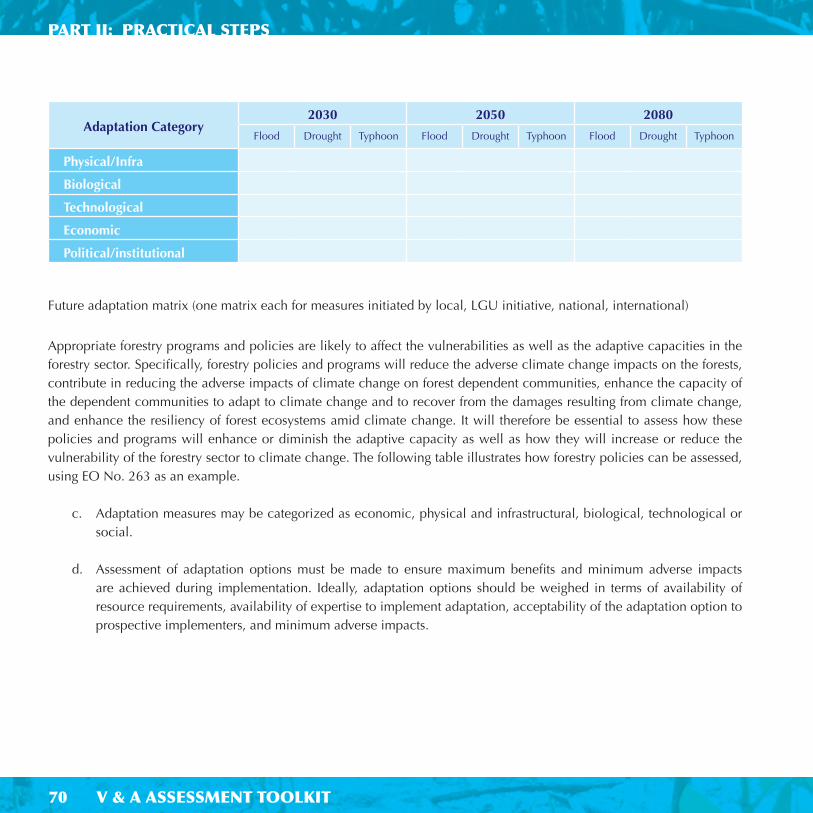
70
PART II: PRACTICAL STEPS
V & A ASSESSMENT TOOLKIT
Future adaptation matrix (one matrix each for measures initiated by local, LGU initiative, national, international)
Appropriate forestry programs and policies are likely to affect the vulnerabilities as well as the adaptive capacities in the forestry sector. Specifi cally, forestry policies and programs will reduce the adverse climate change impacts on the forests, contribute in reducing the adverse impacts of climate change on forest dependent communities, enhance the capacity of the dependent communities to adapt to climate change and to recover from the damages resulting from climate change, and enhance the resiliency of forest ecosystems amid climate change. It will therefore be essential to assess how these policies and programs will enhance or diminish the adaptive capacity as well as how they will increase or reduce the vulnerability of the forestry sector to climate change. The following table illustrates how forestry policies can be assessed, using EO No. 263 as an example.
c. Adaptation measures may be categorized as economic, physical and infrastructural, biological, technological or social.
d. Assessment of adaptation options must be made to ensure maximum benefi ts and minimum adverse impacts are achieved during implementation. Ideally, adaptation options should be weighed in terms of availability of resource requirements, availability of expertise to implement adaptation, acceptability of the adaptation option to prospective implementers, and minimum adverse impacts.
Adaptation Category2030 2050 2080
Flood Drought Typhoon Flood Drought Typhoon Flood Drought Typhoon
Physical/Infra
Biological
Technological
Economic
Political/institutional

71V & A ASSESSMENT TOOLKIT
WATER RESOURCES AND FORESTRY SECTOR
Policy Issuances Brief Policy Description
Indicators of readiness of policies
Reduce adverse impacts to forests
Reduce adverse impacts to
communities
Enhance capacity of communities to adapt to
climate change
EO No. 263 – The Community-Based Forest Mgmt. Program (CBFM) July 29, 1995
Integrated and unifi ed different upland community programs and projects to ensure the sustainable development of forestlands resources and social justice
Section 3. Participating organized communities may be granted access to the forestland resources under long term tenurial agreements, provided they employ environment -friendly, ecologically-sustainable, and labor-intensive harvesting methods.
Section 11. Within 6 months after signing of this Order, the DENR in consultation with government fi nancial institutions such as DBP, LBP, GSIS, SSS, shall effect the creation of favorable fi nancing mechanisms for access by communities and organizations in the pursuit of the CBFM strategy and its sub-strategies such as community training and empowerment, enterprise dev.t, agroforestry dev.t, tree plantations, and other non-forest-based alternative livelihood systems.

72
PART II: PRACTICAL STEPS
V & A ASSESSMENT TOOLKIT72
COASTAL
INTRODUCTION
This section provides guidance on how to do the assessments of impacts, vulnerability and adaptation measures to address climate change in the coastal sector in local communities/LGUs.
Steps are provided in order that the practitioners/responsible staff in the local government units are able to do a meaningful assessment of impacts, vulnerability and responses to sea level rise in order to inform planning and decision-making in the LGU levels.
WHY THE COASTAL SECTOR IS A KEY SECTOR?
Uncertainties in sea level rise predictions create a need to assess a range of scenarios within the vulnerability assessment. These scenarios need to embrace the range of likely change. The objective of the assessment is to focus attention on critical issues concerning the coastal zone, rather than to supply precise predictions. A rapid assessment to highlight possible impacts of a SLR scenario can initially be done as a screening procedure and identify information/data gaps, which can be either qualitative or semi-quantitative. Vulnerability and risk assessment of a coastal area to SLR may include any or all of these impacts: fl ooding, erosion and coastal wetland loss.

73V & A ASSESSMENT TOOLKIT
COASTAL SECTOR
STEPS FOR
DEVELOPING THE COASTAL V & A ASSESSMENT
Source: Perez, 2005
DEVELOP SLR SCENARIOS
COLLECT EXISTING COASTAL DATA
ASSESS POSSIBLE IMPACTS OF A
1M, 2M SLR
Areas of high population
- Mangrove areas
- Important Facilities
- Other services
ANTICIPATE AND PLAN
FOR POSSIBLE
ADAPTATION RESPONSES
PRIORITIZE
ASSESS IMPLICATIONS OF
FUTURE DEVELOPMENT
Repeat process if additional
information is required

74
PART II: PRACTICAL STEPS
V & A ASSESSMENT TOOLKIT74
HOW TO DEVELOP SEA LEVEL RISE (SLR) SCENARIOS
Sea level rise scenarios are generally easier to develop than climate change scenarios because unlike climate change, only one variable, sea level, is involved. Furthermore, there is high confi dence that sea level will rise. Most coastal modelers recommend using incremental scenarios of 0.5 and 1.0 metres of sea level rise above 1990 levels by 2100 to capture global (what is sometimes referred to as “eustatic”) sea level rise. This is essentially the average global increase in sea level resulting from increased GHG concentrations and it follows the IPCC scenarios of a 0.3 to 0.65m SLR.
Sea Level Scenario: 1m for the year 2020 2m for the year 2050
It is important to note that regional rates of sea level rise can vary. This is the result of regionally differing rates of thermal expansion of the oceans as well as regional differences in atmospheric circulation, which can affect relative sea levels. In addition, many coastal areas are either subsiding or being uplifted.
However, fi ner resolution DEMs
or topographic maps are always a problem.
We may start with a 1m SLR for the year
2020 and up to 2m by 2050 depending on
the initial fi ndings (screening) for the area of
study.

75V & A ASSESSMENT TOOLKIT
COASTAL SECTOR
Data Need Possible Source
• Topographic surveys, digital elevation models (DEM) NAMRIA, MGB, Other Mapping Agencies
• Aerial/remote sensing images – topography/land cover
NAMRIA, DPWH, LGU engineering departments
• Coastal geomorphology classifi cation MGB
• Evidence of subsidence Engineering
• Magnitude and damage caused by fl ooding Civil Defence/NDRRMC
• Coastal erosion
• Population density Planning, NEDA
• Activities located on the coast (cities, ports, resort areas and tourist beaches, industrial and agricultural areas)
Planning and Development Offi ce, Treasury Offi ce
• Development plans Planning Offi ce
COLLECTION OF EXISTING COASTAL DATA
Develop a checklist of needed data
The existing data is often scattered, and compiling all the information described shown here can be a considerable effort.
Furthermore, some of these data will not be available.
However, once assembled, a coastal database provides a basis for more informed decisions and helps to identify critical data gaps.

76
PART II: PRACTICAL STEPS
V & A ASSESSMENT TOOLKIT76
b) Screening assessment
Using existing data, a screening assessment should be undertaken which will highlight possible impacts of a 1-meter rise in sea level as well as key data gaps. It only aims to identify susceptibility with limited consideration of possible responses. These results will enable a subsequent more comprehensive vulnerability assessment, including a preliminary assessment of the ability of society to respond to the projected changes. Screening assessments can be qualitative or semi-quantitative.
Ideally, impact assessments should consider all biophysical and socio-economic impacts, but in practice the objectives of any impact assessment study for an activity or project should refl ect the time and resources that are available. Hence, it is important at an early stage to rank the relative importance of potential impacts as (1) not relevant, (2) low, (3) medium or (4) high, together with relevant comments, in a matrix – an example of which is shown below. If change factors other than sea level rise are considered, the process needs to be repeated with those factors. In each case, this could be the outcome of a screening assessment as already discussed.
The resulting matrix is useful to focus resources on the major potential impacts. It is also illuminating if a ranking is not possible or problematic, because this would suggest that a broad, but general assessment is necessary, with a goal of achieving such a ranking in subsequent analysis.
Screening Assessment Matrix: Biophysical vs. Socio-Economic ImpactsRank the relative importance of potential impacts as (1) not relevant, (2) low, (3) medium or (4) high
Biophysical Impact of Sea-Level Rise
Socio-economic impacts
Tourism
Human Settle-ments,Infra
AgriWater Supply
FisheriesFinancial Services
Human Health
CoastalResources
Inundation Flooding
Erosion
Salinization
Others...

77V & A ASSESSMENT TOOLKIT
COASTAL SECTOR
HOW TO ASSESS POSSIBLE IMPACTS OF 1M – 2M SLR
a) Sensitivity Analysis:
Guide questions:
How do I know if the Coastal Sector in my province is vulnerable to climate change?
(i) In what ways will my sector be affected?(ii) What is it in my sector that makes it vulnerable to such impacts?
Complete the following matrix to describe the sensitivity of areas, population and resources to erosion, inundation /fl ooding, salt-water intrusion
Sensitivity screening Location: Population: Resources:
Erosion
Inundation /Flooding
Salt-water intrusion
Others (e.g. subsidence)
For example:
Four impacts may be considered: (i) Increased storm fl ooding; (ii) Beach/bluff erosion; (iii) Wetland and mangrove inundation and loss; and, (iv) Salt water intrusion. Their relative importance will vary from site to site, depending on a range of factors.
b) Vulnerability Assessment - Assess vulnerability based on general characteristics:

78
PART II: PRACTICAL STEPS
V & A ASSESSMENT TOOLKIT78
Increased storm fl ooding Beach erosionWetland and mangrove
inundation and loss Salt water intrusion
• Describe what is located in fl ood-prone areas.
• Describe historical fl oods, including (i) location, magnitude and damage, the response of the local people, and (iii) the response of government.
• How have policies towards fl ooding evolved?
• Describe what is located within 300 m of the ocean coast.
• Describe beach types.
• Describe the various livelihoods of the people living in coastal areas such as commercial fi shers, international-based coastal tourism, or subsistence lifestyles.
• Describe any existing problems of beach erosion including quantitative data. These areas will experience more rapid erosion given accelerated sea-level rise.
• What existing coastal infrastructure might be impacted by such recession?
• Describe the wetland areas, including human activities and resources that depend on the wetlands. For instance, are mangroves being cut and used, or do fi sheries depend on wetlands?
• Have wetlands or mangroves being reclaimed for other uses, and is this likely to continue?
• Are these wetlands viewed as a valuable resource for coastal fi sheries and hunting or merely thought of as wastelands?
• Is there any existing problem with water supply for drinking purposes?
• Does it seem likely that salinization due to sea-level rise will be a problem for surface and/or subsurface water?

79V & A ASSESSMENT TOOLKIT
COASTAL SECTOR
General Characteristics LocationCurrent
ConditionSLR Scenario
1m, 2mRemarks
Low lying areas
Small islands with limited resource base usually tied to coastal ecosystems
Reclaimed lands on river delta
Areas subjected to various coastal hazards such as tropical cyclones, storm surges, subsidence, liquefaction, etc.)
Size of population, coastal resources,/habitats to be affected
Values of damage to land and property
Uniqueness of resources (e.g., coastal plain, coral reef atoll, river delta or wetlands
Others (e.g. facilities such as ports, fi sh landings
The following matrix can be used to compile responses.

80
PART II: PRACTICAL STEPS
V & A ASSESSMENT TOOLKIT80
HOW TO ASSESS IMPLICATIONS OF FUTURE DEVELOPMENTS
Examples:
• New and existing river dams and impacts on downstream deltas
• New coastal settlements
• Expansion of coastal tourism
• Possibility of transmigration
Estimates of the storm surge elevations are raised over time by the relative sea level rise scenario (i.e. global rise plus estimated subsidence) and converted to the corresponding land areas threatened by these different probability fl oods.
These areas are mapped and overlayed with exposure, in terms of the average population density for the coastal area and the vulnerability, in terms of poverty scoring.
Lastly the estimated level of fl ood risk is used to calculate the areas fl ooded.
Flood risk is calculated as areas subjected to:
• Increase in fl ood levels due to rise in sea level
• Increase in populations in coastal fl oodplain, or can be qualifi ed as increase of poor people

81V & A ASSESSMENT TOOLKIT
COASTAL SECTOR
HOW TO ASSESS ADAPTATION TO SEA LEVEL RISE IMPACTS
a) Identify adaptation options:
Different responses to sea level rise (SLR) can be made within an Integrated Coastal Zone Management (ICZM), Environmental Impact Assessment or Disaster Risk Reduction and Management, envisioned to be part of a continuous management process, which ideally aims to integrate responses to all existing and potential problems of a coastal zone, including minimizing vulnerability to long-term effects of climate change.
Generally, the responses can be classifi ed as:
• Planned retreat (i.e., setback of defenses, relocation)
• Accommodate (i.e., raise buildings above fl ood levels, convert agriculture lands to aqua culture, set up early warning systems)
• Protect (i.e., hard and soft defenses such as seawalls, beach nourishment, mangrove rehabilitation/reforestation, indigenous plants to prevent erosion, etc.)
• Structural or physical strategies (e.g., fl ood protection such as dikes, storm shelters, evacuation centers, etc.)
• Non-structural strategies (e.g. Set back policies/buffer zone, regulatory, early warning, forecasting)

82
PART II: PRACTICAL STEPS
V & A ASSESSMENT TOOLKIT82
b) Adaptation Assessment
There is a need to evaluate selected adaptation measures as to their appropriateness
Guide Questions and suggested adaptation assessment matrix (add more rows as necessary to the matrix to cover all adaptation measures):
What can be done to reduce the vulnerability of my Sector to Climate Change and/or counter the adverse impacts on my Sector?
i. What adaptation measures are applicable to the situation? ii. What existing policies /management will support the adaptation objectives?iii. Which can be done with ease (need criteria for evaluation such as cost and benefi t, robustness of option - that is
good for sustainable development even without Climate Change)iv. Planning and implementation analysis: What will be done, who will do it, what are the resources needed, time
frame, monitoring scheme)v. What are the technical, fi nancial and technological needs?vi. What could hinder the successful implementation of the adaptation scheme?
Adaptation Strategies/Measures
Cost Benefi tsFocal Point Resources
neededRank
Planned Retreat
Accommodation
Protection
Structural or Physical Strategies
Non-Structural Strategies

83V & A ASSESSMENT TOOLKIT
COASTAL SECTOR
Some possible measures to enhance the capacity of the coastal sector to adapt to climate change, variability and extremes (Source: Perez, 2003)
ADAPTATION MEASURES CAPACITY ENHANCING MEASURES
• Modifi cation of setback policies to address climate change /sea level rise
• Conduct research studies on salt water intrusion, fi sheries and aqua culture
• Strengthening of the Disaster Management Program
• Improved typhoon warning system• Flood prevention / protection• Shoreline stabilization /Preparation of hazard
and vulnerability maps to fl oods and to probable sea level rise
• Stop further conversion of mangrove into fi shpond development
• Putting in place Integrated Coastal Management (ICM) and expansion of Coastal Environment Program (CEP)
• Massive upland and coastal reforestation, including the expansion of community-based mangrove reforestation program
• Information, education and communication (IEC), awareness program
• Monitoring sea level rise and climatological data: Tidal gauge stations (costly) vs. indigenous methods (staff gauges)
• Installation of Geographical Information System
• People empowerment in the management of coastal resources
• Inventory and survey of coastal resources• Provincial environmental and natural resource accounting• Require industries to install desalination facilities for water
sources, instead of groundwater withdrawal. • Regulation of installation of water pumping systems• Expansion of coverage for artifi cial reefs, marine sanctuary,
marine reserves.• Strengthening of coordination between Department of
Environment and Natural Resources (DENR) and local government units (LGUs)
• Appropriate land use and zoning • Strict monitoring and enforcement of mining laws (sand and
corals) and other coastal management policies, laws and regulations
• Formulation of comprehensive coastal development plan• Develop / Improve watershed management, including
identifying and developing potable water sources• Reactivate/ re-orient Environment and Natural Resources
Committee (ENRC) in the coastal municipalities.• Implementation of Poverty Alleviation Program• Strengthening / enhancement of integrated waste
management program, including adoption of coastal clean-up movements
• Provision of alternative livelihood and resettlement program

84
PART II: PRACTICAL STEPS
V & A ASSESSMENT TOOLKIT
HEALTH
INTRODUCTION
This section provides guidance on how to do the assessments of impacts, vulnerability and adaptation measures to address climate change in the health sector in local communities/LGUs.
Steps are provided in order that the practitioners/responsible staff in the local government units are able to do a meaningful assessment of impacts, vulnerability and responses to health issues in order to inform planning and decision-making in the LGU levels.

85V & A ASSESSMENT TOOLKIT
HEALTH SECTOR
WHY THE HEALTH SECTOR IS A KEY SECTOR?
Health as a sector integrates and determines climate change impacts on human population. It goes through a complex process that has both direct and indirect effects. We will consider health here as articulated by diseases that are sensitive to climate change (indirect); this takes into consideration diseases that are spread with the facility of a vector that is affected by climate (change) and its major weather parameters. The body itself (direct) can be affected by climate change.
In the Philippines, diseases should also be considered as to its epidemic potential/possibility; the endemicity of certain diseases that recur (ie. dengue, cholera, malaria); the double burden of illness where we still have the infectious diseases in children; and the older lifestyle diseases.
Health is likewise a cross cutting sector, one that interacts with the other sectors (ie. forestry, agriculture) and as such it should consider multi-factorial conditions that may modulate its impacts. These areas of interface become the areas where both possible gaps and constraints arise.
From: WHO meeting on Climate Change and Health Maldives, Dec 1-5, 2003

86
PART II: PRACTICAL STEPS
V & A ASSESSMENT TOOLKIT
STEPS FOR
DEVELOPING THE HEALTH V & A ASSESSMENT
Determine Scope
and Purpose
Data Collection / Gathering
Describe Current Distribution
and Burden of Climate-Sensitive
Health Determinants
and Outcomes
Assessment of Impacts of
and Vulnerabilities to
Climate Change
Determine Adaptation Measures
Needed to Reduce Potential
Negative Health Impacts

87V & A ASSESSMENT TOOLKIT
HEALTH SECTOR
HOW TO DEFINE THE SCOPE AND PURPOSE
The Intergovernmental Panel on Climate Change (IPCC), in its Second Assessment Report, defi nes vulnerability as “the extent to which climate change may damage or harm a system.” It adds that vulnerability “depends not only on a system’s sensitivity, but also on its ability to adapt to new climatic conditions” (Watson et al. 1996: 23).
In the Philippine health sector, the early vulnerabilities identifi ed are the following:
• Changing disease patterns– Double burden of disease : infectious and lifestyle
• Climate sensitive diseases– Emerging and re-emerging diseases: multiple drug resistant tuberculosis, malaria
• Health Infrastructure– Human Resource constraints– Physical Resource constraints
• Non-health determinants– Disasters– Socio-economic (Poverty)– Geographical set up (multiple island archipelago) (McMichael AJ and Woodward A.I (2000))
• Isolated Island Cities and Municipalities– Dependency level for resources (Woodward A.Hales S and Weinstein P (1998))
• Information• Technology
This manual will consider how to formulate an adaptation response to these vulnerabilities. Consider the following vulnerable populations to health effects:
• Far fl ung barangays (mountainous or coastal) – with risk hazards that will increase with extreme climate change• Those populations that have least access to health services and are in dense/congested – urban slums (space vs. access)• Areas that are endemic to certain ‘climate sensitive’ diseases ( ie. malaria - multi-drug resistant strains) on top of a bad health system (inadequate resources – fi nancial and human to respond)• Those that are culturally challenging – resistant to health education or change in their behavior towards health brought by culture - beliefs

88
PART II: PRACTICAL STEPS
V & A ASSESSMENT TOOLKIT
The timeframe of 1970-2009 is used as the baseline for diseases recording from the NEC specifi cally the NESSS and so it limits the coverage to 13 epidemic prone diseases and further scopes this to those that are climate sensitive. For the SNC, NESSS data was utilized dating form 1987-2009.
The actors considered are those clients who have had cases recorded as they went for check up to the sentinel data gathering points (hospitals) where the NESSS is set up. Assigned personnel recording the diseases and treatment personnel (doctors) are part of the actors. Training for the NESSS personnel (RESU/PESU/MESU) has already been done for those that have sentinel hospitals.
Likewise the complementing PAGASA data personnel are those in the gathering points in provincial meteorological offi ces. Arrows represent reporting and feedback, where for health personnel reporting and feedback can happen as soon as the provincial level so that adaptive responses can be made rapidly.
The accompanying analysis and results can be utilized in the provincial investment plan for health (PIPH). The burden of these climate sensitive diseases as calculated (for the present scenario) can be the basis for the adaptive responses in the PIPH. This can likewise be projected so that long term budgets and adaptation can be programmed
Personnel
Health
Municipal �Epidemiology Surveillance Unit (MESU)
Provincial �Epidemiology �Surveillance Unit (PESU)
Regional � Epidemiology �Surveillance Unit(RESU)
National �Epidemiologic Surveillance System
Provincial Met Offi ce (Staff)�
Pagasa National Offi ce (Staff) �

89V & A ASSESSMENT TOOLKIT
HEALTH SECTOR
DATA COLLECTION / GATHERING
Baseline data presently comes from two sources for the data on sentinel diseases at the Department of Health/National Epidemiology Center. These are:
Data sources from the National Epidemic Sentinel Surveillance System (NESSS) are available for the last 20-50 years on fi ve of the notifi able diseases which are deemed climate sensitive:
MalariaDengueSchistosomiasisLeptospirosisFilaria
We will only use the NESSS which has more robustness due to its available case defi nition but the NDR – through the FHSIS can act as far second backup/proxy but is less reliable for its being passive and having inadequate case defi nition.
A) Notifi able Disease Reporting - passive system but has a wide coverage.
The information is limited by reports coming in from rural health units and selected hospitals.
Further, there are no case defi nitions used by reporting units. Currently, this is being enhanced into the Philippine
Integrated Disease and Response System (PIDSR) but they are still at the training phase.
B) National Epidemic Sentinel Surveillance System - actively monitors 13 diseases of epidemic potential.
The system uses case defi nitions so the consistency is high.
However, reporting units (sentinel sites) are not as widespread as the NDR. This is the national module of the
PIDSR.

90
PART II: PRACTICAL STEPS
V & A ASSESSMENT TOOLKIT
NESSS data will show:
- Trends of diseases by year and month- Risk factors for disease transmission upon
investigation of cases- Information to formulate hypotheses for disease
causation- Clustering of cases in a geographical area- Estimates of the effectiveness of intervention
measures- Demographic characteristics of cases – age,
gender- Vaccination status of cases with EPI diseases- Estimates of case fatality ratios (CFR)
NESSS data will not show
- Incidence rates- Prevalence rates

91V & A ASSESSMENT TOOLKIT
HEALTH SECTOR
Climate Change and Health V&A Assessment Flowchart
Step 1 Identify/Screen Health Vulnerability in area/ community
Step 2 Conduct analysis(Quantitative/Qualitative)
Step 3Identify action to be taken
Step 4 Evaluate and feedback
� Presence of Diseases (determine climate sensitivity; consider epidemic potential)� Consider number of
cases, occurrence of disease
� Utilize sentinel sites NESSS/MET for weather parameters
� Focused Group Discussions/KII
� Preventive (adaptation) over curative (mitigation) parameters
� Prioritize measures� Effi ciency versus effectiveness� Cost/Timeframe� i.e. Information drives/mass
screening, smearing for febrile people, fast lane for Dengue
� Policy formulation for health impacts- climate change compliance /resilience
� Utilize statistical analysis and correlate adaptation measures
� Identify indicators of success (intermediate and long term)
� Refi ne fl owchart to incorporate other factors (i.e. socio-economic)
� Availability of response mechanisms� health infrastructure
(human and fi nancial/infra – health centers/hospitals
� Occurrence of extreme weather events (quantity and quality)
HOW TO DESCRIBE CURRENT DISTRIBUTION AND BURDEN OF CLIMATE-SENSITIVE HEALTH DETERMINANTS
Below is a working matrix to guide us in our health V&A assessment in the areas using the climate sensitive diseases as the identifi ed vulnerability.

92
PART II: PRACTICAL STEPS
V & A ASSESSMENT TOOLKIT
This is where we specifi cally used the lens of looking at diseases to focus on ‘climate sensitive’ ones. These are diseases which are mediated by the changes in climate parameters. So diseases that are brought by vectors –water borne, vector borne and those that become engaged with the host-vector life cycle (ie. Dengue and malaria, schistosomiasis, typhoid, cholera among others) have seen to fi gure in this section, as their transmission is affected by changed in weather.
HOW TO ASSESS IMPACTS OF AND VULNERABILITIES TO CLIMATE CHANGE
• Project both the disease incidence and the trends versus the four weather parameters into future scenarios covering 20 years (2020) and 40 years (2050).
• Array these against the four weather parameters projected within the same timeframe. The average/mean daily and monthly recordings of the four variables of weather (temperature, rainfall, relative humidity/precipitation and wind) which will be refl ective of climate in the long term will be arrayed with the average monthly/annual number of cases of the ‘sentinel diseases’ deemed climate sensitive; initially these are Dengue, Malaria, Filariasis, Schistosomiasis and Cholera.
• Quantitative analysis using a linear regression model will try to establish association and trends.
• This will be looked at historically and the same disease trends/averages will be projected into the timeframe future scenarios of 2020 and 2050.
• Historical validated NESSS data (1987-2009) as baseline and projected to the timeframes 2020 and 2050; offi cial NESSS sentinel sites (hospital) gathering; Met offi ce correlation from the same sites (radius from hospital 50 km) will be identifi ed as earlier reported.
However, classifi cation/
graduation of climate
sensitivity has not been
done as parameters for
this have not been laid
out. This will need further
disease transmission
dynamics studies in order
to know the indicators of
how one disease can be
more climate sensitive
than others.
We know that the usual
category for looking at
changing disease patterns
refer to social health
determinants; in this
section we have added
the environmental health
dimension of climate
and categorized this
vulnerability under it.

93V & A ASSESSMENT TOOLKIT
HEALTH SECTOR
Methodology
Quantitative In Process
� Gather Data from NEC/HIS DOH - (30-50 years) of NESSS diseases; culled out from Pilot areas of district hospital (sentinel site)
� Climate Sensitive (fi ve): Malaria, Dengue, Schistosomiasis, Filaria and Cholera and get the average year on number of cases
� Array them against climate data (50 years) from MET stations nearest to the district hospitals from where data was gathered
� Do correlation using statistical analysis (Linear regression) between factors –diseases and weather parameters (Temperature, Humidity…)
� Feature statistically signifi cant correlations (trends) towards essential diseases as possible sentinels
� Hypothesis: The notifi able diseases – Dengue, Malaria, Cholera, Filariasis and Schistosomiasis are NOT sensitive to climate change.
� Variables for relationship testing Temperature Rainfall Relative humidity/Precipitation Wind
� Data Requirements and Sources Number of cases reported for dengue, malaria, cholera, fi lariasis, schistosomiasis, and other selected diseases by quarter from 1987-2007 (Data source: National Epidemic Sentinel Surveillance System)
Quarterly average of temperature (°C), rainfall (mm/day), relative humidity (%), and wind speed (mps) recorded from 1987-2007 (Data source: PAGASA)
� Data Analysis Determine if linear relationship exists among selected notifi able diseases and climate change variables
For variables with existing linear relationship, quantify the relationship to determine how changes in climates affect occurrences of notifi able diseases
� Measure of Relationship� Pearson Correlation
Measures the strength of a linear relationship between two quantitative variables There is a positive relationship if generated value is close to +1; negative relationship if close to -1, and no relationship if zero.
� Linear Regression Quantifi es the linear relation between variables when the value of one variable are affected by changes in the values of the other variables
Helpful in assessing how well the dependent variable can be explained by knowing the value of independent variable/s
Helpful in identifying which variable is most effective for estimating the dependent variable
� Data Processing and Analysis Software Statistical Package for Social Sciences (SPSS)
The following table details the methodology:

94
PART II: PRACTICAL STEPS
V & A ASSESSMENT TOOLKIT
HOW TO DETERMINE ADAPTATION MEASURES NEEDED TO REDUCE POTENTIAL NEGATIVE HEALTH IMPACTS
This can be done with a validating initial round of qualitative analysis - ground exercise of consultation of key stakeholders
The provincial investment plans for health (PIPH) of the areas was likewise reviewed as additional substantiation material for possible adaptation strategies which can be identifi ed and corroborated.
The consultation was done in plenary using a general survey question guide with the following:
a. What are the immediate past and existing disease occurrences (whether outbreak proportion or not but was otherwise noticeable)
b. How many of the population were affected (percentage or specifi c if available)c. What were the responses of the LGU/concerned agencies to the noticeable increase in the diseases (human and
fi nancial)d. What were the cross sector responsese. What were the weather conditions prevailing at the time of the increased incidencef. What other contribution factors outside of the weather could have been present at the time
The following table details the methodology:
Methodology
Qualitative In-Process
� Consultation/Focused Group Discussions in the areas for validation of data (questionnaire)
Health personnel Community
� Guide Questions (General Survey) What are the immediate past and existing disease occurrences (whether outbreak proportion or not but was otherwise noticeable)
How many of the population were affected (percentage or specifi c if available)
What were the responses of the LGU/concerned agencies to the noticeable increase in the diseases (human and fi nancial)
What were the cross sector responses What were the weather conditions prevailing at the time of the increased incidence
What other contribution factors outside of the weather could have been present at the time

95V & A ASSESSMENT TOOLKIT
HEALTH SECTOR
The V & A assessment for the health sector has its inherent constraints and barriers.
• Not all the personnel may have training up to the level of the municipality/province• Not all hospitals in the provinces have NESSS training, or not sentinel hospitals• We will be missing cases that do not go to the hospital (those that are not so severe)• The NESSS data is not a rate, it is a trend since it counts cases at a certain time (does not have a denominator ie.
population)• The meteorological offi ce may not be present in the province or may be very far (next province)
GAPS, CONSTRAINTS AND BARRIERS


Part III
INTEGRATION
AND PRIORITIZATION

PART III: INTEGRATION & PRIORITIZATION
98 V & A ASSESSMENT TOOLKIT
INTEGRATION
To produce a comprehensive vulnerability and adaptation (V & A) assessment, the individual sectoral data collected from the preceding chapters needs to be viewed in a holistic and coordinated approach for the development and
implementation of adaptation options / strategies. This approach also needs to be incorporated when prioritizing adaptation options so that an adaptation measure selected by one sector does not create a negative impact on another sector e.g. promoting aquaculture as a way to ensure food security (agriculture) does not further deplete coastal resources (fi sh fry/stock from the sea; mangroves cut to provide areas for fi shponds).
• Impacts do not happen in isolation
• Impacts in one sector can adversely or positively affect another• Some sectors are affected directly and indirectly• Others just indirectly• Sometimes a change in one sector can offset the affect of climate change in another sector
• In addition, integration is necessary for ranking vulnerabilities and adaptations

99
INTEGRATION
V & A ASSESSMENT TOOLKIT
RELATIONSHIPS AMONG CLIMATE CHANGE,
WATER SUPPLY AND AGRICULTURE
AGRICULTURE
CLIMATE CHANGE
COASTAL RESOURCES
SOCIOECONOMIC
ENVIRONMENTAL
BASELINE
WATER
RESOURCES
HUMAN
HEALTH

PART III: INTEGRATION & PRIORITIZATION
100 V & A ASSESSMENT TOOLKIT
TYPES OF INTEGRATION
There are 2 main types of integration:
1) Cross-Sector Integration
Cross-sector integration links two or more related sectors and is a good way to initially approach integration.Various qualitative methods, including expert judgement can be used and descriptive tables compiled to identify the links between sectors.
Another way to display qualitative results is through fi gures for a more visual representation:
e.g. Simple integration of climate change impacts
Climate changeFirst order
impacts
Second order
impactsResponses/feedbacks
Drier climate Water supply� Agricultural
production �
Increased demand for water for irrigation, potentially
further reducing water supplies.
Wetter climate Vegetation
cover �
Standing
water �
Human health � Wetter conditions increase potential for disease
transmission. One possible response is increased use
of pesticides, which has the potential to harm natural
vegetation.

101
INTEGRATION
V & A ASSESSMENT TOOLKIT
2) Multi-Sector Integration
Multi-sector integration is concerned with a much broader scale, generally an entire economy or system. The aim is to understand how a society as a whole may be affected by climate change.
Integrated assessment methods and economic models can be used in this type of approach.
To be effectively applied, multisector integrations need to be as comprehensive as possible, i.e., covering as many affected sectors, regions and populations as possible. In addition, it is helpful, although not necessary, that a common indicator be used, such as the number of people affected or monetary impact, which allows for direct comparison of magnitude and summing of impacts across sectors.
There are both relatively simple and more complex methods for quantitatively combining results across many sectors, regions or affected groups.
A much more complex method is to apply macroeconomic models. Such models have been used to examine integrated impacts of climate change on whole countries. The advantage of applying these models is that they can identify how costs of damages from or adaptation to climate change can reverberate throughout a country’s economy.
Summary
At a minimum integration should at least qualitatively identify linkages and possible direction of impacts.
Simple quantitative integration involves
listing of impacts using a common
indicator, often monetary units. This is
particularly appropriate for economic
sectors because they place a monetary
value on goods and services. Results from
non-economic sectors, such as human
health or biodiversity, can be expressed
in monetary terms, but because these
sectors are not market sectors (they are
not typically traded in markets), such
monetary valuations can be complicated
to develop, involve much uncertainty and
may not be meaningful to all potential
users of results.
A disadvantage is that models must be built for each application.
These can be complicated and expensive to undertake.

PART III: INTEGRATION & PRIORITIZATION
102 V & A ASSESSMENT TOOLKIT
Philippine Vulnerabilities Cross Sector Integration
Adapted from Taylor, S.E. 2000

103
INTEGRATION
V & A ASSESSMENT TOOLKIT
Philippine Adaptation Measures Cross Sector Integration
Adapted from Taylor, S.E. 2000

104
PART III: INTEGRATION & PRIORITIZATION
V & A ASSESSMENT TOOLKIT
PRIORITIZATION
It is important to design integrated adaptation strategies that suffi ciently identify trade-offs, synergies and confl icts among key sectors.
The V & A assessment identifi es existing vulnerabilities and adaptation strategies together with potential additional vulnerabilities and strategies to cope (adaptation measures). The previous section deals with integrating these strategies across sectors to assist in producing a shortlist i.e. eliminating from the list those that have adverse impacts in other sectors. Ranking of vulnerabilities can also help to prioritize adaptation measures.
The shortlist of adaption strategies can be prioritized based on:a) How likely they are to be effective (effi cacy)b) How easy they are to implement (feasibility)c) How acceptable they will be to those affected by them (acceptability)
Feasibility and acceptability might be based on considerations of cost through cost-benefi t studies but non-fi nancial and qualitative criteria can also be as important e.g. availability of technological expertise; social and cultural considerations.
It is especially important
to involve all stakeholders
including policy makers
in this process to reduce
confl ict but also to gain
maximum information in
prioritizing local issues.

105
PRIORITIZATION
V & A ASSESSMENT TOOLKIT
How to Choose a Tool for Prioritization (UNFCCC Guidelines):
Two Objectives, weighting of
Benefi ts Possible?
One Objective/Criterion?
Quantifi cation and Valuation
Possible?
One Objective, but Benefi ts
not in money terms
More Objectives, some or all
Costs and Benefi ts not
in Monetary Units
YES
CBACBA
YES
CEACEA YES
Expert
Judgement
Expert
JudgementNo Data? MCAMCA
NO
NO
• MCA – Multi-Criteria Analysis – normally used for ranking of options
• CBA – Cost Benefi t Analysis
• CEA – Cost Effectiveness Analysis – only produces a ranking
NO
TOOLS FOR
PRIORITIZATION

106
PART III: INTEGRATION & PRIORITIZATION
V & A ASSESSMENT TOOLKIT
a) Multi-Criteria Assessment
Matrices are the best way to assist in ranking e.g.:
Hypothetical example of a multi-criteria assessment. Criteria are arbitrary. Scores are given on a 1-5 scale and added without weighting in the fi nal column. Weights can be applied to columns to refl ect relative importance of criteria.
This is the best known and used method for involving stakeholders especially at the grassroots level. The criteria/indicators to assess the options should also be chosen in a participatory manner for maximum results.
b) Cost Benefi t Analysis
• Estimate all benefi ts and costs in a common metric to determinewhether benefi ts > costs
• Monetary values often used
Options Effectiveness Feasibility Acceptability Cost Score
A 3 2 1 2 8
B 2 4 4 4 14
C 5 1 2 3 11
• Diffi culty: what to do
about nonmarket benefi ts
or uncertainties
• Diffi culty: requires much
data and analysis

Part IV
ANNEXES

ANNEX I
108 V & A ASSESSMENT TOOLKIT
Storylines for the Emission Scenarios
The IPCC published a new set of scenarios in 2000 for use in the Third Assessment Report (Special Report on Emissions Scenarios - SRES). The SRES scenarios were constructed to explore future developments in the global environment
with special reference to the production of greenhouse gases and aerosol precursor emissions. The SRES team defi ned four narrative storylines (see Figure 21), labelled A1, A2, B1 and B2, describing the relationships between the forces driving greenhouse gas and aerosol emissions and their evolution during the 21st century for large world regions and globally. Each storyline represents different demographic, social, economic, technological, and environmental developments that diverge in increasingly irreversible ways.
Fig. 21: Schematic illustration of the four SRES storylines
SRES Scenarios

109
STORYLINES FOR THE EMISSION SCENARIOS
V & A ASSESSMENT TOOLKIT
In simple terms, the four storylines combine two sets of divergent tendencies: one set varying between strong economic values and strong environmental values, the other set between increasing globalization and increasing regionalization. The storylines are summarized as follows (Nakicenovic et al., 2000):
• A1 storyline and scenario family: a future world of very rapid economic growth, global population that peaks in mid-century and declines thereafter, and rapid introduction of new and more effi cient technologies.
• A2 storyline and scenario family: a very heterogeneous world with continuously increasing global population and regionally oriented economic growth that is more fragmented and slower than in other storylines.
• B1 storyline and scenario family: a convergent world with the same global population as in the A1 storyline but with rapid changes in economic structures toward a service and information economy, with reductions in material intensity, and the introduction of clean and resource-effi cient technologies.
• B2 storyline and scenario family: a world in which the emphasis is on local solutions to economic, social, and environmental sustainability, with continuously increasing population (lower than A2) and intermediate economic development.

ANNEX II
110 V & A ASSESSMENT TOOLKIT
List of Links to Online Information Sources
IPCCThe Fourth Assessment Report (AR4) contains reports of three working groups (WGs) and a synthesis report under the following link: http://www.ipcc.ch/ipccreports/assessments-reports.htm
National Communications to the UNFCCCUnder the UNFCCC, developing countries are obliged to submit so-called National Communications. These normally include information on climate change impacts and adaptations in the particular national contexts. Most countries have published at least one National Communication.http://unfccc.int/national_reports/non-annex_i_natcom/items/2979.php
National Adaptation Programmes of ActionNAPAs (national adaptation programmes of action) provide a process for Least Developed Countries (LDCs) (and only for them) to identify priority activities that respond to their urgent and immediate needs with regard to adaptation to climate change. They normally include information on climate change impacts and possible adaptation measures.http://unfccc.int/cooperation_support/least_developed_countries_portal/submitted_napas/items/4585.php
World Bank Climate PortalThe World Bank Climate Portal provides a rich variety of country specifi c climate change information.http://sdwebx.worldbank.org/climateportal/
Population Division of the Department of Economic and Social Affairs of the United Nations SecretariatWorld Population Prospects: The 2008 Revision, http://esa.un.org/unpp
CRED/OFDA International Disaster DatabaseThe EMDAT database provides global disaster statistics, including country-level disaster profi les.http://www.em-dat.net/
Disaster Risk IndexA country-by-country tool to assess disaster risk, developed by UNEP’s Global Resourcehttp://gridca.grid.unep.ch/undp/

111
GLOSSARY OF TERMS
V & A ASSESSMENT TOOLKIT
Glossary of Terms
Adaptation is defi ned by the IPCC as, “adjustment in natural or human systems in response to actual or expected climatic stimuli or their effects, which moderates harm or exploits benefi cial opportunities” (Smith et al., 2001, p. 881). Note that the defi nition includes observed as well as anticipated future changes in climate. Thus, adaptation can be happening in response to perceived change in climate or in anticipation of future change in climate.
Autonomous adaptation is considered to be adaptations made by affected entities, such as individuals, societies or nature, in response to observed or perceived changes in climate.
Anticipatory or proactive adaptation is made to reduce risk from future changes in climate.
Baseline Climate. Climatic conditions that are representative of the present day or recent climatic trends for a given period of time in a specifi c geographic area. It describes average conditions, spatial and temporal variability and anomalous events over the baseline period.
Exposure essentially answer the question of who or what is at risk to climate change (i.e., what is exposed to climate change) and the change in climate. So, it includes:
• The population (e.g., people, species) that can be affected by climate change
• Settlements and infrastructure that can be affected by climate change
• Natural resources that can be affected by climate change
• The nature of climate change itself, e.g., change in sea level, temperature, extreme events.
Forecast/Prediction. When a projection is designated “most likely” it becomes a forecast or prediction. A forecast is often obtained using physically-based models, possibly a set of these, outputs of which can enable some level of confi dence to be attached to projections.
Impact of climate change is typically the effect of climate change. For biophysical systems it can be change in productivity, quality, or population numbers or range. For societal systems, impact can be measured as change in value (e.g., gain or loss of income) or in morbidity, mortality, or other measure of well-being (Parry and Carter, 1998).

ANNEX III
112 V & A ASSESSMENT TOOLKIT
Projection. The term “projection” is used in two senses in the climate change literature. In general usage, a projection can be regarded as any description of the future and the pathway leading to it. However, a more specifi c interpretation has been attached to the term “climate projection” by the IPCC when referring to model-derived estimates of future climate.
Risk is the compounding effect of the hazard (climate change, variability and extremes), exposure and vulnerability.
Scenario is a coherent, internally consistent and plausible description of a possible future state of the world (IPCC, 1994). It is not a forecast; rather, each scenario is one alternative image of how the future can unfold. A projection may serve as the raw material for a scenario, but scenarios often require additional information (e.g., about baseline conditions). A set of scenarios is often adopted to refl ect, as well as possible, the range of uncertainty in projections. Other terms that have been used as synonyms for scenario are “characterization”, “storyline” and “construction”.
Climate Change Scenarios – describe plausible future changes in climate variables and are usually measured with respect to baseline climatic conditions and are derived primarily from climate model simulations combined with (observed) climate baselines.
Sensitivity is defi ned by the Intergovernmental Panel on Climate Change (IPCC) as “the degree to which a system is affected, either adversely or benefi cially, by climate-related stimuli. Climate-related stimuli encompass all of the elements of climate change, including mean climate characteristics, climate variability, and the frequency and magnitude of extremes. The effect may be direct (e.g., a change in crop yield in response to a change in the mean, range, or variability of temperature) or indirect (e.g., damages caused by an increase in the frequency of coastal fl ooding due to sea-level rise)” (McCarthy et al., 2001, p. 6).
Vulnerability is defi ned by the IPCC as “the degree to which a system is susceptible to, or unable to cope with, adverse effects of climate change, including climate variability and extremes. Vulnerability is a function of the character, magnitude, and rate of climate change and variation to which a system is exposed, its sensitivity, and its adaptive capacity” (McCarthy et al., 2001, p. 6). The greater the exposure or sensitivity, the greater is the vulnerability; the greater the adaptive capacity, the lower is the vulnerability. An assessment of vulnerability must consider all these components to be comprehensive.

113
REFERENCES
V & A ASSESSMENT TOOLKIT
Annex IV: References
BACKGROUND / PURPOSE
IPCC Fourth Assessment ReportUNFCCC Compendium of Methods and Tools
PRACTICAL STEPS
CLIMATE CHANGE ANALYSIS
IPCC 1994Mearns et al., 2001GTZ Climate Protection Programme. 2009. Climate Change Information for Effective Adaptation: A Practitioner’s Manual. IPCC 2000 Third Assessment Report (Special Report on Emissions Scenarios - SRES).
SOCIO-ECONOMIC ANALYSIS
IPCC 2000 .Third Assessment Report (Special Report on Emissions Scenarios - SRES).NCSP 2004. Developing Socio-Economic Scenarios for use in Vulnerability and Adaptation Assessments
AGRICULTURE
UKCIP, 2007UNFCCC ‘s Compendium on methods and toolsIPCC-TGICA, 2007: General Guidelines on the Use of Scenario Data for Climate Impact and Adaptation Assessment. Version 2;Malone EL, Smith JB, Hurd, BH, Moss, RH and Bouille,D.,2004; Developing Socio-economic Scenarios For Use in Vulnerability and Adaptation Assessments. New York, United States, UNDP

ANNEX IV
114 V & A ASSESSMENT TOOLKIT
WATER RESOURCES AND FORESTRY
PAGASA 2009
COASTAL
Perez, 2005Perez, 2003
HEALTH
WHO meeting on Climate change and Health Maldives, Dec 1-5, 2003Watson et al. 1996: 23McMichael AJ and Woodward A.I (2000)Woodward A.Hales S and Weinstein P(1998)
INTEGRATION & PRIORITIZATION
Taylor, S.E. 2000UNFCCC GuidelinesUNDP 2005. Adaptation Policy Framework for Climate Change. Developing Strategies, Policies and Measures

Enabling Activities for the Preparation of the Philippines’
Second National Communication on Climate Change to the
UNFCCC Project, Environmental Management Bureau of the
Department of Environment and Natural Resources