Regional Resilience Toolkit
228
REGIONAL RESILIENCE TOOLKIT 5 STEPS TO BUILD LARGE SCALE RESILIENCE TO NATURAL DISASTERS
-
Upload
khangminh22 -
Category
Documents
-
view
1 -
download
0
Transcript of Regional Resilience Toolkit

REGIONAL RESILIENCE
TOOLKIT
5 STEPS TO BUILD LARGE SCALE
RESILIENCE TO NATURAL DISASTERS
BluePoint2
Typewritten Text
BluePoint2
Typewritten Text
BluePoint2
Typewritten Text
BluePoint2
Typewritten Text
BluePoint2
Typewritten Text
BluePoint2
Typewritten Text
BluePoint2
Typewritten Text
BluePoint2
Typewritten Text
BluePoint2
Typewritten Text
BluePoint2
Typewritten Text
BluePoint2
Typewritten Text
BluePoint2
Typewritten Text
BluePoint2
Typewritten Text
July 2019 www.epa.gov/smartgrowth
BluePoint2
Typewritten Text
BluePoint2
Typewritten Text
BluePoint2
Typewritten Text
BluePoint2
Typewritten Text
BluePoint2
Typewritten Text
BluePoint2
Typewritten Text
BluePoint2
Typewritten Text
BluePoint2
Typewritten Text


Regional Resilience Toolkit | Page i
Acknowledgments
Authors and EditorsDana Brechwald, Metropolitan Transportation Commission/ Association of Bay Area GovernmentsArrietta Chakos, Urban Resilience StrategiesAbby Hall, U.S. Environmental Protection AgencySuzanne Marr, U.S. Environmental Protection AgencyMindy Craig, BluePoint PlanningKris Meek, BluePoint Planning
Additional project team membersJuliette Hayes, FEMA Region IXMaryam Hariri, Ogilvy
Significant credit is due to the Bay Conservation and Development Commission’s Adapting to Rising Tides Program, specifically:
Lindy LoweWendy Goodfriend
Other Contributors
Rachel Couch, State Coastal ConservancyJuliana Lucchesi, City of Mt. Shasta, City PlannerNuin-Tara Key, California Governor’s Office of Planning and Research Michael McCormick, California Governor’s Office of Planning and Research Tiffany Wise-West, City of Santa Cruz Sustainability & Climate Action Manager, Central Coast Climate Collaborative
Photos: All photos courtesy of BluePoint Planning unless otherwise noted.
Cover Photo: Sequoia trees in Sequoia National Park
Sequoias have been adversely impacted by fire management practices.

Regional Resilience Toolkit | Page iii
Table of ContentsIntroduction .................................................................................................... 1
Introduction to the Toolkit .............................................................................................3
Step 1. ENGAGE: Engagement for Resilience ............................................. 15
Principles for Successful Engagement .......................................................................17
Tactical Tools for Engagement ...................................................................................25
Step 2. ASSESS: Conduct a Risk and Vulnerability Assessment ............... 33
Lay the Groundwork .....................................................................................................35
Describe the Hazards ...................................................................................................42
Select Assets ...................................................................................................................46
Determine Assessment Method ...................................................................................49
Conduct the Assessment ..............................................................................................50
Step 3. ACT: Identify and Prioritize Strategies ........................................... 53
Summarize Vulnerability ..............................................................................................55
Develop Strategies ........................................................................................................57
Evaluate and Prioritize Strategies ...............................................................................61
Develop Implementation Plans ...................................................................................63
Step 4. FUND: Funding Action ...................................................................... 69
Make the Business Case for Resilience .......................................................................72
Develop a Resilience Capital Strategy .........................................................................76
Step 5. MEASURE: Evaluate Results and Refine Methods ......................... 87
What to Measure and Why? ........................................................................................89
Self-Evaluation to Measure and Refine ......................................................................93
Conclusion ..................................................................................................... 95
A Living Document ........................................................................................................97


Introduction
Figure 2. Eucalyptus grove
Non-native plants and trees such as eucalyptus impact native habitats and increase fire hazard.

Introduction

Introduction
Regional Resilience Toolkit | Page 3
Introduction to the ToolkitCities, regions, and states across the country are facing natural disasters that can have devastating effects on life, property, the economy, and ecosystems. Climate change is already having observable effects on the environment, and past conditions are no longer a reliable indication of the type or extent of disasters communities will face in the future. As more and more communities face the effects of natural disasters, decision makers and community members need tools and guidance to help them take action that can both protect them from natural disasters while also creating great places to live, work, and play. This Regional Resilience Toolkit provides:
ü A coordinated process for meeting many different state and federal planning requirements.
ü Communication and outreach guidance and resources for engaging a broad coalition of stakeholders across a region.
ü Guidance for project teams who are conducting vulnerability assessments, writing required plans, and implementing projects.
ü Clear information and tools that can be used with an advisory group and to bring in decision makers and community leaders to guide the overall action plan and ensure its successful implementation.
ü Detailed appendices with worksheets to help inform and guide work, as well as additional information and resources for each step.
The Federal Emergency Management Agency (FEMA), U.S. Environmental Protection Agency (EPA), and the Metropolitan Transportation Commission/Association of Bay Area Governments (MTC/ABAG) have partnered to create this Regional Resilience Toolkit. These partners used an approach to regional-scale planning and action for disaster resil-ience that was originally developed in the Bay Area. These materials were then used to help two other regional partners, the City of Mt. Shasta (and neighboring towns) and the Central Coast Climate Collaborative. EPA and FEMA worked with these two pilot regions

Page 4 | Regional Resilience Toolkit
Introduction
to test how well the materials worked in other geographic, demographic, and political contexts.
The City of Mt. Shasta and the Central Coast Climate Collaborative both requested assis-tance in building regional resilience. The assistance included a short-term engagement with one on-site workshop, and each partner region received a next steps memo about how to implement disaster resilience actions. With the help of regional partners and participants, the Toolkit has been revised and updated to reflect lessons learned from these pilots.
One key lesson from the two pilots was that state-level policies can really spur along local and regional resilience action because jurisdictions are given new tools, guidance, and even funding support to plan for natural hazards. For example, the California legislature has passed a series of bills that create incentives and requirements for local governments to consider natural hazards and environmental justice and equity as part of routine plan updates. See Figure 26 for more details on these policies. However, any jurisdiction in any state can still use existing plans and processes to improve community safety, livability, and long-term resilience.
The Toolkit is intended for any jurisdiction, no matter the size or capacity or hazards they may face now or in the future. The Toolkit is set up to allow multiple jurisdictions and levels of government to work together for regional scale actions. It is also designed for non-governmental partners and community groups to engage in a more inclusive and holistic process so that resilience actions are guided by core community values.
This Toolkit and its steps are designed to fulfill requirements for Local Hazard Mitigation Plan (LHMP) approval and update, and closely follows FEMA’s Local Mitigation Planning Handbook1. Rather than solely identifying community assets, this process encourages a more in-depth approach to conducting a vulnerability assessment and selecting hazard mitigation actions. This is intended to help shape each assessment according to a community’s preferred goals for a more locally meaningful and actionable LHMP.
1 www.fema.gov/media-library/assets/documents/31598
Figure 3. Central Coast Climate Collaborative workshop
Daylong workshop testing the Toolkit at Cal Poly, San Luis Obispo.

Regional Resilience Toolkit | Page 5
Introduction
Goal of the ToolkitThe goal of this Toolkit is to help cities, regions, and other partners integrate various planning processes – including for hazard mitigation, climate adaptation, sustainability, and equity – into a single process to create a common action plan. There is a need to consolidate varied planning processes, align goals and actions, and make it easier for communities to obtain funding for projects that cut across different planning areas.
This Regional Resilience Toolkit recognizes that the majority of resilience actions, from built projects to implementing policy, will happen at the local level. At the same time, this Toolkit focuses on the regional scale because disasters happen at a regional scale, and a coordinated process across multiple jurisdictions can result in safer communities. There are many benefits of addressing impacts at a larger scale and bringing in partners like nonprofits, community based organizations, and state and federal agencies to support implementation. For example, flood mitigation systems, whether structural (e.g., levees, seawalls) or natural (e.g., river restoration, wetland preservation), must be designed and built across large geographic areas. Fuels reduction efforts to reduce wildfire risk work better across large forestlands that may cross property lines and city or county borders. Even smaller hazard-mitigation efforts have cumulative mitigation benefits when multiple communities take shared actions that carry over from one city to the next.
A region may have many partners working to build resilience, but with slightly different areas of focus and expertise. Resilience partners may include land use planners, emergency managers, fire chiefs, elected officials, utilities, businesses, community activists, nonprofits, faith groups, and more. Each individual department or organization may need to write a specific plan in order to adhere to certain regulations or to seek funding from specific state and federal agencies. But all these partners can support one another’s efforts and realize larger success by teaming up and aligning on mutually beneficial projects. They can use the same assumptions about regional risks and then identify common actions. The larger coordination, across a broader geography and with a diverse set of partners, can result in regional scale projects that protect more people, property, infrastructure, and natural resources and do so more efficiently and effectively.
This Toolkit provides tools that will help partners approach resilience as a campaign. Most people care about how they may be affected by disasters. With the right forms of engagement, those same people will support projects that protect them from those
Figure 4. Increased damage from extreme weather
Ice storm in Maryland and heavy rain storm in Oakland, California.

Page 6 | Regional Resilience Toolkit
Introduction
disasters. Public funding is essential for building resilience, and that only comes when a spectrum of groups and residents support both the effort and the elected officials who take action for disaster resilience. An effective campaign will also draw in private funding from businesses that have a stake in protecting assets and investments, as well as from philanthropies invested in the long-term success of a community and its people. Each region or community will need to tap into a variety of organizational support and funding streams to manage the resilience effort.
The most important aspect of this Toolkit is the emphasis on action. Local commu-nities are motivated by a number of different state and federal planning requirements, including for land use, natural hazards, environmental justice, climate change, and more. This Toolkit guides communities on how to align strategies across different plan requirements, define common actions, and then get regulatory credit and funding for those actions. This Toolkit is designed to help partners across a region address multiple hazards simultaneously within the context of federal, state, and local planning require-ments and funding streams, so that communities have an easier time meeting require-ments while accessing funds for the projects that their residents really care about.
Figure 5. Aerial of the Los Angeles basin in California
Development moves closer to wildlands and increases fire hazards.
Regional Resilience Toolkit | Page 7
Introduction
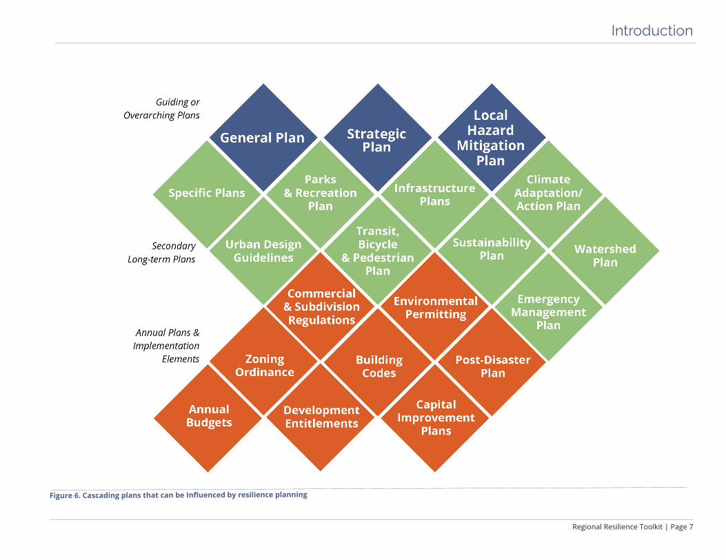
Figure 6. Cascading plans that can be Influenced by resilience planning
Page 8 | Regional Resilience Toolkit
Introduction
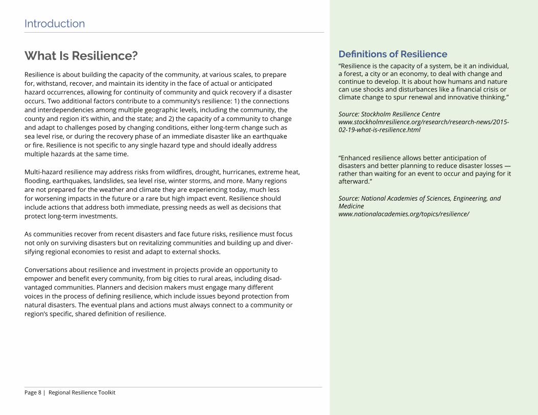
What Is Resilience?Resilience is about building the capacity of the community, at various scales, to prepare for, withstand, recover, and maintain its identity in the face of actual or anticipated hazard occurrences, allowing for continuity of community and quick recovery if a disaster occurs. Two additional factors contribute to a community’s resilience: 1) the connections and interdependencies among multiple geographic levels, including the community, the county and region it’s within, and the state; and 2) the capacity of a community to change and adapt to challenges posed by changing conditions, either long-term change such as sea level rise, or during the recovery phase of an immediate disaster like an earthquake or fire. Resilience is not specific to any single hazard type and should ideally address multiple hazards at the same time.
Multi-hazard resilience may address risks from wildfires, drought, hurricanes, extreme heat, flooding, earthquakes, landslides, sea level rise, winter storms, and more. Many regions are not prepared for the weather and climate they are experiencing today, much less for worsening impacts in the future or a rare but high impact event. Resilience should include actions that address both immediate, pressing needs as well as decisions that protect long-term investments.
As communities recover from recent disasters and face future risks, resilience must focus not only on surviving disasters but on revitalizing communities and building up and diver-sifying regional economies to resist and adapt to external shocks.
Conversations about resilience and investment in projects provide an opportunity to empower and benefit every community, from big cities to rural areas, including disad-vantaged communities. Planners and decision makers must engage many different voices in the process of defining resilience, which include issues beyond protection from natural disasters. The eventual plans and actions must always connect to a community or region’s specific, shared definition of resilience.
Definitions of Resilience“Resilience is the capacity of a system, be it an individual, a forest, a city or an economy, to deal with change and continue to develop. It is about how humans and nature can use shocks and disturbances like a financial crisis or climate change to spur renewal and innovative thinking.”
Source: Stockholm Resilience Centre www.stockholmresilience.org/research/research-news/2015-02-19-what-is-resilience.html
“Enhanced resilience allows better anticipation of disasters and better planning to reduce disaster losses — rather than waiting for an event to occur and paying for it afterward.”
Source: National Academies of Sciences, Engineering, and Medicine www.nationalacademies.org/topics/resilience/

Regional Resilience Toolkit | Page 9
Introduction
How to Use this ToolkitThis Regional Resilience Toolkit can be used by regional partnerships and local jurisdic-tions just starting to plan for resilience, or by those ready to move from planning to action. The Toolkit includes five steps, and users can jump in at any point in the process, depending on where they currently are in resilience planning. The five steps and the expected outcomes are:
Step 1. ENGAGE: Engagement for Resilience ü An understanding of why trust is so important, and how to build it
ü Tools for effective storytelling
ü A Stakeholder Map that includes your project team, advisory group, leadership and decision makers, interest groups, and the broader community
ü An Engagement and Outreach Plan that identifies goals, target audiences, key messages, tools for outreach, strategies for outreach, and an implementation plan
Figure 7. Five steps to building regional resilience
Page 10 | Regional Resilience Toolkit
Introduction
ü A Meeting Roadmap with outreach milestones
ü Practical tools for planning and running a successful meeting or workshop
STEP 2. ASSESS: Conduct Vulnerability Assessment ü Goals to guide the planning process, risk and vulnerability assessment, and devel-
opment of mitigation and adaptation actions
ü Prioritized hazards, hazard scenarios, and maps
ü Assessment methodology and approach
ü An inventory of assets to be used in the assessment
ü Exposure analysis – maps and data describing which assets are exposed to which hazards
ü Assessment information about risk, vulnerability, and potential consequences
ü Vulnerability problem statements
ü Fulfillment of Element B1, B2, B3, B4 and C3 in FEMA’s Local Mitigation Plan Review Tool Checklist
STEP 3. ACT: Identify and Prioritize Strategies ü Problem statements that summarize assessment findings
ü Draft list of strategies to address hazard problem statements
ü Basic information on each strategy to assist in evaluating and prioritizing strategies
ü Prioritized list of feasible, impactful strategies with stakeholder buy in
ü Completed Strategy Development and Implementation worksheets for each priori-tized strategy
ü A long-term implementation plan over 5-20 years
ü A short-term action plan outlining actions that can start in the near-term
ü Fulfillment of Element B3, C4, C5, and C6 in FEMA’s Local Mitigation Plan Review Tool Checklist
Figure 8. Pelicans on coast
Pelicans rest on rocks below favorite tourist spot in La Jolla, California.
Regional Resilience Toolkit | Page 11
Introduction
STEP 4. FUND: Fund for Action ü How to engage funders and decision makers
ü How to make the business case for your projects
ü Connect engagement activities to resilience-building actions
ü An initial finance strategy that starts with local funding options
ü Understanding local tools for self-financing
ü A comprehensive resilience finance menu that includes self -funding, public-private partnerships, philanthropic opportunities, regional funds, and grants
ü Understanding federal, state, and philanthropic grants that may match your funding needs
STEP 5. MEASURE: Evaluate Results and Refine Methods ü An understanding of how and when to use metrics
ü A plan for choosing and implementing metrics
ü A timeline for tracking, evaluating, and reporting metrics
ü Rationale for and benefits of community resilience self-evaluation
ü Designing metrics to support a living document
The five steps ideally work in a continuous loop that will improve planning over time. For instance, partners might start small for the first go round and look at a single category, such as wastewater infrastructure. Partners can then repeat and scale up the process to include other categories and more partners.
The Toolkit was written for project teams of planners, agency staff, and consultants that are responsible for writing plans. The Toolkit is based in FEMA’s Local Hazard Mitigation Plan process but is adaptive and expansive enough to meet many different objec-tives and goals. The Toolkit is also intended for a less technical audience of decision makers, agency and community leaders, and others that will help create and maintain partnerships.

Page 12 | Regional Resilience Toolkit
Introduction
Finally, this Toolkit relies in part on engaging state and federal partners who have funding, policies, and programs intended to support local efforts to create sustainable and resilient communities. Project teams can reach out to FEMA or EPA staff and key state agencies to participate in regional resilience-building process.
The Toolkit includes two appendices organized by the five steps. Appendix A provides more detail on nearly every section of this document, as well as a list of specific outcomes and external resources for each step. Appendix B provides worksheets for use by the project team and an advisory group to help spur conversation and assist in planning. Appendix A and Appendix B will be noted throughout the document with the icons shown on the right.
This icon will indicate when there are companion worksheets in Appendix B to help project teams through the process.
This icon will indicate when there are additional details and information in Appendix A.


Step 1. ENGAGE: Engagement for Resilience
Figure 9. Small group exercise
Testing the vulnerability assessment tools at Central Coast Climate Collaborative workshop.

Step 1. ENGAGE

Step 1. ENGAGE
Regional Resilience Toolkit | Page 17
This step provides specifics about who, what, and how to engage and communicate with stakeholders, decision makers, and the community to build support, ensure successful implementation, and secure ongoing funding for resilience projects and initiatives. This chapter is divided into two primary sections:
üPrinciples for Successful Engagement
üTactical Tools for Engagement
Principles for Successful Engagement
Build Trust in Partnerships and RelationshipsSuccessful community planning for disaster resilience relies on people working together and trusting one another. The lead agency should approach engagement for resilience building as an ongoing process that builds upon itself, expanding and improving over time. Further, establishing trust and long-term relationships can be the difference between successful implementation and a plan that sits on a shelf.
Trust building is a multifaceted effort that needs to happen at several levels:
ü Within the agency/organization
ü With decision makers, in and out of the agency
ü With involved stakeholders
ü With the community as a whole
The project team with assistance from the advisory group must identify these different groups of people, understand their role in the process, and prioritize the effort and kind of engagement that should occur to guide a successful process.
Page 18 | Regional Resilience Toolkit
Step 1. ENGAGE
Project TeamA project manager should lead the internal project team and involve staff from relevant city departments. This staff will do the technical work behind the assessment; managing the project, and coordinating other stake-holders and engaging with their managers, executive staff, and elected officials to ensure that the process is moving along smoothly.
Advisory GroupA project advisory group should include key stakeholders such as city staff not part of the project team, represen-tatives from non-governmental and community based organizations, community members, or representatives from private entities and organizations representing the private sector, economic development, and/or business community. The advisory group provides credibility and subject matter expertise that can assist with public and political support and support the project team with volunteer time or funding.
Best Practices for Building PartnershipsEmbrace a collaborative and cooperative mindset. The lead agency, in particular, must create a collaborative culture among staff and leadership to rebuild or establish trust and a productive planning and implementation process.
Start small. Build on existing relationships and identify high level champions who can help rally other stakeholders to participate in the process. Small, immediate wins can make it easier to address long-term, serious challenges in the planning process.
Take the long view. Establishing relationships and trust for a single project or initiative can seem unwieldy, expensive, and time consuming in relation to the actual project. However, the effort in developing those long-term relationships will not only fuel successful implementation of resilience planning, but it will also seed future efforts by building a long-term coalition for action.
Be authentic. Make sure that the process is designed so that stakeholders and community members can truly guide decisions.
Make cross-cultural communication a critical tenet of community partner-ships. Engagement must be open and inclusive of all cultures, lifestyles, and economic statuses. Embrace customized approaches to welcome and encourage involvement by all members of a community.
Budget for it! Building partnerships take time, staff, and budget. Partnering with community based groups to act as a trusted liaison to less accessible community members can be critical – but these groups are often under budgeted and unable to donate much time. Providing them a stipend can significantly assist in developing meaningful and lasting partnerships.

Regional Resilience Toolkit | Page 19
Step 1. ENGAGE
Know the Community’s StakeholdersTo get the best outcome for the whole community, the resilience-building process should be multidisciplinary, span all local departments, cross levels of authority (e.g., staff, management, executives, and elected officials), and involve many non-governmental stakeholders (e.g., community-based organizations, property owners, regulators, businesses, community members, and local institutions).
Who? The first step is to inventory and identify stakeholders who should be involved, including the broader public and groups who are often underrepresented and hard to reach. Engage a broad range of stakeholders with the necessary expertise, values, and viewpoints at each stage of assessment and implementation.
What?The lead agency will need to identify what each stakeholder or stakeholder group’s role is in the resilience building process, in implementing strategies, and within the community.
When (or how often)?For the identified stakeholders, determine the level of input and outreach that is appro-priate and necessary based on their desired level of engagement and planning role. Align stakeholder expectations with the planning requirements and required level of outreach budget and resources available.
How?The next step is to determine the best approaches to engaging and reaching the stake-holders. Certain processes, and certain stakeholders may prefer a traditional formal outreach approach while others prefer digital tools, videos, short interactions, or other mechanisms.
Figure 10. Stakeholder types

Page 20 | Regional Resilience Toolkit
Step 1. ENGAGE
Example: Environmental Justice in Land Use Planning
In 2016 California passed Senate Bill 1000 (SB 1000), the Planning for Healthy Communities Act, which requires cities and counties to address environmental justice within their General Plans. California communities are also required to address climate change adaptation within General Plans (SB 379). Together, these two state laws create an opportunity to connect environmental justice and disaster resilience into long-term plans for how communities will grow and invest in future infrastructure.
Inclusivity and EquityIdentifying underrepresented audiences is challenging. Each community is different, but often non-English speakers, disadvantaged communities, Native Americans/tribal communities, the homeless, and other groups can be left out of or choose not to partic-ipate in planning efforts. This can be due to disillusionment with government and related processes, lack of interest, time, and resources to participate, limited information about an issue, and lack of information about the relevance of a plan to their lives. Disasters that create the most significant impacts often disproportionately affect environmental justice communities. EPA defines environmental justice as the fair treatment and meaningful involvement of all people regardless of race, color, national origin, or income, with respect to the development, implementation, and enforcement of environmental laws, regulations, and policies. Inclusion, equity, and authentic engagement require the active and comprehensive participation of these audiences.
Figure 11. Environmental justice planning can be built into resilience-building processes. Source: SB 1000 Implementation Toolkit: Planning for Healthy Communities, 2017. Reprinted by permission of the publisher (California Environmental Justice Alliance).
Regional Resilience Toolkit | Page 21
Step 1. ENGAGE
Establish a Common UnderstandingThe process should result in a plan built on community values that also meets the plan’s primary objectives. Many planning processes seem abstract to stakeholders and focus on issues that do not resonate with community members. While stakeholders and the community may be interested in climate change, is climate action a priority? Will it drive them to participate, to commit resources, or time to address risk solutions?
Using the climate action plan example, a community may be more interested in the development of jobs than greenhouse gas reduction. The climate action plan can align with this value by integrating and prioritizing initiatives that support the development of jobs, such as training of a green energy workforce to install solar panels and conduct energy efficiency upgrades. Understanding and addressing community values helps the project team develop actions that support the goals of the plan while meeting the needs of the community.
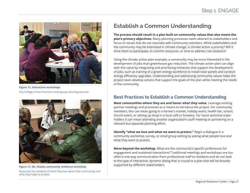
Best Practices to Establish a Common UnderstandingMeet communities where they are and honor what they value. Leverage existing partner meetings and processes as a means to introduce the project. For community members, this can mean going to a farmer’s market, holiday event, health fair, school, church event, or setting up shop in a local café or brewery. For more technical stake-holders it can mean attending another organization’s staff meeting or partnering on a relevant but separate planning effort.
Identify “what we love and what we want to protect.” Begin a dialogue in a community workshop, survey, or small group setting by asking what people love and what they want to protect.
Move beyond the workshop. What are the community’s specific preferences for engagement and sustained interactions? Traditional meetings and workshops are too often a one-way communication from professional staff to residents and do not lead to the type of interactive, dynamic dialog that is crucial to a plan that will be broadly supported by different stakeholders. Figure 13. Mt. Shasta community resilience workshop
Discussion by residents of what they love about their community and what they hope to protect.
Figure 12. Interactive workshops
City College of San Francisco small group visioning exercise.
Page 22 | Regional Resilience Toolkit
Step 1. ENGAGE
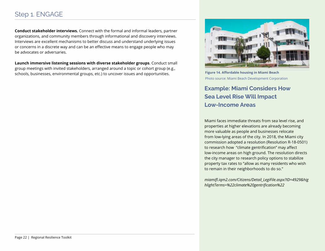
Example: Miami Considers How Sea Level Rise Will Impact Low-Income Areas
Miami faces immediate threats from sea level rise, and properties at higher elevations are already becoming more valuable as people and businesses relocate from low-lying areas of the city. In 2018, the Miami city commission adopted a resolution (Resolution R-18-0501) to research how “climate gentrification” may affect low-income areas on high ground. The resolution directs the city manager to research policy options to stabilize property tax rates to “allow as many residents who wish to remain in their neighborhoods to do so.”
miamifl.iqm2.com/Citizens/Detail_LegiFile.aspx?ID=4929&highlightTerms=%22climate%20gentrification%22
Conduct stakeholder interviews. Connect with the formal and informal leaders, partner organizations, and community members through informational and discovery interviews. Interviews are excellent mechanisms to better discuss and understand underlying issues or concerns in a discrete way and can be an effective means to engage people who may be advocates or adversaries.
Launch immersive listening sessions with diverse stakeholder groups. Conduct small group meetings with invited stakeholders, arranged around a topic or cohort group (e.g., schools, businesses, environmental groups, etc.) to uncover issues and opportunities. Figure 14. Affordable housing in Miami Beach
Photo source: Miami Beach Development Corporation

Regional Resilience Toolkit | Page 23
Step 1. ENGAGE
Tell the Story
“If you need someone to back your innovation, invest in your idea, or get excited about following your lead, you need to tell a great story.” - IDEO, Storytelling for Influence
While listening is a substantial part of successfully engaging stakeholders, it is equally critical to ensure that project teams and other project representatives are communicating the right information, at the right time, to the right people. One of the most successful approaches is telling a story. Project teams can use stories as a frame for communication, to orient and design project information for the specific audience, and help move the audience to action by connecting on a more personal level. Figure 15 illustrates four vital elements for a range of communication channels (e.g., press conference, funding pitch, workshop, or one-on-one meeting, etc.).
Best Practices to Tell a StoryGrab attention: Get people’s attention and help them to recognize the point of the communication. Grabbing people’s attention is essential – through a remarkable fact, a surprising comparison, or a visual. Tie it to the point of the story within the first 30 seconds. For example, a good start might be, “My uncle’s home burned down in the 2017 Tubbs Fire in Sonoma County, California. Not only were his home and personal life impacted, whole neighborhoods and communities were destroyed. ” This offers a signif-icant fact that is attention grabbing and then quickly connects it to action.
Engage and relate to audience: Directly relate the story to the audience and what resonates with them so that the listener becomes engaged and interested. To be effective, use specific information about the community, organization, or person. Continuing the example above, one could say, “Our local fire department helped to fight in that fire and many of you in this room lost properties in these historic fires.”
Core story: Develop the meat of the story with core elements, details, and facts. Organize the core story into succinct pieces – three is a manageable number – with clear connec-tions to the story’s point and to help hint at what the call to action might be. The example might continue, “The Tubbs Fire wasn’t unique. In 2017 alone, California experienced 9,133 fires that burned over 1.3 million acres. And we can expect to see more of the same in the years ahead.”
Figure 15. Story framework

Page 24 | Regional Resilience Toolkit
Step 1. ENGAGE
Example: Public Service Announcements (PSAs) in Tulsa, Okla.Tulsa, Oklahoma’s Disaster Resilience Network does outreach and community education through a series of public service announcements that are read in over 10 languages by people who represent each of those different communities.
www.disasterresiliencenetwork.org/drnresources
Call to action: Tie the entire story together with a strong call to action. This is perhaps the most important step. Reiterate the key point and connect it to what the “ask” is. An “ask” can be for funding, for a meeting, for support, or for an opportunity to follow up. The call to action not only provides a take away for the audience but also provides an opening to re-engage and to follow up on the “ask.” Finally, the example story would wrap up with, “As a community, we need to band together to be better prepared, protect people, and reduce the potential damage to our town.”
Figure 16. Public service announcement image
Photo source: Disaster Resilience Network

Regional Resilience Toolkit | Page 25
Step 1. ENGAGE
Tactical Tools for Engagement
Stakeholder MappingStakeholder mapping is the process of understanding perspectives and interests, visualizing relationships, and establishing which stakeholders are the highest priority for engagement. It may quickly become evident that many people could and should be involved in the planning effort. However, it is essential to differentiate the various audiences based on their level of interest and engagement, what level of technical under-standing and input they have, and what level of resources are available to reach and engage the various groups.
The following are examples of criteria to consider in identifying technical and community audiences:
ü The stakeholder owns an important asset.
ü The stakeholder has the authority to regulate, make policy, or make decisions about an asset or asset class.
ü The stakeholder will be affected by the assessment or potential strategies.
ü The stakeholder has the potential to either help or hinder the political process.
ü The stakeholder has specialized expertise that will help with technical questions.
ü The stakeholder may be able to provide funding or otherwise assist in implementing strategies.
ü The stakeholder represents typically underrepresented community members.
ü The stakeholder may be able to make critical connections to other relevant topic areas and/or projects which the project team is unaware.
ü The stakeholder has the time and ability to commit time and effort to the project.
Figure 17. Identify key stakeholder groups
Worksheet 1.2 Stakeholder Mapping
See Appendix A pages 1.4 - 1.7 for more details.

Page 26 | Regional Resilience Toolkit
Step 1. ENGAGE
“Map” partners to identify trusted and influential actors. Key partners may include a city council aide, faith groups, community organizations, skeptics, and social media influencers, among others; the lead agency will need to create a baseline and evolving set(s) of partners to engage in specific ways. Creating a “map” of all of the potential players is a good start to creating a stakeholder engagement strategy. Use a diagram similar to Figure 18 to identify those with the highest level of influence, and those with the greatest interest to ensure that the effort is reaching the right people at the right level. This type of diagram can also be used to identify where there are stake-holders who have a low influence and interest (lower left quadrant), but there is a benefit to better engaging them and moving them to be more involved.
Figure 18. Audiences and stakeholder mapping
Figure 19. Sample project website
California Peralta Community College District Sustainability and Resilience Master Plan collaboration website

Regional Resilience Toolkit | Page 27
Step 1. ENGAGE
Sample Outline for an Engagement and Outreach Plan
1. Overview
2. Outreach & Engagement Goals and Outcomes
3. Target Audiences - Community-wide - Targeted stakeholders, including decision-
makers, underrepresented groups, and special interest groups
4. Key Messages and Benefits by Audience
5. Outreach Tools and Materials - Communications and education - Workshops and meetings Meeting type, frequency, and format
7. Strategies and Tactics - Print - Online - In-person
8. Implementation and Tracking
Develop an Engagement and Outreach PlanThe project team can develop an Engagement and Outreach Plan with the advisory group and/or with a project consultant. To be as efficient and effective as possible, develop an Engagement and Outreach Plan at the beginning of the process. The Engagement and Outreach Plan can be simple, brief, and adapted over time. Ideally, the Engagement and Outreach Plan should:
ü Identify stakeholders and determine multi-cultural outreach needs.
ü Link planning and outreach messages to community values and needs.
ü Develop outreach goals for each stakeholder group and the broader community.
ü Establish how to engage individuals and groups best, and specify objectives and roles.
ü Define the specific methods to most effectively engage each group: in a meeting, via digital communications, one-on-one, or through partners or other groups.
ü Detail how these activities will integrate and leverage other planning.
ü Determine need, objectives, and composition for an advisory group.
ü Determine the focus and purpose of each event, meeting, and input opportunity.
ü Provide a schedule with objectives and roles for each activity.

Page 28 | Regional Resilience Toolkit
Step 1. ENGAGE
Example: Interactive GameMarin County’s , California’s Game of Floods is a public engagement tool for sea level rise adaptation options. The game encourages community members to understand the impacts of sea level rise on different populations and in various areas of a community to help to develop sound strategies to address the issues. An adaptation outreach kit can be downloaded from their website and a game board is available for purchase.
www.marincounty.org/depts/cd/divisions/planning/csmart-sea-level-rise/game-of-floods
Sample Outreach Tools and MaterialsOutreach materials should be developed with particular audiences in mind and consider the best way to reach each group. The materials should reinforce the key messages and be designed to be simple and clear, resonate with specific audiences, and not be overly technical in nature. The following are examples of tools.
Communications and Education ¨ Talking points ¨ Webpages ¨ Social media ¨ Local media ¨ Texting campaign ¨ Fact sheets ¨ Email newsletter ¨ Brochures, flyers, and print materials ¨ Direct mail ¨ Partner announcements ¨ Outreach kits for partner organizations
Workshops and Meetings ¨ Meeting announcements and flyers ¨ Comment cards ¨ Project presentations ¨ Project and meeting videos ¨ Interactive games ¨ Maps and display boards
Figure 20. Game board image for the Game of FloodsImage source: Marin County Community Development Agency

Regional Resilience Toolkit | Page 29
Step 1. ENGAGE
Planning and Running a Successful MeetingA successful workshop or series of workshops relies on extensive pre-work, planning, and relationship building.
Create a Meeting Plan. A general guide for designing and planning the meeting may include:
¨ Meeting purpose, audience, and objectives ¨ An agenda with clear objectives ¨ Meeting format ¨ Education and meeting materials ¨ Meeting venue and logistics ¨ Outreach effort ¨ Initiation and ‘Save the Date’
After each meeting or group of meetings, develop a meeting summary that will be provided for dissemination and review by meeting participants.
Meeting Roadmap for Resilience
The Meeting Roadmap on the following page illustrates one approach to engaging stake-holders in alignment with the steps outlined in this Toolkit. The top half of the graphic shows the five steps: Engage, Assess, Act, Fund, and Measure, with a brief description of the work elements for each step. The lower half shows the primary meetings in line with the project planning milestones for the advisory group and community stakeholders. Typically, additional activities will occur concurrently with those outlined below.
Appendix A provides details about a suggested series of meetings for the advisory group, as well as draft agendas and checklists for the meetings.
The Spirit of Mt. Shasta RegionBUILDING RESILIENCE WORKSHOP
Join Us for a Community WorkshopWednesday, March 7th at 6 pm
Develop Mt. Shasta Region’s
vision for protecting and supporting long-term safety and disaster resilience
City Park, Dance Hall1315 Nixon Rd.| Mt. Shasta, CA 96067
Refreshments will be served
More Information: mtshastaca.gov/general-plan-2045/
PAR
TNER
S
Figure 21. Meeting announcement sample
Mt. Shasta Building Resilience community workshop flyer.
Worksheet 1.3 Workshop Checklist
See Appendix A pages 1.11-1.18 for more details.

Page 30 | Regional Resilience Toolkit
Step 1. ENGAGE
STEP 5. MEASURE• Determine
evaluation method and timeline
• Identify metrics and milestones
PRO
JECT
STE
PSST
AKE
HO
LDER
S
STEP 1. ENGAGE• Identify project team,
advisory body, and stakeholders
• Develop engagement and outreach plan
• Create communica-tions and messages
STEP 2. ASSESS• Scope and organize• Establish resilience goals • Identify and map past,
current, and future hazards
• Select assets• Conduct exposure
analysis
STEP 3. ACT• Develop problem
statements• Draft strategies and
priorities• Determine level of effort
and resources needed• Draft long-term
implementation plan
STEP 4. FUND• Develop short
term action plan• Establish funding
and financing plan
Advisory Group #1: Kickoff• Review overall process,
purpose, and need• Define resilience• Discuss vision and goals• Discuss community haz-
ards and assets
Advisory Group #2: Vulnerability assessment• Confirm vision and
goals• Review initial
vulnerability assessment
• Plan for workshop
Advisory Group #3: Prioritize strategies• Review and prioritize
strategies• Implementation
planning actions, roles, and responsi-bilities
• Plan for workshop
Advisory Group #4: Implementation• Review implementation,
initial actions and projects• Discuss funding and
financing• Identify potential metrics• Create stakeholder groups
and determine roles for implementation
Public workshop #1:
Community-wide vision and vulnerability
Public workshop #2:
Strategies for a resilience community
Public workshop #3:Open House:
Launch initial actions
Resilience Planning Meeting Roadmap
Figure 22. Resilience planning meeting roadmap


Step 2. ASSESS: Conduct a Risk and
Vulnerability Assessment
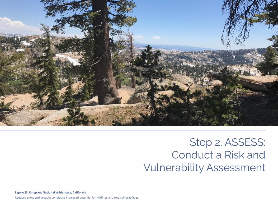
Figure 23. Emigrant National Wilderness, California
Reduced snow and drought conditions increased potential for wildfires and tree vulnerabilities.

Step 2. ASSESS

Step 2. ASSESS
Regional Resilience Toolkit | Page 35
Lay the GroundworkThe risk and vulnerability assessment is one of the core elements of resilience planning. The objective of the assessment is to determine where hazards and community assets intersect and to determine what the potential impacts are at that intersection - or what is the asset’s vulnerability and risk to hazards. In the assessment, make sure to consider:
ü Does asset vulnerability include impacts to people (especially disadvantaged commu-nities), to the economy, and to the environment?
ü Do seemingly unimportant assets provide support to a critical asset?
ü Who controls the asset and how does that affect mitigation efforts?
ü Are there physical or design attributes that make an asset particularly vulnerable, such as age of the building?
Scope and Organize the ProjectEstablish the scope of the project and a develop a common understanding about the purpose and need for the assessment. This includes determining what the “world view” is that is informing the assessment, and what is the level of effort to conduct a successful project. Scoping the project will include Identifying planning triggers, lenses, and desired outcomes to help deliver a more robust assessment, determining imple-mentable strategies, and assessing internal capacity and external resources to help drive implementation.
The assessment can be done using any number of data sources and tools that already exist. Project teams can coordinate with state agencies or other entities to access appro-priate data. For instance, California communities might want to work with the California Department of Forestry and Fire Protection (CAL FIRE) on available wildfire data. Any community in the country can work with federal agencies to obtain data, such as NOAA for sea level rise data or Drought.gov for data on drought.
This chapter provides details about how to conduct a vulnerability assessment that is applicable for a Local Hazard Mitigation Plan, General, Comprehensive, or Master Plan Update. This analysis should lead to the development and implementation of appropriate and achievable resilience strategies and actions. This chapter is divided into five primary sections:
üLay the Groundwork
üDescribe Hazards
üSelect Assets
üDetermine Assessment Method
üConduct the Assessment

Page 36 | Regional Resilience Toolkit
Step 2. ASSESS
Effective scoping will ensure that the resulting risk and vulnerability assessment will be a useful and lasting tool for resilience planning, including helping to:
ü Guide long range planning and future land use decisions.
ü Leverage other planning efforts and funds create multiple benefits for the community.
ü Spur important partnerships with utilities, the business community, and other stakeholders.
ü Provide additional incentives to assist vulnerable communities, small businesses, or to protect unique community features such as historic structures or critical park and recreational facilities.
Scoping QuestionsThe following are some questions that can help identify the “whys” for going through this process, scope the effort for the project, and to develop a more resilient community:
ü What has triggered this process to begin? Is it an individual, or a regulation, or general pressure from the community, an agency, or neighboring jurisdictions?
ü Who cares about this process and why? What are the motivations behind who cares and why they care?
ü What is the “lens” through which the team is viewing this process? Is this rooted in climate change, sustainability, equity, etc.? Are there multiple lenses?
ü How should the team measure a successful process?
ü Is this project a stand alone project or will there be multiple small assessments with different stakeholders as part of a larger project?
ü How can this effort tie to the other planning efforts and amplify potential outcomes?
The answers to these questions can help identify and focus the scope of the project, including determining the geographical area, priorities and draft goals that will help shape the extent of the project, and desired outcomes. It is also quite useful to review all previous hazard plans and technical studies (such as for flood areas) to know what infor-mation has been assembled previously.
Example: Regional Climate Vulnerability Assessment in the Twin CitiesThe Metropolitan Council in Minnesota developed a regional Climate Vulnerability Assessment (CVA) report, a local planning handbook, and a set of online maps and data sets to help local communities address climate change in comprehensive plans. In addition to offering these tools, the Metropolitan Council also encourages communities to partner with academic institutions, which often have the expertise to help communities develop more refined vulnerability assessments and include the results in local plans.
metrocouncil.org/handbook/plan-elements/resilience.aspx
Figure 24. Local planning handbook cover
Image source: Metropolitan Council
Regional Resilience Toolkit | Page 37
Step 2. ASSESS
Identify Triggers and Lenses, and Coordinate with Other PlansEveryone who picks up this document will have their own “trigger” for moving through this process. A trigger is something that spurs this work to happen; this could be an external trigger like a regulatory requirement or an internal trigger such as a strong champion. The trigger provides the motivation to do resilience building work. The Toolkit was developed primarily to help communities that are triggered by the LHMP process, but users will be able to apply this process to any risk and vulnerability assessment, no matter the trigger. Below are some of the most common triggers for undergoing a risk and vulnerability assessment.
Recent disaster. Sometimes resilience building is triggered by either a local disaster or a high profile disaster elsewhere, that wakes up jurisdictions and causes them to realize that they must take action to reduce the risk.
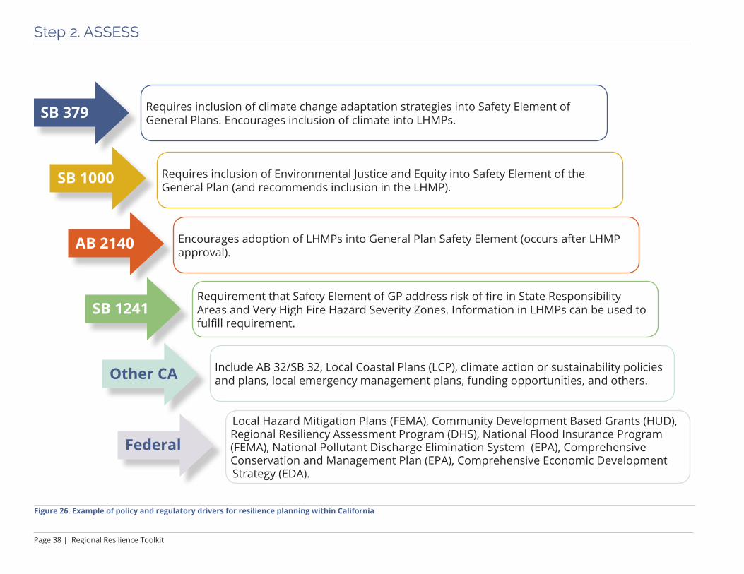
Regulatory landscape. The entry point to resilience building may be triggered by regula-tions, which include specific requirements about what the assessment should include. (See Figure 26 for an example of regulatory triggers in California.)
Local or national trends. A high visibility local, state, or national thought leader can help trigger others to conduct resilience planning. This can be especially true when it comes to climate adaptation, as there is a general understanding of the regional nature of sea level rise and other climate hazards.
Business and investment. A visible, public process to assess the community’s risks and to be responsive to them is a clear signal to the business and insurance community of the city’s commitment to long-term resilience and viability.
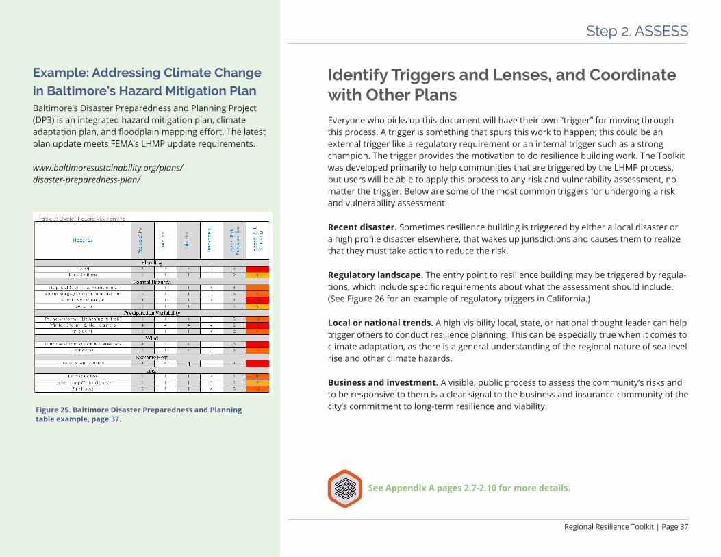
Example: Addressing Climate Change in Baltimore’s Hazard Mitigation PlanBaltimore’s Disaster Preparedness and Planning Project (DP3) is an integrated hazard mitigation plan, climate adaptation plan, and floodplain mapping effort. The latest plan update meets FEMA’s LHMP update requirements.
www.baltimoresustainability.org/plans/disaster-preparedness-plan/
Figure 25. Baltimore Disaster Preparedness and Planning table example, page 37.
See Appendix A pages 2.7-2.10 for more details.
Page 38 | Regional Resilience Toolkit
Step 2. ASSESS
SB 379
SB 1000
AB 2140
SB 1241
Other CA
Federal
Requires inclusion of climate change adaptation strategies into Safety Element of General Plans. Encourages inclusion of climate into LHMPs.
Requires inclusion of Environmental Justice and Equity into Safety Element of the General Plan (and recommends inclusion in the LHMP).
Encourages adoption of LHMPs into General Plan Safety Element (occurs after LHMP approval).
Requirement that Safety Element of GP address risk of fire in State Responsibility Areas and Very High Fire Hazard Severity Zones. Information in LHMPs can be used to fulfill requirement.
Include AB 32/SB 32, Local Coastal Plans (LCP), climate action or sustainability policies and plans, local emergency management plans, funding opportunities, and others.
Local Hazard Mitigation Plans (FEMA), Community Development Based Grants (HUD), Regional Resiliency Assessment Program (DHS), National Flood Insurance Program (FEMA), National Pollutant Discharge Elimination System (EPA), Comprehensive Conservation and Management Plan (EPA), Comprehensive Economic Development Strategy (EDA).
Figure 26. Example of policy and regulatory drivers for resilience planning within California
Regional Resilience Toolkit | Page 39
Step 2. ASSESS
The Four FramesThe Bay Conservation and Development Commission’s Adapting to Rising Tides Program uses four frames that define and prioritize sustainability throughout their assessment and planning process for sea level rise hazards:
Society and Equity: Effects on communities and the services on which they rely, with a focus on dispropor-tionate impacts due to existing inequalities.
Economy: Economic values that may be affected such as costs of infrastructure damages or lost revenues during periods of recovery.
Environment: Environmental values that may be affected, such as species biodiversity, and ecosystem functions and services.
Governance: Factors such as organizational structure, jurisdiction and mechanisms of participation that affect vulnerability to impacts.
Resilience Lenses: Connecting Resilience with Sustainability and EquitySimilar to a trigger, each project team will have its own “lens” that will help scope and frame the work. A lens is the perspective through which the assessment is done; for a LHMP the lens would be hazard risk reduction, but for other jurisdictions and planning processes the lens may be more narrowly focused on climate change adaptation or coastal planning, or may be focused through the lens of a particular asset type, like trans-portation infrastructure.
Environmental sustainability. The environmental sustainability lens and natural hazards resilience are tightly woven together, particularly with the actions that emerge from the assessment. A more environmentally sustainable community is often more resilient to disasters. The project will maximize resilience to disasters by ensuring that environmental sustainability is a core value. In many instances, the degradation of the environment can, in fact, contribute to disaster vulnerability, such as the loss of wetlands increasing vulnerability to hurricanes or sea level rise. Additionally, disasters that destroy or dramatically alter resources render communities unsustainable, since they impact the long-term ability of the community to access and use resources.
Social equity. Equity is also a critical lens of resilience. The most vulnerable populations are often most affected by natural disasters and are the least likely to be able to effec-tively prepare for, respond to, and recover from disasters. They often live in the most vulnerable housing, due to age, condition, and location. They are often more dependent on city services to meet their daily needs, which may be significantly compromised by natural hazards. They are less likely to have insurance, to have control over the safety and adaptive capacity of their homes, and, if impacted, typically do not have adequate financial resources to bounce back. After a disaster event, vulnerable populations may have less access to recovery resources, either because of language barriers, fear or mistrust of government leaders or processes, and social exclusion that prevents equal access to resources. Resilience-building processes and actions need to account for the needs of the most vulnerable residents.

Page 40 | Regional Resilience Toolkit
Step 2. ASSESS
Incorporating Hazards into Local Planning and Decision MakingThis Toolkit provides options for infusing hazards and climate change considerations in the daily thinking of all city departments, in normal processes and protocols, and in the many documents that guide and regulate city functions. Further, this effort can be seen as a critical component of the success or failure of a city’s ability to grow and provide for its residents in a way that contributes to a high quality of life. All decisions that guide city growth, or regulate the current built environment, can include consideration of current and projected hazards and their consequences including projections that take climate change into account.
Establish Resilience Goals
Developing effective resilience goals is an important step to establish a common foundation for stakeholders, the project team, and decision makers. Goals also offer a touchstone throughout the project to assess if strategies and implementation priorities align with the community’s needs and desires. Establishing common resilience goals assist in:
ü Building transparency into the process at the outset so that all participants under-stand the breadth of priorities and topics to cover.
ü Engaging the project team early in deciding what shared outcomes they will work cooperatively to achieve and provide an opportunity for them to ask their stake-holders for input and feedback on the project direction.
ü Providing a foundation upon which future project decisions can be made and help in evaluating how well mitigation actions will help meet established community values and expectations.
ü Connecting to metrics and aid in tracking and monitoring progress of the project through implementation.
Leveraging existing community goals, such as those in a local compre-hensive plan, can help ensure alignment, and can rally a broader base of support amongst stakeholders who have already bought into existing goals or priorities. Further, linking existing goals to resilience goals can provide additional impetus and support to advance broad community goals. Figure 27. Effective goals start with current plans and connect to future priorities and projects
Worksheet 2.1 Develop Resilience Goals Exercise
See Appendix A page 2.12 for more details.

Regional Resilience Toolkit | Page 41
Step 2. ASSESS
Example: County of Santa Cruz, California General Plan and LHMP GoalsGENERAL PLAN GUIDING PRINCIPLES
Population and Residential Growth Goals: To provide an organized and functional balance of urban, rural, and agricul-tural land use that maintains environmental quality, enhances economic vitality, protects the public health, safety, and welfare, and preserves the quality of life in the unincorporated areas of the county.
Rural Residential Siting and Density: To achieve patterns of rural residential development that are compatible with the physical limitations of the land, the natural and cultural resources of the County, the availability of public services, and protection of the natural environment.
Village, Town, Community, and Specific Plans: To continue using village, town, community and specific plans to provide a planning framework to guide future public and private improvements in town centers and other concentrated urban and rural areas, to provide a higher level of planning detail and involvement.
LHMP Goals
1. Avoid or reduce the potential for life loss, injury and economic damage to Santa Cruz residents from hazard events;
2. Increase the ability of the county government to serve the community during and after hazard events;
3. Protect the unique character, scenic beauty and values in the natural and built environment from being compromised by hazard events;
4. Encourage mitigation activities to increase the disaster resil-ience of institutions, private companies and systems essential to a functioning County of Santa Cruz.
Source: County of Santa Cruz LHMP 2015–2020, pgs 16 and 166.
Goals that guide risk and vulnerability assessments should seek to protect assets, reduce impacts from hazards, and help other stakeholders see how resilience fits in with existing community priorities. Use these goals to help determine what assets, and what degree of detail for each asset, is needed to conduct a meaningful risk and vulnerability assessment.
Setting Resilience GoalsGoals may be driven by a desire to protect:
ü Physical areas (e.g., new development along the shoreline, natural resource areas or assets)
ü Asset classes (e.g., critical services)
ü Social values (e.g., protecting parks because beauty and recreation are highly held values)
ü Economic values (e.g., protecting major economic drivers like large businesses)
ü Character, history, sense of place (e.g., protecting historic structures or neighborhoods)
ü Existing functions/activities (e.g., preserving the function of an airport or seaport)
ü Specific communities (e.g., vulnerable populations)
Use the following questions to help refine broad goals.
ü Does everyone understand the goal? Is it written in clear language? Are there multiple ways to interpret the goal?
ü Who is responsible for implementation? Does the lead agency have influence or ability to achieve the goal? Are the resources, skill, and knowledge available to achieve the goal?
ü How does the team know when a goal has been achieved? Is there a milestone that has been reached? An amount of money spent? An action achieved?
ü Can the jurisdictions involved realistically achieve that goal? If not, what is more likely?
ü Is it clear what the result or outcome is from achieving the goal?
ü When should the goal be achieved? Is there a specific date or timeframe that can be established as a target? Should there be a mid-term timeframe?

Page 42 | Regional Resilience Toolkit
Step 2. ASSESS
Potential Hazards• Avalanche• Dam Failure• Drought• Earthquake• Erosion• Expansive Soils• Extreme Heat• Flood• Hail• Hurricane• Landslide• Lighting• Sea Level Rise• Severe Wind• Severe Winter Weather• Storm Surge• Subsidence• Tornado• Tsunami• Wildfire
Describe the Hazards
Identify and Map HazardsBefore conducting a risk and vulnerability assessment, identify and describe the hazards that are or may be present within the community. An important part of this step is identi-fying which hazards pose the greatest threat to the community. You can qualitatively estimate which hazards will have the most impact by considering the extent of exposure (this can be measured by the number of people exposed, number of buildings exposed, or the value of assets exposed), the consequences of a hazard, and the likelihood of the hazard occurring.
ü Discuss the types of hazards to be considered - natural hazards (e.g. wildfires, earth-quakes), man-made hazards (e.g. cyber attacks, terrorism).
ü Review maps and information of hazards predicting and depicting current and future flooding, wildfire risk areas, landslide risk areas, or earthquake ground shaking or liquefaction risk, etc.
ü Understand past hazard patterns. Where have they struck and how often?
ü Talk to emergency managers as well as operations and maintenance staff who will have knowledge of areas most frequently affected.
ü Identify the hazards most likely to impact the community.
ü Identify changes that may intensify or increase the possibility of hazards.
ü Use climate change data to anticipate how hazards may change in the future, including the intensity and frequency of hazards, as well as how the community will be impacted by new and unfamiliar hazards.
See Appendix A pages 2.12-2.13 for more details.
Regional Resilience Toolkit | Page 43
Step 2. ASSESS
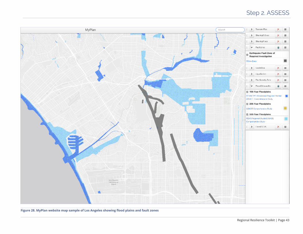
Figure 28. MyPlan website map sample of Los Angeles showing flood plains and fault zones

Page 44 | Regional Resilience Toolkit
Step 2. ASSESS
Figure 29. Enlargement of map of housing and community risk from ABAG’s Stronger Housing, Safer Communities project. Image source: resilience.abag.ca.gov/projects/

Regional Resilience Toolkit | Page 45
Step 2. ASSESS
Develop Hazard Impact StatementsDevelop written descriptions that describe the extent, probability, and expected severity of the hazard. This can help succinctly summarize hot spots or areas with multiple hazards that should receive special attention in assessment or strategy development. These descriptions are often called hazard impact statements.
As an example, a hazard statement might read: “The western portion of the city has very high liquefaction susceptibility while the remainder of the city has a low likelihood of liquefaction. Liquefaction may occur in earthquakes with very high levels of shaking, including one from the Hayward fault, which runs adjacent to the city and has a high probability of occurring in the next thirty years.”
Prioritize HazardsTo complete the risk assessment, prioritize the hazards that could have the most impact on the community. This will help determine which assets will need the most robust assessment (based on exposure to prioritized hazards), can help understand the overlap between high priority hazards and vulnerable populations, or can help engage certain stakeholders.
Once the hazards are prioritized it is a good time for the project team to consider if it is necessary to refine or reprioritize the goals previously outlined. In addition, now that it is understood where hazards may affect the community use that information to guide the remainder of the risk assessment, including which assets should be considered and what information needs to be gathered.
See Appendix A page 2.14 for more details.
Risk Assessment DefinitionsNatural hazard – source of harm or difficulty created by a meteorological, environmental, or geological event
Community assets – the people, structures, facilities, and systems that have value to the community
Vulnerability – characteristics of community assets that make them susceptible to damage from a given hazard
Impact – the consequences or effects of a hazard on the community and its assets
Risk – the potential for damage, loss, or other impacts created by the interaction of natural hazards with community assets
Risk assessment – product or process that collects information and assigns values to risks for the purpose of informing priorities, developing or comparing courses of action, and informing decision making.
FEMA Local Mitigation Plan Review Guide, October, 2011, Threat and Hazard Identification and Risk Assessment Guide, and adapted from the Department of Homeland Security Risk Lexicon, 2008.
Page 46 | Regional Resilience Toolkit
Step 2. ASSESS
AssetsRisks &
Vulnerability Hazards
Figure 30. As hazards interact with assets, the vulnerabilities of those assets and risks to the community are revealed.
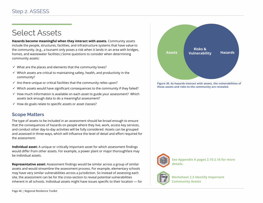
Select AssetsHazards become meaningful when they interact with assets. Community assets include the people, structures, facilities, and infrastructure systems that have value to the community. (e.g., a tsunami only poses a risk when it lands in an area with bridges, homes, and wastewater facilities.) Some questions to consider when determining community assets:
ü What are the places and elements that the community loves?
ü Which assets are critical to maintaining safety, health, and productivity in the community?
ü Are there unique or critical facilities that the community relies upon?
ü Which assets would have significant consequences to the community if they failed?
ü How much information is available on each asset to guide your assessment? Which assets lack enough data to do a meaningful assessment?
ü How do goals relate to specific assets or asset classes?
Scope MattersThe type of assets to be included in an assessment should be broad enough to ensure that the consequences of hazards on people where they live, work, access key services, and conduct other day-to-day activities will be fully considered. Assets can be grouped and assessed in three ways, which will influence the level of detail and effort required for the assessment:
Individual asset: A unique or critically important asset for which assessment findings would differ from other assets. For example, a power plant or major thoroughfare may be individual assets.
Representative asset: Assessment findings would be similar across a group of similar assets and would streamline the assessment process. For example, elementary schools may have very similar vulnerabilities across a jurisdiction. So instead of assessing each site, the assessment can be for the cross-section to reveal potential vulnerabilities inherent in all schools. Individual assets might have issues specific to their location — for
Worksheet 2.3 Identify Important Community Assets
See Appendix A pages 2.15-2.16 for more details.
Regional Resilience Toolkit | Page 47
Step 2. ASSESS
Built Environment
Natural Environment
Critical Services
Economy
Community and People
• Residents
• Employees
• Visitors
• First Responders
• At Risk Populations
• Culture and Ethnicity
• Pets and Animals
• Utilities: Electricity, Water, Sewer, Storm Water, and Propane
• Communication Infrastructure
• Emergency Response Systems and Facilities
• Public Health/Hospitals
• Shelters
• Transportation Infrastructure
• Waste Collection and Management
• Public Buildings and Schools
• Community Facilities (Grocery, Food Banks, Places of Worship, etc.)
• Housing
• Cultural Resources
• Future Growth and Development Areas
• Bike and Pedestrian Infrastructure
• Hazardous Facilities
• Waste Management (Landfills, Transfer and Recycling Stations, etc.)
• Major Employers
• Manufacturing and Industrial Uses
• Commercial Districts/Areas
• Primary Economic Drivers (Recreation, Agriculture, Tourism, etc.)
• Financial Facilities (Banks)
• Natural Infrastructure
• Forest and Woodlands
• Lakes, Rivers, and Wetlands
• Wildlife/Habitat Areas
• Parks and Recreation Areas
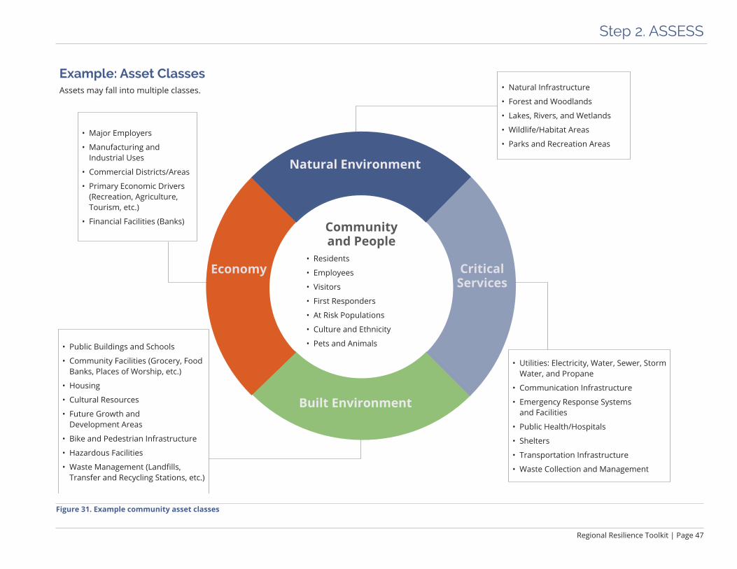
Figure 31. Example community asset classes
Example: Asset ClassesAssets may fall into multiple classes.

Page 48 | Regional Resilience Toolkit
Step 2. ASSESS
Asset InterdependenciesAn ABAG study released in 2015 (Cascading Failures: Earthquake Threats to Transportation and Utilities) explored the concept of interdependencies in utility systems. The study found strong dependencies on the fuel and electric power systems and regional and local roads, meaning that if these systems failed in a disaster, many other systems, like water, wastewater, and telecom, would have difficulty or be unable to function. Failures due to these dependencies would likely lead to significant and widespread consequences. Considering the depen-dencies and interdependencies of asset classes can help determine priorities in assessing asset vulnerabilities.
Additional resources that can help communities examine these interdependencies:
The U.S. Department of Energy’s Energy-Water Nexus Crosscut team has created a set of publications and tools to help a variety of users take a more coordinated approach to water and energy system vulnerabilities. www.energy.gov/energy-water-nexus-crosscut
The C40 Infrastructure Interdependencies + Climate Risks Report provides a summary from different cities that have grappled with the cascading impacts of climate change on infrastructure systems. www.resourcecentre.c40.org/resources/assessing-risks-in-cities
example, one elementary school might be near a flood plain while another might have only one road leading to it. Those issues should be considered when necessary.
Asset class: An asset class is a categorization of similar assets in one group. Figure 31 shows five classes: community and people; critical services; built environment; economy; and natural environment. Categorizing a class of assets allows jurisdictions to develop goals and strategies that may address the broad grouping. For instance, for community and people, a goal could be zero loss of life in disaster.
Not Sure Which Approach is Best?It can be confusing to know what assets should be assessed and at what scale. It may be helpful to do an exploratory assessment of an asset class to gain some basic information about the class to determine if there is a need to explore individual assets, or represen-tative assets, more closely. This can be because of physical vulnerabilities, like greater or more urgent exposure to hazards than anticipated, or because there are some complex governance issues, like ownership or regulations, that require more attention. The project team may also start down an assessment path and find that it is not uncovering any meaningful information. For example if many individual assets are similar and show similar vulnerabilities, it may not make sense to do an assessment of each individual asset but instead use one assessment as a representative for that type of asset.
Be sure to leave some room for adjustments as findings emerge. Sometimes a vulner-ability assessment may start to present a compelling storyline, and it makes sense to tell the story of risk through a certain lens, such as within a specific geographic area, or a critical asset class. Some uncertainty about exactly what assets to assess is normal at the scoping phase — eventually, a storyline will emerge, and it is the project team’s job to listen to it and guide the assessment to help it be told.

Regional Resilience Toolkit | Page 49
Step 2. ASSESS
Determine Assessment MethodThe depth and scope of a vulnerability assessment can vary significantly and will depend on community goals, the availability of data and information, resources to conduct the assessment, and individual interests of the jurisdiction and its residents. Looking at other vulnerability assessments is a good first step for establishing base informational requirements.
The simplest assessment includes an exposure analysis, which maps hazards on top of locations of key assets to identify a potential hazard. This approach requires at least a list of key assets, their locations, and an overlay map of hazards located in the assessment area. More information about an asset’s vulnerability can transform an assessment into a compelling story that sets up targeted, meaningful actions.
However, more detailed information on assets can help uncover the vulnerabilities and consequences for key assets and provides a better platform for identifying hazard mitigation and climate adaptation strategies to address hazards. Because it is important to understand what will happen to assets and the people and services that rely on them if they are exposed to a hazard, the project team may want to go beyond the exposure analysis and collect vulnerability information on the assets. This can be achieved through answering a series of assessment questions about the asset.
• At a minimum, assess emergency response facilities and critical public facilities related to essential services such as police, fire, water, and power.
• A more comprehensive assessment may include residential units, infrastructure systems, and/or recreational spaces.
• The most comprehensive approach would be to evaluate all assets individually, but this will likely require more resources. Project teams may take a simplified approach by choosing a representative asset to assess that may be similar to many others, house important services, or serve a large number of residents. If assessing a repre-sentative asset is not possible, asset classes can be assessed with far fewer resources, but can still provide information useful for the community.
What kind of assessment is right?EPA’s Planning Framework for a Climate-Resilient Economy includes helpful guidance for communities with different levels of resources to help them think about the right type of assessment to undertake. See pages 6 and 13.
www.epa.gov/smartgrowth/planning-framework-climate-resilient-economy
Figure 32. EPA’s Planning Framework for a Climate-Resilient Economy report cover. Image source: EPA
See Appendix A pages 2.17-2.18 for more details.
Worksheet 2.4 Community Asset Data Identification
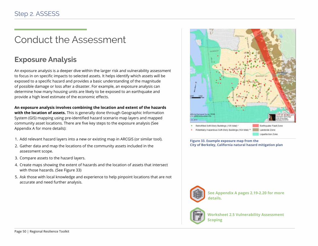
Page 50 | Regional Resilience Toolkit
Step 2. ASSESS
Conduct the Assessment
Exposure AnalysisAn exposure analysis is a deeper dive within the larger risk and vulnerability assessment to focus in on specific impacts to selected assets. It helps identify which assets will be exposed to a specific hazard and provides a basic understanding of the magnitude of possible damage or loss after a disaster. For example, an exposure analysis can determine how many housing units are likely to be exposed to an earthquake and provide a high level estimate of the economic effects.
An exposure analysis involves combining the location and extent of the hazards with the location of assets. This is generally done through Geographic Information System (GIS) mapping using pre-identified hazard scenario map layers and mapped community asset locations. There are five key steps to the exposure analysis (See Appendix A for more details):
1. Add relevant hazard layers into a new or existing map in ARCGIS (or similar tool).
2. Gather data and map the locations of the community assets included in the assessment scope.
3. Compare assets to the hazard layers.
4. Create maps showing the extent of hazards and the location of assets that intersect with those hazards. (See Figure 33)
5. Ask those with local knowledge and experience to help pinpoint locations that are not accurate and need further analysis.
Figure 33. Example exposure map from the City of Berkeley, California natural hazard mitigation plan
Worksheet 2.5 Vulnerability Assessment Scoping
See Appendix A pages 2.19-2.20 for more details.

Regional Resilience Toolkit | Page 51
Step 2. ASSESS
Figure 34. Example exposure table from City of Berkeley Natural Hazard Mitigation Plan
Infrastructure Element
Total Length
Length in Hazard Areas
Earthquake Induced Landslide Planning Zone
Fault Rupture Planning Zone
Liquefaction Planning Zone
Curbs 354 miles 44 miles (12%) 31 miles (9%) 93 miles (26%)
Streets 257 miles 42 miles (16%) 26 miles (10%) 68 miles (27%)
Solano Tunnel 0.09 miles 0 miles (0%) 0 miles (0%) 0 miles (0%)
Answer Assessment QuestionsAssessment questions help describe the existing conditions, different types of vulnerabil-ities, and consequences that may occur if an individual or representative asset is exposed to a specific hazard. There are separate assessment questions for individual or repre-sentative assets and asset classes, so be sure to use the correct assessment questions worksheet for the appropriate scale.
Assessment questions include describing and determining the following information:
ü Ownership and characteristics of an asset
ü Existing conditions
ü Physical vulnerabilities to hazards
ü Functional vulnerabilities including dependencies or relationships to other assets
ü Governance vulnerabilities
ü Consequences if asset is damaged or destroyedWorksheet 2.6 Rapid Vulnerability Assessment Exercise
Worksheets 2.7/2.8 Vulnerability Assessment Questions
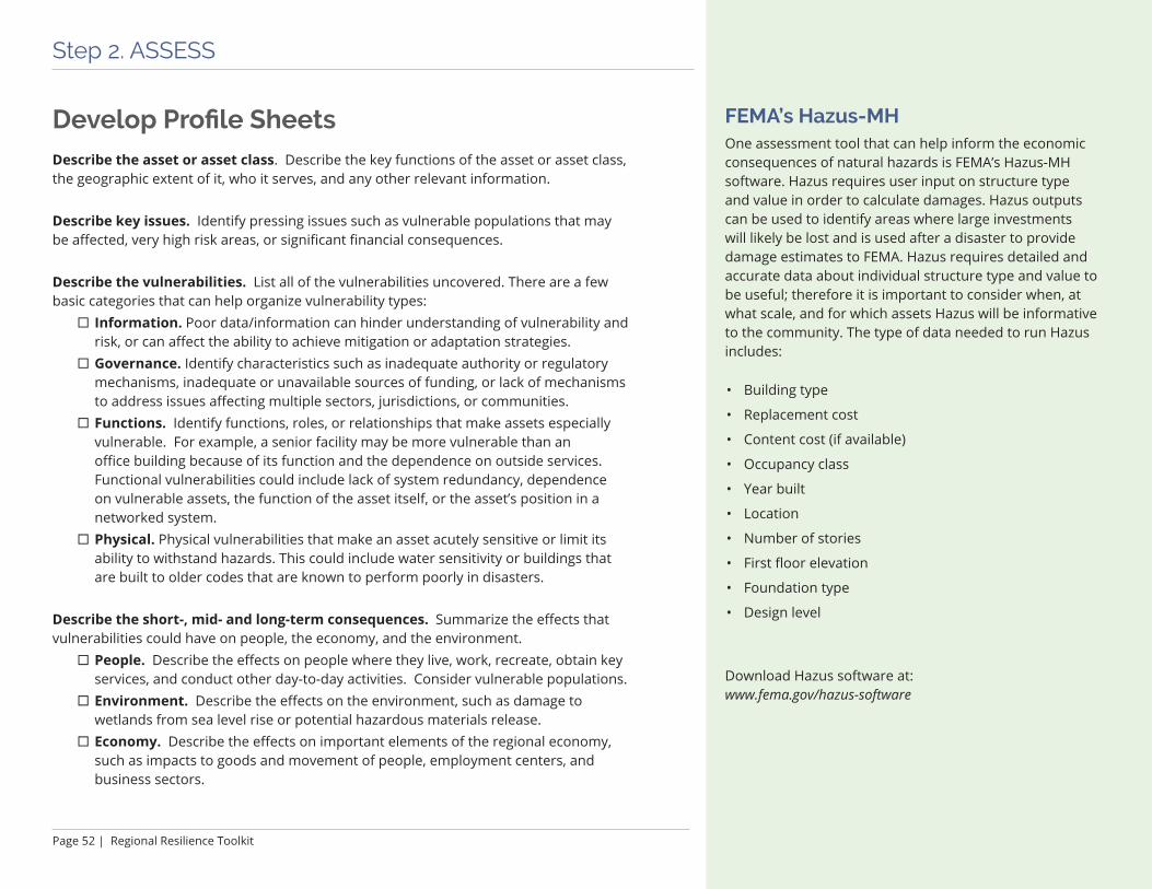
Page 52 | Regional Resilience Toolkit
Step 2. ASSESS
FEMA’s Hazus-MHOne assessment tool that can help inform the economic consequences of natural hazards is FEMA’s Hazus-MH software. Hazus requires user input on structure type and value in order to calculate damages. Hazus outputs can be used to identify areas where large investments will likely be lost and is used after a disaster to provide damage estimates to FEMA. Hazus requires detailed and accurate data about individual structure type and value to be useful; therefore it is important to consider when, at what scale, and for which assets Hazus will be informative to the community. The type of data needed to run Hazus includes:
• Building type
• Replacement cost
• Content cost (if available)
• Occupancy class
• Year built
• Location
• Number of stories
• First floor elevation
• Foundation type
• Design level
Download Hazus software at: www.fema.gov/hazus-software
Develop Profile SheetsDescribe the asset or asset class. Describe the key functions of the asset or asset class, the geographic extent of it, who it serves, and any other relevant information.
Describe key issues. Identify pressing issues such as vulnerable populations that may be affected, very high risk areas, or significant financial consequences.
Describe the vulnerabilities. List all of the vulnerabilities uncovered. There are a few basic categories that can help organize vulnerability types:
¨ Information. Poor data/information can hinder understanding of vulnerability and risk, or can affect the ability to achieve mitigation or adaptation strategies.
¨ Governance. Identify characteristics such as inadequate authority or regulatory mechanisms, inadequate or unavailable sources of funding, or lack of mechanisms to address issues affecting multiple sectors, jurisdictions, or communities.
¨ Functions. Identify functions, roles, or relationships that make assets especially vulnerable. For example, a senior facility may be more vulnerable than an office building because of its function and the dependence on outside services. Functional vulnerabilities could include lack of system redundancy, dependence on vulnerable assets, the function of the asset itself, or the asset’s position in a networked system.
¨ Physical. Physical vulnerabilities that make an asset acutely sensitive or limit its ability to withstand hazards. This could include water sensitivity or buildings that are built to older codes that are known to perform poorly in disasters.
Describe the short-, mid- and long-term consequences. Summarize the effects that vulnerabilities could have on people, the economy, and the environment.
¨ People. Describe the effects on people where they live, work, recreate, obtain key services, and conduct other day-to-day activities. Consider vulnerable populations.
¨ Environment. Describe the effects on the environment, such as damage to wetlands from sea level rise or potential hazardous materials release.
¨ Economy. Describe the effects on important elements of the regional economy, such as impacts to goods and movement of people, employment centers, and business sectors.

Step 3. ACT: Identify and Prioritize Strategies
Figure 35. Fort Bragg sand dunes, California
Natural systems such as dunes can be effective in reducing impacts related to sea level rise and extreme storms.

Step 3. ACT
Step 3. ACT
Regional Resilience Toolkit | Page 55
Assessing hazards and assets and summarizing findings into problem statements leads to the most important component of risk reduction and resilience building: identifying responsive resilience strategies and actions and setting up implementation of these actions. Resilience strategies should be directly responsive to the hazards and vulnerabilities uncovered in the assessment step and be designed to resolve real world, meaningful local problems. This step results in:
ü A short list of prioritized, implementable strategies that tie back to goals, problem statements, and other planned local actions
ü Concrete plans for implementing strategies through local action
ü Buy in from key stakeholders and community to aid in supporting implementation
Summarize VulnerabilityAfter completing the risk assessment, summarize the findings to identify the most significant risks in the community. These findings or “problem statements” will help to craft effective strategies and actions. Problem statements will help to:
ü Communicate critical planning issues, for example which critical assets are particu-larly vulnerable, what areas currently have repetitive losses, or how many high hazard areas are currently zoned for future development.
ü Assist the community and stakeholders to prioritize and focus on the areas that have the greatest need for mitigation or adaptation based on the risk assessment.
ü Create a clear and cogent “story” to help support decision making by elected officials and other stakeholders.
ü Provide a foundation for seeking funds to reduce risks and increase community resilience.
This chapter provides guidance on creating actionable strategies. This chapter is divided into four primary sections:
üSummarize Vulnerability
üDevelop Strategies
üEvaluate and Prioritize Strategies
üDevelop Implementation Plans
Page 56 | Regional Resilience Toolkit
Step 3. ACT
Sample Problem Statements Problem statements can be developed for each hazard, asset class, or individual assets evaluated in the risk assessment, for example:
“The North Creek Sewage Treatment Plant is located in the 100-year floodplain and has been damaged by past flood events. It serves 10,000 residential and commercial properties and it is the primary treatment plant for this area.”
“City Hall is located in an area that is likely to experience very high levels of shaking in either a San Andreas or Hayward earthquake. The building is an unretrofitted unreinforced masonry building built before 1930 and therefore highly vulnerable to damage in an earthquake.”
“Five of the eight public elementary schools in this city are in moderate or high ground shaking areas and one is located in both a liquefaction zone and in the 100-year floodplain. One middle school is not currently in any hazard zone but will likely experience future flooding with 36” of sea level rise. There is a data gap around the retrofit status of any of the schools; it is unknown if any have been seismically retrofitted.”
The first step in writing problem statements is to review the exposure analysis maps and answers to the assessment questions. It is often the case that a number of assets will have similar characteristics, conditions and challenges, so it makes sense to read through and reflect on all of the answers before beginning to summarize.
The second step is to use the answers to the assessment questions to write summary statements describing the vulnerabilities and consequences identified. Depending on the process, the statements can summarize the assessment findings for individual assets, a particular asset category or services, the community as a whole, or the agencies and organizations that own, operate, or manage the assets evaluated.
When writing problem statements, consider what vulnerabilities or consequences to include, and if a stand alone problem statement is most effective. Some vulnerabilities will rise to immediate or near-term need, such as those that have:
ü Broad or wide ranging effects on society and equity, including to a large geographic area, large numbers of residents, or to environmental justice communities.
ü Reduce ecosystem benefits provided by natural areas, such as flood risk reduction, water quality improvement, and supporting biodiversity.
ü Economic impacts at multiple scales, including local, regional, statewide and national.
ü Urgency and complexity, which requires a longer timeframe to address. For example, there may be a stretch of shoreline that may flood with small amounts of sea level rise, but will take a long time to solve due to complexities in ownership, management, financing, and regulatory oversight.
ü Cascading effects on other assets, services, or communities. This is particularly an issue for networked assets, such as transportation, utilities, and shoreline protection, which are interconnected in a manner such that failure of one part of the system will disrupt the rest of the system. This will also be an issue for assets that rely on other assets to maintain functionality, for example hospitals, nursing homes, and waste-water treatment plants that rely on uninterrupted power supplied by others.
Worksheet 3.1 Develop Initial Problem Statements
See Appendix A pages 3.4-3.10 for more details.
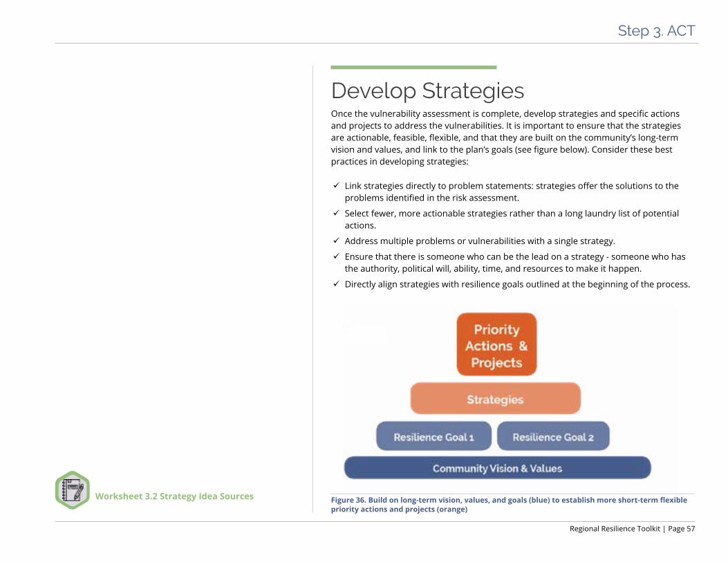
Regional Resilience Toolkit | Page 57
Step 3. ACT
Figure 36. Build on long-term vision, values, and goals (blue) to establish more short-term flexible priority actions and projects (orange)
Develop StrategiesOnce the vulnerability assessment is complete, develop strategies and specific actions and projects to address the vulnerabilities. It is important to ensure that the strategies are actionable, feasible, flexible, and that they are built on the community’s long-term vision and values, and link to the plan’s goals (see figure below). Consider these best practices in developing strategies:
ü Link strategies directly to problem statements: strategies offer the solutions to the problems identified in the risk assessment.
ü Select fewer, more actionable strategies rather than a long laundry list of potential actions.
ü Address multiple problems or vulnerabilities with a single strategy.
ü Ensure that there is someone who can be the lead on a strategy - someone who has the authority, political will, ability, time, and resources to make it happen.
ü Directly align strategies with resilience goals outlined at the beginning of the process.
Worksheet 3.2 Strategy Idea Sources

Page 58 | Regional Resilience Toolkit
Step 3. ACT
Develop Initial List of StrategiesThis step focuses on developing an initial list of potential strategies that are responsive to specific problem statements. Strategies at this point should be robust enough to be able to move forward, but flexible and adaptable enough to adjust as they are advanced. Each kind of problem may have different approaches or types of strategies required. The following are examples of ways to categorize and consider strategies.
ü Operational – Strategies to enact operational and governance-related improvements.
ü Programmatic - Strategies to expand or create new programs , activities, and initiatives.
ü Plans, regulations, and policy development – Strategies to develop or revise policies, plans, regulations, and guidelines.
ü Capital improvement/infrastructure projects - Strategies designed to address physical and functional deficiencies and needs in the built and natural environment.
ü Education/outreach/coordination – Strategies related to initiating or expanding partnerships and relationships, communicating and sharing information, and building awareness.
ü Evaluation – Strategies to improve feedback, input, and data and information or conduct further or new analyses.
The process of developing a basic profile of each potential strategy can help to uncover how easy or feasible the strategy would be to implement. Strategies will vary in terms of timeliness, dependencies, cost, and effort. Some solutions may be preliminary or unlocking, meaning they must be done in a particular order. Some strategies may be easier than others for individual agencies or asset managers to undertake themselves without having to form new partnerships or collaborations. Some strategies are multi benefit, providing community benefits or improving the performance of the asset to multiple hazards. Finally, some strategies should be launched early because they require a long lead time.
Example: Connecting Problem Statements to Strategies
OperationalProblem: The City has a lack of staff to enforce building codes and adherence to retrofit policies.
Strategy: Within the next year, build staffing capacity to implement and support plan implementation.
Plans, Regulations, and PolicyProblem: Electric power outages occur on a regular basis during winter storms, resulting in business in core commercial areas to lose customers.
Strategy: Within the next five years, require all new commercial solar installations to include energy storage with a minimum of 3 hours of downtime.
Education/Outreach/CoordinationProblem: There are over fifteen agencies and twelve non-profits involved in addressing sustainability and resil-ience in the city, resulting in substantial gaps, duplication, and increased competition for funding.
Strategy: Develop and convene a regional sustainability council to coordinate and align efforts of the agencies and non-profits.

Regional Resilience Toolkit | Page 59
Step 3. ACT
Each strategy also has a process or mechanism for implementation that can be identified early on. Some typical identified processes are listed below:
ü Long range planning – these are mechanisms like master plans or climate action plans that articulate a long range vision for the community.
ü Land use planning – this includes elements that dictate current and future land use planning decisions like General Plans or Specific/Area plans.
ü Capital planning – this includes capital improvement plans and is essential if the strategy requires financial support for staff or capital improvements.
ü Operations – this includes the annual budgeting process, which can incorporate the financial planning for strategy implementation.
ü Emergency and hazards planning – this includes incorporation into the LHMP, emergency response plans, or preparedness planning.
ü Project planning and design – this includes public-private development projects like housing developments, which may be necessary to implement specific strategies.
ü New initiatives – this includes anything that cannot occur under current processes and needs an entirely new effort like a new department, legislation, or ballot measure.
On the following page, Figure 38 illustrates the information and level of detail that should be gathered at this stage. Figure 39 is an example of a completed strategy profile.
Example: Connecting Equity to Goals and StrategiesIn 2016, the Georgetown Climate Center with the Urban Sustainability Directors Network (USDN) hosted a two-day workshop in Baltimore with 50 thought-leaders in climate adaptation and equity. The workshop resulted in a report titled “Opportunities for Equitable Adaptation in Cities”, which summarizes the key findings and lessons learned from the group. This resource can help communities consider social justice goals and strategies alongside resil-ience goals and strategies.
www.georgetownclimate.org/reports/opportunities-for-equitable-adaptation-in-cities.html
Figure 37. Opportunities for Equitable Adaptation in Cities report cover
Image source: Georgetown Climate Center
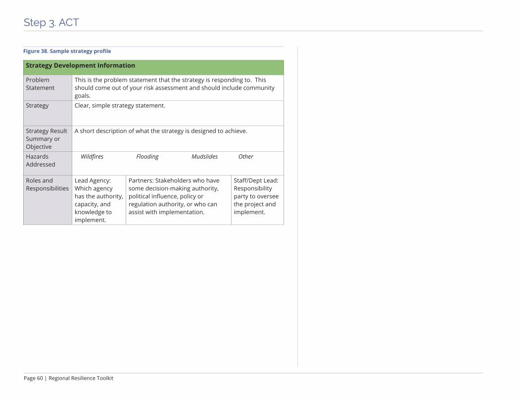
Page 60 | Regional Resilience Toolkit
Step 3. ACT
Strategy Development Information
Problem Statement
This is the problem statement that the strategy is responding to. This should come out of your risk assessment and should include community goals.
Strategy Clear, simple strategy statement.
Strategy Result Summary or Objective
A short description of what the strategy is designed to achieve.
Hazards Addressed
Wildfires Flooding Mudslides Other
Roles and Responsibilities
Lead Agency: Which agency has the authority, capacity, and knowledge to implement.
Partners: Stakeholders who have some decision-making authority, political influence, policy or regulation authority, or who can assist with implementation.
Staff/Dept Lead: Responsibility party to oversee the project and implement.
Figure 38. Sample strategy profile
Regional Resilience Toolkit | Page 61
Step 3. ACT
Example: Santa Cruz County Local Hazard Mitigation Plan Prioritization Criteria
Very High Priority • A project that meets multiple plan objectives
• Benefits exceed cost
• Has strong community support
• Addresses those hazards presenting the highest risk
• Funds are identified or potentially available
• Project can be completed in one to five years once project is funded
High Priority • Project meets at least one plan objective
• Benefits exceed costs
• Funding has not been secured
• Project can be completed in one to five years once project is funded
Important • Project mitigates the risk of a hazard
• Benefits exceed costs
• Funding has not been identified and/ or timeline for completion is considered long-term (e.g., five to ten years)
Source: 2015-2020 Santa Cruz County Local Hazard Mitigation Plan,
Page 168.
Evaluate and Prioritize StrategiesEvaluate and decide which of the initial list of strategies are most relevant, most achievable, or highest priority. Carefully considered evaluation criteria can provide a tool for prioritization. Evaluation criteria can be an essential tool to gauge the priorities and values of different agencies, organizations, communities, or other stakeholders to ensure that strategies are well balanced to reflect the community’s goals. Evaluation criteria can also reveal new perspectives in how different strategies impact the four frames — society and equity, economy, environment, and governance — or whatever frames the community has identified. Evaluating strategies through these frames can identify and highlight the benefits and tradeoffs of strategies in each frame, which can be very useful when garnering political, community, and financial support for implementation.
The four frames can reveal some of the following characteristics of each strategy:
ü Society and equity: Effects on communities and the services on which they rely, with specific attention to disproportionate impacts due to social, political, or economic inequality.
ü Economy: Economic aspects that may be affected such as costs of physical infra-structure damages or lost revenues during recovery periods.
ü Environment: Environmental aspects that may be affected, including ecosystem functions and services and species diversity.
ü Governance: Factors such as organizational structure, ownership of assets, management responsibilities of assets, jurisdictional mandates, regulations, or funding options that affect how a community can respond to a hazard.
The evaluation criteria can be used not just by the project team, but by any individual or group that will play a significant role in implementation. Vetting and evaluating strategies are a key piece of community outreach to ensure that the plan for building resilience represents what the community wants and needs for a safer future. Additionally, various city departments may have different perspectives on things like ease of implementation, and identifying potential issues during the evaluation phase can help prevent unexpected roadblocks in the future. Strategy evaluation is also another chance to build buy-in and support from decision makers and the community.
Page 62 | Regional Resilience Toolkit
Step 3. ACT
Building Consensus on Priorities If many strategies rate similarly, the following questions may help identify top priorities:
ü Is it aligned with other ongoing or planned efforts? Can the city adapt projects already underway to include mitigation or adaptation efforts, or if the city imple-ments the strategy does it meet multiple goals?
ü Is it an “easy win”? An easy win is a strategy that is easy to achieve and provides a high level of benefit.
ü Is it an unlocking strategy? For example, are additional studies required or new stakeholders needed before the city can implement a priority strategy?
ü Is the timing right? For instance, if the regular building code update is due in the next year, it may make sense to prioritize a strategy to update the building code to take climate change projections into account within that same process and time frame.
ü Is there a champion? Is there someone who strongly believes it is a top priority and is willing and able to devote time and resources to implement it in the short term?
Refer to Worksheet 3.3 Evaluation Criteria that can be adapted to match the project and the community’s resilience goals.
Worksheet 3.3 Evaluation Criteria
Regional Resilience Toolkit | Page 63
Step 3. ACT
Things to Consider for Implementation Planning
What is the best timeframe for the implementation plan? Less than five years is reasonable and is relatively predictable. However, some strategies, such as major infrastructure projects, may require a longer timeframe, especially as part of a general plan. The longer the timeframe, the less information, certainty, and feasibility the strategy will have.
Who controls the dependencies that will lead to the success of the strategy? For instance, does a strategy rely on a different organization passing a policy or funding the activity? The more dependencies and the more actors involved in achieving a strategy will likely require more time and resources to complete.
Can the project move forward with some easy win-win strategies early, even if they are not a priority? People and decision-makers like to see action and if there is a way to move forward some activities quickly, make that clear in the implementation plan.
Does a strategy connect to another project? If so, review the timeline for that effort and make sure the implemen-tation plan is responsive to that timeline.
Is the strategy truly feasible? The implementation plan is a final opportunity to ground truth the feasibility of a solution and make sure it will actually be accomplished. If a strategy has been moved forward to this point, and it is more aspirational than realistic, adjust implementation to reflect that reality.
Develop Implementation PlansThe entire planning process should be done with an eye to implementation, working to overcome challenges and build consensus throughout to facilitate successful imple-mentation. Once there is a list of prioritized and actionable strategies, the next step is to develop an implementation plan. Implementation can be considered in two parts:
Implementation is a critical part of sustaining resilience over the long-term, ensuring ongoing support and funding for future projects and initiatives. Below are some best practices to use as the project team develops implementation plans.
ü Connect implementation to the goals and process completed to get to this point.
ü Understand the needs and wants of stakeholders and community members.
ü Use survey and polling to gauge broad support for plans and actions.
ü Build support for the value of the plan to increase buy in and increase stakeholders investment in the outcome.
ü Plan on a lot of ongoing public outreach and education to remind people about the effort and how it connects to their lives.
ü Time projects when the atmosphere is right. Modify the timeframe identified in the plan as needed to benefit from external conditions.
A Long-Term Implementation Plan (5-20 years) is typically higher level, and used to share with stakeholders and decision makers, is included in formal plan documents, and illustrates how to achieve the vision and plan goals.
A Short-Term Action Plan (0-5 years) can act as a staff level working plan that details each step or tactic necessary to achieve those longer term goals and vision in a more manageable time frame, up to 2 years. There is a direct link between the action plan and annual budgets, the capital improvements plan, and daily work.

Page 64 | Regional Resilience Toolkit
Step 3. ACT
Develop Long-Term Implementation PlanThe long-term implementation plan (5-20 years) should map out the activities, priorities, timing, and costs for each strategy. This builds the overarching framework for imple-mentation, ensuring that the implementation plan hits on all the high level goals. The long-term plan comes first so that the short-term action plans are designed to implement and enable the vision laid out in the long-term plan.
Use the implementation plan as the final chance to ground truth the feasibility and effectiveness of a solution. If a strategy has been moved forward to this point, and it is more aspirational than realistic, adjust the implementation to reflect that reality.
Develop Short-Term Action PlansBuilding upon the Long-Term Implementation Plan, a Short Term Action Plan with a 0-2 or even 5 year time frame should be the next step. This near term planning tool should integrate financing, and assist in routine city decision making while still maintaining the long-term vision of the implementation plan. The Short-Term Action Plan should include specifics and tactical details that go into city work plans, budgets, and grants planning.
Planning for implementation will also use the pieces of information filled in on Worksheet 3.5 Strategy Development and Implementation and shown as an example on the following page; the strategy types and process/implementation mechanism portions can be particularly helpful in identifying actions or activities. A Short-Term Action Plan should include the following information:
üStrategy name
üSpecific actions or tactics to implement strategy
ü Information on the lead, cost, level of effort or estimated hours to complete, funding source, and completion date
üA status line that can be updated periodically
üMetric or an evaluation measurement by strategy or tactics depending on the required detail
Worksheets 3.4/3.5 Strategy Development and Implementation

Regional Resilience Toolkit | Page 65
Step 3. ACT
STRATEGY DEVELOPMENT INFORMATIONProblem Statement The City of East Palo Alto experiences coastal flooding during extreme storms. One-quarter of the city and many single family homes are
within the coastal watershed that experiences flooding now. These storms are anticipated to increase in the future causing more frequent and extensive flooding.
Strategy Name Reduce flood risk through integrated watershed management
Strategy Summary Identify projects that sustain or enhance watershed functions while protecting development from shoreline and riverine flooding.
Hazard(s) Addressed Current Flooding, Future Flooding
Strategy Type
Operational ProgrammaticPlans, Regulations, and
Policy Development
Capital Improvement/ Infrastructure
Project
Education/ Outreach/ Coordination
Evaluation
Process/ Implementation Mechanism
Long Range Planning
Land Use Planning
Capital Planning
OperationsEmergency &
Hazards Planning
Project Planning &
DesignNew Initiatives
Responsible AgencyPlanning and Building Department
Partners FEMA, developers
STRATEGY IMPLEMENTATION INFORMATION
Priority (Evaluation Score) 13
Actions/Activities Conduct additional analysis of appropriate watershed projects, partner with FEMA for guidance and assistance, incorporate projects into long-term city plans, and pursue implementation of identified projects
Staff Lead Jane Doe
Cost Estimate $50,000 planning, $300,000 - $1 million implementation
Benefits (losses avoided)
Improves habitats and biodiversity, improves water quality, protects vulnerable residents and recreational uses, protects built environment
Potential Funding Sources FEMA
Timeline 18 months planning, 3-5 additional years for implementation
Related Policies Existing policies for management of estuaries along shoreline to enhance bay shoreline flooding protection capacity
Figure 39. Example Strategy: ABAG/BCDC Stronger Housing, Safer Communities

Page 66 | Regional Resilience Toolkit
Step 3. ACT
Catalysts for ImplementationImplementation is the most difficult part of any planning effort. Many partners can get behind a concept, but when it comes to dedicating funding, time, or resources, it can be a challenge. The process identified in this Toolkit is designed to help avoid common pitfalls, particularly inadequate engagement of stakeholders, decision-makers and the community. The following are some best practices to adhere to when developing imple-mentation plans:
1. Political buy in. Elected officials, like council members, have the power to expedite or stymie action. Building a supportive political climate and addressing the concerns of elected officials or other decision makers can make the difference between action and inaction.
2. Sustained commitment. Many actions can take years to implement. Projects may span multiple terms of office for elected officials and multiple funding cycles. It helps to have an advocate at a high level (see above point about political buy-in), but beyond elected officials, who may cycle in and out of office before a project is complete, engagement of department heads, city administrators, city managers, or someone similar helps ensure implementation success.
3. Focus actions where the money is. Varying priorities from funders means that sources of funding may not align with all actions identified and prioritized. Rather than focusing on an action without regard to where funding will be coming from, select actions that align with funding priorities. (See Step 4. FUND for more on this)
4. Piggyback on successful local projects. What kinds of projects are already successful in communities? Every community has its own capital spending pattern, which reveals the priorities of the community. These priorities should have been identified early on in the project, and strategies and actions should align with existing community prior-ities. It is important to look at existing projects to see where resilience actions may be able to piggyback.
5. Use existing processes, groups, or sources of funding. Similar to capitalizing on existing successful projects, consider how existing working groups, departments, or funding streams can be adapted to include actions that advance resilience. For example, if a community already has a sustainability council that brings together cross-agency staff or department heads, that group could expand its mission to advance resilience as well. Additionally, current investments in infrastructure
Example: Linking Climate Adaptation and Hazard Mitigation in MassachusettsIn 2018, the state of Massachusetts completed an integrated State Hazard Mitigation and Climate Adaptation Plan. The plan outlines 108 specific actions that meet the requirements both for federal disaster mitigation funds and for the governor’s executive order requiring the state to prepare for the impacts of climate change.
These 108 actions are scored by priority and have detailed information about the lead agency, partners, funding sources, and completion time frame. Key state agencies will track progress of each action and update and develop new actions over time.
www.mass.gov/service-details/massachusetts-integrated-state-hazard-mitigation-and-climate-adaptation-plan (Chapters 7 and 8)

Regional Resilience Toolkit | Page 67
Step 3. ACT
maintenance may be able to be adapted to incorporate protective actions like water-proofing or seismic retrofit to improve the longevity of infrastructure without the need for new bond measures or other sources of funding.
6. Consider the city’s partners. Many resilience projects are complex, with multiple owners, regulators, or users of assets that need retrofit, moving, or rebuilding. Create more realistic solutions by identifying and engaging with all involved stakeholders from the beginning, and taking into account all of the moving pieces involved in imple-menting a solution.
7. Do not be afraid to build something new. Sometimes it makes more of a statement and political splash to create an entirely new effort, especially if the effort can garner a lot of excitement and involvement from a wide variety of stakeholders. For example, Bay Conservation and Development Commission’s 2009 Rising Tides design compe-tition generated region-wide interest in climate adaptation, leading to the devel-opment of the Adapting to Rising Tides Program, which has worked with many cities and counties since the competition to develop in-depth vulnerability assessments and sea level rise adaptation strategies for the region.
Every community will need its approach for implementing resilience building actions, building on existing processes to create adaptive decision making and action taking. Ensuring successful implementation stems from active engagement of stakeholders, coordinated decision making, and wide ranging capacity building to minimize barriers to action and garner meaningful support.

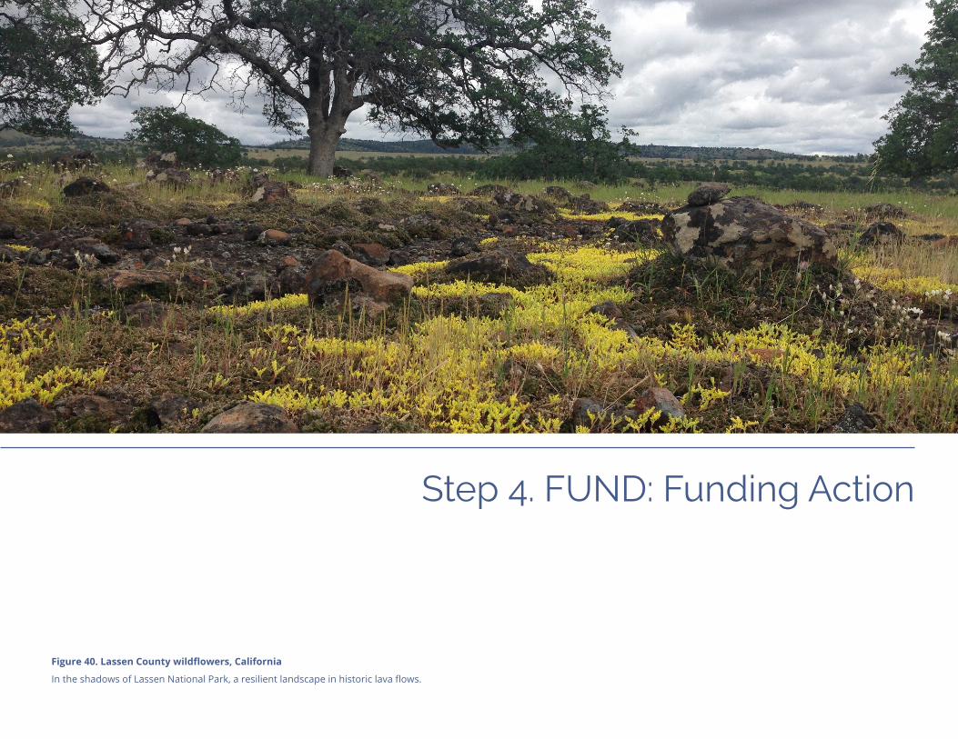
Step 4. FUND: Funding Action
Figure 40. Lassen County wildflowers, California
In the shadows of Lassen National Park, a resilient landscape in historic lava flows.

Step 4. FUND
Step 4. FUND
Regional Resilience Toolkit | Page 71
Figuring out how to fund a project or resilience initiative is a difficult challenge to solve for almost all jurisdictions. No matter the project, financial hurdles are frequently cited as the reason for not acting. Building successful funding and financing for resilience starts with understanding the community’s long-term vision for its future and how collectively it will commit to funding and implementing its goals. Successful communities will figure out meaningful ways to mainstream resilience into overall community development and community visioning.
Adaptive approaches to match resilience needs to funding resources may include uncon-ventional solutions: for example, different departments may coordinate on spending for capital projects, or neighboring cities may pool funding for large-scale green infra-structure projects to benefit many jurisdictions. Unexpected co-benefits arise from these imaginative multi-partner efforts — workforce development opportunities, new sources for potential matching funds, enlivened economic conditions resulting from major construction projects, and an improved physical environment that uplifts the quality of life for the community. By highlighting multiple benefits of resilience projects, more funders are likely to emerge to support implementation.
Project teams can work with the advisory group to develop an overall resilience capital strategy, which can include several steps to ensure a robust, diverse, and long-term sustainable plan for funding resilience actions. But project teams will need to first start by mastering the fiscal landscape with training for key staff and leaders in how to make the business case for resilience projects. Though many project team and advisory group members may be able to talk about the need for resilience actions, they will also need to be able to talk about the cost-benefit analysis, the return on investment, and other such financial considerations for project success. Furthermore, it is important to have a strong network of funders that cut across levels of government and include the private and philanthropic sectors. Lastly, before a capital strategy takes form, the larger community must be willing to invest in actions that improve overall community resilience.
This chapter reviews the pivotal steps for funding the projects outlined during Step 3: ACT. This chapter is divided into two primary sections:
ü Make the Business Case for Resilience
ü Develop a Resilience Capital Strategy
Page 72 | Regional Resilience Toolkit
Step 4. FUND
Make the Business Case for Resilience
Master the Fiscal LandscapeSenior staff and elected leaders will need to develop financial literacy to talk with both private financers and public agencies about their projects and funding needs. Local governments can consider setting up a fiscal coaching program for personnel that work on disaster resilience planning and project action. Training and capacity building on fiscal issues can ensure that all decision-making officials are conversant with current finance and funding options that are evolving at a rapid pace. Social investment firms often provide pro bono training support for clients and community stakeholders. Programs such as the Urban Land Institute’s Pro Forma Fundamentals course provides transferable models for financial analysis in the real estate sector. There are many ways to support local expertise and to ensure communities are savvy investors and funders in resilience planning. In the same way that cities support leadership or equity training programs for staff and super-visors, cities can consider adding fiscal literacy and innovation curricula into professional development programs to build local proficiency.
Build Your Funding NetworkMaking the business case for the resilience effort in the community — planning how to frame the project, back it up with data and numbers, and convince people to invest in it — is a critical part of this effort. The project team should devise a clearly articulated business case for the resilience actions. This will support the larger resilience initiative and be the means for the community/region to demonstrate the purpose of the work with information that an audience of financers will need in its deliberations on partnering and investing. Each project, initiative, and strategy must be “sold” to decision makers, partners, and, most importantly, funders. Worksheet 4.1 Funder Engagement
Inventory
See Appendix A pages 4.5 - 4.6 for more details.
Regional Resilience Toolkit | Page 73
Step 4. FUND
The effort to develop a resilience funding plan is a time-intensive activity that warrants attention, sustained networking, and ongoing communications with a broad range of potential fiscal partners. It is realistic to plan for at least two to three years of planning and project development to successfully secure local and external funding.
Best Practices to Develop a Funding Network• Build partnerships and relationships with local groups and those in other sectors
and levels of government. This is a good business practice and knits together critical social networks used in supporting funding measures, new budget allocations, and for securing new revenues.
• Connect with funding program officers at state agencies to acquaint them with the community’s resilience action planning and fiscal gaps. Meet with the State Hazard Mitigation Officer who monitors federal risk reduction programs and manages the state’s FEMA funding support for federal mitigation assistance.
• Contact the state office of emergency services and regional FEMA Grants teams and invite them to visit the jurisdiction’s resilience team, partners, and community leaders in order to present ongoing action planning efforts and demonstrate local needs for additional fiscal support.
• Keeping up on current policy developments is important: register to receive all public outreach communications on available grant funding, application processes, and proposal deadlines. Monitor the agency’s social media postings and funding alerts to ensure having as much information as possible on funding resources, and place your name on mailing and notice lists for state and federal programs.
• Invite staff from federal agencies such as FEMA, EPA, HUD and other potential funding offices to quarterly briefings about ongoing resilience planning and implementation needs.
• Lead state and federal agency leaders, senior state and federal elected officials and staff from philanthropic funders on community tours to demonstrate the need for resilience funding and resources.
• Attend commission and governing body meetings of funding agencies and organi-zations on a regular basis to become well versed in their policy priorities; establish a jurisdictional presence and interest in their proceedings; and, to present information during public comment periods on the jurisdiction’s resilience efforts.

Page 74 | Regional Resilience Toolkit
Step 4. FUND
Case Study: Accessing Hazard Mitigation Grant Program (HMGP) processThe HMGP program is funded through monies set aside as required by the Stafford Act (the foundational law for FEMA and federal disaster support to communities) to make risk reduction improvements after a federally declared disaster. A set aside for post-disaster dispersal is available and ranges from 10-15% of monies distributed through the federal disaster response programs for Public Assistance.
One complicating issue is that state offices of emergency services direct the grant application process and have a limited alert distribution process when grant funds come available. The jurisdictions filing for a physical project must have an adopted LHMP; funding is also available for development of HMGPs as well.
While typically local fire departments are notified about the potential grants, other municipal departments may not be notified. One common outcome is that a state’s HMGP program often receives applications for funds from local fire departments and OES staff for their depart-ments. Therefore, climate adaptation and large-scale risk reduction projects do not compete or there is inadequate interdepartmental coordination. The program has much wider potential. Building trusting, cooperative relation-ships through this inter-agency and multi-disciplinary regional resilience planning process can increase the likelihood of successfully applying for, and obtaining, HMPG funding.
• Track relevant state and federal resilience legislation as well as budget processes to identify potential sources of resilience funding is another useful tack. Submit comments through the jurisdiction’s governing body, pertinent committees, and legislative representatives on changes in regulation and funding allocations, especially relevant substantive statewide funding measures.
• Encourage the inclusion of resilience policies and actions as eligible funding activities in the development of state regulations developed after voters approve a funding measure.
• Participate in the public dialogue on the development of regulations that govern bond and tax disbursements and promote actions that route funds for resilience implementation.
Build Local SupportBuilding and sustaining stakeholder support for resilience action is an essential component of a finance strategy. As a jurisdiction overhauls its internal spending plan to incorporate climate and disaster resilience improvements, develops new revenue sources, or seeks voter approval for tax measures, having solid community backing is a baseline need. Communities see these efforts as being similar to managing a fundraising drive or a political campaign. After building trust and involvement through consistent outreach and frequent public dialogue, a larger support network naturally evolves as leaders and stakeholders address community risk and develop local solutions that make sense and are doable. Use Worksheet 4.1 Funder Engagement Inventory.
Local officials need to understand effective ways to activate community interest and ensure they are addressing the community’s highest priority needs. This will assure voters that they have responsive government partners and they are more readily invested in resilience outcomes. As outlined above, building a base for community support calls for astute public outreach.
Best Practices to Build Local Support• Cultivate internal allies. Local boards and commissions, along with the mayor
and city council/boards of supervisors, exercise considerable authority on budget decisions, approving grant applications and development of new revenue streams.
Regional Resilience Toolkit | Page 75
Step 4. FUND
Case Study: Two examples of voter-approved flood bonds from Miami and Houston
The Miami Forever Bond passed in 2017 and is a $400 million general obligation bond in which $192 million was set aside for flood risk reduction and sea level rise mitigation.
www.miamigov.com/Government/Departments-Organizations/Capital-Improvements-OCI/Miami-Forever-Bond
In 2018, Harris County, Texas passed a $2.5 billion flood mitigation bond initiative that will be managed by the county flood control district.
www.hcfcd.org/2018-bond-program/
Enlist members of these appointed bodies as champions for resilience implemen-tation. Start by identifying the senior leaders whose approval is essential for resilience projects’ success.
• Develop a briefing plan for senior decision makers to establish program and funding priorities, and work with the agency’s executive team to craft staff level recommenda-tions for resilience actions to present to the jurisdiction’s governing body. Designate senior sponsors who can shepherd projects through planning and budget processes and are trusted figures in the agency and community.
• Weave financing for resilience into daily activities. Establish a resilience action agenda through existing agency planning processes. Identify practical next steps that align with or improve existing organizational practice; identify innovative ways to blend/unlock funding for multi-benefit projects. Present these ideas as incremental, feasible solutions to address long-term challenges that are woven into the annual budget processes and capital planning budgets.
• Enlist the support of community stakeholders and active, local groups. Forging solid community relationships will be the basis for ongoing support for projects and financial support for resilience implementation. Build on community initiatives and link resilience action with other, ongoing local projects and initiatives. This will anchor resilience in daily community life and grow a larger network for implementation.
• Ensure that resilience is a front burner community topic. Develop a consistent briefing plan for varied stakeholder groups and integrate presentations with standing meetings to socialize the public consultation process and to ensure that resilience initiatives are always on the community’s discussion agendas. Make sure senior officials have a clear understanding of the fiscal challenges the community faces to improve resilience outcomes.
• Conduct participatory budget processes. These are public-private discussions about community finances that yield solid results that demonstrate community confidence and partnership. The process is much the same when addressing how to fund resilience improvements; rallying community support at the outset is essential as communities internally negotiate how to pay for climate and disaster safety measures. Whether through electoral campaigns, applying for funds from federal agencies, or by raising local impact fees, local jurisdictions have crucial financial choices to make to reduce the risk they face now and in the years to come.

Page 76 | Regional Resilience Toolkit
Step 4. FUND
Develop a Resilience Capital StrategyA successful resilience capital strategy is one that marries community- and government-supported funding and financing options into a layered and diverse portfolio of options. The concept, similar to a capital stack, is based on the understanding that there is an inherently “correct” sequence of funding and financing to maximize investments. To establish an effective capital strategy, the project team must be intentional about its funding and financing approach from the beginning, and structure its engagement, project development, communications, and resources in a way to leverage and enhance the potential to establish a robust and diverse capital strategy. Most cities struggle to find start-up investments that will bring more partners to the table to scope the project and lay the groundwork, whether through initial design, property acquisition, permitting, and other early-stage project phases. Yet these start-up funds are critical to leverage long-term recovery and pre-disaster funding.
Certain investments, such as those from a community foundation or general fund, can be made early in the process as they require limited return on that investment and are able to seed additional funding sources, particularly private investments, that need a stronger foundation and low-risk profile. For resilience projects, particularly large infrastructure projects, building this funding foundation is essential. Resilience financial planning must consider the need to secure early, pre-development funds from local government reserves or budgets, private-sector partners, or philanthropy sources. This leverages available government funding and keeps initiatives on track.
Communities must consider the overall timing and complicated fiscal process for bringing disaster resilience projects to fruition. Project teams will need to pinpoint financial milestones and appropriate funding sequences to implement the project. This sequencing is tricky to manage, because external government grants are frequently allocated for projects that are fully planned and designed. An effective resilience capital strategy often starts with local, self-reliant investments, and leverages those monies with public-private partnerships, philanthropic dollars, regional funds, grants, and private-sector investments.
TOAH Fund Capital Stack
16
Senior Lenders
Originating CDFIs
Subordinate Lenders
MTC
$30M
$35M
$25M
$40M
$50MFinancing Partners
Seed Financing• Metropolitan Transportation Commission
(MTC)
Subordinate Lenders• Ford Foundation• Living Cities• The San Francisco Foundation (TSFF)
Originating CDFIs• Corporation for Supportive Housing (CSH) • Enterprise Community Loan Fund• Local Initiatives Support Corporation (LISC) • Low Income Investment Fund (LIIF) • Northern California Community Loan Fund
(NCCLF) • Opportunity Fund
Senior Lenders• Citi Community Capital • Morgan Stanley
Figure 41. Example of a diverse capital stack, adapted from the report “Bay Area Transit-Oriented Affordable Housing Fund.” Bay Area TOAH Fund. 2013. www.greatcommunities.org/our-work/financing

Regional Resilience Toolkit | Page 77
Step 4. FUND
Case Study: New York City Subway BondFollowing Hurricane Sandy, New York’s Metropolitan Transportation Authority (MTA) sold a $200 million catas-trophe bond to protect the New York City subway system from future storm surges. The bond trigger is set at a specific storm-surge height based on data provided by USGS and NOAA.
www.adaptationclearinghouse.org/resources/nyc-mta-storm-surge-protection-via-catastrophe-bond-market-new-york-city-metropolitan-transportation-authority.html
Self-Reliant Resilience FinancingStarting with the inventory of local resources demonstrates community commitment to a more self-reliant financial future. It also provides local matching funds required for many federal grant programs and shows private investors that local jurisdictions are serious about addressing risks and willing to adopt innovative ways to fund community safety. Use the following common (and not-so-common) tools for local resilience financing.
Develop an initial financial strategy that starts with locally-based funding opportu-nities. The strategy should consider the following elements:
• Embed resilience budgeting into the community’s fiscal planning. As resilience funding is often limited to external, limited scope grants or restricted portions of general fund or capital improvement plan budgets, local resources are undervalued. This includes existing budget planning as part of mainstream operations. Incrementally, resilience projects and initiatives need to be part of the regular budget and decision-making discussions.
• Examine all funding sources at hand as possible resilience monies that can open new possibilities to implement projects more quickly. Comb through internal budget sources and consider how to re-purpose existing funds or create new revenue scenarios to leverage what’s already available.
• Influence community-wide conversation and day-to-day decisions about long-term capital improvements to both inform the public and build support for future funding campaigns.
Every community has an investment approach shaped by local values, identified risks, and consensus solutions resulting from local dialogue. Developing a zero-based local budget analysis to closely examine resources at hand can be the gateway to advance a diverse resilience funding strategy. Start by looking at existing internal processes, groups, or sources of funding as topics for public consideration that could offer unexpected answers on how to mainstream resilience projects. Local jurisdictions or regional agencies with cross-functional project groups or inter-departmental work teams may be able to incorporate resilience components into ongoing capital projects or planning initiatives. Projects already poised to be funded and implemented are prime examples of efforts to review as potential vehicles for readily integrating resilience improvements.
Page 78 | Regional Resilience Toolkit
Step 4. FUND
Example: Triple Bottom Line in ColoradoFollowing the catastrophic 2013 floods in Boulder County, Colorado, nine local jurisdictions formed a planning collaborative and have used the National Institute of Standards and Technology (NIST) Community Resilience Planning Guide (www.nist.gov/topics/community-resilience/planning-guide) to develop and enact common, location-appropriate guidelines for rebuilding public-sector facil-ities and systems. Boulder County applied a triple bottom line analysis, which considers impacts to the economy, the environment, and society, and that links to state-of-the-practice asset management systems.
www.bouldercounty.org/disasters/flood/2013-flood/resiliency/
Adapting current asset management budgets for infrastructure maintenance might easily combine protective actions such as weather-proofing or structural improvements to expand the full lifecycle investment and infrastructure upgrade with little or no extra funding. This approach is successful when done with a robust participatory process to balance the perspectives of government and local residents. Once local resources are scrutinized and realistically assessed as untapped funds for resilience projects, decision makers can identify additional resilience funding gaps and plan for outside grants or loans. See Worksheet 4.2 Local Funding Source Inventory Worksheet.
It is possible, at the local and state levels, to provide fiscal and resource incentives for resilience improvements that property owners use to good purpose. Some disaster-experienced communities have funded post-event grants (some funded through FEMA or the state Office of Emergency Services) for homeowners to use to implement fire and seismic safety improvements. Other cities have provided permit fee waivers, expedited approvals and property transfer tax rebates for residential resilience upgrades. New programs in residential energy and water efficiency offer a promising pathway for property owners to include disaster safety improvements to their renovation projects. It is also possible to leverage these sustainability resources with added state and public utility federal incentives. The following list describes some of the local or regional financing options that can be used to support resilience projects:.
• Existing budgets. Assess for potential resilience funding or to leverage financing opportunities, including utility user fees, special service taxes, existing general obligation bond monies, and other operational funds.
• Existing infrastructure and community development funds. Review water, public safety, energy efficiency, retrofit funding, green infrastructure funds, housing, climate action, and transportation program budgets. Determine how these monies can be “unlocked” and combined with other funds to amplify resilience action investments and achieve supplemental improvements, e.g., improving a building’s energy efficiency while retrofitting for earthquake resilience.
• Bonds. Local jurisdictions can issue municipal and general obligation bonds with voter approval for taxes assessed on property parcels. Bond proceeds can fund capital improvements. Other types of bonds include social impact, green, resilience, and environmental impact bonds.
Regional Resilience Toolkit | Page 79
Step 4. FUND
Geological Hazard Abatement DistrictsGeologic Hazard Abatement Districts (GHADs) can be used to raise funds to mitigate landslides, land subsidence, soil erosion, earthquake, or fault movement. Funds can be used to address structural hazards and even for flood protection measures, including green infrastructure approaches. Find out more from the California Association of GHADs: ghad.org/
Capital improvements The University of Maryland Environmental Finance Center produced a report for the Eastern Shore Climate Adaptation Partnership analyzing how Eastern Shore juris-dictions are considering resilience in CIP processes. The report provides a set of best practices and case studies from other places.
www.eslc.org/resilience/escap-materials/
Public-Sector Resilience BondA Guide for Public-Sector Resilience Bond Sponsorship, created by re:focus partners, offers cities guidance on setting up resilience bonds as an innovative insurance product to support large-scale infrastructure projects.
www.refocuspartners.com/rebound/
• Special tax assessment districts. Use a voter-approved tax district to levy taxes for a risk-reduction program limited to a particular type of improvement in a defined area. Such districts can use the funds for capital improvements or operating program uses.
• Capital improvements planning budget. Cities develop two-, five-, or ten-year capital budgets that outline long-term community improvements to infrastructure and opera-tional programs. These budgets can incrementally add resilience actions as they are refined and adjusted.
• Resilience impact fees. A jurisdiction can enact a policy to embed resilience fees in development entitlements or via building permit process fees. These fees are similar to other types of entitlement fees such as for affordable housing, parks and open space, and infrastructure improvements. Fees are charged via the permitting process and used by the jurisdiction as funding for resilience improvements.
• Department of Housing and Urban Development (HUD) entitlements. It is possible to repurpose existing federal allocations for higher-impact resilience benefits as allowable under program guidelines; HUD Disaster Recovery funds are also a potential source of funds for resilience improvements.
• City reserve funds for economic uncertainty. City reserve funds may be used as collateral for revolving state or federal loan funds, if approved by the jurisdiction’s governing body.
• Parametric triggered catastrophe insurance. Re-insurance firms offer policies tailored to address probable disaster impacts in a defined area. When the disaster strikes, funds are quickly transmitted to the jurisdiction to accelerate recovery operations.
• Property Assessed Clean Energy (PACE) programs. PACE energy, PACE seismic and Pay As You Save (PAYS) on-bill programs are allowable sources of funds to improve environmental sustainability and resilience. Communities use these established programs to fund risk reduction/resilience with improvements as allowable under state law. Property owners borrow capital from private sector lending programs to install safety and energy improvements. The loan is repaid over a designated period, included with payment of annual property taxes.
• Risk management practices. The jurisdiction’s risk management staff coordinate with other jurisdictions on common safety actions through regional risk pools. Staff can investigate how to work on and accelerate resilience implementation through these typically well-funded programs that provide internal risk-reduction grants for member communities.
Worksheet 4.2 Local Funding Source Inventory

Page 80 | Regional Resilience Toolkit
Step 4. FUND
Case Study: Environmental Impact Bond to Reduce Coastal Land Loss in LouisianaA set of partners in Louisiana structured a $40 million bond to protect Port Fourchon from coastal storms and erosion, including threats to the shipping industry, energy infrastructure, and coastal communities. This environmental impact bond was set up by the Coastal Protection and Restoration Financing Corporation (CPRFC). Impact investors and other investors such as port owners, utilities, and oil and gas companies can buy into the bond. The bond will be used to build wetland restoration projects to protect the Louisiana coastline and all the economic activity located there. Bond repayments depend on the successful performance of the natural infrastructure.
www.conservationfinancenetwork.org/2018/09/25/louisiana-environmental-impact-bond-may-reduce-coastal-land-loss
Boundary organization investmentAnother element in the capital strategy is to create a conduit for donations to the local government for both disaster recovery and pre-disaster mitigation actions. This can be done within the local government or through formation of a non-profit, 501 (c) 3 organi-zation to serve as a fiscal agent. Community Development Financial Institutions (CDFIs), regional land trusts, community foundations, and Community Development Corporations (CDCs) are all potential partners in the initial project phase.
CDFIs, CDCs, land trusts, and community foundations can form a layer of the stack that bridges local need to grants, revolving loan funds, or private sector investments. These boundary organization investments can support the pre-development planning, environmental review, or entitlements that must be in place for projects to be deemed “shovel ready” by grant funders, including federal grants. The Santa Barbara Community Foundation in Southern California supported recovery planning after the 2017/18 disasters struck. Another example is the Rebuild North Bay organization that supports fire recovery work to restore regional housing after the 2017 Wine Country Fires.
Partnering with a boundary organization can help local governments find early funds to jumpstart projects. Boundary organizations are common for bridging science and policy, and these organizations can also function to bring diverse partners together for collabo-ration in areas that neither side is an expert in. In the case of disaster resilience, this partner can provide start-up, pre-development, and entitlement funds for public sector infrastructure projects and serve as a bridge to implementation from planning to action.
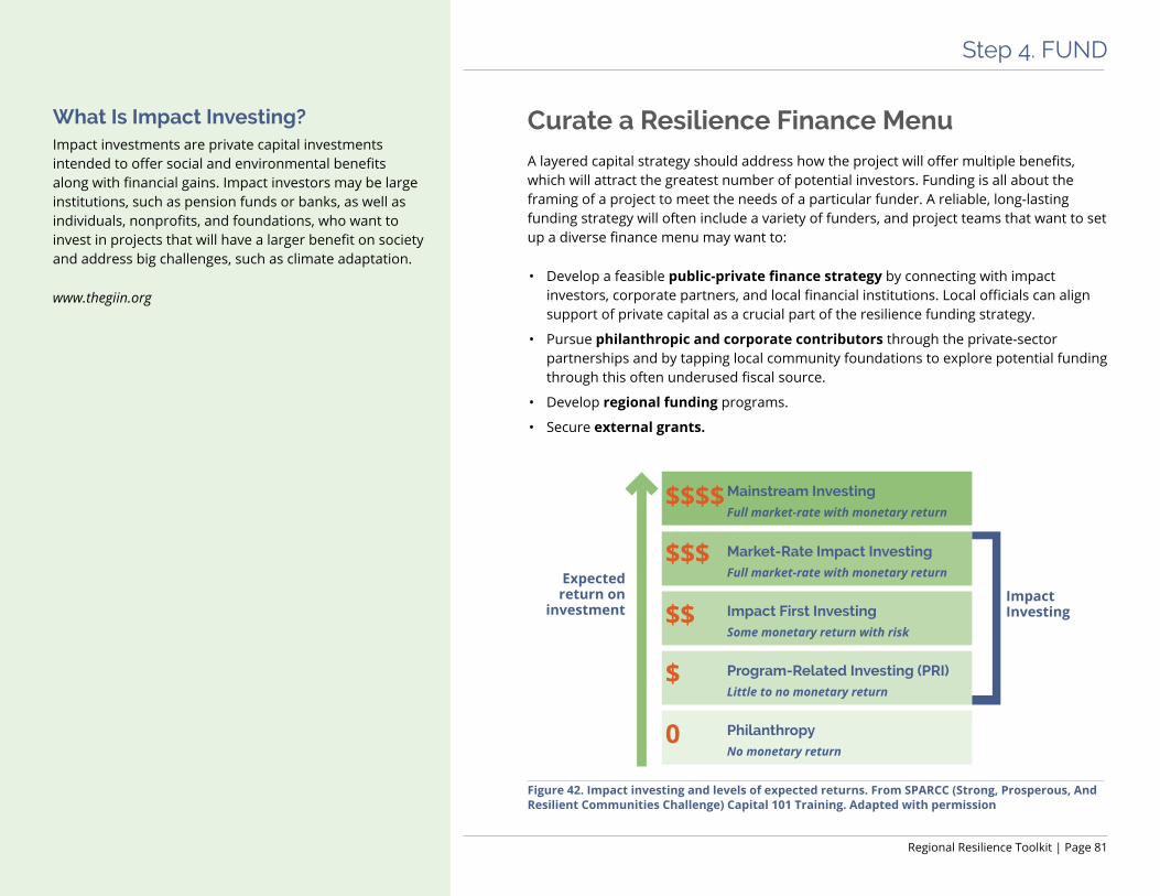
Regional Resilience Toolkit | Page 81
Step 4. FUND
What Is Impact Investing? Impact investments are private capital investments intended to offer social and environmental benefits along with financial gains. Impact investors may be large institutions, such as pension funds or banks, as well as individuals, nonprofits, and foundations, who want to invest in projects that will have a larger benefit on society and address big challenges, such as climate adaptation.
www.thegiin.org
Curate a Resilience Finance Menu A layered capital strategy should address how the project will offer multiple benefits, which will attract the greatest number of potential investors. Funding is all about the framing of a project to meet the needs of a particular funder. A reliable, long-lasting funding strategy will often include a variety of funders, and project teams that want to set up a diverse finance menu may want to:
• Develop a feasible public-private finance strategy by connecting with impact investors, corporate partners, and local financial institutions. Local officials can align support of private capital as a crucial part of the resilience funding strategy.
• Pursue philanthropic and corporate contributors through the private-sector partnerships and by tapping local community foundations to explore potential funding through this often underused fiscal source.
• Develop regional funding programs.
• Secure external grants.
Figure 42. Impact investing and levels of expected returns. From SPARCC (Strong, Prosperous, And Resilient Communities Challenge) Capital 101 Training. Adapted with permission
PhilanthropyNo monetary return
Program-Related Investing (PRI)Little to no monetary return
Impact First InvestingSome monetary return with risk
Market-Rate Impact InvestingFull market-rate with monetary return
Mainstream InvestingFull market-rate with monetary return
Expected return on
investmentImpact Investing
$
0
$$
$$$
$$$$
Page 82 | Regional Resilience Toolkit
Step 4. FUND
Attracting Private InvestmentsPrivate sector support from impact investors, developing private/public partnerships, and exploration of the new federal programs can provide an additional layer of project funding to bolster public sector monies. Programs such as the Department of Treasury’s Opportunity Zone program attract funders to public sector infrastructure investments by providing investment tax incentives if private sector partners remain for ten years in the resilience venture. The underused private sector investment is a promising opportunity that communities are exploring as public sector finance programs shift eligibility require-ments, reduce grant allocations or simply discontinue operations.
Private sector finance may provide funds from instruments including insurance-linked securities, obtained through insurance policies that cover disaster-related impacts, and catastrophe bonds that pay premiums after a specific, pre-designated disaster hits the policy-holder jurisdiction. Social and environmental impact and green bonds are issued by local governments, for environmental and infrastructure improvements, and provide tax benefits for the municipality. For example, the Port of Los Angeles issued $35.2 million in green bonds in 2015 for port infrastructure improvements; the City of Los Angeles has used green bonds to improve municipal water systems.
The first set of Opportunity Zones were designated in April 2018, and now all 50 states, the District of Columbia, and five U.S. territories have designated Opportunity Zones. The program will allow for long-term investments in housing, infrastructure systems, commercial and economic development in state-designated, frontline communities. These investments offer a potentially powerful new tool to speed resilience imple-mentation with private investor funds. California will allow state disaster recovery and climate adaptation funding to leverage private monies in underresourced communities. Newly introduced federal legislation (SB 3648) will add state wildfire areas to the eligible community list. The details and legal guidance for these zones is still in development, but is likely to provide private sector investors tax incentives to spur financing for public sector infrastructure and community/social investments.
Worksheet 4.3 Foundation and Other Grant Funding Alignment

Regional Resilience Toolkit | Page 83
Step 4. FUND
Philanthropic and Corporate GrantsProject teams can establish relationships with community, state, and national grant-makers to further diversify the local capital strategy. Many philanthropies are focusing more and more on issues of disaster resilience, and the list of resilience strategies can be cross-referenced with philanthropy priorities to find overlaps. Philanthropic partners may be well-suited to fund community engagement, training, and non-construction type projects on the list.
The relationship with private grant making groups is another aspect of the social and political networks needed to construct a multi-sector finance strategy and requires steady, intentional, and diplomatic approaches. Finding a good funding match might take more research and communications as compared with more conventional and previously established relationships that local jurisdictions might have with public sector program officers.
The most accessible gateway into information on private sector funding is the Funders Network for Smart Growth and Livable Communities (www.fundersnetwork.org). Many members of this group are focusing their philanthropy on resilience, and they now have a Philanthropic Preparedness, Resiliency and Emergency Partnership (PPREP) to build capacity of community foundations in some states (www.fundersnetwork.org/participate/pprep/). Other resources include regional community grantmaking alliances and local community and family foundations.
Regional Funding ProgramsIn most states, regional funding is available for transportation, water, and open space initiatives; these funding programs favor multi-jurisdictional partnerships and regional solutions to disaster risks, including from climate change. These regional monies can be leveraged to support local-level projects. Local project teams may need to coordinate with metropolitan planning organizations (MPOs), councils of governments (COGs), or other regional entities with reliable funding. Many MPOs, COGs, or regional planning agencies may also be the lead agencies for FEMA-approved Local Hazard Mitigation Plans. Also, many regions have multi-jurisdictional Economic Development Districts that write Comprehensive Economic Development Strategies or CEDS, which are required to include regional vulnerabilities and a resilience action plan (www.eda.gov/funding-oppor-tunities/). Both Hazard Mitigation Plans and CEDS provide good opportunities to apply for
Example: Measure AA—Protecting the San Francisco BayWhat began as a tentative set of goals to address climate challenges and to save the Bay, Measure AA grew into the Bay Area’s first all-region tax measure on the June 2016 ballot. A diverse coalition of environmental, business, foundations, political organizations, with a long history of working together formed and successfully secured the approval of 70% of Bay Area voters for a $500 million program of all nine counties touching the bay. Over the coming decade, the Bay Restoration Authority, the governance body, will ensure effective implementation of the restoration work by coordinating with a community oversight committee.
sfbayrestore.org/

Page 84 | Regional Resilience Toolkit
Step 4. FUND
Example: County Cost-Share in Southeast FloridaThe Southeast Florida Regional Climate Change Compact has been successful at taking in grant funding as a region, including federal funding. By working together across the four-county region, they can demonstrate greater potential outcomes and therefore make a stronger case to funding agencies and organizations than they might be able to as individual counties. For more information on the Compact’s activities and funding initiatives, see the Compact website and the Georgetown Climate Center’s case study on the Compact.
southeastfloridaclimatecompact.org/
https://www.georgetownclimate.org/reports/lessons-in-regional-resilience.html
Funding for Smart Growth ProjectsEPA’s website has a list of federal, state, regional, and local funding programs that may be geared toward other issues such as rural land use or historic preservation, but can fund resilience-related projects.
www.epa.gov/smartgrowth/smart-growth-national-funding-opportunities
federal funding tied to these regional planning documents. Northern California’s Measure AA is a voter-approved tax passed by nine counties in 2016 to fund efforts that keep the San Francisco Bay environmentally healthy. It’s the first regional tax measure for the area and one that garnered approval by all community sectors in the region.
Securing External GrantsAfter assessing local funding sources, a next step is to identify and tap into outside funding sources. Many state, federal, and philanthropic grant programs have specific guidelines about eligible projects and acceptable matching fund sources. These agencies and organizations likely have program priorities that differ from the local applicant; grant parameters might not completely align with what the local community needs or wants to accomplish. From there, identify components of projects that align grantor’s funding priorities and tailor an application to those priorities. Other portions of the project can then be covered by previously identified, re-allocated local funds or through other matching grant or loan programs.
Federal and State GrantsGovernment partners at the state and federal level can complement local and regional resources. While these options vary among the states, California has a long-established practice of passing statewide bond measures to improve infrastructure, open space, schools, and housing via grants to local government. The California Strategic Growth Council, largely funded by the Greenhouse Gas Reduction Fund, has allocated billions annually for resilience implementation and is an example of a state agency program making inroads on resilience investments. Massachusetts also has dedicated billions of dollars toward climate adaptation, including through the Municipal Vulnerability Preparedness (MVP) grant program and with a diverse set of community investment grants for cities, regions, and other entities.
Information on federal grants is available at grants.gov. This portal posts the announce-ments and all process-related information that jurisdictions, states, and tribal nations need for applying to these programs. No single resource posts all county, regional, and state grant programs, and it is difficult to locate them. Identifying county, regional, state, and federal grant opportunities takes more time to discover, as well as additional staff work to discern if the funding source will meet local needs. The outcomes of funding research, though, are worth the staff time and expense.

Regional Resilience Toolkit | Page 85
Step 4. FUND
Federal funding for resilience has been enhanced recently. The Disaster Recovery Reform Act of 2018 will set aside 6% annually of federal disaster expenses to apply to pre-disaster risk reduction. These monies are a significant boost to previous risk-reduction grants and are to be used primarily for national infrastructure improvements. Local governments can actively pursue these funds and be ready to respond to the state-managed appli-cation process that is set to begin in fiscal year 2020.

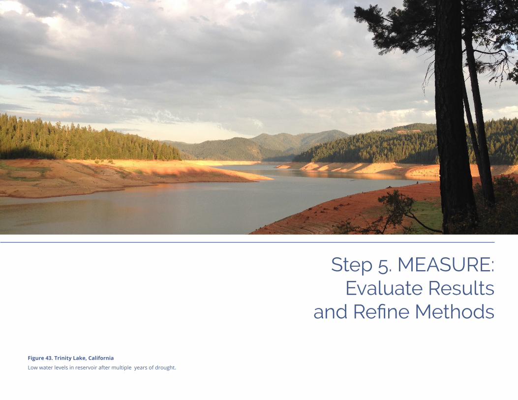
Step 5. MEASURE: Evaluate Results
and Refine Methods
Figure 43. Trinity Lake, California
Low water levels in reservoir after multiple years of drought.

Step 5. MEASURE
Step 5. MEASURE
Regional Resilience Toolkit | Page 89
What to Measure and Why?Tracking success and evaluating actions are critical elements in ensuring effective imple-mentation of resilience strategies and projects, meeting local needs, securing sound investments, and ensuring people work together effectively. Identifying what to measure (metrics), and how to track and evaluate those metrics over time is central to quantifying results. Good metrics provide:
ü A baseline that indicates the starting point;
ü A target for where the community is going;
ü An indication if there is something wrong; and
ü Highlights when the agency or city achieves its goal.
Further, well designed metrics can help tell a story for why resilience building is necessary, attract political support and funding, and focus efforts while providing a feedback mechanism about whether decisions, investments, and actions to improve resil-ience are making a difference and can help guide future decisions. Good metrics should be designed to do the following:
ü Connect to goals, community values, and desired outcomes.
ü Feasibly track information required to measure the metric. If the data is too difficult or expensive to track and gather, it does not help.
ü Mean something and not simply a count. For example, a metric that indicates a number of people who receive training does not necessarily correlate to knowledge.
ü Offer fewer, more meaningful metrics rather than a laundry list that will not be tracked.
ü Provide data for accountability, guiding action, telling a story, and measuring success.
ü Be adaptable and scale with the effort and do not become unwieldy.
This chapter will explore the topics of metrics and evaluation, assist with understanding best practices for measuring progress, and illustrate how these tools can inform the resilience building process. This chapter is divided into two primary sections:
üWhat to Measure and Why?
üSelf-Evaluation to Measure and Refine
See Appendix A pages 5.3 for more details.
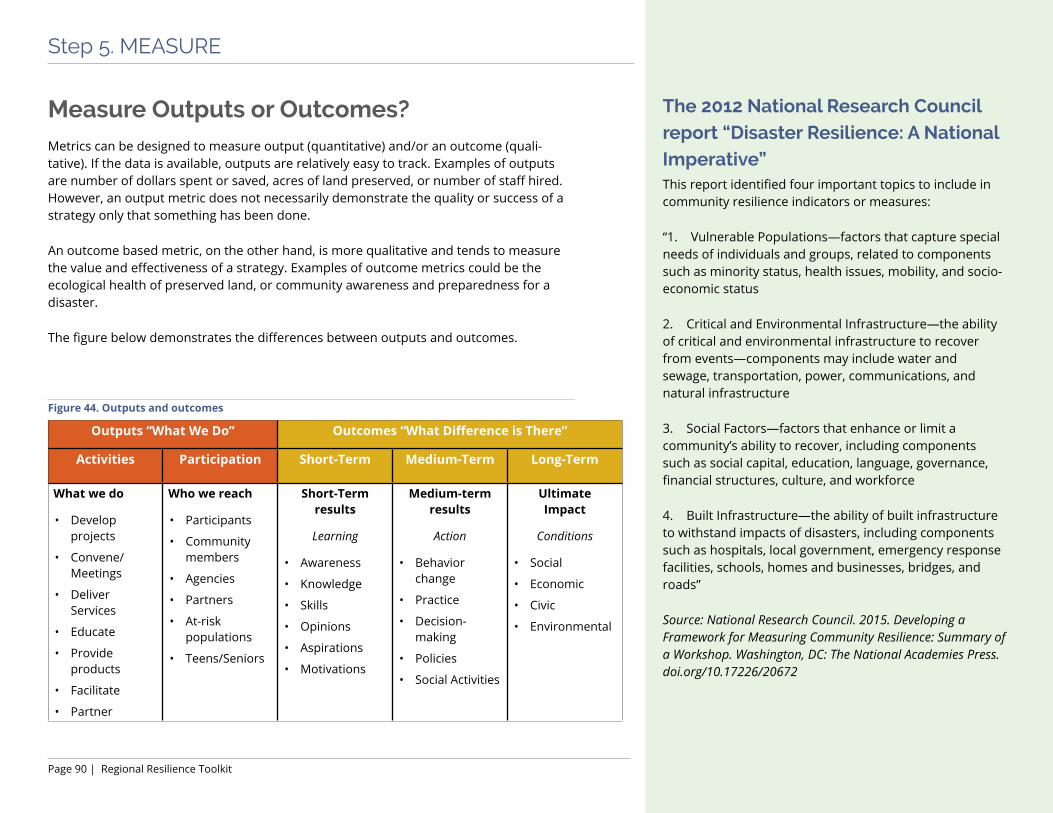
Page 90 | Regional Resilience Toolkit
Step 5. MEASURE
The 2012 National Research Council report “Disaster Resilience: A National Imperative” This report identified four important topics to include in community resilience indicators or measures:
“1. Vulnerable Populations—factors that capture special needs of individuals and groups, related to components such as minority status, health issues, mobility, and socio-economic status
2. Critical and Environmental Infrastructure—the ability of critical and environmental infrastructure to recover from events—components may include water and sewage, transportation, power, communications, and natural infrastructure
3. Social Factors—factors that enhance or limit a community’s ability to recover, including components such as social capital, education, language, governance, financial structures, culture, and workforce
4. Built Infrastructure—the ability of built infrastructure to withstand impacts of disasters, including components such as hospitals, local government, emergency response facilities, schools, homes and businesses, bridges, and roads”
Source: National Research Council. 2015. Developing a Framework for Measuring Community Resilience: Summary of a Workshop. Washington, DC: The National Academies Press. doi.org/10.17226/20672
Outputs “What We Do” Outcomes “What Difference is There”
Activities Participation Short-Term Medium-Term Long-Term
What we do
• Develop projects
• Convene/Meetings
• Deliver Services
• Educate
• Provide products
• Facilitate
• Partner
Who we reach
• Participants
• Community members
• Agencies
• Partners
• At-risk populations
• Teens/Seniors
Short-Term results
Learning
• Awareness
• Knowledge
• Skills
• Opinions
• Aspirations
• Motivations
Medium-term results
Action
• Behavior change
• Practice
• Decision-making
• Policies
• Social Activities
Ultimate Impact
Conditions
• Social
• Economic
• Civic
• Environmental
Figure 44. Outputs and outcomes
Measure Outputs or Outcomes?Metrics can be designed to measure output (quantitative) and/or an outcome (quali-tative). If the data is available, outputs are relatively easy to track. Examples of outputs are number of dollars spent or saved, acres of land preserved, or number of staff hired. However, an output metric does not necessarily demonstrate the quality or success of a strategy only that something has been done.
An outcome based metric, on the other hand, is more qualitative and tends to measure the value and effectiveness of a strategy. Examples of outcome metrics could be the ecological health of preserved land, or community awareness and preparedness for a disaster.
The figure below demonstrates the differences between outputs and outcomes.
BluePoint2
Typewritten Text
,

Regional Resilience Toolkit | Page 91
Step 5. MEASURE
Best Practices for Creating Usable Metrics
Align with Goals and StrategiesMetrics and Resilience Goals, as described in Step 2: Assess, should be linked and designed to be measured. Using a S.M.A.R.T. goal approach (i.e., a goal that is Specific, Measurable, Achievable, Relevant, and Time-based) makes the development of an aligned and useful metric much simpler. Broader goals will require more discussion about specific and useful metrics and may require multiple, phased metrics (i.e., a measurement that changes over time) to help measure progress. The hypothetical examples below illustrate how a goal that is too general makes it challenging to select an effective metric:
Example: Goal A (A broad goal): “Ensure that the City’s Water Supply is Maintained as a Safe and Clean Resource.”
Metric A: To develop Metric A, the team would need to decide what is meant by “Safe and Clean”, need to determine the timeframe, and what ‘ensure’ means. It is difficult to assign a single simple metric to Goal A. The possible metric could be, “City has invested $X funds to support the water supply,” or “City regulators regularly test the water supply and certify it meets acceptable standards.” While both of these metrics are valid, they may not provide the level of detail, and information desired.
Goal B (a SMART Goal): “By 2019, ensure that the water system infrastructure has been updated to exceed local standards by 20% and regular maintenance is funded at 100% of need.”
Metric B: These two related metrics are easier to define than Metric A.
• Metric B.1. ‘By 2019, the Water System has been updated and exceeds local standards by 20%.’
• Metric B.2. ‘Annual Maintenance funding has been allocated at 100% of need.’

Page 92 | Regional Resilience Toolkit
Step 5. MEASURE
Example: 100 Resilient Cities Resilience Indicators The Rockefeller’s Foundation 100 Resilient Cities measured resilience around the world using their City Resilience Index, designed to measure relative perfor-mance of any given city over time, providing a common basis of measurement and assessment.
The index measures 52 indicators supporting 12 goals in four key dimensions: health and well-being, economy and society, infrastructure and environment, and leadership and strategy. The tool also measures performance against 7 qualities of resilience as defined by 100 Resilient Cities: integrated, inclusive, reflective, resourceful, robust, redundant, and flexible. Measuring present-day perfor-mance and assessing a city’s trajectory towards a more resilient future can be achieved through the assessment and measurement of both qualitative and quantitative information within the 51 indicators. This is done through a series of qualitative and quantitative prompt questions, which places the city on a linear scale between 1 and 5 for each indicator, based on responses to the prompt questions.
The tool is accessed through an online platform that allows cities to self-assess. The result is a city resilience profile, that illustrates performance against the 12 goals and 7 qualities, plus a dashboard that summarizes perfor-mance in more detail for the 52 indicators. The tool can be accessed at: cityresilienceindex.org.
Considerations when Choosing Metrics Deciding whether to use metrics and what metrics to use can be overwhelming. The following factors may help guide decision making around metrics:
ü Qualitative or quantitative. Consider adopting a combination of both qualitative outcomes and quantitative outputs.
ü Simple and clear. Choose a small set of metrics that are clearly defined, meaningful and generally accepted by stakeholders and decision makers.
ü Availability of resources and data. Spending too many resources or too much time on data collection and summaries can create a barrier to taking real resilience building action. Metrics are only helpful as far as they increase the ability of the user to create real, on-the-ground change.
ü Type of metrics to use. Communities should be deliberate about selecting metrics systems, and not be afraid to adapt systems to meet their needs.
ü Useful to decision-makers and stakeholders. Real time, defensible data pointing to success, or lack of success, can provide information to craft future decisions, investments, and results. Make sure that the metrics provide data that can be easily reported and shared regularly.
ü Versatile and adaptable. Measurement systems can be adapted for an individual agency’s needs and preferences. Metrics with different evaluation methods can coexist.
ü Up-to-date and relevant. Consider identifying several measurement periods rather than a single absolute end to allow for course correction and updates (e.g., quarterly measurements with annual evaluation). Review and evaluate metrics regularly and change them if they become irrelevant or obsolete.
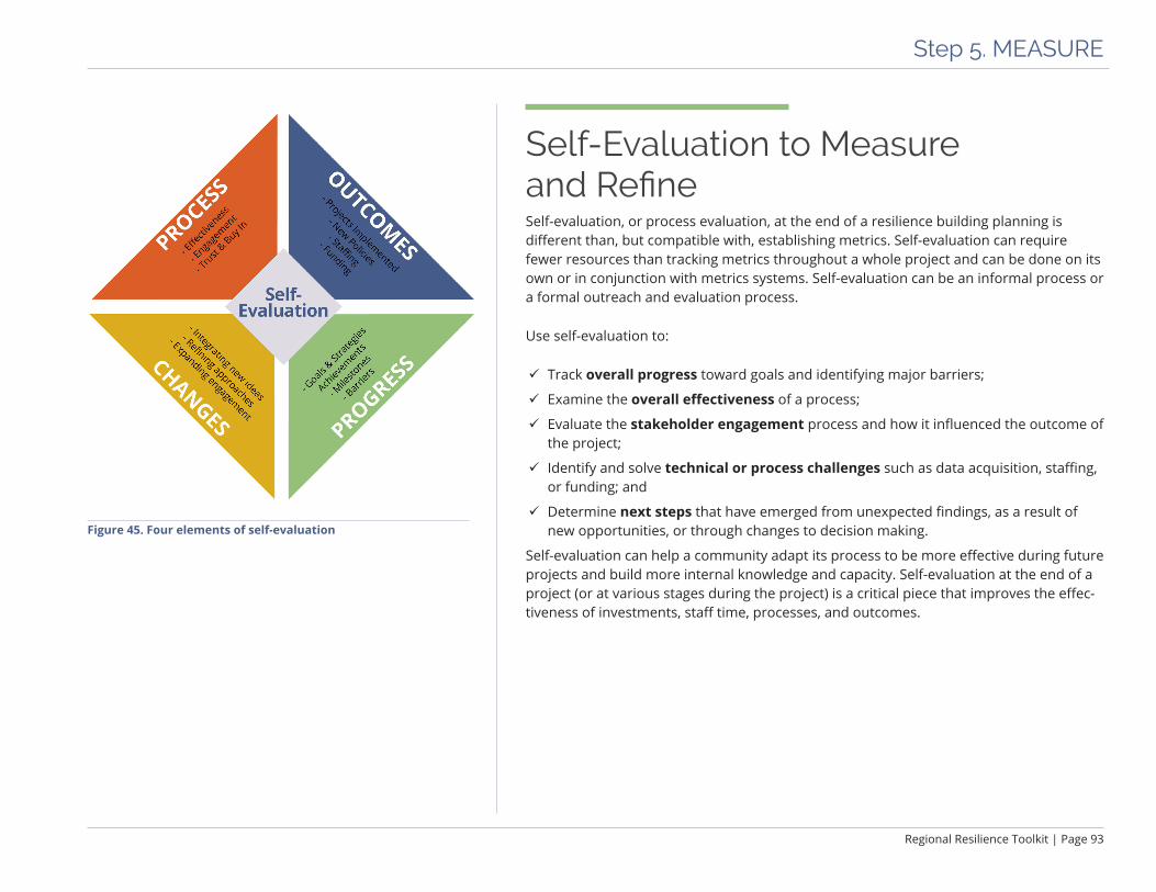
Regional Resilience Toolkit | Page 93
Step 5. MEASURE
Figure 45. Four elements of self-evaluation
Self-Evaluation to Measure and RefineSelf-evaluation, or process evaluation, at the end of a resilience building planning is different than, but compatible with, establishing metrics. Self-evaluation can require fewer resources than tracking metrics throughout a whole project and can be done on its own or in conjunction with metrics systems. Self-evaluation can be an informal process or a formal outreach and evaluation process.
Use self-evaluation to:
ü Track overall progress toward goals and identifying major barriers;
ü Examine the overall effectiveness of a process;
ü Evaluate the stakeholder engagement process and how it influenced the outcome of the project;
ü Identify and solve technical or process challenges such as data acquisition, staffing, or funding; and
ü Determine next steps that have emerged from unexpected findings, as a result of new opportunities, or through changes to decision making.
Self-evaluation can help a community adapt its process to be more effective during future projects and build more internal knowledge and capacity. Self-evaluation at the end of a project (or at various stages during the project) is a critical piece that improves the effec-tiveness of investments, staff time, processes, and outcomes.


Conclusion
Figure 46. Grand Tetons, Wyoming
Bison grazing in National Forest lands.

Conclusion

Conclusion
Regional Resilience Toolkit | Page 97
A Living Document This Toolkit offers an iterative process that is a living and working routine to maintain and enhance a community or region’s resilience over time. The steps, especially Step 1: Engage, need to be pursued consistently to support and ensure successful action. Further, project teams can evaluate results and determine if, when, and where a course correction is needed once metrics and implementation are underway. The lead agency can evaluate work plans, at a minimum on an annual basis and ideally connected to annual budgeting, to streamline implementation and administration.
Figure 47. An iterative process that should be considered part of ongoing efforts

Page 98 | Regional Resilience Toolkit
Conclusion
There are many reasons to refine the implementation plan or action plan regularly:
ü The strategies were successfully implemented and new priorities are needed.
ü Implementation is not achieving the results expected.
ü The strategy has an unintended consequence.
ü Funding has changed.
ü Political will has changed.
ü New data is available or is clearer.
ü Other significant changes in the environment or circumstances.
When it is time to update the plan, the project team can decide if a full update to the plan is required, if there is a minor modification needed, or if it is adequate to change the implementation plan or the annual work plan. Finally, determine the level of community and stakeholder engagement. The same principles of buy-in and support apply to updates as in the original plan development.
Use the advisory group with stakeholder representatives to ensure successful implemen-tation and lasting impact of the resilience strategies:
ü Evaluate and measure the progress of the plan.
ü Connect related and cross-cutting initiatives and actions.
ü Highlight new ideas and discussions for stakeholders.
ü Advocate for applying a resilience lens in other activities for the region or city.
ü Address local, regional, state, and national policy and legislative influences.
ü Integrate new opportunities into the plan.
ü Disseminate quantifiable results.
This five-step process can be as dynamic as changing demographics, climate conditions, and community needs. As communities and regions grow and change, this five-step process for building resilience can be updated and refined to reflect new people, new vulnerabilities, and new ideas for what resilience means.

REGIONAL RESILIENCE
TOOLKIT
APPENDIX A ADDITIONAL
INFORMATIONThis appendix was developed as part of the
U.S. Environmental Protection Agency’s Regional Resilience Toolkit.


Regional Resilience Toolkit | Page i
Table of Contents
Step 1. ENGAGE ................................................................................................1.1
Expected Outcomes, Worksheets, and Resources ................................................ 1.2
Tactical Tools for Engagement ................................................................................ 1.4
Step 2. ASSESS ..................................................................................................2.1Expected Outcomes, Worksheets, and Resources ................................................ 2.2
Laying the Groundwork ........................................................................................... 2.7
Describe Hazards ................................................................................................... 2.12
Select Assets ............................................................................................................ 2.15
Determine Assessment Method ............................................................................ 2.17
Conduct the Assessment ........................................................................................ 2.19
Step 3. ACT .......................................................................................................3.1Expected Outcomes, Worksheets, and Resources ................................................ 3.2
Summarize Vulnerability ......................................................................................... 3.4
Develop Strategies .................................................................................................... 3.4
Step 4. FUND ..................................................................................................4.1Expected Outcomes, Worksheets, and Resources ................................................ 4.2
Make the Business Case for Resilience ................................................................. 4.5
Step 5. MEASURE .............................................................................................5.1Expected Outcomes and Resources ....................................................................... 5.2
What to Measure and Why? .................................................................................... 5.3
Photos: All photos courtesy of BluePoint Planning unless otherwise noted.

Appendix A Step 1. ENGAGE
Photo: Small group exercise
Testing the vulnerability assessment tools at Central Coast Climate Collaborative workshop.
Appendix A | Page 1.2
Appendix A Step 1. Engage
n Expected OutcomesüAn understanding of why trust is so important, and how to build it
üTools for effective storytelling
üA Stakeholder Map that includes your project team, advisory group, leadership and decision makers, interest groups, and the broader community
üAn Engagement and Outreach Plan that identifies goals, target audiences, key messages, tools for outreach, strategies for outreach, and an implementation plan
üA Meeting Roadmap to help plan outreach milestones
üPractical tools for planning and running a successful meeting or workshop
n Worksheets in Appendix B• 1.1 Identify Stakeholders
This worksheet is designed to be used by the initial project team to identify three types of project participants: any additional project team members, an advisory group comprised of key stakeholders who will actively partic-ipate in the project, and other targeted stakeholders including interest groups and leadership that will need to be apprised of decisions as they are made.
• 1.2 Stakeholder Mapping Use this exercise with the project team to map out interests and participation levels, and evaluate who the stakeholders are and how to engage them.
• 1.3 Workshop Checklist Use this checklist to ensure that you have thought through all of the practical details of the meeting beforehand, and that you have everything accounted for on the day of the workshop.
n Resources• Appreciative Inquiry
The AI Commons is a compilation of practical tools on Appreciative Inquiry, which is an approach to community planning and engagement that focuses on positive aspects of the community that people want to see more of, rather than on problems or things people want to change. appreciativeinquiry.champlain.edu
• Adapting to Rising Tides Good Planning Guide: Stakeholder Engagement Use this guide to develop an approach for engaging stakeholders as part of a project team to ensure that the necessary expertise, values, and viewpoints are included in all stages of the assessment and imple-mentation process to build resilience. While this guide, like all ART materials, is geared towards climate adaptation, the concepts can be used for assessment of any hazard. www.adaptingtorisingtides.org/howto/art-supplies/
• Asian Pacific Environmental Network APEN convenes community partners and groups with diverse, leading edge perspectives for environ-mental, social, and economic justice. apen4ej.org
Regional Resilience Toolkit | Page 1.3
Appendix A Step 1. Engage
• Center for Community Action and Environmental Justice The Center for Community Action and Environmental Justice is a progressive, base-building, nonprofit organization that convenes people on cooperative community processes to improve social and environ-mental planning. ccaej.org
• Coastal Hazard Resilience Planning in California Flipbook This flipbook, developed by NOAA’s Office for Coastal Management, the US Geological Survey, FEMA, and state partners can be used to spark ideas for addressing sea level rise and coastal flooding concerns by integrating multiple local planning initiatives. The ideas presented may be applicable to other hazards, as well. It provides a starting point for communicating the benefits of aligning hazard actions in multiple local plans and suggestions for doing so, specifically for the Local Hazard Mitigation Plan, General Plan, Climate Adaptation Plan, and Local Coastal Program. The resource is available in hard copy through USGS and NOAA and on resilientca.org
• Consensus Building Institute This group specializes in working with communities that face sea level rise retreat planning. Its online tools and on-the-ground facilitation skills are widely respected. cbi.org
• FEMA Social Media FEMA offers a series of on-site courses instructing schools, first responders, and other organizations on using social media in disaster response and recovery. www.fema.gov/social-media
• Whole Community: Planning for the Unthinkable Tabletop Exercise FEMA offers free tabletop exercises to help organizations respond to a disaster and fill gaps in emergency management plans. FEMA offers exercise both for the private sector (www.fema.gov/emergency-planning-exercises) and for communities (www.fema.gov/media-library/assets/documents/26713).
• Videos on Earthquake Risks
- HayWired Scenario Video The HayWired scenario video depicts a scientifically realistic earthquake sequence, and its cascading impacts. The video was developed with USGS and local partners. www.usgs.gov/media/videos/haywired-scenario-movie
- Earthquake Ready Burnside Bridge Multnomah County in Portland, Ore. released a video to show the public how a Cascadia Subduction Zone earthquake could impact one of the city’s lifelines. multco.us/cascadia-subduction-zone-earthquake-simulation
• International Association of Public Participation A wide range of resources and tools for effective community and stakeholder outreach. www.iap2.org
• NOAA’s Introduction to Stakeholder Participation National Oceanic and Atmospheric Administration’s guidance including a participatory mapping guide and training. coast.noaa.gov/digitalcoast/training/stakeholder.html
• Public Awareness and Public Education for Disaster Risk Reduction: A Guide This document provides guidance on planning and developing public awareness and public education efforts for disaster risk reduction. www.ifrc.org/Global/Publications/disasters/reducing_risks/302200-Public-awareness-DDR-guide-EN.pdf
• Resilient America Roundtable: Disaster Resilience: A National Imperative; 2012. The National Academy of Sciences studied the state of disaster resilience in the U.S. and identified promising approaches to engage communities and build resilience planning. www.nap.edu/catalog/13457/disaster-resilience-a-national-imperative
Appendix A | Page 1.4
Appendix A Step 1. Engage
Tactical Tools for Engagement
Stakeholder MappingThere are a wide number of types of stakeholders that must be considered in developing an effective engagement and outreach effort. Below is a summary of the types that should be considered and identified for the planning effort.
Overall Community EngagementIn each community, a large percentage of people may not participate directly in the planning effort regardless of the effectiveness of the outreach campaign. However, it is essential to provide information and the opportunity for the largest number of people possible to learn about the effort and to potentially participate at some point in the process. To reach this broad group, engagement activities such as community workshops, open houses, online engagement, mailings, flyers in public locations, a project website, and similar tools are useful.
Targeted Community OutreachWithin the community, some groups will be impacted or potentially impacted by the plan, but similar to the category above, are unlikely to attend a formal meeting or be actively involved. For these groups, there is a higher need and interest to build awareness and get some level of input into the process. To engage this group, more targeted engagement efforts such as holding small coffee talks in the targeted neighborhood, holding events at the local farmers market or church, and other similar events that ‘go to the community’ rather than ask them to attend an event outside of their daily lives, are needed.
Targeted Stakeholders
Project TeamA project manager should lead the internal project team and involve staff from relevant city departments. This staff will do the technical work behind the assessment; managing the project, and coordinating other stake-holders and engaging with their managers, executive staff, and elected officials to ensure that the process is moving along smoothly.
Leadership and Decision MakersLeadership and decision maker engagement is critical to the process and implementation. A challenge with this group is that as stakeholders, they may have different priorities and varying levels of influence. Increased time and efforts should be invested to understand who and where the levers of power reside to make the plan a success. Decision makers should include internal departmental leads as well as other relevant city, county, and regional leaders. They may fall within government agencies, but also within a nonprofit network, the business community, or high profile individuals in the community.
Regional Resilience Toolkit | Page 1.5
Appendix A Step 1. Engage
Interest GroupsInterest groups include organizations, non profits, and neighborhood groups who are typically actively involved or who have a clear stake in the effort. Engaging interest groups through small group meetings and interviews provide input from the organizations, interest groups, and multi-cultural communities that may not be effectively reached in broad community engagement efforts and require additional, targeted engagement. Some individual representatives may also be on the advisory group.
Underrepresented GroupsOften the disasters that create the most significant impacts disproportionately affect unrepresentative commu-nities. Inclusion, equity, and authentic engagement require the active and comprehensive participation of these audiences. Identifying underrepresented audiences is challenging. Each community is different, but often Environmental Justice (EJ) community members, including but not limited to non-English speakers, disadvantaged communities (DACs), Native Americans/tribal communities, the homeless, and similar groups rarely participate proactively in planning efforts. This can be due to many factors including disillusionment with government and related processes, lack of interest, time, and resources to participate, limited information about an issue, and lack of information of the relevance of a plan to their lives.
Advisory GroupA project advisory group should include key stakeholders such as city staff not part of the project team, represen-tatives from non-governmental and community based organizations, community members, or representatives from private entities and organizations representing the private sector, economic development, and/or business community. The advisory group provides credibility and subject matter expertise that can assist with public and political support and support the project team with volunteer time or funding.
SB1000 Legislative Language (Source: California Legislative Information, Senate Bill 1000, Chapter 587, leginfo.legislature.ca.gov.)(h) (1) An environmental justice element, or related goals, policies, and objectives integrated in other elements, that identifies disadvantaged communities within the area covered by the general plan of the city, county, or city and county, if the city, county, or city and county has a disadvantaged community. The environmental justice element, or related environmental justice goals, policies, and objectives integrated in other elements, shall do all of the following:
(A) Identify objectives and policies to reduce the unique or compounded health risks in disadvantaged communities by means that include, but are not limited to, the reduction of pollution exposure, including the improvement of air quality, and the promotion of public facilities, food access, safe and sanitary homes, and physical activity.
(B) Identify objectives and policies to promote civil engagement in the public decision making process.
(C) Identify objectives and policies that prioritize improvements and programs that address the needs of disad-vantaged communities.

Appendix A | Page 1.6
Appendix A Step 1. Engage
Best Practices for Telling a StoryPresent information in an unbiased, objective way. It is imperative that the project lead (and the representa-tives communicating the messages) be open and unbiased. Stakeholders will lose faith if there is a sense that information is either inaccurate or critical facts are missing.
Learn to navigate tough questions and answers. When taking questions, whether it be from a funder, an interested community member, or general audience, it is essential to be a good listener, not be defensive, and to accept not having all the answers. The speaker can offer to get back to someone with a response at a later date if they do not have the information or do not feel comfortable discussing a topic within a larger group. To prepare for tricky questions, work with someone on the project team and brainstorm some of the hardest questions that might be offered to develop good, strong responses.
Use community friendly, ‘layperson’s’, language. The project team should try to use language that resonates with the layperson, and is not overly technical in nature. This is true for meetings with community members, advisory groups, or interest groups. Stay away from acronyms and complicated or technical terms.
Tailor the messages to stakeholders’ needs and agenda. It is essential to be aware of the values and concerns of the various audiences receiving the information. Emphasize tailored messages designed for specific audiences instead of generic concepts. Choice of words is critical. Avoid politically charged terms.
Communicate in multiple languages. To be as inclusive as possible, develop materials and messages that are designed - not just translated - for different cultures and languages. This means the messages may need to be altered to resonate with a particular audience, and photos and graphics changed to be more in line with the audiences’ views. Avoid online translation tools when possible. A good translation is often expensive, but worthwhile.
Engagement and Outreach Plan
Goals and Outcomes The first section of the Engagement and Outreach Plan (E&OP) should be the project’s engagement and outreach goals and expected outcomes. These overarching goals and objectives should help to frame the approach to engagement and prioritize resource allocation. Goals should incorporate necessary relationships and partner-ships, the community’s stakeholders (stakeholder mapping), and the information, time investment, and kind of input that is appropriate for the project.
Target AudiencesIdentify, describe, and categorize the target audiences for the project. Further, identify what level of input and the objective for engagement for each audience category. This can be divided as in the stakeholder map, Worksheet 1.2 Stakeholder Mapping, by the four quadrants or simplified to primary, secondary, and other depending on the complexity and detail desired for the plan.
Regional Resilience Toolkit | Page 1.7
Appendix A Step 1. Engage
Key Messages and BenefitsThe key messages encompass critical information to be communicated to each audience group, including benefits directly tied to the particular audience. These message should be used in every interaction and publication, and across all communication platforms. Whatever the messages are, they should adhere to these fundamental principles:
ü Consistent and clear
ü Accessible and engaging
ü Culturally and linguistically appropriate
ü Relevant in focus and purpose
ü Inclusive, both culturally and geographically
ü Transparent
Key messages should stem from outreach goals, overall community vision, as well as the project scope, lens, and resilience goals established in Step 2. Messages should use simple-to-understand language geared towards each of the project’s audiences. The number of messages should be limited to no more than five, and ideally three or fewer. Too many messages create potential conflicts and confusion for audiences and for messengers who may not understand when to use what messages. Limiting outreach messages gives speakers and advocates a simple concept to remember and relay consistently.
Project messages should include the following elements in some form:
ü Relay the intention of the outreach and engagement effort – do not assume that people know why and if they should be involved
ü Describe the purpose or vision of the planning effort
ü Mention critical elements that may attract and involve challenging to reach audiences or potential naysayers
ü Highlight the benefits of the project and emphasize elements that will resonate with the primary project supporters (or potential supporters)
A single message may hit one or more of these elements.
Examples of E&OP goals: “Provided equal access and opportunity to all community member to participate and provide input at multiple stages in the project.”
“Better involve local and regional decision makers in the process to develop advocates and more diverse voices.”
Example Key Messages“The City is dedicated to inclusive community engagement and making our homes and business more resilient to climate change.”
“The new Resilience Plan and LHMP will provide a roadmap for the next 20 years to protect and preserve our most critical community services. “
“The Plan’s projects will be cost-shared with state and federal partner agencies. Our local contributions will be matched 4:1 by federal and state grants designed for resilience.”
Appendix A | Page 1.8
Appendix A Step 1. Engage
Outreach Tools and MaterialsThere are many types of tools and outreach materials to help reach stakeholders and better engage them in the project. Outreach materials should be developed with particular audiences in mind and consider the best way to reach each group. Consider the use of digital, video, and print materials. The materials should reinforce the key messages and designed to be simple and clear, resonate with specific audiences, and not be overly technical in nature. The following are examples of some of the types of tools to use.
Communications and Education• Talking points. A list of key discussion points that provide clear and concise information regarding all aspects
of the project and provide a consistent and accessible set of points for each potential project voice. These may be several versions, designed for each audience, such as partners; politicians/decision makers; funders; and general public.
• Webpages. Project websites have become more common as either an integrated piece of a jurisdiction’s existing site or as a stand alone website. A project website can act as a hub for sharing information, posting meeting and event dates, and sharing presentations and other materials. A website can also have a password protected area for more sensitive documents for the project team and advisory group.
• Social media. Facebook, Instagram, and Twitter have become regular tools for community engagement. The effectiveness depend on the topic, audience, and reliable, consistent management of the social media presence.
• Local media. Inform stakeholders and the public about the resilience effort through local and regional newspapers, online news forums, broadcast media, and blogs. Press releases should be used to announce newsworthy, essential milestones and events.
• Texting campaign. Texting is a tool that has been used very successfully, especially in Spanish-speaking communities. Hispanics make 40% more cell phone calls than mainstream cell phone users, and they are the most likely ethnic group to text.
• Fact sheets: Create multi lingual project fact sheets that can be used in meetings, workshops, at local community hubs to share information and details about the project. Multiple versions can be created at different milestones if necessary. Consider including an overview of the project goals and the plan devel-opment process, along with basic information about the current conditions and state of the area. All fact sheets should include information on how to participate and be posted on the webpage, distributed at meetings, and provided at public events (street fairs, etc.).
• Email enewsletters: Email or enewsletters can be a useful tool if managed carefully and avoids spam filters. Email blasts can provide invitations, reminders, links to new information, or offer a short newsletter on the project’s process.
• Direct mail: Direct mail pieces to residents can reach everyone in a community, especially in areas where people might not have easy access to a computer. One of the most successful approaches to direct mail is to use a letter from a city leader, such as the mayor, which helps to legitimize the information and assure the recipient that it is valuable information and not junk mail. Direct mail can be expensive but can be used to good effect.
• Partner announcements: At the outset of the project, develop a list of stakeholder communications channels (for example, stakeholders’ respective newsletters and websites). Throughout the project, send brief announcements to the stakeholders with a request to distribute the information to their constituents.

Regional Resilience Toolkit | Page 1.9
Appendix A Step 1. Engage
• Outreach kits: Develop a suite of informational material for use by advisory group members, other city departments, and community organizations that would like to hold a meeting to gather input on the project. The outreach kit should include talking points, fact sheets, a PowerPoint presentation, sign-in sheets, and comment cards.
Workshops and Meetings• Meeting announcements and flyers should be developed to promote and announce workshops, meetings,
and other events related to the Project. All flyers and communication pieces should include links to social media, the project website, and designed for print, email, and other digital formats. The use of a QR code (a scannable icon that allows a cell phone user to access link automatically) is a useful addition to these materials.
• Comment cards provide another avenue to solicit input at meetings. These can be distributed at the community events and can be filled out on the spot at the event itself. They are also a valuable way to expand the email database for future mailings.
• Project presentations provide clear, consistent, and concise information and details to various community groups, and stakeholders.
• Project videos have become easier for local government to develop and use with simple digital apps and tools. Short videos can highlight new information. Local schools or colleges might make the video for free as a student project. Formal videos such as for a city council meeting recording can also be used as an outreach tool. Other new technology such as Facebook live events can be another outlet.
• Interactive Games such as the one pioneered by the County of Marin - Game of Floods - or other interactive games can help engage audience who may not be familiar with technical details, or for younger audiences. Another example is trade off games where participants have to prioritize choices based on some kind of trade off such as allocating a fake amount of money to projects.
• Maps & Display Boards are useful for open house style workshops, for helping participants understand context and for holding small group conversations, and moving away from powerpoints, particularly in outdoor venues or when technology usage may not be desired.
Strategies and TacticsDevelop strategies and tactics that build on, and connect to the outreach goals, audiences, tools, and the methods to reach stakeholders. These elements provide a kit of parts to achieve the Engagement and Outreach Plan goals and objectives. The table on the following page is an example of how this could look.

Appendix A | Page 1.10
Appendix A Step 1. Engage
Table A1: Example engagement and outreach strategies and tacticsStrategy Tactics Target Audience Outreach Tools
1. Engage the broader public in the decision making process
ü Open House
ü Digital Engagement (online survey, website, information on events, etc.)
ü Go out to the People
‘Coffee talks’ and ‘open office hours’
Farmers market booths
Table/kiosk at libraries
Neighborhood Groups
Voters
Volunteers
Talking Points
Flyers
Online Survey
Comment Card
Website
2. Develop a proactive media relations strategy
ü Engage local news, radio, tv and community outlets like the Patch or Nextdoor and non-English language media outlets
Editorial Board
Regular briefings
ü Build speakers group (politicians and decision makers other groups)
ü Utilize Social Media/Digital sources
Broad Community
EJ Communities
Press Kit
Press Releases
FAQs
3. Engage elected officials and decision makers in the process
ü Conduct individual briefings with elected officials
ü Hold a “VIP” breakfast briefing
Elected Officials/
Decision Makers
Talking Points
Presentation
4. Provide tools and support for advisory group members to extend the Outreach personally
ü Individual briefing meetings with advisory group members
ü Advisory group Outreach Kit and Speakers Training
Targeted Stakeholders
Outreach Kit
5. Cultivate and develop partnerships
ü Utilize existing stakeholder list to expand and enhance outreach
ü Conduct small group meetings to listen to interests and needs
Partners
Interest Groups
Elected Officials/ Decision makers
Talking Points
Presentations
Digital connection
Implementation and TrackingEstablish roles, responsibilities, and a timeline for each of the E&OP strategies and tactics. Implementation can and likely should be updated several times over the project to reflect new information, and understanding of what is working well, what is missing, or helping support a new initiative or idea. It is also a good idea to establish targets and measures to track the success of the outreach and engagement effort. This can include identifying the numbers of participants in total and by stakeholder group, the persistence of engagement over the project, the number of responses to surveys, or the number of hits on a website.
Regional Resilience Toolkit | Page 1.11
Appendix A Step 1. Engage
Planning and Running a Successful MeetingA successful workshop or workshop series requires extensive pre-work, planning, and relationship building. This work cannot begin at a workshop, but these attributes can be enhanced and cemented during the process.
General meeting protocol. For each meeting or engagement effort, the Outreach Team (this can be a subcom-mittee of the project team with added specialists) will first coordinate with the project team to understand objec-tives for each particular milestone, what information is important to cover, and any specific requirements for different audiences. The next step includes the creation of a Meeting Plan which includes: developing an agenda with clear objectives, establishing the meeting format, identifying appropriate education, and meeting materials, as well as coordinating other logistics and outreach efforts utilizing this plan as a general guide. After each meeting or group of meetings, develop a meeting summary that will be provided for dissemination and review by meeting participants.
A well designed agenda is central to success. Build on the Meeting Plan to determine how much time is realisti-cally available to cover topics, understand who will be at the meeting, and in which topics participants are inter-ested. Assign times for each agenda item and if it seems like it is too much to cover, delete the least important items or ones that can be covered in another forum. There is no benefit to having a laundry list agenda that is impossible to cover. People appreciate a tight, well designed, and well managed meeting – and they are more likely to come to another if it these elements are in place.
Mix it up. Design meetings to include multiple delivery forms, including presentations, discussions, exercises that get people up and moving, small group discussions, and interactive elements as discussed below.
Use games and exercises as ways to build communication networks and enrich planning among community partner sectors. Public safety and emergency management professionals effectively use disaster tabletop exercises as a training activity. This is one tool for engaging people to strategize how a particular disaster scenario would impact their communities. It can be used to illustrate the location of disaster impacts, think through consequences, identify strategies to reduce risk ahead of time, and lay the groundwork for long term resilience solutions through hazard mitigation and general plan actions.
Use mapping exercises to identify community resources (such as critical community facilities that are essential to the functioning of a community after an earthquake) or at-risk locations which combines local expertise with neighborhood problem solving. Similarly, design charrettes bring people in to discuss visual options and also builds community buy-in on implementing strategies.
Use a skilled facilitator. Develop dialogue and meeting support capacity in the project team and new partners to establish the best ways to support open dialogue in the assessment and implementation phases. Consider bringing in outside facilitators or trusted local conveners if they can enrich the group’s ability to engage together effectively.
Encourage participants to engage actively and equally in discussions, and allow adequate time for all to participate and voice their opinions and recommendations for the group’s consideration.

Appendix A | Page 1.12
Appendix A Step 1. Engage
Meeting AgendasThe following pages provide sample agendas for the four advisory group meetings identified in the Roadmap. Each agenda is designed as a three-hour meeting with specific meeting objectives and topics to cover and move the project forward. It is assumed that the advisory group is a representative body of the community and key stakeholder groups, with some understanding of resilience, but not necessarily with technical knowledge. These agendas can be modified to accommodate the community workshops. Depending on the date, logistics, and expectations, a community meeting may only be two hours and provide a mix of educational content and some input exercises.
Agendas: ü Meeting 1: Kickoff
ü Meeting 2: Vulnerability Assessment
ü Meeting 3: Prioritize Strategies
ü Meeting 4. Implementation
Regional Resilience Toolkit | Page 1.13
Appendix A Step 1. Engage
Advisory Group AGENDAMeeting #1. KickoffMeeting Purpose: Kick off project, define resilience and develop the vision and goals for protecting and supporting long term safety and disaster resilience.
I. INTRODUCTION AND PROJECT PROCESS (45 min)
• Advisory Group and Project Team Introductions
• Expectations, Roles, and Responsibilities
• Review Overall Planning Process, Purpose, and Need
• Presentation and Discussion - Community Engagement and Outreach Plan
II. WHY RESILIENCE IS IMPORTANT (1 Hour)
• Discussion - What Is Resilience and Why Does It Matter to our Community?
• Presentation
Existing Community Goals
Alignment with Existing Plans
Federal and State Policy Context and Goal to Align Plans
• Group Exercise and Discussion - Vision and Resilience Goals
III. SETTING THE CONTEXT: ASSETS, IMPORTANT CHARACTERISTICS & HAZARDS OF THE COMMUNITY & REGION (1 Hour)
• Presentation - Overview of Initial Data: Community’s Hazards, and Assets
• Discussion - Opportunities and Challenges for Community Resilience• Small Group Exercise - What do we love and what do we protect? (Utilize community maps or other aids as
needed)
• Report Back: What are the Community’s Primary Hazards?
IV. WRAP UP & NEXT STEPS (15 min)
• Next Meeting and Action Items
Note: Include a 15-minute break as needed.

Appendix A | Page 1.14
Appendix A Step 1. Engage
Advisory Group AGENDAMeeting #2. Risk and Vulnerability AssessmentMeeting Purpose: Review Resilience Goals and the initial Vulnerability Assessment, and begin prioritizing actions.
I. INTRODUCTION (15 min)
• Review agenda, meeting objectives, and work completed since last meeting
II. CONFIRM VISION AND GOALS (30 min)
• Review the refined Community Vision and Resilience Goals
II. INITIAL RISK & VULNERABILITY ASSESSMENT & STRATEGIES (1½ hours)
• Presentation and Discussion - Review of Initial Risk and Vulnerability Assessment
• Small Group Breakouts: Rapid Vulnerability Assessment Exercise (template in Toolkit)
• Report Back and Discussion
• Identify Initial Strategies
III. PLAN “COMMUNITY VISION & VULNERABILITY COMMUNITY WORKSHOP” #1 (45 min)
• Review and discuss agenda, topics, and format
• Discuss location and venue
• Identify roles and responsibilities
IV. WRAP UP (15 min)
• Next Meeting and Action Items
Note: Include a 15-minute break as needed.

Regional Resilience Toolkit | Page 1.15
Appendix A Step 1. Engage
Advisory Group AGENDAMeeting #3. Prioritize StrategiesMeeting Purpose: Refine and prioritize strategies, develop an initial Implementation Plan, and plan for the Community Workshop.
I. INTRODUCTION (15 min)
• Review agenda, meeting objectives, and work completed since last meeting
II. DEVELOP & PRIORITIZE STRATEGIES (1½ hours)
• Presentation – Initial Strategies based on previous meeting
• Discussion – Refine Strategies
• Discussion – Develop/Utilize Criteria for Priorities (worksheet in Toolkit)
• Small Group Exercise – Prioritize Strategies
Report Back to group 2-3 Key Priorities
IV. KEY ACTIONS FOR IMPLEMENTATION (30 min)
• Discussion- Identify Key Actions to Implement Strategies
Fill out Strategy Development and Implementation Worksheet (included in Toolkit)
IV. PLAN “STRATEGIES FOR A RESILIENT COMMUNITY WORKSHOP” #2 (30 min)
• Review and discuss agenda, topics, and format
• Discuss location and venue
• Identify roles and responsibilities
V. WRAP UP (15 min)
• Next Meeting and Action Items
Note: Include a 15-minute break as needed.
Appendix A | Page 1.16
Appendix A Step 1. Engage
Advisory Group AGENDAMeeting #4. ImplementationMeeting Purpose: Align strategies to financing options, review potential metrics, and develop mechanisms for ongoing engagement and implementation.
I. INTRODUCTION (15 min)
• Review agenda, meeting objectives, and work completed since last meeting
II. IMPLEMENTATION PLAN (20 min)
• Overview and Review of long term Implementation Plan, and Short Term Action Plan
• Discussion
III. ALIGNING STRATEGIES TO FUNDING & FINANCING (1 hour)
• Presentation – Review of Potential Funding Approaches, Highlight Examples of Existing Successful Financing, and Implementation
• Discussion
Align Strategies/Projects to Financing Mechanisms
Identify Gaps, Barriers, and Non-implementation Reasons
Discuss how to “Make the Case” for each Project
IV. POTENTIAL METRICS (30 min)
• Presentation – Developing Metrics tied to Resilience Goals
• Discussion – Identify initial metrics to monitor success of planning effort
IV. ONGOING STAKEHOLDER ENGAGEMENT (15 min)
• Identify Key Stakeholders, Experts, Implementers, and Jurisdictions
• Determine Roles for Implementation
VIII. WRAP UP (10 min)
Note: Include a 15-minute break as needed.
Regional Resilience Toolkit | Page 1.17
Appendix A Step 1. Engage
Meeting Logistics 101This checklist gives tips for arranging a successful meeting or workshop and can be used for each individual event.
Pre-Event InformationChoose a Workshop Date & Time
¨ Determine the best time and day for the workshop. In general Mondays and Fridays are not ideal because of weekend plans (but this depends on the type of workshop).
¨ Anticipate commute (or travel) time when setting the timeframe of a workshop.
¨ Check for major holidays, including religious holidays, and competing events.
¨ Consider the need to provide childcare for public workshops.
Invitation and RSVPs
¨ Use an online invitation program (e.g., Eventbrite, Evite) to help track registrants, send updates about the meeting (parking, meeting changes) with one email, create name tags from the registration lists, and minimizing the need for “sign in” at the event. This also optimizes meeting follow up.
¨ Describe the event and provide a link to register for the workshop in the “invitation” email.
¨ Include a deadline for registration (suggested deadline is 5 days before the event, but this can be looser depending on the numbers of registrants and catering requirements).
¨ Send a “save the date” as early as possible to allow for people to plan and schedule. Give highlights of the workshop and why people will want to attend.
¨ Send the invitation 4 weeks in advance, and send reminders 2 weeks and 1 week before the meeting
¨ Send the “save the date“ and “invitation” using a “personal “email, if the project team does not have access to a mass email program. This helps avoids spam filters and increases the number of people who read the invitation. Consider whose name or organization is more likely to receive a response.
¨ Send out the “invitation” emails in batches of 50 or fewer to avoid spam filters.
Choosing a Workshop Location/Venue
¨ When selecting a venue, consider how convenient it is for attendees arriving on foot, by car, by public transportation, or in other ways.
¨ Confirm the capacity of the venue to fit the needs of the workshop.
¨ Check for internet/WiFi access for webinars and telephone lines for conferencing if needed.
¨ Determine rental needs: tables, chairs, audio/visual equipment, white boards, etc.
¨ Discuss with the venue staff wayfinding signage for room location/building location.
¨ Is the space intended for meetings or is it designed for a different purpose (i.e. gallery space, lecture hall, etc)? Room design may impact the acoustics, set up, lighting/glare, and overall function of the space.
¨ Identify any set up requirements (e.g., union requirements, access for wheelchairs or strollers, or any fixed equipment in the venue)
¨ Confirm that you can have access to the room 1 hour before and 1 hour after the event for set up and clean up.
¨ If you are offering childcare, locate it somewhat separate from the event, at least visually and audibly.

Appendix A | Page 1.18
Appendix A Step 1. Engage
Food and Caterers
¨ Many venues will only allow the use of specific caterers. If proving refreshments, discuss the requirements with the venue manager. Think about having light morning refreshments, vegetarian, and al la carte items available for lunch, and an afternoon sweet such as cookies.
¨ Regardless of other food provision, coffee, tea, and water should be available for the entire day.
¨ If there is no lunch, provide a list of local dining options and allow an adequate amount of time for the lunch period. Consider building in incentives to ensure that participants return after a lunch break.
On the Day of the WorkshopQuestions to Ask the Venue Staff on the Day of the Workshop
¨ Have a venue staff contact in case anything is needed and for catering help.
¨ Ask the venue staff for the restroom and drinking fountain locations, as well as the WiFi sign in information and any recycling/compost specifics.
¨ Put up wayfinding signage and make sure it is visible and legible on the day of the workshop.
Welcome/Sign in Station
¨ Have the “welcome station” personally attended to greet people and answer questions about the day’s events.
¨ Sign in station should have name tags, sign in, pens, agendas, and handouts.
During the Workshop and Conclusion
¨ Take pictures throughout the workshop of the activities.
¨ At the conclusion of the workshop take photos of all the flip chart or wallgraphic notes and collect comment cards/feedback.
After the WorkshopMaking Workshop Materials Available
¨ Decide (before the workshop) on a location/website to share access to the slide presentations, agendas, handouts, and other meeting documents for participants.
¨ Send a “thank you for attending” email and link to workshop materials to the attendees.
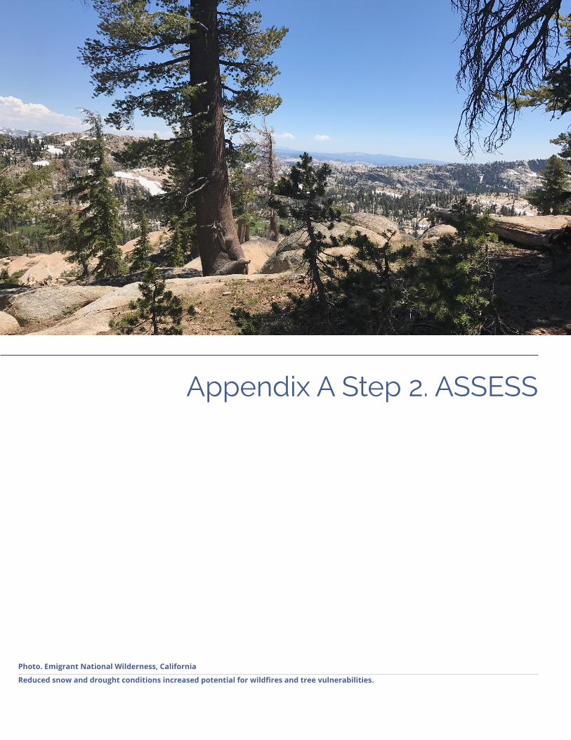
Appendix A Step 2. ASSESS
Photo. Emigrant National Wilderness, California
Reduced snow and drought conditions increased potential for wildfires and tree vulnerabilities.

Appendix A | Page 2.2
Appendix A Step 2. ASSESS
n Expected OutcomesüGoals to guide the planning process, risk and vulnerability assessment, and development of mitigation
and adaptation actions
üPrioritized hazards, hazard scenarios, and maps to be used in the vulnerability assessment
üAssessment methodology and approach
üAn inventory of assets, by asset class and specific assets, to be used in the assessment
üExposure analysis – maps and data describing which assets are exposed to which hazards
üAssessment information about risk, vulnerability, and potential consequences
üVulnerability problem statements
üFulfillment of Element B1 in FEMA’s Local Mitigation Plan Review Tool Checklist
üFulfillment of Element B2 in FEMA’s Local Mitigation Plan Review Tool Checklist
üFulfillment of Element B3 in FEMA’s Local Mitigation Plan Review Tool Checklist
üFulfillment of Element B4 in FEMA’s Local Mitigation Plan Review Tool Checklist
üFulfillment of Element C3 in FEMA’s Local Mitigation Plan Review Tool Checklist
n Worksheets in Appendix B• 2.1 Develop Resilience Goals Exercise
Use this worksheet with the project team and advisory group to establish initial resilience goals.
• 2.2 Develop Hazard Impact Statements Use this worksheet with the project team to develop preliminary hazard impact statements.
• 2.3 Identify Important Community Assets Use this worksheet with the advisory group to develop an initial listing of important community assets.
• 2.4 Community Asset Data Identification Use this worksheet with the project team to develop a general sense of the types of assets the community has and where data may be found. This worksheet can help guide the vulnerability assessment scope and focus resources in areas with the most impact, as well as identify data gaps.
• 2.5 Vulnerability Assessment Scoping Use this scoping worksheet to help plan the community assessment. To help decide which assets to evaluate and if they will be evaluated as individual assets, as an entire asset class, or if representative assets will be selected, consider both the community’s goals and if data and information is readily available to begin answering the assessment questions.
• 2.6 Rapid Vulnerability Assessment Exercise Use this exercise with the project team and/or advisory group to get a sense of the types of information that is needed to conduct the assessment. This exercise expedites and simplifies the Vulnerability assessment questions to provide a quick overview of the vulnerability of an asset. It is designed to be used with a hypothetical asset and hazard, though specifics for the jurisdiction’s community can be used. This exercise is designed to be a warm up, not a substitute for doing a more detailed vulnerability assessment on any asset or asset class.
• 2.7/2.8 Vulnerability Assessment Questions Worksheets (Individual or Representative Asset; Asset Class) Vulnerability assessment questions help to understand the underlying causes and components of vulnerability

Regional Resilience Toolkit | Page 2.3
Appendix A Step 2. ASSESS
and the potential consequences of those vulnerabilities. These worksheets can be used by asset owners or project team members to quickly provide a snapshot of what data is available on assets and where data gaps are. Prior to providing this worksheet to asset owners, the project team should make an effort to fill in readily available public information for the asset owner to confirm.
n Resources• FEMA Worksheet 5.1 Hazards Summary Worksheet
Use this worksheet, or adapt to meet the project, to summarize hazard information and prioritize hazards based on the geographic area affected, the maximum probable magnitude or strength of the hazard, and the probability of the hazard in the future to produce an overall significance rating. mitigationguide.org/wp-content/uploads/2013/05/Worksheet-5.1.pdf
• ABAG Risk Landscapes document ABAG has developed a comprehensive document that describes the hazards the region faces as well as key asset classes and how they are vulnerable to hazards. For the Bay Area, the language in Risk Landscapes is available to provide regional context to hazard descriptions. However, jurisdictions will still need to describe localized hazards. Others may still find useful generalized language or concepts about hazards and asset classes. resilience.abag.ca.gov/wp-content/documents/mitigation_adaptation/RiskProfile_4_26_2017_optimized.pdf
• ABAG Open Data webpage ABAG has gathered 40+ data layers from various partners that illustrate many of the hazards the Bay Area faces. These data layers can be downloaded from the website for use in identifying which hazards are applicable for Bay Area jurisdictions. Some of the data is collected and generated by ABAG; however, most of the data is generated by other agencies and curated here. In some instances, these data sets are unchanged from their original source; in other cases, ABAG has translated the data for use by cities and counties. resilience.abag.ca.gov/open-data
• Adapting to Rising Tides (ART) Resources at www.adaptingtorisingtides.org/howto/art-supplies While all ART materials are geared towards climate adaptation, the concepts can be used for assessment of any hazard.
- ART How-to Guide: Exposure Analysis This guide can help pinpoint the assets and geographies that are most likely to be affected by the community’s hazards and helps identify and prioritize where further, targeted mapping, analysis, or studies are needed.
- ART How-To Guide: Assessment Questions This guide provides additional help for using the ART Assessment Questions to collect data and infor-mation on assets that will inform the characterization of vulnerability and consequences for assets and asset classes.
- ART How-to Guide: Profile Sheets This guide provides additional help preparing profile sheets that summarize, for a specific asset, the findings of the assessment of vulnerability and consequences due to identified hazards.
- ART Engagement Exercise: Functions & Values Mapping This exercise, provided by our partners at Bay Conservation and Development Commission, can be used by the planning team early on to establish the team’s priorities and goals through geographi-cally identifying key functions and values that are critical for the economy, public health and safety, community, and environment in the project area.
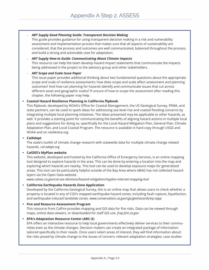
Appendix A | Page 2.4
Appendix A Step 2. ASSESS
- ART Supply Good Planning Guide: Transparent Decision Making This guide provides guidance for using transparent decision making in a risk and vulnerability assessment and implementation process that makes sure that all aspects of sustainability are considered, that the process and outcomes are well communicated, balanced throughout the process, and build a strong and actionable case for adaptation.
- ART Supply How-to Guide: Communicating About Climate Impacts This resource can help the team develop hazard impact statements that communicate the impacts being addressed in the project to the advisory group and other stakeholders.
- ART Scope and Scale Issue Paper This issue paper provides additional thinking about two fundamental questions about the appropriate scope and scale of resilience assessments: how does scope and scale affect assessment and planning outcomes? And how can planning for hazards identify and communicate issues that cut across different asset and geographic scales? If unsure of how to scope the assessment after reading this chapter, the following paper may help.
• Coastal Hazard Resilience Planning in California flipbook This flipbook, developed by NOAA’s Office for Coastal Management, the US Geological Survey, FEMA, and state partners, can be used to spark ideas for addressing sea level rise and coastal flooding concerns by integrating multiple local planning initiatives. The ideas presented may be applicable to other hazards, as well. It provides a starting point for communicating the benefits of aligning hazard actions in multiple local plans and suggestions for doing so, specifically for the Local Hazard Mitigation Plan, General Plan, Climate Adaptation Plan, and Local Coastal Program. The resource is available in hard copy through USGS and NOAA and on resilientca.org.
• CalAdapt The state’s toolkit of climate change research with statewide data for multiple climate change related hazards. cal-adapt.org
• CalOES’s MyPlan website This website, developed and hosted by the California Office of Emergency Services, is an online mapping tool designed to explore hazards in the area. This can be done by entering a location into the map and exploring which hazards are nearby. This tool can be used to develop exposure maps for generalized areas. This tool can be particularly helpful outside of the Bay Area where ABAG has not collected hazard layers via the Open Data website. www.caloes.ca.gov/cal-oes-divisions/hazard-mitigation/myplan-internet-mapping-tool
• California Earthquake Hazards Zone Application Developed by the California Geological Survey, this is an online map that allows users to check whether a property is located in any of CGS’s mapped earthquake hazard zones, including fault rupture, liquefaction, and earthquake induced landslide zones. www.conservation.ca.gov/cgs/geohazards/eq-zapp
• Fire and Resource Assessment Program This resource from CalFire provides mapping and GIS data for fire risks. Data can be viewed through maps, online data viewers, or downloaded for staff GIS use. frap.fire.ca.gov
• EPA’s Adaptation Resource Center (ARC-X) EPA offers an interactive resource to help local governments effectively deliver services to their commu-nities even as the climate changes. Decision makers can create an integrated package of information tailored specifically to their needs. Once users select areas of interest, they will find information about: the risks posed by climate change to the issues of concern; relevant adaptation strategies; case studies

Regional Resilience Toolkit | Page 2.5
Appendix A Step 2. ASSESS
illustrating how other communities have successfully adapted to those risks and tools to replicate their successes; and EPA funding opportunities. www.epa.gov/arc-x
• Smart Growth Fixes for Climate Adaptation and Resilience Florida has excellent guidance on post-disaster redevelopment planning. See pp. 22-23 of Smart Growth Fixes for Climate Adaptation and Resilience for links to the state’s guidance and to individual county plans. www.epa.gov/smartgrowth/smart-growth-fixes-climate-adaptation-and-resilience
• Seven Principles for Equitable Adaptation This article is a good resource with clear approaches to protecting vulnerable populations. Kaswan, Alice. “Seven Principles for Equitable Adaptation.” Sustainable Development Law & Policy 13, no. 1 (2012): 41-46, 67-69. digitalcommons.wcl.american.edu/cgi/viewcontent.cgi?article=1527&context=sdlp
• EPA - Climate Resilience Evaluation and Awareness Tool (CREAT) Climate Scenarios Projection Map This map provides easy-to-access scenario based climate change projections drawn from CREAT. The impacts from a changing climate, including extreme heat and more intense storms, present challenges to water, wastewater, and stormwater utilities and the communities they serve. Understanding how climate change may affect a utility’s ability to maintain and deliver adequate, reliable, and sustainable water supplies and clean water services is the first step in climate related planning. www.arcgis.com/home/item.html?id=3805293158d54846a29f750d63c6890e
• EPA’s I-WASTE Tool This tool includes a waste materials estimator and provides access to technical information, regulations, and guidance to work through important waste management issues to assure safe and efficient removal, transport and management of waste materials. www2.ergweb.com/bdrtool/login.asp
• General Plan Guidelines Data Mapping Tool This tool, developed by OPR, draws data sets from multiple sources to allow users to incorporate local, regional, and statewide data sets into analysis. While the tool is geared towards general plans, it does include a number of hazard and asset layers to assist with vulnerability assessments.
Climate Adaptation Plans
• California Adaptation Planning Guide: Planning for Adaptive Communities, CalOES, CNRA. resilientca.org/projects/964c2e94-aa8b-4e6a-885d-b1e5f4cc8415/
• Preparing for Climate Change: A Guidebook for Local, Regional, and State Governments, ICLEI. www.adaptationclearinghouse.org/resources/preparing-for-climate-change-a-guidebook-for-local-regional-and-state-governments.html
• Digital Coast - NOAA’s website with data, tools, and training for communities to address coastal issues. www.noaa.gov
Aligning planning processes
• Hazard Mitigation: Integrating Best Practices into Planning, APA. www.planning.org/publications/report/9026884/
• State of California General Plan Guidelines, Governor’s Office of Planning and Research. www.opr.ca.gov/planning/general-plan/
• Integrating Hazard Mitigation and Climate Adaptation Planning: Case Studies and Lessons Learned, ICLEI. icleiusa.org/wp-content/uploads/2015/08/Integrating-Hazard-Mitigation-and-Climate-Adaptation-Planning.pdf

Appendix A | Page 2.6
Appendix A Step 2. ASSESS
• Plan Integration: Linking Local Planning Efforts, FEMA. www.fema.gov/media-library-data/1440522008134-ddb097cc285bf741986b48fdcef31c6e/R3_Plan_Integration_0812_508.pdf
• Integrating the Local Natural Hazard Mitigation Plan into a Community’s Comprehensive Plan: A Guidebook for Local Governments, FEMA. www.fema.gov/media-library-data/1388432170894-6f744a8afa8929171dc62d96da067b9a/FEMA-X-IntegratingLocalMitigation.pdf
• Integrating Hazard Mitigation into Local Planning: Case Studies and Tools for Community Officials, FEMA, 2013. www.fema.gov/media-library-data/20130726-1908-25045-0016/integrating_hazmit.pdf
Local Hazard Mitigation Plans
• Local Mitigation Planning Handbook, FEMA. www.fema.gov/media-library/assets/documents/31598
• State Mitigation Plan Review Guide, FEMA. www.fema.gov/media-library/assets/documents/101659
• California State Hazard Mitigation Plan The California State Hazard Mitigation Plan, developed by CalOES, offers a statewide perspective on hazards and asset classes at the state scale. This document may be helpful for jurisdictions outside of the Bay Area that need generalized language to describe hazards. However, jurisdictions will still need to describe localized hazards. Others outside of California may still find useful generalized language or concepts about hazards and asset classes. www.caloes.ca.gov/cal-oes-divisions/hazard-mitigation/hazard-mitigation-planning/state-hazard-mitigation-plan

Regional Resilience Toolkit | Page 2.7
Appendix A Step 2. ASSESS
Laying the Groundwork
Scope and Organize the ProjectThis step can help the project team establish a common understanding about the purpose and need for the assessment in the first place, what the world view is that is informing the assessment, and how much effort will be required to conduct a successful project. Looking through each of the following factors will help lay out what the project team hopes the project will achieve.
Focus on Natural HazardsUsing collective lessons learned, and resulting best practices, states, regions, and jurisdictions now have more information and tools to include natural hazard considerations in regulating and planning for the built environment.
Planning for natural hazards mitigation involves some basic steps:
ü Understanding past, current, and future disaster risks and how these risks interact with critical components of the built environment, natural systems, and people;
ü Understanding the consequences of potential damage to the built environment, natural systems, and people due to natural hazards; and
ü Identifying and implementing strategies to reduce the hazard, reduce exposure to the hazard, reduce the damage that the hazard can inflict, or minimize the consequences of damage.
Identify Planning Triggers and Lenses, and Coordinate with Other PlansIt is good to start the process with a meaningful outcome in mind — the implementation of resilience related actions — and to develop a more holistic project by asking a few questions before beginning. Identifying planning triggers, lenses, and desired outcomes will help deliver a more robust assessment, implementable strategies, and internal capacity to help drive the implementation of strategies. The triggers behind the process and the lenses through which resilience is defined will determine which stakeholders should be at the table. To ensure trans-parency throughout, asking the right questions before the assessment will produce a radically better process.

Appendix A | Page 2.8
Appendix A Step 2. ASSESS
Common Planning Triggers • Risk or Recent Disaster
• Regulatory Landscape
• Local or National Trends
• Attracting Business and Investments
In any state, planning for resilience is good practice to ensure a more secure long-term future. Many federal agencies are requiring consideration of natural hazards, resilience, and/or climate adaptation as part of plans, permits, grant applications, etc. And increasingly, states are starting to include requirements to conduct vulner-ability assessments within other planning processes, whether for transportation, housing, or other infrastructure investments.
Resilience Lenses: Connecting Resilience with Sustainability and EquityThough the primary lens will likely be focused on natural hazards or climate change, building community-wide resilience inherently combines aspects of environmental sustainability, economic strength, risk management, emergency preparedness, and strong social communities. True resilience incorporates the ability to withstand multiple types of stressors. A robust resilience building process incorporates multiple lenses interconnected to the primary lens.
Environmental SustainabilitySustainability here means actions that increase the longevity of natural resources for future generations – not limited to actions like recycling and solar panels, but inclusive of actions like restoring wetlands and protecting water resources. The environmental sustainability lens and natural hazards resilience are tightly woven together, particularly with the actions that emerge from the assessment - often increased sustainability of a community can improve its resilience to disasters. The project will maximize resilience to disasters by ensuring that environ-mental sustainability is a core value.
Social EquityEquity is also a critical lens of resilience. The most vulnerable populations are often most impacted by natural disasters and are the least likely to be able to effectively prepare for, respond to, and recover from disasters.
Incorporating Hazards into Local Planning and Decision MakingTraditionally, hazard mitigation and climate adaptation actions have been relegated to their respective plans and seen as stand alone actions, separate from everyday local planning and decision making.
Whenever making decisions about land use, buildings, infrastructure, and city services, consider current and future hazards information. Jurisdictions may be triggered to do an assessment by regulation or incentive. However, the process here can be done with many different goals and outcomes and incorporated into many different decision making processes, independent of the traditional “home” for risk and vulnerability assess-ments. This can help ensure that a wider variety of stakeholders are involved and invested, leading to better implementation.
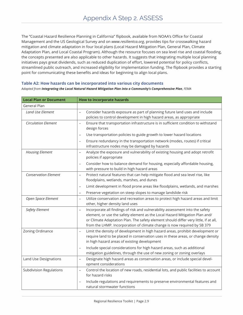
Regional Resilience Toolkit | Page 2.9
Appendix A Step 2. ASSESS
The “Coastal Hazard Resilience Planning in California” flipbook, available from NOAA’s Office for Coastal Management and the US Geological Survey and on www.resilientca.org, provides tips for crosswalking hazard mitigation and climate adaptation in four local plans (Local Hazard Mitigation Plan, General Plan, Climate Adaptation Plan, and Local Coastal Program). Although the resource focuses on sea level rise and coastal flooding, the concepts presented are also applicable to other hazards. It suggests that integrating multiple local planning initiatives pays great dividends, such as reduced duplication of effort, lowered potential for policy conflicts, streamlined public outreach, and increased eligibility for implementation funding. The flipbook provides a starting point for communicating these benefits and ideas for beginning to align local plans.
Table A2: How hazards can be incorporated into various city documentsAdapted from Integrating the Local Natural Hazard Mitigation Plan into a Community’s Comprehensive Plan, FEMA
Local Plan or Document How to incorporate hazardsGeneral Plan
Land Use Element - Consider hazards exposure as part of planning future land uses and include policies to control development in high hazard areas, as appropriate
Circulation Element - Ensure that transportation infrastructure is in sufficient condition to withstand design forces
- Use transportation policies to guide growth to lower hazard locations
- Ensure redundancy in the transportation network (modes, routes) if critical infrastructure nodes may be damaged by hazards
Housing Element - Analyze the exposure and vulnerability of existing housing and adopt retrofit policies if appropriate
- Consider how to balance demand for housing, especially affordable housing, with pressure to build in high hazard areas
Conservation Element - Protect natural features that can help mitigate flood and sea level rise, like floodplains, wetlands, marshes, and dunes
- Limit development in flood prone areas like floodplains, wetlands, and marshes
- Preserve vegetation on steep slopes to manage landslide risk
Open Space Element - Utilize conservation and recreation areas to protect high hazard areas and limit other, higher density land uses
Safety Element - Incorporate all findings of risk and vulnerability assessment into the safety element, or use the safety element as the Local Hazard Mitigation Plan and/or Climate Adaptation Plan. The safety element should differ very little, if at all, from the LHMP. Incorporation of climate change is now required by SB 379
Zoning Ordinance - Limit the density of development in high hazard areas, prohibit development or require land to be placed in conservation uses in these areas, or change density in high hazard areas of existing development
- Include special considerations for high hazard areas, such as additional mitigation guidelines, through the use of new zoning or zoning overlays
Land Use Designations - Designate high hazard areas as conservation areas, or include special devel-opment considerations
Subdivision Regulations - Control the location of new roads, residential lots, and public facilities to account for hazard risks
- Include regulations and requirements to preserve environmental features and natural stormwater functions

Appendix A | Page 2.10
Appendix A Step 2. ASSESS
Local Plan or Document How to incorporate hazardsCapital Improvements Plan (CIP)
- Limit investments that will be vulnerable through exposure to hazard areas and increase vulnerability of the community as a whole
- Include expenditures for hazard mitigation projects
Building Codes - Include local building code amendments that account for increased hazard exposure and create higher levels of performance during disasters
Specific Plans - Ensure that investments in redevelopment areas do not perpetuate vulnerability
- Incorporate hazard resilient features like green infrastructure or flood control features
- Ensure that redevelopment is built to more hazard resistant standards if area is a high hazard area
Stormwater Management Plans - Incorporate natural stormwater retention and detention features to limit flooding due to stormwater
- Develop new stormwater features to account for sea level rise and temporary storm surges
Emergency Management or Operations Plan
- Ensure that emergency management plans use similar assumptions as in mitigation assessments about hazard exposure and asset vulnerability
Post Disaster Redevelopment Plan
- Develop redevelopment plans that coordinate with anticipated consequences of disasters as identified in a risk and vulnerability assessment and account for mitigation measures implemented
Local Hazard Mitigation Plan - Meet FEMA requirements and become eligible for funding by incorporating the risk and vulnerability assessment in a Local Hazard Mitigation Plan
Climate Adaptation Plan - Ensure that assessments about future risks due to climate change are incorpo-rated into other risk and vulnerability assessments and all plans and decisions about existing and future development
Climate Action Plan - Understand the life cycle of climate change – reduce greenhouse gas emissions while planning for inevitable changes through climate adaptation actions
Sustainability Plan - Strategies that reduce the use of resources like energy and water can also help support mitigation to disasters. Tie sustainability strategies to hazard mitigation and climate adaptation strategies to ensure consistency
Local Coastal Plan - Most coastal plans need to seriously take sea level rise and other climate hazards into account and many may also have co-located hazards, like earth-quake liquefaction

Regional Resilience Toolkit | Page 2.11
Appendix A Step 2. ASSESS
Establish Resilience GoalsResilience goals are statements used in the risk and vulnerability assessment, strategy development, and the implementation phase to define desired outcomes, build transparency into what the process is achieving, engage stakeholders, and to capture community’s values throughout the process. Goals can range from broad policy type statements that represent a vision for reducing or avoiding losses from hazards to specific SMART goals (see below for more details) that articulate particular outcomes. Goals will be heavily reflective of the triggers or lenses that are guiding the assessment, and will ideally reflect the perspectives and needs of the stakeholders involved. Identifying goals can also help determine the scope and breadth of the assessment process, establishing a common lens and clarifying priorities, as well as guide the prioritization, selection, and implementation of resil-ience actions.
Build on Existing Community Goals
Selecting community goals early in the planning process helps scope the assessment and prioritize which community assets should be analyzed. Later in the assessment process, community goals help to guide the development of locally meaningful mitigation and adaptation actions. To develop locally relevant goals, start with existing community goals that can be found in General Plans, Specific Plans, Climate Mitigation Plans, Climate Adaptation Plans, Sustainability Plans, Local Hazard Mitigation Plans, Coastal Area Plans, Air Quality Plans, or other local planning documents, as well as identified by stakeholder groups who represent the community.
For example, community goals to improve the quality of life or maintain affordability can be achieved, in part, by protecting housing from earthquakes and flooding, or by keeping small businesses open after a natural disaster. New goals may also emerge that focus on specific vulnerabilities identified through the risk and vulnerability assessment, such as a large elderly population that should be considered prior to a hazard event and will likely need extra support after a disaster.
Use these goals to help determine what assets, and what degree of detail for each asset, is needed to conduct a meaningful risk and vulnerability assessment. Be aware that the process of scoping and conducting a risk and vulnerability assessment may also reveal additional goals. A better understanding of the community’s specific hazard and vulnerability profile may uncover issues that are not fully addressed in existing community goals.
SMART GoalsOne approach to developing goals is to establish SMART goals, or specific, measurable, achievable, results focused, and time bound goals. Using this frame or a version of this approach requires a deeper evaluation of what the project is trying to achieve and details that are sometimes difficult to identify early in the process. A SMART goal framework can increase the likelihood of attaining a goal by providing more detail and clarity at the onset. SMART goals can also make creating valuable metrics easier (more on metrics in Step 5. Measure). While it is often simpler to create a broad goal such as in the Santa Cruz LHMP example, “To protect human life, private property, and the environment.” A corresponding SMART goal that provides more detail, specificity, and guidance is more complex, “Over the next ten years, at least 20% of sales taxes revenue will be dedicated to infrastructure upgrades and capital improvements to protect human life, private property, and the environment.” Use this approach as part of a discussion framework to develop goals with community members, the advisory group, and other stakeholders.

Appendix A | Page 2.12
Appendix A Step 2. ASSESS
Describe HazardsDifferent communities are at risk from different hazards, resulting in unique risk profiles or fingerprints. One community may be located in a very high fire hazard severity zone, while another may have low wildfire risk but large flooding exposure. The scale an agency chooses for describing hazards also impacts which hazards are examined. Fortunately, there are a number of resources that communities can use to map and describe the natural hazards that will affect them. For example, in California the State Hazard Mitigation Plan and the MyPlan website both describe the natural hazards that can impact the State of California. Resources such as these should be used in combination with local data and knowledge, such as local liquefaction assessments and knowledge of past disasters, to characterize the hazards the community may face.
Identify Past Hazard PatternsPatterns of past disasters can help a community understand where disasters may recur and can help to estimate the likelihood of a disaster in the future. This is especially true for disasters such as earthquakes, wildfires, or flooding. Understanding past disasters can also help estimate the magnitude of impact if the disaster recurs.
The state’s Office of Emergency Services (OES) and FEMA should be able to provide a list of all locally relevant state and federally declared disasters. However, information about local disasters that may not have been stated or federally declared is also important. When describing past disasters, include as much information as possible, including the extent and severity of the disaster as well as the impacts (i.e. “this portion of the city has had repeated flooding even in moderate rain events,” or “a fire in 2012 destroyed a transmission line interrupting power to 3,000 residents for 36 hours”).
LHMPs also require a list National Flood Insurance Program (NFIP) insured structures in the community that have suffered repetitive damaged due to flooding1. This list can be obtained through the local NFIP Bureau & Statistical Agent.
Describe and Map Current RisksCurrent hazards may be indicated by hazard map layers depicting current flooding, wildfire risk areas, landslide risk areas, or earthquake ground shaking or liquefaction risk. These maps depict exposure by compiling currently known information about hazard patterns and sources and usually include a level of probability for the hazard occurrence. These layers are often based on past risk patterns or vulnerability factors such as loose soils (lique-faction), steep slopes (landslide), proximity to known faults (ground shaking), or areas with known fire fuels (fire). These maps represent hazards that could occur today and an approximation of the potential degree of severity.
1 Sources: NFIP Flood Insurance Manual, FEMA. Revised October, 2012 44 CFR §79.2(g)
Regional Resilience Toolkit | Page 2.13
Appendix A Step 2. ASSESS
Exploring the current hazards that are of greatest concern is typically done by downloading any available hazards data and by reviewing local hazard maps the city, county, or district may keep. These resources can help develop local scale maps of the community, including the location, expected frequency, and severity of the hazard, such as the strength (magnitude) of an earthquake or the geographic extent or depth of flooding.
Describe and Map Projected Future HazardsWhile past and current disasters can give a good picture of current disaster patterns, they may not accurately predict how disasters will impact the community in the future. Changes to land use and increases in population can significantly change the location, frequency, severity, and consequences of a hazard impact. Additionally, a changing climate could intensify or exacerbate disasters in areas already at risk, expand hazards into areas where they have not occurred in the past, or create new risks that the community may be unfamiliar with. For example, as the climate changes and sea level rises, flooding will become more frequent or severe and some areas that currently experience temporary flooding may become permanently inundated.
Develop Hazard Impact Statements
FEMA’s Hazard Identification and Risk Assessment page provides many good links for data sources and tools for developing hazard impact statements: www.fema.gov/hazard-identification-and-risk-assessment. This page includes links to Hazus, which is FEMA’s methodology for estimating losses from earthquakes, hurricane winds, floods, and tsunamis. In addition, this site includes links to free data and mapping tools from other federal agency and academic institutions and for a range of natural hazards.
The Fourth National Climate Assessment provides useful information on hazards that are likely to get worse with climate change and includes regional chapters with in-depth information for different geographic areas. In addition, the Fourth National Climate Assessment has chapters dedicated to different sectors such as forests, water, and energy that may align with an asset-based vulnerability assessment. The Fourth National Climate Assessment can be found at www.globalchange.gov/nca4.

Appendix A | Page 2.14
Appendix A Step 2. ASSESS
Prioritize the Hazards
Prioritizing hazards that have the most impact on the community is an important step in conducting a vulner-ability assessment. This can help point to which assets will need the most robust assessment (based on exposure to prioritized hazards), can aid in understanding the overlap between high priority hazards and vulnerable populations, or can help engage certain stakeholders. One way of qualitatively estimating which hazards will have the most impact is done by considering the extent of exposure (this can be measured by the number of people exposed, number of buildings exposed, acres of natural resources exposed, or the value of assets exposed), the potential impacts of a hazard, and the likelihood of the hazard occurring. FEMA provides a worksheet for summa-rizing and prioritizing hazards in its Local Mitigation Planning Handbook (See Resources: FEMA Worksheet 5.1, Hazards Summary Worksheet).
The advisory group and other stakeholders can also provide input into prioritizing hazards by identifying additional impacts and conveying which concerns are most pressing, or most align with the community’s values. Stakeholders can also help identify “thresholds” – some limit to damage or exposure that the community does not wish to exceed – to prioritize hazards. For example, if a community prioritizes limiting impacts to one asset over another (say, historic City Hall versus an underused park), a priority would be the hazard that is of most impact to that asset.
A list of prioritized hazards offers a good touch point to consider refining or reprioritized the resilience goals previously developed. In addition, knowing spatially where hazards may affect the community can guide the remainder of the vulnerability assessment, including which assets should be considered and what information needs to be gathered.

Regional Resilience Toolkit | Page 2.15
Appendix A Step 2. ASSESS
Select AssetsIn deciding which assets to include, the team will need to determine which individual assets, representative assets, or entire asset classes will be evaluated. For example, a community can choose to include transportation infrastructure as an asset class or can assess individual transportation assets, such as bus yards, train stations, bridges, etc. Begin by first identifying which asset classes are applicable and important to the assessment, and then decide which asset classes warrant a deeper assessment.
More detail about each asset class, including the specific assets included and where to find information on them, is included in the Worksheet 2.4 Community Asset Data Identification.
Scope MattersFocusing on a single asset class can provide a deep understanding of vulnerability and can lead to implementation of specific actions but may overlook vulnerabilities due to physical or organizational relationships among assets or agencies. For example, publicly owned buildings and critical response facilities rely on a variety of other assets to maintain function such as power, road access, and wastewater services. Starting with a broader assessment and focusing in on individual assets as necessary based on community goals, hazards identified, and the potential consequences of the hazards is a good balance between broad and detailed approaches.
Vulnerability assessments that include multiple asset classes can reveal how seemingly dissimilar assets, such as nursing homes, single access roadways, trails used by those with limited mobility, and tidal marshes that support threatened or endangered species, have similar vulnerabilities due to their unique function. Multi-class assess-ments can also identify complexities in regulatory and other decision making processes that cut across asset categories; for example, actions to address the vulnerability of a roadway that crosses a tidal creek can have similar regulatory challenges as improving the utility or rail crossings.
For LHMPs in California, AB 2140 (2006) requires that for jurisdictions to be eligible for a greater share of disaster assistance costs, the General Plan Safety Elements must contain an earthquake performance evaluation of public facilities that provide essential services, shelter, and critical government functions, as well as an inventory of private facilities that are potentially hazardous, including, but not limited to, multi-unit, soft story, concrete tilt-up, and concrete frame buildings. To meet these requirements, prioritize assessment of these asset classes. To comply with AB 2140 requires not just an exposure analysis, but an assessment of the actual characteristics of the buildings within that asset class.
Scale MattersOnce critical asset classes for the assessment have been identified, determine if the class contains assets that should be evaluated individually. Scaling down to individual assets can help identify specific vulnerabilities that are often caused by particular physical and functional characteristics. An assessment of individual assets can identify specific components, critical functions, or management challenges that will increase vulnerability.

Appendix A | Page 2.16
Appendix A Step 2. ASSESS
Individual assessments should be conducted for unique, critically important or high consequence assets. Individual assessments do require a greater level of effort and more detailed information than may be available. Asset class assessments should be conducted when there are many similar assets and can be supplemented by evaluating representative assets that will provide similar benefits as assessing individual assets. Worksheet 2.5 Vulnerability Assessment Scoping Worksheet provides guidance for selecting asset categories and for deter-mining if they are best assessed individually or as a group.
Diving in Deeper: Profile Sheets and Assessment QuestionsGoing beyond an exposure analysis requires looking at asset classes, representative assets, and individual assets. As the assessment goes deeper, more detailed information about vulnerabilities will emerge. Assessing an asset class as a whole allows for the identification of broad vulnerability factors that tell a high level story about the scale and nature of the asset classes’ vulnerabilities, as well as about the consequences of failure of the asset class as a system. It can be helpful to organize findings for an entire asset class through basic types of vulner-abilities and consequence lenses.
For individual and representative assets, assessment questions can help simplify and facilitate the collection of information, both qualitative and quantitative, about asset conditions and characteristics that can either increase or reduce vulnerability and consequences for individual or representative assets. The assessment questions included in the Toolkit seek to uncover physical, governance, and functional factors that may indicate increased vulnerability, as well as who and what are dependent upon the asset to determine potential consequences of failure. There is a similar set of assessment questions for asset classes.
Assessment questions can be answered in a variety of ways, but one useful approach is to answer as many high level questions as possible using basic, publicly available information on the asset, such as websites and public documents. At this point, the project team conducting the assessment should reach out to the asset’s owner or operator to review the answers the team has collected and to set up a time to discuss the remaining questions in detail. Often team members will have to speak to several stakeholders associated with the asset to answer all of the questions in adequate detail. Once the answers to the questions are summarized in a profile sheet, these stakeholders should review them for accuracy.
The questions in this Toolkit are based on the Bay Conservation and Development Commission’s Adapting to Rising Tides (ART) Program’s robust list of assessment questions that provide a framework for collecting the data and information that lead directly to the identification of vulnerabilities and consequences. The ART assessment questions, which have been applied and refined based on a number of on-the-ground assessments, can be used for a wide variety of sectors at the individual, representative or asset class scale. Answers to the questions help build an understanding of the underlying causes and components of vulnerability and the potential consequences of those vulnerabilities on society and equity, environment, and economy. These questions can also be adapted based on assets, needs, goals, hazards, and access to information.
A reduced list of assessment questions based on the full list of ART assessment questions is included in Appendix B - Worksheets 2.7 and 2.8 Vulnerability Assessment Questions. These represent the short list of questions that if answered, will provide a reasonably detailed understanding of vulnerability and consequences. A link to the full set is identified in Resources Step 2. Assess.

Regional Resilience Toolkit | Page 2.17
Appendix A Step 2. ASSESS
Determine Assessment MethodHazards become meaningful when they interact with assets within the community, including people, structures, facilities, and services. Once risk is understood, the team must conduct a vulnerability assessment to under-stand how assets within the community are vulnerable to the risks identified. This task prepares the team to conduct the vulnerability assessment by identifying which community assets to include and determining the best assessment method. The chosen method for assessment helps the team decide what information is needed to determine the ability of the assets to withstand hazards as well as the consequences to the community if assets are damaged in a disaster.
Determine the ApproachBefore conducting a vulnerability assessment, determine the depth of information that should be collected on individual assets, representative assets, and asset classes. Vulnerability assessments can be expanded or focused based on three different elements:
1. The number of asset classes included in the assessment and the number of representative assets or individual assets assessed within each class. At a minimum, an assessment should include critical facilities like emergency response facilities and public buildings. A more comprehensive assessment may include residential units, infrastructure systems, and/or recreational spaces.
2. Whether the assessment evaluates assets as a class, as representative assets, or as individual assets. The most comprehensive approach would be to evaluate all assets individually, but this will likely require more resources than are available. This process can be simplified by choosing a representative asset to assess that may be similar to many others, house important services, are exposed to more severe hazards or
Repetitive and Severe Loss PropertiesRepetitive and severe loss properties not only put a cost burden on the National Flood Insurance Program, they indicate areas where flooding is repetitive and severe. These properties could help pinpoint areas for changed land use or zoning to avoid similar losses in the future.
Repetitive loss property: an NFIP insured structure that has had at least two paid flood losses of more than $1,000 each in any ten-year period since 1978.
Severe repetitive loss property: any NFIP insured single or multifamily residential properties that:
• Have incurred flood-related damage for which 4 or more separate claims payments have been made, with the amount of each claim exceeding $5,000 and the cumulative amount exceeding $20,000; or
• For which at least 2 separate claims payments have been made under such coverage, with the cumulative amount exceeding the market value of the building.
• In both instances, at least two of the claims must be within 10 years of each other (claims made within 10 days of each other count as one claim).

Appendix A | Page 2.18
Appendix A Step 2. ASSESS
hazards sooner than other assets, or serve a large number of residents. If assessing a representative asset is not possible, asset classes can be assessed with far fewer resources, but can still provide information useful for the community. More information on scale, and deciding whether to choose individual or representative assets, can be found in the following pages.
3. The amount of information available on each asset. The location and use for each asset included in the assessment is a minimum, though even location data can be a challenge to track down and organize. More information, if it is available, can make the assessment more meaningful. Including more information about how the asset is vulnerable to a hazard, or what the consequences are if it is damaged can transform the assessment into a powerful story and leads to targeted, meaningful actions.
There are many factors that go into answering the questions implied in the three elements above. The most basic limiting factor is the amount of time and resources available for the assessment. Data can also be a critical factor, especially data at the right scale. Inability to get high quality or accurate data on hazards or assets at the scale needed to do a meaningful assessment, or if the amount of resources it would take to get good data is too great, means the assessment will be scoped very differently than if there is ready access to robust, accurate, and plentiful data. Another significant factor in scoping an assessment is connected to desired outcomes and goals – what are the desired outcomes of an assessment? Very complex or specific goals may require a more detailed or focused assessment, but if the assessment is more of an exploratory first step, a high level assessment may provide all the information needed to move forward.
Regional Resilience Toolkit | Page 2.19
Appendix A Step 2. ASSESS
Conduct the Assessment
Exposure Analysis An exposure analysis is a stepwise process (for more detail reference the ART How-to Guide: Exposure Analysis):
1. Add relevant hazard layers into a new or existing map in ArcGIS. It is helpful to load all of the layers into a single map so that they can be turned on and off as needed. Many hazards are well mapped and readily available, such as earthquake shaking scenarios, current flood zones, and fire zones. For future hazards, some, such as inundation from higher tides due to sea level rise, may have ready-to-use mapping tools available to evaluate asset exposure. For hazards that are not as well studied or understood (e.g., salinity intrusion due to sea level rise or precipitation patterns) reliable information may not be readily available.
2. Gather data and map the locations of the community assets included in the assessment scope. Worksheet 2.3 Identify Important Community Assets, provides publicly available data sources for a range of asset categories. This step requires the location of the assets (latitude and longitude) or a previously made map layer that contains the assets.
3. Compare assets to the hazard layers. Note which assets are in which hazard zones, the magnitude of the hazard they are exposed to (for example, light, moderate, strong, very strong, violent, or very violent ground shaking) or the probability of the hazard (1% flood hazard zone vs. 0.2% flood hazard zone), and assets that are exposed to multiple hazards.
4. Create maps showing the extent of hazards and the location of assets that intersect with those hazards. It is a good idea to develop summary tables for large asset classes to communicate the different types and levels of hazards exposure.
5. Ask those with local knowledge and experience, such as stakeholders, asset owners, and community members, to review the maps and analysis to help pinpoint locations that do not adequately characterize local conditions and where additional studies, field verification, remapping or reanalysis is needed.
Appendix A | Page 2.20
Appendix A Step 2. ASSESS
Answer Assessment QuestionsThe process of answering the assessment questions is best approached in a stepwise manner (for more detail see ART How-to Guide: Assessment Questions):
1. Get familiar with the assessment questions and the types of vulnerabilities and consequences that these questions have revealed in Worksheets 2.7 and 2.8 Vulnerability Assessment Questions.
2. Develop an approach for answering the questions before starting. Identify key pieces of information, like sources of data and key stakeholders to talk to such as asset owners, managers, and topic experts. The assessment questions are a tool to guide the collection and summary of targeted information in different ways. Recognize that it may be necessary to modify the approach for certain assets depending on input from the project team, availability of information, and preliminary findings as the assessment progresses.
3. Gather answers to assessment questions by conducting research to uncover readily available reports, documents, inspection and monitoring reports, and maps. Make a diligent effort to gather as much infor-mation as possible before seeking input from asset managers, owners or topic experts, as it is far easier and more efficient for them to help refine answers or provide specific resources to fill information gaps than to answer the entire worksheet. Keep in mind answers are typically a few sentences to a paragraph long. It is okay if the answer uncovers further, specific challenges that need to be further investigated.
4. Ground truth preliminary assessment answers with asset managers, owners, and topic experts. As stated above, it can be beneficial to provide the preliminary assessment answers and sources of information to the asset manager, owner, or topic expert before asking for their input. However, be sure to give them enough background on the assessment objectives if they are not already familiar with the vulnerability assessment. Since input on the preliminary assessment answers is partially based on best professional judgment, it is often helpful to ask for assistance in engaging colleagues, co-workers, others in the field, community members, and nonprofit organizations to gather needed information. Lastly, be sure to ask if there are any additional data or resources available that can help fill in information gaps. If there are none then make sure to note this data need or knowledge gap as an information challenge.
This is a good point in the planning process to revisit resilience goals used to guide the assessment phase. The assessment may have uncovered new information or highlighted new priorities, and it may be a good idea to update goals to reflect new findings. If goals were based on existing community goals and not hazard specific, this may also be a good time to develop new, hazards based goals. Goals are important because they can inform which strategies and actions a community values and should prioritize and can also indicate which strategies already have community support and may be easier to implement.
Strategies should respond directly to the problems identified in the assessment and be summarized into problem statements discussed in Step 3. Problem statements should identify the community’s most pressing hazards problems, informed by goals, hazard risks, the vulnerability of assets or asset classes, and the consequences and impacts of damage or failure of key assets or asset classes.
Once strategies have been identified prioritizing those strategies and developing a plan to implement those strategies is essential. In this step, the jurisdiction should develop a long term implementation plan to encompass priority strategies in a 5 to 20-year implementation period. This enables a broad implementation plan within a policy document, General Plan, or Local Hazard Mitigation Plan. Short term, 6 months to 2-year implementation actions, align with more immediate efforts such as informing the Capital Improvement Plan.

Appendix A Step 3. ACT
Photo. Fort Bragg sand dunes, California
Natural systems such as dunes can be effective in reducing impacts related to sea level rise and extreme storms.

Appendix A | Page 3.2
Appendix A Step 3. ACT
n Expected Outcomes ü Problem Statements
ü Draft list of appropriate strategies to address hazard problem statements
ü Basic information on each strategy to assist in evaluating and prioritizing strategies
ü Prioritized list of feasible, impactful strategies with stakeholder buy in
ü Completed Strategy Development and Implementation worksheets for each prioritized strategy
ü A long-term implementation plan that outlines implementation 5-20 years down the line
ü A short-term action plan outlining actions that can start in the near-term
ü Fulfillment of Element B3 in FEMA’s Local Mitigation Plan Review Tool Checklist
ü Fulfillment of Element C4 in FEMA’s Local Mitigation Plan Review Tool Checklist
ü Fulfillment of Element C5 in FEMA’s Local Mitigation Plan Review Tool Checklist
ü Fulfillment of Element C6 in FEMA’s Local Mitigation Plan Review Tool Checklist
n Worksheets in Appendix B• 3.1 Develop Initial Problem Statements
This worksheet should be used by the project team, as well as by the advisory group, to develop the initial problem statements that will become the basis of the strategies.
• 3.2 Strategy Idea Sources This handout presents a number of sources for strategies that address common hazards and asset classes. The sources can be used to provide ideas and language for local strategies that are responsive to individual problem statements. This guide is geared towards the Bay Area in California, but many of the strategies can be applicable in other areas that have similar hazards. For other types of hazards, see the Resources section for other strategy sources.
• 3.3 Evaluation Criteria This worksheet should be used by the project team, as well as by the advisory group, to evaluate and prioritize strategies for implementation. The worksheet uses five categories of criteria to develop a total score: feasi-bility, social benefits, economic benefits, environmental improvement, and community objectives. Jurisdictions can also change scoring criteria to reflect local priorities. It is important that multiple stakeholders fill out this worksheet to ensure that multiple voices and viewpoints are included in strategy prioritization.
• 3.4 Strategy Development and Implementation Handout This handout provides two tools to help fill out a Strategy Development and Implementation Worksheet: a description of what to include in each field, and an example from a real life strategy. Review this handout with the project team before developing a worksheet for each strategy. This will ensure the worksheets are consis-tently filled out and that everyone understands the key pieces of information needed to effectively develop an appropriate and responsive strategy and plan for its implementation.
• 3.5 Strategy Development and Implementation This blank worksheet is a template for recording key information about a strategy that can assist in fleshing out the ideas put forth in the strategy as well as key information needed to move into implementation of the strategy. The project team should fill out this worksheet for every strategy. First, as the team selects possible strategies, work through the top half of the worksheet. After going through the evaluation step, complete the bottom half of the worksheet for those strategies to be implemented.
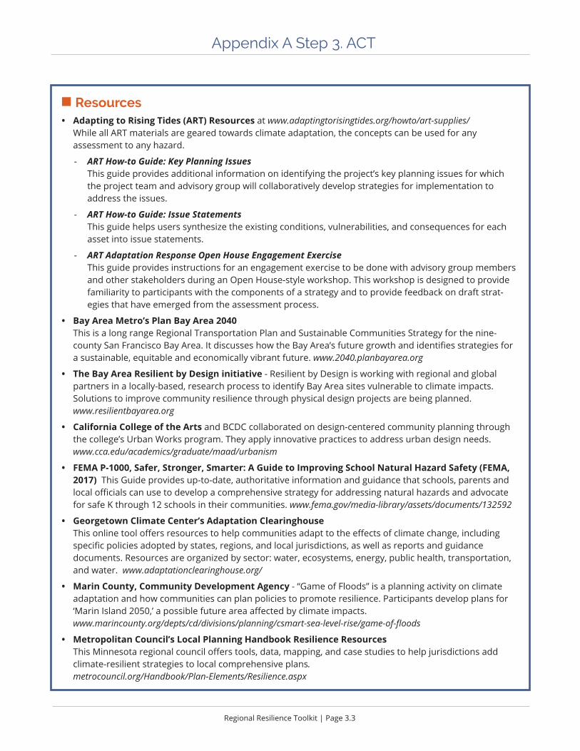
Regional Resilience Toolkit | Page 3.3
Appendix A Step 3. ACT
n Resources• Adapting to Rising Tides (ART) Resources at www.adaptingtorisingtides.org/howto/art-supplies/
While all ART materials are geared towards climate adaptation, the concepts can be used for any assessment to any hazard.
- ART How-to Guide: Key Planning Issues This guide provides additional information on identifying the project’s key planning issues for which the project team and advisory group will collaboratively develop strategies for implementation to address the issues.
- ART How-to Guide: Issue Statements This guide helps users synthesize the existing conditions, vulnerabilities, and consequences for each asset into issue statements.
- ART Adaptation Response Open House Engagement Exercise This guide provides instructions for an engagement exercise to be done with advisory group members and other stakeholders during an Open House-style workshop. This workshop is designed to provide familiarity to participants with the components of a strategy and to provide feedback on draft strat-egies that have emerged from the assessment process.
• Bay Area Metro’s Plan Bay Area 2040 This is a long range Regional Transportation Plan and Sustainable Communities Strategy for the nine-county San Francisco Bay Area. It discusses how the Bay Area’s future growth and identifies strategies for a sustainable, equitable and economically vibrant future. www.2040.planbayarea.org
• The Bay Area Resilient by Design initiative - Resilient by Design is working with regional and global partners in a locally-based, research process to identify Bay Area sites vulnerable to climate impacts. Solutions to improve community resilience through physical design projects are being planned. www.resilientbayarea.org
• California College of the Arts and BCDC collaborated on design-centered community planning through the college’s Urban Works program. They apply innovative practices to address urban design needs. www.cca.edu/academics/graduate/maad/urbanism
• FEMA P-1000, Safer, Stronger, Smarter: A Guide to Improving School Natural Hazard Safety (FEMA, 2017) This Guide provides up-to-date, authoritative information and guidance that schools, parents and local officials can use to develop a comprehensive strategy for addressing natural hazards and advocate for safe K through 12 schools in their communities. www.fema.gov/media-library/assets/documents/132592
• Georgetown Climate Center’s Adaptation Clearinghouse This online tool offers resources to help communities adapt to the effects of climate change, including specific policies adopted by states, regions, and local jurisdictions, as well as reports and guidance documents. Resources are organized by sector: water, ecosystems, energy, public health, transportation, and water. www.adaptationclearinghouse.org/
• Marin County, Community Development Agency - “Game of Floods” is a planning activity on climate adaptation and how communities can plan policies to promote resilience. Participants develop plans for ‘Marin Island 2050,’ a possible future area affected by climate impacts. www.marincounty.org/depts/cd/divisions/planning/csmart-sea-level-rise/game-of-floods
• Metropolitan Council’s Local Planning Handbook Resilience Resources This Minnesota regional council offers tools, data, mapping, and case studies to help jurisdictions add climate-resilient strategies to local comprehensive plans. metrocouncil.org/Handbook/Plan-Elements/Resilience.aspx

Appendix A | Page 3.4
Appendix A Step 3. ACT
Summarize VulnerabilityAfter conducting the vulnerability assessment, findings should be summa-rized to identify the most significant risks in the community. These findings will help to craft appropriate and responsive mitigation and adaptation actions and create a clear and cogent “story” to help support decision making by elected officials and other stakeholders, providing a foundation for seeking funds to reduce risks and increase resilience.
Developing problem statements help to communicate the critical planning issues that emerged during the vulnerability assessment. For
example, a problem statement can highlight which critical assets are particularly at risk, what areas currently have repetitive losses, or how many high hazard areas are zoned for future development. Problem statements can help prioritize and focus on the areas that have the greatest need for mitigation or adaptation based on the risks and consequences identified. Problem statements can also help clearly communicate which issues require collab-orative decision making, shared funding, or changes in laws, regulations, policies, or other processes. Problem statements can be developed for each hazard, asset class, or specific individual assets evaluated in the vulner-ability assessment.
Develop StrategiesStrategies applicable to problem statements may already exist in city documents like past LHMPs, Safety Elements, Housing Elements, Climate Action Plans, Sustainability Plans, or Climate Adaptation Plans, from the State Hazard Mitigation Plan, or from one of the many sources included here. The strategy sources provide a wide range of robust best practices with clear explanations and implementation steps. Before fully embracing existing strategies, especially from existing, but older plans, ask the following:
ü Are the identified strategies the right ones for the current goals and needs?
ü Have they been tried over and over without success?
ü Are they designed to get the right outcomes?
Depending on the assessment there may be a need to develop new strategies and approaches.
Develop Implementation Plans
Building resilience cannot happen without on-the-ground implementation of actions that reduce risk and increase adaptive capacity. Successful implementation is the result of many sustained actions throughout all phases that change decision making within each jurisdiction. The actual implementation phase, is not significantly different from daily processes the jurisdiction goes through to build projects, implement policy, and make plans for future decision making. Yet, implementation is often the most challenging step due to lack of internal capacity, poor stakeholder buy in, no funding, or political obstacles.

Regional Resilience Toolkit | Page 3.5
Appendix A Step 3. ACT
The entire planning process should be done with an eye to implementation, working to overcome challenges and build consensus throughout to facilitate successful implementation.
Implementation can be considered in two parts: Long Term Implementation Plan (5-20 years) and Short Term Action Plan (present to 2 years). A Long Term Implementation Plan is typically higher level, and used to share with stakeholders and decision makers, included in formal plan documents, and illustrates how to achieve the vision and plan goals. A Short Term Action Plan can act as a staff level working plan that details each step or tactic necessary to achieve those longer term goals and vision in a more manageable time frame, up to 2 years. There is a direct link between the action plan and annual budgets, the Capital Improvements Plan, and daily work.
Figures A1-A6 provide examples of action plans, strategy details, and implementation timelines. These examples may help other project teams as they organize strategies into achievable action plans.
Massachusetts 2018 HMP Examples of Landscape-Scale Healthy Watersheds Goals, Strategies, and Action Items
Action Office Goals Funding Hazard1,3
1, 2, 3, 4
3
1,2,3, State Funding Capital B4,5
1,2,3,4,5 1, 3
Goals: 1. Enhance resiliency to natural hazards/climate change by integrating programs and building institutional capacity. 2. Reduce impacts of hazards and climate change with forward-looking policies. 3. Understand our vulnerabilities/risks, develop immediate/long-term risk reduction strategies for current/future conditions using the best available science. 4. Increase the resilience of State/local government, people, natural systems, the built environment, and the economy by investing in performance-based solutions. 5. Support implementation of this plan through increased education, awareness, and incentives for action for state agencies, local governments, private industry, non-profits, and the public.Mission: Reduce the loss of life, protect natural resources, property, infrastructure, public health and economy from hazards and climate change impacts through the development of a comprehensive and integrated hazard mitigation and climate adaptation program. Statement on Importance of Nature-Based Solutions: 7.3 Importance of Nature-Based Solutions in Hazard Mitigation and Climate Adaption Nature-based solutions (NBS) are defined as: The conservation, enhancement, and restoration of nature to reduce emissions,adaptation, and enhance resiliency. These types of solutions use natural systems, mimic natural processes, or work in tandem with traditional engineering approaches to address natural hazards like flooding, erosion, drought, and heat islands. Examples of NBS include restoring wetlands and floodplains to reduce flooding, planting trees to reduce the heat island effect, and conserving and managing agricultural soils to sequester carbon.NBS projects like open space conservation have been shown toprovide habitat services, support a restoration economy, improve water quality, and improve housing value.
Reassess and develop a climate change resiliency framework and criteria for all EOEEA agency land acquisition and grant funding for land acquisition to support natural resource conservation, wildlife, human health and public safety.
Executive Office of Energy and Environmental Affairs (EOEEA)
State Capital and Operating Budget
Precipitation changes, rising temperatures, extreme weather
Incorporate climate change resilience/adaptation standards into grant programs including MassWorks.
Office of Housing, Econ Development
State Operating Budget
Rising temperatures, extreme weather
State Capital and Operating Budget
Precip changes, rising temps, extreme weather
Review habitat management, land stewardship,agricultural and invasive species programs and policies to develop strategies that promote coordination and support climate change adaptation and mitigation goals
Executive Office of Energy and Environmental Affairs (EOEEA)
State Operating Budget
State Operating Budget
Precip changes, rising temps, extreme weather
Develop an implementation plan for priority water quality restoration projects for adaptation and habitat restoration.
Ecological Restoration (DER)
Precipitation Changes, Rising Temperatures
Ecological Restoration (DER)
Build the capacity of regional organizations to implement climate adaptation and habitat restoration at the local level
Regional water quality monitoring initiative. Monitors freshwater streams to detect climate-related changes in biological, thermal, hydrologic, habitat and water chemistry data, gather information on organism response and recovery.
Department of Environmental Protection (DEP)
Precipitation changes, rising temperatures, extreme weather
Figure A1. Massachusetts 2018 HMP Examples if Landscape-Scale Healthy Watersheds Goals, Strategies, and Action Goals
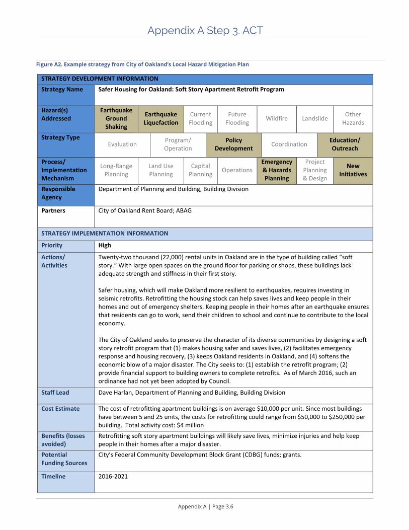
Appendix A | Page 3.6
Appendix A Step 3. ACT
Figure A2. Example strategy from City of Oakland’s Local Hazard Mitigation Plan
STRATEGY DEVELOPMENT INFORMATION Strategy Name Safer Housing for Oakland: Soft Story Apartment Retrofit Program
Hazard(s) Addressed
Earthquake Ground Shaking
Earthquake Liquefaction
Current Flooding
Future Flooding Wildfire Landslide Other
Hazards
Strategy Type Evaluation Program/
Operation Policy
Development Coordination Education/ Outreach
Process/ Implementation Mechanism
Long-Range Planning
Land Use Planning
Capital Planning Operations
Emergency & Hazards Planning
Project Planning & Design
New Initiatives
Responsible Agency
Department of Planning and Building, Building Division
Partners City of Oakland Rent Board; ABAG
STRATEGY IMPLEMENTATION INFORMATION
Priority High
Actions/ Activities
Twenty-two thousand (22,000) rental units in Oakland are in the type of building called “soft story.” With large open spaces on the ground floor for parking or shops, these buildings lack adequate strength and stiffness in their first story. Safer housing, which will make Oakland more resilient to earthquakes, requires investing in seismic retrofits. Retrofitting the housing stock can help saves lives and keep people in their homes and out of emergency shelters. Keeping people in their homes after an earthquake ensures that residents can go to work, send their children to school and continue to contribute to the local economy. The City of Oakland seeks to preserve the character of its diverse communities by designing a soft story retrofit program that (1) makes housing safer and saves lives, (2) facilitates emergency response and housing recovery, (3) keeps Oakland residents in Oakland, and (4) softens the economic blow of a major disaster. The City seeks to: (1) establish the retrofit program; (2) provide financial support to building owners to complete retrofits. As of March 2016, such an ordinance had not yet been adopted by Council.
Staff Lead Dave Harlan, Department of Planning and Building, Building Division
Cost Estimate The cost of retrofitting apartment buildings is on average $10,000 per unit. Since most buildings have between 5 and 25 units, the costs for retrofitting could range from $50,000 to $250,000 per building. Total activity cost: $4 million
Benefits (losses avoided)
Retrofitting soft story apartment buildings will likely save lives, minimize injuries and help keep people in their homes after a major disaster.
Potential Funding Sources
City’s Federal Community Development Block Grant (CDBG) funds; grants.
Timeline 2016-2021
113

Regional Resilience Toolkit | Page 3.7
Appendix A Step 3. ACT
Now
2012
2013
2014
2015
2016
2017
2018
2019
2020
2021
2022
2023
2024
2025
2026
2027
2028
2029
2030
2031
2032
2033
2034
2035
2036
2037
2038
2039
2040
2041
2042
Task A.4.c. Develop repair/retrofit standards for wood‐frame and concrete buildingsResilientSF teamTask A.4.d. Adopt disproportionate damage triggerResilientSF teamTask A.6.a. Assure conformance of Community Safety Element with CAPSS and other recommendationsResilientSF team/Department of Emergency ManagementTask A.6.b. Support voluntary seismic upgrade of one‐and two‐family dwellingsResilientSF team/Department of Building InspectionTask A.2.b. Adopt façade maintenance regulationsResilientSF teamTask A.4.a. Develop and adopt Shelter‐in‐Place policies and proceduresResilientSF teamTask A.4.f. Update post‐earthquake inspection (ATC‐20) policies and procedureResilientSF team/Department of Building InspectionTask A.6.c. Develop evaluation criteria and standards for older concrete and "most hazardous to life" buildingsResilientSF teamTask A.4.e Revise Planning Code to limit nonconforming reconstruction unless minimum retrofit donePlanning DepartmentTask A.6.h. Develop evaluation standards and performance goals for all building typesResilientSF teamTask A.5.a. Develop funding sources to assist private property owners with seismic upgrade costsMayor's OfficeTask A.5.b. Investigate Planning Code and other City agency incentives for seismic upgradePlanning Department/ResilientSF teamTask A.5.c. Seek Federal and State support for earthquake safety implementationMayor's OfficeTask A.5.d. Offer "Ombudsman" services to provide technical and permitting, and other assistance.Department of Building InspectionTask A.6.d. Explore alternative seismic retrofit solutionsResilientSF team
Task A.6.e. Further evaluate effects of retrofits on economically disadvantaged San FranciscansResilientSF teamTask A.1.b. Provide information and assistance about renter’s insurance and other insuranceResilientSF teamTask A.6.f. Review performance requirements for private schools K‐12 ResilientSF teamTask A.3.a. Mandatory evaluation and retrofit of 3+ story, 5+ unit soft‐story wood frame residential buildingsDepartment of Building InspectionTask A.1.a. Expand current public information programs ResilientSF team
Task A.4.g. Develop chimney repair/reconstruction guidelinesResilientSF teamTask A.4.b. Develop and implement Neighborhood Support CentersDepartment of Emergency ManagementTask A.6.g. Assess scope and issues related to critical retail stores, suppliers, medical service providers, and othersResilientSF teamTask A.3.b. Mandatory evaluation and retrofit of concrete tilt‐up and similar buildingsDepartment of Building InspectionTask A.1.c. Encourage voluntary seismic upgrades of one‐ and two‐family dwellingsResilientSF teamTask A.6.i. Study fire‐related earthquake resilience topicsFire Department
Task A.4.h. Implement performance data collection of retrofitted buildings to evaluate effectiveness of retrofit measuresDepartment of Building InspectionTask A.2.a. Mandatory evaluation of all wood frame residential buildings with 3+ dwelling units upon sale or by deadlineDepartment of Building InspectionTask A.1.d. Develop seismic upgrade and techniques training programs for contractorsResilientSF team/Department of Building InspectionTask B.3.a. Mandatory evaluation and retrofit of Private K‐12 schools to public‐school‐equivalent standardsDepartment of Building Inspection
Task B.1.a. Outreach to critical retail stores, suppliers, medical, and others regarding nonstructural and simple structural upgradesResilientSF team/Department of Building InspectionTask B.2.a. Mandatory evaluation of older non‐ductile concrete residential buildingsDepartment of Building InspectionTask B.4.a. Develop earthquake inspection and posting special use buildingsResilientSF teamTask B.6.a. Update codes for new buildings to reflect desired performance goals and acceptable confidence levels in meeting themResilientSF team/Department of Building InspectionTask B.6.b. Review performance of assisted living facilities and similar special purpose facilitiesResilientSF team/Department of Building InspectionTask B.1.b. Develop non‐structural upgrade program for businessesResilientSF teamTask B.2.b. Training of design professionals on seismic evaluation and retrofit programsDepartment of Building InspectionTask B.5.a. Develop links to distribute materials and provide retrofit incentives from building material suppliers and other companiesResilientSF team/Department of Building Inspection
Task B.3.b. Mandatory evaluation and retrofit of Soft‐Story Buildings with 3 or more stories and 3 or more dwelling unitsDepartment of Building InspectionTask B.2.c. Mandatory evaluation of all other wood‐frame residential buildings upon saleDepartment of Building InspectionTask B.6.c. Review ground failure mitigation measures for areas with high geological hazard ResilientSF team/Department of Building Inspection
Task B.2.d. Mandatory evaluation of residential with 5+ dwelling units and hotels/motelsDepartment of Building InspectionTask B.4.b. Develop post‐earthquake repair and retrofit standards for building types not covered in previous standardsResilientSF team
Task C.1.a. Mandatory evaluation on sale or by deadline of building types not otherwise coveredDepartment of Building InspectionTask C.1.b. Evaluation of buildings retrofitted prior to 1994 or built to non‐conforming performance standardsResilientSF team/Department of Building InspectionTask C.2.a. Mandatory retrofit of older non‐ductile concrete residential buildingsDepartment of Building InspectionTask C.2.b. Mandatory evaluation and retrofit of nonstructural/structural elements to critical stores, suppliers and service
providers ResilientSF team/Department of Building InspectionTask C.2.c. Mandatory evaluation and retrofit of assembly (300+ occupancy) buildingsResilientSF team/Department of Building Inspection
Task C.2.d. Mandatory evaluation and retrofit of steel low‐performance buildings ResilientSF team/Dept. of Building InspectionTask C.2.e. Mandatory evaluation and retrofit of other low‐performance buildings ResilientSF team/Dept. of Building Inspection
Start‐Up Phase A
Implem
entation Phase C
(2012–2015)(2020–2042)
(2015–2020)
Implem
entation Phase B
Now
2012
2013
2014
2015
2016
2017
2018
2019
2020
2021
2022
2023
2024
2025
2026
2027
2028
2029
2030
2031
2032
2033
2034
2035
2036
2037
2038
2039
2040
2041
2042
REV. 9/13/2011Recommended Action Mandatory Evaluation Mandatory Retrofit
REV. 9/13/2011
Now
2012
2013
2014
2015
2016
2017
2018
2019
2020
2021
2022
2023
2024
2025
2026
2027
2028
2029
2030
2031
2032
2033
2034
2035
2036
2037
2038
2039
2040
2041
2042
Task A.4.c. Develop repair/retrofit standards for wood‐frame and concrete buildingsResilientSF teamTask A.4.d. Adopt disproportionate damage triggerResilientSF teamTask A.6.a. Assure conformance of Community Safety Element with CAPSS and other recommendationsResilientSF team/Department of Emergency ManagementTask A.6.b. Support voluntary seismic upgrade of one‐and two‐family dwellingsResilientSF team/Department of Building InspectionTask A.2.b. Adopt façade maintenance regulationsResilientSF teamTask A.4.a. Develop and adopt Shelter‐in‐Place policies and proceduresResilientSF teamTask A.4.f. Update post‐earthquake inspection (ATC‐20) policies and procedureResilientSF team/Department of Building InspectionTask A.6.c. Develop evaluation criteria and standards for older concrete and "most hazardous to life" buildingsResilientSF teamTask A.4.e Revise Planning Code to limit nonconforming reconstruction unless minimum retrofit donePlanning DepartmentTask A.6.h. Develop evaluation standards and performance goals for all building typesResilientSF teamTask A.5.a. Develop funding sources to assist private property owners with seismic upgrade costsMayor's OfficeTask A.5.b. Investigate Planning Code and other City agency incentives for seismic upgradePlanning Department/ResilientSF teamTask A.5.c. Seek Federal and State support for earthquake safety implementationMayor's OfficeTask A.5.d. Offer "Ombudsman" services to provide technical and permitting, and other assistance.Department of Building InspectionTask A.6.d. Explore alternative seismic retrofit solutionsResilientSF team
Task A.6.e. Further evaluate effects of retrofits on economically disadvantaged San FranciscansResilientSF teamTask A.1.b. Provide information and assistance about renter’s insurance and other insuranceResilientSF teamTask A.6.f. Review performance requirements for private schools K‐12 ResilientSF teamTask A.3.a. Mandatory evaluation and retrofit of 3+ story, 5+ unit soft‐story wood frame residential buildingsDepartment of Building InspectionTask A.1.a. Expand current public information programs ResilientSF team
Task A.4.g. Develop chimney repair/reconstruction guidelinesResilientSF teamTask A.4.b. Develop and implement Neighborhood Support CentersDepartment of Emergency ManagementTask A.6.g. Assess scope and issues related to critical retail stores, suppliers, medical service providers, and othersResilientSF teamTask A.3.b. Mandatory evaluation and retrofit of concrete tilt‐up and similar buildingsDepartment of Building InspectionTask A.1.c. Encourage voluntary seismic upgrades of one‐ and two‐family dwellingsResilientSF teamTask A.6.i. Study fire‐related earthquake resilience topicsFire Department
Task A.4.h. Implement performance data collection of retrofitted buildings to evaluate effectiveness of retrofit measuresDepartment of Building InspectionTask A.2.a. Mandatory evaluation of all wood frame residential buildings with 3+ dwelling units upon sale or by deadlineDepartment of Building InspectionTask A.1.d. Develop seismic upgrade and techniques training programs for contractorsResilientSF team/Department of Building InspectionTask B.3.a. Mandatory evaluation and retrofit of Private K‐12 schools to public‐school‐equivalent standardsDepartment of Building Inspection
Task B.1.a. Outreach to critical retail stores, suppliers, medical, and others regarding nonstructural and simple structural upgradesResilientSF team/Department of Building InspectionTask B.2.a. Mandatory evaluation of older non‐ductile concrete residential buildingsDepartment of Building InspectionTask B.4.a. Develop earthquake inspection and posting special use buildingsResilientSF teamTask B.6.a. Update codes for new buildings to reflect desired performance goals and acceptable confidence levels in meeting themResilientSF team/Department of Building InspectionTask B.6.b. Review performance of assisted living facilities and similar special purpose facilitiesResilientSF team/Department of Building InspectionTask B.1.b. Develop non‐structural upgrade program for businessesResilientSF teamTask B.2.b. Training of design professionals on seismic evaluation and retrofit programsDepartment of Building InspectionTask B.5.a. Develop links to distribute materials and provide retrofit incentives from building material suppliers and other companiesResilientSF team/Department of Building Inspection
Task B.3.b. Mandatory evaluation and retrofit of Soft‐Story Buildings with 3 or more stories and 3 or more dwelling unitsDepartment of Building InspectionTask B.2.c. Mandatory evaluation of all other wood‐frame residential buildings upon saleDepartment of Building InspectionTask B.6.c. Review ground failure mitigation measures for areas with high geological hazard ResilientSF team/Department of Building Inspection
Task B.2.d. Mandatory evaluation of residential with 5+ dwelling units and hotels/motelsDepartment of Building InspectionTask B.4.b. Develop post‐earthquake repair and retrofit standards for building types not covered in previous standardsResilientSF team
Task C.1.a. Mandatory evaluation on sale or by deadline of building types not otherwise coveredDepartment of Building InspectionTask C.1.b. Evaluation of buildings retrofitted prior to 1994 or built to non‐conforming performance standardsResilientSF team/Department of Building InspectionTask C.2.a. Mandatory retrofit of older non‐ductile concrete residential buildingsDepartment of Building InspectionTask C.2.b. Mandatory evaluation and retrofit of nonstructural/structural elements to critical stores, suppliers and service
providers ResilientSF team/Department of Building InspectionTask C.2.c. Mandatory evaluation and retrofit of assembly (300+ occupancy) buildingsResilientSF team/Department of Building Inspection
Task C.2.d. Mandatory evaluation and retrofit of steel low‐performance buildings ResilientSF team/Dept. of Building InspectionTask C.2.e. Mandatory evaluation and retrofit of other low‐performance buildings ResilientSF team/Dept. of Building Inspection
Start‐Up Phase A
Implem
entation Phase C
(2012–2015)(2020–2042)
(2015–2020)
Implem
entation Phase B
Now
2012
2013
2014
2015
2016
2017
2018
2019
2020
2021
2022
2023
2024
2025
2026
2027
2028
2029
2030
2031
2032
2033
2034
2035
2036
2037
2038
2039
2040
2041
2042
REV. 9/13/2011Recommended Action Mandatory Evaluation Mandatory Retrofit
REV. 9/13/2011
Figure A3. Example timeline based implementation format

Appendix A | Page 3.8
Appendix A Step 3. ACT
Workplan for the CAPSS Earthquake Safety Implementation Program Draft September 13, 2011
11
Phase A Task Details
Task A.1.a. Provide general public information program about building hazards and performance
Schedule Initiateprogramin2012
GeneralComments Muchworkcurrentlyunderway Publicalreadyhasmuchpartialinformation,muchisnotcorrect Manydifferentinformationalmessagesarecurrentbeingprovided.Needtohaveaconsistentoverall
message,towhichdetailedmessagescanbelinked Needtodevelopoverallprogramidentityandrelatedmaterials Communicationsmustbethroughawidevarietyofmedia
CostsandOtherImpacts Majorimpacts.Informedpubliccanhelpdrivepolicyandperformancestandards
TechnicalIssues None
NecessaryPreliminaryWork Needtodefineoverallmessagesandgoals.
LegislativeActionRequired None
LeadAgency ResilientSFteam
SupportingCityAgencies DepartmentofBuildingInspection DepartmentofEmergencyManagement
ExternalInvolvement CAPSSESIPadvisorygroup
ImplementationCost Maybebestdoneunderoutsidecontract Communicationsprogramsmayhaveexpensesforprogramdevelopment,printing,etc.
Figure A4. Example workplan from the City of San Francisco’s Community Action Plan for Seismic Safety (CAPSS)

Regional Resilience Toolkit | Page 3.9
Appendix A Step 3. ACT
Figure A5. Example action plan sample from earthquake and hazards program, Association of Bay Area Governments
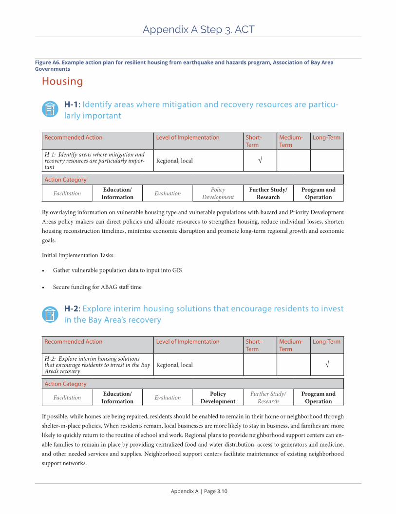
Appendix A | Page 3.10
Appendix A Step 3. ACT
7-11
Housing
H-1: Identify areas where mitigation and recovery resources are particu-larly important
Recommended Action Level of Implementation Short-Term
Medium-Term
Long-Term
H-1: Identify areas where mitigation and recovery resources are particularly impor-tant
Regional, local √
Action Category
Facilitation Education/ Information Evaluation Policy
DevelopmentFurther Study/
ResearchProgram and
Operation
By overlaying information on vulnerable housing type and vulnerable populations with hazard and Priority Development Areas policy makers can direct policies and allocate resources to strengthen housing, reduce individual losses, shorten housing reconstruction timelines, minimize economic disruption and promote long-term regional growth and economic goals.
Initial Implementation Tasks:
• Gather vulnerable population data to input into GIS
• Secure funding for ABAG staff time
H-2: Explore interim housing solutions that encourage residents to invest in the Bay Area’s recovery
Recommended Action Level of Implementation Short-Term
Medium-Term
Long-Term
H-2: Explore interim housing solutions that encourage residents to invest in the Bay Area’s recovery
Regional, local √
Action Category
Facilitation Education/ Information Evaluation Policy
DevelopmentFurther Study/
ResearchProgram and
Operation
If possible, while homes are being repaired, residents should be enabled to remain in their home or neighborhood through shelter-in-place policies. When residents remain, local businesses are more likely to stay in business, and families are more likely to quickly return to the routine of school and work. Regional plans to provide neighborhood support centers can en-able families to remain in place by providing centralized food and water distribution, access to generators and medicine, and other needed services and supplies. Neighborhood support centers facilitate maintenance of existing neighborhood support networks.
Figure A6. Example action plan for resilient housing from earthquake and hazards program, Association of Bay Area Governments

Appendix A Step 4. FUND
Photo. Lassen County wildflowers, California
In the shadows of Lassen National Park, a resilient landscape in historic lava flows.

Appendix A | Page 4.2
Appendix A Step 4. FUND
n Expected Outcomes ü How to engage funders and decision makers to implement strategies and make the business case for
your projects
ü Connect engagement activities to resilience-building actions
ü An initial finance strategy that starts with local funding options first
ü Understanding of potential local tools for self-financing
ü A comprehensive resilience finance menu that includes self -funding, public-private partnerships,philanthropic opportunities, regional funds, and grants
ü Understanding federal, state, and philanthropic grants that may match your funding needs
n Worksheets in Appendix B • 4.1 Funder Engagement Inventory
This blank worksheet is a template for mapping the potential funders that have been engaged or should be engaged in the process and to identify ability to solicit for funds for the resilience project.
• 4.2 Local Funding Sources Inventory This worksheet template is to inventory all existing potential funding sources that are already available within your community and to help assess which ones have potential as a resilience funding source.
• 4.3 Foundation and Other Grant Funding Alignment This worksheet template is to help organize and list all potential grant funding opportunities and link them to the resilience-building strategies and projects.
n Resources• Financial Primer Resources
Two financial primers: Resilient by Design’s Finance Tools and AECOM’s Primer for Practitioners provide state-of-the-art fiscal guidance for communities grappling with seemingly insurmountable resilience funding challenges. These complementary materials lay out the public and private resource options that communities and regional alliances can consider as they develop the local resilience capital stack.
- The Resilient by Design primer focuses on the RBD Bay Area Challenge process. The project team outlines the need for an overall finance strategy, advising that obtaining pre-development project funding as an initial step to longer-term fiscal support. The primer details a decision process for Bay Area communities to use as they assemble funding and finance components for implementation. This guide provides specific regional, state, and federal grants for communities to tap. www.resilientbayarea.org/finance-tools
- The AECOM report is a straight-forward explanation of the types of funding and financing options available for communities to use to implement resilience projects. The report summarizes the big picture on resilience terminology, cites crucial laws and regulations pertaining to adaptation require-ments and addresses the community and equity challenges communities face. It further explains the sectoral entities that can support resilience implementation from community development corpo-rations, land trusts, various finance institutions, as well as how communities establish partnership bodies such as joint powers authorities or infrastructure banks. www.aecom.com/paying-climateadaptation-california-primer-practitioners/

Regional Resilience Toolkit | Page 4.3
Appendix A Step 4. FUND
• National Institute of Standards and Technology Community Resilience Planning Guide The guide is designed to assist communities improve resilience “by setting priorities and allocating resources to manage risks for their prevailing hazards.” The guide can be helpful to communities in devel-oping resilience goals that are aligned with social and economic needs, which will make securing local funding for projects more likely. www.nist.gov/topics/community-resilience/community-resilience-planning-guide
• Toward a More Resilient Community: An Overview of the Community Resilience Planning Guide for Buildings and Infrastructure Systems This December 2015 National Institute of Standards and Technology (NIST) report outlines guidance on determining community resilience goals; promoting a systematic approach to incorporate resilience improvements in existing budget processes; and, implementing triple bottom line actions. www.nist.gov/topics/community-resilience
• Lessons in Regional Resilience: Case Studies on Regional Climate Collaboratives This report provides case studies of several regional climate adaptation efforts, including models for regional funding. Georgetown Climate Center, January 2017 www.georgetownclimate.org/reports/lessons-in-regional-resilience.html
• Natural Hazard Mitigation Saves: 2018 Interim Report This report adds to previous iterations with new information from studies on the utility and transportation sectors. That National Institute of Building Sciences’ (NIBS) found that there is a benefit of $11 for every $1 invested in hazard mitigation strategies, including updated building codes. www.nibs.org/page/mitigationsaves
• re:focus partners A range of guides and toolkits related to resilient financing options, including how to use catastrophic bonds and local procurement processes for resilience, and how to structure resilience bonds. www.refocuspartners.com/library/
• NatureVest, The Nature Conservancy’s impact investing fund This conservation finance platform works to increase the scale of land conservation through investment opportunities that offer environmental benefits alongside financial returns for investors. Investment areas include Green Infrastructure for Cities, Forests and Carbon, Ocean Protection, and Sustainable Agriculture and Water. www.naturevesttnc.org/
• Conservation Finance Network Toolkit The Conservation Finance Network has a set of resources on the basic approaches to raising money for land conservation, and organizes them by simple, moderate, and difficult depending on the reader’s familiarity with a range of financing tools. www.conservationfinancenetwork.org/2017/11/27/launching-the-conservation-finance-network-toolkit
• The Conservation Finance Network also published a report that outlines a framework for incrementally matching public, private, and philanthropic funds together for environmentally-beneficial land conser-vation. www.conservationfinancenetwork.org/2017/04/04/report-private-capital-for-working-lands-conservation
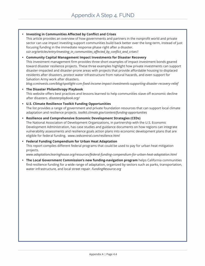
Appendix A | Page 4.4
Appendix A Step 4. FUND
• Investing in Communities Affected by Conflict and Crises This article provides an overview of how governments and partners in the nonprofit world and private sector can use impact investing support communities build back better over the long-term, instead of just focusing funding in the immediate response phase right after a disaster. ssir.org/articles/entry/investing_in_communities_affected_by_conflict_and_crises1
• Community Capital Management Impact Investments for Disaster Recovery This investment management firm provides three short examples of impact investment bonds geared toward disaster resilience projects. These three examples highlight how private investments can support disaster-impacted and disaster-prone areas with projects that provide affordable housing to displaced residents after disasters, protect water infrastructure from natural hazards, and even support for Salvation Army work after disasters. blog.ccminvests.com/blog/spotlight-ccm-fixed-income-impact-investments-supporting-disaster-recovery-relief
• The Disaster Philanthropy Playbook This website offers best practices and lessons learned to help communities stave off economic decline after disasters. disasterplaybook.org/
• U.S. Climate Resilience Toolkit Funding Opportunities The list provides a range of government and private foundation resources that can support local climate adaptation and resilience projects. toolkit.climate.gov/content/funding-opportunities
• Resilience and Comprehensive Economic Development Strategies (CEDs) The National Association of Development Organizations, in partnership with the U.S. Economic Development Administration, has case studies and guidance documents on how regions can integrate vulnerability assessments and resilience goals action plans into economic development plans that are eligible for federal funding. www.cedscentral.com/resilience.html
• Federal Funding Compendium for Urban Heat Adaptation This report compiles different federal programs that could be used to pay for urban heat mitigation projects. www.adaptationclearinghouse.org/resources/federal-funding-compendium-for-urban-heat-adaptation.html
• The Local Government Commission’s new funding-navigation program helps California communities find resilience funding for a wide range of adaptation, organized by sectors such as parks, transportation, water infrastructure, and local street repair. FundingResource.org
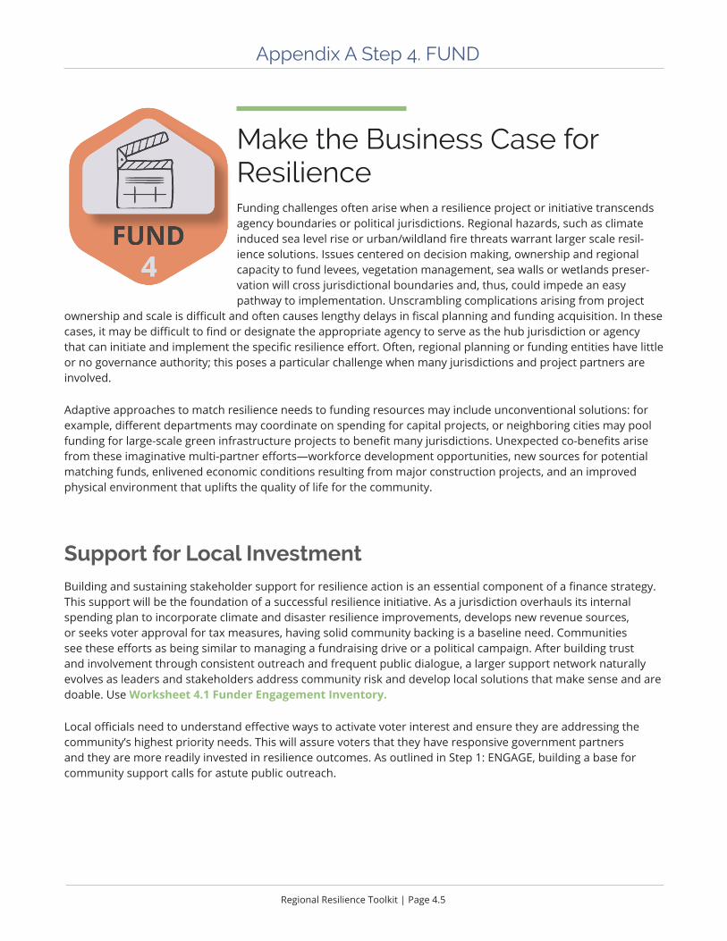
Regional Resilience Toolkit | Page 4.5
Appendix A Step 4. FUND
Make the Business Case for Resilience Funding challenges often arise when a resilience project or initiative transcends agency boundaries or political jurisdictions. Regional hazards, such as climate induced sea level rise or urban/wildland fire threats warrant larger scale resil-ience solutions. Issues centered on decision making, ownership and regional capacity to fund levees, vegetation management, sea walls or wetlands preser-vation will cross jurisdictional boundaries and, thus, could impede an easy pathway to implementation. Unscrambling complications arising from project
ownership and scale is difficult and often causes lengthy delays in fiscal planning and funding acquisition. In these cases, it may be difficult to find or designate the appropriate agency to serve as the hub jurisdiction or agency that can initiate and implement the specific resilience effort. Often, regional planning or funding entities have little or no governance authority; this poses a particular challenge when many jurisdictions and project partners are involved.
Adaptive approaches to match resilience needs to funding resources may include unconventional solutions: for example, different departments may coordinate on spending for capital projects, or neighboring cities may pool funding for large-scale green infrastructure projects to benefit many jurisdictions. Unexpected co-benefits arise from these imaginative multi-partner efforts—workforce development opportunities, new sources for potential matching funds, enlivened economic conditions resulting from major construction projects, and an improved physical environment that uplifts the quality of life for the community.
Support for Local InvestmentBuilding and sustaining stakeholder support for resilience action is an essential component of a finance strategy. This support will be the foundation of a successful resilience initiative. As a jurisdiction overhauls its internal spending plan to incorporate climate and disaster resilience improvements, develops new revenue sources, or seeks voter approval for tax measures, having solid community backing is a baseline need. Communities see these efforts as being similar to managing a fundraising drive or a political campaign. After building trust and involvement through consistent outreach and frequent public dialogue, a larger support network naturally evolves as leaders and stakeholders address community risk and develop local solutions that make sense and are doable. Use Worksheet 4.1 Funder Engagement Inventory.
Local officials need to understand effective ways to activate voter interest and ensure they are addressing the community’s highest priority needs. This will assure voters that they have responsive government partners and they are more readily invested in resilience outcomes. As outlined in Step 1: ENGAGE, building a base for community support calls for astute public outreach.
Appendix A | Page 4.6
Appendix A Step 4. FUND
Develop an initial financial strategy that starts with locally-based funding opportunities.
ü Embed resilience budgeting into the community’s fiscal planning. As resilience funding is often limited to external, limited scope grants or restricted portions of general fund or CIP budgets, local resources are under valued. Incrementally, resilience projects and initiatives need to be part of the regular budget and decision- making discussions.
ü Examine all funding sources as possible resilience monies. Comb through internal budget sources and consider how to re-purpose existing funds or create new revenue scenarios to leverage what’s already available.
ü Influence community-wide conversation and day-to-day decisions about long-term capital improvements to both inform the public and build support for future funding campaigns.
Curate a resilience finance menu. ü Develop a feasible private-public finance strategy by connecting with impact investors, corporate partners, and
local financial institutions. Local officials can align support of private capital as a crucial part of the resilience funding strategy. The role of the private market cannot be over estimated and is often not integrated into a community’s financial planning.
ü Pursue philanthropic contributors through private sector partnerships and by tapping local community foundations to explore potential funding through this often underused fiscal source.
ü Expand the stakeholder circle to include diverse parts of the community, along with organizational and governance partners outside of local government. Regional agencies and community development banks are frequent fiscal contributors to local j projects.
Plan before the disaster strikes. Communities are often not in a mindset to plan for recovery after a disaster occurs. Many people will want to see infrastructure and buildings rebuilt just as they were before the disasters. Communities can develop recovery plans before disasters happen, during what FEMA refers to as “blue sky days.” These pre-disaster recovery plans can include at least five shovel-ready projects to fund along with a well-defined action plan adopted ahead of time. With these planning pieces in place, and imbedded in approved planning documents such as the Local Hazard Mitigation Plan or five-year capital improvement plans, a community can successfully cultivate funding and finance opportunities from the public and private sectors.

Regional Resilience Toolkit | Page 4.7
Appendix A Step 4. FUND
Figure A7. Summary of federal grant and other funding programs from Resilient by Design Bay Area Challenge Finance Guide, December 2017---NHA Advisors, page 42
Federal Grant Program Sponsoring Agency*
Requires Declared Disaster Eligible Projects
Hazard Mitigation Grant Program FEMA Yes Reduction of flood risk
Pre-Disaster Mitigation Program FEMA No Reduction of flood risk
Flood Mitigation Assistance Program
FEMA No Reduction of flood risk
National Disaster Resilience Competition
HUD Yes Reduction of disaster risks
Community Development Block Grants
HUD No Resilient community improvements
Regional Resiliency Assessment Program
Homeland Security No Planning for resilient infrastructure
Coastal Resilience Grants NOAA No Resilient coastal infrastructure
Office of Coastal Management Grants and Cooperative Agree-ments
NOAA No Coastal resilience planning
National Sea Grant College Program
NOAA No Coastal resilience planning
Standard Projects; Continuing Authority Program
ACE No Reduction of storm & flood risk, beneficial use of sediment, aquatic ecosystem restoration
Planning Studies ACE No Area-wide studies not focused on a specific project
San Francisco Bay Water Quality Improvement Fund
EPA No Restore wetlands and watersheds, and reduce polluted runoff
Water Infrastructure and Resil-iency Finance Center
EPA No Information center for drinking water, wastewater, and storm water infra-structure finance

Appendix A | Page 4.8
Appendix A Step 4. FUND
Financing Tools Who are the Key Issuers / Involved Parties?
Key Benefits Key Drawbacks
Bonds
Municipal Bonds (General Obligation Bonds, Revenue Bonds)
Local or state government
Commonly used Subject to voter approval requirements
Private Activity Bonds Local or state government on behalf of private sector
Encourages private sector participation
Limited application and amount
Pay for Success Financing (Social Impact bonds, Environmental Bonds)
Partnership between public agency, private provider, and third-party verifier
Transfers risk of achieving intended outcomes from public sector to private sector
Limited use to date
Significant monitoring and evaluation required
Green Bonds Local or state government
Social impact investor appeal
Publicizes commitment of spending towards environ-mental purposes
Limited use to date
Lack of standardization of what it means to be “green”
Administrative complexity
Insurance-Linked Securities (Catastrophe Bonds, Resilience Bonds)
(Re)Insurance companies, public and private organiza-tions
Less or no correlation with markets adds investor appeal
No resilience bonds as of 2017
Loans
Federal Loans Federal issues; borrower can be private or public entity
Commonly used
Applicable dedicated loans for transportation and water infrastructure
Dependent on authorization from Congress
Revolving Loan Funds State issues; borrower can be non-profits or public entity
Dedicated state programs focused on water and infra-structure programs
Sustainability of programs dependent on loan repayment
Program Related Invest-ments (PRIs)
Philanthropies Flexible application Requires alignment of philan-thropic goals with adaptation and resilience outcomes
Figure A8. Key characteristics of different financing tools from“Paying For Climate Adaptation In California - A Primer For Practitioners”, AECOM, October 2018, pgs. 14-16

Regional Resilience Toolkit | Page 4.9
Appendix A Step 4. FUND
Strategy Type Problem Statement Strategy Funding Approach
Operational Strategy
The city lacks the staff to enforce building codes and adherence to retrofit policies.
Within the next year, build staffing capacity to implement and support plan implementation.
Develop new component to the city’s permit fees to support hiring additional staff 3 FTEs for increased code and upgrade inspection capacity. Explore applying 10% the jurisdiction’s mandated Strong Motion Instru-mentation Program (SMIP) fees to support funding to hire additional staff inspectors.
Plans, Regulations, and Policy Development Strategy
Electric power outages occur on a regular basis during winter storms, resulting in businesses in core commercial areas to lose customers.
Within the next five years, require all new commercial solar instal-lations to include energy storage with a minimum of 3 hours downtime.
The jurisdiction can offer a time limited incentive in the form of a tax rebate NTE 10% of a project’s permit fee for commercial solar installations. The program will be in place for the coming five years.
Education/Outreach/Coordination Strategy
There are over fifteen agencies and twelve nonprofits involved in addressing sustainability and resilience in the city, resulting in substantial gaps, duplication, and increased competition for funding.
Develop and convene a regional sustainability council to coordinate and align the efforts of the agencies and nonprofits.
The jurisdiction will allocate, as a community partner, 1.5% of its Utility User Tax proceeds for three years as seed funding with if contributions equaling its contribution are matched from the partner agencies and nonprofits’ CDBG grants.
Capital Planning
Includes capital improvement plans and is essential if the strategy requires financial support for staff or capital improve-ments.
The community’s capital funding needs exceed current budget allocations for major capital projects in the coming five years.
Develop a supplemental facilities funding plan with designated funding targets for the five-year period.
Hire a grants and investor devel-opment director to be funded from the jurisdiction’s reserve fund for economic uncertainty, development impact fees, and Transient Occupancy tax funds.
Figure A 9. Examples of connecting strategies to funding sources
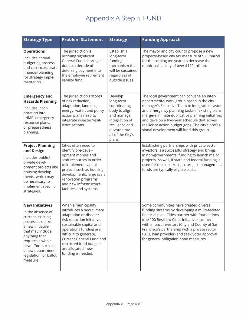
Appendix A | Page 4.10
Appendix A Step 4. FUND
Strategy Type Problem Statement Strategy Funding Approach
Operations
Includes annual budgeting process, and can incorporate financial planning for strategy imple-mentation.
The jurisdiction is accruing significant General Fund shortages due to a decade of deferring payment into the employee retirement liability fund.
Establish a long-term funding mechanism that will be sustained regardless of outside issues.
The mayor and city council propose a new property-based city tax measure of $25/parcel for the coming ten years to decrease the municipal liability of over $120 million.
Emergency and Hazards Planning
Includes incor-poration into LHMP, emergency response plans, or preparedness planning.
The jurisdiction’s scores of risk reduction, adaptation, land use, energy, water, and policy action plans need to integrate disaster/resil-ience actions.
Develop long-term coordinating body to align and manage integration of resilience and disaster into all of the City’s plans.
The local government can convene an inter-departmental work group based in the city manager’s Executive Team to integrate disaster and emergency planning tasks in existing plans, merge/eliminate duplicative planning initiatives and develop a two-year schedule that solves resilience action budget gaps. The city’s profes-sional development will fund this group.
Project Planning and Design
Includes public/private devel-opment projects like housing develop-ments, which may be necessary to implement specific strategies.
Cities often need to identify pre-devel-opment monies and staff resources in order to implement capital projects such as housing developments, large scale renovation programs and new infrastructure facilities and systems.
Establishing partnerships with private sector investors is a successful strategy and brings in non-governmental funding to launch major projects. As well, if state and federal funding is used for the construction, project management funds are typically eligible costs.
New Initiatives
In the absence of current, existing processes utilize a new initiative that may include anything that requires a whole new effort such as a new department, legislation, or ballot measure.
When a municipality introduces a new climate adaptation or disaster risk reduction initiative, sustainable capital and operations funding are difficult to generate. Current General Fund and restricted fund budgets are allocated; new funding is needed.
Some communities have created diverse funding streams by developing a multi-faceted financial plan. Cities partner with foundations (the 100 Resilient Cities initiative), connect with impact investors (City and County of San Francisco’s partnership with a private sector PACE loan provider) and seek voter approval for general obligation bond measures.
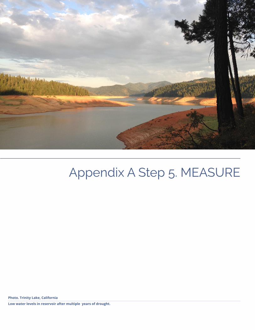
Appendix A Step 5. MEASURE
Photo. Trinity Lake, California
Low water levels in reservoir after multiple years of drought.

Appendix A | Page 5.2
Appendix A Step 5. MEASURE
n Expected OutcomesüAn understanding of how and when to use metrics
üA plan for choosing and implementing metrics in your project
üA timeline for tracking, evaluating, and reporting metrics
üRationale for and benefits of community resilience self-evaluation
üDesigning metrics to help support a living document
n Resources• City Resilience Index: Understanding and measuring city resilience
This document, developed by the Rockefeller Foundation and Arup for 100 Resilient Cities, outlines the concepts behind a comprehensive, technically robust, globally applicable basis for measuring city resil-ience. The index is comprised of 52 indicators, which are assessed based on 156 questions, combining both qualitative and quantitative data. These are aggregated in relation to the 12 goals (or indices) in the Toolkit.
• Community Resilience Organizations Self-Assessment Online Tool This comprehensive assessment will help you understand and prioritize potential actions. It can also help your community track progress over time, as you complete actions and improve resilience. www.gocros.org/community-resilience-selfassessment
• Coastal Community Resilience Indicators and Rating Systems NOAA Office for Coastal Management offers tools and related training for communities starting to assess coastal vulnerabilities as part of a local planning processes. https://coast.noaa.gov/digitalcoast/training/resilience-indicators.html
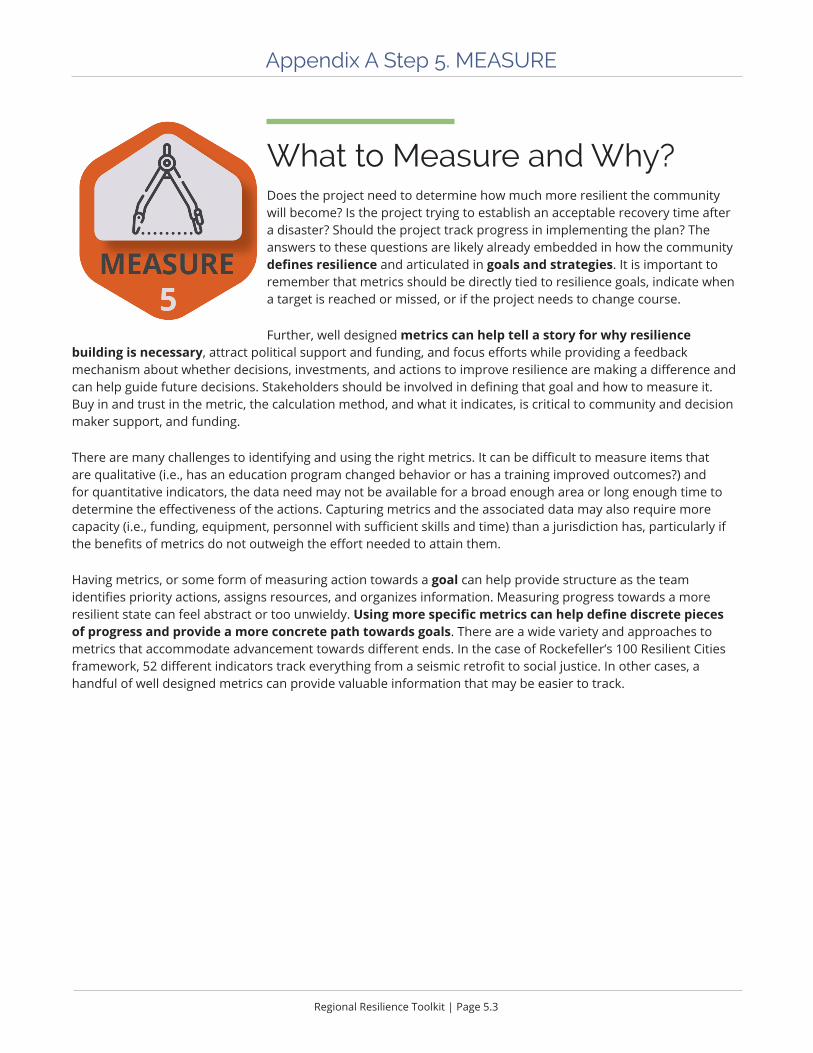
Regional Resilience Toolkit | Page 5.3
Appendix A Step 5. MEASURE
What to Measure and Why?Does the project need to determine how much more resilient the community will become? Is the project trying to establish an acceptable recovery time after a disaster? Should the project track progress in implementing the plan? The answers to these questions are likely already embedded in how the community defines resilience and articulated in goals and strategies. It is important to remember that metrics should be directly tied to resilience goals, indicate when a target is reached or missed, or if the project needs to change course.
Further, well designed metrics can help tell a story for why resilience building is necessary, attract political support and funding, and focus efforts while providing a feedback mechanism about whether decisions, investments, and actions to improve resilience are making a difference and can help guide future decisions. Stakeholders should be involved in defining that goal and how to measure it. Buy in and trust in the metric, the calculation method, and what it indicates, is critical to community and decision maker support, and funding.
There are many challenges to identifying and using the right metrics. It can be difficult to measure items that are qualitative (i.e., has an education program changed behavior or has a training improved outcomes?) and for quantitative indicators, the data need may not be available for a broad enough area or long enough time to determine the effectiveness of the actions. Capturing metrics and the associated data may also require more capacity (i.e., funding, equipment, personnel with sufficient skills and time) than a jurisdiction has, particularly if the benefits of metrics do not outweigh the effort needed to attain them.
Having metrics, or some form of measuring action towards a goal can help provide structure as the team identifies priority actions, assigns resources, and organizes information. Measuring progress towards a more resilient state can feel abstract or too unwieldy. Using more specific metrics can help define discrete pieces of progress and provide a more concrete path towards goals. There are a wide variety and approaches to metrics that accommodate advancement towards different ends. In the case of Rockefeller’s 100 Resilient Cities framework, 52 different indicators track everything from a seismic retrofit to social justice. In other cases, a handful of well designed metrics can provide valuable information that may be easier to track.

REGIONAL RESILIENCE
TOOLKIT
APPENDIX B WORKSHEETS
This appendix was developed as part of the U.S. Environmental Protection Agency’s Regional Resilience Toolkit.

Regional Resilience Toolkit | Page iii
Worksheets
Step 1. ENGAGE ................................................................................................1.11.1 Identify Stakeholders ...................................................................................... 1.2
1.2 Stakeholder Mapping ...................................................................................... 1.6
1.3 Workshop Checklist ......................................................................................... 1.8
Step 2. ASSESS ..................................................................................................2.12.1 Develop Resilience Goals Exercise ................................................................. 2.2
2.2 Develop Hazard Impact Statements ............................................................. 2.4
2.3 Identify Important Community Assets .......................................................... 2.6
2.4 Community Asset Data Identification ........................................................... 2.8
2.5 Vulnerability Assessment Scoping ............................................................... 2.13
2.6 Rapid Vulnerability Assessment Exercise .................................................... 2.15
2.7 Vulnerability Assessment Questions ............................................................ 2.18
2.8 Vulnerability Assessment Questions: Asset Class ....................................... 2.23
Step 3. ACT .......................................................................................................3.13.1 Develop Initial Problem Statements .............................................................. 3.2
3.2 Strategy Idea Sources ..................................................................................... 3.4
3.3 Evaluation Criteria .......................................................................................... 3.8
3.4 Strategy Development and Implementation Handout .............................. 3.10
3.5 Strategy Development and Implementation ............................................................................................. 3.13
Step 4. FUND ...................................................................................................4.14.1 Funder Engagement Inventory ....................................................................... 4.2
4.2 Local Funding Source Inventory .................................................................... 4.4
4.3 Foundation and Other Grant Funding Alignment ....................................... 4.6
Photos: All photos courtesy of BluePoint Planning unless otherwise noted.

Appendix B Step 1. Engage
Photo: Small group exercise
Testing the vulnerability assessment tools at Central Coast Climate Collaborative workshop.
Appendix B | Page 1.2
Appendix B Step 1. Engage Worksheets and Tools
1.1 Identify Stakeholders
Purpose Identify who should participate in the project so that the plan is well supported and leads to an actionable outcome. The stakeholders should represent a variety of voices from those that may be impacted by the project, can help fund or implement the project, or have the authority to make decisions about the project area.
The worksheet identifies three types of project participants: the project team, which leads the project; an advisory group comprised of key stakeholders who will actively participate in the project; and other targeted stakeholders, including interest groups, and leadership and decision makers who need to know about decisions in real time.
Ideally, the project team should work through this worksheet as a group, using the suggested departments and agencies as a starting point. It would be helpful in this exercise to establish guidelines or criteria for identifying participants. Some recommended criteria include:
ü The stakeholder owns an asset that the city cares about
ü The stakeholder has the authority to regulate, make policy, or make decisions about an asset or asset class
ü The stakeholder will be affected by the assessment or potential strategies
ü The stakeholder has the potential to either politically help or hinder the process of assessing hazards and imple-menting strategies
ü The stakeholder has specialized expertise that will help the city with technical questions
ü The stakeholder may be able to provide funding or otherwise assist in implementing strategies
ü The stakeholder represents typically underrepresented community members
ü The stakeholder may be able to make critical connections to other relevant topic areas and/or projects that the project team may not be aware of
ApproachBefore kicking off the project, the project lead should work through this worksheet in conjunction with their manager, or another city authority who will be overseeing or approving the project. The worksheet can be used to establish the internal project team first, then by the full project team once convened.
Outcome1. An initial, comprehensive list of key project participants. This list is adaptable and may change over the course of the
project as more information is gathered but should represent the best understanding of who will be affected by, or have opinions about, the project.
2. An understanding of potential roadblocks or allies within the community who can either slow down or enhance the assessment and/or the implementation of resilience strategies.
3. An initial exercise to bring the project team together and begin working as a team.
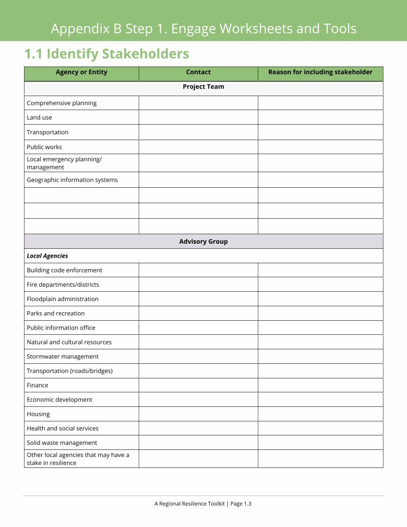
A Regional Resilience Toolkit | Page 1.3
Appendix B Step 1. Engage Worksheets and Tools
Agency or Entity Contact Reason for including stakeholder
Project Team
Comprehensive planning
Land use
Transportation
Public works
Local emergency planning/management
Geographic information systems
Advisory Group
Local Agencies
Building code enforcement
Fire departments/districts
Floodplain administration
Parks and recreation
Public information office
Natural and cultural resources
Stormwater management
Transportation (roads/bridges)
Finance
Economic development
Housing
Health and social services
Solid waste management
Other local agencies that may have a stake in resilience
1.1 Identify Stakeholders

Appendix B | Page 1.4
Appendix B Step 1. Engage Worksheets and Tools
Agency or Entity Contact Reason for including stakeholder
Special Districts and Authorities
Utility districts
Parks districts
Public and private schools
Public and private hospitals
Non-Governmental Organizations
Community-based organizations
Private sector businesses, economic development entities, or business groups
Private utilities
Public-private partnerships or collab-orative
Faith-based organizations
County, State and Federal Partners
State office of emergency services
State energy agency
State office of housing and community development
State planning office
State water agencies
Federal emergency management agency
1.1 Identify Stakeholders

A Regional Resilience Toolkit | Page 1.5
Appendix B Step 1. Engage Worksheets and Tools
Agency or Entity Contact Reason for including stakeholder
Leadership and Decision Makers
City council/board of commissioners
City and/or County planning commission
Other local, regional, or state elected officials
Interest Groups
Environmental groups
Social justice groups
Neighborhood groups
CERT teams
Cultural groups
Adapted from FEMA Worksheet 2.1, Mitigation Planning Team Worksheet
1.1 Identify Stakeholders
Appendix B | Page 1.6
Appendix B Step 1. Engage Worksheets and Tools
1.2 Stakeholder Mapping
Purpose Use this exercise with the project team to map out the relative interest and influence of the project’s primary stake-holders. This exercise is designed to help understand the level of engagement and outreach that will be needed for each stakeholder and to determine stakeholder’s desired or needed participation level. Further this exercise may identify groups that initially are not interested in the project but have high influence or will be heavily impacted by the project. These disconnected stakeholders will require a higher level of engagement and more resources to ensure they become interested enough to participate. This category may apply to disadvantaged communities or high level stakeholders.
Approach
After completing the worksheet 1.1 Identify Stakeholders, map those stakeholders’ interests (or potential level of impact) and influence levels. This will help to develop targeted and effective strategies for each audience. Update during the process as more information becomes available. (Use additional sheets as needed)
OutcomeThis exercise will result in a better understanding of the needs for various audiences and help to develop engagement strategies targeted to the particular needs of each stakeholder or stakeholder group.

A Regional Resilience Toolkit | Page 1.7
Appendix B Step 1. Engage Worksheets and Tools
1.2 Stakeholder Mapping
High Influence/Impact, Low Interest: Keep Satisfied, Targeted Engagement
Low Influence/Low Impact, Low Interest: Monitor and Share Information
High Influence/Impact, High Interest: Manage Closely, Engage Deeply
Low Influence/Low Impact, High Interest: Keep Informed, Consult
Appendix B | Page 1.8
Appendix B Step 1. Engage Worksheets and Tools
1.3 Workshop Checklist
Purpose Use this Workshop Checklist to help organize and plan a workshop or meeting and to ensure that the practical details are covered beforehand, and that all of the necessary materials and tools are prepared for the day of the workshop. It also helps to plan for the meeting room layout and coordinate efforts with the meeting venue staff.
ApproachThe outreach lead should be in charge of the Workshop checklist and work with the team, venue staff, and any consul-tants to review what will be necessary for the workshop and who will be responsible for each item. The group should determine how the room will be laid out and indicate that on the second page.
Outcome ü Clear roles and responsibilities for managing workshop logistics and ensure all necessary materials are available
ü Single list for anyone to help with meeting logistics
ü Meeting room layout
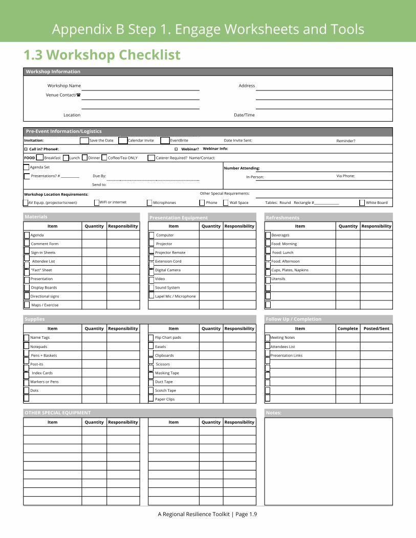
A Regional Resilience Toolkit | Page 1.9
Appendix B Step 1. Engage Worksheets and Tools
Workshop Checklist
Workshop Name Address
Venue Contact/(
Location Date/Time
Invitation: o Save the Date o Calendar Invite o EventBrite Reminder?
o Call in? Phone#: o Webinar? Webinar Info:
o Agenda Set
o Presentations? # ___________ Due By: In-Person: Via Phone:
Send to:
Workshop Location Requirements: Other Special Requirements:
o AV Equip. (projector/screen) o Microphones o Phone o Wall Space o White Board
Presentation Equipment Refreshments
Item Quantity Responsibility Item Quantity Responsibility Item Quantity Responsibility
o Agenda o Computer o Beverages
o Comment Form o Projector o Food: Morning
o Sign-in Sheets o Projector Remote o Food: Lunch
o Attendee List o Extension Cord o Food: Afternoon
o "Fact" Sheet o Digital Camera o Cups, Plates, Napkins
o Presentation o Video o Utensils
o Display Boards o Sound System o
o Directional signs o Lapel Mic / Microphone o
o Maps / Exercise o
Item Quantity Responsibility Item Quantity Responsibility Item Complete Posted/Sent
o Name Tags o Flip Chart pads o Meeting Notes
o Notepads o Easels o Attendees List
o Pens + Baskets o Clipboards o Presentation Links
o Post-its o Scissors o
o Index Cards o Masking Tape o
o Markers or Pens o Duct Tape o
o Dots o Scotch Tape o
o o Paper Clips o
Item Quantity Responsibility Item Quantity Responsibility
Tables: Round Rectangle #_______________
o Caterer Required? Name/Contact:
Supplies
OTHER SPECIAL EQUIPMENT Notes:
Materials
Follow Up / Completion
Pre-Event Information/Logistics
Number Attending:
Date Invite Sent:
FOOD o Breakfast o Lunch o Dinner o Coffee/Tea ONLY
o WiFI or internet
Workshop Information
1.3 Workshop Checklist

Appendix B | Page 1.10
Appendix B Step 1. Engage Worksheets and ToolsWorkshop Checklist
SampleRoomSet-ups
SmallGroupWorkshop AdvisoryGroupWorkshop
PanelPresentationWorkshop
LargeGroupWorkshop
Presentation screen Presentation screen
Presentation screen
Facilitator table
Facilitatortable
Facilitator table
Facilitatortable
1.3 Workshop Checklist

Appendix B Step 2. ASSESS
Photo. Emigrant National Wilderness, California
Reduced snow and drought conditions increased potential for wildfires and tree vulnerabilities.
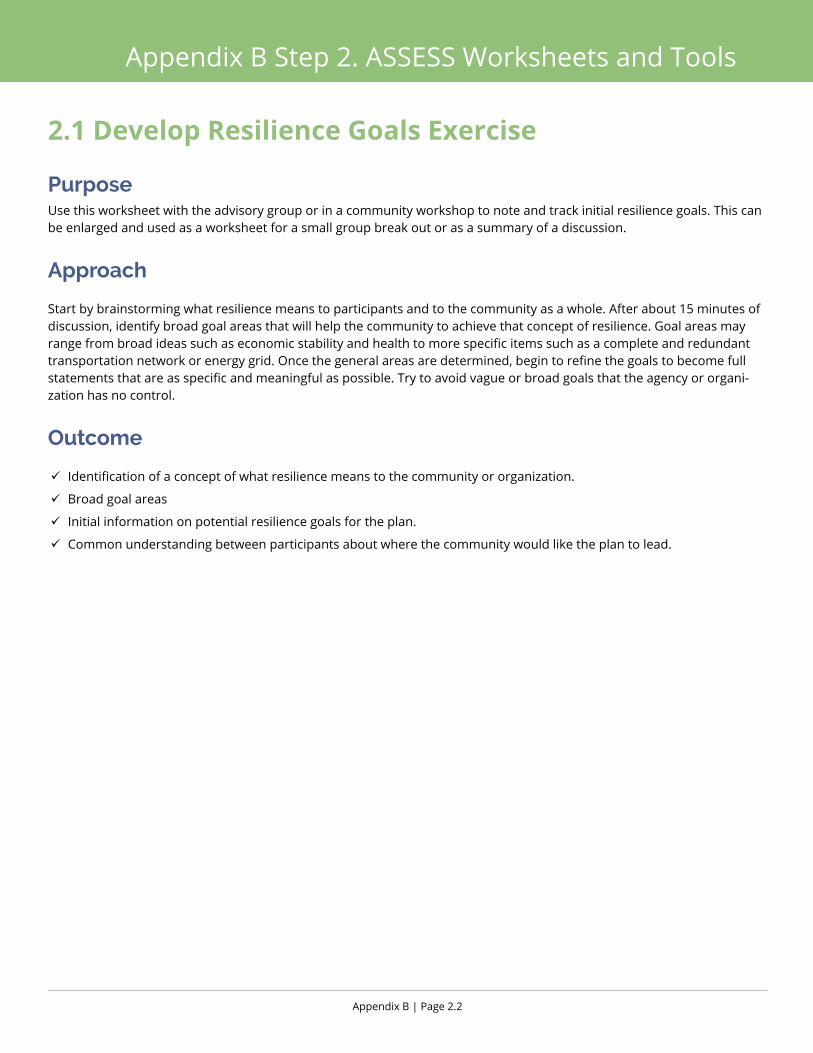
Appendix B | Page 2.2
Appendix B Step 2. ASSESS Worksheets and Tools
2.1 Develop Resilience Goals Exercise
Purpose Use this worksheet with the advisory group or in a community workshop to note and track initial resilience goals. This can be enlarged and used as a worksheet for a small group break out or as a summary of a discussion.
Approach
Start by brainstorming what resilience means to participants and to the community as a whole. After about 15 minutes of discussion, identify broad goal areas that will help the community to achieve that concept of resilience. Goal areas may range from broad ideas such as economic stability and health to more specific items such as a complete and redundant transportation network or energy grid. Once the general areas are determined, begin to refine the goals to become full statements that are as specific and meaningful as possible. Try to avoid vague or broad goals that the agency or organi-zation has no control.
Outcome
ü Identification of a concept of what resilience means to the community or organization.
ü Broad goal areas
ü Initial information on potential resilience goals for the plan.
ü Common understanding between participants about where the community would like the plan to lead.
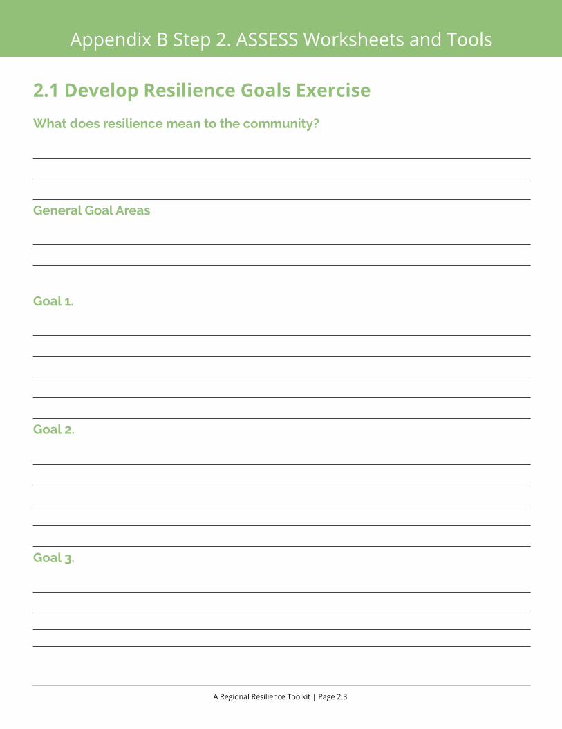
A Regional Resilience Toolkit | Page 2.3
Appendix B Step 2. ASSESS Worksheets and Tools
2.1 Develop Resilience Goals ExerciseWhat does resilience mean to the community?
General Goal Areas
Goal 1.
Goal 2.
Goal 3.
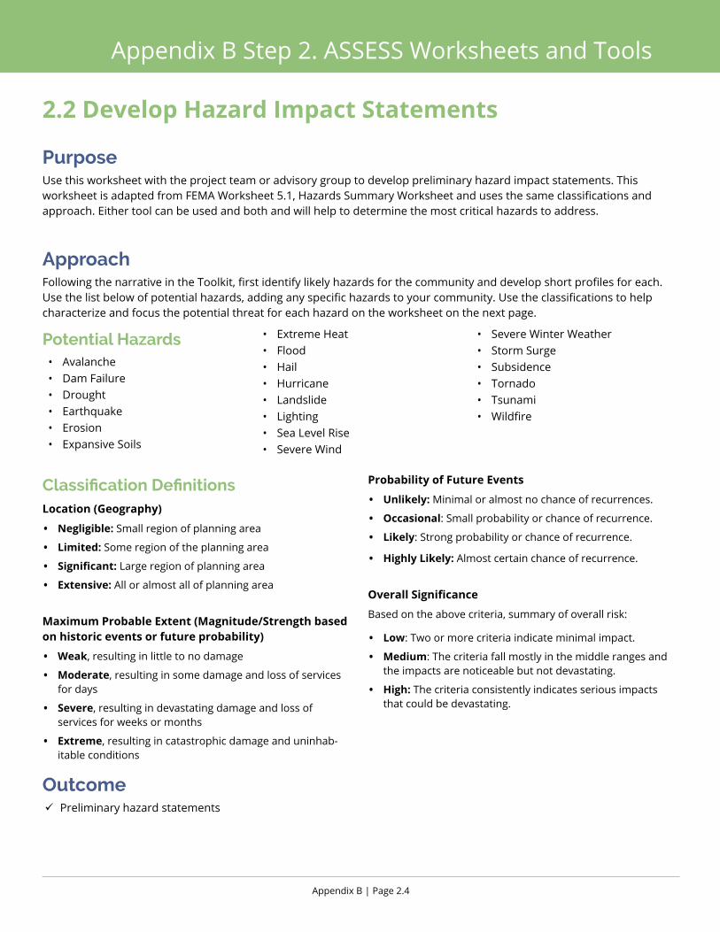
Appendix B | Page 2.4
Appendix B Step 2. ASSESS Worksheets and Tools
2.2 Develop Hazard Impact Statements
Purpose Use this worksheet with the project team or advisory group to develop preliminary hazard impact statements. This worksheet is adapted from FEMA Worksheet 5.1, Hazards Summary Worksheet and uses the same classifications and approach. Either tool can be used and both and will help to determine the most critical hazards to address.
ApproachFollowing the narrative in the Toolkit, first identify likely hazards for the community and develop short profiles for each. Use the list below of potential hazards, adding any specific hazards to your community. Use the classifications to help characterize and focus the potential threat for each hazard on the worksheet on the next page.
Outcome ü Preliminary hazard statements
Potential Hazards• Avalanche• Dam Failure• Drought• Earthquake• Erosion• Expansive Soils
• Extreme Heat• Flood• Hail• Hurricane• Landslide• Lighting• Sea Level Rise• Severe Wind
• Severe Winter Weather• Storm Surge• Subsidence• Tornado• Tsunami• Wildfire
Classification DefinitionsLocation (Geography)
• Negligible: Small region of planning area
• Limited: Some region of the planning area
• Significant: Large region of planning area
• Extensive: All or almost all of planning area
Maximum Probable Extent (Magnitude/Strength based on historic events or future probability)
• Weak, resulting in little to no damage
• Moderate, resulting in some damage and loss of services for days
• Severe, resulting in devastating damage and loss of services for weeks or months
• Extreme, resulting in catastrophic damage and uninhab-itable conditions
Probability of Future Events
• Unlikely: Minimal or almost no chance of recurrences.
• Occasional: Small probability or chance of recurrence.
• Likely: Strong probability or chance of recurrence.
• Highly Likely: Almost certain chance of recurrence.
Overall Significance
Based on the above criteria, summary of overall risk:
• Low: Two or more criteria indicate minimal impact.
• Medium: The criteria fall mostly in the middle ranges and the impacts are noticeable but not devastating.
• High: The criteria consistently indicates serious impacts that could be devastating.
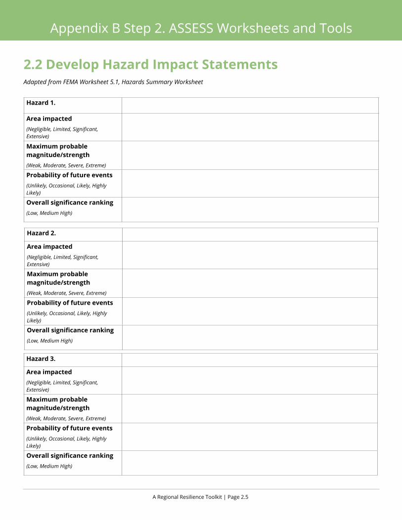
A Regional Resilience Toolkit | Page 2.5
Appendix B Step 2. ASSESS Worksheets and Tools
Hazard 2.
Area impacted(Negligible, Limited, Significant, Extensive)
Maximum probable magnitude/strength(Weak, Moderate, Severe, Extreme)
Probability of future events(Unlikely, Occasional, Likely, Highly Likely)
Overall significance ranking (Low, Medium High)
Hazard 3.
Area impacted(Negligible, Limited, Significant, Extensive)
Maximum probable magnitude/strength(Weak, Moderate, Severe, Extreme)
Probability of future events(Unlikely, Occasional, Likely, Highly Likely)
Overall significance ranking (Low, Medium High)
Hazard 1.
Area impacted(Negligible, Limited, Significant, Extensive)
Maximum probable magnitude/strength(Weak, Moderate, Severe, Extreme)
Probability of future events(Unlikely, Occasional, Likely, Highly Likely)
Overall significance ranking (Low, Medium High)
2.2 Develop Hazard Impact Statements Adapted from FEMA Worksheet 5.1, Hazards Summary Worksheet

Appendix B | Page 2.6
Appendix B Step 2. ASSESS Worksheets and Tools
2.3 Identify Important Community Assets
Purpose Use this worksheet with the advisory group or in a community meeting to develop an initial listing of important community assets. This worksheet can be enlarged for small group discussions.
ApproachUsing the Toolkit as a guide, use the table to begin documenting the community’s assets. For each asset, determine if it is a single asset (e.g., City Hall), a class of assets (e.g., schools), or a representative asset (e.g., secondary roadway). Determine the level of vulnerability of each asset to the hazards identified. Finally, note how the asset functions in the community. For example, does the asset serve all the community with a critical service (e.g., hospital), does it serve a neighborhood only as a mostly recreational element (e.g., a park) or is it for a special subset of the community (e.g., senior housing). Build off the asset classes on Figure 31 in the Toolkit and identify those most critical to the community. (Use additional pages as needed)
Outcome ü Initial list of community assets to evaluate and incorporate into the plan.
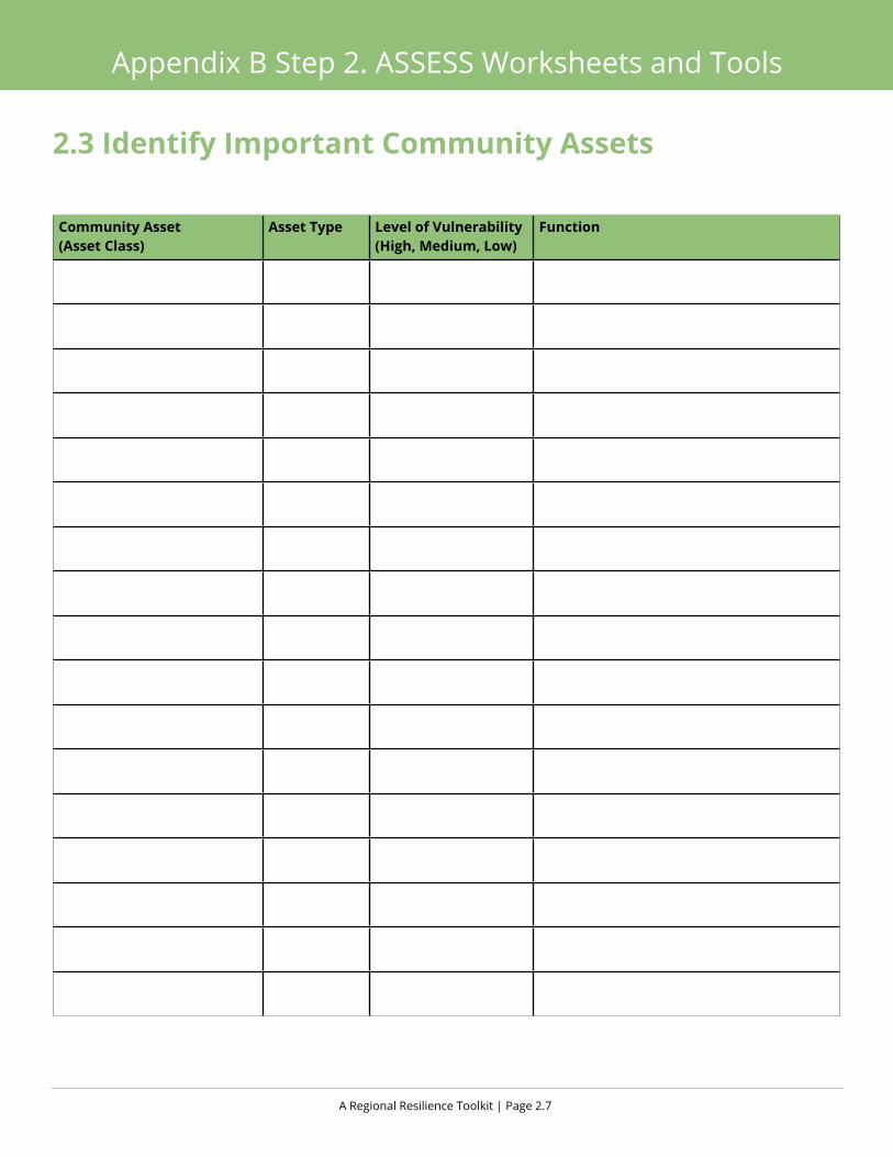
A Regional Resilience Toolkit | Page 2.7
Appendix B Step 2. ASSESS Worksheets and Tools
2.3 Identify Important Community Assets
Community Asset (Asset Class)
Asset Type Level of Vulnerability (High, Medium, Low)
Function

Appendix B | Page 2.8
Appendix B Step 2. ASSESS Worksheets and Tools
2.4 Community Asset Data Identification
PurposeHave a general sense of the types of assets in the community to help guide the vulnerability assessment and focus resources in areas with the most impact. Gathering information on assets now can also help to identify where data gaps exist.
ApproachWork through this worksheet with the project team or have a team member tasked with data collection to work through the worksheet and review with the team. For the asset class column, check off the boxes of the asset classes and sub-classes to include in the assessment. In the Data Sources column, check off sources that apply to the community that might contain the data needed to assess the asset classes accurately.
OutcomeAfter completing this worksheet with the team, the scope of the assessment should be clear (which asset classes you think you will include) as well as where to find the data and if data gaps exist. In some cases, data may not be available for all the asset classes. If this is the case, decide whether to include the asset class; if so, what kind of resources will it take to find new sources of data?

A Regional Resilience Toolkit | Page 2.9
Appendix B Step 2. ASSESS Worksheets and Tools
Asset Class: People Data Sources ¨ Total population – current and future ¨ U.S. Census
¨ American community survey
¨ Regional Association of Governments (ie. ABAG, SCAG)
¨ Priority development areas
¨ County quick facts
¨ Local general plan or specific plans
¨ Local housing element
¨ Local zoning code
Population with access or functional needs, including:
¨ Age dependent, children and seniors
¨ Medically or mobility dependent
¨ Language constraints
¨ Low income
¨ Lack of education
¨ Culture or ethnicity
¨ Cost burdened (housing and/or transportation)
¨ Transit dependent (no car)
¨ Housing tenure (renters)
¨ U.S. Census
¨ American community survey
¨ County health department status reports
¨ Local general plan or specific plans
¨ Local studies
¨ Local housing element
¨ Local hazard mitigation plan
¨ Nonprofit or community based organizations
Asset Class: Building Stock Data Sources ¨ Publicly owned buildings ¨ County tax assessor parcel data
Privately owned buildings: ¨ Residential buildings, e.g., single and multi family, mobile homes, senior and dependent housing
¨ Nonresidential buildings, e.g., industrial, commercial or institutional structures
¨ U.S. Census
¨ American community survey
¨ County tax assessor parcel data
¨ Local general plan or specific plans
¨ Local housing element
¨ Local zoning code
¨ Google Earth/Maps
¨ Future buildings, growth areas and infrastructure ¨ Regional association of governments
¨ Priority development areas
¨ Capital plans
¨ City and county budgets
¨ Local general plan or specific plans
¨ Local housing element
¨ Local zoning code
¨ Local growth boundaries or growth phasing ordinances
2.4 Community Asset Data Identification
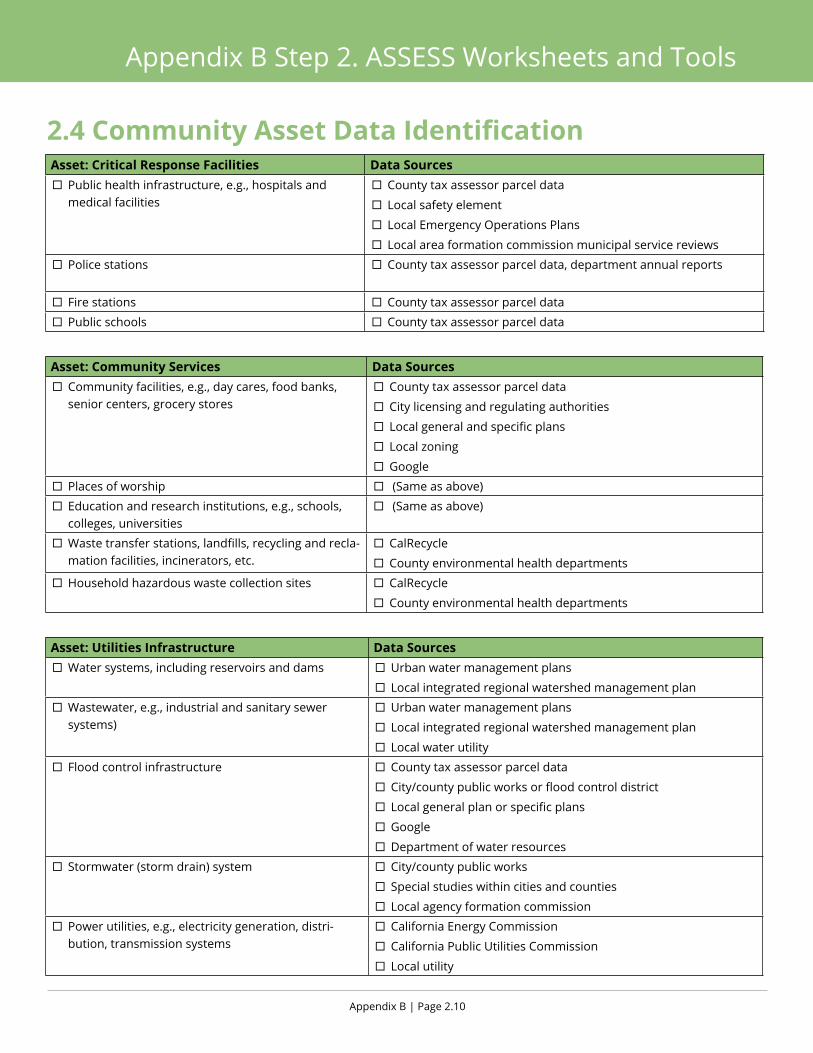
Appendix B | Page 2.10
Appendix B Step 2. ASSESS Worksheets and Tools
Asset: Critical Response Facilities Data Sources ¨ Public health infrastructure, e.g., hospitals and medical facilities
¨ County tax assessor parcel data
¨ Local safety element
¨ Local Emergency Operations Plans
¨ Local area formation commission municipal service reviews
¨ Police stations ¨ County tax assessor parcel data, department annual reports
¨ Fire stations ¨ County tax assessor parcel data
¨ Public schools ¨ County tax assessor parcel data
Asset: Community Services Data Sources ¨ Community facilities, e.g., day cares, food banks, senior centers, grocery stores
¨ County tax assessor parcel data
¨ City licensing and regulating authorities
¨ Local general and specific plans
¨ Local zoning
¨ Places of worship ¨ (Same as above)
¨ Education and research institutions, e.g., schools, colleges, universities
¨ (Same as above)
¨ Waste transfer stations, landfills, recycling and recla-mation facilities, incinerators, etc.
¨ CalRecycle
¨ County environmental health departments
¨ Household hazardous waste collection sites ¨ CalRecycle
¨ County environmental health departments
Asset: Utilities Infrastructure Data Sources ¨ Water systems, including reservoirs and dams ¨ Urban water management plans
¨ Local integrated regional watershed management plan
¨ Wastewater, e.g., industrial and sanitary sewer systems)
¨ Urban water management plans
¨ Local integrated regional watershed management plan
¨ Local water utility
¨ Flood control infrastructure ¨ County tax assessor parcel data
¨ City/county public works or flood control district
¨ Local general plan or specific plans
¨ Department of water resources
¨ Stormwater (storm drain) system ¨ City/county public works
¨ Special studies within cities and counties
¨ Local agency formation commission
¨ Power utilities, e.g., electricity generation, distri-bution, transmission systems
¨ California Energy Commission
¨ California Public Utilities Commission
¨ Local utility
2.4 Community Asset Data Identification

A Regional Resilience Toolkit | Page 2.11
Appendix B Step 2. ASSESS Worksheets and Tools
¨ Pipelines, e.g., fuel and natural gas ¨ National Pipeline Mapping System
¨ California Energy Commission
¨ Kinder Morgan
¨ Oil refineries ¨ EPA
¨ Air Resources Board
¨ State employment statistics
¨ County and city general plans
Asset: Transportation Infrastructure Data Sources ¨ Local streets and roads ¨ Transportation element
¨ Federal and state highways ¨ Metropolitan Transportation Commission 2011TeleAtlas
¨ CA Department of Transportation
¨ Bridges, tubes and tunnels ¨ CA Department of Transportation
¨ Local toll authority
¨ Railroads, passenger and freight lines ¨ Metropolitan Transportation Commission 2011TeleAtlas
¨ Amtrak
¨ Regional transportation agency
¨ Transit services (bus, BART, light rail) ¨ Metropolitan Transportation Commission 2011TeleAtlas
¨ Local transit agency
¨ Ferry service ¨ Highway and transportation district
¨ Water emergency transportation authority
¨ Bike/pedestrian routes ¨ Local general plan
¨ Bicycle, trail, and walkability Ppans
¨ Parks and recreation plan
¨ Airport ¨ Federal Aviation Administration
¨ Regional airport planning committee
¨ Seaports and marine terminals
Asset: Communication Infrastructure Data Sources ¨ Land line telephone systems ¨ Communication service providers
¨ Cable systems ¨ Communication service providers
¨ Cellular telephone antennae ¨ Communication service providers
¨ Underground communication conduits ¨ Communication service providers Asset: Recreation, Open Space and Working Lands Data Sources
¨ Park and recreation facilities ¨ California protected areas database
¨ Parks and recreation master plan
¨ Designated open space ¨ California protected areas database
¨ Conservation lands network explorer tool
¨ General plan open space element
2.4 Community Asset Data Identification
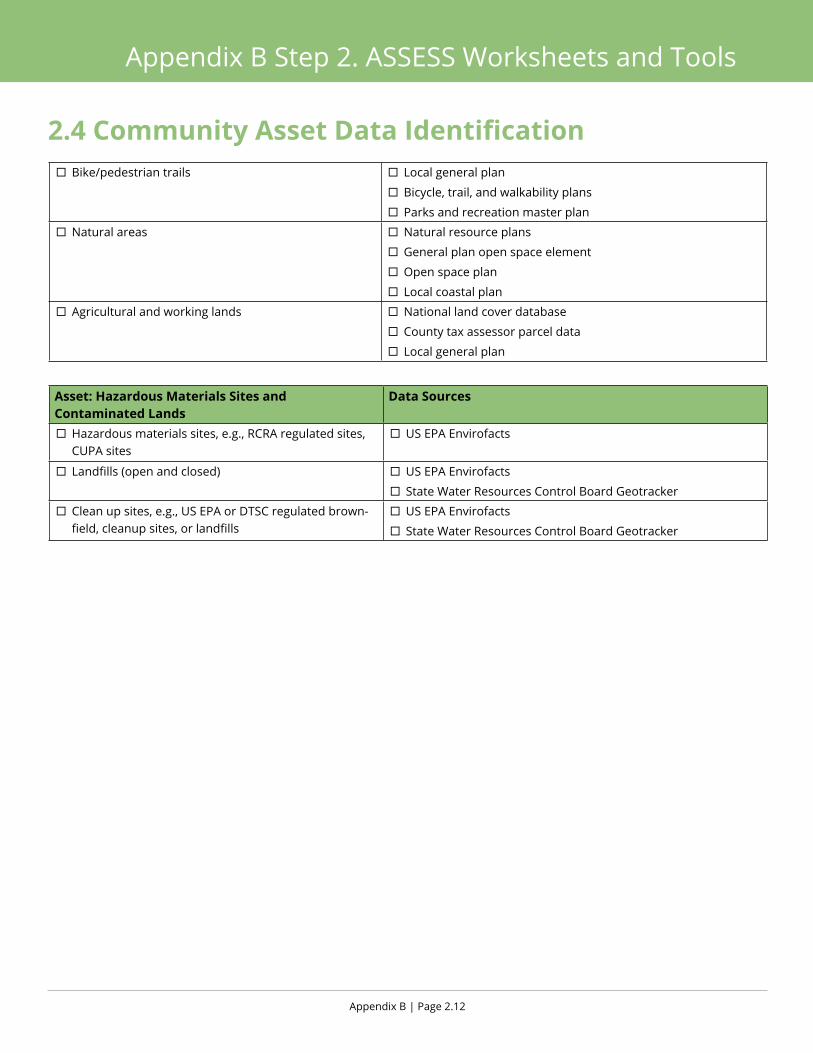
Appendix B | Page 2.12
Appendix B Step 2. ASSESS Worksheets and Tools
¨ Bike/pedestrian trails ¨ Local general plan
¨ Bicycle, trail, and walkability plans
¨ Parks and recreation master plan
¨ Natural areas ¨ Natural resource plans
¨ General plan open space element
¨ Open space plan
¨ Local coastal plan
¨ Agricultural and working lands ¨ National land cover database
¨ County tax assessor parcel data
¨ Local general plan
Asset: Hazardous Materials Sites and Contaminated Lands
Data Sources
¨ Hazardous materials sites, e.g., RCRA regulated sites, CUPA sites
¨ US EPA Envirofacts
¨ Landfills (open and closed) ¨ US EPA Envirofacts
¨ State Water Resources Control Board Geotracker
¨ Clean up sites, e.g., US EPA or DTSC regulated brown-field, cleanup sites, or landfills
¨ US EPA Envirofacts
¨ State Water Resources Control Board Geotracker
2.4 Community Asset Data Identification
A Regional Resilience Toolkit | Page 2.13
Appendix B Step 2. ASSESS Worksheets and Tools
2.5 Vulnerability Assessment Scoping
Purpose
Use this scoping worksheet to help plan and scope the community’s vulnerability assessment. Regulatory triggers, the interests of stakeholders, community goals, internal capacity, and availability of asset data are all factors that may influence the scope of the assessment.
ApproachIt is recommended to work through this worksheet as a team. Use the community’s goals and the results of the Community Asset Data Identification Worksheet to help determine the degree of analysis to perform on each asset type. For each asset type, put a check box in the column of the most in-depth assessment possible (or would like to achieve) for that asset type. Also note whether or not assessing that asset will help meet community goals, and whether or not the data is available or if data gaps exist.
OutcomeUpon completion of this worksheet, the team will have a road map that will help plan and execute the vulnerability assessment.

Appendix B | Page 2.14
Appendix B Step 2. ASSESS Worksheets and Tools
Assets Exposure Analysis
Assessment Questions Would assessing this asset help achieve the
community’s goals?
Is there sufficient data available to conduct the assessment?
Individual Asset
Individual Asset
Asset Class Represent. Assets
Publicly owned buildings X
Critical response facilities X
Police
Fire
Public schools
Public health facilities
Residential buildings
Non-residential buildings
People
Total population
Population with access or functional needs
Community services
Utility infrastructure
Power
Water supply
Wastewater
Waste management facilities
Stormwater/flood control
Transportation
Roads
Rail
Seaport
Airport
Bike/pedestrian routes
Communication
Recreation, open space and working lands
Hazardous materials sites and contaminated lands
2.5 Vulnerability Assessment Scoping
A Regional Resilience Toolkit | Page 2.15
Appendix B Step 2. ASSESS Worksheets and Tools
2.6 Rapid Vulnerability Assessment Exercise
Purpose
This exercise is intended to familiarize the project team and/or advisory group with the types of information that is needed to conduct the assessment. This Rapid Vulnerability Assessment Exercise expedites and simplifies the Vulnerability Assessment questions to provide a quick overview of the vulnerability of an asset. It is designed to be used with a hypothetical asset and hazard, though community specifics can be used. This is designed to be a warm-up exercise, not a substitute for doing a more detailed vulnerability assessment on any asset or asset class.
ApproachUse this exercise in a workshop or group setting with the project team and/or advisory group. Have people work in small groups of 2-3 with either a hypothetical asset or a specific asset. The team may want to walk through each section and describe what people should be thinking through in each section and/or have each group talk through their results. This worksheet can be used to do a preliminary assessment to identify gaps in stakeholder representation and/or data necessary for assessments.
OutcomeThis exercise is designed to give users a sense of how to proceed with a more in-depth asset vulnerability assessment. It is not intended to provide a detailed assessment on any asset or asset class.

Appendix B | Page 2.16
Appendix B Step 2. ASSESS Worksheets and Tools
Asset:
Hazard (note past occurrences): Hazard impact statement:
Existing ConditionsDescribe the asset and highlight current conditions or stressors that could affect vulnerabilityPhysical asset functions (e.g., type of land use, community served, services provided):
Type: ¨ Residential
¨ Institutional
¨ Industrial
¨ Commercial
¨ Other:
Community Served (e.g., public, elderly):
Who owns the asset? Are owner and manager different?
Owner: ¨ Public
¨ Private
Manager: ¨ Public
¨ Private
¨ Different than owner? If so, explain:
What is the current condition of the asset? Has it recently been upgraded or retrofitted?
¨ Yes o No
If yes, explain when and to what standard:
Physical VulnerabilitiesIdentify conditions or design aspects that make an asset particularly vulnerable to impactsWhat characteristics make the asset more or less vulnerable to hazard? Examples include water or salt-sensitive mechanical components, flammable building materials, or location access.
2.6 Rapid Vulnerability Assessment Exercise

A Regional Resilience Toolkit | Page 2.17
Appendix B Step 2. ASSESS Worksheets and Tools
Functional VulnerabilitiesDescribe asset function and/or relationships with or dependence on other assets that can make them vulnerable to impactsIs the asset part of a networked system such that damage to other parts of the system would affect the asset’s ability to function?
¨ Yes o No
If yes, are there alternatives to help maintain continuity of service?
What external services does the asset rely on?
¨ Power
¨ Communications
¨ Food
¨ Water
¨ Fuel
¨ Materials/supplies
¨ Transportation
¨ Other:
If external services were interrupted, are there back up supplies in place?
¨ Yes o No
If yes, how long would they last (circle one): Hours Days Weeks
Governance VulnerabilitiesDescribe challenges with management, regulatory authority, or funding options for adapting to impactsIs the asset protected by land or assets owned by others?
¨ Yes o No If yes, describe:
What types of permits and from what agencies are necessary to maintain, repair or improve the asset?
¨ One agency
¨ Multiple agencies (circle): Local State Regional Federal
Are there funding sources that can be used to assess hazard risk, climate vulnerability or resilience?
¨ Yes o No If yes, describe:
ConsequencesDescribe potential impacts on society, equity, the economy, and the environmentWhat scale of economic disruption would occur if the asset was damaged, disrupted, or failed?
¨ Local
¨ Regional
¨ State
¨ National
Is this based on a past event or an unplanned disruption? If yes, describe:
Who in the community would be affected by damage, disruption, or loss of asset function?
¨ People where the live
¨ People where they work
¨ People where they recreate
¨ Elderly
¨ Youth
¨ Low income
¨ Other:
What would the consequences be to ecological services be if the asset was damaged or lost?
¨ Habitat or species benefits
¨ Public access
¨ Flood risk management
¨ Water quality
¨ Other:
2.6 Rapid Vulnerability Assessment Exercise
Appendix B | Page 2.18
Appendix B Step 2. ASSESS Worksheets and Tools
2.7 Vulnerability Assessment Questions: Individual or Representative Assets
PurposeAssessment questions help to understand the underlying causes and components of vulnerability and the potential consequences of those vulnerabilities. The team can answer assessment questions in a very detailed way for individual assets that either a visual map inspection or a geospatial analysis has identified as being exposed to a hazard.
Many of the assessment questions are broad and apply to all types of assets, while some are specific to a particular hazard or type of asset, so the team will not need to answer all of the questions for all assets. In addition, some questions can easily be answered with readily available information, while others will require research or external input. It can be difficult to know how much effort to expend when answering assessment questions. Instead of spending a lot of effort to uncover hard-to-find, or in some cases nonexistent information, flag critical data needs and knowledge gaps that require further consideration and come back to these when developing the mitigation and adaptation actions.
ApproachProject team members should first fill out the assessment question worksheet as thoroughly as possible with readily available information. Then, provide a copy of the worksheet to the asset owner or manager to verify and provide additional information. A project team member should then discuss the answers with the owner or manager to ensure an accurate understanding of the assessment answers.
Outcome Once completed, this worksheet will provide the project team all the information it needs to write a profile sheet for each selected asset that highlights its primary vulnerabilities.

A Regional Resilience Toolkit | Page 2.19
Appendix B Step 2. ASSESS Worksheets and Tools
Existing Conditions Describe the asset and highlight current conditions or stressors that could affect vulnerability1. Who owns and manages the asset? Note if the owner and manager are different entities.
2. What year was the asset built? What is the remaining service life?
3. Has there been an effort to extend the service life (e.g. improvements, seismic retrofit, mitigation actions)? If so, describe what was done and when.
Physical Vulnerabilities Identify conditions or design aspects that make an asset particularly vulnerable to impacts4. Does the asset have characteristics that make it vulnerable?
- 4a. Are there water or salt sensitive components of the asset are at-grade or below-grade, e.g., mechanical or electrical equipment, pumps, utilities, building heat, ventilation, power systems, or finished basements?
- 4b. Does the asset have openings are at-grade or below-grade that are entry points for flooding, e.g., entryways, tubes, tunnels, ventilation grates?
- 4c. Are their barriers (temporary or permanent) that can protect sensitive components or at- or below-grade entry points? Are there pumps or other systems in place to remove floodwaters if they do enter?
For building assets:5. Does the asset have characteristics that make it vulnerable to earthquakes or fires?
- 5a. Is the facility or building a mobile or manufactured structure? If yes, describe the foundation type.
- 5b. Is the facility or building constructed from unreinforced masonry? If yes, describe how and if seismic hazards have been assessed and/or mitigated.
2.7 Vulnerability Assessment Questions
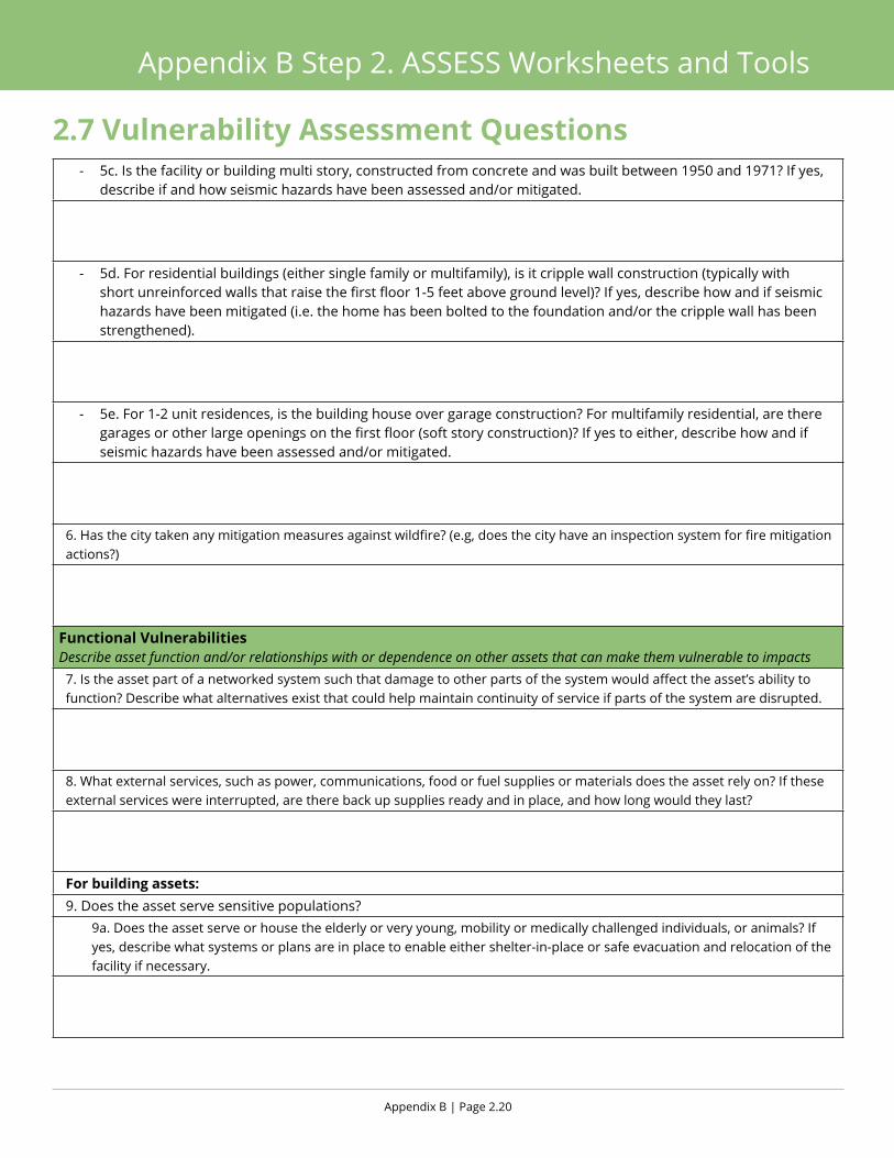
Appendix B | Page 2.20
Appendix B Step 2. ASSESS Worksheets and Tools
- 5c. Is the facility or building multi story, constructed from concrete and was built between 1950 and 1971? If yes, describe if and how seismic hazards have been assessed and/or mitigated.
- 5d. For residential buildings (either single family or multifamily), is it cripple wall construction (typically with short unreinforced walls that raise the first floor 1-5 feet above ground level)? If yes, describe how and if seismic hazards have been mitigated (i.e. the home has been bolted to the foundation and/or the cripple wall has been strengthened).
- 5e. For 1-2 unit residences, is the building house over garage construction? For multifamily residential, are there garages or other large openings on the first floor (soft story construction)? If yes to either, describe how and if seismic hazards have been assessed and/or mitigated.
6. Has the city taken any mitigation measures against wildfire? (e.g, does the city have an inspection system for fire mitigation actions?)
Functional VulnerabilitiesDescribe asset function and/or relationships with or dependence on other assets that can make them vulnerable to impacts7. Is the asset part of a networked system such that damage to other parts of the system would affect the asset’s ability to function? Describe what alternatives exist that could help maintain continuity of service if parts of the system are disrupted.
8. What external services, such as power, communications, food or fuel supplies or materials does the asset rely on? If these external services were interrupted, are there back up supplies ready and in place, and how long would they last?
For building assets:9. Does the asset serve sensitive populations?
9a. Does the asset serve or house the elderly or very young, mobility or medically challenged individuals, or animals? If yes, describe what systems or plans are in place to enable either shelter-in-place or safe evacuation and relocation of the facility if necessary.
2.7 Vulnerability Assessment Questions

A Regional Resilience Toolkit | Page 2.21
Appendix B Step 2. ASSESS Worksheets and Tools
- 9b. Does the asset serve or house community members that are resource limited, e.g., are they low or very low income, housing or transportation cost burdened, renters, or without a car? If yes, what programs or plans in place to help these members prepare for, respond to, or recover from a hazard event?
- 9c. Does the asset serve or house community members that are ethnically or culturally diverse, have limited English-speaking capacity, or are non-English speakers? If yes, what programs or plans in place to help these members prepare for, respond to, or recover from a hazard event?
For transportation assets:10. Does the asset serves as a critical access road, emergency or lifeline route, provide sole or limited access to communities or facilities, or provide service to transit dependent communities? If yes, describe the communities, services, and facilities the asset serves.
For recreation, open space, and working lands:11. Does the asset provide recreational access or opportunities that are unique or limited in the area and/or region, e.g., access for persons with limited mobility, interpretive programs, access to the Bay, etc.? Could these functions be easily replaced in other areas?
12. Does the asset provide or protect habitat for threatened or endangered species? Is this habitat scarce in the region? Could this habitat be established in other areas?
For utility and communication infrastructure assets:13. Does the asset provide critical services to sensitive populations (see question 9), emergency response providers, or critical facilities?
2.7 Vulnerability Assessment Questions
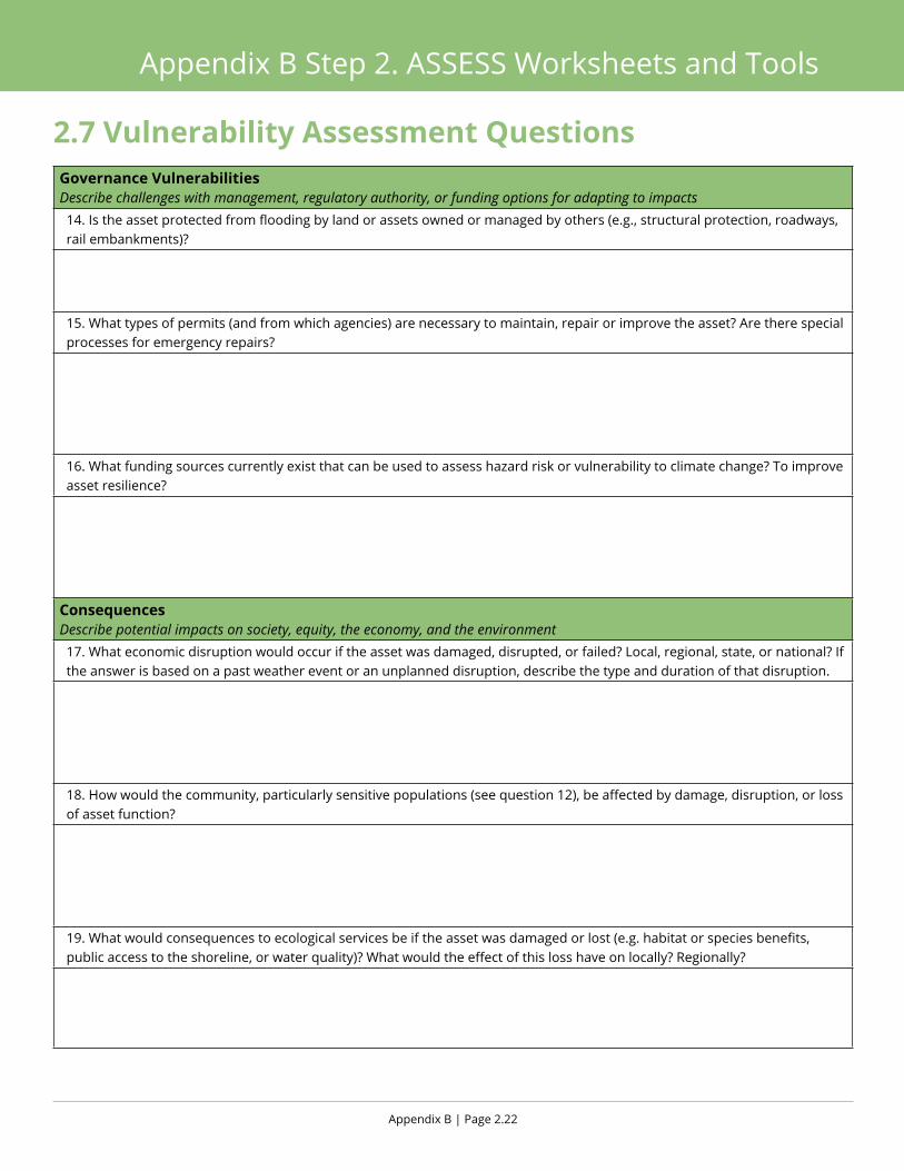
Appendix B | Page 2.22
Appendix B Step 2. ASSESS Worksheets and Tools
Governance VulnerabilitiesDescribe challenges with management, regulatory authority, or funding options for adapting to impacts 14. Is the asset protected from flooding by land or assets owned or managed by others (e.g., structural protection, roadways, rail embankments)?
15. What types of permits (and from which agencies) are necessary to maintain, repair or improve the asset? Are there special processes for emergency repairs?
16. What funding sources currently exist that can be used to assess hazard risk or vulnerability to climate change? To improve asset resilience?
Consequences Describe potential impacts on society, equity, the economy, and the environment17. What economic disruption would occur if the asset was damaged, disrupted, or failed? Local, regional, state, or national? If the answer is based on a past weather event or an unplanned disruption, describe the type and duration of that disruption.
18. How would the community, particularly sensitive populations (see question 12), be affected by damage, disruption, or loss of asset function?
19. What would consequences to ecological services be if the asset was damaged or lost (e.g. habitat or species benefits, public access to the shoreline, or water quality)? What would the effect of this loss have on locally? Regionally?
2.7 Vulnerability Assessment Questions
A Regional Resilience Toolkit | Page 2.23
Appendix B Step 2. ASSESS Worksheets and Tools
2.8 Vulnerability Assessment Questions: Asset Class
PurposeAssessment questions help to understand the underlying causes and components of vulnerability and the potential consequences of those vulnerabilities. These questions are designed to guide the assessment of an asset class, for example public facilities, residential land uses, parks or ground transportation systems.
Many of the assessment questions are broad and could apply to any asset class, while some are specific to particular types of assets, so the team will not need to answer all of the questions for a given asset class. While some answers can be gathered through desktop research or geospatial analysis, it is highly recommended to engage stakeholders who own, manage or can represent the asset class to uncover more detailed information about vulnerabilities and consequences.
ApproachIt is recommended that a project team member fill out the assessment question worksheet as thoroughly as possible with readily available information. Then, provide a copy of the worksheet to the asset owner or manager to verify and provide additional information. A project team member should then discuss the answers with the owner or manager to ensure an accurate understanding of the assessment answers.
Outcome Once completed, this worksheet will provide the project team all the information it needs to write a profile sheet for each selected asset that highlights its primary vulnerabilities.
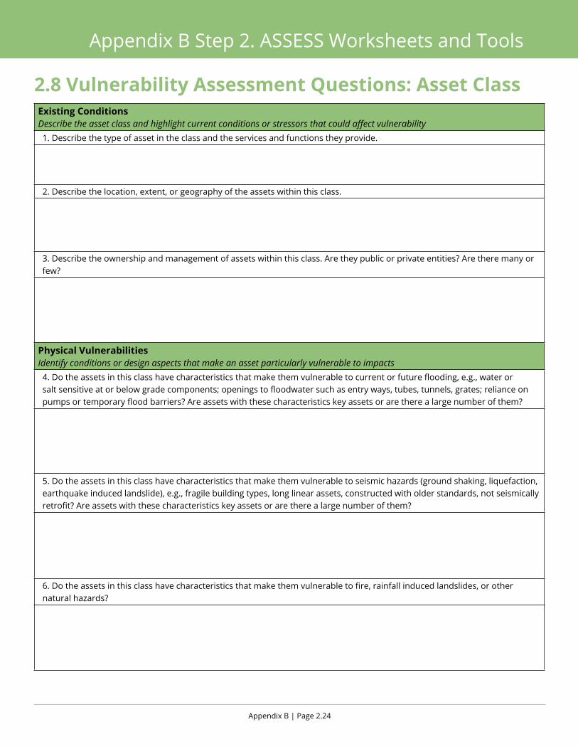
Appendix B | Page 2.24
Appendix B Step 2. ASSESS Worksheets and Tools
Existing Conditions Describe the asset class and highlight current conditions or stressors that could affect vulnerability1. Describe the type of asset in the class and the services and functions they provide.
2. Describe the location, extent, or geography of the assets within this class.
3. Describe the ownership and management of assets within this class. Are they public or private entities? Are there many or few?
Physical Vulnerabilities Identify conditions or design aspects that make an asset particularly vulnerable to impacts4. Do the assets in this class have characteristics that make them vulnerable to current or future flooding, e.g., water or salt sensitive at or below grade components; openings to floodwater such as entry ways, tubes, tunnels, grates; reliance on pumps or temporary flood barriers? Are assets with these characteristics key assets or are there a large number of them?
5. Do the assets in this class have characteristics that make them vulnerable to seismic hazards (ground shaking, liquefaction, earthquake induced landslide), e.g., fragile building types, long linear assets, constructed with older standards, not seismically retrofit? Are assets with these characteristics key assets or are there a large number of them?
6. Do the assets in this class have characteristics that make them vulnerable to fire, rainfall induced landslides, or other natural hazards?
2.8 Vulnerability Assessment Questions: Asset Class
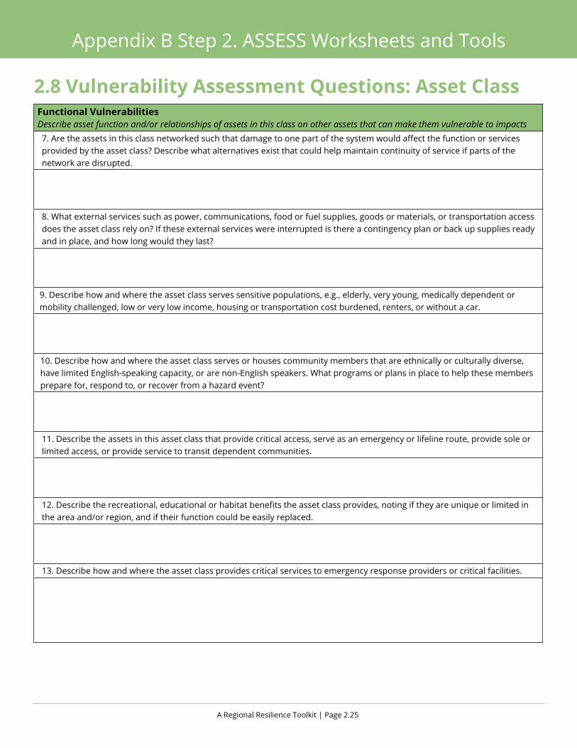
A Regional Resilience Toolkit | Page 2.25
Appendix B Step 2. ASSESS Worksheets and Tools
Functional VulnerabilitiesDescribe asset function and/or relationships of assets in this class on other assets that can make them vulnerable to impacts7. Are the assets in this class networked such that damage to one part of the system would affect the function or services provided by the asset class? Describe what alternatives exist that could help maintain continuity of service if parts of the network are disrupted.
8. What external services such as power, communications, food or fuel supplies, goods or materials, or transportation access does the asset class rely on? If these external services were interrupted is there a contingency plan or back up supplies ready and in place, and how long would they last?
9. Describe how and where the asset class serves sensitive populations, e.g., elderly, very young, medically dependent or mobility challenged, low or very low income, housing or transportation cost burdened, renters, or without a car.
10. Describe how and where the asset class serves or houses community members that are ethnically or culturally diverse, have limited English-speaking capacity, or are non-English speakers. What programs or plans in place to help these members prepare for, respond to, or recover from a hazard event?
11. Describe the assets in this asset class that provide critical access, serve as an emergency or lifeline route, provide sole or limited access, or provide service to transit dependent communities.
12. Describe the recreational, educational or habitat benefits the asset class provides, noting if they are unique or limited in the area and/or region, and if their function could be easily replaced.
13. Describe how and where the asset class provides critical services to emergency response providers or critical facilities.
2.8 Vulnerability Assessment Questions: Asset Class
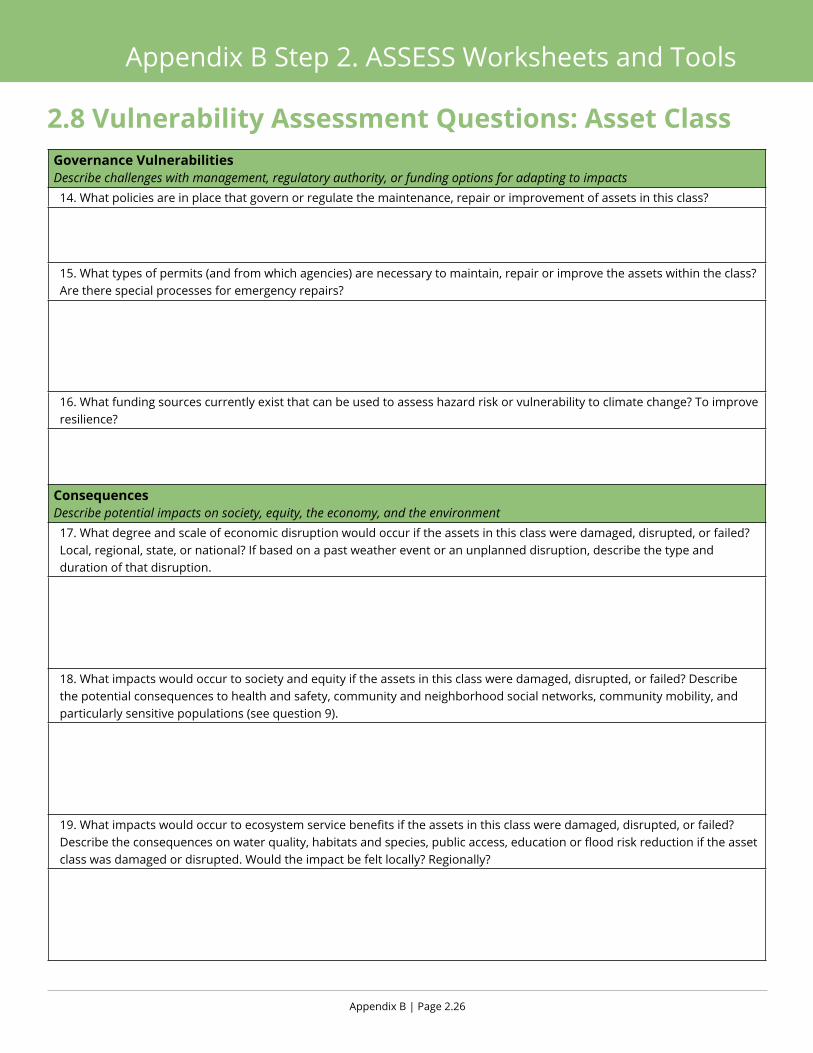
Appendix B | Page 2.26
Appendix B Step 2. ASSESS Worksheets and Tools
Governance VulnerabilitiesDescribe challenges with management, regulatory authority, or funding options for adapting to impacts 14. What policies are in place that govern or regulate the maintenance, repair or improvement of assets in this class?
15. What types of permits (and from which agencies) are necessary to maintain, repair or improve the assets within the class? Are there special processes for emergency repairs?
16. What funding sources currently exist that can be used to assess hazard risk or vulnerability to climate change? To improve resilience?
Consequences Describe potential impacts on society, equity, the economy, and the environment17. What degree and scale of economic disruption would occur if the assets in this class were damaged, disrupted, or failed? Local, regional, state, or national? If based on a past weather event or an unplanned disruption, describe the type and duration of that disruption.
18. What impacts would occur to society and equity if the assets in this class were damaged, disrupted, or failed? Describe the potential consequences to health and safety, community and neighborhood social networks, community mobility, and particularly sensitive populations (see question 9).
19. What impacts would occur to ecosystem service benefits if the assets in this class were damaged, disrupted, or failed? Describe the consequences on water quality, habitats and species, public access, education or flood risk reduction if the asset class was damaged or disrupted. Would the impact be felt locally? Regionally?
2.8 Vulnerability Assessment Questions: Asset Class

Appendix B Step 3. ACT
Photo. Fort Bragg sand dunes, California
Natural systems such as dunes can be effective in reducing impacts related to sea level rise and extreme storms.
Appendix B | Page 3.2
Appendix B Step 3. ACT Worksheets and Tools
3.1 Develop Initial Problem Statements
Purpose This worksheet should be used by the project team, as well as by the advisory group, to develop the initial problem state-ments that will become the basis of the strategies.
ApproachFollow the narrative in Section 3 of the Toolkit to write problem statements describing the vulnerabilities and conse-quences that have been identified for each asset. This should build on the exercises in the previous section. A problem statement summarizes the particular issue that occurs when a hazard impacts an asset. This impact in combination with the potential level of importance should help to define a specific problem that must be addressed.
Outcome ü Detailed and specific problem statements for priority assets.

A Regional Resilience Toolkit | Page 3.3
Appendix B Step 3. ACT Worksheets and Tools
3.1 Develop Initial Problem StatementsAsset:
Hazard:
Summarize impact:
Level of urgency/importance:
Problem statement:

Appendix B | Page 3.4
Appendix B Step 3. ACT Worksheets and Tools
3.2 Strategy Idea Sources
PurposeThis handout presents a number of sources for strategies that address common hazards and asset classes. The sources can be used to provide ideas and language for local strategies that are responsive to the individual problem statements. This guide is geared towards the Bay Area in California, but many of the strategies can be applicable in other areas that have similar hazards.
ApproachReference the following sources for initial strategies that can be customized for community assets and hazards.
Smart Growth Fixes for Climate Adaptation and Resilience www.epa.gov/smartgrowth/smart-growth-fixes-climate-adaptation-and-resilience
Planning Framework for a Climate-Resilient Economy www.epa.gov/smartgrowth/planning-framework-climate-resilient-economy
Flood Resilience www.epa.gov/smartgrowth/flood-resilience-checklist
Enhancing Sustainable Communities with Green Infrastructure www.epa.gov/smartgrowth/enhancing-sustainable-communities-green-infrastructure
2011 ABAG Bay Area Regional Hazard Mitigation PlanHazards Addressed Asset Classes Addressed SourceEarthquakeLandslideWildfireFloodSecurityDam failureLevee FailureTsunamiDroughtAgriculturePandemic flu
InfrastructureHealthHousingEconomyGovernmentEducationEnvironmentLand Use
ABAG
Comprehensive list of strategies developed for previous Regional Hazard Mitigation Plan. Wide range of strategies, but little detail on implementation. Covers many hazard types and asset types. Some jurisdictions may be familiar with these strategies and have them included in their previous hazard mitigation plans.
resilience.abag.ca.gov/2011mitigation/ (see Appendix G)

A Regional Resilience Toolkit | Page 3.5
Appendix B Step 3. ACT Worksheets and Tools
3.2 Strategy Idea Sources Bay Area Regional Resilience InitiativeHazards Addressed Asset Classes Addressed SourceEarthquake Governance
HousingInfrastructureEconomy and business
ABAG
This 2013 report identifies an action plan for the region to improve regional capacity for disaster resilience in four sectors. Many of the actions are regional in implementation, but there are several local strategies as well. Actions align with identified regional priorities adopted by ABAG’s Regional Planning Committee.
resilience.abag.ca.gov/projects/resilience_initiative/
Stronger Housing, Safer Communities: Strategies for Seismic and Flood RisksHazards Addressed Asset Classes Addressed SourceGround shakingLiquefactionCurrent and future flooding
HousingCommunity members
ABAG and BCDC, developed in coordi-nation with AECOM
Contains 40 strategies for state, regional, and local governments to address seismic and flood hazards for current and future development. Strategies are responsive to risk statements based on vulnerability analysis of housing and community capacity. Each strategy contains 2-3 pages of implementation guidance. Also includes a table designed to guide jurisdictions towards financing options to implement the strategies.
resilience.abag.ca.gov/projects/stronger_housing_safer_communities_2015/
Adapting to Rising Tides (ART) ProjectHazards Addressed Asset Classes Addressed SourceCurrent floodingFuture flooding
Community land use, facilities and ServicesTransportationUtilitiesShorelines
BCDC
Dozens of adaptation responses that describe actions and implementation options to address flooding vulnerability. Responses are organized by category: Overarching; Community Land Use, Facilities and Services; Transportation; Utilities; and Shorelines. Also includes a guide to orient the reader to the types of information provided on the cards, and a glossary to define terms and acronyms used in the responses.
www.adaptingtorisingtides.org/wp-content/uploads/2015/04/Adaptation_Responses_Intro-All.pdf

Appendix B | Page 3.6
Appendix B Step 3. ACT Worksheets and Tools
3.2 Strategy Idea SourcesState of California Multi-Hazard Mitigation PlanHazards Addressed Asset Classes Addressed SourceEarthquakeFloodsWildfireLevee failureLandslides and other earth movementsTsunami hazardsClimate related hazardsVolcanoesOther hazards (natural & manmade)
California Governor’s Office of Emergency Services
The plan does not contain a list of strategy action but identifies several possible goals and mitigation actions that can be implemented at a local level. Each hazard section includes possible mitigation actions that can be adapted locally and developed into a strategy.
hazardmitigation.calema.ca.gov/docs/SHMP_Final_2013.pdf
Mitigation Ideas: A Resource for Reducing Risk to Natural HazardsHazards Addressed Asset Classes Addressed SourceDrought EarthquakeErosionExtreme temperaturesFloodHailLandslideLightningSea level riseSevere windSevere winter weatherStorm surgeSubsidenceTornadoTsunamiWildfire
Structure and infrastructureNatural systems
FEMA
Comprehensive resource that communities can use to identify and evaluate a range of potential mitigation actions for reducing risk to natural hazards and disasters. Many of the strategies are fairly generic and serve as a starting point for local innovation and planning projects.
www.fema.gov/media-library-data/20130726-1904-25045-0186/fema_mitigation_ideas_final508.pdf
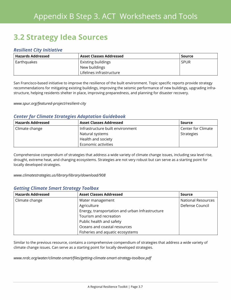
A Regional Resilience Toolkit | Page 3.7
Appendix B Step 3. ACT Worksheets and Tools
3.2 Strategy Idea SourcesResilient City InitiativeHazards Addressed Asset Classes Addressed SourceEarthquakes Existing buildings
New buildingsLifelines infrastructure
SPUR
San Francisco-based initiative to improve the resilience of the built environment. Topic specific reports provide strategy recommendations for mitigating existing buildings, improving the seismic performance of new buildings, upgrading infra-structure, helping residents shelter in place, improving preparedness, and planning for disaster recovery.
www.spur.org/featured-project/resilient-city
Center for Climate Strategies Adaptation GuidebookHazards Addressed Asset Classes Addressed SourceClimate change Infrastructure built environment
Natural systemsHealth and societyEconomic activities
Center for Climate Strategies
Comprehensive compendium of strategies that address a wide variety of climate change issues, including sea level rise, drought, extreme heat, and changing ecosystems. Strategies are not very robust but can serve as a starting point for locally developed strategies.
www.climatestrategies.us/library/library/download/908
Getting Climate Smart Strategy ToolboxHazards Addressed Asset Classes Addressed SourceClimate change Water management
AgricultureEnergy, transportation and urban InfrastructureTourism and recreationPublic health and safetyOceans and coastal resourcesFisheries and aquatic ecosystems
National Resources Defense Council
Similar to the previous resource, contains a comprehensive compendium of strategies that address a wide variety of climate change issues. Can serve as a starting point for locally developed strategies.
www.nrdc.org/water/climate-smart/files/getting-climate-smart-strategy-toolbox.pdf

Appendix B | Page 3.8
Appendix B Step 3. ACT Worksheets and Tools
3.3 Evaluation Criteria
PurposeThis worksheet was developed to provide a tool for evaluating and prioritizing which strategies to implement. The worksheet uses five categories of criteria to develop a total score: feasibility, social benefits, economic benefits, environ-mental improvement, and community objectives. Jurisdictions can also change scoring criteria to reflect local priorities. It is important to include multiple voices and viewpoints in strategy prioritization.
ApproachThis worksheet should be worked through by the project team, as well as by the advisory group and any key stake-holders that will have a role in implementation. Use this worksheet to evaluate every strategy. It is important to get as much feedback as possible on this worksheet, as each stakeholder will evaluate strategies differently, and it is critical to include the perspectives of everyone who could assist with, or possibly hinder, the implementation of strategies. For more guidance on how to use this worksheet in a group setting, refer to the ART Adaptation Response Open House Engagement Exercise. www.adaptingtorisingtides.org/howto/art-supplies/
OutcomeAfter several team members and stakeholders have completed this worksheet, develop a score for each strategy that will help guide its feasibility and priority. Higher scores generally denote higher feasibility and priority.
Scoring Key+1 Criteria definitely met
0 Unsure/do not know
-1 Criteria not met/negative effects
Strategies to Evaluate
1.
2.
3.
4.
5.
6.

A Regional Resilience Toolkit | Page 3.9
Appendix B Step 3. ACT Worksheets and Tools
Criteria
Strategy 1
Strategy 2
Strategy 3
Strategy 4
Strategy 5
FEASIBILITY
Funding: With existing or expected funding sources
Political support*: Likelihood of political support
Local champion*: Supported by a strong advocate or local champion
Administrative*: With existing operations or procedures
Technical*: With existing technology or know how
Legal*: With existing authorities or policies
SOCIAL BENEFITS
Access: Protects access to jobs or services
Life safety: Protects residents lives and prevents injuries
Awareness: Increases public awareness
Vulnerable residents: Protects especially vulnerable community members
Recreation: Maintains recreational or educational opportunities
ECONOMIC BENEFITS
Jobs: Promotes/retains jobs
Commuter movement: Maintains commuter movement
Reduces disruption: Reduces service or network disruptions
Reduces damages*: Reduces asset damage, e.g. to structures, infra-structure
ENVIRONMENTAL IMPROVEMENT*
Habitats and biodiversity: Creates or maintains habitat & biodiversity
Water quality: Maintains or improves water quality
Greenhouse gases (GHG): Reduces GHG
Water use: Reduces water use
Energy use: Reduces energy use
COMMUNITY OBJECTIVES*
Community objectives*: Advances other community objectives
Existing plans: Supports existing plan objectives, i.e. general plan
TOTAL SCORE
* Indicates overlap with FEMA Worksheet 6.1, Mitigation Action Evaluation Worksheet
3.3 Evaluation Criteria
Appendix B | Page 3.10
Appendix B Step 3. ACT Worksheets and Tools
3.4 Strategy Development and Implementation Handout
PurposeThis handout provides two tools to help to fill out a Strategy Development and Implementation Worksheet: a description of what to include in each field, and an example from a real life strategy. Review this handout with the project team prior to developing a worksheet for each strategy to ensure that worksheets are filled out consistently and that everyone understands the key pieces of information that are needed to effectively develop an appropriate and responsive strategy and plan for its implementation.
STRATEGY DEVELOPMENT INFORMATIONProblem statement
This is the problem statement that the strategy is responding to. This should come out of the vulnerability assessment and should include community goals.
Strategy name This is the name of the strategy – try to keep it to a few words.
Strategy summary
This is a short description of what the strategy does.
Hazard(s) addressed Identify which hazard this strategy responds to.
Strategy type
Operational(Strategies to enact
operational and gover-
nance related improvements)
Programmatic(Strategies to
expand or create new programs, activities, and
initiatives)
Plans, Regulations,
and Policy Development(Strategies to
develop or revise policies, plans,
regulations, and guidelines)
Capital Improvement/ Infrastructure
Projects(Strategies designed to
address physical and functional
deficiencies and needs in the built
environment)
Education/ Outreach/
Coordination(Strategies related to
initiating or expanding
partnerships and relationships,
communicating and sharing information, and building awareness)
Evaluation(Strategies to improve feedback,
input, data and information or conduct further or new analysis)
Process/ implementation mechanism
Long Range Planning
(e.g., master plans,
climate action plans)
Land Use Planning
(e.g., general plan, specific
plan)
Capital Planning
(e.g., capital improvement
plan)
Operations(e.g., annual budgeting)
Emergency & Hazards Planning
(e.g., hazard mitigation
plans)
Project Planning and
Design(e.g., private and
public devel-opment projects)
New Initiatives
(e.g., legislation, ballot measure)
Responsible agency
Which department has the proper authority, capacity, and knowledge to implement the strategy.
Partners Internal or external stakeholders who have some decision making authority, political influence, policy or regulation authority, or who can assist with implementation.

A Regional Resilience Toolkit | Page 3.11
Appendix B Step 3. ACT Worksheets and Tools
STRATEGY IMPLEMENTATION INFORMATION
Priority (Evaluation score)
Evaluation score and priority level. Priority levels may vary by jurisdiction for different scores (for example, a score of 10 may be high priority in one jurisdiction and medium priority in another).
Actions/ activities Steps that need to be taken to implement the strategy.
Staff leadWho has responsibility for overseeing the project and ensuring that the actions are taken.
Cost estimate General estimate of the cost of implementation. This can be quantitative or qualitative (no cost, low, medium, high).
Benefits (losses avoided)
General estimate of the impact of the strategy. Can be quantitative (lives, homes, or dollars saved), or qualitative (low, medium, high benefit).
Potential funding sources
How the implementation of the strategy might be funded. This may include general operation funds, grants, fees, or other financing tools.
Timeline How long it will take to implement the strategy? Choose a date by which the action should be imple-mented, or use a qualitative timeline estimate (near term, long term).
Related policies Goals or policies already in place that support or assist the strategy. This may be in the general plan, climate action plan, housing element, climate adaptation plan, or sustainability plan.
Appendix B | Page 3.12
Appendix B Step 3. ACT Worksheets and Tools
Example Strategy: ABAG/BCDC Stronger Housing, Safer CommunitiesSTRATEGY DEVELOPMENT INFORMATIONProblem statement
The City of East Palo Alto experiences coastal flooding during extreme storms. One-quarter of the city and many single family homes are within the coastal watershed that experiences flooding now. These storms are anticipated to increase in the future causing more frequent and extensive flooding.
Strategy name Reduce flood risk through integrated watershed management
Strategy summary
Identify appropriate projects that sustain or enhance watershed functions while protecting development from shoreline flooding and riverine flooding.
Hazard(s) addressed Current Flooding, Future Flooding
Strategy type
Operational Programmatic
Plans, Regulations, and Policy
Development
Capital Improvement/ Infrastructure
Project
Education/ Outreach/ Coordination
Evaluation
Process/ implementation mechanism
Long Range
Planning
Land Use Planning
Capital Planning
Operations
Emergency and
Hazards Planning
Project Planning and
Design
New Initiatives
Responsible agency Planning and Building Department
Partners FEMA, developers
STRATEGY IMPLEMENTATION INFORMATION
Priority (evaluation score)
13
Actions/activities
Conduct additional analysis of appropriate watershed projects, partner with FEMA for guidance and assis-tance, incorporate projects into long term city plans, and pursue implementation of identified projects
Staff leadJane Doe
Cost estimate$50,000 planning, $300,000 - $1 million implementation
Benefits (losses avoided)
Improves habitats and biodiversity, improves water quality, protects vulnerable residents and recreational uses, protects built environment
Potential funding sources FEMA
Timeline18 months planning, 3-5 additional years for implementation
Related policies Existing policies for management of estuaries along shoreline to enhance bay shoreline flooding protection capacity
A Regional Resilience Toolkit | Page 3.13
Appendix B Step 3. ACT Worksheets and Tools
3.5 Strategy Development and Implementation
PurposeThis blank worksheet is a template for recording key information about a strategy that can assist in fleshing out the ideas put forth in the strategy as well as key information needed to move into implementation of the strategy.
ApproachThe project team should fill out this worksheet for every strategy the team is considering including in the project. First, as the team selects possible strategies, work through the top half of the worksheet. Use this information to evaluate each strategy. After going through the evaluation step, move to the bottom half of the worksheet only for those strategies that will be implemented.
OutcomeAfter completing the top half of the worksheet, there will be adequate information on the strategy to evaluate and prior-itize strategies. After completing the bottom half of the worksheet for the strategies, the team will have a basic roadmap for how to implement the strategy. Together, the table provides a succinct summary of each strategy adequate for the Hazard Mitigation Plan or the other plan under development, as well as a document that creates ownership and account-ability for implementation.

Appendix B | Page 3.14
Appendix B Step 3. ACT Worksheets and Tools
STRATEGY DEVELOPMENT INFORMATIONProblem statementStrategy name
Strategy summary
Hazard(s) addressed
Strategy type
Operational Programmatic
Plans, Regulations, and Policy
Development
Capital Improvement/ Infrastructure
Project
Education/ Outreach/ Coordination
Evaluation
Process/ implementation mechanism
Long Range
Planning
Land Use Planning
Capital Planning
Operations
Emergency and
Hazards Planning
Project Planning and Design
New Initiatives
Responsible agency
Partners
STRATEGY IMPLEMENTATION INFORMATION
Priority (evaluation score)Actions/activities
Staff lead
Cost estimate
Benefits (losses avoided)
Potential funding sources
Timeline
Related policies
3.5 Strategy Development and Implementation

Appendix B Step 4. FUND
Photo. Lassen County wildflowers, California
In the shadows of Lassen National Park, a resilient landscape in historic lava flows.

Appendix B | Page 4.2
Appendix B Step 4. FUND Worksheets and Tools
4.1 Funder Engagement Inventory
PurposeThis blank worksheet is a template for mapping the potential funders that have been engaged or should be engaged in the process and to identify ability to solicit for funds for the resilience project.
ApproachThe project team should fill out this worksheet building from the original stakeholder list developed in Step 1, adding any additional potential funding agents in the region. For each stakeholder indicate the level of involvement in the process to date, the state of the relationship, and ability to approach for funds.
OutcomeThe list should serve as a guide to indicate where additional outreach and engagement should be made, and provide a sense of ability to access funds from local and regional funders.

A Regional Resilience Toolkit | Page 4.3
Appendix B Step 4. FUND Worksheets and Tools
Strategy/Project Stakeholder/Funder Engagement to Date (Hi/Med/Low)
Level of Access/Relationship (Strong/OK/Poor)
Contact? (Yes/No/TBD)
4.1 Funder Engagement Inventory

Appendix B | Page 4.4
Appendix B Step 4. FUND Worksheets and Tools
4.2 Local Funding Source Inventory
PurposeThis worksheet template is to inventory all existing potential funding sources that are already available within your community and to help assess which ones have potential as a resilience funding source.
ApproachThe project team should fill out this worksheet with assistance from the Advisory Group and other city agencies. For each funding source, determine what are the potential links to resilience building, identify the lead agency or funder, note the funds available, and the potential to leverage other matching funds or projects.
OutcomeThe inventory should help develop the base funding sources in the community and indicate opportunities for implementation.

A Regional Resilience Toolkit | Page 4.5
Appendix B Step 4. FUND Worksheets and Tools
Local Financing Tools/ Mechanisms
Link to Resilience Actions Contact (Indicate if Existing Stakeholder)
Funds Available
Leveraging Possible? (Yes/No/TBD)
4.2 Local Funding Source Inventory

Appendix B | Page 4.6
Appendix B Step 4. FUND Worksheets and Tools
4.3 Foundation and Other Grant Funding Alignment
PurposeThis worksheet template is to help organize and list all potential grant funding opportunities and link them to the resil-ience building strategies and projects.
ApproachThe project team should fill out this worksheet with assistance from the Advisory Group and other city agencies. List each potential grant/foundation, indicate how the grant requirements link to the Plan’s implementation strategies and projects, determine how much funding is available, include a contact name if available, and assess what the probability is for success. Success will be directly related to: Existing relationships or stakeholder who has participate in the project to date, previous success in securing a grant from the same organization, and alignment to the grants focus and foundation funding priorities.
OutcomeThe exercise should help to focus the lead agency on priority grant opportunities and uncover where potential linkages with grant goals may help in implementation.

A Regional Resilience Toolkit | Page 4.7
Appendix B Step 4. FUND Worksheets and Tools
Grant Name/Foundation Link to Resilience Actions Contact (Indicate if Existing Stakeholder)
Funds Available
Potential Success? (Hi/Med/Low)
4.3 Foundation and Other Grant Funding Alignment