Volume III - BLM's Western Oregon Plan Revision Draft EIS
46
Appendix G. Wildlife This appendix provides background on the analysis of wildlife including detailed data from recovery plans, critical habitat for the northern spotted owl and marbled murrelet, and special status animal species. In this appendix: Management Opportunities on BLM-Administered Lands in the Recovery Plans for the Columbia White-tailed Deer (Columbia River population), Marbled Murrelet, and Bald Eagle. ............................. 1025 Data in Support of Northern Spotted Owl Analysis ...................................................... 1037 Marbled Murrelet Critical Habitat. .................................................................................... 1060 Special Status Animal Species ............................................................................................ 1065 G – 1023
-
Upload
khangminh22 -
Category
Documents
-
view
4 -
download
0
Transcript of Volume III - BLM's Western Oregon Plan Revision Draft EIS

Appendix G. Wildlife
This appendix provides background on the analysis of wildlife including detailed data from recovery plans, critical habitat for the northern spotted owl and marbled murrelet, and special status animal species.
In this appendix:
Management Opportunities on BLM-Administered Lands in the Recovery Plans for the Columbia White-tailed Deer (Columbia River population), Marbled Murrelet, and Bald Eagle. ............................. 1025
Data in Support of Northern Spotted Owl Analysis ...................................................... 1037
Marbled Murrelet Critical Habitat. .................................................................................... 1060
Special Status Animal Species ............................................................................................ 1065
G – 1023

DEIS for the Revision of the Western Oregon RMPs
G – 1024

Appendix G. Wildlife
Management Opportunities on BLM-Administered Lands in the Recovery Plans for the Columbia White-tailed Deer (Columbia River population), Marbled Murrelet, and Bald Eagle.
Columbia white-tailed deer (Columbia River population)
The focus of the recovery strategy is on the national wildlife refuge lands and surrounding privately owned lands. Nothing has been excerpted from the recovery plan.
Marbled Murrelet Portions excerpted from Recovery Plan For The Threatened Marbled Murrelet (Brachyramphus marmoratus) In Washington, Oregon, And California (pages 125-160 in USFWS 1997).
D. Narrative Outline for Recovery Actions.
1. Implement management plans for each Marbled Murrelet Conservation Zone
1.3 Oregon Coast Range Zone (Zone 3).
The Oregon Coast Range Zone extends from the Columbia River, south toNorth Bend, Coos County, Oregon. This Zone includes waters within 2 kilometers (1.2 miles) of the Pacific Ocean shoreline and extends inland a distance of up to 56 kilometers (35 miles) from the Pacific Ocean shoreline and coincides with the “Zone 1” boundary line described by the Forest Ecosystem Management Assessment Team, with minor adjustments (U.S. Department of Agriculture et al. 1993). The boundary encompasses all of the marbled murrelet critical habitat units designated (the boundary extends slightly beyond 56 kilometers (35 miles) in certain areas.
This Zone includes the majority of known marbled murrelet occupied sites in Oregon. Marbled murrelet occupied sites along the western portion of the Tillamook State Forest are especially important to maintaining well distributed marbled murrelet populations. Efforts should focus on maintaining these occupied sites, minimizing the loss of unoccupied but suitable habitat, and
G – 1025

DEIS for the Revision of the Western Oregon RMPs
decreasing the time for development of new habitat. Relatively few known occupied sites occur north of the Tillamook State Forest. Recovery efforts should be directed at restoring some of the north-south distribution of marbled murrelet populations and habitat in this Zone. Maintenance of suitable and occupied marbled murrelet nesting habitat in the Elliott State Forest, Tillamook State Forest, Siuslaw National Forest, and Bureau of Land Management-administered forests is an essential component for the stabilization and recovery of the marbled murrelet.
1.4 Siskiyou Coast Range Zone (Zone 4).
The Siskiyou Coast Range Zone extends from North Bend, Coos County, Oregon, south to the southern end of Humboldt County, California. It includes waters within 2 kilometers (1.2 miles) of the Pacific Ocean shoreline (including Humboldt and Arcata bays) and, in general, extends inland a distance of 56 kilometers (35 miles) from the Pacific Ocean shoreline and coincides with the “Zone 1” boundary line described by the Forest Ecosystem Management Assessment Team with minor adjustments (U.S. Department of Agriculture et al. 1993). The boundary encompasses all of the marbled murrelet critical habitat units designated (the boundary extends slightly beyond 56 kilometers (35 miles) in certain areas.
This Zone includes the marbled murrelet population occupying sites in Redwood National Park and several state parks (Jedediah Smith, Del Norte, Prairie Creek, Grizzly Creek, and Humboldt) in California. In addition, this Zone includes nesting habitat on private lands in southern Humboldt County. Additional marbled murrelet nesting habitat occurs at lower elevations in western portions of the Smith River National Recreation Area. State policies regarding protection of marbled murrelet occupied sites on private lands differ in the Oregon and California portions of this Zone.
Recovery actions should be focused on preventing the loss of occupied nesting habitat, minimizing the loss of unoccupied but suitable habitat, and decreasing the time for development of new suitable habitat. Much marbled murrelet nesting habitat is found in state and national parks that receive considerable recreational use. The need to maintain high quality marbled murrelet terrestrial habitat should be considered in planning any modifications to state or national parks for recreational purposes. Both highway and campground construction, including picnic areas, parking lots, and visitors centers, could present threats to the marbled murrelet through loss of habitat, nest disturbance, and/or increasing potential predation from corvids associated with human activities such as Steller’s jays and crows. Implementing appropriate garbage/trash disposal may help decrease potential predator populations in high human use areas such as county, state and national parks.
G – 1026

Appendix G. Wildlife
This Zone has large blocks of suitable habitat critical to the three-state marbled murrelet population recovery over the next 100 years. However, the amount of suitable habitat protected in parks is probably not sufficient by itself to guarantee long-term survival of marbled murrelets in this Zone. On the other hand, a considerable amount of habitat is preserved in parks such that survival may be more likely in this Zone than in several other Zones. Private lands at the southern end of this Zone are important for maintaining the current distribution of the species. There is already a considerable gap in distribution between this area and the central California population in Zone 6. Efforts should be implemented to, at a minimum, not expand the current distribution gap.
2. Delineate and protect areas of habitat within each Zone.
Areas within each Zone that are essential for marbled murrelet recovery should be delineated and protected, using a variety of means (e.g., designation as critical habitat, protection through Habitat Conservation Plans, management [as reserves] under the Forest Plan, other existing regulatory mechanisms, etc.).
2.1 Protect terrestrial habitat essential for marbled murrelet recovery.
There appears to be little opportunity for increases in marbled murrelet productivity as a result of forest maturation in the near future. Even under optimum conditions and with the successful use of various silvicultural techniques, it will take 50 to 100 years or more to develop new suitable nesting habitat within most reserve areas. Any further substantial reduction in occupied nesting habitat for the marbled murrelet would hamper efforts to stabilize the population and the recovery of the species.
Marbled murrelet population trends described above (also see Appendix B) have led the U.S. Fish and Wildlife Service to conclude that a number of areas, including nesting areas and feeding sites well-distributed throughout its terrestrial and marine range, are essential to the conservation of the species. Late-Successional Reserves, as described in the Forest Plan and the final rule designating critical habitat for marbled murrelets, will eventually contribute to recovery. However, these areas alone are insufficient to reverse the decline and maintain a well-distributed population. Thus, additional areas, including non-Federal lands and marine areas, should be protected using a variety of means including critical habitat, Habitat Conservation Plans, and other existing regulatory mechanisms as described below. If these areas are protected, there is a high likelihood that populations will stabilize.
A. Essential nesting habitats that occur on forest lands managed by the Federal government include:
(1) Any suitable habitat in Late-Successional Reserves located in the Forest Ecosystem Management Assessment Team Zone 1 (see pages IV-23 and IV-24 in U.S. Department of Agriculture et al. 1993 for a description of Zone 1);
G – 1027

DEIS for the Revision of the Western Oregon RMPs
(4) Other large areas of suitable nesting habitat outside of Late-Successional Reserves on Federal lands. For example, large areas of suitable nesting habitat occur on the Siskiyou National Forest, Oregon, the Six Rivers National Forest, California, and in Redwood National and State Park, California.
2.3 Develop and implement a landscape management strategy for each of the six Conservation Zones.
Although many of the factors that have contributed to the decline of marbled murrelet populations in the three-state area are common to all zones, each zone presents unique challenges to the recovery of the species. For example, mortality resulting from incidental capture in net fisheries is a major concern in Zone 1, mortality from oil spills is a major concern in Zones 2 and 6, and potential loss of key suitable nesting habitat on non-Federal lands is of major concern for all Zones. A landscape management plan that addresses the unique circumstances of each Zone should be developed, taking into consideration all affected parties (Federal, state, tribal, private, etc.).
2.3.1 Develop and implement management plans that incorporate the needs of the marbled murrelet for each protected habitat area on Federal lands.
Each protected habitat area within a particular Zone may have unique ecological features and exists in a unique spatial context with lands that may be managed for a variety of values. It is important that these unique characteristics be addressed in the context of a management plan for each of these areas, including the development of appropriate definitions of suitable marbled murrelet habitat for each Zone. In the development of these plans for each Zone, all managers should have an opportunity to be involved, regional issues must be considered, and recovery objectives must be addressed in a consistent manner throughout the range. In some cases, these management plans could be developed using information from the Late-Successional Reserve assessments called for in the Forest Plan Record of Decision.
Management plans should be based on the best available information on the biology and recovery needs of the marbled murrelet and should be able to adapt to new information as it becomes available. For example, a variety of management activities could decrease predation mortality at marbled murrelet nests (e.g., silvicultural practices designed to provide shelter to nest sites or to speed development of murrelet habitat; garbage removal from state and national parks). Efforts to reduce or eliminate these manmade food sources in state and national parks are currently being discussed. As successful strategies are developed to reduce predation at the nest, they should be incorporated into management plans for specific secured areas. An outline of specific management recommendations is provided in task 3.
G – 1028
Appendix G. Wildlife
3. Incorporate management recommendations for protected habitat areas.
Management recommendations for the marbled murrelet need to address two different biological time frames, which reflect (1) aspects o the murrelet’s life history and demographic trends, and (2) the length of time required to develop the majority of new nesting habitat or improve current forest habitat conditions. Short-term actions must address the apparent rapid decline of current populations and the need for immediate stabilization. The ability of marbled murrelet populations to recover rapidly is low due to the low reproductive potential of the species. Long-term actions address the long time-frames required to cultivate or enhance mature forest habitat conditions or to improve marine habitat quality because of the nature and complexity of these ecosystems. Little additional older forest habitat will become available until after 2040.
3.1 Implement short-term actions to stabilize and increase the population.
3.1.1 Maintain/protect occupied nesting habitat and minimize loss of unoccupied but suitable nesting habitat.
3.1.1.1 Maintain occupied nesting habitat.
The loss of occupied nesting habitat appears to be the primary cause of marbled murrelet population declines in Washington, Oregon, and California. The low reproductive potential of this species, and lack of knowledge concerning its ability to locate and reestablish new nesting areas after elimination of nesting habitat, makes it imperative to maintain all occupied nesting habitat, as is being done, for the most part, through implementation of the Forest Plan on Forest Service and Bureau of Land Management lands.
On non-Federal lands the maintenance of all occupied sites also should be the goal. However, it is realized that through the Habitat Conservation Plan process, there may be some limited loss of occupied sites or unsurveyed suitable habitat. In the short-term (the next 5 - 10 years), until additional information is obtained, loss of any occupied sites or unsurveyed suitable habitat should be avoided or the potential impacts significantly reduced through a habitat evaluation and ranking process outlined in the Habitat Conservation Plan.
Short term trade-offs for long-term benefits should be evaluated very carefully at this early stage of marbled murrelet recovery and should be done on a case-by-case basis.
3.1.1.2 Maintain potential and suitable habitat in larger contiguous blocks while maintaining current north/south and east/west distribution of nesting habitat.
G – 1029
DEIS for the Revision of the Western Oregon RMPs
By maintaining occupied sites and suitable habitat in larger blocks with low levels of fragmentation, several objectives will be met. Larger stands will (1) have more nesting and hiding opportunities, (2) provide for multiple alternative nesting sites for individual pairs of birds over time, (3) facilitate nesting for multiple pairs of birds (and thus promote increased social contact), and (4) provide greater interior forest habitat conditions (to reduce potential nest and adult predation, increase protection of nests from windstorms and environmental changes, and reduce loss of habitat from windthrow and fire). Larger stands also may provide a core of birds to attract or develop sufficient activity and eventual nesting by subadults or nonbreeding adult birds to replace breeding adults lost from this habitat over time due to natural causes or human activities. The more contiguous the habitat distribution, the lower the likelihood of future large gaps in distribution of the species due to catastrophic events such as oil spills or large wildfires. Preventing further erosion of the already patchily-distributed nesting habitat is a key element in buffering the species against such catastrophic events. This is especially important in areas where gaps already occur. Furthermore, it is currently unknown how nesting success differs with distance from the coast, and far inland habitats may be as important to species survival as those nearer to shore. Therefore, it is important to maintain both north/south and east/west distribution of suitable habitat.
3.1.1.3 Maintain and enhance buffer habitat surrounding occupied habitat.
Maintaining buffers around occupied habitat will mediate the effects of edge by helping to reduce environmental changes within the stand, reduce loss of habitat from windthrow and fire, reduce fragmentation levels, increase the amount of interior forest habitat available, and potentially help reduce predation at the nest. To have the greatest benefits, buffer widths should be a minimum of 300-600 feet and should consist of whatever age stand is present, including existing plantations (which should be managed to provide replacement.
3.1.3 Minimize nest disturbances to increase reproductive success.
Low juvenile:adult ratios have been documented throughout the three-state range of the marbled murrelet (Appendix B). Current evidence suggests that the cause of this low reproductive rate may be due to high rates of predation on eggs, young, and possibly adults at the nest site. Population modeling indicates that adjusted juvenile:adult ratios should be 15 - 22 percent at a minimum to result in stable or increasing
G – 1030

Appendix G. Wildlife
populations. Current best estimates of unadjusted ratios average 5 percent (range 0.1 - 13.8 percent) and it is unlikely that adjustment will result in 4 - 10 times larger ratios. Breeding adult alcids in general are sensitive to nest site disturbance during the incubation period and the first few days of chick rearing. Disturbances near marbled murrelet nest sites that flush incubating or brooding adults from the nest site may expose adults and young to increased predation or accidental loss of eggs or nestlings by falling or being knocked out of nests. Human activities near nesting areas that result in an increase in the number of predators also could lead to a greater likelihood of nest predation. The timing of disturbances should be adjusted to avoid disruption of marbled murrelet activities, such as courtship, mating, and nesting. Human activities should be modified to reduce attraction of predators to specific forest areas although this action may not reduce actual predator numbers over wider areas. Higher-than normal predation levels are likely to occur in nesting habitat due to forest fragmentation and other causes in many cases.
3.2 Implement long-term actions to stop population decline and increase population growth.
3.2.1 Increase the amount and quality of suitable nesting habitat.
An increase in amount and quality of suitable nesting habitat is important in all zones. However, it is especially important in the western Washington Coast Range and the northern portions of the Oregon Coast Range Zones. In these areas, remaining patches of suitable nesting habitat are relatively small and fragmented, involve private and state lands, and are vitally important for maintaining the current small populations in these areas; thus, blocking up habitat is needed to increase patch size. It also would be desirable to increase and block up suitable nesting habitat in the Mendocino and Santa Cruz Mountains Zones. Little habitat remains outside parks in these two zones, such that an increase in the short term does not appear feasible.
3.2.1.1 Decrease fragmentation by increasing the size of suitable stands to provide a larger area of interior forest conditions.
The majority of suitable nest stands currently exist as small islands within a matrix of younger forests. Although these fragments will provide critically important habitat during the several decades required for younger stands to develop structural characteristics suitable for marbled murrelet nesting, they cannot be considered high quality habitat because of vulnerability to wildfire and windthrow, and perhaps a higher abundance of avian predators. Research is needed to develop judicious ways to use silvicultural techniques such as thinning in young (nonhabitat) stands to hasten development of large trees and decrease vulnerability of habitat fragments to fire, wind, and perhaps predators. Consistent with the Forest Plan Record
G – 1031

DEIS for the Revision of the Western Oregon RMPs
of Decision, thinning within Late-Successional Reserves should be restricted to stands younger than 80 years. However, the Record of Decision also permits thinning within Late-Successional Reserves up to age 110 in Coast Range lands administered by the Bureau of Land Management (Nestucca block) and in the Oregon and California Klamath Provinces (U.S. Department of Agriculture and U.S. Fish and Wildlife Service 1994b). Unthinned buffers should be left around any occupied stands. Precautions should be taken to reduce fire hazard from thinning slash and avoid soil compaction.
3.2.1.2 Protect “recruitment” nesting habitat to buffer and enlarge existing stands, reduce fragmentation, and provide replacement habitat for current suitable nesting habitat lost to disturbance events.
Stands (currently 80 years old or older) that will produce suitable habitat within the next few decades are the most immediate source of new habitat and may be the only replacement for existing habitat lost to disturbance (e.g., timber harvest, fires, etc.) over the next century. Such stands are particularly important because of the vulnerability of many existing habitat fragments to fire and wind and the possibility that climate change will increase the effects of the frequency and severity of natural disturbances. Such stands should not be subjected to any silvicultural treatment that diminishes their capacity to provide quality nesting habitat in the future. Within secured areas, these “recruitment” stands should not be harvested or thinned. In the matrix (on Federal lands), harvest in younger-aged stands should adhere to the techniques discussed in the following task (3.2.1.3) to more quickly develop into marbled murrelet habitat.
3.2.1.3 Use silvicultural techniques to increase speed of development of new habitat.
Nesting marbled murrelets select stands with large trees that provide suitable nesting platforms (large, protected branches, preferably with moss). When available, large stands appear to be preferred over small ones. Nests have been located in stands with a wide range of stocking densities, however the low rate of nesting success raises considerable uncertainty regarding what constitutes quality habitat. It is expected that since marbled murrelets require very specific structures in order to successfully nest, silvicultural techniques may be available to speed the development of these structures in stands of younger forest.
Several silvicultural techniques may be appropriate to increase the area of suitable nesting stands and the rate at which they develop (e.g., thinning, long rotations, etc.). Thinning accelerates tree growth and can be used as a tool to produce large trees more quickly than in normal stand development. However, simply growing large trees is not
G – 1032

Appendix G. Wildlife
sufficient to obtain suitable marbled murrelet habitat. Trees must have large moss-covered, or mistletoed branches that provide nest platforms, something that is likely to be achieved only by growing at least some trees on long rotations. There are two alternatives for doing that (1) “Green-tree retention” designates approximately 20 - 40 trees per hectare to be retained at harvest, with a new crop of younger trees established beneath the older tree canopy. Leaving trees on site and allowing them to grow to an older age will likely produce marbled murrelet nest trees and eventually produce coarse woody debris (important habitat for numerous other species). As younger trees mature, a multilayered canopy develops, which is also an important structural attribute of older forest habitat; and (2) evidence available at this time indicates that growing whole stands on long rotations will produce higher quality habitat in the long-term than green tree retention, which may create sink habitat for a number of bird species. Long rotations have other ecological and economic benefits as well. Landscapes with a higher proportion of older stands should be less susceptible to catastrophic wildfire (providing reduced hazard from thinning slash). Because thinned Douglas-fir maintains good growth well into its second century, silviculturists now conclude that long rotations are economically viable in the Douglas-fir region.
3.2.2 Improve Distribution of Nesting Habitat.
3.2.2.1 Improve and develop north/south distribution of nesting habitat.
Improving the distribution of nesting habitat helps to buffer existing populations against poor breeding success and catastrophic loss and probably facilitates gene flow among separated populations. Three major gaps in existing habitat are particularly apparent: (1) from the southern Olympic Peninsula in Washington to Tillamook in northwestern Oregon; (2) between Patrick’s Point and southern Humboldt Bay in northern California (see Figure 1); and (3) throughout most of the Mendocino Zone and the northern part of the Santa Cruz Mountains Zone (between southern Humboldt County and central San Mateo County). These three geographic gaps represent probable partial barriers to gene flow across them. They include large areas of second-growth forests that originated after logging, from fire (parts of northwestern Oregon), or from natural discontinuities of nesting habitat (especially parts of northern and central California). Gap areas often have a high proportion of private lands and little or no Federal land. State lands cover significant portions of northwest Oregon (the Tillamook and Clatsop State Forests) and southwest Washington. Silvicultural techniques to create suitable habitat at both the stand and landscape level (discussed in task 3.2.1.3) may be particularly beneficial to marbled murrelet recovery in the long term if applied in these areas.
G – 1033

DEIS for the Revision of the Western Oregon RMPs
Portions of the Mendocino Zone and Santa Cruz Mountains Zone also contain blocks of unsuitable habitat that probably naturally created small gaps in the murrelet’s terrestrial range. Again, loss of suitable habitat around these small natural gaps has greatly widened them. These gaps have probably grown together and eliminated suitable nesting habitat over a large section of their range. The existence of small natural gaps in suitable habitat must be recognized when designing ways to improve and develop north/south distribution of nesting habitat.
3.2.2.2 Improve and develop east/west distribution of nesting habitat.
Improving east-west distribution means filling in habitat gaps within the Conservation Zone boundaries described earlier. Many portions of the species range no longer have large amounts of suitable nesting habitat close to the coast and marbled murrelets must fly considerable distances inland to nest. In addition to the north-south gaps discussed above, opportunities exist on the Olympic Peninsula, Puget trough, and along virtually the entire California coast within the murrelet’s range to improve the current east/west distribution of habitat. An important step in developing methods to improve this distribution will be the complete identification of the inland boundary of suitable nesting habitat for the three-state area and identification of factors determining these boundaries in different regions.
Bald Eagle Portions excerpted from Recovery Plan for the Pacific Bald Eagle (pages 73-83 in USFWS 1985).
1. Provide Secure Habitat
Providing secure habitat for eagles involves identifying important habitat, arranging for its long-term protection, and managing it to ensure that its components (e.g., food, nest sties, roost trees) are maintained and enhanced.
1.2 Secure Breeding and Nonbreeding Habitat
Much of the bald eagle habitat in the Pacific recovery area is threatened by development and is not adequate protected by legal statutes. Land use and zoning policies can provide protection in some situations. In others, transfer from private to public ownership must be considered. Habitats in public ownership should be recognized and give priority consideration by agencies. Local working teams (see step 1.26) should play a strong role in all efforts to secure habitat.
1.2.2 Establish Reserves and Management Areas Where Necessary
This approach may be most suitable where human disturbance is a limiting factor for eagles; where intensive, long-term management activities are needed; or where eagle management is being featured over other land management options.
G – 1034

Appendix G. Wildlife
1.2.3 Incorporate Eagle Habitat Guidelines in Agency Land Use Plans
The Bureau of Land Management (BLM) should retain and manage habitat on BLM-administered public lands to benefit bald eagles and compatible uses in accordance with the Federal Land Policy and Management Act (FLPMA). These lands should be identified as important eagle habitat in the Resource Management Planning (RMP) process. The BLM should seriously consider designating all or parts of these areas as “Areas of Critical Environmental Concern”.
1.2.5 Design and Implement Plans to Secure Individual Nest Sites, Roosts, and Foraging Areas
Plans must be developed on a site-specific basis throughout the recovery area. Plans should describe the human activities that can be permitted as well as those that must be prohibited. They should also describe the steps needed to protect and secure hey habitat such as nests, roosting trees and food resources. Each plan should include a map outlining the important eagle use areas and a list of appropriate methods for protecting suitable nesting, foraging, and roosting habitat over time.
1.3.2 Maintain and Improve Forested Habitat in Bothe the Breeding and Wintering Range
Timber stands should be managed to promote habitat characteristics required by eagles for long-term nesting and roosting. In most cases, this requires management for old-growth stands. Silvicultural techniques, such as thinning or selective harvest, can help to create proper tree species composition and stand structure. The important element of any silvicultural plan should be to maintain an old growth overstory in the vicinity of nest sties and communal roosts. Development and maintenance of potential eagle habitat is as important as protection and maintenance of habitat currently used by eagles.
1.3.2.1 Maintain Forested Habitat that is Presently Used by Eagles
Habitat loss is currently the most significant threat to bald eagle populations in the 7-state recovery area. The increasing disappearance of old growth stands makes it imperative that existing habitat be protected. In some cases special actions must be taken to maintain existing habitat.
1.3.2.1.1 Prohibit Logging of Known Nest Trees, Perch Trees, and Winter Roost Trees
Trees used by eagles should be clearly identified and protected from logging. In addition, trees that provide wind breaks, that visually shield eagles from disturbances, or that are needed for long-term viability of eagle sue areas must be maintained. Trees with unoccupied nests in suitable habitat and trees which formerly had nests should also be protected because these sites are sometimes used after several years of abandonment and will be important in providing habitat for expanding populations.
G – 1035

DEIS for the Revision of the Western Oregon RMPs
1.3.3 Restrict Human Disturbance at Eagle Use Areas
Human activities are known to disrupt eagle activity patterns and in some cases cause reproductive failure. In spite of this, any eagles nest and winter near human population centers. Many types of human disturbances at the right distances are compatible with eagles. Regulation of human activity is a critical part of eagle habitat management.
1.3.3.1 Establish Buffer Zones Around Nest Sites
Buffer zones should be established for individual nest territories based on the location of nest trees, perch trees, and flight paths, as well as stand characteristics, known individual tolerances, and weather patterns.
Until site specific plans are available or until guidelines can be developed by local groups or agencies, guidelines prepared by the U.S. Fish and Wildlife Service Region 1 should serve as minimum protective measures.
1.3.3.2 Exclude Logging, Construction, Habitat Improvement, and Other Activities During Critical Periods of Eagle Use
Picnicking, camping, blasting, firearm use, timber harvest, and low level aircraft operations should not be allowed within 400 meters of nests and roosts during periods of eagle use. These activities should also be regulated up to 800 meters from nests and roosts where eagles have line-of-sight vision. Critical nesting periods vary throughout the recover area but generally fall between 1 January an 31 August. Key wintering areas need protection from disturbance from approximately 15 November to 15 March.
G – 1036
Appendix G. Wildlife
Data in Support of Northern Spotted Owl Analysis
The following section contains background information regarding the northern spotted owl analysis found in Chapter 4. It includes a description of the suitable habitat addressed in section 7 consultations from 1994 to April 12, 2004; available nesting, roosting, and foraging habitat on BLM-administered lands, a description of how the alternatives affect individual critical habitat units; and how lands were classified as owl habitat under Alternative 3.
Suitable habitat addressed in Section 7 Consultation from 1994 – April 12, 2004
G – 1037

G – 1038
Tabl
e 24
5.
Agg
rega
te r
esul
ts o
f all
adju
sted
, sui
tabl
e ha
bita
t (N
RF
1) a
cres
add
ress
ed in
sec
tion
7 co
nsul
tatio
n (b
oth
form
al a
nd in
form
al)
for
the
nort
hern
spo
tted
owl;
base
line
and
sum
mar
y of
effe
cts
by S
tate
, phy
siog
raph
ic p
rovi
nce
and
land
use
func
tion
from
199
4 to
Apr
il 12
, 200
4 (t
he fi
rst d
ecad
e of
the
Nor
thw
est F
ores
t Pla
n) (
US
FW
S p
ers
com
. 200
6).
WA
OR
CA
Phys
iogr
aphi
c Pr
ovin
ce4
Eval
uatio
n B
asel
ine2
Hab
itat R
emov
ed/D
owng
rade
d3 %
Pro
vinc
ial
Bas
elin
eA
ffect
ed
% R
ange
-w
ide
Affe
cted
Res
erve
s5 N
on-
Res
erve
s6
Tota
l R
eser
ves5
Non
-R
eser
ves6
Tota
l
Oly
mpi
cP
enin
sula
54
8,48
3 11
,734
56
0,21
7 67
24
91
-0
.02
0.05
Eas
tern
Cas
cade
s 50
6,34
0 20
0,50
9 70
6,84
9 1,
746
4,22
2 5,
968
-0.8
4 3.
13
Wes
tern
C
asca
des
864,
683
247,
797
1,11
2,48
0 24
9 10
,952
11
,201
-1
.01
5.88
Wes
tern
Lo
wla
nds
0 0
0 0
0 0
0 0
Coa
st R
ange
42
2,38
7 94
,190
51
6,57
7 39
9 4,
145
4,54
4 -0
.88
2.39
Kla
mat
hM
ount
ains
44
8,50
9 33
7,78
9 78
6,29
8 2,
434
80,3
94
82,8
28
-10.
53
43.5
Cas
cade
sE
ast
247,
624
196,
035
443,
659
1,81
3 12
,216
14
,029
-3
.16
7.37
Cas
cade
sW
est
1,01
2,42
6 1,
033,
337
2,04
5,76
3 2,
926
52,5
14
55,4
40
-2.7
1 29
.11
Will
amet
teV
alle
y 59
3 5,
065
5,65
8 0
0 0
0 0
Coa
st
47,5
66
3,92
8 51
,494
18
1 69
25
0 -0
.49
0.13
Cas
cade
s 61
,852
2,
6385
88
,237
0
4,80
8 4,
808
-5.4
5 2.
52
Kla
mat
h 73
4,10
3 34
5,76
3 1,
079,
866
1,47
0 9,
800
11,2
70
-1.0
4 5.
92
Tota
l 4,
894,
566
2,50
2,53
2 7,
397,
098
11,2
85
179,
144
190,
429
-2.5
7 10
0
1 N
estin
g, r
oost
ing,
for
agin
g ha
bita
t. In
Cal
ifor
nia,
sui
tabl
e ha
bita
t is
divi
ded
into
two
com
pone
nts;
nes
ting
– ro
ostin
g (N
R)
habi
tat,
and
fora
ging
(F)
ha
bita
t. T
he
NR
com
pone
nt m
ost c
lose
ly r
esem
bles
NR
F ha
bita
t in
Ore
gon
and
Was
hing
ton.
Due
to d
iffe
renc
es in
rep
ortin
g m
etho
ds, e
ffec
ts to
sui
tabl
e
habi
tat c
ompi
led
in th
is, a
nd a
ll su
bseq
uent
tabl
es in
clud
e ef
fect
s fo
r ne
stin
g, r
oost
ing,
and
for
agin
g (N
RF)
for
199
4-6/
26/2
001.
Aft
er 6
/26/
2001
, sui
tabl
e ha
bi
tat i
nclu
des
NR
F fo
r W
ashi
ngto
n an
d O
rego
n bu
t onl
y ne
stin
g an
d ro
ostin
g (N
R)
for
Cal
ifor
nia.
2
1994
FSE
IS b
asel
ine
(USD
A a
nd U
SDI
1994
).
3 In
clud
es b
oth
effe
cts
repo
rted
by
USD
I FW
S (2
001)
and
sub
sequ
ent e
ffec
ts c
ompi
led
in th
e N
orth
ern
Spot
ted
Ow
l Con
sulta
tion
Eff
ects
Tra
ckin
g
Syst
em (
web
app
licat
ion
and
data
base
).
4 D
efine
d by
the
NW
FP a
s th
e tw
elve
phy
siog
raph
ic p
rovi
nces
, as
pres
ente
d in
Fig
ure
3&4-
1 on
pag
e 3&
4-16
of
the
FSE
IS.
5 L
and-
use
allo
catio
ns in
tend
ed to
pro
vide
larg
e bl
ocks
of
habi
tat t
o su
ppor
t clu
ster
s of
bre
edin
g pa
irs.
6
Lan
d-us
e al
loca
tions
inte
nded
to p
rovi
de h
abita
t to
supp
ort m
ovem
ent o
f sp
otte
d ow
ls a
mon
g re
serv
es.
DEIS for the Revision of the Western Oregon RMPs

Appendix G. Wildlife
Table 246. Change in suitable spotted owl habitat from 1994 to April 12, 2004, resulting from Federal management actions (Mgmt) and natural events by physiographic province (USFWS pers. com. 2006).
Physiographic Province
Range of Northwest Forest Plan (Acres)
Causes of Habitat Loss Total Change in Acres
Percent change by Province
Percent of Total Effects3
Mgmt1 Natural Events2
Olympic Peninsula 560,217 -91 -299 -390 -0.07 0.10
WA East Cascades 706,849 -5,968 -5,754 -11,722 -1.66 3.14
WA West Cascades 1,112,480 -11201 0 -11,201 -1.01 3.00
Western Lowlands 0 0 0 0 0.00 0.00
OR Coast 516,577 -4,544 -66 -4,610 -0.89 1.23
OR Klamath Mountains 786,298 -82,828 -117,622 -200,450 -25.49 53.61
OR Cascades East 443,659 -10,595 -22,638 -33,233 -7.49 8.89
OR Cascades West 2,045,763 -55,440 -24,583 -80,023 -3.91 21.40
Willamette Valley 5,658 0 0 0 0.00 0.00
CA Coast 51,494 -250 -100 -350 -0.68 0.09
CA Cascades 88,237 -4,808 0 -4,808 -5.45 1.29
CA Klamath 1,079,866 -11,270 -15,869 -27,139 -2.51 7.26
TOTAL 7,397,098 -186,995 -186,931 -373,926 -4.85 100.00
1 Estimates from the NSO consultation effects tracker (Service 2005). 2 Data compiled by the USDI Fish and Wildlife Service, Northern Spotted Owl Coordination Group. 3 Provincial effect expressed as percentage of total range-wide effects.
G – 1039

Eval
uatio
n B
asel
ine1
Hab
itat R
emov
ed/D
owng
rade
d2
Res
erve
s4 N
on-
Res
erve
s5 To
tal
Res
erve
s4 N
on-
Res
erve
s5 To
tal
193,
081
3,92
8 19
7,00
9 -1
2 -5
9 -7
1
225,
855
100,
737
326,
592
-87
-4,5
49
-4,6
36
424,
273
90,3
05
514,
578
-3
-4,9
91
-4,9
94
0 0
0 0
0 0
332,
562
16,1
55
348,
717
-50
-1,2
00
-1,2
50
228,
112
85,1
57
313,
269
-4
-12,
923
-12,
927
86,8
82
51,8
02
138,
684
-334
-1
,372
-1
,706
532,
571
361,
563
894,
134
-122
-1
9,95
9 -2
0,08
1
0 0
0 0
0 0
2,58
9 27
2,
616
0 0
0
47,9
47
2,74
0 50
,687
0
-472
-4
72
322,
372
33,3
29
355,
701
0 -8
08
-808
G – 1040
Tabl
e 24
7.
Agg
rega
te r
esul
ts o
f all
adju
sted
, sui
tabl
e cr
itica
l hab
itat a
cres
affe
cted
by
Sec
tion
7 C
onsu
ltatio
n fo
r th
e N
orth
ern
spot
ted
owl;
base
line
and
sum
mar
y of
effe
cts
by s
tate
, Phy
siog
raph
ic P
rovi
nce
and
land
use
func
tion
from
199
4 to
Jul
y 19
, 200
5 (U
SF
WS
per
s. c
omm
. 200
6).
Oly
mpi
cP
enin
sula
Eas
tern
Cas
cade
s
Wes
tern
C
asca
des
Wes
tern
Lo
wla
nds
Coa
st
Ran
ge
Kla
mat
hM
ount
ains
Cas
cade
sE
ast
Cas
cade
sW
est
Will
amet
teV
alle
y
Coa
st
Cas
cade
s
Kla
mat
h
1994
FSE
IS b
asel
ine
(USD
A a
nd U
SDI
1994
).
-0.0
4 0.
15
-1.4
2 9.
88
-0.9
7 10
.64
0 0
-0.3
6 2.
66
-4.1
3 27
.54
-1.2
3 3.
63
-2.2
5 42
.78
0 0
0 0
-0.9
3 1.
01
-0.2
3 1.
72
WA
OR
CA
Tota
l 2,
396,
244
745,
743
3,14
1,98
7 -6
12
-46,
333
-46,
945
-1.4
9 10
0
1 2
Phys
iogr
aphi
cPr
ovin
ce3
% P
rovi
ncia
lB
asel
ine
Affe
cted
% R
ange
-wid
eA
ffect
ed
Incl
udes
bot
h ef
fect
s re
port
ed in
USD
I FW
S 20
01 a
nd s
ubse
quen
t eff
ects
rep
orte
d in
the
Nor
ther
n Sp
otte
d O
wl C
onsu
ltatio
n E
ffec
ts T
rack
ing
Syst
em (
web
DEIS for the Revision of the Western Oregon RMPs
appl
icat
ion
and
data
base
.)
3 D
efine
d by
the
Nor
thw
est F
ores
t Pla
n as
the
twel
ve p
hysi
ogra
phic
pro
vinc
es, a
s pr
esen
ted
in F
igur
e 3&
4-1
on p
age
3&4-
16 o
f th
e FS
EIS
. 4
Lan
d-us
e al
loca
tions
inte
nded
to p
rovi
de la
rge
bloc
ks o
f ha
bita
t to
supp
ort c
lust
ers
of b
reed
ing
pair
s.
5 L
and-
use
allo
catio
ns in
tend
ed to
pro
vide
hab
itat t
o su
ppor
t mov
emen
t of
spot
ted
owls
am
ong
rese
rves
.

Tabl
e 24
8.
Cha
nge
in n
orth
ern
spot
ted
owl s
uita
ble
criti
cal h
abita
t fro
m 1
994
to D
ecem
ber
10, 2
004,
res
ultin
g fr
om F
eder
al m
anag
emen
t act
ions
and
na
tura
l eve
nts
by p
hysi
ogra
phic
pro
vinc
e. (
US
FW
S p
ers.
com
m. 2
006)
Phys
iogr
aphi
cPr
ovin
ce
1994
FSE
ISPr
ovin
cial
Crit
ical
Hab
itat
Bas
elin
e
Crit
ical
Hab
itat (
acre
s) R
emov
ed/D
owng
rade
d, 1
994-
2004
Pe
rcen
t of 1
994
FSEI
S Pr
ovin
cial
Crit
ical
Hab
itat
Bas
elin
e
Perc
ent o
f all
Ran
gew
ide
Hab
itat E
ffect
sM
anag
emen
t Fi
re
Inse
ct/
Dis
ease
To
tal
WA
:
Oly
mpi
c P
enin
sula
Eas
t Cas
cade
s
Wes
t Cas
cade
s
Wes
tern
Low
land
s
OR
:
197,
009
326,
592
514,
578
0
71
0 0
71
0.04
0.
08
1,03
5 6,
9251,
2 53
2 8,
492
2.60
9.
67
4,99
4 0
0 4,
994
0.97
5.
69
0 0
0 0
0.00
0.
00
Coa
st R
ange
Kla
mat
h M
ount
ains
Cas
cade
s E
ast
Cas
cade
s W
est
Will
amet
te V
alle
y
CA
:
348,
717
313,
269
138,
684
894,
134
0
1,22
4 0
0 1,
224
0.35
1.
39
13,9
12
17,4
53
0 31
,365
10
.01
35.7
2
1,70
6 6,
8782
0 8,
584
6.18
9.
78
21,0
03
1,21
6 0
22,2
19
2.48
25
.31
0 0
0 0
0.00
0.
00
Coa
st R
ange
2,
616
Cas
cade
s 50
,687
Kla
mat
h 35
5,70
1
0 0
0 0
0.00
0.
00
365
0 0
365
0.72
0.
41
808
9,67
5 0
10,4
83
2.95
11
.95
Tota
l 3,
141,
987
45,1
18
42,1
47
532
87
,797
2.
79
100.
00
1 H
abita
t eff
ects
fro
m s
ome
1994
fire
s w
ere
incl
uded
in th
e 20
01 u
pdat
e, a
nd th
us, a
ppea
r as
con
sulte
d-on
eff
ects
in th
e N
SO C
onsu
ltatio
n E
ffec
ts T
rack
ing
D
atab
ase.
For
the
purp
ose
of th
is c
ritic
al h
abita
t upd
ate,
hab
itat e
ffec
ts a
ssoc
iate
d w
ith th
ose
fires
are
incl
uded
in th
e fir
e ef
fect
s co
lum
n.
2 In
clud
es fi
res
in 2
003.
Appendix G. Wildlife
G – 1041

DEIS for the Revision of the Western Oregon RMPs
Northern Spotted Owl Critical Habitat Units The Endangered Species Act requires the U.S. Fish and Wildlife Service to designate critical habitat to the maximum extent prudent and determinable concurrently with listing a species as endangered or threatened. The U.S. Fish and Wildlife Service listed the northern spotted owl as a threatened species on June 28, 1990, primarily due to concern over widespread habitat loss and modification, and inadequacy of existing regulatory mechanisms. The U.S. Fish and Wildlife Service designated as critical habitat for the northern spotted owl 3,257,000 acres of federal lands in Oregon, including 1,009,000 acres of BLM-administered land (Federal Register. 1992a).
Critical habitat is defined in the Endangered Species Act as: “(i) the specific areas within the geographic area occupied by a species … on which are found those physical and biological features (I) essential to the conservation of the species, and (II) that may require special management considerations or protection; and (ii) specific areas outside the geographical area occupied by a species … upon determination by the Secretary that such areas are essential for the conservation of the species” (Endangered Species Act of 1973, as amended, Sec. 3(5)(A)).
The Endangered Species Act directs Federal agencies to insure that their actions are not likely to result in the “destruction or adverse modification” of designated critical habitat (Endangered Species Act of 1973, as amended, Sec. 7(a)(2)).
None of the alternatives align land use allocations with designated critical habitat units or include management direction specific to designated critical habitat units. Therefore, the amount of suitable habitat within the critical habitat units would result from the land use allocations and management direction in each alternative as it overlays the designated critical habitat units. . As a result, the development of suitable habitat within critical habitat units would not show consistent patterns for any of the alternatives.
Currently, critical habitat units average suitable habitat on 55% of the habitat-capable acres on BLM-administered lands. The only critical habitat units that have more than 90% suitable habitat are two units which have less than 5 acres of BLM-administered lands each.
Under the No Action alternative, the average suitable habitat on BLM-administered lands in critical habitat units would steadily increase to an average of 82% of the habitat-capable acres on BLM-administered lands by 2106. 25 of the 51 critical habitat units would have more than 90% suitable habitat by 2106. On 10 of the 51 critical habitat units, the amount of suitable habitat would decrease from current amounts at some time over the next 100 years.
Under Alternative 1, the average suitable habitat on BLM-administered lands in critical habitat units would decline to 54% in 2016, and then steadily increase to 72% of the habitat-capable acres on BLM-administered lands by 2106. 22 of the 51 critical habitat units would have more than 90% suitable habitat by 2106. On 20 of the 51 critical habitat units, the amount of suitable habitat would decrease from current amounts at some time over the next 100 years.
G – 1042

Appendix G. Wildlife
Under Alternative 2, the average suitable habitat on BLM-administered lands in critical habitat units would decline to 51% in 2016, and then fluctuate until reaching an average of 54% of the habitat-capable acres on BLM-administered lands by 2106. 12 of the 51 critical habitat units would have more than 90% suitable habitat by 2106. On 30 of the 51 critical habitat units, the amount of suitable habitat would decrease from current amounts at some time over the next 100 years.
Under Alternative 3, the average suitable habitat on BLM-administered lands in critical habitat units would decline to 54% in 2016, and then fluctuate until reaching an average of 53% of the habitat-capable acres on BLM-administered lands by 2106. 3 of the 51 critical habitat units would have more than 90% suitable habitat by 2106. On 33 of the 51 critical habitat units, the amount of suitable habitat would decrease from current amounts at some time over the next 100 years.
G – 1043
DEIS for the Revision of the Western Oregon RMPs
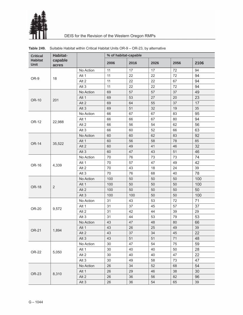
Table 249. Suitable Habitat within Critical Habitat Units OR-9 – OR-23, by alternative
Critical Habitat Unit
Habitat-capable acres
% of habitat-capable
2006 2016 2026 2056 2106
OR-9 18
No Action 11 17 17 72 94
Alt 1 11 22 22 72 94 Alt 2 11 22 22 67 94 Alt 3 11 22 22 72 94
OR-10 201
No Action 69 57 57 37 49 Alt 1 69 53 27 20 23 Alt 2 69 64 55 37 17 Alt 3 69 51 32 19 35
OR-12 22,988
No Action 66 67 67 83 95 Alt 1 66 66 67 80 94 Alt 2 66 56 54 62 56 Alt 3 66 60 52 66 63
OR-14 35,522
No Action 60 60 62 83 92 Alt 1 60 56 58 78 85
Alt 2 60 49 41 46 32 Alt 3 60 47 43 51 46
OR-16 4,339
No Action 70 76 73 73 74 Alt 1 70 57 47 49 42 Alt 2 70 43 18 24 39
Alt 3 70 76 68 40 78
OR-18 2
No Action 100 50 50 50 100 Alt 1 100 50 50 50 100 Alt 2 100 50 50 50 50 Alt 3 100 100 50 50 100
OR-20 9,572
No Action 31 43 53 72 71 Alt 1 31 37 45 57 37 Alt 2 31 42 44 39 29
Alt 3 31 44 53 79 53
OR-21 1,894
No Action 43 47 48 80 66 Alt 1 43 26 25 49 39
Alt 2 43 37 34 45 22 Alt 3 43 51 51 71 48
OR-22 5,050
No Action 30 47 54 75 59 Alt 1 30 40 40 50 28 Alt 2 30 40 40 47 22 Alt 3 30 49 58 73 47
OR-23 8,310
No Action 26 34 52 68 54 Alt 1 26 29 46 38 30 Alt 2 26 36 56 82 96 Alt 3 26 36 54 65 39
G – 1044

Appendix G. Wildlife
Table 250. Suitable Habitat within Critical Habitat Units OR-24 – OR-38, by alternative
Alternative % of habitat-capable
2006 2016 2026 2056 2106
No Action 32 34 40 51 49 Alt 1 32 30 32 48 42 Alt 2 32 36 35 44 28 Alt 3 32 33 37 51 61 No Action 62 62 63 79 95 Alt 1 62 60 61 75 92 Alt 2 62 57 54 64 70 Alt 3 62 53 45 47 53 No Action 58 51 57 60 52 Alt 1 58 46 47 50 48 Alt 2 58 56 44 47 36 Alt 3 58 55 61 51 51 No Action 71 64 62 57 49 Alt 1 71 66 63 40 37 Alt 2 71 65 57 22 23 Alt 3 71 56 47 20 21 No Action 65 61 56 59 55 Alt 1 65 45 44 36 44 Alt 2 65 60 60 14 29 Alt 3 65 58 56 51 59 No Action 53 56 57 69 86 Alt 1 53 56 57 66 82 Alt 2 53 53 50 55 60 Alt 3 53 51 46 53 47 No Action 57 66 64 71 89 Alt 1 57 60 57 61 81 Alt 2 57 53 38 23 37 Alt 3 57 55 53 62 44 No Action 61 60 52 44 47 Alt 1 61 52 46 41 18 Alt 2 61 58 49 24 11 Alt 3 61 60 49 46 29 No Action 71 74 70 60 61 Alt 1 71 70 63 42 32 Alt 2 71 69 63 47 31 Alt 3 71 60 47 40 41 No Action 61 70 72 76 78
Alt 1 61 66 65 67 72 Alt 2 61 65 64 65 70
Alt 3 61 66 66 72 87
Critical Habitat Unit
Habitat-capable acres
OR-24 6,436
OR-25 53,731
OR-27 12,903
OR-29 11,122
OR-31 1,608
OR-32 64,955
OR-34 35,982
OR-36 7,093
OR-37 27,864
OR-38 34,740
G – 1045

DEIS for the Revision of the Western Oregon RMPs
Table 251. Suitable Habitat within Critical Habitat Units OR-39 – OR-50, by alternative
OR-39 7,207
Alternative % of habitat-capable
2006 2016 2026 2056 2106
No Action 57 64 70 94 100 Alt 1 57 64 70 90 99 Alt 2 57 56 56 62 53 Alt 3 57 62 64 69 60 No Action 0 0 0 100 100 Alt 1 0 0 0 100 100
Alt 2 0 0 0 100 35 Alt 3 0 0 0 100 35 No Action 50 53 56 88 100 Alt 1 50 53 56 87 100 Alt 2 50 52 55 91 100 Alt 3 50 50 48 65 57 No Action 12 31 92 99 100 Alt 1 12 31 92 99 61 Alt 2 12 33 90 67 68 Alt 3 12 33 88 74 36 No Action 22 33 63 92 98
Alt 1 22 30 52 89 98 Alt 2 22 32 55 90 98
Alt 3 22 34 60 84 46 No Action 41 50 61 91 100 Alt 1 41 49 58 90 100 Alt 2 41 49 60 94 99 Alt 3 41 48 63 83 54 No Action 80 83 83 83 100 Alt 1 80 83 83 83 100 Alt 2 80 66 41 26 31 Alt 3 80 63 63 26 66 No Action 58 65 72 88 99 Alt 1 58 64 71 86 98 Alt 2 58 63 71 89 97 Alt 3 58 63 65 60 56 No Action 54 65 73 91 99 Alt 1 54 64 71 89 98 Alt 2 54 57 64 74 69 Alt 3 54 60 62 63 56 No Action 54 57 61 89 100 Alt 1 54 57 61 87 100 Alt 2 54 56 61 88 97 Alt 3 54 52 53 67 59
Critical Habitat Unit
Habitat-capable acres
OR-40 34
OR-41 36,989
OR-43 224
OR-44 26,418
OR-45 6,651
OR-46 226
OR-47 25,518
OR-48 40,555
OR-50 17,657
G – 1046

Appendix G. Wildlife
Table 252. Suitable Habitat within Critical Habitat Units OR-51 – OR-60, by alternative
Alternative % of habitat-capable
2006 2016 2026 2056 2106
No Action 35 35 37 67 77 Alt 1 35 35 37 60 77 Alt 2 35 32 37 61 50 Alt 3 35 35 36 73 65 No Action 40 48 59 86 98 Alt 1 40 48 58 85 98 Alt 2 40 40 45 59 61 Alt 3 40 45 49 64 63 No Action 47 51 58 82 91 Alt 1 47 50 57 77 87 Alt 2 47 50 58 81 93 Alt 3 47 46 49 54 52 No Action 49 49 56 84 95 Alt 1 49 48 57 82 96 Alt 2 49 47 50 36 29 Alt 3 49 41 40 57 41 No Action 61 64 71 90 99 Alt 1 61 64 69 88 99 Alt 2 61 44 43 40 33 Alt 3 61 64 71 91 59 No Action 56 55 58 70 79 Alt 1 56 54 57 63 78 Alt 2 56 51 36 22 22
Alt 3 56 49 41 30 39 No Action 59 60 61 71 82 Alt 1 59 60 61 71 79 Alt 2 59 41 29 19 20 Alt 3 59 52 41 26 32 No Action 54 57 60 87 96
Alt 1 54 57 61 85 95 Alt 2 54 56 59 85 94 Alt 3 54 53 49 59 40 No Action 59 61 63 79 86 Alt 1 59 61 63 76 90
Alt 2 59 56 56 26 20 Alt 3 59 56 44 27 40 No Action 52 57 65 86 93 Alt 1 52 56 62 84 92 Alt 2 52 55 60 72 76 Alt 3 52 56 61 76 52
Critical Habitat Unit
Habitat-capable acres
OR-51 3,640
OR-52 33,768
OR-53 49,004
OR-54 8,183
OR-55 15,799
OR-56 6,031
OR-57 9,848
OR-58 48,334
OR-59 4,728
OR-60 68,751
G – 1047

DEIS for the Revision of the Western Oregon RMPs
Table 253. Suitable Habitat within Critical Habitat Units OR-61 – OR-76, by alternative
No Action 71 72 77 83 96
Alt 1 71 72 78 84 100
Alt 2 71 60 57 20 13
Alt 3 71 59 55 14 10
No Action 59 61 61 71 89
Alt 1 59 61 62 69 87
Alt 2 59 60 62 71 91
Alt 3 59 54 51 57 41
No Action 66 64 65 61 59
Alt 1 66 64 61 46 50
Alt 2 66 51 39 30 37
Alt 3 66 66 65 76 61
No Action 60 56 59 63 70
Alt 1 60 57 53 45 39
Alt 2 60 43 35 34 41
Alt 3 60 57 58 57 42
No Action 74 77 78 83 90
Alt 1 74 77 77 83 89
Alt 2 74 75 76 80 84
Alt 3 74 71 70 72 62
No Action 100 100 100 100 100
Alt 1 100 100 100 100 100
Alt 2 100 100 100 100 100
Alt 3 100 100 100 100 100
No Action 61 60 70 77 75
Alt 1 61 59 68 73 58
Alt 2 61 54 56 56 41
Alt 3 61 56 64 66 55
No Action 70 76 78 86 93
Alt 1 70 74 76 81 91
Alt 2 70 74 75 77 79
Alt 3 70 61 55 53 62
No Action 55 63 64 57 59
Alt 1 55 57 58 51 48
Alt 2 55 58 62 52 39
Alt 3 55 52 52 42 57
No Action 47 56 55 43 57
Alt 1 47 48 50 37 41
Alt 2 47 48 52 43 40
Alt 3 47 48 46 38 60
No Action 86 91 94 94 100
Alt 1 86 83 82 23 11
Alt 2 86 48 82 86 95
Alt 3 86 89 85 40 62
Critical Habitat Unit
Habitat-capable acres
Alternative % of habitat-capable
2006 2016 2026 2056 2106
OR-62 45,760
OR-64 5,338
OR-66 4
OR-72 48,573
OR-75 16,985
OR-61
OR-63
OR-65
OR-67
OR-74
OR-76
2,462
8,004
82,184
18,555
26,891
418
G – 1048

Appendix G. Wildlife
Northern Spotted Owl Dispersal Habitat by District/Province Divisions The following graphs display the quantity and quality of dispersal habitat by District/Province Divisions over time for each alternative. The quantity of dispersal habitat is the total amount of suitable habitat and dispersal habitat only. The quality of dispersal habitat is the portion of total dispersal habitat that is suitable habitat.
G – 1049

DEIS for the Revision of the Western Oregon RMPs
G – 1050
Figure 290. Northern spotted habitat by District and Province.

G – 1051
Appendix G. Wildlife
G – 1051

G – 1052
DEIS for the Revision of the Western Oregon RMPs
1052

Appendix G. Wildlife
G – 1053

DEIS for the Revision of the Western Oregon RMPs
G – 1054G – 1054

Appendix G. Wildlife
G – 1055

DEIS for the Revision of the Western Oregon RMPs
Northern Spotted Owl Habitat Classification for Alternative 3
For Alternative 3 in 2056 and 2106, stands are classified as northern spotted owl suitable habitat if they either are classified as such by the habitat classification or are classified as dispersal habitat and are also classified as Mature with Multiple Canopies or Structurally Complex forest by the structural stage classification.
The habitat classification used alone would underestimate the suitable habitat in Alternative 3, because the habitat classification depends in part on measurement of the average diameter of trees in the stand. In Alternative 3, partial harvest would create multi-cohort stands, and the resultant large number of understory trees would depress the average tree diameter of the stand as a whole, causing these partially harvested stands to be classified as dispersal habitat only (Figure 291 - Stand Conditions Resulting from Partial Harvests in Alternative 3 Compared to Regeneration Harvest in No Action). These partially harvested stands would continue to be classified only as dispersal habitat until the understory would grow large enough to no longer depress the average tree diameter of the stand as a whole, which would typically take at least 50 years. The structural stage classification does not use average diameter of trees in the stand, but instead uses the density of trees above a certain diameter (see Ecology Appendix – Structural Stage Classification). As a result, the understory trees do not cause misclassification of stands, as long as the stand retains enough large trees. The structural stage classification automatically reclassifies partially harvested stands to Stand Establishment forest until the understory would grow tall enough to pass out of the Stand Establishment stage (usually 20 – 30 years), after which the partially harvested stand is classified based on the overall stand characteristics. Therefore, even using this combing classification scheme for Alternative 3, stands that had been partially harvested in Alternative 3 would not be classified as suitable habitat for several decades after partial harvest.
This combined classification is only used for results from the years 2056 and 2106; in the earlier years the results of the two different classification approaches are similar because the difference in classification is not apparent for several decades after the partial harvesting applied in Alternative 3. For example, in 2026, using the combined classification would increase the total amount of suitable habitat by 3.3%, which would represent 1.7% of habitat-capable acres.
G – 1056

Appendix G. Wildlife
Figure 291. Stand Conditions Resulting from Partial Harvests in Alternative 3 Compared to Regeneration Harvest in No Action
A. Alternative 3 Partial Harvest
Spotted owl habitat rating = Dispersal habitat (according to standard classification) Structural stage = Mature with multiple canopies
B. No Action - Regeneration Harvest with Green Tree Retention
Spotted owl habitat rating = Dispersal habitat Structural stage = Young with Structural Legacy
G – 1057

DEIS for the Revision of the Western Oregon RMPs
The combined classification might be expected to overestimate the amount of suitable habitat compared to other alternatives, because it expands the definition of suitable habitat wider than the other alternatives. However, in No Action, Alternative 1, and Alternative 2, Mature with Multiple Canopies and Structurally Complex forest is generally a subset of suitable habitat: the amount of Mature with Multiple Canopies and Structurally Complex forest is always lower than the amount of suitable habitat. Therefore, it is unlikely that the combined classification for Alternative 3 substantially overestimates the amount of suitable habitat compared to the other alternatives, and does not overestimate it enough to alter the overall trends and relative results of the alternatives.
No Action provides the best comparison to Alternative 3 for classification of suitable habitat, because No Action includes green tree retention which complicated the classification. Under No Action, the amount of Mature with Multiple Canopies and Structurally Complex forest is very similar to, but always lower, than the amount of suitable habitat in the first decades. In 2056, the amount of Mature with Multiple Canopies and Structurally Complex forest is more substantially lower than the amount of suitable habitat. But in 2056, Mature with Multiple Canopies and Structurally Complex forest is very strongly a subset of suitable habitat: 93% of Mature with Multiple Canopies forest and 94% of Structurally Complex forest in 2056 under No Action is also classified as suitable habitat.
Figure 292. Comparison of Classification of Mature with Multiple Canopies and Structurally Complex Forest with Classification of Suitable Habitat – No Action
No Action
0
200000
400000
600000
800000
1000000
1200000
1400000
1600000
1800000
2006 2016 2026 2056 2106
Acres MMC&SC Suitable
G – 1058

Appendix G. Wildlife
This close correlation between Mature with Multiple Canopies and Structurally Complex forest and suitable habitat in No Action, Alternative 1, and Alternative 2, is in contrast to the poor correlation between the two classifications in Alternative 3. Note that the two classifications have a different trend over time under Alternative 3.
Figure 293. Comparison of Classification of Mature with Multiple Canopies and Structurally Complex Forest with Classification of Suitable Habitat – Alternative 3
Alternative 3
0
200000
400000
600000
800000
1000000
1200000
1400000
2006 2016 2026 2056 2106
Acres MMC&SC Suitable
G – 1059

DEIS for the Revision of the Western Oregon RMPs
Marbled Murrelet Critical Habitat. There are 29 marbled murrelet critical habitat units that include BLM administered lands. Critical habitat was designated by the U.S. Fish and Wildlife Service in 1996 to encompass existing Late-successional Reserves, as defined in the Northwest Forest Plan. Critical habitat units would be managed as late-successional reserves under the no action alternative and as late-successional management areas under alternative 1. By 2106 under the no action alternative and alternative 1, BLM administered lands in 14 and 19 of 29 critical habitat units would be comprised of more than 90 percent murrelet nesting habitat. All except one of these units would have increasing amounts of murrelet nesting habitat. The one exception to this upward trend would be unit CA01-e, in which the BLM administers 14 acres. It is assumed in this analysis that the marbled murrelet critical habitat which is designated as late-successional reserves on U.S. Forest Service lands would follow similar trends to those exhibited by habitat on BLM administered lands under the no action alternative and Alternative 1.
Marbled murrelet nesting habitat would increase under alternative 2 from 218,000 acres to 287,000 acres, or from 47 to 63 percent of habitat capable forest in critical habitat units. The late-successional management areas under alternative 2 would not completely encompass marbled murrelet critical habitat and as a result 6 of 29 critical habitat units would contain greater than 90 percent nesting habitat by 2106, compared to 14 critical habitat units under the no action alternative. Marbled murrelet nesting habitat would increase 10 percent, or more, in one critical habitat unit from 2006 to 2016 while 20 critical habitat units would decrease in habitat during this time period. Nine of these 20 units would decrease in habitat more than 10 percent. Nesting habitat would decrease between 2016 and 2026 in 20 critical habitat units. Two of these 20 critical habitat units would decrease more than 10 percent. From 2006 to 2106, marbled murrelet nesting habitat would increase in 14 critical habitat units. Thirteen of these 14 critical habitat units would increase in habitat more than 10 percent. Murrelet nesting habitat would decrease in 15 critical habitat units, 10 of these units would decrease more than 10 percent.
Marbled murrelet nesting habitat would increase under alternative 3 from 217,000 acres to 269,000 acres, or from 47 to 59 percent of habitat-capable forest on BLM administered lands.
Under alternative 3, with the exception of Congressionally-withdrawn lands and riparian management areas, almost all marbled murrelet critical habitat units would be subject to regeneration harvests and partial harvests that would remove marbled murrelet nesting habitat. Under alternative 3, there would be 3 of 29 critical habitat units which would contain greater than 90 percent nesting habitat by 2106, compared to 14 units under the no action alternative and 19 units under alternative 1 and 6 units under alternative 2. Under alternative 3, marbled murrelet nesting habitat would increase more than 10 percent in one critical habitat unit from 2006 to 2106 while habitat would decrease in 14 critical habitat units in the first decade. Three of these 14 units would decrease more than 10 percent. Nesting habitat would decrease between 2016 and 2026 in 23 critical habitat units. One of these 23 units would decrease more than 10 percent. From 2006 to 2106, marbled murrelet nesting habitat would increase in 20 critical habitat units, in 10 of these units habitat would increase more than 10 percent, while habitat would decrease in 9 critical habitat units, habitat would decrease more than 10 percent in two of those nine units. Although alternative 3 opens almost all of the critical habitat units to vegetative management compared
G – 1060

Appendix G. Wildlife
to alternative 2, retention tree requirements in both the partial and regeneration harvests provide for much more rapid redevelopment of murrelet nesting habitat. Murrelet nesting habitat would develop up to 70 years sooner in alternative 3 compared to alternative 2, because of the role of retention trees in habitat development.
Table 254. Marbled murrelet nesting habitat summarized by critical habitat unit and alternative.
Critical Habitat Unit
Alternative Habitat-capable (ac)
Marbled murrelet nesting habitat (ac)
2006 2016 2026 2056 2106
14 10 3 3 9
14 10 10 10 8
14 10 14 14 14
OR-01-b
Alt 1 1 1 1 1 1 1
Alt 2 1 1 1 1 1 1
Alt 3 1 1 1 1 1 1
No Action 1 1 1 1 1 1
CA-01-e
OR-01-c
OR-02-b
OR-02-d
Alt 1
Alt 2
Alt 3
No Action
Alt 1
Alt 2
Alt 3
No Action
Alt 1
Alt 2
Alt 3
No Action
14
7217
7217
7217
7217
11
11
11
11
10
4472
4472
4472
4472
1
1
1
1
7
4874
4340
4792
4873
1
1
1
1
6
4903
3973
4465
4903
1
1
1
1
10
5089
2991
3081
5089
1
1
1
1
8
7
12
9
5680
3076
4497
5297
4
1
1
1
OR-02-a
Alt 1 0 0 0 0 0 0
Alt 2 0 0 0 0 0 0
Alt 3 0 0 0 0 0 0
No Action 0 0 0 0 0 0
OR-02-c
Alt 1 3139 969 1332 1557 1910 2742
Alt 2 3139 969 985 1206 1355 2148
Alt 3 3139 969 1027 963 557 1077
No Action 3139 969 1332 1557 1910 2114
Alt 1 25584 4948 6082 6700 9143 23955
Alt 2 25584 4948 6579 7391 11258 23667
Alt 3 25584 4948 7041 7414 10653 17785
No Action 25584 4948 6874 8201 14458 23688
OR-02-e
Alt 1 37256 13750 16475 17692 20158 34639
Alt 2 37256 13750 15532 16625 18578 31857
Alt 3 37256 13750 14709 13997 9737 18669
No Action 37256 13750 16613 17883 20232 30462
G – 1061

DEIS for the Revision of the Western Oregon RMPs
Critical Habitat Unit
Alternative Habitat-capable (ac)
Marbled murrelet nesting habitat (ac)
2006 2016 2026 2056 2106
OR-03-a
Alt 1 39 39 41 41 41 41
Alt 2 39 39 39 39 39 39
Alt 3 39 39 39 39 15 15
No Action 39 39 41 41 41 41
OR-03-c
Alt 1 8087 3158 3992 3819 4165 7892
Alt 2 8087 3158 3593 3521 4100 6786
Alt 3 8087 3158 3624 3652 3188 5207
No Action 8087 3158 3988 4051 5047 7542
OR-04-a
Alt 1 1283 711 729 736 803 1165
Alt 2 1283 711 658 661 612 694
Alt 3 1283 711 628 605 294 537
No Action 1283 711 728 736 803 1039
OR-04-b
Alt 1 1083 893 964 1076 1076 1080
Alt 2 1083 893 960 1072 1072 1072
Alt 3 1083 893 959 1071 721 1068
No Action 1083 893 964 1076 1076 1076
OR-04-c
Alt 1 13378 7560 7575 7575 7701 12059
Alt 2 13378 7560 7452 7450 7432 10999
Alt 3 13378 7560 6755 6465 5458 6851
No Action 13378 7560 7582 7580 7724 11177
OR-04-d
Alt 1 20059 10832 10945 11251 11340 17555
Alt 2 20059 10832 7755 6723 4092 5535
Alt 3 20059 10832 10834 11156 11069 10642
No Action 20059 10832 10945 11283 11407 16553
OR-04-e
Alt 1 50508 26602 27244 27615 29639 46806
Alt 2 50508 26602 26780 26336 27211 42963
Alt 3 50508 26602 24887 21442 17695 30230
No Action 50508 26602 27429 27968 29840 46945
OR-04-f
Alt 1 20099 12133 12220 13014 13512 17531
Alt 2 20099 12133 9482 7901 3248 3423
Alt 3 20099 12133 11148 9212 5219 13302
No Action 20099 12133 12220 13040 13743 18431
OR-04-g
Alt 1 15352 7374 7280 7287 7405 12759
Alt 2 15352 7374 7034 6437 3319 4064
Alt 3 15352 7374 6294 4901 3355 8483
No Action 15352 7374 7082 7146 7912 12618
G – 1062

Appendix G. Wildlife
Critical Habitat Unit
Alternative Habitat-capable (ac)
Marbled murrelet nesting habitat (ac)
2006 2016 2026 2056 2106
OR-04-i
Alt 1 79203 34727 38319 41145 46096 71373
Alt 2 79203 34727 33995 34037 32619 47235
Alt 3 79203 34727 34184 32490 29996 51010
No Action 79203 34727 38410 41538 49490 70351
OR-04-j
Alt 1 55887 25062 27390 29112 32083 51859
Alt 2 55887 25062 23712 23768 21026 25494
Alt 3 55887 25062 25354 24338 20163 33843
No Action 55887 25062 27740 30180 33584 50827
OR-04-k
Alt 1 25526 13379 14524 15283 16322 23694
Alt 2 25526 13379 14234 14956 15706 21771
Alt 3 25526 13379 13701 13541 8513 14137
No Action 25526 13379 14637 15656 16724 22211
OR-06-a
Alt 1 39 26 26 26 26 36
Alt 2 39 26 7 7 7 7
Alt 3 39 26 4 4 4 26
No Action 39 26 26 26 26 36
OR-06-b
Alt 1 49888 26052 27344 28484 29942 43864
Alt 2 49888 26052 27034 28113 27242 38638
Alt 3 49888 26052 26873 26206 25836 22602
No Action 49888 26052 27509 28719 30299 42247
OR-06-c
Alt 1 4608 3508 3406 3444 3543 4447
Alt 2 4608 3508 1526 1238 1189 1543
Alt 3 4608 3508 2932 2461 1896 3652
No Action 4608 3508 3486 3523 3543 4389
OR-06-d
Alt 1 16177 8407 8445 8494 9627 15545
Alt 2 16177 8407 6551 5041 3045 3569
Alt 3 16177 8407 6347 4959 3961 8965
No Action 16177 8407 8405 8611 9843 15324
OR-07-a
Alt 1 2364 1466 1227 1227 1752 2127
Alt 2 2364 1466 998 749 719 750
Alt 3 2364 1466 1534 1580 918 1289
No Action 2364 1466 1218 1289 1801 2114
OR-07-b
Alt 1 2168 1073 1304 1304 2047 2047
Alt 2 2168 1073 1300 1300 2166 2167
Alt 3 2168 1073 1302 1302 2167 2167
No Action 2168 1073 1428 1428 2171 2171
G – 1063

DEIS for the Revision of the Western Oregon RMPs
Critical Habitat Unit
Alternative Habitat-capable (ac)
Marbled murrelet nesting habitat (ac)
2006 2016 2026 2056 2106
OR-07-d
Alt 1 1839 836 836 868 1194 1723
Alt 2 1839 836 509 442 1021 1469
Alt 3 1839 836 837 868 1086 1565
No Action 1839 836 836 876 1231 1752
OR-07-f
Alt 1 15595 8577 9459 9706 11030 14908
Alt 2 15595 8577 6635 5982 6803 7271
Alt 3 15595 8577 8589 7816 7344 10621
No Action 15595 8577 11472 11711 13467 15016
OR-07-g
Alt 1 2078 984 1085 1085 1097 1469
Alt 2 2078 984 829 450 367 394
Alt 3 2078 984 1034 999 1248 835
No Action 2078 984 1085 1085 1085 1514
G – 1064

Appendix G. Wildlife
Special Status Animal Species The following table shows the Bureau Special Status Animal Species in the planning area by their habitat group and location.
Table 255. Documented and suspected occurrence of Bureau special status animal species (as of March 14, 2005) within the planning area of the Western Oregon Plan Revision.
Scientific Name Common Name
District
Sta
tus
1
Coo
s B
ay
Eug
ene
Kla
mat
h F
alls
Med
ford
Ros
ebur
g
Sal
em
Amphibians and Reptiles Rana pretiosa*
Batrachoseps wrighti*
Chrysemys picta Clemmys marmorata marmorata
Plethodon stormi*
Rhyacotriton kezeri
Aneides flavipunctatus Ascaphus montanus
Batrachoseps attenuatus
Dicamptodon copei
Plethodon larselli
Rana boylii*
Rhyacotriton cascadae*
Birds Pelecanus occidentalis californicus Brachyramphus marmoratus maroratum* Charadrius alexandrinus nivosus Haliaeetus leucocephalus* Strix occidentalis caurina*
Eremophila alpestris strigata
Accipiter gentilis* Anser albifrons elgasi
Athene cunicularia hypugaea
Oregon spotted frog
Oregon slender salamander
Painted turtle
Northwestern pond turtle
Siskiyou mountains salamander
Columbia torrent salamander
Black salamander
Inland tailed frog
California slender salamander
Cope’s giant salamander
Larch mountain salamander
Foothill yellow-legged frog
Cascade torrent salamander
California brown pelican
Marbled murrelet
Western snowy plover (coastal population)
Bald eagle
Northern spotted owl
Streaked horned lark (oregon cr , wv, km)
Northern goshawk
Tule goose
Burrowing owl (wv, km, hp, cb, bm)
FC D D
BS D D
BS S S
BS D D D D D S
BS D
BS D
BA D
BA S
BA D
BA D
BA S
BA D D D D S
BA D D
FE D S S
FT D D S D D
FT D
FT D D D D D D
FT D D D D D D
FC D S D
BS D D D D D D
BS S S
BS D S
G – 1065

DEIS for the Revision of the Western Oregon RMPs
Bartramia longicauda Branta canadensis leucopareia Branta canadensis occidentalis Buteo regalis Centrocercus urophasianus Chordeiles minor Coturnicops noveboracensis Falco peregrinus anatum* Falco peregrinus tundrius
Glaucidium gnoma
Icteria virens
Melanerpes lewis
Otus flammeolus*
Picoides albolarvatus
Picoides arcticus
Picoides tridactylus
Podiceps grisegena
Pooecetes gramineus affinis
Progne subis*
Sturnella neglecta
Agelaius tricolor
Ammodramus savannarum Cerorhinca monocerata Cygnus buccinator Dolichonyx oryzivorus Elanus leucurus
Falco columbarius
Fratercula cirrhata
Histrionicus histrionicus
Melanerpes lewis
Oceanodroma furcata
Pelecanus erythrorhynchos
Ptychoramphus aleuticus
Upland sandpiper
Aleutian canada goose (wintering)
Dusky canada goose
Ferruginous hawk
Greater sage-grouse
Common nighthawk (wv)
Yellow rail
American peregrine falcon
Arctic peregrine falcon
Northern pygmy-owl (Blue Mtns)
Yellow-breasted chat (wv)
Lewis’ woodpecker (wv, km, wc, ec, cb)
Flammulated owl (ec, bm, br, wc, km)
White-headed woodpecker (km, wc, ec, bm)
Black-backed woodpecker (km, wc, ec, bm)
Three-toed woodpecker (wc, ec, bm)
Red-necked grebe (breeding pops: wc, ec)
Oregon vesper sparrow (wv, km, cr)
Purple martin (cr, wv, km, wc, ec)
Western meadowlark (wv)
Tricolored blackbird (breeding pop: wv, km, ec, hp, cb)
Grasshopper sparrow (wv)
Rhinoceros auklet
Trumpeter swan
Bobolink
White-tailed kite
Merlin (possible breeding pop: ec, cb, br)
Tufted puffin
Harlequin duck (breeding pops: wc, ec, bm)
Lewis’ woodpecker
Fork-tailed storm petrel (breeding population)
American white pelican (breeding pops: ec, br)
Cassin’s auklet
BS
BS
BS
BS
BS
BS
BS
BS
BS
BS
BS
BS
BS
BS
BS
BS
BS
BS
BS
BS
BA
BA
BA
BA
BA
BA
BA
BA
BA
BA
BA
BA
BA
D
D
S
D
D
D
D
D
D
D
D
S
S
D
D
S
D
S
S
S
D
D
D
S
D
D
D
D
D
D
D
D
S
D
S
D
D
D
D
D
D
D
D
S
D
D
D
D
S
D
D
D
D
D
D
S
D
D
D
D
D
D
D
D
D
D
D
D
D
S
D
D
D
D
S
D
S
D
D
S
G – 1066

Appendix G. Wildlife
Invertebrates Icaricia icarioides fenderi Branchinecta lynchi Speyeria zerene hippolyta
Euphydryas editha taylori Polites mardon* Acetropis americana Algamorda newcombiana Allomyia scotti Anodonta wahlametensis
Chloealtis aspasma Cryptomastix devia Cryptomastix populi Deroceras hesperium Driloleirus macelfreshi Fluminicola sp. nov. Fluminicola sp nov. Fluminicola sp nov. Fluminicola sp. nov. 1* Fluminicola sp. nov. 11
Fluminicola sp. nov. 3 Gliabates oregonius Helisoma newberryi newberryi
Helminthoglypta hertleini*
Hesperarion mariae* Hochbergellus hirsutus Incisalia polia maritima Lanx klamathensis Lanx subrotunda
Mitoura johnsoni
Monadenia chaceana* Monadenia fidelis beryllica Monadenia fidelis celeuthia Monadenia fidelis ssp. nov. Pisidium ultramontanum Plebejus saepiolus littoralis Pomatiopsis binneyi Pomatiopsis californica Pristiloma articum crateris* Pristiloma pilsbryi
Prophysaon sp. nov.
Fender’s blue butterfly
Vernal pool fairy shrimp
Oregon silverspot butterfly
Whulge checkerspot (butterfly)
Mardon skipper (butterfly)
American grass bug
Newcomb’s littorine snail
Scott’s apatanian caddisfly
Willamette floater (mussel)
Siskiyou short-horned grasshopper
Puget oregonian (snail)
Hells canyon land snail
Evening fieldslug
Oregon giant earthworm
Fall creek pebblesnail
Keene creek pebblesnail
Toothed pebblesnail
Klamath pebblesnail
Nerite pebblesnail
Diminutive pebblesnail
Salamander slug
Great basin ramshorn (snail)
Oregon shoulderband (snail)
Tillamook westernslug
Sisters hesperian (snail)
Hoary elfin (butterfly)
Scale lanx (snail)
Rotund lanx (snail)
Johnson’s hairstreak (butterfly)
Chase sideband (snail)
Green sideband (snail)
Travelling sideband (snail)
Modoc sideband (snail)
Montane peaclam
Insular blue butterfly
Robust walker
Pacific walker
Crater lake tightcoil (snail)
Crowned tightcoil (snail)
Klamath tail-dropper
FE
FT
FT
FC
FC
BS
BS
BS
BS
BS
BS
BS
BS
BS
BS
BS
BS
BS
BS
BS
BS
BS
BS
BS
BS
BS
BS
BS
BS
BS
BS
BS
BS
BS
BS
BS
BS
BS
BS
BS
S
D
S
D
S
S 2
S
S
S
S
S
D
S
S
S
D
S
S
S
S
S
S
D
S
S
D
D
S
D
D
D
S
D
S
D
D
D
D
D
D
D
S
D
D
S
D
D
S
S
S
D
D
D
D
D
S
S
S
S
S
S
S
D
S
S
D
D
S
S
S
S
S
S
G – 1067

DEIS for the Revision of the Western Oregon RMPs
Prophysaon vanattae pardalis Pterostichus rothi
Rhyacophila haddocki
Vespericola sierrana Vespericola sp. nov. Vespericola sp. nov.
Mammals Balaenoptera musculus Eschrichtius robustus Megaptera novaeangliae Odocoileus virginianus leucurus Eumetopias jubatus Martes pennanti pacifica* Arborimus longicaudus silvicola Corynorhinus townsendii Odocoileus virginianus leucurus Antrozous pallidus Antrozous pallidus pacificus Brachylagus idahoensis Euderma maculatum Myotis thysanodes Thomomys bottae detumidus
Thomomys mazama helleri * Species known from more than 20 sites
Spotted tail-dropper
Roth’s blind ground beetle
Haddock’s rhyacophilan caddisfly
Siskiyou hesperian
Bald hesperian
Oak springs hesperian
Blue whale
Gray whale
Humpback whale
Columbian white-tailed deer
Steller sea lion
Fisher
Oregon red tree vole (nw or coast)
Townsend’s big-eared bat
Columbian white-tailed deer (Douglas County only)
Pallid bat
Pacific pallid bat
Pygmy rabbit
Spotted bat
Fringed myotis
Pistol river pocket gopher
Gold beach pocket gopher
BS
BS
BS
BS
BS
BS
FE
FE
FE
FE
FT
FC
BS
BS
BS
BA
BA
BA
BA
BA
BA
BA
D
S
S
S
S
S
D
S
S
D
S
S
S
S
S
D
D
D
D
S
S
S
S
D
D
S
S
D
D
D
D
D
D
D
S
D
D
D
D
D
D
S
D
S
D
D
S
S
1 Status Codes: FE - Federally listed as endangered; FT - Federally listed as threatened; FC -- Candidate for federal listing; BS - Bureau Sensitive; BA - Bureau Assessment. 2 Occurrence Codes: D - Documented to occur within the district; S - Suspected to occur in the district
G – 1068