OREGON - eRegulations
112
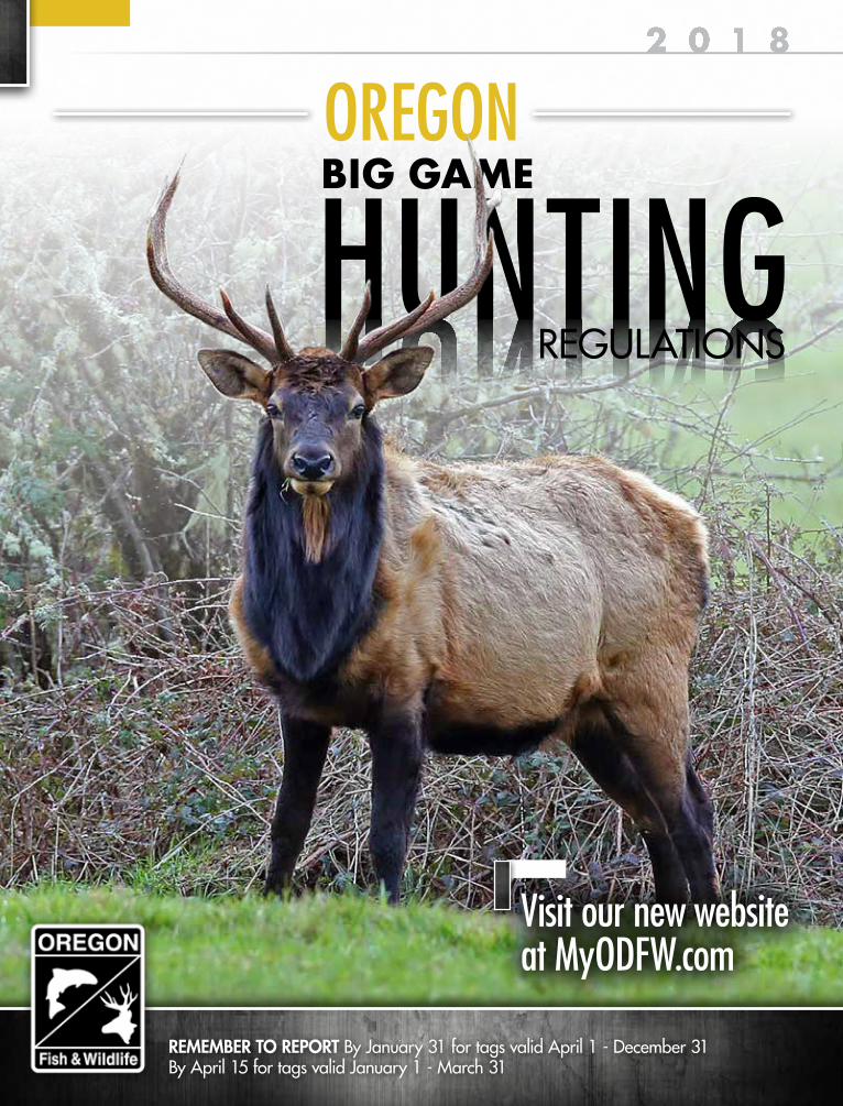
REMEMBER TO REPORT By January 31 for tags valid April 1 - December 31 By April 15 for tags valid January 1 - March 31 OREGON HUNTING REGULATIONS BIG GAME Visit our new website at MyODFW.com
-
Upload
khangminh22 -
Category
Documents
-
view
0 -
download
0
Transcript of OREGON - eRegulations
REMEMBER TO REPORT By January 31 for tags valid April 1 - December 31By April 15 for tags valid January 1 - March 31
OREGON2 0 1 8
HUNTINGHUNTINGREGULATIONS
BIG GAME
Visit our new website at MyODFW.com

ALL SEASONS EQUIPMENTEugene, OR n 541-461-6716 allseasonsequipment.net
AL’S TRACTOR SALES OF SALEMSalem, OR n 541- 666-8444 alstractors.com
JONES TRUCK AND IMPLEMENT (JTI)The Dalles, OR n 541-298-6277 jtii.com
KENO TRACTORSKeno, OR n 541-850-8193 kenotractors.com
ROGUE VALLEY FARM EQUIPMENTCentral Point, OR n 541-826-8500
STARK STREET LAWN & GARDENNewberg, OR n 503-862-5016starkstreet.biz
TRAILER CITY Portland, OR n 503-283-5311 trailercityportland.com
VISIT OREGONMAHINDRADEALERS.COM
Shown: Camo XTVShown: 1533
VISIT YOUR OREGON MAHINDRA DEALER TODAY!
GET MORE BANGFOR YOUR BUCK.HURRY IN FOR 0% INTERESTFOR UP TO 84 MONTHS.
NO WONDER WE’RETHE WORLD’S NUMBER 1
SELLING TRACTOR

Representingthe Finest Hunting,Farm, Ranch, andRecreationalProperties in the Pacific Northwest
EXCLUSIVE PARTNER OF
LET US SELL YOUR LAND !Our Real Estate Brokers are Passionate About & Specialize in Land and the Outdoor Way of Life.
We Live the Lifestyle we Sell®
DO YOU HAVE THE PASSION IT TAKES TO JOIN OUR TEAM?Our team is ardent about hunting, fishing, horses, farms, and ranches. If you have the knowledge
of and passion for the outdoor way of life, we would be interested in hearing from you.
LandandWildLife.com (866) 559-3478 [email protected]
NOW SEEKING BROKERS in Oregon, Wash, Idaho, & Alaska !

Cover Photo:Roosevelt Elk at Jewell Meadows Wildlife Area.Photo courtesy of Keith Kohl.
Websitewww.myodfw.com
Information and Education503-947-6002
Licensing503-947-6101
Wildlife Division503-947-6301
Wildlife Violations 1-800-452-7888
Or Dial *OSP (*677)
OREGON DEPARTMENT OF FISH AND WILDLIFE
Full Service OfficesHigh Desert
61374 Parrell Rd.Bend, OR 97702
541-388-6363
Northeast107 20th Street
La Grande, OR 97850541-963-2138
Northwest17330 SE Evelyn Street
Clackamas, OR 97015971-673-6000
Southwest4192 N Umpqua Hwy
Roseburg, OR 97470541-440-3353
OREGON
2 0 1 8
HUNTINGREGULATIONS
BIG GAME
• As a first step in a project to simplify the Big Game Regulations, this booklet has been reorganized and reformatted; examples are the new Youth section on pages 20 and 21 and highlighting new information and changes in yellow.
• Beginning January 1, 2018, the eligible age for the Mentored Youth Program is extended two years to include youth 14 and 15 years of age.
• The 3% limitation on nonresident bear tags has been removed for the General Fall Bear Season. The 3% nonresident limitation will continue to be in effect for all spring bear hunts.
• The Department is sponsoring a new “Take a Friend Hunting” Contest (Contest) to encourage mentoring among adult hunters. Mentors and mentees must be at least 18 years of age or older. To be eligible, mentees must have 1) not had a hunting license prior 2017 or only had a hunting license in 2016; or 2) not had a hunting license in the past five consecutive years (i.e., since 2012). To see the full eligibility and contest rules, and for information on prizes, visit the Contest page at http://www.oregonhunter.info/take-a-friend/.
WHAT’S NEW FOR 2018
Facebook.com/MyODFW Facebook.com/ODFWConservation
Twitter @MyODFW @MyODFWRecReport @ODFWConserve
Instagram @MyODFW
Snapchat @MyODFW
Pinterest @MyODFW
CONTENTSLicensing/Controlled Hunts
Fees��������������������������������������������������6Tag Sale Deadlines ����������������������������7Mandatory Hunter Reporting �������������8License/Tag Requirements ������������������8Applying for Hunts ��������������������������13
Hunting Regulations/ProgramsGeneral Regulations ������������������������15Weapon Regulations �����������������������18Youth and Hunter Education �������������20Landowners ������������������������������������22Veterans/Active Military �������������������24Disability Permit �������������������������������25
Hunting OpportunitiesBuck Deer (100 Series)
General Centerfire �����������������������26General Archery��������������������������28Controlled �����������������������������������30
Antlerless Deer (600 Series) �������������36Elk (200 Series)
General Centerfire �����������������������40General Archery��������������������������42Controlled �����������������������������������44
Pronghorn (400 Series) ��������������������56Bighorn Sheep (500 Series) ��������������58Rocky Mountain Goat (900 Series) ����60Black Bear (700 Series) ��������������������61Cougar �������������������������������������������64Western Gray Squirrel and Small Game ������������������������������������65Extended Hunting Opportunities
Premium Hunts �����������������������������66Auction and Raffle Hunts ��������������69
Maps ����������������������������������������������72Unit Boundaries ������������������������������73Travel Management Areas ��������������81Special Area Restrictions �����������������85Definitions ��������������������������������������89Abbreviations ���������������������������������89Controlled Hunt Boundary Descriptions ��������������������91

2018 OREGON BIG GAME HUNTING REGULATIONS 3
The information in this booklet will be furnished in alternate format for people with disabilities, if needed. Please call 503-947-6002 or e-mail [email protected] to request an alternate format.
ODFW prohibits discrimination on the basis of race, color, national origin, age, sex or disability. If you believe you have been discriminated against as described above in any program, activity or facility, or if you desire further information, please contact Deputy Director, Fish & Wildlife Programs, ODFW, 4034 Fairview Industrial Dr. SE, Salem, OR 97302, or call 503-947-6000, or write to the Civil Rights Coordinator for Public Access, Department of the Interior, 1849 C Street NW, Washington, DC 20240.
ODFW allows appropriate advertising in this booklet to help offset the cost of printing. ODFW neither endorses products or services listed nor accepts any liability arising from the use of products or services listed.
Oregon Department of Fish and Wildlife
EnglishThis book includes important information about Oregon hunting laws. You can be fined or jailed if you violate these laws. Please have an English reader who fully understands this information and can accurately interpret the legal meaning of the regulations in this book explain them to you.
SpanishEste libro incluye información importante sobre las leyes de caza de Oregon. Puede ser multado o encarcelado si usted viola estas leyes. Tenga a mano un lector inglés que entiende completamente esta información y puede interpretar con precisión legal les explicarle el significado de las regulaciones en este libro.
Traditional Chinese本書包括有關俄勒岡州狩獵法的重要資訊。如果違反這些法律,將會被處以罰款或監禁。請讓完全瞭解這些資訊並能夠準確詮釋本書條例法律含義的英文讀者為你解釋這些資訊。
RussianДанная книга содержит важную информацию о законах штата Орегон об охоте. За нарушение этих законов Вы можете быть оштрафованы или осуждены. Пожалуйста, убедитесь, что Вы полностью понимаете информацию правового характера, изложенную в этой книге.
UkranianЦя книга містить важливу інформацію про закони про полювання в штаті Орегон. Якщо Ви порушите ці закони, з Вас можуть стягнути штраф або посадити у вязницю.Будь ласка, попросіть людину, яка добре розуміє англійську і може точно передати юридичне значення цієї книги, прочитати і пояснити Вам ці правила.
VietnameseQuyển sách này bao gồm những thông tin quan trọng về luật đi săn của Oregon. Quý vị có thể bị phạt tiền hoặc phạt tù nếu vi phạm những luật này. Hãy nhờ một người thạo tiếng Anh, người có thể hoàn toàn hiểu những thông tin này và có thể giải thích ch.
Curt Melcher, Director Salem Headquarters Office 4034 Fairview Industrial Dr. SE Salem, OR 97302 503-947-6000ODFW in-state toll-free 800-720-6339 [email protected]
Oregon Fish and Wildlife CommissionMichael Finley (Chair) .......................... MedfordHolly Akenson..................................... EnterpriseLaura Anderson ..................................... NewportJim Bittle..........................................Central PointBruce Buckmaster .....................................AstoriaBob Webber .......................................Port OrfordGreg Wolley. ........................................... Portland
In an effort to make these regulations easier to understand, at times simplified language is used. ODFW’s intention is for these summarized regulations to be consistent with the actual language in Oregon statutes and administrative rules, but in the event of an inconsistency the statutes and administrative rules take precedence. The actual wording of relevant Oregon Revised Statutes and Oregon Administrative Rules can be found at: www.odfw.com/oars and www.oregonlaws.org/oregon_revised_statutes.
NOTICE TO HUNTERS
Graphic Design: Jon Gulley, Dane Fay,
John Corey, Evelyn Haddad, Chris Sobolowski
Williamstown, MA | Birmingham, AL
About This GuideThis high-quality guide is offered to you by the Oregon Department of Fish and Wildlife through its unique partnership with J.F. Griffin Publishing, LLC.
The revenue generated through ad sales signifi-cantly lowers production costs and generates savings. These savings translate into additional funds for other important agency programs.
If you have any feedback or are interested in advertising, please contact us at 413.884.1001 or at www.JFGriffin.com
This guide is available online at
Your purchase of hunting equipment supports Wildlife Restoration.
WILDLIFE RESTORATION

HUNT EXPLORE OREGON
MyODFW.com


2018 OREGON BIG GAME HUNTING REGULATIONS6
LICENSE, TAG, AND PERMIT FEESBIG GAME LICENSES AND TAGS
DESCRIPTION RESIDENT NONRESIDENT
LICENSESHunting $33.50 $167.00Sports Pac - Includes Combination Hunting and Angling/Shellfish License, Combined Angling Harvest Tag, Upland Game Bird and Waterfowl Validations, plus a General or Controlled Deer, General or Controlled Elk, Cougar, General or Controlled Bear, and Spring Turkey tag.
$188.50 N/A
Combination Angling and Hunting $69.00 N/ATAGS
Black Bear $16.00Additional Bear $16.00Cougar $16.00Additional Cougar $16.00Deer $27.50 $430.50Elk $48.00 $571.00Bighorn Sheep $138.00 $1,469.50Pronghorn Antelope $50.00 $384.00Rocky Mountain Goat $138.00 $1,469.50
YOUTHDESCRIPTION RESIDENT NONRESIDENT
Youth License (12-17 years old) - Includes Hunting, Angling, Shellfish and Columbia Rvr Basin Endorsement
$10.00
Youth Sports Pac - Includes Combination Hunting, Angling, Shellfish License, Combined Angling Harvest Tag, Upland Game Bird and Waterfowl Validations, plus a General or Controlled Deer, General or Controlled Elk, Cougar, General or Controlled Bear, and Spring Turkey tag. A Youth Sports Pac also includes the Columbia Rvr Basin Endorsement.
$55.00 N/A
Youth Game Bird Hunting License (age 11 and under) FREE
RESIDENT SENIOR AND PIONEERDESCRIPTION RESIDENT NONRESIDENT
LICENSESSenior Hunting (age 70 and 5 years Oregon residency) $21.50 N/A
Senior Combination Hunting and Angling (age 70 and 5 years Oregon residency) $44.50 N/A
Pioneer Combination - Hunting, Angling, and Columbia Rvr Basin Endorsement* (age 65 and 50 years Oregon residency)
$6.00 N/A
TAGSPioneer Elk $25.00 N/A
OTHER PERMITS AND APPLICATIONSDESCRIPTION RESIDENT NONRESIDENT
Duplicate (Licenses Tags, Permits)** $25.50Wildlife Area Parking Permit - Daily $10.00Wildlife Area Parking Permit - Annual $30.00Controlled Hunt Application Change Fee*** $25.00Controlled Hunt Application - Big Game $8.00Aquatic Invasive Species Prevention Permit - Nonmotorized Boats $7.00
Aquatic Invasive Species Prevention Permit - Motorized Boats N/A $22.00
Oregon Disabilities Hunting And Fishing Permit - Contact ODFW Salem Hq FREE
All fees are non-refundable. * Initial documents are issued at Salem, Bend, Central Point, Charleston,
Clackamas, Corvallis, La Grande, Newport, Roseburg, Springfield, and Tillamook ODFW offices.
** You can only exchange or receive a duplicate tag at ODFW offices. Hunting licenses may be exchanged for a Combination or Sports Pac within 90 days of purchase. Tags cannot be exchanged after the season starts. If the fee paid for the license, tag, or permit that was lost, destroyed or stolen was less than $25.50, the original fee shall be charged for the duplicate.
*** If you decide to change your controlled hunt application after you apply, there is no charge for the first change for each controlled hunt series. A $25.00 fee is assessed for each subsequent application change to the same hunt series.
You can buy a license, tags and/or apply for controlled hunt:• Online at: http://www.dfw.state.or.us/online_license_sales/• At a Point-of-Sale license agents• At ODFW offices that sell licenses• By mail or fax order using the application available online at:
http://www.dfw.state.or.us/resources/hunting/big_game/regulations/docs/2018_Mail_Order_Application.pdf
HOW TO BUY LICENSE, TAGS OR PERMITS

7
TAG SALE DEADLINES AND SPORTS PAC PICKUP DATES
TAG NAME DEADLINEBighorn Sheep (Controlled) The day before the season
end date Rocky Mt Goat (Controlled)Black Bear (Controlled)
Day before earliest hunt period opensPronghorn Antelope (Controlled)Deer (Controlled)Elk (Controlled)Deer or Elk Archery (General) Aug. 24Western Oregon Deer Centerfire (General) Sept. 28Black Bear (General) Sept. 28Bear (SW Additional) No Deadline*Cascade Elk Centerfire (General) Oct. 12Cougar (General) Sept. 28Cougar (Additional) No Deadline*Rocky Mt Elk Centerfire, 1st Sea son (General - Limited Open Area) Oct. 23
Rocky Mt Elk Centerfire, 2nd Sea son (General) Nov. 2Coast Elk Centerfire, 1st Season (General) Nov. 9Coast Elk Centerfire, 2nd Season (General) Nov. 16
Tags may be purchased or obtained after the deadline date through ODFW’s headquarter office, regional offices, and some district offices; provided an affidavit is signed and a fee for a duplicate tag is paid.* Hunters must purchase the general season tag for that species prior to the deadline to be eligible for the
additional tag.
CONTROLLED HUNT APPLICATION DEADLINETAG NAME DEADLINE
Spring Black Bear Feb. 10Results Available Feb. 20
All Others Big Game Tags May 15Results Available June 20
DISABLED VETERAN AND UNIFORMED SERVICE MEMBERDESCRIPTION RESIDENT NONRESIDENT
LICENSESUniformed Services Hunting $17.00 $33.50Disabled Veteran Combination Hunting and Angling - Includes Columbia Rvr Basin Endorsement FREE N/A
TAGSUniformed Service Cougar $16.00Uniformed Service Buck Deer $27.50Uniformed Service Elk $48.00Uniformed Service Pronghorn Antelope $50.00Uniformed Service Black Bear $16.00Disabled Veteran Elk $25.00 N/A
Southern Oregon Archery LLC226 E. Pine St. Central Point, OR
541-664-3310Tuesday- Friday 10:00 AM- 6:00 PM
Saturday 9:00-5:00 www. Southernoregonarchery.com
contact: [email protected]
Note: Artist’s Intent & CopyrightThis Drawing and/or Design is the property
of Pike Awning Co. and may not be reproduced in any manner without consent. All primary &
secondary rights reserved. Copyright 2014
The Gun Room
8/31/15
Ken
New cornerwrap aroundawning
RIFLES PISTOLS SHOTGUNSRIFLES PISTOLS SHOTGUNS
Nitelite Vinyl fabric. White face& Forest green
Both gabled sign faces are the same
ARCHERY EQUIPMENT
OUTDOORCLOTHING
Archery Equipment • Outdoor Clothing
Rifles • Shotguns • Pistols
BUY • SELL • TRADE5537 SE Foster Rd.
Portland, Oregon 97206
503-777-3931thegunroominc.com
We carry a large selection of quality new and used fi rearms.
• Complete archery pro shop• We build custom long-range rifl es• Gunsmithing offered
Authorized Hoyt Dealer
8 2018 OREGON BIG GAME HUNTING REGULATIONS
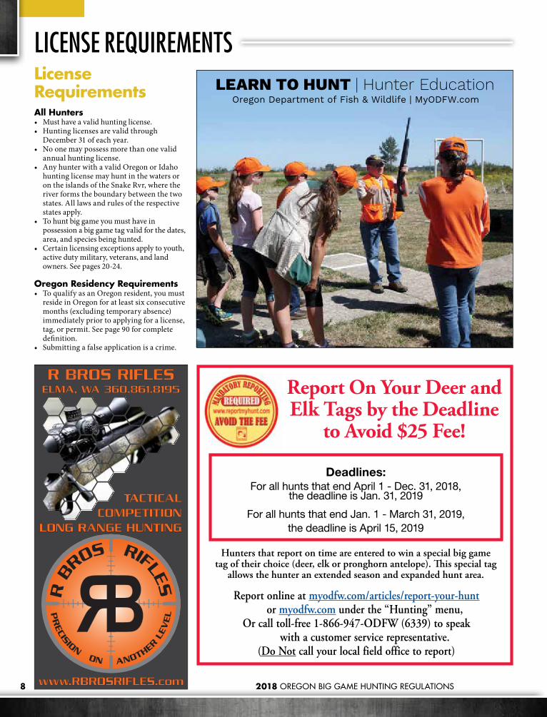
License RequirementsAll Hunters• Must have a valid hunting license.• Hunting licenses are valid through
December 31 of each year. • No one may possess more than one valid
annual hunting license. • Any hunter with a valid Oregon or Idaho
hunting license may hunt in the waters or on the islands of the Snake Rvr, where the river forms the boundary between the two states. All laws and rules of the respective states apply.
• To hunt big game you must have in possession a big game tag valid for the dates, area, and species being hunted.
• Certain licensing exceptions apply to youth, active duty military, veterans, and land owners. See pages 20-24.
Oregon Residency Requirements• To qualify as an Oregon resident, you must
reside in Oregon for at least six consecutive months (excluding temporary absence) immediately prior to applying for a license, tag, or permit. See page 90 for complete definition.
• Submitting a false application is a crime.
LICENSE REQUIREMENTS
PRECISION ON ANOTHER
LEV
EL
R B
ROS RIFLES
R BROS RIFLESELMA, WA 360.861.8195
TACTICALCOMPETITION
LONG RANGE HUNTING
Deadlines:For all hunts that end April 1 - Dec. 31, 2018,
the deadline is Jan. 31, 2019
For all hunts that end Jan. 1 - March 31, 2019, the deadline is April 15, 2019
Report On Your Deer and Elk Tags by the Deadline
to Avoid $25 Fee!
Report online at myodfw.com/articles/report-your-hunt or myodfw.com under the “Hunting” menu,
Or call toll-free 1-866-947-ODFW (6339) to speak with a customer service representative.
(Do Not call your local field office to report)
Hunters that report on time are entered to win a special big game tag of their choice (deer, elk or pronghorn antelope). This special tag
allows the hunter an extended season and expanded hunt area.
Oregon Department of Fish & Wildlife | MyODFW.comLEARN TO HUNT | Hunter Education

Motorcycle
geico.com | 1-800-947-AUTO | local offi ce
You ride. We help you save money.
Some discounts, coverages, payment plans and features are not available in all states or all GEICO companies. Motorcycle and ATV coverages are underwritten by GEICO Indemnity Company. GEICO is a registered service mark of Government Employees Insurance Company, Washington, D.C. 20076; a Berkshire Hathaway Inc. subsidiary. © 2017 GEICO
2018 OREGON BIG GAME HUNTING REGULATIONS10
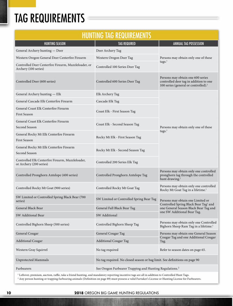
HUNTING TAG REQUIREMENTSHUNTING SEASON TAG REQUIRED ANNUAL TAG POSSESSION
General Archery hunting — Deer Deer Archery Tag
Persons may obtain only one of these tags.1
Western Oregon General Deer Centerfire Firearm Western Oregon Deer Tag
Controlled Deer Centerfire Firearm, Muzzleloader, or Archery (100 series) Controlled 100 Series Deer Tag
Controlled Deer (600 series) Con trolled 600 Series Deer TagPersons may obtain one 600 series controlled deer tag in addition to one 100 series (general or controlled).1
General Archery hunting — Elk Elk Archery Tag
Persons may obtain only one of these tags.1
General Cascade Elk Centerfire Firearm Cascade Elk Tag
General Coast Elk Centerfire Firearm
First SeasonCoast Elk - First Season Tag
General Coast Elk Centerfire Firearm
Second SeasonCoast Elk - Second Season Tag
General Rocky Mt Elk Centerfire Firearm
First SeasonRocky Mt Elk - First Season Tag
General Rocky Mt Elk Centerfire Firearm
Second SeasonRocky Mt Elk - Second Season Tag
Controlled Elk Centerfire Firearm, Muzzleloader, or Archery (200 series) Controlled 200 Series Elk Tag
Controlled Pronghorn Antelope (400 series) Controlled Pronghorn Antelope TagPersons may obtain only one controlled pronghorn tag through the controlled hunt drawing.1
Controlled Rocky Mt Goat (900 series) Controlled Rocky Mt Goat Tag Persons may obtain only one controlled Rocky Mt Goat Tag in a lifetime.1
SW Limited or Controlled Spring Black Bear (700 series) SW Limited or Controlled Spring Bear Tag Persons may obtain one Limited or
Controlled Spring Black Bear Tag1 and one General Season Black Bear Tag and one SW Additional Bear Tag.
General Black Bear General Fall Black Bear Tag
SW Additional Bear SW Additional
Controlled Bighorn Sheep (500 series) Controlled Bighorn Sheep Tag Persons may obtain only one Controlled Bighorn Sheep Ram Tag in a lifetime.1
General Cougar General Cougar Tag Persons may obtain one General Season Cougar Tag and one Additional Cougar Tag.Additional Cougar Additional Cougar Tag
Western Gray Squirrel No tag required Refer to season dates on page 65.
Unprotected Mammals No tag required. No closed season or bag limit. See definitions on page 90
Furbearers See Oregon Furbearer Trapping and Hunting Regulations.2
1 Leftover, premium, auction, raffle, take a friend hunting, and mandatory reporting incentive tags are all in addition to Controlled Hunt Tags.2 Any person hunting or trapping furbearing animals (Definition on page 89) must possess a valid Furtaker’s License or Hunting License for Furbearers.
TAG REQUIREMENTS

Real Estate SPECIALISTS in:• HUNTING • RECREATION • RANCHING • FARMING • INVESTMENT
Game on.
101 SE 3rd Street, Pendleton, OR 97801 • [email protected] 541.278.4444 • WhitneyLandCompany.com
A M E R I C A N
AFRF A R M + R A N C H
A M E R IC A N FA R M A N D R A N C H .C O M
The Whitney Land Company has been providing professional real estate services in Oregon, the Pacific Northwest and throughout the Rocky Mountain states for more than 47 years
Find your ULTIMATE HUNTING PROPERTY
with

12
CONTROLLED HUNT APPLICATIONS AND TAGSWhat is a Controlled Hunt?Unlike general season hunts where anyone can buy a tag over-the-counter, controlled hunts are limited entry hunts that require you to apply in advance for the opportunity to draw a tag in ODFW’s controlled hunts drawing. Much of Oregon’s deer and elk hunting is limited entry - along with all pronghorn antelope, bighorn sheep and Rocky Mt goat hunting.
How Does the Controlled Hunt Draw Work?For deer, elk, pronghorn and spring bear hunts (Premium Hunts excluded), most tags (75%) are awarded to those first choice applicants with the most preference points. The remaining 25% are awarded randomly amongst all first choice applicants, so everyone that applies always has a chance to draw their first choice hunt. If tags remain
after all first choice applicants have been successful, then remaining tags are distributed randomly amongst all second choice applicants, and so on through fifth choice applicants if tags remain. Preference points are not considered in selection of application choices two through five.
For bighorn sheep, Rocky Mt goat, and premium hunts, there are no preference points, all tags are awarded based on a random draw.
Controlled hunts are divided into hunt series based on species, and then further divided into hunt numbers based on location. Hunters can apply for one hunt number in each hunt series each year as their first choice.
Hunt Series: • 100 – Buck Deer • 200 – Elk • 400 – Pronghorn Antelope • 500 – Bighorn Sheep • 600 – Antlerless Deer • 700 – Spring Black Bear • 900 – Rocky Mountain Goat • L – Premium Deer • M – Premium Elk • N – Premium Pronghorn Antelope
Preference Points Explained Every year you do not draw your first choice hunt you get a preference point, which increases your odds in future years. If you draw your first choice hunt, your preference points are reset to zero whether or not you actually purchase the tag. One exception to this is for Pioneer License holders, who have their points reset to one rather than zero when they are successful in drawing their first choice hunt. Preference points are tracked by your Hunter/Angler ID# and are maintained until you are successful in drawing your first choice hunt for a series.
If you cannot hunt this year, or choose to hunt in a general season, apply for a point saver to gain a prefer ence point and increase your odds in future years. You must have a hunting license. If you do not go through the draw, you can also apply for a point saver for each hunt series July 1 through November 30 (except spring bear). Point saver hunt numbers always end in 99 (i.e. use hunt number 199 when applying for a buck deer point saver, 299 when applying for an elk point saver, etc.). You cannot apply for other hunt choices within the
© W
AYN
E D
. LEW
IS
Colorado isCalling
Big-game application deadline:
April 3, 2018
Answer the callFree hunt-planning help: 303-291-7526cpw.state.co.us

13
same series if you apply for a Point Saver (i.e. no second choice hunt selections are permitted).
Youth nine years of age or older can apply for Point Savers provided they have a social security number and a valid Youth License. Youth applying for Point Savers cannot apply for a First Time Youth tag in the same series in the same year.
How Do I Apply for a Controlled Hunt? Step 1: Choose a hunt. Controlled hunts are broken down by species and location. All hunts are listed by hunt series in the hunt tables, and each hunt has a unique hunt number. You may select up to five hunt choices per series (1st choice, 2nd choice, 3rd choice, etc.). Most tags run out after the 1st choice drawing. Keep in mind that your first choice hunt is the most critical because preference points and the 25% pool only apply to first choice hunts.
You can get an idea of your odds of drawing a hunt by looking at the Big Game Regulations, where you will see the number of tags and
number of 1st choice applicants from the previous year. Tag numbers and applicants can change from year to year, but usually not by huge amounts.
Step 2: Decide if applying as an individual or in a party. Many hunters choose to join together with family and friends and apply for a hunt as a party. This means that either everyone in the party will draw a tag, or no one will. Parties will not be split if the nonresident maximum is reached for any hunt. Parties composed solely or partially of nonresidents will not be eligible to receive tags in a hunt after the nonresident maximum is reached. When applying as a party, all applicants must purchase separate applications and individual preference points are combined and then averaged for the group (averages of .51 and above will be rounded up, and averages of .50 and below will be rounded down). You must indicate whether you are applying as a party member or party leader. Party members must include the party leader’s Hunter/Angler ID# on their applications, and the party leader’s choices will apply to the entire group. Hunts also have party size limits: 18 for deer and elk, 6 for black bear, 2 for pronghorn antelope,
individual only for Rocky Mt goat, bighorn sheep, and premium hunts.
Step 3: Get a hunting license. To apply, you must first purchase an annual hunting license. You can purchase the hunting license at the same time you apply for a controlled hunt. You can buy a license and apply online, at a license sales agent, at ODFW offices that sell licenses, or by mail or fax order using the application available online at: http://www.dfw.state.or.us/resources/hunting/big_game/regulations/docs/2017_Mail_Order_Application.pdf
Step 4: Complete your application and apply by February 10th for spring bear, and May 15 for all other big game species. Once you have completed steps 1–3 above, you are ready to apply for your tag! Get your application right — simple mistakes can derail your chances of drawing a tag. Triple-check your hunt number (and party leader’s number if applying with others) to make sure they are correct. If applying at a license sales agent, check your application before you leave the store and get a receipt showing your hunt choices. Keep your receipt for proof of application.
Explore our permits and leases at: www.WYrecreation.com
Weyerhaeuser forestlands provide outdoor enthusiasts a vast resource for enjoying the great outdoors.
Our permits and leases include access for hunting, camping, fishing, hiking, mountain biking, horseback riding, berry and mushroom picking, and more.
PREMIER OUTDOOR RECREATION
AD-OR game book - half page horz-Michelle Metcalf 100517.indd 1 10/6/2017 11:30:24 AM

14 2018 OREGON BIG GAME HUNTING REGULATIONS
An error can be corrected if done by June 1. For applications completed at a license sales agent, errors discovered the same day as the purchase can be canceled by the agent and a new, corrected application can be issued. For errors caught after the day of application or errors to online or mail order applications, a completed application change request form must be received at ODFW headquarters by June 1 to have the application changed. Contact the Controlled Hunt staff at ODFW headquarters if you have questions. Application change request forms can be obtained from ODFW offices that sell licenses or at: http://www.dfw.state.or.us/resources/hunting/big_game/controlled_hunts/docs/2018_ch_app_change_request.pdf
There is no charge for the first change to a controlled hunt application, but $25 will be charged for each subsequent application change to the same hunt series.
Step 5: Wait for draw results.Results (successful or unsuccessful) will be made available by February 20 (spring black bear) and June 20 (big game). Check draw results by visiting the My Hunter Information page at or.outdoorcentral.us/or/hunterreport or call Controlled Hunts 503-947-6102 or 1-800-708- 1782 (In Oregon only).
Step 6: After the draw.If you drew the tag, congratulations! But don’t forget to pick up your tag before the first hunt period begins. If you purchased a Sports Pac, you still need to pick up the tag for your particular hunt.
If you didn’t get your first choice hunt, you now have a preference point for that hunt series for next year’s draw. Points are affiliated with a hunt series, not a particular hunt number, so even if you change your mind and choose a different hunt next year, the point goes with you.
Hunters have the option of deciding whether or not they want to purchase the tag for the hunt choice drawn, but if their first choice hunt is drawn they will lose their preference points.
If you did not draw a tag check out general season opportunities.
Step 7: Report your results.Don’t forget to report the results of your hunt! See page 8 for details.
Leftover Controlled TagsThere are very few leftover tags and they typically sell out within a few minutes. Leftover spring bear tags go on sale Mar. 15 at 10:00 am (PST), leftover tags for all other big game species go on sale July 1st at 10:00 am. For more information please go to: http://www.dfw.state.or.us/resources/hunting/index.asp
Cancelled HuntsIt is rare but occasionally hunts are canceled in response to an unexpected event such as winter kill or disease outbreak. Information about any cancelled hunts will be made available by Apr. 15. A postcard will be sent to all applicants who apply for a hunt that is cancelled by Apr. 15, stating the hunt applied for has been cancelled and detailing their options. If ODFW does not receive a response from the applicant, their second hunt choice will become their first choice. If that hunter is successful in the draw, no preference points are awarded and existing preference points will return to zero. If unsuccessful, applicants will receive a preference point.
Nonresident ApplicantsA maximum of 3% of tags for pronghorn antelope and controlled black bear hunts, and a maximum 5% of tags for controlled deer and controlled elk hunts can be issued to nonresidents. No less than 5% and no more than 10% of all bighorn sheep and Rocky Mt goat tags will be issued to nonresidents. Less than the maximum percentage may be issued, as nonresident applications receive no preference other than existing preference points in the drawings. The Guides and Outfitters Program impacts the number of nonresident tags available in the drawing.
Guides and OutfittersAs enacted by the 1997 Oregon State Legislature, the Guides and Outfitters Program provides guides and outfitters with the opportunity to market nonresident tags. A number of tags equal to one-half the nonresident tags drawn in the previous year are available through this program. Guides certified by the Oregon State Marine Board submitted applications and competed for the right to market these tags. Tags not sold to guides by Apr. 15 are available in that year’s big game drawing. Information on Guides and Outfitters can be obtained from Oregon State Marine Board in Salem, 503-378-2633.
Additional Controlled Hunt InformationFor more detailed information on how the drawing works, or to check your preference points or success in the draw, visit or.outdoorcentral.us/or/hunterreport. The computer-assisted telephone line allows hunters to access preference point information or to check the status of their applications, by entering their Hunter ID number and selecting the type of information desired. Controlled Hunt staff will also be available during regular business hours by calling 503-947-6102 or 1-800-708-1782 (in Oregon only).
CONTROLLED HUNT APPLICATIONS AND TAGS
Est. 1954
Hunt prime land in Barbour & Bullock Counties.• Highest deer density in Alabama. Coyotes and bobcats
no charge, no limit (with paid deer hunt).
• 6,000 acre family-owned plantation. NO LEASED LAND.
• 50 Food Plots with elevated shooting houses surrounded by pines and oak bottoms.
• New cottages with private bedrooms and baths. First class lodge. All meals included.
• Great family hunting experience with true southern hospitality
Visit us at www.pa-ko.comTo plan your hunt, call J. Paul Taylor at 877.539.5699

15
Western Range Camps, LLC - 1145 So. Blackhawk Blvd, Mt Pleasant, Utah
435-462-5300, www.westernrangecamp.com
Western Range Camps, LLC - 1145 So. Blackhawk Blvd, Mt Pleasant, Utah
435-462-5300, www.westernrangecamp.com
Western Range Camps, LLC - 1145 So. Blackhawk Blvd, Mt Pleasant, Utah
435-462-5300, www.westernrangecamp.com
GENERAL HUNTING REGULATIONSGeneral Hunting RegulationsShooting HoursGame mammals may only be hunted from 1/2 hour before sunrise to 1/2 hour after sunset.
DecoysThe use of decoys with moving parts is prohibited for big game species. This prohibition includes, but is not limited to, decoys with parts that are powered by a motor, battery, human action (for example, cable or pull-string), or the wind. Flexible or adjustable parts that permit placement or adjustment of a decoy but do not otherwise move do not constitute “moving parts”.
Aircraft, ATVS, Boats, Drones, VehiclesIt is unlawful to:• Hunt or harass any wildlife from a motor-
propelled vehicle. • Hunt within eight hours of communicating
with or receiving information on the location of game mam mals from a manned aircraft.
• Use drones for the following purposes: » Hunting, trapping, or angling.
» Aiding hunting, trapping, or angling through the use of drones to harass, track, locate or scout wildlife.
» Interfering in the acts of a person who is lawfully hunting, trapping or angling.
• Hunt within 8 hours after having been trans-ported by he li cop ter or fixed-wing air craft to any point other than an established airport adequate for fixed-wing aircraft.
• Operate or be transported in a motor-propelled vehicle in violation of a Cooperative Travel Management Area restriction. This includes aircraft, except for those landing on a designated air strip.
• Operate a snowmobile or ATV while carrying a firearm or bow. Firearms and bows must be unloaded except for the following circumstances: » A person who is licensed to carry a
concealed handgun in Oregon » A current or honorably retired law
enforcement officerFor this regulation “unloaded” means: » Revolver – no live cartridge in the chamber
that is aligned with the hammer » Muzzleloader – not capped or primed » Bow – all arrows in the quiver » All Other Firearms – no live cartridge in the
chamberSee ORS 821.240 for complete statute language.
• Cast an artificial light from a motor vehicle while in possession of a weapon; or cast an artificial light upon a game mammal, predatory animal, or livestock from within 500 feet of a motor vehicle while in pos ses sion of a weapon.
Prohibited MethodsIt is unlawful to:• Hunt or shoot from or across a public Rd, Rd
right-of-way or railroad right-of-way, except persons legally hunting on Rds closed to use of motor vehicles by the public.
• Hunt for or kill any wildlife for another person. • Hunt any game mammal with dogs, except
western gray squirrel.• Hunt any wildlife with infrared or any other
night vision sights.• Use an artificial light for hunting any wildlife,
except raccoon, bobcat and opossum provided the light is not cast from or attached to a motor vehicle. This includes laser sights or any other sights which project a beam to the target. This does not include battery operated sights which only light the reticle.
• Take game mam mals with trap or snare.• Use any poisoning, immobilizing, or
tranquilizing drug or chemical to hunt or kill any game mam mal.

2018 OREGON BIG GAME HUNTING REGULATIONS16
GENERAL HUNTING REGULATIONSTrespassIt is unlawful to hunt on private property without permission from the landowner. See ORS 105.700 and 498.120.
The duty to retrieve and to not waste does not justify otherwise criminal conduct including but not limited to trespass.
Hunting ProhibitedIt is unlawful to:• Hunt with a centerfire or muzzleloading
rifle without a valid used or unused deer or elk tag for that time period and area on your person (see exceptions) during: standard Eastern Oregon controlled buck deer centerfire firearm season (Sept. 29 – Oct. 10), Cascade bull elk centerfire firearm season (Oct. 13 –Oct. 19), Coast bull elk 1st and 2nd centerfire firearm seasons, Rocky Mt bull elk or either sex centerfire firearm seasons, or the standard Rocky Mt antlerless elk centerfire firearm seasons (Nov. 17 - Nov. 25). This does not include the controlled W High Cascade (119A) or Hood White Rvr (141A) buck hunts. Exceptions: (1) Hunters who have a tag for one of the hunts listed above, or a valid tag for another game mammal controlled hunt that includes all or a portion of the time period and area of the above hunts, may hunt as authorized by that tag and may continue to hunt bear and/or cougar within the time period and area for which their tag is valid (used or unused) provided they have a valid, unused bear and/or cougar tag; used tags must be on the tagged animal and not on the hunters person. (2) Hunters are not required to have an elk tag to hunt bear or cougar in the Applegate WMU during elk seasons. (3) Landowners, or their agent, hunting predatory animals on lands they own or lease may use centerfire or muzzleloading firearms to hunt on such lands; (4) Hunters may use .22 caliber or smaller centerfire firearms for hunting coyotes in Juniper, Beatys Butte, Whitehorse and Owyhee Units, in Wagontire Unit south of Lk Co Rd 5-14 and those portions of the Beulah Unit in Malheur and Baker Cos. during Rocky Mt bull or either-sex elk centerfire firearm seasons. Legal .22 caliber centerfire firearms include common cartridges such as .222, .223, .22-250, .220 Swift and others less than .23 caliber.
• Hunt on any refuge closed by state or federal gov ern ment.
• Hunt within corporate limits of any city or town; public park or cemetery; or on any campus or grounds of a public school, college, or university.
• Hunt game mammals outside any area designated by a controlled hunt tag when such tag is required for that season.
Other Restrictions It is unlawful to:• Refuse inspection of any license, tag, or permit,
and any wildlife taken, by an em ployee of
ODFW, any person au thor ized to enforce wild life laws, or a land owner or agent of the landowner on their land.
• Refuse inspection of any gear used for the purpose of taking wildlife by an employee of the Oregon Department of Fish and Wildlife, or any person authorized to enforce wildlife laws.
• Hunt protected wildlife.• Disturb or remove traps or snares of
any licensed trapper while that person is trapping on public lands or on other land by landowner’s permission.
• Disturb, damage, remove, alter, or possess any offi cial ODFW signs.
• Knowingly provide false information to the Department or Commission on any report required by law.
• Counsel, aid or assist in any violation of the wildlife laws, or share in any of the proceeds of such violation by receiving or possessing any wildlife. Any person who violates this rule shall incur the penalties provided for the person guilty of such violation.
Hunter OrangeNo person younger than 18 years of age shall hunt with any firearm for any game mammal or upland game bird (excluding turkey) unless the person is wearing in a manner visible from all directions a hat or exterior garment of hunter orange. “Exterior garment” means a shirt, jacket, coat, vest, or sweater. Hunter orange camouflage patterns are acceptable. “Hat” means any head covering.
Disguising Sex, Waste, SaleIt is unlawful to:• Disguise the sex or kind of any wildlife while
in the field or in transit from the field.• Possess the meat or carcass of any deer, elk,
pronghorn antelope, bighorn sheep, or Rocky Mtn goat without evidence of sex while in the field, forest, or in transit on any of the hwys or premises open to the public in Oregon, except processed or cut and wrapped meat.
Evidence of sex for deer, elk, pronghorn antelope, bighorn sheep, or Rocky Mountain goat is:
Option 1- Either the animal’s scalp which shall include the attached eyes and ears if animal is female; or ears, antlers or horns, and eyes if the animal is male; or Option 2 - reproductive organs (testicles, scrotum, or penis, if male; vulva or udder (mammary), if female) naturally attached to one quarter of the carcass or to another major portion of meat.
Applies to option 2 only: * For Hunts with Antler or Horn Restrictions: if the head is not attached to the carcass, in addition to leaving the testicles, scrotum, or penis naturally attached to one quarter of the carcass or to another major portion of meat, the head or skull plate with both antlers or horns
naturally attached shall accompany the carcass or major portions of meat. * For White-tailed Deer Only Hunts and for Mule Deer Only Hunts: in addition to evidence of sex, (testicles, scrotum, penis, vulva, udder, mammary), either the head or tail shall remain naturally attached to one quarter of the carcass or to another major portion of meat as evidence of the species taken.
• Waste any game mammals or edible portions thereof, except that meat of cougar need not be salvaged. See definition on page 90. The duty to retrieve and to not waste does not justify otherwise criminal conduct including but not limited to trespass.
• Sell, trade, barter, exchange, or offer for sale, trade, barter, or exchange, any game mammal or parts thereof except as identified in Oregon Administrative Rule 635, Division 200.
Tagging, Possession and Transportation• The owner of a game mammal tag that kills a
game mammal for which a tag is issued, shall im me di ate ly remove in its entirety only the month and day of kill and attach the tag in plain sight securely to the game mammal. The tag shall be kept attached to such carcass or remain with any parts thereof so long as the same are preserved.
• No person shall have in possession any game mammal tag from which all or part of any date has been removed or mutilated except when the tag is legally validated and attached to a game mammal.
• When a game mammal or part thereof is transferred to the possession of another person, including a meat processor or taxidermist, a written record describing the game mammal or part being transferred and name and address of the person whose tag was originally attached to the carcass and the number of that tag shall accompany such transfer and shall remain with such game mammal or part so long as the same is preserved (see Wildlife Transfer Record Form form on page 84). The original tag should remain with the portion of the animal retained by the hunter.
• All game mammals in pos ses sion in the field or forest or in transit more than 48 hours after the close of the open season for such mammal must be tagged by ODFW or Oregon State Police.
• All game mammals or portions thereof shipped by commercial carrier must be tagged by ODFW or Oregon State Police.
• No person shall receive or have in possession any game mammal or part thereof which: (1) is not properly tagged; (2) was taken in violation of any wildlife laws or regulations; or (3) was taken by any person who is or may be exempt from jurisdiction of such laws or regulations.
• No person shall possess or transport any game mammal or part thereof, which has been illegally killed, found or killed for humane reasons, except shed antlers, unless they

2018 OREGON BIG GAME HUNTING REGULATIONS 17
MD
MT ND
SDWY
WIMN
IANE
NY
PAUT
OHIL
WVCO KS VAMO
OK
TX
NM AR
MI
SKAB
CWD Positive States and Provinces
have notified and received permission from personnel of the Oregon State Police or ODFW prior to transporting.
• No person shall possess the horns of bighorn sheep that were not taken legally during an authorized season.
• No person shall sell, lend, or borrow any big game tags.
Parts BanNo person shall import all or parts of a cervid (deer/elk family) carcass if the cervid was killed in one of the states or provinces shown below with a documented case of Chronic Wasting Disease. Common cervid species include deer, elk, moose, and caribou.
The following parts are allowed:• Meat that is cut and wrapped commercially or
privately;• Meat that has been boned out;• Quarters or other portions of meat with no
part of the spinal column or head attached;• Hides and/or capes with no head attached;• Skull plates with antlers attached that have
been cleaned of all meat and brain tissue; • Antlers (including velvet antlers) with no tissue
attached;
• Upper canine teeth (i.e. buglers, whistlers, ivories);
• Finished Taxidermy heads.
Illegal parts brought into Oregon will be confiscated and persons may be liable for disposal expenses.
Chronic Wasting Disease (CWD)The most important wildlife disease in North America, CWD, is a 100% fatal, infectious, transmissible spongiform encephalopathy (TSE) of deer, elk, and moose. The disease has not been detected in Oregon. In areas where this neurological disease occurs, it is spread by nose to nose contact between animals and through urine, feces and saliva infecting soils and habitats. CWD remains in the soil for an unknown number of years, continuing to infect animals that use infected sites.
If you plan on hunting outside of Oregon in areas with a documented case of CWD the importation of a cervid carcass or parts of a cervid carcass with brain or spinal column tissue is prohibited. “Parts Ban” regulations including a list of states and provinces where CWD has been found are shown on the map below.
Although CWD has not been documented in humans, public health and wildlife officials advise hunters to take precautions when pursuing or handling deer, elk, and moose that may have been exposed to CWD. Basic precautions include:• Wear latex or rubber gloves when field dressing
animals• Bone out the meat, do not saw through the
brain or bone, especially the backbone• Minimize the handling of brain and spinal
tissues• Avoid consuming the meat from any animal
that tests positive for the disease.
If you will be hunting in an area where CWD may occur, more detailed information regarding precautions to take when handling animals that may have been exposed can be found online at https://datcp.wi.gov/Documents/CommonSense.pdf.

2018 OREGON BIG GAME HUNTING REGULATIONS18
LEGAL HUNTING WEAPONS FOR GAME MAMMALSCENTERFIRE FIREARMS OTHER WEAPONS
SPECIES AND SEASON RIFLE HANDGUN SHOTGUN (ANY BARREL) MUZZLELOADING FIREARM BOW
Note: Some hunts and areas have specific weapon restrictions; consult hunt tables and descriptions for other restrictions.
.22
cal.
or la
rger
.24
cal.
or la
rger
.22
cal.
or la
rger
.24
cal.
or la
rger
#1 b
uck
or la
rger
Slug
s onl
y
any
.40
cal.
or
larg
er
.40
cal.
or la
rger
; op
en o
r pee
p sig
hts
& o
pen
igni
tion
any
.50
cal.
or
larg
er
.50
cal.
or la
rger
; op
en o
r pee
p sig
hts
& o
pen
igni
tion
40 lb
. or g
reat
er
recu
rve,
long
, or
com
poun
d bo
w50
lb. o
r gre
ater
re
curv
e, lo
ng, o
r co
mpo
und
bow
BLACK BEAR & COUGARGeneral or controlled seasons YES YES YES YES YES YES YES YES YES YES YES YES
PRONGHORNRifle YES YES YES YES YES YES YES YES YES YES YES YESMuzzleloader (round ball or conical bullets only) NO NO NO NO NO NO NO YES NO YES NO NO
Archery NO NO NO NO NO NO NO NO NO NO YES YES
BUCK DEERGeneral or controlled rifle YES YES YES YES YES YES YES YES YES YES YES YESMuzzleloader (#1 or larger buckshot, round ball, conical bullets, slug)
NO NO NO NO NO NO NO YES NO YES NO NO
Archery NO NO NO NO NO NO NO NO NO NO YES YES600 Series Deer Hunts* YES YES YES YES YES YES YES YES YES YES YES YES
ELKGeneral or controlled rifle NO YES NO YES NO YES NO NO YES YES NO YESMuzzleloader (round ball or conical bullets only) NO NO NO NO NO NO NO NO NO YES NO NO
Archery NO NO NO NO NO NO NO NO NO NO NO YES
BIGHORN SHEEP & ROCKY MOUNTAIN GOATBighorn Sheep & Rocky Mt. Goat NO YES NO YES NO NO NO NO YES YES NO YES
WESTERN GRAY SQUIRRELWestern Gray Squirrel Any rifle; handgun; shotgun; muzzleloading firearm; or long, recurve or compound bow.
* Except during 600 series hunts where there is a weapon restriction of shotgun/muzzleloader only or archery/muzzleloader only.
General Weapons Provisions for Hunting Game Mammals:Centerfire firearm• 22 caliber rimfire are not legal for hunting
big game. Legal .22 caliber centerfire firearms include common cartridges such as .222, .223, .22-250, .220 Swift.
• Fully automatic firearms prohibited.• Semiautomatic rifles with a magazine
capacity greater than five cartridges prohibited (except for western gray squirrel).
• Military or full-metal jacket bullets in original or altered form prohibited.
• Infrared, night vision, laser or any other sight that projects a beam to the target is prohibited.
• During centerfire firearm seasons, hunters may use any muzzleloader with any ignition type, except matchlock, any legal sight, any propellant, or any bullet type provided the weapon meets caliber restriction for the species.
Shotgun• Shotgun is a smooth bore firearm, designed
for firing bird shot and intended to be fired from the shoulder, with a barrel length of 18 inches or more and with an overall length of 26 inches or more.
• Shotguns equipped with rifled slug barrels are considered shotguns when used for hunting pronghorn antelope, bear, cougar, deer, or elk when centerfire rifles or shotguns are legal weapons.

19
Bow• Broadhead blades must be fixed, unbarbed
and at least 7/8” wide (except for western gray squirrel). It is illegal to hunt with or possess broadheads or arrows with mechanical or moveable blade when hunting game mammals, except western gray squirrel.
• No device secured to or supported by a bow may be used to maintain the bow at full draw.
• No electronic devices may be attached to bow or arrow, except lighted arrow nocks that have no function other than to increase visibility of the arrow.
• No device that supports or guides the arrow from a point rearward of the bow string when the bow is at rest (undrawn) may be secured to or supported by a bow’s riser. Overdraws meeting this restriction are legal during archery seasons.
Muzzleloader• During muzzleloader only seasons and
600 series hunts where there is a weapon restriction of shotgun/muzzleloader only or archery/muzzleloader only the following restrictions apply: » Scopes, and sights that use batteries,
artificial light or energy are not allowed except for visually impaired hunters (a permit is required; please see page 25). Open and peep sights made from alloys, plastic, or other materials that do not have the properties described above are legal sights. Fiber optics and fluorescent paint incorporated into or on open or iron sights are legal.
» It is illegal to hunt with jacketed bullets, sabots, and bullets with plastic or synthetic tips or bases. Only the following projectile/bullet types are
Help OregOn Wildlife
Lead can be harmful to wildlife and humans. A nationwide ban on lead shot for waterfowl hunting is credited with saving millions of ducks, geese and waterfowl from lead poisoning. Birds of prey, scavengers and other wildlife can be harmed by eating meat containing lead fragments.
dO yOur part tO Help OregOn Wildlife. get tHe lead Out.
Hunters have a long history of supporting and conserving Oregon’s wildlife. Continue that tradition by switching to non-lead ammunition. Non-lead ammunition is available for most rifles, handguns and shotguns.
High performance non-lead bullets have the same stopping power as lead, but leave fewer bullet fragments that can be swallowed by scavengers and other wildlife. Switching
to non-lead ammunition means eagles, scavengers, other wildlife and humans will not be exposed to lead fragments in game meat.
allowed: a) Round balls made of lead, lead alloy, or federally-approved nontoxic shot material, used with cloth, paper or felt patches; (b) Conical bullets made of lead, lead alloy, or federally-approved nontoxic shot material, with a length that does not exceed twice the diameter; (c) Lead free copper conical bullets with a length that does not exceed twice the diameter.
» It is illegal to hunt with centerfire primers as an ignition source, the muzzleloader must have an open ignition. See definition on page 90.
» It is illegal to hunt with pelletized powders or propellants. Granular (loose) black powder and black powder substitutes are the only legal propellants.
» No other firearm may be used for hunting during a muzzleloader-only season.
» Muzzleloading firearms with revolving actions are prohibited.

2018 OREGON BIG GAME HUNTING REGULATIONS20
Oregon offers numerous youth hunting opportunities intended to promote a safe, enjoyable experience with an increased chance for success. License prices are reduced to make it easier for families to introduce kids to hunting.
Licensing Requirements• The Youth License is a combination
hunting/fishing/shellfish license.• Youth 12 to 17 years of age must purchase a
Youth License to hunt, participate in the big game controlled hunt drawing, or purchase preference points.
• Youth 11 years of age and under do not need a license to hunt game birds, small game, or unprotected wildlife except: » A Youth License or free Youth Game
Bird Hunting license is required in order to purchase turkey tags or apply for sage grouse hunts and waterfowl reservations.
» See Hunter Education requirements below.• Youth 9 to 11 years of age and older may
apply for preference point savers through the controlled hunt drawing provided they purchase a Youth License. The free Youth Game Bird Hunting License does not allow a youth to participate in the controlled hunt drawing or apply for preference points.
• Youth between 9 and 12 years of age may possess both a free Youth Game Bird Hunting License and a Youth License.
• A Youth License or Youth Sports Pac purchased by a youth 17 year of age will be valid for the entire calendar year even if the youth turns age 18 before the end of the calendar year.
Hunter EducationBefore hunting, youth 17 years of age or younger must:• Complete a Hunter Education Course (Any
U.S. state, Canada or Mexico)
• Have in their possession a Hunter Education Certificate or a department issued document with their Hunter Education Certificate number to hunt anywhere except land owned by their parent or legal guardian. See exceptions under the Mentored Youth Hunter Program.
Hunter Education can be completed with a conventional classroom course or independent study with a hands-on field day. For more information visit: myodfw.com/articles/take-hunter-education-course
Hunter Orange No person younger than 18 years of age shall hunt with any firearm for any game mammal or upland game bird (excluding turkey) unless the person is wearing in a manner visible from all directions a hat or exterior garment of hunter orange.
Youth Specific Regulations• No youth 11 years of age or younger
may hunt for big game except for youth participating in the Mentored Youth Hunter Program.
• Any youth 13 years of age and under must be accompanied by an adult 21 years of age or older while hunting on property other than land owned by their parent or legal guardian.
Controlled Hunts• A Youth License is required for a youth to
participate in the controlled hunt drawing.• A youth 11 years of age may apply in the
controlled hunt drawing provided the youth is 12 years of age or older and has completed a Hunter Education Course by
the time they participate in the hunt.• Youth 9 to 11 years of age may purchase
point saver applications in the controlled hunt drawing provided they possess a valid Youth License.
• Only youth 12 to 17 years of age at the time of the hunt may participate in Youth Controlled Hunts. » Any youth participating in a Youth
Controlled Hunt must be accompanied by an adult 21 years of age or older. Adults may not accompany more than two youths at time.
» Youth are not limited to applying for Youth Controlled Hunts and may choose to apply for other controlled hunts.
Youth First Time Hunt ProgramResident youth are eligible to receive one buck deer (100 series), one antlerless deer (600 series) and one antlerless elk (200 series) provided they have not previously been successful in the controlled hunt drawing for that series. This program provides an opportunity for families to have a back-up plan that ensures beginning youth hunters will get a chance to hunt even if they are unsuccessful in the controlled hunt drawing.
Who May Apply:• Resident youth 12 to 17 years of age. Youth
11 years of age may apply if they will be 12 years of age by the time they hunt. Youths may not hunt with “First Time” tags once they turn 18 years of age.
• Youth that applied but were unsuccessful for 100, 200, and/or 600 series controlled hunts in the current year controlled hunt drawing and have never drawn a controlled hunt for that respective series.
100 series deer ����������������������pg 35200 series elk ������������������������pg 53400 series pronghorn�������������pg 57600 series antlerless deer ������ pg 38700 series bear ���������������������pg 63
YOUTH CONTROLLED HUNTS (12-17 YEARS OLD)
YOUTH HUNTINGYOUTH
DESCRIPTION RESIDENT NONRESIDENTYouth License (12 - 17 years old) - Includes Angling, Hunting, Shellfish and Columbia Rvr Basin Endorsement $10.00
Youth Sports Pac - Includes Combination Hunting, Angling, and Shellfish License, Combined Angling Harvest Tag, Upland Game Bird and Waterfowl Validations, plus a General or Controlled Deer, General or Controlled Elk, Cougar, General or Controlled Bear, and Spring Turkey tag. A Youth Sports Pac also includes the Columbia Rvr Basin Endorsement.
$55.00 N/A
Youth Game Bird Hunting License (age 11 and under) FREE

2018 OREGON BIG GAME HUNTING REGULATIONS 21
Eligible Hunts• The Youth “First Time” Hunt Program
applies to all controlled hunts that meet a minimum tag allocation: » Buck Deer (100 series): at least 201 tags » Elk (200 series) antlerless only: at least
51 tags » Antlerless deer (600 series): at least 51
tags
How to Apply:• If youth meet the criteria above, mail or
fax a Youth “First Time” Program Hunt application to request a tag of their choice. No additional fee is required for this application. See myodfw.com/articles/hunting-opportunities-youth for an application and a list of qualifying hunts.
• Applications must be received after July 1 and before the hunt begins.
• Enter up to five hunt choices per hunt series to ensure receipt of an eligible hunt (see min. tag level, per hunt series above). The hunt choices may be different than the hunt choices made in the unsuccessful controlled hunt drawing.
• Youth will be assigned a tag in the first eligible hunt listed and be able to purchase the tag from a license agent a few days after their application is processed.
• Tag sale deadlines apply.
Important Things to Know:• Youth must have completed a Hunter
Education Course by the time they participate in the hunt.
• A youth loses eligibility for a “First Time” tag in a hunt series once they have been successful for any hunt choice in that series (including youth hunts and LOP tags), except for leftover tags.
• Preference points will not be used if participating in the “First Time” program.
• Youth that have applied for Point Savers in the respective hunt series for the current year are NOT eligible for a guaranteed “First Time” tag.
• Applications must be received before the hunt begins.
• Adults who apply in a party with a youth in the controlled hunt drawing and are unsuccessful will not receive tags if the youth requests a “First Time” tag.
• Youth can use their “First Time” options in any combination (all in one year, one per year, skip years between tags).
• For elk (200 series) hunts, only those hunts with a minimum of 51 tags and a bag limit of “one antlerless elk” are eligible for the Youth “First Time” Hunt Program.
• Youth can hunt in general seasons and use leftover tags if available without losing eligibility for “First Time” tag.
• “First Time” tags are not extra tags. • Other hunters with appropriate tags may
hunt with youth.
• Youths participating in the “First Time” program are not eligible to participate in the Mentored Youth Hunter Program for that particular hunt for that year.
Mentored Youth Hunter ProgramThe program gives unlicensed youth the opportunity to receive mentored, one-on-one field training on the ethics, safety, responsibility and enjoyment of hunting while being closely supervised by a licensed adult.
Youth Participation Resident and nonresident youth may participate in the Mentored Youth Hunter Program, without first passing an approved Hunter Education Program, provided the youth:• Is 9 to 15 years of age. At age 16, a youth
is no longer eligible to participate in the Mentored Youth Hunting Program and must pass an approved hunter education program, possess a Youth License, and appropriate tags.
• Hunts while accompanied by a supervising hunter who is 21 years of age or older and who has a valid license and tag(s) for the dates, area and species being hunted.
• Completes the free annual registration. Register Online at: myodfw.com/articles/mentored-youth-hunter-program or at your local license agent.
• Possesses a signed registration document while hunting.
• Follows all hunting regulations. • Remains under the immediate control of
the supervising hunter at all times while the youth is in possession of any legal weapon for the hunt.
• Is wearing a hunter orange exterior garment (shirt, jacket, coat, vest, or sweater) or hat when hunting with a firearm for game mammals or upland birds (except turkey). The exterior garment or hat must have hunter orange visible in all directions (360 degrees).
Supervising Hunter The supervising hunter shall: • Have a valid hunting license and tag(s)
valid for the dates, area and species being hunted.
• Maintain immediate control of the mentored youth hunter at all times while the youth is in possession of any legal weapon for the hunt.
• Ensure that all Oregon hunting regulations are followed.
• Be responsible and accountable for all actions of the mentored youth hunter while engaged in hunting.
• Supervise only one mentored youth hunter at any given time while engaged in hunting.
• Review information on safe hunting practices provided on the Mentored Youth Hunter registration document with the youth being mentored.
• Ensure no more than one legal weapon for the hunt is possessed collectively by the supervising hunter and the youth being mentored at any time while engaged in hunting.
Seasons and Bag Limits • Any wildlife harvested by the mentored
youth hunter shall be counted towards the supervising hunter’s bag limit.
• A youth is not eligible to participate in the Mentored Youth Hunting Program if the youth possesses their own valid hunting license and/or tag(s) valid for the dates, area and species being hunted.
• The Mentored Youth Hunting Program is not applicable to designated youth only seasons and hunts. » This is because the mentored youth can
only take an animal the supervising hunter could legally harvest and the supervising hunter could not legally harvest an animal during a youth only hunt.
Mentored Youth Preference Points • Youth participating in the Mentored
Youth Hunting Program will receive one mentored youth preference point for each year the youth registers for the program.
• The mentored youth preference points will be “banked” and held in the licensing system with no expiration date. To redeem banked points, the mentored youth must fill out the form available online at: myodfw.com/articles/mentored-youth-hunter-program or by contacting 503-947-6102
• Once Mentored Youth Preference Points are redeemed, they are converted to the Preference Point System and are subject to the Oregon Administrative Rules that govern preference points.
• Redeemed points must be used at one time and may not be split among controlled hunt series.
For More Information Please Visit: myodfw.com/articles/mentored-youth-hunter-program
Register Online at: or.outdoorcentral.us/or/license or at your local license agent.

22
Landowner Specific Rules and Regulations• A resident does not need a license to hunt
on land upon which the person resides and is owned by the person or a member of the person’s immediate family, unless they are hunting for a species for which a tag is required or are applying for big game tags.
• A landowner or landowner agent does not need a hunting or trapping license to take predatory animals on land they own, lease, lawfully occupy, possess, or have charge or dominion over.
• Landowners or their agents may hunt predatory animals with a spotlight, and from a vehicle on lands that they legally own or occupy.
Landowner Preference Program• Landowners with a minimum of 40
contiguous acres may qualify for controlled hunts tags on their property. In order to qualify, lands must be registered with
LOP ELIGIBLE HUNTS AND DEADLINES
LOP ELIGIBLE HUNT SERIESLOP DEADLINES
PURCHASE OF CONTROLLED HUNT APPLICATION
LANDOWNER REGISTRATION/TAG DISTRIBUTION FORMS* TAG PURCHASE
100 series deer (limited) May 15 May 15 Day Before Hunt100 series deer Day before hunt Sept. 15 Day Before Hunt200 series elk (bull and either sex) Day Before Hunt Sept. 15 Day Before Hunt200 series elk (antlerless) Day Before Hunt Day Before Hunt Day Before Hunt200 series elk (Long Duration Youth) LOP not available LOP not available LOP not available200 series elk (limited) May 15 May 15 Day Before Hunt200 series elk (Leftover limited tags) Sept. 15 Sept. 15 Day Before Hunt400 series pronghorn Day Before Hunt Day Before Hunt Day Before Hunt600 series deer Day Before Hunt Day Before Hunt Day Before Hunt
LANDOWNERS
TAG ACREAGE HUNT TYPES
2 401
Antlerless deer, antlerless elk, and all hunts occurring in western Oregon
2 1602 All Hunts3 1,2002 All Hunts4 2,5002 All Hunts5 5,0002 All Hunts6 10,0002 All Hunts8 20,0002 All Hunts10 40,0002 All Hunts12 80,0002 All Hunts14 160,000+2 All Hunts
1 Must be contiguous/connected acreage.2 Must be minimum of 160 contiguous/
connected acres.
The number of tags allowed per hunt series is based on registered landowner acreage.
ODFW and hunters must apply for hunts through the controlled hunt system. Registration and further information on the Landowner Preference Program can be found at: http://www.dfw.state.or.us/resources/hunting/big_game/controlled_hunts/landowner.asp or by contacting ODFW Controlled Hunts at 503-947-6102. Registration packets can also be acquired through local ODFW offices.
• LOP tags are only valid within the registered property boundaries for which the tag is issued.
• Antelope hunts with an either sex or a one doe or fawn bag limit are available to landowners or immediate family through the LOP program. All LOP antelope tags will be limited to a doe/fawn bag limit.
• All landowners and eligible applicants must purchase controlled hunt application prior to the deadline. Applications for LOP tags must indicate a landowner preference hunt choice on their application.
• LOP tags are not available for 223T or Aug. 1 – Dec. 31 youth elk hunts. In the following hunts LOP tags will be limited to five tags or 10% of the total controlled hunt tags, whichever is greater: elk hunts; 226R, 226Y, 248A1, 249A1, 250X, 251A, 252A1, 253X, 254R1, 254Y1, 255R1, 255Y1, 256R1, 256Y1, 259Y, 261X, 262X and 263X: buck deer hunts; 141C, 142B, 154C, 156R2, 157A, 165R, 168R2, and 170R3.
• Cultural resources in Oregon include both Indian and early Euro-American archaeological sites, burials, and sacred objects.• Cultural sites are not a renewable resource. Once taken or damaged they are lost forever.• They are protected by law on public and private land. Disturbing them can lead to serious penalties.• Further information is available at http://www.oregon.gov/oprd/HCD/ARCH/docs/Brochure.pdf
THANK YOU FOR PROTECTING OREGON’S RICH CULTURAL HERITAGE
2018 OREGON BIG GAME HUNTING REGULATIONS
• In addition to the hunts listed, buck mule deer LOP tags may be limited in WMUs below Population Management Objective. The list of affected mule deer buck hunts will be available starting May 1 of each year.

23
EVERY SHOT COUNTS
Shop these Name Brands at select Coastal stores.
Find locations at CoastalFarm.com
Coastal
Fishing_Hunting_Oregon_Guides.indd 1 10/15/15 4:45 PM
Sports Tough, Household-Ready
Sharpens Even the Thickest and Heaviest Knives!• Superior edges for sports knives, household and pocket knives• Great for machetes too!• Sharpens single and double-sided style knives,
straight and serrated • 2-Stages for flawless, ultra-sharp, double-bevel edges• 100% diamond abrasives• Advanced flexible polishing disks
chefschoice.comEdgeCraft 610-268-0500
©2018 EdgeCraft
Xtreme® 317
Hunt
Fish
Roam
StayP E N D L E T O N , O R E G O N

2018 OREGON BIG GAME HUNTING REGULATIONS24
UNIFORMED SERVICES AND DISABLED VETERANS
The information on this page is a summary of regulations and opportunities related to Disabled Veterans and Members of the Uniformed Services.
Members of the Uniformed Services“Uniformed Services” includes Army, Navy, Air Force, Marine Corps and Coast Guard, or their reserve components; the National Guard or Oregon National Guard, commissioned corps of the National Oceanic and Atmospheric Administration, and the Public Health Service of the United States Department of Health and Human Services detailed with the Army or Navy.
Resident The requirement for a person to reside in Oregon for at least six months to be considered a resident is waived for Members of the uniformed services of the United States who: • Are permanently assigned to active duty in
this state, and their spouse and dependent children; or
• Reside in this state while assigned to duty at any base, station, shore establishment or other facility in this state; or
• Reside in this state while serving as members of the crew of a ship that has an Oregon port or shore establishment as its home port or permanent station.
Nonresident Members of the Uniformed Services• Must obtain a valid nonresident hunting
license• A nonresident member of the uniformed
services may purchase licenses, tags, and permits at resident rates. (See Table)
Tag Sales DeadlinesMembers of the uniformed services with Oregon resident status will be permitted to purchase their general season tag after the deadline.
Uniformed Services Active Duty Controlled Hunt TagsOregon’s active duty members of the uniformed services stationed outside of the state can obtain a controlled deer, elk, or spring bear hunt tag while on leave during the season. To qualify for these tags the individual must be an Oregon resident currently stationed outside of the state.• To purchase the tag the active members of
the uniformed services must provide the following information to the local ODFW District office responsible for issuing the tag: » A copy of an active duty military ID. » A copy of current leave papers to
document they are currently stationed outside of Oregon.
» A valid Oregon resident hunting license. • Tags will be issued on a first-come, first-
served basis until the authorized number of tags have been issued.
• Tags may be issued for: » Spring bear hunts, controlled deer or elk
hunts with a bag limit of “antlerless”, or “spike only”, or “antlerless or spike”, that have a minimum of 20 tags.
» Controlled deer or elk hunts with a bag limit that allows buck deer or bull elk with two or more points on one antler, not counting the brow tine, to be harvested, that have a minimum of 60 tags authorized by the Commission.
» Additional tags for active members of the uniformed services for each controlled hunt will not exceed 10% of the tag number authorized by the Commission.
• Active members of the uniformed services Controlled Hunt Tags cannot be authorized for controlled hunts occurring on the Starkey Experimental Forest, Hart Mountain NAR, or Umatilla NWR.
• All hunt specific regulations for the hunt where a tag is issued will apply.
• Tag recipient must pay the standard resident price for the tag.
• Hunter must provide harvest and effort information to the issuing office within five business days after the closing date of the hunt.
• For further information, please contact an ODFW District Office to make an appointment.
Disabled VeteransDisabled Veteran LicenseTo qualify for a free disabled veteran license you must have at least a 25% disabled rating from any branch of the Armed Forces of the United States.
Disabled Veterans are eligible to purchase an elk tag at a reduced price. For an application visit: dfw.state.or.us/resources/licenses_regs/pioneer_veteran_licenses.asp
Disabled Veterans Criteria for Oregon Disabilities Hunting and Fishing PermitsTo be considered a person with a disability under the wildlife laws, a disabled veteran must provide: Written proof that the last official certification of record by the United States Department of Veterans Affairs or any branch of the Armed Forces of the United States shows the person to be at least 65 percent disabled (ORS 496. 018).
See page 25 for more information regarding the Oregon Disabilities Hunting and Fishing Permit program.
UNIFORMED SERVICE MEMBER AND DISABLED VETERAN LICENSES AND TAGS
DESCRIPTION RESIDENT NON-RESIDENT
LICENSES
Uniformed Services Hunting $17.00 $33.50
Disabled Veteran Combination - Includes Columbia Rvr Basin Endorsement FREE N/A
TAGS
Uniformed Service Cougar $16.00
Uniformed Service Buck Deer $27.50
Uniformed Service Elk $48.00
Uniformed Service Pronghorn Antelope $50.00
Uniformed Service Black Bear $16.00
Disabled Veteran Elk $25.00 N/A

2018 OREGON BIG GAME HUNTING REGULATIONS 25
ONE DEER DURING BUCK ONLY SEASONS:Biggs Columbia Basin Hood Indigo Maupin
McKenzie Melrose Santiam Willamette
ANTLERLESS OR LEGAL BULL DURING BULL ONLY SEASON:Applegate Beatys Butte Beulah Biggs Catherine CreekChesnimnus Columbia Basin East Fort Rocka Fossil GrizzlyHood Imnaha Juniper Keating Lookout MountainMalheur River Maupin Melrose Minam Murderers CreekNorthside Ochoco Owyhee Paulina Pine CreekSilvies Siuslaw Sixes Sled Springs Snake RiverSteens Mountain South Sumpterb Wagontire White River WhitehorseWillamette
ANTLERLESS OR LEGAL BULL DURING BULL ONLY SEASON OUTSIDE NATIONAL FOREST LANDS:Dixon Evans Creek Indigo McKenzie RogueSantiam
PRONGHORN ANTELOPE: ALL “BUCK PRONGHORN” HUNTS HAVE A BAG LIMIT OF “ONE PRONGHORN ANTELOPE”
a That portion east of highway 97.b Hunt area for 251B1 and 251B2: see page 103.
DISABILITIES HUNTING AND FISHING PERMIT INFORMATION
Oregon makes hunting and fishing more accessible for people with permanent disabilities.
Who May ApplyIn order to be considered a person with adisability under the wildlife laws, a personshall provide either:• Written certification from a licensed
physician, licensed physician assistant or certified nurse practitioner which states that the applicant: » Is permanently unable to walk without
the use of, or assistance from, a brace, cane, crutch, prosthetic device, wheelchair, scooter or walker;
» Is restricted by lung disease to the extent that the person’s forced expiratory volume for one second, when measured by a spirometer, is less than 35 percent predicted, or arterial oxygen tension is less than 55 mm/Hg on room air at rest;
» Has a cardiac condition to the extent that the person’s functional limitations are classified in severity as Class III or Class IV, according to standards established by the American Heart Association;
» Has a permanent, physical impairment that prevents the person from holding or shooting a firearm or bow or from holding a fishing rod in hand; or
» Has central visual acuity that permanently does not exceed 20/200 in the better eye with corrective lenses, or the widest diameter of the visual field is no greater than 20 degrees; or
• Written proof that the last official certification of record by the United States Department of Veterans Affairs or any branch of the Armed Forces of the United States shows the person to be at least 65 percent disabled (ORS 496. 018).
AccommodationsAn “Oregon Disabilities Hunting and Fishing Permit” holder may:• Hunt from a parked motor-propelled vehicle
except on any public road or Hwy, or within Cooperative Travel Management Areas. A public road is the entire right of way of any road over which the public has a right of use. Public roads include, but are not limited to, road related structures that are in the right of way such as tunnels, bridges, or similar structures. Roads on federal, state, or local
government lands are public roads. Hunting from a parked motor-propelled vehicle is allowed on private land with the landowner’s permission and on public land where offroad travel is permitted.
• Have an able-bodied companion accompany them and kill any animal wounded by the permit holder. The wounded animal must be killed using a legal weapon for the season and species designated on the tag. The companion must immediately attach the permit holder’s tag to the carcass of the animal. The companion is not required to possess a hunting license or tag, except a person accompanying a visually impaired hunter is required to possess a valid hunting license (OAR 635-065-0090(3))
Assistance From OthersDisabilities listed above must be permanent. A Disabilities Hunting and Fishing Permit will not be issued for temporary disabilities. Permits are valid for five calendar years. To renew a permit, the holder must submit a new, updated application form.
A person who is not visually impaired and who accompanies a hunter who is visually impaired that possesses an “Oregon Disabilities Hunting and Fishing Permit” may:• assist the hunter in selecting a game animal
or bird;• assist the hunter aiming or sighting a firearm;• advise the hunter when to fire a firearm;• shoot a game animal or bird on behalf of the
hunter while in the immediate presence of the hunter; and
• tag and retrieve game animals and birds on behalf of the hunter.
The person accompanying a hunter who is visually impaired is required to possess a valid hunting license and may also hunt game animals or birds if the person possesses the appropriate tags, permits, validations and stamps for the area and time period.
For more information or to obtain an “Oregon Disabilities Hunting and Fishing Permit” application packet, please visit our website at myodfw.com/articles/oregon-disabilities-hunting-and-fishing-permit-information. Application packets are also available at the headquarters office, regional offices, district offices, or by calling 503-947-6101.
PERMIT APPLICATION
2018 Oregon Disabilities Hunting and Fishing Permit Bag LimitFor holders of an “Oregon Disabilities Hunting and Fishing Permit” the bag limit includes antlerless animals in the following units only:

2018 OREGON BIG GAME HUNTING REGULATIONS26
General Centerfire Seasons
SANTIAM16
WHITEHORSE68
JUNIPER71
BEULAH65
OWYHEE67
ALSEA18
INDIGO21
PAULINA35
MCKENZIE19
WAGONTIRE73
TIOGA24
DIXON22
SILVIES72
GRIZZLY38
CHETCO27
ROGUE30
KENO31
INTERSTATE75
OCHOCO37
MALHEUR RIVER66
BEATYS BUTTE70
SIUSLAW20
SIXES25
SUMPTER51
MAURY36
FORT ROCK77
APPLEGATE28
WARNER74
NORTHSIDE47
SPRAGUE33
SILVER LAKE76
EVANS CREEK29
METOLIUS39
MURDERERS CR46
BIGGS43WILLAMETTE
15
FOSSIL45
TRASK14
COLUMBIA BASIN44
HEPPNER48
UKIAH49
STEENSMTN69
MEL
ROSE
23
POWERS26
STARKEY52
MINAM60
KLAMATH FALLS32
WILSON12
WHITERIVER
41
UPPER
DESCHUTES
34
KEATING63
MAUPIN40
HOOD42
SLEDSPRINGS
57SCAP
POOS
E11
MTEMILY
54
IMNAHA61
DESOLATION50
CHESNIM
NU
S
58
SADDLE MTN10 WENAHA
56
WARMSPRINGSINDIANRES.
CATHERINE CR
53
SNAKERIVER
59
PINECREEK
62STOTT MTN 17
LOOKOUTMTN
64
WALLAWALLA
55
CRATERLAKEN.P.
UMATILLA INDIANRESERVATION
WEST
EAST
OPEN SEASON TAG REQUIRED BAG LIMIT OPEN AREA
Western (General Season)
Cascade Buck Area Sept. 29 - Oct. 12 & Oct. 20 - Nov. 2
Western Oregon Deer Tag
One buck deer having not less than a forked antler
Units, 16, 19, 21, 22, 29, and 30.
Coast Buck Area Sept. 29 - Nov. 2 Western Oregon Deer Tag
One buck deer having not less than a forked antler
Units, 10, 11, 12, 14, 15, 17, 18, 20, 23, 24, 25, 26, 27 and 28.
Eastern (Controlled Season)
Consult controlled hunt tables
Controlled 100 Series Deer Tag
Consult controlled hunt tables
Consult controlled hunt table, see pages 30-35
White-tailed deer are protected in all Western Oregon units except controlled hunts in Southwest Oregon that specifically list white-tailed deer in the bag limit.
BUCK DEER SEASONS
To increase youth hunting opportunity, the Western Oregon general buck deer firearm season is extended two days for youth 12-17 years of age. Youth hunters with an unfilled Western Oregon general season deer tag, an unfilled W. High Cascade (119A), or an unfilled Hood-White River (141A) controlled hunt tag may hunt the area of the Western Oregon general deer season Nov. 3-4, 2018. This opportunity is not available to Mentored Youth Hunt Program participants as each youth hunter must have their own tag to participate. The tag sale deadline is Sept. 28, 2018. Bag limit: One buck having not less than a forked antler.
ATTENTION YOUTH HUNTERS: EXTENDED WESTERN OREGON DEER SEASON
There are no hunting seasons on NP lands or Tribal lands in these areas.
APPLEGATE28
KLAMATHFALLS
32
CHETCO27
BEATYS BUTTE70
INTERSTATE75
WARNER74
KENO31
SPRAGUE33
EVANS CREEK29
WHITEHORSE68
CRATER LAKEN. P.POWERS
26
SILVER LAKE76
ROGUE30
DIXON22
SIXES25
JUNIPER71 STEENS
MTN69
WARM SPRINGSTRIBAL
RES.
FORT ROCK77
TIOGA24
MELRO
SE23 WAGONTIRE
73
INDIGO21
OWYHEE67
SILVIES72
MAURY36
MALHEUR RIVER66
SIUSLAW20
PAULINA35
UPPER
DESCHUTES
34
MURDERERS CR46
MCKENZIE19
BEULAH65
OCHOCO37
METOLIUS39
NORTHSIDE47
LOOKOUTMTN 64GRIZZLY
38
ALSEA18
DESOLATION50
SUMPTER51
STOTT MTN17 KEATING
63
FOSSIL45
PINECREEK
62
MAUPIN40
STARKEY52HEPPNER
48
IMNAHA61
CATHERINE CR
53
SANTIAM16
MINAM60WILLAMETTE
15 UKIAH49
TRASK14
WHITERIVER
41
HOOD42
BIGGS43
MT EMILY54
SNAKERIVER
59
WILSON12
WALLAWALLA
55
WENAHA56
SLEDSPRINGS
57
CHESNIMNUS
58
SCAPP
OOSE11
SADDLE MTN10
COLUMBIA BASIN44
UMATILLA TRIBAL RESERVATION

AMERICAN TO THE CORE | LEUPOLD.COM
5:1 ZOOM RATIOCDS TWO-TURN
ZEROLOCK ELEVATION DIAL
TWILIGHT MAX HDLIGHT MANAGEMENT
SYSTEM
EXTREME FAST-FOCUS
EYEPIECE
HUNTING ■ FISHING ■ CAMPING ■ HIKING ■ RAIN GEAR ■ CRABBING & CLAMMING ■ BOATING
PORTLAND / DELTA PARK1120 N. Hayden Meadows Dr.Portland, OR 97217(503) 283-0044
TIGARD10355 SW Cascade Ave.Tigard, OR 97223(503) 549-5061
OREGON CITY1900 SE McLoughlin Blvd.Oregon City, OR 97045(503) 557-3313
www.fishermans-marine.com
Mention this ad when you buy any Leupold VX-5HD at Fisherman’s Marine & Outdoor and get a Leupold Pro Gear 30-liter dry bag FREE.

2018 OREGON BIG GAME HUNTING REGULATIONS28
BUCK DEER SEASONSGeneral Archery Seasons
SANTIAM16
WHITEHORSE68
JUNIPER71
BEULAH65
OWYHEE67
ALSEA18
INDIGO21
PAULINA35
MCKENZIE19
WAGONTIRE73
TIOGA24
DIXON22
SILVIES72
GRIZZLY38
CHETCO27
ROGUE30
KENO31
INTERSTATE75
OCHOCO37
MALHEUR RIVER66
BEATYS BUTTE70
SIUSLAW20
SIXES25
SUMPTER51
MAURY36
FORT ROCK77
APPLEGATE28
WARNER74
NORTHSIDE47
SPRAGUE33
SILVER LAKE76
EVANS CREEK29
METOLIUS39
MURDERERS CR46
BIGGS43WILLAMETTE
15
FOSSIL45
TRASK14
COLUMBIA BASIN44
HEPPNER48
UKIAH49
STEENSMTN69
MEL
ROSE
23
POWERS26
STARKEY52
MINAM60
KLAMATH FALLS32
WILSON12
WHITERIVER
41
UPPER
DESCHUTES
34
KEATING63
MAUPIN40
HOOD42
SLEDSPRINGS
57SCAP
POOS
E11
MTEMILY
54
IMNAHA61
DESOLATION50
CH
ESNIM
NU
S
58
SADDLE MTN10 WENAHA
56
WARMSPRINGS
INDIANRES.
CATHERINE CR
53
SNAKERIVER
59
PINECREEK
62STOTT MTN 17
LOOKOUTMTN
64
WALLAWALLA
55
CRATERLAKEN.P.
UMATILLA INDIANRESERVATION
WEST
EAST
Closed to all archery hunting (see Eastern Oregon deer area description).
There are no hunting seasons on NP lands or allotted and/or Tribal lands in these areas.
• Hunters should be aware of drought conditions and risk of fire in their hunting units• ODFW will not close hunting seasons due to drought or fire• Landowners/managers control access, so check on access and road closure information in advance• If all access to a hunt unit is closed due to fire restrictions and ODFW determines hunters lost their opportunity to hunt, ODFW will
evaluate the situation after the season(s) close• If ODFW determines compensation for lost access is warranted, ODFW will notify the affected hunters of their options
DROUGHT, FIRE, AND HUNTING

2018 OREGON BIG GAME HUNTING REGULATIONS 29
GENERAL ARCHERY SEASONSOPEN SEASON BAG LIMIT OPEN AREA
WEST
ERN
OREG
ON
Aug. 25 - Sept. 23
One buck deer having not less than a forked antler Units 11, 12, 14, 22, 24, 26, 27, and 28.
One deer That part of unit 21 as described in the hunt description for Hunt 121M. [Map: Eastern Lane Forest Protection District - Cottage Grove Unit]
Aug. 25 - Sept. 23 & Nov. 10 - Dec. 2
One buck deer having not less than a forked antler Units 25, 29, and 30.
One deer Unit 23.
Aug. 25 - Sept. 23 & Nov. 17 - Dec. 9
One buck deer having not less than a forked antler Units 10, 17, 18, and 20.
One deer Units 15, 16, 19 and that part of unit 21 north of the line described in 121M.
EAST
ERN
OREG
ON
Aug. 25 - Sept. 23
One buck with visible antler
All units east of the eastern boundary of units 16, 19, 21, 22, and 30. (Please note exception in sections below.) Approximately 40 sq mi. of the Starkey Experimental Forest within the Starkey Unit shall be closed to all deer archery hunting.
One deer
Units 40, 42, 43, and 44. EXCEPTION: Unit 44 is closed to all archery hunting beginning at Vinson at the intersection of Hwy 74 and Butter Creek Rd, west on Hwy 74 to Sandhollow Rd, north on Sandhollow Rd to Baseline Rd, west half mile to Sandhollow Rd, north on Sandhollow Rd to Hwy 207, north and east on Hwy 207 to Butter Creek Junction, south on Butter Creek Rd to Hwy 74 at Vinson.
Aug. 25 - Aug. 31* (Traditional archery equipment only)
One buck with visible antler Canyon Cr - 100% public lands. Approximately 35.5 sq mi in Unit 46 beginning at the junction of FR 15 and FR 651; north and east on 651 to Table Mt trail head (trail 217); north on 217 to trail 211; north and east on 211 to trail 218; west on 218 to trail 219; west on 219 to Berry Cr; west on Berry Cr to Malheur NF boundary; south and east on forest boundary to FR 15; south and east on 15 to point of beginning. Please visit our website at www.odfw.com for map. *Weapons Restriction: Traditional archery equipment only (long or recurve bows).
Sept. 1 - Sept. 23
(Any legal archery equipment)
One buck with visible antler
Controlled Ochoco archery elk tag required
One buck with visible antler Unit 37 is closed to all archery deer hunting unless the hunter has Ochoco Unit controlled archery elk tag (used or unused). See page 52.
Controlled deer archery hunting only One buck with visible antler
Units 36, 54, 55, 56, and 74, Hart Mt. NAR and Trout Cr Mts, that part of Unit 68 south of Whitehorse Ranch Rd and west of US Hwy 95, is closed to general archery hunting.
NOTE: White-tailed deer are protected in all Western Oregon units except controlled hunts in Southwest Oregon that specifically list white-tailed deer in the bag limit.

30
Private lands will limit access for highlighted hunts. Do not apply unless you have access to a place to hunt.
CENTERFIRE CONTROLLED 100 SERIES HUNTSHUNT # HUNT NAME BAG LIMIT OPEN SEASON 2018 TAGS 2017 1ST CHOICE
APPLICANTS
119A
W High Cascade* Tag valid for both W High Cascade hunt and Western Oregon General Deer Rifle season. Hunters who harvest a deer in the W High Cascade hunt may not hunt in General deer season.
One buck having not less than a forked antler Sept. 8 - Sept. 16 3,300 1,551
123A Umpqua*One white-tailed or black-tailed buck having not less than a forked antler
Sept. 29 - Oct. 10 22 112
123B N Bank Habitat*
One white-tailed buck having not less than a forked antler or one black-tailed deer
Dec. 22 - Dec. 28 3 186
131 Keno Unit One buck with visible antler Sept. 29 - Oct. 10 1,100 1,151
BUCK DEER SEASONSAdditional Regulations• It is unlawful to hunt with a centerfire or muzzleloading rifle
without a valid (used or unused) deer or elk tag for certain time periods and areas; see page 16.
• White-tailed deer are protected in all Western Oregon units except controlled hunts in Southwest Oregon that specifically list white-tailed deer in the bag limit.
Hunt AreaEntire Wildlife Management Unit unless indicated with an asterisk(*). See pages 91-92 for controlled hunt boundary descriptions.
Tag Sale DeadlineThe day before the hunt begins.
Mazama is locally-owned and operated since 1972When you think Fishing or Firearms, think Mazama!Come gear up with our friendly staff!Home of the Build an AR-15 Wall!
1055 Bailey Hill Rd. Eugene, OR541-357-4419www.mazamasportinggoods.comShop: www.TeamMazama.com
Fishing Pro Shop & Gun Room
When you think Fishing or Firearms, think Mazama!
www.mazamasportinggoods.comCZ Firearms
Dealer
$5 Could Win You the Huntof a Lifetime
Visit www.NVDreamTag.org to purchase unlimited chances.
Visit www.NVDreamTag.org Visit www.NVDreamTag.org

31
Private lands will limit access for highlighted hunts. Do not apply unless you have access to a place to hunt.
CENTERFIRE CONTROLLED 100 SERIES HUNTS (CONTINUED)HUNT # HUNT NAME BAG LIMIT OPEN SEASON 2018 TAGS 2017 1ST CHOICE
APPLICANTS132 Klamath Falls Unit One buck with visible antler Sept. 29 - Oct. 10 927 1,350133 Sprague Unit One buck with visible antler Sept. 29 - Oct. 10 660 413134 Upper Deschutes Unit One buck with visible antler Sept. 29 - Oct. 10 2,365 3,260135 Paulina Unit One buck with visible antler Sept. 29 - Oct. 10 1,430 3,778136 Maury Unit One buck with visible antler Sept. 29 - Oct. 10 378 921137 Ochoco Unit One buck with visible antler Sept. 29 - Oct. 10 2,585 4,269138 Grizzly Unit One buck with visible antler Sept. 29 - Oct. 10 1,199 2,320139 Metolius Unit One buck with visible antler Sept. 29 - Oct. 10 400 2,381140 Maupin Unit One buck with visible antler Sept. 29 - Oct. 10 440 370
141A
Hood-White River* Tag valid for both Hood — White Rvr hunt and Western Oregon General Deer Rifle season. Hunters who harvest a deer in the Hood — White Rvr hunt may not hunt in General deer season.
One buck having not less than a forked antler Sept. 8 - Sept. 16 132 553
141B White River Unit No. 1 One buck with visible antler Sept. 29 - Oct. 10 1,705 2,644141C White River Unit No. 2 One buck with visible antler Nov. 10 - Nov. 21 10 1,850142A Hood Unit No. 1 One buck with visible antler Sept. 29 - Oct. 10 660 142142B Hood Unit No. 2 One buck with visible antler Nov. 10 - Nov. 21 10 262143A E Biggs* One buck with visible antler Sept. 29 - Oct. 10 715 585143B W Biggs* One buck with visible antler Sept. 29 - Oct. 10 770 999144 Columbia Basin Unit One buck with visible antler Sept. 29 - Oct. 10 1,980 1,489

32
CENTERFIRE CONTROLLED 100 SERIES HUNTS (CONTINUED)HUNT # HUNT NAME BAG LIMIT OPEN SEASON 2018 TAGS 2017 1ST CHOICE
APPLICANTS145 Fossil Unit One buck with visible antler Sept. 29 - Oct. 10 2,200 1,801146 Murderers Cr Unit One buck with visible antler Sept. 29 - Oct. 10 990 2,842147 Northside Unit One buck with visible antler Sept. 29 - Oct. 10 1,100 2,166148 Heppner Unit One buck with visible antler Sept. 29 - Oct. 10 3,520 3,707149 Ukiah Unit One buck with visible antler Sept. 29 - Oct. 10 1,898 2,169150 Desolation Unit One buck with visible antler Sept. 29 - Oct. 10 990 1,843151 Sumpter Unit One buck with visible antler Sept. 29 - Oct. 10 825 1,746
152A Starkey* One buck with visible antler Sept. 29 - Oct. 10 537 1,105
152B
Starkey Exp Forest* **Tag is valid in the Starkey Unit, outside the Exp For and Range enclosure from Oct. 4-10. See hunt desc. For 152A for boundary
One buck with visible antler Sept. 29 - Oct. 3** 25 188
153 Catherine Cr Unit One buck with visible antler Sept. 29 - Oct. 10 273 870154A E Mt Emily* One buck with visible antler Sept. 29 - Oct. 10 138 529154B W Mt Emily* One buck with visible antler Sept. 29 - Oct. 10 523 948154C Mt Emily One buck with visible antler Nov. 10 - Nov. 21 10 2,141155A Walla Walla Unit* One buck with visible antler Sept. 29 - Oct. 10 245 626156 Wenaha Unit One buck with visible antler Sept. 29 - Oct. 10 495 878157 Sled Springs Unit One buck with visible antler Sept. 29 - Oct. 10 1,925 2,168
157A Lower Wallowa Valley* (Centerfire Rifles Prohibited) One white-tailed deer Nov. 12 - Nov. 21 33 82
158 Chesnimnus Unit One buck with visible antler Sept. 29 - Oct. 10 550 792159 Snake Rvr Unit One buck with visible antler Sept. 29 - Oct. 10 330 461
BUCK DEER SEASONS

33
CENTERFIRE CONTROLLED 100 SERIES HUNTS (CONTINUED)HUNT # HUNT NAME BAG LIMIT OPEN SEASON 2018 TAGS 2017 1ST CHOICE
APPLICANTS160 Minam Unit One buck with visible antler Sept. 29 - Oct. 10 660 612161 Imnaha Unit One buck with visible antler Sept. 29 - Oct. 10 825 940162 Pine Cr Unit One buck with visible antler Sept. 29 - Oct. 10 193 556163 Keating Unit One buck with visible antler Sept. 29 - Oct. 10 273 1,036164 Lookout Mt Unit One buck with visible antler Sept. 29 - Oct. 10 161 655165 Beulah Unit One buck with visible antler Sept. 29 - Oct. 10 1,188 2,677
165A SE Beulah* One buck with visible antler Sept. 29 - Oct. 10 294 431166 Malheur Rvr Unit One buck with visible antler Sept. 29 - Oct. 10 1,210 2,591167 Owyhee Unit One buck with visible antler Sept. 29 - Oct. 10 367 1,121
167A NE Owyhee* One buck with visible antler Sept. 29 - Oct. 10 105 129168A Trout Cr Mts* One buck with visible antler Sept. 29 - Oct. 10 74 1,919168B E Whitehorse* One buck with visible antler Sept. 29 - Oct. 10 275 582169A Steens Mt* One buck with visible antler Sept. 29 - Oct. 10 265 1,859170A Beatys Butte* One buck with visible antler Sept. 29 - Oct. 10 165 620171A N Juniper* One buck with visible antler Sept. 29 - Oct. 10 110 128171B S Juniper* One buck with visible antler Sept. 29 - Oct. 10 110 207172 Silvies Unit One buck with visible antler Sept. 29 - Oct. 10 756 3,724173 Wagontire Unit One buck with visible antler Sept. 29 - Oct. 10 216 561
174A N Warner* One buck with visible antler Sept. 29 - Oct. 10 50 853174B S Warner* One buck with visible antler Sept. 29 - Oct. 10 303 463175 Interstate Unit One buck with visible antler Sept. 29 - Oct. 10 1,744 3,979176 Silver Lake Unit One buck with visible antler Sept. 29 - Oct. 10 1,980 2,113177 Fort Rock Unit One buck with visible antler Sept. 29 - Oct. 10 2,750 3,194
Artistic TaxidermyPortland Showroom5700 SE Foster RoadPortland, OR 97206
503.771.DEERwww.ortaxidermy.com
Garret Heying
Artistic Taxidermy has been in business since 1937. We handle all types and sizes of North American
animals, birds and � sh, as well as African safari animals. We do full body and head mounts; each mount is
unique and tailored to your speci� cations.
Come in to our Portland Showroom! We don’t just provide services for
hunters, but also have an ever-changing inventory of mounts,
skulls, antlers, pelts, and hides for sale. Feel free to browse!

34 2018 OREGON BIG GAME HUNTING REGULATIONS
BUCK DEER SEASONS
Private lands will limit access for highlighted hunts. Do not apply unless you have access to a place to hunt.
ARCHERY CONTROLLED 100 SERIES HUNTSHUNT # HUNT NAME BAG LIMIT OPEN SEASON 2018 TAGS 2017 1ST CHOICE
APPLICANTS
123R1 Umpqua Bow*One white-tailed buck having not less than a forked antler or one black-tailed deer (*see hunt desciption for details)
Aug. 25 - Sept. 23 55 38
123R2 N Bank Habitat Bow* One white-tailed buck having not less than a forked antler or one black-tailed deer Sept. 8 - Sept. 23 10 42
131R Keno Unit Bow* (only archery deer opportunity) One buck with visible antler Oct. 20 - Nov. 19 134 246
135R Paulina Unit Bow (only archery deer opportunity) One antlerless deer Nov. 12 - Nov. 30 6 58
136R Maury Unit Bow One buck with visible antler Aug. 25 - Sept. 23 125 126
139R1 Metolius Unit No.1 Bow (only archery deer opportunity) One deer Nov. 1 - Nov. 30 20 2,217
139R2 Metolius Unit No.2 Bow (only archery deer opportunity) One antlerless deer Nov. 1 - Nov. 30 28 100
154R Mt. Emily Unit Bow One buck with visible antler Aug. 25 - Sept. 23 440 143155R Walla Walla Unit Bow One buck with visible antler Aug. 25 - Sept. 23 165 30
156R1 Wenaha Unit Bow One buck with visible antler Aug. 25 - Sept. 23 275 81
156R2 N Wenaha Bow* (only archery deer opportunity) One white-tailed deer Nov. 12 - Nov. 25 30 22
165R Beulah Unit Bow (only archery deer opportunity) One buck with visible antler Nov. 17 - Nov. 30 20 371
168R1Trout Cr Mts Traditional Bow* (Long or recurve bow ONLY; compound bows prohibited)
One buck with visible antler Aug. 25 - Sept. 23 Unlimited 35
168R2 SE Whitehorse* (only archery deer opportunity) One buck with visible antler Nov. 17 - Nov. 30 20 113
Note:Successful applicants for 123R1, 123R2, 136R, 154R, 155R, 156R1, 168R1, 174R1 and 174R2 will receive one tag valid for the controlled hunt and general deer bow season. Tags must be purchased or redeemed by the day before the earliest hunt begins. Do not purchase a general season deer bow tag if applying for a 100 series controlled hunt

352018 OREGON BIG GAME HUNTING REGULATIONS
MUZZLELOADER CONTROLLED 100 SERIES HUNTSHUNT # HUNT NAME BAG LIMIT OPEN SEASON 2018 TAGS 2017 1ST CHOICE
APPLICANTS
100M
N Muzzleloader*
872 1,338Willamette Unit One deer Sept. 29 - Nov. 30Trask Unit One deer Nov. 3 - Nov. 16McKenzie Unit & N Indigo One deer Nov. 10 - Nov. 21
121M S Indigo* One deer Nov. 25 - Dec. 6 53 186123M1 Melrose - N Sixes* One deer Nov. 10 - Nov. 18 182 100
123M2 N Bank Habitat* One white-tailed buck having not less than a forked antler or one black-tailed deer Nov. 24 - Nov. 30 3 43
127M Chetco Unit One buck having not less than a forked antler Nov. 10 - Dec. 2 36 44128M Applegate Unit One deer Nov. 10 - Dec. 2 315 1,002132M Klamath Falls Unit One deer Oct. 29 - Nov. 6 27 277135M Paulina Unit One antlerless deer Oct. 13 - Oct. 19 5 108
139M1 Metolius No. 1 One deer Oct. 20 - Oct. 26 30 337139M2 Metolius No. 2 One antlerless deer Oct. 20 - Oct. 26 21 74141M Hood-White River* One deer Oct. 13 - Oct. 21 37 132145M Flatiron* One buck with visible antler Oct. 13 - Oct. 21 61 65148M Ditch Cr* One buck with visible antler Oct. 13 - Oct. 21 193 251151M Baker* One white-tailed deer Nov. 12 - Nov. 25 80 104153M Union Co* One white-tailed deer Nov. 12 - Nov.25 440 470156M N Wenaha-E Sled Springs* One white-tailed deer Dec. 1 - Dec. 9 303 254166M N Malheur* One buck with visible antler Oct. 13 - Oct. 21 55 122168M NE Whitehorse* One buck with visible antler Nov. 17 - Nov. 30 25 285170M Hart Mt* One buck with visible antler Sept. 29 - Oct. 10 15 183171M Juniper* One buck with visible antler Nov. 24 - Dec. 2 10 451172M Silvies Unit One buck with visible antler Oct. 13 - Oct. 21 53 228175M Interstate Unit One deer Oct. 13 - Oct. 21 28 147176M Silver Lake/E. Ft. Rock* One deer Oct. 13 - Oct. 21 54 256
Private lands will limit access for highlighted hunts. Do not apply unless you have access to a place to hunt.
YOUTH ONLY CONTROLLED 100 SERIES HUNTSHUNT # HUNT NAME BAG LIMIT OPEN SEASON 2018 TAGS 2017 1ST CHOICE
APPLICANTS141T The Dalles Watershed* One buck with visible antler Nov. 10 - Nov. 21 7 157
174T Warner Unit One deer Sept. 15 - Sept. 23 20 179
175T Interstate Unit One deer Nov. 17 - Nov. 25 30 1,045
ARCHERY CONTROLLED 100 SERIES HUNTS (CONTINUED)HUNT # HUNT NAME BAG LIMIT OPEN SEASON 2018 TAGS 2017 1ST CHOICE
APPLICANTS
170R1 Hart Mt No.1* Bow (only archery deer opportunity) One buck with visible antler Aug. 2 - Aug. 10 17 110
170R2 Hart Mt No. 2* Bow (only archery deer opportunity) One buck with visible antler Aug. 11 - Aug. 19 17 76
170R3 Hart Mt No.3* Bow (only archery deer opportunity) One buck with visible antler Nov. 1 - Nov. 7 5 133
174R1 N Warner Bow* One buck with visible antler Aug. 25 - Sept. 23 64 137174R2 S Warner Bow* One buck with visible antler Aug. 25 - Sept. 23 94 21

2018 OREGON BIG GAME HUNTING REGULATIONS36
CENTERFIRE CONTROLLED 600 SERIES HUNTSHUNT # HUNT NAME BAG LIMIT OPEN SEASON 2018 TAGS 2017 1ST CHOICE
APPLICANTS610 Saddle Mt Unit One antlerless or spike deer Oct. 20 - Nov. 2 21 1,091611 Scappoose Unit One antlerless or spike deer Oct. 20 - Nov. 2 20 759612 Wilson Unit One antlerless or spike deer Oct. 20 - Nov. 2 20 780614 Trask Unit* One antlerless or spike deer Oct. 20 - Nov. 2 50 1,501615 Willamette Unit One deer Sept. 1 - Feb. 28, 2019 3,210 9,990
616A1 NW Santiam* One antlerless or spike deer Oct. 20 - Nov. 2 50 1,256616A2 SW Santiam* One antlerless or spike deer Oct. 20 - Nov. 2 50 721
617 Stott Mt Unit* One antlerless or spike deer Oct. 20 - Nov. 2 50 523618 Alsea Unit One antlerless or spike deer Oct. 20 - Nov. 2 50 1,134619 W McKenzie* One antlerless or spike deer Oct. 20 - Nov. 2 375 1,845
619A Mill Cr* One antlerless or spike deer Nov. 3-4, 10-11, 17-18, 24-25 214 863
620A N Siuslaw* One antlerless or spike deer Oct. 20 - Nov. 2 52 468620B S Siuslaw* One antlerless or spike deer Oct. 20 - Nov. 2 33 228620C Camas Swale* One antlerless or spike deer Oct. 20 - Nov. 2 324 725621A Dorena* One antlerless or spike deer Oct. 20 - Nov. 2 143 465621B Calapooya* One antlerless or spike deer Oct. 20 - Nov. 2 32 112622A W Dixon* One antlerless or spike deer Oct. 20 - Nov. 2 32 358623 Melrose Unit One antlerless or spike deer Oct. 20 - Nov. 2 270 733
623A Central Melrose* One antlerless or spike deer Oct. 20 - Nov. 2 1,100 672
623B1
N Bank Habitat No. 1* Master Hunter ONLY. Must have completed Master Hunter Program to apply.
One antlerless or spike deer Oct. 13 - Oct. 19 28 30
623B2
N Bank Habitat No. 2* Master Hunter ONLY. Must have completed Master Hunter Program to apply.
One antlerless or spike deer Nov. 10 - Nov. 16 28 22
623B3
N Bank Habitat No.3* Master Hunter ONLY. Must have completed Master Hunter Program to apply.
One antlerless or spike deer Dec. 8 - Dec. 14 28 24
624A Tioga* One antlerless or spike deer Oct. 20 - Nov. 2 55 748624B E Tioga* One antlerless or spike deer Oct. 20 - Nov. 2 74 223625 Sixes Unit One antlerless or spike deer Oct. 20 - Nov. 2 103 477626 Powers Unit One antlerless or spike deer Oct. 20 - Nov. 2 70 491627 Chetco Unit One antlerless or spike deer Oct. 20 - Nov. 2 35 475
628A W Applegate* One antlerless or spike deer Oct. 20 - Nov. 2 35 568629 Evans Cr Unit One antlerless or spike deer Oct. 20 - Nov. 2 28 559
Private lands will limit access for highlighted hunts. Do not apply unless you have access to a place to hunt.
Additional Regulations• White-tailed deer are protected in all Western Oregon units
except controlled hunts in Southwest Oregon that specifically list white-tailed deer in the bag limit.
Hunt AreaEntire Wildlife Management Unit unless indicated with an asterisk(*). See pages 93-95 for controlled hunt boundary descriptions.
Tag Sale DeadlineThe day before the hunt begins.
ANTLERLESS DEER SEASONS

2018 OREGON BIG GAME HUNTING REGULATIONS 37
Private lands will limit access for highlighted hunts. Do not apply unless you have access to a place to hunt.
CENTERFIRE CONTROLLED 600 SERIES HUNTS (CONTINUED)HUNT # HUNT NAME BAG LIMIT OPEN SEASON 2018 TAGS 2017 1ST CHOICE
APPLICANTS638A Lower Willow Cr Agri* One antlerless deer Oct. 13 - Nov. 30 11 373640 Maupin Unit One antlerless deer Oct. 13 - Oct. 21 5 135
641A The Dalles Orchard* (Shotgun /Muzzleloader Only) One antlerless deer Sept. 1 - Sept. 9 33 101
641B Wamic Bench* One antlerless deer Oct. 13 - Oct. 21 6 60642A Hood Unit - Hood Rvr Valley* One antlerless deer Nov. 17 - Nov. 25 11 399643A E Biggs* One antlerless deer Oct. 13 - Oct. 21 22 226643B W Biggs* One antlerless deer Oct. 13 - Oct. 21 22 477
644A1 Umatilla NWR No. 1* (Shotgun/Archery/Muzzleloader Only) One antlerless deer Aug. 25 - Aug. 29 15 100
644A2 Umatilla NWR No. 2* (Shotgun /Archery/Muzzleloader Only) One antlerless deer Sept. 8 - Sept. 12 15 109
644A3 Umatilla NWR No. 3* (Shotgun /Archery/Muzzleloader Only) One deer Sept. 29 - Oct. 3 3 1,385
644B1 N Columbia Basin No. 1* One antlerless deer Oct. 20 - Oct. 28 55 243644B2 N Columbia Basin No. 2* One antlerless deer Nov. 3 - Nov. 11 55 172644C S Columbia Basin* One antlerless deer Oct. 13 - Oct. 21 50 525645A N Fossil* One antlerless deer Oct. 13 - Oct. 21 21 507647A John Day Valley* One antlerless deer Oct. 13 - Oct. 21 10 167647B Middle Fork John Day* One antlerless white-tailed deer Oct. 13 - Oct. 21 26 379648A Heppner Private* One antlerless deer Oct. 13 - Oct. 21 21 264649A1 N Ukiah No. 1* One antlerless deer Oct. 20 - Oct. 28 55 314649A2 N Ukiah No. 2* One antlerless deer Nov. 3 - Nov. 11 54 217
649B W Blue Mts * (Archer/Muzzleloader ONLY) One white-tailed deer Nov. 17 - Dec. 9 124 1,366
654A Rawhide* One antlerless deer Oct. 20 - Nov. 11 44 51655A Orchards* One white-tailed deer Dec. 1 - Dec. 10 22 410655B1 Walla Walla No. 1* One antlerless deer Oct. 27 - Nov. 4 44 139655B2 Walla Walla No. 2* One antlerless white-tailed deer Jan. 1 - Jan. 20, 2019 44 119657A1 Flora No 1* One antlerless white-tailed deer Oct. 13 - Oct. 21 44 105657A2 Flora No 2* One antlerless mule deer Oct. 13 - Oct. 21 22 67657B1 N Wallowa Valley No. 1* One antlerless mule deer Oct. 13 - Oct. 21 17 130657B2 N Wallowa Valley No. 2* One antlerless white-tailed deer Oct. 13 - Oct. 21 77 191657C Upper Swamp Cr* One antlerless deer Oct. 13 - Oct. 21 44 99
657D Prairie Creek* (Centerfire Rifles Prohibited) One antlerless white-tailed deer Dec. 17 - Dec. 23 44 43
660A1 Upper Wallowa Valley No. 1* (Centerfire Rifles Prohibited) One antlerless mule deer Oct. 13 - Oct. 21 17 31
660A2 Upper Wallowa Valley No. 2* (Centerfire Rifles Prohibited) One antlerless white-tailed deer Oct. 13 - Oct. 21 165 193
660A3 Upper Wallowa Valley No. 3* (Centerfire Rifles Prohibited) One antlerless white-tailed deer Dec. 8 - Dec. 16 66 105
660B South Wallowa Valley* One antlerless white-tailed deer Oct. 13 - Oct. 21 44 65665A SE Beulah Agri* One antlerless deer Oct. 13 - Oct. 21 61 NEW667A NE Owyhee Agri* One antlerless deer Oct. 13 - Oct. 21 33 NEW679A Harney Basin Agri* One antlerless deer Oct. 13 - Oct. 21 11 190

38
YOUTH ONLY CONTROLLED 600 SERIES HUNTSHUNT # HUNT NAME BAG LIMIT OPEN SEASON 2018 TAGS 2017 1ST CHOICE
APPLICANTS610T Saddle Mt Unit One antlerless or spike deer Sept. 29 - Nov. 4 50 97611T Scappoose Unit One antlerless or spike deer Sept. 29 - Nov. 4 50 91612T Wilson Unit One antlerless or spike deer Sept. 29 - Nov. 4 50 78614T1 Trask Unit* One antlerless or spike deer Sept. 29 - Nov. 4 50 114
614T2 Upper Tualatin - Trask* One antlerless or spike deer Dec. 8-9, 15-16, 22-23, 29-30 30 41
616T SW Santiam* One deer Nov. 10 -Nov. 21 50 163617T Stott Mt. Unit* One antlerless or spike deer Sept. 29- Nov. 4 31 55618T Alsea Unit One antlerless or spike deer Sept. 29- Nov. 4 20 67619T McKenzie Unit One deer Nov. 10 - Nov. 21 100 441
620T1 N Siuslaw* One antlerless or spike deer Sept. 29 - Nov. 4 42 48
620T2 Territorial* One deer Nov 3-4, 10-11, 17-18, 24-25 10 58
621T N Indigo* One deer Nov. 10 - Nov. 21 75 141
623T1 N Bank Habitat Mgt Area No.1* One white-tailed buck having not less than a forked antler or one black-tailed deer
Sept. 29 - Oct. 7 30 79
623T2 N Bank Habitat Mgt Area No.2* One black-tailed deer Oct. 27- Nov. 4 31 64623T3 Melrose* One deer Dec. 15 - Jan. 5, 2019 44 95625T N Sixes* One antlerless or spike deer Dec. 15 - Jan. 5, 2019 77 31627T Chetco Unit One deer Dec. 15 - Jan. 5, 2019 25 45628T Applegate Unit One deer Dec. 15 - Jan. 5, 2019 27 127629T Evans Cr Unit One deer Dec. 15 - Jan. 5, 2019 55 150630T Rogue Unit One deer Dec. 15 - Jan. 5, 2019 55 378
632T2 S Bryant Youth* One deer Oct. 20 - Oct. 28 5 48640T Mid-Columbia Private* One antlerless deer Nov. 17 - Dec. 31 44 58
644T1 Umatilla NWR* (Shotgun/Muzzleloader ONLY) One antlerless deer Aug. 18 - Aug. 22 8 16
644T2 Umatilla Co Private* One antlerless deer Nov. 10 - Dec. 2 43 87648T Morrow Co* One antlerless deer Nov. 10 - Nov. 18 41 76651T1 Baker No.1* One antlerless deer Oct. 20 - Oct. 28 15 38651T2 Baker No.2* One antlerless white-tailed deer Oct. 20 - Oct. 28 33 19
665T Malheur Co* One antlerless deer Aug. 1 - Sept. 23, Oct. 13 - Oct. 31 50 64
675T Paisley* One antlerless deer Sept. 1 - Sept. 9 5 11679T Harney Basin* One antlerless deer Sept. 8 - Sept. 16 28 47
Private lands will limit access for highlighted hunts. Do not apply unless you have access to a place to hunt.
• Applies to youth hunters (age 17 and under)• When hunting all game mammals and upland birds (except turkey) with any firearm• Hat OR exterior garment (shirt, jacket, coat, vest, sweater) visible in all directions• Hunter orange camouflage acceptable• Hunter orange NOT required for youth archery, turkey and waterfowl hunting
YOUTH HUNTER ORANGE REQUIREMENT
ANTLERLESS DEER SEASONS
2018 OREGON BIG GAME HUNTING REGULATIONS

392018 OREGON BIG GAME HUNTING REGULATIONS
Columbian white-tailed deer (CWTD) were once common throughout the valleys of western Oregon. Two populations of CWTD remain; one along the lower Columbia River and the other in the Umpqua Basin near Roseburg. After being federally listed in 1973, the Oregon populations recovered sufficiently and were removed from the state Endangered Species list in 1995. Efforts by ODFW, other state and federal agencies, Douglas County and private landowners led to the removal of the Roseburg population of the CWTD from the federal Endangered Species list in 2003.
Today, CWTD continue to be protected in all of Western Oregon except for a limited number of controlled hunts in the Roseburg area that specifically list CWTD in the bag limit. Hunters are responsible for distinguishing CWTD from black-tailed deer.
COLUMBIAN WHITE-TAILED DEER
Showcaseyour business!
For advertising inquiries, please call
(413) 884-1001
Missed the printed edition?Ask about year-round digital opportunities.
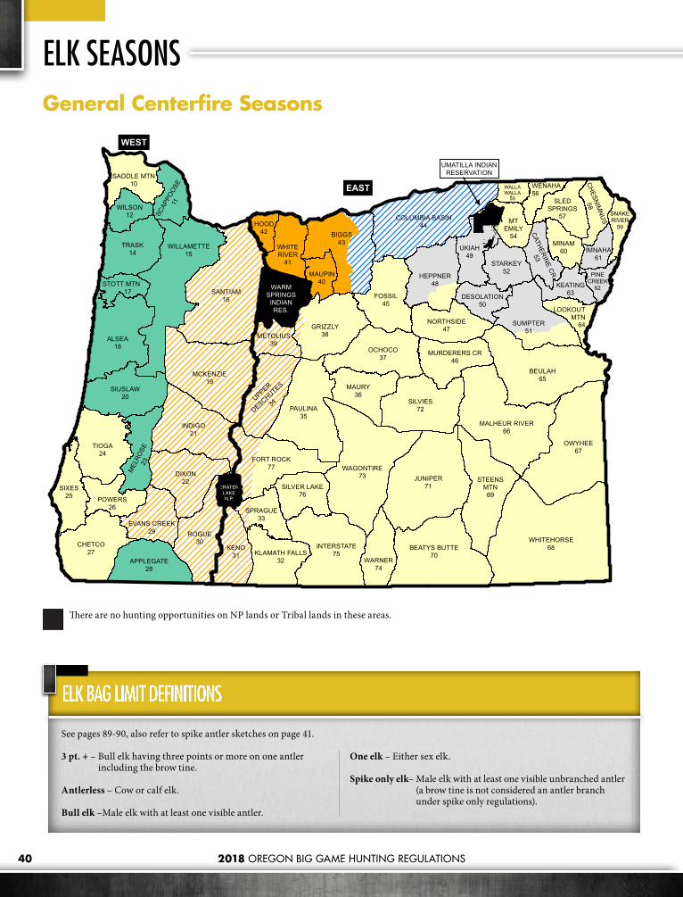
2018 OREGON BIG GAME HUNTING REGULATIONS40
SANTIAM16
WHITEHORSE68
JUNIPER71
BEULAH65
OWYHEE67
ALSEA18
INDIGO21
PAULINA35
MCKENZIE19
WAGONTIRE73
TIOGA24
DIXON22
SILVIES72
GRIZZLY38
CHETCO27
ROGUE30
KENO31
INTERSTATE75
OCHOCO37
MALHEUR RIVER66
BEATYS BUTTE70
SIUSLAW20
SIXES25
SUMPTER51
MAURY36
FORT ROCK77
APPLEGATE28
WARNER74
NORTHSIDE47
SPRAGUE33
SILVER LAKE76
EVANS CREEK29
METOLIUS39
MURDERERS CR46
BIGGS43WILLAMETTE
15
FOSSIL45
TRASK14
COLUMBIA BASIN44
HEPPNER48
UKIAH49
STEENSMTN69
MEL
ROSE
23
POWERS26
STARKEY52
MINAM60
KLAMATH FALLS32
WILSON12
WHITERIVER
41
UPPER
DESCHUTES
34
KEATING63
MAUPIN40
HOOD42
SLEDSPRINGS
57SCAP
POOS
E11
MTEMILY
54
IMNAHA61
DESOLATION50
CH
ESNIM
NU
S
58
SADDLE MTN10 WENAHA
56
WARMSPRINGS
INDIANRES.
CATHERINE CR
53
SNAKERIVER
59
PINECREEK
62STOTT MTN 17
LOOKOUTMTN
64
WALLAWALLA
55
CRATERLAKEN.P.
UMATILLA INDIANRESERVATION
WEST
EAST
General Centerfire Seasons
There are no hunting opportunities on NP lands or Tribal lands in these areas.
See pages 89-90, also refer to spike antler sketches on page 41.
3 pt. + – Bull elk having three points or more on one antler including the brow tine.
Antlerless – Cow or calf elk.
Bull elk – Male elk with at least one visible antler.
One elk – Either sex elk.
Spike only elk– Male elk with at least one visible unbranched antler (a brow tine is not considered an antler branch under spike only regulations).
ELK BAG LIMIT DEFINITIONS
ELK SEASONS

2018 OREGON BIG GAME HUNTING REGULATIONS 41
A “spike only” bag limit applies in some hunts. The sketches below show some antler configurations you may encounter in the field. Please use caution and judgement when selecting your target.
ILLUSTRATIONS FOR SPIKE ELK HUNT
Private lands will limit access for highlighted hunts. Do not apply unless you have access to a place to hunt.
CENTERFIRE GENERAL SEASONSOPEN SEASON TAG REQUIRED BAG LIMIT 1 OPEN AREA 2
WEST
ERN
OREG
ON
Oct. 13 - Oct. 19 Cascade Elk One bull elk with visible antler
Units 16, 19, 21, 22, 29, 30, 31, 34, 39, those parts of unit 33 and 77 west of Hwy 97 and that part of unit 38 west of Hwy 97 and south of Hwy 26.
Nov. 10 - Nov. 13 Coast Elk 1st Season
One bull elk with visible antler Units 11, 12, 14, 15, 17, 18, 20, 23, and 28.
Nov. 17 - Nov. 23 Coast Elk 2nd Season
One bull elk with visible antler Units 11, 15, 17, 18, 23, and 28.
One spike elk with at least one visible unbranched antler
Units 12, 14, and 20.
EAST
ERN
OREG
ON
Oct. 24 - Oct. 28 Rocky Mt Elk 1st Season
One bull elk with visible antler Units 40, 41, 42 and that part of unit 43 west of John Day Rvr.
Oct. 24 - Nov. 30 Rocky Mt Elk 1st Season One elk
Units 43 east of John Day Rvr and unit 44.Dec. 1 - Dec. 30 Rocky Mt Elk
1st Season One antlerless elk
Nov. 3 - Nov. 11 Rocky Mt Elk 2nd Season
One bull elk with visible antler Unit 40, 41, 42 and that part of unit 43 west of John Day Rvr.
Nov. 3 - Nov. 11 Rocky Mt Elk 2nd Season
One spike elk with at least one visible unbranched antler
Unit 48 north and west of N Fork John Day Rvr and unit 51 north of State Hwy 245 and Burnt Rvr Canyon Rd between Unity and Durkee. Units 49, 50, 52, 53, 61, 62, 63.
Exceptions: Starkey Experimental Forest except by controlled elk centerfire tag.
CONT
ROLL
ED
Consult Hunt Tables
Controlled 200 Series Elk Tag
Consult the controlled hunt tables
Consult the controlled hunt tables.
1 Refer to BAG LIMIT DEFINITIONS. 2 See page 85 under units 14 & 17 for weapon restrictions in parts of Stott Mt and Trask units referred to as the Cascade Head – Lincoln City Area.

2018 OREGON BIG GAME HUNTING REGULATIONS42
SANTIAM16
WHITEHORSE68
JUNIPER71
BEULAH65
OWYHEE67
ALSEA18
INDIGO21
PAULINA35
MCKENZIE19
WAGONTIRE73
TIOGA24
DIXON22
SILVIES72
GRIZZLY38
CHETCO27
ROGUE30
KENO31
INTERSTATE75
OCHOCO37
MALHEUR RIVER66
BEATYS BUTTE70
SIUSLAW20
SIXES25
SUMPTER51
MAURY36
FORT ROCK77
APPLEGATE28
WARNER74
NORTHSIDE47
SPRAGUE33
SILVER LAKE76
EVANS CREEK29
METOLIUS39
MURDERERS CR46
BIGGS43WILLAMETTE
15
FOSSIL45
TRASK14
COLUMBIA BASIN44
HEPPNER48
UKIAH49
STEENSMTN69
MEL
ROSE
23
POWERS26
STARKEY52
MINAM60
KLAMATH FALLS32
WILSON12
WHITERIVER
41
UPPER
DESCHUTES
34
KEATING63
MAUPIN40
HOOD42
SLEDSPRINGS
57SCAP
POOS
E11
MTEMILY
54
IMNAHA61
DESOLATION50
CH
ESNIM
NU
S
58
SADDLE MTN10 WENAHA
56
WARMSPRINGS
INDIANRES.
CATHERINE CR
53
SNAKERIVER
59
PINECREEK
62STOTT MTN 17
LOOKOUTMTN
64
WALLAWALLA
55
CRATERLAKEN.P.
WEST
EASTUMATILLA INDIAN
RESERVATION
General Archery Seasons
Closed to All Archery Hunting No Hunting Seasons on NP lands or alloted and/or Tribal Lands.
Moose continue to expand their range through out the western states including Oregon. A resident population of 50-60 moose now occupies portions of the Walla Walla and Wenaha Wildlife Management Units north of Elgin. Moose are also frequently sighted in adjacent management units particularly the Sled Springs, Chesnimnus, Snake River, Imnaha and Pine Creek Wildlife Management Units. Moose are generally larger than elk and vary in color from dark brown to black; nevertheless, moose are occasionally mistaken for other big game species, particularly elk. There are no hunts for moose, but moose occur where there are elk hunts. ODFW is reminding hunters to be sure of their target.
ELK HUNTERS– DON’T SHOOT A MOOSE!
ELK SEASONS

2018 OREGON BIG GAME HUNTING REGULATIONS 43
GENERAL ARCHERY SEASONSOPEN SEASON BAG LIMIT OPEN AREA (SEE PAGES 85-88 FOR REFUGE AND AREA REGULATIONS.)
WEST
ERN
OREG
ON
Aug. 25 - Sept. 23
One elk Units 15, 20, 23, 25, and 28.
One bull elk Units 11, 12, 14, 17, 18, and 27.
One bull elk,except one elk outside of USFS lands
Units 16, 19, 21, 22, 29, and 30.
One bull 3 pt. + Units 10 and 24.
One spike only elk Unit 26.
EAST
ERN
OREG
ON
Aug. 25 - Sept. 23
One elk
Units 35, 38, 40, 41, 42, 43, 44, 45, 46, 47, 50, southern portion of Unit 51 (see pg 102-S Sumpter), 53, 60, 61, 62, 63, 64, 65, 66, 67, 68, 69, 70, 71, 72, 73 east 77 (that portion east of Hwy 97), Ritter portion of Unit 48 (that part of 48 south and east of N Fork John Day Rvr.),
Exceptions: Unit 44 is closed to all archery hunting beginning at Vinson at the intersection of Hwy 74 and Butter Creek Rd, west on Hwy 74 to Sandhollow Rd, north on Sandhollow Rd to Baseline Rd, west half mile to Sandhollow Rd, north on Sandhollow Rd to Hwy 207, north and east on Hwy 207 to Butter Creek Junction, south on Butter Creek Rd to Hwy 74 at Vinson.
One bull elkUnits 31, 32, 33, 34, 39, 49, northern portion of Unit 51 (see pg 102-N Sumpter), 52, 59, 75, 76, west 77 (that portion west of Hwy 97), 48 north and west of N John Day Rvr,
Exceptions: Starkey Experimental Forest except by controlled elk archery tag.
Aug. 25 - Aug. 31** (Traditional archery equipment only)
One elk
Canyon Cr –100% public lands. Approximately 35.5 sqmi in Unit 46 beginning at the junction of FR 15 and FR 651; north and east on 651 to Table Mt trail head (trail 217); north on 217 to trail 211; north and east on 211 to trail 218; west on 218 to trail 219; west on 219 to Berry Cr; west on Berry Cr to Malheur NF boundary; south and east on forest boundary to FR 15; south and east on 15 to point of beginning. Please visit our website at myodfw.com/murderers-creek-unit-46 for map. Boundary to FR 15; south and east on 15 to point of beginning. Please visit our website at www.odfw.com for map. **Weapons Restriction: Traditional archery equipment only (long or recurve bows).Sept. 1 - Sept. 23
CONT
ROLL
ED
Consult Elk Hunt Tables
Consult controlled elk hunt tables
Controlled elk archery hunting only for Units 36, 37, 54, 55, 56, 57, 58, and 74. Consult Controlled Elk Hunt Tables

2018 OREGON BIG GAME HUNTING REGULATIONS44
CENTERFIRE CONTROLLED 200 SERIES HUNTSHUNT # HUNT NAME BAG LIMIT OPEN SEASON 2018 TAGS 2017 1ST CHOICE
APPLICANTS210 Saddle Mt Unit One antlerless elk Dec. 1 - Mar. 15, 2019 10 650
210A1 Onion Peak No. 1* One antlerless elk Dec. 1-2, 8-9, 15-16, 22-23, 29-30 10 116
210A2 Onion Peak No. 2* One antlerless elk Jan. 5-6, 12-13, 19-20, 26-27, 2019 11 81
210B1 Lewis & Clark No. 1* One antlerless elk Dec. 1-2, 8-9, 15-16, 22-23, 29-30 10 92
210B2 Lewis & Clark No. 2* One antlerless elk Jan. 5-6, 12-13, 19-20, 26-27, 2019 10 85
210C1 Upper Nehalem No. 1* One antlerless elk Dec. 1 - Jan 31, 2019 20 NEW210C2 Upper Nehalem No. 2* One antlerless elk Feb. 1 - Mar. 31, 2019 20 NEW
210D
Lower Columbia* (Master Hunter Only. Must have completed Master Hunter Program to apply.)
One antlerless elk Dec. 1 - Mar. 15, 2019 11 23
210E Young's Rvr* One antlerless elk Dec. 1 - Mar. 15, 2019 10 61
210F1 Camp McGregor No. 1* One antlerless elk Dec. 1-2, 8-9, 15-16, 22-23, 29-30 10 67
210F2 Camp McGregor No. 2* One antlerless elk Jan. 5-6, 12-13, 19-20, 26-27, 2019 10 64
210G1 Central Saddle Mt No. 1* One antlerless elk Dec. 1 - Jan. 15, 2019 17 164210G2 Central Saddle Mt No. 2* One antlerless elk Jan. 16 - Feb. 28, 2019 17 75210X Saddle Mt Unit No. 1 One 3 pt.+ Nov. 10 - Nov. 13 1,320 1,365210Y Saddle Mt Unit No. 2 One 3 pt.+ Nov. 17 - Nov. 23 1,320 1,216211 Scappoose Unit One antlerless elk Jan. 1 - Mar. 31, 2019 20 315
211A1 North Plains No. 1* One antlerless elk Dec. 1 - Mar. 31, 2019 37 127211A2 North Plains No. 2* One antlerless elk Dec. 1 - Dec. 31 39 22211A3 North Plains No. 3* One antlerless elk Jan. 1 - Jan. 31, 2019 33 7211A4 North Plains No. 4* One antlerless elk Feb. 1 - Mar. 31, 2019 33 21211B N Central Scappoose* One antlerless elk Jan. 1 - Mar. 31, 2019 30 146211C Banks* One antlerless elk Feb. 1 - Mar. 31, 2019 15 NEW212 Wilson Unit One antlerless elk Dec. 1 - Mar. 15, 2019 10 484
212A1 Miami-Nehalem No. 1* One antlerless elk Dec. 1 - Jan. 31, 2019 27 113
212A2
Miami-Nehalem No. 2* (Master Hunter Only. Must have completed Master Hunter Program to apply.)
One antlerless elk Feb. 1 - Mar. 15, 2019 26 69
212B Buick Canyon* One antlerless elk Dec. 15 - Mar. 15, 2019 10 79214 Trask Unit* One antlerless elk Dec. 1 - Mar. 15, 2019 10 764
Private lands will limit access for highlighted hunts. Do not apply unless you have access to a place to hunt.
Additional Regulations• It is unlawful to hunt with a centerfire or muzzleloading rifle
without a valid elk tag for that time period and area during: Cascade bull elk centerfire firearm season, Coast bull elk centerfire firearm seasons, or Rocky Mt bull elk or either-sex centerfire firearm seasons or standard Rocky Mt antlerless elk centerfire firearm seasons (Nov. 17 - Nov. 25). See page 16 for exceptions.
Hunt AreaEntire Wildlife Management Unit unless indicated with an asterisk(*). See pages 96-104 for controlled hunt boundary descriptions.
Tag Sale DeadlineThe day before the hunt begins.
ELK SEASONS

2018 OREGON BIG GAME HUNTING REGULATIONS 45
CENTERFIRE CONTROLLED 200 SERIES HUNTS (CONTINUED)HUNT # HUNT NAME BAG LIMIT OPEN SEASON 2018 TAGS 2017 1ST CHOICE
APPLICANTS214A1 W Trask No. 1* One antlerless elk Dec. 1 - Jan. 31, 2019 20 NEW214A2 W Trask No. 2* One antlerless elk Feb. 1 - Mar. 15, 2019 20 NEW214B1 Central Trask No. 1* One antlerless elk Jan. 1 - Feb. 14, 2019 15 153214B2 Central Trask No. 2* One antlerless elk Feb. 15 - Mar. 31, 2019 16 69214C Wind Rvr* One antlerless elk Dec. 1 - Mar. 31, 2019 10 142214D Beaver Cr* One antlerless elk Dec. 1 - Mar. 31, 2019 20 130214E Pike* One antlerless elk Dec. 1 - Mar. 31, 2019 22 61214F1 NE Trask No. 1* One antlerless elk Jan. 1 - Mar. 31, 2019 11 71214F2 NE Trask No. 2* One antlerless elk Feb. 1 - Mar. 31, 2019 10 57214G Panther Cr* One antlerless elk Jan. 1 - Jan. 31, 2019 11 47
215A1Willamette Plus No. 1* (Spike or antlerless elk from Aug. 25-Oct. 31’ 18 in Monroe Subunit)
One elk Aug.1 - Mar. 31, 2019 79 272
215A2 Willamette Plus No. 2* See W.L. Finley Refuge pg. 85 One antlerless elk Aug. 1 - Mar. 31, 2019 220 145
216B SW Santiam* One antlerless elk Jan. 1 - Jan. 31, 2019 10 185216C1 Molalla No. 1* One antlerless elk Jan. 1 - Mar. 31, 2019 11 117216C2 Molalla No. 2* One antlerless elk Jan. 1 - Jan. 31, 2019 11 35216C3 Molalla No. 3* One antlerless elk Feb. 1 - Mar. 31, 2019 11 23216D Sandy* One antlerless elk Jan. 1 - Mar. 31, 2019 16 90216E Green Mt* One antlerless elk Jan. 1 - Mar. 31, 2019 10 28216F NW Santiam* One antlerless elk Jan. 1 - Mar. 31, 2019 20 133217A Lower Siletz Rvr* One antlerless elk Jan.1 - Jan. 31, 2019 10 140217B Upper Siletz Rvr* One antlerless elk Jan. 1 - Feb. 28, 2019 10 94217C Dallas* One antlerless elk Jan. 1 - Feb. 28, 2019 11 53218A NE Alsea* One antlerless elk Jan. 1 - Jan. 31, 2019 11 139218B SW Alsea* One antlerless elk Dec. 15- Dec. 31 11 208218C SE Alsea* One antlerless elk Jan. 1 - Jan. 31, 2019 11 68218D SW Alsea Private Lands* One antlerless elk Jan. 1 - Feb. 28, 2019 10 52218E Central Alsea Private* One antlerless elk Jan. 1 - Feb.28, 2019 10 117218F NW Alsea* One antlerless elk Jan. 1 - Feb. 28, 2019 10 131219A S Central McKenzie* One antlerless elk Jan. 1 - Jan. 31, 2019 11 154219B NW McKenzie* One antlerless elk Jan. 1 - Feb. 28, 2019 11 122219C Horse Rock* One antlerless elk Jan. 1 - Feb. 28, 2019 11 28219D Scott Mt* One antlerless elk Jan. 1 - Mar. 31, 2019 17 69219E Pengra* One antlerless elk Aug. 1 - Mar. 31, 2019 10 16219F Oakridge Private Lands* One antlerless elk Jan. 1 - Feb. 28, 2019 22 27220A Noti-Saginaw* One antlerless elk Jan. 1 - Feb. 28, 2019 21 39220B W Siuslaw* One antlerless elk Dec. 1 - Dec. 31 50 236220C E Siuslaw* One antlerless elk Dec. 1 - Dec. 31 10 80220D Elkton* One antlerless elk Aug 1- Mar. 31, 2019 40 207221A NW Indigo* One antlerless elk Dec. 15 - Dec. 23 22 70221C Harness Mt* One antlerless elk Feb. 1 - Feb. 28, 2019 21 26221D S Indigo Private Lands* One antlerless elk Dec 1- Feb. 28, 2019 11 57221E Mosby* One antlerless elk Feb. 1 - Feb. 28, 2019 15 34222A Dixon Private Lands* One antlerless elk Nov. 15 - Mar. 31, 2019 11 51223A1 Melrose Unit No. 1* One antlerless elk Aug. 1- Mar. 31, 2019 208 304
Private lands will limit access for highlighted hunts. Do not apply unless you have access to a place to hunt.

46
CENTERFIRE CONTROLLED 200 SERIES HUNTS (CONTINUED)HUNT # HUNT NAME BAG LIMIT OPEN SEASON 2018 TAGS 2017 1ST CHOICE
APPLICANTS223A2 Melrose Unit No. 2* One elk Aug. 1- Mar. 31, 2019 10 394
224A Callahan* One antlerless elk Jan. 26-27, Feb. 2-3, 9-10, 2019 11 76
224B Old Blue* One antlerless elk Jan. 26-27, Feb. 2-3, 9-10, 2019 11 91
224C Tioga Private* One antlerless elk Dec. 1 - Feb. 28 2019 100 1,034224X Tioga Unit No. 1 One 3pt+ Nov. 10 - Nov. 14 1,400 667224Y Tioga Unit No. 2 One 3pt+ Nov. 17 - Nov. 25 1,600 778225A N Sixes* One antlerless elk Dec. 1 - Feb. 28, 2019 200 331225B Curry Private* One antlerless elk Dec. 1 - Feb. 28, 2019 20 119225X Sixes Unit No. 1 One bull elk Nov. 10 - Nov. 14 140 289225Y Sixes Unit No. 2 One bull elk Nov. 17 - Nov. 25 140 223226A Powers Unit Private* One antlerless elk Dec. 1 - Feb. 28, 2019 20 166226X Powers Unit No. 1 One spike only elk Nov. 10 - Nov. 14 400 93226Y Powers Unit No. 2 One bull elk Nov. 17 - Nov. 25 105 697227X Chetco Unit No. 1 One bull elk Nov. 10 - Nov. 14 77 222227Y Chetco Unit No. 2 One bull elk Nov. 17 - Nov. 25 77 150228A Applegate-Evans Cr* One antlerless elk Nov. 15 - Mar. 31, 2019 20 147
Private lands will limit access for highlighted hunts. Do not apply unless you have access to a place to hunt.
ELK SEASONS

47
CENTERFIRE CONTROLLED 200 SERIES HUNTS (CONTINUED)HUNT # HUNT NAME BAG LIMIT OPEN SEASON 2018 TAGS 2017 1ST CHOICE
APPLICANTS230A W Rogue * One antlerless elk Nov. 15 - Mar. 31, 2019 25 316232X Klamath Falls Unit No. 1 One bull elk Oct. 24 - Oct. 28 77 26232Y Klamath Falls Unit No. 2 One bull elk Nov. 3 - Nov. 11 55 30233X Sprague No. 1* One bull elk Oct. 24 - Oct. 28 220 54233Y Sprague No. 2* One bull elk Nov. 3 - Nov. 11 110 96
234A Little River* One antlerless elk Aug. 4 - Aug. 17, Nov. 17 - Nov. 30 10 168
234B Tumalo* One antlerless elk Nov. 24 - Dec. 31 48 136235A Badlands* One antlerless elk Aug. 15 - Oct. 15 65 153235X Paulina-E Fort Rock No. 1* One bull elk Oct. 24 - Oct. 28 605 718235Y Paulina-E Fort Rock No. 2* One bull elk Nov. 3 - Nov. 11 385 669236A Maury-Hampton Butte* One antlerless elk Aug. 15 - Nov. 15 40 192236X Maury Unit No. 1 One bull elk Oct. 24 - Oct. 28 55 287236Y Maury Unit No. 2 One bull elk Nov. 3 - Nov. 11 55 232237A N Ochoco* One antlerless elk Aug. 15 - Dec. 31 110 147237B Crooked Rvr* One antlerless elk Aug. 15 - Dec. 31 220 138
237C1 Ochoco Private No. 1* One elk Oct. 24 - Oct. 28 50 67237C2 Ochoco Private No. 2* One elk Nov. 3 - Nov. 11 50 100
Private lands will limit access for highlighted hunts. Do not apply unless you have access to a place to hunt.
ROCKY MOUNTAIN ELK FOUNDATIONConservationLeading the way for
OREGONConservation and hunting heritage
outreach projects
875 $57.4Combined valuemillion
793,317Acres Protected
or Enhanced
90,073Acres opened
or improved for public access
RMEF.ORG/OREGONBecome a Member Attend a Banquet
Figures as of 9/30/17
Auction DatesPENDLETON March 17EUGENE April 7ELK TAG
For more information contact:Ed Seeger 844-615-5519Dan Beraldo 844-484-4070
2018 Oregon Hunting Regulations Ad.indd 1 10/10/2017 2:16:23 PM

2018 OREGON BIG GAME HUNTING REGULATIONS48
Private lands will limit access for highlighted hunts. Do not apply unless you have access to a place to hunt.
CENTERFIRE CONTROLLED 200 SERIES HUNTS (CONTINUED)HUNT # HUNT NAME BAG LIMIT OPEN SEASON 2018 TAGS 2017 1ST CHOICE
APPLICANTS237X Ochoco Unit No. 1 One bull elk Oct. 24 - Oct. 28 218 1,907237Y Ochoco Unit No. 2 One bull elk Nov. 3 - Nov. 11 214 1,622238A SW Grizzly* One antlerless elk Aug. 15 - Dec. 31 432 450238B N Grizzly Private* One antlerless elk Aug. 15 - Nov. 30 110 105
238C1 Grizzly Private No. 1* One elk Oct. 24 - Oct. 28 138 103238C2 Grizzly Private No. 2* One elk Nov. 3 - Nov. 11 165 131238X Grizzly Unit No. 1 One bull elk Oct. 24 - Oct. 28 72 382238Y Grizzly Unit No. 2 One bull elk Nov. 3 - Nov. 11 68 272240A Maupin-W Biggs* One antlerless elk Oct. 13 - Nov. 30 330 55240B Maupin-W Biggs Private* One antlerless elk Aug. 1 - Feb. 28, 2019 330 191241A The Dalles Watershed* One elk Oct. 24 - Oct. 28 33 116241B White Rvr-Hood* One antlerless elk Nov. 17 - Nov. 25 55 311
241C1 N White Rvr-Hood No. 1* One antlerless elk Dec. 1 - Jan. 15, 2019 42 125241C2 N White Rvr-Hood No. 2* One antlerless elk Jan. 16 - Feb. 28, 2019 44 91241D Larch Cr* One antlerless elk Dec. 1 - Feb. 28, 2019 42 42244A Columbia Basin One antlerless elk Aug. 1 - Mar. 31, 2019 94 111245A1 N Fossil Private No. 1* One bull elk Oct. 24 - Oct. 28 330 34245A2 N Fossil Private No. 2* One elk Nov. 3 - Nov. 11 330 118245B1 S. Fossil Private No. 1* One bull elk Oct. 24 - Oct. 28 770 44245B2 S. Fossil Private No. 2* One elk Nov. 3 - Nov. 11 770 129245C N Fossil * One antlerless elk Nov. 17 - Nov. 25 22 43
245D1 S Fossil No. 1* One antlerless elk Nov. 17 - Nov. 25 165 20245D2 S Fossil No. 2* One antlerless elk Dec. 1 -Dec. 9 121 13245D3 S Fossil No. 3* One antlerless elk Dec. 15 - Dec. 23 66 6245E Fossil - E Biggs Agri* One antlerless elk Aug. 1 - Mar. 31, 2019 688 561245X Fossil Unit No. 1 One bull elk Oct. 24 - Oct. 28 330 163245Y Fossil Unit No. 2 One bull elk Nov. 3 - Nov. 11 330 163246 Murderers Cr Unit One antlerless elk Nov. 17 - Nov. 25 550 681
246A W Murderers Cr* One elk Nov. 3 - Nov. 11 495 1,667246B E Murderers Cr* One elk Nov. 3 - Nov. 11 275 532246D Upper John Day Rvr* One antlerless elk Dec. 1 - Dec. 31 101 36
246E
Murderers Cr Private Lands Plus* Must be listed on Landowner Permission Form to apply for this hunt (see hunt desc.)
One antlerless elk Aug. 1 - Dec. 31 193 107
246X Murderers Cr Unit One bull elk Oct. 24 - Oct. 28 468 1,311247 Northside Unit One antlerless elk Nov. 17 - Nov. 25 440 572
247A1
Northside Private Lands No. 1* Must be listed on Landowner Permission Form to apply for this hunt (see hunt desc.)
One elk Oct. 24 - Oct. 28 165 74
247A2 Northside Private Lands No. 2* One elk Nov. 3 - Nov. 11 165 100247B W Northside* One elk Nov. 3 - Nov. 11 275 564247C E Northside* One elk Nov. 3 - Nov. 11 413 1,539
247D1
Northside - Ritter Private No.1* Must be listed on Landowner Permisssion Form to apply for this hunt (see hunt desc.)
One antlerless elk Aug. 1 - Dec. 31 600 302
ELK SEASONS

2018 OREGON BIG GAME HUNTING REGULATIONS 49
CENTERFIRE CONTROLLED 200 SERIES HUNTS (CONTINUED)HUNT # HUNT NAME BAG LIMIT OPEN SEASON 2018 TAGS 2017 1ST CHOICE
APPLICANTS
247D2
Northside - Ritter Private No.2* Must be listed on Landowner Permisstion Form to apply for this hunt (See hunt desc.)
One antlerless elk Jan. 1 - Mar. 31, 2019 150 33
247X Northside Unit One bull elk Oct. 24 - Oct. 28 413 1,045248A1 Heppner No. 1* One bull elk Oct. 24 - Oct. 28 715 3,505248A2 Heppner No. 2* One spike only elk Oct. 24 - Oct. 28 825 324248B1 Ritter No. 1* One elk Oct. 24 - Oct. 28 138 95248B2 Ritter No. 2* One elk Nov. 3 - Nov. 11 220 79248C Monument* One antlerless elk Aug. 1 - Dec. 31 66 88248D Heppner* One antlerless elk Nov. 17 - Nov. 25 30 357248E Willow Creek* One antlerless elk Aug. 1 - Dec. 31 60 143
249A1 Ukiah Unit No. 1 One bull elk Oct. 24 - Oct. 28 440 2,595249A2 Ukiah Unit No. 2 One spike only elk Oct. 24 - Oct. 28 990 210249B McKay Cr* One antlerless elk Nov. 17 - Dec. 9 83 69249C Central Ukiah* One antlerless elk Nov. 17 - Nov. 25 64 221249D South Ukiah* One antlerless elk Nov. 17 - Nov. 25 66 305250A Desolation Unit One antlerless elk Nov. 17 - Nov. 25 11 175250X Desolation Unit One bull elk Oct. 24 - Oct. 28 1,100 2,140251A N Sumpter* One bull elk Oct. 24 - Oct. 28 770 1,162251B1 S Sumpter No. 1 * One elk Oct. 24 - Oct. 28 138 142251B2 S Sumpter No. 2* One elk Nov.3 - Nov. 11 138 124251C N Sumpter* One antlerless elk Oct. 13 - Oct. 21 11 119251D S Sumpter* One antlerless elk Oct. 13 - Dec. 31 193 120251E1 Elkhorn Mt No. 1* One antlerless elk Oct. 13 - Oct. 21 21 47251E2 Elkhorn Mt No. 2* One antlerless elk Nov. 17 - Nov. 25 21 75252A1 Starkey Unit No. 1* One bull elk Oct. 24 - Oct. 28 413 2,543252A2 Starkey Unit No. 2* One spike only elk Oct. 24 - Oct. 28 2,530 68252B S Starkey* One antlerless elk Nov. 17 - Nov. 25 11 180252C S Starkey Private* One antlerless elk Nov. 17 - Nov. 25 110 88
252D1 Starkey Experimental Forest No. 1* One bull elk Oct. 24 - Oct. 28 25 709252D2 Starkey Experimental Forest No. 2* One antlerless elk Nov. 3 - Nov. 11 100 NEW252E1 Shaw Mt No. 1* One antlerless elk Oct. 6 - Oct. 28 107 92252E2 Shaw Mt No. 2* One antlerless elk Nov. 3 - Nov. 25 110 54252E3 Peach Cr* One elk Nov. 3 - Nov. 11 11 65252F N Starkey* One antlerless elk Dec. 1 - Dec. 9 10 92
253A1 S Catherine Cr Private No. 1* One antlerless elk Sept. 1 - Oct. 31 330 114253A2 S Catherine Cr Private No. 2* One antlerless elk Nov. 1 -Dec. 31 214 129253B S Catherine Cr* One antlerless elk Nov. 17 - Nov. 25 28 104
253C1 Mt Harris No. 1* One antlerless elk Nov. 17 - Nov. 25 165 65253C2 Mt Harris No. 2* One antlerless elk Dec. 17 - Dec. 31 165 74253X Catherine Cr Unit One bull elk Oct. 24 - Oct. 28 275 586
254A Pumpkin Ridge* One antlerless elk Aug. 15 - Sept. 23, Nov. 17 - Dec. 31 125 243
254X Mt Emily Unit No. 1 One spike only elk Oct. 24 - Oct. 28 660 241254Y1 Mt Emily Unit No. 2 One bull elk Oct. 24 - Nov. 11 57 4,613254Y2 Mt Emily Unit No. 3 One spike only elk Nov. 3 - Nov. 11 330 201255A Mill Cr Watershed* One antlerless or 3pt+ bull elk Oct. 27 - Nov. 4 20 227
Private lands will limit access for highlighted hunts. Do not apply unless you have access to a place to hunt.
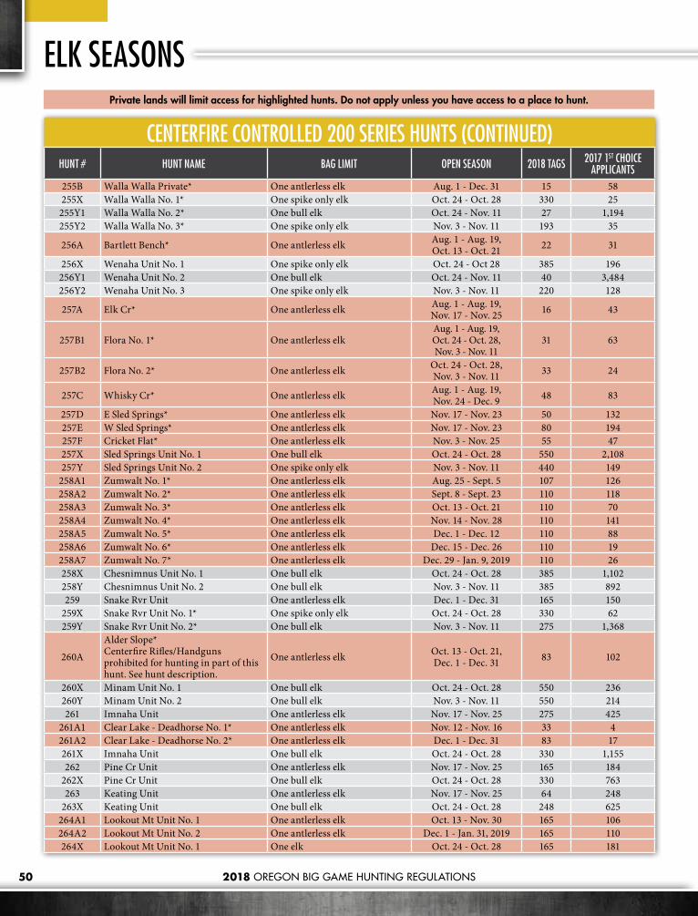
2018 OREGON BIG GAME HUNTING REGULATIONS50
ELK SEASONS
CENTERFIRE CONTROLLED 200 SERIES HUNTS (CONTINUED)HUNT # HUNT NAME BAG LIMIT OPEN SEASON 2018 TAGS 2017 1ST CHOICE
APPLICANTS255B Walla Walla Private* One antlerless elk Aug. 1 - Dec. 31 15 58255X Walla Walla No. 1* One spike only elk Oct. 24 - Oct. 28 330 25255Y1 Walla Walla No. 2* One bull elk Oct. 24 - Nov. 11 27 1,194255Y2 Walla Walla No. 3* One spike only elk Nov. 3 - Nov. 11 193 35
256A Bartlett Bench* One antlerless elk Aug. 1 - Aug. 19, Oct. 13 - Oct. 21 22 31
256X Wenaha Unit No. 1 One spike only elk Oct. 24 - Oct 28 385 196256Y1 Wenaha Unit No. 2 One bull elk Oct. 24 - Nov. 11 40 3,484256Y2 Wenaha Unit No. 3 One spike only elk Nov. 3 - Nov. 11 220 128
257A Elk Cr* One antlerless elk Aug. 1 - Aug. 19, Nov. 17 - Nov. 25 16 43
257B1 Flora No. 1* One antlerless elkAug. 1 - Aug. 19, Oct. 24 - Oct. 28, Nov. 3 - Nov. 11
31 63
257B2 Flora No. 2* One antlerless elk Oct. 24 - Oct. 28, Nov. 3 - Nov. 11 33 24
257C Whisky Cr* One antlerless elk Aug. 1 - Aug. 19, Nov. 24 - Dec. 9 48 83
257D E Sled Springs* One antlerless elk Nov. 17 - Nov. 23 50 132257E W Sled Springs* One antlerless elk Nov. 17 - Nov. 23 80 194257F Cricket Flat* One antlerless elk Nov. 3 - Nov. 25 55 47257X Sled Springs Unit No. 1 One bull elk Oct. 24 - Oct. 28 550 2,108257Y Sled Springs Unit No. 2 One spike only elk Nov. 3 - Nov. 11 440 149
258A1 Zumwalt No. 1* One antlerless elk Aug. 25 - Sept. 5 107 126258A2 Zumwalt No. 2* One antlerless elk Sept. 8 - Sept. 23 110 118258A3 Zumwalt No. 3* One antlerless elk Oct. 13 - Oct. 21 110 70258A4 Zumwalt No. 4* One antlerless elk Nov. 14 - Nov. 28 110 141258A5 Zumwalt No. 5* One antlerless elk Dec. 1 - Dec. 12 110 88258A6 Zumwalt No. 6* One antlerless elk Dec. 15 - Dec. 26 110 19258A7 Zumwalt No. 7* One antlerless elk Dec. 29 - Jan. 9, 2019 110 26258X Chesnimnus Unit No. 1 One bull elk Oct. 24 - Oct. 28 385 1,102258Y Chesnimnus Unit No. 2 One bull elk Nov. 3 - Nov. 11 385 892259 Snake Rvr Unit One antlerless elk Dec. 1 - Dec. 31 165 150
259X Snake Rvr Unit No. 1* One spike only elk Oct. 24 - Oct. 28 330 62259Y Snake Rvr Unit No. 2* One bull elk Nov. 3 - Nov. 11 275 1,368
260A
Alder Slope* Centerfire Rifles/Handguns prohibited for hunting in part of this hunt. See hunt description.
One antlerless elk Oct. 13 - Oct. 21, Dec. 1 - Dec. 31 83 102
260X Minam Unit No. 1 One bull elk Oct. 24 - Oct. 28 550 236260Y Minam Unit No. 2 One bull elk Nov. 3 - Nov. 11 550 214261 Imnaha Unit One antlerless elk Nov. 17 - Nov. 25 275 425
261A1 Clear Lake - Deadhorse No. 1* One antlerless elk Nov. 12 - Nov. 16 33 4261A2 Clear Lake - Deadhorse No. 2* One antlerless elk Dec. 1 - Dec. 31 83 17261X Imnaha Unit One bull elk Oct. 24 - Oct. 28 330 1,155262 Pine Cr Unit One antlerless elk Nov. 17 - Nov. 25 165 184
262X Pine Cr Unit One bull elk Oct. 24 - Oct. 28 330 763263 Keating Unit One antlerless elk Nov. 17 - Nov. 25 64 248
263X Keating Unit One bull elk Oct. 24 - Oct. 28 248 625264A1 Lookout Mt Unit No. 1 One antlerless elk Oct. 13 - Nov. 30 165 106264A2 Lookout Mt Unit No. 2 One antlerless elk Dec. 1 - Jan. 31, 2019 165 110264X Lookout Mt Unit No. 1 One elk Oct. 24 - Oct. 28 165 181
Private lands will limit access for highlighted hunts. Do not apply unless you have access to a place to hunt.

2018 OREGON BIG GAME HUNTING REGULATIONS 51
Private lands will limit access for highlighted hunts. Do not apply unless you have access to a place to hunt.
ODFW is asking hunters to report limping elk or animals with abnormal hooves. Report sightings to the ODFW’s elk hoof disease online reporting page http://www.dfw.state.or.us/wildlife/health_program/elk_hoof_disease/ or call or email ODFW’s Wildlife Health Lab (1-866-968-2600 / [email protected]). Hoof Disease can be caused by a bacterial infection causing severe lameness in elk resulting in deformed, overgrown, infected, or sloughed hooves www.dfw.state.or.us/wildlife/health_program/elk_hoof_disease/. Hunters finding hoof abnormalities in their harvested animals are asked to take pictures and save all hooves of elk with hoof deformities. Hoof disease does not affect the meat of elk harvested by hunters and poses no risk to human health. However, lame elk may be in poorer body condition and appear thin.
ELK HOOF DISEASE
CENTERFIRE CONTROLLED 200 SERIES HUNTS (CONTINUED)HUNT # HUNT NAME BAG LIMIT OPEN SEASON 2018 TAGS 2017 1ST CHOICE
APPLICANTS264Y Lookout Mt Unit No. 2 One elk Nov. 3 - Nov. 11 165 215
265A1 W Beulah No. 1* One bull elk Oct. 24 - Oct. 28 385 646265A2 W Beulah No. 2* One elk Nov. 3 - Nov. 11 216 845265A3 W Beulah No. 3* One antlerless elk Nov. 17 - Nov. 25 110 111265B1 E Beulah No. 1* One elk Oct. 24 - Oct. 28 440 185265B2 E Beulah No. 2* One elk Nov. 3 - Nov. 11 440 157265B3 E Beulah No. 3* One antlerless elk Nov. 17 - Dec. 31 382 252265C Bully Cr* One antlerless elk Aug. 1 - Feb. 28, 2019 125 419
266A1 Drewsey Valley No. 1* One antlerless elk Aug. 15 - Sept. 30 88 45266A2 Drewsey Valley No. 2* One antlerless elk Nov. 1 - Nov. 30 33 27266B N Malheur Rvr* One antlerless elk Nov. 17 - Nov. 25 413 586266C S Malheur Rvr* One antlerless elk Aug. 15 - Sept. 30 165 154266X N Malheur Rvr No. 1* One bull elk Oct. 24 - Oct. 28 440 845266Y N Malheur Rvr No. 2* One bull elk Nov. 3 - Nov. 11 440 722267 Owyhee Unit One antlerless elk Oct. 13 - Jan. 31, 2019 76 197
268A E Whitehorse* One antlerless elk Oct. 13 - Jan. 31, 2019 83 46271A1 Silvies - N Juniper No. 1* One antlerless elk Aug. 15 - Sept. 30 165 213271A2 Silvies - N Juniper No. 2* One antlerless elk Nov. 1 - Nov. 30 133 220271B1 N Juniper No. 1* One antlerless elk Dec. 1 - Dec. 31 44 20271B2 N Juniper No. 2* One antlerless elk Jan. 1 - Jan. 31, 2019 44 14272A Silvies Unit One antlerless elk Nov. 17 - Nov. 25 715 996272B W Silvies* One antlerless elk Dec. 1 - Dec. 9 138 79272X Silvies Unit No. 1 One bull elk Oct. 24 - Oct. 28 550 1,255272Y Silvies Unit No. 2 One bull elk Nov. 3 - Nov. 11 550 1,056273A North Wagontire* One antlerless elk Aug. 15 - Sept. 30 28 84274X Warner No. 1 One bull elk Oct. 24 - Oct. 28 55 47274Y Warner No. 2 One bull elk Nov. 3 - Nov. 11 55 34275X Interstate Unit No. 1 One bull elk Oct. 24 - Oct. 28 330 148275Y Interstate Unit No. 2 One bull elk Nov. 3 - Nov. 11 165 207276X Silver Lake Unit No. 1 One bull elk Oct. 24 - Oct. 28 350 73276Y Silver Lake Unit No. 2 One bull elk Nov. 3 - Nov. 11 200 192277A North Lake* One antlerless elk Aug. 1 - Mar. 31, 2019 150 953
278A1 High Desert No. 1* One elk Oct. 24 - Oct. 30 440 886278A2 High Desert No. 2* One elk Nov. 3 - Nov. 11 440 867

2018 OREGON BIG GAME HUNTING REGULATIONS52
ELK SEASONS
ARCHERY CONTROLLED 200 SERIES HUNTSHUNT
# HUNT NAME BAG LIMIT OPEN SEASON 2018 TAGS 2017 1ST CHOICE APPLICANTS
216R Santiam Bow* One antlerless elk Nov. 24 - Dec. 9 880 102
217R Stott Mt Unit Bow One antlerless elk Nov 24 - Dec. 9 275 73
218R Alsea Unit Bow One antlerless elk Nov 24 - Dec. 9 550 219
219R McKenzie Unit Bow* One antlerless elk Nov. 24 - Dec. 9 880 115
221R N Indigo Bow* One antlerless elk Nov. 24 - Dec. 9 660 32
224R Tioga Unit Bow 3pt + Jan. 5 - Jan. 20, 2019 330 84
226R Powers Unit Bow One elk Aug. 25 - Sept. 23 64 289
230R W Rogue Bow* One antlerless elk Jan. 1 - Feb. 28, 2019 55 64
234R Upper Deschutes Bow One elk Aug. 25 - Sept. 23 77 188
236R Maury Unit Bow One elk Aug. 25 - Sept. 23 110 73
237R1
Ochoco Unit Bow No. 1 Deer archery hunter must also have a controlled Ochoco Unit elk archery tag (used or unused) to hunt deer in the Ochoco Unit.
One elk Aug. 25 - Sept. 23 162 520
237R2
Ochoco Unit Bow No. 2 Deer archery hunter must also have a controlled Ochoco Unit elk archery tag (used or unused) to hunt deer in the Ochoco Unit.
One bull elk Aug. 25 - Sept. 23 600 904
239R Metolius Bow One elk Aug. 25 - Sept. 23 55 60
248R Heppner Bow* One elk Aug. 25 - Sept. 23 158 330
249R Ukiah Unit Bow One elk Aug. 25 - Sept. 23 321 425
252R1 Starkey Exp. Forest Bow* One bull elk Sept. 8 - Sept. 16 25 180
252R2 Shaw Mt Bow* One elk Aug. 25 - Sept. 23 110 11
254R1 Mt Emily Unit Bow No. 1 One bull elk Aug. 25 - Sept. 23 55 2,035
254R2 Mt Emily Unit Bow No.2 One spike only elk Aug. 25 - Sept. 23 176 32
255R1 Walla Walla Bow No. 1* One bull elk Aug. 25 - Sept. 23 25 608
255R2 Walla Walla Bow No.2* One spike only elk Aug. 25 - Sept. 23 55 10
256R1 Wenaha Unit Bow No. 1 One bull elk Aug. 25 - Sept. 23 40 2,608
256R2 Wenaha Unit Bow No.2 One spike only elk Aug. 25 - Sept. 23 165 28
257R1 Sled Springs Unit Bow No. 1 One elk Aug. 25 - Sept. 23 212 1,076
257R2 Sled Springs Unit Bow No. 2 One antlerless or spike elk Aug. 25 - Sept. 23 165 138
258R1 Chesnimnus Unit Bow No. 1 One elk Aug. 25 - Sept. 23 330 881
258R2 Chesnimnus Unit Bow No. 2 One antlerless or spike elk Aug. 25 - Sept. 23 83 96
259R Snake River Unit Bow One elk Aug. 25 - Sept. 23 110 34
274R Warner Unit Bow One bull elk Aug. 25 - Sept 23 55 26
Private lands will limit access for highlighted hunts. Do not apply unless you have access to a place to hunt.
Additional Regulations
Successful applicants for controlled elk archery hunts will need to purchase their controlled archery elk tag that will be valid for both the general archery elk season and controlled archery season. Tags must be purchased by the day before general archery season begins. Hunters who harvest an elk during the general archery hunting season may not hunt in the controlled archery season.

532018 OREGON BIG GAME HUNTING REGULATIONS
MUZZLELOADER CONTROLLED 200 SERIES HUNTSHUNT # HUNT NAME BAG LIMIT OPEN SEASON 2018 TAGS 2017 1ST CHOICE
APPLICANTS
200M1 NW Cascades* One bull inside all USFS lands OR One elk outside all USFS lands Nov. 10 - Nov. 16 500 389
200M2 SW Cascade* One bull inside all USFS lands OR One elk outside all USFS lands Nov. 10 - Nov. 16 400 469
214M NE Trask* One elk Dec. 18 - Dec. 31 42 135224M Tioga Unit One bull elk Dec. 8- Dec. 23 220 155234M E Cascade* One elk Nov. 3 - Nov. 11 193 548235M Paulina - E Fort Rock* One elk Oct. 13 - Oct. 19 77 165248M Pole Cr* One bull elk Oct. 13 - Oct. 21 27 274251M1 Elkhorn No. 1* One antlerless elk Aug. 1 - Oct. 15 55 45251M2 Elkhorn No. 2* One antlerless elk Oct. 16 - Dec. 31 55 34253M Mt Harris * One antlerless elk Dec. 1 - Dec. 16 83 0
254M1 Union Agri No. 1* One antlerless elk Aug. 1 - Oct. 31 159 163254M2 Union Agri No. 2* One antlerless elk Nov. 1 - Jan. 31 2019 275 157260M Eagle Cap* One bull elk Oct. 13 - Oct. 21 55 57265M E Grant* One elk Oct. 13 - Oct. 19 193 217278M High Desert* One elk Oct. 13 - Oct. 21 138 150
Private lands will limit access for highlighted hunts. Do not apply unless you have access to a place to hunt.
YOUTH ONLY CONTROLLED 200 SERIES HUNTSHUNT # HUNT NAME BAG LIMIT OPEN SEASON 2018 TAGS 2017 1ST CHOICE
APPLICANTS
210T Saddle Mt Unit One antlerless elk Aug. 1 - Dec. 31 10 131
211T Scappoose Unit One antlerless elk Aug. 1 - Dec. 31 20 98
212T1 Wilson Unit No. 1 One antlerless elk Aug. 1 - Dec. 31 10 75
212T2 Wilson Unit No. 2 One antlerless elk Dec. 22 - Dec. 30 31 48
212T3 Wilson Unit No. 3 One antlerless elk Dec. 29 - Jan. 6, 2019 32 41
214T Trask Unit* One antlerless elk Aug. 1 - Dec. 31 10 112
216T Santiam Unit* One antlerless elk Aug. 1 - Dec. 31 20 93
217T Stott Mt Unit One antlerless elk Aug. 1 - Dec. 31 10 50
218T Alsea Unit One antlerless elk Aug. 1 - Dec. 31 10 85
219T McKenzie Unit One antlerless elk Aug. 1 - Dec. 31 10 91
220T Siuslaw Unit One antlerless elk Aug. 1 - Dec. 31 10 36
221T1 Indigo Unit One antlerless elk Aug. 1 - Dec. 31 10 65
221T2 Sutherlin* One antlerless elk Jan. 1 - Jan. 31, 2019 21 13
222T Dixon Unit One antlerless elk Aug. 1 - Dec. 31 10 52
223T Melrose Unit* One antlerless elk Aug. 1 - Mar. 31, 2019 10 22
224T1 Tioga Unit One antlerless elk Aug. 1 - Dec. 31 10 208
224T2 Callahan* One antlerless elk Jan. 5-6,12-13,19-20, 2019 11 21
224T3 Old Blue* One antlerless elk Jan. 5-6, 12-13, 19-20, 2019 11 31
225T1 Sixes Unit No. 1 One antlerless elk Aug. 1 - Dec. 31 26 39
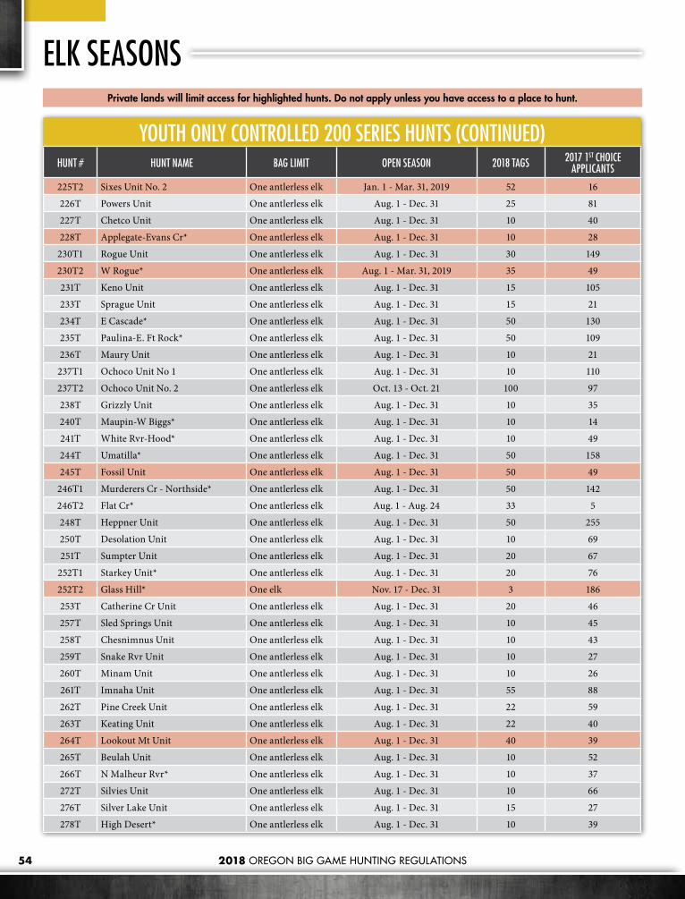
2018 OREGON BIG GAME HUNTING REGULATIONS54
ELK SEASONSPrivate lands will limit access for highlighted hunts. Do not apply unless you have access to a place to hunt.
YOUTH ONLY CONTROLLED 200 SERIES HUNTS (CONTINUED)HUNT # HUNT NAME BAG LIMIT OPEN SEASON 2018 TAGS 2017 1ST CHOICE
APPLICANTS
225T2 Sixes Unit No. 2 One antlerless elk Jan. 1 - Mar. 31, 2019 52 16
226T Powers Unit One antlerless elk Aug. 1 - Dec. 31 25 81
227T Chetco Unit One antlerless elk Aug. 1 - Dec. 31 10 40
228T Applegate-Evans Cr* One antlerless elk Aug. 1 - Dec. 31 10 28
230T1 Rogue Unit One antlerless elk Aug. 1 - Dec. 31 30 149
230T2 W Rogue* One antlerless elk Aug. 1 - Mar. 31, 2019 35 49
231T Keno Unit One antlerless elk Aug. 1 - Dec. 31 15 105
233T Sprague Unit One antlerless elk Aug. 1 - Dec. 31 15 21
234T E Cascade* One antlerless elk Aug. 1 - Dec. 31 50 130
235T Paulina-E. Ft Rock* One antlerless elk Aug. 1 - Dec. 31 50 109
236T Maury Unit One antlerless elk Aug. 1 - Dec. 31 10 21
237T1 Ochoco Unit No 1 One antlerless elk Aug. 1 - Dec. 31 10 110
237T2 Ochoco Unit No. 2 One antlerless elk Oct. 13 - Oct. 21 100 97
238T Grizzly Unit One antlerless elk Aug. 1 - Dec. 31 10 35
240T Maupin-W Biggs* One antlerless elk Aug. 1 - Dec. 31 10 14
241T White Rvr-Hood* One antlerless elk Aug. 1 - Dec. 31 10 49
244T Umatilla* One antlerless elk Aug. 1 - Dec. 31 50 158
245T Fossil Unit One antlerless elk Aug. 1 - Dec. 31 50 49
246T1 Murderers Cr - Northside* One antlerless elk Aug. 1 - Dec. 31 50 142
246T2 Flat Cr* One antlerless elk Aug. 1 - Aug. 24 33 5
248T Heppner Unit One antlerless elk Aug. 1 - Dec. 31 50 255
250T Desolation Unit One antlerless elk Aug. 1 - Dec. 31 10 69
251T Sumpter Unit One antlerless elk Aug. 1 - Dec. 31 20 67
252T1 Starkey Unit* One antlerless elk Aug. 1 - Dec. 31 20 76
252T2 Glass Hill* One elk Nov. 17 - Dec. 31 3 186
253T Catherine Cr Unit One antlerless elk Aug. 1 - Dec. 31 20 46
257T Sled Springs Unit One antlerless elk Aug. 1 - Dec. 31 10 45
258T Chesnimnus Unit One antlerless elk Aug. 1 - Dec. 31 10 43
259T Snake Rvr Unit One antlerless elk Aug. 1 - Dec. 31 10 27
260T Minam Unit One antlerless elk Aug. 1 - Dec. 31 10 26
261T Imnaha Unit One antlerless elk Aug. 1 - Dec. 31 55 88
262T Pine Creek Unit One antlerless elk Aug. 1 - Dec. 31 22 59
263T Keating Unit One antlerless elk Aug. 1 - Dec. 31 22 40
264T Lookout Mt Unit One antlerless elk Aug. 1 - Dec. 31 40 39
265T Beulah Unit One antlerless elk Aug. 1 - Dec. 31 10 52
266T N Malheur Rvr* One antlerless elk Aug. 1 - Dec. 31 10 37
272T Silvies Unit One antlerless elk Aug. 1 - Dec. 31 10 66
276T Silver Lake Unit One antlerless elk Aug. 1 - Dec. 31 15 27
278T High Desert* One antlerless elk Aug. 1 - Dec. 31 10 39

We are very excited about the NEW 6th Edition of the Record Book for OREGON’S BIG GAME ANIMALS! Since size really does matter, we have significantly increased the total number of entries and photos since the 5th Edition.Our newest edition is lavishly illustrated, all color, with great attention to detail! It is a definitive source of big game hunting in Oregon. Now with more than 8,000 entries in four categories: Rifle, Archery, Black Powder and Shed Antlers. Species include bear, cougar, whitetail, blacktail, mule deer, rocky mountain, Roosevelt elk, bighorn sheep, wild turkey and mountain goat. This 6th Edition also features hunting stories by the actual hunters as well as a collection of rare historical photographs and exciting color photos of record-setting big game trophies!
6th Edition Record Book for Oregon’s Big Game Animals
To order, go to www.nwbiggame.com or call 541-566-0149 Also available at Bi-Mart Stores
Only$29.95

56
CENTERFIRE CONTROLLED 400 SERIES HUNTSHUNT # HUNT NAME BAG LIMIT OPEN SEASON 2018 TAGS 2017 1ST CHOICE
APPLICANTS435 Paulina Unit One buck pronghorn Aug. 11 - Aug. 19 16 538436 Maury Unit One buck pronghorn Aug. 11 - Aug. 19 27 622437 Ochoco Unit One buck pronghorn Aug. 11 - Aug. 19 95 1,754438 Grizzly Unit One buck pronghorn Aug. 11 - Aug. 19 11 251440 Maupin-W Biggs* One pronghorn either sex Aug. 11 - Aug. 19 5 201
443A1 Columbia Plateau No. 1* One doe or fawn pronghorn Oct. 13 - Oct. 21 55 84443A2 Columbia Plateau No. 2* One buck pronghorn Oct. 13 - Oct. 21 20 311445A S Fossil-Winlock* One doe or fawn pronghorn Oct. 13 - Oct. 21 22 60446 Murderers Cr Unit One buck pronghorn Aug. 11 - Aug. 19 54 614447 Northside - Ritter* One buck pronghorn Aug. 11 - Aug. 19 6 111
451A N Sumpter* One buck pronghorn Aug. 11 - Aug. 19 5 129451B S Sumpter* One buck pronghorn Aug. 11 - Aug. 19 5 165463 Keating Unit One buck pronghorn Aug. 11 - Aug. 19 5 221464 Lookout Mt Unit One buck pronghorn Aug. 11 - Aug. 19 8 322465 Beulah Unit One pronghorn either sex Aug. 11 - Aug. 19 11 1,174
466A1 Malheur Rvr No. 1 One pronghorn either sex Aug. 11 - Aug. 19 96 1,215466A2 Malheur Rvr No. 2 One pronghorn either sex Aug. 22 - Aug. 30 96 929466B Harney Basin* One doe or fawn pronghorn Sept. 1 - Sept. 16 55 155467 Owyhee Unit One pronghorn either sex Aug. 11 - Aug. 19 64 1,196
468A1 Whitehorse Unit No. 1 One pronghorn either sex Aug. 11 - Aug. 19 76 1,600468A2 Whitehorse Unit No. 2 One pronghorn either sex Aug. 22 - Aug. 30 75 1,123469A Steens Mt* One buck pronghorn Aug. 11 - Aug. 19 127 2,488470A E Beatys Butte* One buck pronghorn Aug. 11 - Aug. 19 96 1,663470B W Beatys Butte* One buck pronghorn Aug. 11 - Aug. 19 53 1,868470C Hart Mt* One buck pronghorn Sept. 8 - Sept. 14 41 3,328471A Juniper* One buck pronghorn Aug. 11 - Aug. 19 84 2,263
472A1 Silvies Unit No. 1 One pronghorn either sex Aug. 11 - Aug. 19 42 940472A2 Silvies Unit No. 2 One pronghorn either sex Aug. 22 - Aug. 30 42 695472B Riley* One doe or fawn pronghorn Sept. 1 - Sept. 16 32 110473A N Wagontire* One buck pronghorn Aug. 11 - Aug. 19 31 926473B S Wagontire* One buck pronghorn Aug. 11 - Aug. 19 10 486474A Warner Unit No. 1 One buck pronghorn Aug. 11 - Aug. 19 62 1,764474B Warner Unit No. 2 One buck pronghorn Aug. 22 - Aug. 30 62 997475A E Interstate* One pronghorn either sex Aug. 11 - Aug. 19 26 452476A E Ft Rock-Silver Lake* One pronghorn either sex Aug. 11 - Aug. 19 44 482
Private lands will limit access for highlighted hunts. Do not apply unless you have access to a place to hunt.
2018 OREGON BIG GAME HUNTING REGULATIONS
Additional Regulations• No more than two people may apply as a party for pronghorn
antelope.• No person shall shoot at a pronghorn antelope from a point within
50 yards of a motor vehicle including aircraft, except persons that have an “Oregon Disabilities Hunting and Fishing Permit” (see page 25).
Hunt AreaEntire Wildlife Management Unit unless indicated with an asterisk(*). See page 105 for controlled hunt boundary descriptions.
Tag Sale DeadlineThe day before the hunt begins.
PRONGHORN ANTELOPE SEASONS

2018 OREGON BIG GAME HUNTING REGULATIONS 57
ARCHERY CONTROLLED 400 SERIES HUNTSHUNT # HUNT NAME BAG LIMIT OPEN SEASON 2018 TAGS 2017 1ST CHOICE
APPLICANTS435R Paulina Unit Bow One buck pronghorn Aug. 25 - Sept. 2 6 40436R Maury Unit Bow One pronghorn either sex Aug. 25 - Sept. 2 33 120464R Lookout Mt Unit Bow One pronghorn either sex Sept. 1 - Sept. 9 11 28466R Malheur Rvr Unit Bow One pronghorn either sex Sept. 1 - Sept. 9 61 143467R Owyhee Unit Bow One pronghorn either sex Aug. 25 - Sept. 2 55 134470R1 Hart Mt Bow* One buck pronghorn Aug. 2 - Aug. 10 26 614470R2 W Beatys Butte Bow* One pronghorn either sex Aug. 22 - Aug. 30 38 308473R N Wagontire Bow* One buck pronghorn Aug. 25 - Sept. 2 6 66474R Warner Unit Bow One pronghorn either sex Aug. 2 - Aug. 10 49 416
475R1 E Interstate Bow* One pronghorn either sex Sept. 1 - Sept. 9 55 47475R2 Gerber Reservoir Bow* One pronghorn either sex Aug. 4 - Aug. 12 165 284
477R
E Slope Bow* Please read note in hunt description before applying for this hunt
One pronghorn either sex Aug. 25 - Sept. 23 55 10
To report wildlife violators, Call 1-800-452-7888 Or Dial *OSP (*677) or send an email to [email protected]
REPORT WILDLIFE VIOLATORS
MUZZLELOADER CONTROLLED 400 SERIES HUNTSHUNT # HUNT NAME BAG LIMIT OPEN SEASON 2018 TAGS 2017 1ST CHOICE
APPLICANTS435M Paulina Unit Muzzleloader One buck pronghorn Aug. 25 - Sept. 2 6 66470M E Beatys Butte Muzzleloader* One buck pronghorn Aug. 22 - Aug. 30 50 331
473M1 S Wagontire Muzzleloader* One pronghorn either sex Aug. 22 - Aug. 30 11 106473M2 N Wagontire Muzzleloader* One pronghorn either sex Aug. 25 - Sept. 2 5 66475M Gerber Reservior Muzzleloader* One pronghorn either sex Sept. 1 - Sept. 9 55 271
476M E Fort Rock-Silver Lake Muzzleloader* One pronghorn either sex Sept. 1 - Sept. 9 44 170
YOUTH ONLY CONTROLLED 400 SERIES HUNTSHUNT # HUNT NAME BAG LIMIT OPEN SEASON 2018 TAGS 2017 1ST CHOICE
APPLICANTS432T Swan Lake* One pronghorn either sex Aug. 11 - Aug. 19 3 99453T Thief Valley* One buck pronghorn Aug. 1 - Aug. 31 3 92470T Hart Mt* One buck pronghorn Aug. 11 - Aug. 19 3 476475T Gerber Reservior* One pronghorn either sex Aug. 18 - Aug. 26 31 508
Private lands will limit access for highlighted hunts. Do not apply unless you have access to a place to hunt.
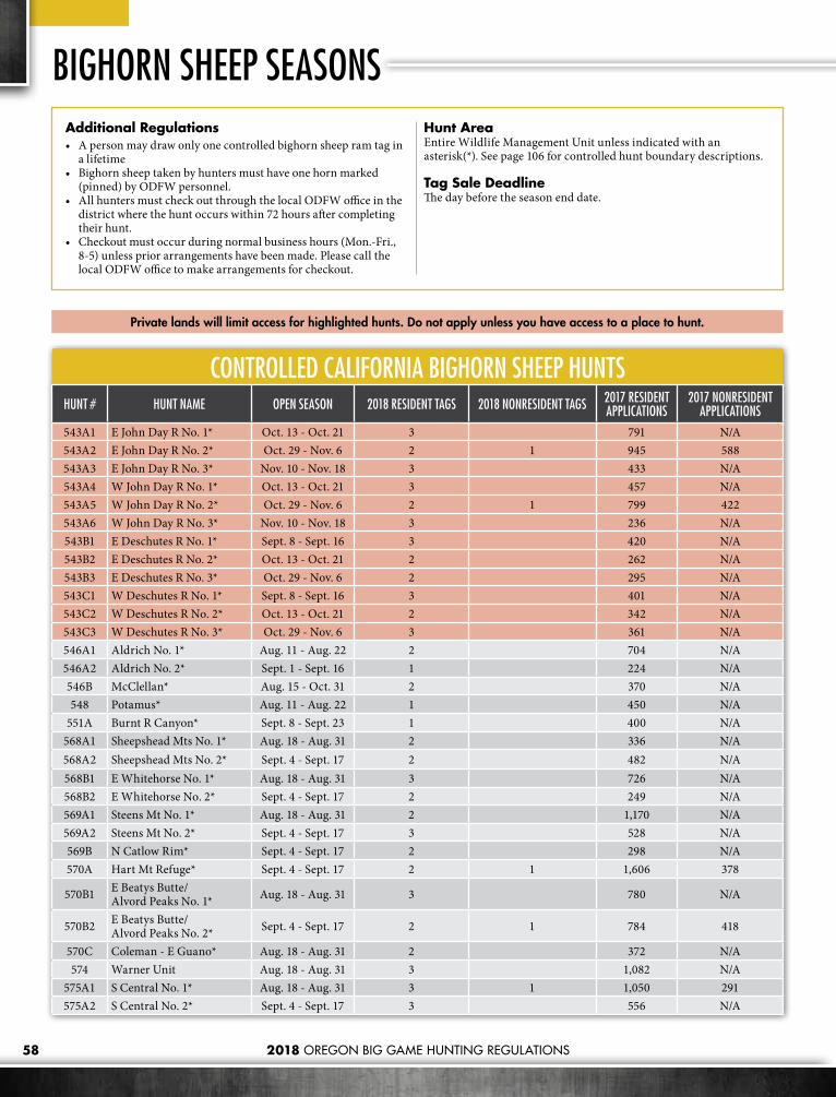
2018 OREGON BIG GAME HUNTING REGULATIONS58
BIGHORN SHEEP SEASONS
CONTROLLED CALIFORNIA BIGHORN SHEEP HUNTSHUNT # HUNT NAME OPEN SEASON 2018 RESIDENT TAGS 2018 NONRESIDENT TAGS 2017 RESIDENT
APPLICATIONS2017 NONRESIDENT
APPLICATIONS543A1 E John Day R No. 1* Oct. 13 - Oct. 21 3 791 N/A543A2 E John Day R No. 2* Oct. 29 - Nov. 6 2 1 945 588543A3 E John Day R No. 3* Nov. 10 - Nov. 18 3 433 N/A543A4 W John Day R No. 1* Oct. 13 - Oct. 21 3 457 N/A543A5 W John Day R No. 2* Oct. 29 - Nov. 6 2 1 799 422543A6 W John Day R No. 3* Nov. 10 - Nov. 18 3 236 N/A543B1 E Deschutes R No. 1* Sept. 8 - Sept. 16 3 420 N/A543B2 E Deschutes R No. 2* Oct. 13 - Oct. 21 2 262 N/A543B3 E Deschutes R No. 3* Oct. 29 - Nov. 6 2 295 N/A543C1 W Deschutes R No. 1* Sept. 8 - Sept. 16 3 401 N/A543C2 W Deschutes R No. 2* Oct. 13 - Oct. 21 2 342 N/A543C3 W Deschutes R No. 3* Oct. 29 - Nov. 6 3 361 N/A546A1 Aldrich No. 1* Aug. 11 - Aug. 22 2 704 N/A546A2 Aldrich No. 2* Sept. 1 - Sept. 16 1 224 N/A546B McClellan* Aug. 15 - Oct. 31 2 370 N/A548 Potamus* Aug. 11 - Aug. 22 1 450 N/A
551A Burnt R Canyon* Sept. 8 - Sept. 23 1 400 N/A568A1 Sheepshead Mts No. 1* Aug. 18 - Aug. 31 2 336 N/A568A2 Sheepshead Mts No. 2* Sept. 4 - Sept. 17 2 482 N/A568B1 E Whitehorse No. 1* Aug. 18 - Aug. 31 3 726 N/A568B2 E Whitehorse No. 2* Sept. 4 - Sept. 17 2 249 N/A569A1 Steens Mt No. 1* Aug. 18 - Aug. 31 2 1,170 N/A569A2 Steens Mt No. 2* Sept. 4 - Sept. 17 3 528 N/A569B N Catlow Rim* Sept. 4 - Sept. 17 2 298 N/A570A Hart Mt Refuge* Sept. 4 - Sept. 17 2 1 1,606 378
570B1 E Beatys Butte/ Alvord Peaks No. 1* Aug. 18 - Aug. 31 3 780 N/A
570B2 E Beatys Butte/ Alvord Peaks No. 2* Sept. 4 - Sept. 17 2 1 784 418
570C Coleman - E Guano* Aug. 18 - Aug. 31 2 372 N/A574 Warner Unit Aug. 18 - Aug. 31 3 1,082 N/A
575A1 S Central No. 1* Aug. 18 - Aug. 31 3 1 1,050 291575A2 S Central No. 2* Sept. 4 - Sept. 17 3 556 N/A
Private lands will limit access for highlighted hunts. Do not apply unless you have access to a place to hunt.
Additional Regulations• A person may draw only one controlled bighorn sheep ram tag in
a lifetime• Bighorn sheep taken by hunters must have one horn marked
(pinned) by ODFW personnel.• All hunters must check out through the local ODFW office in the
district where the hunt occurs within 72 hours after completing their hunt.
• Checkout must occur during normal business hours (Mon.-Fri., 8-5) unless prior arrangements have been made. Please call the local ODFW office to make arrangements for checkout.
Hunt AreaEntire Wildlife Management Unit unless indicated with an asterisk(*). See page 106 for controlled hunt boundary descriptions.
Tag Sale DeadlineThe day before the season end date.

59
CONTROLLED ROCKY MOUNTAIN BIGHORN SHEEP HUNTSHUNT # HUNT NAME OPEN SEASON 2018 RESIDENT TAGS 2018 NONRESIDENT TAGS 2017 RESIDENT
APPLICATIONS2017 NONRESIDENT
APPLICATIONS
559A1 N Snake Rvr* Sept. 8 - Sept. 23 1 1,017 N/A
560A Hurricane Divide* Sept. 8 - Sept. 23 2 830 N/A
560B Bear Creek* Sept. 8 - Sept. 23 1 310 N/A
564A1 Lookout Mt No. 1 Aug. 25 - Sept. 5 1 707 N/A
564A2 Lookout Mt No. 2 Sept. 8 - Sept. 23 1 1 1,002 567
Private lands will limit access for highlighted hunts. Do not apply unless you have access to a place to hunt.
Lawyers who support the Second Amendment and can clean up the past of you or a loved one. We
can help the family hunt together, again.
(541) 388-1660 [email protected]
CALL OR EMAIL FOR A FREE CONSULTATION
OREGON GUN LAWGUN RIGHTS RESTORED

2018 OREGON BIG GAME HUNTING REGULATIONS60
ROCKY MOUNTAIN GOAT SEASONS
CONTROLLED 900 SERIES HUNTSHUNT # HUNT NAME OPEN SEASON 2018 RESIDENT TAGS 2018 NONRESIDENT TAGS 2017 RESIDENT
APPLICATIONS2017 NONRESIDENT
APPLICATIONS946A Strawberry Mt* Sept. 1 - Oct. 31 1 1,360 N/A951A1 Elkhorn No. 1* Sept. 8 - Sept. 16 3 2,481 N/A951A2 Elkhorn No. 2* Sept. 17 - Sept. 25 1 1 1,184 786951A3 Elkhorn No. 3* Oct. 13 - Oct. 21 3 1,326 N/A956A N Wenaha* Sept. 8 - Sept. 23 1 356 N/A959A1 Hat Point No. 1* Sept. 8 - Sept. 23 1 1 1,138 584959A2 Hat Point No. 2* Oct. 13 - Oct. 23 2 726 N/A959B1 S Snake Rvr No. 1* Sept. 8 - Sept. 23 2 745 N/A959B2 S Snake Rvr No. 2* Oct. 13 - Oct. 23 1 269 N/A960A1 E Hurricane Cr* Sept. 8 - Sept. 23 1 509 N/A960A2 W Hurricane Cr* Sept. 8 - Sept. 23 1 262 N/A960B1 Goat Mt No. 1* Sept. 8 - Sept. 23 2 762 N/A960B2 Goat Mt No. 2* Oct. 13 - Oct. 23 2 332 N/A961A Cusick Mt* Sept. 8 - Sept. 23 1 564 N/A
Additional Regulations• A person may draw only one controlled Rocky Mt goat tag in a
lifetime.• Orientation class with district biologist is required. • Rocky Mt goats taken by hunters must be marked by ODFW
personnel prior to hunters leaving the hunt area. • All hunters must check out through the local ODFW office in the
district where the hunt occurs within 72 hours after completing their hunt unless other arrangements have been made.
• Checkout must occur during normal business hours (Mon. - Fri., 8-5) unless prior arrangements have been made.
Hunt AreaEntire Wildlife Management Unit unless indicated with an asterisk(*). See page 107 for controlled hunt boundary descriptions.
Bag LimitOne Rocky Mt goat.
Tag Sale DeadlineThe day before the season end date.
ATTENTION ALL 2018 BIGHORN SHEEP & ROCKY MTN GOAT TAG HOLDERS
Workshop & Orientation July 21, 2018
Fort Dalles Readiness Center, 402 E. Scenic Dr, The Dalles, OR 97058
OregonFNAWS.org Don South 503-647-5954 | George Houston 503-826-9109
Turn in Poachers Program–
Sponsored by: Oregon Hunters Association. In Cooperation with Oregon State Police and Oregon Department of Fish and Wildlife
TIPs Can Remain Anonymous Call 1-800-452-7888 Or Dial *OSP (*677)
REPORT WILDLIFE AND HABITAT VIOLATIONS
OREGONTURN •
IN• POACHERS
PROGRAM

2018 OREGON BIG GAME HUNTING REGULATIONS 61
BEAR SEASONSGeneral Bear RegulationsWithin a calendar year, and during authorized seasons, a hunter may harvest:• One bear with a general fall black bear tag• One bear with a SW Additional fall black
bear tag• One bear with a controlled or SW limited
spring black bear tag• It is unlawful to take cubs less than one year
old or sows with cubs less than one year old.• Using bait to attract black bear and using
dogs to locate and tree black bear is prohibited.
• It is unlawful to hunt with a centerfire or muzzleloading rifle without a valid (used or unused) deer or elk tag during certain time periods and areas; see page 16.
Mandatory Check for All Harvested BearsThe skull of any bear taken must be presented to an ODFW office or designated collection site within 10 days of the kill to be checked and marked; the hunter is responsible to have it presented.• Skull must be unfrozen when presented for
check-in and please prop open mouth so tooth can be accessed. Inserting a stick or dowel between the molars prior to freezing/drying out will help keep jaw open.
• Check-in at ODFW offices must occur by appointment during normal business hours (Mon. - Fri., 8-5). Please call ahead to make arrangements to have the bear checked.
• Hunters are required to check-in the skull only.
• Hunters are requested but not required to submit the reproductive tract of any female bear harvested, see diagram below.
1. Label a plastic bag with: Tag Number, Date of Kill, Unit Number and Name, County, and Your Name and Address. Ziplock type kitchen or freezer bags work very well for this purpose.
2. Locate the “Y” shaped reproductive tract beneath and slightly ahead of the pelvis or hip bones. It usually is necessary to move some of the intestines and other organs aside to locate the entire tract, including both ovaries and the uterus.
3. Cut the uterus immediately forward of the bladder. Use caution when handling the bladder and cutting the reproductive tract from the body cavity to insure the meat is not contaminated with urine from the bladder.
4. Place the entire reproductive tract in the labeled plastic bag and seal.
5. Preserve specimens by freezing as soon as possible and submit to any ODFW district office or check station.
COLLECTING THE REPRODUCTIVE TRACT FROM A FEMALE BLACK BEAR OR COUGAR
• At check-in, hunters must provide: » Date and location including Wildlife
Management Unit of harvest. » Complete hunting information including
bear tag number. The bear tag, a copy of the tag, or a completed “Wildlife Transfer Record Form” are alternatives for providing the needed information.
• Hunters must still complete mandatory reporting via the internet or toll free line.

2018 OREGON BIG GAME HUNTING REGULATIONS62
BLACK BEAR SEASONSGeneral Black Bear Seasons
WEST
EAST
SANTIAM16
WHITEHORSE68
JUNIPER71
BEULAH65
OWYHEE67
ALSEA18
INDIGO21
PAULINA35
MCKENZIE19
WAGONTIRE73
TIOGA24
DIXON22
SILVIES72
GRIZZLY38
CHETCO27
ROGUE30
KENO31
INTERSTATE75
OCHOCO37
MALHEUR RIVER66
BEATYS BUTTE70
SIUSLAW20
SIXES25
SUMPTER51
MAURY36
FORT ROCK77
APPLEGATE28
WARNER74
NORTHSIDE47
SPRAGUE33
SILVER LAKE76
EVANS CREEK29
METOLIUS39
MURDERERS CR46
BIGGS43WILLAMETTE
15
FOSSIL45
TRASK14
COLUMBIA BASIN44
HEPPNER48
UKIAH49
STEENSMTN69
MEL
ROSE
23
POWERS26
STARKEY52
MINAM60
KLAMATH FALLS32
WILSON12
WHITERIVER
41
UPPER
DESCHUTES
34
KEATING63
MAUPIN40
HOOD42
SLEDSPRINGS
57SCAP
POOS
E11
MTEMILY
54
IMNAHA61
DESOLATION50
CH
ESNIM
NU
S
58
SADDLE MTN10 WENAHA
56
WARMSPRINGS
INDIANRES.
CATHERINE CR
53
SNAKERIVER
59
PINECREEK
62STOTT MTN 17
LOOKOUTMTN
64
WALLAWALLA
55
CRATERLAKEN.P.
GENERAL BLACK BEAR SEASONSOPEN SEASON TAG REQUIRED BAG LIMIT OPEN AREA
(SEE PAGES 85-88 FOR REFUGE AND AREA REGULATIONS.)
Aug. 1 - Dec. 31 General Fall BearOne black bear, unlawful to take cubs less than one year old or sows with cubs less than one year old.
WMUs 10-30
Aug. 1 - Dec. 31 SW Additional Bear
One black bear, unlawful to take cubs less than one year old or sows with cubs less than one year old.
WMUs 20-30
Aug. 1 - Nov. 30 General Fall BearOne black bear, unlawful to take cubs less than one year old or sows with cubs less than one year old.
WMUs 31-77
No Hunting Seasons

2018 OREGON BIG GAME HUNTING REGULATIONS 63
Every hunter who purchased a deer, elk, cougar, bear, pronghorn antelope or turkey tag needs to report. Complete a survey for every tag you purchased — even if you didn’t hunt or weren’t successful. Visit myodfw.com/articles/report-your-hunt
DON’T FORGET TO REPORT
CONTROLLED 700 SERIES SPRING HUNTSHUNT # HUNT NAME OPEN SEASON 2018 TAGS 2017 1ST CHOICE
APPLICANTS710A Saddle Mt - Scappoose* April 1 - May 31 165 92712A Wilson-Trask* April 1 - May 31 440 346716A N Cascades* April 1 - May 31 385 283717A Alsea-Stott Mt* April 1 - May 31 214 424731A South Central* April 15 - May 31 303 191741 White River Unit April 1 - May 31 165 226742 Hood Unit April 1- May 31 165 92
746A S Blue Mts* April 15 - May 31 660 691749A W Blue Mts* April 1 - May 31 212 1,495752A Starkey* April 15 - May 31 220 169756 Wenaha Unit April 15 - May 31 248 450
757A Sled Springs -Chesnimnus* April 15 - May 31 275 770759A Snake Rvr Unit April 15 - May 31 440 740760A Minam-Imnaha* April 15 - May 31 248 500762A Pine Cr - Keating - Catherine Cr* April 15 - May 31 440 769764 Lookout Mt Unit April 15 - May 31 43 87
SW LIMITED 700 SERIES HUNTSHUNT # HUNT NAME OPEN SEASON 2018 TAGS
SW Oregon* SW Oregon Limited April 1 - May 31 4,400 (Tags will be availble on a first-come, first served basis. See hunt description)
YOUTH ONLY CONTROLLED 700 SERIES HUNTSHUNT # HUNT NAME OPEN SEASON 2018 TAGS 2017 1ST CHOICE
APPLICANTS756T Wenaha Unit April 15 - May 31 55 38757T Sled Springs-Chesnimnus* April 15 - May 31 88 83760T Minam-Imnaha* April 15 - May 31 55 37
Private lands will limit access for highlighted hunts. Do not apply unless you have access to a place to hunt.
Hunt AreaEntire Wildlife Management Unit unless indicated with an asterisk(*). See page 107 for controlled hunt boundary descriptions.
Bag LimitOne black bear, except that it is unlawful to take cubs less than one year old or sows with cubs less than one year old.
Tag Sale DeadlineDay before the season begins.

2018 OREGON BIG GAME HUNTING REGULATIONS64
COUGAR SEASONSGeneral Cougar RegulationsStatewide Season: Jan. 1 – Dec. 31
Mortality Quotas: Cougar Quota Zones will be closed to cougar hunting if the zone quota has been reached. However, quotas are typically not met. See table below for zones and quotas. Quota information is updated regularly at: myodfw.com/big-game-hunting/species/cougar
Additional Tag: An “additional” cougar tag may be purchased throughout the season; however, hunters must purchase the general season tag prior to the tag sale deadline to be eligible for the additional tag.
Bag Limit: One cougar per tag, except it is unlawful to take spotted kittens or females with spotted kittens.
Mandatory Check for All Cougar• Any cougar taken must be presented to an
ODFW office within 10 days of the kill to be checked and marked; the person who took the animal is responsible to have it presented.
• Check-in must occur by appointment during normal business hours (Mon. - Fri., 8-5). Please call ahead to make arrangements to have the cougar checked.
• Hunters are required to check the unfrozen hide with skull and proof of sex attached
• To make check-in easier, ODFW biologist request hunters use a stick to hold the mouth open so teeth are easier to access
• Hunters are required to submit the reproductive tract of any female cougar taken (see page 61)
• At check-in, hunters must provide » Date, and location including Wildlife
Management Unit of harvest.
» Complete hunting information including cougar tag number. The cougar tag, a copy of the tag, or a completed “Wildlife Transfer Record Form” are alternatives for providing the needed information.
• Hunters must still complete mandatory reporting via the internet or toll free line.
COUGAR QUOTA ZONESHUNT ZONE* NAME QUOTA MANAGEMENT UNITS
A Coast/North Cascade 180 10, 11, 12, 14, 15, 16, 17, 18, 20, 24, 25, 26 27, 39, 41, 42
B Southwest Cascades 200 19, 21, 22, 23, 28, 29, 30, 31
C Southeast Cascades 80 32, 33, 34, 35, 75, 76, 77
D Columbia Basin 100 38, 40, 43, 44, 45
E Blue Mountains 270 37, 46, 47, 48, 49, 50, 51, 52, 53, 54, 55, 56, 57, 58, 59, 60, 61, 62, 63, 64
F Southeast Oregon 140 36, 65, 66, 67, 68, 69, 70, 71, 72, 73, 74
STATEWIDE TOTAL QUOTA: 970
As a hunter, you are responsible to adopt and follow a personal code of ethics that reflects your values
and your respect for wildlife, hunting and pass on the sport of hunting to those who come after you. Remember the following points to help ensure the future of Oregon’s hunting heritage. Respect Landowners• Ask for permission to hunt well
before you plan on hunting.• Leave all gates the way you find them.• Follow all landowner restrictions.• Offer to share part of your harvest
with the landowner.
Respect the Resource• Leave the land better than you
found it.• Adhere to fair chase rules.• Know your capabilities and
limitations as a marksman.• Harvest no more than you will use,
and take care of what you take.• Abide by game laws andregulations.Report hunting violations to the Oregon State Police at1-800-452-7888 or dial *OSP (*677).
Hunter Ethics Respect Others• Follow safe firearm handling
practices and insist your hunting partners do the same.
• Know what is beyond your target. Shot pellets can be fatal to both people and dogs.
• Don’t interfere with another person's hunt.
• If mentoring a youth hunter, be sure to pass on safe, responsible and ethical knowledge and skills.
• Wear hunter orange when hunting. Be Safe – Be Seen.

2018 OREGON BIG GAME HUNTING REGULATIONS 65
SMALL GAME HUNTINGSmall game species provide a variety of hunting opportunities throughout the state and are an excellent way to introduce new hunters to hunting. Only the appropriate hunting license is necessary to hunt small game (no tags or permits). There are three major categories of small game in Oregon, Western Gray Squirrel, unprotected mammals, and furbearers.
Western Gray SquirrelThe Western Gray Squirrel is a “Game Mammal”. A hunting license is required to hunt Western Gray Squirrels. Western Gray Squirrels can only be hunted during the seasons listed below.
White River - HoodOpen Season: Sept. 8 - Oct. 14Bag Limit: 3 squirrels daily.Possession Limit: 6 in possession.Open Area: White Rvr and Hood units.
Western OregonOpen Season: Aug. 25 - Nov. 7Bag Limit: 5 squirrels daily.Possession Limit: 15 in possession.Open Area: All units west of the eastern boundary of the Santiam, McKenzie, Indigo, Sprague and Interstate units. Exception: No bag limit or closed season in that part of the Rogue Unit south of Rogue Rvr and S Fork Rogue Rvr and north of Hwy 140.
Unprotected MammalsUnprotected mammals are not covered under the game mammal, furbearer, or sensitive species rules. For unprotected mammals, there are no closed seasons or bag limits. However, a hunting license is required and all general hunting regulations still apply. Commonly hunted unprotected mammals include coyote, cottontail rabbits, black-tailed jackrabbit, opossum, nutria, California ground squirrel, and Belding’s ground squirrels. • Coyote: Both mouth blown and electronic
call are legal. Note, if calling coyotes and interested in taking a bobcat, fox, bear, or cougar, if they come to the call, it is necessary to have the appropriate licenses and tags. Bear and cougar require tags, Fox and bobcat require a Hunting License for Furbearers; bobcat also require a Bobcat Record Card. (See Furbearers information on this page.)
• Ground Squirrel Hunting: » In eastern Oregon, the medium sized
Belding’s ground squirrels (often
referred to as “sage-rats”) are typically hunted from February – July, then they return to their burrows, where they spend the next six to eight months. Most “sage-rat” hunting is in pastures and alfalfa fields so getting permission from the landowner is necessary.
» California ground squirrels (“grey diggers”) can be found in western and central Oregon; they are one of the larger ground squirrels. While they can climb, if startled they head for their burrow, which is another way to distinguish California ground squirrels from tree squirrels species that are protected and usually climb a tree to escape. For more information on Oregon’s squirrels, check http://www.dfw.state.or.us/species/mammals/squirrels.asp#Top.
• Rabbits and Hares are found throughout Oregon. » Mountain cottontails are found
throughout eastern Oregon, primarily in areas with rock outcrops or rimrock where they use the small gaps between rocks to escape.
» Black-tailed jackrabbits are primarily hunted in eastern Oregon in the most open, driest “desert” habitats. Black-tailed jackrabbits can also be hunted in the dry habitat around the outside of alfalfa fields where they forage during the night.
» Snowshoe Hares inhabit the mountain ranges of Oregon. Some snowshoe hares, particularly in the Coastal Range, may not turn white in the winter. Few people hunt for snowshoes in Oregon, they tend to live at high elevations where access is difficult in the winter. In western Oregon, like the brush rabbit (a small species of cottontail that is rarely hunted), snowshoes take advantage of dense cover to escape. More information on Oregon’s rabbits and hares can be found online at myodfw.com/wildlife-viewing/species/pikas-rabbits-and-hares.
Furbearers“Furbearers” include beaver, bobcat, marten, mink, muskrat, otter, raccoon, red fox and gray fox. To hunt furbearers a Furtaker’s License or a Hunting License for Furbearers is required. For seasons, bag limits and more information please refer to the current “Oregon Furbearer Trapping and Hunting Regulations”, available at any ODFW office, online at http://www.dfw.state.or.us/resources/hunting/small_game/, or by contacting Oregon Department of Fish and Wildlife, Trapper Education, 4034 Fairview Industrial Dr. SE, Salem, OR 97302; 503-947-6000.
Feral PigsFeral Swine, more commonly known as Wild Pigs, are an invasive, non-native species in Oregon that destroy important habitat. Luckily there are very few feral swine in the state and they are located almost entirely on private land.
It is legal to hunt feral swine year round on public land. There are no bag limits and hunters must have a valid hunting license. On private land, feral swine are defined as “predatory animals”. Hunting feral swine on private land does not require a hunting license, but you must have landowner permission to act as their agent.
See The Oregon Department of Agriculture Oregon, Administrative Rule 603-010-0055 for the criteria to determine if a pig is considered to be a “feral swine” and legal to harvest.
TIPs can remain anonymous
1-800-452-7888 or dial *OSP (*677)

2018 OREGON BIG GAME HUNTING REGULATIONS66
Ever wish that your deer, elk or antelope season lasted months instead of days or weeks? Or that you could hunt during the rut? Premium Hunts offer you the opportunity for just that! These hunts give any hunter a chance to draw an additional tag available in nearly every unit with existing deer, elk, or pronghorn hunts. With a Premium Hunts tag, you have months-long deer, elk and pronghorn seasons and an either sex, no antler restriction bag limit. There are no preference points associated with these hunts, so every hunter will have the same chance every year in the random draw. The hunts are not once-in-a-lifetime, so can be applied for and drawn again.
Application Deadline Date: May 15. No party applications. Premium hunts are in addition to controlled and general season tags.
Applications: Hunters may submit one hunt application per premium hunt series, and include up to five hunt choices per application. Standard application fee applies. Preference points, landowner preference tags and guide and outfitter tags are not available for these hunts. Residents and non-residents may apply and have equal opportunity to draw.
PREMIUM HUNTSTag Sale Deadline: The day before the hunt begins. Standard tag fees apply.
Bag Limit: One animal. Premium Hunt deer tags are good for any species of deer for which there is a hunt in that unit.
Hunt Area: Entire Wildlife Management Unit unless indicated with an asterisk(*). See page 107 for controlled hunt boundary descriptions.
Private lands will limit access for highlighted hunts. Do not apply unless you have access to a place to hunt.
DEER HUNTSBAG LIMIT: ONE DEER SEASON: AUG. 1 - NOV. 30
HUNT # HUNT NAME 2018 TAGS 2017 1ST CHOICE APPLICANTS
L10 Saddle Mt 1 272L11 Scappoose 1 117L12 Wilson 1 177L14 Trask 1 364L15 Willamette 1 123L16 Santiam 1 267L17 Stott Mt 1 105L18 Alsea 1 180L19 Mckenzie 1 211L20 Siuslaw 1 79L21 Indigo 1 149L22 Dixon 1 225L23 Melrose 1 122L24 Tioga 1 217L25 Sixes 1 76L26 Powers 1 93L27 Chetco 1 103L28 Applegate 1 271L29 Evans Cr 1 103L30 Rogue 1 191L31 Keno 1 223L32 Klamath Falls 1 289L33 Sprague 1 120L34 Upper Deschutes 1 318L35 Paulina 1 648L36 Maury 1 183L37 Ochoco 1 475L38 Grizzly 1 188L39 Metolius 1 1,447L40 Maupin 1 119L41 White River 1 819L42 Hood 1 168L43 Biggs 1 190L44 Columbia Basin 1 165
HUNT # HUNT NAME 2018 TAGS 2017 1ST CHOICE APPLICANTS
L45 Fossil 1 235L46 Murderers Cr 1 436L47 Northside 1 341L48 Heppner 1 418L49 Ukiah 1 211L50 Desolation 1 250L51 Sumpter 1 227L52 Starkey 1 193L53 Catherine Cr 1 234L54 Mt Emily 1 696L55 Walla Walla 1 186L56 Wenaha 1 197L57 Sled Springs 1 216L58 Chesnimnus 1 191L59 Snake River 1 257L60 Minam 1 222L61 Imnaha 1 239L62 Pine Creek 1 183L63 Keating 1 290L64 Lookout Mt 1 297L65 Beulah 1 523L66 Malheur River 1 325L67 Owyhee 1 288L68 Whitehorse 1 665L69 Steens Mt 1 836L70 Beatys Butte 1 270L71 Juniper 1 286L72 Silvies 1 748L73 Wagontire 1 210L74 Warner 1 568L75 Interstate 1 853L76 Silver Lake 1 309L77 Fort Rock 1 520

2018 OREGON BIG GAME HUNTING REGULATIONS 67
ELK HUNTSBAG LIMIT: ONE ELKSEASON: AUG. 1 - NOV. 30
HUNT # HUNT NAME 2018 TAGS 2017 1ST CHOICE APPLICANTS
M10 Saddle Mt 1 801M11 Scappoose 1 200M12 Wilson 1 302M14 Trask 1 575M15 Willamette 1 35M16 Santiam 1 235M17 Stott Mt 1 123M18 Alsea 1 304M19 Mckenzie 1 156M20 Siuslaw 1 121M21 Indigo 1 172M22 Dixon 1 114M23 Melrose 1 56M24 Tioga 1 628M25 Sixes 1 149M26 Powers 1 486M27 Chetco 1 127M28 Applegate 1 65M29 Evans Cr 1 64M30 Rogue 1 168M31 Keno 1 240M32 Klamath Falls 1 45M33 Sprague 1 80M34 Upper Deschutes 1 243M35 Paulina 1 111M36 Maury 1 158M37 Ochoco 1 1,017M38 Grizzly 1 183M39 Metolius 1 96M40 Maupin 1 74M41 White River 1 176M42 Hood 1 99
HUNT # HUNT NAME 2018 TAGS 2017 1ST CHOICE APPLICANTS
M43 Biggs 1 78M44 Columbia Basin 1 41M45 Fossil 1 182M46 Murderers Cr 1 659M47 Northside 1 436M48 Heppner 1 683M49 Ukiah 1 457M50 Desolation 1 392M51 Sumpter 1 214M52 Starkey 1 540M53 Catherine Cr 1 239M54 Mt Emily 1 2,339M55 Walla Walla 1 739M56 Wenaha 1 2,177M57 Sled Springs 1 704M58 Chesnimnus 1 516M59 Snake River 1 548M60 Minam 1 223M61 Imnaha 1 359M62 Pine Creek 1 280M63 Keating 1 208M64 Lookout Mt 1 155M65 Beulah 1 293M66 Malheur River 1 343M67 Owyhee/Whitehorse 1 144M69 Steens Mt/B Butte 1 148M71 Juniper/Wagontire 1 109M72 Silvies 1 474M74 Warner 1 90M75 Interstate 1 109M76 Silver Lake 1 67M77 Fort Rock 1 155
NASP - National Archery in the Schools ProgramAn in-school archery program for students in grades 4-12.
S3DA - Scholastic 3D ArcheryA next-step, community-based archery program for students in grades 3-12.
Contact ODFW’s Archery Education Program to learn more! | ODFW.com

2018 OREGON BIG GAME HUNTING REGULATIONS68
PREMIUM HUNTSPRONGHORN ANTELOPE HUNTS
BAG LIMIT: ONE PRONGHORNSEASON: AUG. 1 - NOV. 30
HUNT # HUNT NAME 2018 TAGS 2017 1ST CHOICE APPLICANTS
N32 Klamath Falls 1 130N33 Sprague 1 54N35 Paulina 1 215N36 Maury 1 238N37 Ochoco 1 454N38 Grizzly 1 111N40 Maupin/W Biggs* 1 79N44 Col. Basin/E Biggs* 1 95N45 Fossil/Heppner 1 96N46 Murderers Cr 1 129N47 Northside 1 68N51 Sumpter 1 80N63 Keating 1 102N64 Lookout Mt 1 157
HUNT # HUNT NAME 2018 TAGS 2017 1ST CHOICE APPLICANTS
N65 Beulah 1 260N66 Malheur River 1 387N67 Owyhee 1 429N68 Whitehorse 1 919N69 Steens Mt 1 1,020
N70A E Beatys Butte* 1 761N70B W Beatys Butte* 1 1,247N71 Juniper* 1 1,135N72 Silvies 1 432N73 Wagontire 1 580N74 Warner 1 1,199N75 Interstate 1 248N77 Fort Rock/Silver Lake 1 166
Gray wolves are protected by law throughout Oregon; there is no hunting season. It is unlawful to shoot wolves except in defense of human life or for livestock producers in certain situations. Visit www.odfw.com/wolves to report wolf sightings.
Coyotes:• Weight: 15-35 pounds• Shoulder Height: 1 1/2 Feet• Snout/Muzzle: Long and Pointed• Ears: Long and Pointed
Wolves:• Weight: 70-110 pounds• Shoulder Height: 2 1/2 Feet• Snout/Muzzle: Large and Blocky• Ears: Short and Rounded
IDENTIFICATION OF WOLVES AND COYOTESThe most up-to-date regulations online.

2018 OREGON BIG GAME HUNTING REGULATIONS 69
BIG GAME AUCTION HUNTS2018 AUCTION EVENTS SCHEDULE
2018 AUCTION TAG ORGANIZATION/CONTACT DATE & LOCATION
Bighorn Sheep Wild Sheep Foundation Don Whittaker, (503) 947-6325
January 18 - 20, 2018 Reno-Sparks Convention Center, Reno, NV
Statewide Deer Mule Deer Foundation, National Ken Hand (541) 281-2224
February 9, 2018 8:00 P.M. Salt Palace Convention Center, Salt Lake City, UT
Statewide Elk Oregon Hunters Association, Columbia Basin Chapter Ken McCall (541) 602-1819
February 24, 2018 at 8:00 P.M. PST Columbia County Fairgrounds, St. Helens, OR
Statewide Deer Mule Deer Foundation, Western Oregon Chapter Alan Bakkala (541) 501-2808
March 10, 2018 at 8:00 P.M. PST Linn-Benton Fairgrounds, Albany, OR
Statewide Elk Rocky Mountain Elk Foundation, Pendleton Chapter Tim Campbell (541) 278-1092
March 17, 2018 8:00 P.M. PST Pendleton, OR
Statewide Deer National Wild Turkey Federation, Central Oregon Chapter Mikal Moore (541) 550-7074
April 7, 2018 8:00 P.M. PST Bend Elks Lodge, Bend, OR
Statewide Elk Rocky Mountain Elk Foundation, Eugene Chapter Daniel Beraldo (541) 790-9255
April 7, 2018 at 8:30 P.M. PST Hilton Eugene, Eugene, OR
Pronghorn Antelope Oregon Hunters Association - Lake County Chapter Ken McCall (541) 602-1819
April 7, 2018 7:30 P.M. PST Lakeview County Fairgrounds, Lakeview, OR
Statewide Deer Foundation for North American Wild Sheep Thomas Peterson (503) 816-8124
April 21, 2018 8:00 P.M. PST Hood River Inn, Hood River, OR
Statewide Elk Safari Club International, Lewis & Clark Chapter Jim McWhorter, (360) 607-1021
April 21, 2018 8:30 P.M. PST Red Lion Jantzen Beach Convention Center, Portland, OR
Rocky Mountain Goat Wild Sheep Foundation, CA Jon Kruger (925) 822-4744
May 5, 2018 8:00 P.M. PST DoubleTree by Hilton, Sacramento, CA
Governor’s Statewide Deer/Elk Combination
Oregon Hunters Association, Oregon Chapter Ken McCall (541) 602-1819
May 12, 2018 at 8:45 P.M. PST Seven Feathers Casino, Canyonville, OR
Phone bidders should contact the sponsoring organization to register at least 48 hours prior to the scheduled event. All funds raised by Big Game Auction and Raffle tags directly fund big game management, big game research, and habitat and hunter access projects. All auction and raffle tags are in addition to controlled and general season tags. Any weapon legal for that species may be used.
OREGON BIG GAME AUCTION AND RAFFLE HUNTS REGULATIONSAUCTION/RAFFLE HUNT HUNT DATES HUNT AREA
Deer and Elk Aug 1 - Nov 30 Statewide or within regional hunt boundaries shown on page 70, except for specific area closures listed on pages 85-88.
Pronghorn Antelope Aug 1 - Nov 30 Anywhere there is an authorized pronghorn antelope season and tags in 2018
Rocky Mountain Goat Aug 1 - Nov 30 Anywhere there is an authorized Rocky Mountain goat season and tags in 2018 Note: Previous holders of any Oregon Rocky Mountain goat tag are eligible.
Bighorn Sheep Aug 1 - Nov 30 Anywhere there is an authorized bighorn sheep season and tags in 2018 Note: Previous holders of any Oregon bighorn sheep tag are eligible.

2018 OREGON BIG GAME HUNTING REGULATIONS70
WIL
LAMET
TE
SANTIAM
WILSON
W E S T E R N OR E G ON
C E N TR A L OR E G ON
S OU T H E A S T O R E GO N
NORTHEAST OREGON
UMATILLA INDIAN RES.
DIXON
MCKENZIE
MEL
RO
SE
POWERS
RO
GU
E
SADDLEMT
SCAPPOOSESIXES
TIOGA
STOTT MT
TRASK
BEATYSBUTTE
BEULAH
BIGGS
CHESNIMNUSCOLUMBIA BASIN
DESOLATIONFOSSIL
GRIZZLY
HEPPNER
HO
OD
IMNAHA
INTERSTATE
JUNIPER
KEATING
KENOKLAMATH
FALLS
LOOKOUT MT
MALHEURRIVER
MAUPIN
MAURY
METOLIUS
MINAM
MTEMILY
MURDERERSCREEK
NORTHSIDE
OCHOCO
OWYHEE
PAULINA
FORT ROCK
SILVERLAKE
SILVIES
SNAK
E RV
R
SPRAGUE
STARKEY
STEE
NS M
T
SUMPTER
UKIA
H
UPPE
RDE
SCHU
TES
WAGONTIRE
WA
RN
ER WHITEHORSE
WALLAWALLA
WEN
AHA
WHITERIVER
CRAT
ERLA
KE N
P
WARMSPRINGSTRIBAL
RES.
SLEDSPRINGS
CATHERINE
CREEK
INDIGO
ALSEA
SIUSLAW
APPLEGATE
CHETCO
EVANSCREEK
PINECR
Raffle Rules:• Residents and nonresidents may purchase
raffle tickets.• Incomplete or altered tickets will not be
accepted. All tickets must include a name, address, and telephone number. If this information is not pre-printed on your ticket, you must write it in. Deer and elk tickets must also include a hunt choice selection.
• All raffle ticket sales are non refundable.• To designate the ticket to another person
you must include both the first and last name of the designated tag recipient on the raffle ticket prior to submitting the ticket. If these are not included prior to submitting the ticket, the tag will be automatically designated to the entrant named on the pre-printed portion of the ticket.
• Each tag will be issued to the designated tag recipient on the winning ticket and cannot be transferred.
• All raffle hunts are in addition to controlled and general season tags.
• There is no limit on the number of tickets entered by any one individual.
• One winner and two alternates will be drawn for each raffle hunt.
• If an individual is drawn as the winner of more than one hunt for the same species, the department will issue that person the first raffle tag drawn for that species.
• Individuals who purchase a deer auction tag are not eligible to win a deer raffle tag (and vice versa); individuals who purchase an elk auction tag are not eligible to win an elk raffle tag (and vice versa).
How to Purchase Raffle Tickets:• Raffle tickets can be purchased from any
point of sale agent, online at www.odfw.com/online_license_sales, or by mail/fax using the order form on page 71, December 1, 2017 through April 30, 2018. Deer and elk 40 and 100 ticket packages will only be available through the Salem headquarters or by mail/fax order.
• Tickets will be pre-printed with the name, address, and telephone number associated with the hunter ID provided to the point of sale agent or entered on the order form. To have these tickets mailed to a different
address, you must complete the “mail to” section on the order form.
• For deer and elk tickets: You have the option to pre-print your hunt choice on your raffle tickets. • If you choose to have your tickets pre-
printed with a hunt choice, the choice must be made on a per-package basis.
• If you wish to make multiple hunt choices on different tickets from the same package, you must choose “No Hunt Selection”. You must then manually mark your hunt choices before submitting the tickets.
• You must indicate the number of packages that you would like to be printed with a particular hunt choice.
• A summary of raffle tickets sold can be found at: myodfw.com/articles/big-game-raffle-and-auction-hunts. This information will be updated as it is available.
One lucky winner will be drawn for each hunt at the Annual Oregon Hunters Association convention
May 12, 2018 at Seven Feathers Casino, Canyonville, OR.
Raffle Hunts Available In 2018(drawn in the order listed)
1. Governor’s Statewide Deer & Elk Combination
2. Statewide Deer 3. Southeast Oregon Deer 4. Central Oregon Deer 5. Northeast Oregon Deer 6. Statewide Elk 7. Northeast Oregon Elk8. Central/Southeast Elk 9. Western Oregon Elk 10. Rocky Mt. Goat 11. Pronghorn Antelope 12. Bighorn Sheep
BIG GAME RAFFLE HUNTS

2018 OREGON BIG GAME HUNTING REGULATIONS 71
If you do not select a hunt choice at time of ticket purchase, the hunt choice field will be left blank. A hunt choice must be selected (for deer or elk) before tickets are entered into the drawing.
Purchase Deadlines
• The last day to purchase raffle tickets at a POS license agent, or online is April 30, 2018.
• Mail order/fax ticket orders must be received by April 30, 2018 at the following address: ODFW - Raffles 4034 Fairview Industrial Dr SE Salem, OR 97302 503-947-6100 or Fax: 503-947-6117 or 6113
or:
Tickets may be purchased the day of the drawing at the OHA Convention, May 12, 2018, 4:30 - 7:00 P.M.
Entry of Tickets
• Mail completed tickets to: ODFW - Raffles, PO Box 3307 Salem OR. 97302. Tickets must be postmarked no later than May 7, 2018.
or
Hand deliver tickets to Salem Headquarters, 4034 Fairview Industrial Dr. SE. Salem OR. 97302. Tickets must be delivered before 5:00 P.M. May 11, 2018.
or
Tickets can be hand-delivered to the 2018 OHA Convention at the Seven Feathers Casino, Canyonville, OR, on Saturday, May 12, 2018, between 4:30 and 7:15 P.M.
PAYMENT METHOD (DO NOT SEND CASH)p Check/Money Order to ODFW enclosedp MasterCard p Visa p Discover
Raffle Entrant: This information will be pre-printed on raffle tickets
Name ________________________________________________
Hunter/Angler ID _______________ Date of Birth ____________
Address _______________________________________________
City/State/Zip __________________________________________
Phone ________________________________________________
p Do not mail - submit directly into drawing (not available for orders that include tickets with “No Hunt Selection”)
or
Mail to: (if different than entrant’s address)
Name _________________________________________________
Address _______________________________________________
City/State/Zip __________________________________________
Credit Card Number ____________________________________________________Expiration Date _____________________ CVC # ____________________________Signature ______________________________________________________________
Enter the number of packages you want printed with each hunt choice
STAT
EWID
E
SOUT
HEAS
T
CENT
RAL
NORT
HEAS
T
NO H
UNT
SELE
CTIO
N
TOTA
L # O
F PA
CKAG
ES
TOTAL PRICE
Deer 1 ticket pkg x $4.50= $
6 ticket pkg x $11.50= $
15 ticket pkg x $21.50= $
40 ticket pkg* x $51.50= $
100 ticket pkg* x $101.50= $
STAT
EWID
E
NORT
HEAS
T
CENT
RAL/
SE
WEST
ERN
NO H
UNT
SELE
CTIO
N
TOTA
L # O
F PA
CKAG
ES
TOTAL PRICE
Elk 1 ticket pkg x $6.50= $
6 ticket pkg x $21.50= $
15 ticket pkg x $41.50= $
40 ticket pkg* x $101.50= $
Comb. Deer/Elk
1 ticket pkg x $11.50= $
6 ticket pkg x $31.50= $
15 ticket pkg x $61.50= $
40 ticket pkg* x $151.50= $
Bighorn Sheep
1 ticket pkg x $11.50= $
6 ticket pkg x $51.50= $
13 ticket pkg x $101.50= $
Pronghorn 1 ticket pkg x $11.50= $
6 ticket pkg x $51.50= $
13 ticket pkg x $101.50= $
Rocky Mountain
Goat
1 ticket pkg x $11.50= $
6 ticket pkg x $51.50= $
13 ticket pkg x $101.50= $*Only available through the Salem headquarters or by mail/fax order. Shipping & Handling $2.00
Grand Total $
DO NOT WRITE IN SHADED AREA
BIG GAME RAFFLE TICKET MAIL/FAX ORDER FORM

2018 OREGON BIG GAME HUNTING REGULATIONS72
MAP AVAILABILITYThere are many online resources available for hunters to determine public vs. private land, wildlife management unit and controlled hunt boundaries, travel management areas, ODFW wildlife areas and see satellite images of your hunting areas.
Visit www.dfw.state.or.us/maps for weblinks to:• Wildlife
Management Unit Boundary Maps
• Select Controlled Hunt Boundary Maps
• ODFW Wildlife
Area Maps• Access and Habitat
Hunting Area Maps
• Travel Management Maps
ODFW produces a statewide wildlife management unit boundary map. This map can be ordered online or is available for sale at ODFW Salem and Region offices. These boundaries can also be viewed at oregonhuntingmap.com
Hunters who successfully draw a controlled hunt for which a map is provided, will be mailed a map prior to the hunt. These hunts are indicated by “[MAP]” in the hunt description; they are also available online.
Access & Habitat and Travel Management Area maps can be downloaded for free as GEOpdf files online. A special App is needed. Avenza is an example of a free App for your smartphone, tablet or computer to follow your location, identify boundaries, and save waypoints while hunting.
Many new technologies, such as onXmaps, are available to hunters via private businesses that produce public land maps and private landowner name/boundary maps for your GPS, smartphone, or computer.
Additional resources for paper maps are available at:
• U.S. Bureau of Land Management Land Maps 503-986-3154 https://www.blm.gov/services/mobile-gis
• U.S. Forest Service Available at their offices or https://www.fs.fed.us/visit/maps
• Oregon Department of Forestry Protection District Maps (available hard copy or GEOpdf; many show Wildlife Management Unit Boundaries) 503-945-7200 http://www.oregon.gov/ODF/Pages/index.aspx
• Harney County produces printed maps of ODFW Management Units in Central and Southeast Oregon. They can be purchased online at: https://www.co.harney.or.us/index.php/oregon-hunt-maps
• A number of private companies produce maps for specific wildlife management units. These are available at many sporting goods stores.
A statewide hunting unit map is available from the Oregon Department of Fish and Wildlife. Cost of the unit map is $5.
This map includes big game unit boundaries and denotes land ownership and landmarks. This map includes a written description of each management unit, along with additional information hunters will find helpful. It is printed in color on high quality, durable paper.
This map can be ordered online at http://www.dfw.state.or.us/resources/hunting/big_game/units/index.asp or visit your local ODFW Office.
HUNTERS – GET THE STATEWIDE WILDLIFE MANAGEMENT UNIT MAP
Find Great Hunting in Oregon
OREGON DEPARTMENT OF FISH AND WILDLIFE
ODFW has a new hunting map to help you find your next spot. With new features you can:a Search by speciesa Search by locationa Show landownershipa Show property boundariesa Find Lat/Long coordinatesa Show wildlife management unitsa And more!
Oregonhuntingmap.comBecause the map is based on Google Maps, you’ll be
able to scout areas for habitat and terrain. Before heading
out to the field, check out Oregonhuntingmap.com

2018 OREGON BIG GAME HUNTING REGULATIONS 73
!
!!
!
!!!
!
!
!
!
!
!
!!
!!
!
!
!
!
!
!
!B
!A
!A
!A
!A
!A
!B!C
!D!A
!A
Sauvie Island WA
FernRidgeWA
JewellMeadowsWA
E.E. WilsonWA
Denman WA
SALEM
EUGENE
ALBANY
MEDFORD
NEWPORT
RAINIER
ASTORIA
COOS BAY
ROSEBURG
OAKRIDGE
FLORENCE
WALDPORT
PORTLAND
BROOKINGS
CORVALLIS
TILLAMOOK
GOLD BEACHGRANTS PASS
MCMINNVILLE
FORESTGROVE
COTTAGEGROVE
SANTIAM16
ALSEA18
DIXON22
WILLAMETTE15
CHETCO27 ROGUE
30
TRASK14
SIXES25
APPLEGATE28
WILSON12
INDIGO21
MCKENZIE19
TIOGA24
SIUSLAW20
MELROSE
23
POWERS26 EVANS
CREEK29
SCAPPOOSE11
SADDLE MTN10
STOTT MTN17
ST HELENS
CoquilleValley
WA
§̈¦5
§̈¦5
§̈¦5
£¤101
£¤199
£¤101
£¤101
£¤30
£¤26
£¤101
£¤20
£¤20
£¤101
£¤26
£¤30
£¤26
§̈¦5
£¤101
£¤101
ÄÆ
58
ÄÆ
36
ÄÆ
6
ÄÆ
126
ÄÆ
214
ÄÆ
223
ÄÆ
66
ÄÆ
62
§̈¦5
ÄÆ
211
ÄÆ
38
ÄÆ
255
ÄÆ
42
ÄÆ
227
ÄÆ99
ÄÆ
22
ÄÆ
140ÄÆ
202
ÄÆ242
ÄÆ
99E
ÄÆ
230
ÄÆ
228
ÄÆ
34
ÄÆ
34
ÄÆ
226
ÄÆ
221
ÄÆ
46
ÄÆ
99W
ÄÆ
99W
ÄÆ
99W
ÄÆ
213
ÄÆ
47
ÄÆ
30
ÄÆ
47
ÄÆ
224
ÄÆ
542
ÄÆ
53
ÄÆ
130
£¤101
ÄÆ
212
ÄÆ
47
§̈¦5
ÄÆ
8
ÄÆ
138ÄÆ
18
ÄÆ
99
ÄÆ
62
ÄÆ
42
ÄÆ
22
ÄÆ
18
ÄÆ
126
ÄÆ
238
ÄÆ
22
ÄÆ
62
ÄÆ
42
ÄÆ
22
§̈¦5
ÄÆ
99
ÄÆ
126
ÄÆ
22
ÄÆ
200
ÄÆ
126
0 10 20 30 40Miles
¯
County BoundariesHighways!A
Cooperative Travel Management Areas(approx. location)Wildlife Management Unit Boundaries
Reservations and National ParkOregon Department of Forestryand Department of State LandsUS Bureau of Land Management
US Forest Service
Wildlife Area (WA)
0 10 20 30 40Miles
¯
County BoundariesHighways!A
Cooperative Travel Management Areas(approx. location)Wildlife Management Unit Boundaries
Reservations and National ParkOregon Department of Forestryand Department of State LandsUS Bureau of Land Management
US Forest Service
Wildlife Area (WA)
0 10 20 30 40Miles
¯
County BoundariesHighways!A
Cooperative Travel Management Areas(approx. location)Wildlife Management Unit Boundaries
Reservations and National ParkOregon Department of Forestryand Department of State LandsUS Bureau of Land Management
US Forest Service
Wildlife Area (WA)
0 10 20 30 40Miles
¯
County BoundariesHighways!A
Cooperative Travel Management Areas(approx. location)Wildlife Management Unit Boundaries
Reservations and National ParkOregon Department of Forestryand Department of State LandsUS Bureau of Land Management
US Forest Service
Wildlife Area (WA)
See the descriptions on pages 74-75 for exact boundaries.
WESTERN OREGON UNIT MAP
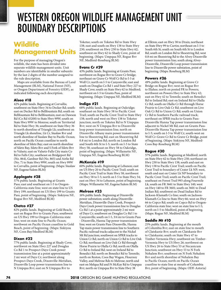
2018 OREGON BIG GAME HUNTING REGULATIONS74
Wildlife Management Units For the purpose of man ag ing Or e gon’s wildlife, the state has been divided into separate wildlife management units. Unit numbers are identifiable in smaller subunits by the last 2 digits of the number assigned to the rule description.
Maps are available from the Bu reau of Land Management (BLM), National Forest (NF), or Oregon Department of Forestry (ODF), as indicated following each descrip tion.
Alsea #1842% public lands. Beginning at Corvallis; southwest on State Hwy 34 to Decker Rd; south-east on Decker Rd to Bellfountain Rd; south on Bellfountain Rd to Bellfountain; east on Dawson Rd (Co Rd 45200) to State Hwy 99W; south on State Hwy 99W to Monroe; south on Territorial Rd to State Hwy 36; southwest on State Hwy 36 to north shoreline of Triangle Lk; southwest on Triangle Lk shore line, Lk Cr, Siuslaw Rvr and north shoreline of Siuslaw Bay to Pacific Ocean; north on Pacific Ocean coastline to north shoreline of Siletz Bay; east on north shoreline of Siletz Bay, Siletz Rvr and S Fork of Siletz Rvr to Valsetz; east on Valsetz-Falls City main Co Rd to Falls City; southeast on Bridgeport Rd (No. 864), Gardner Rd (No. 865) and Airlie Rd (No. 7) to State Hwy 99W; south on Hwy 99W to Corvallis, point of beginning. (Maps: Siuslaw NF, Eugene/Salem BLM)
Applegate #2857% public lands. Beginning at Grants Pass; east and southeast on I-5 to Oregon-California state line; west on state line to US Hwy 199; northeast on US Hwy 199 to Grants Pass, point of beginning. (Maps: Siskiyou NF, Rogue Rvr NF, Medford BLM)
Chetco #2782% public lands. Beginning at Gold Beach; east on Rogue Rvr to Grants Pass; southwest on US Hwy 199 to Oregon-California state line; west on state line to Pa cific Ocean; northwest on Pacific Ocean coast line to Gold Beach, point of beginning. (Maps: Siskiyou NF, Coos Bay/Medford BLM)
Dixon #2277% public lands. Beginning at Shady Cove; northwest on State Hwy 227 and Douglas Co Rd 1 to Prospect-Days Creek power transmission line at a point approximately 2 mi west of Days Cr; northwest along Prospect-Days Creek, Dixonville-Meridian, Dixonville Loop power transmission line to N Umpqua Rvr; east on N Umpqua Rvr to
Toketee; south on Toketee Rd to State Hwy 138; east and south on Hwy 138 to State Hwy 230; southwest on Hwy 230 to State Hwy 62; southwest on Hwy 62 to Shady Cove, point of beginning. (Maps: Umpqua NF, Rogue Rvr NF, Medford-Roseburg BLM)
Evans Cr #29 43% public lands. Beginning at Grants Pass; northwest on Rogue Rvr to Grave Cr bridge; northeast on Grave Cr-Wolf Cr Rd to I-5 at Wolf Cr; north on I-5 to Canyonville; east and south on Douglas Co Rd 1 and State Hwy 227 to Shady Cove; south on State Hwy 62 to Medford; northwest on I-5 to Grants Pass, point of beginning. (Maps: Umpqua NF, Medford BLM)
Indigo #2168% public lands. Beginning at Oakridge; southeast on State Hwy 58 to Pacific Crest Trail; south on Pacific Crest Trail to State Hwy 138; north and west on Hwy 138 to Toketee junction; north on Toketee Rd to N Umpqua Rvr; west on N Umpqua Rvr to Dixonville loop power trans mis sion line; north on Dixon ville-Albany main power transmission line to Shoe string Rd; east on Shoestring Rd 0.8 mi to London Rd; north on London Rd and South 6th St to I-5; north on I-5 to State Hwy 58; southeast on Hwy 58 to Oakridge, point of beginning. (Maps: Willamette NF, Umpqua NF, Eugene/Roseburg BLM)
McKenzie #1960% public lands. Beginning at Lebanon; east on US Hwy 20 to Pacific Crest Trail; south on Pacific Crest Trail to State Hwy 58; northwest on Hwy 58 to I-5; north on I-5 to State Hwy 34; east on Hwy 34 to Lebanon, point of beginning. (Maps: Willamette NF, Eugene/Salem BLM)
Melrose #2316% public lands. Beginning at Dixonville power substation; south along Dixonville-Meridian, Dixonville-Days Creek, Prospect-Days Creek power trans mis sion line to Douglas Co Rd 1 at a point ap proxi mately 2 mi west of Days Cr; southwest on Douglas Co Rd 1 to Canyonville; south on I-5, 3/4 mi to Grants Pass - Dixonville, Hanna Tap power trans mis sion line; west on Grants Pass-Dixonville, Hanna Tap main power trans mis sion line to Southern Pacific railroad tracks ad ja cent to the Nickel Mt Rd junction; southwest on SPRR tracks to Union Cr Rd; north on Union Cr Rd to Live Oak Cr Rd; northeast on Live Oak Cr Rd through Horse Prairie to Olalla Cr Rd; north on Olalla Cr Rd to Ireland Rd; west on Ireland Rd to Benedict Rd; north on Benedict Rd to Tenmile; north on Reston, Coos Bay Wagon, Flournoy Valley, and Melrose Rds to Melrose; north and east on Melqua Rd and Ft McKay Rd to Umpqua Rvr; north on Umpqua Rvr to State Hwy 38
at Elkton; east on Hwy 38 to Drain; northeast on State Hwy 99 to Curtin; northeast on I-5 to South 6th St; south on South 6th St to London Rd; south on London Rd to Shoestring Rd; west 0.8 mi on Shoestring Rd to the Alvey-Dixonville power trans mis sion line; south along Alvey-Dixonville, Dixonville Loop power transmission line to Dix on ville power substation, point of beginning. (Maps: Roseburg BLM)
Powers #2649% public lands. Beginning at Grave Cr Bridge on Rogue Rvr; west on Rogue Rvr to Illahee; north on posted FR to Powers; northwest on Powers Hwy to State Hwy 42; east on Hwy 42 to Tenmile; south on Benedict Rd to Ireland Rd; east on Ireland Rd to Olalla Cr Rd; south on Olalla Cr Rd through Horse Prairie to Live Oak Cr Rd; southwest on Live Oak Cr Rd to Union Cr Rd; south on Union Cr Rd to Southern Pacific railroad track; northeast on SPRR tracks to Grants Pass-Dixonville Hanna Tap power transmission line adjacent to Nickel Mt Rd; east on Grants Pass-Dixonville Hanna Tap power transmission line to I-5; south on I-5 to Wolf Cr; south-west on Wolf Cr-Grave Cr Rd to Grave Cr Bridge, point of beginning. (Maps: Siskiyou NF, Medford-Coos Bay-Roseburg BLM)
Rogue #3057% public lands. Beginning at Medford; north on State Hwy 62 to State Hwy 230; northeast on Hwy 230 to State Hwy 138; south and east on Hwy 138 to Pacific Crest Trail; south on Pacific Crest Trail to bound ary of Crater Lk NP; west, south and east on Crater Lk NP boundary to Pacific Crest Trail; south on Pacific Crest Trail; southeast on Forest Trail 993 along Fourmile Lk; south on FR 3661 to State Hwy 140; west on Hwy 140 to FR 3601; south on 3601 to Dead Indian Rd; southwest on Dead Indian Rd to Jackson-Klamath Co line; south on Jackson-Klamath Co line to State Hwy 66; west on Hwy 66 to Copco Rd; south on Copco Rd to Oregon-California state line; west on state line to I-5; north on I-5 to Medford, point of beginning. (Maps: Rogue NF, Medford BLM)
Saddle Mt #1025% public lands. Beginning at the mouth of Columbia Rvr; east on state line to mouth of Clatskanie Rvr; south on Clatskanie Rvr to Clatskanie; south on State Hwy 47 to Timber-Vernonia Hwy; southwest on Timber-Vernonia Hwy to US Hwy 26; northwest on US Hwy 26 to State Hwy 53 at Necanicum Junction; south west on Hwy 53 to N Fork Nehalem Rvr; southwest on N Fork Nehalem Rvr and north shoreline of Nehalem Bay to Pacific Ocean; north on Pacific Ocean coastline to state line at mouth of Columbia Rvr, point of beginning. (Maps: ODF-Astoria)
WESTERN OREGON WILDLIFE MANAGEMENT UNIT BOUNDARY DESCRIPTIONS

2018 OREGON BIG GAME HUNTING REGULATIONS 75
Santiam #1663% public lands. Beginning at Lebanon; north on Brewster Rd to Lacomb Rd; east on Lacomb Rd to Kowitz Rd; north on Kowitz Rd to Baptist Church Dr; west on Baptist Church Dr to Richardson Gap Rd; north on Richardson Gap Rd to State Hwy 226; northeast on Hwy 226 to State Hwy 22; west on Hwy 22 to Cascade Hwy; north on Cascade Hwy to State Hwy 213 at Silverton; northeast on Hwy 213 to State Hwy 211; northeast on Hwy 211 to Sandy; north on Teneyck Rd to Sandy Rvr; northwest down Sandy Rvr to state line in Columbia Rvr; northeast on state line to Multnomah-Hood Rvr Co line; southeast on Multnomah-Hood Rvr Co line to Lolo Pass; southeast on Pacific Crest Trail to Barlow Pass; west on Hwy 35 to Hwy 26; southeast on Hwy 26 to Hwy 216; west and then south along the west boundary of The Confederated Tribes of Warm Springs Tribal Reservation (CTWSRO) (McQuinn Strip line) to summit of Mt Jefferson; south along the west CTWSRO boundary and the Cascade crest (Jefferson/Linn Co line) to the junction of the Pacific Crest National Scenic Trail (PCT) in T11S, R8E Sec 17 then south on PCT to US Hwy 20/126 at Santiam Pass; PCT west on US Hwy 20 to Lebanon, point of beginning. (The McQuinn Strip portion of White Rvr Unit and Warm Springs Tribal Reservation was closed to public hunting Sept. 21, 1992 until further notice). (Maps: Mt Hood NF, Willamette NF, Salem BLM)
Scappoose #119% public lands. Beginning at Vernonia; northeast on State Hwy 47 to Clatskanie; north on Clatskanie Rvr to state line in Columbia Rvr; southeast on state line to Willamette Rvr; south west on Wil lam ette Rvr to Multnomah Channel; northwest on Multnomah Channel to US Hwy 30 at Sauvie Island bridge; north west on US Hwy 30 to Cornelius Pass Rd; southwest on Cornelius Pass Rd to US Hwy 26; northwest on US Hwy 26 to State Hwy 6; west on Hwy 6 to Glenwood; northwest on Glenwood-Tim ber-Vernonia Hwy to State Hwy 47; north on Hwy 47 to Vernonia, point of beginning. (Maps: Salem BLM and Co maps)
Siuslaw #2040% public lands. Beginning at I-5-Belt Line Rd junc tion north of Eugene; south on I-5 to Drain junction and State Hwy 99; southwest on Hwy 99 to Drain; west on State Hwy 38 to Umpqua Rvr at Elkton; west on Umpqua Rvr and south shoreline of Winchester Bay to Pacific Ocean; north on Pacific Ocean coastline to north shoreline of Siuslaw Bay; northeast on north shore line of Siuslaw Bay, Siuslaw Rvr, Lk Cr and north shoreline of Triangle Lk to State Hwy 36; south on Hwy 36 to Poodle Cr junction; south on Poodle Cr Rd to State Hwy 126; east on Hwy
126 to Belt Line Rd; northeast on Belt Line Rd to I-5, point of beginning. (Maps: Siuslaw NF, Coos Bay-Eugene-/Roseburg BLM)
Sixes #2529% public lands. Beginning at Gold Beach; north on Pacific Ocean coastline to south shoreline of Coos Bay; easterly on south shore of Coos Bay to US Hwy 101; south on US Hwy 101 to State Hwy 42; southeast on Hwy 42 to Powers Hwy; southeast on Powers Hwy to Powers; south on posted FR to Rogue Rvr at Illahee; southwest on Rogue Rvr to Gold Beach, point of beginning. (Maps: Siskiyou NF, Coos Bay BLM)
Stott Mt #1722% public lands. Beginning at Dallas; south on State Hwy 223 to Gardner Rd (No. 865); northwest on Gardner Rd and Bridgeport Rd (No. 864) to Falls City; west on Valsetz Rd to S Fork of Siletz Rvr; down stream on S Fork of Siletz Rvr, main Siletz Rvr and north shoreline of Siletz Bay to Pacific Ocean; north on Pacific Ocean coastline to mouth of Salmon Rvr; east on Salmon Rvr to State Hwy 18 near Rose Lodge; east on Hwy 18 to State Hwy 22; southeast on Hwy 22 to Perrydale Rd; south on Perrydale Rd to State Hwy 223 at Dallas, point of beginning. (Maps: Siuslaw NF, Salem BLM)
Tioga #2435% public lands. Beginning at Coquille; north on State Hwy 42 and US Hwy 101 to south shoreline of Coos Bay; southwest on south shoreline of Coos Bay to Pacific Ocean; north on Pacific Ocean coastline to south shoreline of Winchester Bay; east on south shoreline of Winchester Bay and Umpqua Rvr to Ft. McKay Rd; west and south on Ft. McKay and Melqua Rds to Melrose; south on Melrose, Flournoy Valley, Coos Bay Wagon and Reston Rds to Tenmile; west on State Hwy 42 to Coquille, point of beginning. (Maps: ODF-Elliot, Coos Bay BLM)
Trask #1442% public lands. Beginning at McMinnville; southwest on State Hwy 18 to Salmon Rvr; west on Salmon Rvr to Pacific Ocean; north on Pacific Ocean coastline to north shoreline at mouth of Til lamook Bay; east on north shoreline of Tillamook Bay and Wilson Rvr to State Hwy 6 at Mills Bridge; northeast on Hwy 6 to State Hwy 8 near Gales Cr; southeast on Hwy 8 to State Hwy 47 at Forest Grove; south on Hwy 47 to State Hwy 99W; southwest on Hwy 99W to McMinnville, point of beginning. (Maps: ODF-Tillamook, Siuslaw NF, Salem (BLM)
Willamette #152% public lands. Beginning at Sandy; southwest on State Hwy 211 to State Hwy 213; southwest on Hwy 213 to Cascade Hwy at Silverton;
south on Cascade Hwy to State Hwy 22; east on Hwy 22 to State Hwy 226; south and west on Hwy 226 to Richardson Gap Rd; south on Richardson Gap Rd to Baptist Church Dr; east on Baptist Church Dr to Kowitz Rd; south on Kowitz Rd to Lacomb Rd; west on Lacomb Rd to Brewster Rd; south on Brewster Rd to State Hwy 34; west on State Hwy 34 to I-5; south on I-5 to Belt Line Rd; west and south on Belt Line Rd to State Hwy 126; west on Hwy 126 to Poodle Cr Rd; north on Poodle Cr Rd to State Hwy 36; northeast on Hwy 36 to Territorial Rd near Cheshire; north on Territorial Rd to Monroe; north on State Hwy 99W to Dawson Rd (Co Rd 45200); west on Dawson Rd to Bellfountain; north on Bellfountain Rd to Decker Rd at Invale School; west on Decker Rd to State Hwy 34; northeast on Hwy 34 to Corvallis; north on State Hwy 99W to Airlie Rd (No. 7) at Suver; north west on Airlie Rd to State Hwy 223; north on Hwy 223 to Perrydale Rd at Dallas; north on Perrydale Rd to State Hwy 22; northwest on Hwy 22 to State Hwy 18; northeast on Hwy 18 to State Hwy 99W; north on Hwy 99W to State Hwy 47; north on Hwy 47 to State Hwy 8; northwest on Hwy 8 to State Hwy 6; east on Hwy 6 to US Hwy 26; southeast on US Hwy 26 to Cornelius Pass Rd; northeast on Cornelius Pass Rd to US Hwy 30; southeast on US Hwy 30 to Multnomah Channel at Sauvie Island bridge; southeast on Multnomah Channel to Willamette Rvr; northeast down Willamette Rvr to state line in Columbia Rvr; southeast on state line to Sandy Rvr; southeast up Sandy Rvr to TenEyck Rd; south on TenEyck Rd to Sandy, point of beginning. (Co maps)
Wilson #1265% public lands. Beginning on north shoreline at mouth of Tillamook Bay; north on Pacific Ocean coast line to north shoreline of Nehalem Bay; northeast on north shoreline of Nehalem Bay and N Fork Nehalem Rvr to State Hwy 53 bridge; northeast on Hwy 53 to US Hwy 26; southeast on US Hwy 26 to Timber-Glenwood Hwy; south on Timber-Glenwood Hwy to Glenwood; south west on State Hwy 6 to Wilson Rvr at Mills Bridge; west on Wilson Rvr and north shoreline of Tillamook Bay to mouth, point of beginning. (Maps: ODF-Astoria and Tillamook, Salem (BLM).
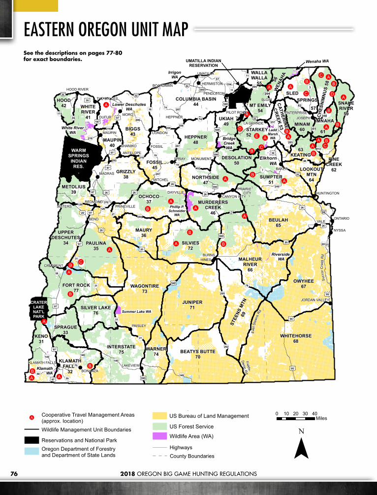
2018 OREGON BIG GAME HUNTING REGULATIONS76
EASTERN OREGON UNIT MAP
!
!
!
!
!
!
!
!
! !
!
!
!!
!
!
!
!
!
!
!
!
!
!
!
!!
!
!!!
!
!
!
!!
!
!
!
!
!
!
!!
!B
!A
!A
!B
!B
!A
!A
!B
!B!C
!A
!B!A
!A!B
!B
!C
!A
!A
!A
!A
!A
!A
!C!B
!A!E!D
!C!B
!A
!A
!A
!B
!A
!B
!A
!A
!B
!A
!B
!B!C
!D
!A
!B
WHITEHORSE68
OWYHEE67
JUNIPER71
GRIZZLY38
INTERSTATE75 BEATYS BUTTE
70
KENO31
SUMPTER51
BEULAH65
BIGGS43
WAGONTIRE73
PAULINA35
SILVIES72
FOSSIL45
MALHEURRIVER
66
OCHOCO37
COLUMBIA BASIN44
FORT ROCK77
HEPPNER48
MAURY36
UKIAH49
WARNER74
STEE
NS M
TN69
NORTHSIDE47
STARKEY52
MINAM60
SPRAGUE33
KLAMATHFALLS
32
SILVER LAKE76
UPPERDESCHUTES
34
WHITERIVER
41
63KEATING
MAUPIN40
METOLIUS39
SLEDSPRINGS
57HOOD
42
MURDERERSCREEK
46
MT EMILY54
IMNAHA
61
DESOLATION50
CH
ESN
IMN
US
58
56W
ENAH
A
WARMSPRINGSINDIAN
RES..
SNAKERIVER
59
PINECREEK
62LOOKOUTMTN64
WALLAWALLA
55
CATHERINE
CREEK 53
Phillip P.Schneider
WA
Summer Lake WA
White RiverWA
BridgeCreek
WA
Wenaha WA
ElkhornWA
LaddMarsh
WA
KlamathWA
Lower DeschutesWA
VALEBEND
MORO
SPRAY
NYSSA
ELGIN
HINESBURNS
DUFUR
FOSSIL
CONDON
MADRAS
MAUPIN
BONANZA
MITCHEL
ONTARIO
HEPPNER
PAISLEY
REDMONDSISTERS
CRESCENT
DAYVILLE
MONUMENT
UMATILLA
BOARDMAN
LAKEVIEW
LA GRANDE
HERMISTON
HUNTINGTON
ENTERPRISEPILOT ROCK
PRINEVILLE
THE DALLES
HOOD RIVER
CANYON CITY
PRAIRIECITY
JORDAN VALLEY
BAKER
JOSEPH
SHANIKO
ANTELOPE
PENDLETON
KLAMATH FALLS
Riverside WA
CRATERLAKENAT'LPARK
IrrigonWA
UMATILLA INDIANRESERVATION
Eas
t Ste
ens
Rd
Fields-
Denio R
d
Succ
orC
r ee k
Rd
§̈¦84§̈¦84
§̈¦82
§̈¦84
§̈¦84
£¤97
£¤95
£¤20
£¤395
£¤95
£¤20
£¤97
£¤97
§̈¦84
£¤30
£¤97
£¤26
£¤197
£¤395
£¤97
£¤26
£¤97
£¤30
£¤97
£¤20
£¤395
£¤395
£¤26
£¤395
£¤97
£¤20
£¤395
£¤26
£¤395
£¤395
£¤26
£¤26
£¤95
£¤97
ÄÆ
31ÄÆ
19
ÄÆ
78
ÄÆ
31
ÄÆ
380
ÄÆ
206ÄÆ
66
ÄÆ
3
ÄÆ
27
ÄÆ
39
ÄÆ
11
ÄÆ
293
ÄÆ
173
ÄÆ
126
ÄÆ
19
ÄÆ
140 ÄÆ
140
ÄÆ
140
ÄÆ
205
ÄÆ
7
ÄÆ
74
ÄÆ
74
ÄÆ
245
ÄÆ
402
ÄÆ
350
ÄÆ
86
ÄÆ
216
ÄÆ
216
ÄÆ
207
ÄÆ
207
ÄÆ
207
ÄÆ
37
ÄÆ
35
ÄÆ
82
ÄÆ
204
ÄÆ
204
ÄÆ
237
ÄÆ
334
ÄÆ
370
ÄÆ
11
ÄÆ
203
ÄÆ
218
ÄÆ201
ÄÆ
70ÄÆ
351
ÄÆ
413
ª½16
ÄÆ
31
ÄÆ
206
ÄÆ
58
ÄÆ
31
ÄÆ
202
ÄÆ
126
ÄÆ
19
ÄÆ
140
ÄÆ
206
See the descriptions on pages 77-80 for exact boundaries.
0 10 20 30 40Miles
¯
County BoundariesHighways!A
Cooperative Travel Management Areas(approx. location)Wildlife Management Unit Boundaries
Reservations and National ParkOregon Department of Forestryand Department of State LandsUS Bureau of Land Management
US Forest Service
Wildlife Area (WA)
0 10 20 30 40Miles
¯
County BoundariesHighways!A
Cooperative Travel Management Areas(approx. location)Wildlife Management Unit Boundaries
Reservations and National ParkOregon Department of Forestryand Department of State LandsUS Bureau of Land Management
US Forest Service
Wildlife Area (WA)
0 10 20 30 40Miles
¯
County BoundariesHighways!A
Cooperative Travel Management Areas(approx. location)Wildlife Management Unit Boundaries
Reservations and National ParkOregon Department of Forestryand Department of State LandsUS Bureau of Land Management
US Forest Service
Wildlife Area (WA)
0 10 20 30 40Miles
¯
County BoundariesHighways!A
Cooperative Travel Management Areas(approx. location)Wildlife Management Unit Boundaries
Reservations and National ParkOregon Department of Forestryand Department of State LandsUS Bureau of Land Management
US Forest Service
Wildlife Area (WA)

2018 OREGON BIG GAME HUNTING REGULATIONS 77
Beatys Butte #7082% public lands. Beginning at Denio; west on Oregon state line to Fort Bidwell-Warner Valley Rd (Lake Co Rd 3-14); north on 3-14 to Adel; north on Co Rd 3-10 through Plush to Co Rd 3-11; east on 3-11 to Hart Refuge and Co Rd 3-12; north and east on 3-12 to Hart Refuge headquarters; east on Hart Mt-Frenchglen Rd (Lake Co Rd 3-12 and Harney Co Rd 412) to Catlow Valley Rd (Harney Co Rd 202); south and east on Catlow Valley Rd to Harney Co Rd 201, 1 mi north of Fields; south on Co Rd 201 through Fields to Denio, point of beginning. Specific hunts do not include Hart Mt NAR. (Maps: Lakeview/Burns BLM)
Beulah #6557% public lands. Beginning at Vale; southwest on US Hwy 20 to Drewsey-Prairie City Rd near Drewsey; northwest on Drewsey-Prairie City Rd and FR 1663 to the junction with FR 14 near Antelope Mt; northwest on FR 14 and FR 16 to Summit Prairie; north on Co Rd 62 to US Hwy 26; east on Hwy 26 to Ironside; east on Willow Creek Rd to Huntington Junction; east on Huntington Junction Rd/Malheur Line Rd (Durbin Creek), to I-84; southeast on I-84 to Birch Cr near Farewell Bend; east on Birch Cr to Snake Rvr; south east along Snake Rvr to Nyssa; north on Hwy 201 to Cairo Junction; and west on US Hwy 20 to Vale, point of beginning. (Maps: Vale/Burns BLM, Malheur/Wallowa-Whitman NF)
Biggs #4311% public lands. Beginning at Arlington; south on State Hwy 19 to Fossil; southwest on State Hwy 218 to Shaniko; north on US Hwy 97 to Grass Valley; southwest on State Hwy 216 to Tygh Valley; north on US Hwy 197 to Columbia Rvr; east on Columbia Rvr to Arlington, point of beginning. (Maps: Prineville BLM)
Catherine Cr #5324% public lands. Beginning at Elgin; northeast on State Hwy 82 to Minam; south on Minam Rvr to Wallowa-Whitman NF boundary; west on forest boundary to Point Prominence Rd (62 and 6220); south on Point Prominence Rd to Moss Springs Campground; south and east from Moss Springs Campground on Lodgepole Trail 1920 to Cartwheel Ridge Trail 1907; north and east on Cartwheel Ridge Trail 1907 to the divide between Catherine Cr and Minam Rvr drainages and south to Meadow Mt; generally southeast on the divide between Catherine Cr and the Minam Rvr drainages past Burger Butte to Granite Butte; generally south on the divide between Catherine Cr and Eagle Cr drainages to Flagstaff Butte; west on FR 7700582 to FR 77; west on FR 77 to FR 7740; south on 7740 to 7740050; south and west on 7740050 to Big Cr; south along Big Cr to FR 67; west on FR Rd 67
to Big Cr Rd 71; southwest and northwest on Big Cr Rd 71 to Medical Springs; southwest on State Hwy 203 to Powder Rvr; northwest on Powder Rvr to I-84 at N Powder; north on I-84 to State Hwy 82 at La Grande; northeast on Hwy 82 to Elgin, point of beginning. (Maps: Wallowa-Whitman NF, Vale BLM, ODF)
Chesnimnus #5848% public lands. Beginning at Joseph; north on State Hwy 82 to Crow Cr Rd; north on Crow Cr Rd to Chesnimnus Cr; northwest on Chesnimnus Cr to Joseph Cr; northeast on Joseph Cr to Oregon-Washington state line; east and southeast along state line to Snake Rvr; southeast on Snake Rvr to mouth of Imnaha Rvr; southwest on Imnaha Rvr to Imnaha; southwest on Imnaha Hwy to Joseph, point of beginning. (Maps: Wallowa-Whitman NF, Vale BLM)
Columbia Basin #445% public lands. Beginning at Condon; north on State Hwy 19 to Oregon-Washington state line at Arlington; north east on state line to State Hwy 11; southwest on Hwy 11 to Pendleton; southwest on US Hwy 395 to State Hwy 74; southwest on Hwy 74 to Heppner; southwest on State Hwy 207 to State Hwy 206; west on Hwy 206 to Condon, point of beginning. (Co maps)
Desolation #5087% public lands. Beginning at Dale on US Hwy 395; southeast on N Fork John Day Rvr to Big Cr; northeast on Big Cr to Meadow Cr; northeast on Meadow Cr to FR 5225 at Forks Guard Station; northwest on 5225 to Granite-Ukiah Rd 52; southeast on Granite-Ukiah Rd 52 to Anthony Lks Rd 73; northeast on Anthony Lakes Rd to Summit of Blue Mts west of Anthony Lakes; south along summit of Blue Mts. to the Summit of Anthony Lakes Ski Area (junction of Grant, Baker, and Union counties); southwest on summit of Blue Mts. (Baker/Grant county line) to Hwy 7; southwest along Hwy 7 to Co Rd 20; northwest on Co Rd 20 to US Hwy 395; north on Hwy 395 to Dale, point of beginning. (Maps: Umatilla National Forest, Malheur NF, Prineville BLM, ODF)
Fort Rock #7765% public lands. Beginning at Silver Lake; west on State Hwy 31 to Klamath Marsh-Silver Lk Rd; west on Klamath Marsh Rd to Williamson Rvr; west and south on Williamson Rvr returning to Klamath Marsh Rd; west on Klamath Marsh Rd to US Hwy 97; west on Scott Cr Rd 66 one mi to Sand Cr; southwest on Sand Cr to Crater Lk NP boundary; north and west on Crater Lk NP boundary to Pacific Crest Trail; north on Pacific Crest Trail to State Hwy 58; southeast on Hwy 58 to Crescent Cr; north on Crescent Cr to Co Rd 61 to Crescent; east on Co
Rd 61 to Crescent; north on Hwy 97 to Gilchrist main logging Rd one mi north of Gilchrist; east on Gilchrist main logging Rd 9775 to State Hwy 31 between milepost 16 and 17; south east on Hwy 31 to Lk Co Rd 5-10 at Horse Ranch; 22 mi east and south on Lk Co Rd 5-10 to junction with Lk Co Rd 5-14; east on Lk Co Rd 5-14 to Lk Co Rd 5-14F at Christmas Valley; southwest on Lk Co Rd 5- 14F to State Hwy 31, 9 mi east of Silver Lake; west on Hwy 31 to Silver Lk, point of beginning. (Maps: Deschutes/ Winema/ Fremont NF, Lakeview BLM)
Fossil #4516% public lands. Beginning at Fossil; north on Hwy 19 to Condon; east on State Hwy 206 to State Hwy 207; south on Hwy 207 to State Hwy 19; southeast on Hwy 19 to US Hwy 26; west on Hwy 26 to Bridge Cr near Mitchell; northwest on Bridge Cr to John Day Rvr; northwest on John Day Rvr to State Hwy 218 at Clarno; northeast on Hwy 218 to Fossil, point of beginning. (Maps: Umatilla NF, Prineville BLM, ODF)
Grizzly #3828% public lands. Beginning at Redmond; north on US Hwy 97 to Crooked Rvr; north on Crooked Rvr and Deschutes Rvr to S Junction; northeast on S Junction Co Rd to Hwy 97 and US Hwy 197; south on Hwy 97 to Antelope Cr Rd; northeast on Antelope Cr Rd to Antelope; east on Hwy 218 to John Day Rvr at Clarno; southeast on John Day Rvr to Bridge Cr; southeast on Bridge Cr to US Hwy 26 near Mitchell; southwest on Hwy 26 to Prineville; west on US Hwy 126 to Redmond, point of beginning. (Maps: Ochoco NF, Prineville BLM)
Heppner #4834% public lands. Beginning at Heppner; northeast on State Hwy 74 to US Hwy 395; south on Hwy 395 to Long Cr-Monument Rd; northwest on Long Cr-Monument Rd to N Fork John Day Rvr at Monument; southwest on N Fork John Day Rvr to State Hwy 19 at Kimberly; north west on Hwy 19 to State Hwy 207; north on Hwy 207 to Heppner, point of beginning. (Maps: Umatilla NF, ODF)
Hood #4265% public lands. Beginning at Hood Rvr; southwest on State Hwy 35 to Barlow Pass (Pacific Crest Trail); northwest on Pacific Crest Trail to Lolo Pass; northwest on Hood Rvr-Multnomah Co line to Columbia Rvr near Bonneville; east on Columbia Rvr to Hood Rvr, point of beginning. (Maps: Mt Hood NF)
Imnaha #6174% public lands. Beginning at Joseph; northeast on Imnaha Hwy to Imnaha; south and west on Imnaha Rvr and S Fork
EASTERN OREGON WILDLIFE MANAGEMENT UNIT BOUNDARY DESCRIPTIONS

2018 OREGON BIG GAME HUNTING REGULATIONS78
of Imnaha Rvr to Hawkins Pass; north on W Fork Trail to Wallowa Lk; north on State Hwy 82 to Joseph, point of beginning. (Maps: Wallowa-Whitman NF)
Interstate #7556% public lands. Beginning at Bly; west on State Hwy 140 to Beatty; north on Godowa Springs Rd to Sprague Rvr; west on Sprague Rvr one mi to Sycan Rvr; upstream north and east on Sycan Rvr to Pikes Crossing; east on FR 30 to FR 28; east on 28 to FR 29; east on 29 to State Hwy 31; southeast on Hwy 31 to Valley Falls; south on US Hwy 395 to Oregon-California state line; west on state line to Lost Rvr; northwest on Lost Rvr to East Langell Valley Rd; north on East Langell Valley Rd to Gerber Rd; northeast on Gerber Rd to Bly, point of beginning. (Maps: Fremont NF, Lakeview BLM)
Juniper #7189% public lands. Beginning at Burns; east 2 mi on State Hwy 78 to State Hwy 205; south on Hwy 205 through Frenchglen to Hart Mt Rd (Harney Co Rd 412 and Lake Co Rd 3-12); west on Hart Mt Rd to Flagstaff Lk Rd (Lake Co Rd 3-11); west on Flagstaff Lk Rd to Hogback Rd (Lake Co Rd 3-10); northwest on Hogback Rd to US Hwy 395; northeast on Hwy 395 to US Hwy 20; east on Hwy 20 to Burns; point of beginning. Specific hunts do not include Hart Mt NAR. (Maps: Lakeview/Burns BLM)
Keating #6358% Public lands. Beginning at N Powder; northeast and southeast on Powder Rvr to State Hwy 203; northeast on Hwy 203 to Medical Springs; southeast and northeast on Big Cr Rd 71 and FR 67; north on Big Cr to FR 7740050; east and north on FR 7740050 to FR 7740 and to FR 77; east on 77 to Flagstaff Butte Rd 7700582; east on Rd 7700582 to Flagstaff Butte; north on the divide between Catherine Cr and Eagle Cr drainages to Granite Butte; east on summit of Eagle Mts. to Hawkins pass; south to Jackson Peak; south to Krag Peak; south and east to Crater Lake; north and east to Red Mt.; north and east to Blue Cr Trail (1865) north of Cornucopia; south on Blue Cr trail to Pine Cr; south and east on Pine Cr to State Hwy 86; southwest on Hwy 86 to Old Richland-Halfway Hwy (Sag Rd); south on Sag Rd to Powder Rvr arm of Brownlee Reservoir; west on Powder Rvr to Hwy 86 near Goose Cr; west on Hwy 86 to I-84; north on I-84 to N Powder; point of beginning. (Maps Wallowa-Whitman NF; Vale BLM)
Keno #3141% public lands. Beginning at Klamath Falls; south on US Hwy 97 to Oregon-California state line; west on state line to Copco Rd; north on Copco Rd to State Hwy 66; east on Hwy 66
to Jackson-Klamath Co line; north on Jackson-Klamath Co line to Dead Indian Rd; northeast on Dead Indian Rd to FR 3601; north on 3601 to State Hwy 140; east on Hwy 140 to FR 3661; north on 3661 to Fourmile Lk; northwest on Forest Trail 993 to Pacific Crest Trail; north on Pacific Crest Trail to south boundary of Crater Lk NP; east on south boundary of Crater Lk NP to State Hwy 62; southeast on Hwy 62 to Hwy 97; south on Hwy 97 to Klamath Falls, point of beginning. (Maps: Winema NF)
Klamath Falls #3235% public lands. Beginning at Klamath Falls; north on US Hwy 97 to Williamson Rvr; north on Williamson Rvr to confluence of Sprague Rvr; east on Sprague Rvr to Godowa Springs Rd north of Beatty; south on Godowa Springs Rd to State Hwy 140 at Beatty; east on Hwy 140 to Bly; southwest on Gerber Rd to East Langell Valley Rd; south on East Langell Valley Rd to Lost Rvr; southeast on Lost Rvr to Oregon-California state line; west on state line to US Hwy 97; northeast on Hwy 97 to Klamath Falls, point of beginning. (Maps: Winema NF, Fremont NF)
Lookout Mt #6438% public lands. Beginning at junction of I-84 and State Hwy 86 northeast of Baker; east on Hwy 86 to Powder Rvr near Goose Cr; east on Powder Rvr to Snake Rvr; southwest on Snake Rvr to Birch Cr at Farewell Bend; west on Birch Cr to I-84; northwest on I-84 to Hwy 86, point of beginning. (Maps: Vale BLM, ODF)
Malheur Rvr #6669% public lands. Beginning at Burns; north on US Hwy 395 to Seneca; east on Logan Valley Co Rd (FR 16) to FR 14; southeast on FR 14 to FR 1663 near Antelope Mt; south on 1663 and Otis Valley Rd (Harney Co Rd 304) to Drewsey; south on Drewsey Rd (Harney Co Rd 305) to US Hwy 20; east on Hwy 20 to Harper; southwest on Harper-Follyfarm Rd (Malheur Co Rds 585 and 513) to state Hwy 78 near Follyfarm; northwest on State Hwy 78 to Burns, point of beginning. (Maps: Malheur NF, Burns and Vale BLM)
Maupin #409% public lands. Beginning at Maupin; north on US Hwy 197 to Tygh Valley; northeast on State Hwy 216 to Grass Valley; south on Hwy 97 to Shaniko; southeast on State Hwy 218 to Antelope; south west on Antelope Cr Rd to Hwy 97; north on Hwy 97 to Hwy 197 and S Junction Rd; southwest on S Junction Rd to Deschutes Rvr at S Junction; northeast on Deschutes Rvr to Maupin, point of beginning. (Maps: Prineville BLM)
Maury #3656% public lands. Beginning at Brothers on
US Hwy 20; north west on Hwy 20 to State Hwy 27; north on Hwy 27 to Prineville Dam; east on Prineville Reservoir, Crooked Rvr and Beaver Cr to Paulina; east on main Co Rd to Grindstone Cr Rd; southeast on Grindstone Cr Rd to Twelvemile Cr Rd; west on Twelvemile Cr Rd to Camp Cr-Glass Buttes Rd; south on Camp Cr-Glass Buttes Rd to US Hwy 20 near Glass Buttes; northwest on Hwy 20 to Brothers, point of beginning. (Maps: Ochoco NF, Prineville BLM)
Metolius #3966% public lands. Beginning at Sisters; west on State Hwy 242 to Pacific Crest Trail; north on Pacific Crest Trail to to the junction of the “crest of the Cascades” with the Pacific Crest National Scenic Trail (PCT) in T11S R8E Sec 17; north on the Crest of the Cascades to the south boundary of Warm Springs Tribal Reservation; east on Warm Springs Tribal Reservation boundary following Jefferson Cr and Metolius Rvr to Lk Billy Chinook; south on Lk Billy Chinook to Crooked Rvr; southeast on Crooked Rvr to US Hwy 97; south on Hwy 97 to Redmond; west on State Hwy 126 to Sisters, point of beginning. (Maps: Deschutes NF, Prineville BLM)
Minam #6074% public lands. Beginning at Minam; southeast on State Hwy 82 to head of Wallowa Lk; southwest on W Fork Trail to Hawkins Pass; southwest on summit of Eagle Mts to Granite Butte; northwest on summit separating Big Minam and Catherine Cr drainages past Burger Butte and Meadow Mt to Cartwheel Ridge Trail 1907; west on Cartwheel Ridge Trail to Lodgepole Trail 1920; north on Lodge Pole Trail to Moss Springs; north on Point Prominence Rd to boundary of Wallowa-Whitman NF; north and east on Forest boundary to Minam Rvr; north on Minam Rvr to Hwy 82 at Minam, point of beginning. (Maps: Wallowa-Whitman NF, Vale BLM)
Mt Emily #5444% public lands. Beginning at Pendleton; northeast on State Hwy 11 to Weston; southeast on State Hwy 204 to Elgin; southwest on State Hwy 82 to I-84; northwest on I-84 to Pendleton, point of beginning. (Maps: Umatilla NF, Wallowa-Whitman NF, ODF)
Murderers Cr #4665% public lands. Beginning at Dayville; east on US Hwy 26 to Prairie City; southeast on Co Rd 62 to Summit Prairie; west on Logan Valley Co Rd 16 to Seneca; south on US Hwy 395 to FR 37; southwest on 37 to FR 3750; west on 3750 to S Fork John Day Rvr; northwest on S Fork John Day Rvr to Dayville, point of beginning. (Maps: Malheur NF, Prineville BLM, ODF)
2018 OREGON BIG GAME HUNTING REGULATIONS
EASTERN OREGON WILDLIFE MANAGEMENT UNIT BOUNDARY DESCRIPTIONS

2018 OREGON BIG GAME HUNTING REGULATIONS 79
Northside #4741% public lands. Beginning at John Day; northwest on US Hwy 26 to State Hwy 19; north on Hwy 19 to N Fork John Day Rvr at Kimberly; north east on N Fork John Day Rvr to Long Cr Rd at Monument; southeast on Long Cr Rd to Long Cr; north on US Hwy 395 to Co Rd 20; southeast on Co Rd 20 to State Hwy 7; south on Hwy 7 to US Hwy 26; southwest on Hwy 26 to John Day, point of beginning. (Maps: Malheur NF, Prineville BLM, ODF)
Ochoco #3754% public lands. Beginning at Prineville; northeast on US Hwy 26 to Dayville; south on S Fork John Day Rvr to Pine Cr Rd; west on Pine Cr Rd to Suplee; west on Co Rd to Paulina; west on Beaver Cr, Crooked Rvr and Prineville Reservoir to State Hwy 27 at Prineville Dam; northwest on Hwy 27 to Prineville, point of beginning. (Maps: Ochoco NF, Prineville BLM)
Owyhee #6782% public lands. Beginning at Nyssa; south on Oregon-Idaho state line to Jordan Valley-Silver City Rd; west on Jordan Valley-Silver City Rd to Jordan Valley; southwest on US Hwy 95 to State Hwy 78; northwest on Hwy 78 to Follyfarm; north east on Follyfarm-Harper Rd to Harper; east on US Hwy 20 to Cairo Junction, south on Hwy 20/26 to Nyssa, point of beginning. (Maps: Vale BLM)
Paulina #3576% public lands. Beginning at Redmond; east on State Hwy 126 to Prineville; southeast on State Hwy 27 to US Hwy 20; northwest on Hwy 20 to Millican-Lk Rd 2-1/2 mi east of Millican; southeast and south on Millican-Lk Rd past Dickerson Well and Janes Well (Lk Co Rd 5-12D) to intersection of Lk Co Rd 5-12B; east on Lk Co Rd 5-12B to intersection of Lk Co Rd 5-14C; south on Lk Co Rd 5-14C to junction of Lk Co Rd 5-14; 2 mi east of Christmas Valley; west on Lk Co Rd 5-14 13 mi to junction with Lk Co Rd 5-10; 22 mi north and west on Lk Co Rd 5-10 to State Hwy 31; northwest on Hwy 31 to Gilchrist main logging Rd 9775 between MP 16 and 17; west on Gilchrist main logging Rd to US Hwy 97; northeast on Hwy 97 to Redmond, point of beginning. (Maps: Deschutes NF, Prineville/Lakeview BLM)
Pine Cr #6276% public lands. Beginning at Cornucopia; north on Blue Cr trail (1865) to summit of Eagle Mts; west and south on summit of Eagle Mts to Red Mt; west and south on summit of Eagle Mts to Crater Lake; north and west on summit of Eagle Mts to Krag Peak; north on summit of Eagle Mts to Jackson Peak; north to Hawkins Pass; east and north on S Fork Imnaha Rvr and
Imnaha Rvr to Dry Cr; southeast on Dry Cr and northeast on N Fork Dry Cr to Summit Rd; north and northeast on Summit Rd to Thirty-two Point Cr; east on Thirty-two Point Cr to Snake Rvr; south on Snake Rvr to mouth of Powder Rvr; west on Powder Rvr arm of Brownlee Reservoir to Old Richland-Halfway Hwy (Sag Rd); north on Sag Rd to Hwy 86; northeast on Hwy 86 to Pine Cr; northwest on Pine Cr to Cornucopia, point of beginning. (Maps: Wallowa-Whitman NF, Vale BLM, ODF)
Silver Lake #7660% public lands. Beginning at Silver Lk; southeast on State Hwy 31 to FR 29; west on 29 to FR 28; west on 28 to FR 30; west on 30 to Pikes Crossing; downstream north and southwest on Sycan Rvr to Powers Crossing (Teddy Powers Meadow); northwest on Rd 44 to Yamsey Guard Station at head of Williamson Rvr; north and west on Williamson Rvr to Klamath Marsh-Silver Lk Rd; east on Klamath Marsh Rd through Bear Flat to Hwy 31; east on Hwy 31 to Silver Lake, point of beginning. (Maps: Winema NF, Fremont NF, Lakeview BLM)
Silvies #7267% public lands. Beginning at Burns; west on US Hwy 20 to Glass Buttes-Camp Cr Rd near Glass Buttes; north on Glass Buttes-Camp Cr Rd to Twelvemile Cr Rd; east on Twelvemile Cr Rd to Grindstone Cr Rd; northeast on Grindstone Cr Rd to Paulina-Suplee Rd; southeast on Paulina-Suplee Rd to Suplee; east on Pine Cr Rd to S Fork John Day Rvr; southeast on S Fork John Day Rvr to FR 3750 at Bear Cr; east on 3750 to FR 37; northeast on 37 to US Hwy 395; south on Hwy 395 to Burns, point of beginning. (Maps: Ochoco NF, Malheur NF, Burns BLM)
Sled Springs #5721% public lands. Beginning at Wallowa; west on State Hwy 82 to Elgin; northeast on Grande Ronde Rvr to Oregon-Washington state line; east along state line to Joseph Cr; southwest on Joseph Cr to Chesnimnus Cr; southeast on Ch esnimnus Cr to Crow Cr Rd; south on Crow Cr Rd to Hwy 82; northwest on Hwy 82 to Wallowa, point of beginning. (Maps: Wallowa-Whitman NF, Vale BLM, ODF)
Snake Rvr #5992% public lands. Beginning at confluence of Imnaha and Snake Rvr; southeast on Snake Rvr to Thirty-two Point Cr; southwest on Thirty-two Point Cr to Summit Rd; southwest and northwest on Summit Rd to N Fork Dry Cr; southwest on N Fork Dry Cr and northwest on Dry Cr to Imnaha Rvr; north on Imnaha Rvr to Snake Rvr, point of beginning. (Maps: Wallowa-Whitman NF)
Sprague #3372% public lands. Beginning at Chiloquin; south on Williamson Rvr to US Hwy 97; north on Hwy 97 to State Hwy 62; northwest on Hwy 62 to Crater Lk NP boundary; east and north on Crater Lk NP boundary to Sand Cr; east on Sand Cr to Scott Cr Rd 66; east on Scott Cr Rd one mi to Hwy 97; east on Klamath Marsh-Silver Lk Rd to Williamson Rvr; up stream north, east and south on Williamson Rvr to Yamsey Guard Station; southeast on FR 44 to Sycan Rvr at Powers Crossing; south on Sycan Rvr to Sprague Rvr; west on Sprague Rvr to Williamson Rvr at Chiloquin, point of beginning. (Maps: Winema NF)
Starkey #5267% public lands. Beginning on I-84 at State Hwy 82 at La Grande; southeast on I-84 to North Powder; west on N Powder Rvr Ln to Ellis Rd; south on Ellis Rd to Anthony Lks Rd; west on Anthony Lks Rd 73 to Anthony Lks; west past Anthony Lks to Granite-Ukiah Rd 52; northwest on Granite-Ukiah Rd 52 to Tower Mt Rd 5226; east and north on Tower Mt Rd 5226 past Tower Mt and Frazier Forest Camp to State Hwy 244 (FR 59); east on Hwy 244 (FR 59) to FR 5900230 at Four Corners Forest Camp; north on Rd 5900230 to 2100040, north on Rd 2100040 to FR 21; north on 21 to FR 2135; northeast on 2135 to FR 2135400; northeast on FR 2135400 to Kamela; east on Summit Rd to I-84; southeast on I-84 to Hwy 82, point of beginning. (Maps: Wallowa-Whitman NF, Vale BLM, ODF)
Steens Mt #6964% public lands. Beginning at the junction of State Hwy 78 and State Hwy 205, 2 mi east of Burns; southeast on Hwy 78 to East Steens Rd (Harney Co Rd 201) near Follyfarm; southwest on East Steens Rd through Andrews to Catlow Valley Rd (Harney Co Rd 202) junction, 1 mi north of Fields; west and north on Catlow Valley Rd to Hwy 205 at Frenchglen; north on Hwy 205 to Hwy 78, point of beginning. (Maps: Burns BLM)
Sumpter #5145% public lands. Beginning at Ironside; northwest on US Hwy 26 to Austin junction; northeast on State Hwy 7 to summit of Blue Mountains (Tipton Summit); northeast on Blue Mt summit (Baker/Grant county line) to the Summit of Anthony Lks Ski Area (junction of Grant, Baker, and Union counties); north along the Blue Mt summit to Anthony Lks Rd 73; northeast on Anthony Lks Rd to Ellis Rd; north on Ellis Rd to North Powder River Ln; east on North Powder River Ln to I-84 at North Powder; southeast on I-84 to Malheur Line Rd (Durbin Creek) overpass; west on Malheur Line

2018 OREGON BIG GAME HUNTING REGULATIONS80
Rd/Huntington Rd to Huntington Junction; west on Willow Creek Rd to Ironside, point of beginning. (Maps: Malheur NF, Wallowa-Whitman NF, Vale BLM, ODF)
Ukiah #4935% public lands. Beginning at Pendleton; southeast on I-84 to Mt Emily exit; west on Co Rd to Kamela; southwest on FR 2135400 to FR 2135; southwest on 2135 to FR 21; southwest on 21 to 2100040, south on 2100040 to FR 5900230; south on 5900230 to State Hwy 244 ( FR 59) at Four Corners Forest Camp; west on Hwy 244 (FR 59) approximately 2 mi to Tower Mt Rd 5226; south and east on Tower Mt Rd 5226 past Frazier Forest Camp and Tower Mt to Silver Butte Rd 5225; south on Silver Butte Rd 5225 to Meadow Cr; southwest on Meadow Cr to Big Cr; southwest on Big Cr to N Fork John Day Rvr; northwest on N Fork John Day Rvr to US Hwy 395; north on Hwy 395 to Pendleton, point of beginning. (Maps: Umatilla NF, Wallowa-Whitman NF, Vale BLM, ODF)
Upper Deschutes #3475% public lands. Beginning at Bend; southwest on US Hwy 97 to Crescent; west on Klamath Co Rd 61 to Crescent Cr; southwest on Crescent Cr to State Hwy 58; northwest on Hwy 58 to Pacific Crest Trail; north on Pacific Crest Trail to US Hwy 242; east on Hwy 242 to Sisters; east on State Hwy 126 to Redmond; southwest on US Hwy 97 to Bend, point of beginning. (Maps: Deschutes NF)
Wagontire #7385% public lands. Begin- ning on US Hwy 20, 2-1/2 mi east of Millican; southeast on Hwy 20 to US Hwy 395; southwest on Hwy 395 to State Hwy 31 at Valley Falls; northwest on Hwy 31 to Lk Co Rd 5-14F, 9 mi east of Silver Lk; northeast on Lk Co Rd 5-14F to Lk Co Rd 5-14 at Christmas Valley; east 2 mi on Lk Co Rd 5-14 to junction with Lk Co Rd 5-14C, 2 mi east of Christmas Valley; north and northeast on Lk Co Rd 5-14C to junction with Lk Co Rd 5-14D; continue north on Lk Co Rd 5-14C to intersection of Lk Co Rd 5-12B; west on Lk Co Rd 5-12B to Junction of Lk Co Rd 5-12D; north on Lk Co Rd 5-12D past Janes Well and Dickerson Well to Hwy 20, point of beginning. (Maps: Lakeview /Prineville/Vale BLM)
Walla Walla #5533% public lands. Beginning at Weston; north on State Hwy 11 to Oregon-Washington state line; east on state line to FR 64; southwest on 64 to Tollgate; northwest on State Hwy 204 to Weston, point of beginning. (Only specific hunts include Mill Cr Watershed.) (Maps: Umatilla NF, Vale BLM, ODF)
Warner #7470% public lands. Beginning at Lakeview; northeast on US Hwy 395 to Fort Bidwell-Warner Valley Rd north of Abert Lk; south on Fort Bidwell-Warner Valley Rd through Plush and Adel to Oregon-California state line; west on state line to Hwy 395; north on Hwy 395 to Lakeview, point of beginning. (Maps: Fremont NF, Lakeview BLM)
Wenaha #5670% public lands. Beginning at Troy; southwest on Grande Ronde Rvr to Elgin; northwest on State Hwy 204 to Tollgate; northeast on FR 64 to Oregon-Washington state line; east on state line to Grande Ronde Rvr; southwest on Grande Ronde Rvr to Troy, point of beginning. (Maps: Umatilla NF, ODF)
Whitehorse #6890% public lands. Beginning at Follyfarm; southeast on State Hwy 78 to US Hwy 95; northeast on Hwy 95 to Jordan Valley; east on
Jordan Valley-Silver City Rd to Oregon-Idaho state line; south on Oregon-Idaho state line to the Oregon-Nevada state line; west on the Oregon-Nevada state line to Denio; northeast on Co Rd 201 through Fields and Andrews to Follyfarm, point of beginning. (Maps: Burns/Vale BLM)
White Rvr #4143% public lands. Beginning at The Dalles; east on Columbia Rvr to US Hwy 197; south on Hwy 197 to Deschutes Rvr at Maupin; south on Deschutes Rvr to north boundary of Warm Springs Tribal Reservation boundary; west on northern Warm Springs Tribal Reservation boundary (McQuinn Strip line) to Hwy 216 and Hwy 26; northwest on Hwy 26 to Hwy 35; northeast on Hwy 35 to Hood Rvr; east on Columbia Rvr to The Dalles; point of beginning. (The McQuinn Strip portion of White Rvr Unit and Warm Springs Tribal Reservation was closed to public hunting Sept. 21, 1992 until further notice). (Maps: Mt Hood NF, Prineville BLM)
Why we hunt...
HUNT TO TABLE. GREAT OUTDOORS. FRIENDS. OREGON. NATURAL MEAT. CONSERVATION. FAMILY. MEMORIES. ORGANIC. CONNECT WITH NATURE. BIG GAME. QUALITY TIME. SUPPORT CONSERVATION. ENJOYMENT. GET AWAY. SHARED EXPERIENCES. HARVEST NATURAL. TRADITION.
Oregonhunter.info
EASTERN OREGON WILDLIFE MANAGEMENT UNIT BOUNDARY DESCRIPTIONS

2018 OREGON BIG GAME HUNTING REGULATIONS 81
Through cooperative agreement, motor vehicle use is limited to specific roads for dates and areas listed below. Maps of most areas will be available by Sept. We do not carry maps of areas that are easily plotted on forestry maps. Old maps should not be relied on because roads open to vehicles may change.
There are two methods of posting roads for motorized travel: 1. Negative marking in which closed roads are marked by signs, gates, berms, designated on maps, etc. 2. Positive marking in which open roads are marked by round green reflectors (areas below where round green reflectors are used are
highlighted in green), orange carsonite posts, designated on maps, etc.
A TMA may use more than one method, for example TMAs with positive markings may also use signs for some situations, such as confusing intersections. No person shall shoot from or across a public Rd or railroad right-of-way, except that persons legally hunting on closed Rds within Cooperative Travel Management Areas (TMAs) are not violating current prohibitions on shooting from or across a public Rd. The same is true for other Rds closed to use of motor vehicles by the public (See WA Regs. pages 85-88). There are additional travel management programs being implemented by other public agencies and private landowners. ODFW has no information for Rd closures not listed on these pages. Hunters need to contact the land management agency or landowner to determine the extent of such closures before going hunting.
* Signifies TMAs that have maps.
COOPERATIVE TRAVEL MANAGEMENT AREASAREA # UNIT(S) CLOSURE NAME EFFECTIVE PERIOD LOCATION
10A*Saddle Mt, Scappoose, Trask and Wilson
N Coast Access Area
3 days prior to the opening of archery season through close of all bull elk rifle seasons. Access may be closed during extreme fire danger.
All gated, posted and/or barrier closed Rds within Saddle Mt, Scappoose, Trask and Wilson units. Cooperators require: day use only on private lands, no ATV use on private and designated state lands, no vehicle may block any Rd or gate.
14A* Trask Upper Tualatin-Trask
3 days prior to the opening of buck deer rifle season through the close of all bull elk rifle seasons
60 sq mi in Townships 1S and 1 & 2N, Ranges 5 & 6W.
17A* Stott Mt-Alsea Stott Mt-N Alsea
1 day prior to opening of archery season through the close of all bull elk rifle seasons. Access may be closed during extreme fire danger.
All gated, posted and/or barrier closed Rds within the Alsea Unit north of US Hwy 20 and west of State Hwy 223 (Kings Valley Hwy); and in the Stott Mt Unit. Cooperators require: day use only on private lands, no ATV use on private and designated state lands, no vehicle may block any Rd or gate.
18A Alsea Mid-Coast Permanent
Open Rds in the Siuslaw NF lands south of US Hwy 20 and north of State Hwy 126 are designated on the Siuslaw NF Motor Vehicle Use Map. However, additional Rds may be posted as closed as part of the Cooperative TMA or for administrative purposes.
19A McKenzie Smith Ridge Permanent 8 sq mi in Townships 13 & 14S, Ranges 6 & 7E.19B McKenzie Chucksney Mt Sept. 1 - Nov. 30 6 sq mi in Township 19S, Range 5-1/2E.19C McKenzie Skookum Flat Permanent 8 sq mi in Townships 19 & 20S, Range 6E.
19D McKenzie Scott Cr Permanent51 sq mi in Townships 14, 15 and 16S, Ranges 6 & 7E. Individual gated, barricaded and posted Rds. Refer to informational signs as you enter area.
24A Tioga Coos Bay BLM Permanent Individual posted Rds on lands administered by BLM.
30A* Rogue, Dixon Upper Rogue3 days prior to opening of general Cascade elk season through the close of general Cascade elk season
High Cascades Ranger District, Rogue Rvr NF. All OHV use prohibited on north High Cascades Ranger District (formerly Prospect Ranger District) during this time period.
30B* Rogue, Dixon, Evans Cr Jackson 3 days prior to opening of general
Cascade elk season through Apr. 30
116 sq mi in Townships 32, 33, 34 & 35S, Ranges 1 & 2W and 1 & 2 E; off Rd motor vehicle travel is prohibited at all times.
31A Keno Pokegama Nov. 20 - Mar. 31 97 sq mi in Townships 40 & 41S, Ranges 4, 5 & 6E.
31B*
Fort Rock Interstate, Keno, Klamath Falls, Rogue, Silver Lake, Sprague
Green Diamond (formerly JWTR) Permanent
Applies to all gated, posted, or barrier-closed roads within the Rogue, Keno, Klamath Falls, Sprague, Interstate, Silver Lake, and Fort Rock Units within the land holdings of Green Diamond Resource Company.
32A Klamath Lower Klamath Hills Permanent 3 sq mi in Township 40 S, Range 9E.
COOPERATIVE TRAVEL MANAGEMENT AREAS

2018 OREGON BIG GAME HUNTING REGULATIONS82
COOPERATIVE TRAVEL MANAGEMENT AREASAREA # UNIT(S) CLOSURE NAME EFFECTIVE PERIOD LOCATION
32B Klamath Goodlow Mt Dec. 1 - Mar. 31 17 sq mi in Townships 38 & 39S, Ranges 12 & 13E.33A Sprague Sun Cr Nov. 1 - June 30 14 sq mi in Township 32S, Ranges 6 & 7-1/2E.
35A* Paulina Fox Butte
3 days prior to opening of controlled buck deer rifle season through the close of the controlled buck deer season
210 sq mi in Townships 20, 21, 22, 23, & 24S, Ranges 14, 15, & 16E.
35B* Paulina Timbers Permanent 25 sq mi in Townships 23 & 24S, Ranges 9 & 10E.35C* Paulina Spring Butte Permanent 30 sq mi in Township 23S, Range 11 E.
37A* Ochoco Rager
3 days prior to opening of controlled buck deer rifle season through the close of the Rocky Mt. bull elk second season
352 sq mi. All Ochoco NF land Paulina Ranger District.
37B* Ochoco South Boundary Permanent47 sq mi Ochoco National Forest along the southern boundary of the Lookout Mountain Ranger District. Townships 15 and 16S; Ranges 20, 21 and 22E.
43A Biggs Lower Deschutes Permanent 28 sq mi along lower 37 mi of Deschutes Rvr except County access Rd to Kloan.
46A* Murderers Cr Murderers Cr-Flagtail
3 days prior to opening of archery deer and elk season through the close of controlled buck deer rifle season and 3 days prior to opening of controlled Rocky Mt. bull elk first season through close of Rocky Mt. bull elk second season.
185 sq mi in Townships 13, 14, 15, 16, & 17S, Ranges 26, 27, 28, & 29E
47A* Northside Camp Cr
3 days prior to opening of controlled buck deer rifle season through the close of controlled buck deer rifle season and 3 days prior to opening of controlled Rocky Mt. bull elk first season through close of Rocky Mt. bull elk second season
54 sq mi in Townships 10, 11, & 12S, Ranges 31, 32, & 33E.
49A Ukiah Meacham 3 days prior to opening of archery season through May 31
Approx. 41 sq. mi in Units 49, 52, and 54 in townships 1 & 2S, Township 1N, Ranges 34, 35, and 36E.
51A* Sumpter Dark Canyon3 days prior to opening of controlled buck deer season through the close of the last elk season
20 sq mi in Townships 11 & 12S, Ranges 40 & 41E.
51B* Sumpter Patrick Cr
3 days prior to opening of controlled buck deer season through the close of the last elk season and May 1 through June 30
8 sq mi in Townships 10 & 11S, Ranges 35-1/2 & 36E.
52A* Starkey Clear Cr.
3 days prior to the opening of the general deer and elk archery season through the close of Rocky Mt. bull elk second season.
23 sq mi in Township 5S, Ranges 37 & 38E.
52B* Starkey Trail Cr3 days prior to opening of Rocky Mt. bull elk first season through close of Rocky Mt. bull elk second season
29 sq mi in Townships 6 & 7S, Ranges 35-1/2 & 36E.
52C* Starkey Indian Cr-Gorham Butte See 52A 24 sq mi in Townships 6 & 7S, Ranges 36 & 37E.
52D* Starkey Starkey Exp Forest Enclosure Permanent 40 sq mi in Townships 3 & 4S, Range 34E.
52E* Starkey Dry Beaver-Ladd Canyon Permanent 125 sq mi in Townships 4, 5, & 6S, Ranges 35, 36, 37, &
38E.
53A Catherine Cr Hall Ranch3 days prior to the opening of Rocky Mt. bull elk first season through Apr. 30
3 sq mi in Township 5S, Range 41E.
COOPERATIVE TRAVEL MANAGEMENT AREAS

2018 OREGON BIG GAME HUNTING REGULATIONS 83
COOPERATIVE TRAVEL MANAGEMENT AREASAREA # UNIT(S) CLOSURE NAME EFFECTIVE PERIOD LOCATION
53B* Catherine Cr Little Catherine Cr
3 days prior to opening of archery season through May 31 22 sq mi in Townships 3, 4 & 5S, Ranges 40 & 41E.
56AWalla Walla, Wenaha, Mt Emily
Walla Walla, Wenaha, Mt Emily
Permanent All gated, posted and closed Rds in Walla Walla Ranger District of Umatilla NF.
57A*Sled Springs Noregaard 3 days prior to opening of archery
season through May 31 175 sq mi in west one-third of Sled Springs WMU
NOTE: Gates will be open to permit removal of camping equipment during the two days following the end of the antlerless elk rifle season.
57B* Sled Springs Shamrock 3 days prior to opening of archery season through May 31 20 sq mi in Township 4N, Range 44E.
57C* Sled Springs Whiskey Cr 3 days prior to opening of archery season through May 31 45 sq. mi. in Townships 2 & 3N, Ranges 43, 44, & 45E.
58A Chesnimnus Chesnimnus3 days prior to 1st Chesnimnus rifle bull season through end of the 2nd Chesnimnus rifle bull season
That part of Chesnimnus Unit in Wallowa-Whitman NF.
58B* Chesnimnus Cemetery Ridge Ridge Rd Permanent Cemetery Ridge Rd north of the south boundary of
Section 4, Township 3N, Range 48E.
58C* Chesnimnus Wildhorse Ridge-Teepee Butte*
3 days prior to opening of archery season through end of elk rifle season
Posted and gated Rds N of 46 Rd in Chesnimnus Unit closed.
58DChesnimnus, Imnaha, Snake Rvr, Pine Cr
Hells Canyon National Recreation Area
PermanentThose parts of Chesnimnus, Imnaha, Snake Rvr & Pine Cr units in Wallowa and Baker counties that are closed by the Hells Canyon National Recreation Area.
59A Snake River Lord Flat Trail (#1774)
3 days prior to opening of archery season through the end of all elk rifle seasons
15 mi of Rd in Townships 1S , 1 & 2N, Ranges 49 & 50E.
59B Snake River PO Saddle Rd 3 days prior to opening of archery season through June 15th 3 mi of Rd in Townships 3 & 4S, Range 48E.
61A* Imnaha Grouse-Lick Crs3 days prior to opening of Rocky Mt. bull elk first season through close of Rocky Mt. bull elk second season
100 sq mi in Townships 2, 3, 4, & 5S, Ranges 46, 47, & 48E.
61B Imnaha Clear Lake Ridge 3 days prior to opening of archery season through Dec. 1
5 sq mi in Township 2S, Range 47E, Sec. 3 & 4 and Township 1S, Range 47E, Sec. 28, 15, 33, 34, & 22.
62A* Pine Cr, Keating Mehlhorn Permanent 26 sq mi in Township 6S, Ranges 45 & 46E.
62B* Pine Cr Lake Fork-Dutchman
3 days prior to opening of archery season to end of all elk rifle seasons and from May 1 to July 1
42 sq mi in Township 6 & 7S, Ranges 46 & 47E.
62C* Pine Cr Okanogan-Fish3 days prior to opening of buck deer rifle season to end of all elk rifle seasons and from May 1 to July 1
20 sq mi in Townships 6 & 7S, Ranges 46 & 47E.
63A* Keating Summit Point Permanent 14 sq mi in Townships 6 & 7S, Ranges 44 & 45E.
63B* Keating Eagle Cr Dec. 1 - Apr. 15 17 sq mi in Townships 7 & 8S, Ranges 44 and 45E.
66A* Malheur Rvr Conroy-Cliff
3 days prior to opening of controlled buck deer rifle season through the close of controlled buck deer rifle season and 3 days prior to opening of controlled Rocky Mt. bull elk first season through close of Rocky Mt. bull elk second season
46 sq mi in Townships 16, 17, & 18S, Ranges 32-1/2, 34, & 35E.
66B* Malheur Rvr Devine Ridge-Rattlesnake See 66A effective period 59 sq mi in Townships 20 & 21S, Ranges 31, 32, &
32-1/2E.
72A* Silvies Dairy C See 66A effective period 98 sq mi in Townships 19, 20, 21, & 22S, Ranges 24, 25, & 26E.

2018 OREGON BIG GAME HUNTING REGULATIONS84
COOPERATIVE TRAVEL MANAGEMENT AREASAREA # UNIT(S) CLOSURE NAME EFFECTIVE PERIOD LOCATION
72B* Silvies Burnt Cabin See 66A effective period 22 sq mi in Townships 18 & 19S, Ranges 26 & 27E.
77A* Fort Rock Walker Rim3 days prior to opening of controlled buck deer season through the close of controlled buck deer season
113 sq mi in Townships 24, 25, & 26S, Ranges 8, 9, & 10E.
77C Fort Rock Sugarpine Mt Permanent 40 sq mi in Township 28, Ranges 9 & 10E.
COOPERATIVE TRAVEL MANAGEMENT AREAS
WILDLIFE TRANSFER RECORD
When a game mammal or part thereof is transferred to the possession of another person, a written record (use form below) describing the game mammal or part being transferred indicating the name and address of the person whose tag was originally attached to the carcass and the number of that tag shall accompany such transfer and shall remain with such game mammal or part so long as the same is preserved.
Hunter/Person Transferring Wildlife:
Name: _______________________________ Address: ____________________________________________________________________________
Phone:____________________________
Tag Purchase Date: _______________________________ Tag Number: ______________________________________________________________
WMU:__________________Harvest Date:____________________
Signature:_____________________________________________________________
SPECIES: ____________________Antler points: ________________________ ☐ Entire carcass ☐ Parts List Parts___________________
Transferred to:
Name: ________________________________Address:_____________________________________________________________________________
Phone:____________________________
The Department, through the Access and Habitat (A&H) Program, provides hunting access to approximately 35 “Access Areas” on private land.
In Access Areas funded by the Access and Habitat Program that are Welcome to Hunt, hunters are required to follow the area regulations printed on the map produced by the Oregon Department of Fish and Wildlife for each Access Area. Specific regulations for each Access Area can be found through the Oregon Hunting Map at: http://www.oregonhuntingmap.com/.
Maps are also available in map boxes at TMA entrances, local District ODFW offices, and at ODFW HQ in Salem.
Natural Resources Conservation Service (NRCS) grant provides access to 250,000 acres of Northeast Oregon timberlands. Access & Habitat license dollars along with funds from the NRCS are providing year round public access to 250,000 acres of private timberlands managed by Hancock Forest Management in northeast Oregon. The purpose of the NRCS Voluntary Public Access and Habitat Incentive Program grant, funded by the 2014 Farm Bill, is to encourage owners and operators of privately –held farm, ranch and forest land to voluntary make that land available for access to the public for wildlife dependent recreation including hunting, fishing and wildlife viewing.
ACCESS AND HABITAT “WELCOME TO HUNT”, “ACCESS AREA” REGULATIONS

2018 OREGON BIG GAME HUNTING REGULATIONS 85
WILDLIFE AREAS, REFUGES AND SPECIAL AREASUNIT(S) AREA NAME REGULATION
10, 12 Jewell Meadows WA (Clatsop Co)
All areas posted as “Refuge” are closed to public entry. The Beneke Tract is open to hunting only during game mammal and game bird seasons. Posted portions of the Beneke tract are closed to public entry during any open Saddle Mt. Unit elk season except for black-tailed deer hunting only during the general western Oregon rifle season with a valid unused tag. The Humbug Tract is open to hunting only during game mammal and game bird seasons. It is unlawful to shoot firearms and bows from or across open fields during any open Wilson Unit elk season. ODFW parking permit is required (see page 88 for more information).
11Sauvie Island WA (Multnomah and Columbia Cos)
Open to archery hunt ing for black-tailed deer Aug. 25 - Sept. 23, except Oak Island (Multnomah-Columbia Co) is closed to deer hunting and Sturgeon Lk Refuge is closed to all hunting. Rabbit hunting is allowed in the North Unit only during Sept. 1 – Jan. 31, 2019. Free daily hunt permits are required and are available at self-service check stations located at Sauvie Island WA headquarters, Willow Bar parking lot off Reeder Rd and North Unit parking lot. Hunters must check in and out daily. Closed to hunting for furbearers, predators, unprotected and protected wildlife (except black-tailed deer, rabbit, crow, Eurasian collared dove and game birds). Use of rifles, handguns and crossbows prohibited at all times. ODFW parking permit is required (see page 88 for more information).
12 Gods Valley WA (Clatsop Co) Vehicles restricted to travel on Co Rds.
14, 17
Cascade Head - Lincoln City Area
(Lincoln-Tillamook Cos) (Portions of Stott Mt and Trask units)
The Cascade Head - Lincoln City Area is closed to hunting with centerfire rifles, muzzleloaders, or handguns. Hunting is restricted to archery and shotguns only during authorized seasons, except for department approved emergency hunts. Hunters using shotguns for elk shall use slugs (single projectile) only. Area boundary: Beginning at Pacific Ocean and Siletz River mouth, east along the north of shoreline of the Siletz Rvr to Drift Cr Rd (milepost 1 on Hwy 229); north on Drift Cr Rd to Anderson Cr Rd; north on Anderson Cr Rd to Schooner Cr Rd; west on Schooner Cr Rd to Forest Rd 2200; north and east on FR 2200 to FR 1726; west on FR 1726 to FR 2100; northeast on FR 2100 to the powerline crossing; north along the powerline to State Hwy 18; west on Hwy 18 to Old Scenic Hwy 101; north on Old Scenic Hwy 101 to Three Rocks Rd; west on Three Rocks Rd to US Hwy 101; north on Hwy 101 to FR 1861; west on FR 1861 to Harts Cove trailhead; west on Harts Cove trail to the Pacific Ocean; south along the coastline to the Siletz River, point of beginning.
15 E.E. Wilson WA (Benton Co)
Open to big game hunting during authorized seasons, except closed to archery deer hunting when youth pheasant hunts are in progress. (See current Oregon Game Bird Regulations.) Rabbit hunting is permitted from Nov. 1 through Feb. 28. Hunting by permit only. Permits are available at self-service stations located on the area. Hunters must check in and out daily. Use of rifles, handguns and crossbows prohibited at all times. The possession or use of shot other than federally-approved non-toxic shot is prohibited. Non-toxic shot restrictions do not apply to big game hunting. ODFW parking permit is required (see page 88 for more information).
15, 20 Fern Ridge WA (Lane Co)
Open to big game hunting during authorized seasons (see current Oregon Game Bird Regulations). Free daily hunting permits are required for East Coyote, West Coyote, Fisher Butte, Royal-Amazon and Kirk Park units and are available at self-service stations located at area access points. Hunters must check in and out daily. Hunters limited to muzzleloaders, shotguns and archery equipment only; discharging rifles and handguns prohibited. ODFW parking permit is required (see page 88 for more information).
15 William Finley NWR (Benton Co)
All hunters must obtain a refuge permit and check in and out daily. Information about deer and elk hunting locations, seasons, weapon restrictions, and applications instructions are available at the refuge office at 541-757-7236, or on their website.
15 Willamette Rvr Greenway
Hunting is permitted with shotguns or bows and arrows only, during authorized seasons on Willamette Rvr Corridor Greenway parcels, except in those parcels where hunting is prohibited.
15Government Island State Recreation Area (Multnomah Co)
Oregon Parks and Recreation Department prohibits trespass above mean high water mark on their ownerships. Discharge of rifles, handguns, shotguns with slugs or buckshot, and bows is prohibited.
16 Sandy Rvr Delta (Multnomah Co)
This area, bounded by the Sandy Rvr on the west, I-84 on the south and Columbia Rvr on the north is owned and managed by the USFS. The area is closed to all hunting, except the portion of the area north and east of the BPA powerline is open to waterfowl hunting with shotgun only. Lands below the mean high water line of the Columbia Rvr or Sandy Rvr are not affected by this regulation.
18 Tami Wagner WA (Lincoln Co)
Open for wilidlife-oriented public use unless otherwise excluded or restricted by the following rules: discharge of any firearm is prohibited except as authorized during game bird and game mammal seasons. Camping is prohibited except by ODFW access permit. Unauthorized motor vehicle use is prohibited. Phone 541-867-4741.
19 Long Ranch (Linn Co) 48 acres 21 mi east of Sweet Home off Hwy 20. Closed to all hunting.
20 Dunes National Recreation Area
Use of rifles and handguns prohibited for all hunting in that part of Siuslaw Unit west of Hwy 101 and north of Tahkenitch Cr.
REGULATIONS FOR WILDLIFE AREAS, REFUGES AND SPECIAL AREAS

2018 OREGON BIG GAME HUNTING REGULATIONS86
WILDLIFE AREAS, REFUGES AND SPECIAL AREASUNIT(S) AREA NAME REGULATION
21, 23
North Bank Habitat Management Area (Dunning Ranch Area) (Douglas Co)
The area is closed to all big game hunting except for and during controlled hunts specific to the management area by hunters possessing a controlled hunt tag for the area. Elk hunting will be allowed for hunters who possess a valid NBHMA controlled hunt tag in addition to a valid elk tag. All BLM lands located in T25S, R5W, Sections 35, 36; T26S, R5W, Sections 1, 2, 11, 12, 13, 14; T25S, R4W, Sections 31,32, 33; T26S, R4W, Sections 4, 5, 6, 7, 8, 18 (6,500 acres located ap prox i mately 8 mi northeast of Roseburg). The use of bait for hunting game mammals is prohibited on NBHMA.
24 Dean Cr Elk Viewing Area (Douglas Co)
All Bureau of Land Management lands within or adjacent to T22S, R11W (including Spruce Reach Island located adjacent to Hwy 38 and between the outlets of Koapke and Hinsdale Sloughs) are closed to hunting. Also, other lands located with in the following boundary are closed to hunting during all deer and elk seasons that pertain to this area: Beginning at the intersection of Schofield Rd. and Hwy 38, south on Schofield Rd. to it’s intersection with Hakki Ridge Rd., east on Hakki Ridge Rd. to the crest of Hakki Ridge, east along the crest of Hakki Ridge to it’s intersection with the BLM boundary located in T22S, R11W, Section 4, easterly along the BLM boundary to Hwy. 38, west to Hwy. 38 to point of beginning.
25 South Slough National Estuarine Reserve
Specific areas are closed to hunting for public health and safety. Contact reserve head quar ters 541-888-5558 for map of specific closures.
25, 26, 27 Rogue Rvr Area
All land within 1 mi of Rogue Rvr between Grave Cr and Lobster Cr closed to bear hunting. All land within 1/4 mi of Rogue Rvr in the wild rvr section from Grave Cr down stream to Watson Cr is closed to all hunting except during authorized seasons.
25 Coquille Valley WA
Free daily hunting/access permit required and must be possessed at all times by users and must be completed and returned at end of day. Discharging of firearms is prohibited except as authorized during game bird and game mammal seasons. All dogs must be on a leash except when used in the pursuit or retrieval of game during authorized game bird seasons or by access permit issued by ODFW. No person shall possess or use any shot other than federally-approved nontoxic shot at any time, except for big game hunters using buckshot or slugs. Discharge of firearms into, from or across Safety Zones is prohibited. Posted refuges are closed to public access except to retrieve lawfully taken wildlife during authorized hunting seasons, or by access permit issued by ODFW. Camping and/or open fires are prohibited.
28Oregon Caves National Monument and Preserve
Hunting is permitted on Preserve lands under Oregon State regulations for seasons and bag limits. No hunting permitted in the original 480 National Monument. For maps and other information contact the National Park Service (541-592-2100) www.nps.gov/orca
29 Denman WA (Jackson Co)
Open to hunt ing only during game mammal and game bird seasons. The use of rifles and handguns prohibited at all times. All hunters must check in and out daily at self-service check stations located at area access points. ODFW parking permit is required (see page 88 for more information).
31 Klamath WA (Klamath Co)
Miller Island Unit is closed to all big game hunting. ODFW parking permit is required (see page 88 for more information).
31 Bear Valley NWR (Klamath Co)
Closed to all public entry except walk-in deer hunting prior to Nov. 1. Closed to all motor vehicle use year round. 6 sq. mi. in T40S, R7 and 8E.
32 Lost Rvr Winter Range Closed to all motor vehicle use Dec. 1 - Apr. 15. 6 sq mi in T39S, R11, 11-1/2 and 12E.32 Bryant Mt Closed to all motor vehicle use Nov. 1 - Apr. 15. 50 sq. mi. in T39, 40 and 41S, R12 and 13E.
33, 77 Klamath Marsh NWR Closed to all deer and elk hunting.34 Tumalo Winter Range Restricted motor vehicle use Dec. 1 - Mar. 31. 125 sq mi in T15, 16, 17, 18 and 19S, R10, 11E.
35Newberry Crater Wildlife Refuge (Deschutes Co)
All hunting, injuring, taking, killing, or destroying any wild bird or mammal on public land is prohibited within the rim of Newberry Crater in: T21S, R12E; T22S R12E; T21S, R13E; T22S, R13E (approximately 15 sq mi).
36,37 Prineville Reservoir WA (Crook Co.)
Open to public access and hunting of big game and game birds during authorized seasons. Motorized vehicle travel is restricted to designated open roads. This area is closed to motorized vehicle access from Nov. 15 or Dec. 1 as posted at each gate through April 15 annually.
That part of the Ochoco and Maury Unit as follows: 5 square miles in Township 16S, Range 17E. 35, 76,
77Cabin Lake-Silver Lake Winter Range
Restricted motor vehicle use Dec. 1 - Mar. 31. 342 sq mi in T23, 24, 25, 26, 27, 28 and 29S, R11, 12, 14, 15 and 16E.
38 Rimrock Springs WA Closed to all hunting.38, 43, 45, 47
John Day Fossil Beds National Monument Closed to all hunting and trapping.
39 Metolius Wildlife Refuge (Jefferson Co)
All hunting, injuring, taking, killing, or destroying any wild bird or mammal on public land is prohibited within T12 and T13S, R9E, bounded by FR 1420 and 1419 on the west, FR 1400 on the south and east and FR 1420-400, Metolius Rvr and posted boundary from Metolius Rvr to Rd 1400 on the north. (36 CFR 261.58(v)). (approx. 5 sq mi)
39 Metolius Winter Range Restricted motor vehicle use Dec. 1 - Mar. 31. 101 sq. mi. in T11, 12,13 and 14S, R11 and 12E.
REGULATIONS FOR WILDLIFE AREAS, REFUGES AND SPECIAL AREAS

2018 OREGON BIG GAME HUNTING REGULATIONS 87
WILDLIFE AREAS, REFUGES AND SPECIAL AREASUNIT(S) AREA NAME REGULATION
41 White Rvr WA
The Wildlife Area lands north of Forest Road 27 are closed to the public from December 1 through March 31. Motor vehicle travel is only allowed in parking areas, designated campsites, and open roads. No cross country travel or off road motor vehicle use is allowed, except by permit or for administrative use. ATV/OHV and snowmobile use are prohibited on all area lands except for administrative use. Camping is prohibited except in designated campsites or by permit, and may not exceed 14 days in a 30-day period. Campfires and open burning prohibited except in designated campsites. Fires are prohibited during designated fire closures. Dogs are prohibited from running at large except during authorized bird hunting seasons. ODFW parking permit is required (see page 88 for more information).
43 Lower Deschutes WA
Open to the discharge of firearms only while hunting of big game and game birds during authorized seasons, except that discharge of firearms is prohibited within the Wild and Scenic waterway boundary from the third Saturday in May through August 31. Access by foot, boat, or bicycle only. Camping is allowed on the Woosley tract from three days prior to the opening of controlled buck deer season through February 28, and may not exceed 14 days per stay. Public access to the Woosley tract is only allowed from the Deschutes River through adjacent Bureau of Land Management lands.
43John Day Rvr Refuge (Sherman & Gilliam Cos)
Includes all public and private land and water within ¼ mi of the John Day Rvr mean high water line from the Columbia Rvr upstream to Thirtymile Cr. The area within ¼ mi of mean high water line on the John Day Rvr from the Railroad Bridge at the mouth to Rock Cr is closed to waterfowl hunting. Upland hunting is permitted only between Sept. 1 and Oct. 31. Hunting is allowed in the remainder of the refuge during authorized seasons. Hunting on private lands within this refuge requires landowner permission.
44 Cold Springs Refuge (Umatilla Co) Closed to deer and elk hunting.
44
Irrigon, Coyote Springs, and Power City (Morrow-Umatilla Cos)
Use of rifles and handguns prohibited at all times. Big game hunting is prohibited at Coyote Springs. ODFW parking permit is required (see page 88 for more information).
44 Umatilla Refuge (Morrow-Umatilla Cos)
Closed to deer and elk hunting except by permit during controlled hunts or emergency hunts specific to the refuge.
44 Willow Cr WADischarge of firearms is prohibited except during game bird, game mammal, furbearer seasons, or for the hunting of nongame, non-protected wildlife. ODFW parking permit is required (see page 88 for more information).
45, 48 Heppner RHAHeppner Regulated Hunt Area: Open fires and camping prohibited in posted areas. Approximately 63 square miles in Townships 2, 3, 4, and 5 South, Ranges 25, 26, 27 and 28 East. Closed to all motor vehicle use year-round unless posted otherwise.
46 Phillip W Schneider WA (Grant Co.)
Open to public access and hunting Apr. 15 - Jan. 31. Motorized vehicle travel restricted to open rds. Some rds closed seasonally from Dec. 1 - Apr. 14. Entry by permit only Feb. 1 - Apr. 14; including BLM land within exterior boundaries of the area. ODFW parking permit is required (see page 88 for more information).
49 Bridge Cr WAOpen to public access and hunting Apr. 15 - Nov. 30. Motorized vehicle travel restricted to open rd. A portion of the public access rd is closed for vehicular travel following the closure of Rocky Mt Elk 2nd Season. Entry by permit only Dec. 1 - Apr. 14. 20 sq mi in Townships 5 & 6S, Ranges 31 & 32E in southwest corner of Ukiah Unit.
49 McKay Cr Refuge (Umatilla Co) Closed to deer and elk hunting.
51, 52 Elkhorn WA (Baker-Union Cos)
Open to public access Apr. 11 - Nov. 30, or by permit. Roth Tract closed to all hunting; an entry permit is required at all times of the year. Motorized vehicle travel restricted to open rds. Permanent Rd closure: 7 sq mi in T6S, R38E. ATV and snowmobile use is prohibited on all area lands except for administrative use or by permit. ODFW parking permit is required (see page 88 for more information).
52 Ladd Marsh WA (Union Co)
All land north and east of Foothill Rd are open to big game hunting Wed., Sat., Sun. and Federal holidays August 1 through January 31. The use of centerfire rifles and handguns is prohibited. A free daily access permit is required. All safety zones and refuge areas are closed to all hunting. All lands west of Foothill Rd are closed to all entry Feb. 1 - Mar. 31, except by access permit issued by ODFW. ODFW parking permit is required (see page 88 for more information).
52Starkey Experimental Forest Enclosure (Union Co)
A posted 1/4-mi wide buffer zone on NF surrounding the Experimental Forest enclosure is closed to all hunting with a centerfire rifle or bow. The enclosure is open to deer and elk hunting only by permit during controlled hunts. The main study area is open to hunting of other species during authorized seasons. The 12-foot right-of-way along each side of all 8-foot-high perimeter and internal game fences is closed to all motorized travel. Public entry is allowed only through the main gate. The Experimental Forest is closed to all public entry during the winter closure, which runs from Nov. 15 - April 30. Premium hunts, mandatory harvest incentive tag, take a friend hunting tag, and big game auction and raffle tag holders are not eligible to hunt in this area.

2018 OREGON BIG GAME HUNTING REGULATIONS88
WILDLIFE AREAS, REFUGES AND SPECIAL AREASUNIT(S) AREA NAME REGULATION
52 Spring Cr Winter Range Closed to all motor vehicle use Dec. 15 - Apr. 30. 14 sq mi in T2 and 3S, R36E.
52 McCarty Winter Range Closed to all motor vehicle use Dec. 15 - Mar. 31. 12 sq mi in T4 and 5S, R34 and 35E.
55 Mill Cr Watershed (Umatilla Co)
Closed to all access and hunting except during specific hunt dates by USFS permit and ODFW controlled hunt tag (255A). Entry at any other time is prohibited. Each tag holder will be permitted to have one person accompany them during the hunt. After the kill, up to three people may assist the tag holder to remove the elk.
56 Wenaha WA (Wallowa Co)
Open to public access and hunting from April 1 through December 31, except by access permit issued by ODFW. Exceptions: Year-round public access is permitted at designated camping areas, (headquarters and Griz Flat), on department land along the Wenaha Rvr, and between the Grande Ronde Rvr Rd and the Grande Ronde Rvr from the Redmond grade bridge below Troy to the mouth of Wildcat Cr. Motorized vehicle travel restricted to open rds. Camping is restricted to areas designated for that use. Permanent Rd closure: 17 sq mi in T5 and 6N, R42 and 43E along eastern edge of Umatilla Forest in northeast corner of Wenaha Unit.
60 Enterprise Wildlife Area (Wallowa Co)
Open to hunting seven days a week. No entry permit is required. Posted portions of the area lying south of the Union Pacific Railroad line and the entire Marr Tract are closed to all hunting.
60 Wallowa Lake (Wallowa Co)
All land on or within 1/4-mi of Wallowa Rvr from Wallowa Lk upstream to the falls and within 1/4-mi on the west side of Wallowa Lk from Wallowa Lk State Park to Wallowa Rvr outlet is closed to all big game hunting.
65, 67 Snake Rvr Islands (Malheur Co)
Closed to hunting with rifles. Please visit www.fws.gov/refuge/Deer_Flat/visit/plan_your_visit.html for regulations on the islands of the Deer Flat National Wildlife Refuge.
71 Malheur NWR (Harney Co)
Parts of the refuge in Blitzen Valley west of State Hwy 205 are open during authorized deer and pronghorn antelope seasons.
70, 71 Hart Mt NAR (Lake Co)
Parts of the refuge will be open for hunting as prescribed under chukar season, controlled pronghorn antelope, bighorn sheep, deer archery hunting and muzzleloader deer. The refuge is open for pronghorn antelope Mandatory Reporting Incentive tag holders pronghorn Premium Hunt tag holder, and pronghorn and bighorn sheep auction and raffle tag holders, but is closed for A&H auction and raffle and Mandatory Reporting Incentive and Premium Hunt tags deer and elk tag holders. A U.S. Fish and Wildlife Service permit is required for anyone conducting commercial outfitting or guiding on the refuge. Special use permit applications must be received by the Hart Mountain National Antelope Refuge office no later than July 1. Information on open areas and special regulations are available at the refuge (541-947-2731).
73 Summer Lake WA (Lake Co)
Portions of the Area are open to public access and hunting during authorized big game and game bird hunting seasons. It is unlawful to discharge firearms except during game mammal and game bird hunting seasons or by permit. Centerfire rifles and handguns are prohibited for game mammal hunting east of Hwy 31. Closed to game mammal hunting with firearms during any pheasant, quail or waterfowl hunting seasons east of State Hwy. 31 and posted refuges areas are closed to hunting. Motorized vehicle travel restricted to open rds and some rds may be closed prior to and during waterfowl hunting seasons. Hunters must obtain a daily hunting permit. Check out at the end of the day or following two consecutive days is required. Permits and area maps are available at Headquarters (1.1 mi south of the town of Summer Lake). ODFW parking permit is required (see page 88 for more information). Please note: The area south of Thousand Springs Lane (Lake Co. Road 4-17), except the Foster Place unit and specfied open rds and campgrounds may be closed to access seven days prior to general waterfowl hunting seasons.
75 Lost Rvr Winter Range Closed to all motor vehicle use Dec. 1 - Apr. 15. 6 sq mi in T41S and R14E.
REGULATIONS FOR WILDLIFE AREAS, REFUGES AND SPECIAL AREAS
Don’t forget to display the parking permit that comes with your hunting license on your vehicle at the following wildlife areas: Coyote Springs, Ken Denman, EE Wilson, Elkhorn, Fern Ridge, Irrigon, Jewell Meadows, Klamath, Ladd Marsh, Phillip W. Schneider, Power City, Sauvie Island, Summer Lake, White River and Willow Creek.
A free annual permit comes with the purchase of an annual hunting license, combination license, or Sports Pac. All other wildlife area users need to purchase a permit. Permits are available where fishing and hunting licenses are sold and on the ODFW website (myodfw.com/articles/buying-odfw-wildlife-area-parking-permit).
DISPLAY YOUR PARKING PERMIT AT WILDLIFE AREAS
VOID

2018 OREGON BIG GAME HUNTING REGULATIONS 89
DEFINITIONS“Adult Hunting License” is a resident or non-resident hunting license, resident combination angler’s and hunting license, disabled veteran’s angling and hunting license, pioneer’s angling and hunting license, or senior citizen’s angling and hunting license.
“Agricultural Lands” are lands not less than 10 acres in extent that have been cultivated and planted or irrigated to domestic crops that are currently in use. Isolated home gardens, aban doned farmsteads, logged lands, range lands and tree farms are not included in this definition.
“Antler Point” is a point at least 1 inch in length measured from tip of point to nearest edge of beam. This definition applies only to the 3-point elk and spike only elk bag limits.
“Antlerless Deer” means doe (female deer) or deer fawn (young of the year).
“Antlerless Elk” means cow (female elk) or elk calf (young of the year).
“Bait” for hunting game mammals means any substance placed to attract an animal by its sense of smell or taste, including, but not limited to, food items or minerals (such as salt). Applying a scent or attractant to one’s body or clothing while worn is not baiting.
“Brace Height” is the distance from the back of the bow’s riser at the handgrip to the string when the bow is at rest.
“Broadhead” see Unbarbed Broadhead.
“Buck deer” means a male deer with at least one visible antler.
“Buck Pronghorn” means a male pronghorn antelope with visible horns and a dark cheek patch below the ear.
“Bull elk” for the purposes of a bag limit definition, means a male elk with at least one visible antler.
“Carcass” means the skinned or unskinned body, with or without entrails, of a game bird or game mammal.
“Cervid” means any member of the family cervidae (deer), including gametes or hybrids.
“Closed Season” is any time and place when it is not authorized to take a specific species, sex, or size of wildlife.
“Controlled Hunt” is a season where the number or distribution of hunters is limited through a public drawing or other means.
“Doe or fawn pronghorn”, for the purpose of pronghorn bag limits, means a female pronghorn without a dark cheek patch below the ear, or a pronghorn fawn (young of the year) of either sex.
“Drone” means an unmanned flying machine; an unmanned water-based vehicle; or any other vehicle that is able to operate in the air, in or under the water or on land, either remotely or autonomously, and without a human occupant.
“Eligible Hunter” is someone who will be 12 years of age by the time they hunt.
“Established Airport” is one that the Oregon Department of Aviation has licensed as a public-use airport, registered as a personal-use airport, or specifically exempted from either licensing or registration.
“Furbearers” are beaver, bobcat, fisher, marten, mink, muskrat, otter, rac coon, red fox and gray fox.
“Game Mammals” are pronghorn antelope, bighorn sheep, black bear, cougar, deer, elk, moose, Rocky Mt goat and western gray squirrel.
“General Season” is any season open to the holder of a valid hunting license and appropriate game mammal tag without restriction as to the number of participants.
“Hunt” means to take or attempt to take any wildlife by means involving the use of a weap on or with the as sis tance of any mammal or bird. In for ma tion al Note: As per ORS 161.405 “Attempt” de scribed: A person is guilty of an attempt to commit a crime when the person intentionally engages in conduct which con sti tutes a substantial step toward com mis sion of the crime.
“Immediate Family” means a landowner’s spouse, domestic partner, children, father, moth er, brother, sister, step-children and grandchildren. For the purpose of Landowner Preference, “immediate family” also includes brother-in-law and sister-in-law.
“Inedible” means unfit for human con sump tion.
“Landowner” means a person who holds title in trust or in fee simple to 40 or more contiguous acres of land provided that a recorded deed or contract of ownership shall be on file in the county in which the land is located; and/or a corporation or Limited Liability Company (LLC) holding title in fee simple to 40 or more contiguous acres of land provided that the corporation or LLC shall be registered with the State of Oregon; and/or a partnership holding title in fee simple to 40 or more contiguous acres of land. Persons who hold title as part of a time share are not eligible for landowner preference.
“Muzzleloader” is any single barreled (shotguns may be double barreled) long gun meant to be fired from the shoulder and loaded from the muzzle with an open ignition system and open or peep sights. This includes: open ignition in-line percussion; sidelock, under-hammer, top-hammer and mule ear
ABBREVIATIONS KEY
Ave = AvenueATV = All terrain vehicleBLM = Bureau of Land
ManagementBlvd = BoulevardCo = CountyCos = CountiesCr = CreekDr = DriveFR = Forest RoadHIP = Harvest
Information Program
Hwy = HighwayI = Interstate HighwayID = IdentificationLk = Lake
Ln = LaneMi = MileMt = MountainNAR = National Antelope RefugeNP = National ParkNF = National ForestNWR = National Wildlife
RefugeODA = Oregon Dept. of AgricultureODF = Oregon Dept. of
ForestryODFW = Oregon Dept. of
Fish & WildlifePOS = Point of SaleR = Range
RHA = Regulated Hunt AreaRd = RoadRvr = RiverS = SectionSq Mi = Square MilesT = TownshipUCAP = Upland Coop.
Access ProgramUSFS = U.S. Forest ServiceUSFWS = U.S. Fish and
Wildlife ServiceWA = Wildlife AreaWMU = Wildlife Management Unit

2018 OREGON BIG GAME HUNTING REGULATIONS90
percussion; sidelock flintlock and wheelock ignition systems. Matchlock ignition systems are not allowed.
“One deer” means a buck, doe, or fawn deer.
“One elk” means a bull, cow, or calf elk.
“Open Ignition” is an ignition system where the percussion cap, frizzen, or flint is visible and exposed to the weather at all times and is not capable of being closed or covered by any piece of the weapon.
“Point-of-Sale” (POS) is a computerized licensing system available at all locations that sell Oregon’s hunting and angling licenses. Licenses and tags are generated and issued directly to customers from a POS machine at the time of sale.
“Possession” means holding any wildlife or parts there of in custody and any person who counsels, aids, or abets another person holding such wildlife is deemed equally in possession.
“Predatory Animals” (as defined in ORS 610.002) means coyotes, rabbits, rodents and feral swine which are or may be destructive to agricultural crops.
“Protected Mammals and Birds” are any game mammal, game bird, furbearer, Threatened or Endangered species, fisher, ringtail cat, fringed myotis, Townsend’s big-eared bat, pallid bat, silver-haired bat, western small-footed myotis, long-eared myotis, long-legged myotis, yuma myotis, pika (cony), pygmy rabbit, white-tailed jackrabbit, white-tailed antelope squirrel, Washington ground squirrel, northern flying squirrel, chickaree (pine squirrel), golden-mantled ground squirrel, chipmunks, white-footed vole, all marine mammals and all nongame birds except European starling, house sparrow, Eurasian collared dove, and rock pigeon.
“Pursue” means the act of trailing, tracking, or chasing wildlife in an attempt to locate, capture, catch, tree, or kill any game mammal, game bird or furbearer.
”Resident” is any person who has; (a) has resided in Oregon for a period of at least six consecutive months immediately prior to the date of making application for a license, tag, or permit; (b) Members of the uniformed services of the United States who: (i) Are permanently assigned to active duty in this state, and their spouse and dependent children, (ii) Reside in this state while assigned to duty at any base, station, shore establishment or other facility in this state, (iii) Reside in this state while serving
as members of the crew of a ship that has an Oregon port or shore establishment as its home port or permanent station. (c) Aliens attending school in Oregon under a foreign student exchange program.
“Sabot” is a carrier, bushing or device in which a projectile of a smaller caliber is centered so as to permit firing the projectile within a larger caliber weapon. Cloth, paper or felt patches used with round balls are not considered a sabot.
“Shotgun” is a smooth bore firearm, designed for firing birdshot and intended to be fired from the shoulder, with a barrel length of 18 inches or more and with an overall length of 26 inches or more. Exception: Shotguns equipped with rifled slug barrels are considered shotguns when used for hunting pronghorn antelope, black bear, cougar, deer, or elk when centerfire rifles or shotguns are legal weapons.
“Spike Deer” is a deer with spike (unbranched) antlers.
“Spike only elk” for the purposes of a bag limit definition, means a bull elk with at least one visible unbranched antler (a brow tine is not considered an antler branch under spike only elk regulations).
“Tag” is a document authorizing the taking of a designated kind of mammal at a specified time and place.
“Take” means to kill or obtain possession or control of any wildlife.
“Three (3) point plus (+) elk” for the purposes of a bag limit definition, means a bull elk having 3 points or more on 1 antler including the brow tine.
“Unbarbed Broadhead” means a fixed position ar row head where the rear edge of the blade(s) forms an angle with the arrow shaft to which it is attached of 90° or greater. Both of the dashed lines (Figure 1) designate an unbarbed broadhead. Blades with rear edges that form an angle of less than 90 degrees in the direction of the arrow tip (Figure 2, for example) are not legal.
“Unprotected Mammals and Birds” means European starling, house sparrow, Eurasian collared dove, rock pigeon and any mammal species for which there are no closed seasons or bag limits. However, all general hunting regulations and licensing laws still apply. Common unprotected mammals include coyote, badger, gophers, moles, mountain beaver, marmots, porcupine, skunks, cottontails, black-tailed jackrabbit, rats, mice, opossum, nutria and weasels.
“Visible Antler” means a velvet or hardened antler that is visible above the hairline on the skullcap and is capable of being shed.
“Waste” means to allow any edible portion of any game mammal (except cougar) or game bird to be rendered unfit for human consumption, or, to fail to retrieve edible portions except internal organs of such game mammals or game birds from the field. Entrails, including the heart and liver, are not considered edible. “Edible portion” of game mammals means 1) the meat of the front quarters as far down as the knees (the distal joint of the radius-ulna), 2) meat of the hindquarters as far down as the hocks (the distal joint of the tibia-fibula), the meat along the backbone including the 3) loins (back-strap), and 4) tenderloins, for elk it also includes 5) the meat of the neck. See figure below.
“Weapon” means any device used to take or at tempt to take wildlife.
“Wildlife” means fish, wild birds, am phib i-ans, reptiles, wild mammals and feral swine.
“Wildlife Unit” means a geographic area described in the section, Wildlife Management Unit Boundary Descriptions, pages 73-80.
DEFINITIONS

2018 OREGON BIG GAME HUNTING REGULATIONS 91
100 Series Hunt DescriptionsHunt descriptions with [MAP] following the description, maps can be found on our website at myodfw.com/big-game-hunting/areas.
HUNT 100M: N Muzzleloader - 40% public lands. Units 15, and 19: All of Unit 14 except Cascade Head - Lincoln City Area see page 85 under Unit 14); That part of Unit 21 in the Willamette Rvr drainage north of the following line: beginning along the eastern edge of the Indigo Unit at the Pacific Crest Trail, south on the Pacific Crest Trail to Trail 3641, westerly on Trails 3641, 3643 and 1407 to FS Rd 770, westerly on FRs 770, 2154, 236, 436 to FR 3810, northwest on 3810 to junction of FR 3810 and 5851, north on 5851 to trail 1407, north on 1407 to FR 5850, north and west on 5850 to 745; westerly along FRs 745, 2213, 767, 2212 (Champion Saddle) and county Rd 2460 (Sharps Cr Rd) to BLM Rd 23-1-12; southwest on BLM Rds 23-1-12 and 23-1-13 to BLM Rd 23-3-5.4 (Big River Rd); northwest on BLM Rd 23-3-5.4 to the unit boundary at London Rd [Maps: USFS Umpqua NF, Willamette NF, Umpqua NF –Diamond Lake Ranger District].
HUNT 119A: W High Cascade - 100% public lands. Approximately 1,900 sq mi. Parts of units 16, 19, 21, 22, 30, 31 and 77 as follows: Within wilderness boundaries of Rogue-Umpqua Divide and Sky Lks Wilderness areas and beginning at Detroit; northeast on Breitenbush Rd 46 to FR 4660; east on 4660 to FR 4661; north and east on 4661 to FR 5732; north on 5732 to FR 5730; northwest on 5730 to FR 57; east on 57 to FR 58; north on 58 to FR 5850; north on 5850 to Linney Cr; north on Linney Cr to Salmon Rvr; northwest on Salmon Rvr to FR 2618; north on 2618 to Hwy 26; east and south on Hwy 26 to north boundary at Warm Springs Reservation; northwest on north reservation boundary through Bear Springs to Clear Lk Butte; west and south on the west boundary of the Confederated Tribes of the Warm Springs Reservation (CTWSRO) to the summit of Mt. Jefferson; south along the west CTWSRO boundary and the Cascade crest (Jefferson/Linn Co. line) to the junction of the “crest of the Cascades” with the Pacific Crest National Scenic Trail (PCT) in T11S R8E Sec 17; then south on the PCT to Hwy 20/126 at Santiam Pass; south on Pacific Crest Trail to Southern Pacific Railroad track north of Diamond Peak; southeast on Southern Pacific Railroad track to FR 60; southwest on 60 to Pacific Crest Trail at Windigo Pass; south on Pacific Crest Trail to the boundary of Mt Thielsen Wilderness near Tolo Mt; east and south on eastern
wilderness boundary to Pacific Crest Trail near Summit Rock in S36, T28S, R5-1/2E; south on Pacific Crest Trail to Hwy 138; west and north on Hwy 138 to FR 60; northeast on 60 to FR 700; northwest on 700 to FR 770; north on 770 to FR 2154; east on 2154 to FR 362; north on 362 approximately 3/4 mi to FR 2153; north on 2153 to FR 21; west and north on 21 to FR 23; northwest on 23 to FR 5875; north on 5875 to Hwy 58; west on Hwy 58 to FR 5871; north on 5871 to FR 2408; northwest on 2408 to FR 24; east on 24 to FR 1934; north on 1934 to FR 19; east and north on 19 to FR 410; south on 410 to FR 2639; east on 2639 to FR 2638; north on 2638 to Hwy 126; east on Hwy 126 to FR 2654; north on 2654 to FR 15; north on 15 to Hwy 20; west on Hwy 20 to Sheep Cr Rd (FR 2047); north and east on 2047 to FR 2266; east on 2266 to Hwy 22; north and west on Hwy 22 to Detroit, the point of beginning. [MAP]
HUNT 121M: S Indigo - 73% public lands. That part of Unit 21 south of the following line: beginning along the eastern edge of Unit 21 at the Pacific Crest Trail; south on the Pacific Crest Trail to Trail 3641; westerly on Trails 3641, 3643 and 1407 to FS Rd 770; westerly on FRs 770, 2154, 236, 436 to FR 3810; northwest on 3810 to junction of FR 3810 and 5851; north on 5851 to Trail 1407; north on 1407 to FR 5850; north and west on 5850 to 745; westerly along FRs 745, 2213, 767, 2212 (Champion Saddle) and County Rd 2460 (Sharps Creek Rd) to BLM Rd 23-1-12; southwest on BLM Rds 23-1-12 and 23-1-13 to BLM Rd 23-3-5.4 (Big River Rd); northwest on BLM Rd 23-3-5.4 to the unit boundary at London Rd. [Maps: USFS Umpqua NF, USFS-Umpqua NF Diamond Lake Ranger District [Map]
HUNT 123A and 123R1: Umpqua - 50% public lands. Unit 23 and those parts of units 21, 22 and 24 within Douglas Co (not including the BLM North Bank Habitat Mgt Area). Hunters with 123R1 tag may continue to hunt in Wetern Oregon late season archery hunts and must follow the bag limit as outlined on page 29.
HUNT 123B, 123M2 and 123R2: N Bank Habitat - 100% public lands. No motorized vehicles allowed within the hunt area. N Bank Habitat Mgt Area (Dunning Ranch) - 6,500 acres located approximately 8 mi northeast of Roseburg. Open Area: BLM lands located in T25S, R5W, sections 35 and 36; T26S, R5W, sections 1, 2, 11-14; T25S, R4W, sections 31-33; T26S, R4W, sections 4-8, 18. Hunters with 123R2 unfilled tag after Sept. 25, may continue to hunt in Western Oregon late season archery hunts and must follow the bag limit as outlined on page 29. [MAP]
HUNT 123M1: Melrose-N Sixes - 8% public lands. Unit 23 and that portion of Unit 25 north of the following line: From the mouth of Sixes Rvr upstream following Sixes Rvr and Middle Fork Sixes Rvr to NF boundary in Section 13, T32S, R13W; east and north along NF boundary to Salmon Cr; northeast on Salmon Cr to Powers Hwy.
Hunt 131R: Keno Unit Bow - 41% public lands. Unit 31. This tag is not valid for the General Deer Archery hunting Season. This would be your only archery season deer opportunity.
HUNT 141A: Hood-White Rvr - 100% public lands. Units 41 and 42 within the Mt Hood Forest Boundary.
HUNT 141M: Hood-White River - 50% public lands. Unit 42 and that part of Unit 41 north of Dufur Mill Rd (FR44).
HUNT 141T: The Dalles Watershed - 100% public lands. That part of Unit 41 as follows: 22 sq mi in Unit 41 southwest of The Dalles within the boundaries of The Dalles Watershed. This area is closed to motor vehicles. Entry is allowed only by a valid City of The Dalles permit, only for the duration of the hunt. Any entry into watershed at other times or by persons other than tag holder and two accompaning adult is prohibited. The City of The Dalles entry permit will be limited to the youth with a valid ODFW controlled hunt tag and two adults, 21 years or older, who may not hunt. Early season snows may make this hunt challenging. [MAP]
HUNT 143A: E Biggs - 15% public lands. That part of Unit 43 east of John Day Rvr.
HUNT 143B: W Biggs - 15% public lands. That part of Unit 43 west of John Day Rvr.
HUNT 145M: Flatiron - 100% public lands. All public lands within Unit 45.
HUNT 148M: Ditch Cr - 100% public lands. All public lands within Unit 48.
HUNT 151M: Baker - 45% public lands. Units 51, 62, 63 and 64.
HUNT 152A: Starkey - 67% public lands. Unit 52 excluding the Starkey Experimental Forest and Range fenced enclosure and a 1/4-mi buffer outside the exterior 8-ft fence.
HUNT 152B: Starkey Exp. Forest - 100% public lands. That part of Unit 52 as follows: approximately 30 sq mi of Starkey Experimental Forest and Range enclosure located within Unit 52. A 1/4-mi buffer along all 8-ft high fences, the 900-acre feed area, 1,500-acre Campbell Flat and 3,600-acre
BUCK DEER HUNT DESCRIPTIONS
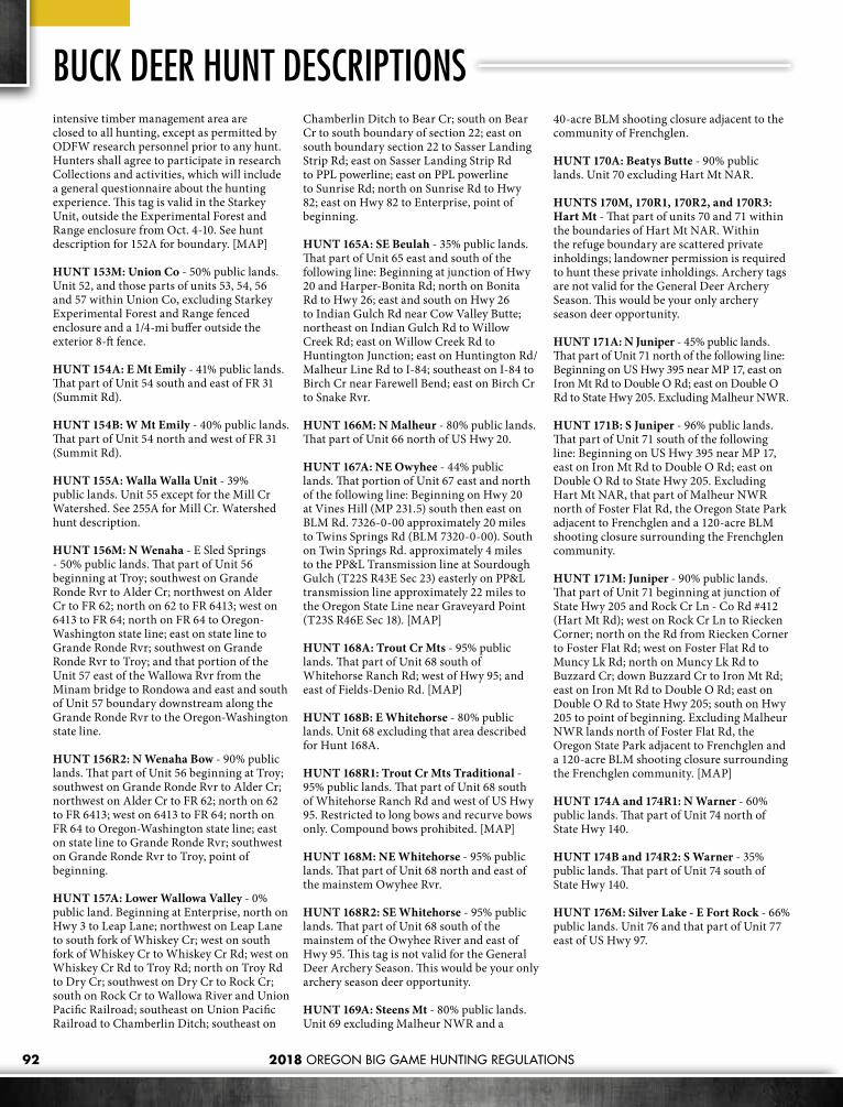
2018 OREGON BIG GAME HUNTING REGULATIONS92
intensive timber management area are closed to all hunting, except as permitted by ODFW research personnel prior to any hunt. Hunters shall agree to participate in research Collections and activities, which will include a general questionnaire about the hunting experience. This tag is valid in the Starkey Unit, outside the Experimental Forest and Range enclosure from Oct. 4-10. See hunt description for 152A for boundary. [MAP]
HUNT 153M: Union Co - 50% public lands. Unit 52, and those parts of units 53, 54, 56 and 57 within Union Co, excluding Starkey Experimental Forest and Range fenced enclosure and a 1/4-mi buffer outside the exterior 8-ft fence.
HUNT 154A: E Mt Emily - 41% public lands. That part of Unit 54 south and east of FR 31 (Summit Rd).
HUNT 154B: W Mt Emily - 40% public lands. That part of Unit 54 north and west of FR 31 (Summit Rd).
HUNT 155A: Walla Walla Unit - 39% public lands. Unit 55 except for the Mill Cr Watershed. See 255A for Mill Cr. Watershed hunt description.
HUNT 156M: N Wenaha - E Sled Springs - 50% public lands. That part of Unit 56 beginning at Troy; southwest on Grande Ronde Rvr to Alder Cr; northwest on Alder Cr to FR 62; north on 62 to FR 6413; west on 6413 to FR 64; north on FR 64 to Oregon-Washington state line; east on state line to Grande Ronde Rvr; southwest on Grande Ronde Rvr to Troy; and that portion of the Unit 57 east of the Wallowa Rvr from the Minam bridge to Rondowa and east and south of Unit 57 boundary downstream along the Grande Ronde Rvr to the Oregon-Washington state line.
HUNT 156R2: N Wenaha Bow - 90% public lands. That part of Unit 56 beginning at Troy; southwest on Grande Ronde Rvr to Alder Cr; northwest on Alder Cr to FR 62; north on 62 to FR 6413; west on 6413 to FR 64; north on FR 64 to Oregon-Washington state line; east on state line to Grande Ronde Rvr; southwest on Grande Ronde Rvr to Troy, point of beginning.
HUNT 157A: Lower Wallowa Valley - 0% public land. Beginning at Enterprise, north on Hwy 3 to Leap Lane; northwest on Leap Lane to south fork of Whiskey Cr; west on south fork of Whiskey Cr to Whiskey Cr Rd; west on Whiskey Cr Rd to Troy Rd; north on Troy Rd to Dry Cr; southwest on Dry Cr to Rock Cr; south on Rock Cr to Wallowa River and Union Pacific Railroad; southeast on Union Pacific Railroad to Chamberlin Ditch; southeast on
Chamberlin Ditch to Bear Cr; south on Bear Cr to south boundary of section 22; east on south boundary section 22 to Sasser Landing Strip Rd; east on Sasser Landing Strip Rd to PPL powerline; east on PPL powerline to Sunrise Rd; north on Sunrise Rd to Hwy 82; east on Hwy 82 to Enterprise, point of beginning.
HUNT 165A: SE Beulah - 35% public lands. That part of Unit 65 east and south of the following line: Beginning at junction of Hwy 20 and Harper-Bonita Rd; north on Bonita Rd to Hwy 26; east and south on Hwy 26 to Indian Gulch Rd near Cow Valley Butte; northeast on Indian Gulch Rd to Willow Creek Rd; east on Willow Creek Rd to Huntington Junction; east on Huntington Rd/Malheur Line Rd to I-84; southeast on I-84 to Birch Cr near Farewell Bend; east on Birch Cr to Snake Rvr.
HUNT 166M: N Malheur - 80% public lands. That part of Unit 66 north of US Hwy 20.
HUNT 167A: NE Owyhee - 44% public lands. That portion of Unit 67 east and north of the following line: Beginning on Hwy 20 at Vines Hill (MP 231.5) south then east on BLM Rd. 7326-0-00 approximately 20 miles to Twins Springs Rd (BLM 7320-0-00). South on Twin Springs Rd. approximately 4 miles to the PP&L Transmission line at Sourdough Gulch (T22S R43E Sec 23) easterly on PP&L transmission line approximately 22 miles to the Oregon State Line near Graveyard Point (T23S R46E Sec 18). [MAP]
HUNT 168A: Trout Cr Mts - 95% public lands. That part of Unit 68 south of Whitehorse Ranch Rd; west of Hwy 95; and east of Fields-Denio Rd. [MAP]
HUNT 168B: E Whitehorse - 80% public lands. Unit 68 excluding that area described for Hunt 168A.
HUNT 168R1: Trout Cr Mts Traditional - 95% public lands. That part of Unit 68 south of Whitehorse Ranch Rd and west of US Hwy 95. Restricted to long bows and recurve bows only. Compound bows prohibited. [MAP]
HUNT 168M: NE Whitehorse - 95% public lands. That part of Unit 68 north and east of the mainstem Owyhee Rvr.
HUNT 168R2: SE Whitehorse - 95% public lands. That part of Unit 68 south of the mainstem of the Owyhee River and east of Hwy 95. This tag is not valid for the General Deer Archery Season. This would be your only archery season deer opportunity.
HUNT 169A: Steens Mt - 80% public lands. Unit 69 excluding Malheur NWR and a
40-acre BLM shooting closure adjacent to the community of Frenchglen.
HUNT 170A: Beatys Butte - 90% public lands. Unit 70 excluding Hart Mt NAR.
HUNTS 170M, 170R1, 170R2, and 170R3: Hart Mt - That part of units 70 and 71 within the boundaries of Hart Mt NAR. Within the refuge boundary are scattered private inholdings; landowner permission is required to hunt these private inholdings. Archery tags are not valid for the General Deer Archery Season. This would be your only archery season deer opportunity.
HUNT 171A: N Juniper - 45% public lands. That part of Unit 71 north of the following line: Beginning on US Hwy 395 near MP 17, east on Iron Mt Rd to Double O Rd; east on Double O Rd to State Hwy 205. Excluding Malheur NWR.
HUNT 171B: S Juniper - 96% public lands. That part of Unit 71 south of the following line: Beginning on US Hwy 395 near MP 17, east on Iron Mt Rd to Double O Rd; east on Double O Rd to State Hwy 205. Excluding Hart Mt NAR, that part of Malheur NWR north of Foster Flat Rd, the Oregon State Park adjacent to Frenchglen and a 120-acre BLM shooting closure surrounding the Frenchglen community.
HUNT 171M: Juniper - 90% public lands. That part of Unit 71 beginning at junction of State Hwy 205 and Rock Cr Ln - Co Rd #412 (Hart Mt Rd); west on Rock Cr Ln to Riecken Corner; north on the Rd from Riecken Corner to Foster Flat Rd; west on Foster Flat Rd to Muncy Lk Rd; north on Muncy Lk Rd to Buzzard Cr; down Buzzard Cr to Iron Mt Rd; east on Iron Mt Rd to Double O Rd; east on Double O Rd to State Hwy 205; south on Hwy 205 to point of beginning. Excluding Malheur NWR lands north of Foster Flat Rd, the Oregon State Park adjacent to Frenchglen and a 120-acre BLM shooting closure surrounding the Frenchglen community. [MAP]
HUNT 174A and 174R1: N Warner - 60% public lands. That part of Unit 74 north of State Hwy 140.
HUNT 174B and 174R2: S Warner - 35% public lands. That part of Unit 74 south of State Hwy 140.
HUNT 176M: Silver Lake - E Fort Rock - 66% public lands. Unit 76 and that part of Unit 77 east of US Hwy 97.
BUCK DEER HUNT DESCRIPTIONS
2018 OREGON BIG GAME HUNTING REGULATIONS 93
600 Series Hunt DescriptionsHunt descriptions with [MAP] following the description, maps can be found on our website at myodfw.com/big-game-hunting/areas.
HUNT 614 and 614T1: Trask Unit - 42% public lands. All of Unit 14. There are specific weapon restrictions in the Cascade Head – Lincoln City area of the Trask Unit. See page 85.
HUNT 614T2: Upper Tualatin-Trask - 25% public lands. That part of Unit 14 as follows: 64 square miles in Unit 14 northwest of Gaston within the boundaries of the Upper Tualatin-Trask Travel Management Area. Entry is allowed only by Stimson Lumber Company through the mainline gate during the open hunt days. Entry will be limited to the youth with a valid ODFW controlled hunt tag and two adults, 21 years or older, who may not hunt. [MAP]
HUNT 616A1: NW Santiam - 22% public lands. That part of Unit 16 outside of the western exterior boundary of the Mt. Hood NF and Willamette NF beginning at the junction of Hwy 22 and Hwy 226; west on Hwy 22 to Cascade Hwy; north on Cascade Hwy to State Hwy 213 at Silverton; northeast on Hwy 213 to State Hwy 211; northeast on Hwy 211 to Hwy 26 at Sandy; east on Hwy 26 to Teneyck Rd; north on Teneyck Rd to Sandy River; northwest down Sandy River to I-84; northeast on I-84 to Benson State Park and Mt. Hood NF boundary; south along the western exterior boundary of the Mt. Hood NF and Willamette NF to Hwy 22; west on Hwy 22 to Hwy 226; point of beginning. [MAP]
HUNT 616A2 and 616T: SW Santiam - 30% public lands. That part of Unit 16 beginning at Lebanon, north on Brewster Rd to Lacomb Rd; east on Lacomb Rd to Kowitz Rd; north on Kowitz Rd to Baptist Church Dr; west on Baptist Church Dr to Richardson Gap Rd; north on Richardson Gap Rd to State Hwy 226; northeast on Hwy 226 to State Hwy 22, east on Hwy 22 to the western exterior boundary of the Willamette NF; south along the western exterior boundary of the Willamette NF to State Hwy 20; west on Hwy 20 to Lebanon, point of beginning.
HUNT 617 and 617T: Stott Mt Unit - 22% public lands. All of Unit 17. There are specific weapon restrictions in the Cascade Head - Lincoln City area of the Stott Mt Unit. See page 85.
HUNT 619: W McKenzie - 5% public lands. All of Unit 19 excluding Willamette NF lands.
HUNT 619A: Mill Cr - 10% public lands. That part of Unit 19 beginning at Springfield; north on Marcola Rd and Brush Cr Rd to HWY 228; east on HWY 228, Upper Calapooia Dr., and Calapooia Mainline Rd to the boundary of the Willamette NF, south and west along the exterior boundary of the Willamette NF to South Fork Gate Cr (T16S R3E sect 15); south west along South Fork Gate Cr and Gate Cr to HWY 126; west on Hwy 126 to Springfield, point of beginning.[MAP]
HUNT 620A and 620T1: N Siuslaw - 60% public lands. That part of Unit 20 in Lane Co.
HUNT 620B: S Siuslaw - 40% public lands. That part of Unit 20 in Douglas Co.
HUNT 620C: Camas Swale - 7% public lands. 255 sq mi. That part of Unit 20 east of Territorial Hwy. [MAP]
HUNT 620T1: N. Siuslaw - 60% public lands.That part of Unit 20 in Lane County
HUNT 620T2: Territorial - 100% private lands. 6.9 sq. mi in Unit 20 two mi west of Curtin. Giustina Resources and Seneca Jones Timber Co lands located within T21S, R5W, Sections 2, 11, 12, 13, 14, 23, 24, 25 and 26. Youths and accompanying adult(s) must register with the landowner, agree to the conditions of access and check in and out daily with security. [MAP]
HUNT 621A: Dorena -23% public lands. 415 sq mi in northwest corner of Unit 1beginning at Cottage Grove; north on I-5 to State Hwy 58; southeast on Hwy 58 to Willamette NF boundary; west then south on Forest boundary to BLM Rd 23-1-13; west on 23-1-13 to 23-3-5.4 (Big Rvr Rd); northwest on Big Rvr Rd, London Rd, and S 6th St to I-5; north on I-5 to Cottage Grove, point of beginning. [MAP]
HUNT 621B: Calapooya - 15% public lands. Those parts of units 21 and 23 beginning at Roseburg; north on I-5 to S. 6th St. at Cottage Grove, south on S. 6th St. and London Rd. to Big Rvr Rd 23-3-5.4; southeast on 23-3-5.4 to Rock Cr Rd 26-3-1; southwest on 26-3-1 to Hwy 138; west on Hwy 138 to Roseburg, point of beginning. [MAP]
HUNT 621T: N Indigo - 65% public lands. 1,055 sq mi. in that part of the Unit 21 in the Willamette Rvr drainage (includes Middle Fork Willamette Rvr, Brice Cr, Sharps Cr, Mosby Cr, Big Rvr, Little Rvr and Lost Cr). [MAP]
HUNT 622A: W Dixon - 44% public lands. That part of Unit 22 beginning at Dixonville; north on Hwy 138 to FR 27 (Little Rvr Rd); east on 27 to FR 2719 (Black Cr Rd); south on 2719 to FR 28; southwest on 28 to Co Rd 1 at Tiller; west on 1 to the Dixonville-Nickel Mt
powerline at Days Cr; north on powerline to Dixonville, point of beginning. [MAP]
HUNT 623A: Central Melrose - 2% public lands. All of Unit 23 excluding those portions described as follows: Northwest portion bounded by I-5 and Hwy 138 and southwest portion bounded by I-5 and Hwy 42.
HUNTS 623B1, 623B2, and 623B3: N Bank Habitat Area - 100% public lands. No motorized vehicles allowed within the hunt area. N Bank Habitat Mgt Area (Dunning Ranch) - 6,500 acres located approximately 8 mi northeast of Roseburg. Open Area: BLM lands located in T25S, R5W, sections 35 and 36; T26S, R5W, sections 1, 2, 11, 12, 13, 14; T25S, R4W, sections 31, 32, 33; T26S, R4W, sections 4, 5, 6, 7, 8, 18. These hunts are exclusively for Master Hunters and requires collecting biological samples from deer. [MAP]
HUNTS 623T1 and 623T2: N Bank HabitatMgt Area - 100% public lands. IMPORTANT NOTICE: Youth hunters participating in these hunts and adults accompanying them are required to review a video prior to hunting. Please call the ODFW Roseburg office at 541-440-3353 to make arrangements to obtain the video. The video can also be reviewed online at www.dfw.state.or.us/images/video_gallery/north_bank_HMA_2.asp. Hunters are required to collect biological samples from deer. No motorized vehicles allowed within the hunt area. OPEN AREA: The N Bank Habitat Mgt Area (Dunning Ranch) - 6,500 acres located approximately 8 mi northeast of Roseburg. All BLM lands located in T25S, R5W, sections 35 and 36; T26S, R5W, sections 1, 2, 11-14; T25S, R4W, sections 31-33; and T26S, R4W, sections 4-8, 18. [MAP]
HUNT 623T3: Melrose - That part of Unit 23, excluding the BLM N Bank Habitat Mgt Area.
HUNT 624A: Tioga - 40% public lands. All of Unit 24 excluding the following: Beginning at confluence of Millicoma and Coos Rvrs;northeast on Millicoma Rvr to Glenn Cr; northeast on Glenn Cr to south boundary of T23S; east on south boundary of T23S to northeast corner of Section 5, T24S, R8W; south on that section line 2 mi to Old Blue Access Rd; south on Old Blue Access Rd, Bateman Access Rd, Weyco 8420, 8800 and 8500 spurs and Reston Rim Rd to south boundary of 27S; west on T27S boundary to southwest corner of T27S, R8W; north on west boundary of R8W to Williams Rvr; northwest on Williams Rvr to S Fork Coos Rvr; northwest on S Fork Coos Rvr to point of beginning. [MAP]
HUNT 624B: E Tioga - 30% public lands. That part of Unit 24 east of the following line:
ANTLERLESS DEER HUNT DESCRIPTIONS

2018 OREGON BIG GAME HUNTING REGULATIONS94
ANTLERLESS DEER HUNT DESCRIPTIONSBeginning at Hwy 42 and BLM Rd 29-9-36.0 (Signal Tree Rd) near Camas Valley; west then north on 29-9-36.0 to BLM Rd 28-9-35.0; north on 28-9-35.0 to BLM Rd 28-8-18.0 to Douglas Co Rd 112; east on 112 to BLM Rd 28-8-16.0; northwest on 28-8-16.0 to BLM Rd 28-8-9.1; northeast on 28-8-9.1 to BLM Rd 27-7-4.0; north on 27-7-4.0 to BLM Rd 26-7-33.0; north on 26-7-33.0 to BLM Rd 25-7-29.1; north on 25-7-29.1 to BLM Rd 25-7-29.0; north on 25-7-29.0 to Douglas Co Rd 6 (Hubbard Cr Rd); north on 6 to Unit 23 boundary (Umpqua Rvr). Part of Unit 24 that includes the east and north flowing Tributaries of Umpqua Rvr from Basin to Lutsinger Cr. [MAP]
HUNT 625T: N Sixes - 8% public lands. That part of Unit 25 north of the following line: From the mouth of Sixes Rvr upstream following Sixes Rvr and Middle Fork Sixes Rvr to NF boundary in Section 13, T32S, R13W; east and north on NF boundary to Salmon Cr; northeast on Salmon Cr to Powers Hwy. Note: The majority of deer during this hunt are concentrated on private lands. Do not apply unless you have access to a place to hunt.
HUNT 628A: W Applegate - 57% public lands. 590 sq mi. That part of Unit 28 west of the Jackson-Josephine Co line.
HUNT 632T2: S Bryant Youth - 100% private lands. 4 sq. mi in Unit 32, 5 miles east of Malin. Basin View Ranch lands in T41S R13E Sec 15,16, 21, 22, 23, 24. Youth hunters and accompanying adults will be required to check in with the landowner prior to hunting. [MAP]
HUNT 638A: Lower Willow Cr Agri - 14% public lands. That part of Units 38 and 39; Beginning at confluence of Deschutes Rvr and Trout Cr; east on Trout Cr to Hwy 97; south on Hwy 97 to Dogwood Rd; east on Dogwood Rd to powerlines; south on powerlines to Willow Cr; south on Willow Cr to powerlines; west on powerlines to CRNG’s west boundary; south on west boundary to BOR’s north boundary at Haystack Reservoir; west on BOR boundary to Jericho Ln; west on Jericho Ln to Hwy 97; south on Hwy 97 to Norris Rd; east on Norris Rd to CRNG’s west boundary; south on CRNG’s boundary to the Crooked Rvr; south on the Crooked Rvr to Smith Rock State Park; south and east on State Park boundary to Deschutes Co boundary; north on Co boundary to CRNG; east and north on CRNG boundry to Hwy 26; south on Hwy 26 to Elliot Rd; west and south on Elliot Rd to O’Neil Hwy; west on O’Neil Hwy to Hwy 97; south on Hwy 97 to Hwy 126; west on Hwy 126 to Deschutes Rvr; north on Deschutes Rvr to Trout Cr, point of beginning. [MAP]
HUNT 640T: Mid-Columbia Private - Private lands within units 40, 41, 42 and that part of Unit 43 west of the John Day Rvr.
HUNT 641A: The Dalles Orchard - 0% public land. That part of Unit 41 within 1 mi of commercial orchards beginning at The Dalles south on Hwy 197 to south boundary of section 32 (T1N, R13E); west on section lines 9.5 mi; north on section lines 3.75 mi to Browns Cr Rd; northeast on Browns Cr Rd to intersection with Chenowith Rd; northeast on Chenowith Rd and follow Chenowith Creek to its intersection with I-84; east on I-84 to intersection of Hwy 197, point of beginning. [MAP]
HUNT 641B: Wamic Bench - 2% public lands. Beginning at Hwy 197 at Shadybrook Rd., south along 197 to the White River, west along the river to the White River Wildlife Area game fence, north along the White River Wildlife Area eastern boundary to Shadybrook Rd., south and east along Shadybrook Rd. to point of beginning.
HUNT 642A: Hood Unit-Hood Rvr Valley - 50% public lands. All of Unit 42 and that portion of Unit 41 beginning at the intersection of Hwy 35 and I-84; east on I-84 to the transmission lines at MP83; follow transmission lines west to Husky Rd; south on Husky rd to Fir Mountain Rd.; south on Fir Mtn. Rd. to USFS Rd 17; south on USFS Rd 17 to USFS Rd 44; west on USFS rd 44 to Hwy 35; north on Hwy 35 to beginning.
HUNT 643A: E Biggs - 15% public lands. That part of Unit 43 east of John Day Rvr.
HUNT 643B: W Biggs - 15% public lands. That part of Unit 43 west of John Day Rvr.
HUNTS 644A1, 644A2, and 644A3: Umatilla NWR - 100% public lands. That part of Umatilla NWR in Morrow Co. Note: only a portion of the refuge will be available for hunting as selected by Umatilla NWR personnel. Hunters should contact Umatilla NWR for hunt area description. [MAP]
HUNTS 644B1 and 644B2: N Columbia Basin - 2% public lands. That part of Unit 44 north of I-84.
HUNT 644C: S Columbia Basin - 2% public lands. That part of Unit 44 south of I-84.
HUNT 644T1: Umatilla NWR - 100% public lands. Shotgun and muzzleloader only. That part of the Umatilla NWR located in Morrow Co. Note: only a portion of the refuge will be available for hunting as selected by Umatilla NWR personnel. Hunters should contact Umatilla NWR for hunt area description.
HUNT 644T2: Umatilla Co. Private - 0% public lands. All of Umatilla Co outside the exterior boundaries of the NF.
HUNT 645A: N Fossil Hunt - 10% public
lands. That part of Unit 45 north of State Hwy 19.
HUNT 647A: John Day Valley - 5% public lands. Those parts of units 37, 46 and 47 within 1 mi on either side of Hwy 26 from Picture Gorge east to Prairie City and within 1 mi on either side of Hwy 395 north of Hwy 26 to Little Beech Cr.
HUNT 647B: Middle Fork John Day - 72% public lands. Those parts of units 47 and 50 within 1 mi on either side of Grant Co Rd 20 from the junction of Hwy 7 west to the FS boundary. [MAP]
HUNT 648A: Heppner Private - 0% public lands. All private lands in Unit 48 north and west of N Fork John Day Rvr.
HUNT 648T: Morrow Co - 0% public lands. Those parts of units 48 and 44 in Morrow Co. This hunt is on private lands only. If you are not familiar with the area and/or the landowners, you may contact the Heppner District Office at 541-676-5230.
HUNTS 649A1 and 649A2: N Ukiah - 0% public lands. That part of Unit 49 outside the exterior boundary of the NF and north of Hwy 244. [MAP]
HUNT 649B: W Blue Mts - 0% public lands. Those parts of units 44, 49 and 55 outside the exterior boundary of the NF, that part of Unit 54 north and west of FR 31 which is outside the exterior boundary of the NF and that part of units 45 and 48 north of FR’s 53 and 21 outside the exterior boundary of the NF.
HUNTS 651T1 and 651T2: Baker - Private lands within units 51, 62, and 63.
HUNT 654A: Rawhide - 0% public lands. That part of Unit 54 north of the Umatilla Rvr and west of the eastern boundary of R35E (Longitude W 118° 22’) outside of the exterior boundary of the Umatilla Indian Reservation. [MAP]
HUNT 655A: Orchards - 0% public lands. That part of Unit 55 outside the exterior boundary of Umatilla NF.
HUNTS 655B1 and 655B2: Walla Walla - 0% public lands. That part of Unit 55 west of the eastern boundary of R36E (Longitude W 118° 14.5’). [MAP]
HUNTS 657A1 and 657A2: Flora - 0% public lands. That part of Unit 57 beginning at the intersection of Joseph Cr and the Oregon-Washington state line; south on Joseph Cr to Wallowa-Whitman Forest Boundary; west along the south edge of Township 5 North to Courtney Cr; west and northwest on Courtney

2018 OREGON BIG GAME HUNTING REGULATIONS 95
Cr to the Grande Ronde Rvr; northeast on the Grande Ronde Rvr to Oregon-Washington state line; east on state line to Joseph Cr, point of beginning. [MAP]
HUNTS 657B1 and 657B2: N Wallowa Valley - 0% public lands. That part of Unit 57 beginning at Enterprise, north on Hwy 3 to Leap Ln ; northwest on Leap Ln to Gaston Rd; west on Gaston Rd to south fork of Whiskey Cr in Section 11; northwest on south fork of Whiskey Cr to Whiskey Cr Rd; west on Whiskey Cr Rd to west section boundary of Section 4; north on section line to Bear Wallow Rd; west on Bear Wallow Rd to Powwatka Rd; north on Powwatka Rd to Dry Cr; southwest on Dry Cr to Promise Rd; south on Promise Rd to Hwy 82; southeast on Hwy 82 to Enterprise, point of beginning. [MAP]
HUNT 657C: Upper Swamp Cr - 0% public lands. That part of Unit 57 beginning at Enterprise; north on Hwy 3 to Co Rd 646 (Swamp Cr Ln); southeast on Swamp Cr Ln to Co Rd 797 (Elk Mt Rd); northeast on Elk Mt Rd to Crow Cr Rd; south and west on Crow Cr Rd to Hwy 82; northwest on Hwy 82 to Enterprise, point of beginning. [MAP]
HUNT 657D: Prairie Cr - 0% public lands. Those parts of units 57, 58, and 60 beginning at Enterprise; south on Hwy 82 to Ira Pratt Rd; east on Ira Pratt Rd to Crow Cr Rd; east of Crow Cr Rd to Klages Rd; south on Klages Rd to Bicentennial Ln; west on Bicentennial Ln to Dobbin Rd; south on Dobbin Rd to Imnaha Hwy; west on Imnaha Hwy to W. Wallowa Ave; west on W. Wallowa Ave to Airport Ln. to Hurricane Cr Rd; north on Hurricane Cr. Rd to Enterprise; point of beginning.
HUNTS 660A1, 660A2, and 660A3: Upper Wallowa Valley - 0% public lands. Those parts of units 58, 60 and 61 beginning at Enterprise; south on Hwy 82 to Crow Cr Rd; east on Crow Cr Rd to Silver Lake Ditch; south along Silver Lake Ditch to Bicentennial Rd; east on Bicentennial Rd to section line separating sections 24 and 19; south along section line to Daggett Ln to Little Sheep Hwy; west on Little Sheep Hwy to Tucker Down Rd; south on Tucker Down Rd to Kinney Lk Rd; east on Kinney Lk Rd to Kinney Lk; south, then west on big game fence to its end above Wallowa Lk; from end of game fence directly west to Hwy 82; north on Hwy 82 to Ski Run Rd; south on Ski Run Rd to Moonshine Ditch; west on Moonshine Ditch to Hurricane Cr; across Hurricane Cr to Upper Alder Slope Ditch; northwest on Upper Alder Slope Ditch to Black Marble Ln; west on Black Marble Ln to Lime Quarry Rd; north on Lime Quarry Rd to upper Alder Slope Ditch; northwest on Alder Slope Ditch to Bennett Gulch; north on Bennett Gulch to Hwy 82; east on Hwy 82 to Enterprise; point of beginning. [MAP]
HUNT 660B: South Wallowa Valley - 0% public lands. That part of Unit 60 beginning at Wallowa, southeast on Hwy 82 to Sunrise Rd; south on Sunrise Rd to PPL powerline; west on PPL powerline to Sasser Landing Strip Rd; generally west on Sasser Landing Strip Rd to Bear Cr; north on Bear Cr to Chamberlin Ditch; northwest on Chamberlin Ditch to Union Pacific Railroad; northwest on Union Pacific Railroad to mouth of Rock Cr on Wallowa Rvr; north on Rock Cr to Hwy 82; southeast on Hwy 82 to Wallowa, point of beginning.
HUNT 665A: SE Beulah Agri - 15% Public Land. No centerfire rifles are allowed for hunting on private land unless permission is obtained from landowner. That part of unit 65 as follows: Beginning at Nyssa North on the Snake River to Birch Creek, upstream on Birch Creek to I-84, SE on I-84 to Jacobsen Gulch Road, West on Jacobsen Gulch Road to Alkali Flat Road Southwest on Alkali Flat Road to Section 13, Northwest parallel to Willow Creek drainage to a point in the center of section 3 1.5 miles N of Jameson, due South to N Road K, south on North Road K to 14th Ave West., West on 14th Ave West to Gum Cr Road, West on Gum Cr Road to Hope Flat-Gum Cr Road, South on Hope Flat-Gum Creek Road to the south line of Sec 22, West on section lines 1.6 miles, south 12 miles on section lines thru hope spring to Hwy 20 East on Hwy 20 to Hwy 201 S on Hwy 201 to Nyssa. [MAP]
HUNT 665T: Malheur Co - 5% Public Land. That part of unit 65 and 67 as follows: Any private land with landowner permission and public lands within the following boundary: Beginning at Nyssa North on the Snake River to Birch Creek, upstream on Birch Creek to I-84, SE on I-84 to Jacobsen Gulch Road, West on Jacobsen Gulch Road to Alkali Flat Road Southwest on Alkali Flat Road to Section 13 Northwest parallel to Willow Creek drainage to a point in the center of section 3 1.5 miles n of Jameson, due South to N Road K, south on North Road K to 14th Ave West., West on 14th Ave West to Gum Cr Road, West on Gum Cr Road to Hope Flat-Gum Cr Road, South on Hope Flat-Gum Creek Road to the south line of Sec 22, West on section lines 1.6 miles, south 12 miles on section lines thru hope spring to Hwy 20 East on Hwy 20 to JH canal East (downstream) on JH canal to Sandhollow Road, NE on Sand hollow road to Lyle Blvd Southeast on Lytle Blvd to Enterprise Ave due West on Enterprise Ave to end, due West on section lines 4.5 miles, due South on section lines 9 miles, due East on section lines 4 miles, dues South on section lines 8 miles to PPL power line, South East on PPL power line to OR/ID state line, North on Stateline to Nyssa, point of beginning. [MAP]
HUNT 667A: NE Owyhee Agri - 10% Public Land. No centerfire rifles are allowed for hunting on private land unless permission is obtained from landowner. That part of Unit 67 as follows: Beginning at Nyssa North on Hwy 201 to Hwy 20 at Cairo Junction, West on Hwy 20 to JH canal East (downstream) on JH canal to Sandhollow Road, NE on Sandhollow road to Lyle Blvd Southeast on Lytle Blvd to Enterprise Ave due West on Enterprise Ave to end, due West on section lines 4.5 miles, due South on section lines 9 miles, due East on section lines 4 miles, dues South on section lines 8 miles, to PPL power line, South East on PPL power line to OR/ID state line, North on Stateline to Nyssa, point of beginning. [MAP]
HUNT 675T: Paisley - This hunt occurs exclusively on private land, outside but within 2 miles of the Paisley city limits in Unit 75. Prior to the hunt, successful applicants will be provided with a list of landowners where a hunt may be arranged.
HUNT 679A and 679T: Harney Basin - 45% public lands. Parts of units 66, 69, 71 and 72 as follows: That part of Unit 66 south of US Hwy 20 and west of Crane-Buchanan Rd. In Unit 69, that part north of the following line: Beginning at Hwy 78 near Princeton; south on Lavea Bed Rd (Co Rd 404) to Diamond Ln (Co Rd 409); west on Diamond Ln to Hwy 205. In Unit 71, that part north of the following line: Beginning on Us Hwy 395 near MP 17; east on Iron Mt Rd to Double O Rd; east on Double O Rd to Hwy 205. Excluding Malheur NWR. In Unit 72, that part south and east of the following line: Beginning at the intersection of US Hwy 395 and 500KV Powerline 6 mi north of Burns; west on 500KV Powerline to its intersection with Foley Rd (Co Rd 121); south on Foley to West Loop Rd; continue south to intersection of Radar Ln (Co Rd 124); west on Radar Ln to the Hines Logging Road (Co Rd 127/FS Rd 47); south to Hwy 20/395. [MAP]

2018 OREGON BIG GAME HUNTING REGULATIONS96
ELK HUNT DESCRIPTIONS200 Series Hunt DescriptionsHunt descriptions with [MAP] following the description, maps can be found on our website at myodfw.com/big-game-hunting/areas.
HUNT 200M1: NW Cascades - Units 16 and 19 and that part of Unit 21 in the Willamette Rvr Drainage north of the following line: Beginning along the eastern edge of Unit 21 at the Pacific Crest Trail; south on the Pacific Crest Trail to Trail 3641; westerly on Trails 3641, 3643 and 1407 to FS Rd 770; westerly on FRs 770, 2154, 236, 436 to FR 3810; northwest on 3810 to junction of FR 3810 and 5851; north on 5851 to trail 1407; north on 1407 to FR 5850; north and west on 5850 to 745; westerly along FRs 745, 2213, 767, 2212 (Champion Saddle) and Co Rd 2460 (Sharps Cr Rd) to BLM Rd 23-1-12; southwest on BLM Rds 23-1-12 and 23-1-13 to BLM Rd 23-3-5.4 (Big Rvr Rd); northwest on BLM Rd 23-3-5.4 to the unit boundary at London Rd. [MAPS: USFS Umpqua NF, Willamette NF, Umpqua NF-Diamond Lake Ranger District]
HUNT 200M2: SW Cascades - Units 22, 29, 30 and that part of Unit 21 south of the following line: Beginning along the eastern edge of Unit 21 at the Pacific Crest Trail; south on the Pacific Crest Trail to Trail 3641; westerly on Trails 3641, 3643 and 1407 to FS Rd 770; westerly on FRs 770, 2154, 236, 436 to FR 3810; northwest on 3810 to junction of FR 3810 and 5851; north on 5851 to Trail 1407; north on 1407 to FR 5850; north and west on 5850 to 745; westerly along FRs 745, 2213, 767, 2212 (Champion Saddle) and Co Rd 2460 (Sharps Cr Rd) to BLM Rd 23-1-12; southwest on BLM Rds 23-1-12 and 23-1-13 to BLM Rd 23-3-5.4 (Big Rvr Rd); northwest on BLM Rd 23-3-5.4 to the unit boundary at London Rd. [MAPS:USFS Umpqua NF, Umpqua NF-Diamond Lake Ranger District].
HUNTS 210A1 and 210A2: Onion Peak - 6% public lands. Those parts of units 10 and 12 beginning at mouth of Nehalem Bay; north on coast line to Hwy 101 at Seaside; south on Hwy 101 to Hwy 26; east on Hwy 26 to Hwy 53 at Necanicum Junction; south on Hwy 53 to Hwy 101; south on Hwy 101 to mouth of Nehalem Bay, point of beginning. [MAP]
HUNTS 210B1 and 210B2: Lewis & Clark - 0% public lands. That part of Unit 10 beginning at Seaside; north on Hwy 101 to Hwy 202; southeast on Hwy 202 to Hwy 103; south on Hwy 103 to Hwy 26; west on Hwy 26 to Hwy 101, north on Hwy 101 to Seaside, point of beginning. [MAP]
HUNT 210C1 and 210C2: Upper Nehalem - 18% public lands. 184 sq mi in units 10 and 11 within the first two mi either side of the following Rds: Starting at Timber Junction on Hwy 26; north on Timber Rd to Hwy 47; north on Hwy 47 to Hwy 202; west on Hwy 202 to Jewell; southwest on Hwy 103 to Hwy 26. Jewell WA lands are closed to hunting. [MAP]
HUNT 210D: Lower Columbia - 28% public lands. Hunters must complete the Master Hunter Program prior to applying for this hunt. 81 sq mi in Unit 10 beginning at the mouth of Clatskanie Rvr; south on Clatskanie Rvr to State Hwy 47 at Clatskanie; south on Hwy 47 to BPA transmission line, west on BPA transmission line to Knappa-Svensen R.F.P.D. boundary; west on Knappa-Svensen R.F.P.D. boundary to Akerstadt Rd; north on Akerstadt Rd to Hillcrest Rd; northwest on Hillcrest Rd to Old Hwy 30; west on Old Hwy 30 to Market Rd; south on Market Rd to George Hill Rd; southeast on George Hill Rd to Knappa-Svensen R.F.P.D. boundary, west on Knappa-Svensen R.F.P.D. boundary to John Day-Fernhill R.F.P.D. boundary; west on John Day-Fernhill R.F.P.D. to BPA transmission line; west on BPA transmission line to Pipeline Rd; southeast on Pipeline Rd to Walluski Way; southwest on Walluski Way to Labiski Rd; west on Labiski Rd to Walluski Lp Rd; west on Walluski Lp Rd to Hwy 202; north on Hwy 202 to BPA transmission line; west on BPA transmission line to Youngs Bay; north on east shore of Youngs Bay to Columbia Rvr; east on Columbia Rvr to Clatskanie Rvr, point of beginning. [MAP]
HUNT 210E: Young’s Rvr - 3% public lands. 40 sq mi in Unit 10 within 1 mi west of Hwy 202 from Astoria District ODF Office to southern junction of Walluski Lp Rd and within 1 mi of the following Rds: Hwy 202 from southern junction of Walluski Lp Rd to Klaskanine Fish Hatchery; Lewis and Clark Rd from Miles Crossing to junction with Lewis and Clark Mainline just north of CZ Camp; Fort Clatsop Rd south of Fort Clatsop parking lot; Tucker Cr Rd and Logan Rd from Hwy 101 Alternate to Lewis and Clark Rd; Young’s Rvr Lp Rd from Miles Crossing to junction with Olney Ln; Olney Ln to junction with Hwy 202. [MAP]
HUNTS 210F1 and 210F2: Camp McGregor - 16% public lands. That part of Unit 10 within the following boundary: Beginning at Sunset Rest Area on Hwy 26 at MP 29; east along Hwy 26 to McGregor Rd; east and north along McGregor Rd to NoFo Rd; south along NoFo Rd to the ODF/Private land boundary at section 36; east to the Clatsop/ Columbia county line; north along the county line and including NW 1/4 of section 30 to the southern boundary of section 18; east to the southeastern corner of section 17; north to Eastside Grade
Rd; north on Eastside Grade Rd to Rock Cr; east along Rock Cr to the Columbia Rvr Mainline; north on the Columbia Rvr Mainline to Deep Cr; west and south along Deep Cr to the NE corner of section 19; west to the Clatsop/Columbia co line; south along the co line to the T4N/5N boundary; west along the T4N/5N line to the NW corner of S1 of T4N, R7W; southwest to Hwy 26 at MP 24; southeast along Hwy 26 to Sunset Rest Area, point of beginning. [MAP]
HUNTS 210G1 and 210G2: Central Saddle Mt. - 100% public lands. Approximately 153 sq. mi. in Unit 10. All Oregon Department of Forestry administered lands within the following boundary: beginning at the Hwy 26 junction with Hwy 103, southeast on Hwy 26 to Rock Creek (just west of Sunset Rest Area), northeast down Rock Creek to the Clatsop/ Columbia county line, north on Clatsop/ Columbia county line to Hwy 30, west on Hwy 30 to Hwy 202 at Astoria, southeast on Hwy 202 to Ebsen Rd (just west of Jewell Meadows Wildlife Area), northeast on Ebsen Rd to Sarajarvie Ridge Rd, northeast then southeast on Sarajarvie Ridge Rd to Beneke Rd, northeast on Beneke Rd to Walker Cr Rd, northeast on Walker Cr Rd to Crawford Ridge Rd, south on Crawford Ridge Rd to Hwy 202, west on Hwy 202 to Hwy 103 at Jewell, southwest on Hwy 103 to junction with Hwy 26, point of beginning.
HUNTS 211A1, 211A2, 211A3 and 211A4: North Plains - 6% public lands. That part of Unit 11 beginning at Hwy 26 and Cornelius Pass Rd junction; west on Hwy 26 to Hwy 47; north on Hwy 47 to Fisher Rd; northeast on Fisher Rd to Bacona Rd; north on Bacona Rd to John Lee Rd; east on John Lee Rd to Buxton Lookout Rd; north on Buxton Lookout Rd to Bacona Rd; east on Bacona Rd to Shermans Mill Rd; southeast on Shermans Mill Rd to Fern Flat Rd; north on Fern Flat Rd to Greener Rd; west on Greener Rd to Burgdorfer Rd; east on Burgdorfer Rd to Pumpkin Ridge Rd; south on Pumpkin Ridge Rd to Smoke Ranch Rd; northeast on Smoke Ranch Rd to Dixie Mountain Rd; southeast on Dixie Mountain Rd to Rocky Point Rd; east on Rocky Point Rd to Skyline Rd; southeast on Skyline Rd to Cornelius Pass Rd; south and west on Cornelius Pass Rd to Hwy 26, point of beginning.
HUNT 211B: N Central Scappoose - 5% public lands. That part of Unit 11 beginning at Scappoose, northwest on the Scappoose- Vernonia Hwy to Hwy 47; north on Hwy 47 to Clatskanie; north on Clatskanie Rvr to state line in Columbia Rvr; southeast on state line to Willamette Rvr; southwest on Willamette Rvr to Multnomah Channel; northwest on Multnomah Channel to Hwy 30 at Sauvie Island bridge; northwest on Hwy 30 to Scappoose, point of beginning.

2018 OREGON BIG GAME HUNTING REGULATIONS 97
HUNT 211C: Banks - Beginning at the intersection of Hwy 26 and Hwy 47; west on Hwy 26 to Timber Rd; south on Timber Rd to the Hwy 6 junction; east on Hwy 6 to Hwy 47; northwest of Hwy 47 to Hwy 26 junction, point of beginning.
HUNTS 212A1 AND 212A2: Miami - Nehalem - 15% public lands. 80 sq mi in units 10 and 12 within 1 mi either side of the following Rds: Hwy 53 from Nehalem Hatchery to Hwy 101; N Fork Rd from Hwy 53 to Hwy 101; Foss Rd from Hwy 53 to the mouth of Cook Cr; Miami Foley Rd from Foss Rd to the mouth of Miami River and that part of Unit 12 east of Hwy 101 and west of Miami Foley Rd. [MAP]
HUNT 212B: Buick Canyon - 60% public lands. 15 sq mi in Unit 12 beginning at the Foss Rd junction with Sibley Rd; east on Sibley Rd to Buck Mt Rd; southeast on Buck Mt Rd to North Side Rd; east on North Side Rd to Clay Cr Rd junction; due south of the junction approximately 3/4 mi to S Fk Salmonberry Rvr; northeast along S Fk Salmonberry to Salmonberry Rvr; northwest on Salmonberry Rvr to Foss Rd; west on Foss Rd to Sibley Rd junction, point of beginning. [MAP]
HUNT 214: Trask - 42% public lands. All of Unit 14. There are specific weapon restrictions in the Cascade Head - Lincoln City area of the Trask Unit. See page 85.
HUNT 214A1 and 214A2: W Trask - That part of Unit 14 beginning at Tillamook; west on Netarts Hwy to Bayocean Rd (Three Capes Scenic Loop); north and west on Bayocean Rd to Cape Meares Loop Rd; south on Cape Meares Loop Rd. to the coast at Oceanside; south on coast to Proposal Rock; east from Proposal Rock to Hwy 101; southeast on Hwy 101 to the T5S/6S boundary; due east on the T5S/6S boundary to the corner of S34 and 35; northeast in a straight line to Castle Rock campground; north in a straight line to Hebo Lk campground; northeast in a straight line to Square Top Mt; northwest in a straight line to High Peak; north in a straight line to Edwards Butte; northeast in a straight line to Gold Peak; northwest in a straight line through Peninsula Co Park to Hwy 6; west on Hwy 6 to Tillamook, point of beginning.
HUNT 214B1 and 214B2: Central Trask - 95% public land. That part of Unit 14 beginning at Beaver Dam Rd near the summit of Hwy 6; west on Hwy 6 to MP8 (Sylvan Cr); southeast in a straight line to TraskRvr Rd at Peninsula Park; west on Trask Rvr Rd to the mouth of Gold Cr; upstream on Gold Cr to Gold Cr Rd; east and south on Gold Cr Rd to Edwards Butte Rd; south on Edwards Butte Rd to Simmons Ridge Rd; east on Simmons Ridge Rd to BSM Rd south on BSM Rd to 3-7-7.1 (Grindstone
Mtn); east on 3-7-7.1 to Boundary Rd to Headquarters Grade;north on Headquarters Grade to Murphys Camp; north and east on 2-6-3 Rd (Flora Mainline) to N Fork Trask Rvr Rd at Neverstill; north and west on N Fork Trask Rvr Rd to Williams Rd; north on Williams Rd to 2500 Line Rd; north and west on 2500 Line Rd to Seven Cedars cross-over; north and east on Seven Cedars cross-over to C-Line Rd; north and east on C-Line Rd to Beaver Dam Rd; north on Bever Dam Rd to Hwy 6, point of beginning. [MAP]
HUNT 214C: Wind Rvr - 28% public lands. 109 sq mi. That part of Unit 14 beginning at Willamina Cr Rd in Willamina; north on Willamina Cr Rd to Coast Cr Rd; west on Coast Cr Rd to Gilbert Cr Rd; north on Gilbert Cr Rd to Bald Mt Access Rd; north on Bald Mt Access Rd to Bible Cr Rd; west on Bible Cr Rd to Siuslaw NF FR 14; west on Siuslaw NF FR 14 to FR 2210; southwest on FR 2210 to FR 2282; south on FR 2282 to Hwy 22; southwest on Hwy 22 to powerline crossing at T5S, R9W, Sec 36; southeast on powerline to 9A Rd; south on 9A Rd to 9 Rd; south on 9 Rd to Hwy 18; east on Hwy 18 to Hwy 18 Business Route; northeast on Hwy 18 Business Route to Willimina Cr Rd; point of beginning. [MAP]
HUNT 214D: Beaver Cr - 8% public lands. 100 sq mi. That part of Unit 14 : Beginning at Willamina Cr Rd in Willamina; north on Willamina Cr Rd to Coast Cr Rd; west on Coast Cr Rd to Gilbert Cr Rd; north on Gilbert Cr Rd to Bald Mt Access Rd; north on Bald Mt Access Rd to Homestead Tie Rd; southeast on Homestead Tie Rd to Willamina Cr Rd; northeast on Willamina Cr Rd to East Cr Rd; southeast on East Cr Rd to Green Top Rd; east on Green Top Rd to Gopher Valley Rd; north on Gopher Valley Rd to Peavine Rd; east on Peavine Rd to SW Old Sheridan Rd; north on SW Old Sheridan Rd to Hwy 99W; south on Hwy 99W to Hwy 18; south and west on Hwy 18 to Hwy 18 Business Route; west on Hwy 18 Business Route to Willamina Cr Rd, point of beginning. [MAP]
HUNT 214E: Pike - 5% public lands. 80 sq mi. That part of Unit 14 : Beginning at McMinnville; southwest on Hwy 99W to SW Old Sheridan Rd; west on SW Old Sheridan Rd to Peavine Rd; west on Peavine Rd to White Rd; north on White Rd to Wanless Rd; northeast on Wanless Rd to High Heaven Rd; east on High Heaven Rd to Von Rd; northeast on Von Rd to Panther Cr Rd; northwest on Panther Cr Rd to Meadowlake Rd; east on Meadowlake Rd to Haskins Cr Rd; west on Haskins Cr Rd to Haskins Cr Guard Station; northwest on 100 line to Rd 121 in T3S, R6W Section 12; north on 121 to Rd 122; north on 122 to Rd 3-6-12.2; north on 3-6-12.2 to Kutch Cr Rd; north on Kutch Cr Rd to Upper Kutch Rd (in T3S,R6W section 1); north and east on Upper Kutch Rd
to Boise Cascade’s N Fairdale Rd; east and north on N Fairdale Rd to Fairdale Rd; north on Fairdale Rd to Old Railroad Grade Rd; east on Old Railroad to Rockyford Rd; north on Rockyford Rd to Pike Rd; southeast on Pike Rd to Hwy 47 at Yamhill; south on Hwy 47 to Hwy 99W; southwest on Hwy 99W to McMinnville, point of beginning. [MAP]
HUNTS 214F1 and 214F2: NE Trask - 15% public lands. That part of Unit 14 beginning at the junction of Hwy 8 and Hwy 47 (Forest Grove); south on Hwy 47 to Pike Rd (Yamhill); north and west on Pike Rd to Rockyford Rd; south on Rockyford Rd to Old Railroad Grade; west on Old Railroad Grade to 2-5-29.0 Rd (CCC Rd and Toll Rd); west and north on 2-5-29.0 Rd to 2-6-3 Rd at Murphy Camp; north and east on 2-6-3 Rd (Flora Mainline) to N Fork Trask Rvr Rd at Neverstill; north and west on N Fork Trask Rvr Rd to Williams Rd; north on Williams Rd to 2500 Line Rd; north and west on 2500 Line Rd to Seven Cedars Rd cross-over; north and east on Seven Cedars cross-over to C-Line Rd; north and east on C-line Rd to Beaver Dam Rd; north on Beaver Dam Rd to Hwy 6; east on Hwy 6 to junction with Hwy 8; south and east on Hwy 8 to Hwy 47, point of beginning. [MAP]
HUNT 214G: Panther Cr - 50% public lands. 16 sq mi. That part of Unit 14 beginning at intersection of Alder Brook and Hwy 18 one mi east of Rose Lodge; north up Alder Brook to Widow Cr Ridge Rd; north on Widow Cr Ridge Rd to FR 115, south on 115 to Cascade Head Experimental FR (FR 1861), north and west on 1861 to US Hwy 101; south on Hwy 101 to Three Rocks Rd; east on Three Rocks Rd to Old Scenic Hwy 101; south on Old Scenic Hwy 101 to N Bank Rd; east on N Bank Rd to Hwy 18 at Rose Lodge; east on Hwy 18 to Alder Brook, point of beginning. [MAP]
HUNT 214M: NE Trask - 15% public lands. That part of Unit 14 beginning at the junction of Hwy 8 and Hwy 47 (Forest Grove); south on Hwy 47 to Pike Rd (Yamhill); north and west on Pike Rd to Rockyford Rd; south on Rockyford Rd to Old Railroad Grade; west on Old Railroad Grade to 2-5-29.0 Rd (CCC Rd and Toll Rd); west and north on 2-5-29.0 Rd to 2-6-3 Rd at Murphy Camp; north and east on 2-6-3 Rd (Flora Mainline) to N Fork Trask Rvr Rd at Neverstill; north and west on N Fork Trask Rvr Rd to Williams Rd; north on Williams Rd to 2500 Line Rd; north and west on 2500 Line Rd to Seven Cedars Rd crossover; north and east on Seven Cedars crossover to C-Line Rd; north and east on C-line Rd to Beaver Dam Rd; north on Beaver Dam Rd to Hwy 6; east on Hwy 6 to junction with Hwy 8; south and east on Hwy 8 to Hwy 47, point of beginning. [MAP]

2018 OREGON BIG GAME HUNTING REGULATIONS98
ELK HUNT DESCRIPTIONSHUNT 214T: Trask Unit - 42% public lands. Unit 14. There are specific weapon restrictions in the Cascade Head - Lincoln City area of the Trask Unit. See page 85.
HUNT 215A1: Willamette Plus No. 1 - 1% public lands. All of Unit 15 and that part of Unit 18 as follows: 11 square mi east of Bellfountian Rd and north of Coon Rd. Special Restriction Monroe Subunit: Bag limit restricted to antlerless elk only from Aug. 25 - Oct. 31. 58 sq miles. Inside the following area within the Willamette Unit; beginning at the intersection of Llewellyn and Bellfountain Roads; east on Lewellyn Rd to Hwy 99; south on Hwy 99 to Smith Loop Rd; southeast on Smith Loop Rd to Hurlburt Rd; southeast on Hurlburt Rd to the Willamette River; south along the west bank of the Willamette River to Goracke Rd; west on Goracke Rd to Stow Pit Rd, west on Stow Pit Rd to Hwy 99 W; north on 99 W to Dawson Rd.; west on Dawson Rd. to Bellfountain; north on Bellfountain Rd to Llewellyn Rd: point of beginning. Hunting on William Finely Refuge requires a permit. See page 85.
HUNT 215A2: Willamette Plus No. 2 - 1% public lands. All of Unit 15 and that part of Unit 18 as follows: 11 sq mi east of Bellfountain Rd and north of Coon Rd. Hunting on William Finely Refuge requires a permit. See page 85.
HUNT 216B: SW Santiam - 30% public lands. That part of Unit 16 beginning at Lebanon, north on Brewster Rd. to Lacomb Rd.; east on Lacomb Rd to Kowitz Rd; north on Kowitz Rd to Baptist Church Dr; west on Baptist Church Dr to Richardson Gap Rd; north on Richardson Gap Rd to State Hwy 226; northeast on Hwy 226 to State Hwy 22; east on Hwy 22 to the western exterior boundary of the Willamette NF; south along the western exterior boundary of the Willamette NF to Hwy 20; west on Hwy 20 to Lebanon, point of beginning.
HUNTS 216C1, 216C2, and 216C3: Molalla - 25% public lands. That part of Unit 16 west of the western exterior boundary of Mt Hood and Willamette NF: Beginning at the junction of Hwy 211 and the Molalla FR; south and east on Molalla FR to N Fork Main Line; east on N Fork Main Line to Lukens Cr Rd; east on Lukens Cr Rd to NF boundary; south on the NF boundary to the north bank of the N Santiam Rvr; west on the north bank of the N Santiam Rvr to Stayton-Scio Rd; north on Stayton-Scio Rd and Cascade Hwy to Hwy 213 at Silverton; north on Hwy 213 to Hwy 211; east on Hwy 211 to Molalla FR, point of beginning.
HUNT 216D: Sandy - 10% public lands. Those portions of unit 16 west of the western exterior boundary of the Mt Hood NF: Beginning at Interstate 84 at Benson State Park; west on Interstate 84 to Sandy River; southeast on the
Sandy River to Teneyck Rd; south on Teneyck Rd to Hwy 211; southwest on Hwy 211 to Hwy 224; southeast on Hwy 224 to western exterior boundary of Mt Hood NF; north on western exterior boundary of Mt. Hood NF to Interstate 84; point of beginning.
HUNT 216E: Green Mt. - 18% public lands. 114 sq mi. That part of Unit 16 west of the western exterior boundary of Mt Hood NF. Beginning at Hwy 224 and Hwy 211 Junction in Estacada; south on Hwy 211 to Molalla FR; south and east on Molalla FR to N Fork Main Line; east on N Fork Main Line to Lukens Cr Rd; east on Lukens Cr Rd to Mt. Hood NF boundary; north on western exterior boundary of Mt Hood NF to Hwy 224; west on Hwy 224 to Hwy 211 junction; point of beginning.
HUNT 216F: NW Santiam - 22% public lands. That part of Unit 16 outside of the western exterior boundary of the Mt. Hood NF and Willamette NF beginning at the junction of Hwy 22 and Hwy 226; west on Hwy 22 to Cascade Hwy; north on Cascade Hwy to State Hwy 213 at Silverton; northeast on Hwy 213 to State Hwy 211; northeast on Hwy 211 to Hwy 26 at Sandy; east on Hwy 26 to Teneyck Rd; north on Teneyck Rd to Sandy River; northwest down Sandy River to I-84; northeast on I-84 to Benson State Park and Mt. Hood NF boundary; south along the western exterior boundary of the Mt. Hood NF and Willamette NF to Hwy 22; west on Hwy 22 to Hwy 226; point of beginning[MAP]
HUNT 216R: Santiam Bow - Those portions of Unit 16 in Linn and Marion Cos excluding Mt. Hood NF and Willamette NF lands.
HUNT 216T: Santiam Unit - Unit 16, excluding the Willamette National Forest.
HUNT 217A: Lower Siletz Rvr - 25% public lands. 106 sq mi. That part of Unit 17 as follows: Beginning at the intersection of Hwy 101 and Hwy 18; east on Hwy 18 to Murphy Rd; south on Murphy Rd to 100 Rd; south on 100 to BLM Rd 6-8-35; east on 6-8-35 to 300 Rd; south and west on 300 to 100 Rd; south on 100 to 800 Rd; west on 800 to BLM Rd 7-9-20 (Box Canyon); west on 7-9-20 to 200 Rd (Gravel Cr Rd); southeast on 200 to 300 Rd; southwest on 300 to 4000 Rd (Werner Rd); west on 4000 to Siletz Rvr at Ichwhit County Park; downstream on Siletz Rvr to the Hwy 101 bridge; north on Hwy 101 to East Devils Lake Rd east and north on E. Devils Lake Rd to Hwy 101, then north on Hwy 101 to Hwy 18; point of begining. [MAP]
HUNT 217B: Upper Siletz Rvr - 10% public lands. 128 sq mi. Beginning at the bridge over the Siletz Rvr, on the south side of Siletz upstream along the north side of the Siletz Rvr to the confluence of the north and south forks of the Siletz Rvr; upstream along the S Fork to
the Old Valsetz-Falls City bridge; east on Old Valsetz-Falls City Rd to 1300 Rd; northwest on the 1300 to Fanno Ridge Rd; northwest on Fanno Ridge Rd to BLM Rd 8-8-23; northwest on 8-8-23 to BLM Rd 8-8-11; north on 8-8-11 to BLM Rd 8-8-12; northeast on 8-8-12 to BLM Rd 8-7-23 (M4 and Blackrock mainline); north and west on 8-7-23 to 300 Rd; west on 300 to 100 Rd; south on 100 to 800 Rd; west on 800 to BLM Rd 7-9-20 (Box Canyon); west on 7-9-20 to 200 Rd; southeast on 200 (Gravel Cr Rd) to 300 Rd; southwest on 300 to 4000 Rd (Werner Rd); southwest on 4000 to the Siletz Rvr at Ichwhit Co Park; upstream along the Siletz Rvr to the bridge on the south side of Siletz, point of beginning. [MAP]
HUNT 217C: Dallas - 17% public lands. That part of Unit 17 beginning at Dallas; northeast on State Hwy 223 to State Hwy 22; Northwest on Hwy 22 to State Hwy 18; west on Hwy 18 to Murphy Rd; south on Murphy Rd to 100 Rd; south on Rd 100 Rd to BLM Rd 6-8-35; east on 6-8-35 to 300 Rd; south on 300 Rd to BLM Rd 8-7-23 (M4 and Blackrock mainline); east on Blackrock mainline to S-line; southwest on S-line to Fanno Ridge Rd; southeast on Fanno Ridge to 1300 Rd; southeast on 1300 Rd to old Valsetz-Fall City Co Rd; east on old Valsetz-Fall City Co Rd to Fall City; southeast on Bridgeport Rd (No 864) and Gardner Rd (No 865) to Hwy 223; north on Hwy 223 to Dallas, point of beginning. [MAP]
HUNT 218A: NE Alsea - 15% public lands. That part of Unit 18 beginning at the intersection of Hwys 99 and 20/34 in Corvallis; west on Hwy 34 to Philomath; west on Hwy 20 to Blodgett; north west on the Summit-Nashville Rd (Co Rd 180) to the Logsden Rd in Nashville; north on Logsden Rd to the Green Mt Rd; north on Green Mt Rd to the 1420 Rd; north on 1420 to 1400 Rd; west on 1400 Rd to the old Valsetz-Fall City main Co Rd; east on the old Valsetz-Fall City main Co Rd to Fall City, southeast on Bridgeport Rd (No 864), Gardner Rd (No. 865), Airlie Rd ( No 7) to State Hwy 99; south on Hwy 99 to Corvallis, point of beginning. [MAP]
HUNT 218B: SW Alsea - 84% public lands. 468 sq mi. That part of Unit 18 south and west of the following line: Beginning at Waldport; east on State Hwy 34 to FR 3415; south on FRs 3415, 3412 and 3310 to Lobster Cr Rd; south and east on Lobster Cr Rd to Preacher Cr Rd; south on Preacher Cr Rd to FR 35; south on 35 to Panther Cr Rd; south on Panther Cr Rd to Deadwood Cr Rd; south on Deadwood Cr Rd to State Hwy 36, south to the north shoreline of Lake Cr. [MAP]
HUNT 218C: SE Alsea - 42% public lands. 381 sq mi. That part of Unit 18 south and east of the following line: Beginning at the intersection of Decker Rd and Bellfountain Rd; west on Decker

2018 OREGON BIG GAME HUNTING REGULATIONS 99
Rd to State Hwy 34; southwest on Hwy 34 to FR 3415; south on FRs 3415, 3412 and 3310 to Lobster Cr Rd; south and east on Lobster Cr Rd to Preacher Cr Rd; south on Preacher Cr Rd to FR 35; south on 35 to Panther Cr Rd; south on Panther Cr Rd to Deadwood Cr Rd; south on Deadwood Cr Rd to State Hwy 36, south to the north shoreline of Lake Cr. [MAP]
HUNT 218D: SW Alsea Private Lands: - 0% public lands. PRIVATE LANDS ONLY within that part of Unit 18 south and west of the following line: Beginning at Waldport; east on State Hwy 34 to FR 3415; south on FRs 3415, 3412 and 3310 to Lobster Cr Rd; south and east on Lobster Cr Rd to Preacher Cr Rd; south on Preacher Cr Rd to FR 35; south on 35 to Panther Cr Rd; south on Panther Cr Rd to Deadwood Cr Rd; south on Deadwood Cr Rd to State Hwy 36, south to the north shoreline of Lake Cr. [MAP]
HUNT 218E: Central Alsea Private - 0% public lands. PRIVATE LANDS ONLY. Within that part of Unit 18 beginning at Newport; east on Hwy 20 to state Hwy 34 in Philomath; southwest on Hwy 34 to Waldport; north on Hwy 101 to Newport, point of beginning.
HUNT 218F: NW Alsea - 5% public lands. 263 sq mi. Beginning at the intersection of US Hwy 101 and US Hwy 20 in Newport; east on Hwy 20 to Co Rd 180 (Nashville Summit Rd) in Blodgett; northwest on Co Rd 180 to the Logsden Rd intersection at Nashville; north on Logsden Rd to Green Mt Rd (BLM Rd 10-8-23.1); north on Green Mt Rd to the 1420 Rd; north on 1420 Rd to the 1400 Rd (Luckiamute Rd); west and north on the 1400 Rd to Old Valsetz-Fall City Rd; west on the Old Valsetz- Fall City Rd to the bridge over the S Fork of the Siletz Rvr; downstream along the south side of the Siletz Rvr to US Hwy 101 in Kernville; then south on Hwy 101 to Newport, point of beginning. [MAP]
HUNT 219A: S Central McKenzie - 22% public lands. 803 sq mi. That part of Unit 19 beginning in Springfield; south on I-5 to Hwy 58; east on Hwy 58 to Lowell; east on N Shore Rd to Willamette NF boundary; north on NF boundary to FR 1806 (Little Fall Cr); northeast on FR 1806 to Willamette NF boundary; east on Willamette NF boundary to FR 1985; northeast on FR 1985 to FR 19; north on FR 19 to Hwy 126; west on Hwy 126 to FR 15; north on FR 15 to FR 1509; northwest on FRs 1509 and 1510 to the Lane Co Line/Calapooia divide; west along the Lane Co Line/Calapooia divide to Brush Cr Rd; north on Brush Cr Rd to Hwy 228; west on Hwy 228 to 1-5; south on I-5 to Springfield, point of beginning. [MAP]
HUNTS 219B: NW McKenzie - 5% public lands. That part of Unit 19 beginning at the junction of I-5 and Hwy 34; south on I-5 to
Hwy 228; east on Hwy 228 to Brush Cr Rd; south on Brush Cr Rd to the Lane Co Line/ Calapooia Divide; east on the Lane Co Line/ Calapooia Divide to the western exterior boundary of Willamette NF; north along the exterior boundary of the Willamette NF to Hwy 20, near Cascadia; west and north on Hwy 20 to Hwy 34; west on Hwy 34 to I-5, point of beginning. [MAP]
HUNT 219C: Horse Rock - 20% public lands. 210 sq mi. That part of Unit 19 beginning at Hwy 228 at I-5; east on Hwy 228 to Brush Cr Rd; south on Brush Cr Rd to Marcola Rd; south on Marcola Rd to I-105; west on I-105 to I-5; north on I-5 to Hwy 228, point of beginning. [MAP]
HUNT 219D: Scott Mt - 0% public lands. 103 sq mi. That part of Unit 19 beginning at junction of Hwys 228 and 20; west and north on Hwy 20 to Hwy 34; west on Hwy 34 to Steckly Rd; south on Steckly Rd, Sand Ridge Rd and Brownsville Rd to Hwy 228; east on Hwy 228 to Hwy 20 point of beginning. [MAP]
HUNT 219E: Pengra - 1% public lands. Approximately 14 sq. mi. That part of Unit 19 beginning at the junction of Hwy 58 and Parkway Rd; east on Hwy 58 to Jasper –Lowell Rd; north and west on Jasper-Lowell Rd to Parkway Rd; south on Parkway Rd to Hwy 58, point of beginning. State and Co parks within this hunt boundary are not open to big game hunting.
HUNT 219F: Oakridge Private Lands - 0% public lands. Private lands only in the following townships of Unit 19: T20S R3E, T21S R2E, and T21S R3E.
HUNT 219R: McKenzie Unit Bow - Unit 19 excluding Willamette NF Land.
HUNT 220A: Noti-Saginaw - 10% public lands. 308 sq mi. That part of Unit 20 beginning at Eugene; west on Hwy 126 to Poodle Cr Rd; north on Poodle Cr Rd to Hwy 36; west on Hwy 36 to BLM Rd 16-7-12.1; south on BLM Rds 16-7-12.1, 16-7-12, 16-7-23, 17-7-14 and 17-7-22.3 to Hwy 126; southwest on Hwy 126 to Penn Rd; east on Penn Rd and Co Rd 4335 to Crow; south from Crow on Territorial Hwy to I-5; north on I-5 to Eugene, point of beginning. [MAP]
HUNT 220B: W Siuslaw - 50% public lands. That part of Unit 20 west of the following line: From the intersection of State Hwy 38 and Weatherly Cr Rd (BLM Rd 22-9-14) east of Scottsburg; north on Weatherly and Big Cr Rds to Upper Smith Rvr Access Rd (BLM Rd 20-11-36); north on BLM Rd 20-11-36 to Twin Sisters; east from Twin Sisters on BLM Rds 20-8-17 and 20-7-8.2 (South Sister Cr Rd) to BLM Rd 19-7-25.1 (Oxbow Access Rd); east on 19-7-25.1 to
Siuslaw Rvr Rd (BLM Rd 19-7-25) at Alma; west on BLM Rd 19-7-25 and BLM Rd 18-8-34 to State Hwy 126; west on Hwy 126 to the Siuslaw Rvr at Mapleton. [MAP]
HUNT 220C: E Siuslaw - 50% public lands. That part of Unit 20 east of the following line: From the intersection of Hwy 38 and Weatherly Cr Rd (BLM Rd 22-9-14) east of Scottsburg; north on Weatherly and Big Cr. Rds to Upper Smith Rvr Access Rd (BLM Rd 20-11-36); north on 20-11-36 to Twin Sisters; east from Twin Sisters on BLM Rds 20-8-17 and 20-7-8.2 (South Sister Cr Rd) to BLM Rd 19-7-25.1 (Oxbow Access Rd); east on 19-7- 25.1 to Siuslaw Rvr Rd (BLM Rd 19-7-25) at Alma; west on 19-7-25 and BLM Rd 18-8-34 to State Hwy 126; west on Hwy 126 to the Siuslaw Rvr at Mapleton. [MAP]
HUNT 220D: Elkton - 35% public lands. Southeast corner of Unit 20 in Umpqua Rvr drainage above Scottsburg. [MAP]
HUNT 221A: NW Indigo - 23% public lands. 415 sq mi in northwest corner of Unit 21 beginning at Cottage Grove; north on I-5 to State Hwy 58; southeast on Hwy 58 to Willamette NF boundary; west then south on Forest boundary to BLM Rd 23-1-13; west on 23-1-13 to 23-3-5.4 (Big Rvr Rd); northwest on Big Rvr Rd, London Rd, and S 6th St to I-5; north on I-5 to Cottage Grove, point of beginning. MAP]
HUNT 221C: Harness Mt: - 28% public lands. That part of unit 21 east of Sutherlin starting at junction of Nonpareil Rd (Co Rd 19) and Weyco Sutherlin Mainline; proceed east to junction with Weyco Rd 200; proceed south on Weyco Rds 200 to 210 to 217 to BLM Rd. 24-3-35; proceed east on 24-3-35 to 24-3-31.2 (becomes Weyco 318 Rd); proceed east and north on 318 to BLM 24-2-27.1; proceed east and south on 24-2-27.1 to 25-2-2.1 to Rock Creek Rd (26-3-1.0); north and east on Rock Cr Rd to 23-3-5.4; north and west on 23-3-5.4 to London and London Hill (Co Rd 8A);west on London Hill Rd to the powerline crossing in section 30 (Unit boundary line); follow powerline south and west to Romie Howard Rd (Co Rd 69); south and east on Romie Howard Rd to BLM Rd 23-4-34; south on 23-4-34 to 24-4-14; south on 24-4-14 to 24-4-22; north and east on 24-4-22 to 24-3-20; east on 24-3-20 to Nonpareil Rd (Co Rd 19); northeast on Rd 19, to point of beginning.
HUNT 221D: S Indigo Private Lands - 0% public lands. PRIVATE LANDS ONLY within that portion of Unit 21 in Douglas Co.
HUNT 221E: Mosby - 35% public lands. That part of Unit 21 beginning at the intersection of I-5 and Row Rvr Rd at Cottage Grove; east on Row Rvr Rd to Sharps Cr Rd; southeast on Sharps Cr Rd to BLM Rd 23-1-12; southwest on

2018 OREGON BIG GAME HUNTING REGULATIONS100
ELK HUNT DESCRIPTIONSBLM Rd 23-1-12 and 23-1-13 to 23-3-5.4 (Big Rvr Rd); northwest on Big Rvr Rd, London Rd, and S 6th St to I-5; north on I-5 to the intersection of Row Rvr Rd, point of beginning. [MAP]
HUNT 221R: N Indigo Bow - 23% public lands. 415 sq mi in northwest corner of Unit 21 beginning at Cottage Grove; north on I-5 to State Hwy 58; southeast on Hwy 58 to Willamette NF boundary; south on Forest boundary to BLM Rd 23-1-13; west on 23-1-13 to 23-3-5.4 (Big Rvr Rd); northwest on Big Rvr Rd, London Rd, and S 6th St to I-5; north on I-5 to Cottage Grove, point of beginning. [MAP]
HUNT 221T2: Sutherlin - 25% public lands. That part of unit 21 east of Sutherlin starting at junction of Nonpareil Road (Co Rd 19) and Gassy Cr (BLM 25-4-2.0) proceed east and south on 2.0 to jct with road 25-4-12.1; proceed east and south on 12.1 and it becomes 25-3W-36.0, and continue on 36.0 to Rock Creek Road (26-3-1.0); north and east on Rock Cr Rd to 23-3-5.4; north and west on 23-3-5.4 to London and London Hill (Co Rd 8A); west on London Hill Rd to the powerline crossing in section 30 ( Unit boundary line); follow powerline south and west to Romie Howard Rd (Co Rd 69); south and east on Romie Howard Rd to BLM Rd 23-4-34; south on 23-4-34 to 24-4-14; south on 24-4-14 to 24-4-22; north and east on 24-4-22 to 24-3-20; east on 24- 3-20 to Nonpareil Rd (Co Rd 19); south and west on Co Rd 19 to point of beginning. Roseburg Forest Products lands in the Hinkle Cr drainage will be open to hunting on weekends only.[MAP]
HUNT 222A: Dixon Private Lands -0% public lands. PRIVATE LANDS ONLY in Unit 22.
HUNT 223A1, 223A2 and 223T: Melrose Unit - 14% public lands. All of Unit 23.
HUNT 224A and 224T2: Callahan - 11% public lands. 111 sq. mi. In Unit 24, west of Roseburg, at the junction of Callahan Rd (Co Rd 174) and BLM Rd 27-7-4.0 (Rd 5340); southwest on 27-7-4.0 to Reston Rim Rd (Weyerhaeuser 9540 & 28-8-3.0); south and west on 28-8-3.0 to 28-8-9.1; west to Burnt Mt Rd (28-8-16.0); north and west on 28-8-16.0 to Burnt Ridge Rd (27-9-24.0); north on 27-9-24.0 to 26-9-8.0; north and west on 26-9-8.0 to Rd 5000 (Williams Rvr Rd); east on Rd 5000 to 7000 (Bottom Cr Rd); north and east on Rd 7000 to Rd 2550; Rd 2550 north to Rd 2000 (Bateman Rd); east on Rd 2000 to 8420 Rd; southeast on 8420 to 8800; south and east on 8800 (25-8-1.0); to 8500; east and south on 8500 to 5340; southeast on 5340 to junction of Co Rd 174 and 27-7-4.0, point of beginning. [MAP]
HUNTS 224B and 224T3: Old Blue -10% public lands. 156 sq mi. That part of Unit 24 southwest of Elkton starting at junction of Loon Lake Rd (Co Rd 3) and Soup Cr (Co
Rd 72 & BLM 23-9-19.0); east on 23-9-19.0 to 23-9-4.0; south and east on 23-9-4.0 to 23-9-28.0, south & east on 23-9-28.0 to Section 4 (1 mi east of Old Blue); south & east 1/2 mi to 24-8-20 becoming 3606 Rd (Bateman Rd); south and west on 3606 becoming Rd 2000 (still Bateman Rd); south and west on Rd 2000 to 2550; south on 2550 to 7000 Rd (Bottom Cr Rd); southwest on Rd 7000 to 5000 Rd (Williams Rvr Rd); northwest on Rd 5000 to 4000 Rd (E Millicoma Rvr Rd); west on 4000 to 1000 Rd (Matson Cr Rd); north and east on 1000 to Loon Lake Rd (Co Rd 3); east and north on Co Rd 3 to junction of Soup Cr, point of beginning. [MAP]
HUNT 224C: Tioga Private - 0% public lands. PRIVATE LANDS ONLY in Unit 24.
HUNT 225A: N Sixes - 8% public lands. That portion of Unit 25 north of the following line: From the mouth of Sixes Rvr upstream following Sixes Rvr and Middle Fork Sixes Rvr to NF boundary in Section 13, T32S, R13W; east and north on NF boundary to Salmon Cr; northeast on Salmon Cr to Powers Hwy.
HUNT 225B: Curry Private - 0% public lands. Private lands in that part of Unit 25 south of the following line: From the mouth of the Sixes Rvr upstream following Sixes Rvr and Middle Fork Sixes Rvr to the NF boundary in Section 13, T32S, R13W; east and north on Forest boundary to Salmon Cr; northeast on Salmon Cr to Powers Hwy; and private lands in that portion of Unit 27 in Curry Co.
HUNT 226A: Powers Unit Private - 0% public lands. PRIVATE LANDS ONLY in Unit 26.
HUNT 228A and 228T: Applegate-Evans Cr - 35% public lands. All of Units 28 and 29.
HUNT 230A, 230R and 230T2: W Rogue - 35% public lands. That part of Unit 30 west of the following line: Beginning at State Hwy 62 and Butte Falls-Prospect Rd; south on Butte Falls-Prospect Rd to Butte Falls Fish Lk Rd southeast of Butte Falls; southeast on Butte Falls Fish Lk Rd to State Hwy 140; east on Hwy 140 to boundary of Unit 30; south on Unit boundary to Oregon-California State line; and that part of Unit 22 in Jackson Co south of the NF exterior boundary. [MAP]
HUNTS 233X and 233Y: Sprague - 75% public lands. That part of Unit 33 east of US Hwy 97.
HUNT 234A: Little Rvr - 50% public lands. Those parts of units 34 and 35 beginning at Burgess Rd and US Hwy 97; west on Burgess Rd to Ponderosa; west on Ponderosa to FR 4320; south on FR 4320 to Masten Rd; south and west on Masten Rd to FR 6203; west on 6203 to FR 6224; west on 6224 to FR 6220; south on 6220 to FR 62; south on 62 to US Hwy 97;
south on Hwy 97 to USFS Rd 9775; east on 9775 to FR 9775-770; north on 9775-770 to Hwy 31; northwest on Hwy 31 to Hwy 97, point of beginning. [MAP]
HUNT 234B: Tumalo - 47% public lands. 415 sq mi in northeast part of Unit 34 and southeast part of Unit 39. Beginning at Deschutes Rvr at Tumalo; north on Deschutes Rvr to confluence with Whychus Cr; southwest on Whychus Cr to intersection with USFS 16 road in Sisters. South on USFS 16 road to junction of USFS 16x46-370. South on USFS 370 to jct with USFS 46 road (Century Drive), east and north on USFS 46 to Bend. From Bend, north on US Hwy 97 to jct with Hwy 20 west. Northwest on Hwy 20 west to Deschutes River in Tumalo, point of beginning. [MAP]. Please note: The Metolius and Tumalo winter range road closure are in effect in portions of the hunt area. Motor vehicles are not allowed on closed roads within the closure area.
HUNT 234M: E Cascade - 70% public lands. Units 34 and 39; that part of Unit 38 west of US Hwy 97 and south of US Hwy 26; and that part of Unit 77 west of Hwy 97.
HUNT 234T: E Cascade - Units 34, 39 and 77 west of Hwy 97.
HUNT 235A: Badlands - 65% public lands. 405 sq mi. That part of Unit 35 beginning a Bend southeast on Hwy 20 to junction with Millican Rd; north on Millican Rd to Bear Cr Rd; east on Bear Cr Rd to Hwy 27; north on Hwy 27 to Prineville and Hwy 126; west on Hwy 126 to Redmond and Hwy 97; south on Hwy 97 to Bend, point of beginning. [MAP]
HUNTS 235M, 235T, 235X and 235Y: Paulina - E Fort Rock - 75% public lands. All of Unit 35 and that part of Unit 77 east of US Hwy 97.
HUNT 236A: Maury-Hampton Butte - 53% public lands. That part of Unit 36 outside exterior boundary of Ochoco NF.
HUNT 237A: N Ochoco - 12% public lands. 235 sq mi of the northern part of Unit 37. Beginning at Mitchell east on Hwy 26 to Dayville; south on the South Fork John Day River to Tunnel Cr to Ochoco NF (ONF); west along exterior boundary of the ONF to Hwy 26; east on Hwy 26 to Mitchell, point of beginning. [MAP]
HUNT 237B: Crooked Rvr - 12% public land. 461 sq mi in the southern part of Unit 37. Beginning at the town of Prineville east on Hwy 26 to Ochoco NF (ONF) boundary; east along exterior boundary of the ONF and selected BLM lands (BLM lands adjoining the ONF and along the NF Crooked Rvr) to where Forest Rd 58 exits the east side of the ONF; east on Forest Rd 58 to the South Fork John Day Rvr (SFJDR); south on

2018 OREGON BIG GAME HUNTING REGULATIONS 101
SFJDR to Grant Co Rd 67; west on Grant Co Rd 67, Crook Co Rd 112 and State Hwy 380 to the Crooked River; west on Crooked Rvr, Prineville Res to Hwy 27 at Bowman Dam; northwest on Hwy 27 to Prineville and Hwy 26, point of beginning. [MAP]
HUNTS 237C1 and 237C2: Ochoco Private - 16% public land, 893 sq mi That part of Unit 37 outside the exterior boundary of the Ochoco NF. Private “in-holdings” within the Ochoco NF are closed to hunting with this tag.
HUNT 238A: SW Grizzly - 17% public lands. 450 sq mi of Unit 38 in portions of T10, 11, 12, 13, 14S and R13, 14, 15, 16, 17 and 18E. [MAP]
HUNT 238B: N Grizzly Private - 0% public lands. PRIVATE LANDS ONLY. 326 sq mi of units 38, 40 and 43 in parts of T6, 7, 8, 9 and 10S, R14, 15, 16, 17, 18, 19 and 20E. [MAP]
HUNTS 238C1 and 238C2: Grizzly Private - 0% public lands. PRIVATE LANDS ONLY in Unit 38.
HUNT 240A: Maupin-W Biggs - 7% public lands. All of Unit 40 and that part of Unit 43 west of John Day Rvr.
HUNT 240B: Maupin-West Biggs Private: -100% Private lands. All private lands within Unit 40 and Unit 43 west of the John Day River.
HUNT 240T Maupin-W Biggs - 7% public lands. All of Unit 40 and that part of Unit 43 west of the John Day Rvr.
HUNT 241A: The Dalles Watershed - 100% public lands. That part of Unit 41 as follows: 22 sq mi in Unit 41 southwest of The Dalles within the boundaries of The Dalles Watershed. This area is closed to motor vehicles. Entry is allowed only by City of The Dalles permit, only for the duration of the hunt. Any entry into watershed at other times or by persons other than tag holders is prohibited. The City of The Dalles entry permits are limited to persons with a valid ODFW controlled hunt tag. After a tag holder harvests an animal, one person may accompany the permit holder to help remove the animal. Persons unable to hunt alone should apply as a party or not apply for this hunt. [MAP]
HUNT 241B and 241T: White Rvr-Hood - 50% public lands. All of units 41 and 42.
HUNTS 241C1 and 241C2: N White Rvr - Hood - 50% public lands. All of Unit 42 and that part of Unit 41 north of Dufur Mill Rd (FR 44).
HUNT 241D: Larch Cr - 20% public lands. That part of Unit 41 beginning at Dufur; south on Hwy 197 approximately 12 mi to Tooter Cr Big Game Fence; northwest on Big
Game Fence to Friend Rd; west on Friend Rd to FR 2730; west on 2730 to Forest trail 457; northeast on 457 to Fifteenmile Cr; east on Fifteenmile Cr to NF boundary; north on Forest boundary to FR 44; east on 44 to Dufur, point of beginning. [MAP]
HUNT 244T: Umatilla - All of units 44, 49, 54, 55 and that part of Unit 43 east of the John Day Rvr.
HUNTS 245A1 and 245A2: N Fossil Private - Private lands only within that part of Unit 45 north of State Hwy 19.
HUNTS 245B1 and 245B2: S Fossil Private - Private lands only within that part of Unit 45 south of State Hwy 19.
HUNT 245C: N Fossil - 14% public lands. That part of Unit 45 north of State Hwy 19.
HUNTS 245D1, 245D2, and 245D3: S Fossil - 10% public lands. That part of Unit 45 south of State Hwy 19.
HUNT 245E: Fossil-E Biggs Agri - 8% public lands. That part of Unit 45 that is on or within one mi of agricultural lands and that portion of Unit 43 that is east of the John Day Rvr that is on or within one mi of agricultural lands and that portion of Unit 44 west of Rock Cr that is on or within one mi of agricultural lands or active CRP lands. Agricultural lands are defined on the definitions page.
HUNT 246A: W Murderers Cr - 65% public lands. That part of Unit 46 west of US Hwy 395.
HUNT 246B: E Murderers Cr - 65% public lands. That part of Unit 46 east of US Hwy 395.
HUNT 246D: Upper John Day Rvr - 7% public lands. Those parts of units 46, 47 and 65 as follows: In Unit 46: from US Hwy 26 Dog Cr intersection; south on Dog Cr to a line 1/2 mi south of exterior NF boundary from Dog Cr to John Day Rvr. In Unit 65: west of a line 1/2 mi east of the exterior boundary of NF from Rail Cr to Hwy 26 at Dixie Summit. In Unit 47 south from Dixie Summit, west on FS Rd 096 to Ella Gulch; downstream on Ella Gulch to Dixie Cr; downstream on Dixie Cr to the junction of Dixie Cr and the north edge of Section 26; west on sections 26, 27, 28 and 29 to exterior boundary on NF; west on exterior boundary to US Hwy 395. South on US Hwy 395 to 395/26 intersection; east on Hwy 26 to Dog Cr, point of beginning. [MAP]
HUNT 246E: Murderers Cr Private Lands Plus - 0% public lands. PRIVATE LANDS ONLY in Unit 46 and that part of Unit 65 starting at the junction of Co Rd 62 and the Malheur NF boundary; north on the exterior forest boundary to the junction of Hwy 26;
southwest on Hwy 26 to the junction of Co Rd 62, point of beginning. ALL applicants for this hunts must be listed on a Landowner Permission Form of a qualified landowner within the hunt area. You are still eligible to hunt on other private lands within the entire hunt area, but must have permission to hunt at least one property via the form.
HUNT 246T1: Murderers Cr - Northside - Units 46 and 47.
HUNT 246T2: Flat Cr - 70% public land. That part of Unit 46 beginning at Dayville; east on Hwy 26 to NF Rd 21; south on NF Rd 21 to the exterior boundary of the NF; west on the exterior boundary of the NF to the exterior boundary of the Phillip W. Schneider WA (PWSWA); follow the PWSWA boundary west; continue south to the southern boundary neer Deer Cr; west to the S Fork John Day, continue to follow the west boundary of the PWSWA north to the point where the most norhtern boundary of the PWSWA crosses the S Fork John Day Rvr; from this point, travel north on the S Fork John Day Rvr to Dayville; point of beginning. Contact information for cooperating surrounding private landowners will be provided. [MAP]
HUNTS 247A1 and 247A2: Northside Private Lands - 0% public lands. OPEN AREA: Private lands only in Unit 47; by permission from landowner. ALL applicants for these hunts must be listed on a Landowner Permission Form of a qualified landowner within the hunt area. You are still eligible to hunt on other private lands within the hunt area, but must have permission to hunt at least one property via the form.
HUNT 247B: W Northside - 30% public lands. That part of Unit 47 west of US Hwy 395.
HUNT 247C: E Northside - 90% public lands. That part of Unit 47 east of US Hwy 395.
HUNTS 247D1 and 247D2: Northside - Ritter Private - 0% public lands. PRIVATE LANDS ONLY in that part of Unit 48 south and east of N Fork John Day Rvr and all of Unit 47. ALL applicants for these hunts must be listed on a Landowner Permission Form of a qualified landowner within the hunt area. You are still eligible to hunt on other private lands within the hunt area, but must have permission to hunt at least one property via the form.
HUNTS 248A1 and 248A2: Heppner - 38% public lands. That part of Unit 48 north and west of N Fork John Day Rvr.
HUNTS 248B1 and 248B2: Ritter - 8% public lands. That part of Unit 48 south and east of N Fork John Day Rvr.

2018 OREGON BIG GAME HUNTING REGULATIONS102
ELK HUNT DESCRIPTIONSHUNT 248C: Monument - 0% public lands. Private lands only in that part of Unit 48 located south of exterior boundary of Umatilla NF and north of mainstem and N Fork John Day Rvr.
HUNT 248D: Heppner - 38% public lands. That part of Unit 48 north of mainstem and N Fork John Day Rvr.
HUNT 248E: Willow Creek - 0 % public lands. Private lands only in that part of unit 48 north of the exterior boundary of the Umatilla NF. This includes private lands east of the NF boundary and north of FR 53 to Hwy 395.
Hunt 248M: Pole Cr - 100% public lands. All public lands within the Unit 48.
Hunt 248R: Heppner Bow - 38% public lands. That part of Unit 48 north and west of N Fork John Day Rvr.
HUNT 249B: McKay Cr - 5% public lands. That part of Unit 49 north of East Birch Cr Co Rd (including Indian Lk Rd).
HUNT 249C: Central Ukiah - 35% public lands. That part of Unit 49 south of East Birch Cr Co Rd, Indian Lake Rd and FR 21, and north of Hwy 244.
HUNT 249D: South Ukiah - 70% public lands. That part of Unit 49 south of Hwy 244.
HUNT 251A and 251C: N Sumpter - 40% public lands. That part of Unit 51 north of the following ine; Beginning at the I-84 overpass of Burnt River Canyon Ln; west on Burnt River Canyon Ln to Burnt River Canyon Rd; west on Burnt River Canyon Rd to Hwy 245; west on Hwy 245 to Hwy 26.
HUNTS 251B1, 251B2 and 251D: S Sumpter - 25% public lands. That part of Unit 51 south of the following line; Beginning at the I-84 overpass of Burnt River Canyon Ln; west on Burnt River Canyon Ln to Burnt River Canyon Rd; west on Burnt River Canyon Rd to Hwy 245; west on Hwy 245 to Hwy 26.
HUNTS 251E1 and 251E2: Elkhorn Mt - 70% public lands. This hunt area is mostly rugged terrain with few Rds; hunters should be prepared. That part of Unit 51 beginning at Baker City, south on Hwy 7 to FR 6550 (near McEwen); north on 6550 to FR 6530; east and north on 6530 to FR 6510; east and north on 6510 to Elkhorn Ridge; northwest on Elkhorn Ridge to Anthony Lks Rd; east on Anthony Lks Rd to Foothill Rd; south on Foothill Rd to Muddy Cr Rd; east on Muddy Cr Rd to Pocahontas Rd; south and east on Pocahontas Rd to Baker City, point of beginning. [MAP]
HUNTS 251M1 and 251M2: Elkhorn - All private lands in Unit 51 and the Auburn and Muddy Creek tracts of the Elkhorn Wildlife Area. Elkhorn Wildlife Area is closed to public access Dec. 1 - April 10.
HUNTS 252A1, 252A2 and 252T1: Starkey - 67% public lands. All of Unit 52 excluding the Starkey Experimental Forest and Range fenced enclosure and a 1/4-mi buffer outside the exterior 8-ft fence.
HUNT 252B: S Starkey - 60% public lands. All of Unit 52 south of State Hwy 244.
HUNT 252C: S Starkey Private - 0% public lands. PRIVATE LANDS ONLY in that part of Unit 52 south of State Hwy 244, excluding Elkhorn WA.
HUNT 252D1, 252D2 and 252R1: Starkey Experimental Forest - That part of Unit 52 as follows: approximately 30 sq mi of Starkey Experimental Forest and Range enclosure located within Unit 52. A ¼-mi buffer along all 8-ft high fences, the 900-acre feed area, 1,500 acre Campbell Fla, and 3,600 acre intensive timber management area are closed to all hunting except as permitted by ODFW research personnel prior to any hunt. Hunters shall agree to participate in research collections and activities, which will include a general questionnaire about the hunting experience.
HUNT 252E1, 252E2, 252R2: Shaw Mt and 252E3 Peach Cr: - 23% public lands. That part of Unit 52 as follows: Beginning 7 mi. south of La Grande at junction of I-84 and FR 43; west and south on FR 43 to FR 4315; south and east on FR 4315 to Wolf Creek Ln to I-84 and north to point of beginning.
HUNT 252F: North Starkey - 77% public lands. All of Unit 52 north of Hwy 244, excluding the Starkey Experimental Forest and Range fenced enclosure and 1/4 mile buffer outside the exterior 8 ft. fence.
HUNT 252T2: Glass Hill - Beginning at La Grande; west on Morgan Lake Rd to Glass Hill Rd; south on Glass Hill Rd to FR 4305, south and east on FR 4305 to FR 43 (Ladd Creek Rd); east on the 43 road to I-84; I-84 north to Foothill Rd to La Grande.
HUNT 253A1 and 253A2: S Catherine Cr Private - 0% public land. Private lands only in that part of Unit 53 south of Hwy 237 from Island City to Cove and Mill Cr Rd from Cove to Moss Springs Campground and that portion of unit 63 north of Hwy 203.
HUNT 253B: S Catherine Cr - 40% public lands. That part of Unit 53 south of Hwy 237 from Island City to Cove and Mill Cr Rd from Cove to Moss Springs Campground.
HUNTS 253C1 and 253C2: Mt Harris - 20% public lands. That part of Unit 53 north of Hwy 237 from Island City to Cove and Mill Cr Rd from Cove to Moss Springs Campground. [MAP]
HUNT 253M: Mt Harris - 20% public lands. That part of Unit 53 north of Hwy 237 from Island City to Cove and Mill Cr Rd from Cove to Moss Springs Campground. [MAP]
HUNT 254A: Pumpkin Ridge - 25% public lands. That part of Unit 54 beginning at Elgin; south on State Hwy 82 approximately 4-1/4 mi to Courtney Ln; west on Courtney Ln to Summerville Rd; north on Summerville Rd to Dry Cr Ln; west on Dry Cr Ln to Craig Lp; northwest on Craig Lp to Ruckel Rd; northwest on Ruckel Rd (FR 32) to FR 31; north on 31 to FR 3738 (Phillips Cr Rd); on Mill Cr to Mill Cr Watershed intake, point of beginning. [MAP]
HUNTS 254M1 and 254M2: Union Agri - 5% public lands. On or within 1 mi of agricultural lands in Unit 52 and those portions of units 53, 54, 56, and 57 on or within 1 mi of agricultural lands in Union Co, excluding Elkhorn WA from Dec. 1 - Jan. 31. Agricultural lands are described on definitions page 89.
HUNT 255A: Mill Cr Watershed - 100% public lands. That part of Unit 55 beginning at Mill Cr Watershed intake at Mill Cr; north on Intake Ridge trail to Oregon-Washington state line in T6N, R38E, Section 15; east on state line to FR 64 (Skyline Rd); southwest on 64 to FR 65 (Tiger Canyon Rd); southwest on FR 65 to Indian Ridge trail; northwest on Indian Ridge trail to Tiger Cr Bridge on Mill Cr; east on Mill Cr to Mill Cr Watershed intake, point of beginning. See page 88 for specific regulations prior to applying for hunt. [MAP]
HUNT 255B: Walla Walla Private - 0% public lands. PRIVATE LANDS ONLY in that part of Unit 55 outside the exterior boundary of the NF.
HUNTS 255R1 and 255R2: Walla Walla Bow - 33% public lands. All of Unit 55 except for the Mill Cr Watershed. See 255A for hunt description.
HUNTS 255X, 255Y1, and 255Y2: Walla Walla - 33% public lands. All of Unit 55 except for the Mill Cr Watershed. See 255A for Mill Cr. Watershed hunt description.
HUNT 256A: Bartlett Bench - 10% public lands. That part of Unit 56 beginning at Troy; west on Wenaha Rvr to Crooked Cr; north on Crooked Cr to Washington state line; east on state line to Grande Ronde Rvr; southwest on Grande Ronde Rvr to Troy, point of beginning. [MAP]

2018 OREGON BIG GAME HUNTING REGULATIONS 103
HUNT 257A: Elk Cr - 20% public lands. That part of Unit 57 south and east of following line: Beginning on Unit 57 boundary at Enterprise; north on Hwy 3 to Charlois Rd (FR 46); southeast on Charlois Rd to FR 4605; north on 4605 to FR 4605-200; north on 4605-200 to FR 4615; north on 4615 to north boundary of Section 9 (T3N, R45W); east on north boundary of section 9 and 10 to Unit 57 boundary at Joseph Cr. [MAP]
HUNTS 257B1 and 257B2: Flora - 5% public lands. That part of Unit 57 beginning at Day Ridge Rd; west on Day Ridge Rd to the line between Sections 28 and 29 (T4N, R44E); north on section line to Shamrock Cr; northwest on Shamrock Cr to Courtney Cr; northwest on Courtney Cr to Grande Ronde Rvr; northeast on Grande Ronde Rvr to Oregon-Washington state line; east on state line to Joseph Cr; southwest on Joseph Cr to Wallowa-Whitman Forest boundary; southwest on Forest boundary to Hwy 3; south on Hwy 3 to Day Ridge Rd, point of beginning. [MAP]
HUNT 257C: Whisky Cr - 0% public lands. That part of Unit 57 beginning at Enterprise; northwest on Hwy 82 to Promise Rd; north on Promise Rd to Dry Cr; east on Dry Cr to Troy Rd; north on Troy Rd to Tope Cr Lookout Rd; southeast on Tope Cr Lookout Rd to Whisky Cr Rd; south on Whisky Cr Rd to Middle Fork Whisky Cr; east on Middle Fork Whisky Cr to Hick Springs Rd, northeast on Hick Springs Rd to Hwy 3; south on Hwy 3 to Enterprise, point of beginning.
HUNT 257D: E Sled Springs - 10% public lands. That part of Unit 57 east of Powwatka Ridge Rd.
HUNT 257E: W Sled Springs - 25% public lands. That part of Unit 57 west of Powwatka Ridge Rd. southeast on 3738 to State Hwy 204; east on Hwy 204 to Elgin, point of beginning. [MAP]
HUNT 257F: Cricket Flat - 0% public lands. That part of Unit 57 west of Wallowa Rvr.
HUNTS 258A1, 258A2, 258A3, 258A4 258A5, 258A6, and 258A7 Zumwalt - 5% public lands. That part of Unit 57 south and east of the following line: Beginning at Enterprise; north on Hwy 3 to Co Rd 646 (Swamp Cr Ln); southeast on Swamp Cr Ln to Co Rd 797 (Elk Mt Rd); north on Co Rd 797 to Co Rd 749 (Beaver Cr Rd); northeast on Co Rd 749 to FR 80; northwest on FR 80 to FR 46; northeast on FR 46 to Crow Cr and that part of Unit 58 south of the following line: Beginning where Crow Cr Rd crosses Chesnimnus Cr; east on Chesnimnus Cr to Pine Cr; southeast on Pine Cr to Alder Cr; southeast on Alder Cr to FR 990; east on 990 to FR 46; north on FR 46 to township line separating T2 and 3N; east on township line to Imnaha Rvr. [MAP]
HUNTS 259X and 259Y: Snake Rvr Unit - 92% public lands. All of Unit 59. NOTE: Private lands on Imnaha Rvr may limit access to west portion of Unit 59.
HUNT 260A: Alder Slope - 40% public lands. That part of Unit 60 beginning at Enterprise; south and east on Hwy 82 to BC Cr; up BC Cr through BC Saddle to Twin Cr; down Twin Cr to Hurricane Cr; north on Hurricane Cr to Little Granite Cr; up Little Granite Cr to summit of Lostine-Hurricane Divide; north on Lostine-Hurricane Divide through Ruby Peak and Murray Saddle to Eagle Cap Wilderness boundary; north and west on wilderness boundary to Silver Cr; down Silver Cr to Lostine Rvr; north on Lostine Rvr to Rd 8250; northwest on Rd 8250 to Co Rd 515; north on 515 to Hwy 82; southeast on Hwy 82 to Enterprise, point of beginning. [MAP] Special restriction: Within the following portion of the Alder Slope Hunt boundary, centerfire rifles and handguns are prohibited for hunting:
Beginning at Enterprise, south and east on Hwy 82 to W Wallowa Ave in Joseph; west on W Wallowa Ave to Airport Ln; west on Airport Ln to Hurricane Cr Rd; north on Hurricane Cr Rd to Pine Tree Rd; west and north on Pine Tree Rd to Century Ln; west on Century Ln to Alder Slope Rd; north on Alder Slope Rd to Black Marble Ln; west on Black Marble Ln to Lime Quarry Rd; north on Lime Quarry Rd to Reavis Ln; west on Reavis Ln to Sunrise Rd; north on Sunrise Rd to Homan Rd; east on Homan Rd to Powers Rd; north on Powers Rd to Hwy 82; east on Hwy 82 to Enterprise, point of beginning. [MAP]
HUNT 260M: Eagle Cap - 100% Public land. That portion of the Unit 60 within the Eagle Cap Wilderness boundary.
HUNT 261A1 and 261A2: Clear Lake - Deadhorse - 55% public lands. That part of unit 61 beginning at the junction of Hwy 350 (Imnaha Hwy) and county Rd 674 (Rail Canyon); south and east on Rd 674 to Co Rd 805; east on Rd 805 to Big Sheep Cr.; north on Big Sheep Cr. to Hwy 350; southwest on Hwy 350 to junction of Hwy 350 and Co. Rd. 674, point of beginning.
HUNTS 265A1, 265A2 and 265A3: W Beulah - 80% public lands. That part of Unit 65 west of the following line: Beginning at the junction of Hwy 20 and N Fork of Malheur Rvr at Juntura; north on N Fork Malheur Rvr to Little Malheur Rvr; then northerly on Little Malheur Rvr to FR 16; north and east on 16 to Hwy 26 east of Unity.
HUNTS 265B1, 265B2, 265B3 and 265C: E Beulah and Bully Cr. - 50% public lands. This hunt occurs in an elk de-emphasis zone with liberal hunting seasons designed to control elk populations. It is not intended to be a quality hunting opportunity. That part of Unit 65 east of the following line: Beginning at the junction of Hwy 20 and N Fork of Malheur Rvr at Juntura; north on N Fork Malheur Rvr to Little Malheur Rvr; northerly on Little Malheur Rvr to FR 16; north and east on 16 to Hwy 26 near Murray Reservoir.
HUNT 265M: E Grant - 85% public lands. That part of Unit 65 that drains into John Day Rvr system and that part of Unit 46 east of US Hwy 395. [MAP]
HUNTS 266A1 and 266A2: Drewsey Valley - 55% public lands. Those parts of units 65 and 66 as follows: In Unit 65 beginning at the junction of the Drewsey Rd (Co Rd 305) and US Hwy 20; north on the Drewsey Rd to the Otis Valley Rd (Co Rd 304) to the Malheur NF boundary; east and north along the Malheur NF exterior boundary to the N fork Malheur Rvr; south on the N Fork Malheur Rvr to US Hwy 20; west on US Hwy 20 to the point of the beginning Drewsey Rd (Co Rd 305). In
HUNT SAFELYHUNT RESPONSIBLYEvery hunter has the responsibility to enter the field well prepared to hunt in a safe ethical manner; the future of our hunting heritage depends on it.
THE FOUR PRIMARY RULES OF FIREARM SAFETYMUZZLE- Control the direction of your muzzle at all times
TRIGGER- Keep your finger outside of the trigger guard until ready to shootACTION- Treat every firearm as though it were loaded-open the action and visually check if it is loaded
TARGET- Be sure of your target and what is in front of it and beyond it
WEAR HUNTER ORANGEMost firearm incidents during big game hunting are vision related- a hunter is shot because they were not seen. Hunter orange clothing makes it much easier for one hunter to recognize another hunter because nothing in nature matches this color. All hunters ages 17 and below must wear a hunter orange hat or vest while hunting big game and upland game birds (except turkey) with any firearm. ODFW strongly encourages you to wear HUNTER ORANGE.
Check us out on Facebook at www.facebook.com\MyODFW or visit the ODFW Outdoors section of our website at www.dfw.state.or.us

2018 OREGON BIG GAME HUNTING REGULATIONS104
Unit 66 beginning at the junction of US Hwy 20 and the Drewsey Rd (Co Rd 305); west on US Hwy 20 to the Rattlesnake Rd (Co Rd 102); north on the Rattlesnake Rd to the Malheur NF boundary; east and north on the Malheur NF exterior boundary to the Otis Valley Rd (Co Rd 304); south on Otis Valley Rd to Drewsey Rd (Co 305) to US Hwy 20, the point of beginning. National Forest land, as well as state, private and other lands within the exterior boundary of the NF are excluded from the hunt area. [MAP]
HUNTS 266B, 266T, 266X and 266Y: N Malheur Rvr - 80% public lands. That part of Unit 66 north of US Hwy 20.
HUNT 266C: S Malheur Rvr - 70% public lands. That part of Unit 66 south of US Hwy 20.
HUNT 268A: E Whitehorse - 95% public lands. That part of Unit 68 lying south and east of State Hwy 95. Most elk found in this area migrate from Idaho and cannot consistently be found in Oregon. Elk will be scattered.
HUNT 265M: E Grant - 85% public lands. That part of Unit 65 that drains into John Day Rvr system and that part of Unit 46 east of US Hwy 395. [MAP]
HUNTS 271A1 and 271A2: Silvies-N Juniper - 45% public lands. Those parts of Units 71, 72 and 73 as follows: In Unit 71 north of the following line: Beginning on US Hwy 395 near MP 17, east on Iron Mt Rd to Double O Rd; east on Double O Rd to State Hwy 205 (excluding Malheur NWR). That part of Unit 72 outside the exterior boundary of the Ochoco and Malheur NF (National Forest land as well as state, private and other lands within the exterior boundary of the NF are excluded from the hunt area). That part of Unit 73 north and east of Placidea Butte Rd. [MAP]
HUNT 271B1 and 271B2: N Juniper - 50% public lands. Those parts of units 71 and 73 as follows: That part of Unit 71 north of the following line: Beginning on US Hwy 395 near MP 17; east on Iron Mt Rd to Double O Rd; east on Double O Rd to State Hwy 205. Excluding Malheur NWR. That part of Unit 73 north and east of Placidea Butte Rd.
HUNT 272B: W Silvies - 60% public lands. That part of Unit 72 west of the following roads: Beginning at junction of US Hwy 20 and Silver Creek Rd (Harney Co Rd 138); north on Co Rd 138 and USFS Rd 45 to USFS Rd 41 north of Delintment Lake; north on USFS Rd 41 to 125Grant Co Rd 69; north on Co 69 to Crook
Co Rd 318; north on Co Rd 318 to junction with Paulina-Suplee Rd. [MAP]
HUNT 273A: North Wagontire - 80 % public lands. That part of the Wagontire unit north of Lake County Road 5-14.
HUNT 277A: North Lake - 60% public lands. That part of Unit 76 north and east of FR 2901, 3036, 2914, 2916, 2917 and 2804 and that part of Unit 77 east of FR 2516 and that part of unit 35 south of FR 24, 2435, 18, 22, 2260, 23, 2320, 2320-500 and BLM Rd 6159-0-00. [MAP] Please note: The Cabin Lake/Silver Lake winter range road closure is in effect in portions of the hunt area. Motor vehicles are not allowed on closed roads within the closure December 1 – March 31.
HUNT 278A1, 278A2, 278M and 278T: High Desert - 80% public lands. That part of Unit 66 south of US Hwy 20; and all of units 67, 68, 69, 70, 71 and 73, hunt excludes Malheur NWR and Hart Mt NAR.
ELK HUNT DESCRIPTIONS
• Hunting Safety• Rifle Skills• Archery Skills• Shotgun Skills• Gear Selection• Hunting Techniques• Game Care
Oregon Department of Fish & Wildlife | MyODFW.comLEARN TO HUNT WORKSHOPS

2018 OREGON BIG GAME HUNTING REGULATIONS 105
400 Series Hunt DescriptionsFor those hunt descriptions with [MAP] following the description, maps can be found on our website at myodfw.com/big-game-hunting/areas.
Hunt 432T: Swan Lake - 10% public lands. That part of Unit 32 beginning at Klamath Falls north on US Hwy 97 to Hagelstien Park; east on FR 9718 to FR 22; south and east on 22 to Co Rd 1101; south on 1101 to State Hwy 140; west on Hwy 140 to Klamath Falls, point of beginning. Successful applicants will be provided a list of landowners where a hunt may be arranged. [MAP]
Hunt 440: Maupin-W Biggs - 15% public lands. Unit 40 and that part of Unit 43 west of John Day Rvr.
Hunts 443A1 and 443A2: Columbia Plateau - 2% pub lic lands. That part of Unit 43 east of John Day Rvr; Unit 44 south of I-84; and those parts of units 45 and 48 north of FRs 21 and 53.
Hunt 445A: S Fossil - Winlock - 10% public lands. That part of Unit 45 south of FR 21.
Hunt 447: Northside - Ritter - Unit 47 and that part of Unit 48 south and east of North Fork John Day Rvr.
Hunt 451A: N Sumpter - 40% pub lic lands. That part of Unit 51 north of the following line; Beginning at the I-84 overpass of Burnt River Canyon Ln; west on Burnt River Canyon Ln to Burnt River Canyon Rd; west on Burnt River Canyon Rd to Hwy 245; west on Hwy 245 to Hwy 26.
Hunt 451B: S Sumpter - That part of Unit 51 south of the following line; Beginning at the I-84 overpass of Burnt River Canyon Ln; west on Burnt River Canyon Ln to Burnt River Canyon Rd; west on Burnt River Canyon Rd to Hwy 245; west on Hwy 245 to Hwy 26.
Hunt 453T: Thief Valley - 8% public lands. That part of units 53 and 63 begining at I-84 at North Powder to Clover Cr, east and south along Clover Cr to Jimmy Cr and south along Jimmy Cr to Hwy 237; northeast on Hwy 237 to Telocaset Ln, south and east on Telocaset Ln to Hwy 203; south and west on Hwy 203 to I-84 (approx. 5 mi. north of Baker City), north on I-84 to point of beginning.
Hunt 466B: Harney Basin - 45% public lands. Parts of units 66, 69, 71 and 72 as follows: In Unit 66, that part south and west of the following line: Beginning at the intersection
of US Hwy 395 and 500 KV Powerline 6 mi north of Burns; east on 500 KV Powerline to its intersection with US Hwy 20 about 1 mi northeast of Buchanan; southeast on Hwy 20 to Buchanan; south on Crane-Buchanan Rd to State Hwy 78 near Crane, the Unit boundary. In Unit 69, that part north of the following line: Beginning at State Hwy 78 near Princeton, west on Co Rd 404 to Co Rd 405 (Sodhouse Ln); west on 405 to State Hwy 205 near The Narrows. In Unit 71, that part north of the following line: Beginning on US Hwy 395 near MP 17 (T26S, R25E, SW corner of Section 2); east on Iron Mt Rd to Double O Rd; east on Double O Rd to State Hwy 205. Excluding Malheur NWR. In Unit 72, that part south and east of the following line: Beginning at the intersection of US Hwy 395 and 500 KV Powerline 6 mi north of Burns; southwest on 500 KV Powerline to its intersection with US Hwy 20/US Hwy 395 near MP 117 west of Burns. [MAP]
Hunt 469A: Steens Mt - 80% public lands. Unit 69 excluding Malheur NWR.
Hunts 470A and 470M: E Beatys Butte - 85% public lands. That part of Unit 70, east of the fol low ing: Beginning at Nevada-Oregon line at East Guano Valley Rim; north on East Guano Valley Rim to State Hwy 140; west on Hwy 140 to Lakeview BLM Rd 6176-00; north on 6176-00 to Lakeview BLM Rd 6176-1-K; northwest 6176-1-K to Hart Mt NAR boundary; north on refuge boundary to Frenchglen-Plush Rd.
Hunts 470B and 470R2: W Beatys Butte - 95% public lands. That part of Unit 70, exclud ing Hart Mt NAR, west of the fol low-ing: Beginning at Nevada-Oregon line at East Guano Valley Rim; north on East Guano Valley Rim to State Hwy 140; west on Hwy 140 to Lakeview BLM Rd 6176-00; north on 6176-00 to Lakeview BLM Rd 6176-1-K; northwest 6176-1-K to Hart Mt NAR bound ary; north on ref uge boundary to Frenchglen-Plush Rd.
Hunts 470C; 470R1 and 470T: Hart Mt - That part of units 70 and 71 within the boundaries of Hart Mt NAR. Within the refuge boundary are scattered private inholdings; landowner permission is required to hunt these private inholdings.
HUNT 471A: Juniper - 90% pub lic lands. Unit 71, ex clud ing Hart Mt NAR and that part of Malheur NWR north of Foster Flat Rd.
Hunt 472B: Riley - 65% public lands. Beginning at the junction of US Hwy 20 and Mayo Ranch Rd near MP 96; north and east on Mayo Ranch Rd and Best Ln to Silver Creek Rd (Harney Co Rd 138); north on Silver Creek Rd to FR 4130; east on 4130 to FR 4135 near Egypt Well; south on 4135, 4120 and 4126
to Forest boundary; east and south on Forest boundary to N Sagehen Hill Rd; south on N Sagehen Hill Rd to US Hwy 20; west on Hwy 20 to Mayo Ranch, point of beginning. [MAP]
Hunt 473A, 473R and 473M2: N Wagontire - 80% public lands. That part of Unit 73 north of Lk Co Rd 5-14.
Hunts 473B and 473M1: S Wagontire - 95% pub lic lands. That part of Unit 73 south of Lk Co Rd 5-14.
Hunts 475A, and 475R1: E Interstate - 60% public lands. That part of Unit 75 east of Klamath-Lake Co line.
Hunts 475R2, 475M and 475T: Gerber Reservoir - 75% public lands. That part of Unit 75 west of Kla math-Lake Co line; that part of Unit 33 southeast of FR 44 (Lone Pine to Teddy Power’s Meadow); and that part of Unit 32 east of the following line: Starting at Beatty; south west on Hwy 140 to Bly Mt Cutoff Rd to Bonanza; west on Hwy 70 to Dairy; west on Hwy 140 to Crystal Springs Rd; south on Crystal Springs Rd to Hill Rd; south on Hill Rd to town of Merrill; south on South Merrill Rd to STateline Rd; east on Stateline Rd to Klamath-Interstate unit boundary. [MAP]
Hunts 476A and 476M: E Fort Rock-Silver Lake - 70% public lands. Unit 76 and that part of Unit 77 east of the Klamath-Lake Co line.
Hunt 477R: E Slope - 44% public lands. Be aware pronghorn antelope exist at very low densities within this hunt area, the hunt area is comprised of heavily timbered landscapes, and hunter success is low. Beginning at Diamond Lk junction; west on State Hwy 138 to Crater Lk NP boundary; south on NP boundary to 2304; southeast on 2304 to 2300, southwest on 2300 to 9740; southeast on 9740 to US Hwy 97; south on Hwy 97 to 43; north and east on 43 to Klamath Marsh Rd; north on Klamath Marsh Rd to 86; north and west on 86 to US Hwy 97; south on Hwy 97 to Diamond Lk junction, point of beginning, excluding Klamath Marsh NWR. [MAP]
PRONGHORN ANTELOPE HUNT DESCRIPTIONS

2018 OREGON BIG GAME HUNTING REGULATIONS106
500 Series Hunt DescriptionsFor those hunt descriptions with [MAP] following the description, maps can be found on our website at myodfw.com/big-game-hunting/areas.
Hunts 543A1, 543A2 AND 543A3: E John Day Rvr - 90% public lands. That part of the John Day Rvr canyon from Clarno Bridge to McDonald Ferry/Rock Cr in Unit 43 east of the John Day Rvr. Access is extremely limited, hunters may have to float the John Day Rvr to access public lands. Access to public land through some private land may be by fee only.
Hunts 543A4, 543A5 and 543A6: W John Day Rvr - 60% public lands. That part of the John Day Rvr canyon from Clarno Bridge to McDonald Ferry/Rock Cr in Unit 43 west of the John Day Rvr. Access is extremely limited, hunters may have to float the John Day Rvr to access public lands. Access to public land through some private land may be by fee only.
Hunts 543B1, 543B2 and 543B3: E Deschutes Rvr - 40% public lands. That part of the Deschutes Rvr canyon from Sherar’s bridge to the mouth east of the Deschutes Rvr. Access will be limited from the top of the canyon and boat or foot access will be required. Access through some private land may be by fee only.
Hunts 543C1, 543C2 and 543C3: W Deschutes Rvr - 40% public lands. That part of the Deschutes Rvr canyon from Sherar’s bridge to the mouth that is west of the Deschutes Rvr. Access will be limited from the top of the canyon and boat or foot access will be required. Access through some private land may be by fee only.
Hunts 546A1 and 546A2: Aldrich - 85% public lands. That part of Unit 46 west of the following line; starting at junction of Hwy 26 and Dry Cr, follow Dry Cr south to West Dry Cr; follow West Dry Cr south to FS Rd 2140; southeast on FS Rd 2140 to junction of FS Rd 21; follow FS Rd 21 south and east to Co Rd 63; west on Co Rd 63 to unit 46 boundary.
Hunt 546B: McClellan - 85% public lands. That part of Unit 46 east of the following line: starting at Junction of Hwy 26 and Dry Cr; follow Dry Cr south to West Dry Cr; follow West Dry Cr south to FS Rd 2140; southeast on FS Rd 2140 to junction of FS Rd 21; follow FS Rd 21 south and east to Co Rd 63, east on Co Rd 63 to Hwy 395; north on Hwy 395 to Hwy 26 to starting point.
Hunt 548: Potamus - That part of Unit 48 beginning where the N Fork John Day Rvr
BIGHORN SHEEP HUNT DESCRIPTIONScrosses Hwy 395; west along the N Fork John Day Rvr to Ditch Creek, north along Ditch Cr to FR 53; east along FR 53 to Hwy 395; south along Hwy 395, point of beginning.
Hunt 551A: Burnt Rvr Canyon - 95% public lands. That part of Unit 51 south of Hwy 7.
Hunts 559A1: N Snake Rvr - 95% public lands. That part of Unit 59 north and west of the following line: Beginning at the mouth of Temperance Cr; southwest on trail no. 1778 to Warnock Corral; south then northwest on Rd number 4240 to Imnaha; and that part of unit 58 north and east of the following line; west along Corral Cr to FR 46; north on FR 46 to Buckhorn Spring; north along Cherry Cr to the Snake River.
Hunt 560A: Hurricane Divide - 100% public lands. Unit 61 and parts of units 60, 62 and 63 as follows: Beginning at Lostine; south along Lostine River Rd and trail nos. 1670, 1673 to trail no. 1947; east on trail 1947 to trail no. 1910; south on trail 1910 to trail no. 1945; east on trail 1945 to trail no. 1885; north on trail 1885 to trail no. 1816; northwest on trail 1816 to trail no. 1820; north on trail 1820 to Wallowa Lake and Hwy 82; northwest on Hwy 82 to Lostine, point of beginning.
Hunt 560B: Bear Cr - 100% public lands. That part of Unit 60 west of Lostine Rvr Rd and trail nos. 1670, 1673 and 1947 to Frazier Pass on Unit 60 boundary.
Hunts 568A1 and 568A2: Sheepshead Mts - 95% public lands. That part of Unit 68 north of the following line: Beginning at Burns Junction; south 6 mi on US Hwy 95 to Crooked Cr/Mickey Hot Springs Rd (BLM Rds 6313000, 7282100 and 7282000); west on that route to East Steens Co Rd about 4 mi north of Alvord Ranch.
Hunts 568B1 and 568B2: E Whitehorse - 90% public lands. That part of Unit 68 east and south of the following line: Beginning at OR/NV state line near Denio, north on Co Rd 201 to Whitehorse Rd, east on Whitehorse Rd to Hwy 95, north then east on Hwy 95 to Jordan Valley, east on Jordan Valley - Silver City Rd to OR/ID state line.
Hunts 569A1 and 569A2: Steens Mt - 75% public lands. That part of Unit 69 north of the following line: Beginning on State Hwy 205 at South Steens Lp Rd; east on South Steens Lp Rd to Blitzen Crossing; south and east following Blitzen Rvr, Ankle Cr and South Ankle Cr to northwest corner of Section 21 in T34S, R33E; due east on north section lines of sections 21 and 22 to Wildhorse Cr; south on Wildhorse Cr to East Steens Co Rd.
Hunt 569B: N Catlow Rim - 70% public lands. That part of Unit 69 south and west of
the following line: Beginning on State Hwy 205 at South Steens Lp Rd; east on South Steens Lp Rd to Blitzen Crossing; south following the Blitzen Rvr to BLM Rd 8247-1-AO near Huffman Camp; east and south on 8247-1-AO Rd through Smith Flat and down Skull Cr to 8247-0-00 Rd; west on Skull Cr on 8247-0-00 Rd to Hwy 205; north on Hwy 205 to point of beginning. [MAP]
Hunt 570A: Hart Mt Refuge - That part of units 70 and 71 within the boundaries of Hart Mt NAR. Within the refuge boundary are scattered private inholdings; landowner permission is required to hunt these private inholdings.
Hunts 570B1 and 570B2: E Beatys Butte/Alvord Peaks - 85% public lands. Those parts of units 68, 69, and 70 as follows: In Unit 68 beginning at the intersection of Wildhorse Cr and East Steens Co Rd (unit boundary); south and east on unimproved Rd past Serrano Springs, across Alvord Desert through Little Sand Gap to Whitehorse Rd about 1 mi west of Whitehorse Ranch; southwest on Whitehorse Rd to Fields-Denio Rd; north on Fields-Denio Rd to East Steens Co Rd (unit boundary); that part of Unit 69 not included in hunts 569A1, 569A2, and 569B, (see hunt descriptions for these hunts); that part of Unit 70 lying east of the following roads: starting on Hwy 140 at the OR/NV border, north on BLM Rd 6176-0-00 to BLM Rd 8249-0-00; north on Rd 8249-0-00 to Rock Cr Ln to unit boundary. [MAP]
Hunt 570C: Coleman - E Guano -That portion of Unit 70, excluding Hart Mountain NAR, lying west of the following Rds. Starting at Hwy 140 at the Nevada - Oregon border, north on BLM road 6176-0-00 to BLM Road 8249-0-00, north on 8249-0-00 to the unit boundary.
Hunts 575A1 and 575A2: S Central - 90% public lands. Unit 75; all of Unit 71, excluding Hart Mt NAR; and that part of Unit 73 south of Lk Co Rd 5-14.

2018 OREGON BIG GAME HUNTING REGULATIONS 107
ROCKY MOUNTAIN GOAT HUNT DESCRIPTIONS900 Series Hunt Descriptions
Hunt 946A: Strawberry Mt - 65% public lands. That part of Unit 46 east of US Hwy 395.
Hunts 951A1, 951A2 and 951A3: Elkhorn - Unit 51 and that portion of Unit 50 that lies east of USFS Rd 7300.
Hunt 956A: N Wenaha - 100% public lands. That portion of Unit 56 within the Wenaha-Tucannon Wilderness; north of the Wenaha Rvr and west of Butte Cr.
Hunts 959A1 and 959A2: Hat Point - 95% public lands. That part of unit 59 north of Freezeout Creek Rd 4230 and Saddle Creek Trail 1776.
Hunt 959B1 and 959B2: S Snake Rvr No. 1 and S Snake Rvr No. 2 - 95% public lands. That part of unit 59 south of Freezeout Cr Rd 4230 and Saddle Cr Trail 1776.
Hunt 960A1: E. Hurricane Cr - 100% public lands. Beginning at Wallowa Lk trailhead; south on trail 1820 to trail 1810; west on 1810 to trail 1807; north on 1807 to Hurricane Creek Rd; north on Hurricane Creek Rd to Airport Ln; east on Airport Ln to Hwy 82; south on Hwy 82 to Wallowa Lk trailhead point of beginning.
Hunt 960A2: W. Hurricane Cr - 90% public lands. That part of unit 60 beginning at Lostine; south along Lostine Rvr Rd and East Fork trail no. 1662 to trail no. 1810; north along trail no. 1810 to trail no. 1807; north along trail no. 1807 to Hurricane Cr Rd; north on Hurricane Cr Rd to Hwy 82; west on Hwy 82 to Lostine, point of beginning.
BLACK BEAR HUNT DESCRIPTIONS
PREMIUM HUNTS
700 Series Hunt Descriptions
Hunt 710A: Saddle Mt - Scappoose - Units 10 and 11.
Hunt 712A: Wilson-Trask - Units 12 and 14. There are specific weapon restrictions in the Cascade Head - Lincoln City area of the Trask Unit. See page 85.
Hunt 716A: N Cascades - Unit 16 excluding the Marion and Linn Co portion outside of the USFS lands: Unit 19 excluding the Linn Co portion outside of the Willamette NF.
Hunt 960B1 and 960B2: Goat Mt No. 1 and Goat Mt No 2- 95% public lands. That part of unit 60 as follows: Beginning at Boundary Campground; north on FR 040 to junction of Rd 8250; southeast on 8250 to junction of Lostine River Rd 8210; south on 8210 to Bowman Trail 1651; southwest on trail 1651 to junction of Bear Cr trail 1653; north on 1653 to Washboard Ridge Trail 1680; north on 1680 to Stanley Spring Trail 1677; north on 1677 to wilderness boundary; east on wilderness boundary to Doc Cr; north on Doc Cr to Bear Cr; north on Bear Cr to Boundary Campground, point of beginning.
Hunt 961A: Cusick Mt - 100% public lands. That part of unit 61 as follows: Beginning at Wallowa Lake trailhead; southeast along trail 1804 to Tenderfoot Pass; southeast along trail 1814 to trail 1816; west and north along trail 1816 to Hawkins Pass; north along trail 1820 to Wallowa Lake trailhead point of beginning.
Hunt 717A: Alsea-Stott Mt - Units 17 and 18. There are specific weapon restrictions in the Cascade Head - Lincoln City area of the Stott Mt Unit. See page 85.
SW Oregon - Units 20, 21, 22, 23, 24, 25, 26, 27, 28, 29 and 30. Exception: Lands within 1 mi of Rogue Rvr between Grave Cr and Lobster Cr are closed to bear hunting.
Hunt 731A: South Central - Units 31, 32, 33, 74, 75, 76 and 77.
Hunt 746A: S Blue Mts - 64% public lands. Units 45, 46, 47, 48, 50, 51, 65, 66 and 72.
Hunt 749A: W Blue Mts - Units 49, 54 and 55.
Hunt 752A: Starkey - 67% public lands. Unit 52 except the Starkey Experimental Forest and Range fenced enclosure and a 1/4-mi buffer outside the exterior 8-ft fence.
Hunts 757A and 757T: Sled Springs-Chesnimnus - Units 57 and 58.
Hunts 760A and 760T: Minam-Imnaha - Units 60 and 61.
Hunt 762A: Pine Cr - Keating - Catherine Cr - Units 53, 62 and 63.
Premium Hunt Descriptions
HUNT N40: Maupin/W Biggs - 15% public lands. All of Unit 40 and that part of Unit 43 west of John Day Rvr.
HUNT N44: Columbia Basin/ E Biggs - 2% public lands. That part of Unit 43 east of John Day Rvr and all of Unit 44.
HUNT N70A: E Beatys Butte - 85% public lands. That part of Unit 70, east of the fol¬low¬ing: Beginning at Nevada-Oregon line at East Guano Valley Rim; north on East Guano Valley Rim to State Hwy 140; west on Hwy 140 to Lakeview BLM Rd 6176-00; north on 6176-00 to Lakeview BLM Rd 6176-1-K; northwest 6176-1-K to Hart Mt NAR boundary; north on refuge boundary to Frenchglen-Plush Rd.
HUNT N70B: W Beatys Butte - 95% public lands. That part of Unit 70, west of the following: Beginning at Nevada-Oregon line
at East Guano Valley Rim; north on East Guano Valley Rim to State Hwy 140; west on Hwy 140 to Lakeview BLM Rd 6176-00; north on 6176-00 to Lakeview BLM Rd 6176-1-K; northwest 6176-1-K to Hart Mt NAR bound¬ary; north on refuge boundary to Frenchglen-Plush Rd. That portion of Hart Mt NAR within the Beatys Butte Unit is included.
HUNT N71: Juniper - 90% public lands. All of Unit 71, excluding that part of Malheur NWR north of Foster Flat Rd. That portion of Hart Mt NAR within the Juniper Unit is included.

108
MARKETPLACEGUNS HUNTING PRODUCTSGAME PROCESSING
LAND MANAGEMENT
OUT OF STATE GUIDES
CHARITY
229-669-9748Thermal Sales & Consulting
www.HogSwat.com
For $500 per night, per person, we take you on the ultimate Hog Hunt! We use highly modi� ed 4x4 vans equipped with long range FLIR on the roof and large screens and comfortable seating. This allows us to take up to 4 hunters in comfort and cover
1000’s of thousands of acres a night in search of wild hogs to kill. Once we spot them from the van, it turns into ‘bowhunting with an AR’. We foot stalk into 60 yards and you try to kill every pig in front of you with an AR with a top of the line Armasight thermal scope. How many will ya get?
253 West Hermiston Ave, Hermiston, OR541-567-2011 • [email protected]
easternoregonmobileslaughter.com
COMPLETE WILD GAME PROCESSING INCLUDING SMOKED PRODUCTS!
MADE IN THE USA
(760) 789-2094
Catquiver Mini
Shaggie Bowhunter Ghilli
BLINDS • FIELD BLANKETS • BOAT BLINDS
1005
16
CUSTOM ORDERS WELCOME
Email for Catalog
Making Hunting & Fishing Dreams Come Truefor YoungsTers, 21 & unDer, with
LiFe-THreaTening iLLnesses
Toll Free: 866-345-4455www.HuntofaLifetime.org
Missed the printed edition? Ask about year-round digital opportunities.
For advertising inquiries, please call (413) 884-1001
Showcaseyour business!

VALUE THAT GETS BETTER BY THE MILE.
107 Oregon locations to serve you!Over 475 locations throughout the West • www.LesSchwab.com
TIRES • BATTERIES • BRAKES • SHOCKS • ALIGNMENTS • WHEELS
3 Free Peace of Mind Tire Protection3 Free Lifetime Tire & Mileage Care