Using satellite data to identify and track intense thunderstorms ...
9
1 South African Journal of Science http://www.sajs.co.za Volume 111 | Number 7/8 July/August 2015 AUTHORS: Estelle de Coning 1 Morne Gijben 1 Bathobile Maseko 1 Louis van Hemert 1 AFFILIATION: 1 South African Weather Service – Research, Pretoria, South Africa CORRESPONDENCE TO: Estelle de Coning EMAIL: estelle.deconing@weathersa. co.za POSTAL ADDRESS: South African Weather Service – Research, Private Bag X097, Pretoria 0001, South Africa DATES: Received: 18 Nov. 2014 Revised: 02 Feb. 2015 Accepted: 15 Feb. 2015 KEYWORDS: geostationary satellite; remote sensing; lightning; data sparse regions HOW TO CITE: De Coning E, Gijben M, Maseko B, Van Hemert L. Using satellite data to identify and track intense thunderstorms in South and southern Africa. S Afr J Sci. 2015;111(7/8), Art. #2014-0402, 9 pages. http://dx.doi.org/10.17159/ sajs.2015/20140402 Research Article Using satellite data to identify and track intense thunderstorms Page 1 of 9 © 2015. The Author(s). Published under a Creative Commons Attribution Licence. Using satellite data to identify and track intense thunderstorms in South and southern Africa To issue warnings of thunderstorms, which have the potential for severe weather elements such as heavy rainfall and hail, is a task of all weather services. In data sparse regions, where there is no or limited access to expensive observation systems, satellite data can provide very useful information for this purpose. The Nowcasting Satellite Application Facility in Europe developed software to identify and track rapidly developing thunderstorms (RDT) using data from the geostationary Meteosat Second Generation satellite. The software was installed in South Africa and tested over the South African as well as the southern African domain. The RDT product was validated by means of 20 case studies. Over the South African region, validation was done by means of visual comparison to radar images as well as in a quantitative manner against the occurrence of lightning. Visual comparisons between the RDT product and images from satellite data as well as the occurrence of heavier rainfall were done over areas outside South Africa. Good correlations were found between the identified storms and the occurrence of lightning over South Africa. Visual comparisons indicated that the RDT software can be useful over the southern African domain, where lightning and radar data are not available. Very encouraging results were obtained in the 20 case studies. The RDT software can be a valuable tool for general and aviation forecasters to warn the public of pending severe weather, especially in areas where other data sources are absent or not adequate. Introduction National weather services such as the South African Weather Service (SAWS) have the responsibility to warn the public of pending hazardous weather events. Based on inputs from numerical weather prediction (NWP) models, an advisory can be issued a few days ahead of a possible severe weather event, such as heavy rainfall or strong wind. Closer to the time of a potentially dangerous weather event, warnings or watches are issued when forecasters have more certainty of such an event. Nowcasting implies the forecasting of weather events for the next 2–6 h and relies heavily on remote-sensing tools such as satellite and/or radar systems. In countries in which radar systems are available and well maintained, radar data form a crucial part of nowcasting systems as a result of the vast amount of information that can be supplied by well-calibrated radar systems. However, in many countries, especially developing and least developed countries, radar systems are too expensive to obtain and maintain. 1 In many African countries, even the basic ground-based observation systems are not adequate to provide a real-time feed of observed weather elements such as rainfall. 2 Despite the lack of enough data, the public still needs to be warned of severe weather events, which can lead to loss of life and/or property. The World Meteorological Organization realised the need for nowcasting in countries in which advanced observation data are not available and thus initiated the Severe Weather Forecasting Demonstration Projects (SWFDP) to improve nowcasting and severe weather forecasting in data sparse regions around the globe. At the World Meteorological Organization steering group meeting for SWFDP in 2012, 3 it was recognised that there is a growing need for nowcasting tools for severe weather events in the absence of adequate real-time observation networks and radar coverage. At this meeting, it was mentioned that NWP data, together with geostationary satellite data, could be very useful for this purpose. The Meteosat Second Generation (MSG) satellite was launched in 2002 by the European Space Agency and the European Organisation for the Exploitation of Meteorological Satellites. This satellite provides full coverage of the entire African continent with a time resolution of 15 min. Although polar orbiting satellites with microwave sensors on board can provide much more detailed information at a higher spatial resolution, the latency of these satellites’ data is more than 6 h and thus they are not useful in a nowcasting environment. The numerous visible (VIS), infrared (IR) and water vapour (WV) channels as well as colour (red-green-blue, RGB) combinations of these channels, can provide reliable data for nowcasting purposes over data sparse regions. When the MSG satellite was launched, an initiative was also started to task the experts in Europe to develop applications for various purposes using the 12 channels provided by the satellite. Eight so-called Satellite Application Facilities (SAF) were established, each with their own focus: (1) nowcasting and very short range forecasting, (2) ocean and sea ice, (3) climate monitoring, (4) NWP, (5) land surface analysis, (6) ozone and atmospheric chemistry, (7) radio-occultation meteorology and (8) operation hydrology. 4 Various products were developed for the nowcasting purpose, one of which is the Rapidly Developing Thunderstorms (RDT) product. The RDT uses data from the geostationary MSG satellite and NWP data to provide information on clouds related to significant convective systems. The objectives of RDT are to identify, monitor and track intense convective system clouds and to detect rapidly developing convective cells. 5 It is becoming more and more important to improve decision-making for aviation safety. The need for more accurate decisions is expected to be even more critical with expected future increases in flight demand. ‘The rapidly changing nature of convective weather places a premium on making good decisions in a short amount of time’ 6 . The RDT tool can enhance nowcasting of meteorological features and could be very useful for aeronautical users. The RDT distinguishes different phases of the thunderstorm, namely, growing, mature and decaying. The RDT has been part of the operational nowcasting tools in many European countries for a number of years. Several
-
Upload
khangminh22 -
Category
Documents
-
view
0 -
download
0
Transcript of Using satellite data to identify and track intense thunderstorms ...

1South African Journal of Science http://www.sajs.co.za
Volume 111 | Number 7/8July/August 2015
AUTHORS: Estelle de Coning1
Morne Gijben1
Bathobile Maseko1
Louis van Hemert1
AFFILIATION:1South African Weather Service – Research, Pretoria, South Africa
CORRESPONDENCE TO: Estelle de Coning
EMAIL: [email protected]
POSTAL ADDRESS: South African Weather Service – Research, Private Bag X097, Pretoria 0001, South Africa
DATES:Received: 18 Nov. 2014
Revised: 02 Feb. 2015
Accepted: 15 Feb. 2015
KEYWORDS: geostationary satellite; remote sensing; lightning; data sparse regions
HOW TO CITE:De Coning E, Gijben M, Maseko B, Van Hemert L. Using satellite data to identify and track intense thunderstorms in South and southern Africa. S Afr J Sci. 2015;111(7/8), Art. #2014-0402, 9 pages. http://dx.doi.org/10.17159/sajs.2015/20140402
Research Article Using satellite data to identify and track intense thunderstormsPage 1 of 9
© 2015. The Author(s). Published under a Creative Commons Attribution Licence.
Using satellite data to identify and track intense thunderstorms in South and southern Africa
To issue warnings of thunderstorms, which have the potential for severe weather elements such as heavy rainfall and hail, is a task of all weather services. In data sparse regions, where there is no or limited access to expensive observation systems, satellite data can provide very useful information for this purpose. The Nowcasting Satellite Application Facility in Europe developed software to identify and track rapidly developing thunderstorms (RDT) using data from the geostationary Meteosat Second Generation satellite. The software was installed in South Africa and tested over the South African as well as the southern African domain. The RDT product was validated by means of 20 case studies. Over the South African region, validation was done by means of visual comparison to radar images as well as in a quantitative manner against the occurrence of lightning. Visual comparisons between the RDT product and images from satellite data as well as the occurrence of heavier rainfall were done over areas outside South Africa. Good correlations were found between the identified storms and the occurrence of lightning over South Africa. Visual comparisons indicated that the RDT software can be useful over the southern African domain, where lightning and radar data are not available. Very encouraging results were obtained in the 20 case studies. The RDT software can be a valuable tool for general and aviation forecasters to warn the public of pending severe weather, especially in areas where other data sources are absent or not adequate.
IntroductionNational weather services such as the South African Weather Service (SAWS) have the responsibility to warn the public of pending hazardous weather events. Based on inputs from numerical weather prediction (NWP) models, an advisory can be issued a few days ahead of a possible severe weather event, such as heavy rainfall or strong wind. Closer to the time of a potentially dangerous weather event, warnings or watches are issued when forecasters have more certainty of such an event. Nowcasting implies the forecasting of weather events for the next 2–6 h and relies heavily on remote-sensing tools such as satellite and/or radar systems. In countries in which radar systems are available and well maintained, radar data form a crucial part of nowcasting systems as a result of the vast amount of information that can be supplied by well-calibrated radar systems. However, in many countries, especially developing and least developed countries, radar systems are too expensive to obtain and maintain.1 In many African countries, even the basic ground-based observation systems are not adequate to provide a real-time feed of observed weather elements such as rainfall.2 Despite the lack of enough data, the public still needs to be warned of severe weather events, which can lead to loss of life and/or property.
The World Meteorological Organization realised the need for nowcasting in countries in which advanced observation data are not available and thus initiated the Severe Weather Forecasting Demonstration Projects (SWFDP) to improve nowcasting and severe weather forecasting in data sparse regions around the globe. At the World Meteorological Organization steering group meeting for SWFDP in 2012,3 it was recognised that there is a growing need for nowcasting tools for severe weather events in the absence of adequate real-time observation networks and radar coverage. At this meeting, it was mentioned that NWP data, together with geostationary satellite data, could be very useful for this purpose.
The Meteosat Second Generation (MSG) satellite was launched in 2002 by the European Space Agency and the European Organisation for the Exploitation of Meteorological Satellites. This satellite provides full coverage of the entire African continent with a time resolution of 15 min. Although polar orbiting satellites with microwave sensors on board can provide much more detailed information at a higher spatial resolution, the latency of these satellites’ data is more than 6 h and thus they are not useful in a nowcasting environment. The numerous visible (VIS), infrared (IR) and water vapour (WV) channels as well as colour (red-green-blue, RGB) combinations of these channels, can provide reliable data for nowcasting purposes over data sparse regions. When the MSG satellite was launched, an initiative was also started to task the experts in Europe to develop applications for various purposes using the 12 channels provided by the satellite. Eight so-called Satellite Application Facilities (SAF) were established, each with their own focus: (1) nowcasting and very short range forecasting, (2) ocean and sea ice, (3) climate monitoring, (4) NWP, (5) land surface analysis, (6) ozone and atmospheric chemistry, (7) radio-occultation meteorology and (8) operation hydrology.4 Various products were developed for the nowcasting purpose, one of which is the Rapidly Developing Thunderstorms (RDT) product. The RDT uses data from the geostationary MSG satellite and NWP data to provide information on clouds related to significant convective systems. The objectives of RDT are to identify, monitor and track intense convective system clouds and to detect rapidly developing convective cells.5
It is becoming more and more important to improve decision-making for aviation safety. The need for more accurate decisions is expected to be even more critical with expected future increases in flight demand. ‘The rapidly changing nature of convective weather places a premium on making good decisions in a short amount of time’6. The RDT tool can enhance nowcasting of meteorological features and could be very useful for aeronautical users.
The RDT distinguishes different phases of the thunderstorm, namely, growing, mature and decaying. The RDT has been part of the operational nowcasting tools in many European countries for a number of years. Several

2South African Journal of Science http://www.sajs.co.za
Volume 111 | Number 7/8July/August 2015
upgrades of the software have been done since the initial phase and the most recent operational version of the software was released in 2013. As part of the development of the RDT, extensive validation studies were done over the European region.7 Lightning data are often used for the nowcasting and tracking of convective thunderstorms8 because of the close relationship with convective updrafts.9,10 Aside from its relationship to convection, lightning data can also be used as a validation tool for other nowcasting tools. The objective validation for the RDT product over the European region was done by using the European Cooperation for Lightning Detection data. The RDT product showed good skill for the full-trajectory approach using an object-orientated validation methodology. Probability of detection was 74%, probability of false detection was 2%, the false alarm ratio was 22% and the threat score was 61%.7 Better scores were acquired when sections of trajectories or individual cloud cells were considered. In their conclusion, it was found that the RDT:
[provides] an accurate depiction of convective phenomena, from triggering phase to mature stage. The RDT object allows pointing out some areas of interest of a satellite image. It provides relevant information on triggering and development clouds and on mature systems.7
The RDT product uses satellite and NWP data for nowcasting purposes, which could clearly be useful over data sparse regions. A project was started in 2013 to implement the software to run the Nowcasting SAF products for the southern African region. The aim of this Water Research Commission funded project was to implement and test the RDT software based on MSG and a local version of the UK Met Office Unified Model (UM) data. The purpose of the project was to provide forecasters as well as aviation meteorologists with information about the development, life cycle and dissipation of significant convection in regions where radar systems do not provide coverage (in between radars over South Africa) or where no radar systems are available (most of South Africa’s neighbouring countries).
Our goal in this paper is to show the value of RDT for nowcasting processes in data sparse regions, such as Africa. Lightning and radar data over South Africa are available to validate the RDT product; thus if it can be shown that the RDT validates well over South Africa, it should be useful in other parts of Africa where much less data are available for validation purposes. Ten case studies were done with the 2012 version of the software over the South African domain. Visual as well as quantitative validation could be done; for the latter, data from the ground-based lightning detection network were used to validate the RDT product. The results of these 10 cases are discussed and some examples are shown to demonstrate the potential of the RDT product over the South African domain. Because of a lack of adequate lightning data over the African continent, a quantitative validation of the RDT could not be done for the regions outside the borders of South Africa, but some visual comparisons are shown of a few cases over countries other than South Africa.
Methods
DataThe RDT product requires the use of 11 of the 12 channels from the MSG satellite, including: high-resolution VIS, VIS 0.6, VIS 0.8, IR 1.6, IR 3.9, WV 6.2, WV 7.3, IR 8.7, IR 10.8, IR 12.0 and IR 13.4 mm. Updated satellite data are available every 15 min. Input from several NWP fields are also needed: 2-m temperature, 2-m relative humidity, 2-m dew point temperature, surface pressure, temperature and humidity at all the levels of the NWP, temperature of the tropopause, geopotential at the surface as well as a land sea mask.5 Adjustments needed to be made to the RDT software to accommodate the UM, because in Europe most countries make use of the European Centre for Medium-Range Weather Forecasts model. At the SAWS, the local version of the UM runs operationally once a day at a horizontal resolution of 12 km and provides hourly output for 48 h ahead. Similar to the satellite data, the RDT product updates every 15 min and is available during day and night-time. For the purpose of the study, the period from 11:00 to 18:00 UTC was considered in each of the
10 case study days, as this period coincides with the time when most convection occurs – late afternoon and early evening.
For the South African domain
For the South African case studies, the domain of interest is the area covering South Africa – 22°S to 36°S and between 16°E and 33°E. The South African Lightning Detection Network (SALDN) includes 20 LS 7000 and 4 LS 7001 Vaisala sensors which detect cloud-to-ground (CG) lightning.11
The RDT product (version 2012 of the software) was validated against (1) radar images (visually) and (2) data from the SALDN (quantitatively). The 10 dates selected for evaluation are indicated in Table 1. These days were selected based on their convective activity, with a form of severe weather also occurring on some of the days. All the dates chosen were in the spring and summer time over South Africa (September – March), with the exception of one day in June (winter) when convective activity occurred over the central parts of South Africa.
Table 1: The 10 dates chosen for evaluation of the RDT for the South African region and those for the southern African region
South African case study dates Southern African case study dates
31 December 2011 8 November 2013
23 June 2012 13 November 2013
6 September 2012 19 November 2013
9 October 2012 20 November 2013
17 October 2012 21 November 2013
20 October 2012 24 December 2013
8 November 2012 28 December 2013
9 November 2012 2 January 2014
10 December 2012 4 January 2014
19 January 2013 10 January 2014
For the southern African domain
For the southern African case studies, the domain of interest is the area covering 0°S to 36°S and between 12°E and 40°E. Ten case study dates were chosen over the southern African region when convective activity was evident. Validation of the RDT (version 2012) over this region could be done using (1) satellite data, using RGB images which are useful in depicting deep convective features of thunderstorms and (2) rainfall estimation from the Tropical Rainfall Measuring Mission (TRMM) data set. The satellite channels and RGB combinations that were used include: (1) the high-resolution visible (HRV)RGB, (2) convection RGB and (3) the colour-enhanced IR 10.8 channel. These RGB combinations all enhance convective features of cloud systems. In the HRVRGB, deep precipitating clouds (cumulonimbus or nimbostratus) are indicated in bright white. In the convection RGB, deep precipitating clouds with small ice particles and strong updrafts (which could include severe weather features) are indicated in bright yellow. In the colour-enhanced infrared imagery, brightness temperatures are allocated to different colours in a palette: red indicates very cold cloud top temperatures of -73 °C and colder.12 A more complete interpretation of the MSG RGB colours can be found in the Appendix. The case dates for the southern African region are given in Table 1.
Research Article Using satellite data to identify and track intense thunderstormsPage 2 of 9

3South African Journal of Science http://www.sajs.co.za
Volume 111 | Number 7/8July/August 2015
Methodology
The methodology used by the RDT algorithmThe methodology of the RDT algorithm is described in detail in the NWC SAF documentation.5 A summary of the principles is provided here. The first step is to identify and track cloud systems and then to define satellite characteristics of these cloud systems during different phases (triggering, development and mature) of the storms. The RDT algorithm could be divided into three parts: the detection of cloud systems, the tracking of cloud systems and the discrimination of convective cloud objects.
The detection algorithm defines ‘cells’ which represent the cloud systems. In the RDT algorithm, ‘cells’ are identified by using the infrared channel (IR 10.8). An adaptive threshold that is specific to each cloud system is used, based on the brightness temperature patterns of the cell and its surroundings.
The tracking algorithm is built on the principle of overlapping between cells in two successive images. Cells are tracked according to their movement and speed in successive images. The time series of a cell’s characteristics (e.g. peripheral gradient, volume, cooling rate) serve as input variables to the discrimination algorithm.
The goal of the discrimination method is to identify the convective RDT objects among all cloud cells. The discrimination phase makes use of discrimination parameters calculated from five MSG channels – IR 10.8mm, IR 8.7mm, IR 12mm, WV 6.2mm and WV 7.3mm – as well as NWP data. Both spatial and temporal characteristics are used as discrimination parameters. The discrimination scheme is a mix between empirical rules and statistical models tuned on a learning database. The different phases of the storms are determined by using the history of the cell, the temperature trend (cooling or warming), the vertical extent, the expansion of the cell as well as whether there is convective or non-convective activity in the storm (if lightning data are used as input). NWP data are used to identify areas that are stable and where no convective development should occur, thus reducing the false alarms.
Finally, the outcome of the RDT is a map with polygons, identifying the different phases of thunderstorms: triggering, growing, mature and decaying. Each of these phases is depicted in different colours to make them easy to see if overlaid on an infrared satellite image.
Validation methodologyFor the South African cases, the growing and mature phases of the RDT product were quantitatively evaluated against CG lightning data from the SALDN. CG lightning constitutes less than 50% of total lightning. During the mature phase of a thunderstorm, the maximum intra-cloud and significant amounts of CG lightning are found, while IC lightning dominates in the growing phase.13 It should be noted that the large fraction of IC lightning in both the growing and mature phase of a thunderstorm cannot be detected by the SALDN and cannot be included in the evaluation. This limitation of the SALDN can affect the performance of the statistical evaluation scores.
Each RDT time step was evaluated against lightning that occurred in the 10 min before and 10 min after the time of the RDT. To exclude areas outside the coverage of the SALDN, a mask was applied to the evaluation domain so that only accurate lightning data were used for the validation.
The RDT algorithm is an object-orientated methodology to identify and track thunderstorms by means of polygons for different phases of the convective storms – triggering, growing and mature. To validate these objects against point measurements of lightning requires an object-orientated methodology, which was also followed by the developers.7 Ebert14 gives a thorough overview of the research done on spatial validation methodology. Feature-based or object-based approaches identify different attributes (such as position and size) for each individual pair of forecast observed ‘objects’.14 The methodology behind object-orientated methods has been built into an open-source statistical software package called ‘R’.15 This methodology identifies individual
a
bXFeature Field
XhatFeature Field
0.2 0.20.0 0.00.4 0.40.6 0.60.8 0.81.0 1.00.0 0.0
0.2 0.2
0.4 0.4
0.6 0.6
0.8 0.8
1.0 1.0
0
2
4
6
8
RDT for 20121009 at 1315Z
RDT
LTG
MatureGrowing
600
225
235
245
255
365
275
285
295
305
315
325
335
345
355
16E 18E 20E 22E 24E 26E 28E 30E 32E 34E
400300100503525151051
Figure 1: (a) RDT data for 9 October 2012 at 13:15 UTC, overlaid on IR 10.8 channel. Lightning intensity is given by the different colours as indicated by the palette. (b) Object-orientated comparison for the lightning occurrence (left) and RDT product (right). The colours indicate which objects match with which; grey indicates false alarms and misses.
features within a field, and subsequently analyses the fields on a feature-by-feature basis. Information on errors in intensity and location can be included in the analysis. Contingency table verification statistics can be calculated using new definitions for hits, misses and false alarms according to the identified objects. The software module that can be used in R – called SpatialVx16 – currently uses the analysis methodology of Davis et al.17,18, the merge/match algorithms of Gilleland et al.19 and the structure, amplitude and location technique of Wernli et al.20,21 This package was used to do an object-orientated validation of the RDT in this study.
An example of how this software matches the RDT object to a lightning object is shown in Figure 1. Figure 1a depicts the RDT product for 13:15 UTC on 9 October 2012. The RDT polygons for growing (red) and mature (purple) storms are displayed on the IR 10.8 background. Also indicated in Figure 1a is the amount of lightning which occurred in the 10 min before and after the RDT time – i.e. lightning from 13:05 to 13:25 UTC – in different colours for intensity, as indicated by the colour palette on the right. Figure 1b indicates how these features are transformed to objects and the colours indicate which RDT objects (right) match with which lightning objects (left). The analysis indicates that there were 40 hits, 10 misses, 5 false alarms and 662 correct negatives based on the objects that were identified and matched. Using the contingency table scores as defined by Wilks22, the scores for this time stamp were: probability of detection 0.8, false alarm rate 0.111, probability of false detection 0.007 and Heidke skill score 0.831.
Research Article Using satellite data to identify and track intense thunderstormsPage 3 of 9

4South African Journal of Science http://www.sajs.co.za
Volume 111 | Number 7/8July/August 2015
Results
South African casesA few examples of the 10 cases will be shown in which the lightning data surrounding the time of the RDT product (10 min before and 10 min after) are compared with radar images at the same time of the RDT. The statistical validation of the RDT against lightning data will be shown as an average of all 10 cases.
Case 1: 10 December 2012On 10 December 2012, there was a cut-off low present over the country with a cold front ahead of it. The systems affected the country for 3 days, from 9 to 11 December 2012, and as such heavy rainfall and local floods occurred. The RDT image for 15:30 UTC (Figure 2) indicated that there was an extensive cloud shield associated with the cut-off low system over the central part of South Africa. Figure 2 includes the lightning strikes for the 10 min surrounding the RDT timestamp, i.e. 15:20 to15:40 UTC. The intensity of the lightning strikes is indicated by the colour palette on the right. Much lightning occurred along the eastern edges of the system. The most intense lightning locations were captured
within the RDT storm polygons. Not all lightning is expected to be inside the RDT polygons, as this product aims to identity the more intense parts of the storms and not all thunderstorms.
Case 2: 23 June 2012On 23 June 2012, a cut-off low system was present over the western parts of South Africa. At the eastern edge of the cut-off low system, there was a band of convective cells. These storms did not have a very high vertical extent (as would be the case with a typical summer convection). The RDT at 12:30 UTC (Figure 3a) indicated a few mature storms (purple polygons) and a number of growing storms (red polygons). This image includes the number of lightning strikes from 12:20 to 12:40 UTC, indicated by the colour palette on the right. The location of the mature storms corresponded well with the higher number of lightning strikes. Smaller amounts of lightning are noted within the growing storms. Radar reflectivity values are shown in Figure 3b, with the reflectivity scale on the right-hand side. The mature RDT storms corresponded very well with the areas of higher reflectivity in the radar image. The growing storms corresponded with the lower radar reflectivity values.
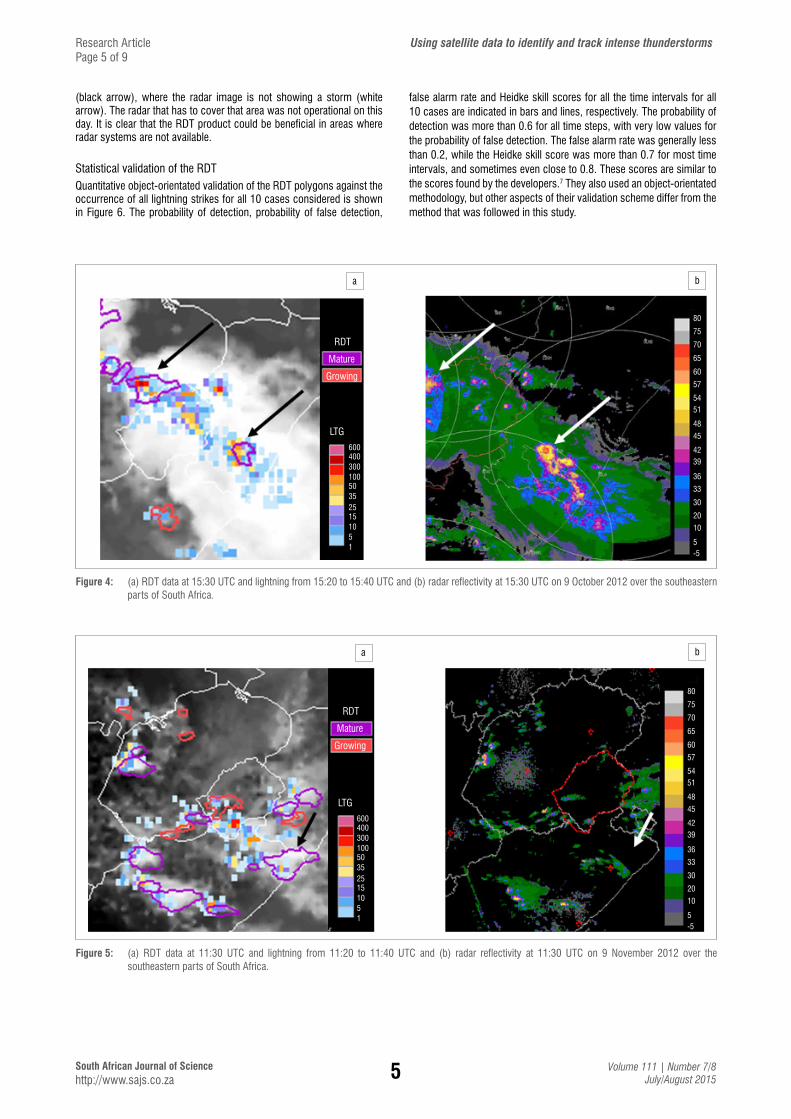
Case 3: 9 October 2012On 9 October 2012, a cold front passed over the country. The associated trough formed a convergent region that encouraged convective activity. Convective storms started to develop around 10:00 UTC over the central and eastern parts of the country, and later developed into well-organised convective systems. The squall lines produced cirrus outflow and caused much stratiform cloud in association with the line. In Figure 4, it can be seen that areas with higher amounts of lightning corresponded well with the RDT polygons for mature storms at 15:30 UTC. The storms indicated by the RDT coincided with the most intense convective cells within the radar imagery. This case demonstrates how the RDT product can complement the radar data.
Case 4: 9 November 2012On 9 November 2012, a surface trough extended from the northern parts of Namibia to a low-pressure system over the central interior of South Africa, with a high-pressure system east of the country. All the RDT polygons depicted on the image (Figure 5a) were associated with lightning at 11:30 UTC. The radar image (Figure 5b) indicates that the mature storms (purple polygons) correspond well with the areas of high reflectivity. The RDT identified a mature storm with lightning
Figure 2: RDT data at 15:30 UTC overlaid with lightning strikes from 15:20 to 15:40 UTC on 10 December 2012.
a b
RDT
LTG
MatureGrowing
600
807570656057
54
51
48
45
4239363330
20
10
-5
5
400300100503525151051
Figure 3: (a) RDT data at 12:30 UTC and lightning from 12:20 to 12:40 UTC and (b) radar reflectivity at 12:30 UTC on 23 June 2012 over the central part of South Africa.
Research Article Using satellite data to identify and track intense thunderstormsPage 4 of 9
RDT for 20121210 at 1530Z
RDT
LTG
MatureGrowing
600
225
235
245
255
365
275
285
295
305
315
325
335
345
355
16E 18E 20E 22E 24E 26E 28E 30E 32E 34E
400300100503525151051
5South African Journal of Science http://www.sajs.co.za
Volume 111 | Number 7/8July/August 2015
(black arrow), where the radar image is not showing a storm (white arrow). The radar that has to cover that area was not operational on this day. It is clear that the RDT product could be beneficial in areas where radar systems are not available.
Statistical validation of the RDT Quantitative object-orientated validation of the RDT polygons against the occurrence of all lightning strikes for all 10 cases considered is shown in Figure 6. The probability of detection, probability of false detection,
false alarm rate and Heidke skill scores for all the time intervals for all 10 cases are indicated in bars and lines, respectively. The probability of detection was more than 0.6 for all time steps, with very low values for the probability of false detection. The false alarm rate was generally less than 0.2, while the Heidke skill score was more than 0.7 for most time intervals, and sometimes even close to 0.8. These scores are similar to the scores found by the developers.7 They also used an object-orientated methodology, but other aspects of their validation scheme differ from the method that was followed in this study.
a b
RDT
LTG
Mature
Growing
600400300100503525151051
80
75
70
65
60
57
5451
48
45
4239
36
33
30
20
10
-55
Figure 4: (a) RDT data at 15:30 UTC and lightning from 15:20 to 15:40 UTC and (b) radar reflectivity at 15:30 UTC on 9 October 2012 over the southeastern parts of South Africa.
a b
RDT
Mature
Growing
LTG
600400300100503525151051
80
75
70
65
60
57
5451
48
45
4239
36
33
30
20
10
-55
Figure 5: (a) RDT data at 11:30 UTC and lightning from 11:20 to 11:40 UTC and (b) radar reflectivity at 11:30 UTC on 9 November 2012 over the southeastern parts of South Africa.
Research Article Using satellite data to identify and track intense thunderstormsPage 5 of 9
6South African Journal of Science http://www.sajs.co.za
Volume 111 | Number 7/8July/August 2015
Average of 10 cases (all lightning)
0.0
0.1
0.2
0.3
0.4
0.5
0.6
0.7
0.8
0.9
1.011
00
1105
1130
1145
1200
1500
1215
1515
1230
1530
1245
1545
1300
1600
1315
1615
1330
1630
1345
1645
1400
1700
1415
1715
1430
1730
1445
1745
1800
POD
POFD
FAR
HSS
Figure 6: Probability of detection (POD, blue), probability of false detection (POFD, orange), false alarm rate (FAR, green) and Heidke skill score (HSS, yellow) for the validation of the growing and mature RDT polygons against the lightning occurrence from 11:00 to 18:00 UTC for all 10 cases.
Research Article Using satellite data to identify and track intense thunderstormsPage 6 of 9
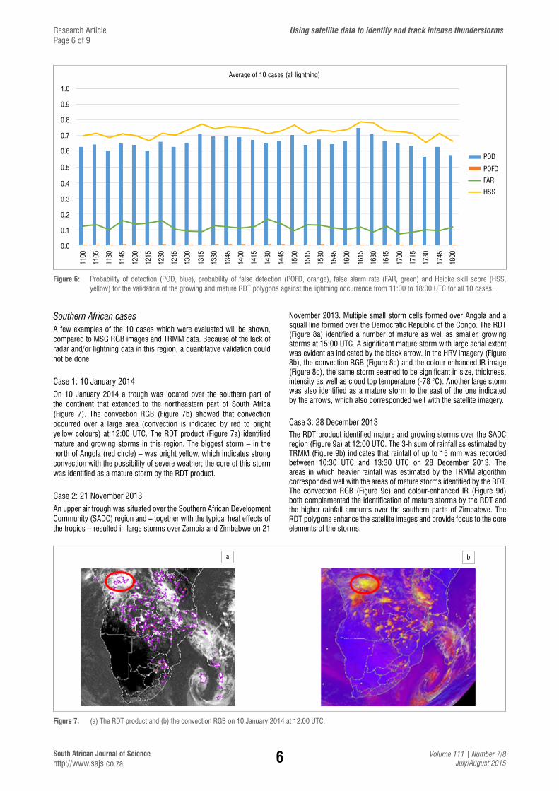
Southern African casesA few examples of the 10 cases which were evaluated will be shown, compared to MSG RGB images and TRMM data. Because of the lack of radar and/or lightning data in this region, a quantitative validation could not be done.
Case 1: 10 January 2014On 10 January 2014 a trough was located over the southern part of the continent that extended to the northeastern part of South Africa (Figure 7). The convection RGB (Figure 7b) showed that convection occurred over a large area (convection is indicated by red to bright yellow colours) at 12:00 UTC. The RDT product (Figure 7a) identified mature and growing storms in this region. The biggest storm – in the north of Angola (red circle) – was bright yellow, which indicates strong convection with the possibility of severe weather; the core of this storm was identified as a mature storm by the RDT product.
Case 2: 21 November 2013An upper air trough was situated over the Southern African Development Community (SADC) region and – together with the typical heat effects of the tropics – resulted in large storms over Zambia and Zimbabwe on 21
a b
Figure 7: (a) The RDT product and (b) the convection RGB on 10 January 2014 at 12:00 UTC.
November 2013. Multiple small storm cells formed over Angola and a squall line formed over the Democratic Republic of the Congo. The RDT (Figure 8a) identified a number of mature as well as smaller, growing storms at 15:00 UTC. A significant mature storm with large aerial extent was evident as indicated by the black arrow. In the HRV imagery (Figure 8b), the convection RGB (Figure 8c) and the colour-enhanced IR image (Figure 8d), the same storm seemed to be significant in size, thickness, intensity as well as cloud top temperature (-78 °C). Another large storm was also identified as a mature storm to the east of the one indicated by the arrows, which also corresponded well with the satellite imagery.
Case 3: 28 December 2013The RDT product identified mature and growing storms over the SADC region (Figure 9a) at 12:00 UTC. The 3-h sum of rainfall as estimated by TRMM (Figure 9b) indicates that rainfall of up to 15 mm was recorded between 10:30 UTC and 13:30 UTC on 28 December 2013. The areas in which heavier rainfall was estimated by the TRMM algorithm corresponded well with the areas of mature storms identified by the RDT. The convection RGB (Figure 9c) and colour-enhanced IR (Figure 9d) both complemented the identification of mature storms by the RDT and the higher rainfall amounts over the southern parts of Zimbabwe. The RDT polygons enhance the satellite images and provide focus to the core elements of the storms.

7South African Journal of Science http://www.sajs.co.za
Volume 111 | Number 7/8July/August 2015
a
c
b
d
R108
43.00
48.00
53.00
58.00
63.00
68.00
73.00
78.00
Figure 8: Images for (a) RDT, (b) HRV RGB, (c) convective storms RGB and (d) IR 10.8 colour-enhanced imagery on 21 November 2013 at 15:00 UTC over the central parts of Africa.
Research Article Using satellite data to identify and track intense thunderstormsPage 7 of 9
a cb d
R10843.00
48.00
53.00
58.00
63.00
68.00
73.00
78.00
60
50
30
20
15
7
5
3
2
1
Figure 9: Images for (a) RDT, (b) 3-h TRMM rainfall, (c) convection RGB and (d) IR 10.8 colour-enhanced imagery on 28 December 2013 at 12:00 UTC over the central parts of Africa.

8South African Journal of Science http://www.sajs.co.za
Volume 111 | Number 7/8July/August 2015
ConclusionsWarning the public about pending severe weather events saves lives as well as property – and is the mandate of all operational weather services. The identification and tracking of thunderstorms is a bigger challenge in data sparse regions than in areas in which expensive and extensive ground and remote observation networks exist. The RDT software, which was developed by the NWC SAF, was installed in South Africa during 2014. Initial tests of 10 cases over the South African domain and 10 cases over the southern African domain show encouraging results indicating that the RDT product can be used to identify the more intense part of thunderstorms using mainly data from the geostationary MSG satellite.
Over the South African domain, the RDT product could be compared to radar images and it was shown that the two products complemented one another in regions where both satellite and radar data are available. Lightning data from the SALDN were used to do a quantitative object-orientated validation to measure how well the RDT polygons for mature and growing storms match the occurrence of lightning. Contingency table scores indicated very good results when RDT polygon-objects were matched with lightning objects. The Heidke skill score often exceeded 0.6 and even 0.7 between 13:00 and 17:00 UTC, which is the most convective part of the day.
Over the southern African domain, adequate lightning data to do quantitative validation are not readily available. Some global lightning networks that cover the southern African region exist, but have a very low detection efficiency, which would not be useful in quantitative validation studies. Some examples of visual comparisons are shown in which the RGB combinations of satellite channels (which highlight convective activity) were used to validate the RDT storms. TRMM rainfall estimates were also used to show that higher rainfall amounts occurred in areas designated as mature storms by the RDT product. Over the southern African domain, it was shown that the RDT could add value to the satellite images to identify the more intense parts of the thunderstorms over regions where very little other data exist.
The 2013 version of the RDT product has been running operationally at SAWS since September 2014. Although this software is used extensively in European weather services, South Africa is, to our knowledge, the only African country to run this software locally and operationally. RDT products are updated every 15 min (similar to the satellite data) and are now available to operational forecasters in South Africa as well as southern African through websites designated for the purpose of nowcasting and forecasting. Initial workshops to demonstrate the new tool to general and aviation forecasters resulted in a very positive response, especially for regions in South Africa that are not covered by the radar network and for the southern African region.23-26 Validation of the RDT will be an ongoing project, and statistics will be gathered over a longer period, such as months and seasons. The NWC SAF regularly updates their software to improve on the products and to address the needs expressed by the users. The next upgrade is planned for 2015. The latest release of the software will be downloaded and installed when it is available. SAWS is in the process of updating and upgrading their local version of the UM. This upgrade will include not only better physics, but also higher resolution. The plan is to run a 4-km resolution version of the UM over the southern African domain and perhaps even a 1.5-km resolution window over South Africa. Improvements in the NWP input will also benefit the RDT product. During 2015, we also plan to add lightning data as an additional input to the RDT product over South Africa, which, according to the developers, will lead to an improvement in the RDT product. We are convinced that this geostationary satellite-based methodology can play a role in assisting in the identification and tracking of rapidly developing and intense thunderstorms in an operational environment, especially over data sparse regions (outside South Africa). This product could benefit not only nowcasting procedures, but also clients in the aviation industry.
AcknowledgementsWe thank the Water Research Commission for funding the research done to implement and validate the RDT product presented in this paper. Cassandra Pringle was part of the project team until March 2013, when she resigned from SAWS; her contribution to the case studies is appreciated. Regular interaction with the help desk of the NWC SAF contributed to the successful installation of the software. We are also grateful for the interaction with Frederic Autones from Meteo-France, one of the developers of the RDT product, which guided us in the installation of the RDT product. Guidance on the use of object-orientated validation for the SpatialVx package was provided by Beth Ebert (Bureau of Meteorology, Australia) and Eric Gilleland (NCAR, USA).
Authors’ contributionsE.d.C. was the project leader, M.G. was responsible for the display and validation methodology, B.M. worked on the case studies and L.v.H. was responsible for implementing the software on local servers. E.d.C. wrote the manuscript.
References1. De Coning E. Satellite applications for very short range weather forecasting
systems in southern African developing countries. In: Gardiner S, Olsen KP, editors. Recent advances in satellite research and development. New York: Nova Science Publishers; 2013. p. 67–92.
2. Global Humanitarian Forum. Weather info for all initiative 2008-2012 [document on the Internet]. No date [cited 2014 Nov 13]. Available from: http://publicintelligence.info/WIFA_Project_Outline_Executive_Summary.pdf.
3. WMO CBS Steering Group SWFDP. Fourth meeting, Geneva, Switzerland, February 2012 [document on the Internet]. c2012 [cited 2014 Nov 07]. Available from: https://www/wmo/int/pages/prog/www/CBS-Reports/documents/SG-SWFDP-4_Final_Report.pdf.
4. Nowcasting Satellite Application Facilities [homepage on the Internet]. No date [cited 2014 Nov 07]. Available from: http://www.eumetsat.int/website/home/Satellites/GroundSegment/Safs/index.html.
5. Algorithm theoretical basis document for 'Rapid Development Thunderstorms' (RDT-PGE11 v2.3) SAF/NWC/CDOP/MFT/SCI/ATBD/11, Issue 2, Rev. 3, Applicable to SAFNWC/MSG version 2012 [homepage on the Internet]. No date [cited 2014 Nov 07]. Available from: https://www.nwcsaf.org/HD/Main.jsp.
6. Weber ME, Evans JE, Moser WR, Newell OJ. Air traffic management decision support during convective weather. Linc Lab J. 2007;16 (2):263–275.
7. Validation report for Rapidly Developing Thunderstorms (RDT-PGE11 v3.0). SAF/NWC/CDOP/MFT/SCI/ATBD/11, Issue 3, Rev. 0, Applicable to SAFNWC/MSG version 2013 [homepage in the Internet]. No date [cited 2014 Nov 07]. Available from: https://www.nwcsaf.org/HD/Main.jsp.
8. Price C. Lightning sensors for observing, tracking and nowcasting severe weather. Sensors. 2008;8:157–170. http://dx.doi.org/10.3390/s8010157
9. Weiss SA, MacGorman DR, Calhoun KM. Lightning in the anvils of supercell thunderstorms. Mon Wea Rev. 2012;140:2064–2079. http://dx.doi.org/10.1175/MWR-D-11-00312.1
10. Carey LD, Buffalo KM. Environmental control of cloud-to-ground lightning polarity in severe storms. Mon Wea Rev. 2007;135:1327–1353. http://dx.doi.org/10.1175/MWR3361.1
11. Gijben M. The lightning climatology of South Africa. S Afr J Sci. 2012;108(3/4):44–53. http://dx.doi.org/10.4102/sajs.v108i3/4.740
12. MSG channels interpretation guide: Weather, surface conditions and atmospheric constituents [homepage on the Internet]. No date [cited 2014 Nov 07]. Available from: http://eumetrain.org/IntGuide/.
13. Price CG. Lightning applications in weather and climate research. Surv Geophys. 2013;34(6):755–767. http://dx.doi.org/10.1007/s10712-012-9218-7
14. Ebert EE. Fuzzy verification of high resolution gridded forecasts: A review and proposed framework. Meteorol Appl. 2008;15:51–64. http://dx.doi.org/10.1002/met.25
15. The R project for statistical computing [homepage on the Internet]. No date [cited 2014 Nov 14]. Available from: http://www.r-project.org/.
Research Article Using satellite data to identify and track intense thunderstormsPage 8 of 9

9South African Journal of Science http://www.sajs.co.za
Volume 111 | Number 7/8July/August 2015
16. Package 'Spatial Vx' [document on the Internet]. c2014 [cited 2014 Nov 14]. Available from: http://cran.r-project.org/web/packages/SpatialVx/SpatialVx.pdf
17. Davis CA, Brown BG, Bullock RG. Object-based verification of precipitation forecasts, Part I: Methodology and application to mesoscale rain areas. Mon Wea Rev. 2006;134:1772–1784. http://dx.doi.org/10.1175/MWR3145.1
18. Davis CA, Brown BG, Bullock RG, Halley Gotway J. The method for object-based diagnostic evaluation (MODE) applied to numerical forecasts from the 2005 NSSL/SPC Spring Program. Wea Forecsting. 2009;24:1252–1267. http://dx.doi.org/10.1175/2009WAF2222241.1
19. Gilleland E, Lee TCM, Halley Gotway J, Bullock RG, Brown BG. Computationally efficient spatial forecast verification using Baddeley's delta image metric. Mon Wea Rev. 2008;136:1747–1757. http://dx.doi.org/10.1175/2007MWR2274.1
20. Wernli H, Paulat M, Hagen M, Frei C. SAL – A novel quality measure for the verification of quantitative precipitation forecasts. Mon Wea Rev. 2008;136:4470–4487. http://dx.doi.org/10.1175/2008MWR2415.1
21. Wernli H, Hofmann C, Zimmer M. Spatial forecast verification methods intercomparison project: Application of the SAL technique. Wea Forecasting. 2009;24:1472–1484. http://dx.doi.org/10.1175/2009WAF2222271.1
Appendix
White
Cirrus
Land Sea
Ns / CbAc
Low cloud
Description of colour interpretation for the high-resolution visible red-green-blue (HRVRGB) imagery.12
Ocean Land
Deep precipitating cloud (precipitation not necessarily reaching the ground)
� high-level cloud
� large ice particles
Deep precipitating cloud (Cb cloud with strong updrafts and severe weather)*
� high-level cloud
� small ice particles
* or thick, high-level lee cloudiness with small ice particles
Thin cirrus cloud(large ice particles)
Thin cirrus cloud(small ice particles)
Description of the colour interpretation for the convection red-green-blue colour palette.12
Research Article Using satellite data to identify and track intense thunderstormsPage 9 of 9
22. Wilks DS. Statistical methods in the atmospheric sciences. London: Academic Press; 1995.
23. Maseko B, Pringle C, Gijben M. Preliminary results of the rapidly developing thunderstorm product in South Africa. In: Proceedings of the 29th South African Society for Atmospheric Scientists; 2013 Sept 26–27; Shaka’s Rock, KwaZulu-Natal, South Africa. p. 44.
24. Gijben M, De Coning E, Van Hemert L, Maseko B, Pringle C. The Rapidly Developing Thunderstorm product – Results of case studies and future plans. In: Proceedings of the 30th South African Society for Atmospheric Scientists; 2014 Oct 8–10; Potchefstroom, South Africa. p. 33.
25. De Coning E, Gijben M, Maseko B, Pringle C, Van Hemert L. Using the Nowcasting SAF products over South Africa and southern Africa to enhance nowcasting capabilities in data sparse regions. In: Proceedings of the 11th EUMETSAT African User Forum; 2014 Aug 8–12; Johannesburg, South Africa.
26. De Coning E. Improving nowcasting techniques in data sparse regions using the Nowcasting SAF products. Paper presented at: Severe Weather Forecasting Demonstration Project Southern Africa – Training workshop on severe weather forecasting; 2014 Nov 3–7; Pretoria, South Africa.