Urban Green Spaces for Quality Life - CBS Research Portal
528
Urban Green Spaces for Quality Life Case Study: The Landscape Architecture for People in Copenhagen Yang, Binzhang Document Version Final published version Publication date: 2013 License CC BY-NC-ND Citation for published version (APA): Yang, B. (2013). Urban Green Spaces for Quality Life: Case Study: The Landscape Architecture for People in Copenhagen. Copenhagen Business School [Phd]. PhD series No. 39.2013 Link to publication in CBS Research Portal General rights Copyright and moral rights for the publications made accessible in the public portal are retained by the authors and/or other copyright owners and it is a condition of accessing publications that users recognise and abide by the legal requirements associated with these rights. Take down policy If you believe that this document breaches copyright please contact us ([email protected]) providing details, and we will remove access to the work immediately and investigate your claim. Download date: 26. Jul. 2022
-
Upload
khangminh22 -
Category
Documents
-
view
0 -
download
0
Transcript of Urban Green Spaces for Quality Life - CBS Research Portal

Urban Green Spaces for Quality LifeCase Study: The Landscape Architecture for People in CopenhagenYang, Binzhang
Document VersionFinal published version
Publication date:2013
LicenseCC BY-NC-ND
Citation for published version (APA):Yang, B. (2013). Urban Green Spaces for Quality Life: Case Study: The Landscape Architecture for People inCopenhagen. Copenhagen Business School [Phd]. PhD series No. 39.2013
Link to publication in CBS Research Portal
General rightsCopyright and moral rights for the publications made accessible in the public portal are retained by the authors and/or other copyright ownersand it is a condition of accessing publications that users recognise and abide by the legal requirements associated with these rights.
Take down policyIf you believe that this document breaches copyright please contact us ([email protected]) providing details, and we will remove access tothe work immediately and investigate your claim.
Download date: 26. Jul. 2022

Binzhang YANG
The PhD School of Economics and Management PhD Series 39.2013
PhD Series 39.2013
Urban G
reen Spaces for Quality Life
copenhagen business schoolhandelshøjskolensolbjerg plads 3dk-2000 frederiksbergdanmark
www.cbs.dk
ISSN 0906-6934
Print ISBN: 978-87-92977-90-8Online ISBN: 978-87-92977-91-5
Urban Green Spaces for Quality Life - Case Study: the landscape architecture for people in Copenhagen

1
Urban Green Spaces for Quality Life - Case Study: the landscape architecture for people in Copenhagen
Binzhang YANG
Supervisors: Prof. Verner D. Worm
Prof. Lise Lyck
Centre for Tourism and Culture Management, Copenhagen Business School

Binzhang YANGUrban Green Spaces for Quality Life - Case Study: the landscape architecture for people in Copenhagen
1st edition 2013PhD Series 39.2013
© The Author
ISSN 0906-6934
Print ISBN: 978-87-92977-90-8Online ISBN: 978-87-92977-91-5
“The Doctoral School of Economics and Management is an active national and international research environment at CBS for research degree studentswho deal with economics and management at business, industry and countrylevel in a theoretical and empirical manner”.
All rights reserved.No parts of this book may be reproduced or transmitted in any form or by any means,electronic or mechanical, including photocopying, recording, or by any informationstorage or retrieval system, without permission in writing from the publisher.

English Foreword
1
English Foreword
The entering of the 21st Millennium marked a new era of development for our
civilization and society where mankind is paying to greater extents attention to
their living condition, living environment, life style and life quality. Therefore, the
sustainable development concept is deeply understood and accepted by the
broader public, and is manifested in various aspects and fields.
China and Denmark are two countries with tremendously distinctive disparity,
one being huge in geographical scale but behind in development while the other
one being small but leading in development; one making effort for achieving
industrialization and urbanization while the other one already experiencing
post-industrialism, post-modernism and post-urbanism. Currently, China is at the
stage of rapid development of industrialization and urbanization. Due to historical
and cultural reasons as well as economic and infrastructural limitations, China is
confronted with inherent and man-made issues not only in the planning but also in
the construction of urban green spaces. Thus, by learning the successful practices
and experiences from developed countries such as Demark and using them as
references, China would benefit profoundly in terms of changing the current urban
green space structure, promoting the urban environmental quality and improving
people’s living standards. Based on the above-mentioned thinking, this research
utilizes Copenhagen as a case study focusing on following research questions: 1)
how it ensures systematic and orderly development through the use of the urban
planning; how it builds green barriers for the urban area through preservation of
farm land, wood land and other natural areas; 2) how it creates diversified types of
urban green space through planning and design methodologies of landscape
architecture, and provides a pleasant working and living environment to its
citizens as well as promotes the city’s life quality and image.

Urban Green Spaces for Quality Life
2
During the process of defining the research direction, I have gained kind help
from my supervisors Professor Lise Lyck and Professor Verner Worm, as well as
the support from the Head of Doctoral School, Professor Ms. Danna B. Minbaeva
and the coordinator of doctoral group in Marketing Department, Professor Torsten
Ringberg. This dissertation is a result of my research works which mainly derives
from my academic publications in the past few years based on observation,
investigation, consideration and field study of the developing history and
achievements of Danish Landscape Architecture in modern time. It includes the
following sections: 1) the research of the Copenhagen “Finger Plan” related to its
background, evolution, development and current condition; 2) the research of the
urban park design, Harbor Park in Copenhagen as a case study; 3) the study on the
developing history and artistic features of children’s playgrounds in Copenhagen;
4) the research on the development and current condition of cemetery in
Copenhagen as a type of green space; 5) the research of the philosophy and
representation methods in Danish landscape architects’ designs. According to the
initial research plan, an additional number of papers should also have been
published focusing on special types of landscape design such as the college
campus, the hospital outdoor space, urban parks, residential areas as well as a
further study of certain Danish famous landscape architects and scholars in this
area. Unfortunately, these works have not been completed due to the limitation of
time and personal ability, which is a pity. Nevertheless, I will continue to explore
these research areas after I finish my work at CBS. Even though this dissertation
does not provide a complete picture of every aspect of the Danish landscape
architecture, it is able to provide contents for study and reference.
Looking back at the journey of learning and research in the past few years, it
contains joy and happiness as well as pain and confusion. I was absolutely
attracted by this so-called “Fairytale Kingdom”, since I first arrived in 1996. As I

English Foreword
3
established better knowledge of the country, a strong wish for obtaining a doctoral
degree here was fostered in my mind. However, the opportunity did not come
easily. In 2004, I received a chance to do research work at the Centre for Tourism
and Culture Management (TCM) in Copenhagen Business School (CBS) as a
guest scholar. The favorable working conditions and strong academic atmosphere
encouraged me to reconsider the PhD dream, which I in May 2005 expressed to
Prof. Lise Lyck and gained her kind support. However, due to strong competition
for application, I was not offered an opportunity. In Feb. 2006, I submitted my
application to the Department of Geography in Roskilde University, and received
to my surprise a positive response from Prof. Michael Haldrup on Feb 13th. In the
meanwhile, Lise did not stop her effort to help me apply for the PhD. position.
Finally, I received an official letter signed by Mr. Finn Junge-Jensen, the former
president of CBS, on 28th March, 2006 informing me that I have been accepted as
a PhD student by the CBS Doctor Selection Committee and that the register time
started on 1st April, 2006. Having just passed my 46th birthday, my journey for a
PhD degree began. On one hand, the source of joy and happiness in study and
research comes from the help and support by my family, supervisors, friends and
colleagues, as well as the excitement of acquiring new knowledge and making
continual progress for the research work. On the other hand, the pain and
confusion in this process were caused by the hardship of exploring new academic
territories and the tremendous stress that was present. Fortunately, I have finally
completed this tough journey with the encouragement and support from my family
members, supervisors and colleagues.
I would like to use this opportunity to express my sincere gratitude to my
family members; to Mr. Finn Junge-Jensen, the former president of Copenhagen
Business School; to Prof. LI Jian, former headmaster of my home university,
current headmaster Prof. YANG Chuanping, vice headmaster CAO Jun in

Urban Green Spaces for Quality Life
4
Northeast Forestry University (NEFU), China; to Dean of School of Landscape
Architecture (SLA) at NEFU, Prof. XU Dawei; Chairman of SLA Board, Prof.
WU Jianping, thanks for their powerful support and help in those years. My thanks
also goes to Prof. Peder Boas Jensen from School of Architecture at the Royal
Academy of Fine Arts; to Prof. Jatt Abel from Faculty of Life Sciences at
Copenhagen University; to the Danish landscape architects Mr. Jeper Aargaar
Anderson, Mr. Stig L Andersson, Mrs. Hellen Nebelong, Mrs. Annemarie Lund
and all the friends in the Center of Park administration in Copenhagen
Municipality. I would also like to thank my colleagues and friends, Mrs. Susanne
Faurholdt, Mr. Kristian Hvass, Mr. Kasper Vind Teilman and Mrs. Lene Granzau
Jacobsen. I want to send my special thanks to Mr. WU Hua, the former first
secretary of education section in the Chinese embassy in Denmark, who helped me
to gain the Cirrus Founding. Moreover, I need to thank my student Miss ZHAO
Chunli, who helped me with picture editing and typing. Last but not least, the most
sincere gratitude to my supervisor Prof. Lise Lyck, it would not be possible for me
to finish my dissertation without her firm support and powerful help. And the
same special thanks to my supervisor Prof. Verner Worm, the review of the
dissertation and the final defense cannot run smoothly without his help. In addition,
I should express my deep gratitude to the members of the committee and their
work.
Binzhang YANG
Jan 20, 2012 Copenhagen, Denmark
November 8, 2013, Harbin, China

Dansk Forord
1
Dansk Forord
Indtræden i det nye millenium markerede begyndelsen på en ny
udviklingsfase i menneskehedens civilisation og samfund, hvor vi retter i stigende
grad blikket mod egne levevilkår, levestil, livskvalitet og livsmiljø. Derfor er
konceptet af bæredygtige udvikling blevet i mere omfattende forstand forstået og
accepteret af den brede befolkning, og kommer til udtryk i adskillige aspekter og
områder.
Kina og Danmark er to yderst forskellige lande, det ene er stor i geografisk
scala men bagud i udvikling, mens det andet er lille i størrelse men førende i
udvikling, det ene arbejder hårdt for at opnå industrialisering og urbanisering,
mens det andet allerede befinder sig i post-industrialisering, post-modernisering
og post-urbanisering. Grundet historiske, kulturelle såvel som økonomiske og
infrastrukturelle begræsninger konfronteres Kina med naturlige og
menneske-skabte udfordringer ikke blot i forbindelse med planlægningen men
også i forbindelse med konstruktionen af urbane grønne områder. Ved at tage ved
lære af de successrige erfaringer fra i-lande som Danmark, vil det uden tvivl gavne
Kina enormt på punkter såsom omstrukturering af nuværende urbane grønne
områder, fremme kvalitet af bymiljø og forbedring af menneskers levestandarder.
På baggrund af denne anskuelse anvendes der i dette forskningsarbejde
København som et case-study til at undersøge følgende: 1) hvordan der sikres en
systematisk og ordentlig udvikling af byen ved brug af byplanlægning; hvordan
byens grønne barrierer er dannet ved fredning og bevaring af landbrugs arealer,
skove og andre naturområder; 2) hvordan der skabes forskelligartet urbane grønne
områder i byen ved landskabsarkitektonisk planlægning og design metoder,

Urban Green Spaces for Quality Life
2
hvorfra der leveres et attraktivt arbejds- og livsmiljø for dens indbyggere og
fremme dens livslvalitet og omdømme.
Under forløbet hvor denne afhandlings forskningsområde blev fastlagt, har
jeg fået hjælp fra mine vejledere Professor Lise Lyck og Professor Verner Worm,
og støtte fra the Dean of Doctoral School, Professor Ms. Danna B. Minbaeva og
Ph.D. koordinator i Institut for Afsætningsøkonomi Professor Torsten Ringbjerg.
Denne afhandling er resultatet af mit forskningsarbejde, hvilket er primært baseret
på mine publicerede videnskabelige artikler i de sidste få år, og skrevet ud fra
iagtagelser, undersøgelser, overvejelser og feltstudier omkring udviklingshistorien
og værkerne af den danske landskabsarkitektur i nyere tid. Afhandlingen
indeholder følgende afsnit, 1) forskningen omkring Københavns Fingerplan med
henblik på dens baggrund, udvikling og aktuelle forhold; 2) forskningen omkring
urbant parkdesign hvor Havneparken i Islands Brygge anvendes som et casestudie;
3) forskningen omkring udviklingshistorien og de æstetiske og kunstneriske træk
i de københavnske legepladser; 4) forskningen omkring udviklingen af og de
aktuelle forhold på københavnske kirkegårde som grønt område; 5) forskningen
omkring filosofien og repræsentationsmetoderne i de danske landskabsarkitekters
værker. Ifølge den første forskningsplan skulle et yderligere antal artikler
publiceres med fokus rettet mod særlige kategorier af landskabsdesign såsom
universitetscampusser, udendørs områder tilhørende hospitaler, urbane parker,
beboelsesområder og et dybtgående studie af kendte danske landskabsarkitekers
værker i dette område. Dette arbejde er dog ikke blevet fuldført på grund af
tidsmæssige og personlige begræsninger, hvilket er ærgerligt. Ikke desto mindre
vil jeg fortsætte med at forske i disse faglige områder efter arbejdet på CBS.
Selvom denne afhandling ikke tilvejebringer et fyldestgørende billede på ethvert
aspekt indenfor den danske landskabsarkitektur, kan dens indhold benyttes til
læring og som reference.

Dansk Forord
3
Når jeg ser tilbage på lærings- og forskningsrejsen i de seneste år indebærer
den både glæde og lykke og smerte og forvirring. Jeg følte fuldstændigt tiltrukket
til dette såkaldte ”eventyrland”, lige siden min første ankomst i 1996. Efterhånden
som jeg stiftede bedre kendskab til landet, blev et stærkt ønske om at modtage en
Ph.D. grad her i landet fosteret i mit hoved. Muligheden kom dog ikke let. I 2004
fik jeg muligheden for at arbejde på Centre for Tourism and Culture Management
(TCM) på Copenhagen Business School (CBS) som gæstforsker. De attraktive
arbejdsforhold og den favorable akademiske stemning fik mig til at genoverveje
Ph.D. drømmen, hvilket jeg udtrykte til Prof. Lise Lyck og fik hendes støtte. Jeg
blev dog ikke tilbudt en plads foreløbigt. I feb. 2006 sendte jeg en ansøgning til
Institut for Geografi på Roskilde Universitetscenter, og snart modtog jeg til min
store overraskelse positivt respons fra Prof. Michael Haldrup den 13. feb.
Imellemtiden opgav Lise ikke med sin indsats for at hjælpe mig med at ansøge om
en Ph.D. stilling. Endelig modtog jeg det officielle brev, underskrevet af den
daværende rektor på CBS Hr Finn Junge-Jensen, om at jeg er blevet optaget som
Ph.D. studerende af CBS Doctor Selection Committee, og at det skulle
påbegyndes den 1. april 2006. Således startede min rejse mod en Ph.D. grad, kort
efter min 46. fødselsdag. På den ene side stammer kilden til glæde og lykke i
læring og forskning fra hjælp og støtte fra min familie, vejledere, venner og
kollegaer, og ligeledes begejstring i tilegnelse af ny viden og kontinuerlig
fremskridt i forskningsarbejdet. På den anden side stammer smerte og forvirring i
denne proces fra modgang i udforskningen af nye akademiske territorium og den
kolosale mængde stress som var til stede. Jeg har nu endelig fuldført denne hårde
rejse med hjælp og støtte fra mine familiemedlemmer, vejledere og kollegaer.
Jeg vil gerne benytte denne mulighed til at udtrykke min store
taknemmelighed til mine familiemedlemmer; den tidligere rektor på CBS Hr Finn
Junge-Jensen; Prof. LI Jian, den tidligere rektor på mit hjemme-universitet, den

Urban Green Spaces for Quality Life
4
nuværende rektor Prof. YANG Chunping, vicerektor CAO Jun på Northeast
Forestry University (NEFU), Kina; rektor på School of Landscape Architecture
(SLA) på NEFU, Prof. XU Dawei; Formand of SLA Board, tak for deres
uundværelige støtte og hjælp i disse år. Jeg vil også gerne takke Prof. Peder fra
Kunstakademiets arkitekskole, Prof. Jatt Abel fra Faculty of Life Sciences på
Københavns Universitet, den danske landskabsarkitek Hr Jeper Aargaar Anderson,
Hr Stig L Andersson, Frk Hellen Nebelong, Frk Annemarie Lund og alle vennerne
fra Center for Park og Natur i Københavns Kommune. Derudover vil jeg gerne
sige en stor tak til mine kollegaer og venner Susanne Faurholdt, Kristian Hvass,
Kasper Vind Teilman og Lene Granzau Jacobsen. Ydermere vil jeg gerne takke Hr
WU Hua, den tidligere første sekretær på Uddannelsesafdelingen på det kinesiske
ambassade i Danmark, hvis hjælp resulterede i min modtagelse af Cirrus Founding.
Endvidere er jeg nødt til at takke min studerende Frk ZHAO Chunli, som hjalp
mig med billedredigering og indtastning. Sidst men ikke mindst vil jeg udtrykke
min dybeste taknemmelighed til Prof. Lise Lyck, uden hendes urokkelige støtte og
betydningsfulde hjælp ville jeg ikke være i stand til at færdiggøre min afhandling.
Ligeledes en særdeles stor tak til min vejleder Prof. Verner Worm, uden hans
hjælp vil evalueringen af afhandlingen og det endelige Ph.D.-forsvar ikke foreløbe
problemfrit. Til sidst ønsker jeg at udtrykke min dybe taknemmelighed til
medlemmerne af bedømmelsesudvalget og deres arbejde.
Binzhang YANG
Den 20. jan. 2012, København, Danmark
November 8, 2013, Harbin, Kina

English Summary
1
English Summary
Urban green spaces have a significant impact on the balance of urban
ecosystem, the adjustment of urban environment and especially the enhancement
of urban citizens' life and work quality. A city's image and its citizens' health and
well-being is to a certain extent directly affected by whether the quantity of urban
green spaces is sufficient, whether the distribution is reasonable and whether the
functionality is complete. Therefore, the planning and construction of urban green
spaces are already being viewed as a city's green infrastructure as well as the
guarantee of a city's sustainable development.
Currently, China is on the fast track of an urbanisation process. How to
handle environmental protection and how to maintain the relationship between
ecosystem, urbanisation and city construction are crucial projects China is facing.
In this respect, developed Western countries is one step ahead of China and have
aggregated massive valuable experience which China can learn from. With this as
aim, this Ph.D. research discusses the relationship between urban green spaces and
citizens' life by studying the creation and evolvement of green spaces in
Copenhagen. The research focus is to discuss the development situation of this
city's urban green spaces and what can be learned by China.
This dissertation consists of six chapters. Chapter One is introduction and its
main content is the research background, research questions, research objectives
and research methods. The research questions include What is the Danish urban
planning system consisted of? How does Copenhagen "Finger Plan" provide
support for the development of the city and the protection of the green spaces?
What are Copenhagen's urban green spaces comprised of? Which categories and
characteristics are there? What are especially the characteristics of the special

Urban Green Spaces for Quality Life
2
types of green spaces? What are the design philosophies of the Danish
landscape architects? How are the philosophies reflected in their planning and
design work? What experiences have Copenhagen achieved for the
development of urban green spaces? Which inspirations can China gain for its
construction of urban green spaces and the development of landscape
architecture?The research methods include induction and deduction based on
literature reviews, historical studies, in-depth investigations and field observations.
At the same time, qualitative and quantitative research methods are employed.
Chapter Two presents basic concepts and theories and forms the foundation
of this research. The conducted research work is multidisciplinary and primarily
touches the urban planning discipline, the landscape architecture discipline and
other relevant social science disciplines. The research especially employs basic
concepts and theories from two disciplines, urban planning and landscape
architecture. The content of this chapter includes urban planning and landscape
architecture, urban spaces and urban green spaces, outdoor recreation and quality
of urban life, the development of urban space theory and the evolvement of urban
green spaces among others.
Chapter Three is about Copenhagen’s green barriers and discusses the
establishment planning and protection strategy of Copenhagen's green spaces. It
contains an analysis and discussion of Copenhagen Finger Plan's more than 60
years of evolvement since firstly proposed in 1947 and includes Copenhagen's
urban planning system, evolvement and characteristics. This chapter has emphasis
on especially the formation background and content of Copenhagen Finger Plan as
well as the evolvement background and process for its second to seventh version.
Chapter Four concerns Copenhagen’s green spaces and studies the
transformation of the green spaces' development in Copenhagen which is also the

English Summary
3
focus of this research. This chapter discusses in detail the transformation of urban
green spaces in Denmark, the constituents of the urban green space system in
Copenhagen and focuses on a number of categories of urban green spaces
including parks, children's playgrounds and cemeteries. Through analysis of
selected site examples, how parks, children's playgrounds and cemeteries are
planned, designed and constructed according to changes in Copenhagen's urban
development and citizens' life quality are thoroughly examined.
Chapter Five analyses the design philosophies of Danish landscape architects
and focuses on how Danish landscape architecture improves urban environment
and fulfills citizens' demand throughout the development process of urban green
spaces. It concerns landscape architects which historically have had significant
influence on the development of Danish landscape architecture and especially
focuses on two world renowned Danish landscape architects of our time, their
design concept and style.
Chapter Six deals with the inspirations which can be gained from the
development of urban green spaces in Copenhagen and is not only another
important research topic, but also the closing topic of this study. With respect to
utilising planning methods to protect urban green spaces and planning designs to
create urban green spaces, Denmark including Copenhagen have conducted its
own advantageous exploration and established its own unique practice and style
which can exactly function as the building blocks of learning and reference for
China.Therefore based on research from the previous five chapters, especially
through analysis and discussion in Chapter Two, Three, Four and Five, a number
of aspects with inspiration implications are concluded concerning China's modern
city development and urban green spaces. These include emphasising on the
scientific aspect and stability of city planning, emphasising on the significance of
Copenhagen Finger Plan's mode, emphasising on the construction of urban green

Urban Green Spaces for Quality Life
4
spaces, emphasising on the creation of landscape architecture form with national
characteristics and emphasising on the standardisation of the landscape
architecture education.
It should be mentioned that along withfurther development of China's
reformand opening-up and further accumulation of experience, along with China's
further learning and reference from developed countries, along with Chinese
scholars, planners and designers' further research of urban green spaces and better
grasp of city construction patterns, the planning, designing and building of
Chinese urban green spaces will gradually be on its way towards maturation and
success. Then more beautiful, more comfortable and more sustainable green
spaces can be provided to Chinese citizens.

Dansk Resumé
1
Dansk Resumé
Grønne områder i byen har en betydningsfuld effekt på balancen i det urbane
økosystem, reguleringen af bymiljøet og især forbedringen på indbyggeres livs- og
arbejdskvalitet. En bys image og dens indbyggeres sundhed og velvære er til en
vis grad direkte påvirket af om antallet af urbane grønne områder er tilstrækkeligt,
om fordelingen er passende og om funktionaliteten er fuldstændig. Derfor
betragtes planlægningen og opførelsen af grønne byrum allerede som en bys grøn
infrastruktur og garantien for en bys bæredygtig udvikling.
På nuværende tidspunkt befinder Kina sig på et hurtigt udviklingsspor i
urbaniseringsprocessen. Hvordan miljøbeskyttelsen håndteres og hvordan
forholdet mellem økosystem, urbanisering og konstruktion af by opretholdes er
essentielle projekter Kina konfronteres med. I denne henseende er de vestlige
I-lande foran Kina, og har samlet massivt værdifuld erfaring som Kina kan lære af.
Med udgangspunkt i dette diskuterer ph.d. studiet forholdet mellem grønne byrum
og indbyggeres liv ved at belyse opførelsen og forandringsprocessen af grønne
områder i København. Fokus i dette studie er at diskutere udviklingssituationen på
de grønne byrum, og de punkter Kina kan tage ved lære af.
Afhandlingen består af seks kapitler. Kapitel Et er en introduktion og
omhandler baggrunden for studiet, arbejdsspørgsmålene i studiet, formålet med
studiet og de anvendte metoder i studiet. De arbejdsspørgsmål som analyseres i
studiet er (1) Hvad består det danske system for byplanlægning af? Hvordan
støtter Fingerplanen Storkøbenhavns byudvikling og beskyttelse af grønne
områder? (2) Hvad består Københavns grønne områder af? Hvilke typer områder
og karakteristika er der tale om? Hvilke karakteristika repræsenterer specielle
typer grønne områder? (3) Hvilke designfilosofier bruges af de danske

Urban Green Spaces for Quality Life
2
landskabsarkitekter? Hvordan kommer filosofierne til udtryk gennem deres
planlægnings- og designarbejde? (4) Hvilke erfaringer er der opnået i København
angående udviklingen af urbane grønne områder? Hvordan kan Kina med fordel
bruge København som inspiration under opførelsen af grønne områder og i
landskabsarkitekturen? De metoder som anvendes i studiet består af induktion og
deduktion baseret på blandt andet litteraturstudier, historiske studier, dybdegående
undersøgelser og feltobservationer. Derudover er den kvalitative og kvantitative
forskningsmetode implementeret.
Kapitel To præsenterer de fundamentale koncepter og teorier, somdanner
grundlag for afhandlingen. Studiet er tværfagligt, og berørerprimært fagområder
såsom byplanlægning, landskabsarkitektur og andre relevante
samfundsvidenskabelige fagområder. Især koncepter og teorier fra de to
fagområder byplanlægning og landskabsarkitektur er brugt i denne sammenhænge.
Dette kapitel indeholder blandt andet emner som byplanlægning og
landskabsarkitektur, byrum og urbane grønne områder, udendørs rekreationer og
livskvalitet i byerne, udvikling af teorien om byrum, tilblivelse og
forandringsproces af urbane grønne områder.
Kapitel Tre handler om Købehavns grønne barrierer, og diskuterer
planlægningfor etablering og strategi for beskyttelse af Københavns grønne byrum.
Det indeholder en analyse og en diskussion af Københavns Fingerplans mere end
60-årige udvikling siden først foreslået i 1947, herunder systemet for Københavns
byplanlægning, dets udvikling og dets karakteristika. Dette kapitel har især fokus
på Købehavns Fingerplans baggrund for etablering og indhold samt baggrunden
for udvikling og udviklingsprocessen for den anden til syvende version af
Fingerplanen.
Kapitel Fire omhandler grønne byrum og analyserer ændringen i de grønne
byrums udvikling i København, hvilket er dette studies hovedfokus. dette kapitel

Dansk Resumé
3
gennemgår deltaljeret ændringen i de grønne byrum i Danmark, de
delekomponenter af det københavnske system for urbane grønne områder, og
fokuserer på en række urbane grønne områder inklusiv parker, legepladser og
kirkegårde. Gennem udvalgte eksempler er sammenhængen mellem hvordan
parker, legepladser og kirkegårde er planlagt, designet og konstrueret i forhold til
ændringen i Københavns byudvikling og indbyggeres livskvalitet er grundigt
analyseret.
Kapitel Fem analyserer danske landskabsarkitektersdesignfilosofier, og
fokuserer på hvordan danske landskabsarkitekter forbedrer bymiljø og
imødekommer indbyggeres behov gennem udviklingsprocessen af de grønne
byrum. Dette kapitel omhandler landskabsarkitekter, som historisk set har haft stor
betydning for udviklingen af dansk landskabsarkitektur, og har især fokus på to af
nutidens verdenskendte danske landskabsarkitekter, deres designkoncept og stil.
Kapitel Seks omhandler de inspirationer som kan fås fra udviklingen af de
grønne byrum i København, og er ikke kun endnu et vigtigt emne, men også det
afsluttende emne i studiet. Med hensyn til udnyttelse af planlægningsmetoder som
beskytter de grønne byrum og planlægninsdesign som skaber de grønne byrum har
Danmark, herunder København, udført dens egen fordelagtige udforskning og
etableret dens egen unikke fremgangsmåde og stil, som netop kan fungerer som
byggesten for Kinas læring og reference. Derfor baseret på studiet i de fem forrige
kapitler, især gennem analyse og diskussion i Kapitel To, Tre, Fire og Fem er en
række aspekter med implikation til inspiration konkluderet angående Kinas
moderne byudvikling og de grønne byrum. Disse inkluderer at lægge vægt på
videnskaben og stabiliteten i byplanlægning; vægt på vigtigheden af
Fingerplanmodellen; vægt på opførelsen af grønne byrum; vægt på at skabe
former for landskabsarkitektur med nationale elementer; og vægt på
standardiseringen af landskabsarkitektur-uddannelsen.

Urban Green Spaces for Quality Life
4
Det bør nævnes, at sammen med en yderligere udvikling af Kinas
åbningsreformer og yderligere akkumulering af erfaring; sammen med Kinas
yderligere læringog reference fra I-lande; sammen med kinesiske forskere,
planlæggere og designers yderligere studier af grønne byrum og bedre greb om
urbane konstruktionsmønstrer vil planlægning, design og opførelse af kinesiske
grønne byrum gradvist bevæge sig mod modning og succes. Derefter vil flottere,
mere komfortable og mere bæredygtige grønne byrum være tilgængelige for
kinesiske indbyggere.

Content
1
Content
Chapter 1 Introduction ........................................................................................... 1
1.1 Background ...................................................................................................... 1
1.2 Research questions ........................................................................................... 4
1.3 Research objectives .......................................................................................... 7
1.4 Methods of research ......................................................................................... 8
1.4.1 Literature Review ......................................................................................... 8
1.4.2 Historical Study .......................................................................................... 10
1.4.3 In-depth interview ...................................................................................... 11
1.4.4 Field Observation ....................................................................................... 13
1.5 Conclusion...................................................................................................... 14
Chapter 2 The basic concepts and theories ...................................................... 16
2.1 Introduction .................................................................................................... 16
2.2 Urban planning & Landscape architecture .................................................... 16
2.2.1 Urban planning ........................................................................................... 17
2.2.2 Landscape architecture ............................................................................... 20
2.3 Urban spaces & Urban green spaces .............................................................. 25
2.3.1 Definition of Urban space .......................................................................... 26
2.3.2 Theoretical development of urban space ................................................... 29
2.3.3 Urban green space ...................................................................................... 39
2.3.4 Developmental evolution of urban green space ......................................... 46
2.4 Outdoor recreation and quality of urban life ................................................. 60
2.4.1 Outdoor recreation ..................................................................................... 61
2.4.2 Quality of urban life ................................................................................... 68

Urban Green Spaces for Quality Life
2
Chapter 3 Backbone for Copenhagen’s urban green spaces ............................. 73
3.1 Introduction .................................................................................................... 73
3.2 The system of Danish spatial planning .......................................................... 76
3.2.1 Establishment of urban planning system in Denmark ................................ 78
3.2.2 Evaluation of urban planning in Denmark ................................................. 82
3.2.3 Content of urban planning in Denmark ...................................................... 90
3.2.4 The features of Danish city planning.......................................................... 95
3.3 Background and context for first-version of Copenhagen Finger-Plan ......... 97
3.3.1 Introduction................................................................................................. 97
3.3.2 Background of Finger-Plan proposed ....................................................... 100
3.3.3 Reasons for Finger-Plan proposed ............................................................ 103
3.3.4 Princibles and contents of Finger-Plan ..................................................... 106
3.3.5Conclusion ................................................................................................. 111
3.4 The Background and Processes of Evolution on Copenhagen Finger Plan
(Part One) ................................................................................................... 111
3.4.1Introduction................................................................................................ 112
3.4.2 Second version of Finger-Plan – planning in 50s-60s 20th Century ....... 115
3.4.3 Third version of Finger-Plan – planning in 70s, 20th Century ................ 123
3.5 The Background and Processes of Evolution on Copenhagen Finger-Plan
(Part Tow) ................................................................................................... 129
3.5.1 Fourth version of Finger-Plan – planning in 80s-90s, 20th Century ........ 129
3.5.2 From fifth to seventh version of Finger-Plan – planning in 20ty
century ................................................................................................... 135
3.6 Conclusion .................................................................................................... 144
Chapter 4 Green spaces for Copenhagen city ................................................... 146
4.1 Introduction ............................................................................................... 146
4.1.1 The evolution of Danish urban green space ............................................. 147

Content
3
4.1.2 The system of green spaces in Copenhagen ............................................ 156
4.1.3 The urban park in Copenhagen ................................................................ 160
4.1.4 Conclusion ................................................................................................ 167
4.2 Harbor Park in Copenhagen ......................................................................... 170
4.2.1 The historical back ground ....................................................................... 171
4.2.2 The site analysis ....................................................................................... 173
4.2.3 The design of park .................................................................................... 175
4.2.4 The inspirations from Harbor Park .......................................................... 182
4.2.5 Conclusion ................................................................................................ 185
4.3 Features Analysis of the Design Art in Danish Cemetery ........................... 185
4.3.1 Introduction .............................................................................................. 186
4.3.2 The principles for cemetery ..................................................................... 188
4.3.3 The forms of cemetery ............................................................................. 193
4.3.4 The plant design for cemetery .................................................................. 196
4.3.5 Conclusion ................................................................................................ 202
4.4 The Historical Development of Danish Playground and Inspirations from
it .................................................................................................................. 202
4.4.1 The development history of Danish playground ...................................... 203
4.4.2 The impacts and contributions of Danish playground ............................. 213
4.4.3 The inspirations from Danish playground development .......................... 218
4.4.4 Conclusion ................................................................................................ 220
4.5 Analysis of Design Art in Danish Children Playground ............................. 220
4.5.1 Introduction .............................................................................................. 221
4.5.2 The kinds of playground .......................................................................... 222
4.5.3 The principles for playground design ...................................................... 225
4.5.4 The patters of playground design ............................................................. 230
4.5.5 Conclution ................................................................................................ 236

Urban Green Spaces for Quality Life
4
Chapter 5 The philosophies of Danish landscape architects ......................... 237
5.1 Introduction .................................................................................................. 237
5.1.1Erik Erstad-Jøgensen’s contribution to the garden art .............................. 240
5.1.2 G. N. Brandt’s contribution to garden art .............................................. 242
5.1.3 C. T. Sørensen’s contribution to Danish garden art .............................. 246
5.2 Philosophy and Its Expression in J. A. Andersen’s Landscape Design
Works .......................................................................................................... 251
5.2.1 Introduction............................................................................................... 251
5.2.2 The style of design: simple forms ............................................................ 253
5.2.3 The ideals of design: human dimension ................................................... 256
5.2.4 The languages of design: harmonious delication ..................................... 259
5.2.5 The design of principles: natural integration ............................................ 261
5.2.6 Conclution................................................................................................. 263
5.3 Philosophy and Its Expression of Landscape Architecture in S. L.
Andersson’s Design Works ........................................................................ 264
5.3.1 Introduction............................................................................................... 264
5.3.2 Philosophy of landscape architecture in S. L. Andersson’s design
works ...................................................................................................... 266
5.3.3 Artistic approaches of landscape architecture in S. L. Andersson’s design
works ...................................................................................................... 273
5.3.4 Conclusion ................................................................................................ 280
Chapter 6 Inspirations from the development of urban green spaces in
Copenhagen ...................................................................................... 282
6.1 Introduction .................................................................................................. 282
6.2 Concerning scientific and steadiness for urban planning ............................. 284
6.3 Concerning significance of the Finger Planning modal for China ............... 288
6.4 Concerning the construction of urban green spaces ..................................... 295

Content
5
6.4.1 Great efforts to strengthening the construction of urban green space ..... 296
6.4.2 Great efforts to strengthening the protection of urban green space ......... 302
6.4.3 Great efforts to strengthening the design work of urban green space ..... 306
6.5 Concerning for creating a landscape architecture style with native
features ....................................................................................................... 308
6.5.1 Path for neo-Chinese style: historic fortuity and era certainity ............... 308
6.5.2 Connotation for neo-Chinese style: native characters and era features ... 311
6.5.3 Path for neo-Chinese style: exterior integration and interior innovation 313
6.5.4 Conclusion ................................................................................................ 318
6.6 Concerning the normative construction on landscape architecture
education .................................................................................................... 318
6.6.1 Premise for the educational normative: consensus in the positioning ..... 321
6.6.2 Basis for the educational normative: demand in the workplace .............. 324
6.6.3 Content for educational normative: Diversity in unity ............................ 327
6.6.4 Process for educational normative: Progress in exploration .................... 328
6.6.5 Conclusion ................................................................................................ 330
Danish Version in Brlef ...................................................................................... 331


1


Chapter 1 Introduction
1
Chapter 1 Introduction
1.1 Background
Along with the economic growth and the continuous progress in science and
technology after the Second World War, especially under the driving force of
industrialization, urbanization, informatization and globalization, human
civilization has entered an unprecedented period in its history of development.
Since the 21st century, such development has been accelerated by the rise of
emerging economies, such as Gold Brick countries like China, India, Brazil and
Russia, and has brought about significant revolutions to human activities and
lifestyle. Meanwhile, together with such profound changes there also come some
disturbing global problems such as climate change, environmental pollution,
ecological balance and resource scarcity. Those problems have forced people to
start re-examining and rethinking about the relation between human and nature, as
well as reflecting on the developing method and living pattern of themselves. In
this way, people are forced to pay attention to the issue of sustainable
development. Since the cities are the main area where people work and live, the
sustainability of their development is directly linked to people’s quality of life.
Therefore, urban green space, one of the crucial factors guaranteeing the urban life
quality, has naturally become a hot issue of attention.
As a matter of fact, after the industrial revolution, especially after the 19th
century, western countries have witnessed a series of drawbacks such as
environmental pollution, deteriorating sanitation and prevalence of illness, all
brought by the blind urban construction and haphazard development in the process
of early urbanization. Therefore, they have begun to gradually attach attention to
fields of urban environment, urban planning and urban greening, and have made
efforts to improve the living conditions of citizens and fulfill their needs in work,

Urban Green Spaces for Quality Life
2
life, recreation and entertainments through increasing the quantity and coverage of
parks and greeneries to build urban green spaces. Through over a century of
development and construction, urban green spaces in the cities of developed
western countries have not only provided a comfortable environment for citizens
to live and work in, but have also upgraded the cities’ images and enhanced the
cities’ influences, coherence and attractiveness, thus injecting vitality and
dynamism to the cities’ economic growth.
Among Western developed countries, Denmark is just a relatively small
country with a land area of 42,000 square kilometers and a population of 5.4
million, but it managed to gradually realize the transition from an impoverished
agricultural country to a modern industrialized country through its continuous
construction for more than half a century after World War II. It has established a
social system based on political democracy, social equality, prosperous economy
and a sound welfare system. Denmark has become a well-respected nation not
only for its leading position in economic, social, cultural, and other various fields,
but also for its remarkable achievements in such aspects as homeland governance,
environmental protection, and residential environment construction. In 2009,
Copenhagen was ranked 11th place by the internationally renowned magazine
Mercer in its ‘Quality of Living Global City Rankings 2009’. It ranked first as
‘Most Livable City’ in international Lifestyle Magazine Monocle in 2008, and
came second only to Munich in 2010. It ranked fourth after London, Paris and
Berlin in the Top 50 European Cities ranking of Financial Times-owned FDi
Magazine 2008, and was nominated as the Scandinavian City of Future by FDi in
Year 2006-20071. In the 2010 Gallup World Pull: Happiest Countries and Regions,
Denmark ranked first among the 155 countries surveyed.2
1 Copenhagen. h ttp ://en .wikipedia .o rg/wi ki/Copen hagen . 04-28-2011. 2 . : , 14, 125, , http ://news .qq .com/a/20100717/000077.h tm, 28-06-2012.

Chapter 1 Introduction
3
In comparison to Western countries, China went through more obstacles in its
process of modernization. In the past three decades, China’s economic and social
development has gained new momentum thanks to the reform and opening up
policy, and has embarked on a journey of rapid growth. Not only has economy and
society obtained profound progress, people’s living standard has witnessed
significant improvement, the process of urbanization has also reached a
remarkably rapid speed. As documents show, to increase the urbanization rate
from 20% to 40% took 120 years for Britain, 100 for France and 80 for Germany.
The same process took the United States and Japan respectively 40 years and 30
years, while China accomplished the process in merely 22 years.3
Currently, China is undergoing the rapid development of industrialization and
urbanization. The Urban Blue Book 2010 published in July 2010 by Chinese
Academy of Social Sciences predicted that in 2015 China’s urbanization rate
would exceed 50%, and that the urban population would outnumber the rural
population for the first time4. However, it has raised to 51.27 in 2011 and even
52.57 in 2023. As projected by other researches, in the upcoming 20 years,
urbanization rate would rise from 47%, as in 2009, to 65% in year 2030. 56 If
China manages to achieve this ambitious goal, it would be an unprecedented and
significant social change in human history. Meanwhile, it remains a huge
challenge how to accomplish such transformational development, and at the same
time to guide China to a path of sustainable development, a path of harmonious
coexistence between human and society, between human and environment, and
between human and nature. More specifically, how to, through scientific planning
and optimal distribution, create beautiful, well-functioning and ecologically
natural urban green spaces where citizens can live, work and entertain themselves,
3 . . - ,2010 12 29 h ttp ://www.china city.o rg.cn /cs tj/zjwz/644 62.h tml . 05-01-2011 4 . . 2010-10-26 11:03:38 , h ttp ://www.ci tyup .o rg/ne ws/u rbanplan/20101028/ 71437.sh tml . 05-01-2011. 5 2010 , h ttp ://zhidao .baidu .com/q uestio n/173879950.h tml (a ccess in Feb. 20, 2011) 6 2030 65% , 2010 , h ttp ://www.cn r.cn /allnews/201009 / t20100921_507085232.h tml (a ccess in Feb. 20, 2011)

Urban Green Spaces for Quality Life
4
is a crucial challenge. Now there have already been indications of various issues
concerning China’s urbanization process that call for attention. Denmark, in
comparison, has accumulated richer experience in such aspect, especially in the
planning and construction of its capital Copenhagen, where unremitting efforts
and explorations were made to create a rational pattern of urban green space and
greenery system constituted by residential greenery, parks, eco-green space and
blue waters, thus providing the citizens with good living environment. The
experience from Copenhagen can be a template for us to learn about urban
planning, which is inspiration of this study.
1.2 Research questions
Urban development is under the influence and constraints of not only its
natural condition such as geography, climate and resources, but also its social,
political, economic, and cultural factors. In particular, urban development is
profoundly affected by the city’s urban planning theory, ideology and traditions.
“The city is the most majestic master piece of culture and geography, the product
of multiple forces working together.”7 Therefore, the formation of urban green
space is both a process of history evolution and a process where man and nature,
and man and city interact to influence and shape each other. “Winston Churchill
said, first we shape our buildings, then they shape us.”8 Men made the city, and
the city made men’s lifestyle. With the improving science and technology, and
men’s growing abilities to conquer and reform nature, men are playing a more and
more influential role in the process of a city’s development. Therefore, for a city
under modern concept, the urban planning and design is closely related to both the
city’s fate and its citizens’ well-being and quality of life.
7 [ ] E , . —— (The Continuing City – Urban Morphology in Western Civilization),, ,2007( ), 4 .
8

Chapter 1 Introduction
5
In this thesis, I will first propose two hypotheses: Does urban planning have
an important guiding significance to the rational, harmonious and healthy
development of the city? More specifically, what guiding effects does urban
planning have on the development of urban morphology and the layout of urban
functions? In this study, it is assumed that urban planning plays an important role
safeguarding the urban green space and its growth. When constructing the urban
green space under the guidance of urban planning, is it possible to properly design
and create different types of space to meet different needs of the citizens in their
work and living? As for the former hypothesis, theoretically speaking, a scientific
and rational plan will surely promote the city’s development. In practice however,
due to the different problems and challenges faced by the city in different periods,
the inconsistent goals chased by different interest groups, the different insights
held by leaders, managers and planners of the city in different times, and due to
the evolution of science and technology and the changes in lifestyle, the goals,
principles, contents and methods of urban planning vary through time, casting
direct impact on urban morphology and layout. The latter assumption is directly
related to the former one, that is, urban planning affects and constrains the city’s
morphology and layout, therefore it must be closely linked to the planning,
construction and management of urban green space. Under its auspices, the city’s
image is constituted by the buildings, streets, plazas and other “gray area” which is
not endowed with life, and “green area” which contains living characteristics such
as the lands and waters where animals and plants habitat. Therefore, to get close to
and live in nature will become an integral part of people’s life. The planning,
design, construction and protection of various types of green space require the
guidance of urban planning, and need to rely on the overall planning of the city.
Based on the two hypotheses, the study analyzes the case of Copenhagen and
tries to verified the hypotheses through the discussion of the following four
questions:

Urban Green Spaces for Quality Life
6
How is the urban planning system of Denmark constituted? How does
the “Finger Plan” of Copenhagen provide support to the development of the city
and the protection of green space?
How is the urban green space of Copenhagen constituted? What are the
types and characteristics? More specifically, what are the characteristics of the
special types of green space?
What is the designing philosophy of Danish landscape architects? How
is it reflected in the works of their design?
What experiences does Copenhagen have concerning building urban
green spaces? What enlightenments do they have on China’s urban green space
construction and landscape architecture?
By conducting research on the first question, we can have a in depth
understanding of the principles, contents, machinery and guarantee of the Danish
urban planning system. More than others, by studying the “Finger Plan” of
Copenhagen, we can gain a deep insight into the evolution of the city’s
morphology and space, especially the evolution after late 20th century. The second
question examines the specific functions of green space in citizen’s daily life,
through studying the components, layout, functions and features of Copenhagen’s
green space, especially the connection between green area and blue area, and the
design of special green spaces (such as city parks, playgrounds and cemeteries).
The third question focuses on how the Danish landscape architects managed to
integrate their personal style to the site condition, citizens’ demands and local
identity, in order to create comfortable and ecologically favorable green space that
satisfied the citizens. The last question aims to discuss the inspirations and
meanings of Denmark’s case, as well as the doing-ways and experiences drawn
from it. It is safe to say that the four questions are codependent and mutually
reinforcing. The close links between green space and citizens’ life keep growing

Chapter 1 Introduction
7
tighter along with the development of society and the improvement of living
standard. Meanwhile, such links have vastly different nature due to the overall
influence of natural, historical and social factors, constituting distinguish features
of the cities, as well as shaping and affecting people’s lifestyles. Therefore, it is
profoundly important to examine the different links between urban green space
and public life, so as to enhance and upgrade the city’s image, and to improve and
ameliorate people’s life.
1.3 Research objectives
This thesis aims to gain insights into the process and achievements of
Copenhagen’s urban green space planning and construction in a comprehensive,
systematic and objective manner. At the same time, we will closely examine the
present situation and future trends of Copenhagen’s green space through different
aspects such as laws and policies, machinery and operation, science and
technology, and development and innovation. I hope by studying both universal
and particular characteristics exposed during Copenhagen’s construction of urban
green space, we can discover and summarize the social and cultural driving forces
behind it, so as to utilize them as references under China’s special conditions. In
this way, China can take fewer detours in its course of urban construction, so as to
more quickly solve existing problems in the process of urban development,
especially by correcting the biased cognition in planning and protecting urban
green spaces; to reverse the current lagging status of green space planning and
construction in China’s urbanization, especially by eliminating the phenomenon of
imbalance, irrational and unscientific layout of urban green spaces, thus creating a
city with beautiful environment, safe ecology and pleasant scenery for people to
work and live in.

Urban Green Spaces for Quality Life
8
1.4 Methods of research
Scientific research method is the guarantee to desirable research consequents.
Based on the research questions and objectives, case study method is applied in
this study. Case study is “a research method that utilizes historical data, files,
interviews and observation to collect information and analyze a case with reliable
techniques to draw a conclusion with universality.” 9 Despite its possible
limitations and some controversies over its applicability and regularity, the
applicability of case study method is commonly recognized. In terms of this thesis,
the induction and deduction based on the literature review, historical study,
interviews and field investment and observation are used, incorporated with
qualitative and quantitative research methods.
Given the research assumptions and the questions posed, this thesis intends to
start with concepts and theories, to review and summarize such concepts as urban
planning, green space and social activities, and theories concerning green space
development, so as to establish the theoretical foundation and research direction
for the follow-up study. Then, we will analyze and examine, layer by layer, each
of the three aspects: the planning and evolution of Copenhagen city, the
development and construction of Copenhagen green space, and the mentality and
methodology of Danish landscape architects. Such insights will not only provide
answers to the hypothesis and questions, but also pave the way for the application
of the results of this study.
1.4.1 Literature Review
Literature review serves as the foundation and starting point of any study. On
the one hand, literature review helps us grasp and understand the theoretical
9 ,( ) . , ,2002 1 ( 199 ). http://cpac.sysu.edu.cn/Upload Files//200711121 6501 2859.pdf. 04-28-2011.

Chapter 1 Introduction
9
achievements made by scholars in the related fields, their focal point of concern,
discovered facts, accumulated data, their assumptions, conclusions and summaries,
as well as the methods and means they used, including data collection, collation
and analysis methods, so as to provide theoretical support and methods for
reference for the study. On the other hand, by going through and summarizing the
literature, and understanding the research results on “Copenhagen urban green
space” achieved by scholars from Denmark and other countries, especially the
achievements on Copenhagen “Finger Plan”, land-use, residential area
development, greenery system, landscape architecture design and park greening,
we can obtain information and inspirations crucial for the study.
According to the published literature in the fields of urban planning and
landscaping, western scholars have done a lot of work, and have far surpassed the
scholars from other countries in terms of the depth and breath of their research, the
vitality of their theories and the abundance of their achievements. This
phenomenon is largely due to the fact that industrial revolution first took place in
western countries, and that they first realized urbanization, industrialization and
modernization. Due to being the leading and advancing position, their practice of
planning and construction promoted the development of relevant science and
disciplines, and in return, the advanced science and disciplines facilitated their
planning and construction.
Existing literature shows that Danish scholars have conducted systematic and
thorough research on the concepts, principles, methods and strategies about
Denmark’s urban planning ever since World War II. In their earlier researches,
they laid more emphasis on the study of other scholars’ ideas, theories and
experience, such as the “garden city” theory of Howard, Britain; the “modern city”
theory of Corbusier and the “Greater London Plan” of Britain. In the later
researches however, they tended to integrate Denmark’s own experiences into the

Urban Green Spaces for Quality Life
10
investigation of urban planning theories and methods. For instance, the economic
and industrial status of Europe and the rest of the world in different periods, and
the domestic politic situations and government structures of different times were
all investigated. Non-Danish researches were mainly focused on the type of cases
including Copenhagen’s “Finger Plan” and other cities with the same
wedge-shaped green space layout. The former category contains more study
results, but since most were written in Danish, few can be directly utilized. The
later category contains fewer results, but they were in English and were easier to
utilize. However, few researches on Copenhagen’s green space and Denmark’s
landscaping architect could be found, and they were mainly focused on the
studying the royal gardens of Denmark, the history of city parks and the life story
of some famous landscape architects. Other than those, the researches on modern
landscape architects mainly concentrated in introducing their works.
Since I know little about the Danish language, my literature review mainly
covers English materials, supplemented by some Danish materials. Though this
might to some extent affect the study, it is the best way to guarantee the integrity
of basic information, historical data and other research materials and ensure the
smooth progress of the study.
1.4.2 Historical Study
Historical study overlaps with literature review to some extent, but they have
different emphases. The method of historical study, widely used in various fields
of sociology, aims to figure out the background and cause behind historical events
by collecting and organizing relevant historic data (articles, literature, statistics,
pictures, etc.) according to chronological order, so as to understand the past the
present and the predict the future. Data collection is the first step of historical
study, and the starting point of the whole research. The second step, data analysis,
is the process of reorganizing the data, identifying the forgeries and understanding

Chapter 1 Introduction
11
the materials. The final step, to orderly and systematically organize and process
the results from analyzing historical literature, is the collation and deepening of
the previous steps.
The basic idea of this study is to examine and analyze related history of
Denmark and Copenhagen so as to facilitate the research by figuring out the
evolution of the events, the life stories of relevant people, the process of planning
and construction and the formation of theories. Therefore, the first task is to
collect as complete data as possible. The scarcity and incompleteness of
information on Denmark’s urban planning and green space might cause some
difficulties to the research. The research materials should not only be linked
together to form a complete logical chain, but also prove and support each other.
As no one in or outside of Denmark has studied the sixty years of development of
Copenhagen and the construction of its green space as the research target since the
“Finger Plan” proposed, the scarcity of systematic research materials shows the
difficulty of such study, as well as the great exploratory and innovativeness. Much
of the information was in Danish and needs to be translated before being used. The
research work is sometimes like a puzzle game, because one needs to organize the
scattered materials to restore and recreate the original images, so as to reveal the
nature and open up new ways to discover the regular patterns. The method of
induction and deduction runs through the whole research, serving as an important
and indispensable means of the study.
1.4.3 In-depth interview
In-depth interview is an important way to get first-hand information. By
interviewing insiders and people in charge of relevant departments, agencies and
organizations, especially through face-to-face conversations, we can, on the one
hand, verify the events and personnel in the materials, and on the other hand
obtain much information that cannot be found in documents, thus explaining more

Urban Green Spaces for Quality Life
12
phenomenon. Therefore, in-depth interview is an important supplement to
second-hand information.
In this study, by interviewing scholars, specialists, government officials in
related fields as well as planners and landscape architects, we managed to grasp
the urban planning regulations and systems of Denmark and Copenhagen city, and
learnt about the specific methods that planners and landscape architects used in
each projects, as well as the outcomes.
The communication with government officials helped us understand
Copenhagen’s development strategies, environmental protection policies,
transportation planning policies, public welfare system, parks and greenery
planning and managerial regulations. Such investigations helped us understand the
inner driving forces of Copenhagen’s development, the background and
characteristics of its urban green space, and the close connection between public
green space and citizen’ work and life.
By interviewing city planners and landscape architects, we managed to
understand the history and traditions of Danish landscaping, its artistic features
and cultural connotations, the designing procedures and patterns, as well as the
policies concerning the construction and management.
By interviewing the managers, rangers and users of parks, cemeteries and
playgrounds, we gained a further understanding of the problems concerning the
maintenance and utilization of green space, such as the number of workers, the
maintenance expense and cycle, as well as the problems concerning the usage of
green space.
The communication with organizations and personnel from different levels
helped carry out the research by connecting and proving the information gained
from different sources. The conflicting information, however, required verification,
analysis and judgment. There are several possible causes for contradiction first is

Chapter 1 Introduction
13
the inconsistence of information sources and informers’ understandings; second is
the divergence of the attitudes held by different informers from different levels
and fields; the third is the disparity in the targeted interest of different groups.
Therefore, these problems must be treated with an objective view to avoid
misleading distractions in the research.
1.4.4 Field Observation
Field observation is another method to obtain first-hand information. Similar
to the method of interviewing, it can support, supplement and even correct the
second-hand information. Field observation method is especially vital to the data
collection when there is a lack of first-hand materials.
The first-hand information could be obtained through field observations,
during which we learnt about the status quo of various sites. Especially for “urban
green space” such as park greeneries, playgrounds, street greeneries, cemeteries
and water areas, field observation is more helpful in providing the knowledge in
aspects as terrain handling, site layout, botanical condition and equipment usage,
and such knowledge cannot be replaced by book learning. In addition, we could
have a closer inspection into the modus taken by Danish planners and architects in
green space planning, as well as their expressive techniques and artistic features.
I took field trips to five cemeteries (Kirkegård) inside Copenhagen city,
including Assistens Kirkegård Bispebjerg Kirkegård Vestre Kirkegård Brønshøj
Kirkegård Sundby Kirkegård, etc. More than 50 playgrounds have been visited,
including those in schools, kindergartens, residential areas, hospitals, churches and
parks, so as to defined the basic types, formations, styles and facility conditions of
this kind of sites. During the research on parks, parks from all over the city were
visited, including large parks like Ørstedsparken Fælledparken Østre Anlæg
Kongens Have Valbyparken, and small and medium sized parks like Enghaven.

Urban Green Spaces for Quality Life
14
In addition, we inspected the river shores and beaches in order to learn about the
natural greeneries in the city, because aqueous is part of Copenhagen green land.
Needless to say, it is essential to avoid observer bias and maintain the
objectivity of the observation and investigation during the field study.
1.5 Conclusion
The Copenhagen case can serve as a positive reference for China, a country
experiencing rapid development. Despite its small territory and population,
Denmark has gone a long way in fields as urban morphology, space planning,
green land protections, and has accumulated abundant experience, especially in
the practice of creating comfortable green living environment for citizens, that are
worth learning from.
The questions, purposes and methods chosen for this research are of
fundamental significance to the research. The research questions must point the
direction for the research purposes, and the research methods must provide
guarantee to the successful accomplishment of the research.

Chapter 1 Introduction
15
Research methods
Green spaces & People’s life
Research hypotheses & Research questions
Fundamental research
Basic concepts & theories
Case study Copenhagen
Green spaces in Copenhagen Copenhagen’s Finger Plan Design philosophies V
aluing the significance of
Finger Plan modal for C
hina
Valuing the construction of urban
green spaces
Valuing the creation of the landscape
architecture style with native features
Inspirations from Copenhagen
Valuing the scientific and
steadiness for urban planning
Valuing the norm
ative construction
of landscape architecture education
Identifying the
problems
Analyzing the
problems
Solving the
problems
Fig. 1-1 The research framework

Urban Green Spaces for Quality Life
16
Chapter 2 The Basic Concepts and Theories
2.1 Introduction
This research involves some interdisciplinary study, mainly focusing on the
disciplines of urban planning, landscape architecture and social science. As basic
concepts and theories of urban planning and landscaping were used in the research
on urban green spaces, it is needed to briefly review, introduce and examine the
relevant concepts and theories.
2.2 Urban planning & Landscape architecture
The cities are regarded as man’s most brilliant creation and the most splendid
achievement of civilization. Ancient Greek thinker Aristotle (384BC-322BC) once
said, “People come to the cities to search for safety and happiness, and to lead a
good life” (Fig. 2-1). Lewis Mumford (1895-1990), American historian and
philosopher, made the profound statement for the nature of the cities in “The
Culture of Cities” (1938) that “The city is the form and symbol of an integrated
social relationship: it is the seat of the temple, the market, the hall of justice, the
academy of learning. Here is where human experience is transformed into viable
signs, symbols, patterns of conduct, and systems of order. Here is where the issues
of civilization are focused: here too, ritual passes on occasion into the active
drama of a fully differentiated and self-conscious society.”10(Fig. 2-2) Of course,
the city presents different forms under different environments, conditions and
backgrounds. “Ever since human history, the features of a city has been dependent
on special needs, such as military defense, scientific invention, administrative
system and the ever improving production and transportation methods...Basic
10 Lewis Mumford. Whatis a City? http://www.scribd.com/doc/6545189/Lewis-Mumford-What-is-a-City, 04-29-2011.

Chapter 2 The Basic Concepts and Theories
17
factors affecting the city’s development are always evolving.”11 The city, as the
physical environment and space, provides people with security, life, production,
trade, work, residence, entertainment and other convenience; as the spiritual
environment and cultural site, provides people with the atmosphere where the
thoughts, morals, emotions, cognition, knowledge and art can be developed.
Therefore in some way, the city creates the people and plays an invaluable role in
the development of human civilization and social progress. Urban spaces,
including the green spaces, provide not only stages but also guarantee for human
activities, while urban planning and landscape architecture provide strong
scientific and technique support for the formation of urban spaces, especially the
modern urban spaces.
Fig.2-1 Aristotle (left), Fig.2-2 Lewis Mumford (right)
2.2.1 Urban Planning
In the early formation of cities, people of various nations from all over the
world had begun to use their wisdom to create the city with their cultural features
and traditions, thus originating different city urban patterns with distinguished
ideologies of urban planning. For example, the ancient Chinese literature about
11 Athens Charter, translated by TSU in Oct.1951, http://hi.baidu.com/yake/blog/item/ad98349b112293b1c9 eaf4ae.html. 04-29-2011.

Urban Green Spaces for Quality Life
18
urban planning “Zhou Li, Kao Gong Ji, Crafter Making City” has the following
recording: “Architects built the city with a wall of 9 li and 3 gates on each side.
There were 9 horizontal main streets and 9 vertical streets, each having nine lanes.
Ancestral temples were on the left side of the street, and altars were on the right
side. The palace was in the front and the markets were in the back.”12 Since
Ancient China had strict social hierarchy, the scale of the cities varied according
to the status of its emperor or governor. The city mentioned before was the capital
city with the highest level of scale (Fig. 2-3). In today’s measurements, the “city
walls of 9 Li on each side” equals 3742.2m on each side. Apart from the 3 gates
along each wall, there were respectively 9 north-south roads and 9 east-west roads.
The Palace was located in the middle of the city, with temples on its left and altars
on its right. The governance hall was to the south of the palace, and the markets
were in the back. The regularity of the city layouts demonstrated the hierarchy of
feudal society, as well as the experience accumulated and the achievements
obtained by Ancient China in urban planning. Plenty of documents were left by
other ancient cultures such as Mesopotamia (Fig. 2-4), Ancient Egypt, Ancient
Greece and Ancient Rome. Relatively, the western countries have obtained more
abundant results in practice and theories. Especially since Medieval and
Renaissance, the quantity and scale of cities have experienced unprecedented
growth. Since modern times, the emergence of industrial revolution has brought
about unprecedented changes to the pattern, the scale and the layout of the city,
promoting the development of urban planning theories and techniques and laying
down the foundation for the birth of modern urban planning theory.
12 Shi Nianhai. Zhou Li, The Origin of “Kao Gong Ji, The Crafter Building the City”, the Traditional Culture and Modernization, March 1998, http:// economy.guoxue.com/ article. Php /8372. 03-26-2011.

Chapter 2 The Basic Concepts and Theories
19
Fig. 2-3 Canonical plan of capital city in ancient China’s classical book – Crafter Making City (left); (Source: htt p:/
/img4.dutia nya.com/imagecache/f/f/5/ff5c798cc790a9689 389fbbf23 db92 00.jpg )
Fig.2-4 The ruin of Ur in ancient Mesopotamia (right) (Source: http ://en .wikipedia. org/wiki/Ur)
The modern term of urban planning involves not only substantial aspects
such as terrain utilization, transportation distribution, construction control,
resource consumption and environmental protection, but also non-substantial
aspects including the city’s economy, community, culture, population and
management. Modern urban planning concerns not only the land, space, layout
and functions of inside the city, but also issues like job distribution and
coordinated development of the suburbs and towns around the city. With the
enlarging size and population of cites, urban planning has become an increasingly
comprehensive science. As early as 1912, American scholar Nelson P. Lewis
(whose book “The Planning of the Modern City” published in 1916 was the
second such book to be published in America) has explained the following 5
questions in his article “Engineer and the City Plan”: What does city planning
mean? What are its economic advantages? What progress has been made in city
planning in this and other countries? Who should be responsible for the city plan?
What general principles should govern city planning? As for the definition of city
plan, he wrote “It is simply the exercise of such foresight as will promote the
orderly and sightly development of a city and its environs along rational lines,
with proper regard for the health and convenience of the citizens and for the

Urban Green Spaces for Quality Life
20
commercial and industrial advancement of the community.”13 According to his
definition, “city planning should include not only the city, but its environs--that is,
it should bear some relation to the neighboring cities and the rural and small urban
districts which are within easy reach.” “Regard for the health as well as for the
convenience of the citizens requires that there shall be ample provision for open
spaces for recreation and amusement. In other words, that there shall be, within
easy reach of every home, a park where the occupants of that home can find fresh
air and out-of-door rest or play. This does not mean that the parks must necessarily
be large, that they should be highly developed by the landscape architect, or that
they shall be located upon most expensive property. There are many tracts of land
of varying sizes which are passed over by the real estate operator as unsuitable for
development, and the cost of which would be very small, but which, if secured and
held, would become extremely valuable to the public as parts of the park system of
the future city. Nor need they be developed for years to come. A piece of natural
woodland, a creek bottom now little more than a swamp, a rocky ridge or steep
slope which is unavailable for building purposes, can often, by the building of a
few paths or drains, be made to serve their purpose as playgrounds at slight
expense.”14
2.2.2 Landscape architecture
Landscape architecture is both an ancient art and a young science. It is
ancient because it traces back to the gardening construction of early human history.
When early human got rid of the fear for nature, began to enjoy the natural
scenery and started agricultural and farming production, the construction of
gardens started. For instance, the hunting fields and orchards of early emperors
and the vegetable gardens of citizens were all initial prototypes of gardening. Later
13 Nelson P. Lewis. The Engineer in his Relations to the City Plan, Proceedings of the Engineers' Club of Philadelphia 29 (July 1912):198-215. http:// www. library.cornell.edu/Reps/DOCS/lewis.htm. 03-24-2011. 14 Ibid.

Chapter 2 The Basic Concepts and Theories
21
on, with the progress in civilization, the growth of economy and the evolution of
arts, gardening construction prospered, and spreads to the normal people apart
from royal families, wealthy courtiers and the literati. Due to the influence of
geometry, culture and religions, a large variety of gardening styles and patterns
have been formed around the world, creating abundant artistic and cultural
achievements in gardening. Landscape architecture is also a young science
because it did not become a science until modern times. Before then, it was merely
the pursuit of visual effects and aesthetic pleasure to beautify the environment and
embellish the life. Now, it is no longer confined to the design of traditional
courtyards, parks and public greeneries, but increasingly concerns various issues
facing human life such as existing environment and ecological protection. By
utilizing the achievements in multiple disciplines and various technologies, it aims
to solve the unprecedented problems, especially the vital problems concerning
people’s development, such as land use, resource consumption, environmental
protection and ecological balance. Landscape architecture ranges from small green
space designing in cities, to regional planning and homeland management on a
large scale.
As one of the ancient civilizations, Ancient China is regarded as the pearl in
the crown of world gardening history for its long history and splendid
achievements. In 1634, Ming Dynasty, Ji Cheng from Wu Jiang systematically
summarized the gardening arts of that time and wrote “Yuan Ye” (The Art of
Making Garden), the first book of gardening known in Chinese history. The
significance of this book lies in its comprehensive elaboration of the author’s
knowledge and understanding of gardening arts, including those obtained from his
personal experiences and those learnt from others. The theoretical contribution of
the book lies in its achievements in gardening arts and styles, which can be
summarized into 10 main points: To pursue the artistic effect of natural looking

Urban Green Spaces for Quality Life
22
landscape despite the artificialness; To value the diversity over static laws;
To design the layout appropriately without fixed patterns; To be smart
arrangement by borrowed scenery from the surroundings; To select the location
based on its condition without limitation; To value the proper placement of the
buildings and pavilions; To embellish the mountains with miniatures and to
bear in mind that great beauty lies in small details; To build bridges over the
water and to keep the water clear; To plant the botanic alternately, such as to
plant peach trees between the willows and to plant bamboos next to the plum trees;
To think outside the box and embrace innovation.15
In western countries, the boundary of between professional domain in both
duty and practice between house designer (architect) and garden designer
(landscape architect) was not clear until the 19th century, so it was common for
architects to design a garden and for landscape architects to design a building. For
example, Lancelot Brown, a famous British landscape architect in the 18th century,
was a brilliant building architect, but was renowned for the gardens he designed
and built, and was devoted to scenic architecture.16 At that time, his job was called
“landscape gardening”. Like his predecessors and peers, Lancelot obtained his
knowledge and techniques mainly from the experience and models of predecessors,
the teaching and guidance of the teachers, and the practice and comprehension of
himself. The term “landscape architecture” first appeared in 1828 in the book “On
the Landscape Architecture of the Great Painters of Italy” written by Scottish artist
Gilbert Laing Meason.17 American designer Frederick Law Olmsted (1822-1903)
and Calvert Vaux (1824-1895) first called themselves “landscape architects” when
designing the Central Park of New York, an action later regarded as the official
15 Wrote by Ji Cheng, edited by Zhao Nong. The Illumination of Yuan Ye, Shandong Picture Publishing House, 2003. 16 Michael Lancaster. The New European Lands cape, Butterworth Architecture, Oxford, 1994, p 13 17 History of landscape architecture. http://en.wikipedia.org/wiki/History_of_landscape_architecture. 03-29-2011.

Chapter 2 The Basic Concepts and Theories
23
establishment of modern landscape architect as a profession. Since International
Federation of Landscape Architects (IFLA) was established in 1948, people
around the world have gradually recognized the occupation of landscape architect.
Fig.2-5 Lancelot Brown, Frederick Law O lmsted and Calvert Vaux (from left to right)
(Source: htt p:/ /en.wikipe dia.org/wiki/Lancelot_%22Ca pability%22_Brow n) (Source: htt p:/ /en.wikipe
dia.org/wiki/Frederick_Law_Olmsted,) (Source: htt p:/ /en.wikipe dia.org/wiki/Calvert_Vaux)
The evolution of modern landscape architecture is largely influenced by the
process of urbanization and people’s cognition. The biggest driving forces
promoting the development of landscape architecture should be the
industrialization, urbanization and peoples’ pursuit of beautiful life. The second
driving forces are people’s recognition, research and utilization of landscape,
ecology and environment. The former forces gradually transformed the poorly
designed, seriously polluted cities with poor environment in early industrialization
period into rationally designed, clean, safe and comfortable cities, which are now
becoming more livable, eco-friendly, environmental friendly and sustainable.
During such process, landscape architects played an irreplaceable role in
beautifying and greening the city by designing parks, green lands, building
gardens, greening the streets, clarifying the rivers and reconstructing the
waterfront areas. The later driving forces gave people deeper insights to not only
the theories and issues regarding their living conditions, but also the earth and

Urban Green Spaces for Quality Life
24
universe that they live in. In this way, people have more expectation in improving
the quality of their life and the future of the world. In terms of the design, planning,
construction and management of urban landscaping, more attention should be paid
to maintaining ecological balance, protecting the environment and conserving the
resources, other than merely purifying, greening, beautifying and embellishing the
city. (Fig. 2-6)
Fig 2-6 The diagram of landscape meaning – the relationship between people and place
(Source: Prof. Carys Swanwick-Department of Landscape University of Sheffield. The role of rural landscape planning in
addressing new forms of land use, Presentation to Nanjing Conference, 14th – 15th November 2009)
The American Society of Landscape Architects (ASLA) defines “landscape
architecture” as “the profession which applies artistic and scientific principles to
the research, planning, design and management of both natural and built
environments. Practitioners of this profession apply creative and technical skills
and scientific, cultural and political knowledge in the planned arrangement of
natural and constructed elements on the land with a concern for the stewardship
and conservation of natural, constructed and human resources. The resulting

Chapter 2 The Basic Concepts and Theories
25
environments shall serve useful, aesthetic, safe and enjoyable purposes.” 18
Wikipedia has a more detailed and specified definition: “Landscape Architecture
is the design of outdoor public areas, landmarks, and structures to achieve
environmental, social-behavioral, or aesthetic outcomes. It involves the systematic
investigation of existing social, ecological, and geological conditions and
processes in the landscape, and the design of interventions that will produce the
desired outcome.” It is “a multi-disciplinary field, incorporating aspects of: botany,
horticulture, the fine arts, architecture, industrial design, geology and the earth
sciences, environmental psychology, geography, and ecology. The activities of a
landscape architect can range from the creation of public parks and parkways to
site planning for campuses and corporate office parks, from the design of
residential estates to the design of civil infrastructure and the management of large
wilderness areas or reclamation of degraded landscapes such as mines or landfills.
Landscape architects work on all types of structures and external space - large or
small, urban, suburban and rural, and with ‘hard’ (built) and ‘soft’, (planted)
materials, while integrating ecological sustainability.”19
2.3 Urban Space & Urban Green Space
As substantial formation of a city, it is the three dimensional space composed
by its land and the various natural objects as well as the artificial buildings and
structures on it. For this “three dimension” space, it is not only regarded to its
external surroundings, and is delimited by its geometric boundaries, but also
regarded to the internal structure, and is divided according to different types of
spaces. Human activities can be divided into three categories, life, work and
recreation. Each type of activities requires different sites or spaces, thus
designating different functions to different districts of urban spaces. Urban green
18 The American Society of Landscape Architects. definition and application of the profession of landscape architecture. http://www.kansas.net/~tjhittle /ladef.htm. 04-01-2011. 19 Landscape architecture. http://en.wikipedia.org/wiki/Landscape_architecture. 04-01-2011.

Urban Green Spaces for Quality Life
26
space, a type of urban spaces, refers specifically to the artificial space,
semi-natural space and natural space where plants grow. With the growing
awareness of ecological and environmental thinking, the quantity and quality of
urban green spaces have become a significant aspect of people’s life quality.
2.3.1 Definition of Urban Space
Urban space (a.k.a., urban open space) is the open space encircled by various
types of buildings inside the city. The concept of urban “open space” first came up
in the report of Select Committee on Public Walks of UK Parliament in 1833. The
report stated that “during the last half century a very great increase of the
population has taken place in large towns and little, and no provision has been
made for Public Walks or Open Spaces, fitted to afford means of exercise or
amusement to the middle or humbler classes”.20 Later in year 1877, the United
Kingdom expressly enacted the Metropolitan Open Spaces Act 1877. In the Open
Spaces Act 1906, open space was defined as “any land, whether includes or not,
on which there are no buildings or of which not more than one-twentieth part is
covered with buildings, and the whole of the remainder is laid out as a garden or is
used for purposes of recreation or lies waste and unoccupied”.21 According to
Wikipedia, “In land use planning, urban open space is open space areas for parks,
green spaces, and other open areas. The landscape of urban open spaces can range
from playing fields to highly maintained environments to relatively natural
landscapes. They are commonly open to public access, however, urban open
spaces may be privately owned. Areas outside of city boundaries, such as state and
national parks as well as open space in the countryside, are not considered urban
domain”.22 The National Wildlife Federation of America made the definition that
20 1929 Greater London Plan. http://www.gardenvisit.com/landscape_architecture/london_landscape_architecture/ landscape_planning_pos_public _open_space/1929_greater_london_plan. 05-06-2002. 21 Ibid 22 Urban open space . h ttp ://en .wikipedia .o rg/wi ki/Urban _open _spa ce . 03-17-2011.

Chapter 2 The Basic Concepts and Theories
27
“Open spaces are the sites undeveloped which, due to human interference, do not
account for natural areas, but still provides habitat, scenery and other benefits.
Open spaces include farmlands, recreational districts and other functional areas.”23
More specifically, urban open spaces consist of the spaces outside the buildings,
streets, plazas, parks, sports-fields and playgrounds, as well as the natural lands,
farmlands, forests and rivers embedded in the urban area. Stanley Tankel, former
planning director of New York City’s Regional Plan Association, classified open
spaces into 6 levels of openness, each containing several specific types. (Tab. 2-1)
Urban spaces not only provide the venues for human activities, but also provide
animals with habitat for living and reproduction. For human being, urban spaces
mainly facilitate their daily life and production activities such as transportation,
business, recreation, exhibition, sports competitions, sports and fitness, sightseeing,
holiday gatherings, celebrations and other interpersonal activities. These activities
are necessary for human’s survival as well as development. Urban space is one of
the physical forms of a city, as well as a component of urban ecological system.
Therefore, urban spaces safeguard not only human, but also other creatures living
in the city.
Tab. 2-1 Stanley Tankel’s categorization of open space24
Scale or level Present examples of open space
Land Water
Street Building site Yards, courts (i.e. sites lee building
Group of Building Right-of-way, streets, piazzas, residential comments, tot lots
Community Neighborhood School grounds, playgrounds, small parks (<10 acres)
Ponds, streams Municipality Parks (10-100 acres), playfields
County Group of municipalities
Parks (100-1000acres), golf courses, minor conservation areas (flood plains, watersheds, wildlife)
Lakes, rivers
23 Urban open space . h ttp ://en .wikipedia .o rg/wi ki/Urban _open _spa ce . 03-17-2011. 24 Donna L. Erickson, MetroGreen – Connecting Open Spa ce in North Ameri can Ci ties, Island Press, Washington, Covelo, London, 2006, p 12

Urban Green Spaces for Quality Life
28
Region Metropolitan region Parks (>1000acres), large conservation areas, major water bodies, Private farms, woodland and other land on the urban fringe
Oceans,
great rivers Megalopolis Coastline, mountain ranges, milkshelds
With the ever evolving and upgrading forms of human activities, the scales
and forms of urban spaces vary through time. In particular, the industrial
revolution and the industrialization have enlarged the quantity and scale of cities,
thus triggering the subsequent ever-lasting tide of urbanization. Alongside the
prevalence of urbanization after the Second World War, enormous changes have
taken place in the functions, appearance and forms of the cities. Up to now, about
50% of the world population lives in urban areas. In Latin America and the
Caribbean, 77% of the people live in cities.25 As for the 27 member countries of
EU, 74% of the population lives in the cities26, and the number is expected to
reach 80% by 2020.27 The United Nation predicted that by 2030, 60 percent of the
world population would have been living in the cities28, and the number would
have grown to 70% by 2050, with annual growth rate of 2.27% in developing
regions and 0.49% in developed regions (Tab. 2-2).29 Due to the huge disparities
in the cities’ histories, resource conditions, economic situations, industrial layouts,
geographical environments and populations, the forms of urban spaces are widely
diversified. In EU countries, for example, there are 1600 cities with population
larger than 50,000.30 Undoubtedly, the forms of the cities vary from inland to
coast, from plains to mountains, from loud metropolis to peaceful towns through
the South Europe to the North, through the East to the West. However, these forms
show no significant difference regarding the influence on people’s work and life.
25 Urban Quality of Life: More Than Bricks and Mortar. http://idbdocs.iadb.org/wsdocs/getdocument.aspx? docnum=1772596. 04-20-2011. 26 Author: Berthold FELDMANN. The Urban Audit — measuring the quality of life in European cities. General and regional statistics. Statistics in focus. 82/2008. http://epp.eurostat.ec.europa.eu/cache/ITY_OFFPUB/KS-SF-08-082/EN/KS-SF-08-082-EN.PDF. 27 EEA (European Environment Agency) Report. Ensuring Quality of Life in Europe’s Cities and Town, No 5/2009 Copenhagen, p 10. 28 Sara Putnam and Andrew Quinn. Jane Jacobs and Urban Health. UN-Habitat. State of the World’s Cities: Globalization and Urban Culture. Nairobi, Kenya: United Nations Human Settlements Programme; 2004.http://www.bvsde.paho.org/bvsacd/cd65/ JaneJacobs.pdf. 05-12-2011. 29 United Nations Human Settlement Programme. Planning Sustainable Cities – Global Report on Human Settlements 2009. London, 2009, p8. 30 EEA (European Environment Agency) Report. Ensuring Quality of Life in Europe’s Cities and Town, No 5/2009 Copenhagen, p 10.

Chapter 2 The Basic Concepts and Theories
29
Tab. 2-2 Global trends in population (1950-2050)31
Region Urban population (million) Percentage urban
1950 1975 2007 2025 2050 1950 1975 2007 2025 2050
World 737 1518 3294 4584 6398 29.1 37.3 49.4 57.2 69.6
More developed region 427 702 916 995 1071 52.5 67.0 74.4 79.0 86. 0
Less developed region 310 817 2382 3590 5327 18.0 27.0 43.8 53.2 67.0
Africa 32 107 373 658 1233 14.5 25.7 38.7 47.2 61.8
Asia 237 574 1645 2440 3486 16.8 24.0 40.8 51.1 66.2
Europe 281 444 528 545 557 51.2 65.7 72.2 76.2 83.8
Latin America and the Caribbean
69 198 448 575 683 41.4 61.1 78.3 83.5 88.7
North America 110 180 275 365 402 63.9 73.8 81.3 85.7 90.2
Oceania 8 13 24 27 31 62.0 71.5 70.5 71.9 76.4
2.3.2 Theoretical development of urban space
To cope with the rapidly increasing number and growing scale of the cities,
people had begun to examine the urban development patterns and strive to solve the
problems of irrational urban pattern and space layout by as early as late 19th century.
This is the main reason why modern urban planning first emerged in Western Europe.
Generally, many western cities suffered from the overcrowded buildings, narrow
streets, poor condition of air, sunlight and ventilation, serous pollution, chaotic order
and limited space for civil activities at that time. Visionaries like Sir Ebenezer Howard
(1850-1928) brought about new ideas in urban development patterns (Fig. 2-7). His
book “To-morrow: A Peaceful Path to Real Reform” was published in October 1898,
and was renamed as “Garden Cities of To-morrow” when reprinted in 1902. His theory
focused on the analysis of pros and cons demonstrated by British cities and suburbs to
obtain inspirations from their combined strengths. He proposed to replace old
urban-rural separation social structure with the new social structure of “integrated
31 United Nations Human Settlement Program, Planning Sustainable Cities – Global Report on Human Settlements 2009. London, 2009, p23.

Urban Green Spaces for Quality Life
30
urban and rural areas”. “The integration of urban and rural areas will bring about new
hopes, new life and new civilization”. The “garden city”, which combines the vitality
and dynamism of the city with the pleasant environment of suburbs, will become a
“magnet”.32 He intended to clear up the existing slums and eliminate the disparity and
ugliness of the city by introducing the new type of city. In his vision, the garden city
would have a population of 32,000 and coverage of 6,000 acre, with 1,000 acre of
urban area and 5,000 acre of farmland (including parks); the city would be internally
connected by round railways and cannels, and externally connected to grand avenues
with radial layout; The factories, storehouses, diaries, timber yards and coal yards
should be placed on the outer ring of the town.33 Chinese scholar Jingxiang Zhang
summarized the merits of Howard’s theory into four aspects: In terms of the
guidelines of urban planning, he had got rid of the old-fashioned patterns of
demonstrating the authority of the privileged or showcasing the personal aesthetics of
the designer, and had set the principle of keeping in heart the interest of the public.
Thus, the focus of urban planning had been fundamentally transferred; In response
to the grim, complex problems facing industrialized cities, he had surpassed the narrow
concept of the cities to solve the problems by combining the urban and the suburban
into an entirety; He came up with a pioneering mode, a comprehensive system of
planning ideas and practices, which brought significant enlightenments to modern city
planning ideology and its practice and development; He initiated the trend of
conducting social study on urban planning, and closely integrated substantial planning
with social planning for the good of the society.34
Though Howard’s ideas were not widely adopted at his time due to historical
and social reasons, his pioneering ideas regarding the urban problems of modern
32Zhang Jingxiang. The History of Western Urban Planning, Nanjing, Southeast University Press, May 2005, page 92. 33 Ebene zer Howard. Garden Cities of To-Morrow, (London, 1902. Reprinted, edited with a Preface by F. J. Osborn and an Introductory Essay by Lewis Mumford. (London: Faber and Faber, [1946]) h ttp ://www.lib ra ry.co rnell .ed u/Reps/D OCS/howa rd .h tm.
34Zhang Jingxiang. The History of Western Urban Planning, Nanjing, Southeast University Press, May 2005, page 94.

Chapter 2 The Basic Concepts and Theories
31
society, especially his original insights on the scale, layout, population density and
greenery planning of the city, to a large extent inspired the modern urban planning
theories. The impact is profound and far-reaching.
Fig.2-7 Ebenezer Howard (left) and his original Garden City concept (right)
(Source: http://en.wikipedia.org/wiki/File:Ebenezer_Howard.jpg, http://en.wikipedia. org/wiki/File:Garden_City_C once pt_by_Howar d.jpg )
In regard to the urban development patterns, Howard brought forward the
vision of “Garden City” by constraining the scale of the city, both its terrain and
its population, while American scholar Clarence Perry (1872-1944) proposed the
idea of “Neighborhood Unit” based on the transformation of the city’s inner
structure and the adjustment of spatial relation. In year 1923 Perry first put
forward the concept of “neighborhood unit” (though some documents said that the
concept was first used in Chicago Planning 191635), which was later adopted in the
planning of New York City and used in his book “Housing for the Mechanic
Age”.36 Mainly based on the background of expanding city and soaring number of
vehicles, the idea was to seek more rational urban structure and development
mode, in order to create a safer and more comfortable residential environment
with better infrastructure for households. He believed that the city should be
composed by “neighborhood units”, which are small and comfortable
35 Neighborhood unit. Geography & Geology Encyclopedia. h ttp ://www.geod z.co m/en g/d /nei ghb ou rhoo d-u ni t/neigh bou rhoo d-u nit.h tm. 04-04-2011. 36 Neighborhood Unit. h ttp ://en .wi kipedia .o rg/wiki /Nei ghb ou rh ood _uni t. 03-14-2011

Urban Green Spaces for Quality Life
32
communities with at least four components: elementary schools, small parks and
playgrounds, commercial service and residential environment.37 The residential
environment should involve the quality of the architecture, the layout of the streets,
the plants along the roads and in the gardens, the structure and orientation of the
buildings, the distribution of markets and other commercial services, etc. He also
developed six principles for “neighborhood unit”. Size: A neighborhood unit
development should provide housing for that population for which one elementary
school is ordinarily required, its actual area depending upon population density;
Boundaries: The unit should be bounded on all sides by arterial streets,
sufficiently wide to facilitate its by-passing by all through traffic; Open Spaces:
A system of small parks and recreation spaces, planned to meet the needs of the
particular neighborhood, should be provided; Institution Sites: Sites for the
school and other institution having service spheres coinciding with the limits of
the unit should be suitably grouped around a central point or public areas;
Local shops: One or more shopping districts, adequate for the population to be
served, should be laid out in the circumference of the unit, preferably at traffic
junctions and adjacent to similar districts of adjoining neighborhoods; Internal
Street System: The unit should be provided with a special street system, each
highway being proportioned to its probable traffic load, and the street net as a
whole being designed to facilitate circulation within the unit and to discourage its
use by through traffic.38 In this way, the scale of the residential unit should be
constrained to preferably a population of 5000 to 10000.39 Perry’s theory has a
huge impact on the development of American urban planning and urban space
patterns.
37Clarence Perry. The Neighborhood Unit, Regional Plan of New York and its Environs, 1929, p34. http://codesproject.asu.edu/sites/ default/files/code_pdfs/The_Neighborhood_Unit_a.pdf. 03-14-2011 38 Clarence Perry. The Neighborhood Unit, Regional Plan of New York and its Environs, 1929, p34. http://codesproject.asu.edu/sites/ default/files/code_pdfs/The_Neighborhood_Unit_a.pdf. 03-14-2011 39 Neighborhood Unit. Definition from Answers .com. h ttp ://www.answe rs .com/topi c/nei ghb ou rh ood -u nit. 04-04-2011.

Chapter 2 The Basic Concepts and Theories
33
Fig.2-8 Clarence Perry (left) and his Neighbourhood Unit sketch (right) (Source : htt p://3 .bp .blogsp ot.c om/_irUu7sFub0 o/R7Vp VteBizI/AAA AAAA AAC Y/xD4srfd96H4/s1600 -h/Per ry.jpg and
http://www.google.dk/imgres?imgurl=http://hugeasscity.com/images/Perry_Neighborhood.jpg&imgrefurl=http :// hugeasscity.com/2008/12/18 /the-neighborhood-school/&h=589 &w=500
&sz=136&tbnid=9Cufsy0HFOZTeM:&tbnh=135&tb nw=115&prev=/images%3Fq%3DClarence%2BPerry&zoom=1&q=Clarence+Perry&hl=zh-CN&usg=__OB6Vx9a1J4St
7ExB7Atp78LVaIk=&sa=X&ei=6k5-TdiJDM2cOr7rmPwG&ved=0CC8Q9QEwBA)
Meanwhile, French architect Le Corbusier (1887-1965) and American
architect Frank Lloyd Wright (1867-1959) developed their theories of urban
development mode and spatial pattern from two distinct angles. Le Corbusier
advocated the transformation of the original city using new planning ideas. In
contrast to Howard’s opposition against large cities, Corbusier considered it
possible to maintain high population density and create comfortable living
environment at the same time with the help of modern technologies. He stood for
the view that the improvement of the existing urban space should start with
planning, assisted by modern technologies. His specific idea is to utilize high-rise
buildings in order to increase population density and make place for modern
transportation network and large green lands, thus improving environmental
conditions like sunlight and ventilation, and enhancing living conditions such as
recreation and sports. Corbusier’s ideas were first demonstrated in the “Ville
Contemporaine” (Contemporary City) project he designed. The City resembled a
huge park, with high-rise buildings surrounding by spacious space for civil
activities (Fig. 2-9). In his design, the buildings had population density of 1200
people per acre, while the population density of the city as a whole was merely

Urban Green Spaces for Quality Life
34
120 people per acre.40 Based on the concept of “Ville Contemporaine”, he brought
about the urban planning theory of “The City of To-Morrow” in 1930, which
suggested that the center of a great city should consist mainly of skyscrapers –
exclusively for commercial use – and that the area occupied by these should be no
greater than 5 percent. The remaining 95% should be parks with trees. 41
Corbusier’s theory was called “urban centralization” for its proposition of
transforming the city by increasing population density, improving the layouts and
perfecting the functions instead of constraining the scale of the city. During the
fourth meeting of International Congress for Modern Architecture (Congrès
internationaux d”architecture moderne, CIAM, established in 1928 by Corbusier
and others, held 10 formal meetings through 1928 to 195742) in October 1933,
Corbusier’s theories of urban predication and new planning ideas were all adopted
in “Guidelines of City Planning” (later known as “The Athens Charter”), the
general guidance of urban planning theories and methods issued by the meeting.
The Athens Charter probes into the exposed problems in modern cities, pointing
out that “The chaos of modern cities is caused by the poorly-planned and disorder
development during the mechanical age.” 43 According to the charter, basic
elements of urban biology are sun, space, vegetation, and steel and concrete.44 The
rational allocation and utilization of these elements is vital to solving the city’s
problems. By examining urban functions, The Athens Charter divided civil
activities into four categories, living, working, recreation and circulation.
According to The Charter, the city should meet the citizens’ needs in these four
aspects, and should promote the future development of the four functions by
solving any problems between them. At the same time, The Charter provided
40 Simon Eisner, Arthur Gallion, Stanley Eisner. The Urban Pattern, Van Nostrand Reinhold, New York, 1993, p119. 41 Le Corbusier’s The City of Tomorrow and its Planning, h ttp ://tesu gen .com/a rchi ves /04/06/co rbus -ci ty-of-tomo rro w. 03-16-2011 42 Biographical History, International Congress for Modern Architecture. Belgian Section. AACR2, http://socialarchi ve .iath.vi rginia. edu/xtf/view?docId=International +Congress+for+Mode rn+Architecture+Belgian+Section-cr.xml . 03-22-2011. 43 The Athens Charter 44 Simon Eisner, Arthur Gallion, Stanley Eisner. The Urban Pattern, Van Nostrand Reinhold, New York, 1993, p 120

Chapter 2 The Basic Concepts and Theories
35
suggestions on protecting the ancient buildings, which were endangered and
damaged by the rapid development of the city, from the viewpoint of urban
planning. The responsibilities of urban planners were clearly defined for the first
time. In general, despite its imperfections, The Athens Charter is regarded as an
epoch-making masterpiece. It brought forward refreshing ideas and methods of
urban planning by summarizing experience and drawing lessons from the past,
especially from the development of cities after industrialization, casting a
profound influence on the reconstruction of cities around the world, particularly
the European cities that suffered from Second World War.
Fig.2-9 Le Corbusier (left) and his City of To-Morrow sketch (right) (Source: http ://en .wikipedia. org/wiki/Le_Corb usier)
As opposed to Corbusier’s theories, American architect Wright was against
the excessive expansion of the city, and suggested reducing the population to solve
the problems in overspreading and over expansion. His theory is therefore called
“urban decentralism”. Later in 1932, in his book “The Disappearing City”, he
developed the mode of “Broadacre City”, a mode which he later amended when
publishing “When Democracy Builds” in 1945, and made final modifications in
the book “The Living City” published in 1958.45
Wright believed that the three important inventions of human paved the way for
the planning and construction of “Broadacre City”: motor car: general
45 ZARA A BROWN (Sep. 4, 2007). Broada cre Ci ty, 1932-1959. h ttp ://po n tilly2007.files .wo rdp ress .co m/2007/09/ b roada cre ci ty.p df . 03-21-2011

Urban Green Spaces for Quality Life
36
mobilization of the human being; radio, telephone and telegraph: facilitating the
electrical inter-communication; Standardized machine-shop production: machine
invention plus scientific discovery.46 He believed that people in a democracy country
should embrace the rights migrate and choose their own lives, and that motor cars
provided the possibility of living away from the city. Therefore people needed not
constrain their activities in the city, and could get rid of the restriction to form a new
living mode (urban pattern) that combined together life, work and habitation,
featuring decentralization and low density. At that time, the per capita arable land was
57 acre for Americans. In his vision, every person (adult or child) in the “broadacre
city” should have 1 acre of space for living and habitation (or according to some
documents, each household should have 1 acre of land47). That being said, the
population density of “broadacre city” should be 500 people per square mile.48 In a
broadacre city, there shall be factories, skyscrapers, schools, farmlands and venues
for celebration and recreation. The city should be fed with highways with 6 lanes. Of
course, the premise of any of these visions is the public ownership of land. Though
Wright considered his own vision somewhat utopian, he did point out solutions for
the illness in American cities and society. The fact that many American cities were
suburbanized, and the phenomenon that many people moved out of the cities after the
1960s are, to a large extent, a reflection of his theories. Wright is regarded as the
greatest American architect of the 20th century, not only for his outstanding
achievements in architecture, but also for the profound impact of “broadacre city” on
American city development and planning.
During the international conference about architecture and urban planning
held in Lima, Peru in December 1977, participants discussed about The Athens
46 Frank Lloyd Wright “Broadacre City: A New Community Plan” – Architectural Record (1935). h ttp ://cou rses.washington.edu/gmforum/Readings/Wright.p df. 03-22-2011. 47 Broadacre_City. h ttp ://e n .wikipe dia.o rg/wiki/Broada cre _Ci ty. 03-22-2011 48 ZARA A BROWN (Sep. 4, 2007). Broadacre City, 1932-1959. h ttp ://pon till y2007.files.wo rdp ress .co m/2007/09/b roada cre ci ty.p df .03-21-2011

Chapter 2 The Basic Concepts and Theories
37
Charter, acknowledged its positive historic significance, and brought about many
new ideas that kept up with the times. The paper they wrote, “Charter of Machu
Picchu”, supplemented and developed some ideas of The Athens Charter, and was
thus regarded as another important literature in the history of urban planning. The
core ideas of “Charter of Machu Picchu” are as follows: Urban planning should
timely reflect the dynamic but united relation between the city and its surrounding
areas; Urban planning shall actively cope with the undesirable phenomenon
appeared in urbanization, such as the shortages in housing and public facilities and
the deteriorations of life quality; Urban planning must not make the city less
dynamic, systematic or sustainable by separating urban functions; to
persistently promote the development of public transportation system; to
relentlessly improve the urban environment; to lay emphasis on the protection
of historical sites and the inheritance of culture and traditions; to encourage
involve people from various sectors to involve into urban planning. These ideas
served as complement of The Athens Charter, as well as active response to new
emerging conditions and problems. They promoted not only the development of
urban planning theory and methodology, but also the improvement of urban
spatial structure and layout.
Fig.2-10 Frank Lloyd Wright (left) and broadacre city plan (right) (Source : http ://en .wikipedia.
org/wiki/Frank_Lloyd_Wright and htt p:// pontilly2007.files.wor dp ress.com/2007/09 /br oadacrecity. pdf)

Urban Green Spaces for Quality Life
38
In June 1992, Declaration on Environment and Development was adopted by
the United Nations Conference on Environment and Development held in Rio de
Janeiro of Brazil. Since then, the notion of ‘sustainable development” has been
accepted by more and more people, and has become the common development
strategy for governments and the consensus of mankind as a whole. The concept
of “development that meets the needs of the present without compromising the
ability of future generations to meet their own needs’ was both an important
guideline to city development and urban planning, and a higher requirement to the
city’s development mode. From the macro aspect, the development of a city must
be synthetically coordinated with its economy, resource and environment, and in
conformity with its social, population and cultural conditions. Today, the number
and sizes of cities are still growing. For instance, according to “Natural Resources
Inventory for the United States, 2.2 million acre of land is used for urban
construction in the States every year.49
In modern times, urban planning and the study of city’s history and future
have become hot topics for many disciplines. American scholar Emily Talen
summarized all the prevalent theories throughout American history, and
categorized them into four “urbanist cultures”:50
Incrementalism: concern for existing urban settlements in a way that is
necessarily small scale, incremental, and preservationist, originating with the
settlement house and municipal arts movements;
Urban plan-making: concern with the existing city, but rather than
small-scale change, a focus on the larger and more comprehensive means of
plan-making, the urban improvement guided by a physical plan;
49 Donna Eri ckson. MetroGreen – Connecting Open Spa ce i n North Ameri can Ci ties , Island Press , Washington, Covelo, London, 2006, p 4. 50 Emily Talen, New Urbanism and American Planning—The Conflict of Cultures. Routledge, New York, 2005,p18-19

Chapter 2 The Basic Concepts and Theories
39
Planned communities: utopian and quasi-utopian ideas about the proper place
of cities in the region, the correct functioning of society within urban areas, and the
formation of new towns, villages, or neighborhoods according to specific principles;
Regionalism: the viewpoint of human settlement in its natural regional
context. Though these four “urbanist cultures” each had their strengths, Emily
Talen thought they failed to coordinate the relations between diversity, community,
accessibility, connectivity, social equity and civic space.51 Meanwhile, the reports
from related UN departments thoroughly analyzed the challenges facing modern
cities from such aspects as environmental, economic, institutional and social
changes. The reports required changes to be made to the traditional urban planning
methods to keep up with the changes brought by urbanization, growth and
socio-spatial evolution. Such changes should be made by inspecting the role of
planning in addressing rapid urbanization, urban poverty and slum, the role of
planning in addressing sustainable urban development and climate change, the role
of planning in addressing urban crime and violence, and the role of planning in
addressing post-conflict and post-disaster situations.52 Therefore, in aspect of the
urban development status or people’s cognition about the city, it remains a vital
but difficult task to find out urban planning theories and methods for sustainable
development to keep up with the ongoing globalization.
2.3.3 Urban Green Space
Humankind, as the son of nature, has an innate bond with nature, especially
the greenings. Despite all the fun, enjoyment and warmth it has brought to man, a
city constituted with concrete, steel and stone fells short to satisfy all the
emotional and psychological needs of people. Besides, the city’s ecological
system and environment must be required to integrate into natural factors.
51 Emily Talen, New Urbanism and American Planning—The Conflict of Cultures. Routledge, New York, 2005,p18-19 52 United Nations Human Settlement Programme. Planning Sustainable Cities – Global Report on Human Settlements 2009. London, 2009, p 13-14.

Urban Green Spaces for Quality Life
40
Regrettably, with the continuous growth and expansion of cities since the
industrial revolution, people have been damaging and changing the original
natural heritage (space, resources, etc.) of the city. What used to be farmlands,
forests and uncultivated lands in or around the city have been gradually made
replaced by lifeless buildings and roads. Plants and animals are gradually
disappearing from the city, leaving the citizens far away from nature. According to
the observations of British ornithologists, only 6 species of birds are found in
downtown Manchester, while 81 species are spotted in Alderley Edge, 20 km from
the city center. This phenomena has been further verified by ornithologists’
observations in Brent Reservoir outside the London city, where there were 71 bird
species in 1833 and 47 species in 1970 when the 65% of the area was rebuilt into
residential districts. The number of bird species is expected to reduce to 20 when
the region is a hundred percent built into residential areas, and drop below 7 if the
residential areas are of high density (Tab. 2-4, 2-5).53 Having witnessed the evil
consequences of early urbanization, people have realized the importance of nature
to urban life. “Nature brings people inspirations and beauty, providing the
mankind, who is becoming increasingly isolated, with valuable connection to the
world outside.”54 Therefore, apart from embracing the convenience and joy of
urban life, people also look forward to feeling the warmth and romance of nature,
and expect nature to have effects in adjusting the city’s ecology and environment.
As a result, in both developed countries and developing countries today, more and
more cities have been regarding urban green space as an important infrastructure.
Green space has become not only an indispensible part of urban space, but also the
symbol and image of the city’s civilization, thus becoming a crucial aspect in the
construction of low-carb society and sustainable cities.
53 City landscape— a contribution to the Council of Europe’s European Campaign for Urban renaissance, Edited by A.B. Grove and R.W. Cresswell, Butterworths, London- Boston – Durban –Singapore –Toronto –Wellington, 1983, p.48 54 Ibid

Chapter 2 The Basic Concepts and Theories
41
Tab. 2-3 The bridal species in different location of British Isles 1976 55
Location Number of Species
1 Maximum number of breeding species (British Isles) 200-230
2 Reasonable common breeding species (British Isles) 170-190
3 Residents 120-130
4 Migrants 50-60
5 Ma xi mum usually found in one area of the British Isles 80-100
6 Maximum possible in cities 70-80
7 Ma xi mum recorded in ci ties, including suburbs 50-60
8 Maximum recorded in large city centers 25-30
9 Numbers in a good city park 25+
10 Numbers in a moderate city park 15-24
11 Numbers in a poor city park or housing area less than 15
Tab. 2-4 The bridal species in different location of London56
Location Number of breeding specie Distance from Caring Cross (km)
1 St. James /Green Park 22 1.5
2 Hyde Park/Kensington Gardens 29 3.0
3 Regents Park/Primrose Hill 34 3.5
4 Hollan Park 24 5.5
5 Clapham Common 17 5.75
6 Bishop’s Park 16 7.25
7 Wandsworth Common 18 10.0
8 Wimbledon Common 46 11.25
9 Brent Reservoir 44 12.5
10 Richmond Park 56 12.5
11 Kew Gardens 39 12.75
12 Greenwich Park 27 14.0
13 Ha m House 38 14.5
14 Osterly Park 46 15.5
15 Hampton Court 42 18.0
16 Bushey Park 47 18.0
55 Edited by Ian C. Laurie. Nature in cities – The Natural Environment in the Design and Development of Urban Green Space, John Wiley & Sons, Chichester, New York, Brisbane, Toronto, 1979, p189. 56 Ibid.

Urban Green Spaces for Quality Life
42
Tab. 2-5 The bridal species in different location of Manchester57
Location Number of breeding specie Distance from Caring Cross (km)
1 Manchester City Center 4 0
2 University Campus 11 1.2
3 Platte Fields 22 3.6
4 Didsbury Village 45 7.25 5 Ringway Airport 68 13.7
6 Alderley Edge 81 19.3
“Urban Green Space” refers to the open areas covered with living vegetation
or plant communities, as opposed to the urban space without plants. It includes
various parks, gardens, botanical gardens, zoos, playgrounds, sports fields,
greeneries along the streets and in residential areas, vertical plantings, and green
corridors in the city, as well as urban forests, orchards, farmlands, rivers, lakes,
wetlands, deserted areas and natural reserves. American scholar Karen Payne
made such definition: “Open Space, or green space, can be thought of as a mix of
traditional parks and reserves, hiking or biking corridors, scenic vistas and other
areas that provide for informal recreation and natural resources protection.”58
Meanwhile, another American scholar Anne Beer defined green space from the
angle of spatial and environmental qualities: “Green spaces are ‘places’– areas of
land with mainly unsealed surfaces within and around the city –these ‘place’ –
carry human activity as well as plants, wildlife and water and their presence
influences quality of life, as well as local air and water quality.”59 The European
Union classified “public open areas” into three types: parks, gardens, spaces
available for pedestrians and cyclers, cemeteries; sports fields that open to
public free of charge; private owned districts that open to public free of charge,
57 Edited by Ian C. Laurie. Nature in Cities – The Natural Environment in the Design and Development of Urban Green Space, John Wiley & Sons, Chichester, New York, Brisbane, Toronto, 1979, p190 58 Donna L. Erickson, Metro Green – Connecting Open Space in North American Cities, Island Press, Washington, Covelo, London, 2006, p7 59 Ibid, p7-9

Chapter 2 The Basic Concepts and Theories
43
including farmlands and private gardens.60 In the Planning Policy Guidance 17 of
Britain: Planning for Open Space, Sport and Recreation (PPG17), open space is
divided into 10 types (Tab. 2-6),61 which are all in accordance with the green
space concept discussed here, except the tenth category. These green network
systems of various types, levels and scales, made up of natural, semi-natural and
artificial vegetation, constitute the living physical surroundings and ecological
environment of the city. Of course, in addition to the large-scale green spaces,
many small or scattered districts can account for green spaces, such as private
social space, open space between buildings, neighborhood streets or squares and
street corners. These spaces can often be utilized in civic life. Scholars including
Swanwick divided urban green spaces into four types, namely “amenity green
space, functional green space, semi-natural habitats and linear green space”. The
first three categories were further divided into 9 subcategories (Tab. 2-7),
complementing the open space classification in United Kingdom.
With different classification methods, urban green spaces can be divided into:
street greeneries, green squares, park greeneries and scenic spots, categorized
by the types of the spaces; living spaces, work spaces, transportation spaces and
recreational spaces, categorized by the functions; punctate spaces, linear spaces
and planar spaces, categorized by the spatial form. Each type of spaces contains
specific spatial forms and contents. Due to their different locations, different
functions, different size and shape, the urban spaces each play different roles in
the urban green space system. Such diversities, however, do not hinder their
abilities to complement each other, to adjust the environment, or to help preserve
the urban landscape and pass on the cultural heritage.
60 Annex 3: European Common Indicators: Towards a Local Sustainability Profile, Towards an Urban Atlas-Assessment of spatial data on 25 European Cities and Urban Areas. Environmental Issue Report No.30, 2002, p118 61 Department for Communities and Local Government. Planning Policy Guidance 17: Planning for Open Space, Sports and Recreation.

Urban Green Spaces for Quality Life
44
Modern urban green spaces have the following features: Free: Unlike the
private gardens exclusively owned by the royal family, the nobility and the rich as
in earlier ages, most urban green spaces are now open to the public to serve the
citizens in their daily life, except for a few special properties. For instance, in the
1770s, there were over 4000 private country estate parks in Britain, exclusively
available to the rich and powerful.62 In modern cities, however, the green spaces
have become the venue where citizens participate in daily recreational activities,
social interactions and important events such as gatherings.
Tab. 2-6 Open Space Typology in United Kingdom
Open space typologies Types
1 Parks and gardens Urban parks, country parks, formal gardens
2 Natural and semi-natural urban greenspaces Woodlands, urban forestry, scrub, grasslands, wetlands,
open and running water, wastelands and derelict open
land, rock areas(including cliffs, quarries and pits)
3 Green corridors Rivers, canal banks, cycle ways and rights of way
4 Outdoor sports facilities Tennis courts, bowling greens, sports pitches, golf
courses, athletics tracks, school and other institutional
playing fields and other outdoor sports areas
5 Amenity greenspace Informal recreation spaces, green spaces in and around
the housing, domestic gardens and village greens
6 Provision for children and teenagers Play fields, skateboard parks, outdoor basketball hoops
other more informal areas
7 Allotments, community gardens, city/urban
farms
8 Cemeteries, churchyards
9 Accessible countryside in urban fringe areas
10 Civic spaces Civic and market squares and other hard surfaced areas
designed for pedestrians
62 John L. Crompton. The Role of the Proximate Principle in the Emergence of Urban Parks in the United Kingdom and in the United States. Leisure Studies, Vol. 26, No. 2, 213–234. April 2007.

Chapter 2 The Basic Concepts and Theories
45
Tab. 2-7 The typology of urban green space63
All G
reen Spaces
Amenity green space
Recreation green space Parks and gardens, informal recreation areas, outdoor sports areas, play areas
Incidental green space Housing green space, other incidental space
Private green space Domestic gardens
Functional green space
Productive green space Remnant farmland, city farms, allotments
Burial grounds Cemeteries, churchyards
Institutional grounds School grounds (including school farm and growing areas), other institutional grounds
Semi-natural habitats
Wetland Open/running water, marshes and fens
Woodland Deciduous woodland, coniferous woodland, mixed woodland
Other habitats Moors and heaths, grasslands, disturbed ground
Linear green space River and canal banks, transport corridors,(road, rail, cycle ways and walking routes), other linear features (e.g. cliffs)
Easy Access: The premise of easy access and availability to citizens lies in the
reasonable structure, even distribution and appropriate distance of the green spaces.
The parks and greeneries distributed around people’s living areas are also a
demonstration of social equity and justice. Scenic beauty: Most urban green
spaces are carefully designed and executed, with very attractive scenic beauty. Even
the natural spaces, which are not manly designed, have gained beautiful sceneries
after being used and transformed by man. In this way, people can enjoy and
appreciate the pleasant sceneries whilst getting intimate with nature. Fully
functional: As important urban infrastructure, green spaces, in whichever districts,
are supposed to meet different needs of the citizens, such as children’s attachment to
playgrounds, or teenagers’ preference to sports fields. Besides, urban green spaces
also provide shelter from disasters. They are also the important channels and hubs
connecting residential districts, education districts, commercial districts and
administration districts. Ecological stability: Urban green spaces are of great
significance to maintaining the species diversity in the city because they help
63 Donna Erickson. MetroGreen – Connecting Open Space in North American Cities, Island Press, Washington, Covelo, London, 2006, p 17.

Urban Green Spaces for Quality Life
46
stabilize the ecology, providing man with suitable living environment and outdoor
venues, and providing habitats for other animals, plants and creatures. Besides, they
also play an active role in balancing the material cycle, energy cycle and water cycle
of the city. Environmental protection: Green spaces play an irreplaceable role in
ameliorating urban environment. They help purify the environment, adjust the
microclimate, reduce the noise, preserve the soil and water and mitigate the heat
island effect, laying the foundation for the functionality of the city. According to a
research on Chicago, the trees in the city can reduce particulates by 234 tons (212
metric tons), as well as absorb 98 tons of nitrogen dioxide (89 metric tons), 93 tons
of sulfur dioxide (84 metric tons) and 17 tons of carbon monoxide (15 metric
tons).64
2.3.4 Developmental evolution of urban green space
In early ages, Urban green space is consisted mainly by farmlands, natural
lands, rivers and lakes within the city, while manmade green space such as private
gardens (of the royal family, the nobility, officials and rich people) remained small
in scale. With the growing economic and trading activities, the expanding
handicraft industry, and the increasing population, such green spaces in the city
were gradually replaced by “grey” spaces—the architectural areas. Nonetheless,
due to the limited scales of the cities before industrial revolution, there was a
smaller disparity and a closer connection between urban and suburban areas.
Therefore, people did not have urgent need to get intimate with nature or urgent
demand for suburban environment. From 1650 to 1900, however, the emergence
of industrial revolution, particularly the evolution of manufacturing methods, the
expansion industrial scale and the sharply increased population, brought about
unprecedented changes to the old urban spatial patterns, completely changing the
64 By Jennifer Ackerman. Urban Downtime. The City of Light is also a city of green, with a panoply of parks and gardens where Parisians rest and rejuvenate.

Chapter 2 The Basic Concepts and Theories
47
urban-rural layout and the traditional urban images and landscape layouts of the
agricultural age. In the aspect of land use, 75% of Britain’s total wealth was
contributed by agricultural production and only 7% was from industrial production.
However after one century, the percentage of industrial contribution rose to 24%
while the percentage of agricultural contributed wealth dropped to 36%.65 This
phenomenon indicates that a lot of land was used to build factories and industrial
towns, as well as to build the transportation network (roads, railways and
waterways) for cargos and raw materials. As for the waterways, Britain had built
400 miles of canals by the mid-19th century for cargo transportation, and the total
length had reached nearly 3000 miles by 1900.66 In the aspect of urban population,
Berlin had a population of 30,000 in 1701, which had increased to 170,000 by the
year 180067; the populations of Birmingham and Sheffield were respectively
73,000 and 46,000 people in 1801, and reached respectively 200,000 and 110,000
by year 1844; the population of Leeds also increased from 53,000 people in 1801
to 125,000 people in 1831.68 London had become the world largest city with a
population of 1 million by the early 19th century, and its population further
expanded to 6.7 million in the late 19th century 69 (Fig. 2-11). The same
phenomena was witnessed in many of the European industrial cities. By the year
1900, the number of people living in European urban areas, old or new, had
reached 293 million, sextupled the population in 170070. Meanwhile in the United
States, urban population soared from 10 million to 30 million in merely 30 years
of time from 1870 to 190071. Consequently, industrialization and urbanization
largely destroyed the original patterns of urban spaces, with the exacerbated trend
65 Philip Pergill & Nancy Volkman. Landscape in History – Design and Planning in the Eastern and Western Traditions, John Wiley & Sons, INC. New York, 1999. P 248-49. 66 Ibid, p250. 67 Ibid, p250. 68 Christopher G. Boone & Ali Modarres. City and Environment, Temple University Press, Philadelphia, 2006, p30. 69 History of London. http://en.wikipedia.org/wiki/History_of_London. 04--04-2011. 70 Philip Pergill & Nancy Volkman. Landscape in History – Design and Planning in the Eastern and Western Traditions, John Wiley & Sons, INC. New York, 1999. P 260. 71 Emily Talen. New Urbanism & American Planning – The Conflict of Cultures. Routledge, New York and London, 2005, p 73.

Urban Green Spaces for Quality Life
48
of green areas being encroached by “grey areas”. Urban environment encountered
unprecedented obstacles, which became intolerable in the 19th century (Fig. 2-12).
Fig. 2-11 London in 1300 (left, with population of 100,00072) and Rocque’s Map of London, 1741-5 (right), demonstrating
the expansion of London city (Source: http://en.wikipedia.org/wiki/History_of_London)
Fig 2-12 London by Rail Gustave Doré c. 1870, showing the densely populated and polluted environments created in the
new industrial cities (left) (Source: http://en.wikipedia.org/wiki/Industrial_Revolution)
Fig.2-13 Englischer Garten, München (right) (Source:
http://de.wikipedia.org/wiki/Englischer_Garten_(M%C3%BCnchen)
To cope with and alleviate such trends, many city made efforts to improve
urban green spaces so as to safeguard public health, to improve urban
environmental quality, to prevent fires and diseases, as well as to promote the
healthy development of the city. After the French Revolution in 1789, many
72 London. http://en.wikipedia.org/wiki/London. 04-04-2011.

Chapter 2 The Basic Concepts and Theories
49
private gardens originally owned by the royal family and the nobility started to
open to the public. However, these gardens failed to meet the public’s needs due
to the limited quantity and the fact that the gardens were mainly located near the
palace. Therefore, building promenades and public parks was the major measure
taken to improve the environment.
In the late 18th century, German scholar Christian Cay Lorenz Hirschfeld
(1742-1792), professor of philosophy and aesthetics at Christian Albrechts
University at Kiel, who published five volumes of Theory of Garden Art (Theorie
der Gartenkunst) from 1779 to 1785, developed the idea of building “Volksgarten”
(People Garden/Park) available for all levels of society. “Volksgarten” is where
everyone can enjoy nature. Statues of ancient heroes and monuments of major
historical events should be built in the park to create fascination sceneries73. Under
the influence of his theory, Sir Benjamin Thompson (1753-1814) designed the
first “people park” for Munich, Germany, in 1789. Because Hirschfeld praised
highly of the English style of gardening architecture, the park was named “English
Garden of Munich” (Englischer Garten, München), but it did not present the real
English style until Schell reformed it in 1804. Another “people park” was built in
Vienna, Austria in the years 1819 to 1823 (Fig. 2-13)74. It is safe to say that
Hirschfeld’s vision was in accordance with the prevailing social trends of that time.
Later, British scholar John Claudius Loudon (1783-1843) stated that park should
display less artificial landscape and provide more fresh air and natural walking
paths for the sake of people’s health. He also believed that “public gardens” were
conducive to upgrading the civilization standard of the unprivileged populace75.
His ideas had profound influence on the later development of park design.
73 Michael Lancaster. The New European Landscape, Butterworth Architecture, Oxford, 1994, p 60. 74 Volksgarten. http://www.aeiou.at/aeiou.encyclop.v/v734767.htm;internal&action=_setlanguage.action?LANGUAGE =en. 04-11-2011. 75 Michael Lancaster. The New European Landscape, Butterworth Architecture, Oxford, 1994, p 60.

Urban Green Spaces for Quality Life
50
The Regent’s Park designed by John Nash (1752-1835) in 1811 marked the
beginning of such efforts made by British cities. Rather than the popular
“gardensque” style, he adopted the mode of suburban landscape in his design,
using woodlands and lakes (Fig. 2-14). The significance of this park lied in the
fact that it provided the neighborhood with “breathing space between town and
country”, and that it separated the far-stretching construction regions. 76 The
completion of the Regent’s Park played an exemplary role. As the country where
industrial revolution first took place, Britain also initiated the concept of
“municipal park” (a.k.a., city park) and witnessed the first “park movement” of
western history in 1930s to 1940s.77 The movement traced back to a report
submitted to the Congress by the “Select Committee on Public Walks” which
mainly contained the feasibility study of carrying out recreational activities in
major industrial cities and small towns. The report pointed out that the most
impoverished people living in the dilapidated, densely populated downtown areas
had the most pressing needs for parks.78 However, even in London, only part of
the city (where the upper society gathered) contained adequate number of parks,
while the east part (where workers lived) did not. In the report, the Committee
identified the benefits of parks in physical, moral, spiritual and political terms.
Parks would be the lungs for the city and would refresh the air; would improve
people’s health and provide places for exercise; would be an alternative form of
recreation to the tavern; and would provide beneficial contact with nature, thus
elevating the spirit. Furthermore, as all members of society would use parks, social
tensions would be reduced and the classes would learn from each other.79 The
publication of the report marked the official start of the park movement in Britain.
The park movement was considered in its pioneering phase from the 1830s to
76 Philip Pergill & Nancy Volkman. Landscape in History – Design and Planning in the Eastern and Western Traditions, John Wiley & Sons, INC. New York, 1999. P254. 77 Hazel Conway. Parks and People: the Social Function. Edited by Jan Woudstra and Ken Fieldhouse. The Regeneration of Public Parks. Published by The Garden History Society Landscape Design Trust and E & Fn Spon, London 2000. p9. 78 Ibid. 79 Ibid.

Chapter 2 The Basic Concepts and Theories
51
1885. In 1833, a municipal park –Moor Park was built in Preston, a newly
industrialized town.80 In 1843, municipal government of Liverpool purchased 225
acres of land and hired architect Joseph Paxton (1803-1865) for the planning and
design. Like John Nash, Paxton also adopted the “country park” style instead of
“gardensque” design. The way he allocated the buildings around the park and the
application of round roads made a deep impression on American landscape
architect Olmsted when he visited the park in 1850.81 Manchester was regarded as
the first “industrial city” in the world82, and the city also suffered the worst
environmental pollution. In response to the strong appealing of the public, the
municipal authorities began the planning and construction of city parks. In 1846,
the first publics parks in British history came into being— namely the Peel Park,
Queens Park and Phillips Park, all designed by Joshua Major83. In 1854, Glasgow
also built its first municipal park, the Kelvingrove Park, designed by Paxton. The
completion of these parks largely enriched people’s life. According to a research
on Glasgow in 1883, Glasgow Green Park had 100,000 visitors on an ordinary
Sunday, and Kelvingrove Park also had 48,000 visitors.84 Since then, the tide of
park construction prevailed across Britain. The new parks were mostly located on
the rural-urban fringe due to the lower price of land. In the 1880s, people began to
realize the inconveniences of such park location, and started the trend of building
smaller parks in the inner-city areas. The years between 1885 and 1914 marked a
new phase of the park movement, during which the number of various parks
soared and more attention was paid to the effects of park on people’s health,
happiness and civilization level. With the reconstruction of old towns and the
building of new cities after the Second World War, the concept of “garden city”
80 Hazel Conway. Parks and People: the Social Function. Edited by Jan Woudstra and Ken Fieldhouse. The Regeneration of Public Parks. Published by The Garden History Society Landscape Design Trust and E & Fn Spon, London 2000, p10 81 Philip Pergill & Nancy Volkman. Landscape in History – Design and Planning in the Eastern and Western Traditions, John Wiley & Sons, INC. New York, 1999. P254. 82 Industrial Revolution. http://en.wikipedia.org/wiki/Industrial_Revolution. 04-04-2011. 83 Peel Park, Salford. http://en.wikipedia.org/wiki/Peel_Park,_Salford. 04-08-2011. 84 Hazel Conway. Parks and People: the Social Function. Edited by Jan Woudstra and Ken Fieldhouse. The Regeneration of Public Parks. Published by The Garden History Society Landscape Design Trust and E & Fn Spon, London 2000. P11.

Urban Green Spaces for Quality Life
52
was adopted, and urban parks and open spaces were nicely integrated with new
buildings and districts, bringing fresh changes to the form and content of urban
green spaces. Through great efforts during the 1960s and the 1970s, British cities
completely changed the old image of pollution and deterioration, fundamentally
improving the life quality of their citizens. For example, due to serious pollution,
fish became extinct from the upstream of River Thames during 1939 to 1945.
Since the pollution treatment started in 1965, the number of fish species rose to 73
from year 1967 to 1973, and reached 91 by year 1976.85
Drawing influence from the park movement of Britain, other European
countries such as Germany, France and Netherland also started the campaigns of
park construction. In Germany, for instance, an English style park, the Muskau
Park was built in Muskau by Prince Hermann Von Pückler-Muskau (1785-1871,
educated in Britain, author of Hints on Landscape Gardening) (Fig. 2-15). The
design of the park did not only pursue natural aesthetics, but also adopted
ecological concepts, thus being considered an exploration in such aspect. The
United States was also hit by a prevalent park movement in the late 19th century.
It was more than just a movement of new gardening trends, but also a revolution
in American urban green space development. The movement was also of great
significance in achieving social ideals such as promoting democratic equality,
social coherence, public health and economic value.86 In terms of “democratic
equality”, the parks were expected to provide places for healthful recreations like
strolling, picnicking and croquet playing and to tear down class barriers by
immersing people in beautiful surroundings. In regard to “social coherence”,
people hoped to enhance the sense of local pride and affection by building parks,
so as to save the non-mainstream classes and ethnic groups from isolation. As for
85 Edited by Ian C. Laurie. Nature in Cities – The Natural Environment in the Design and Development of Urban Green Space, John Wiley & Sons, Chichester, New York, Brisbane, Toronto, 1979, p 163. 86 John L. Crompton. The Role of the Proximate Principle in the Emergence of Urban Parks in the United Kingdom and in the United States. Leisure Studies, Vol. 26, No. 2, 213–234. April 2007.

Chapter 2 The Basic Concepts and Theories
53
“public health”, parks could refresh the air and protect the public from polluted
environment. Finally, the “economic value” of the parks lies in the benefits they
brought to the physical and mental rehabilitation of blue-collar workers, the
increased tax revenue contributable to tourism, and the development of the real
estate industry. Andrew Jackson Downing (1815-1852), a pioneer in American
landscape design, stated in one of his articles that “parks are better preachers of
temperance than Abstinence church, better refiners of national manners than
dancing academies and better promoters of general good feeling philosophy
lectures of happiness”87. Such comment showcased how people expected the parks
to perform social functions.
Fig. 2-14 Regent's Park London from 1833 (left), (Source : http://en.wikipedia.org/wiki/Regent's_Park);
Fig. 2-15 Muskau Park Plan (right) (Source : http://www.tankonyvtar.hu/tajrendezes/tajtervezes-tajrendezes-080906-41)
Before the American park movement started in the 1850s, there were not any
large comprehensive parks in American cities. People had few places to go to
enjoy pastoral views apart from the countryside, city squares, common lands and
cemeteries88. In as early as 1785, long before the park movement started, someone
under the alias “Veritas” has suggested that parks be built in Bettery and Fields in
87 Dorceta E. Taylor. Central Park as a Model for Social Control: Urban Parks, Social Class and Leisure Behavior in Nineteenth-Century America, Journal of Leisure Research, Fall, 1999. 88 Ibid.

Urban Green Spaces for Quality Life
54
New York.89 Half a century later, together with the poet and editor of Evening
Post (now known as The New York Post) William Cullen Bryant, Downing called
for the construction of municipal park in New York so as to improve the health
and living conditions of the citizens90. New York was, on one hand, facing the
pressure of the expanding city and the ever growing population, while lacking
outdoor venues and suffering increasingly severe air pollutions, water pollutions
and waste pollutions. On the other hand, since there were no large green lands in
the city but for some small squares and public gardens, the beautifully-designed
rural romantic cemeteries became a popular spot for recreation because they were
large enough to hold a lot of people. For example, the Mount Auburn Cemetery
outside Boston had over 2000 visitors on its opening ceremony in 183191. As a
result, the community requested strongly to improve the environment and build
parks, especially parks like Bois de Boulogne of Paris and Hyde Park of London.
The park was initially designed to locate along the side of East River with the
advantage of water view, but the site had an area of merely 16 acres, not large
enough to create a countryside landscape92. Later, they purchased the land in the
middle of Manhattan Island, where the park is now located. In 1853, New York
municipal government purchased a 700-acre some sources indicated 770 acre93
instead area from 59th to 106th streets for the creation of Central Park, at a loss of
more than 5 million dollars for the land94. A special commission was also set up
for the construction of the park. The initial design was completed in 1856, by
Edward Viele, the project director of urban parks. However, the Commission
found the design lackluster and unoriginal, for it followed the “romantic style” and
the existing landscape styles in England. In 1857 the commission held a landscape
89 Ibid. 90 Andrew Jackson Downing. http://en.wikipedia.org/wiki/Andrew_Jackson_Downing. 04-12-2011. 91 Dorceta E. Taylor. Central Park as a Model for Social Control: Urban Parks, Social Class and Leisure Behavior in Nineteenth-Century America, Journal of Leisure Research, Fall, 1999. 92 Philip Pergill & Nancy Volkman. Landscape in History – Design and Planning in the Eastern and Western Traditions, John Wiley & Sons, INC. New York, 1999. P481. 93 Ibid. 94 Central Park. http://en.wikipedia.org/wiki/Central_Park. 04-12-2011.

Chapter 2 The Basic Concepts and Theories
55
design competition. Among the 33 designs they received, the “Greensward Plan”
developed by Olmsted and Vaux was selected as the winning piece (Fig. 2-16,
2-17). In his design, Olmsted exhibited the inspirations drawn from his visits to
the parks in England, and incorporated many ideas of his own. The central park
project marked the beginning of the park movement in America. After gaining
reputation from the Central Park design, Olmsted and Vaux received many park
design orders, such as the Prospect Park in Brooklyn (Fig. 2-18), the Riverside
Parks in Chicago and the Grand Necklace of Parks in Wisconsin, among which the
most renowned was the Emerald Necklace park system of Boston which
connected municipal parks with parkways and waterways (Fig. 2-19).
Fig. 2-16 A map of Central Park from 1863, New York
(Source: Alexander Darvin, The American City – What works, what doesn’t, McGraw-Hill, New York, 2002, p33)
Navigated by Olmsted, the park movement of America surpassed the old
forms and contents of European park design and created new methods of
establishing municipal park system. It not only contributed to the construction of
national parks which were designed to preserve historical and cultural landmarks,
but also paved the way for landscape architecture to become a specialized subject
and profession. The suburbaization of American cities after World War II changed
the shape and layout of urban development. By the mid 20th century, the United
States has set up a complete urban park system. With the rising awareness of

Urban Green Spaces for Quality Life
56
environmental protection and the prevalence of green movements in the 1960s, a
new trend emerged among the scholars and designers to integrate ecological
concepts and ecological protection into the planning and construction of landscape
architecture. Ian L. McHarg (1920-2001) was a representative figure of this period
(Fig. 2-20). His book Design with Nature (published in 1969) not only enriched
the theories of landscape architecture and redirected its future development, but
also largely expanded the professional scope of landscape architects, casting
profound influence on both the United States and the rest of the world. In his
paper Urban Parks of the Past and Future, American scholar Galen Cranz
summarized the history of urban parks in the United States as five stages95: The
Pleasure Ground, typically located on the edge of a city, mainly presenting
pastoral landscape, mostly built during the period 1850 to 1900; The Reform
Park, mainly refers to small parks built from 1900 to 1930, mostly built in densely
populated communities and often combined with community sports fields and
playgrounds; The Recreational Facility, built in the period from 1930 to 1965,
was less a park than important recreational space with sports stadiums and parking
lots combined together; Open Space System—with changes in the urban space
and people’s ideology of recreation after the mid 20th century, parks became part
of the open space system as various open spaces were regarded as recreational
places; and The Model of the Future, mainly concerning the search for ways to
establish sustainable green space system.
95 Galen Cranz. Urban Parks of the Past and Future. http://www.pps.org/articles/futureparks/. 04-15-2011.

Chapter 2 The Basic Concepts and Theories
57
Fig. 2-17 A map of Central Park from 1875, New York (Source: http://en.wikipedia.org/wiki/Central_Park)
Fig. 2-18 Map of Prospect Park in 1901 (left); (Source: http://en.wikipedia.org/wiki/Prospect_Park_(Brooklyn)) Fig. 2-19 The Emerald Necklace today (right)
(Source: http://www.nps.gov/history/nr/twhp/wwwlps/lessons/86bostonparks/86visual2.htm)
Fig. 2-20 Ian L. McHarg (Source: http://en.wikipedia.org/wiki/Ian_McHarg)
In a sense, the cases of park evolution in the UK and the US were merely a
microcosm of the urban green space construction and development in western
countries, among which some cities had formed their unique characteristics. The urban

Urban Green Spaces for Quality Life
58
park system of Stockholm was an outstanding example. The city was blessed with
great natural conditions, consisting of 14 islands connected by 57 bridges, with built-up
area, water area and green area each accounting for 1/3 of the city. Though such urban
spatial structure should be the envy of many cities, Stockholm was not contented. It
had started the design and construction of urban park system since the 1930s. As
commented by Swedish scholar Thorbjörn Anderson, “Stockholm is the city with the
world’s most advanced park system, ... The form of the park system is a green network
that reaches to every corner of the city, with greenlands being a major, indispensable
part of the urban structure.”96 In the Green Map of Stockholm, established in 1999, the
following goals were set for the urban green spaces: Within 200m there shall be a
green oasis where people can play, do sports, walk and sit in the sun; Within 200m
there shall be a park block with an area of 1-5 ha; With 500m there shall be place for
picnic and soccer; Within 500m there shall be a city district park with an area of
5-50ha; Within 1 km there shall be a nature reserve with an area of at least 50ha.97
The Plan also stated that protective green wedges should be built in between the road
network.98 Fig. 2-21 Stockholm now has over 1000 parks99, and a total open green
space area of over 68,704ha, 86 m2 per head, accounting for 36% of the city’s land100
(Fig. 2-22). Globally speaking, with the social and economic development, the
advancing science and technology and the changes in people’s life style ever since the
late 20th century, the construction of urban green space has no longer been restricted to
parks and green lands, but has involved the protection of ecology, environment,
resources and nature, so as to create a more comprehensive and more sustainable green
space system (Fig. 2-23). Meanwhile, while building and perfecting their inner city
green spaces, many cities have also taken into consideration the planning and
96 Thorbjorn Andersson, Sweden. .Swedish Dream of the mid 20th Century—Park Design as a means of social progress; Michael Conan, France, Chen Wangheng, China. City and Gardens—the Influence of Gardens on Urban Life and Culture. Wuhan University Publishing House, 2006, page 227. 97 Alyse Nelson. Stockholm, Sweden. http://depts.washington.edu/open2100/Resources/1_OpenSpaceSystems/Open_Space_ Systems/Stockholm_ Case_Study.pdf. 04-16-2011. 98 Ibid. 99 SOCKHOLM European Green Capital 2010, Publications Office of the European Union, Luxembourg, 2010, p 17. 100 European Green Capital. Measuring Urban Sustainability Analysis of the European Green Capital Award 2010 & 2011 application round, p19. http://ec.europa.eu/environment/europeangreencapital/docs/cities/egc_analysis2010-2011.pdf. 05-18-2011.

Chapter 2 The Basic Concepts and Theories
59
construction of green spaces outside the city, so as to perform more comprehensive
functions. For example, by building greenbelts, green rings and green wedges on the
edge and fringe of the city, they managed to constrain the otherwise unlimited
expansion of the city, and provided supplement to the inner city green spaces. For
another example, the Greater London Regional Planning Committee issued the
Metropolitan Green Belt Plan to protect the natural, ecological, environmental and
landscape resources of the urban area in 1935.
Over the past century, parks and other forms of green lands, such as
recreational areas, ecological areas and product areas, have achieved profound
progress in both quantities and types, and in terms of both the designs and the
functions. At the same time, there have been more public spaces of different forms
than before, including the pedestrian streets, shopping centres, entertainment parks,
theme parks and so on. These public spaces have played a regulatory and
complementary role for the traditional green spaces which mainly concerned parks.
Particularly, ever since the late 20th century, profound changes have taken place
in the structure and layout of urban spaces, due to the unprecedented
transformations in economic patterns, industrial structures, market situations,
science and technology and lifestyles.
Fig. 2-21 Green Map showed existing and future growth areas (1999) (left)
(Source: http://www.eurometrex.org/Docs/eAtlas/STOCKHOLM_eAtlas.pdf) ,
Fig. 2-22 Map of Stockholm (in 2010) (right), (Source: STOCKHOLM European Green Capital 2010)

Urban Green Spaces for Quality Life
60
Fig 2-23 The illustration for evolution of urban green space, from park as an oasis in the nineteenth century (top
diagram) to green space as liner and network system (middle and bottom diagram) 101
In response to such changes in Europe, EU started to pay attention to the
urban environment and sustainable development in as early as the 1990s, issuing
the Greenpaper on the Urban Environment in 1990 and the European Sustainable
Cities in 1996. Apart from these, in 1990, OECD also issued the Environmental
Policies for Cities in the 1990s. These papers had an apparent effect in promoting
the planning and construction of urban green spaces. With the rising awareness in
ecology, environment, sustainable development and climate change since the 21st
century, urban green space has witnessed profound development, playing a more
important role in improving the city’s image and the people’s living environment.
For example, the citizens of Michigan raised 84 million dollars in order to
preserve the 8000 acre of green spaces around the city in the November 2003, by
voting through a 30-year property tax levy. Two-thirds of the fund raised would be
used for the 8 neighboring townships102.
2.4 Outdoor Recreation and Quality of Urban Life
Recreation is a unique phenomenon to the human being, and an activity
different from working and living. In a sense, the ways of recreation can be the
criterion of human civilization as well as urban life quality. The diversified
101 By Tom Turner. Parks and Boundless Space, http://www.gardenvisit.com/history_theory/library_online_ebooks/ architecture_city_as_landscape /public_parks_boundless_space. 03-31-2011. 102 Donna L. Erickson, MetroGreen – Connecting Open Space in North American Cities, Island Press, Washington, Covelo, London, 2006, p 3.

Chapter 2 The Basic Concepts and Theories
61
recreational activities provided by the city can be one important reason why
people adore the urban life. Relatively, outdoor recreation is the most favored
means among various types of recreational activities. Especially for the citizens
who wish to get close to nature, it is most desirable to engage in activities such as
relaxing, entertainment, leisure sports and leisure rehabilitation in green spaces.
Both the urban park movements 150 years ago and the later construction of urban
spatial system including the green spaces were focused on improving urban
environment and creating healthy living conditions and recreational atmosphere
for the citizens, which basically concerned the improvement of people’s life
quality. As history has demonstrated, the efforts made have been effective and
functional. For instance, people’s average life expectancy has been universally
prolonged. In the United States, for example, the average life span was 49.2 years
at the beginning of the 20th century, and has reached 77.5 years by 2003, and
more specifically, 80.5 years for Caucasian women, 76.1 years for African
American women, 75.3 years for Caucasian men and 69 years for African
American men103. The average life expectancy of China was merely 35 years in
1949, and has reached 71 by 2001, which was higher than the average life span of
the world (69 years)104 and that of middle income countries (65 years)105. The
number further rose to 73 by year 2010. Of course, the extension of people’s life is
the joint result of multiple factors, but no doubt the well-constructed urban green
spaces have played unavailable role for it.
2.4.1 Outdoor Recreation
Recreation is an active method and important way for people to refresh
themselves physically and mentally, to reduce the stress, to recover their health
103 Laura B. Shrestha. CRS Report for Congress: Life Expectancy in the United States, Updated August 16, 2006. 104 Wang Shaoguang, professor at The Chinese University of Hong Kong, Crisis and Opportunities of China’s Public Health. http://unpan1.un.org/ intradoc/groups/public /documents/ APCITY/UNPAN011980.pdf, 28-06-2012. 105 People’s Daily Online. Average life expectancy of Chinese to reach 73 by 2010 (April 13, 2009), http://english.peopledaily.com.cn/90001/ 90776/ 90882/6635572.html, 28-06-2012.

Urban Green Spaces for Quality Life
62
and to experience life. In the modern society, recreation has gradually become one
point of healthy lifestyle, a positive value orientation and a civilized cultural
wealth. Recreation can help people better cope with various challenges in their
daily life, and perform their duty and responsibilities more efficiently, thus
fundamentally guaranteeing their happiness and life quality.
According to the history, with the accumulation of knowledge and experience,
people have been persistently upgrading the production methods, improving the
working conditions and promoting the work efficiency in the process of
transforming nature. Generally, the labor time required for survival has been
constantly reduced. Especially since the industrialization, the working time and
working intensity have been further reduced by the advancing science and
technology. Currently, the 35-hour workweek regime is adopted in France, and the
working hour for an European worker is generally between 35 to 37.5 hours106.
Naturally, such progress came with unremitting efforts and struggles. During the
industrial revolution in England, for example, the adoption of mechanized
production methods did not alleviate the workers’ labor intensity or labor time, but
aggravated them (Tab. 2-8). According to the book Time and Work in England
1750-1830, the total labor time of a worker was 2500 hours in 1760 and 3000
hours in 1830. Some scholars estimated that the labor time rose from 3000 hours
to 4000 hours during the period from the mid 18th century to the mid 19th
century107. The detailed labor hours are shown in Table 8, the timing of main
activities during a day for workers from London and North England. As regulated
by the Health and Morals of Apprentices Act, 1802, daily labor time for an
apprentice should not exceed 12 hours. Based on the Factory Act 1833, a child
under 13 years old must not work for more than 9 hours a day or 48 hours a week.
The Factory Act 1844 provided that women and teenagers (between the age of 13
106 Working time. http://en.wikipedia.org/wiki/Working_time. 04-19-2011. 107 Hans-Joachim Voth. Time and work in England 1750-1830. Oxford University Press, 2000, p 4.

Chapter 2 The Basic Concepts and Theories
63
and 18) must not work for over 12 hours a day. It was not until 1847 was the
provision changed to limit the daily working hour under 10 hours108. From these
laws and regulations we can learn about the labor time of children and women,
and can imagine, under such circumstances, how scarce the leisure time was. Back
then, it was difficult, if not impossible, to rest even on religious holidays. Hence,
in the early 20th century, people were still fighting for the 8-hour working regime
by carrying out various strikes and demonstrations. Besides, the fact that people
spent more time commuting also imperceptibly increased the total time they spent
at work (Fig. 2-24).
Tab. 2-8 Timing of main activities during the day, London and North of England109
Activities 1750 1800 1830
London North
England London
North England
London North England
Get up 06:00 06:00 05:56 06:00 07:08 05:49
Go to bed 22:50 22:40 23:21 22:04 22:46 22:33
Start to work 06:10 06:10 06:33 06:45 07:50 06:03
End of work 19:00 19:00 19:06 n/a 19:05 20:00
With the economic development and people’s rising living standards, with
the increasing attention paid to life quality and health, and more importantly with
the increasing disposable income and decreasing labor hour, recreation has now
become a public, common activity which is no longer exclusively available to a
small number of people. For citizens today, daily outdoor activities, especially
recreation activities in green spaces, have become an important part of their life.
Therefore, people now have unprecedentedly high demand for the urban green
spaces which can be used for recreational purposes. Such demand encourages
municipal authorities to increase the investment and efforts in this area, so as to
better keep up with the trend of social development. The sound spatial
108 Impact of the Industrial Revolution, http://industrialrevolution.sea.ca/impact.html. 07-21-2011. 109 Hans-Joachim Voth. Time and work in England 1750-1830. Oxford University Press, 2000, p 67.

Urban Green Spaces for Quality Life
64
environment can encourage and attract people to increase their activities. In regard
to this, the renowned Danish architect Jan Gehl observed and studied outdoor
activities, and categorized them into three types, namely the necessary activities,
the optional activities and the social activities (Tab. 2-9)110. In his point of view,
people’s “optional activities” are closely dependent on the quality of spatial
environment. Based on a survey in 1996 on British people’s outdoor activities, the
main purpose of outdoor activities for 18% respondents was to see their friends,
and for another 18% was to have dinner, for 15% was to take a walk, and 11%
people mainly went out for shopping111. In a way, the survey result showcased
Gehl’s observation on human outdoor activity types. In 1992, MORI (Market &
Opinion Research International, a world famous British company) conducted a
survey on the recreation activities in the United Kingdom. The survey showed that
47% of the people had utilized local recreation centers and swimming pools in the
last 12 months, and meanwhile 70% had utilized local parks, playgrounds and
open spaces, over half of whom used these facilities for over 10 times112. It is clear
how green open spaces are important to citizen’s daily life. Generally, many
people regard outdoor activities as optional, specific activities, which are directly
affected by the weather, the distance between the green space and their home, the
conditions of the site and the atmosphere. However, outdoor activities could be a
type of necessary activity for certain groups. For example, for people who are
overweight, it should be their lifestyle to take more physical exercises. According
to Landscape Ireland, in the period from 1991 to 2003 in Greater Dublin Area, the
average commuting time rose from 31 minutes to 57 minutes. Meanwhile, 1/5 of
the children were overweight and 1/20 were obese, among which 63% of the
110 Jan Gehl. Life Between Buildings. Copenhagen: The Danish Architectural Press. Six edition, second, issue, 2010. P 9-10. 111 Hazel Conway. Parks and People: the Social Function. Edited by Jan Woudstra and Ken Fieldhouse. The Regeneration of Public Parks. Published by The Garden History Society Landscape Design Trust and E & Fn Spon, London 2000. P11. 112 Ibid.

Chapter 2 The Basic Concepts and Theories
65
school-age children were 2kg overweight and 40% were 1kg overweight, while
only 25% and 2% of them went to school on foot or by bike113.
Fig.2-24 Commuting distances became longer and longer with the city sprawl as showed Copenhagen, Aarhus, Aalborg
and Odense on the map (Source: Town Planning in Denmark, 2010, the Danish Town Planning Institute and
Geografforlaget A/S, p28)
Tab. 2-9 Jan Gehl’s three types of outdoor activities
Type Contents
Necessary activity Activities that one must do daily, such as attending school,
going to work and shopping
Optional activity Activities that can be flexibly arranged according to specific
circumstances, such as walking, entertainment and fitness,
Social activity Such as formal and informal socializing activities
To fulfill people’s demand for outdoor recreation activities, many cities have
set up specific goals in aspect of designing and constructing urban green spaces.
Though there is no clear standard for the accessibility of the nearest green space
from the residence, it has been shown in many researches that when the nearest
green space is over 300 to 400 meters away from the residence, people go there
much less frequently and much less willingly. Hence, this distance is often
regarded as the threshold of green space accessibility. In the 1990s, European
Environment Agency (EEA) defines such threshold as “within 15 minutes’ walk”
113 by Aisling Leahy. The Greener Side of Getting Around. Landscape Ireland – Getting around (Geimhridh 2007). http://www.irishlandscapeinstitute. com/home.html. 05-05-2011.

Urban Green Spaces for Quality Life
66
(as it is equal to a 500m walk for the elderly). The Environmental Issue Report No.
30, 2002, however, defined the threshold of public open area accessibility as
300m114. The United Kingdom set up clear requirements for the distribution and
layout of various types of green spaces throughout the country as they issued the
Accessible Natural Green space Standard (ANGSt) (Tab. 2-10), which established
the nearest accessible distance of green area under 2ha as within 300m.
Meanwhile, European Environmental Agency (EEA) suggested the accessible
distance be within 15 minutes’ walk (approximately 900-1000m). To fulfill such
standard, many cities have set up their own construction targets. For instance,
London issued the Open Space Strategies—Best Practice Guidance in September
2008, in which it followed the suggestion of “Natural England” Organization and
divided London’s Public Open Space Hierarchy into 7 classes, assigning specific
scale and service requirements to each class (Tab. 2-11). London has now had a
green space coverage of 4,250 ha (10,000 acres)115, enough to promote the
fulfillment people’s daily recreational needs. As demonstrated by a survey on
Redbridge Town conducted by MORI (Market & Opinion Research International,
a world renowned British company), 73% of the citizens were content with their
life, and 79% were satisfied with the parks and open spaces116. Of course, by the
time the survey was conducted, all British cities had not reached the recommended
standards of PPG17. According to a study in Sheffield, for instance, though only
36.5% of the households were living within 300m away from the nearest green
space, 95.6% households were within 15 minutes’ walk from the nearest green
space, which met the standards set by the European Union117. Currently, there are
114 Annex 3: European common indicators: Towards a local sustainability Profile. Towards an urban atlas - Assessment of spatial data on 25 European cities and urban areas, P118. 115 City of London. Nature of the London – A spotlight on biodiversity within the City of London’s Open Spaces. P6. http://217.154.230.218/NR/ rdonlyres/715B523F-875D-41DA-A883-3D6B3253FDFC/0/OS_BioDiversityWeb.pdf. 04-22-2011. 116 General Survey March 2006 – Results. http://econsultations.redbridge.gov.uk/redbridge/UploadedFiles/RLcopy%20 for%20E%20con% 20data base.pdf. 117 Olga Barbosa, et al. Who benefits from access to green space? A case study from Sheffield, UK. Landscape and Urban Planning Volume 83, Issues 2-3, 19 November 2007, P 190.

Chapter 2 The Basic Concepts and Theories
67
approximately 30,000 parks in the UK, among which 5,000 are of historical
significance118 . The parks have become important venues of people’s daily
activities where around 8 million people carry out recreational activities every
day119. According to the National Recreation and Park Association, the United
States now possesses 105,000 parks (private parks excluded), in the service of
over 300 million people120. In New York alone there lie 1700 parks of various
types and 14 miles’ of beaches accessible for public recreational use 121 .
Meanwhile, total park coverage in Stockholm has reached 21,000 acres
(accounting for 40% of the total land area), equivalent to 27 acres for each
resident122. As demonstrated by the data of the Canadian Ministry of Culture and
Recreation, Canadian cities have accomplished high standards of urban green
space layout and accessibility (Tab. 2-12).
In spite of the huge disparities in the development levels and stages between
countries and cities, it should be their common target to create more outdoor
activity venues for the citizens through their efforts in establishing and improving
the green space system.
Tab. 2-10 Natural England’s Accessible Natural Greenspace Standard (ANGSt) 123
Types of green space Area Accessible distance
greenspace 1 2 ha >300 m greenspace 2 20 ha ≥2 km
greenspace 3 100 ha ≥5 km
greenspace 4 500 ha ≥10 km greenspace 5 1ha/1000 people Local
118 Stewart Harding. A Blind Date between Illness and Cure. Edited by Jan Woudstra and Ken Fieldhouse. The Regeneration of Public Parks. Published by The Garden History Society Landscape Design Trust and E & Fn Spon, London 2000. Foreword IV. 119 Hazel Conway. Parks and People: the Social Function. Edited by Jan Woudstra and Ken Fieldhouse. The Regeneration of Public Parks. Published by The Garden History Society Landscape Design Trust and E & Fn Spon, London 2000. P11. 120 National Initiative Launched to Support Public Parks and Recreation in America. http://www.theoutdoorwire.com/ story/1290593585aswga87tcpv. 04-17-2011. 121 Smoke-Free in New in New York – New Law Extends Ban to Park and Beaches. Park & Recreation. April 2011, P 13. http://www.Nxt book.com/ nxtbooks/nrpa/201104/index.php#/14. 04-20-2011. 122 Alyse Nelson. Stockholm, Sweden. http://depts.washington.edu/open2100/Resources/1_OpenSpaceSystems/Open _Space_Systems /Stockholm Case Study.pdf. 04-15-2011. 123 Nature Nearby’ Accessible Natural Greenspace Guidance. http://www.ukmaburbanforum.co.uk/docunents/other/ nature_nearby.pdf. 04-20-2011.

Urban Green Spaces for Quality Life
68
Tab. 2-11 London’s Public Open Space Hierarch124
Types of Open Spaces Area Accessible Distance
Regional Parks 400 ka 3.2-4 km
Metropolitan Parks 60 ha 3.2 km
District Parks 20 ha 1.2 km
Local Parks and Open Spaces 2 ha 400 m
Small Open Spaces 2 ha >400 m
Pocket Parks 0.4 ha >400 m
Linear Open Spaces Diversed Flexible
Tab. 2-12 The layout and accession of urban green space in Canada125
Types of green space Acres per 1,000
population Service Radius (miles) Size (acres)
Tot-lot 0.25 to 0.5 1/8 to ¼ usually 1/4 0.6 to 2.0 (usually 0.5)
Parkette(vest-pocket park) 0.5 1/8 to ¼ 0.6to 1.0 (usually 0.5)
Neighborhood park (playground, local park)
1 to 2 ½ to 3, usually 1 ¼ to 20 (usually 6)
Community park (playfield)
1 to 2 ½ to 3, usually 1 4 to 100 (usually 8 to 25)
City park (municipal subregional park)
5 ½ to 3, usually 2 (or ½ hour
driving time) 25 to 200 (usually 100)
Regional park 4 to 10 20 (or 1 hour driving time) 25 to 1,000 (usually 100 to
250)
Total 11.75 to 20
2.4.2 Quality of Urban Life
The quality of urban life is an ambiguous concept with very broad contents.
Under different social backgrounds, cultural backgrounds, ethic backgrounds,
religious backgrounds and personal backgrounds, people’s perceptions and
cognitions of urban life quality can be widely diverged and even opposite. There
exist multiple factors that influence the quality of urban life, including political,
economic, social, cultural, religious, security and environmental aspects among
124 A Joint Consultation Draft by the Mayor of London and CABE Space. Open Space Strategies – Best Practice Guidance. P20. http://legacy.london.gov. uk/mayor/strategies/sds/open_space/oss-draft-sept08.pdf. 04-20-2011. 125 Donna L. Erickson, MetroGreen – Connecting Open Space in North American Cities, Island Press, Washington, Covelo, London, 2006, p 13.

Chapter 2 The Basic Concepts and Theories
69
others. By as early as the 17th century, famous British thinker Francis Bacon
(1561-1626) had pointed out that “an advanced civilization must be accompanied
by exquisite gardens”126. Casting aside other influencing factors, the quantity,
scale, quality, layout and structure of urban green spaces are of great significance.
“In the past, parks were regarded as the downtown oasis encompassing the open
spaces that have long belonged to the city; more accurately, parks serve as the
antidote of urban environment. In contrast, the parks have now become the venue
for every day outdoor activities, and an essential complement to the life in
residential units127. When examining the life quality of cities, many scholars now
include the environmental factor as an important criterion. For example, Greek
scholar Kostas Karatzas believes that the influencing factors of urban life quality
include environmental pressures (such as air quality, noise pollution, and waste
disposal), transportation (including the establishment of road network and the
relation between roads and buildings), accessibility of the roads, street spaces,
green spaces, and administrative and governmental services128. Meanwhile, Zhu
Dajian and other Chinese scholars recognize urban life quality as consisting of
four aspects, namely economic life quality, educational life quality, healthy life
quality and environmental life quality129. According to a real estate study of the
United States, 78% of the property buyers claimed to consider open space as a
vital factor when purchasing the property130. As shown by a U.S. national survey
in 1994, among the 39 factors affecting the purchase, “lots of natural open space”
and “plenty of walking and biking paths” ranked the second and the third,
respectively. Another study showed that although U.S. urban population increased
126 Wrote by Francis Bacon, U.K., translated by He Xin. Francis Bacon. Shanxi Normal University General Publishing House, 2003, page 205. 127 Thorbjorn Andersson, Sweden. .Swedish Dream of the mid 20th Century—Park Design as a means of social progress; Michael Conan, France, Chen Wangheng, China. City and Gardens—the Influence of Gardens on Urban Life and Culture. Wuhan University Publishing House, 2006, page 227. 128 Kostas Karatzas (Aristotle University, Thessaloniki, Greece). http://www.towntology.net/Meetings/0512-BXL/presentations/ C2 1_towntology _karatzas_brussels.pdf. 04-24-2011. 129 Zhu Dajian. 2010 World Expo and Urban Life Quality in terms of Sustainable Development. http://www.jsc.fudan.edu.cn/ meeting/051126 /%E8 %AF%B8%E5%A4%A7%E5%BB%BA.pdf. 04-24-2011. 130 Donna Erickson. Metro Green – Connecting Open Space in North American Cities, Island Press, Washington, Covelo, London, 2006, p 5.

Urban Green Spaces for Quality Life
70
by merely 17% from 1982 to 1997, urban land use area rose by 47%131, which
demonstrated the enlargement of the land use per head and expansion of open
space in the city. Similarly, a study on Leuven, Belgium showed that 50%
households had moved out of the city in pursuit for the open green spaces unique
to the suburban areas132. Therefore, urban environment, especially green space
conditions, has an apparent influence on citizen’s life quality and daily agenda.
As to the specific effects of green spaces on civic life, it has been
demonstrated by many researches that the effects are enormous, especially in
terms of physical and mental health. Anna Chiesura conducted a survey on 750
visitors (aged from 15 to 65 years) who carried out recreational activities in the
Vondel Park of Amsterdam (and received 467 feed-backs, a questionnaire
feed-back rate of 62.3%). According to the study, people went to the park for
various reasons, but the main incentive was to “relax” and to “listen and observe
nature” (Fig. 2-25)133. A similar study, the Danish National Health Interview
Survey jointly conducted by organizations including the Danish National Institute
of Public Health, also indicated that the main purposes of recreational activities
were “to enjoy the weather and get fresh air” and “to reduce stress and relax” (Fig.
2-26)134. As shown by the study, 66.9% of the Danish people lived within 300m
distance to green spaces, 26.9% lived within the range of 300 m to 1km distance,
6% lived 1-5 km away and only 0.2% of the residents lived outside a 5km range.
As for the distance between the residence and the nearest park or other green space,
53.5% were within 300 m, 31.2% were within 300m to 1 km, 12.4% were within
1-5 km and 2.9% were over 5km. In terms of the frequencies at which people
visited the parks, 43% of the people visited the park daily, 29.9% went to the park
several times a week, 18.6% weekly and 6.6% monthly, while only 2% of the
131 Donna Erickson. Metro Green – Connecting Open Space in North American Cities, Island Press, Washington, Covelo, London, 2006, p 5. 132 Ibid. 133 Anna Chiesura. The role of urban parks for the sustainable city. Landscape and Urban Planning Volume 68, Issue 1, 15 May 2004, p 132. 134 Jasper Schipperijn, et al. Factors influencing the use of green space: Results from a Danish national representative survey. Landscape and Urban Planning. Volume 95, Issue 3, 15 April 2010, p 134.

Chapter 2 The Basic Concepts and Theories
71
people seldom or never visited the parks. Among the residents who utilized the
green spaces on a daily basis, 81% of the people living within 300 m away from
various green spaces tended to visit parks and green spaces, 70.3% headed to the
forests, 76.6% went to other open natural areas and 54.9% headed towards the sea,
the lakes and the beaches135. These researches proved that urban green spaces had
become important venues for citizen’s daily life, and that the recreational activities
they held have also become an indispensible and essential part of people’s life.
Fig. 2-25 People’s motives for visiting park
Fig. 2-26 Citizen’s reasons for visiting green space
135 Jasper Schipperijn, et al. Factors influencing the use of green space: Results from a Danish national representative survey. Landscape and Urban Planning. Volume 95, Issue 3, 15 April 2010, p 132.

Urban Green Spaces for Quality Life
72
Recreations, apart from certain illegal ones, are what everybody can enjoy and
where everybody can obtain satisfaction or pleasure136. The reason why citizens enjoy
doing recreational activities in various open green spaces largely lies in their hope to
get relaxed and reduce the stress. As data indicates, the number of Danish people who
felt stressed in their daily life had risen from 35% in 1987 to 44% in 2000137. Another
study conducted by Danish scholars has demonstrated the effects urban green spaces
have in alleviating and reducing people’s stress (Tab. 2-13)138. As shown by the table,
the distances between the residences and green spaces are inversely proportional to
people’s stress, while directly proportional to the frequency of people’s visits.
Tab. 2-13 Mean scores (standard deviations) of the Perceived Stress Scale
Mean/SD Number of respondents
Gender
Men 10.2 (5.68) 4802
Women 11.7 (6.05) 5448
Age
16–24 years old 12.0 (6.11) 886
25–44 years old 11.1 (5.93) 3520
45–64 years old 10.8 (5.81) 4058
Over 65 years old 10.9 (6.06) 1786
Distance to green space or natural areas
<300m 10.8 (5.84) 6931
300 m-1km 11.1 (6.00) 2630
>1km 12.3 (6.36) 602
Frequency of visits to green spaces or natural areas
Daily 10.5 (5.70) 4446
Several times a week 10.7 (5.84) 3023
Weekly 11.7 (6.02) 1850
Monthly/seldom/never 12.8 (6.65) 810
136 City landscape – a contribution to the Council of Europe’s European Campaign for Urban renaissance, Edited by A. B. Grove and R. W. Cresswell, Butterworths, London – Boston – Durban – Sigapore – Sydney – Toronto – Wellington, 1983, p. 11. 137 Thomas Sick Nielsen, Karsten Bruun Hansen. Do green areas affect health? Results from a Danish survey on the use of green areas and health indicators. Health & Place. Volume 13, Issue 4, December 2007, p 839. 138 Ulrika K. Stigsdotter, et al. Health promoting outdoor environments – Associations between green space, and health, health-related quality of life and stress based on a Danish national representative survey. Public Health, 2010; 38: 411–417.

Chapter 3 Backbone for Copenhagen’s Urban Green Spaces
73
Chapter 3 Backbone for Copenhagen’s Urban Green Spaces
3.1 Introduction
Denmark, the smallest Scandinavian country, with its territory of only
43,100 km2 (excluding Greenland and Faeroe Islands), consists of 406 islands
(500 according to another source139), of which 81 are inhabited (88 accoding
toanother source 140 ). According to Census 2009, Denmark’s population is
currently 5.4 million, 90.5% of which are Danish, 9.5% immigrants. The
population density has reached 129.16 people per km2.141 Since 1998, 85% of
the Danish are urban dwellers;142 by 2007, 86% of the population had resided in
towns with more than 100 people, and rural dwellers had only composed 14% of
the population. 143 47% of the families nationwide live in single-family
housing.144 GDP reached 301,000 Danish krone (DKK, 2006, approximately
40,000 Euros)145, ranking the 16th worldwide (Fig.3-1, 3-2)146. Within its GDP,
Agriculture and other primary production covers about 2%, industry and
construction 26%, private services 50%, and public services around 22%.147
139 Denmark–AgreenroomintheEuropeanhouse,p70.http://www.nordregio.se/filer/Files/r0208p69-101.pdf.04-29-2011. 140 Ibid. 141 Ibid. 142 Denmark. http://en.wikipedia.org/wiki/Denmark. 04-29-2011. 143 Denmark – A green rooming the European house, p 72. http://www.nordregio.se/filer/Files/r0208p69-101.pdf. 04-29-2011. 144 Danish Ministry of the Environment. Spatial Planning in Denmark, Copenhagen, 2007, p 2. 145 Karen Attwell and Ole Michael Jensen. Spatial Planning Denmark. http://www.greenstructureplanning.eu/COSTC11 /dk- planning.htm. 146 Danish Ministry of the Environment. Spatial Planning in Denmark, Copenhagen, 2007, p 2. 147 Denmark. http://en.wikipedia.org/wiki/Denmark. 04-29-2011.

Urban Green Spaces for Quality Life
74
Fig.3-1 Number of cars in Denmark, 1945-2005 (Source: Town Planning in Denmark, p18)
Denmark is a constitutional monarchy, in which the queen is head of state.
The political system operates under the cabinet, headed by the prime minister.
The parliamentary elections are held every four years. The winning party staffs
the cabinet. The entire country is now divided into 5 regions and a total of 98
municipalities (kommuner in Danish). Before the Danish Municipal Reform in
2007, Denmark was made up of 14 counties (amter in Danish) and a total of 270
municipalities that were overly small (275 according to another source148) (Fig.
3-3). The first-level regional administrations hold much less power than the
former counties. They consist of 41 council members, and are only in charge of
the National Health Service.149 Besides Copenhagen the capital, four other
provincial primary cities are Aarhus (population 310,000), Odense (population
190,000), Aalborg (population 199,000) and Esbjerg (population 115,000)150
(Fig. 3-4). Economically, Denmark practices mixed market capitalist economy,
boasting one of the most comprehensive welfare systems in the world.
148 Karen Attwell and Ole Michael Jensen. Spatial Planning Denmark. http://www.greenstructureplanning.eu/COSTC11/dk- planning.htm. 149 Denmark. http://en.wikipedia.org/wiki/Denmark. 04-29-2011. 150 Kommuner på landkortet. Danmarks Statistik. http://www.dst.dk/Statistik/kit.aspx. 05-02-2011.

Chapter 3 Backbone for Copenhagen’s Urban Green Spaces
75
Fig.3-2 Number of single-family detached home built in Denmark, 1945-2004 (Source: Town Planning in Denmark, p18)
Fig. 3-3 Illuation of the Kingdom of Denmark’s territory (left) (Source: htt p://e n.wikipe dia.org/wiki/Denmark)
Fig. 3-4 Map of Denmark (right) (Source: same with fig 3-1)
Fig. 3-5 Climate chart of Copenhagen (left) (Source: htt p:/ /en.wikipe dia.org/wiki/Geography_of_Denmark)
Fig. 3-6 Development in land use in Denmark (right)
(Source: htt p://www.eea. eur opa.e u/soer /countries/ dk/land- use-state-and-impacts-denmark)

Urban Green Spaces for Quality Life
76
Denmark’s topography is generally flat. The average elevation is 31 m, the
highest point being 170.86 m. The territory covers 452 km from east to west, 368
km from north to south. The coastline reaches 7,314 km (7,987 km according to
another source151). It is only adjacent with Germany by a borderline of 68 km.152
The mild climate, namely warm winters and cool summers, is suitable for
agriculture and grazing (Fig. 3-5). Agricultural area amounts to 62% of the
national territory, forests 13%, roads and built-up areas 10%, nature areas 9%,
and lakes and watercourses 2% (Fig.3-6).153
3.2 The System of Danish Spatial Planning
With regards to the phrase urban planning, “city planning” or “town
planning” are often used in Europe, while “urban planning” in the United States.
After the passing of On the European Regional/Spatial Planning Charter by the
Committee of Ministers to Member States, a general understanding of
“regional/spatial planning” became gradually accepted. The concept is expressed
as “regional/spatial planning is the geographical expression of economic, social,
cultural and ecological policies of the society. It is also a scientific discipline, an
administrative technique and a policy that is developed as an interdisciplinary
under an overall strategy and a comprehensive approach directed towards a
balanced regional development and the physical organization of space.”154 The
“regional/spatial planning” from the EU is characterized by democratic,
comprehensive, functional and longer term, and contains four fundamental
objectives: balanced socio-economic development of the regions;
improvement of the quality of life; responsible management of natural
151 Kommunerpålandkortet.DanmarksStatistik.http://www.dst.dk/Statistik/kit.aspx. 05-03-2011. 152 GeographyofDenmark.http://en.wikipedia.org/wiki/Geography_of_Denmark. 05-03-2011. 153 Denmark. http://en.wikipedia.org/wiki/Denmark. 04-29-2011. 154 Land use - State and impacts (Denmark). The European environment – state and outlook 2010. 26 Nov 2010 Modified: 08 Apr 2011. http://www.eea. europa.eu/soer/countries/dk/land-use-state-and-impacts-denmark. 05-02-2011.

Chapter 3 Backbone for Copenhagen’s Urban Green Spaces
77
resources and protection of the environment; rational use of land. 155
Compared to the past “urban planning” and “rural planning” that singly
emphasized physical planning, “regional/spatial” is a more comprehensive
planning concept that takes both “hard” and “soft planning”, and urban and rural
planning into consideration. Therefore, “spatial” and “regional planning” are
interchangeable in EU documents. In actual planning documents, “spatial
planning” covers not only traditional demographical, use of land, traffic, various
architectural planning, etc., but also environmental (air quality, water, etc.),
resources and energy, socio-economic, culture and sport, and medical services
planning. It is named “spatial planning” because what it covers contain both
tangible spatial planning above ground and underground and intangible planning.
It is a comprehensive planning that combines multiple sectional planning. The
Danish Planning System adopted this concept after the EU proposed it. In the
framework of the Danish “town planning”, it is understood as “integrated
technical and scientific disciplines that attempts to anticipate future needs, and
through thinking, forecasting, and calculation to avoid worse inconvenience
caused by bad planning.”156
The development of Danish cities is resulted from both natural growth’s
internal motivation and external factors driven by the planning. Currently, the
Danish city system can be broken down into several levels, the first being the
capital - Copenhagen, the second being the center cities - provincial cities,
namely cities whose population has reached over 100,000, the third being
regional center cities. In this pyramid structure, cities at every level play different
roles in the state’s politics, economics and cultures.
155 Council of Europe Committee of Ministers Recommendation (1984). No. R (84) 2. Of the Committee of Ministers to Member States on the European Regional/Spatial Planning Charter. 156 Ibid.

Urban Green Spaces for Quality Life
78
3.2.1 The Establishment of Urban Planning System in Denmark
In 1925, Denmark produced the first Town Planning Act, which was not
thoroughly executed. A new act was passed in 1938 that perfected the loopholes
of its predecessor, requiring all towns that were inhabited by over 1000 people to
produce town planning by laws approved by the law. The acts then were only
limited to urban planning in built cities, having no effect on the differentiation
between urban and rural divisions, and no biding power over urban expansion.157
Another new act was passed in 1947 in order to adjust to the established welfare
state158. Next, the Parliament passed City Regulation Act (byregulaerinslove in
Danish) in 1949, Rural Village Law (landsbygdloven in Danish) in 1960, and
Land Law (jordloven in Danish) in 1963159. The basic legal framework was
founded through these several stages of experimentation, and granted a solid
foundation for future planning (Tab. 3-1, 3-2, 3-3, 3-4).
Tab. 3-1 The figure of Danish town in the years160
Year Number of towns Year Number of towns
1801 81 1925 581
1834 81 1930 621
1840 81 1935 600
1855 82 1940 628
1860 83 1945 626
1870 84 1950 663
1880 84 1955 707
1890 84 1960 1120
1901 169 1965 1239
1906 321 1970 1295
1911 379 1976 1442
1916 424 1979 1427
1921 511 1981 1423
N.B.: According to Denmark town and residential regulations, the distance between houses should not exceed 200 m, when there are more than 200 inhabitants.
157 Ana Rottbøll Jørgensenetal.Town Planning in Denmark – 1945-2010, Copenhagen, the Danish Town Planning Institute, an Geografforlaget A/S, 2010, p 11. 158 Ole B. Jensen. A ’Green Room in the European house’: Converging Discourses in European & Danish Spatial Planning, http://www.ncl.ac.uk/guru/ assets/documents/ewp29.pdf. 05-05-2011. 159 Denmark – A green room in the European house. http://www.nordregio.se/filer/Files/r0208p69-101.pdf. 05-02-2011. 160 Stig Enemark. The Danish Way – Spatial Planning System in Denmark, p5. http://ida.dk/sites/ddl/Documents/02_spatial.pdf. 05-06-2011.

Chapter 3 Backbone for Copenhagen’s Urban Green Spaces
79
Tab. 3-2 The figure of Danish town161
Site class Number of cities
1960 1970 1981 1988 1991 1998
Greater Copenhagen 1 1 1 1 1 1
Cities 10,000 39 46 45 46 48 48
Town 1000-9999 185 286 406 419 411 417
Town 200-999 874 962 971 907 925 923
Denmark 1099 1295 1423 1373 1385 1389
Tab. 3-3 The figure of Danish population in town (1)162
Site class Population
1960 1970 1981 1988 1994 1998
Greater Copenhagen 1,348,454 1,380,204 1,381,882 1,343,916 1,346,289 1,379,413
Cities 10,000 1,220,927 1,458,154 1,457,768 1,497,233 1,567,026 1,598,693
Town 1000-9999 460,744 688,789 1,021,806 1,086,425 1,089,521 1,112,494
Town 200-999 367,951 419,010 435,925 410,147 420,967 420,123
Rural area 1,187,180 991,422 826,608 791,533 772,839 784,137
Denmark 4,585,256 4,937,579 5,123,989 5,129,254 5,196,642 5,294,860
Tab. 3-4 The figure of Danish population in town (2)163
Site class % of total population
1960 1970 1981 1988 1994 1998
Greater Copenhagen 29.4 28.0 27.0 26.2 25.9 26.1
Cities 10,000 26.6 29.5 28.4 29.2 30.2 30.2
Town 1000-9999 10.0 13.9 19.9 21.2 21.0 21.0
Town 200-999 8.0 8.5 8.5 8.0 8.1 7.9
Rural area 25.9 20.9 16.1 15.4 14.9 14.8
Denmark 100.0 100.0 100.0 100.0 100.0 100.0
161 Ole B. Jensen. A ’Green Room in the European house’: Converging Discourses in European & Danish Spatial Planning, http://www.ncl.ac.uk/ guru/ assets/documents/ewp29.pdf. 05-05-2011. 162 Denmark–AgreenroomintheEuropeanhouse.http://www.nordregio.se/filer/Files/r0208p69-101.pdf.05-02-2011. 163 Christian Wichmann Matthiessen. Danske Byers Væ kst. Udgiver af Det Kongelige Danske Geografiske Selskab, Reitzels Fortag, København, 1985, P19.

Urban Green Spaces for Quality Life
80
In 1970s, Denmark pushed through a major administration reform
nationwide, combining 1388 local authorities into 275 municipalities (population
above 2000 164 ), and cutting the original 25 counties down to 14. 165 To
complement the reform, Urban and Rural Zones Act was enacted in 1970,
National and Regional Planning Act in 1973, and Municipal Planning Act in
1974.166 The enacting and amending of laws in planning area had a profound
influence on Denmark’s future development. In 1992, in face of new situation,
the Danish Parliament formulated a new comprehensive planning law that
integrated the past laws and became perfected.
Along with actively building and improving the planning legislative system,
professional planning institutions were born in Denmark. Denmark initiated the
first non-governmental institution that was devoted to urban planning - Danish
Town Planning Institute. The institution set up a Regional Planning Committee,
which completed the renowned “Copenhagen Finger Planning”. From then on,
local councils and governments gradually founded their own planning
institutions. Denmark officially launched the 30-member National Planning
Committee in 1961, whose primary task was to explore the models for
Denmark’s future urban development. However, it was not until 1975 was the
national planning standard confirmed by the new Planning Act. The urban
planning pyramid system of “national, regional, municipal” was officially
formed at the enacting and publishing of the first National Planning Report in
1975 (Fig. 3-7).
164 Bue Nielsen, The Danish Urban Sytem, Kandrups Bogtrykkeri, København, 2000, p 23. 165 Ibid. 166 Stig Enemark. The Integration of Natural and Built Environment Data –The Experience of Europe with a Focus on Denmark. Seventeenth United Nations Regional Cartographic Conference for Asia and the Pacific Bangkok, 18-22 September 2006. http://vbn.aau.dk/files/4949346/SE_ 17thun rccap IP40.pdf. 0506-2011.
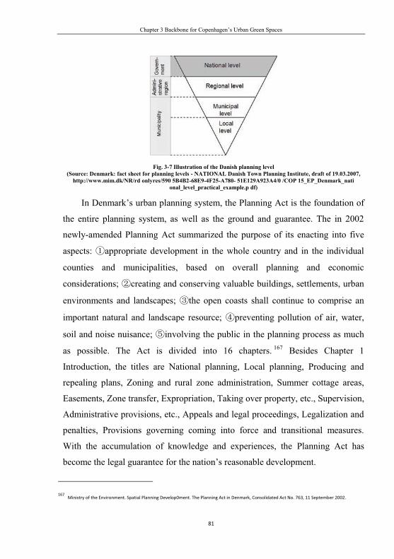
Chapter 3 Backbone for Copenhagen’s Urban Green Spaces
81
Fig. 3-7 Illustration of the Danish planning level (Source: Denmark: fact sheet for planning levels - NATIONAL Danish Town Planning Institute, draft of 19.03.2007,
http://www.mim.dk/NR/rd onlyres/590 5B4B2-68E9-4F25-A780- 51E129A923A4/0 /COP 15_EP_Denmark_nati onal_level_practical_example.p df)
In Denmark’s urban planning system, the Planning Act is the foundation of
the entire planning system, as well as the ground and guarantee. The in 2002
newly-amended Planning Act summarized the purpose of its enacting into five
aspects: appropriate development in the whole country and in the individual
counties and municipalities, based on overall planning and economic
considerations; creating and conserving valuable buildings, settlements, urban
environments and landscapes; the open coasts shall continue to comprise an
important natural and landscape resource; preventing pollution of air, water,
soil and noise nuisance; involving the public in the planning process as much
as possible. The Act is divided into 16 chapters. 167 Besides Chapter 1
Introduction, the titles are National planning, Local planning, Producing and
repealing plans, Zoning and rural zone administration, Summer cottage areas,
Easements, Zone transfer, Expropriation, Taking over property, etc., Supervision,
Administrative provisions, etc., Appeals and legal proceedings, Legalization and
penalties, Provisions governing coming into force and transitional measures.
With the accumulation of knowledge and experiences, the Planning Act has
become the legal guarantee for the nation’s reasonable development.
167 Ministry of the Environment. Spatial Planning Develop0ment. The Planning Act in Denmark, Consolidated Act No. 763, 11 September 2002.

Urban Green Spaces for Quality Life
82
3.2.2 Evolvement of Urban Planning in Denmark
“Town planning is a product of time.” 168 The Danish Town Planning
(“Spatial Planning” since 1980s) originated in 1920s, and its goals, contents and
requirements have been constantly adjusted and changed according to the time and
evolving developing goals and political situations. In general, the evolvement can
be divided into three phases: the first is “physical planning”, which began in 1920s.
Conventional town planning methods were applied, and planning was regarded as
the means of building an equal and fair welfare society and stimulating
socio-economic developments; the second is “spatial planning”, which started in
1980s and developed with promoting competitiveness as the goal of planning, in
order to go along with the new international trends; the third is balanced
development. After 2000, besides keeping up with its own competitiveness
construction, Denmark has dedicated itself to maintaining the balance in
environment, society and culture, in order to sustain its competing capacity.
3.2.2.1 Phase of physical planning
The first planning that took place in Denmark was the traffic report in 1926, a
plan for the Copenhagen area. The Regional Planning Committee of the Danish
Town Planning Institute produced a Plan for Future Green Area in the
Copenhagen Region in 1928. Thereafter, the Committee came up with a plan for
the capital Copenhagen area, that was regarded as the first Danish regional
planning, namely the later internationally famous “Finger Plan”. It joined traffic
development, industry layout and living areas together.
After the Second World War, Denmark entered into a new rapidly developing
phase as other European countries. Since 1945, the Danish urbanization was
greatly pushed through, with economic prosperity and augmenting the housing
demand as motivation. Development at this stage, however, was also full of
168 Denmark–AgreenroomintheEuropeanhouse.http://www.nordregio.se/filer/Files/r0208p69-101.pdf.04-29-2011.

Chapter 3 Backbone for Copenhagen’s Urban Green Spaces
83
conflicts. On the one hand, the country was striving toward the welfare dimension
that was initiated in 1930s; on the other hand, the industrialization process was
unbalanced throughout the country. Building a welfare state requires balance, as
the Planning Act of 1947 proposed “to ensure an equally paced development in
more regions”. 169 But industrially, especially during the Danish economic
development phase from 1960 to 1975, some regions thrived economically, while
others withered as the population emigrated, and thus the “unbalanced Denmark”,
for the Danish economy was founded on the market-oriented principle. With
regards to this issue, the planner Erik Kaufmann presented the idea of “star towns”,
namely a “self-generating natural urban growth process”, in order to provide a
solution to the dilemma between balance and profit (Fig. 3-8). He explained, “In
the coming decades, increases in population, commercial transactions, and cultural
activities will continue to agglomerate. Were this trend ignored or resisted, our
efforts and expense would be in vain. However, if we go along with it, it will be
influential, and the country will benefit from it.”170 This theory of his received
huge attention, and had a great impact on Danish future planning. Meanwhile,
planners came up with the “Big H” developing model, namely propel the balanced
economic growth in all regions through the construction of highway (Fig. 3-9).
Thereafter, the Planning Act of 1973 still aimed at “equal territorial
development”.171 All in all, decentralization and polycentrism policies of this
period contributed to the growth of welfare society. This strategy, which both
ensured equal development and helped Denmark’s transition from a traditional
agricultural society to an industrial one, continued onto late 1980s and pushed to
be a developed country.
169 Ole B. Jensen. A ’Green Room in the European house’: Converging Discourses in European & Danish Spatial Planning, http://www.ncl.ac.uk/guru/ assets/documents/ewp29.pdf. 05-05-2011. 170 Ibid. 171 Ibid.

Urban Green Spaces for Quality Life
84
Fig. 3-8 Illustration of “Urban Star System” (left) (Source: ht tp:/ /www.n ord regio.se/filer/Files/r0208p 69-101.p df) Fig. 3-9 illustration of “Large H” (right) (Source: same with fig 3-5)
3.2.2.2 Phase of spatial planning
Upon entering in the 1980s, with economic globalization, industry adjustment
and capital flow are accelerating. The competitions among countries and countries,
regions and regions, cities and cities in Europe are becoming more and more fierce,
making the original “physical planning” strategy and goals unreasonable for the
new circumstances. The past planning has excessively lingered on the balance
between domestic economy and social development and among regions. To
respond to new external competing pressure, the thinking based on “the regional
development drived by city planning to gear up the national deveplopment”
needed to be adjusted to how to promote the comprehensive competitiveness. It is
apparent that decentralization and polycentrism are not helpful for increasing the
power in municipal and regional competitions. Under this circumstance,
Denmark’s three-level planning system has been upgraded to four, which means to
bring the whole plan under the context of the EU. It wished to at least play a
significant roll in the economies of the Nordic and the Baltic sea areas.
Two different prospects and goals appeared for the nation’s future
development against this background. One was the decentered city pattern in
regional networks, and the other was large city model in European integration.

Chapter 3 Backbone for Copenhagen’s Urban Green Spaces
85
Supporters of the former were worried that emphasis on the external rivalries
would affect the internal balanced development, while advocates of the latter were
afraid that too much care over the internal would sacrifice the interest of the larger
nation. Granted, both parties were clearly aware of the rapidly changed external
environment. In fact, the 1989 National Planning Report has pointed out the issue
of international orientation, suggesting that domestic development should take full
advantage of international interaction, in order to enhance Denmark’s
competitiveness.172 The result of this debate was presented at last in the 1990
Danish National Planning Report, which argued that “in the future, the capital
would be able to rival with other (European) city-regions of the same size that
shared the same distinctive character in business and culture. Cities as Aarhus,
Odense, and Aalborg should develop their own distinctive characters so that they
get a chance to contend with other European city-regions.” 173 It was also
incorporated in the Planning Act early in 1992. The amended Planning Act turned
toward competition-oriented global capitalism,174 and changed the older goal of
pursuing “equal spatial development” to seeking “appropriate spatial
development.” From then on, concepts as globe, Europe, nation, and regions have
frequently appeared in the various planning reports. They clearly proposed to
develop the more competitive city-regions first, and then develop the nation
through these big cities. All these were in line with the globalization goal of
European-orientation. For instance, the National Planning Report in 1992 -
Denmark towards the Year 2018 - the Spatial Structuring of Denmark in the
Future Europe, the Role of Copenhagen in the Øresund Region in 1995, and the
National Planning Report in 1997 - Denmark and European Spatial Planning
Policy (Danmark og europæsk plampolitik in Danish). In the 1997 report, three
172 Denmark – A green room in the European house. http://www.nordregio.se/filer/Files/r0208p69-101.pdf. 05-08-2011. 173 Ibid. 174 Ole B. Jensen. A ’Green Room in the European house’: Converging Discourses in European & Danish Spatial Planning, http://www.ncl.ac.uk/guru /assets/documents/ewp29.pdf. 05-05-2011.

Urban Green Spaces for Quality Life
86
goals of national planning were set based on the European discourse of urban
space: firstly, balance in the city system; secondly, environmental acceptable
accessibility; lastly, protection of nature and cultural heritage. These three targets
involved cooperation with the EU both socio-economically and environmentally.
The report also put forward a “five-string strategy”: development of
city-networks between regional center and municipality center; regional center
with increased European orientation; the Øresund-region as an international
urban region; development in the small towns and rural areas; plan
cooperation across borders.175 One could tell decisively from the “five-string
strategy” that the external challenges have become the primary motivation. It
showed not only the intention to further connect domestically but also the
foresight to expand the national space. The domestic growth, based on European
orientation, followed polycentric and market-oriented spatial planning. The later
development demonstrated that this strategy provided opportunities for Denmark,
and improved conditions for its domestic construction. The Øresund Bridge,
started in 1995 and officially put into use in July 2000, now commuts more than
60,000 people every day, annually 6 million vehicles’ passage were taken place.176
This strengthens the connection between Copenhagen, Denmark and Malmö,
Sweden, and betters the public transportation between the European continent and
North European countries. Cooperation of personnel, technology, and trade are
drawn closer. Denmark successfully played the role of a leader in developing the
economy of the Nordic region. At the same time, it added weight to the Baltic
countries’ political and economic influence.
With town planning transforming from traditional “physical planning” into
“spatial planning”, environmental protection and economic development were
175 Denmark–AgreenroomintheEuropeanhouse.http://www.nordregio.se/filer/Files/r0208p69-101.pdf.05-10-2011. 176 By Terri Mapes. The Øresund Bridge: The Connection of Denmark & Sweden. http://goscandinavia.about.com/od/denmar1/qt/ oresund bridge.htm. 05-07-2011.

Chapter 3 Backbone for Copenhagen’s Urban Green Spaces
87
being treated with the same amount of attention, which was regarded as a symbol
for transition. Externally, this was directly affected by the 1987 Brundtland Report,
and also by European Spatial Development Perspective. Internally, Denmark had
not been a significant player in the EU spatial planning, but has always been a
model in environmental protection. Therefore, Denmark wished to take advantage
of this characteristic. The 1997 National Planning Report pointed out that
Denmark resolved to become “a green room in the European house.”
3.2.2.3 Phase of balanced development
Scholars described the Danish town planning stages after 1950s as “four
seasons”: 1959-1971: control of economic growth; 1972-1981: management
of the economic crises caused by the international oil crisis; 1982-1988: the
pursuit of equalization, decentralization and modernization; 1989 until present:
internationalization and creation of a distinctive image. 177 However, upon
entering a new century, the Danish planning has returned back to developing the
domestic economy and consolidating what it has achieved in globalization, when
competitions in Europe have shown satisfactory results. This phase is thus named
balanced development.
The National Planning Report for Denmark 2000 - Local Identity and New
Challenges did not refer again to the “European orientation”. Instead, it returned
to the track of “balanced development throughout Denmark” and “physical
planning and regional economic development.” “Regional” here referred to
Denmark doing its best domestically, while “new challenges” were coming from
both home and abroad. The report pointed out that “Denmark’s future vision is
how to realize the optimum interaction between private and public actors
environmentally, economically and culturally, within a specific national and local
177 Denmark – A green room in the European house, p85. http://www.nordregio.se/filer/Files/r0208p69-101.pdf. 04-29-2011.

Urban Green Spaces for Quality Life
88
geographical context.”178 Although the report did not mentioned again to the
“European orientation”, it did not mean that the policy makers and regulators
ignored the external difficult situation. Instead, they were clearly aware of
Denmark’s small territory, and have realized that only an upgrade in the national
competitiveness could maintain its leading position (Fig. 3-10). Consequently the
report suggested the municipal councils expand their horizons regionally and
internationally while making the strategic policies. 179 This guideline saw
continuation in the National Planning Reports later and national planning policies,
and was continually deepened. For example, the 2006 National Planning Report:
The New Map of Denmark - Spatial Planning under new conditions depicted
globalization as technological development, trade and financial laissez-faire, the
marketization in China and East Europe, rapid growth and the expanding
communication, and low transportation costs, and analyzed the impact of these
five characteristics on the Danish spatial planning (Fig.3-11). The Report listed the
impact as the following five items: urban development brings more public
transportation options to the greater city areas; powerful city regions will
benefit the nation; the nature, scenery, and the look of the towns should be
respected; protect the distinctive boundary between cities and villages, ensuring
local characteristics and specialties; Safeguard the quality of the surrounding
areas, including architecture, urban planning and leisure activities. Based on the
analysis above, the Report claimed the goals to be the following five items:
Rural and urban areas should be distinct; Development should benefit all of
Denmark; Spatial planning must be based on the respect for the identity of cities
and towns, nature, the environment and the landscape and townscape; Spatial
178 Ole B. Jensen. A ’Green Room in the European house’: Converging Discourses in European & Danish Spatial Planning, p41. http://www.ncl.ac.uk/ guru / assets/documents/ewp29.pdf. 05-07-2011. 179 Department of Environment and Energy. National planning report for Denmark 2000 – Local identity and new challenges. http://www.lpa.dk/ topmenuen /Publikationer/Andre_sprog/2000/lpr_2000_UK1_13.pdf. 05-10-2011.

Chapter 3 Backbone for Copenhagen’s Urban Green Spaces
89
planning and investment in infrastructure should be closely integrated; Spatial
planning should be comprehensive (Fig.3-12).180
Fig. 3-10 the 2000 national planning report: A vision for 2025 focuses on the opportunities to create development
in the individual regions of Denmark (Source: Spatial Planning in Denmark, 2002, p7)
Fig. 3-11 Globalization influences and changes the prerequisites for strategic spatial planning in Denmark (Source:
The 2006 national planning report in brief, p9)
180 By Terri Mapes. The Øresund Bridge: The Connection of Denmark & Sweden. http://goscandinavia.about.com/od/denmar1/qt/ oresundbridge.htm. 05-07-2011.

Urban Green Spaces for Quality Life
90
Fig.3-12 Settlement and geographical features of Denmark’s five administrative regions (distinguished by colour)
(Source: The 2006 national plan report in brief, p15)
Judging from the development during this phase, Denmark, under the
guidance of the “Spatial planning” reports, not only realized the smooth domestic
economic growth and the social coordinated development, but also maintained its
leading effects in the Nordic areas, and continues to contribute to the regional
economic development.
3.2.3 Content of Urban Planning in Denmark
Before the reformation on the national administration region and authorities
in 2007, Danish cities were categorized into three levels, namely the national
government, which is responsible for making national planning, counties for
regional, and municipalities for local. After 2007, the original 14 counties were
substituted by 5 power-deprived regional institutions, which still bear some
responsibilities in planning as the former counties. Therefore the national planning
system is still categorized into three levels - national, regional, and local planning.

Chapter 3 Backbone for Copenhagen’s Urban Green Spaces
91
Fig.3-13 Denmark’s city planning system before 2007 reform (Source: The Planning Act in Denmark,
Consolidated Act, 2002)
Fig.3-14 Denmark’s city planning system after 2007 reform (Source: Spatial planning in Denmark, 2007, p7)
The Danish urban planning follows these three rules: firstly,
consensus-oriented: it is based on the democratic power structure and political
philosophy. Danish planning at any level must inquire the opinions and requests
from every social group. The planning is passed only when the majority expresses
their agreement and acceptance, and when the minority has fully expressed their
opinions. Secondly, framework control: as for the national level, planning merely
means policy, strategic, and principle. It only represents suggestions and models
that belong to a macro level. The actual work is presented by the lower level
planning or specific planning. Finally, hierarchy: every planning institution has

Urban Green Spaces for Quality Life
92
its own obligations and responsibilities. The upper level has the right to instruct
the lower level, and the lower must proceed under the principles of the upper level.
It has to meet the demand of the upper levels and local interest.
3.2.3.1 National Planning
“Planning is politics”,181 and “Planning is policy”182 in Denmark. Thus,
national planning belongs to politics, policy and strategy, reflecting the
arrangements that the central government makes for the country’s future
advancement and fundamental interests. It tells the government’s political and
strategic suggestions for the future, and enjoys guiding and binding legal power
over regional and local planning. Since the parliamentary election is held every
four years, it means the planning reports must be amended and published at least
once every four years. The report is drafted by the Ministry of Environment,
which is in charge of national planning. After seeking public opinions and
parliamentary debate and votes, it becomes legally effective once the parliament
approves it. Subsequently, planning institutions of regions and municipalities
revise their visions and tasks according to the National Planning Report. National
planning often takes the form of national report, national planning directives,
guidelines or intervention, overview of national interests was added in 2006.
The National Planning Reports usually deal with visions and perspectives for
topical planning themes followed by an action plan, including projects with
municipalities and private sector. Additionally, the Ministry of Environment
submits Reports on Nature and Environment Policy and feature reports as Reports
on Retail Trade Planning to the parliament every four years. The National
Planning Directives are mandatory instructive documents that pronounce the
government’s arrangements and executions over specific governmental projects
181 Stig Enemark.The Integration of Naturaland Built Environment Data – The Experience of Europe with a Focuson Denmark. Seventeenth United Nations Regional Cartographic Conference for Asia and the Pacific Bangkok, 18-22 September 2006. http://vbn.aau.dk/files/4949346/SE 17 thunrccapIP40.pdf . 05-06-2011. 182 Danish Ministry of the Evironment. Spatial Planningin Denmark, Copenhagen, 2007, p3.

Chapter 3 Backbone for Copenhagen’s Urban Green Spaces
93
and certain directions of the development. For example, they are such as
large-scale natural gas pipelines, electrical transmission lines, new summer cottage
areas, and some areas that demand special arrangements, such as the greater
Copenhagen area. The Guidelines are also an essential part of national planning.
They are often explanations of related national planning laws, including rural area
administration, local planning and environmental impact assessment. The
Overview of National Interests is published every four years. The primary aim is
to provide necessary overview and inspection on related legislation, action plans,
sector plans, national planning decisions and agreements between public
authorities. “Interventions” are vetoes from the national government over the local
planning that are against national interests.
3.2.3.2 Regional Planning
“Regional planning” is an essential constituent of realizing national strategies
and plans. Denmark’s regional planning is comprehensive planning of the future
space in this region. It is the planning of cities and towns, residential areas, rural
nature and environment (leisure areas included), commercial (tourism included),
employment, education and training, and culture-related matters. The regional
councils are in charge of the planning, and usually submit the Regional Plan for
Spatial Development of the region to the national government during the first two
years of the four-year term. The Report should include: describing the relations
between the future spatial planning and related national and regional infrastructure;
describing cooperation between the administrative region and public authorities
in adjacent countries on spatial planning and special development; clarifying the
actions the regional council will take to follow up with the plan. Additionally,
“regional spatial planning” should be linked with regional economic forums,
regional employment councils, regional and municipal Local Agenda 21 and other
planning projects related to education, training, culture and other categories.

Urban Green Spaces for Quality Life
94
“Regional planning” includes urban growth and summer cottage areas, large
public institutions and transport, technical facilities, polluting enterprises requiring
special sitting, projects requiring environmental impact assessment, regional
structure of retail trade, especially valuable agricultural areas, afforestation areas,
conservation-worthy assets and the protection of nature, wetlands, recreational
areas, extractions of raw materials, drinking-water resources, use of watercourses,
lakes and coastal waters, implementation of national planning guidelines, etc.183
One can tell from these areas that the content covers not only everyday residential,
service and commerce, but also bigger social topics.
3.2.3.3 Municipal Planning
“Municipal planning” is both the execution of national and regional planning
and the key of policies and strategies. It contains the planning of the seat-city of
the council and of its subject towns. According to legal procedures, amending and
redrafting the municipal planning should be completed within the first two years
of the new parliamentary term. The three main parts are: general structure with
overall objectives for development and land use in the municipality, including
maps and text used in municipal planning matched with detailed content of the
plan; guidelines for land use, mainly protection over various sorts of land in the
framework of the Planning Act, such as special habitats; framework for the
content of local plans for the specific parts of the municipality, including how to
promote a cohesive urban structure and the overall municipal objectives through
the actual use of the land, illustrating future opportunities, and determining which
areas in rural zones may be transferred to urban zones or summer cottage areas,
etc.
The specific content for “municipal planning” is the same with that for
“regional planning”, and even more detailed. The content includes urban growth
183 Danish Ministry of the Evironment. Spatial Planning in Denmark, Copenhagen, 2002, p10.

Chapter 3 Backbone for Copenhagen’s Urban Green Spaces
95
and summer cottage areas, location of various urban functions, structure of retail
trade, transportation installations, technical installations, polluting enterprises
requiring special sitting, projects requiring environmental impact assessment,
noise protection, recreational facilities and allotment gardens, especially valuable
agricultural areas, afforestation areas, wetlands, nature protection areas, valuable
cultural environments, valuable landscapes, valuable geological assets, use of
watercourses, lakes and coastal waters, coastal zones and implementation of
national planning directives.184
“Local planning” is another sort of “municipality planning”. In the Danish
town planning system, if the “national planning” is political policies, “regional”
instructive principles, “municipality” detailed suggestions, then “local planning” is
the actual processes, a detailed plan about a specific construction project in the
subject areas. “Local planning” includes not only projects on existing buildings as
changing the use of land, constructing density control and design, protecting
sightseeing specialties, rebuilding energy-conservation systems, and preserving
old architecture, but also preparing for new houses, roads, and pipelines. We could
take the year of 2001 as a example, among the 1200 planning reports submitted by
municipalities, 29% were regarding residential district, 16% business district, 5%
recreation and leisure, 14% public purposes, 11% mixed residential and business,
11% technical installations, 2% rural district, 1% shopping center, and 1%
others.185
3.2.4 The Features of Danish City Planning
The Danish city planning system has the following attributes: Connected
with the parliament elections of all levels. Every newly-elected national
government must draft new planning. Regional and municipal governments also
184 Danish Ministry of the Evironment. Spatial Planning in Denmark, Copenhagen, 2002, p10. 185 Ibid, p19.

Urban Green Spaces for Quality Life
96
have to amend and draft their regulations after the elections. Comprehensive
planning. Vertically, each planning must be in line with the ones from the upper
level. Horizontally, planning has to abide by and combine with all specific
regulations of the same level. Local governments have more say in planning.
Generally speaking, the Danish planning system is closely linked to power sharing
and decentralization. It is based on legal provincial self-governance and check and
balance with the supervising government. The aim is to solve the tasks at the
lowest possible level as possible. Therefore, local municipalities enjoy great
initiative and activeness. The Danish public administration ranges broadly,
providing job positions that make up 30% of the labor force. 186 Local
governments contribute over 30% to gross national product (GNP), much higher
than 10% in Germany and France.187 Besides, more than half of the public
expenses and governmental expenses of the local governments come from
residents’ income tax. As a result, local governments have secure and strong
sources of endowment and the willingness to defend local interests.
The Danish urban planning has both strict assignments by level and strict
processes. Take the process of regional planning and municipality planning, and it
can be summarized as the following six items: Prior public participation for the
past four years as basis, information on previous planning disseminated, ideas and
proposals solicited for “regional planning”, strategies for planning developed for
municipal planning, no less than eight weeks in advance; Proposed plan,
prepared in cooperation with other public authorities, citizens, nongovernmental
organizations, etc.; Proposal published, sent to other public authorities (veto
suggested when in conflict with national interest), deadline for objection at least in
8 weeks; Proposal processed, objections, commenting process, proposed
186 Economy of Denmark. http://en.wikipedia.org/wiki/Economy_of_Denmark. 05-03-2011. 187 Denmark – A green room in the European house. http://www.nordregio.se/filer/Files/r0208p69-101.pdf. 05-03-2011.

Chapter 3 Backbone for Copenhagen’s Urban Green Spaces
97
changes; Final plan published; Administration of plan. Relevant authorities
strive to implement the plan.188
3.3 Background and Context for First-version of Copenhagen Finger-plan
Abstract: Since it was proposed firstly in 1947, Greater Copenhagen’s Finger Plan has
been remade and revised several times. Today, the Finger Plan has become one of the most
successful examples worldwide. With constant exploration for the past 60 years, the Greater
Copenhagen region has turned into a beautiful, comfortable, vigorous and sustainable area for
living and work. This paper attempts to analyze how the plan has been changed and adjusted
according to the situation, which was based on the initial principles and basic ideas of the Finger
Plan in the changing form of economics, social structure and living standard in this area for the
past 60 years. It also summarizes the characteristics of its evolution.
Keywords: Copenhagen region; Finger Plan; evolutional process; reasoning analysis;
public participation
3.3.1 Introduction
The Denmark Kingdom’s territory amounts to 43,000 km2 (Greenland and
Faeroe Islands excluded), with a population of 5.4 million. It is composed of more
than 400 islands, of which 70 are inhabited. The largest three are Jutland, Zealand
and Fyn. Copenhagen lies at the northeast end of Zealand (Fig. 3-15), playing an
essential and particular role in Denmark Kingdom. On the one hand, as the capital,
it is the center of politics, economics, culture and social activities; on the other
hand, as a cosmopolitan in its region, its impact reaches surrounding areas both
home and abroad. Copenhagen is now becoming the financial center of the Danish
and Swedish Oresund Region, as well as a major urban district and economic
growing point.
188 Danish Ministry of the Evironment. Spatial Planning in Denmark, Copenhagen, 2002, p5.

Urban Green Spaces for Quality Life
98
Fig.3-15 Map of Danish Kingdom, Copenhagen located within the dark part (left) (source: Development in all of
Denmark, http ://www.sns. dk/udgivelser/2006/ 87-7279-728-2/html/kap05_e ng)
Fig.3-16 Illustration of districts of Copenhagen (dark part is water) (right) (source: Copenhagen, ht tp: //en.wikipe
dia.org/wiki/Copen hagen)
The name Copenhagen holds four meanings: first, the center/core city of
Copenhagen, i.e. central town or old town (Fig. 3-16); second, City of
Copenhagen, sometimes as Capital Region), including the city Copenhagen and its
surrounding areas; third, Copenhagen County (its provincial capital in Glostrup),
which no longer includes the city of Copenhagen, but merely other middle and
small towns outside Copenhagen, according to the Reforming Act of the National
Administration Districts; fourth, Region of Copenhagen, or sometimes as Greater
Copenhagen or Copenhagen Metropolitan Region, which covers not only city of
Copenhagen and the Copenhagen County, but also the Municipality of
Frederiksborg, County of Frederiksborg, and County of Roskild (Fig. 3-17), and
whose population makes up one-third of the total. Because of different
adjustments in national administration districts in different times, the Copenhagen
population and territory vary accordingly, though in an increasing trend
territorially. For instance, population of the district was 1,591,871 people in
2002189, 1,825,814 in 2007190. In order to make full use of the capital region’s
189 Hans Ege. Greater Copenhagen Region Integrated Planningand Settlement and Transport [R] 2004.

Chapter 3 Backbone for Copenhagen’s Urban Green Spaces
99
advantage in talents, technology, endowment and resources, four counties and two
municipalities now belong to the Copenhagen region, as the Act passed on January
1st, 2007 regulated. Among these is Bornholm Regional Municipality which is far
from Zealand. Although sometimes there has been confusion over the name of the
Copenhagen City and the Copenhagen Region, generally speaking, the meaning of
these two phrases and the territories they stand for are clearly distinct (Tab. 3-5).
The Copenhagen, which people often talk about, usually refers to the Copenhagen
City. Supported by materials from 2000, the Copenhagen City supplied 307,000
job positions (993,000 from the entire Copenhagen Region 191), within which
28,000 in manufacturing, 48,000 in trade and tourism, 231,000 in services; GNP
equals 15% of the total.192
Fig.3-17 Illustration of Municipality of Copenhagen (in origin), County of Copenhagen (in red) and region of
Copenhagen (within all colors, excluded Bornholm) (white is water in map)
190 Environmental Software and Services. SUTRA,a City of Tomorrow Project: City Profile: Copenhagen (R/O L). http://www.ess.co.at/SUTRA/CITIES/copenhagen.html, 2007-1-20. 191 Copenhagen. Wikipedia [DB/OL]. from http://en.wikipedia.org/wiki/Copenhagen. 18-01-2007. 192 PeterHall. Urban Regional Planning (third edition)[M].Routledge, London, 1992.

Urban Green Spaces for Quality Life
100
Tab. 3-5 Population, areas and densities (2007)193
Region Population km2 person/km2
Copenhagen town 503,699 88.25 5707
City of Copenhagen 1,211,466 455.61 2659
Copenhagen County a 95,353 169.67 560
Copenhagen Region 1,825,814 2,864.14 693
N.B.: a from 2004’s statistics. (Source: Danish Capital Region, http://en.wikipedia.org/wiki/Danish_Capital_Region)
The Copenhagen’s Finger Plan, when first proposed by government officials,
scholars and planners in 1947, covers only the Copenhagen City and its
surrounding suburbs (i.e. capital area). The administration area was constantly
expanding, depending on the need of city, district economics, and social
development. The present Copenhagen’s Finger Plan covers the entire
Copenhagen Region. In the past 60 years, related authorities has conducted
researches, drafted, revised and complemented it based on the changes of situation
and tasks. Now the Finger Plan has evolved from a concept that had no legal effect
to a legal strategic plan of regional development, playing an important instructive
role in the growth and construction of Copenhagen and its surrounding areas.
3.3.2 Background of Proposing the Finger Plan
In the second half of the 19th century, the urbanization in the West greatly
accelerated with the continuously growing size of economic and trade, and the
enhancement of industrialization and production. In the case of Great Britain and
Wales, the size of the cities kept increasing, as the population grew larger. In
mid-1930s, the amount of arable land taken by the cities every year reached
148,000 ha, while the total arable land in these two places were 91 million ha.194
193 PeterHall. Urban Regional Planning (third edition)[M].Routledge, London, 1992. 194 Dansk Byplanlaboratorium.Skitsefoslag Til Egnsplan For Storkbenhavn Udaebjdet 1947 AF Egnsplamkotoret [Z]. A Summary of the Preliminary Proposal 1948-49, 1993.

Chapter 3 Backbone for Copenhagen’s Urban Green Spaces
101
Within a short time, cities were overflowed with exponentially growing population,
environmental conditions deteriorating rapidly. The situation brought considerable
difficulties, and caused people to think about how to build, plan and develop cities.
In face of various problems in urban development, Ebenezer Howard came up
with the concept of “Garden City” in his book Garden Cities of Tomorrow
published in 1902. So was Denmark at that time (Tab. 3-6). With the setting up of
the Town Plan Institute in Great Britain in 1914, urban planning gradually
changed from pioneers’ individual exploration into systemized professional social
work. Influenced and inspired by Great Britain, Denmark established a
nongovernmental planning organization in 1928 - Danish Town Planning Institute,
and began its research work in urban planning.
Tab. 3-6 Danish population of urban and countryside area (%)195
Region/Year 1801 1840 1901 1925 1940 1950 1960 1980 2001a
Urban 21 21 39 56 64 68 74 81 85.1
countryside 79 79 61 44 36 32 26 19 14.9
a: Paul L. Knox, Linda McCarthy. Urbanization (Second Edition) An Introduction to Urban Geography, Pears on, New
Jersey, 2005, pp.97.
Danish Parliament legislated the first Town Planning Act in 1938-1939. The
Act required the local government to plan the use of land every five years in towns
that are inhabited by more than 1000 people.196 The plan could be carried on once
it was approved by the Ministry of Internal Affairs of the national government.197
Only one-sixth of the towns in Denmark met the standard at the time, to demand a
physical planning. According to the law then, the planning was classified into two:
one was structure planning, the other town planning.198 The purpose of the former
195 John J rgensen. Copenhagen Evolution of the Finger Structure [Z/OL]. http://www.qub.ac.uk/ep/research/cost10/ findoc/cs08- Cope.pdf. 2007-01-08. 196 Dansk By planlaboratorium. Skitsefoslag Til Egnsplan For Stork benhavn Udaebjdet 1947 AF Egnsplamkotoret [Z]. A Summary of the Preliminary Proposal 1948-49, 1993. 197 Ibid. 198 R H Williams. Planning in Europe[M]. George Alle & Unwin Lid, London, 1984.

Urban Green Spaces for Quality Life
102
was to make clear of the future use of the land and its goal, while the latter was to
require the towns to clarify detailed regulations regarding the use of land. But new
issues came along. Laws only applied to the range of land in towns, but leaving
out the vast rural areas lying outside the city. Moreover, the new Act only focused
on the use of land, neglecting the socio-economic issues. Therefore, regional
planning between towns were unvisited issues, making it, especially economic
development coordination, a difficult problem to solve. The situation was more
serious in the Copenhagen region. The Danish Town Planning Institute set up a
committee before the birth of the Town Planning Act. The members came from all
municipalities in the region, related government departments and representatives
from public transportation. The committee was only responsible for coordinating
and processing various emergency cases in the region at the beginning. The
passing of the new Act drew its attention to the open space in the region.
In 1945 after the Second World War, European countries embarked upon the
large-scale reconstructing work. Urban planning was in great need. Against this
background, the committee proposed to draft a comprehensive plan for the region,
which would be co-written by the 29 municipalities of the Copenhagen region at
the time. A technical office emerged as the times required, and took up and
finished the innovative task of drafting the planning. The idea of “Greater
Copenhagen” was first mentioned in this document. At first, the planners merely
called it “Plan for the Capital Region” without a specific name. Towards the end
of the job, a German secretary put her hand on the plan, and realized it fit the
shape of the hand. Then came the name “Finger Plan”. The plan was officially
published in early 1948 under the name Suggestions on the Planning of the Capital
Region (Skitsefoslag Til Engsplan For Stork benhavn Udaebjdet 1947 AF
Egnsplamkotoret) (Fig. 3-18).

Chapter 3 Backbone for Copenhagen’s Urban Green Spaces
103
Fig.3-18 Cover page of First Finger Plan proposal published in 1948
3.3.3 Reasons for Proposing the Finger Plan
The Finger Plan was in fact a prediction of the planners then over the
population and future socio-economic development. The suggestion for the future
planning of Copenhagen was based on the historical experiences of Copenhagen
and other major European cities, with Copenhagen as the center and existing
railways stemming out of it as the foundation. It equals to what people now call a
“conceptual plan”.
The four factors of the Finger Plan are:
Firstly, the analysis on the economic and social situations. The office first
compared Copenhagen with other European capitals, and came to the conclusion
that Copenhagen, populated like all other capitals, is the center of national
business, trade, industry and administration, beside the political function as a
capital. The downtown then was occupied by 40% of the stores and workshops in
the city, approximately 200,000 people commuting between work and home.199
This caused traffic congestions. As a result, many people would rather live in the
199 Dansk Byplanlaboratorium.Skitsefoslag Til Egnsplan For Stork benhavn Udaebjdet 1947 AF Egnsplamkotoret [Z]. A Summary of the Preliminary Proposal 1948-49, 1993.

Urban Green Spaces for Quality Life
104
downtown, especially near the industrial area, which greatly increased the density.
So Copenhagen at the time was facing the problem of which is how to solve the
density as other cities. On the other hand, since most of the houses were built in
late 1800, conditions and equipment were less than satisfactory. Some housing
districts turned into ghettoes in the long run. According to statistics, 75% of the
downtown houses were built before 1940, 25% in suburbs; over 85% of the houses
only had 1 to 3 rooms, whereas such houses made up 50% in the suburbs.200
Meanwhile, as conditions and environment worsened, many people, especially
wealthy families with high income, moved out of downtown, and migrated to
better districts north of Copenhagen. Building houses in suburbs became a trendy
fashion at the beginning of the 20th century. Although this movement in some
extent has decreased urban population density, it also significantly cut down the
tax revenue of the city. The amount of money the authorities used for maintenance
and construction decreased correspondingly; thus rose a vicious circle.
Consequently, the plan in need had to not only tackle with the future use of land in
Copenhagen, but also to revive the society and the economy. It must strengthen
both its leadership in domestic economy and its competitiveness with other
European central regions.
Sencondly, the analysis on the size of urban population. After World War II,
the population in Copenhagen already reached 1.1 million people, 1/4 of the
total201. According to prediction on the future demographic growth, the plan
argued that population in this region will not exceed 1.5 million in an estimable
time. Development in this region is divided into short-term and long-term; the
former was based on 1.3 million, the latter on 1.5 million.202 New growth would
mostly be added outside downtown, which was proved by later demographic
200 Peder Boas Jensen. Framing the Urban Development [A].Peter Madsen, Richard Plunz,The Urban Life World [M]. London, Routledge, 2002.201 Dansk Byplanlaboratorium.Skitsefoslag Til Egnsplan For Storkbenhavn Udaebjdet 1947 AF Egnsplamkotoret [Z]. A Summary of the Preliminary Proposal 1948-49, 1993. 202 Copenhagen. Wikipedia [DB/OL]. from http://en.wikipedia.org/wiki/Copenhagen. 2007-01-18.

Chapter 3 Backbone for Copenhagen’s Urban Green Spaces
105
change (Fig. 3-7). Therefore, scholars later named plans made in this period about
demographic growth “limited growth”.
Tab. 3-7 Population in the central city of Copenhagen in history203
Year Popu. Year Popu. Year Popu. Year Popu. Year Popu.
1850 129,695 1930 617,069 1971 625,671 1983 486,593 1998 487,969
1870 181,291 1940 700,465 1972 610,985 1985 478,615 2000 495,699
1890 312,859 1950 768,105 1973 595,751 1988 468,704 2003 501,285
1901 360,787 1960 721,381 1975 562,405 1990 466,723 2005 502,362
1911 462,161 1960 721,381 1978 515,594 1993 466,129 2006 501,158
1921 561,344 1970 622,773 1980 496,850 1995 471,300 2007 503,699
Thirdly, the analysis on the development model of future cities. Various
hypotheses about urban models were raised at the time by western government
planning departments and scholars. The planning office once proposed three
suggestions to the Copenhagen City and its surrounding regions: Decrease the
size of the city. At the end of World War II, out of concerns about nuclear weapon,
residents in Copenhagen were suggested move out, which meant weakening the
capital’s status as the central city; Construct a coastal city. Taking advantage of
the natural surroundings, Copenhagen should expand toward south and north to
become a typical band-shaped coastal city; The “old town + satellite cities”
model. Take the existing city as the center, and build independent satellite cities in
a distance. The committee, after serious consideration, decided that none of the
three plans work. As the capital city, Copenhagen enjoys irreplaceable historical
and cultural values. Since it is also the political and economic center, declining
and unplanned expansion are not acceptable. Instead, Copenhagen should lead,
preserve and develop the towns through reasonable planning and other effective
measures, based on current structure. These towns should form a valid network
203 Copenhagen. Wikipedia [DB/OL]. from http://en.wikipedia.org/wiki/Copenhagen. 2007-01-18.

Urban Green Spaces for Quality Life
106
(via road, traffic, communication) with Copenhagen, and share some of the
functions (residential, working, and production). This could prevent developing
Copenhagen at the cost of other towns and an overfilled downtown.
Fig.3-19 Analysis diagram of urban development in four patterns
Finally, the analysis on the geographic location. Copenhagen is adjacent to
the sea to the east, boasting fine harbors and convenient ocean channels. The
northern topography is uneven, with enormous grasslands, lakes, hills and bathing
beaches. The scenery in the South and West is more monotonous, with
comparatively flat fields and wasteland. This provides the urban development with
more space. Since the citizens have the right to choose where to work and live, if
no systematic planning was conducted on the regions, urbanization would go
further to the North. Therefore, the direction of the future development should be
focusing on the western part, and slowing down the development to the North.
3.3.4 Principles and Content of the Finger Plan
As the post-war economy and social life recovered and became lively again,
the demand for housing surged accordingly. The increase of land used for housing
in Denmark every week was about 1 to 2 ha. The situation was worse in
Copenhagen than in other areas. The continual invasion of urbanization decreased
considerable amount of arable land, and increased the commuting time between

Chapter 3 Backbone for Copenhagen’s Urban Green Spaces
107
home and work. The Finger Plan put forward solutions, providing the
development of Copenhagen with a clear blueprint.
3.3.4.1 Principles
Principles can be summarized as below:
Firstly, control the development of Old Town, and construct new suburbs.
The plan clearly pointed out that the layer-upon-layer growth of downtown should
be prevented, and effective methods should be taken to alter the downtown
development. The plan suggested protecting the Old Town, with necessary and
limited reconstruction. The key of construction was to improve the infrastructures
and as well both environment and the living conditions for the residents. Plans
for the new suburbs did not adopt the satellite city model. Instead, it took
advantage of the original layout and built new suburbs through planning, making
them part of the city.
Secondly, depend on the railways to form the Finger City. At the time, there
had been already two railways from downtown of Copenhagen to the West. Plus
other lines towaed to different didirections, in total 5 routes of railways, are being
planned in the future. Consequently, the plan suggested that the structure of the
future city take the railways as the axis, and stations as the centers, to form towns
with well-equipped business, cultural and educational services and effective
administration system. The Old Town was to be connected with these towns
through frequent and convenient train rides, thus constituting an urban layout
model, with the railways as “fingers”, stations and nearby towns as “pearls”, and
the downtown as “palm”. At the same time, the plan has also rightly predicted the
development of future highways, creating opportunities for public transportation
enabling the citizens to travel more conveniently. The transportation network
composed of railways and highways will draw between the “fingers” and “palm”,
“fingers” and “fingers”, “pearls” and “pearls” closer (Fig. 3-20).

Urban Green Spaces for Quality Life
108
Fig. 3-20 Pearl (town) on the Finger in the proposal
Thirdly, taking up less arable lands as possible, improving the condition of
wastelands, and creating living-friendly environments. The Plan suggested that
Copenhagen’s future development should direct at the broader West and South
which had more potentials instead of the North. Because when the high-salary
class moved to the better North, more and more ordinary citizens also imitated
doing so, which would inevitably exacerbate the pressure and damage to the
environment there. It would lead to harm their life quality. Comparatively
speaking, although scenery-wise the western and southern parts are a bit inferior to
the North, through plantating and building parks to ameliorate the envronment,
more citizens would be attracted to move there. By developing the coasts and
putting up bathing beaches, the original topography and environments can be
beautified, and thus realize the reasonable urban expansion and layout.
Thirdly, keep the green space, beautifying and protect the environment at the
same time. The plan mentioned specifically that between each finger, wedge green
spaces should be kept, and should stretch to the downtown area as far as possible.
The wedge green spaces include grassland, farmland, rivers and wasteland, as well
as parks, greens, etc. (Fig. 3-21). Keeping and creating wedge green spaces can,
on the one hand, prevent the towns from horizontally expanding, enabling them to
reasonably develop in the planned area; on the other hand, it can protect the
environment, supplying the citizens with diverse and pleasant recreation spaces.

Chapter 3 Backbone for Copenhagen’s Urban Green Spaces
109
Fig. 3-21 Rail way (in black) and residential area (in red) in the proposal of Finger plan 1947
3.3.4.2 Contents of the Plan
Firstly, the requirements on the location of the towns. The plan proposed
clearly that the new towns should be built upon along the railways, and the
distance of the towns should not be 45 minutes away from downtown via public
transportation (meaning from home to work).204 The reason was that the plan took
into consideration, that 40% of women have gone out the home and became
working ladies. Since they had to run back home after work to take care of the
housework, the women should not spend more time on commuting. It was also
true that if transportation takes too long, the towns would lose their attractions to
the people.
Secondly, the consideration over the size of the towns. The plan set three
categories: residential unit, inhabited by 1,000-2,000 people; neighborhood
unit, inhabited by 5,000-50,000 people; community unit, or metropolitan district,
inhabited by 50,000-100,000 people.205 The main reason for the classification is
that on the one hand demands vary from towns to towns, and people to people.
Generally, young people prefer bigger towns, while senior citizens and wealthy
204 Dansk Byplanlaboratorium.Skitsefoslag Til Egnsplan For Stork benhavn Udaebjdet 1947 AF Egnsplamkotoret [Z]. A Summary of the Preliminary Proposal 1948-49, 1993. 205 Ibid.

Urban Green Spaces for Quality Life
110
families like smaller towns better. On the other hand, future industrial areas are
mostly located along the railways. It is helpful for production and transporting
goods, and also suitable for workers to live. Therefore, enterprises and citizens can
choose towns of different sizes based on their own preference.
Fig.3-22 Future industry (in black) areas in the proposal, Left is original, right for future
Thirdly, the consideration over traffic in Old Town. While the plan gave
suggestions on perfecting the traffic layout from downtown to suburbs, it also
looked at the unsatisfying inner-city traffic situation. The plan proposed that
public transportation like tram cars and buses should be improved and systemized.
It also recommended to upgrade roads and sidewalks.
Lastly, the improvement of the living conditions for downtown residents. In
Old Town, 75% of the residents in Copenhagen lived in apartments then, 25% in
single-family houses. Most single-family houses had yards, where leisure
activities take place. It also became a significant factor in measuring the living
conditions. In order to reduce the population density of the city and to improve the
living conditions without taking up too much arable land, the plan suggested 35%
be the percentage of single-family houses.206
206 Dansk Byplanlaboratorium.Skitsefoslag Til Egnsplan For Stork benhavn Udaebjdet 1947 AF Egnsplamkotoret [Z]. A Summary of the Preliminary Proposal 1948-49, 1993.

Chapter 3 Backbone for Copenhagen’s Urban Green Spaces
111
From what we have seen, the “human-oriented” planning philosophy was not
merely for talking. It was carried out in actual policies, and was combined with
corresponding systematic planning. Since the Finger Plan was only a regional
planning suggestion, it did not replace the development planning of all towns,
especially Copenhagen. Therefore, under the guiding of framework and prirncapes
in this proposal, every town needed to make its own plan for its construction and
development basedon its own situation.
3.3.5 Conclusion
Although this Finger Plan suggestion was only a nongovernmental document
without any legal power or standing, the issues that it focused on and the
suggestions had huge influence. On the one hand, the principles and hypotheses in
the Plan received broad attention, and laid down the foundation for Copenhagen’s
future; on the other hand, it had a positive impact on the 1949 City Regulation Act,
for this Act was a memorial in instructing regions like Copenhagen. Meanwhile, it
opposed cities widely spreading out, and was adopted in the 1956 National Zonal
Decisions. In spite of great changes and the few unsatisfying points, the Finger
Plan still feels familiar and intimate when people today look back to it. The
planners then are sincerely respected. Without their foresight and wisdom, this city
would look completely different. The influence and meaning of the Plan still
persists today in a world where people explore for ecological harmony and
friendly living environment.
3.4 The Background and Processes of Evolution on Copenhagen Finger
Plan (Part I)
Abstract: Since it was first proposed in 1947, Greater Copenhagen’s Finger Plan has been
remade and modified several times. Having been constantly explored and constructed in the past
60 years, today, the Greater Copenhagen region has become a beautiful, comfortable, dynamic
and sustainable area for both living and work. The Finger Plan has thus become one of the best

Urban Green Spaces for Quality Life
112
examples worldwide. This paper attempts to analyze, under the constant changes of economic
form, social structures and life standards in Greater Copenhagen region during the six decades,
how the planning has been developed and renewed, and finally came to life in accordance with
the condition change and situation development, on which the initial principles and basic ideas
of the Finger Plan was based.
Keywords: Copenhagen region, Finger Plan, evolutional background, evolutional process,
public participation
3.4.1 Introduction
A city’s developing model is closely related to the natural environmental and
geographic conditions, the historical and cultural background of its country, the
economic and development situation, the urban planning and administration, and
people’s way of life. The state of Copenhagen and its layout formed gradually on
the basis of its nature, humanity, society, economics and politics.
From the view of process of the historical evolution in Copenhagen, it could
be divided into four stages before Finger Plan proposed. The stage of the
medieval ages, until the 19th century, it has always been a castle city with walls
and a moat. The wall obstructed its further expansion. The city was 3 km2 large at
the time, its population being 130,000.207 Walking and carriage were the primary
transportation methods (Fig. 3-23). The stage of tram car from the late 19th
century to the early 20th century, after the walls were demolished, which
obstructed the city’s development, the original residents in the inner city areas
integrated with nearby external small villages, and it made the town was greatly
enlarged, and was connected by new tram cars in 1917 instead of carriages.208 The
population had amounted to 400,000 people, and the territory had expanded to
207 John Jørgensen. Copenhagen – Evolution of the Finger Structure, 2004, p. 189, Available from http://www.qub.ac.uk/ep/research/cost10/ findoc/ cs08-Cope.pdf. 208 Poul Lyager’s Plan Office. København, A short description of the origin of Copenhagen – the City’s physical structure and planning [M]. 1973, Copenhagen, p. 9.

Chapter 3 Backbone for Copenhagen’s Urban Green Spaces
113
7,000 ha209 (Fig. 3-24). Before the WW II phase, from 1930s, when quick and
convenient railway system was put into use (built in 1934)210, the population
increased exponentially to 850,000 people211, aided by tram cars, carriages and
bikes in town. The population in the Copenhagen region also reached 1 million.
Until 1945, the size of the city has tripled or quadrupled, and was still in the
tendency of getting bigger.212 After the WW II stage from the end of war to the
Finger Plan emerged (Fig.3-25). Copenhagen today is a modernized Finger-plan
city constantly planned and constructed in the past 60 years. It retains the city’s
historical tradition, and also integrates elements and functions of modern cities.
All these are closely related to the Finger Plan. To some extent, Copenhagen’s
development has had a clear direction, since the publishing of the first Finger Plan,
which is gradually coming true as the city develops.
1650 1750
Fig.3-23 Diagrams of the City of Copenhagen in 1650 and in 1750
(Source: Københavnerliv – Før & Nu,by Kay Nielsen and Herlfuf Stokholm)
209 Kay Nielsen and Herlfuf Stokholm (1981). Københavnerliv – Før & Nu Herlfuf Stokholm Forlag, Copenhagen. 210 Poul Lyager’s Plan Office. København, A short description of the origin of Copenhagen – the City’s physical structure and planning [M]. 1973, Copenhagen, p. 9. 211 Kay Nielsen and Herlfuf Stokholm (1981). Københavnerliv – Før & Nu Herlfuf Stokholm Forlag, Copenhagen, 212 P. Hall. Planning for Urban Growth: Metropolitan Area Plans and their Implications for South-East England [J]. Regional Studies, Vul. 1, 1967, p. 103.

Urban Green Spaces for Quality Life
114
1860 1880
1920 1940
Fig. 3-24 Diagrams of the City of Copenhagen in 1860, 1880, 1920 and 1940
(Source: Picture of 1850 from Københavnerliv – Før & Nu, by Kay Nielsen and Herlfuf Stokholm, Picture of 1920 from
København 1840 – 1940, by Dansk Byplanlaboratorium)
1930 1950
Fig. 3-25 Diagrams of the City of Copenhagen in 1930 and in 1950
(Source: Københavnerliv–Før & Nu, by Kay Nielsen and Herlfuf Stokholm)

Chapter 3 Backbone for Copenhagen’s Urban Green Spaces
115
In the sixty years of the Finger Plan’s evolution, the human society is
advancing at a unprecedented speed in history. The ever-renewing scientific
technology, abundant material products, and copious artistic creations have all
enhanced our life quality. They also further complicated the planning work,
making it more comprehensive and more challenging.
The Greater Copenhagen region (the Copenhagen City as its core areas) has
experienced industrial revolutions, economic transitions, technological advances,
political party changes, government reform and civil activities as same as the city
of Copenhagen. Although its development has witnessed ups and downs, its
development planning received several revisions and modifications in different
times. Altogether there were six versions of the Plan, but most followed the
principles given in the first version. The different versions were perfected by
practice. The Copenhagen Finger Plan not only enabled cities and villages to
develop healthily, but also became one of the most successful examples in world
urban planning.
3.4.2 Second version of the Finger Plan - Planning in 1950s-1960s
3.4.2.1 Background
The first version of Finger Plan came out in 1947, with Old Town and new
suburbs’ future development and layout as the focus. In this version, the assumtion
of which based on the “limited growth” of resources as population, housing and
land was the plan precondition; the developement mordle of which changed from
the unserupulous sprawl to the rational controlibility was the core principle; the
developement direction for future city would be to follow the existing and planned
railways as fingers. Meanwhile, the centre of towns would be built around railway
stations as closer as possible. In this way, it leaded that commuting time of the
citizens and transportation costs of enterprises could be cut. Since the
industrialization accelerating in 1950s and 1960s, the spead of urban sprawl was

Urban Green Spaces for Quality Life
116
not in the “limited growth” way people had envisioned. Instead, it strongly
accelerated. This phenomenon and tendency not only appeared in West Europen
cities, but also in Copenhagen region at the time.
From the view of Copenhagen’s situation then, we could find that main reasons
for making a new round of planning can be summarized as: The adjustment of
national development strategies. To respond to the requirements of industrialization
and urbanization, the central government adjusted the policy of developing the capital
area to assisting less-developed areas outside the capital. Change in urban population.
The population in city of Copenhagen decreased from its peak 750,000 in the 1950s to
600,000 in the 1960s (Fig. 3-26). Reasons were varied. Among the reasons the
investment Copenhagen city received and the amount of job positions were decreased,
and these definitely contributed to the stagnation or even downfall of the city. Another
reason was that many wealthy families moved out from the crowded downtown to
better equipped suburbs. These factors lowered the population density, and improved
the living conditions. For instance, the statistics shows that population was 600,000 in
1950, and there were 180,000 houses; in 1970, the approximately same amount of
people owned 285,000 houses.213 However, at the same time, government revenue
decreased, which also resulted in a dramatic cut in infrastructure expenses. The rapid
increase in private cars. On the one hand, private cars are a more convenient alternative
to travel than railway and public buses. They also increased the demand for rods and
parking lots. On the other hand, they also cause the residential area to further expand
outwards. Because the government encouraged the citizens to move to suburbs for
living, this brought a number of “Finger City” residential and villa areas that have a
comparatively lower population density. For example, Brondbyoster and Glosstrop
built in western Copenhagen, Herleve and Ballerup in the Northwest, Sorgenfri, Lynby
and Hjortekaer in the North. High apartment buildings, condominiums and villas were
213 Poul Lyager’s Plan Office. København, A short description of the origin of Copenhagen – the City’s physical structure and planning. 1973, Copenhagen, p. 9.

Chapter 3 Backbone for Copenhagen’s Urban Green Spaces
117
erected. Statistics showed that the percentages of new housing area 0-6 km, 6-20 km,
and 20-50 km away from downtown were respectively 67.63%, 19.47% and 11.91%
during 1900-1945, 11.97%, 51.7%, and 36.34% during 1950-1965.214 All these factors
combined increased the demand of land. As a result, the Finger Plan in 1947 was
shadowed as too tiny and conservative. So new plans were necessary in need to guide
and regulate the developing direction and the use of land for Copenhagen city.
Fig.3-26 Population changes in Copenhagen (by line) and Copenhagen Region (by dot line) (in mil.), in 1900 -2004
(Source: Copenhagen in Figure 2004,by Statistics Office of Copenhagen City)
The department of Copenhagen regional planning revised the 1947 version of
"Finger Plan" in order to cope with these new changes, and the planning radius
were expanded from 15 km in the first edition to 50 km.215 In addition to
Copenhagen City and the Municipality of Frederiksberg (a municipality located in
the city of Copenhagen), the Plan covers three counties - Copenhagen County,
Philippine Derek Harrisburg County (County of Frederiksberg) and 55 towns from
County of Roskild, making it the true sense of regional planning. Meanwhile,
during this period, the regional plannings between counties and urban planning
were carried out one after another .
214 Poul Lyager’s Plan Office. København, A short description of the origin of Copenhagen – the City’s physical structure and planning. 1973, Copenhagen, p. 9. 215 Edited by James Berry and Stanley McGreal. European Cities Planning Systems and Property Markets, E & FN SPON, 1995, London, p. 163.

Urban Green Spaces for Quality Life
118
3.4.2.2 Planning
3.4.2.2.1 Activities
There was no unified leadership in the Copenhagen region planning in early
1950s, but each county and municipal was in charge. Later the Ministry of
Housing took over the responsibility. Planning for the capital region, the Ministry
has set up a technical committee made up of officials from the Ministry of
Housing and experts of urban planning, transportation, energy experts, who are
responsible for the preparation of the planning, development and demonstration
work. Meanwhile, although the Copenhagen area has Greater Copenhagen Council,
it had little impact on the planning, due to the constraints of a variety of reasons.
The reason was that the urgent problems it raised in the area were ignored by
domestic lawmakers from other regions. Therefore, specific planning was mainly
borne by local governments. At the same time, some of the private industry
organizations spontaneously conducted planning studies and suggestions. The plan
encountered resistance from all sides. However, the establishment of a joint
committee was made possible by the support of the government. It was composed
of members from six central ministries, the National Railway Bureau, two
counties and eight local governments. Together they would be responsible for the
planning guidance work.216
3.4.2.2.2 Situation
A new round of planning led by the Ministry of Housing started in 1958.
Previously, Copenhagen developed a regional development plan in 1954, but it has
not been implemented. During this period, results chaired by the technical
committee of the planning can be divided into two parts. The first part is the
216 City of Copenhagen. Ørestad – Historic perspective planning implementation documentation, 2003, p. 32.

Chapter 3 Backbone for Copenhagen’s Urban Green Spaces
119
Outline Development Plan released in December 1960, and some called it the
Strategic Concept For A Regional Plan (Fig. 3-27). There were 12 supporting
programs that were released at the same time, but most of them were rejected by
public comments. In May 1961, Congress passed its matching program - the
Køgebugt Planen (the General Development Plan) (Fig. 3-28). The latter part was
the Regional Planning, a deeper revision of the previous planning. The plan has
been recognized by planners and state officials of the Ministry of Housing
Assessment Committee, and a consensus was reached within the technical
committee in 1966, within the Ministry of Housing in 1968. It is known as the
second edition of “Finger Plan”. Although, like the first edition of “Finger Plan”,
it is not legally binding, but many central government ministries were involved in
the formulation of the plan, so many articles in the plan received implementation
to different extents.
Fig.3-27 Cover Papers for Regional Plan in 1960s Outline Development Plan (left) and Capital Region Structural Plan
(right)

Urban Green Spaces for Quality Life
120
Fig. 3-28 Diagram of Køgebugt Plan
Traffic Planning (black dots for traffic stop) (left), Industrial Planning (black areas for industries) (right), housing areas
(in gray)
(Source: Ørestad – Historic Planning implementation Documentation 2003, by City of Copenhagen)
The second edition is mainly based on the Copenhagen population growth
prediction. According to the analysis of the economic and social tendencies, the
Commission forecasted that in 2000 the Copenhagen area population would
increase to 1 million more than the one in 1960.217 Accordingly, in order to meet
the new requirements of the population at work and life, 500 km2 of new land was
expected for construction. To this end, the Ministry of Housing decided to expand
the area 3000 km2 (planning area having far exceeded the actual area of the
Greater Copenhagen area).218 Under the influence of the policy which was
reducing-investment-in-Copenhagen, the Commission would create 4 new
regional central cities with the scale of a population of 250,000. The intentions of
this planning can be summarized as the following aspects: Protecting historical
and cultural valuesof the landscape, to prevent the sprawl of urbanization to the
north of Copenhagen City; protecting the historic Old Town, to prevent the
intrusion of commercial high-rises; protecting downtown and its surrounding
area, to reduce the impact of increasing vehicles on the urban living environment
217 City of Copenhagen. Ørestad – Historic perspective planning implementation documentation, 2003, p. 32. 218 City of Copenhagen. Ørestad – Historic perspective planning implementation documentation, 2003, p. 28.

Chapter 3 Backbone for Copenhagen’s Urban Green Spaces
121
and air quality; increasing employment opportunities and improve city services
for new suburban population; maintaining the existing urban pattern and
avoiding further expansion of the new suburban residential area.
Although these basic principles were in full compliance with the 1947
version of the planning, but there are serious divergences on how to choose new
regional centers. The Planning Board implemented the central government’s
policy of reducing investment in Copenhagen City, and advocated the west and
southwest of Copenhagen. However, the wealthy towns north of Copenhagen City
and Copenhagen itself hoped to increase investment in their own region by
planning, in order to increase the population in the area, and so as to achieve the
purpose of increasing revenue (a large part of the local government revenue comes
from residents' income tax - the author notes). After intense debate, the Committee
formed a long-term and a short-term scenarios, and the long-term planning is
divided into A and B two options. The A program focused on the common
development of the three "fingers" (i.e., thumb, index finger and middle finger),
while the B program concentrated on the "thumb" and "forefinger", as well as the
area between the two fingers that connects Mexico City southwest of Køge (as the
“thumb” in "Finger Plan", 40 km from Copenhagen- the author noted) and western
Roskilde (considered as the "index finger", 30km from Copenhagen- the author
noted) (Fig. 3-29, 1 a and 1b, and 2a and 2b). The short-term planning, also known
as the "first stage" of the 10-year planning219, focused only on these two “fingers”
(Fig. 3-29, 3a & 3b), intending to build them into cities with a population of 25
million220. The support of the central government, especially after the Køgebugt
Planen in 1961, made the short-term plan of concentrating on building the
"thumb" and "forefinger" two lines possible, especially in the direction of the
"thumb". Specific construction are not, as expected, ideal, since the population in
219 Dansk Byplan Guide (Danish Twon Planning Guide). 1981, Copenhagen, p. 46, 33, 17 (in Dabish). 220 Regionplan 1973 for Hovedstadsregion, p.46 (in Danish).

Urban Green Spaces for Quality Life
122
the 1970s only reached 150,000 221; in the forefinger direction, urban planning
and construction did not take shape until the 1970s.
1a 1b
2a 2b
3a 3b
Fig. 3-29 Diagram of second Finger Plan between thumb and point-finger 1a and 1b for A plan, 2a and 2b for B plan, 3a
and 3b for short-term plan (Source: København – Et bysamfunds særpræg og udvikling gennem tiderne, by Steen Eiler
Rasmussen)
221 City of Copenhagen. Ørestad – Historic perspective planning implementation documentation, 2003, p. 32.

Chapter 3 Backbone for Copenhagen’s Urban Green Spaces
123
3.4.3 Third Version of Finger Plan - planning in the 1970s
3.4.3.1 Background
The 1970s was a significant period in Denmark’s transition into an industrialized
country from a traditional agricultural society. From the economic perspective, the
process of industrialization that began in the 1960s continued onto the 1970s. More and
more industrial enterprises were gradually built throughout whole country, and also
further promoted the balanced development of the national urbanization. The data
showed that, across the country in the 1958-1975 period, a total of 18,000 new
production and processing sites were built.222 Many of these enterprises originally
located in the urban area were relocated from the large and medium-sized cities to
relatively small towns with lower land prices and production costs. From the social
aspects, since the 1970s, the national social welfare system in the smaller towns has
also been perfected. With the acceleration of suburbanization in Copenhagen and the
rise of the Finger City, the attractiveness of Copenhagen’s Old Town further weakened.
At the same time, with the development of the national economy and the increase in
personal wealth, the penetration of the private car increased. During this period, more
than 50% of households had private cars, and more than 10% of households possessed
their own outskirts vacation villa (summer house). The automobile changed the way of
traveling and the lifestyle of people, and also made a further separation between
residence and place of work.223 Every day people travel farther and farther. From
political aspect, in Denmark in the 1970s a large reform was conducted over the
national government system, its aim being to enhance the coordination of government
and to reduce the phenomenons of political chaos caused by varied authorities which
held the policy-made right. The contents of the reform involved aspects of education,
social welfare, and national and regional physical planning. The power both of the
222 Dansk Byplan Guide (Danish Twon Planning Guide). 1981, Copenhagen, p. 33. (in Dabish). 223 Poul Lyager’s Plan Office. København, A short description of the origin of Copenhagen – the City’s physical structure and planning. 1973, Copenhagen, p. 10.

Urban Green Spaces for Quality Life
124
central and county’s administration delegated to some parts of their management rights
to the local, so that the local government (municipal level - the author notes) has been
strengthened. In addition, since various political thoughts in this period were more
active than ever, the public and various public organizations had unprecedented
enthusiasm in politics. Concerning urban planning, the survey showed that 3-4% of the
people were involved in various forms of planning discussions activities224.
After the reform, judging from the leadership, on the one hand, the Ministry of the
Environment was established in 1973 to take charge of physical planning (i.e., regional
planning and urban planning - the author notes). At the same time, it was also
responsible for natural and environmental protection and raw material consumption.
Matters of Sector Planning like energy, housing construction, agricultural land,
transportation and other special programs, respectively, by the Department of Energy,
the Ministry of Housing, the Ministry of Agriculture, and the Ministry of Public Affairs.
On the other hand, a planning system was established, consisting of four levels of
government - the national, regional, county, municipal and local, and each level has its
own scope of responsibility. At the same time, research, discussion and design
activities of citizen participation were encouraged and supported in the planning.
Individual citizens could put forward different views on planning, and also could
question the higher level of planning departments. In order to better coordinate and
guide the country's development, the Ministry of Environment in 1975 published the
first annual report on the activities of the national planning. The report depicted an
overview of the national policy on urban development, and divided the city pattern into
four kinds of city pattern, the capital region, large-scale provincial capital cities,
regional center cities and local town. It proposed that the capital region and the other
two provincial capital cities Odense, Aarhus should stop the outward expansion,
224 Dansk Byplan Guide (Danish Twon Planning Guide). 1981, Copenhagen, p. 17. (in Dabish).

Chapter 3 Backbone for Copenhagen’s Urban Green Spaces
125
mainly concentrating construction projects in the inadequate existing development
areas. This report laid the foundation for later national and regional planning.
From legislative aspect, the Urban and Rural Zones Act was enacted in 1969,
Land Use Act in 1970, National and Regional Planning Act and Municipal Planning
Act in 1973 and 1977 respectively. In dealing with Copenhagen, the Regional Planning
Act for Metropolitan Region was especially made in 1973. The enacting and execution
of these acts both satisfied social needs and perfected the legal system. Of these acts,
the Urban and Rural Zones Act grouped the land into urban zones, rural zones, and
summer cottage areas. It regulated that towns’ construction could only take place in the
areas-planed. Occupation of rural land without legal approval was prohibited. Taking
the special needs into account, such as road construction, two specific laws were
enacted to ensure the legitimate change between both urban and rural nature of the land.
If rural land was to turn into urban land, not only local approval was necessary, but the
land seller also needed to pay off the tax from the difference of the price to the local
authorities, in order to avoid the landowners seeking profits and transfer of land
without permission. It was clear in the National and Regional Planning Act, regional
planning is not merely land-use planning, but also includes other sectors planning, such
as the protection of natural resources and balance of urban and rural interests. It also
provisioned to encourage political parties, social organizations, government
departments and the public to participate in the planning activities, planning work to
ensure rigor, scientific, and balance; the details of plan should include the city layout
mode, residential, industrial and commercial construction, rural planning, public
institutions and facilities planning (such as hospitals, schools and transport), etc.;
planning proposals would only be submitted by local council to the Ministry of
Environment after open question and comments from community and public. The Act
regulates that each round of planning lasts 12 years, and the planning of each round
was required to be established in the form of legislation. In the meantime, every four
years an assessment of the implementation and inspection would be carried out. These

Urban Green Spaces for Quality Life
126
changes in the background of the times brought new challenges and higher
requirements to urban planning.
3.4.3.2 Activities
3.4.3.2.1 Organizations
Starting from the late 1960s, in order to strengthen the future development of
the capital region and to organize and coordinate the planning in this region, the
Parliament approved the establishment of an advisory named "Regional Planning
Council”, which was responsible to prepare the regional development proposal
within the capital region. In order to facilitate the discussion of public for planning,
in 1971, the Council published Regional Planning 1970-1985: Basic Situation
Analysis (Regionplanlæging 1970-1985: Forudsætninger) and Regional Planning
1970-1985: Regional Planning Proposals" (Regionplanlæging 1970-1985:
Regionplan Forslag). After six months of public discussion and subsequent
revisions, the Council in 1973 published the new proposal under the name of
Structure Plan For The Capital Region Planning 1972 (Strukturplan 1972 the for
Hovedstadsregionen). Subsequently, the Council also announced a more detailed
Regional Plan For Capital Region 1973 (Regionplan 1973 for Hovedstadsregionen)
(also referred to as the Regional Plan 1973). In the same year, the new Capital
Region Greater Copenhagen Council made up of term by 37 mayors replaced the
original Council's work, and became an institution with real power. The Regional
Plan 1973 was approved by the State Ministry of Environment in 1976. It became
the third version of the "Finger Plan". Enjoying a different status with the
recommendations of the two previous planning, it was not only the first
Copenhagen District Planning developed by official organizations, and it was the
first time in a legislative form to recognize the Copenhagen regional planning.

Chapter 3 Backbone for Copenhagen’s Urban Green Spaces
127
3.4.3.2.2 Planning works
The rapid development was still the basic theme for third Finger Plan. The size of
the population was expected to increase to 1.9-2.1 million in 1985 from 1.8 million in
1970225. The content of the third version involved more in accordance with the
requirements of the Planning Act, including not only transportation and residential
construction in the whole region, but also environmental protection and hospital layout.
First of all, the Plan continued to adhere to the principle of “Finger City”, and predicted
that the city would further expand in the future and the structure of the city would also
have some fundamental changes. On the basis of the idea of building a “thumb” and
“forefinger” in the second version (i.e. the 1963 version), it also proposed to expand the
buildings to other “fingers”. Secondly, It was for continuation with the policy of regional
development which supported outside the capital, and meanwhile it would alleviate the
development pressure of Copenhagen City. For that, the Plan put forward two new
strategies for future development. The first one was to constructe the transport corridors,
and the second was to form the junction center. The former envisaged the formation of
two new “corridors” of central traffic and activities in the whole easten Sjaelland. One
was east-west, the starting point connected with the original finger planning urban area;
the other north-south, connected to the five “fingers”. The latter was envisaged as a new
industrial park built in regional centers in the corridor interchange, at the same time
erecting a certain number of commercial centers, public and private service centers, to
support a new residential area (Fig. 3-30). According to such ideas, in the structure plan,
it suggested the entire region be divided into three types of secondary regions based on
different functions. These were finger planning urban areas (basically existing cities),
future urban development area (west and southwest areas of Copenhagen) and leisure
protected area (north of Copenhagen City area) (Fig. 3-31). The plan suggested 56,000
225 Poul Lyager’s Plan Office. København, A short description of the origin of Copenhagen – the City’s physical structure and planning [M]. 1973, Copenhagen, p. 9.

Urban Green Spaces for Quality Life
128
new housing units in the residential area along the east-west corridor, 49,000 in the
south-north, and 25,000 on the Vest Amager226(Fig. 3-32).
Fig. 3-30 The different patterns for proposed Transportation corridors (in ora nge) and Junction centers (in black) (left)
(Source: Dansk Bypan Guide)
Fig. 3-31 Chart of new business areas (in red) and green areas (in green) in Finger Plan 1972 (right)
1. the Finger Town areas (shading); 2. Urban growing areas (open hatching); 3. Recreational areas (framed)
Shortly after the plan was implemented, the world encountered the outbreak of the
1970s oil crisis, and thus it leaded to the national depression in Denmark, which caused
so many projects to be stranded. Among the four key central towns in planning, only
Høje Ta strup on the west "index finger" line was built. In order to cope with the
changes in the new situation, the previously proposed "better cities over more cities"
goal has been prioritized in the agenda227. People began to re-locate the finger city and
to explore how to make better use of the open space outside the urban area.
Copenhagen City gave up upon the strategy of constructing large-scale projects to
promote economic development and urban revitalization, and transferred the target to
the transformation of the old city. Due to the development of the region "finger City",
plus that many administrative privileges in government reform were devolved to local
municipalities, this granted local governments the ability to better manage their own
226 Regionplan 1973 for Hovedstadsregion, p.46 (in Danish). 227 City of Copenhagen. Ørestad – Historic perspective planning implementation documentation, 2003, p. 38.

Chapter 3 Backbone for Copenhagen’s Urban Green Spaces
129
things, but also contributed to the local parochialism. Some municipalities took the
approach that is conducive to safeguarding their own interests, attracting a number of
industrial enterprises and commercial organizations away from Copenhagen City. This
directly resulted in the decline and desertion of Old Town, the original industrial zones
and residential areas, as well as the waterfront area (Fig. 3-33). So the renewal and
transformation of the old town were again prioritized in the agenda. These
transformation not only improved the living environment, but also changed the
appearance of the city.
Fig. 3-32 Chart of new housing (in orange), business/industries (in red) and recreation (in green) areas in Finger Plan
1973 (lrft) (Source: Regionplan 1973 for Hovedstadsregion)
Fig. 3-33 Diagram of renewal areas in inner city (in green) (right)
(Source: Dansk Byplanlæ ging 1938 – 1992, by Arne Gaardmand, Arkitektens Forlag, 1993)
3.5 The Background and Processes of Evolution on Copenhagen Finger
Plan (Part Two)
3.5.1 Fourth Version of the Finger Plan - Planning in 1980s-90s
3.5.1.1 Background
The fourth “finger plan” in 1989 - Regional Plan 1989, came out from a
background much different than its predecessors. From the European internal
environment, with the enlargement of the European Union, the competition among

Urban Green Spaces for Quality Life
130
the continental European countries have been gradually evolved into the
competition among the various metropolitan areas. For a small country as
Denmark, Copenhagen was qualified to compete with the "fourth-class" cities
(according to a 1989 French study, London and Paris belonged to the first level,
where as Hamburg, an equivalent in population to Copenhagen, belonged to the
fourth level228 - the author notes). In order to ensure that the Copenhagen area
would not lose its advantage in the competition, the Danish central government
was prompted to re-examine some of the policies and practices that inhibited the
development of Copenhagen. From Denmark's own environment, on the one hand,
since the 1980s, the Danish economy has maintained steady growth, and the
economic structure has gradually completed the transition from an industrial
economy to a service economy. Employment and social structure have also
experienced some profound changes, and people's living standards continued to
improve. On the other hand, the Central Government’s investment in Copenhagen
was far lower than the national average (mainly invested in the infrastructure – the
author notes), and every year there were about 800 million U.S dollars flowing
from this area to the rest of the country (This situation didn’t change until the
national policy adjustment in the early 1990s – the author notes)229. These factors
brought in two direct results. First, the population within the region and the
number of jobs continued a downward trend. Take industrial enterprises for
example, job vacancies fell from 15,000 to 10,000 between the year 1982 and
1988230. Second, Copenhagen is no longer the most affluent area in the country,
and the living quality is also lower than the national average. Besides, 40% of the
old houses located in Copenhagen231. Judging from the situation within the region,
after the first proposal of the “Finger Plan” and the continuing development and
228 Copenhagen Municipal Plan 1993. City of Copenhagen, p. 15. 229 Peder Boas Jensen Framing the Urban Development The Urban Life World Edited By Peter Madsen and Richard Plunz, Routledge, 2002, London, p.89. 230 Copenhagen Municipal Plan 1993. City of Copenhagen, p. 19. 231 Peder Boas Jensen Framing the Urban Development The Urban Life World Edited By Peter Madsen and Richard Plunz, Routledge, 2002, London, p.89.

Chapter 3 Backbone for Copenhagen’s Urban Green Spaces
131
construction in 1950s, 1960s and 1970s, the blueprint of the “Finger Plan” was
realized in 1980s and 1990s, and the city became more dynamic and attractive. For
one thing, there were more housing in the “Pearl Town”, and the newly built
houses were farther away from the urban centers. Data show that between 1970
and 1975, the ratio of newly built houses that located 0-6 km, 6-20 km, and 20-50
km away from the urban area was 8.55%, 37.5% and 53.95%232. However between
1980 and 1995, the ratio changed to 16.33%, 29.59% and 54.08% respectively.
For another, due to the adjustment of the industrial structure, not only
production-oriented enterprises moved out of the old town and settled in the
“Finger City”, but many multinational corporations began to move to these areas
as well. All these factors lead to the increasingly slow development of
Copenhagen.
In order to cope with the new trend of international economic development
and the European internal development, the National Ministry of Environment
issued the National planning Review 1989 in December 1989. The Review clearly
stated:” We should see the regional development in Denmark will be carried out in
an international perspective in the future. The growing internationalization is the
implication of challenges as well as opportunities for each individual region, and
also the country as a whole. The differences that exist or may be caused between
regions in Denmark must be viewed as the difference within Europe or the whole
world. That is why regional decisions must be strengthened in 1990s to avoid
marginalization of Denmark in the international context.” 233 That means
Copenhagen will become the key area of the national strategic development afresh.
In fact, since the late 1980s the Central Government and the National Parliament
have faced the Depression in Copenhagen brought by the policies since 1960s.
232 Poul Lyager’s Plan Office. København, A short description of the origin of Copenhagen – the City’s physical structure and planning [M]. 1973, Copenhagen, p.10. 233 Copenhagen Municipal Plan 1993. City of Copenhagen, p. 19.

Urban Green Spaces for Quality Life
132
After repeated research and fierce debate, the National Ministry of Environment
appointed a “Committee on Copenhagen Port” in 1988 that studies the
re-development and utilization of the port areas in Copenhagen. In March 1989,
the Prime Minister appointed the “Initiative Group on the Metropolitan Region”.
The Region submitted a report on The Capital, What Do We Want to Do with It
that did the in-depth study of the repositioning and existing problems of the capital,
and put forward corresponding suggestions. The fourth edition of the “Finger
Plan” is the production in the international and domestic context, reflecting the
urgent need of the social and economic transition process.
3.5.1.2 Activities
3.5.1.2.1 Organizations
The planning and organization in this period is still chaired by the Greater
Copenhagen Council. The formulation of Regional Planning 1989 began in the
late 1980s and finished in 1989. On 15 Dec. the same year, it obtained the
approval of the Ministry of Environment. On 28 Dec, it was published in the form
of legislation: the National Planning Directive. After the completion of the
planning, the agency was dissolved by the Parliament. Since then, no unified
regional planning agencies have been established. The agencies set up by the three
counties and two municipalities are responsible for the planning. The five
planning agencies achieved the consensus: “finding an acceptable solution through
coordination and balanced ways without the need of the adjustment by the
Ministry of Environment”. The Central Government proposes and develops the
significant development plans and projects that involve the whole regions.
Relevant agencies within the region cooperated twice in 1993 and 1997 and
formatted two files: Regional Planning 1993 and Regional Planning 1997 based on
the planning in 1989, which reflected the political will of harmonious

Chapter 3 Backbone for Copenhagen’s Urban Green Spaces
133
development in the region. But they only served as the supplementary of the 1989
version without new ideas, so they didn’t cause much reaction.
3.5.1.2.2 Planning works
The 1989 fourth Finger Plan included traditional urban and suburban land use
and public transportation, and also environmental protection contents. It
particularly stressed the need to provide the public with more leisure space. Unlike
past planning, the strategic focus of this version focused on "urban-oriented"
development ideas, highlighting the central location and traffic nodal point as
planning emphasis and functional layout concept. Specific plan is divided into a
location of commercial construction, urban pattern, traffic structure, central
structure and the building of important parts as Amager Island (Fig. 3-34).
1 2 3 4
Fig. 3-34 Diagram of urban patterns and structures in Regional Plan 1989
(Source: Copenhagen Municipal Plan 1993, by Municipal Copenhagen)
Division between the commercial/public building location. The Plan clearly
pointed out new commercial services institutions and government agencies should
be located in the finger city, near the traffic site. New culture, sports and higher
education facilities and institutions should be located in the palm area (i.e. center
city area). Concerning the layout of urban development, the plan suggested the
cities within the region should continue to follow the existing pattern, adhere to

Urban Green Spaces for Quality Life
134
the finger city as the center and the mode of community with different ranges in
large or small around. For the structural adjustment of the traffic, the Plan put
forward to focus on the construction of three railway lines when improving the
overall situation: "Airport Line" - the construction of the railway line leading to
the airport from the city center railway station; light rail line - connected to the
metro line from the city center to Ørestad in the Amarger Island; Continue to
improve the city Inner Ring Road railway construction. For residential
construction, the plan particularly proposed the suggestion of close-to-station area,
it deepened the past principle of train station as the construction center. The basic
content for the residential construction should be at least 1 km near the train
station. On the one hand, this can increase the density of residential, rational use of
land resources; on the other hand, one can take full advantage of the benefits of
public transport, save commuting time, and thus less private vehicles. For the
downtown development in Copenhagen, the proposal advocated the planning
should take the urban development and environmental protection into account, and
adhere to the principle of prioritizing public transport. For the development and
construction of Amarger Island, the plan regarded it with great significance in the
future in the Øresund region, especially the recent development West Amarger
Island. It proposed to build the Bella Centre to a world-class convention and
exhibition center. An additional national park of 30 km2 was also in the plan.
To complement the new regional planning, the central government arranged
the following major projects from 1988 to 1991: start the construction of a
cross-sea bridge and undersea tunnel connecting the Copenhagen region and the
Swedish Malmö region; improving the roads and highways in and out of the
capital airport; expanding and improving the public transport system within the
region; Increase investment in higher education, high-tech industry and research,
tourism, cultural and exhibition industry. For example, in the pharmaceutical and

Chapter 3 Backbone for Copenhagen’s Urban Green Spaces
135
gauges instrument industry for R&D investment respectively, Copenhagen City
accounted for 90% and 94% of the country; 53% and 33% for electricity and
energy. Copenhagen City employees earned about 28,000 kroner per capita,
compared with a national average of only 11,000. In investment in the cultural
aspects, Copenhagen City residents had 1300 kroner per kapita, while the national
average of 1,100 kronor234. In order to support the construction of West Amarger
Island, in 1991, Congress also passed the Act on the Ørestad Line, to construct a
4-lane highway and a double track railway leading to Malmo in Southern Sweden
that connected with the existing transportation network.
In order to further enhance the competitiveness of downtown Copenhagen,
the city combined the Regional Planning 1993 and set up five specific
construction goals: “Designing a compact urban structure on the basis of public
transportation; rebuilding the workplace according to the traffic sites;
strengthening and changing the port areas to promote the growth of the city;
strengthening the ‘green’ work in the city; restoring and protecting the historic
look and the change of specific areas in the city”.235 The establishment of these
goals laid the foundation for the further development of the city.
3.5.2 From Fifth to Seventh Version of Finger Plan - Planning in the 20th
Century
3.5.2.1 Background
Judging from the international background, since 1990s, especially entering
21st century, the international competition has become more intense with the
acceleration of the pace of global economic integration and industrial restructuring,
with the rapid rise of “BRICs” (namely Brazil, Russia, India and China – the
author notes) and with the fast development of some countries in the former
234 Copenhagen Municipal Plan 1993. City of Copenhagen, p. 76. 235 Copenhagen Land use and transport planning Available from www.Eaue.de/winuwd/135.htm. 21-05-2007.

Urban Green Spaces for Quality Life
136
Eastern Europe, Africa and Asia. In European countries especially, the
competition expands more and more towards areas acting as protagonists in the
competition. In this regard, in 2000 the “local features and new challenges” was
set up the theme for National Planning Report for Denmark. Upon recalling the
planning priorities of European countries in 1990s, the report pointed that all
countries are making effort to “form more polycentric urban systems and acquire
more power through cooperation. Cooperation between citys as networks can
make effective divisions of labor, and help the city to improve as a whole.” The
report further pointed out the cooperation direction of the Øresund area in the
future. The role of cities and urban areasIn in these conpetitions stated, in the Map
of Denmark – Spatial planning under new condition in 2006, was “Towns and
cities play an important role in the knowledge-based society. Only by reaching the
innovative level of European cities can Denmark strengthen its position in the
world.” The report also pointed out that this new type of city can be acquired
through spacial planning. It can not only create high-quality working, life and
entertainment conditions for Denmark people, but can also create the environment
that draw international investment and the settlement of internationally renowned
companies. As for the challenges of globalization towards the spacial planning of
Denmark, the report summarized “ Urban growth, combined with public
transport options, must be able to be improved in a larger urban area; Strong
and vibrant urban areas can benefit the development of the country as a whole;
Respect for the nature, the environment and the landscape; Maintain clear
boundaries between urban and rural areas; Protect the local uniqueness and
differences.”236 Therefore, from the political and policy level, the government
pays more attention than ever to the regional planning and construction work.
236 Danish Ministry of Environment (2006). The Map of Denmark – Spatial planning under new condition, p. 9.

Chapter 3 Backbone for Copenhagen’s Urban Green Spaces
137
Judging from the domestic situation, on one hand, with the adjustment of the
national development strategy in the late 1980s, the country didn’t limit its focus
on driving the development of the other areas within the country. Instead, it
focuses on playing as the central role in Northern Europe. Especially, with the
development of the countries in Eastern Europe (particularlly Baltic Seas
countries), Copenhagen also needs to play an important role in Baltic Seas area,
making it have the strength to be able to compete with Berlin and Hamburg at the
same time of becoming the leader in Øresund region. To this end, the 2006
National Planning Report summarized the challenges and tasks facing
Copenhagen into the following four aspects: handle the relationship between
traffic and future city development, coping with the pressure of the traffic growth
effectively; finish the transformation of traditional business district, making it
adapt to the requirement of new commerce and services sectors; Regulate the
total residential construction and maintain housing prices smooth; Perfect the
green and recreational spaces and keep the area environment beautiful. On the
other hand, in order to build an efficient and streamlined government, Denmark
has started another round government reform from 2005 after the last time in
1970s, and a new model of government has started operation in January 2007. In
terms of planning, it replaced the former four-level planning system “national,
regional, county and local” with the two-level system “national and municipal”. At
the same time, it decentralizes the planning powers in a large scale again, so that
the municipal level government can be more flexible to adapt to the needs of local
economic and social development. In order to cope with the new government
reformation, the state amended the Planning Act in Denmark in June 2007.
According to its situation, the act divides the Greater Copenhagen into four
hierachy, namely central city, urban fringe area, and the wedge region and the
Greater Copenhagen area, and it set out different requirements for the hierachy:
the urban development and the update took place in the area of central city

Urban Green Spaces for Quality Life
138
should be within the existing urban areas, and public transport services should be
strengthened to facilitate the public; the urban development and the update took
place in the edge areas (finger city), as well as new developing functional areas,
should select the areas with infrastructure which existed or planned. Meanwhile,
these development has to take into account for the strengthening of public
transport services to facilitate; green wedge areas between “fingers” shall not be
converted to urban land or leisure facilities; the urban development outside of
Greater Copenhagen should be connected with the local town center area, or as a
part of their town." 237 (Fig. 3-35)
Fig. 3-35 Area divisions of Greater Copenhagen Region in Finger Plan 2007 (left) (Source: Finger Plan 2007)
(Core city in dark red, City periphery in red, recreational are in green, other Copenhagen in shadow)
Fig. 3-36 Chart of Copenhagen region and Malmö region (right) (Source: Regional Plan 2001)
Judging from Copenhagen’s internal situation, on the one hand, after the
development in the 1980s and 1990s, in 2000 the economy in Copenhagen region
formed a new pattern. The research-intensive enterprises and institutions such as
consulting and business services played the leading roles in Northern part; the
information technology, insurance and financial industry dominated in Northwest;
while in the West and Southwest the manufacturing sector. The industrial pattern
237 Ministry of Environment. The Planning Act in Denmark, 2007, Copenhagen, p. 9.

Chapter 3 Backbone for Copenhagen’s Urban Green Spaces
139
further stimulated the adjustment of the urban layout, and the
transportation-oriented urban structure was greatly eimproved. At present, the
total mileage of Copenhagen area rail reached 600 km, 200 stations, and a daily
commute by train reached 300,000. Nearly 700,000 people take bus.238 On the
other hand, with the completion of the Øresund Strait Bridge and Tunnel on July
1, 2000, Copenhagen and Mälmo formed a Metropolitan Area with a population
of 3.5 million (300 million according to another source), 170,000 companies, 14
universities, and 12,000 researchers239 (Fig. 3-36). This would play a strong
supporting role to improve the Copenhagen area in the international arena,
especially when competing within Europe. In addition, the reform of government
institutions that took effect in January 2007 expanded the Copenhagen territory,
and the population increased. All of these changes placed higher, finer, more
humane and more sustainability requirements on urban planning.
Upon entering the 21st century, three development plans of Copenhagen were
released in 2001, 2005, and 2007. It showed that the periodicity of planning has
greatly cecome shorter, which is a sign for the acceleration of the regional
economic, cultural, and social development. It also indicated the national prospect
of what kind of role the capital would play in globalization.
3.5.2.2 Activities
3.5.2.2.1 Organizations
The Greater Copenhagen Authority (Hovedstadens Udviklingsrårded, HUR),
approved by the Parliament in 1999, was mainly responsible for the spatial
planning in the region. It included traffic planning, public transportation
administration, regional industrial development, organization of local cultural
238 The Finger Plan, Available from www.denmark.dk/en/menu/aboutDenmark/EconomyProduction/Infrastructure/TheFingerPlan. 23-05-2007. 239 The Øresund Region, Available from http://www3.kk.dk/Globalmenu/City%20of%20Copenhagen/A%20City%20in%20Motion /The%20%C3%98
resund%20Region.aspx. 24-05-2007.

Urban Green Spaces for Quality Life
140
activities, the development of Øresund, and represented Denmark to deal with the
issues related to cooperation in regional politics and administration with Sweden.
Since the Authority was not directly elected, the proposals would not take effect
until all county governments reached a consensus.
During this period, the three versions of Finger Plans have been made, and
two of them were drafted by the Regional Planning Committee, i.e. Regional
Planning 2001 in 2000, Regional Planning 2005 in 2005, while the third Finger
plan 2007 in 2007 was by the Ministry of Environment. The reason was that after
the new reform in 2007, the original regional planning was taken over by the
Ministry of Environment, and local governments had to follow the guidelines
when planning their subjected areas. These three plans were regarded as the fifth,
the sixth, and the seventh version of Finger Plan (Fig. 3-37).
Fig. 3-37 Cover Papers of Finger Plan in 2001 2005 and 2007
3.5.2.2.2 Planning works
Compared to the past four Finger Plans, what the 5th, 6th, and 7th versions
have in common is that the view was further wider to the international perspective
and further higher to strategical level, and as well they further deepened the city’s
coordinating development such as the urban size and function, industry and
resources, work and housing, environmental protection and ecological system. All

Chapter 3 Backbone for Copenhagen’s Urban Green Spaces
141
these aimed to enable the city to meet the requirements of people in working and
living. Among the three, the 5th and the 7th are more influential.
Fig. 3-38 Illustration of the Evolution of Finger Plan from 1947 to 1989
(Source: Ørestad–Historic perspective planning implementation documentation, by Municipality of Copenhagen, 2003)
To meet the challenge of globalization, the planning committee in 2005
conducted an in-depth study of Copenhagen’s urban model based on its evolution
of the past 50 years and proposed 5 assummed models: Finger city model, dense
city model, prolonged finger model, ring model, and municipal center model240.
By carefully analyzied and compared, it revealed that most people would prefer
the prolonged finger city model. At same time, the committee considered that it
was necessary and important for remaining the finger city model under the present
condition. Therefore, in both 2005 and 2007 planning, the idea of the finger city
model was carried out for city layout and patterns in the future.
240 METREX—The of European Metropolitan Regions and Areas Analysis Workshop 5 2004, London, Available from http://www.eurometrex.org/ Docs/InterMETREX/Workshops/Workshop5/EN_Inter_WK5-London_Mins.pdf. 17-08-2007.

Urban Green Spaces for Quality Life
142
Fig. 3-39 Urban patters in Regional Plan 2001 (left) and 2007 (2005)
(Source: Regional Plan 2001 and Regional Plan 2005, by HUR)
The Finger Plan 2005 is a guide for urban development between 2005 and
2017. Its overall goals are: to make Copenhagen region as the centre with the
dynamic, creative, and innovative economic centre in the Oresund region; to
make Copenhagen region as a place with the cultural enrichment, advanced
technology, and thriving tourism; to make Copenhagen region as a place with
advance environmental protection and ecological balance and natural harmony;
to make Copenhagen region as one of the world’s most suitable metropolises
for work, living, and entertainment. The Plan composed of three sections: first one
was Planning vision and principle; second one was Guiding principle and
objective; and third was Appendix. The total page count is 367. Among them, the
Guiding principle and objective was the core part, which is divided into 8
sub-chapters. The sub-topics are as follows: urban land use, construction of urban
functional spaces (divided into residential, industrial, commercial and vacation
home areas), the use of land resources (divided into landscape protection, natural
preservation, agriculture, industry, forestry, mineral and transportation), water
resource (divided into surface water, groundwater, sea water), transportation,
technology development and use of (clean energy, waste disposal) and noise
control. According to the prediction, in the next 20 years, the population in

Chapter 3 Backbone for Copenhagen’s Urban Green Spaces
143
Copenhagen City would grow by 10,000 people per year. Therefore, the Plan also
set up a goal of constructing 75,000 residential units.241 Of them, 25,000 units are
intended for the increase in population; 15,000 are for housing upgrades; 50,000
are for the aging population due to increased life expectancy.242
Compared to the Regional Plan 2005, the Finger Plan 2005 was more
condensed and succinct: it is the first regional development plan proposed by the
Department of Environment after the government reform. The Planning 2007
contains 4 sections - Preface, Political Statement, Planning and Explanation, and
Environmental Evaluation - and is only 121 pages in length. The section of
Political Statement outlines four key principles of urban design, summarized as
“four guarantees”: to guarantee the capital’s international competitiveness; to
maintain the finger city model; to ensure the future sustainability of the finger
city; to guarantee public participation in future urban planning. The section of
Planning and Explanation was divided into 8 chapters and outline the
developmental goals and requirements for the capital, the “palm” area, the
“finger” areas, and the outside of capital areas. In particular, the section
emphasizes the full utilization of existing land resources. For example, the Plan
proposed that the issues for transportation and environmental protection should
consider, when the office building were constructed with the occupied area more
than 1600 m2, and the same time, these buildings should be located within the
distance not over 600m away from railway stations.243 This is a continuation of
the railway proximity principle, as outlined in Planning 1989.
241 Copenhagen Capability, Available from http://www.copcap.com/composite-8109.htm. 12-07-2007. 242 HUR. Forslag til Regionalplan 2005 – Vision for Hovedstadsregionen 2017 – en stærk og bæredygtig (in Danush), 2005, Copenhagen, p. 21. 243 Danish Ministry of Environment. Spatial Planning in Denmark, 2007, Copenhagen, p. 15.

Urban Green Spaces for Quality Life
144
Fig. 3-40 Diagrams of the future urban development in Finger Plan 2005 (left) and 2007 (right) (Source: Regional Plan
2005 and Finger Plan 2007)
3.6 Conclusion
For Copenhagen, a city with more than 900 years of history, the 60-year
period from 1947 to 2007 seems like an eclipse. However, looking back the
development in the past years, especially, under the situation constant chaging,
Copenhagen consisted on the entire view of regional development with the
direction of scientific and rational planning, continious and stable planning, open
and planning, and harmenious planning.
Yet despite the constant changes in both international and national arenas of
the past 60 years, Copenhagen was able to maintain a holistic development model
and created a unique trajectory of growth. The continuous improvement in life
quality is a result of careful urban planning, which, based on principles of science,
continuity, transparency, and dialogue, results in stimulating new industries,
preserving existing resources, and integrating both rural and urban areas. As we
reflect on these successive rounds of planning, we discover that the finger
planning model not only preserves the city’s unique historical heritage, but also
adds to its modern allure and dynamism. It creates the foundation for its future
sustainable growth, too.

Chapter 3 Backbone for Copenhagen’s Urban Green Spaces
145
The evolution and development of urban scale, function, and forms are the
result of myriad factors - natural, political, economic, demographic, and cultural.
It is also a symbol and miniature of the social and technological development. The
history of Copenhagen’s growth reveals that urban planning - including that of the
greater metropolitan area - is a critical and strategic task for a city because it
affects not only its growth model, but also the quality of life of its inhabitants.
Copenhagen’s experience with the finger model is a particular lesson for Chinese
government officials, urban planners and scholars who seek to find a growth path
for China’s rapidly-urbanizing cities.

Urban Green Spaces for Quality Life
146
Chapter 4 Green Spaces for Copenhagen City
4.1 Introduction
The European landscaping rooted back to Ancient Greece and Ancient Rome,
and witnessed the revolutions during the Middle Ages and the Renaissance. Only
after then did there emerge the humanism garden represented by Italy, the
monarchical despotism garden represented by France and the bourgeois garden
represented by the U.K., each with distinctive characteristics of the times and
unique values. Danish landscape architecture went through a similar path of
development as other European countries, by originating from early kitchen
gardens and cloister gardens, and reaching its peak with royal gardens. In terms of
the style, it experienced the Renaissance style of the 17th century, the Baroque
style of the 18th century and the Romanticism style of the 19th century. During
such process it gradually formed some unique characteristics of its own, but the
basic style and pattern are still influenced by foreign culture, most significantly by
Italy from the South Europe and France from the Western Europe. In modern
times, alongside the industrial revolution and urban expansion, and particularly
due to the changing social structure and economic forms, and the increasing
population, there have been drastic changes in the urban environment, especially
in the neighborhoods where ordinary workers live, where there have been
problems such as overcrowded construction, waste pollution, inadequate
ventilation and sunshine, severe fire hazard as well as rampant plague. Therefore,
citizens’ requirement for urban green spaces and for the improvement of
environment were increasing, under this background, the gardens which used to be
exclusively available to royal families have now been open to the public. At the
same time, Denmark, influenced by the “park movements” of Britain and other
countries, has included the construction of parks and gardens into its municipal

Chapter 4 Green Spaces for Copenhagen City
147
governance. After entering the modern society, and especially after the reform of
national political regime in June 1849, the constitutional monarchy has been
established and the constructions of welfare system and social transformation have
started, driving the planning and building of urban green spaces into a new path.
With unremitting efforts, the cities and towns in Denmark have now formed a
green spatial system with well function, and provided a vital material basis for the
development of the cities and the improvement of people’s life quality.
4.1.1 The Evolution of Danish Urban Green Space
The Evolution of Danish urban green space also originated from parks and
gardens. According to current data, early gardens appeared from the cloisters of the
Ages. This type of gardens featured functionality, with medical herbs and aromatic
plants being the main components, joined by kitchen herbs and fruit trees. In terms of
the pattern, the gardens were mostly divided into four squares by horizontal and
vertical paths, and each square was further divided into four smaller squares. Vilhelm
(1127-1203), Abbot of Æbelholt and Eskildsø Abby, is regarded as the first gardener,
as well as Danish patron saint of gardens. As the religious revolution spread to
Denmark, many monasteries were reconstructed to serve other functions, thus
changing the form of gardens. By the mid 16th century, the Renaissance pleasure
garden of Italy had been introduced to Denmark by Queen Dorothea of the Emperor
Christian III. In 1562, a garden of this type was built in Koldinghus Castle. The
Queen’s son Frederiks II (1534-1588) was also keen of garden arts, and built gardens
within his severed palaces, among which the most famous was the Kronborg Castle
Garden built in 1575. However at that time, the designs of the gardens remained an
imitation of medieval style, which featured high walls on all four sides, and hedges
with trimmed box. By the era of Christian IV (1577-1648), Danish Royal Gardens
had developed profoundly. In 1606, Christian IV purchased 46 pieces of personal
lands outside the Copenhagen Wall and started to build his castles and King’s Garden,

Urban Green Spaces for Quality Life
148
which was completed in 1624244 while the castle constantly to expanse for a long
period. Based on the Heider statistics of 1649, there were as many as 1400 species of
plants in this garden245. In 1647, Hans Raszmussøn Blook published Denmark’s first
literary work on gardening, “Danish Garden” (Horticultural Danica), in which he
passed on his knowledge in garden designing and trimming.246 At that time, he was
not only the leading expert of garden plants in Denmark, but also a specialist in
garden designing.
Fig. 4-1 Queen Dorothea’s garden at Koldinghus Castle and Kolding town by Braun and Hogenberg, 1587 (left) (Annemarie Lund, Guide to Danish LandscapeArchitecture1000-2003, the Danish Architecture Press, 2003, p9.)
Fig. 4-2 Kronborg Castle in present day (right), (http://en.wikipedia.org/wiki/File:KronborgCastle_HCS.jpg)
Fig. 4-3 Danish king Christian IV (left) (Source: http://en.wikipedia.org/wiki/Christian_IV_of_Denmark)
Fig. 4-4 André Le Nôtre (right) (Source: http://en.wikipedia.org/wiki/Andr%C3%A9_Le_N%C3%B4tre)
244 MinistryofFinance, Palace and Properties Agency. The King's Gardens.http://www.ses.dk/en/SlotteOgHaver/Slotte/ RosenborgSlotOgKongens Have/kongenshave.aspx. 05-16-2011. 245 Annemarie Lund, Guide to Danish LandscapeArchitecture1000-2003, the Danish Architecture Press, 2003, p9. 246 Ibid.

Chapter 4 Green Spaces for Copenhagen City
149
In the late 17th century, French gardeners, under the influence of renowned
French landscape architect André Le Nôtre (1613-1700), brought to life the
baroque gardens, the style of which was best represented by Gardens of Versailles.
Hence, the French garden style started to inspire the rest of the world. All of a
sudden, there emerged a hot tide among European royal families to emulate the
Gardens of Versailles, and numerous palaces of different features were built. After
Denmark ended the war with Sweden in 1720, Danish royal gardens such as
Frederiksborg Castle (Frederiksborg Slot) and Fredensborg Palace (Fredensborg
Slot) began to be constructed, under the domination of Frederiks IV (1671-1730)
and the design of landscape architect Johan Cornelius Krieger (1983-1755). Since
the styles of the royal gardens were in imitation of Versailles gardens, the
Fredensborg Palace has been hailed as the “Danish Versailles”. All of the gardens
adopted the axis of the main building as the axis of the garden, and used radial
roads and symmetrical layout to demenstrate the authority and nobility of the royal
families. However, in terms of the decoration and size, these royal gardens were
relatively plainer and simpler than French royal gardens. This might be due to
economic reasons or cultural reasons.
Fig. 4-5 Gardens and palace of Versailles in 1746, by the abbot Delagrive
(Source: http://en.wikipedia.org/wiki/Palace_of_Versailles)

Urban Green Spaces for Quality Life
150
Alongside the rise of the Enlightenment and the emergence of social changes
and industrial revolution in the 18th century, huge transformation took place in the
styles and forms of gardens. The adoration of French baroque gardens was
replaced by the preference of English landscape gardens. As famous British
architect and garden designer William Kent (1685-1748) completed the
construction of Rousham House Gardens, the landscape garden style officially
came into being. The new fashion soon spreaded to Denmark, the fashion-forward
royal families have transformed the old symmetrical gardens into English styled
gardens, although such trend was more largely influenced by the book “Theory of
Garden Art” (Theorie der Gartenkunst) of Kiel C.C.L. Hirschfeld. By 1760s and
1770s, the concept of English landscape garden arts had disseminated to Denmark,
and later the Søndermarken Garden and Frederiksberg Garden were transformed
from French baroque style to English landscape style. In the former garden, the
regular roads were rebuilt into winding paths, and regular water sceneries were
replaced by natural lakes with a Chinese pavilion on the island in the center of the
lake. Meanwhile, a lot of nobles and wealthy merchants became enthusiasts of
garden arts and garden designing, hence creating English landscape gardens have
became a popular thing. During this period, a group of influential garden designers
emerged in Denmark, including J.L. Mansa (1740-1820) and Rudolph Rothe
(1802-1877). Mansa participated in the reconstruction of the gardens in
Frederiksborg Castle and Fredensborg Palace, and has published books about
garden arts. One of them is Garden and Cemetry (Haigekatekismus), published in
1787, and another is “English Gardening Facility” (Udkast til Hauge-Alæg i den
engleske Smag), published in 1998. Later, Rothe also joined the reconstruction of
Frendensborg Palace gardens. He believed that the royal palace gardens should be
constructed as natural parks. 247 Besides, in the reconstruction project of
247 Annemarie Lund, Guide to Danish LandscapeArchitecture1000-2003, the Danish Architecture Press, 2003, p 17.

Chapter 4 Green Spaces for Copenhagen City
151
Jægersborg Deer Park, he placed a lot of woods in the gardens to enhance the
natural atmosphere.
Fig. 4-6 William Kent (Source: http://en.wikipedia.org/wiki/William_Kent)
After entering the 19th century, the prevalence of park movements in the
United Kingdom, France and other countries promoted the construction of
boulevards among measures to beautify the city, to embellish the urban
environment and image, and to improve the living conditions of the citizens. Such
efforts also had a great impact on Denmark, where many social groups and
organizations started to call for the construction of city parks. In response to such
demands of the society and the people, Denmark not only opened up the royal
gardens for public visits, but also constructed many parks in its capital
Copenhagen and the provincial cities. In regard to the opening of royal gardens, in
October 27th of 1849, the year when constitutional monarchy replaced monarchy
as the national polity, a document of the Ministry of the Interior stated that:
“Landscape gardening should be affiliated to the sections of gardens at the royal
palaces. Up to now, it has been regarded as ordinary promenades and as the
exhibition of keeping with the concepts of the landscape gardening arts. As state
property, it should not only meet people’s need for walking and recreation, but

Urban Green Spaces for Quality Life
152
also become a school of the art for landscape gardening.”248 In the “Act of State
Gardens” issued on March 12th 1852, the gardens were classified into three
types249: Kitchen gardens, which mainly consisted of vegetables, herbs, summer
flowers and flowers for decoration; Landscape gardens, which mainly served
for the preservation and aesthetic development of gardens; Fruit-tree
cultivations. Excepting the kitchen garden and fruit garden landscape gardens
were only managed by the State after being included in the list by municipal
departments. As for the building of municipal parks, Copenhagen City built a
amount of municipal parks on the original site of the city walls. These parks
include the Østre Anlæg Park designed by landscape gardener Ove Høeg
Hansen(1832-1910) in 1872, and the Ørstedsparken Park designed by other
designers in 1876. These parks soon became major places of gatherings and
recreations for the middle class. At that time, the form of romanticism prevailed in
the garden design is also casted some influence on Danish park designs. Since the
20th century, Danish gardeners have adopted the New-classicism methods in their
designs under the influence of the Art and Crafts Movement in Britain. During this
period, there emerged many renowned landscape gardeners such as I.P. Andersen
(1877-1942), V. Fahricus Hansen (1866-1953) and Gudmund Nyeland Brandt
(1878-1945). Among them, G.N. Brandt was the editor of “Gardener Journal of
Denmark” (Gartner-Tidende) from 1905 to 1907, and once the secretary of
General Gardener Association of Denmark (Almindelig Gartnerforening). During
the years from 1924 to 1941, he was an instructor at Danish Academy of Arts,
School of Architecture, and was teaching“garden design”.250 Through publishing
articles, writing books and lecturing, he casted profound impacts on the landscape
architecture of Denmark. By using botanic materials in a unique way, he also
created garden spatial patterns with Danish features in the works he designed, such
248 Jens Hendeliowitz. The Royal Gardens of Denmark, Forlaget Guld og Grønne Skove, Copenhagen, 2005, p 11. 249 Ibid. 250 Gudmund Nyeland Brandt. http://en.wikipedia.org/wiki/Gudmund_Nyeland_Brandt. 05-20-2011.

Chapter 4 Green Spaces for Copenhagen City
153
as the Ordrup Cemetery, the Hellerup Coastal Park, and the Mariebjerg Cemetery.
In his designs, he often used evergreens to create rectilinear, circle, oval, and even
spiral spaces, to create a new, moving form of beauty. G.N. Brandt had a
significant influence on the later garden designers such as George Georgsen
(1893-1976) and C.T. Sørensen (1893-1979), and also laid the foundation for
modern Danish landscaping.
Fig. 4-7 Kungsparken in Malmö, Swedendesigned by Ove Høeg Hansen (1890-1900)251
(Source: http://sv.wikipedia.org/wiki/Kungsparken,_Malm%C3%B6)
By the time the Second World War broke out, the scope of professional
activities for landscape architects in Denmark had already broadened greatly. It
had expanded from the designing of parks and private gardens to the planning of
residential areas and the city, including the designing of playgrounds, sports
facilities, allotment gardens, courtyards and so on. During this period of 1920s,
there rose the designing of recreational green areas in residential areas, which
combined the small residential areas to the big public areas with recreation
facilities such as playgrounds, largely promoting the improvement of citizen’s
living conditions. In 1929, Copenhagen established the “Building Code”, which
had promoting effects on the planning and construction of recreational venues and
251 Kungsparken. http://www.malmo.com/tourism/city_of_parks/kungs.asp?Menu=Tourism.

Urban Green Spaces for Quality Life
154
playgrounds around residential neighborhoods. As to the planning of large scale
for public green spaces, Steen Eiler Rasmussen orgnized the landscape gardeners
and designers together in 1936 to plan the green areas of “the Great Copenhagen”,
in fact, it was the prelude to the 1947 “Finger Plan”. The event foreboded that the
city would open up and embrace nature, and that nature would be better integrated
into the green spaces inside the city. Meanwhile, landscape architects like V.
Fabricius Hansen and Jacob Bergmann (1899-1991) had started off the designing
and building of the “Green Ring” around the city.
During this period, Danish landscape gardeners were still following the
direction pioneered by G.N. Brandt in garden construction, which featured the
usage of botanic material to create geometrical patterns in the gardens. Among
those gardeners, the most influential one was C.T. Sørensen, who is considered
one of the most influential landscape architects of Denmark in the 20th century.
When designing the Hans Christina Andersen garden in Odense, Sørensen used
diamond shapes to divide the spatial units, creating a geometric form of
arrangement. In his other representative design, the Allotment Garden in Nærum,
he adopted ovals as the spatial units. Other designer, such as Erick Mygind
(1916-1978), Morten Klint (1918-1978), Sen Hansen (1910-1989), Ingwer
Ingwersen (1911-1969) and Georg Boye (1906-1972), also experimented with
various geometric shapes such as hexagons and pentagons in their projects.
Therefore, the prevalence of “geometric shape” in private gardens was an
significant feature of garden design in the period from 1930 to 1950.

Chapter 4 Green Spaces for Copenhagen City
155
Fig. 4- 8 Allotment garden in Nærum (Source: http://www.vulgare.net/page/13/)
With the recovering and boosting economy after the World War II, the field
and scope of Danish landscape architecture profession were broadened and
extended, with the construction of Danish cities, new housing estates, elementary
and high schools, universities, health-care centers, cultural institutions, sports
stadiums, cemeteries, highway networks and other infrastructures. Since most of
the landscape designers of that time were graduated from Royal Danish Academy
of Arts, School of Architecture, and had been instructed by Brandt and Sørensen,
they were able to strike a good balance among the functionality, rationality,
practicality and beautifulness in their designs for either private gardens or large
scale public projects. Since the 1960s, many Danish cities have made their own
“park policies” to set the goal for urban green space development, and to put
forward establish requirements and provide guidance to the construction, service,
management and designing of urban green spaces. By establishing regulatory
policies, the cities laid more emphasis on the design and construction of new parks
as well as the maintenance and upgrade of old parks. With such efforts came
remarkable achievements in the construction of urban green spaces.
After entering the 21st century, Danish landscape architects, like their peers
in other countries, have been more focused on innovation and uniqueness of their
designs, and have paid more attention to the hidden meaning inside the designs

Urban Green Spaces for Quality Life
156
and the feelings of the public. As the number of domestic projects decreased as
compared to the number in the mass construction period, more and more Danish
landscape architects participated in international projects, which enhanced the
influence of Danish landscaping upon the rest of the world.
4.1.2 The System of Green Spaces in Copenhagen
Ever since the launch of “Finger Plan” in 1947, there have been clearer
objectives for the construction of the Copenhagen green space system. In terms of
the macro-layout, the system can be divided into the internal system, which
mainly consisted of urban parks and green lands, and the external system in the
outer ring of the city, represented by the green wedges between the “Finger Cities”.
It should be made clear that the notion “Copenhagen” may have different
meanings. Geographically speaking, it usually refers to the urban area of
Copenhagen, or the region of Copenhagen. In administrational aspects, it refers to
the Municipality of Copenhagen or the Great Copenhagen Authority. Here, the
internal system of Copenhagen green space system concerns the green spaces in
the urban area of Copenhagen (and there are 34 cities and towns in the
Copenhagen region 252 ), while the external system deals with the region of
Copenhagen. Generally speaking, the green space system of Copenhagen
consisted of five levels and aspects, namely the plots, lines, lumps, wedges and
rings.
The internal system of green spaces in Copenhagen City is composed of
“plots”, “lines” and “lumps”. The “plot” green spaces mainly included green areas
such as roadside greeneries, pocket gardens, community gardens and local parks,
as well as private gardens, institutional gardens (in companies, schools, churches,
etc.), apartment building courtyards, residential green areas and so on. The
252 Ole Hjorth Caspersen and Anton Stahl Olafssona, Recreational mapping and planning for enlargement of the green structure in greater Copenhagen, Urban Forestry & Urban Greening, Volume 9, Issue 2, 2010, P 102.

Chapter 4 Green Spaces for Copenhagen City
157
“linear” green spaces mainly referred to roadside greeneries and linear-shaped
green lands along the railways, high ways and bike lanes, as well as linear water
areas including rivers and stream. The green “lumps” referred to large parks and
gardens, natural and semi-natural green lands, and natural and man-made lakes
inside the city. The formation of the internal green space system went through a
long evolution alongside the rise and fall of the city, the decrease and increase of
the population, and the expansion of the urban area. (Fig. 4-9)
As for the external system, it is mainly consisted of “wedges” and “rings”.
Green “wedges” referred to the wedges between finger cities, including the
farmlands, woods, natural lands, as well as water areas such as rivers, ponds and
lakes. The “rings” referred to the green spaces connecting the cities in between the
“fingers”. It was developed through more well-defined planning and design, as
compared to the internal system. Since 60 years ago when the first “Finger Plan”
was proposed, the development of Copenhagen region has been carried out in
accordance with the idea of reserving the wedge-shaped green spaces in between
the “finger cities”. In the Copenhagen region, “finger cities” have long been
formed along the four rail lines, including the thumb reaching to Køg, the index
finger reaching to Roskild, the ring finger heading towards Hilerød, and the pinky
pointing towards Hesingborg. With the four fingers, Copenhagen on one hand
effectively blocked the tendency of excessive horizontal expansion of the cities
with planning measures, and on the other hand reserved large areas of lands for
future construction of urban green spaces and recreational venues. Despite the
complicated land ownership issues over the green wedges, government and
various interest parties have effectively preserve those regions through
coordination and collaboration. (Tab. 4-1) The “arc-shaped” spaces were mainly
located outside the Copenhagen urban area, connecting the “linear” green spaces
of the “finger cities”. Most of these spaces were built upon “arc-shaped” roads
(such as highways and local roads). Currently there have formed three

Urban Green Spaces for Quality Life
158
“arc-shaped” green ways, and the Finger Plan 2007 has brought about the proposal
to build the fourth “arc” green corridor. (Fig. 4-10)
Fig. 4-9 Illustration of green spaces in Copenhagen Municipality
(Source: Jesper Ole Jensen,Sustainability Profile for Urban Districts in Copenhagen)
Fig. 4-10 Regional green structure of greater Copenhagen
(Source:http://www.sciencedirect.com/science/article/pii/S1618866709000405)
Tab. 4-1 The ownership for land in Copenhagen region
Ownership Fourth green ring (%) Existing green structure (%) Whole region (%)
Public 20.6 65.1 19.3
Private 74.7 25.4 76.1
Other 0.2 0.8 0.6
Unknown 4.5 8.7 4.0
Total 100 100 100
Noted: public (state, municipal, county); private (including association, trust); other (areas owned by
different categories); unknown (areas not mapped)
In the big complicated system of green spaces, each level and type has its
own function and role. As a whole, the system relies largely on the numerous
scattered “plots” green spaces inside the urban area of Copenhagen, which has

Chapter 4 Green Spaces for Copenhagen City
159
been playing a positive role, not only in the daily life, work, study, recreation of
the citizen, the improvement of the urban air quality, but also in the adjustment of
micro-environmental (such as urban heat island), noise reduction and ecological
protection (such as rainfall interception, bird habitation, living situation of small
animals and insects, etc.). The green “lumps” serve as the frame and pillar of the
system, playing irreplaceable role in urban activities such as major cultural events,
festival activities and sports events. In particular, the municipal parks are often the
heritage and witness of the city’s history, playing an important role in preserving
the city’s culture and promoting its tourism. At the same time, as the “island of
ecology”, the “island of flora and fauna” and the “urban lung”, this type of spaces
serve a vital role as the balancer, stabilizer and generator for the urban
environment and ecology. The Botanical Garden of Copenhagen University built
in 1874, for instance, covers an area of 25 acres, and boasts a huge collection of
over 42,000 botanic species253, including many rare species, thus having become
an important front for the preservation of urban biodiversity. As an essential
supplement to the system, “linear” green spaces serve as vital greenways and
ecological corridors for they connect and link the green “plots” and “lumps” inside
the city, as well as the green “wedges” and “rings” outside the city. The green
spaces constituted of “wedges” and “rings” act as the external barriers outside the
urban region, and undoubtedly play a supportive and protective role, which in a
macro sense helped to preserve and maintain the city’s environmental and
ecological systems. It is only because the “blue” (water areas) and the “green”
(green lands) have been integrated together, complementing each other in
functionally and geographically with diversified types and sizes of urban green
space, can the city Copenhagen showcase its unique dynamic and charm, and
reliably safeguard the high living standard of its citizens.
253 Copenhagen Parks, Gardens and Copenhagen Arboretums. http://www.copenhagen.world-guides.com/copenhagen parks_gardens.html. 04-29-2011.

Urban Green Spaces for Quality Life
160
4.1.3 The Urban Parks in Copenhagen
The urban parks play a significant role in the inner city green space system,
providing not only recreational venues for people’s daily life and work, but also
habitats for the wildlife in the city. In Copenhagen, there are tens of parks (and
green lands) of different sizes and various types (Tab. 4-2). In terms of their styles,
some followed the traditional English landscape style and the French regular style,
some adopted modern minimalism or geometric patterns, and the others are mini
pocket gardens built in recent years. In terms of the types, there are large
municipal parks, district parks and also community parks.
Under the influence of the park movement of England, the traditional English
landscape parks in Copenhagen were mostly built in the late 19th century to
improve the urban environment by providing recreational and entertaining spaces.
The main feature of these parks is the way of imitating natural landscape to create
poetic sceneries which remind people of nature. Parks usually have broad open
spaces where citizens can carry out activities and enjoy nature. In terms of the
topography, the terrains of the parks were carefully manipulated to show ups and
downs, and different levels. The concave lands were made into lakes while the
convex lands were made into high hills. As to the use of plants, the park chose
deciduous broadleaved trees like Oak, Tilia and Aesculus as the major arbors,
complemented with evergreens such as pines and spruces. As for the shrubs, the
parks mainly used flowering azaleas, cherries, apple, pear, lilac, honeysuckle,
forsythia and roses. The herb mainly consisted of lawns and flowers. Aquatic
plants were grown on the edge of the lakes. The architectures in the gardens
mainly included pavilions, corridors, bridges and monuments. The roads in the
parks were mostly curves which were designed in accordance with the changing
terrain and sceneries. In terms of park facilities, most parks were equipped with

Chapter 4 Green Spaces for Copenhagen City
161
playgrounds, barbeque venues, and adequate supporting facilities such as benches,
street lamps, dustbins and toilettes.
Among such parks, the Ørstedsparken Park and Østre Anlæg Park are two
very representative examples. The Ørstedsparken Park was built upon the ruins of
an old castle in Copenhagen city which was abandoned in 1870. In 1872, the city
council of Copenhagen approved the proposal of building three parks upon the
relics site, and Ørstedsparken was one of them (with the other two being Østre
Anlæg Park and the Copenhagen Botanic Garden). Ørstedsparken covers an area
of 6.5 ha (1.8 ha of which is composed of lakes). It was designed by Henrik
August Flindt in 1876, and was completed in 1879. H.A. Flindt worked as
apprentice in several Danish Royal gardens in his earlier years, and subsequently
traveled to England, Scotland and Germany for further study254. Therefore, given
his familiarity with the popular English landscape gardens, he adapted what he had
learnt into his designs, in which he fully utilized the original terrain of the castle
remains. He designed a “kidney-shaped lake” in the center of the park and built an
iron bridge over it for people to stroll on and enjoy the view. The lake bank is
surrounded with undulating terrains so that people could experience the natural
mountains and waters in a city (Fig. 4-11, 4-12, 4-13, 4-14). Similar to
Ørstedsparken Park, the Østre Anlæg Park also adopted the form of natural
landscape. The rectangular shape of the park was converted from the old castle.
With the winding rivers in center of the park and naturally grown vegetation, the
park presents a natural country sense of beauty.
254 H. A. Flindt Biography, by Annemarie Lund.http://www.jrank.org/gardening/pages/589/H-Flindt.html. 03-08-2011.

Urban Green Spaces for Quality Life
162
Tab. 4-2 Main urban green spaces in Copenhagen255 256
Name Built time Size Type Origin
Frederiksberg Park 1699 31,7 ha City park Royal garden
Søndermarken 1699 32,3 ha City park Royal garden
Kongens Have 1760s 16 ha City park Royal garden
Assistens Kirkegård 1760 25 ha Cemetery Public land
Tivoli 1843 8.3 ha Playground Private land
Kastellets 1860s 50 ha Urban green land City wall relics
Vestre Kirkegård 1870 54 ha Cemetery Public land
Copenhagen Zoo 1859 Zoo Royal garden
Botanisk have 1870 10 ha Botanic garden University
Østre Anlæg 1870 12 ha City park City wall relics
Sundby Kirkegård 1872 10 ha Cemetery Public land
Ørstedsparken 1879 6.5 ha City park City wall relics
Bispebjerg irkegård 1903 43 ha Cemetery Public land
Hans Tavsens Park 1907-08 2,9 ha City park Public land
Fælledparken 1908-1914 58 ha Park greenery Public land
Kildevæld park 1926-1927 1.3 ha Lake Public land
Enghaven 1928-1929 3.6 ha City park Public land
Vigerslevparken 1929 41,5 ha Linear green land Public land
Amager Strandpark 1934-2005 60 ha Waterfront park Public land
Valbyparken 1937-1939 64,2 ha Park greenery Public land
Damhussøen 1939-1941 85.7 ha Lake Public land
Kagsmosen 1939-1941 15 ha City park Public land
Havneparken 1984 3.8 ha Port greenery Abandoned industrial
land
255 Byens parker og naturområder (The city's parks and natural areas). http://www.kk.dk/Borger/ByOgTrafik/GroenneOmraader/Parker.aspx. 05-18-2011. 256 Parks and open spaces in Copenhagen. http://en.wikipedia.org/wiki/Parks_and_open_spaces_in_Copenhagen. 05-18-2011.

Chapter 4 Green Spaces for Copenhagen City
163
The regular style gardens in Copenhagen were under the inspiration of early
Italian gardens and late French gardens, especially the latter. This type of parks
featured geometricsymmetry and clear axis, with regular symmetrical patterns of
vegetation and orderly trimmed green fences. The King’s Garden (Kongens Have)
were initially constructed in 1624, during the period of Christian IV (1588-1648),
and reconstructed in the 18th and 19th century, transforming form Italian
Renaissance style to French Baroque style, and latter into English Romantic style.
Ever since the 20th century, the landscape of the park has been transformed for
several times, but the road pattern and the overall composition have been
preserved (Fig. 4-16, 4-17). More attention has been paid to visitors’ comfort and
convenience, and facilities such as children’s playgrounds have been added (Fig.
4-18). The Herbaceous Border was built in early 20th century, on the basis of
original vegetable yards in the King’s Garden. During its reconstruction in years
from 1998 to 2000, British landscape architect and gardener Gertrude Jekyll
(1843-1932) drew inspirations from the fine arts, and planned to transform the site
(which was originally 120 m long and was extended to 240 m in the 1970s) into a
flower garden containing over 200 types of herbaceous flowers every year.257
Today, over 2.5 million citizens and tourists visit the “King’s Garden” every
year258.
257 The Herbaceous Border. Palaces and Properties Agency, Ministry of Finance. http://www.ses.dk/en/SlotteOgHaver/Slotte/Rosenborg SlotOgKongens Have/kongenshave/staudebedet.aspx. 02-08-2011. 258Ministry of Finance, Palace and Properties Agency. The King's Gardens. http://www.ses.dk/en/SlotteOgHaver/Slotte/ RosenborgSlotOgKongens Have / kongenshave.aspx. 05-16-2011.

Urban Green Spaces for Quality Life
164
Fig. 4-11 The location of Ørstedsparken in Copenhagen (left) (Source:
http://da.wikipedia.org/wiki/%C3%98rstedsparken)
Fig. 4-12 The plan of Ørstedsparken (right); (Source, same as Fig 10)
Fig. 4-13 A view of Ørstedsparken (left), Fig. 4- 14 The lake of Ørstedsparken (right) (Source: same as Fig 10)
Fig. 4-15 A view of Østre Anlæg (Source: http://en.wikipedia.org/wiki/%C3%98stre_Anl%C3%A6g_(Copenhagen))

Chapter 4 Green Spaces for Copenhagen City
165
Fig. 4-16 The plan of Kings garden (left) (Source: Fredningsbestemmelser for Kongens Have - Rosenborg
Have,http://www.dn.dk/files/billeder/Lokale_billeder/koebenhavn/kort_fredninger/Kongens_Have_Fredningskort2.GIF)
Fig. 4-17 A bird-eye view of Kings garden (right)
(Source: http://fotografilia.dk/upload_dir/shop/kongens-have-rosenborg-koeb.w800.h700.jpg)
Fig. 4- 18 The flower carpet in King’s garden (Source:http://www.pkaj.dk/images/vindue%20til%20verden/DANMARK/
Kongens%20Have,%20K%C3%B8benhavn%20marts%202000.jpg)
Among modern city parks, some are reconstructed on the basis of an old park, and
the others are newly designed and constructed to meet the development needs of the
city. The design of these parks have not only demonstrated modern landscaping
concepts and forms by adopting modern landscape expression elements and modern
spatial functions, but also incorporated the history and culture of Denmark, as well as
the Danish people’s aesthetic and functional demands in the urban green spaces. At the
same time, the design of these parks often featured concise spatial layouts, minimalized
scene sets, unadorned material use and simple maintenance techniques, so as to create a

Urban Green Spaces for Quality Life
166
green space of multiple functions, various forms and rich connotation. For example,
Copenhagen municipal government built the Nørrebroparkenduring the reformation of
the Nørrebro region. The park covers an area of 6ha, and was designed by Steen Høyer,
professor at the Royal Danish Academy of Fine Arts, School of Architecture. In his
design, he utilized the trees and manipulated the micro-terrain, thus effectively dividing
and recombining the long and narrow spaces so that citizens could carry out various
recreational activities such as taking sun baths, having picnics, skating, and playing
soccer or volleyball. The reformation has not only upgraded the quality of the land, but
also improved the neighborhood relations in the region (Fig. 4-19). Designed by
Mutopia Designing Studio and located in Ørestad, the City Park is another brilliant
achievement in Denmark’s modern park designing. With an area of 7ha, the park was
divided into spaces of various sizes by three horizontal and one vertical road (Fig.
4-20). Furthermore, units of large, medium and small circular spaces were randomly
scattered inside the park, with each unit serving its unique function for the citizens to
use. These spaces included playgrounds for the children, beach volleyball court for the
youngsters, as well as places for people to meet and chat. People of different ages who
had different interests were all able to find a suitable place in the park (Fig. 4-21).
Fig. 4-19 A view of Nørrebroparken (Source: Storbyens Grønne, Lunger,
http://culturel.dk/en/Articles/~/media/Images/Culturel/Culturel03/parker_norrebro.ashx?w=440&h=287&as=1)

Chapter 4 Green Spaces for Copenhagen City
167
Fig. 4-20 A bird-eye view of City Park (left)(Source: Urban Transformation: Understanding City Form and
Design,http://aplust.net/permalink.php?atajo=mutopia_city_park_orestad_city_copenhagen)
Fig. 4-21 A view of City Park (right) (Source: VULGARE, http://www.vulgare.net/page/1/)
Aside from abundant park greeneries, Copenhagen boasts a large coverage of
water areas, composed of artificial lakes, canals and natural lakes. Like park
greeneries, these water areas not only serve recreational purposes for the citizens,
but also play an essential role in protecting the ecological environment of the city.
4.1.4 Conclusion
The ways how people use the parks today differ widely from those 150 years
ago in the age of Olmsted, and hencepublic green spaces today enjoy far more
diversified forms and types than ever before. One driving force behind this is the
essentially different urban developing mode today, where urban planning and
construction have become in order, fundamental changes have been made in the
city’s infrastructure, sanitation status, health care and waste management, and the
sustainable development method has been under exploration. Another driving
force roots in the changes in people’s ways of life. Thanks to the economic growth
and improved living conditions, and thanks to the development in road network
and transportation, people today have more choices when it comes to travelling
and leisure activities. For example, in 2008, as many as 1.1 million citizens visited

Urban Green Spaces for Quality Life
168
the zoo, and over 3.97 million visited Tivoli259. In the same year, the number of
visits to Enghave Park reached 1.1 million260. The third driving force is people’s
shifted attitude towards nature. With the continuous development in science and
technologies, people now have gained a new understanding of the Earth, the living
environment for people themselves and the cities, and have taken up a new
attitude towards nature and ecology. Therefore, there have been far more public
green spaces of various kinds than ever, and more places for the citizens to carry
out leisure activities. For instance, by year 2000, the average park and wood area
for each citizen of Copenhagen had reached 16m2, and would have reached 24 m2
if the playgrounds (approximately 5m2 per person) and cemeteries (approximately
3 m2 per person) had been included261. The fourth reason is the changes in
government responsibilities and management. In western countries, especially
Denmark, both central government and municipal governments have been striving,
more than ever, to promote the urban environment construction so as to boost the
economic growth, improve investment conditions, upgrade urban life quality, and
safeguard citizen’s health, which has driven the development of urban green
spaces.
Although Copenhagen did not win the “European Green Capital Award,
2011-2012” and finished 8thamong the 35 candidates, it was already an
recognition and appreciation of its achievements in the construction of urban
greeneries and green spaces. Despite the existing imbalance distribution of green
areas per capita among different regions due to historical reasons, Copenhagen has
already gain huge success in the construction of urban green spaces (Tab. 4-3).
259 De 50 mest besøgte attraktioner 2008. http://www.visitdenmark.com/danmark/da-dk/menu/ turist/oplevelser/attraktioner/sightseeing/ tophalv treds.htm. 05-18-2011. 260Enghaven.http://www.kk.dk/Borger/ByOgTrafik/GroenneOmraader/Parker/enghaven/faktahistorie.aspx 261 Nature and Environment 2001 – Ministry of the Environment.

Chapter 4 Green Spaces for Copenhagen City
169
Tab. 4-3 Public Green Areas of the “Top Eight Cities”262
City Public open areas,m2/inh population living < 300 m from public open area
Amsterdam 33 71%
Bristol) 38 -
Copenhagen 28 79%
Freiburg 32 100%
Hamburg 39 89%
Muenster 32 95%
Oslo 52 94%
Stockholm 86 90%
Fig. 4-22 The citizen’s average of green space in Copenhagen
(Source: http://www.miljoe.kk.dk/2c4c04c3-9d93-4777-bdf9-8d150bf6088a.W5Doc#1)
262European Green Capital. Measuring Urban SustainabilityAnalysis of the European Green Capital Award 2010 & 2011 application round, p20. http://ec.europa.eu/environment/europeangreencapital/docs/cities/egc_analysis2010-2011.pdf. 05-18-2011.

Urban Green Spaces for Quality Life
170
4.2 Harbor Park of Copenhagen
Abstract: The site of Harbor Park used to be a work area of Copenhagen Port on the canal
within city. It has been degenerated into an industrial ruin area since the transformation of
economic form and the restructuring of industrial configuration. Through redesigning and
rebuilding, it has become a hot waterfront park of Copenhageners’ favor. This design is simple
and plain, as well as accessible and enjoyable. Citizens can enjoy both the scenery and facilities
on the land, and the fun of playing and swimming in the water. The ideas indicated in this
design, which pay respects to people’s will, to the history of site and to the values of tradition,
are worth learning and drawing from.
Key words: Copenhagen; city waterfront; site history; park design; residential participation
The word “Copenhagen” means “harbor for the merchants” in Danish
(København), which showcases the pivotal role the ports and piers used to play in
the formation and evolution of the city. In the mid and late 20th century, however,
the original factories moved out of the city due to changes in industrial
configuration and economic form, slashing down the amount of cargo transport at
the ports, and turning the once prosperous piers into ruins. Since the 1980s,
together with the reconstruction and revitalization plan of the city, those
waterfront regions of gold locations have been gradually rebuilt and developed
into office buildings and upscale residential areas.
The Harbor Park was built upon an old dock work area. The construction
began in 1994 and finished in 2000, costing a total expense of 25 million Danish
Kroner (excluding the cultural activity center on the site)263. The completion of
this park provided with citizens of this region an improved living environment,
and added to the city another venue for leisure and entertainment, cultural events
and sports activities as well. When the old harbor was being reconstructed, efforts
were also paid to the pollution control of the water areas, giving the gold
263 Malene Hauxner. Park Identity in Denmark Today. Landsacpe Architecture in Scandinavia, Topos, 2002, p. 38.

Chapter 4 Green Spaces for Copenhagen City
171
waterway back its purity. As a result, the park became a precious swimming pool
and water park for the citizens of Copenhagen in the summers. In recent years,
with the growing efforts in environmental protection and investment, the
waterfront region has become one of the places with the highest housing prices in
Copenhagen, and is thus called the “Manhattan” of Copenhagen264.
4.2.1 The Historical Background
The Harbor Park is located in the “Islands Brygge” region of the Vest
Amager district in the south-west part of Copenhagen. Originally being shallow
shoals, this region was turned into a port through reclamation (which was not
finished until 1933)265 (Fig. 2-23). Some of the land served military purposes, and
others gradually became industrial lands and construction sites. In 1903, a railway
was built to connect the main city with Sjaelland, and the Langebro Bridge
connecting the main city was completed in the same year (the bridge was
reconstructed twice in 1930 and in 1954266) (Fig. 4-24). Officially put into use in
1901, the pier mainly served for the loading and unloading of coal, wood and
other materials. With the development in transportation and industrial business,
and with the residential neighborhoods being built in 1905, the port gradually
expanded into an industrial zone of freight transporting, warehousing and
processing all in one. The pier was named “Islands Brygge” because it is mainly
used for the trade and transport to Iceland and Faeroe Islands (Fig. 4-25). In the
1930s, the population of the region once reached 2 million267.
264 Islands Brygge (in Danish).Available from:http://da.wikipedia.org/wiki/Islands_Brygge. 265 Ibid..
266 Ibid..
267 Ibid..

Urban Green Spaces for Quality Life
172
Fig. 4-23 The illustration of Islands Brygge in 1888 (which was a shallow shoal see lower left) (left)(Source:
Islands_Brygge (in Danish).
http://da.wikipedia.org/wiki/Islands_Brygge)
Fig. 4-24 The habor in 1935 (and in the background is the temporary bridge) (right)
Source: Havnen gennem tiden (Danish) (Havnen through time). http://www.bryggenslokalhistorie.dk/havn.
Fig. 4-25 A view of harbor in 1950 (Source: htmlIslands Brygge 100 år (in Danish).
http://home8.inet.tele.dk/oktober/artikler_forum/050827_islands_brygge_100.html)
Due to the depression of the industrial and transport sectors in the 70s and
80s, the population of the region had dropped to below 7000 by the mid 1980s
(and remained so till 2003)268. After that, the region was gradually transformed
into office buildings and residential districts. With the over crowded buildings and
narrow streets formed historically, the public spaces of this region fell short to
meet citizen’s needs. By as early as the 1970s when the pier ceased to transport
cargos, citizens from all walks of life had jointly called for the reconstruction of
the old pier into community parks. The explosion accident of a chemical firm in
268 Islands Brygge (in Danish). Available from http://da.wikipedia.org/wiki/Islands_Brygge.

Chapter 4 Green Spaces for Copenhagen City
173
1980 269 made local authorities realize the importance of establishing an
evacuation site for emergencies. Since Copenhagen was in the process of planning
the city renovation at that time, a “Neighborhood Council” was set up to promote
the reconstruction of the port into a park, so as to improve living conditions and
safeguard citizens’ rights. Permitted by municipal port management authority,
local citizens voluntarily worked together and built a small park from a 1ha area of
work site in the north of the old pier.
4.2.2 The Site Conditions
Currently, the Islands Brygge neighborhood has a population of 12,000
people (in year 2009), and an area of 1 km2. In 1995, municipal authorities
expanded the park from 1ha to 2.8 ha (or 3 ha according to another source270)271.
The waterfront region is 50 m wide and 925 m long. On the east side of the region
is a major arterial road parallel to and named after the port, with 6-story residential
buildings of approximately the same height on its side. On the north end lies the
Langobro Bridge which stretches across the sea, and on the south end lies the
residential estates. To the west of the waterfront region are the straight berths and
the 300m-wide sea lane. The Kalvebod Brygge neighborhood lies right across the
sea, with fascinating skyline composed of buildings and church steeples.
In terms of the entrances, the north side of the Harbor Park is adjacent to the
cross-sea bridge and connected to the roads beneath the bridge, and is therefore
the main entrance for visitors on foot or on bike. The citizens who go there by bus
often choose to enter from the central part of the park where bus stops are located,
while the self-driving tourists mostly enter from the relatively spacious south part.
Since a larger proportion of visitors enter from the north and central part of the
park, the spatial layout is more concentrated in those two parts.
269 Edited by Ian Thompson, Torben Dam, Jens Balsby Nielsen. European Landscape Architecture: Best Practice in Detailing [M], Routledge, London, October 2007. 270 Malene Hauxner. Park Identity in Denmark Today. Landscape Architecture in Scandinavia, Topos, 2002, pp. 38. 271 Ibid.

Urban Green Spaces for Quality Life
174
Fig 4-26The location of Harbor Park (Source: Google map)
Fig. 4-27 The view of Islands Brygge opposite to the park on the other side of the sea (Islands Brygge.
http://da.wikipedia.org/wiki/Islands_Brygge.)
When the citizens spontaneously constructed the park in 1984, they retained
the railway tracks and pavements on the coastal side, tore down the ground
facilities in the northern part of the park, and built large areas of lawns. Such
reconstruction to some extent laid the foundation for the subsequent designing and
construction. Since the place had long been used as a cargo wharf, the soil there
suffered various levels of pollution. According to the test results from municipal
environmental protection authority, the topsoil was not safe for human to touch,
which required the replacement of topsoil in the construction.
As a waterfront park, the sea water quality is crucial to the design and use of
the park. The water quality of the port region was high enough for swimming until
1953. After that, the water was deteriorated by shipping, industrial production and
sewage emission, causing all the outdoor sea water baths to shut down. There
remained 93 sewage and rainwater outfalls in the waterfront region of Copenhagen
till year 1995. Then the sewage and rainfall emission was largely reduced thanks

Chapter 4 Green Spaces for Copenhagen City
175
to the newly constructed large sewage treatment plants and rainwater storage
systems, and the number of outfalls dropped to 38272. Such improvement has
brought a profound change to the overall water quality of the waterfront region,
and paved the way for the realization of the water park design.
4.2.3 The Design of Park
After approving the park project in 1993, Copenhagen municipal departments
contracted the designing to architect Annelise Bramsnæs (1941-1999) and
landscape gardener Poul Jensen (1929-). At that time, Annelise Bramsnæs was
associate professor at Royal Academy of Arts, School of Architecture, Department
of Town Planning and Landscape, while Poul was Chairman of “Neighborhood
Council” and manager of his own landscape design company. The two of them
later became the chief designers of the park.
During the entire process of the design, the two architects kept close contact
with government departments and local residents, by listening to the wishes and
suggestions from all parties and adopting them into their design. The designing
period lasted for over a year, with the final plan epitomizing the joint wisdom of
everyone (Fig. 4-28).
4.2.3.1 Overall Layout
As a waterfront city park, its function and essence were oriented to fulfilling
citizen’s needs for recreational venues. The overall layout was clean, effortless
and unadorned. With the wide roads and large areas of lawns as the basic tone, and
paralleled roads on the sides as the axis, the park obtained a capacious vision and a
orderly fashion. On a micro level, the details of the layout was carefully and
delicately designed, with distinctive architectures as spatial nodes, creating a
272 Copenhagen: From sewer to harbor bath. Available from:http://sustainablecities.dk/en/cityprojects/cases/copenhagen-from- sewer-to -harbour-bath.

Urban Green Spaces for Quality Life
176
waterfront park that is suitable for both sightseeing and recreation by fulfilling the
demand of hosting a variety of activities.
Fig 4-28 Plan of Harbor Park (which was later revised)273
4.2.3.2 Design of the Roads
The road design for a ribbon-shaped waterfront park can easily fall plain, but
the designers studied the site conditions and drew inspiration from the boulevards
in Berlin and Paris, ending up with the plan of a 8m wide green avenue composed
of 2 lines of Prunus aviums on the east side of the park. The design not only
fulfilled the traffic needs, but also helped reduce and block the noise. On the other
side of the coastal waterway, a waterfront boulevard of 12 meters wide was
designed, in order to provide spaces where people could enjoy the view and get
close to water. As for the two rectangular grass terracewith a width of 30 meters in
the north of the park, the designers built 3 walking trails with tilted angle of 45°,
60° and 30° to connect the east with the west, thus giving the stiff-looking lawns a
dynamic image.
273 Malene Hauxner. Park Identity in Denmark Today. Landscape Architecture in Scandinavia, Topos, 2002, pp. 38.

Chapter 4 Green Spaces for Copenhagen City
177
4.2.3.3 Design of the Activity Sites
The activity sites can be broadly divided into three sections from north to
south, the northern section, the central section and the southern section. The
northern and southern sections are similar in length, which the central section
covers a slightly larger proportion. The northern section starts from the sculpture
of iron ship and is composed of commercial bars, lawns, skateboarding rink,
leisure greeneries and arc-shaped scenery walls. The skateboarding rink lies to
the north of the green terrace, and is composed of a sunken basketball court of
280m2, the adjacent slopes of 140m2 and arc-shaped high skateboarding platforms
on both ends (Fig. 4-29). The two green terraces are divided into 5 irregular
trapezoids by the tilted walking paths. The lawns are 30m in width and 100m in
length, with a retaining wall of 36cm tall. The brick-red curved walls are
perpendicular to the longitudinal axis of the park and beautifully divided into three
parts. The scenery walls are curved on the edge, with the front and middle parts of
the wall overlapping with each other. Windows have been opened on the walls,
and seats are built for people to rest from the wind and sun in the winter or early
spring. The middle part of the walls is divided in two halves, with a 40cm high
arc-shaped flower alter in the front, also divided in halves by the same pedestrian.
Fig. 4-29 Children playing at the skateboardingrink

Urban Green Spaces for Quality Life
178
The essence of the design lies in the central section of the park which mainly
consists of activity venues. It is constituted of steel frames, a cultural center, a
steel-structure corridor, “Festival Place”, the wall of Halfdan’s passage and
playgrounds (Fig. 4-30), among which, the latitudinal steel frames and corridors,
the “Festival Place” and the longitudinal Halfdan’s Passage are the most
ornamental places in the park of the most historic and monumental significance.
The steel structure frames and corridors are located to the north of the cultural
center and arranged in an irregular pattern from east to west. The steel structure is
made up of 5 sets of frames, each consisting 2 or 3 standing cement boards of
3.5m high and 90cm wide, together with abandoned rail beams of varying lengths.
The cultural center is the main building of the Harbor Park, with an area of
1650m2.274 Shaped like a cabin on the deck facing towards the waterway, the
building hosts daily activities for the citizens. The steel corridor is located to the
south of the cultural center, echoing the steel frames on the other side. Nine sets of
4-meter-high towers that resemble gantry cranes constitute the 5.7 meter-wide
steel corridor that stretches from the green avenue to the waterfront boulevard (Fig.
4-31). The “Festival Place” is right next to the steel frames. In the center is the
“boat pavilion” made of the upside-down old wooden sailboat “Pinen”. A spacious
square is surrounded by benches and bushes. In order to highlight the landmark
“Boat Pavilion”, the ground of the site is gradually elevated form the north to the
south by 65cm. Located on a wood platform of 7 meters wide and 30 meters long,
and held up by two wooden scaffolds of 3.5m long, the “boat pavilion” faces the
water with an 45°angle (Fig. 4-32). Standing on the south side to the boat
pavilion, the wall of Halfdan’s Passage was reconstructed from an old pier factory
building that was 63m in length. It lies on the central axis of the park, paralleled to
the longitudinal axis. A discus court and a volleyball court are placed on one side
274 Dispensation fra lokalplan nr. 253 "Havneparken Islands Brygge" (in Danish). Available from http://www.kk.dk/eDoc/lukket-Bygge-%20og%20 Teknikudvalget/16-08-2000%2014.00/Dagsorden/23-05-2003%2013.57.38/78C122BA9B584C66C1256D2F0041B3B5.htm.

Chapter 4 Green Spaces for Copenhagen City
179
of the wall that faces the green avenue, and on the other side is the small square
built upon the preserved cement floor of a 15 meter-long abandoned factory (Fig.
4-33). Besides, there are another two playgrounds to the north of the “boat
pavilion”, a climbing wall and a children’s playground (Fig. 4-34). The design of
the southern park section is relatively concise, with two large green terraces and
an arc-shaped square in between. The lawns are in consistent style with the lawns
in the northern section. The open space in between the two lawns is about 50 m
wide, while the arc-shaped square is 30 m wide.
Fig. 4-30 The layout of middle of harbor Park ( steel structure, cultural center, steel structure corridor, Festival
place, The wall of Halfdan’s passage, climbing wall, children playground
Fig. 4-31 A view of steel structure walk (left), Fig. 4-32 The boat pavilion at Festival place (right)

Urban Green Spaces for Quality Life
180
Fig. 4-33 The playground at The wall of Halfdan’s passage (left), Fig. 4-34 A view of the climbing wall (right)
4.2.3.4 Close-water Design
As a waterfront park, close-water landscape is a vital part of the whole design.
Permanente close-water spaces were initially built only in the southern section due to
security concerns, since the northern section is close to the Langobro Bridge and is
therefore vulnerable to the high and fluctuating speed of water flow. On the south
side, however, the surface of the water is much broader and more peaceful, thus
suitable for swimming and kayaking. Later, in response to the demand of the citizens
and the improving water quality of the port area, sea baths and diving platforms with
protective facilities have been built in the northern section, with a maximum
accommodation of 600 visitors275. Meanwhile, the central section of the waterfront
became the venues for temporary close-water sports such as water polo and kayaking.
As for the close-water landscape of the southern section, a wooden
close-water platform which was 5 m wide, 300 m long and 90 cm lower than the
ground was designed to provide spaces for swimmers, sailors and other people to
have fun near the water (Fig. 4-35). The sea pool in the northern section is 45 m in
width and 80 m in length. A 2.5 meter-wide wooden platform is built in between
the sea pool with the pier, connecting the two parts with slopes and steps. In
275 Copenhagen Harbour Baths. http://en.wikipedia.org/wiki/Copenhagen_Harbour_Baths.

Chapter 4 Green Spaces for Copenhagen City
181
addition, the terrace-shaped lawn is both perfect place for people to sun-bath and
to rest after the swimming, and an ideal place to watch the passing ships and
ongoing water activities.
4.2.3.5 Vegetation Design
The design of plants in the harbor park is relatively simple and concise as
compared to that of the activity venues. The vegetation design is consistent with
the overall style of the park, and also closely related to the functions of the park.
Except for the green boulevard, the plants merely play a minor role in the park.
Apart from the European cherry trees used for the boulevard, ornamental trees and
shrubs, vines, flowers and turf grass are also used in the park. Salix purouea and
Salix alba were planted in the children’s playground, while Crataegus crus-galli
and Lonicera maackii were planted around the benches and in other places. The
plants were arranged in a natural way to shade the sun and create the sceneries.
Vines were mostly used on the steel structures and walls.
The grass terrace was brilliantly designed to go with its terrain. As the topsoil
was being replaced, the designers cleverly manipulated and utilized the waste soil
to build the terrace. In this way, they managed to reuse the waste, reduce the cost
and at the same time improve the venue for sun-bathing and other activities on the
lawn. The cement retaining walls surrounding the lawn is multifunctional, for it
can not only protect the lawn, but also provide citizens with places to rest (Fig.
4-36).

Urban Green Spaces for Quality Life
182
Fig.4-35 The wood platform for playing water (left), Fig. 4-36 The terrace grass for recreation and activities (right)
4.2.4 The Inspirations from Harbor Park
Judging merely from the form, the design of Harbor Park, without any marble
pavements or mighty sculptures, appears too plain and thrifty as compared to the
various waterfront parks. However in some way, the park is more approachable
for the public, which brought us at least three inspirations in aspects of respecting
the people’s wish, respecting the history, and respecting the tradition.
4.2.4.1 Respecting the wish of the public
The citizens are the master of the city, and the city park is a stage holding
recreational activities for the citizens. How to build a stage that attracts and
pleases the citizens by satisfying their needs for open spaces, is an important issue
for not only the city managers and planners, but for the citizens as well. As
regulated by Denmark, any designing project that concerns public interest must go
through a public inquiry period of at least 3 months. Here, the designers work
through their plans to express and coordinate various wishes and demands of the
citizens, while the relevant government authorities act as the organizer, supervisor
and coordinator of the project. Both the self-motivated construction of the park
and the government-sponsored rebuilding and expanding has demonstrated the
government’s respect for people’s voice. During the designing process of the park,
the plan was always a hot public issue, and many suggestions came from the

Chapter 4 Green Spaces for Copenhagen City
183
citizens. For example, the skateboarding rink was designed because of its
popularity among teenagers. For another example, the designers visited local
schools and kindergartens several times to discuss with children and their parents.
It was the children who proposed the construction of woods and caves to play
hide-and-seek in. Although the proposal was denied by relevant authority due to
safety concerns, they built three hills and placed plastic pipes with a diameter of
80cm to serve as caves, in response to the children’s demand (Fig. 4-37). To make
up for the children’s disappointment, they planted some willows on the hills and
built a 20 m-long suspension bridge over it. In this aspect, our government
officials and planners should learn from them, pay more attention to people’s
voice, and base the designs on people’s need. Let the parks be more functional
than decorative, and let there be more respect to people than bureaucracy. In this
way, our parks can be more consistent with citizens’ need and with the concept of
affordability and environmental friendliness.
4.2.4.2 Respecting the history of the site
A city’s history is not only recorded by the literature and photographs in
books, but also engraved on each and every brick, stone, tree and grass in the city.
In the planning and construction of the Harbor Park, the respect to the site’s
history is not only reflected in the overall designing concept, but demonstrated
with every detail as well. Take the waterfront boulevard for instance; they
reserved the symbolic landmarks of the pier such as the railroad tracks, the stone
pavement, the iron pickets and rings that were used to constrain the boats. The
designs of the “Pinen” boat pavilion and the Halfdan’s passage both showcased
the combination of function, scenery and history. Though they removed the
cement floor on the Halfdan’s passage to plant trees, they did not forget to exhibit
the old cement boards on the site. Those inexplicit scenarios are all recording,
telling and carrying on the history of the site. Even the newly designed landscape

Urban Green Spaces for Quality Life
184
is still consistent with the history. The steel corridor, for example, was designed
under the inspiration of the cranes used for loading and unloading. Nevertheless,
to respect the history does not necessary means to be constrained. While reserving
the rail tracks and stone pavements of the boulevard, the designers replaced stone
road on the inner side of the site with chipped ashlar to form two “stone tracks” to
facilitate those citizens with special needs (wheel-chairs and strollers) (Fig. 4-38).
On contrary, many designs in our country only chase after the so-called fashion,
trend and avant-garde, with no respect paid to the original history of the site or its
significance to the present and the future. Intentionally or not, they cut off the
historical connection and lost the rich connotation that should have been seen,
leaving the designs hollow and plain.
Fig 4-37 Children play at playground (left), Fig. 4-38 The stone track for strollers and wheelchairs(right)
4.2.4.3 Respecting the Traditions
In some sense, the traditions are the spiritual wealth of a country or nation.
The respect for traditions in landscape designing should include the respect for
people’s lifestyle and habits, as well as the respect for the designing culture. As
for the former, the Danish people typically love sun-baths, and they enjoy lying on
the lawns and getting exposed to the sunshine. In response to such tradition of
“enjoying the sun”, large areas of lawns were designed in the Harbor Park. As for
the latter, Danish landscape architecture has a good tradition of simple and elegant
design, with detailed techniques and functional effects. The style of the Harbor

Chapter 4 Green Spaces for Copenhagen City
185
Park has completely inherited such essence of tradition. The style is not loud or
fancy, but based on practical needs and the users’ comfort. For example, the
ground of the park was paved with stones and gravel materials, which is on one
hand consistent with the traditional pavement in Denmark, and on the other hand
good for the drainage system. At the same time, the design is more modern than
conservative, given the modern designing concepts it used. The modern qualities
can be reflected by the tilting paths separating the lawns, the arc-shaped walls, the
cement board decoration of the “steel frames” and the openings in the walls. Such
innovation and variation based on the respect for culture and traditions is exactly
the quality missing in many designs we see today. How to inherit and pass forward
the essence of our traditional landscaping while adapting to new trends remains an
urgent problem to be solved.
4.2.5 Conclusion
The design of the Harbor Park may not be perfect, and may have some
limitations, but like a mirror, it has refracted some problems in our landscaping
designs today. It should be said that the concepts targeted and expressed by the
park are exactly what we should pay attention to. Alongside the tide of the reform
and opening up, the “new landscape architecture” has experienced unprecedented
development in the last 30 years, yet it still appears too young and inexperienced,
as compared to the western landscape architecture which has gone through a 100
years of history. We hope that we can avoid the errors caused by short-sightedness
and ignorance, and that the Chinese landscape architecture can form its own
characteristics through sound development.
4.3 Analysis of the Art Features in the Danish Cemeteries Designs.
Abstract: Cemetery is not only for burying the die people, but also plays other roles such
as social, landscape and environmental functions. Danish cemetery as other European countries
derived from medieval graveyards, and shapes in the middle of 18th century. In modern time the

Urban Green Spaces for Quality Life
186
style has been designed as modern landscape park. It aims to create a mysterious and solemn
circumstance for respecting passing people, meanwhile, it also pay a special attention for
citizens daily using, such as providing a place and space for citizens’ leisure and recreational
activity as a park and also for citizens learning history and died famous persons through their
visit as a open museum. Danish cemeteries use more plant materials and create rich sceneries as
they could in their design to gain an ideal situation in both circumstance, functions and
effectiveness of environment.
Key words: Denmark, cemetery, design art, social function, plant using
4.3.1 Introduction
The cemetery is where the souls of the deceased rest, and where the living
commemorate and cherish the memory of the deceased. The cemeteries have been
assigned different forms and functions in different historic periods, cultural
backgrounds and religious beliefs. In modern Western society, the cemetery is
both a special type of garden and part of the urban green space system. At the
same time, it plays an important role in promoting the social culture and protecting
the environment.
The ancient cemeteries in Denmark rooted back to the Bronze Age, when the
main method of interment was soil cavities with a huge stone as the mark, due to
the flat terrains. In the medieval period, the cemeteries were managed and
controlled by the church. Only people from the upper class or people with
prestigious status and wealth were allowed to be buried in the underground tombs
in their parishes, while average folks and people from the lower class could only
be buried in the graveyards outside the churches. The modern cemeteries came
into being in Denmark in the mid 18th century, mainly due to the limited
graveyard space in the churches and the booming population, and also partly due
to environmental, health or disease control reasons. For a long time after the
emergence of modern cemeteries, the cemetery had remained dependent on the
social society of the deceased, with disparity in the social hierarchy. The royal

Chapter 4 Green Spaces for Copenhagen City
187
family and upper class had their exclusive cemeteries, while civilians and the
bottom class had their destination. Initially, the cemeteries were mostly built upon
public-owned lands on the fringes of the towns. Later, with the ever expanding
town sizes and the ever growing population, the cemeteries naturally became part
of the urban districts. Due to the needs of social development, quite a few
cemeteries experienced different degrees of partial modification and redesigning,
while some of them were further expanded. Since modern cemeteries mostly take
the form of the parks, and often cover a large area, they have become an important
part of the green space system of towns and cities. Currently, there are 298
cemeteries of different sizes in Denmark276. Except for the three cemeteries in
Frederiskberg, which are managed by a private company, most cemeteries are
managed by local public departments which are organized by municipal
government authorities and churches. In the capital city Copenhagen, for instance,
excluding those old small graveyards in the churches, there are 5 major public
cemeteries covering an area of 150.43 hm2,277 accounting for 6.04% of the total
urban park area (2489.92 hm2 278). Among those cemeteries, the biggest is the
Vestre Cemetery initially built in 1870. With an area of 53.7 hm2,279 it is also the
biggest cemetery in Denmark and in Scandinavian region. Today, the cemeteries
in Denmark serve more functions than providing a solemn and quiet environment
for burials, and have become venues with beautiful refreshing environment for
people to learn about the history, memorize the deceased and carry out
recreational activities and sports.
276 Danskirkegårde. http://www.danskirkegårde.dk. 277 Københavans Kommune – Kirkegårde. http://www3.kk.dk. 278 Paul Cahasan & Arielle Farina Clark. Copenhagen, Denmark – 5 Fingers Plan, http://depets.washington.edu. 279 Københavans Kommune – Kirkegårde. http://www3.kk.dk,.

Urban Green Spaces for Quality Life
188
4.3.2 The Principles for Cemetery Design
4.3.2.1 People-Oriented
The cemeteries have special functions, among which the main function is to
provide space for the interment of the deceased. Such place must be
people-oriented, by treating the deceased equally, satisfying their different needs
and providing the users with convenience.
The people-oriented quality of the Danish cemeteries is showcased by its
concept of offering the pubic equality and high-quality service. More specifically,
efforts are made in the designs to satisfy the different requirements of people of
different religions, nations, families and ages, in terms of the grave size,
conditions, Pastor services and cemetery conservation. In April 2008, a law was
issued to approve the construction of special cemeteries for the homosexual people.
The Vestre Cemetery of Copenhagen, for example, contains different types of
graveyards, including the family style, individual, group graves (with tombstones
and boundaries) (Fig. 4-39), cluster graves (in which the tombstones are embedded
in the ground and no boundaries are set) (Fig. 4-40), anonymous graves (without
tombstones or boundaries). Each type of the graveyards has different sizes and
locations so that the user could choose the burial place during his lifetime, or the
family and friends of the deceased could choose according to the deceased’s will.
To choose the location of the grave is not restricted by the user’s profession or
social status, therefore it is common to see the celebrities and ordinary citizens
share adjacent graves, which embodies the spirit of democracy and equality. The
glory of the lifetime is only reflected in the epitaph and design of the tombstone.
The cemetery also includes Catholic graveyards and Islamic graveyards to satisfy
with their different beliefs and traditions. Since some of the deceased had love for
their country of origin, the cemetery accordingly set graveyards for original
nationalities, such as Britain, France and Latvia. In addition, a special grave

Chapter 4 Green Spaces for Copenhagen City
189
district in the cemetery is built for and devoted to the German soldiers who died in
Denmark during the Second World War, even though they were the invaders
stationed in Denmark. Such action showcases the humanitarian spirit (Fig. 4-41).
In the Bispebjerg Cemetery (the second largest cemetery in Denmark, with an area
of 43.64 hm2),280 a special burial district has been built for the military and the
police in order to show respect for their contribution in safeguarding the country
and maintaining social order (Fig. 4-42).
Fig. 4-39 A view of group graves in Vestre cemetery (left), Fig. 4-40 A view of cluster graves in Vestre cemetery (right)
Fig. 4-41 A view of Germen soldiers graves in Vestre cemetery (left)
Fig. 4-42 A view of Danish soldiers graves in Vestre cemetery (right)
While satisfying the citizens’ requirements for the cemetery functions and
conditions, the design of cemeteries must also take into consideration the needs of
citizens to carry out activities in the cemeteries. Generally, the cemeteries in
280 Københavans Kommune – Kirkegårde. http://www3.kk.dk,.

Urban Green Spaces for Quality Life
190
Denmark are equipped with benches for people to rest on and enjoy the view, and
the facilities and tools for people to water the trees and plants.
4.3.2.2 The Principle of solemnness
A solemn and serene cemetery is both respect to the deceased and
consolation to the living. This principle shows respect for the integrity and dignity
of the late, and the praise and tribute to life.
In the designs of Danish cemeteries, the solemnness is mainly demonstrated
by the uniform layout, the rhythm of ups and downs, the mixture of density and
sparseness, the permanence created with evergreens and the cleanliness of the
environment. The uniform layout is demonstrated by the regular layout of the
roads and burial districts. The rhythm of ups and downs is created through the
burial vaults and the mixture of density and sparseness is achieved through the
planting method of the vegetation. Meanwhile, the use of plants and the
maintenance of the lawns also help highlight the ceremonial atmosphere (Fig.
4-43).
Of course, the solemn and serene atmosphere should not necessarily make
people nervous and anxious, and definitely should not be ghastly or horrifying.
The cemeteries in Denmark, while pursuing the principle of solemnness, do not
cast an unpleasant feeling to visitors. On the contrary, they bring people close to
nature, so that people can feel that the heaven and earth are not parted or
confronting and that the living and the deceased can communicate. In this way,
people feel less daunted by the death, more respectful to life, and more
appreciative of their own living.
Among the cemeteries in Denmark, the micro environment of a graveyard is
often personally created by the family of the deceased. They can plant trees and

Chapter 4 Green Spaces for Copenhagen City
191
flowers within the grave boundary, or place flowers if the grave is small.
Ornaments such as candlesticks, porcelain dolls and birds are often placed on the
graveyards to create a lively and warm atmosphere (Fig. 4-44).
Fig. 4-43 The view of roadside trees in Bispebjerg cemetery (left), Fig. 4-44 A view of graves in Vestre cemetery (right)
4.3.2.3 Principle of Functionality
The main function of the cemetery makes it different from any other forms of
landscape gardens. While fulfilling its main function, we must also think about
how to effectively perform its comprehensive functions.
In Danish cemetery designs, the functionality is mainly achieved through
planning and designing to better perform the diversified functions and obtain
overall effectiveness. The diversity of the functions of cemetery lies in the fact
that it should help protect historical and cultural values, fulfill the communication
needs in modern social life, and protect the biodiversity, apart from providing
burial places for the deceased. The comprehensive effectiveness includes the
embellishment effects, ecological effects and environmental benefits apart from
the social effects of the cemeteries.
In terms of historical and cultural values, the cemetery is a special form of
historical archive, and a gallery of architecture, designing and sculpture arts. The
cemetery recorded both the historical movements and the evolution of science and

Urban Green Spaces for Quality Life
192
technology, as well as arts. Walking in it is like walking in the time tunnel.
Therefore, many cemeteries in Denmark provide citizens and visitors with free
introductory materials about the great men buried in the graveyards. For example,
the Assistens Cemetery, the burial place for the famous Danish fairy tale master
Hans. Christen. Andersen (1805-1875), famous philosopher Søren Kierkegård
(1813—1855, father of Existentialism), as well as physicist and Nobel-prize
winner Niels Bohr (1885-1962), has now become a major tourist attraction in
Copenhagen (Fig 4-45, 4-46). In terms of environmental and ecological protection,
the cemeteries forbid the use of herbicides and pesticides in their maintenance, so
as to prevent the environment and ecology from being jeopardized. The cemeteries
have also become important libraries for plant species by bring in and cultivating
plants according to careful planning. For instance, the Vestre Cemetery has
introduced more than 50 species of rare plants281. The large variety of plant
species and the favorable environment provide habitats for small animals, birds
and insects, and at the same time provide citizens with an ideal place to go for
sports and the exposure to nature (Fig. 4-47).
Fig. 4-45 The grave of H C Anderson in Assistens cemetery (left)
Fig. 4-46 Visitors at the grave of H C Anderson in Assistens cemetery (right)
281 Københavans Kommune – Centre for Kirkegårde, Vestre Kirkegårde. Cemeteries Authority, City of Copenhagen, 1st edition 1995, reprinted in 1999 and 2001.

Chapter 4 Green Spaces for Copenhagen City
193
Besides, through careful planning and designing, the Danish cemeteries have
been playing an effective role in aspects such as beautifying and protecting the
environment, and maintaining the ecological balance.
4.3.3 The forms of the cemeteries
4.3.3.1 The Overall Layout of the Design
The overall planning of the Danish cemeteries mostly adopts regular layouts
where the roads and grave units are arranged in lattice structures, and are often
placed symmetrically. Such design does not only fully utilize the land, but also
facilitates the transport system in the cemetery (Fig. 4-48, 4-49). Even in those
modern cemeteries reconstructed from old graveyards, regular layouts are adopted,
and you can see the traces of each expansion from the layouts of roads and graves.
Initially built in 1753, the Assistens Cemetery has expanded into a large cemetery
with an area of 20 hm2, from merely a few hectares (see the section A in the lower
right corner of Fig. 4-49)282.
Fig 4-47 people picnic at Assistens cemetery
282 Københavans Kommune – Københavans Kirkegårde, Assistens Kirkegårde – Assistens Cemetery. Cemeteries Authority, City of Copenhagen, 1st edition 1995, reprinted in 1999 and 2001.

Urban Green Spaces for Quality Life
194
The roads in the park are usually divided into three classes. The main roads
usually have asphalt surfaces and a width of 2.5-4.5 m (some roads are as wide as
5-6 meters in Vestre Cemetery and Bisperjerg Cemetery). Vehicles are banned
from all cemeteries except the Bisperjerg. The side roads are usually 2 to 3 meters
wide, paved with sand, gravels, slates or stone bricks. The paths vary from 0.5 to 2
meters wide, mostly paved with white gravels while some are grass paths. In terms
of the composing units, the graveyards are divided into burial areas, grave districts
and graveyards. Generally, the burial areas are arranged along the axis of the main
road, while the grave districts and graveyards are symmetrically placed around the
axis of the side roads and paths. Under common circumstances, the burial areas
and grave districts are also designed in regular patterns, especially for the grave
districts, in which every tomb has the same format. Besides, some regular-shaped
small spaces are often designed in the cemeteries for people to use in activities and
recreational purposes.
Fig. 4-48 The map of Vestre cemetery (left) (Source: http://www.3.kk.dk)
Fig. 4-49 The map of Assistens cemetery (right) (Source: http://www.3.kk.dk)
The regular patterns of the designs were also achieved through utilizing
terraces, ramps and stairs in accordance with the specific terrain conditions of the

Chapter 4 Green Spaces for Copenhagen City
195
cemeteries. The Vestre Cemetery, for instance, resembles a rectangular lying from
east to west, with higher terrain in the middle and lower on both sides. The lowest
part in the west was 6 meters lower than the central part. Meanwhile, the south
part was also lower than the north, with an altitude disparity of 2 meters.
Therefore, the cemetery took the form of a terrace garden, with stairs and ramps as
connection and transition. The west part of the cemetery was designed as two
stories of 30m wide terraces. In addition, curved or diagonal roads were designed
for the cemetery to create changes and diversification, as well as to avoid the rigid
look of straight roads.
4.3.3.2 The Freestyle Design of the Details
On the basis of regular overall layout, the Danish cemeteries adopted
freestyle designs in the details. This is firstly showcased by the interior design of
the grave districts where symmetry and asymmetry coexist, and variety is brought
by the randomness of the layout. Secondly, such freestyle can be seen in the
creation of natural landscape in the cemetery parks. For example, when the Vestre
Cemetery was redesigned by Charles Ambt and Hans Jørgen in 1883, a
natural-looking lake was designed out of a swamp in the center of the park, and
the removed soil was made into a hill. Such landscaping techniques have added a
touch of vividness and closeness to the cemetery. The cemetery has been chosen
by many artists, scientists and politicians as their final destination, and thus having
been called a honorable cemetery. In addition, small landscapes including
monuments, pavilions, pergolas, ponds, sculptures and vegetated alters (Fig. 4-50)
are often used in the cemeteries to enrich the sceneries. The freestyle is also shown
by the scattered trees and vegetation. Different from uniformly planted road side
trees, these plants have filled the cemeteries with a variety of colors and forms.
The fact that the design of the details is partly accomplished by the users of
the cemeteries also demonstrates the freestyle quality. As regulated by the Danish

Urban Green Spaces for Quality Life
196
cemetery management authorities, the boundaries of the graveyards offered to the
users are defined with green fences, and the users may plant trees and flowers
within the boundaries. In general, most users would fully utilize this limited area
through careful designing, planting the trees and flowers that were most beloved
by the deceased or that can demonstrate the love of the living to the passing. In
this way, a unified grave district can demonstrate a wide various of beauty,
making the cemetery an exhibition of landscape designs while enriching and
refining the overall design of the cemetery (Fig. 4-51). This is especially true for
old burial areas where the saplings have grown into tall trees and have become an
important part of the cemetery landscape.
Fig 4-50 The sculpture, trimmed green fences and trees at Brønshøj cemetery (left)
Fig. 4-51 A view of Brønshøj cemetery (right)
4.3.4 The Design of the Plants in the Cemetery
4.3.4.1 Choices of the Plants
Despite its high latitude, Denmark has an average temperature of 0 in
January and February, and 15.7 in August, thanks to the seas on three sides (the
North Sea and Baltic Sea). Located in temperate climate zone and coupled with
good soil conditions, Denmark boasts a wide variety of plant species. In terms of
floristic phytogeography, Denmark belongs to 2 subtypes, namely the Atlantic

Chapter 4 Green Spaces for Copenhagen City
197
mixed forests and Baltic mixed forests.283 Therefore, the plant use of cemeteries
enjoys a wide range of choices. Meanwhile, as Europeans have a tradition to
collect rare plants, the cemeteries enjoy a rich variety of plants like botanic
specimen exhibitions. Danish cemeteries consist mainly of evergreen trees,
complemented with deciduous trees and shrubs. Among the evergreens, the most
commonly used types are the pine, cedar, cypress and other coniferous species,
including the Chinese pine, black pine, white pine, fir, yew, hemlock, Japanese
cedar, arborvitae, American arborvitae, juniper, Cedrus and so on. Apart from
those tall trees, some shortened species of evergreen coniferous trees are also
widely used in cemeteries. Evergreen broad-leaved trees include rhododendron,
holly, boxwoods and so on. Commonly used deciduous tree speciesinclude the
larch, ginkgo, oak, linden, birch, willow, poplar, elm, maple, walnut, yellow
pineapple, Liriodendron, Cyclobalanopsis glauca and beech. The shrubs include
the Magnolia, lilac, rose, bloom, pear, cherry, plum, apple, plum, elderberry,
forsythia, honeysuckle, Caragana arborescens, Spiraea, sumac, Xylosma
racemosum, etc.When choosing the trees for the cemeteries, the planners did not
only consider the landscape, but also took into consideration people’s needs of
appreciating the trees, smelling the flowers, enjoying the fruits and observing the
leaves. Moreover, with the wide use of herbaceous plants such as lawn grass, ferns
and flowers, aquatic plants such as lotus, reeds and rushes, and vine plants such as
ivies, clematis and grape vines, the plants in the woods, beneath the woods and on
the ground have been connected together, adding a brilliant touch to the cemetery.
4.3.4.2 The Forms of Plant Use
The method used to plant the trees is the major part of the form of plant use
in a cemetery. In Danish cemeteries, trees are mainly planted in forms of coupled
planting, row planting, belt planting, cluster planting and solitary planting. Couple
283 Denmark, http://en.wikipedia.org/wiki/Denmark.

Urban Green Spaces for Quality Life
198
planting is often used in various nodes, to highlight the scenery or serve as signs.
Row planting is mainly used for the greening and embellishment of road sides and
cemetery surroundings. For example, Sundby Cemetery mainly uses birches and
apple trees; Assistens Cemetery uses lindens, white pines and oaks; while
Bispebjerg Cemetery mainly uses white pines, spruces, and C. glaucas. Belt
planting is commonly used to separate the spaces, and it often takes the forms of
separation walls, belts and lines. Arborvitae, boxwood and oak trees are often used
for belt planting. The separation walls, often of 1.8-2.0 m high and 0.6 m wide, are
used to divide the burial districts and block the views. The separation belts have a
average height of 0.5-1.5 m and a width of 0.3-0.5 m, and are used to separate
smaller districts, while the separation lines are 0.3-0.5 m tall and 0.1-0.3 m wide.
Carefully trimmed separation walls and separation belts are not only a form of
spatial segmentation and a measure to create solemnness, but also a demonstration
of beautiful trimming techniques (Fig. 4-53). The cluster planting and solitary
planting are mainly used to create landscape sceneries. Thanks to the long history
of Danish cemeteries, many trees have already grown into such towering trees that
sometimes one tree can create the magnificence of a forest.
Fig. 4-52 A view of pool with lotus and graves at Vestre cemetery
Fig. 4-53 A view of sections with hedge at Sundby cemetery (right)

Chapter 4 Green Spaces for Copenhagen City
199
Vegetation arrangement is not only an essential part of plant design, but also
a major landscaping technique. In his work “The International Book of Trees”,
British scholar Hugh Johnson categorized 4 types of tree arrangements in the
garden: urban style, classical style, pastoral style and romantic style.284 The urban
style is often used for street greeneries, presenting a beautiful rhythm of uniform
types and sizes. The classical style emphasizes purity and simplicity, and pursues
a beautiful coordination between the buildings, the plants and the environment.
The pastoral style embodies the natural yearning for the countryside and homeland,
and demonstrates the classic beauty of suburban plants and pastoral environment.
The romantic style stands for the exploration of novelty and innovation while
creating a fantasy of various plants in a limited space. All of the four types can be
seen in Danish cemeteries. The urban style is used in the overall planning, while
the other types of tree arrangement are dispersedly used in different areas of the
cemeteries (Fig. 4-54, 4-55, 4-56, 4-57). Generally speaking, the plant
arrangement of Danish cemeteries emphasized the combination between different
species, such as between evergreens and deciduous, between coniferous and
broad-leaved trees, between single-leaved and compound leaf plants, between
green leaves and coleus, between flowers and ornamental fruits, etc. The planners
also pay attention to the combination among different tree shapes, including
vase-shaped trees, tower-shaped trees, conical trees, cylindrical trees,
irregular-shaped trees and sagging-shaped trees. Attention is also paid to the
mixture among different levels, such as trees, shrubs, vines, ferns and herbs, as
well as mixture among leaf colors, such as dark green, light green, gray, orange,
red, purple, gold and coleus, etc., so as to fully take advantage of the
morphological, ecological and physical characteristics of different plant species
284 Hugh Johnson (1999). The International Book of Trees [M], Chancellor Press, London, p248.

Urban Green Spaces for Quality Life
200
(Fig. 4-58). In addition, in some cemeteries, trees are often trimmed into different
geometric shapes to enhance the beauty of the park.
Fig. 4-54 A view of classical style landscape at Vestre cemetery (left)
Fig. 4-55 A view of pastoral style landscape at Bispebjerg cemetery (right)
4.3.4.3 Maintenance of the Plants
As part of the social benefit system, Danish cemeteries shoulder the public
interest, and are thus in charge of a specialized government authority, the Center
of Cemetery Administration (Centre for Kirkedaarde, in Danish). The graves are
generally leased to the family friends of the deceased, with a relatively low rent.
For example, a cluster grave usually covers an area of 1.5~2 m2, and costs an
annual rent of 200 Kroner (approximately 300 RMB). The lease term of a grave is
usually 10 to 20 years, and can be renewed after expiration. During the lease term,
the user is responsible for the regular maintenance (watering, pruning and refilling)
and cleaning-up (eliminating the weeds and dead plants) of the plants grown or
placed within the grave area. For example, the Sundby Cemetery requires the
users to clean up the graves at least twice a month. Of course, for the users who
cannot fulfill such requirement due to work, health or migration reasons, they can
pay the cemetery staff to do the maintenance.

Chapter 4 Green Spaces for Copenhagen City
201
Fig. 4-56 A view of romantic style landscape at Sundby cemetery (left)
Fig. 4-57 A view of pastoral style landscape at Bispebjerg cemetery (right)
Fig. 4-58 The color combination of trees at Brønshøj
Each cemetery has different number of staffs who take charge of the regular
planting, trimming, watering, and other maintenance of the plants in the cemetery
park, as well as the hygiene and security of the park. The complete management
system and the highly qualified staff, including some experts in landscape
architecture and plant application, are the reasons why Danish cemeteries have
been able to maintain a solemn, neat and beautiful environment.

Urban Green Spaces for Quality Life
202
4.3.5 Conclusion
The cemetery is the final destination of life, and the permanent home of the
deceased. In terms of its social functions, the cemetery is of great significance to
both the deceased and the living. Therefore, the planning, designing and
management of the cemeteries is an important part of the social benefit system of
Denmark. In contrast, though our nation used to have the custom and tradition of
elaborate interments, such tradition has been largely streamlined and weakened
due to various factors and constraints, with the changes of times and progress of
the society. Due to historical reasons, the planning and construction of public
cemeteries has a relatively short history in our country, and the number of social
welfare cemeteries has been declining. Driven by economic interests, commercial
cemeteries have experienced rapid growth over the last decade, partly fulfilling the
public needs. Judging from the trends of the diversification of social values and
the revival of traditions, the public demand for social beneficial cemeteries will
continue to rise in the future. Therefore, it is of practical significance for us to
draw experience from the designing and management of Danish cemeteries, and to
design and construct the cemeteries suitable for our national conditions.
4.4 The Historical Development of Danish Playground and Inspirations
Abstract: In this paper, through reviewing and exploring its evolution, the author reveals
the results of construction and development of Danish children playgrounds in its different
phases from its origins in the middle of 19 century to modern times. And then, the author
introduces Danish landscape architect Sørensen’ idea and style for his “Advantage
Playground”, and his unique influence and contribution in Denmark and abroad. Finally, the
author points out several inspirations from Danish experiences including social concerns,
government domination, legal protection and design innovation for developing and building
Chinese children playgrounds with our own identity.
Key words: Denmark; children; playground; development of history; unique contribution;
inspirations

Chapter 4 Green Spaces for Copenhagen City
203
Playground is an important part of city public space and also one of the
important material environments for the best growth of children. It can provide
children with not only a place of entertainment, but an environment to have more
contact with the outside and improve techniques as well. With the marching of
times and the development of society, Denmark has accumulated rich experiences
in planning, constructing and managing children’s playground and has formed its
unique feature through 100 years of efforts. With the 30-year rapid development
of Chinese economy and society, construction of children’s playground in China
has aroused people’s attention gradually. The development experiences of that in
Denmark might bring us some beneficial inspiration so that we can better build
Chinese-characterized children’s playground.
4.4.1 The development history of Danish playground
The development history of Danish playground can be divided into four
periods; Starting period from late 19th century to 1920s, booming period from
1930s to 1940s, steady increasing period from 1950s to 1970s and improving
innovation period from 1980s till now.
4.4.1.1 The rise of Danish playground
In the early stages of industrial society, the city of Demark and other
surrounding open space were used to cope with the housing demand for rapid
growth of population and were not attended to the needs of playground just like
many other European cities at that time. For example, playground was still an
unfamiliar concept in Copenhagen before 19th century. At that time, narrow
streets and small open space around houses with poor conditions of light and
ventilation have become the main place for children to play (Fig. 4-59). For elder
children, open space between buildings became their playgrounds. In the 19th
century, there was a rapid expansion of population (increased from 100 thousand

Urban Green Spaces for Quality Life
204
by the 18th century to 144,000 in 1850 and to 358,000285 in 1900) and city size
due to industrial and commercial activities. By the mid-19th century, the original
castle fortress and moat for military defense was abandoned and the neighboring
children used these places as their own natural playgrounds. In November 1867,
citizen representative, Economics professor William Scharling, proposed that
children's playgrounds with protective facilities should be set up in the park.
Architect Prof. Ferdinand Meldahl supported the proposal and suggested that the
ruins of fortress be leveled into playgrounds. 286 With the emergence of
carefully-designed Ørsted Parken on the ruins of an abandoned fortress and moat
in 1897, the city of Copenhagen had its first public playgrounds.287 However, the
playground was located in the corner of the park with only 14X20 feet
(approximately 4 6 m) size, and was open only for upper-class families. There
was another larger playground in this park around 1890.288 During 1870 to
1885,the Copenhagen municipal government built a large playground in Østre
Anlæg with a variety of ball games carrying out on the lawn, which makes it a
playground for children who had no opportunities to go to playgrounds before.
Thereafter, in 1891, the establishment of Playground Association by writer
Rigmor Bendixevoked concerns and enthusiasm for building playgrounds. In the
following August, the city built the first public playgrounds with facilities like
swings, seesaws and balance beam (Fig. 4-60). By 1907, the number of
playgrounds in Copenhagen has reached eight.289 The number reached 22 by 1913
with all kinds of efforts (Fig. 4-61, 4-62, 4-63, 4-64).290
285 T. Kidokoro, N. Harata, L. P. Subanu, J. Jessen, A. Motte, E. P. Seltzer edited. Sustainable City Regions: Space, Place and Governance, Springer, Japan, 2008, p204. 286 Playground's history. http://www.kk.dk/Borger/ByOgTrafik/GroenneOmraader/Legepladser.aspx&hl=da&langpair=auto|en&tbb=1&ie =utf-8. [2009-3-15] 287Ibid. 288 Historien om Københavns Offentlige Legepladser. Stadsgartnerens kontor, Stadsingeniorens direktorat. Københavns, Okt. 1989, p6. 289 Ibid, p11. 290 Ibid, p12.

Chapter 4 Green Spaces for Copenhagen City
205
Fig. 4-59 The urban street situation in the mid-19century of Copenhagen (left),
(Source: Historien om Københavns Offentlige Legepladser)
Fig. 4-60 The upper class children with their parents at playground in Ørsted Parken in 1890 (right),(Source: Same as Fig.4-59)
Fig.4-61 The upper class children with their parents at playground in Kongens Havnin 1900 (left);(Source: Same as Fig.
4-59), Fig. 4-62 Children play at backyard in slum block (right),(Source: same as Fig.4-59)
Fig.4-63 Children play at community playground in 1908 (left); (Source: Same as Fig 4-59)
Fig. 4-64 Children play at Fællledparken playground in 1914 (right) (Source: Same as Fig 4-59)

Urban Green Spaces for Quality Life
206
Generally speaking, the emergence of Danish first playground was about the
same time as the emergence of the first one in Britain in 1877 (built in Burbery,
England) and the first one in the United States(built in Boston).291This period was
mainly exploratory stage of the construction of the playground and necessary
experience was accumulated for later development.
4.4.1.2 The development of Danish playground
1930s and 1940s, especially the Second World War period, were the hard
time for the development of European countries. However, it was the developing
period of Danish playground. Still take Copenhagen as an example. During this
period, although the children’s population(under the age of 15—Note by
Author)292 in this city increased from 120,000 in 1913 to 130,000 in 1939 293, the
number of public playground increased to 50 in 1936 and then 109 in 1947, thus
laying the basic pattern of playgrounds of the city.294 The increase in the number
of playground is inseparable from both the huge efforts of urban management
department in site selection and financing and the attention and support of the
community, which also reflects the foresight of Danish society on the future
development of their own nation.
In addition to the construction of public playgrounds, the Copenhagen City
equipped the major playgrounds with full-time specially-educated game
instructors and the number of instructors increased as the number of playgrounds.
The number of game instructors was 7 in 1939, 10 295 in 1943 and reached 18 296
in 1967. Their major work is; Firstly, provide guidance and help for children’s
activities. Secondly, keep order of the playground and the safety of the children.
291 Helen Woolley, Urban Open Spaces, Spon Press, London and New York, 2003, p73.
292 Historien om Københavns Offentlige Legepladser. Stadsgartnerens kontor, Stadsingeniorens direktorat. Københavns, Okt. 1989, p12.
293 Ibid, p14. 294 Historien om Københavns Offentlige Legepladser. Stadsgartnerens kontor, Stadsingeniorens direktorat. Københavns, Okt. 1989, p14. 295 Ibid, p16. 296 Ibid, p18.

Chapter 4 Green Spaces for Copenhagen City
207
Thirdly, check and maintain the playground and game facilities. According to data
in 1939, for example, every game instructor gave guidance to average 135
children per day in summer and 65 in winter.297
While the public playgrounds were under construction, the Copenhagen city
also make full use of legal means to give requirements on new residential
construction projects in order to promote the development of the playgrounds in
residential area. According to the City of Copenhagen Building Act adopted on
March 29th, 1939: playgrounds should be built in the construction of residential
projects with more than 8 families and the site be separate from courtyard for
other uses.298This rule played a significant role in improving the condition of
game for children who live in the residential areasand gradually changed the
situation of lacking dedicated playground.
4.4.1.3 The Enhancement of Danish Playgrounds
After World War II, 1950s to 1970s was the critical historical moment when
Danish economy and society were transformed from agricultural to industrial.
With the establishment and improvement of the country's social welfare system,
the change of public lifestyle, the improvement of life quality and the
development of playgrounds in Denmark also entered a new phase. First of all,
ensure the development of playgrounds by means of legislation. In the Town and
Country Building Actimplemented on March 1st, 1961, it is proposed that a certain
amount of open space be planned and reserved for playgrounds in the planning
and design stage of the proposed housing.299 In order to solve the lack of funding
and management issue raised when first building public playgrounds, the Children
and Juvenile Welfare Act was enacted in June, 1964. The Act requires that
departments and social organizations that related to children and youth welfare at
297 Historien om Københavns Offentlige Legepladser. Stadsgartnerens kontor, Stadsingeniorens direktorat. Københavns, Okt. 1989, p16. 298 Jens Sigsgaard. The Playground in Modern Danish Housing, Danish Foreign Office Journal, No 54, October 1965, p4. 299 Ibid, p4.

Urban Green Spaces for Quality Life
208
all levels work together to ensure the good operation and functioning of all kinds
of playgrounds, leisure venues (including communities and schools) with social
education. The Act also regulates that 45% of the required funds for playgrounds
is borne by the central government, 35% by the local government and the rest by
other institutions and organizations. Besides, 4/7 of the mortgage loans and
interest used for venue construction should be borne by the central government
and 3/7 by the local government.300
Secondly, establish a network system with neighborhoods as basis, public
space(including playgrounds in communities and green parks) as backbone, and
venue from agency subsidiaries as complementary so that children of all age
groups can use the nearest space to carry out their favorite games. This network
system means that the focus of the development of playgrounds transferred from
the rational layout of playgrounds and ensuring children’s basic rights to play at
the beginning to the improvement of both site conditions and facilities and the
quality of the games and making it the second classroom for children's growth.
Furthermore, establish professional associations for playground planning and
designers. In 1959, Danish Playground Association was established and Danish
famous modern Landscape Architect C. Th. Sørensen (1893 -1979) was named
chairman.In 1961, International Play Association was set up in Copenhagen,
aimed at protecting children’s right to play and promoting the development of the
playgrounds. Sørensen was elected as the first President. The establishment of
professional associations put on the right track the plan and design of playgrounds
and provided the designers with a platform to exchange ideas and learn from each
other.
Fourthly, actively carry out research work related to children’s games and
playgrounds. On the one hand, studying the preferences of children’s game
300 Jens Sigsgaard. The Playground in Modern Danish Housing, Danish Foreign Office Journal, No 54, October 1965, p5

Chapter 4 Green Spaces for Copenhagen City
209
provides reference for planning and designing to improve the attractiveness of the
playground and the facilities. On the other hand, studying the references can
prevent and reduce the occurrence of accidents in the course of the game, thus
improving the safety of the playground and the facilities.
Fig. 4-65 A view of courtyard in Vesterbro, 1960s before renewal (left), Source Træk af Byens Ansigf 1938-1978, p40
Fig. 4-66 A view of same place in 1970s after renewal (right), (Source: same as Fig 65)
During this period, there were 200 public playgrounds in the Copenhagen
City and 80 game instructors (1978).301 This not only fundamentally changed the
condition and environment of children’s outdoor games, but also provided more
facilities. As for the status quo that playgrounds were poor in the old
neighborhoods that have high density, small space and poor environment
especially those built in 1880s and 1890s, buildings and fences in the backyard of
the old residential area were dismantled in conjunction with urban transformation
since 1970 so that the courtyards were connected into open space and opened up
more new playgrounds (Fig. 4-65, 4-66). Since the old game facilities are simple
and mostly steel structure, more playgrounds of different kinds were being built to
meet the needs of children with different age group. At the meantime, the design
of the facilities used brighter color, more cartoon shape and wood and soft
materials (such as rubber, rope, etc.). Also, traffic playgrounds that enable
301 Magistrateens 4. afdeling, Træk af Byens Ansigf 1938-1978 (Teature of the City’s Face), Kobenhavn, 1978, p61.

Urban Green Spaces for Quality Life
210
children to be familiar with all kinds of traffic rules were designed and built due to
the sharp increase of the private cars and deterioration of traffic. In 1965, there
was the Europe’s largest “animal feeding” playground in Remiseparken which
gave children access to tame animals such as poultry and livestock.
4.4.1.4 The Improvement of Danish Playgrounds
After entering the 1980s, especially since 21st century, the development of
Danish playgrounds stepped into a more mature stage with the further
transformation of Danish economy and society. During this time, on the one hand,
the form and content of children and teenager entertainment and games changed
dramatically since the rise of mass media and the popularity of the computer.
Parents and educators are concerned with the addiction to TV and electronic
games. Voice for increasing outdoor activities and games are higher. On the other
hand, people are more demanding with quality of public space, green parks and
living environment. In this context, people had higher expectation on the
development of playgrounds, thus promoting the integration between the
development of Danish playgrounds and the construction and improvement of
green park system, and urban transformation and renewal project and the
requirement of adults’ place for creation, entertainment, fitness and cultural
communication. The development of Danish playgrounds has enter the stage
where the focus shifts from concerns for rational layout, beautiful form and
complete function to concerns for environmental construction, innovative design,
renew and reconstruction and scientific management, embarking on the road that
is consistent with social development, civil requirement and the idea of
sustainable development.

Chapter 4 Green Spaces for Copenhagen City
211
Tab. 4-4 The evolution of playgrounds in Copenhagen302
Time No. of playgrounds No. of managers
1907 12 1
1913 22 4
1950-59 137 15
1960-69 125 -
1975 166 a -
2000-09 129b 25
(Source: a. Stadsingeniorens direktorat, Redaktion (editional) Stadartnenerens Kontor, Offentlige Legepladser i Kobenhavn,
september 1975; b. Helle Nebelong. Designs on Play. Available from http://www.freeplaynetwork.org.uk/design/index.htm.)
In the Copenhagen City, although the number of children had rebounded in
the 21st century (from 55,000 in 1995 to 75,000 in 2005303) , some small
playground of low usage was integrated or dismantled due to the road construction.
This decreased the number of playgrounds. In 2009, there were 129 playgrounds 304 and 25 game instructors (Tab. 4-4, Fig. 4-67). The number of playgrounds and
game instructors decreased but the human and material invested in the
development didn’t decrease and the construction and redesign of the playgrounds
were important measures to promote playgrounds. Merely the investment of the
municipal government in redesign and reconstruction for public playgrounds
reached 3 million US dollar per year.305
302 Historien om Københavns Offentlige Legepladser. Stadsgartnerens kontor, Stadsingeniorens direktorat. Københavns, Okt. 1989. 303Copenhagen City. Statistical ten-year review 2005, http://www.kk.dk/FaktaOmKommunen/KoebenhavnITalOgOrd/StatistikOm Koebenhavn OgKoebenhavnere/UdgaedePublikationer/BlandedePublikationer/~/media/332C4F5D993F4B64A5054D413EB3C9E7.ashx. [2009-7-18] 304 Helle Nebelong. Designs on Play. http://www.freeplaynetwork.org.uk/design/index.htm. [2009-5-15] 305 Niels Tørløv. A Lifestyle Choice (An Active living Research Conference 2009). http://www.activelivingresearch.org/files/2009_ InternationalPanel_Torslov.pdf. [2009-7-18]

Urban Green Spaces for Quality Life
212
Fig. 4-67 The map of children playground in Copenhagen (red dot) (Source: Managerial Center of park and nature,
Copenhagen)
During this period, the Danish playgrounds formed 6 styles with its unique
characters; traditional, modern, adventure, natural style, Robinsonstyle and
romantic style playgrounds. The traditional playgrounds had structured design
techniques, regularized configuration and embodied style in the late 20th century
(Fig. 4-68). The modern playgrounds adopted new technologies in design and new
materials in construction, more focused on the children’s needs for novelty
games(Fig. 4-69). The adventure playgrounds are places that provide children
with a certain size of space and tools and materials to play with under the
guidance of the instructors (Fig. 4-70). The natural style playgrounds used timber,
dead trees, sand, stones and plants as materials for site design and facility
construction. This kind of playgrounds was quite local and rustic, satisfying
people’s needs to contact the nature (Fig. 4-71). The Robinson-style playgrounds
were built in non-fixed and non-regularized way. They used specially-processed
log to decorate and build gaming facilities to create the artistic conception of
adventure and wilderness (Fig. 4-72). The romantic style playgrounds with
exaggerate design and site construction created dramatic scenes and vivid game

Chapter 4 Green Spaces for Copenhagen City
213
environment (Fig. 4-73). The adventure, natural style and romantic style
playgrounds were more vivid and charming among them.
4.4.2 The Impacts and Contributions of Danish Playgrounds
The influence and contribution Danish playgrounds made to the world lie
mainly in the design of sites and facilities, especially famous for the creation of
“Adventure Playground”, which has changed the way of games for several
generations of children and enriched the games. The explorer of this kind of
playgrounds is Danish Landscape Architect C. Th.Sørensen.
4.4.2.1 The Appearance of “Adventure Playground”
In the beginning of the 20th century when Danish playgrounds reached a
considerable scale, people started to be disappointed by the identical in design and
standard facilities what was popular then. In this context, Sørensen published in
1931 Park Policy in Parish and Town. In this book, “the landscape architect’s
design includes entertainment place and playground, school garden, sports
place...”306 In the book, he also mentioned the idea of “Junk Playground”. He
wrote, “To some extent, we should experience what is called ‘Junk Playground’. I
think, for elder children to play games, we could use a larger area separated by
dense vegetation and collect some litter for children in the residential buildings to
play as children in the rural area do. Litter could be trimmed branches, old crates
and planks, scrapped cars and tires as well as other things.”307
306 C. Th. Søresen.Wikipedia. http://da.wikipedia.org/wiki/C.Th._S%C3%B8rensen. [2009-5-8] 307 Nile Normen. Pockets of Disorder, The Hoistory of Adenture Playg, http://www.cityprojects.org/cityprojects_content.php?id=167&=9. [2010-5-15]

Urban Green Spaces for Quality Life
214
Fig. 4-68 A playground at Horenhanns community in Copenhagen (left)
Fig. 4-69 A playground at Fredensgads street in Copenhagen (right)
Fig 4-70 A view of adventure playground in Copenhagen (left)
Fig 4-71 A natural style playground in Frederiskborg (right)
Fig. 4-72 A Robinson style playground in Horenhanns, Copenhagen (left)
Fig. 4-73 A Romantic style playground at Østre park in Copenhagen (right)

Chapter 4 Green Spaces for Copenhagen City
215
They could make use of all kinds of waste materials to carry out and perform their
creativity and imagination, such as building houses, hiding holes, gardens and even
constructing road. All his thoughts were very consistent to the idea” learn from
practice” by American famous educationist John Dewey (1855-1952). These thoughts
were the origin of the Adventure Playground campaign. Soon after, he and Hans
Dragehjelm (Hans Dragehjelm, 1875-1948, a Danish teacher), together with Workers
Cooperative Housing Association designed and built the first “Litter Playground” in
Emdrup town, northwest in Copenhagen. The project started from 1938, and was open
to public in August, 1943. The place was covered with green grass and had an area of
6000 m2. The place had an entrance and was surrounded by soil 2 meters high. There
were plants outside of the soil embankment.308 There were restrooms, tool room,
indoor workplaces, warehouses etc. and materials such as scrapped cars, old furniture,
trashed wood, bricks. Children can either play in the rooms or carry out activities like
building houses under the guidance of game instructors (Fig. 4-74). This place was
warmly-welcomed by children and attracted about 900 children per day at that time
(Fig. 4-75).309
Fig. 4-74 The houses made by children at adventure playground (right) (Source: Huts, Emdrup Adventure Playground,
Copenhagenhttp://www.flickr.com/photos/rethinkingchildhood/674836196/page2/);
Fig. 4-75 Children play at adventure playground in Emdrup 1949 (left) (Source:
Legepladsproblemer,http://haabet.dk/users/willy_f_hansen/legeplads.html)
308 Helen Woolley, Urban Open Spaces, Spon Press, London and New York, 2003, p5. 309 The History of adventure playground. http://www.adventureplay.org.uk/history.htm. [2009-7-20]

Urban Green Spaces for Quality Life
216
This new kind of playground aroused the interest of Johe Bertelsen
(1917-1978, psychologist, educationist for children, the person in charge of
Emdrup playground). He played an important role in the later prevailing of this
kind of playgrounds. He wrote in his diary after visiting the playground in 1946
that, “Adventure Playground” (changed into this name when the diary was
translated to English) is a replacement of playground for urban children. Since the
city has no room for children to use imagination and play, they can only develop
their potential in the playgrounds.”310 More and more “Litter Playgrounds” of
different kinds showed up in Demark after Sørensen.
4.4.2.2 The spread-out of “Adventure Playground”
The appearance of “Litter Playground” is not only an innovation of playground
form but also enrichment for education method for children. In 1946, shortly after
World War II, Lady Allen of Hurtwood (1897-1976, formerly known as Mariory Allen,
British Landscape Architect, Sponsor and first Director General of World Organization
for Early Childhood Education), chairman of Nursery School Association of Great
Britain, visited this playground companied by John Bertelsen and gave a high remark
when traveling around North Europe. When back in Britain, Lady Allen gave
introduction to the public by public speech and articles. This new design aroused
people’s concern not only in Britain but also Switzerland and Germany and formed a
wave of building this kind of playground in 1950s and 1960s. Many countries
established associations to study, improve, and popularize this new phenomenon.
However, since the time when “Litter Playground” was called “Adventure
Playground”,Sørensenbecame the Pioneer of this kind of playground. There are about
1000 playgrounds of this kind in Europe now, scattering at Denmark, Switzerland,
France, Germany, Holland, Britain, etc. Germany alone has 400 playgrounds,311 while
310 John Bertelsen. http://www.adventureplay.org.uk/johnbertelsen.htm. [2010-4-25] 311 Adventure Playgrounds: Achildren’s world in the City. http://adventureplayground.hamshire.edu/history.html. [2010-2-5]

Chapter 4 Green Spaces for Copenhagen City
217
London has more than 80 playgrounds.312 (Anothersource shows that there were 100
playgrounds in London in 1977, and 150 playgrounds in other places of Britain.313). In
Denmark, there had been more than 100 playgrounds by 1970s.314 10 “Adventure
Playgrounds” are still preserved in Copenhagen at present.315 Besides, Japan, the
United States and Canada have this kind of playgrounds too.
Due to the change of times and conditions, the form and context of games changed
after reached its peak in the mid of 1970s. “Adventure Playgrounds” moved into a smooth
developing period. Although this kind of playgrounds was once been resisted concerning its
safety, it made undeniable efforts in reforming the design of playgrounds. Its popularity
itself explained its necessity and reasonableness (Fig. 4-76). Later, “Natural Playground”,
with its “Free Play” idea (contrary to “Fixed Play” idea—Note by Author), also had a close
relation to the design of Sørensen.
Note AP- Adventure Playgrounds, SPC-Staffed Play Centers ASC-After School Clubs, EPA-Equipped Play Area, MP-
Mobile Playground, HP- Holiday Playschemes (Source PlayAction Guide,
http://www.fairplayforchildren.org/pdf/1200486832.pdf.)
Fig. 4-76 A survey on different kinds of children’s playground in Canada shows thatthe adventureplayground got the
only full score for all 5 criteria
312 Adventure Playgrounds. London play working for a capital where all children can play. http://londonplay.org.uk/document. php?document _i d=40.[2010-7-10] 313 A little bit of history, Londonplay – working for a capital where all children can play. http://londonplay.org.uk/document. php? document_ id=1140. [2010-5-10] 314 Jeppe Villadsen. Children play with rubbish, http://kulturikanon.kum.dk/Childrens-culture/Building-Playground/. [2010-5-11] 315 YNKB TEMA6. Adventure Playgrounds Copenhagen 2003. ISSN 1602-2815. http://www.ynkb.dk/pdf/tema6a4.pdf. [2010-5-21]
Emotion
Creativity
Intelligence
Physical Health

Urban Green Spaces for Quality Life
218
4.4.3 The inspirations from Danish playground development
The course of development of Danish playgrounds brings us useful
inspirations. Generally speaking, the promotion of the construction of playgrounds
is inseparable from social consensus, government guidance, legislation and design
innovation.
4.4.3.1 Social consensus is the basis of development
Games are important in children’s growth and children’s lives. Therefore,
playgrounds are the important guarantee of children’s rights and welfare. “If the
youth are wise, the nation will be wise. If the youth are strong, the nation will be
strong.” To some extent, to provide children with a playground with good
environment and safe and convenient facilities is to pave the way for prosperous
nation, social development and country’s future. Many factors constitute the
volatility and creativity of Denmark. Yet, it cannot be neglected that good
growing environment of children might be the basis for everything. Comparably,
China has a long way to go on the design and construction of playgrounds due to
historical and social reasons. Playgrounds are far from enough. Thus, our society
should concern about the importance of developing playgrounds, create an
atmosphere where the whole society care about site planning of playgrounds and
devote ourselves to a better growth environment of the next generation.
4.4.3.2 Government guidance is the key to development
Denmark’s experience shows that if governments of all levels regard
playgrounds as an important part of social welfare and city infrastructure, with
careful planning, construction and managing, the whole society would receive
huge benefits with the healthy growth of generations after the war and the
progress of the whole country, whatever its economy is, developed or
underdeveloped. After 30-year construction, China has created and accumulated

Chapter 4 Green Spaces for Copenhagen City
219
huge social wealth to provide good conditions for the promotion of playgrounds.
Governments of all levels should bear a sense of mission to shoulder the
responsibility of promoting the playgrounds under the situation of constructing
harmonious society and socialist market economy. Therefore, we should make
realistic policies for developing playgrounds in our country, strive to do all the
work of the organization, planning, construction and management in order to
ensure the game rights of children, just as what we do for infrastructures like
energy, transportation and communication.
4.4.3.3 The improvement of law is the core of development
Ruling the country according to the law is one of the principles of the
development of the modern society. Denmark has set a good example in the
construction of playgrounds. We should improve the law and regulations about
site planning, design and construction of the playgrounds as soon as possible
nationwide. This includes setting up technical standards for different kinds of
game facilities to make it an important social and charitable infrastructure
construction supported and protected by law. It is extremely necessary and urgent
to adjust and deal with the relationship between the construction of playgrounds
and that of the municipal projects, residential area and schools by law especially
during the current period of rapid development of urbanization. If we can make
use of the current opportunity to build up a network system of constructing
playgrounds, we can lay a good and firm foundation for future development of the
playgrounds.
4.4.3.4 Design innovation is the guarantee of the development
Design innovation is the important source of the continuous development and
innovation of Danish playgrounds as well as the major factor that attracts children
and their parents to experience and visit. Relatively, China not only is short of
playground designers, but also lags behind in research of related area. In site

Urban Green Spaces for Quality Life
220
design, we simply use other’s experience. In game facilities design, we also have
problems. Therefore, we should encourage landscape architects to broaden their
minds and actively participate in playground design on the one hand. On the other
hand, we should cultivate more talents of this area to solve the restraints of
shortage of experts on the long run. At the meantime, we should also encourage
professions of all areas such as teachers, artists, psychologists to cooperate with
landscape architects to provide useful advice to their design. Landscape architects
should also spend more time with children to understand their thoughts and needs
to design playgrounds that serve them well.
4.4.4 Conclusion
As you can see from the course of development of Danish playgrounds,
although the work targets and focus shifts with the change of historical conditions,
from providing a safe game place at the beginning when living conditions were
bad in the urban area to focusing on the quality of playgrounds and safety of the
facilities later when children’s welfare and rights are greatly concerned, the idea to
focus on the happy and healthy growth of the next generation and the function and
importance of the playgrounds to children’s growth remains the same. If our
society is able to treat this issue in this way, playgrounds will soon be on the right
track of development
4.5Analysis of the art of designing in Danish Children Playground
Abstract: playground is an important place for both children and the community. Its
design and construction level incarnates the city’s image and progress on its way to civilization.
In this chapter, four basic types and corresponding features of Danish playgrounds are first
introduced. Then six designing principles, namely the safety, healthiness, attractiveness,
edutainment, participatory and comprehensive consideration, are analyzed and summarized.
Finally, diverse aspects of artistic characteristics pursued and embodied in the design layout are
discussed, which include centralization or dispersion, regulation or latitude, simplicity or
delicacy, with or without themes, natural or rigid look and modernity or conventionalism.

Chapter 4 Green Spaces for Copenhagen City
221
Keywords: Denmark, children playground, design principal, design layout
4.5.1 Introduction
Play, an intrinsic and essential part of children’s life, is a vital way for them
to mature physically and psychologically. Properly designed and well-equipped
playgrounds are important premise and basis for children to involve in various
play activities. Moreover, to children, playgrounds serve as both a place for
entertainment and development, and a learning environment for them to practice
communication skills, to be close to nature, and to foster talents. Hence, the
playground in its planning, designing, building and managing does not only
concern the healthy and sound growth of our next generation, but incarnates the
city’s image and progress on its way to civilization. In Denmark, a typical
developed country, both government and community pay close attention to the
design and construction of children’s playground, which is deemed as a major
public service and welfare cause. With judicial and financial guarantees and
supports, playgrounds in Denmark achieved great success in all aspects such as
planning, design, maintaining and management.
The United Nations Convention on the Rights of the Child defines a child as
any human being under the age of eighteen. 316 In respect to the design of
playgrounds, children are normally divided into four groups according to their age
in the western: toddlers (between the age one and three), kindergarteners (between
the age three and six), school-age children (between the age six and twelve), and
teenagers (between the age twelve and eighteen).317 Other scholars may divide
children before school-age into four classes: zero through three, three through six,
six through eight and eight through twelve.318 In Denmark, children under fifteen
316FACT SHEET: A summary of the rights under the Convention on the Rights of the Child. http://www.unicef.org/crc/files/Rightsoverview.pdf.[2009-4-18]
317Marta Rojals del Alano. Design for Fun: Playground. LINKS international, Barcelona, Spain, 2003. 318KOMPAN PLAY INSTITUTE. http://www.kompan.dk/index.php/COR/KOMPAN-play-institute.html.[2009-3-17]

Urban Green Spaces for Quality Life
222
are considered the major users of the playgrounds, whose various needs are catered
in the design and layout of the field.
4.5.2. Types of Children’s Playground
After hundreds years of ceaseless effort since the systematic building in the
twentieth century, Danish children playgrounds have formed a network architecture,
in which residential land serves as foundation, public space (such as playground
area in communities and parks) as mainstays, and institution field (such as
playground area in kindergartens, schools, hospitals and churches) as supplement.
According to a survey conducted in April, 2007 among 299 Danish children aged
five to fifteen, 82.3 percent of them believed it was fairly easy to find a playground
outdoor.319 Such result indicated that the network could duly fulfill and suit the
demand for children’s playground.
4.5.2.1 Playgrounds in Residential Area
Currently, eighty five percent Danish citizens live in urban areas320, seventy
percent of whom live in residential housing estates of different kinds in the cities.
Children playgrounds in those neighborhoods are normally invested and built by
developers as matching facilities of real estate projects. Their maintenance cost, on
the other hand, is covered by rent or property management fee. In the case of
government-invested neighborhoods, the playgrounds will also be built by the
government. As property management of Danish residential estate has strict respect
for ownership, playgrounds inside the neighborhoods, especially ones adopting
enclosed management, become the main recreational sites for children living in the
neighborhoods. These playgrounds usually lie in courtyards surrounded by
buildings or space in between buildings. The size and form of the playground and
the amount and distribution of its facilities all depend on the condition of the land.
319Børn savner forældre som legekammerater Naturen er det bedste legetøj mener mange børn (Children need parents who legekammerater. Nature is the best toy, many children). http://www.unilever.dk/ourbrands/healthyliving/Bornsavnerforaldresomlegekammerater.asp. [2009-5-21] 320 Denmark in brief. http://www.denmark.dk/en/menu/About-Denmark/Denmark-In-Brief/. [2009-7-5]

Chapter 4 Green Spaces for Copenhagen City
223
Moreover, its layout and facilities will be designed separately for kindergarteners
and school-age children (Fig. 4-77).
Fig. 4-77 The playgrounds within different kinds of communities
(Left: in neighborhood on Marskensgade Street, Right: in Stjernen)
4.5.2.2 Playgrounds in communities
Playgrounds in communities mainly rise from the need to resolve the issue of
layout in limited residential area (mostly old neighborhoods). They are also aimed
to assuage the issue of restrained interaction among children caused by separation
of neighborhoods. Often accompanied by street plaza gardens and green filed, these
playgrounds are mainly located in the common open space of the community. Their
layout and design chiefly serve for kindergarteners and school-age children (Fig.
4-78). Such playgrounds are usually built and maintained by the government, while
some may be sponsored by organizations and enterprises.
Fig.4-78 Playgrounds within the communities (Left: in Forum, Right: in Læssøesgade)

Urban Green Spaces for Quality Life
224
4.5.2.3 The Playgrounds in the Parks
Playgrounds in parks provide a place for social activities such as family
outings on weekdays and holidays, recreations of nearby children and gatherings
among friends or relatives. Since these playgrounds are public-oriented communal
sites, government divisions are responsible for their building, and parks
management department is in charge of daily maintenance. Without restrictions
from limited space, playgrounds of this kind are often spacious, providing facilities
catering for children of all ages, while primarily for younger ones(Fig. 4-79).As for
teenagers, who enjoy a larger variety of interests and activities, their playground
sites are separately planned.
4.5.2.4 Playgrounds in institutions
In Denmark, educational institutions and public services like kindergartens,
day cares, schools, and some churches and hospitals are equipped with children
playgrounds. In addition to performing their intended functions, these playgrounds
are also open to public, except day cares and kindergartens (both public and private
ones), which has to be kept under enclosed operation due to safety reasons.
Consequently, these playgrounds become a popular site for children nearby, and
thus a supplement for public playgrounds (Fig. 4-80). Investors of the playgrounds
may vary with regard to the institution owners: private ones are built by the property
owners, and public ones by the departments concerned.
Fig. 4-79 Playgroundsin parks and green field (left: Park Kydebanehaven, right: in Park Valby)

Chapter 4 Green Spaces for Copenhagen City
225
Fig. 4-80 Playgrounds in institutions (Left: in Nyelandsvej Primary School, Right: in Helligaandskirkeen Church)
4.5.3 The Principles for Playground Design
The design of a Danish playground involves both designing the site and
surroundings, and choosing and designing the equipment and facilities. These two
aspects have been specially combined in the design of public playgrounds. The
special nature of children’s playgrounds requires the following principles being
followed in the design.
4.5.3.1 Principle of Safety
Safety is commonly regarded as the most essential principle in playground
designing. First of all, safety should be guarded by the protectiveness of
playground equipment and facilities. In Denmark, the designers should not only
stick to the technology standards of their own country, but abide by the standards
set by EU as well (namely, the European Committee of Standardization, issued in
1998). Take the DS/EN 1176 and 1177 for example, the former is “Playground
Equipment –Safety requirements and test methods”, and the later is “Impact
Absorbing Playground Surfacing –Safety requirements and test methods”. Since
children are persons with no capacity or with limited capacity due to their limited
strength, knowledge and experience, their perception of the sizes of objects and
the spatial dimensions may suffer a certain deviation. The negligence in the design
of a playground would undermine its future use after the construction. Therefore,

Urban Green Spaces for Quality Life
226
designers must avoid the hazard by accurately measuring the equipment and
facilities and adopting reasonable sizes and proportions. In addition, the usage of
different colors can serve as warnings, and the adoption of proper pavement
material can help avoid and mitigate the injuries caused by falling. Secondly, the
safety principle should be realized with the preventive measures. Normally, the
playgrounds are separated from the outside by fences, so as to prevent outside
intervention and invasion. Inside the playgrounds, the placement of equipment and
facilities must leave out appropriate spaces in order to prevent the children from
interfering with each other (Fig. 4-81). Thirdly, the safe principle is shown by the
emphasis laid on ruggedness and durability. Any material used for playground
equipment and facilities, no matter if it is wood, steel, plastic or other material, all
must follow unified and stringent requirements in the size and ruggedness, so as to
fundamentally ensure the safety and reliability.
4.5.3.2 Principle of Healthiness
The health protection during the games is a highly emphasized issue for both
parents and the government. The principle is primarily implemented through careful
evaluation of the site conditions. Generally, the designer would conduct in-depth
investigation and analysis of the air, soil, water conditions of the site before the
designing, and would later transform the site and compliment its defects with the
design. For example, the original site of the playground of Copenhagen Valby
Parkused to be piled with waste soil and garbage of the park. The construction was
not started until the 0.5 meter deep of soil under the ground surface had been
removed together with the waste and garbage, and the hole was refilled with new
healthful soil (Fig. 4-82)321. Moreover, the healthiness is demonstrated by the
material choice for equipment and facilities. When the children are playing, their
bodies make frequent contact with the surface of playground facilities. If the coatings
321 Helle Nebelong. Designs on Play, [2009-7-11] http://www.freeplaynetwork.org.uk/design/dophn2.htm .

Chapter 4 Green Spaces for Copenhagen City
227
or the materials of such facilities are harmful, the children’s health will be threatened.
Therefore, due to health concerns, natural materials such as wood, stone and sand are
used in more and more playgrounds. The principle can also be seen in the plant
choice. The designs usually avoid the use of barbed or poisonous plants to protect
children from being stabbed or food poisoning.
Fig. 4-81 A view of playgrounds for different age groups of children at Weidekampsgade
(1. playgrounds for different age groups; 2. playground for toddlers; 3. playground for pre-school children; 4.
playground for school-age children)
Fig. 4-82 A view of children playing in the sand, playground at Valby

Urban Green Spaces for Quality Life
228
4.5.3.3 The Principle of Attractiveness
The ability to attract children into playing is the most important proof of a
successful playground design. Danish designers have demonstrated excellent
professional abilities in this aspect through the following qualities. 1. Innovation:
The designers would usually integrate together different elements such as
architecture, cartoon, furniture and sculpture to give the playground facilities more
refreshing appearances and more unique functions, attracting the children with
bright colorful decorations (Fig. 4-83). 2. Challengingness: The safety and the
challenge are often contradicting, because the excessive emphasis on safety makes
the playground less thrilling or challenging, leaving the playground plain and
boring, thus unattractive to the kids. Therefore, under the circumstance of
controllable risks, it is important to moderately increase the challengingness of the
playground facilities so as to attract children. In this aspect, the Danish designers
are often able to grasp a good balance (Fig. 4-84).
Fig. 4-83 A view of playground at Halvtolv residential estate (left)
Fig 4-84 A view of playground at Rantzausgade residential estate (right)
4.5.3.4 Principle of Edutainment
Educational entertainment is a basic function of playgrounds. In the designs,
the principle of edutainment should first be realized through the demonstration of
knowledge. In a playground, any game facilities, desks and benches, as well as the

Chapter 4 Green Spaces for Copenhagen City
229
trees, flowers and insects can trigger the curiosity of the kids, and become their
objects of recognition. Therefore, the functions of the facilities and the changes of
the seasonal plants can all teach the kids to observe and understand nature.
Edutainment should also be achieved by boosting the creativity of the children.
Since the kids are often full of fantasies and imagination, the designers should
strive to provide the children with opportunities and conditions to live out their
fantasies so as to boost their intelligence, with proper playground layout and
facility choices. The “broken airplane and sank boat” in the playground of
Nørrebroparke is a good example, which exhibits a broken plane on one side, as
well as three boats in the form of disintegration and overturning (Fig. 4-85). Hence,
Danish designers have been paying much attention to this aspect in their designs.
Fig. 4-85 The view of “broken airplane and sank boat” at Nørrebroparken
4.5.3.5 The Principle of Participatory
It is common in Denmark for the public to participate in social activities and
social affairs, which is both the practice of national democratic system and the

Urban Green Spaces for Quality Life
230
manifestation of citizens’ democratic rights. In the design and reconstruction of
playgrounds, like in other social affairs, the public are not only highly motivated
to participate, but also encouraged by the government and the designers to give
their opinions and suggestions. In this way, the site can better meet the various
needs and preferences of the citizens, which is beneficial to the use of the sites and
the improvement of local environment. Generally speaking, the designing and
reconstruction of sites such as school playgrounds must include the opinions from
not only the teachers of the school, but also from the students and their parents.
Therefore, in Denmark, to draw the public into the design of a project is an
important guarantee of the success of the design.
4.5.3.6 The Principle of Comprehensive Consideration
The comprehensive consideration is shown in two aspects: firstly, the design
of a playground should both satisfy the needs of the children and take into
consideration the needs of other social members. For example, in the design of a
residential area playground, pedestrian access must be taken into consideration,
and so are the needs of the residents to use the gardens for drying clothes,
communicating with neighbors and gathering with friends. Secondly, the design of
a playground should include not only the design of the site itself, but also the
design of its surroundings, so that the playground area could form integration.
4.5.4 The Patterns of Playground Design
The key of playground layout lies in cleverly handling the relations between
various facilities and the site, between the forms and the functions, between the
main facilities and the supporting facilities, and between the lighting and
ventilation. The detailed design is achieved through the following measures,
which are, of course, not contradicting with each other, but penetrating and
complementing each other.

Chapter 4 Green Spaces for Copenhagen City
231
4.5.4.1Centralization and Decentralization
To adopt centralized layout or decentralized layout depends on the natural
conditions of the site, the orientation of the buildings, and the designing concept
and techniques of the designer. That is to say, in a housing estate with limited
space, some sites are designed with concentrated game facilities while others are
designed with scattered lay outs. A centralized pattern of the playground is often
centered around a large group of slides, with swings, seesaws, sandpits and
dollhouses placed around according to age groups (Fig. 4-86). In a decentralized
pattern of playground, however, the facilities are often placed according to the site
conditions, so as to integrate the facilities with the landscape, to provide
convenience and equal opportunities, and to combine the safety protection with
the lighting and ventilation.
4.5.4.2 Formality and Freestyle
The formal pattern refers to the way of placing the facilities orderly in the
playground, while the freestyle pattern enjoys more casualties. The former
emphasizes the uniform orderliness, while the latter is more romantic than demure.
Both types are commonly seen. In some of the formal patterned playgrounds of
large parks and green lands, game equipment and facilities are arranged in an
order to keep the balance between the left and the right. For example, in the
playground at the north end of Helgesvej Street Park in Fredriskberg, four groups
of game facilities were orderly places on both sides of the axis, separated by green
fences and connected by pedestrian paths (Fig. 4-87). In other formal patterned
playgrounds, facilities are just evenly distributed on the ground. Meanwhile, the
layout of a freestyle playground may seem more random, but is always designed
in accordance with the theme of the park, the overall landscape and the terrain
conditions. Though the facilities may appear randomly placed and unrelated to

Urban Green Spaces for Quality Life
232
each other, these playgrounds enjoy greater diversity, which meets the children’s
sporadic interests in the playgrounds.
Fig. 4-86 The layout of concentrated style playground at Blågrdsgade
Fig. 4-87 The layout of formal style playground at Helgesvejl
4.5.4.3 Simplicity and Refinement
The pursuit of simplicity is part of Danish culture and value. Therefore,
Danish playgrounds generally appear more simple than elaborate, especially
compared to those of other western countries pursuing the trends ofpeculiar shapes
and complicated structures. However, such simplicity does not strike people as
humble or plain, but presents much fun and taste. In many playgrounds, you can
see how designers have manipulated and utilized the local resources by peeling the
dead tree and placing it inside a sandpit for the children to climb; or by placing
stone bricks in the sand to form a pedestrian bridge; or by turning some round
wooden piers into chairs or watchtowers (Fig. 4-88). Such simplicity has freed the

Chapter 4 Green Spaces for Copenhagen City
233
playgrounds from excessive accessories, thus creating a characteristic of simple
appearance and practical functions. Meanwhile, the refinement of the playgrounds
can be demonstrated by the details of the designs and the elaborate craftsmanship
of the construction. The baffle of the sandpit, for example, is often constituted of
thick wooden boards in a simple style playground, and made up of a row of
wooden stakes of the same size in a refined style playground. For another example,
the designers have designed inside the Asistian playground a small wooden bridge
over a small creek, which goes from one side of the site to another side to form a
small pond for children to play in (Fig. 4-89).
Fig. 4-88 A view of “balancestakes” at Stjernen (left)
Fig. 4-89A view of “Bridge and creek” at Hans Tausenvest (right)
4.5.4.4 With or Without a Theme
Children love to fantasize and imagine about their own world, and the
playground is the ideal place to live out their imagination, especially with the
themes, scenarios and stories built in the playground which help trigger their
imagination and imitation. A lot of playgrounds in Denmark have been designed
around a specific theme, making the site more popular with children and their
parents. Take the four residential area playgrounds at Mjølnerparken in Nørebro
district of Copenhagen for example, site 1 is themed “modern and nature”, with
the central part designed into a mound, and with modern facilities on its sides; The

Urban Green Spaces for Quality Life
234
inspiration of Playground 2 was “castle by the lake”, and therefore a 4 meter-tall
castle was built on the east side, and sandpits were built in the central and west
part of the playground to simulate the lake, with small wooden bridges, islands
and sailboats placed inside. Site 3 is a “spider world” theme playground, mainly
containing one large and one small spider-shaped slider. The theme of site 4 is
“game paradise”, and facilities such as slider group, overhead cable and swing are
placed on the playground in an orderly fashion (Fig. 4-90). As for the playgrounds
without a theme, the layout is usually formal.
Fig. 4-90 The four different theme playgrounds at Karre
(Site 1: “modern and nature”; Site 2: “castle by the lake”; Site 3: “spider world”; Site 4: “game paradise”)
4.5.4.5 Nature and Orthodox
In the Danish orthodox designs in the past, most facilities of the playgrounds
were standardized and unified, with the same combination of slide groups, swings
and dollhouses everywhere. Nowadays, people are leaning towards diversity and
personality, bringing a new trend of naturalization to the playground designs. In a
naturalized design, the designers would rationally utilize the terrain of the site and
adopt more natural materials and elements, such as trees, water, stone, sand and
wood, to work with the spatial enclosure, the landscape scenes and road
connections, and to build game facilities. Helle Nebelong is a representative of the
natural style playground designing in Denmark. In the Valby Park playground she
designed, she thoroughly utilized the naturalization techniques, by creating hills
for children to climb on, and creating ring-shaped wooden plank roads and sand
seas for children to walk on and play in. At the same time, other supporting
facilities provide the children and their parents with optional games and rest areas

Chapter 4 Green Spaces for Copenhagen City
235
(Fig.4-91). Meanwhile, the orthodox designs mainly adopt traditional layouts and
facilities, but more and more playgrounds today start to incorporate the natural
style while maintaining the orthodox settings.
4.5.4.6 Modern and Tradition
With the progress in science and technology, more modern elements have
been incorporated into the playground designs. Such elements mainly involve
electronic games and trendy game facilities. In 2006, Copenhagen municipal
government had invested and constructed the first video game playground in the
city, just on the other side of the original playground in Ørsted Parken, the oldest
park in the city. With 9 different types of computer programmed games, the
playground provided children with the options of different games on various
facilities (Fig. 4-92). In addition, with the reconstruction of old playgrounds, a
series of modern facilities and equipment have been adopted, largely changing the
images of playgrounds. Such new facilities,such as group equipment, rotating
bowl, BLOQX and skateboarding rinks, have completely different forms and
functions from the traditional facilities (Fig. 4-93). The old-fashioned cartoon
style and fairytale style group slides have also been gradually replaced by the
more naturalized Robin style (Fig. 4-94).
Fig. 4-91 A view of playground at Valby (left);
Fig. 4-92 A view of playground at Ørsted Parken (right)

Urban Green Spaces for Quality Life
236
Fig. 4-93 The Climbing the ball at Lindevangssparke (left)
Fig. 4-94 The Robin-type slides at Hans Tausenvest (right)
4.5.5 Conclusion
It is often said that the children are the future of the country, the hope of the
nation. How to create an environment good for the children’s development is an
important question concerning the whole society. In the past three decades, the
huge social progress achieved since the reform and opening up has brought
significant improvement to people’s material living conditions and cultural living
qualities, as well as huge development in the environment and conditions of
children’s development. The children’s playgrounds have not only increased in the
quantity, but also improved in terms of planning and designing qualities. However,
there is still a big gap between our standards and the advanced standards of more
developed foreign countries. The achievement of Danish playground designs may
bring us some useful inspirations, and may help us find a way to design
playgrounds with national characteristics by integrating our national conditions
and reality into the designs.

Chapter 5 The Philosophies of Danish Landscape Architecture
237
Chapter 5 The Philosophies of Danish Landscape
Architecture
5.1 Introduction
The development and achievements of Danish landscape architecture should
be attributed to social evolvement and people’s pursuit of a better life; should be
attributed to the study and research on the culture and art of other countries; and
most importantly, should be attributed to the relentless efforts and explorations
made by generations of landscape architects. From the first known Danish
gardener Vilhelm (1127-1203) to all the landscape architects and designers today,
they have been not only striving to improve people’s living conditions and make
landscape architect a respected profession, but also actively engaging themselves
in the international landscaping field, presenting to the world their pursuit for a
better life, and thus gaining the respect and reputation.
The prosperity and development of Danish landscape architecture started in
the 18th century, when gardening activities began to flourish, and Danish
gardeners gradually formed their style in garden designing and construction, and
created a number of works of high artistic value. Johan Cornelius Krieger
(1683-1755) was the main representative of Danish royal family gardeners during
the Baroque time. Between the 1720s to the 1740s, he designed or reconstructed
Fredensborg Castle, Frederiksborg Castle, Fredenlund Manor, Vøll Castal
Rosenborg Palace Hirschholm Palace and King’s Garden in Odense. In those
designs, Krieger sophisticatedly utilized various techniques of the French Baroque
style, such as axis and symmetry, as well as various elements such as flower beds,
waterfalls and terraces. When English garden style prevailed, there emerged some
professional landscape architects such as J.L. Mansa (1740-1820) and Rudolph

Urban Green Spaces for Quality Life
238
Rothe (1802-1877), as well as many amateur designers and garden enthusiasts.
Later, landscape architect OveHøeg Hansen (1832-1910) and Henry August Flindt
(1822-1901) did a large number of designs for the emerging city parks, and they
also designed many private gardens. Flindt also participated in the re-designing
and reconstruction of several royal gardens. Influenced by Flindt, Edvard Glæsel
(1858-1915) (who had worked for Flindt for a period of time) designed many
cemetery parks, including the Western Cemetery and Bispebjerg Cemetery in
Copenhagen (Fig. 5-1), as well as the “New Cemetery” in Sorø. When designing
the Fælledparken, Glæsel chose not to use the landscape elements with curiosities
or sentimentality, which were in fashion back then, so as to achieve the effect of
pure scenery. He also designed the garden of Copenhagen City Hall and
Bispebjerg Hospital, in which he adopted the “architectural style” and was
therefore hailed as “the last landscape gardener of Denmark”.322
With experience accumulated in the 18th and 19century, Denmark had
gradually form its own style in landscape architecture by the beginning of 20th
century, which could not have been achieved without the explorations and efforts
made by many landscape architects. Through studying French gardens and English
gardens, Danish landscape architects had gradually gained deeper insights into the
landscape architecture in all aspects, including the aesthetics and artistic aspects,
forms and functions, architectural and technical aspects, as well as natural and
ecological aspects. This is, of course, also inseparable from the development of
science and arts in Denmark. In 1895, Danish Botanist Eugen Warming
(1841-1924) published the concept of “Ecological Plant Geography”. It said:
“Ecological plant geography is a completely different subject compared
322 Annemarie Lund, Guide to Danish LandscapeArchitecture1000-2003, the Danish Architecture Press, 2003, p19.

Chapter 5 The Philosophies of Danish Landscape Architecture
239
Fig 5-1 Bispebjerg cemetery (Source: http://www.kk.dk/Borger/ByOgTrafik/GroenneOmraader/Kirkegaarde.aspx)
to flowering plant geography. It guides us to understand how plants and plant
colonies adapt their forms and habits to different planting conditions, such as the
heat, sunlight, nutrients and moisture conditions.”323 Though his work was about
botanic study, it has casted a significant influence on not only subsequent
landscape architects and gardeners, but also the plant use of gardens. In particular,
the book has drawn landscape gardeners’ attention to the use of wild flora. By the
end of the 19th century, gardeners had turned to large-scale designs, but in the mid
19th century, the main focus of landscape architects was still small gardens in
residential areas. However, the gardens back at that time seemed to be “comical
landscape architecture”324 because the designers had not yet grasped the essence
of garden designing, and had done nothing but copying the magnificent English
landscape style gardens onto smaller residential gardens. This phenomenon was
not changed until the Erik Erstad-Jøgensen published his masterpiece “Villa
haven” (Villa Garden) in 1900. Meanwhile, Edvard Glæsel (1858-1915) was the
leading figure of large-scale design in that period. Many books such as
“Illustrations of landscape architecture of the Northern Europe” (Nordisk
323 Lulu Salto Stephensen, Garden Design in Denmark – C. N. Brandt and the Early Decades of the Twentieth Century, Packard Publishing Limited, Chichester, 2007, p27. 324 Ibid, p28.

Urban Green Spaces for Quality Life
240
illustreret Havebrugsleksikn, in Danish) also emerged. In the first edition of
Encyclopedia published between 1987-1902, Glæsel described “garden art” as
“decorative arts”, and stated that “When designing every garden, it is always
necessary to plan the layout for the garden. Even for tiny gardens, an overall plan
must be set.”325 The early garden designs were restricted to the manipulation of
original terrain, without intentionally following the natural beauty to create and
decorate the gardens. The early garden style was exactly what Britain adopted in
the early 19th century, and Denmark was still imitating the style in the end of 19th
century because the style was unconstrained and did not require careful planning
or designing. Meanwhile, due to the unsatisfying outcomes of plant use, designers
added many elements such as inscriptions, sculptures, temples, caves and even
artificial ancient ruins replicas, so as to the gardens to make them less monotonous.
Therefore, those gardens were not as natural as they
5.1.1 Erik Erstad-Jøgensen’s Contribution to the Garden Art
Erik Erstad-Jøgensen was the major proponent of Danish garden designing at
his time, and the first ever to call himself “garden architect”. In 1901, he stated in
his book “Haven” (The Garden) that: “When you step into a garden (small villa
garden, surrounded by defined boundaries and separated from the outside), you
will have the feeling of being in a space free of strangers’ stare. Though in the
outside the air is drifting and the sunlight is splendid, you will have your private
summer room, a space full of flowers, a space for children to play in.”326 He
regarded the garden as part of the residence, and emphasized that the garden
should be separated from the outside and enclosed with green fences or walls so as
to protect family privacy. Erik Erstad-Jøgensen was very renowned and influential
in the era he lived in, by designing gardens for the middle-class and the city
325 Lulu Salto Stephensen, Garden Design in Denmark – C. N. Brandt and the Early Decades of the Twentieth Century, Packard Publishing Limited, Chichester, 2007, p28. 326 Lulu Salto Stephensen, Garden Design in Denmark – C. N. Brandt and the Early Decades of the Twentieth Century, Packard Publishing Limited, Chichester, 2007, p30.

Chapter 5 The Philosophies of Danish Landscape Architecture
241
residents. In his designs, he highlighted not only the balance of the building and
the garden in terms of functionality, but also the balance of the building and the
garden in terms of protectiveness. He emphasized that the garden should be an
integrated part of the building, rather than merely an accessory. He based his
designs on careful observations of the users’ lifestyle, so as to better satisfy their
distinctive needs. He drew inspirations from Italian, French and German elements,
but most essentially from the English prototypes, especially in such aspects as the
architecture and the softening effect of plants.327 Nonetheless, he laid more
emphasis on leaving enough space for the plants to grow. The biggest contribution
Erstad-Jøgensen made to the Danish landscape architecture is the introduction of
“architectonic style garden”. Besides, he also promoted the education of landscape
architecture in Denmark. Due to his deep affection for “architectonic style garden”,
he examined and compared the Royal Danish Academy of Fine Arts, School of
Architecture and the Joyal Veterinary and Agricultural University, and chose the
former as a more appropriate academy to develop landscaping education, because
the trainings in painting and spatial sense are crucial for landscape architects. In
1921, both schools hired specialized professors and started to cultivate
landscaping talents.
After he had passed away, the debate over the old and new gardening styles
continued. In 1920, the first issue of Havenkunst (Garden Art) published two
articles, one was “Transitional Times” written by I.P. Andersen, a student of
Erstad-Jøgensen, and the other was Æstetikog Havekunst (Aesthetics and Garden
Art) written by Aage Hansen (1872-1935). The author of the former article had
not yet decided whether to call himself “landscape gardener” or “garden architect”,
while the latter author portrayed himself as “landscape gardener”. The former
article revealed the fact that Denmark was in the transition from the old
327 Lulu Salto Stephensen, Garden Design in Denmark – C. N. Brandt and the Early Decades of the Twentieth Century, Packard Publishing Limited, Chichester, 2007, p 37.

Urban Green Spaces for Quality Life
242
“landscape style of garden” to the new “symmetrical and architectonic design”,
the design style of Erstad-Jøgensen. The latter article stated that people back then
mainly designed the gardens as artworks, that is to say, the garden designing was
an aesthetics-oriented art.328 The article said: “Here in Scandinavia, we did not
previously regarded landscape gardening as a special art, despite the fact that it
harbored many aesthetic values. However, its position should be close to ‘fine
arts’. Though garden architecture is closely related to building, it should be
brought closer to painting through landscaping techniques.”329 In the comparison
of these two styles, Hansen did not define either one to be the dominant style, but
held the opinion that the two styles should be combined to satisfy people’s
different artistic tastes. In fact, British landscape gardener Humphry Repton
(1852-1818) had already done so, and Danish landscape gardener Rudolph Rothe
(1802-1877) was the first in Denmark to have done such experimentation.330 It is
safe to say that such discussion and attempts casted significant influence on the
later formation of Danish landscape architecture philosophies.
5.1.2 G.N. Brandt’s Contribution to the Garden Art
Following E. Erstad-Jøgensen, there emerged several influential landscape
gardeners in Denmark in the first half of the 20th century, among whom the most
greatest was G.N. Brandt. He was born in a family of landscape gardeners, with
his father Peter Christoffer Brandt being a gardener, and her mother’s sister
Stephen Nyeland (1845-1922) being the famous founder of Vilvorde School of
Horticulture, and also an enthusiast of garden history. The Brandt family lived in
the city of Frederisksberg, with a close distant to the Frederisksberg Castle Garden
and the Sødermarken Park, therefore Brandt used to visit the gardens frequently in
his early times. After he graduated from high school in 1897, he began his training
328 Lulu Salto Stephensen, Garden Design in Denmark – C. N. Brandt and the Early Decades of the Twentieth Century, Packard Publishing Limited, Chichester, 2007, p 39. 329 Ibid. 330 Ibid.

Chapter 5 The Philosophies of Danish Landscape Architecture
243
in landscape architecture, and enrolled himself in Copenhagen University to study
philosophy in 1898. To further his education in landscaping, he studied under the
plant nursery supplier N. Jensen between 1899 to 1901, and continued his study in
the U.K. between 1901 to 1902. Later, Brandt travelled to Paris, Germany and
Belgium to work and study. He returned to Denmark in 1914 to work for Gentofte
Municipality, where he became the manager of the Park Administration
Department in 1920 and devoted himself to the development of parks and
cemeteries in the city (Fig. 5-1, 5-2, 5-3). He had been teaching in the Royal
Danish Academy of Fine Arts, School of Architecture since 1921, and was an
associate professor from 1924 to 1941. During this period, he had cultivated
numerous talents for the Danish landscape architecture through teaching and
writing articles331. From the angle of a landscape gardener, an artist and a
philosopher, Brandt taught his students the importance of landscape architecture to
nature and society332. While he was teaching, he also designed numerous large
projects in which he utilized not only conventional elements such as orchards,
meadows and forests, but also unconventional elements. For example, in the “June
Garden” he designed for Svastika (in Rungsted) in 1926, he installed square
flower beds to plant yellow and white flowers, and designed rectangular grass
terraces on the sides of the pedestrian roads as decorations. In his own garden in
Ordrup (which is now a public park), he adopted the conventional design
techniques of Villa Gamberaia from Italy, while in other designs he utilized the
designing concepts of British park designers such as William Robinson, Edwin
Lutyens and Gertrude Jekyll.
331 Annemarie Lund, G. N. Brandt Biography,http://www.jrank.org/gardening/pages/240/G-N-Brandt.html, 332 Lulu Salto Stephensen, Garden Design in Denmark – C. N. Brandt and the Early Decades of the Twentieth Century, Packard Publishing Limited, Chichester, 2007, p 59.

Urban Green Spaces for Quality Life
244
Fig. 5-2 Plan of Mariebjergkirkegård (left); the anonymous funeral in shape of a hexagonal plant, and each hexagons again subdivided into small hexagons that form the unit (right)
(Source: http://www.arkitekturbilleder.dk/bygning_Mariebjerg_kirkeg%C3%A5rd_%24%24168)
Fig. 5-3 Hexagonal grave in Mariebjergkirkegårdnowadays (left) (Source : http://petergaunitz.blogspot.com)
Fig. 5-4 Plan of Ordrup Cemetery (right)
(Source: http://www.arkitekturbilleder.dk/bygning_Ordrup_kirkeg%C3%A5rd_%24%24162)
Fig. 5-5 Ordrup Cemetery by Brandt, 1 Ladies drinking coffee in Ordrup Cemetery in the 1940s; 2 the entrance for
Cemetery; 3 The main avenue in Ordrup Cemetery.

Chapter 5 The Philosophies of Danish Landscape Architecture
245
In particular, Brandt spent a lot of efforts in dealing with the relation between
architectural elements and natural elements in the gardens, which can be
demonstrated through his designs, including the Marienlyst Palace (!919) in
Elsinore, the neoclassic styled Hellerup Coastal Park (1912-1928) in Hellerup, the
Ordrup Cemetery (1919-1930) (Fig. 5-4), the Solbakken Allotment Gardens (1935)
in Elsinore, the Tivoli Wonderland gardens in Copenhagen, the roof gardens on
the Radio Building, and the Mariebjerg Cemetery.
Though Brandt worked closely with architects, he was more fond of the title
of “garden architect”. Thanks to his reputation, the occupational title of “garden
architect” had gradually been accepted by the public. Brandt personally was not
interested in drawing blue plans, even though the few blueprints he left
demonstrated that he was skillful in painting. His working method was to get
completely involved in the project and to draw a simple draft that can accurately
present his designing ideas for the partners. When choosing a partner, he not only
valued their designing abilities, but also valued their comprehension abilities
because he usually inspired the partners to further accomplish and perfect his
visions. In general cases, when Brandt took charge of the design of a project, he
would plan in his head the whole layout and every detail of the project, and then
would let the assistants paint the ideas out. His vision was very refined as he took
into consideration all aspects including the lighting, the wind, the shadows and the
angles of the light.
Brandt had also done a lot of explorations in the theoretical ground. He
published Stauder. En Vejledning for Havevenner (Perennials. A Guide for
Garden Lovers) in 1915. Subsequently, he co-published several other books about
landscape gardening. Besides, he composed many articles concerning landscape
architecture and the environment. The key of his designing concept is the
objection to rigid aesthetic dogma and the advocating for independent innovation

Urban Green Spaces for Quality Life
246
with periodic features based on in-depth study of the history, without being
constrained by rigid dogmatic styles. At the same time, he actively studied the
functions and forms of future gardens. Of course, his theoretical thinking of future
gardens was under the influence of other scholars and gardeners back then. He
brought forward five proposals on the future gardens: The layout of the garden
must be economic; The garden must be easy to maintain; The garden must be
useful; The garden must be plaything; The garden must enhance the pleasure
of flowers.333 These theories of Brandt have been quite influential to the successor
designers.
5.1.3 C. T. Sørensen’s Contribution to Danish Garden Art
C.T. Sørensen was not only regarded as the greatest gardener in Danish
landscape architecture history, but also regarded as one of the most distinguished
landscape gardeners of the world in the 20th century. He finished as many as 2000
landscape garden designs in his life. Born to a family of coach maker, Sørensen
lost his father when he was 4 years old, and lived with another man since his
mother remarried. He left home when he was 15 to become an apprentice in
Nørlund Manor. Three years later he left for Copenhagen where he studied under
landscape gardener Erik ErtadJørgensen (1871-1945). Since 1916, he had started
to participate in garden designs as a garden architect, while studying effortlessly.
In 1922, he left E. Jørgensen and started his own practice in landscaping. Despite
his apparent talents, he could not get enough designing commissions due to his
young age. Therefore, he became an artistic medium of G.N. Brandt in 1925 and
started his career of a landscape architect. During his time in Brandt Design Studio,
he had the opportunity to meet some famous Danish architects and to participate in
some informal discussions, and therefore his talent was gradually recognized.
333 Lulu Salto Stephensen, Garden Design in Denmark – C. N. Brandt and the Early Decades of the Twentieth Century, Packard Publishing Limited, Chichester, 2007, p123-124.

Chapter 5 The Philosophies of Danish Landscape Architecture
247
Since the 1940s, Sørensen had been teaching in the Royal Danish Academy of
Fine Arts, School of Architecture. He worked as a professor their between 1954 to
1963. As he was awarded the professorship, his position in Danish landscape
architecture was formally recognized.
Sørensen was largely under the influence of Brandt, but was also influenced
by landscape gardener J.K. Jørgensen (1864-1930), who was once the President of
Danish Royal Horticultural Society. Based on years of studying, designing and
researching, Sørensen gradually formed his own artistic style, which mainly
featured the sophisticated utilization of pruned hedges to create various geometric
forms, a style that some scholars called the “sculptural style”.334 The style mainly
involved the use of geometric forms, especially circles, to divide and enclose the
spaces in the gardens. Masterpieces of this style included the famous “Allotment
Garden” in Nærum, and the “Geometric Garden” he designed in 1954 (which he
called the “Musical Garden”). The “Geometric Garden” Sørensen designed was
made into being in the Herning Art Museum in 1983 (Fig. 5-7). The garden was
constituted of a straight line, a circle, an oval and six polygons of various shapes.
The geometric spaces enclosed by green hedges were connected to each other with
a narrow walking path (Fig 5-8). Besides the “Geometric Garden”, the campus
design Sørensen created for Aahus University in 1931 was another important
manifestation of his talents and master works. In the design, he fully utilized and
manipulated the original terrain conditions to create a poetic bucolic style for the
park. The park boasted a broad lake, undulating grass lands, wandering paths, and
oak wood forests, exposing the students and teachers to nature, and providing
recreational venues for the nearby residents (Fig. 5-9). He also took advantage of
the terrain to design a large open air theatre paved with lawns next to the campus
building. The theatre later became the students’ favorite outdoor activity venue.
334 C.ThSørensen Biography. https://ww.jrank.org/gardening/pages/1565/C-Th-S%C3%B8rensen.html#izziSU7a8Cpq. 07-20-2011.

Urban Green Spaces for Quality Life
248
One significant contribution of Sørensen was his invention of the “adventure
playground” (skrammellegeplads, in Danish). His ground-breaking invention
spread around Europe in the 1950s and later spread to the North America. It has
changed the boring monotonous status of playgrounds and has brought happiness
to numerous children.
Fig. 5-6 Allotmentgarden in Nærum (Source : http://www.vulgare.net/page/13/)
Fig 5-7 A view of Herning Art Museum (left) (Source :
http://3.bp.blogspot.com/_36qp77-oETc/TSaAqfKNKnI/AAAAAAAAdws/Y34gMeqj9_c/s1600/Herning+Museum+of+C
ontemporary+Art+%2528HEART%2529+By+Steven+Holl+Architects-Photo+%25C2%25A9+Iwan+Baan+-01.jpg)
Fig. 5-8 Sørensen’sGeometric Garden at Herning (right)
(Source : http://www.flickr.com/photos/kap_cris/1036711522/in/photostream/)

Chapter 5 The Philosophies of Danish Landscape Architecture
249
Fig. 5-9 The Lake of Park atAahusUniversity campus (left)
(http://en.wikipedia.org/wiki/File:Aarhus_Universitet_-_Lake_and_library.jpg)
Fig. 5-10 Open air theatre at Aahus University’s campus (right) (Source:
http://www.qtvr.dk/panoramas1/aarhusuni.jpg)
Apart from his great achievements in landscape garden designing,
Sørensenhas also made great contribution to landscape architectural theories in
terms of researching and summarizing. He is the author of eight books and the
editor of two, and he also published hundreds of articles335, including Europe’s
Garden Art (“Europashavekunst”, in Danish, 1959), The Origin of Garden Art
(1963), 39 Garden Plans (39 haveplaner, in Danish, 1966), and his biography
Gardens: Thoughts and Works (Haver: tanker, arbejder, in Danish, 1975) in which
he summarized his whole life. As a modern landscape gardener, Sørensen laid
much emphasis on dealing with the relation between garden art and visual art,
between garden art and nature, and between garden art and building art, and
regarded these relations as the core of garden art. The motifs of his designs
consisted of common elements of the Danish cultural landscape, such as woodland
edges, open fields, hedges and groves. The presence of these elements can be
interpreted as his adherence to ethnic and cultural regionalism. His design always
gave priority to people’s comfort, which showcased his people-oriented concept.
335 Sven-Ingvar Andersson and Steen Høyer. C. Th. Sørensen Landscape modernist, the Danish architecture press, Copenhagen 2001, p 11.

Urban Green Spaces for Quality Life
250
In regard to garden art, he always examined his designs from the angle of a
garden artist. He once wrote: “Here, I’d like to emphasize that the products of fine
art and fine craftsmanship are not two different things, but the opposite ends of
one same thing. As to the garden art, it is closer to the art of painting and sculpture
rather than architecture, for it has an aim in itself, which is seldom understood.”336
In regard to nature, he believed that garden designers should embrace nature with
an open arm because nature itself provides the material elements for gardens. In
regard to the history of garden art, he analyzedvarious gardening styles from the
angle of a garden creator and classified garden designs into two categorizes,
namely the proper garden and stylized landscape, which respectively developed
into two types of gardens, the normal garden and the landscape garden. The
English landscape garden is not nature, but a type of garden art. He was against
treating the imitation of nature as the method and goal of garden art, and instead
he believed that imitation is inimical to any form of art337. Therefore, he did not
imitate any existing pattern, but utilized the traditional elements in a flexible
manner.
BesidesSørensen, Sven-Ingvar Andersson (1927-2007) was another man to
have made great contributions to modern Danish landscape architecture.
Andersson was a Swedish landscape architect, who later worked in Denmark as an
instructor at Royal Danish Academy of Fine Arts, School of Architecture. After
Sørensen retired in 1963, Andersson took over his professorship and taught until
1994, and had made great impact in promoting the development of the Danish
landscape architecture. S. Andersson received his education in Sweden in his early
life and started his career as a landscape architect.
In short, it was because of the relentless exploration and creation of these
landscape architects, including E. Erstad-Jøgensen, G.N. Brandt, C. Th. Sørensen
336 Sven-Ingvar Andersson and Steen Høyer. C. Th. Sørensen Landscape modernist, the Danish architecture press, Copenhagen 2001, p47. 337 Sven-Ingvar Andersson and Steen Høyer. C. Th. Sørensen Landscape modernist, the Danish architecture press, Copenhagen 2001, p 38.

Chapter 5 The Philosophies of Danish Landscape Architecture
251
and S. Andersson, was the Danish landscape architecture able to prosper. As the
pioneers of modern Danish landscape architecture, they all adhered to the realistic
conditions of Danish history, culture and traditions to create a unique style of
Danish designs, and thus have established their names in the world. In their
long-time process of exploration and creation, Danish landscape architects,
through innovating and learning, have formed their distinct features that combined
simplicity, practicality and artistry together with the emphasis on environmental
protection, ecological balance and native styles.
5.2 Philosophy and Its Expression in J. A. Andersen’s Landscape Design
Works
Abstract: J. A. Andersen is one of the representative figures in Danish contemporary art of
landscape architecture. In recent years, Andersen has been active in the Danish landscape design
circle as well as in the international stage of landscape designs and exchanges. His design
philosophyand works display the traditions of Danish and Nordic countries and the modern
conceptions. In his works, Andersen expresses his elegant forms in a Spartan style, the deeply
concern of human feelings and the respected relationship between humanbeings and the nature.
It helps us understand Danish landscape architecture in modern time, and to develop China’s
native landscape architecture through introducing his works.
Keywords: Landscape Architecture; J. A. Andersen; Study; Landscape Design; Harmony
with Nature
5.2.1 Introduction
Denmark is a small country on the Scandinavian Peninsula, but it proudly
possesses its distinct influence and charisma in terms of landscaping science and
art. In Denmark, 70% households have their own gardens, with an average area of
about 800m2. Family gardens not only provide the place for family members and
friends to gather together, for children to play games and for the senior to plant
flowers, but also play an important role in greening and beautifying the

Urban Green Spaces for Quality Life
252
environment, as well as protecting ecological balance for the city. In addition to
the private gardens, Denmark also has a careful planning and designing of
landscape gardens and urban public spaces that embellishes the homeland,
safeguards the ecological balance, improve the city’s image and functions and
actively enhances the life quality of the citizens. Danish architects have made
great contributions to both private and public sectors. As stated by Geoffrey
Jellicoe (1900-1996), the first President of IFLA, “we have always believed that
landscape architecture was one of the pioneers that would lead us to the new world
after World War II.”338
Established in 1931, Association of Danish Landscape Architecture now have
450 members (and 200 student members). Famous landscape gardener Sven
Hansen was one of the founders of IFLA. JeppeAagaard Andersen (1950-) is one
of the leading modern landscape architects. As one of the vice presidents of IFLA,
he is not only a skillful landscape architect, a versatile artist, but also an
enthusiastic social philanthropist. Andersen was born to a family of artists, with
his father Guuar Aagaard Andersen being an artist and college professor, and his
mother being a sculptor. The artistic family atmosphere had triggered his interest
in art when he was a little boy. After graduated from college in 1980, he
participated in the environment designing project of the new Triumphal Arch in
Paris as one of the landscape architects. Since he started his practice in 1987,
Andersen has overseen more than a hundred designing projects, mostly large
projects, and most of them were obtained through international bidding. These
projects have gained reputation for not only himself, but his Danish counterparts.
His designs have not only lightened up Denmark, but also travelled to the whole
European continent, Australia and Peru.
338 Jan Woudstra. Danish Landscape Design inthe Modern Era (1920- 1970) [J]. Journal of Garden History, 1995 (2): 222- 241.

Chapter 5 The Philosophies of Danish Landscape Architecture
253
Anderson’s designing projects have shown a wide range, involving both
residential areas and urban environment, both the restorationof ancient relics and
the creation of modern landscape, both private spaces like gardens and public
spaces such as parks, green lands and squares. He is especially skilled in
large-scale environment planning such as urban districts, port terminals and
airports. Some of his works have won domestic and international awards. His
designs have been a consistent manifestation of his artistic philosophies of
pursuing simplicity, culture, refinement and nature, a brilliant combination of the
modern and the traditions, the regional features and the international standards,
and a vivid demonstration of good spatial and morphological senses, as well as the
interactions between human and nature.
5.2.2 The Style of Design: Simplicity
Like other Nordic nations, Denmark is a nation that values pragmatism,
practicality and effectiveness over extravagancy. Therefore, all of the Danish art
designs, from architecture to industrial products, have embodied such spirit. As
Andersen said: “The pursuit of visual clarity is no longer new in Danish landscape
architectural designs, for it has been demonstrated in many ancient gardens. In fact,
even some Baroque style gardens displayed clear simplicity and minimalism.” He
also believed that “the garden designs are supposed to be simple, besides
functional” 339 . Apparently, he himself has been greatly influenced by such
tradition. Simple forms can be seen throughout his designs. Judging from his
works, Andersen’s style of simplicity can be summarized as two aspects: the
conciseness and lightness of the forms, and the simplicity and practicality of the
decorations.
339 JeppeAagaardAndersen.Principle of Danish Landscape Architecture [A].Catalogue ——Jeppe Aagaard Andersen 2006 [C]. 2006.

Urban Green Spaces for Quality Life
254
The “Old Dock” (Gammel Dok, 1996-1998) reconstruction project is a good
example. The “old dock” lied in between a building district on the east side of
Copenhagen’s waterway. The central part of the dock was a courtyard garden
enclosed by the sea on one side and three office buildings on the other sides. The
trapezoidal courtyard, with the length of 80m and widths of 50m and 60m on
opposite sides, was originally a place to dry boats. The buildings on the north and
south sides were reconstructed from old storehouses, and are now national monument
buildings, while the building on the north side is the Danish Architectural Art Center.
The priority of the reconstruction project was to meet the staff’s needs for vehicle
parking, and the second object was to embellish the environment. With originality
and ingenuity, Andersen’s design adopted a long strip-shaped pool to divide the
courtyard into two parts, each providing enough space for two rows of vehicles.
Meanwhile, to connect the two sides, he divided the pool into three parts with
walking paths and one driving lane in between (Fig. 5-11). To inject a vividness to
the pool and avoid rigidness, he designed an arc-shaped stone shore for the south
bank of the pool, and left the north bank open, with underground drains rather than
stone shore. The bottom of the pool was sloping, 25 cm deep on the south side and
even to the ground on the north side. Whenever a sea breeze ripples the surface of the
pool, the water would surge out from the open north side, creating an illusion of tides.
The inner side of the pool close to the courtyard extended to the walls of the office
building on the opposite side, and was designed into a small waterfall by the building.
The outer side of the pool was adjacent to a round island of trees on its south, with
half of the circle embedded in the pool (Fig. 5-12). Andersen adopted an arch-shaped
layout to arrange the decorations such as road lamps and benches on the south edge
of the north parking lot, echoing with the arc-shaped south bank of the pool. Besides,
there were no plants in the courtyard except for the five trees on the tree island. The
entire design of the courtyard consisted of clean, smooth lines. Similarly, the campus
of Royal Danish Academic of Fine Art, School of Architecture, that he designed was

Chapter 5 The Philosophies of Danish Landscape Architecture
255
also extremely simple. The main campus of architecture school was 80 m wide,
enclosed by two buildings on the north and south sides with a length of 150 meters.
There were also buildings on the east and west ends, as well as in the central part. The
south building was further away from other buildings on campus. Therefore,
Andersen focused his design on the long narrow space between the south building
and the 4 meter-wide avenue behind it. Corresponding to the exits of the south
building, he designed this space into six 5 meter-wide rectangular lawns surrounded
by 10cm-thick iron boards, with a line of linden trees planted in between. The other
two places were also designed into lawns, with linden trees and street lamps (Fig.
5-13). His entire design echoed with the existing buildings on campus, while
providing activity spaces for the students (Fig. 5-14). The simplicity presented by
Andersen’s works does not equal to merely humbleness, or crudeness, but was the
extraction and sublimation of artistry. His seemingly simple designs contained
in-depth understanding of the relation between human and space, therefore the
seemingly simple geometric shapes demonstrated high artistic values. As Andersen
has been frequently using geometric shapes in his works, he has been titled the
“urban geometrician” in Denmark.340
Fig 5-11The pool and parking plot in GammelDok (left), Fig. 5-12 The tree island and the pool in GammelDok (right)
340 Annemarie Lund. Danmarks Havekuns t [M]. DanmarksNationalbanksJubilaeums fond, 2002.

Urban Green Spaces for Quality Life
256
Fig. 5-13The belt-shaped greening in the campus of Royal Danish Academic of Fine Art, School of Architecture (left)
Fig. 5-14 A view of greening in the campus of Royal Danish Academic of Fine Art, School of Architecture (right)
5.2.3 Designing Conception: Human Dimension
Landscape architecture should serve to improve the living conditions and
working environment for human beings. Therefore, giving full consideration to the
needs and feelings of the public, the convenience and comfort of the users and the
respect and protection of culture and history should be the value orientation of the
designers. Such spirit has been displayed and embodied by Andersen’s works.
In the project of the “City of Tomorrow Bo01” (1999-2001) in Malmoe,
Sweden, Andersen was in charge of the design of a 500m long waterfront
landscape on the west side and south side of the housing estate. Since the housing
estate had already been well-designed and well-equipped with small squares,
greeneries, playgrounds and parking lots, the design of the outside landscape was
highly anticipated. However, Andersen was faced with some unfavorable site
conditions. The west part of the housing estate was adjacent to the enormous stone
embankment of the seaon one side, and indented buildings on the other side. On
the south side of the residence was an irregularly shaped yacht pier. The challenge
facing him was to create beautiful sceneries under such conditions while providing
the citizens with facilities to enjoy the sea and water. In the west coastal area of
the housing estate, Andersen built a three-story close-water wooden platform with

Chapter 5 The Philosophies of Danish Landscape Architecture
257
a length of 250 meters. Each level was 40cm tall; the bottom level was 1.6 m wide;
the middle level was 80cm wide; and the top level was 1.6m wide. At the north
1/3 point of the platform, he extended the bottom platform towards the sea and
designed a 20 m long, 8m wide close-water platform. People can walk seven stairs
down to the seaside, where 7 giant square concrete platforms have been placed.
Sitting on the wooden platform, people can not only see the tides and boats, but
also appreciate the texture and shape of the thick, rugged boulders on the sea shore.
The wooden boards of the platform contrasted with the giant boulders, adding an
urban and modern sense to the scene. By not placing any guardrails, street lights
or plants on the platform, Andersen has enabled people to better appreciate and get
close to the sea, and created the conception of embracing the ocean (Fig. 5-15).
More importantly, the anti-slippery wooden boards could protect the safety of
visitors and swimmers. He chose to use asphalt pavement for the sidewalk
between the wooden platform and the buildings, while paving the rest of the roads
with granite stone patterns. The originality of the design lied in the way he
irregularly placed 3 meter-long strip-shaped ground light boxes and wooden
planks in between the asphalt pavement and the granite stone pavement as the
connection and transition. Apart from the light boxes, he also used disjointed
street lamps to create a changing night-time scenery and to provide enough
lighting for the ramblers (Fig. 5-16). These people-oriented conceptions in his
designs have gained him the public’s affection. The reconstruction project of
Sydney University, Australia (2004-2010) was also a manifestation of humanity
values. The core of the project was the narrow space between the new and the old
buildings, lying in the center of the campus (Fig. 5-17). Before the reconstruction,
the passerby seldom lingered there because the place lacked attractiveness.
Andersen intentionally planted trees to change the spatial layout, built roads to
attract pedestrians, and created certain space for people to stay. In this way, he
intended to slow down people’s paces and increase their communications.

Urban Green Spaces for Quality Life
258
Fig 5-15 The platform in the project of City of Tomorrow, Bo01 (left)
Fig. 5-16 The pavement and light design in City of Tomorrow, Bo01 (right)
During one interview, Andersen summarized the main essences of landscape
architecture designs into three aspects: 1. the conditions and limitations of the site;
2. the will of the commissioning party of the project; 3. the introduction of the
designer’s conceptions. In fact, in order to better satisfy and relect the needs of
local citizens, Andersen would always participate in the seminar before the
beginning of every project, listen to the suggestions and thoughts of all parties and
strive to integrate the public’s ideas into his design. Meanwhile, he would often
exchange opinions with various sectors during the process of designing and
planning, so that the design could live up to people’s expectations.
Fig 5-17 The map of re-plan for the campus of Sydney University, Australia

Chapter 5 The Philosophies of Danish Landscape Architecture
259
5.2.4 The Language of the Design: Harmonious Exquisiteness
Landscape design is the combination of science, technology and art.
Therefore, the designers must cleverly deal with the relationship between the three
and effectively organize various design elements through proper techniques, so as
to meet both functional and aesthetic requirements. The harmonious exquisiteness
that Andersen pursues refers to on one hand the harmony between the classic and
the modern, and on the other hand the harmony between functionality and
aesthetic values. In terms of the former, he said, “Danish gardens have a timeless
quality, and the use of plants is not subject to any trends. Therefore, despite the
passage of time, Danish gardens have seldom changed. The inspiration and
influence of the gardens go beyond the boundary of time.” The key of such
timeless vitality lies in grasping the features of the times and inheriting the
traditions. As for the latter, he believed that “one of the distinctive features of
Danish landscape gardens is its maximized freedom of design, which is based on
both functional and aesthetic requirements.”341 Therefore, Andersen has been
keen on drawing inspirations from classic garden arts, integrating the historic
elements with modern spirits and creating new forms, so as to interpret the
functional and aesthetic relationship between modern space, natural environment
and cultural connotation with classic design techniques.
His design concept of exquisite harmony is fully embodied in the garden
design along the elevated road at Ørestaden metro station in Copenhagen. The
project concerned a 5 km-long linear region with newly developed residential
areas, university campus and commercial centers on its sides, including a large
area of reserved area (the Nature Park). Andersen was in charge of the design of
the gardens underneath the elevated road, in the residential and commercial areas.
Here again he demonstrated his affection for water, which he believe is the soul of
341 Jeppe Aagaard Andersen. Principle of Danish Landscape Architecture [A].Catalogue———Jeppe Aagaard Andersen 2006 [C]. 2006.

Urban Green Spaces for Quality Life
260
classic Italian landscape gardens. For the 2 km-long space east to the elevated way,
he designed a series of rectangular water pools ornamented with lotuses. These
pools boasted a sense of rhythm and a sense of openness. The starting point of the
pools lied in the square in front of a high-story building, where Andersen designed
a 30m×40m square water tank to go with the tall buildings. To prevent the large
tank from appearing vain, he placed several small cement platforms in side the
pool (which were actually the small window roof of the underground bicycle
parking lot—author notes) and planted water lilies in the pool (Fig. 5-18). In
response to the slowly sloping ground from the south to the north, he accordingly
designed a few small waterfalls in the pool (Fig. 5-19). At the places with flat
terrain, he designed the pool into four parts of 100m-long canals, resembling the
Grand Canal of Versailles Palace as described by Le Notre (1613-1700). To add
some diversification, he extended the last part of the pools which originally lied
east to the elevated way to the axis beneath the elevated way, creating a sense of
“sailing across the river” (Fig. 5-20). In between the pools, he separated the roads
with square grass lands and trees, allowing the design to present changes of views
while meeting the traffic requirements, thus presenting a sense of uniformity and
integrity (Fig. 5-21).
Fig 5-18 The pool around station in Ørestaden (left), Fig. 5-19 The small waterfalls around station in Ørestaden (right)

Chapter 5 The Philosophies of Danish Landscape Architecture
261
Fig. 5-20 The grass lands and the pool under the elevated metro line in Ørestaden (left)
Fig. 5-21 The greening under the elevated metro line in Ørestaden (right)
Andersen’s designs have demonstrated his rigorous and relentless pursuit of
art. In the “Gammel Dok” project, the seemingly ordinary pavements showcased
his idea of exquisiteness: The parking lot in the courtyard was paved with asphalt;
the waterfront area was paved with wooden planks, which reminded people of the
decks; the rest of the place was paved with granite stones, offering people a sense
of security.
5.2.5 The Design Principle: Integration of Nature
Environmental protection in Denmark has been broadly supported by the
society. The country had established the first Natural Conservation Act by 1917342.
Needless to say, landscape garden planning and designing shoulders an important
responsibility in environmental protection. In his designs, Andersen has paid much
attention to dealing with the relation between the project and the surroundings,
especially with the natural conditions of the site. “Let the site speak for itself” is a
major principle of his design343, which means to fully take advantage of the
inherent potentials of the site, to fully utilize and properly manipulate various site
conditions in order to create the best landscape. More specifically, the keys are: 1.
342 Denmark. www.denmark.dk 343 Lulu Salto.Jeppe Aagaard Andersen [J ].Landsksbap, 1995(7): 157- 167.

Urban Green Spaces for Quality Life
262
to value the use of natural elements including the terrain, the topography, the
water, vegetation and climate factors; 2. to highlight the integration and
combination of the project with the existing environment.
His design of European Film College campus (1993) is a masterpiece that
best showcases his design principle of abiding by nature. In the design, he strived
to hide the hint of artificial designing and made efforts to present a natural looking
outcome. The college is located on a small mountain in Aarhus near Ebeltoft, with
beautiful surroundings. The hill is covered with wild herbs except for a small pine
forest and some scattered shrubs. The main building complex of the campus
consisted of two parts: five interval small buildings arranged into a curved layout
and a narrow rectangular-shaped tall building. The essence of the design was
showcased in the main scenic area which lied on the side hills behind the main
building. To add more dynamic and changes to the hill, he appropriately
manipulated the valley by removing some soil and piling the soil on both sides of
the hill to create steepness and a sense of layering. At the same time, he retained
the existing vegetation and added some trees and shrubs. The treatments of the
terrain did not destroy the natural beauty, but on contrast, enriched the scenery.
The dense forests, spacious grasslands and scattering trees have added a pastoral
touch to the place, naturally resembling the English landscape architecture style.
The same design principle has been adopted in the project of DGS Headquarter
(Danish Gymnastic and Sports Association headquarter, 1993). The Headquarter is
located in a valley surrounded by steep cliffs and green trees, with a stream on the
bottom. Through collaboration with other designers, Andersen cleverly utilized the
changing forms of the terraces to connect the buildings with the surrounding
slopes, and blended the buildings into the woodlands. The winding stream added a
charming touch to the scenery. Such design technique displayed similar
exquisiteness as that demonstrated by the “Falling water villa” design of the
famous American architecture Frank Lloyd Wright (1869-1959). In Andersen’s

Chapter 5 The Philosophies of Danish Landscape Architecture
263
opinion, the site is more than just the symbol of nature, but is also the carrier and
element of the design, and, more importantly, the manifestation of the soul of
nature. Therefore, the designer must fully utilize, rather than being constrained by,
the existing natural conditions and strive for the brilliant combination of natural
beauty and man-made beauty, which is the best demonstration of the value of the
designer.
5.2.6 Conclusion
Though he has already achieved huge success and great worldwide reputation
in the landscape community, J.A. Andersen has never stopped his pursuit. He has
been adhering to his own design visions despite the changing trends in the fast
growing modern landscape architecture. In his view, only the classic and the
traditional can survive the test of time, and only by respecting and inheriting the
history can landscape architecture better develop. When accepting the Nykredit
Architecture Prize in 1993, he said: “The expressive methods of architecture often
changes with the times, but the art of landscape architecture relies on a timeless
platform that travels through centuries. Maybe because of the long life cycle of the
trees, landscape gardens mainly utilize concise art forms and architectural
elements unaffected by the changes in society, giving the gardens a timeless and
permanent quality.” This easily showcased the art realm Andersen has been
pursuing.
In the search for new inspirations and deeper understanding of the landscape
arts of different times, Andersen followed the traces of history and traveled to
Italy, France, Britain, Germany and other European countries to visit the ancient
gardens and famous parks, while taking every opportunity to study and understand
the landscape art of other countries. For example, the Herning Square (1996) he
designed was inspired by the Kungsträdgården Square of Stockholm, Sweden. For
another example, the green avenues in some of his works were inspired by the Le

Urban Green Spaces for Quality Life
264
Notre’s design of the Versailles Palace. When he studies the art of landscape
architecture, he does not only study the gardens, but also investigate into the
historical background, environmental conditions, cultural references and local
features. Currently, Andersen is invited to participate in over 30 international
biddings every year, and he maintains a high winning rate. His success lies in his
great abilities to break through the old pattern, to draw inspirations from others,
and to think independently, which is enlightening for other designers.
5.3 Philosophy and Its Expression of Landscape Architecture in S. L.
Andersson’s Design Works
Abstract: Stig Lennart Andersson is one of the few renowned Danish landscape architects
in the worldwide. His design works are becoming the favorof people thanks to their unique
features, comfortable and romantic atmosphere, local identity and human dimension. In this
paper, the author attempts to help people understand his works well by analyzing his design
philosophy and methods through his works. His philosophy could be attributed into four aspects:
using human-oriented ideals to enhance social harmony, using native elements to promote
cultural inheritance, using artistic renovation to drive the development of landscape design, and
adopting the principle of sustainability to improve life quality. And his expression could be
summarized as simple design forms, multi-functional spaces, abundant visual experiences and
elegant detail dealing.
Keywords: S.L. Andersson, landscape architecture, design philosophy, artistic expression
5.3.1 Introduction
Stig Lennart Andersson is one of the few renowned Danish landscape
architects in the worldwide. His company SLA, which was named after him, also
enjoys great reputation in Denmark and Europe. In his early years (1978-1982), S.
L. Andersson studied civil engineering at Technical University of Denmark.
Subsequently, he studied Japanese art history at East Asia Institute, Copenhagen
University during 1985 to 1986, and obtained the master degree in architecture at

Chapter 5 The Philosophies of Danish Landscape Architecture
265
School of Architecture at the Royal Danish Academy of Fine Arts in 1986. He
later took an opportunity to further his study in Japan for 3 years from 1987 to
1989. Between 1990 and 1991 he worked as a landscape gardener for the studio of
famous Danish architect Sven-Ingvar Andersson (1927-2007). Later he worked as
instructor and researcher at different universities in Denmark, Sweden and
Norway. His abundant academic background and work experience played a huge
role in his career and success. When he was working as a university professor, he
had established his own designing studio in 1994, which was re-named to SLA in
2004 and has grown into a large company now. The business scope has expanded
from merely garden designing at the beginning, to including general urban
planning, landscape planning and detailed installations now. Since he started his
practice as landscape architect, he has undertaken various types of commissioned
projects and over 70 bid projects, among which 34 projects won the first prize and
1 project won the second prize in bidding. The projects included gardens,
courtyards, parks, zoos, campus, stadiums, sports centers, residential areas,
squares and roads, as well as the planning of new cities, the reconstruction of old
cities and general urban planning. His landscape designs did not only flourish in
Denmark, but also can be seen in Sweden, Norway, Iceland, Italy, Nigeria, China
and other countries. Andersson’s designs have won over 10 professional awards
from home and abroad, including the “European Landscape Award” sponsored by
Topos in 2002, the “Eckersberg Medal” awarded by the Royal Danish Institute of
Fine Arts, the “Road Prize 2009” and the “Nykredit Architecture Award 2010”.
Besides, the works of Andersson and his team have been included in and
introduced by both domestic and international academic books and professional
journals for over a hundred times. During the “International Horticulture
Exhibition 2011” in Xi’an, China, Andersson, as one of the nine invited masters,
displayed his design works theming “Yellow Mud Gardens”, with a hope to be
recognized by Chinese public and peers. Through the examination of his design

Urban Green Spaces for Quality Life
266
philosophies and artistic expressions, this thesis hopes to help people better
understand his works and learn about the status quo of the landscape architecture
in Denmark.
5.3.2 Philosophies of Andersson’s Landscape Architecture Designs
In Denmark, any landscape design project has been injected with more
connotations than merely pursuing functions and visual effects. The understanding
and pursuit of such connotations, together with the implementation and expressive
forms of the connotations, constitute the different designing conceptions of
different designers. The designing philosophy of Andersson and his team is based
on the search for trans-disciplinary connection and collaboration. More specially,
it refers to the efforts to combine the unique artistic visions with the democratic
processes involving the users and clients, so as to offer a solution that
scientifically deals with the interaction between human experience with the
physical, geographic, climate and resource factors of the site. Andersson’s design
philosophies can be summarized as the following four aspects: to use designs to
enhance social harmony, to promote cultural inheritance, to push forward the
development of landscape art and to improve the quality of life.
5.3.2.1 Using Human-oriented Ideals to Enhance Social Harmony
Ever since the 1830s when the city park movement emerged in Britain ,
landscape architecture designs in the western countries have been performing the
functions such as narrowing the disparity between social classes, promoting social
justice and enhancing neighborhood harmony. In his designs, Andersson has
always regarded social liability as his priority and strived to display the
“people-orientation” conception through his works. The “North West Park” is a
good example. The park is located in an impoverished district with relatively
serious environmental pollution and high crime rate. Therefore, the design and

Chapter 5 The Philosophies of Danish Landscape Architecture
267
construction of the park not only concerned the reformation of urban public spaces,
but also concerned the reconstruction of a neighborhood and civil life. In 2006,
SLA obtained the commission to design the project by winning the first place in
the bidding. The park covered an area of 3.5 ha, and originally consisted of bus
terminals, garages and parking lots. To deal with such a tricky, irregular-shaped
site, Andersson and his team established in-depth communication with the local
residents, listened to their wishes and integrated their requirements into the design
(Fig. 5-22). Firstly, in response to the surrounding grey building complex, the
team decided to plant 1001 trees to change and improve the tone of the
surrounding environment. Secondly, in terms of the status quo of the large
proportion of foreign immigrant population, they determined to use colorful
lighting that resembled ethnic cultures so as to encourage the interaction between
different cultures. Next, the team designed a diversified spatial layout to
complement with different activities and satisfy different users. With the
combinations of different shapes and colors of the trees, straight roads and
winding paths, different colors and volumes of the lighting, and different textures
of the grass lawns, the park was filled with vitality and liveliness (Fig. 5-23). The
park was constructed in 2009 and 2010, and is now open to public. The
completion of this park has not only largely improved the public spaces of the
region, but also greatly changed the conditions of civic life by increasing the
dynamic of the neighborhood, promoting the communication between residents
and maintaining the security and stability of the community.

Urban Green Spaces for Quality Life
268
Fig. 5-22 Plan of North West Park (left), Fig. 5-23 A view of night in West Park (right)
(Source: http://www.sla.dk/byrum/nordvgb.htm)
5.3.2.2 Using Native Elements to Promote Cultural Inheritance
Native features can serve as both inspirations and elements of the design.
With the prevalence of the so-called “international style” today, using native
elements has become both a method of protecting local landscape and a measure
of cultural inheritance. Native elements involve the historic and cultural heritage
of the site as well as its geographic features. In his designs, Andersson highly
values the exploration and utilization of local features, so as to preserve the native
identity and promote the cultural inheritance of the region. In his point of view,
the designing element itself “can evoke people’s feelings and imaginations”.344The
design of “City Dune” is a great illustration of his designing vision. The project
was to design a courtyard for the Copenhagen headquarter of SEB Bank, but it
was not just an average courtyard. The site was located in between two
irregular-shaped office buildings in the waterfront area of Copenhagen, covering
an area of 7300 m2. The challenge was to design a site that could harmoniously
complement the buildings, connect the public spaces, and at the same time, meet
the requirement of the bank clerks and provide a high-quality venue for local
citizens. Andersson drew the inspiration of “Dune” from the geographic
344 Malene Hauxner, Supergraphik und Superlogik– Super graphics and superlogic, Topos(vol. 40), Munich,2002, p 81.

Chapter 5 The Philosophies of Danish Landscape Architecture
269
characteristics of Denmark. Firstly, the “Dune” symbolized the sand dunes, a
unique natural landscape in the northern part of Jutland Island of Denmark, and
also resembled the beautiful snow scenes in the winter of North Europe. Secondly,
the irregular shape of the “Dune” echoed with the irregular shape of the buildings,
while the white “Dune” echoes with the blue buildings, forming a beautiful
synchrony (Fig. 5-24). In addition, the trees planted on the “Dune” displayed a
sense of liveliness and hope, and mitigated the rigidness and coldness of the
building and the ground (Fig. 5-25). Native elements have been widely used in
many of Andersson’s works.
Fig. 5-24 The Plan of City Dune (left)
Fig. 5-25 The view of City Dune (right)(Source: http://www.sla.dk/byrum/sebgb.htm)
5.3.2.3 Using Artistic Innovation to Promote the Development of Landscape
Industry
Artistic innovation is the source and driving force of the development of
landscape industry. To think outside of the box in the design is the demonstration
of innovative abilities. It is one of Andersson’s principal goals to constantly try
out new forms and contents. Most of his design projects were obtained through
bidding, which could only be won with artistic innovation and exploration. From
small gardens of a couple hundred square meters to large city parks of dozens of
hectares, Andersson could express in them his unique understanding of the site,

Urban Green Spaces for Quality Life
270
demonstrate his true concerns for the users and display his persistence in exploring
the landscaping art.
In the “City Dune” project, the “dunes” are constituted of layers over layers
of irregularly shaped concrete boards that stretch from the ground to the second
floor, reaching a total height of 7 meters. Between different layers of the “dune”,
irregular strip-shaped greeneries were designed to plant trees and other plants. The
surface of the “dunes” also had round tree pools in them for tree planting. The
intertwining evergreens and deciduous trees formed a sharp contrast against the
cement ground (Fig. 5-26). Besides, Andersson also created a metropolitan
romanticism with the designs of the lighting and the spraying mist. The design
was awarded in 2011 by the Academy of Danish Architecture with the “Årne
Store Arne” Prize, which was named after the famous Danish architect Årne
Jacobsen. Meanwhile, in the design of “Solbjerg Square” in “Frederiksberg New
Urban Spaces”, Andderson showcased his amazing imagination and creativity to a
larger extent. The space consisted of three sites of different natures and functions
(Fig. 5-27): Site A was enclosed by Copenhagen Business University, Wroclaw
Commercial Center and the Wroclaw City Library; Site B was surrounded by the
Wroclaw City Library, a gym and a high school; and Site C was constituted of a
couple of banks, coffeehouses and small buildings. All three sites served traffic
functions and conjoined into a T-junction.For the biggest site A, the main square,
Andersson arranged two sets of mist fountain matrix (constituted of 140 and 115
mouths respectively), sound wells and 50 round draining plates in the center. In
the north of the square, he designed a 0.4m-tall, 11m-wide, 25m-long iron matrix
equipped with seats and planted with trees. At the western end, he designed a
forest with the size of 20m×68m, in order to block the west wind from
undermining the environment of the square. In the south part of the square, he
took advantage of the 3m-tall retaining wall in Site B to create a 10m-long lighted
water curtain (Fig. 5-28). For Site B, Andersson created a wide stepped platform

Chapter 5 The Philosophies of Danish Landscape Architecture
271
in accordance with the ground height difference. Each level of the platform was
regularly equipped with a bowl-shaped planting box with a diameter of 1.5m,
decorated with lights. In conformity to the commercial functions of Site C,
Andersson designed an outdoor activity space for the coffeehouse in the north of
the site, and a bicycle lane in the south. As people walk down the square, the
fountain creates a misty and dreamy water curtain, and the 50 sound wells
simulate the songs of birds, the roars of animals, the tides of the sea and the
sounds of wind, so that people could feel the existence of nature even in the city.
The round draining plates, which stores the rainfall, can not only maintain the
humidity of the environment, but also reflect the shadows of the clouds (Fig. 5-29).
It is because of the beautiful design that many visitors have been attracted to the
new urban space.
Fig. 5-26A view of City Dune (left) (Source: http://www.sla.dk/byrum/sebgb.htm)
Fig. 5-27 The Plan of Solbjerg Square (middle)
Fig. 5-28 A view of waterfall in Solbjerg Square (right)(Source: http://www.sla.dk/byrum/fredegb.htm)

Urban Green Spaces for Quality Life
272
Fig. 5-29 A view of Solbjerg Square, fountain, sound well and bicycle tracks (from left to right, the upper row), the
stepped platform and the spine wood (from left to right, lower row)
5.3.2.4 Enhancing the Quality with the Principle of Sustainability
As one of the major principles in the world today, the principle of
“sustainable development” has been regarded as an important guideline in the field
of landscape architecture. As American scholar Elizabeth K. Meyer once stated,
the “sustainability” of landscape design should include four aspects, the ecological
health, social justice, economic prosperity and beauty. The pursuit of sustainable
development has been reflected in Andersson’s works. In terms of ecological
health and beauty, he paid great efforts to naturally integrate the design with the
environmental factors, and strived to reduce the negative effects on the
environment to the lowest level possible. On the other hand, by effectively
utilizing various natural elements, he aims to improve the urban ecological
environment, provide beautiful living conditions for the citizens, and enhance the
urban life quality. While designing the “Anchor Park” in Malmö, Sweden,

Chapter 5 The Philosophies of Danish Landscape Architecture
273
Andersson was inspired by the unique diverse characteristics of Sweden’s natural
environment and decided to build a sustainable city park using local materials. The
park covered an area of 2.9ha, with flat terrain and the shape of a regular
rectangular (Fig. 5-30). The region was originally an industrial port in west
Malmö and was reconstructed into waterfront residential area in the late 1990s due
to the depression in transportation industry. Therefore, the park region must open
to the public and satisfy the requirements of the local residents. In his design,
Andersson first created a lake that covered 1/4 of the total area, with a straight
south bank and a meandering north shore which looked natural and inspirational.
Next, he placed grass lawns, alder marshes, oak woods as well as salt-water
biotopes with crayfish in the park, and decorated the park with granite stones,
highlighting the rustic and exotic charm of the landscape (Fig. 5-31). Besides,
trestles were built over the wetlands and the rivers, performing both protective and
decorative effects. In addition, the cement pavement was equipped with circular
draining plates to store the rainfall, and the park also had a rainfall collection
system to efficiently utilize the rain water resource. Under Andersson’s brilliant
arrangement, the park has not only reached the sustainability requirements on
beauty and ecological health, but has also upgraded the living conditions of the
new residential region. The very same conception of sustainable development is
also demonstrated in the “City Dune” project, where the rainwater collection
system guides the water into two gigantic tanks under the surface. The 110 mist
mouths placed all around the “Dune” can water the plants in average days and
perform humidification and cooling effects during the hot seasons.
5.3.3 Artistic approaches of landscape architecture in S. L. Andersson’s
design works
Andersson’s design works are favored for their uniqueness, romance,
provincialism, and humanistic feelings. His artistic approaches, therefore, enjoy

Urban Green Spaces for Quality Life
274
much attention. Approaches and designing philosophy cannot be separated from
each other. Great artistic approaches can enrich designers’ conceptions. Succinct
styles, various spaces, affluent experiences, and delicate detail treatments are the
main concepts of Andersson’s design works.
5.3.3.1 Succinct designing styles
Succinctness, simplicity and frugality of the designs are the traditions of
Danish landscape architectures. Andersson inherits such style in his design works.
Ladegårdsparken is an green space attached to a public welfare housing area,
which is occupied by more than 900 household (2000 people), in Holbæk,
Denmark. The area of Ladegårdsparken is 3.8 ha (Fig. 5-32). In the continuous
strip-shape spaces of 22 buildings of 3 layers, Andersson did not apply any
superfluous elements and decorations in his design. Instead, he utilized linear and
arc roads to connect more than 40 little gardens of different sizes and types,
including entertaining sites (sandpit sites, skateboarding site, and etc.), rosary
gardens, herb gardens, orchards, and other paved and semi-paved open areas.
Besides his simple style, Andersson also created some stereoscopic
transformations by adding some ups and downs of micro-topography in his design.
He shaped open and enclosed areas by using the spacing of plants. He paired black
pine and maple tree to create a contrast form. Especially, by arranging 1600 types
of cherry trees and rhododendron, Anderssonbrought about a floral world in this
garden in both spring and summer (Fig. 5-33). In the “Little Plot” design in
Assistens Kirkegard in Copenhagen, Andersson applied his succinct and simple
style to make an open space of 400 m2 distinctive (Fig. 5-34). By paving the whole
site by 30 grass and red sandstones of the same sizes in a well-spaced but
seemingly irregular order, he managed to make the whole site dignified and
solemn. At the same time, this design was dynamic and changing, standing for the
strength and eternity of life (Fig. 5-35).

Chapter 5 The Philosophies of Danish Landscape Architecture
275
Fig. 5-32 Map of Ladegårdsparken (left)
Fig. 5-33 A view of Ladegårdsparken (right)(Source: http://www.sla.dk/borger/ladegaa.htm)
Fig. 5-34 View of A Small Plot from distance in AssistensKirkegård (left)
Fig. 5-35 A view of A Plot (right)(Source: http://www.sla.dk/byrum/assisgb.htm)
5.3.3.2 Various functional spaces
To create alternative spaces for different requirements under limited
circumstances requires the designer to have superb ability of controlling and
manipulating the space. Andersson always puts many flexible approaches into his
design works which demonstrate his control over spaces, as well as represent his
abundant imaginations and creativities. Between 1999 and 2001, Andersson used
roads, ponds, hills, and gardens in an area of 2.2 ha in “Trekroner School” design.
He built a “garden of wisdom”—a large playground, which was highly favored by

Urban Green Spaces for Quality Life
276
teachers and students. At beginning, he separated the area into a big and a small
part by using a fold line. He designed an oval pond on one side of the small part.
Children can play with water in summer (Fig. 5-38). However, on the side of the
bigger part, he built a little hill, which was a significant contraction to the pond,
and showed a “mount-water” formation. At the same time, he laid a triangle herb
green island surrounded by sands. Secondly, a quite game center was built on the
edge of the area with some tables and chairs for children to play some crafting
games. Besides, with grass lawns as the keynote and a few trees as decoration, the
campus was full of liveliness. In 2005, Danish Institute of Education and Society
conveyed a research on the school and showed that its students enjoyed more
outdoor sports than those in other schools, and that their gaming spaces were
larger than the others. Students also had more tendency and opportunities to play
with the opposite sex. This survey is the greatest reward for Andersson’s design.
In Andersson’s park designs and residential green space designs, he has always
been adherence to the use of various and flexible spacing techniques, and he never
agrees on any rigidity. In this way, he manages to maximize the social benefits of
green areas.
Fig. 5-36 Plan of Trekroner School (left)
Fig. 5-37 A view of Trekroner School (right) (Source: http://www.sla.dk/byrum/assisgb.htm)

Chapter 5 The Philosophies of Danish Landscape Architecture
277
Fig. 5-38 A pool in Trekroner School (left)
Fig. 5-39 A view of Trekroner School (right) (Source: http://www.sla.dk/byrum/assisgb.htm)
5.3.3.3 Affluent experiences
Landscape architecture is a designing art that combines science and beauty.
Whether it can provideto people as much affluent experiences as possible while
meeting social requirements and according with ecological principles, is a
measurement of the landscape architect’s artistic expressive capabilities.
Andersson fully utilizes different landscape elements in his design works to build
an environment of abundant experiences for people. In 2003, he only utilized the
herb as the only element in an area of 1.3 ha in “Charlotte Garden” design. By the
use of dozen various herbaceous plants, he created a colorful landscape for people
to experience the beauty of different types, the beauty of plant patterns, and the
beauty of four seasons (Fig. 5-40, 5-41, 5-42). In his “Fredericksberg New City
Space” design, Andersson changed a ground into a great place for natural
experiencing by using sounding and atomizing landscape approaches. Besides
using the lights to enhance the change of the color in the garden, in “North West
Park” design, Andersson also painted different colors in lamp poles to enrich
tourists’ experiences (Fig. 5-43). The light design was also rewarded as “Danish
Light Award” (Lysprisen in Danish).

Urban Green Spaces for Quality Life
278
Fig. 5-40 Plan of Charlotte Garden (left), Fig. 5-41 A view in Charlotte Garden (right)
(Source: http://www.architonic.com/aisht/charlotte-garden-sla/5100080)
Fig. 5-42 A view in Charlotte Garden from spring (upper left), summer (upper right), autumn (lower left) to winter
(lower right)
5.3.5.4 Delicate detail treatments
It is a tradition to focus on the detail treatment in Danish landscape architecture.
Delicate detail treatments can promote designing whole level of a work and artistic

Chapter 5 The Philosophies of Danish Landscape Architecture
279
standard. At the same time it can ease and satisfy people when they are
experiencing the work. In Andersson’s design work, it is easy to see delicate detail
treatments everywhere. In “Birthday Cake Building” design, a garden of 550 m2,
Andersson designed it as a “palette” of a painter (Fig. 5-44). The colors on the
“palette” were various plants he picked, mostly were herbs and small trees (Fig.
5-45). On the east-south and west-north corner of the “Palette”, he designed a
bicycle frame by using the edge of the “Palette”. Several small spaces were created
by the arc edges. He also built a small playground for kids (Figure 5-46). In
“TuborgSundpark” residential area, he used stones to decorate the wall and elevated
the whole level of the area (Fig. 5-47). Meanwhile, in “Anchor Garden” design, the
unique design of trestle was also a spotlight in the garden (Fig. 5-48).
Fig. 5-44 A bird-eye view of Lagkagehuset garden (left)
Fig. 5-45 A view of Lagkagehuset garden (right) (Source: http://www.sla.dk/byrum/lagkagb.htm)
Fig. 5-46 A view of Lagkagehuset garden (left) (Source: http://www.sla.dk/byrum/lagkagb.htm)
Fig. 5-47 A view of TuborgSundpark (right) (Source: http://www.sla.dk/planlaeg/tuborggb.htm)

Urban Green Spaces for Quality Life
280
Fig. 5-48 A view of the Trestle in Anchor Park
5.3.4 Conclusion
Even though each design project has different requirements and functions,
S.L. Andersson’s design works are all manifestation of his designing philosophies.
They include scientific researches and artistic approaches. The designing
approaches of his works inherit the essence of Danish landscape architecture and
embed his own unique artistic style. Andersson’s landscape architecture design
works can enlighten us in the following 3 ways:
Firstly, landscape architecture designers should have social responsibility.
When taking the commission of a project, a landscape architect would have his
own understanding and conception about the project. No matter the conception
comes from ideality or reality, designers should always integrate the design with
social responsibility. This connection is definitely not a threat for designers to
surrender or quit. Designers should always apply their professional knowledge and
skill effectively under the sense of social response. In Andersson’s design works,
he puts users as the center of the work and sets his goal around the needs, feelings,
convenience and wishes of the users. He always keeps social responsibility in his
mind by shouldering the responsibilities to protect the environment and maintain

Chapter 5 The Philosophies of Danish Landscape Architecture
281
the sustainability of his works. It is all these factors that makes his works widely
accepted and favored.
Secondly, landscape architecture designers should have complete knowledge
and ability. The reason Andersson can continuously provide great works is related
to his educational background and experiences. He is familiar with engineering
detail requirements because he is majored in civil engineering. This is absolutely
helpful in his design. He also has deep conception of Japanese landscape
architecture because he learnt Japanese art history. This is also the reason why his
works has a succinct style of Japanese landscape architecture, which can be
connected to the introvert and frugal style of Danish landscape architecture.
Besides, Andersson’s education and professorship atthe Royal Danish Academy of
Fine Arts, School of Architecture,has also become a great support for his success.
Thirdly, landscape architecture designers should have acute ability of art
comprehension. Comprehension is the base of creativity and is the premise of
representation. Elements in Andersson’s design works can be summarized as
plants, aqua, landscape, light, and small decorations. However, he can group these
elements creatively by using his acute ability of art comprehension to optimize the
function, potential and value of the combination. This is also regarded as the
uniqueness of his artistic charm.
In conclusion, Andersson is at the peak of his landscape architecture design
career. It is believable that his works will keep flourish. And his designing
philosophy and artistic approaches are expected to be enriched and perfected.

Urban Green Spaces for Quality Life
282
Chapter 6 Inspirations from the development of urban green space in Copenhagen
6.1 Introduction
With experience of urban green space construction, Denmark has provided
great inspiration for China on its way to urbanization land urban green spaces. The
course of Denmark’s urbanization, especially in Copenhagen which is the main
research object here, has revealed that the experiences have been acquired by
Danish people through their explaration and hard work , in the field of the
construction of modern cities. Although their experiences may be stamped with
Danish features determined by its own national, cultural and traditional conditions,
these experiences contains the universality which can be drawn from it.
As discussed in this paper, every city must face and deal with the issue of
how to resolve problems concerning space, pattern, scale and quality of
development through scientific method and approach. In the process of seeking
such method, the starting and focal point of city planning should manifest itself in
the protection and construction of urban green space for the sake of better urban
living environment and living quality. The primary issue in city planning is the
formulation and utilization of a long-term development strategy in order to ensure
various aspects of urban space development can function separately and
coordinate together, like housing, transportation, finance, and service industry.
The basic approach is to manage the usage of land and the amount of land
employed, thus meeting the demand for present and future land use. Such
approach is in great accordance with the modern-day guide for a sustainable,
eco-friendly, and low-carbon city. However, the real issue here is how to fulfill the
daily needs and how to raise the living standards of urban residents.

Chapter 6 Inspirations from the development of urban green space in Copenhagen
283
As the capital and Denmark’s political, cultural and economic center,
Copenhagen has to take under consideration its role in the long-term development
of the whole nation, rather than merely the evolution of its own. Hence, it requires
a more complex, diverse, and therefore complicated plan than other cities. Despite
all the difficulties, Copenhagen’s city planning, from the initial “Finger Plan” in
1947 to the latest one in 2007, has drawn up a successful scientific layout of
long-standing for the city in the course of sixty years. With a sense of perspective
and strategy, it has combined the city’s element features of geography, resource
and population. It has provided necessary opportunities for the city’s development
at the time and in the long run. Meanwhile, under the guidance of city planning,
Copenhagen’s development and green space construction have been improving the
quality of urban space steadily. After constant effort in the past decades,
Copenhagen finally achieved the highly admired results today.
The main object of this study is not specific problems like planning
techniques and space design, but broader issues such as how to develop the policy
and law, how to formulate public policy, how to manage sociaty and how to
develop civic culture. Consequently, the inspiration and lessons we draw from the
case of Copenhagen are mainly from the point of view of macro policy and
management. In general, the two fundamental hypotheses raised at the beginning
are proved: Urban planning has irreplaceable significance for rational,
harmonious and healthy progress of the city. In the past sixty years, with the
unremitting application of city planning as a tool, Copenhagen has marched
forward into a properly functioning and sensibly distributed city, which has, on
one hand, secured its role in Denmark’s national progression, and on the other
hand reserved its leading position in regional competitions. Assisted by support
from policy, law and the public, through application of theorys and methods for
landscape planning and design, urban green space under the guidance of urban
planning is able to take the shape of different types required by the citizens for

Urban Green Spaces for Quality Life
284
various work and living purposes. The specific enlightenment will be depicted in
five aspects: the scientific nature and steadiness of urban planning should be
valued; the significance of Copenhagen’s “Finger Plan” mode should be valued;
the construction of urban green space should be valued; the creation with native
distinctive style for landscape architecture should be valued, and the constraction
of hormativity for landscape architecture should be valued.
6.2 To lay emphasis on scientific nature and steadiness of urban planning
Urban planning plays the role of a guideline and establishes a foundation to
city development. As a result, maintaining the plan steady and consistent is the
primary issue in pursuit of progress. Despite there is its own deficiency, seen as a
whole, the case of the Copenhagen is a sufficient proof that by applying properly
designed and well implemented plans, the desired results can be achieved
regarding city scale, pattern and distribution regulation. Though China boasts a
long-standing history of city planning, it has, in comparison to developed country
like Denmark, lagged behind western countries in modern urban planning, for in
the nineteenth century when urban evolution took off in western countries, China
was still suffering from domestic turmoil and foreign invasions. The coordinated
and methodical large-scale urban planning did not start until the founding the New
China in the fifties of twentieth century. Similarly, the comprehensive, profound
and methodical research also had a comparatively late start, leaving a big gap
between China and western countries.
China is currently still in the stage of urbanization. Statistics showed that
China’s initial urbanization ratio has soared from 17.92% in 1978 when the reform
and opening-up policy was first put into practice (and 7.3 before 1949 345) to
345 Zheng Liu. and Y.F. Chen, The number of cities in China reached 655 [ J/OL ] http://news.csfqw.com/news-show-236538. html, 2009-9-18

Chapter 6 Inspirations from the development of urban green space in Copenhagen
285
46.59% in 2009 346. The growth rate is unprecedented. As documented in the
history of urbanization, China's urbanization took only 22 years to increase to 40%
from 20%. It took Britain 120 years, France 100 years, Germany 80 years, the US
40 years, the Soviet Union and Japan 30 years, to accomplish this347. According to
National Bureau of Statistics of China, China had 655 cities in 2007, a huge
increase from only 132 cities before 1949. In year 2007, there were 36 cities with
a population of more than two million, and 83 cities with a population between
one million and two (back in 1949, there were only 10 cities with a population of
more than a million348).349 The amount of China’s designated towns has also
increased from 2173 in 1978 (mainly county towns and industrial and mining
towns) to 19249 reported for the year-end 2007 (most of which evolved from the
former designated villages)350 (Fig. 6-1). China currently has a urban population
of 620 million, twice the population of US, and even a quarter more than that of
twenty-six EU countries combined351. All the statistics point to the undeniable
progress China has made in the course of urbanization, which has both improved
the quality of Chinese citizen’s life and sped up the economic growth in China.
Meanwhile, such rapid a pace directly causes planning to fall behind construction.
Consequently, with the plans revised constantly, many constructions began when
plans were still to be shaped. In such a rare period of development opportunities,
with China’s special national conditions taken into consideration, it is unfavorable
for China’s urbanization to slow its pace down to embrace a more steady and
orderly plan. For this reason, urban planning in China cannot be as scientific and
coordinated as in Copenhagen. It may result in the lack of long-standing
considerations and prospect concerning population regulation, space distribution,
346 China’s urban observation: No leap forward in urbanization, [ J/OL ] http://www.cityup.org/news/urbanplan/20110214/ 74661.shtml, 2011-02-14, 347 D.D Lu, Academician of the Chinese Academy of Sciences: China’s urbanizationis still in danger of traps of premature advance, http://www.cityup.org/news/urbanplan/20100708/66254.shtml, 2010-07-08 348 Zheng Liu. and Y.F. Chen, The number of cities in China reached 655 [ J/OL ] http://news.csfqw.com/news-show-236538.html, 2009-9-18 349 China now has 655 cities, 462 more in 30 years , [ J/OL ] http://www.zhgpl.com/crn-webapp/doc/docDetailCreate.jsp?coluid=7&kindid=0&docid =100790135 , 2008-11-0 350 Ibid. 351 ”The Urbanization Fever” needs cooling, People’s Daily (Oversea Edition), http://www.cityup.org/topic/urbanization /ideas/2011022875135. shtml. 2011-02-28

Urban Green Spaces for Quality Life
286
resource utilization and land conservation. In other words, many cities may suffer
from unmethodical planning and construction.
Fig. 6-1 The illustration of urban population growth from 1949 to 2008
(Source: http://www.csfqw.com/html/6/6DB7DDC1-490E-4BB7-866D-1C7A190AE0A2.html)
Admittedly, urban planning in China faces tremendous challenges, in which
are unprecedented in human history. However, hardship is no excuse to withdraw
from the research and launching of urban planning. On the contrary, for the sake
of our future, the people’s future and the future of mankind, we must give
prominence to urban planning and strengthen the work, achieving sustainable
urban development through schemes.
The success of Copenhagen’s “Finger Plan” fundamentally lies in its steady
and consistent planning and its steadfast and coherent objects. However, it does
not mean the process ran smoothly without a hitch. As a matter of fact, barriers
were to be broken in different stages, some of which even involved temporary
deviations and inversions from the original plan. The sixties and seventies of the
twentieth century, for instance, witnessed strayed practice from the plan, which
resulted in the crosswise sprawl of the “Pearl” towns on some “Fingers”, marring
the distribution and structure of the green wedges in between “Fingers”. Naturally,
all these momentary deviated advances were recognized and rectified in the latter
plans. The twists and turns in the proceeding may have in some way confirmed

Chapter 6 Inspirations from the development of urban green space in Copenhagen
287
people’s resolution and confidence in the planning and its path. Therefore, to learn
from Copenhagen’s “Finger Plan”, we should start with how to enhance the
scientific nature and steadiness of urban planning, and how to detach personal
perception and preference of the administrator and regulator from the plan, and
thus achieving a complete eradication of the blindness in city planning and
construction. To accomplish this, we should attach as great importance to the
research and study of urban planning as Copenhagen did. Furthermore, such
research requires mobilization and organization of all forces, since studies and
proposals from the people laid a solid foundation for Copenhagen’s evolution.
Had the folk never initiate researches and studies, Copenhagen might have taken a
total different form. As reflected in this case, the social and value form of a civil
society like Denmark provided favorable premises and conditions for the
unfolding of a democratic and scientific urban planning. Involving all forces, on
one hand, stimulate initiative and bring forth joint attention and participation at all
levels of society, which serves to increase both public support and quality of the
research. On the other hand, it may help to reflect and represent the desire of the
people to the uttermost extent, ensuring that the plan serves the people to its
maximum capacity, and therefore serves its function in urban living quality
improvement.
At present, China’s urban planning is mainly led by government branches,
consisting of four levels — state, province, city and county level in that order.
Though China’s institutional form bears a similarity to Denmark’s three-level one,
their operations and procedures are utterly different. In Denmark, urban planning
of all three levels proceeds simultaneously with the election of the aforementioned
level, but any amendment has to go through strict procedures under clear
regulations. While in China, urban plans are normally modified every five or ten
years, sometimes additionally by the new administration. Although necessary
amendments are needed to cater to the changes of circumstances and tasks, new

Urban Green Spaces for Quality Life
288
administration may revise the plan out of its different focus than the last one,
which may weaken the authority of the plan implementation. The success of
Copenhagen’s “Finger Plan” lies primarily in its undistracted attention to
steadiness and consistency. Had Copenhagen adopted a fickle policy, what would
have become of it would be hard to predict. Steadiness and consistency should be
one indispensable lesson we draw from the Copenhagen case.
6. 3 To lay emphasis on the significance of the Copenhagen’s ” Finger Plan” mode
The imaginative “Finger Plan” of Copenhagen not only brought practical
benefit to Copenhagen itself, but also formed an exemplary mode. In the process
of a city’s evolution, how to improve its environment and ecological conditions
continually is both a fundamental issue in urban living quality enhancement and a
challenge every city has to face. Many countries has made active attempt to find
solutions, among which introducing green space into established urban districts is
a method many chose to employ. Such measures include for instance, satellite
pattern which radiates from a central existing urban areas, network pattern, and
linear patterns (Fig. 6-2, 6-3). It is fair to say that each pattern has its strength and
limitation. However, it is not the case with Copenhagen’s “Finger Plan” mode, and
for that reason its exemplary significance manifests itself. On one hand, the plan
effectively prevents the disorderly rampancy of urban areas through strategic
planning, allowing the cities to follow its schemed path—to develop rail lines,
centered on “finger” cities, combining urban pattern and structure with the cities’
natural and environmental resources, and laying a spatial foundation for
sustainable development. On the other hand, green wedges between “fingers” are
reserved through planning. In the initial stage when “Finger Plan” was first
brought forward, reserving green wedges did not seem to contain too much
practical value, if not costing financial lost and additional investment. However,
with the ever-growing scale of Copenhagen through orderly extension, theses

Chapter 6 Inspirations from the development of urban green space in Copenhagen
289
green wedges are by far an essential part engraved in Copenhagen’s spatial
structure. They became an important carrier of urban green space, indispensable
ecological corridors for the city, and recreational locations for citizens on
weekdays and vacations. There lies its true function, value and importance. For
these reasons, the significance of Copenhagen’s “Finger Plan” mode manifests
itself not only on technical level, but on a visionary strategic one.
Fig. 6-2 The illustrations of different Urban Patterns under different development strategies (left) (Source:
URBAN OPERATIONS, http://www.globalsecurity.org/military/library/policy/army/fm/3-06/chap2.htm),
Fig. 6-3 The illustrations of different Urban models (right) (Source: Towards a Functional Classification Replacement -
Part Three Laurence Aurbach, http://pedshed.net/blog/wp-content/uploads/2009/02/regional_patterns.gif)

Urban Green Spaces for Quality Life
290
Through the study of Copenhagen case, we can summarize the mode as an urban
planning pattern oriented by three dimensions — transportation, green space and
spatial dimension, based on which the relations between urban development and
population, land resources and environment are handled. Directed by this pattern, the
city established a pattern extended along “commuter lines”, filled with “green space”,
and centered on “urban fabric of central city”, thus harmonizing the relations between
the three(Fig. 6-4). It is also under the guidance of this pattern that Denmark’s new
economic form featured by “knowledge-based economy”, “service-based economy”
and “information-based economy” can arrange and evolve itself flexibly in the new
space pattern, providing fresh opportunities for the city’s economy. The Copenhagen
case proved that three-dimension planning pattern can successfully choke the
tendency of disorderly rampancy of metropolitan area, resolve the issue of urban
green space reservation, and therefore guarantee urban ecological balance and
fulfill citizens’ reasonable requirement for green space.
Fig. 6-4 Three dimensions of urban planning pattern
On technical levels, Copenhagen’s “Finger Plan” pattern helps to tackle
issues of land and natural resources, and environmental and ecological problems

Chapter 6 Inspirations from the development of urban green space in Copenhagen
291
met in China’s urban development process. The presence of Copenhagen green
space system predominated by green wedges and green belts, seen from a
technical aspect, ensured the improvement of urban environmental quality and
ecological balance. The result was elaborated in the submitted material for
European Green Capital Award 2010 & 2011. Copenhagen ranked high among the
eight finalists of all the thirty-five running cities. Though it did not win the first
place in the end, Copenhagen showed excellent performance in many criteria. CO2
emissions, NO2 and ozone concentrations and public green areas per capita (Tab.
6-5, 6-6, 6-7), for instance, were an indicator of the great importance
Copenhagen’s relevant government departments had attached to environmental
protection and emission reduction, as well as the proud doings of urban green
space. This is yet another reason to value the exemplary effect and significance of
the Copenhagen case, and to promote its verified experience.
As a matter of fact, from the planning and research conducted by some
Chinese scholars, we can see the influence and inspiration the Copenhagen case
has brought on us. Feng Li, Rusong Wang, et al. for instance, proposed in “Beijing
2005 Concept Planning of Urban Greening” to introduce “green wedges” under
the guidance of ecological planning principles to reform and improve green space
layout and structure of Beijing, in response to green space issues in the current
state of general planning and construction. In this proposal they suggested to
establish green area and ecological buffer at three scales— the regional scale (the
entire area of Beijing Province), the city scale (the urban area of Beijing) and the
neighborhood scale352. The proposal stated that by building green wedges, which
consisted of park, farm land, forest patches, rivers and mountains, and introducing
green space into urban area, the issue of unbalanced urban spatial distribution
caused by ever-growing population and city scale could be ameliorated. Such
352 Feng Li, Rusong Wang, Juergen Paulussena, Xusheng Liu. Comprehensive concept planning of urban greening based on ecological principles: a case study in Beijing, China, Landscape and Urban Planning, Volume 72, Issue 4, 15 May 2005, p330.

Urban Green Spaces for Quality Life
292
distribution disorder displayed particular urgency in urban air-pollution, poor
environment quality, fragile ecosystem, and shortage of recreational locations for
residents, all caused by urban green space limitation (Fig. 6-5, 6-6). This idea was
in great accordance with the green wedges scheme of Copenhagen’s “Finger Plan”
in its form, details, function and effect(Fig.6-7).
Table 6-5 CO2 Emissions in European green capital (candidate)353
City t/inh % from transport 1990-2005
Amsterdam 6.6 33% 12%
Bristol 5.4 Na na
Copenhagen 4.9 20% -26%
Freiburg 9.3 22% -13%
Hamburg 8.8 41% -25%
Muenster 6.3 32% -22%
Oslo 2.4 58% -8%
Stockholm 4 33% -26%
Table 6-6 NO2 Annual concentrations (average values)354
City Annual mean NO2 (traffic)
Annual mean NO2 background)
Days ozone > limit value
μg/m3 μg/m3 number
Amsterdam 53 31 2
Bristol 47 30 3
Copenhagen 45 19 3
Freiburg 58 20 33
Hamburg 65 25 7
Muenster 48 23 18
Oslo 44 Na 4
Stockholm 44 13 0
(Note: EU limit value is set to 46 μg/m3 in the Directive 2008/50/EC)
353 European Green Capital. Measuring Urban Sustainability - Analysis of the European Green Capital Award 2010 & 2011 application round, May 2010, p7. 354 Ibid, p27.

Chapter 6 Inspirations from the development of urban green space in Copenhagen
293
Table 6-7 The public green areas (m2/inhabitant)355
City Public open areas pop living < 300 m from
public open area
Amsterdam 33 71%
Bristol 38 na
Copenhagen
28 79%
Freiburg 32 100%
Hamburg 39 89%
Muenster 32 95%
Oslo 52 94%
Stockholm 86 90%
Fig. 6-5 The existing green space and proposed green space planning in Beijing City: (A) the existing green space; (B)
proposed green wedges and green corridors356; (Source: Comprehensive concept planning of urban greening based on
ecological principles: a case study in Beijing, China)(left)
Fig. 6-6 The illustration of Copenhagen Finger Plan(right)
Fig. 6-7 The settlement and green structure proposed at the city scale for the future development of Beijing
(Source: same as Fig.6-5)
355 Ibid, p20. 356 Feng Li, Rusong Wanga, Juergen Paulussena and Xusheng Liu. Comprehensive concept planning of urban greening based on ecological principles: a case study in Beijing, China, Landscape and Urban Planning, Volume 72, Issue 4, 15 May 2005, p333.

Urban Green Spaces for Quality Life
294
Another example of Copenhagen’s “Finger Plan” mode inspiration is the
study about Nanjing done by C.Y. Jim and Sophia S. Chen, though they did not
mention that they drew inspiration directly from the Copenhagen mode. Instead,
“star-shaped configuration” for green space-city interface brought up by Forman
and Godron in 1986 was referred to in the study. As shown in its name, this
configuration proposes star-shaped curvilinear and convoluted outline for cities,
enabling long contact boundary and generous penetration of nature into urban
areas (Fig.6-8). The population density of Nanjing is 12,700 inh/km2 (while that of
Copenhagen is only 5708 inh/km2 357) 358, combined with a sharp shortage of
urban green space, resulting in comparatively low green space area per capita
(Fig.6-9). In the research about urban green space system in Nanjing, China,
considering the city is lying on one side of Yangtze River (a much similar
geographic condition to that of the coastal city Copenhagen), they put forward in
green space planning the “Finger Plan” pattern and its measures about green
wedges and corridors, which was directed against the existing finger-shaped
structure in the city. They suggested that the city should in the future develop
along four planned directions— northeast, east, southeast, and northwest, all of
which extended from the city center, and enhance connections between four
“fingers” by building two arc-shaped paths (Fig.6-10). They proposed to establish
five patches of green wedges and through reservation and construction between
fingers (Fig. 6-11), among which the southwest and southeast land would be
reserved for agricultural use, and the rest would be kept as the original forestry
land or be reconstructed as one.
357 European Green Capital. Measuring Urban Sustainability - Analysis of the European Green Capital Award 2010 & 2011 application round, May 2010, p18. 358 C. Y. Jim, Sophia S. Chenb. Comprehensive greenspace planning based on landscape ecology principles in compact Nanjing city, China, Landscape and Urban Planning, Volume 65, Issue 3, 15 October 2003, p 95-116.

Chapter 6 Inspirations from the development of urban green space in Copenhagen
295
Fig. 6-8 A star-shaped configuration of the city–countryside interface with a curvilinear and convoluted outline (left);
(Source: Comprehensive greenspace planning based on landscape ecology principles in compact Nanjing city, China)(left)
Fig. 6-9 The illustration of per capita green area in Nanjing City (right)(Source: Nanjing Statistics Bureau”Nanjing Statistical Yearbook” http://www.njtj.gov.cn/2004/2009/shouye/lvdi.htm)(right)
The aforementioned two examples clearly prove that Copenhagen’s “Finger
Plan” mode, a.k.a. the “three-dimension urban planning pattern”, can be widely
adopted in China’s city form planning and green space planning. The experience
drew form this mode is of great significance to both the construction of urban
spatial pattern and the establishment of urban green space system. It could change
the all-around indiscriminate spreading path many Chinese cities used to follow,
and more importantly avoid the inapposite spatial layout resulting from this kind
of spreading, especially the green space shortage situation. If these issues are not
elegantly resolved , without doubt, we can never settle the prevailing
environmental and ecological problems fundamentally, not to mention achieving
sustainable development. For these reasons, the three-dimension pattern concluded
from Copenhagen’s “Finger Plan” mode can not only help us control the
directions that cities are matching towards at strategic and operational level, but
also help us at a technical level to choose a priority and set a right path.
6. 4 To lay emphasis on the construction of urban green space
The Danish have casted the sacred vote for their homeland as the world’s
happiest country. Conceivably, many factors contribute to the feeling of blessed,
and urban green space is undoubtedly one of them considering its essential role in

Urban Green Spaces for Quality Life
296
citizen s’ life. As for the construction of green space, its success cannot be
separated from the active participation of citizens, proper planning of the
government, and the studious creation of the designers. Through the analysis in
the aforementioned relevant chapters, Copenhagen has received laudable result in
both urban green space construction and land reservation. The former reflected in
the fine establishment of green space of various scales, types and styles, and the
latter reflected in the well-reserved natural and semi-natural green space like farm
land, forestry patches, rivers and lakes. It is by applying these two methods that
the green of inner and outer Copenhagen city, the green of artificial and natural
composition, and the green of land and water body all achieved perfect harmony,
and thus playing important parts in recreation, eco protection and environment
reformation. Hence, these are the two methods we should draw from
Copenhagen’s case.
Fig. 6-10 Four urban development fingers at the metropolis scale are proposed for Nanjing (Source: same as Fig.6-8)
(left) Fig. 6-11 Five primary green wedges at the metropolis scale are proposed for Nanjing (Source: same as Fig.6-8)(right)
6.4.1 To make an all-out effort in strengthening the construction of urban green space
Compared with western countries, especially Denmark, China endured a long
history of lack of public space, green space in particular. Before modern times,
due to long-time feudal rule, Chinese cities underwent a slow period of urban form

Chapter 6 Inspirations from the development of urban green space in Copenhagen
297
evolvement. The common Chinese people were shoved in the overcrowded and
shabby alleys, quadrangles, and other neighborhoods of traditional kinds. Only the
gentry and a handful of wealthy class can have their own private gardens, a dream
so far apart from the reach of the general public. This is the very reason why the
construction and design of Chinese private landscape gardens were so blooming in
old times that its turned into an elegant and splendid art. Records show that by the
founding of the People's Republic of China in 1949, Beijing old town covered a
total area of 32 km2,359 with only a few patches of green totaling 733 ha including
seven converted
from the original imperial gardens, and green area in Guangzhou then was
only 32.6 ha 360. While at the end of 2004, Beijing built-up area enjoyed a
landscape green area of 36,754 ha, among which public green space accounted for
8,948 ha, and a total of 169 parks accounted for 5900 ha 361.
As the reform and opening-up deepens, profound changes are taking place in
China’s social economy, literature and art, life styles and urban and rural
landscapes more and more with each passing day. These numerable changes on
one hand are concentrated in the process of urbanization, and embodied in the
result of urbanization; one the other hand, urbanization are promoting these
changes towards a deeper and more extensive direction. Yet with the increasing
urban population and city scale, especially the soaring number of motor vehicle in
cities, cities’ environmental and ecological became more severe by day, which
leaves a large gap between the situation and the goal of building a refined, livable,
energetic and development sustainable city, and between that situation and the
citizens’ need for a better surrounding and better living quality. To rise up to these
359 Proposal about Beijing old town protection plan made by Sicheng Liang and Zhanxiang Chen in 1950[DB/OL], http://www.chinabaike.com/z/jz/ 516560.html. 01-08-2011. 360 C. Y. Jim and W. Y. Chen. Ecosystem services monetary value of urban forest in China, University of Hong Kong, (paper for the 3rd Workshop on Landscape Economics, European Consortium on Landscape Economics, May 28-30, Paris, French), www.ceep-europe.org/workshop_files/workshop47_ 115.pdf. 07-21-2011. 361 Wei Yang, Beijing will achieve 11.2 m2green space per capita in five years [DB/OL], http://env.people.com.cn/GB/1072 /3680902.html. 07-21-2011.

Urban Green Spaces for Quality Life
298
challenges, emphasis should be laid on the planning and construction of urban
green space featuring city parks, and a large scale “park movement” seems
necessary, and even pressing. For the vital and irreplaceable role parks are playing
in cities, more and more nations in the world, both developed and developing
countries, are treating parks as an essential infrastructure. Parks, as urban green
space, are not only an indispensable element of city area, but also a symbol and
indicator of urban civilization, as well as central content of building a low-carbon
sustainable city.
The Appearance of parks was comparatively new for China, and it did not
become an indispensable part in people’s life until after the founding of the New
China. The thriving of parks have been mainly among the late 30 years since the
reform and opening-up. Due to many historical reasons, the planning and
construction of urban parks had not received the appreciation and attention it
deserved for a long time. It was then not treated and appreciated as the other
infrastructure like transportation, electricity, and communication, leaving the
park-featuring urban green space in a state of congenial deficiency and acquired
imbalance.
The history of urban green space reformation of western developed countries
including Denmark witnessed certain extensive and prolonged urban park
movement in each of these countries. In early nineteenth century, western
countries were caught in the adversity of environment pollution and ecological
damage in urban development as a result of industrial revolution and foreign trade
promotion. In order to improve surroundings and physical conditions for citizens,
and to ameliorate the state of overcrowded, squalid and crime-ridden cities,
European countries represented by Britain and North American countries
represented by the U.S. rose to their first ”park movement ” in the thirties and
fifties of the nineteenth century respectively. The starting point of the British

Chapter 6 Inspirations from the development of urban green space in Copenhagen
299
movement can be traced back to a report to Parliament from the select committee
on public walks in 1833. It stated that the humbler classes living in the severely
worn-out and extremely dense gutters in city center were those with the most
urgent need for public parks. It was also stated in the report that parks tended to
benefit people physically, ethically, mentally and politically, that parks, like the
lung of a city, could provide fresh air, citizens’ health improvement, physical
training field, new forms of recreation, chances to be close to nature, and people’s
mental status promotion; that all classes of the society could all share and enjoy
parks together, reducing antagonism between classes and offering opportunities
for mutual learning 362 . Once the report was made public, an upsurge in
constructing parks rose from every corner of the U.K. While in the U.S., the park
movement started at and was marked by the construction of “Central Park”, New
York, and has achieved remarkable results since. Britain now boasts 30,000 parks,
5000 of which are ones with historic significance363, and nearly eight million
people go to parks for leisure every day364; the U.S. possesses 105,000 parks
(private ones excluded)365, and New York alone has 1700 parks of various types366.
Urban parks have now became more than recreational locations for residents, but
essential infrastructure for enhancement of environment, reservation of ecological
balance and protection of biodiversity. Though park movement in Denmark
history lacked the vigorous touch compared to Britain and the U.S., it perfectly
resolved the issue of urban green space shortage in its own steady and mild way.
The twentieth century in particular, witnessed the all-out effort in planning and
building of parks in Denmark’s city construction. With the combined efforts from
362 Hazel Conway. Parks and People: the Social Function. Edited by Jan Woudstra and Ken Fieldhouse. The Regeneration of Public Parks. Published by The Garden History Society Landscape Design Trust and E & Fn Spon, London 2000. P9-10. 363 Stewart Harding. A Blind Date between Illness and Cure. Edited by Jan Woudstra and Ken Fieldhouse. The Regeneration of Public Parks. Published by The Garden History Society Landscape Design Trust and E & Fn Spon, London 2000. Foreword IV. 364 Hazel Conway. Parks and People: the Social Function. Edited by Jan Woudstra and Ken Fieldhouse. The Regeneration of Public Parks. Published by The Garden History Society Landscape Design Trust and E & Fn Spon, London 2000. P11. 365 National Initiative Launched to Support Public Parks and Recreation in America,[DB/OL] http://www.theoutdoorwire.com/ story/1290593585aswga87 tcpv . 04-17-2011. 366 Smoke-Free in New in New York – New Law Extends Ban to Park and Beaches. Park & Recreation. April 2011, P 13. http://www.nxtbook.com/nxtbooks /nrpa/201104/index.php#/14. 04-20-2011.

Urban Green Spaces for Quality Life
300
the slum transformation project in the 60s and 70s, and from city transformation
project in the 80s and 90s, parks have become more properly and suitably
composed, and more convenient for citizens’ daily use.
Since the reform and opening-up, especially the last decade, China’s urban
parks have gone through a sharp growth in both quantity and scale. The total
amount increased from near 1000 parks in the eighties to more than 4000 ones in
2002367, and by the end of 2006, it reached a total of 7913368. The ever-growing
urban parks have an active role in the enhancement of urban appearance and in the
fulfillment of citizens’ recreational needs (Fig. 6-12). However, due to severe
historical deficiency, parks in China in general still suffer from serious shortage in
amount, extreme imbalance in distribution and great limitation in area. Owing to
lack of attention from city management and designers in the past, the construction
of parks was not supported in its planning and land use arrangement. Such state
must be turned around now. otherwise, under the speed and method of our current
urbanization course, it will not be long before the old towns are reformed and the
new ones are finalized, and by then designing and constructing parks will be a
larger difficulty. Back when Britain was launching “park movement”, some cities
was faced with the same problem of shortage in land, as a solution to which many
of them had to set aside a sum of special fund from the public finance to purchase
construction land. Such valuable experience merits learning .
Urban parks in modern western countries have attained satisfaction not only
in quantity, scale, form, and function, but also in its layout and accessibility. As a
cogent example, the “Green Map” drafted by Stockholm, Sweden in 1999
suggested that a “green island” integrating functions of recreation, exercising,
walk and sun bath as well as a community park covering at least 1-5ha should be
367 Ziqian Song, reform and development of Chinese urban parks, analysis and prediction of Chinese tourism from 2002 to 2004 , http://www.chinamengzi.net/Tourism/hydt/200801/2707.html. 04-20-2011. 368 China review, Chinese cities reached 655, an increase of 462 in thirty years, http://www.zhgpl.com/doc/1007/9/0/1/1007 90135.html?coluid =7&kindid =0&docid=100790135. 31-07-2011.

Chapter 6 Inspirations from the development of urban green space in Copenhagen
301
built within a radius of every two hundred meters; at the same time a football field
which can be used as picnic location and a district-level park covering 5-50ha
should be set up within a radius of every five hundred meters369. Stockholm now
possesses 1000 parks370 and public green space with a total area of 68,704 ha,
covering 36% of the city, which accounts to 86 m2 per capita371. Likewise,
Britain put forward in the “Open Space Strategies ” in 2008 that a miniature park
of 0.4ha and a small open space of 2 ha should be established within a radius of
every 400 meters, where a community park or open space covering more than 2 ha
should also be set up372. European Environment Agency(EEA) proposed in the
nineties that green space should be within fifteen minutes’ walk for every resident
(so that it would be within five hundred meters for the senior). EEA then again in
Environmental issue report No 30. 2002 defined the distance of open space access
for citizens as 300 meters373. In this regard, 79 percent of Copenhagen residents
are within 300 meters to the parks (and 66.9 percent for the whole Denmark) 374.
In comparison with these standards and executions, though China has also
laid down the 500 meters urban park service radius, few city can truly meet the
requirement. For instance, even in Beijing, some neighborhoods are still at least 3
kilometers away from the nearest green land375. Admittedly , we are faced with
extremely arduous tasks and immensely long way to go, but we shall seize the
golden opportunity of the current urbanization proceeding by adapting to
circumstances and springing up a wave of park movement of our own. We are to
build parks of various scales, functions and types to lay a solid and favorable
369 Alyse Nelson. Stockholm, Sweden. http://depts.washington.edu/open2100/Resources/1 OpenSpaceSystems/Open Space Systems/Stockholm Case_ Study.pdf. 04-16-2011.
370 SOCKHOLM European Green Capital 2010, Publications Office of the European Union, Luxembourg, 2010, p 17. 371 European Green Capital. Measuring Urban Sustainability Analysis of the European Green Capital Award 2010 & 2011 application round, p19. http://ec.europa.eu/environment/europeangreencapital/docs/cities/egc_analysis2010-2011.pdf. 05-18-2011. 372 A Joint Consultation Draft by the Mayor of London and CABE Space. Open Space Strategies – Best Practice Guidance. P20. http://legacy.london.gov.uk/mayor/strategies/ sds/open_space/oss-draft-sept08.pdf. 04-20-2011. 373 Annex 3: European common indicators: Towards a local sustainability Profile. Towards an urban atlas - Assessment of spatial data on 25 European cities and urban areas, P118. 374 European Green Capital. Measuring Urban Sustainability - Analysis of the European Green Capital Award 2010 & 2011 application round, May 2010, p20. 375 Feng Li, Rusong Wanga, Juergen Paulussena and Xusheng Liu. Comprehensive concept planning of urban greening based on ecological principles: a case study in Beijing, China, Landscape and Urban Planning, Volume 72, Issue 4, 15 May 2005, Pages 325-336.

Urban Green Spaces for Quality Life
302
foundation for the sustainable development of future cities as well as the
well-beings of our generations to come.
Fig. 6-12 The development of urban parks and green area in China (1999-2009) (Source: report on national urban landscape and green 2009, China landscape and senery, http://www.chla.com.cn/htm/2011/0517/85550.html)
6.4.2 To make an all-out effort in strengthening the protection of urban green space
While striving to establish green space like urban parks, gardens, recreational
locations and playground, we should make an all-out effort to strengthen the
protection of natural land, semi-natural land, forest, farm land, rivers and lakes of
all kinds in the city, and the protection of city outlines and surroundings, so as to
build up a better, more efficient and more bountiful green space system.
In the current state of urbanization acceleration, land resource has always
been the bottleneck that harries and restricts urban evolution. Therefore, many city
management and developers have fixed their eyes on inner city green land and
natural field, hoping to occupy the green land and other natural land and water
body with the same function to gain commercial profits. Reports showed that in
the past few decades, Wuhan has been reclaiming land by filling lakes to deal with
land resource shortage, resulting in a decrease of lakes in the city from the original
127 ones to 38 376. In the process, city management and real estate developers
376 Sina News Hubei, Wuhan fills lake to reclaim land, 127 lakes now down to 38, http://hb.sina.com.cn/news/y/2012-04-07 /63734.html, 26-06-2012.

Chapter 6 Inspirations from the development of urban green space in Copenhagen
303
reaped their profits, and so did some citizens. Yet the altered natural formation and
environment has changed the appearance of the city substantially, and changed the
original urban green space pattern as a whole, thus impairing the ecosystem and
micro-climatic environment of the city. Though still no one can be sure of the
ultimate consequence from such alternation, yet every one of us can feel and see
with our own eyes the spreading of urban heat island, the decrease in species and
mortality of lake fish and the deterioration of water quality, whose impairment on
long-term sustainable development of the city can thus be predicted. Relevant
study observed a tendency of ascent in Wuhan’s annual average temperature,
highest temperature and lowest temperature: annual temperature has increased
0.917 /50a, highest temperature 0.388 /50a, and lowest temperature 1.53 /50a;
the average annual temperature of fourteen years from 1991 to 2004 rises by 1.1
compared to that of forty years from 1950 to1990 377. Wuhan has gone through
eighteen consecutive warm waters since 1998 378. In addition to temperature rise,
Wuhan also saw a tendency of precipitation enhancement, and moreover the
nineties witnessed an increasing amount of flooding379. Admittedly, many factors
may contribute to this situation, but the alternation of Wuhan’s inherent natural
and ecological environment is obviously one that cannot be dismissed. Though
Wuhan counts as an extreme case of large-scale land reclamation, changing the
shape of urban watercourse arbitrarily or occupying internal green space of all
kinds is a fairly common conduct. Constructions that are at the expense of outer
city ecological barrier and inner city ecological pillars do harm rather than good,
and need immediate correction and reversion.
In addition to enhancing the protection of natural and semi-natural green
space inside the cities, we should also lay emphasis on the protection force of
377 Zhicheng Liu, Climate change and sustainable development in Wuhan urban circle, Hubei Weather, 2005(3),3-6. 378 Ibid. 379 Ibid

Urban Green Spaces for Quality Life
304
existing green space in cities. We shall provide the already rare green space in
urban area, especially in the inner city and old towns the protection and
appreciation it deserves, therefore enabling it to benefit the daily life, work and
entertainment of citizens, which is a key element in life quality improvement. In
regard to this, Copenhagen has offered advantageous inspirations. Copenhagen
reserved its original parks, gardens. And green space as sites of historical and
cultural heritage. They cannot be occupied or usurped without authorization, and
more importantly they receive a large amount of manpower and resources in
preservation and management. The measures many of our cities take pale in
comparison. Take Harbin as an example. We can see from the evolution plotted in
Fig.6-13 and Fig.6-14 and the historical status in Fig.6-15 that Harbin started off
as a limited-scale city initially, and after several rounds of planning and
constructing it formed a green space structure both in and outside the city.
However, since the founding of the New China in the middle of the twentieth
century, China’s economy has broken away from the decadent path induced by the
long war, and marched into the stage of speeding development. By the late sixties,
Harbin’s urban area has rapidly expanded thanks to industrial evolution.
Meanwhile, parks and green area in the old town was encroached and turned into
office area, industrial zone, commercial sites and residential land, resulting in a
huge loss of various green land and public place, public green space in particular,
for residents’ activities of all kinds in Harbin. Though Harbin has put more effort
into urban green space planning and construction, to which we shall give credit for
the total green space area of 8,354 ha with a 25.24 percent green area ratio and the
total public green space area of 2,636 ha with a per capita area of 7.01 m2 380, the
old town however, due to high density of construction and population, and low
coverage of green area, was not apt to large-scale transformation for too many a
380 Harbin yearbook 2007,Landscaping, http://www.harbyb.com/article/chengxiang/2008-4-21/237.html, 20-06-2012

Chapter 6 Inspirations from the development of urban green space in Copenhagen
305
factor such as high land price. As a result, many of China’s cities were troubled by
the coexistence of a well-proportioned accessible green space layout in new town,
and an old town full of historical deficiency.
Fig. 6-13 The illustration of evolution of the historical green space in Harbin381
Fig. 6-14 The illustration of formation and disappearance of historical green space in Nangang District, Harbin
(Source:same as Fig. 6-13)
381Mei liu, Hongjiao Xu, Bingzhang Yang, Analysis of historical green space in Harbin old town based on patch theory, Central China architecture, 2012(4),138-140.

Urban Green Spaces for Quality Life
306
Fig. 6-15 The scale and distribution of historical green space in Harbin(Source:same as Fig. 6-13)
6.4.3 To make an all-out effort in strengthening the design work of urban green space
The study of Copenhagen’s green space evolution in the previous chapter
reveals that the Danish have gained plenty of successful experience, including the
respect for their culture and tradition, respect for the need of the public, and
respect for designing and artistic rules. The inspirations drawn from Danish
landscape designers on the subject of green design of all kinds are already
included in relevant chapters, such as the study of “harbor parks”, “cemeteries”,
“playgrounds”, and designers. We focus here on the summarization and
generalization of its designing methods and models. The “five dimension”
designing mode in particular is concluded: planning and designing dimension, site
matrix dimension, society functional dimension, environmental benefit dimension,
using and management dimension. More details and contents are further included
in each of the dimensions (Fig. 6-16).

Chapter 6 Inspirations from the development of urban green space in Copenhagen
307
Fig. 6-16 The design model of Five Dimension
Suffice it to say that since the design model of five dimensions are
summarized from design philosophy and methodology aspects, it has great
significance on specific designs as a guidance. Admittedly, the level of impact
each dimension has on the case may alter with different kinds of green space
design, and in each case, concrete design should be molded by the nature and
function of the project, the demand of citizens and the styles of the designers.
Moreover, due to ethnic, cultural and national condition difference, Chinese
landscapers should combine their own situations while learning from Danish
counterparts. For instance, the Danish prefer natural sights in park design, while
the Chinese enjoy artificial features more; the Danish appreciate to creat a
atmosphere, while the Chinese value surroundings and fengshui. Hence, only by
combining our practical conditions with advanced foreign designing concepts can
we blaze a trail of our own.

Urban Green Spaces for Quality Life
308
6.5 To lay emphasis on creating a landscape architecture style with native features
The history of Denmark landscape evolution reveals that only by adhering to
the history and culture of one’s nation, and adhering to the conventions and arts of
one’s people can the evolution of landscape obtain exuberant vitality and gain its
own position and accolade in the field of world’s landscaping. It is obvious the
acquisition of such position and accolade does not happen overnight, but through
the aggregating effort of generations of designers in Denmark’s case. Though
compared with Denmark, Chinese traditional garden arts once peaked in history,
modern Chinese landscape architecture however, took a detour in the last thirty
years. Fortunately, recent years witnessed the quiet blooming of “neo-Chinese”
landscape in the realms of Chinese landscape architecture. More than a few
designers has made intentional attempts to employ this unconventional designing
style or model in residential neighborhood designs as well as urban park designs.
Judging from the present circumstances, the neo-Chinese landscape still need time
to brew, and the evolving course will not be a smooth one, but its appearance in
itself is an breakthrough for the new development Chinese landscape architecture
is seeking, and a transcendence of present design styles. It, with no doubt, brought
to Chinese landscape architecture field hope and new directions to follow.
6.5.1 Appearance of neo-Chinese style: the contingent in history yet the inevitable in times
Chinese traditional gardening art, a gem in the Chinese culture, enjoys a
unique status and significance in the world history. Due to the nationwide
decadence since modern era, the progression of gardening arts was bogged down,
if not falling back. In the first half of twentieth century, gardening art attract even
fewer attentions owing to dire poverty the masses were in and chaos caused by
wars in and out of the country. With the founding of the New China in the fifties
and sixties, our traditional gardening art was offered a chance of rebirth with new

Chapter 6 Inspirations from the development of urban green space in Copenhagen
309
form and content. In order to fulfill the ever-growing material and cultural
requirement of the public, a large number of parks with modern significance were
established all around the nation. These parks were constructed under the guides
of the Soviet Union's design methods combined with quite a few artistic concepts
and techniques from Chinese traditional garden arts, leaving a refreshing
collection of new public gardens. This was the time when the early form of
Chinese modern landscape was initially shaped, and this should be recognized as
the starting point of neo-Chinese garden styles. Owing to the limitation of history
and times, the explorations of that period did not converge into a theoretical
system or complete style.
Since the reform and opening-up in the late seventies, both the profile of
urban and rural area and lives of citizens have gone through tremendous and
profound changes. The increment of social wealth, improvement of living quality,
advancement of science and technology and evolution of culture and education all
indicate that China’ s transition from a traditional agricultural society to a modern
industrial one is in progress. Such transition is not just helping China move away
from poverty and backwardness, but also changing the original world pattern and
creating opportunities for development. In the process of this huge transition, the
Chinese landscape industry will encounter a greater opportunity than ever. On one
hand, large strides are made on resource and technique level, art and education
level, and operation and management level. At the same time, the rapid
urbanization progression combined with the unprecedentedly active state real
estate industry is in brings countless business opportunities for landscape
architecture. Both domestic and abroad landscape architecture design institutes
have sprang up, taking on an overwhelming amount of design projects one after
another. However, new issues like resource consumptions, environment
deterioration, and ecological imbalance revealed themselves in rapid development,
raising new challenges to Chinese landscape architecture realm. On the other hand,

Urban Green Spaces for Quality Life
310
driven by various interests and pressured by various forces, the evolution of
Chinese landscaping took a somewhat distorted course in rising up to the
opportunities and challenges of this era. In terms of planning and designing, such
detour manifests itself in the ardent enthusiasm about western styles and exotic
atmosphere, which has swept across China. Fellow designers overseas are
astonished by this phenomenon. Dutch landscape architect Hank van Tilborg, for
instance published an article in ‘Scape 2006 / 1 named “ Higher, bigger, and faster
in China, environment and tradition pay the price for change”, and in it he wrote
“Many European architects and urban designers are working in China. They are
asked to base their designs on European architectural and artistic traditions. Whole
new districts are being built in German, English and Dutch styles.” 382 Another
example is the feature story titled “Landscape Design Architecture in China And
It's Changing Face” on Landscape Design Architecture Advisor. In it the author
wrote, “Landscape design architecture in China has seen many changes in the past
decades, shifting from what was once a delicate art form with spiritual foundations
to contemporary designs similar to those found in western landscaping.”
“Environmental struggles have also emerged as a consequence of these new trends,
creating deserts and eliminating wetlands. Present landscape design architecture in
China is often materialistic, with grandeur walls and extensive hardscaping”, and
“Vegetation typically includes ornamental, non-native plants that require a great
deal of maintenance. Spiritual and cultural elements of traditional oriental gardens
have been replaced with designs that lack the artistic flair and careful planning of
the past”383. In fact, criticism and doubt directed at this phenomenon have never
ceased in Chinese landscape design. Unfortunately, whether actively catering to
western styles or passively receiving them, more than a few Chinese landscape
designs nowadays have lost the regional, national and cultural features they once
382 Hank van Tilborg, ’SCAPE – Hot spots, 1/2006, Birkhauser Verlag AG, P.O. Box 133, CH 4010 Basel, Schweiz, p34. 383 Landscape Design Architecture in China And It's Changing Face, http://www.landscape-design-advisor.com/ landscape-design- architecture-in- china. html. 27-07-2011.

Chapter 6 Inspirations from the development of urban green space in Copenhagen
311
had. Many factors may contribute to this situation, including weak foundation,
lack of theory, stale concepts, outmoded techniques, and talents shortage on our
part, as well as early start, rapid development, and high design level on their part.
More blame should be put on the blind pursuit of achievement from some officials,
and the violent hijack in the profit war among real estate developers.
After a long time of imitation and assimilation, accompanied by the rising
trend of cultural rejuvenation, Chinese landscape finally stepped on the way back
home to convention. In this we assert the appearing of neo-Chinese landscape is
not a random event, but an inherently logical and inevitable one. The neo-Chinese
style, based on western countries’ familiarity and comprehension of landscape
architecture, based on the heritage and rediscovery of traditional Chinese garden
arts, and based on the grasping and lead of the contemporary social development
request, is bound to have a promising future.
6.5.2 Connotation of neo-Chinese style: features of a nation and stamp of the age
The neo-Chinese landscape was “neo” compared to traditional Chinese
gardens. It should also be differentiated from the “modern landscape architecture”
rising in the last few decades. Traditional Chinese garden art, the gem on the
crown of world gardening art, once created glorious history, whose fame spread
beyond neighbors across to the Europe. Due to historical reasons, traditional
Chinese gardens had strived with feudal society and also decayed with it. Yet the
“Chinese features” and “Chinese styles” it had once created are undoubtedly a
treasure and heritage from our history. Despite its inherent connection with feudal
society, it was exuberating with Chinese culture and artistic essence, in perfect
harmony with aesthetic value and spiritual desire of the Chinese people. Though
time and society have changed tremendously, the sense of cultural belonging and
pursuit of a better life stay the same, which is the very reason why traditional

Urban Green Spaces for Quality Life
312
garden arts stand as a nourishment and inspiration for the evolution of
neo-Chinese style.
Despite some blemishes like lost of identity, blind imitation, reckless pursuit
for larger scale and worship of the west, Chinese landscape and architecture has
made considerable headway in the last thirty years. On one hand, it plays an active
role in the transition of urban green space layout and distribution, the
improvement of urban ecological quality and environment, and the upgrading of
life quality. In this process, landscape, as a vehicle of urban green infrastructure
construction, was appreciated by more and more people. On the other hand, many
contemporary “modern gardens” are marching in the same direction, though not
dignified with the name “neo-Chinese” landscape architecture. More than a few
designers have been trying out all kinds of design patterns, infusing into modern
landscape architecture methods and concepts consciously and unconsciously the
national circumstantial features and traditional Chinese gardening arts. Their
explorations are of great value. More importantly, these modern gardens built in
China offers the opportunities for the China’s landscape realm to be exposed to
and familiar with progressions overseas, and to experience and understand
inherent nature and features of contemporary gardens. Talents are fostered,
experience is gathered, and foundations concerning concept, method, technique
and talents are laid for the evolution of neo-Chinese gardens. Suffice it to say that
it is precisely the experience and lessons in the last thirty years that bestow on
people a chance to reflect and examine the goals and directions of contemporary
Chinese landscape architecture development, and a chance to rediscover and
ruminate the value and meaning traditional garden art bears to the modern times.
Based on such understanding, the connotation of neo-Chinese gardens is to
unite rich national identity and distinct time features. National identity is the soul
of neo-Chinese landscape. It reflects various Chinese cultures of different regions

Chapter 6 Inspirations from the development of urban green space in Copenhagen
313
and customs of different times, distinguishing itself from any other people or area
in the world. This identity is formed with the Chinese civilization as culture
element, traditional landscaping as art element and value orientation of
cotemporary Chinese society as an aesthetic element. One need to realize that
stressing national identity does not necessarily mean to go back in times or to
wrap up the modern era with landscape models from the past, not to mention the
challenges and issues faced by contemporary landscape architecture far exceeds
the content of traditional designs. The national identity is de facto highlighting
Chinese features, Chinese standards and Chinese makings. The aforementioned
time features, the basic property and form of expression in neo-Chinese gardens,
reflect both the spiritual outlook and aesthetic pursuit of Chinese people and their
new garden patterns and techniques in the course of rejuvenating China. It reveals,
at the same time, how the Chinese deal with the relationship between man and
nature as well as that between society and environment. In it we see Chinese
landscape architecture learning from and taking in advanced new concepts, new
techniques, new materials and new process from landscaping art all over the world,
an interaction between an open China and the rest of the world. Hence, these time
features indicates Chinese landscape architecture is keeping pace with the times.
In short, the essence of neo-Chinese landscape architecture is a fusion of
opening-up and embracing as well as a fusion of tradition and innovation.
6.5.3 Approaches for neo-Chinese style: to integrate in forms and to innovate in contents
We should admit that though China’s current development has provided
neo-Chinese style a unique opportunity to thrive, time is still needed for it to
develop and mature. The length of this time depends on both internal and external
factors and their interactions. The internal factors include our theoretical and
practical understanding of the essence of modern landscape architecture, our

Urban Green Spaces for Quality Life
314
understanding of nature, resource and environment, and our understanding of
mankind’s future and objective. The perception of ourselves and our culture as
well as the way we act are two other essential factors. In details, the approach
for advancing landscape architecture can be elaborated in four aspects: to inherit,
to learn, to innovate and to cooperate.
6.5.3.1 Approach one: to inherit
To pass on existing civilization achievements is the foundation and vital
source of human society development. Neo-Chinese style did not emerge out of
thin air, and can only proceed under existing Chinese history and contemporary
circumstances. Hence, to inherit from the past is the first and most important
approach. Neo-Chinese style shall inherit not only from works beneficial to
modern landscape, but from exceptional historical and cultural heritage of all
kinds. In both the beginning of the New China and the thirty years of reform and
opening-up, Chinese landscape architecture went through a time of rapid growth
of different degrees. The recent thirty years in particular saw an unprecedented
progress. In this progress, Chinese landscape architecture was able to narrow the
gap between the world and itself, and grasp the opportunity to come near and
understand the modern landscape architecture. It then learned modern gardening
theories and methods, which was applied into practice, helping the transition from
traditional gardening to modern landscape architecture. Therefore, the practice and
fruit of these two staged merit our attention and candid analysis, which will later
provide basis for further development.
In terms of inheriting, by adhering to the guideline of making the past serve
the present, and weeding through the old to bring forth the new, we shall inherit
and carry forward the precious value of “ pursuing the harmony between man and
nature, life and art, sight-setting and construction, field and surrounding,
conventional and versatile design, external views and internal cultural

Chapter 6 Inspirations from the development of urban green space in Copenhagen
315
connotation” 384 in the traditional garden art. Unfortunately, our inheritance is not
satisfactory. It lacked the touch of dexterity possessed by the westerners. It,
therefore behoove us to master this job for the sake of neo-Chinese style’s
evolution.
6.5.3.2 Approach two: to learn
Objectively speaking, it is owning to the reform and opening-up policy that
contemporary Chinese landscape architecture has accomplished so much. From
interacting with fellow designers overseas, we obtained new concept, new
knowledge and new techniques, empowering us to stride forward. History shows
French gardens outgrew Italian’s, British gardens exceeded French’s and
American gardens topped European’s in different times all because they had
learned and grew from their forerunners. In Denmark’s case, it also went through
the stage of learning and imitating from French and English gardens. China being
a new-comer, there is quite a large gap between it and western developed
countries. Since the two sides are evidently in different stages of development, it is
more than necessary for China to draw advanced concepts and techniques from the
other.
The large differences between the east and the west in cultural tradition,
value system, and aesthetic orientation are constantly reminding us that much
attention should be paid to the extent of such learning. In present practice of
borrowing from western landscape exists the fallacy of copying the external
format without any considerations to internal value or connotation. Yet format is
but means to express value and connotation. There also prevails the mistake of
blindly pursuing fashion trend with deliberate ignorance to their history or culture.
Yet trend is but a reflection upon history and culture. Adding more fuel to the
384 Bingzhang Yang, Reflections on cognition and inheritance of Chinese traditional garden art, Chinese landscape architecture, 2009,(11)

Urban Green Spaces for Quality Life
316
flames, our mindset of worshipping foreign things and rushing towards quick
results urges us to copy indiscriminately, leading inevitably to lifeless and
ludicrous imitations. This serving as a lesson to us, we should from now on draw
from the west selectively and critically on a research basis. Only in such way can
we catch up by learning from the best and lead neo-Chinese style back to a healthy
path of development.
6.5.3.3 Approach three: to innovate
The success of neo-Chinese landscape architecture is destined to rely on
innovation, the key of vitality, for the style is in itself a combination of science
and art. From a scientific point of view, it is to landscape architects a calling and
duty to put landscape construction in harmony with environment, ecology,
resources and land in the course of achieving sustainable development and
building low-carbon societies for the mankind. Such duty is a challenge to both
eastern and western designers. It is fair to say that a solution to issues faced by
China is a solution to issues worldwide, and the key to such solution lies in the
hand of Chinese landscape architects with their wisdom and creation to offer.
Hence, we shall face and tackle these challenges by unremittingly creating new
theories, techniques and managerial skills. From a artistic point of view, naturally,
people are expecting more in gardening art with the their elevated life quality,
spiritual pursuit and aesthetic taste. To cater to people’ s material and spiritual
desires, landscape professionals lay their faith in the exploration and creation of
new artistic forms, cultural essence and functions. In that sense, innovation is both
an approach for neo-Chinese style’s evolution and a key indicator of
developmental level for this style. In this we shall follow the examples of the
landscape architects, whose imagination and creation provide the main impetus to
the development of this art.

Chapter 6 Inspirations from the development of urban green space in Copenhagen
317
6.5.3.3 Approach four: to cooperate
With the advancement of science and technology, worldwide communication
and cooperation have become the major force that promotes development. On one
hand, when only the landscaping industry itself is concerned, economical
globalization and information network has brought the mankind into a situation
never seen before. As the reform and opening-up deepens, China now has a closer
than ever bond with the rest of the world. China’s urbanization has attracted the
attention of many landscape designers and architects from various nations (mainly
developed ones), and thereupon they have entered the Chinese designing market
as well as other fields like construction, materials and management, as groups
(corporations or institutions) or as individuals. Their dominancy in concepts,
techniques, talents and funding keeps them in fierce competition with local design
institutions and construction units. Currently, many large-scale and high-end
projects are obtained by firms with an overseas background, which acts as a
somewhat restrain to the development of local institutions and firms as well as an
uncertain factor to the maturation of neo-Chinese style. Therefore, enhancing the
communication and cooperation both between Chinese landscape profession with
that overseas and between local institutions and foreign ones is a vital premise and
important way to push neo-Chinese style forward. Competitions foster
development. For local firms and institutions who are already in the inferior
position, competition may be a blessing in disguise. On the other hand, when it
comes to external factors, the evolution of neo-Chinese style involves other fields,
industries and branches of study like architecture, city planning, environment
study and agriculture and forestry. Efforts should be put into the handling and
coordinating of the relationships and interests among all sides to achieve common
development through overall planning and mutual support. Therefore,
neo-Chinese style cannot march forward without cooperation across nations or
cooperation across industries. It can only thrive together with the growth of all

Urban Green Spaces for Quality Life
318
parties as well as mutual benefit and win-win results for all parties under such
cooperation.
6.5.4 Conclusion
The emergence of neo-Chinese style is inevitable under the historical
background of China’s rising in the twenty-first century. It is a beacon for Chinese
landscape architecture, a stage for the mass landscape professionals to display
their talents, a milestone in the course of contemporary Chinese garden art
evolution, and a symbol of China’s rising and growing. Just as commented by our
fellow designers, “Today’s architects working on landscape design architecture in
China are seeking new design techniques that fulfill the needs of modern living
while also integrating the elements of traditional Chinese gardens. Landscaping
styles that protect the area’s limited natural resources are equally important.” 385
As long as we build on the foundation of Chinese cultural heritage, draw from
advanced contemporary designs, strive for the welfare of the masses Chinese
people, seek support from those who desire for the promotion of modern Chinese
landscape architecture, and remain a solid faith, we shall blaze a glorious trail.
Such trail was once marched on by Danish designers, who developed the now
influential Danish design pattern and style through none other than exchange of
ideas with fellow designers, frequent field trips and inheritance of their own
national culture and tradition.
6.6 To lay emphasis on the construction of normativity for landscape architecture education
The construction of urban green spaces in Danish cities has brought us an
important inspiration that they emphasize on cultivating professionals and that
they also highly values the normalization and standardization of professional
385 Landscape Design Architecture in China And It's Changing Face, http://www.landscape-design-advisor.com/ landscape-design-architecture -in- china.html. 27-07-2011.

Chapter 6 Inspirations from the development of urban green space in Copenhagen
319
education. This can be shown by the high professional level of Danish architects,
as well as the rewards and applauses they gain. Danish landscape architecture
professional education started relatively early among European countries. It has
gained much attention like urban planning and construction major, thus having
been well-developed. Due to the small size of Denmark, the scale of landscape
architecture education is relatively small so it is facile to standardize and uniform
the professional education so as to ensure the consistency of the standardization
and qualifications of cultivating professionals.
Compared to Denmark, China started relatively late in modern landscape
architecture industry, which is built after the founding of new China. Although it
had once been quite harsh for landscape architecture development because the
amount of professional colleges was limited and the historical, social environment
and education basis were prohibited, all these hardness laid the foundation of new
Chinese landscape architecture to gather experiences and cultivate professionals.
Since China’s reform and opening up, with the speedy development of economies,
society and culture, especially the development of cities and people’s living
standards, people cared more about the quality of environment and were more
aware of protecting ecological balance so it was a great time to promote landscape
architecture. During 10 years of development and construction, China had 184
professional colleges that had landscape architecture (aka LA) or other majors that
were the same indeed but have different names, like landscape science, landscape
planning, landscape building architecture and etc. (according to statistics by 2009)
386. Over hundreds of thousands of students were studying in those majors.
Meanwhile, 62 universities (research institutes) had master degrees in landscape
architecture (researched by 2006) 387, and boasted over one million students (Fig.
386 Press Center of Tongji University, First Meeting of National Guidance Committee over Architecture, Planning and Landscaping Majors of Universities, 2010/9/8 http://news.tongji.edu.cn/classid-5-newsid-29064-t-show.html, 15-05-2012. 387 Lin Guangsi, 1951-1996, Investigation and Research on the Landscape Majors in China[J], China Landscape, 2007 5 ,7-13.

Urban Green Spaces for Quality Life
320
17, 18). The success of the development of professional landscape architecture
education cannot be merely shown by the number of students. The research results,
social benefits, and the higher level of recognizing the social reputation of
landscape architecture can also reflect the success. In 2011, landscape architecture
was regarded as one of the “first-class major” by China, and achieved the same
position as city planning.
(Landscape architecture Architecture City Planning)
Fig. 17 The illustration of development for landscape architecture, architecture and urban plan discipline in China
(Landscape Architect Architect City Planner)
Fig. 18 The illustration of development for landscape architecture, architecture and urban plan discipline in USA
At the same time of achieving the great success of landscape architecture
education, people also noticed the difference in the quality and qualifications of
training professionals between various institutions because of the nature of schools,
teaching staffs, training objectives, curriculum, teaching approaches, and

Chapter 6 Inspirations from the development of urban green space in Copenhagen
321
textbooks selections. To meet new requirements of the development of Chinese
construction, harmonious society, and revolution of new education, we should
learn from some developed countries, like Denmark, in training professionals for
promoting our landscape architecture education. It is essential to emphasize more
on the normativity construction of landscape architecture education in order to
witness the booming development, cultivate professionals who can be accepted by
the whole society that has multi-requirements and multi-levels, and reach a target
of high-level and high-quality education.
6.6.1 Premise for the educational normativity: orientation of consensus
With the booming development of landscape architecture industry in the
recent 10 years, people started to have deeper understanding of the nature and the
range of landscape architecture, and had more senses of the contents and
principles of landscape architecture. They also have converted these recognitions
and practices into every step of training professionals. Meanwhile, the dispute
over the scientific nature of landscape architecture has also emerged, triggering an
everlasting debate. Currently, in Chinese academic field, most scholars accept and
agree that Chinese landscape architecture has been evolved from traditional
landscape architecture, which is consistent with international landscape
architecture. However, other scholars state that landscape architecture, originating
from western countries, is essentially different from Chinese landscape
architecture, so these two majors cannot be equally treated. They proposed that
Chinese current landscape architecture education is a continuation of traditional
landscape architecture. The educational concepts, teaching objectives, teaching
contents, teaching approaches, research ideas, research approaches, research fields
and etc. are still connected to traditional landscape architecture. Due to the
presence of this view, people are distorted in their recognition, which has affected
the normativity construction of landscape architecture education. In fact, although

Urban Green Spaces for Quality Life
322
the current Chinese landscape architecture industry is relatively weaker than those
of western countries, this kind of gap is mainly originated from Chinese society,
economy, cultural development, and historical phases. In terms of the ranges it
refers, our landscape architecture is not widely different from international
landscape architecture no matter in planning, design, research, education, science
and management. It should be noted that with so much efforts we have put in
learning from foreign countries’ in science and technology, educational idea, and
managerial experiences, we have been narrowing the gap between Chinese and
western landscape architecture in both theoretical and practical terms.
In fact, in terms of the relationship of traditional and modern LA, unlike our
scholars, western scholars do not separate the connection between those two. They
regard the modern one as the inheritance and development of the traditional one in
the view of cultural accumulation and lineage. For instance, a well-known
American landscape architect, Norman T. Newton, wrote in his preface in “Design
on the Land: the Development of Landscape Architecture” that “This book
originated from an insisted faith that agrees with the development of landscape
architecture—regarding it as an art and a career—which can help people to
understand the world they live on through valuable new knowledge. Landscape
architecture, a career that only has over 100 years of history, an ancient art that
exist with human beings… What kind of notation should we crown to landscape
architecture? Here we comprehend it as an art—or science, or more willingly—as
arranging lands, spaces and objects on them for people to utilize them safely,
effectively, healthily, and joyfully. From the results and process, we can tell that
no matter when and where, people always apply this art, which we called
landscape architecture now.” American Society of Landscape Architects, ASLA,
hold the same perspective and introduced in the website, Landscape architecture
education and career development, that “Landscape architecture merges art and
science together. It is a job to plan, design and manage our lands.” European

Chapter 6 Inspirations from the development of urban green space in Copenhagen
323
Council of Landscape Architecture School also stated that “This field has a unique
modern European content. It can be traced to courtyard in monastery and secular
delighted gardens in early medieval period—they are from the traditional Roman,
Byzantium, and Moore—from French baroque epic by Italian humanist, Le Notre,
in renaissance period to English landscape architecture tradition in18th century. In
20th century, modern European landscape architecture was largely affected by
ideas from Scandinavia, German, Holland, and Spain. In the recent several
decades, this science has expanded its content and included various environmental
problems. By using approaches that mixed scientific technology and planning, we
developed the measurement of environmental effect, other problems related.”
Based on the above, we can tell that western scholars hold the similar ideas as the
mainstream of our scholars in landscape architecture fields. In fact, we are not
largely different from Americans in terms of landscape architecture planning
fields. Therefore, in the perspective of benefiting the development of science and
professional education, both emerging scholars and celebrated scholars should
orient to a consensus and put away all prejudices in order to support the
development of the educational industry. We should use the name “landscape
architecture” as a unified name, as recognized by National Science Technology
Technical Term Committee and state education authorities, to standardize the
development of landscape architecture industry, and to avoid the inclination of
separated professional education and ideological misrecognitions due to the
different names. Meanwhile, by having this consensus, we could easily handle
problems and relationship between landscape architecture and other related and
interdisciplinary subjects, such as city planning science, architecture science,
environmental protection, ecology, resources protection, art design, agriculture,
geography and etc. Instead of controlling and replacing each other, these subjects
should complement each other through collaboration and communication, so as to
achieve a consistent promotion and development of all majors.

Urban Green Spaces for Quality Life
324
6.6.2 Basis for the educational normativity: demand in the workplace
Ensuring the educational normativity is the foundation of realizing the
standardization of landscape architecture education. The basis of the normativity
does not exist without any foundation; however, it is established in accordance
with the objectives of cultivating professionals and approaches to realize these
proposals. These two objectives respectively come from experiences and
accumulations of landscape architecture educational principle and from
specifications of professionals for social development in landscape architecture.
Due to the social nature of education, it should actively adjust itself according to
different requirements from the developing society, and meet these requirements
through some self-adjustment. Therefore, the basis for the normativity should arise
from continuous development of social life styles and the consequent rising
demand for professionals. Educational principles are the generalization of
approaches of cultivating professionals and recognitions of scientific approaches
during the process of adaption and satisfaction. Thus, under the new historical
condition that the higher education is continuously and deeply being reformed, we
should voluntarily highlight the changes in the requirements of professionals’
amounts, levels, and forms from job markets, while summarizing benefits from
researches of landscape architecture normativity construction, so as to accordingly
adjust our directions and objectives to cultivate professionals.
Based on the summary of recognition and experience of landscape
architecture educational principles, after several decades’ development, our
colleges and universities have established our own systems and specializations in
terms of the curriculum, mainly including agriculture and forestry, architecture,
city planning, art and comprehensive colleges. These colleges have great
curriculum with a strong academic background and personnel training systems.
These systems and specializations are related to our college systems in the current

Chapter 6 Inspirations from the development of urban green space in Copenhagen
325
phase, and they are also closely related to the need of professionals for our current
social development. Since the industrial development and the job market are not
looked upon favorably, many colleges have established their majors according to
their own advantages and specializations to gain more educational and market
resources in this field. After the leapfrog development, every college now is facing
the personnel training approach problem that how to deal with the relationship
between “general professionals” (the versatile professionals) and “specialized
professionals” (the skillful experts) and relationship between “application” and
“academic” professionals. Nowadays, many colleges put great effort into training
students’ planning ability, and many students are fond of joining planning and
design industries, which has revealed the tendency of regarding planning and
designing education as the center of professional training.
In terms of the need of landscape architecture from the society, employers are
now in need of professionals from construction, protection and management
majors. These employers are mainly from such fields as constructional
engineering, landscape engineering, real estate development, tourism development,
property management and etc. Other employers, mainly including the planning
companies, schools, and research and development institutions, are looking for
professionals in planning, design, education, and scientific research. Based on the
employment status of undergraduates from the past few years, over 1/5 of these
people found jobs in the field of designing and planning; 3/5 of them worked for
construction, protection and management industries; 1/5 of them had other jobs.
Among all the employers, more private companies become the main places for
undergraduates to find jobs. By combining the status of college education and job
markets, we can tell that, on one hand, there exists a gap between requirements of
knowledge and skills from job markets and courses provided by colleges, as the
refinement of the social labor division is inevitably reflected in the requirements
of the knowledge and skills of the personnel; on the other hand, the knowledge

Urban Green Spaces for Quality Life
326
and principles students have learnt from textbooks are sometimes out of touch
with actual practices because some of the principles are dated, and some of them
are too theoretical. Therefore, it is inevitable to adjust the objectives of landscape
architecture education. The main purpose is to convert the emphasis to planning,
design, construction, and management from planning and design by refining the
objectives of training professionals. From the perspectives of educational
normativity, this not only represents the requirements of standardization but also
creates opportunities for the implement of normalization.
It should be noted that such adjustment is practical and unavoidable, because
the fields and ranges of the current landscape architecture have surpassed those of
any previous times. For instance, American Landscape Architecture Association
explained LA as “Nowadays, landscape architects are facing more complicated
relationships between architecture and natural environment. Landscape architects
should not only plan and design not only places like parks, residential areas,
schools, gardens, graveyards, commercial centers, health resorts, public
transportation, enterprises, waterfronts and etc., but also restore natural areas like
wet lands, lakes, mine lots, and forests that are damaged by human beings.” Due
to the universality of the works, employees should not only be equipped with wide
knowledge but also specialize in details and professions. Thus, Danish well-know
landscape architect, Sven-Ingvar Anderson proposed to split LA range into three
domains, which are landscape planning, landscape architecture, and garden design.
Each domain can be defined by: landscape planning mainly focuses on planning of
cities and areas in a macro-perspective; landscape architecture is responsible for
organizing layout of outer spaces, mainly on cities; garden design deals with detail
designing problems to built an idyllic feelings to works. Even if his division was
not reasonable enough, this suggestion still has some merits to refine professional
directions when the LA industry becomes more complicated.

Chapter 6 Inspirations from the development of urban green space in Copenhagen
327
In consideration of the limited amount of colleges, it is hard to choose
between “general professionals” and “specialized professionals.” According to
social needs and students’ interests and potentials, we could divide training
directions into planning, design, construction, management, and herb application.
In this way, e could not only satisfy social needs professionals in different levels
but also resolve conflicts between “general professionals” and “specialized
professionals.” It would benefit colleges in adopting their good points and
avoiding their shortcomings, and at the same time, in normalizing the professional
education.
6.6.3 Contents for educational normativity: diversity in unity
Contents for normativity are in the following three aspects: one, the basic
requirements for the establishment of curriculum; two, the basic requirements of
training contents; three, the basic requirements of training results. These three
aspects of basic requirements should be regarded as the keystone for the quality of
landscape architecture professional education. It is the minimum requirement for
both college programs and qualified graduates. We set these basic requirements to
balance different areas, properties, and conditions in colleges, and also to build a
cooperation platform to promote interactions between all these colleges. Based on
the above, we certainly should encourage colleges to reveal their advantages and
specialties, to set higher standards, to showcase the diverse values and reputations
of different colleges, so that the value of graduates could be accurately recognized.
In terms of the curriculum system, graduates’ jobs are widely diversified due
to the large range of landscape architecture. Some colleges now build professional
platforms—public courses, professional basic courses, humane and social
scientific courses, and other majors’ directions—plants, design, planning,
protection, management, environment, ecology, art and etc. These approaches are
quite practical on some levels.

Urban Green Spaces for Quality Life
328
In terms of training contents, this is the core issue of professional education
normativity, which is directly related to not only the ages of teaching staff, the
educational level, educational organizations and etc. in colleges, but also the
faculty’s knowledge, researching ability, morality, professional ethics and etc. At
the same time, all these are closely connected to the overall level of colleges,
learning styles, school spirits. In terms of the training result, it is the most difficult
issue to measure and assess in the process of professional educational normativity.
It does not only directly reflect the overall normative curriculum and training
contents, but also concerns training approaches and experiences, as well as school
conditions—facilities and budgets, internship experiences and etc. For instance,
the internship experience, a crucial part of the training process, involves the site
conditions, forms of the programs, project duration and etc. Admittedly, it is also
related to students’ quality, ability, aspiration, effort level, and etc. Therefore,
these two aspects above are the keys to the normativity construction of landscape
architecture education.
We should point out that the unity in normativity construction does not force
all colleges to conduct a single professional educational mode or compel all
graduates to have the same ability. In fact, this is neither possible nor necessary.
The main objectives of normativity construction are to uniformly diversify
development and to encourage the pursuit of excellence in diverse development.
Based on their own advantages and specializations, colleges could establish their
new characteristics and styles in a uniformed platform in order to improve the
whole quality of landscape architecture education.
6.6.4 Process of educational normativity: progress in exploration
Normativity construction of landscape architecture is a tough work, the
promotion of which is a process of exploration and development. We could
promote educational normativity in the following two ways: first, to establish a

Chapter 6 Inspirations from the development of urban green space in Copenhagen
329
detailed plan of action; second, to explore and draw inspirations from various
beneficial forms and approaches.
The establishment of detailed plan of action calls for the collaboration of
education authorities, industry authorities, education association, collages, and
employers. The support by education authorities, the coordination and
organization by education association, and the cooperation by colleges and
employers are the organizational guarantee of promoting the normativity
construction of education. It is inevitable to have some resistances due to the
different interests of colleges and local departments involved in this work. These
resistances could come from the preserved conception, from the inherent patterns,
or from the existing benefits. However, for the sake of the whole interest of
landscape architecture and the healthy development of professional education, we
should work out a feasible plan to ensure the smooth development of normativity
construction by rational planning and effective communication based on the
premise of expanding consensus as greatly as possible.
From the aspects of exploring and learning from various beneficial forms and
approaches, firstly, in term of organizational management, the Professional
Education Committee of China Landscape Architecture Association should be
responsible for supervising, balancing and promoting the process of normativity
construction of landscape architecture education. Secondly, colleges should take
initiatives in such process because colleges are not only the main body of
promoting normativity construction of professional education, but also the major
beneficiary. Regardless of their diverged levels of strengths, all colleges can be
more or less improved during the process in terms of organizational forms of
professional education and approaches of training professionals. In addition,
during the process of promoting normativity construction of professional
education, we should advocate the cooperation and communication between

Urban Green Spaces for Quality Life
330
colleges (both domestic and international). Nowadays, all western colleges
emphasize on the cooperation and communication between each other. For
instance, students majoring in landscape architecture in Danish colleges have the
chance to join exchange programs to study in other local or international colleges
for a half or a whole year. On one hand, this program is helpful for students to
broaden their horizons and gain experiences. On the other hand, it is beneficial for
colleges to share experiences and results of their establishment to promote and
improve themselves mutually. Currently, the gap and difference between
landscape architecture educations of domestic colleges exist independently of
man’s will. The advantaging colleges should voluntarily help those disadvantaging
colleges. At the same time, we should encourage well-known scholars to become
part-time lecturers in other colleges. In fact, many Danish landscape architects
have experiences of giving lectures in colleges as part-time jobs, which have
played a significant role in the improvement of professional education.
6.6.5 Conclusion
Normativity construction of landscape architecture represents the nature,
status, and value of professional education. It also mirrors the occupational
stigmas and internal requirements. The point of developing normativity
construction of professional education is to provide all colleges a clear guiding
ideology and a specific developing direction so as to lay a solid foundation for
achieving the goal of cultivating professionals of high qualities and levels.
Certainly, landscape architecture education is in a sound developing period. We
should make most of this opportunity to develop our landscape architecture
industry and to train more high quality talents by enhancing the education quality
and level under the guidance of normativity construction of professional education.

Danish Version in Brief
331
Danish Version in Brief
Som følge af det øgede fokus på samfundsudvikling og god livskvalitet, er
der ligeledes øget fokus på grønne områder i bymiljøet, der efterhånden tillægges
ligeså stor værdi som byens infrastruktur, herunder transport og
telekommunikation, og opfattes som en uundværlig del af indbyggernes liv, og en
nødvendig del af en god livskvalitet.
Denne afhandling omhandler primært grønne områders indflydelse på bylivet,
og redegør for, hvordan der kan skabes et balanceret forhold mellem byens
udvikling, og bevaring og implementering af grønne områder for byer i vækst og
ved byfornyelse. Dette gøres gennem analyser af nuværende og historiske
eksempler. Baseret på disse analyser, undersøges forholdet mellem forskellige
typer grønne områder i byer og indbyggernes livskvalitet.
Det første spørgsmål, der undersøges, er hvordan der i forskellige perioder i
Københavns historie er arbejdet med de adskillige modsigelser, udfordringer og
muligheder byen har stået overfor, siden den første fingerplan blev introduceret i
1947. Dette bruges som baggrund for at udarbejde en egnet, realistisk byplan for
København, der giver de nødvendige retningslinjer for at opnå balance mellem
byens vækst og udvikling og miljøbeskyttelse, med samtidig hensyntagen til de
omkringliggende landbrugsarealer, skove, søer og øvrige naturområder, der danner
en grøn barriere omkring København.
Det sidstnævnte spørgsmål fokuserer på hvordan der ved hjælp af by- og
landskabsplanlægning og design, er blevet skabt varierende typer af grønne
områder i København, der giver et behageligt og inspirerende miljø, som samtidig
danner rammerne for forskellige rekreative aktiviteter, hvilket alt sammen er med
til at forbedre livskvaliteten for indbyggerne i København, og forme byens

Urban Green Spaces for Quality Life
332
omdømme. Målet med det grundige studie af København – byen for mennesker,
er at samle erfaringer, der kan bruges som inspiration og reference ved
byplanlægning under den tiltagene, hurtige urbanisering, der foregår i Kina.
Rapporten består af seks kapitler. Det første kapitel er en introduktion til
emnet og opgaven; det andet kapitel præsenterer grundlæggende koncepter og
teorier; det tredje kapitel beskæftiger sig med de grønne områder omkring
København; det fjerde kapitel omhandler de grønne områder i selve København; i
det femte kapitel analyseres danske arkitekters designfilosofi; i det sjette kapitel,
beskrives hvordan der kan hentes inspiration fra den danske udvikling af grønne
områder. De første kapitler danner således grundlaget for rapporten, og udstikker
rammerne for videre undersøgelser via de angivne metoder og teorier. De tre
efterfølgende kapitler udgør kernen af afhandlingen, hvor resultaterne af
undersøgelserne præsenteres, det vil sige hhv. udviklingen af Københavns
Fingerplan, de forskellige typer grønne områder der kan bruges i byplanlægningen,
og de danske landskabsarkitekters designteorier. Det sidste kapitel indeholder
diskussion og konklusion af den samlede rapport, hvis hovedformål er at belyse
hvordan man i Kina kan drage fordel af byplanlægningen og udformningen af
København.
Hvert kapitels og underkapitels hovedpunkter forelægges i de efterfølgende
afsnit.
Kapitel 1 - Introduktion
I første kapitel præsenteres baggrunden for den efterfølgende undersøgelse,
og signifikansen af undersøgelsen underbygges. Desuden fremsættes formålet med
undersøgelsen, og arbejdsspørgsmålene, der ligger til grund for denne, formuleres
ligeledes i kapitel et. Afsluttende introduceres de metoder, der bruges i
undersøgelsen, hvilket indbefatter: Litteraturstudie, Historisk studie, dybdegående

Danish Version in Brief
333
interview og feltobservationer.
Baggrund
Efter Anden Verdenskrig, sideløbende med den vedvarende udvikling og
fremgang af økonomi, samfund og videnskab, begyndte en periode med hidtil uset
hastig udvikling, drevet af industrialisering, urbanisering, globalisering og øget
tilgang til information. Dette har dog medført seriøse problematikker, blandt andet
klimaforandringer, luft- jord- og vandforurening, negative påvirkninger af
økosystemer og udtømning af ressourcer, hvilket alt sammen er med til at øge
vigtigheden af bæredygtige tiltag og bæredygtig udvikling, ikke mindst i byerne.
Eftersom hovedparten af jordens befolkning er bosat i byer, påvirkes den generelle
livskvalitet direkte af, om byerne drives og udvikles er bæredygtig eller ej. Derfor
er grønne områder i byerne, der er et af de nøgleelementer, som direkte påvirker
livskvaliteten, blevet et vigtigt anliggende for byens indbyggere.
Siden den industrielle revolutions begyndelse, det vil sige fra begyndelsen af
det 19. århundrede, medførte den tidlige urbanisering i den vestlige verden
alvorlige problemer, blandt andet med forurening, dårlig sanitet samt hurtig
spredning af sygdomme, der alle bundede i manglende planlægning, med
tankeløse bygningskonstruktioner til følge. Disse problemer gjorde befolkningen
opmærksomme på vigtigheden af god byplanlægning og implementering af grønne
områder i byerne. Dette resulterede i flere bestræbelser på at øge arealandelen af
parker og grønne områder i byen, samt et øget fokus på disses udformning for at
forbedre bymiljøet og imødekomme befolkningens behov i forbindelse med deres
arbejde, fritid, rekreative aktiviteter og liv generelt. Igennem mere end et
århundrede har udviklingen og opførelsen af grønne områder i de vestlige lande
ikke bare leveret behagelige omgivelser, men også forbedret og promoveret byers
omdømme, indflydelse, sammenhæng og tiltrækningskraft, hvilket har været med
til at styrke vitaliteten og dynamikken i byernes økonomiske vækst.

Urban Green Spaces for Quality Life
334
Blandt de industrialiserede lande har Danmark, på trods af at det er et lille
land med kun 5.4 millioner indbyggere på 42.000 km2, gradvist gennemgået en
transformation fra et fattigt landbrugsland til et industrialiseret land, og undervejs
opbygget et socialt system med politisk demokrati, social lighed, blomstrende
økonomi, og omfattende velfærdsydelser, efter mere end et halvt århundredes lang
og konstant opbygning. Sammenlignet med vestlige lande har Kina mødt flere
vanskeligheder og udfordringer i moderniseringsprocessen siden 1840. På
baggrund af de reformer og den ”opening-up” politik Kina har ført de sidste 30 år,
har landets økonomi og samfund oplevet ny fremgang, der har ført Kina ind i en
rivende udvikling, og medført en bemærkelsesværdig urbaniseringsrate. På
nuværende tidspunkt er Kina således midt i en hurtigt udviklende
industrialiserings- og urbaniseringsproces, og det skønnes at urbaniseringsraten vil
overstige 50% i 2015, og nå 65% i 2030. Denne hastige udvikling betyder, at det
er presserende for Kina, at finde en løsning på hvordan dette udviklingsspring kan
opnås, og hvordan dette gøres på en bæredygtig måde, der baner vejen for et mere
harmonisk forhold mellem individ og samfund, menneske og miljø og menneske
og natur, gennem rationel planlægning og distribution på et videnskabeligt niveau
i denne periode med dramatiske forandringer. Som kontrast til det hurtigt
udviklende Kina, har Danmark gennem tiden opnået stor erfaring indenfor dette
område, især gennem planlægningen og opførelsen af Københavnsområdet, med
konstant fokus på at skabe en fornuftig opdeling og planlægning af byens grønne
områder, og det system sammensat af grønne beboelsesområder, parker,
vandområder og naturområder. Alle disse komponenter er med til at skabe et
attraktivt miljø i byrummet, og de gode erfaringer kan desuden bruges i
byudviklingen og – planlægningen i Kina. Nærværende afhandling er udledt af
denne ide.

Danish Version in Brief
335
Arbejdsspørgsmål
De faktorer der har indflydelse på byers udvikling kan inddeles i to
hovedgrupper, hvor den ene udgøres af geografiske begrænsninger og naturlige
forudsætninger, og den anden udgøres af de menneskelige faktorer, herunder den
sociale, politiske, økonomiske og kulturelle indvirkning, samt teorier, ideer og
traditioner omkring byplanlægning. En bys grønne områder er et resultat af byens
udvikling med indflydelse fra dens historie, inter-aktion og inter-indflydelse
mellem mennesket og naturen, mand og by. Man kan derfor sige, at denne
dobbeltrettede påvirkning betyder, at mennesket skaber byens udformning, og
byen skaber menneskets livsstil. Med videnskabelig og teknologisk fremgang og
forbedringen af menneskets evne til at kontrollere naturen, er den menneskelige
faktor i byers udvikling blevet stadig mere betydningsfuld. Det betyder, at i
moderne byer har byplanlægning og –design indflydelse på byens fremtid, men
også på indbyggernes trivsel og livskvalitet.
På baggrund af dette er der opstillet to hypoteser i denne undersøgelse:
(1)Byplanlægning spiller en væsentlig rolle i en bys rationelle, koordinerede og
sunde udvikling. De spiller især en vigtig rolle ved at lede udviklingen af byens
udformning og layoutet af byens funktioner. I denne undersøgelse antages det, at
byplanlægning kan være vigtigt i beskyttelsen og oprettelsen af grønne områder i
byer. (2) Det antages at de grønne områder, gennem hensigtsmæssigt planlægning
og design på baggrund af byplanlægningsprincipper, kan imødekomme
befolkningens behov, og leve op til de krav der stilles i forbindelse med arbejde og
rekreative aktiviteter i varierende former for områder.
I afhandlingen forsøges disse hypoteser bekræftet ved at analysere de fire
følgende spørgsmål med København som eksempel:
(1) Hvad består Danmarks byplanlægningssystem af? Hvordan kan
Fingerplanen i København være med til at beskytte byens grønne områder under

Urban Green Spaces for Quality Life
336
byudviklingen? (2) Hvad består Københavns grønne områder af? Hvilke typer
områder og karakteristika er der tale om? Hvilke karakteristika repræsenterer
specielle typer grønne områder? (3) Hvilke designfilosofier bruges af de danske
landskabsarkitekter? Hvordan er de reflekteret de deres planlægnings- og
designarbejde? (4) Hvilke erfaringer er der opnået gennem Københavns udvikling
om grønne områder i byen? Hvordan kan Kina med fordel bruge København som
inspiration under opførelsen af grønne områder og i landskabsarkitekturen?
Besvarelsen af det første spørgsmål hjælper med at forstå principperne for
hvordan systemerne i den danske byplanlægning er tilrettelagt, indholdet i
systemerne og driftsmekanismerne, og desuden hvordan systemerne er sikret.
Gennem specifikt at undersøge Københavns Fingerplan opnås forståelse for
udviklingen af byens form og byrum, med særligt fokus på udviklingen i sidste
halvdel af 1900-tallet. Det andet spørgsmål fokuserer på indhold, layout,
funktioner og karakteristika samt andre aspekter af Københavns grønne byrum. I
disse to spørgsmål betragtes især de grønne og blå områder (vandområder), og
designet af specielle typer grønne områder som parker, legepladser, design af
kirkegårde og den konkrete rolle de grønne områder spiller i befolkningens
dagligdag. Det tredje spørgsmål beskæftiger sig primært med hvordan stedets
fysiske forudsætninger kombineres med brugernes behov, lokal identitet og
designerens personlige stil, når danske landskabsarkitekter designer et offentligt
rum. Det sidste spørgsmål udforsker den inspiration der kan hentes fra den danske
model.
Undersøgelsens formål
Formålet med denne undersøgelse og afhandling, er at forstå forløbet og
resultaterne i udviklingen af hvordan grønne områder planlægges og udformes i
København, på en mere dybdegående, systematisk og objektiv måde. På samme
tid forsøger undersøgelsen at afdække den nuværende situation og

Danish Version in Brief
337
udviklingstendensen for fremtidige grønne byrum i København, ved, på
forskellige niveauer, at analysere love og politik, system og drift, videnskab og
teknologi, sociale og kulturelle aspekter, design og konstruktion, forvaltning og
vedligeholdelse, og slutteligt udvikling og innovation. Intentionen er at udforske
de universelle og partikulære karakteristika, der demonstrere udviklingen af de
grønne byrum i København, og de sociale og kulturelle forhold, der ligger til
grund for denne udvikling. Resultaterne af undersøgelsen opnås med en
forventning om at de kan bruges til det specifikke formål, at løse de problemer der
er opstået i forbindelse med udviklingen og konstruktionen af byer i Kina, og
dermed undgå så mange omveje som muligt på vejen mod at omvende den
nuværende uens, ufornuftige, uvidenskabelige tendens i layoutet af grønne
områder i Kinas voksende byer. Hvis dette lykkedes, vil det føre til udviklingen af
bedre byer, med et mere æstetisk udseende og mere sikkert miljø for de mennesker
der bor, arbejder og færdes i byen.
Undersøgelsens metoder
Baseret på denne forventning om den efterfølgende anvendelse af
undersøgelsen, anvendes Case Study -metoden. Dette Case Study er her defineret
som ”en metode der anvendes for at indsamle data og materiale som historiske
data og filer, interviews og observationer, og derefter analysere disse data ved
pålidelige teknikker og herudfra finde frem til generaliserbare konklusioner på
baggrund af de indsamlede data. Helt konkret er data frembragt, og
konklusionerne dermed draget, på baggrund af litteraturstudie, historiske studier
og feltobservationer og – undersøgelser. På samme tid er der udført kvalitativ og
kvantitative undersøgelser af forskellig art.
Litteraturstudie
Litteraturstudiet danner udgangspunktet og grundlaget for enhver
undersøgelse. Det kan på den ene side hjælpe studerende med at forstå de

Urban Green Spaces for Quality Life
338
teoretiske resultater indenfor det pågældende felt, hvad de skal fokusere på, hvilke
konklusioner og sammendrag der kan laves på baggrund af de fundne data, og
hvilke metoder der anvendes. Alt i alt kan det altså give undersøgelsen en teoretisk
ballast. På den anden side kan et litteraturstudie bidrage med en bedre forståelse af
de resultater der er opnået af danske og udenlandske studerende i relation til
Københavns grønne byrum, mere specifikt Fingerplanen, arealanvendelse,
udvikling af beboelsesområder, systemet af grønne områder, landskabsarkitektur,
planlægning og design indenfor de grønne byrum. Det kan også forventes at
nødvendig information og inspiration opnås ved en gennemgang af eksisterende
litteratur.
Historisk studie
I det historiske studie fokuseres der primært på indsamling og analyse af
relevante historiske dokumenter (artikler, bøger, statistikker, billeder etc.) i
overensstemmelse med den kronologiske udvikling, og på baggrund af disse data
at finde begrundelser for den historiske udvikling. I denne afhandling analyseres
Danmarks og Københavns historie for at finde sammenhængende ledetråde, der
gengiver processen for udarbejdelse af projekter og designs og for formuleringen
af teoretiske synspunkter, og denne analyse danner dermed grundlaget for
undersøgelsen. Eksempelvis er det i undersøgelsen af Københavns Fingerplan
nødvendigt at indsamle og sammenholde tekster omkring planlægningen,
demografiske data, arealanvendelse osv., fra de forskellige udviklingsperioder, for
at opnå en grundig forståelse for Fingerplanens udvikling og historie, og danne et
solidt grundlag for videre undersøgelse.
Dybdegående interview
Det videnskabelige, dybdegående interview er en vigtig metode til
indhentning af primært kildemateriale. Ved at interviewe studerende, eksperter,
myndigheder, planlæggere og landskabsarkitekter opnås der detaljer på et

Danish Version in Brief
339
makroniveau, der vedrører regulativer og systemer, udviklingsstrategier og
programmer i Danmark og København. Der opnås desuden detaljer på et
mikroniveau som består af information om hvordan de danske planlæggere og
landskabsarkitekter arbejder med de konkrete projekter og deres konsekvenser.
Gennem kommunikation med embedsmænd i kommunen opnås der viden om
strategien for byudvikling i Danmark, den politik der føres for at beskytte miljøet,
planerne for infrastrukturen, velfærdssystemet, og strategien for planlægning og
forvaltning af grønne arealer mm. Ved at gennemgå data med planlæggere og
landskabsarkitekter opnås der indsigt i den danske tradition for
landskabsarkitektur, det kunstneriske særpræg og den kulturelle betydning,
procedurerne og regulativerne for design af de grønne områder samt Politiken for
konstruktion og forvaltning af disse.
Feltobservationer
Feltobservationer er en vigtig metode til at opnå primær viden i denne
undersøgelse. Under observationerne er det for det første vigtigt at lægge mærke
til stedets beliggenhed og områdets bestanddele som parkareal, legepladser,
stisystemer, kirkegårde og områder med vand. Desuden er det vigtigt at undersøge
hvordan den pågældende landskabsform er udarbejdet, hvordan layoutet er udført,
hvordan planterne er brugt, hvordan de forskellige faciliteter er arrangeret osv.
Dette rekognosceringsarbejde kan ikke erstattes med data og materiale fundet i
litteraturen. Gennem hele processen med feltobservationerne opleves de grønne
områder direkte, og man mærker effekten af områdets fremtoning og de særpræg
der anvendes og kendetegner de danske planlæggere og designeres arbejde. Det er
dog vigtigt at bibeholde en rationel synsvinkel under observationerne.
Kapitel 2 – Grundlæggende koncepter og teorier
I kapitel 2 opridses først koncepterne for byplanlægning og
landskabsarkitektur, derefter for byrummet og grønne områder i byerne, og

Urban Green Spaces for Quality Life
340
slutteligt behandles begreber relateret til udeliv, rekreative aktiviteter og
livskvalitet.
2.1 Byplanlægning og landskabsarkitektur
2.1.1 Byplanlægning
I den tidlige bydannelsesproces begyndte folkeslag verden over at udnytte
deres viden til at bygge byer med deres egne kulturelle særpræg og traditioner.
Disse tidlige bydannelser har resulteret i dannelsen af forskellige typer af byer og
deres opbygning, og har ledt til særegne ideer indenfor byplanlægning. Som
kontrast til andre lande og regioner er de anvendte byplanlægnings strategier og
teorier i den vestlige verden mere talrige, og især siden middelalderen og
renæssancen har antallet og størrelsen af byerne nået usete højder. I tidlige
moderne tider, siden fremkomsten af den industrielle revolution, er byernes form,
omfang og layout blevet ændret i et hidtil uset tempo, hvilket har drevet
udviklingen af teorier og teknikker i byplanlægningen. Dette har etableret en
grundsten for tilblivelsen af moderne byplanlægning.
Moderne byplanlægning inkluderer per definition både den fysiske
planlægning som arealanvendelse, planlægning af infrastruktur, kontrol med
byggeriet, ressource forbrug, miljøbeskyttelse, men også den ikke-fysiske
planlægning som byens økonomi, samfund, kultur og befolkning. Den moderne
byplanlægning beskæftiger sig ikke kun med emner inden for byens grænser som
land, rum, layout og funktion, men også industriel opdeling og en koordineret
udvikling mellem byens og det omkringliggende landskab. Med stadig større byer
og befolkningstal, er byplanlægning blevet en omfattende videnskab. Den
amerikanske videnskabsmand Nelson P. Lewis, som i 1916 udgav bogen ”The
Planning of the Modern City” skrev en artikel om ”The Engineer in his Relations
to the City Plan”, hvor han forklarede byplanlægning som ”Det er simpelthen
udøvelsen af en fremsynethed, der promoverer en velordnet og moderat udvikling

Danish Version in Brief
341
af en by og dens omegn i en rationel retning med behørig hensyntagen til
beboernes sundhed og bekvemmelighed og til samfundets kommercielle og
industrielle fremgang.” som er i overensstemmelse med hans definition”
planlægningen skal ikke bare dreje sig om byen, men også dens omegn – det vil
sige den skal afføde en tilknytning til nabobyerne og de landlige og mindre
bymæssige distrikter der ligger inden for rækkevidde.” ”Hensyntagen til
indbyggernes sundhed og bekvemmelighed nødvendiggør tilstedeværelsen af
rigeligt med åbne områder til rekreative aktiviteter og fritidsbeskæftigelser. Med
andre ord, skal der inden for rækkevidde af ethvert hjem, være en park hvor
beboerne kan få frisk luft og udendørs liv”.
2.1.2 Landskabsarkitektur
Begrebet landskabsarkitektur så første gang dagens lys i 1828. Det blev
introduceret af den skotske kunstner Gilbert Laing Meason i hans bog ”On The
Landscape Architecture of the Great Painters of Italy”. Landskabsarkitektur er
både en gammel kunstart og en ny disciplin. En gammel kunstart fordi dens
oprindelse kan spores tilbage til tidlige haveanlæg. For eksempel er de tidlige
kongers jagtparker, blomsterhaver og frugthaver og middelstandens køkkenhaver
tidlige eksempler. Med fremgangen af civilisationen og udviklingen af økonomien,
har beskæftigelsen med pryd- og nyttehaver gradvist spredt sig fra de kongelige og
adelige til forretningsmænd, tjenestemænd, lærde og professorer til den almene
befolkning. Desuden er der gennem tiden opstået en bred vifte af stilarter indenfor
haveanlæg med baggrund i geografiske, kulturelle, religiøse og andre forskelle,
der tilsammen har skabt en dynamisk havekunst og –kultur.
Landskabsarkitekturen er samtidig en ny disciplin fordi det ikke før nyere tid er
blevet sidestillet med videnskab. Formålet er ikke længere at dekorere
omgivelserne med visuelle effekter og et æstetisk landskab, og der arbejdes ikke
længere kun med traditionelle gårdhaver, parker, offentlige grønne områder og

Urban Green Spaces for Quality Life
342
regionale planer og design, men i stadig større grad også med menneskets
omgivelser generelt og beskyttelse af miljøet. Gennem anvendelse af resultater
opnået i adskillige former for videnskaber, anvender landskabsarkitekturen
teknologier der løser forskellige problemer der førhen er opstået, især har
landskabsarkitekturen været brugt til at håndtere væsentlig problemstillinger inden
for arealanvendelse, ressourceforbrug, miljøbeskyttelse og balancen mellem
miljøet og menneskets udviklingsproces.
Ifølge ASLA’s (the American Society og Landscape Architects) definition er
landskabsarkitektur ”en profession der anvender kunstneriske og videnskabelige
principper i udforskningen, planlægningen, designet og driften af både naturlige
og bebyggede miljøer. Landskabsarkitekter anvender kreative og tekniske evner
og videnskabelig, kulturel og politisk viden i den planlagte tilrettelæggelse af
naturlige og opførte elementer med tanke for ledelsen og bevaringen af naturlige,
opførte og menneskelige ressourcer. De resulterende miljøer skal tjene brugbare,
æstetiske, trygge og fornøjelige formål.” I Wikipedias definition er
landskabsarkitekturen beskrevet langt mere detaljeret og
konkret: ”Landskabsarkitektur er designet af udendørs og offentlige rum, for at
opnå miljømæssige, sociale eller æstetiske resultater. Det involverer systematisk
granskning af eksisterende sociale, miljømæssige og geologiske forhold og
processer i landskabet samt design af interventioner der vil frembringe det
ønskede resultat” det ”er et multi-disciplinært område, der indbefatter aspekter
som: botanik, havebrug, kunst, arkitektur, industrielt design, geologi, miljømæssig
psykologi, geografi og økologi. En Landskabsarkitekts arbejdsområder kan
spænde vidt, fra skabelsen af offentlige parker og områder til planlægning af
universitetsområder og virksomheders kontorparker, fra designet af
beboelsesområder til designet af infrastruktur og forvaltning af store naturområder
eller genindvinding af forringede landskab som miner eller lossepladser.

Danish Version in Brief
343
Landskabsarkitekter arbejder med alle typer strukturer og udeområder – store og
små, urbane, landlige, og med hårde (konstruerede) og bløde (plantede) materialer,
og integrerer samtidig en grad af miljømæssig bæredygtighed.”
2.2 Byers rum og grønne områder
2.2.1 Byers rum
Byrum består af det åbne rum der er mellem, og omgrænses af, alle typer
arkitektoniske enheder i den indre by. Termen ”Det åben rum” blev første gang
brugt i en rapport fra 1833 skrevet af the Select Committee on public Walk. I 8177
fremsatte det engelske parlament ”the Metropolian Open Spaces Act”, og i en
senere udgave af dokumentet fra 1906, blev det åbne rum defineret som områder
der var ”indelukkede eller ikke, så længe der ikke er bygninger eller mere end en
tyvendedel er dækket af bygninger, og resten kan anvendes til parker, eller til
rekreative formål, eller som ligger uberørte.” Ifølge Wikipedias forklaring: ”I
planlægningen af arealanvendelse, er byrum åbne områder, hvor der kan placeres
parker, grønne områder eller andre åbne landskaber. Disse landskaber kan veksle
fra legepladser til nøje vedligeholdte områder til relativt naturlige landskaber.
Byrum er sædvanligvis åbne for offentligheden, dog kan de være privatejede.
Områder udenfor bygrænsen, som stats- og nationalparker, samt åbne landskaber
på landet, er ikke at betragte som byrum.” I USA har ”the National Wildlife
Federation” defineret at ”Byrum er ubebyggede områder, der ikke imødekommer
kriterierne for naturområder på grund af menneskelig aktivitet, men som stadig
yder levesteder, scenerier eller andre fordele. Byrum kan inkludere åbne områder
som landbrugsjord, rekreative områder og transportveje”. Helt konkret udgøres
byens åbne rum altså af det ydre af bygninger, gader, torve, parker, grønne
områder, legepladser og sportsbaner, samt byområder udgjort af naturområder,
landbrugsområder, floder osv. De åbne byrum er hovedsageligt til for
indbyggernes aktiviteter som transport, handel, rekreative aktiviteter, udstillinger,

Urban Green Spaces for Quality Life
344
sportsudøvelse, sightseeing, festivaler, fejring af traditioner og kommunikation.
Disse aktiviteter udfylder ikke bare menneskets grundlæggende livsbehov, men
også behovet for udvikling. Byrummene kan enten opfattes som fysiske former,
eller som et element i byens økosystem. Byrummene sikrer altså ikke bare
menneskets sikkerhed, men muliggør også andre arters overlevelse i byerne.
2.2.2 Den teoretiske udvikling af byrum
For at kunne håndtere den hurtige stigning i antallet af byer og deres størrelse,
begyndte man i starten af det 19 århundrede at udforske strukturen i byernes
udvikling, problemerne med byernes udformning samt ufornuftige layout af byer
på grund af dårlig planlægning og design. Dette er hovedårsagen til den moderne
byplanlægning. På den tid var bygningsdensiteten generelt for høj, gaderne for
smalle og luften, sollyset, ventilationen og forureningen var i højeste grad uegnet
for mennesker at bo i. Desuden herskede der kaos på grund af mangel på plads til
indbyggernes aktiviteter i mange vestlige byer. Sir Ebenezer Howard (1850-1928)
repræsenterede en del af befolkningen der forsøgte at ændre disse forhold, og
fremlagde et nyt koncept til byers udformning. I oktober 1898 udgav han
bogen: ”To-Morrow: A Peaceful Path to Real Reform”, der i 1902 blev genudgivet
med titlen “Garden Cities of To-morrow”. I denne bog fremlagde Howard en ny
form for social struktur og form, der havde til formål at udligne barrieren mellem
urbane og landlige områder, og dermed erstatte den eksisterende
form. ”Ægteskabet mellem bymæssige og landlige områder vil springe ud af det
nye håb; et nyt liv; en ny civilisation”, for at integrere fordelene ved et dynamisk
byliv og det smukke og behagelig landlige miljø som en ”haveby” der ville blive
som en ”magnet”.
Howards ide om ”havebyer” fremlagde to aspekter der ville begrænse byens
størrelse, arealanvendelse og indbyggertal. Modsat ham fremlagde Clarence Perry
(1872-1944) sin egen teori, der fokuserede på at ændre byens indre struktur og

Danish Version in Brief
345
tilpasse det i rummelige inddelinger kaldet ”blokke”. Konceptet ”kvarter”
eller ”blok” blev anvendt første gang af Perry i 1923 (en kilde anviste at det blev
brugt under Chicago Planlægningen tidligt i 1923). I 1929 blev det brugt i
planlægningen af New York, og senere i Perrys bog ”Housing for the Mechanic
age”. Startskuddet til denne tankegang var den uhæmmede vækst af byerne og
drastiske stigning i antallet af biler, der gjorde det nødvendigt at lede efter en mere
effektiv strukturering af byerne, og udvikle modeller og danne samfund med
tryggere, og samtidig lettere tilgængelige faciliteter. Perry foreslog derfor at byen
skulle konstrueres og formes ud fra ”kvarterer”, der udgjorde en samfundsgruppe
af en passende størrelse med mindst fire tilstedeværende delelementer: en skole,
en minipark, en legeplads, beboelse og værested. Planen for værestedet skulle
inkludere kvaliteten af bygningerne, gadeplanen, baggårde, layout af beboelsen,
forretninger og andre servicefaciliteter.
I modsætning til Perry kom den franske arkitekt Le Corbusier (1887-1965) og
den amerikanske arkitekt Frank Lloyd Wright (1867-1959) med deres egne teorier
og udviklingsplaner fra modsatrettede synsvinkler. Baseret på dilemmaerne i de
europæiske byer foreslog Le Corbusier at bruge nye planlægningsidealer til at
omforme de gamle byer. Modsat Howards ide om store byer, argumenterede Le
Corbusier for at byer, ved hjælp af moderne teknologier, var i stand til at
opretholde en høj befolkningstæthed og samtidig være ramme for en komfortabel
og hygiejnisk levevis. Derfor mente han, at med planlægning som udgangspunkt,
skulle de moderne teknologier bruges til at forbedre byens eksisterende struktur.
Mere præcist gik hans ide ud på at øge befolkningstætheden ved at bygge i højden
og anlægge moderne transportnetværk og store grønne områder ved at udnytte det
frigjorte areal. Dermed kunne byens adgang til solskin, ventilation og andre
luftforbedrende aspekter øges, og føre til bedre betingelser for rekreative
aktiviteter, sport osv. I 1922 blev Le Corbusiers ideer anvendt første gang i hans

Urban Green Spaces for Quality Life
346
designede projekt ”Contemporary city” (Nutidsby). Denne by var konstrueret som
en kæmpe park med højhuse omgivet af åbne grønne arealer til befolkningens
aktiviteter. Le Corbusier var uenig i at man skulle begrænse byens udbredelse, i
stedet forsøgte han at opnå en forandring af byen gennem den øgede
befolkningstæthed, justere byens struktur og forbedre funktioner. Hans tankegang
blev derfor sidenhen kaldt ”Urban Centralisation” (bymæssig centralisering).
Wright derimod var modstander af en udvidelse af byerne. Han
argumenterede for rømning af byerne for at løse problemerne med den hastige
vækst og overekspansion, og dermed blev hans tankegang kendt som ”urban
decentralisation” (bymæssig decentralisering). I 1932 introducerede
han ”Broadacre City” i bogen ”The disappearing City”. I 1945 korrigerede han
denne model til sin nye bog “when democracy builds”. I 1958 korrigerede han den
endnu engang til bogen ”the living city”. Hans model antog at hver indbygger,
både voksne og børn, optog 1 acre (0,4 hektar) til beboelse og aktiviteter. I byen
skulle der være fabrikker, skyskrabere, skoler, landbrugsjord, samt lokaliteter til
offentlige aktiviteter og udfoldelser, og vejene mellem forskellige byer var en 6
sporet motorvej. Selvom Wright var klar over hans ideer tangerede Utopia, var det
løsninger på den syge by og sociale ildebefindende han mente var i de
amerikanske byer. Rent faktisk har udbygning af forstæderne og flytning fra
byerne været praktiseret i USA siden 1960’erne, som en refleksion på Wrights
tankegang. Grundprincipperne fra ”Broadacre City” har altså i høj grad præget den
amerikanske byplanlægningsmodel og byudvikling.
I 1992 holdt FN konferencen ”Conference of Environment and
Development” i Brasilien, hvor bekendtgørelsen ”Declaration on Environment and
Development and Agenda 21 at Rio de Janeiro, Brazil” blev dannet. Siden er
konceptet om bæredygtig udvikling blevet accepteret af flere og flere mennesker
og regeringer verden over, hvilket gør det til den gængse form for

Danish Version in Brief
347
udviklingsstrategi for menneskeheden. Ideen om at ”Opfylde nuværende
generationers behov, uden at mindske kommende generationers mulighed for at
opfylde deres behov”, spiller en vigtig rolle for både byplanlægning og –udvikling,
og det har sat større krav til måden byer udvikles på. På en større skala betyder det
at byen skal udvikle sig sideløbende med økonomien, ressourcer, miljø, og
samtidig bevare balancen med samfundet, demografien og kulturen.
Forskning i byers historie og udvikling i fortiden og fremtiden er blevet et
attraktivt emne indenfor mange discipliner. Den amerikanske videnskabsmand
Emily Talen har sammenfattet forskellige populære teorier i Amerikansk historie.
Hun inddelte dem i fire kategorier for bykultur: (1) Inkrementalisme, der
beskæftiger sig med det eksisterende byområde, på basis af at bevare mindre byer,
men øge dens værdi, og bevare dens oprindelige fremtoning gennem
myndighedsstøttet kunst. (2) byplanlægning der beskæftiger sig med de
eksisterende byer, men ikke at begrænse deres vækst, derimod lægges der vægt på
udviklingen af byerne via fysisk planlægning, for at opnå omfattende forandringer.
(3) Planlagte samfund, der argumenterer for at byen bør bygges et passende sted i
regionen, og for vigtigheden af at samfundet fungerer korrekt indenfor byen. (4)
Regionalisme, der står for tankegangen om at menneskelig beboelse skal være i en
naturlig regional kontekst. Selvom disse fire subkulturer har deres egne styrker,
mener Emily Talen at ingen af teorierne beskæftiger sig grundigt nok med
forholdende mellem diversitet, samfund, tilgængelighed, forbindelser, social
retfærdighed og plads til borgerne. Relevante rapporter fra FN analyserer de
problemstillinger moderne byer står overfor gennem miljømæssige, økonomiske,
institutionelle og sociale forandringer. På grund af byernes vækst og andre
faktorer, er der brug for en ændring af de traditionelle metoder for byplanlægning.
Disse forandringer fokuserer på planlægning der tager højde for den hurtige vækst
i byer, fattigdom og slumkvarterer, bæredygtig byudvikling og klimaforandringer,

Urban Green Spaces for Quality Life
348
kriminalitet i byerne og konflikt- og krisehåndtering i byerne. Samtidig med at den
verdensomspændende urbaniseringsproces fortsætter, er der stadig lang vej til
bæredygtige byplanlægningsteorier og –metoder.
2.2.3 Grønne områder i byerne
Mennesket har naturligt en forkærlighed for naturen, især den grønne natur.
Selvom en by giver anledning til underholdning, leg og andre bekvemmeligheder i
folks liv, er den ofte præget af stål, beton og sten, hvilket i ringe grad
imødekommer menneskets følelsesmæssige og psykologiske behov. Desuden
kræver byens økosystem og miljømæssige formidling en gennemgående
integration af varierende elementer fra naturen.
Desværre er den oprindelige arv (områder, ressourcer etc.), siden den
industrielle revolution forsvundet i mange byer på grund af den konstante
forandring og vækst af byerne. De oprindelige landbrugsområder, skove og
naturområder i og omkring byen er gradvist blevet til ikke-levende bygninger og
veje. Med dyrs og planters forsvinden fra byerne er menneskets liv kun blevet
yderligere separeret fra naturen. Ifølge britiske ornitologers iagttagelser levede der
seks fuglearter i Manchesters bymidte, mens der i området Alderly Edge, 20 km
fra byen, fandtes 81 arter. Efter at have lidt konsekvenserne af den tidlige
urbanisering, er folk igen blevet klar over naturens vigtighed i bylivet. ”Naturen er
en kilde til skønhed, der spiller en rolle i at bringe folk inspiration. Den yder en
værdifuld forbindelse med verden udenfor byerne, hvor folk i stigende grad bliver
isoleret”. Selvom folk nyder bylivet og dets goder, ønsker de også at opleve
varmen og romancen fra naturen, og ønsker at den skal spille en rolle i bymiljøet. I
nutidens verden, uanset om det er i industrialiserede eller udviklingslande, opfattes
de grønne byrum som en vigtig del af byens infrastruktur i flere og flere byer. Det
grønne element i byerne er ikke bare en vigtig del af byrummet, et symbol på
byens civilisation og velstand, men også en vigtig faktor i bestræbelserne på at

Danish Version in Brief
349
opnå bæredygtige byer med lavt CO2 udslip.
Grønne byrum referer til åbne rum hvor der vokser planter i modsætning til
åbne rum uden grønne planter. Begrebet dækker over alle former for parker, haver,
botaniske haver, zoologiske haver, legepladser, sportsbaner, grønne strækninger
langs veje, private beboelsers grønne områder, grønne korridorer osv. Og også
skove, frugtplantager, marker, floder, søer, vådområder, og naturområder i byen.
Den amerikanske professor Karen Payn har følgende definition: ”Byrum, eller
grønne byrum, kan opfattes som et miks af traditionelle parker og opholdssteder,
vandre- og cykelstier, udsigtspunkter, og andre områder, der giver anledning til
uformelle aktiviteter og beskytter naturressourcerne”. En anden amerikansk
professor, Anne Beer, definerer byrummet ud fra deres individuelle og
miljømæssige kvaliteter ”grønne byrum er steder – landområder med uforsejlede
overflader i og omkring byen – disse steder understøtter menneskelige aktiviteter
så vel som planteliv, dyreliv og vand, og deres tilstedeværelse har stor indflydelse
på livskvaliteten samt på den lokale luft- og vandkvalitet”. I EU’s definition,
inddeles det offentlige rum i tre kategorier: (1) parker, haver, gang- og cykelstier
og kirkegårde (2) sportspladser, der er åbne og gratis for offentligheden (3) private
områder, herunder landbrugsjord, der er åben og gratis for offentligheden.
I ”Planning Policy Guidance 17: Planning for open space, sport and recreation”
inddeles de byrummet i 10 typer. Forskellige systemer og grønne netværk
bestående af kunstige, semi-naturlige og naturlig vegetation på forskellige
niveauer og skalaer, har bidraget med at give livet mening i byrummet.
Selvfølgelig er der udover disse store områder og netværk også mange små,
spredte områder, der indgår under definitionen grønne byrum, som private
områder, åbne passager mellem bygninger, små åbne pladser og gadehjørner.
Disse steder er ofte mest tilgængelige i beboernes dagligdag. Professor Swanwick
(et al.) har opdelt grønne byrum i fire typer: bekvemmelige byrum, funktionelle

Urban Green Spaces for Quality Life
350
byrum, semi-naturlige habitater og lineære byrum, hvoraf de første tre kategorier
inddeles i yderligere ni underklasser.
Ifølge forskellige kriterier for klassifikation, kan byens offentlige grønne rum
inddeles efter følgende kriterier: (1) efter type af rum, inklusiv grønne gader,
grønne pladser, parker og udsigtspunkter. (2) efter funktion, inklusiv beboelse,
arbejdsområder, transportarealer og rekreative områder. (3) efter den rummelige
form som små punkter med grønt, lineære områder eller store plane områder.
Selvfølgelig indeholder hver type rum helt specielle konkrete former og indhold.
Eftersom hvert byrum er placeret forskellige steder, og har deres egen unikke
funktion med forskellig størrelse og form, er den rolle de grønne byrum spiller
forskellig i hele byen. Men det forhindrer dem ikke i at komplimentere hinandens
funktioner, og fælles støtte miljøregulativer og spille en rolle for beskyttelse af
landskaber og kulturel identitet og arv.
Der er nogle kendetegn der er fælles for de grønne byrum i en moderne by: (1)
gratis: med få undtagelser er langt størstedelen af de grønne byrum gratis og åbne
for offentligheden. De er til rådighed i alle indbyggernes hverdag, og er ikke
længere forbeholdt kongelige og adelige, som før i tiden. Derfor er de blevet
vigtige steder for indbyggernes rekreative aktiviteter, underholdning,
kommunikation og sociale liv i det daglige. (2) Let tilgængelig: Det er en
nødvendighed at de grønne rum med rationel struktur, jævne layout og passende
afstand er let tilgængeligt og let brugbart for alle indbyggere. Det er en konkret
demonstration af det sociale demokrati og retfærdighed, at de grønne områder er
placeret jævnt, så alle har let adgang. (3) Skønhed: hovedparten af de grønne
byrum er nøje designet og opbygget, så sceneriet vækker folks opmærksomhed,
interesser og kærlighed. I nogle ikke-designede områder bidrager folks brug og
formning af området til denne skønhed, og gør det til et sted hvor de kan få
forbindelse til naturen, og nyde naturen gennem årstidernes skiften. (4)

Danish Version in Brief
351
Multi-funktionelt: De grønne områder er en vigtig del af infrastrukturen i byen.
Uanset fordelingen mellem beboelseskvarterer, arbejdsarealer eller rekreative
områder, er de vigtige for at imødekomme beboernes forskellige behov, som
legepladser til børn og sportsområder til unge mennesker. De fungerer også som
vigtige forbindelser mellem byens funktionelle dele, som beboelsesområder,
uddannelsessteder og industriområder. (5) stabil økologisk funktion: De grønne
byrum yder en relativ stabil økologisk funktion. Ud over at give mennesket et
passende miljø at leve i og plads til udendørsaktiviteter, er det også hjemsted for
en lang række flora og fauna. De spiller derfor en vigtig rolle for bevarelsen af
biodiversiteten i byerne, og desuden spiller det en positiv rolle i materiale-, energi-,
og vandcyklusser i byen. (6) miljøbeskyttelse: De grønne byrum spiller en
uerstattelig rolle for at forbedre byens miljø, i forbindelse med blandt andet
rensning af luften, støjreduktion, bevarelse af vand- og jord i byen, reduktion af
byers opvarmning sydpå osv. De skaber altså et solidt fundament for at opretholde
byens funktion.
2.2.4 Udviklingen af de grønne byrum
Før i tiden var de grønne områder en mosaik af forskellige typer landskab
bestående af landbrugsjord, naturområder, floder og søer. Heriblandt var de
forskellige haver (fra kongelige og adelige familier) en form for kunstige grønne
områder, der i forhold til de øvrige områder er relativt små. Med udviklingen af
byernes økonomi, handelsaktiviteter og produktion samt indbyggertallet steget, og
samtidig er disse grønne områder erstattet med grå områder – det vil sige
bebyggelser. På trods af denne vækst var byernes størrelse naturligt begrænset før
den industrielle revolution. Før dette var forskellen på byområdet og landområdet
forholdsvis uklar, og der var en naturlig forbindelse mellem de to, hvilket
medførte at byens beboere let havde adgang til naturen udenfor byen. Men fra
1650 til 1900, efter den industrielle revolutions tilsynekomst, især på grund af den

Urban Green Spaces for Quality Life
352
konstante udvikling i produktion og udvidelse af produktionsskala, øgedes både
byens og populationens størrelse markant. Det medførte at byens oprindelige
struktur ændrede sig fuldstændigt, og det har ændret den naturlige forbindelse
mellem byen og landet.
Som reaktion på dette, og for at forbedre befolkningens sundhed, forbedre
miljøet, forhindre epidemier og udvikle byerne, var der mange byer der fremmede
tilblivelsen af grønne byrum. Efter den franske revolution i 1789 blev mange
haver og parker, der før var forbeholdt de kongelige, åbnet for offentligheden.
Dette var dog ikke nok til at imødekomme befolkningens behov, da antallet af
parker og haver var begrænset, og oftest placeret tæt på paladserne. Derfor blev
opførelsen af promenader og offentlige parker den vigtigste måde at måle
forbedringen i byens og miljøets kvalitet.
I slutningen af det 18. århundrede havde den tyske professor, Christian Cay
Lorenz Hirschfeld udviklet konceptet ”folkehave” (eller folkepark), der sigtede
mod at bygge parker til brug for folk fra alle samfundslag. Folkeparker var altså
steder hvor folk kunne få en forbindelse til naturen. Hirschfeld mente at der i
parkerne skulle være statuer af historiske helte og monumenter af vigtige
begivenheder, og desuden skulle parkerne have et spektakulært landskab, der ville
tiltrække og imponere folk. Ved brug af disse tanker og koncepter designede Sir
Benjamin Thompson den første folkepark i München i 1789. Eftersom den britiske
landskabstype var fremherskende på den tid, er haven kendt som ”Münchens
engelske have”. Sidenhen har den britiske professor John Claudius Loudon
(1783-1843) pointeret at parkerne i mindre grad skulle være en udstilling af statuer
og smukt, men kunstigt sceneri, og i stedet indeholde mere natur og gangstier
igennem denne. Han hævdede desuden af disse folkeparker var med til at øge den
kulturelle kvalitet for de laveste i samfundet. Hans ideer har haft indflydelse på
senere tiders design og udvikling af parker.

Danish Version in Brief
353
Da disse ideer blev brugt ved designet af Regent’s Park i 1811 af John Nash
(1752-1835) markerede det en vigtig begyndelse for måden at lave parker på i
britiske byer. Han benyttede sig ikke af den ellers fremherskende kunstneriske
havestil, men inkorporerede områder med træer og søer i sine designs. Opførelsen
af denne park kom til at fungere som rollemodel. Som det første land i verden
hvor revolutionen foregik, var England også det første land der opførte
kommunale parker og startede ”park-bevægelsen” for første gang i den vestlige
verdens historie i 1930’erne og 1940’erne. Grundlaget for denne bevægelse var en
rapport der blev indleveret til det engelske parlament af ”Select Committe on
Public Walks” i 1833. Indholdet var en undersøgelse af forholdende for rekreative
aktiviteter på offentlige områder i de store og små industribyer. Rapporten
fremlagde det synspunkt, at folk der levede meget tæt og i de mest ringe områder i
bymidten, som desuden ofte var fattige, var dem der havde mest behov for
parkerne. Rapporten argumenterede desuden for at disse mennesker ville opleve
forbedringer både fysisk, mentalt, moralsk og politisk på grund af disse parker, og
at parkerne var ”byens lunger”. En park kan forbedre beboernes helbred og
mentale velvære, give frisk luft, plads til motion og aktivitet og muligheden for at
for kontakt til naturen. På samme tid kan parkerne være med til at mindske de
sociale skel, når beboere fra alle sociale klasser bruger samme park, og får
mulighed for at lære hinanden bedre at kende. Da rapporten blev udgivet blev den
startskuddet til Parkbevægelsen i England. På grund af den lave grundpris var de
fleste parker placeret i byens udkant. i 1880’erne var det gradvist gået op for folk
at dette var meget upraktisk for daglig brug af parkerne. Derfor blev det populært
at opføre mindre parker i den indre by. Fra 1885 til 1914 var antallet af alle typer
parker steget markant. Desuden blev folk opmærksomme på parkens positive
indvirkning med hensyn til at forbedre helbredet, humøret og livskvaliteten. Efter
anden verdenskrig blev ideen om ”havebyer” i høj grad anvendt ved forbedring af
gamle byer og opførelsen af nye. På den måde blev parker og åbne områder

Urban Green Spaces for Quality Life
354
integreret i de nye bebyggede områder. Udviklingen af de grønne områder havde
medført ændringer i både form og indhold. Efter 1960’erne og 1970’erne var den
tidligere situation med forurening og nedbrydning i England vendt fuldstændig,
hvilket fundamentalt forbedrede indbyggernes livskvalitet.
Under indflydelse af den engelske Parkbevægelse begyndte andre europæiske
lande som Tyskland, Frankrig og Holland af danne deres egene Parkbevægelser.
For eksempel opførte Prince Hermann von Pückler-Muskau (1785-1871) i 1811 en
park af britisk type i byen Muskau i Tyskland. Den forfulgte ikke bare den
naturlige stil, men havde også inkorporeret miljømæssige ideer i sit design. Dette
gjorde parken til en pioner indenfor ”økodesign”. På samme måde gav
Parkbevægelsen i USA også anledning til forandring i mange byer i slutningen af
de 19. århundrede. Ud over at opføre nye parker i USA's byer, var den
amerikanske Parkbevægelse også beskæftiget med at ændre de eksisterende
grønne områder. På samme tid havde bevægelsen indset parkernes betydning for
de sociale idealer omkring demokratisk lighed, social sammenhæng,
befolkningssundhed og økonomisk værdi. I 1818 skrev pioneren for den nye
amerikanske parkstil, Andrew Jackson Downing (1815-1852) en artikel hvor han
pointerede at ”parker er bedre til at prædike mådeholdenhed end kirken, bedre til
at raffinere nationens manerer end daskeskolen, og giver en mere storslået følelse
af lykke end klasseværelset for filosofi om lykke”.
Den amerikanske parkbevægelse startede i 1850’erne, før der fandtes nogen
store multi-funktionelle parker i de amerikanske byer. I 1853 investerede New
Yorks bystyre mere en 5 millioner dollars i at opkøbe 700 acres (280 hektar) jord
fra 59th street til 106th street for at opføre Central Park. Frederick Law Olmsted
og Calvert Vaux’s design ”Greensward” vand førstepræmien om at designe parken,
og senere fik Olmsted ansvaret for opførelsen. Central Park står altså som et
symbol for begyndelsen af den amerikanske Parkbevægelse.

Danish Version in Brief
355
Olmsted, der var frontfigur for den amerikanske Parkbevægelse, brød ikke
kun med traditionen for udformningen og indholdet i parker udviklet i Europa,
men opfandt også byggemetoder til parker i byen. Han medvirkede i
grundlæggelsen af nationalparker for at beskytte landets natur og kultur, og lagde
fundamentet for landskabsarkitektur og design ved at højne disse felters anseelse
og status til at være en profession. Udvidelsen af forstæderne i USA efter anden
verdenskrig medførte store forandringer i byernes former og strukturer. Indtil
midten af det 20. århundrede blev systemet af offentlige parker grundlagt i byerne.
Med den øgede fokus på miljøet i 1960’erne og den grønne bevægelse blev mere
udbredt, blev indbyggelsen af miljøbeskyttelsesideer i parkernes design en ny
tendens i den akademiske designkreds.
Som følge af den sociale og økonomiske udvikling, videnskabelige og
teknologiske fremgang og ændring af livsstil verden over siden slutningen af
1900-tallet, er formålet med opførelsen af parker ikke længere blot at der skal
være en park eller grønt område, men at kombinere traditionelle parker med
økologi, miljø, ressourcer, naturbevaring osv., for at danne et system af grønne
områder med mere sammenhængende og langtidsholdbare resultater og funktioner.
Samtidig begyndte man under opførelsen og forbedringen af grønne områder i
mange byer at kombinere de grønne områder i byerne med områder udenfor for at
opnå en mere ensartet plan for konstruktionen, og opnå flere fordele. Som
eksempel kan nævnes grønne bælter, grønne ringe og grønne kiler, der er blevet
opført i byens periferi. Dette kan på den ene side forhindre en bys grænseløse
udvidelse, og på den anden side hjælpe med at bevare de grønne områders
funktion. Generelt er parker og andre grønne områder som en vigtig del af en by,
undergået en stor udvikling både hvad angår antal og type, plandesign, funktion og
indhold. Samtidig er antallet af forskellige former og strukturer for offentlige rum
i byerne steget voldsomt, blandt andet er der indført gågader, shoppingcentre,

Urban Green Spaces for Quality Life
356
forlystelsesparker og temaparker, og disse nye typer grønne områder har dannet
nye alternativer til de traditionelle parker.
2.3 Rekreative aktiviteter og livskvalitet i byerne
Fritid og rekreative aktiviteter er et unikt fænomen for mennesker, og en
adspredelse fra arbejde og dagligdag. Man kan sige at formen og indholdet i
fritiden er en målestok for den menneskelige civilisation og en vigtig indikator for
livskvaliteten o byerne. Diversiteten af fritidsaktiviteter der er tilgængelig i en by,
er en af grundende til at mennesker foretrækker at leve i byerne. Generelt er
udendørs aktiviteter de mest foretrukne af alle aktiviteter for de fleste mennesker.
Især for dem der ønsker at have kontakt til naturen er udendørs aktiviteter i grønne
områder højt værdsat. Både i begyndelsen til byernes Parkbevægelse for 150 år
siden og opførelsen af offentlige områder i byen, inklusive de grønne områder, har
bundet i ønsket om at forbedre byens miljø og skabe et godt og sund miljø at leve i
og skabe mulighed for udfoldelse og rekreative aktiviteter. Med andre ord handler
det om at forbedre indbyggernes livskvalitet.
2.3.1 Udendørs aktiviteter
Fritidsaktiviteter er en positiv form for genopladning, både fysisk og psykisk,
en måde at håndtere stress, bevare sundheden og opleve livet. I det moderne
samfund er disse aktiviteter i høj grad blevet en del af en sund livsstil, der giver et
positivt syn på livet og kulturel velstand. Fritidsaktiviteter kan hjælpe folk med
bedre at håndtere udfordringer i dagligdagen og at udføre deres arbejde og pligter
mere effektivt. Alle disse ting er med til at sørge for og øge folks velvære og
livskvalitet.
Gennem menneskets transformation af naturen, den konstante forbedring af
produktionsmetoder og arbejdsforhold, og bestræbelserne på at opnår effektivitet
som et resultatet af den stadig øgede viden og erfaring, har generelt reduceret den
tid mennesket skal bruge på overlevelse. Især under industrialiseringen blev

Danish Version in Brief
357
arbejdsintensiteten og –tiden afkortet med indførelsen af nye teknologier. I dag er
den ugentlige arbejdstid i Frankrig 35 timer, og gennemsnittet i Europa er 37,5
timer. Dette er uden tvivl resultatet af konstant kamp for rettigheder. Under
industrialiseringsperioden i England blev arbejdsintensiteten og –tiden ikke
reduceret, men øget. Ifølge den engelske bog ”time and work in England
1750-1830” var en arbejders årlige arbejdstid ca. 2500 timer i 1769, men 3000
timer i 1830. Nogle har endda estimeret at arbejdstiden steg fra 3000 timer i
midten af 1700-tallet til 4000 timer i midten af 1800-tallet. Under disse
forudsætninger havde arbejderne ingen fritid, og det var endda svært for dem at få
fri til religiøse højtider.
Som følge af den økonomiske vækst, er forbedret livskvalitet blevet et vigtigt
emne, især i takt med stigningen i indkomst og reduktionen i arbejdstimer, er fritid
allerede gået fra at være et gode for de få, til at være en rettighed for størstedelen
af verdens befolkning. For indbyggere i nutidens byer er de daglige
udendørsaktiviteter blevet essentiel del af deres liv, især rekreative aktiviteter i de
byens grønne områder. Derfor er behovet for grønne områder i byerne steget mere
end nogensinde før. Dette har givet de relevante instanser større ansvar og mere
arbejde, for at kunne tilfredsstille disse behov og tilpasse sig denne tendens i den
sociale udvikling. Et rummeligt og imødekommende miljø vil virke opfordrende
til tiltrækkende på indbyggerne, og øge deres udendørs aktiviteter. Ifølge en britisk
undersøgelse om folks udendørsaktiviteter i 1996, gik 18% udenfor for at møde
venner, 18% gik ud for at spise, 15% for at gå tut og 11% for at shoppe. En anden
britisk undersøgelse ”On recreation” udført af MORI (Market & Opinion Research
International) i 1992 viste at 46 % af de adspurgte havde brugt de faciliteter der
blev administreret af den lokale kommune indenfor de sidste 12 måneder. 70%
brugte de lokale parker, legepladser osv., og halvdelen af dem havde brugt dem
mere end 10 gange. Det er derfor tydeligt at de grønne områder er vigtige for

Urban Green Spaces for Quality Life
358
indbyggernes liv.
For at kunne imødekomme indbyggernes behov, har mange byer sat
specifikke mål for planlægning og opførelse af grønne områder. Selvom der på
nuværende tidspunkt ikke er nogen fælles standarder for afstanden mellem
beboelse og grønne områder, har mange undersøgelser vist at brugen af områderne
falder drastisk når afstanden er mere end 300-400 meter fra beboelsen. Derfor har
man i nogle lande indført en grænse for hvor lang afstanden må være. I 1990’erne
satte EEA (the European Environamental Agency) denne afstand til 15 minutter
gang, og i 2002 blev det sat til 300 meter. I England har ”Accessive natural
Greenspace Standard” indført regulativer for fordelingen og placeringen af hver
type grønne områder, der klart skitserer at den maksimale afstand til et minimum 2
hektar grønt område er 300 m.
For at gennemføre denne standard har mange byer fremsat deres mål. For
eksempel udgav London, ifølge Natural England fra september 2008, deres egen
politik ”open Space Strategies – best Practice Guidance”, der inddelte de grønne
områder i et hierarki med syv trin, og gav konkrete retningslinjer for hvert trin i
form af skala og serviceradius. På nuværende tidspunkt er der i alt 4.250 hektar
grønne områder i London, der giv indbyggerne mulighed for udendørs aktiviteter i
deres dagligdag. Der i alt omkring 30.000 parker i England, hvor af 5.000 er
historiske, bevaringsværdige parker. Disse parker har været vigtige opholdssteder i
befolkningens dagligdag, og omkring 8 millioner mennesker bruger dagligt disse
parker til fritids- og rekreative aktiviteter.
Ifølge data fra American National recreation and Park Association, her der
omkring 105.000 parker i USA (eksklusiv private parker), der servicerer over 300
millioner indbyggere. Heriblandt findes 1700 parker af forskellige typer i New
York alene samt en 14 mil lang strand tilgængelig for offentligheden. I Stockholm
Sverige, er der 21,000 parkareal (40% af byens samlede areal), hvilket betyder at

Danish Version in Brief
359
der er 27 acre park per 1000 indbyggere.
2.4.2 Livskvaliteten i byerne
Kvaliteten af livet i byerne er en meget bred og vag definition. I forskellige
sociale, kulturelle, etniske, religiøse og personlige samfundsgrupper er
befolkningens opfattelse og fortolkning af livskvaliteten meget forskellige, og i
nogle tilfælde endda modsatrettede. De faktorer der påvirker livskvaliteten i
byerne er mangefacetterede og involverer politiske, økonomiske, sociale,
kulturelle, religiøse, lovmæssige og miljømæssige faktorer. Når der ses bort fra de
øvrige faktorer spiller antallet, kvaliteten, layoutet og strukturen af grønne byrum
en vigtig rolle for livskvaliteten i en by. På nuværende tidspunkt viser relevante
undersøgelser at mange professorer og eksperter på områder opfatter disse
parametre som et vigtigt aspekt at måle på. For eksempel den græske ekspert
Kostas Karatzas, der mener de faktorer der påvirker livskvaliteten i byen er de
miljømæssige forhold (som luftkvalitet, støj og affaldshåndtering), transport
(vejnetværket, offentlig transport og forholdet mellem veje og bygninger),
tilgængeligheden, gaderummet, grønne byrum og den administrative og
kommunale service. Den kinesiske professor Zhu Dajian pointerer at livskvaliteten
afhænger af den økonomiske situation, uddannelseskvaliteten, folkesundheden og
miljømæssige forhold.
Ifølge en undersøgelse i USA, anser 78% af huskøberne de åbne byrum som
et særligt vigtigt aspekt, når de vælger hus. I 1994 viste en amerikansk national
undersøgelse, at 39 faktorer spillede ind når potentielle huskøbere ledte efter bolig,
herunder var ”masser af naturlige omgivelser” og ”mange gang- og cykelstier”
rangerende på henholdsvis 2. og 3. pladsen. En tredje undersøgelse viste at
indbyggertallet i byerne i USA steg med kun 17% mellem 1982 og 1997, men at
byernes areal steg med 47%. Dette viser den ekspansion der har været i areal per
indbygger i byerne, so skyldes tilblivelsen af flere åbne og grønne byrum. Et

Urban Green Spaces for Quality Life
360
lignende studie fra Belgien viste at 50% af familierne flytter fra byerne på grund
af ønsket om mere grønne omgivelser i forstæderne. Alt i alt er vigtigheden af
byens udformning, især med hensyn til de grønne byrum og den indflydelse de har
på livskvaliteten i byerne, tydelig.
Mange andre undersøgelser viser også at de grønne omgivelsers betydning
for menneskers liv er enorm, især for deres fysiske og mentale helbred. For
eksempel lavede Sundhedsstyrelsen i 2005 i samarbejde med en række andre
organisationer en stor undersøgelse af danskernes sundhed. Resultaterne viste
at ”nyde vejret og få frisk luft” og ”for at reducere stress og slappe af” var de to
hovedårsager til befolkningens rekreative aktiviteter. Med hensyn til afstand viste
undersøgelsen at 66.9%af danskerne har grønne områder indenfor en 300 m radius,
26.9% i en radius af 300-1 km, 6% mellem 1 oh 5 km, og kun 0.2% havde over 5
km til grønne områder. Undersøgelsen viste desuden at 43% af danskerne dagligt
benyttede de grønne områder, 29.9% flere gange om ugen, 18,6% en gang om uge,
6.6% en gang om måneden, og 2% svarede sjældent eller aldrig. Blandt dem der
havde mindre end 300 m til grønne områder, og brugte dem dagligt, besøgte 81%
parker og lignende områder, 70.3% tog til skoven, 76.6% tog til andre åbne
naturområder, 54.9 tog til stranden eller søer. Hele undersøgelsen underbygger at
byens grønne byrum er blevet en vigtig del af folks daglige liv, og at de rekreative
aktiviteter der foregår på disse steder er blevet en uundværlig del af folks liv.
Alle kan deltage i fritidsaktiviteter til gavn og glæde for alle, undtagen når
der er tale om ulovlig eller ubehagelig adfærd. Folk nyder motion og andre
rekreative aktiviteter i alle former for grønne områder i byen, der er uadskillelige
fra folks ønske om at slappe og stresse af. Data viser at stressfaktorerne for
danskerne sted fra 35% i 1987 til 44% i 2000. Dansker studier viser desuden at
grønne byrum kan dæmpe og afhjælpe den opståede stress.

Danish Version in Brief
361
Kapitel 3 – Rygraden for Københavns grønne byrum
Årene mellem 1947 og i dag er en kort tidsperiode for København
sammenlignet med byens 900 år lange historie. Udviklingen i København de
sidste 60 år har ikke desto mindre i høj grad formet byen som den er i dag med de
funktioner den indeholder, størrelsen og strukturen, haft betydning for placering
og udvikling af byens industri. Det er også i løbet af denne periode København har
fået en plan for ressource forbrug og inkorporeringen og integrationen af landlige
elementer for at øge kvaliteten af byen og livet i den. Alt dette har været muligt på
grund af den holistiske udvikling i regionen, gennem videnskabelige og rationelle,
forenelige og stabile, transparente og kollaborative guidelines der er afstemt efter
en lang periodes erfaringer. Når man i dag gennemgår den planlægning, er det
tydeligt at Finderplanen har bidraget til København både med bevarelse af
historiske traditioner og ved at tilføje moderne popularitet og livskraft. Desuden
er der allerede grundlag for en fremtidig bæredygtig udvikling i København.
I det tredje kapitel gennemgås først byplanlægningssystemet i Danmark,
inklusiv dets tilblivelsesproces og udvikling samt indholdet og elementerne i
systemet. Derefter diskuteres baggrunden og indholdet i Fingerplanen, og slutteligt
analyseres og diskuteres den historiske udvikling af Fingerplanen. Konkret
behandles anden (1950-60), tredje (1970’erne), Fjerde (1980’erne til 1990’erne)
og femte til syvende (2000’erne) udgave af Fingerplanen.
3.1 Det danske rumplansystem
I Danmark forstås byplanlægningskonceptet som “At integrere tekniske og
videnskabelige discipliner for at imødese fremtidig behov gennem rationel
tankegang, avancerede forudsigelser og fornuftsbetonede beregninger for at undgå
at medføre fremtidige gener”. Dansk byplanlægning er drevet af naturlig vækst
som indre fremdriftsfaktor og planlægningen som ydre faktorer. På nuværende
tidspunkt kan det danske bysystem opdeles i flere niveauer. Det første er landets

Urban Green Spaces for Quality Life
362
hovedstad – København. Det andet er de øvrige store by, i alt tre byer med et
indbyggertal over 100.000. det tredje er regionale centrum. I dette
by-pyramidesystem spiller hvert niveau vigtige roller for landets samlede politiske,
økonomiske og sociale scene.
3.1.1 Grundlæggelse af byplanlægningssystemet i Danmark
Så tidlig som i 1925 var der i Danmark fremlagt de første
byplanlægningsvedtægter, men de var blevet dårligt implementerede. I 1928 blev
der lavet en ny planlægningslov, der forbedrede den hidtidige lov, og anførte at
alle byer med et indbyggertal over 100, skulle indbygge byplanlægning i deres
lovgivning. For at tilpasse den til den fulde dækning af velfærdsstaten, blev en ny
byplanlægningslov vedtaget i 1947. I 1949 indførte den danske regering
Byreguleringsloven, og i 1960 Landsbyloven, i 1963 kom Landloven, og
vedtægter om de bymæssige og landlige zoner i 1970. I 1973 og 1974 blev der
indført love om national- regional- og kommuneplanlægning. Udgivelsen og
modificeringen af denne lov har stor indflydelse på den danske udvikling i
fremtiden. I 1992, i forbindelse med den nye situation nationen stod overfor,
vedtog den danske regering en ny planlægningslov, der integrerede forskellige
lover, der ikke tidligere havde indgået, og gjorde hele planlægningslovgivningen
mere omfattende end tidligere.
Samtidig med grundlæggelsen og forbedringen af lovgivningen for den
nationale planlægning, opstod flere professionelle danske
planlægningsorganisationer. Den første ikke-regeringsbaserede
byplanlægningsorganisation, Det Danske Byplanlægningsinstitut blev dannet i
1928. Derefter grundlagde amterne og regeringen deres egne planlægningsorganer.
I 1961 grundlagdes Den Nationale Planlægningskomite, men først i 1974 blev en
ny planlægningslov indeholdende planlægning på nationalt plan vedtaget. Som et
symbol på denne lov blev der udgivet en National planlægningsrapport, og siden

Danish Version in Brief
363
blev tre-trins systemet for byplanlægning med nationen, amter, kommuner og byer
dannet.
Den nyeste planlægningslov (2002 versionen) er inddelt i 16 kapitler. Når
kapitel et, som er formålet, ikke medtages omhandler de øvrige kapitler hhv.
National planlægning, Regionalplanlægning, byplanlægning, lokalplaner,
planlægning for tilblivelsen og ophævelsen af planer, zoneinddeling af byer og
landzone, sommerhusområder, servitutter, zone omlægninger, ekspropriering og
overtagelse af ejendom osv., rådgivning, administrative klausuler, appeller og
sagsanlæg, legaliseringer og bøder og overgangsfaseevalueringer mellem nye og
gammel kommuneplan. Gennem akkumuleringen af viden og erfaringer indenfor
området er planlægningsloven blevet den lovmæssige garanti for rationel
udvikling på nationalt plan.
3.1.2 Evaluering af byplanlægning i Danmark
”Byplanlægning er et resultat af tiden der er gået”. Dansk byplanlægning
(omdøbt til fysisk planlægning i 1980’erne) opstod i 1920’erne. Som tiden gik,
ændredes udviklingsmålene og den politiske situation, og planlægningens
målsætninger, indhold og krav ændredes tilsvarende. Denne udvikling kan
inddeles i tre perioder. Den første var byplanlægningsfasen fra 1920’erne hvor
planlægningen af byernes udvikling primært benyttede de traditionelle metoder og
systemer for at etablere et nationalt jævnt og fair velfærdssamfund, der
promoverede økonomisk og social udvikling. Den anden fase foregik fra
1980’erne. Denne planlægning havde som mål at forbedre Københavns
konkurrencedygtighed som reaktion på de nye trends indenfor international
udvikling. Den tredje periode var den afbalancerede udviklingsfase siden 2000,
hvor Danmark forsat styrkede konkurrencedygtigheden, og samtidig forsøget at
opretholde en afbalanceret international udvikling på miljømæssig, social,

Urban Green Spaces for Quality Life
364
kulturelt og andre planer, som til sammen sikrer en langtidsholdbar
konkurrencedygtighed.
3.1.3 Indholdet i dansk byplanlægning
Før den nye kommunalreform i 2007, var byplanlægningen, og al offentlig
administration i øvrigt, inddelt i tre instanser i Danmark: Folketinget, der var
ansvarlige for den nationale planlægning, Amterne, der var ansvarlige for den
regionale planlægning, og kommunerne der var ansvarlige for den lokale
planlægning. Efter reformen i 2007 blev flere kommuner sammenlagt, så der var
14 mindre, og kun fem regioner i stedet for amterne, som stadig er ansvarlig for
den regionale planlægning. Som resultat heraf er landets planlægningssystem
stadig inddelt i tre niveauer: national, regional og lokal planlægning.
Principperne for dansk byplanlægning kan sammenfattes til følgende tre
principper: det første er enstemmigheds-princippet, der bygger på den
demokratiske politiske struktur og måde at fungere på. I Danmark er alle
planlægningsforslag fremlagt af myndighederne åbne for kritik og kommentarer.
Kun når forslaget bliver accepteret af hovedparten af de berørte indbyggere, og
minoritetens synspunkter er blevet taget i betragtning, kan planerne lovligt
gennemføres. Det andet princip er den strukturelle regulering. På nationalt niveau
danner planerne kun den politiske, strategiske og principielle ramme, og kun
meget overordnede konkrete forslag og ideer. Derefter er det de underlæggende
myndigheder, der er ansvarlige for den specialiserede og detaljerede planlægning.
Det tredje princip er hierarki-princippet. Hvert niveau af
planlægningsmyndigheder har specificerede ansvarsområder og pligter. Det
øverste planlægningsniveau er en guide til de nedre niveauer, og det nederste
planlægningsniveau følger de principper, der er udstukket af de højere niveauer,
og opfylder deres restriktioner samtidig med, at de lokale interesser tilgodeses.

Danish Version in Brief
365
3.1.4 Elementerne i Dansk byplanlægning
Følgende karakteristika gør sig gældende for den danske byplanlægning: for
det første er planlægningen direkte relateret til de politiske valg på alle planer.
Efter hvert valg i folketinget eller kommunen, skal den nye instans komme med et
nyt planlægningsforslag. Dette er ens for planlægningsstrategierne på kommunalt,
regionalt og nationalt plan, der alle skal fornys efter et valg. For det andet er
planlægningen sammenhængende, hvilket vil sige at den skal være forbundet med
forrige planer, og samtidig tilpasses og kombineres med andre specifikke planer
på samme niveau. For det tredje har de lokale regeringsinstanser, kommunerne,
større ansvar end de øvrige. Generelt kan man sige at det danske
planlægningssystem lever op til principperne om magtdeling og decentralisering,
og er baseret på lokal selvbestemmelse i overensstemmelse med love og
regulativer. Udgangspunktet er, at problemstillinger og konflikter så vidt muligt
skal løses på de lavere planlægningsniveauer.
3.2 Baggrund og indhold i den første version af Københavns Fingerplan
Da anden Verdenskrig sluttede i 1945, begynde de europæiske lande at
genopbygge deres byer i stor skala, og lige præcis byplanlægning blev dermed et
vigtigt anliggende. I 1928 blev den uofficielle organisation Det Danske
Byplanlægningsinstitut grundlagt, der tilbød at laver en regionalplan, der skulle
forene 29 mindre byer i Københavnsregionen til en samlet. Herefter begyndte
organisationen at skitsere omfattende planlægningsforslag. Denne opgave med
innovativ ånd blev færdiggjort i 1947. konceptet Storkøbenhavn blev brugt første
gang i dette forslag. I begyndelsen kaldte planlægningsmedarbejderne planen
for ”Storhovedstadsplanen”, uden at give den et specielt navn. Da planlægningen
stort set var færdiggjort, lagde en tysk pige, der arbejdede som sekreter, hånden
over skitsen af planen og så, at formen svarede til en hånd. Dette er oprindelsen til
navnet Fingerplanen, som den er blevet kaldt lige siden.

Urban Green Spaces for Quality Life
366
3.2.1 Den rationelle basis for Fingerplanen.
I virkeligheden var Fingerplanens forslag til fremtidig udvikling i København
baseret på planlæggeres forudsigelser om populationsudvikling og
socioøkonomisk udvikling i København og omegn, på baggrunden af den
historiske udvikling i København og andre europæiske storbyer, og på den
centrale del af København og det netværk af jernbane der spredte sig herfra.
Fingerplanen svarer til den Konceptplan man arbejder efter i dag. De konkrete
grundlag for Fingerplanen kan sammenfattes til analysen af økonomiske og
sociale forhold, analyser af befolkningens størrelse og vækst, analyse af
fremtidens byplanlægningsmønstre og analysen af geografiske forhold.
3.2.2 Principper og indhold i Fingerplanen
3.2.2.1 Planens principper
Principperne for Fingerplanen kan sammenfattes til det følgende. For det
første måtte udvidelsen af den gamle by forhindres ved at opføre nye forstæder.
Planen havde tydeligt fremlagt at lag-på-lag-væksten skulle afskaffes, og at byens
udvikling skulle ændre retning. Denne plan foreslog beskyttelse og kun begrænset
ændring af den gamle by med fokus på forbedring af infrastrukturen, omgivelser
og livsvilkårene. Med hensyn til konstruktionen af nye forstæder gik planen ikke
ind for ideen om ”satellitbyer”, men valgte en anden realitetsbaseret løsning, hvor
nye forstæder blev placeret i eller omkring den oprindelig by, og de nye områder
kunne dermed integreres i byen til en enhed gennem planlægning.
For det andet skulle fingeropbygningen af byen baseres på de allerede
eksisterende jernbanelinjer samt dem der var planlagt i fremtiden. Planen
anbefalede at fremtidens struktur af byen skulle baseres på layoutet af de
udadgående jernbaner som akser (fem hovedlinjer), og på stationer fordelt langs
disse jernbaner som centrummer med komplette forretningskvarterer, gode
kulturelle og uddannelsesmæssige faciliteter og effektive administrationer. Med

Danish Version in Brief
367
hyppig, let anvendelig og glidende togtrafik, ville disse byer være forbundet som
perler på en snor, med det gamle bycentrum som håndfladen og jernbanerne som
fingre. På samme tid havde planen forsøgt at forudse udviklingen i trafikken, og
presserende muligheder for forbedringer af den offentlige transport der svarede til
denne udvikling. Planen fremlagde jernbaner og vejnet som et transportnetværk,
der dannede tætte forbindelser mellem ”fingrene” og ”håndfladen”, ”fingrende”
imellem og ”perlerne” imellem.
For det tredje skulle nye byområder ikke optage god landbrugsjord, men i
stedet omdanne vilde naturområder til beboelse. Planen foreslog at de nye
byområder i København i fremtiden skulle udvikle sig mere mod vest og syd, der
er mere flade landskaber, der har større potentiel kapacitet for nyopførsler end i
nordlig retning, hvor mange familier med høj indkomst vælger at bo på grund af
de ønskværdige forhold. Det ville gradvist øge presset på det lokale miljø, hvis
udviklingen skete mod nord. Selvom landskaberne og naturområder vest og
sydvest for København ikke var så attraktive som mod nord, kunne dette ændres
ved at plante træer og lave parker og bruge kystlinjerne til at konstruere havnebade
og strande for at ændre de oprindelige landskaber og miljø. Alle disse tiltag ville
gradvist tiltrække folk til at bo i disse områder, og på den måde opnå en trinvis
udvidelse af byen med et rationelt layout.
For det fjerde skulle princippet om bevarelse af grønne områder og
beskyttelse og forskønnelse af miljøet samtidig tages i betragtning. Planen
foreslog helt præcist at kilerne af grønne åbne områder mellem hver ”finger”
skulle bevares og designs, og så vidt muligt strække sig helt ind til byens centrum.
Kilerne skulle bestå af forskellige naturtyper som skove, landbrug, floder og vildt
naturlandskab, men også menneskeskabte miljøer som parker og andre grønne
områder. Meningen med at bevare disse grønne kiler var a gøre plads til udvidelse
af alle byerne langs ”fingrene”, og kunne opretholde den fornuftsbetonede

Urban Green Spaces for Quality Life
368
planlægning, samtidig med det beskyttede miljøet og gav rekreative muligheder
for beboerne.
3.2.2.2 Planens hovedindhold
For det første fremlagde planen betingelserne for byerne. Den foreslog nøje
at nye byer skille placeres tæt på jernbanerne, hvor afstanden ikke skille være
mere en 45 minutter fra hjemmet til bymidten med toget. Dette svar vigtigt fordi
mere end 40% af kvinderne arbejdede på den tid. Planlæggerne mente ikke at
kvinderne skulle bruge deres tid og energi på transport efter en endt arbejdsdag.
Desuden ville de nye byer og forstæder miste deres tiltrækningskraft, hvis
transporten mellem hjem og arbejde var for lang.
Desuden ses planlæggernes overvejseler omkring størrelsen af de nye byer i
planen. Byerne blev opdelt i tre typer: (1) beboelsesområder, med 1000-2000
boliger, (2) kvarterer med mellem 50000 og 50.000 boliger, (3) kommuner med
mellem 50.000 og 100.000 boliger. Rationalet bag denne kategorisering var at der
var store forskelle på forholdende og omgivelserne i byerne samt på kravene fra de
forskellige sociale grupper. Generelt ville unge mennesker gerne bo i store byer,
og ældre eller velhavende familier i mindre byer. På same tid skulle industrien
fordeles langs jernbanerne, og ikke kun på grund af fordelen for transport af varer,
men også for arbejdernes tilgængelighed til fabrikkerne. Dermed kunne
indbyggerne frit vælge mellem typer af boliger eller byer ud fra deres egne behov
og ønsker.
For det tredje blev trafikken i det gamle byområde taget i betragtning. Planen
anbefalede forbedringer på layoutet af trafikken mellem centrum og forstøder,
samt forbedringer på trafikbelastningen i byområdet. Den foreslog at offentlig
transport som sporvogne og busser skulle forbedres betydeligt og derefter udvikle
sig til et netværk. Desuden blev det foreslået at fortove skulle forbedres for at gøre

Danish Version in Brief
369
det lettere at gå rundt i byen.
For det fjerde skulle forholdende i byerne, især indre by forbedres. Med
hensyn til det gamle byområde i København, boede 75% af befolkningen på dette
tidspunkt i lejligheder, mens 25% boede i enfamiliehuse, der generelt havde haver.
Haverne gav beboerne mulighed for fritidsaktiviteter, og var derfor en vigtig
indikator for livskvaliteten. For at mindske befolkningstætheden i byområdet og
forbedre deres levestandard, men ikke optage mere landbrugsjord, foreslog
planene at andelen af enfamiliehuse gradvist skulle stige til 35 %.
3.3 Baggrunden og udviklingsprocessen for Københavns Fingerplan
Siden det første forslag om fingerplanen i 1947, er den blevet ændret mange
gange på baggrund af den danske og internationale situation, hvilket har resulteret
i i alt fire udgaver af planen.
3.3.1 Anden udgave af Fingerplanen – i 1950’erne og 1960’erne
3.3.1.1 Planlægningens baggrund
Den første udgave af Fingerplanen blev fremlagt i 1947. Dens hovedfokus
var på udviklingen af forstædernes beliggenhed og layout. Planen antog at
ressourceforbruget, indbyggertallet og arealanvendelse til boliger ville møde
begrænset vækst, og satte ændringen af den hidtidige ukontrollable byudvidelse
som kerneprincip. Planen fastlagde udviklingsretningen for fremtidige byområder
sammen med de eksisterende jernbaner og planlagde fingerstrukturen. Den
foreslog at fremtidige bymidter så vidt muligt skulle bygges omkring
togstationerne, for at afkorte folks daglige transporttid, og mindske
transportomkostningerne.
Som reaktion på de nye forandringer i 1950’erne, var en ny plan nødvendig
fir at tilpasse sig følgende faktorer: (1) justeringen af de nationale
udviklingsstrategier. På baggrund af behovene fra udviklingen af industrien og

Urban Green Spaces for Quality Life
370
urbaniseringen landet over, justerede staten den originale politik fra at
høj-prioritere udviklingen af Københavnsområdet til også at støtte andre områder
udenfor København i deres udvikling, for at sikre en afbalanceret vækst i alle
regioner. (2) Befolkningstilvæksten. Indbyggertallet i København faldt fra 750.000
i 1950’erne til omkring 600.000 i 1960’erne. Selvom der var mange grunde til
dette, var en af hovedårsagerne fald i investeringer og i antallet af jobs. Desuden
flyttede mange velhavende familier ud af den trange bymidte til forstæderne, der
havde mere moderne forhold og smukkere omgivelser. Disse to faktorer
reducerede befolkningstætheden i byområderne, og forbedrede befolkningens
levestandard. (3) den drastiske stigning i antallet af private biler. Denne situation
ændrede på den ene side borgernes måde at transportere sig på, så de blev
uafhængige af jernbaner og busser, og gav øget efterspørgsel på veje; på den
anden side blev det muligt at bo længere væk fra togstationerne, hvilket betød at
forstæderne udvidedes yderligere. (4) Incitamentet for folk til at flytte fra byerne
til forstæderne med mere favorable skatter, hvilket resulterede i beboelses- og
villaområder med lavt indbyggertal i flere af byerne langs ”fingrene”.
3.3.1.2 Planlægningsarbejdet
Den anden udgave af Fingerplanen var hovedsageligt baseret på udsigterne
om befolkningstilvækst i Københavnsregionen. Ifølge analyser af de økonomiske
og sociale udviklingstrends, ville indbyggertallet i Københavnsområdet stige med
en million mellem 1960’erne og 2000. For at tilgodese behovene for arbejde og
bolig til alle disse nye indbyggere, forventedes det at 500 km2 ekstra areal skulle
bruges til bebyggelse. Derfor besluttede staten at udvide det totale planlagte
område til omkring 3000 km2, hvilket er langt mere en det faktiske areal for
Storkøbenhavn. Under indflydelse af politikken om reduceret investering i
København, foreslog planen at opføre fire nye regionale hovedstæder, hver med
omkring 250.000 indbyggere. Intentionerne kan sammenfattes til følgende

Danish Version in Brief
371
aspekter: (1) Beskyttelse af områder med historiske og kulturelle værdier og undgå
udvidelse mod nord for København. (2) At beskytte den historiske indre by og
undgå opførelsen af højhuse. (3) at beskytter byens centrum og de
omkringliggende områder og at reducere trafikkens stigende påvirkning af miljøet
og luftkvaliteten. (4) at øge arbejdsmulighederne for nye indbyggere i forstæderne
og forbedre servicen der. (5) at bevare det eksisterende monster for byen og undgå
yderligere udvidelse af forstæderne.
Selvom disse aspekter stemte fuldt overens med dem fra 1947’udgaven af
planen, var der væsentlige forskelle i valget af nye bycentre. Efter langs tids
diskussion blev det til sidst besluttet at lave to fremtidsplaner: en langsigtet og en
kortsigtet. Den langsigtede planlægning var inddelt i to muligheder, A og B.
Mulighed A fokuserede på ideen om en fælles udvikling af tre af fingrene
(tommelfinger, pegefinger og langfinger); mulighed B fokuserede på
Tommelfingeren og pegefingeren og området i mellem dem. Den kortsigtede plan
(også kendt som fase 1 planen, for de første 10 år) fokuserede kun på disse to
fingre, og foreslog at konstruere dem så der var plafs til 250.000 indbyggere i
hver.
3.4.1 Den tredje version af Fingerplanen – i 1970’erne
3.4.1.1 Planlægningens baggrund
1970’erne var en vigtig periode for Danmark, hvor overgangen fra
traditionelt landbrugssamfund til et industrialiseret land foregik. Fra et økonomisk
synspunkt fortsatte denne industrialiseringsproces i Danmark fra 1960’erne ind i
1970’erne. Med stigningen i antallet af industrielle virksomheder lander over,
fulgte en mere afbalanceret udvikling i industri og urbanisering i hele landet. Data
viser at 18.000 nye produktionsvirksomheder blev opført mellem 1958 og 1975-
iblandt dem var mange virksomheder, der før var placeret i byområder blevet
flyttet til nye steder, primært fra store og mellemstore byer til små byer, hvor

Urban Green Spaces for Quality Life
372
grundpriser og arbejdskraft var relativ billig.
Fa et socialt synspunkt, blev det sociale velfærdssystem forbedre i hele landet,
inklusive i de små byer 1070’erne, og med accelerationen af forstædernes vækst
i København og ”fingerbyerne”, blev det gamle centrum stadig mindre attraktivt.
På same tid, med udviklingen i national økonomi og stigningen i personlig
velstand, steg antallet af private biler drastisk- i denne perioder ejede over 50% af
familierne private biler, og mere end 10% havde ferieboliger i byernes udkant.
Bilen havde ændret folks made at rejse og leve på, der førte til øget afstand
mellem hjem og arbejde, og en øgning af folks daglige transportafstand.
Fra et politisk synspunkt, blev der i stor skala indført reformer for det danske
folketing i 1970’erne. Hovedmålene var at forbedre samarbejdet mellem
forskellige afdelinger, og undgå konflikter mellem ensartede politiker fremlagt af
forskellige afdelinger. Reformerne dækkede blandt andet uddannelse, social
velfærd og national og fysisk planlægning. Administrationen på national plan gav
meget af beslutningskraften videre til lavere planlægningsinstanser, så de lokale
amter og kommuner blev mere beslutningsdygtige. Desuden var der i løbet af
denne periode langt mere politisk engagement i befolkningen end nogensinde før,
og de deltog i politiske diskussioner og dannede forskellige folkelige
organisationer. Med hensyn til byplanlægning viste undersøgelser af 3-4% af
befolkningen deltog i forskellige former for planlægningsdiskussioner.
Fra planlæggeres synspunkt, tog Miljøministeriet efter reformen i 1973,
ansvaret for den fysiske planlægning. Samtidig var dette ministerium også
ansvarlig for miljøbeskyttelse go materialeforbrug. Andre ansvarsområder som
energi, byggereglementet, landbrugsjord, transport og planlægning andre sektorer
blev varetaget af hhv. Energiministeriet, Byggeministeriet og landbrugsministeriet.
Desuden blev der grundlagt et planlægningssystem i fire niveauer: national,
regional, by og bydel, der opfordrede indbyggerne til at deltage i undersøgelser,

Danish Version in Brief
373
diskussioner og design aktiviteter.
Fra et planlægnings og lovgivningssynspunkt, loven om By- og Landzoner
vedtaget i 1969, og loven om Arealanvendelse i 1970. i 1973 og 1977, blev den
nationale, regionale og kommunale planlægningslov offentliggjort. Med hensyn til
den specielle situation i Københavnsområdet, blev Loven for regional planlægning
i Hovedstadsområdet lavet i 1973. Lovende medførte blandt andet at landet blev
inddelt i byzoner, landzoner og sommerhusområder. Desuden matte opførelse af
bygninger i byzonerne kun ske i bestemte zoner. Uden tilladelse fra myndigheder
var det ulovligt at bebygge landzoner på nogen måde. I forbindelse med speciel
arealanvendelse som vejanlæg, blev to specifikke love skrevet for at sikre det
lovmæssige skæl mellem by- og landzone. Den regionale planlægningslov var
ikke bare en lov om arealanvendelse, men også for sektorplanlægning. For
eksempel regulerede den også beskyttelsen af naturressourcer, og balancerede
interessen mellem byområder og landområder. Den opfordrede desuden politikere,
organisationer, kommuner og befolkningen til at deltage i planlægningsaktiviteter,
for at sikre en streng, videnskabelig planlægning og balance. Den guidede konkret
indholdet af planlægningen herunder planlægning af byerne, beboelse,
industriområder, offentlige bygninger og landzoneplanlægning, og fastslog at et
forslag kun kunne godkendes efter offentlig høring.
3.4.1.2 Planlægningsarbejdet
Den tredje udgave af fingerplanen brugte den hurtige udvikling som centralt
tema. Indbyggertallet var forudset at stige fra 1.8 millioner i 1970 til 1.9-2.1
millioner o 1985. Med hensyn til planlægningslovens krav var den tredje udgave
langt mere omfattende. Den inkluderede ikke bare hele regionens transport og
beboelses konstruktion, men også miljøbeskyttelse og fordelingen af hospitaler.
For det første fortsatte denne plan med Fingerplan layoutet af byen. Den
forventede at byen ville forsætte med at udvides i fremtiden, og at byens struktur

Urban Green Spaces for Quality Life
374
ville ændres fundamentalt. Ideen om at fokusere på tommel- og pegefinger fra
anden udgave blev erstattet med et forslag om at flytte nyopførelser til de
andre ”fingre”. For det andet fremsatte planen to nye politiker for fremtidig
planlægning for at større regional udvikling udenfor hovedstaden, og reducere
presset på København. Disse politikker gik ud på at konstruere en
transportkorridor og trafikknudepunkter. En korridor skulle gå fra øst til vest med
udgangspunkt i den originale ”håndflade”, og den anden skulle gå i nord/syd
retning og være forbundet med de fem fingre. Sidstnævnte byggede på opførelsen
af nye industriparker i korridorens til og frakørsler, hvor de regionale centrummer
var placeret, men også på konstriktionen af et antal af butikscentre, offentlige og
private servicecentre og nye boligområder.
Efter implementeringen af planen, brød oliekrisen ud i 1970’erne, og
resulterede i national recession. Derfor blev mange af planerne sat på standby.
Byen Høje Tåstrup, placeret i den vestlige pegefiner, som var en af de fire
planlagte centrummer, nåede at blive bygget. For at reagere på den ændrede
situation blev der bygget efter devisen ”bedre byer i stedet for flere byer”. Folk
begyndte at spekulere på hvordan man bedre kunne udnytte de opnå områder
udenfor byerne. På samme tid blev fornyelsen og ombygningen af det gamle
byområde i København sat på dagsordnen. Gennem denne ombygning blev ikke
kun levestandarden, men også byens fremtoning ændret.
3.5.1 Den fjerde version af Fingerplanen – i 1980’erne og 1990’erne
3.5.1.1 Planlægningens baggrund
Baggrunden for den fjerde Fingerplan i 1989 var meget forskellige for de
forrige. På grund af den Europæiske situation og udvidelsen af Europa havde
konkurrencen mellem landende gradvist ændret sig til en konkurrence mellem
hovedstæder og storbyer landende imellem. Med hensyn til Danmark,
konkurrerede Københavnsområdet med andre ”fjerde klasse” byer (ifølge et

Danish Version in Brief
375
Fransk studie for EU i 1989 blev byområderne klassificeret, hvor London og Paris
var første klasses byer, var København, Hamborg andre regioner klasse fire byer).
For at sikre Københavns fordele i konkurrencen, måtte staten evaluere de
politikker og målsætninger der havde forsøgt at hindre Københavns udvikling sien
1960’erne. Fra et indenrigssynpunkt har økonomien i Danmark på den ene side
opretholdt en jævn vækst siden 1980’erne. Den økonomiske struktur er gradvist
blevet ændret fra primært industriel økonomi til service økonomi, så
arbejdsmarkedets og den sociale struktur er blevet ændret markant, og folkets
levestandard er forbedret. På den anden side var væksten i København mindre end
det nationale gennemsnit på grund af de investeringer staten foretog, hvilket
resulterede i at omkring 800 millioner dollars årligt strømmede fra
hovedstadsregionen til andre dele af landet, hvilket havde direkte konsekvenser.
For det første blev regionens indbyggertal og jobmuligheder ved med at falde.
Antallet af Industrielle virksomheder i København faldt fra 15.000 medarbejdere i
1982 til 10.000 i 1988, og København var ikke længere landets mest velhavende
område, og levestandarden var også under det nationale gennemsnit. Desuden
fandtes mere end 40% af landets truede ældre huse i København. Efter den første
udgave af Fingerplanen og den fortsatte udvikling og bygning fra 1950’erne til
1970’erne og op gennem 1980’erne og 1990’erne, hvor planen blev en realitet,
blev de udenlandske byer og den internationale region til gengæld tiltagende
dynamiske og attraktive.
Som reaktion på de nye trends indenfor international økonomisk udvikling og
udviklingen i Europa, fremsatte miljøministeriet i 1989 ”Revidering af national
planlægning 1989”. Rapporten sagde følgende: “Vi skal sørge for at den
fremtidige regionale udvikling i Danmark bliver udført i et internationalt
perspektiv. Den voksende internationalisering for hver enkelt region, og endda
hele landet, er en udfordring og en mulighed … Forskellene på regionerne i

Urban Green Spaces for Quality Life
376
Danmark skal ses i et europæisk eller globalt perspektiv. Derfor skal der tages
beslutninger for at styrke regionerne i 1990’erne, for at undgå at Danmark bliver
marginaliseret i international sammenhæng”. Dette betød at Københavnsområdet
igen blev anset som et af hovedområder for national strategisk udvikling. Faktisk
begyndte regeringen fra sent i 1980’erne at afhjælpe Københavnsområdets
depression, forårsaget af den førte politik i 1960’erne. Efter gentagne
undersøgelser og intens debat, nedsatte statsministeren i marts
1989 ”Initiativgruppen for hovedstadsområdet”. Samme år indgav denne
arbejdsgruppe rapporten “Hovedstaden, hvad vil vi med den?”, der redefinerede
hovedstaden position, og udførte et dybdegående studie af de eksisterende
problemer og løsninger på disse.
3.5.1.2 Planlægningsarbejdet
I 1989 indeholdt den fjerde Fingerplan ikke bare traditionelle problem
stillinger for byplanlægning som byens og forstædernes arealanvendelse, men
også miljøbeskyttelse. Især fokuseredes der på at give befolkningen flere
rekreative områder. I modsætning til tidligere planlægning fokuserede denne
udgave på byorienteret udvikling, og lagde vægt på central placering og
trafikknudepunkt som prioriterer for planlægningen og konceptet for et funktionelt
layout. Den konkrete del af planen var inddelt i flere vigtige dele som ”placering
af forretningsbebyggelser, ”bymønster”, ”trafikstruktur”, ”indre by” og ”amager”.
Planen foreslog at nye forretningsområder og myndighedsafdelinger skulle
laves i byerne langs fingrene, tættere på vejene og at nye kulturelle, sports og
uddannelses stedet skulle placeres i håndfladen, dvs. København. Med hensyn til
byens layout skulle København fortsat følge det fastlagte mønster, hvor
København var omgivet at mindre byområder. Med hensyn til trafikken forslog
planen samtidig at fornedre den overordnede byplan og opføre tre jernbaner:
(1) ”lufthavnslinjen” – en jernbane mellem Københavns Hovedbanegård og

Danish Version in Brief
377
Lufthavnen; (2) letbanen – en forbindelse mellem indre by og Ørestaden på
Amager; (3) forbedring af jernbanenetværket i byen. Med hensyn til boligområder
foreslog planen at de skulle kombineres med trafikplanen, og
danne ”nærstationsområder”. Ideen var at boligområderne skulle ære indenfor 1
km radius af jernbanestationerne. Dette ville øge densiteten af bebyggelsen og
udnytte arealet på en fornuftig måde. Desuden ville man på den måde kunne
udnytte fordelene ved den offentlige transport fuldt ud, og spare transporttid for
dermed at mindske antallet af private biler. Amager ville i følge planen spille en
vigtig rolle i øresundsregionen i fremtiden, især med hensyn til de nybyggede
Vestamager. Planen foreslog derfor at Bellacenteret skulle bygges som et
verdensklasses kongrescenter i forbindelse med en 30 km2 stor park.
3.5.1 Den femte til syvende version af Fingerplanen – det 21. århundrede
Fra et internationalt synspunkt er konkurrencen mellem landende intensiveret
siden 1990øerne, i sær efter overgangen til det 21. århundrede med accelerationen
af globaliseringen og den globale økonomi, den hurtige fremgang for BRIC
landende samt den drastiske udvikling i Østeuropa, Afrika og nogle asiatiske lande.
Mellem de Europæiske lande er denne konkurrence mere rettet mod
storbyområder, der spiller en afgørende rolle for konkurrencedygtigheden. Derfor
er temaet i ”Den nationale planlægningsrapport for Danmark” fra 2000 fokuseret
på ”lokale elementer og nye udfordringer”. I gennemgangen af de europæiske
nationale planlægningsprioriterer, anfører rapporten at alle landende forsøgte
at ”forme et mere centralt bysystem gennem samarbejde for at opnå større styrke.
Samarbejde mellem bynetværket kan effektivt fordele arbejdet, og sammenkoble
byen til mange områder”. Rapporten behandlede desuden retningslinjerne for det
fremtidige samarbejde om Øresundsregionen. Med fokus på den rolle store byer
spiller i den internationale rolle fremlagde den danske nationale
planlægningsrapport (sammenfatning) i 2006 at ”byer har spillet en vigtig rolle for

Urban Green Spaces for Quality Life
378
videnssamfundet. Fro at styrke sin position i Verden, kan Danmark kun nå sine
mål ved at skabe innovationsorienterede byer, for at konkurrere på europæisk
niveau”. Rapporten troede på ideen om at nye byer kan opnås gennem rummelig
planlægning. Det skaber ikke kun arbejds- leve og fritidsmiljøet af høj kvalitet for
danskerne, men også attraktive omgivelser for internationale investeringer og store
internationale virksomheder.
Med justeringerne i den nationale udviklingsstrategi i 1980’erne var det
nationale fokus på Københavns regionale planlægning ikke længere begrænset til
andre dele af landet, men fokuserede på at gøre København til et regionalt centrum
for Nordeuropa. Med den nationale økonomiske udvikling i de Østeuropæiske
lande, især de baltiske lande, er København langsomt blevet midtpunktet for
øresundsregion, og sigter også efter at spille en ledende rolle i den baltiske region,
hvilket ville give byen kapacitet til at konkurrere mod Berlin og Hamborg i
Tyskland. For at opnå dette, skal følgende opgaver og udfordringer løses, som er
nævnt i den nationale planlægningsrapport fra 2006: (1) Effektiv håndtering af
sammenhængen mellem trafik og fremtidig byudvikling, og det pres den øgede
trafik udgør. (2) Ændring af de traditionelle forretningsdistrikter for at tilpasse
dem til nye forretnings- og service områder. (3) Regulering af det totale antal
entrepriser, for at holder priserne jævne. (4) perfektion af de grønne rekreative
områder for at bevare et smukt miljø i området. For at etablere en effektivt og
enkel regering, påbegyndte man i Danmark en ny runde regeringsreformer i 2005
efter reformen i 1970’erne. Det nye system blev indført i 2007. For at de nye
regeringsinstanser kunne overtage opgaven, blev ”Planlægningsloven i Danmark”
udgivet i juni 2007. Storkøbenhavn ble vi denne lov inddelt i fire områder:
centrale København, ydre København, grønne kiler og resten af Storkøbenhavn.
For de forskellige områder foreslog loven sammenhængende krav: “(1) byens
udvikling og renovering af eksisterende bygninger skal foregå i byernes centrum,

Danish Version in Brief
379
og konstruktion skal forbedre den offentlige transport. (2) Byggeaktiviteter og nye
funktionelle områder i byens udkant, skal vælges ud fra eksisterende eller planlagt
infrastruktur, og skal fremme den offentlige transport. (3) De grønne kiler placeret
mellem fingrene skal ikke omdannes til bymæssig bebyggelse. (4) byudviklingen i
Storkøbenhavn skal være sammenhængende med den lokale by, eller være en del
heraf”.
Når man ser på København, dannede udviklingen i 1980’erne og 1990’erne
på den ene side et nyt økonomisk mønster indtil 2000. I den nordlige del fandtes
forskningsintensive firmaer og institutioner og rådgivende service virksomheder. I
den nordvestlige del var det It, forsikrings og finansielle industrier. I vest og
sydvest var det hovedsageligt produktionssektoren. Dette industrielle mønster har
yderligere fremmet justeringerne i bylayoutet mod en forbedring af transporten i
byen. På nuværende tidspunkt er der 600 km jernbane i københavnsområdet, 200
togstationer, 300.000 daglige afgange og næsten 700.000 buspassagerer. På den
anden side betyder Øresundsbroen fra 2000, at København og Malmø er smeltet
sammen til ét stort byområde med 3.5 millioner indbyggere, 170-000
virksomheder, 14 universiteter og 12.000 forskere. Dette giver et stærkt grundlag
for at forbedre Københavns konkurrencedygtighed på den internationale scene,
især indenfor Europa. Derudover er det geografiske område København dækker
over udvidet siden reformen i 2007, og indbyggertallet er steget. Alle disse
forandringer giver anledning til endnu højere standarder indenfor planlægning.
Efter indgangen id et 21. århundrede har komiteen for planlægning i
Storkøbenhavn udgivet tre udgaver af Fingerplanen i hhv. 2001, 2005 og 2007.
Disse tre planer fokuserer traditionelt på hovedstadsregionens udvikling i
fremtiden. Dog viser det kortere mellemrum mellem udgivelserne, at den
økonomiske, sociale og kulturelle udvikling accelererer i denne region. Desuden
viser landets forventninger til området globaliseringens fremgang.

Urban Green Spaces for Quality Life
380
Kapitel 4 – De grønne områder i København
Kapitel fire fokuserer for det første på undersøgelsen af de grønne byrums
udvikling i Danmark, især et dybdegående studie af de grønne byrum i København.
For det andet indeholder det et studie af Havnebadet som en specifik
repræsentation for København, undersøger den historiske udvikling af
parkplaceringer og hvordan designet og parken er bygget op omkring folks behov,
og en diskussion af designet af parken og den inspiration der er brugt. Slutteligt er
to specielle typer byrum, kirkegårde og legepladser, valgt til detaljeret
gennemgang. Førstnævnte er ikke bare et sted hvor afdøde begraves og de levende
kan mindes, men også et sted med aktiviteter for byens beboere og forbedring af
det byens miljø. Desuden udforskes kirkegårdenes historie i København, og ruges
som eksempel op designprincipper, former, brug af planter osv. Sidstnævnte er et
sted hvor børn leger udendørs. Her udforskes oprindelsen, udviklingen, typerne og
karakteristikaene for legepladser, samt deres indflydelse på verden.
4.1 Udviklingen af grønne byrum i Danmark
Udviklingen af de grønne byrum i Danmark startede med haver og parker.
Baseret på tilgængelig information, ved man at tidlige former for haver fandtes i
middelalderens klostre. Disse haver var relativt funktionelle, og indehold blandt
andet medicinske og aromatiske planter som vigtige elementer. Derudover var der
køkkenurter og frugttræer, som spillede en væsentlig rolle. Generelt var haverne
inddelt i fire firkanter, men to krydsende stier i mellem, og hver firkant var
yderligere inddelt i fire. I midten af det 16. århundrede introducerede Kong
Christian III og Dronning Dorothea italienske renæssance haver i Danmark. På det
tidspunkt fulgte designet og stilen stadig de middelalderlige udformninger, og
haverne var omgivet af høje mure og trimmede hække indenfor. På befaling af
Kong Christian IV (1577-1648) blev de kongelige danske haver ændret i høj grad.
I 1606 opkøbte han 46 stykker privat jord udenfor Københavns bymure, hvor

Danish Version in Brief
381
Kongens have og slot blev anlagt. Haven stod færdig i 1624, mens slottet forsatte
udvidelsen.
I slutningen af det 17. århundrede, under den berømte André Le Nôtrés
(1613-1700) indflydelse, blev franske haver udviklet i en ny barokstil, og
slotshaven i Versailles var den bedste repræsentant for dette design. De franske
haver fik indflydelse på verden. I en periode anlagde kongefamilier stort antal af
slotte og haver i stil med Versailles, i stor og lille skala over hele Europa. I
Danmark, under Frederik IV’s lederskab i 1671-1730, designede landskabs og
have designen Johan Cornelius Krieger (1683-1755) Frederiksborg og
Fredensborg slot i Versailles stilen, hvor sidstnævnte også kaldtes det danske
Versailles er befolkningen. Disse haver brugte hovedbygningens akse, og dannede
stier med samme begyndelsespunkt og symmetriske beplantninger langs denne,
for at understrege de kongelige familiers autoritet og adelighed. Disse haver
virkede dog enkle og sparsomme i størrelse og dekoration sammenlignet med de
franske kongelige haver.
I det 18- århundrede, med Oplysningstiden, sociale forandringer og den
spæde begyndelse på den industrielle revolution, ændredes stilen på haverne også
drastisk. Overklassens smag ændrede sig fra tilbedelse af de franske barokhaver,
til engelske landskabshaver. I 1860’erne og 1870’erne, spredtes konceptet med
engelske landskabshaver sig til Danmark. Som resultat heraf blev Søndermarken
og Frederiksberg Have omlagt fra Fransk Barok stil til Britisk landskabsstil. I den
tidligere have blev lige stier til snoede, geometriske damme blev omlagt til
naturlige søer, og der blev bygget en kinesisk pavillon på en lille ø i den ene sø.
Det var også på denne tid mange af de adelige og velhavende handelsmænd
begyndte at interessere sig for havedesign. I en kort periode blev de engelske
landskabshaver moderne. I løbet af denne periode dukkede en gruppe
indflydelsesrige havedesignere op i Danmark, heriblandt JL Mansa (1740-1820)

Urban Green Spaces for Quality Life
382
og Rudolph Rothe (1802-1877). Mansa var med til ændringen af Frederiksborg
slots og Fredensborgs haver, og Rothe var også senere involveret i denne
transformation.
Efter indtrædelsen idet 19.århundrede, med en begyndende bevægelse
indenfor bygningen af byparker i England, skete der store forbedringer på
anlægget af boulevarder, bymiljøet, dekorationen og fremtoningen af byerne og
levestandarden for byens indbyggere i Frankrig og andre lande. Disse ændringer
havde også stor indflydelse på Danmark, eftersom mange sociale grupper og
organisationer efterspurgte byparker. For at imødekomme disse ønsker og
offentligheden behov, blev de kongelige haver åbnet for offentligheden, og flere
haver blev bygget i København og omegn. I København blev flere parker anlagt
på ruinerne af den gamle by. Heriblandt anlagde landskabsarkitekten Ove Høegh
Hansen (1832-1910) Østre Anlæg, og i 1876desigende andre arkitekter
Ørstedsparken. Disse parker blev hurtigt et vigtigt sted at mødes og dyrke
fritidsinteresser for middelklassen. Den romantiske stil havde indflydelse på
designet af disse haver.
Fra det 20. Århundrede, med indflydelse af den britiske kunst og håndværker
bevægelse, tog danske landskabsarkitekter neoklassisismen til sig. I løbet af denne
periode dukkede en gruppe af velkendte landskabsarkitekter som IP Andersen
(1877-1942), V. Fabricus Hansen (1866-1953) og Gudmund Nyeland Brandt
(1878-1945) op i Danmark. Blandt dem havde GN Brandt en stor indflydelse på
udviklingen af den danske landskabsarkitektur gennem udgivelsen af artikler,
bøger og afholdelse af forelæsninger. I hans design brugte han stedsegrønne
planter for at skabe forskellige former som runde, firkantede, ovale og spiraler, så
haverne berørte folk ved at indføre nye, smukke former. GN Brandt havde også
sort indflydelse på senere havearkitekter som Georg Georgsen (1893-1976) og C.T.
Sørensen (1893-1979), og lagde grundlaget for den moderne danske landskabsstil.

Danish Version in Brief
383
For Anden Verdenskrigs udbrud var de professionelle opgaver danske
landskabsarkitekter blevet meget spredt. Fra at omhandle parker og private haver
spredtes deres arbejdsområder til boligområder, byplanlægning, herunder
legepladser, sportsfaciliteter, kolonihaver og gårdhaver. I 1929 fremlagde
Københavns kommune Byggereglementet, der havde en katalysatorisk rolle for
planlægningen og opførelsen af rekreative områder og legepladser omkring
bygninger. I 1936 samlede Steen og Eiler Rasmussen flere landskabsarkitekter og
designere for at lave en plan for Storkøbenhavns grønne områder, som faktisk var
en forløber for fingerplanen i 1947. Her var meningen at åbne dørene til naturen
fra byen, for bedre at integrere naturen i byen, og kombinere den med grønne
områder inde i indre by. I mellemtiden begyndte V. Fabricius Hansen og Jacob
Bergmann (1899-1991) på designet af den ”grønne ring” udenom København. I
denne periode fulgte havearkitekturen stadig den vej GN Brandt havde lagt ud, der
var karakteriseret ved brugen af planter og forskellige geometriske former til
skabelse af havens rum. En af de fremtrædende arkitekter var C T Sørensen, der
også anses for at være en af de mest indflydelsesrige landskabsarkitekter i det 20.
århundrede.
Med den økonomiske fremgang efter anden verdenskrig, begyndte man i
Danmark at konstruere nye boligområder i byen, skoler, universiteter, hospitaler,
kulturelle institutioner, stadioner, Kirkegårde, motorvejsnetværk osv., og det
professionelle felt og rækkevidden for danske landskabsarkitekter har derfor til
stadighed udvidet sig. Uanset om det er små private haver eller store offentlige
projekter, er designerne blevet bedre til at skabe en sammenhæng mellem
funktionalitet, bæredygtighed, praktisk anvendelighed og skønhed.
Siden 1960’erne har mange byer i Danmark udviklet deres egen ”parkpolitik”,
og sat mål for udviklingen af byens grønne områder, og fremsat krav til
konstruktionen, servicen, driften og designet af dem. Gennem disse

Urban Green Spaces for Quality Life
384
udviklingspolitikker, har byens administration givet meget opmærksomhed til
opførelsen af forskellige former for grønne områder, fra kirkegårde til parker, fra
planlægning og konstruktion af nye parker, til vedligeholdelse og renovering af
gamle parker. Gennem disse anstrengelser er der opnået enestående resultater i
design og opførsel af grønne områder. Med hensyn til designet, fokuserer de
danske landskabsarkitekter på innovation af designet, det kunstneriske særpræg og
manifestation af identiteten. Alle disse elementer har bidraget til deres omdømme
og indflydelse på den internationale scene.
4.2 Systemet af grønne områder i København
Siden tilblivelsen af Fingerplanen i 1947, har der været klare mål for opførelsen af
grønne områder i København. Fra et makroskopisk perspektiv er hele systemet
opdelt i det indre grønne byrumssytem bader parker som rygrad, og det ydre
område med byens udkant, og især kilerne mellem fingrene som grænse. Her
refererer "Københavns grønne byrumssystem" til det interne system af grønne
områder indenfor byens grænser, og det eksterne system i Storkøbenhavn.
Overordnet består Københavns grønne byrumssystem af fem niveauer og aspekter,
som er grundstykker, lineære rum, knudepunkter, kiler og ringe.
Med hensyn til det indre system, består systemet af grønne byrum i
København af grundstykker, linjer og knuder. Grundstykkerne inkluderer grønne
gader, lommeparker, fælleshaver, lokale parker og andre grønne områder ud over
private haver, institutioners haver (som firmaers, skolers, kirkers osv.),
lejlighedsblokkes gårdhaver og baghaver. ”lineære rum” består af jernbaner,
motorveje, cykelstier, veje og lineære parker, samt floder, åer og andre lineære
vandføringer. ”knuderne” refererer hovedsageligt til store parker i byen og lejede
haver, naturlige og semi-naturlige områder og kunstige og naturlige søer.
Opbygningen af det interne grønne byrumssytem har gennemgået en lang historisk
udvikling sammen med byen, befolkningen og forstæderne.

Danish Version in Brief
385
Med hensyn til det eksterne system gælder det, at det primært består
af ”bånd” og ”ringe”. ”bånd er de kile-formede grønne områder mellem fingrene i
København, der består af landbrugsjord, skove, naturområder, floder, damme, søer
og andre vandområder. ”ringe” refererer til byens grønne forbindelser mellem
fingrene. I modsætning til det indre system, er det ydre grønne system afhængigt
af veldefineret planlægning og design. Siden det første forslag om Fingerplanen
for 60 år siden, har modellen for udviklingen af København grundlæggende været
at bevare ”fingrene”, i sammenhold med ideen om grønne byrum foreslået i
Fingerplanen. På nuværende tidspunkt er der formet fingerbyer langs de fem
hoved-jernbanelinjer i Storkøbenhavn, hvoraf tommelfingeren leder til Køge,
pegefingeren til Roskilde, langfingeren til Frederikssund, ringfingeren til Hillerød
og lillefingeren til Helsingør. Planlægning er et effektivt værktøj for at undgå den
vandrette spredning af byerne mellem fingrene. Desuden bevares store
tragtformede landstykker på denne made som grønne områder til brug for
befolkningen og eventuel senere udnyttelse. Selvom ejerskabet af den jord hvor de
kileformede grønne områder er placeret er mere kompliceret, har koordineret
indsat fra myndigheder og forskellige interesse personer sikret at disse områder er
blevet effektivt beskyttet. Slutteligt referer ”ringene” til de lineære grønne
områder, der forbinder hver by for enden af fingrene med hinanden helt udenfor
København. Disse grønne områder er primært grundlag for motorveje og lokale
veje.
Hver type og niveau af grønne områder spiller en unik rolle og funktion i
dette store, komplekse system af grønne byrum. Overordnet er de vidt spredte
punkt-lignende grønne områder en vigtig grundpille i dette system indenfor
København. Uanset om det bruges i befolkningens dagligdag, arbejde, studier,
rekreative aktiviteter, til miljøbeskyttelse, regulering af mikro-miljøer (som
støjreduktion, nedbørs nedsivning, habitat for fugle, overlevelsessted for små dyr

Urban Green Spaces for Quality Life
386
og insekter) spiller disse små områder en væsentlig rolle.
“knude” byrum er skelettet og grundpillen for system, og spiller en
uundværlig rolle i bylivet, blandt andet byens kulturelle liv, festivaler go
sportsaktiviteter. Især fungerer byens parker som et bevis på byens historie og arv,
og bidrager med bevaringen af byens kultur og rigdommen i byens turisme. Som
byens “miljømæssige øer”, “flora og fauna øer” og “grønne lunger” bidrager disse
steder med udligning, stabilisering og generering af miljøet i byen.
”Lineære” byrum er vigtige tilføjelser til system. De forener ”knude”
og ”punkt” byrummene med den indre by, og firbinder ”bånd” og ”ring”
byrummene med den ydre by. Faktisk fungerer de som grønne kanaler og
økonomiske korridorer. De grønne ”bånd” og ”ring” byrum er de yderste barrierer
for dette system, og spiller en rolle for bevarelsen og beskyttelsen af de grønne
byrum, og på både makroskopisk og mikroskopisk fungerer de som vagter for
miljøet og økosystemet. Med forbindelsen mellem de grønne og blå områder, den
sammenkædede funktion af de grønne byrum og deres forskel i type og størrelse,
har København en unik livskraft og charme, og forudsætningerne for en god
livskvalitet for borgerne.
4.3 Parkerne i København
Yens parker er de vigtigste elementer af det indre byrumssytem, ikke kun til
brug for befolkningen o deres daglige liv, men også som vildtlivsbeskyttelse i
byen. Der er mange forskellige typer små og store parker i København. Med
hensyn til parkernes stil, er der også her stor variation, som de engelske
landskabshaver, de franske, formelle haver, moderne minimalistiske og
geometriske haver samt lommehaver fra de senere år. Desuden er parkerne inddelt
i enhedsparker, distriktsparker og kommunale parker.
Traditionen for de engelske landskabsparker i København stammer fra

Danish Version in Brief
387
slutningen af 19- århundrede. Under indflydelse af den engelske parkbevægelse,
forsøgte byen at forbedre miljøet og skabe rekreative områder for beboerne. På
den tid var trenden normalt at forsøge at efterligne det naturlige landskab, for at
skabe parker med billedskønne landskaber inde i byen, så folk kunne føle sig i
kontakt med naturen, hvilket var hovedformålet med parkerne. Disse parker er
generelt relativt åbne, så besøgende kunne deltage i offentlige aktiviteter og nyde
naturen. (1) når man dannede landskaberne, var terrænet i disse parker som regel
grundigt behandlet, for at forme varierende geografiske konkave og konvekse
former. De konkave former kunne omdannes til søer, og de konvekse til små høje.
(2) med hensyn til planter var trætyperne som regel domineret af storbladede
løvfældende træer som eg, lind, hestekastanje samt stedsegrønne planter som fyr,
gran osv. De mindre træer bestod af blomsterne arter, som azalea, kirsebær, æble,
pære, syrener, kaprifolium, roser osv. Som bunddække blev ofte brugt græsplæner
og forskellige urtelignende blomster. Ved søbredder blev plantede forskellige
vandplanter. (3) når man tilføjede bygninger til landskabet, var det ofte pavilloner,
søjlegange, broer, monumenter osv. (4) ved placering af parkens veje, var formen
på stierne ofte runde og buede, og skiftede med terrænet og sceneriet. (5) ved
design af parkfaciliteter var legepladser og grillpladser ofte til stede, og desuden
sidepladser, skraldespande, toiletter osv.
Ørstedparken og Østre Anlæg er repræsentative eksempler på denne type
parker. Hvor Ørstedsparken ligger, var der oprindeligt ruiner af et gammelt slot. I
1870, da den gamle by blev forladt, accepterede bystyret i 1872 et forslag om at
placere tre parker på ruinerne. Ørstedparken er et af resultaterne (de andre to er
Østre Anlæg og Københavns botaniske have, der blev opført i 1882).
Ørstedsparken dækker et areal på 6.5 hektar (søareal på 1.8 hektar). Parkens
designer, Henrik August Flindt benyttede terrænet som det var efter ruinen, og
designene en ”nyreformet” sø i parkens centrum, og opførte en jernbro så

Urban Green Spaces for Quality Life
388
fodgængere kunne krydse floden. Desuden gjorde han søens bred varierende i
højde, så folk kunne opleve det naturlige landskab i byen. På samme måde
udnyttede Østre Anlæg også det naturlige landskab. Parken er rektangulær, og
også baseret på grunden for det oprindelige slot. I midten af parken blev der lavet
en lineær kunstig sø. Planterne i parken repræsenterede den naturlige
beplantningsstil med stærke linjer til den lokale natur og landskab.
De formelle parker i København blev hovedsageligt påvirket af tidlige
Italienske haver og senere franske haver. Karakteristikaene for denne type
parkdesign er symmetrien geometriske former, der vises tydeligt. Desuden er
beplantningen brugt til at understrege disse symmetriske former, fx ved klippede
hække. Kongens have blev oprindeligt grundlagt i 1624 undr Kong Christian IV
(1588-1648) regime. Efter ændringerne i det 18. og 19. århundrede blev stilen
ændret fra italiensk renæssance til fransk barok og derefter til britisk romantik.
Efter indgangen til det 20. århundrede, blev havens udseende drastisk ændret, men
stierne, den overordnede struktur og rosenhaven forblev i den formelle harvestil.
Ændringerne var mere fokuseret på offentligheden brug af haven, mens antallet af
steder hvor børn kunne lege også steg. Baseret på køkkenhaven i den oprindelige
Kongens have, blev denne beplantede kantning rekonstrueret i 1998-2000 med et
design inspireret af den britiske arkitekt og haveekspert Gertrude Jekyll
(1843-1932). Området blev udvidet fra de oprindelige 120 m i længden til 240 m,
og årligt blomstrer der over 200 blomsterarter på området.
Med hensyn til de moderne parker blev nogle af dem ændret fra gamle parker,
der blev redesignet og genopbygget i sammenhæng med byens udvikling. I disse
parker reflekterede designet ikke kun de koncepter og kunstformer der bruges i
moderne landskabsdesign, og anvendte en lang række moderne
landskabselementer og funktioner; men de integrerede også den danske historie,
kultur og æstetik med brugernes behov. Samtidig var mange af disse parker

Danish Version in Brief
389
tilpasset et simpelt layout af områder, simplificerede scenarier og faciliteter,
brugen af sparsommelige materialer, og den økonomiske måde de blev
vedligeholdt, skyldes målet om et multi-funktionelle, multi-formt og
multi-indholds grøn område. For eksempel er Nørrebroparken resultatet af
regenerering af Nørrebro gennem redesign og omlæggelse af området til en park i
2007. parken dækker et areal på 6 hektar, og er designet af Professor Steen Høyer
fra den danske arkitektskole. I sit design brugte han metoder som plantning af
træer og mikro-geografiske ændringer for effektivt at opdele og genkende dette
lange, smalle område, for at give befolkningen et sted hvor mange forskellige
rekreative aktiviteter kan udføres i deres dagligdag, herunder solbadning, picnic,
skateboarding, fodbold, volleyball osv. Ændringen af parken gjorde ikke bare
stedet attraktivt, men forbedrede også forholdende mellem områdets
boligkvarterer.
Byparken er en ny bedrift i Danmarks moderne parkdesign, og er designet af
det danske arkitektfirma Mutopia. Parken ligger i Ørestaden, og er på omkring 7
hektar. Hele parken er opdelt og organiseret i rum af forskellige størrelse ved
hjælp tre øst-vest og en syd-nord gående lige sti. Med dette som grundlag, har
designerne arrangerede tilfældige runde lokaliteter i store, medium og små
størrelser som knudepunkter i parken. Hvert af disse områder har fået deres egen
funktion. Blandt andet er der opsat legepladser, volleyballbaner og faciliteter hvor
folk kan mødes og kommunikere. Forskellige aldersgrupper og folk med
forskellige interesser kan nemt finde et sted i parken der passer dem.
Til forskel fra mange grønne parker, er der mange vandområder i København,
der udgøres af kunstige og naturlige søer og kanaler. Ligesom de grønne områder
er de der ikke kun til rekreative formel, men spiller også en vigtig rolle for
beskyttelsen af det naturlige miljø i byen.
Blandt de 35 byer der konkurrerede om ”the European Green Capital Award”

Urban Green Spaces for Quality Life
390
i 2010-201, blev København placeret i top 8. Selvom den ikke vand prisen bør
resultaterne indenfor forgrønnelse af byen og opførelsen af de grønne byområder
anerkendes. Fænomener som ulige fordeling af grønne arealer per indbygger i
forskellige dele af København er til stede af historiske grunde, men generelt har
København opnået enestående resultater i opførelsen af grønne byrum.
4.3 Havnebadet i København
Havnebadet er bygget på ændringerne af en gammel remise. Parken blev
officielt grundlagt i 1994, og færdiggjort i 2000. den blev ikke kun bygget for at
forbedre omgivelserne, men også for at tilføje en helt ny type område med
rekreative, underholdnings og kulturelle funktioner til byen. Under ændringen af
det gamle havneanlæg forbedrede byen også sin forureningskontrol i vandmiljøet,
og den ”gyldne vandvej” blev klar igen. Dette gør parken til en skattet svømme og
vandpark for Københavns beboere om sommeren. I de sidste år, med flere
forbedringer og udvikling af områdets miljø, er det blevet et af de dyreste steder at
købe hus i København, og er blevet kaldt ”Københavns Manhattan”.
4.3.1 Den historiske baggrund
Havneparken ligger på Islandsbrygge på Vestamager og købehavn. Området
var oprindeligt en lavvandet strand, tilbage efter en havnemole fra 1880’erne. En
del af den blev brugt til militære formel, resten blev industrielt område. I 1903
blev jernbanen, der forbandt byen med resten af sjælland bygget. Samme år blev
broen til bymidten, Langebro færdiggjort og taget i brug. Havnen der åbnede i
1901, blev primært brugt til lastning af kul, træ og andre materialer. Med
udviklingen af transport og industrisektoren, begyndte konstruktionen af
beboelsesområder i 1905 i områder langs havnen, og gradvist blev det en
kombineret, fragt, opbevarings og ekspeditionszone. Terminalen blev primært
brugt til handels og transport til Island og Færøerne, deraf navnet Islands Brygge. I
1930’erne var der omkring 20.000 indbyggere i området.

Danish Version in Brief
391
På grund af depressionen indenfor industri og transport i 1970’erne og
1980’erne, faldt områdets indbyggertal til under 7.000 (hvilket var tilfældet helt
frem til 2003). Siden da blev området gradvist ændret til kontorområde og
beboelse. Af historiske grunde er bygningsdensiteten i området for høj, og gaderne
smalle, så der er ikke meget plads til at imødekomme befolkningens behov for
byrum. Så tidligt som i 197+’erne, da den originale havn stoppede transport af
varer, tog alle de civile organisationer i område affære, og foreslog at området
blev ændret til en folkepark. I 1980 skete en kemisk eksplosion i en fabrik i
nærheden. Ulykken fik relevante afdelinger til at indse vigtigheden af en måde at
kunne evakuere i nødstilfælde. I denne periode var København begyndt på et
omfattende byfornyelses og renoverings arbejde. For at beskytte deres interesser
og forbedre omgivelserne, nedlagde området et nabolagsråd, der havde som mål at
få omdannet den gamle havn til en park. I 1983-1984, med tilladelse fra
myndighederne, organiserede de lokale beboere sig spontant for at danne en 1
hektar simpel park i nord-enden af havnen.
4.3.2 Stedsanalyse
Islandsbrygger har 1.2 millioner indbyggere (2009), og er 1 km2 stort. I 1995
godkendte kommunen at udvide parkarealet fra 1 hektar til 2.8 hektar.
Havneparken er 5m bred og 925 lang. På østsiden ligger hovedvejen af samme
navn, og samme retning som havnen. På den ene side af vejen er en seksetagers
boligblok, hvis nordside vender mod den 10 m høje Langebro. I syd-enden af
parken er flere boliger, og mod vest ligger vandet med 300 m til den modsatte side,
Kalvebod Brygge. Her danner bygninger og en fjern kirke en meget charmerende
skyline.
Med hensyn til at få adgang til parken, kan det konkluderes at den nordliges
dels tilslutning til broen, er en vigtig måde for cykler og fodgængere at få adgang
til parken. Parkens midtersektion er det primære adgangspunkt for dem der

Urban Green Spaces for Quality Life
392
kommer med offentlig transport. Den sydlige ende af parken er primært for dem
der kommer i bil grundet den relativt megen plads.
I 1984, da folk spontant dannede parken, bevarede de jernbanesporene og
brolægningen på kystsiden, mens flere ting blev fjernet i den nordlige ende, for at
gøre plads til store arealer med græs. Alle disse forandringer lagde grundstenen for
det efterfølgende design. Fordi stedet i lang tid blev brugt som gods terminal, var
jorden i området forurenet. Byens miljøafdeling hævdede at overfladejorden ikke
var egnet til menneskelig kontakt, og derfor krævede de at de øverste jordlag blev
fjernet og udskiftet i efterfølgende anlægsprocesser.
Da parken ligger ud til vandet, har det marine miljø også indflydelse på
parkens design og fremtidige brug. I 1953 kunne vandet i området nå en kvalitet
der gjorde det egnet at svømme i. Men på grund af industriel produktion og
kloakudledninger, blev vandet i havneområdet forringet, så stedet blev lukket for
ophold i vandet. I 1955 var der 93 kloakledninger og regnvandsledninger, der førte
ud i Københavns havne. Med den efterfølgende konstruktion af store renseanlæg
og regnvandsopsamlingssystemer, blev dette antal mindsket til 38, og mængden af
udledt spildevand fald, hvilket ændrede vandkvaliteten, og gjorde det muligt igen
at medtage ophold og berøring med vandet i parkens design.
4.3.3 Parkdesign
Arkitekten Annelise Bramsnæs (1941-1999) og landskabsarkitekten Poul
Jensen (1929 -) ledte designarbejdet. Under processen havde de begge tæt kontakt
til administrationen og lokale beboer, og samlede mange ideer og forslag fra alle
sider. Det færdige resultat legemliggør visdom på forskellige niveauer. Designet er
inddelt i flere dele: det overordnede layout, stisystemet, områdedesigns, design af
området ved vandet og plantedesign.

Danish Version in Brief
393
4.3.3.1 Overordnet layout
Som en park ud til vandet, er naturens funktion tilpasset, for at imødekomme
behovene for offentlighedens rekreative aktiviteter. Det overordnede layout
benytter sig af en simpel og uhøjtidelig tilgang, brede stier og store plæneområder,
som basis og stier på højre og venstre som akser, for at skabe en omfattende og
bred opfattelse af et velorganiseret rum. Med hensyn til mere detaljeret design
brugte de raffinerede tilgange, for at skabe forskellige typer områder, der kunne
imødekomme beboernes forskelligartede behov. Desuden skabte de forskellige
strukturer som knudepunkter for ikke bare at gøre parken egnet til afslapning med
en flot udsigt, men også for aktiviteter og underholdning.
4.3.3.2 Stisystemet
For en langstrakt park ved vandet, er stisystemet relativt let og monotont, men på
baggrund af områdets forhold, er der lavet en 8 m bred sti kantet med prunus avium
på begge sider, i den østlige side, som er inspireret af boulevarderne i Berlin og
Paris. Dette er ikke bare for at muliggøre store mængder trafik, men er også vigtig
for støjisolering og –reduktion. Ved kystsiden blev 12 m brede promenader
designet, som skulle fungere både som udsigtspunkt og skabe plads til leg med
vandet. Den centrale del af parkens nordlige ende er designet med to 30 brede
trapez-formede plæner og tre gangstier med hhv. 45, 60 og 30 graders vinkler, der
forbinder øst og vest siden, og gør de store plæner, der ellers kunne virke tomme,
mere levende.
4.3.3.3 Områdets design
Fra nord til syd kan parken nogenlunde inddeles i tre sektioner: Nord, midt
og syd. Begyndelsespunktet for den nordlige sektion er en stor jernskulptur af et
skib, og området indeholder barer, plæner, plads til rulleskøjteløb, en
terrasseinddelt plæne og en buet væg. (1) skateboardbanen er placeret i den

Urban Green Spaces for Quality Life
394
nordlige ende af terrasseområdet (2) tre gangstier opdeler de to terrasseinddelte
plæner i fem irregulære trapezer. (3) den buede væg er lavet af røde mursten, og er
vinkelret på den lange akse, og inddelt i tre sektioner.
Midtersektionen er primært til aktiviteter, som er en vigtig del af hele
parkdesignet. Den består af en gallerigang af gamle togskinner, kulturelle
områder, ”kran korridor”, ”festivalpladsen”, ”væggen i Halfdan’s passage” og en
legeplads. Af disse har gallerigangen og ”krankorridoren” horisontale layout.
Disse to samt Festivalpladsen er parallelle med parkens akse, og er de mest
underholdende, historiske og monumentale områder i hele parken. (1)
Gallerigangen er placeret i nord-enden af centrummet for kulturelle aktiviteter, og
indeholder forskelligformede øst-vest lineære opstillinger. Galleriet i sig selv har i
alt tre rækker a fem grupper, hvor hver gruppe består af to eller tre 3.5 m høje, 0.9
m brede lodrette cement plader samt gamle rester af jernbaneskinner med
forskellig længde. (2) Centrummet for kulturelle aktiviteter er hovedbygningen i
havneparken. Formen miner om styrehuset på dækket, og formålet er at få folk til
at deltage i daglige kulturaktiviteter. (3) Krankorridoren er placeret midt i
syd-enden, og matcher Gallerigangen. Det består ni grupper 4 m høje tårn-formede
havnekraner, der danner en 5.7 meter bred korridor i forlængelsen af den
trestrengede vej mod promenaden. (4) Festivalpladsen ligger tæt på krantårnene.
Her er der brugt en gammeldags fiskekutter i træ, som er vendt på hovedet og
fungerer som pavillon, og der er sæter og bænke tæt på krantårnene som danner en
lille plads. (5) ”væggen ved Halfdans passage” er placeret syd for bådpavillionen,
og dannet ud fra en 63 m lang væg, som var en del af den originale moles varehus.
Væggen løber parallelt med parkens lange akse, og er placeret langs den centrale
akse i det aktive område. På den ene side af væggen er boldbaner og
beachvolleyball net, og på den anden side en lille plads dannet af 15 m af det
oprindelige varehusgulv. Desuden er der to legepladser nord for bådpavillonen,

Danish Version in Brief
395
hvor der er både klatrevæg og legeplads til mindre børn.
Designet af den sydlige sektion er relativt simpelt; det består af to store
terrasseinddelte plæner af varierende længde og med en rund plads imellem.
Designstilen er de samme som i den nordlige ende; den åbne plads mellem de to
terrasser er omkring 50m i diameter, og buerne omkring 30 m i diameter.
4.3.3.4 Design af området omkring vandet
Eftersom parken ligger ud til vandet, er leg med og i vandet en vigtig del af
parken og dens design. Overordnet set er den nordlige del af parken tæt på
Langebro, og strømmen herunder er meget omskiftelige og stærke, så i
begyndelsen var vandaktiviteter kun placeret i den sydlige sektion af
sikkerhedsårsager. Her er vandeoverfladen større, og har mere moderate strømme,
som er egnede til svømning og sejlads. Senere, på grund af den forbedrede
vandkvalitet og de besøgendes behov, blev der lavet et indhegnet bassin med en
platform der kan springes fra, og der blev opsat sikkerhedsforanstaltninger, alt
sammen i 2002. bassinets maksimale kapacitet er 600 mennesker. Midtersektionen
af vandet er sted for vandsportsgrene som vandpolo, roning og andre aktiviteter.
I sydsektionen er der en træplatform ud for molen og 0.9 m længere nede, der
er 5x300 m, og sat op til dem der vil svømme i havet, sejle eller opholde sig der.
Det andet havnebassin i den nordlige sektion er 45m bredt og 80 m langt.
Herudover danner terrasserne rum til afslapning og solbadning efter svømmeturen,
og er et sted hvor man kan nyde udsigten med både og vandaktiviteter.
4.3.3.5 Plantedesign
Sammenlignet med udlægningen og designet af parkens funktioner, er
plantedesignet relativt simpelt. Dette skyldes ikke kun parkens overordnede
designstil, men er også en uadskillelig del af parkens funktion. Her spiller planter,

Urban Green Spaces for Quality Life
396
bortset fra dem der kanter boulevarden, kun en sekundær rolle. Ud over de
europæiske kirsebær der er brugt ved boulevarden, er der brugt planter til
dekorative formål som træer, buske, slyngplanter, blomster og græs. Ved børnenes
legepladser er der plantet salix purouea og salix alba. Disse skaber et mere naturligt
layout, og funktionen er både skyggeskabende og dekorativ. Liana bruges langs
galleriet og væggen for at skabe grønt.
4.3.4 Inspiration fra Havneparken
Parkens design er ikke bare en vandpark, men også en brugervenlig park.
Den inspiration og refleksion parken giver inkluderer respekten for befolkningens
ønsker, respekt for stedets historie og respekt for de traditionelle værdier.
4.3.4.1 Respekt for befolkningens ønsker
Befolkningen er bestemmer over byen, og parkerne er steder hvor de kan
opholde sig og udføre rekreative aktiviteter. Men at bygge disse parker, opfylde
befolkningens behov og skabe et godt og elskværdigt sted for dem, er ikke
udelukkende en sag for byens myndigheder og byplanlægger, men også for
offentligheden. Gennem hele opbygningen af denne park, fra borgernes
selvkonstruktion til rekonstruktionen og udvidelsen fra regeringens side, er den
brede offentligheds mening blev hørt og respekteret. Undr designprocessen af
rekonstruktionen var designet blevet et fælles emne i lokalsamfundet, og mange af
forslagene kom herfra. For eksempel er rulleskøjtning en af de unge menneskers
favorit beskæftigelser, og derfor er der opsat plads til dette. Hvis man i Kina på
samme måde kunne handle som de danske myndigheder og designere, og lytte til
borgerne, tænkte fra deres dagligdagsperspektiv, inkorporere færre rent dekorative
elementer og flere praktiske funktioner, undgå nogle af magthavernes subjektive
mening og beskæftige sig mere med folkets opfattelser, ville parkdesignet i Kina
komme tættere på folkets ønsker og konceptet om prisbillighed go
naturbeskyttelse.

Danish Version in Brief
397
4.3.4.1 Respekt for stedets historie
Et steds historie er ikke kun dokumenteret i tekst og billeder i bøger, men er
også optaget i stenene, planterne og træerne rundt omkring i byen. Inder designet
og rekonstruktionen af Havneparken, blev respekten for stedet ikke kun reflekteret
i konceptet, men også i alle detaljer. For eksempel er boulevarden en måde at
bevare skinner og brolægning, og pæle og øjer efter skibene er typiske tegn på en
arbejdende havn. Designet af bådpavillonen viser også en integrationen af
funktion, landskab og historie. Selvfølgelig betyder respekt for historien ikke at
man skal begrænse fantasien og konstruktionen på stedet. Hvor skinner og
brolægning blev bevaret langs vandet, blev stierne andre steder i parken udskiftet,
for at gøre det muligt for folk med særlige behov (barnevogne og kørestole) at
bruge parken. I modsætning til dette er meget kinesisk design formet på en helt
anden måde. Det er kun de såkaldte moderne, trendy og avantgarde designs der
foretrækkes. Samtidig bliver den historie stederne har, og deres signifikans for
nutiden og fremtiden, totalt ignoreret, og dermed mister man den rige betydning
der ellers ville være til steder, og designene bliver tomme og blege.
4.3.4.3 Respekt for nationale værdier
På en måde er tradition lig med rigdom, i hvert fald den åndelige rigdom for
et land eller nation. I design bør respekt for traditioner på den ene side blive vist
gennem respekt for livsstil og vaner i befolkningen, og på den anden side gennem
respekt for designtraditionen. Med hensyn til førstnævnte er danskerne for
eksempel meget glade for solbadning og udendørs afslapning, på grund af de
geografiske og klimatiske forhold. I Havneparken er der designet et stort område
med plæner på grund af denne ”sol-nydelses”-tradition. Med hensyn til
sidstnævnte aspekt har det danske landskabsdesign sine egne traditioner, som er
simplicitet og sparsommelighed, der reflekteres i parkens stil, sarthed og finesse i
designmetoder, og funktionalitet og effektivitet i designeffekterne. Havneparkens

Urban Green Spaces for Quality Life
398
stil og mønster har fuldstændig fanget essensen af denne tradition. Å samme tid
udstråler den moderne atmosfære, gør brug af moderne sprog, og undgår å den
måde at blivekonservativt. Dette er hvad der mangler i det kinesiske design.
Derfor er emner som hvordan man gennem kontinuerlig læring og accept af nye
ting, tager traditioner til sig og fører dem videre igennem designet, presserende i
Kina.
4.4 Analyse af designet af danske kirkegårde
En kirkegård er et sted hvor døde begraves og et sted hvor efter lade kan
komme og sørge og mindes de afdøde. I forskellige historiske sammenhænge,
kulturer og religioner har kirkegården forskellige udformninger og funktioner. I
det moderne vestlige samfund, er kirkegården ikke bare en speciel type have, men
også en del af de grønne byrumssystemer. På samme tid udgør det også en vigtig
funktion som social, kulturel og miljømæssig beskyttelse i byen.
4.4.1 Kirkegårdes principper
4.4.1.1 Det menneske-orienterede princip
På grund af de specielle egenskaber for en kirkegård er den primære funktion
at være en sted hvor døde kan begrave. Det menneske-orienterede princip på dette
sted skal for det første vises gennem den ligeværdige behandling af de afdøde, og
for det andet ved at imødekomme folks forskellige behov, og for det tredje ved at
være et behageligt sted for brugerne.
I det danske kirkegårdsdesign vises dette menneske-orienterede princip, bed
at give befolkningen fair service af høj kvalitet. Især ses det gennem
anstrengelserne for at opfylde behovene for forskellige religioner, etniske
oprindelser, familier og aldersgrupper i samfundet, samt gennem gravstedernes
placering og tilstand og vedligehold af kirkegården osv. For eksempel er Vestre
Kirkegård i København designet i forskellige stilarter, som familiegravsteder,

Danish Version in Brief
399
enkelte gravsteder, grave med grænser, fælles grave (med gravsten, men ingen
grænser mellem enkelte grave), de ukendtes grav (anonym begravelse uden
gravsten eller grænser) og andre typer gravsteder. Hver type har forskellige
specifikationer og placeringer, for at kunne vælge en grav der passer til folks
individuelle ønsker (eller testamente). Ud over at dække ovenstående behov,
skal kirkegården også dække behovet for folks aktiviteter når den designes.
Kirkegårde i Danmark er generelt udstyret med bænke, hvor folk kan hvilke og se
på omgivelserne smat faciliteter og værktøj så man selv kan vande træer og planter,
og passe graven.
4.4.1.2 Højtidelighedsprincippet
Den ærefulde og højtidelige atmosfære på en kirkegård viser respekt til både
de døde og de levende. Dette princip dækker ikke kun over respekt for de døde,
men også lovprisning og værdsættelse af livet. Måden dette princip er vist i
designet af danske kirkegårde er ved at danne en form for ensartet orden og layout,
med varierende densitet, samt en følelse af evighed med stedsegrønne planter og
en fornemmelse af renhed med pæne omgivelser. Det ensartede layout af
kirkegården er primært dannet af stierne og gravstederne, den varierende densitet
opnås gennem beplantningen, mens brugen af planter og plæners vedligeholdelse
også har en effekt på atmosfæren.
At skabe en højtidelig atmosfære betyder ikke at folk skal føle spænding eller
ængstelse, og heller ikke mørke og frygt. Selvom dette princip er til stede, giver de
danske kirkegårde ikke folk en ubehagelig følelse, men på den anden side får det
dem til at føle varme og nærhed med deres afdøde familiemedlemmer og venner,
endda kan de få fornemmelsen af kommunikation med de døde. Desuden får det
folk til ikke at frygte døden, at respektere livets værdi og sætte pris på deres
daglige liv.

Urban Green Spaces for Quality Life
400
4.4.1.3 Funktionalitets- og effektivitetsprincippet
I Danmark udnyttes funktionalitets- og effektivitetsprincippet i
planlægningen og designet for bed at kunne imødegå de forskellige funktioner og
dertilhørende fordele ved effektivitet. Ud over at være begravelses sted, fungerer
kirkegårde også som beskyttelse af historiske og kulturelle værdier, desuden giver
det social interaktion mellem mennesker, og beskytter den biologiske diversitet.
Ud over de sociale fordele, ses effektiviteten primært gennem forskønnelsen og
miljøbeskyttende fordele.
Med hensyn til historiske og kulturelle værdier, er kirkegården en speciel
form for historisk arkiv, arkitektur, design og skulpturel udstilling. Den optager
indholdet af den historiske udvikling, og udviklingen af videnskab, teknologi og
kunst. Når folk går gennem den, minder det om en gåtur gennem en tidstunnel.
Derfor udleverer mange danske kirkegårde gratis materiale om kirkegården til
besøgende, for at introducere de enestående personligheder der er begravet der.
For eksempel er den berømte digter og forfatter HC Andersens (1805-1875) grav
på Assistents Kirkegård blev en vigtig turistattraktion i København. Med hensyn
til miljøbeskyttelse er brugen af pesticider som regel forbudt på kirkegårde. Ved
systematisk kultivering og indføring af planter, kan der ligeledes findes værdifulde
botaniske ressourcer på en kirkegård. Dens artsrigdom af planter og gode miljø,
danner et levested for små dyr, fugle og insekter. Samtidig danner der også
rammen for udendørsophold og –aktivitet for borgerne, og mange opfatter det som
et godt sted at opholde sig og komme i kontakt med naturen.
4.4.2 Typer af kirkegårde
4.4.2.1 Planlægning af det overordnede layout
I den overordnede planlægning benytter danske kirkegårde sig ofte af
regulære former, som primært udtrykket det gitter-layout af stier i parken, samt

Danish Version in Brief
401
designet af lunde i et symmetrisk mønster. Dette design er en effektiv måde at
udnytte arealet til fulde og skabe organiseret trafik i parken.
Stierne på en kirkegård er som regel inddelt i tre niveauer, for det meste med
brolagte overflader. Den generelle bredde er 2.5-4.5 m for hovedvejene. Bortset
fra Vestre og Bispebjerg kirkegård, hvor biler kan køre ind, tillader andre
kirkegårde ikke indkørsel med køretøjer. De øvrige stier er mellem 2 og 3 meter
brede, og brolægningsmaterialet er sand, grus, sten eller perlegrus. For stier der er
0.5-2 m brede er det som regel hvidt grus eller græs. I overensstemmelse med
designet, kan kirkegården inddeles i gravpladsområder, gravområder og grave.
Som regel er gravpladsområderne inddelt med hovedstien som akse.
Gravområderne og gravpladserne er arrangeret med de øvrige stier som akser i
symmetriske former. Under normale omstændigheder, er gravpladsområderne og
gravområderne designet i regulære former. Især er gravene i gravområderne af
sammes størrelse. Desuden er der små rektangulære områder designet til
aktiviteter og afslapning på kirkegårdene.
4.4.2.2 Frit sektionsopdelt design
Ud over det regulære design i det overordnede layout, anvendes frit design i
layoutet af sektionerne på danske kirkegårde. Dette ses for det første på designet
af gravene, der ofte veksler mellem forskellige former for symmetri og asymmetri,
og fremviser et tilfældigt layout på kirkegården. Ford et andet ses det på den form
får naturlige landskab der er på kirkegården. Desuden anvendes der ofte objekter
som monumenter, pavilloner, pergolaer, damme skulpturer osv. for at skabe et
forskelligartet sceneri på kirkegårdene. Slutteligt ses det på de forskellige træer og
planter der er spredt over kirkegården. Disse træer er forskellige sammenlignet
med de ensartede grønne træer på begge sider af hovedstien, for at kirkegården
fremviser forskellige former og farver. Dette frie sektionsopdelte design defineres
ligeledes af brugerne. Ifølge det danske kirkegårdsregulativ, er det tilladt brugerne

Urban Green Spaces for Quality Life
402
at plante træer og blomster på gravpladsen. Derfor viser det ellers ensartede
kirkegårdslayout mange forskelligartede scenarier, og gravene bliver en sted for
design, der yderligere raffinere og beriger det overordnede design.
4.4.3 Plantedesignet på kirkegårde
4.4.4.1 Valget af plantearter
På de danske kirkegårde bruges løvfældende træer som basis, og
stedsegrønne træer som supplement. De stedsegrønne træer inkluderer nåletræer,
især fyr cedertræ, cypresser og andre af denne type. I blandt dem er P.
tabulaeformis, sort fyr, hvid fyr, gran, taks, skarntyde, japansk cedertræ, arborvitae,
Jinzhong Bo, enebær osv. Ud over alle disse træer er der et antal dværgvariationer
der også bruges meget. Stedstegrønne bladbærende træer er rododendron, kristtorn
og buksbom. Blandt de løvfældende træer er lærk, eg, lind, birk, pil, poppel, elm,
ahorn, valnød, Quercus glauca og bøg af de mest benyttede. Af buske er det ofte
magnolia, roser, syrener, blommer, pære, kirsebær, æbler, hyldeblomst, forsythia,
kaprifolium, spiraera, sumak oh egetræer. Træer på gravpladserne er både rige i
artsvariation og danner scenarier der tilfredsstiller besøgenes behov for at se træer,
dufte blomster, nyde frugter, blade og andre aspekter. Ud over dette er der et stort
antal græsser, blomster, urter, vandplanter samt efeu, klematis og slyngplanter, så
alle planter mellem og over træerne og på jorden smelter sammen til en grøn
masse.
4.4.4.2 Beplantningens opbygning
Måden træerne plantes på er en grundlæggende måde at demonstrere
plantedesign på. På danske kirkegårde er træer ofte plantet i par, rækker, bælter,
grupper og alene. Plantning parvis bruges ofte som punkt i et område, for at skabe
opmærksomhed på stedet. Beplantning i rækker bruges mest langs veje, ved
kirkegårdens ydergrænse og som dekoration. Beplantning i korte rækker bruges

Danish Version in Brief
403
ofte for at opdele rummet som en væg, et bælte eller en linje, og her plantes ofte
samtidig buksbom eller egetræer.
4.5 Den historiske udvikling af danske legeplader og den tilsvarende
inspiration
Børns legeplader er en vigtig del af byens offentlige rum, og også en vigtig
del af det fysiske miljø for børns sundhed under deres opvækst. Den
grundlæggende funktion er at skabe steder hvor børn kan lege samt komme i
kontakt med det ydre miljø og forbedre forskellige færdigheder. Efter mere ind
100 års konstant indsats, sammen med økonomisk udvikling og social fremgang,
har man i Danmark akkumuleret værdifulde erfaringer i at planlægge, designe og
drive legepladser, og en helt unik måde at gøre det på.
4.5.1 De danske legepladsers udviklingshistorie
Udviklingen af de danske legepladser kan groft inddeles i fire stadier. De er
opståelsesfasen fra sent i 19. århundrede til slutningen af 1920’erne,
udviklingsfasen fra 1930’erne til 1940’erne, forbedringsfasen fra 1950’erne til
1970’erne og innovationsfasen fra 1980’erne til i dag.
4.5.1.1 Opståelsesfasen
I det 19. århundrede var legepladser stadig et fremmed koncept i Danmark.
På dette tidspunkt var smalle garder og dårligt oplyste og ventilerede områder
omkring husene det primære sted for børns leg. For ældre børn blev pladsen
mellem bygninger med deres eget initiativ et sted hvor de legede og socialiserede
sig med andre børn. Efter indgangen til det 19- århundrede befolkningen i
København samt byens størrelse steget kraftigt på grund af industrialiseringen,
(100,000 indbyggere i 1800, 144,000 i 1850, og 358,000 i 1900). I midten af 1800-tallet, da byens
oprindelige fæstningsvold blev forladt, begyndte børn i nabolaget at bruge det som
legeplads. I november 1867, foreslog professor i økonomi, William Scharling som

Urban Green Spaces for Quality Life
404
repræsentant for børnene, at man byggede en legeplads med
sikkerhedsforanstaltning omkring. Hans forslag blev støttet af arkitekten Prof.
Ferdinand Meldahl. I 1879 blev Ørstedparken bygget på ruinerne af den gamle
fæstningsvold efter nøje design, og København fik dermed sin første offentlige
legeplads. I 1870-1885 blev der opført en stor legeplads i Østre Anlæg park, hvor
man kunne spille forskellige boldspil på græsset, og børn der ikke tidligere havde
mulighed for at lege, havde nu et sted hvor de kunne gøre det. I 1891 grundlagde
forfatteren Rigmor Bendix Legeplads Sammenslutningen, der medførte
opmærksomhed på legepladser til børn og den tilhørende konstruktion i området. I
august kom den første offentlige legeplads med gynger, vippe og balancebom
samt andre faciliteter København. I år 1907 var der i alt otte legepladser i
København, og i 1913 var dette steget til 22.
4.5.1.2 Udviklingsfasen
1930’erne og 1940’erne udgjorde udviklingsfasen for legepladser i Danmark.
Med København som eksempel, steg antallet af børn under 15 år fra 120.000 i
1913 til 130.000 i 1939, mens antallet af legepladser steg fra 50 i 1936 til 109 i
1947, hvilket dannede grundlaget for udlægningen af legepladser i byen.
Udover indsatsen for at opføre offentlige legepladser, tildelte Københavns
også specialtrænede vejledere på fuldtid på legepladserne til at passe på børnene,
og antallet af ansatte sted med antallet af legepladser. I 1939 var der syv vejledere,
der steg til 10 i 1943 og 18 i 1947. Deres primære opgave var at hjælpe børnene i
deres aktiviteter, opretholde orden, og sikre børnenes sikkerhed, samt
vedligeholde pladsernes faciliteter. Som eksempel guidede hver vejleder omkring
135 børn dagligt i sommerperioden og 65 i vinterperioden.
Da der var fuld gang i opførelsen af legepladser, fremskyndede man også
byggeriet af tiltrængte nye boliger, hvor man udviklede legepladserne i

Danish Version in Brief
405
boligområderne. Den 29. marts 1939 blev Københavns Byggereglement vedtaget.
Heri stod der at ”når der bygges boliger til mere end 8 familier, skal
byggeprojektet indeholde en legeplads, og området skal separeres fra gårdhaven,
der også bliver brugt til andre formål”. Dette spillede en vigtig rolle i forbedringen
af børnenes forhold og mulighed for lege i boligområdet.
4.5.1.3 Forbedringsfasen
I perioden 1950-1970, efter anden verdenskrig, var en vigtigt historisk
periode, hvor den danske økonomi og samfund ændrede sig fra landbrugssamfund
til industrisamfund. Med etableringen og forbedringen af det nationale
velfærdssystem, forandredes befolkningens livsstil, og levestandarden steg, hvilket
medførte at legepladsernes udvikling i Danmark gik ind i en ny fase. I marts 1961
blev ”by og land bebyggelses dekretet” vedtager, som vedtog at der i forslag til
planlægning og design af alle bygninger skulle afsættes et vist areal til bøns leg.
For at løse problemet med utilstrækkelig ledelse og drift af de offentlige
legepladser i 1964, udgav man ”regulering om børn og unges velfærd”. Her blev
fremsat et krav om at alle niveauer og afdelinger af sociale organisationer, der
arbejdede med børn og deres velfærd, skulle arbejde sammen for at sikre at de
forskellige former for legepladser, steder fritidsaktiviteter med social og
uddannelsesmæssig funktion (herunder skoler) fungerede godt og blev brugt.
Der blev også lavet et netværkssystem med legepladser i boligkvarterer og
offentlige legepladser (herunder dem i parker og nærliggende områder) som
rygrad og institutionelle legepladser (børnehavers, skolers, kirkers osv.) som
supplement, så børn fra alle aldersgrupper havde mulighed for at benytte den
nærmeste legeplads. Fokus skiftede altså fra udvikling af legepladserne til en
rationel fordeling af dem og til sikring af børns rettigheder til at lege, for at
forbedre forholdende og kvaliteten af legen, med det mål at legepladserne ville
blive et andet ”klasseværelse” for børnene.

Urban Green Spaces for Quality Life
406
Desuden blev der nedsat en professionel gruppe der skulle beskæftige sig
med planlægning og design af legeplader. I 1959 blev ”den Danske
legepladssammenslutning” så grundlagt, og den berømte danske landskabsarkitekt
C. Th. Sørensen (1893-1979) blev valgt som formand. Sammenslutningen bragte
planlægningen og designet af legepladser på rette vej mod standardisering og
dannede også en international platform, hvor designerne kunne udveksle
erfaringer og lære af hinanden.
Endnu et tiltag var forskning i børns leg og brug af legepladser. På den ene
side hjalp dette professionelle med at forstå præferencerne for børns leg og opnå
viden om god planlægning og design for at promovere tiltrækningen til
faciliteterne. På den anden side hjalp denne forskning med at fremme
holdbarheden og sikkerheden på legepladsen og dens faciliteter, og dermed undgå
ulykker.
I denne periode nåede antallet af legepladser i København op på 200, og
antallet af vejledere tilknyttet dem op på 80 (i 1978). Dette resulterede i
fundamentale forandringer i forudsætningerne og mulighederne for børns
udendørsaktiviteter samt i de fysiske faciliteter. Med hensyn til den tidligere
mangel på legepladser i gamle boligområder, især de mange bygninger fra
1880’erne og 1890’erne hvor bygningerne stod tæt, og der ikke var plafs til
legepladser, blev dette problem afhjulpet ved at rive disse gamle bygninger ned,
for at skabe åbne, forbundne uderum, og lave nye legepladser. For at forbedre de
gamle legepladser, der for de flestes vedkommende var simple med stålstrukturer,
begyndte man i København at forbedre kvaliteten og kvantiteten af ustyr, for at
kunne imødekomme behovene fra børn i alle aldersgrupper. Desuden blev klare
farver go tegneseriefigurer inkorporeret i designet af faciliteterne, og materialer
som træ og bløde materialer (gummi, reb osv.) blev taget i brug.

Danish Version in Brief
407
4.5.1.4 Innovationsfasen
Efter begyndelsen af 1980’erne, især efter indgangen til det 21. århundrede,
er udviklingen af legepladserne i Danmark nået et mere modent stadie, til dels på
grund af ændringer i økonomien og samfundet. I løbet af denne periode, er formen
og indholdet børn og unges underholdning, leg og fritidsaktiviteter ændret i
forhold til tidligere på grund af tv og computere. På den anden side har
forbedringen af folks levestandard og uddannelse betydet stadig højere krav til
kvaliteten af de offentlige rum og grønne områder. Som et resultat heraf er
udviklingen og forbedringen af legepladser blevet integreret i konstruktionen og
forbedringen af det grønne byrumssystem, med byens renoveringsprojekter og
med behovene for voksnes rekreative og kulturelle områder. Denne integration har
skiftet fokus for legepladsernes udvikling fra rationelt layout, smukke omgivelser
og mange funktioner, til miljørigtige konstruktioner, innovativt design og teknisk
drift. Desuden bør udvikling af legepladser koordineres med social udvikling,
opfylde befolkningens behov og være i overensstemmelse med bæredygtig
udvikling. Selvom antallet af legepladser i 2009 var faldet til 129, og antallet af
vejledere til 25, er mængden af menneskelige og materielle ressourcer der bruges i
legepladsernes udvikling ikke faldet. Byens ledelse anser redesign og
rekonstruktion som en vigtig parameter for genoplivning af legepladserne, og
derfor bruges omkring 3 millioner dollars på dette årligt (ca. 19 millioner danske
kroner).
I den innovative periode blev legepladserne inddelt i seks stilarter med hver
deres karakteristika. Disse stilarter er: traditionel, moderne, adventure, natur,
oplevelse og romantisk. Den traditionelle stilart referer til legepladser i typisk
1900-tals stil, hvis design er mere formelt, og som indeholder standardudstyr. Den
moderne stilart vil sige at legepladsen er bygget og designet med moderne
teknologier og nye materialer, der bedre opfylder børnenes behov for de nye typer

Urban Green Spaces for Quality Life
408
leg og spil. Adventure legepladserne har som regel meget plads, og nødvendigt
værktøj og materialer, hvor børnene med hjælp fra instruktører leger individuelt.
Naturlegeplader er bygget på af træer, sand, sten og planter og andre naturlige
materialer. Ideen er at skabe en landlig atmosfære i simpel stil, for at opfylde
behovet for kontakt med naturen. Oplevelseslegepladserne er bygget på en
bevægelig og anderledes måde, med specialbehandlet tre, der bruges til faciliteter,
som giver en eventyrlig og vildnisagtig atmosfære. Den romantiske stil findes på
legeplader der er designet og opbygget med overdrevne effekter, for at danne
teater scener til leg.
4.5.2 Indflydelsen og bidraget fra danske legepladser.
Den indflydelse danske legepladser har i verden, kan bedst ses ud fra
områdedesigns og udstyr, især opfindelsen af adventure legepladser, som medførte
flere forandringer i måden børn leger på, og berigede indholdet i deres lege. Den
centrale figur og ophavsmand til denne type legepladser er den danske
landskabsarkitekt C. Th. Sørensen.
4.5.2.1 Tilblivelsen af ”adventure legepladser”
I starten af det 20. århundrede, da opførelsen af legepladser nåede et stort
omfang, var mange skuffede over de identiske design og det standardiserede
udstyr, der var populært på den tid. I denne sammenhæng udgav Sørensen i 1931
bogen ”Parkpolitik i sognet og byen”, hvor han pointerede: ” for
landskabsarkitekter bør designopgaven inkludere områder for fritid og
underholdning, legepladser, skolegårde, sportsbaner for børn…” han
introducerede også konceptet ”Skrammel legeplads”, og skrev: ”på en måde burde
vi nok opleve det der kan kaldes en ”skrammellegeplads”, jeg tror legepladsen
skille være et større område med frodige planter, isoleret fra det omkringværende
miljø, hvor man samlede noget af skraldet fra de børn der boede i nærheden, og de
kunne bruge disse materialer i deres leg, ligesom børnene der levede i de landlige

Danish Version in Brief
409
områder. Skraldet kan være klippet op i mindre dele, bestå af indpakning, kasser,
træ, gamle bildæk andre ting”. Efterfølgende samarbejdede han med Hans
Dragehjelm (1875-1948) og ”Arbejdernes Sammenslutnings Boligforening”, for at
skabe den første “skrammellegeplads” i Emdrup nordvest for København.
Opførelsen startede i 1938, og blev officielt indviet i august 1943. Den havde et
areal på 6000 m2. Inde på legepladsen var der toiletter, værktøjsrum, indendørs
arbejdssteder, materialelagre osv. Bygget i forskellige materialer, herunder gamle
biler, møbler, træ og mursten. Børnene kunne enten lege i området eller bygge
huse o.l. under opsyn af vejlerede. Legepladsen blev hurtigt meget populær blandt
børnene, og havde omkring 900 besøgende om dagen.
4.5.2.2 Udbredelsen af “adventure legepladser”
Introduktionen af “skrammellegepladser” var ikke bare en innovation af
udformningen af legepladser, men også en berigelse med hensyn til pasning af
børn og deres uddannelse. I 1946, efter anden verdenskrig, besøgte formanden
for ”Børnehavernes sammenslutning” i England, Mrs. Hurtwood Allen (Lady
Allen og Hurtwood, 1897-1976, tidligere kendt som Marjiorie Allen, Englands
landskabsarkitekter, grundlægger og første direktør for ”verdensorganisationen for
tidlig uddannelse af børn”) de nordiske lande, herunder
denne ”skrammellegeplads”, og roste den meget. Da hun kom tilbage til England
oplyste Mrs. Allen offentligheden om denne type legeplads gennem artikler og
taler, og designet tiltrak snart herefter stor opmærksomhed, ikke bare i England,
men også i Schweiz og Tyskland.
I 1950’erne til 1960’erne skete der et opsving i konstruktionen af denne type
legeplads. Her blev konceptet omdømt fra ”skrammellegeplads” til ”adventure
legeplads”. Sørensen blev dermed pioneren for denne type legepladser. På
nuværende tidspunkt er der omkring 1000 af denne type legepladser i Europa,
primært i Danmark, Schweiz, Frankrig, Tyskland, Holland og England. Der er

Urban Green Spaces for Quality Life
410
omkring 400 bare i Tyskland og 80 i London. I Danmark var der mere en 100
indtil 1970’erne, og på nuværende tidspunkt er der 10 tilbage i København.
Desuden er der bygget denne type legepladser i Japan, USA og Canada.
4.5.3 Inspiration fra udviklingen af danske legepladser
Udviklingsforløbet for danske legepladsers udvikling kan give mange
brugbare lektioner. Generelt, at promoveringen af konstruktionen af legepladser er
uadskillelig fra den sociale sammenhæng, fra regeringens retningslinjer og
etableringen af relevante regulativer og fra den generelle innovation i design.
4.5.3.1 Den sociale sammenhæng er fundamentet for udvikling
At lege er ikke bare en nødvendighed for børns fysiske vækst og mentale
udvikling, men også en vigtig komponent i deres dagligdag. På den måde er det at
lave legepladser med gode omgivelse, sikkert udstyr, let adgang og praktiske
anvendelsesmuligheder ækvivalent med at danne et meningsfuldt grundlag for
nations velstand og sociale udvikling i fremtiden. der er flere faktorer der har
betydning for vitaliteten og kreativiteten i det danske samfund, men det bør ikke
overses at de gode forhold børns udvikling nok er grundlaget for alt dette. I
modsætning til denne situation, er der af historiske grunde, store mangler i
designet og konstruktionen af legepladser i Kina, og derfor er det ikke muligt at
imødekomme børnenes behov. Derfor er det nødvendigt at øge erkendelsen af
legepladsernes vigtighed i samfundet, og at skabe en atmosfære med fokus og
omhyggelig planlægning, design og konstruktion af legepladser, for at opnå et
godt opvækstmiljø for den næste generation.
4.5.3.2 Regeringens lederskab er nøglen til udvikling
De danske erfaringer viser, at regeringen på alle niveauer, anser legeplaser
som en vigtig del af den offentlige velfærd og byens infrastruktur, og gennem
omhyggelig planlægning og drift, har den sunde opvækst af efterkrigstidens

Danish Version in Brief
411
generationer i landet givet enorme sociale fordele. Efter 30 års opbygning har
Kina skabt og akkumuleret stor social rigdom med hensyn til muligheden for at
fremme og opføre offentlige legepladser. For at bygge et harmonisk samfund og
en socialistisk markedsøkonomi, bør regeringen på alle planer leve op til deres
ansvar og fremme udviklingen af legepladser. Konstruktionen af legepladser bør
fremmes på samme måde som andre infrastrukturelle elementer som energi,
transport og telekommunikation. Desuden bør der snarest muligt laves en
planlægningspolitik for udviklingen af offentlige legepladser i Kina, for at arbejde
for organisation, planlægning, opførelse go drift af legepladserne, så børnenes
rettigheder til leg kan sikres.
4.5.3.3 Regulativer er kernen i udviklingen
Styring og udvikling af et land gennem lovgivning og regulativer et er princip
i det moderne samfund. Med hensyn til legepladser, har de danske erfaringer sat
eksempel der er værd at tage ved lære af. På nationalt niveau, burde Kineserne
lave love og regulativer relateret til planlægning, design og konstruktion af
legelaser inklusive tekniske standarder for faciliteterne og udstyret, så snart som
muligt, for at gøre legepladserne til en vigtig del af den sociale, velgørende og
grundlæggende infrastrukturudvikling, og sikre tilsvarende lovgivningsmæssig
støtte og beskyttelse. Især på dette stadie af udviklingen med den hurtige
urbanisering i Kina, er det ekstremt vigtigt og nødvendigt at bruge lovgivningen til
at justere og håndtere forholdet mellem kommunale konstruktioner og
konstruktionen af legepladser, mellem boligopførelse og opførelsen af legepladser,
og mellem opførelsen af skoler og legepladser.
4.5.3.4 Innovativt design er en garanti for udvikling
Innovativt design er en vigtig kilde til bæredygtig udvikling af danske
legepladser, og er også den primære grund til at børn og voksne kommer for at

Urban Green Spaces for Quality Life
412
lege og nyde omgivelserne. I kontrast til dette, mangler Kina på nuværende
tidspunkt ikke bare specialister i planlægning af legepladser, men også relevante
undersøgelser mangler i høj grad. På den ene side bør hovedparten af Kinas
landskabsarkitekter derfor opmuntres til at udvide deres horisont, forny deres ideer
og deltage mere aktivt i designet af legepladser. På den anden side, bør
opdragelsen af disse talenter forstærkes som langsigtede løsninger på
udviklingsbegrænsningerne relateret til utilstrækkelige kompetencer. På samme tid
bør alle der praktiserer indenfor relevante felter, som lærere, kunstnere,
psykologer osv. opfordres til at samarbejde med landskabsarkitekter, for at
videregive brugbar viden og forslag til designet. Og landskabsarkitekterne bør
kommunikere mere med børn, så designet retter sig mere mod den relevante
målgruppe, og lever op til deres behov.
4.6 Analyse af designkunsten på danske legepladser
Med den sociale udvikling og forbedrede levestandard, er planlægning,
design, konstruktion og drift af legepladser ikke et simpelt anlæggende relateret til
den sunde opvækst af de næste generationer, men også en målestok for
civilisationens fremgang og et udtryk for en bys fremtoning og omdømme. Som en
typisk repræsentant for et udviklet land, har den danske regering og samfund altid
været opmærksomme på design af og konstruktionen af legeplaser; det anses for
en vigtigt parameter for social og offentlig velfærd, og støtten opnås gennem
lovgivning og myndighedsfinansiering. Dette har resulteret i nogle signifikante
resultater indenfor planlægning og design samt vedligeholdelse og drift.
4.6.1 Typer af legepladser
Efter næsten et århundredes konstante anstrengelser, begyndende med den
omfattende konstruktion tidligt i det 20. århundrede, har legepladserne i Danmark
udviklet sig til et helt netværk af legepladser i byerne, med legepladser i beboelser
som basis, offentlige legepladser (nabolagslegepladser, legepladser i parker og

Danish Version in Brief
413
grønne områder) som rygrad, og institutioners (børnehavers, skolers, hospitalers,
kirkers) legepladser som supplement. Ifølge en undersøgelse fra april 2007, synes
82,3 % af de 299 adspurgte børn mellem 5 og 15, at det var nemt at finde en
udendørs legeplads. Undersøgelsen viste også at dette legepladsnetværk
imødekom og passede til deres behov for aktiviteter. Disse steder, især de
offentlige legepladser, er ikke bare et sted hvor børn kan lege, men også et sted der
tiltrækker andre aldersgrupper, og er altså et sted hvor der kommunikeres kultur,
læres kunst og udøves fysisk aktivitet.
4.6.2.1 Legepladser I boligkvarterer
Legepladser I boligkvarterer opføres generelt af bygherren når der investeres
i boligudviklingsprojekter. Vedligeholdelsen og udgifterne betales gennem
beboernes leje eller ejendomsskat. Legepladserne tæt på beboelsesområder
finansieret af myndighederne er ofte også bygget af myndighederne. Eftersom
driften af beboelsesejendomme har strikse regler i Danmark, er legepladserne i
boligområderne (især dem drevet af det lokale samfund) primært steder hvor børn
der bor i ejendommene kommer og leger dagligt. Disser legepladser opføres som
regel I gårdhaver omgivet af beboerejendommene eller imellem to sådanne
ejendomme. Størrelsen, formen, antallet af faciliteter of layoutet afhænger
hovedsageligt af forholdende af denne placering, og legepladser designes som
regel separat for børn under og i skolealderen.
4.6.2.1 Legepladser I nabolag og lokalsamfund
Formålet med legepladserne i nabolag og lokalsamfund er hovedsageligt at
afhjælpe de pladsproblemer der findes i nogle boligområder (især ældre
boligområder), der påvirker layoutet af legeområderne. Desuden afhjælper det
problemer med lille kontakt til andre børn på grund af afstanden mellem de
enkelte boligområder. Disse områder er hovedsageligt opført I nærområdet

Urban Green Spaces for Quality Life
414
mellem åbne offentlige områder, og er mere integreret med grønne byrum på
gaderne. Designet og layoutet fokuserer også primært på førskole-børn og børn i
skolealderen. Opførelsen og vedligeholdelsen af disse legepladser, finansieres
hovedsageligt af myndighederne, og nogle af dem er opført af sociale grupper og
virksomhedssponsorater.
4.6.2.3 Legepladser i parker of grønne områder.
Legepladser I parker og grønne områder skaber hovedsageligt et sted hvor
familier kan udføre udendørs aktiviteter på hverdage og feriedage, hvor børn fra
nærområdet kan lege, hvor venner og familie kan samles og andre sociale
aktiviteter. Eftersom der er tale om offentlige steder, der servicerer den offentlige
befolkning, er de bygget af de lokale myndigheder og vedligeholdt af park og vej
afdelingen i kommunens teknik- og miljøforvaltning. Eftersom der ikke er nogen
begrænsninger med pladsen, er disse områder generelt mere åbne og faciliteter og
udstyr tager hensyn alle aldersgruppe af børn. Selvfølgelig er det primære formål
at imødekomme behovene fra yngre børn. Eftersom teenageres interesser er mere
forskelligartede og deres aktiviteter mere varierende, bliver områder forbeholdt
dem planlagt separat.
4.6.2.4 Institutions-tilknyttede legepladser.
I Danmark er vuggestuer, børnehaver, skoler og nogle kirker og hospitaler og
andre uddannelses- og serviceinstitutioner udstyret med legepladser. Disse steder,
ud over vuggestuer og børnehaver (både private og offentlige) der er lukkede for
fritidsbrug af sikkerhedsmæssige årsager, opfyldes ikke kun de krævede
funktioner, men er generelt åbne for offentligheden og børn i området. Derfor
fungerer disse legepladser som det primære supplement til de offentlige
legepladser. Hovedinvestorerne til disse steder er mere forskelligartede, ansvaret
for de private legepladser tages af private grundejere, og de offentlige legepladser

Danish Version in Brief
415
vedligeholdes af de respektive administrative afdelinger i kommunen.
4.6.3 Principperne for legepladsdesign.
I Danmark inkluderer designet af legepladser både design af et sted at lege og
det omkringliggende miljø og valget af legefaciliteter og udstyr. Især i designet af
de offentlige legepladser, er disse aspekter kombineret. På grund af de specielle
designegenskaber for legepladser, er det nødvendigt at følge en lang række
principper der kan sammenfattes som det er gjort i det følgende.
4.5.3.1 Sikkerhedsprincippet
Sikkerhed anses generelt som det vigtigste aspekt i designet af legepladser.
For det første ses det ved beskyttelsen af faciliteter og udsyr. Danske designere
skal ikke bare følge deres egne tekniske standarder, men også følge EU standarder
(fx standarder fra Den Europæiske Standardkomite, vedtaget i 1998), for eksempel
tekniske standarder som DS/EN 1176 og 1177. den førstnævnte
er ”legepladsudstyr – sikkerhedsforanstaltninger og testmetoder”, den sidstnævnte
er ”faldunderlag på legepladser – sikkerhedskrav og testmetoder”. Børn er
individer uden ansvar for deres egen adfærd, og begrænsede forpligtelser, både
deres bedømmelse af objektskala og fortolkning af rummelige dimensioner har
afvigelser. Derfor bør designere udføre prævise beregninger og målinger af
faciliteterne, udstyret og den overordnede struktur, og undgå usynlige farer ved at
kontrollere proportioner og skala af hver komponent. Desuden kan der gennem
brug af forskellige farver opnås opmærksomhed på alle komponenter; og gennem
anvendelse af materialer til brolægning kan faldskader undgås og forbygges. For
det andet er det udtrykt gennem forebyggelse. Som regel er legepladser omgivet af
hegn for at få en rummelig adskillelse med omgivelserne, og undgå
udefrakommende forstyrrelse. Der er også passende afstand mellem de interne
legefaciliteter og udstyr, for at undgå forstyrrelse mellem legende børn. For det
tredje ses det på holdbarheden. Med hensyn til materialer der bruges til

Urban Green Spaces for Quality Life
416
legefaciliteter og udstyr, uanset om det er træ, stål, plastik eller andre, er der
strenge regler for både størrelsen og styrken af materialet, for at sikre at det
grundlæggende er sikkert og holdbart for børnene at lege i.
4.6.3.2 Sundhedsprincippet
Beskyttelse af børnenes sundhed er et vigtigt emne for myndigheder og
forældre. For det første ses dette princip i praksissen om analyse af områdets
forhold. Når designere begynder deres arbejde undersøges først stedet luft, jord,
vand og andre kvaliteter, der herefter tages med og tages hensyn til i designet.
For det andet ses det gennem valget af udstyr og andre materialer. I legeprocessen,
er børnenes krop o kontakt med overfalden af legefaciliteterne. For at beskytte
deres sundhed vælges derfor mere naturlige materialer som træ, sten og sand af
flere of flere op nuværende tidspunkt. For det tredje ses det gennem valgets af
planter, hvor man gennem design forsøger at undgå tornede eller giftige planter,
for at undgå at børnene kommer til skade gennem indtagelse eller ved at rive sig.
4.6.3.3 Tiltrækningsprincippet
At tiltrække børns interesse og give dem lyst til at lege, er en vigtig parameter
for en succesfuld legeplads. For det første reflekteres dette princip gennem
innovation. Danske designere kombinerer som regel en vifte af kunstneriske
elementer som konstruktion, tegneserie, møbler, uskæringer og andre former, så
faciliteterne opnår nye former og unikke egenskaber, samt dekoration med stærke
farver, for at vinde børnenes hjerter. For det andet reflekteres dette princip gennem
udfordringer. Sikkerhed og udfordrende leg er ofte modsætninger; nogle gange
fokuserer designerne for meget på sikkerheden, hvilket giver legepladsen
reduceret evne til at stimulere og glæde børnene. Derfor er det, under
sikkerhedskrav og risikostyrings forhold, vigtigt at øge udfordringerne i
områderne og udstyret så meget som muligt, for at tiltrække legende børn.

Danish Version in Brief
417
4.6.3.4 Intelligens-udviklings princippet
Gennem design er dette princip for det første reflekteret gennem
illustrationen af viden. Legepladsen er et barns varden, hvor forskellige
legefaciliteter og udstyr, herunder de opstillede borde og bænke, de
omkringstående træer, blomster og insekter bliver læringsobjekter. Alle disse gør
børnene nysgerrige. Derfor bliver de anvendte funktioner i faciliteterne, herunder
den sæsonprægede ændring af planter, naturlige læringsmaterialer for børnene at
observere og lære naturen at kende. For det andet reflekteres princippet gennem
kreativ tænkning. Børns hjerne er ofte fyldt med forskellige magiske fantasier og
forestillinger, og valget af områdets layout og legefaciliteter bør derfor give dem
mulighed for at lege frit, samt give dem mulighed for at vise deres fantasi for at
opnå en udvikling i deres intelligens.
4.6.3.5 Deltagelsesprincippet
I Danmark er offentlig deltagelse i sociale aktiviteter og arrangementer et
meget udbredt fænomen, hvilket ikke kun manifesterer landets demokratiske
systems sociale praksis, men også brugen af borgernes demokratiske rettigheder. I
legeplads design og fornyelse, så vel som på mange andre områder, udviser
borgerne en høj grad af entusiasme og deltagelse, og samtidig tiltrækker og
opfordrer regeringen og designere bevist befolkningen til at give udtryk for deres
meninger og forslag. På denne måde opnås ikke kun områder der bedrer, tilpasser
sig forskellige behov og præferencer i befolkningen, men også områder der er
fordelagtige at bruge og forbedrer miljøet i det lokale område efter færdiggørelsen.
Generelt søges der i nydesign og renovationer som skolelegepladser, kommentarer
og forslag fra skolelærere og også forældre og elever.
4.6.3.6 Kompromisprincippet
Dette princip er indbefattet af to aspekter. For det første skal designet af

Urban Green Spaces for Quality Life
418
legepladser imødekomme behovene for både børn og andre samfundsmedlemmer.
For eksempel i designet af boligområder legepladser, er det nødvendigt at tage
højde for de forgængere der går forbi og også andre pladsbehov, som til tørring af
tøj og nabosamvær. For det andet, når legepladsen designes er det ikke kun
nødvendigt at tage højde for selve legepladsen, men også de forskellige relationer
med det omkringliggende miljø, og forsøge at integrere legepladsen i det
overordnede område.
4.6.4 Mønstrene for legepladsdesign.
Mønstrene på danske legepladsers design beskæftiger sig hovedsageligt med
forholdet mellem faciliteter, udstyr og området, mellem området form og funktion,
mellem hovedfaciliteter of hjælpefaciliteter samt mellem området og
mikroklimaelementer som sollys og ventilation. Med hensyn til de konkrete
mønstre på layoutet, ses disse elementer på følgende måder.
4.6.4.1 Centralisering og decentralisering
Det centraliserede eller decentraliserede mønster for en legeplads afhænger af
området og naturlige forhold, og også af orienteringen af bygningen og
designerens koncepter og layout teknikker. I et centraliseret layout er store
kombinerede legestativer generelt placeret som kernen med gynger, vippe,
sandkasse og legehuse arrangeret rundt om, baseret på princippet om separering
mellem bevægelige og statiske områder og forskellige aldersgrupper. I det
decentraliserede layout er faciliteterne arrangeret baseret på områdets forhold og
landskab, hvilket kombinerer bekvemmelighed med lige mulighed for børnene til
at lege, samt sikker beskyttelse med lys og ventilation.
4.6.4.2 System og fleksibilitet
Det systematiske mønster refererer til faciliteter og udstyr der er arrangeret på
en ordnet maner på jorden, hvor det fleksible mønster angiver en stil, der ikke er

Danish Version in Brief
419
baseret på regler. Førstnævnte er uniform og har en prioriteret tilrettelæggelse.
Den sidstnævnte er romantisk, varieret og ukontrolleret. Begge typer er
almindelige. I store parker og grønne områder, er legepladser med systemer enten
arrangeret med en balanceret venstre og højre side eller med legefaciliteter og
udstyr regelmæssigt lagt ud i området. Med hensyn til den fleksible stil, er det
nogle gange langt frit ud, men oftere er det baseret på områdets tema,
scenarieeffekter af layoutet og landskabets jordforhold i området.
4.6.4.3 Simplicitet og raffinement
Generelt er danske legepladser sparsommelige og ikke ekstravagante. Denne
sparsommelighed giver dog ikke et indtryk af primitivitet og enkelthed hos folk.
På mange legepladser kan det ofte ses, at designerne placerer bunker af udgravet
jord eller sand inden i sandkasserne, som børnene kan kravle op på, grupper af
sten som trædesten mellem sandet eller bjælker og træstammer som stole og
udkigsposter. Denne simplicitet resulterer i at der ikke er yderligere dekoration af
legeområdet eller udstyret, og har et naturligt udseende og praktisk funktionalitet.
Raffinement reflekteres gennem sofistikeret detaljeret design af legepladsen, samt
detaljegraden og præcisionen i fremtoningen
4.6.4.4 Med og uden tema
Børn kan lide at fantasere og imitere deres egen verden, og legepladsen er
derfor et sted hvor de kan vise denne verden af forestillinger og imitationer, især
de tematiske, maleriske og teatralske områder, der nemt stimulerer deres
forestillingsevne og imitationer. På mange legepladser i Danmark har designerne
implementeret et bestemt tema i området, for at gøre det mere interessant og
tiltrække børn og deres forældre. Legepladser uden et specifikt tema er generelt
designet med konventionelt layout.

Urban Green Spaces for Quality Life
420
4.6.4.5 Naturlighed og formalitet
I de forgangne årtier er designet af den formelle danske stil næsten
standardiseret of uniform med hensyn til udstyr og legesager, for eksempel ens
kombinationer med rutsjebaner, gynger og legehuse på mange legepladser. I dag,
hvor folk søger diversitet og personalisering i deres dagligdag, er monotonien i de
den formelle stil også nødt til at ændre sig. Dette medfører trenden i naturlighed
som en fremherskende stil. I denne stil med naturligt design, udnytter designeren
ændringerne i geografi mere fornuftigt, og bruger i større omfang naturlige
materialer og elementer, som træer, vand, sten, sand og tømmer for at opnå
afgrænsning af legepladsens område, til stisystemer og til legeudstyret. Den
formelle stil benytter sig generelt af den traditionelle måde at planlægge
legefaciliteterne. Dog er flere og flere lagepladser en naturlig stil integreret i den
formelle.
4.6.4.6 Modernisme og traditionalisme
Med fremgangen af moderne teknologier, er flere og flere moderne elementer
blevet integreret i legepladserne. Disse elementer, især videospil og moderigtigt
legeudstyr og faciliteter spiller en vigtig rolle. Derudover benyttes former og
funktoner forskellig fra det traditionelle udstyr på legepladserne, som
kombinationsspilfaciliteter, roterende skåle, kravlebolde (BLOQX),
skateboardramper osv. Disse bruges også for at transformere og opdatere mange
ældre legepladser, hvilket giver legepladserne en make over. De traditionelle
kombinationer med rutsjebaner i tegneserie eller eventyrstil, har også taget nye
kulturelle inputs til sig og blevet til den mere naturlige oplevelsesstil.
Kapitel 5 – Danske landskabsarkitekters filosofier
I kapitel fem fokuserer undersøgelsen først på de landskabsarkitekter der har
bidraget mest til den historiske udvikling af dansk landskabsarkitektur, herunder

Danish Version in Brief
421
Erik Erstad-Jøgensen, G. N. Brandt og C. T. Sørensen som pionererne indenfor
den moderne danske landskabsarkitektur. Derefter fokuserer undersøgelsen på to
nutidige danske landskabsarkitekter, J. A. Anderson og Stig. L. Anderson. Alt i alt,
ledte de konstante bestræbelser indenfor udvikling og skabelse, fra Erik
Erstad-Jørgensen til G N Brandt, go fra C. T. Sørensen til Stig Anderson, til
uviklingen af moderne dansk landskabsarkitektur. Som pionerer of succesfulde
udøvere indenfor deres felt, insisterede de på at tage udgangspunkt i dansk historie,
kultur og tradition og den aktuelle tradition, og formede dermed en designtendens
med en unik dansk stil, der gjorde det berømt på verdensplan.
5.1 Oprindelsen af den danske landskabsarkitekters designfilosofi
Udviklingen og resultaterne inden for dansk landskabsarkitektur kan ikke
adskilles fra den drivende kraft, som består af den sociale udvikling og jagten på et
bedre liv. De kan ikke adskilles fra læren og forskningen af kultur og kunst i andre
lande. Selvfølgelig kan det heller ikke adskilles fra hård arbejde og flittig
udforskning af danske landskabsarkitekter generation efter generation. Siden den
første kendte gartner, Vilhelm (1127-1203), der levede i middelalderen til de
moderne planlæggere og designere, har danske landskabsarkitekter ikke kun
ændret omgivelserne for folk i Danmark gennem deres eget hårde arbejde og
opnået social respekt for deres karriere som landskabsarkitekter, men de var også
aktive i det internationale landskabsplanlægnings- og designfællesskab, spredte
danske ideer for at opnå et bedre liv gennem deres designarbejde, og vandt respekt
og gode ry fra folk i ind- og udlandet.
Modenheden og udviklingen af moderne dansk landskabsarkitektur begyndte
i det 18. århundrede. Efter at være indtrådt i det 18. århundrede blev Danmarks
haveaktiviteter i stigende grad aktive, og danske landskabsarkitekter modnedes i
processen af havedesign og skabte et antal udførelser af høj kunstnerisk værdi. I
disse designs brugte for eksempel Krieger, forskellige designteknikker og evner

Urban Green Spaces for Quality Life
422
fra den franske barokstil som akser, symmetri og designelementer som blomster,
vandfald og terrasser. Da den engelske havestil blev fremherskende, opstod nye
professionelle designere som J. L. Mansa (1740-1820) og Rudolph Rothe
(1802-1877) sammen med en lang række haveentusiaster og amatørdesignere.
Efter akkumulering i det 18. og 19. århundrede, begyndte der at opstå en
særegen dansk stil i begyndelsen af et 20. århundrede, hvilket i høj grad havde
forbindelse til udforskningen og arbejdet fra mange danske landskabsarkitekter. I
løbet af læringsprocessen om franske og engelske havestilarter, øgede danske
landskabsarkitekter gradvist deres viden om problemstillinger i landskabsdesign,
både med hensyn til æstetik og kunst, form og funktion go arkitektonisk og
tekniske, naturlige og økologiske aspekter. Frem til det 19. århundrede, begyndte
designarbejdet for havearkitekter at skifte mod storskalaprojekter. Up til midten af
det 19. århundrede, var hovedinteressen for havearkitekterne stadig på småskala
projekter som private haver. I løbet af denne periode virkede haverne
som ”komisk landskabsarkitektur”, fordi designerne endnu ikke mestrede de
essentielle principper i godt havedesign, og brugte det engelske mønster for
storskala landskabshaver i små private haver. På den tid dykkede der også
forskellige bøger om ”nordisk hortikulturel brug atlas” op. Glæsel udgav den
første udgave af denne ”encyklopædi” i årene 1887-1902. udtrykket ”havekunst”
blevet beskrevet som ”dekorativ kunst”. Med hensyn til termen ”have plan”,
mente han at haveplanlægning var nødvendigt for designet af alle haver – selv for
designet af små haver var det nødvendigt for at bevare helhedsindtrykket. De
tidligere havedesign forblev udelukkende en simpel måde at bruge det oprindelige
land, menu begyndte designerne med fuldt overlæg at benytte sig af naturen for at
skabe smukke haver. Disse tidligere stilarter anvendt i England tidligt i det 19.
århundrede, men blev stadig anvendt i Danmark sent i det 19. århundrede, fordi
denne stil var forholdsvis åben, og ikke behøvede præcis planlægning og design.

Danish Version in Brief
423
5.2 Pionererne indenfor dansk landskabsarkitektur
5.2.1 Erik Erstad-Jørgensens bidrag til den danske havekunst
Erik Erstad-Jørgensen var en stor fortaler for dansk havedesign i starten af
det 20. århundrede, og den første der kaldte sig selv ”havearkitekt”. I 1901 skrev
han i sin bog ”Haven”: ”Når du går rundt i sådan en have (en lille villahave
omkranset af regelmæssige grænser, indelukket og adskilt fra verden udenfor),
føles det som om man i et rum hvor fremmede ikke kan se ind, selvom udeluften
flyder frit og solen skinner klart, men man har sit eget sommerrum derhjemme
fyldt med blomster og plads til børns leg”. Han behandlede haven som en del af en
hjem, og var meget opmærksom på at beskytte en families privatliv. Derfor
påpegede han at haven skulle separeres fra verden udenfor, og lukkes inde af
hække eller hegn.
Med hensyn til designet, understregede han at bygninger og haver ikke bare
skulle være harmoniske i funktion, men også med hensyn til at afværge fare; han
pointerede at bygningens og havens design skulle behandles som en
sammenhørende enhed, frem for at behandle haven som en sekundær del. I hans
design brugte han en nøje observation af brugernes livsstil som basis, så designet
bedre levede op til deres behov. Hans design inspiration kom fra Italien, Frankrig
og Tyskland, men det praktiske element var fra den engelske stil, i særdeleshed
bygningerne og de opblødende effekter som planter på bygningerne. Desuden var
han opmærksom på at lade der være nok plads for planterne at gro på.
Erstad-Jørgensens største bidrag til de danske haver var introduktionen af den
arkitektoniske havestil. I tilgift spillede han også en stor rolle i udviklingen af
uddannelsen i landskabsarkitektur i Danmark. Før det 20. århundrede, var
træningen af landskabsarkitekter hovedsageligt baseret på selvstudier og
mesterlære. På baggrund af hans iver omkring den arkitektoniske havestil,
besluttede han, på baggrund af analyser og sammenligninger af den Kongelige

Urban Green Spaces for Quality Life
424
veterinær og landsbrugs universitet og den kongelige arkitektskole, at den
kongelige arkitektskole var mere passende til at starte et uddannelsesprogram for
landskabsarkitekter, fordi han mente at havearkitekter havde brug for at lære at
tegne og fornemme et rum. I 1921 have begge disse skoler en fuldtidsprofessor
ansat til at lære de studerende netop dette.
5.2.2 G. N. Brandts bidrag til den danske havekunst
Efter Erik Erstad Jørgensen i den første halvdel af det 20. århundrede var der
mange arkitekter der havde vigtig indflydelse på den danske landskabsarkitektur,
den første blandt dem var G. N. Brandt. Han blev født ind i en familie af gartnere.
Hans far, Peter Christoffer Brandt var gartner, og selvom hans mor ikke var
arkitekt, var hendes bror, den berømte Stephen Nyeland (1845-1922) grundlægger
af Vilvorde gartneriskole, og meget interesseret i havehistorie. Efter dimission fra
gymnasiet i 1897, begyndte G. N. Brandt at modtage undervisning i havearbejde. I
1898 kom han ind på Københavns Universitet for at studere filosofi. For at kunne
komme ind på havearkitektuddannelsen, fulgte han i årene 1899-1901
planteskoleleverandøren N. Jensen. I 1901-2902 tog han til England for at studere.
Siden da tog Brandt også til Paris, andre steder i Frankrig, Tyskland og Belgien
for at studere og arbejde. I 1914 kom han tilbage til Danmark og arbejdede ved
Gentofte Kommune, hvor han var leder for parkdriften fra 1920. Han var
engageret i udviklingen af byparker og kirkegårde. I 1921 begyndte han at
undervise på den Kongelige Arkitektskole, og blev udnævnt til lektor på Det
Kongelige Akademi for Kunst og Arkitektur fra 1924 til 1941. I denne periode
underviste han et stort antal professionelle gennem sin undervisning og ved at
skrive artikler. Mens han underviste designede han også flere projekter, hvor han
både brugte konventionelle elementer som gårdhaver og enge samt
ukonventionelle elementer. I ”junihaven” i Rungsted for eksempel, brugte han
1926 firkantede blomsterbede med gule og hvide blomster, og designede

Danish Version in Brief
425
rektangulære græsarealer for at dekorere begge sider af fortovet. I hans egen have
(der nu er åben for offentligheden) i Ordrup, brugte Brandt systematiske
designteknikker sammenlignelige med den i Villa Gamberaia i Italien. I andre
design brugte han dog principper fra de britiske designere William Robinson,
Edwin Lutyens og Gertrude Jekyll osv.
Brandt var glad for titlen ”havearkitekt”. Det var på grund af hans gode
omdømme, at den professionelle titel ”havearkitekt” gradvist blev almindeligt
accepteret. I de fleste tilfælde forestillede Brandt sig det overordnede layout og
hver en detalje i hovedet, og hans assistenter tegnede det derefter ned. Hans ideer
var ekstremt detaljerede, og tog højde for alle aspekter som belysning, vind,
skygge og lysets vinkel.
Med hensyn til teoretiske bidrag, udførte Brandt også en stor mængde
undersøgelser. I 1915, efter han havde udgivet bogen ”Stauder. En guide til
haveelskere”, udgav han flere andre bøger som medforfatter. Derudover skrev han
også mange artikler relaterede til forskellige aspekter af haven og miljøet. Den
grundlægende ide i hans design modsatte sig den æstetiske doktrin baseret på den
læren af en streng stil, han argumenterede for at designet skille baseret på
dybdegående studier af historien, og ikke fanges af immobile og fikserede stilarter,
og skabes uafhængigt kombineret med karakteristika for tiden. Samtidig
undersøgte han aktivt form og funktion i fremtidens haver. Han kom med fem
hovedtræk: (1) Layoutet af haven skal være økonomisk; (2) Haven skal være let at
vedligeholde; (3) Haven skal være brugbar; (4) Haven skal være til
underholdning og morskab; (5) Haven skal forbedre niveauet af
blomsterbeplantning. Disse ideer har givet en hvis indflydelse på senere
havedesignere.
5.2.3 C. T. Sørensens bidrag til den danske havekunst
C. T. Sørensen blev anset som den mest enestående danske landskabsarkitekt

Urban Green Spaces for Quality Life
426
i den moderne historie af dansk landskabsarkitektur, på samme tid var han en af
Verdens mest distingverede landskabsarkitekter i den 20. århundrede. Gennem sit
virke færdiggjorde han om mod 2000 designprojekter. Sørensen blev født ind i en
familie af jernbanevognsmekanikere. Da han var 15 pr gammel forlod han sit
barndomshjem og blev lærling på Nørlund gods. Tre år senere tog han til
København. Her blev han lærling for landskabsarkitekten Erik Erstad-Jørgensen.
Fra 1916 og fremefter arbejdede han som havearkitekt og deltog i praktisk
designarbejde. I 1922 forlod han Erik-Erstad Jørgensen for at starte sit eget
designværksted. Selvom han havde udvist stor talent fik han kun begrænsede
designopgaver. Efter 1925 arbejdede Sørensen som G. N. Brandts kunstneriske
medie, og begyndte sin nye landskabsarkitektkarriere. Mens han arbejdede for
Brandt designstudie havde han mulighed for at møde nogle af de berømte danske
landskabsarkitekter, og deltog regelmæssigt i uformelle diskussioner, så hans
talent blev anerkendt. I begyndelsen af 1940’erne, blev Sørensen ansat af Det
Kongelige Akademi for Kunst og Arkitektur. Han arbejdede der som professor fra
1954 til 1963. Sørensen ansættelse som professor symboliserede at
landskabsarkitektur formelt blev anerkendt af samfundet i Danmark.
Baseret på hans oplæring, design og undersøgelser fra hans lange karriere,
skabte Sørensen gradvist sin egen kunstneriske stil. Hovedtrækkene bestod i hans
talentfulde brug af beskårede hække som en form for manifestation. Disse
beskårne hække var formet i forskellige geometriske former, nogle kaldte dette
for ”skulpturstilen”. Det primære indhold i stilen var at bruge forskellige
geometriske former, især cirkler til rumlig opdeling og aflukker. Der er to
repræsentanter af denne designstil, ikke kun de berømte ”familiehaver” i Nærum,
men også den geometriske have (han kaldte den Musikhaven) designet i 1954 og
opført ved Hernings Kunstmuseum i 1983. Haven bestod af en lige linje, en vinkel,
en oval og seks forskellige polygoner. Det aflukkede område omgivet af

Danish Version in Brief
427
geometriske hække var forbundet, og en smal sti var lavet som gangareal.
Designet af Århus Universitets Campus i 1931 var en centraliseret fremvisning af
hans kunstneriske talent. I hans design udnyttede Sørensen fuldt ud og
transformerede de originale terræn forhold, og designede en idyllisk og poetisk
park på campus. Der var en stor sø, snoede stier, enge i forskellige højder og
egetræsbevoksninger med forskellige densitet. Dette gav ikke bare en mulighed
for lære og studerende, men også for andre i området for at føle naturen på campus.
En af Sørensens store bidrag i landskabsdesignet var ”adventure legepladserne”,
der spredte sig over Europa i 1950’erne. Dette design ændrede de monotune,
kedelige legepladser , og gav mulighed for millioner af børn verden over for at
vokse fornøjede op.
Ud over de store resultater indenfor landskabsdesign, var Sørensen
succesfuld i forskningen og sammenfatningen af dansk landskabsteori. Han skrev
otte bøger, redigerede to, og udgav hundredvis af artikler. Blandt dem
var ”Europas havekunst” fra 1959, ”havekunstens oprindelse” fra 1963, ”39
haveplaner” fra 1966 og i 1975 udkom ”Haver: tanker og værker” der samlede op
på hans erfaringer. Som miderne landskabsarkitekt lage Sørensen meget vægt på
Forholdet mellem havekunst og visuelkunst, have og nature, havekunst og
bygningskunst i hans egen designpraksis, og opfattede disse forhold som kernen i
havekunst. Designmotiverne var almindelige elementer fra de danske kultiverede
landskab, som skovområder, åbne marker, hække og lunde, der kan ses overalt og
kan anses som den nationale og lokale kultur han knytter sig til. I hans design satte
han altid mennesker som det mest vigtige, og medtog menneskelig komfort som et
vigtigt element, hvilket kan anses som et udtryk for hans menneskeorienterede
tankegang.
Med hensyn til havekunst, undersøgte han sit eget design fra et
havekunstsynspunkt. Engang skrev han ”her vil jeg underbygge at produkterne af

Urban Green Spaces for Quality Life
428
kunst og fint håndværk ikke er to forskellige ting, men modsatte ender af den
samme ting. Havekunsten er tættere på kunstarter som maleri og skulpturer, frem
for at de er bygget som mål i sig selv, men dette sjældent forstået”. Med hensyn til
naturen mente han at landskabsarkitekten skulle omfavne naturen med accept, og
naturen selv som materialet for haven. Med hensyn til havekunstens historie,
opdelte han den i to kategorier efter at have undersøgt alle historiske havestilarter
fra en gartners perspektiv, den anstændige have og det stiliserede landskab, hvilket
resulterede i to typer af have; normale have og landskabshaver. Den engelske
landskabshave var mere en form for havekunst end egentlig natur, og viste at
imitation er begrænsende for alle typer kunst. Han imiterede ikke bare
eksisterende stilarter, men brugte i stedet traditionelle elementer på fleksibel
måde.
5.3 Filosofien og dens udtryk i landskabsdesign arbejdet af J. A. Anderson
J. A. Anderson er en af Danmarks mest berømte nutidige landskabsarkitekter.
Han blev født ind i en kunstnerisk familie, hvor hans far, Guuar Aagaard Andersen
var kunstner g universitetsprofessor, og hans mor skulptør. Under familiens
indflydelse i det kunstneriske miljø, blev han interesseret i kunst fra barnsben. I
1980, efter dimission fra universitetet, deltog han i designet af den nye triumfbue i
Paris, Frankrig, som landskabsarkitekt. Siden hans engagement i denne profession
fra 1987, har han ledet over næsten 100 designprojekter, hvoraf størstedelen har
været store projekter og de fleste som deltagelse i konkurrencer verden over. Han
har ikke kun opnået personligt ry, men også givet Danmark et godt ry.
Indholdet i Andersens design projekter er meget forskelligt, og er både
beboelsesområder, byområder, historisk bevarelse og moderne landskaber,
herunder private gårdhaver og offentlig parker og grønne områder. Især har han
specialiseret sig i miljømæssig planlægning og design på en stor skala, med
eksempler på byområder, havne, lufthavne osv. Nogle af hans værker har vundet

Danish Version in Brief
429
designpriser både i Danmark og i udlandet. Andersons design er fyldt med
kunstnerisk filosofi med det kunstneriske koncept om simplicitet, raffinement og
naturen, der sammen kombinerer tradition, modernisme, regionale karakteristika
og internationale standarder. Disse værker reflekterer en fornemmelse af
enestående rum, flow af former og interaktion mellem mennesket og naturen.
5.3.1 Designstilen: simple former
Danskerne foretrækker realistiske, praktiske og effektive design, ikke luksus.
Derfor legemliggør dansk designkunst denne ånd, uanset om det er i bygninger,
industrielle produkter eller haver. Med Andersons egne ord: ”Søgen efter visuel
klarhed har længe eksisteret i dansk landskabsdesign, så det er ikke nyt, for det er
reflekteret i mange historiske haver, faktisk også i nogle barokhaver er der blevet
vist en klar og koncis, og ultimativt simpelt design.” Han menter at ”Ud over i
dens funktion skal en have være simpel.” Han var altså tydeligt influeret af denne
tradition. Simple former i hans værker kan ses over det hele. Gennem hans arbejde,
kan Andersons minimalistiske stil sammenfattes til to aspekter: For det første skal
formen være simpel og oplysende; for det andet skal dekorationer være enkle og
praktiske.
I hans arbejde udtrykte Anderson simplicitet som kontrast til at være primitivt
eller endda lurvet, gennem raffinement og forfinelse. Hans udadtil simple designs
indeholder en dyb forståelse for forholdet mellem mennesker og miljøet. Den
tilsyneladende simple geometri udtrykker en høj kunstnerisk færdighed. Anderson
bruger ofte en vifte af geometri i hans værker, og er kendt som em specialist
indenfor brugen af geometri i landskabsarkitekturen i Danmark.
5.3.2 Designidealet: den menneskelige dimension
Landskabs kunst er at skabe et godt leve- og arbejdsmiljø for mennesker.
Derfor bør værdierne for designerne fuldt ud at tage højde for behovene og
følelserne i befolkningen, bekvemmeligheden og komforten i brugen, samt respekt

Urban Green Spaces for Quality Life
430
for og beskyttelse af historie og kultur, når de udfører deres professionelle arbejde.
Idealet er udtrykt og reflekteret i alle aspekter af Andersons designs.
Engang udtalte han til en journalist i et interview, at der er elementer der
påvirker landskabsarkitekters design: For det første forholdene og
begrænsningerne i området, for det andet ønskerne fra modparten, der igangsatte
projektet, og for det tredje introduktionen af designerens designkoncepter. For
bedst muligt at kunne imødekomme brugernes behov, deltog Anderson før
påbegyndelsen af hvert projekt i den diskussion med lokale repræsentanter fra alle
sektorer, og lyttede åbent til forskellige forslag og ideer folk måtte have, hvilket
han derefter integrerede i sine designs. På samme tid udvekslede han ofte ideer og
synspunkter med alle der var interesserede i projektet under selve designprocessen,
for at designet ville leve op til alles forventninger.
5.3.3 Designsproget: harmonisk helligelse
Landskabsplanlægning og –design er en kombination af videnskab, teknologi
og kunst. Designeren skal på en smart måde håndtere forholdene mellem disse tre
aspekter ved at anvende passende designteknikker og organisere de forskellige
designelementer, så de opfylder projektets mål. Andersons mål er at opnå
harmonisk elegance, hvilket på én måde kan demonstreres gennem klassisk og
moderne harmoni, og på en anden måde gennem funktionel og æstetisk harmoni.
Med hensyn til førstnævnte mener han at ”dansk havekunst kan i en vis forstand
krydse tid og rum, planterne der bruges er ikke begrænset på nogen måde. Lige
præcis derfor, selvom årstiderne skifter, og tiden går, er den danske havekunst
blevet ændret meget lidt, derfor bringer den inspiration og indflydelse der når ud
over tiden”. Dette aspekt om krydsende tid og rum, kan opnås ved at forstå tiden
og bevare traditioner. Med hensyn til sidstnævnte sagde han ”et af de mest
fremtrædende elementer i dansk landskabsarkitektur er at det har maksimal
designfrihed, der er baseret på både funktion og æstetik.” Derfor foretrækker

Danish Version in Brief
431
Anderson at samle inspiration til hans design fra den klassiske havekunst, for at
kombinerer historiske elementer med moderne tendenser for at forny, og at bruge
klassiske designfremgangsmåder for at tolke forholdet mellem funktion og
udseende i det moderne rum, naturlige miljø og kulturelle område.
Andersons design reflekterer hans pertentlige og ubønhørlige stræben efter
kunst. I projektet af ”gammelhavn”, illustrerer gulvet, der ser normalt ud, i
virkeligheden hans fintfølende koncept. Asfalt er blevet brugt i gården
parkeringsområde, træplanker foran svømmebassinet og end til stranden, hvilket
giver associationer til et skibsdæk. Resten af jorden er brolagt med granitsten,
hvilket giver en følelse af tryghed ligesom gårdens port.
5.3.4 Designprincippet: integration af naturen
Miljøbeskyttelse har et bredt socialt grundlag i Danmark. I 1917 blev
naturbevarelsesloven indført. For landskabsplanlægning og –design, er den
mission der ligger i hvervet uadskilleligt fra naturbevarelse. I hans design
fokuserer Anderson også på hvordan han håndterer forholdet mellem
designprojektet og dets omgivelser, især mellem området og de naturlige
forhold. ”lad området udtrykke sig selv” er et vigtigt princip i hans designs.
Betydningen er at designet fuldt ud skal udnytte det tilstedeværende potentiale
området har, og skabe de bedste landskab ved at lave nødvendige og passende
justeringer til de eksisterende forhold. Det betyder konkret, at først skal brugen af
de naturlige elementer underbygges, fx topografi, vandområder, vegetation, klima
og andre faktorer; derefter er fokus rettet mod integrationen og foreningen af
designprojektet og det eksisterende miljø.
Efter Andersons mening, repræsenterer et sted ikke bare naturens
karakteristika og symboler, og er ikke bare bæreren af designelementer; det er
manifestationen af naturens sjæl. Derfor bør det oprindelige naturforhold udnyttes
så godt som muligt i designet, men på samme tid skal designet ikke begrænses af

Urban Green Spaces for Quality Life
432
disse forhold. At kombinerer de naturlige skønhed med kunstig skønhed på en
passende måde, er den bedste repræsentation af en designers værdier.
5.3.5 Epilog
Selvom han har opnået stor succes i sin karriere og opnået et godt omdømme
i de internationale landskabsdesigner kredse, har J. A. Anderson kontant udforsket
i hans arbejde. Selvom moderne landskabsarkitektur udvikler sig hurtigt, og trends
mode i konstant skifter, bevarer han altid sin egen designfilosofi. Efter hans
mening, lever kun tradition og klassikere evigt, og kun ved at respektere historisk
arv, kan landskabsarkitekturens videnskab og kunst opnå en god udvikling. I 1993,
da Anderson modtog Nykredits arkitektpris i Danmark, sagde han ”konstruktions
udtryksform skifter ofte med tidens gang, men havekunstens afhængighed af tiden
befinder sig på en anderledes platform der kan krydse århundrederne. Måske er det
lige præcis fordi træer har en længere livscyklus, at havekunsten gør brug af meget
simple kunstformer og konstruktionselementer, og dermed ikke bliver påvirket af
de sociale ændringer, således tilføjes haven et tidløst element.” Som et resultat
heraf er det ikke svært at finde Andersons bestræbelser på et kunstnerisk rige i
hans landskabsdesigns.
For at få ny næring og inspiration, og fortsætte med at uddybe forståelsen for
udviklingen af forskellige historiske perioder af havekunst, fulgte Anderson det
historiske spor, og lavede studier af gamle og berømte haver i Italien, Frankrig,
England, Tyskland samt andre europæiske lande. På samme tid fik han
muligheden for lære og forstå havekunsten i resten af verden. Under hans
feltundersøgelser, fokuserede han ikke bare på haven i sig selv, men også de
historiske forhold, miljømæssige faktorer, kulturelle karakteristika, lokale
elementer og andre aspekter. Anderson er inviteret til at deltage i omkring 30
internationale designkonkurrencer årligt, og har opretholdt en høj vinderrate. At
være innovativ, god til at lære af andre og tænke selvstændigt er måske nøglen til

Danish Version in Brief
433
Andersons succes, hvilket også giver brugbar indsigt for andre.
5.4 Filosofi og dens udtryk i landskabsarkitekturen i S. L. Anderssons
designarbejde
Stig Lennart Andersson (1957-) er en af de få verdensberømte
landskabsarkitekter i Danmark. Firmaet SLA design, opdøbt efter ham selv, er
også berømt i Danmark og Europa. I hans tidlige år, fra 1978 til 1982, studerede
Anderson til civilingeniør på Danmarks tekniske Universitet, i årene 1985-1986
studerede han japansk kunsthistorie På Københavns universitets asiatiske institut. I
1986 færdiggjorde han sin kandidatuddannelse i arkitektur på arkitektskolen. I
1987-1989 studerede han i Japan i tre år, og i 1990-1991, arbejdede han for
Sven-Ingvar Andersson (1927-2007), der var en berømt dansk landskabsarkitekt.
Derefter engagerede han sig undervisning og forskning på universiteter i Danmark,
Sverige og Norge. Hans rige professionelle baggrund og arbejdserfaring har uden
tvivl været en fordel af udviklingen og succesen i hans karriere. Tidligt i hans
karriere, i 1994, opsatte han sit eget designstudie. I 2004 blev det omdøbt til SLA,
og har nu udviklet sig til en større virksomhed. Firmaets arbejdsområder har
udvidet sig fra landskabsarkitektur til generelt byplanlægning,
landskabsplanlægning og design af detaljerede installationer. Efter hans blev
landskabsarkitekt, har han arbejdet på mere end 70 projekter. Iblandt dem vandt
34 projekter førstepladsen og et projekt andenpladsen. Disse projekter inkluderer
haver, baggårde, parker, skoleområder, beboelsesområder, pladser, torve, gader
samt distriktsplanlægning, renovation af gamle bydele, og overordnet
byplanlægning. Udover dem i Danmark, er mange af projekterne placeret i Sverige,
Norge, Island, Italien, Nigeria og Kina.
I 2011 blev Anderson inviteret som en ud af ni i verden til at deltage i den
Internationale Havebrugs Udstilling i Xi’an i Kina, og viste sit design under
navnet ”Yellow Mud Garden”, og har siden da også været kendt i Kina.

Urban Green Spaces for Quality Life
434
5.4.1 Filosofien bag Landskabsarkitekt S. L. Andersons designarbejde
I Danmark er alle designprojekter allerede nået ud over stadiet hvor man
forsøger at opnår funktionelle og visuelle effekter, til et stadie hvor flere
bibetydninger er involveret. Ved at forstå alle disse bibetydninger, deres udtryk og
realiserbarhed, formes en designers forskellige designfilosofier. Anderssons og
hans holds designfilosofi er baseret på at forsøge at optimere den
multidisciplinære sammenhæng og samarbejdet og overlapningen af alle de
forskellige discipliner. Den konkrete metode i det enkelte projekt er at kombinere
unik kunstnerisk vision med en demokratisk proces, der involverer brugere og
klienter, så designet reflekterer forholdet af den videnskabelige forståelse mellem
stedets fysik, geografi, klima, ressourcer og andre elementer, der interagerer med
menneskelig erfaring. Andersons designfilosofi kan sammenfattes til brugen af
design for at promovere social harmoni, kulturel arv, udvikling af landskabskunst
og underbygning af livskvaliteten.
5.4.1.1 Brugen af den menneske-orienterede ide for at promovere social harmoni
Siden begyndelsen af parkbevægelsen i England i 1830’erne, har
landskabsplanlægning og –design den vestlige verden spillet en rolle for at
mindske klasseskel, skabe social retfærdighed og promovere samfundsharmoni.
Anderson holder altid fast ved hans eget sociale ansvar, der er et vigtigt kriterium i
hans design, og legemliggør den ”menneske-orienterede” ide. Nordvest Park er et
godt eksempel på dette. Denne park ligger i det mindre velhavende område af
København, hvor andelen af indvandrere er dobbelt så høj som andre steder i byen,
og arbejdsløsheden er stor. De fleste beboere i dette område bor i små lejligheder i
almene boligbyggerier. Det offentlige liv er ringe, og der er seriøse miljømæssige
forureninger og meget kriminalitet. Derfor er designet af denne park ikke bare
transformationen af et offentligt rum og opførelsen af et grønt område, men også
en transformation af lokalsamfundet og en fornyelse af det offentlige liv i området.

Danish Version in Brief
435
I 2006 blev SLA inviteret til designkonkurrencen, vandt førstepladsen og dermed
designrettighederne. Parken dækker et areal på 3.5 hektar, der tidligere var en
busterminal og parkeringsplads. Da han stod overfor dette utilfredsstillende og
irregulære område, besøgte Anderson med sit hold området, og startede en dialog
med beboerne, for at forstå deres ønsker og krav, og integrere dem i
projektdesignet. For det første besluttede de, på grund af de omkringliggende grå
bygninger, at plante 1001 træer som grundlag, hvilket skulle ændre det lokale
udseende. På grund af det store antal indvandrere, besluttede de at bruge farverig
belysning som en indikation for kulturelle forskelle, og opmuntre til kulturel
udveksling mellem beboerne. For det tredje, på grund af kravene fra forskellige
brugere, besluttede de at anvende et delvist åbent, delvist lukket design layout med
rum af forskellig størrelse, så forskellige aktiviteter kunne udføres i parken. Hele
parken er fuld af liv og vitalitet gennem brugen af træerne i forskellige former og
farver, lige og snoede stier, belysning i forskellige farver og højder, siddepladser i
forskellige former samt brugen og forandringen i forskellige kombinationer af
græsplæne og hård brolægning. Efter indvielsen har parken ikke bare forbedret
kvaliteten af det offentlige rum i området, men har også ændret det offentlige liv
drastisk, højnet vitaliteten i lokalsamfundet, forbedret forholdet mellem beboere,
og skabt tryghed og stabilitet i området.
5.4.1.2 Brugen af lokale elementer for at promovere kulturel arv
De lokale elementer er både en kilde til inspiration for landskabsdesignet og
designmaterialet i sig selv. Med nutidens såkaldte ”internationale stil” som
dominerende stilart, er opmærksomheden på at bruge lokale elementer ikke bare
en nødvendighed for at beskytte det regionale landskab, men er også blevet en
form for kulturel arv. De lokale elementer indeholder både den historiske kontekst
af området og naturens karakteristika i regionerne. I hans værker, var Anderson
meget opmærksom på at lede efter og bruge regionale kulturelle kendetegn. Efter

Urban Green Spaces for Quality Life
436
hans mening, kunne materialerne brugt i selve designet gøre det ”muligt at vække
folks følelser og fantasi”. ”City og Dune” viser meget fint denne stræben i hans
design. Det er et projekt hvor Anderson designede en baggård i hovedkvarteret for
den svenske bank SEB i København i 2005, men det er overhovedet ikke en
baggård i almindelig forstand. Området ligger tæt på Københavns havnefront, og
bankens bygninger, to irregulært formede kontorbygninger, er placeret på hjørnet
af to gader, med et designareal på 7300 m2. Designudfordringen var at integrere
området med de to bygninger, at forbinde området med det offentlige område,
ikke kun at imødekomme kravene fra bankens ansatte, men også skabe et
højkvalitetsområde for byens beboere. Anderson opnåede inspiration til ”the
Dune” fra danske geografiske elementer. For det første er ”the Dune” et symbol på
sandbankerne i Nordjylland. Det er et unikt naturligt landskab for de lokale, men
kan også sammenlignes med sneen i den nordiske vinter. For det andet anvendte
designet irregulære banker for at hænge sammen med de to irregulære bygninger,
og anvendte hvide farver, som modsvar til bygningernes blå farve, så de kunne
komplementere hinanden. For det tredje giver området folk håb om liv på grund af
de mange træer, og samtidig svækkes følelsen af stivhed skabt af bygningerne.
Lokale elementer er blevet brugt vidt og bredt af Anderson i hans mange
designprojekter.
5.4.1.3 Brugen af kunstnerisk innovation for at promovere landskabsudvikling
Innovationen i kunst er drivkraften og kilden til udvikling indenfor
landskabsdesign. I design er det at kunne bryde med rutinen en demonstration af
kunstnerisk innovation. Det er et vigtigt mål, der konstant bliver eksperimenteret
med i Andersons designs med nye former og udtryk af indhold. De fleste af hans
designprojekter blev vundet gennem konkurrencer, hvilket ikke kan adskilles fra
hans kunstneriske udforskning og innovation. Hvad enten der er tale om mange
hektar byparker eller haver på få hundrede kvadratmeter, er Anderson i stand til

Danish Version in Brief
437
opfindsomt at udtrykke en unik indsigt i området, udtrykke reelle overvejelser
omkring brugerens behov og udtrykke hans vedvarende udforskning af
landskabskunsten.
Igen med ”City of Dune” som eksempel, var selve klitten opdelt af irregulære
hvide betonblokke lagt oveni hinanden fra jordniveau til 2. etage med en højde på
7 m. mellem de forskellige lag af klitten, er der designet irregulære grønne
områder hvor der kan plantes træer. Desuden er der nogle runde bede hvor der kan
plantes træer på overfladen af betonklitten. Stedsegrønne og løvfældende træer er
blandet for at skabe en kontrast med betondækket. Derudover skaber ”the Dune”
en romantisk atmosfære med lyset over byen. I 2011 blev dette design tildelt Arne
prisen, opkaldt efter den danske arkitekt Arne Jakobsen og uddelt af den danske
arkitekt sammenslutning.
I designet af Solbjerg plads, der ligger på Frederiksberg, viste Anderson sin
stærke kunstneriske fantasi og kreativitet på en stor skala. Denne plads består af
tre områder med forskellige tilhørsforhold og funktioner. Område A er omgivet af
CBS (Copenhagen Business School), Frederiksberg Centret og Frederiksberg
bibliotek. Område B består af biblioteket, et fitnesscenter og Frederiksberg
gymnasium. Område C er omkranset af gymnasiet og en gruppe af små bygninger
med forretninger og cafeer. Disse tre områder udgør alle en transportfunktion, og
danner tilsammen et T-formet området. På område A anbragte Anderson to set
vandforstøvere (med hhv. 140 og 115 dysser), lydbrønde, 40 runde reservoirer i
midten af området og en 0,4 m høj, 11 m bred og 25 m lang rektangulær stålkasse
med træer, buske og siddepladser i den nordlige ende. Desuden designede han et
200 m x 68 m stykke træbevoksning i den vestlige ende, der skulle blokere for
vinden fra vest og undgå forstyrrelser med området omkring pladsen. Slutteligt
brugte han en 3 m høj væg på grænsen til område B i område A’s sydlige ende for
at skabe et 10 m langt vandgardin med belysning. Mellem biblioteket og

Urban Green Spaces for Quality Life
438
gymnasiet på område B, brugte han højdeforskellene i jorden til at designe en stor
stige platform. På hver platform er et skålformet bed med lys og en diameter på
1,5 m. Med øje for butikkernes brug af plads C, har han designet et lille område
for cafeen på dens nordside mens der på den anden side er cykelsti. Når folk går
på pladsen, skabes et drømmende eventyrland med vandforstøverne lydbrøndene i
jorden i forskellige retninger, der spreder alle mulige fuglelyse, dyrelyde samt lyde
af havet og vinden, der giver folk mulighed for at opleve naturen inde i byen. I de
runde reservoirer opsamles regnvand. De er med til at holde området fugtigt og
også reflekterer skyerne på himlen. På grund af de ovennævnte elementer har dette
nye område tiltrukket mange mennesker.
5.4.1.4 Brugen af bæredygtighedsprincippet for at promovere kvalitetsforbedring
Princippet om ”bæredygtig udvikling” er blevet et vigtigt princip i nutidens
verden. Det anses også for vigtige retningslinjer for planlægning og design i
landskabsarkitekturen. Den Amerikanske professor Elizabeth K. Meyer mener
at ”bæredygtigt” landskabsdesign skal inkludere fire aspekter, miljømæssig
sundhed, social retfærdighed, økonomisk velstand og skønhed. Jagten på dette
princip reflekteres ligeledes i Andersons designs. Med hensyn til miljø og æstetik
er han opmærksom på naturlig integration af faktorerne og designet fra det
naturlige miljø. På den ene sider prøver han at mindske negative indvirkninger på
miljøet så meget som muligt. På den anden side, håber han at forbedre miljøet i
byen for befolkningen, for at skabe smukke omgivelser at leve i, og forbedre
livskvaliteten i byen gennem effektivt at bruge forskellige naturlige elementer.
I designet af ”Ankarparken” i Malmø, Sverige, blev Anderson inspireret af de
forskelligartede karakteristika for Sveriges natur, og designede en bæredygtig
bypark med lokale materialer. Parken dækker et areal på 2,9 hektar, og området er
fladt og rektangulært. Området var oprindeligt en industrihavn i det vestlige
Malmø, der i slutningen af 1920’erne, på grund af depressionen i

Danish Version in Brief
439
transportindustrien, blev omdannet til et boligområde ud til vandet, så det skulle
ikke kun opfylde beboernes behov, men også den øvrige offentligheds.
I hans design brugte Anderson omkring ¼ af området som vandområde,
sydsiden er en lige strandbred, men nordsiden er mere snoet, og dermed naturlig
og inspirerende. Desuden anvendte han græsområder, sumpe, egetræer,
træbevoksninger samt saltvandsbiotober med krebs og lokalt producerede
granitsten i parken, for at forstærke den naturlige og vilde charme ved landskabet.
Derudover er der arrangeret bukke i vådområderne og fliden, der spiller en
beskyttende rolle og har den dekorativ effekt i landskabet. Designet af
regnvandsopsamlingssystemet blev skabt ved at sætte runde vandreservoirer op på
jorden, så vandet kan bruges effektivt. Ved hjælp af Andersons design blev parken
ikke bare et smukt og miljøvenligt sundt sted for bæredygtig udvikling, men
forbedrede også miljøkvaliteten i det nye beboelsesområde.
Det samme princip er blevet fuldt reflekteret i ”the City of Dune”. Klittens
overflade blev designet med drænfunktion efter opsamling af regnvand, der bliver
ledt ned i to store underjordiske tanke. I normalt vejer, kan vandet bruges til at
vande planter gennem de 110 forstøvere placeret i forskellige hjørne af klitten; de
kan også være fugtgivere til nedkøling i den varme sæson.
5.4.2 Kunstneriske tilgange til landskabsarkitektur i S. L. Andersons
designarbejde
Andersons designarbejde er elsket af folket, fordi detaljerne er nye, unikke,
romantiske, nostalgiske go fyldt med følelser. Derfor tiltrækker hans værker folks
opmærksomhed. Hans teknikker og designfilosofi er komplementære, og et godt
kunstnerisk udtryk kan bedre demonstrere designerens koncepter. Andersons
udtryksformer kan sammenfattes som en simpel form, en mangfoldighed af rum,
rige oplevelser og stor detaljetæthed.

Urban Green Spaces for Quality Life
440
5.4.2.1 Den simple designform
Det er en tradition i dansk landskabsdesign at holde det simpelt, enkelt og
nøjsomt, og Andersons designs har reflekteret arven fra denne
tilgang. ”Ladegårdsparken” er et grønt område der tilhører et alment boligbyggeri
i Holbæk med mere en 900 husholdninger og mere end 2000 beboere, og er i alt
3.8 hektar. På dette sammenhængende stykke land mellem 22 treetagers bygninger,
brugte Anderson ikke nogen luksuriøse elementer eller dekorative design, men en
fordeling af lineære og kurvede veje, forbundet med mere end 40 store og små
haverum til aktiviteter, herunder mange legepladser til forskellige aldersgrupper
(sandkasse, skateboard områder), rosenhave, urtehave og andre ånderum, der
tilsammen danner hovedandelen af det grønne område. Derudover brugte han
desuden konvekse og konkave jordområder, hvilket skabte mikro-topografiske
variationer i terrænet, og plantede træer med forskellige densitet for at danne både
åbne og private rum. Nåletræer (sort fyr) og løvfældende træer (ahorn) blev brugt
for at skabe kontrast, især de 1600 kirsebærtræer af forskellige sorter og klumper
af rododendroner blev brugt fora at gøre dette grønne område til en verden af
blomster i forår og sommer månederne. I designet af ”A Plot” på Assistents
Kirkegård i København, brugte Andersson sparsommelige materialer og simple
former for at gøre dette område på kun 400 m2 anderledes. Han opdelte området i
30 mindre stykker græsplæne og røde sandsten med de samme specifikationer, så
brolægningen ser ujævn ud (i virkeligheden nøje designet), hvilket får hele
området til at virke stateligt og højtideligt, på samme tid dynamisk og foranderligt,
så det symboliserer livets vedholdenhed og evighed.
5.4.2.2 De forskellige funktionelle områder
I områder af begrænset størrelse skal designeren have fortræffelige evner til
at kontrollere rummet for at skabe forskelligartede rim, der imødekommer
behovene fra forskellige brugere. Andersons design kan ofte bruge rummet

Danish Version in Brief
441
fleksibelt, hvilket ikke kun demonstrerer hans evne til at håndtere funktionelle rum,
men også viser hans store fantasi og kreativitet. I 1999-2001 i designet
af ”trekroner skolens” Campus, brugte Anderson på det 2.2 hektar store areal stier,
vandlegemer, små bakker, grønne områder og andre former, for at skabe en ”have
af viden” – en kæmpe legeplafs der blev vel modtaget af lærere og elever. Først
brugte han en foldet lineær sti til at opdele området i to dele, en stor og en lille. På
den lille del, designede han en stor oval pool hvor børnene kan lege med vand om
sommeren; og på den store del designede han en brødformet bakke overfor poolen,
for at skabe ”et bjerg og vand” layout på campus. Samtidig placerede han også
et trekantet ø med træer og omgivet af sandhøje. I hele områdets udkant planlagde
han et stille legeområde med borde og stole så børnene kan spille spil. Desuden
besluttede han at bruge græsplæne som fundament for hele området med kun få
træer, så hele legepladsen er fuld af liv. Ifølge en undersøgelse udført i 2005 af
professorer ved afdelingen for Uddannelsessociologi på Københavns Universitet,
brugte elever fra denne skole mere tid på udendørsaktiviteter end på andre skoler,
legepladsen på denne skole er større, og proportionen af elevernes aktiviteter på
tværs af kønnene var højere end på andre skoler. Resultatet af denne undersøgelse,
er det bedste kompliment til Andersons design.
5.4.2.3 Den rige følelsesmæssige oplevelse
Landskabsarkitektur er en form for designkunst, der integrerer videnskab og
skønhed. For at opfylde de sociale funktioner og miljøprincipper, skal det skabe så
mange gode følelsesmæssige oplevelser for folk som muligt, og er en målestok for
landskabsarkitektens kunstneriske udtryk. Anderson har fuldt ud og effektivt brugt
de forskellige landskabselementer for at skabe et miljø med mange følelser og
markante oplevelser for folk i hans designarbejde. I 2003 designede han Charlotte
haven med et areal på 1.3 hektar, hvor han simpelthen brugte forskellige
plantematerialer, især et antal forskellige urter, for at skabe en varierende skønhed,

Urban Green Spaces for Quality Life
442
en skønhed i beplantningsmønstre, en skønhed af årstidernes forandring og en
skønhed i det farverige sceneri. I det moderne byrum omkring Solbjerg Plads på
Frederiksberg, skabte Anderson et godt sted at opleve naturen ved at bruge et
lydlandskab og et landskab med belyste tåger af forstøvet vand. I designet af
nordvest parken, bortset fra de forskelligfarvede lys, øgede Anderson
parklampernes antal, og malede dem i forskellige farver, for at forstærke
besøgerens følelser. Parkens belysning har også vundet den danske lys pris.
5.4.2.4 Den store detaljetæthed
At være opmærksom på de mange detaljer er en tradition for dansk
landskabsarkitektur. Det kan hjælpe med at forstærke det overordnede design af
projektet, og projektets kunstneriske niveau. Samtidig kan det give folk følelsen af
bekvemmelighed og komfort i designet ved brugen af det. Den præcise og
passende detaljetæthed i Andersons designs kan ses over det hele. ”Lagkagehusets
have” er en baggård på kun 550 m2; det blev lavet om til en malers palet af
Anderson. Farverne på paletten er en mangfoldighed af planter han nøje har
udvalgt, for det meste urteplanterne samt små træer. Cykelparkering er designet
ved kanten af paletten i det sydøstlige og nordvestlige hjørne, mens mange små
områder er dannet af masser kurvede kanter, og skaber en minilegeplads for børn.
Da han designede de bærende vægge i boligområdet Tuborg sundpark, brugte han
skiffer som råmateriale, så dette eksklusive boligområde blev anderledes. Bukken
i Ankarparken er også blevet designet unikt, og blev det bedste kendetegn for
parken.
5.4.3 Epilog
Selvom formålet og funktionen for hvert designprojekt varierer, er alle
Andersons designs faktisk den bedste manifestation af hans designfilosofi, og den
bedste inkorporering af hans videnskabelige undersøgelser og kunstneriske
teknikker. Hans design filosofi og teknikker bunder ikke bare i traditionerne for

Danish Version in Brief
443
dansk landskabsdesign, men indeholder også hans egene unikke kunstneriske
charme og designstil. Den inspiration der kan hentes fra designfilosofien og det
kunstneriske udtryk i Andersons landskabsarkitektur kan udtrykkes ved de
følgende tre aspekter.
For det første skal landskabsarkitekter tage et socialt ansvar. Når
landskabsarkitekter accepterer designprojekter, har de deres egen forståelse og
holdning til projekterne. Uanset om denne forståelse og holdning bunder i idealer
eller en forestilling om virkeligheden, skal designerne integrere deres personlige
tanker sammen med et socialt ansvar. Selvfølgelig er denne forening ikke et
resultat af tvunget kompromis eller villig høflighed, men nødvendigheden af at
tage socialt ansvar for effektivt at bruge deres professionelle viden og evner for at
skabe projektdesignet. I designprocessen, har Anderson altid brugerne i
baghovedet. Han tænker over deres behov, følelser, bekvemmelighed samt
fremtidige forventninger som sit mål og retningslinjer, men interesser i samfundet,
miljøforbedring, naturbeskyttelse, vedligeholdelse og bæredygtighed er hans
forpligtelser. Dette gør at hans værker genkendes og accepteres af befolkningen.
For det andet skal landskabsarkitekter have en komplet struktur af viden og
evne. Grunden til Anderson igen og igen skaber mesterværker er ikke
usammenhængende med hans uddannelsesmæssige baggrund og erfaring. Hans
uddannelse som civilingeniør gør ham mere bekendt med detaljerne i
konstruktioner, hvilket uden tvivl er en hjælp til at guide projektdesignet; og
studierne i japansk kunsthistorie giver ham en dy forståelse for naturen i japanske
haver. Dette gør det muligt at reflektere enkeltheden i japanske haver i hans
værker, hvilket matcher det minimalistiske udtryk i danske haver. Derudover er
hans uddannelse på arkitektskolen og hans korte læregerning i haveplanter vigtige
grundsten i Andersons succesfulde karriere.
For det tredje skal landskabsarkitekter have en skabt kunstnerisk kunnen for

Urban Green Spaces for Quality Life
444
at forstå. Forståeligheden er grundlaget for skabelse og en forudsætning for at
opnå resultater. I hans design er de brugte elementer så simple som beplantning,
vandlayout, skabelse af terræn, brug af lys og faciliteter osv., men Anderson kan
på sin egen måde, baseret på forståelse for områdets historiske sammenhæng,
analyse af naturlige forhold, undersøgelser af udviklingspotentialet, estimering af
brugbare funktioner samt hans indsigt og evne til at observerer og forstå, kreativt
kombinere alle disse elementer for at opnår den bedste kombination af form og
funktionalitet, potentiale og værdi. Dette bør anses som det unikke i kunstnerisk
charme.
Kapitel 6 – Inspiration fra udviklingen af grønne byområder i
København
Kapitel 6 kan enten opfattes som den sidste del af denne afhandling eller som
konklusionen på undersøgelsen. Det fokuserer især på at udforske den inspiration
Kina kan få fra København som eksempel, og fra udviklingen af de grønne
byområder, for at sikre en høj livskvalitet i byerne. Konkret indeholder det
følgende: vægt på videnskaben og stabiliteten i byplanlægning; highlights af
vigtigheden af Københavns Fingerplan model; fokus på opførelsen af grønne
byområder; realisering af vigtigheden af at skabe landskabsarkitektur med hjemlig
identitet. Selvom den danske erfaring har sine særpræg, der er afhængige af
nationale omstændigheder, kultur og traditioner, indeholder disse særpræg også
universelle elementer.
6.1 Introduktion
Fra hovedindholdet i denne afhandling kan det konkluderes at måden at løse
problemer relateret til byudvikling, mønsterudvikling, skalaudvikling og
kvalitetsudvikling i byer gennem videnskabelige værktøjer er noget alle byer er
nødt til at håndtere. I løbet af processen om at finde tilgange løsninger, er måden
grønne områder kan opføres og beskyttes, for at skabe et godt bymiljø og forbedre

Danish Version in Brief
445
livskvaliteten udgangspunktet og det ultimative mål for byplanlægning. Selvom
kerneproblemerne i byplanlægning er at bruge langsigtede udviklingsstrategier, og
løse funktionalitets- og koordineringsproblemer som beboelse, transport, økonomi
osv. i byudviklingen, er den grundlæggende tilgang at imødekommende de
nuværende og kommende behov i byens rum gennem kontrol med hvordan landet
bruges, især i den moderne kontekst, hvor målet for bæredygtig udvikling,
øko-byer og lavt Co2 udslip er hvad der stræbes efter. Kerneværdien i denne
sammenhæng er at tilfredsstille behovene i indbyggernes liv, og forbedre
livskvaliteten.
København re som Danmarks hovedstad det nationale, kulturelle og
økonomiske centrum. Dens byplanlægning omhandler ikke bare udviklingen af
byen i sig selv, men den rolle og funktion i den langsigtede nationale udvikling er
også taget i betragtning. Dette gør planlægningen sværere end i andre byer på
grund af planens kompleksitet og forskellige krav. Ikke desto mindre har
planlægningen af København, fra den oprindelige fingerplan i 1947 til den nyeste
version i 2007, i over 60år kombineret karakteristikaene for byens geografi,
ressourcer, befolkning og andre elementer, baseret på dens fremsynede og
strategiske vision, og har succesfuldt skabt en videnskabelig langsigtet plan for
byens planlægning. Det giver ikke bare gode forhold for byens udvikling i
samtiden, men skaber også muligheder for langsitet udvikling. Samtidig har
brugen af byplanlægning som retningslinjer for byens udvikling og for opførelsen
af grønne byrum konstant ændret kvaliteten af det offentlig rum i indre
København. Efter vedholdende anstrengelser gennem et antal årtier har
København nået enestående resultater.
Denne afhandling fokuserer ikke på specifikke planlægningsteknikker eller
rummelige design, men på udviklingsstrategi, lov, offentlig deltagelse, social
ledelse, byens kultur osv. Derfor beskæftiger diskussionen om København som

Urban Green Spaces for Quality Life
446
case sig hovedsageligt med makropolitiske og ledelses aspekter. Generelt har
denne afhandling bekræftet de to oprindelige hypoteser: (1) byplanlægning er
vigtigt for den rationelle, harmoniske og sunde udvikling af en by. I løbet af de
sidste 60 år, har København til stadighed gjort brug af byplanlægning som en
tilgang til at guide udviklingen af byens udseende og funktioner i en passende
retning. På den ene sidse beskytter det den vigtige rolle København har
internationalt; på den anden side opretholder det den magtfulde status København
har i den regionale konkurrence. (2) med politiske, lovmæssige, sociale og andre
aspekter der tilsammen skaber et godt miljø, kan de grønne byrum dannet under
byplanlægningens retningslinjer indeholde teorier og metoder fra
landskabsplanlægning og – design for at skabe en variation af forskellige typer
grønne områder, og tilfredsstille og sikre befolkningens behov for grønne områder
i deres arbejde og fritid. Den konkrete inspiration kan hovedsageligt diskuteres
omkring de følgende fire aspekter: vægt på videnskaben og stabiliteten i
byplanlægning; vægt på vigtigheden af Fingerplanmodellen for Kina; vægt på
opførelsen af grønne byrum; og vægt på at skabe en ny stil af landskabsarkitektur
med lokale elementer.
6.2 Vægt på videnskaben og stabiliteten i byplanlægning
Byplanlægning er retningslinjerne og grundlaget for byudvikling. Derfor er
opretholdelse af dens stabilitet og sammenhæng den mest vigtige faktor for
byudvikling. Eksemplet om København har fuldt ud bevist, at rationel
planlægning og implementering giver de forventede resultater. I kontrast til
industrialiserede lande som Danmark, er Kina, selvom der er en lang historie for
byplanlægning og – udvikling, langt bagud med den moderne byplanlægning i
forhold til vestlige lande. Især efter det 19. århundrede, begyndte vestlige lande på
urbaniseringsprocessen, mens Kina stadig var plaget af civil og udenlands
krigsførelse. Det egentlige systematiske planlægningsarbejde på stor skala blev

Danish Version in Brief
447
ikke gennemført før i 1950’erne efter grundlæggelsen af folkerepublikken Kina.
Dog blev det mere omfattende, dybdegående og systematiske byplanlægnings- og
undersøgelsesarbejde udført relativt sent; er relativt stort gab eksisterer også i
sammenligning med de vestlige lande.
På nuværende tidspunkt er Kina stadig på et stadie af udviklende urbanisering.
Data har vist, at da Kina i 1978 begyndte sin reform og ”opening-up” politik, var
urbaniseringsraten kun 17.92% (kun 7.3% før 1949), men har i slutningen af 2009
nået 46,59 %. Denne vækst er uden fortilfælde. Historien indenfor urbanisering
har vist at væksten i urbaniseringsraten fra 20 % til 40 % tog England 120 år,
Frankrig 100 år, Tyskland 80 år, USA 40 år, og det tidligere sovjetunionen og
Japan 30 år, men det kun har taget Kina 22 år. Ifølge bureauet for statistik i Kina,
er antallet af større byer i Kina steget fra 132 i 1949 til 655 i 2007, hvoraf der er
36 byer med mere end 2 millioner indbyggere, 83 byer med 1-2 millioner
indbyggere (antallet af byer med mere end 1 million indbyggere var kun 10 i
1949). Der var i alt 2173 mellemstore byer i 1978. i slutningen af 2007, var der
19.249 buer (de fleste opstået i tidligere landområder). Kinas bybefolkning har
nået 620 millioner, og er det dobbelte af indbyggertallet i USA og ¼ mere en det
totale indbyggertal i EU’s 27 lande. Disse tal viser at Kina har opnået kæmpestore
resultater indenfor udviklingen af urbaniseringen. Dette har i høj grad forbedret
folks levestandard, og har også drevet Kinas hurtige økonomiske vækst. På samme
tid har planlægningen af mange byer dog, på grund af denne hurtige udviklingen,
ikke været i stand til at følge med, og derfor er planlægningen blev ændret år og
får, hvilket har resulteret i at et stort antal byer gennemfører planlægning samtidig
med opførelsen af ny bymæssig bebyggelse. Når man står overfor denne situation i
Kina, er det meget svært at gennemføre videnskabelig og stabil byplanlægning
som man har gjort i København. Mange byer mangler langsigtede overvejelser og
visioner o befolkningsplanlægning, arealanvendelse, ressource forbrug og

Urban Green Spaces for Quality Life
448
landbeskyttelse, så det er svært at undgå blindhed indenfor planlægning og
bebyggelse.
For at forbedre den videnskabelige tilgang og stabiliteten af byplanlægningen,
og grundlæggende undgå blindhed i opførelsen af nye bydele, er det nødvendigt at
være meget opmærksom på undersøgelserne indenfor planlægningsarbejdet,
ligesom man har været i København, og disse undersøgelser skal motiverer og
organiserer alle sociale grupper til at deltage. Undersøgelser og forslag fra
offentligheden har skabt et godt fundament for udviklingen af København. Det er
muligt at forestille sig, at hvis der ikke havde været magt i befolkningen til at
udføre frivillige undersøgelser, ville den rummelige opdeling af København bære
anderledes. Det viser også at det værdierne i det danske samfund skaber
forudsætningerne for demokrati og videnskabelig tilgang til byplanlægningen.
Dette vil hjælpe til at mobilisere og engagere alle sektorer i samfundet til at
deltage i planlægningen, og dermed forbedre kvaliteten af planlægningsarbejdet på
den ene side; og på den anden side hjælper der også til at maksimere refleksionen
og repræsentationen af folks ønsker, og gør byen bedre stand til at servicerer
befolkningen, hvilket garanterer brugbarheden ved at forbedre livskvaliteten i
byen.
På nuværende tidspunkt er systemet for byplanlægning i Kina ledet af den
nationale regering, og består af fire niveauer: landet, provinser, byer og distrikter.
Selvom det virker forholdsvis ens på det institutionelle plan, når man
sammenligner med treniveausystemet i dansk byplanlægning, eksisterer der
enorme forskelle i procedurerne. Alle niveauer af byplanlægningen fortsætter
samtidig med valgene på forskellige niveauer i Danmark, men modifikationer i
byplanlægning har strengere procedurer, hvor hvert niveau og aspekt er klart
defineret. Kinas byplanlægningen ændre generelt for hver periode, der varer 5
eller 10 år. Dog omformes den i overensstemmelse med cyklussen for etableringen

Danish Version in Brief
449
af en ny regering på alle niveauer (som regel hvert femte år). Det er nødvendigt at
lave justeringer på grund af ændringer i situationen og prioriteter i planlægning,
men hyppige justeringer på grund af ændringer i fokusområder laves af den nye
administration. Dette forstyrrer ofte implementeringen af planlægningen og skaber
forstyrrelser i planlægningens stabilitet og sammenhæng, så planlægning bliver
mindre seriøs. Grundlaget for succesen med Københavns Fingerplan ligger for en
stor dels vedkommende i stabiliteten og kontinuiteten af planlægningen. Hvis der
var lavet justeringer med korte mellemrum, ville layoutet af nutidens København
være svært at forudsige. Dette er også hvad vi skal lære fra erfaringerne i
København.
6.3 Vægt på signifikansen af Fingerplan-modellen for Kina
Den kreative Fingerplan har ikke kun givet håndgribelige fordele for
udvikling af København, fremkomsten af Fingermønstret har også en vigtig
demonstrativ betydning. I byens udviklingsproces, er forbedringen af byens
miljømæssige kvalitet ikke bare en garanti for en bedre livskvalitet i byerne, men
også en afgørende udfordring, der skal løses. Betydningen af fingermønstret for
København er, på den ene side, effektivt at forhindre uhæmmet vækst af byen
gennem planlægning, skabe bymæssig udvikling i overensstemmelse med den
planlagte strategi – langs jernbaner, udvikling i de planlagte ”fingerbyer”, for at
opnå en kombination af by og rummelig struktur med byens naturlige forhold,
ressourcer og miljø, og dermed skabe rummeligt grundlag for den bæredygtige
udvikling af byen. Å den anden side bevares de grønne kiler mellem fingrene
gennem planlægning. I begyndelsen, i stadiet hvor fingerplanen blev præsenteret,
udgjorde ideen om kileformede områder ikke stor praktiske betydning eller værdi,
og har måske endda givet anledning til økonomiske tab eller yderligere
investeringer. Med den gradvise udbygning af København, gennem den ordentlige
udadgående udvidelse, er disse kiler dog blevet en vigtig del af den rummelige

Urban Green Spaces for Quality Life
450
struktur af København helt frem til nu, og det er blevet et vigtigt fundament for
grønne byrum, en vigtig økologisk korridor samt at sted for indbyggernes daglige
rekreative aktiviteter, der i sandhed fremstiller deres vigtighed, funktionalitet og
værdi. Derfor er er betydningen af Københavns Fingerplan reflekteret i specifikke
tekniske aspekter og langsigtede strategiske aspekter.
Ved at analysere København, kan Fingerplanen kort sammenfattes som
en ”tredimensionel” byplanlægningsmodel: de tre dimensioner er
transportdimensionen, den grønne byrumsdimension og byrumsdimensionen, der
beskæftiger sig med forholdet mellem byens udvikling, befolkning, areal og miljø.
Inder denne models retningslinjer, kunne byen forme en struktur bestående
af ”rygrads trafiklinjer” som forbindelsen, ”grønne områder” som mellemrum, og
fysiske byrum som kernen i succesfuldt at håndtere de ovennævnte forhold (figur
6-4). Gennem modellens retningslinjer skabes der også muligheder for byens
økonomiske vækst, og resulterer i et mere fleksibelt rummeligt layout og
udvikling baseret på den danske ”vidensøkonomi”, ”serviceøkonomi”
og ”informationsøkonomi” som hovedelementer i en ny økonomisk form. Fra
studiet af København kan det ses at den ”tredimensionelle” planlægning
succesfuldt har løst tendensen med uhæmmet vækst af byerne, og løst
problemerne omkring beskyttelse af grønne byrum, og givet en grundlæggende
garanti for byens økologiske balance, for at sikre at kunne imødekomme kravene
til grønne områder i befolkningens dagligdag.

Danish Version in Brief
451
Fig. 6-4 De tre dimensioner i byplanlægningsmønstret
På det tekniske niveau, hjælper Københavns Fingerplan-model med at løse
miljømæssige problemer, der er opstået i byudviklingen i Kina. Teknisk set
forbedrer de grønne områder i København, der primært består af kileformede
grønne områder og runde grønne områder, byens miljømæssige kvalitet og
økosystemernes balance. Dette kan verificeres gennem den europæiske ”grønne
hovedstads pris” i 2010 og 2011, hvor København lå som nummer otte blandt 35
kandidater. Selvom København ikke vandt førstepladsen, havde byen gode
resultater på en række parametre som kuldioxidemissioner, svovldioxid og ozon
niveauer og mængden af grønne områder per indbygger. Disse indikatorer har på
den ene side vist at myndighederne i København har været meget opmærksomme
på miljømæssig beskyttelse og reduktion af emissioner, og viser på den anden side
at dette er uadskilleligt fra den rolle grønne byområder spiller. Derfor bør man i
Kina lægge vægt på denne funktionalitet der ses i Købehavn, og udbrede disse
allerede verificerede erfaringer.
Faktisk kan skyggen af Københavns byplanlægning ses i den forskning der er
udført af Kinesiske professorer på området, og indflydelsen og inspirationen

Urban Green Spaces for Quality Life
452
eksemplet København har på folk, kan ses. For eksempel foreslog Feng Li og
RUsong Wang fra Beijing Koncept Planlægning af Bymæssig forgrønnelse i 2005,
at fokusere på de grønne byområder som guide, og introducerede ”kileformede
grønne områder” for at reformere og forbedre strukturen og fordelingen af grønne
områder. De foreslog at konstruere grønne områder og buffere i tre skalaer: den
regionale skala indenfor hele området, Beijing by skalaen samt nabolagsskalaen. I
denne planlægning kunne indførelsen af kileformede grønne områder (herunder
parker, landbrugsjord, skove, floder, bjerge osv.), bringe de eksterne områder ind i
byområderne, og dermed reducere det øgede pres fra befolkningstilvæksten, byens
udvidelse, ulogisk layout af byen, især luftforurening, dårlig miljøkvalitet,
skrøbelige økosystemer, mangel på offentlige rekreative områder samt andre
problemer der bunder i det begrænsede areal af grønne områder. Ideen bag
forskningen var i det hele taget meget foreneligt med formen, indholdet,
funktionerne og rollen af de grønne kiler i Københavns Fingerplan.
I et andet case study, lavet for byen Nanjing af Professor C.Y Jim og Sophia
S. Chen, reflekteres modellen af Københavns Fingerplan også i høj grad. På trods
at København ikke blev nævnt som inspirationseksempel, nævnte de den
stjerneformede udlægning af de grønne områder – en udlægning foreslået af
Forman og Godron i 1986. ”stjernen” repræsenterer de bugtende bygrænser, og
giver en lang kontaktflade og stor gennemtrængning af naturen i byens områder.
Nanjings befolkningstæthed er 12.700 indbyggere per km2 (i København er det
5.708 indbyggere per km2) og byen har derfor ekstrem mangel på grønne områder
med meget lidt grønt per indbygger. I dette Case study blev systemet af grønne
områder i Nanjing analyseret. I den del af byen der er placeret langs Yangtze
floden (sammenligneligt med havnefronten i København), eksisterede allerede
en ”finger”-agtig struktur i de grønne områder, og rapporten foreslog at udnytte
Fingerplan-modellen og kileformede grønne korridorer for at forbedre den grønne

Danish Version in Brief
453
struktur. Rapporten anbefalede at byens fremtidige udvikling skulle være langs
fire retning fra byens centrum og ud mod de allerede planlagte nordøstlige, østlige,
sydøstlige og sydvestlige regioner. På samme tid blev det forslået at styrke
forbindelserne mellem de fire ”fingre” med to ringveje. Desuden blev fem grønne
kiler planlagt, en mellem hver finger, gennem fastholdelse og opførelse.
Heriblandt skulle landbrugsjord i den sydvestlige og sydøstlige del bevares, og
andre kiler skulle bestå af de oprindelige bjerge og skove gennem bevarelse og
genopførsel af skove.
Fra disse to ovennævnte eksempler ses det at Københavns Fingerplan model,
kan overføres til Kinesisk byplanlægning. Denne reference er derfor
betydningsfuld, uanset om det er med hensyn til rummelig opbygning af byen,
eller opførelsen af grønne byrumssystemer. Den kan ikke bare hjælpe med at
ændre udviklingens modellen, kaldet ”kagemodellen”, som mange Kinesiske byer
følger, men kan også være med til at forhindre ulogisk og dårligt layout af byens
områder, der er et resultat af den uordnede udvikling af byerne, med især den store
mangel på grønne områder til følge.
6.4 Konstruktionen af grønne byrum
6.4.1 Styrkelse af konstruktionen af grønne byrum
Danskerne er blevet udpeget til at være det lykkeligste folkefærd i Verden.
Denne lykke bunder selvfølgelig i mange forskellige årsager, men en af de
vigtigste faktorer er uden tvivl de grønne byrums rolle i danskernes liv. De vigtige
elementer for at opnå succes med de grønne byrum er regeringen planlægning,
designernes arbejde samt den aktive deltagelse fra befolkningen. Gennem af
analysen i de foregående kapitler, ses det at det i København er lykkedes gennem
arbejdet for opførelsen af de grønne områder og beskyttelsen af byens områder, at
opnå gode resultater. Førstnævnte er reflekteret i de grønne byrum der er skabt i
mange forskellige skalaer i byen med mange forskellige funktioner og stilarter.

Urban Green Spaces for Quality Life
454
Sidstnævnte reflekteres gennem en mangfoldighed af beskyttede naturlige og
semi-naturlige grønne områder, landbrugsarealer, skove, åer og søer. Fra disse to
aspekter alene, er København støttet af kunstige og naturlige grønne områder både
inden og uden for byen, hvor land og vand er blevet koordineret i rekreativ og
økologisk beskyttelse og miljømæssige forbedringer. Disse to aspekter er
bemærkelsesværdige for denne afhandling og for Kina.
I sammenligning med vestlige lande, især med Danmark, mangler de
Kinesiske byer i historisk set offentlige områder, især grønne offentlige områder.
Forud for Kinas indtræden i det moderne samfund, og på grund af det langvarige
feudale styre, var udviklingen af Kinas byer meget langsom. Almindelige kinesere
levede i overfyldte og faldefærdige traditionelle boligområder og baggårde, og kun
den kongelige familie, magthavere og nogle få velhavere havde deres egne private
haver, som den almindelige kineser kun kunne se på med misundelse. Dette er
også hovedårsagen til at private haver var overdådige i det historiske Kina, og blev
kultiveret som elegant og enestående kunst. Ifølge historiske data, var Beijing i
ældre tid 32 km2, men der var kun syv parler, der blev omdannet til kongelige
haver og få andre grønne områder, med et areal på kun 733 hektar, da Den
folkelige republik Kina blev grundlagt i 1949. På det tidspunkt var Guangzhou by
kun omkring 32,6 hektar. I slutningen af 2004 udgjorde grønne områder 36.754
hektar af det bebyggede areal af Beijing, herunder var 8.948 hektar offentlige
grønne områder hvoraf 5.900 hektar udgjorde 169 parker.
Med den dybdegående udvikling af ”opening-up” reformen, undergår Kinas
socio-økonomi, kultur, livsstil og udseendet af byer og landområder til stadighed
store forandringer. Disse forandringer er på den ene side reflekteret i
urbaniseringsprocessen og på den anden side har urbaniseringen fremskyndet disse
forandringer. Men som befolkningen i byerne stiger, og byerne udvides, med især
den hastige stigning i motordrevne køretøjer, er byernes miljøproblemer blevet

Danish Version in Brief
455
mere og mere alvorlige. Dette står i stærk kontrast til målet om at skabe smukke,
beboelige, dynamiske og bæredygtige byer, og offentlighedens forventninger om
forbedringer i nærmiljøet og kravene om forbedret livskvalitet.
Historien for parker i Kina er relativt kort. Ikke før grundlæggelsen af
Folkerepublikken Kina, og i særdeleshed ”opening-up” politikken for 30 år siden,
at parkerne virkelig blev en vigtig del af folks liv. Af historiske grunde har
planlægningen og opførelsen af parker i Kinas byer ikke fået så meget
opmærksomhed som det burde i de forgangne årtier. Parkerne blev ikke behandlet
på samme måde som anden infrastruktur, herunder transport, el-netværket og
telekommunikationen, og derfor er parkernes status som grundlag for grønne
byområder i høj grad deformeret i fortiden og ubetydeliggjort i nutiden. På grund
af den meget vigtige og uerstattelige rolle parkerne spiller i byen, er flere og flere
byer i både udviklede og udviklings lande begyndt at opfatte parkerne som en
grundlæggende facilitet i nutidens verden. Parker er ikke kun en vigtig og
uundværlig del af byers udformning, men også symbol og tegn på civilisation, og
bliver i fremtiden en vigtig del af opførelsen af lav-karbon samfundet og
bæredygtig udvikling af byer.
Når man ser på udviklingen af grønne byrum i de industrialiserede, vestlige
lande, herunder Danmark, har de alle gennemgået en storskala langsigtet
parkbevægelse. I det tidlige 19. århundrede, begyndende med den industrielle
revolution, og drevet af international handel, har mennesket resulteret i en tilstand
af miljømæssig forurening og ødelæggelse af naturen under
urbaniseringsprocessen i de vestlige lande. For at forbedre folks nærmiljø og
helbred, og ændre de overfyldte og beskidte byer med høj kriminalitet, opstod den
første parkbevægelse i 1830’erne med Storbritannien son repræsentant for
Europæiske lande, og i 1950’erne med USA som repræsentant for Nordamerika.
Nu er byernes parker ikke bare blevet et sted for daglig adspredelse, men også en

Urban Green Spaces for Quality Life
456
vigtiginfrastruktur til forbedring af miljøet, opretholdelse af den naturlige balance
og bevarelse af biodiversiteten. Selvom parkbevægelsen ikke var så energisk i
Danmark som i Storbritannien og USA, blev de oprindelige problemer med
mangel på grønne parker løst gennem en relativt let udviklingsproces.
Især efter indtræden i det 20. århundrede, blev Danmark fortsat ved med at
øge intensiteten af planlægningen, og opførelsen af parker. Dette er blevet
kombineret med slum-fornyelsesprojekter i 1960’erne og 1970’erne og
byrenoveringer i 1980’erne-1990’erne, hvilket ikke kun har gjort trenden for
parklayout mere fair og fornuftig, men også i høj grad har gjort befolkningens
dagligdag lettere.
Siden Kinas indførelse af ”opening-up” reformen, især i de sidste 10 år, er
antallet af parker i Kina steget fra omkring 1000 i 1980’erne til mere end 4000 i
2002, 5832 i 2005 og 7913 i slutningen af 2006. Som følge heraf har byernes
udseende også ændret sig og parkerne har spillet en positiv rolle i at imødekommet
folks behov for daglige aktiviteter. På grund af historiske dybder er de nuværende
parker dog generelt for få, og ekstremt ulige fordelt samt meget små af størrelse,
hvilket alle sammen bør løses. I fortiden har byplanlæggere og beslutningstagere
ikke været opmærksomme på opførelsen af parker og planlægningen af
arealanvendelse i parker, er ikke blevet prioriteret højt nok. Nu er det tid til at
ændre denne situation.
I Europa og USA er parkerne blevet udviklet på en mere ideel måde, ikke kun
med hensyn til antal og størrelse, form og funktion, men også med hensyn til
layout og tilgængelighed. For i eksempel i lavede man i Sveriges hovedstad,
Stockholm i 1999 ”Det Grønne Kort”, der foreslog at der skulle være en ”grøn ø”
indenfor hver 200 m til leg, fitness, gang og solbadning, og en ”folkepark” med et
areal på 1-5 hektar til picnic og sport for hver 500 m, og en ”regional bypark” med
et areal på 5-50 hektar. I dag er der 1000 parker i Stockholm og et offentligt

Danish Version in Brief
457
grønt område på 68.704 hektar, der udgør 36% af byens areal og har et areal på 86
m2 per indbygger. Det er blevet foreslået i ”the Open Space Strategies” i London i
2008, at en minipark på 0,4 hektar og et lille åbent område på 2 hektar skulle
opføres med en radius på 400m. Desuden skulle der indenfor denne 400 m radius
være en park og et åbent område på 2 hektar. I EU foreslog EU’s miljøagentur i
1990’erne at afstanden fra boliger til et grønt område skulle være indenfor 15
minutters gang (fortolket som gåafstanden fra en ældre person svarende til 500 m).
i 2002 definerede Miljørapporten (Nr. 30), en 300 m distance for offentlig adgang
til åben områder. I København kan 79% af indbyggerne finde det nærmeste grønne
område indenfor 300 m (66,9 % for hele Danmark).
I modsætning til disse standarder, selvom regeringen i Kina har sat en
standard på 500 m radius for parkerne, kan meget få byer i realiteten opnå dette
under planlægnings- og opførelsesprocessen. For eksempel er der selv i Beijing
mere en 3 km til et grønt område fra flere boligområder. På trods af det faktum at
det er en meget svær opgave at opbygge parker i Kina og der er er lang vej endnu,
bør vi udnytte denne unikke mulighed som urbaniseringsprocessen er, for hurtigt
at fremme opståen af ”parkbevægelser” tilsvarende de forskellige lokale forhold,
og bygge flere parker med forskellige størrelser, funktioner og former, for at
danne en god, solid basis for fremtidens byers bæredygtige udvikling og
fremtidige generationers livskvalitet.
6.4.2 Bedre beskyttelse af de grønne byrum
Samtidig med der lægges store anstrengelser i at bygge forskellige typer af
grønne områder, som parker, haver, rekreative grønne områder og legepladser, bør
vi ihærdigt styrke forbedre beskyttelsen af forskellige naturlige og semi-naturlige
områder samt skove, landbrugsjord, floder og søer i byerne, og også forbedre
beskyttelsen af byens udkant og dennes eksterne miljø, for at skabe bedre, mere
effektive og mere rige grønne områder.

Urban Green Spaces for Quality Life
458
Under accelerationen af urbaniseringsprocessen i Kina, har landressourcerne
konstant været en bekymring og den flaskehals der bremser byens udvikling.
Derfor er mange udvikleres og beslutningstageres opmærksomhed i høj grad rettet
mod de grønne og de naturlige områder i mange byer, hvor de ønsker at opnå
kommercielle fordele ved fx at bebygge de grønne områder, og naturområder der
udgør samme funktion. For eksempel fyldte man i Wuhan by i de forgangne årtier
naturlige søer op, for at løse problemet med mangel på byareal, hvilket reducerede
antallet af søer i byen fra 127 til 38. Under denne proces har byens ledere og
ejendomsmæglere opnået deres respektive fordele, mens nogle indbyggere også
har draget fordel af huse bygget på disse arealer. Denne ændring af det naturlige
miljø har dog fundamentalt ændret byens udseende samt det originale
landskabsmønster af byens grønne rum. Som et resultat er byens miljø og
mikro-klima desuden ændret radikalt. Selvom folk ikke kan vide med sikkerhed
hvad de ultimative konsekvenser vil være, opleves større udbredelse af byens
overophedede områder, et fald i fiskearter i søer og ødelæggelse af vandkvaliteten
af indbyggere hver dag, og dermed er ødelæggelser af byens langsigtede
bæredygtige udvikling allerede i gang.
Relaterede studier har vist at Wuhans temperatur de sidste 50 år er steget,
både hvad angår gennemsnits-temperaturen samt højeste og laveste temperatur.
Den gennemsnitlige årstemperatur er steget med 0.917°C på de 50 år, den højeste
temperatur med 0.388°, og den laveste temperatur med 1.53 °C. i perioden
1991-2004 er den gennemsnitlige årstemperatur i disse 14 år 1.1°C højere end den
var i de 40 år mellem 1950-1990. Siden 1998 har byen Wuhan oplevet 18 ”varme
vintre”. Udover den øgede temperatur, har nedbørsmængden i Wuhan ligeledes
vist en opadgående kurver, hvor antallet af oversvømmelser er steget signifikant
siden 1990’erne. Selvom denne situation er opstået på baggrund af mange faktorer,
er modifikationerne af Wuhans interne naturlige miljø natur en af de vigtigste

Danish Version in Brief
459
grunde til denne forandring. Selvom om den udbredte fremgangsmåde med at
fylde naturlige søer i Wuhan er et ekstremt eksempel, er drastiske ændringer af
byens vandveje og samtidig bebyggelse på forskellige typer grønne områder i
byerne, et vidt spredt fænomen i Kina. Disse handlinger der både ødelægger byens
udvendige grønne barriere og den indre bys grønne områder, er skadelig og bør
bremses og vendes med det samme.
Udover at forbedre beskyttelsen af en række naturlige og semi-naturlige
grønne områder på inder- og ydersiden af bygrænsen, bør man også øge indsatsten
for at beskytte de eksisterende grønne områder i byerne, så det allerede meget
begrænsede antal grønne byrum, især dem i det oprindelige indre byområde og
gamle bydele, får den rigtige vedligeholdelse, og der opnås fordele for
befolkningens daglige liv og arbejde. Det er en vigtig måde at forbedre
livskvaliteten i byerne, og også på dette område kan København være brugbar
inspiration. Byen oprindelige indre byparker, haver og grønne områder er
beskyttes som byens historiske og kulturelle arv. Disse grønne områder kan ikke
bare blive omlagt eller bebygget, og byens lokale beslutningstagere har desuden
investeret betragtelige menneskelige og materielle ressourcer i at bevare dem. I
modsætning har mange kinesiske byer gjort det langt farligere. For eksempel i
Harbin by, var byens størrelse stadig relativt begrænset i starten af det 20.
århundrede, og strukturen af de interne og eksterne grønne områder var skabt efter
få runder af planlægning og opførelse. Men siden midten af det 20. århundrede,
med grundlæggelsens af Folkerepublikken Kina gjorde den økonomiske og sociale
udvikling op med den langvarige trend skabt af lang tids krig, og gik ind i et nyt
stadie af rivende udvikling. Indtil slutningen af 1960’erne udvidedes byens
område også drastisk. På grund af udviklingen i industrielt byggeri. På samme
tid blev de oprindelige grønne områder og parker i byens ældre områder lidt efter
lidt indtaget og ændret til kontorområder, industriområder, kommercielle områder

Urban Green Spaces for Quality Life
460
og boligområder. Dette resulterede i betydelige tab af forskellige typer grønne
områder i den indre by, hvor befolkningen kunne have udført aktiviteter, da disse
grønne områder er svære at finde.
I de seneste år har Harbin by øget intensiteten af grønne byplanlægning og
opførelsen af grønne byrum. Indtil 2006 var byens grønne områder i alt på 354
hektar med en grønt byrums forhold på 25,24 %, og et totalt offentligt grøn
område på 636 hektar med 7,01 m2 grønt byrum per indbygger. På grund af den
høje densitet af både befolkning og bygninger i de gamle byområder, det lille antal
grønne områder og høje grundpriser, er det dog umuligt at gennemføre
grundlæggende forbedringer i disse områder. Derfor har mange kinesiske byer et
fænomen i dag, hvor fordelingen og tilgængeligheden af grønne områder i nye
bydele er relativt jævne, og fornuftige, og hvor grønne områder i gamle bydele er
ikke eksisterende af historiske grunde. Denne situation bør altså ændres gennem
konstante anstrengelser i fremtiden.
6.4.3 Forbedring af designet af grønne byrum.
Gennem studiet af udviklingen af grønne byrum i København o forrige
sektion, kan det ses at danskerne har mange succesfulde erfaringer indenfor design
af alle typer grønne byrum. Disse inkluderer en respekt for deres kulturelle
traditioner, respekt for folkets behov og respekt for kunsten. De danske
landskabsarkitekters bestræbelser har medført design af de forskellige typer
grønne områder nævnt ovenfor i relevante sektioner, som
i ”havneparken”, ”kirkegårde”, ”legepladser” samt undersøgelsen om designere. I
denne sektion opridser hovedsageligt design metoder og modeller i designet af
grønne områder. Dette kan opsummeres i et fem dimensionalt design mønster:
Planlægnings og Design dimensionen, Matrix dimensionen, Social Funktion
dimensionen, Miljø dimensionen og Vedligeholdelse og Drift dimensionen. Disse
fem dimensioner indeholder hver specifikke dele (figur6-20).

Danish Version in Brief
461
Fig. 6-20 Modellen for de fem dimensioner af design
Det skal nævnes at det fem dimensionale designmønster er summeret på
baggrund af design metoder baseret på danske erfaringer. Selvfølgelig er
indflydelsen fra hver af dimensionerne forskelligt alt efter typen af byrum man ser
på. For et konkret projekt kunne dette være bestemt projektets funktion, folkets
behov og designeres stil. Derudover bør kinesiske landskabsarkitekter kombinere
de danske designmetoder med deres egen situation på grund af nationale skikke,
kultur og andre aspekter. Dette gælder for eksempel park designet, hvor danskerne
favoriserer den naturlige stil, mens kineserne foretrækker kunstige elementer.
Danskerne fokuserer på at skabe en atmosfære i deres kirkegårdsdesign, hvor
kineserne lægger mere vægt på Feng Shui og placering. Derfor er det nødvendigt
at fokusere på en kombination af egne forhold og udenlandske koncepter og
metoder.

Urban Green Spaces for Quality Life
462
6.5 Skabelsen af en ny stil landskabsarkitektur med nationale elementer
Når man ser på den historiske udvikling i landskaber i Danmark, kan man
konkludere at kun når designet er baseret på en nations egen historie, kultur,
havetraditioner og æstetiske opfattelse, kan udviklingen af landskabsarkitekturen
opnå sin egen status og ære indenfor landskabsarkitektur verden over. Selvfølgelig
opnås denne status og ære ikke natten over, men er opnået gennem danske
landskabsarkitekters anstrengelser gennem flere generationer. Selvom klassiske
kinesiske haver har opnået en høj anseelse som kunst i historien, har udviklingen
af moderne landskabsarkitektur i Kina fulgt en snoet vej de sidste 30 år. Indenfor
de sidste år er der heldigvis opstået stadig flere referencer til den neo-kinesiske
landskabsarkitektur stil. Uanset om det drejer sig om design af boligområder eller
parker, er mange designere bevidst begyndt at inkorporere denne stil der er
forskellig fra tidligere designstile. Den ”neo-kinesiske” landskabsarkitektur har
dog stadig brug for tid til at vokse, og vejen frem er ikke flad og uden
forhindringer, men består nærmere i et gennembrud i sin søgen efter ny udvikling
indenfor og udover nutidig kinesisk landskabsarkitektur. Den har også uden tvivl
bragt nyt håb for den kinesiske landskabsindustri samt en ny udviklingsretning.
6.5.1 Fremkomsten af den neo-kinesiske stil: historisk tilfældighed og nutidig
sikkerhed
De traditionelle kinesiske haver er en skat for den kinesiske kultur, og har en
unik position og værdi i verdens historie. I den første halvdel af det 20.århundrede,
beskæftigede færre mennesker sig med haverne, på grund af både ekstern og intern
krig og heraf følgende modgang. Med grundlæggelsen af Folkerepublikken Kina,
opnåede Kinas traditionelle haver genoprejsning i 1950’erne og 1960’erne, og fik
desuden ny form og indhold. For at imødekomme folkets voksende materialistiske
og kulturelle krav på dette tidspunkt, blev et stort antal parker med moderne
udseende bygget på tværs af hele landet. Denne periode var grundlaget for den

Danish Version in Brief
463
første prototype af den moderne kinesiske have, og kan anses som begyndelsen for
den neo-kinesiske havestil.
Siden ”opening-up” reformen i 1970’erne, har udseendet af by og land
områder, samt folks liv, undergået enorme forandringer i Kina. I denne store
omvæltningsproces, har udviklingen af kinesisk landskabs-arkitektur mødt hidtil
usete muligheder. På den ene side er der sket et stort spring fremad, både hvad
angår det materialistiske og tekniske niveau, det kunstneriske og
uddannelsesmæssige niveau og driftsniveauet. På samme tid er der på grund af
den hurtige udvikling af Kinas urbanisering og hidtil usete aktivitet i
ejendomsmæglerindustrien, opstået ubegrænsede forretningsmuligheder indenfor
landskabsindustrien, hvilket har resulteret i et hurtigt voksende antal af nationale
og multi-nationale landskabsdesign agenturer der udfører det ene projekt efter det
andet. På grund af den hurtige udvikling er der opstået mange problemer relateret
til overforbrug af ressourcer, skade på miljøet og naturlig ubalance, hvilket også
har givet anledning til utallige nye problemer, som den kinesiske
landskabsarkitektur skal tackle. På den anden side er udviklingen af den kinesiske
landskabsarkitektur som respons på mulighederne og udfordringerne i denne
periode, blevet forstyrret af konkurrencen mellem forskellige interessenter og
fordele. Dette ses blandt andet på planlægning og design der er stærkt inspireret af
den vestlige og eksotiske stil, der gjorde at den europæiske og amerikanske stil
blev udbredt over hele Kina. Selv udenlandske professionelle blev overraskede.
For eksempel den Hollandske landskabsarkitekt Hank van Tilborg, der
skrev ”højere, større, hurtigere for at betale prisen for ændringerne i miljøet og
traditionerne” til det første nummer af Scape i 2006. Desuden skrev han ”en stor
del af de Europæiske arkitekter og byplanlæggere der arbejder i Kina, blev bedt op
designe i Europæisk stil og med Europæiske kunsttraditioner som de nye
opførelser i tysk, engelsk og hollandsk stil”. Denne kritik og undren over dette

Urban Green Spaces for Quality Life
464
fænomen i den kinesiske landskabsarkitektur er ofte blevet hørt. Efter en lang
periode med imitation, læring og fordøjelse, kombineret med en større
opmærksomhed på kulturel tilbagekomst, er den Kinesiske landskabsarkitektur
endelig på vej tilbage mod et udtryk af traditionel og lokal identitet. Derfor er den
neo-kinesiske havestil ikke tilfældig; den indeholder en nedarvet logik og
uundgåelighed i den historiske udvikling. Baseret på genkendelse og forståelse af
landskabsarkitekturen i vestlige lande, og udryddelsen og arven fra de traditionelle
kinesiske haver, samt nødvendighederne for udviklingen af det moderne kinesiske
samfund, er det tænkeligt at udviklingen af den neo-kinesiske landskabsarkitektur
går en klar fremtid i møde.
6.5.2 Bibetydningen af den neo-kinesiske stil: nationale karakteristika og
tidssvarende elementer
Den neo-kinesiske landskabsarkitektur stil har relationer til både den
traditionelle kinesiske have til den moderne landskabsarkitektur der opstået de
sidste få årtier. Den traditionelle kinesiske have har skabt en glorværdig historie,
og er kendt som ”et vidunder i havekunstens verden”. På trods af at denne havestil
blomstrede under det feudale samfund, oplevede den et tilsvarende fald med
feudalismens fald, men de kinesiske karakteristika og den kinesiske stil den skabte,
er uden tvivl en værdifuld historisk arv for os. Selvom denne havekunst blev
grundlagt under det feudale samfund, er det infiltreret og fyldt med bibetydninger
og konnotationer fra den kinesiske kultur og kunst; den er i overensstemmelse
med den æstetiske psykologi og spirituelle søgen i den kinesiske nation. Selvom
tiden og samfundet har ændret sig markant, er bidraget til folk kulturelle psykologi
og ønsket om et bedre liv ikke forandret. Dette er lige præcis den næring og
interne basis fra den traditionelle havekunst til udviklingen af en ny kinesisk
landskabsarkitektur.
Selvom der i udviklingen af kinesisk landskabsarkitektur de sidste 30 har

Danish Version in Brief
465
eksisteret utilfredsstillende aspekter som identitetstab, blindt byggeri og grådighed
for store konstruktioner, er der generelt gjort store fremskridt. På den ene side har
udviklingen spillet en vigtig og aktiv rolle for at ændre strukturen og layoutet af
grønne byrum, for at forbedre miljøet og for at forbedre folks livskvalitet. På
samme tid er vigtigheden af landskabsarkitekturen som driveren for byens grønne
infrastruktur påskønnet af flere og flere mennesker. På den anden side, forsøger
mange landskabsarkitekter sig med udforskning af forskellige former og bevidst
eller ubevidst at kombinerer morderne landskabskoncepter og metoder med den
kinesiske situation, samt med den traditionelle kinesiske havekunst, på trods af at
langt det meste af denne moderne landskabsarkitektur ikke kaldes under navnet
den neo-kinesiske stil. Disse udforskninger er meget værdifulde. Desuden har
denne moderne landskabsarkitektur bygget på Kinesisk jord en hjulpet den
kinesiske landskabsarkitekturindustri til at føle og forstå sin udvikling i udlandet,
og givet mulighed for at være opmærksom på de essentielle karakteristika for
moderne landskaber. Dette har resulteret i uddannelsen af professionelle på højt
niveau og akkumuleringen af erfaringer, hvilket har været grundlaget for de
koncepter, metoder, tekniker og personale der hører til udviklingen af den
neo-kinesiske have. Det er på grund af de 30 års erfaring og lærte lektioner at
muligheden for at undersøge og evaluere retningen og målene for fremtidig
udvikling af den moderne kinesiske landskabsarkitektur, samt chancen for at
gen-forstå og tænke på den traditionelle kinesiske have og dens værdi for den
nutidige forståelse, opstod.
Baseret på denne ovennævnte forståelse, bør bibetydningen af den
neo-kinesiske landskabsarkitektur både indeholde en stærk national identitet og en
klar moderne karakter. Den nationale identitet er stilens sjæl og refleksion af de
forskellige geografiske og kulturelle, historiske og lokale skikke, og dens
adskillelse fra andre etniske grupper eller regioner i verden. Dette identitetsbidrag

Urban Green Spaces for Quality Life
466
er det kulturelle gen for den kinesiske civilisation, kunstgenet for den traditionelle
kinesiske havekunst og det æstetiske gen for den omfattende refleksion af de
kinesiske samtidige sociale værdier. Det bør understreges at vi ikke tilgår den
nationale identitet af neo-kinesisk landskabsarkitektur, som retro eller brug af
gamle haveformer for at dekorere nye genstande. Desuden står den moderne
landskabsarkitektur i sig selv overfor problemer og udfordringer, der rækker langt
ud over det traditionelle havedesigns formåen. Derfor er den nationale identitet et
udtryk for ”kinesisk karakteristika”, ”kinesisk kvalitet” og ”kinesisk charme”.
De nutidige karakteristika er de basale egenskaber og manifestationer af
neo-kinesisk landskabsarkitektur, da det er refleksionen af det spirituelle livssyn
og det æstetiske formål, refleksionen af skabelsen af nye former for
landskabsarkitektur, og refleksionen over ny teknologi og andre resultater opnået
af det moderne kinesiske folk. På samme tid reflekterer det resultatet af hvordan
det moderne kinesiske folk har beskæftiget sig med forholdet mellem menneske
og natur, og samfund og miljø. Desuden inkluderer det og reflekterer alle de nye
koncepter, teknikker, materialer og håndværk i den avancerede
landskabsarkitektur, som kinesiske professionelle har lært og taget til sig fra
verden, og interaktionen mellem verden og et åbent Kina.
6.5.3 Den neo-kinesiske stils vej: eksteriør integration og interiør innovation
Det bør bemærkes at på trods af den sjældne mulighed for udviklingen af
neo-kinesisk stil skabt af udviklingen af det moderne Kina, tager processen for
udviklingen og væksten stadig tid. Udstrækningen og hastigheden af denne proces
afhænger af interaktionen mellem interne og eksterne faktorer. De interne faktorer
afhænger af vores forståelse for dens natur og metoder, vores forståelse for
naturlige ressourcer og miljøet, samt målene og den fremtidige menneskelige og
sociale udvikling. De afhænger ligeledes af vores forståelse for os selv og vores
egen kultur og vores måder at handle på. Specifikt kan udviklingsvejen for

Danish Version in Brief
467
neo-kinesiske haver opdeles i de følgende fire aspekter: Arv, Læring, Innovation
og Samarbejde.
6.5.3.1 Første aspekt: Arv
Arv fra civilisationens bedrifter er hjørnestenen i udviklingen af det
menneskelige samfund, og også en vigtig kilde til udvikling. Den neo-kinesiske
landskabsarkitekturs arv indeholder både succesfulde bedrifter fra moderne
landskabsarkitektur samt kulturel og historisk arv. Efter grundlæggelsen af
Folkerepublikken Kina og gennem 30 år med ”opening-up” reformen, har kinesisk
landskabsarkitektur gennemgået en relativ hurtig udvikling på forskellige områder.
Især udviklingen de sidste 30 år er hidtil uset. Dette har mindsket afstanden
mellem kinesisk landskabsarkitektur og resten af verden, og hjulpet Kina til i
sandhed at forstå og genkende realiteterne for moderne landskabsarkitektur, givet
mulighed for at lære og mestre teorierne og metoderne i moderne
landskabsarkitektur, og at bruge dem i praksis, hvilket har muliggjort ændringen
fra traditionel havekunst til moderne landskabsarkitektur. Med hensyn til
videregivelsen af den historiske arv, bør vi insistere på princippet om at ”fortiden
skal tjene nutidens innovation fra gammel til ny”, for at arve og videregive den
dyrebare værdi af ”harmoni mellem menneske og natur, harmoni mellem liv og
kunst, harmoni mellem at skabe scenerier og bygger haver, harmoni mellem
arbejdsplads og miljø, harmoni mellem almindelige og udefinerbare metoder, samt
harmoni mellem eksternt sceneri og intern kulturel betydning” i den traditionelle
havekunst.
6.5.3.2 Andet aspekt: Læring
Historisk set foregik udviklingen af franske haver baseret på italienske haver,
udfordringen engelske have bragte de franske haver, og måde de amerikanske
haver overgik europæiske haver, alle sammen i forskellige tider med forskellig

Urban Green Spaces for Quality Life
468
baggrund, men en ting de har til fælles er hvordan de senere lærte af tidligere. Det
danske landskab oplevede også stadier hvor det lærte og imiterede de franske og
engelske haver. Som et land i udvikling, er gabet mellem Kina og vestlige lande
tydeligt. Eftersom de befinder sig i forskellige udviklingsfaser, bestemmer dette at
udviklingen af den neo-kinesiske stil stadig ikke kan adskilles fra læren om
koncepter og teknologier. De store forskellige der eksisterer i kulturelle traditioner,
værdisæt og æstetiske præferencer mellem øst og vest bør minde os om at skabe
en hvis balance under læringen. På nuværende tidspunkt, hvor den vestlige stil
læres og imiteres, er fokus udelukkende på imitationen af eksterne former, og i
ringe grad på at udforske de tilsvarende betydninger og værdier. De eksterne
former og dog en måde at udtrykke betydning og værdi. Desuden er nuværende
fokus kun på at følge moden, hvorimod udforskningen af historie og kultur er sat i
baggrunden. Mode er dog netop en refleksion af historie og kultur. På samme tid
har bestræbelserne på succes ledt til en uhæmmet kopiering af andre stilarter. For
at afslutte dette, bør vi tage valg, lave analyser og undersøgelser i fremtidens
læring. Det er den eneste måde at opnå målet om at ”gøre brug af andres fordele
for at mindske vores egne svagheder” og skubbe udviklingen af neo-kinesisk stil i
den rigtige retning.
6.5.3.3 Tredje aspekt: Innovation
”videnskab og kunst” – kombinationen der er den nedarvede karakteristika
for landskabsarkitektur fastsætter at innovation er nøglen til om den neo-kinesiske
landskabsstil kan vokse og opnå vitalitet eller ej. For det videnskabelige potentiale
og processen mod at opnå en bæredygtig udvikling, er måden vi forholder os til
forholde mellem miljø, natur, ressourcer og land en vigtig mission og et vigtigt
ansvar for både østlige og vestlige lande. Derfor er fortsat udvikling af teori,
teknologi og ledelse vigtige aspekter for at overkomme disse udfordringer. Fra et
kunstnerisk syn, med forbedringen af folks levestandard og spirituelle søgen og

Danish Version in Brief
469
æstetiske smag, stiger kravene til landskabsarkitekturens kunst ligeledes. For at
imødekomme folks higen efter materialistiske og spirituelle aspekter, kan
landskabsarkitekter kun udforske og udvikle inden for de kunstneriske former,
kulturelle betydninger og funktionelle brug der findes i landskabsarkitekturen.
Derfor skal innovationen både være en vej for udviklingen og en indikator for at
måle niveauet af udvikling i den neo-kinesiske stil.
6.5.3.4 Fjerde aspekt: Samarbejde
Fremgangen i moderne videnskab og teknologi har gjort global udveksling og
samarbejde til en vigtig drivkraft for at skubbe udviklingen fremad. I
landskabsindustrien er der på den ene side økonomisk globalisering og internet
informationer har ført menneskeheden ind i en helt ny æra. Med den videre
udvikling af Kinas ”opening-up” reform, er Kina mere end nogensinde før
sammenkoblet med resten af verden. På nuværende tidspunkt vindes mange
storskala højprioritets-projekter af udenlandske firmaer, hvilket hæmmer
udviklingen af lokale institutioner og virksomheder, og skaber usikkerhedsfaktorer
i udviklingen af den neo-kinesiske landskabsarkitektur. Derfor er det vigtigt at
styrke kommunikationen og samarbejdet mellem kinesiske og udenlandske
professionelle og mellem lokale og udenlandske institutioner, for at skabe vej for
den neo-kinesiske stil. Konkurrence fremmer udviklingen, men det er helt sikkert
et tveægget sværd, især for lokale virksomheder og institutioner, der står i relativt
ugunstig position. På den anden side er den neo-kinesiske stil, uden for
landskabsindustrien, involveret i andre industrier, områder og discipliner som
arkitektur, planlægning, miljø, landbrug, skovbrug, osv. Alle disse forhold og
interesser skal tages hånd om og koordineres, og bør støtte hinanden ved
koordineret planlægning og fælles udvikling.
6.5.4 Konklusion
Tilsynekomsten af den neo-kinesiske stil er en historisk nødvendighed for

Urban Green Spaces for Quality Life
470
Kinas oprejsning i det 21. århundrede. Det guider ikke bare retningen for fremtidig
udvikling af kinesisk landskabsarkitektur og sætter rammerne for talentfulde
landskabsarkitekter, men bliver uden tvivl også en milepæl for Kinas moderne
landskabsarkitekturs udvikling. Selvom denne vej til udvikling ikke vil blive glat,
indikerer det at den kinesiske landskabsarkitektur har fundet en ny koordinator.
Som kommenteret af udenlandske professionelle er ”arkitekter involveret i
landskabsdesign og opbygning på udkig efter nye designteknikker, der ikke bare
lever fuldt ud op til kravene fra den moderne levevis og integrerer elementer af
traditionel kinesisk havekunst, men også ligeligt tager højde for vigtigheden af at
beskytte begrænsede naturressourcer og landskabers udseende”. Så længe der er
tiltro til at den kinesiske kultur skal være baggrund med moderne havedesign som
læringseksempel, med det kinesiske folks ve og vel som mål og med fortalerne for
Kinas moderne landskabsudvikling som rygrad, vil vi være i stand til at komme
ind på en vej mod triumf og succes. Vi ser frem til snart at se neo-kinesisk
landskabsarkitektur på den internationale landskabsarkitekturscene, og vinde ny
status. Dette er præcis den vej de danske landskabsarkitekter tidligere har oplevet.
Den ”danske designstil” er også skabt gennem kommunikation og læring fra andre
professionelle samt gennem integrationen af egne nationale kulturelementer og
traditioner.
6.6 Den retningsgivende opbygning af landskabsarkitekturuddannelsen
En anden vigtigt inspiration fra opbygningen af danske grønne byrum, er den
store anstrengelse der lægges i at uddanne professionelle, og på formaliseringen
og standardiseringen af den professionelle uddannelse. Disse ting kan let vises ved
de professionelle kvalifikationer af danske landskabsarkitekter, deres resultater og
rygte. Den danske landskabsarkitekturuddannelse begyndte tidligt i forhold til
andre europæiske lande, og modtog samme niveau af opmærksomhed som
byplanlægning og arkitektur, hvilket resulterede i en fremragende udvikling.

Danish Version in Brief
471
Eftersom der er jævnlig kommunikation mellem industri og professionelle i
Europæiske lande, er kvaliteten af professionelle uddannelser relativt høj. Da
Danmark er et lille land, er skalaen af landskabsarkitektur også relativt lille, så det
er let at opnå konsensus indenfor den normative professionelle uddannelse, hvilket
sikrer overensstemmelse mellem uddannede professionelle med hensyn til
specifikationer og standarder.
I sammenligning blev den moderne landskabsarkitekturuddannelse i Kina
grundlagt sent i forhold til grundlæggelsen af Folkerepublikken Kina. Selvom det
kun er et begrænset antal universiteter der grundlagde uddannelsen, og
landskabsarkitekturuddannelsen led under den historiske situation og sociale
forhold i en periode, dannede den stadig grobund for den moderne kinesiske
landskabsarkitekturuddannelse og akkumulerede erfaring og kultiverede talent.
Siden ”opening-up” reformen og sideløbende med Kinas hurtige økonomiske,
sociale og kulturelle udvikling, især med den accelererede urbaniseringsproces og
forbedringen i levestandard, er opmærksomheden på miljømæssige kvalitet og
naturbeskyttelse i hele samfundet steget, hvilket har givet en god mulighed for
udviklingen af landskabsarkitekturuddannelsen. Efter næsten 10 års opbygning og
udvikling, er der på nuværende tidspunkt (2009) 184 universiteter der har en
bacheloruddannelse i Landskabsarkitektur eller synonyme uddannelser som
landskabsplanlægning, med mere en et par hundredetusinde studerende.
Derudover har 62 universiteter (i 2006) fået tilladelse til at give en
masteruddannelse i landskabsarkitektur, og antallet af studerende er mere end
10.000. resultaterne indenfor professionel uddannelse ses ikke bare i antallet af
studerende, men også i bidragene til forskning og design til samfundet, og på
landskabsarkitekturens omdømme i samfundet. I 2011 blev landskabsarkitekturen
bekræftet som en af de 110 top discipliner og modtog den samme status som
byplanlægning og arkitektur.

Urban Green Spaces for Quality Life
472
Det skal dog bemærkes at der er mange forskellige på uddannelsen i
landskabsarkitektur på ”college” og universiteter hvad angår kvalitet, ansatte,
læringsmål, pensum, læringsmetoder og bøger, hvilket har medført forskelle i
niveau og kvalitet af uddannelsen fra universitet til universitet. Som resultat af den
nye situation og ønsket om at opbygge et harmonisk samfund i Kina og de nye
krav fra reformer for højere uddannelse, er det nødvendigt at tage ved lære af
erfaringer fra Danmark og andre udviklede lande, for at standardisere den
kinesiske landskabsarkitekturuddannelse, for på den ene side at skubbe dette felt
mod en bedre fremtid og opfylde samfundets behov for multifacetterede
professionelle, og på den anden side at nå målene om uddannelse på højt niveau af
høj kvalitet.
6.6.1 Forudsætninger for uddannelsesmæssig ensretning: enstemmighed i
positioneringen
Sideløbende med den hastige udvikling af landskabsarkitekturindustrien i de
sidste 10 år, har folk opnået en mere dybdegående forståelse for naturen og
begrænsningerne for moderne landskabsarkitektur, og en mere omfattende
forståelse for betydningen og reguleringen af landskabsarkitekturuddannelsen.
Samtidig er der opstået forskellige syn på hvordan man forstår
landskabsarkitekturens natur, hvilket har medført en fortsat debat. På nuværende
tidspunkt er langt størstedelen af professorerne på Det Kinesiske Akademi, enige
om, og accepterer at disciplinen har udviklet sig fra den traditionelle have. Dette
stemmer overens med den internationale forståelse for ”Landskabsarkitektur”. Der
er dog nogle der mener at eftersom landskabsarkitektur har sin oprindelse i vesten,
eksisterer der fundamentale forskelle i forhold til den kinesiske
landskabsarkitektur, og de to hører derfor ikke under samme disciplin. Ifølge dette
synspunkt er den kinesiske landskabsarkitekturuddannelse en fortsættelse af den
traditionelle havekunst, hvor den uddannelsesmæssige filosofi, læringsmål,

Danish Version in Brief
473
indhold og metoder samt forskningsteorier og –områder endnu ikke er adskilt fra
begrænsningerne ved traditionel landskabskunst. Eksistensen af denne påstand har
skabt en del forvirring i folk opfattelse og forståelse, og har påvirket
standardiseringen af landskabsarkitekturuddannelsen. På trods af en vis afstand
mellem det nuværende udviklingstrin i kinesiske og vestlige landskaber, skabt af
det historiske stadie af Kinas sociale, økonomiske og kulturelle udvikling,
involverer Kinas akademiske felt faktisk ikke meget anderledes indhold end den
internationale landskabsarkitekturuddannelse i nogen sammenhænge. Desuden
skal det bemærkes at gennem anstrengelser de sidste år, lærer professionen
landskabsarkitektur i Kina aktivt af udenlandske teknologier,
uddannelsesfilosofier og ledelseserfaringer, hvilket gradvist mindsker gabet
mellem teori og praksis under processen.
Med hensyn til forholdet mellem historiske haver og moderne
landskabsarkitektur deler vestlige professorer ikke det samme syn på denne
opdeling som visse kinesiske professorer, og behandler i stedet den moderne
landskabsarkitektur som kulturel arv og udvikling af historiske haver ud fra en
kulturel fortolkning og videregivelses synspunkt. For eksempel skriver den
berømte amerikanske landskabshistoriker, Norman T. Newton i forordet til
bogen ”Design on Land: Development of Landskape Architecture” at: ”Denne bog
er skrevet på baggrund af en urokkelig tro på at udviklingen af
landskabsarkitekturen stemmer overens med en forståelse – betragte det som en
slags kunst og en slags profession – evnen til at skabe værdifuld ny viden for at
hjælpe mennesker med at forstå den verden de lever i. Landskabsarkitektur, en
beskæftigelse som kun er 100 år gammel, den menneskelige eksistens så gammel
som kunsten. … Hvilket betydning skal landskabsarkitektur tillægges? Her vil det
blive forstået som kunst – eller videnskab, der arrangerer land og rum sammen
med objekter til brug for mennesker på en sikker, effektiv, sund og behagelig

Urban Green Spaces for Quality Life
474
måde. Set fra processen og resultaterne, uanset hvor og hvornår det var i fortiden,
blev denne kunst praktiseret, denne kunst som kaldes landskabsarkitektur med
nutidens terminologi”.
For at opnå bedre udvikling indenfor disciplinen og den professionelle
uddannelse, bør gamle og nye professorer inden for
landskabsarkitekturprofessionen derfor søge et fælles grundlag for at nedbryde
barrierer og fordomme. Gennem bekræftelsen af det Nationale Videnskabelige og
Teknologiske Terminologi Agentur og godkendelse af den nationale
uddannelse ”Landskabsarkitektur” som en ensbetydende term, kan udviklingen ad
landskabsarkitekturuddannelsen reguleres og tendensen til ideologisk forvirring og
adskillelse undgås. Med en sådan konsensus kan der skabes et forhold mellem
landskabsarkitektur og andre beslægtede discipliner. For eksempel forholdet
mellem byplanlægning, arkitektur, miljøbeskyttelse, ressourcebeskyttelse, kunst
design, landbrug, og skovbrug samt geografi. Gennem udveksling og samarbejde
med andre discipliner, er det muligt at bidrage til hinandens arbejde uden at
erstatte eller kontrollere hinanden for at opnå en samlet forbedring og fælles
udvikling.
6.6.2 Grundlag for en uddannelsesmæssig ensretning: Krav til arbejdsstedet
At etablere grundlaget for ensretningen er udgangspunktet for
standardiseringen af landskabsarkitektur-uddannelsen. Dette grundlag skal baseres
på både objektiv professionel træning specifikke målinger for at opnå en
uddannelse der stammer fra akkumuleringen af viden om
landskabsarkitekturuddannelsens erfaring fra specifikke krav til den sociale
udvikling. På grund af det sociale bidrag til uddannelsen, skal den aktivt
imødekomme de forskellige krav for talenters udvikling, hvilket opnås gennem
selv-justering. Altså skal ensretningsgrundlaget komme fra det sociale liv, der er i
konstant udvikling og fra krav til talenter, som er resultatet af udviklingen.

Danish Version in Brief
475
Regelmæssigheden i uddannelse er en konklusion på det omfang de
videnskabelige metoder om talentkultivering er forstået, sammenfattet fra
processen med at tilpasse og opfylde disse krav. I den nuværende historiske
sammenhæng, hvor reformering af højere uddannelse til stadighed uddybes og
udforskes, skal landskabsarkitekturuddannelsen fuldt ud opsummere brugbare
erfaringer fra fortiden og samtidig bringe et mere aktivt og bevidst fokus på
ændringerne i efterspørgsel for talent kvantitet, niveau og størrelse på jobmarkedet,
og baseret på dette opsætte retningslinjer og mål for den professionelle træning.
Gennem udviklingen i de sidste årtier, har Kinesiske universiteter skabt deres
egne pensumsystem og karakteristika, herunder landbrug og skovbrug,
konstruktion, byplanlægning, kunst og Universiteter med omfattende udbud af
uddannelser, og har også skabt deres egne læringssystemer og
uddannelsesmetoder indenfor deres respektive kompetenceområder. Disse
systemelementer er sammenkædet med den nuværende læringsform ved højere
undervisningsanstalter i Kina, og også tæt sammenbundet med behovet for talenter
under den nuværende sociale udvikling. Eftersom fremtiden for udviklingen og
jobmulighederne i landskabsindustrien ser ud til at være favorable, udnytter mange
universiteter deres fordele og karakteristika for at grundlægge denne disciplin for
at opnå uddannelsesmæssige og markedsmæssige ressourcer på området. Så efter
dette spring i udvikling står alle universiteter overfor de samme problemer med
udtømning af måden uddannelserne er tilrettelagt, altså hvordan man skal forholde
sig til forholdet mellem ”generalister” og ”specialister”, og hvordan man håndterer
forholdet mellem ”praktisk” og ”akademisk” uddannelse. Mange universiteter
lægger i dag vægt på de stuerenes evner til planlægning og design, og de fleste
studerende er også opsatte på at arbejde for firmaer indenfor planlægning og
design området, hvilket leder til en favorisering af netop planlægning og design i
uddannelsesprocessen.

Urban Green Spaces for Quality Life
476
På baggrund af behovet for landskabsarkitekter i samfundet, mangler
arbejdsgiverne nu færdiguddannede primært til konstruktion, vedligeholdelse og
ledelse, og kun sekundært til planlægning og design, undervisning og
videnskabelig forskning. Ifølge undersøgelser om beskæftigelsen af
bacheloruddannede i de sidste par år, er ca. 1/5 ansat i planlægning og design –
relateret arbejde, 3/5 arbejdede med konstruktion, vedligeholdelse og ledelse, og
1/5 var ansat i andet arbejde. Ved at sammenholde disse tal med uddannelsernes
fokus, er det ikke svært at observere, at der på den ene side er en vis afstand
mellem jobmarkedets behov og de studerendes viden og akademiske evner samt
universiteternes nuværende pensumsystem, og denne opdeling på arbejdsmarkedet,
der reflekteres i den efterspurgte viden og evner. P den anden side er meget af den
viden og teori studerende lærer fra tekstbøger ofte ikke koblet til praktisk arbejde.
Derfor er ændringer af landskabsarkitekturuddannelsernes mål højst nødvendige,
og det primære mål bør være at opdele de alt for generelle læringsmål i specifikke
videreudviklinger, samt at skifte primært fokus fra planlægning og design til mere
bredt at fokusere på planlægning, design, konstruktion og ledelse. Dette er
indbygget i de normative krav, og skaber også basis for implementering af
uddannelsesstandarder.
Man kan sige at denne justering er af realistisk og nødvendig karakter, fordi
de professionelle områder og begrænsninger der dækkes af landskabsarkitektur i
moderne tid, ikke er samstemmende med noget andet tidspunkt i historien.
Grundet de omfattende arbejdsområder, kræves der praktisk viden for at have en
bred forståelse og horisont, hvilket skaber mere specifikke professionelle og
specialiserede krav. For at gøre dette foreslog Sven-Ingvar Anderson, en berømt
dansk landskabsarkitekt at landskabsarkitekturen kunne inddeles i tre
ekspertiseområder, som er landskabsplanlægning, landskabsarkitektur og
havedesign. Disse områder blev defineret som: Landskabsplanlægning fokuserer
på byer og regional planlægning i et makroperspektiv; Landskabsarkitektur

Danish Version in Brief
477
fokuserer på organisationen af udendørsområder og layout, primært i byer;
havedesign fokuserer på specifikke detaljer af designs, så rummet opnår en poetisk
effekt. Selvom denne opdeling måske ikke virker fornuftig, kan hans forslag til
denne underopdeling i karriereveje have sine fordele i forhold til de stadig mere
komplekse opgaver indenfor landskabsarkitektur.
Med hensyn til hvordan universiteter bør inddele antallet af
undervisningstimer, og finde balancen mellem ”generalister” og ”specialister” er
et dilemma. Baseret på behovene for social udvikling og studerendes interesser og
potentiale, bør undervisningsprogrammet opdeles i forskellige
uddannelsesretninger, som for eksempel planlægning og design, konstruktion,
ledelse og plantebrug. Dette kunne være med til at imødekomme de sociale behov
for forskellige grader af talent og kunne også løse problemet med modsætningen
mellem ”generalister” og ”specialister”.
6.6.3 Indholdet i en uddannelsesmæssig normativitet: Mangfoldighed i enighed
Der er tre aspekter for et normativt indhold. Det første bør være de basale
krav til at skabe et pensumsystem; det andet bør være at opsætte de basale behov
til undervisningsindholdet; og det sidste bør være de generelle krav til resultaterne
af undervisningen. Disse tre grundlæggende krav, bør anses som referencepunktet
for kvalitet i landskabsarkitekturuddannelsen. De bør både fungere som
minimumskravene for højere uddannelse samt for de grundlæggende krav for
kvalificerede færdiguddannede. Tilrettelæggelsen af disse krav skal ske både for at
tage højde for de forskellige regioner, forskellige baggrunde og forskellige forhold
på universiteterne, og også for at opbygge en fælles platform for samarbejde og
forbedring af interaktionen mellem forskellige universiteter. Selvfølgelig bør alle
universiteter ud over dette standardgrundlag, opfordres til at udnytte deres styrker
og karakteristika til at udvikle en højere standard end de grundlæggende krav, for
at belyse deres tilsvarende rygte og værdi,. Hvilket kunne have indflydelse på

Urban Green Spaces for Quality Life
478
værdien af de studerendes personlige resultater.
Med hensyn til pensumsystemer, vil der være stor forskel på jobbene for
færdiguddannede på grund af det brede felt landskabsarkitektur er involveret i. På
nuværende tidspunkt benytter nogle universiteter en model hvor der først
opbygges en professionel vidensplatform bestående af offentlige kurser,
professionelle basiskurser, humanitære og socialvidenskabelige kurser, for derefter
at begynde undervisningen i den professionelle viden og evner indenfor planter,
design, planlægning, bevarelse, ledelse, miljøvidenskab, økologi og kunst. Der bør
være en bedre model.
Undervisningsindholdet er kernespørgsmålet indenfor normativiteten af den
professionelle uddannelse, fordi det er direkte relateret til universitetspersonalets
aldersstruktur, akademiske struktur, fagstruktur og også til strukturen af
undervisernes viden, forskning, professionelle etik, professionalisme og andre
faktorer. På samme tid er alt dette relateret til de overordnede forhold og det
overordnede niveau, læringskultur og skolekultur på universitet. Med hensyn til
læringseffektivitet er det det sværeste at måle indenfor professionel
uddannelsesnormativitet. Det er også den mest direkte og omfattende refleksion af
standardisering af både pensumsystemet og læringsindholdet, og er relateret til
lærernes metoder og erfaringer samt skolens forhold – som fx faciliteter, støtte og
udveksling. Selvfølgelig er der også en direkte relation til de studerendes kvalitet,
evner, anstrengelser, ambitionsniveau osv. Derfor er begge de ovennævnte
aspekter nøgleparametre for standardiseringen af landskabsarkitekturuddannelsen.
Det bør nævnes at ensartetheden i det normative indhold ikke er for at skabe en
professionel uddannelse der er ens på alle universiteter og dermed identiske
studerende. Faktisk er dette hverken muligt eller nødvendigt. Målet med et
normativt indhold er at opmuntre til udvikling af diversitet på basis af fælles krav
og at opfordre til stræben efter gode resultater i mangfoldigheden af udviklingen.

Danish Version in Brief
479
Som et resultat har alle universiteter en fælles platform og kan ved at kombinere
deres respektive karakteristika og fordele skabe deres egne elementer stilarter
indenfor professionel uddannelse, og altså forbedre der overordnede nivau af
landskabsarkitekturuddannelse.
6.6.4 Udviklingen af uddannelsesmæssig normativitet: fremgang i udforskning
Standardiseringen af landskabsarkitekturuddannelsen er en meget svær
opgave, og promoveringen af dette arbejde er en proces med udforskning og
udvikling. Denne promovering kan imødekommes fra følgende to aspekter: et er at
opsætte en specifik handlingsplan, og en anden er at udforske og afprøve alle
former for brugbare former og metoder.
For at skabe en specifik handlingsplan er tæt samarbejde mellem den
nationale udviklingsafdeling, industriafdelinger, lokale uddannelsesinstitutioner,
professionelle sammenslutninger, universiteter og arbejdsgivere nødvendigt. Støtte
fra uddannelse og andre relaterede afdelinger, arrangement fra organisationer,
samarbejde mellem universiteter og arbejdsgivere er den organisatoriske garanti
for promoveringen af uddannelsesmæssig normativitet. Fordi dette arbejde
involverer forskellige universiteter og lokale interessegrupper, er forskellige
former for modstand uundgåelige, hvilket kan bunder i traditionelle ideer og fra
nedarvede mønstre for læring og ledelse. For at skabe en fordel for den samlede
landskabsarkitektur industri, og drive uddannelsen i en sund retning, bør alle
interessenter dog udvide deres rammer for enstemmighed så meget som muligt, og
derefter gennem ordnet planlægning, effektiv kommunikation og formulering af
en handlingsorienteret plan, sikre en glat standardiseringsudvikling.
For at udforske og referere til brugbare former og metoder, bør den
professionelle uddannelses komite under den Kinesiske Association for
Landskabsarkitektur for det første tage ansvar og spille en rolle i at vejlede,
balancere og promovere under standardiseringsprocessen. For det andet bør

Urban Green Spaces for Quality Life
480
universiteter spille en aktiv rolle i denne udfordring. Fordi de er
hovedbestanddelen af den professionelle uddannelsesnormativitet, er de dem der
hovedsageligt vil opleve fordelene. Uanset om det er et større eller mindre
universitet kan de alle opnå forskellige grader af forbedringer i organisationen og
metoderne indenfor uddannelsen. For det tredje bør der tales for et samarbejde
og udveksling skolerne imellem (både nationale og internationale) under
standardiseringsprocessen. På nuværende tidspunkt fokuserer de vestlige
universiteter i høj grad på samarbejdet og udvekslingen mellem nationale og
internationale universiteter. For eksempel kan udvekslingsstuderende indenfor
landskabsarkitektur fra Danmark studere på andre universiteter i ind eller udland i
6 måneder eller mere. På den ene side hjælper det de studerende med at udvide
deres horisont og akkumulere erfaring, på den anden side er det også til gavn for
universiteterne med hensyn til erfaringsudveksling og præstationer indenfor
skoleledelse.
På nuværende tidspunkt er der en objektiv, tydelig forskel mellem de
forskellige kinesiske universiteters landskabsarkitekturuddannelse. Universiteter
der har fordele bør hjælpe dem med færre fordele, samt der bør opfordres til at
kendte og dygtige forelæsere arbejder deltid eller forelæser på andre universiteter.
Faktisk har mange danske landskabsarkitekter erfaring med deltidsundervisning på
universiteter. Dette spiller en afgørende rolle for at højne uddannelsesniveauet.
6.6.5 Konklusion
Normativiteten i landskabsarkitekturuddannelsen er ikke bare en refleksion af
uddannelsens elementer, status og værdi, men også en refleksion af dens
professionelle elementer og interne nødvendigheder. Formålet med at udføre dette
uddannelsesmæssige normative arbejde er at det kan guide retningen for
uddannelsens opbygning og skabe et solidt fundament for udviklingen af talenter
of professionelle af høj kvalitet. På nuværende tidspunkt er

Danish Version in Brief
481
landskabsarkitekturuddannelsen i Kina midt i en god udviklingsperiode, og vi bør
udnytte denne mulighed fuldt ud for at forbedre uddannelsens kvalitet of niveau
gennem standardiseret professionel uddannelse for at uddanne mange kvalif
icerede professionelle der i fremtiden kan videreudvikle disciplinen i Kina.


TITLER I PH.D.SERIEN:
20041. Martin Grieger Internet-based Electronic Marketplaces and Supply Chain Management
2. Thomas Basbøll LIKENESS A Philosophical Investigation
3. Morten Knudsen Beslutningens vaklen En systemteoretisk analyse of mo-
derniseringen af et amtskommunalt sundhedsvæsen 1980-2000
4. Lars Bo Jeppesen Organizing Consumer Innovation A product development strategy that
is based on online communities and allows some firms to benefit from a distributed process of innovation by consumers
5. Barbara Dragsted SEGMENTATION IN TRANSLATION
AND TRANSLATION MEMORY SYSTEMS An empirical investigation of cognitive segmentation and effects of integra-
ting a TM system into the translation process
6. Jeanet Hardis Sociale partnerskaber Et socialkonstruktivistisk casestudie af partnerskabsaktørers virkeligheds-
opfattelse mellem identitet og legitimitet
7. Henriette Hallberg Thygesen System Dynamics in Action
8. Carsten Mejer Plath Strategisk Økonomistyring
9. Annemette Kjærgaard Knowledge Management as Internal Corporate Venturing
– a Field Study of the Rise and Fall of a Bottom-Up Process
10. Knut Arne Hovdal De profesjonelle i endring Norsk ph.d., ej til salg gennem Samfundslitteratur
11. Søren Jeppesen Environmental Practices and Greening Strategies in Small Manufacturing Enterprises in South Africa – A Critical Realist Approach
12. Lars Frode Frederiksen Industriel forskningsledelse – på sporet af mønstre og samarbejde
i danske forskningsintensive virksom-heder
13. Martin Jes Iversen The Governance of GN Great Nordic – in an age of strategic and structural transitions 1939-1988
14. Lars Pynt Andersen The Rhetorical Strategies of Danish TV Advertising A study of the first fifteen years with special emphasis on genre and irony
15. Jakob Rasmussen Business Perspectives on E-learning
16. Sof Thrane The Social and Economic Dynamics of Networks – a Weberian Analysis of Three Formalised Horizontal Networks
17. Lene Nielsen Engaging Personas and Narrative Scenarios – a study on how a user- centered approach influenced the perception of the design process in
the e-business group at AstraZeneca
18. S.J Valstad Organisationsidentitet Norsk ph.d., ej til salg gennem Samfundslitteratur

19. Thomas Lyse Hansen Six Essays on Pricing and Weather risk
in Energy Markets
20. Sabine Madsen Emerging Methods – An Interpretive Study of ISD Methods in Practice
21. Evis Sinani The Impact of Foreign Direct Inve-
stment on Efficiency, Productivity Growth and Trade: An Empirical Inve-stigation
22. Bent Meier Sørensen Making Events Work Or, How to Multiply Your Crisis
23. Pernille Schnoor Brand Ethos Om troværdige brand- og virksomhedsidentiteter i et retorisk og
diskursteoretisk perspektiv
24. Sidsel Fabech Von welchem Österreich ist hier die
Rede? Diskursive forhandlinger og magt-
kampe mellem rivaliserende nationale identitetskonstruktioner i østrigske pressediskurser
25. Klavs Odgaard Christensen Sprogpolitik og identitetsdannelse i flersprogede forbundsstater Et komparativt studie af Schweiz og Canada
26. Dana B. Minbaeva Human Resource Practices and Knowledge Transfer in Multinational Corporations
27. Holger Højlund Markedets politiske fornuft Et studie af velfærdens organisering i perioden 1990-2003
28. Christine Mølgaard Frandsen A.s erfaring Om mellemværendets praktik i en
transformation af mennesket og subjektiviteten
29. Sine Nørholm Just The Constitution of Meaning – A Meaningful Constitution? Legitimacy, identity, and public opinion
in the debate on the future of Europe
20051. Claus J. Varnes Managing product innovation through rules – The role of formal and structu-
red methods in product development
2. Helle Hedegaard Hein Mellem konflikt og konsensus – Dialogudvikling på hospitalsklinikker
3. Axel Rosenø Customer Value Driven Product Inno-
vation – A Study of Market Learning in New Product Development
4. Søren Buhl Pedersen Making space An outline of place branding
5. Camilla Funck Ellehave Differences that Matter An analysis of practices of gender and organizing in contemporary work-
places
6. Rigmor Madeleine Lond Styring af kommunale forvaltninger
7. Mette Aagaard Andreassen Supply Chain versus Supply Chain Benchmarking as a Means to Managing Supply Chains
8. Caroline Aggestam-Pontoppidan From an idea to a standard The UN and the global governance of accountants’ competence
9. Norsk ph.d.
10. Vivienne Heng Ker-ni An Experimental Field Study on the

Effectiveness of Grocer Media Advertising Measuring Ad Recall and Recognition, Purchase Intentions and Short-Term
Sales
11. Allan Mortensen Essays on the Pricing of Corporate
Bonds and Credit Derivatives
12. Remo Stefano Chiari Figure che fanno conoscere Itinerario sull’idea del valore cognitivo
e espressivo della metafora e di altri tropi da Aristotele e da Vico fino al cognitivismo contemporaneo
13. Anders McIlquham-Schmidt Strategic Planning and Corporate Performance An integrative research review and a meta-analysis of the strategic planning and corporate performance literature from 1956 to 2003
14. Jens Geersbro The TDF – PMI Case Making Sense of the Dynamics of Business Relationships and Networks
15 Mette Andersen Corporate Social Responsibility in Global Supply Chains Understanding the uniqueness of firm behaviour
16. Eva Boxenbaum Institutional Genesis: Micro – Dynamic Foundations of Institutional Change
17. Peter Lund-Thomsen Capacity Development, Environmental Justice NGOs, and Governance: The
Case of South Africa
18. Signe Jarlov Konstruktioner af offentlig ledelse
19. Lars Stæhr Jensen Vocabulary Knowledge and Listening Comprehension in English as a Foreign Language
An empirical study employing data elicited from Danish EFL learners
20. Christian Nielsen Essays on Business Reporting Production and consumption of
strategic information in the market for information
21. Marianne Thejls Fischer Egos and Ethics of Management Consultants
22. Annie Bekke Kjær Performance management i Proces- innovation – belyst i et social-konstruktivistisk perspektiv
23. Suzanne Dee Pedersen GENTAGELSENS METAMORFOSE Om organisering af den kreative gøren
i den kunstneriske arbejdspraksis
24. Benedikte Dorte Rosenbrink Revenue Management Økonomiske, konkurrencemæssige & organisatoriske konsekvenser
25. Thomas Riise Johansen Written Accounts and Verbal Accounts The Danish Case of Accounting and Accountability to Employees
26. Ann Fogelgren-Pedersen The Mobile Internet: Pioneering Users’ Adoption Decisions
27. Birgitte Rasmussen Ledelse i fællesskab – de tillidsvalgtes fornyende rolle
28. Gitte Thit Nielsen Remerger – skabende ledelseskræfter i fusion og opkøb
29. Carmine Gioia A MICROECONOMETRIC ANALYSIS OF MERGERS AND ACQUISITIONS

30. Ole Hinz Den effektive forandringsleder: pilot, pædagog eller politiker? Et studie i arbejdslederes meningstil-
skrivninger i forbindelse med vellykket gennemførelse af ledelsesinitierede forandringsprojekter
31. Kjell-Åge Gotvassli Et praksisbasert perspektiv på dynami-
ske læringsnettverk i toppidretten Norsk ph.d., ej til salg gennem Samfundslitteratur
32. Henriette Langstrup Nielsen Linking Healthcare An inquiry into the changing perfor- mances of web-based technology for asthma monitoring
33. Karin Tweddell Levinsen Virtuel Uddannelsespraksis Master i IKT og Læring – et casestudie
i hvordan proaktiv proceshåndtering kan forbedre praksis i virtuelle lærings-miljøer
34. Anika Liversage Finding a Path Labour Market Life Stories of Immigrant Professionals
35. Kasper Elmquist Jørgensen Studier i samspillet mellem stat og
erhvervsliv i Danmark under 1. verdenskrig
36. Finn Janning A DIFFERENT STORY Seduction, Conquest and Discovery
37. Patricia Ann Plackett Strategic Management of the Radical Innovation Process Leveraging Social Capital for Market Uncertainty Management
20061. Christian Vintergaard Early Phases of Corporate Venturing
2. Niels Rom-Poulsen Essays in Computational Finance
3. Tina Brandt Husman Organisational Capabilities, Competitive Advantage & Project-
Based Organisations The Case of Advertising and Creative Good Production
4. Mette Rosenkrands Johansen Practice at the top – how top managers mobilise and use non-financial performance measures
5. Eva Parum Corporate governance som strategisk kommunikations- og ledelsesværktøj
6. Susan Aagaard Petersen Culture’s Influence on Performance Management: The Case of a Danish Company in China
7. Thomas Nicolai Pedersen The Discursive Constitution of Organi-
zational Governance – Between unity and differentiation
The Case of the governance of environmental risks by World Bank
environmental staff
8. Cynthia Selin Volatile Visions: Transactons in Anticipatory Knowledge
9. Jesper Banghøj Financial Accounting Information and
Compensation in Danish Companies
10. Mikkel Lucas Overby Strategic Alliances in Emerging High-
Tech Markets: What’s the Difference and does it Matter?
11. Tine Aage External Information Acquisition of Industrial Districts and the Impact of Different Knowledge Creation Dimen-
sions

A case study of the Fashion and Design Branch of the Industrial District of Montebelluna, NE Italy
12. Mikkel Flyverbom Making the Global Information Society Governable On the Governmentality of Multi-
Stakeholder Networks
13. Anette Grønning Personen bag Tilstedevær i e-mail som inter-
aktionsform mellem kunde og med-arbejder i dansk forsikringskontekst
14. Jørn Helder One Company – One Language? The NN-case
15. Lars Bjerregaard Mikkelsen Differing perceptions of customer
value Development and application of a tool
for mapping perceptions of customer value at both ends of customer-suppli-er dyads in industrial markets
16. Lise Granerud Exploring Learning Technological learning within small manufacturers in South Africa
17. Esben Rahbek Pedersen Between Hopes and Realities: Reflections on the Promises and Practices of Corporate Social Responsibility (CSR)
18. Ramona Samson The Cultural Integration Model and European Transformation. The Case of Romania
20071. Jakob Vestergaard Discipline in The Global Economy Panopticism and the Post-Washington Consensus
2. Heidi Lund Hansen Spaces for learning and working A qualitative study of change of work, management, vehicles of power and social practices in open offices
3. Sudhanshu Rai Exploring the internal dynamics of
software development teams during user analysis
A tension enabled Institutionalization Model; ”Where process becomes the objective”
4. Norsk ph.d. Ej til salg gennem Samfundslitteratur
5. Serden Ozcan EXPLORING HETEROGENEITY IN ORGANIZATIONAL ACTIONS AND OUTCOMES A Behavioural Perspective
6. Kim Sundtoft Hald Inter-organizational Performance Measurement and Management in
Action – An Ethnography on the Construction
of Management, Identity and Relationships
7. Tobias Lindeberg Evaluative Technologies Quality and the Multiplicity of Performance
8. Merete Wedell-Wedellsborg Den globale soldat Identitetsdannelse og identitetsledelse
i multinationale militære organisatio-ner
9. Lars Frederiksen Open Innovation Business Models Innovation in firm-hosted online user communities and inter-firm project ventures in the music industry – A collection of essays
10. Jonas Gabrielsen Retorisk toposlære – fra statisk ’sted’
til persuasiv aktivitet

11. Christian Moldt-Jørgensen Fra meningsløs til meningsfuld
evaluering. Anvendelsen af studentertilfredsheds- målinger på de korte og mellemlange
videregående uddannelser set fra et psykodynamisk systemperspektiv
12. Ping Gao Extending the application of actor-network theory Cases of innovation in the tele- communications industry
13. Peter Mejlby Frihed og fængsel, en del af den
samme drøm? Et phronetisk baseret casestudie af frigørelsens og kontrollens sam-
eksistens i værdibaseret ledelse! 14. Kristina Birch Statistical Modelling in Marketing
15. Signe Poulsen Sense and sensibility: The language of emotional appeals in
insurance marketing
16. Anders Bjerre Trolle Essays on derivatives pricing and dyna-
mic asset allocation
17. Peter Feldhütter Empirical Studies of Bond and Credit
Markets
18. Jens Henrik Eggert Christensen Default and Recovery Risk Modeling
and Estimation
19. Maria Theresa Larsen Academic Enterprise: A New Mission
for Universities or a Contradiction in Terms?
Four papers on the long-term impli-cations of increasing industry involve-ment and commercialization in acade-mia
20. Morten Wellendorf Postimplementering af teknologi i den
offentlige forvaltning Analyser af en organisations konti-
nuerlige arbejde med informations-teknologi
21. Ekaterina Mhaanna Concept Relations for Terminological
Process Analysis
22. Stefan Ring Thorbjørnsen Forsvaret i forandring Et studie i officerers kapabiliteter un-
der påvirkning af omverdenens foran-dringspres mod øget styring og læring
23. Christa Breum Amhøj Det selvskabte medlemskab om ma-
nagementstaten, dens styringstekno-logier og indbyggere
24. Karoline Bromose Between Technological Turbulence and
Operational Stability – An empirical case study of corporate
venturing in TDC
25. Susanne Justesen Navigating the Paradoxes of Diversity
in Innovation Practice – A Longitudinal study of six very different innovation processes – in
practice
26. Luise Noring Henler Conceptualising successful supply
chain partnerships – Viewing supply chain partnerships
from an organisational culture per-spective
27. Mark Mau Kampen om telefonen Det danske telefonvæsen under den
tyske besættelse 1940-45
28. Jakob Halskov The semiautomatic expansion of
existing terminological ontologies using knowledge patterns discovered

on the WWW – an implementation and evaluation
29. Gergana Koleva European Policy Instruments Beyond
Networks and Structure: The Innova-tive Medicines Initiative
30. Christian Geisler Asmussen Global Strategy and International Diversity: A Double-Edged Sword?
31. Christina Holm-Petersen Stolthed og fordom Kultur- og identitetsarbejde ved ska-
belsen af en ny sengeafdeling gennem fusion
32. Hans Peter Olsen Hybrid Governance of Standardized
States Causes and Contours of the Global
Regulation of Government Auditing
33. Lars Bøge Sørensen Risk Management in the Supply Chain
34. Peter Aagaard Det unikkes dynamikker De institutionelle mulighedsbetingel-
ser bag den individuelle udforskning i professionelt og frivilligt arbejde
35. Yun Mi Antorini Brand Community Innovation An Intrinsic Case Study of the Adult
Fans of LEGO Community
36. Joachim Lynggaard Boll Labor Related Corporate Social Perfor-
mance in Denmark Organizational and Institutional Per-
spectives
20081. Frederik Christian Vinten Essays on Private Equity
2. Jesper Clement Visual Influence of Packaging Design
on In-Store Buying Decisions
3. Marius Brostrøm Kousgaard Tid til kvalitetsmåling? – Studier af indrulleringsprocesser i
forbindelse med introduktionen af kliniske kvalitetsdatabaser i speciallæ-gepraksissektoren
4. Irene Skovgaard Smith Management Consulting in Action Value creation and ambiguity in client-consultant relations
5. Anders Rom Management accounting and inte-
grated information systems How to exploit the potential for ma-
nagement accounting of information technology
6. Marina Candi Aesthetic Design as an Element of Service Innovation in New Technology-
based Firms
7. Morten Schnack Teknologi og tværfaglighed – en analyse af diskussionen omkring indførelse af EPJ på en hospitalsafde-
ling
8. Helene Balslev Clausen Juntos pero no revueltos – un estudio
sobre emigrantes norteamericanos en un pueblo mexicano
9. Lise Justesen Kunsten at skrive revisionsrapporter. En beretning om forvaltningsrevisio-
nens beretninger
10. Michael E. Hansen The politics of corporate responsibility: CSR and the governance of child labor
and core labor rights in the 1990s
11. Anne Roepstorff Holdning for handling – en etnologisk
undersøgelse af Virksomheders Sociale Ansvar/CSR

12. Claus Bajlum Essays on Credit Risk and Credit Derivatives
13. Anders Bojesen The Performative Power of Competen-
ce – an Inquiry into Subjectivity and Social Technologies at Work
14. Satu Reijonen Green and Fragile A Study on Markets and the Natural
Environment
15. Ilduara Busta Corporate Governance in Banking A European Study
16. Kristian Anders Hvass A Boolean Analysis Predicting Industry
Change: Innovation, Imitation & Busi-ness Models
The Winning Hybrid: A case study of isomorphism in the airline industry
17. Trine Paludan De uvidende og de udviklingsparate Identitet som mulighed og restriktion
blandt fabriksarbejdere på det aftaylo-riserede fabriksgulv
18. Kristian Jakobsen Foreign market entry in transition eco-
nomies: Entry timing and mode choice
19. Jakob Elming Syntactic reordering in statistical ma-
chine translation
20. Lars Brømsøe Termansen Regional Computable General Equili-
brium Models for Denmark Three papers laying the foundation for
regional CGE models with agglomera-tion characteristics
21. Mia Reinholt The Motivational Foundations of
Knowledge Sharing
22. Frederikke Krogh-Meibom The Co-Evolution of Institutions and
Technology – A Neo-Institutional Understanding of
Change Processes within the Business Press – the Case Study of Financial Times
23. Peter D. Ørberg Jensen OFFSHORING OF ADVANCED AND
HIGH-VALUE TECHNICAL SERVICES: ANTECEDENTS, PROCESS DYNAMICS AND FIRMLEVEL IMPACTS
24. Pham Thi Song Hanh Functional Upgrading, Relational Capability and Export Performance of
Vietnamese Wood Furniture Producers
25. Mads Vangkilde Why wait? An Exploration of first-mover advanta-
ges among Danish e-grocers through a resource perspective
26. Hubert Buch-Hansen Rethinking the History of European
Level Merger Control A Critical Political Economy Perspective
20091. Vivian Lindhardsen From Independent Ratings to Commu-
nal Ratings: A Study of CWA Raters’ Decision-Making Behaviours
2. Guðrið Weihe Public-Private Partnerships: Meaning
and Practice
3. Chris Nøkkentved Enabling Supply Networks with Colla-
borative Information Infrastructures An Empirical Investigation of Business
Model Innovation in Supplier Relation-ship Management
4. Sara Louise Muhr Wound, Interrupted – On the Vulner-
ability of Diversity Management

5. Christine Sestoft Forbrugeradfærd i et Stats- og Livs-
formsteoretisk perspektiv
6. Michael Pedersen Tune in, Breakdown, and Reboot: On
the production of the stress-fit self-managing employee
7. Salla Lutz Position and Reposition in Networks – Exemplified by the Transformation of
the Danish Pine Furniture Manu- facturers
8. Jens Forssbæck Essays on market discipline in commercial and central banking
9. Tine Murphy Sense from Silence – A Basis for Orga-
nised Action How do Sensemaking Processes with
Minimal Sharing Relate to the Repro-duction of Organised Action?
10. Sara Malou Strandvad Inspirations for a new sociology of art:
A sociomaterial study of development processes in the Danish film industry
11. Nicolaas Mouton On the evolution of social scientific
metaphors: A cognitive-historical enquiry into the
divergent trajectories of the idea that collective entities – states and societies, cities and corporations – are biological organisms.
12. Lars Andreas Knutsen Mobile Data Services: Shaping of user engagements
13. Nikolaos Theodoros Korfiatis Information Exchange and Behavior A Multi-method Inquiry on Online
Communities
14. Jens Albæk Forestillinger om kvalitet og tværfaglig-
hed på sygehuse – skabelse af forestillinger i læge- og
plejegrupperne angående relevans af nye idéer om kvalitetsudvikling gen-nem tolkningsprocesser
15. Maja Lotz The Business of Co-Creation – and the
Co-Creation of Business
16. Gitte P. Jakobsen Narrative Construction of Leader Iden-
tity in a Leader Development Program Context
17. Dorte Hermansen ”Living the brand” som en brandorien-
teret dialogisk praxis: Om udvikling af medarbejdernes
brandorienterede dømmekraft
18. Aseem Kinra Supply Chain (logistics) Environmental
Complexity
19. Michael Nørager How to manage SMEs through the
transformation from non innovative to innovative?
20. Kristin Wallevik Corporate Governance in Family Firms The Norwegian Maritime Sector
21. Bo Hansen Hansen Beyond the Process Enriching Software Process Improve-
ment with Knowledge Management
22. Annemette Skot-Hansen Franske adjektivisk afledte adverbier,
der tager præpositionssyntagmer ind-ledt med præpositionen à som argu-menter
En valensgrammatisk undersøgelse
23. Line Gry Knudsen Collaborative R&D Capabilities In Search of Micro-Foundations

24. Christian Scheuer Employers meet employees Essays on sorting and globalization
25. Rasmus Johnsen The Great Health of Melancholy A Study of the Pathologies of Perfor-
mativity
26. Ha Thi Van Pham Internationalization, Competitiveness
Enhancement and Export Performance of Emerging Market Firms:
Evidence from Vietnam
27. Henriette Balieu Kontrolbegrebets betydning for kausa-
tivalternationen i spansk En kognitiv-typologisk analyse
20101. Yen Tran Organizing Innovationin Turbulent
Fashion Market Four papers on how fashion firms crea-
te and appropriate innovation value
2. Anders Raastrup Kristensen Metaphysical Labour Flexibility, Performance and Commit-
ment in Work-Life Management
3. Margrét Sigrún Sigurdardottir Dependently independent Co-existence of institutional logics in
the recorded music industry
4. Ásta Dis Óladóttir Internationalization from a small do-
mestic base: An empirical analysis of Economics and
Management
5. Christine Secher E-deltagelse i praksis – politikernes og
forvaltningens medkonstruktion og konsekvenserne heraf
6. Marianne Stang Våland What we talk about when we talk
about space:
End User Participation between Proces-ses of Organizational and Architectural Design
7. Rex Degnegaard Strategic Change Management Change Management Challenges in
the Danish Police Reform
8. Ulrik Schultz Brix Værdi i rekruttering – den sikre beslut-
ning En pragmatisk analyse af perception
og synliggørelse af værdi i rekrutte-rings- og udvælgelsesarbejdet
9. Jan Ole Similä Kontraktsledelse Relasjonen mellom virksomhetsledelse
og kontraktshåndtering, belyst via fire norske virksomheter
10. Susanne Boch Waldorff Emerging Organizations: In between
local translation, institutional logics and discourse
11. Brian Kane Performance Talk Next Generation Management of
Organizational Performance
12. Lars Ohnemus Brand Thrust: Strategic Branding and
Shareholder Value An Empirical Reconciliation of two
Critical Concepts
13. Jesper Schlamovitz Håndtering af usikkerhed i film- og
byggeprojekter
14. Tommy Moesby-Jensen Det faktiske livs forbindtlighed Førsokratisk informeret, ny-aristotelisk
τηθος-tænkning hos Martin Heidegger
15. Christian Fich Two Nations Divided by Common Values French National Habitus and the Rejection of American Power

16. Peter Beyer Processer, sammenhængskraft
og fleksibilitet Et empirisk casestudie af omstillings-
forløb i fire virksomheder
17. Adam Buchhorn Markets of Good Intentions Constructing and Organizing Biogas Markets Amid Fragility
and Controversy
18. Cecilie K. Moesby-Jensen Social læring og fælles praksis Et mixed method studie, der belyser
læringskonsekvenser af et lederkursus for et praksisfællesskab af offentlige mellemledere
19. Heidi Boye Fødevarer og sundhed i sen-
modernismen – En indsigt i hyggefænomenet og
de relaterede fødevarepraksisser
20. Kristine Munkgård Pedersen Flygtige forbindelser og midlertidige
mobiliseringer Om kulturel produktion på Roskilde
Festival
21. Oliver Jacob Weber Causes of Intercompany Harmony in
Business Markets – An Empirical Inve-stigation from a Dyad Perspective
22. Susanne Ekman Authority and Autonomy Paradoxes of Modern Knowledge
Work
23. Anette Frey Larsen Kvalitetsledelse på danske hospitaler – Ledelsernes indflydelse på introduk-
tion og vedligeholdelse af kvalitetsstra-tegier i det danske sundhedsvæsen
24. Toyoko Sato Performativity and Discourse: Japanese
Advertisements on the Aesthetic Edu-cation of Desire
25. Kenneth Brinch Jensen Identifying the Last Planner System Lean management in the construction
industry
26. Javier Busquets Orchestrating Network Behavior
for Innovation
27. Luke Patey The Power of Resistance: India’s Na-
tional Oil Company and International Activism in Sudan
28. Mette Vedel Value Creation in Triadic Business Rela-
tionships. Interaction, Interconnection and Position
29. Kristian Tørning Knowledge Management Systems in
Practice – A Work Place Study
30. Qingxin Shi An Empirical Study of Thinking Aloud
Usability Testing from a Cultural Perspective
31. Tanja Juul Christiansen Corporate blogging: Medarbejderes
kommunikative handlekraft
32. Malgorzata Ciesielska Hybrid Organisations. A study of the Open Source – business
setting
33. Jens Dick-Nielsen Three Essays on Corporate Bond
Market Liquidity
34. Sabrina Speiermann Modstandens Politik Kampagnestyring i Velfærdsstaten. En diskussion af trafikkampagners sty-
ringspotentiale
35. Julie Uldam Fickle Commitment. Fostering political
engagement in 'the flighty world of online activism’

36. Annegrete Juul Nielsen Traveling technologies and
transformations in health care
37. Athur Mühlen-Schulte Organising Development Power and Organisational Reform in
the United Nations Development Programme
38. Louise Rygaard Jonas Branding på butiksgulvet Et case-studie af kultur- og identitets-
arbejdet i Kvickly
20111. Stefan Fraenkel Key Success Factors for Sales Force
Readiness during New Product Launch A Study of Product Launches in the
Swedish Pharmaceutical Industry
2. Christian Plesner Rossing International Transfer Pricing in Theory
and Practice
3. Tobias Dam Hede Samtalekunst og ledelsesdisciplin – en analyse af coachingsdiskursens
genealogi og governmentality
4. Kim Pettersson Essays on Audit Quality, Auditor Choi-
ce, and Equity Valuation
5. Henrik Merkelsen The expert-lay controversy in risk
research and management. Effects of institutional distances. Studies of risk definitions, perceptions, management and communication
6. Simon S. Torp Employee Stock Ownership: Effect on Strategic Management and
Performance
7. Mie Harder Internal Antecedents of Management
Innovation
8. Ole Helby Petersen Public-Private Partnerships: Policy and
Regulation – With Comparative and Multi-level Case Studies from Denmark and Ireland
9. Morten Krogh Petersen ’Good’ Outcomes. Handling Multipli-
city in Government Communication
10. Kristian Tangsgaard Hvelplund Allocation of cognitive resources in
translation - an eye-tracking and key-logging study
11. Moshe Yonatany The Internationalization Process of
Digital Service Providers
12. Anne Vestergaard Distance and Suffering Humanitarian Discourse in the age of
Mediatization
13. Thorsten Mikkelsen Personligsheds indflydelse på forret-
ningsrelationer
14. Jane Thostrup Jagd Hvorfor fortsætter fusionsbølgen ud-
over ”the tipping point”? – en empirisk analyse af information
og kognitioner om fusioner
15. Gregory Gimpel Value-driven Adoption and Consump-
tion of Technology: Understanding Technology Decision Making
16. Thomas Stengade Sønderskov Den nye mulighed Social innovation i en forretningsmæs-
sig kontekst
17. Jeppe Christoffersen Donor supported strategic alliances in
developing countries
18. Vibeke Vad Baunsgaard Dominant Ideological Modes of
Rationality: Cross functional

integration in the process of product innovation
19. Throstur Olaf Sigurjonsson Governance Failure and Icelands’s Financial Collapse
20. Allan Sall Tang Andersen Essays on the modeling of risks in interest-rate and inflation markets
21. Heidi Tscherning Mobile Devices in Social Contexts
22. Birgitte Gorm Hansen Adapting in the Knowledge Economy Lateral Strategies for Scientists and
Those Who Study Them
23. Kristina Vaarst Andersen Optimal Levels of Embeddedness The Contingent Value of Networked
Collaboration
24. Justine Grønbæk Pors Noisy Management A History of Danish School Governing
from 1970-2010
25. Stefan Linder Micro-foundations of Strategic
Entrepreneurship Essays on Autonomous Strategic Action
26. Xin Li Toward an Integrative Framework of
National Competitiveness An application to China
27. Rune Thorbjørn Clausen Værdifuld arkitektur Et eksplorativt studie af bygningers
rolle i virksomheders værdiskabelse
28. Monica Viken Markedsundersøkelser som bevis i
varemerke- og markedsføringsrett
29. Christian Wymann Tattooing The Economic and Artistic Constitution
of a Social Phenomenon
30. Sanne Frandsen Productive Incoherence A Case Study of Branding and
Identity Struggles in a Low-Prestige Organization
31. Mads Stenbo Nielsen Essays on Correlation Modelling
32. Ivan Häuser Følelse og sprog Etablering af en ekspressiv kategori,
eksemplificeret på russisk
33. Sebastian Schwenen Security of Supply in Electricity Markets
20121. Peter Holm Andreasen The Dynamics of Procurement
Management - A Complexity Approach
2. Martin Haulrich Data-Driven Bitext Dependency Parsing and Alignment
3. Line Kirkegaard Konsulenten i den anden nat En undersøgelse af det intense
arbejdsliv
4. Tonny Stenheim Decision usefulness of goodwill
under IFRS
5. Morten Lind Larsen Produktivitet, vækst og velfærd Industrirådet og efterkrigstidens
Danmark 1945 - 1958
6. Petter Berg Cartel Damages and Cost Asymmetries
7. Lynn Kahle Experiential Discourse in Marketing A methodical inquiry into practice
and theory
8. Anne Roelsgaard Obling Management of Emotions
in Accelerated Medical Relationships

9. Thomas Frandsen Managing Modularity of
Service Processes Architecture
10. Carina Christine Skovmøller CSR som noget særligt Et casestudie om styring og menings-
skabelse i relation til CSR ud fra en intern optik
11. Michael Tell Fradragsbeskæring af selskabers
finansieringsudgifter En skatteretlig analyse af SEL §§ 11,
11B og 11C
12. Morten Holm Customer Profitability Measurement
Models Their Merits and Sophistication
across Contexts
13. Katja Joo Dyppel Beskatning af derivater En analyse af dansk skatteret
14. Esben Anton Schultz Essays in Labor Economics Evidence from Danish Micro Data
15. Carina Risvig Hansen ”Contracts not covered, or not fully
covered, by the Public Sector Directive”
16. Anja Svejgaard Pors Iværksættelse af kommunikation - patientfigurer i hospitalets strategiske
kommunikation
17. Frans Bévort Making sense of management with
logics An ethnographic study of accountants
who become managers
18. René Kallestrup The Dynamics of Bank and Sovereign
Credit Risk
19. Brett Crawford Revisiting the Phenomenon of Interests
in Organizational Institutionalism The Case of U.S. Chambers of
Commerce
20. Mario Daniele Amore Essays on Empirical Corporate Finance
21. Arne Stjernholm Madsen The evolution of innovation strategy Studied in the context of medical
device activities at the pharmaceutical company Novo Nordisk A/S in the period 1980-2008
22. Jacob Holm Hansen Is Social Integration Necessary for
Corporate Branding? A study of corporate branding
strategies at Novo Nordisk
23. Stuart Webber Corporate Profit Shifting and the
Multinational Enterprise
24. Helene Ratner Promises of Reflexivity Managing and Researching
Inclusive Schools
25. Therese Strand The Owners and the Power: Insights
from Annual General Meetings
26. Robert Gavin Strand In Praise of Corporate Social
Responsibility Bureaucracy
27. Nina Sormunen Auditor’s going-concern reporting Reporting decision and content of the
report
28. John Bang Mathiasen Learning within a product development
working practice: - an understanding anchored
in pragmatism
29. Philip Holst Riis Understanding Role-Oriented Enterprise
Systems: From Vendors to Customers
30. Marie Lisa Dacanay Social Enterprises and the Poor Enhancing Social Entrepreneurship and
Stakeholder Theory

31. Fumiko Kano Glückstad Bridging Remote Cultures: Cross-lingual
concept mapping based on the information receiver’s prior-knowledge
32. Henrik Barslund Fosse Empirical Essays in International Trade
33. Peter Alexander Albrecht Foundational hybridity and its
reproduction Security sector reform in Sierra Leone
34. Maja Rosenstock CSR - hvor svært kan det være? Kulturanalytisk casestudie om
udfordringer og dilemmaer med at forankre Coops CSR-strategi
35. Jeanette Rasmussen Tweens, medier og forbrug Et studie af 10-12 årige danske børns
brug af internettet, opfattelse og for-ståelse af markedsføring og forbrug
36. Ib Tunby Gulbrandsen ‘This page is not intended for a
US Audience’ A five-act spectacle on online
communication, collaboration & organization.
37. Kasper Aalling Teilmann Interactive Approaches to
Rural Development
38. Mette Mogensen The Organization(s) of Well-being
and Productivity (Re)assembling work in the Danish Post
39. Søren Friis Møller From Disinterestedness to Engagement Towards Relational Leadership In the
Cultural Sector
40. Nico Peter Berhausen Management Control, Innovation and
Strategic Objectives – Interactions and Convergence in Product Development Networks
41. Balder Onarheim Creativity under Constraints Creativity as Balancing
‘Constrainedness’
42. Haoyong Zhou Essays on Family Firms
43. Elisabeth Naima Mikkelsen Making sense of organisational conflict An empirical study of enacted sense-
making in everyday conflict at work
20131. Jacob Lyngsie Entrepreneurship in an Organizational
Context
2. Signe Groth-Brodersen Fra ledelse til selvet En socialpsykologisk analyse af
forholdet imellem selvledelse, ledelse og stress i det moderne arbejdsliv
3. Nis Høyrup Christensen Shaping Markets: A Neoinstitutional
Analysis of the Emerging Organizational Field of Renewable Energy in China
4. Christian Edelvold Berg As a matter of size THE IMPORTANCE OF CRITICAL
MASS AND THE CONSEQUENCES OF SCARCITY FOR TELEVISION MARKETS
5. Christine D. Isakson Coworker Influence and Labor Mobility
Essays on Turnover, Entrepreneurship and Location Choice in the Danish Maritime Industry
6. Niels Joseph Jerne Lennon Accounting Qualities in Practice
Rhizomatic stories of representational faithfulness, decision making and control
7. Shannon O’Donnell Making Ensemble Possible How special groups organize for
collaborative creativity in conditions of spatial variability and distance

8. Robert W. D. Veitch Access Decisions in a
Partly-Digital World Comparing Digital Piracy and Legal Modes for Film and Music
9. Marie Mathiesen Making Strategy Work An Organizational Ethnography
10. Arisa Shollo The role of business intelligence in organizational decision-making
11. Mia Kaspersen The construction of social and
environmental reporting
12. Marcus Møller Larsen The organizational design of offshoring
13. Mette Ohm Rørdam EU Law on Food Naming The prohibition against misleading names in an internal market context
14. Hans Peter Rasmussen GIV EN GED! Kan giver-idealtyper forklare støtte til velgørenhed og understøtte relationsopbygning?
15. Ruben Schachtenhaufen Fonetisk reduktion i dansk
16. Peter Koerver Schmidt Dansk CFC-beskatning I et internationalt og komparativt
perspektiv
17. Morten Froholdt Strategi i den offentlige sektor En kortlægning af styringsmæssig kontekst, strategisk tilgang, samt anvendte redskaber og teknologier for udvalgte danske statslige styrelser
18. Annette Camilla Sjørup Cognitive effort in metaphor translation An eye-tracking and key-logging study
19. Tamara Stucchi The Internationalization
of Emerging Market Firms: A Context-Specific Study
20. Thomas Lopdrup-Hjorth “Let’s Go Outside”: The Value of Co-Creation
21. Ana Alačovska Genre and Autonomy in Cultural Production The case of travel guidebook production
22. Marius Gudmand-Høyer Stemningssindssygdommenes historie
i det 19. århundrede Omtydningen af melankolien og
manien som bipolære stemningslidelser i dansk sammenhæng under hensyn til dannelsen af det moderne følelseslivs relative autonomi.
En problematiserings- og erfarings-analytisk undersøgelse
23. Lichen Alex Yu Fabricating an S&OP Process Circulating References and Matters
of Concern
24. Esben Alfort The Expression of a Need Understanding search
25. Trine Pallesen Assembling Markets for Wind Power An Inquiry into the Making of Market Devices
26. Anders Koed Madsen Web-Visions Repurposing digital traces to organize social attention
27. Lærke Højgaard Christiansen BREWING ORGANIZATIONAL RESPONSES TO INSTITUTIONAL LOGICS
28. Lærke Højgaard Christiansen EGENTLIG SELVLEDELSE En ledelsesfilosofisk afhandling om selvledelsens paradoksale dynamik og eksistentielle engagement

29. Morten Rossing Local Adaption and Meaning Creation in Performance Appraisal
30. Søren Obed Madsen Lederen som oversætter Et oversættelsesteoretisk perspektiv på strategisk arbejde
31. Thomas Høgenhaven Open Government Communities Does Design Affect Participation?
32. Kirstine Zinck Pedersen Failsafe Organizing? A Pragmatic Stance on Patient Safety
33. Anne Petersen Hverdagslogikker i psykiatrisk arbejde En institutionsetnografisk undersøgelse af hverdagen i psykiatriske organisationer
34. Didde Maria Humle Fortællinger om arbejde
35. Mark Holst-Mikkelsen Strategieksekvering i praksis – barrierer og muligheder!
36. Malek Maalouf Sustaining lean Strategies for dealing with organizational paradoxes
37. Nicolaj Tofte Brenneche Systemic Innovation In The Making The Social Productivity of Cartographic Crisis and Transitions in the Case of SEEIT
38. Morten Gylling The Structure of Discourse A Corpus-Based Cross-Linguistic Study
39. Binzhang YANG Urban Green Spaces for Quality Life - Case Study: the landscape
architecture for people in Copenhagen

TITLER I ATV PH.D.-SERIEN
19921. Niels Kornum Servicesamkørsel – organisation, øko-
nomi og planlægningsmetode
19952. Verner Worm Nordiske virksomheder i Kina Kulturspecifikke interaktionsrelationer ved nordiske virksomhedsetableringer i Kina
19993. Mogens Bjerre Key Account Management of Complex Strategic Relationships An Empirical Study of the Fast Moving Consumer Goods Industry
20004. Lotte Darsø Innovation in the Making Interaction Research with heteroge-
neous Groups of Knowledge Workers creating new Knowledge and new Leads
20015. Peter Hobolt Jensen Managing Strategic Design Identities The case of the Lego Developer Net-
work
20026. Peter Lohmann The Deleuzian Other of Organizational Change – Moving Perspectives of the Human
7. Anne Marie Jess Hansen To lead from a distance: The dynamic interplay between strategy and strate-
gizing – A case study of the strategic management process
20038. Lotte Henriksen Videndeling – om organisatoriske og ledelsesmæs-
sige udfordringer ved videndeling i praksis
9. Niels Christian Nickelsen Arrangements of Knowing: Coordi-
nating Procedures Tools and Bodies in Industrial Production – a case study of the collective making of new products
200510. Carsten Ørts Hansen Konstruktion af ledelsesteknologier og effektivitet
TITLER I DBA PH.D.-SERIEN
20071. Peter Kastrup-Misir Endeavoring to Understand Market Orientation – and the concomitant co-mutation of the researched, the re searcher, the research itself and the truth
20091. Torkild Leo Thellefsen Fundamental Signs and Significance
effects A Semeiotic outline of Fundamental Signs, Significance-effects, Knowledge Profiling and their use in Knowledge Organization and Branding
2. Daniel Ronzani When Bits Learn to Walk Don’t Make Them Trip. Technological Innovation and the Role of Regulation by Law in Information Systems Research: the Case of Radio Frequency Identification (RFID)
20101. Alexander Carnera Magten over livet og livet som magt Studier i den biopolitiske ambivalens