UPGRADING OF GIDAN SARKI, FANISAU, KANO - Ahmadu ...
180
1 UPGRADING OF GIDAN SARKI, FANISAU, KANO EVOLUTION OF ARCHITECTURE IN KANO PALACES By HASSANA GAMBO Msc/Env.Des/38248/02-03 A THESIS SUBMITTED TO THE POST GRADUATE SCHOOL, AHMADU BELLO UNIVERSITY ZARIA ,IN PARTIAL FULFILMENT OF THE REQUIREMENTS FOR THE AWARD OF A MASTER’S DEGREE OF SCIENCE (M.SC) ARCHITECTURE DEPARTMENT OF ARCHITECTURE, FACULTY OF ENVIROMENTAL DESIGN. AHMADU BELLO UNIVERSITY, ZARIA. OCTOBER 2006
-
Upload
khangminh22 -
Category
Documents
-
view
0 -
download
0
Transcript of UPGRADING OF GIDAN SARKI, FANISAU, KANO - Ahmadu ...

1
UPGRADING OF GIDAN SARKI, FANISAU,
KANO
EVOLUTION OF ARCHITECTURE IN KANO PALACES
By
HASSANA GAMBO
Msc/Env.Des/38248/02-03
A THESIS SUBMITTED TO THE POST GRADUATE SCHOOL,
AHMADU BELLO UNIVERSITY ZARIA ,IN PARTIAL FULFILMENT OF THE
REQUIREMENTS FOR THE AWARD OF A MASTER’S DEGREE OF SCIENCE (M.SC)
ARCHITECTURE
DEPARTMENT OF ARCHITECTURE, FACULTY OF ENVIROMENTAL DESIGN.
AHMADU BELLO UNIVERSITY, ZARIA.
OCTOBER 2006

2
DECLARATION
I, HASSANA GAMBO do hereby declare that this thesis entitled,
UPGRADING OF GIDAN SARKI, NA FANISU, KANO; AN EVOLUTION OF
ARCHITECTURE IN HAUSA PALACES, in an original work carried out by me in
the Department of Architecture under the supervision of Arc. M.H.
Mukhtar and Arc. Ruqayyatu Tukur.
The information derived from the literature has been duly
acknowledged in the text and a list of references provided. No part of this
project has been accepted in any previous publications for a higher
degree or diploma at any university.
GAMBO, HASSANA
------------------------------------ ----------------------------------
Signature

3
DEDICATION
This thesis is dedicated to my beloved parents Malama Zainab Gambo
and Alh. G.D Paiko. May Allah bless you in abundance.

4
CERTIFICATION
This thesis entitled UPGRADING OF GIDAN SARKI, FANISAU; Evolution
in Architecture of Kano Palaces meets the regulations governing the
award of degree of Master of Science in Architecture ( M.Sc Arch.) of
Ahmadu Bello University , Zaria, Nigeria. And its approved for its
contribution to knowledge.
Sign ……………………… Date …………………
Chairman, Supervisory Committee
Sign ……………………… Date …………………
Member, Supervisory Committee
Sign ……………………… Date …………………
Member, Supervisory Committee
Sign ……………………… Date …………………
Head of Department
Sign ……………………… Date …………………
Dean, Postgraduate school

5
ACKNOWLEDGEMENT
This thesis is a product of many peoples concern and effort, towards
supporting and guiding me in achieving a worthy thesis.
First and foremost I acknowledge my self for the endless effort I
made through out my academic life to reach this stage, may this be the
beginning of many glorious things.
- Arc. M. H Muktar & Arc Ruqayyatu Tukur; This research work was
made achievable through your efforts, may you be blessed
abundantly.
- My distinguished lecturers amongst whom are; Arc. M.D. Ahmed,
Arc. Ibrahim Haruna, Arc. Eneh.
- My sincere appreciation to the Emir of Kano; His Excellency Dr. Ado
Bayero. For permitting me undertake this research.
- The Secretary of the Kano Emirate Council, Alh. Sarki Waziri; For
providing all necessary protocols required to undertake the
research.
- The non-academic staff of my department; Danjuma, Anto, Mallam
Haruna.
- The staff of History and Culture bureau, Kano, particularly Hajiya
Aisha N. Shehu for providing me with the bulk of my research
materials.
- The staff of Gidan Makama Museum, particularly Dikko, for
providing selfless guidance
- The staff of British council, Kano.
- The Sarkin gini of Kano Mallam Ibrahim
- The Sarkin gida of Gidan Sarki Fanisau and Nassarawa

6
Secondly, I will like to show my sincere appreciation to my family members
and friends for their endless support and prayers.
- The Gambo Sisters and Brothers.
- My brother Imam Abdullahi Gambo; The genesis of this topic was
entirely planted by you.
- Alh. Abdulqadir Buhari and His wife Yayajummai
- Alh. Abdulkarim Muhammed and his lovely family
- Hajia Rabi Wali (gwaggo); This thesis wouldn’t have evolved without
you .You have been my academic mentor from the beginning
(tarbiyya nursery) to date.
- Special appreciation to a wonderful friend Ruqayya Ayuba , For
enacting the interest of hausa Architecture in me.
- Special thumb-up to the biiiiiiiiiiiiig gal Jamila Suleiman Abdulqadir
- Further thumb-up to Sharmin and her entire family members, for the
mental and physical stress endured.
- The stay in A.B.U would have simply been impossible without your
presence; Fati Yakubu, Saki, Habee ,Zee.
- The whole class members of U97-98. Particularly Aisha .D, Amina .S,
Yinka, Ruth and every one.

7
ABSTRACT
A Palace is a large grand house where a ruling King or Queen
officially lives. Hausa Palaces were planned solely as residence and
quarters for administration and various social ceremonies. Kano Emirate
has the unique feature of possessing ample palaces , apart from the
primary residence of the Emir ( Gidan Rumfa).They are reffered to as
Partial (daughter) Palaces.
The existence of partial Palaces are located in different parts of the
Emirate. They were built to serve numerous functions for different Sarki’s/
Emirs’ centuries ago. These functions ranges from slave quarters , ranch
houses, tax collection centres and Ribats.These Partial Palaces are
regarded with high esteem in the royalty due to their historical inclination.
Gidan Sarki Fanisau is the only partial Palace in Kano that has the most
relevant historical events.The use of Gidan Fanisau by the emirate dates
back to the (pagan period) origin of civilisation in Hausa communities and
has been a favourite for receiving of guest s, particularly from the west by
ancient Sarkis.
The demands of the society dictates the usage of these buildings,
important buildings were adopting new functions as new eras and Sarkis
ascend the throne .

8
Evolution of Architecture refers to changes that occur due to certain
influences. In this research such changes were categorised into
Architectural elements and functional usages.
The Hausa Architecture we observe today is a resultant of numerous
changes over hundreds of years .Therefore the researcher used a royal
building due to its role indication of architectural advancements in
ancient hausa land.
This thesis is aimed towards sustaining the historical royal buildings in
Kano and protecting them from degeneration through public usage.
Therefore the proposal of adopting a new function in the ancient Palace
of Fanisau is not an alien practice. The upgrading of the Palace into a
research centre is primarily due to the strong linkage between the Kano
Royalty and academic researchers that patronised the ancient city for
centuries. Ancient Kano was a favourite destination for western explorers,
famous Islamic jurists and scholars, whose pursuits were made possible
due to the immense co-operation and assistance of the Kano Emirate.

9
TABLE OF CONTENT
Title Page--------------------------------------------------------------------------------------------1
Declaration-----------------------------------------------------------------------------------------2
Certification----------------------------------------------------------------------------------------3
Dedication-----------------------------------------------------------------------------------------4
Acknowledgement------------------------------------------------------------------------------5
Table of Content --------------------------------------------------------------------------------7
List of Figures--------------------------------------------------------------------------------------9
List of Plates---------------------------------------------------------------------------------------13
Appendix------------------------------------------------------------------------------------------16
CHAPTER ONE; Introduction
1.1 Motivation------------------------------------------------------------------------------------19
1.2 Aims and Objectives---------------------------------------------------------------------20
1.3 Justification----------------------------------------------------------------------------------20
1.4 Architectural Significance--------------------------------------------------------------21
1.5 Scope and Limitations-------------------------------------------------------------------21
1.6 Methodology--------------------------------------------------------------------------------22
CHAPTER TWO; Historical Background
2.1 Hausa States---------------------------------------------------------------------------------24
2.2 Spread of Civilization in West Africa------------------------------------------------26
2.2.1 Growth of States in West Africa----------------------------------------------------27

10
2.3 Formation of Hausa City States----------------------------------------------------29-
2.4 African mud Architecture--------------------------------------------------------------31
2.5 Hausa Architecture---------------------------------------------------------------------35
2.5.1 Building tools and materials--------------------------------------------------------
2.5.2 Door ways--------------------------------------------------------------------------------39
2.5.3 Brackets and corbels-----------------------------------------------------------------43
2.5.4 Windows----------------------------------------------------------------------------------46
2.5.5 Floors--------------------------------------------------------------------------------------46
2.5.6 Pillars---------------------------------------------------------------------------------------47
CHAPTER THREE; Kano Palaces
3.1 Palaces in Kano----------------------------------------------------------------------------56
3.2 Establishment of Palaces ---------------------------------------------------------------57
3.2.1 Period between C. 1063-1349------------------------------------------------------59
3.2.2 Period Between C.1349-1421-------------------------------------------------------62
3.2.3 The 15th Century ------------------------------------------------------------------------63
3.2.4 The Establishment of Gidan Rumfa-----------------------------------------------64
3.2.5 Partial Palaces---------------------------------------------------------------------------67
3.3 Royal Festival (Durbar) and its Physical Setting-------------------------------69
3.3.1 Durbar Participants & Order of Procession-------------------------------------72
3.3.2 Emir’s Entourage-------------------------------------------------------------------------74
3.3.3 Activities after the Durbar------------------------------------------------------------75
3.4 Research exploits in Kano---------------------------------------------------------------76

11
CHAPTER FOUR; Evolution of Palace Architecture
4.1 Historical periods and its influence on traditional Architecture.
4.1.1 Maguzawa Period----------------------------------------------------------------------78
4.1.2 Habe Period-------------------------------------------------------------------------------79
4.1.3 Fulani Period-------------------------------------------------------------------------------80
4.1.4 Colonial Period---------------------------------------------------------------------------81
4.2 Evolution of Architectural Elements-------------------------------------------------81
4.3.1 Spatial Evolution in Palaces---------------------------------------------------------98
4.3.2 Functional re-use of royal buildings in Kano---------------------------------102
CHAPTER FIVE; Gidan Sarki, Fanisau (existing situation)
5.1 Historical Background------------------------------------------------------------------105
5.2 Activities of Gidan Fanisau-----------------------------------------------------------107
5.3 Planning and Orientation-------------------------------------------------------------108
5.4 Architecture and Construction ----------------------------------------------------112
5.5 Prospects of Gidan Fanisau---------------------------------------------------------116
CHAPTER SIX; Case study
6.1 Case study selection criteria-------------------------------------------------------116
6.1.1 Gidan Sarki ,Nassarawa----------------------------------------------------------118
6.1.2 Gidan Sarki ,Dorayi----------------------------------------------------------------122
6.1.3 Gidan Makama Museum------------------------------------------------------125
6.1.4 Gidan Dan-Hausa ---------------------------------------------------------------131
6.1.5 British Council, Kano-----------------------------------------------------------135

12
6.1.6 Arewa House, Kaduna-----------------------------------------------------140
CHAPTER SEVEN; Site
7.1 Location--------------------------------------------------------------------------------145
7.2 Vegetation----------------------------------------------------------------------------145
7.3 Geology & topography----------------------------------------------------------147
7.4 Climate---------------------------------------------------------------------------------147
7.5. Infrastructural Facilities-----------------------------------------------------------158
7.6 Site Analysis----------------------------------------------------------------------------158
CHAPTER EIGHT; Concept Development
8.1 Design Philosophy------------------------------------------------------------------160
8.2 Site Zoning------------------------------------------------------------------------------160
8.3 Clients and Users-----------------------------------------------------------------------160
8.4 Design Brief-----------------------------------------------------------------------------162
8.5 Schedule of Accommodation---------------------------------------------------170
8.5 Construction and Materials------------------------------------------------------173
CHAPTER NINE; Design proposal
9.1Resarch considerations in design----------------------------------------------175
9.2 Recommendation------------------------------------------------------------------176
9.3 Conclusions----------------------------------------------------------------------------177
9.4 References and Bibliography---------------------------------------------------179

13
LIST OF PLATES
Plate 4.1 Massive columns at the centre of hall----------------------------------68
Plate 4.2 The shimfide ceiling------------------------------------------------------------71
Plate 4.3 Flat roof gutter-------------------------------------------------------------------72
Plate 4.4 Pinnacles for support during plaster-------------------------------------72
Plate 4.5 Decorative pinnacle---------------------------------------------------------73
4.6 Staircase-------------------------------------------------------------------------74
4.7 Pestle shaped screen wall-------------------------------------------------74
4.8 3-d relief decoration---------------------------------------------------------76
4.9 Mai gidan dara ceiling pattern------------------------------------------77
4.10 Mai lema daya ceiling------------------------------------------------------78
4.11 Mai lema mai rijiya-----------------------------------------------------------78
4.12 Ceiling colour decoration-------------------------------------------------78
4.13 Mosque built on madabo site--------------------------------------------87
Plate 5.1 Entrance façade of gidan Sarki, Fanisau----------------------------92
Plate 5.2 Entrance Zaure----------------------------------------------------------------93
5.4 Private chamber of Sarki---------------------------------------------------94
5.5 The Sarki’s Stables shamaki------------------------------------------------94
5.6 Upper chamber of Sarki----------------------------------------------------94
5.7 Hall of concubines-----------------------------------------------------------97
5.8 School hall (Soron makaranta)------------------------------------------97
5.9 Balcony of Sarki’s chamber-----------------------------------------------98

14
5.10 Stair case leading to Sarki’s chamber--------------------------------98
Plate 6.1 Back entrance way-------------------------------------------------------107
Plate 6.2 General bathroom---------------------------------------------------------107
6.3 Entrance of Gidan Makama--------------------------------------------109
6.4 Base of column in Zaure--------------------------------------------------111
6.5 Corbels of archway--------------------------------------------------------111
6.6 Intricate ceiling design----------------------------------------------------111
6.7 Typical Hausa bedroom--------------------------------------------------111
6.8 Dandali foreground--------------------------------------------------------111
6.9 Demarcation; Fortification walls---------------------------------------112
6.10 Seating area of dandali--------------------------------------------------112
6.11 Corbel shaped doorway-------------------------------------------------112
6.12 Library entrance-------------------------------------------------------------119
6.13 Amphitheatre-----------------------------------------------------------------119
6.14 Amphitheatre stage-------------------------------------------------------120
6.15 Side view of main building----------------------------------------------120
6.16 Journal section of library-------------------------------------------------121
6.17 Audio room--------------------------------------------------------------------121
6.18 Library Canteen-------------------------------------------------------------121
6.19 Landscaped garden-------------------------------------------------------121
6.20 Multi –purpose hall----------------------------------------------------------125
6.21 Bookshop----------------------------------------------------------------------125

15
6.22 Conference hall-------------------------------------------------------------125
6.23 Water fountain---------------------------------------------------------------126
Plate 8.1 Site plan------------------------------------------------------------------------148
Plate 8.2 Floor plan ---------------------------------------------------------------------149
8.3 Elevations----------------------------------------------------------------------150
8.4 Sections------------------------------------------------------------------------151

16
LIST OF FIGURES
Fig. 2.1 Map of Kano state-----------------------------------------------------------------8
Fig. 2.2 Early empires of West Africa----------------------------------------------------10
2.3 Trans- Saharan trade routes-------------------------------------------------11
2.4 Hausa city states----------------------------------------------------------------14
2.5 Detail of lintel beam-----------------------------------------------------------23
2.6 Azara construction in arched doorway-------------------------------25
2.7 Corbel with mashimfidi counterweight-------------------------------28
2.8 Construction of Takamin kaza-------------------------------------------28
2.9 Square roofed interior-----------------------------------------------------28
2.10 Rectangular interior roof--------------------------------------------------28
2.11 Tauyi Beams------------------------------------------------------------------37
2.12 Cross wise Azara-----------------------------------------------------------37
3.1 Partial Palaces of Kano Emirate-------------------------------------51
4.1 Orientation of field setting-----------------------------------------------65
4.2 Orientation of Farmland-------------------------------------------------66
4.3 Site plan of Gidan Rumfa------------------------------------------------67
4.4 Samples of openings in palaces--------------------------------------70
4.5 Diagramatic construction of gidan Rumfa--------------------------82
4.6 Diagramatic reconstruction of Gidan rumfa------------------------84
Fig. 5.1 Maps Kano showing Fanisau-----------------------------------------------88
5.2 Sketch plan of Fanisau Palaces-------------------------------------------91

17
Fig. 6.1 Sketch of Gidan Nassarawa-----------------------------------------------101
6.2 Sketch plan of Gidan Dorayi--------------------------------------------105
6.3 Location map Gidan Makama --------------------------------------110
6.4 Sketch floor plan of Gidan Dan-Hausa------------------------------114
6.5 Location map of British Council----------------------------------------118
6.6 Redeveloped site plan----------------------------------------------------123
6.7 Original site plan-------------------------------------------------------------123
7.1 Site analysis--------------------------------------------------------------------128
7.2 Climatic data sheet--------------------------------------------------------131
7.3 Climatic data graph of Kano-------------------------------------------132
7.4 Average of temperature-------------------------------------------------133
7.5 Average low temperature ----------------------------------------------134
7.6 Average No. rainy days---------------------------------------------------135
7.7 Average precipitation ----------------------------------------------------136
7.8 Average of relative humidity-------------------------------------------137
7.9 Average dew point--------------------------------------------------------138
7.10 Average No. of days above 90f/32C--------------------------------139

18
CHAPTER ONE
1.0 INTRODUCTION
Evolution is the gradual development of forms from earlier simple
forms. All aspects of history evolved from one form to another which is
always responding to surrounding circumstances.
Architecture has always been a historical tool that identifies the
period and life styles of ancient times such as Greek architecture, Roman
Architecture e.t.c these historical architectural forms eventually becomes
a stepping stone for future Architectural innovations, for instance the re-
use of Greek columns in institutional buildings today, to emphasise
grandeur and originality . Hence, preservation and exposure of ancient
Architecture proves to be essential towards architectural advancement in
the future.
Hausa, as a tribe and language is the second most spoken
language in Africa. The ancient Hausa community is famously known for
its advancement in economic, social and political organisation. Such
advancements include Hausa architecture, which involves advanced use
of mud to create buildings.
Hausa architecture as seen today is a result of improvements and
changes over hundreds of years. These changes are a result of economic
and social conditions at that period of time, which are usually determined
by the ruling class and nobles of the community.

19
This research work is an attempt in determining the original Hausa
Architectural style centuries ago, and identifying the gradual changes
that occurred as a result of social and environmental circumstances. The
researcher streamlined the study area towards the evolution in buildings
of royalty in Kano. The best patron of the traditional mason was the Ruling
class, therefore necessitating the use of royal residences (palaces) as a
sample size.
The upgrading of a daughter palace is primarily made to create
adequate re-use of the historical building and of the site (Fanisau hill), the
present use of the building as a durbar ground during Sallah festivals,
which is a famous event with thousands of spectators from Nigeria and
abroad.
1.1 Motivation
Kano State is the most re known Hausa city in the Sub-Sahara, the
Hausa mason is equally the most refined builder in these parts of Africa.
Therefore the importance of Kano in the history of architectural civilisation
can not be overemphasised.
The quest for ancient history is fast gaining the interest of people of all
ages all over the world, which necessitates organised historical structures
which in return will provide a channel towards propagating and
preserving the Hausa architecture and mason.

20
This thesis research is motivated from the need to adequately
emphasise the Architectural elements and accentuate the historical
features on the site, so as to enhance patronage and usage of a once
important and influential site and building to the history of Kano.
1.2 Aim
The aim of this research work is to express the evolution of
architectural features and elements in hausa architecture particularly in
the Palace and to showcase the changes and adaptability of Royal
buildings for multiple functions.
The objective is;
1) To emphasise the historical structures and features on the site.
2) To expose the gradual evolving art and creativity of the Hausa
mason.
3) To create adequate re-use of the site.
4) To render the cultural heritage (durbar) of Kano emirate into an
international standard festival.
1.3 Justification
Gidan sarki Fanisau is the only mini Palace of Kano Emirate that has a
direct linkage to all the historical periods of Kano. The history of the site
and the building is of importance, the location of the site is strategic
due to its proximity to the international airport, furthermore, it’s situated
within a truly traditional environment. The ill use and deteriorating state

21
of the palace justifies its upgrading into a viable avenue for
educational and tourist uses.
1.4 Architectural significance;
This research is an attempt to identify the catalysts for Architectural
changes and the responses of the Architectural elements in Kano Palaces
.Through the past ,the Hausa Architecture and construction can re-
emerge in the future as an ideal and recognised Architectural style.
1.5 Scope and Limitations;
The scope of the research will not be limited to the conversion of
the Fanisau Palace into a historical research building, but will also include
facilities that will enhance tourism and emulate traditional activities. In
terms of construction materials, the research will simply highlight possible
application of traditional and modern materials, which is liable to change
on further research by building material specialists.
1) A researchers lodge
2) Provide a banquet hall for use during the durbar lunch of the
council men, exhibitions , conferences and public activities.
3) Specialty guests / Hakimai(councillors) chalets
4) Dubar arena

22
1.7 Methodology
The primary method the researcher acquired was to obtain
historical information from historical archives.
The historical information on earlier palace buildings of Kano were
constituted through descriptions or sketchy illustrations from historians,
which were further emphasised by oral descriptions from members of the
royal family.
The existing historical buildings (palaces) provided an opportunity to
study the physical architectural features of different periods. The present
day function and activities of the Palaces (daughter) provided a clear
picture of evolution and adaptation of palaces in Kano.
The social and political influences of kano were extensively studied to
provide an enhanced analysis of the ability of architecture to evolve due
to social and political influences.
The use of oral information from historians, Sarkin gida; caretakers of
the royal houses and the Sarkin gini of Kano, further provided an in depth
knowledge on the artistry of the traditional mason as well as the
importance of traditional Architecture to the Kano royalty.
To provide ease of understanding, the researcher cartegorised the
historical information into periods; Maguzawa period, Habe period, Fulani
period and colonial period. The divisions were made due to the distinct

23
changes in the political, economic and commercial conditions in Kano
emirate during each of the aforementioned periods.
Lastly, illustrations and descriptions were obtained from buildings of
similar periods, particularly of wealthy merchants , markets i.e Kasuwar
kurmi , official colonial buildings.

24
CHAPTER TWO
2.0 HISTORICAL BACKGROUND
2.1 HAUSA STATES (Hausa land)
The Hausa land famously known as kasar Hausa is the present
heartland of the Hausa people. It is situated between the confluence of
the rivers Niger and Benue, in the Federal Republic of Nigeria. It extends
approximately from latitude 3.5 degree east to latitude 11, 0 degree east
or 844km; and from longitude 10.5 degree north to longitude 14.0 degree
south, or 400 km.
Climate is an important factor in both the location and form of
Hausa settlements. West Africa has a tropical climate with wet and dry
seasons. It is characterized by broad east-west belts in which the duration
of the season depends on proximity to the sea or the Sahara. Broadly
speaking, the length of the rainy season decreases from south to north
and the length of the dry season increases.
Its evident therefore that despite wide variations from north to
south, buildings in Hausa land must resolve the incompatible requirements
of two broad climatic conditions; a hot humid climate and a hot dry
climate. (A.M Fika ,1978)

25
Hausa cities, towns and villages seem to grow organically from the
sweeping savannah Parkland, built from the late rite on which they stand,
and using local vegetation as a source of materials for roofs and fences.
The ecological result of the interaction of climate, geological structure,
topography, soils and drainage is a vegetation cover which is the base
from which man develops his agricultural technology, which is a limiting
factor in the development of settlement.
There are two main vegetation zones in Hausa land, the northern
guinea and the Sudan, with a zone of transition between them, running
broadly east-west through northern Zaria province.
The present heartland of the Hausa people is an area of Sudan savannah,
one of the great east-west ecological zones of West Africa which run
parallel to the coast. There are Hausa speaking people to the north in the
Sahel zone just south of the Sahara, and important out layers in the south.
Fig. 2.1 Map of Kano State
26
2.2 SPREAD OF CIVILISATION IN WEST AFRICA From 300 B.C, West Africa was unable to benefit from the Bronze
Age civilization in Egypt, until the coming of the camel. The area was
virtually isolated and West Africa entered the mainstream of development
with the introduction of iron smelting.
Iron smelting in west Africa is associated with Nok culture which was
in an area to the south of Jos plateau from about 500B.C.It is possible that
it was a west African development but more likely to have spread into the
area either from the kingdom of Kush, which lasted for nearly a thousand
years in the area of the great bend of the Nile south of Dongola or from
Carthage in the north.
The introduction of iron-smelting and the agricultural revolution
which preceded it were both significant developments in the pre-history
of West Africa. There is little evidence of the Nok people after A.D 200 and
it is not known where they went or who supplanted them. The
development of the Nok people was made possible because of the
spread of iron technology throughout West Africa. The possession of the
horse and the camel provided the necessary mobility for policing large
territories. However the key to the whole process of urbanization was the
development of the organizing ability to gather agricultural surplus into a
few key centres.( J.C Moughtin, 1985)

27
2.2.1 THE GROWTH OF STATES IN WEST AFRICA
The early years of the first millennium A.D may have been the period
in which some rural communities in West Africa began to emerge as
urban settlement stimulated by the possibilities of trade across the sahara
with north Africa, and by the growing need to aggregate into walled
defensive settlements as a precaution against the pressures of marauding
desert people. This explosion of people and the growth of commerce
may well have provided the sparks that triggered off the political changes
resulting in the growth of a succession of mighty empires in the West
African Sudan.
The succession of empires which rose and fell in the Sudan between
the 14th and 19th centuries A.D established their capitals at the terminus
of one of the great trans-Saharan trade routes.
Fig . 2.2 Early Empires of West Africa
Source; J.C Mougthin

28
Until the coming of the European to West Africa and the opening
up of trade along the coast, all trade and cultural contact for West
African Sudan was via the routes across the Sahara. To the west of Hausa
land, at the northern bend of the river Niger, was centred a succession of
empires; Ghana, Mali, and Songhai. Which were in close contact with
and influenced by Morocco and Algeria. To the east of Hausa land was
the equally powerful state of kanem-bornu, centered on Lake Chad,
whose routes gave it close connection with Tunisia.
Fig 2.3 Trans-Saharan trade routes
Source; J.C Mougthin

29
2.3 FORMATION OF THE HAUSA CITY STATES
Very little is known about the territory comprising Kano prior to the
tenth century A.D. and what is known is mainly mythical and as such
belongs to pre-historic times. As far as the present location of Kano city is
concerned, there seem to have been a flourishing sedentary iron-working
community there, by the seventh century A.D.
As for the Habe or Hausa people, at large whose descendants form
the bulk of the population inhabiting hausaland, tradition prescribes their
origin to the cohabitation of a legendary hero Bayajjida, prince of
Baghdad . (A.M.Fika , 1978)
In the savannah land between the great northern bend of the Niger
and Lake Chad founded the Hausa states (fig. 2.4). A legend of unknown
antiquity, suggests that a group of 7 related states, the Hausa bakwai
were founded by a common family. According to this legend a man
named Bayajjida came to Daura where he killed a snake that had long
prevented people drawing water from a well; he then married the Queen
of Daura and became the new ruler. Gwaram, a son of Bayajjidda was
founder of Garun-Gabas near modern hadeija, and Bawo another son
was father of the remaining founders; Gazaura in Daura, Kumaiyu in
Katsina, Baganda in Rano, Gunguma in Zazzau (Zaria) and Duma in Gobir.
The Bayajjidda legend has been interpreted as evidence of the
invasion of Hausa land by politically organized warrior folk from the North

30
who subjugated the indigenous tribes and imposed on them a new
structure of government which provided the impetus for urbanization.
Some of the major urban settlements were established close to the
rocky outcrops which were the dwelling places of the spirits (Iskoki). It is
hardly surprising that the inselbergs , the great black hills of central Hausa
land, strategically dominating the landscape and having a constant
water supply , should take on a religious significance and attract settlers
from the surrounding country sides, for example the abandoned city of
turunku was located at Dutsen Turunku and kano at Dutsen Dala.
(Abadom .O 1988)
The earliest organized settlements in Kano were the pagans
(maguzawa), whose existence is assumed to be the iron age period. The
deity that was worshipped was Tsumburbura, while the chief priest is
Barbushe. Other priests were Gumbari-Jadu of Fanisau hill amongst others.
The settlement pattern is believed to have been of sparse
population of hunters residing within caves or between rock outcrops.
(Dokaji.A, 1978)

31
Fig. 2.4 Hausa city states
J.C Mougthin
2.4 African mud Architecture (Past, Present and Future)
Mud is usually considered as a primitive building material ,but as
historian and political scientist , Randall Fegley of Pennsylvania state
university, points out the use of mud in Architecture makes a lot of sense
both environmentally and financially, in many northern African countries.
Mud is cheap, practical and attractive, it’s easy to work with, and it also
takes decoration well. Mud is also abundant, especially where other
building materials such as stone, wood are lacking, mud Architecture
evolved evolved from necessity, no other building material was available.
Although people in damp climates have built with mud in the past, mud is

32
especially effective in dry climates where it doesn’t face erosion from
water.
One of the famous mud construction is the Jalus (tubali-in
hausa).The advantage of Jalus is the ability to use them immediately after
they are formed. The jalus technique thus requires only one pool of mud
and much less time and area than the adobe process. Walls erected
using jalus can match adobe walls in strength, thickness and height,
overcoming mud’s architectural limitations.
Mud buildings are usually very sturdy, so long as strong foundations
support them. The same cant be said of the shoddily built modern building
found in some African cities. Using mud for building does pose certain
problems. The chief disadvantage of mud for building is its lack of tensile
strength, a quality that limits the height of the mud building and creates
difficulty in roof construction (though in some places such as mud city of
Shibam, Yemen, buildings that rise 30m are not uncommon).In most of the
northern Africa, however, low population density eliminates a need to
build upwards.
Providing light and ventilation; Building mud walls of mud presents no
problem, but mud pulls away from a door or window frames as it dries.
Builders traditionally worked around this difficulty by creating only a few
openings, leading many people to believe that mud buildings can not be
adequately lit or ventilated.

33
Builders in Northern Sudan have found a way to provide a mud
house with both light and ventilation. They leave a gap between the top
of the walls and the ceiling, so that houses appear to have their roofs
jacked up on blocks. Even a slight breeze pulls rising hot air out of the
house and carries a cool draft through its doors.
Many residents improve this traditional air conditioning by stacking
fodder on the roof to provide insulation from the sun and by wetting the
dirt floors to cool the rooms and keep the rooms under control, preventing
erosion.
Traditional mud architecture erodes, as wind, rain, and other
abrasions tear at it. As with any building maintenance is important, recular
re-application of coats of dung plaster, white wash or paint can protect
surfaces and enable mud structure to last. Much of Sudan’s former capital
of Omdurman was built from mud more than a century ago, reversing
negative perceptions.
The major barrier to the increase use and innovation of mud
architecture, how ever is a perception that mud is a primitive material
and mud architecture is “backwards”. In rural areas of Sudan, mud
construction methods remain effective and virtually unchanged. Yet
people in Sudanese cities view mud architecture as an inferior. Many
African governments and western financiers reject traditional building
material in favour to what they see as universal symbol of progress;

34
building material made of steel, concrete and glass. These materials often
must be imported , making these modern buildings wastefully expensive.
The result in many African cities has been a high level of expenditure on
small buildings.
The future of mud architecture; Using wood ,concrete, glass and
steel construction can waste money and resources , while mud is cheap,
accessible and ecologically sound, efforts are underway through out
Africa to overcome negative perceptions of this traditional building
material. The use of machinery and the addition of concrete as a binding
agent have breathed new life into the timeless technologies of adobe
brick mud bricks can be produced quickly and cheaply and made
almost as strong as a concrete block.
In Mali, local health authorities have built a modern hospital with a
western design out of mud (with 10% admixture of cement) and steel
bracing rods. To build a structure in Mali of comparable size entirely from
reinforced concrete would have been expensive, yet no more stronger,
durable or attractive. Similar success have earned Malians International
award for architecture.

35
2.5 HAUSA TRAITIONAL ARCHITECTURE
2.5.1 BUILDING MATERIALS AND CONSTRUCTION
The tools used by Hausa buildings their homely materials were few
and of a simple kind. The factory-made steel headpan replaced the
basket and calabashes formerly mortar and plaster.
In the 1960s, locally made adzes axes were still more popular
with traditional buildings than imported pick-axes. They consist of a
wooden handle and an iron blade. The favourite wood for making
handles was makarfi (also called kariye gatari: break the axe’) a common
bush tree of excessive hardness. The timber for the handles was a carefully
selected part of a trunk cut out on both sides of an outgrowing branch.
The branch, trimmed to the desired length, served as a handle. The forked
part of the trunk was worked into which the blade was set.. The flat
wedge-shaped blade was elongated by a narrow projection with a
shaped point. This projection was driven into the head of the handle, and
its form ensured it was firmly wedged inside the head when the toll was
used. The weight of the head added momentum to the stroke of the tool.
The main difference between the adze and the axe was the
position horizontal and vertical respectively, of the cutting edge. Usually
the blade of the axe was narrower but thicker than that of the adze.
The walls of most Hausa dwellings were build on foundations.
The depth and thickness of the foundations varied considerably, the

36
deciding factor being the dimensions of the walls to be build upon them.
Since the site for a building was carefully selected, the quality of the
ground had to be taken into considerations was dug so as get below the
loose topsoil.
The cross section of the foundations was usually an extension
of the footing of the wall. In Katsina, however. I was told the foundations
of large buildings consist of two parts: at the base was a footing ix tubali
thicker than the wall itself and two layers of tubali high. The footing
projected by two tobali on each side beyond the upper part of the
foundation. The thickness of the wall itself was further reduced by one
tubali on each side. This would mean, for example, that a wall 1.5 metres
thick would have a looting ten tubali thick and the upper part of the
foundation would be six tubali thick. The foundations of certain buildings
were laid by specialists and reached considerable dimensions. For
instance. Kofar sauri at Katsina had foundations twenty-two tubali thick.
The depth of the foundations varied from 45 centimetres to
the height of a man’s chest. (there was a special term. Gaba. Used to
indicate the depth- not the width. Which was based on the dimension of
a man his arms spread.)
More often he sat on top of the wall as if on a horse. When
the wall reached a height of 3.5 metres or more, the throw require

37
considerably strength. The bricklayer caught the tubali in mid air, rather
like a tennis player his spare ball.
The greatest care was given, naturally, to he outermost and
innermost rows of tubali, since these determined the shape of the wall
face when approaching the corner of the building, the tubali layer made
a break in the row about one metre from the corner tubali in place and
then completed the row. If the remaining space could not be filled evenly
with tubali. One of them was usually placed bottom up, its pointed top
wedged downwards between the others.
The layer of tubali thus completed presented a fairly regular,
three-dimensional pattern of conical shapes fitted close to each other at
the bottom, and gap-toothed at the top, with empty spaces that were
almost a negative in voids of the positives of the tubali in solids. These
resulting interlock of the two basic elements comprising the wall – the
tubali brick and the mortar – was extremely thorough.
Mortar too placed by the mainly by throwing the lump of
mortar to him from the ground was usually diposed of in two powerful
throws, the second correcting the first. The internal tubali of the wall were
plastered first, leaving the outer rows bare. Then the builder worked some
where else for a while and came back when the wall surface. This was
done with the greatest care, and began with the usually throw from
above, but was followed immediately by a forceful horizontal pressing of
38
mortar from the outside of the wall toward for about 25 centimetres; thus
a thin layer of tubali of mortar was spread onto the surface of the previous
layer of tubali, sealing the two neatly together.
Conical tubaliiwere the only use in Kano. In Katsina another
type, of a different shape and consistency, was used as well. The poorest
surface layers of soil were mixed with water and molded into lumps about
15 centimetres in diameter. They had only a slight consistency, but their
role was limited to that of a filler. The structural function was served the
blaster, which was very carefully processed from Kasa of the highest
quality: it formed a strong shell around.
When the cost of the building was not the main
consideration, and when the walls were to be high, particularly in two,
stored buildings, horizontal bracings made from azara grids were set within
the walls. Each bracing consisted of two layers of timber: a bottom one of
longer rods, laid longitudinally. These grids were usually fixed at about one
metre and gain at two metres above the ground.
The walls decreased in thickness towards the top through the
reduction. One by one, of the number of tubali used in their cross section.
The first reduction was usually made at the height of a man’s breast, the
second at his full height, and so on in consequence the walls were
strongly tapered, which added to their stability. Their thickness varied,
greatly. The wall of Hausa palace were often about six tubali thick (ie.
39
About 90 centimetres) at ground level, but in some cases they were twice
as thick – as, for example, the outer walls of entrance gates, the Zaura.
This was done to create an impression of strength and and opulence
rather than from constructional necessary, it is worth nothing, however,
that in some buildings excessive thickness of the outer walls resulted from
yearly rendering of their surfaces with new layers of plates this process
repeated for decades, added several strata to the original cadt and
created imposing masses of solid masonry.
When the height of a wall was so great that the tapering
reduced its thickness too much, the interior on brackets set into its
thickness too much, the uppermost part of the wall was often protruded
towards the interior on brackets set into its thickness. These brackets
support beams. Tauyi , which overhung the lower part of the wall. The
effect thus created was like a cornice around the wall of the room, and
allowed their cross section to be increased to the appropriate thickness.
2.5.2 Doorways
Doorways in Hausa houses of two kinds. Outer doorways were
closed by wooden (or, in major palaces, by single iron) door hung on
pivots, rarely and only recent on hings inre doorways, which allowed
passage between joining rooms were doorless and occasionally screened
with grass-plated curtains.

40
Outer doorways were generally rectangular in shape. With a
horizontal lintel; this was a wooden beam supported at each end by an
abutment, usually the end of the wall which were thicker than the wall.
FIG. 2.1 Detail of lintel beam
The length of the flat lintel-beams was restricted by their
limited resistance tobending, which could lead to breaking. Lintel-beams
could be made longer if the timbers were thicker or used double. But a
lintel more than two azara thich was considered uneconomical.
The breaking of a beam, if it occurs happens in the middle,
but breaking results from bending. Which usually begins above the

41
support. In order to avoid breaking, bending must be prevented, and to
achieve this, the beam must be strengthened above the abutment, when
wooded rods were to strengthened`above the abutment. When wooded
rods were to be used for a beam, the simplest way was to put another
short and immediately the abutment under the abutment and this both
strengthened the beam where it tendered to bend, and of course also
shortened the spened the spn of ingle rod. Thus the bracket in its most
elementary form was born. It natural development was by multiplication;
that is beneath one short bracket aother was placed to give it support.
Such strengthening of the beam by bracket made it possible
to increase the span and was to be seen in many setting. It was
cantilevered when above a door or window. When supported by a pillar,
brackets were symmetrically balanced on top of the pillar, but in every
case, their strengh was conditioned by their resistance to bending above
the point support.
Doors (kyaure) were made rom a few planks (gizago) held in
position by trails (mafiyadi), set on each side a stile (kafari). All these were
fixed together with nails (kusa), which had wide, frequent decoratively
shaped, heads. One of the kafar often served as the pivot for the door.
Usually it was made of azara, the lower end revolving in a stone socket
(duten kofa), the top end held in place with an iron mariki Doors Katsina
were closed with short (sarka)

42
Occasionally the outer surface of a door was covered with
horse’s hide, or narrow strips of iron.
A typical doorless entrance consisted of two parts. The lower
part was rectangular, and this was covered by a semicircular arch
(Kandame) the diameter of which extended about 30 centimetres
beyond each of the jams, (fitilla). The kandame were suitable places to
put oil lambs (fitila).the kandame rested on a hidden internal frame, which
was almost the same rested on a the thickness of the wall of the wall. The
frame was made from two symmetrical slabs of azara, set in goove
backed out of the bottom of the proposed arh: their upper ends reached
its apex. In the next stage, the walls on both sides were erected level with
the apex, and then a horizontal beam, as wide as the thickness of the
wall, was laid on the walls and the diagonal azaras. The trapezoidal form
thus produced carried the upper part of the wall, and maintained the
plasted forming the arch in position. This device was additionally
strengthened when was set.
FIG.2.2 Azara construction in an arched doorway

43
2.5.3 Brackets Corbels
A sample bracket of rods laid horizontally was greatly strengthened
if the end of the bracket was additionally supported by a diagonal
member, set with its lower end at some distance below the abutment;
and this can be considered as the beginning of the logical development
of the bracket.
In order to differentiate it, let us call new item a corbel. The
corbels were made usually of four layers of azara rods. Cantilevered and
set obliquely in the wall. Each rod was called kafar guga, each layer kafin
kafar (where kafi means the fixing and securing of rods from which an
arch is made, and kafa means erect, establish, set-up, fix).28 The first layer
jutted out at a very shape angle – it formed a support for the three
subsequence layers, each leaning towards the wall at the steadily
reduced angle ad projection further out.
Brackets and corbels were never build out of single azaras.
Anything from three to six azaras laid in a now gave the bracket both the
desired strength and a satisfactory appearance.
The setting of four consecutive tiers, kafin kafa. Was
synchronized with the building of the layers of the wall, into which the
corels were set.

44
The first tier, about 30 centimetre wide, made usually of 4
azaras laid on edge, jutted out at a very sharp angle it was set almost
vertically into the wall, in such a way that its upper end stood out about a
third of a metre above the wall so far erected. At this level of the wall was
mounted the lower part of the second tier. Half of its length (about 65
centimetres) overhung the top of the lower tier, and its angle was more
inclined towards the horizontal. The two tiers were then bound fast with
rope, and the wedge-shaped space between them was filled with tubali
and special plaster. Above the base of the second tier, at right angles to
it. short azaras (mashim fidi) were laid along the axist of the wall. The
mashim fidi when plastered provide a counterweight for the overhung
part of the tier. Next, the wall was built up to a level about 30 centimetres
below the top of the second tier. Subsequently, that each projected, with
further tiers mounted so that each projected still further out, and the
angels at which they were inclined were steadily reduced. The last tier in
consequence was almost horizontal. This top layer of cantilevered azaras
projected towards the centre of the room thus making the horizontal span
of the beam (hadin kafa) no more than the desired length of 3 metres.
The azaras used for this purpose (biko) were about 10 metres. Long and
not only spanned the corbels but usually also covered the crowns of the
two opposite walls.

45
The beams, about 25 centimetres thick, were bound together
with rope. The angularities of the corbels were then plastered over to from
a quadrant or a quarter-ellipse in outline.
FIG.2.4 Corbel with mashimfidi counterweight

46
2.5.4 Windows
The windows in old Hausa buildings were simple openings always set
in the uppermost part of walls on the lee side of the building which were
less affected by driving rain. In spite of their small size the windows were
sufficient to let in some of the brilliant outside light, and at the same time
they provided ventilation. Most often their shape was an elongated
upright rectangle, although in more elaborate buildings they were often
topped with an arch, Kandame; or with a triangle which gave the whole
the form of an arrowhead. Inside wider rectangular windows were set
grilles of vertical azaras, occasionally plastered to a baluster shape (plate
1.47). or the rectangle of the window was filled with a decorative lattice-
work of thin boards, intertwined and profiled in such a way as to give the
effect of an arabesque design.
2.5.5 Floors
Floors (dabe, debe) were usually laid by women. A surface of
laterite above 3 centimetres thick was put on top of a layer of beaten
earth. Laterite is the brittle red clay found on top of the ground, and
contains iron or iron oxide.
In Katsina dabe were made from building earth. This was
sprinkled with gravel, then watered and beaten with a tool called

47
madobi, a thick, slightly curved branch, flattened a little on the outer side.
When it was dry the floor was further hardened with makuba, which pods
were spread onto the floor surface and water was poured over them.
2.5.6 Pillars
Pillars, as a rule used by Hausa in their interior have structure similar
to that of the walls. Pillars that are square in plan are called al’amudi,
those with a plan of cross, ginshiki. They supported flat roofs in rooms of
large dimensions. In other instances they provide support for a pseudo
arch, as in the more sophisticated interiors.
Al’amudi are battered towards the toe and have capitals
which are wider than the top of the pillar and trapezoidal in outline. Since
the whole effect bears a certain similarity to the pestle used by women for
pounding corn (tabarya), this type of pillar is called al amudi mai tabarya.
The top of each capital is extended horizontally on two or on all four sides
by short brackets made of azaras, set symmetrically and balanced. The
latter device forms a cross,. These brackets support the beams (tauyi),
whose outer ends are laid on corbels set into the walls or simply on the
walls themselves.
In the royal palace of Katagum a very special kind of post
impressed visitors. The pillars that supported a room over the western gate
were superior to any I had seen in central Africa, they were formed of the
48
trunks of the palm-tree fashioned into columns, with rude pedestals and
capitals of no intelligent appearance, all encrusted with clay.
To emphasize how correctly the Kano builders qualified the
structural basis of their formal compositions, the nomenclature concerned
with them is worth nothing.
The pseudo-arch, the complex of coupled quadrantal
corbels was called bakan gizo meaning the rainbow, a name that is
suggestive of shape, not of construction. But-and this seems to me quite
remarkable – rooms containing bakan gizo’s were never named
according to the number of corbels that made them. Thus a room
containing for example, six bakan gizo’s was called ‘soro ne daurin guga
kafa goma sha biyu’ meaning building roofed on twelve corbels, centred
in daurin guga.
The organic character of Hausa corbelled baka permitted
number of solutions sometimes purely utilitarian, sometimes meaning
architectural composition. When one of the walls was produced by a
door on the axis of one of the perpendicular if it was desired to keep the
wall plain for any cros-wise baka was reduced to part of its full span,
kasa was set into the centre of the former .
Square rooms the roof came to be supported by a pillar
which sprang from all four walls of the interior. When bakuna only were
used four square panels were created as supports for the roof. A pair of
49
bakuna springing from each of the opposite walls formed nine square
panels. In rectangular interiors three (seldommore( bakluna were set in the
longitudinal walls and the curve of the longer bakuna looked like a much
extended semi-ellipsoid. For structural reasons the outer bakuna always
supported the longer ones.
In more extensive houses it was common for the inner walls
between adjoining interiors to carry bakuna on both sides. In such cases,
the bakuna were almost always not set opposite each other; this was
apparently done so that the corbels of one bako should not interfere with
those of the other. However, the mashim fadi used in such cases were
sufficiently long to reach and counterweight the corbels of both bakuna.
Bakuna were often used in pillared interiors. The simplest
method was and interpretation of a flat-roofed pillared room (as in Fig.
1.25) or in Kafin Madaki mosque (Fig. 2.25) with this difference: the flat
beams were supplanted by bakuna. This arrangement gave way to
varied designs of which one of the best was applied in the azure of
Katsina palace, where the possibilities of corbelled construction were
exploited to produce an in…….. spatial composition.
Bakuna usually sprang from the place where the top of the
first corbel protruded from the surface of the wall. Originally (up to the
end of the nineteenth century) this protrusion was supported by a sunk-in
pillar. Since the column had no structural importance it was abandoned

50
but baka was protruded downwards giving it a slightly horseshoe
configuration. Conscientious builders supported these protrusions with a
bracket of azaras set into a narrow horizontal groove hacked out of the
wall.
FIG. 2.5 Construction of Takalmin Kaza

51
FIG. 2.6 Square interior roofed withtwo crossed baka(bakan-gizo)
The roofing of Hausa interiors of various sizes and shapes
prompted a number of different solutions from the simple to the complex
always subject to the growing skill of the builder and the quality of his
materials. Resulting from centuries of experience, Hausa people have
found that the maximum span between supports for azara timbers should
be about two metres and for cheaper and less resistant types of timber,
about 1.5 metres.

52
The span of both rectangular and circular buildings was
therefore limited at first to these dimensions and the ends of the joist rods
rested on the tops of the walls.
Larger buildings were required however and the simplest way
of roofing large rectangular interiors was to reduce the span by placing
brackets on one or both sides of the room. (The brackets were flat topped
projections made from one or more layers of rods set in rows). Jutting out
horizontally from the walls, the brackets supported tauyi, wooden beams
running parallel to the walls. In this way the span of the timbers forming the
roof was reduced to the required dimensions.
FIG.2.7 Rectangular interior roofed with two parallel baka

53
Were topped with brackets that were not cantilevered like those set
into the thickness of the wall but being made of longer rods, projected
over both sides of the pillar. Thus they balanced the weight of the two
opposite beams. The device was evolved by setting crosswise two such
symmetrical double brackets in order to support four beams set at right
angles to one another. The crosswise timbers overlapped thus one pair of
symmetrical brackets was always one azara higher than the crossing pair.
The pillars supporting such brackets were often not square but cross like in
plan.
There were many ways of waterproofing flat roofs. The most
frequently used material for joists was rods of azara which provided both
an attractively textured ceiling (rufi) and a base for the heat insulating
and rain proofing slab of the roof. Immediately over the azaras was an
overlay of zana mats plaited from zana grass; or a course of neatly
arranged cornstalks or straws or when there was the danger of termites or
twigs of the makarfo plant which are very strong as well as being resistant
to termites. This overlay prevented the plaster (kafar rufi) which
constituted the next level of the slab from leaking through the gaps
between the underlying azaras. Kafar rufi was carefully prepared from
very smooth kasa (building earth) and laid about ten centimetres thick.
When completely dry and hard, kafar rufi was covered with babbarkiya a
pale grey earth found in waterholes and borrow pits as a dry fine powder.

54
FIG 2.8 Tauyi beams, formed by laying Azaras on top of brackets
parallel to wall
FIG. 2.9 Crosswise Azaras laid on top of tauyi to form the roof

55
Babbarkiya was sprinkled to form a layer about fifteen centimetres
thick then compressed with bare feet to solidify its consistency and left in
this condition until the end of the harmattan. The early light rains
moistened the upper level of babbarkiya forming a hard shell on top. It
was desirable that the bottom of the deposit remained in its original
powdered state keeping the roof dry and properly insulated. Another well
known waterproof coating was laso.
It was important to provide the roof surface with a slope to
carry the rainwater towards the parapet. This was best done by
appropriately inclining the azaras not by changing the thickness of the
waterproof slab above them. The parapets were deeply chased to
contain long rain-gutters, or rather rainvalleys (indararo) running
perpendicular to the parapet. They used to be made in burnt clay by
specialists and were shaped rather like cannon barrels. In more modest
buildings they were carved out of wood – but they always protruded far
beyond the walls to prevent the out flowing rainwater from damaging the
façade of the building .
Large flat roofs were occasionally divided by a grid of low internal
parapets into rectangular panels: a central parapet formed the ridge and each panel sloped
gently towards the outside.(D.M. Dchmosky, 19)

56
CHAPTER THREE
3.0 KANO PALACES
3.1 THE PALACES IN KANO
A palace is a residence of a ruler where matters of the state are
carried out. The activities in the palace vary from one culture to another.
The 20th century chambers dictionary defined a palace as a house
of a King or Queen. This differs from the definition of a palace in the Hausa
perspective, which considers a palace as any property of an emirate that
serves as the residence of the Sarki/Emir, farm house, Ribat camps or tax
collection centre. Therefore it can generally be assumed that all buildings
constructed by a reigning ruler, which was used by him or his successors,
for a social or political function can be referred to as (Gidan Sarki) Palace.
Earlier rulers have resided in different and numerous buildings all
around Kano. Therefore, the advent of a permanent seat of power was
never realized until Gidan Rumfa was built .This necessitated a change in
function of the smaller old palaces which are referred to as daughter
Palaces.

57
3.2 THE ESTABLISHMENT OF KANO PALACES
According to Aishat N (2004), The establishment of the palace must
have followed the emergence of a powerful kingship system in kano ,
which has been brought about by the socio-economic and political
development that must have been going on for centuries.
Kano legend associate the emergence of king ship system with
Barbushe, Kano then was not a single political emirate. There appeared
several groups each under its own clan head, who may have been also
the head of its own religion. The spirit tsunburbura appear to be the only
thing that was recognized in the Area as a strong deity which fore-told the
future. The groove which contained tsunburbura appear to have had its
guardians called mai tsunburburai
Possibly, Barbushe or his ancestors in one way or the other took
away the power of mai tsunburburai who was the priest of dala hill. How
Barbushe or his forbearers took ever the power of Dala is not known.
However, if allowed to develop, the groove of tsunburburai would
have become a religion and focal point or a palace. Barbushe came
down only twice in year to tell the people what was in store for them in
the near future, he comes down only at night which means people do not
see him but only hear his voice. Definitely, if this development was
allowed to continue, Barbushe’s successors would have started making
specific demands from the people.

58
Thus eventually a priest-king would have emerged with the groove
at tsunburburai as his ‘palace’.
However kingship in Kano did not develop along this line and so a
priest-king did not emerge in this area. This is because by the time of
Barbushe’s death, Dala has already become attractive to other
immigrants. One of these was the one headed by Bagauda , who finally
took over the rule in year 999A.D.( Kirk.G & Hogben 1900)
The Dala area become attractive to immigrate which is important
because it forms the background of the emergence of the palace, it was
suggested that migration into fertile land of Kano was prompted by the
famine conditions prevailing elsewhere.
The tsunburburai cult was also a factor for the fact that the future
of people was being fore told by the tsunburbura through Barbushe
meant that whoever took barbushe’s position automatically had
influence over the people, lastly the iron stone found on Dala hill must
have contributed to the attraction of people to the area.
It appears that Bagauda didn’t even move to Kano during his reign.
Therefore, up to the 10th century, kingship has not been fully established in
Kano and hence a seat of power (palace).
As suggested by Rufai (2004),The state formation was taking place
in an area near Dala hill itself. These were Goron Dutse, Megwar, Fanisau,
Jigirya and Tanagar. The period between the rule of Warisi (c.1065 – 1095)

59
and that of Zamna gawa (C.1343 -1349) was the period when Bagauda
ruler finally succeeded in taking over the settlement around Dala hill,
which was then completely walled.
It appears therefore by the end of the second half of the fourteenth
century, Bagaudawa rulers had not only succeeded in consolidating their
hold on areas of Dala hill but they also extended their influence over the
groups who were settled around the 6 neighbouring hills mentioned.
It was only after the Bagaudawa have succeeded in bringing the
area around the Dalahill under the political homogeny that the word
‘palace’ was used to refer to the residence of the ruler. The complete
walling of the settlement at the emergence of the palace as a focal point
of authority seems to almost develop together. From this time the
association between the Sarki who ruled the Birni (city) and the palace
must have started developing, however the extent of the power of the
Sarki is not known and the appearance of the palace is not known.
The period between C. 1063-1349
The period between the rule of Warisi (. 1063-1095) to that of
Zamnagawa (C.1343-1349) was the period when the Bagauda rulers
finally succeeded in taking over power in settlement around the Dala hill
which was then completely walled. That was the period when the city
must have emerged. As suggested by Abdullahi Smith ;
60
“The process of developing a birni (i.e. city), as a centre of
government which could have succeeded in overriding previously held
loyalties, must have been essentially a lengthy one with many false starts
and failures before the new sovereign could be imposed.”
This proved to be so in the development of Kano city. It took many
centuries of intermittent conflicts between the Bagauda dynasty and
other powers near Dala hill before the Bagaudawa finally succeeded in
emerging as the accepted rulers in the area. This final phase was likely to
been in the reign of Usman Zamnagawa, when the “Maguzawa” whose
stockade (Kaguwa) was attacked and later destroyed during the earlier
reigns are said to have left the city and went to live in Fongai.
The period was also one in which state formations were taking
place in areas near Dala hill itself. Several mini states have emerged. The
Kano chronicle speaks of Six hills in the Kano system , each beign a
residence of an ancestor of a group. These were Dala, Goron Dutse,
Magwan, Jigirya, Fanisau and Tanagar. Through conquest, coesion and
persuasion most of these areas were eventually brought under the
leadership of Bagauda.
It appears therefore by the end of the second half of the 14th
century Bagauda rulers have not only succeeded in consolidating their
hold on areas around the Dala but they also extended their influence
over the groups who were settled around the six neighbouring hills

61
mentioned above. Exactly how this was done was not exactly told, by the
rule of Yaji, it was only Santolo whoo could rival the rule of Bagaudawa.It
should be noted that the Bagaudawa only succeeded in taking over the
Dala area when they finally captured the Tsumburburai cult which has
been dominated by Barbushe.This happened under the rule of Tsamiya (
C.1307-1343). It is important to note that the mention of the word ‘palace’
was also connected to the rule of Tsamiya .
By the rule of Usmanu Zamnagawa, kingship has definitely
emerged in Kano. The Sarki controlled not only the city but also some of
the towns as wall.Also not only had the palace now appeared as the
focal point of authority but there are also signs of royal paraphernalia.
We could thus see the the important connection between political power
and the emergence of the Palace. It was only when Bagaudawa have
succeeded in bringing the area around Dala hill under their political
homogeny that the word ‘ palace’ was used to refer to the residence of
the ruler.It should also be noted that the complete walling of the
settlement and the emergence of the Palace as the focal point of
authority seem to almost develop together. From this time the association
between the Sarki who ruled the city and the palace must have started
developing. How ever the extent of the power of the Sarki is not known.
The Palace as at that time may not have been different from the houses
of other people in the area. This is because there may not have been

62
much disparity between the material wealth of the rulers and the rest of
the people.
The period between C.1349-1421
The political development going on in Kano must have continued
under the rule of Sarki Yaji (C.1349-1385). He must have made further
conquests or consolidation over the area already gained by his
predecessors. This political development must have gone hand in hand
with economic developments.
By this period the Borno-Kano-Tekedda trade route which must
have been going on for a long time became very active. So important
was this development that it possibly contributed to a crisis in Kanem and
the Saifawa migrated to Borno.
The development of trade encouraged the coming of immigrants
to Kano. The most important were the Wangarawa who where not only
attracted to the economic and political development but also force to
leave their homes due to crisis. Many scholars and traders were said to
have left especially Gao area for Timbuktu and Hausaland. The arrival of
the 1st wangarawa immigrants to Kano could be tentatively dated to the
later period of Yaji’s rule (c.1371-1380). The Wangarawa scholars came
with the Islamic religion and Islam was eventually adopted as a court
religion by Sarki Yaji.

63
The establishment of the Bagauda dynasty house occurred in this
period, which could be regarded as a palace of that period. The palace
continued to develop in size as the functionaries at the palace must have
started to emerge for one more and more states were being brought to
Kano and the use of expensive materials means that some people must
have been specifically employed to look after them, and the palace is
the most appropriate place than anywhere else. The location of this
palace was speculated to be on the site of the old Madabo mosque,
which was known as the Gidan Bagauda. The palace has been ruined
centuries ago; a mosque was eventually built on the site.
The 15th century development
The period preceding the coming to power of Muhammadu Rumfa
was a very important one in the history of Kano. It was the period that
more and more people came to Kano from all directions. This means the
economy of Kano was growing by having trade relations with more areas.
The efforts by Kano in expanding the states, making the trade routes
safer and the expansion of the economy motivated further arrival of
merchants’ scholars and artisans from Borno, the Mali-Songhai areas,
Asben and North Africa.
Towards the end of this 15th century , trade expanded in all
directions to and from Kano.Birnin Kano at the time appeared as a graet
centre of wealth and commerce with long distance international

64
connections. Kano became a mighty kingdom which led some states and
people to put themselves voluntarily under the rule of Sarkin Kano. At this
time there was surplus slaves not only from the conquest of Galadima
Daudu but also from trade with Kwararrafa.
Islam had at this time definitely become the religion of the capital.
Most of the immigrants were Muslims and they mostly settled in Kano city.
The Sarki had no alternative but to identify himself with the religion of the
people of his capital.
It was at this prosperous period of Kano’s political , social and
economic developments that Sarki Muhammadu Rumfa appeared in the
scene.(Rufai , R. 2004)
The establishment of Gidan Rumfa
It was of the opinion that that by the time Rumfa became Sarki , the
rulers were rich and powerful enough to carry out major projects. It was
not a surprise though that rumfa built Gidan Rumfa outside the former city
wall. It then became more urgent to build a new wall that will enclose the
new palace.
Sarki Mohammadu Rumfa (1463 – 1499) moved from his family
home then (Gidan Bagauda) to reside in Gidan Makama when he was
assigned to the prestigious title of Makaman Kano at a very tender age of
approximately 8 years old.

65
The transfer of the Habe seat of power from the old Madabo house
to Rumfa house was initiated by Muhammadu Rumfa, who built the Gidan
Rumfa, which till date is the seat of power for Emirs of Kano.
According to Nast (1992),Rumfa was remembered for numerous
things amongst which was the building of a palace in a new walled
suburb away form the old city dominated by non – Islamic influences 5.
The palace has been referred to in different terms by different situations
for instance, it was described that Rumfa built the 'Dar Rumfa – a palace
or castle (a Cesbah) . And in some instances it was mentioned that Rumfa
built Gidan Rumfa, also referred to as Dakin (hut of) Rumfa.
After building the palace, Rumfa’s first extension of the city wall
showed clearly that it was extended to enclose the newly established
palace, and established a new market as kurmi market .
The design and layout of the Rumfa Palace is said to have followed
the pattern then said to have been prevalent in North Africa. Many
scholars claim that Rumfa was advised on this by the North African scholar
Mohd Ibn Abdulkarim al – Maghili, who had been the guest of Rumfa in
Kano in 1492.
Therefore it can be concluded that Rumfa built Gidan Rumfa as a
result of many factors, mostly internal ones. But the style and design of the
palace must have been based on the advice of al - Maghili, since it was
the same style found in North Africa at that particular time.

66
The Fulani jihad at the beginning of 19th century had tremendous
repercussions on all walks of life in Hausa land and even beyond. Initially,
the effect of the holy wars on architectural development was definitely
negative. The ascetic nature of the of the Jihad leaders that came to
power immediately after the overthrow of the Habe rulers led them to
disdain worldly pleasures. Shehu Usman Danfodio and his leading disciples
condemned the life style of the Habe kings, especially their lust for the
pleasures of this world such as women, beautiful palaces and other
trappings of princely power. Consequently, only the buildings of mosques
were encouraged by the first generation of Fulani rulers.Ahmad B.N (1981)
However, this period of religious fervour and contempus mundis did
not last very long amongst the ruling classes. Soon the Fulbe rulers of
the19th century adopted the Habe lifestyle and embraced their
architectural styles. Not only did the later Fulani rulers adopt Hausa
architecture, they acted also as catalysts for its development to greater
heights of achievement.
The increase in number of converts to Islam more and larger
mosques were required to accommodate the faithful. Thus, mosque grew
both in number and splendour. With the restoration of princely privileges
came the building of reception halls, audience chambers, magnificent
palaces and large splendid residences.
67
The principle of ‘hausa vault’ reached its peak during this era. By
the use of the sweeping arches, the builders of that epoch were able to
create magnificent interiors. The spans of these vaults sometimes
approach the 8.00 meters limit for reinforced concrete mud construction.
The aesthetics qualities of the ceilings are further enhanced by the
intricate arrangements of the ribs. Another feature that emerged is the
use of relief decorative patterns that are applied to the walls and
ceilings.Tukur.S(1983)
3.3 Partial palaces Another peculiar character of Kano royalty is the possession of
many properties around the Emirate. These properties ranges from
ranches, farmlands, slave quarters e.t.c. amongst these estates are the
partial or daughter palaces.
The phrase partial palace or ‘Daughter Palaces’ was used to
differentiate the main palace (Gidan Rumfa) from the similar ones
situated in various parts of Kasar Kano. These include the ones at Fanisau,
Dorayi, Gogel, Wudil, Nassarawa and Takai. They are not independent
palaces, but rather extensions of Gidan Rumfa. They were built for
different purposes and by different Sarki’s depending on the
circumstances. Most of them were built as rest or farm houses. Often the
Sarki needed to withdraw form the hubbub of public activity in the main
palace in order to rest in one of the daughter palaces. At other times he

68
may have liked to supervise the work going on in one of the farms . Often
daughter palaces have other functions apart from being a rest or farm
house. At least one daughter palace is connected with a religious activity,
which is strongly believed to be Fanisau; where the Sarki and his people
go to pray when there is something worrying the stability of the state for
example drought. Aishat .N (2004)
Fig 3.1 Partial Palaces of Kano Emirate
S/No Name of Palace Sarki/Emir Period District 1 Dausayi Palace Muhammad
Rumfa
15th Century Kano
2 Tokarawa
Palace
Kutumbi Al-
Wali
17th Century Ungogo
3 Takai Palace Yaji 18th Century Sumaila
4 Fanisau Palace Ibrahim
Dabo
18th Century Fanisau
5 Dorayi Palace Ibrahim
Dabo
18th Century Kano
6 Nasarawa
Ibrahim
Dabo
18th Century Kano
Source; Kano Chronicle
69
3.4 DURBAR AND ITS PHYSICAL SETTINGS IN HAUSALAND
Starting from the general enthusiasm, Durbar is perhaps the
most outstanding colourful and remarkable cultural festival in hausaland
during each sallah period and a mini Durbar to welcome and
acknowledge the eminence of special visitors. The Durbar is an impressive
display of rich cultural heritage through dancing, drumming, singing,
horsemanship, and wearing of local traditional dresses. It really portrays
the the peoples rich culture values and it reminds of the splendid past. The
occasion is undoubtly the most important festival in the socio-political and
cultural life of Hausa land or Northern Nigeria as a whole and without
doubt an international event that attracts the fancy of all sundry, in
addition to its tremendous political, cultural and tourism potential.
According to Kano tourist guide (2006), Durbar is witnessed
twice annually by thousands of people from all walks of life and from
various parts of the world.. It is a religious event that takes place after the
muslim fasting of Ramadan and during the annual hajj pilgrimage. These
ceremonies , usually known as Eid-el-Fitr, and Eid-el-Kabir respectively. In
some Hausaland cities they also celebrate the Mauludul-nabiyul-warah
besides the two Eids, this is referred to as Eid-el-Maulud.
Generally the physical setting setting of Durbar in Hausaland
is common which can be seen in each of the ancient and original seven

70
Hausa kingdoms of Daura, Katsina, Kano, Gobir, Rano, Biram and Zazzau.
It was also to the later Sokoto empire states (Daular Usmaniyya) in 1840.
The occasion is always first marked by offering special
congregational prayers called Salatul in Eid in Arabic on the central
praying ground referred as Eid –Mosque, where they are normally offered.
It was also observed with a lot or merry making, exchange of visits to
friends and relations, which was one of the reason why the Emirs of this
area always go to the Government reservation areas (G.R.A) of their city
to pay homage to the government administrators of present day . This
can be dated back to the time of colonial administration when the Emir
used to pay homage to the resident during which occasion, the resident
and the Emir read out their address.
Therefore this tradition is still maintained to date. But before
Islam reached the Durbar can only be seen when ever the city went for a
war with its neighbouring cities, that was when they display such weapons
of war or during their seasonal festivities and worshipping of their gods.
Now, the occasions are purely religious and only in some
cases that that it becomes special and this time around they are referred
to as Mini-Durbar . Traditionally Durbar starts after the sermon which is
always made by the chief Imam of the Emir after termination of the Eid-
congregational two Raka’ats prayer at the open Eid- mosque. After the
sermon the ‘ Sarkin Yaki’ chief of defence of the Emirate who is also a

71
district head will now prepare with his entourage accordingly well
arranged ( each entourage colourfully decorate themselves and their
horses) , followed by other title holders and their entourages, in a manner
of the Emirate rules and regulations. The chief of defence will now follow
the traditional routes displaying their weapons and cultural heritage. In
front of the long awaited spectators that rallied themselves along the
traditional routes waiting for them to pass.. In some Emirate the Emir is at
the centre or end of the entourage. Until they reach the Palace the
heirachy remains intact . At the palace , the crowd now increases due to
the coming of the Emir , district head and their entourage, together with
the spectators that rallied along the traditional routes to see how the
district heads will salute the Emir (Jafi)and the Emirs address to the
‘talakawa’ masses.
During the salutation, the Emir seats on his throne or Stands on
a platform before a microphone to address the Talakawas, this ends the
Durbar of day one. Afterwards, different activities take place.
On the following day,there is the Hawan daushe which was
first staged 200 years ago in honour of one of the Emirs favourite aid
called Daushe, who couldn’t participate in the Hawan Sallah due to ill
health. Because of the influence of Daushe the court, his request for a
special ride a day after he Daushe could participate was granted by the
Emir. Since that time, the tradition to host the Hawn Daushe was

72
maintained to commemorate this special Durbar in honour of the late
Daushe. Later, this occasion was used for the Emir to pay homage to his
mother.
The following day is the Hawan Nassarawa which is
particularly initiated during the colonial days to extend greetings to the
masters by the Emir, the tradition continued where the Emir goes to the
Governors house then proceeds to Gidan Sarki na Nassarawa on
horseback.
Hawan Fanisau is another special Durbar which is staged on
the fourth day of the Sallah period.It is termed as royal picnic outing ,
where the Emir treate all his traditional title holders-District heads, village
heads, war heads to a befitting luncheon, and well prepare delicacies at
the Fanisau Palace.This outing is a full days activity.
The last day of Durbar is the Hawan Dorayi, where similar
activities with the Hawan Fanisau is done.Dahiru .K (1988)
3.4.1 DURBBAR PARTICIPANTS AND THEIR ORDER OF PROCESSION
Each of the district heads have similar procession pattern, which goes as;
a) ‘YAN TUTA (The banners); These are banner displayers, they
carried the banner that carries the name of the district and its
traditional title. They are mostly boys of age 17-20 yrs old. They

73
came from the district barefooted throughout the durbar
period, they dress in colourful regalia.
b) ‘YAN TAURI (The warriors) ; These are the people mostly of
matured age, who were the warriors of the district during war,
but now only come to Durbar to display their local weapons
mostly swords , superstitious and other sophisticated weapons
which were used by the warriors. They walk in group shouting
epithets using knives and swords on their bodies to show that
they have a charm that prevents sword from wounding them.
c) MAKADAN HAKIMI ( The royal musicians); These are hausa
traditional musicians and drummers, parading themselves
and singing to their district head to make him feel proud of his
people so that the spectators will know how much they love
him and what he has done to his people so far. They are
usually on foot but some times on horse back, they often use
loudspeakers to enable the spectators hear their sondgsand
epiteth.
d) ‘YAYAN HAKIMI (The princes);The princes range from the
brothers of the reigning district head to his sons. They dress in
expensive regalia on horse back through out the procession.
e) DOGARAWAN HAKIMI (The district Royal body guard); These
are the people that look after the needs and security of the

74
district head. They form astraight row in front of the district
heads horse and some on the horse sides, giving him
necessary attention such as adjusting his (Alkyyabba) royal
throne garment.
f) THE HAKIMI(The district head); The district head himself comes
on a colourful and well dressed horse parading himself as the
head of the district , who rules the people of the district,
answerable to the Emir. He raises his thumb to answer and
salute the salutation of the spectators along the route leading
to the Durbar and during the procession.
3.4.2 THE EMIR’S ENTOURAGE
The Emir’s entourage is the last set in the order of procession. His
entourage consists of the following order;
(a) SARKIN TUTA (Chief of flag)
(b) WAWAN SARKI (The chief clown or jester of the Emir)
(c) SARKIN TAFSHI (Chief of tafshi- local drum beating by palm)
(d) ‘YAN KWAR KWALLI; (The fashion paraders)
(e) KANNEN SARKI (The princes)
(f) AWAKEN DAWAKAI (The spare horses or the Emir’s wives
horses.
(g) YAN BINDIGA (The royal gunmen)
(h) ‘YAN BAKA (The bow and arrow men)

75
(i) ‘YAN TAURI (The sword warriors)
(j) ‘YAN SANDAN SARKI (The Emirs policemen)
(k) ‘ YAYAN SARKI (The princes)
(l) MAKADAN SARKI (The Emirs musicians)
(m)DOGARAWAN SARKI ( The Emirs body guard)
(n) ‘YAN SULKE (The Emirs special guards)
(o) JAMA’N SARKI (The Emirs entourage)
(p) MAKADAN TAMBURAN SARKI (THE Emirs royal drummers)18
3.4.3 ACTIVITIES AFTER DURBAR
After the procession, the entourage of the Emir and that of
the district heads engage themselves in entertaining people. Local
people selling eateries e.t.c. Now a days people selling ice-creams,
Mr Biggs confectionaries, photographers e.t.c are also engaged in
the galore of the Durbar.

76
3.5 RESEARCH EXPLOITS IN ANCIENT KANO Kano has been a centre of academic pursuits for centuries,
which can be assumed to be due to the economic affluence of the
city. Different categories of immigrants in search of knowledge were
trooping into Kano ;
1) Western explorers; Explorers from the west particularly
Europe, who travel into different countries of civilisations
to discover new tribes and cultures for historical
documentation. Some that were particularly famously
known in Kano were Henry Barth, Captain Clapperton,
and in recent years the exploits of D.M Dmochwski,
amongst many others. These researchers were usually
interested in the aspects of Kano that is related to
history, politics, literature and Architecture. The Kano
emirate plays a major role in providing accommodation
and security to these researchers as well as information.
2) Islamic scholars; numerous famous scholars migrated into
Kano before and after the Jihad to enforce Islamic
teachings. Amongst the famous scholars are;
A ) Sheikh Al-Maghili; This great scholar was believed to have
migrated from east Africa. According to Hassan I.
Gwarzo,( 1972), the time that Al-Maghili was in Kano

77
coincided with the reign of the Kano ruler
Muhammadu Rumfa( 1463-1499). Al Maghili found that
there was in existence more Islamic learning, but
Islamic institution had not been properly developed. He
also found pagan practices existing side by side with
Islamic practices. So he set about, evidently, to remove
innovations, improve religious practices and establish
Islamic institutions. Another major contribution made by
Maghili in Kano was the provision of a constitution for
the institution of the Emirate which he found already in
existence. This is embodied in the treatise which he
wrote at the request of the reigning ruler Muhammadu
Rumfa. This treatise was in truth the constitution of Kano
which made its government a theocracy.
B)Sheikh Abdurrahman Zaite; The origin of this scholar was
Mali . The great scholar arrived in Kano from Katsina ,
on his entrance into Kano himself and his entourage
made a stopover at Kofar Kabuga. The Sarki then
offered him a residence which today is reffered to as
Zaitawa ward. Sheikh Abdurrahman Zaite distributed his
entourage whom were scholars to different wards to
spread Islamic teachings.

78
C) Mallam Umaru Kabara; this famous scholar’s origin was Mali.
He settled in Adakawa with the permission of the then
reigning Sarki. The renown Scholar Shehi Nasiru Kabara ,
leader Darika of West and North Africa, is a descendant of
Mallam Umaru Kabara.(A. Bahago, 1998)
These are a few of the scholars that resided or passed through
Kano hundreds of years ago. Some of them returned to their
respective home countries, while others eventually married and
died in Kano. Till date Kano is considered a focal point in
acquiring Islamic teachings, historical knowledge and numerous
aspects of African culture and heritage in these parts of Africa.

79
CHAPTER FOUR
4.0 EVOLUTION OF PALACE ARCHITECTURE
4.1 The maguzawa (pagan) period ( -999)
The earliest history of kano man is traced to the people known as
the maguzawas (pagans) .The use of mud as building material was not
established from historical sources, Its believed that people of this era
resided within caves and grooves .The only evident mud structure of the
period is the fortification wall (Ganuwa), hence it can be assumed that
the built environment wasn’t developed enough to be considered as a
form of Architecture. Dokaji .A(1978)
4.2 The Habe period (999-1805)
The earliest development of a structure “house” could be traced to
the reign of Bagauda. It was after the Bagaudawa have succeeded in
bringing the area around the Dala hill under the political homogeny that
the word ‘palace’ was used to refer to the residence of a ruler. The
physical appearance of the ‘palace’ in the early years of the habe era
wasn’t different from the houses of other people in the area, which is
because there may not have been much disparity between the material
wealth of the rulers and the rest of the people.
The establishment of the Bagauda dynasty ruling house which is
equally considered as a Palace, continued to develop in size as the

80
functionaries at the palace must have started to emerge. The location of
this palace is speculated to be on the site of the old Madabo mosque,
formerly known as Gidan Bagauda. Rufai.R(2004)
The construction of Gidan Makama for Muhammadu Rumfa when
he became the Makaman Kano, which made him to move his residence
from Gidan Bagauda to Gidan Makama, provided an opportunity to
assess the physical structure of the nobility buildings in the early habe era.
Eventually, a permanent seat of power (palace) was constructed
known as the Gidan Rumfa (C. 1463-1499).Subsequent changes and
improvements in the Hausa Architecture occurred as immigrants from
different places were migrating to Kano. The building of Gidan Rumfa in
the Habe era indicated the peak of sophistication in Hausa Architecture.
4.2.3 The Fulani period (1805-1903)
The succession of Fulani rulers over the habe rulers brought about
much Architectural advancement. The major aim of the Fulani rulers was
to dispose the pagan practices in the community which include the art of
building using supernatural practices.
The Fulani rulers were mostly concerned with building of large
mosques to inhabit the growing population of Muslims; they embark on
buildings of mini palaces to function as ribats or tax collection centres. The
major Architectural advancements achieved during this period were the
81
height of sophistication in the Hausa vaults (Bakan-gizo) and the art of
decoration .Aishat N (2004)
4.2.4 Colonial period (1903-1940)
The years between 1900 and the 1940s can be termed as the
colonial period. The reduction in the power of the traditional rulers resulted
in a corresponding reduction in the Architectural superiority of the Palaces
.The economic base of the traditional patrons was severely eroded.
Traditional rulers no longer received a major potion of the taxes and spoils
of war, nor did they continue to have access to voluntary free labour of
their citizens and slaves for their palaces. Fika A.M(1978)
4.3 EVOLUTION OF ELEMENTS
4.3.1 Maguzawa period;
Planning and Layout; The planning layout and buildings of the
people of this era cannot be directly identified .But by comparison
on the form of settlement in other west African ancient cities that
flourished around the same period, it can easily be assumed that
the grooves of the hill and caves was the primary living quarters,
which easily provided security and protection from harsh weather.
Years later, the pagans built a stockade known as Kaguwa, which

82
houses the diety (tsumburbura) that is worshipped by the pagans
and built a fortification wall.
According to Philips Edward, the stockades can be imagined to be
building of stakes. The word stockade is a verbal noun of the Hausa
word Kafe, which translates as an intensive form of erecting or
establishing a defensive barrier.
4.3.2 Habe period
Physical planning and orientation ; The physical orientation of earlier
palaces belongs to two worlds; the natural physical of the movement of
the wind and direction of rainfall ; and the world of the supernatural world
of the direction of movement of spirits and jinn .The notion of the North
being an evil direction of a compound entrance ,to face east is avoided
for climatic reasons, but the west is considered a good omen
.Supernaturally it is neutral, in addition it has climatic advantages over
other directions. J.C Moughtin (1985)
Fig.4.1Orientation of field setting

83
Fig.4.2Orientation of farmland setting
Source J.C Moughtin
The orientation of the palace entrances were in the Northern
direction, which was evident from the morphology of the north western
hall of Gidan Rumfa. The (Kofar gida) area was quite large and probably
accommodated a large number of male slaves, serving the Sarki (King), in
addition to his post-pubescent sons.
Instead of each shigifa leading to a separate family unit, as in
extended vernacular family house hold, the palace shigifa are staggered
along a northerly axis, separated by courtyards and are guarded mostly
by female slaves. Each of the passage way is known as ( Soron
Jakadiya)hall of the guards woman and is considered to be her express
terrain and in a sense property. The (shigifa) special chamber became
the most important meeting place for the aristocracy and some served as
the important weapons depot, east and adjacent to which was a royal
stable. In Gidan Rumfa unlike vernacular (gidaje) houses, the (turaka)

84
sleeping chamber of the Sarki was placed away from the public realm ,
which have been influenced by injunctions in ‘The crown of religion
conerning the obligation of the princes’. Nast (1992)
Fig. 4.2 Site plan of Gidan Rumfa
Source; Liberty, M.Mustapha
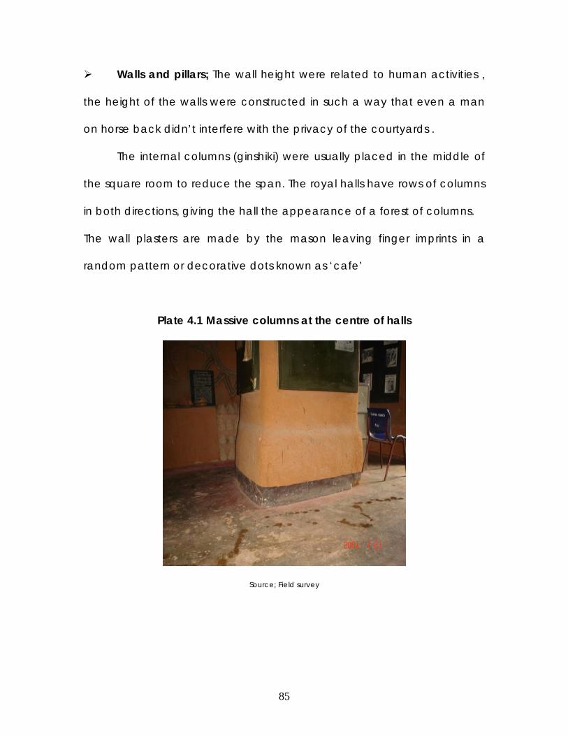
85
Walls and pillars; The wall height were related to human activities ,
the height of the walls were constructed in such a way that even a man
on horse back didn’t interfere with the privacy of the courtyards .
The internal columns (ginshiki) were usually placed in the middle of
the square room to reduce the span. The royal halls have rows of columns
in both directions, giving the hall the appearance of a forest of columns.
The wall plasters are made by the mason leaving finger imprints in a
random pattern or decorative dots known as ‘cafe’
Plate 4.1 Massive columns at the centre of halls
Source; Field survey
86
Entrances and Doorways; Two common rules regulated the size of
entrance into the palaces; the need to have openings in proportion to
the monumental nature of the edifice and the practical requirement of
having a horse and saddle, to pass through without scraping the sides or
the top of the door way, both of which resulted in huge doorways.
Palaces boasted of iron doors, two of the most common were the
door made by weaving strips of iron together and nailing them to
wooden frames; the second kind was made of sheet iron nailed to
wooden frames. The internal doorways were usually corbel shaped with a
mantel on the sides for placing lanterns.
Windows; traditionally are never meant to be closed, consequently,
the openings never had shutters. Windows were too small to allow human
penetration and too high up to afford entry to animals and provide good
lighting for ceiling decorations. The typical window is a vertical slit about
20cm by 50cm, set just below the ceiling level. Two of such slits could be
coupled to form (tagwayen taga) twin windows.
Less important parts of the building such as the kitchens, stores and
goat pens often have smaller circular windows, framed with the neck of a
broken pot. Another type of window is the ‘sakata’ which consists of an
ordinary window topped by a triangle giving it an appearance of an
arrow.

87
FIG. 4.3 SAMPLES OF OPENINGS IN PALACES

88
Ceilings; The oldest and simplest ancient ceiling is the shimfide
ceiling, which spans a space of not more than 2m, followed by the
mai ginshiki ceiling. The Hausa vault was in its early stage of
development
Plate 4.2 The Shimfide ceiling
Parapets; The ubiquitous pinnacles crowning the corners of the
traditional Hausa building was originally a functional element which
the mason utilizes as a stake around which to dangle a rope ladder
for climbing the roof; or on which to climb precariously while
plastering a façade. It was also utilized for shield on the fortification
walls (battlements) during war. The flat roof gutters were (indaroro),
made with clay as tubular ceramic sprouts, often 15cm in diameter
and 50cm in length. Tukur S (1983)

89
Plate. 4.3 Flat roof gutter ( indararo)
Plate 4.4 Pinnacle for support during plaster

90
Plate.4.5 Decorative Pinnacles
4.3.3 Fulani period
Physical planning and orientation; The Palaces built in this period
had the direction of their entrances towards the east. The east-west
orientation of palaces and mosques was to face the direction of the holy
land, Mecca which all Muslims face during prayers. This confirms the
spiritual position of a palace as a religious centre. In some instances even
the orientation of toilets is not allowed to face east .Liberty .m (1999)
New cultural activities such as Durbar, Eid celebrations and juma’at
prayers necessitated the provision of (Dandali) foreground in front of the
Emirs palace .During grand occasions, most of the palaces have a grand
stand on top of the entrance gates where the Emir sits with some
dignitaries.14

91
Walls and stairs; The Fulani rulers have ventured into many developed
countries particularly Sarki Abdullahi, therefore introducing many
advanced building technology into hausa Architecture, such as the
introduction of upper storey buildings.
The walls for the storey building usually differ from the normal
traditional wall. The ground floor which is considered as the (Jakin bene )
donkey of the upper floor is usually constructed with a low head room,
instead of the usual 3 mud(tubali) thickness of the wall, the thickness is
increased to 4 or 5 (tubalis) mud courses to be capable of supporting the
upper floor.
The stairs are usually straight flight or dog-legged. The interior stairs
often have a balustrade molded out of cob called pestles ( tabarya), the
pestles are used as screens to reduce the height of openings and perform
the function of lighting the stairway.
Plate4.6. Staircase Plate 4.7 Pestle shaped screen wall
Source; Field survey

92
The parapet (rawani) performs functional and aesthetic values.
Functionally, they are used in conducting rainwater to the point of
discharge, thus minimizing damage to the roof often considered
unsightly by masons, they also add height and dignity to the building
just as the royal headgear also called rawani ,articulates the majesty of
chief.
Mosques; Elaborate halls for prayers were constructed. The number
of columns was reduced to permit better view of the (Imam) leader,
which was achievable through use of wide spanning vaults. A mihrab
niche is an alcove where the liman stands in front of the congregation; it
assumes great proportions and emerges as a special feature on the
exterior of the building. On plan, mihrab niches are semi-circular,
rectangular or square.
Another important element of the mosque which had often attracted the
attention of visitors is the (hasumiya) minaret; these are simple towers with
internal stairs leading to the top platform where the muezzin calls the five
daily prayers.
Entrances, doorways and windows; The entrance of the palace is
constructed in an elaborate and flamboyant manner. The entrance is
usually a protrusion with two elaborate zanko on either sides of the high
walls of entrance way. The Zanko (pinnacle) became an element of
beautification. As a symbol of power and dignity Zankwaye (pinnacles)

93
are the prerogative of the royalty in Kano. The ruler of Kano turbans his
head in a fashion that creates two pinnacles pointing to the sky.
The doorways and windows became a focal point for decoration s on
the exterior surface of the palaces, during this period the decoration
was mainly done through application of 3-dimensional relief of
geometric patterns. This was later supplemented by the use of
psychedelic colours.
The decorative motifs are Islamic influenced, with the
patterns similar to designs made on the cover of the Quran.3
.
Plate. 4.8 3-Dimentional relief decorations
Source;
Ceilings; The hausa vaults reached its impetus of sophistication during
this period, intricate ceiling patterns were introduced such as the (kafar
kaza) chicken leg which is used decoratively most of the time, then the
(Daurin- guga) securing the water pail, it derived it’s name from the
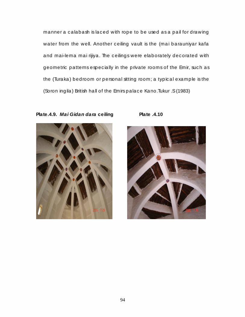
94
manner a calabash is laced with rope to be used as a pail for drawing
water from the well. Another ceiling vault is the (mai barauniyar kafa
and mai-lema mai rijiya. The ceilings were elaborately decorated with
geometric patterns especially in the private rooms of the Emir, such as
the (Turaka) bedroom or personal sitting room; a typical example is the
(Soron ingila) British hall of the Emirs palace Kano.Tukur .S (1983)
Plate.4.9. Mai Gidan dara ceiling Plate .4.10

95
Plate4.11. Mai lema daya ceiling Plate 4.12 Mai lema mai rijiya
Source; Field survey
Plate 4.13 Ceiling colour decoration
Source; Field survey

96
FIG. 4.14 Decorative motifs from Kano princesses apartments
1.Kan figini (head of fan) 2. Sarka (chain) 3.Kayar Kifi(fish bone)4. Fitsarin bijimi
(bulls urine5. (head of gecko) Kan tsaka 6.Takalmi(sandal)7. Kan
kadangare(head of gecko)8. Tambari(emirs drum) 9. Tsattsewala (swift or
swallow) 10. Igiyan tambari (leather ropeon drum) 11. Tukunya (cooking pot)12.
Gindin murhu (fire place for cooking)13. Matsefi(comb)14. Bakin buta (mouth of
bottle 15. Ludayi (ladle)16. Kuge (metal gong)17. Gululu (clay spindle whorl)18.
Shantali (jug for abulution).
SOURCE; Journal Nigeria vol 14

97
4.3.4 Colonial period
British Architecture and life style influenced the Hausa vaults,
elaborately embossed entrance halls were being supplanted with
upper storey suites for the house hold head.
The introduction of the rectangular clay brick in cob or sand Crete
which created a draw back on traditional aesthetics.
There was consideration for ventilation, necessitating use of numerous
openings (doors and windows).
Windows/ Doors; European window styles invaded the Architectural
land scape , which often go by the name ‘windo’ or ’fenitir’ . The
windows were made larger and in a lower position as against the
ancient traditional windows. Wooden window panes were made to
cover newly developed windows. In the early 20th century, the use of
glass panes was adopted. Furthermore, the doors were also replaced
with panelled or sliding doors.
The floor finishing changed from the traditional (dabe) into cement
floors. Abadom. O (1988)

98
4.4 SPATIAL EVOLUTION IN ARCHITECTURAL PLANNING
Few persons of the Kano palace community claimed
knowledge or insights in the pre-jihad palace landscapes. Aerial
photograph and archival field map reveal that no new spatial
avenue or pathways into the palace were developed until the
Fulani period. It is indicated that the entrance into the Palace and
the general placement and sequence of male spaces remained
unchanged from circa 1500-1807. The longetivity of these
placements partly reflects the growing importance of the central
city market to the state and royal household, and the continued
disadvantages of using the eastern pathway to reach the city walls.
The only addition to the Shigifa area recorded by the Chronicle is
the building of an open religious court area near Soron fadanci for
the Alkali of Kano during the reign of Kisoki (1509-65). A more
permanent structure was built in the nineteenth century
whichindicates that the Islamic ideal of unity between religion and
the state was incorporated more formally into the state realms.
Other changes between 1500 and circa 1800 occurred in the cikin
gida. Around the same period , it was discovered that the realms of
the women quarters was a walled area of cloth dyeing pits, which is
presently used as a cemetery.

99
FIG 4.4 DIAGRAMTIC RECONSTRUCTION OF RUMFA PALACE SHOWING CHANGES
IMPLEMENTED BY SULEIMAN(1807-19), DABO(1819-46)AND (1846-55)

100
During the nineteenth century, the western portion of the
Palace was an open field divided up into farm plots awned and
farmed by domestic slave women .The current belief that, prior to
the British conquest , the area was a haven for hausa spirits .
Rumfa adapted his house hold (Palace) to accommodate state
concerns . The entrance halls azure became nodes along
privileged avenues connecting the Palace to the city central
market and city walls, The Kofar Gida was used as site for
developing a state and domestic slave division of labour. The
placement of these slaves was carefully thought out. Slaves in
charge of the stables were located on the path bordering the
stables and leading to the city walls. The shigifa was extended or
distended to form a female –guarded labyrinth of court and council
of state and a permanent staging ground for the development of
an aristocracy. To guard against slave rebellions, the palace arsenal
and stables were located not in the Kofar Gida, as was the
characteristic of vernacular houses.
These are a few of the spatial changes that were effected in
Gidan rumfa , as subsequent Sarki’s occupied the Palace.
Spacial evolution (changes) was not only restricted to the primary
palace, it also included the daughter palaces. Gidan Sarki of
Nassarawa was expanded by the Emir of Kano in the early 1970’s

101
to accommodate royal and governmental guests. While the Gidan
Sarki of Fanisau was expanded by Sarki Dabo to accommodate
Soron makaranta, and vast rooms for the wives and concubines
that are residing in the palace during the retreats of Emir.
FIG. 4.5 DIAGRAMATIC RECONSTRUCTION OF RUMFA PALACE circa 1800

102
4.5 FUNCTIONAL RE-USE AND ADAPTATION OF PALATIAL BUILDINGS
The Hausa mason designs his buildings with consciousness of future
changes that may necessitate improvement or demolition of parts of the
building. In Palaces, the possibility of demolition is almost nil, due to the
historical importance of every part of the building and in some instances ,
the buildings are left abandoned so as not to interfere with spiritual
factors. Therefore some people refer to Hausa Architecture as organic
(traditional) architecture, due to it’s flexibility .
The Palaces of Kano were all built for certain reasons and to
accommodate certain functions, over the years with change in rulers and
demands of the society the functions of these palaces were changing to
adapt to the new circumstances. The Chief builder usually erects the new
buildings to conform with the existing building, he further applies the latest
architectural technique of that period, so as to emphasise the importance
of the building to the public. Such practices enabled architectural and
historical researchers to be able to trace the trends of the chief builders
and the Architectural elements in use at their respective regimes.
The ‘daughter Palaces’ in Kano adopted numerous functions , by
its different users. This was done as an effort to enhance its usage and
preserve history.
Royal Ranch ; The life style of the Emirs/ Sarkis indicate their flair for
seclusion and retreat into quite environments. These ranches are

103
sometimes reffered to as summer ranches. The Palaces
accommodates some members of the royal family, slaves and close
associates of the ruler. During the absence of the ruler the palace is
inhabited by slaves that are the caretakers of the building and in
some instances some concubines of the Sarki. The ranches are
characterised by vast farmlands for provision of food items to the
inhabitants of the Palace and gardens for the relaxation of the Royal
family.
Tax collection centre; Some of the ancient Palaces were adopted as
tax collection centres of the emirate district that were far away from
the Kano metropolis.The adoption of such function prompted the
incorporation of new buildings to enhance the activity.
Ribats; The word Ribat is derived from the root of the Arabic word
rabata , it has been defined as “to be firm, to be stead fast”.Islam
attaches graet importance to the founding of ribats , mainly for the
defense and protection of the community. Ribats are to be found or
established in vulnerable places in which muslim communities expect
external attacksor in similar locations were muslims live in perpetual
fear of harassment from their adversaries.
Considering Kano as the wealthiest and most prosperous emirate
amongst the Caliphate emirates, was threatened by such hostile states as
Ningi, Maradi and Damagaram.The reigning Emir responded to these

104
threats by resorting to earlier Islamic practice of establishing ribats ,
primarily for defensive purposes. The ribats were located at Rano, Babura,
Karaye and Gwarzo, while former existing Palaces in desirable locations
were also adapted to this use.
Amongst the historical buildings/sites of Kano Emirate that had to
adopt new functions were the madabo Palace. This Palace is believed to
be the oldest known Palace site of ancient kano (Bagauda dynasty). The
Palace was ruined centuries ago, therefore the site was adopted as a
Mosque. It is evident that the need to preserve the site as a public and
respected place coincides with its conversion into a mosque.
PLATE 4.14 MOSQUE BUILT ON SITE OF MADABO MOSQUE

105
CHAPTER FIVE
5.0 GIDAN FANISAU
5.1 Historical background
The Fanisau community is located at Ungogo local Government of
Kano state at the fringes of the Kano , it’s accessed from Sarki road ,off
Airport road . A Fairly tarred road leads into the heart of the community
where the Palace is located. The palace is surrounded by a Ganuwa (city
wall), at a radius of approximately 25m, though the wall no longer exist
the gates of the wall are still standing, their names are Kofar Kudu, Kofar
Gabas and Kofar Yamma .
Fig. 5.1 Map of kano showing Fanisau

106
The origin of Fanisau is from the earliest settlers of Kano, known as
the Maguzawa. The chief priest of the Tsumburbura worshippers,
Barbushe, amongst his clan chiefs is Gumbari-Jadu followed by his
successor Nissau,
The hill was therefore the focal point of the community, hence
called FA (hill) NISSAU (nissau’s hill). Years later during the Habe era, the
ruling family seek for spiritual assistance from the deities on the Hill, for
success in war and many other issues. According to Sarkin Gida, At a
certain period the area within the walls of Fanisau is reffered to as Muntsira
(we’ve been saved) based on the longstanding belief that during war,
everybody within the wall of Fanisau is saved from any harm,this belief
corresponds with the historical use of the hill as a hiding place, through an
excavated hole of approximately 15m in depth, hence accommodating
a large number of the villagers during war.
The original building of the Palace was a small and simple shelter,
towards the eastern side of the hill, on the instructions of the spirit on the
hill, to provide immunity to the royalty of that era.
Through the years, as the Kano Emirate became politically and socially
powerful, Fanisau became a Gandun Sarki (slave quaters), therefore
necessitating the building of a palace, which was eventually built by Sarki
Ibrahim Dabo, years later it was utilised as a Royal Ribat for training of
military troops due to its strategic location.

107
5.2 ACTIVITIES OF GIDAN FANISAU
The Gidan Sarki of Fanisau has gone through a lot of spatial
changes as its social demand changes.
The original occupants of the Palace site were the maguzawa,
who settled around the hill following the orders of their clan priest
Gumbari-Jadu , who is a subordinate of Barbushe ,years later the priest
hood passed on to Nissau and their activities continued until it was
brought to an end by Sarki Tsamiya.
In the early pre-jihad period it was reported to be a timber
stockade of huts which was later converted to a conventional building of
tubali, by Sarki Abdullahi. The Building was designed in such a way to
carter for the needs of the Royal family, who reside in it for long period of
time i.e during war. Hence it had all the necessary functional spaces
required in a Palace, which are; Mosque, Dandali and the Living quarters
of the Sarki. The activities in the Palace progressed into Durbar processions
when it was introduced by Sarki Rumfa .
After the Jihad, all pagan activities were stopped. The Gidan Sarki
became a resting abode for the Emir and his family, to enjoy the silence
and tranquility of the environment. The dandali was used by the locals as
a weekly market, and the Durbar is held on the dandali grounds twice a
year.

108
Today the most active events that holds in the Gidan Sarki na
Fanisau is the Durbar .Foreign tourists visit the Hill for historical researches,
but are not allowed into the surroundings of the Palace.
Fig.5.1 Sketch of Fanisau Palace
Source; B.N Ahmad

109
5.3 PLANNING AND ORIENTATION
As seen in majority of Hausa palaces, Gidan Fanisau is also
identified with the Dandali, Masallaci, and Gidan Sarki.
At the front of the western façade, one sees the mosque attached to the
outer wall of the northern extension of the Palace. The Soron-kofar Gida to
the right, and facing west, the Soro’s gate which is made of boarded
timber and nailed iron-strips.
Plate.5.1 Entrance façade of Gidan Sarki, Fanisau
Source; Field survey
The gate stands very tall, with 2 small openings located on either
side, with 4 zankuna (pinnacles) mounted on the wall, 2 at the corners
and 2 in between them.

110
Inside the entrance Soro or Zaure , 2 massive circular columns, that
taper towards the top ,supporting the trabeated bundle of Azara beams
(dantsina) and flat mud roof. Another Soro leads into the Sarari from
which the Dakin Hakimai (chief’s chamber) located to the northern side of
the building.
Plate 5.2 Entrance Zaure; showing column Plate 5.3
More courtyards and Soro leads into the interior. The Dakin mata
(females room), Dakin rabon Hatsi and Soron Makaranta (where the Sarki
and his family members take Islamic lessons) are all located to the South.
The private areas of the Sarki is located at the South eastern corner
of the building. It is composed of a number of flat roofed rooms, including
a single storey structure. The upper floors comprises of a private sitting
room , Bedroom, bathroom and toilets.

111
Plate 5.4 Private quarters of Sarki
The shamaki is located opposite the Sarkis area, at the northeast
corner. The area of the Sarki is separated from the Shamaki by courtyards
and Soraye. The mosque is located farther north, adjacent to the sarari.16
Plate. 5.5 The Sarkis shamaki stables) Plate 5.6 Upper chamber of Sarki

112
5.4 ARCHITECTURE AND CONSTRUCTION
The periods of construction and usage of Gidan Fanisau varied from
the period of one Sarki to the, furthermore the function at which the
building is used for has prompted necessary changes.
During the occupation of the Maguzawa in Fanisau , it is believed
that their abode was on Hills or inside caves ,therefore any physical
building structure was not evident.
As stated by Clappertton on his visit to Kano in the early 14th
century. He visited the reigning Sarki as at the time in Fanisau, He
described the palace as a cluster of wide huts of tubali with thatch roofs.
Years later further improvements were made to the building by Sarki
Abdullahi, who converted the spaces into large rectangular halls (soraye)
, built a new mosque and a new Sarki’s chamber.
Inside the entrance soro or zaure, 2 massive circular columns that taper
towards the top of the ceiling, supporting the trabeated bundle of azara
beams (dantsina) and flat mud roof.
Plate 5.7 Plate 5.8

113
trabeated bundle of azara beams Fanisau hill
More courtyards and Sora leads into the interior parts of the
building, which consists of ; dakin mata (females hall), dakin rabon hatsi
(food distribution room)and soron makaranta ( where the Sarki and his
family members takes islamic teachings) are all located to the south.
The (soraye) halls have elaborate vaults and beams (daurin guga & dauri
baka) ,each exhibiting a different decorative patterns.
Plate 5.9 Plate 5.10
Soron mata (womens halls) Dakin rabon hatsi (kitchen)

114
Plate 5.11 Plate 5.12
Soron Sadaka (concubine halls) Soron makaranta (school hall)
The new mosque that was constructed by Sarki Abdullahi ,has 2
entrances in the wall facing west ,the mihrab consists of 7 steps .Inside the
mosque are 6 thick columns ,of 1m in diameter each at the base, then
taper as it progresses upwards.
The next stage of changes came about in the early reign of the present
Sarki, Alh. Ado Bayero.
In the first Soro a massive column (approximately 1.2m) in diameter
as well as a new daurin-guga, constructed by the present Sarkin –gini
mallam ibrahim.The new daurin-giga posed an architectural fineness in
terms of lesser vertical sweep or prorportions and smoothness-to-near
perfection curves, clearer structural details is emphasized, the same can
be said of the Kafin-Lema.
The Soron kofar-gida was also recently renovated. The new Azara
bundle that serves as the beam have been tied together, before other

115
horizontal members were introduced, exhibiting a unique traditional
structural system.
Further improvements were made in the Sarki’s chambers. The
roofing was of corrugated zinc sheets on timber trusses, the ceiling was of
modern celotex ceiling board. The windows are louvered with green glass.
An open balcony was introduced with access from the Sarki’s private
sitting room. The balcony is covered with green translucent roofing sheets,
the most interesting view of the Fanisau hill is observed from here.
Plate 5.13 Plate 5.14
Balcony of the Sarkis living quarters staircase leading upstairs
On the few occasions that the present Sarki visit’s the Fanisau
palace, he spends a considerable amount of time luxuriating in the
peaceful tranquility and views of his upper chambers.
During major yearly Durbar Festivals the certain places in the palace is
white-washed to enhance its appearance to the thousands of spectators
in attendance.

116
5.5 PROSPECTS OF GIDAN FANISAU
The Fanisau hill is a major historical site that identifies the origin of
Hausa man, as far back as the first century. The palace has played major
roles in the political, social and religious roles of Kano emirate, through
many centuries.
Gidan Sarki Fanisau is a monumental edifice that has numerous
prospects such as;
1) It provides historical knowledge on the Maguzawa era.
2) It educates on the numerous social activities that made Kano become
a powerful Emirate.
3) It is situated in a tranquil, secure and typical Hausa traditional
community, which is ideal for tourism.
4) The Gidan Fanisau is a host of the most celebrated festival in Kano,
namely the Durbar festival.
5) The Dandali of the palace is used as a weekly market, were unique
traditional items are obtainable.

117
CHAPTER SIX
6.0 CASE STUDIES
6.1 Case studies selection criteria
All the case studies selected in this research work were chosen to
further identify the research situation from buildings of similar function or
construction. Therefore, the Gidan Sarki Nassarawa and Dorayi were
selected due to their similarity in function with Gidan Sarki Fanisau, while
the British council and Nigerian embassy Riyadh were selected due to
their traditional mode of construction. Lastly, the Gidan Makama and
Gidan Dan-Hausa were selected based on their historicy, architecture
style and as traditional tourist centres.

118
6.1.1 Case study 1; Gidan Sarki, Nassarawa
Location; Gidan Nassarawa is located outside the walled city of Kano, in
Nassarawa Local government. It is situated on State road , The Gidan Sarki
is sandwiched between the Government house, Ministry of works &
housing and Ministry of Land & Physical planning.
Fig 6.1 Sketch plan of Gidan Nassarawa
Source; B.N.Ahmad
Historical background; The Palace was built by Sarki Abdullahi (1855-83)
son of Dabo. According to Kano chronicle “Sarki Abdullahi gave orders
that a house to be built for him to live in during the hot season”.
Activities; The Palace was originally built for the care taker of the
(Gandun-Sarki) Emirs ranch/garden, who was known as maishanu (slave
title). It was later expanded to accommodate the Royal family and serve
as a rest house. Since its construction, the Palace has been a favorite rest

119
house for the Emirs. Such visits usually last for two to four weeks, the
duration for these visits started reducing considerably with time. With the
advent of colonialism the activity of the activity in the building changed.
The vast farm land was converted to plots for Governmental usage such
as ministries amongst others. Today, the Gidan Sarki Nassarawa is the
primary official Guest lodge of the Emir. It is one of the venue where the
Durbar is held, famously known as Hawan Nassarawa, the Emir and his
horsemen makes a stop here to rest before proceeding to greet the
Governor on Sallah days.
Building structure and spatial organization; The first structure is the vaulted
(Soron Tambura) hall of drums, followed by two smaller (Soraye) halls
which the Emir passes through on horse back until he reaches the
courtyard aligned to the (Soron makaranta) learning hall.
The Emir removes his riding shoes, during sallah days and replaces it
with his ostrich leather shoes ,then proceeds through another 2 (soraye)
halls called (Soron jakadu). This opens into a large courtyard called (Soron
baki) guest hall, where inmates of the palace greet the Emir.
The private chalet of the Emir consists of a large sitting room that
was recently renovated. To the right of the sitting room is a door leading
to the old Bedroom of the past Emir, on the left is a doorway that leads to

120
the dinning room. On the upper floor is the bedroom and toilets. This
building is completely traditional from its interior and exterior.
Behind the private chalet of the Emir is the (Hubbare) tomb, which is
a regular square modern building which houses the graves of the
ancestors of the Emir ; Sarki Abdullahi Bayero, Sarki Abbas and Sarki Sunusi.
Adjacent to the Emirs chalet is the female quarters, where his wives
and concubines stay during their prolonged visits to the Palace. This
building has been renovated recently into a modern sand Crete building.
Opposite the female quarters is another modern building , built by
the former Governor of Kano, Audu Bako,as a gesture to create
awareness in use of modern building materials. This section is also used by
the Emir during his visits.
Adjacent to the Emirs chalet is another modern building, used as a
guest house. The guest house is particularly used by dignitaries of the
Government or Royalty that come to Kano to pay a visit to the Emir.
Architecture; The Soraye (halls) were all in existence since the inception of
building the Palace. All the ceilings were made in different elaborate
Hausa vaults, except the (Soron Tambura) hall of drums that was changed
into a modern ceiling due to leakages. The interior of the Emirs chalet was
decorated in various decorative 2-d relief forms and painted in green and
red colors.

121
The exterior of the Emirs chalet and the (Soron makaranta) learning
hall, have a newly plastered wall with neat motif patterns, while the
remaining traditional buildings are finished in the ancient (Café) finishing.
Merits;
The (Soraye) halls and private living room of the Emir have excellent
lighting, through the open slit windows placed close to the ceiling.
The atmospheric condition of the ancient traditional areas of the
Palace is cool in temperature and has good absorption of noise.
The circulation pattern for the Emir is intricate, making it impossible to
predict the movement of the Emir.
The renovations made to the Palace has made it to become the most
frequented and useful Palace to the Emirate.
Demerits;
There are many repetitive functions such as the guest houses.
The design and orientation of the new buildings are in contrast with the
ancient parts of the Palace.
The appreciation of the Palace is limited to the immediate royal family
members.

122
6.1.2 Gidan Sarki Dorayi , Kano
Location; The Dorayi Palace is located roughly 1km from the walls of
ancient Kanocity, along an untarred road, behind Bayero University fence
from the west.
Fig.6.2.Sketch Plan of Gidan sarki Dorayi
Source; B.N Ahmad
Historical background; The site became the property of the Kano Emirate
since early 17th century. As at that time it was built as a timber stockade
with thatch roof. It was later converted into a mud building by Sarki
Abdullahi (1855-83).
The Palace was originally a Royal farmstead. Slaves were deposited
on the fields to work for the Sarki in production of crops for the household

123
of the main palace (Gidan Rumfa) and other smaller palaces of the
Emirate.
After the jihad, a new building was erected to serve as a military
encampment (Ribat) due to its strategic location at the outskirt of the
walled city of Kano.
Activities; This Palace is the smallest of all the Palaces of Kano Emirate. It is
also not in much use except on Sallah days due to its dilapidated state
and poor location.
During Sallah, the Emir makes a stop at the Dorayi Palace together
with his council men.
Building structure & spatial organization; The layout of the Palace is the
same as all typical palaces built by the Fulani rulers, comprising of a
Mosque, Dandali (foreground) and the Cikin gida (residential).
The Dandali is the grounds were the yearly procession of Durbar
festival takes place, while the mosque is attached to the residential
building , it is small in size and presently in ruins.
The first (soro) hall is the (Soron kofargida), which leads to the Soron
Sharia (courtroom) which opens onto a courtyard. The Soron hakimai
(council men) is located at the north east corner of the palace.The Emirs
chamber is located on the east with a transition chamber called the (
Soron cikin gida).

124
Architecture; The (Soron kofar gida) is a unique building , it is circular in
shape with a simple vaulted roof. The concubines wing is also a circular
building approximately 6m in diameter. The (soro) hall has a gigantic
column of approximately 1.4m thick in the centre of the circular hall.
The finishing of the Palace is made in local finishing of dabe.
Plate.6.1 Back entranceway Plate 6.2 Bathroom
Merits;
Amongst all the existing palaces of Kano, its only here that a circular
mud soro is still standing.
The (soro) halls interwoven in a simpler way compered to other
palaces.
Demerits;
The majority of the (soraye )halls are poorly lighted.
The simplicity of the building doesn’t depict the residence of a sarki.
The walls of the building from the interior and the exterior is not
decorated either in motifs (café) indentations.

125
The surrounding environment of the palace has been encroached
by slums.
6.1.3 Gidan Makama Museum, Kano.
Location; The gidan makama is located on Emir Road, opposite the kofar
kudu of emirs’ main palace within the wall city of kano.
Fig.6.1.3.1Location map of Gidan makama
Source; A.M Fika
Historical background; Gidan makama was originally built in 1442 as a
house for the grand child of the reigning Sarki, Muhammad barda. The
grand child who is Muhammad mansir Rumfa was appointed as the
makama of kano at an early age if seven.
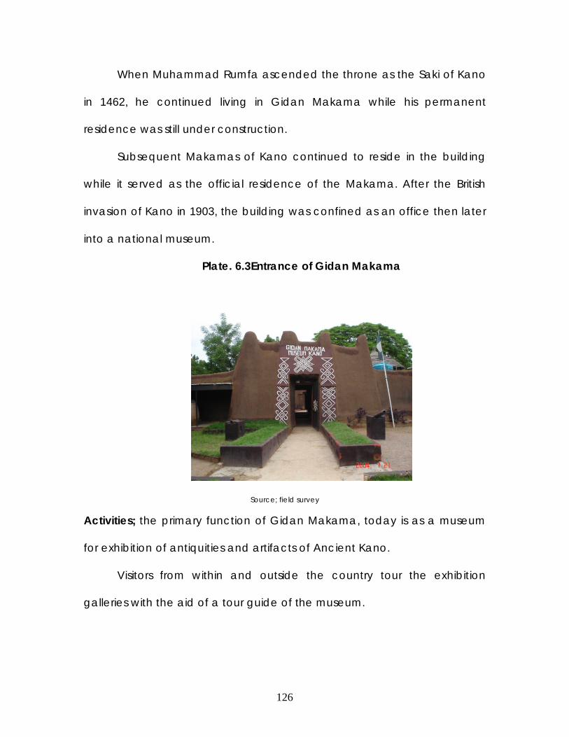
126
When Muhammad Rumfa ascended the throne as the Saki of Kano
in 1462, he continued living in Gidan Makama while his permanent
residence was still under construction.
Subsequent Makamas of Kano continued to reside in the building
while it served as the official residence of the Makama. After the British
invasion of Kano in 1903, the building was confined as an office then later
into a national museum.
Plate. 6.3Entrance of Gidan Makama
Source; field survey
Activities; the primary function of Gidan Makama, today is as a museum
for exhibition of antiquities and artifacts of Ancient Kano.
Visitors from within and outside the country tour the exhibition
galleries with the aid of a tour guide of the museum.

127
Sometime certain special programmes are organized by the state
government to enhance knowledge on craft and art especially to youths
and children. Such activity takes place in the circular amphitheatre.
Building structure & spatial organization; All galleries of Gidan Makama
were originally the rooms, courtyard and of the ancient home of
Muhammadu Rumfa. Therefore the setup is of a typical residence of
noble man in the Habe period.
Fig 6.3. Sketch plan of Gidan Makama

128
As typical of mud walls, the thicknesses of the walls are 600-1000mm
thick. The roofs are simple dome roofing with vault ceilings, the openings
are close to the ceiling level, permitting good flow of light.
Plate 6.4 Base of column Plate. 65 corbels of archways
Plate.6.6 intricate ceiling Plate.6.7 a typical bedroom
The new extensions made to the building were of modern materials.
Its only link to traditional Architecture is the decoration of the interior walls.
The extension serves as the offices/ administrative section of the museum.

129
Plate 6.8 Plate.6.9
The (Dandali) fore ground for entertainment Demarcation; fortification walls
Plate. 6.10 Plate. 6.11
Seating area of the (Dandali) foreground Corbel shaped doorway
Architecture; Gidan Makama is a perfect exhibition of a noble mans
residence. This was achieved by maintaining the design of the building as
it was years ago.

130
Demarcations of zones in the palace were achieved by building a
wall in certain places that resembles the famous Hausa fortification walls
(ganuwa).
The headroom of the galleries is approximately 2.5m, while the
doorways are around 1.8m high.
Merits;
The Gidan Makama is the only public building in Northern Nigeria that
emulates Hausa traditional building.
The atmospheric condition is very cool with good sound absorption
from the always busy and noisy environment.
There is adequate security for the artifacts due to proper orientation of
the building sections.
It is properly located to serve the purpose of public viewing.
Demerits;
The new buildings are constructed with modern materials ,which
contrast with the traditional trend of the ancient side of the building.
The galleries do not provide adequate viewing due to poor lighting
and low headroom.
The location and orientation of the modern building is poor.
Appropriate exhibition of the Architectural features is deemphasized.
There are inadequate functional facilities that will enhance tourism.

131
6.1.4 Gidan Dan-Hausa, Kano.
Location; Gidan Dan-Hausa is located on Commissioner Road ,
Nassrawa G.R.A.
Fig 6.4. Location map of Gidan Dan-Hausa
Historical background; The building site was originally part of the
(Gandun-Sarki) royal garden of Gidan Sarki Nassarawa. The only built
structure on the site was the hut of the caretaker, which serves as his
accommodation. Years later it was converted into a bigger residential
building for Turakin Kano, presumably after Jihad.
After British occupation of Kano, certain parts of the Gandun
Nassarawa were converted into public offices or residence for the

132
colonial masters. In 1907, the building was demolished and a new building
was erected for the 1st western education teacher in Kano, known as
Hans Vishner popularly known as Dan-Hausa.
After the Nigerian independence the building was converted into a
State public museum.
Activities; the primary function of Gidan Dan-Hausa is a guided tourism
around the historical building and site, with the aid of a tour guide.
Recently, a newly constructed modern building was erected which is
known as the Kano Hall of Fame.
Building structure and spatial organization; The structure of the building
was made with local tubali , but in Victorian Architecture.
There are 3 entrances into the building; the hall way, garage and
backdoor. The ground floor of the building comprises of a sitting room,
dinning room, bar, kitchen and conference room, while the upper floor
comprises of 2 bedrooms, toilet, study, radio room and balcony.
The sitting room and conference room was converted to a gallery
where show glasses are placed for displaying historical artifacts.
The Hall of fame, consist of a large hall and some adjoining offices
where the pictures of dignitaries in Kano are hanged on the vast walls.

133
Fig6.5 Sketch of floor plan, Gidan Dan-Hausa
Architecture; An interesting Architectural style was created in the mixture
of traditional materials and western Architecture. The functional spaces
where well planned, hence overcoming the poor orientation evident in
traditional Architecture.
The newly constructed hall of fame doesn’t conform to the
historical Gidan- Dan Hausa Modern sand Crete blocks were used, the

134
only obvious effort made towards application of traditional architecture
was in the decorative motifs on the walls and the vaulted ceiling of the
domed roof.
Merits;
An ideal expression of trado-modern Architecture was achieved
through the mixture of Western Architecture with traditional material
and construction.
The grounds are large enough to accommodate oout door activities.
Demerits;
Formal tourism facilities are not available.
Necessary facilities and activities were not incorporated for enhancing
public interest.
The location of the building is inappropriate.

135
6.1.5 British council, Kano.
Location; The British council is located at No. 10, Emir Road, few meters
away from the Emirs palace, Kano.
Fig 6.6 Location map of British council

136
Historical background; The building of the British council was originally a
property of the Kano Emirate, probably a residence of one of the council
men of the Sarki. It was handed over to the British in 1951 as an official
building due to its proximity to the Emirs Place.
Activities; after the civil war the building was used as information centre
for the British Embassy. In 1987 it was converted into a full lending library.
The centre organizes other activities such as British exams (London G.C.E,
TOFFEL Exams e.t.c), hosting the world book day, administering
chevenning scholarships, internet Cafe and periodic film shows.
Building structure & spatial organization; The british council have made in
maintaining and emphasizing the original façade of and Architecture of
the building.
Plate 6.12 Library entrance Plate 6.13 Amphitheatre

137
Plate 6.14 Plate 6.15
stage of Amphitheatre side view of main building
The main building comprises of the reading rooms and offices. In
front of the main building is an open landscaped courtyard, while beside
the main building is an internet café and a multipurpose hall.
Behind the main building is an amphitheatre which is an extension
of the original building. The amphitheatre is semi-circular in shape,
depicting the traditional Dandali.
Architecture; the most ancient part of the building is the main reading
room , therefore changes were not made to the external walls of this
section. The corbel shaped windows were the typical windows of the
16th-17th century residences of noble men.
Modifications were made to the original buildings to suit the present
function such as removal of walls to provide a wide reading room. The
toilet facilities were also moved to new spaces outside the building.

138
The Zaure’s (chambers) and inner rooms were converted into
offices. The entrance ways into the building were designed in the
traditional corbel door ways. The walls of the old interior walls were
maintained, in areas were there is the need for new walls the traditional
wall which is approximately 1000mm thick.
Plate 6.16 Plate 6.17
Journal section inside library audio room
Plate 6.18 Plate 6.19

139
canteen landscaped grounds
Merits;
The British council is the most famous of the British councils of Nigeria
due to its traditional Architectural styles.
Appropriate flow of spaces was achieved by proper zoning of noisy
and quiet areas.
All activities of the council are appropriately accommodated.
Demerits;
The old parts of the building were replastered with cement hindering
the benefit of thermal cooling.
The designers limited their efforts attempting to maintain the traditional
Architecture from the exterior only.
There is an unavailable space for future expansion.
The maintenance is costly due to the poor durability of the traditional
plaster (makuba), which demands constant refurbishing.
Application of electricity conduits is very difficult due to the absences
in provision of such items in the original design.
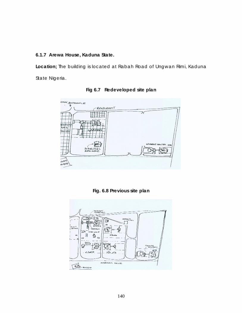
140
6.1.7 Arewa House, Kaduna State.
Location; The building is located at Rabah Road of Ungwan Rimi, Kaduna
State Nigeria.
Fig 6.7 Redeveloped site plan
Fig. 6.8 Previous site plan

141
History ; Arewa house was the residence and officequaters of the former
late premier of the defunct Northern region, Sir Ahmadu Bello. It was built
along side other buildings, hence called ministers quarters.
In 1972, The interim common service agency, which took over the
asset, gave formal approval for the use of this quarters as a centre for
research and historical documentation hence Arewa House. The property
was transferred to Ahmadu Bello University in 1976 on the order of the
Federal Government.
Building structure and spatial organisation; The original building site was
cleverly zoned into active (official) areas and the quiet residential areas.
The Official areas were located at the centre while the guest section,
servant quarters was on the right side, while the private residence was on
the left side. These areas were demarcated by a tarred road.
Upon the upgrading and renovation of the building commenced,
an Architectural firm known as Home development worked on the
project. New facilities were incorporated such as conference hall,
restaurant , gardens, museum, bookshops printing and bindery and
additional offices were proposed. The construction work was completed
in the 1990’s.

142
Architecture; The Architectural theme of the design was initially of
the colonial style. The fenestrations, Building height and interior was a
depiction of the style during the colonial period as with the time the
original building was built.
The new additions were made in the new–era design (post-
colonialism). Applications of numerous sliding glass windows, wall fins
amongst others. The private residence was converted into the
researchers’ hostel. While the restaurant, was placed at the fore front of
the site. Recent additional buildings were constructed such as the multi
purpose hall, which is used for public functions such as conferences and
weddings. These new facilities are obviously integrated so as to establish a
good financial provision to enhance adequate maintenance of the
building, in as much as the functions on the site are conflicting.
Plate 6.20 Plate 6.21
The multi purpose hall book shop

143
Plate 6.22 Conference hall Plate 6.23 Water fountains
Merits;
1) A historical building has been preserved and the site been placed
into good use.
2) The planning of the site was successful due to the minimal
interaction of the researchers and the public was duly achieved.
3) Necessary facilities required by a researcher, is easily available
within the building site.
Demerits;
1) The new structures bear no semblance with the old buildings,
therefore a good flow of design was not a achieved.
2) The former quarters were located far behind the new quarters,
Hence the new over shadowed the old buildings.
144
3) The buildings do not have a link to one another, Therefore a
demarcation line exists.

145
CHAPTER SEVEN
7.0 SITE
7.1 LOCATION
The site is located in Fanisau, minjibir local government of Kano
state. The site is precisely located within the ancient walls of
Fanisau, where the Palace is located. The site is boarded by the
houses of the local chiefs of Fanisau on the north and east, in the
other directions there are small farmlands that belongs to the
emirate. The notable facilities surrounding the site are the Fanisau
primary school on the south east and the Export processing zone in
the northern direction. The site is accessed from the major Airport
road, where a newly tarred road is linked, leading to the outskirts of
Fanisau. A fairly tarred road leads into the heart of Fanisau and
stops at the surroundings of the Palace. Generally the site is
characterized by shallow swamps and the flat topped Fanisau hill.
7.2 VEGETATION
The area is underlain by the Sudan Savannah vegetation type which
consists of scattered trees and shrubs. Which is associated with the hot
and dry climate that lasts for approximately 8 months and short rainy
seasons.

146
Design implications
- The swampy areas will be filled, therefore the foundations to be
used in such areas will be determined according to the soil type used for
the filling.
- The existing old trees (70 yrs and above) shall be retained ,for
historical benefit. Therefore the design shall revolve around them.
- The cave that is located within the Hill shall be structurally reinforced
to enhance its stability.
Fig. 7.1 SITE ANALYSIS

147
7.3 GEOLOGY AND TOPOGRAPHY
The terrain of the site is gentle with uniform slope. Therefore construction of
the buildings will not slope or require costly cut offs. The swampy areas will
be filled with appropriate soil to increase usage spaces.
7.4 CLIMATE
Nigeria enjoys the humid tropical climate type. Because of its location just
north of the equator, Nigeria enjoys a truly tropical climate characterized
by the hot and wet conditions.
The climatic conditions in the northern part of Nigeria exhibit only two
different seasons, namely, a short wet season and a prolonged dry
season. Temperatures during the day remain constantly high while
humidity is relatively low throughout the year, with little or no cloud cover.
There are, however, wide diurnal ranges in temperature (between nights
and days) particularly in the very hot months. The mean monthly
temperatures during the day exceed 36°C while the mean monthly
temperatures at night fall, at most times, to below 22°C.
(i) The Long Dry Season: This period extends from October to mid-May.
The harmattan period during December- January is more intense and
longer in the north than in the south. This is the period of little or no cloud
cover, resulting in wide diurnal ranges of temperature.
(ii) The Wet Season: The wet season covers a relatively short period,
from June to September. Both the number of rain days and total annual

148
rainfall decrease progressively from the south to the north. The rains are
generally convectional, heavy and short in duration, often characterized
by frequent storms. This results in flash floods, and in some places also in
sheet or gully erosion.
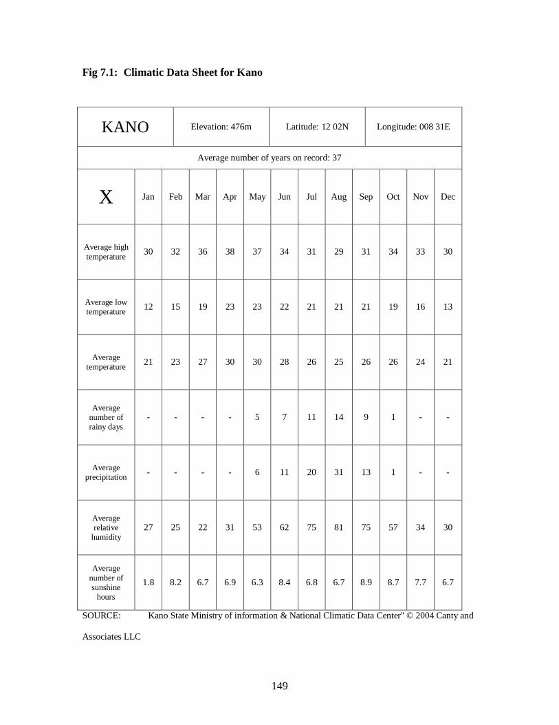
149
Fig 7.1: Climatic Data Sheet for Kano
SOURCE: Kano State Ministry of information & National Climatic Data Center'' © 2004 Canty and
Associates LLC
KANO Elevation: 476m Latitude: 12 02N Longitude: 008 31E
Average number of years on record: 37
X Jan Feb Mar Apr May Jun Jul Aug Sep Oct Nov Dec
Average high temperature 30 32 36 38 37 34 31 29 31 34 33 30
Average low temperature 12 15 19 23 23 22 21 21 21 19 16 13
Average temperature 21 23 27 30 30 28 26 25 26 26 24 21
Average number of rainy days
- - - - 5 7 11 14 9 1 - -
Average precipitation - - - - 6 11 20 31 13 1 - -
Average relative
humidity 27 25 22 31 53 62 75 81 75 57 34 30
Average number of sunshine
hours
1.8 8.2 6.7 6.9 6.3 8.4 6.8 6.7 8.9 8.7 7.7 6.7

150
Fig. 7.2 Climatic Data Graph for Kano
0
10
20
30
40
50
60
70
80
90
Jan Feb Mar Apr May Jun Jul Aug Sep Oct Nov Dec months
average high temperature average low temperature average temperature average number of rainy days average precipitation average relative humidity average number of sunshine hours

151
Fig. 7.3 Average Temparature
21 23
27
30 30 28
26 25 26 26 24
21
0
5
10
15
20
25
30
35
Jan Feb Mar Apr May Jun Jul Aug Sep Oct Nov Dec
months of the year
temparature

152
Fig. 7.4 Average Low Temparature
12
15
19
23 23 22
21 21 21
19
16
13
0
5
10
15
20
25
Jan Feb Mar Apr May Jun Jul Aug Sep Oct Nov Dec
months of the year
temparature
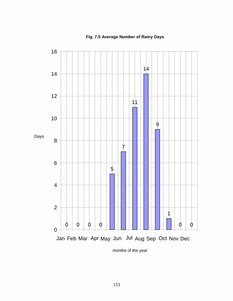
153
Fig. 7.5 Average Number of Rainy Days
0 0 0 0
5
7
11
14
9
1
0 0 0
2
4
6
8
10
12
14
16
Jan Feb Mar Apr May Jun Jul Aug Sep Oct Nov Dec
months of the year
Days

154
Fig. 7.6 Average Precipitation
0 0 0 0
6
11
20
31
13
1 0 0
0
5
10
15
20
25
30
35
Jan Feb Mar Apr May Jun Jul Aug Sep Oct Nov Dec months of the year
cm

155
Fig. 7.7 Average Relative Humidity
2725
22
31
53
62
75
81
75
57
34
30
0
10
20
30
40
50
60
70
80
90
Jan Feb Mar Apr May Jun Jul Aug Sep Oct Nov Dec months of the year
percentage %

156
Fig. 7.8 Average Dew Point
2 2
5
13
21 2120 20 20
18
8
4
0
5
10
15
20
25
Jan Feb Mar Apr May Jun Jul Aug Sep Oct Nov Decmonths of the year
°C

157
Fig. 7.9 Average Number of Days Above 90F/32C
10
15
26
30 31
20
13
9
12
21
17
11
0
5
10
15
20
25
30
35
Jan Feb Mar Apr May Jun Jul Aug Sep Oct Nov Dec months of the year
Days

158
7.5 INFRASTRUCTURAL FACILITIES
Drainage system has to be provided due to increment in facilities, the
water system used in the existing building is obsolete therefore
necessitates the designing of new water piplines, drainage systems and
other necessary service. An electrical transformer is situated at the
grounds of the site capable of supporting the required electrical power.
7.6 SITE ANALYSIS
The proposed site is centrally located within the walled town of Fanisau.
The location of the site fits in well with the need to create a strictly
traditional environment, hence the surrounding buildings are an excellent
reflection of local traditional environment .The serenity of the surrounding
provided an ideal atmosphere for research and relaxation.
The notable features on the site are the flat topped hill, approximately 6m
high, the total width is 24m.From the anterior side of the hill is a cave of
approximately 15msq in size. Other features on the site are the shallow
swamps that were formerly farmlands cultivated by the slaves in the
Emirate.
Adequate sunshine is usually received from 7.00 am to 6.30 am. Since the
sun moves from east- west directions the longer axis of the building is to be
oriented towards north-south axis. Also to protect the part of the building
oriented towards such positions could be protected by screen walls,
windows, windows hoods and landscape elements.

159
The soil is alluvial mostly dominated by laterite, the soil is very strong
suitable for the most common foundation types. The vegetation cover is
composed of schist, granites and gneiss rock, outcrops are not evident on
the site as with the other parts of the locality. The soil is considered
moderately suitable for dry season farming (fadama) and it is cultivable.
Vegetation of the site is predominantly shrubs in different proportions,
various types of grasses are found.
Heavy concentration of rainfall during the period which is July –
August would require adequate drainage system to handle large volumes
of water.
7.8 SITE SELECTION CRITERIA
The site was selected primarily due to reasons such as;
1) Fanisau hill is amongst the 5 ancient hills of Kano. Its historical impact
identifies the earliest settlement in Kano.
2) The Durbar festival is held on the site twice in a year, therefore
enhancing the publicity and appreciation of the site.
3) The existing building (palace) is amongst the few existing Places of its
period.
4) The Fanisau Palace has evolved in usage through the years. It was
initially a farmstead of the Sarki, it then became a royal Ribat , a tax
collection centre, and today it serves as a resting place for the Emir.

160
CHAPTER EIGHT 8.0 DESIGN DEVELOPMENT
8.1 DESIGN PHILOSOPHY
The major aim of the design bearing is to emphasize the historical
and Architectural features of the Fanisau site. This could only be achieved
by emphasizing these features through creation of activities that will
enhance its usage.
The new building facilities will have to be designed to flow with the
existing building on the site, without compromising the functionality and
aesthetic effect of a Palace building.
8.2 SOCIAL SURVEY
RESEARCHERS
8.2 SITE ZONING
The site was zoned based on the different users and rate of
activities. The most active functionality is moved to the rear end of the site
(Durbar activity), while the quiet activity is placed at the fore front of the
site.
8.3 CLIENTS AND USERS
The client for this proposal will be the Kano Emirate council. There is
need to enhance tourism in Kano from an angle where the genuine
experience required will be obtained. Kano emirate has always been a

161
host for researchers from different parts of the world , it has also hosted
royalty from other countries on many occasions such as the British and
German monarchy, particularly.
The users of the design are categorized into three groups;
The researchers; Kano State is the focal point in the study of Hausa culture,
therefore researches in the aspect relating to the hausa man usually
necessitates the incorporation of information from Kano. Researchers in
different field of study such as Hausa Architecture, Hausa languages,
Hausa History e.t.c. always require the assistance of data provision from
Kano, usually related to Kano royalty. The need to have a conducive
environment with adequate facilities is necessary. The incorporation of the
researcn centre and lodge on the Fanisau site was to provide an
environment that is ancient, historical and interesting. Furthermore, the
presence of the researchers where the majority are non- Nigerians
requires adequate provision of security and privacy, which only the Kano
emirate can absolutely ensure that in Kano State.
The royalty; This specifically entails the Emir’s casual visits. Further usage by
the Emir and his council men is on Sallah days. On improvement of the
facilities on the site, the Emir can host special guests in the executive
lodges, special Durbar can also be hosted for special visitors.
The public users; These users are occasional , the durbar normally holds
once a year or when hosted for special guests. The users of the banquet

162
hall includes different type of audience, such as educational bodies,
traditional organizations e.t.c
8.4 DESIGN BRIEF
The building site constitutes an upgrade of the exiting structure and
designing of new ancillary facilities.
The existing Gidan Sarki of Fanisau was upgraded into research centre.
The chambers for the Emir still maintains its position and usage. The Emirs
chamber is to be used by the Emir on his casual visits for resting and to
receive greetings from his subordinates on Durbar days. Therefore the
existing horse stable (Shamaki) shall be maintained, the entrance hall
(Soran Bene) shall continue to perform the same function it does today.
The Private rooms of the Emir shall also remain at their present location
and state. The entrance ways to the Emirs section is the same as the
entrance into the research offices, this was maintained so as to enhance
interaction between the Emir and the researchers. The existing halls in the
remaining building part was put to use by converting them into the
libraries, archives, catalogue, stores, offices and toilets. The halls were
maintained in their present state (Architectural preservation), openings
were made were necessary. The finishes of these areas were improved to
enhance comfortable usage, therefore the floors are changed into
marble floors, Water closets and urinals were installed in the toilets.

163
The mosque of the Gidan Sarki is equally maintained as a mosque. The
need to relocate the mosque wasn’t required due to its strategic location
on the active areas of the site , easily recognizable and access. The
proximity of the mosque to the lodge is adequate for easier usage by
researchers in the lodge.
BANQUT HALL; this new facility is connected to the old Palace through a
reception hall. The hall is primarily going to serve as the premise for the re-
known banquet hosted by the Emir for his council men and important
guests after the Durbar procession. The hall shall equally serve other
functions that are related to the research activities, such as conferences,
seminars e.t.c. The reception hall is to serve as an entrance way for the
Emir onto the Grand stand of the Durbar ground and to access the
Banquet hall without public exposure. The Architectural theme of the Hall
is a slight depiction of an exaggerated halls of ancient Palaces. The
building is made of modern sandcrete walls. The walls of the entrance
doors were decorated with traditional motif drawings, as customary to
Palaces. The entrance door was also exaggerated to conform with the
high headroom of the hall. The supporting facilities around the hall are the
reception area, store, toilets, and outdoor terrace.
RESEARCH LODGE; This new facility is located at the far northern edge of
the site. The building is secluded from the noisy areas of the site and within
walking distance to the research centre. The lodge comprises of 20 units

164
of bedrooms adjoined to a toilet and kitchenette each. The ground floor
consists of the bedrooms, cafeteria, gymnasium and common room. On
the upper floor are the bedrooms, miniature library, and laundry room and
storage area. Beside the building is the outdoor recreation area which
constitutes the swimming pool and lawn tennis courts, with out door seats
surrounding them for relaxation. This building is a single storey building
made of sandcrete walls, strip foundations and external finishing of
textured granite paint on plastered wall. The colour of this building shall
also be the conventional mud brown colour, except in areas where
decorative motifs shall be used.
EXECUTIVE LODGE; This building is located beside the research lodge ,
southwards. This lodge is to serve the function of accommodating the
high ranking council men and their subordinates after the Durbar lunch
while waiting for the exit of the Emir. It can further serve the purpose of
accommodating important guests of the Emirate, to enhance its
utilization. The spatial organization is a depiction of the Hausa house hold
setup, incorporating the inner and outer chambers (Zaure).
GRAND STAND; The grand stand is a typical reclining structure of concrete
with an array of seats, the orientation of the stand permits appropriate
view of the activity on the Durbar ground. The grand stand is the venue
that the Emir seats during the Durbar festival. The stand is connected to
the Emir’s chambers through the entrance hall. The researchers and other

165
important dignitaries watch the Durbar from the stand to ensure comfort
and security.
DURBAR GROUND; The field to be used for the procession of the Durbar
participants on horse back is the Durbar ground. The ground is situated
around the historic Fanisau hill . The ground can equally be used for leisure
horse riding by the researchers.
The Fanisau hill was made into the centre of focus on the site .This was
achieved by bringing the active activities around the Hill. An attempt of
imposing an arena seats on the Hill without tampering with the natural
features of the hill was implemented. The steady slope of the hill was
utilized to excavate the standing/sitting platforms. The platforms were
finished in clay like bricks. Series of stairs and ramps were provided on
either sides of the hill.
CAVE/ TUNNEL; The proposal in upgrading of Gidan Fanisau is aimed
towards propogation of historical features, therefore the ancient cave
within the Fanisau hill was celebrated. The cave will serve the function of
leisure attraction as wall as traffic control. The present entrance into the
cave is maintained, while the top of the cave is excavated to permit the
movement of an escalator .During the Durbar procession people can
ascend the hill through the straight flight of stairs in the cave or the
escalator.
PLATE 8.1 Site Plan

166

167
PLATE 8.2 Floor Plan

168
Plate 8.3 Elevations

169
Plate8.4 Sections

170
8.5 SCHEDULE OF ACCOMMODATION
1] RESEARCHER’S ACCOMMODATION
Function No. Size Area
Bedroom 5 x 3 15
Toilet 2 x 3 6
Common room 14 x 10 140
Gymnasium 10 x 10 100
Restaurant
Kitchen 7.5 x 7 52.5
Store
Library
Maintenance
unit
office
Store
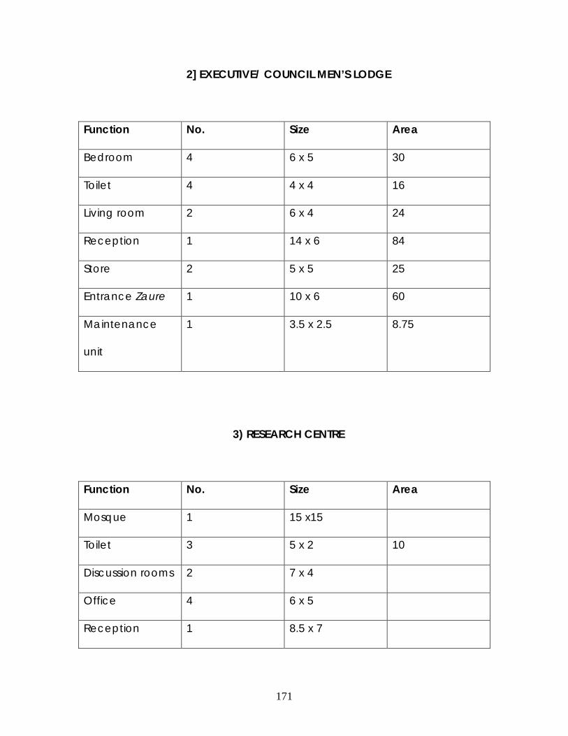
171
2] EXECUTIVE/ COUNCIL MEN’S LODGE
Function No. Size Area
Bedroom 4 6 x 5 30
Toilet 4 4 x 4 16
Living room 2 6 x 4 24
Reception 1 14 x 6 84
Store 2 5 x 5 25
Entrance Zaure 1 10 x 6 60
Maintenance
unit
1 3.5 x 2.5 8.75
3) RESEARCH CENTRE
Function No. Size Area
Mosque 1 15 x15
Toilet 3 5 x 2 10
Discussion rooms 2 7 x 4
Office 4 6 x 5
Reception 1 8.5 x 7

172
Library 2 16 x 16
Entrance Zaure 8.5 x 7
Research
laboratory
7.5 x 5.5
3) EMIR’S CHAMBERS
Function No. Size Area
Shamaki
Reception
Sitting room
Bedroom
Living room
Balcony
5) BANQUET HALL
Function No. Size Area
Banquet hall

173
Servery
Toilet
6) DURBAR ARE NA
Function No. Size Area
Grand stand
Hill sit-out
Horse stable
Tack room
Hay stack
Durbar ground
8.5 CONSTRUCTION MATRIALS AND METHODS
Considering the need to impact a traditional appearance on the
site requires careful usage of materials that will give the desirable effect.

174
The new buildings will be constructed in a manner that will compliment
the existing mud building on the site. Consideration shall also be made
towards provision of easily sustainable materials and maximum comfort.
FLOORS; The use of concrete over hardcore shall be adopted. The
damp proof course shall be laid to the floor in protection against water
rising and penetration to the surface floor, this is liable to happen due to
the fill-in of the gulley on site. The floor finish of the existing Palace shall
be in white marble laid over the traditional rammed floor. The floor finish
in the remaining parts of the site includes use of terrazzo with ebonite
strips in traditional motifs, smooth and non-slip ceramic tiles and
interlocking paving tiles for the external walkways.
WALLS; The conventional concrete block work will be used. The walls
shall be floated and plastered in concrete. The sandpapered wall will be
finished in granite crystal paints, in the colour of deep brown. The
building areas that have decorative motifs were done with strips of
plaster of Paris P.O.P. and coloured in Royal colours (blue, green, red).
LANDSCAPE; The surroundings of the buildings were landscaped with
exotic plants. A royal garden was provided , landscaped with carpet
grass , shrubs and flowers. An attempt towards maintaining the royal
heritage in landscape by placing cotton trees in every courtyard, which
indicates the presence of Royalty.

175
CHAPTER NINE
9.1 RESEARCH CONSIDERATION IN DESIGN
Amongst the major features of Kano Palaces are adaptability to
new functions, the design incorporated modern functionality that are
linked to cultural heritage. The functional spaces are a repetition of
squares and rectangles with intermediate spaces (Zaure) . The uses of
courtyard were also evident in the accommodation zones.
The major features of palaces represented in the design includes
the pinnacles (Zanko), this is represented in a different manner , they are
wider sloping parapets as against the straight and pointed conventional
type. The implementation of exaggerated wall height was evident in all
the buildings which indicated power and authority.
The application of few fenestrations was emphasized, so as to
maintain the exquisite but simple elevation of Palaces. The windows are
mostly rectangular, an imitation of the Hausa slits. The traditional theme
for application of portals on entrance ways is adopted, bold motifs,
usually in the forms of the northern star was applied.
176
9.2 RECCOMENDATION
Globally, culture and heritage has become a tool towards
enhancing publicity and financial upliftment. The adoption of historical
buildings to such ends is a means of ensuring re-use of historical
monuments.
The adoption of historical monuments into museums is an inadequate
practice due to the poor appreciation and utilization of such in these
parts of the world. In developed countries historical Palaces are being
upgraded into resorts, hotels e.t.c .depending on the need for such
facilities in their locality.
Therefore, I recommend the upgrading of other partial Palaces of Kano
for public appreciation so as to keep it from becoming ruins due to lack
of usage. This practice will enhance the tourism market of Kano state as
well as permitting the Kano emirate play a major role in the tourism
market of Kano, considering its history and achievements are what sets
Kano State apart from other hausa states
.

177
9.3 CONCLUSION
The hausa Architecture that we visualize today is a product of
evolutions over hundreds of years. These changes occurred as a
response to surrounding circumstances.
The research identified the intellectual capability of the Hausa
mason in adapting his buildings with the economic and social status of
his patrons. The buildings of the royalty went through subsequent
changes, from an ordinary mud house to a change in spatial
organization due to economic buoyancy, from use of building elements
for structural purposes to adapting them as aesthetic purposes, from use
of plain surfaces to application of decorations due to Islamic/ Arabian
influences, amongst many others.
The Palaces of Kano have been identified to posses a unique
capability in adaptation .The ancient Palaces were discovered to have
under gone changes in functions from one period to another, in an
attempt to enhance continuous usage.
The upgrading of Gidan Sarki ,Fanisau, have created a new outlet
for adequate usage, maintenance and appreciation of a Historical site
and building. The adoption of certain parts of the existing building as a
research centre will provide first hand appreciation of the hausa
Architecture as well as ensure its sustainability. While the new extensions

178
in the palace are modern facilities adopting the ingenuity of the Hausa
mason without compromising the functionality of the facilities.

179
9.4 REFERENCES AND BIBLIOGRAPHY
1) Ahmed, B.N (1988). Kano Emirate palaces, unpublished M.sc. Thesis,
Department of Architecture A.B.U Zaria.
2) Adamu H.A (1981).Kano state, a giant leap. Triumph Publishing Company, kano,
Nigeria.
3) Barkindo,B.N (ed). (1983). Studies in the history of Kano. Heinemann, Ibadan
Nigeria.
4) Awwal Ibrahim , Historical essay on Gidan Rumfa., Unpublished N.C.E
5) Dokaji, A.A (1985). Kano Ta Dabo Cigari. N.N.P.C ,Zaria
6) Fika Adamu Muhammad, 1978; The kano civil war and British overrule ,
1882-1940, O.U.P Ibadan.
7) Galadanci, Anas Badamasi (1990). Emirs lodging complex, Kano , unpublished
M.sc. Thesis, Department of Architecture A.B.U Zaria
8) Hogben, S.J and Kirk Greene, A.H.M (1966) Emirate of Northern Nigeria,
Oxford University Press,London.
9) Mousa Booth, M (ed). (1987). This is Kano state, 20 years of progress. Academy
Press ,Lagos Nigeria .
10) Nasiru Ibrahim Dantiye (1995). Study of origins, status and defensive role of 4
Kano frontier strong holds (Ribat).Unpublished Ph,d Thesis.
11) Padan, J.N (1973). Religion and Political Culture in kano. University of
California Press , Berkley .
12) Prussin, L. (1974). An introduction to indigenous African architecture.Journal of
the society of Architectural historians. Vol XXXIII no 3

180
13) Philips John Edward (1992). Ribats in Sokoto Caliphate. U.M.I.Press.
14) Rappoprt, A (1966) House forms and culture, Eaglewood Cliffe, N.J.
15) Sa’ad ,H.T (1983) “Hausa Traditional Architecture in historical perspective”.
Unpublished paper delivered at Sokoto international seminar on
hausa studies.
16) Schwertfegger ,F.W. (1982). Traditional Housing in African Cities. John Wiley,
Chechester.