Untitled - Unud Repository
32
-
Upload
khangminh22 -
Category
Documents
-
view
7 -
download
0
Transcript of Untitled - Unud Repository


IJPSE
Elsevier Mendeley, Thomson Reuters, CrossRef (PILA), Google Scholar, ROAD (Directory of Open Access Scholarly
Resources), Bielefeld University Library, Simon Fraser University Library, OAI Organization, CiteULike.
International Journal of Physical Sciences and Engineering
ScienceScholar (SS) Publishing is a non-profit international scientific association of distinguished scholars engaged in Health Sciences, Physical Sciences and Engineering, Life Sciences, Social Sciences, and Humanities devoted to promoting researches field through digital technology. SS is a fast growing organization that aims to benefit the world, as much as possible, via technological innovations. The mission of SS is to encourage and conduct collaborative research in “state of the art” methodologies and technologies within its areas of expertise. SS publishes high-quality reputation international journals. Four journals are covered by SS publishing, those are:
1. International Journal of Health Sciences (IJHS) 2. International Journal of Physical Sciences and Engineering (IJPSE) 3. International Journal of Life Sciences (IJLS) 4. International Journal of Social Sciences and Humanities (IJSSH)
It as well as will organizes multidisciplinary conferences and workshop for academics and professionals and to get sponsors for supporting the activities. In addition, SS is involved in many international projects and welcomes collaborative work. The SS members include research excellent scientists, engineers, scholars, research, and development center heads, faculty deans, department heads, professors, university postgraduate engineering and science students, experienced hardware and software development directors, managers and engineers, linguist, management, etc. SS is a large publishing of articles database of peer-reviewed literature: scientific research, books, and conference proceedings. Delivering a comprehensive overview of the world's research output in the fields of science, technology, medicine, social sciences, and arts and humanities, SS membership and service features is smart tools to track, analyze and visualize research. As research becomes increasingly global, interdisciplinary and collaborative, you can make sure that critical research from around the world is not missed when you choose SS journals that reliable field to publish your paper. Journals Publication Frequency: The journal will be published every four months online and print version (three times a year). Those are: April, August, and December
Copyright © 2017 ScienceScholar Publishing, Universidad Técnica de Manabí. Disclaimer: This website has been updated to the best of our knowledge to be accurate.
However, Universidad Técnica de Manabí shall not be liable for any loss or damage caused by the usage of any information obtained from this web site. Best viewed: Mozilla Firefox 4.0 & Google
Chrome at 1024 × 768 resolution.

Elsevier Mendeley, Thomson Reuters, CrossRef (PILA), Google Scholar, ROAD (Directory of Open Access Scholarly
Resources), Bielefeld University Library, Simon Fraser University Library, OAI Organization, CiteULike.
International Journal of Physical Sciences and Engineering
Chief Patron
Prof. María Rodríguez Gámez, Ph.D. Profesor-Investigador Titular, Facultad de Ciencias Matemáticas, Físicas y Químicas
Universidad Técnica de Manabí. Associate Professor of the Universidad Técnica de Manabí. Currently, it has the area of scientific research in engineering careers. It has participated in more than 90
publications, related Renovales Sources of Energy, Environment, Geographic information systems, land management, etc. They stand 17 publications including 11 listed as the principal author, 6 of them
indexed in the last 2 years.
Editor-in-Chief
Prof. Joan Manuel Rodríguez Díaz, Ph.D. Professor and Director of Laboratory of Chemical and Biotechnological Analysis in the Universidad
Técnica de Manabí
International Editorial Board
Prof. Guillermo Antonio Loor Castillo Electrical Engineering, Universidad Técnica de Manabí (UTM), Portoviejo, Ecuador
Elsevier Mendeley, Thomson Reuters, CrossRef (PILA), Google Scholar, ROAD (Directory of Open Access Scholarly
Resources), Bielefeld University Library, Simon Fraser University Library, OAI Organization, CiteULike.
International Journal of Physical Sciences and Engineering
Prof. Lenin Agustin Cuenca Alava Professor and Vice Dean of race of Industrial Engineering, Universidad Técnica de Manabí (UTM),
Ecuador
Prof. Galo Arturo Perero Espinoza Industrial Engineering, Universidad Técnica de Manabí, Ecuador
Odiwo Williams Omokhudu, Ph.D. Mathematics, Edo University, Iyamho, Nigeria
Miguel Castro Fernández, Ph.D. Technical Sciences, Dean of the Faculty of Electrical of Cujae, Spain

Elsevier Mendeley, Thomson Reuters, CrossRef (PILA), Google Scholar, ROAD (Directory of Open Access Scholarly
Resources), Bielefeld University Library, Simon Fraser University Library, OAI Organization, CiteULike.
International Journal of Physical Sciences and Engineering
Behnam Neyestani, Ph.D. Civil Engineering, De La Salle University, Manila, Philippines
Chukwuma Chukwudumebi Stephen Ph.D. Lecturer with Delta State Polytechnic Ogwashi-uku, Nigeria
Prof. W. Manuel Saltos Arauz Renewables energy source, Escuela Superior Politécnica del Chimborazo, Electrical engineer in the
Universidad Técnica de Manabí, Ecuador
Yolanda Eugenia Llosas Albuerne, Ph.D. Electrical Engineer, Teacher, Specialist and Automatic Control, Faculty of Mathematical, Physical and
Chemical Sciences, Universidad Técnica de Manabí
Elsevier Mendeley, Thomson Reuters, CrossRef (PILA), Google Scholar, ROAD (Directory of Open Access Scholarly
Resources), Bielefeld University Library, Simon Fraser University Library, OAI Organization, CiteULike.
International Journal of Physical Sciences and Engineering
Ciaddy Gina Rodríguez Borges, PhD. Industrial Engineer, Head of the Energy Supervision Area, Corporación Eléctrica Nacional
(CORPOELEC) Venezuela

Elsevier Mendeley, Thomson Reuters, CrossRef (PILA), Google Scholar, ROAD (Directory of Open Access Scholarly
Resources), Bielefeld University Library, Simon Fraser University Library, OAI Organization, CiteULike.
International Journal of Physical Sciences and Engineering
TABLE OF CONTENTS
No Title Page
1 The Future of Micro-Grids in Ecuador Wilber Manuel Saltos Arauz, María Rodríguez Gámez, Antonio Vázquez Pérez, Guillermo Antonio Loor Castillo, Lenin Agustín Cuenca Alava http://dx.doi.org/10.21744/ijpse.v1i3.53
1
2 The Effectiveness of the Use of Portfolio Assessment by Controlling
Prior Knowledge to Enhance Scientific Attitude among Senior
High School Students Putu gede wartawan http://dx.doi.org/10.21744/ijpse.v1i3.54
9
3 Photovoltaic Energy to Face an Earthquake Andrés Emilio Delgado González, W. Manuel Saltos Arauz, María Rodríguez Gámez, Lenin Agustín Cuenca Alava http://dx.doi.org/10.21744/ijpse.v1i3.61
19
4 Reflections on the Implementation of Tidal Energy in Ecuador Edison David Morillo Tipan, Genial Belvinel Epeni Tombo, Wilson Quijije Castro, Roddy Valentin Montes Garcia, María Rodríguez Gámez http://dx.doi.org/10.21744/ijpse.v1i3.64
31
5 Aquifers Selection to Aid Geoelectrical Methods on Drilled Well
Building near the Beach I Nengah Simpen, I Wayan Redana, Ni Nyoman Pujianiki, Ika Umratul http://dx.doi.org/10.21744/ijpse.v1i3.66
41

Elsevier Mendeley, Thomson Reuters, CrossRef (PILA), Google Scholar, ROAD (Directory of Open Access Scholarly
Resources), Bielefeld University Library, Simon Fraser University Library, OAI Organization, CiteULike.
International Journal of Physical Sciences and Engineering
International Journal of Physical Sciences and Engineering Available online at http://sciencescholar.us/journal/index.php/ijpse Vol. 1 No. 3, December 2017, pages: 41~50 e-ISSN : 2550-6943, p-ISSN : 2550-6951 http://dx.doi.org/10.21744/ijpse.v1i3.66
41
Aquifers Selection to Aid Geoelectrical Methods on
Drilled Well Building near the Beach
I Nengah Simpen a, I Wayan Redana b, Ni Nyoman Pujianiki c, Ika Umratul d,
Article history: Received 10 June 2017; Accepted in revised form 23 November 2017; Approved 29 November 2017; Available online 25 December 2017
Correspondence Author a Abstract
The aquifer was a rock form wherein the water was collected and as well as able to release water economically. The aquifers near the beach were susceptible to intruded sea water, especially areas that have a lot of groundwater taking, therefore, if building a well, should be chosen aquifer that had not been intruded sea water. It was needed a way thus, the water taken is not salt water or brackish water. This study has a long-term goal of finding a way to choose aquifer by geoelectric method aid. In order to build a drilled well, for getting the right aquifer. The research had been conducted in Candidasa Karangasem Bali with the geoelectric method. The results showed that there were two aquifers types, i.e. free aquifer with resistivity was 33.9 ohm.m and distressed aquifer with a resistivity was 70 ohm.m. Taking into account the two resistivity magnitudes, then, the free aquifer was thought to have been intruded by the sea water, while the distressed aquifer was thought to have not been intruded by sea water. Based on water samples on three dug wells that take water in a free aquifer, obtained electric conductivity 850.00, 1288,81, and 1341,55 μmho/cm, means the water has been intruded by sea water. Drilled well water samples, taking water in the distressed aquifer, obtained electric conductivity 200.00 μmho/cm, means the water has not been intruded by sea water. Thus the geoelectric method could be used to select the aquifer in order to build a well near the beach.
Keywords
Aquifer; Drill Well; Near Beach; Geoelectric Method;
a Physics Department, Faculty of Mathematics and Science, Udayana University Denpasar, Bali-Indonesia b Engineering Doctorate Program, Udayana University, Jl. P.B. Sudirman Denpasar, Bali-Indonesia c Engineering Doctorate Program, Udayana University, Jl. P.B. Sudirman Denpasar, Bali-Indonesia d Physics Department, Faculty of Mathematics and Science, Udayana University Denpasar, Bali-Indonesia
e-ISSN : 2550-6943 p-ISSN : 2550-6951
IJPSE Vol. 1 No. 3, December 2017, pages: 41~50
42
e-ISSN : 2550-6943, p-ISSN : 2550-6951© Copyright 2017. The Author. Published by ScienceScholar.
This is an open access article under the CC-BY-SA license (https://creativecommons.org/licenses/by/4.0/)
All rights reserved.
Contents
Abstract ....................................................................................................................................................................... 41 1. Introduction ......................................................................................................................................................... 42 2. Research Method ............................................................................................................................................... 42 3. Results and Analysis ......................................................................................................................................... 44 4. Conclusion ............................................................................................................................................................. 47 Acknowledgements ............................................................................................................................................... 47 References ................................................................................................................................................................. 48 Biography of Authors ............................................................................................................................................ 50
1. Introduction An aquifer is a rock form wherein the water is collected as well as capable of releasing water
economically.14, 15 There are three aquifers types i.e. free aquifers, distressed aquifers, and semi-distressed aquifers.8 The water in aquifers is influenced by the aquifer environment.24 The free aquifer its infiltration region around the aquifer. The distressed aquifer its infiltration region deep in the upstream, therefore, it has undergone some filtering. Whereas the semi-distressed aquifer has a distant infiltrating region upstream but also has infiltration around the aquifer.4
There is free aquifer near beach aquifers, distressed aquifer, and semi-distressed aquifer. The aquifers near the beach are susceptible to be intruded seawater, especially areas that have a lot of groundwater taking, if the well is built, should be chosen aquifer that has not been intruded seawater.11 It is needed a way, therefore, the water taken is not salt water or brackish water. 22, 23
There are several factors that determine the magnitude of the rocks resistivity value, i.e. material types, water content, rock porosity, and chemical properties of the fluid fillers.2, 9, 10 The presence of water in a rock formation causes the rock to behave as an aquifer, consequently the resistivity of the rock formation changes. The resistivity aquifers near the beach-dependent on the aquatic salinity present in the aquifer.12,16 One geophysical method that can describe the formations rock resistivity is the geoelectric method. Thus, the geoelectric method is expected to aid the selection of aquifers on building drilled well to obtain good water, not brine or brackish water. The research was conducted in Candidasa Karangasem Bali in order to drill wells near the beach because the research found at Candidasa Beach has been intruded by seawater however uneven. This situation is very good used as a case study.7,17 The research is expected to be a model in choosing aquifers if the drilled well is built near the beach.20,21
2. Research Method In order to achieve the research, objective is to obtain the aquifer image in the research area
based on the geoelectric data and to get the water quality in the aquifer in the research area, the research is conducted by the following steps. 2.1 Perform Geoelectric Measurements
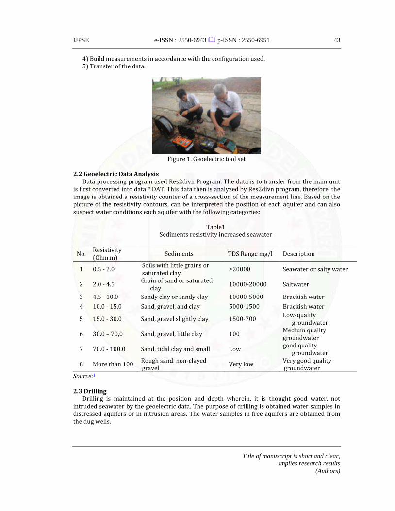
The measurements using geoelectric sets are performed at the drilled well site. The equipment used is a set of geoelectric equipment (Figure 1) consisting of main unit geoelectric along with a laptop for interface, electrode, cable, meter, yarn, hammer, battery, and mat. Measurement steps include:
1) Create a measurement line. 2) Install the geoelectric device set. 3) Attach the connecting cables.
IJPSE e-ISSN : 2550-6943 p-ISSN : 2550-6951
Title of manuscript is short and clear,
implies research results
(Authors)
43
4) Build measurements in accordance with the configuration used. 5) Transfer of the data.
Figure 1. Geoelectric tool set
2.2 Geoelectric Data Analysis
Data processing program used Res2divn Program. The data is to transfer from the main unit is first converted into data *.DAT. This data then is analyzed by Res2divn program, therefore, the image is obtained a resistivity counter of a cross-section of the measurement line. Based on the picture of the resistivity contours, can be interpreted the position of each aquifer and can also suspect water conditions each aquifer with the following categories:
Table1
Sediments resistivity increased seawater
No. Resistivity (Ohm.m)
Sediments TDS Range mg/l Description
1 0.5 - 2.0 Soils with little grains or saturated clay
≥20000 Seawater or salty water
2 2.0 - 4.5 Grain of sand or saturated
clay 10000-20000 Saltwater
3 4,5 - 10.0 Sandy clay or sandy clay 10000-5000 Brackish water
4 10.0 - 15.0 Sand, gravel, and clay 5000-1500 Brackish water
5 15.0 - 30.0 Sand, gravel slightly clay 1500-700 Low-quality
groundwater
6 30.0 – 70,0 Sand, gravel, little clay 100 Medium quality groundwater
7 70.0 - 100.0 Sand, tidal clay and small Low good quality
groundwater
8 More than 100 Rough sand, non-clayed gravel
Very low Very good quality groundwater
Source:1
2.3 Drilling Drilling is maintained at the position and depth wherein, it is thought good water, not
intruded seawater by the geoelectric data. The purpose of drilling is obtained water samples in distressed aquifers or in intrusion areas. The water samples in free aquifers are obtained from the dug wells.
e-ISSN : 2550-6943 p-ISSN : 2550-6951
IJPSE Vol. 1 No. 3, December 2017, pages: 41~50
44
2.4 Measuring water electrical conductivity The water samples are taken from dug wells and drilled wells then is measured electrical
conductivity. An electrical conductivity measurement results are categorized as follows.
Table 2 Well water classification near the beach based on seawater intrusion level
No. conductivity range (µmho/cm, 25oC)
Intrusion classification
1 ≤ 200,00 Not intruded 2 200,01-229,24 Medium intruded 3 229,25-387,44 Slightly intruded 4 387,44-554,67 Rather high intruded 5 ≥534,68 High intruded
Source: Davis and Wiest (1996)
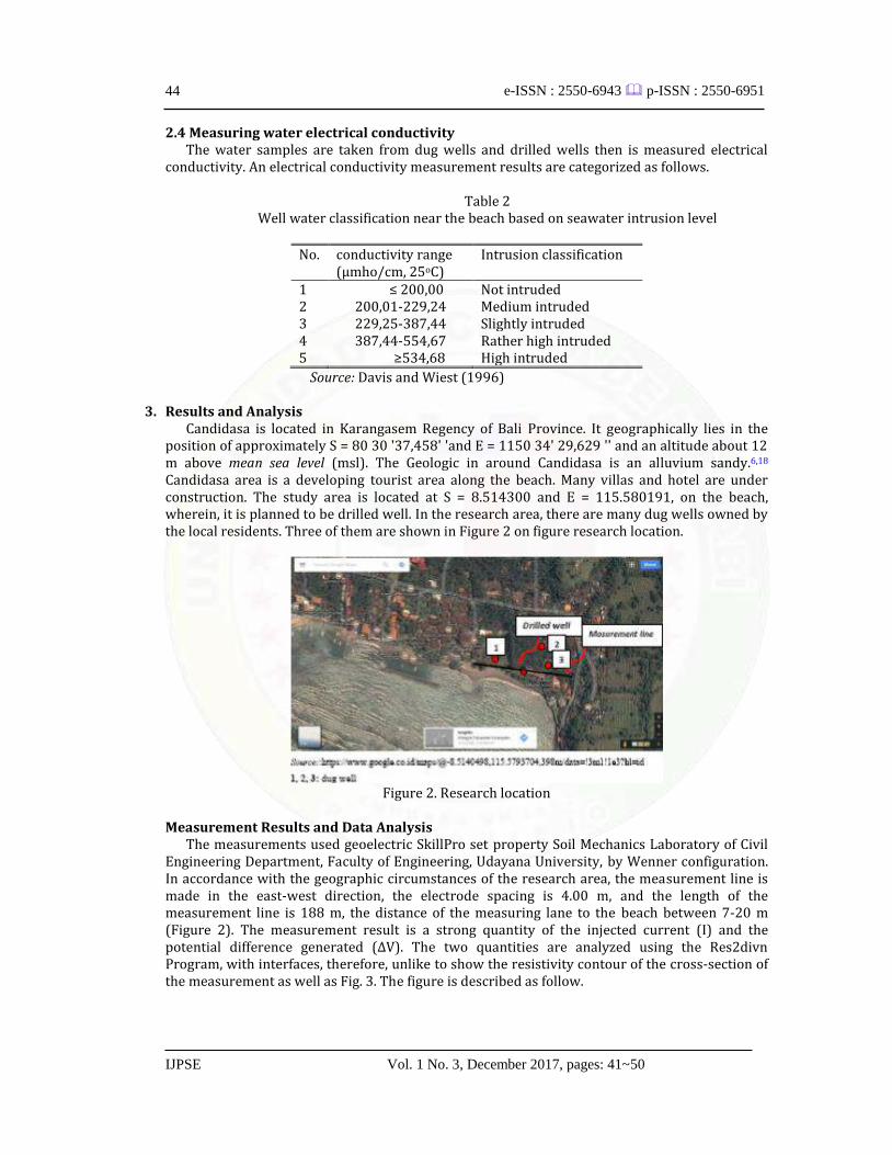
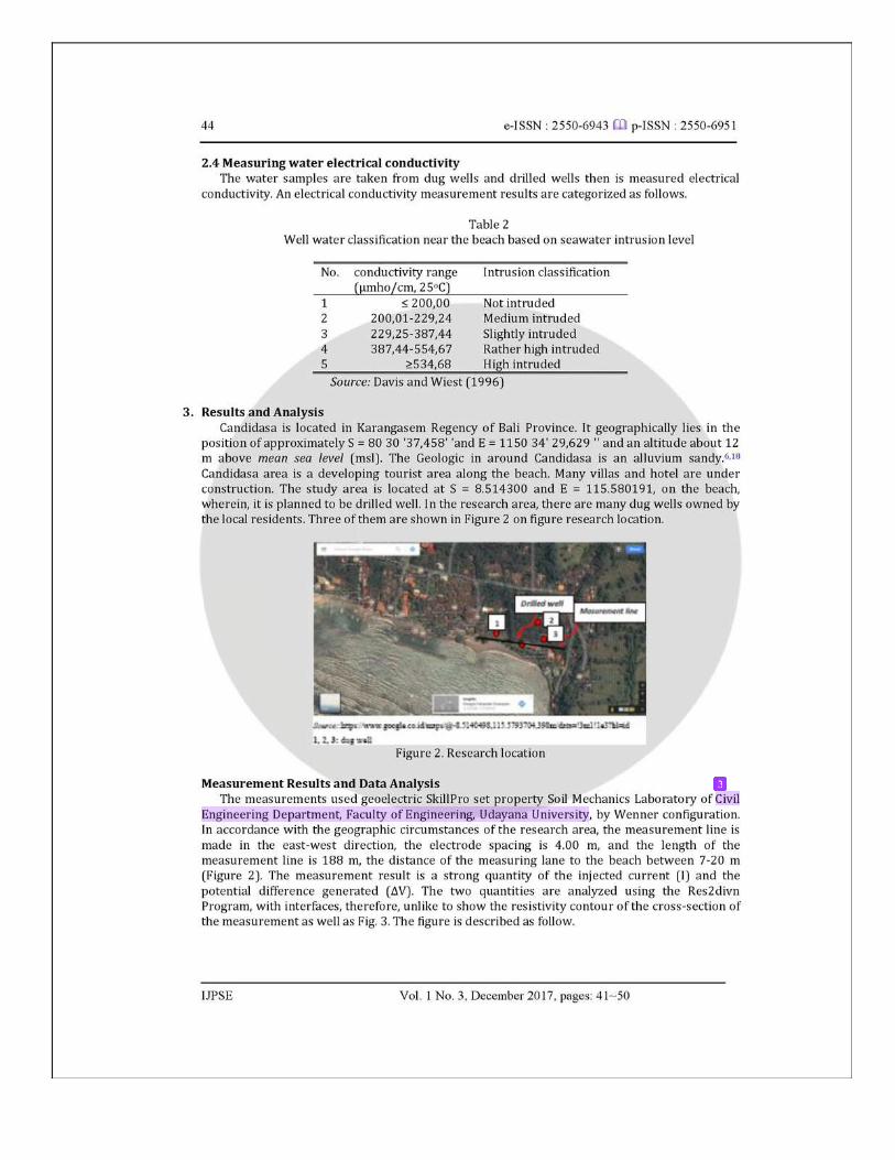
3. Results and Analysis Candidasa is located in Karangasem Regency of Bali Province. It geographically lies in the
position of approximately S = 80 30 '37,458' 'and E = 1150 34' 29,629 '' and an altitude about 12 m above mean sea level (msl). The Geologic in around Candidasa is an alluvium sandy.6,18 Candidasa area is a developing tourist area along the beach. Many villas and hotel are under construction. The study area is located at S = 8.514300 and E = 115.580191, on the beach, wherein, it is planned to be drilled well. In the research area, there are many dug wells owned by the local residents. Three of them are shown in Figure 2 on figure research location.
Figure 2. Research location
Measurement Results and Data Analysis
The measurements used geoelectric SkillPro set property Soil Mechanics Laboratory of Civil Engineering Department, Faculty of Engineering, Udayana University, by Wenner configuration. In accordance with the geographic circumstances of the research area, the measurement line is made in the east-west direction, the electrode spacing is 4.00 m, and the length of the measurement line is 188 m, the distance of the measuring lane to the beach between 7-20 m (Figure 2). The measurement result is a strong quantity of the injected current (I) and the potential difference generated (ΔV). The two quantities are analyzed using the Res2divn Program, with interfaces, therefore, unlike to show the resistivity contour of the cross-section of the measurement as well as Fig. 3. The figure is described as follow.
IJPSE e-ISSN : 2550-6943 p-ISSN : 2550-6951
Title of manuscript is short and clear,
implies research results
(Authors)
45
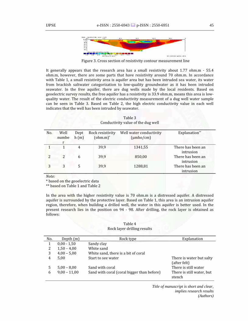
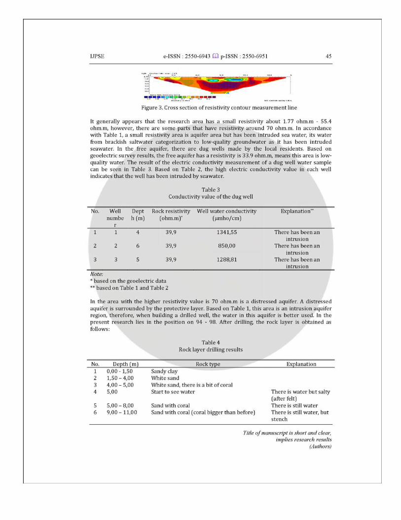
Figure 3. Cross section of resistivity contour measurement line
It generally appears that the research area has a small resistivity about 1.77 ohm.m - 55.4 ohm.m, however, there are some parts that have resistivity around 70 ohm.m. In accordance with Table 1, a small resistivity area is aquifer area but has been intruded sea water, its water from brackish saltwater categorization to low-quality groundwater as it has been intruded seawater. In the free aquifer, there are dug wells made by the local residents. Based on geoelectric survey results, the free aquifer has a resistivity is 33.9 ohm.m, means this area is low-quality water. The result of the electric conductivity measurement of a dug well water sample can be seen in Table 3. Based on Table 2, the high electric conductivity value in each well indicates that the well has been intruded by seawater.
Table 3
Conductivity value of the dug well
No. Well numbe
r
Depth (m)
Rock resistivity (ohm.m)*
Well water conductivity (µmho/cm)
Explanation**
1 1 4 39,9 1341,55 There has been an intrusion
2 2 6 39,9 850,00 There has been an intrusion
3 3 5 39,9 1288,81 There has been an intrusion
Note: * based on the geoelectric data ** based on Table 1 and Table 2
In the area with the higher resistivity value is 70 ohm.m is a distressed aquifer. A distressed aquifer is surrounded by the protective layer. Based on Table 1, this area is an intrusion aquifer region, therefore, when building a drilled well, the water in this aquifer is better used. In the present research lies in the position on 94 - 98. After drilling, the rock layer is obtained as follows:
Table 4
Rock layer drilling results
No. Depth (m) Rock type Explanation 1 0,00 - 1,50 Sandy clay 2 1,50 – 4,00 White sand 3 4,00 – 5,00 White sand, there is a bit of coral 4 5,00 Start to see water There is water but salty
(after felt) 5 5,00 – 8,00 Sand with coral There is still water 6 9,00 – 11,00 Sand with coral (coral bigger than before) There is still water, but
stench
e-ISSN : 2550-6943 p-ISSN : 2550-6951
IJPSE Vol. 1 No. 3, December 2017, pages: 41~50
46
7 11,00 – 12,00 Sandy clay, rather hard texture There is still water 8 12,00 Started there was nice water There is still water 9 12,00 – 17,50 The fractured rocks containing the alluvium
sand as an aquifer as figure 4 There is still water
10 17,50 – 18,00 Sandy clay, rather hard texture Drilling stopped
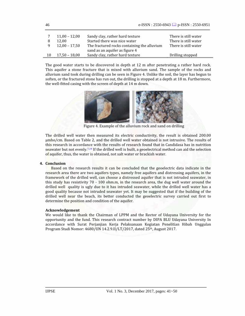
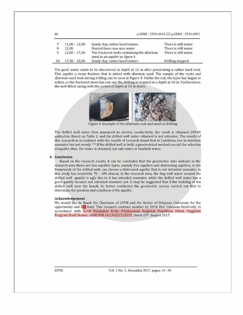
The good water starts to be discovered in depth at 12 m after penetrating a rather hard rock. This aquifer a stone fracture that is mixed with alluvium sand. The sample of the rocks and alluvium sand took during drilling can be seen in Figure 4. Unlike the soil, the layer has begun to soften, or the fractured stone has run out, the drilling is stopped at a depth at 18 m. Furthermore, the well-fitted casing with the screen of depth at 14 m down.
Figure 4. Example of the alluvium rock and sand on drilling
The drilled well water then measured its electric conductivity, the result is obtained 200.00 μmho/cm. Based on Table 2, and the drilled well water obtained is not intrusive. The results of this research in accordance with the results of research found that in Candidasa has in nutrition seawater but not evenly.7,19 If the drilled well is built, a geoelectrical method can aid the selection of aquifer, thus, the water is obtained, not salt water or brackish water.
4. Conclusion
Based on the research results it can be concluded that the geoelectric data indicate in the research area there are two aquifers types, namely free aquifers and distressing aquifers, in the framework of the drilled well, can choose a distressed aquifer that is not intruded seawater, in this study has resistivity 70 - 100 ohm.m, in the research area, the dug well water around the drilled well quality is ugly due to it has intruded seawater, while the drilled well water has a good quality because not intruded seawater yet. It may be suggested that if the building of the drilled well near the beach, its better conducted the geoelectric survey carried out first to determine the position and condition of the aquifer. Acknowledgement We would like to thank the Chairman of LPPM and the Rector of Udayana University for the opportunity and the fund. This research contract number by DIPA BLU Udayana University In accordance with Surat Perjanjian Kerja Pelaksanaan Kegiatan Penelitian Hibah Unggulan Program Studi Nomor: 4680/UN 14.2.9.II/LT/2017, dated 25th, August 2017.
IJPSE e-ISSN : 2550-6943 p-ISSN : 2550-6951
Title of manuscript is short and clear,
implies research results
(Authors)
47
References 1. Adepelumi, A. A., Ako, B. D., Ajayi, T. R., Afolabi, O., & Omotoso, E. J. (2009). Delineation of
saltwater intrusion into the freshwater aquifer of Lekki Peninsula, Lagos, Nigeria. Environmental Geology, 56(5), 927-933. View in (Google Scholar) (Scopus)
2. Araffa, S. A. S. (2012). Delineation of groundwater aquifer and subsurface structures on North
Cairo, Egypt, using integrated interpretation of magnetic, gravity, geoelectrical and geochemical data. Geophysical Journal International, 192(1), 94-112. View in (Google Scholar)
3. Farrah, D. (2016). Studi Indikasi Intrusi Air Laut Dengan Pengukuran Konduktivitas Dan
Salinitas Air Sumur Serta Hubungannya Terhadap Kejadian Diare (Studi Kasus: Pesisir Pantai Kecamatan Padang Utara, Kota Padang) (Doctoral dissertation, Universitas Andalas). View in (Google Scholar)
4. Bear, J., & Cheng, A. H. D. (2010). Modeling groundwater flow and contaminant transport (Vol.
23). Springer Science & Business Media. View in (Google Books)
5. Davis, S. N., & Wiest, R. J. M. (1996). Hydrogeology. New York: Jhon Willey & Sons.
View in (Google Scholar) 6. Simpen, I. N., Sutama, I. N. S., Redana, I. W., & Zulaikah, S. Metoda Step Drow Down Test
Sebagai Cara untuk Menganalisa Kemampuan Produksi Sumur. View in (Google Scholar)
7. Pujianiki, N. N., I N. Simpen. 2016. Pemetaan Intrusi Air Laut di Daerah Pariwisata Candidasa
dengan Metode Geolistrik. Laporan Penelitian HUPS. Jurusan Teknik Sipil. Fakultas Teknik Universitas Udayana. View in (Google)
8. Suardika, I. K., Simpen, I. N., & Redana, I. W. Menentukan Posisi Pengeboran Untuk
Mendapatkan Air Yang Berkualitas Di Jalan Tunjung I Denpasar Barat Dengan Metode Geolistrik. View in (Google Scholar)
9. Sen, P. N., Goode, P. A., & Sibbit, A. (1988). Electrical conduction in clay bearing sandstones at
low and high salinities. Journal of Applied Physics, 63(10), 4832-4840. View in (Google Scholar)
10. Simpen, I N., I N.S. Sutama, I W. Redana, S. Zulaikah. 2016. Aquifer Porosity Prediction Based
on Resistivity Data and Water Conductivity. International Research Journal of Engineering, IT & Scientific Research. 2(5): 8-21. View in (Google Scholar)
11. Suhartono, E., Purwanto, P., & Suripin, S. (2015). Seawater intrusion modeling on
groundwater confined aquifer in Semarang. Procedia Environmental Sciences, 23, 110-115. View in (Google Scholar) (Scopus) (Elsevier)

e-ISSN : 2550-6943 p-ISSN : 2550-6951
IJPSE Vol. 1 No. 3, December 2017, pages: 41~50
48
12. Susiyanti. N., H. D. Armono dan K. Sambodho. 2013. Aplikasi Metode 2D Resistivitas Untuk Menyeliidiki Intrusi Air Laut di Akuifer Pantai. View in (Google)
13. Tebbutt, T. H. Y. (1997). Principles of water quality control. Butterworth-Heinemann.
View in (Google Books) 14. Stower, G. X., Sigey, J. K., & Warui, K. G. (2017). The effect of pumping water from wells in an
aquifer. View in (Google Scholar)
15. Arauz, W. M. S., Cedeño, G. I., Chávez, S. S., Pérez, A. V., & Gámez, M. R. (2017). Microgrid With
a 3.4 kWp Photovoltaic System in the Universidad Técnica de Manabí. International Journal of Physical Sciences and Engineering (IJPSE), 1(2), 11-20. View in (Google Scholar) (Elsevier)
16. Ogunsiji, A. S., & Ladanu, W. K. (2017). A Theoretical Study of Performance Measures in the
Strategic and Corporate Entrepreneurships of Firms. International Journal of Physical Sciences and Engineering (IJPSE), 1(1), 72-80. View in (Google Scholar) (Elsevier)
17. González, A. E. D., Arauz, W. M. S., Gámez, M. R., & Alava, L. A. C. (2017). Photovoltaic Energy to
Face an Earthquake. International Journal of Physical Sciences and Engineering (IJPSE), 1(3), 19-30. View in (Google Scholar) (Elsevier)
18. Omer, A. M. (2017). Sustainable Development and Environmentally Friendly Energy
Systems. International Journal of Physical Sciences and Engineering (IJPSE), 1(1), 1-39. View in (Google Scholar) (Elsevier)
19. Arango, C., Marcuello, A., Ledo, J., & Queralt, P. (2009). 3D magnetotelluric characterization of
the geothermal anomaly in the Llucmajor aquifer system (Majorca, Spain). Journal of Applied Geophysics, 68(4), 479-488. View in (Google Scholar) (Scopus)
20. Trabelsi, F., Mammou, A. B., Tarhouni, J., Piga, C., & Ranieri, G. (2013). Delineation of saltwater
intrusion zones using the time domain electromagnetic method: the Nabeul–Hammamet coastal aquifer case study (NE Tunisia). Hydrological Processes, 27(14), 2004-2020. View in (Google Scholar) (Scopus)
21. George, N. J., Ibanga, J. I., & Ubom, A. I. (2015). Geoelectrohydrogeological indices of evidence
of ingress of saline water into freshwater in parts of coastal aquifers of Ikot Abasi, southern Nigeria. Journal of African Earth Sciences, 109, 37-46. View in (Google Scholar) (Scopus)
22. Ezersky, M. G., & Frumkin, A. (2017). Evaluation and mapping of Dead Sea coastal aquifers
salinity using Transient Electromagnetic (TEM) resistivity measurements. Comptes Rendus Geoscience, 349(1), 1-11. View in (Google Scholar) (Scopus) (Elsevier)

IJPSE e-ISSN : 2550-6943 p-ISSN : 2550-6951
Title of manuscript is short and clear,
implies research results
(Authors)
49
23. Loke, M. H., Chambers, J. E., Rucker, D. F., Kuras, O., & Wilkinson, P. B. (2013). Recent developments in the direct-current geoelectrical imaging method. Journal of Applied Geophysics, 95, 135-156. View in (Google Scholar) (Scopus) (Elsevier)
24. George, N. J., Atat, J. G., Umoren, E. B., & Etebong, I. (2017). Geophysical exploration to
estimate the surface conductivity of residual argillaceous bands in the groundwater repositories of coastal sediments of EOLGA, Nigeria. NRIAG Journal of Astronomy and Geophysics. View in (Google Scholar) (Scopus) (Elsevier)
e-ISSN : 2550-6943 p-ISSN : 2550-6951
IJPSE Vol. 1 No. 3, December 2017, pages: 41~50
50
Biography of Authors
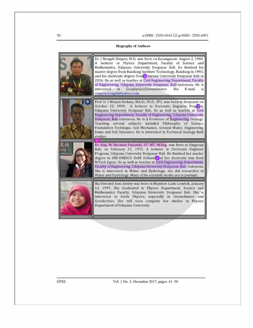
Dr. I Nengah Simpen, M.Si. was born on Karangasem August 2, 1960. A lecturer in Physics Department, Faculty of Science and Mathematics, Udayana University Denpasar Bali. He finished his master degree from Bandung Institute Technology, Bandung in 1993, and his doctorate degree from Udayana University Denpasar Bali in 2016. He as well as teaches at Civil Engineering Department, Faculty of Engineering, Udayana University Denpasar, Bali-Indonesia. He is interested in Geophysics/Groundwater. His E-mail is [email protected].
Prof. Ir. I Wayan Redana, MA.Sc, Ph.D., IPU, was born in Denpasar on October 25, 1959. A lecturer in Doctorate Engineer Program, Udayana University Denpasar Bali. He as well as teaches at Civil Engineering Department, Faculty of Engineering, Udayana University Denpasar, Bali-Indonesia. He is a Professor of Engineering Geology. Teaching several subjects included Philosophy of Science, Foundation Technique, Soil Mechanics, Ground Water, Engineering Dams and Soil Dynamics. He is interested in Technical Geology field studies.
Dr. Eng. Ni Nyoman Pujianiki, ST. MT. M.Eng. was born in Singaraja Bali, on February 25, 1971. A lecturer in Doctorate Engineer Program, Udayana University Denpasar Bali. He finished her master degree in IHE-UNESCO Delft Holland and her doctorate was from NITech Japan. He as well as teaches at Civil Engineering Department, Faculty of Engineering, Udayana University Denpasar, Bali-Indonesia. She is interested in Water and Hydrology, she did researches in Water and Hydrology. Many of his scientific works are in journals.
Ika Umratul Asni Aminy was born in Mamben Lauk Lombok, January 13, 1997, She Graduated in Physics Department, Science and Mathematics Faculty, Udayana University Denpasar Bali. She is interested in Earth Physics, especially in Groundwater and Geoelectrics. She will soon complete her studies in Physics Department of Udayana University.
Journal SSby Inengah Simpen
Submission date: 31-Jan-2018 11:34AM (UTC+0700)Submission ID: 909087721File name: Aquif er_Selection_SS.pdf (1.01M)Word count: 3548Character count: 19731


18%SIMILARITY INDEX
11%INTERNET SOURCES
9%PUBLICATIONS
12%STUDENT PAPERS
1 4%
2 1%
3 1%
4 1%
5 1%
6 1%
Journal SSORIGINALITY REPORT
PRIMARY SOURCES
Submitted to Udayana UniversityStudent Paper
Submitted to The University of the West ofScotlandStudent Paper
puslit2.petra.ac.idInternet Source
www.polarresearch.netInternet Source
Submitted to Universiti Kebangsaan MalaysiaStudent Paper
N J George, D N Obiora, A M Ekanem, A EAkpan. "Approximate relationship betweenfrequency-dependent skin depth resolved fromgeoelectromagnetic pedotransfer function anddepth of investigation resolved fromgeoelectrical measurements: A case study ofcoastal formation, southern Nigeria", Journal ofEarth System Science, 2016Publicat ion
7 1%
8 1%
9 1%
10 1%
11 1%
12 1%
13 1%
14 1%
15 1%
16 1%
17 1%
www.i-scholar.inInternet Source
apcz.plInternet Source
www.ub.eduInternet Source
scholar.unand.ac.idInternet Source
my.unil.chInternet Source
Submitted to University of HuddersfieldStudent Paper
horizon.documentation.ird.frInternet Source
www.unud.ac.idInternet Source
Submitted to University Tun Hussein OnnMalaysiaStudent Paper
etheses.whiterose.ac.ukInternet Source
Sembiring, Andrianus, Ni Putu Dian Pertiwi,Angka Mahardini, Rizki Wulandari, Eka MayaKurniasih, Andri Wahyu Kuncoro, N.K. Dita
Exclude quotes Of f
Exclude bibliography Of f
Exclude matches < 1%
Cahyani, Aji Wahyu Anggoro, Maria Ulfa,Hawis Madduppa, Kent E. Carpenter, Paul H.Barber, and Gusti Ngurah Mahardika. "DNAbarcoding reveals targeted f isheries forendangered sharks in Indonesia", FisheriesResearch, 2015.Publicat ion