United States Exploring Expedition. During the year 1838 ...
548
-
Upload
khangminh22 -
Category
Documents
-
view
3 -
download
0
Transcript of United States Exploring Expedition. During the year 1838 ...
I
1
I


UNITED STATES
EXPLORING EXPEDITION
BY AUTHORITY OF CONGRESS.


HYDROGRAPHY,WITH
VOLS. I AND II
CHARTS.


UNITED STATES
EXPLORING EXPEDITION.DURING THE YEARS
1838, 1839, 1840, 1841, 1842.
UNDEK THE COMMAND OF
CHARLES WILKES, U. S. N.
VOL. XXIII.
HYDROGRAPHY.BY
CAPT. CHARLES WILKES, U. S. N.,
MEMBER OF THE AMERICAN PHILOSOPHICAL SOCIETY, ETC.
WITH ILLUSTRATIONS.
PHILADELPHIA:
PRINTED BY C. SHERMAN.
1861.
^3oo34
J

HYDROGRAPHY.
CHAPTER I.
INSTRUMENTS.
The manufacture of astronomical instruments at the time the Ex-
pedition was fitted out, had not attained that perfection that it had in
Europe, and that it since has in this country. Confidence in our
mechanics was wanting, as well as encouragement sufficient for them
to compete with those of Europe, both in constructing and keeping for
sale, those that were required for its use ; of necessity, therefore, the
instruments which were furnished the Expedition, were mostly pro-
cured from the best makers in Europe. For this purpose it was
deemed necessary by the Government to send an officer to Europe, at
the time the Expedition was organizing under Commodore Jones, to
obtain such instruments as could not be had on this side of the Atlantic,
and as would suffice for the results in the departments of science which
the Expedition was intended to investigate. I was requested to submit
a list, and subsequently directed to proceed to Europe, with positive in-
structions to return in six months, or by the end of January, 1837; this
left me but about one hundred days to effect the object in : consequently,
I could not expect to have any instruments constructed, and little time
left to complete any that might be found unfinished. On my arrival,
I found that all the principal instrument makers were fully occupied,
and very unwilling to lay aside any of their engagements, and it was
only by representing the great objects of the Expedition, and their
becoming interested in them, that they were induced to furnish those
I was in search of. Messrs. Troughton and Simms, Dolland, Jones of
V.Z3

HYDROGRAPHY.
Charing Cross, the Messrs. Molyneux, Parkinson and Frodsham, the
Messrs. Dents, Charles Frodsham, Lloyd, and others, of England; Gam-
bey and Chevalier, of Paris; and the Messrs. Ertel, Meyer and Fraun-
hofer, of Munich, all took a most lively interest in executing the orders;
indeed, this interest was equally participated in by many gentlemen,
who, although they had been a long time waiting for instruments
which were then constructing, came forward, and desired that their
orders might be postponed or laid aside until the instruments required
for the Expedition should be completed. It was under these circum-
stances that I was enabled to execute the duties assigned me to the
satisfaction of the Government, and which enabled the Expedition to
go forth sufficiently well provided for the duties that devolved upon it.
The following is a list of the instruments procured, designating
those in the several departments, as well as the names of those in
whose establishments they were constructed, viz. :
—
ASTRONOMICAL AND SURVEYING INSTRUMENTS.
1 Three and a half feet transit, iron stand, &c, Dolland.
1 Altitude and azimuth circle (eighteen inch) two feet telescope,
with microscope readings, by Dolland.
1 Repeating circle, twelve inch, by Ertel.
1 Five feet refracting telescope, six inch aperture, with micrometers,
&c, by Meyer and Fraunhofer.
1 Three and a half feet refractor. Three inch ap., by Troughton.
2 Six inch repeating reflecting circles. Ertel.
1 Twelve inch repeating reflecting circle, by Gambey, with depres-
sion mirror.
1 Variation transit. Dolland.
6 Sextants. Troughton and Simms.
2 Levels, staffs, &c. Troughton and Simms.
2 Plane tables.
6 Box sextants.
6 Schmalcalder's prismatic compasses.
2 Dip sectors.
6 Mercurial horizons.
1 Glass horizon.
2 Massey's patent logs.
DSI

INSTRUMENTS. 3
6 Surveying chains.
6 Barlow's compensating plates.
1 Amici collamator.
MAGNETIC INSTRUMENTS.
1 Variation apparatus, by Gambey.
1 Variation apparatus, by Dolland.
1 Gauss's diurnal variation. Troughton and Simms.
1 Diurnal variation. Gambey.
1 Diurnal variation. Dolland.
2 Dipping needles, six inches, by Robinson.
2 Dipping needles, twelve inches, by Gambey.
2 Dipping needles, six inches. Dolland.
3 Intensity needles. Gambey.
2 Intensity needles. Dolland.
METEOROLOGICAL AND PHYSICAL INSTRUMENTS.
2 Standard barometers. Troughton and Simms.
6 Mountain barometers, with extra tubes.
1 Iron cistern. Jones.
2 Sympiesometers. Adie.
6 Daniell's hygrometers.
2 Pouillet's hygrometers, a capsule.
9 Standard thermometers, by Simms, Jones, and Dolland.
16 Six's self-registering thermometers, with copper cylinders for
deep sea soundings.
2 Scopeloscopes.
3 Pluviometers.
1 Brass convertible axis experimental pendulum, by Jones.
1 Iron convertible axis experimental pendulum, by Jones.
1 Eight day astronomical clock, mercurial pendulum. Molyneux.
1 Eight day clock, steel bar pendulum, for pendulum experiments.
Molyneux.
1 Journeyman clock. Molyneux.
Iron frame to support the agate planes and its fixtures ; also clock
frames and stands. Molyneux.

4 HYDROGRAPHY.
Telescopes for observing coincidences, &c., &c. Jones.
Two weekly chronometers, Nos. 1567 and 1503. Charles Frod-
sham.
One Siderial chronometer, No. 1615. Charles Frodsham.
Twenty-five 56hrs. Chronometers, viz. :—Nos. 2075, 2085, 2203,
1839, 2204, 2066, 2093, 2095, 1964, 2105, 2052, 2083, 2096, 2037,
by Parkinson and Frodsham; Nos. 2088, 3001, 1826, 2067, 2042, 2057,
by Molyneux; Nos. 972, 766, by Arnold and Dent ; Nos. 169, 170, by
Chas. Young; No. 850, by James Murray; and four Pocket chrono-
meters, viz. : Nos. 2124, 733, by Parkinson and Frodsham; No. 22, by
Molyneux, and No. 786, by Cotterel and Co.
We were likewise provided with suitable libraries for each of the
larger vessels, and duplicate instruments of those which were liable
to be broken or become injured. For the repairs, there was attached
to the Expedition a competent instrument maker. Besides those
above enumerated, each officer was required to furnish himself with
a sextant, watch, &c. It will thus be seen that we were well pro-
vided for the performance of our duties. There were some instru-
ments I regretted not being able to procure, and among them was
Fox's magnetic dipping apparatus.
Convenient portable houses and tents, for the protection and use
of the instruments, were also provided, which rendered us entirely
independent of external circumstance or local aid, so much so, that if
we had been obliged to occupy a bare sandbank, we should have
wanted for nothing ; and I trust that the labors performed will
exhibit abundant proof that the opportunities enjoyed were improved
with the utmost industry and all the energy we possessed.
The reliance to be placed on Hydrographical labors depends upon
the accuracy of the modes employed in obtaining the results. It
therefore seems necessary to give a statement of these, and to explain
the combinations by which the positions that have been astronomically
determined are brought to prove and bear upon each other, thereby
affording strong evidence of the credit the combined results are entitled
to, and the confidence that ought to be placed in the surveys and charts
resulting from our labors.

SURVEYS. 5
SURVEYS.
The surveys made by the Expedition were numerous, amounting to
234, during the four years of our absence from the United States. It
will readily be seen, that in order to accomplish this amount of work,
that some expeditious method of surveying the numerous coral islands
had to be adopted;indeed, it may almost seem incredible, situated so
far asunder as the surveys were, for even a much larger force than
was placed at my disposal to execute them ; but as the mode of con-
ducting them will be shown, I trust that all will be satisfied that it
was quite possible not only to execute the work, but to do it with ac-
curacy.
In surveying operations it is all-important that an easy and per-
spicuous method should be adopted, as well in taking the observations
as in recording them, particularly where it would be impossible to
regain an opportunity that might, from inattention or neglect, be
suffered to escape ; and any one who may have the direction of such
duties, should be careful that the rough charts be at once drawn
from the note-books, and that these latter should be kept in so clear
a manner, and in a formula so well understood, as not to require
explanations. In order to effect this object, I deemed it necessary
that all the officers should have a thorough knowledge of the operations
by which I intended to carry on the surveying duties, and for this
purpose I prepared a short syllabus, to render them familiar with the
operations, and to avoid the defects existing in all treatises on sur-
veying that I have hitherto seen, which appear to me to omit the first
and most essential explanation of the principles. Many things appear
to be taken for granted which the learner does not know, nor where
to look for information, and he is consequently apt to neglect their
importance. In other words, he must acquire much practical experi-
ence before he can understand the performance of duties which they
pretend to teach. This omission is a serious one, and prevents the
works on surveying from being as useful as they ought to the learner.
I gave (in Appendix xli, vol. i) the manner of executing our
surveys, by the squadron, under sail: it had not been practised before,
although the method of measuring bases by sound has been exten-
sively used. As it more properly belongs to this place, I shall tran-
2

scribe it here, so as to bring the method into notice, as well as to ex-
plain it more fully.
METHOD OF SURVEYING THE CORAL ISLANDS.
The basis of the method rested on the measure of distances by
sound. For this we had ready means, by firing guns alternately
from the different vessels, any three of which being stationary, the
distances and positions of objects could be determined from them by
direct angles, giving a double result, or by the angles between them,
taken from the shore, or from boats, furnishing data for the problem
of " the three points." When both methods can be applied at the same
time, it is evident that the utmost accuracy may be obtained. Uponthe land, by employing many observers, and occupying all the points
of a trigonometric survey simultaneously, the whole work might evi-
dently be completed in a very short space of time ; and in like manner
upon the water, creating by means of vessels and boats a number of
artificial stations around an island, measuring angles simultaneously at
them all, and base lines by sound, the rapidity with which a survey
can be performed is equally as great.
By means of the system of signals prepared by me for the Exploring
Expedition, I could direct the vessels to assume any position I might
select as most fit for our purpose. When these were reached, general
but minute instructions directed the observations that were to be taken
at each, in doing which there was no difficulty. These observations
were entered upon a deck-board, for which the following form was
prescribed
:
FORM OF DECK-BOARD.
On approaching the island to be surveyed, signal was made to pre-
pare for surveying duty ; if boats were to be used, the number of them
and the vessels whence they were to be despatched was next indicated
;


SURVEYS.
and finally, the position each vessel was to occupy was shown. The
vessels having reached their assigned places hove-to, and the boats
having been previously despatched, would about the same time have
anchored in their assigned stations, at the points of reefs, and hoisted
their appropriate signals. The vessel that is first to fire a gun then
hoists an ensign at the foremast-head, which is answered by all, and
the flag is in like manner displayed previous to each successive fire.
The firing then goes on in quick succession from all the vessels ; and
at the time, all the officers being on deck for the purpose, angles are
measured between the other vessels and objects on the shore, each by
a different observer, as directed and indicated by the senior officer pre-
sent ; these angles, together with those made by the visual tangents to
the shore, have always been found sufficient to plot from. During this
operation the ensign is kept hoisted at the peak, so that all the angles
may be taken simultaneously ; and at the same time, the altitude and
azimuth of the masts of the ships is observed from the boats, for the
purpose of determining their position more accurately. Altitudes of
the sun for time, and angles whence to calculate the azimuth of some
one of the objects, are also taken immediately before or after the hori-
zontal angles.
When the duties at the first station have been finished the vessels
and boats change positions alternately, and at each change the same
operations are repeated.
To illustrate still further the mode in which the whole squadron was
made to concur in obtaining unity of action, a detail of a survey and
a plot of the work are given on Plate 1, Fig. 1.
By these alternate changes in the stations of the several vessels and
boats, continued until a circuit of the island has been made, the work
is finished, and when it joins, it is proved by the last distance deter-
mined by azimuthal angles and base by sound, as for a base of verifi-
cation. The deck-boards are then sent on board the flag-ship, where
the work is calculated and plotted.
The survey of the island thus represented, which is about seven
miles in length, was performed in three hours and thirty-five minutes.
It began, as noted on the deck-boards, at 1*18 p. m., and the observa-
tions closed at 4*53 p. m.
The facility with which the operations are made can scarcely be con-
ceived until they are witnessed, and I may add the accuracy, not less
so when the proper steps are taken to carry all parts into operation.

8 HYDROGRAPHY.
The measurement of the bases being all taken within a short time of
each other, and the observations made by many officers at all the
angles of the triangles, it leaves little correction even for personal error
or inaccuracy in measuring the distance by sound, and as the angles
are simultaneously measured, there can be but little variation from the
truth. The objects are generally so well defined as to make their selec-
tion an easy task to even the most uninitiated.
It may be thought that the movements of the vessels would be too
great ; but this is not of any great amount, indeed is very small during
the actual time engaged. There can be no doubt of the first positions
being occupied, when the original angles are "kept on;" besides, the
proof of the whole work by the bases of verification, fully assures one
of its accuracy as well as efficiency. Indeed, I do not know what is
more to be desired or obtained, except it be the rise and fall of the
tides, which the short time occupied does not admit. Having fully
tested and satisfied myself of the accuracy of the method, and the
celerity of execution, even by ships of any squadron, not expressly
fitted for surveying operations, I cannot too strongly recommend its
adoption whenever an opportunity offers, believing there are few things
that would add more to our knowledge of the changes going on in the
islands and shores, than the results would bring to light.
Although we had recourse to sound, in many cases, to obtain our
bases on land, or rather the sides of the triangles, yet these were fre-
quently proven by a measured base for verification, or one obtained by
the subtension of a staff at a distance, where the ground did not admit
of its being actually measured.
The methods which were employed in the more extended surveys of
the groups of islands, as well as those of the rivers, that fell to our duties,
require also some explanation, and for this purpose, and to illustrate
the methods more clearly, a diagram of each triangulation is given on
Plates 1 and 11.
The Feejee Group of Islands embraces an extent of sixty thousand
square miles, in which are situated one hundred and eighty islands,
reefs, and shoals, some having areas of six hundred miles, and coasts
of three hundred miles, with well-sheltered and commodious harbors,
formed by reefs which encircle them, besides a large number of ancho-
rages and passages through the reefs. This group was, so far as any
knowledge of its hydrography and topography, entirely unknown,
and but few of its fine harbors had ever been visited. Its inhabi-

SURVEYS.
tants were numerous, and addicted to cannibalism, and of a warlike
and inhospitable disposition. It was under these circumstances that
our duties were to be performed;yet, discouraging as they were, I
aimed at accomplishing all we could in the shortest possible time, and
feel gratified that we succeeded in making a full and complete examina-
tion of the whole Group. It must be evident that little time was lost
;
and I trust I may be permitted to express here the admiration I felt
for the ardor and zeal manifested by those under my command in
this duty, and for the accuracy with which the greater part of the
minute details were performed, when surrounded, as they oftentimes
were, by numbers of savages, who were constantly upon the watch to
surprise or overpower the parties.
On our approach, the Porpoise was left at the Eastern Islands, to
carry the examination to the north ; this duty, I supposed, would oc-
cupy her for a limited time, or until I was able to visit the Northern
Islands, where I intended to meet her, and give further instructions.
With the Vincennes, Peacock, and Tender, I sought the Harbor of
Levuka, in the Island of Ovolau, as the most central position, to esta-
blish the observatory, and to begin the general survey. On my ar-
rival, I found it admirably adapted to the object, and no time was
lost in directing the operations. Had it been possible to visit the
interior of the large or even smaller high islands, without jeopardy to
the lives intrusted to my care, the task would have been an easy one,
and attended with much less anxiety, as well as labor, to both the
officers and men ; but in the work to be performed it was necessary
to keep near the shores, and remain under the protection of the boats,
as much as possible, to avoid surprise and prevent accident ; conse-
quently, we all suffered from confinement in such limited accommo-
dations as the boats afforded, and incurred unavoidably greater
fatigue in our duties.
The plan adopted was, to determine the position of Ovolau (the
centre of the Group), by a careful set of astronomical observations,
and from it to obtain meridian distances to all points, as well as their
latitude by observations, including the measurement of the angles in
the triangles, with the azimuthal bearings of the sides : this gave a
series of large triangles, connecting all the prominent peaks, points,
&c, of the islands with each other, and constituted the primary work.
The lesser triangulations embraced the minor surveys and hydrogra-
phic operations, and were often connected with the larger triangles
3
10 HYDROGRAPHY.
by an independent set of observations, including meridian distances,
latitudes, bases by sound, and distances from heights, the whole proved
and rectified by final observations, made when passing around the
Group, and after the charts had been constructed;by this means I
felt confident that few errors had escaped us, and that the work was
complete.
The explanation of the manner of conducting the surveys of the
rivers will also admit of a few remarks.
In the survey of a river, it is very important that the officers acting
in boats should understand the part they are required to perform. Thesurvey of a river by a regular and slow triangulation is a very simple
affair. The skeleton charts are prepared from the triangulation s, and
the hydrographical part is filled in by a small force : this requires muchtime, and that, it is well known, was not at my disposal ; therefore
it became necessary that the duties should be conducted quickly,
and, while the work was in progress, that it should be immediately
plotted and compared, as each day's work was finished. A mistake
or error was a loss not only of our time, but necessarily of muchlabor to rectify it : to avoid this, as far as possible, the operations
were conducted so as to triplicate the results or observations; which
operated as checks and proofs on all the work. In the survey of the
Columbia we had eight boats, manned by the officers and men of the
Peacock, after her wreck, and the Porpoise ; six of the boats were di-
vided into two divisions, one to take the starboard side of the river, and
the other the port side, or what I termed the alphabetical and numerical
sides, as distinguished by the signals so marked. The leading boats
placed the signals and observed the back angles ; the centre boats fol-
lowed, and observed the forward and backward angles, and the rear
boats observed the forward angles, and all fired guns for bases. The
boats of either division never changed sides, consequently all the
stations the one division occupied were numerical, while those of the
other were alphabetical;thus, moving on almost simultaneously, being
well aware of the character of the signals, and fully understanding
their positions, no impediment was suffered to interfere with the pro-
gress of the work. The remaining two boats observed the astrono-
mical bearings from one distant station to another, sketched in the
shores, and, as frequently happened, engaged in the triangulation;
and when about to pass a bend in the river, they occupied the neces-
sary additional stations. Further facilities were afforded by the brigs

SURVEYS.
Porpoise and Oregon, being in company : they were brought into the
triangulation, and were employed in carrying on an independent set
of observations, through azimuthal bearings and distances by sound,
when at their several anchorages, which went to prove the other ope-
rations. A series of stations were also occupied on the land, where
the latitudes and meridian distances were determined by observation.
The close agreement of all the results proved that the survey was
entitled to great confidence.
The " sounding out" formed a distinct part of the work, and was
made on the return down the river. Each officer engaged thereon was
furnished with a diagram of the section of the river he was ordered
to sound out, taken from the original plotted chart, and on it the lines
to be " sounded out" were drawn to the signal-points, as well as to in-
termediate points between the signals : these latter were fixed by the
three-point problem, or by measured distances from signal-points.
During the absence of the river party, the sounding out of the Bar
at the mouth of the Columbia was effected, and the soundings placed
upon the projection, which had been previously made and furnished
the officer in charge of the Flying-Fish and two boats. After this
manner the whole extent of the Columbia, from the sea to the highest
point of navigation, together with its branches, was surveyed. The
survey began on the 12th of August, and was finished on the 10th of
October.
For the purpose of showing the triangulation, both primary and
secondary, I have selected a part of the Columbia River, a diagram of
which will be found on Plate 1, Fig. 2. As the character of the lines
on it is given, it is not deemed necessary to offer any further remarks
in explanation.
After this view of the surveying operations, I think it will be ad-
mitted that our duty was energetically performed, and that a greater
amount of work could not have been executed in a shorter time, even
under the most favorable circumstances.
The surveying and hydrographical duties, although so extensive,
have been fully proved by navigators who have followed us. It would,
however, be surprising if there were no errors : yet I am satisfied there
are but few; and from the reports of those who have had an opportu-
nity of using the charts, I am confident that nothing essential to navi-
gation and the interests of commerce has been neglected or overlooked
in them.

12 HYDROGRAPHY.
A few remarks are also necessary respecting the search made by
the Expedition for the numerous reported shoals or vigias, embraced
in my instructions and published in Congressional documents. Themany positions assigned these shoals, from their situations being often
determined by meridian distances from places whose longitudes are
not well established, renders the search for them by one vessel ex-
tremely uncertain;indeed, the ineffectual search and various positions
assigned these doubtful islands and shoals have increased the confusion,
—the only result that can reasonably be expected from the imperfect
manner in which the examinations have been made. It would save
much time and trouble, and much of the difficulty would be avoided,
if, when an island or shoal is discovered, the navigator would state the
longitude of the place where the error of the chronometers had been
ascertained, and the meridian distance from it. Any one at all ac-
quainted with navigation is aware how doubtful the position of a vessel
becomes, even after the lapse of a few hours from the last observations,
however vigilant the officers may be. It is this which renders the
search by a vessel of so little value ; in fact, very few are warranted in
the assertion, that the part of the ocean in question has actually been
examined, and is free from danger. At a short distance from the ves-
sel, the very danger sought for, may exist, and still remain unseen.
But this can hardly occur in a search made by a squadron, which in-
sures the utmost certainty, and can be performed in much less time.
Aware of the discrepancies existing in the determination of the posi-
tions, creating a doubt as to their actual place, and that parts of the ocean
have been examined where no dangers whatever existed, a mode of
search was adopted to effectually guard against these mistakes, or to
cover and stretch over a sufficient space to make full allowance for
them. The longitude was considered as most doubtful, and liable to
the greatest errors. Errors in latitude are of less amount;indeed,
there are but few observers who are not able to determine the position
with respect to latitude correctly. The errors which exist are for the
most part occasioned by the position being deduced from the dead
reckoning ; but even this is seldom? very remote from the truth in
latitude. Taking these things into consideration, a course was pursued
that has put to rest the question of the existence or non-existence of
these islands, shoals, &c. On arriving at the parallel of the island,
reef, or shoal, such a position was sought as would enable us to begin
the search, either to the eastward or westward, as the prevailing winds

SURVEYS. 13
favored, and to examine as large an area as could be passed over by
the squadron, which generally embraced half a degree of latitude, and
from one to two degrees of longitude. The examinations were always
made by daylight, and frequently during the most favorable weather,
and all the precautions taken that nothing should escape us, by having
many " look-outs" and the lead going. In this way we have been
able to erase from the charts many islands and reefs, which have been
a constant source of alarm to those passing near their assigned posi-
tions, not unfrequently causing great detention, from fear of coming in
contact with them during the night ; but in many cases, disasters have
been brought about, by drift and current (not previously known)
carrying vessels beyond their ports, and oftentimes into real dangers.
No search should be considered effective, unless a sufficient area is
passed over, in which, taking all the probabilities of error, the re-
ported shoal or danger is said to exist. It is due to the navigating
interests of our country, that these searches should be continued, until
the existence or non-existence of these dangers is clearly ascertained.
SOUND.
Sound has been referred to as the medium through which was ob-
tained, oftentimes, bases for the surveys. In order to test the accu-
racy of this mode of measurement, I determined to make the experi-
ment on an extended scale, by measuring the distance from Cape Frio
to Rio de Janeiro ; the ascertainment of the position of the former
having been made a part of my instructions. This was a distance of
about 76 miles. The diagram of this measurement, and its accuracy,
as compared with the meridian distance taken by chronometers from
the observatory, will be found in Appendix XXIII, Vol. I, although
it more properly belongs to this treatise on Hydrography. The
two methods, though very dissimilar, approximate closely in results
;
proving the accuracy of the method by sound, and the reliance that
can be placed upon its employment for extended bases. Notwith-
standing this apparent confirmation, I was not satisfied that the velo-
city of sound had been truly ascertained by experiment. The dif-
ference between that deduced by theory and experiment, respectively,
equal to one-sixth, was, in my opinion, too great ; and in looking for
the reason of the discrepancy, I concluded it might arise from the

14 HYDROGRAPHY.
measurement of the time not being sufficiently minute, and this to-
gether with the personal error in observation would, most probably,
be found the cause, rather than that assigned for it, viz., the evolve-
ment of latent heat by its wave-like motion. On this account
I became desirous of repeating the experiments under the most
favorable circumstances. An opportunity was afforded by the erec-
tion of the Fire Alarm Apparatus recently in Boston, which gave methe opportunity of recording the time on a cylinder, making the
second of time equal to about five inches in length, and therefore
giving the time with a degree of accuracy that had never been here-
tofore obtained. The close agreement of the many distinguished
experimenters on sound, had led me to believe that I should but
verify the conclusions arrived at, yet I hoped so to vary the experi-
ments as to enable full reliance to be placed in the results : these I
have embodied in Appendix I, where I have placed them by the
approbation of the Joint Committee of the Library of Congress,—in
whose name I applied to the Mayor of Boston, the Hon. Benjamin
Seaver, for permission to use the apparatus, which was readily and
obligingly placed at my disposal.
The State House at Boston was occupied as the central position,
and at other distant stations guns were placed ; while the steeples in
which the bells were situated were connected by triangles with the
State House, all radiating from it in various directions. The distances
were kindly furnished me by Mr. Boutelle, an able assistant on the
Coast Survey, from the surveys in progress. After we had arranged
this part, it became important that the record of the firing should
be made, if possible, by the concussion, or by the same impulse which
was given to the air by the discharge of the cannon, so that no per-
sonal error might affect the observation, except in the record of hearing
the sound. In the case of the bells in the steeples, the magnetic cir-
cuit was broken by the hammer the moment it struck the bell ; the
personal error then was only to be looked for in the last record to be
made, the differences between the two marks on the time-cylinder of
course giving the time in seconds and parts of seconds, in lineal mea-
surement, the sound had occupied in passing over the distance. The
experiments were numerous,—in the greater distances by the report
of cannons, and the lesser ones by the bells of the several churches
connected with the Fire Alarm Apparatus, both marked by striking
the magnetic key. The lines on which the sounds passed radiated in
SURVEYS. 15
all directions, and thus afforded the means of obtaining satisfactory
results, in a measure independent of atmospheric influences. The
state of the atmosphere, as to pressure, temperature, moisture, and
wind, was carefully noted, and duly recorded during the continuance
of the experiments.
Mr. W. C. Bond, and his son, Mr. George Bond, the distinguished
astronomers of Harvard University, kindly offered their aid, and re-
corded the observations upon the time-cylinder connected with the
observatory clock at Cambridge. To these gentlemen, and to Mr.
Moses G. Farmer, Telegraphic Engineer, and his assistants, I feel
greatly indebted for the aid they rendered me in operating with the
Telegraphs. I would also make mention of the obliging manner in
which the different Telegraph Companies placed their wires and appa-
ratus at my disposal.
LATITUDES.
The latitudes of all the principal stations have been obtained by cir-
cummeridian observations of the sun and stars, with the repeating
circle ; at the minor stations generally by equal altitudes with the
sextant and artificial horizon. The headlands, capes, &c, which have
not been observed at, are deduced by triangulation from two or morestations where observations were made : these different determina-
tions are distinguished by appropriate marks in the tables,
LONGITUDES.
The longitudes of the principal stations have been determined by a
series of observations of moon-culminating stars, east and west of the
moon. In order to carry out these views, application was made to the
Hon. Secretary of the Navy, to appoint Wra. Cranch Bond, Esq.,* at
Dorchester, near Boston, to make a regular series of observations on
the moon-culminating stars, at his private observatory, during the
absence of the Expedition. Directions were also given to Lieut. James
M. Gillis, of the Navy, who succeeded me at the Naval Depot, to
observe a similar series at Washington. From these arrangements, the
Expedition derived most important aid in the determinations of the
absolute longitudes where the observatories were established. Very
* Since the Astronomer of Harvard University.

10 HYDROGRAPHY.
many corresponding observations were obtained of moon-culminating
stars with each of these places. The duties of these gentlemen con-
tinued through the period of four years, or during the absence of the
Expedition, and from their untiring assiduity, perseverance, and atten-
tion, many comparative results were also obtained in magnetism and
meteorology.
At some points they have been more numerous than at others, in
consequence of the weather being more favorable. These points
have been connected by meridian distances measured by chronometers,
and a net of triangles, if I may so express it, has thus been spread
over both the North and South Pacific, which include positions whose
longitudes have been ascertained by others as well as by ourselves. In
many cases the meridian distances have been measured several times.
In this way I have not only been able to satisfy myself of the perform-
ance of our chronometers, but of the accuracy of the positions assigned
these points, which in turn aided to prove those of the islands, reefs,
and shoals, which were encountered on the route from one point to
another. The correctness of the determinations of the meridian dis-
tances we have had frequent opportunities of proving, by different
chronometers and observations, entirely independent of each other,
increasing the dependence that may be placed on them.
Although we were well provided with instruments, but few oppor-
tunities offered for the observation of occultations, or the eclipses of
Jupiter's satellites. A single eclipse of the sun was observed, and only
the end, owing to the first contact being lost by obscuration. This
gave the position of Peacock or Ahii Island (south side), within a few
minutes of the chronometric measurement. As respects chronometric
distances, I have preferred to place greater reliance upon the determi-
nations of short intervals, confining each to its own limit, and not to
allow, by an extension of the series, the accumulation of error by any
change that the comparison of chronometers may have shown in longer
periods. I have invariably preferred adopting the determinations by
a chronometer whose rate had proved most uniform during our passage
from port to port, instead of taking the mean of the whole. The reduc-
tions of meridian distances have been computed for all intermediate
points, by the supposition of a gradual increase or decrease of rate
;
and for any intermediate point, where a rate was obtained, the correc-
tion has been applied by the usual formula, according to the time that
had elapsed when the observations were made. The weekly rates of

SURVEYS. 17
the chronometers during the entire cruise are given in the table,
which will show their performance and what confidence is to be placed
in them.
MAGNETIC OBSERVATIONS.
At an early period of the cruise, Barlow's plates were adapted to the
azimuth compasses, and the position kept throughout. These azimuth
compasses were after Kater's construction, with prismatic eye-pieces.
The greatest amount of local attraction, in high latitudes, observed on
board the Vincennes, was but 5° ; in lower latitudes it was not per-
ceptible. The situation of the compass was about half way between
the mizzen-mast and tafFrail amidship, and the stand was of sufficient
height to enable an observation to be taken at all times without diffi-
culty. The variation was observed at sea, when the chronometric
sights were taken, both morning and evening. The result of the meanof ten observations is given. At the observatories, during the time
they were established, once every day, with the variation transit.
The results are embodied in tables under the proper heading. The
dip and intensity were observed frequently throughout the cruise, at
sea, but at times it was found impossible to obviate the motion so as
to get any results that I deemed worthy of record, even by means of
swinging-tables and other contrivances which were resorted to with
the intensity needles. The Expedition was not furnished with the
apparatus of Fox. The dipping-needles were used with more success
at sea, and by noting the vibrations of the needle, and taking the
mean, the result could be depended upon. I resorted to the plan of
always putting the ship's head north or south during the time of
making the observation : this brought the line of local attraction in
the plane of the magnetic meridian, and obviated the necessity of any
reductions for the effect on the needle caused by the local attractions
on the various rhumbs of the compass,—an element constantly under-
going changes with the latitude, and also affected by any alterations
of the iron in the vessel.
Although I experimented by changing the poles of the needles, I
cannot but believe that it increases the liability to errors more than
it obviates them. The manner of changing the poles should always
be uniform, and, if possible, by the same person. Great care is neces-
sary to avoid scratching the needles ; and in order to prevent this,
5

18 HYDROGRAPHY.
they should be covered with paper. They are liable to be much in-
jured by sand if this is neglected ; and when scratched are soon liable
to become corroded, permanent injury being the consequence. Themagnets used to change the poles, if this course is adopted, should be
sufficiently powerful to effect it with a small number of manipula-
tions. It appears to me that the result of experiments with magnetic
needles would be more satisfactory if this were omitted. Careful ob-
servations made on returning to the same points, would give the state
of the needle, and although all the results would be rendered compa-
rative, yet, with the changes known, they could be calculated, and
must be of less amount and uncertainty than the usual mode of pro-
curing the direct determination by changing the poles, in order to ob-
viate the errors likely to arise from a defective axis.
TIDES.
Observations on the tides in connection with the surveys were
made. Our attention was also directed to the flow of the tidal wave
throughout the great Pacific, for the purpose of examining into the
anomalies that it is said to exhibit. On arrival in port a station was
established as soon as practicable, a position being chosen where the
free action of the tide could be felt, and the tide- staffs erected, con-
sisting of two stout poles, 3 inches square, with ratchets to receive
the springs of a float 8 inches square, which caused the tide to
register itself. One of these floats indicated the rise, the other the fall,
—the feet, inches, and fractional parts being legibly marked on the
staffs. It was noted hourly both night and day, and recorded. Floats
were anchored in the stream, which gave the direction, and there
the velocity of the tide was ascertained. These have been embodied
in the charts and the general hydrographical information. Onseveral islands, 60 to 80 miles apart, simultaneous observations were
made, in order to mark more particularly the flow of the tidal wave.
The tidal observations have been projected in the usual form in
curves of ordinates, as well as the results given in tabular form,
which will enable them to be readily understood and the anomalies
to be perceived. I have to regret that, in some of the most inte-
resting localities, particularly in the South Pacific,—where so great
an interest has been manifested, for some years, relative to the appa-

SURVEYS. 19
rent anomaly from the Newtonian theory,—our time for observation
was often too limited for full series ; but this was unavoidable, as
the duties required of the Expidition did not admit of longer delays.
Notwithstanding, I hope our observations will tend to throw some
satisfactory light upon the subject. They are given in the chapter
on Tidal Observations.
HEIGHTS.
Heights, as connected with the surveying duties, were obtained
by triangulation as well as by actual levelling, observations with the
barometer, sympiesometer, and the thermometer, as marking the boil-
ing-point. They are given in a column with the tables of latitudes
and longitudes.
CURRENTS.
The velocity of the current experienced by the vessels, I have
inserted in a column of the table of Magnetic Variations. The dif-
ference between the true place and that by Dead Reckoning may be the
effect of current on the ship, or the result of local attraction, oftentimes
entirely unsuspected. Though included in the variation, but without
knowledge of its amount, half a point or even a few degrees of local
attraction would be imputed to the effect of current. It is true, there
is no great danger likely to arise from this omission, or want of know-
ledge, on a continuous route, when observations are made from day
to day, as it is generally allowed for in giving the course to be steered,
yet many serious accidents have happened to vessels from ignorance
of this subject. This is the reason I consider currents so intimately
connected with the magnetic variation to be allowed by all navigators,
and why I have joined the tables. I am satisfied, that one of the
causes why our American merchant fleet are generally so successfully
navigated, is owing to the absence of local attraction in our ships.
CHAPTER II.
RATES OF CHRONOMETERS.
In giving the rates of the Chronometers of the Expedition in the
table hereto annexed, I have adopted the true rates, as derived from
the observations from time to time during the cruise. These have
been established through a daily comparison with one chosen as a
standard, and on which the astronomical time was immediately
brought from the observatory. Although this chronometer, No. 1567,
was selected for this purpose principally for its loud and distinct beat,
as well as its being a weekly one, and therefore not liable to the daily
winding which those of 56 hours require, yet throughout the voyage
it proved itself admirably adapted, not only for the uses it had been
selected for, but, as will be seen, maintained a very uniform rate. It
was wound every third day, as I felt satisfied its motive power would
exert a more uniform motion if confined within the limits of its
greatest activity. The chronometers were compared daily on board
all the vessels, and every third day, when the squadron was in com-
pany, through their standards, with that of the Vincennes, which
was entered in the recording books for reference and future use.
These were all reduced weekly to mean Greenwich time, from their
established rate and errors, and the result of their performances tabu-
lated, thus exhibiting at a glance any deviations which might have
taken place. The standard has itself been farther corrected by the
variation it underwent in each week, after it had become known, on
the supposition that its rate had been uniformly increasing or decreas-
ing between any two observations or establishments of rate. The true
rate thus established has been compared with that of the others, as
shown at the weekly comparison, from which has resulted their true
rates given in the table, bringing them all to the same test as the
RATES OF CHRONOMETERS. 21
standard ; the rates, which are given for each chronometer to the
closest figure deemed necessary, being arranged in vertical columns, all
discrepancies are easily seen, and show the reliance that is to be
placed on their performance, and in our determination of longitudes
through them.
By referring to the numbers in Chapter I, it will be seen by whomthe instruments were made, and which have performed the best.
After such proofs, it might seem invidious were I to designate any
particular instruments;yet I cannot deny, that greater confidence was
felt in some, when navigating through the devious routes followed
during the course of the Expedition, than in others. I must give the
assurance, however, that all the chronometers were uniformly at-
tended to with great care.
In the tables, I am aware that many discrepancies appear that can-
not well be imputed to the instruments themselves ; these may possi-
bly have arisen with ourselves, but it is now beyond my power to de-
termine : such the record books give, and they must stand. All those
who are conversant with the use of chronometers well know the lia-
bility of error of a few seconds in the comparisons, and will makeallowance therefore in places in which it is apparent that such mayhave been the case.
As the Table of Rates fully explains itself, I deem it unnecessary to
offer any further explanatory remarks. It shows the changes and
transfers of the chronometers, and their periods of absence from the
ships; when they were returned, the comparisons and rates were
again taken up, as before.
The capital letter of the name of the vessel on board of which the
chronometer was, is placed over the head of the column, and whentransferred to other vessels, is then noted in the column of remarks.
It is necessary to remark here, in reference to the Peacock's instru-
ments, that the daily record of comparisons, for a part of her cruise,
was lost at the time of her wreck ; but I have endeavored to supply
this, by the weekly and monthly returns which Captain Hudson madeof their performance during the period.
c

22 HYDROGRAPHY.
RATES OF CHRONOMETERS.
UNITED STATES EXPLORING EXPEDITION.
CHRONOMETER RATES.
DATE.
J'V.
REMARKS.
1567 972 2037 2088 766 169 3001 2203
1838.
Aug. 10, . -f-1-4 — 1-06 + 4-24 + 2-20 + 0-22 + 1-65 — 095 — 3-46 Rate by observa-
" 24, . + 1-39 — 0'09 + 5-20 + 5-72 + 1-66 + 2-13 + 0-34 — 2-01tions at Nor-
folk.
" 31, . + 1-39 — 24 + 4T61 + 8-61 + 1-83 + 1-23 — 0-78 — 2-31
Sept. 7, . + 1-38 + 0-26 + 5-19 + 4-64 + 2-11 + 1-47 — 0-31 — 2-17
" I 4,
• + 1-38 + 0-71 + 4-97 + 0-61 + 2-40 + 1-19 — 0-31 — 2-31
" 21, . + 1-37 + 0-96 + 5-18 + 0-61 + 2-61 On shore.— 0G7 — 2-38 AtFunchal.
" 28, . + 1-36 + 61 + 5-26 + 0-47 + 2-40 + 1-82 — 0-81 — 2-67
Oct. 5, . + 1-35 + 0-54 + 5-33 + 0-68 + 2-17 + 1-04 — 0-60 — 2-46
" 12, . + 1-35 + 0-28 + 5-68 + 0-26 + 2-13 + 1-33 + 0-04 — 2-78
" 10, . + 1-34 + 0-30 + 5-15 + 2-16 + 2-14 + 1-65 — 0-40 — 2-18 At Rio Janeiro.
" 26, . + 1-36 + 023 + 6-41 + 0-77 + 2-03 + 0-71 — 0-08 — 3-31
Nov. 2, . + 1-40 + 0-94 + 6-69 + 1-01 + 2-84 + 1-41 + 0-48 — 1-92
" 9»
• + 1-46 + 1-19 + 6-69 + 1-12 + 3-01 + 0-84 + 0-34 — 1-76
" 16, . + 1-54 + 1-41 + 6'84 + 1-15 + 2-98 + 0-69 + 0-58 — 2-01
" 23, . + 1-65 + 1-45 + 6-91 + 1-45 + 2-79 + 1-55 + 0-34 — 2-23
" 30, . + 1-77 + 154 + 7-19 + 1-02 -f 2-82 + 1-38 + 0-31 — 3-30
Dec. 7, . + 1-91 + 1-63 + 7-30 + 1-23 + 2-74 + 1-47 + 0-37 — 3-00
" 14, . + 2-07 -f 1-48 + 7-34 + 0-98 + 2-37 On shore. + 0-24 — 3-42
" 21, . + 2-26 + 1-24 + 6-81 -f 0-95 + 2-17 + 0-71 — 3-44
" 28, . + 2-46 + 1-24 + 7-45 + 1-05 + 2-12 + 2-23 + 1-08 — 3-14
1839.
Jan. 4, . + 2-69 + 1-96 + 7-79 + 1-91 + 3-00 + 2-31 + 1-82 — 2-17
" 11, • + 2-93 + 2-78 + 9-11 + 2 64 + 3-83 + 2-47 + 2-85 — 1-83 On leaving Rio
" 18, . + 2-93 + 2-83 + 8-39 + 2-47 + 404 + 2-17 + 2-253— 1-73Janeiro.
" 25, . + 2-94 + 2-96 + 8-26 + 2-79 + 4-53 + 2-40 + 2-23 — 1-57
Feb. 1, . + 2-94 + 2-94 + 8-57 + 2-90 + 4-46 + 2-47 + 2-84 — 1-61
" 8, . + 2-95 + 2-86 + 8-76 + 2-89 + 4-97 + 1-93 + 2-00 — 1-67
" 15, . + 2-96 + 2-92 + 8-89 + 3-04 + 5-54 + 1-63 + 1-69 — 1-83
" 22, . + 2-97 + 3-17 + 11-22 + 2-67 + 5-53 + 1-93 + 2-29 — 1-99
Mar. 1, . + 2-99 + 3-67 + 12-50 + 3-22 + 6-00 + 1-97 + 1-87 — 1-95
" 8, . + 3-00 + 3-62 + 10-62 + 2-79 + 6-57 + 2-00 + 3-54 — 1-85
" 10, . + 3-02 + 3-65 + 10-74 + 299 + 7-25 + 2-12 + 2-94 — 1-60
" 22, . + 3-02 + 3-77 + 10-18 + 2-96 + 625 + 2-64 — 1-91
" 29, . + 3-03 + 3-66 + 13-23 + 2-88 + 7-73 + 2-95 — 1-41
April 5, . + 3-04 + 3-59 + 10-59 + 2-95 + 6-88 + 3-02 — 1-69
" 12, . + 3-0G + 3-59 + 10-45 + 3-09 + 6-59 + 3-30 — 1-91
" 20, . + 3-08 + 3-67 + 9-77 + 3-12 + 6-94 + 2-06 + 3-17 — 1-63
" 27, . + 3-00 + 3-38 + 10-88 + 2-62 + 9-26 + 1-88 + 2-66 — 1-12
May 4, . + 3-13 + 3-38 + 10-77 + 2-83 + 9-63 + 1-85 + 2-88 — 1-21
" 11, • + 3-16 + 3-28 + 9-05 + 3-28 + 9-01 + 2-12 + 3-31 — 1-36
" 18, . + 3-19 + 3-09 + 9-36 + 3-12 + 9-27 + 1-92 + 3-13 — 1-83

RATES OF CHRONOMETERS.
RATES OF CHRONOMETERS.
UNITED STATES EXPLORING EXPEDITION.
23
CHRONOMETER RATES.
1839.
May 26,
June 1,
July 7,
31,
Sept. 7,
26,
Nov. 2,
1840.
Jan. 4,
+ 3-23
+ 3-27
+ 3-32
+ 3-32
+ 3-32
+ 3-32
+ 3-33
+ 3-33
3-34
+ 3-34
+ 3-35
+ 3-36
+ 3-37
+ 3-37
+ 3-38
+ 3-40
+ 3-42
+ 3-43
3-45
+ 3-46
+ 3-48
+ 3-49
+ 3-51
3-53
+ 3-55
+ 3-57
+ 3-59
+ 3-16
+ 3-02
+ 4-00
+ 3-39
+ 3-20
+ 3-03
+ 3-25
+ 3-12
+ 2-85
+ 2-82
+ 2-75
-1- 2-46
+ 2-51
2-35
+ 2-19
2-09
+ 2-03
+ 2-60
+ 2-12
1-85
+ 1-78
+ 2-10
+ 2'10
+ 1-96
+ T96
1-70
+ 2-03
+ 361 + 2-46
-3-63 +2-79- 3-66 + 2-46
-3-68 +2-18
+ 3-71 +2-14
+ 3-73
+ 3-76
+ 3-79
+ 3-81
+ 3-84
+ 3-87
+ 3-90
+ 3-93
+ 1-88
+ 1-76
1-73
+ 1-69
+ 1-78
+ 1-39
+ 1-29
+ 1-75
+ 10-88 + 2-95
+ 11-00 + 3-62
+ 11-51 + 3-44
+ 10 89 + 3-23
+ 11-66 + 2-93
+ 11-72 + 2-82
+ 10-85 + 2-94
+ 6-32 + 2-68
+ 10-89+2-68
+ 9-96 + 2-51
10-10+2-25
+ 10-76 + 271
+ 10-35 + 2-46
+ 10-96 + 2-29
+ 10-11 + 2-28
+ 10-95+2-55
+ 10-76 + 2-40
+ 11-82+ 2-31
+ 1176 + 2-33
+ 12-35 + 2-52
+ 12-85 + 2-39
+ 12-72+2-36
+ 10-77 + 1-94
11-99 + 2-29
+ 12-10 + 207
+ 14-82 + 2 09
+ 16-33 + 2-10
f 15-81 + 1-72
f 12-96+2-23
+ 1-49
+ 1-19
+ 1-02
+ 1-19
+ 1-31
+ 089
+ 0-79
+ 1-17
•59+ 1-89
+ 8-09+1-95
8-00+ 2-00
7-89+1-74
+ 7-66 + 4-16
6-96 + 2-39
85+2-53
+ 6-18+2-85
+ 5-39 + 2-93
+ 5-36 + 2-93
+ 6 02 + 2-95
5-66 + 2-89
5-43 + 3-01
568
+ 5-85
+ 2-89
+ 3-03
+ 6-00 + 3-06
5-96 + 2-86
5-75 + 2-68
+ 5-63 + 2-80
+ 5-72+2-98
5-61 + 2 88
+ 6-18+2-61
6-28 + 2-75
+ 5-27 + 2-17
6-46 + 253
+ 11-22 + 2 49
+ 10-25 + 2-82
+ 12-29 + 2-62
+ 10-59+ 2-61
+ 11-00 + 2-6
+ 11-89+ 2-42
+ 12-32 + 2-06
+ 20-73 + 1-02
+ 17-52 + 1-71
+ 18-99
+ 16-93
+ 2-13
+ 1-96
+ 3-8
+ 3-66
+ 3-4
+ 3-95
+ 3-82
+ 3-48
+ 3 63
+ 3-85
3-69
+ 3-59
+ 3-48 •
+ 3-28
+ 3-21
+ 3-25
+ 3-25 •
+ 3-10
+ 3
+ 3-25
+ 3-35
+ 3-03
+ 307
+ 3-56
+ 3-58
+ 3-61
+ 3-72 •
+ 2-99
+ 3-42 •
+ 3-15
+ 3-45
+ 3-46
+ 3-25
+ 3-25
+ 3-39
+ 2-28 •
+ 1-8
+ 2-18
+ 2-28 •
+ 2-33
+ 2-46
+ 2-46
24 HYDROGRAPHY.
BATES OF CHRONOMETERS.
UNITED STATES EXPLORING EXPEDITION.
CHRONOMETER I
1567 972 2037 2088 766 169 3001 2203
REMARKS.
1840.
Feb. 29,
Mar. 7,
April 4,
May 2,
9,
July 4,
Sept. 5,
+ 3-97
399
+ 4-00
[+4-00
|+4-00
+ 3-99
+ 3
+ 1-92
+ 1-75
+ 4-5
+ 2-29
+ 1-79
1-93
2-53
+ 2-14
+ 1-74
+ 1-61
In boat
+ 3-98
+ 3-98
3-97
+ 3-96
3-95
+ 3-94
+ 3-93
+ 3-91
+ 3-90
+ 3-89
+ 3-863
+ 3-866
+ 3-873
+ 3-883 + 1-366
3-896 + 1-
+ 3-913 + 2-25
+ 3-932 + 2-47
+ 3-955 + 2-24
+ 3-981
+ 4-011
+ 4-944+ 1-93
+ 4-080
+ 4-120 + 2-08
+ 4 163 + 2-15
+ 4-209 + 2-59
+ 4-259 + 2-42
+ 4-311 + 2-62
+ 4-367 + 2-22
+ 4-427 + 2-72
+ 4-490 + 2-36
+ 4-556 + 2-65
4.625 + 2-79
+ 4-71 ++ 4-72 +3-34
- 1-96
- 2-00
- 1-94
-2-10
-2-43
-226- 2-46
- 2-36
+ 2-28
+ 2-24
+ 2-90
+ 2-68
+ 19-29 + 2-71
+ 15-28 + 2-49
+ 11-00 + 3-97
+ 10-57 + 3-86
+ 10-19 + 3-36
+ 14-34 + 3-43
+ 11 69 + 3-46
9-90 + 3-43
9-06 + 3-51
+ 8-54+3-74
8-53 + 3-40
8-61 In boat
9-00
+ 9-46
9-58
+ 9-98
+ 9-68
+ 2-389+ 9-50
+ 1-96
+ 2-36
+ 2-13
+ 2-58
+ 2-65
+ 2-43
+ 2-12
+ 8-06
+ 9-92
+ 15-23 + 2-06
+ 15-53 + 2-01
+ 14-93 + 1-85
+ 13-93+1-79
• 9-50 + 3-01
-10-82 + 3-16
- 7-51 + 3-22
8-38+ 3 28
- 8-93 + 3-19
+ 8-85+2-98
+ 10-01 + 2-99
+ 10-43 + 3-43
+ 10-45 + 3-29
+ 9-71 + 3-62
+ 8-12 + 3-18
+ 8-36 + 3-83
+ 8-68 + 3-46
+ 9-22 + 3-83
+ 9-55 + 3-96
+ 10 00 + 4-20
+ 11-35 + 4-41
+ 2-16
+ 2-41
+ 4-20
+ 4-41
+ 4-14
+ 3-83
+ 4-24
+ 4-43
+ 4-47
+ 4-88
+ 4-57
+ 4-83
+ 4-78
+ 4-67
+ 4-73
+ 5-31
+ 5-00
+ 4-79
+ 4-59
+ 4-55
+ 4-53
+ 4-86
+ 4-72
+ 4-83
+ 4-70
+ 4-55
+ 441
+ 4-43
+ 4-49
+ 4-43
+ 4-31
+ 4-63
+ 4-23
+ 4-29
+ 4-18
+ 4-36
+ 3-96
+ 4-16
+ 4-28
+ 4-863
+ 4-64I
- 0-70
-0-26
— 0-07
+ 0-27

RATES OF CHRONOMETERS. 25
RATES OF CHRONOMETERS.
UNITED STATES EXPLORING EXPEDITION.
CHRONOMETER RATES.
1840.
Dec. 12,
19,
16,
23,
April 3,
10,
May 1,
17,
24,
31,
Sept. 4,
+ 4-77
+ 4-81
+ 4-84
- 4 86
+ 4-89
+ 4-94
+ 5-00
+ 5-01
+ 5-03
+ 5-05
- 5-09
-5-1:5
+ 5-18
+ 5-24
+ 5-31
+ 5-32
+ 5-35
3-38
+ 5-43
+ 5-49
+ 5-56
+ 5-64
+ 5-74
5-85
+ 5-97
+ G-10
+ G-24
+ G-40
+ G-57
+ 6-80
0- 17
— 0-15
+ 0-51
+ 1-03
1- 04
+ 1-20
+ 1-37
+ 1-24
|- 1-81
+ 353
f-1-84
h 1-42
+ 1-84
+ 1-81
+ 1-42
+ 1-19
In lioat,
+ 16-54 + 2-28
+ 16-71
+ 15-64
+ 15-98
+ 16-32
+ 17-17
+ 16-75
+ 16-92 + 3-17
+ 0£
+ 6-79
+ 6-78
+ 6-77
+ G-7G
+ 6-74
+ 6-72
+ 6-70
+ 1-70
+ 3-04
+ 2-98
+ 2-90
2-81
In ISoat
+ 16-41
+ 17-86
+ 18-58
+ 18-57
+ 18-24
15-92
+ ls-2-
+ 18-96 + 366
12 + 3-74
+ 20-28 + 3-15
+ 18-48 + 3-59
+ 3-68
+ 3-67
+ 3-22
+ 3-14
+ 3-42
+ 18-17
17-17
+ 15-02
+ 14-85
+ 15-84
+ 17-85 + 3-72
16-69 + 3-18
+ 16-38 + 3-17
+ 17-90 + 3-65
+ 18-46 + 5-24
-h 18-90 + 4 94
+ 19-51 + 5 11
+ 1973 ++ 21 30 + 5-23
+ 20-70 ++ 21-08 + 5-17
+ 20-73+ 5-11
+ 11-02
+ 11-64
+ 11-52
37 + 3-66
+ 11-61 + 382
+ 12-38+3-88
+ 11-81 +3-74
+ 11-54 + 3
+ 16-90 + 3-714+ 11-91
+ 17-92 + 3-36
+ 3-43
+ 4-71
+ 4-71
+ 3-46
+ 3-26
+ 3-63
+ 4-70
+ 17-69 + 3-81
-3 52
+ 4-19
+ 11-84 + 3-89
+ 10-90 + 411
+ 11-60 + 3-81
+ 11-97 + 3-90
+ 11-74 + 3-91
+ 11-74 + 4-07
+ 11-49 + 4-51
+ 11-93 + 4-35
+ 115
+ 12-44
+ 14-96
+ 18-55 + 372
+ 17-38+ 3-42
+ 15-41
15 0'
+ 13-09 + 4-24
+ 13-88 + 3-87
+ 14-78 + 3 92
+ 15-62 + 4-38
+ 17-14 + 4-41
+ 3-85
+ 14-87 + 3-92
+ 15-70 + 4-75
+ 15-30 + 5-54
+ 17-08 ++ 17-66 + 4-94
15-28 + 5
+ 14-51 la boat.
+ 14-70
+ 15-64
+ 16-91
+ 4-24
+ 4-18
+
3 69
+ 4-24
F. F.
3001 2203
+ 3-63
+ 4-27
+ 4-51
4-4-02
+ 4-
+ 4-18
+ 3-92
+ 3-89
+ 4-50
+ 4-21
+ 4-36
+ 4-06
+ 4-07
+ 4-07
+ 4-04
+ 4-31
+ 4-55
+ 4-48
+ 4-77
+ 4-77
+ 5-38
+ 4-61
+ 6-56
+ 6-60
+ 0-27
+ 0-27
+ 0-27
+ 0-27
+ 0-2
+ 0-27
+ 0-27
+ 0-27
+ 0-27
+ 0-27
+ 0-27
+ 0-27
+ 0-27
+ 0-27
+ 0-27
+ 0-27
+ 0-27
+ 0-27
+ 0-27
+ 0-27
+ 0-27
+ 0-27
+ 0-27
+ 27
+ 0-27
+ 0-27
+ 0-27
+ 27
+ 27
+ 0-27
+ 0-27
+ 0-27
+ 0-27
+ 67
+ 72
+ 0-61
+ 0-58
+ 0-92
+ 0-8
+ 0-6
26 HYDROGRAPHY.
RATES OF CHRONOMETERS.
UNITED STATES EXPLORING EXPEDITION.
CHRONOMETER I
1567 972 2037 2088 766 169 3001
F. F.
220:J
Sept. ]
u2
Oct. 2,
April 3,
May 1,
+ 6-67
+ 6-65
+ 6-G2
+ 6-58
+ 6-55
+ 6-50
+ 6-50
+ 6-50
+ 6-50
+ 6-50
+ 6-50
+ 6-50
+ 6-50
+ 6-50
+ 6-50
+ 6-50
+ 6-50
+ 6-50
+ 6-50
+ 6-50
+ 6-50
+ 6-50
+ 6-50
+ 6-50
+ 6-50
+ 6-50
+ 6-50
+ 6-50
+ 6-50
+ 6-50
+ 6-50
+ 6-50
+ G-50
+ 6-50
+ 6-50
+ 6-50
+ 6-50
+ 6-50
+ G-50
+ 2-13
+ 1-74
+ 1-86
+ 2-01
+ 1-76
+ 1-26
+ 1-28
+ 1-47
+ 0-57
+ 0-43
+ 0-50
+ 21-28 + 5-33
+ 20-94 + 5-16
+ 21-51
+ 22-01
+ 21-94
+ 5-16
+ 5-24
+ 5-23
+ 21-43 + 4-70
+ 21-47 + 4-33
+ 20-57 + 4-91
+ 20-93 + 4-43
+ 21-43 + 4-50
+ 21-55 + 4-83
+ 22-14 + 3-93
+ 19-79 + 3-43
+ 22-07 + 4-00
+ 22-21 + 4-07
+ 22-00 + 3-78
+ 21-71
+ 23-18 + 4-00
21-99 + 4-00
+ 22-60
+ 22-93
+ 3-98
+ 4-21
+ 22-78 + 4-00
+ 22-43 + 4-14
+ 22-14 + 4-28
+ 21-50 + 4-07
+ 3-79
+ 22-50+ 3-57
+ 22-64+ 3-43
+ 336
+ 3-50
+ 21-71
+ 21-71
+ 21-86 + 3-55
+ 22-14 + 3-64
+ 22 28j+ 3-64
+ 22-93'+ 3-50
+ 23-67 + 3 07
+ 22-61 + 3-57
22-57 + 3-50
+ 22-57 + 3 56
+ 22-80 + 3-50
+ 17-16
+ 14-77
+ 14-3:
+ 14-67
+ 14-73
+ 1493
+ 14-39
+ 15-37 + 4-86
+ 13-14 + 4-78
+ 12-64 + 4-93
+ 12-50 + 4 81
+ 5-07
+ 9-93 + 4-14
+ 11-04+4-86
+ 11-50 + 4-86
+ 11-00+4-78
+ 12-14 + 4-79
+ 19-56 + 4-44
+ 11-69+4-80
+ 12-35 + 4-55
+ 12-21 + 4-57
+ 6
+ 6
+ 6<
+ 6-66
+ 6-43
+ 5-61
+ 6-11
+ 5-78
+ 5-64
+ 5-62
+ 5-57
+ 5-43
-12-71 + 4-36
- 13-43 + 4-21
.- 13-16 + 4-28
+ 12-86 + 4-36
+ 15-07 + 4-36
+ 14-36 + 4-28
+ 1493 + 4-36
+ 13-78 + 4-43
+ 13-86 + 4-21
+ 12-94 + 4-14
+ 13-36 + 4-00
Stopp'd. + 4-07
+ 4-43
+ 4-21
+ 4-14
+ 3-93
+ 4-00
+ 3-90
+ 5-44
+ 5-52
+ 4-73
+ 5-64
+ 5-36
+ 5-00
+ 4-93
+ 4-71
+ 4-86
+ 4-64
+ 5-07
+ 5-14
+ 4-75
+ 5'
+ 0-82
+ 1-11
0- 97
+ 1-23
1- 60
+ 1-52
+ 1-74
+ 1-67
+ 1-96
+ 2-01
+ 2-32 1
+ 2-60
+ 2001-29
+ 4-14
+ 4-07
+ 1-43
+ 2-94
+ 2-80
+ 2-65
+ 3-14
+ 2 21
+ 2-21
+ 2-57
+ 2-64
+ 2-71
+ 2-78
+ 1 50
+ 1-57
3-14
+ 2-39
1+ 2-93
+ 2-50
+ 4-64 + 2-43
+ 4-57 + 1-86
2-21
5-07'
+ 5-07

RATES OF CHRONOMETERS.
UNITED STATES EXPLORING EXPEDITION.
CHRONOMETER RATES.
DATE.V. V. V. F. F. Por. Por. Por. Por.
REMARKS.
170 2083 2096 2204 2095 2042 2052 773
1838.
Aug. 10, .+ 3-50 + 2-184— 3-022 + 4-41 + 5-87 + 4-10 + 4-22 — 6-17
" 24, .+ 5-08 + 2-34 — 0-68 + 4-40 + 6-10 + 4-13 + 4-27
" 31, .+ 3-97 + 2-59 + 0-09 + 4-39 + 5-92 + 3-98 + 4-31
Sept. 7, . + 3-90 + 3-11 — 2-03 + 4-36 + 6-17 + 3-97 + 4-42
" 14, . + 3-83 + 3-46 — 1-43 + 4-33 + 6-43 + 3-64 + 4-49
" 21, . + 3-90 + 3-18 — 1 27 + 4-29 + 6 69 + 3-72 + 4-40
" 28, . + 4-16 + 3-26 — 1-38 + 4-24 + 6-69 + 3-28 + 4-35
Oct. 5, . + 3-78 + 3-33 — 1-31 + 4-19 + 6-84 + 2-47 + 3-69
" 12, . + 4-61 + 3G1 — 2-17 + 4-13 + 7-13 + 212 + 3-54
" 16, . + 4-35 + 2-95 — 1-96 + 4-06 + 7-57 + 3-19 + 3-69
" 26, . + 4-81 + 4-62 — 2-00 + 4-00 + 8-16 + 2-58 + 4-88
Nov. 2, . + 4-08 + 4-45 — 2-02 + 4-00 + 8-90 + 3-35 + 6-49 — 5-56
" 9j • + 3'98 + 4-65 — 0-59 + 4-00 + 8-87 + 2-47 + 6-04 — 5-46
" 16, . + 3-57 + 4-41 — 0-36 + 4-00 + 8-81 + 393 + 6-07 — 5-22
" 23, . + 3-89 + 4-52 + 0-25 + 4-01 + 8-73 + 3-47 + 5-97 — 5-67
" 30, . + 3-33 + 4-57 + 251 + 4-01 + 861 + 3 54 + 6-33 — 5-60
Dec. 7, . + 4-06 + 4-86 + 1-G1 + 401 + 8-47 + 3-47 + 6-54
" 14, . + 3-91 + 4-32 — 0-63 + 4-02 + 8-30 + 1-56 + 4-56
" 21, . + 4-77 + 4-48 — 0-02 + 4-03 + 8 47 + 2 52 + 6-44 — 10-44
" 28, . + 4-94 + 4-67 + 0-64 + 4-03 + 8-80 + 2-59 + 5-59 — 7-07
1839.
Jan. 4, . + 5-36 + 5-72 — 0-59 + 4-04 + 8-81 + 2-82 + 596 — 7-09
" 11, • + 6-17 + 6-35 + 3-60 + 4 05 + 8-83 + 2-29 + 5-29 — 7-13
" 18, . + 5-02 + 5-72 + 5-00 + 4 05 + 8 85 + 2-66 + 5-02 — 7-26
" 25, . + 4-64 + 5-43 + 7-66 + 4-06 + 8-89 + 3-16 + 580 — 7-20
Feb. 1, . + 5-19 + 5-50 + 7-70 + 4-07 + 8-93 + 2-52 + 4-94 — 7-G3
" 8, . + 3-53 + 4-36 + 6-69 + 4 08 + 899 + 2-30 + 4 94 — 7-49
" 15, . + 3-12 + 393 + 9-26 + 4-10 + 9-05 + 2-60 + 5-05 — 6-70
" 22, . + 3-86 + 4-14 + 7-70 + 4-11 + 9-12 + 2-49 — 7-66
Mar. 1, . + 3-64 + 4-14 + 1054 + 4-12 + 9-21 + 2-47 — 6-46
" 8, . + 3-36 + 3-89 + 11-74 + 4-13 + 9-29 + 3-09 + 3-76 — 7-65
" 10, . + 2-95 + 4-49 + 11-15 + 4 15 + 9-39
" 22, . + 2-41 + 4-40 + 11-39 + 4-16 + 9 50 + 3-13 + 3-20 — 9-94
" 29, . + 3-31 + 4-52 + 11-02 + 4-18 + 9 62 + 2-23 + 5-30 — 8-20
April 5, . + 3-59 + 4-27 + 11-95 + 4-19 + 9-75 + 0-66 + 4-01 — 9-13
" 12, . + 2-77 + 4-99 + 9-88 + 4-21 + 9-88 + 0-44 + 3-80 — 9-13
" 20, . + 3-11 + 4-74 + 12-16 + 4-23 + 10-02 + 0-91 + 4-63 — 10-09
" 27, . + 2-13 + 4-15 + 13-09 + 4-24 + 10 18 + 1-30 + 3 66 — 906May 4, . + 2-55 + 3-85 + 14-19 + 4 26 + 10-34 + 109 + 3-66 — 9-06
" H> • + 2-99 + 4-33 + 8-71 + 4-24 + 10-5.1 + 1-23 + 4-37 — 9-06
" 18, . + 4-13 + 7-23 + 4-22 + 10-69 + 0-51 + 3-73 — 10 061

2S HYDROGRAPHY.
RATES OF CHRONOMETERS.
UNITED STATES EXPLORING EXPEDITION.
CIlltONOMETER BATES.
DATE.v. v. v. F. F. Por. Por. Por. Por
170 2083 2096 2204 2095 2042 2052 773
1839.
May 26, . 4- 4-38 4- 1059 4-4-16 + 10-88 4- 0-54 4- 3-11
June 1, .-|- 3-52 + 10-16 + 4-10 4- 11-08 4- 0-76 4-3-73 — 35-02
" 9, . + 3-80 4-4-50 4- 9-00 4-4-11 4- 11-28 4- 83 4-4-04 — 18-03
" 16, . + 6-69 + 4-50 + 7-78 4- 4-13 4- 11-50 4- 1-22 4- 3-80 — 9-53
« 23, . + 3-46 + 4-03 + 9-02 4- 4-16 4- H-73 4- 0-20 4- 3-53 — 9-35
" 30, . + 2-96 + 4-15 + 9-18 4- 4-21 + 11-96 + 1-77 4-4-21 — 9-73
July 1, . + 3-01 + 4-17 + 9-01 4-4-26 4- 12-11 4-3-615 4- 6-80 — 10-01
" 13, . + 3-69 + 5-18 + 10-48 4- 4-334- 12-07 4- 3-82 4- 7-23 — 9-89
" 20, . + 3-44 + 4-68 + 10-02 4-4-41 + 12 00 4- 4-21 4- 7-54 — 10-13
" 27, . + 3-73 + 3-96 + 9-75 4- 4-504- 11-90 4-4-40 4- 8-00 — 10-36
Aug. 3, . + 4-08 + 4-72 + 11-92 + 11-91 4- 4-43 4- 7-69 — 636
" 10, . + 4-29 4-4-93 + 10-61 4- 11-92 4- 4-68 4-7-97
" 17, . + 4-38 + 4-99 + 11-25 4- 11-93 4- 4-40 4-7-61 — 7-17
" 24, . + 4-61 + 4-39 + 10-25 + 11-95 4-4-76 4- 8-04 — 5-19
" 31, . + 4-86 + 4-28 + 5-79 4- 11-98 4-4-68 4- 8-11 — 5-38
Sept. 7, . + 5-18 + 5-36 + 5-96 4- 12-01 4- 4-61 4- 8-28 — 6-13
" 14, . + 4-99 + 6-93 On 4- 12-05 4-4-26 4- 8-58 — 5-97
" 21, . + 3-72 + 3-80 shore. 4- 12-09 4- 4-50 4- 8-21
" 28, . + 4-31 + 5-38 + 8-41 — 12-10 4- 4-37 4- 8-20
Oct. 5, . + 4-93 + 5-72 + 7-11 4- 12-11 4- 4-59 4-7-97
« 12, . + 5-35 + 4-49 + 8-19 4- 12-13 4-4-66 4-8-21
" 19, . + 5-25 + 5-61 + 8-13 4- 12-16 4-4-44 4- 8-09
« 26, . + 5-15 + 5-60 + 5-61 4- 12-19 4- 4-23 4- 7-66
Nov. 2, . + 4-93 + 5-56 + 6-72 4- 12-23 4-4-04 4- 7-09
" 9; + 5-06 + 5-82 + 5-49 4- 12-28 4- 3-92 4-7-47
" 16, . + 4-06 + 4-49 + 5-20 4- 12-33 4-4-10 4-7-32
" 23, . + 4-22 + 5-01 + 6-83 4- 12-40 4- 3-66 4- 7-59
" 30, . + 3-61 + 4-85 + 8-03 4- 12-46 4- 3-52 4- 5-73
Dec. 7, . + 3-59 + 4-71 On 4- 12-52 + 3-09 4- 6-37
" 14, . + 4-10 + 5-36 4- 12-60 + 2-59 4-5-66
" 21, . + 3-55 + 4-93 4- 12-70 4- 3-70 4- 5-20
" 28, . + 4-38 + 5-25 4- 6-00 4- 12-68 4-2-74 4- 5-10
1840.
+ 3-35 + 4-17 4- 6-86 4- 12-64 4- 3-94 4-7-30 — 9-13
" 11, • + 1-25 + 3-82 + 11-82 4- 12-58 4- 4-13 4- 6-42 — 8-37
" 18, . + 0-61 + 2-98 + 16-39 4- 12-50 4- 0-70 4- 3-42 — 8-92
" 25, . + 2-18 + 3-71 + 16-75 4- 12-40 4- 0-114 4- 2 70 — 10-90
Feb. 1, . + 0-95 + 3-82 + 1946 + 12-41 — 0-59 4- 1-44 — 12-68
" 8, . + 2-55 + 185 + 14-68 4- 12-42 4- 0-54 4- 2-76 — 11-31
" !5, • + 2-35 + 3-29 + 14-49 4- 12-44 — 2-21 4- 0-33 — 13-96
1" 22, . + 2-01 + 3-56
;l :;-95 4- 12-47 4- 0-36 + 2-54 — 11-31

RATES OF CHRONOMETERS. 29
RATES OF CHRONOMETERS.
UNITED STATES EXPLORING EXPEDITION.
CHRONOMETER RATES.
DATE. REMARKS.V. V. V. F. F. Por. Por. Por. Por.
170 2083 2096 2204 2095 2042 2052 773
1840.
Feb. 29, .+ 1-52 + 3-82 + 13-01 + 12-51 + 1-15 + 3-26 — 10-6
Mar. 7, .+ 2-41 + 3-83 + 20-61 + 12-55 + 2-61 + 5-04 - 8-9(
" 14, .+ 3-88 + 5-45 + 13-3 + 12-60 + 2-43 + 5-19
" 21, .+ 5-00 + 5-61 + 9-55 + 12-66 + 3-11 + 5-00
" 28, .+ 4-04 + 5'26 + 7-71 + 12-72 + 2-20 + 4-56
April 4, .+ 3-86 + 4-93 + 10-28 + 12-80 + 3-50 + 5-90
" H> • + 3-97 + 5-10 + 11-43 + 12-87 + 3-62 + 5-93
" 18, . + 4-88 + 4-86 + 9-21 + 13-79 + 3-86 + 5-57
" 25, . + 5-18 + 5-47 + 7-83 + 13-71 + 4-22 + 5-46
May 2, .
" 9 >
+ 5-67 + 6-21 + 7-78 + 14-50 + 4-70 + 7-00
+ 5-64 + 5-57 + 7-31 + 15-39 + 4-70 + 7-41
" 16, .In boat. In boat. + 8-50 + 15-45 + 4-71 + 8-36
" 30, .
+ 8-28
+ 9-03
+ 14-03
+ 13-70
+ 4-72
+ 4-74
+ 6-71
+ 7-34
June 6, . + 8-78 + 13-66 + 4-75 + 7-59
" 13, . + 9-50 + 13-66 + 4-77 + 7-53
" 20, . + 8-36 + 14-99 + 4-80 + 7-56
" 27, . + 14-84 + 4-83 + 7-99
July 4, . + 14-66 + 4-86 + 7-56
" H> •4-4-54 + 11-65 + 13-74 + 4-89 + 7-37
" 18, . + 5-26 + 6-22 + 11-36 + 13-91 + 4-93 + 7-24
" 25, . + 6-02 + 6-06 + 12-01 + 13-41 + 4-97 + 7'09
+ 5-85 + 6-22 + 10-86 + 13-34 + 5-02 + 7-24
" 8, • + 6-01 + 7-33 + 11-22 + 13-27 + 5-07 + 7-13
" 15, . + 5-94 + 7-38 + 10-17 + 13-86 + 5-115 + 7-61
" 22, . + 6-15 + 7-62 + 9-08 + 13-84 + 5-12 + 7-41
" 29, . + 5-62 + 7-51 + 9-69 + 14-11 + 5-14 + 7-61
Sept. 5, . + 5-61 + 7-75 + 7-82 + 14-61 + 5-16 + 7-62
" 12, . + 5-26 + 7-62 + 10-89 + 13-62 + 5-19 + 7-21
" 19, . + 5-33 + 7-32 + H-55 + 14-52 + 5-23 + 7-25
" 26, . + 5-03 + 6/38 -f 11-52 + 14-11 + 5-27 + 7-11
Oct. 3, . + 6-18 + 6-71 -f 12-95 + 14-12 + 5-33 + 7-21
" 10, . + 6-23 -t- 6-29 -f 13-93 + 14-32 4-5-39 + 7-92
" 17, . + 6-39 -f-7-26 + 11-91 + 14-11 + 5-46 + 7-64
" 24, . -r-5-65 + 7-01 f 9-51 f 14-21 4-5-54 + 7-82
" 31, . + 5-75 + 7-18 f 10-51 f 14-62 4-5-62 f 7-97
Nov. 7, . 4-5-52 + 6-86 -f 11-46 f 14-56 + 5-71 + 7-82
" 14, . + 5-58-f-
6-16 -f 11-81 +- 14-91 f 5-82 f 8-16
" 21, . + 5-61 + 6-01 + 12-10 +- 15-11 +5-82 4-8-01
" 28, . 4- 6-40 4-7-40 f 12-44 f- 15-53 f 5-83 f 7-61
8

30 HYDROGRAPHY.
RATES OF CHRONOMETERS.
UNITED STATES EXPLORING EXPEDITION.
F. F. Por.
2204 2095 2042
Por.
2052
' 26,
1841.
April 3,
10,
12,
19,
July 3,
+ 5-61
+ 5-91
+ 5-75
+ 6-28
+ 5-74
+ 5-57
+ 5-47
+ 5-35
+ 5-49
+ 6-09
+ 6-32
+ 6-73
+ 5-76
+ 5-07
+ 5-73
+ 5-77
+ 5-37
+ 6-08
+ 4-45
+ 4-32
+ 3-45
+ 2-37
+ 2-91
+ 3-64
+ 3-55
+ 3-68
+ 2-48
+ 2-52
+ 3-74
+ 3-98
+ 3-18
+ 4-03
+ 6-47
+ 5-77
+ 6-43
+ 6-17
+ 5-67
+ 6-36
+ 6-51
+ 6-38
+ 6-81
+ 6-15
+ 6-05
+ 11-14
+ 11-78
+ 12-38
12-71
+ 12-08
+ 7-18 + 13-45
+ 4-59 + 12-92
— 2-32 + 12-92
+ 6-70+12-72
+ 6-92+13-18
+ 6-47 + 13-61
+ 6-24 + 12-99
1-16 + 14-33
+ 6-63 + 14-46
+ 6-47 + 15-58
11-21 + 16-20
+ 6-80 + 13-70
6-39 + 12-95
6-08 + 13-21
+ 5-42 + 13-05
+ 5-14+14-38
+ 4-79+16-16
5-39+14-48
5-72+ 16-85
+ 5-85 + 14-54
+ 5-09+17-86
+ 4-99 + 20-57
+ 5-55+19-88
+ 5-91 + 20-48
+ 5-35 + 20-75
5-66 + 20-41
6-09+ 17-00
+ 7-06 + 26-63
+ 6-76 + 14-84
+ 6-84+16-21
+ 6-71 + 16-66
6-38+15-37
+ 7-07 + 16-37
+ 6-00
+ 6-02
+ 6-12
5-97
+ 5-65
+ 5-81
+ 5-73
4-24
+ 4-53
3-59
+ 4-07
On shore.
+ 5-31
+ 10-36
+ 7-60
+ 7-78
5-41
6-76
+ 8-25
6-29
5-45
+ 7-14
+ 7-12
+ 4-54
+ 4-84
+ 5-07
5-94
+ 7-24
+ 4-82
+ 6-78
+ 6-81
+ 5-66
+ 6-18
+ 6-48
7-94
+ 5-11
+ 15-32 + 5-83
+ 15-18 + 5-84
+ 15-03+5-85
+ 15-25 + 5-86
+ 15-32 + 5-88
+ 15-25 + 5-89
+ 15-25 + 6-91
+ 16-03 + 5-93
+ 15-75 + 5-95
+ 15-53 + 5-98
16-11 + 6-00
+ 15-39 + 6-03
+ 15-77 + 6-06
+ 15-65 + 6-09
+ 15-82 + 6-13
+ 15-77 + 6-17
+ 16-36 + 6-22
+ 16-88 + 6-30
+ 17-42 + 6-35
+ 18-66+6-46
+ 15-66 + 6-61
+ 16-94 + 6-82
+ 16-87 + 7-08
+ 18-35 + 7-40
06 + 7-40
+ 18-32 + 7-40
• • +7-40
+ 18-55 + 7-40
+ 18-40 + 7-40
+ 18-14 + 7-39
+ 18-37 + 7-39
18-18 + 7-39
+ 18-04+7-39
+ 17-35 + 7-38
+ 18-87 + 7-38
+ 18-14+7-38
+ 18-44 + 7-37
+ 18-47 + 7-37
+ 18-90 + 7-36
+ 7-89
+ 7-75
+ 7-89
+ 7-92
+ 7-68
+ 8-03
+ 8-18
+ 7-61
7-46
+ 7-61
8- 10
+ 7-53
+ 7-82
+ 8-03
+ 8-11
8-93
+ 9-18
+ 9-23
+ 9-37
+ 9-51
+ 9-73
+ 10-49
+ 10-32
+ 10-36
+ 11-28
+ 10-33
+ 10-26
+ 10-19
+ 10-33
+ 10-04
+ 10-26
+ 9-78
+ 10-26
11-04
+ 9-83
10-04
+ 9-76

RATES OF CHRONOMETERS.
RATES OF CHRONOMETERS.
UNITED STATES EXPLORING EXPEDITION.
31
F. F.
Sept. 4,
" 26,
1842.
April 3,
10,
+ 5-T4
+ 5-76
+ 6-13
+ 6-18
+ 6-18
+ 5'87
+ 5-41
+ 5-36
+ 4-36
+ 4-77
+ 5-07
+ 5-93
+ 6-21
+ 5-07
+ 4-64
+ 5-86
+ 5-57
+ 5-28
+ 6-12
+ 5-92
h 6-45
+ 7-00
+ 6-57
+ 6-57
+ 7-43
+ 6-57
+ 5-57
+ 6-57
+ 5-36
+ 5-43
+ 5-07
+ 5-70
5-07
+ 4-78
+ 5-43
+ 5-71
+ 5-86
+ 5-86
+ 6-50
+ 6-33
+ 6-11
+ 6-31
+ 6-30
+ 6-01
+ 5-77
+ 4-90
+ 6-11
+ 5-78
+ 6-21
+ 6-10
+ 5-93
+ 4-79
+ 5'36
+ 5-28
+ 5-14
+ 4-64
+ 5-02
+ 5-30
+ 5-08
+ 5-36
+ 5-07
+ 5'07
+ 4-93
+ 5-50
+ 4-71
+ 4-36
+ 18-57 +17-68 +
+ 16-64 ++ 15-44 + 5-97
+ 7-3618-65
18-82 + 7-35
96 + 18-74 + 7-35
+ 18-76 + 7-34
7-47 + 18-43 + 7-34
+ 18-73 + 7-336-03
+ 17-13 +14-51
+ 13-30 + 8-30 + 17-18 + 7
+ 14-47 + 6-84 ++ 15-06+ 6-57
+ 16-36 ++ 14-71
+ 12-59 + 12-57 ++ 12-71
+ 10-86 Stopp'd
+ 10-00
+ 11-78
+ 11-57
+ 12-70
12- 21
+ 12-87
+ 12-11
+ 13-53
13- 00
+ 11-64
+ 9-64
+ 9-43
10- 93
+ 11-14
11- 36
+ 7-32
+ 7-31
20-54
+ 19-47
29 + 18-98+ 7-30
+ 9-86 + 19-11 + 7-29
18-83 + 7-29
+ *7-62 + 18-28+ 7-28
+ 18-28 + 7-29
+ 18-29+7-30
+ 16-38 + 7-32
+ 18-49 + 7-34
+ 18-35+7-37
+ 18-56 + 7-40
+ 18-35 + 7-45
+ 18-32 + 7-50
+ 18-66+7-55
+ 18-63+7-61
+ 18-58+7-68
+ 18-83+7-75
+ 19-41 + 7-83
+ 19-33 + 7-92
+ 19-40+7-81
+ 4-28 +10-36
+ 4-21 +12-07
+ 4-07
+ 4-22
+ 12-07
11-04
+ 4-50 +11-71
+ 3-64 +11-64
+ 3-86 + 11-57
+ 4-43
+ 4-64 +10-71
+ 4-21 +12-07
+ 19-83 + 7-69
+ 19-80+ 7-64
+ 20-36 + 7-58
+ 20-33 + 7-52
+ 20-73 + 7-47
+ 19-85 + 7-40
+ 19-11 + 7-40
+ 10-01
+ 9-76
+ 9-93
+ 9-83
+ 9-71
+ 9-69
+ 8-11
+ 11-33
+ 10-18
+ 9-98
+ 9-61
+ 9-26
+ 9-03
+ 8-99
+ 9-06
+ 8-59
+ 9-63
+ 9-31
+ 9-32
+ 9-21
+ 9-61
+ 9-66
+ 9-71
+ 9-21
+ 9-71
+ 10-56
+ 10-74
+ 10-43
+ 10-72
+ 10-79
+ 10-95
+ 11-04
+ 10-83
+ 10-97
+ 10-47
+ 11-33
+ 10-20
+ 10-40
+ 10-11

32 HYDROGRAPHY.
RATES OF CHRONOMETERS.
UNITED STATES EXPLORING EXPEDITION.
CHRONOMETER RATES.
DATE.V. V. V. F. F. Por. Por. Por. Por.
170 2083 2096 2204 2095 2042 2052 773
1842.
+ 5-50 + 4-14 + 12-86 + 19-80 + 7-40 + 10-11
" 10'. + 4-80 + 4-20 + 12-10 Viu .ennes arrived.
" H» + 20-00 + 7-40 + 10-47
" 18, . + 20-16 + 7-40 + 10-47
" 25, . + 20-43 + 7-40 + 10-40
July 2, . + 20-17 + 7-40 + 10-47 Por poise arrived.
CHRONOMETIJtS ON BOARD THE PEACOCK.
P. P. P. P. P. P. P. P.
1964 2085 1503 1826 22 2093 2057 972
1838.
Aug. 10, . + 0-723 + 2-244— 1-40 — 3-956— 11-278 + 0-27 + 9-024— 1-106
" 24, .— 1-40
" 31, . — 1-38 £
Sept. 7, .— 1-39 1
" 14, .— 1-57 1
" 21, .— 2-01 is 1
Oct. 5, .— 2-42 1 f
Nov. 30, .— 2-36 s >
Dec. 7, .— 2-35
" 14, .— 2-34
1
1
" 21, .— 2-36
" 28, .— 2-38
1839.
Jan. 4, . — 3-31
" 11, • — 2-99 1 g" 18, .
— 2-761
4
" 25, .— 2-95
g §
Feb. 1, .— 2-93 1
1
" 8, .— 2-48
" 15, . — 2-62
" 22, .— 2-77
Mar. 1, .— 2-75
" 8, .— 2-54
1
1
April 5, . — 2-401
*
" 12, . — 2-25
May 4, .— 2-10

RATES OF CHRONOMETERS.
UNITED STATES EXPLORING EXPEDITION.
CHRONOMETER RATES.
DATE.P. P.
REMARKS.P. P. P. P. P. P.
1964 2085 1503 1826 22 2093 2057 972
1839.
May 11, . — 1-97
" 18, .— 1-G7
" 25, .— 1-28
June 2, .
" 9>
•
— 1-05
— 1-15
" 1G, .— 1-25
" 23, .— 1-15
" 30, .— 0-996
July 7, .— 1-20
" 14>
• — 1-20
" 21, .— 1-20
" 28, . + 3-10 + 3-00 — 1-20 + 0-50 + 3-60 + 4-70 + 9-40
Aug. 4, .. + 4-23 + 4-40 — 1-20 + 0-44 + 5-94 + 8-01 + 12-23
" Hj • + 3-58 + 4-38 — 1-21 + 030 + 5-80 + 7-01 + 12-30
" 18, . + 3-80 + 4-70 — 122 + 0-44 + 6-44 + 7-G6 + 12-66
" 25, . + 3-51 + 4-76 — 1-23 + 0-87 + 6-30 + 7-62 + 12-73
Sept. 1, . + 3-45 + 4-G7 — 1-24 + 1-23 + G-08 + 7-G6 + 12-80
" 8, . + 3-15 + 5-23 — 1-25 + 1-23 + 6-56 + 8-44 + 13-58
+ 3'30 + 5-13 — 1-27 + 1-13 + 6-75 + 8-G3 + 13-96
" 22'
'
— 1-26
It on' — 1-31 Between Sept. 21st
Oct g'
'
— 1-34and Oct. 19th,
record lost.
" 13, .— 1-37
+ 3-02 + 5-10 — 1-40 + 0-92 + 6-80 + 8-91 + 13-74
" 27, .— 1-46 October 19th to
Nov. 3, .— 1-57 Nov. 9, record
" 10, . + 2-24 + 4-85 — 1-75 + 0-27 + G-90 + 8-71 + 13-39
" 17, . + 2-53 + 3 82 — 1-77 + 1-32 < >n shore + 8-18 + 12-25
" 24, . + 3-53 + 4-Gl — 1-80 + M8 + 7-82 + 9-61 + 13-96
Dec. 1, .
" 8, .
-f 5-25 + 4-68 — 1-85
— 191
— 0-68 + 1-G8 + 9-11 + 13-39
" 15, . — 200 Record lost.
" 22, . — 2-09
" 29, . + 8-7G + 4-40 — 2-21 — 3-52 + 6-90 + 6-84 + 13-79
1840. Between January
Mar. 21,* . + 4-87 + 4-37 — 2-00 — 3-00 + 8-00 + 8'57 + 14-001st and March
14th, record lost.
May 2* . + 4-30 + 4-55 — 2-40 + 2-44 + 8-00 + 1030 + 15-00 * Record lost with-
" 9, . + 4-16 + 4-62 — 2-41 + 1-12 + 8-17 + 10-62 + 15-03
" 16, . + 4-27 + 4-45 — 2-42 + 0-97 + 8-00 + 11-67 + 15-87
9

34 HYDROGRAPHY.
RATES OF CHRONOMETERS.
UNITED STATES EXPLORING EXPEDITION.
1840.
May 23,
July 4,
29,
Sept. 5,
Sept. 4,
+ 4-39
+ 4-28
+ 4-17
CHRONOMETER RATES.
4-21-f-4-97
+ 5-06
+ 4-87
+ 4-80
+ 4-03 + 4-60
+ 4-31 + 4-96
4-66 + 5-03
•53 + 4-80
4-04 + 4-76
+ 4-23'+ 4-94
II + 5-24
'3 + 5-24
+ 4-26 + 5-20
+ 4-10+5-09
4-05 + 5-12
4-15 + 5-06
4-17 + 5-02
+ 4-12 + 4-90
4-00
+ 4-51
+ 4-80
+ 4-11
+ 4-88 + 3-38
+ 3-79
+ 4-26 + 4-53
+ 3-92+3-57
+ 3-23 + 3-01
3-73+3-67
+ 3-75 + 3-53
3-65 + 3-22
+ 17-82
+ 17-12
+ 17-67 + 3-40
+ 18-91 + 3-69
+ 13-33 + 3-55
+ 17-05 + 2-55
+ 16-97 + 2-48
+ 17-62 + 2-83
+ 18-35 + 2-77
+ 2-69
+ 3-08 + 3-25
0-32
+ 0-48
( )n shore
+ 0-31
4-00
— 0-47
0-80
+ 0-81
3-089 + -0-96
+ 0-87
+ 0-85
+ 0-53
+ 0-25
+ 0-20
+ 0-16
0-15
0-17
— 0-24
0-20
0-25
+ 0-21
0-55
+ 0-62
0-39
0-36
+ 8-56
+ 8-32
+ 8-00
+ 7-73
+ 8-17
( )n shore
8-15
+ 8-50
+ 8-31
+ 8-47
+ 8-47
+ 8-50
+ 8-60
+ 8-36
+ 8-11
+ 7-86
+ 7-15
+ 7-89
+ 8-06
+ M05
+ 8-96
+ 8-22
P. P.
2093 2057
+ 12-08 + 16-01
+ 12-32 + 16-27
< )n shore. + 15-53
+ 14-80
+ 15-81
+ 11-73 + 16-17
+ 12-96 + 15-58
+ 12-51 + 14-89
( )n slu ire. + 15-26
+ 12-53 + 15-30
+ 13-03 + 15-39
( In shore.
+ 13 00 + 15-43
+ 13-05 + 15 40
+ 39 + 15-43
+ 13-51 + 15- 13
+ 13-56 + 15-45
+ 14-17 + lo-o0
+ 14-50 + 15-55
+ 12*7'" + 13*63
+ 12-48 + 13-79
+ 12-81 + 16-03
+ 11-39 + 12-49
+ 11-02 + 12-23
+ 14-27 + 15-41
+ 12-89 + 14-18
+ 12-58 + 13-58
+ 14-71 + 12-73
+ 14-69 + 12-98
+ 11-98 + 12-83
+ 12-63 + 18-60
+ 11-12 + 18-72
+ 13-55 + 18-05
+ 13-76 + 19-05
+ 14-19 + 1802
+ 13-93 + 17-02
+ 14-26 + 18-66
+ 14-26 + 18-92

RATES OF CHRONOMETERS.
RATES OF CHRONOMETERS.
UNITED STATES EXPLORING EXPEDITION.
35
CHRONOMETER KATES.
1841.
Oct, 23,
" 26,
1842.
n. 2,
Mar. 5,
12,
PS
+ 2-00
+ 3-G4
+ 4-14
+ 4-00
+ 4-11
+ 3-71
+ 3-36
+ 3-87
+ 4-10
f-3-40
f-2-36
+ 2-28
+ 2-00
+ 1-86
+ 1-64
+ 1-21
+ 0-86
+ 0-G4
+ 0-57
+ 0-14
-0-34
+ 0-14
- 1-64
+ 1-93
- 0-3(5
-0-64
-0-36
-0-21
-0-28
+ 3-62 -
+ 4-12 -
+ 4-65 -
+ 3-97 -
( )n shore. -
+ 3-18 -
+ 3-13 -
+ 3-21 -
+ 3-07 -
+ 3-09 -
+ 3-42
+ 2-84
+ 3-11
+ 2-92
+ 3-16
+ 3-21
+ 3-42
+ 3-21
+ 361
+ 334
+ 2-81
+ 3-01
+ 2-96
+ 395
+ 4-47
+ 4-71
+ 4-51
+ 4-61
+ 3-76
+ 3-43
July 2,
+ 1-42
1-30
1-29
+ 1-22
1-90
+ 1-85
+ 1-96
+ 2-07
+ 2-07
+ 1-36
+ 1-66
+ 1-50
+ 1-44
+ 1-73
+ 1-78
+ 1-66
+ 1-42
+ 1-17
061
— 1-86
— 0-68
0-54
+ 0-G7
+ 0-38
+ 2-31
+ 1-02
+ V17
+ 1-31
+ 1-67
+ 1-52
+ 1-98
+ 2-15
+ 1-74
+ 2-29
+ 2 23
+ 2-G5
+ 14-40
- 14-42
+ 14-42
+ 16-37
+ 17-76
+ 14-221
+ 18-07
h 18-21
- 18-23
- 18-14
h 19-16
+ 18-21
f 18-09
+ 19-46
h 18-21
+ 17-99
+ 18-42
+ 18-03
+ 18-04
+ 15-38
+ 16-57
f-15-67
I- 16-88
+ 17-35
+ 17-19
+ 17-02
+ 17-24
+ 17-52
I- 18-31
I- 18-01
+ 18-13
+ 17-95
+ 18-78
- 19-23
+ 19 08
+ 18-51
+ 1967
+ 19-7
+ 19-77 + 1-47
+ 22-08 + 1-47
- 21-69+ 1-23
- 21-94 + 0-50
- 22-82
+ 21-78
+ 22-32
+ 22-57
+ 22-94
+ 22-29
+ 22-76
+ 21-94
21-71
+ 22-58
21-92
+ 22-54
+ 22-18
+ 20-43
+ 21-61
+ 20-74 + 0-95
+ 22-95 + 1-02
+ 20-81 + 0-81
+ 20-24 + 0-59
+ 19-74 + 0-31
+ 20-31 + 0-81
+ 20-24+ 0-95
+ 20-67 + 0-83
+ 21-72 + 0-96
+ 21-83 + 0-95
+ 21-65 + 0-9,
+ 21-44+ 1-01
+ 22-01
+ 21-29 + 1-51
+ 1-24
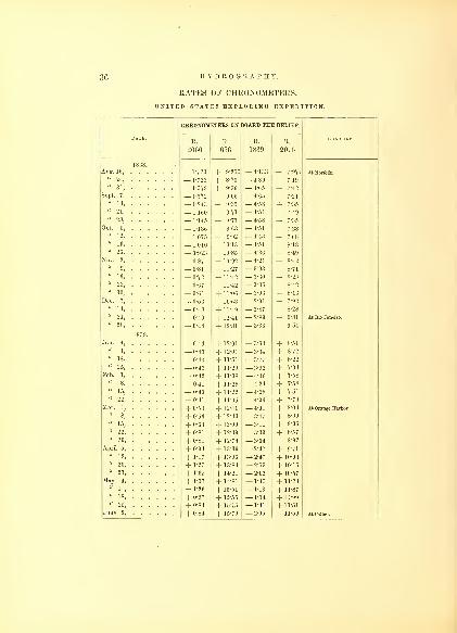
36 HYDROGRAPHY.
RATES OF CHRONOMETERS.
UNITED STATES EXPLORING EXPEDITION.
CHRONOMETERS ON BOARD THE RELIEF.
R. R. R. R.REMARKS.
20G6 656 1839 2075
1838.
— 1*723 -j- 9-255 — 4-133 + 7-97-4 At Norfolk.
u24
'— 1*723 4- 8'73 — 4 -89 + 7
- 19
— 1-579 + 0-36 — 4-65 + 7-42
eP ' 4- 7-21
u 2
_1-243 + 9-35 — 4-58
1-160 + 9-71 4-51 + 7-49
" 28
_1-145 4- 9-77 4-58 4- 735
Oct. 5, . 4-51
i \r<?" 12, . . . .
^ r + 9-92
" 19 1-010 4- 1013 4-51 + 8-13
" 26 0-923 4-3G + 8-49
Nov. 2,
_0-87 4- 10-92 4-21 + 8-42
" 9, . . . .
_0-81 + 11-27 3-93 + 8-71
" 16 -72 4- 11-42 — 360 + 8-28
" 23 0'67 _[_ 11-42 — 3-36 + 8-42
"30, 3-03 + 8-13
Dec. 7, . .
~~0-53 4- 10-63 2 -91 + 7'92
" 14, . . 0-48 + 11-49 2 -
87 + 8-28
" 21, . 0-49 12-41 — 2-89 + 9-81 At Rio Janeiro
"28, -48 + 12 81 — 3-36 + 9-54
1839.
a°' ' — 0-46 + 12-01 — 3-63 4- 8-51
u'
— -43 4- 12-01 —> 3
-34 4- 8-<2
((
* 8 ' + 11*51 — 3*77 4- 8-22
' + 11-29 — 3-92
e
((
" '— 0-42 + ] 1-08 — 4-36 + 7"8
— 41 + 11-29 — 4-24 + 7-58
+ 11-22 — 4-28 + 7-51
"22, — 0-41 + 11-65 — 4-06 + 7-79
Mar. 1, + 0-53 + 12-41 — 401 + 8-03 At Orange Harbor.
" 8, + 0-56 + 1243 — 3-47 4- 8-60
"15, + 0-63 + 13-00 — 3-11 + 9-06
"22, + 0-81 + 12-39 — 3-39 + 8-57
+ 0-81 + 12-74 — 3-04 + 8-92
+ 0-94 + 13-39 — 2-47 + 9-71
"12, + 1-17 + 13-96 — 2-47 + 10-03
"20, + 1-27 + 13-84 — 2-53 + 10-15
"27, + 1-35 + 14-21 — 2-02 + 10-57
+ 1-37 + 14-81 — 1-45 + 11-24
"11, + 1-26 + 15-51 — 1-13 + 11-87
"18, + 0-97 + 1555 — 1-34 + 11-99
"25, + 0-84 + 15-15 — 1-41 + 11-51
+ 084 + 15-79 — 2-05 + 11-59 At Callao.

RATES OF CHRONOMETERS. 37
RATES OF CHRONOMETERS.
UNITED STATES EXPLORING EXPEDITION.
DATE.
CHRONOMETER RATES.
REMARKS.R.
2066
R.
656
R.
1839
R.
2075
1839.
June 9, + 0-82 + 15-03 — 2-46 + 11-30
u
16' + 0-61 + 15-12 — 2-26 + 1M7
"23
' + 0-57 + 14-94 — 2-42 + 11-08
30' + 0-42 + 14-91 — 2-40 + 11-02
^y ' + 0-40 + 14-97 — 2-43 + 10-71
14' + 0-43 + 14-84 — 2-21 + 11-11
+ 0-46 + 15-62 * + 11-71 * Transferred to Vincennes.
+ 0-41 + 16-77 + 12-17
+ 0-37 + 17-09 + 12-38
((
' + 0-39 + 17-10 + 12-82
+ 0-41 + 16-46 + 12-96
+ 0-33 + 16-08 + 12-54
+ 0-25 + 15-96 + 12-01
((
8' + 0-12 + 15-74 + 11-82 At Sandwich Islands.
"20' + 0-25 + 15-63 + 12-04
+ 0-37 + 15-82 + 12-09
+ 0-54 + 16-05 + 12-26
+ 0-87 + 15-91 + 12-17
+ M0 + 16-12 + 12-92
+ 1-22 + 16-78 + 13-01
+ 1-33 + 16-21 + 12-72
+ 1-36 + 16-47 + 12-57
+ 1-37 + 16-67 + 12-73 At Sydney, N. S. W.
K„!' + 1-45 + 16-82 + 12-66
* + P50 + 16-83 + 12-83
' + 1-57 + 16-75 + 12-46
+ 1-63 + 16-31 + 12-37« jg + 1-69 + 16-59 + 12-46"22 + 1-83 + 16-52 + 11-69
"29, + 2-10 + 16-72 + 12-01
1840.
+ 2-0 + 16-33 + 12-19
"11, + 2-12 + 16-47 + 12-34
"18, + 2-3 + 16-29 + 12-29
"25, + 2-2 + 16-36 + 12-81
Feb. I, + 2-1 + 16-42 + 13-06
" 8, + 2-21 + 16-81 + 12-67
"15, + 2-3 + 16-69 + 12-43
"22, + 2-4 + 16-35 + 12-21
"29, + 2-5 + 16-66 + 12-39
Mar. 7, + 2-6 + 16-87 + 12-65
"14, + 2-7 + 16-71 + 12-42
"21, + 2-5 + 16-67 + 12-26
"28, Arrived in United States.

CHAPTER III.
PASSAGES.
It was found necessary to insert in the Narrative some general
remarks connected with the Hydrography of the Expedition : the
detailed information belongs to this volume. In treating of the pas-
sages from port to port, I shall follow the order of the cruise, believing
it to be the most useful as well as the most convenient for reference. Atthis day it may seem superfluous, or be deemed a work of supereroga-
tion, to make any remarks on the passage across the Atlantic, a sea so
much frequented : yet, strange as it may appear, there is no part of
the ocean where so many vigias are laid down on the charts, and of
which the accounts that have been published are so contradictory, or
in which there appears to be so great a necessity for a thorough exa-
mination, to set at rest the doubtful points, as the Atlantic. This
state of things seems to be tolerated by nautical men, who appear
averse to record or publish any observations that might tend to illu-
mine the paths of those who may pass after them, so that almost all
navigators are left to derive their knowledge from their own, often-
times dear-bought, experience.
The recent publication of charts, by the Hydrographical Bureau, on
which are laid down the tracks of vessels, has had the effect to direct
attention to this subject. It would have been desirable if the " dead
reckoning" as well as the true daily positions had been laid down on
the charts, to show the currents, as well as the errors arising from bad
steering, &c. The tracks may give the approximate route of a vessel,
but all navigators are aware how great are the daily and unaccounta-
ble discrepancies, and how many causes combine to render the courses
and position of a vessel uncertain on the ocean.

PASSAGES.
CAPES OF VIRGINIA TO THE CAPE DE VEItDE ISLANDS.
From the 18th of August to the 7th of October, 1838.
The passage first in order is that from the Capes of Virginia to the
Cape de Verde Islands. It was remarkable as illustrating the length
of passage caused by a difference of routes across the Atlantic.
It was my intention to pass into the Gulf Stream, and continue in
it as long as it lay in my power, but the winds not permitting us to
pursue that course, we were compelled to pass outside of it. I feel
satisfied that it would have expedited our passage to Madeira, had wekept within it, but the temptation of steering within a few points of
our course, which the wind permitted, prevailed, and we continued
our route without it, though nearly parallel to its direction, receiving
but little aid from it, and experiencing variable currents and light
winds, but, at the same time avoiding exposure to the heavy August
gales, which were to be expected, and from the experience of manyare believed to be much more severely felt within its limits, and are
extremely dangerous from the effect of the current, which renders the
sea higher and shorter.
The Relief parted company when four days out, with orders to make
the best of her way to the Cape de Verde Islands. Lieutenant-Comman-
der Long chose a direct route across the Atlantic, between the parallels
of 32° and 34°, and continued it until he reached the longitude of 37°
west, after being out 37 days. During all this time they were scarcely
able to steer their course, but were constantly annoyed by light and
head winds with opposing currents; after this, easterly winds pre-
vailed, until within a few days sail of the port, preventing her from
reaching her destination until after a lapse of 60 days.
The Relief was not to be classed among fast sailers, but it is be-
lieved will bear a fair comparison with ordinary merchant vessels that
carry a large cargo. At any other season, it is probable she would
have made better time ; but when the sun is approaching the northern
tropic, there is little doubt in my mind that the result must be the
same, by pursuing a similar route;light and variable winds will al-
ways then be found to prevail, and as far as this passage serves, it
proves that they generally prevail from the east instead of the western
quarter. The log-book of the Relief only mentions her having set
studding-sails on 13 days.

40 HYDROGRAPHY.
The route which I took with the squadron was between the 37th
and 38th parallels, to the Azores, some 200 miles to the northward of
that of the Relief. Here we find a totally different state of things.
The wind was fair 16 days out of the 28, and we only encountered
adverse winds during 6 days ; and I am under the impression that, had
our passage been made on a more northern parallel, we should have
shortened it by having more wind and deriving greater assistance from
the Gulf Stream;indeed, as a proof of it, the Peacock, after parting
company, kept about a degree to the northward of the Vincennes's
track, and reached the Azores two days before us, but was detained
longer in consequence of passing between the islands of this group.
On this passage the position assigned St. Anne's Shoal, as well as a
vigia in lat. 38° 8' north, long. 34° 3' west, was visited, and no appear-
ance of either found. I have mentioned in the Narrative my belief
that many of these shoals and vigias, which have obtained a place on
our charts, result from encountering large trees in boisterous and
thick weather, or during the night. It would appear likely that they
should be met with hereabouts, having been brought by the currents
or Gulf Stream, and for a time remain floating in this part of the
ocean. In this longitude (42° west), we encountered many pieces of
drift-wood, as well as large trees, which were of a deceptive appear-
ance until closely approached.
The course to be pursued in passing the Azores bound to the east-
ward, is to give them a wide berth, to the northward or southward
;
the former in the winter months, the latter in the summer months,
when the winds incline mostly from those quarters, by which a steady
breeze will be secured in the neighborhood of these islands, when it is
often interrupted and variable nearer them ; the strong currents
would also be avoided by keeping at a distance.
The position of the Tulloch Reef was passed near to, reported in
the neighborhood of the Formigas Rocks as long ago as 1808, and
said to have been seen several times since. In 1829, it was diligently
sought for by H. M. S. Ariadne, expressly sent for that purpose, with-
out success. We also have to report its non-existence.
The approach to Madeira is generally shaped for the purpose of
doubling its eastern end, and thus taking advantage of the prevail-
ing winds to reach the roadstead of Funchal with the least delay.
There are seasons when the winds permit an approach from the west-
ward : this being the case at the time of our visit, I took advantage

PASSAGES. 41
of it, in order to save time, and by standing close along the southern
shore of the island, favored with a gentle breeze from the southwest,
we were wafted by sunset to our anchorage in the roadstead. Ordi-
narily this is not an advisable course to pursue, as a large vessel maybe sometimes becalmed, or meet with baffling and light airs, in passing
under the high land, and be unable to reach an anchorage. It is
better to approach from the eastward when the northeast winds pre-
vail. During June, July, and August, a day and upwards may be
saved in reaching the port. Captain Hudson, in the Peacock, took
the eastern route, anticipating a leading wind to the anchorage : on
the north side of the island he found the wind northwest, and as he
proceeded round the east end it became southwest, which caused him
to stand well over towards the Deserters, where the wind was baffling
and squally, with a current setting to the south and east.
It may be as well here to notice that the best anchorage in the
roadstead is limited to the range of the Loo Rock with the Castle on
the Hill;you then avoid the declivity of the bank to the eastward,
which deepens suddenly, .and have a good depth of water to anchor
in, from a half to one mile out. Not having been aware of this, I
anchored further to the eastward than this range, and was obliged to
change to a place of more safety the next morning. I mention this
circumstance in order that others, on their first visit to this port, maynot fall into a like error.
The Peacock and Flying-Fish both came east about, and reached
the roadstead the next day. The current which prevailed in the
roadstead during our stay, was from east to southeast, varying from
half to one mile per hour ; the winds were light and variable, gene-
rally from the southward and westward.
At Madeira it is scarcely requisite to inform the navigator that all
kinds of provisions may be had to recruit, but it is a bad place to
effect repairs in.
From Madeira we steered to the southward, with the intention of
passing over the positions of several reported shoals. The winds, in
our passage from Madeira to the Cape de Verdes, were light, though
favorable. We did not obtain the trades until we had reached the
latitude of 26° north. They had previously been found to prevail in
veins, generally springing up fresh for a few hours, and then dying
away to nearly calm. There appears to me great necessity for
taking advantage of all these spirts or cat's-paws ; the greatest atten-
11

42 HYDROGRAPHY.
tion is required in keeping the ship on her course, to secure all the
progress possible, as a mile, or even a smaller distance, in position,
may make a great difference in time when a favorable breeze is
taken, and the voyage is accelerated or retarded accordingly.
The winds on this route, from latitude 29° to 27°, are no doubt some-
what influenced by the proximity of the Canary Islands, and the
approach to the trade winds. I am satisfied that attention to the
trimming of the sails and sailing of the vessel, whilst passing through
these latitudes, will greatly expedite a voyage.
We encountered on this passage, between latitude 24° 30' and18° 25' north, on the meridian of 20° 40' west, an extent of 360 miles
of water as green as that of but 50 fathoms in depth. In passing
through it, we repeatedly sounded in from 150 to 300 fathoms, with-
out obtaining bottom.
The width of this discolored water I have ascertained to be about
150 miles, on the parallel of 21° north latitude. In passing into it the
temperature fell 2° of Fahrenheit, and rose the same amount on passing
out. The line of demarcation was very well defined, the sea on either
side being of a deep blue. It was noticed in the voyage of Frazer, in
1712, but, considering the great number of navigators who have since
traversed that part of the ocean, it does not seem to have been often
observed. There seems to be an impression by those who have
noticed it that soundings could be had, but the lead has been often
tried, as was the case with us, to various depths, without success.
Many have imputed the discoloration to animalcula, but I am con-
fident that this was not the case at the time we passed through it,
for careful examination failed to discover any in water taken from the
surface as well as that from a depth of fifty fathoms ; and I would also
urge against its being the effect of animalcula, the long continuance of
it in the same place. Whether it is the reflection of the bottom, as
some suppose, or a peculiarity of the surface waters, emanating from
the rivers of Africa, I leave for others to decide ; it is a phenomenon
well worthy of investigation. While in it we saw no phosphorescence
of the water, but on passing out, it was very evident. To determine
its actual limits, both in breadth and width, is a work of no great diffi-
culty, and if observations were repeated, in a few years the question
would be settled as to its being permanent.
In the Pacific as well as Atlantic Ocean there are many places of
discolored waters, betokening banks of large extent, which have served

PASSAGES. 43
useful purposes in navigation. The discolored water to windward of
Barbadoes and that of the False Brazil Bank are well-known examples.
The deep sea temperature at the depth of 350 fathoms was 23° less
than that of the surface.
The reputed shoals, on which it is said the Maria and Bon Felix
struck, are on this route; the former is said to be in latitude 19° 45'
north, longitude 20° 50' west, and the latter in latitude 19° 20' north,
longitude 20° 37' west. Both of these situations were passed over, by
the squadron, in the manner I have before described, and the examina-
tion of the localities fully satisfied us that no such shoals exist where
they are laid down. It is to be hoped that this evidence will have
the effect to erase these supposed dangers from the charts.
On this passage we found the current trending to the northward and
eastward, from one-half to five-eighths of a knot per hour, but there
was none most of the time. Many navigators give it as setting to the
southwest. The set of the ship by current in the whole passage was
found to be north 57° east, 42 miles in 13 days.
The Bonetta Rocks, in latitude 16° 32' north, longitude 20° 57'
west, said to lie to the eastward of Bonavista, and nearly in our track,
I determined to make search for. Although the account given in
Purdy's Atlantic Memoirs appeared so well authenticated, and the
failure to find them after so diligent a search as that made by H. B.
M. Ship Leven, Captain Bartholemew, left but little hope of our being
more successful, yet I considered the sweeping over the locality with
the squadron would be, as I have before stated, still more satisfactory
;
we therefore passed over this locality, as well as an area of ocean of
from 40 to 50 miles in extent in the neighborhood, with the lead
continually going to the depth of from 60 to 70 fathoms, and good
look-outs both below and aloft, the sea being quite smooth ; we also,
after having passed over the position assigned them, continued to steer
on their reported bearing, towards the island of Bonavista, but saw
nothing of them. It appears that in the year 1841, the British Ship
Charlotte was wrecked on a shoal which was reported in latitude
16° 17' north, longitude 22° 21' west; the nearest we approached this
position was eighty-two miles, on a bearing of north 79° west. I amstill inclined to doubt the accuracy of this position, as it appears to
have been passed over by H. B. M. Ship Leven in her search. Should
the rocks be hereafter seen, I have little doubt that their true position
will correspond to that of the Hartwell Reef, on which a ship of that
name, and the Madelaine, were both lost.

44 HYDROGRAPHY.
In this neighborhood we encountered many tide rips, and found
the current, on trial, to set northeast by north three-quarters of a mile
per hour.
Formerly it was deemed equally feasible as well as more advan-
tageous to pass to the eastward of the Cape de Verdes, to be enabled
to cross the equator on a more eastern meridian. Vessels now sel-
dom pursue this route, unless they have similar intentions with our-
selves, viz., to touch at St. Jago.
Experience has proved that the best course for vessels to take that
are bound across the line, is to pass some distance to the westward of
San Antonio;some, however, still prefer sighting this island, to ascer-
tain that the rates of their chronometers have not altered.
Before leaving the Cape de Verdes, and as somewhat connected with
the interests of navigators, I may call attention to the remarkable
dry haze that frequently envelopes these islands, which renders all
objects indistinct, and at times entirely obscures the horizon, so as to
make it impossible to get observations with accuracy. Our observa-
tions place the fort at Porto Praya in latitude 14° 53' 45" north,
longitude 23° 30' 55" west.
The supplies for ships at Porto Praya are not to be depended upon,
if required in a short time;indeed, they are, at times, very difficult
to be had, the cultivation of late years having been much neglected,
in consequence of the few vessels visiting it, and the small demand in
comparison to what it was formerly.
The magnetic variations decreased with regularity from Madeira to
the Cape de Verdes, viz., from 24° to 17° westwardly.
FROM THE CAPE DE VERDES TO RIO DE JANEIRO.
From October 8th to November 20th, 1838.
On leaving Porto Praya, my intention was to pass over the position
of several shoals, which were embraced in my orders, and which lie
on the route of ships in the part of the ocean we were to traverse. I
was, therefore, not particularly anxious to cross the equator on any
particular meridian, but to be governed more by the opportunities I
might have of making our search as effectual as possible, without
losing too much time.
We lost the northeast trade winds the day after we left Porto

PASSAGES. 45
Praya, when we were in 12° 24' north latitude, and 23° 45' west lon-
gitude, and experienced squalls, with much rain and lightning. On
the 23d of October, the Relief lost the trades in 11° north, and on the
meridian of 22° west. The Danish Brig Lion, which vessel we spoke,
had lost the southeast trades in 6° 30' north, and the Ship Crusader
likewise informed us that she had lost the trades in 7° 30' north, both
having crossed the line between 22° and 27° west longitude.
Patty's Overfalls was the first supposed danger we steered for, in
longitude 24° 30' west, and latitude 11° 02' 18" north. On the 11th
of October, we reached this position, and we were in its neighborhood
for forty-eight hours. Various tide rips were encountered, trending
east and west, but no current was found to exist, either by our obser-
vations, or by the trial with the current log ; so that I feel satisfied
that Patty's Overfalls does not proceed from reefs or shoals. Atother seasons there may be an appearance of broken water, but there
are no dangers existing.
It was with some difficulty we reached the position of Warley's
Shoal, in latitude 5° 04' north, and longitude 21° 35' west. We exa-
mined this locality thoroughly, but without success. From the man-
ner of our search, I am well satisfied it does not exist in the position
assigned it.
The westerly wind which we found in this latitude enabled us to
run to the eastward as far as longitude 13° 53' west, to look for the
French Shoal. The positions assigned it by both French and English
hydrographers were passed over, the first in latitude 4° 05' north,
longitude 20° 35' west, and the second in latitude 4° 15' north, longi-
tude 19° 20' west.
When we had reached 5° north latitude, we passed out of the sultry
and damp weather that we had been subjected to for twenty days.
Since we had lost the northeast trades, in 12° north latitude, we had
comparatively little rain, and the expectation of filling our water-casks
were not realized. I mention this circumstance, as I find from inves-
tigation, that there appears to be less rain in October and November,
than other months of the year; therefore, those who pass at one sea-
son, and obtain a supply, may be disappointed in another. About the
equinoxes, particularly the vernal, more rain falls than at other
times. The quantity of rain that fell during this passage, was only
6*15 inches, and the greatest fall in 24 hours was 1*95.
As we approached the southeast trades we had a long swell from12

40 HYDROGRAPHY.
the south-southeast, which gradually grew more perceptible until wereached them. We crossed the equator in 17° west, and sounded for
the Triton Bank, under the longitude of 17° 46' west, and latitude
0° 32' south, keeping the lead constantly going ; but no appearances
of a shoal, either in the color of the water, tide rips, or soundings,
were perceptible. The current setting to the northward had influ-
enced us very considerably for the last few days before reaching the
equator.
In passing through this space between the north and south trades,
we observed the upper strata of clouds passing rapidly from the east-
ward.
From the number of rips encountered, and the variation of the tem-
perature of the water from 3° to 5° between them, I suspected that a
current of some magnitude existed ; but after making frequent trials,
it was found of very little strength, and running to the east-northeast.
The winds, until we reached the equator, prevailed from south-
southwest to south-southeast, generally light, inclining to calm ; those
experienced by the Relief were very similar 15 days later.
The set by current of the squadron from Porto Praya to the line, in
24 days, was north 25° east 132 miles. The Peacock experienced it
north 56° east 144 miles in 23 days, and the Relief north 48° east,
203 miles in 25 days.
A variety of opinions have always been held on the subject of the
best meridian on which to cross the equator ; I propose to say a few
words upon it, having found it almost impossible to arrive, after exa-
mining all of them, at any satisfactory result. In my opinion, the sea-
son of the year ought alone to be the guide ; that which controls more
than anything else, being the monsoons of the coast of Brazil. During
the prevalence of the southerly monsoon, it is extremely disadvanta-
geous to cross the line too far to the westward, for after being so fortu-
nate as to pass Cape St. Roque, the prevailing winds may be found to
the southeast, and sometimes as far as south, thereby driving a vessel
upon the coast, and subjecting her to tack to the eastward again, and
consequently to a very long and tedious passage. On the other hand,
during the northerly monsoon, a vessel pursuing a more westerly route
would meet with no detention, but, on the contrary, having the wind
to the northward and eastward, at times as far as north-northeast, she
would be enabled to make rapid progress, with a free wind on a line
parallel with the coast. It is thus evident that the equator may be
PASSAGES. 4 7
passed well to the westward, if the sun is advancing to the southward,
but, on the contrary, it is always safer to navigate well to the eastward
during the advance of the sun to northern declination. These direc-
tions are intended for all kinds of vessels, as well the slow as the fast,
and notwithstanding the latter may pass with less difficulty, yet it is
beyond a question that even with them a much cphcker passage
would be the result of taking the most favorable route. Another rea-
son is to be found in the necessity there seems to be to avoid enter-
ing the great Equatorial Stream before reaching the equator. Wefound it cutting the equator about the meridian of 18° west, at an
angle of fifty degrees ; and although our experience may not determine
its actual northern boundaries at all times, yet it is probable it does not
vary very much from that here given;consequently, vessels passing
the equator in a more western longitude, would enter it before reach-
ing the equator, and be subject to its influence much sooner. Bytaking a course to the eastward, it would be entered later; but it is to
be considered whether the opposing northern current, in a more
eastern longitude, is not as disadvantageous. On the other hand,
by crossing at the meridian of 18°, it is evident that the Equatorial
Stream would not be encountered until the winds from the southeast
had become so well established, that its influence would be less felt,
and it would have but comparatively little effect on a vessel, until
she had the means of quickly passing beyond its influence, and
therefore be subject to it the shortest possible time ; on this account
I am decidedly of opinion, that, taking the winds and currents into
consideration, the nearer a vessel, bound to the south across the equa-
tor, can cut the meridian of 18°, the better, at all seasons of the year,
though during the favorable monsoon I would myself try, and even
recommend, a more western meridian.
Much has been said about " Great Circle Sailing" and it has
been recommended particularly on this route. Although I do not
wish to dispel the illusion, or to detract from the merits of the officer to
whom is assigned the origin of "Great Circle Sailing," I cannot but do
justice to the prior right of Mr. John Garnett,* a distinguished mathe-
matician, of New Brunswick, New Jersey, whose devotion to nautical
science was well known, and who edited and published the first edition
* In the Tran. Am. Phil. Society, vol. vi, p. 303 (Old Scries), August 25th, 1807, is
a notice by Mr. Garnett, of the "Principle of Sailing in the Arc of a Great Circle," with
a Chart, for which he was awarded the Magellanic Gold Medal.

48 HYDROGRAPHY.
of the American Nautical Almanac in 1815, and a set of highly useful
nautical tables in 1816, and also a large chart, showing the projection
of the " Great Circle Sailing," under the title of " Loxodromic Curve,"
copies of which I had the honor of presenting to the Honorable
Secretary of the Navy from the author, on my first entrance into the
navy. By claiming a prior right for a distinguished mathematician, a
friend and associate of Adrain, Vateck, Fulton, and other distinguished
mathematicians and mechanicians of our country, I only desire to
restore to one, and to claim for him the original investigation of this
subject, and publication of the chart. I am well satisfied there are
few parts of any ocean in which the loxodromic curve can or ought
to be attempted; and although the route from the United States
to the Brazils is one of those on which it is strongly recommended,
I think there are sufficient reasons why vessels should not attempt
it. Many have failed entirely, others have but partially succeeded,
whilst others, again, have made quick passages. Those voyages which
I have examined have derived all their advantages from gaining the
line at the most favorable time to take the northeast monsoon of
the coast of Brazil, which is fallen in with sometimes as far as 5° to the
north of the equator, and at times the wind veers as far to the north-
ward as north-northwest ; thus giving vessels, though close to the
coast of Brazil, a favorable opportunity to make the passage the
whole distance almost on a loxodromic curve, or the shortest distance
between two points,—evidently the most desirable to be sought for, or
taken, if possible;yet there are few routes across the ocean where the
winds will permit its being taken to advantage at all seasons, except
within the trades : these passed, the variables succeed, and change so
rapidly, that it is next to impossible to pursue, for any length of time,
a course on any loxodromic curve.
From the equator to 3° south, the set by the Equatorial Stream was
south 69° west 75 miles, while from latitude 3° south, longitude 20°
west, to latitude 13° south, longitude 30° west, its set was north 80°
west, 100 miles; thence to the latitude of Cape Frio it was to the
southward and westward. The amount of current between the equa-
tor and Rio was north 82° west 300 miles. The greatest set we ex-
perienced between latitude 10° north and 13° south, was on the meri-
dian of 26° 30' west, 30 miles a day, nearly west.
The position of Bouvet's Sandy Isle was passed over, but nothing
whatever was seen of it. As it was my intention to examine the posi-

PASSAGES. 49
tion of Krusenstern's Volcano, I limited the search under the equator
to the twentieth degree of west longitude, as I was apprehensive the
Equatorial Current might render it impossible to reach its assigned
position in longitude 20° 41' west, and latitude 2° 53' south. The
squadron passed over the locality three times, in different directions,
but saw no indications of a shoal.
We were 25 days in reaching the equator, and 20 days from the
equator to Rio de Janeiro.
Very great differences occur in estimating the latitude to which the
southeast and northeast trades extend, arising no doubt from sailing
to or from them ; in both cases great allowance is to be made for the
want of accurate observation, and disappointment often experienced
in losing or meeting them. As respects my own experience on this
voyage, and from information obtained, navigators give the latitude
where they lost the southeast trades, too far to the north, and in
sailing in an opposite direction, too far to the south; therefore, we find
several degrees of difference assigned the trades at the same period,
when they could not have altered to any extent. The condensed
table which Horsburgh gives as the result of his examination of 238
voyages shows this fact ; without this explanation his long list would.
be of little use, but with it, it becomes perfectly intelligible. Although
many of his sailing directions have been superseded, yet the debt that
all seamen owe to this great navigator is not to be measured. Fewmen have done so much for the commerce of the world ; and his
industry in obtaining nautical information and compiling sailing direc-
tions, has been the cause of preserving many lives, and a vast amount
of property.
In crossing the space between the northeast and southeast trades,
the changes of wind are at times sudden, and require constant atten-
tion ; sometimes severe and rapidly shifting squalls are experienced :
one of them happened to us in latitude 9° 30' north. The squadron
was sailing in close order, with a fresh breeze from the southeast,
when the vessels were taken suddenly aback by a squall from the
southwest ; in a few minutes we had the wind from different quarters,
so that it required during the time it lasted, good management of the
vessels to avoid running into each other.
The approach to Cape Frio may be said to be safe at all times, the
lighthouse now established affording all necessary facilities to the
navigator to advance without fear or apprehension at night. When
50 HYDROGRAPHY.
the light cannot be seen from haze or thick weather, the soundings,
as well as a fall in the temperature of the water, will indicate a proxi-
mity to the land. The soundings extend some 25 miles, and are of
ooze and shells. The lighthouse on Cape Frio we found to be 1285
feet above the level of the sea, placed on the highest peak of the
island, and often enveloped in mists and clouds. Its position ap-
pears to have been chosen that it might be seen from as many points
as possible. It is a revolving light, and can be seen distinctly from
30 to 35 miles in clear weather. As this is a point which is always
made by our ships, and from whence their departure is usually mea-
sured, it was deemed important that its correct position should be
ascertained : this was effected by connecting it with the observatory
on Enxados Island, the position of which had been determined by a
series of moon-culminating stars. Sound was employed as the most
convenient and expeditious mode to measure the meridian differ-
ence : the result placed the lighthouse on Cape Frio in longitude
42° 00' 13" 87'" west.
It has been generally supposed that it was necessary for vessels to
await a favorable wind to enter and depart from Rio Janeiro, but
this is a mistake ; there is no difficulty whatever in vessels departing
or entering, at any hour and with any wind and favorable tide : the
best time, however, to enter is during the day, when the sea-breeze is
fresh : it ordinarily dies away at sunset, and then remains calm until
an early hour in the morning, when a gentle land-breeze prevails
until about 9 o'clock.
So safe and free from danger is this harbor, that pilots are un-
necessary, but it is requisite to pay attention to the tides, which at
times run with great velocity. There are times, too, when heavy
squalls prevail, from the southwest to northwest, which sometimes
blow with violence, and I have been informed that a heavy sea has
been experienced at the anchorage in the harbor, so much so as to
prevent any landing at the Great Quay, and rendering it necessary
for boats to seek the upper or mercantile harbor to land, where it is
practicable at all times. Vessels lie at anchor, and lighters are em-
ployed to land all goods, thereby causing a detention, as well as ex-
pense, in discharging the cargoes.
The situation of the upper harbor is well adapted for the erection
of wharves, and they might be constructed with little expense, and

PASSAGES. 51
would be entirely protected from the influence of the winds and sea
by the small islands of Enxados and Cobra.
The tide in the harbor of Rio ebbs and flows 4£ feet, and it is high
water at 2h 15m p. m. full and change. A tide-staff was kept during
the time of our stay, and marked hourly, night and day. The ebb
often runs very nearly the whole day, and is always represented as
much stronger than the flood.
Vessels after leaving the harbor of Rio would do well to follow the
example of the coasters, and stand down along the northern shore
towards Cape Frio, for they would thereby not only preserve the
land-breeze, but also be assisted by the counter current which sets
along the shore, and save much of the time that is frequently lost by
standing off to the southward and eastward, when not only contrary
winds are met with, but frequently calms of some duration. The
coast is free from dangers, and a vessel of any size may approach it
within a short distance. The light on Raza Island we found to be a
brilliant revolving light, showing alternately a deep-red and white
light.
The port regulations of Rio are somewhat unfavorable to trade,
and the number of holidays interfere with the desirable despatch in
the loading and unloading of vessels, but as the commerce of this
region is rapidly on the increase, it is believed that a better system
will ultimately prevail.
Every kind of supplies may be had here, and generally at reason-
able prices.
FROM RIO DE JANEIRO TO THE RIO NEGRO.
Between the 6tli and 25th of January, 1839.
On the 6th of January, 1839, we got under way and dropped downthe bay, but the breeze in a short time left us, and we were obliged
to drop our anchor until the sea-breeze set in, which we were favored
with at about 10 o'clock, when we made sail and beat out of the har-
bor with the last of the ebb tide. In the afternoon we anchored
outside the bar, in 20 fathoms, white sand, owing to the breeze failing,
as well as to await the return of one of the tenders, which I had de-
spatched back to Rio on business : the time was, however, usefully
employed in measuring the altitude of the Sugar Loaf. It continued
calm until the next afternoon, when the sea-breeze was so light, that

HYDROGRAPHY.
I determined to await the land-breeze, which came off at an early
hour in the night, when we made sail, and stood to the southward.
On the 9 th we had heavy showers, with lightning, but no thunder,
succeeded by a southeasterly wind, and a reduction of temperature,
which gave us great relief, as we had been suffering from the heat for
the last eight months. On the 11th, when we had reached the lati-
tude of 30° south, the air had assumed a very perceptible change in
respect to its hygrometric state, being now much drier, and giving a
feeling of more elasticity than we had experienced for some months.
We had fine weather, with the wind from the northward and east-
ward, increasing towards evening. On the 15th, we had reached the
latitude of 34° south and longitude 51° west, just to the northward of
the Rio de la Plata. The current previous to this time had been ex-
perienced to the southward and westward, and as we were now on
soundings in 80 fathoms, of ooze, the current was tried by anchoring
a boat, and was found to be setting north-by-west 6 fathoms.
On the 18th January, the twelfth day from Rio, in latitude 37°
south, longitude 52° 40' west, we passed into the discolored water
of the Rio de la Plata. The line of demarcation on entering it was
very distinct, and its temperature 4° less than the surrounding ocean.
We continued in it until after passing to the southward of the latitude
of the La Plata, being about 80 miles in width. To the northward
of latitude 40° we again struck soundings, in 55 fathoms, which proved
to be sand. From this it is probable that the ooze deposit of the
river has spread over an area of great extent north and south.
The great fall of temperature, both in the water and air, which weexperienced in latitude 40° south (some ten degrees), with thick fog,
led me strongly to believe that we were in the immediate vicinity of
icebergs, which have often been seen in this latitude, and longitude
50° west. Commodore Wadsworth, in the Vincennes, on a former
cruise, encountered them in latitude 39°, and longitude 54°, and had
great difficulty in escaping from them; on this point navigators should
be cautious at this season of the year (January). The best course to
pursue in order to avoid the ice, I am satisfied, is to keep near the
Patagonia coast. Ice has been seen in great quantities to the east of
the Falkland Islands, and although commonly in the form of field ice,
yet it is dangerous, requiring the greatest care on the part of the navi-
gator. By taking the open sea to the eastward, instead of getting out
of it, the probability is it would be encountered in much greater quan-

PASSAGES. 53
titles. As far as my inquiries went, I satisfied myself that when met
with on the edge of soundings it will be found to interrupt the navi-
gation more seriously to the eastward than along the coast.
Our run towards the Rio Negro was attended with fine weather,
and after reaching the parallel on which the Ariel Rocks were be-
lieved to exist, and to the eastward of the longitude, we sailed two
degrees to the west, but saw nothing of them ; and from our search
and that of others we feel satisfied that they have no existence. Theposition in which they were supposed to lie was in latitude 40° south,
longitude 57° 33' west.
As We approached the coast, we found the soundings extremely
regular, varying about a fathom for every three miles. The coast
at the mouth of the Rio Negro presents a low line of sand-hills. Tothe south of the river is a bluff 100 feet in height, of tertiary lime-
stone, regularly stratified ; to the north of Point de Maine, there is a
remarkable sand-hill, called the Barrancas ; and beyond are seen
others, which terminate in extensive pampas.
We dropped anchor off the Rio Negro on the eighteenth day from
Rio de Janeiro.
The Rio Negro is barred, and from the examinations we made and
the reports of the pilots, it proved to be a shifting bar. In endeavor-
ing to enter the former channel, without pilots, with the tenders, wegrounded on the sand-bar that had recently formed, rendering it no
longer practicable for the entrance of vessels. A vessel drawing more
than 10 feet water cannot safely enter the Rio Negro. The best
position to anchor in the roadstead is with the flag-staff on Point de
Maine north 65° west, in about 9 or 10 fathoms water, within a mile
and a half of the breakers, which extend in a northeast and southwest
direction.
Pilots are usually found here, but in case they should not come off
immediately, it is better to wait for them than to attempt to follow
the directions for entering, which, from the shifting of the sands, are
not to be relied upon after a flood or freshet. At the time of our visit,
two poles were placed on Point de Maine, one on the hill and another
near the beach; the first had several pieces nailed across it, that
served for the purpose of ascending, for a look-out ; these poles, kept
in range, were intended as guides to lead a vessel in the deepest water
over the bar, and until within half a cable's length of the point, which
must then be turned short round to pass into the river. The course
14

54 HYDROGRAPHY.
by compass is northwest I west. The depth of water on the bar will
be found to be 13 feet, and the passage never should be attempted but
at or nearly high water. The rise of the tide, at full and change, is
11 feet, and the current at the mouth of the river runs 5 knots; at
the anchorage in the roadstead it was 2 knots. The tide in the
river usually runs ebb 10 hours, and the flood 2 hours, but during the
freshets it runs ebb the whole time. Large quantities of sand and
mud are brought down, and on meeting with the ocean water, is de-
posited, forming extensive bars.
The roadstead may be considered at all times dangerous, but par-
ticularly so during the winter months. From May till October, south-
east gales frequently blow, which are directly on shore, accompanied
by a heavy sea. They are preceded by a heavy swell and thick
weather, and are indicated by the barometer, which we found exceed-
ingly sensitive to change to the south of 30° latitude. The holding-
ground, composed of coarse sand, gravel, and shells, with clay, is good;
and there is no great difficulty in getting off shore, provided advan-
tage be taken of the flood tide, which sets to the windward, casting
on the starboard tack.
The tide off the Rio Negro sets strong (the flood) to the south-
west 5 h, the ebb to the northeast 6h hours. This is opposite to what
Captain King gives it in his Patagonia directions, between Cape
Blanco and Cape Virgins.
During the prevalence of northerly and westerly winds the weather
is fine and the sea smooth.
Water may be obtained about a mile within Point de Maine, and
after settling is considered wholesome. Supplies may also be had, but
only in limited quantities ; the lack of industry of the inhabitants being
the cause of the scarcity, for the soil is capable of raising vegetables
and fruit in abundance.
Vessels intending to visit this part of the coast would do well to
seek the fine harbor of San Antonio, at the head of the bay of San
Mathias, where supplies, I was informed, can be as readily obtained as
at the Rio Negro. It is but about 30 miles from the town of Paula
del Carmen. The charge on vessels in these ports is half a rial per
ton ; whale ships are admitted free for less than twenty days.

PASSAGES. 55
RIO NEGRO TOWARDS ORANGE HARBOR, TIERRA DEL FTJEGO.
From the 3d to 17th February, 1839.
We made this passage in 13 days; it was considered a favorable
one. Our route was farther off the coast than I desired, in conse-
quence of experiencing for the first two days fresh gales from the south-
west, accompanied with a heavy sea, which drove us off the coast ; it
would have been but lost time to have regained the coast, and fol-
lowed it down on soundings. One of the squadron, the Relief, sighted
the coast frequently on her passage from Rio de Janeiro to Orange
Harbor, stopping for two days at Good Success Bay ; she made the
passage in 42 days, the same length of time taken by the squadron,
although we passed eight days off Rio Negro. On the seventh day
we reached the Straits of Le Maire, previous to which we passed near
to, but a little to the westward of the place assigned the L'Aigle
Rock : its position is given as latitude 51° 50' south, longitude 64° 45'
west, which had been searched for previously by others without
success.
The weather we met with before entering the Straits of Le Maire
was boisterous, but not more so than we anticipated or had reason to
expect. The winds prevailed mostly from the northward; those from
the southward were dry and cold ; the northerly ones brought dampand rainy weather : they change to the southward and westward by
the north and west ; the precursor of this change is usually a heavy
bank of cumuli in that quarter. The barometer was an indicator of
bad weather ; but I here observed, for the first time, that the wind did
not begin to blow until the mercury began to rise. Any change from
the northward to the southward was attended by a fall in tempera-
ture of several degrees.
The winds on the east coast of South America for the most part
prevail from the northward and eastward, or the southward and west-
ward, and very seldom are found to remain long in the southeast ; but
the severest gales that are felt in these latitudes are from that quarter.
Off the coast, near Watchman's Cape, lie the Bellaco Rocks. There
are two distinct rocks, bearing from each other south 17° east (true).
The northernmost was seen by Captain Stokes, in 1828; he placed it
in latitude 48° 30' 50" south, and longitude 66° 09' 25" west. The

56 HYDROGRAPHY.
Relief made it in latitude 48° 30' south, and longitude 66° 07' 11"
west. This I have named Stokes's Bellaco, while that which lies in
latitude 48° 38' 44" south, longitude 66° 03' 53" west, about 10 miles
distant, I have called Long's Bellaco. The latter was discovered by
Lieutenant-Commandant Long, of the Relief, who appears to be the
first navigator who saw and verified both rocks. The latter is be-
lieved to be the true Bellaco of Nodales.
Watchman's Cape should be cautiously approached, and if not re-
quired to be sighted had better be avoided, in consequence of the
strong currents that prevail in its neighborhood.
To pass through the Straits of Le Maire, I would always recom-
mend making the land to the westward with the ebb tide, but Middle
Cape on Staten Land, with the flood ; the reason is, that the ebb sets
towards the Staten Land shore, and the flood to the Tierra del Fuego
side.
Our passage through the Straits of Le Maire was effected in a few
hours, although we were not particularly favored with good weather.
We entered the Strait with a fair wind and all sail set, but were re-
duced before we left it to close-reefed topsails, in consequence of the
squalls that came rushing out of the ravines of Tierra del Fuego, as
we passed them. We made the land off Cape St. Diego in the morn-
ing about 8 o'clock, and by 3 o'clock we had passed through, and had
Cape Good Success bearing to the northward.
Some navigators have thought proper to caution others against
attempting this passage. I have carefully examined the supposed
difficulties, and think they are more imaginary than real. The Strait
is 12 miles wide, has no hidden dangers, and its coasts are high, and
may be closely approached by any class of vessels without fear; there
is, in fact, nothing to contend with but the tide, which runs occa-
sionally with great velocity, and with a contrary wind produces a
short, and sometimes a heavy sea. We were exposed, in the Por-
poise, to a strong gale of wind, and passed through what has been
reported as " The Dangerous Race," off both Middle Cape and that of
St. Anthony, on Staten Land, without difficulty.
It is high water, at the full and change, off Cape St. Diego, at 4
o'clock, p. m. Here again we encountered the " Race," and although
we were knocked about with some force while in it, yet we did not
apprehend or perceive any danger. I would recommend keeping near
the middle of the Strait, as the squalls or " williwaws" do not blow so

PASSAGES. 57
furiously as near the high land, nor will vessels be subjected to
calms as on the western side. Good Success Bay offers a stopping-
place for vessels in case the weather should prove bad. The anchor-
age is good during gales from the southwest, but when it blows from
the southeast, the sea sets in, and it becomes rough and quite danger-
ous. The Porpoise and Relief stopped here : the former, on the wind
veering to the southeast, was obliged to slip her cable and leave the
anchorage, owing to the heavy sea. As at Rio Negro, it is necessary
to slip when the windward tide is running strong.
The survey of this bay by the Beagle we found correct, but the
directions are not quite so plain as is desirable. When sailing along
the coast from the south, on which 'side it is generally approached,
there is little appearance of a bay. The " Broad Road" of Cook, though
given as the direction for it, is not sufficient. The first guide is the
" Sail Rocks:" they lie 5 miles southwest-by-south from Good Success
Bay. The two jagged, rocky heights, resembling a cock's comb, will
present themselves when the bay is open to view. The best place to
anchor in, is in 10 fathoms, sand and shells, a short distance outside
the line of kelp, the " Cock's-comb" bearing southwest-by-west,—
a
berth convenient for procuring both wood and water. Scurvy-grass
and wild celery, with berries, may be obtained in quantities.
The currents, from Rio de Janeiro to the Rio Negro, we found south
39° 30' west, 167 miles. From Rio Negro to the Straits of Le Maire,
north 20° east, 126 miles.
In proceeding from the Straits towards Cape Horn, I would strongly
advise vessels to take the route inside of the Hermit Islands, by
Nassau Bay. A vessel standing to the westward, for Nassau Bay,
by keeping close to New Island, would avoid the currents, which set
strong outside a line drawn from Cape Good Success to Cape Deceit,
the easternmost land near Cape Horn ; and even if intending to pass
to the south of Cape Horn, with a contrary wind, it would be better
to pursue this course. All vessels ought to beat up to this Cape
within the above line, as they would thereby very much shorten their
passage, and be enabled to round the Cape, or to await the first good
opportunity that offered, without being subjected to the great wear
and tear from an exposure to the heavy seas and strong gales that
must be encountered to the south. The dangers are all visible or
pointed out by the kelp ; the sea is comparatively smooth, although
the squalls are violent and accompanied with hail, rain, and snow ; but15

58 HYDROGRAPHY.
there is ample room for working a ship, and no danger to be appre-
hended from a lee shore. The winds, together with the tides, will
assist very much in making progress to the west, and the smoothness
of the water will avoid much wear and tear to a vessel. There are
several anchorages that are convenient and perfectly safe : New Is-
land, Goree Roads, Gretton Bay, Sea-Gull Harbor, Orange and Sca-
penham Bays ; the latter two may be known by the " Sentry-Boxes,"
which are conspicuous craggy peaks behind Scapenham Bay. This
course would be much more desirable at some seasons of the year than
at others, and particularly during that portion of the year when day-
light prevails.
In fine weather the passage outside the Hermit Islands and round
Cape Horn is attended with no difficulty, and the Cape may be closely
approached. The squadron was much favored, and passed within
3 miles of it.
I should not have taken the outside route around the Cape if the
Admiralty Charts had been in my possession, as I very much preferred
that through Nassau Bay.
The Relief had previously reached Orange Harbor, by the inner
route, from Good Success Bay. She anchored for a day under NewIsland, where they obtained observations, by which I find an error in
longitude of 6' west, as laid down on the Admiralty Charts. As NewIsland is a well-defined object on which to get bearings, it is impor-
tant that its position should be accurately given. The situation of
Orange Harbor is easily known by Packsaddle and Burnt Islands
:
the former lies some 5 miles to the north, and cannot well be mis-
taken, from its remarkable appearance ; the latter protects and forms
the harbor, and is readily recognized by its smooth surface. In
entering, either side of Burnt Island may be taken, but I recommend
that to the north, bearing in mind that there are no dangers without
the line of kelp. The best position in which to anchor is towards the
head of the harbor.
Orange Harbor lies in longitude 68° 02' 40" west, latitude 55° 31'
south. The tide rises 4 feet, and it is high water, full and change, at
4 o'clock. The flood runs to the eastward 5 hours.
The water we procured here, although apparently highly impreg-
nated with vegetable matter, was found quite wholesome.
It is scarcely necessary to add that it was almost impossible, from
the fickleness of the climate, to get a series of observations, and that
PASSAGES. 59
we considered ourselves fortunate in making as many as were requisite
to ascertain the rates of our chronometers.
Vessels desiring to stop for repairs, or wood and water, will find
Orange Harbor far preferable to any other port on the coast. It is
both convenient and safe, and affords every facility to procure those
articles, as well as scurvy-grass, wild celery, and berries ; and fish
may be also taken in abundance. Temporary anchorage is found in
the Bay outside Burnt Island. The stay of a part of the squadron in
Orange Harbor for 60 days, during the months of February, March,
and April, afforded us an opportunity of testing its advantages. During
this time the weather was extremely changeable. The wind pre-
vailed 47 days from the westward, 12 days from the northward and
westward, and but 1 from southeast. Eleven gales of wind occurred,
of from 2 to 3 days' duration. Nearly all navigators report that the
summer is the best time of the year to make the passage round Cape
Horn ; but it is doubtful, as it would appear almost impossible for
gales of wind to be more frequent than we experienced them.
But to return to the inner passage. I here speak of it in contra-
distinction to the outward or southern one round Cape Horn. Once
having reached Gretton or Orange Bay, the first opportunity of a
favorable wind and tide which offers may be taken, of passing out of
the western channel, round False Cape Horn, to the southward and
westward. With the wind from the northward and westward, a course
may be made good to the west of Diego Ramirez, and under favor-
able circumstances even to reach the Ildefonso Isles. It is advisable to
stand as long as possible to the west, provided a vessel does not go
to the southward of latitude 58° south ; if the longitude of 75° west
has been reached, it would be better to stand to the northward again,
and close with the coast : no apprehension of a lee shore need be en-
tertained. All navigators who have had any experience on this coast,
from Cook down, agree as to the wind not " blowing home," and the
fact of the currents setting off shore to the southward would make it
impossible for any vessel to incur danger, with ordinary care. Whenthe gales blow from the westward, they seldom continue long from the
same quarter, but vary from the northwest to the southwest. This
offers many facilities in making the passage, and advantage should be-
taken of these changes, standing upon that tack which gives the best
opportunity of making westing.
From a careful examination of the tracks of very many vessels that

GO HYDROGRAPHY.
have passed the Cape, I am well satisfied that much time, besides
great wear and tear of the vessel and fatigue to her crew, will be
saved by following the inner route, and continuing along the coast
as far as Cape Pillar. Some objections have been made to approach-
ing the southern shores of Tierra del Fuego, to the east of the Hermit
Isles ; but they are bold and high, and no hidden dangers exist to
cause alarm. The danger attending the passage through the Straits of
Le Mai re from the velocity of " the races," caused by the tides, manydeem the great objection to attempting this inner route; but I
cannot conceive why, if the weather will permit carrying sail at
all, there can be any difficulty in beating to the westward, within
the line I have indicated, between Cape Good Success and Cape
Deceit. Once up with the Hermit Islands, and being overtaken by
night, it would be well to seek anchorage in either of the bays
spoken of, and await daylight or a favorable time to proceed. The
only inconvenience that a vessel can be put to is in getting her ground-
tackle ready for use, which is not to be considered in comparison
with the wear and tear, if exposed to the violent storms at the
south. In nine times out of ten, the passage round Cape Horn, by
taking this inner route, will be not only much shortened, but de-
prived of its hardships and terrors, and subject to much fewer casual-
ties than that by the outside.
The charts of Captain King, and his sailing directions for Eastern
and Western Patagonia, are admirable guides through this navigation,
and are very necessary for every navigator in doubling the Cape, or
when frequenting this inhospitable coast.
Captains King and Fitzroy deserve great credit for the perseverance
and ability displayed in conducting the surveys in these boisterous
latitudes, the results of which are embodied in the Admiralty Charts,
with the directions of Captain King.
As far as our experience goes, the barometer is extremely useful,
and indicates truly the weather. Those in the habit of using it in
northern latitudes would be inclined to doubt it, for its indications are
directly opposite ; fine weather accompanies its fall, and a gale is
seldom felt until it has begun to rise, when the wind veers several
points and increases till it blows with great violence ; this continues
until the mercury has attained its ordinary height.
There is another view of this subject, that will probably show the
utility of adopting this route, viz., that it places the vessel in a situa-
PASSAGES. 61
tion, the moment a gale has subsided, to take advantage of the short
space of fine weather that succeeds, and in all probability to make the
desired westing, before a recurrence of storms ; for the distance to be
run is but some 350 miles, and may be passed over in a very short
time.
There seems some difference of opinion relative to the longitude
to be reached before keeping off to the northward. In most cases, it
is that of 80°, in the latitude of 57° south ; but during the winter
season, from April to October, as the north and northwest winds pre-
vail in the Southern Pacific, it would be better for vessels to attain
the longitude of 82° west before steering away to the northward, thus
in all probability avoiding the heavy northwest winds which blow
near the coast of Chili, saving much time, and sooner enjoying fine
weather, which is generally less boisterous as the distance from the
coast is increased. My own experience is decidedly adverse to near-
ing the coast, or being forced upon it by northerly winds. For nine
days (from the 2d to the 11th of May), between the latitude of 40°
and 47°, we had constant and unintermitting north winds.
Another argument I would urge in favor of these views is, that
nearly all the disasters that have happened in passing the Cape have
occurred to the eastward of Diego Ramirez, where the currents are
found to have greater strength, and the winds appear to hold longer
from one quarter, and do not veer, as has been noticed in the preceding-
remarks.
At all seasons, the navigator is well assured that he is not so liable
to meet with icebergs,—one of the most serious impediments in the
spring and summer months. In the year 1832, the ocean was found
so covered with them that many whaling vessels, bound round Cape
Horn, encountering them, put back to Valparaiso, there to await a
more favorable season, considering it too dangerous to involve them-
selves with the numbers that were seen.
From our experience of the weather, after we left Orange Harbor,
I cannot represent it as being stormy : it was boisterous, as one always
must expect it to be in these high latitudes, and off the extreme end
of the continent, it is subject to great vicissitudes, and the seas pro-
duced by the meeting of the waters of two great oceans are heavy.
In the Vincennes, we were but eight days in attaining longitude
78° 30', in latitude 56° 30' south, when we bore up to the northward.
This longitude will not leave as much room as is to be desired to
16

62 HYDROGRAPHY.
weather the coast of Western Patagonia to the north of Cape Pillar.
The gales that prevail during the winter season are from the west to
northwest : these have a tendency to force the navigator on the coast,
although there can be no apprehension of suffering from a lee shore.
Yet I deem it safer to avoid the chances of it, notwithstanding I was
successful in the course I took. It ought to be recollected, that after
getting to the north of the parallel of 40° the most stormy latitudes
have been passed, and the navigator is relieved from his excessive toil
and watching.
On the whole, although the passage around Cape Horn is boiste-
rous, I cannot bring myself to look upon it as so surrounded with
dangers as has frequently been represented, and do not believe that
the great precautions recommended to be taken are necessary ; at
the same time, the navigator should not be off his guard, or avoid
putting his vessel in the best possible condition to meet with bad
weather. The precautions alluded to, however, are the striking be-
low of the guns, and other like acts. The ordinary winter weather
experienced by vessels navigating our own coast and the North Atlantic,
is as severe as that encountered in passing the Cape. To draw a
comparison between the two would be impossible, they have so few
points of similarity. The exposure, however, in passing round the
latter is little when compared with the former.
By the ordinary route pursued, doubling the eastern end of Staten
Land (Cape St. John), it frequently takes from 20 to 25 days—say
from the longitude of 62° to 80° west, on the parallel of 54° south,
a distance of about six hundred miles. Anything short of this time
may be considered a good passage, supposing a vessel to meet with a
full share of boisterous weather : there are times, however, when the
weather is equal to that of the tropics;indeed, on our first arrival off
this dreaded promontory, it was of this character, but our stay was
long enough in these desolate regions to satisfy every one that its
fickleness is not to be surpassed in any quarter of the globe.
The current from Cape Horn to Valparaiso was south 72° east, 364
miles.
The wind hauled to the southward and eastward, in the latitude
of 36° south.
Anchoring on the western coast of Tierra del Fuego is to be avoided.
Noir Island is a dangerous anchorage, as was sufficiently proved by
the Belief. For an account of her disasters, see Narrative, Vol. I,
page 161.

PASSAGES. 68
FROM VALPARAISO TO CA1LAO.
From June 7th to 20th, 1839.
Our stay in Valparaiso was twenty days. When this place was
first visited by American vessels, they anchored towards the head of
the bay, before the town ; this exposed them to all the violence of the
south winds during the summer season, and also during the northers
to the heavy sea that rolled in from that quarter.
The requisite precaution in approaching this harbor is, to make the
coast to the southward. If it should be late in the day, and there is no
prospect of reaching an anchorage, it would be advisable for vessels to
keep off the land some 8 or 10 miles with the light on Point Angelos
bearing southeast, as they would then be beyond the influence of the
strong northerly current that sometimes prevails near the coast, and
within 6 miles of the land ; and in the event of calm, which is fre-
quently the case during the night, a vessel may be set very far to
leeward of the port before daylight by being exposed to it, and placed
in a somewhat critical situation. Near the beach of Concon, or that
of Quintera, the current is usually strongest about the time of newand full moon, when a most remarkable increase of the surf occurs on
this coast;indeed, as far as my observations have extended, the entire
west coast of South America is subject to this phenomenon.
The anchorage is now under the bluff to the north of Point San
Antonio. During the winter season, thick, rainy weather, with fogs,
are frequent, attended with little or no wind, making it extremely
difficult to get out of the harbor or bay during its continuance. The
summer season is remarkable for the regular southeast wind : the
morning being usually calm and pleasant until about 11 o'clock, when
a breeze comes up from the southeast, gradually increasing to a strong
gale, with perfectly clear weather. During the continuance of these
high winds, the discharging of cargoes and even intercourse with the
shore are for the time suspended ; it becomes therefore necessary, in
anchoring in the bay, during the summer months, to give a longer
scope to the southeast cable ; and in the winter months, to moor with
the heaviest anchor to the northward and westward.
Gales from the north, termed northers, occur seldom, once in several
years. In June, 1823, I experienced one of the most violent and
G4 HYDROGRAPHY.
destructive ones which ever happened at this place, in which 18
vessels—nearly all of them large and fine ships—were cast on shore,
in consequence of their cables having been chafed off—chain cables
not being then generally in use, and the bottom much fouled by lost
anchors. The risk in this harbor from such causes is much less now,
on account of the nearly universal use of the chain cable.
The northers are indicated by a fall of the barometer, with a day
or two of dull, heavy weather, and an increasing swell setting into the
Bay, giving timely warning to prepare by securing boats on board and
everything else for riding at anchor in a heavy sea. The immediate
precursors of it are a lighting up of the clouds and a bright clear sky
to the northward and westward, and the looming of the land to the
northward off Concon and Quintera, which is not usually visible from
the Bay. The worst riding is experienced on the flood tide, the sea
setting in very heavy. It is somewhat more moderate with the ebb,
which setting to windward and acting as an undertow, prevents so
great a strain on the cables; the sea is shorter, but nevertheless
vessels ride easier.
From the experience I have had in this Bay, some precautions in
anchoring are deemed necessary, and it would therefore be well to
observe the following directions. In the summer season, a single
anchor to the southward and eastward is alone required, having a
long scope, as the winds are strong from that quarter, and frequently
come in heavy gusts off the highlands, rushing down with great force,
when vessels are liable to drag off the bank, which is steep. If
anchoring to the north of Point San Antonio, you moor with open
hawser to seaward ; if to the south of it, in the summer season, it is
better to ride at single anchor, steadied by a kedge. In winter, care
should be taken not to be in the hawse of other vessels, the harbor
regulations being indifferently attended to. Vessels frequently suffer
great damage from collision, as any vessel breaking adrift, must neces-
sarily come in contact with many others. All should endeavor to
moor in a clear berth, so as to be able to ride with a cable on each
anchor, say from 90 to 100 fathoms, to insure the certainty of not
dragging; the usual depth of water is from 15 to 30 fathoms, mudand sand.
The anchorage for men-of-war is to the north of Fort San Antonio.
It is high water, full and change, at 11 hours 30 minutes, A. m.;
and the rise of the tide is 4 feet 9 inches.
PASSAGES. 65
Provisions of all kinds are plenty. Wood, however, is dear and
with difficulty procured. Water can be obtained by the boats of
a vessel ; but it is a great saving of time and expense, to have it
brought off in tanks. The price is one dollar per tun.
The current between Valparaiso and Callao was found to be north
82° west, 162 miles.
The trades, at the season of the year when we passed over this
route, were uncertain and unsteady, but they generally prevailed
from the southward and eastward. When the wind was not strong,
the breeze would veer to the northward and eastward for a few hours.
The sky was for the most part overcast, though the weather was
mild and pleasant.
During the winter, April to October, it is better to steer directly off
from the coast until you reach an offing of from 100 to 150 miles,
and then make a direct course for your port;by this means you get
within the influence of the regular trade, which is generally found at
this distance from the coast, and beyond the influence of the north
monsoon, which prevails near the land;you are then sure to have a
favorable breeze to carry you forward to your destined port.
The Vincennes was 13 days on this passage ; but it is frequently
made in 8 days.
At Callao we remained from the 20th of June till the 19th of July.
During the greater part of this time we experienced thick, misty
weather, so as to render it difficult to obtain the necessary observa-
tions for rating our chronometers. The longitude deduced by them
was 77° 11' 10" west, and the meridian distance between Callao and
Valparaiso, 5° 31' 50".
The Bouqueron Channel seems to be seldom used by large vessels;
yet coming from the windward it is certainly preferable to passing
round Point Galena, the north Point of San Lorenzo. The directions
for passing through it are extremely simple. Stand in to the south-
ward of Isle del Fronton until La Horadada Rock and Point Morro
Solar are in one ; then steer directly for the inner point of San
Lorenzo, until the town of Callao is seen to open with the Castle, when
haul in and anchor in the roads, in any berth that may be con-
venient.
I passed through the Bouqueron Channel after dark, and over the
tail of the shoals at its entrance in oh fathoms, anchoring opposite the
burial-ground on the Island of San Lorenzo. Our observations place
17
66 HYDROGRAPHY.
the wharf in longitude 77° 16' 45" west, and latitude 12° 4' 46"
south.
Callao Bay is at all times smooth. The sea-breeze sets in usually
about noon and continues until towards sunset. The nights are for the
most part calm and pleasant, although frequently the almozo or dew is
heavy. With the exception of not being able to land the stores of a
vessel conveniently, it is one of the best ports of the Pacific to effect
repairs in. Water is here obtained from pipes at the mole with ease,
and is good ; wood is scarce, and consequently dear. The markets
are well supplied with provisions, and tropical fruits are abundant,
when there are no intestine wars to disturb the country.
FROM CALLAO TO TAHITI, THROUGH THE PAUMOTU GROUP.
Between the 19th of July and the 10th of September, 1839.
The time employed in making this passage was 53 days—this in-
cludes that spent among the islands of the Paumotu or Dangerous
Archipelago, amounting to some 25 days. Our route lay between the
parallels of 12° and 18° 30' south latitude. Within these parallels I
hoped to have been favored with a strong trade wind ; but the winds
at this season of the year (July), on the parallel of 18°, cannot well
be so termed, although generally prevailing from the eastward. Theeffect of the southwest monsoon is evident from the interruptions, and
by the long swell from that quarter. The sky was unattended with
the usual light clouds that are met with in the trade winds : instead
of this, we had the scud flying at times rapidly from the southwest.
I would therefore advise that vessels, when bound for the Society
Islands from the coast of South America, should keep to the north-
ward of latitude 15° south, or even as far as 12° south, in order to
insure good weather and steady breezes ; and when approaching the
longitude of the Paumotu Group, to steer for the Disappointment Is-
lands, and after sighting them, thence on a southwest-by-west course
for Raraka, passing between it and Katin or Saken Island, and after-
wards between Fakarawa and Faaite to Tahiti. This route is the
most practicable as well as the least dangerous, and will materially
shorten the passage by preserving a favorable wind through the
whole distance, and can be navigated during the night as well as the
day.

PASSAG'E S. G7
The currents on the passage from the coast were variable, and
nearly neutralized each other ; the amount we found to have influ-
enced us during the passage was north 57° east, only 17 miles. At
other seasons of the year the currents may be stronger, and more in
favor of the vessel bound to the west. To judge from our experience,
it would appear that these westerly currents are influenced by the
westerly monsoon, for the currents that are known to prevail during
this portion of the year in the Pacific set in an opposite direction.
On this passage we had an opportunity of verifying the positions of
the Island of Clermont de Tonnerre and that of Serle Island, and to
prove the non-existence of Minerva Island. Whether the latter is
identical with either is a matter of little moment to navigators. The
existence of a separate island it was necessary to disprove, and in so
doing it involved the position of the two others ; and although neither
can be, from the description, identified as Minerva Island, yet if it
existed, it must from its position lie between them. In order to re-
concile the various observations, it is most probable that the Captain
of the Minerva saw the northwest end of Clermont de Tonnerre, as
his description of the island is totally at variance with the truth, un-
less this is admitted. Both the latitude and longitude would warrant
the belief that such was the case. I have therefore supposed it iden-
tical with Clermont de Tonnerre, and not Serle Island.
There were no perceptible currents experienced during the period
we were cruising among the Paumotu Group. We had many oppor-
tunities of trying the current, but none was found ; neither did the
position of the ships, when hove to, or beating to windward, indicate
any, and I feel warranted in the belief that at other seasons of the
year none will be found to exist. The operations of the Porpoise
were not at all impeded by them in this group in the months of De-
cember and January.
The passage from the coast of South America to the Society Islands
is ordinarily made in about 40 days.
The Island of Tahiti, is the most resorted to, particularly its har-
bors on the north side, from Point Venus on the east to Papieti on
the west. This island may be seen some 80 miles, in clear weather,
but ordinarily not beyond 40 or 50 miles. The peaks are seldom
seen, being usually covered with clouds. In approaching the harbors
of Tahiti, it is decidedly advantageous to do so from the eastward, or
windward. A pilot may be found in the offing, yet no one need have

68 HYDEOGBAPHY.
any hesitation in running in, provided a good lookout is kept from
aloft. The shoals and reefs are all laid down on the charts, and can
be easily avoided.
FROM THE SOCIETY ISLANDS TO THE SAMOAN GROUP.
Between the 29th of September and the 10th of October, 1839.
Vessels bound to the westward should leave the harbor of Tahiti as
soon as the sea-breeze or trade reaches there ; this is during the fore-
noon, and when it is well advanced. If in the harbor of Papieti, it
would be better, from its being so far under the lee, to get under wayat an earlier hour, taking advantage of the land-breeze, which will
generally be found to extend beyond the sea-reef. The weather har-
bors and bays get the full force of the trade winds, which almost
constantly prevail. In standing to the westward, pass to the north-
ward of the Island of Eimeo. The trades generally blow fresh, ex-
cept during the months of November, December, and January, whenit would be advisable to take the route to the northward of the
Society Group, and get into a lower latitude, especially during the
above months, the summer of the southern hemisphere. When in
latitude 13° south, a course to westward may be pursued.
The passage to the Samoan Group is usually made in 6 or 8 days
;
a distance of 1200 miles. The parallel of 15° south will avoid all
the islands and reefs. Between these two groups the winds will be
generally favorable, but there are exceptions, and bad weather is fre-
quently encountered. When we made the passage, in October, we en-
countered much rain, and winds from the northwest, south, and south-
west; but very little regular trade. The Peacock and Flying-Fish
made the passage 10 days later, and had very strong trades all the
way. It seems that little dependence is to be placed in the winds at
this season, to the southward of the parallel of 15°; indeed, I should
advise navigators to avoid the belt of ocean between the latitudes of 15°
and 18° south: the trades are not to be depended upon south of the for-
mer, nor is there any certainty of winds from the westward in any
season. Many anomalies seem to take place to the westward of the
Paumotu Group, although I am not inclined to believe that they can
arise from any influence that is exerted by that group, for, as I have
remarked, this same vacillation of the winds seems to exist between

PASSAGES.
this archipelago and the coast of South America, between the same
parallels. The currents during our passage were from the south, but
trifling; and we found the sea remarkably smooth and the winds
variable.
Rose Island, the easternmost of the Samoan Group, may be run for
in the daytime : its rounded clump of trees can be perceived at a long
distance. Its longitude is well established. It is better to pass to the
southward of it and Manua;by doing so, you will keep to windward
and preserve the breeze; and if bound to Tutuila, can enter Pago Pago
Harbor; if to Apia or Upolu, pursue the same course, and then pass
between Tutuila and Upolu.
FROM THE SAMOAN ISLANDS TO SYDNEY, NEW SOUTH WALES.
Between the 10th and the 29th of November, 1839.
This passage was made in the month of November, and occupied
19 days. Upon leaving the Samoan Islands, we steered for Uea or
Wallis Island, which consists of several islands enclosed in the same
reef : it is moderately high and can be seen at the distance of 10 miles.
The entrance to the lagoon is on the south side, where communication
and supplies may be had. (See Uea or Wallis Island, in this volume.)
From thence we passed to the west of Hoorn Island, which we sighted
;
thence steering southwest-by-south, passed 150 miles to the westward
of the Feejee Group, and approached close to Mathew's Rock. Wewere favored with fair winds nearly the whole distance to Lord Howe's
Isles, mostly from the eastward and southeast. The winds generally
increased towards evening, and the trades were not lost until to the
southward of the parallel of 25° south ; then the wind came from the
northward and westward, after a short gale and severe lightning and
thunder, and with a heavy swell from the southwest; it gradually
hauled to southwest, and then to the southeast. The currents were
generally from the eastward, until we had passed the Feejee Group,
when they came from the southward, but were of little strength.
In approaching the coast of New Holland, care should be taken
not to make a land fall to the southward of the port, as some delay
may be experienced at this season of the year (November) in entering
the port of Sydney, from the southerly current, which resembles a
18
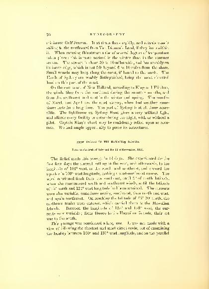
70 HYDROGRAPHY.
miniature Gulf Stream. It at times flows rapidly, and retards vessels
sailing to the northward from Van Diemen's Land, if they keep within
it. When entering this stream a rise of several degrees of temperature
takes place : this is more noticed in the winter than in the summer
season. The stream is about 30 to 40 miles wide, and has an eddy on
its inner edge, which is not felt beyond 6 to 10 miles from the shore.
Small vessels may keep along the coast, if bound to the north. TheHeads of Sydney are readily distinguished, being the most elevated
land on this part of the coast.
On the east coast of New Holland, according to King and Flinders,
the winds blow from the southeast during the summer months, and
from the southwest and west in the winter and spring. The months
of March and April are the most stormy, when bad weather some-
times lasts for a long time. The port of Sydney is at all times acces-
sible. The lighthouse on Sydney Head gives a very brilliant light,
and affords every facility to enter during the night, with or without a
pilot. Captain King's chart may be confidently relied upon as accu-
rate. We had ample opportunity to prove its correctness.
FROM CALIAO TO THE HAWAIIAN ISLANDS.
Between the 20th of July and the 2d of September, 1839.
The Relief made this passage in 44 days. She experienced for the
first four days the current setting to the west, and afterwards, to the
longitude of 104° west, to the south and southeast, and crossed the
equator in 109° west longitude, making a west-northwest course. The
wind continued fresh from the southeast, until 9° of north latitude,
when she encountered south and southwest winds, until the latitude
of 15° north and 124° west longitude had been attained. The currents
were also variable, sometimes setting southwest, then north and west,
and again southwest. On reaching the latitude of 16° 30' north, the
northeast trades were entered, which carried them to the Hawaiian
Islands. Between the longitude of 125° and 130° west, the cur-
rents were variable ; from thence to the Hawaiian Islands, their set
was to the south.
This passage was considered a long one. It was not made with a
view of following the shortest and most direct route, but of examining
the locality between 130° and 135° west longitude, and on the parallel
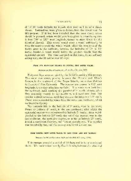
PASSAGES. 71
of 16° 30' north latitude, for islands that were said to exist there-
abouts. Instructions were given to deviate from the direct route for
this purpose. If it had been intended that the most direct course
should be pursued, orders would have been given to cross the equator
in from 130° to 135° west longitude, thence to steer direct for the
island of Hawaii. This course would carry a vessel sufficiently far
from the coast to avoid the winds which affect the steadiness of the
trades more to the eastward, between the latitudes of 10° to 15°
north;
besides, a vessel would derive the greatest benefit from the
equatorial current. The time occupied on this route, in an ordinary
sailing ship, should not be over 35 days.
FROM THE HAWAIIAN ISLANDS TO SYDNEY, NEW SOUTH WALES.
Between the 20th of September and the 31st of October, 1839.
Forty-one days were occupied by the Relief in making this passage.
The route was direct, passing between the Phoenix and Ellice's
Groups, to the westward of the Feejee Islands, and a short distance
to the east of New Caledonia. The equator was crossed in 172° west
longitude, in ten days after leaving Oahu. The winds were fresh from
the northeast, until reaching the parallel of 9° north latitude, whenthey gradually veered to the southeast, and continued from that
quarter without cessation until they reached the latitude of 30° south.
These were succeeded by winds from the north and northwest, which
continued to Sydney.
The currents felt, to the latitude of 9° north, were to the west
;
thence to latitude 4° north, to the east-northeast ; after which the
equatorial current was experienced to latitude 7° south ; from which
parallel to the latitude 18° south the set of the current was to the
east-southeast; the next nine degrees, or as far as latitude 27° south,
it took a southwest direction, and then an easterly one. The weather
was remarkably fine, and the passage considered a short one.
FROM SYDNEY, NEW SOUTH WALES, TO CAPE HORN AND RIO JANEIRO.
Between the 20th of November, 1839, and the 29th of January, 1840.
This passage occupied a period of 70 days, and is to be considered
short. The route taken was by Cook's Straits, between the islands of

72 HYDROGRAPHY.
New Zealand : they were reached by the 1st of December, a distance
of 1000 miles, in ten days. For the first half of the passage the
winds prevailed from the north and west, and the latter half from the
southwest. The currents experienced were strong from the northeast.
Cook's Straits were passed through without difficulty, the wind and
current being favorable. The lands are high and the shores bold, and
no dangers to be apprehended. It would be advisable for a stranger,
if he should be late in approaching the Straits, not to attempt them
until the reappearance of daylight. There is no particular caution
necessary, except to keep the mid-channel, where a vessel would be
least affected by the tides, and have all the benefits of the current, if
any existed. In case vessels desired to stop, they may seek tempo-
rary anchorage in the bays on the north or south. Here some supplies
can be obtained. Formerly much was to be apprehended from the
savage disposition of the natives, but since the large immigration of
English, they are friendly, and desirous of trading for their produc-
tions, which consist of potatoes and hogs.
The Relief's run to Cape Horn was made in 31 days, a distance of
4500 miles. The course was almost a direct one, with a fair wind,
either on one side or the other, all the distance. The first 900 miles
after leaving New Zealand, it blew from the north to north-northeast;
for the next 600 miles, from the southwest and south ; then it came
out again from the north until they reached longitude 127° west,
where they encountered, but for a day, the only head wind during the
passage ; then it again blew from the southwest or northwest until
they reached Cape Horn, passing which they arrived at the latitude
of 45° south, in the South Atlantic, where they wrere met by the north-
westerly winds, which compelled them to make a considerable devia-
tion from their course, and retarded their arrival at Rio. At no time
of the passage did they enter the southeast trades. The winds were
from the southwest and west, resembling in character a monsoon.
Until within several hundred miles of Cape Horn, they may be said
not to have had any current : that which they did meet with was
from the northward, but as they approached the Cape it was found to
be 30 miles a day, setting to the east-southeast ; and after passing the
Cape, it set to the northeast and east, to the latitude of 45° south,
when it changed to the southwest, southeast, northeast, and west, for
the last few days, before their arrival at Rio Janeiro.
This may be said to be the best time of the year to make this pas-

PASSAGES. 73
sage : no ice was seen, and the long days make it less hazardous to
encounter. In some years, during the months of December and
January, much ice has been met with, so much so that many of our
whale ships have considered it far safer to put back to the northward
again, and wait until it disappeared.
The passage by Cape Horn may be at all times considered the best
for homeward-bound ships from the coast of New Holland or NewZealand. The track during the summer to insure steady and favor-
able winds, is between the latitudes of 45° and 50° south. In the
winter months of the southern hemisphere, it would be much better
to keep near the parallel of 40° south, until approaching the Cape,
when a course which would lead for it should be adopted : this will
secure better weather and more constant winds;
THE ANTARCTIC CRUISE.
Between the 26th of December, 1839, and the 11th of March, 1840.
Although this does not come within the usual limits of the pas-
sages or routes of vesels, yet it may prove of use to navigators whovisit the high southern latitudes.
On leaving Sydney we had easterly winds, which enabled us to
stand to the southward, and favored us for several days, gradually
hauling to the northward and eastward. On reaching the latitude
of 45° south, the wind came from the north, and northward and
westward, accompanied with lightning and thunder, a change of
weather, boisterous, misty, and disagreeable, settling into thick fog,
attended with a fall of the mercury in both the barometer and ther-
mometer. On the tenth day we made Macquarie's Island. Thewesterly winds, which had set in strong, with a northeasterly current,
carried us to leeward of that island. Vessels wishing to visit Mac-
quarie's Island ought to allow for a northeasterly set of 20 to 30
miles in the 24 hours. The south end of Macquarie's Island weplace in latitude 54° 44' south, and longitude 159° 49' west : it is
within the stormy latitudes. After leaving it we cannot be said to
have enjoyed any continuance of fine weather in the higher latitudes,
along the Antarctic continent especially, while the wind was in the
western quarter. After passing to the west of 160° longitude, instead
19

74 HYDROGRAPHY.
of northwest and southwest winds, they prevailed from the eastward,
with better weather, although our hardest gales came from the south-
east, arising very suddenly;they were generally preceded by fine
weather whilst the wind continued to the northward of east; the
barometer falling, while the temperature rose. Easterly winds pre-
vail to the southward of latitude 60° south, but to the north of that
parallel, westerly winds, accompanied by fog, snow, sleet, but seldom
rain. Heavy cumulus clouds in the southwest indicate wind from
that quarter, as they do to the south of Cape Horn, but though bois-
terous they are not to be classed as storms. The barometer's range
is low, the mean being 29'04 inches; its movements are rapid,
frequently a great change occurring within an hour. The wind in-
creases as it rises, and continues for some hours after it has become
stationary.
In navigating towards the Antarctic, vessels should be well found,
not only with good sails and rigging, but protected against cold and
wet; the temperature, though not very low, is remarkably searching,
and from its being a low equable temperature and damp, there is no
opportunity to ventilate or dry the vessel except by artificial means.
Icebergs are seldom met with until the latitude of 56° south ; to the
westward of New Holland, they have been encountered in as low a
latitude as 42° south, by vessels making the passage to New South
Wales, in October and November; but this is unusually far to the
northward at this time of the year ; later in the year they have been
met with off the Cape of Good Hope, where several accidents have
happened by vessels coming in contact with them. The prevalence
of a current setting to the northeast, is the only way in which these
masses of ice can be carried to so low a latitude as a few degrees to the
southward of the Cape of Good Hope.
In this Southern Cruise we passed over the locality of Emerald
Isle, assuming its position to be in latitude 57° 15' south, and longi-
tude 162° 30' east, but saw nothing which indicated its existence.
During the continuance of our cruise of 1500 miles along its coast,
we were for a large part of the time surrounded by vast numbers of
icebergs, as well as having the icy barrier attached to the land to
avoid, consequently it became difficult to ascertain if any current
existed. The small movement of the ice to and fro, when we had
an opportunity of observing it, indicated that the tides were not of

PASSAGES. 75
much strength. The most unpleasant occurrence in this navigation
is the sudden rising of fog, frequently when the ship is surrounded
in all directions by numbers of these bergs of all sizes and shapes,
differing in height as much as they do in length, from 5 above the
sea surface until they reach that of 220 feet. Those who attempt
to navigate among these bergs would do well to observe the rule,
never to pass very close to windward of them ; the wind is apt
to fail at the most critical moment, or haul a point or two, and the set
of the current is sure to be towards them, involving a vessel in
much hazard, as well as creating great anxiety for her safety. So far
as the fear of the bottom striking, or the hull coming in contact,
there need be no apprehension, the spars would be the first to touch,
the iceberg continuing the wall-sided structure to a great depth below
the surface. I can only add that there is very great hazard in navi-
gating along the Antarctic coast during the season of all daylight
;
how much more so must' it be with a part of the time night.
Our return route from the coast of the Antarctic continent, in lon-
gitude 98° east and 05° south, was made to the northeastward,
towards the south of Van Diemen's Land. Here we were favored
with strong gales from the southwest, such as usually prevail between
the latitude of 50° and 60° south of New Holland ; and from our ownexperience as well as the character given of the latitudes in this loca-
lity, I am satisfied that this may well be termed a region of storms.
I have heard an opinion entertained that a southern passage was the
most advisable on leaving Sydney for England ; that is, passing to the
south of Van Diemen's Land. It has frequently been attempted, and
perhaps in a few instances with success, but I am well satisfied that it
cannot prove of any advantage to the navigator to take this route :
the winds will be found to prevail for the most part between the north-
west and southwest : they are boisterous, and accompanied with heavy
seas from the same quarters. After visiting the high latitudes, I cannot
believe any one could have the hardihood to advise it, let alone to
make the attempt. The wear and tear of such a voyage, its length
and chances of sustaining damage, are greatly against it ; in all proba-
bility, making a return to port absolutely necessary : the expenses there-
by incurred would be more than sufficient to pay for navigating in
the tropics for months.
On our return, we encountered the currents, already mentioned,
setting to the southward, along the coast of New Holland ; which

76 HYDROGRAPHY.
readily accounts for the difference in the length of passage from
Sydney to Van Diemen's Land and back. By keeping off from the
coast a sufficient distance, the return passage will be much shortened,
or, if in a small vessel, by hugging the coast, the eddy current may be
taken advantage of during the fine season.
FROM SYDNEY TO BAY OF ISLANDS, NEW ZEALAND.
Between the 19th and 30th of March, 1840.
Sydney and the north point of New Zealand lie very nearly in the
same latitude ; the course is therefore nearly due east. We enjoyed
tine weather, smooth seas, and fair winds, and made the run in eleven
days. The winds prevailed from the north, and northward and west-
ward. On approaching the island, the wind was from the south-
west, and after getting to the eastward of Cape Otou, variable. The
currents during the passage were from the northwest, until approach-
ing New Zealand, when they came from the southeast. After the
month of March, on the coast of New Holland, the winds prevail
from the southeast, when it is difficult to get an offing. The Peacock,
in the month of April, experienced light southeast winds for 12 days
after she left Sydney, on her passage to the Friendly Islands ; at the
same time was set by a strong current to the northwest, which carried
her within 150 miles of New Caledonia before she could make east'
ing. Her passage to Tongataboo was in consequence greatly retarded,
having been 32 days making the distance of 1700 miles. I think
it would be preferable if, on leaving Sydney, the wind should be
encountered from the eastward, to stand to the southward until suffi-
ciently out of the influence of the coast, or if the wind did not permit
that tack to be taken, then beat directly to windward until 100 or
150 miles from the port, rather than pursue the northern route.
FROM BAY OF ISLANDS, NEW ZEALAND, TO TONGATABOO, FRIENDLY ISLANDS.
Between the 6th and 24th of April, 1840.
This passage was made by the Vincennes, Porpoise, and Flying-
Fish, in 18 days. On the 13th, passed over the Rosetta Shoal. Not
finding it, have erased it from the charts. On the 8th day we sighted

P A S.S AGE S. 77
Raoul or Sunday Island, the most northern of the Kermadec Islands.
The winds were variable, which was also the case with the currents.
The course was a direct one. The passage might have been per-
formed in less time, if we had gone to the eastward of the Ker-
madec Islands;by which route, I am of opinion, we should have
found the southeast trades in a higher latitude. These islands,
situated in latitude 30° south, exert considerable influence on the
course of the trades, and produce calms in their neighborhood, par-
ticularly to the westward. In sailing to the Friendly Group, Eooa is
the best to sight ; it is high, and may be seen at a considerable dis-
tance. At some seasons currents are said to prevail off these islands,
setting to the westward ; but we experienced none.
On this passage, Vasquez Island was searched for, in latitude
24° 44' south, and longitude 174° 25' west; but without success.
Intending to enter the harbor of Tongataboo by the Astrolabe Gut,
a vessel should be off its eastern entrance at an early hour of the
day, to take advantage of the sea-breeze or trade which then usually
sets in. The Gut is 9 miles long, and contracts from 2 miles at its
mouth to a quarter of a mile in width at its western terminus, and
is difficult to navigate unless with a fair wind. Coral reefs border
each side, and no anchorage can be had until the western end is
reached, where the island and reef of Magonha separate it from the
harbor. The channels on either side of this island may be taken;
though narrow, they are perfectly safe, and after passing through
safe anchorage is found in the spacious harbor, well protected by
the surrounding land and the outlying reefs, which are of great ex-
tent. The anchorage near the island of Pangaimotu is the best, but
that off the town of Nukualofa is usually preferred, being more con-
venient for obtaining supplies. The shore-reef is of great extent,
bare at low water, making it extremely difficult to land in boats, so
that intercourse with the shore is generally limited to the time of
high water.
20

78 HYDROGRAPHY.
FROM TONGATABOO TO THE FEEJEE ISLANDS.
In May, 1840.
We were two days on this passage. The squadron went to sea
through the reefs by the north channel, and with a favorable wind
sailed past the islands of Honga Tonga and Honga Hapai, steering to
sight Turtle Island ; after which, the course was changed to make the
island of Ongea, one of the eastern group of the Feejee Islands. This
is one of the best islands to sight, if bound into any of the harbors
of the Feejee Group from the southeast. It forms the eastern side of
the Fulanga Passage, which may be passed through, but it would be
advisable to go to the southward of Fulanga and steer for Moala,
running close to Kambara. When to the westward of Kambara, if
overtaken by night, there is plenty of sea-room, to await daylight ; a
vessel can then pursue her course towards her port with safety. For
further remarks on the entrance to the Feejee Group, the sailing
directions of that group in this volume are referred to, as embracing
full instructions.
FROM THE FEEJEE GROUP TO THE HAWAIIAN ISLANDS.
Between the 14th of August and 24th of September, 1840.
As this passage was made by the vessels of the squadron at the
same time, following separate routes, and crossing the equator in differ-
ent longitudes, it affords information tending to show the best route to
be taken when bound from the Feejee Group to the northern hemis-
phere, during the months of August and September.
On the 14th of August, the Vincennes, Peacock, Porpoise, and Fly-
ing-Fish left the harbor of Muthuata by the Malu Passage, on the
north side of the Island of Vanua Levu ; on getting clear of the reefs
the Porpoise parted company, to visit again the eastern portion of the
Group, wrhile the Flying-Fish was sent to run along the great sea-reef,
to complete some minor examinations. This separation led to the
diversity of routes followed in proceeding to the northward.
The Vincennes and Peacock also parted company, the second day

PASSAGES.
out : the former stood to the northward, on the meridian of 1 78°, with
the southeast trades, which were carried to the latitude of 8° south,
when the wind hauled to east-northeast, with a long swell from the
northward and eastward. The wind had been previously found
to veer several points to the northward toward night, and generally
continued until morning, when it would veer to the southward again.
This obliged us to make northing too fast. On the wind's hauling
more to the southward, I determined to make easting, instead of
running with the wind free to the north. The winds were very
light. On the seventh day out, we made an island, which we sup-
posed to be the Kemiss or Gardener's Island of former navigators,
and passed the day on it making observations. Here we found the
flood setting strong to the northward, and the rise of the tide was 3z
feet, which nearly overflows the island. The next day we discovered
McKean's Island, in nearly the same longitude, but a degree north
of Kemiss. The winds were quite light, with some rain, which was
succeeded by dark, cloudy weather, and showers, with light breezes
from the westward. Under these circumstances, I steered to the
eastward, for the Phoenix Group. After copious rains (5-2 inches),
the weather cleared up ; the wind returned again to its old quarter,
northeast. We had heavy rolling seas from the southward, and
a current of half a mile, setting south i west.
We passed 10 days in examining the Phoenix Group : three of
the five islands of which it is composed were surveyed. They are
situated between latitude 5° south and the equator ; and between
longitudes 168° and 173° west.
The winds were very variable, as well as the weather, and the cur-
rents vacillating : some days equal to 30 miles to the west, again to
the southwest, and then none at all. It was not until the 4th of
September that we crossed the equator, in longitude 168° west. Theday before crossing, the weather was delightful, with a strong breeze
from the east ; we then stood to the northward, keeping the ship a
good full by the wind, which now veered from southeast to east-
southeast, with occasional squalls and rain. This weather continued
until we entered the northeast trades, between the latitudes of 9° and10° north. We were from this lime, 11th of September, until the
19th, beating up for the Hawaiian Islands, taking every advantage
of the variation of wind to make the most easting, when we made the
Island of Kauai, and two days aftewards anchored off the town

80 HYDROGRAPHY.
of Honolulu, Oahu : making the passage in 41 days, including the
ten days detention in the explorations of the Phoenix Group.
The Peacock's course was different. Captain Hudson determined to
keep at once to the northward, and crossed the equator in longitude
174° 30' west, about 350 miles to the west of where it was cut by the
Vincennes. The Peacock passed over the locality of the shoals re-
ported by Captain Swain, of Nantucket, as lying near Solitary Isle,
of Arrowsmith's charts, but saw nothing of them. She experienced
the same kind of baffling and light winds as described by the Vin-
cennes, but they were somewhat more to the northward and eastward.
The weather was fine, but warm. In latitude 2° south, the Peacock
experienced the same heavy swell from the eastward as the Vin-
cennes, which occasioned the ship to roll excessively,—-the surface of
the ocean being as smooth as a mirror. It was followed by the wind
from the west and southwest, and after rain again returned to the
eastern quarter, inclining to southeast, though baffling and squally,
which continued until they had reached the latitude of 5° north ; the
atmosphere being hazy and the weather sultry. Here they encoun-
tered the northeast trades, but exceedingly variable in direction,
changing from northeast to east, with frequent squalls and rain. Be-
tween the latitudes of 6° and 7° north, they made a tack for several
days to the southward and eastward, and were favored by the
easterly current. The winds were found too baffling and uncertain
to make much progress in beating to windward;besides, the ship was
light, and not in a condition to hold a wind;notwithstanding, it is
evident that she made much progress to the east, which could not
have been done if a strong easterly current had not prevailed.
On the parallel of 10° north they had fairly entered the northeast
trades, and made the best of their way to the northward, arriving at
Oahu on the 1st of October, making the passage in 50 days. Captain
Hudson found the northeast trades very strong and squally, muchmore so than we experienced them. The lightness of his vessel mayaccount for the difference in the passages, but I am almost inclined to
believe that there is something in crossing the equator in a more
easterly longitude, thereby preserving the southeasterly winds longer,
and being less subject to calms. The southeast wind, during the Por-
poise's passage from the Samoan Group, while it lasted, enabled her to
make considerably more easting, crossing the equator in 165° 30'
west ; she also kept a fresh southeast wind to latitude 5° north,
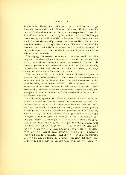
PASSAGES. 81
having crossed the equator on the tenth day, and making the passage
from the Samoan Group in 27 days; being only 17 days from the
line, while the Vincennes and Peacock were respectively 26 and 33.
I would not assert that this fully establishes the fact of its being a
better route ; for the Samoan Group lies some 500 miles to the east-
ward of where the two ships crossed the same parallel. This easting
may be considered a full equivalent for the difference in length of the
passages ; but I feel satisfied, after making a careful examination of
the whole route, that it is also due to the prevalence of more favor-
able and stronger winds.
The Flying-Fish crossed the equator in the same longitude as the
Porpoise. Passing to the eastward of all the small groups, she pre-
served the southeast trades, and made the passage in 33 days : this
length of passage cannot be compared with that of the other vessels,
the schooner being well adapted for plying to windward, and only
shows the prevalence of fresh southeast winds.
The weather, so far as respects its general character, appears to
have been nearly similar with all. The currents on the western track
were more variable in direction than those to the eastward, in the
same latitudes, and of greater velocity. All experienced the north-
easterly set of the current between 4° and 9° of north latitude. After
entering the northeast trades they encountered a strong westerly set,
averaging 15 miles in 24 hours, and this continued to the latitude of
the Hawaiian Islands.
It will now be apparent that there is no necessity for vessels bound
to the northward and eastward across the Pacific Ocean, to make for
the northern variables, as has heretofore been the practice,—thus
making a very circuitous course and occupying a much greater portion
of time, besides subjecting themselves to encounter much bad weather.
This, however, is not to be understood as applying to vessels to the
westward of 180° longitude: they ought to make the shortest pos-
sible stay within the trades ; and if this course is determined upon,
they should steer due north, without regard to making easting, until
they have fully entered the variables. It is, however, at times very
doubtful where they will encounter them ; and as far as our expe-
rience goes, and that of other navigators whom I have consulted,
they ought not to be expected short of 27° to 30° of north latitude,
to which parallel the trades often reach. The great difficulty seems
to be, with many, that on the first wind from the west being en-
21

82 HYDROGRAPHY.
countered, they are induced to believe that it will prove constant,
when nine times in ten they will be deceived.
FROM THE HAWAIIAN ISLANDS TO THE COLUMBIA RIVER AND STRAITS OF FUCA,OREGON.
Between the 6th of April and the 1st of May, 1841.
The remarks which follow are applicable to any part of the North-
west Coast, so far as general directions for sailing towards that coast
are concerned. The passages made by the Vincennes and Peacock,
the one in April, the other in July, show the winds during those
seasons on the above route, and the time when it is most favorable
to visit that coast. That different winds as well as currents are met
with, is clearly shown by the tracks of the two ships on the General
Chart of the Pacific.
The Vincennes left Oahu on the 6th of April, and passed between
Oahu and Kauai. For the first 8 days the wind was from north-
by-east, the weather being disagreeable and cloudy. On the 14th,
we had reached the latitude of 26° 30' north, longitude 160° west,
and had passed through the zone of calms (then about 300 miles from
our port of departure), when the wind hauled to the southeast; with
but a few hours' exception, the Vincennes carried the southeast
wind to the coast : it was quite strong, attended with much haze and
fog. In latitude 28° 30' north, we had the report of land ; but it
proved a false alarm. Many navigators have looked for land in the
space comprised within the latitudes of 33° and 43° north, and longi-
tudes 140° and 150° west, as yet unsuccessfully : all have been satis-
fied that the appearances of land are frequent and not to be mistaken,
landbirds in particular being numerous. This part of the ocean, from
the low temperature of the water and the warm air blowing over it,
is nearly always enveloped in fog and haze, rendering its examina-
tion exceedingly difficult; consequently rocks or even small islands
may exist which have not yet been discovered.
In passing over this space, I endeavored to take such a course
as would lead clear of the tracks of navigators who had preceded
us. This part of the North Pacific should be examined in the winter
season, when it is probable these fogs do not exist to the extent they
are found the rest of the year.


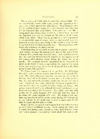
PASSAGES. 83
The quantities of villella that we met with exceeds belief. The
sea was literally covered with them, having the appearance of a
vast sheet of water spread over with cinders. What seems remarka-
ble, the position of these zoophytes has not changed since they were
met by Vancouver fifty years before. This seems to me to offer a
strong proof that, having been brought by currents from the north
and deposited here, they are retained by the absence of all current
within these limits. There was no perceptible current experienced
as we crossed this space of ocean; but to the northward of it, we ex-
perienced a very strong one, setting to the southeast some 35 miles
a day, from 150 to 700 miles from the coast. The temperature of the
water, also, indicated a southerly current.
Notwithstanding the detention we met with in passing through the
calm latitudes, we made the passage in 22 days to the mouth of the
Columbia River, which was unusually short. It is well here to state
that the southeast wind is not to be regarded as the regular one of
this coast,—seldom blowing except during the winter and spring
months. The southerly currents experienced by the Vincennes (as
shown on the Pacific Chart), on approaching the coast at this season
of the year, may be expected, and no doubt prevail during the other
spring months with equal force.
The Peacock made the passage in June and July. She did not get
through the calms until reaching latitude 33° north, in longitude 157°
west. The winds afterwards were from the east, and carried her to
the latitude of 44° north before she was enabled to make easting;
then she encountered the prevalent winds from the west and south-
west. Instead of the current which the Vincennes experienced, it
was found to set in an opposite direction, though not strong. Her
passage was made in 27 days, although the route was farther to the
westward than that of the Vincennes. The villella were met with
in latitude 40° north, longitude 157° west, and were lost sight of
in latitude 43° north, longitude 155° west. The limits of this mol-
lusca may therefore be said to extend nearly through 18° of longitude
on the latitude of 40° north, and to cover a space equal to 800
miles in length and 180 miles in width.
From these two passages, it would appear that very different routes
are to be pursued at different seasons. In the spring, the winds will
be found, after having passed beyond the calms, more from the south-
east than in summer;consequently, vessels should hold more to the
84 HYDROGRAPHY.
east, and cross the calms in the most eastern longitude, and as quickly
as possible ; it likewise shows that the calms are of less width, though
more difficult to pass through, in the spring. As was proved, the
error committed in the Vincennes was in not keeping by the wind,
and therefore too far to the west, thus falling under the lee or in-
fluence of the currents of air in the neighborhood of the Hawaiian
Group, which detained us. The information received from those whowere supposed to be well informed upon the subject, induced me to
take this course, expecting to meet the northwest and westerly winds
in a low latitude, and consequently be in a situation to take full
advantage of them. The plan I should have adopted was, to stand
directly to the north, or to the northward and eastward, and thus
make a more easterly route. This the Peacock did, and the first part
of her passage was made in much less time. I would, in making the
passage again, in the spring or summer, expect to have east and
southeast winds to latitude 40°, making as direct a course as they
would permit towards the part of the coast for which I was bound.
All vessels may expect to meet with fogs and hazy atmosphere between
latitudes 33° and 40°. This space may be very truly called the
region of fog, the temperature of the water decreasing some 15° ; and
what perhaps is more remarkable, on a near approach to the coast, it
again rises.
The navigation from the Columbia River to the Straits of Fuca
requires some care. There is a current setting upon the coast, of
some force, during the spring months. In our passage we expe-
rienced it, and came very nearly meeting with a serious accident off
Destruction Islet, near Cape Grenville. Fogs usually prevail until a
late hour in the morning, and care should be taken to keep a good
offing. The distance from shore may be readily ascertained by the
soundings, and it would be advisable, in unsettled weather, or fog,
not to approach nearer than 90 fathoms water, which will be found
at the distance of 35 miles from the coast, muddy bottom. If, in
standing along the coast, the water should become of a light green,
and the waterfowl be numerous, no time should be lost in changing
the course : it is not safe to approach the coast nearer, as there are
many outlying rocks on which a vessel may strike. This is parti-
cularly the case in the neighborhood of Cape Flattery, near the
entrance to the Straits of Fuca. The coast runs a little to the west-
ward of north ; but it may with proper precautions be considered safe,
PASSAGES. 85
as the prevailing gales enable a vessel to make an offing, either on
one tack or the other, and the Straits of Fuca are at all times under
the lee, with good harbors and anchorages, and may be entered with-
out apprehension.
PROM THE STRAITS OF FUCA, OREGON, TO SAN FRANCISCO, CALIFORNIA.
Between the 3d and 14th of August, 1841.
This route is along the line of the coast of Oregon, where the pre-
vailing winds in summer are from the southwest to northwest;gene-
rally to the southward of west before meridian, and after that time to
the northward : the distance is over 10° of latitude. It is advisable,
in sailing coastwise, to keep off shore from 60 to 100 miles. Thewinds will be found much more constant, and there will not be the
same liability to fog, and the currents, if any, will be favorable,
when bound to the southward. Excepting in the early spring months,
there is but little current. From five to seven days will be the
average passage. In approaching the harbor of San Francisco, it is
advisable to make the Punta de los Reyes, which may be considered
the northern point of land, forming the Bay of San Francisco. Bythis course vessels will avoid the islands and rocks of the Farallones,
which lie off from the land 22 miles. The passage is quite safe on
either side of these rocks, and they can be closely approached ; but if
at night, give them a good berth.*
The return passage to the northward is more difficult in the fine
season, as the prevailing winds and the trending of the coast make it
necessary to .beat nearly the whole distance ; but there are times
when a vessel may carry the southwest wind from the one port to the
other. On leaving the Bay of San Francisco an offing should be ob-
tained as soon as possible, from 100 to 150 miles, when any slant that
may offer could be taken advantage of, and the passage made in the
shortest time.
* There is some intention of establishing a lighthouse on the largest, which appears
to me a very suitable position for one.
22

sG HYDROGRAPHY.
FROM SAN FRANCISCO TO THE HAWAIIAN ISLANDS.
Between the 1st and the 15th of November, 1841.
This passage was made in 15 days. On leaving the coast, we were
favored with a fresh wind from the northward and westward, ac-
companied by a dense fog for 150 miles from the coast. We steered
a southwest course, to enter the trade winds as soon as possible.
As we made southing, the wind veered to the northward, and
when in latitude 26° north, and longitude 132° west, to the northward
and eastward ; with the usual appearances of the trade winds. In
latitude 20° north, it veered more to the eastward, and we kept off
on a west-by-south course. The weather was delightful, with a long
and regular sea from the eastward. We passed to the west nearly on
that parallel until up with the Hawaiian Islands, when we stood to
the south, and entered the Pailolo Passage, between Maui and Molokai.
This passage is safe, and affords, I think, the best route to the
Island of Oahu; if belated, a vessel may lie on and off the west end
of Molokai at night, and reach Oahu in time to enter the harbor
by early dawn, when a pilot can be obtained. If a vessel is of
small burthen, or light draft of water, there is no difficulty in run-
ning into the harbor without one, sufficient way being preserved
on the vessel to pass within the buoy. The directions for entering
this harbor or leaving it, will be found in the part of this work
which treats of the harbors of the Hawaiian Islands. The amount
of current experienced during this passage was 56 miles, south 71°
west.
Some would probably prefer the direct course from the coast to the
Hawaiian Islands. I am satisfied there is little to be gained by it
;
and I should prefer taking the route which we passed over, getting
into the trades as soon as possible, and after entering them, steering
a direct course to the west, for the windward islands, taking care,
however, to pass to windward or the northward of those lying east,
and thus avoid being becalmed under them. I do not think it neces-
sary to point out any particular directions for making this passage at
other seasons, as they vary but little ; the prevailing winds being
those we experienced, when an offing from the coast is obtained.

PASSAGES. 87
FROM THE HAWAIIAN ISLANDS TO MANILLA AND SINGAPORE.
Between the 1st of December, 1841, and the 14th of January, 1842.
This route is much frequented in all seasons. In the months of
December and January, the passage from the Hawaiian Islands to the
entrance of the China Sea took us 41 days. As part of this time,
however, was occupied in searching for islands and reefs, and as we
were obliged to deviate from the direct course for that purpose, it is
not a good criterion of the usual time, for I was not intent upon
merely making a quick passage;many delays occurring from the
necessity of shortening sail and lying to during the nights, in order to
avoid passing over parts of the ocean without examination ; we also
approached several degrees nearer the equator in our course, where
the winds were neither so steady nor so fresh.
I would recommend vessels bound to the west to keep on the
parallel of about 18° north latitude, where the trades will be found
stronger and more constant. This was satisfactorily proved when
we hauled up to regain a higher latitude, in our search for Wake's
Island ; which we found in latitude 19° 15' north, and longitude
166° 30' east. Another reason that may be assigned for keeping on
this parallel is, the influence of the westerly current, which is about
half a mile per hour. I would not advise making Wake's Island on this
passage : it is low and at night dangerous. Its latitude being nowwell established, there is no difficulty in passing it safely. Wake's
Reef, also, is in this range ; its position is said to be in longitude 173°
45' east, and in latitude 17° 54' north. I am very much inclined to
the belief that they are one and the same, as it is probable, from the
exploration we gave the island, that it is at times submerged, having
then the appearance of a reef rather than that of an island.
After the extensive searches we made on this route towards the
Marianne Islands, I feel confident there are no dangers which lie in
the track of vessels. The positions assigned several islands we found
to be erroneous, and passed directly over the place occupied on the
charts by Halcyon and Folger's Islands, and saw nothing whatever of
them.
From the Hawaiian Islands to the Mariannes we experienced a
current setting north 68° west, 300 miles, which gives an average for

88 HYDROGRAPHY.
a westerly current of 10 miles per day. The Marianne Islands lie
north and south. Vessels generally pass to the northward of Grigan
and between it and Assumption ; but I think, if there is no necessity
to sight them, that a quicker passage may be made by keeping a
degree or two farther to the north, as the winds* are undoubtedly
more or less influenced by the high land of this group. In our route
we went between Assumption and Grigan, and over the position
assigned the Mangs by Freycinet. It is not a little singular that the
position of these rocks has been laid down to the south, when in truth
they lie to the north, of Assumption ; and that this error has crept
into the work of one so generally accurate as the above celebrated
navigator. As far as I have examined and made search for them,
there are no rocks or shoals existing south of Assumption, and
between that island and Grigan, and I am quite certain the Mangs
have been erroneously placed.
We were 11 days from the Ladrones to the Bashee Islands : this
was in the first part of January. We found the winds variable, gene-
rally from the southward, but veering several points, with frequent
squalls of rain—what would be termed unsettled weather, and desti-
tute of any resemblance to the trade-winds—until we approached
within a short distance of the Bashee Islands ; then we took the north-
east monsoon. The current from the Marian or Ladrone Islands to
the Straits of Balintang was north 72° west, 1\ miles a day. The
cause of the variable winds and absence or interruption of the trades,
on the route between the Ladrones and the China Sea, is to be ac-
counted for by the prevalence of a southwest monsoon between the
Marianne and Philippine Islands, which encounters and interrupts the
northeast trades, on the parallel of 19° north.
Our route to Manilla, along the west coast of Luzon, was made with-
out difficulty, although somewhat delayed by light winds. The en-
trance to the Bay of Manilla is often tedious. The channel on the
north side of the Island of Corregidor is the best, the winds being
more regular and stronger. I made a mistake in beating up in the
south channel, which, through having more space to beat in, I amsatisfied is not so good as the north, particularly as greater advantage
is to be derived from the tide, which sets strongly through the latter.
The " inbat" or sea-breeze generally prevails in the afternoon, or from
11 A. m. until after sunset.
A vessel may anchor anywhere in the bay. There are some shoal

PASSAGES. 89
places, but they do not lie in the track of vessels entering or depart-
ing. The anchorage off the city of Manilla is safe, except during
the season of the typhoons. These sometimes are experienced at
Manilla, and do great damage. From the extent of the bay, vessels
are exposed to the full violence of the wind and sea, and until
within a few years they have never attempted to ride them out.
The port of Cavite, which lies on the south side, between Manilla and
the entrance or Island of Corregidor, is quite safe. It is there that
the Manilla gunboats and galleys are stationed, and the government
has a dock-yard and some means to make repairs. In the event of a
vessel receiving damage, she may find facilities for undergoing repairs
there, but it very much depends upon the individual who is Governor
of these islands, whose permission it is necessary to procure.
FROM MANILLA THROUGH THE SOOLOO SEA TO SINGAPORE.
Between the 25th of January and the 3d of February, 1842.
As my instructions embraced the exploration of the Sooloo Sea, I
endeavored to acquire, during my short stay at Manilla, all the infor-
mation that was to be had upon the subject. Captain Halcon, of the
Spanish Navy, was kind enough to offer me all he possessed, but
regretted exceedingly that it was so limited. He had himself been
engaged in several explorations or surveys near Manilla, but beyond
the Straits of Mindoro, he said, all was uncertain, and little known.
I failed also in procuring a pilot who had any knowledge of the
general route pursued by vessels bound for Sooloo. Viewing my time
as exceedingly limited, it occurred to me that the best course would
be to secure a knowledge of the entrances, particularly the Straits of
Mindoro on the north, as well as the Straits of Balabac on the west,
and Basilan on the south.
Although the route chosen and surveyed by the Expedition was
the straits on the west of Mindoro, it is not, in my opinion, the best.
I should prefer passing into the Sooloo Sea from the northward,
through the Embarcadero Passage, between the islands of Luzon
and Mindoro, which leads to the east of the latter island : this passage
is clear of sunken coral reefs, and easily passed through. When up
with the east end of the Isle of Verde, a fair wind may be expected,
and the route being free from all obstructions, it may be navigated
23
90 HYDROGRAPHY.
in the night as well as the day. The Embarcadero leads to the
Straits of San Bernadino : its length is about 50 miles, its average
width 10 miles. Intending to take this route, it is necessary to
pass to the eastward of Luban Island and turn into it, giving Point
Santiago a good berth to clear the Minerva Rock, stretching over to
the Mindoro side, for the wind will generally be found to draw
through the channel from the eastward;consequently it will be a
dead beat. Anchorage may be found in Calapan Roads, on the coast
of Mindoro, and within the Bacos Isles. It is high water, full and
change, at 7 a. jr. The tides flow through with some strength. Thesouth end of the Island of Luzon affords many anchorages, which
may be used temporarily to await both wind and tide. In this chan-
nel lies the Island of Maricoban, the Isle of Verde, and the Bacos and
Silunay Islands. In their neighborhood it is comparatively narrow,
but there is ample room to work a large vessel.
The entrance through the Straits of Mindoro is rendered dangerous
by the Apo Shoal. This shoal lies 12 miles from the Island of Min-
doro, is of a triangular form, and has several small sand-islets on it,
and a mile to the west is a small sand-island. The longest side of the
shoal makes a sweep from west-northwest to east-southeast, while the
two others join, forming a tail, at the south. On each side of it there
is a clear passage : that nearest Mindoro I have called the Pandan
Channel; the outer one has been known as the Northumberland
Channel : the former being 10 miles, and the latter 15 miles in width.
I much prefer the Pandan Channel. In the event of night coming
on, one may anchor with safety in the small bays, which I think is
preferable to beating about, subjected to tides, and in danger of being
set on a coral rock or reef, many of which, though of small extent,
exist off the south end of Mindoro Island, and render it necessary for
large vessels to be very cautious.
After reaching Ylin Island, off the south point of Mindoro, the
route is to windward, around the Island of Semerara, before standing
over for the coast of Panay : this, though the safer course, is never-
theless attended with delay ; and one is greatly tempted to pursue the
straight course, and pass directly through the coral reefs and shoals;
but it requires both confidence and self-possession. By keeping a
good look-out, however, with a commanding breeze, the gauntlet maybe run. The shoals and reefs can be distinctly made out in the morn-
ing hours by the color of the water, and avoided.

PASSAGES. 91
After rounding the Island of Semerara, it is desirable to steer direct
for Point Nasog, the north end of the Island of Panay, and continue
down its coast, passing inside of Hat Island of the charts. The
winds here will be found generally to prevail off the land, and usually,
when close to the island, are light, from the eastward, from which
direction it blows for the most part of the year.
The coast of Panay, within the line of Banco Seco, and Hat Island,
is clear of danger : this gives a good beating channel of about 20 miles
in width ; but the wind will be generally found favorable when pass-
ing either to the north or south along this coast, which trends in the
same direction. West winds are sometimes felt as eddy winds when
abreast of the high land of Panay : these will be found of great assis-
tance, allowing a vessel to stand along the land.
After leaving Panay, the west point of Mindanao lies due south,
which is the north point to the entrance of the Straits of Basilan.
There is nothing to obstruct the navigation. The Islands of Negros,
Zebu, Bohol, and Leyte, lie to the eastward of this track, and although
high, they do not offer any obstruction to the prevailing wind, which
will be found steady in passing by them.
At the wrestern entrance of the Straits of Basilan is the small port
of Caldera, which offers at all times a safe and convenient anchorage
for vessels passing through, and where they may await a tide. To
the east of Caldera lies the town of Samboangan, the largest on the
island : it is the headquarters or residence of the Governor. The an-
chorage off it is rocky, and exposed to the strength of the tides. Alittle fruit may be had here, but no other supplies of consequence.
Vessels touching here are liable to meet with some annoyances in
consequence of Spanish jealousy.
The Straits of Basilan offer no difficulties to the navigator, and
may be passed through during a tide. There are several sandbanks,
about one and a half miles off Caldera, with ten fathoms water on
them. The chart of this strait will point out all the dangers. The
south side is the safest, where anchorage may be found in moderate
depths of water. The flood-tide sets to the northward and westward.
On leaving Caldera, we passed directly towards the Island of
Sooloo, between Pilas Island and the Sandboys : these last are readily
known by the two pointed peaks. This, though a practicable route,
cannot be recommended for vessels : if bound to the west, through the
Sooloo Sea, it is better to pass to the northward of all this small
02 HYDROGRAPHY.
cluster of islets, from which a direct course, nearly due west, may be
pursued to the Island of Cagayan Sooloo, which will carry a vessel
clear of all the islands and shoals. There are several coral sand-
banks, with from 15 to 30 fathoms of water on them, suitable for a
vessel of large size to anchor on, in the event of calms, rather than
be subjected to the strong tides and cross currents that are found to
prevail;indeed, the difficulties which seem most to impede the navi-
gation of this sea, are the currents and light airs and calms of the
night hours, when it would be advisable for large ships to anchor, if
they are fortunate enough to obtain suitable bottom. I practised
this myself to advantage, and felt it a security as well as time gained
in saving the distance the ship might have been carried by the tides
to the southward and eastward. Unless there is this reason for it,
there is no necessity to have recourse to anchoring, as the weather is
seldom stormy, or subject to anything more than strong breezes, of
short duration. Typhoons have never been experienced ; and what
is still more advantageous for vessels pursuing this route, they never
meet with the rough seas which are encountered in the Palawan Pas-
sage or China Sea. After passing beyond the Straits of Balabac,
they are in a situation to take advantage of any favorable wind that
may offer for the purpose of reaching the Straits of Sunda, if in the
southwest monsoon, either by stretching across the China Sea, or
beating down the west coast of Borneo.
If the navigator desires to pass to the west, through the Sooloo Sea,
from the Island of Panay, after having passed the Banco Seco, or
abreast of Antique, he may take the direct course between the Caga-
yanes Islands and the Cayos Isles. The only dangers to be avoided
are the Golconda Shoal, to the south of this track, and Piedra
Blanca to the north, lying south of the Cayos. In all probability
a favorable breeze will enable both to be cleared before night,
after which there is plenty of open and unobstructed sea to work to
the westward in ; the direct course is about west-southwest. The
current will generally be in the opposite direction to that of the
monsoon blowing in the China Sea. This direct track, if intended
to be pursued, should be confined to the northward of the small
banks and islets lying in the same direction as the Cagayanes, viz.,
Cabreja, Cavalli, Temerario, Tob, Bataka, Bancoran, and San Miguel.
When up with Bajo Neuvo both the peaks of Banguey and Balabac
will be in sight, and it will be better to steer for the former, with a
PASSAGES. 93
view of sighting the Mangsee Islands, and passing through that chan-
nel, as there are fewer concealed banks than on the north side of the
strait.
In consequence of the monsoons not prevailing in the Sooloo Sea
with the same regularity as in the China Seas, there is much greater
opportunity of advancing against their directions. They are inter-
rupted by the highlands, lying both to the east and west, which
bound this sea. In the months of June and July, fresh gales occur,
while in August and September, the winds are usually from the
south, sometimes blowing strong. In the months of December and
January north winds prevail. The usual direction of the wind is,
however, from the same quarter as the monsoon is, though much less
strong, the weather being more or less of the same character.
In the Ilydrographical Atlas will be found correct charts of the
Sea of Sooloo and its three entrances, viz., the Straits of Mindoro on
the north, Basilan on the south, and Balabac on the west ; also of the
Island of Sooloo, and Harbor of Soung : these are derived from the
best surveys by the Spanish, as well as our own observations ; and I
think those parts that we were not able particularly to examine maybe relied upon.
The impression that these islands are infested by pirates is but too
well founded. They are, in fact, seldom visited, so great is the dread
of an attack by these freebooters. It is surprising that they have
been permitted so long to set at defiance the laws of nations and civi-
lization ; but the time is not far distant, perhaps has arrived, whenour own country and the European governments will interpose the
strong arm of power, and render this sea entirely free from appre-
hension and danger, by compelling these lawless hordes to seek occu-
pations less destructive to the lives and property of others. Were it
not for the great fear all navigators have of falling into the power of
pirates, by pursuing this route, it would have been long since muchfrequented
;being, without doubt, the best, when it is desired to
make a voyage up or down the China Seas, against either monsoon.
From what I have seen and experienced, and the information pro-
cured from reliable sources, I am quite confident it will be deemed so
hereafter.
Vessels leaving Singapore, or the islands of Sumatra and Java, for
the northern ports of China, can save much time by passing through
the Straits of Balabac. Although the winds may prove unfavorable,
24

94 HYDROGRAPHY.
yet the current sets on the coast of Borneo, to the north, in their
favor, and with great velocity. The approach to the Straits of
Balabac ought not to cause anxiety. The Peak of Balabac on the
north, as well as that of Banguey on the south, are good and distinct
landmarks ; all that is then required is to keep a good lookout from
aloft for the shoals and reefs in the range trending north-northeast
and south-southwest. The passage through the shoals, sailing west-
ward, is best made when the sun is in the east, or during the morning
hours ; and it is almost needless to say, that when sailing to the east-
ward, the sun should be, for the same reasons, in the west. I would
strongly advise that the Great and Little Mangsee should be run for,
as they will afford the necessary landmarks to insure a clear passage,
and if desirable, at the setting in of night, a vessel may anchor under
them until daylight. A few hours will suffice to clear the dangers,
and place a vessel in such a position in the China or Sooloo Seas, that
she will be enabled to pursue her route, or to seek any port of desti-
nation whither she is bound, without further anxiety or detention.
FROM SINGAPORE TO THE CAPE OF GOOD HOPE.
Between 26th February and 13th April, 1842.
This passage occupied 46 days. On leaving Singapore I chose the
route by the Straits of Rhio, thence to the eastward of Lingin Island
to the Straits of Banca, and through them to the Straits of Sunda.
This I thought the preferable and shortest route. It was taken with a
view of examining more particularly the charts extant of these straits.
Before leaving Singapore, I was permitted, by the kindness of Lieu-
tenant Dittlof Jassen, of the Royal Dutch Navy, to take a copy of his
MS. chart of the Straits of Rhio, on which he was then engaged.
This I examined carefully, and I am gratified in being able to state
the confidence I feel in its correctness, and to vouch for the accuracy
of very many of its details.
Leaving Singapore at an early hour, a vessel will reach the entrance
of the Rhio Straits before the setting in of the trades, and may be
able to pass through to the southern entrance of the straits before
being overtaken by night, particularly if the tide should serve. In
case of detention, it would be well to drop anchor: this may be done
anywhere within the straits with safety ; the depth ranges from 5 to

PASSAGES. 95
15 fathoms ; the tide sets in a line with the straits, the flood to the
north, the ebb to the south : it is high water at full and change, at
the northern entrance of the strait, about 10 o'clock;strength of the
tide from 1 to 3 miles per hour. In rounding Lingin Island, if at
night, it would be advisable to give it a berth of from 3 to 4 miles,
and pass around it in from 15 to 18 fathoms depth of water. After
passing Lingin Island, if it is thought preferable, the route by Gaspar's
Straits may be taken. In the season of the northeast monsoon, this
may be preferable to that by the Straits of Banca, as the wind will be
more likely to hold, and the route may be pursued during the night.
There are some shoals in these straits which have been recently
examined by the late surveyors, the positions of which are now well
ascertained. The east or west channel may be taken, according to cir-
cumstances. Accidents in passing through these straits ought to be
imputed more to carelessness, than the want of good charts and direc-
tions to pass through them. The sailing directions for Banca Straits,
as given by Horsburgh, were found in the main correct ; the only
difficulty is in passing through the Lucepara Passage after nightfall.
There are many places of shoal water, but the bottom is soft, and not
much danger to be apprehended. I should recommend always anchor-
ing on the approach of night, while in the straits. After getting
through the Lucepara Passage, we found good anchorage under the
Two Brothers ; the next night anchored off North Island, and the
day after reached Hout's Island, at the entrance of the Straits of
Sunda. Here we also anchored, owing to a loss of wind and being left
to the action of a strong tide. On its making in our favor, with some
breeze, we proceeded round Zutphen's Island and Hog Point, and
anchored off Rajah Bassa. The weather was what is usually experi-
enced at the end of the northeast monsoon,—cloudy with light winds
during the day, and thunder-squalls with copious rains during the
night. We left the Straits of Sunda, between the islands of Pulo Bessy
and Crockatoa, with the wind from the eastward, but we had not
been long in the Indian Ocean before we encountered the north-
westerly monsoon, with severe squalls accompanied with lightning and
rain. This kind of weather, with strong winds, continued until wereached the latitude of 14° south and 100° east longitude, and maybe expected to prevail towards the end of the monsoon. The north-
east monsoon of the China Seas, is identical in point of time with
the northwest monsoon of the Indian Ocean ; and during the south-

9G HYDROGRAPHY.
west monsoon of the China Seas, the southeast monsoon prevails ; while
the northeast monsoon is the dry season, the northwest is the rainy;
yet this is not the case throughout this sea, but more particularly
applicable to the weather coast, the leeward coast being generally
subject to great drought during the same periods ; and while the south-
west monsoon is the wet season of the China Seas, the southeast mon-
soon is the dry one of the Indian Ocean. The southwest monsoon is
supposed to be an extension of the southeast trades ; but this I think
there is great reason to doubt. We found the limits of the northwest
monsoon to extend farther than usual, to the 14th parallel of south
latitude ; and they extend to the northward of the equator as far even
as 5° north. The usual limits are within the latitude of 11° south
and the equator.
The passages to and from China have been much shortened by the
enterprise of our ship-masters, and the superior class of ships that are
now built for this trade ; in consequence, these vessels pursue a muchmore direct route, and instead of making the long detour recom-
mended by Horsburgh and others, for contrary monsoons, steer a
direct course towards the Straits of Sunda, and thence beat up the
China Seas against the monsoon;indeed, so much difference is there
in the length of the passages, that a vessel may almost go and return
by the new route, before another could accomplish the distance to
China by the eastern passage.
The passage home from the Straits of Sunda is a very simple naviga-
tion. When the northwest monsoon prevails, the course is to the south-
ward and westward, to reach the southeast trades as soon as possible :
these will generally be entered about the latitude of 10° or 12° south,
when the latitude in which they prevail with the greatest strength is
to be kept : this is generally between 12° and 20°. The parallel of
15° may be preserved, unless it is in the hurricane months, from
December to April, during which period it is advisable to give Mauri-
tius and Bourbon Islands a wider berth, experience having shown that
these storms take place more frequently and with more violence in
their neighborhood than elsewhere. These gales are represented
as more violent than those which occur in the West Indies, but the
accounts are probably somewhat exaggerated. The precautions advised
by Horsburgh, and all those who have written upon these storms,
or the typhoons of the China Seas, cause them to be looked forward
to with more anxiety than is necessary. The barometer gives timely

PASSAGES. 97
notice of their approach by rising somewhat higher than its ordinary
standing, then falling gradually, the sky becomes overcast and lower-
ing, with much lightning in the northwest. On encountering a swell
from the northward, with these appearances, in the Indian Ocean, it
may be some indication that a storm is approaching; and all the
necessary steps should be taken to make ready for what may be ex-
pected in a few hours : if, however, the swell should be perceived
coming from the southward or westward, I think it may be considered
an indication that the storm has passed, and no apprehension need be
entertained. A recurrence of these storms, of any magnitude, seldom
takes place in the same season.
The axis or centre of the storms of the Indian Ocean describe
an ellipse towards the southwest, in their onward course to the west,
the wind's veering being from left to right, instead of from right to
left.
The storms which take place on the Avestern side of the South
Pacific, however, show another variation by their course being from
west to east, and the longest diameter of the ellipse being in a direction
northwest and southeast. These discrepancies I here point out, not
to controvert any of the ingenious theories which have been brought
forward, but simply to show that there are many facts connected with
these storms, which have not been as yet brought to light or fully
investigated.
In navigating towards the Cape of Good Hope it is to be remarked,
that the longer a vessel can keep within the strength of the trade
wind, the greater is the probability of shortening the passage. It
will therefore be more advantageous to pass at other seasons than
those subject to hurricanes, nearer to the Mauritius and Bourbon.
From December to April is the season of hurricanes;during the rest
of the year they do not take place : these islands then may be ap-
proached without apprehension. Yet in steering to the west, after
passing these islands, it is to be considered whether the coast of Africa
ought to be sighted, as calms and southwest winds prevail at the en-
trance to the Mozambique Channel, particularly during the summer
of the southern hemisphere.
In passing the Cape of Good Hope with a view of stopping there,
the cold water on the Agulhas Bank will be entered. The use of the
thermometer in navigation is now well known and admitted ; had it
been known formerly, there is no place where it would have saved
25

98 HYDROGRAPHY.
more lives than in rounding the Cape of Good Hope. If the ther-
mometer is used, it will give timely warning, and should claim atten-
tion, whatever confidence may be put in the position of the ship.
All that is necessary in passing the Cape is to preserve the tempera-
ture of the water above 70°, which is the temperature of the cur-
rent setting to the southwest, and which will carry a vessel quickly to
the west. The water on the Agulhas Bank is always below 70°, or a
few degrees below the temperature of the surrounding ocean, and if
due attention is paid, the land cannot be reached without noticing it
;
no possible danger can occur. When bound into Table Bay, keep
within the cold water : the current will carry a vessel to the north-
ward along the coast. When up with it, steer for Green Point, and
into the bay, where good berths are found to anchor in before Cape
Town. The bay is almost an open roadstead, but dangerous only in
the event of a northwest storm, in which case the whole anchorage is
open to the ocean, when heavy seas roll in with great force. Theperiods of the year when it is deemed an unsafe anchorage is during
the months of April and May.
CAPE OF GOOD HOPE TO ST. HELENA AND THE UNITED STATES.
Between the 17th of April and the 9th of June, 1842.
If vessels do not intend to touch at the Cape of Good Hope, they of
course will keep in the warm current until it is passed, and then
direct their course towards St. Helena. It is preferable to give the
Cape a good berth, by which course the winds will be less variable
and the southeast trades be entered sooner, not being affected by the
influence of the Cape winds. These may be looked for on the parallel
of 30°, in the longitude of 10° east, which meridian will seldom be
passed before the trades are entered ; a direct course then may be
steered to cross the equator in the longitude of 30° west, thence to
strike the Gulf Stream near the 73d meridian west, on the parallel
of 30° north. In this route there is almost a certainty of preserving
a fair wind the whole distance. The southeast and northeast trades
will be more or less fresh, according to the season of the year. They
may become light, yet they will be favorable ; in our voyage we
passed from the one to the other without an hour's calm, with the aid
of a breeze from the south-southwest. If, however, they should, as the
PASSAGES. 00
equator is approached, be found from the northward and light, it is
advisable to keep a good full, trusting without fear, as northing is
made, the wind will enable a vessel to come up to her proper course.
The only difficulty in this long navigation is to avoid the calms in the
North Atlantic, between the latitudes of 28° and 32° and the meri-
dians of 60° and 73°. The northeast trades will be held longer
to the west, and for this purpose a navigator ought not to be too
anxious to maintain an inflexible purpose of sailing on a Loxo-
dromic curve : a deviation to strike the Gulf Stream to the south of
Cape Hatteras, to take advantage of the winds which generally prevail
on our southern coast, is the best, and will insure the help of that
current. After getting into the Gulf Stream, the passage can only be
retarded by the local weather of our coast. In the spring and sum-
mer of the year southwest winds prevail ; in the winter, easterly as
well as northwesterly winds are prevalent : these ought to be consi-
dered by the navigator, when about to make the coast and shape a
course for his port of destination.

CHAPTER IV.
PAUMOTU GROUP.
SAILING DIBECTIONS FOR THE PAUMOTU GROUP.
Before giving a full description of each island of the Paumotu
Group visited by the Expedition, I shall indicate the best routes to
pass through this group, with the least danger, and subject to the
least delay or difficulties. Few vessels heretofore have been willing
to run the risk of a night navigation among them, and have been
constrained to lie to until daylight reappears. While I would have
every precaution observed in navigating through this dangerous clus-
ter, I can yet see no necessity for detention in passing through them.
Most vessels have the intention of stopping at Tahiti, and as this
group lies immediately in the route between it and the coast of South
America, it becomes of advantage to pass through the islands which
are embraced within it.
During the summer months of the southern hemisphere (from
December to March), the weather is the most boisterous : the trade
winds are usually fresh, but the vessel cannot calculate on them with
any degree of certainty. The currents are not strong, nor do they at
any season affect a vessel, and from all the authorities I have con-
sulted, as well as our own experiments, I am inclined to believe that
no allowance for current need be made. Some slight current will at
times be experienced near some of the islands, during or after a strong
wind, but it will be found to be both local and variable.
During the winter season (from March to September), the trade
winds are by no means regular among these islands;they seldom
extend so far to the south, are very often prevalent from the south-
west, and the weather is frequently very unpleasant, inclining to calms
and light winds, with an occasional squall ; it is, however, the fine

PAUMOTD GROUP. 101
season, for in summer, gales from the west not unfrequently occur,
blowing very heavy, with rain, interrupting the course of the trades,
an overcast sky often prevails, rendering it impossible to obtain the
usual observations for latitude.
A vessel desirous of passing through the group, will find the 20th
parallel most free from dangers, and can continue on it until reaching
longitude 141° west, when a direct course to Tahiti may be steered :
on either side of this parallel, north or south, Whitsunday and
Carysfort Island may be sighted, in 138°, and afterwards Teku or
Barrow Island on the south, and Nganaiti or Byam-Martin on the
north, and farther to the westward Heretua or Archangel and St.
Pablo : all of these can be seen from seven to ten miles.
The next route is on the paralled of 18° 30' south, making the
Island of Clermont de Tonnerre in 136° 30' west longitude;passing by
Serle Island, and steering direct for Hau or Bow, then pass Dawhaidia,
or the Two Groups, to Tahiti. The only dangers on this route are
the Buyers ; but I think their existence is very doubtful : the space
where they are situated, I have every reason to believe has been
passed over frequently, though having no knowledge of absolute
search having been made for them, they are retained on the chart.
The next route is on the 15th parallel, sighting Henuake or Honclen,
whence a due course may be steered for Aratica or Carlshoff, or the
north end of Taiara or King's ; thence passing to the north of Kawaheor Vincennes, to the east of Toau or Elizabeth and Niau or Greig
Islands to Tahiti.
I have already spoken of the route by the Disappointment Group
of islands. These are the routes to be pursued with a favorable
wind ; but it frequently becomes necessary for vessels to pass through
this group, when bound to the northward or southward. Vessels com-
ing from the North Pacific, for instance, from the Sandwich Islands,
rarely can get so far to windward as this group, and if they could,
would seldom wish to take the risk, and would not desire to be
subjected to a navigation so beset with dangers. When bound
from the north, I would recommend making Nairsa or Dean's Island,
and passing through between it and Tikehau or Krusenstern's, as
being the most safe and advisable to follow. If it is desirable to cut
the group more to the eastward, Ahii or Peacock Island may be
sighted, and the passage between Nairsa and Arutua taken. If still on
a more eastern meridian, I would recommend passing between Raraka20
102 HYDROGRAPHY.
and Saken Islands, previous to which both Tike and Taiara may be
sighted ; and after passing through the channel between Raraka,
Saken, and Tahanea, the wind will generally permit a vessel to pass
to the eastward of that island, when the sea will be clear until the
20th parallel is reached.
Another route, still more eastward, may be recommended, which is,
making the Disappointment Group, and holding a southeasterly
course, to make Ahangatou, and thence pass Amanu, Han, Harris,
Nganaiti, Teku, Hereheretua, Matilda, and Cockburn Islands. Great
doubt still exists concerning the Island of St. Juan Batiste : it has not
been seen since the time of Quiros, 1603 ; but I have not felt autho-
rized to expunge it from our chart, for we ourselves verified his dis-
coveries of the Four Crowns, Archangel, and St. Pablo.
On the routes that I have pointed out, reference has been had to
the winds, and the probability of a vessel experiencing those pre-
vailing in this part of the Pacific. It is very evident that the
islands may be passed through in all directions, by those who are
acquainted with them, or feel disposed to incur the risk ; but I have
felt it my duty to sketch what in my opinion are the safest routes,
and those I would myself endeavor to pursue. On these routes
there are islands where a vessel may obtain a shelter, as well as all
the products that are to be found in this group.
In entering the lagoon of any island, it would not be advisable to
attempt it, unless the current should have ceased setting in ; off the
entrance, the direction of the current will always be known by the
race, that is readily perceived either on its influx or reflux.
CLERMONT DE TONNERRE.*
This island has been the subject of much dispute, in consequence of
its being identified with that of Minerva Island. Captain Duperrey saw
it in 1825, and as it did not coincide with that of Minerva Island, he
believed it to be a new discovery, and gave it the name of Clermont
de Tonnerre. Undoubtedly he was correct, for if it was seen by the
Minerva, it was so erroneously described, as not to be entitled to
credit ; and although corresponding in situation, I have retained the
name of Captain Duperrey.
* For the position of islands and points, reference is made to the table of latitudes
and longitudes.

PAUMOTU GROUP. 103
It is a lagoon island, lying west-northwest and east-southeast, 10
miles in length, by 1? in width ; it is 12 feet above the sea, and its
rim 600 feet wide. There are cocoanut and Pandanus trees on it,
and a number of shrubs. It is inhabited; the natives, however, proved
hostile, and we had no communication with them. There is a boat-
opening into its lagoon on the southwest side. The reef from its
southeast point extends half a mile, on which the sea breaks ; and
from its northwest point there is another, but its extent is not over
two hundred yards. The north side is the most wooded, that on the
south being nearly a bare reef.
SERLE'S ISLAND.
Serle's Island is a low coral island, with a lagoon 7 miles in length
by li in width. It lies in a northwest and southeast direction. This
island is remarkable for having two large clumps of trees at each end,
which Wilson, who discovered it in 1797, took for hills. It affords
cocoanuts and Pandanus. The south side is for the most part free
of vegetation, while the extreme ends and north side are Avell covered
with trees and shrubs. It has no entrance for vessels into the lagoon.
HENUAKE, OR HONDEN ISLAND.
Henuake was discovered by Schouten and Le Maire, in 1G16.
It is a coral island, with a shallow lagoon in its centre, but no
entrance to it. In form it is oblong, its length being in a west-by-
north direction 7 miles, and width 4 miles. There are no cocoanut
palms on it, nor is there any water. At times there are turtle to be
found on the reef; but the landing is at best difficult.
DISAPPOINTMENT ISLES.
These islands were discovered by Byron, in 1765 ; there are two,
Wytoohee and Otooho.
Wytoohee is a low coral island, of irregular form ; it lies nearly east
and west ; has a lagoon, but no entrance into it. The south side is
mostly a washed reef, and this is also the case with a part of the
northwest side. The eastern part is more wrooded than the western. It
produces a few cocoanut palms, but not more than the inhabitants

104 HYDROGRAPHY.
need ; the natives are willing to trade for them, notwithstanding the
scarcity. I do not consider them friendly. Although Byron was dis-
appointed in procuring supplies for his vessel, yet these islands offer full
as much for the sustenance of life, as the other islands of the group.
Wytoohee is five miles and a half in length, and its greatest breadth
two miles. The lagoon is shallow, and has many coral knolls that
are above water, on some of which there is a scanty vegetation.
Otooho lies 12 miles west-northwest and is in sight from Wytoohee.
It is a little over a mile square. It has no lagoon, and is well wooded.
TAIARA, OR KING'S ISLAND.
Taiara was first placed on our charts. We discovered it in 1839.
I called it King's Island before knowing the native name. It is
nearly round, with a lagoon in the centre, is 7 miles in circumference,
has no outlet to its lagoon, and little reef on its leeward side, owing to
its being protected from the southwest swell of the Pacific, by the
Islands of Raraka and Kawahe. There are cocoanut palms on it in
groves. It appeared to have been often frequented by the natives, for
pearl-fishing, of which the lagoon affords a large supply.
RARAKA ISLAND.
Raraka was discovered in 1831. It is a low coral lagoon island, in
the form of a triangle, its northern side trending east and west 12
miles, and the southeast and southwest sides are 11 miles : while the
former is covered with trees, the two latter are submerged, and appear
like extensive reefs. On the north side there is an opening into the
lagoon, through which a small vessel may enter. The lagoon is very
deep, and the sea often very rough. This island has some temporary
inhabitants, produces cocoanuts and Pandanus, and is a good station
for the pearl fishery. We found the natives inoffensive and kind.
KAWAHE, OR VINCENNES ISLAND.
Kawahe we claim as a discovery of the Expedition, in 1839. In its
form it is nearly oval, and some 36 miles in circuit; when off Raraka, a
high clump of trees on it is in sight, which has the appearance of a round
hill. The rim of coral is very narrow, and the lagoon deep and as

PAUMOTU GROUP. 105
blue as the ocean itself. It is 12 miles in length, by 9 miles wide.
There is an opening for small vessels on the north side near the west
end. It is visited occasionally by the natives, and affords a harbor
for small vessels engaged in the pearl fisher}^.
TOAU, OR ELIZABETH ISLAND.
Toau was discovered by Roggewein, in 1722. It is a large, low,
coral island, lying in a northwest and southeast direction ; in length
about 23 miles, and 7 miles in width ; well wooded on its northern
side, but its southern and western sides show but a bare reef. It has
an entrance at its southeast end, and a small vessel may enter and
find a harbor. This island was one of the Pernicieuses Islands of
Roggewein, and also one of the Pallisers of Cook. It is inhabited, and
offers some inducement for those who may be engaged in the pearl
fishery to visit it. Water may be procured by digging pits.
APATAKI ISLAND.
Apataki is one of the Pernicieuses Isles of Roggewein, seen in 1722.
It is one of the large islands of this group ; has the same detached,
low islets, and in places a submerged reef, with an opening on its
west side into its lagoon. The form of the island approaches that of
an obtuse-angled triangle, with its longest side trending northwest 28
miles ; the north side trends east 20 miles, and the east side south 18
miles. It is inhabited, and the natives are friendly. The island is
represented as a good place for the pearl fishery. It produces cocoa-
nut palms and the Pandanus.
ARATICA, OR CARLSHOFF ISLAND.
Aratica was discovered by Roggewein in 1722. It was seen by
Kotzebue in 1824. Its extent and shape, however, was not knownuntil the visit of the Expedition, in 1839, when a survey of it wasmade. Its form is that of an isosceles triangle, having its apex to the
northeast, and its base to the southwest. Its base is 12 miles in
length, and that of its two sides 17 miles. The north side is well
wooded, and the southern side little more than a bare reef. On its
27

106 HYDROGRAPHY.
northwest angle, it has an opening, through which small vessels mayenter into the lagoon ; near by there is a pond of fresh water, on the
lagoon side. There are a few inhabitants, and fish can be obtained.
Cocoanut palms and the Pisonia tree grow quite large on this island :
with the latter, the natives build their canoes. The lagoon is deep,
and from its weather side being overliown, in the outlet a strong
current usually sets out, except a short time before high water, which
is, therefore, the best time to enter.
MANHII, OR WILSON'S ISLAND.
Manhii was discovered by Wilson in 1796. It is a low coral island,
trending west-by-south and east-by-north, 13 miles in length : its
greatest breadth is across the centre, where it is five miles. There is
a narrow and tortuous though deep entrance on the southeast side :
small vessels engaged in the pearl fishery enter here, and find secure
anchorage. At its western end, fresh water can be procured from
pools. There are a few detached cocoanut palms of large growth on
this island ; the rest of the vegetation is small. Some few natives
were dwelling on the island. The fish of this island at some seasons
of the year are believed by the natives to be poisonous.
AHII, OR PEACOCK'S ISLAND.
Ahii may have been the Waterland of Le Maire, seen in 1616. It
very much resembles Manhii, excepting that it trends more to the
south. Its length is 15 miles west-southwest, and widest part 6 miles.
It has an opening into its lagoon, which is shallow, but plentifully
supplied with fish ; these at certain seasons, as at Manhii, are reported
by the natives to be poisonous. There are no cocoanut trees on this
island, and I am inclined to believe never have been. The natives visit
it from the surrounding islands for the purpose of catching fish. It
has no fresh water. The distance between it and Manhii is eight and
six-tenth miles, on a west-three-fourth-north course.
TIOKEA AND OURA ISLANDS.
Tiokea was probably discovered by Le Maire, in 1616, who gave

PAUMOTU GROUP. 107
it the name of Sondergrond. It is about 15 miles in length, by 3 h in
width, trending northeast and southwest, and has an opening of* suffi-
cient depth for vessels of large size, but they are debarred from the
lagoon by large masses of coral which break up the passage;
vessels,
however, may lie secure in this gut when moored. There is a small
harbor within the lagoon. It is the north island of the King
George Group, of Byron. Oura is distant 4 \ miles from Tiokea,
lying north-by-east and south-by-west, 15 miles in length, by 3 in
width. It has no opening. Both are inhabited, and Tiokea is well
covered with cocoanut groves ; on Oura few are now growing : they
have probably been destroyed during the wars.
ARUTUA, OR RURICK ISLAND.
Arutua was also seen by Boggewein, in 1722. It forms an acute
angle at its southern end ; is low, and has its north part, which trends
east and west, well covered with trees. Its length from north to south
is 20 miles, and greatest width, which is at its northern end, 10
miles ; a part of its western side is a low reef, with here and there a
small green islet on it. The island is permanently inhabited, and
there are extensive groves of cocoanut trees.
NAIRSA, OR DEAN'S ISLAND.
There are various claimants for the discovery of this island, among
them Le Maire, in 1616, Byron, in 1765, and The Margaret, in 1803.
This is the largest of all the low islands, being in length 45 miles, with
a width of 18 miles ; at its western termination it is 12 miles : it
trends for the most part east-half-south and west-half-north. On
the north side, towards its western end, there are two openings into
the lagoon, for small vessels, and anchorage is to be found within
it. Near the centre of the lagoon is a small island, which is covered
with trees. The northern side and western end of Nairsa are well
wooded, and some cocoanut trees grow near the entrance of the lagoon.
The southern side is for the most part but a submerged reef, on which
there are many large oblong coral blocks, standing erect, against which
the sea breaks heavily ; the eastern end forms an acute angle. It is
inhabited, and acknowledges the rule of Queen Pomare, of Tahiti.

108 HYDROGRAPHY.
TIKEHAU, OR KRUSENSTERN'S ISLAND.
Tikehau was discovered by Kotzebue, in 1816. It is a low coral
island, has a large lagoon in the centre, is 15 miles long, by 10 wide;
it has an opening for small vessels into its lagoon on the western side.
Between it and Nairsa there is a good passage, 12 miles wide. When a
vessel is off its eastern extremity, Nairsa is in sight. Water may be
obtained on it by digging. It has no permanent inhabitants, but is
frequented by the natives who are pearl-fishers.
MATAIWA, OR LAZAREFF ISLAND.
Mataiwa was discovered by Bellinghausen, in 1820. It is a low
coral island, the westernmost of this group, nearly round in form, hav-
ing a lagoon, and an entrance on the west side. It is 13 miles in cir-
cumference, and covered with vegetation. Except to the pearl-fishers
from Nairsa, there is no inducement to visit it.
METIA, OR AURORA ISLAND.
Metia was discovered by Roggewein, in 1722. It is a high coral
island, rising at its northern side 250 feet above the sea, and gradually
sloping off toward the south ; in shape it is somewhat of a crescent
form, the curve being toward the south. It is well covered with
trees, and yields abundantly all the products of the Polynesian
islands ; is well inhabited, the village being situated on the north-
eastern side, where a friendly reception will always be found from the
natives, who are disposed to offer everything they have to part with,
in exchange for old clothing, &c. &c. They are subjects of Queen
Pomare. There are plenty of springs of fresh water on the island,
but no streams.
TUINAKA, TIPOTU, AND OHITI, OR SEA-GULL GROUP.
These are three small isles, noticed for the first time by the Expe-
dition. Tuinaka was inhabited by about 25 souls, who had been sent

PAUMOTU GROUP. 100
by Queen Pomare to plant cocoanuts. They are all low islands, with
lagoons, and all three lie between the latitudes of 16° 36' 45",
and 16° 50' 30" south, and longitude 144° 3' and 144° 16' 30" west.
There ia a rock in the neighborhood of Tipotu to the south, which is
seen at some distance rising out of the sea. Water sufficient for the
supply of the inhabitants, is obtained from pits.
ST. PABLO ISLAND.
St. Pablo was a discovery of Quiros, in 1606. It is a small lagoon
island, in form nearly oval, higher than most of the low islands of this
group, 5 miles in length, by 21 in width, and has no outlet to its
lagoon. It is inhabited ; but the natives were not disposed to have
any intercourse further than an interchange of presents, and seemed
to be desirous of preventing a landing.
HERETXJA, OR ARCHANGEL.
Heretua was discovered by Quiros, in 1606. It is a small lagoon
island, of oblong shape, lying northeast and southwest ; a reef extends
off its northwest and southeast ends, on which a heavy surf beats.
The northeast and east side is covered with a stunted growth of trees,
and on the west and southwest it is only a submerged reef. There
are no cocoanut trees, and the foliage of the eastern portion appears as
if it had been burnt. There is no opening into the lagoon.
TEKU, OR THE FOUR CROWNS.
Teku was also discovered by Quiros, in 1606. It has now five clumps
of trees, which have the appearance of crowns, and from these it no
doubt derived its name ; it has no opening to its lagoon. The island
is not inhabited, nor are there any cocoanut trees on it.
NUKUTIPIPI, OR MARGARET'S ISLAND.
Nukutipipi was discovered by the Margaret, Captain Buyers, in
1803. It is a small, round, lagoon island, two miles in circumference,
is well wooded on the north side, but on the southwest side it is
a flat, submerged reef. It has no inhabitants.
28

no HYDROGRAPHY.
TAWEREE, OR ST. SIMEON, OR RESOLUTION ISLAND.
Taweree was discovered by Boccheno, in 1772. It has the appear-
ance of two small, low, coral islands : it is four miles in circumference.
There is no outlet to its lagoon. There are three clumps of cocoanut
trees, and a few Pandanus on it. Fresh water can be obtained bydigging pits. The south and west sides are but a bare reef.
TAKUREA, OR WOLCONSKY ISLAND.
Takurea was discovered by Bellinghausen, in 1820. It is a low
coral island, of oblong shape, in a north half east and south half west
direction, ten miles in circumference. There is no opening into the
lagoon. It is inhabited, the north end being high and thickly wooded,
while its eastern side is partly a submerged reef.
THE TWO GROUPS.
The Two Groups were discovered by Captain Cook, in 1773. Theycomprise but two islands, Dawhaida and Manaka. The first is the
most northern, and has an opening on the northwest for small vessels
and boats. There is a channel of a mile wide between them, but no
soundings. The islands have a north-northwest and south-southeast
direction. They are each about ten miles long and three wide. Daw-haida on the north is for the most part well wooded, but the southern
part is a bare reef, with some few cocoanut trees on its southeast
end. Manaka has a grove of cocoanut palms on the south end. Its
east and west sides are nearly bare, and in places awash. The coral
reef of Manaka is continuous. These islands are inhabited.

CHAPTER V.
SOCIETY ISLANDS.
TnE prevailing winds among these islands are from the east-south-
east to east-northeast during good weather ; from any other quarter
the weather is usually unsettled, cloudy, and rainy, with occasional
gales from the southwest, north, and northwest. The months of
December, January, February, and March, may be termed the bad
season : it is then that the north and northwest winds prevail. The
rest of the year the weather is fine, although occasional southwest
winds are experienced, bringing rain ; these are usually followed by
light westerly breezes;during their prevalence the weather is ex-
tremely sultry and warm.
The Society Group include all the high islands in the neighbor-
hood, in other words, they comprehend both the Society and Georgian
Islands, and embrace Tahiti, Ulieta, Huahine, Otaha, Borobora, Maurua,
Matia, Eimeo, Tapamanoa, Tetuaroa, and Tubai ; these are all, with
the exception of the last two, high volcanic islands, and differ from
those of the Low Archipelago. The reasons given by some for uniting
them under one head is, that they are subject to one rule ; but this
would equally apply to most of the Paumotu Group. It seems muchmore reasonable that all those that can be combined within distinct
geographical limits should form a group, whether they are of the
same description or not;high or low islands, of volcanic or coral
formation.
TAHITI.
Tahiti was no doubt discovered by Quiros, in 1606, who gave it the
name of Sagittaria;Captain Wallis saw it in 1767, and called it King
George's Island; Bougainville again named it in 1768, Nouvelle
Cythera; and again, in 1772, it was called by Boccheno, A mat. ; but
these names have long since given place to that of the native, Tahiti.

112 HYDROGRAPHY.
The island is almost divided into two parts or peninsulas ; the
largest, Tahiti, is 90 miles in circumference and nearly circular : it
lies to the west ; the smaller one, known by the name of Taiarabu,
is of oblong shape and about 30 miles in circumference : they are both
mountainous, and rise in lofty and sharp ridges, Tahiti, next to
Hawaii, being the highest island in the Pacific,—the altitude of
Pitohiti and Orohena being between 9,000 and 10,000 feet. It is
volcanic, and surrounded by an extensive coral-reef. In clear weather
it may be seen at the distance of 50 miles ; but ordinarily the highest
peaks are hidden by clouds, when it is not visible over half that dis-
tance.
Tahiti is indebted for its fine harbors to the coral reefs, and only
where these are detached from the shore are they found. The south
side has no harbors, the reef being in some places wanting, while in
others it is attached to the shore. On the north, however, the har-
bors are continuous, viz., Matavai, Papaoa, Toanoa, and Papeiti,
extending from Point Venus to the west 8 miles. There are other
harbors, on the east and southwest sides, but they are more or less
exposed to the influence of the easterly and southwesterly winds;
those on the northwest and west sides, with the exception of Matavai
Bay, are at all seasons quite secure.
Matavai Bay is protected to the north and east by Point Venus
and the projecting reefs off it, as well as somewhat by the Dolphin
Bank to the northwest. With the trade winds it is a convenient har-
bor for a vessel to seek, as there is no difficulty whatever in entering
or departing from it. The least depth of water found on the Dolphin
Shoal was 13 feet 6 inches. It may be passed on either side ; if to the
eastward, the reef ought to be kept close aboard and a lookout from
aloft;intending to anchor, it is better to turn short around the reef
and pass through this passage, as a vessel thereby avoids any necessity
of beating up. The bay is entirely clear, with the exception of two
small shoals lying to the north of One Tree Hill, on which there is not
over 3£ fathoms water : the depth in the bay varies from 6 to 18
fathoms. The anchorage is good in any part of the bay, but it is
better to anchor well up towards Point Venus ; the bottom black sand
with mud.
Water is to be had without difficulty from the river that empties
behind Point Venus, and can be obtained by passing over the sand-
beach, where the stream has the appearance of having formerly

SOCIETY ISLANDS. 113
flowed. Natives may be employed to fill the casks, being expert and
faithful in their labor ; it is necessary, however, for an officer to
superintend them. Wood can be purchased here for four dollars a
cord, of the chief, who brings it to the beach, and there piles it.
The bay is surrounded by a beautiful beach, extending from Point
Venus to the foot of One Tree Hill. A boat, in the fine season, mayland on any part of it without difficulty, but from December to March
it becomes difficult at times to communicate with the shore.
The harbor of Papaoa lies next to Matavai Bay on the west. It is
formed by coral reefs, and though small is well sheltered ; the entrance
lies on the east. There is plenty of water for a large vessel, but the
passages, though not intricate, are narrow. The only way to navigate
through them is to choose a moderate breeze, and have a good look-
out from aloft. The best anchorage is off Queen Pomare's house,
in from 7 to 12 fathoms water, which is near the watering-place.
The reefs afford the harbor all the protection from the sea that
could be desired. There is a passage through to the harbor of
Toanoa, lying to the west, but the turn through the reefs off Alaheda
Point is very short, narrow, and difficult to pass. The chart of this
harbor shows the channel more clearly than any description.
The fine harbor of Toanoa has an entrance of much greater width,
and is consequently much safer than that of Papaoa. There are some
coral rocks lying off the east point of the reef at the entrance : care
must be taken to avoid these ; and vessels bound in, after opening the
mouth of the harbor, have only to haul up for the houses on the
beach, on a south-southeast course, where they can anchor in from 6
to 10 fathoms water. Toanoa is more exposed to the north than
Papaoa, and a heavy sea rolls in, which renders it uncomfortable for a
vessel in the bad season. The bottom is good holding-ground, black
sand, with mud. The watering-place is convenient, though attended
with some difficulty in consequence of the coral which forms the
beach. There is a deep and broad passage between this harbor and
that of Papeiti, a mile and a half in length, and suitable for any class
of vessels, though all navigation among coral islands and shoals re-
quires great attention : it is not to be disregarded in this case. Theentrance into the channel from Toanoa is narrow, but the passage
between the coral shoals is readily perceived. The best course is to
keep close to the outer reef, whose edge is for the most part well de-
fined ; but this passage should not be attempted in the afternoon,
29

114 HYDROGRAPHY.
when the rays of the sun make it impossible to see the coral shoals
that are to be avoided. As soon as the harbor of Papeiti opens, the
Government Wharf may be steered for, and when to the southward of
the middle coral shoal, the anchor may be dropped in 8 and 9 fathoms
water.
In approaching Papeiti Harbor from the north, its position is well
pointed out by the Red Hill and Crown, which lie immediately
behind it. but as vessels seldom make the island otherwise than from
to windward, it is not deemed necessary to give any particular marks
for entering by the north, as they would or might tend to mislead
;
the whole attention is to be given to the reefs along which the ship
will be making rapid way, and the distance being short, there is but
little time even to make preparations. Tow-lines and boats should be
ready, as, in the event of being obliged to anchor near the entrance,
it becomes necessary to either tow or kedge to a suitable berth. If
any vessels are lying in port, aid from them in the way of boats maybe confidently relied upon.
The north entrance is somewhat dangerous : the current setting ob-
liquely across it, is very apt to throw a vessel on the sea or western
reef, if due attention is not paid to turning short round the eastern
point, giving the ship all the way possible, in order to shoot her well
into the harbor. Every sail ought to be ready to clew up and hand,
and the anchor to let go, before the attempt is made, as in all proba-
bility the moment the vessel hauls up with yards braced sharp, she
may meet a light breeze off the land, which taking her aback, would
endanger her being driven out, or on the lee reef: this is more parti-
cularly the case when the trade winds are strong, as then the wind is
apt to draw off the land. The entrance from the north is the usual
one, but I feel satisfied myself that the one by Toanoa Harbor is the
safest and least objectionable.
I have not spoken of the native pilots, who are in attendance,
but they are not to be relied upon, except to point out the chan-
nel, and all masters of vessels must attend to the working of their
ships.
The harbor of Papeiti is one of the best ports of the Pacific. It is
perfectly sheltered from winds, for picturesque beauty cannot be
excelled, and has sufficient depth of water for any class of vessels,
and, as far as the Islands can have, under the present government,
every facility for making repairs. Water may be had in abundance

SOCIETY ISLANDS. 115
and without difficulty, and supplies of all kinds are readily procured.
Being the residence of the Queen and foreign consuls, all the trade
centres here.
At Papeiti there are many supplies to be had in the way of repairs,
and what the place does not itself afford may, in all probability,
be obtained from whalers, or the men-of-war that are met with in the
port. It has, however, one great disadvantage, in being deprived of the
trade-wind, being too far under the lee of the island to be benefited by
it ; the heat consequently is at times intolerable and very enervating,
while in the harbors to windward the temperature is very much
modified, and in comparison invigorating ; on this account I should
advise vessels merely stopping to refresh their crews, and not requiring
repairs, to visit one of the windward harbors : of these, I should prefer
Toanoa.
The position of the small island of Motuutu, on which there is a
small fort, renders the harbor of Papeiti susceptible of being well
defended from an attack by sea, but the place is not tenable from an
assault by land.
There is an extensive shoal to the eastward of Point Venus, on
which the French frigate Artemise struck.
This northeastern reef extends from li miles east half north, of
Point Venus to abreast of the Valley of Hapaino, which is distant
about 10 miles from Point Venus. It is detached from the land, and
for the most part lies parallel with the shore, except near its centre,
where it deviates to the north-northeast, for about a quarter or half
a mile. The soundings on it decrease very regularly ; the centre is
the shoalest part; from thence they gradually increase from 3 to 12
fathoms, all coral bottom. On or near the centre, which lies directly
off a remarkable table-land, it has for a considerable distance from 3
to 4 2 fathoms. On the eastern side the shoal trends for a short dis-
tance to the south-southeast, south, and southwest. The outer part
of the reef is about 3 miles from the shore. When on its centre Point
Venus will just be on with the high peak of Eimeo, bearing west-by-
south three-quarters south. To avoid this shoal, all that is necessary
is to keep the bearing of Point Venus to the south of west-southwest.
The passage inside leads to no shelter or harbor ; and every precau-
tion ought to be taken to avoid getting within it. If, however, a
vessel should by any chance find herself there, she may continue her
course to the westward, as the passage is perfectly safe and free from

116 HYDROGRAPHY.
danger, until deep water is found, which is said to exist at the western
end of the shoal, in the proximity of Point Venus. I should deem it
better, however, if the sea is not high, to cross the shoal at any point
some distance from its centre, as the water, for an ordinary sized ship,
will be found sufficient. The reef is from half to three-quarters of a
mile wide, and as the sea seldom breaks on it, is particularly danger-
ous to vessels running along for Point Venus, when they have closed
with the land to the eastward.
There is another shoal, called Tecalai, lying off the Valley of
Tecalai, which, though more dangerous, is at the same time more out
of the track of vessels. It becomes necessary to notice it, as vessels
sometimes make the land to the eastward, in thick and cloudy
weather. This shoal, like the former, lies parallel with and about
3 miles from the shore, with a clear passage inside : there is a good
channel between the two. On its shoalest place there is but 2%
fathoms ; like the other it seldoms breaks. It is half a mile wide
and 5 miles in length. The marks by which the position of the
shoalest part may be known are, the high peak on Tiarabu on with
the two small islands of Bovulou and Taawirri, bearing south-south-
east half east, and a remarkable black mould hill, near the beach,
nearly perpendicular, bearing northwest half west. The water is deep
at both ends.
In the survey which we made of the harbors of Tahiti, our opera-
tions did not go east of Point Venus : my time would not admit of
any extension in that direction. Captain Kotzebue, of the Russian
Navy, in the year 1824, extended his survey a short distance to the
eastward of Matavai Bay, and has named a small harbor on the east
side of Point Venus formed by an islet, Port Papeiti : this is liable to
lead to error, as the true Port Papeiti is several miles to the west-
ward, and I am satisfied his name was adopted without due consi-
deration ; or perhaps the port of Papeiti to the westward was unknown
to him. This small port, if it deserves the name, is, when compared
with any of those to the westward, totally unfit for anchorage, being
more exposed to all the winds than either of the others, and of
course less secure.
The tides of Tahiti have little rise or fall, and apparently are not
under the usual influences : they are generally affected by the trade-
winds, which cause the anomalies that have been noted. They will be
noticed in their proper place. I would call the attention of navigators

SOCIETY ISLANDS. 117
to the interesting observations that may be made in Matavai Bay, re-
lative to the growth of coral on the Dolphin Shoal, at some future
time. Of this an account has been given in the Narrative, Vol. II,
to which I would here refer.
EIMEO.
Eimeo, discovered by Wallis, in 1767, who gave it the name of
Duke of York, is a high volcanic island, extremely picturesque.
The distance from the reef off Papeiti Harbor to the nearest point of
its reef is 10 miles. It is 15 miles from north to south, and 20 miles
from east to west. It possesses two fine harbors, Taloo and Papoa,
or Cook's Harbor, which bear a strong resemblance to each other.
The former is the largest. The harbor of Papoa or Cook's lies to
the eastward of Taloo. Wood and water can be procured here, also
cocoanuts, but vegetables must be brought from Taloo. Both lie
on the north side of the island, and afford shelter and supplies for
a few vessels. They are not so safe during the summer months as
those of Tahiti, the north wind drawing through them with great
violence, and the sea rolling in with some force, and unless a vessel is
anchored near the head of the harbor, she would be much annoyed
both by the sea and wind.
Taloo is very easy of access : all that is necessary, is to run downthe reef until the harbor opens to view, and steer through the open-
ing, when a vessel may anchor under the high land on its south shore
in 15 fathoms of water.
Provisions may be obtained here in considerable quantities, as well
as wood and water ; but all the small articles that can be transported
to Tahiti, are held at the same prices as they are sold at that island :
other supplies are much cheaper.
The harbor of Papoa cannot be recommended for vessels to stop
at, when that of Taloo is so near at hand, more easy of entrance, and
where everything may be obtained with convenience.
30

CHAPTER VI.
PHCENIX GROUP.
The Phoenix Group consists of five small islands, lying between2° 30' and 5° south latitude, and longitude 170° and 175° west. I
have thought proper to embrace them in a distinct group. They are
low and very dangerous, and being situated in the track of vessels
from the Sandwich Islands to the southwestern groups, as well as to
New South Wales, ought to be well known, in order that they maybe passed with safety. Many of these islands were considered
doubtful, until they were examined by the Expedition ; and their posi-
tions had been so much misrepresented that several names were ap-
plied to the same island. The islands included in this group are all
of the low coral formation, and bear marks of being at times inun-
dated. Their names are Mary Balcouts, Enderbury's, Birnie, Hull's,
and Sidney. They have been resorted to for taking turtle, but with-
out much success.
MARY BALCOUTS. *
The discoverer of Mary Balcouts is doubtful. It is a low coral
lagoon island, 13 miles in length by 5 in width. The lagoon is exten-
sive, and has an opening on its south side ; there is good anchorage
within it, and but little inducement to seek it. No inhabitants.
ENDERBURY'S ISLAND.
Enderbury's Island is a parallelogram in shape. Having been
detained a whole day on it, we were enabled to make a particular
survey of it. It is a coral island, with a small lagoon, which was quite
dry during our visit, and can only be filled by the sea washing over
it in storms, or by rain. The lowest part of the island is towards the
south, where it is 6 feet above high water mark. On the north it
PHCENIX GROUP. 119
rises 18 feet, presenting nearly a level ridge for half its length on the
west side. Its greatest length is 21 miles north and south, and width
li miles. On the south side there is some vegetation, but the growth
appears stunted, and I am warranted in saying that there are times
at which it is nearly submerged, for on the high ridge was found a
very large tree, that could not have been deposited where it lies,
unless the rest of the island had been covered by water. The coral
reef surrounds it, but is attached to the shore, from 30 to 150 feet
wide. The material which composed the ridge was formed of coral
slabs, some 3 to 4 inches in thickness, and as many feet square.
Landing on the lee side was not difficult. Turtles are at times to be
found on this island.
BIRNIE ISLAND.
Birnie Island lies southwest from Enderbury's. It is but a strip of
coral, about a mile long, by half a mile wide, trending northwest and
southeast. Its elevation above the sea is about 6 feet, and it has
nothing but a little grass upon it. It is extremely dangerous to
vessels, as it would scarcely be discovered in time to be avoided, and
there must be times when it is submerged entirely.
HULL'S ISLAND.
Hull's Island was discovered by the Vincennes, in 1840, and namedafter a distinguished officer of our navy. It is a low coral island, with
a lagoon, and several openings for boats. It is well covered with
vegetation. This island I was first led to believe was identical with
that of Sidney, from its being in the same latitude and but a degree to
the westward ; but a party of natives from Tahiti who were on it, as-
sured me that there was another island, very like it, to the eastward,
on which they had been to catch turtle. There are a few cocoanut
palms, and water may be procured in small cjuantities.
SIDNEY ISLAND.
Sidney Island is reported as the discovery of Captain Emmet, of
the Ship Sidney ; it has been also seen by Captain Tromelin. It is a

120 HYDROGRAPHY.
low coral island, with a lagoon 3 miles in its greatest diameter. I
had entertained some doubts as to its existence ; but from the report of
the natives, together with the observations of Captain Tromelin, which
I think ought to be relied upon, I am constrained to the belief in its
existence. His observations at other islands I have found correct, and
I have little doubt of their being so in this instance. This island he
places some 60 miles to the eastward of Hull's. In my endeavors to
sight it, I was disappointed. We approached its position during a very
dark night, and every evidence of the existence of an island was
manifested by the appearances around us ; but lying off in hopes of
holding our own to sight it when daylight appeared, we found that the
ship had been set by a strong current to the westward, and the short-
ness of our provisions, with the delays incident on attempting to get to
windward, compelled me to abandon the search for it.
CHAPTER VII.
UNION GROUP.
The Union Group comprises Oatafu, Nukunono, and Fakaafo
Islands. These are all of coral formation. A long time had elapsed
since they had been visited by any vessel. The first two were dis-
covered by Byron, who named them Duke of York and Duke of Cla-
rence Islands ; the last was discovered by the Peacock, in 1841, and
was called Bowditch Island, in honor of our great mathematician.
During the rainy season, December, January, February, and March,
they are subject to sudden squalls from the west, and very heavy
rains. The currents in this part of the ocean are weak and variable
:
they will generally be found to set to the westward. These islands
trend west-northwest and east-southeast from each other. They pro-
duce nothing but some tortoise-shell and cocoanuts. The inhabitants
were found to be a docile, harmless people, but strongly addicted to
theft.
OATAFU, OR DUKE OF YORK'S ISLAND.
Oatafu was discovered by Lord Byron, in 1765. It is a low coral
lagoon island. Its length, north and south, is 4 miles, and its width 24miles east and west. There are several islets formed on various parts
of the reef, which are from 8 to 10 feet above the water, and well
covered with trees, some of them of large size;among them are many
cocoanut palms. The vegetation corresponds to that of the large
islands of Polynesia. On the reef the sea breaks with great violence,
but at high water there is sufficient depth to float a boat over into the
lagoon : there are no openings. This island is inhabited, and the
natives use double canoes.
31
122 HYDROGRAPHY.
NUKUNONO, OR DUKE OF CLARENCE ISLAND.
Nukunono was also discovered by Byron, in 1765. It is a low coral
lagoon island, of a triangular shape, with its apex to the north. It is
7i miles long, north and south, and 5 miles wide, east and west. Thenorthwest side is a bare reef, awash, on which the sea breaks heavily
;
the other sides have islets upon them. There is no opening into the
lagoon. This island is inhabited, and cocoanut palms and other trees
are growing upon it.
FAKAAFO, OR BOWDITCH ISLAND.
Fakaafo was discovered by the Peacock, Captain Hudson, belonging
to the Exploring Expedition, 1841. It is a low coral lagoon island,
its shape that of a triangle, with the apex to the south. It is 8 miles
long, from north to south, and 4 miles in width. On its southwest
and north points the land is considerably elevated, and these are
connected by an extensive coral reef, which is awash. On the east
side the land is more contiguous, and in places there are extensive
groves of cocoanut trees and shrubbery. From appearance, the
lagoon is believed to be of little depth. The canoes here were single,
with outriggers, resembling those of Samoa. On this island the king
or chief of the group resides. These islanders have no knowledge of
any other islands but there own three, and showed great astonishment
at our visit. Water is very scarce, and the small supply necessary
for them is ingeniously obtained from small reservoirs cut in the
cocoanut trees, to catch the rain.

CHAPTER VIII.
SAMOAN GROUP.
The Samoan Group was believed to be a discovery of Roggewein,
in 1590, who named them the Bauman Isles ; but as the whole group
did not agree in size, shape, or form, with his description, it has been
discarded, and they have become known, since they were seen by
Bougainville, as the Navigators' Group. The first intercourse with
these islands, and particularly that of La Perouse, produced the im-
pression that these islanders were warlike savages : their bad name
caused them to be seldom visited, and little has been known about
them until within a few years back, since which they have assumed
their native name, and their characters are better understood.
This fine group consists of eight islands, viz., Savaii, Upolu,
Tutuila, Manua, Oloosinga, Ofoo, Manono, Apolima, and Rose Island.
They are all volcanic, except the last, which is a small coral island,
with a lagoon. Savaii is the most western and largest, and Rose
Island the most eastern and smallest. They are embraced within
the longitude of 168° and 173° west, and between the latitude of
13° 30' and 14° 30' south.
All are inhabited except Rose Island. The two most important
are Upolu and Tutuila, both as regards their productions, as well as
the number of fine harbors they offer for vessels ; for these they are,
with but one exception, indebted to the coral reefs : this exception is
that of Pago-pago, in the Island of Tutuila, which is completely land-
locked, and will be described in its proper place.
These islands afford all kinds of refreshments in abundance, parti-
cularly those that are the productions of Polynesia, and since the
establishment of the missionaries, the attempt to introduce neat cattle
has been so successful, that they will be shortly able to supply beef at
a reasonable price.
The weather from April to December is generally fine, but from

124 HYDROGRAPHY.
December till the end of March, long and heavy rains prevail, and
the gales are frequent from the northwest and west, with much bad
weather. The climate may be termed variable ; the mean temperature
is between 75° and 82°, and the mean height of the barometer 30128
inches. Destructive hurricanes are at times experienced on these
islands, as well as in the neighborhood of the group.
SAVAII.
Savaii is the largest island of the group, was known by the first dis-
coverers under the name of Pola, and since then it has been called
Chatham Island, Shaore, and Otuwhy. Its length lies east and west
40 miles, and its width north and south 20 miles. The surface of
the island is much broken by numerous cone craters, which appear
on all sides. The land gradually rises towards the centre, until it
reaches an elevation of not less than 4000 feet, apparently terminated
by a large crater. The natives describe it as a mass of stone;and, if
we may judge from appearances, it is mostly covered with volcanic
eruptions proceeding from a terminal crater.
Savaii is devoid of harbors ; the whole southern and western
portion being an iron-bound shore, alternating with small sandy
beaches, on which the sea breaks with much violence.
The eastern end, though having extensive outlying reefs, has no
opening, except for boats, and the area within is filled up by exten-
sive coral patches.
Near the southeast end there is a large bay, called Paluale ; the
reef, however, extends across it and closes it from the sea : the shore
can only be approached through the narrow boat-openings which lie
on its western side. The village at this place is prettily situated, and
is the residence of a missionary. Here a vessel may lie off and on till
a boat can be sent in for supplies. Formerly, those who attempted to
land for supplies found it necessary to take every precaution to pre-
vent being cut off, by a noted chief, called Opotuno ; the officers and
crews were oftentimes maltreated, and even murdered. The change
that has been wrought among this people by the missionaries is so
great, that there is little or no danger at the present time.
From this bay the coast trends west 14 miles, then northwest 6
miles, until the deep bight, forming the Bay of Salealoua, is reached.
The village of Salealoua is situated at the head of the bay, on a con-

SAMOAN GROUP. 125
siderable plain, surrounded by groves of cocoanut and bread-fruit
trees ; there is, however, no shelter in it for vessels. The shore is
skirted with coral, except near the west side, where boats may land
on a sandy beach. Native missionaries are located here, and the
inhabitants are friendly and desirous of trading.
Near the western point of the island is a small cove for boats to
land, and in it the site of the large and beautiful village of Felialupo.
Here also supplies may be had in abundance : the natives are friendly,
and willing to exchange their poultry and fruit for cloth, tools, and
other articles. A native missionary resides here.
Turning the western point, Asau is the next town on the north
side : it is situated in a deep bay, which has the appearance of being
a good harbor, but is closed up by a coral reef, and has only a small
and shallow boat-entrance on the western side. The town is very
populous, and the natives readily visit, in their canoes, vessels that
are lying off and on, with articles for trade.
One of the natives committed a theft here, from the Porpoise, but
on its being represented to the chief, the articles were promptly
restored. The Bay of Asau contains the only coral that is to be met
with on this side of the island.
The next harbor, or rather roadstead, is Mataatu : it is situated at
the extreme north point of the island ; but one mile in length and a
little over half a mile deep : it is exposed to the sea from the north
to the west. The eastern point projects but a short distance beyond
the reef. The shore is skirted by a fringe of coral, 1000 yards wide,
on which the sea breaks at all times, and frequently very heavily.
There are two boat-openings through it to the shore, which are at
times difficult to pass into when there is much surf, as the sea whenretreating leaves them nearly dry, particularly at low water
;making
it impossible to get off either wood or water, except between half tide
and high water. The soundings in the roadstead are very regular,
varying from 8 to 10 fathoms, which depth is carried to near the
shore reef : the bottom is hard black sand.
The best landing is near the northeast point of the bay, in a bight
formed by the reef, where a small vessel might find protection and
anchorage. This is convenient in the fine season, but during
that portion of the year (from December to March) when the north
and northwest winds blow, becomes extremely dangerous, as the sea
32

126 HYDROGRAPHY.
would in all probability make a complete sweep of the reef, and pro-
bably over the point.
A swell usually sets into the bay, which makes the anchorage
disagreeable;yet it is safe when the southeast winds prevail, as the
island then forms a lee. Wood and water can be obtained in plenty,
as also the usual fruits and vegetables.
To seaward of this roadstead there is an extensive bank or bar,
about 11 miles outside the points forming the bay, on which the least
depth of water is 62 fathoms, with hard bottom : it may be readily
known by the long groundswell upon it ; but a vessel can cross it
without danger.
The town of Mataatu is beautifully located around the bay, in an
extensive cocoanut grove : it contains about 2000 inhabitants, and is
the residence of a missionary. A small rivulet, which flows from the
Lusva Hills, behind the town, is lost, percolating through the sand-
beach into the sea.
From the Point of Mataatu the coral reef extends 2 miles to the
eastward, where it is again interrupted for 5 miles, the whole being
iron-bound ; thence it is continuous to the southeast point, and has no
opening, except four passages for boats, one at Amoa, another at
Sapapale, and the others near the southeast point of the island. The
reef off Sapapale, which is the most important town on the island, is
upwards of a mile from the shore, affording a great protection to the
canoes of the natives. This portion of the island is the most thickly
settled, and has constant intercourse with Upolu, from which it is dis-
tant 6 miles, the small islands of Apolima and Manono lying between
Savaii and Upolu.
The part of Savaii that is cultivated is very productive. It has no
rivers like the other islands of the group, but copious springs are
found everywhere near the shore ; the cause assigned for this is, that
the rains are rapidly absorbed by the vesicular lava, and again given
out at the base or along the shore.
In its having no harbors, nature seems to have placed an insupe-
rable obstacle to its ever becoming of the importance its size and
population would at first view indicate. The intercourse with
foreigners, and the advantages to be derived from commerce, must
always be in the possession of the more fortunate islands, that have
been blessed by nature with fine harbors.
SAMOAN GROUP. 127
UPOLTT.
TJpolu is without doubt the finest island of this group. It occupies
almost a central position, is much diversified by hills and valleys,
and has many streams that irrigate and render fertile a luxuriant
soil, composed of volcanic and decayed vegetable matter. It has safe
and commodious harbors, though of no great size, formed by its sur-
rounding reef, which seems by nature to have been intended to facili-
tate commerce as well as the safety of the ships that are destined at
no great period of time to frequent its ports, and carry away to dis-
tant countries its valuable products. Upolu lies nearly east-by-south
and west-by-north. It is 40 miles long. Its greatest breadth is 10
miles, which is about one-third from its western end. At both ends
there are several islands, Manono and Cockscomb on the west, Fanua-
tapu, Namua, Nuutele, and Nuulua on the east;these, except the
last two, are enclosed within its reef.
There are two harbors on the south side, Falealili and Sanaapu
;
while on the north side there are six, viz., Apia, Saluafata, Falifa,
Fangaloa, Uafato, Latonga, and Laulii roadstead.
The shores of the whole island are covered with a succession of
villages, which occupy the level spots of ground : these are more
extensive on the western end ; towards the eastern, the land becomes
more abrupt, the width of the mountain range extending from shore
to shore, and rising to the height of 2700 feet;along this range there
are several extinct craters of volcanoes, exhibiting extensive volcanic
action. The localities of these are seen better on the chart of the
island than they can be described ; the most remarkable one is that
of Tofua, near the west end. These peaks form excellent landmarks,
and in sailing towards the island, they cannot well be mistaken, and
afford facilities of making the desired port without loss of time. Onthe charts are sketches of the land.
The harbor of Apia, though small, from its central position as well
as its accessibility, is the most convenient to resort to : there all sup-
plies for a vessel may be readily obtained, and from its having been
selected as the first residence of the missionaries, it has become the
focus of civilization, and is now the abode of the consuls of the foreign
powers.

128 HYDROGRAPHY.
Apia Harbor requires few directions for entering. In coming from
the eastward, Matafongatele Point will be readily known by its exten-
sive grove of cocoanut trees, resembling that of Point Venus, Tahiti.
If there should be any vessels in the harbor, their masts will be
seen above the grove. When abreast of the town, Apia Hill, having
the appearance of a double crater, will bear south (true), then haul
close around the eastern reef, and stand in for the big tree, near the
Fale-tele or council-house, which will carry you along the edge of
the reef until it turns abruptly to the east;by clewing up all before
reaching it, a vessel will have headway enough to fetch a berth in
5 2 fathoms water (sand and mud), convenient for getting wood and
filling with water ; the reef protects a vessel partially from the swell
of the sea.
From April to December the anchorage in Apia Harbor is quite
safe, and will accommodate several vessels conveniently ; but from
December to March, vessels are very much exposed to the prevail-
ing winds from the north, often blowing strong, and accompanied
by a heavy sea, from which the reef offers little or no protection.
Owing to the quantity of water discharged by the creek, and the
current setting round the bay from west to east, a vessel is kept
riding head to the stream and in the trough of the sea, rendering her
situation extremely unpleasant from heavy rolling. She will seldom
swing to her anchors, unless during heavy puffs of wind, and rides
with little strain upon the cables.
The harbor of Apia is about a mile in length, northwest and south-
east, by a third of a mile wide, and the depth of water varies from 5i
to 12 fathoms. The position of our observatory was near the mouth
of the creek, for which the longitude is given.
The roadstead between Laulii and Latonga is the next anchorage
to the east, 3 2 miles distant from Apia, which offers protection to a
vessel. It may be known by the rocky bluff which separates the two
towns, for which it is necessary to steer when entering, and on dis-
covering the town of Laulii, a vessel may bring it to bear south, and
steer in for it, passing along the western edge of the sea-reef, and to
the westward of the two coral patches, behind which there is good
anchoring ground in the fine season, in from 7 to 11 fathoms water,
coral sand ; but during the bad season, it would be advisable to anchor
as far up the bight of the reef as possible, in 5 to 7 \ fathoms. Woodand water can be obtained at either town, though the landing at

SAMOAN GROUP. 129
Latonga is more sheltered. I would not, however, advise a vessel to
seek so exposed an anchorage, when a much better one is to be found
within so short a distance as Apia or Saluafata.
The harbor of Saluafata, situated 7i miles to the east of Apia, is
the best harbor of the island during the stormy season. It is in
extent three-fourths of a mile east and west, and the same distance
north and south. The sea-reef to the westward forms almost a com-
plete protection from the north and northwest winds, while that to
the east in like manner shields it from northeast to east. The depth
of water varies, after passing within the line of the reefs, from 12 to 4
fathoms. The bottom under 8 fathoms is sand and mud, and good
holding-ground ; over that depth it is sand. The best anchorage is
near the centre of the bay, in 8 fathoms, with the village of Saluafata
east, and that of Fouci bearing south.
The harbor of Saluafata lies, to appearance, under the highest peak
on Upolu, bearing south 22° west, for which it is necessary to steer.
On coming up with the reef, care must be taken to avoid a shoal, that
lies nearer the eastern side of the entrance than the western : this maybe avoided, by keeping the reef on either side close aboard. At half
tide and low water the sea frequently breaks on this shoal. It has at
low water but a quarter less 3 fathoms. The small island nearly at
the head of the harbor bears from the shoalest part south half west.
Captain Hudson remarks that it is difficult to distinguish this island
from the main land when outside the harbor. The best course in is
to avoid bringing the eastern point of the western reef to bear to the
westward of south-southwest, running to pass close by it, and reach-
ing the anchorage on a south or south-by-west course. Between
the west reef and the shore, there is a good boat-passage, leading by
the town of Salelese and Eva to sea.
Five towns are situated around the shores of the Bay of Saluafata,
all embosomed in groves of cocoanut trees;they are, Saluafata, Fouci,
Salelese, Eva, and one between Saluafata and Fouci, whose native
name we did not obtain. Wood, water, and provisions may be
obtained here in abundance, and got off without injury to the men or
boats. The chiefs of these towns, at the time of the visit of the Expe-
dition, were disposed to be unfriendly to the whites. The murder of
an American sailor, and the refusal of the town to give up the mur-
derer, caused Captain Hudson, in the Peacock, to burn two towns,
Saluafata and Salelese, to which the guilty chiefs belonged. It is
33
130 HYDROGRAPHY.
believed that this punishment has had the desired effect, of making
them more cautious how they molest those who are protected by our
flag.
The harbor of Falifa is 3 miles east of that of Saluafata : its situa-
tion is readily known by the only gap in the high ridge of the island,
and the plains of Falifa, both of which lie immediately behind it,
and are too remarkable not to attract notice. The small bay which
forms the harbor is nearly one mile wide and half a mile deep ; the
eastern point (Naneivi) is a rocky bluff, and its western (Sandy) is
low. The town of Falifa is situated at the head of the bay, at the
mouth of a fine stream of water, which may be approached by boats.
On the eastern side of the harbor, under the high land, is the town
of Naneivi. The bay is skirted with coral on its western, as well as
eastern sides, with the exception of Point Naneivi, and in the imme-
diate neighborhood of the fresh-water stream. On the eastern side
the land is high, and very much broken, but to the west it is low,
and covered with groves of cocoanut palms. Off the western point
of the reef there is a sunken coral patch, on which the least water is
3 fathoms : to avoid this, in entering the harbor, it will be better to
keep near Naneivi Point. Falifa Harbor is exposed to the northeast
and east winds, but good protection may be found from the north and
northwest winds by anchoring well up in the bight towards Sandy
Point. The depth of water in the harbor varies from 11 to 5
fathoms : the bottom is sand. Wood and water may be obtained here
without any difficulty.
Fangaloa Harbor is a remarkable indentation of the island, 3 miles
deep by a mile wide, between its two points, and gradually con-
verging until it forms almost an acute angle at its head. The course
in is south-southwest, on which bearing there is a very remarkable
pointed peak (Malata). The two outer points (Eld and Emmons)are sharp bluffs, and free from coral ; off the former (Eld's Point)
there are several black rocks, which project seaward. There are no
other dangers near the entrance, and the shores are bold. Within both
points the coral reef is seen ; as you advance towards the head of
the harbor, it continues to increase in width, until in some places it
reaches to upwards of 1000 feet, the edges of which are dry at low
water. At the head of the bay it is free, and here is found an excel-
lent stream of water, that is very convenient to fill casks, and re-
markably pure.

S A M A N GROUP. 131
Both sides of the harbor rise very rapidly. There is a small plain
of level land extending around, on which the villages are situated, in
groves of cocoanut palms. These villages are separated from each
other by rocky points, serving as natural divisions to the limits of
each;they are seven in number : on the left entering is Samamea,
Lena, Masina, and Oluna ; on the right, Musumusu and Atoe ; while
at the head of the harbor lies Tirefanga.
In the centre, between the points, there is 56 fathoms water : this
decreases towards each point, as well as in proceeding up the harbor,
until, on reaching the head, there is but 5 fathoms ; the bottom is
sandy.
This harbor cannot be recommended. The wind, when it blows
a fresh trade, draws down over the high land with some violence, and
in stormy weather smart squalls are experienced. Though protected
somewhat in the bad season from the north and northwest winds, yet
it is very subject to rain, and severe squalls oftentimes come down the
sides of the mountains.
Supplies may be had here in quantities. The natives are inclined
to be peaceable and friendly. Few ships have as yet visited this pic-
turesque harbor. In point of scenery it is scarcely to be equalled. Its
jutting peaks, of bold and fantastic outline, are agreeably contrasted
with the peaceful and quiet villages embosomed in the luxuriant
foliage. The position of Fangaloa cannot well be mistaken ; the re-
markable Peak of Fao, which rises to a great height on the west side
of the harbor, is a conspicuous guide to point it out.
Uafato is a small bay, that lies 2 miles to the east of Fangaloa. It
is not over half a mile deep, surrounded by a shore-reef of coral,
and from the head of the bay there is a long strip of coral, which
projects one-fifth of a mile into the bay, forming a considerable obstruc-
tion. The bay is entirely open to the east and northeast winds, but
is somewhat sheltered from those from the north and northwest.
Uafato is a large town, surrounding the head of the bay, and at a
short distance back of it is a lake of fresh water, from which there is a
small stream emptying into the bay at the town, and where water-casks
may be readily filled. The natives report that the lake is filled with
large eels, and many other fish; but I think this wants confirmation.
The best anchorage is with Rocky Point bearing north-northeast
true, in 15 and 16 fathoms water, sandy bottom. At times there is
considerable surf and much swell in the bay. The scenery around
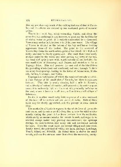
132 HYDROGRAPHY.
this bay partakes very much of the striking features of that of Fanga-
loa, and the shores are covered by one continued grove of cocoanut
palms.
Tiavea is a small bay, much resembling Uafato, and about the
same size ; the anchorage is not, however, so good, nor the facilities for
obtaining water so great : it is entirely surrounded by a shore-reef.
Vessels may anchor in it, in from 8 to 10 fathoms water. The village
of Tiavea is situated at the bottom of the bay, and has an inviting
appearance from off the harbor. The point to the eastward of
Tiavea Bay forms the northeastern point of the island : it is high and
rocky, and may be closely approached. The coast then turns nearly
at right angles to the south, and after passing the town of Samusu,
the coral reef again is met with, which extends off and includes the
two small islets of Fanuatapu and Namua, and stretches as far as
Tapanga Point. This reef protects the east end of the island from
the prevailing winds (east and southeast) and sea;through it there
are many boat-openings, leading to the towns of Saleaaumua, Mutia-
tele, Satitoa, Ulutongia, and Vailoa.
Tapanga is a rocky point, off which the coral reef extends to within
a short distance of the small islet of Nuutele, but there is a passage
between. This islet is nearly circular, half a mile in diameter,
and evidently of volcanic formation, still preserving its crater appear-
ance : it is moderately high on the west side, gradually inclining to
the east, where it forms a small cove, and on it is a small village of
fishermen.
Nuulua is another small rocky islet, a quarter of a mile southeast
of Nuutele : off its eastern end are two small rocks. Both of these
islets may be closely approached, and the passage between them is
clear.
The south side of Upolu is exposed to the whole force of the south-
east trades, and the sea or swell is from that quarter for eight or nine
months during the year : it has fewer harbors than the north side,
which are by no means desirable for vessels to seek, and ought to be
avoided, except under very pressing circumstances ; the openings
through the reef, however, offer many safe and convenient harbors
for boats. Upon the coast there are several villages and some consi-
derable towns, the principal of which are Lepa, Anfanga, Lotofanga,
Toupii, Salani, and Falealili. At Salani there is shelter for small
vessels, and two fine streams come down from the mountains, empty-

SAMOAN GROUP.
ing into the sea. The town of Salani is situated on a fertile plain,
with extensive groves of cocoanut trees. Supplies of wood and water,
fruit and vegetables, may be procured.
The position of Falealili may be known by the small cocoanut
island lying off the town on the reef, which is a very conspicuous
object. This is the best harbor for vessels on the south side, and
is the only one where the ingress and egress is not attended with dif-
ficulty or danger. Falealili is indebted for its shelter to the coral
reef above mentioned, which covers the openings or indentations in
the shore-reef. The eastern channel is the best to enter by, and the
western to depart from. The prevailing wind is fair in both channels,
but as the channel is narrow, it is entered with some difficulty, re-
quiring great attention in steering, and the quick action of the helm.
The direction for entering is to run for the large church when it bears
north-northwest (true), taking care not to be under too much head-
way. The sunken coral patches at the entrance of the channel maybe easily avoided by keeping a good look-out, as they are plainly to
be seen. When Cocoanut Island bears southwest (true), keep awayto the westward, passing through the channel between the reefs, and
when the island bears south-southeast (true), anchor in 15 to 19
fathoms water. The reef and island shield vessels from the force of
the sea, as well as the wind, but the eastern opening of the reef affords
the best boat-landing ; there water can be easily procured from two
streams, that pass through the town, giving a large and constant
supply. Falealili is a large town, extending along the shore upwards
of a mile. The plain is well covered with cocoanut palms and other
trees of the island, exhibiting a very luxuriant prospect. Wood maybe obtained, as well as fruit and provisions. The chiefs are friendly
and hospitable;by arranging with them for supplies, they will be
procured better and with the least trouble.
To the west of Falealili the coast becomes bold and iron-bound for
the distance of 3i miles, when the coral reef is again met with, and
continues to the harbor of Sanaapu : through this reef there are
several boat-openings. From Sanaapu to the west end of the island
the land is generally low, except here and there a rocky point, and
between Lafanga and Falilati the shore has steep rocks and is iron-
bound. The principal towns are Sanaapu, Lafanga, Falilati, Samatou,
and Faluasofia.
The harbor of Sanaapu is about a mile in length by half a mile in
3-1

134 HYDROGRAPHY.
breadth : it is formed by the coral reef. At its entrance there is a coral
patch of half a mile in circumference, which serves as an additional
protection to its anchorage from the southeast swell. The course in is
due north (true), and if Suisigna Peak can be seen, a course direct
for it will lead off the harbor ; in the absence of other marks, the
reef on the eastern side of the harbor can be followed, and the
anchorage sought within the coral patch : the best place to drop the
anchor is in from 7 to 9 fathoms ; the bottom sand and mud, and
good holding-ground. The prevailing wind on this side of the island
enables a vessel to sail in and out with a free wind. Water may be
had here without difficulty, at either of the streams, and wood, with
all the supplies of the island. Sanaapu lies nearly opposite to
Apia, and there is a good path leading across the island at this place,
so that the foreign consuls may be consulted if required in a few
hours.
Although there are no harbors for vessels on the south side, towards
the western end, yet there are many safe ones for boats, which the
chart of the island, by the Exploring Expedition, will point out. Thereef here encloses Manono, whose situation and connection with Upolu
is spoken of hereafter. Though the channel between the island and
reef affords no facilities to large vessels, yet for the native canoes and
boats it is everything that could be desired, giving them protection
and the natives opportunities for fishing, from Falilati to Apia, which
is upwards of 20 miles, a district comprising some of the most fertile
lands and most populous towns of this island;though but a few years
before, at the time of the arrival of the missionaries, it is said to have
been depopulated. Salafuata, Sasava, Faleatii, Fasetoolai, Nafavalii,
Tooanea, Salamoa, Saugana, Falooloo, Vaialasa, and Vailela, are the
chief towns. All of them afford ample supplies, which can be readily
brought to Apia, and at short notice within the waters protected by
the reef.
Upolu has, both on the north and south sides, soundings extending
off some distance from its shores, and off Falooloo Point there are
several patches of coral, with but 2 and 3 fathoms on them : it is re-
quisite to avoid these when vessels are lying off and on.
There are few finer islands, and none where supplies can be
obtained so readily as at Upolu. Being the seat of the supreme or
governing power of the group, the natives are under better control,
and in cases of accident or injury the reparation would be more easily

SAMOAN GROUP. 135
obtained here than elsewhere. The ruling chiefs of this group are
extremely well-disposed towards foreigners, and are for the most part
professing Christians. From the exertions and perseverance of the
missionaries, the natives are advancing rapidly in civilization.
APOLIMA.
Apolima lies east from the east end of Savaii Si miles. It is evi-
dently an extinct crater of a volcano. The southern side or ridge is
elevated 470 feet above the level of the sea, gradually descending
towards the north, on which side there is an opening, through which
the sea rushes with violence : after it is entered it forms a safe harbor
for boats. A village is situated at the head of the harbor, sur-
rounded by groves of cocoanut trees. The island is Is miles in cir-
cumference. This is the stronghold of the natives, requiring to be
defended only at the narrow entrance, which passes between danger-
ous rocks, and has been the resort of the people of the island of Savaii,
as well as those of the western end of Upolu and Manono, when hard
pressed by their enemies. One-eighth of a mile to the north is Calinape
Rock, which shows above water.
Soundings are to be had between this island and Savaii, and also
between it and Manono. Both channels are free from dangers, and a
vessel may pass through either Avithout difficulty. This island has
been named by some navigators Calinape, but it is more appropriate
to the Eock.
MANONO.
Manono properly belongs to Upolu, being enclosed in the same
coral reef ; otherwise it is distinct, and in political interest as well as
relationship it is closely allied to Savaii. Manono is of an oval shape.
3 miles in circumference, and covered with forest ; it contains 1100
inhabitants. There is but one opening on the .southeast side through
the reef, and this will only admit of the passage of boats ; the reef,
however, forms a great protection for the canoes of the natives,
rendering the water smooth, and at all times safe for them to proceed
between Manono and Upolu. To the west of Manono is a black rock,
called Cockscomb Islet, situated within the' reef. On some charts
Manono has been called Floe Island. Wood and water are to be pro-
cured here, but it is better to resort to one of the harbors on the
north side of Upolu.

136 HYDROGRAPHY.
TUTUILA.
Tutuila is the next island in importance of this group to Upolu,
and lies south 60° east, distant 40 miles. It is 17 miles in length, and
4h miles at its greatest breadth. Its surface is very much broken, and
exclusively of volcanic formation. It has many good harbors, and
one, without a parallel in the Pacific, Pago-pago, which is entirely
land-locked ; its entrance is on the south side of the island, and so deep
as almost to divide the island into two parts. The only objection to it
is the great depth of water, and the necessity of beating out, which is some-
times attended with danger, although I am not aware that any disaster
has yet occurred to the numerous vessels that now seek its shelter.
Its form is that of a retort, with high land, nearly perpendicular, on
either side. The town of Pago-pago lies at the head of the harbor, and
gives it its name. The situation of this harbor is readily known by
the Peak of Matafao, 2327 feet high, which rises just westward of the
entrance. The Tower Rock, on the left side, and the Devil's-own
Point, will be readily distinguished as the entrance is approached; the
first by its square and detached appearance, rising from the reef, and
the latter by the blackness of the rocks, contrasted with the green
foliage in the rear.
To the southward of the entrance there is a coral bank, of nearly 2
miles in length, trending east-northeast and west-southwest, on which
the least depth of water is 4i fathoms : it is about a quarter of a mile
wide. It is wTell to avoid passing over it, the swell being usually
heavy, though I am not aware that it actually breaks, except during
a storm. There are no dangers after this until within the Devil's-own
or Breaker Point. On the opposite side, off Blunt's Point, is the Whale
Rock : this should be carefully avoided ; there is only 8 feet on it at
low water. The sea breaking every few minutes, points out its situa-
tion, and it can be easily avoided in going in, the wind being fair
and generally fresh. Grampus Rock lies a little within the Whale
Rock, but on the opposite shore : it is but 600 feet from the reef. After
passing Breaker Point, by keeping Goat Island a little open on the
larboard bow, you will clear both the dangers. When up with Goat
Island, the harbor will be open, and a berth may be chosen, either
between Trading and Swimming Points, in 20 fathoms, or farther up,
in less water. It is advisable to moor here with open hawse to the east-
ward, as the wind not unfrequently blows fresh from that quarter
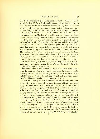
SAMOAN GROUP. 137
The holding-ground is good, being mud and sand. Wood and water
are of the best kinds, and all provisions can be had, though at times
it is very difficult to trade with the natives, for they frequently come
with the intention of obtaining a certain article which they have
taken a fancy to, and will for no consideration exchange for another,
although it may be ten times more valuable ; for men-of-war I would
recommend the establishing of a trading-post or market on shore,
under a proper officer, and that he should make all the purchases for
the ship's crew ; in this way much difficulty is prevented, and the
natives obtain a fair valuation for their products, and all are satisfied.
Pago-pago is one of the best regulated places in Polynesia. The
chief, Pomare, has very great influence among his people, and bears a
high character for morals, as well as friendliness towards the whites.
The products of the island are brought from all parts of it to Pago-
pago, when there are vessels lying there. No better port could be
found for repairs to be made in or to recruit a crew. From the
shape of the harbor, and lying as it does among hills, there is a con-
stant breeze, both by day and night, moderating the heat of the cli-
mate, and very much tending to obviate that lassitude which the
tropical climate produces on a crew.
This harbor has a shore-reef of from 500 to 1000 feet in width, which
is for the most part dry at low water ; the shore in places is sandy,
affording ample room for the villages and groves of cocoanut palms
and other trees. Most of the hills are covered with forest and under-
growth. Fish are abundant and pigeons in numbers.
It will be necessary to offer a few remarks before leaving this har-
bor relative to the egress, which there is much difficulty and some
danger in effecting, as it is necessary to beat out, with the wind at
times light and flawy, especially at the entrance, where the water is
so deep as not to admit of anchoring in case of missing stays on either
tack, by which a vessel would be set on shore. Although the distance
is short, it is a dead beat, and unless a vessel works remarkably well,
it will require a long time to accomplish, and is attended with danger.
It would seem of little consequence in a harbor so confined and land-
locked to regard the tides ; it becomes, however, of great consequence
to take advantage of them. When getting under way, it is better to
wait till the ebb has made ; it should never be done on the flood. I
would farther observe, that the reef near the Tower ought not to be
approached too close, or to leave any doubt that there is room to stay.
35
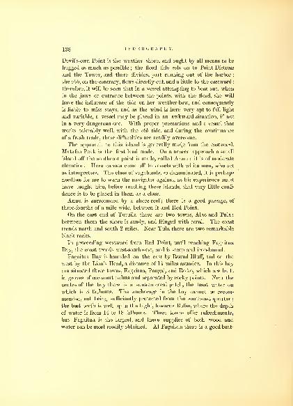
138 HYDROGRAPHY.
Devil's-own Point is the weather shore, and ought by all means to be
hugged as much as possible ; the flood tide sets on to Point Distress
and the Tower, and there divides, part running out of the harbor
;
the ebb, on the contrary, flows directly out, and a little to the eastward :
therefore, it will be seen that in a vessel attempting to beat out, whenin the jaws or entrance between the points, with the flood, she will
have the influence of the tide on her weather-bow, and consequently
is liable to miss stays, and as the wind is here very apt to fall light
and variable, a vessel may be placed in an awkward situation, if not
in a very dangerous one. With proper precautions and a vessel that
works tolerably well, with the ebb tide, and during the continuance
of a fresh trade, these difficulties are readily overcome.
The approach to this island is generally mad^e from the eastward.
Matafao Peak is the first land made. On a nearer approach a -small
island off the southeast point is made, called Anuu : it is of moderate
elevation. Here canoes come off to vessels with white men, who act
as interpreters. The class of vagabonds, so denominated, it is perhaps
needless for me to warn the navigator against, as his experience must
have taught him, before reaching these islands, that very little confi-
dence is to be placed in them as a class.
Anuu is surrounded by a shore-reef ; there is a good passage, of
three-fourths of a mile wide, between it and Red Point.
On the east end of Tutuila there are two towns, Alao and Tula;
between them the shore is sandy, and fringed with coral. The coast
trends north and south 2 miles. Near Tula there are two remarkable
black rocks.
In proceeding westward from Red Point, until reaching Fagaitua
Bay, the coast trends west-southwest, and is steep and iron-bound.
Fagaitua Bay is bounded on the east by Round Bluff, and on the
west by the Lion's Head, a distance of H miles asunder. In this bay
are situated three towns, Fagaitua, Pougai, and Rofao, which are built
in groves of cocoanut palms and separated by rocky points. Near the
centre of the bay there is a sunken coral patch, the least water on
which is 3 fathoms. The anchorage in the bay cannot be recom-
mended, not being sufficiently protected from the southeast quarter
;
the best berth is well up in the bight, towards Rofao, where the depth
of water is from 14 to 18 fathoms. These towns offer refreshments,
but Fagaitua is the largest, and there supplies of both wood and
water can be most readily obtained. At Fagaitua there is a good boat-

SAMOAN GROUP. 139
passage through the coral reef, which fringes the shore. Beyond the
Lion's Head, the coast again assumes an abrupt and rocky character.
3 miles to the west of this point is situated a remarkable rock, called
Pyramid Rock ; thence to the Devil's-own or Breaker Point, off the
harbor of Pago-pago, are two sandy beaches, continuing to the west
from Pago-pago ; the shore is lined with coral, which completely
closes Black's Bay, and affords no protection whatever either for
vessels or boats, and the sea beats violently on the whole extent to
Sail Rock Point, which is the southernmost point of the island ; round
to Leone Bay, the coast is high and rocky. Leone, though entirely
destitute of a harbor for vessels, and its shore fringed with coral, is
one of the most productive and populous towns of the island. It is
situated in a most luxuriant valley, in which cultivation by the
natives is carried to as great an extent as in any part of this group.
The inhabitants of the bay also engage in fishing, and their canoes
are seen in great numbers during the prevalence of fine weather off
the coast.
From Leone to West Cape the shore is rocky and much broken,
and offers no shelter. Off West Cape are some large black rocks.
To the northward of this cape, and between it and Leopard Point, is
situated the town of Susua ; but the bay offers no shelter ; it is choked
up with coral, yet with care boats may land. A distance of 3 h miles
brings us to Aluau, the coast being rough and rocky, with the excep-
tion of the small bay in which it is situated ; but like Susua there is
no anchorage, and the beach is skirted with coral.
Aluau Bay is one-third of a mile wide, and the same in depth ; at
the head of it is a fine town, where supplies may be procured. Theanchorage is in from 12 to 15 fathoms, fine gray sand; during the fine
months it is perfectly safe for a vessel. A mile to the east, separated
only by a rocky point, is Massacre Bay, where La Perouse's expedi-
tion met with so melancholy a fate ; it affords no protection, the bay
being nearly filled with coral, which at low water is in many parts
entirely bare. One mile to the eastward is the harbor of Fungasar.
This is the best harbor on the north side of the island, and during
the fine season one of safety and of easy access. Though not large, it
affords all that could be required for a few vessels that may stop for
supplies. Wood, water, and all the productions of the island may be
had here. The best anchorage is between East and Cocoanut Points,
in 14 fathoms water, over a black and white sand and shell bottom.

140 HYDROGRAPHY.
Besides the village of Fungasar, there are Fusi and Alfoo in the
West Cove. The inhabitants and chiefs are all kind and attentive;
schools are established, and they have all become Christians.
From Fungasar Harbor the coast trends east-northeast for 5
miles to the most northern point of the island, Cockscomb Point,
which is a singular insulated rock, much jagged and having muchresemblance to the name that has been given it. It is of considerable
height and quite abrupt ; there is a passage between it and the rocks
of the island. To the eastward is Vatia Bay, but it affords no ancho-
rage, and is broken up with coral.
The next harbor is that of Oafonu : this is lh miles beyond Vatia,
the coast between being a series of abrupt rocky crags. It is half a
mile in depth and one-third wide, and good anchorage in the fine
season, from April to December, may be found there : the best berth is
near the centre, in 14 fathoms, on a fine gray sandy bottom. Thetown of Oafonu is situated at the head of the bay, and is embosomed
in cocoanut palms ; the fresh-water streams near the town cause a
break through the coral, and admit the approach of a boat to the
beach. To the west, just round Craggy Point, there is another town,
called Amalao.
Massefao Bay is 3 miles east of Oafonu Harbor : the intermediate
shore partakes of the usual character of the coast of the island. Theentrance to the bay is between Bartlett's Point on the west, and Butt
Point on the east, bearing from each other northwest-by-west and
southeast-by-east, half a mile asunder ; the direction toward the
head of the bay is west-southwest. It is very much protected from
the north and northwest winds, but exposed to those of the northeast.
The depth in the bay is not less than 18 fathoms, over a sandy
bottom ; the head of the bay is lined with a coral reef, which has the
usual break in it consequent upon there being an outlet of fresh
water. The town of Massefao is one of the largest on the island, but
the people are not so well-disposed or accustomed to deal with
foreigners as the towns nearer to the vicinity of Pago-pago. The
village of Masaosh is situated just beyond Butt Point.
The harbor of Aur is the most eastern, on the north side of the
Island of Tutuila; its width is half a mile and its depth somewhat
less. There is little room for anchorage within the points of the bay,
as it is almost entirely occupied by coral, excepting a narrow channel,
which leads up to the town, affording facilities of approaching with a

SAM AN GROUP. 141
boat, that could not otherwise be done at low water. Aur is a very
considerable town, and being remote from the operations of the mis-
sionaries, has not yet derived much benefit from, their instructions.
The best anchorage is Avith Point Protection bearing northeast-by-
east, in 9 fathoms, gray sand, Musquito Point west-by-south.
From Aur to Cape Matutula the coast is high and rocky, with
several outlying rocks ; the cape is high, and projects in a long rocky
point to the northeast.
OFOO AND OLOOSINGA.
These two islands are in such close proximity that they may be
described as one : they lie north 85° east of Tutuila 54 miles. Ofoo
and Oloosinga together are 4 miles in length;they trend east and
west, one mile wide;they may be termed spurs or ridges, for they
have little level ground to boast of, their basaltic walls rising almost
perpendicular from the water to the height of 1200 feet. Oloo-
singa is about one-third the size of Ofoo, but it has more inhabitants.
The settlement on Ofoo is on the western end; the strip which is
cultivated is some hundred yards in width, including the coral, which
fringes the island on the west side ; the eastern side being little more
than an escarpment of rocks, which renders it almost as impregnable
as a fortress. The king or chief of Manua resides on Oloosinga, to
secure his safety during troubles on Manua. This islajicl usually
affords enough provisions for its few inhabitants. At the west end,
under Ofoo, there is anchorage in 10 fathoms water, but no supplies
can be obtained there.
To the southeast of Oloosinga lies Manua, separated by a channel
of 3* miles in width. Manua is a much larger island, rising in a
dome shape to the height of 2500 feet ; it is nearly circular, and 4i
miles in diameter ; the whole is covered with luxuriant foliage. Onthe north side the cliffs are somewhat precipitous, bounded by a sandy
beach, where the landing is not difficult ; at the northwest corner
there is a pretty cove, in which boats can land without surf, and at
this point and a sandy beach adjoining it, the principal town on the
island is situated. Native missionaries have been established here,
and have done much good by their example. Wood and water maybe obtained at Manua, but very few if any supplies except cocoanuts.
36

142 HYDROGRAPHY.
On all the eastern, southern, and western parts of the island a heavy
surf beats. The island, like that of Ofoo and Oloosinga, is of volcanic
formation, and there are but few patches of coral around its shores,
and what is perceptible is only sunken reefs.
EOSE ISLAND.
Eose Island is the most eastern of this interesting group. It was
discovered by Captain Freycinet ; it lies south 80° east from Manua,
distant 74 miles. It is a low coral island, with a lagoon. Onits eastern end there is a clump of large trees, which can be seen at
some 10 miles distance. It is nearly 2 miles in diameter, and of a
circular form. The greatest part of it is submerged at high water ; and
during storms it is, with the exception of the small space on which
the trees are growing, an entire breaker. There is an opening into
the lagoon on the northwest side, where a small vessel might enter
and find protection. Vast quantities of birds are on this island, and
some fish in the lagoon, which has here and there large masses of
coral growing up in it.

CHAPTER IX.
TONGA ISLES.
The Tonga Islands were discovered by Tasman in 1643. The}'
have, however, been generally known by the name which Captain
Cook gave them,—the Friendly Isles. They are said to be as manyas 150, but this is a great exaggeration, for many of these are merely
islets, situated on the same reef, and therefore instead of being
separated should be counted as one ; 15 of them are high and vol-
canic, and the rest low, and 40 of them are of considerable size, and
inhabited.
This group is situated between the latitudes of 18° and 23° south,
and 173° and 176° west longitude. It may be said to embrace three
small clusters, that of Tonga, Haabai, and Vavao, of which Tonga
being the most important and largest, besides holding sway, gives its
name to the whole. The three clusters offer some good harbors, and
afford all the supplies that can be obtained among the Pacific Islands.
Since the missionaries have been established, they have become more
entitled to the designation given by Cook, the Friendly Isles ; but yet
they are inclined to be somewhat lawless, and use the power that
force will give them over an unprotected vessel, seizing whatever they
can lay their hands on belonging to strangers, whether of the crew
or vessel, regardless of the inconveniences they may put others to.
It is as well, therefore, for the masters of vessels to avoid all kinds
of disputes or differences in trading, and particularly to prevent any
infringement of their Sabbath laws, as the chiefs border on fanaticism
in their observance of them.
The Tonga cluster comprises the islands of Tongatabou, Eoa, Evai-
tihe, Katoo, and 19 islets situated on the reef attached to Tonga-
tabou. Of these Tongatabou is the largest, including the coral reef
attached to it, on which the islets are situated ; it has the form
of a triangle, each side being nearly 20 miles in length, and of this
area a little more than half is land. Within the space between the

144 HYDROGRAPHY.
island and the reefs is embraced a fine roadstead, containing manysafe anchorages. It has two entrances, one on the north, and the
other on the east ; both of these are difficult and somewhat dangerous;
the first is the northern outlet, and the last the Astrolabe Gut, nine
miles in length, and two miles at its eastern entrance, but narrowing
down at its western end to less than half a mile, where is situated
the island of Mahonga with its reef, the channel turning to the north
and south of it through narrow passages, infested with coral-knolls.
In the Astrolabe Gut there is no anchorage, and the tide runs with
much velocity through it. Vessels should not think of taking this
channel late in the day, and at any time without a steady breeze or
trade wind, as they may be subject to long calms and head winds, and
if detained over night incur much risk of loss. With a steady breeze
and fine weather there is little or no danger. It requires a good look-
out from the mast-head when sailing through the Mahonga Passage,
to avoid the coral lumps and projections from the main reef. The
Pangaimotu Passage, to the left or south of Mahonga, though narrow,
is safe, and leads at once to the anchorage west of Pangaimotu, which
is the most sheltered berth in Mariner's Bay. There are several
northern passages through the reefs ; these are narrow and a good
deal obstructed with sunken patches. An examination of these
proved that it was impossible to make a careful and minute survey of
them. With a good look-out from aloft there are many places where a
vessel may pass through this broken reef; the two best passages,
however, are those near Alata Islet, and the other bearing north-north-
west from the anchorage at Pangaimotu. The depth of water in
Mariner's Bay varies ; in most places it will be found greater than
10 fathoms.
The Island of Tonga at its south side has a narrow shore-reef: the
land rises perpendicularly from 40 to 80 feet, and gradually declines
towards the northern side. Towards the centre is an extensive inlet,
forming a shallow lagoon, some twelve miles in circumference : this,
with the exception of a narrow channel leading to the town of Moua,
is an extensive coral flat, which is dry at low water. The passage into
the lagoon communicates with the Astrolabe Gut, to the east of the
island of Pangaimotu. I mention this, as it affords facilities of getting
supplies from the natives of the island at a much more reasonable
rate than can be obtained at the anchorage. Nikualofa is the resi-
dence of the chief or king ; but the anchorage off it is not so conve-

TONGA ISLES. 145
nient as that at Pangaimotu. The shore in places, except at that
island, is skirted by a coral reef, and offers many obstructions to
the landing in boats at all times but extreme high-water. Water at
the island is obtained from springs, and is scarce. The island is beau-
tifully cultivated, and yields abundantly all kinds of tropical fruits.
Besides the harbor of Mariner's Bay, there is anchorage during the
fine season in Maria Bay, Van Diemen's Roads, where Tasman first
anchored, but they are neither of them secure. The tides at Tonga-
tabou are regular, the springs rising ordinarily 5 feet : the flood sets
southeast, and the ebb the contrary way;high-water, full and change,
at 7 A.m. It is necessary to pay attention to them in entering and
leaving the port, as a contrary tide in the narrow passages renders
them more difficult to pass through.
The longitude of this island appears to have had more determina-
tion made of it than any other island, except Tahiti, in the Southern
Pacific, having been visited by many of the most celebrated navigators
and expeditions that have been fitted out.
Cook made the longitude . . . 184° 50' 18" W.D'Entrecasteaux made the longitude . . . 184° 46' 46" "
D'Urville 184° 47' 00" "
The Expedition in . . . . . 184° 49' 00" "
I have given a chart of Mariner's Bay, which is as complete as our
time would admit of.
Wood is difficult to be had, and is very dear if obtained from the
natives.
This group of islands is frequently visited by severe hurricanes, that
do much damage ; these occur in the months of November, December,
January, February, and March ; it is then that the anchorage in
Mariner's Bay is much exposed, both to sea and wind ; the former is
said to beat at times very heavy on the shore. It may be as well to
avoid making a visit to these islands during these months. Myriads
of mosquitoes are the greatest annoyance in this bay;they infest all
parts of the ship, and sleep is absolutely out of the question ; the
only way to free oneself from them is by anchoring some 3 miles from
the land. On the beach to the south of Pangaimotu the seine may be
drawn, and at times with great success.
At the mouth of the Astrolabe Gut lies the small and wooded37

146 HYDROGRAPHY.
island of Eooatiahe, which, including its reef, is II miles in length, bjhalf a mile wide ; it offers no inducements to visit, and is seldom
resorted to by the natives except in the turtle season.
EOA.
The Island of Eoa lies to the east of Tongatabou 10 miles. By its
first discoverers it was named Middleburg. There is a small island
on its southwest side, called Kaloo, and between it and Eoa there is a
clear passage. Eoa is elevated 350 feet above the sea, and is 30 miles
in circumference, its length lying nearly north and south ; it rises to
a central ridge. Owing to its height it can be seen in fair weather at
a distance of 30 miles. Eoa, in comparison to Tongatabou, offers but
little for the residence of the natives, and very few of them reside
upon it. It is of volcanic formation, and has very little space for cul-
tivation. A small village is situated on the northwest side, abreast
of which Cook anchored, in what he called English Road. There
is considerable intercourse with Tongatabou, by whose chief it is
governed. A vessel would, however, be disappointed in obtaining
supplies here. It is as well to caution the navigator, that frequently
he may meet with severe squalls in the strait between Eoa and
Tongatabou ; there are no dangers, however, but in case of being too
late to make the passage through the Astrolabe Gut, I would advise
a long stretch to the southward during the night, rather than expe-
rience the flaws and calms that a vessel would be subjected to by
too near an approach to Eoa.
HONGA TONGA AND HONGA HAABAI,
The islands of Honga Tonga and Honga Haabai are situated to the
northwest of Tongatabou. They are high islands, and almost bare
rocks, lying nearly northeast and southwest of each other, and sepa-
rated by a channel about 3 miles wide, which is free from dangers.
These islands have a shore-reef, and are inhabited. There is a small
space, at the foot of the high and rocky bluffs, that enables the natives
to raise some productions on the easternmost.
To the north of these islands is a reef of 6 miles in extent, trending
northwest and southeast : its south point is 10 miles from Honga
Tonga. Breakers are generally found on it : at times these are very

TONGA ISLES. 147
high. This reef was discovered by Maurelle, in 1781, who gave it
the name of Baxo de Culebras.
VAVAO.
A degree to the north of the Haabai cluster lies that of Vavao.
This cluster is formed by Vavao, Panguimotu, Tonga, Hounga, and
Telika. Vavao has a circumference of some 30 miles, and has one
of the finest ports in the Pacific,—Port Valdes. Maurelle appears to
have been the first European who visited these islands, in 1781.
Vavao is formed of coral limestone ; its greatest height does not exceed
300 feet. Its surface is remarkably level. The cliffs are perpendicular
and to some extent have been washed by the sea, so that they form from
overhanging masses an impediment to landing, and none can be effected
except where the cliffs have been broken down. Port Valdes has its
entrance on the southwest side, among an archipelago of islands, and
the channel is some 4 miles northeast between them;through these a
square-rigged vessel may have some difficulty in beating, as there is a
leeward set constantly making out. The water is so deep, that an
anchor cannot conveniently be let go in the channel. The inner
harbor is perfectly safe and land-locked, but it requires a well-appointed
vessel to reach it. The entrance may be readily known by White
Point, which lies on the left of the entrance, and which is nearest to
what is called Ninepin Island, and south of Refuge Road, where vessels
ordinarily anchor to obtain supplies. There is another anchorage to
the south, called Port Maurelle, which is tolerably secure, except from
the northwest. The narrows leading into Port Valdes is over half a
mile wide. A vessel may proceed farther up the harbor and anchor
in less water; but the coral patches and the broken ground should
claim attention.
The only objection to this port seems to be the great depth of water
in the outer roads and anchorages, and the unevenness of the bottom,
varying in a cast of the lead from 10 to 15 fathoms. Supplies maybe had in abundance, and fish are procured in considerable quantities
by the natives. Vavao is one of the principal establishments of the
missionaries in the South Seas.

CHAPTER X.
VITI GROUP, OR FEEJEE ISLANDS.
The Feejee Islands form one of the largest, as well as most im-
portant groups of the Pacific. This group of islands was first seen by
Tasman, in 1643. The islands discovered by him were those lying at
the northeast part of the group, some twenty in number, which he
designated as Prince William's Isles, and on account of the numerous
shoals and reefs, he called them the Basses de Hemskirk.
The Duff missionary ship and Captain Bligh, of the Bounty,
visited this group, and they were frequented, some thirty years ago,
by Americans in search of sandalwood, and lately by others to obtain
cargoes of biche de mar, for the China market. The chart of Arrow-
smith of these islands was found quite erroneous, little beyond guess-
work : it is impossible to conceive from what sources it was derived.
Captain D'Urville, in the Astrolabe, visited the group in 1827, and
in 1838 ; but his stay was short, and resulted only in the surveys of
a few points, so that the whole field was open to us on our arrival.
The examination of this group was one of the duties assigned the
Expedition, and proved one of no common labor. The surveys made
by the Expedition have rendered its intricate navigation safe, and have
removed the apprehensions of its many dangers to seamen ; it maynow be considered as one of the most thoroughly surveyed groups in
the Pacific.
The Viti Group consists of 154 islands and 80 reefs, lying be-
tween the latitude of 15° 30' and 21° south, and longitude 178° west,
and 176° 30' east, several outlying islands to the south being included,
though not properly within the limits of the group. Yet I have
thought they ought to be embraced, particularly as they are inhabited
by Feejeeans, and are under the control of the chiefs of the Eastern

V I T I GROUP. 140
group, and are occasionally visited by them. The whole embrace
an area of about 95,000 square miles.
As the group is very extensive, and its islands situated so as to
form somewhat detached clusters, I have separated them into three
groups, viz., Eastern, Centre, and Western. Those lying in the Eastern
range, and trending north and south, are Vatoa (or Turtle Island),
Fulanga, Moramba, Kambara, Enkaba, Tubanielli, and Ono;Ongea
Levu and Riki, Angasa, Namuka, Komo, Karoni, Moth a, and Ularua,
and fourteen reefs;Oneata, Aiva, Lakemba, Bacon's and Reid's Isles
;
Naiau, Chichia, Tabutha, Aro, Vekai, Katafanga, Mango, Vaturera,
Ythata, Kanathia, Munia, Sasui, Vanua Valavo, Avia, Osubo;
Naitamba, Okimbo, Veterara, Yalangalala, Namoku, and eleven
reefs; of which Lakemba is the principal. The Centre group includes
the large and most important islands, viz., Viti Levu, Vanua Levu,
Chicobia, Korutuna, Rambe, Kea, Vuna, Kamia, Lauthala, Goro, Mo-
kingai, Yendua, Wakaia, Ovolau, Ambatiki, Nairai, Angau, Moala,
Tova reef, Totoia, Matuku, Mbenga, Vatulele, Kantavu, Ono, and seve-
ral others, lying near the larger islands, and partly joined to them by
coral reefs. The Western range embrace the Asua Group;viz., Awakala,
Timboor, Kinsick, Asaua, Ya-asua, Kawakawa, Asaua-ilau Androna,
Otovawa, Nanuia, Nangati, Matathoni Levu, Naviti, Eld, Fox, Agate,
Sinclair, Waia, Waia-lailai, Waia-lailai-thake, Biva, Knox, Baldwin,
Davis, Totten, Vomo, Carr, Johnson, Alden, Walker, Emmons, Perry,
Palmer, Malolo, Malolo-lailai, Waldron, and Speiden.
These will be described in their order from east to west, which is
believed to be the most useful, as the islands are usually approached
by navigators from the east. Before entering upon the hydrographical
description, I will give some general information, that those who mayvisit this group would most desire.
The fine season in the Viti Group is from April till November,
during which time the winds generally prevail from the east-northeast
to southeast; they sometimes blow fresh, but usually a moderate trade
prevails, increasing towards the afternoon, and moderating towards
night, and continuing during the night hours light and calm. In the
harbors and along the larger islands, a gentle land breeze is frequently
felt a short time before and after daylight, but is never of long duration,
yet it affords facilities of passing outside of the reefs, which obviates
much anxiety, as well as the risk of accident. In navigating amongthe islands, the tides should claim particular attention : the course of
38

15i» HYDROGRAPHY.
the flood and ebb are shown on the chart ; but there are times of tide
in which the current is often found to set stronger in some places than
in others, from the water being forced through the narrow passages
between the reefs. Those navigating within the reefs can very readily
perceive when this is likely to be the case. After the reefs become
visible the current through the passages is much stronger, and at
times it flows almost as rapidly as a sluice ; at such times it is not
advisable to attempt to pass. Against this current it is next to im-
possible to make headway except with a very strong wind.
From November to March northerly winds for the most part prevail,
which blow from the northwest with great violence. The heaviest
gales come from this quarter, during February and March. In these
months the weather is very wet and unpleasant. At this time of year,
vessels visiting this group would do well to seek those harbors that are
the best protected or least exposed to the northwest. If bad weather
occurs between April and November, the wind will prevail from the
east to southeast ; it blows very strong, accompanied by a mist that
renders everything obscure : this generally continues for three or four
days, but there are no sudden changes of wind, or tornado storms, as
experienced in the bad season.
It is unnecessary in this place to offer any remarks upon the inter-
course with the natives, their character, customs, &c. : these have been
fully detailed in the third volume of the Narrative of the Exploring
Expedition, and it is presumed that no navigator will visit this inte-
resting group without possessing that work, which contains a full
account of our intercourse with them, and which, it is believed, will
afford an accurate view of the facilities as well as the difficulties which
are to be expected from intercourse with them: they are daily making
much progress in civilization.
VATOA OR TURTLE ISLAND.
Vatoa or Turtle Island, is the most southeastern island of the
Feejee Group. When first seen, it appears as a rounded hummock,
somewhat flattened on the top. Its form is oval ; the longest axis
trending north-northeast and south-southwest, 3 miles, while it is but
\l miles wide. It is surrounded by a shore-reef, half a mile in width,
through which there is a break for boats on the west side. 2h miles
to the south-southwest is the Shylock Reef, 6 miles in length by 3£
its greatest width. The passage between the island and reef is clear,
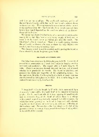
VITI GROUP. 151
and there are no soundings. The south and southwest portion of
the reef breaks heavily, while that on the north and northeast shows
at times but a rip. There appears to be a constant set of the current
to the northeast near this island, articles from vessels wrecked here
having been found deposited on the southern islands of the Eastern
Group of the Feejees.
The island has about 50 inhabitants, who have native missionaries
among them ; but they have a very scanty supply of food, and no
water is to be found except by digging pits near the beach. Theisland is of volcanic formation. There is a small opening through
the reef on the southwest side, near to where the Ship Shylock was
wrecked, but it can only be used for boats.
This dangerous reef should be avoided, and in passing the island to
the southward it should be given a good berth.
ONO ISLAND AND BEREGHIS EEEF.
Ono Island was discovered by Bellinghausen, in 1820. It consists of
several islets, surrounded by a coral reef 7 miles in length, trending
northeast and southwest. The largest islet is 3 miles long by li
wide. There is an entrance through the reef, but I am not informed
whether it is practicable for vessels. The island is inhabited, and
produces the fruits and vegetables of the neighboring islands. To
the southwest, 19 miles, lies Bereghis Reef, a bank of coral; this was
also discovered by Bellinghausen, in 1820. It is 4 miles long, in an
east and west direction, by 2 miles wide.
FULANGA.
Fulanga is 4i miles in length by 21 wide : it is surrounded by a
shore-reef of some width ; the north bluff of the island is 150 feet in
height. On the northeast side there is an opening for small vessels
into an extensive bay, at the head of which there is a village
with a small population, principally engaged in building canoes, for
which the timber growing on the island is large and well adapted.
Supplies can be obtained, and water also, but with some difficulty, on
the southeast end. Fulanga forms the first island on the left of the
passage of the same name, and is separated from Ongea 8 miles, which
is the width of the channel.

152 HYDROGRAPHY.
ONGEA.
Ongea is formed of two islands, called Levu and Riki, which are
enclosed in the same reef: these are both barren and destitute of
water;they are some 200 feet high, round or dome-shaped, and both
together 4z miles long, north and south, and one mile wide : there are
three entrances for small vessels, two at the north, and the third at
the western side ; the latter leads to Port Refuge. To the southeast of
the south island, three miles distant, lies a dangerous sandbank and
coral reef, called Nugu Ongea : this must claim the attention of navi-
gators when approaching this extremity of the group. Due regard
should be paid to the current, which sets with some force to the north-
ward and eastward.
To the north of Ongea there are three coral reefs, viz., Teteka, Nisu-
kisuki, and Revareva, which the charts show, rendering the passage
between it and Angasa extremely dangerous.
ANGASA.
Within the reef which surrounds this island there are three smaller
ones, Abutolema, Abutuena, and Abuda. Angasa is the most eastern
and largest ; it is remarkable for its regular ridges, of volcanic forma-
tion. The reef encompassing these islands is 8 miles northwest and
southeast, and 5 northeast and southwest : there are no openings
through it, and no permanent inhabitants on either of the islands. Tothe north-northeast of Angasa lies the Levu Reef, distant three miles
from the reef of Angasa; and to the east Chicondua and Konaivo, the
latter including an islet. Angasa forms nearly an ecpailateral triangle
with Fulanga and Ongea, of which the sides are about 8 miles.
MORAMBA.
Moramba lies northwest of Fulanga, 9 miles distant ; it is but half
a mile in diameter, high and well wooded, with a shore-reef ; it has no
convenient landing.
NAMUKA.
Namuka rises to the usual height of these islands, is of the same
formation, and lies north of Fulanga 15 miles. It is three miles in

VITI GROUP. 153
length, east and west, by li wide; the reef surrounds it on all sides.
The natives visit it, but do not make it their permanent abode.
Three miles to the north-northeast of it lies the Taluno Reef.
KAMBARA.
Kambara is nearly rectangular in form, 3 i miles long by two wide,
the direction of its length being north and south ; with the exception
of the small island of Tubanielli, it is the most western of the
southern part of the Eastern Group. A shore coral reef extends on all
sides. On the northwest there is no anchorage for large vessels, but
small ones and boats may find protection in the fine season. Soundings
close to the reef are had from one to four fathoms. This island maybe known by a remarkable bill-shaped peak on its northwest end, which
was called Vermont Peak, and forms a good landmark ; its height
is 350 feet above the level of the sea.
The island is densely covered with rich verdure, and has groves of
cocoanut palms on its shores; its timber is, esteemed for building
canoes, and there is more of it than on any other island of the group.
It has a population of 350.
ENKABA.
Enkaba is a small island, lying north-northeast of Kambara, 3 miles
distant, the channel between them being free from danger. It is two
miles long by one mile wide, and well wooded, has a few inhabitants,
but oilers no supplies for shipping ; the coral reef which .surrounds it
has a break in its western side, which admits the landing of boats.
TUBANIELLI.
Tubanielli is a small uninhabited isle, of half a mile in diameter,
lying on the western side of the Eastern Group, and rises to an eleva-
tion of 150 feet.
ULARUA OR OLENEA.
Ularua is high, desolate, and surrounded by an extensive reef, through
which there is no opening. It lies at the junction of the Oneata with the39

154 HYDROGRAPHY.
Fulanga Passage ; to the south-southeast of it lies Tavunuku and
Chicks reefs, on which the sea usually breaks. Both Komo and Ularua
are in sight from these dangers : they may be easily perceived during
daylight, but ought to be studiously avoided at night ; the set of the
current is to the eastward at this part of the Eastern Group.
KOMO AND KOMO-RIKI.
Komo and Komo-Riki are two small islands surrounded by a reef,
with an opening on the northeast side. Anchorage may be found
within the reef, but it is exposed in northeast winds. Komo is high,
about three miles in circumference, and inhabited. But few articles
of provision can be obtained.
MOTHA AND KARONI.
Motha and Karoni are situated in the same reef, which extends in
a north-northwest and south-southeast direction, 8 miles in length, and
has a breadth of 4 i miles ; there is only a boat-entrance on the north
end. Motha is situated in the northern part, is two miles in diameter,
with a surface much broken, but rises to a considerable height, and on
its sloping sides are many elevations divided by ravines; these are but
partially covered with trees. The soil is rich, but the population is
small. This island can be seen from a great distance; it has a rounded
form, and is the southern landmark for the Oneata Passage. Karoni is
but a small island, in the southern bight of the reef ; it offers nothing
of interest, but serves to identify Motha. One mile from the southeast
end of Motha Reef, lies Konapotu Reef, 6 miles in circumference : the
sea usually breaks on it with violence. To the east of the northern
end of Motha Reef, 3 miles distant, is Matau Reef; it is of an irregular
shape, nearly 2 miles in length, northeast and southwest, by 1J wide
;
and 4 miles beyond this, to the east-southeast, lies Vao Reef, which is
3 miles in length, northwest and southeast, and but 1 mile wide. The
most dangerous reef, lying more immediately in the Oneata Channel,
is Like-like ; it is about li miles square, and rather nearer the Motha
side of the channel : this is also known as the Active Reef, on which
a vessel of that name was lost.

V I T I GROUP. 155
ONEATA.
Oneata Island, with its two islets, one named Observatory Isle, lies
in an extensive reef, 8 miles in length, east and west, by 31 wide, its
eastern end forming a point. There is one good entrance on its
northeast side, and two on the northwest. Good anchorage may be
found under Observatory Isle, and also abreast of a sandy bay on the
west side of Oneata, where there is a village. The northeast entrance
is marked by two rocks, which are readily perceived on approaching
it. All the entrances into the reef are bold ; those on the northeast
are most suitable to enter at, the wind being fair, which is also the
case with those on the west to depart by.
Observatory Isle is 250 feet high, and well marked by a few trees
on its top; it is not seen on the approach from the east. An abundance
of vegetables, with poultry, &c. &c, can be obtained at Oneata. Thenatives are considered to be sharp traders, notwithstanding they are
mostly Christians. There has been two native missionaries for some
years residing among them. Good pilots for the Eastern Group maybe obtained here, and the natives of this island have done many humaneand kind acts to those who have been shipwrecked.
The length of Oneata is 3 miles, and its greatest width 1 h miles.
There is no water to be had, except from wells, and that at times is
brackish.
The current through the Oneata Passage generally sets to the east-
ward. The tide rises feet, and it is high water, full and change, at
11 o'clock. The principal village is situated on the south side of the
island, in a grove of luxuriant cocoanut palms. This island is very
much covered with scorise and lava, with many deep chasms. Theshores are covered with mangrove bushes.
AIVA.
Aiva-va and Aiva-thaki (high and low), are two uninhabited
islands, enclosed within the same reef, which is 9 miles in length,
west-by-north and east-by-south, and 3i wide, having an extensive
break on the north side, which affords an entrance and good anchorage
within. There are some patches of coral that show themselves, but
are easily avoided by a careful look-out from aloft ; there is, however,

15G HYDROGRAPHY.
nothing to tempt vessels to enter. With northeast winds the anchor-
age is somewhat exposed. These islands and reef lie nearly half waybetween Lakemba and Oneata.
LAKEMBA.
Lakemba, the most important island of the Eastern Group, occupies
nearly a central position, and is the seat of the political power ; it is
of a circular form, 31 miles in circumference, and rises towards a
central peak, called Kendikendi, the apex of which is 900 feet above
the level of the sea. This island has many fertile valleys, and exten-
sive groves of cocoanut palms and breadfruit, the rich soil producing
all the necessaries of life in abundance, and supplies may be had here
in great quantities.
Lakemba is surrounded by a reef, which extends to the eastward of
the island 7 miles, forming a point to the northeast. On the north,
south, and west sides of the island, the reef extends but a short dis-
tance ; it has two openings, one on the east, narrow, though deep
enough for large vessels, but the channel is very tortuous and danger-
ous, from the many shoals that stud its passage ; that on the south
side is only available for small vessels. In consequence of the confined
space within the reef, none but a small vessel could find shelter, and
only by mooring head and stern. The principal settlement is on the
south side. "Water is obtained here from wells, but on the northeast
side of the island, several streamlets flow down to the beach. Lakembahas some 1500 inhabitants, and is the residence of the king of the
Eastern range. Some 4 or 500 of the inhabitants are Tongamen, and
nominally Christians. The Wesleyan Missionary Society has an esta-
blishment here, which has now been in operation for some years.
BOCATATANOA, OR ARGO REEF.
On the east of Lakemba lies one of the most extensive reefs in this
range, called Bocatatanoa, or the Argo Reef. In shape it resembles a
triangle, having a base of 20 miles, trending north-by-west and south-
by-east ; its apex approaches within two miles of the eastern point
of the Lakemba Reef. On its northwest side it is very much broken
up in patches, which, though lying in range, towards the northern
angle it becomes continuous, in which Bacon's Isles are situated.

V I T I GROUP. 1-37
The south side of the reef, which trends east and west, is 15 miles in
length. The centre of each side is somewhat broken up, and might
be passed through in case of necessity. Bacon's Isles are two insulated
rocks, and excellent landmarks. To the northeast of the Bocatatanoa,
distant two miles, lies the Latti Reef; it embraces an area of 25 square
miles. Within it lie three rocky islets, called Reid's : two of them
resemble, when first discovered, ships at a distance. They form the
southern side of the Lakemba Passage. There is no entrance through
this reef, it being continuous all round. At high water it may be
passed over easily on its western side in canoes and boats. The sea
usually breaks violently on its eastern side.
The sea to the west of Lakemba, for 20 to 25 miles, is free from
dangers, and a vessel may safely lie by under its lee during the
night.
VANUA VATU.
Twenty-five miles to the west-southwest of Lakemba lies Vanua
Vatu. It is G miles in circumference, and rises gradually on all sides
to the height of 500 feet. This island is encircled by a reef, through
which there are two entrances for boats : a small vessel may enter on
its west side during the fine season. The island is not inhabited, but
the natives resort to it during the turtle season. The reef does not
extend beyond a mile from the island : to the north it extends that
distance in a point. Wood may be obtained here, but it is difficult
to be got off, and vessels would do better to obtain it at one of the
islands before named. There is no water except from wells.
NAIATJ,
Naiau lies northwest of Lakemba 15 miles; it rises several hundred
feet above the level of the sea, is bounded by high basaltic cliffs, and
is covered with forest ; on its lofty peak there are two villages, which
contain about 200 inhabitants. The island is nearly 4 miles in length,
by 2h wide, of lozenge shape ; it is surrounded by a reef, conforming
very much to the trend, and attached to the shore ; there is a break
in it on its southwest side, but of no advantage to vessels ; another
opening is to be found on its northeast side for boats.
40

158 HYDROGEAPHY.
CHICHIA.
Chichia is next adjacent to Naiau, and lies in the same direction
from Lakemba, and 30 miles from it, which places Naiau half waybetween the two. Chichia is of an elliptical shape, its longest diameter
being 4 miles, while that of its shorter is 3 miles ; it is surrounded by
a shore-reef, which has a few breaks for canoes. The low points are
clothed with groves of cocoanut palms, while the uplands, rising 300
feet, are partially clothed with wood ; the soil is rich, and every kind
of the productions of these islands is raised in abundance. There are
about 300 inhabitants. To the west of the south end of the island
lies Kneass Reef, a small coral reef, circular in form, half a mile in
diameter. It is separated from the island one and a half miles : there
is a clear passage between them. This is not to be considered a
dangerous reef ; the sea usually breaks upon it, and therefore is well-
marked, and there is plenty of room to avoid it.
ARO.
The small island of Aro, with its three outlying reefs, named
Gorden, Freeman's, and Hawkins, form the northern side of the La-
kemba Passage. It is a very pretty island in appearance, but deso-
late ; lies in the centre of a coral reef, and is only frequented by the
natives during the turtle season.
Gorden Reef lies 5 miles to the east-northeast ; Freeman's to the
southeast, 3 miles ; and Hawkins to the south, 3 miles. The first is
2 miles in circumference ; the second lies northeast and southwest, 2
miles in length ; and the third, north and south, 2 miles. On all of
them the sea breaks violently. Between each of them there is a free
passage from one to 3 miles wide.
TABUTHA.
Tabutha lies 33 miles north of Lakemba, and can be distinctly
seen from the top of the latter island. A high peak on the north
end, somewhat resembling a cap, gave it the name of Cap Island, by
which it has been known on the charts. It is 3 miles in length,
north-northwest and south-southeast, by 1? in width. Near its
northern end it is surrounded by a reef, having two boat-entrances :
one on the northwest, and the other on the southwest sides ; the reef

V I T I GROUP.1 59
is continuous to the shore. There is no water on the island, except
that procured from wells. The island is well wooded, and has some
90 inhabitants. Quinin and Smith's Reefs lie 3 miles south-southwest
of this island.
VEKAI.
Vekai Island lies 5 miles north of Tabutha. It is but a small, low
islet, with a reef around it, extending 2 miles east and west, and 1J
north and south. It is of volcanic formation, and without fresh water,
and is only resorted to during the turtle season.
KATAFANGA.
Katafanga is another small island ; it rises to the height of 150
feet, and affords abundance of sugar cane, fruit, and vegetables. On
the northeast point of the island there are a few huts, but it is inha-
bited only during the turtle season. The reef that encompasses it is
3 miles long, east and west, by 1 \ miles wide ; on its north side
there is an opening, which will admit vessels drawing 10 feet water,
but it requires great care to enter in consequence of the many coral
patches.
Five miles directly to the north of Katafanga is the Malevuvu Reef,
2h miles long, by one wide ; on it the sea breaks heavily.
MANGO.
Mango lies to the north-by-east of Chichia, 18 miles ; its diameter
is 3 miles, and its elevation, 300 feet. It is remarkable for an open
space near its centre, as if it had been artificially cleared. It is sur-
rounded by a reef, which extends nearly a mile to the southward, and
has three small islets on it. On the northwest side there is a break
in it, but it affords no protection for vessels. The usual productions
are found here, but no water except from wells. To the northwest,
3 miles, lies Frost's Reef, which is about a mile in length, and one
quarter in width.
VATUREKA.
On the same parallel with Mango lies Vaturera, 18 miles dis-

160 HYDROGRAPHY.
tant from it. It is a high, square-topped, rugged island, with an
extensive reef surrounding it, affording no entrance or protection for
vessels or boats. The island is 3 miles in length, north and south,
by 2 wide. With Chichia and Mango it forms an equilateral triangle.
YTHATA.
Ythata lies 8 miles north of Vaturera. It is a high island, with a
bill-shaped peak; its length is 2 1 miles, east and west, and but one
mile wide ; to the east of it and within the same reef are two small
low islets. The low grounds of Ythata are covered with extensive
cocoanut groves, but it has not more than 20 inhabitants. No water
except that procured from wells. There are several boat-entrances
through the reef. Ythata is one of the islands that form the boun-
dary of the Nanuku Passage.
NUGUTOBE ISLETS.
The Nugutobe Islets are three in number;they lie west-south-
west of Ythata, the two westernmost being joined by the same reef.
They trend west-by-south and east-by-north, and are separated by a
channel from Ythata of a mile in width : there is also a passage
between the eastern and western islets. Two of the islets are com-
posed of white sand and coral, but the other is black lava and stones.
The reef is of small extent, and there is a passage through it on the
north side. On these islets are some pandanus trees, but they offer
little or nothing else.
EXPLORING ISLES.
The Exploring Isles are surrounded by an extensive reef, of a trian-
gular shape ; it has many breaks and irregularities in its sides,
which are upwards of 20 miles in length. The isles are seven in
number, besides many islets ; the most important are Vanua Valavo,
Malata, Susui, Munia, Ticumbia, Avia, and Osubu. There are six
openings through the reef, two on each side, which lead to safe and
convenient harbors. The island of Vanua Valavo is serpentine in
its form, 14 miles in length, but very irregular in width, being not
over li miles at its greatest breadth. Besides its irregularity in form,

V I T I GROUP. 161
it is extremely so in surface, and has a ridge running throughout its
whole length, with many high peaks jutting up several hundred feet.
It is productive, and has a population of 500. On its west side wefound the best harbors. This island, from its length, has been
divided into two by the natives, who give the southern portion the
name of Somu-Somu, and that of the northern Ava.
There is a good anchorage, protected by a small islet, on the east
side of Somu-Somu, but the western side of Vanua Valavo affords
several fine anchorages, among them Port Bidgely, which must be
reached through the western entrance, as the reefs, both at the north
and south end, approach so near to the island, as to close the passage
for vessels. The harbors formed by the bays and reefs, are all very
secure, and the only difficulty to be apprehended is in entering ; the
entrance at the northwest angle of the reef may be passed through
with the prevailing winds. Fruit, vegetables, and water may be ob-
tained here.
At the southern end of Somu-Somu is Malatta, divided from it by
a narrow channel. It is but a small island, 2 miles in length, by one-
third of a mile wide. Anchorage is to be found near its eastern end,
opposite Susui.
Susui lies next to Malatta on the east; its eastern part is low, while
its western rises in broken, basaltic peaks, several hundred feet high;
the former is covered with extensive groves of shrubbery, while the
latter is thickly wooded. This island is well cultivated, and contains
150 inhabitants, who live in several villages. On the northwest side
there is a beautiful harbor, abreast of which is a considerable valley,
thickly studded with groves of cocoanut palms, bananas, &c. : through
which there is a fine stream of water. Here every security is offered
for a vessel to effect repairs. On this island sugar-cane was found
growing in great perfection.
The island of Munia lies on the south angle of the reef, 2h miles
east of Susui ; under Munia there is a safe harbor, called Discovery
Harbor;
anchorage in 8| fathoms, with a sandy bottom. Thehighest peak of Munia, called Telanicolo, is 1054 feet in height above
the sea. It is composed of volcanic rocks, and is of so difficult an
ascent, that its top affords a safe retreat to the natives to protect them-
selves from their enemies. The settlement is on the western side,
where water is to be obtained. The island contains 80 inhabitants.
It is 2 miles north-by-east and south-by-west in length ; its greatest
41
1(12 HYDROGRAPHY.
width being but one mile. From its northern point there is a coral
reef, extending to the north 2i miles.
The Island of Ticumbia lies 2 miles to the northeastward of the
southeast entrance, and 5 miles to the northeast of Munia. It resem-
bles Munia in appearance, but is much smallei", and trends west-by-
south and east-by-north. It is inhabited by about 70 natives. There
is no good anchorage, and water is scarce.
Avia Island lies to the northeast of Vanua Valavo, near the north
side of the reef; it is 3 miles in circumference, and has a central peak,
which rises some 200 feet : there is a ship channel between it and
Vanua Valavo. A few natives reside upon it.
The islets of Osubu are three in number;
they lie to the east-
ward of Avia, and are a good mark for the northern entrance
;
they are high and rocky, connected by a coral reef; they are not
inhabited except during the turtle season. Besides marking the
entrance to the reef on the northern side, they serve as a good guide
to that on the east, which they are directly west of, and distant 4
miles. This eastern opening is covered by the outlying reef of NukuTicumbia, which lies 5 miles to the east of it, trending in a north and
south direction 5 miles : it is quite narrow ; on it the sea continually
breaks.
KANATHIA.
Kanathia is 3 miles long, north-northwest and south-southeast, by
2 wide. A high peak rises from its centre, resembling a watch-tower,
formed of basaltic columns ; the rest of the island forms rolling hills,
which are verdant and fertile, the whole having a picturesque
appearance. It is surrounded by an extensive reef, which stretches
to the distance of 4i miles to the northeast, towards the north point
of Vanua Valavo, and approaches within 11 miles of the reef of the
latter ; the passage is quite clear, and from the middle both reefs are
visible. On the north side of the island there is a break in the reef
;
there are also various boat-openings on the other sides. Morse's Reef
lies one mile off the south end.
Kanathia offers the same kind of supplies that the other islands do.
It has 300 inhabitants.

V I T I GROUP. 103
MALINA.
Malina lies north-by-west of Kanathia 6 miles ; it is a small low
island, situated on the northern end of the reef which encloses it.
The reef is 4 miles in length, north-northwest and south-southeast, by
li miles wide. This low island is resorted to in the turtle season:
there are no breaks in the reef. Off the north end of Malina there is
a small islet within the same reef.
NAITAMBA.
Naitamba is high and rugged, nearly of a circular form, and 3
miles in diameter ; on its northwest side there are two small islets.
The reef does not extend beyond a mile from the shore ; it has no
openings, and there are but few inhabitants. This island lies on the
south side of the Nanuku Passage.
OKIMBO ISLES.
The Okimbo Isles are three small isles, situated in a reef, which lies
north of Vanua Valavo. This reef is of an oblong form, its longest
side being 4 miles, trending northwest and southeast, while its
shortest side is but 2£ miles. There are three reefs in its neighbor-
hood, viz. : Bell's, Dibble's, and Williamson's. To the east of Okimbo
Reef and off its eastern angle lies Bell's Reef, 34 miles in circuit ; be-
tween it and that of Okimbo there is a passage one-third of a mile
wide.
Dibble's Reef lies northeast 4 miles, of triangular shape, with sides
of a mile in length ; and Williamson's lies northwest, one mile in
length, north and south.
To the northeast and having Dibble's Reef nearly in range with
the Okimbo Isles 8 miles, lies Lewis's Reef, nearly round, 2 miles in
circumference ; and to the eastward of it 2 miles, is the extensive
Lookout Reef ox Shoal, stretching to the eastward 5 miles, and having
a breadth of 3 miles. On this shoal there is in places from 10 to 14
fathoms ; its form is readily distinguished by the discoloration of the
water. It would be advisable for vessels to avoid it, as there may be
some coral patches, which may have escaped the observation.

1G4 HYDROGRAPHY.
YALANGALALA.
Yalangalala is a small island, of moderate height, forming the
southern point of the Nanuku Passage. It is situated in the southern
bight of a very extensive reef, which surrounds it, extending from
the island to the west-northwest 4 miles, when it again turns to the
northeast 4£ miles, then to the southeast and around the island ; the
southeast end is overlapped by the Duff Reef, which trends south-
southeast and north-northwest for the distance of 6 miles, to the sandy
island of Volerara, which rises from near the southern end.
Yalangalala is uninhabited, and only resorted to in the turtle
season. These reefs, notwithstanding they can be distinctly seen by
the sea breaking occasionally on them, are very dangerous, particu-
larly in boisterous weather, and from the fact that there is a strong
set to the northward, sometimes as much as a mile and an eighth per
hour.
NANUKU.
West-northwest of Yalangalala lies the island of Nanuku, which
gives the name to the passage between the two ; between the nearest
points of the reefs surrounding these islands it is 15 miles. The
Island of Nanuku lies in the southeast bight of its reef, is low, well
covered with trees, and 1J miles in length, by half a mile wide. Thereef which encloses it is one of the most extensive in the group, being
14 miles in length, by 8 miles in width, in shape nearly a parallelo-
gram, and embracing an area of 110 square miles. Throughout this
whole extent there is no opening, and the sea within is as blue as the
ocean.
NUKUMBASANGA AND NUKUMANU.
Nukumbasanga and Nukumanu are two small islands, lying 10
miles to the north of the reef of Nanuku. They lie in a direction
west-by-south and east-by-north from each other, and are surrounded
by reefs ; the former lies to the east, and has a small islet in the
western part of its reef, called Otto; the reef is 2 miles long, by li
wide, and nearly a parallelogram in form. That which surrounds
Nukumanu is of irregular shape, 2$ miles in length, by II wide.
The Adolphus and Doughty Reefs lie between the two, and nearly

V I T I GROUP. 165
fill up the space ; there are narrow passages between these reefs, and
those surrounding Nukumanu and Nukumbasanga, but safe to pass
through. Brown's Reef lies to the north-northwest of Nukumanu 3
miles. Dye's, Robinson's, Poukeepsie, and Porpoise Reefs, are situated
between Nukumanu and Nanuku Reefs;they are detached from each
other, and although they have passages between them, yet this part of
the group ought to be avoided. These last-described islands and reefs
are believed to be the Scylla and Charybdis of the Duff.
KINGGOLD ISLES.
The islands which I have named the Ringgold Isles lie to the
west of the before-mentioned reefs. They form a small group of high
volcanic islands, which have been named Budd, Maury, North,
Holmes, and De Haven, after officers of the Expedition. Budd Island
is an extinguished crater ; the lip is broken down on the north, and
admits the sea. The highest point is 800 feet above the level of the
ocean. These islands are surrounded by many outlying reefs to the
northeast, concentric with each other, through which there are a few
breaks to the southwest;many detached patches of coral extend
several miles to the southwest. Under Budd Island, we found ancho-
rage, near the shore, in 7 fathoms, sandy bottom. These islands are
not inhabited, and produce nothing but a little wood. The whole of
the Ringgold Isles with their reefs form such a labyrinth, that none
but a small vessel should venture to navigate among them, and they
ought to be avoided if possible.
KOROTTJNA AND NUKULEVTT.
Korotuna and Nukulevu are the most northeastern islands of the
group : they are both situated in the eastern end of extensive reefs
which surround them. The former extends to the westward of the
island 8 miles, and is from 3 to 5 miles in width ; the latter is 9
miles long and 2 miles wide. The reefs are separated 3 miles, the
east end of the reef of the former lying due north of the west end of
the latter. There are no breaks in these reefs, but the natives pass
over them in their canoes. Both of these islands, as well as those of
Nukumanu and Nukumbasanga, are thickly inhabited, and covered
with fine groves of cocoanut trees. The distance between the reefs of
166 HYDROGRAPHY.
Korotuna and Nukulevu, and those of Nukumanu and Nukum-
basanga is 10 miles ; this is clear of any reefs, and may be passed
through.
Having described the islands and reefs of the eastern cluster or
group, I will say a few words relative to the four passages by which
vessels may sail safely through them.
FULANGA PASSAGE.
The Fulanga Passage is the most southern. It is bounded on the
east by the islands of Ongea, Angasa, Namuka, and Olenea ; on the
west by Fulanga, Moramba, Kambara, Enkaba, and Tubanaielli : the
course through is north 35° west. The two Ongea Islands are suita-
ble to make for a land-fall, having a care to avoid the coral sandbank
of Nuga Ongea, which lies to the southeast of the Ongeas ; those in-
tending to enter the Feejee Group at its southeastern extremity would
do well to pursue this course, especially if intending to touch at
Lakemba, which island affords the best point to gain information as
to the condition of the group, from the missionaries. I look upon it
as necessary for all vessels upon a trading voyage to obtain a correct
knowledge of the political state of the group. Then a friendly recep-
tion will always be met with, and vessels may procure either a foreign
or native pilot.
On arriving off Ongea, and with daylight, I would advise this
passage being taken. The distance to Lakemba is but 60 miles after
entering the passage : this passage is 30 miles in length. The wind
will generally continue to draw up the passage. When the island
of Namuka bears east, and that of Olenea to the eastward of north, a
north course may be steered for Lakemba. Due regard must be paid
to an easterly set,- which is seldom less than half a mile per hour.
Should the weather on arrival off Ongea prove bad, or be doubtful in
its appearance, and having no intentions of stopping at Lakemba, I
would recommend passing to the southward of the Island of Fulanga,
and not enter the passage, but steer a course north-by-west, which
will lead 10 miles to windward of the Tova Reef, distant 55 miles
from Fulanga. If, however, apprehensions should be entertained of
passing to windward of so dangerous a shoal at night, I would then
recommend a west-northwest course for the Island of Moala, distant
75 miles.
V I T I GROUP. 1G7
The winds will be found to prevail from the east-northeast to east-
southeast, generally from the former, and very seldom from the latter.
When the wind has been blowing a strong trade for several days, and
has become squally, it will continue from 30 to 40 hours ; after this
it will change to variable, with rain, shifting to the northwest for a
day, then hauling round again to the eastward, with fine weather.
ONEATA PASSAGE.
The Oneata Passage may be recommended if the weather should
be fine. It lies between Oneata on the north, and Motha on the
south. To enter it, steer a direct west course for Oneata Island,
which is high and remarkable. Motha will be seen long before the
reefs are discovered. By keeping on the northern side of the pas-
sage, the Ickulaka Reef, which lies directly north of Motha, will be
avoided. The Oneata is the shortest of the passages, and may be
considered the best. Its length is 15 miles, and its width 10 miles;
this, however, is partly taken up by the reefs of Ickulaka. If the
passage should be reached near nightfall, and the weather prove bad,
I would recommend running for a harbor within the reef of Oneata;
there is no difficulty in entering while daylight lasts, and the ancho-
rage under Observatory Isle will be found safe. The break in the
reef lies north 67° east from the isle. If the weather is fine, after
passing Oneata, Lakemba will be in sight, when a course may be
steered to round the reefs of the two Aivas, or, with the intention of
passing into the group, steer direct for Vanua Vatu, thence for Nairai,
through the Sea of Goro.
LAKEMBA PASSAGE.
The Lakemba Passage should not be attempted except in fine
weather and by daylight. The reefs will be fallen in with before the
islands are seen. The first land made in approaching it from the
east will be the Island of Tabutha, with its conical cap. The outlying
reefs to the east are distant from it 15 miles : much danger may there-
fore be incurred before a vessel gets sight of it. If a good lookout is
kept from aloft, these reefs will be seen in time to be avoided, as the sea
constantly breaks over them, which permits their being distinguished at
from two to three miles distance. Reid's Isles lie on the south side of
1G8 HYDROGRAPHY.
this channel, situated in the Latte Reef; if these should be made to the
westward, no time ought to be lost in hauling up to pass to the north-
ward of them, and after they bear south, the Island of Naiau should
be steered for. The direct course through this channel is southwest.
It is 46 miles in length, and 16 miles at its narrowest part. Though
obstructed by outlying reefs of great extent, yet after these are passed,
there is a clear and open sea for vessels to work in, and the islands of
Lakemba and Naiau are good marks, being careful not to bring the
Island of Lakemba to bear to the west of southwest, on which bearing
the northern edge of the Bocatatanoa Reef lies. The wind usually
permits a vessel to stand through this passage.
NANUKU PASSAGE.
The Nanuku Passage is the most northern in the Eastern Group.
In fine weather it may be approached without danger. The course
through this channel is southwest half west. Vessels desirous of pass-
ing through it, should endeavor to make the Island of Nanuku. After
they have sighted it, the passage will be open, and by steering a
southwest course, they will be led into the Sea of Goro, where they
will find plenty of room to encounter bad weather. If vessels should
be at the entrance of this passage, towards nightfall, without having
made either Nanuku or Yalangalala Islands, I would strongly urge
them to continue their course, if they are sure of their latitude, as
much the safest;by so doing they will avoid the doubt as to their
situation, which a few hours lying by would produce, from drift by
current;indeed, it is desirable to pursue this course also in making
the reefs at the mouth of the Lakemba Passage. It must be con-
stantly borne in mind, when approaching this group, that the reefs, in
most cases, and particularly those of great extent, and most danger-
ous, extend the greatest distance on the windward or eastern side of
the islands, and therefore, by getting on the western side, dangers are
not only avoided, but smooth water may be found under the lee of
the islands.
Vessels entering through the Nanuku Passage and bound for Somu-
somu, can haul up to the north-northwest, to pass between the reef of
Lauthala and Nanuku, and thence round the north end of Vuna, into
the Strait of Somu-somu. This course I deem preferable to passing
through Tasman's Strait. Another and a safe route is to stand on to

V I T I GROUP. 169
the southwest, and pass round the south end of Vuna into the Strait
of Somu-somu, as the trades will be retained, and the harbors of
Somu-somu reached much sooner. If not disposed to proceed beyond
Lauthala, advantage may be taken of the harbor at the junction
of Kamia and Lauthala Islands, which is well protected by the reef,
and easy of access, from the absence of reef to the eastward of
Matangi.
These Passages are all suitable for a vessel bound to or through
this group, sailing from east to west. I have not imagined that any
navigator would have the hardihood to attempt to pass in a contrary
direction, surrounded as he would be by so many dangers, and which
he had no necessity for encountering, with a certainty of adverse
winds.
TOVA REEF.
Tova Reef lies halfway between the islands of Totoia and Vanua-
vatu, from which latter the distance is 22 miles. It is due east of
Moala, 25 miles. It is one of the most dangerous outlying reefs in
this group, of circular form, one mile in diameter, and has an opening
for boats on its north side. The water inside the reef is quite shoal
and irregular in depth, from 2 feet to 2 fathoms. At low water this
reef is dry, and then protection for a boat may be had inside. At all
times the sea breaks on it, but at high water the breakers are very
high and can be seen some distance. Its true bearing from Totoia
Peak is northeast-by-north. Moala and Totoia are in sight from it,
but Vanua-vatu is not.
TOTOIA.
The Island of Totoia is high and much broken, of volcanic forma-
tion, and has many fertile valleys. A coral-reef extends all around
the island, except on its north side. It is from 1 to li miles from
the shore ; and although here and there a coral patch exists, yet good
anchorage may be found within the reef. On the northern side the
soundings are very irregular, and the bottom much broken, and only
answers for a temporary anchorage. North Bay is more convenient
and better adapted for vessels, though South Bay affords also good
protection. Water and wood may be obtained at this island, but as
the natives have a very bad character even among the Feejeeans,
it is necessary for visitors to be on their guard.
43

170 HYDROGRAPHY.
Totoia is 5 miles in length, east and west, by 3 i wide. Its North
and South Bays form deep indentations, and are separated 3 \ miles.
The altitude of Notch Peak is 1148 feet.
MATUKTJ.
The Island of Matuku lies 22 miles southwest of Totoia. It is
much broken. Volcanic craters are numerous, some of which are well-
defined ; the sides rise up in picturesque peaks, and between them are
fertile valleys. The island is 4 miles long, north and south, and 3
miles wide at its southern end, but it does not exceed li at its
northern. It is surrounded by an extensive reef, which has three
openings in it, two on the east side and one on the west ; the former
leads to Colvo Harbor and Rocky Cove, the latter into Carr's Harbor.
The reef extends to the distance of li miles from the southeast
point, and to the same distance from the northeast point.
The entrance to Colvo Harbor is 180 yards wide ; the sea sets
into it when the wind is strong. The anchorage is good, though the
water is 20 fathoms deep. This harbor may be easily known by
a craggy peak and the walled town situated on its projecting point.
There is a passage inside the reef for boats, to the north; to the south,
one exists for large vessels, so that a ship may pass round the south
end of the island within the reef, and make her exit through the reef
at Carr's Harbor, on the west.
The entrance to the north of Rocky Point is only suitable for small
vessels, and is extremely intricate, from the patches of coral that are
situated just within its entrance. Half way between this opening
and Colvo Harbor there is a considerable sand-island, which rises
from the reef.
Matuku affords every facility for wooding and watering, and the
supplies that these islands afford may be had here.
The entrance into Carr's Harbor is 400 yards wide, but being on
the lee side of the island, and the course in due east, a vessel has a
head wind to enter;consequently it is very difficult for any but a
small or quick-working vessel to succeed. The passage widens after
entrance, and the water is deep close to the reef. Those having a
desire to pass in, must take the precaution to examine the state of the
current, in the boats, before making the attempt; if it should be setting
out, it would be next to impossible to attain the anchorage. Fre-
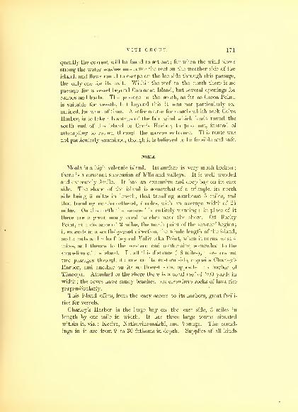
VITI GROUP. 171
quently the current will be found to set out ; for when the wind blows
strong the water washes most over the reef on the weather side of the
island, and flows round to escape on the lee side through this passage,
the only one for its exit. Within the reef to the north there is no
passage for a vessel beyond Cocoanut Island, but several openings for
canoes and boats. The passage to the south, as far as Cocoa Point,
is suitable for vessels, but beyond this it was not particularly ex-
amined, for want of time. A safer course for vessels which seek Colvo
Harbor, is to take advantage of the fair wind which leads round the
south end of the island to Carr's Harbor, to pass out, instead of
attempting to return through the narrow entrance. This route was
not particularly examined, though it is believed to be feasible and safe.
MOAIA.
Moala is a high volcanic island. Its surface is very much broken
;
there is a constant succession of hills and valleys. It is well wooded
and extremely fertile. It has an extensive and deep bay on its east
side. The shape of the island is somewhat of a triangle, its north
side being 6 miles in length, that trending southeast 5 miles, and
that trending north-northeast, 7 miles, with an average width of 2 J
miles. On the north the sea-reef is entirely wanting ; in place of it
there are a great many coral patches near the shore. Off Rocky
Point, at a distance of 2 miles, the north point of the sea-reef begins
;
it extends in a south-by-west direction, the whole length of the island,
and a mile and a half beyond Valivuaka Point, when it turns west 4
miles, and thence to the western end conforming somewhat to the
shore-line of the island. In all this distance (18 miles), there are but
two passages through it : one on its eastern side, opposite Charley's
Harbor, and another on its southwest side, opposite the harbor of
Thacopa. Attached to the shore there is a coral reef of 200 yards in
width; the coves have sandy beaches, but elsewhere rocks of lava rise
perpendicularly.
This island offers, from the easy access to its harbors, great facili-
ties for vessels.
Charley's Harbor is the large bay on the east side, 3 miles in
length by one mile in width. It has three large towns situated
within it, viz. : Ketira, Nathuvinemaishi, and Vonuga. The sound-
ings in it are from 9 to 30 fathoms in depth. Supplies of all kinds

172 HYDROGRAPHY.
may be had here, but in consequence of the disposition and character
of the natives, it is deemed advisable to be prepared against their evil
machinations, if communication is had with them. The eastern pas-
sage is quite safe, and is the best to enter by, even if desirous to
anchor under the lee of the island in the harbor of Thacopa, which is
situated on the southwest side, and has a fine opening through the sea-
reef abreast of it. There are two anchorages on the west side : one
to the south of Ridge Point, the other to the north of it, near Green
Island. This latter is the best, being more protected, and offering
every means to get to sea without difficulty. The town of Thacopa is
situated at the head of a bay. On the north side there is Female Bay,
which is quite small; at the head of it, the town of Malago is situated.
Some provisions may be had there, but I would advise vessels to resort
to the regular anchorage for supplies.
ANGAU.
Angau resembles the rest of the detached islands of this group in
having lofty peaks, of volcanic formation. It is 10 miles long, north-
west-by-north and southeast-by-south, by 4 2 miles wide. Of its high
peaks, that of Dilathoa is the most lofty ; it is 1560 feet in altitude.
Its hills range with the length of the island, and there are manyfertile valleys, surrounding the numerous bays, that are formed by
projecting points.
The coral reef extends quite around the island ; on the west side it
is 2 and 3 miles removed from the shore, while on the east it becomes
a shore-reef, and is from 100 to 200 yards wide.
On the east side there are two openings, 150 yards wide, near
Uthivione Point, which is the north point of the island : this is a
ship channel, and leads to the town of Thopanauti. The other is
near the town of Lamilu and Pig Islet, but the harbor is small, and
but little protected from the prevailing winds. About half waybetween these, there is an entrance for boats, leading to the town of
Maluai. Off the south end, the shore-reef extends some distance, and
at low tide the water is too shoal for a boat. On this reef, off South
Point, is the small low island of Lathiba, one mile distant. The
southwest side of the island, extending from Point Lobo to that of
Via Via, is detached from 2 to 3 miles from the shore, forming two
bays ; that of Levuka, which is the largest and most southern, and

V I T I GROUP. 173
Waicama : these are separated by Tongue Point. In both these bays
there is good anchorage, and around them several towns are situated,
being well protected from all but the southwest winds, which seldom
blow;immediately west of Levuka Point there is a fine ship-passage
through the reef. Vessels resorting to these bays would do well to
enter through the reef off Sauieke Bay; here there is a passage between
the sea-reefs, nearly a mile wide. Sauieke Bay lies on the northwest
side, immediately opposite the opening, but it is too much obstructed
by coral patches to afford safe anchorage to any but small vessels. Avessel after having passed through the reef, and wishing to proceed to
Levuka Bay, should steer for Via Via Point a southwest course, and
then continue to Pirate Point, when both the bays will open to view,
and the anchor may be dropped abreast either of the towns, where
supplies may be had of wood, water, and provisions. It is proper
here to remark, that, as this island is subject to the king of Ambau,
it is necessary to have permission to obtain supplies, as the natives
have fears relative to supplying vessels, without some authority from
the king.
On the north side of Angau the reef approaches the shore, and
within, it is much broken up in small patches, having very shoal water
between them.
Dilathoa Peak is the most conspicuous on Angau. This peak in
clear weather is readily perceived from the large island of Viti Levu,
from which it is distant 30 miles.
MUMBOLITHE REEF.
Eight miles south-by-west of Lobo Point, on Angau, lies the insu-
lated reef of Mumbolithe. It is in shape nearly an equilateral tri-
angle, whose sides are one mile in length : on it the sea usually
breaks. It is a dangerous reef, and ought to be carefully avoided.
NAIRAI.
The Island of Nairai occupies a situation north 35° east of Angau,
7 miles distant. It is 6 miles in length, north-northwest and south-
southeast, with an average width of 2 miles. It has the same volcanic
formation, but its peaks do not rise as high as those of Angau : it has
several fine bays and good anchorages, which are made by the peculiar

174 HYDROGRAPHY.
form of its reefs. On the west it has the Onoruga Reef; on the south,
the Mothea Reef; on the east and projecting to the north, the Flying-
Fish Reef, while on the northwest side it is entirely free. The Onoruga
Reef extends more than 5 miles due west from the west side of the
island ; it forms an extensive bight, in which are several outlying
patches of coral. As this reef approaches the island, its course, whenwithin a mile of the shore, trends southerly, off Lanagi Point, where
it terminates. Several coral patches lie between it and the Mothea
Reef; the openings between these afford safe passages for vessels, by
which they can pass to the various anchorages on the south and west
sides of the island. An extensive basin is formed by the bight of
Mothea Reef, which extends to the south 5 miles ; it is 3 miles wide,
and within it is the Cobu Rock, an insulated rock, a mile from Nalico
Point. On the west side the harbor of Venemole is the best anchor-
age ; it is well protected from all the prevailing winds : on the north
by the two small islands of Sudine Levu and Sucline Lailai, which are
joined by a wide coral reef, which extends to the island, stopping up
the entrance into Veneinole Bay, and rendering it inaccessible for any
kind of vessel. This Bay is an extensive sheet of water, nearly cir-
cular in form, and has the appearance of having once been an extensive
crater. The depth of water in Venemole Harbor is from 12 to 15
fathoms, with good holding-ground. It is easy of access, and supplies
of water may be had at the town of Venemole, situated at its head. Nospecial directions are deemed necessary to enter. The two small islands
on the reef are readily discovered. When approaching the island from
the northwest these may be steered for, and when within half a mile of
Sudine Lailai haul round it, and anchor within half a mile of the reef
or shore. The only danger is a small sandbank, which lies to the
south : there is 3 fathoms on it at low water.
On the east side is the Bay of Corobamba, where there is good
anchorage, being well protected by the reef, which here follows the
trend of the island. This bay reaches from Muselana Point to that
of Toburoro, a distance of 3 miles. Corobamba is situated within a
mile of Musilana Point, and is the second largest town on the island
of Nairai: the depth of water is 15 fathoms on a clear bottom of sand.
Within a mile of Musilana Point and to the northward of it, there is
a break in the reef; this divides the Flying-Fish Reef from that of
Mothea. Vessels must at once haul up sufficiently to pass to wind-
ward of Musilana Point, and after it is passed, the town of Corabamba

V I T I GROUP. 175
will be open, off which is the anchorage. The Flying-Fish Beef ex-
tends 4 miles, trending to the north-northwest ; at its north end it
takes a turn for one and a half miles to the west. Near the north end
there are some patches of coral, but they lie very near the reef. Theextreme point of this reef is some feet under water, and as the sea
does not at all times break on it, a vessel should not approach too
close. When the central peak on Nairai, Corobata, bears south (true),
it will cut the end of the reef. At 2 miles from the island there is
an opening through this reef, which may be used in case it becomes
necessary. The channel leading from Corobamba Bay round Tuburoro
Point, between it and the sea-reef, is safe, and free from any obstruc-
tions ; the only danger is a small coral patch, a quarter of a mile east-
southeast of Nalico Point. After this is passed, either side of the
Cobu Rock may be taken, and thence due west of Cobu Rock to a
safe passage through the sea-reef.
Besides the towns mentioned, there is another on the north side,
called Tauloa, which is at the head of the bay of the same name. It
affords little protection for vessels, but supplies may be had there.
On the southwest side of the island is Lanagi, another large town,
at which supplies may be procured. At this island the natives are
very friendly, and although under the authority of Ambau, yet they
are at times independent of it. The natives are reputed to be well
skilled in making mats, &c. &c, in which articles they generally
supply many of the other islands, and in consequence have a good
deal of trade and intercourse with them. The population of Nairai is
reported to amount to 7000.
Navigators should not go to the west of Nairai during the night.
The Sea of Goro, which lies to the east of this island, is quite free
from dangers, excepting the Tova Reef;having passed it, there is no
necessity for a vessel running further ; there is plenty of sea room to
lie to or keep under way on short boards. By standing on to the
westward, after nightfall, little or nothing is gained, and many per-
plexities, by the near approach to dangers, will be encountered.
AMBATIKI.
Ambatiki is a small volcanic island, situated northwest from
Angau and west of Nairai, from both of which it is 11 miles distant.
It is nearly equilateral in form, the sides of which are 2 miles in

17G HYDROGRAPHY.
length : it rises in a dome-shaped hill to the altitude of 750 feet. The
reef is continuous around, and offers no protection for vessels, and
only a few passages for boats ; it does not extend from the island
more than a third of a mile. There are several small villages. The
inhabitants of all are subject to Ambau, and are afraid to do anything
without the authority of its chief ; therefore it is fruitless to attempt
to get supplies from them, unless having permission from the proper
authority. The number of inhabitants amounts to 500.
GORO.
The Island of Goro lies north of Nairai, 25 miles : it is half waybetween the latter and Yanua Levu, and is southwest of Vuna, 30
miles. Goro is a high island, not so much broken as those I have
already described ; has no sharp peaks, but is capable of being culti-
vated to its very top ; a large part is table land. Like the rest, it is of
volcanic formation. It is 9 1 miles in length, by 4 in width. Theusual sea-reef is here wanting, and the shore-reef is not continuous.
The form of the island is a trapezium, its length lying nearly north
and south. On the east side the shore-reef is irregular, having manyprojecting points and deep indentations, in shape of large segments.
This reef projects at the northeast point one and a half miles to the
north. There are likewise patches of the shore-reef off the southwest
and northwest points of the island, but the west side and part of the
north end are free from coral. There are two small anchorages under
this island : on the west side, one at the northwest, and the other
at the southwest point. That in Kalau Harbor, under the north
point, is the best. On the north side there is no anchorage. Useless
Bay is too much filled with patches, and Coa Coa Bay offers no
inducements. Under Ruku Point, close to the shore, there is anchor-
age, but it cannot be recommended. The east side, from the trend
of the reef and its being the weather side of the island, offers
scarcely a place for even a small vessel to seek shelter in. Temporary
anchorage may be had near the southeast point. The northeast
point must be avoided, on account of the distance to which the shore-
reef runs off. On this reef there is a small sand-spit, beyond which
the reef extends three-quarters of a mile.
Goro has 2000 inhabitants, and there are many towns, which are
very flourishing. It produces more cocoanut oil and tortoise-shell
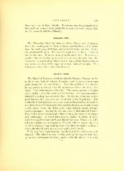
V I T I GROUP. 177
than any other of these islands. Provisions may be procured here,
but wood and water it is far preferable to seek elsewhere, where they
can be procured with less difficulty.
HORSESHOE REEF.
The Horseshoe Reef lies between Goro, Nairai, and Ambatiki.
From the south point of Goro, it bears south-half-west, I02 miles,
from the north point of Nairai, northwest 10 J miles, and from Amba-tiki, northeast 11 miles. It derives its name from its form. It is one
mile in diameter. It has an entrance on the north side. In boisterous
weather the sea breaks on it, and then it may be seen from the
heights of the surrounding islands, but in fine weather there is seldom
any break on it beyond the ripple at certain times of the tide. It is
a dangerous reef, and ought to be shunned.
KANTAVU ISLAND.
The Island of Kantavu, which bounds the Kantavu Passage on the
south, is very high, of volcanic formation, and has many conspicuous
peaks rising from its central ridge. Near the middle of the island it
is very narrow and low, having the appearance of two islands at a dis-
tance. The whole length is 26 miles. The eastern portion is 7 miles
wide ; whilst that of the western is but 4 miles. Its .southern coast is
indented by a deep bay,—Gressin Bay. On this side it has one or two
good harbors, but they were not examined by the Expedition. The
north side is well provided with coral reefs, to form harbors, so much so
as to,have some of its bays quite obstructed by the patches, which extend
nearly across them, and debar their being entered, except through
tortuous passages. Among the best, are those of Mallatta and Tabuka
Bays, but I cannot recommend either of them for more than tempo-
rary anchorages. A vessel intending to anchor in either of them
must have good lookouts aloft, and thread her way. There is no diffi-
culty in reaching an anchorage in 17 to 20 fathoms water; but if a
vessel is desirous of approaching "hearer the shore, to anchor in shoaler
water, she should warp into a proper and suitable berth.
There is a large population on this island, and the natives are well-
disposed. The island is very fruitful, and supplies may be had here,
by previous arrangements being made with the chiefs ; it is well,
45

178 HYDROGRAPHY.
however, for vessels communicating with this island to be upon their
guard ; for although the natives are disposed to be friendly, yet, if
opportunity offers, they will detain an officer for a ransom. Large
spars may be had here, the island being well covered with lofty
timber on its high lands. The most remarkable peak on the island
is situated at its western end. This is known as the Peak of Kan-
tavu ; it is of a cone shape, and its top has the appearance of being a
crater. The altitude was found to be 2879 feet.
The coast of Kantavu, to the east of Mallatta Bay, is destitute of
coral reefs, excepting at one point, where a small patch occurs, until
the approach to the island of Ono, situated off its eastern end, and
divided from it by a channel 3 miles wide, in which there are manycoral patches. The Island of Ono may be reached without difficulty
by a vessel, and good anchorage found under it on its west side.
Ono is 12 miles in circumference, and rises about 80 feet above the
sea, in the form of a regular dome ; from it the great Astrolabe Reef
extends to the north 12 miles, and has a mean breadth of 3 miles.
Within this reef there are eleven small islands, which I have called
the Passed-Midshipmen's Group, after the officers of that rank at-
tached to the Expedition. On the west side, the reef is much broken,
and a large vessel may pass through it, and find temporary anchorage
under the largest islands. No directions are deemed necessary to
enter, as the breaks in the reef clearly show themselves. The ancho-
rages, however, cannot be recommended for any but small vessels to
make use of. The northern end of the Astrolabe Reef is rounded,
and has an opening of 250 yards wide. In the centre of this northern
bight stands an insulated black rock, which is very conspicuous.
The eastern side of the Astrolabe Reef is unbroken, and forms a
slight curve to the eastward. As it trends to the south, it joins the
Island of Kantavu at its extreme eastern point,—Point Bligh. This
reef obtains its name from the narrow escape from wreck which the
French discovery vessel, the Astrolabe, Captain D'Urville, had when
in the group. From the north end of the Astrolabe Reef the high
land of the islands of Viti Levu, 'Mbenga, and Kantavu can be seen.
The Black Rock lies in latitude 18° 43' south, and longitude 178° 27'
east.
The Island of Kantavu is the Mywoolla of Captain Bligh, who was
the first that touched at it. The north side of the island is generally
the resort of the English whalers for supplies, which they readily ob-

V I T I GROUP. 179
tain, consisting of yams, taro, &c, the products of these islands.
Wood and water can be had there in abundance.
VATULELE AND FLYING-FISH BEEF.
The Island of Vatulele lies 16 miles south of Viti Levu, and 30
miles west-by-south of 'Mbenga; it is 8 miles in length, by 2 in width,
trending northwest and southeast ; from its southern to its northern end
it gradually rises to the height of 70 feet above the sea-level, and is
composed of a reddish clay and sandstone, lying in horizontal strata.
Its southwest side has but a narrow shore-reef, throughout its whole
extent ; this on the northeast side becomes a sea-reef, and extends to
the distance of a mile and a half to two miles from the island. The
sea-reef, after trending three miles to the southeast, again trends
towards the centre of the island, embracing an extensive lagoon, and
encloses four small islands, which I named the Midshipmen's Group,
after the officers of that rank in the Expedition;they are nearly as
high as the north end of the island. There is a narrow passage be-
tween the reef and the island, for boats or canoes, as far as the south
end, and a few entrances into the lagoon. Vatulele offers very little
to claim the attention of the navigator or trader ; it has a few inhabi-
tants. The north bluff of the island exhibits the same reel earthy
formation as that part of the coast of Viti Levu called the Red Bluff.
To the east-by-north of the south point of Vatulele, 7 i miles distant,
is the Flying- Fish Shoal or reef ; it is 300 yards north and south, by
150 east and west, and is awash ; on it the sea always breaks. Both
Vatulele and 'Mbenga may be seen distinctly from it in clear weather.
From the southwest bight of the reef of 'Mbenga, it bears southwest,
distant 14 miles. This is the only detached reef in the Kantavu
Passage.
KANTAVU PASSAGE.
The channel lying between the Island of Kantavu on the south,
and 'Mbenga, Viti Levu, and Vatulele, with their reefs, on the north,
I have called the Kantavu Passage. At the eastern end, in a north-
west direction from the north point of the Astrolabe Reef to that of
'Mbenga, it is 24 miles wide, and at its western end, between the west
point of Kantavu and Vatulele, it is 30 miles; it is 40 miles in length.
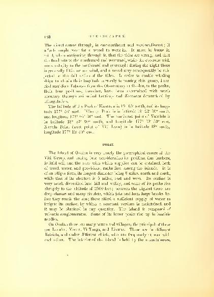
180 HYDROGRAPHY.
The direct course through, is east-northeast and west-southwest ; it
affords ample room for a vessel to work in. It must be borne in
mind, when navigating through it, that the tides are strong, and that
the flood sets to the northward and westward, while the ebb runs with
some velocity to the southward and eastward : during the night there
is generally little or no wind, and a vessel may consequently be sub-
jected to the full action of the tides. In order to enable whaling
ships to obtain their longitude correctly in passing this group, I car-
ried meridian distances from the Observatory at Ovolau, to the peaks;
their true positions, therefore, have been ascertained with much
accuracy through azimuthal bearings and distances determined by
triangulation.
The latitude of the Peak of Kantavu is 19° 05' south, and its longi-
tude 177° 58' east. 'Mbenga Peak is in latitude 18° 22' 30" south,
and longitude 178° 07' 30" east. The southeast point of Vatulele is
in latitude 18° 37' 30" south, and longitude 177° 39' 30" east.
Navula Point (west point of Viti Levu) is in latitude 18° south,
longitude 177° 12' 30" east.
OVOLAU.
The Island of Ovolau is very nearly the geographical centre of the
Viti Group, and taking into consideration its position, fine harbors,
fruitful soil, and the ease with which supplies can be obtained, both
of wood, water, and provisions, ranks first among the islands. It is
of an ellipse form, its longest diameter being 8 miles, north and south,
while that of its shortest is 5 miles, east and west. Its surface is
very much diversified into hill and valley, and some of its peaks rise
abruptly to the altitude of 2500 feet ; between the highest there are
deep chasms and many rivulets, which join and form large brooks be-
fore they reach the sea ; these afford a sufficient supply of water to
irrigate its surface, by which a constant verdure is maintained, and
it may be obtained in any quantity. The island is composed of
volcanic conglomerates. Some of its lesser peaks rise up in basaltic
needles.
On Ovolau there are many towns and villages; the principal of these
are Levuka, Voona, Vi Tonga, and Livune. These are in different
districts, and under different chiefs, who are frequently at war with
each other. The interior of the island is held by the mountaineers,
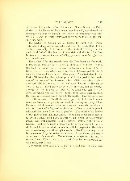
V I T I GROUP. 181
who are an independent tribe ; this circumscribes visitors to the limits
of the friendly district of Tui Levuka, who has fully experienced the
advantage accruing to himself and people by communication with
the whites, and he offers every facility for them to obtain the sup-
plies they need.
The harbors of Ovolau are all formed by coral reefs. These
reefs extend along the eastern side, and from the Lada Reef off the
northern extremity of the island to the Moturiki Passage, on the
south, and include the islands of Moturiki and the two Anuthas.
In places the reefs are broken, affording good entrances through them
to the anchorages.
The harbor of Levuka extends from the Fore-finger on the south,
to Underwood's Tower on the north, a distance of 5s miles. It is a
fine harbor; the anchorage is good throughout, in from 11 to 17
fathoms water, remarkably easy of ingress and egress, and the direc-
tions for entering it are simple. After passing Ambatiki, steer for the
Peak of Dille-Ovolau, the highest peak of Ovolau ;—this lies north-
west of the town of Levuka,—and when within two miles, a black
coral rock will be observed, on the reef, some distance to the south-
ward of the entrance ; when up with the entrance, and the passage
through the reef is open, the Observatory knoll will bear west-by-
north, for which you then steer. If the flood tide is running, keep
the south reef aboard, but if the ebb, the north. This passage is not
over 800 feet wide. Should the wind prove light, I would recom-
mend the boats to be got out, and ready for towing, as it may fail at
the most critical moment in the entrance, and leave the vessel some-
what in danger of being cast on the reef. When the reef is passed,
sail should be taken in as soon as possible. The width of the harbor
at this place is less than half a mile. In coming to anchor be careful
to avoid a small coral patch a little to the south of Observatory
Point. The best anchorage is in 11 fathoms water, off the town of
Levuka. Fail not to make a present to the chief ; it ought to be one
of the first duties, by which means he will be propitiated, the inter-
course satisfactory, and the supplies ample. Should a contrary course
be recommended by the resident whites, avoid the advice, and refuse
to espouse their quarrels. The northern openings are the best to
depart from. Either side of the sandspit which lies between the
coral reefs, may be taken.
The Ovolau Reef continues to the south, and forms the northern4G
182 HYDROGRAPHY.
boundary of the Moturiki Passage. There are several narrow passages
through the reef, leading to good anchorages under the island.
On the west side of Ovolau the coral reef is wanting, except in a
few places. Two miles from the island, there is a large area covered
with coral patches, called the Mana Shoals, which must be carefully
avoided ; there is no difficulty in doing this, as there is sufficient room,
either with a fair or head wind. All the direction deemed necessary
is to keep the island side of the channel, with a careful lookout from
aloft. The channel between the Mana Shoal and the reef off the
north end of Moturiki Island is a mile wide and clear.
On the north of Ovolau, the Lada Reef extends 4 I miles ; its form
is irregular ; it encloses an area of about 3 square miles. Patches of
coral compose its western side, and project from it to the west, 2
miles. Boats may pass among them, but it would be dangerous for
even a small vessel to venture.
MOTURIKI.
The Island of Moturiki lies within the same reef, and on the south-
west side of Ovolau : it might be considered as one and the same
island ; for they are almost connected by the two small islands of Anu-
tha-levu and Anutha-lailai with their reefs. Moturiki is 5 miles long,
by 1 wide ; it trends north-northwest and south-southeast, 5 miles. Tothe west, abreast the middle of the island, it has some small outlying
patches of coral ; its shore-reef extends the whole length, and round
on the east side, till within a short distance of Laudolib Islet, on the
southeast point of the Ovolau shore-reef. On the north of Moturiki,
and between it and Ovolau, there is good temporary anchorage.
Moturiki has two towns on its southwest side, Sabuna and Corabo,
and one on its east, Aubuti.
MOTURIKI PASSAGE.
The Moturiki Passage is 4 miles in length, by three-fourths of a
mile wide in its narrowest part, between the Island of Thangala on the
north, and those of Leluvia, Angasau, and Tombu, with their reefs, on
the south. This last is situated at its entrance, near the point of the
great reef of Viti Levu, that trends towards Kamba Point. These
small islands and reefs form the portals to the Bay of Ambau • they
V I T I GROUP. 183
are each about a mile in circumference, and covered with foliage : which
gives them a pretty appearance. In the passage there are no sound-
ings, but under the western side of the Island of Leluvia a vessel mayanchor in 10 fathoms water, sandy bottom. The mark for sailing
through the Moturiki Passage is Rich's Peak, on Viti Levu, which
bring to bear due west. Before reaching Leluvia, on the south side,
there are some small coral patches ; it is best to avoid these by keep-
ing on the north side. The tides run strong through this passage ; the
flood flows in, and the ebb out ; the latter continues 8 or 9 hours out
of the 12. Anchorage 'may be had under Thangala or Moturiki, by
passing through the entrances in the north reef.
VITI LEVU.
The Island of Viti Levu is the largest of the Viti Group ; its shape
is somewhat of an ellipse, being 100 miles long, by 60 miles wide.
The general appearance of the island is broken, and of volcanic forma-
tion, rising in many high and needle-shaped peaks, often to the alti-
tude of several thousand feet. The highest range lies north-north-
east and south-southwest, dividing the island by passing obliquely
through it. This range is called the Ulunikoro Mountains. Some of
the measurements of its peaks gave an altitude of 5750 feet. From
this range there are many spurs, which set off in different directions,
in sharp ridges, towards detached peaks, which rise in regular cones;
to these the names of some of the gentlemen comprising the corps of
naturalists of the Expedition were given. These, with the extent of
broken surface, give the impression that the greater part of the island
is entirely unadapted to cultivation, or even for the abode of any
number of inhabitants. Like all the islands of any extent situated
in the trade-winds, the leeward side is subject to long and exces-
sive drought, and has a very different appearance from that of the
windward part. Viti Levu on its leeward side enjoys the advan-
tage of several harbors, where a plentiful supply of water may be
had from the streams which flow from the mountains,—sufficient even
for irrigation in places. Its weather side is abundantly supplied with
streams, and the Wailevu River enters into the sea at Rewa, after a
winding course of some 45 miles from the mountains. Along the banks
of this river the most fertile portion of the island is found, and it is

184 HYDROGRAPHY.
the most densely populated, and destined to be the seat of improve-
ment when the Feejeeans become more civilized and enlightened. .
As this island embraces a large number of smaller islands situated
on its reef, and connected with its harbors, I shall include them in
the description as they occur, in which both 'Mbenga, and Namuka,
and three reefs will be embraced, beginning at the Moturiki Passage,
which leads into the Bay of Ambau on the east, and thence around
its southern, western, and northern sides.
From Leluvia the inner reef trends due south, 11 miles : this forms
the eastern boundary of the Bay of Ambau ; at its southern end lies
the small island of Tombarua. There are several extensive patches
of coral connected with this reef, lying three-fourths of a mile to
the west. The Bay of Ambau lies between this and the east end of
the Island of Viti Levu ; the shores are low, and along them lie
several small islands, on which the principal towns, Ambau, Viwa,
and Verata, are situated, where the political power has long been
concentrated, and where it now exists. The bay is 12 miles in
length, by 4 in width : it is a fine sheet of water, and has anchorage
throughout. Kamba Point forms its southern termination, while that
of Verata bounds it on the north. The water towards its western
shore is shallow, and there is no harbor except the open bay ; small
vessels may anchor under the Island of Viwa. Although the anchor-
age in the bay is good, it is exposed and unsafe for a vessel : in gales
of wind mairy vessels have been either wrecked or lost their anchors.
One and a half miles off Verata Point there is an extensive coral
patch, 2 miles in length, north-by-west and south-by-east, and a mile
wide. Between it and the land there is a passage, and another to the
eastward, where there are many patches of coral, some of which are
bare at low water. There are several other coral patches, which have
not been located on the chart, as I was not satisfied that we have their
places correctly ascertained. Vessels sailing in the Bay of Ambauare recommended to keep a good lookout from aloft, and not to
attempt passing through it without daylight. As to supplies, the Bay
of Ambau offers no inducements to visit it, nor is it advisable to incur
the risk while the Feejees remain in their present savage state, and
while supplies may be had elsewhere in security.
There is a communication by water with Rewa, by a small stream
that flows into the Bay of Ambau, a branch of the river of Rewa,
the length of which is ten miles. All the productions of this group

V I T I GROUP. 185
are very abundant here ; the population is greater, and the consump-
tion of supplies larger than in other parts of the group. Every trick
is resorted to by the chiefs, great and small, to exact presents from
strangers, by throwing impediments in the way of obtaining supplies;
it is, therefore, better, unless a vessel has especial business with the
authorities of Ambau, to seek them in another part of the group.
To the east, around Kamba Point, there is a passage for small
vessels or boats through the reefs, but it is very confined and muchobstructed by patches of coral ; the outer sea-reef coming from the
north forms the northern side of this passage ; in its bight of the outer
reef lies the small island of Mambualau, and 3 miles to the west, on
the inner reef, that of Tombarua ; both have groves of cocoanut
palms on them, which is also the case with the small island of Nezim-
bazimba, directly off Kamba Point. The land about Kamba Point is
all low, alluvial, exceedingly fertile, and densely covered with vegeta-
tion. On the outer reef the sea breaks at all times. The sea-reef
joins Kamba Point; it then trends 3 miles to the east, and follows
the coast-line to the south.
Four miles south of Kamba is Kuva Point, which is also low,
and covered with trees. The width of the reef from Kamba Point
is 3 2 miles. Nasilai Point is southwest of Kuva, 3 miles, and be-
tween the two the coast makes a considerable indentation, and the
shore is free of coral. The reef terminates at Kuva Point and re-
appears at Nasilai Point, forming a large and extensive bay, but in
consequence of its being open to the sea, and exposed to the pre-
vailing winds, it forms no harbors of safety for vessels. FromNasilai Point the coast trends to the westward to Kania Point, the
eastern termination of the Roads of Rewa, the line of the reef running
with the coast, but without openings. The land is low, and covered
with cocoanut palms. Just beyond Kania the reef turns towards
the northwest, joins the land, and ends three-fourths of a mile to the
west of that point. The interruption is believed to be caused by the
fresh water discharged from the Wailevu. To the southwest of
Kania Point, 3 miles, are the islands of Nukulau and Mukulau, which
with their reefs form the protection to Rewa Roads. There are three
passages into the Roads, on the east, southeast, and south : the first,
between the reef off Kania Point and that of Nukulau Island, a mile
wide, called the Kania Entrance ; the second, between the islands of
Nukulau and Mukulau, called the Middle Entrance ; and the third,
47

186 HYDROGRAPHY.
on the west side of both islands, the Southern Entrance : the last two
are not wide, but the safest. The Island of Nukulau is one-third of a
mile long, but there is a long sandspit, which extends to the eastward
half a mile, covered at high water : the width of the island is one-
fourth of a mile. The coral reef connected with this island is 2 miles
in length, by half a mile wide ; it is only bare in places at low water,
and unless there is a heavy swell the sea does not break on all parts
of it : its sides trend east-by-north and west-by-south.
The Island of Mukulau is smaller, not more than half a mile in
circumference; it lies south of Nukulau, and has a reef extending from
it to the eastward. The Northern, or Kania Entrance, is somewhat
obstructed by coral patches, off the east side of Nukulau sandspit, and
ought not to be used without a good lookout being kept from aloft,
and if used it should be in the morning hours, or before the sun gets
to the west : three coral patches lie in it, on which there is but 6 and
8 feet water, but around them it is deep. Vessels ought not to
anchor in the Kania Entrance, unless in case of absolute necessity :
the bottom is uneven, and the liability to lose an anchor great. The
course for sailing into the Eoads when off Kania Point, is to steer for
'Ndraketi Point, until clear of the Nukulau Island Reef, then stand
on to the west until that island bears southeast. Anchor on a line
about half-way between the island and 'Ndraketi Point.
The Middle Entrance is between the extensive reefs which surround
these small islands. The islands are situated on the western side of
the reef, and the dangers lie to the eastward of them. This entrance is
a mile and a half in length. At its eastern termination are also some
outlying coral patches, which are not visible until close upon them.
To pass through, the course is west : it is better to keep in the middle
;
the reef will be visible on both sides. It is one- fourth of a mile wide,
and joins the South Entrance, which leads north to the anchorage.
The best entrance to Rewa Roads is that from the south : it maybe used at all times. It is bounded by the islands of Mukulau and
Nukulau on the east, and the broad sea-reef on the west. The channel
is a mile in length, and at its narrowest part 400 yards in width.
When off it, 'Ndraketi Point can be seen clear of the islands, and
nearly on a line with them : it bears north-by-west ; this is the course
to steer ; it will lead directly through it, and towards the anchorage.
'Ndraketi Point is low, and forms the western point of the Wailevu
or Peale's River: although low land, the trees on it make it quite con.-

VITI GROUP. IS7
spicuous. When inside the Island of Nukulau, a vessel may anchor
in any berth, in from 7 to 15 fathoms water, muddy bottom, and good
holding-ground ; but the best anchorage is that already given. Three
miles west of the south entrance into Rewa Roads, there is another
break through the sea-reef. This is 300 yards wide; a small grass or
sand islet on the reef points it out ; it is, therefore, a good sailing
mark; but this entrance is only to be used to depart from, as the wind
would be ahead, and a vessel have a long beat among the coral
patches within the reef to reach the anchorage after passing through,
which could be made quicker and with more safety outside. Besides
these there are several boat-passages, and at high water a boat maypass over the reef without difficulty, if there is no swell.
The mouth of the Wailevu River is visible from the anchorage.
The deposit of sand is very great, and shifts frequently: a large quan-
tity of water flows out of it. The town of Rewa is situated 6 miles
up the river, from the anchorage ; it is a narrow stream, has a very
tortuous course, and is difficult even for a boat to navigate, on account
of the many sandbanks and bars that are in it; vessels drawing more
than 10 feet cannot enter. The water of the river is fresh, and maybe obtained in abundance : that which is found in a pool on the
Island of Nukulau, is bad and unwholesome. Supplies can be pro-
cured at Rewa,, but the same difficulties are liable to occur here as at
Ambau,—the kings and chiefs desire to make the most of the visit,
by compelling presents to be made to them. Rewa is a large town,
containing over 500 bouses ; it is built on the right bank of the
river. Its lanes, or streets, are very narrow ; on both sides they are
fenced in with tall bamboo reeds. The low situation of the town
causes it to be a perfect mud-hole, and it seems scarcely possible to
believe that human beings could long survive living in such filth.
Rewa is the rival to Ambau ; the king holds the second rank
in political power. The people of Rewa are much more liberal and
kind to strangers than those of Ambau.
Rewa is the residence also of the Wesleyan missionaries;they do
all in their power to assist visitors. As yet they have made but few
converts, though they are much esteemed by the natives. The popu-
lation of this part of the island, together with the independent tribes
on the river, amounts to 5000. The River Wailevu was ascended by
the boats of the Expedition up to Budd's Point, which place is the
limit of navigation.
188 HYDROGRAPHY.
To the west of Rewa Roads, 4 miles distant, lies Suva Point : it is
low, and projects beyond the general line of the coast. On the west
side is Suva Bay ; at the head of the bay there is a small stream,
which falls into it, and where water may be procured with facility.
At Suva Point the reef follows round the bay, and forms a conve-
nient harbor for vessels ; the anchorage is good, one of the best the
island affords ; the low shores are skirted with mangroves. The
town of Suva lies on its east side, and Malloni on the west. Supplies
can be obtained here in abundance and cheap. The natives are
friendly, and some of them are termed Christians.
From Suva Bay to the town of Indimbi to the west, the coast is
low, and bounded, for the distance of 13 miles, by a reef, trending
nearly on a line with it. Indimbi is near the mouth of a consi-
derable stream, supposed to be a branch of the Wailevu, or a river
taking its rise near its source in the mountains. There is no good
harbor at Indimbi. From thence to Nangara Point, the distance
is 12 miles, the coast trending west-southwest ; it is of the same low
character, but the flat or low land is not so wide, the hills approach-
ing the coast. Nangara Point, although formed by a high hill, has its
extreme termination low. The coral reef continues to follow the shore
as far as the point, and has no break. The channel between the reef
of 'Mbenga and Viti Levu, from Indimbi to Storm Islet, situated on
the former, is 7 miles in width, but gradually contracts up to Nangara
Point, off which there are many detached patches of coral, which
nearly unite the two reefs : the passage through from this cause is
rendered somewhat intricate and unsafe.
The sea-reef of 'Mbenga is 17 miles in length, east and west, by 12
miles at its greatest breadth ; it is irregular in its outline, particularly
on its south side, where the reef is continuous. The north side of the
reef, or that towards Vitu Levu, is very much broken. This reef
encloses the Islands of 'Mbenga, Nemuka, Stuart's, and Bird. Storm
Islet is situated on the northeast side of the reef.
'Mbenga Island is 5 miles in length, east and west, by 3 miles wide;
it lies in the eastern bight of 'Mbenga Reef. It is high, rising up in
two cone-shaped peaks to the altitude of 1289 feet, and is of volcanic
formation. It contains two harbors, Sawau and Elliott : though not
large, they are safe : the former has its entrance at the north and east
end of the island, the latter at the west end. The land round Sawau
rises in most places from 1 to 200 feet. The town is situated on a
VITI GROUP. 1S9
high craggy peak at the head of the harbor, 500 feet higher than the
land by which it is surrounded.
To enter it, pass through the reef near Storm Islet, which is a good
guide for the passage : due south of this is the entrance to Sawau.
The distance asunder of Point Leavett and Dobbs, is not over one-
fourth of a mile. This harbor enlarges after passing these points, and
extends to half a mile in width, and a mile in length ; the soundings
decrease from 12 to 4 fathoms. At the head of the bay there is a
wide shore-reef, with three small islets situated on it;through a
break there is a passage for boats to the shore. The coral reef else-
where is narrow. Around the harbor water and wood may be ob-
tained in plenty, and the usual supplies that are to be found in this
group. Anchorage is in 4 J to 11 fathoms.
Elliott's Harbor lies on the west side of 'Mbenga ; it is three-fourths
of a mile wide at its entrance, and enlarges till it becomes nearly a cir-
cle, one mile in diameter. Immediately off the harbor there is a coral
patch, which is directly in the way of vessels seeking the harbor :
either side of it may be taken ; to the west, one and a half miles dis-
tant, there are also several small ones, which must be avoided. The an-
chorage is in deeper water than Sawau,—from 13 to 20 fathoms. Onthe left of the harbor stands the village of Y'some, with a white sandy
beach in front of it, off which there is a large coral patch, and between it
and the beach a small vessel may anchor. Supplies may also be had here.
Stuart's Island lies off the southwest point of 'Mbenga, a mile
distant ; it is one and a half miles in circumference, and high ; has a
reef around it, and two small patches on its northwest side. Thechannel between it and 'Mbenga is clear.
Namuka lies to the westward of 'Mbenga, 7 miles, and is at the
western bight of the reef: it is II miles long, north and south, by one
wide. Anchorage may be found near Namuka, but there is no harbor;
it has a very narrow coral shore-reef. Namuka is of considerable height,
and of volcanic formation ; it contains about 100 inhabitants, who are
very friendly, and disposed to trade their provisions, &c. Bird Island
is a small, low island, two miles north of Namuka : it has a reef
around it ; the island and reef being It miles in circumference : it is
covered with foliage.
The Madono Reef is the largest outlying reef: it is situated 2 miles
to the westward of the west side of the 'Mbenga Reef, and is 3 miles in
length, by half a mile wide, trending northwest and southeast. Dye's48

190 HYDROGRAPHY.
Sand Island and Shoals lie directly in the fair way, and with the
Whippy Harbor and Madono Reefs, form serious obstructions to the
navigation of the channel between the 'Mbenga and Vitu Levu Reefs.
The western side of the 'Mbenga Reef has two passages through it.
Near the southern one is a large black rock, which is quite conspi-
cuous at low water ; this sea-reef is well-defined, and may be closely
approached.
Three miles west of Nangara Point, the reef from the Vitu Levushore takes a sharp turn to the south, and extends 5 miles ; thence it
makes again for the shore in a bend towards the west : it encloses a
large area free from coral, and forms Whippy Harbor: this area is li
miles, on an average, in width. Its southern end terminates in a point,
towards the east. There are several boat-passages through it, on its
eastern side, but no ship-passage. The Whippy Harbor Reef is
one of the most remarkable conformations of coral in these islands,
extremely fantastic in its shape and trending ; in many places there
is good anchorage within it, in from 5 to 20 fathoms water. On the
western side, two and a half miles from the shore, there is a ship-
passage 200 yards wide, and through this a vessel may pass with
safety, and seek the inner harbor. This is a small bay, completely
sheltered from the sea and wind. Twin Island, situated off its
western point, forms a good landmark : after passing through the
entrance in the reef steer for it on the north course, 2^- miles. This
inner harbor is doubly protected by the outer and inner reefs,
and has good holding-ground, muddy bottom, with a depth of water
from 5 to 7 fathoms. Wood and water may be obtained in plenty.
Boats can cross the bar of the river at high tide. The town lies a
mile up the river or creek.
The next harbor to Whippy is that of Granby ; it is 4i miles
to the west, but not so well protected as that of Whippy ; it lies open
to the southern swell; is a mile deep, and li mile wide. It can
only be used as a temporary anchorage : the passage in, is one-
third of a mile wide, due north. The best berth is with Beacon Islet
bearing east-northeast one-third of a mile distant, and Point Dunlop
south-southeast three-fourths of a mile, in 9 fathoms, black sand and
mud. The shore-reef of Granby Harbor joins that of Whippy.
Eight miles west of Granby Harbor is Red Bluff. The land here
rises to the height of 2500 feet, and continues of nearly the same alti-
tude until reaching the harbor of 'Ndronga. 'Ndronga is 28 miles
V I T I GROUP. 191
west of Granby Harbor, and the shore-reef continues unbroken, and
offers no kind of protection in all this distance. A shore-reef sur-
rounds the bay ; it is narrow ; on it the surf beats violently. 'Ndronga
affords temporary anchorage ; it is not a safe port ; the swell rolls in
heavily, and a vessel is very much exposed. The anchorage is in 8
J
fathoms, sandy bottom. To the northwest of 'Ndronga is Peck's
Peak, which is the landmark for the harbor.
After leaving 'Ndronga the land changes its character, becoming
sandy, and much less in altitude. Six miles west of 'Ndronga is
Leku Island ; here there is a fine harbor for small vessels ; the en-
trance is narrow ; a northeast course leads in. The only wind to which
it is exposed is that from the southwest, which seldom blows. Leku
Island is easily recognized from the groves of cocoanut palms ; huts
were seen on it, but it is believed to be only a temporary abode of the
natives : wood and water may be procured there. From Leku, the
coast of Viti Levu trends to the northward and westward, the low hind
gradually extending in width as the hills retreat from the shore-line;
the hills are destitute of wood, but the lowland is covered by exten-
sive groves of cocoanut palms. The distance to Navula Point, the
extreme western point of Viti Levu, is seven miles ; the shore-reef
extends to the distance of a mile to a mile and a half from the shore.
There is no opening in the reef until the Navula Passage, which lies
A\ miles to the westward of Navula Point. This passage is a good
one for small vessels to enter, though the course through takes a
sharp elbow turn. As the wind which generally prevails under the lee
of Viti Levu is from the westward, a vessel in coining out is obliged to
make several tacks. After passing the reef and entering Navula Bay,
a vessel may anchor in any part of it, in from 12 to 15 fathoms
water, muddy bottom. The direction of the Navula Passage is north-
east-by-east; it is half a mile wide, and a mile in length, the soundings
in it 13 fathoms. The flood sets into the passage, and the ebb out,
both strong, the latter 2i to 3 knots; the low tide generally leaves the
reefs bare, when the outline of the passage is visible. This passage
may be used by a ship to pass in, but I would rather prefer recom-
mending that of Malolo, 3 miles to the west, both to enter and depart
from.
After clearing the reefs on the west side of Viti Levu, and being
desirous of proceeding to the northward, the best course to pursue is
to hug the Viti Levu shore. The winds in this part of the group

102 HYDROGRAPHY.
are generally light and variable, sometimes from the southwest,
until reaching Vunda Point, where they prevail from the northeast.
Navula Bay is three miles across from Navula Point on the south, to
Vavula Point on the north, and is two miles in width ; the coral reef
extends around it, and the shore is lined with mangrove bushes, and
extensive groves of cocoanut palms. There are two villages within
this bay, and supplies may be obtained. The next bay to Navula is
that of Vitiraurau, which is 10 miles in extent, from Vavula Point
to Talatala Point ; its greatest depth does not exceed 4 miles. In the
centre of the bight lies Mangrove Island, within the shore-reef. Thesmaller bights within it are mostly filled with coral reef. The land
immediately around is quite low, and the shore which surrounds it
is entirely covered by extensive mangrove bushes. There is sufficient
room for vessels of any size to beat about. Good anchorage is found in
any part of the bay, in from 12 to 20 fathoms water, with muddybottom. The western side of this bay is bounded by the Island of
Malolo, and its reefs, and those of Underwood's Group ; the latter are
all low, sandy islands, from a mile to a mile and a half in circum-
ference, covered with, vegetation, and surrounded by coral reefs.
North of Talatala Point lies Watmough Island ; it forms the southwest
point of Matau Bay. Kanusi Point bounds it on the northeast. The
distance between these points is 6 miles. An extensive coral reef, 3
miles in length, lies across this bay, which affords good protection to
the anchorage between it and the shore, a mile and a half wide. The
channel between the reef and Kanusi Point is wide, and free from
dangers ; that between Watmough Island and the reef is partly
blocked up by a sand islet, but the passage between them, though
narrow, is safe. The Underwood Group lies off to the west, 6 miles,
and protects the bay on the outside from any heavy seas. The reefs
that encompass these islands trend towards Vunda Point, and makethe passage between it and Vandeford's Island very narrow. ByVunda Point is the only safe ship-passage when proceeding northward
and eastward along this coast. The sea between the island of Viti
Levu and Vomo, a distance of 12 miles, is filled up by a succession of
reefs and patches of coral (called the Kasoa Reefs), that makes it
next to impossible to navigate it with any degree of safety even
for the smallest class of vessels. Many of these patches are visible,
extending in long lines, while others are scattered about at different
depths below the surface. After passing Vunda Point, the route is

V I T I GROUP. 193
direct for Votia Island, which lies off Vitonga Point, the next conspi-
cuous headland to the northeast, a distance of 10 miles ; this is entirely
protected by the line of the Kasoa Reefs. Three miles from VundaPoint is Sand Island, and Sam Island lies three miles beyond it. Thewestern side of these islands is to be preferred, anchoring wherever it
is deemed necessary. The bottom is good holding-ground, and the
water not deep, and will at all times be found smooth. If wishing to
enter into Vitonga Bay, either side of Votia Island may be taken, as
may appear desirable. On reaching Vitonga Point, a vessel may pass
into the Sea of Viti, and be well to windward of the Kasoa Reefs,
which lie to the westward, but it is more advisable for a ship to keep
within the reefs and near the land, until arriving at one of the
passages more to windward. Off Vitonga Point, the shore-reef
extends to some distance, but leaves a clear passage between it and
Votia Island, though a very narrow one, into Vitonga Bay, the least
water being 5 fathoms. Vitonga Bay lies between Vitonga Point and
Tabooa Point ; it is 9 miles in length. This bay is protected on the
north by an extensive coral reef, which lies parallel with the shore for
4 miles, and is about half a mile wide ; it is exposed to the sea by the
opening between the reef and Votia Island Reef, which is 2i miles
wide; the anchorage, however, is good under the reefs. Vitonga Point
and Tabooa Point are both formed by sharp spurs from the moun-
tains, but the land between is low and cultivated;mangrove bushes
growing along on the shore-reef.
Off Tabooa Point 2 miles, lies Tabooa Island, situated on the
southern end of an extensive reef, which projects to the northeast,
and with others forms a line of sea-reefs, enclosing what I have named
Ba and Egleston's Bays, which extend to the northeast 15 miles, to
the Leonidas Passage, near the Dongaloa Islets.
After passing Tabooa Point the hills take a sweep inland, making
a bend as far as Batia Point, a distance of 22 miles. This portion of
the island is densely wooded, its shores being also overgrown by man-
grove bushes. The trend of the coast continues northeast to Ba
Point, after which the shore inclines more to the eastward. The dis-
tance between the sea-reef and the shore, beyond Tabooa Point, in-
creases to the width of from 2 to 3 miles, until arriving at Dongaloa
Islets, which is within 4 miles of Batia Point, where the channel again
becomes contracted to less than half a mile. The Ba Passage is a
49

194 HYDROGRAPHY.
break in the reef about the middle of Ba Bay ; it is 2 miles long, and
one wide, and leads into the Sea of Viti.
Numerous streams of fresh water enter into these bays, and
anchorage is to be found in almost any part, in from 5 to 15 fathoms
water, muddy bottom. There are a few coral shoals in the former,
but they are easily avoided. It is confidently believed that no other
dangers exist. It is well, however, for vessels to be on the lookout.
The Leonidas Passage lies abreast of the Dongaloa Islets, and at the
eastern terminus of Egleston's Bay ; it is a mile wide, and is the best
pass through the reefs into the Sea of Viti. To proceed further to
windward or to the eastward, within the reefs, is exceedingly labor-
ious, and causes much delay,—the wind being for the most part of
the time dead ahead, and some of the passages between the reefs are
too narrow for a ship to beat through. Many of the sea-reefs are
covered with sand, and show at low water as extensive sandbanks.
On the northern shore of Viti Levu, the fishery of the biche de mer is
extensively carried on. The sea-reefs are of great extent and well sup-
plied with this animal. Wood and water may be procured along this
coast in many places, particularly in Ba and Egleston Bays.
There are many towns along the coast of Ba. From the water they
are concealed from view by the thick growth of mangroves which stud
the shore. Thick forests cover the extensive plain between the two
points. Ba Point separates Ba from Egleston Bay.
From Dongaloa Islets to Batia Point, is a distance of 4i miles.
Batia Point is a sharp point, projecting to the northeast, and forming
one of the boundaries of Batia Bay, which lies directly to the east-
ward of it. The point is high and rocky, with Batia Islet adjoining,
forming a part of it. The sea-reef approaches within half a mile of
Batia Islet. The passage is narrow, but is free from obstructions.
Directly north of Batia, there is a small sand islet on the sea-reef,
which is visible at low water ; it points out the channel leading
into Batia Bay from the sea. At the head of Batia Bay is the large
town of Batia, and near it is Tokotusi Peak. The country around
is extremely fruitful, and supplies may be had in quantities. The
chiefs require permission from Ambau to furnish them.
Batia Bay is 3 miles in depth, by 2 miles across its mouth. Onthe east it has a projecting reef, 2§ miles to the northward, towards
the Sakau Passage, and approaches to within one-third of a mile of
the sea-reef dividing Batia from Sakau Bay. Sakau Bay is 8 miles

V I T I GROUP. 195
in length, and the distance between the shore and sea-reef is 3 miles.
On its eastern side it is much blocked up with shoals and patches,
particularly off the town of Tabooa.
Raki-raki Island and shoals, which are situated to the east of
Anufe Point, nearly close the passage between that point and the Loa
Reef, which lies off the coast ; it is difficult to get through unless with
a favorable tide, as a vessel will meet a contrary wind, which pre-
vails all the way up to the Annan Islands and through Malaki Bay.
Opposite Anufe Point is the Raki-raki Passage, leading north-north-
west between the coral reefs ; it is about two miles in length, and one
mile wide. A vessel may pass through without difficulty, either way,
with the prevailing wyind. It is a good passage to enter the Sea of
Viti, and sufficiently to windward for a vessel to sail directly for
Vanua Levu, and to reach 'Mbua Bay by daylight.
Anufe Point is low and well wrooded. There is no shore-reef on the
east side of the point, but it extends some distance from it, and in-
cludes Ika Isle. To the west there are large patches of coral, which
make the passage intricate, especially when beating up. Easterly
winds will be found to prevail here almost constantly when the
weather is fine.
Four and a half miles distant from Raki-raki Island is Tuki
Islet, which is a mile in diameter ; it lies half way between the sea-
shore and reef. The reef which surrounds it nearly joins the shore-
reef on the south. A mile beyond is Tub Islet ; the Malaki Passage
through the sea-reefs bears northeast from it. This passage is three
and a half miles long, and from three-quarters to half a mile wide ; its
narrowest point being at its outer entrance. When Tub Islet is
brought to bear southwest, the passage will be open, and by steering
for it, the course will lead through clear of the reefs on either side.
It is a good passage, but too narrow to beat out of, and ought not to be
attempted when the wind is scant.
The Island of Malaki is high ; it is situated in the bay of the same
name, which extends from Tub Islet to Monersah Point. It is of
triangular form ; its sides are two miles in length. It was formerly
well inhabited, but has been entirely laid waste by the Ambaupeople, who killed the men, while the women were taken into capti-
vity. It still bears the appearance of having undergone devastation.
This bay affords good anchorage ; it is well protected from the swell
by the sea-reef, which is li miles in width. On the north, near to

196 HYDROGRAPHY.
Malaki Island, is the Malaki Passage. When bound for the island
of Vanua Levu, the Sea of Viti can be entered through it. With the
ordinary winds a vessel can sail direct for 'Mbua or Sandalwood Bay,
a distance of only 30 miles; with daylight, many of its dangers may be
seen and avoided. I cannot too strongly urge the necessity of navigators
visiting this group, to avoid passing the night under way in any of
the seas and channels, if it can by any possibility be prevented, as
it will greatly endanger the safety of a vessel. Although I have great
confidence in our charts, yet I feel the necessity of recommending
every precaution in case the navigator, on his entrance into the group,
might be disposed to trust too much to them. When he has been a
short time within the influence of the reefs and channels, these pre-
cautions will be unnecessary, as he will have found himself in situa-
tions that must arouse his attention and insure watchfulness after-
wards.
Monersah Point lies 2 miles to the east of Malaki Island ; it is the
most northern point of Viti Levu, and is the eastern point of Malaki
Bay. The point is high ; the land rises immediately behind it into
lofty spurs, which come from the central range of the island. Three
miles to the eastward of Monersah Point are the Annan Islands,
three in number : these are of volcanic formation, and project some
three miles beyond the mainland to the northward ; the sea-reef again
projects - beyond them. The larger Annan is 610 feet in height. They
trend north-northwest and south-southeast, are 4 miles in length, and
three-fourths of a mile in width;they are connected by coral reefs,
and communication can be kept up without difficulty between them.
To the east of the Annan Islands are several patches and sunken
shoals;they require care to pass among them.
Between the southern end of the Annan Islands and Viti Levu
is the Kume Channel ; it is only one-third of a mile wide, and maybe used by a large vessel. It leads into Novelou Bay, distant 2i miles,
where there is good anchorage. This bay is small and somewhat cir-
cumscribed ; to reach it from the west many shoals have to be passed.
With a head wind it ought not to be attempted. From the east there
is no difficulty. By steering for the south point of the Annan Islands
it will lead clear of these shoals, which lie nearly parallel to the coast.
The town of Novelou lies at the head of the bay, where supplies maybe obtained. From Novelou Point the shore of Viti Levu trends
south-southeast, 4 miles, and from thence south-southwest, forming the

V I T I GROUP. 107
western side of the Bay of Viti Levu, which is 4 miles deep, by 2 wide.
At the head of this bay a large stream empties, after the long circui-
tous course of 40 miles from the interior, taking its rise in a lake, as
reported by the natives. The coast between Novelou Point, across
the mouth of Viti Levu Bay as far as the Island of Navumbalavu, a
distance of 30 miles, is destitute of a sea-reef; in place of it there are
a number of scattering coral patches along the shore-line, and manybroken reefs lying due east of Viti Levu Bay, and between the small
island of Vitimira and the shore, called the Katakatana Shoals.
Vitimira is a rocky islet covered with some vegetation, and has an
elevation of 560 feet above the sea. It lies west-southwest 6 miles
from the west end of the great Mamoa Reef, which extends from
Ovalu or Passage Island. The Katakatana Shoals are connected
with this island by a reef 2 miles in length, stretching off to the
south-southwest;
they are broken up in places into small, sunken
patches, but generally lie in the line with the reefs ; their whole
length is 10 miles, in an east-southeast and west-northwest direction.
Between Vitimira and the Mamoa Reef the passage is clear ; it is
the best channel leading into the Sea of Viti through the Straits of
Ovolau. To the north of Vitimira there are two small reefs, lying in
a line with each other ; their whole length is 2 miles.
Illalu Point lies 2 miles to the southeast of Ceva Point, the south-
east point of Viti Levu Bay. The coast beyond Illalu Point trends to
the southeast as far as Batatho Point, off which lie the Navumba-
lavu Islets. Three miles to the southward of Illalu Point is Nuka-
timba Bay ; it makes but a small indentation in the coast, but it
affords protection if a vessel is anchored well towards the head of it.
The Katakatana Shoals also serve, in part, to protect the anchorage
from the sea, but it cannot be called safe in the stormy season. The
next bay is Vela, 3 miles further to the southeast ; it is divided from
Nukatimba by Round Island. To the southward and eastward, the
coast forming it trends due south 2 miles, thence east to Linea Point,
but this bay is contracted and exposed, and affords only a temporary
anchorage. Linea Point is also the northwestern boundary of Inar-
mara Bay. It is somewhat larger than the former, and more pro-
tected by coral reefs, particularly off Toki Point on the southeast. The
sea-reef approaches very near to the shore-reef off this point, but there
is a narrow passage between, which may be made use of in passing
along the coast to the northwest. At the head of Inarmara Bay there
is a fine stream of water, near to which is the town, surrounded by50

10$ HYDROGRAPHY.
groves of cocoanut palms. The shores of the bay are lined with nar-
row coral reefs. The anchorage is in 12 to 15 fathoms water, coral
mud, and good holding-ground.
Five and a half miles to the southeast is Toba Point. Situated a
short distance inland is Toba Peak, one of the most remarkable peaks
in the group, and which was extensively made use of in our surveying
operations. It is very conspicuous from all the peaks, islands, and
reefs which lie between the two large islands of the group, and a con-
spicuous mark to procure bearings while navigating through the coral
reefs of this group. Its latitude by the triangulation is 17° 33' 30"
south, and longitude 178° 17' east.
Off this part of the coast there are many coral patches which
require some care to avoid; they generally lie parallel with the shore,
are of little width, and from a quarter of a mile to a mile in length.
The next point to Toba is Tua, 4 miles distant ; the coast has
nearly the same trend to the southward and eastward. The flourish-
ing towns of Doasan and Matagora are situated on either side of this
point, where supplies may be readily obtained. Along this coast the
ebb tide sets to the southeast, while the flood runs in the opposite
direction as far as the Annan Islands.
Batatho Point is 3* miles beyond Tua ; off it lie the Navumbalavu
Islets, which are surrounded by extensive coral reefs. These islets
are situated to the east of the point, and with the reef afford protec-
tion both from the prevailing winds and sea ; vessels can anchor in
7 fathoms water under them. The reef which surrounds the islets
and that which makes out from Batatho Point approach near to each
other, but leave a narrow passage along the coast. On the point is
the town of Batatho.
From Batatho Point the trend of the coast changes to south-by-east
as far as Verrata Point, and the coral reefs become irregular in out-
line and extend from the shore;they increase in width in some places
to the distance of 3 miles ; their indentations are deep, but they do not
form any harbors.
The small island of Nukulevu lies 3 miles south-southeast of Na-
vumbalavu. It is surrounded by a reef: there is a good passage
between it and the shore-reef for vessels. The coast of Viti Levu
makes a considerable bend between Batatho and Verrata Points, but
the coral reef cuts it entirely off, and the shore is unapproachable. The
two islets of Omene and Taunava are on this reef, on which there are

V I T I GROUP. 199
towns of the same name, the natives occupying them as places of
safety. The land of Viti Levu is low for some distance from the
shore, exceedingly fertile, and well cultivated : from it the inhabitants
of these towns procure their subsistence.
NAINGANI.
The Island of Naingani is small but high, one mile in length and
three-fourths of a mile wide, with an irregular coast-line ; from the
southeast side a coral reef projects to the southeast 2 miles, at which
distance it comes to a well-rounded point. This coral reef skirts the
shore on the east side ; on it are two small islets. The north and west
sides are destitute of coral. The height of the island is 420 feet ; it
rises in two regular peaks ; is inhabited by a few natives, who are
subject to the king of Ambau, and frequently interrupted in their oc-
cupations and despoiled of all by the rapacious chiefs under his orders.
Naingani lies but 2 miles north of the Mana Shoals, before described
;
between its reef and the shoals there is a passage a mile wide, but I
would advise vessels to pass around to the north of Naingani, where the
sea is quite clear. Naingani is northwest of Ovolau 6 miles, and the
same distance to the east-northeast of the Island of Navumbalavu or
the northeastern point of Viti Levu. In leaving Ovolau by its north
channel, the course would be, when the Island of Naingani opens, to
steer for it, and after passing the Lada Reef Shoals, then to keep it
open on the port bow, which will lead to the Island of Vitimira, and
thus into the Sea of Viti. The tides flow on this course, and will
afford assistance or retard the progress as they may claim the atten-
tion of the navigator.
WAKAIA.
Wakaia lies to the northwest of Ambatiki 11 miles, and 10 miles
east of Ovolau, forming the eastern side of the Straits of Ovolau.
Wakaia is high and volcanic, 4 miles long, by 1* wide ; it has several
peaks, and precipices formed by escarpments of their sides ; its whole
outline is picturesque. Its north end is the widest;tapering to a
point at the south ; the sea-reef on the west side becomes a shore-
reef the whole length of the island.

200 HYDROGRAPHY.
Although it is capable of being well cultivated, it has but few
inhabitants, who are subject to the chief of Levuka on Ovolau. There
is little to tempt a vessel to anchor at it ; all its productions are
brought to Ovolau for sale.
The Wakaia Reef extends in the direction of Ambatiki, 5 miles,
leaving a clear passage of 6 miles between it and the latter island.
The position of this reef is at all times visible as the sea breaks upon
it ; in places it is bare at low water. The reef which encompasses
the Island of Wakaia, is 9 miles in length by 5 miles wide, and is con-
tinuous, except at its northwest end ; on the northeast, it is muchbroken, lying in patches, through which there are many passages
leading to the north end of the island, where there is good anchorage,
in Flying-Fish Harbor, for small vessels.
Four miles north of Wakaia the two sides of the reef form a junc-
tion, and continue united for a short distance, when they again sepa-
rate and form another extensive lagoon, in which is situated the
Islands of Mokungai and Mokundranga.
MOKUNGAI AND MOKUNDKANGA.
Mokungai lies to the eastward of Mokundranga. It is much the
largest of the two islands, and situated on the eastern side of the
lagoon. This island is 3 miles long, north and south, by li wide;
it is volcanic and hilly, and very much broken at its northern end.
On the northwest side lies Mokundranga, of slight elevation, li
miles in length, by a quarter of a mile wide. Between the two is a
harbor, protected by the reefs on the north as well as those on the
northwest. This harbor is accessible from north, east, and west.
On the south the Mokungai Reef is 6 miles in length from its junc-
tion with the Wakaia Reef to its extreme northern extremity. Its
eastern side from the junction tends directly to the island, where it
becomes broken, and in places assumes the character of a shore-reef,
but there is a narrow passage between the shore and the reef. Onthe northwest side the reef is broken, but is still distinctly marked,
and lies nearly at right angles with the western side of the reef; these
patches extend 3 miles, and form the northern side of the lagoon, and
the eastern side of the Mokungai Passage, leading from the Straits of
Ovolau into the Sea of Goro. Just off the point of the reef and at the
entrance of this passage there is a large coral patch, which may be
V I T I GROUP. 201
passed on either side, but it is better to keep to the westward of it
with plenty of sea-room. The Mokungai Passage is 2J miles wide;
the west side is formed by the acute angle of the Ovalu or Passage
Island Reef, with that of the great Nemena Reef. The former reef
runs to the west-northwest, towards the Island of Ovalu, which is 7
miles distant, while that of the Nemena makes a bold sweep to the
northward and westward and then to the eastward towards that island :
these reefs are both visible for a long distance. The course through
Mokungai Passage is northeast-by-north ; the tides set through it north
and south.
OVALU OR PASSAGE ISLAND AND KEEFS.
Ovalu is a small rocky island, situated within the acute angle
formed by the Passage Island and Nemena Reefs : it is half a mile
long, and has but a few trees and bushes on it. Under its lee or
western side there is anchorage for a small vessel ; several breaks
through the reef at or near the island afford passages for vessels, and
if desirable a vessel may pass through them, and to leeward of the
bend of the Nemena Reef, which divides the Sea of Viti from that of
Goro, pursuing a direct course (north) for Buia Point. It requires care
to avoid the sunken patches, that make oif from the Vanua Levu
shore to the distance of 9 or 10 miles. The clear space between
these patches and the main reef is about 4 miles wide ; the former
are visible from the masthead, and with a good lookout may be easily
avoided. The advantage of this route over that to windward or east-
ward of the Nemena Reef, when bound for the Island of Vanua Levu,
is that a vessel is not dependent upon the tide to pass through the
Mokungai and Buia Passages, which at times runs with great velocity.
If a vessel should not have sufficient wind to command her move-
ments, she would be very much at the mercy of the tide, and cause
her some danger by carrying her very near the reefs. The NemenaReef makes a circuit of 40 miles, and then encircles that island in the
form of a loop, joining the main reef again, 6 miles from its eastern
termination.
NEMENA ISLAND.
The Island of Nemena is 310 feet in height, and is well wooded.
Its length is one mile, by one-third of a mile wide. It has anchorage51
202 HYDROGRAPHY.
under its northwest or lee side in 13 fathoms water, sandy bottom.
There are no inhabitants, but the natives resort to it in the turtle
season,—April and May. There are some small springs where water
may be obtained : a larger supply may be had by digging wells.
On the south side of the reef there are two narrow openings,
through which a ship may pass with safety, one the Nighthawk Pas-
sage, 150 feet wide : this was entered by the Vincennes. To the west
the reef is so much broken up that it is but a continuation of sunken
patches. On the north side there are two openings bearing due north
from the west end of the island. It is necessary for a vessel to have
a commanding breeze when attempting any of these passages : at such
times they are easily and quickly passed, but with the wind light
there is much cause for uneasiness, and great anxiety and danger maybe incurred. The eastern side or bight of the reef for 7 miles has
no breaks in it ; it is very well marked by the sea constantly break-
ing on it.
The Buia Passage has been most frequently used in passing through
the Nemena Reef; it is li miles wide. The directions for passing it
are to bring the high point of Nemena Island to bear east per com-
pass, and steer for Buia Point. The reef of Nemena at the surface is
50 to 100 yards wide, throughout its whole length.
VANTJA LEVU ISLAND.
This island trends east-northeast and west-southwest, and its length
between its extreme points is 100 miles, its mean width 25 miles. It
has very many fine bays and harbors, formed by its coral-reefs,
affording good protection for vessels : and supplies can be obtained
at the island in abundance. It is of volcanic formation, and manyof its peaks shoot up in needle-shape points to the height of 3200
feet. It is extremely fertile along the coast, well peopled, but they
are savage in their dispositions, and require every precaution to be
taken to insure safety to parties on shore.
Buia Point is a high bluff point readily recognized, and is the
southern point of the large island of Vanua Levu. It is the termina-
tion of a spur from the main ridge which traverses the island
;
beyond it a large bay sweeps to the northward and westward as far
as Lecumba Point. This is surrounded by low land, which con-
tinues beyond Lecumba Point and around Sandalwood or 'Mbua

VITI GROUP. 203
Bay, a distance of 15 miles. Off Buia Point there are one or two
sunken shoals, and the shore-reef extends to Cocoanut Point,'—a low
point 3 miles distant, covered with a fine grove of cocoanut palms,
whence its name. Off it the channel is contracted and somewhat intri-
cate, caused by sunken patches of coral, approaching almost near
enough to form a junction with the island. There are two psssages;
the one nearest the point is to be preferred, although it is much less in
width than the outer one, but the reef admits of its being easily fol-
lowed. From Cocoanut Point, a northwest-by-west course will lead
directly to Lecumba Point, which is low. Corobatoo Peak should be
kept open on the starboard bow. The distance to 'Mbua Bay is 10
miles : the channel in places is not over a mile wide, particularly as
you approach the western terminus to pass into 'Mbua Bay. The
soundings in it vary from 10 to 20 fathoms, muddy bottom; the patches
of reef on the outer side of this passage are numerous, but they are
not in the way, unless a course is shaped more to the south than that
recommended ; if deviated from, the sight of coral rocks under the
bottom will soon be evident, if they do not bring the vessel up. After
leaving Cocoanut Point, and having passed the first group of patches,
care must be taken that the reef bounding the north side of the channel
is not mistaken for the outer one ; this may happen by inattention in
passing the small island of Rabi-rabi. Should it occur, the first open-
ing that is met with should be taken to get into the main channel
again, leading to Lecumba Point. It may appear quite unnecessary
to give this caution, but that it is likely to happen, I can speak from
experience.
'Mbua Bay is 3i miles deep, by 3 miles wide : it is bounded on the
east by Lecumba Point, and on the west by that of Dimba-dimba.
The east and north sides are low, and studded with mangrove bushes,
which grow on an extensive shore-reef. There are three rivulets
which enter into the bay;they are not of any length, are shallow,
and will scarcely admit a boat, except at high water. The water is
good when taken from a distance above the rise of the tide. On the
west side of the bay the land rises into the Peak of Corobatoo, 850
feet in height. This peak may be seen from the southern islands dis-
tinctly in fine weather, and affords a good landmark for bearings, and
by which to shape a course.
'Mbua Bay has several extensive coral patches in it, on the largest
of which there is a small sand-bank. Notwithstanding these reefs
204 HYDROGRAPHY.
occupy a large space, still there is room for a fleet to anchor. Theholding-ground is very good, and the depth does not exceed 12 fathoms.
The best and most covenient anchorage is near L'ecumba Point ; there
a vessel is better protected by the vicinity of the reefs, at the same
time with the prevailing winds being under the lee of the land, and in
no way exposed to the sea from any quarter. The sea-reef extends
quite across the bay, leaving the channel leading to the eastward, of
which I have spoken above, and that to the westward, round Dimba-
dimba Point, clear between it and those formed in the bay. This
sea-reef is of great extent, being 6 miles long, northwest-by-west, and
3 miles wide ; at high water it is covered sufficiently to admit a boat
to pass over it, but at extreme low water the irregularities of its sur-
face are seen. Off its extreme western limits there are many de-
tached patches, that obstruct the passage leading to the westward
towards the Island of Y'Endua. Around 'Mbua Bay there are manytowns. These are situated on high and inaccessible hills, for the
safety of their inhabitants, in consequence of the continual wars which
the different chiefs are waging one with another ; this state of things
renders it difficult to procure any supplies here. 'Mbua Bay was
formerly principally resorted to for sandalwood, but this has been long
since exhausted : and vessels have ceased to seek this harbor. The
reefs, however, were well supplied with the biche de mer, but from the
extent of this fishery of late years, these animals are becoming also
scarce on the reefs. 'Mbua is a good and safe stopping-place for ves-
sels, and if the chiefs would settle their domestic feuds, there is no
part of the group where supplies could be obtained more easily and in
greater abundance.
In passing out of 'Mbua Bay, on the eastern side, into the Sea of
Viti, it is necessary to hug Lecumba Point and beat to windward of
the great reef: to the west, it is much studded with patches, both
above and below water, but the wind being fair they may be easily
avoided, and are soon passed. On reaching Dimba-dimba Point, the
coast trends north-by-west for 4 2 miles to Point Suke, and off this
point the coral reefs extend to the distance of 3 miles from the shore,
leaving a comparatively free route, and sufficiently wide for a vessel
to beat in. The shore is bold and rocky, with but a narrow coral reef
bounding it. To enter Ruke-ruke Bay, on arriving off Point Suke,
and opening out Sleepy Point, you must steer for the latter, and pass
within the coral reef, which runs directly across the mouth of Ruke-
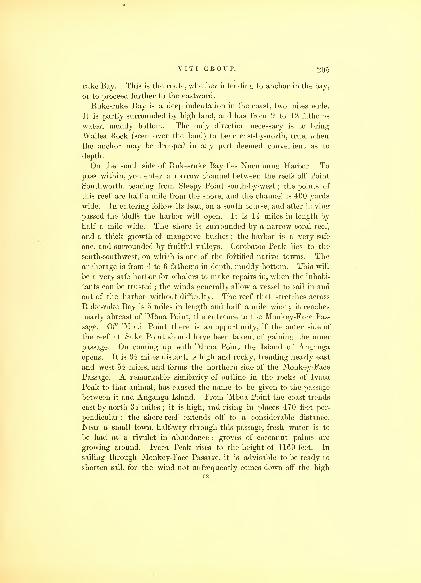
V I T I GROUP. 2(1-3
ruke Bay. This is the route, whether intending to anchor in the bay,
or to proceed further to the eastward.
Ruke-ruke Bay is a deep indentation in the coast, two miles wide.
It is partly surrounded by high land, and has from 9 to 12 fathoms
water, muddy bottom. The only direction necessary is to bring
Wailea Rock (seen over the land) to bear east-by-north, true, when
the anchor may be dropped in any part deemed convenient as to
depth.
On the south side of Ruke-ruke Bay lies Nucumung Harbor. Topass within, you enter a narrow channel between the reefs off Point
Southworth, bearing from Sleepy Point south-by-west ; the points of
this reef are half a mile from the shore, and the channel is 400 yards
wide. In entering follow its lead, on a south course, and after having
passed the bluffs the harbor will open. It is lk miles in length by
half a mile wide. The shore is surrounded by a narrow coral reef,
and a thick growth of mangrove bushes ; the harbor is a very safe
one, and surrounded by fruitful valleys. Corobatoo Peak lies to the
south-southwest, on which is one of the fortified native towns. The
anchorage is from 4 to 6 fathoms in depth, muddy bottom. This will
be a very safe harbor for whalers to make repairs in, when the inhabi-
tants can be trusted ; the winds generally allow a vessel to sail in and
out of the harbor without difficulty. The reef that stretches across
Ruke-ruke Bay is 5 miles in length and half a mile wide ; it reaches
nearly abreast of 'Mbua Point, the entrance to the Monkey-Face Pas-
sage. Off 'Mbua Point there is an opportunity, if the outer side of
the reef at Suke Point should have been taken, of gaining the inner
passage. On coming up with 'Mbua Point the Island of Anganga
opens. It is oi miles distant, is high and rocky, trending nearly east
and west 51 miles, and forms the northern side of the Monkey-Face
Passage. A remarkable similarity of outline in the rocks of Ivaca
Peak to that animal, has caused the name to be given to the passage
between it and Anganga Island. From 'Mbua Point the coast trends
east-by-north 3i miles; it is high, and rising in places 470 feet per-
pendicular : the shore-reef extends off to a considerable distance.
Near a small town, half-way through this passage, fresh water is to
be had at a rivulet in abundance : groves of cocoanut palms are
growing around. Ivaca Peak rises to the height of 11 GO feet. In
sailing through Monkey-Face Passage, it is advisable to be ready to
shorten sail, for the wind not unfrequently comes down off the high
52

20G HYDROGRAPHY.
land in heavy squalls. The best direction is to keep the reef of the
south shore close aboard, and as soon as the Island of Naloa bears
east, if the wind will permit, steer directly for it; 3 011 will then pass
in mid channel between the reefs, and avoid those that lay off the
Anganga side, which extend nearly half-way across the passage.
After passing Marquis Point, the coast again trends to the southeast
2 miles to Dillon's Rock, which forms the western point of Wailea
Bay ; its east point being formed by Leonidas Island. Between the
Monkey-Face Passage and Wailea Bay the shore-reef, together with a
small coral reef, extends to the east, 14 miles, by one-third of a mile
wide, and in order to reach Wailea Bay, it is necessary to make a
circuit around them. There is a narrow passage on the west, but
unless the wind is fair, it would not be advisable to attempt it with a
vessel. Wailea Bay is of an oval shape ; its shores are low and
muddy, and thickly set with mangrove bushes ; the water in the bay
is not deeper than 6 fathoms, and a stream of fresh water empties at
its head. Leonidas Island is three-fourths of a mile in circuit, and
rocky. There are one or two towns around the bay, on Wailea and
Dillon Bluffs : these appear to be well fortified, and are secure posi-
tions from native attack.
The coast from Leonidas Island to Veraki Point makes a consi-
derable bend to the southward, forming Naloa Bay ; the distance
between them is 9 i miles. The shore is quite low for some distance
back, and the mangroves prevail as elsewhere. A mud-flat extends
to the distance of a mile in some places from the shore, and the usual
shore-reef of coral is met with. In the Bay of Naloa there are five
islands,—Naloa, Tavea, Vendrala, Anutunga, and Rock Islet. The
first three are high and rocky, though covered with vegetation ; the
last two are low : all are surrounded with a coral reef, and are in-
habited. Tavea has an extensive and populous town on it, and so
has Naloa, but on the rest there are comparatively few natives. At
Orana Point there is a small stream of fresh water, which empties
into the bay. A boat may enter it at high water ; it leads to the
town of Votua, which lies about a mile from the shore, but the stream
has a very serpentine course, making the distance nearly 4 miles.
Supplies may be had here, and the natives are friendly. This part
of the island has a very fruitful soil, but owing to the civil wars that
are constantly carried on, little attention can be paid to cultivation
or the raising of any kind of provisions. There is anchorage through-

V I T I GROUP. 207
out the bay, but the best berth is between the Islands of Vendrala,
Naloa, and Tavea ; the depth of water is from 8 to 10 fathoms,
muddy bottom. There is a small coral patch between the three
islands nearest to Vendrala; but it can be readily avoided in day-
light.
To the north of the islands in Naloa Bay are several reefs, with
islands on them, extending in a line to the eastward of Anganga, and
forming the northern side of the channel, along the coast of Vanua
Leva, viz. : Nakumbutha, Vatungili, Vatou, Loangi, Brackenridge,
Nuvera, and Nambiti. Connected with these are reefs extending
several miles from the islands to the northward, and from one to two
miles in width. There are narrow passages between the reefs, but no
anchorage, and little use can be made of them, as they lead only to
the area which lies to the north, and bounded at the distance of 18
miles by the Great Sea-Keef. This space is very much obstructed
with sunken coral patches, so as to make it extremely dangerous for
any vessel to venture through it, unless favored by the weather, and
keeping good lookouts aloft. In the Great Sea-Reef opposite to An-
ganga, there are two openings, which are shown on the chart. Na-
kumbutha and Vatungili, are both rocky and small ; while Vatou,
Nuvera, Nambiti, Loangi, and Brackenridge Islands are low, and
covered with mangrove bushes. The first three are in length from
li to 4 miles, and not over half a mile wide; the two latter are
quite small, not over one mile in length. Between Vatou and
Vatungili, and Naloa and Vendrala, the space is 2 miles wide, but
there are four coral reefs, which almost fill it up ; near to Vatou
there is a good anchorage in 11 to 15 fathoms water. The bottom is
very tenacious, composed of mud and sand. A vessel desirous of
taking this rpute may thread her way through the reefs, but it is not
advisable to do so. Veraki Point is the eastern point of Naloa Bay,
and its distance from Vatou is 2 miles.
The coast trends to the northeast-by-east, 5 miles to Nuthila Point,
which is rocky and projects beyond the line of coast ; here the low
land terminates. The extensive mud-flat still continues to make out
from the shore to the channel. There are many small streams
which empty into the sea along the coast; basaltic columns are
visible in the distance, and the land rises towards the centre of the
island in several lofty peaks. Among the most remarkable of these
are the Mitre and Two Sisters, which attain the elevation of 2300

208 HYDROGRAPHY.
feet. Off the west end of Nuvera and in a line with Nuthila Point
there is a coral patch, which should deter vessels from passing too
close to the north side of the channel. It lies three-fourths of a mile
from Nuvera Island. On either side of it there is a passage, but the
south side should be preferred.
Oandrou Islet lies in midchannel ; it is half a mile in circumfe-
rence, and has a coral reef surrounding it. It is a good mark for
sailing up and down the channel, and by steering for it a vessel will
keep in the deepest water. The soundings vary from 6 to 9 fathoms.
In beating in this part of the channel, a vessel should not go nearer
to the main shore than 4 fathoms.
From Nuthila Point to Winn's Point the distance is 4 miles north-
east, between which the coast forms Murderer's Bay. It is useless
for vessels, the mud-flat extending half way into the main channel.
The town of Navendarra is situated at the bottom of this bay. Winn's
Point is rocky and elevated. 2 miles northwest from it lies Cocoanut
Islet, covered with cocoanut palms. This islet is 6 miles from Oandrou,
and bears from it northeast. From Winn's Point to Ravu-ravu Island
is 4 miles in a direct line northeast, but it is necessary to deviate from
it to pass the shoal off Nuvera, before spoken of. The coast here again
rises in hills from the shore : and instead of the mud-bank, a coral
reef bounds the shore, which begins about a mile east of Winn's Point,
and 3 miles from Vana Point. Off Vana Point coral patches again
appear in the channel and confine it to narrow limits ; these approach
within half a mile of Ravu-ravu Point. The Yande Reef lies directly
off Ravu-ravu Point : its outline has many indentations, and it is par-
ticularly irregular on the land side. The principal indentation is
opposite Ravu-ravu Island. This makes it necessary to pass close to
that island. When up with Ravu-ravu Island, that of Muthuata will
be visible, bearing east-by-north, distant 7 miles, and also the small
island of Nucumbati, due east4i miles.
Ravu-ravu Island is situated off the tongue of land of the same
name; it is li miles long and three-fourths wide. It rises into
two conspicuous peaks, and forms the western side of Navutu Har-
bor. This harbor is quite small, much of its space being taken up
by the coral reef. The water is shallow, from 3 to 6 fathoms. The
anchorage is safe, and at the head of the harbor there is a small
stream of fresh water. The town of Navutu lies on the east side,
where the land is somewhat lower. The coast from Navutu trends

VITI GROUP. 200
due east oh miles, to Nucumbati Bay, where it makes an inden-
tation around the Island of Nucumbati. In the bay the water
is from 4 to 5 fathoms deep. The distance from point to point is
2 miles, and the indentation three-fourths of a mile deep. On either
side of Nucumbati the channel is good, though narrow. Two coral
patches lie between the island and the head of the bay. Nucumbati
Island is one-third of a mile long, north and south, by 400 yards wide;
the north end of it forms a high knoll, while the south is low and
covered with cocoanut palms. The town was formerly populous, but
it was deserted when we visited the island. The Bouri is one of the
largest in the group, which generally betokens the consequence or rank
the place has held.
In sailing to the east from Ravu-ravu Point, steer directly for the
western point of Nucumbati Bay ; when within a mile of it, haul up
for the point of the island, and after passing it, then direct for Mu-
thuata Island;by keeping Muthuata open a little on the port bow,
you will pass to the southward of all the coral patches, in from 9 to
10 fathoms water. The distance from Nucumbati to Muthuata
Island is 2i miles, and forms Muthuata Harbor. Anywhere within
this space is good anchorage, but the most convenient berth is off
the town of Muthuata, both for obtaining supplies and being more pro-
tected from the north winds by the Island of Muthuata. The Island
of Muthuata is la miles long, by half a mile wide, rising in two peaks
to the altitude of 1005 feet. It has some fine timber growing on it,
but very few inhabitants. It is one of the principal burying-places
of the natives, and consequently is tabooed to them. Muthuata is
one of the principal towns of Vanua Levu, and the residence of the
king, Tui Muthuata. With him and his chiefs all arrangements are
made for supplies, fishing for the biche de mer, and trading for tor-
toise-shell ; and it is well to effect a good understanding with these
chiefs by presents in the first instance, as it will prevent muchtrouble and difficulty afterwards. The channel between the island
and the town is a mile wide ; the depth of water varies from 6 to 9
fathoms. To the north are several extensive coral reefs, among them
the Henrietta and Rotu Reefs. The first is 5z miles long, by 11 wide;
it trends nearly north and south.
The Rotu Reef forms a crescent, 4 miles in length;
part of it
lies 1 1 miles north of the Island of Muthuata; between it and the Rotu
Reef there is good anchorage, the depth of water ranging from 7
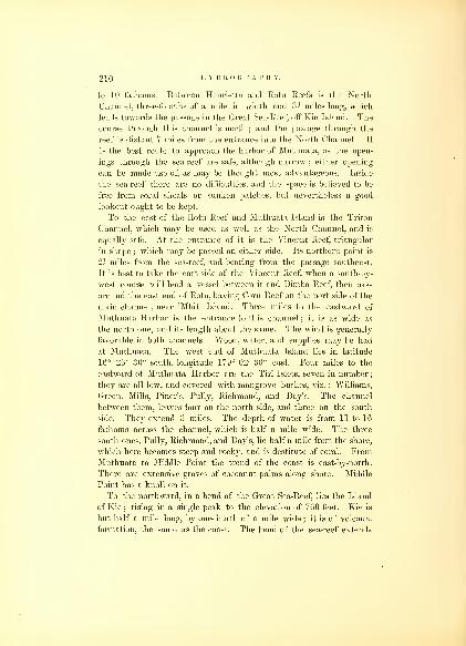
210 HYDROGRAPHY.
to 10 fathoms. Between Henrietta and Rotn Reefs is the North
Channel, three-fourths of a mile in width and 3 2 miles long, which
leads towards the passage in the Great Sea- Reef, off Kie Island. The
course through this channel is north ; and the passage through the
reef is distant 7 miles from the entrance into the North Channel. It
is the best route to approach the harbor of Muthuata, as the open-
ings through the sea-reef are safe, although narrow ; either opening
can be made use of, as may be thought most advantageous. Inside
the sea-reef there are no difficulties, and the space is believed to be
free from coral shoals or sunken patches, but nevertheless a good
lookout ought to be kept.
To the east of the Rotu Reef and Muthuata Island is the Triton
Channel, Avhich may be used as well as the North Channel, and is
equally safe. At the entrance of it is the Vincent Reef, triangular
in shape ; which may be passed on either side. Its northern point is
2h miles from the sea-reef, and bearing from the passage southeast.
It is best to take the east side of the Vincent Reef, when a south-by-
west course will lead a vessel between it and Dimba Reef, then pass
around the east end of Rotu, having Coru Reef on the port side of the
main channel, near 'Mbiti Island. Three miles to the eastward of
Muthuata Harbor is the entrance to this channel ; it is as wide as
the north one, and its length about the same. The wind is generally
favorable in both channels. Wood, water, and supplies may be had
at Muthuata. The west end of Muthuata Island lies in latitude
1G° 26' 30" south, longitude 179° 02' 30" east. Four miles to the
eastward of Muthuata Harbor are the Tiri Islets, seven in number
;
they are all low, and covered with mangrove bushes, viz. : Williams,
Green, Mills, Piner's, Pully, Richmond, and Day's. The channel
between them, leaves four on the north side, and three on the south
side. They extend 3 miles. The depth of water is from 11 to 16
fathoms across the channel, which is half a mile wide. The three
south ones, Pully, Richmond, and Day's, lie half a mile from the shore,
which here becomes steep and rocky, and is destitute of coral. FromMuthuata to Middle Point the trend of the coast is east-by-north.
There are extensive groves of cocoanut palms along shore. Middle
Point has a knoll on it.
To the northward, in a bend of the Great Sea-Reef, lies the Island
of Kie;rising in a single peak to the elevation of 760 feet. Kie is
but half a mile long, by one-fourth of a mile wide ; it is of volcanic
formation, the same as the coast. The bend of the sea-reef extends

V I T I GROUP. 211
3 miles further north, and the whole distance of the projection is 6
miles. Kie is situated in the middle of this bight, and is free from
coral. There is a good passage through the reef, 2 miles west from
Kie; and two others hearing southwest, half a mile from the first.
These three are not as easily passed through as one 2 miles more to the
south and west : with the prevailing wind a ship may lay her course
through it, and not be subjected to make a tack, which it is desi-
rable to avoid, as a misstays in these narrow passages might bring
about disaster. Kie Island is 12 miles north of that of Muthuata;
its latitude is 1G° 14' 20" south, longitude 179° 04' 30" east, From
the extreme northern bend of the Great Sea-Reef, off Kie, to the west
point of the Mali Passage, is 11 miles south G0° east. The reef itself
makes a sharp turn in this distance to the east ; there is no opening
in any part of it ; the sea breaks constantly upon it, and with vio-
lence. The reef on the west side of the Mali Passage is 4? miles in
length, while that on the east is but 2i miles. The passage gradually
narrows from its outer to its inner end, where it is half a mile wide.
The wind at all times does not permit a vessel to sail through it,
and frequently it becomes necessary to make several tacks ; this is
sometimes attended with danger. When the tide is flood, it sets with
some velocity on the lee reef, and care should be taken to avoid
being subjected to it. The ebb tide is the most suitable to pass out,
for then much assistance will be had in working ship on the weather
side of the passage, and in gaining an offing. There is no anchorage;
the course through the passage is north 30° west, or south 30° east,
The weather reef should be hugged close. The direction for entering
the passage is, to bring the west end of Mali Island open with the
line of the reef on the east side, then haul up immediately for it ; and
after having passed through, a vessel may anchor in Mali Roads, in
13 fathoms, or pass on to the westward through Mali Bay, steering
south 30° west for Sac Point, which is 5s miles distant. Having run
3 miles on this course, and opened the south side of Mali Island,
Middle Reef will be passed, when keep off to west-by-south for the
centre of the Tiri Islet, a distance of 7 miles, which is free from any
shoals, except that running off from Gibson's Island to the westward.
This extends one mile, but it is not in the way of the direct course
pointed out. The channel between Middle Point and Gibson's is one-
third of a mile wide.
The depth close to Middle Point is 8 fathoms, so that a vessel maypass very near the shore without any apprehensions.

212 HYDROGRAPHY.
The coast from Sac Point eastward is again low, and lined with
mangrove bushes, trending nearly east-by-north 5? miles. It is then
terminated by another rivulet, which is opposite to Mali Harbor,
and suitable to procure water at. Between the Island of Mali and
the main land is Sarah's Bosom ; it extends the whole length of Mali
Island, and forms a secure harbor. There is a good passage to the
east between Mali and the large island, a mile wide, but the water is
not over 6 to 7 fathoms deep. The main island at the eastern part
of Sarah's Bosom is again low, and studded with mangroves ; three
small streams of water discharge into it.
Mali Island is 4 miles in length, by three-fourths wide. It has two
remarkable sugar-loaf-shaped peaks, and low land between them ; the
western is the highest, its altitude being 350 feet. These are easily
distinguishable when approaching the passage. The channel to the
east runs on the north side of the island, the depth of water in it being
from 8 to 14 fathoms ; it is 1^ miles wide. At the east end of Mali
is Malitu Bay, a good anchorage for vessels engaged in the biche de
mer fishery, as it is near the reefs on which they are taken. The north-
ern side of Mali has some patches of coral at its points, but they ex-
tend but a short distance. From the east end of Mali to Sau-sau
Islet is 5 miles, course north 50° east. Sau-sau Islet is a small sandy
islet, situated on a projection of the inner part of the sea-reef. The
ship-channel passes between Sau-sau Islet and Point Lloyd, distant
from it half a mile. It is quite free of dangers in a line without
Point Roberts and Point Lloyd, and the water from 10 to 12 fathoms
deep. The coast beyond Point Lloyd has many indentations or small
bays as far as the 'Ndrundrua Islands. The headlands bear north
70° east from each other. These bays are small, and do not offer
more protection than the open channel, the depth of water in which
does not exceed 18 fathoms. Off Point Fenno there is a patch of
coral, but this lies near the shore. The shore is well covered with
wood, and water may be procured at several places. Point Graves
has a small reef projecting from it, and within it an islet, which is
connected by the reef with the point. The point is remarkable,
rising up to a considerable elevation in a conical peak ; it is the
sailing-mark to enter the Sau-sau Passage. The course through
the passage is south 32° east, or bring Hale's Peak, in the
interior of the island, on with Point Graves. If coming from the
eastward, it would be advisable, after making the eastern point
VITI GROUP. 213
of the reef, to haul in at once for Point Graves, and when you
have run li miles, to keep off and steer for the bluff on Fenno's
Point, in order to clear a sunken coral patch, that lies at the distance
of 2 miles from Point Graves on the eastern side of the passage.
The Sau-sau Passage at its entrance is three-fourths of a mile wide;
it gradually opens out as it approaches the coast to 2 miles wide
;
there is therefore plenty of room to work ship in, and I am of the
opinion it is one of the safest and best passages for vessels both to
enter and depart from. The wind that generally prevails enables a
vessel to sail free through it both ways ; it has in this respect the
advantage over the Mali Passage, and no lee reef to cause anxiety.
Blimt's Point is a projecting tongue of land, 2 miles long ; there is
a high bluff at its outer end, where it is a mile broad. Within a mile
of it, bearing northwest, is Henderson's Islet, small and low, surrounded
by a coral reef. Between Point Graves and Blunt's Point is a bay, li
miles deep, and the same in width ; it has from 7 to 8 fathoms water in
it. Both wood and water may be procured ; but there are no villages.
The coast from Blunt's Point to Point Bolin has two extensive bays,
but they are useless, being filled with coral. The islands of 'Ndrun-
drua or Druau Island, Cabeva, and Banbury, lie off these bays, and
afford every security for anchorage that could be desired. The first is
the largest, two miles in length, north and south, and a mile wide ; it
rises in a dome shape; on its northwest point it has a very remark-
able peak. Cabeva is a mile long and one-third in width, and Han-
bury is much smaller. Druau has a clear channel around it, which
is the case with Hanbury, but Cabeva is situated on the sea-reef.
These three islands enclose a triangular space, which forms an ex-
cellent harbor, and is easy of access. The depth of water is from 10
to 14 fathoms, with good holding-ground, and is secure from all winds.
The harbor may indeed be said to extend as far as Blunt's Point.
On the sea-reef, a mile to the north of Druau Island, is the MonkRock. It is a basaltic column, 80 feet in height, and very conspi-
cuous in sailing down the coast : its latitude is 10° 10' 53" south,
longitude 179° 35' 50" east. To the northwest of the island of
Cabeva one mile, are the Sail Rocks. They are smaller than the
Monk Rock, in appearance more conical, and can also be seen off the
coast 8 or 10 miles distant.
Point Bolin lies one mile east of Druau Island. To the eastward,
the coast trends nearly due east to Tibethe Point, 5 miles, but the

214 HYDROGRAPHY.
channel is very much obstructed by innumerable coral patches, and
the sea-reef approaches within a few hundred yards of Tibethe Point.
This is the end of the channel along the north shore of the great
island of Vanua Levu for large vessels; smaller ones may pass through
the break in the reef into Tibethe Harbor. The sea side of the
Great Sea-Reef, between the Mali and Sau-sau Passages, trends north
53° east, 12 miles ; from thence, a distance of 15 miles, it runs nearly
due east to the Aramula Passage. In the latter space the reef is
much more irregular in its outline, and not so broad, as it is between
Mali and Sau-sau.
The Aramula Passage leads from sea into Tilingitha Roads and
Tibethe Harbor. Its course is south half east, and its length 4 miles,
and from one-half to a mile wide. At the head of Tilingitha Harbor
is Bukalau Island, which is low, a mile in length, lying within the
shore-reef; near its eastern end a fine rivulet, called Endregatta,
empties. At the mouth of this rivulet is a considerable town of the
same name. Tibethe Harbor extends from Tibethe Point to Tilin-
githa Islet, and joins Tilingitha Roads. It has many coral patches
in it, but still sufficient room for small vessels ; the depth of water
is from 3 to 8 fathoms, and good holding-ground. Large vessels
should not attempt to go farther in than Tilingitha Roads, where
they may anchor in 7 to 9 fathoms off Tilingitha Islet.
Tilingitha Islet is small and low, in shape a triangle, with its
base to the eastward. It is covered by a dense vegetation. The
length of either of its three sides does not exceed half a mile. It lies
within the reef, and is a mile from the shore ; there is no passage
to the eastward for a large vessel. Vanua Levu again becomes
low, is bordered with mangrove bushes, but rises a short distance
inland in high peaks, which are conspicuous a long distance at sea.
Bush Peak bears south half east off the entrance of the Aramula
Passage. Water, wood, and provisions may be had here ; the
natives are civil and ready to exchange their products. The coast
from Endregatta trends to the northward of east for three miles to
Bunabugea Point, the boundary of Vicuna Harbor on the west
;
the shore-reef here extends off and unites with the sea-reef, forming
a wide flat, which is nearly dry at low water. East from Tilingitha
Roads, there is an extensive bight, but no greater security for a
ship to anchor in it, than that which is to be found in the road. Aboat may use this bight to facilitate her route to the eastward, being
V I T I GROUP. 2 1
5
able to pass over the narrow part of the reef into the Vicuna Passage
at high water.
The entrance to Vicuna Harbor through Vicuna Passage is very
narrow, so much so as to make it dangerous for even a small vessel
to attempt it, unless the water is verj smooth. It lies between Tilin-
githa Reef and that of Vicuna, and runs due south. After having
entered the passage, it widens, and a course steered for Tibethe
Point will carry a vessel through. At the distance of 2 miles, the
channel between Severacota Point and Vicuna Islet will be open;
steer through it south-southeast, and anchor under Vicuna Islet in
from G to 9 fathoms water.
Vicuna is low and marshy, situated on the southwest corner of
the Vicuna Reef; it has a large town on it, the natives of which are
quite friendly. The harbor extends into a deep bay to the west of
Ritithicumbue Point ; it has a shore coral reef around it, which
extends to Issingalossa Point, off which there is another coral
patch. The channel between Issingalossa Point and Vicuna Reef is a
mile wide, and the water increases to the depth of 12 fathoms, where
it joins Nucussa Harbor. Nucussa Point lies 2 miles to the eastward
of Issingalossa Point. Haycock Islet lies off Nucussa Point, where
the passage turns short to the north-by-west, and is a mile long, but
not over one-third of a mile in its narrowest part. It is a conve-
nient and safe entrance, and may be known by the remarkable
peak resembling a nipple which lies inland ; when this bears
south 50° east, and within a mile of the reef, the entrance will be
open, and Nucussa Point distinctly visible. To the east of this
entrance there are two deep indentations in the reef, which may be
termed false harbors : they must be carefully looked to, as they are
both quite small; the true Nucussa Passage is sufficiently distinguished
from these, as it is funnel-shaped, the reverse of these. The reef to
the westward of the Nucussa Passage extends to seaward beyond the
eastern side, and trends more to the westward;by this also it may be
known. If Vicuna and Haycock Islets can be seen, there is no need
of further directions. The water in Nucussa Harbor is deeper than
it is in Vicuna. The best anchorage is between Haycock Islet and
Issingalossa Point. If farther security be desired, a vessel may pass
into Vicuna Harbor. These two harbors are easily entered, but they
are extremely difficult to depart from. The Vicuna Passage is the most
difficult to pass out of ; it is only fit for very small vessels, boats, or

21G HYDROGRAPHY.
canoes. The disadvantage of the Harbor of Nucussa is that a vessel
is obliged to beat through a narrow passage. I would therefore re-
commend, if a vessel should seek shelter here, that she should wait
for the land-breeze, or a favorable slant of wind, before attempting to
get to sea.
The sea-reef to the eastward of the Nucussa and Vicuna Passage
trends north 70° east, 10 miles, as far as Unda Point, the most
northern point of the island. The sea-reef becomes united to the
shore-reef, and is about a mile wide ; there are but two openings in it,
but they are narrow and only afford a passage for a boat to the land.
The coast is much more irregular in its outline, though the trending
from point to point is the same. There are several towns on this part
of the coast, and the whole has the appearance of being well inhabited.
Unda Point is a long low point, with a knoll at its end ; the reef ex-
tends 3 miles to the northeast of it. After turning around this reef
off Unda Point the great Bay of Natava is open. The coast nowtrends south 70° west for 18 miles, and forming Natava Bay. This bay
is 15 miles deep, by 7 miles wide ; it has no harbors ; the shore-reef
is continuous around it. From the west side there are many pro-
jecting reefs, and the water is very deep in most parts of it ; the land
around is high, and there are many volcanic peaks perceived jutting
up in the interior. There are many small villages on the west side;
but the principal town lies at the foot of Natava Peak, on the east
side ; there is nothing to induce the visit of a vessel.
Unda Point is in latitude 16° 7' 30" south, and longitude 179° 55'
29" west.
RAMBE ISLAND.
Rambe Island lies off Vava Point, the eastern point of Natava
Bay, from which it is separated 3 miles ; the channel between is prac-
ticable, although the coral patches project from both shores ; it is 4
miles in length. Rambe Island is of a triangular shape ; its longest
side trending northeast and southwest, and the other two north and
south and east and west. It is of volcanic formation, and rises to a
considerable height in peaks, the eastern ones having flat tops. It
contains but few inhabitants. From its northeast point the coral reef
projects to the northeast for II miles, and forms, as is often the case

V I T I GROUP. 217
with reefs, a considerable curve to the eastward. It is necessary
when vessels are passing it to give it a good berth. Rambe has but
little space susceptible of cultivation.
KEA ISLAND.
The shore of Vanua Levu from Vava Point trends south-by-west 10
miles, to Rocky Point. The Island of Kea lies in front of Mataponi
Bay; it is 9 miles in circumference, has a high ridge, which runs
through its centre northeast and southwest, and affords several good
harbors,—a very safe one, Port Safety, at its northern end. The sea
between it and Rambe is very much obstructed by coral patches ; as
these extend from the Rambe side, it is necessary to avoid approach-
ing that island, and in passing through between Rambe and Vanua
Levu a course should be steered for Kea Island, which will lead clear
of the patches and foul ground ; no attempt should be made to haul
out into the Straits of Somu-somu until well up with Kea Island, whenthese dangerous shoals will be passed.
Kea Island forms the protection to Mataponi Bay ; it lies directly
before its mouth. This bay is 3 miles in depth by 2i wide : its shape
is that of a large segment. The west point of Kea terminates in a long
and narrow tongue, which points directly into this bay ; it is three-
quarters of a mile distant from Mela-mela Point, the south point of
Mataponi Bay. On the north and west side of the bay, the village of
Mataponi is situated, just within Rocky Point, the north point of the
bay. The passage between Kea Island and Vanua Levu is safe for
vessels. There are two small reefs lying to the eastward of Mela-mela
Point, 2 miles distant from it, which may be avoided by keeping near
either shore ; the best passage is on the Kea side. The anchorage in
Mataponi Bay is in deep water, from 21 to 30 fathoms, blue mudbottom ; that abreast of the village of Mataponi is to be preferred
;
but the bay affords little to induce a vessel to enter, as it is sur-
rounded by high land, and has but the one village. The natives are
few in number, and supplies in consequence scarce and difficult to be
obtained.
Port Safety lies at the northeast end of Kea Island ; it is a deep in-
dentation, formed by a neck of land 2 miles in length by half a mile
in width, which bounds it on its northern side, leaving a bay, 14
miles in depth, and nearly three-quarters of a mile in width. The55

2 IS HYDROGRAPHY.
southern part of it has the shape of a basin. The eastern point of
this port was named Cook's Point, and the western Point Carter.
Half a mile from Cook's Point to the west is a coral patch, 1500
feet long by 500 wide ; on both sides of it, there is sufficient depth of
water for a vessel of any class. The harbor is very commodious, and
has good holding-ground in 10 to 12 fathoms. The course to be
steered to enter when the bay is open is due south until Point Carter
bears northwest and Cook's Point north-by-east, when you will be in
the centre of the bay. The latitude is 16° 37' 30" south, longitude
179° 58' 30" east, variation 9° 30' easterly. The shores of this bay
are lined with coral, and at the head of it there is a small stream of
water, where a supply may be obtained ; from Point Carter the island
trends off to the west. Port Safety may be recommended as a suitable
harbor for vessels of any size, and may be sought in bad weather, if
such should be encountered in passing through the Straits of Somu-
somu. There is no village on this island, and very few inhabitants.
The coast between Mela-mela and Long Points (the latter is the
eastern point of Vanua Levu), makes a small curve around KukuIslet ; the distance from point to point is 5 miles southeast.
VUNA.
The Island of Vuna is one of the most fertile of the group, and the
seat of the second political power. It is 25 miles in length, trending
southwest and northeast, and 8 miles in width. It rises to a central
ridge, which runs through its whole length, and whose greatest altitude
was found to be 2050 feet. The island is most of the time capped
with clouds, particularly during a strong easterly wind. It is separated
from the larger island of Vanua Levu, by the Strait of Somu-somu.
On the southeast side of Vuna there are no harbors. The shore
is destitute of coral ; but on the northeast side, bounding on Tasman's
Strait, the coral reefs again appear, and form Tubou Harbor, a most
excellent anchorage, on a sandy bottom, in 10 fathoms water, admi-
rably adapted for a port of refuge in case of necessity, when passing
through Tasman's Strait. It offers a safe harbor from the prevailing
wind, and supplies may be had there. No particular directions are
necessary for entering it, as the reef will point out clearly the pas-
sages and openings.

V I T I GROUP. 219
If a vessel wishes to anchor at Somu-somu, the principal town of
the Island of Vuna, it is necessary, if favored by the tide, and com-
ing from the northward, to close with the Vuna shore to the north
of Corolib Island, which is free of coral. The best berth to anchor
in is directly off the town of Somu-somu, with the Island of Corolib
bearing west, 1* miles distant: there the anchor may be dropped in
12 fathoms water.
If desirous of proceeding to the south from Somu-somu, an inside
passage between Corolib and the land may be taken, passing the sand-
banks to the south-southeast of that island (which are visible at low
water) and the Vuna shore. Owing to the eddy winds under the lee
of Vuna, this passage is sometimes very tedious, and therefore it is
better to seek at once the middle of the strait, as less subject to
calms and eddy winds.
If bound to the northward, the ebb tide will carry you clear of the
island, where the regular easterly trade will be found, and enable a
vessel to stand to windward of the Island of Rambe and Unda Point.
It is advisable to keep, as near as possible, the mid-channel between
Rambe and the Ringgold Isles, which is free from coral reefs or
obstruction.
Somu-somu offers refreshments of every kind, which are purchased
from the king, who is friendly to foreigners. Two missionaries reside
there, who obligingly afford all information that may be necessary.
STRAIT OF SOMU-SOMU.
The Strait of Somu-somu separates the large island of Vanua Levu
from the Island of Vuna and the Ringgold Isles. It is 10 miles in
length, by 5 wide at the narrowest part. Opposite to the town of
Somu-somu, the strait is much obstructed with shoals>surrounding
Corolib or Goat Island, and the great reef which extends from the
Vanua Levu shore a long distance into the strait. The tides are
rapid ; the flood runs to the southward, while the ebb sets strong to
the northward. This strait is perfectly practicable for vessels, but
requires precaution in navigating. When bound to the southward,
the middle of the strait should be kept, until the Island of Corolib
bears east-northeast ; the shoals near it will then be passed. These
shoals extend nearly a mile to the west of the Island of Corolib : in
some places there is not more than 10 feet water on them. After

220 HYDROGRAPHY.
passing Corolib, keep a mid-channel course, until to the southward
of Tokanova Point; this clears Tokanova Reef, which projects nearly
due east from that point. When clear of it, the Vuna side ought not
to be closed with, as a vessel may be becalmed for a long time under
the lee of the island. The shore, however, is bold, and may be closely
approached. At this part of the Island of Vuna there is only a shore
coral reef, of little width.
KAMIA, LAUTHALA, AND MATANGI.
These three islands lie within the same reef, to the east of
Vuna; they will therefore be described together. Kamia and Lau-
thala are very lofty, rising nearly to the height of Vuna ; their
surfaces are much more broken and less susceptible of cultivation.
The length of Kamia lies east and west ; it is much the largest, being
6 miles long, by 4 wide. Lauthala lies with its length across that of
Kamia, and is but 3 miles long by wide;they are separated by a
channel half a mile wide, which is free from dangers, with deep water.
The Island of Matangi is but a mile and a half in circumference;
it rises to a considerable elevation, though in consequence of its
nearness to Kamia it appears low, and cannot be distinguished until
well up with it. Matangi is surrounded by a shore-reef. A mile to
the eastward of it, the Great Sea-Reef which surrounds these islands
begins, trending first east and then south, around Lauthala, whence it
turns west, parallel with the Island of Kamia, until it reaches its
southwest point, where it ends in broken patches. The whole length
is 18 miles; it has no breaks in it. The west end of Kamia forms the
eastern side of Tasman's Strait. It has two bays, formed by indenta-
tions at its western end, but they are filled with coral ; the southern
one may be known by the Pig Islets. Neither are places for anchor-
ing in, particularly when better and more suitable harbors are so
near at hand. The principal harbor is under Matangi, between it and
Kamia. In the approach towards Matangi there are several patches
of coral, which are visible;they may be passed without danger, by
keeping a good lookout;they extend in a curve round to the north-
west from the island into Tasman's Strait.

V I T I GROUP. 221
TASMAN'S STRAIT.
Tasman's Strait is 4 miles in length, by 1 mile wide ; it separates
the Island of Kamia from that of Vuna, and is much choked up with
coral shoals, several of which are just beneath the surface, on which
the sea does not break. A range of these shoals lies across the
northern entrance, stretching from the eastern point of Vuna around
towards Matangi, which require attention on the part of navigators.
The passages between them are readily perceived, and may be passed
through without difficulty by daylight.
In the narrowest part of this strait the water is deep, and by keep-
ing a good lookout it may be passed through without apprehension.
The winds are frequently light under the lee of Kamia, the high land
causing calms or light eddy winds. When a strong southeast wind
prevails, the wind draws through the strait from that quarter. Tothe northward the water is smooth, the flood-tide sets through to the
south, while the ebb flows strong to the north.
SOUTH COAST OF VANUA LEVU.
Mount Cocoanut is situated on the extreme east end of Vanua
Levu ; it rises to the height of 500 feet. To the westward it appears
somewhat of a sugar-loaf in shape, and is very conspicuous in passing
down the Somu-somu Straits ; from the north it serves as a good
mark to steer by, keeping it a little open on the starboard bow whenin midchannel. The land slopes from Mount Cocoanut to the south-
east, and terminates in Niebee Point, which lies li miles to the east-
ward of the meridian of Mount Cocoanut ; it is low, and beyond it the
Tokanova Reef extends into the Straits of Somu-somu nearly 2 miles.
From Niebee Point to that of Tokanova the course is southwest 3
miles; between them there is a considerable bay, in which are situated
three small islets near the shore. This bay is entirely useless,
the reef running across it east and west, and has no break in it
;
consequently there is no access for vessels. Boats at high water
may pass over the reef, and find a safe and good passage along the
land, secure from the swell of the ocean. The centre one of the islets
which lie on the western side of the bay, II miles from Tokanova
Point, was named Tom's Islet. Tokanova Point is the southern point
5(j

2\i2 HYDROGRAPHY.
of the south side of Vanua Levu. A mile to the westward of it, inside
of the sea-reef, lies Baino Islet ; it is small, but an excellent mark for
vessels to recognize the situation of the point of the reef. Off Toka-
nova the sea-reef trends to the northward and westward for 4 miles,
where there is a break leading into Baino Harbor. This channel is 700
feet wide and 1500 feet in length; beyond it opens out and forms a
capacious harbor, one mile deep by Is miles wide. The course in, is
north-by-east (true) ; steer directly for the bluff of Sharp Point, a small
spur whose projection divides the two indentations of the land. Atthe head of the harbor is the best berth to anchor in, with Rock
Point and Black Island in range bearing southeast, or if desirous of
being nearer the shore, anchor in the eastern bight within Corodowdow
Point. The harbor of Baino is sufficiently large to accommodate
many vessels ; there are a few coral shoals or patches in it, but they
are visible and can be readily avoided. There is a good boat-passage
withinside the reef, both to the eastward and westward. The depth
of water in the entrance is from 15 to 22 fathoms, and within the har-
bor it is from 10 to 20 fathoms. The town of Baino is situated at the
head of the western bight ; it has a number of inhabitants, but they
are savages. Water may be procured from a small streamlet near the
town ; wood also may be had. Baino Harbor lies in latitude 16° 44'
south, longitude 179° 51' east, var. 9° 30' east.
The coast between Baino and Fawn Harbors trends a little to the
north of west 4 miles ; the sea-reef has nearly the same direction.
There is a small islet, called Lavou, situated half-way between Baino
and Fawn Harbors, but there is no passage for vessels within the reef;
boats may pass at high water over the reef, which is about a mile in
width. Fawn Harbor has but little space within ; it is much more
difficult of egress than Baino, in consequence of the direction of its
channel more towards the point from which the wind usually blows,
the entrance being narrow and somewhat curved; the projecting points
of its reef also nearly overlap. It is upwards of a mile deep, and maybe known by the small islet lying on the western side of its reef, called
Tukonreva, covered with cocoanut trees. The course through the
entrance is north half east ; between the outer point of the reefs, it is
not more than 500 feet wide ; as it increases in width, the water
deepens to 28 fathoms, until the first quarter of a mile is passed, whenit shoals to 10 and 12. To enter, steer for the Bourri-house or centre
of the village of Tukonreva, which is situated at the head of the har-

V I T I GROUP. 223
bor. The best anchorage is with the Island of Tukonreva bearing
west. The area is small, and but few vessels can be accommodated.
At the village of Tukonreva, water may be procured from a creek,
which empties into the harbor to the east of the village ; its position
may be known by a beautiful grove of cocoanuts. The villagers are
not to be trusted. Fawn Harbor was so named from the loss of the
brig Fawn ; whilst attempting to beat out of the harbor, she missed
stays, went on shore on the western reef, and was bilged. Although
this harbor is an excellent one for small vessels, yet I would caution
all navigators from entering it, unless their vessels work well, and
would recommend Baino in preference. Fawn Harbor lies in latitude
16° 43' 42" south, longitude 179° 47' 11" east. Besides the Island of
Tukonreva, the situation of this harbor may be known by a conspi-
cuous conical hill, which lies directly in the rear of the village.
From Tukonreva Island to the entrance of Nabouni is 5 miles. Thesea-reef and the island trend nearly due west, and the reef is li
miles wide ; the whole extent of its surface is flat, with here and there
a narrow and intricate channel for boats, but which only can be
passed through at high water. Before reaching Nabouni Bay, about
a mile to the eastward of its entrance, there are two conspicuous black
rocks, by which it may be known ; it is very narrow, and a mile
in length, which makes it very difficult for even a small vessel
to beat out of; the water is deep, and as the land is approached
its width enlarges to a bay, on which lies the town of Nabouni.
Nabouni is one of the largest towns on the south coast, and the
two small islands of Ya and Nabouni lie directly in front of it : on
these the inhabitants build their canoes. Both islands are low and well
wooded, and distant half a mile from the town of Nabouni. On the
west side of the bay is another large town, called Engada, and in front
of it is the small island of Engada, very similar to that of Nabouni ; to
the west a short distance, there is another small sand-island. Bene-
dict's Island and Point form the western termination of the Bay of
Nabouni, which is 3 miles in extent. The land in this vicinity is low
and fruitful, and well covered with groves of cocoanut. To the south
of Benedict's Point, and within the reef lies the small rocky islet of
Rativa, black and square, rising 12 feet above the surface of the reef.
It is a very conspicuous object when sailing along the coast.
The boat-channel from Rativa Isle continues to the Rock Haven
Passage, 2 miles to the westward. The greater part of the sea-reef is

224 HYDROGRAPHY.
bare at low water. This haven will only accommodate small vessels,
the space within being very limited. The sea-reef, from the Rock
Haven, turns towards the shore, and becomes a narrow shore-reef. Topass through the Rock Passage, steer for a small island situated near
the town of Kopee, which bring to bear north half east (true). Thedepth of water in Rock Haven is from 5 to 10 fathoms.
Alelo is the next point to the westward ; it is conspicuous when seen
from the eastward, projecting farthest to the south of any land on the
southeast side ; it bears from Benedict's Point southwest-by-west, dis-
tant 4£ miles, the coast between the two making a considerable bight,
in which is situated the village of Kopee. Between Kopee Village
and Alelo Point is Black Point, and between the latter and Point
Alelo there are four small islets situated on the reef, one near the point.
The next point to the west of Alelo, is Graham's, li miles distant;
between them is a bay, at the head of which is situated the town of
Alelo. The reef passes directly in a line from point to point, and has
an opening through it 50 yards wide for boats, leading to the town;
this opening is well marked by a rock on its west side in shape of a
cone. If any difficulty should be found in recognizing Cone Rock,
Alelo Point is well marked by black rocks situated off it on the edge
of the reefs; it is half a mile to the eastward of the boat-entrance.
Alelo is a large town, and occupies a pleasant situation. The natives
have had but little communication with foreigners, and are not to
be trusted. From Graham's Point the coast trends northwest 2i
miles to the town of Susu, which is situated at the head of a bay,
and then it stretches southwest 2 miles to Hope Isle ; the reef
follows very closely the shore-line, and is about a quarter of a mile
wide. Between Hope Isle and Graham Point there are five small
islets ; boats may pass over the reef between half tide and high
water. The town of Susu is one of the most populous on this coast
;
but there are no conveniences for landing at it. It is surrounded
by cocoanut groves, and the ground under cultivation is extensive.
From Hope Isle to that of Narangi, the trend of the coast is west-
by-south 5i miles ; the land is more elevated than about Nabouni.
The shore-reef within this distance again assumes its original dimen-
sions, extending off abreast of Royes Island, Is miles; it afterwards
gradually nears the shore, until it reaches Narangi, where it again
becomes narrow. There are three breaks in this reef ; the first is li
miles to the west of Hope Isle; it is narrow, for boats only; the second
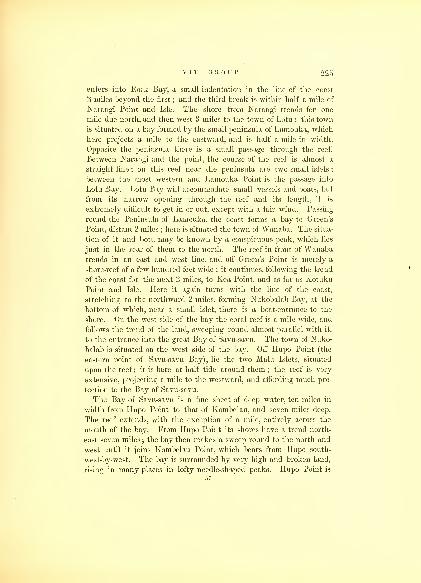
V I T I GROUP. 225
enters into Rock Bay, a small indentation in the line of the coast
2 miles beyond the first ; and the third break is within half a mile of
Narangi Point and Isle. The shore from Narangi trends for one
mile due north, and then west 3 miles to the town of Lotu ; this town
is situated on a bay formed by the small peninsula of Lamouka, which
here projects a mile to the eastward, and is half a mile in width.
Opposite the peninsula there is a small passage through the reef.
Between Narangi and the point, the course of the reef is almost a
straight line ; on this reef near the peninsula are two small islets;
between the most western and Lamouka Point is the passage into
Lotu Bay. Lotu Bay will accommodate small vessels and boats, but
from its narrow opening through the reef and its length, it is
extremely difficult to get in or out, except with a fair wind. Passing
round the Peninsula of Lamouka, the coast forms a bay to Green's
Point, distant 2 miles ; here is situated the town of Wanaba. The situa-
tion of it and Lotu may be known by a conspicuous peak, which lies
just in the rear of them to the north. The reef in front of Wanabatrends in an east and west line, and off Green's Point is merely a
shore-reef of a few hundred feet wide ; it continues, following the trend
of the coast for the next 2 miles, to Kea Point, and as far as Kotuku
Point and Isle. Here it again turns with the line of the coast,
stretching to the northward 2 miles, forming Nukobalab Bay, at the
bottom of which, near a small islet, there is a boat-entrance to the
shore. On the west side of the bay the coral reef is a mile wide, and
follows the trend of the land, sweeping round almost parallel with it,
to the entrance into the great Bay of Savu-savu. The town of Nuko-
balab is situated on the west side of the bay. Off Hupo Point (the
eastern point of Savu-savu Bay), lie the two Main Islets, situated
upon the reef ; it is bare at half tide around them ; the reef is very
extensive, projecting a mile to the westward, and affording much pro-
tection to the Bay of Savu-savu.
The Bay of Savu-savu is a fine sheet of deep water, ten miles in
width from Hupo Point to that of Kombelau, and seven miles deep.
The reef extends, with the exception of a mile, entirely across the
mouth of the bay. From Hupo Point its shores have a trend north-
east seven miles ; the bay then makes a sweep round to the north and
west until it joins Kombelau Point, which bears from Hupo south-
west-by-west. The bay is surrounded by very high and broken land,
rising in many places in lofty needle-shaped peaks. Hupo Point is
57

220 HYDROGRAPHY.
the lowest land in the neighhorhood. The reef crosses the mouth
of the bay, with a trend more westerly : the entrance is a mile wide,
and three miles distant from Hupo Point : to the west there are seve-
ral coral patches, and two or three openings through the reef near to
Kombelau Point, but they cannot be recommended for vessels : if
entered, many intricacies will be found within.
Three miles to the northeast from the entrance is the inlet of
Wailea ; a considerable stream of water flows through it into the bay.
The hot springs of Waicama are situated about a mile from the bay up
this inlet. The anchorage in the inlet is not a good one ; the water
is deep ; and much exposed to the westerly winds. There are a few
good berths for vessels, and by mooring head and stern far up it,
protection may be had from all winds.
Around the Bay of Savu-savu are several towns, but there is little
to be obtained from thein. The character of the natives does not
stand high, and it is necessary to be guarded in having communica-
tion with them. The town of Savu-savu is situated about a mile
inland from the hot springs ; the natives belonging to it constantly
visit the springs for the purpose of cooking their food. Water and
provisions may be obtained at Wailea in plenty ; the natives furnish
the usual products of the islands, for which cotton cloths and hard-
ware are exchanged.
The land near Kombelau Point rises precipitately in hills from the
sea-shore to a considerable elevation. The shores are generally fringed
with narrow coral reefs;
beyond these are large outlying reefs,
some of which occupy a large area, and are partially bare at low
water. The two that are most remarkable are the Sake and To-
kelau Reefs ; the one covers the Point of Kombelau on the east,
while the other projects off from its point in a south-by-west di-
rection. The former is 3 miles in length by I2 in width, and the
latter 51 miles in length by 2 miles at its greatest breadth. Off
Kombelau Point lie the islets of Moro and Rawaike on the west, and
Makatu on the east, each surrounded by coral. There is a snug har-
bor for boats or small vessels within these islets ; it is about a mile
in length, and an eighth of a mile wide ; the depth of the water is
from 5 to 19 fathoms, decreasing from its mouth to the head, where
is situated a Bourri house, and a large village or town, occupied by
the Kombelau fishermen, who form a strong party in the group;they
are much dreaded by all their neighbors, and hold the small towns
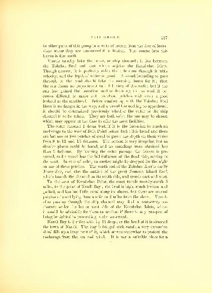
V I T I GROUP.
in other parts of this group in a state of terror, from the fear of incur-
sions when* they are unsuccessful in fishing. The course into this
haven is due north.
Vessels usually take the inner, or ship channel ; it lies between
the Tokelau Reef and that which adjoins the Kombelau Islets.
Though narrow, it is perfectly safe ; the tide runs through it with
velocity, and the depth of water is great. A vessel intending to pass
through to the west should take the morning hours for it ; then
the sun forms no impediment to a full view of the reefs ; but if the
sun has gained the meridian and is declining in the west, it be-
comes difficult to make out the sboal patches with even a good
lookout at the masthead. Before coming up with the Tokelau Reef
there is no danger in the way, and a vessel has nothing to apprehend;
it should be determined previously whether the outer or the ship
channel is to be taken. They are both safe ; the one may be chosen
which may appear at the time to offer the most facilities.
The outer channel I deem best, if it is the intention to reach an
anchorage to the west of Buia Point before dark ; it is broad and there
are but one or two patches of coral to pass : the depth on them varies
from 9 to 12 and 15 fathoms. The bottom is very irregular, but no
shoaler places could be found, and no soundings were obtained less
than 9 fathoms. By keeping the outer passage the breeze is pre-
served, and a vessel has the full influence of the flood tide, setting to
the west. In case of calm, an anchor might be dropped for the night
on one of these patches. The south end of the Tokelau Reef is easily
discernible, and also the outline of the great Nemena Island Reef,
which bounds the channel on its south side, and trends east and west.
To the west of Kombelau Point, the coast trends west-by-north 5
miles, to the point of Nandi Bay ; the land is high, much broken and
gullied, and has but little coral along its shores, but there are several
patches of coral lying from a mile to 2 miles from the shore. Vessels
after passing through the ship channel may find a temporary an-
chorage under the lee or west side of the Kombelau Islets, where
it would be advisable for them to anchor, if there is any prospect of
being benighted in proceeding to the westward.
Nandi Bay is 2 miles wide by 1 $ deep ; at the head of it is situated
the town of Nandi. The bay is fringed with coral ; a very extensive
shoal fills up a large part of it, which serves somewhat to protect the
anchorage from the sea and wind. It is not a suitable place for a

228 HYDROGRAPHY.
vessel of any size. The coast from Nandi to Sualib Bay trends in
a southwest direction 10 miles ; it is bold and abrupt, aiad offers no
harbors or places of protection for vessels. The shore is fringed with
coral, and the whole is iron-bound. There are no villages or inhabi-
tants throughout the whole distance.
Sualib Bay is within 2 miles of Buia Point, 'the most southern part
of the Island of Vanua Levu. The bay is surrounded by high hills,
forming a kind of amphitheatre ; the sides and the flats at the bases
are well cultivated, producing large crops of yams and taro. It is a
mile in width by lz in depth, open to the southeast ; the coral reef fills
up half of its area, consequently the anchorage is very much con-
tracted ; the reef is dry at low water, is confined to the head and the
western side. At the head of the bay there is a stream of water, on
which the town of Tye is situated, surrounded by an extensive grove
of cocoanuts. On the eastern side of the bay the town of Sualib is
situated. These two towns are divided by a steep, projecting spur,
but the extensive reef, when bare, at the head of the bay, enables direct
communication to be effected between them at low water; the creek is
easily crossed, so that the two at such times almost form but one town.
They are under different chiefs; the Sualib chief is the most powerful,
and rules.
With the wind at southeast this bay is a dangerous and exposed
anchorage, not suitable for large vessels ; small vessels and boats
may find some protection within. The shore at this part of the island
is steep and inaccessible. From Sualib Bay to Buia Point the coast
trends a little to the southward of west ; the shore is fringed with
coral. At low water it is usually dry, not even admitting a boat to
pass along ; but this is in part owing to the fish-weirs, which the
natives have constructed on the reef, with large stones. The fish are
driven into these pens before half tide, where they are easily captured
at low water.
The people of these two towns committed depredations upon one of
our boats, for which it became necessary to punish them, and in so
doing the town of Tye was burnt ; the inhabitants ever since have
shown every disposition to befriend the whites and their property.
Between Tokelau Reef and Buia Point there are three shoals, lying
6 miles from Buia Point ; one was found to be 2 miles in length ; the
others are smaller, and lie to the eastward of the largest. Their
length lies east and west, but they have very little breadth. Vessels

V I T I GROUP. 220
may pass on either side of them ; the space is clear, being 3 or 4 miles
wide. As these reefs lie to the east of the Buia Passage through the
great Nemena Reef, they are not in the way of vessels making use
of it.
Buia Point is a bold and steep headland, rising abruptly at first from
the shore, and then gradually till it joins the main ridge of the island,
of which it is properly a spur ; it is easily distinguished by its
reddish-black appearance. Between Buia Point and the spur to the
eastward of it, there is a small contracted valley, which has a large
Bourri house near the shore, surrounded by a luxuriant grove of
cocoanut trees. The village had been destroyed, and its inhabitants
forced to fly in a body, and to seek protection under some of the more
powerful chiefs ; those that were not able to do so were carried off to
other parts of the group as slaves.
Off Buia Point the flood tides from the east and west meet, and
flow off to the south, though not with great velocity. At the distance
of 2 miles from the point, there is a small coral patch, which vessels
should be mindful of; itLis better to keep between the point and it.
On rounding Buia Point, Cocoanut Point comes in sight ; its distance
is 3 miles northwest ; a vessel proceeding to the westward must steer
to pass close to it ; the channel lies between it and the coral patches,
which lie off the coast here ; there is ample depth of water and suffi-
cient room for a vessel of any size. Under Cocoanut Point the anchor-
age is good, in from 7 to 10 fathoms water. If night is approaching,
I would recommend anchoring there. The distance to 'Mbua Bay is
fully 10 miles ; the channel has been before described, and although
not intricate, is narrow, and requires care, as the tides run through it
with some force.
Y'ENDUA.
The Island of Y'Endua lies off the west end of Vanua Levu, 10
miles distant ; it is a high island and can be distinctly seen from
'Mbua Bay, one of its peaks, Loto, being 875 feet above tide ; it
is of volcanic formation, and has a very uneven surface ; its shores
are likewise indented with deep bays. Its greatest length is 4
miles in a northwest direction, while its greatest breadth is 2h.
It has two good harbors, one on the south, Porpoise Harbor ; and58

230 HYDROGRAPHY.
another on the west, Strahan's Harbor. Besides these there are
several places where a vessel may drop anchor.
The passage leading to it through the reefs from 'Mbua Bay I
have called the Sifo Channel ; a west-by-south course from Dimba-
dimba Point will take a vessel through, though bordering the coral
patches on its northern side, which are numerous and dangerous,
and should be avoided if possible ; therefore in passing through
the Sifo Channel, if the tide should be setting ebb, it would be well
to keep a more southern course until within 2$ miles of Y'Endua,
when the Lela Reef will be passed. A vessel intending to anchor in
Porpoise Harbor should haul up for Green Point (the south point of
the island), and pass to the northward and westward of the outlying
reefs, which protect the harbor from the sea on the south ; these reefs
are visible, and may be closely approached. If the wind should not
enable a vessel to pass to the northward of them, the west end maybe turned, and so through between the reefs until the entrance into
the harbor is gained, which is near to Green Point ; within the reefs,
the water is deep and always smooth ; the entrance is nearly a mile
wide. After the entrance is passed, there are three rocks, two of
which lie off Aliki Point, both visible : a vessel can pass between
them ; the third lies south-by-east a quarter of a mile from the others
:
it is awash. Porpoise Harbor is a mile in depth by a mile in width;
it is formed by the small Island of Y'Endua Tomba on the west side,
and that of Y'Endua on the north and east ; these are connected by the
coral reef, over which the tide flows at high water ; the anchorage is
in 10 and 11 fathoms water, muddy bottom. The reef that lies across
the bay and encloses the harbor, projects from the south point of
Y'Endua Tomba to Green Point, and is 1J miles in length. The
shores of the islands are in all parts fringed with coral, in width from
200 to 500 feet.
Strahan's Harbor lies on the west side of Y'Endua. It is not as
extensive or so convenient as Porpoise Harbor, and is only separated
from it by a tongue of low land, fringed on each side by coral. In
it there are many coral patches, which occupy a large part of the
area, curtailing the anchorage to a very limited space : these patches
are discernible, and by ordinary care may be avoided ; the chart
of the harbor will be the best guide to point out these obstructions.
Under Modonovi Point (the north point of the island), there is like-
wise a temporary anchorage. The east side of the island offers no

V I T I GROUP. 231
shelter for vessels, and is, as before stated, fringed with coral ; near
the centre of the island lies the small islet of Latu ; it is connected
to the island by the shore-reef, over which boats may pass when it
is high water. The Island of Y'Endua has a fruitful soil, and but a
few years before our visit (1840) contained a large population, whowere abundantly able to supply the wants of vessels ; but it had been
almost depopulated since by one of the powerful chiefs of VanuaLevu, who massacred its inhabitants. It will be some years before it
will be again in a state to afford supplies of any kind. Wood and
water may be obtained here, the latter from many springs just above
high water mark.
Vessels intending to go to sea from 'Mbua Bay, ought to take the
Sifo Channel, passing between the Lela Reef and those off Y'Endua,
steering a southwest-by-south course, until they bring Y'Endua to
bear north, when they may keep away directly for the highlands of
Ya-Asaua : this will carry them clear of the Fafo Reef; when Awakalo
or Round Island is seen from the deck, they may steer for it : this
course will avoid the Sakau Reef, extending 20 miles from "V 'Endua
to the west, most of it being sunken rocks, with various depths of water.
On passing Awakalo, a course from west-northwest to northwest will
lead to sea and an offing.
AWAKALO OR ROUND ISLAND.
Awakalo or Round Island lies north 75° west 32 miles from Y'Endua.
The Great Sea or Western Reef of the Viti Group reaches to within 6
miles of this island ; it loses itself here in a sunken reef, the point of
which bears north from Awakalo. The Island of Awakalo is nearly
circular in shape, and has but one part, on the west side, where a
landing can be effected. The eastern side is a perpendicular escarp-
ment, and the whole island has the appearance of having been torn
and ruptured by volcanic fires. To the east and southeast, there are
patches of sunken reefs, extending some 7 miles, no doubt a con-
tinuation of the Sakau Reef;although separated from it by a broad
space.
This island is 515 feet high, half a mile in circumference, and
can be seen at a considerable distance. Standing as it does alone,
it has the appearance of a large mound : it may be quite closely
approached. A vessel may anchor on its east side upon some

232 HYDROGRAPHY.
sunken patches, but it would not be advisable to do so, as it would be
better to seek one of the fine harbors in the Asaua Group, where any
supplies may be had if required.
The space included within the Great Western Reef, which begins
at Kie Island, off Muthuata, and extends to Awakalo, although it was
not all minutely examined by us, yet was found to have so manydangers within it as to preclude my recommending vessels to pass
within it ; there are many openings for boats and small vessels,
through which they might pass to escape a rough sea outside, but it
would be necessary for them to use great caution;yet many portions
are comparatively free, through which a vessel may pass to get to an
anchorage in one of the many harbors along the north shore of the
Island of Vanua Levu. So dangerous do I think the navigation,
that I deem it proper to discourage the attempt being made by a
vessel of any size to seek a port through it, if it can be avoided.
Towards the western termination of this great reef, which is 80 miles
in length, the openings become more frequent and practicable. There
is only one rock above the surface of the sea, and that is a basaltic
column, called the Sail Rock, 7 miles north of Y'Endua, from which
it is distinctly visible ; and in clear weather may also be seen from
the western side of Vanua Levu.
Round Island Passage is between the north end of the Asaua Group
and Awakalo ; it is 13 miles wide and without any dangers.
It is not supposed that navigators will approach this group for the
purpose of entering it from the west through the Round Island
Passage. This course cannot be recommended, as it would subject
them to much difficult navigation in beating about among the reefs,
where the tides are strong, and their direction and velocity frequently
changed by the reefs. To depart from this group, the Round Island
Passage is one of the safest, and all things taken into consideration,
probably the best ; much time and distance is saved, particularly
when vessels are bound to the westward.
ASAUA OR WESTERN ISLANDS.
The Asaua or Western Islands of the Viti Group is composed of
forty islands, including large and small ones ; the islands range in a
northeast and southwest direction, extending 55 miles from Round

VITI GROUP. 233
Island Passage to the south. They are for the most part fringed with
coral, and have extensive outlying reefs, running parallel with their
length, and in many cases uniting neighboring islands ; the reefs are
connected with the west end of Viti Levu, and enclose the Sea of Viti
on the west. The area between the southern part of the Asauas and
the Island of Viti Levu is obstructed by reefs and sand-banks, which
impede navigation ; there are also a number of sand-islands, called
Underwood's Group, within this space. The northern islands of the
Asaua Group are Timboor, Kuisick, Asaua, Ya Asaua, Ovawa, Yasau-
i-lau, Androna, Otovawa, Nanuia, Nangati, Matathoni Levu, Yangati,
Naviti, Eld, Fox, Agate, Sinclair, Waia, Waialailai, Waialailai Thake,
and Biva. The southern ones are Knox, Ombi, Davis, Totten,
Baldwin, Lewis, Vomo, Carr, Walker, Johnson, Case, Emmons, Alden,
Craven, Perry, Malolo, Malololailai, Soni, Palmer's, Waldron, and
Speiden. They will be described in the order in which they come
from north to south.
TIMBOOR AND KUISICK.
Timboor and Kuisick are two small twin islands, the most northern
of this chain; they are quite low, covered with trees, and about a quarter
of a mile in circumference, and lie within the same reef; this reef is
31 miles in length, by one-third of a mile wide. They form the
southern boundary of the Round Island Passage.
ASAUA, YA ASAUA, AND OVAWA.
Asaua and Ya Asaua are distant a mile and a half from Timboor.
The former island is quite small, and is joined by the reef to the latter
on its east end. The channel between Timboor and Asaua is free
from danger, and has a depth of water varying from 10 to 15 fathoms.
The course through is southwest-by-south. The reefs on both sides
may be approached without fear ; the side of Timboor should be pre-
ferred, as it is freer from any projecting rocks. I am not aware that
there are any other dangers on either side.
Asaua is but half a mile in length by a quarter in width. It rises
to the height of 50 feet, forming a knoll. It is surrounded by a coral
reef, which projects nearly a mile to the southward and westward
;
59

234 HYDROGRAPHY.
this reef is bare at low water. The island is covered with a scanty
growth of trees, and is connected by its reef on the east with
Ya Asaua. Half a mile to the west lies Levu Islet, with a small reef
around it ; between them the channel is clear and deep. The Island
of Ya Asaua, as before remarked, is connected at its western termi-
nation by the reef with Asaua. It is 8 miles in length, and 2 at its
greatest breadth ; it has a central ridge running the whole length of
the island. Both its northern and southern end curve to the west,
forming bays. That to the north I have called Emmons Bay, and that
to the south Raritona Harbor. The former is one mile wide by 2i
long, protected by a sunken reef, extending 2 miles to the southwest
from its western point. It is tolerably protected on the west, but is
entirely so on the east and north by the island from which the winds
prevail. The depth of water does not exceed 15 fathoms ; but the
bottom, unless well up in the bay, is very much broken, and an anchor
is liable to be fouled. It is necessary that all anchors should be pro-
vided by good buoy-ropes if let go here, as it may be impossible to
regain them by any other means.
The Harbor of Raritona lies at the southern extremity, and is pro-
tected on the west by the Island of Ovawa and One Tree Islet ; it is
not a very capacious anchorage, from having a great part of its south
and west side occupied by a coral flat. At the head of the harbor
there is an extensive and fertile plain, from which the hill of Tau-
thake rises, to an elevation above the sea of 784 feet. The Island of
Ovawa is li miles in circumference, and rises 40 feet above tide.
The shore-reefs are for the most part dry at low water. The channel
from Emmons Bay to Raritona Harbor lies near the island, but the
head of the harbor cannot be approached with the smallest sized
vessel, on account of the above-mentioned flat. This island during our
visit was almost destitute of any provisions, the inhabitants that were
left being obliged to live upon the yaka, a wild root, in consequence
of the incursions of the natives from Vanua Levu. The island was
formerly under extensive cultivation, and will be again in a few
years ; when vessels will be able to procure all the productions that
the islands are capable of raising.
YASAU-I-LAU.
The small Island of Yasau-i-lau is situated at the southern and
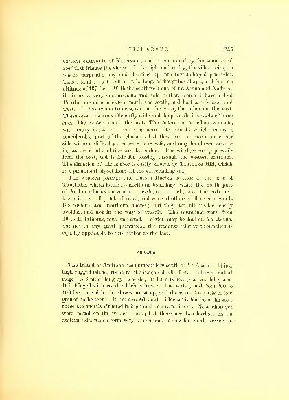
V I T I GROUP. 235
eastern extremity of Ya Asaua, and is connected by the same coral
reef that fringes the shore. It is high and rocky, the sides being in
places perpendicular, and shooting up into turret-shaped pinnacles.
This island is but half a mile long, of irregular shape, and has an
altitude of 437 feet. With the southwest end of Ya Asaua and Androna
it forms a very commodious and safe harbor, which I have called
Pulotu, one mile in extent north and south, and half a mile east and
west. It has two entrances, one on the west, the other on the east.
These openings are sufficiently wide and deep to admit vessels of large
size. The western one is the best. The eastern entrance has two reefs,
with rocky islets on them lying across its mouth, which occupy a
considerable part of the channel, but they can be passed on either
side without difficulty ; either side is safe, and may be chosen accord-
ing as the wind and tide are favorable. The wind generally prevails
from the east, and is fair for passing through the eastern entrance.
The situation of this harbor is easily known by Tauthake Hill, which
is a prominent object from all the surrounding sea.
The western passage into Pulotu Harbor is close at the base of
Tauthake, which forms its northern boundary, while the north part
of Androna forms the south. Inside, on the left, near the entrance,
there is a small patch of coral, and several others well over towards
the eastern and northern shores ; but they are all visible, easily
avoided, and not in the way of vessels. The soundings vary from
10 to 15 fathoms, mud and sand. Water may be had on Ya Asaua,
but not in any great quantities ; the remarks relative to supplies is
ecpjally applicable to this harbor as the last.
ANDRONA.
The Island of Androna lies immediately south of Ya Asaua. It is a
high rugged island, rising to the height of 900 feet. It has a central
ridge; is 3 miles long by li wide ; its form is nearly a parallelogram.
It is fringed with coral, which is bare at low water, and from 200 to
400 feet in width ; its shores are steep, and there are few spots of low
ground to be seen. It has several small villages visible from the sea;
these are mostly situated in high and secure positions. No anchorages
were found on its western side ; but there are two harbors on its
eastern side, which form very convenient havens for small vessels to
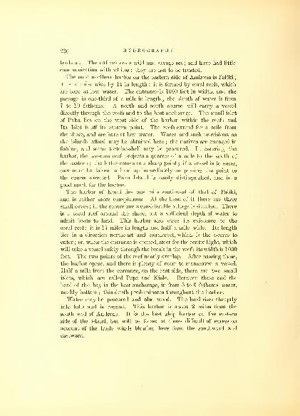
230 HYDROGRAPHY.
trade at. The natives are a wild and savage set ; and have had little
communication with whites : they are not to be trusted.
The most northern harbor on the eastern side of Androna is Faliki
;
it is a mile wide by li in length ; it is formed by coral reefs, which
are bare at low water. The entrance is 1000 feet in width, and the
passage is one-third of a mile in length ; the depth of water is from
7 to 10 fathoms. A north and south course will carry a vessel
directly through the reefs and to the best anchorage. The small islet
of Paka lies on the west side of the harbor within the reef ; and
Ita Islet is off its eastern point. The reefs extend for a mile from
the shore, and are bare at low water. Water and such provisions as
the islands afford may be obtained here ; the natives are engaged in
fishing, and some tortoise-shell may be procured. In entering the
harbor, the western reef projects a quarter of a mile to the south of
the eastern ; the latter comes to a sharp point ; if a vessel is to enter,
care must be taken to haul up immediately on passing the point to
the course directed. Paka Island is easily distinguished, and is a
good mark for the harbor.
The harbor of Korai lies one mile southwest of that of Faliki,
and is rather more conspicuous. At the head of it there are three
small coves ; in the centre one a considerable village is situated. There
is a coral reef around the shore, but a sufficient depth of water to
admit boats to land. This harbor also owes its existence to the
coral reef; it is li miles in length and half a mile wide. Its length
lies in a direction northeast and southwest, which is the course to
enter;or, when the entrance is opened, steer for the centre bight, which
will take a vessel safely through the break in the reef ; its width is 1000
feet. The two points of the reef nearly overlap. After passing these,
the harbor opens, and there is plenty of room to manoeuvre a vessel.
Half a mile from the entrance, on the east side, there are two small
islets, which are called Pepe and Kiole. Between these and the
head of the bay is the best anchorage, in from 5 to 6 fathoms water,
muddy bottom ; this depth predominates throughout the harbor.
Water may be procured and also wood. The land rises abruptly
into hills and is rugged. This harbor is about 2 miles from the
south end of Androna. It is the best ship harbor on the eastern
side of the island, but will be found at times difficult of egress on
account of the trade winds blowing here from the southward and
eastward.

V I T I GROUP.
To the south of Androna there are two islands, Otovawa and
Nanuia ; these are separated from Androna by the Taofi Channel,
three-fourths of a mile wide. This space is very much filled with
coral patches ; the reefs from the islands also extend to a considerable
distance. On some of these patches on the Androna side of the
channel, there are black rocks, which point out its direction. Thewater is sufficiently deep for large ships, and the course through in
passing from the northward is nearly due south, until the channel
between Otovawa and the northern Nanuia with the north point of
Matathoni Levu is well opened, then haul up southeast. Although
this is a ship channel, it requires great caution to sail through it even
with a small vessel ; and unless there is a necessity for using it, I would
not advise the attempt to be made. Anchorage may be had in almost
any part of it, in from 10 to 30 fathoms. The channel between Oto-
vawa and Nanuia is also practicable for ships, as well as that between
Nanuia and Matathoni Levu, and Otovawa and Matathoni Levu, in
both of which there is anchorage.
OTOVAWA.
The Island of Otovawa is three-fourths of a mile in length, by half
a mile wide. It lies nearly due north and south, and is surrounded
by a coral reef ; some of the patches of coral extend on the eastern
side, and are part of those spoken of above as lying in the Taofi
Channel. Otovawa lies west of the southern end of Androna one
mile ; it is high and rugged as the others of this group, and is of the
same geological character.
NANUIA AND NANGATI.
Nanuia and Nangati are connected by a coral reef, but the tide
flows through between them, leaving a good boat-passage. They are
both nearly of the same size, though differing somewhat in figure ; the
northern one is a mile in length, by half a mile wide. Nanuia is the
most southern, and is three-fourths of a mile in diameter. Nangati
trends west and east. Both are high and have the rugged character
already described as belonging to this group. They are both inha-
bited. There are no harbors, except that on the west of the islands,
60
238 HYDROGRAPHY.
and between them and Matathoni Levu. They are both bordered
with a fringe of coral, of from 200 to 500 feet wide. The reef to the
south extends beyond this distance, and on the southern point of it
there are two small islets. East of these islands there are several
outlying patches, one called Mafuna Reef: they can all be readily
seen and avoided.
MATATHONI LEVU.
This island is 2 miles in length and lies north and south ; its
width, including the reefs, is a little over half a mile. It is high and
has a central ridge, and is divided from the Island of Yangati, which
lies to the south of it, by a narrow strait. The coral reefs of the
two islands connect. Between the islands lies the small islet of Ato.
Nifo Islet is also included within the same reef : it lies to the east.
These islets are connected on the east and west with Matathoni Levu
and Yangati ; there is no passage between them, except for boats at high
water.
YANGATI.
Yangati is the middle island of the northern section of the Western
Group. It is upwards of 3 miles long, and lies, as most of the rest of
this range, northeast and southwest; its width is I2 miles; its features
are rugged. It has no harbors for shipping, and there are but three
towns on it, one on its north end and two at the southern end.
Maca Point is its extreme southern point, and forms the north side of
the Naviti Passage, lying between Yangati and Naviti Islands.
NAVITI PASSAGE.
The Naviti Passage is 2 miles wide, and has but one danger in it,
a small coral-reef, lying near its centre, which is visible. Maca Point
on the north, as well as Tapau Point on the south, are both highland.
The course through this passage is east-southeast. The south side,
towards Naviti, is somewhat obstructed by coral reefs, but they are
visible and not far from the shore.
NAVITI.
The Island of Naviti is one of the most important of the Asaua

V I T I GROUP. 230
Group. It is 8 miles in length and upwards of 2 miles in breadth.
Its peaks are distinctly seen from a great distance, and are next in
height to those of Waia. On its west side towards the northern end
there are many coral patches ; its east side is much indented with bays,
which, however, offer no shelter for vessels ; at its northeast end it has
a reef of outlying rocks off Kupa Point. There are several towns on
this island ; the most important is Kumia, on its west side, but it offers
no inducement to visit it, and the inhabitants are not trustworthy.
Within Vaka Bay lies the town of Vaka : this is the best anchorage
which this island affords, and the bay is of easy entrance ; the anchor-
age is tolerably safe, being partly protected by the coral reef which
lies off its mouth, and with a proper lookout for the treachery of the
natives, wood and water may be obtained.
ELD, FOX, AGATE, AND SINCLAIR.
To the south of Naviti lie four smaller islands, which I have
named, after officers of the Expedition, Eld, Fox, Agate, and Sinclair.
These are high, rugged, and rocky. Off Eld Island there is a
temporary anchorage. They are not inhabited, but are occasionally
the temporary abode of the natives from the larger islands. Eld
Island is only separated by a boat-passage from Naviti ; it is of a
triangular shape, about one mile in length. Fox Island lies east and
west, in shape a crescent ; its length is over two miles. Between it
and Eld Island there is a good passage. At its eastern entrance lies a
small islet surrounded by a reef, and a mile farther to the east is the
Moya Rock, which is visible and has around it a reef. Agate
and Sinclair Islands are nearly of the same shape, but their lengths
lie nearly at right-angles;they are connected by a coral reef, which is
bare at low wT ater. To the east of these there is an outlying coral
patch.
WAIA PASSAGE.
The Waia Passage is bounded on the north by Sinclair Island,
on the south by Waia Island ; it is 3 miles wide between Vatu Islet
and 'Mbua Point. There are no dangers lying within it, and the
depth of water is adequate for a vessel of any size.

240 HYDROGRAPHY.
WAIA ISLAND.
Waia Island is the highest of the Asaua Group ; its inhabitants
are deemed the most warlike and treacherous. Its form is nearly
circular, 3 miles in diameter, and it has but one indentation, that
of the Bay of Poto on its southeast side. Its highest peak rises to
the height of 1640 feet; there are several that attain nearly this
altitude;indeed, the whole surface of the island seems to be but a
collection of peaks and fastnesses. It is well populated, and the
natives enjoy the reputation, even among the Feejee Islands, of being
a set of pirates and bad fellows, making frequent incursions on the
towns of the other islands ; its population is estimated at 3000.
Poto Bay offers a tolerable anchorage ; there is a village lying on its
western side. In approaching this bay there are three coral patches
lying off Bombote Point, to the south and southwest, from half a mile
to 2 miles distant. Waia is surrounded by a shore-reef, which
extends on the north, and includes the small Island of Vatu, and also
joins with that of Waialailai Island at the south. Wood and water
and some provisions may be procured here, but I would not advise,
unless in cases of necessity, a vessel seeking the island for that purpose.
The inhabitants are mostly engaged in fishing for turtle on the neigh-
boring islands and reefs during the season.
WAIALAILAI AND WAIALAILAI-THAKE.
Waialailai, as well as Waialailai-thake, lies directly south of
Waia. They resemble it in its topography, but are of minor conse-
quence. The former is 2 miles in length, by li at its greatest
breadth ; the latter is a mile in length, by half a mile in breadth.
On the latter is a remarkable peak, which now bears the name of
Observatory Hill ; its altitude is 555 feet. Temporary anchorage maybe found under these islands on the eastern side.
BIVA ISLAND.
Biva Island is the most western of the Feejee Group ; it lies 10
miles to the west of the Asaua range. It is low, of coral formation,
has a lagoon on the south, which is formed by the extension of the

V I T I GROUP. 241
reef ; its diameter is a mile ; and although the reef is partly sunken
and awash, yet its direction and outline are distinctly seen. The
island is densely covered by cocoanut groves ; it is inhabited, and
ships may obtain fruit here. The natives are friendly and have had
frequent intercourse with ships cruising in the neighborhood for
whales. The sea between it and the Asaua range is clear, though it
is better for ships lying off and on to keep to the west. It may be seen
10 miles. Its position is well determined, and was ascertained to be
in latitude 17° 08' 30" south, and longitude 176° 53' 30'' east. There
is a narrow entrance on the west side into the lagoon, and anchorage
may be found within.
PORPOISE SHOAL.
To the north-northeast of Biva Island, 5 miles, lies Porpoise Shoal,
which is one mile in length, by half a mile wide ; it is composed
of coral. The sea seldom breaks on it, but the discoloration of the
water may be seen some distance, and can be avoided.
WHITE ROCK AND MOKA REEF.
Five miles to the east of Waia Island, lies the White Rock. It is
readily distinguished, and forms a good sailing-mark ; 3 miles far-
ther to the east is the extensive Moka Reef, trending from VomoIsland north-northeast towards the north end of Androna, unbroken
as far as abreast of the Naviti Passage, a distance of 20 miles ; thence
northward are several patches, but the passages between them are
wide. On the Moka Reef the sea generally breaks, which causes it
to be seen a long distance in fine weather; its limits and trending
were accurately determined, and are represented on the chart ; its
south end reaches to within 2 miles of Vomo.
VOMO, OMBI, KNOX, BALDWIN, DAVIS, LEWIS, AND TOTTEN.
Vomo Island lies southeast from Waialailai, 10 miles. It is a mile
and a half in length ; its southern and eastern half rises 250 feet, and
has a flat top, while the western is low and sandy, connected by a
coral reef with Vomolailai, a small rocky islet, rising abruptly to the
Gl

242 HYDROGRAPH Y.
height of 60 feet, of volcanic formation. Within the bight of Vomoon the west there is anchorage for small vessels. Between Waialailai
and Vomo there are three patches of coral ; one lies just to the north
of the latter island. To the west from Vomo extends the Fua Reef,
which reaches to within a mile of Ombi Island, one of six small,
rocky isles, which lie south-southwest, 8 miles from Waia Island;
these were named Knox, Baldwin, Davis, Lewis, and Totten. They
are all surrounded by narrow shore-reefs. There are two outlying
patches of coral in their neighborhood, one to the north, 3 miles
distant, and the other off the southeast end of Totten Island.
HUDSON ISLES.
The fourteen islands 8 miles south of Totten Island I have called
the Hudson Isles, viz., Carr, Walker, Johnson, Case, Emmons, Alden,
Craven, Perry, Malolo, Malololailai, Soni, Palmer's, Waldron. and
Speiden. These are the extreme southwestern part of the Feejee
Group;they are all surrounded by shore-reefs of little width, ex-
cept at the points, where the reef extends from a quarter to half a
mile. There are a few coral patches between Case and Craven
Islands. The sea-reef from near the latter island stretches over 3 miles
to the south. There is no sea-reef to the westward of the most
northern of the Hudson Isles, as has been generally supposed, conse-
quently they are exposed to the full swell of the ocean from the west,
but being to leeward of the group, the sea is for the most part of the
year quite smooth. The first eight are not inhabited, consequently
supplies cannot be obtained. There is anchorage within them, yet
they cannot be said to afford any safe port for vessels. Further
remarks are deemed unnecessary, as the chart points out their relative
situations, and renders a particular description of them useless.
MALOLO, MALOLOLAILAI, WALDRON, AND SPEIDEN.
Malolo and its accompanying four islets, Malololailai, Soni, Palmer's,
and Kuku, are the southeastern islands. On the south and west they
are surrounded by extensive coral reefs, which protect them from the
force of the sea. Malolo is triangular in shape, its sides being 2
miles in length. This island is 400 feet in height; the ridge rises to a
V I T I G R U P. 243
peak near its centre ; it has a diversified and picturesque appearance.
For its size Malolo is one of the most fruitful islands of the group. It
is well cultivated.
The reef around Malolo is much broken, and the passage intricate
for small vessels. The sea-reef extends to Waldron and Speiden
Islets ; it is 2 miles in width ; at these small islets there is an open-
ing in the reef, which I named the Malolo Passage. These islets are
situated on separate coral patches, lying inside the sea-reef, and covered
with green bushes; they form an excellent mark for the passage. The
coral reef on which they are situated extends several hundred feet in
a northerly direction from the islets, but, notwithstanding, the passage
is clear and safe. The islets lie northwest and southeast from each
other, three-fourths of a mile distant, and about the same distance
within the entrance. The course through and between the islets is
northeast half north : the tide generally runs in the same direction.
It is advisable to keep nearest to Waldron Islet, both passing in or out,
as its reef is narrower ; this will avoid the point of the reef extending
to the north, off Speiden Islet. A mile to the north of the Malolo
Passage there is another break in the sea-reef, which may be entered,
steering to pass to the northward of Waldron Islet, but I should prefer
to make use of the Malolo Passage. In the afternoon the wind gene-
rally is favorable to enter, at which time the reefs are visible, the sun
being in the west. At low water the reefs are dry.
The anchorage under Malolo on the east side is confined and muchobstructed by coral knolls ; it is difficult to get a clear berth for any
but a small vessel; for a vessel of large size, it is better to anchor out-
side the reefs, between Malolo and Viti Levu.
Malololailai is connected by the coral reef with Malolo ; it is about
one-third the size of the larger island. Palmers and Soni Islands lie
on the northwest side of Malolo three-fourths of a mile, and close to
the reef. Kuku Islet is on the southwest side.
The inhabitants of Malolo were, until our visit, deemed, with those
of Waia, the most savage of the Feejees. The necessity I was under
of administering punishment for the massacre of my officers, has had
the effect to change their character, and vessels may now visit the
island with safety, and receive all the hospitality and assistance
they may desire, with supplies in small quantities.

244 HYDROGRAPHY.
UNDERWOOD GROUP.
To the northeast of Malolo lie the Underwood Group, consisting
of six islets, viz. : Linthicum, Smith, Henry, Ogle, Bateman, and
Reynolds. These were named after the officers and men who died
in the Expedition ; it forms, with its reefs, a parallelogram, the centre
of which is distant from Malololailai 6 miles. The sea is usually
quite smooth, and the water of the deepest blue, and few scenes seem
to make a deeper impression on the mind, or could afford a more
lasting monument to the memory of the dead. Their position on the
chart will show their relative situation, and renders any further de-
scription unnecessary.
SOUTH ENTRANCE AND ROUND ISLAND PASSAGE.
I have already described the entrances into the Viti Group, by the
several passages through the eastern islands ; it now remains to men-
tion that from the south, which may be preferred by many intending
to anchor at Ovolau, or pass through the reefs to some of the ports
and anchorages in the larger islands, within the Sea of Viti.
In the approach from the south, the best island to sight is Matuku;
it lies to the southward of all, is high, and may be seen a long
distance in clear weather ; a north-northwest course, after coming up
with it, will take a vessel to Ovolau, 100 miles distant. There are no
dangers, excepting the reef of Muinbolithe, on this route ; it lies to
windward of the course, but care should be taken to avoid it. Thehigh island of Angau, off which this reef lies, will be sighted on the
starboard bow, and when the centre of it bears to the eastward of
north, this reef will be passed. On coming up with Ovolau, with a
fresh trade-wind and favorable tide, it is necessary to shorten sail,
otherwise the narrow south entrance to the harbor of Levuka maybe passed, and oblige a vessel to seek the north entrance, and beat up
to the anchorage off the village. In the forenoon the wind is gene-
rally light and variable.
In taking a departure from the Viti Group two routes present
themselves which may be followed,—by the Southern Entrance, and the
Round Island Passage—according as it may be the desire of the navi-
gator to proceed to the southward or westward. If the former, the
best course is to pass into the Straits of Ovolau, and beat to windward

V I T I GROUP. 245
until the reefs off Kamba Point can be cleared, then either to pass to
the eastward of the Island of Kantavu, or through the Kantavu Pas-
sage to the westward;by this route a vessel will gain an offing much
sooner than by any other. The departure by the Round Island Pas-
sage requires daylight; it is distant from Ovolau 100 miles; the course
lies about northwest-by-west. In resolving to take this route there
should be a commanding breeze, the weather fine, and an early departure
made, in order to secure daylight. The first course after clearing the
harbor is to steer for the Island of Vitimera, which lies some 30 miles
west from Ovolau, thence direct for Awakalo or Round Island. There
are no shoals in this route but what are visible, and by proper precau-
tion in stationing lookouts, these can be seen and avoided. In the
morning, when the sun is to the east, is the best time to pass out;by
noon these reefs will all be passed, and if care is taken to avoid being
set by the tide to the northward, there is no danger to be appre-
hended. After passing Round Island, all dangers are at an end, and
an offing to the westward is soon reached.
CHICOBEA.
Chicobea is a small island lying off Unda Point, the northeast point
of Vanua Levu. It is 20 miles distant, and in fair weather may be
seen from the large island ; it rises in two knolls to a considerable
height. It is 3 miles in length, northwest and southeast, and 2 in
width, and has a coral reef around its shores. There is no safe anchor-
age for vessels, or anything to induce a visit to it, and but few inhabi-
tants. It is the most northern island of the Feejee Group. The lati-
tude of its highest and most northern knoll was ascertained to be in
15° 47' 40" south, and longitude 179° 51' west.
62

CHAPTER XI.
SOUTH PACIFIC ISLANDS.
STAVERS OR WOSTOCK ISLAND.
Wostock was discovered by Captain Bellinghausen in 1820. This
island was seen by Captain Stavers in a whale ship. Its position has
been well determined by the Expedition. It is a low, sandy islet,
with a lagoon of oval shape and half a mile in diameter ; it is well
wooded, affords no landing, and is surrounded by heavy breakers.
FLINT'S ISLAND.
Flint's Island is reported to have been discovered as early as 1801.
The position assigned it was found to be erroneous by the Expedition.
It is a small coral island, lh miles in length, north-northwest and
south-southeast, is thickly wooded ; has high breakers extending off
its points, and landing is extremely difficult, if not impossible.
PENRHYN'S ISLAND.
Penrhyn's Island was discovered in 1788. It is a low coral island,
with a lagoon, in shape nearly oval, its longest axis trending north-
northwest and south-southeast, 12 miles in length, by 6 in width.
There is a boat-entrance into its lagoon. The sea washes over its
reef on the northwest side. It is densely covered with cocoanut
palms. There are many villages ; the inhabitants are numerous and
savage;great caution is required on the part of those who are desirous
of communicating with them. There are several large patches of coral

SOUTH PACIFIC ISLANDS. 247
in the lagoon. Under the lee of the island a landing can be easily
effected, but it would not be advisable, unless the party was large and
well armed, to protect themselves.
JARVIS ISLAND.
It is not known to whom the discovery of this island is due ; some
have thought that it is identical with Brock's Island, but I believe
they are different. Jarvis Island was visited and surveyed by the
.Peacock and Flying-Fish. It is of triangular form, the sides being
from 1 to U miles long. It is a coral sand-bar, quite barren,
excepting a few bushes and tufts of grass, and affords nothing ; the
surf is usually so high as to prevent landing. Jarvis Island in ordi-
nary weather would be seen from the deck of a vessel about 6 miles.
The Peacock searched to the westward some 50 miles in the same
latitude for another reported island, but saw no appearance of land.
BELLINGSHAUSEN ISLAND.
Bellinghausen Island was discovered by Captain Kotzebue in 1824.
The island is of triangular shape, with its sides 2i to 3 miles in
length. It has a shallow lagoon in its centre without any entrance.
Its northwest side is a bare reef, over which the tides flow at high
water. The southeast and south parts are well covered with wood.
There is no water on the island, nor any cocoanut palms. This island
was visited by the Vincennes in 1839. There is no landing, except
passing over the coral reef.
M'KEAN'S ISLAND.
M'Kean's Island was discovered by the Vincennes in 1840. It is
but three-quarters of a mile long, by half a mile wide ; it rises 25 feet
above the sea, and is composed of coral blocks and sand, having no
vegetation on it but a scanty growth of coarse grass. The surf was
found to be too heavy to effect a landing. It is very dangerous, and
vessels should be cautious how they run for it in the night, unless
they are very sure of the correctness of their latitude and longitude.
I am inclined to think that Arthur's Island may be considered iden-
tical with this, although 2° to the westward of it.

248 HYDROGRAPHY.
GARDNER'S OR KEMIN'S ISLAND.
Gardner's Island was visited by the Vincennes. It is a low coral
island, with a shallow lagoon, which occupies the northwest end
;
there is no opening into the lagoon, and the tide flows over the reef
into it. The island is II miles square. The trees on it are of large
growth, 40 to 50 feet high, of the same kind as are usually found on
the islands, but it is remarkable that there is no undergrowth similar
to other islands. There are no inhabitants, and the birds in conse-
quence congregate in numbers, and are quite tame and fearless.
SWAIN'S ISLAND.
Swain's Island was first seen by Captain Swain, of the whale ship
Swain, and visited by the Peacock in 1841. It is of coral formation,
has no lagoon, and may be classed with the high coral islands.
It forms a large segment of a circle, and is 4 T3
5 miles in circum-
ference. Its height above the sea is from 15 to 25 feet. It is well
wooded with cocoanut palms, pandanus, and other tropical trees and
shrubs, is not inhabited, and there are no signs of its ever having
been so, except the trees that produce fruit. The sea breaks violently
on all sides, and landing must be at all times difficult. There are no
soundings within a mile of the island with 250 fathoms of line. I aminclined to believe this island may be the Solitaire of Mendana, dis-
covered in 1595.
SIMINOFF AND MIRIKOFF.
Twenty miles to the south of the Island of Ono, lie the two small
islands of Siminoff and Mirikoff, both of which are inhabited. They
were discovered by Bellinghausen the same year as Ono. They are
separated from each other 6 miles in a west-by-south and east-by-
north direction, are of nearly the same size, and have a coral reef sur-
rounding them, which extends one mile. The most northern and
eastern one is Mirikoff ; it trends northwest-by-west and southeast-
by-east ; it is li miles long, by half a mile wide. The southern
Siminoff, has its length northeast-by-east and southwest-by-west.

SOUTH PACIFIC ISLANDS. 210
PYLSTAKT ISLAND.
Pylstart Island was discovered by Tasman, in 1643. It is a high
island, and lies southwest-by-south 75 miles from Tongataboo, and
oilers nothing to invite the navigator.
This island was sighted by the squadron, and the appearance of
the land does not warrant the belief that it is inhabited, or that sup-
plies may be had there ; its true position is given in the tables.
UEA OR WALLIS ISLAND.
This island was discovered by Mandeville, in 1781. The position
he assigned it was erroneous. Wallis also believed he had discovered
it. They both differ in their descriptions of it. There is little doubt
in my mind that the two navigators have reference to the same island;
both were in error as to its position. Ilea lies nearly due west of
the Samoan Group 180 miles. Instead of one island it is a collection
of islands within the same reef, nine in number, which lie nearly
north and south of each other. The coral reef extends some distance
to the east of the island ; in form it is a triangle, with its apex to
the north and its shortest side to the southwest ; the area between
the reef and the islands is extensive. The largest islands are high
and well wooded, and produce all the tropical fruits. The Catholic
missionaries have an establishment here, and have been successful
in promoting the good of the people, though with much risk and
exertion. Fruits and vegetables are plenty. Although the natives
are represented as savage, the chiefs are well disposed. Wood,
water, fruits, and vegetables may be procured here, but it is advi-
sable for vessels trading or seeking supplies to be on their guard.
The southern side of the reef trends west-southwest and east-north-
east ; its length is one mile ; there is a passage through it leading
into the lagoon. This opening is the only one ; it is near to the small
Island of Eta, is 150 yards wide and half a mile in length ; like all
entrances through reefs, it requires care to pass in and out ; the cur-
rent generally is rapid. The direction of the entrance is north-northeast
and south-southwest. It is deep enough for a large ship. After having
entered, a vessel may stand to the north for the largest island, Little
Oware, on which is the residence of the king ; this is 6 miles from63

250 HYDROGRAPHY.
the entrance. It is high water, full and change, at 5 o'clock ; rise of
tide 5 feet. All the islands are near the western side of the surround-
ing reef.
HOORN ISLAND.
Hoorn Island was discovered by Lemaire and Van Shouten, in 1616.
It was passed by the Expedition in 1839. At a distance, it has the
appearance of two high islands lying in a northwest and southeast
direction ; the height of the western mountain was found to be 2500
feet;they are joined by a low peninsula. The western one is very
abrupt and rocky, and has many outlying black rocks ; there is no
regular shore reef;
patches of coral are attached to the projecting
points of the island. On several low points there are extensive groves
of cocoanut palms. The island is well inhabited, but the natives are
not friendly. Attempts have been made to establish missionaries
among them, but without success.
I hold the opinion that Hoorn Island may be identical with the
Enfant Perdu of Bougainville. The difference of longitude that he
makes at the Navigators' or Samoan Group, is nearly the same as his
assigned longitude to Enfant Perdu and the true position of Hoorn
Island, viz., 2° too far to the east. I have in consequence erased
Enfant Perdu from the chart, as having no existence whatever, and
believing it identical with Hoorn Island.
Van Shouten and Lemaire passed some time in one of its bays, to
which they gave the name of Eng Vaght, where they received a
plentiful supply of fruits and vegetables.
KERMADEC ISLES.
These islands are composed of Raoul, Esperance, Macauley, Curtis,
and the Rosarette Rock.
This small group lies nearly in a north-northeast and south-south-
west direction. Raoul is the most northern, and Esperance the most
southern. Raoul is the largest ; it is triangular in form, about 14
miles in circumference, high and rugged, with steep and rocky sides.
The landing on it is dangerous, and at all times difficult. It is said to
be inhabited by a few sailors or runaway convicts, who have at times
come off to whale ships, when cruising in this neighborhood, with a
few vegetables. This island is identical with Sunday Island.

SOUTH PACIFIC ISLANDS. 251
The next south of Raoul is Macauley. It is distant from it 50
miles. The formation of the island is similar to that of Raoul, but in
size it is much smaller.
Curtis Island lies south half west of Macauley, and 20 miles from
it. It is divided into two small, rocky, naked islets, separated a
quarter of a mile from each other.
Esperance Rock is of small size, but high ; it lies 45 miles to the
south of Curtis Island.
To this small group I add the Rosarette Rock : it lies 35 miles to
the west of Curtis Island ; it was discovered in 1810. I think there
is no doubt of the existence of this Rock ; but the Rosarette Reef,
laid down on the charts, in the same latitude and in 173° 40' east
longitude, there is ; but in the absence of reliable information relative
to it, I have deemed it proper to retain it on the chart.
MINERVA REEF.
The Minerva Reef was discovered by Captain Nicholson, in 1818.
The discoverer encountered what he thought was two reefs ; but it is
now known to form but one. On this the Ship Minerva was lost,
in 1831, near the southwest end. The reef trends northeast and
southwest ; is 45 miles in length; at either end the sea breaks. It
is dangerous, and correctly laid down. The Peacock passed near
this reef.
MACQUARIE ISLAND.
Macquarie Island was discovered in 1811. It is much broken in
surface, of volcanic formation, and rises to the height of 1500 feet
above the sea. It has no port or anchorage, and landing on it is at
all times difficult. Off its north end lie two small islets, called the
Judge and Clerk, while two others, of a similar appearance, arc situated
off its south end, which have been named the Bishop and Clerk :
both have the appearance of basaltic rocks. The first two are distant
from the island 5 miles ; the latter, 25 miles.
The south end of Macquarie Island lies in 54° 44' south latitude,
and 159° 49' east longitude. The island has no trees or shrubs, but
is covered with a tall rank grass. The currents near the island are
2G2 HYDROGRAPHY.
strong, setting to the eastward ; the winds generally prevail from the
westward, and the weather is usually stormy.
ROYAL COMPANY'S ISLE.
The parallel of 49° 40' south, on which the Royal Company's Isle
is said to be situated, was examined by the Expedition, through eight
degrees of longitude, passing directly over the position assigned it.
There were no signs of it, or any indications of land, within the
search.
MATHEWS ROCK.
Mathew's Rock lies in the route of vessels bound from the Northern
Pacific to New South Wales. It is a very conspicuous object, rising
1186 feet above the sea, of conical shape, and a mile in circum-
ference. The position we place it in is 22° 27' south latitude, and
172° 10' 33" east longitude.
AUCKLAND ISLANDS.
The Harbor of Sarah's Bosom, in the Auckland Islands, was visited
by the Porpoise. Though a convenient harbor for whale ships, yet
it is not so good and safe to effect repairs in as that of Lawrie's, which
is secure from all winds. Sarah's Bosom lies in latitude 50° 38'
south, and longitude 166° 28' east. Some few vegetables may nowbe obtained there. Wood and water can be procured in abundance,
and many kinds of fish. The best anchorage is in 10 or 12 fathoms
water. The Auckland Islands are of volcanic formation. The rocks
have much magnetic attraction. The highest point of the islands
does not exceed 1500 feet. The season for whaling in the neighbor-
hood is in April and May.

CHAPTER XII.
EL LICE'S GROUP.
Ellice's Group embraces the following eight islands, viz., Funafuti,
Nukufetau, Oaitupu, Nederlanditch, Speiden, Hudson's, Gran Cocal,
and San Augustin. These trend in a northwest and southeast di-
rection, and are comprised between the latitudes of 5° and 9° south,
and the longitudes of 175° and 180° east.
Much discrepancy has existed relative to the position and the num-
ber of islands within the area embraced in this group, but they are
now all known and correctly located, although during the visit of the
Expedition there was not time for minute surveys of all the islands;
the great detention it would have caused, prevented this desirable
object from being effected.
This group I think is identical with what has been called Mitchell's,
although there is nearly a degree difference in the longitude. ThePeacock and Flying-Fish of the Exploring Squadron passed near its
reported locality, but did not see anything of it.
Around these islands there is but little current ; at the season of
the year it was visited by the vessels of the Expedition there was
none. The prevailing winds are from the northeast and east. These
are intermitted by the monsoons, which prevail from the months of
November till March, occasionally blowing strongly from the north
to west, with thick and squally weather, accompanied with much rain
and lightning.
There are reasons for believing that another island exists about 50
miles to the east of Oaitupu, but I have not sufficient confidence in
its position to warrant me in giving it a place among the group. I
have, however, marked it as doubtful, believing that it may be
another position for Oaitupu or Tracy's Island.
G4
254 HYDROGRAPHY.
For vessels passing from the North to the South Pacific it is advan-
tageous to steer between Ellice's and the Samoan Groups ; the sea is
quite clear and the islands are well situated for the purpose of veri-
fying chronometers, moreover many of them are high and can be seen
at a great distance ; the currents also are favorable for proceeding to
the southward, and there is no route by which a vessel can make so
short and direct a run to New South Wales.
This group lies within the variables or calms of the South Pacific,
consequently the winds are somewhat irregular;they do not prevail
from any quarter. The currents which exist are variable.
FUNAFUTI OR ELLICE'S ISLAND.
Funafuti Island was discovered in 1819, by Depeyster. It has usually
been termed a group, but it has little pretensions to be so called.
It consists of but two lagoon islands ; the larger is nearly of the
form of a parallelogram, whose longest sides trend north-northwest
and south-southeast 13 miles, and the shortest is about 7 ; the
eastern side is for 5 miles covered with groves ; at the south end there
are four islets on the same reef ; the north and west sides are bare
reefs, in some places with but a patch of sand visible at low water.
The reef at the northwest corner is broken. There are two clear
passages, by which a ship may enter and find anchorage on the east
side under the land ; the lagoon is clear of coral-reefs. At the south
there is another small island, 5 miles in length by li at its greatest
breadth ; its trend is north and south ; its eastern side is also covered
with vegetation similar to the large island. Between the two a pas-
sage exists, one mile, wide but whether there is sufficient water for a
ship, there was not time to determine. The north and west sides are
also bare of vegetation, and the reef is awash.
These islands have about 250 inhabitants, who are quite friendly,
having had repeated intercourse with whites. They have nothing to
supply. Wood and water are very scarce. They gave the name of
the island as Funafuti.
These two islands I have included with those of Depeyster's and
Tracy, and united them in one group, under the name of their dis-
coverer, Ellice, Funafuti being the most southern and eastern of the
group.

EL LICE'S GROUP. 255
NUKUFETAU OR DEPEYSTER'S ISLAND.
This island lies to the northwest of Funafuti 45 miles ; it is a low
coral lagoon island, nearly square in shape, with the angles bearing
from each other north and south, and east and west ; the length of the
diagonal is 8 miles. The south, east, and west points are covered
with vegetation, consisting of groves of cocoanut trees ; the southwest,
northwest, and northeast sides being almost a bare reef, except here
and there a few sand islets. There are six towns on this island ; one
on the southwest, and the others on the east and southeast sides, which
contain a population of 1000. There is a passage into the lagoon on
the northwest side for vessels, half a mile wide ; the least depth of
water is 41 fathoms. The current usually sets out strong, owing to
the water being forced over the reef to windward. Good anchorage is
found under a small islet, which is readily seen, from being higher
than the others, and to which a vessel may carry from 17 to 20
fathoms, over a sandy bottom. The anchorage, though exposed to the
wind, is protected from the sea, except that which arises in the lagoon.
To the northward of the ship-passage are two boat-passages ; with
light boats and care the reef may be passed in many places at high
water. About a mile off the west hummock, there is a reef or ledge,
trending south-southwest for a mile or more to seaward, over which
the tide sweeps, but there is not much swell ; this reef lies very muchin the way of vessels wishing to communicate with the principal town
on the west point, and should be cautiously approached. Nukufetau
does not offer much to induce a visit. Firewood may be obtained,
and a small supply of water ; taro is scarce. The natives are well-
behaved, docile, and less addicted to thieving than those of many of
the other islands.
OAITUPU OR TRACY'S ISLAND.
Oaitupu lies to the north-northeast of Nukufetau 30 miles. Its
form is not known, or the extent it covers, or whether it has a lagoon
or not. It is well covered with trees, and the vegetation on its western
hummock can be seen at a distance of 15 miles. It is inhabited, and
the natives resemble those of Funafuti and Nukufetau. The position

256 HYDROGRAPHY.
of its western part is well determined ; it affords no more supplies
than the other two islands.
NEDERLANDITCH ISLAND.
This island was discovered by Captain Kotzebue, in 1825. It is in
shape a crescent, trending north and south 4 2 miles; its width
is less than a mile, with an elevation of 80 feet. It is not known
to be inhabited, nor whether anything can be procured there.
SPEIDEN ISLAND.
This island I am doubtful to whom to assign the discovery. It
was seen by the Peacock, and its true position ascertained. I
gave it the name of Speiden, after the Purser of the Peacock. The
Peacock did not succeed in getting sufficiently near it to make a
detailed survey, nor to ascertain what it produces, or whether it was
inhabited.
HUDSON ISLAND.
This island was discovered by the Peacock, Captain Hudson, in
March, 1841. It was .not found on any chart or among any of the list
of islands we had. It is one mile and four-tenths long, trending north
and south, and nine-tenths of a mile wide at the widest part. It has
no lagoon ; it is of coral formation, and is well covered with cocoanut
groves ; is inhabited, several natives and huts being seen on the beach.
Reefs extend from its north and south points nearly half a mile, on
which the sea breaks violently, which enables them to be easily
avoided. This island may be seen 6 or 7 miles from a ship's deck.
It differs from Sherson's or Torwell's Isle, in both latitude and longi-
tude, and were it not from the late determination, by several good
observers, of Gran Cocal, it might be probable that it has been often
mistaken for it.

ELLICE'S GROUP. 257
GRAN COCAL.
This island was discovered by Maurelle, in 1781 ; the position
assigned it is identical with Sherson's Island, viz., in G° south and
176° 36' east longitude. Captain Duperrey places Gran Cocal in 6° 5'
south latitude, while this was found by the Expedition to be in
6° 19' 30", too great a difference to allow for error in observation ; an
equal amount of difference was found in the longitude, Duperrey
placing Gran Cocal in 176° 6', a difference of 30'. From a careful
examination of the position of Gran Cocal, assigned by Duperrey, I
am led to believe it does not exist there. San Augustin was found
to coincide in latitude and longitude, by both observers, showing that
their instruments and observations were good. The Peacock ran
directly over the site of Duperrey's Gran Cocal. The distance be-
tween it and San Augustin, which was seen by Captain Hudson, is
corroborative proof that neither Hudson nor Speiden Islands can be
identical with it. Moreover, it is described as a low island, sur-
rounded by reefs and covered with rocks, which does not seem to be
reconcilable with either of them.
SAN AUGUSTIN ISLE.
San Augustin was discovered by Maurelle, in 1781. It is a low
coral lagoon island, 10 miles in length, trending northeast and south-
west ; it is well wooded. A particular survey has not as yet been
made of it, and therefore I am unable to say if there are any en-
trances into its lagoon, or whether supplies can be obtained. It
is inhabited; and may be seen from 12 to 15 miles from the deck of
a vessel.
G5

CHAPTER XIII.
TARAWA N, OR KINGS MILL GROUP.
The Tarawan or Kingsmill Group consists of eleven coral islands,
trending north-northwest and south-southeast, from the latitude of 1°
34' south to 3° 20' north, and between the longitude of 172° 30' and
175° 20' east, viz. : Taputeouea, or Drummond's Island;Nanouti, or
Sydenham;Nanouki, or Henderville
;Kuria, or Woodle
;Apamama,
or Hopper;Maiana, or Hall's
;Tarawa, or Knox
;Apia, or Charlotte
;
Maraki, or Mathew's;Taritari, and Makin ; the two latter are known
as Pitt's Island. All but two are lagoon islands,, and, with the excep-
tion of the two last, are inhabited by' savage and hostile people, whodiffer in character very much from those of Ellice's Group.
There are eight other islands, that lie to the eastward and westward
of this group, which I include as a part of it. The five which lie to
the east are Arurai, or Hurd Island, Onouta, or Rotche's Island,
Nukunau, or Byron Island, Peru, or Francis Island, Tamana, or
Phoebe Island. The three to the west are Meek's, Nameless, and
Ocean Islands. It was found impossible to include those on the chart
with the more important islands of the group, without reducing the
scale. Being one of the principal grounds of the whale fishery, it
became desirable to have it on as large a scale as practicable for the
use intended.
The visit of the vessels of the squadron was made in the month of
April, 1841, during which time they were engaged surveying the
group, and had frequent communication with the natives.
The currents experienced were strong, setting constantly to the
westward between the islands. The winds prevail from the north-
ward and eastward, and resemble the regular northeast trades ; at

TARAWA N, OR KINGS MILL GROUP. 200
times the winds blow strong and squally from south-southeast to
north-northeast, with lightning and rain ; the weather generally is
pleasant. From the information derived from the whites, who had
resided several years on these islands, it was ascertained that the
westerly monsoon prevails from November to February, and heavy
gales are experienced during that season, though they are not fre-
quent.
If vessels should be drifted to leeward of this group by the currents,
in order to regain their situation they ought to work to windward
under one of the larger islands, by which means they will avoid the
current and gain their point much sooner than by making long
boards. It would seem, however, that westerly currents do not
always prevail during the year, for Captain Duperrey, when he visited
these islands, in the month of May, 1824, experienced a current
setting past the southern islands of this group, north-northwest ; near
the middle of the group, to the north, and at the northern end it was
found to set to the north-northeast.
TAPUTEOUEA ISLAND.
This island has heretofore borne the name of Drummond. Several
might be designated as the discoverers. It seems to be due to Captain
Bishop, but in what year I have not been able to ascertain. It
was surveyed for the first time, by the Expedition, in 1841. It is
of coral formation, 30 miles long in a northwest and southeast direc-
tion, and varies in width from half to three-quarters of a mile, which
includes only the area above tide, a few feet above the level of the
ocean. The reef extends off its western side, or to leeward, to the
distance of 6 miles, and forms a large lagoon ; but to the north it
joins the island, forming sand-banks and detached reefs, seldom at a
greater distance than a mile from the shore.
The island is but sparsely covered with eocoanut and panclanus
trees, and is totally destitute of undergrowth and grass. The shore,
for its whole extent, is almost one continuous village.
, Off the town of Uteroa there is a good anchorage on an extensive
bank, in 15 fathoms water, with a sandy bottom. The small sand-
island off the town of Uteroa lies in latitude 1° 14' 00" south, and lon-
gitude 174° 53' 00" east. The Peacock's anchorage was with the north

200 HYDROGRAPHY.
point bearing north half west, and the town of Uteroa east-by-north,
the small sand-island being distant li miles east-southeast.
Vessels communicating with Taputeouea should be very much on
their guard, as the natives are both numerous and treacherous, and
are disposed to take any advantage that may offer to make an attack.
This island offers a few supplies : fowls, fish, cocoanuts, and some
taro;except for its anchorage it has nothing to recommend it. The
current experienced here was found to be setting north 67° west.
In landing, care must be taken to choose the time of high water, for
there is a long flat reef over which a boat will not float but at that
time, and care ought to be taken in case of landing not to wait long
enough to allow a boat to ground on this flat, as it might induce the
natives to make an attack, and they would easily overpower an ordi-
nary boat's crew by their numbers.
There are 14 towns on the Island of Taputeouea, all of which are
under independent chiefs ; and the entire island is supposed to contain
12 to 14,000 inhabitants.
NANOUTI ISLAND.
Nanouti Island lies 27 miles northwest of Taputeouea ; this has
been called Sydenham Island. It is a coral lagoon island, 19 miles
in length, northwest and southeast, and 8z miles in width. From its
north end two-thirds is of the parallelogram form ; the other part,
forming its southeast termination, gradually draws to a point. Thenortheast side is almost a continuous string of islets, connected by
the usual coral reef; while on the north, west, and southwest sides is
a washed reef. The land is partially covered with cocoanut, pan-
danus, and other trees. Off the southwest and west portions there is
a coral bank beyond the reef, about 1 to li miles distant, with 8
to 10 fathoms water on it. Soundings were had 4 miles from the
northwest end, in 265 fathoms water. No communication was had
with the natives of Nanouti;they are represented to be the same
savage people as those of Taputeouea, with whom they are in con-
stant intercourse.
There is no entrance into the lagoon. This island is populous, and
has several villages. Sable Island, or the isle said to lie due north of
Depeyster, does not exist. Nanouti was circumnavigated by the

TARAWAN, OR KINGS MILL GROUP. 201
vessels of the squadron, and no island beyond the reef was found, nor
was any in sight. The mistake in reference to it seems to have
occurred from taking a small islet, connected with the reef and rising
into a hummock, for a separate island.
This island can be seen on its eastern side from 8 to 10 miles in
ordinary weather. In approaching it from the westward great care
should be taken, as the reef would be fallen in with before any indica-
tion of land was perceived. It should not be approached, in that
direction, at night or in thick weather, without great caution. Theweather or eastern side of the island is clear of dangers ; but as the
currents set strong to the westward, a vessel had better pass to lee-
ward, unless she has a commanding breeze, and can preserve her
position to windward.
NANOUKI ISLAND.
Nanouki is the native name of the island that has borne the name
of Henderville on the charts. Its shape is a triangle, with its base to
the east. The sides trend west-southwest and west-northwest, while
its base is on a line north and south : the former are 6 miles long,
and the latter 5;they embrace a lagoon, but there is no entrance into
it for vessels. Boats may find a passage over the reef at high tide
on its southwest side. Near the western hummock there is a boat-
passage. The base or east side is a continuous strip of land, on which
there is a thick growth of trees, and two conspicuous mounds rising
above the general surface of coral islands, which enable it to be seen
some 12 or 15 miles in ordinary weather. The western termination
or point has also a hummock, covered with trees, but it is detached,
and only joined to the eastern part by a washed reef. On this
end there are two towns, while on the eastern side there are several.
It contains a large population, who are but scantily supplied with
food, and the island affords neither wood, water, nor refreshments.
The natives resemble those of Taputeouea and Nanouti. The western
towns are constantly at war with those of the eastern side.
From the north end of the island around the western point, there is
an extensive reef of submerged rocks, extending off from the latter
nearly 2 miles. Off this point the sea usually breaks, which enables
it to be seen in time to be avoided ; there are reefs also off the north
and south points, but they do not extend beyond two cables' length.
GC

2G2 HYDROGRAPHY.
The south point of the island lies in 00° 09' 00" north latitude, and173° 40' 15" east longitude. Nanouki lies northwest (true) from
Nanouti, 52 miles distant.
KUEIA ISLAND.
This island has borne the designation of Wooclle's Island. It is a
low coral island, and can be seen from Nanouki, from which it bears
west-by-north (true) 6 miles. Its greatest length is 5 miles, in a
northwest and southeast direction ; but this does not include the
bank which projects from its northwest end, which is 3 miles in
extent. The island in shape resembles an hour-glass, or two triangles
joined at their apices; its ends are 2i miles wide. The northwest
portion has two small lagoons ; both parts are encompassed by coral
reefs. There is a narrow boat-passage, a quarter of a mile to the
southward of the reef, on its southwest side. The two parts are joined
by a low reef, on which the sea breaks continually to windward.
The island has four towns on it, which contain from 4 to 5000
inhabitants. It is but moderately wooded with cocoanut-palm, pan-
danus, and a few stunted bread-fruit trees and some undergrowth.
There is anchorage on the bank off the northwest end ; but a vessel
would be much exposed to the wind and sea. Neither wood, water,
or refreshments for vessels are to be had. The natives have but few
things to barter. They resemble those of the islands last spoken of,
but are apparently less hostile to strangers.
The island should be approached on its west side, as it is the safest.
The current sets to the westward.
APAMAMA ISLAND.
This island has been known under several names,— Simpson,
Harbottle, and Hopper ; it was believed to form a small group, but
the survey has reduced it to one low coral lagoon island, nearly
in the form of a parallelogram, lying northwest-by-west and south-
east-by-east, in length 10 i miles and in width 5 miles. On the
north and east sides the land is continuous, except two small gaps on
the latter, over which the sea breaks and flows into the lagoon. At
the western angle there is a hummock, and another small one on the
T A R A W A N, OR KINGS MILL GROUP. 203
southern side. On the northwest end there is an opening into the
lagoon, nearly a mile wide ; the soundings across it vary from 2 to 5
fathoms, over a coral and sandy bottom, after which the water gra-
dually shoals, and renders this opening useless and unfit for vessels,
the lagoon for a long distance within being much infested with coral
lumps. There is a good entrance, half a mile wide, near a hummockon the south side. The situation of this passage or entrance may be
readily known by this hummock, for which it would be proper to steer;
it lies to the northward and westward of it. The course through is
northeast and southwest (per compass), and after getting into the
lagoon, a vessel may anchor in 8 to 10 fathoms, well protected by the
reefs from the sea.
The Island of Apamama was discovered by Captain Bishop, whogave it the name of Simpson. It lies nearly northeast from Nanouki.
distant 15 miles ; the latter may be seen from the western side of the
former. It affords but little if any water, and this would require to
be obtained from wells dug in the sandy beach. There are some 12
towns on the island, which are all populous. The natives resemble
those of Nanouki and Kuria, and have constant communication with
them.
MAIANA ISLAND.
Maiana is the island that has been called Hall's Island ; it was dis-
covered by the Brig Elizabeth, in IS 09. It is a low coral lagoon
island, 9 miles in length, northeast-by-southwest, and 6 miles wide
;
in shape a parallelogram. The northeast and southeast sides are
continuous land, but the northwest and southwest sides are, with
a few exceptions, a washed reef. Off the southern end there is a
sandspit, on which a vessel might anchor, in 10 to 12 fathoms
water. The western sides of the island are dangerous to approach, in
consequence of the sea seldom breaking on the reef, and its outline
can only be seen by the discoloration of the water ; therefore vessels
sailing towards it during the night should be careful not to approach
it too closely.
The eastern sides are well covered with trees, consisting of cocoanut,
pandanus, &c.;they render the island visible 10 to 12 miles.
There are many towns on the island ; it is quite populous.
The inhabitants have a close resemblance to those of the other islands
204 HYDROGRAPHY.
to the southward. There is no entrance into the lagoon. There are
no dangers around or near this island which a good lookout and care-
ful management may not avoid. This island bears north-northwest
(true) from Kuria 40 miles. There are no refreshments to be obtained
here of any kind.
TARAWA ISLAND.
Tarawa has borne the name of Knox Island, Gilbert, Marshall's,
and Cook's, on the charts, but the whole constitute but one island,
and must be hereafter merged in it. This is one of the most impor-
tant islands of this group. It is a low coral lagoon island, in shape
somewhat of a right-angled triangle. Its base trends east and west,
13 miles, the hypothenuse northwest and southeast, 20 miles, and
the perpendicular north and south 18 miles. It lies due north from
Maiana 19 miles.
On the southern and eastern sides of the island the land is con-
tinuous, with the exception of five places, which are separated by the
usual washed reef, from which circumstance it is probable that they
have been deemed separate islands, for at a distance they appear
like distinct islands, with hummocks. The reef on the western side,
for a great part of its length, is sunken, giving the lagoon rather the
appearance of an extensive bay. Soundings were found upon it as
deep as 5 fathoms, of sand and coral, which gradually increased on
passing to the east, or within its boundaries. Within the lagoon
there are very many knolls of coral and sunken patches. Good an-
chorage may be found within ; but it would be better to seek it
near the north or south ends, where a vessel would be more pro-
tected by the reefs. From the north point the reef stretches out
nearly half a mile to the north, and another to the south, 3 miles,
which is visible ; the reef then becomes submerged. About 2 miles
south of this point the Peacock grounded on the reef for a short time,
but sustained no injury. The water on the west or lee side of the
island is usually quite smooth.
This island is but moderately wooded, consisting of cocoanut
groves, the pandanus, and a stunted undergrowth. There are several
towns on the island, one of which is at the north end, and is built on
poles, partly over the water, some 7 or 8 feet high. It is thickly
inhabited; but the natives do not appear to have had much intercourse

TARAWAN, OR KINGSMILL GROUP. 265
with vessels, and were extremely shy. They speak the same dialect,
and appear to resemble the rest of the group. It is scarcely necessary
to say that it affords no refreshments, and neither wood nor water.
APIA ISLAND.
Apia is the native name of Charlotte Island. It was discovered in
1788. This is also a low coral lagoon island; it lies but 6 miles north
of Tarawa, with a safe channel between. Apia is 15 miles in length,
and of an average width of 6 miles. It trends north-northwest and
south-southeast. It is somewhat in shape of a parallelogram, with its
southeast corner cut off, the eastern side forming a curve, and its
southern end terminates in a blunt point, while its northern end is
square and trends perpendicular to its other sides. The whole length of
the eastern side is one continuous belt of land. That to the north
is a bare reef, and the western has on it nine hummocks. Half a mile
to the northward of the centre hummock is a ship-passage into the
lagoon. The southern part of the western reef is for the most part
from 9 to 10 feet under water, while that to the north is raised 5 or 6
feet above. There is no island in this lagoon. The ship-entrance into
the lagoon is a quarter of a mile wide, and has a depth of water
varying from 3 to 4 fathoms, and the anchorage in the lagoon is in
from 6 to 10 fathoms.
The island is thickly inhabited. There are a great many towns
on it. The population consumes all that the soil produces, and the
natives are at times subject to scanty fare;consequently they have
nothing to dispose of. Water in small quantities may be obtained at
the central hummock from a native well, but it was flat and brackish.
The natives of this island are similar in character to the others, and
are not to be trusted, as there is little doubt but that they will attack
boats and small vessels the moment they conceive they have anyprospect of overpowering them. Near the fourth hummock on the
west side there is a town, with a wall built of coral on its sea front.
Off Apia Island the Peacock experienced a strong current, setting
to the south, which during a night carried her 15 miles to the lee-
ward of her position.
G7

2GG HYDROGRAPHY.
MARAKI ISLAND,
This island has been known on the charts as Mathew's Island. It
lies nearly due east from the north point of Apia Island, distant 20
miles. It is also of coral formation, with a lagoon, in shape of an
isosceles triangle, the base lying east and west, forming its southern
side, 2 2 miles in length, and its two sides trend north-northeast and
north-northwest, each 5 miles and three-fourths in length ; the whole
is a continuous strip of land, excepting a small gap on the eastern
side, where the reef is bare. It is but moderately wooded with cocoa-
nut, pandanus, and a sparse shrubbery. The trees are less elevated
than those of some other islands, which prevents it from being seen
at as great a distance as those whose foliage is more dense and
higher.
The island is well populated, and from several of the natives with
whom communication was had, they appeared to have had but little
intercourse with ships ; all they desired was to have iron hoops.
There is no entrance into the lagoon, but a good lee may be had
under it from the northeast winds. The shore-reef extends entirely
around the island, and has a white coral sand beach, that looms up
very bright. At the north and southeast points of the island the
reef extends off to a short distance, on which the sea breaks with
violence.
This island offers no refreshments for ships.
TAMTAM AND MAKLN ISLANDS.
These have been designated as the Pitt Islands. Taritari is the
largest ; it is nearly in form of an equilateral triangle, with an
extensive lagoon, the sides being 13 miles in length ; that on the east
trending northeast and southwest ; the one on the north, west-by-
north and east-by-south ; and on the west, north-northwest and
south-southeast. The southern side is the only one which has any
soil on the reef ; this is well wooded, with the exception of two gaps,
about a mile wide, where the reef is bare. The northeast angle
of the triangle is cut off, leaving a short side, trending north-north-

TARAWAN, OR KOGSMILL GROUP. 267
west about 3 miles, which is a bare reef, excepting at its northern
end, where there are two small islets or hummocks, well clothed with
cocoanut trees. From this to the northwest angle the reef is awash,
where there are two more hummocks, which are inhabited ; near them
is a boat-passage through the reef. On the west side, the reef is also
awash for the whole distance, excepting near the middle of it, where
there are two small hummocks on it, and three openings into the
lagoon ; one of these is a good ship-passage; it is 4 2 miles from the
south end of the island. The ship-passage is a quarter of a mile wide,
and has from 4 to 5 fathoms depth of water, with good anchorage in
the lagoon, near a small islet, which separates two of the passages
;
the third lies farther to the north, near a sand-spit, about 2 miles
from the north point. This entrance is half a mile wide, but the
ground is foul within, and there is no channel to the town, nor
would it be safe to anchor within. It is dangerous to approach
Taritari in the night, on its northern and western sides, as a vessel
would be almost on the reef before it was discovered. There are,
however, no outlying shoals or banks. The eastern side being covered
with wood, may be seen at a distance of 10 or 12 miles.
Makin, the smaller island, lies off the northern point of Taritari, 3
miles distant. It is 6 miles long, and trends nearly north and
south, and is from a half to a mile wide. It has three hummocks,
the largest of which rises at its northern extremity. This small
island is of coral formation, and has a small lagoon on its north end.
There is a reef extending the whole distance around Makin.
The inhabitants of Makin Island,—for by this name they are both
called by the natives, from the fact of the smaller island having been
the seat of government,—are totally different in character from those
of the southern islands of the same group, being as gentle, docile,
and kind, as the others are savage and hostile. The islands are
both well wooded with cocoanut, breadfruit, and pandanus, and are
fruitful in taro, to the cultivation of which the natives pay great
attention. Supplies may be procured here more readily than at the
other islands, though not in plenty. There has been but little inter-
course with these islands, and the natives are well disposed to give
everything they have in barter.
There are besides these, five small islands, of which we obtained
information during our visit to this group.
Arurai, or Hurd Island, is represented as very small. It appears to
208 HYDROGRAPHY.
have been discovered by the Brig Elizabeth, in 1809. It is inhabited,
but affords no refreshments.
Onoutu, or Rotche's Island, was discovered by Captain Clest, of the
Ship Palmer. It is inhabited, but of small dimensions.
Nukunau, or Byron Island, is represented as having a reef 2 miles
in length from its north end. It affords no supplies. Its position I
do not consider as very accurately fixed.
Peru, or Francis Island, has been often seen, but I still have doubts
if it is well located. It is probably identical with Maria Island. It
is small, of coral formation, and inhabited.
Tamana, or Phoebe Island. This island is inhabited, and well
known to the natives of the Kingsmill Group. There are several
whites on it, who are said to have obtained complete ascendency over
the natives. The island is small and of coral formation, and pro-
duces nothing more than what is required for the consumption of the
inhabitants. The three which lie to the west are small and unim-
portant.
The climate of the Tarawan or Kingsmill Group, though of a high
temperature, yet is equable, and less oppressive than most islands
situated under the equator, being moderated by constant breezes and
frequent rains. From May to September, inclusive, the winds are
regular from the east, and the sky generally clear and weather
pleasant : this is the summer. The winter is from October to April,
when the rains are more frequent, and the winds variable, generally
from the westward. During this season violent gales occur from the
southwest, lasting three or four days, when they gradually veer to
the north by the west. These are sometimes so violent as to over-
throw houses and tear, up trees. Notwithstanding the devastation
these storms occasion, they are looked for with anticipation by the
natives, in the hope they will receive an accession of large trees, that
are usually thrown upon the islands by the winds and currents from
the southwest quarter. The trees are sometimes found to be squared
and hewed with an axe, but they most generally are uprooted trees,
with stones and resin entangled in their roots. These stones the
natives make use of for various purposes, as hones on which to
sharpen their adzes of shell or pieces of old iron hoop. They are
generally of the size of a man's head, and those seen proved to be
fine-grained basalt ; the resin is similar to that which was found

TARAWA N, OR KINGS MILL GROUP. 200
buried in the soil at New Zealand. The trees were much worm-eaten,
leaving no doubt but that they had been a long time in the water.
These circumstances are given in order to incite navigators to the
inquiry, relative to the drift of the masses, and thereby throw some
light upon the set of the currents in this part of the Pacific Ocean.
During the winter season the nights are frequently so cool as to
make the use of fire necessary for comfort.
G8

CHAPTER XIV.
NORTH PACIFIC ISLANDS.
nWALKER'S ISLAND. "
Walker's Island is laid down on our charts in latitude 4° north,
and longitude 149° west. The authority for it was derived from a
master of a whale-ship, whose name I regret not to be able to give,
having omitted to note it down when it was reported to me. Krusen-
stern gives its position as latitude 3° 54' north, and longitude 149° 25'
west. The Porpoise passed to the eastward of the situation as-
signed it, but did not see it. I was in hopes of being able to verify
its position or disprove its existence. Although I feel some doubts
of its existence, and am still under the impression, that notwith-
standing it lies many degrees removed from Fanning's Isle, it mayhave been mistaken for it, I have retained it on the chart, from the
authority above quoted. There is another island, laid down on
some charts, between the above and Fanning's Island, called Sarah
Anne, in longitude 155° west. This I have omitted on our charts,
believing there is no reliance to be placed in its existence. It is de-
sirable that Walker's Island should be sighted, to ascertain its position
correctly. The accounts represent it as a lagoon island, with manysmall islets on its rim.
FANNING'S ISLAND.
Fanning's Island was discovered by Captain Fanning, in the year
1798. It consists of three islands joined by a coral reef, enclosing an
extensive lagoon, which has an entrance on the west side. The island
is 9 miles east and west, by 6 miles north and south. The entrance is
sufficiently deep for a large-sized merchant vessel. There is a sand-
bank off the opening, on which a vessel may anchor in smooth water,
and be protected from the prevailing winds. Supplies of tropical

NORTH PACIFIC ISLANDS. 271
fruits, fish, &c, may be had here, and an abundance of wood and
water. The island is covered with a luxuriant vegetation.
The western side is in latitude 3° 53' north, longitude 158° 23'
west. Captain de Tromelin has given a good determination of this
island, which was found to be correct, and has been adopted in our
tables.
CHRISTMAS ISLAND.
Christmas Island was discovered by Captain Cook, in 1777. It is
a lagoon island, semicircular in form, and 80 miles in circumference.
The land lying on the east and south side is in the form of a cres-
cent. There is an entrance into the lagoon at the west end, off
which lies a small island, on which Captain Cook observed an eclipse,
placing it in longitude 157° 32' west, and latitude 1° 59' north. Theproductions are few ; there are some cocoanut trees and small shrubs,
but the vegetation is scanty. The island, being composed of coral
sand, and exposed to the heat of a tropical sun, with no water, renders
it barren. The northeast side forms a bay, with a strong current
setting into it; it should be avoided, as a vessel may become embayed,
and liable to accident. The Ship Briton was wrecked there. Not-
withstanding this island has been so long known, and its position
considered accurately determined, yet from the many wrecks which
have taken place on it, I am inclined to believe that there is some
unknown cause, or great carelessness in navigating this sea in its
neighborhood. It lies in the usual route for vessels bound from the
Hawaiian Group to the south. I feel disposed to doubt the accuracy
of its position, notwithstanding the high authority from which it is
derived, and regret it was not in my power to have it examined ; the
information is derived from the best authority. The anchorage on the
west side is safe, on a sandy bottom, in from 10 to 30 fathoms. It is
immediately opposite the entrance to the lagoon.
The island, excepting at the entrance into the lagoon, is surrounded
by a coral reef, over which the surf breaks heavily, which renders
landing hazardous at any other place.
WASHINGTON ISLAND.
Washington Island was discovered by Captain Fanning, in 1798.

272 HYDROGRAPHY.
The island is elevated about 10 feet above the level of the sea. It is
31 miles long, in a northwest-by-west direction, and li wide, and
entirely covered with groves of cocoanut and other trees. Off its
eastern end, a reef extends half a mile, and there is a ledge off its
western end, which extends 2 miles, the water on^ which appears
much discolored, bat the sea was not seen to break. This island
was placed by the Peacock in latitude 4° 41' 35" north, and longitude
160° 15' 37" west. The surf was too heavy to admit of landing, and
there is no anchorage. The current off this island was found to set
to the northeast. As there were many islands reported to exist in
this neighborhood, the sea to the westward was searched thoroughly,
but none were found. Captain Hudson expresses himself well satisfied
that no island but Washington Island exists thereabouts.
COPPER ISLAND.
Copper Island rests upon doubtful authority. In our passage from
California to the Sandwich Islands it was impossible to run over its
supposed position, in latitude 20° 0G' north, and longitude 131° 54'
west. I have thought proper to retain it on the charts, until its
position shall have been examined.
COOPER ISLAND.
From the similarity of the name of Copper and Cooper, I am in-
duced to believe that this latter may have been one and the same
with the foregoing, but its latitude differs some 5° farther to the north.
The situation assigned Cooper Island is in latitude 25° 24' north, and
longitude 131° 26' west. It is to be desired that the position of this
island should likewise be searched for in east longitude, where I aminclined to believe, if it exists, it will be found, as there are manyothers lying in the same latitude, and agreeing nearly in longitude.
SPACE BETWEEN LATITUDE 16° AND 18° NORTH, AND LONGITUDE 130° AND 140° WEST.
Many navigators have believed that there are islands existing
within the above designated space, and several expeditions have sought


NORTH PACIFIC ISLANDS. 275
GARDNER' S ISLE, OR MAN-OF-WAR ROCK.
Man-of-war Rock was discovered by Captain Morell, in 1825. It
lies in latitude 25° 03' north, and longitude 1G7° 52' 45" west. The
position of this island was correctly determined by Captain Stani-
howitch, of the Russian Navy. It is a bare rock, having a reef ex-
tending from its southwest extremity.
TWO BROTHERS, OR REEF SHOAI.
The position of this shoal is given in latitude 24° 14' north, longi-
tude 168° 30' west. On it the Two Brothers was lost. It requires
a new determination. The Porpoise and Oregon, from stress of
weather, were unable to examine the locality sufficiently to deter-
mine its exact position. They saw no signs of it in the search they
made. No appearance of a shoal was visible in the position indicated,
and I am somewhat inclined to believe it may be another erroneous
position for Gardner's Island. 1 have, however, retained it on the
chart.
MARO REEF,
The Maro Reef was discovered by Captain Allen, in 1820, whonamed it after his ship. It was visited and surveyed by two of the
vessels of the Expedition. It lies in a direction northwest and south-
east, is 10 miles in length, and 5 miles in width, which includes the
lagoon. The reef itself is not wide, and nearly awash;heavy
breakers extend on its northwest, north, and east sides. On the
southwest side there are some sunken patches, which lie between its
two southern points. According to our determinations the east side
is in longitude 170° 31' 30'' west : its western extremity being in
170° 37' 3G" west longitude. The latitude of its southern point weplace in 25° 21' 00" north. It is an extremely dangerous reef, and
vessels should be careful to avoid it, when in its neighborhood at
night. In the daytime it may be seen 6 or 8 miles. The current in
its neighborhood was found to set north-by-west.

276 HYDROGRAPHY.
LAYSON ISLE.
Layson Isle is an American discovery. It is a small lagoon
island, nearly round, above 6 miles in circumference. It was also
seen by Captain Stanihowitch, of the Russian Navy, who gave it the
name of Layson. His determination I have adopted. He places it
in latitude 25° 46' north, and longitude 171° 49' west. It is inha-
bited, but does not afford any supplies. It may be seen 8 or 10 miles
in good weather.
LISIANSKY ISLE.
This isle was discovered by Captain Lisiansky, in 1805. It is
quite a small island, situated in latitude 26° north, and longitude
173° .45' west. In 1827, Captain Stanihowitch discovered a dan-
gerous reef which had not been seen by the discoverer. The east
point of the reef lies 7? miles south 41° east from the northwest point
of the island, and its western point at the distance of 3 * miles.
PEARL AND HERMES REEF.
This is one of the most dangerous reefs in the Pacific Ocean, on
which the two vessels whose names the reef bears were wrecked, in 1822.
It lies in a northwest and southeast direction ; is 90 miles in length.
It has many sand-islets upon it, and near to the centre two which are
larger than the rest ; these are called Pearl and Hermes. Its north-
west extremity lies in latitude 28° 22' north, longitude 177° 32' west;
its southeast extremity in 27° 31' north, and 178° 28' west. It is
somewhat in the form of a crescent, with its bow turned towards the
northeast. The Russian navigators give the situation somewhat
different, but I have retained the determination which I believe to be
the most correct. There is an anchorage on the west side near the
larger islets. The island affords little that can be worth seeking
;
care should rather be taken to avoid it, unless necessity or interest
compel a visit. That part of the squadron detached for the survey
of the Western Groups were unable to sight these dangers, in conse-

NORTH PACIFIC ISLANDS. 27 I
for them, but hitherto without success. One of the vessels of the
Exploring Expedition was directed to pass over this locality, on the
latitude of 10° 30' north. Captain Beechey, in the Blossom, and
Captain Belcher, with the Sulphur and Starling, passed twice between
the parallel of 16° and 17° 30' north, without seeing any indications
of land ; and it would seem that this ought almost to set the subject
at rest. But as this space of ocean, comprising nearly 100,000 square
miles, has been much frequented by whaling ships, some of which have
reported the existence of islands, the positions of many are marked
on the accompanying map. I cannot, therefore, deem it yet to be
fully examined, and it may be possible that there are low islands
situated within it. Vessels in passing to the westward, from the coast
of South America, run over this space ; and I have thought proper to
call attention to the examination of it by those who are navigating
within its limits, that they may devote some care to it, and add
to the exploration by pursuing other tracks than those which have
been passed over. The space which has been explored is marked by
a dark shade on the accompanying map.
BIRD ISLAND.
Bird Island lies north 51° west of Kauai, 100 miles. It is a
league in circumference ; a naked rock ; was discovered by Captain
Douglass, of the Iphigenia, in 1789. It does not appear to have been
known to the Hawaiians previously. It affords nothing, but is gene-
rally surrounded by birds, which at different seasons seem to frequent
opposite sides of it. In the spring, summer, and autumn, they will
generally be found to the southwestward of the island, but in the winter
to the northeast. This points out the prevalence of the current near
this island at those seasons of the year,—the food of these sea-fowl
being found in the greatest abundance under the lee of the island
;
and by these indications the situation of the island may be known to
navigators, in the various seasons, when passing in its neighborhood.
PALMYRA ISLAND.
Palmyra is a lagoon island, discovered by Captain Sawle, of the
American ship Palmyra, in November, 1802. It is 14 miles in length,
69
274 HYDROGRAPHY.
east and west, and 7 miles in width. The lagoon is 7 miles in length
by 2 in width. This island is inhabited, and is situated in latitude
5° 50' north, and longitude 162° 23' west. An opening is reported
on its west side, through which the tide flowrs. The Palmyra an-
chored on a bank near its northwest side, in 20 fathoms, on a sandy
and coral bottom, three-quarters of a mile from the island.
The Porpoise sighted this island, and found the position assigned
it correct. It is low, and cannot be seen over 10 or 12 miles in
fine weather. Water and fruits may be obtained in small quantities.
It is to be regretted that all these detached islands should not be
visited by our national vessels, and friendly intercourse kept up with
them. The benefit and assistance that any shipwrecked mariners
might derive from their rude inhabitants, would repay the time,
trouble, and expense such visits would occasion.
NECKAR ISLAND.
Neckar Island was discovered by La Perouse, in 1786. It is half a
mile in circumference, and rises perpendicularly from the sea to the
height of 350 feet. Against it the sea beats with violence, so as to
make landing impracticable. It may be seen in fine weather 15
miles. According to our observations, it lies in latitude 23° 34' 40"
north, longitude 164° 42' 40" west. Variation was determined to be
11° easterly. Soundings extend 2 miles from it to the eastward, in
from 13 to 34 fathoms.
FRENCH FRIGATE SHOAL.
This was also a discovery of La Perouse, in 1786. On its north-
western extremity there is an islet, composed of sand, from which rise
jagged rocks 150 yards in diameter, to the height of 100 feet above
the level of the sea. The north point of this shoal lies in latitude
23° 45' north, the south point in latitude 23° 34', and the east side
in longitude 165° 59' 15" west. The bank extends in a west-north-
west and east-southeast direction, 15 miles.

NORTH PACIFIC ISLANDS. 277
quence of the shortness of their provisions, so that we were unable to
get a confirmation of the position which I have here given, and be-
lieve to be correct.
ISLE CURE.
The Isle Cure is an American discovery, but to whom we owe it is
not known. It lies due west of the northern point of the Pearl and
Hermes Reef, 50 miles. It is but 2 miles long, northeast and south-
west. It has a reef lying 4 miles on the west side, which extends
some 6 miles to the north. Captain Stanihowitch, of the Russian
Navy, who visited it in 1827, gives its position in latitude 28° 27'
north, and longitude 178° 23' 30" west, which corresponds with other
authorities, and which I have adopted.
BYER'S ISLAND.
Byer's Island was seen by Captain Morell, in 1823. He gives it as
4 miles in circumference, and describes it as having a good anchor-
age on its west-southwest side, and a reef extending for 2 miles off
its southeast point. The position assigned by him is in latitude
28° 32' north, and longitude 177° 04' east.
Byer's Island was intended to be sighted for a new determination
of its position, but from the reasons above given, it was impossible to
do so. Some have questioned its existence, but I have no doubt of
it. In order to draw attention to it, I have placed it upon the chart,
adding the doubtful sign.
MALLOON'S ISLAND.
Malloon's Island was reported as being situated in latitude 19° 26'
north, and longitude 165° 15' west. We examined this position care-
fully, passed from 110 miles to the eastward of its assigned place, on
the above parallel, to 60 miles west of it, but no indication whatever
of land was seen. Another island was searched for in 19° 17' north,
and 166° 48' west, and also a shoal, in 18° 20' north, and 170° 30'
west, in the same manner, but there was no signs of either.
70

27S HYDROGRAPHY.
JANE'S ISLAND.
Jane's Island was looked for in or near the position assigned it,
16° 34' north, and 173° 20' west. It cannot exist hereabouts, or wemust have seen it ; the weather was extremely clear, and enabled us
to take in an extensive horizon. In this neighborhood we experi-
enced a strong current setting to the northward, which continued for
two days, causing a difference in our reckoning of 36 miles.
AVON ISLAND.
Avon Island has a position on many charts, yet the authority for
it is unknown. I have been induced to adopt it from the representa-
tiens of many who believe it does exist in latitude 13° 05' north, and
longitude 168° 30' west ; but I consider the position given it as very
doubtful.
There are two shoals reported to the west of Avon Island, in
13° 36' and 14° 40' north latitude, in longitude 170° 30' west, which
rest on the same authority as the island. From falling to leeward of
these positions we failed to examine them.
SMYTH'S ISLAND.
Smyth's Island was seen by one of the vessels of the Exploring
Expedition. Its reef encloses a lagoon, 10 miles northeast and south-
west, and 5 miles wide. The island is similar to those of coral forma-
tion in the North Pacific Ocean, with several small islets, joined by
extensive reefs, and many outlying rocks. There are two low islets on
the northwest side of the reef ; the eastern one, a mere sand-bank, the
Avestern one slightly elevated, covered with verdure, but no trees. Theposition of the last is in latitude 16° 48' north, longitude 169° 45' 36"
west. The reef lies deep, and cannot easily be discerned until within
two miles of it, even with a heavy sea upon it. Captain Johnston, of
the frigate Cornwallis, who discovered the island in 1807, gives its
position in latitude 16° 53' north, and longitude 169° 32' west. The
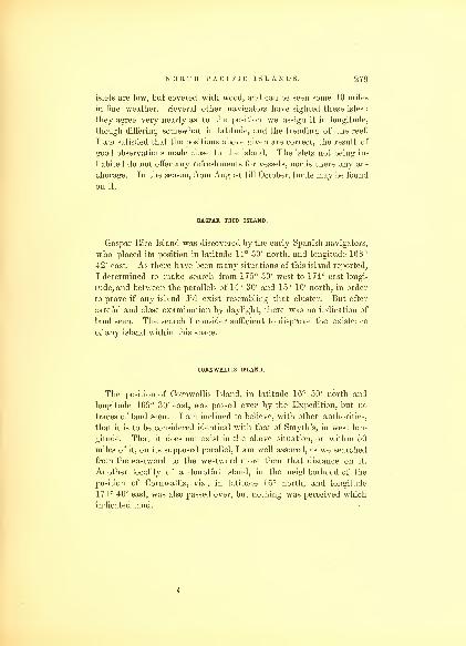
NORTH PACIFIC ISLANDS. 279
islets are low, but covered with wood, and can be seen some 10 miles
in fine weather. Several other navigators have sighted these isles :
they agree very nearly as to the position we assign it in longitude,
though differing somewhat in latitude, and the trending of the reef.
I am satisfied that the positions above given are correct, the result of
good observations made close to the island. The islets not being in-
habited do not offer any refreshments for vessels, nor is there any an-
chorage. In the season, from August till October, turtle may be found
on it.
GASPAR RICO ISLAND.
Gaspar Rico Island was discovered by the early Spanish navigators,
who placed its position in latitude 14° 30' north, and longitude 168°
42' east. As there have been many situations of this island reported,
I determined to make search from 175° 30' west to 174° east longi-
tude, and between the parallels of 14° 30' and 15° 10' north, in order
to prove if any island did exist resembling that cluster. But after
careful and close examination by daylight, there was no indication of
land seen. The search I consider sufficient to disprove the existence
of any island within this space.
CORNWALLIS ISLAND.
The position of Cornwallis Island, in latitude 16° 50' north and
longitude 169° 30' east, was passed over by the Expedition, but no
traces of land seen. I am inclined to believe, with other authorities,
that it is to be considered identical with that of Smyth's, in west lon-
gitude. That it does not exist in the above situation, or within 50
miles of it, on its supposed parallel, I am well assured, as we searched
from the eastward to the westward more than that distance on it.
Another locality of a doubtful island, in the neighborhood of the
position of Cornwallis, viz., in latitude 16° north, and longitude
171° 40' east, was also passed over, but nothing was perceived which
indicated land.
i
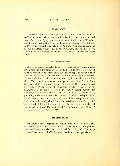
280 HYDROGRAPHY.
MORELL ISLAND.
This island was discovered by Captain Morell, in 1823. It is de-
scribed as a small island, not over 4 i miles in circumference, of coral
formation. A reef projects on its west side to the distance of 15 miles,
and from its southeast side, to the distance of 10 miles. Its latitude
is 29° 57' north, and longitude 174° 31' east. The Flying-Fish, one
of the squadron, passed just to the westward, but did not see it.
There is no doubt of the existence of this island and its dangerous
reefs.
NEW NANTUCKET ISLE.
New Nantucket is reported to be a low coral island, of small dimen-
sions, with but a few trees on it. Several islands have been reported
near its position in the same latitude to the west ; it is probable they
are one and the same. I have retained the name of New Nantucket.
Its longitude is not well established, and requires another determina-
tion. Two positions reported were passed over at different times
by vessels of the squadron; the one situated in 00° Hi' north, and
longitude 176° 20' west. If navigators should be passing in its
neighborhood, it would be well to keep a bright lookout for
dangers, as the position of this island may be in error, from 1° to 2°,
probably, to the west of that above given. It offers nothing to tempt
a visit, except turtle, in their season. A rock is also reported to exist
200 miles to the west ; this I have also retained on the chart, but I
am not satisfied that it exists. A reef has also been reported 60
miles northwest from the rock, which would place it in latitude 1°
north, and longitude 179° 34' east.
SAN PABLO ISLAND.
San Pablo Island is reported to exist in latitude 16° 07' north, and
longitude 179° 00' west. Here it certainly does not exist; the position
was passed over, and the search continued from 40 to 50 miles to the
eastward and westward of it, but no indications of land perceived.
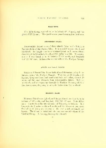
NORTH PACIFIC ISLANDS. 281
MILLE GROUP.
The Mille Group, reported to be in latitude 6° 12' north, and lon-
gitude 172° 22' east. This position was passed over and no land seen,
ARROWSMITH'S ISLAND.
Arrowsmith's Island is one of three islands lying in the Rulick or
Eastern chain of the Radick Isles. It is a coral lagoon island, and
inhabited. Its length lies in a west-northwest and east-southeast
direction ; it is 18 miles in length, and 11 miles in width. The south-
east end was found to be in latitude 7° 05' north, and longitude
171° 23' 54" east. It forms the western side of the Fordyce Passage.
PEDDER AND DANIEL ISLANDS.
Pedder and Daniel Islands are both of coral formation;they lie on
the east side of the Fordyce Passage. They are small islands, with
lagoons, lying northeast and southwest from each other, distant 20
miles, and the same distance from Arrowsmith's Island. Both are
inhabited ; and when passing through the Fordyce Passage, which is
free from danger, they may be seen, the latter from the masthead.
MULGRAVE ISLAND.
Mulgrave Island was sighted, and its position determined to be in
latitude 5° 59' north, and longitude 172° 02' 33" east. This differs
some 13 miles from the determination of Duperrey in latitude. It is
low, extends 2 miles north and south, and 1J miles east and west.
Several small islets are situated on the reef which surrounds the
lagoon. The island is inhabited : the natives resemble those of the
Caroline Group. A few supplies may be obtained.
71

282 HYDROGRAPHY.
BONHAM ISLAND.
Bonham Island was discovered in 1S09 ; it is a lagoon island. It
lies 150 miles west of Mulgrave. It has 4 large and 20 small islets
on its rim of coral, surrounding the lagoon, which is 30 miles in length,
northwest and southeast, by 20 in width. There are three entrances
into it on the northwest and southeast sides. The latitude of its
centre is 5° 53' 45" north, and the longitude 169° 36' 16" east. It is
inhabited.
HUNTER ISLAND.
Hunter Island was discovered by Captain Bond, in 1809. It is a
small coral island, li miles north and south, and I of a mile east and
west, including the reef. It has no lagoon, and is elevated towards
the centre. The latitude of its centre is 5° 42' north, and longitude
169° 05' 46" east. It lies west from the south end of Bonham.
BAKING ISLAND.
Baring Island lies west-southwest of Hunter Island, 40 miles. It
is a small low coral island, without a lagoon ; was discovered by
Captain Dennet ; is inhabited, and situated in 5° 34' 42" north, and
168° 26' 24" east.
FAROILEP AND FEIS ISLANDS.
Faroilep and Feis Islands were searched for along the parallels on
which they were supposed to exist, viz. : 8° 36' and 9° 47' north, but
there were no signs of land seen near the longitude assigned them.
The determination of these islands by Leutke must be correct, who
gives their position in longitude as 144° 36' and 140° 38' east.
OULOUTHY OR M'KENZIE'S GROUP AND SHOAL.
The eastern extremity of Oulouthy or M'Kenzie's Group is placed
by us in 10° 07' 53" north, longitude 139° 54' 58" east. The
southern extremity in 9° 46' north, and 139° 44' east. It is composed
of an eastern and western island; which are separated by a passage of
8 miles. The western island is upwards of 20 miles in length, north
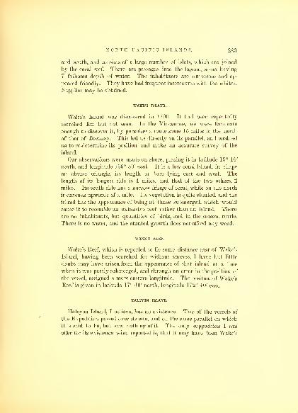
NORTH PACIFIC ISLANDS. 283
and south, and consists of a large number of islets, which are joined
by the coral reef. There are passages into the lagoon, some having
7 fathoms depth of water. The inhabitants are numerous and ap-
peared friendly. They have had frequent intercourse with the whites.
Supplies may be obtained.
WAKE'S ISLAND.
Wake's Island was discovered in 1796. It had been repeatedly
searched for, but not seen. In the Vincennes, we were fortunate
enough to discover it, by pursuing a route some 15 miles to the north
of that of Beechey. This led us directly on its parallel, and enabled
us to re-determine its position and make an accurate survey of the
island.
Our observations were made on shore, placing it in latitude 19° 15'
north, and longitude 166° 30' east. It is a low coral Island, in shape
an obtuse triangle, its length or base lying east and west. The
length of its longest side is 4 miles, and that of the two others, 2
miles. Its south side has a narrow fringe of coral, while on the north
it extends upwards of a mile. Its vegetation is quite stunted, and the
island has the appearance of being at times submerged, which would
cause it to resemble an extensive reef rather than an island. There
are no inhabitants, but quantities of birds, and in the season, turtle.
There is no water, and the stunted growth does not afford any wood.
WAKE'S BEEF.
Wake's Reef, which is reported to lie some distance east of Wake's
Island, having been searched for without success, I have but little
doubt may have arisen from the appearance of that island at a time
when it was partly submerged, and through an error in the position of
the vessel, assigned a more eastern longitude. The position of Wake's
Reef is given in latitude 17° 40' north, longitude 172° 40' east.
HALCYON ISLAND.
Halcyon Island, I believe, has no existence. Two of the vessels of
the Expedition passed over its site, and on the same parallel on which
it is said to be, but saw nothing of it. The only supposition I can
offer for its existence being reported is, that it may have been Wake's

28-1 HYDROGRAPHY.
Island which was seen, and an erroneous position to the westward of
that island assigned it, as has been the case with Wake's Reef to the
eastward. Both of these I have omitted on the chart of the Pacific
Ocean, but it may be advisable to give also the supposed position of
Halcyon Island, that navigators may, when passing, sail on other
parallels in search of it. Its latitude is given as 19° 13' north, and
longitude 163° 30' east.
FOLGER'S ISLAND.
Folger's Island was searched for by the squadron in the locality as-
signed it, viz., latitude 18° 21/ north and longitude 155° 19' east, but
no signs of land were discovered, or any indications of its existence.
It is impossible to account for the many erroneous positions of islands
which are found on the charts, and still remain there after a careful
search has disproved their existence. Folger's Island is one of these,
which lies in the route of vessels bound to China from the coast of
South America, and must, if it had existed, been frequently en-
countered by them. Our search extended on the parallel some degrees
to the eastward and westward of its assigned position.
BIGINI ISLAND (PESCADORES).
Bigini Island was discovered by Wallis, in 17G7. The island is
nearly of a triangular shape, of coral formation, and has a lagoon.
Its eastern side trends north-northeast and south-southwest, 10 miles;
its western nearly north-northwest, 10 miles; and its northern side
west-by-north and east-by-south, 8 miles. Its greatest length north and
south is 10 miles, and it is also 10 miles east and west. There are
three large and seven small islets; the first are situated at or near its
angular points. The reef or rim of coral is nearly awash, except
near the islets or where a low sandspit rises above, on its western
side. This makes it a dangerous island to approach, particularly as
its north and south points project ; it cannot be seen over 6 or 7 miles
in clear weather. The vegetation on the islets consists of but a few
low bushes : there was not a cocoanut or pandanus tree on either of
them at the time of our visit. At the northwest side there is a boat-
opening into the lagoon, and another about the middle of the north

NORTH PACIFIC ISLANDS. 285
side. Anchorage is found within. The island affords nothing onwhich human beings can subsist. It has no inhabitants, and is pro-
bably only resorted to by the natives of the neighboring islands
during the turtle season, or while in pursuit of the pearl fishery.
At this island Captain Dowsett and his boat's crew were treacher-
ously murdered by the natives.
RADOGALA AND KORSAKOFF ISLANDS.
Radogala lies 19 miles west of Bigini. Instead of but one island, as
reported by Kotzebue, there are two. I have therefore determined
to retain both names : Radogala to the largest and most eastern
island, and Korsakoff to the smaller or Avestern island. The island
of Radogala is a low coral island, with a lagoon ; it is above 20 miles
on each side, and in shape approaching a square. The longest side is
on the north, and trends nearly west-northwest and east-southeast;
the west side trends north and south ; the south side is parallel with
the north ; and the east side from its extreme east point trends
southwest, which curves westward, forming a large crescent-shaped
bay. The eastern side from Kumi Islet to the south extreme is a
range or string of small islets and sandbanks, the latter not muchabove the reef. Rimsky Islet is the largest, and of some extent : it
forms the southeast point; from it to Tufa Islet it is 12 miles, west-
northwest, which is the extreme south and west point. Near the
middle of the south side there is an opening, ll miles wide, into the
lagoon, having a sand-islet on a reef in its middle, on either side of
which there is a passage for vessels : the westernmost one is the best,
and anchorage may be found within under either islet. Radogala is
inhabited by a few natives, with whom no communication was had.
The islets offer but little sustenance. Kotzebue reports that he saw
some cocoanut or pandanus frees. None were seen on it by us;they
have probably been destroyed.
Korsakoff Island lies 15 miles to the southwestward of Radogala;
it is also a low coral island, with a lagoon. It trends east-southeast
and west-north
w
Test, is 14 miles in length, by 4 in width. There is
an entrance into the lagoon on the south side, over a mile in width,
which is bounded on each side by an islet. There are seven islets on
its south side, connected by the reef, which is awash in places ; the
72

28G HYDROGRAPHY.
north side is a bare reef, on which the sea breaks. No natives were
seen on this island, and there is believed to be no permanent inhabi-
tants, for it has not wherewithal to sustain life.
ASSUMPTION AND GEIGAN ISLAND, WITH THE MANGS.
Grigan lies to the south of Assumption, the northern island of the
Marian or Ladrones. It is high, and makes from the northeast in
the shape of a dome. As vessels generally pass between it and
Assumption, I was desirous of fixing their true positions, and that of
the Mang Eocks. According to Freycinet, the Mangs lie in the
channel between them ; but we found the Mangs to lie to the north-
ward of Assumption, 20 miles. The north end of Grigan we made in
latitude 18° 48' north, and longitude 145° 50' east. It was my inten-
tion to have sought a harbor on the west side of the Island of Grigan,
to obtain water, and make it a magnetical station, but my time did
not permit of the delay. The distance between Grigan and Assump-
tion Island is 50 miles ; this space is entirely clear. Assumption weplace in 19° 43' 30" north, and longitude 144° 48' east. Its height
above the sea was determined to be 2090 feet.
When passing this group it is advisable for vessels to keep a middle
course between Grigan and Assumption, by which they will not be
subject to be becalmed, as would be the case by a near approach to
either of these islands. The Marian Islands seem to intercept the
course of the easterly winds, which prevail with steadiness from the
eastward to their meridian, but after passing them vary to the south-
ward and westward, and become uncertain.
COPPER ISLAND.
The Copper Island of west longitude, as before remarked, was sought
for unsuccessfully. The charts place the position of the one of eastern
longitude in 20° 05' north, and 131° 50' east. In this position it does
not exist, for we passed directly over the place, in fine weather, and
had a most favorable opportunity for the search, with a smooth sea
and very clear horizon ; but nothing like land or indications of it were
to be seen.

NORTH PACIFIC ISLANDS. 287
ABAJOS ISLAND OR SHOAL.
The Abajos Island or Shoal is reported to lie about 3° to the west-
ward of Copper Island, and some 20 miles to the southward of it.
Although represented to be some distance apart, I thought it very pro-
bable they might be identical ; its locality was therefore passed over,
to make it certain that it did not exist there. It is difficult to con-
ceive how so many of these islands and shoals should be reported to
exist, in latitudes where the appearance of land must be always dis-
tinct, and the discovery of an island so remarkable an event that it
could not be mistaken.
SABTANG, BATAN, AND RICHMOND ROCKS, IN THE STRAITS OF BALINTANG.
We passed through these straits, between the islands of Sabtang and
Batan on the north, and the Richmond Rocks on the south. The
islands are all high, and that of Sabtang has many remarkable peaks,
rising between 900 and 1200 feet above the level of the sea. Onthe meridian of the west point of Sabtang we made the longitude
121° 50' 11" east. The transit bearing of Sabtang and the northwest
point of Batan was north 18° east, that of the east point of Sabtang
and Richmond Rocks, north 35° west. The latitude was found to be
28° 18' north, being situated 9' farther to the north than was given.
The course steered through these straits was west-by-south. Strong
currents prevailed, and many ripples were seen. The current was
found to set to the northward and westward.
CHAPTER XV.
HAWAIIAN OR SANDWICH ISLANDS.
These islands have long been considered as holding an important
position among the groups of the Pacific, and situated as they are
midway in the North Pacific, will continue to be one of the principal
resorts of our whaling fleet. From them a large part of the supplies are
drawn for repairs, and the health of their crews is re-established.
Besides these aids, they now afford recreation and amusement to our
fellow-citizens, after having undergone for months their toilsome
avocations. I therefore deem it necessary to give a full description
of the facilities these islands offer to our shipping interest, their
anchorages, and sailing directions to their different ports. For an ac-
count of their moral, social, and political condition, I must refer to
the fourth and fifth volumes of my Narrative of the Exploring Expe-
dition.
The Hawaiian Group includes eight islands, viz. : Hawaii, Maui,
Kahoolawe, Lanai, Molokai, Oahu, Kauai, and Niihau, which are
enumerated in order from east to west. There are besides three
rocky islets, viz. : Kaula and Lehua, off Niihau, and Molokini between
Maui and Kahoolawe.
The Island of Hawaii, the most eastern of the group, has a sea-
coast of 240 miles, and is nearly ecpjilateral in shape. The western
side trends north and south, while the other two sides towards the
east, extend in a northeast and southeast direction. Hawaii is the
most elevated of the Pacific Islands, its mountains rising to the height
of 14,000 feet, nearly to the line of perpetual snow. It is of volcanic
formation, and its shores are what may be termed iron-bound. Un-
like the islands of the Pacific within the coral range, it has no reefs
to form harbors, and has but one or two small bays partially pro-
tected by sunken reefs ; that of Hilo is the best. There is no place

HAWAIIAN OR SANDWICH ISLANDS. 289
where a vessel can undergo repairs. Hawaii can be seen in clear
weather at a great distance. Its rise is so gradual, that few are pre-
pared to admit its elevation. It lias four distinct elevations, Maun a
Kea, Mauna Loa, Hualalai, and Kohala. The greater part of the
island is covered with forest, except where the indurated lava has
flowed over. But comparatively a small portion of this island is sus-
ceptible of cultivation. Nearly all the population reside on the sea-
shore, where the climate is mild, and the productions of the tropics
are obtained with little labor.
Hilo Bay is the only anchorage on the northeast side for vessels.
It is much exposed to the swell of the ocean, being but litle protected
by the sunken coral reefs, which lie to seaward of the anchorage. This
bay is 3 miles wide by 2 miles deep. It is not difficult to enter, but
recpuires some precaution. Vessels intending to anchor in Hilo Bay,
should stand in for the southern part of Mauna Kea, if it can be seen.
"When the sea-breeze or trade-wind, which generally prevails, blows
fresh from the northeast, steer directly for the gulch on the west side
of the bay. A southwest course per compass will lead clear of the
point of the reef, which lies east from it. On the reef the sea usually
breaks. A vessel should not approach nearer the reef than ten fathoms,
and if becalmed when on soundings, it is advisable to anchor until
the breeze springs up. Soundings will be had within about a mile of
the reef, in 30 fathoms ; coarse gravel and sand, to the northward of
the reef, but if to the eastward, fine sand. The sea-breeze seldom
blows strong in the early part of the day, and generally fails when it
encounters the land-breeze, about 3 miles from the shore. WhenCocoanut Island bears to the eastward of south, steer in for the coni-
cal hill back of the town of Hilo; this course will lead clear of the west
point of the reef. Cocoanut Island has three black rocks lying to
the north of it. When Cocoanut Island bears southeast, steer for
the mouth of Waiakea Creek, at the eastern point of the beach, and
when the black rocks off Cocoanut Island and East Point come in
range, anchor in 5 to 6 fathoms water, soft mud and sticky bottom.
There is no occasion to moor, but the anchor should be dropped with
a long scope of cable laid out to seaward : there is sometimes a
heavy sea setting in, but the wind does not blow home, and a vessel
will ride by the bight of her cable to all the other winds. Theafternoons and evenings are usually calm. The sea-breezes are accom-
panied with rain showers. Water is obtained in the Waiakea River,
-1)0 HYDROGRAPHY.
where it is to be had in abundance. There is sometimes difficulty in
entering the river, on account of the surf which breaks across its
mouth, and boats are liable to be swamped;they should keep the
centre of the channel, and not attempt to enter unless it is smooth.
Landing on the beach is always difficult. Opposite the town the surf
at all times is heavy, but at Observatory Point, near Waiakea Creek,
it is safe. Supplies can be had here, but not in such abundance as at
Oahu. The latitude of the observatory was determined to be 19° 43'
51" north, and longitude 155° 03' 06" west; the variation 8° 50' east.
The East Point of Hawaii (Kapoho), lies in longitude 154° 54' west,
latitude 19° 34' north. The southeast side of the island is nearly a
straight line, bounded by a rocky and iron-bound coast. There is
no landing or shelter, even for small vessels, on this part of the coast.
From Kalae to Pohue on the south, a distance of 20 miles, the shores
are likewise iron-bound. The coast from Point Pohue to Point Kawili
takes a northerly direction for 9 miles, then as far as Point Mano, a
distance of 32 miles, it makes a considerable bend to the eastward, and
within this distance lie the bays of Kealakeakua and Kailua, both
being under the lee of the island. They were formerly much fre-
quented by vessels touching at this island for supplies. The former, on
account of being the place where the celebrated Captain Cook lost his
life, will always be a point of interest to the navigator. It is seldom
frequented now : vessels prefer to resort to the ports of Lahaina, on
Maui, and Honolulu, in the Island of Oahu. The bay is half a mile in
width, by the same in depth. The anchorage at Kealakeakua is ex-
posed from the north by the west to south, but the sea is generally
quite smooth and calm under the lee of this high island. The sound-
ings extend off very gradually upwards of a mile, to the depth of 18
or 20 fathoms. The best anchorage is in about 10 fathoms, coral mudand sand, good holding-ground, with the village bearing east. At the
head of the bay there is a small beach, on which the village is
situated, but elsewhere the rocks rise perpendicularly from the sea.
The landing is neither difficult nor dangerous. There is no water to
be had here, except what the natives bring in their calabashes from
the mountain springs ; and those in search of provisions and fruit, had
much better resort to the Islands of Maui or Oahu. Standing in for
the Bay of Kealakeakua, it is necessary to avoid approaching too near
the land, either to the southward or northward of it, as vessels are
liable to be becalmed and detained for some hours. The best course

HAWAIIAN OK SANDWICH ISLANDS. 201
is to approach it directly from the westward, when either a favor-
able eddy breeze from the west or the light wind coming over the
island, may be taken advantage of, to reach the anchorage in the
least time. The latitude of Kealakeakua Bay was made in 10° 28' 12"
north, and longitude 156° 00' 00" west. At Kealakeakua Bay, there
is but little trade carried on ; it is now seldom visited by vessels.
Kailua Bay lies 12 miles to the northward of Kealakeakua. It has
a small harbor for native craft, and lies immediately at the foot of
Mauna Hualalai. The shore is rugged and bold, with but little space
for cultivation. It is not a good harbor, and offers little to induce a
visit.
The village of Kailua is thriving ; it is the residence of the
Governor of the island. From Kailua the coast trends west-north-
west to Point Mano, which is the most western point of the island. It
lies in latitude 10° 43' north, and longitude 156° 10' 30" west. FromPoint Mano, the coast again turns to the north 10 miles, to Waina-
nalu, thence it sweeps to the eastward 15 miles, to the roadstead of
Kawaihae, which is situated in latitude 20° 03' north, and longitude
155° 57' west. Kawaihae is the port or bay nearest to Maui and the
islands to the westward, and there are many small native vessels
which trade to this island, which only frequent this port. This bay is
readily known by the gorge in the mountains that is directly behind
it, in which lies the town of Waimea, where a lively trade is carried
on by the natives shipping their productions to Honolulu, consisting
of hides, tallow, leather, beef, wood, &c. The mountains rise from
the coast to a great height, and the country has the appearance of a
parched or burnt district. This port was first brought into notice by
Kuakini, well known under his English appellation of Governor
Adams. The Bay of Kawaihae does not deserve the name of a
port. Being under the lee of the island, it is difficult to reach ; calms
and light airs predominate ; the trade wind sometimes blows very
strong, rushing down the mountain side ; vessels lying in the roadstead
are frequently blown off. A peculiar squall, called by the natives
Hum uke, sometimes bursts upon the bay a short time before sunset;
its duration is not long, but of great violence ; its coming is prog-
nosticated by an illuminated streak, seen far inland, by the natives,
who prepare in time to resist its violence ; it is accompanied by quan-
tities of sand. Oftentimes the native craft take advantage of it to
escape beyond the region of calms that prevail under the high land

292 HYDROGRAPHY.
of the island. Navigators should also be on the lookout for these
squalls in passing the island a little before and after sunset'; they are
felt some distance from the island, and extend into the southern part
of the channel between Hawaii and Maui. The best anchorage off
Kawaihae is with the gorge well open, in 12 fathoms water. Some
supplies may be had here, but they are not as plentiful as at Maui or
Oahu ; wood can be procured of a good quality. As a place of resort
it is by no means agreeable, the air being hot and stifling. The morn-
ing hours are the best to transact business in, and the shipment of
cargo at that time does not meet with interruption from the weather.
From the Bay of Kawaihae the coast takes a trend due north to
Cape Upolu, the northwestern angle of Hawaii, a distance of 16 miles.
This is a moderately high cape, of a reddish appearance ; it lies in lati-
tude 20° 19' 30" north, and longitude 155° 58' west. Near the cape
is a sandy beach, but the surf seldom admits of a safe landing. From
Cape Upolu the coast trends eastward to Waipio, 32 miles. It is a
high and steep bluff coast, being much abraded and worn into deep
ravines (called at the islands gulches), by the rains. At Point Niulu,
10 miles from Cape Upolu, is a coral sandbank ; it extends some dis-
tance from the shore, but affords no shelter or anchorage. FromWaipio the coast takes a southeastern direction to Hilo Bay, 37 miles
distant, and continues to present the same perpendicular and iron-
bound character, with many gulches, and black volcanic rocks
lying within them and along the shore, on which the sea conti-
nually breaks. Some of these ravines present the appearance of
being accessible, but they afford no shelter or landing, and are for the
most part quite dry, the remains of mountain torrents that have
for ages passed through them during the rainy season.
The tide in Hilo Bay rises 3 feet;high water, on full and change,
at 1 p. m.
MAUI AND KAHOOLAWE ISLANDS.
The Island of Maui lies to the northwest of Hawaii, divided from
it by a channel 19 h miles wide. Maui is a high volcanic island,
formed by two oval-shaped mountains ; the easternmost is the largest
and highest : in one point it reaches the altitude of 10,000 feet above

HAWAIIAN, OR SANDWICH ISLANDS. 293
the sea : while that to the west is smaller, rising to the height of only
5000 feet. There are several well-defined peaks, projecting above this
mountain range, from its eastern to its western end. They are joined
by a sandy plain, 3 miles east and west ; it is quite low, and from
a distance to the north, appears as though there was a passage
between them. Many navigators have mistaken Western Maui for
Molokai Island, and have hauled up, as they supposed, to pass
through the Pailolo Channel, which lies between Molokai and Maui,
leading into Lahaina Roads. This error resulted, in one case, in the
entire loss of a vessel. West Maui, though the smallest, is of the
most importance ; and Lahaina, at its western end, is one of the
principal ports of this group. To anchor there, vessels either go to
the south of Kahoolawe, through the Avau Passage, or round the
north and west end of West Maui, through the Pailolo Channel,
and approach Lahaina Roads from the west. If a vessel wishes to
anchor in Lahaina Roads, coming from the eastward, she ought,
after leaving Hawaii, to steer so as to clear the west end of Kahoo-
lawe. There is a passage to the north of Kahoolawe, between it
and Maui, through which a vessel may sail. The Islet of Molokini
lies in the middle, between the two, and is the only danger ; but I
cannot recommend this route to any vessel. The land of both islands
is high, and a vessel may be becalmed in passing through, and expe-
rience much detention from baffling airs from all points of the compass,
and not unfrequently be struck by heavy squalls, which from their
suddenness as well as violence, would be very apt to cause the loss of
light sails and spars.
The southwest point (Kealaikahiki Point) lies in 156° 42' west
longitude, latitude 20° 31' north. A berth of 5 miles should be given
to this point; off it lies Kuia Shoal, li miles distant, on which there
is but Is fathoms water.
A vessel may pass close to the shore within this shoal, but it is
advisable to go outside farther to the south. The more room a vessel
gives the west point of Kahoolawe the better; the breeze will be
stronger, and cause the least delay in reaching the roadstead of
Lahaina. When to the west of Kealaikahiki Point some 6 miles,
the easterly breeze will be lost. Then the most western peak of West
Maui will bear north 25° east (true) ; steer directly for it. About noon
the sea-breeze sets in daily towards Maui, which will carry a vessel
onward to the anchorage. Care, however, must be taken not to ap-

294 HYDROGRAPHY.
proach too near to Maui. When far enough in to open out all the
high land of Molokai, steer for Lahaina;having the Palace and Fort
in sight, head directly for either of them. The best anchorage is with-
in a mile of the shore, in 17 fathoms water, the Palace bearing south
76° east;High School, north 43° east, and Point Halawa on Molokai
just shut in. The anchorage is not of great extent, but a vesel during
the fine season, from April till December, is perfectly safe. In
the months of January, February, and March, the southwest winds
prevail, when it is dangerous for vessels to ride out a gale there.
Of these gales, timely warning is given by the long swell from
the southwest ; then a vessel should prepare to leave, and by no
means attempt to remain at the anchorage. The north side of Maui
offers a good lee during these gales, and it is advisable that vessels
should take advantage of it when driven from the roadstead. This
is the mode adopted by the ill-found native craft, who continue under
the lee until the return of fine weather permits them to resume the
anchorage. The duration of these gales is some three days, but they
seldom happen more than once or twice during a season, and years
pass when none are experienced. Lahaina is the only place for
vessels to anchor at on the shores of Maui, an island having a sea-
coast of 100 miles, the greater part of which is an iron-bound shore,
along which a heavy surf breaks over sunken and outlying coral reefs.
Intending to visit Lahaina Roads, and approaching from the north,
care should be taken to be sure of the correct bearings of the west
end of Maui ; it lies in latitude 21° 03' north, and longitude 156° 39'
west. The appearance of the west end, in coming from the northward,
is a high, black, and knotty bluff, gradually rising to the eastward in
mountainous land. Molokai, the next island to the west, has the
appearance of a high, narrow, and level headland, stretching to the
southwest, and of a much less altitude than West Maui : from this de-
scription it would appear almost impossible that the one could be
mistaken for the other ; but having felt a doubt myself, I can easily
understand that it may occur. After the trade has been blowing for
some hours, towards the afternoon, the whole highland is obscured by
a thick haze, which envelopes both islands, quite impenetrable to the
sight, with or without the aid of telescopes, and gives the low isthmus
the appearance of the strait between Maui and Molokai. By taking
the bearing carefully, it will at once lead to a correction of the error,
the apparent passage being nearly south, while the true one leads

HAWAIIAN OR SANDWICH ISLANDS. 2!>G
southwest. After passing into the Pailolo Passage with a strong
trade, it is advisable to keep close to its eastern side. There are a
few outlying rocks, but nothing beyond half a mile from the shore.
When turning round the point of the island, the shore may be ap-
proached nearer, and as soon as the anchorage is opened, haul up for
it, reducing sail as occasion may require;by this means a vessel will
reach a berth without making a tack.
The town of Lahaina is the residence of the king, and has a popu-
lation of 3000. The roadstead is one of the principal resorts of our
whale ships, where they recruit their crews and obtain a supply of
provisions and water. The landing at low water is bad ; the tide
falls below the coral reef, which extends from the shore. A narrow
and tortuous channel for boats leads through it. At high water,
boats can pass over the reef and land at almost any point on the
beach ; the principal landing, however, is close to the Fort. The
supplies consist of beef, potatoes, taro, fruits, and wood ; the water is
pure and abundant. There is here a Seamen's Chapel, built by the
contributions of our whaling fleet ; in this, one of the missionaries
usually officiates on the Sabbath. The police of the place is good,
and there is freedom from annoyance to masters of ships in conse-
quence of it. Grogshops are comparatively few, and there are no
enticements for sailors to visit the shore. The place is healthy, and
well fitted for the re-establishment of health.
The current at Lahaina usually sets along the line of the coast,
running northwest 16 hours out of the 24 ; it sometimes varies in
direction and velocity, according to the prevalence of winds. It is
high water, full and change, at 2-30 p. m.
Rain seldom falls at Lahaina, in consequence of its being on the lee
side of the island, but scarcely a day passes in which showers do not
take place upon the mountains and descend in rivulets on the west side,
affording every opportunity to irrigate the land. The soil about
Lahaina is generally dry, and driven about in all directions by the
violent flurries of wind, which sweep down the mountain side, and
make it an uncomfortable place for a few hours in the day.
The Island of Kahoolawe offers no harbor or anchorage, nor has it
any inhabitants except a state prisoner or two, who are exiled there
for high crimes and misdemeanors.

29G HYDROGRAPHY.
LANAI.
Lanai is of an oblong form, rising to the height of 3000 feet.
It lies 10 miles on the southwest of West Maui, and shields its road-
stead from the Southern Ocean. It is but a mass of volcanic rocks,
20 miles in length, northwest and southeast, and with an average
breadth of 8 miles. Its shores rise abruptly from the ocean. The strait
between it and Maui is known by the name of the Avau Passage.
It affords little ground for cultivation, and is only inhabited by a few
fishermen, who have some temporary huts at its eastern end. It is
alike destitute of cattle, water, and wood, and is generally capped
with clouds, which give it at times a picturesque appearance. Its
southwestern side is the most abrupt, rising in perpendicular escarp-
ments, of a red ochre color. In passing to leeward of it, a vessel will
feel the effects of its influence in the calms, a distance of 20 miles.
MOLOKAI.
Molokai lies nearly east and west, in length 30 miles, with a meanwidth of G miles. It is separated from Maui by the Pailolo Passage,
10 miles wide. The eastern half of the island is 2700 feet high, rising
abruptly from a narrow strip of land between it and the sea, where
cultivation is carried on. The western half is composed of low sand-
hills, and defies all efforts at cultivation. Molokai has some 600
inhabitants, and is the residence of a missionary. Its inhabitants
have had but little intercourse with foreigners. The surplus produce
is carried to Lahaina, to be disposed of to the shipping ; it amounts to
but a small quantity. Vessels bound to Oahu, coming from north-
ward or eastward, generally run through the Pailolo Passage, which
is advisable, particularly if the day is far spent. The western end of
Molokai offers a good lee to lay by under during the night. It is
almost needless to say that this island has no harbors, or any cer-
tainty of obtaining supplies beyond a few fowls and some vegetables.
When the trade-wind blows, it rushes through the Pailolo Passage
with great strength, and violent flaws of wind are experienced, which
renders caution necessary, in order to save the lighter spars and sails.

HAWAIIAN OR SANDWICH ISLANDS. 29 7
It is entirely free from rocks or shoals. Kalaua Point, the western
point of Molokai, lies in longitude 157° 18' west, and latitude 21° 06 ;
north. Its western coast trends north-by-east, and is but 5i miles in
length.
OAHU.
Oahu Island lies to the west-northwest of Molokai, distant 27 miles.
Its form is an irregular four-sided figure, the northeastern side being
80 miles in length, while the remaining three sides are not over 20
each. Its surface is much diversified by two ranges of mountains,
which run parallel to its longest side. They rise to the height of from
2500 to 4200 feet, having a valley between them, contracted on the
north, but which gradually widens and opens into an extensive plain
:
this occupies the whole of the south side, bounded by coral reefs, to
some distance from the shore-line, and watered by many streams,
forming the safest and best harbors in the group; to these Oahu is
indebted for its advantages over the neighboring islands.
The streams descend from both the mountain ridges, and joining
in the centre of the valley, pursue an eastern course, and empty into
the harbor of Ewa, which is capacious, when all its many branching-
arms are taken into consideration, and affords a depth of water suffi-
cient for the largest vessels. Unfortunately, there is a bar across the
mouth, which does not admit of vessels drawing more than 12 feet
water. This could be removed, when Ewa would be superior to
Honolulu as a port. Vessels would find no difficuty in entering and
departing from it at all times of the day. This is not the case with
the port of Honolulu, the entrance into which is only to be effected
early in the morning, as the prevailing wind hauls a few points at
that time. The eastern end of Oahu is readily known by the pecu-
liarity of its* headland, which is high and broken into numerous
conical peaks, rising to a considerable elevation. Its easternmost
point, Makapua, lies in 157° 40' west longitude, and 21° 19' north
latitude. The coast from this point trends northwest 30 miles, and
southwest 8 miles, to Kawaikua Point ; from the latter, Leehi or
Diamond Hill is distant 6 miles. Between these two, there is a con-
siderable bay, but it offers no anchorage for vessels. In approaching
Oahu from the eastward, Leehi or Diamond Hill may be distinguished
75
298 HYDROGRAPHY.
by its peculiar oblong form. It is one of the craters that are so often
met with in the volcanic islands of the Pacific. The apex of Dia-
mond Hill lies in longitude 157° 49' west, and latitude 21° 15' north.
Diamond Point is low, and bounded by coral reefs of from \ to \\
miles in width, along which there are soundings and safe anchorage
at the eastern part ; from it the coast makes a sweep to the westward
to Laeloa Point, a distance of 18 miles. Waiakea is at the foot of
Diamond Hill, and was the place of anchorage when the island was
first visited ; but since the port of Honolulu has become known, few
vessels have dropped anchor there.
The port of Honolulu is situated 6 miles to the northward and
westward of Diamond Hill. The outer anchorage is safe in all
months except those of January and February, during which south-
west gales may occur;
they always give ample warning of their
approach, by the heavy swell setting in from that quarter, and suffi-
cient time is afforded to leave the anchorage. The situation of this
port may be readily recognized by the Punch Bowl Hill, a remarkable
crater peak, which lies directly in the rear of the town ; the best berth
for anchoring in is to the eastward of the entrance to the harbor,
with the Flagstaff on Punch Bowl bearing north 30° east ; Diamond
Hill, south 75° east ; Bethel Church, north ; Point Laeloa, north 85°
west.
The harbor, as I before remarked, is formed by the coral reef. It
is divided into an outer and inner one, neither of which is large,
but for a small number of vessels it is sufficiently commodious. The
bar is just within the outer line of the reef. To enter, the following
directions should be followed. Vessels must anchor in the outer roads,
if they reach the port after the morning has advanced. Before day-
light, hawsers for warping should be prepared, and an anchor ready to
drop under foot, and at early dawn to be under way. The breeze is
usually light, but being to windward of the entrance, all sail is to be
made, and everything prepared to shorten sail as quickly as possible.
Stand down for the buoy, which is on the starboard hand, at the end
of the coral reef to the eastward of the channel, in 10 feet water ; run
quite near to it, luffing up close to preserve full headway as long as
possible, for the wind will be found too scant when in the channel for
the sails to draw;they ought then to be at once clewed up, to avoid
stopping the headway. The pilot has boats prepared to take out the
hawsers, with many natives on the reef, to warp the vessel the mo-
HAWAIIAN, OR SANDWICH ISLANDS. 291)
ment the headway ceases, and to prevent her dragging on the lee reef.
When the elbow between the outer and inner harbor is reached, the
sails may be again used to pass into the inner harbor. The inner
harbor, though not large, is convenient and safe. It is necessary to
moor head and stern, on account of the smallness of space. The
depth of water on the bar is sufficient to admit vessels drawing not
more than 17 feet water. At the entrance of the passage there is a
small shoal, called the Middle Ground, on which there is but 5 i feet
of water : if there is any swell on, this ought to be carefully avoided.
While in the act of entering or passing through the channel, if the
ship's headway is stopped, and she begins to fall off, the anchor
should be instantly dropped, and hawsers run out to the buoys
on the reef. The authorities at Honolulu are always particular in
having assistance ready on the reef to warp men-of-war, and they
are in other respects extremely obliging in affording aid. The pilots
are skilful and attentive, and perfectly competent to manage a vessel;
their fees include services both for entrance and departure. Although
there is no kind of difficulty in the latter, yet it is advisable to make
use of them.
Honolulu offers the most convenient port for repairs among the
islands in the Pacific. Very good mechanics are to be found there,
and almost all kinds of supplies, excepting large spars, can be pro-
cured. Fresh provisions are abundant and good;they consist of beef,
mutton, and all kinds of poultry;vegetables and fruits are plenty.
Water is conveniently obtained up the creek, which empties into the
harbor at the west end of the town, and it may also be had at the
wells, but there it is not so good. It can only be obtained at high
water, the water falling too low upon the ebb to admit boats to pass
over the reef to the creek. It is believed that better arrangements
have been made since our visit to supply vessels with this necessary
article. The port of Honolulu is now the general resort of the whale
ships that require repairs. With the exception of the enticements
held out to crews, it is the best port for this purpose. Many of our
vessels will hereafter resort to our own ports, in Oregon and Cali-
fornia, which are certainly better adapted for refitting and refresh-
ments.
As before remarked, Pearl River, or Ewa, does not afford sufficient
depth of water for vessels. The time, however, may come when the
Hawaiian government will be induced to remove the obstruction,—
a

SOU HYDROGRAPHY.
work of no great difficulty, as the bottom consists of irregular coral
formations. It might be deepened to admit vessels of any draft of
water.
From Laeloa Point, the coast trends northwest 18 miles to Point
Kaena, on which no harbors are found, the shore being bold, and
the spurs from the western range rising abruptly in many places from
the sea, forming small coves, where landing is quite easy and safe.
Kaena Point lies in longitude 158° 15' west, and 21° 35' north latitude.
From Kaena Point the coast trends northeast 16 miles to KahukuPoint. This portion of the coast is also protected from the prevailing
winds. At Waimea, there is a good anchorage on a bank, in 12 fathoms
water, but it is not used, except by small vessels, or those which maybe in distress, and unable to reach the harbors to windward. Thevillage of Waimea lies at the western end of the valley : it enjoys a good
climate, and the neighborhood is productive. Its produce is similar to
the rest of the island, and goes to the town of Honolulu for a market.
The eastern coast trends northwest and southeast for 30 miles ; it is
the windward side of the island, is for the most part an iron-bound
shore, and particularly towards its northern end, where the spurs
join the coast. Farther to the southward, the principal range
retires from the coast line, leaving an extended flat, of several miles
wide, which is susceptible of cultivation. The line of this part of the
coast has some coral reefs, which, though affording no safe protection
for vessels, give some shelter for anchorage. One of these is Ka-
neoho : this is partly formed by the jutting out of the peninsula of
Mokapu on its southeast side. South of Waimanalo, the mountainous
range again approaches the coast, and forms an iron-bound shore. The
highest points of Oahu attain the altitude of 4200 feet. The average
height of the eastern range is 3000 feet, those of the western being less.
The Island of Oahu may be seen at a considerable distance in the early
part of the day, but when the trade wind sets in, it is usually enveloped
in clouds. Vessels falling to the leeward would do well to beat up dur-
ing the day, under the lee of the island;according to our experience,
there is less current than beyond the range of the island, but after
nightfall it is advisable to stretch well to the southward, and be in a
situation to take advantage of the breeze, which after midnight varies
to the southward and eastward a few points, and enables a vessel to
make a good board to the northward and eastward. • The latitude of
Honolulu is 21° 18' 40" north, longitude 157° 52' 15" west.
HAWAIIAN OR SANDWICH ISLANDS. 301
KAUAI.
The Island of Kauai lies 64 miles to the west-northwest of Oahu :
it is nearly circular in form, being 24 miles in diameter, and rises to
the height of 4000 feet. It has several peaks, but none that are
very pointed. From a distance, it appears somewhat dome-shaped.
Spurs lead from the high land to the coast, where they form manybarren and steep cliffs, with valleys between them, though of small
extent, yet of great fruitfulness, being well watered from the numerous
streamlets which descend from the mountain peaks, and receive their
supplies by the continual depositions of the clouds. The indentations
of the shores formed by these valleys, in a few instances, offer small
havens, which, though not deserving the name of harbors, admit the
embarkation of produce in the small vessels of the islands, and maybe used as temporary stopping-places for vessels in want of supplies.
On the south and southeast are the small bays of Waimea and
Kaneohe. Waimea Bay lies in latitude 21° 56' north, and longitude
159° 43' west. The harbor of Halelea lies on the north : it is the
best port to obtain beef at, which can be purchased at moderate prices.
This small bay is somewhat exposed to the sea and wind, but its land-
ing is safe. It lies in latitude 22° 13' north, and longitude 159° 34'
west. Both wood and water can be obtained at this island, but little
else, and vessels may readily be supplied with them on a temporary
visit ; the natives prefer sending to Oahu to dispose of their products.
The supplies derived from Kauai are very considerable.
NIIHAU.
Niihau is distant from the western part of Kauai (Kolo Point), 12
miles, and is divided from it by the Kaulaka Passage. This island
lies northeast and southwest, 20 miles in length by 7 in width : it is
of volcanic formation, and at first appears almost a barren rock,
having little or no wood upon it. When compared with the other
islands of the group it may be called low. It is remarkable for its
yams and fruits, which come here to great perfection. At times
there is a great scarcity of water on the island, rendering the cul-
tivation difficult. Formerly, ships were in the habit of calling off the76
HYDROGRAPHY.
island to procure a supply of yams, but it is seldom the case now, as
vegetables may be had in plenty at the islands where vessels are
obliged to stop and have intercourse. The southern and western end
of Niihau lies in latitude 21° 45' north, and longitude 160° 21' west.
There is anchorage in the bay, on the northwest side of the island,
from one-half to three-cparters of a mile from the shore. Vessels
intending to have communication with it, may stand boldly into the
bay, until the west point bears southwest-by-west (true), and its
north point northeast. The landing abreast of this position is practi-
cable,—taking care to pass sufficiently clear of the Islet of Lehua and
the rocks which lie off its northwest point, about li miles from the
shore. Off the west point there is a reef, which extends upwards of a
mile. To the south and west of the south end of Niihau lies the
barren rock Kaula. It bears southwest-by-west, and is 16 miles dis-
tant. It may be closely approached and readily avoided. It lies in
latitude 21° 40' north, and longitude 160° 35' west.

CHAPTER XVI.
OREGON TERRITORY.
STRAIT OF JUAN DE FUCA.
In approaching this strait, I have elsewhere mentioned that the
coast, to the southward of Cape Flattery, is a dangerous one, on ac-
count of the numerous outlying rocks, and the prevalence of the almost
daily fogs, which prove of serious difficulty and anxiety to all naviga-
tors. Many of these rocks are isolated, lie at the distance of several
miles from the coast, and surrounded by water of the depth of 10 to
15 fathoms. The coast is high and iron-bound. On account of the cur-
rents, it is desirable to avoid this part of the coast, as they set for the
most part on it from the northwest. I therefore deem it preferable,
for vessels bound into the Strait of Juan de Fuca, to make the land
of Vancouver's Island to the northward, which is visible a long dis-
tance to seaward, and can be perceived before that of the mainland to
the southward of Cape Flattery. Having attained the latitude of 48°
30' north, a due east course will lead a vessel to the centre of the Strait,
into the fair channel-way, with the highland visible on both sides.
Off Cape Flattery lies Tatooch Island and the Duncan Rock. Be-
tween these there is a safe passage. We passed through it in the
Vincennes. It is well, however, not to attempt it unless with a favor-
able tide and a commanding breeze. Duncan Rock is a few feet
above the water : when the sea is high it breaks entirely over it.
To the north of the Duncan there is a small shoal, with three fathoms
on it. When the tide is strong, it shows the position by whirls.
From Tatooch Island, at the distance of five miles east-southeast
(true), lies Scarborough Harbor, formed by a small bay and NeahIsland, which lies off its eastern point. This harbor is protected
from all but north and northwest winds, to which it is entirely
exposed. It affords temporary anchorage for vessels bound in or out.
304 HYDROGRAPHY.
Water may be procured in small quantities. For large vessels, the
anchorage to the eastward of Neah Island, between it and Sail Rock
Point, is to be preferred ; it is more easily reached than the harbor,
where the flow and reflow of the tide is regular. Whilst lying within
or at the mouth of the harbor, a vessel is liable to foul her anchors
unless moored. The set of the tides outside is parallel with the shore.
During the summer months fogs prevail after midday, which pre-
vent or rather shut out the sight of the land from seaward ; but if
the latitude has been obtained, there is no need of apprehension :
a vessel may stand on without fear. The wind is generally from the
westward in the strait, but dies away a short time after sunset. Thenights are calm. The fogs are indicated by a heavy bank of clouds
to the westward, which, as the afternoon advances, gradually rises,
and is driven in by the westerly breeze;they continue, or it re-
mains hazy throughout the night. On the north shore of the strait,
at its mouth, is the harbor of St. Juan. It is nearly opposite to Scar-
borough Harbor, and is exposed to the southwest winds ; it is 1 mile
wide by 02 deep. Off Quadra and Makomek Points lie clusters of
rocks, the Kaset and the Mush Rocks. The depth of water to anchor
in is 9 fathoms. The holding-ground is good. Wood and water maybe obtained at the head of the harbor, from a creek, near Siki Point.
In entering the Strait of Fuca, it must be borne in mind that
the prevailing winds are either up or down the strait. If they
happen to be in the eastern quarter, they will become more easterly,
and the same if in the western quarter. The cause of this is, the
high lands which traverse the length of Vancouver Island, on the
north, and the Olympic Range, on the south. They attain the height
of several thousand feet, and act as a funnel, through which the wind
draws either way.
The direct course up the Strait of Juan de Fuca is east-by-south
(true). It will lead to New Dungeness Point, which is 80 miles distant.
The Strait of Juan de Fuca is 95 miles in length, and has an ave-
rage width of 11 miles. At the entrance, abreast of Duncan Rock, it
is 8 miles wide. The Vancouver's Island shore is rocky, everywhere
composed of a conglomerate and a reddish granite, containing several
fine harbors, which have been lately surveyed by officers of the Eng-
lish government.
It was not in our power to survey either the north or south shore of
this Strait, between Scarborough Harbor and New Dungeness. All

OREGON TERRITORY. OHO
that we had time to do, was to make recognizance of the points, and
to connect them. For the outline of the shore we are indebted to the
Spanish surveys. There is a small harbor within Point Angeles,
but its mouth is barred by a sandspit, which does not permit any
but a vessel of small draft of water to pass in. The shores of the
strait on the south is composed of perpendicular sand-cliffs, which rise
gradually into high land, covered with forests of various species of
pine. Mount Olympus is conspicuous to the south, rising to the alti-
tude of 8138 feet, and is capped with snow.
The navigation of the strait by night is perfectly safe. The shores
are bold ; a vessel would almost strike her spars before her keel could
touch. It is better to navigate on the south shore than on the north.
The tides are more regular, and may be taken advantage of. They
flow in a direction with the course of the strait ; seldom with muchvelocity until they reach its eastern terminus, where they divide,
a part running towards and through the Canal de Arro, and another
to the south into Admiralty Inlet. A strong westerly wind on the
ebb produces a heavy cross sea.
NEW DUNGENESS ROADS.
New Dungeness Roads is the first safe anchorage on the south shore.
The point is low and sandy, extending from the high bluff, in the
form of a sickle, to the eastward, between 3 and 4 miles. This sand-
point forms the protection to New Dungeness Roads on the north-
west, and vessels desiring to anchor there, must double around it,
from a quarter to half a mile distant, standing into the roads from
1. to 2, and 3 miles, and anchor in from 10 to 15 fathoms, 1 to li
miles from the shore. Should it be the intention to proceed at
once into Admiralty Inlet, stand on for Point Wilson, the high
land of which will be visible to the east, on the starboard bow. Adirect course may be steered for it, if the wind will permit. But if
seeking some of the harbors to the northward through Ringgold's
Channel, steer for Watmaugh Head, which lies northeast, which
course will lead clear of Blunt's Island. Should night overtake, it
would be advisable and is deemed more prudent to seek anchorage
in Argus Bay and await daylight, than attempt to pass through Ring-
gold's Channel at night, where the tides are strong and set in various
7.7

HYDROGRAPHY.
directions through openings between the different islands. If this be
decided on, then stand for Mount Erie, on Perry's Island, which will
lead directly into that bay. The only dangers lying off are the Wil-
liamson Rocks. Wood and water may be obtained at an Indian settle-
ment in the bay, and some provisions.
NAVY ARCHIPELAGO.
Navy Archipelago is a collection of 25 islands, having the Straits
of Fuca on the south, the Gulf of Georgia on the north, the Canal de
Arro on the west, and Ringgold's Channel on the east. They have
been named from distinguished officers late of the U. S. naval service,
viz., Roclgers, Chauncey, Hull, Shaw, Decatur, Jones, Blakeley, Perry,
Sinclair, Lawrence, Gordon, Percival, and others. Most of them
are of moderate elevation. Mount Constitution, on Hull's Island,
rises to the height of 2356 feet. Hull's Island is the largest ; it is
indented by two deep bays, one of which has been called Ironsides,
the other Guerriere Bay. It is composed of reddish granite and con-
glomerate ; in some places the granite is seen to crop out. Both
Rodgers and Chauncey Islands partake of the same character. Onthe north of Rodgers Island, and between it and Hull's, is President's
Passage, 8 miles in length, by 1 to 2 in width. This passes into
Ontario Roads, between Rodgers and Chauncey Islands, and again
communicates on the south with De Fuca Strait, by the Little Belt
Passage ; on the north, the waters flow through Frolic Straits, into
Ironsides Bay, and around the Macedonian Crescent, between Blakeley
nnd Obstruction, Decatur and Blakeley Islands, again into Ringgold
Channel. The soundings throughout these waters are very deep,
seldom less than 30 fathoms.
RINGGOLD CHANNEL.
Ringgold Channel leads from the head of the Strait of Juan de
Fuca to the Gulf of Georgia. It is 19 miles in length, by from 1 to
3 miles wide. On the east it is bounded by McLaughlin, Sinclair,
Cypress, and Perry Islands ; while on the west it has Hull, Blakeley,
Decatur, and Chauncey. This channel trends nearly north and
OREGON TERRITORY. 307
south ; a north-by-east course from off Point Watmaugh will pass
clear of James's Island. The water is deep. There are but two dan-
gerous reefs, the Bird and the Peapod Rocks, which lie near mid-
channel ; the first about 1 i miles south-southeast of James's Island;
the former, between Hull's and Sinclair Islands.
CANAL DE AERO.
The Canal de Arro lies between the Archipelago of Arro and the
east end of Vancouver's Island ; it is the shortest and most direct
route into the Gulf of Georgia, from the Strait of De Fuca. The
distance from Point Gonzalo, the southeastern extremity of Van-
couver Island, to Java Head, the northeast point of the same island,
is 22 miles. Henry, Stuart, Speiden, John's, Waldron, and Gourd
Islands, lie near to and on the east side of the channel course, which
is north half west : this passes to the west of Stuart Island, and be-
tween it and Noon Island; thence north 60° east, 9 miles, brings
abreast of Java Head ; then steer for Gourd Island, and stand over to
the east for Point Roberts, on the mainland, to anchor in Drayton or
Birch Bay. Point Roberts is 7 miles south of the boundary line.
The Canal de Arro is free from dangers. The tides set very muchin the channel course above indicated, which may be called the
Fairway. The prevailing winds permit vessels to steer this course
through it both ways. Should the wind be ahead, there is ample room
for beating, and no dangers unless close to the shores of the islands.
There are few places where an anchor can be let go, on account of
the depth of water and the rocky bottom ; but anchorage need not be
resorted to, unless in case of absolute necessity, and those places indi-
cated on the chart are the best.
DRAYTON AND BIRCH BAYS.
Drayton Bay lies east of Point Roberts, and has an irregular outline;
its northern part is filled with mud, and bounded by a low marsh,
through which one of the branches of Frazer's River formerly dis-
charged. There is a cove on the east side, a snug harbor for small
vessels. A small peninsula divides Drayton from Birch Bay. The

308 HYDROGRAPHY.
latter may be .said to be included in Drayton Bay, which embraces
the waters between Point Roberts and Point Whitehorn ; the distance
between them is 10 miles. The anchorage in all parts of Drayton
Bay is safe, though somewhat exposed to the southwesterly winds. I
prefer to anchor in the south part of it or Birch Bay.
Birch Bay forms a part of Drayton Bay; the water in it is not deep,
ranging from 5 to 10 fathoms. The shores are low, and in places
marshy. Water and wood may be procured here.
SANDY POINT.
The coast trends southeast. From Point Whitehorn to Sandy Point
is 7 miles. The shores are moderately high, and the coast clear.
To the south of Sandy Point lies Point Migly, the north end of
M'Laughlin's Island, which is separated from the main by Hale's
Passage.
HALE'S PASSAGE.
Hale's Passage is 6 miles in length by three-quarters of a mile wide
;
it leads into Bellingham Bay. The depth of water through it, ranges
from 4 to 12 fathoms, and the current sets through it northwest and
southeast.
M'LAUGHLIN ISLAND.
M'Laughlin Island is 8 miles in length by 1 in width ; it is elevated,
with abrupt shores. On the west side it is bounded by Ringgold's
Chnnnel. The Viti Rocks lie off Point Carter, its southern end ; these
rucks are visible at all times of tide. The water is deep close to the
shore, which may be approached with safety.
BELLINGHAM BAY.
Bellingham Bay is 12 miles in length, northwest and southeast,
and ii miles in width. Point Francis and Point William, which
embrace the bay, are but 7 miles asunder. There is good anchorage
in Bellingham Bay, in from 4 to 20 fathoms water. At its northern
and southern ends are extensive mud-flats. The shores surrounding

OREGON TERRITORY. 300
these are low and marshy ; but towards the centre the land rises and
forms a bluff. Point Francis projects from the north shore in the
form of an oval-shaped peninsula. Point William, the south point of
the bay, is elevated ; a tongue of land joins it to the main land, and
separates it from Penguin Harbor. Near the centre of this bay, and
between the two points, lies Eliza Island, triangular in form, one
mile in length, by half a mile wide ; it is separated from the south
end of M'Laughlin's Island one mile. The entrance to Bellingham
Bay is between Point Carter and Point William. Vendovi Island,
three-quarters of a mile in diameter, nearly circular in form, lies be-
tween the two; either side of it may be taken. The Viti Rocks
lie in the passage, but there is ample room to sail on either side.
PENGUIN HARBOR.
Penguin Harbor lies southwest of Bellingham Bay ; it is formed by
Point William and Vendovi Islands on the north and east ; Lawrence
Island bounds it on the south and west, and Sinclair Island covers it
on the northwest; it is nearly 3 miles square. Jack's Island lies near
the centre of it. The anchorage is convenient and safe, with a depth
of water not exceeding 20 fathoms.
CYPRESS ISLAND.
Cypress Island lies on the west of Lawrence ; its length is 4 miles,
and greatest breadth 2 miles ; its surface is much broken, and rises
higher than those in its immediate neighborhood. On its west side is
Strawberry Bay, protected by Hautboy Islet, and contiguous to Ring-
gold Channel. It is a convenient stopping-place for a tide. Good water
and wood may be procured there. Leading north, between Cypress
and Lawrence Islands, is a safe and deep passage through to Bel-
lingham Bay. On the north end a conical hill rises to the elevation
of 780 feet, and off its north point there is a small islet and rocks, half
a mile from the shore.
SINCLAIR ISLAND.
Sinclair Island is also high, and separated from Cypress about three-
quarters of a mile ; it bounds Ringgold's Channel on the east. Be-
tween Sinclair, Cypress, and Lawrence Islands, are the Cone Islets.
78
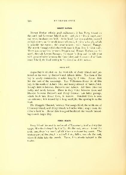
310 HYDROGRAPHY.
HORNET HARBOR,
Hornet Harbor affords good anchorage ; it has Perry Island on
the south and Lawrence Island on the north ; is 4 miles in length, east
and west; its shores are bold. At its head there is a mud-flat, covered
at high water ; on the south is a small creek, 6 miles in length, which
is passable for canoes : this communicates with Saratoga Passage.
The marsh through which the creek runs is from 2 to 3 miles wide.
There is a connection between Penguin and Hornet Harbors on the
north, through Levant Passage ; the water is deep and the tide runs
with great velocity between the three islets and the east end of Law-
rence Island, the flood setting in the direction of the arrows.
ARGUS BAY.
Argus Bay is situated on the west side of Perry Island, and pro-
tected on the west by Burrow's and Allan's Islets. The form of the
bay is nearly semicircular, 3 miles long by 2 wide. Mount Erie
lies due east of the anchorage. The Williamson Rocks lie off this
bay, to the south of Allan's Islet, and nearly abreast of Sare's Point.
Young's Islet is between Burrow's and Allan's. All these islets are
rocky, and much broken. There is deep water between them, and
likewise between Burrow's and Perry Islands ; this latter passage,
which leads into Boxer Cove, is narrow. Sandford Cove is near
the entrance ; it is formed by a long sandspit ; the opening is on the
west.
The Ringgold Channel, between Watmaugh Head, the south end of
Chauncey Island, and Perry Island, is 6 miles wide;ample room for
ships to beat in. Mount Erie is a good landmark for vessels intend-
ing to seek Argus Bay.
PERRY ISLAND.
Perry Island lies next to and south of Lawrence ; is of an irregular
shape, 10 miles in length by 6 wide. On the east, between it and the
main land, there is a marsh, which is bare at extreme low water. The
western part of the island is a bluff shore, falling towards the east,
where it sinks into the marsh. Mount Erie stands isolated in the
centre.

OREGON TERRITORY. 311
SARATOGA PASSAGE.
I have called Saratoga Passage, the strait leading from Deception
Passage to Admiralty Inlet, at the south end of Whidby's Island, 35
miles distant ; it has Whidby's Island on the west, and M'Donough
Island on the east. Within is Penn's Cove, Holmes Harbor, Port
Susan, and Port Gardner. Throughout Saratoga Passage the water
is of sufficient depth for the largest class of vessels ; it is well pro-
tected from all winds. The tides are strong, and their direction gene-
rally north and south. The southern end of this passage enlarges
into Possession Sound before it joins Admiralty Inlet.
DECEPTION PASSAGE.
Deception Passage is intricate and narrow, separating Perry from
Whidby's Island; its length is 3 miles; in some places it is not over
500 feet wide. Ketslum Islet lies at the west entrance;Hope, Skait,
and Kiket Islets, at the east. The three in the passage are called
Stam, Big and Little Tenif. These all have deep water close to them.
This passage ought not to be attempted without a commanding
breeze, which generally prevails from the westward. Small, quick-
working vessels may beat out with a favorable tide, but it would not
be safe for those of any burden.
BLUNT'S ISLAND.
Blunt's Island lies north-northwest of Point Partridge, distant from
it 6 miles ; it is of small elevation, lies nearly east and west, and in
length from its west end to the outer part of the shoal to the east, lh
miles. There -is a considerable bank at its western end, on which
there is kelp. A temporary anchorage may be made near it, but it
affords no shelter ; elsewhere the water is deep.
WHIDBY'S ISLAND.
Whidby's Island extends from Deception Passage on the north to
Scatchet's Head on the south, a distance of 35 miles. On the west it
is washed by Admiralty Inlet ; on the east by Saratoga Passage. It

312 HYDROGRAPHY.
has many indentations and small bays and coves on the eastern side
;
but its western side, from Deception Passage to Point Partridge, a
distance of 12 miles, is a high and nearly level bluff.
Point Partridge is the northern and western point of Admiralty
Inlet, and can be seen a long distance down Fuca's Strait; the shore is
bold and the water close to it deep.
From Point Partridge to Bed Bluff, is 5 miles, southeast ; thence
to Point Leavitt, is 8 miles, and Ariel Point is 4 miles from Point
Leavitt. From Ariel Point to Scatchet Head is a distance of 62 miles
;
here the shore makes a sweep, forming Useless Bay, with very deep
water ; and with the prevailing winds it is a lee shore, affording no
protection for vessels.
NEW DUNGENESS ROADS.
New Dungeness Koads is the best temporary anchorage for vessels,
as they are well protected from the prevailing winds, easy of access,
and if need be, water may be filled up. It is probable that here, in
future, pilots for Admiralty Inlet may be obtained, and supplies
in any quantities that may be required. To vessels requiring repairs,
this will be an important stopping-place, on account of its vicinity to
Budd's Harbor.
BUDD'S HARBOR AND PORT DISCOVERY.
Budd's Harbor might be designated as an extension of New Dun-
geness Roads, being separated from it only by a narrow tongue of land,
which lies across, and renders the harbor entirely land-locked. The
narrow entrance is on the west side. Vessels drawing 12 feet can
pass over the bar at low water. The rise and fall of the tide is 6
feet. The extent of this fine harbor is 3 miles north and south, by
a mile wide. The water is from 4 to 20 fathoms deep. The shores are
of moderate elevation, and covered with timber. There is a good
watering-place at the head of the harbor. It is believed that the
entrance may be deepened and improved at small expense.
Port Discovery lies 4 miles east of Budd's Harbor, and NewDungeness Roads; its form is serpentine, 7 miles in length by li
miles wide. Protection Island is situated li miles off its mouth, and
covers its entrance from the northwest winds. The great depth

OREGON TERRITORY. 313
of water is disadvantageous and very inconvenient for anchorage.
The banks rise abruptly. The port is easily distinguished by the
east and north bluffs at its entrance. Protection Island is of moderate
elevation ; on either side of it Port Discovery may be entered. The
best anchorage is off Carr's Point, in 20 fathoms water. "Wood,
water, &c, may be obtained without difficulty.
Five miles east of Port Discovery lies Point Wilson, the western
point of Admiralty Inlet ; it is a low, sandy point. Red Bluff, on
Whidby's Island, is directly opposite to it, distant 3 miles. Point
Hudson is low ; it bears due south from Point Wilson, If miles ; near
it, is a red-colored clay bluff, 80 feet high ; it is the north point of
Port Townshend.
PORT TOWNSHEND.
Port Townshend lies between Dickerson and Craven Peninsulas. It
extends to the southwest 3 miles, and then to the south and east the
same distance ; at its entrance it is 2 miles wide, but within increases
to three. This port is capacious, and has ample depth of water for
vessels of any size, and room for a large fleet ; towards its head it is
entirely laud-locked. It is separated from Port Lawrence on the
south by a very narrow isthmus of sand, joining Craven Peninsula to
the main. The anchorage in Port Townshend is safe at all times
;
the soundings throughout are from 9 to 15 fathoms; for vessels bound
up Admiralty Inlet, it affords a much better anchorage than Port
Discovery. Wood and water may both be procured here in plenty.
DICKERSON AND CRAVEN PENINSULAS.
Dickerson Peninsula rises abruptly on its north and west sides,
where it bounds on Port Discovery and Fuca Strait ; to the south and
east its elevation is less, falling in gentle declivities towards Port
Townshend. Its surface is for the most part open prairie ; it is 5
miles in length by 2i wide, and separates Port Townshend from Port
Discovery. The soil is a sandy loam, and easy of cultivation.
Craven Peninsula has an extensive sheet of water, called Kilisut
Harbor, enclosed within its area, which communicates with Port
79
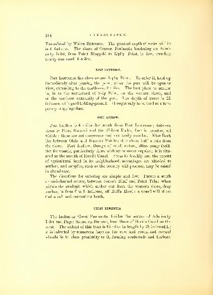
314 HYDROGRAPHY.
Townshend by Walan Entrance. The greatest depth of water within
is 6 fathoms. The shore of Craven Peninsula bordering on Admi-
ralty Inlet, from Point Ringgold to Liplip Point, is low, trending
nearly due south 6 miles.
POET LAWRENCE.
Port Lawrence lies close around Liplip Point. To enter it, haul up
immediately after passing the point, when the port will be open to
view, extending to the northwest 2 miles. The best place to anchor
in, is to the northward of Ship Point, on the western shore, and
at the southern extremity of the port. The depth of water is 21
fathoms, with good holding-ground. It ought only to be used as a tem-
porary stopping-place.
PORT LUDLOW.
Port Ludlow is 4 miles due south from Port Lawrence ; between
them is Point Kanawi and the Colvos Rocks, four in number, all
visible : these are not dangerous and are easily avoided. Klas Rock
lies between Olele and Kanawi Points ; it is about half a mile from
the shore. Port Ludlow, though of small extent, offers many facili-
ties for vessels, particularly those wishing to make repairs ; it is situ-
ated at the mouth of Hood's Canal. From its locality and the extent
of agricultural land in its neighborhood, advantages are afforded to
settlers, and supplies, such as the country will produce, may be raised
in abundance.
The directions for entering are simple and few. Pursue a south
or mid-channel course, between Jones's Bluff and Point Tala ; whenwithin the sandspit which makes out from the western shore, drop
anchor, in from 6 to 8 fathoms, off Bull's Head ; a vessel will there
find a safe and convenient berth.
GREAT PENINSULA.
The Indian or Great Peninsula divides the waters of Admiralty
Inlet and Puget Sound on the east, from those of Hood's Canal on the
west. The extent of this tract is 45 miles in length by 25 in breadth;
it is indented by numerous bays on the east and south, and several
islands lie in close proximity to it, forming roadsteads and harbors.
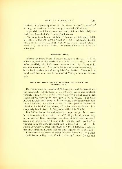
OREGON TERRITORY. 315
Its elevation is generally about 120 feet above tide, and composed of
a sandy, light soil, and for the most part covered with timber.
Suquamish Head, its extreme northern point, is a bold bluff, and
readily distinguished after passing Point Wilson.
The course from Liplip Point, in proceeding up Admiralty Inlet,
is southeast : this will carry a vessel off Point-no-Point, after passing
which, the first anchorage is at Pilot's Cove, 3 miles distant, where a
vessel may stop to await a tide. Admiralty Inlet at this place is 6
miles wide.
Mcdonough island.
McDonough Island bounds Saratoga Passage on the east. It is 15
miles long, and at the northern part it is 3 miles wide, but dimi-
nishes in width, being little more than a narrow strip of land at its
southern termination. Its eastern side forms a considerable curve. It
is low land, productive, and susceptible of cultivation. There is little
wood on it, but water can be obtained at Triangle Cove, on its east
side.
PORT SUSAN, PENN'S COVE, HOLMES' HARBOR, PORT GARDNER, ANDPOSSESSION SOUND.
Port Susan is on the east side of McDonough Island, between it and
the mainland. At its head is an extensive marsh and mud-flat,
through which a creek passes around the north end of McDonoughIsland, joining Saratoga Passage, opposite Point Polnell. The water
in Port Susan is deep, except at its north end, where it decreases from
14 to 2 fathoms. From Point Allen, the south point of McDonoughIsland, to the head of Port Susan, is 9 miles, north-northwest. It is
completely land-locked. At its greatest width it is oh miles.
Penn's Cove lies on the west side of Saratoga Passage. It is formed
by an indentation of the eastern side of Whidby's Island, immediately
to the east of Point Partridge. In shape it is a parallelogram, 3
miles east and west, by 1 mile wide. Off the south point of its
entrance is a sandspit, extending half a mile from the shore. In
Penn's Cove there is good anchorage, in 8 to 15 fathoms, which is a
safe and convenient harbor ; and the usual supplies can be obtained.
I have named the extent of water between Penn's Cove and Point
Polnell, Duncan's Bay ; it is 3i miles wide by 1 deep. On the west

31G HYDROGRAPHY.
side is Kalamut Island, which is surrounded by a reef of rocks.
The anchorage in the bay is from 8 to 12 fathoms in depth.
Holmes' Harbor lies in Saratoga Passage, 10 miles south of Penn's
Cove, 6 miles deep by one wide, an indentation which nearly divides
Whidby's Island. The water in it is deep, but anchorage may be
found at its extreme south. It offers but few advantages.
Port Gardner lies at the south end of Saratoga Passage. It is 6
miles square. On the east side of it Fresh-water Creek empties, at
the mouth of which is a broad mud-flat. The anchorage is on the
southeast side. Gedney's Island lies in the middle of Port Gardner :
it is one and a quarter miles in length by one-third of a mile wide,
and trends northwest and southeast. There is a shoal off its south-
east point.
Possession Sound joins Saratoga Passage at its southern termination.
It has the south end of Whidby's Island on the west, and divides it
from the mainland on the east. It leads from Admiralty Inlet into
Port Gardner, a distance of four miles ; it is two and a half miles
wide. Vessels seeking anchorage at Port Gardner, must pass close
to Point Elliott, and anchor under and near to the south shore, as the
bank drops off very suddenly.
Between Possession Sound and Elliott Bay, on the east side of Admi-
ralty Inlet, there is no anchorage or harbor for a distance of 16 miles.
The shore trends a little to the westward of south.
Five miles above Pilot's Cove, on the west side, there is another
good anchorage, at Apple Cove;though small, it is very convenient
for vessels passing up and down the inlet.
ELLIOTT BAY.
Elliott Bay is embraced between West Point and Point Roberts, the
south bluff. From West Point the shore trends southeast 5 miles,
to the head of the bay, has a sweep of 2 miles to the southwest, and
thence northwest the same distance to Point Rand, which is 11 miles
from Point Roberts. The anchorage is of comparatively small ex-
tent, owing to the great depth of water, as well as to the extensive
mud-flats ; these are bare at low water. Three small streams enter at
the head of the bay, where good water may be obtained. I do not
consider the bay a desirable anchorage ; from the west it is exposed
to the prevailing winds, and during their strength there is much sea.
Admiralty Inlet at this point is 3 miles wide.

OREGON TERRITORY. 317
PORT MADISON.
Port Madison is 5 miles to the southward of Apple Cove, on the
west side of Admiralty Inlet ; it is one of the best anchorages,
capacious and safe ; is 2 miles wide by 3 deep. The head of the bay
communicates with Port Orchard, through Agate's Passage, a good,
though narrow channel, dividing Bainbridge Island from the Great
Peninsula. The north and south points of Port Madison were named
Jefferson and Monroe ; under the latter a vessel may anchor, but it is
better to enter the port, and there await a favorable tide to pro-
ceed up the inlet.
PORT ORCHARD.
The southern entrance to Port Orchard lies to the south of Port
Madison 9 miles ; it has three arms, stretching to the southwest,
west, and northwest ; the latter communicates, as before stated, with
Port Madison. The waters of Port Orchard are separated from Ad-
miralty Inlet by Bainbridge Island, 7 miles in length, north and south,
by 3 wide. Towards its southern end, on its east side, are two small
coves, Eagle Harbor and Port Blakeley. The main entrance to Port
Orchard is through Rich's Passage : this lies between the south end
of Bainbridge Island and the Great Peninsula, trending in a north-
west direction, 2 miles in length, by half a mile wide, when it takes
a sharp turn to the southwest, of one mile. Properly speaking,
Rich's Passage is a part of Port Orchard, but as there were so
many branches, I thought it necessary to give the arms which
lead into it different names, reserving the name given by Vancouver
to the largest ; the others we called Dye's, Sinclair's, and May's
Inlets. Port Orchard offers all that could be desired for the safety
and equipment of vessels. It will be a convenient place of resort
for supplies as well as repairs. It is needless to point out any parti-
cular place of anchorage;every part of it may be used, and that
resorted to will depend upon future settlements that may be formed.
There are several rocks at the entrance of Rich's Passage, situated
near mid-channel. Vessels may pass on either side of them, but the
south shore is to be preferred, offering more room and a clearer pas-
sage. If it is not the intention to enter this harbor, good anchorage
may be had in Barron's Bay, between the land and Blake's Island at
its mouth.so

31S HYDROGRAPHY.
BLAKE'S ISLAND AND COLVO'S PASSAGE.
Blake's Island is triangular in form, with deep water around it ; its
sides 1 mile in length, and the island elevated. It forms the protec-
tion to Barron's Bay, where good anchorage may be obtained. It lies
a mile north of the entrance to Colvo's Passage, which is bounded by
Vashon Island on the east, and the Great Peninsula on the west : it
is 12 miles in length by half to a mile in width. Throughout its
length the water is very deep, with few places where an anchor can
be dropped. The shores are bold, and the largest class of vessels mayapproach close to them. A vessel should not drop anchor, unless
from necessity, until she arrives at the southern end, where anchorage
may be found in 13 to 17 fathoms, very close to the shore. Should
the wind be from the west, which is generally the case, it will be very
difficult to get under way on account of the eddies of wind under the
bank, 300 feet high. If the tide serves through the Narrows, or the
breeze be a commanding one, it would be advisable to stand on and
pass through them.
Colvo's Passage is the shortest and best route to the Narrows. That
on the east side of Vashon Island is broad and safe, though a much
longer route ; it affords better anchorages than Colvo's Passage, but it
is not advisable to take it, as the wind draws through Colvo's Passage,
and is more favorable than when passing round the eastern side of
Vashon's Island.
VASHON' S ISLAND.
Vashon's Island divides Colvo's Passage from the eastern channel
of Admiralty Inlet ; it is 13 miles in length by 3 miles at its greatest
breadth ; it rises to the elevation of 700 feet, tapers from its middle
north and south, in which direction its length lies. It is composed of
rough masses of rocks, and is well covered with timber.
MAURY'S ISLAND.
On the east of Vashon's Island, and near to it, is Maury's Island. It
is 4 miles in length by 1 wide ; trends northeast and southwest. Be-
tween it and Vashon's Island is Quarter-Master's Harbor, which is
safe, and of moderate depth. A small neck of land extends from the

OREGON TERRITORY. 319
upper or northern part of Vashon's Island, where it forms a snug cove.
At extreme low water, Maury's and Vashon's Islands are joined by a
sandbar. Vessels wishing to pass up the inlet on the east side of
Vashon's Island should steer for Point Robinson, the eastern point of
Maury's Island. Point Robinson may be closely approached, but if
the tide should be favorable, it would be advisable to keep a mid-chan-
nel course. After passing Point Robinson, Admiralty Inlet turns to
the southwest and west, and again joins Colvo's Passage, at the south
end of Vashon's Island, abreast of Point Defiance.
COMMENCEMENT BAY.
Opposite the southwest point of Maury's Island, on the main, lies
Commencement Bay, an indentation on the southeast, 3 miles deep
by 2 wide. The water is too deep for anchorage, except around the
borders of the bay, on its south shore. The head of the bay has an
extensive mud-flat, where several small streams enter, among them
the Pugallop, which takes its rise in the Cascade Range of Mountains.
The distance of this bay from Point Defiance is 5 miles.
THE NARROWS.
The distance through the Narrows is 4 miles ; at its narrowest
place it is nearly a mile wide, though from the height of the shores it
appears much less. Point Defiance, on the left, is a flat bluff, 250
feet high, of yellow sandstone, and horizontal stratification. It com-
pletely commands this pass. Opposite Point Defiance is Gig Harbor,
which has a sufficient depth of water for small vessels.
For passing the Narrows, the young flood is deemed the best time;
both ebb and flood run with great velocity, the flood on the eastern
shore, while the ebb generally prevails strongest on the west. Withthe wind from the west, it will be free until Puget Sound is opened,
when it generally draws ahead, and compels a vessel to back and fill,
along the east shore. The strong flood will carry a vessel through
in a short time. Great care should be taken not to stand too far over
towards the west shore, where an eddy current prevails with equal
strength on the flood and ebb in the opposite direction; if a vessel
stand too far over, and be caught within this eddy, she would be
carried back from whence she came.
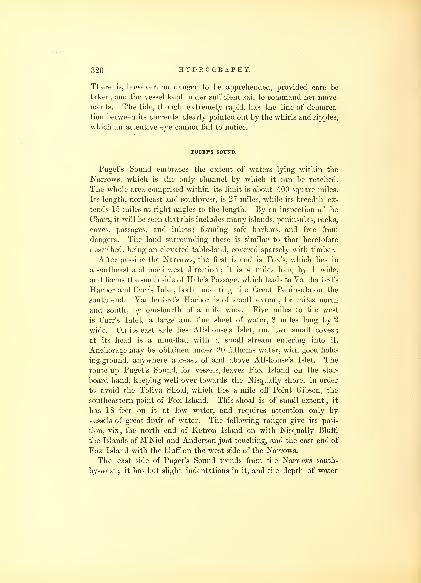
•;20 HYDROGRAPHY.
There is, however, no danger to be apprehended, provided care be
taken, and the vessel kept under sufficient sail to command her move-
ments. The tide, though extremely rapid, has the line of demarca-
tion between its currents clearly pointed out by the whirls and ripples,
which an attentive eye cannot fail to notice.
PUGET'S SOUND.
Puget's Sound embraces the extent of waters lying within the
Narrows, which is the only channel by which it can be reached.
The whole area comprised within its limit is about 400 square miles.
Its length, northeast and southwest, is 27 miles, while its breadth ex-
tends 15 miles at right angles to the length. By an inspection of the
Chart, it will be seen that this includes many islands, peninsulas, rocks,
coves, passages, and inlets;
forming safe harbors, and free from
dangers. The land surrounding these is similar to that heretofore
described, being an elevated table-land, covered sparsely with timber.
After passing the Narrows, the first island is Fox's, which lies in
a southeast and northwest direction ; it is 4 miles long by 1 wide,
and forms the south side of Hale's Passage, which leads to Vanderford's
Harbor and Carr's Inlet, both indenting the Great Peninsula on the
south end. Vanderford's Harbor is of small extent, 11 miles north
and south, by one-fourth of a mile wide. Five miles to the west
is Carr's Inlet, a large and fine sheet of water, 8 miles long by 2
wide. On its east side lies Allshouse's Islet, and two small coves
;
at its head is a mud-flat, with a small stream entering into it.
Anchorage may be obtained under 20 fathoms water, with good hold-
ing-ground, anywhere abreast of and above Allshouse's Islet. The
route up Puget's Sound, for vessels, leaves Fox Island on the star-
board hand, keeping well over towards the Nisqually shore, in order
to avoid the Toliva Shoal, which lies a mile off Point Gibson, the
southeastern point of Fox Island. This shoal is of small extent ; it
has 18 feet on it at low water, and requires attention only by
vessels of great draft of water. The following ranges give its posi-
tion, viz., the north end of Ketron Island on with Nisqually Bluff,
the Islands of M'Niel and Anderson just touching, and the east end of
Fox Island with the bluff on the west side of the Narrows.
The east side of Puget's Sound trends from the Narrows south-
by-west ; it has but slight indentations in it, and the depth of water

OREGON TERRITORY. 321
precludes any anchorage, except close to the shore. The bank both
above and below water-line is very steep. The distance from Day's
Island, at the south opening of the Narrows, to Nisqually Bluff, is
10 miles. M'Niel's Island lies above Fox's, to the southwest. It is
nearly oval in form, its longest axis being east and west, 3 by 2i
miles. Between it and Fox Island is Brackenridge's Passage, 1£ miles
wide. This leads to the northwest, into Carr's Inlet, of which it maybe said to form a part. Ketron Island is high, rocky, and barren ; it
lies north and south ; it is a mile in length and a quarter of a mile wide.
Between it and the shore is a tolerable harbor; but when the wind and
tide are opposed, a sharp and disagreeable sea prevails. The island af-
fords the only protection from the westerly winds, which blow strong.
The depth of water and the steepness of the bank, with the strength of
tide, does not permit me to recommended it as a good anchoring-place.
The sound abreast of Anderson and M'Niel's Islands is 2 miles wide.
Wood and water may be easily procured. Three miles to the south of
Ketron Island is the landing of Fort Nisqually. From the bank shelving
very rapidly, the anchorage is of very limited extent; within a cable's
length, a change of from 17 to 44 fathoms takes place. The anchorage
of the Vincennes, at Nisqually, was directly opposite a fine stream of
water ; we found it very convenient for our purpose, but it is very
unsafe in the winter. The steamer of the H. B. C. usually discharges
her cargo here, but it is more for the convenience to Fort Nisqually,
that it was chosen, than as a safe port. The bank rises abruptly 210
feet, at which height there is a plateau extending for many miles to
the eastward, forming one of the prairies of Oregon. Fort Nisqually
lies li miles from the sound, on the prairie. A mile beyond the anchor-
age to the south is the north bluff to the Nisqually River, called KwaatzPoint. Close to it the river empties into the sound; its mouth is upwards
of a mile wide, occupied by an extensive mud-flat, which is bare at low
water. There is another small and tortuous channel into the river on
the southwest side, near Loa Point. From the mouth of the river to
Point Moody, the shore trends northwest 6 miles ; thence it turns to
the south into Henderson Inlet; thence passing the south end of Hart-
stene Island it divides into Budd's, Eld's, Totten, and HammerslyInlets, all capacious, and affording every facility for vessels of any
size. These inlets are separated from that of Case's by Jack's, Hope,
and Hartstene Islands ; and Pickering's, Dana's, and Peale's Passages
lead into them. Case's Inlet stretches up towards the north, until it
81

322 HYDROGRAPHY.
approaches within a short distance of the waters of Hood's Canal, where
there is a portage. This is a low marshy strip, li miles wide,
forming a narrow isthmus, which joins the Indian or Great Peninsula
to the main land. In Case's Inlet, there are two small islets, viz., Herron
and Stretch's ; the former lies just within its entrance, and the latter
where the waters of the southern inlets join it. From the mouth
of this Inlet to its farthest point is 12 miles ; its width at its entrance
is 1* miles, but it decreases gradually towards its head. There is
good anchorage throughout in a moderate depth ; the banks are not
so high, and the shores more shelving than the other inlets.
Anderson's Island lies opposite to Nisqually, distant Is miles; its
form is nearly oblong, 3 miles in length, north-northeast and south-
southwest, and 2 miles wide. On the eastern side is the Bay of Oro,
lying opposite to the anchorage at Nisqually : it is nearly semicircular,
and half a mile deep. Anderson's and M'Niel's Islands are separated
from the Great Peninsula by Drayton's Passage. The eastern branch
of Drayton's Passage divides Anderson's and M'Niel's Islands : in it lie
also Ned and Tom's Islets;they may be passed close on the north
side, where there is sufficient water for the largest vessels, as well
as ample space for manoeuvring in. Puget's Sound and its inlets offer
every advantage for naval or- commercial purposes. The rise and fall
of the tide is sufficient for dry docks of large dimensions, and there
are many localities where they could be established, and built at a
moderate expense.
HOOD'S CANAL.
Hood's Canal branches off from Admiralty Inlet at Suquamish
Head, where it is 2 miles wide. Its direction is south-southeast, 5
miles ; it then turns to the south-southwest, 6 miles ; thence to Squal-
ler's Point, southeast, 6 miles, turning again to the west-southwest, 3
miles, to Nukolowap Point, the south point of Toandos Peninsula,
which divides the north branch from the Canal. Continuing on this
course, across the mouth of the north branch, for 4 miles, is Quatsap
Point, passing the Harbor and Point of Scabock on the east, thence
southwest, 3 miles, to Triton Head, continuing to Point Cummings,
Ayoch's Point, to Point Neelim. Throughout this distance, 30 miles,
the shore is elevated and well wooded. There are several small streams

OREGON TERRITORY. 323
of fresh water : the one near Point Cummings is the largest ; at its
outlet there is a mud-flat.
The eastern shore, from Sandy Point, opposite Quatsap, though not
so elevated, is more precipitous. From Sandy Point to Point Musquiti,
which lies nearly opposite to Neelim Point, the shore is of the same
character, and the width of the Canal throughout the distance varies
but little ; the points are all low and sandy, while those on the opposite
side are high. The anchorage on the west side is better than on the
east, where the water is too deep in many places to admit of it. FromNeelim Point, the Canal takes a sharp turn to the east-northeast.
Between Neelim Point and Point Crowlie lies Anna's Bay, into which
empties Black Creek: the distancebetween the points is 2 miles, the bay
1 mile deep, the eastern part of it being filled by an extensive mud-fiat.
From Point Crowlie to Sister's Point is 3 miles. Here the northeast
arm contracts to half a mile in width, whence it changes its course to
the east-northeast, 8 miles, ending in Lynch Cove, which, as is usual
in all these harbors, has an extensive mud-fiat at its head.
The harbors in Hood's Canal are, Port Ludlow, at its entrance,
heretofore described, Port Gamble, Suquamish, Scabock, Hoo-et-zen,
and Col-see-ed Harbors;Dabop and Anna Bays ; Tzu-sa-ted and
Lynch Coves.
Port Gamble lies 6 miles within Hood's Canal from Suquamish
Head, on its eastern side; it is 2z miles in length, north and south,
and half a mile wide at its entrance. The channel lies through an
extensive mud-flat, to the northward of its two points, Totten's on the
west, and Point Julia on the east. To enter, bring Point Julia
to bear south half east, and steer due south, taking care to keep it
open on the port bow. The bottom is quite soft, and a vessel cannot
be injured if she grounds on either side ; but those drawing less than
20 feet can find no difficulty in passing through it, even at low water,
with a fair wind. Within the harbor there is from 5 to 7 fathoms
water ; the bottom is of mud and sand, and the holding-ground
good ; the shores are moderately high. At the south end, there are
two or three small streams of water, but they are not at all times
to be relied upon for a supply. In entering the Canal, steer for
Point Hannon, a sandy point on its western side ; thence for Point
Salisbury ; but to enter Suquamish Harbor, it is better to keep the
western shore aboard, passing round the Sister Rocks, off Point
Termination, and anchor on the east side, avoiding the sandbank

324 HYDROGRAPHY.
off the western shore. The Sister Rocks may be avoided by not
shutting out the land to the southward of South Point. There is no
other danger to be apprehended, and these are usually visible.
The next harbor is that of Scabock. It lies on the eastern side
of the Canal, directly south of Nukolowap Point, distant from it 3
miles. It is one of the most convenient anchorages in the Canal. Its
shape is triangular; its shore is bordered by a sand-beach, from which
the hills rise : these are well-covered with wood. The distance be-
tween the two points of the harbor (Samum and Wikat), is 1 mile; it
is also a mile deep towards the southwest. Near its head is an ex-
tensive sand-flat, dry in places at low water. The watering-place
can be approached by boats at half tide : the landing is on the south-
east side, at Makak Point. The best anchorage is near the centre of
the harbor, Samum Point bearing northwest, with a gray sandy
bottom.
Opposite Scabock Point is the entrance to the north branch of Hood's
Canal, which lies between the Toandos Peninsula and the western shore
:
it is 9 miles deep and 2 miles wide between Sylopash and Tskulusco
Points. It contains three harbors, but there is no anchorage in it,
the water being very deep.
Hoo-et-zen Harbor is the next. It lies on the west shore of the
north branch, 3 miles above Sylopash Point, and forms a segment
of a circle, three-fourths of a mile in diameter ; its shores are rocky
and elevated, except on the northwest side, where there is a sand-
beach, with the usual mud-flat. Pulali Point lies on the east side,
from which to the double heads the shore is a rocky bluff. The
west side, from Weewa to Naika Points, is of a similar character. Atthe head of the harbor is Musam Place, where a small creek enters,
from which good water may be obtained. The best anchorage is in 11
fathoms, about the centre of the harbor. To enter, either shore maybe closely approached. After rounding Nukolowap Point, steer
directly for the harbor ; the course is north-northwest.
Two miles to the northward of Hoo-et-zen, you enter Col-see-ed
Harbor, between Bramblebluff and Rose Point;they are half a mile
asunder. The harbor is 2 miles in length, including the extensive
mud-flat at its head, which occupies nearly one-half the space, and is
generally bare at low water, the upper part being a salt marsh, with
creeks running through. Both shores of the southern part of the
harbor are steep, hilly, and well covered with wood. The anchorage
lies off Point Yakso, half a mile above Rose Point, in 7 to 10 fathoms

OREGON TERRITORY. 320
water, with muddy bottom. At Point Yakso, there is an Indian
village. Water may be obtained at half tide from the streams and
creeks at the head of the harbor. Col-see-ed Harbor is separated
from Dabop Bay by Bolton Peninsula, which is 4 miles long, by 1
mile wide. In Dabop Bay, the water to the southward of Pilash
Point, is too deep for anchorage ; to the north, it is necessary to
anchor very near the shore at the head, of the Bay, which terminates
in a small muddy and useless cove. The land which borders this
bay is high, and covered with woods ; into it several small streams
discharge themselves. As a harbor it is not to be compared to the
others before spoken of. The shores in this arm, as well as those of
the Canal, are well supplied with shell-fish.
Anna's Bay lies at the southern extremity of the Canal, where
Vancouver supposed it ended. Black Creek enters into this Bay, by
which the Indians make the communication with the Chekeeles and
the country to the south. The anchorage in Anna's Bay is on the
western side, under Point Neelim, where there is a moderate depth
of water. A large Indian village is situated on Point Neelim.
A mile to the north of Quatsap Point lies Tzusated Cove. Its posi-
tion may be readily known by the Jupiter Hills, which lie just above
it. The best anchorage is off Boston Point, a rocky bluff, distant 1
mile from Olo Bluff; between the two lies the cove : an anchorage
may be obtained in any part of it. On the southwest, there is a
narrow entrance between Palisi and Slik Points, into the basin, which
is half a mile long, by quarter of a mile wide, and secure from all
winds. The depth of water in it is between 5 and 6 fathoms. In
the entrance there is but 2i fathoms at low tide. It is well marked
by Palisi Point, low and sandy, on the west side, and the rocky bluff of
Slik Point on the east. In anchoring in this cove, it is necessary
to look out for the heavy flaws of wind which come down from the
Jupiter Hills.
Lynch Cove is situated at the farthest point of the northeast
branch. The land about it is low and marshy on the east ; on the
west it rises, and is sparsely covered with wood. At the head of this
cove is also an extensive mud-flat. There is good anchorage, in 5 and
6 fathoms, between the two small sandspits, which lie on opposite
sides of and form the cove.
In closing my remarks upon the intercommunication these waters
afford, it might be deemed desirable that I should point out the
82

326 HYDROGRAPHY.
localities wliich afford the best positions for future settlements.
These at first will be selected more from convenience for present
supplies, than with a view to future trade. But the positions which
must claim most attention, are those at the head of the inlets,
affording facilities for trade as well as internal communication. The
waters within Cape Flattery offer an extent of safe navigation unsur-
passed in any country, and every facility that can be needed for carry-
ing on the most extensive commerce. But a few years will elapse
before this estuary will be overrun by the tide of emigration, which is
now flowing so rapidly toward the western shores.
Our surveys did not extend to the north of Frazer's River, in the
Gulf of Georgia ; I omit therefore to give any particular description of
it. It may be stated, however, that the tides are very strong, that
there are many detached rocks, that the shores are bold and iron-bound,
and that there is great difficulty in navigating through Johnson's
Strait, and little security to shipping against the dangers. Fogs prevail
for a large portion of the year, which throw great difficulties and
impediments to its ever being used as a route for navigation, even when
assisted by steam.
FRAZER'S RIVER.
The mouth of Frazer's River lies 7 miles to the north of the 49th
parallel. Like all the other rivers of Oregon, it is barred by an ex-
tensive mud and sand flat, extending for some 6 miles to the west
;
this is partially bare at low water. The channel in the river is of
ample depth ; its course is serpentine. From its north bluff outwards,
towards the bar, the depth decreases to 12 feet, which is the greatest
draft of water that can be carried in : this renders the entrance
impracticable for vessels of large size. The bar bears southwest
from the north bluff, and west-southwest from Cowitchen Peak.
Point M'Leod, at the mouth of the north channel, now nearly
filled up, is 4 miles distant. During freshets, the river dis-
charges a part of its water through it, and then it may be passed
through by boats and canoes. The south bank of the river is low
and marshy. At high water the tide flows through several small
inlets into the river ; these once formed a delta, but they are nowtoo much obstructed and too small to be so considered. The posi-

OREGON TERRITORY. 327
tion of the north bluff, where our observations were made, is 49° 07'
05" north, longitude 123° 08' 57" west, and the variation 21° 14' 41"
west. The trade of Frazer's River will be considerable when the
country becomes settled ; it is navigable for steamboats to its falls,
80 miles from its mouth. It has a fine salmon fishery;though the
fish are not so large as those of the Columbia River, yet they abound
in greater number. The principal settlement is Fort Langley, twenty-
five miles from its mouth, which is one of the posts of the Hudson
Bay Company.
CHAPTER XVII.
COAST OP OREGON AND CALIFORNIA.
On leaving the Straits of Juan de Fuca to pass to the southward,
there are no ports along the coast until Gray's Harbor is reached, a
distance of 90 miles. The trend of the coast is south three-quarters
east. It decreases in height, and the sea-shore is bordered by low land.
In some parts there are low cliffs, but the land rises towards the
interior to a considerable elevation.
The Flattery Rocks lie 10 miles south of Cape Flattery. They
are detached from the shore, worn by the sea into many fantastic
shapes, and lie at various distances, 4 to 5 miles from the coast. They
are columnar in form, black in color, and rise to the height of from
50 to 100 feet.
Destruction Islet is 30 miles to the southward of Cape Flattery.
It is low and flat, one-third of a mile in diameter, quite barren,
with a few dwarf trees on it. A reef extends from its northern
end, on which the sea usually breaks.
Point Grenville is elevated. It may be known by the three small
rocky islets lying off the coast : one of them, the southern one, is
perforated. There is anchorage off this coast, during the fine season,
in from 16 to 20 fathoms, on sandy bottom. There is no shelter
;
the coast may be considered dangerous, from the outlying rocks and
the set of the currents, which Ave experienced ; it ought not to be
approached nearer than the depth of 15 fathoms. Several vessels,
both English, Russian, and Japanese, have been wrecked in the
neighborhood of Point Grenville. Formerly, great danger was to
be apprehended from the Indians, who massacred all of those who
were shipwrecked near this Point. There is no longer any danger, as
they have become sufficiently civilized not to sacrifice the lives of
those who may have the misfortune to fall into their hands. One of

COAST OF OREGON AND CALIFORNIA. 329
the best guides along this coast, is the green water, taking care to
keep without it during foggy weather. The most advisable course is
to keep beyond the depth of 70 fathoms. The current generally runs
to the northward, but it sometimes sets directly on the coast, and
oftentimes a high sea prevails.
Gray's Harbor lies 20 miles to the southward of Point Grenville.
The land is comparatively low, till within a short distance of
the entrance of the harbor, then a few low sand-hills rise up.
Point Brown forms the north point of the harbor, Point Hanson the
southern. They are 2i miles asunder, and bear south-by-west (true)
from each other. Both these points have extensive sandspits, pro-
jecting some 3 miles to seaward ; between these is the entrance.
The bar lies just beyond the outer end of the sandspits. It has
been reported that it is a shifting one, but I have reason to believe it
not to be the case. The see breaks heavily upon both the sandspits,
and at times extends entirely across from point to point. Fogs prevail
generally every afternoon, during the summer months, on this coast.
On the northern sandspit lies Eld's Islet, from which rise several
hillocks. The channel between the sandspits is deep, and 2 miles in
length. To enter the harbor there is little difficulty. When off the
bar, bring Stearns Bluff Islet to bear south 85° east, on with the
side of Eld Islet. This course will lead through the channel. The
wind is usually fair, and it is only necessary to keep clear of the break-
ers on either side ; but to depart from this port, is as difficult as the
entrance is easy. The tides are irregular ; it is high water, full and
change, at 11 h. 45 m., with a rise and fall of 8 feet.
Gray's Harbor, though apparently capacious, is more than half
filled up by mud-flats and sandspits. Its length lies east and west.
As a port it is only suitable for vessels of a small draft of water.
The land bordering it is low, with the exception of Brackenridge
Bluff on the east, and Stearns Bluff on the south. Both are covered
with pines.
There are several anchorages, but they are very limited in space
;
that under Point Brown on the north, and another under Point Hansonon the south, are the most convenient at which to procure supplies.
Elsewhere it is difficult to find a place where a landing can be effected,
in consequence of the mud-fiats ; most part of these are bare at low
water. The northern part of the harbor I have designated as Useless
Bay ; it is entirely filled by a mud-flat.
83

330 HYDROGRAPHY.
The Chikeelis empties into the harbor on the east. For nearly its
whole length it is very narrow and serpentine, and is navigable for 8 or
10 miles for small vessels ; the greatest depth of water is 12 feet. In
this river there is an excellent salmon fishery, and vast numbers
are taken during the season. At the time of the passage of the wild
fowls, they are also very numerous in the harbor. Some few Indians
frequent this harbor, but none make it their permanent home. Thelower banks during freshets are overflowed.
On the south of the harbor the land is low, extending for some
distance into the interior, with salt marshes. The soil is a mixture of
red and white sand and pebble-stones, and is unproductive.
From Gray's Harbor to the mouth of the Columbia River is 40
miles. This is a low and sandy coast, having a deep indentation in
the land, which is called Shoalwater Bay, from its shallowness and
the many obstructions within. From its exposure to the prevailing
westerly wind vessels can find no protection.
The Columbia River has been long known for its dangers and the
difficulties attending its entrance. These, in my opinion, have not
been exaggerated, and it may be truly said to offer very few advan-
tages as a port. The land near and in the rear of it is well marked
:
far in the interior rises Mount St. Helen's, with its regular and
conical peak always capped with snow ; on the right is Katalamet
Head and Tongue Point, and the Coxcomb Hills, lying in the
rear of Astoria, and extending down to where Young's River enters
the Columbia from the south, separating Point Adams from the high
land. On the left lie the Pillar Rock Heights, extending to the high
hills of Gray's Bay, and the rocky and bold bluff, rising above Point
Ellis and the Chinook Hills, which turn and trend to the north, having
several well-defined gaps and peaks, which gradually approach the
coast, and enclose the waters of the river, bounded by Cape Dis-
appointment, the highest point of which is 500 feet above the sea level.
On it are many lofty spruce and pine trees. A few of these have been
trimmed up, leaving tops which form well-marked objects.
Point Adams is the southern boundary. It is low and sandy, and
covered in part by a recent growth of spruce and pine trees.
These two points are 5 miles asunder and have sandspits projecting
from each. That from Cape Disappointment stretches to the south,
whilst that from Point Adams makes out to the west;they are, con-
sequently nearly at right angles ; their nearest approach is one mile.

COAST OF OREGON AND CALIFORNIA. 331
The South Sandspit overlaps the North, extending beyond it to the
west. They have been formed by deposits of sand brought down by
the current of the river, and from the abrasion of the capes by the
sea ; the water being checked by the ocean, causes the, sand, which
it held suspended, to be deposited. Whilst this cause continues, it
must result in constant changes to the channels, and the shifting or
increase of the bar.
The greater part of the mouth of the Columbia is occupied by
a sand island and the spits above mentioned. They are daily under-
going changes, although composed of hard sand. The former occupies
the middle of the river.
The bar lies 1 mile outside of the spits. On it there is from 4 to 4 i
fathoms depth of water. There is no danger or risk in passing it
when the sea does not break.
On both spits there are usually heavy breakers on the flood ; but
there are times when there is little or no break on either spit.
The south end of the North Spit has to be closely approached, if
intending to take the old channel into Bakers Bay. This is the
point of greatest danger, and here most of the accidents have hap-
pened to vessels and boats entering the river. The cross-tides to
which a vessel is subjected, their velocity, the influence of an under-
current, together with a heavy swell and oftentimes the loss of the
breeze, renders this point and part of the channel exceedingly diffi-
cult. The leading marks are so distant that they are of little use
in guiding a vessel ; but when they become indistinct from the misti-
ness of the weather, it is attended with great danger. Although
the channel has materially changed since the survey of the Columbia
River by the Expedition, it may yet be useful to give the precautions
and sailing directions which I drew up at the time, in order to
show the changes which have taken place, and may be expected to
occur.
It is safest to enter the river on the ebb tide, with the westerly
wind, which sets in about 10 or 11 o'clock A.m., during the summermonths. As a general rule, the entrance should never be attempted
with a flood tide and northwest wind, unless the Clatsop Channel is
used and the sea is quite smooth. After making Cape Disappoint-
ment, if to the southward, lead in for it on a northeast bearing ; if
to the northward, stand in until you have that bearing on. A saddle

o32 HYDROGRAPHY.
hill to the northward on with the outer part of the cape, will
notify that you are on the bar, in 4^ or 5 fathoms water. From this
position, in ordinary weather, the outer line of the North Spit will be
perceived ; the inner line of demarcation is at all times perceptible
by the ripple. When Young's Point is open with Point Adams you
are to the northward of the end of the North Spit, in which case,
stand to the southward until these two points are in range. If
intending to take the old channel by the cape and Baker's Bay,
then haul in for Point Ellis, or the light-green patch visible on
Chinook Hill.
When Leading-in Cliff is well open with the inner point of the
cape, haul up for the latter and stand on;you will then have doubled
close around the North Spit, in 7 fathoms water. It is better then to
keep the North Spit close aboard, if the wind is not too scant to
make a tack necessary, or to beat up for Baker's Bay ; but it will not
be found necessary to tack, if the ebb tide is strong on the lee bow; it
will keep a vessel sufficiently to windward, and on the direct course
for the inner point of the cape. If, however, a vessel should open
Green Point, she must go about, as it is not safe to approach nearer
the Middle Sands than this range.
In standing in, take care to avoid the sandspit which stretches
off from the Middle Sands towards the cape. The two outer bluffs
of the cape in range will strike it ; and until this range is passed,
the cape side should be kept close aboard, but do not approach so
near as to be subjected to be becalmed. If through negligence or
otherwise this should happen, the only resource is to come to anchor,
and await a favorable tide. Both ebb and flood are strong, but
particularly the former, which sometimes flows at the rate of 5 and
6 miles an hour,—a perfect mill-race ; no boat can make way against
it. After the range of the bluffs is passed, stand in for Baker's
Bay, and having opened a broad clearing of the woods on the cape,
anchor in from 7 to 10 fathoms.
If it be the intention to proceed up to Astoria, and a pilot is not to
be had, stand up, keeping the small islet in the cove of the cape
open until the dead trees on Point Adams bear nearly south-
southeast, per compass. Steer for them. If young flood, take care to
keep on the starboard, or Sand Island side, whilst crossing over to the
Clatsop Channel ; if near high water, give the Sand Island a wider
berth, as there is a liability to touch on the sandspit making off

COAST OF OREGON AND CALIFORNIA.
from it. When in the Clatsop Channel;, steer up for Young's Point,
keeping in from 5 to 6 fathoms water. The sandbanks on either
side of this channel are bold;keep the shore of Young's Point close
aboard, and when abreast of Astoria, anchor, and moor with an ebb
and flood anchor.
Should it be determined to make use of the Clatsop Channel,
the same directions are to be observed for passing the North Spit,
but when the Leading-in Cliff opens, instead of hauling up for Cape
Disappointment, steer direct for the Clatsop village on Point Adams,
which leads in the fair channel way. The breakers on each side will
be visible. Keep in the middle, and steer directly for Young's Point.
Entering the Columbia River should never be attempted when the
passage between the North and South Spits is not well defined. It is
equally dangerous whether it be concealed by the breakers all
the way across, or so smooth as not to show any ripple or break.
Oftentimes the wind fails or becomes light in the channel between
the North and South Spits, especially when it does not exceed a
moderate breeze, and this is a position wherein a vessel is subjected
to a strong tide and heavy swell. The best time both to enter and
depart, is after half-ebb or before quarter-flood ; the tide then flows
through the channels and is confined to them. It is always
dangerous to drop an anchor in the channel, between the cape and
the end of the North Spit ; it should only be done in case of absolute
necessity, and not a moment ought to be lost when it is possible to
lift it, to proceed in or out. The sea-breeze or westerly winds blow
at times very fresh. A hazy bank in the western horizon is a sure
indication of a breeze from the west. When waiting in Baker's
Bay for a favorable time to get to sea, the state of the bar may be
judged of by its appearance from the top of the cape, and the surf
beating on the cape is also a good guide.
There was little doubt in my mind, but that the North and South
Spits were undergoing constant changes at the time of our survey.
In the memory of many persons whom I met, Cape Disappointment
has been worn away some hundred feet by the tide which flows at
its base. The Middle Sands, which lie within the two spits, are
subject to still greater changes. During our stay there, a large part
of what was a dry sand-island, part of the Middle Sands, and 2 feet
above the highest tide, was washed awTay. On the western edge of it
there are usually heavy breakers.
84

334 HYDROGRAPHY.
Baker's Bay is the usual anchorage of vessels, but it is by no
means well sheltered. During the winter months it is much exposed
to the southeast winds.
The New or Clatsop Channel leads directly from the bar to Point
Adams. Changes in both these channels have taken place since
the surveys of the Exploring Expedition.
The alteration in the Old Channel is thought to be caused by the
wreck of the Peacock ; in the Clatsop Channel, by the great deposit
of sand round the wreck of the Shark, and from the failure of the
usual spring freshets, which causes the sands to be deposited in the
channels, instead of being swept farther to seaward ; and in manycases a slight obstruction causes the water to flow off and make a newoutlet through the sandy spit.
I have carefully compared the chart of the mouth of the Columbia,
by the Exploring Expedition, with that of the South Channel, by
Lieut. McArthur, of the Coast Survey. The changes have apparently
occurred from the causes that I have adverted to ;and, although there
is much greater facilities for passing in and out of the Columbia, by the
establishment of beacons and marks, and the organization of regular
pilots, still these have not obviated, though they have much lessened,
the difficulties and dangers which nature has placed upon it, and which
all the art of man will not be able to remove.
In the Clatsop Channel, the water having been diverted, has cut
through the South Sandspit, which extends from Point Adams to the
west : this makes the entrance less difficult. The sea is smoother, and
the channel shielded somewhat from the ocean, by the head of the
South Spit.
To improve and afford facilities for entering the Columbia, Govern-
ment have erected a lighthouse on Cape Disappointment, which
affords the best direction to the navigator, and permits him to run
boldly for the land ; and a blockhouse, on the Middle Sand Island, with
a staff 85 feet above high water mark, with a white flag, which can
be distinguished plainly 12 miles at sea;
thereby obviating often-
times great delays and detention by adverse winds. The blockhouse
staff on with the highest peak westward of Chinook Hill, and Point
Adams open with Pillar Hill tree, are the ranges for 12 fathoms.
With the usual wind, this south channel can be used at all times,
and may be easily passed through either with a fair or head wind.
The depth of water on the bar is 16 feet at half-flood, making 20 feet
at high water ; it deepens to 5 fathoms inside the point of the Spit,

COAST OF OREGON AND CALIFORNIA. 335
and thence up to Sand Island, through the Clatsop Channel. In myopinion, there are no means by which the entrance into the river can
be made feasible in the hours of darkness.
The Columbia River is navigable for vessels drawing 12 feet water,
to within 1 mile of the Cascade Range of mountains. To this point
it was surveyed by the Exploring Expedition, a distance of 120
miles from its mouth. At the low stage of the water, owing to the
numerous sandbanks and bars, its navigation is intricate, and for
vessels of large size, extremely tedious.
The channel leading to Astoria is on the south side of the river
:
it is narrow and very close to the shore. That on the north shore is
much broader as far as Point Ellice, above which it is encroached
upon by the Lower Flats, and contracted to very narrow limits off the
western point of Gray's Bay, yet there is room and depth of water for
ships to pass up through Kutzule Bay into the Pillar Rock Channel.
The Columbia is 31 miles wide between Astoria and Point Ellice,
which lie nearly opposite to each other. The middle of the river
is almost entirely occupied by sandbanks, which in some places are
dry at low water ; in others, there are bights with deep water.
These sandbanks I have distinguished on the first sheet of the chart
of the river, as Upper, Middle, and Lower Sandbanks ; on the second
sheet, as Upper and Lower Flats. Between the Upper and Middle
Sandbanks is the passage leading up and across from Baker's Bay,
before described ; and abreast of Tongue Point there is another, lead-
ing across the river from the south to the north shore, called Tongue
Point Channel, in which there is a very narrow and intricate pas-
sage, from which circumstance it was called the Pishak Pass.
Tongue Point Channel lies on a line between Tongue Point and the
Yellow Bluff, on the east side of Kutzule Bay. That part of the
channel called Pishak Pass, is not over 300 feet in width, and one-third
of a mile in length ; it lies opposite to Kutzule Bay.
Tongue Point is a high bluff, projecting into the river from the
south shore a mile ; it divides Swan Bay from the lower river
:
the extreme point is 3 miles above Astoria. The channel up to it is
close to the shore, and half a mile wide. Until the survey by the
Exploring Expedition, it was the belief that there was no other
channel above, than by the Tongue Point Channel across the
river. I was satisfied that, from the great flow of water towards
the south shore, a channel must exist ; and the examination resulted

336 HYDROGRAPHY.
in the discovery of a broad and almost straight channel from the Ter-
mination Islands to Tongue Point, a distance of 5 miles; it proved to
be one-third of a mile wide: it was named the Boston Channel. After
arriving abreast of Tongue Point, in 6 to 7 fathoms water, either the
Tongue Point or Boston Channels may be taken. The latter is to be
preferred. To pass through it, having reached the position indicated
above, steer for Little Finger Island (the most northern of the Ter-
mination Islands) an east-northeast course, which will carry up through
mid-channel. When abreast of the dead tree, above the Little Finger,
the eastern end of the Upper Flat will be passed, then haul over for
Bee Point, on the north shore, and steer for Point Eagle.
To sail up the North Channel, steer so as to pass close to the
western point to Gray's Bay, from thence a direct course for Red
Bluff will lead across Gray's and Kutzule Bays into the Pillar Rock
Channel; continue to follow close to the north shore, passing between
the Pillar Rock, a square basaltic pillar, rising 62 feet above the
water, situated on the northern point of the Upper Flats : the channel
continues to Bee Point, where it unites with the Boston Channel.
There are two small streams of fresh water emptying into Kutzule
Bay at its head. Gray's and Kutzule Bay are unfit for anchorage;
the water is shallow, with mud and sandy bottom. Swan Bay, on
the south shore, lies between Tongue Point and the Termination
Islands. It is 3 miles wide by 2 deep, is shallow, has a muddybottom, which in places becomes visible at extreme low water.
The Termination Islands are six in number. They are separated
from the south shore by Dick's Run, 5 miles in length, which joins
Swan Bay to the Swash. The western or lower islands have been
named the Fingers;they are all low and swampy. Katalamet Head
is a high and remarkable bluff, which may be seen from the coast : it
borders the river, and is the most northern point of the hills which
stretch to the south.
From Eagle Point, the river takes a sweep to the east and south-
east, passing round Capsize and Katalamet Islands ; the main channel
follows the north shore until it passes Sand Islet, off the north
point of Katalamet Island ; thence to Sunday Point, the northwestern
point of Puget's Island, where it divides, passing on the north and
south side of Puget's Island. There is a passage to the south of
the Katalamet Island, called the Miami Run : it opens into the
Swash, lying between Katalamet and the Termination Islands : it

COAST OF OEEGON AND CALIFORNIA. 337
is one-third of a mile wide and 3 miles long,—a good passage for very
small vessels, barges, and boats. From Eagle Point to Sunday Point
is bi miles : the channel is half a mile wide, with deep water. Twocreeks enter on the north shore, the Pimeca and Oluman. They
afford good water : at this part the banks are low and marshy, but
soon rise in hills. If desirous of taking the channel south of Puget's
Island, after passing Rogue's Islet, steer for Framboise Bluff ; but if it
be the intention to take the channel on the north side, stand on until
nearly up with Sunday Point, and when Lotiva Head bears east, steer
for it, avoiding the shoal which lies off Sunday Point. From Lotiva
Head the channel runs under the high bluff of the north shore, with
deep water; when half a mile above Bag Island, near the east point of
Puget's Island, haul over to the shore of Kintshotsh Island, to avoid
the shoal which extends from Bell's Bluff to the west a mile, the
outer edge of which is half a mile from the north shore. Having
brought Bell's Bluff to bear east, you will have entered St. Helen's
Reach ; then steer for Oak Point. In taking the south side of Puget's
Island, you pass under Framboise Bluff, which rises 600 feet above
the river. It is better to keep the shore of the island abroad until
the high bluff opens out, then to cross to the south shore, until you
pass Ataki Creek, which flows round Kintshotsh Island;you have
then entered St. Helen's Reach, and can steer for Bell's Bluff, keeping
mid-channel : this will carry clear of the shoal off Yupat's Island,
which extends beyond Kotze Island, and thence to Oak Point. Nat-
sox Run passes between Yupat's and Kotze Islands and the south
shore : it has only depth of water sufficient for small barges and boats.
St. Helen's Reach extends from the eastern part of Framboise Bluff
to the upper end of the Basaltic Cliff, opposite Oak Point, a distance
of 11 miles. The western part is bounded on the north by Puget's
Island, which is low and marshy, 4 miles in length, by lh miles in
width, and by Kintshotsh Islaud on the south, of like character.
It is 64 miles in length, separated by Ataki Creek from the prairie
beyond. The eastern part of St. Helen's Reach has the high Basaltic
Cliff, extending from Bell's Point to opposite "Weacpuus Islet, on the
north, and the low prairie ground of Oak Point, on the south, as its
boundaries. The river expands and contracts in width, but the chan-
nel preserves its dimensions from one-third to half a mile wide. Thedepth of water varies from 3i to 11 fathoms. The tide is felt as far
up as Oak Point, but its rise and fall here is only 3 feet. At Oak Point,
85
338 HYDROGRAPHY.
the Columbia again turns to the southeast, and continues the same
course up to Smoke Island, a distance of 25 miles. Five miles above
the turn the prairie terminates, where a high basaltic bluff rises,
which I named Waldron's Bluff ; it is 3 miles in length, and rises 800
feet above the river. Above the turn at Oak Point there are two
islands, Gull and Weaquus; the former is 2 miles long, by one-third of a
mile wide, separated from the prairie land by the Kinak Passage, one-
eighth of a mile wide. Off its northwest end is a shoal, which must be
avoided. Weaquus Island lies to the north of Gull : it is quite small,
one-third of a mile long; it has a shoal surrounding it. The main chan-
nel passes to the north of Weaquus Island. When Plumondon Island,
which lies opposite to Waldron's Bluff, opens, steer for it. This course
will lead into the deepest water, and avoid the shoals which makeoff the north shore, opposite to the upper end of Gull Island. WalaCreek here empties into the Columbia. From it to the mouth of the
Cowlitz River there is an extensive prairie of several miles in
width, on which, near to the river bank, is situated Mount Coffin, a
regular cone, rising to the height of 720 feet. It is the only high
land on the north shore in this distance.
Opposite to the upper part of Waldron's Bluff lies Walker's Island,
one-third of a mile from the shore : it is li miles long and one-sixth of
a mile wide. The best channel lies between it and the south shore,
but that on the north may be used, care being taken to avoid the shoal
making off from the east end of it. The shoal which lies above the
island has a small sandbank on it ; bare at low water.
Latap Bluff lies on the south side of the river, and extends from
opposite Mount Coffin to Sandy Island, a distance of 11 miles; it is
450 feet high. The river from Waldron's Bluff to above the mouth
of the Cowlitz, I have named Mount Coffin Reach. Its average
width is nearly a mile.
The mouth of the Cowlitz is 4 miles above Mount Coffin. At its
entrance into the Columbia it is one-sixth of a mile wide; off its mouth
lies Taney's Island, low and at times submerged ; it is one-third of a
mile long. The Cowlitz is serpentine, and cannot be navigated, except
when there is a freshet, or when its waters are backed up by those of
the Columbia ; then barges may ascend the Cowlitz a distance of 18
miles.
Kanem Island lies 1 mile above the mouth of the Cowlitz, on the
northern shore, is 1 i miles long, and one-sixth of a mile wide. The

COAST OF OREGON AND CALIFORNIA. 339
channel runs on the south side. Two miles above this island the river
contracts in width to half a mile. On the north shore there is a fine
salmon fishery, near the Mitlait Creek, which is just opposite to
Coffin Rock, where the Columbia is 30 fathoms deep. The river
continues of the same width 1£ miles, to Holmes Point, when it
again enlarges to upwards of a mile in width, Sandy Island occupying
the centre of it. The best channel is near the south shore ; that
on the north, though wider, has less depth. The Lalu Islets lie
along the north shore : a narrow passage divides them from the land.
Five miles above Holmes Point is Brown's Point. On the south shore
the Kalukau Creek forms Deer Island, 3 miles long. The creek is
much used by boats and barges when the river is high. Opposite to
Brown's Point lies Smoke and Paia Islands : these are formed by
Stiak Run. At the upper end of Paia Island lies Porpoise Shoal, on
which that vessel grounded for several hours ; we borrowed too much
on the north shore. It is better to keep a mid-channel course, avoid-
ing the shoal which makes off from the Deer Island side. The course
of the Columbia here varies to nearly south, and continues to Ca-
zenove Point, 4 miles below Fort Vancouver. The river contracts
above Deer Island, and its south shore rises to 150 feet for a distance
of 5 miles. To this I have given the name of Wyeth Bluff, which
extends from Kalukau Creek to the Wapautoo or Lower Branch of
the Willamette River, which enters from the south-southwest, divid-
ing Multnomah Island from the south shore, and forming MultnomahIsland. At Warrior's Point, the lower end of Multnomah Island, the
river maintains the same course. Opposite to Warrior's Point two
small creeks enter, one from the southeast, called Calapuya ; the
other from the northeast, called the Snas Creek : the Nut Islets lie in
front of them. One branch of the Calapuya, called the Piscou Creek,
unites with the Columbia, 3£ miles above, separating a large part of
the low prairie land into an island, called Pasainks. Another branch
runs up to within a mile of Vancouver, and affords a safe and con-
venient passage for boats and canoes when the river is high ; at its
upper end it approaches within a few hundred feet of the river, at
which place there is a short portage. Above Piscou Creek, the river is
not over one-fifth of a mile wide, and continues so until Ramsey's
Island is passed ; it then widens to over half a mile, forming the Wil-
lamette Reach, 5 miles in length, as far as the upper mouth of the
Willamette, which flows into the Columbia, between Billy Bruce and

340 HYDROGRAPHY.
Johnson's Islands. From this point, the river takes a bend to the
southeast, increasing in width : McTavish, Joe, and Barclay's Islands
lie on its south shore. There is a channel on the south side of these
islands, but it is very shallow. From the Willamette River to
McLaughlin Point, above the landing at Fort Vancouver, is called
Vancouver Reach; it is 5 miles long. The deepest channel during
the lowest stage of the river lies on the Vancouver side. Obstructions
are formed, and changes occur in the channels annually. At high
water the river at Vancouver rises 19 feet above its low water mark.
It attains its highest point in May and June, its lowest in October.
The rise and fall of the tide is perceived at Vancouver, but the cur-
rent does not change its direction.
The shores of the Columbia near Vancouver are low. The river
bank is a kind of levee, which is several feet above the river, at its
highest flood ; were it not for this, it would spread over the whole
extent of prairie. On this levee is a thick growth of trees and shrubs,
which binds the earth together, and prevents a break.
The course of the Columbia above Vancouver is to the southward
and eastward. Its average width is three-quarters of a mile ; this in-
cludes the islands which have been formed by its deposits and serve to
contract its channel. From Point McLaughlin to Frost Island, a dis-
tance of 10 miles, the river is nearly straight, and the channel is along
the north shore. The hills which bordered the river prairies below, here
approach the bank. Along the south shore lie Smith, Rower, Sandy,
and Douglass Islands. The water is too shallow for even small vessels
to use the passage between these islands and the south shore. Boats
and barges may pass through. The channel passes from the north to
the south shore, between Douglass and Frost Islands, and again seeks
the north shore beyond Frost Island, between it and Bachelet Island,
the river changing its course more to the eastward. Frost Island is
2 miles long; it lies near the north shore. Abreast of it the river is one-
third of a mile wide. To the north of the east end of Frost Island is
Evert's Bay, nearly circular, a mile in diameter. Bachelet Island is
of an oval shape, 11 miles in length. Palle Creek, which passes
between it and the south shore, is only used for boats and canoes.
Above Bachelet Island the river again widens. Point Broughton lies
two miles above the island. The channel again crosses to the south
shore, is very narrow, and runs very close to it. On approaching
Vancouver's Island the river is contracted ; the channel occupies the

COAST OF OREGON AND CALIFORNIA. 341
width between that island and the Square Rock. Vancouver's Island
is three-quarters of a mile in length; it has a conical hill on its east end.
Square Rock lies opposite to it on the south shore, and a mile above it
is the Obelisk. From the latter the channel passes to the high bluff on
the north shore, called the Natural Wharf. Three miles above this, on
the same shore, is Cape Horn ; the bluff continues 2 miles beyond.
Hermit Islet lies below, near the middle of the river ; the channel is
between it and the north shore, where the water is deep. On the
south side the shores are low and sandy, the river quite shallow and
filled with shoals and small sandbanks. Grist Point, is a low sandy
point. The point next above Grist Point is Rounding Point, situated
directly opposite to the east end of Cape Horn Bluff. Here the
channel is the whole width of the river ; as it approaches Long Island
it turns towards the south shore. Long Island lies close to the north
shore, is composed of sand, with a very few bushes growing on it.
Between it and the shore there is a narrow passage for barges and
boats, which may be used to avoid the strength of the current whenascending the river. Seven miles above Long Island is the head of
navigation, near what was named Castle Rock, at Observatory Point,
on the north shore. Holmes and Eld Island lie at the foot of the
Cascade Range, and near to Observatory Point are the Rapids, the
highest point of the survey. Above this, the river flows with the
velocity of a mill-race, where the first portage occurs. At this place
there is a small inlet.
The Willamette, though a much smaller stream than the Columbia,
is one of its most important branches : it is navigable for 23 miles to
its falls, by small vessels : 3 miles above its mouth the western or
Wapautoo branch turns off, forming Multnomah Island, joining the
Columbia, as before remarked, between Warrior's Point and Wyeth's
Bluff. The course of the Willamette and its branch is serpentine.
Its lower reach is to the south 3 miles ; thence it turns to the southeast
6 miles, to Willow Island;again south 5 miles, to the Oak Islands,
varying beyond them for 3 miles to the southward and eastward, where
it makes an elbow to the southward and westward of 2 miles ; thence
a south-southeast course of 4 miles to Goat Island, at the mouth of the
Klackamus ; it then turns to the southwest, 1 mile to the falls. Its
banks are composed of bluffs and low prairie. The channel is narrow,
and at places intricate, particularly abreast of the islands ; the OakIslands lie on its east side. The Wapautoo branch is also navigable,
86

342 HYDROGRAPHY.
and partakes of the same character as the Willamette. Its length is
17 miles. In making use of it much time and distance may be saved.
When there is a freshet in the Columbia, there is little or no current
in the Willamette, the water being backed up nearly to the falls
;
then it affords a slack-water navigation, and appears very muchswollen. Some of the richest lands in Oregon lie on the borders of
these streams. Wood and water may be obtained in abundance.
The navigation of the Columbia and its branches requires care and
attention, particularly at those parts of the river where an abrasion of
its banks is liable to take place, and deposits of its sands are made.
These parts I need not point out, for they will readily occur to the
intelligent navigator.
In proceeding southward from the Columbia River, the first remark-
able land is Killamook Head, a bold chalky bluff. It is 18 miles
south of Point Adams : the low land connected with that point reaches
to it. The coast is a sandy beach. Killamook Head may be readily
distinguished, and, during the winter season, should be sighted by
vessels bound to the Columbia, in order to be to the windward of their
port, the period when the southwest and southeast winds prevail.
Cape Lookout lies 30 miles to the southward of Killamook Head.
It is described by Vancouver as having four rocks lying off it ; one of
them perforated. The coast between it and Killamook consists of a
sandy beach, rising almost immediately into well-wooded hills. Thesame line of coast continues to Cape Foul Weather, which is situated
31 miles to the southward. It is a high, conspicuous bluff, projecting
from the coast, remarkable for a flat top hill to the north, while
on the south there is a round bluff. The coast continues to trend
nearly north and south, being a succession of sandy beaches, inter-
rupted occasionally by perpendicular cliffs : a few rocks lie about a
mile outside of the line of coast. The high land approaches within
a short distance of the sea. The coast-line to Cape Perpetua has the
same direction and character. This cape is a high, rocky bluff, on
which the ocean dashes with violence. Here, too, the coast is iron-
bound, the sandy coves giving place to high rocks and barren cliffs.
Cape Gregory lies 35 miles to the southward of Cape Perpetua.
It is somewhat conspicuous, when seen from the northward, and
resembles a mound or hill, on the top of which are white, rocky cliffs.
The land between it and the coast range of hills, is low, giving it the
appearance, at a distance, of an island. The rocky and iron-bound

COAST OF OREGON AND CALIFORNIA. 343
shore about Cape Gregory, is different from Cape Perpetua. Nine-
teen miles south of Cape Perpetua, lies the mouth of the UmpquaRiver. It may be known by the position of its headland, which is
the first to the northward of Cape Gregory.
The Umpqua River enters the ocean between sandspits. The
northern one is li miles in length. The southern spit may be distin-
guished by a rock on it. The bar of the river lies outside of these
spits, and on it there is but 2 fathoms of water ; but the depth
between the spits and inside varies between 6 and 11 fathoms, but it
does not continue, for the Umpqua is not navigable for vessels drawing
over 12 feet water, more than 10 miles, if they could cross the bar.
Cape Blanco is a conspicuous low point, and may be known by its
cuneiform shape, projecting from the high, rocky coast. Between
Cape Gregory and Cape Blanco the distance is 20 miles ; it is a high
and rocky coast, trending a little to the westward of south. To the
southward and westward of the cape, there is a line of rocks, which
extend some 8 or 10 miles from the coast ; vessels should keep out-
side of them. The coast to the southward of Cape Blanco is high for
40 miles; its trend is nearly due south. There are one or two coves
where anchorage may be made in the summer, but they are exposed
to the south wind. The mouth of the Rogue's River lies 30 miles
south of Cape Blanco. Its course is between high and abrupt moun-
tains : it is inaccessible for vessels of any kind ; to the northward of
it there is a range of rocky islets, trending from the coast-line south-
west-by-south;they extend a distance of 10 miles. To the south of
Rogue's River the coast is lower, and appears to be inhabited by the
Indians in greater number; it trends to the southward and eastward
to Pelican Bay, which is situated to the north of Point St. George ; it
is 45 miles south of Rogue's River. Point St. George is easily distin-
guished by the reef of rocky islets, which lie off from it in a north-
west-by-north direction 8 miles. There is a passage into Pelican Baybetween these rocky islets and Point St. George. This bay affords no
shelter for vessels;temporary anchorage may be made there in sum-
mer, as well as along the coast. Round the southern point of Point
St. George there is a small cove ; off the point forming it there are
very many rocky islets. Twelve miles south of Point St. George lies
the Klameth or Tootootutness River ; it enters the sea between high
bluffs. This stream is very rapid, and is reported to have 15 feet
water on its bar. From the velocity of the current, the narrowness

344 HYDROGRAPHY.
of the entrance, and the swell of the ocean, none but small vessels
can safely pass in. From the Tootootutness, the coast continues high
until the Bay. of Trinidad, and along it there are many rocky islets,
which should ba avoided by the navigator, not only at night, but
during the day, as the wind often falls light near the coast ; it will
be found stronger in the offing. Redding Rock lies 8 miles from the
coast, and 15 miles southwest of the mouth of Rogue's River. Trini-
dad Bay offers little or no protection. During the fine season it maybe used, as other parts of the coast, for anchorage, but it cannot be
considered a port.
From Trinidad Bay to Cape Mendocino is 18 miles ; the coast is
low and sandy, rising in the background into high hills. The usual
anchorage is to be obtained off this part of the coast in summer*Cape Mendocino is high and rocky. The cliffs continue as far as
Point Arena, a distance of 110 miles to the south-southeast. Five
miles west of the pitch of the Cape lie Blunt Rocks. From Point
Arena to Punta de los Reyes, the trend of the coast is more to the
eastward;they are distant from each other 60 miles. Along this
part of the coast there are quantities of kelp and many rocks, though
not far from the coast-line. As a general rule, it may be advisable not
to pass through kelp,—it indicates rocks;though on them there may
be sufficient depth of water to float the largest vessels, yet it is better
to avoid it. Eighteen miles to the north of Punta de los Reyes is
Port Bodega ; it is a small and inconvenient bay, and cannot be en-
tered except by vessels of light draft of water; the anchorage outside
is rocky and dangerous. Wood and water may be obtained there
with difficulty.
Punta de los Reyes is somewhat remarkable, forming a small penin-
sula, projecting from the coast some 5 miles south-southwest. Thesweep of the coast from Punta de los Reyes to the southeast forms
Sir Francis Drake's Bay. It may be known by its white or yellowish
cliffs. This bay is entirely open, and exposed to the south and south-
east. During the fine season, when the winds prevail from the west-
ward, vessels may anchor in it. It cannot be considered as a safe port.
The coast to the mouth of San Francisco Bay trends to the south-
* A more particular examination has since been given to this part of the coast by the
United States Coast Survey ; a bay was ascertained to exist, which has been called
Humboldt, 15 miles south of the Bay of Trinidad. For a description of it, see Coast
Survey Papers.

COAST OF OREGON AND CALIFORNIA. -r! ;j
east ; the whole is high and bold, but less elevated near the sea-shore.
The Farallones de los Frayles lie off the entrance to San Francisco
;
they consist of two groups of rocks and islets, the South, and the
Northwest, and lie from each other northwest, 8 miles distant.
The South Farallones consist of two rocky islets : they bear from
the entrance of San Francisco south 66° west, 28 miles, and south 3°
west from Punta de los Reyes, 18 miles. The largest is a mile in
length, lying east-northeast and west-southwest. It is of volcanic
formation, and has a knob or hill on each end ; these are 250 and 300
feet high ; from the southward or northward it has a resemblace to a
saddle. The land between them is covered with volcanic scoria and
pumice : there is no fresh water upon the islet. There are soundings
off the southeast side in 15 fathoms water, with good holding-ground.
On this side a landing may be easily effected. In clear weather it
can be seen 25 miles. The smaller islet is one-third the size of the
larger : it lies on the west side of it. The northern cluster consists
of several naked rocks, extending in a northwest and southeast direc-
tion 3 miles. Between the Northwest and South Farallones there are
soundings in 25 to 40 fathoms. When the weather is thick and
foggy, which is often the case, if sighted, it is better to approach them
and anchor until daylight, rather than stand in toward the coast.
The entrance to San Francisco is distant from Punta de los Reyes
30 miles. To the north, Table Hill rises 2430 feet, descending in
lesser hills to Boneta Point, the north and outer point of the entrance;
to the south lie the heights of San Bruno, not so elevated, but quite
conspicuous, sloping down towards Point Lobos, which forms the
southern point. Off the entrance to San Francisco there is a bar,
which extends from the north shore south-by-east 4 miles, and lies
outside Boneta Point 5 miles. The shoalest part is near the north
shore, gradually deepening towards the south. The least depth of
water on the bar is 4 \ fathoms ; as it is approached from seaward, it
shoals gradually ; after passing it, the depth again increases to 10
and 30 fathoms. On this bar there is usually a long swell, but at
the full and new moon very heavy breakers are met with, even on its
southern part, in 7 fathoms. Those which we experienced in the
Vincennes were entirely unexpected. At sunset, from its falling calm
and the tide having changed, we anchored,—the sea then was quite
smooth : a few hours afterwards, the swell arose gradually, until wefound ourselves riding at anchor among heavy breakers, several of
87
34 6 HYDROGRAPHY.
which broke over the ship, as high as the foretop, and swept the deck
fore and aft. Our situation for several hours was very dangerous
;
there was no wind, and it was impossible to change our anchorage.
When the signal was made to anchor, part of the squadron got be-
yond the bar, in 12 fathoms water, and only experienced a heavy
swell. It is better, therefore, for a vessel when off this port to drop
anchor in a depth of water above 10 fathoms, either within or outside
the bar, particularly at the full and change ; at these periods of the
moon, there is always a heavy surf on the coast. It is safer to
approach the entrance on the southern side, as the soundings are
deeper, and what dangers exist are above water. In steering for the
entrance, keep the opening to bear to the northward of northeast-by-
east. On that bearing, you will pass the bar in 6 fathoms water, and
if towards the south of that bearing, there will be 7 to 9 fathoms,
with irregular bottom.
The entrance to the bay is very striking; on each side bold and
rocky cliffs. It is 1 mile wide and 3 miles in length, with deep water
and no obstructions. The bay expands and extends north and south
beyond the visible horizon. Its length is 36 miles, by an average
width of 6 miles ; a large part of its southern, eastern, and northern
shores are bordered by wide mud-flats, preventing the landing at low
water of even a boat, for nearly the whole distance. The eastern
shore may be said to be inaccessible for a distance of 30 miles. In
this extensive bay lie several islands ; that of San Angelo is the
highest and largest, covered with vegetation to its top. The next in
size is Yerba Buena and Alcantras, besides several rocky islets covered
with guano, which makes them conspicuous : they usually have im-
mense numbers of sea-fowl hovering over them. To the east is the
Coast Range, and beyond rise the lofty Californian Mountains, capped
with snow, brilliant with all the beautiful tints which the atmosphere
of this climate gives. The southern extremity of the bay contracts
and ends in several creeks, which make up towards the Embarcadero,
Santa Clara, and San Juan. On the north, the bay is bounded by
the Straits of San Pablo, which divide it from the bay of that name.
The Bay of San Pablo is nearly circular, 10 miles in diameter. Achannel runs on the east side of the bay to the Strait of Karquines,
the mouth of the Sacramento River, where there is sufficient depth
of water for large vessels. On the west is an extensive mud-flat, with
COAST OF OREGON AND CALIFORNIA. 347
only a few feet of water on it, forming a large segment of the bay,
which renders its shores quite inaccessible.
The best anchorages are off Yerba Buena Island and at Sausa-
lito Bay : they lie on opposite sides of the entrance. The former is
now occupied almost exclusively by the trading vessels to San Fran-
cisco : it is exposed to the prevailing winds from the northwest, which
blow at times very strong. The accommodations for trade have
been very much improved, since the cove in front of the City of San
Francisco has been filled in.
Sausalito or Whaler's Harbor lies under the high land of Table
Hill, which protects vessels from the prevailing westerly winds.
On the north, inside of Boneta Point, we have Cavallos and Lima
Points ; on the south, Point Lobos and Fort Point, and outside of
Point Lobos is Mile Rock. Point Boneta appears like three dark
hillocks. A reef of rocks extends from it to the southeast, on which
the sea usually breaks : to the north of it there are some rocks which
appear white, being covered with guano. In entering and departing
from the Bay of San Francisco, the tide must claim attention, particu-
larly when leaving. The wind usually draws in from the westward,
and makes it less necessary in the first case, as there is usually suffi-
cient breeze to keep a vessel under command.
The best course going in is northeast-by-east half east, to keep the
middle of the entrance, with the Island of Alcantras on with Fort
Point. If the south shore has been hugged, on deepening the water
inside the bar, and changing the soundings to red sand, haul to the
northward, until you bring the above range on, and then steer in :
this will lead into a mid-channel course,-—it matters not whether
the tide be flood or ebb; on both shores the tide makes ebb some
two hours before it changes in the middle. It is extremely rapid :
the flood-tide of the south bay runs 5i hours, while that to the north
is half an hour less in duration : where the tides meet, they form
extensive ripples. The ebb tide is very strong. The tide sets most
strongly from the southeast and northwest. The ebb tide from the
southern bay sets over towards Lima Point, opposite to Fort Point,
whilst that from the north bay sets from off Sausalito towards Fort
Point and Mile Rock : hence the necessity of steering a course to
guard against being carried towards either side among the rocks.
Those under water are well marked by the kelp growing on them
;
although there is frequently water enough for a large ship to pass

348 HYDROGRAPHY".
over them, yet generally it is dangerous to approach too near, or
through the kelp on any part of this coast.
After the Bay of San Francisco is entered, and all the islands are
in sight, if bound to San Francisco, steer for Yerba Buena Island
direct. If the flood tide is in its strength, shorten sail in time, and
anchor in a clear berth. The vessels usually anchor between the
city and the Island of Yerba Buena. A vessel may drop anchor any-
where within Fort Point and Alcantras, avoiding the shoal which lies
off the Presidio. If the intention be to anchor in Sausalito Bay, steer
for the Island of Angelos, and after having opened out the Bay of
Sausalito, haul in for it gradually, to preserve the wind, and avoid
the set of the ebb, if it should have made, which might carry a vessel
back, and prevent her reaching the anchorage, which is well up the
bay, in from 5 to 7 fathoms water.
Ships making the Southern Farallones should steer for the coast an
east-northeast course, if the wind is to the southward of west : this
will bring them sufficiently to the southward, and will enable them,
after making out the entrance, to steer in for it, on a northeast-by
east half east course, which leads over the bar in the deepest water, 6£
fathoms. On the south end of the bar the soundings are deeper, and
all the dangers are in sight. On the above bearing, Alcantras will
be seen nearly on with Fort Point, which course may be pursued,
taking the precaution not to be set too near the Fort. If entering on
the ebb, steer for mid-channel, in order to avoid being set upon either
shore. If swept into Lobos Bay by the ebb, it would be advisable
to anchor. There is a passage inside of Mile Rock, but it ought
not to be used except in cases of necessity. The wind from the north
and westward is the most favorable time to enter and depart. It
seldom blows from the east, and when it does, it rarely reaches
beyond the entrance : a vessel is then left to the tide, and liable to be
carried among the rocks on either side : the depth of water is too
great to anchor. With the westerly wind a vessel may beat out, but
it will take some hours to get beyond the capes. This bay is often
enveloped in dense fogs, and generally a thick haze prevails, which
renders the land indistinct to a stranger. There are no dangers,
except those above mentioned, and it is not difficult to feel one's wayinto this fine port, through the aid of the soundings, during the con-
tinuance of fogs, or in the night time.
The surveys of the Expedition extended up the River Sacramento
to the highest point of boat navigation. At this late period, I do not
deem it necessary to give the outline of its navigation. The chart
that was published soon after the return of the Expedition is referred
to as containing all the necessary information of the state of the river
at that time, which will be found in the Hydrographical Atlas.
CHAPTER XVIII.
MANILLA AND SOOLOO SEA.•
Some general remarks under the head of Passages have been given
respecting the route from Manilla through the Sooloo Sea to Singapore.
I shall enter more particularly into the subject in this chapter. Myinstructions contemplated a full examination of this sea, to enable meto draw up sailing directions. As my time did not permit of this, I
confined myself to the most essential parts,—the entrances to the
Sooloo Sea, including the different islands, reefs, and shoals, with the
passages through them, and to an examination of the charts which
had been placed in my possession by Captain Halcon, of the Spanish
Navy : these enabled me to save much time, and afforded me the
opportunities I desired.
A knowledge of the entrances to the Sooloo Sea has become more
requisite, in consequence of the new route from the China Seas towards
the islands, whaling-grounds, and ports in the South Pacific, which
offers such facilities and the saving of much time and expense for
vessels bound to the eastward, avoiding thereby the circuitous routes
around New Holland, or through the North Pacific. This route I have
named the Equatorial Passage ; to take advantage of which, it is ne-
cessary that vessels should pass through the Sooloo Sea, the Straits of
Macassar, or some of the straits to the southward or westward of it.
MANILLA.
With the port of Manilla there is considerable commerce, and wethink it may, when the Equatorial Passage is used, cause manyvessels to seek its fine bay for supplies, as well as trade. The
season which is considered the finest, and in which it is most visited,
is from the month of December till May. The Bay of Manilla then

MANILLA AND S L SEA. 3.31
offers safe anchorage. There are several routes towards Manilla, which
have been pointed out by Horsburgh, whose directions to avoid the
numerous shoals in the China Seas, when passing from the west to the
east, should be followed, viz. : to keep to the north of 12° 30' north lati-
tude, on which parallel the most " northern danger'' is situated. This
the winds will generally permit from Pula Sapata. It is better to
make Point Caponi on the coast of Luzon, than Cabras or Goat Island,
particularly during the pendency of the northeast monsoon, whence a
course may be shaped for Point Hornos and Miraviles ; when up with
the former, the Island of Corregidor, which lies at the entrance of
Manilla Bay, will be seen. From Point Caponi the wind will gene-
rally draw off the land ; and although it is not advisable to keep too
close, on account of the outlying rocks, yet it is better to hug the land,
and if at night, it would be well to guard against the southerly current,
which sets off this point with some rapidity. During the northeast mon-
soon, the wind blows often very strong out of the Bay of Manilla. Asthe bay is approached, the breeze will often be found to draw off the land;
the north shore should be hugged, as it will aid a vessel in beating up ;
and oftentimes an eddy wind prevails under the highland. To the
west of the Island of Corregidor, two and a half miles, lies the Morja
or Nun Rock : it is nearly the same distance off the Cochinos. These
latter lie off the southwestern point of the port of Miraviles. This
port is li miles deep and 1 mile wide. It is quite safe, and is seldom
affected by any sea, being exposed only to the southeast. The anchor-
age is in 15 fathoms, towards the head of the bay. Good wood and
water can be easily obtained. In entering the Bay of Manilla, a
vessel may pass either side of the Island of Corregidor ; the channel
on the north is usually preferred, and it is the best, though there is
more room for a vessel to beat up in the south channel, between the
Cavallo and the Friar Rocks or Islets, which are distant from each
other 4 miles, on a south quarter east bearing. When passing through
the north channel, the shore may be closely approached on either
side, as the water is upwards of 25 fathoms deep close to the shores.
The anchorage off the city of Manilla lies 25 miles northeast-by-
east from the Island of Corregidor. The sailing directions are
simply to keep the Nun Rock open with the Corregidor, until the
fortress or steeple of Cavite bears east; the St. Nicholas Shoal will
then have been passed, the only one which exists in this extensive
bay. It would be very desirable to have the point of this danger
buoyed. In beating up, I felt this omission : it prevented my ap-

352 HYDROGRAPHY.
proacliing it. The water is deep close to it, but it cannot be seen :
some doubts were raised in my mind as to the accuracy of the charts
of this bay;many of our bearings would not fall on the Cavallo,
though repeatedly tried, yet the other points, islands, and rocks,
seemed well established. The Bay of Manilla is a beautiful sheet of
water, in form nearly a circle, of 25 miles diameter ; the depth of
water generally averages 16 to 18 fathoms in its centre, whence it
gradually decreases towards the shore to 5 fathoms. The anchorage
off the city of Manilla is an open roadstead, and during the periods
of the typhoons, it is very unsafe for vessels to remain at anchor there.
The city of Manilla is situated on the southeastern side of the bay.
The land around the bay to the northward is high, rising into manypeaks, while to the south and east, it is low, extending many miles
inland ; to the foot of the mountains, around the Laguna de Bay, the
outlet of this lake is called the Pasig River ; on its banks the city is
built. Through this river, many of the supplies and much of the
produce of the country is brought. Vessels obtain their water from
it, which is good if taken above the wash of the city. The port of
Cavite, 9 miles to the south-southwest of Manilla, is protected, and
forms a safe port for small vessels ; it is the naval dockyard.
Navigators may know before they open the Bay of Manilla, whether
the northeast wind prevails strong : during it a misty cloud forms an
arch to the southwest ; if this is not observed, there will be a sea-
breeze in the after part of the day. The north passage, between
Corregidor and Miraviles Point, is the one ordinarily used during the
northeast winds ; there is no anchorage .in this passage, the depth
being too great, but after getting within the Bay good anchorage maybe obtained. If the sea-breeze dies away at sunset, it will be better to
drop an anchor. In the north channel, the ebb tide sometimes is
strong, and often flows out 18 hours ; at such times it may be advisable
to use the south passage. The anchorage off Manilla is a mile distant
from the mole. The best berth is with the north bastion bearing
north 35° east ; southwest bastion, north 70° east ; the cathedral,
north 35° east. Although the velocity of the tide setting out is great
during the northeast wind, yet as the wind moderates it returns with
great force. The usual rise and fall is between 3 and 4 feet;high
water, full and change, at 6'15 A. m.
During the bad season, the Bay of Manilla is occasionally visited by
MANILLA AND SOOLOO SEA. 353
typhoons : the anchorage then is unsafe ; these may happen from
May till September, but they are more liable to occur at the time
of the equinoxes;during this period of the year there is little trade
carried on by the coasting vessels.
The winds on the west coast of Luconia, in the northeast monsoon,
are oftentimes from the north and northwest, and during the south-
west monsoon it not unfrequently veers from the south to south-
east ; the land and sea-breezes often prevail, advantage of which is
taken by vessels on their passage up and down the coast.
In proceeding to the southward to enter the Sooloo Sea, a preference
should be given to the route through the Embarcadero Passage, be-
tween Lucon and Mindoro, on the east side of Mindoro, believing it
will be found to be generally the best and shortest ; but it is neces-
sary to point out to navigators both routes, and permit them to judge
and choose for themselves, for there are many times when one route
would be preferable to the other ; the season and prevailing wind,
and the prospects of the weather, will render it easy for the navigator
to determine which to take.
ISLAND AND STRAITS OF MINDORO.
Passing the Isle of Cabras, or Goat Isle, 5 miles to the northwest of
Luban, stand to the south-southeast, rounding Calavite Point, 10 miles
to the west: the land near it rises to the height of 2080 feet, called
the Peak of Calavite ; when abreast of it, in the season of the north-
east monsoon, the wind will draw off the land, oftentimes in puffs of
some force : if too near the land, the breeze will be light;eddy winds
will be experienced, inclining to calms. As the peak is passed, its influ-
ence on the.winds will be lost, and a moderate breeze prevail from off
the land, which rises in a broken surface from the sea, ridge after
ridge, until the highest is reached, which by measurement we madeto be 3126 feet : these breezes will enable a vessel to steer for PandanIslets, pass through the Pandan Channel, and avoid the Apo Shoal.
The coast of Mindoro, on its west side, has a low, sandy beach, except
at the points, which are rocky. Soundings extend off the coast but a
short distance : the sea is generally smooth. South of Calavite Point,
9 miles, is Palaon Bay, where vessels may anchor, and obtain wood andwater. The anchorage is off the village. The bay is nearly circular,
89

354 HYDROGRAPHY.
and 5 miles in diameter, and easy of access. Point Tubuli lies to the
southward of it, and the coast between it and the bay lies north and
south 8 miles. Between Tubuli Point and the Pandan Islets, the dis-
tance is 37 miles : the coast makes here a considerable indentation.
Talabasi Point lies half way between Tubuli and the Pandans. Whenabreast of Pandan Point, the Apo Shoal lies west 12 miles : it has
deep water close to it ; on the eastern side it seldom shows any ripples,
but when the water is low, the small sandspit on its eastern end maybe seen.
Steer so as to pass a mile or two to the west of the Island of Am-bolan. The passage to the south of the Pandan Islets is clear. The dis-
tance to Ambolan is 35 miles, and the coast trends south-southeast.
In close proximity to the Island of Ambolan, lie two others, East and
"West Ylin : these cover the Bay of Usnariga, which indents the south-
west coast of Mindoro : it is said to offer good anchorage and supplies,
but our time did not permit us to examine it. It is an extensive
sheet of water; but those desiring to enter it should be cautious about
approaching its points too closely, as there are many outlying rocks,
some distance off, and under water.
The passage to the west of the Apo Shoal is usually called the
Northumberland Channel, or Strait : this is bounded on the west by
the Calamines Islands ; on the east by Apo Islet and Shoal. This
channel is wider than the Pandan ; and if it be the intention to take
it, vessels, after coming up with Calavite Point, should steer for the
centre of Busvagan Island, which will lead clear of the Apo Shoal
;
if not seen when abreast of Pandan Point, then haul to the south-
southeast, to clear the eastern coast of the Calamines Islands, or,
if desirous of closing with the southern point of Mindoro, steer
directly for it : there are no obstructions in the way. The Island
of Ambolan may be approached within a mile. To pursue the safest,
though more tedious, route towards Panay, it will be necessary to
turn to windward of the Island of Semarara, but if the weather is
favorable and with daylight, I would advise continuing to the south-
ward, with a good lookout for shoals from aloft. The principal shoals
to be avoided are the Falmouth Bank, Vincennes, Camden, and Siam
Shoals, having 12 to 21 feet water on them : these may be passed,
with care, in safety. There may be a few others on which a ship of
large size would touch, but I think, as the route is so much shorter,
and the delay great in pursuing the one to windward of Semarara, it
MANILLA AND SOOLOO SEA. 355
is better to run the risk, if there be any. I have further to remark
in taking this route, that if the wind should be from the westward,
I should prefer and advise the Northumberland or Western Channel
to be taken, but if to the northward and eastward, the Pandan
should be chosen : this will place a vessel to windward of all the
shoals, passing them more easily, and be enabled to clear them in
the shortest possible time. From Ambolan steer south-southeast : this
course will lead between the Vincennes Shoal and Falmouth Bank.
A vessel may pass either to the westward or eastward of the CamdenShoal, and when the Island of Caluhia is in range with the centre
of Tablas Island, all these dangers will have been passed. If the
wind is from the westward, the Cuyos Islands may be hugged : Quini-
luban is the largest and most northern. If, however, the wind should
be from the eastward, it will draw down the Tablas Channel. I
think it then would be advisable to pass close to Caluhia Island,
standing well over to the Panay shore, and pass to the southward
along it. The distance from Ambolan to the shore of Panay is 70
miles, south 35° east. The Camden Shoal lies 30 miles from Ambolan.
The route through the Embarcadero to the east of Mindoro is to
haul to the eastward, after passing Luban Island and between it and
Mindoro, giving Point Santiago, the south point of Luzon, a good berth,
to clear the Minerva Rock, stretching over to the Mindoro side ; for
the wind will generally be found to draw from the eastward, conse-
quently it will be a dead beat. The length of the Embarcadero to
pass Mindoro is 50 miles, and averages 10 miles in width. When up
with the Isle Verde, a fair wind may be expected. This route is then
free from danger, and may be navigated in the night. Anchorage
may be found in Calapan Roads, and within the Bacos Isles ; and the
south end of Luzon also affords many temporary stopping-places, if
desired. It is high water, full and change, at 7 A. m. The tides flow
through with some strength.
In the Embarcadero lie the Island of Maricoban, the Bacos Silunay
Isles, and the Isle Verde ; in their neighborhood the channel is compa-
ratively narrow, but there is ample room to work a large vessel.
ISLAND OF PANAY.
The Island of Panay is of similar formation to Mindoro, and like it,

356 HYDROGRAPHY.
its hills are generally devoid of forests, though there appears to be
abundance of wood growing in the valleys or gorges which separate
the broken surface of this island. The highest ridge visible on the
western side was found to be 3000 feet ; those on the east side
were not visible, from clouds, and undoubtedly are much higher,
though I question their being as high as they are reported to be : if
their altitude had been 7000 feet, I think we should have seen them
during our stay off the island. The channel on the west side of the
island is from 12 to 20 miles wide, and entirely free of shoals;
by keeping within it, the wind will be more or less favorable, either
up or down the coast : its trend is north and south, and has but few
indentations. The small island of Bagbatan lies 30 miles south of
Point Potol; from thence to Antique Point, is 45 miles. The coast
takes a sweep to the eastward, making a considerable indentation,
but there is no anchorage or even soundings to be obtained until close
to the shore. The island is dotted with neat villages ; the steeples of
the churches are conspicuous, and the telegraphic stations occupy all
the prominent peaks. At Antique Roads there is anchorage close
to the shore. The point of land projects a small distance, and with a
small creek, gives shelter to the native coasting vessels. Larger
vessels may anchor in the roads, -but it is necessary to stand in under
short sail, and to be ready to drop anchor the first cast of the lead :
the bank is very steep. At the village of San Jose, where there are a
few troops, vessels may be supplied with some few refreshments. The
chart of the survey of this small bay in the Atlas is referred to, as
well as the Narrative, Vol. V, for a description of it. The longitude,
as determined by our chronometers, places the Point of Antique Roads
in 121° 59' 30" east, and 10° 40' north latitude. This coast I under-
stood is rarely visited by the typhoons, as they seldom extend south
of this parallel. Antique Roads lie 18 miles north of Nasog Point,
the south point of Panay, which is a bold, high bluff, off which are
two small islets. In navigating along the west shore of this island,
great advantage may be taken of the land and sea breezes, which gene-
rally prevail throughout the year.
From Point Nasog, the coast of Panay trends to the eastward as far
as the Island of Guimari, which occupies a large part of the strait
between Panay and Negros, on which side the greatest number of the
inhabitants of this island dwell. Yli Yli is the principal town, and
lies at the northward and eastward end of the strait. There is good
MANILLA AND SOOLOO SEA. 357
anchorage off it, and supplies may be had in abundance. During
the northeast monsoon, the current sets to the westward, which it
will be well to guard against in proceeding to the southward, as a
vessel might be set by it towards the Golconda Shoal or the Cagayanes.
If proceeding south, steer for Point Baloganon on Mindanao, distant
150 miles due south : the winds are generally from the northward
and eastward ; but if bound to the northward from Mindanao, the
course should be more to the eastward, hugging the Island of Negros
closely, where the winds will be more favorable, and enable a vessel
to take advantage of any variation in the winds that may occur
under the islands, as well as of the land and sea breezes. The coasts
of these islands are all bold, and have no outlying rocks which are
not visible.
The Golconda Shoal, which lies to the southwest of Point Nasog, 35
miles, is of coral and low : on it the sea sometimes breaks, but it is
not in the way of vessels, if they do not fall to leeward. The Caga-
yanes lie to the west, on this route : they are two low islands, of con-
siderable extent, covered with bushes and a few trees : a reef sur-
rounds them, projecting off from their northern side H to 2 miles.
A passage is said to exist between them, but it is obstructed by reefs,
and is useless. To the west of these islands lie the smaller ones of
Cabreja and Cavalli : the former lies at the distance of 15 miles, and the
latter at 45 : they lie in range with others, which extend across the
Sooloo Sea, in an east-northeast and west-southwest direction.
ISLAND OF MINDANAO.
The Island of Mindanao should not be approached too closely, for
fear of losing the breeze. The land is very high, rising to 3000 feet,
but more even and regular than the islands to the northward : unlike
them it is covered to the very top with woods.
The Straits of Basillan are entered from the north when DamolooPoint is passed. Should the wind be favorable, I would advise a vessel
to proceed forthwith, notwithstanding the tide may be unfavorable.
The tides are very irregular in their flow, and are much governed bythe winds. It is better to hug the Mindanao shore of the Strait, as
the winds are generally from the northward and westward, and often
there is a strong land-breeze, which makes it favorable for vessels90

r,3S HYDROGRAPHY.
bound eastward. Care should be taken in passing to the south of Santa
Cruz Island, off which there is an extensive reef, projecting to the
westward : this requires to be avoided, and in order to do so, I would
prefer to take the inside of that island. This, I believe, is the only
danger. The tides, though irregular as to time of running, set
through the strait, the flood to the northward and westward, and
the ebb to the southward and eastward. In the small port of Caldera,
their velocity by the log was found to be 2 miles an hour, but they
must be much stronger than this in the strait. It is high water, full
and change, 9h. 30m. a.m.
In opening out Caldera Bay, if the time is not favorable to pro-
ceed through the Strait, an anchorage may be sought there : its posi-
tion is well known by the Square Fort. It requires no direction for
seeking this harbor, except what the chart furnishes. The anchor-
age is in 7 to 10 fathoms, coral-sand bottom. The land immediately
round the bay is low, with a sandy beach. A heavy growth of
wood rises from it, with all the luxuriance of the tropics. Eight
miles east of Caldera is Samboangan, the convict settlement . of the
Philippine Islands. The coast between these two places is low and
well wooded. There is anchorage off Samboangan, but the cross-tides
render a vessel liable to foul her anchors in the rocky bottom. It is
tolerably well protected by the Island of Santa Cruz, which lies 2
miles from the shore, is 3 miles in length including the reef, by
which it is surrounded. The anchorage in the roadstead is with
the steeple bearing east a little northerly, from half to three-fourths
of a mile distant, the east end of Santa Cruz Island, south-by-west,
and Point Balota south 50° east. Supplies may be obtained here,
but unless there is a necessity for it, I would not advise stopping,
particularly if the weather should be favorable for passing through the
strait. In case the navigator should prefer it, he may pass into the
Sea of Celebes, to the southward, through the Pilas Channel, at the
west end of Basillan, and thence towards the Tolour Islands.
S00L00 ARCHIPELAGO AND ISLAND.
This archipelago consists of some 80 islands, great and small;they
lie scattered across the space between the Islands of Borneo and that
of Mindanao and Basillan, and form the southern boundary of the

MANILLA AND SOOLOO SEA. 3r»0
Sooloo Sea. The two largest islands of the archipelago are Sooloo and
Tawitawi : the former being the most important, the seat of govern-
ment, and principal point of trade, was visited by the Expedition. Its
length is 33 miles east and west, and its extreme breadth 13 miles, but
will average about 9 miles, its broadest and highest part lying to the
west. In our examination, we were much aided by the Spanish charts.
I have little doubt but that the parts which our time prevented us from
scrutinizing are as trustworthy as those which we examined. The best
harbor of the Island of Sooloo is that of Soung ; it lies on the north-
west side of the island, and is protected by a group of low coral islands
covered with mangroves ; there are several coral shoals on the north : the
smallest of these is 3 miles distant ; it is partly exposed on the west. The
best anchorage is with Observatory Point bearing east, in 10 fathoms
water, Datu Point southwest, and Point Dyangappik northeast. The
Road embraces the area from Datu to Dyangappik Point, a distance
of 2 miles, and is 1 mile wide : beyond this boundary the soundings
increase to a great depth. Soung Road may" be reached either from
the west or by the northeast channel. The currents which prevail in
the Sooloo Sea are much governed by the monsoons, but tides prevail
neax the islands, and have their regular ebb and flood, with a rise and
fall of 4 J feet. In approaching the anchorages or departing, they
must claim attention, and be taken advantage of.
The seasons are divided into wet and dry, corresponding to the
monsoons, the former from May till September, the latter from Octo-
ber to April. Although the winds correspond in part to the monsoons
of the China Seas, yet they more frequently prevail from the north
and south, enabling vessels to sail both east and west through the
Sooloo Sea. In all cases the sea is comparatively smooth, and not
subject to typhoons, which so often cause such devastation in the
China Seas. For an account of the trade and political character of
the inhabitants of this archipelago, I must refer to my Narrative of
the Exploring Expedition, Vol. V.
Tawitawi is the next island in size to Sooloo. It lies about 50 miles
to the west, and its trend is a little to the southward of west and north-
ward of east : it is 30 miles in length and 10 miles wide. On its south
side there are many smaller islands, and there are several lying
between it and Sooloo : the largest are Siassi, west of it, and Parangan.
There is a broad channel, through which a strong current sets, during
the southwest monsoon, to the northeast.
3G0 HYDROGRAPHY.
The channel to the west of Tawitawi, between it and Borneo, is also
safe, but during the season of the northeast monsoon, the current sets
with strength through it to the southward. If this channel should be
attempted, care must be taken not to approach too near to the Pearl
Bank, with its islets and shoals, which extend some distance around it.
The Island of Tawitawi is reported as having two extensive lakes,
one of which is said to communicate with the sea, having at high
water a channel of from 4 to 6 fathoms leading into it. The average
depth of the lake is reported to be 8 fathoms. The channels amongthe small islands are shallow, and in places very narrow : this locality
is considered the best pearl fishery of this archipelago, and is frequented
at all seasons.
The small group of islands, lying to the northwest of Sooloo, and
distant 20 miles, of which Pangootaran is the largest, are all low,
with deep water between them : some have projecting coral reefs, but
they may be easily avoided : it is better not to attempt to pass be-
tween them without daylight. They occupy an area of 40 miles in
length by 12 miles in width.
The smaller islands between Basillan and Sooloo are very numer-
ous, and cover almost the entire space : they all appear to be accurately
laid down;many were ascertained to be so by numerous cross bearings
and angles, and I feel confidence in stating that, from my examina-
tion, our charts may be relied on. Most of the islands are high, and
may be closely approached.
In passing through the Sooloo Sea, either to the east or west, the
Island of Cagayan Sooloo, and the small islets near it, should be
sighted : their position in latitude and longitude is well determined.
Cagayan is moderately high and may be seen a considerable distance.
I think it advisable for navigators to p.ass near it : its bearings from
time to time may show the effect of the current. It is 5 miles long,
east and west, by 3 miles wide. Several small islets lie off to the
northward ; the most northern one is Kanaposan.
Between Cagayan Sooloo and the Straits of Balabac, there are
several coral-banks, on which an anchor may be dropped in 25 or 30
fathoms : they range east and west for a distance of 40 miles. The
Vincennes anchored on Midnight Shoal : it is about half way between
Cagayan Sooloo and the Straits of Balabac.

MANILLA AND SOOLOO SEA. 361
STRAITS OF BALABAC.
The Straits of Balabac lie at the western entrance to the Sooloo
Sea, occupying the space between the Island of Balabac on the north,
and the Islands of Banguey and Balainbangan on the south, a width
of 30 miles. The range of shoals and sand-banks, which extend
across the entrance and between the above islands, were examined
by the Expedition. It is believed that all the obstructions in these
straits were surveyed, and are laid down on the chart of the Expe-
dition ; but as our time was limited, and we were unfortunately
deprived of the use of the tender Flying-Fish, the examination was
not so thorough as I could have wished. To the north, in range
with the east side of the Island of Banguey, lie the largest number
of these dangers to affect its free and safe navigation. The most
conspicuous of these is the two Mangsee Islands (Great and Little
Mangsee) with their reefs : these lie nine miles north of Banguey,
and north and south of each other, extending parallel, two miles
east and west, their reefs overlapping, with a passage between, in
which there is anchorage, though in deep water. The islands are
small, composed of sand, and thickly covered with a luxuriant growth
of trees. Between these islands and Banguey, there are two very
extensive coral reefs, one, the Helix Reef, lying within 3 miles of
Banguey, oval in shape, with a sandy spot bare at low water ; the
other, the Cama Reef, triangular in shape, having its longest or hypo-
thenuse side to the south, trending east and west 5 miles, while the
other two sides trend northeast and northwest from the respective
ends, the first a distance of 3, the last of 4 miles : near its centre it has
also a bare spot, visible at low water. The distance between the CamaReef and the Mangsee Islands is 2 miles : its outline is distinctly
visible from the islands, and there is usually a ripple on its edges. Duenorth of the Mangsees, 3 miles, lies the small islet of Salinsingan, resem-
bling the Mangsees, though smaller, but without wood. To the
east of Salinsingan, and within 3 miles of it, is another island,
called Sinanahan. The reef surrounding it is of a curved shape, 5
miles in length by li wide; the sand-island on it is Ih miles in
length by one-fourth wide : it has scarcely any vegetation on it.
Its bearing from the Mangsees is northeast 5 miles. The channel
between is 2 miles wide, and free from dangers. Two miles to the
north-northeast of Sinanahan lie the Beche de Mer Shoals, occupying91
362 HYDROGRAPHY.
an area of 10 miles north and south, by 4 miles wide : they have
several small sand-banks bare at low water, and a depth of 20 to 25
fathoms near them on the east and west sides. To the west of the
most northern part of these shoals, lies Turtle Shoal, nearly circular,
3 h miles in diameter: there is also a sand-bank on it, visible at low
water. The small Island of Lamboogan lies 5 miles farther to the
north, and due east of the south point of Balabac 10 miles : it is sur-
rounded by an extensive coral reef, which projects a mile to the
east, and 2 miles from its west point to the southwest. Landalaman
Islet lies 5 miles to the north of Lamboogan.
The only remaining danger is Sandy Isle, winch lies off to the west,
on a bearing of south 66° west, 20 miles from the south end of Balabac,
and north 45° west, 65 miles from Point Seeaggoot, the north point
of Balambangan. The range of the Monmouth Isles, on with the
Peak of Banguey, will strike it. Throughout these straits the sound-
ings range from 25 to 40 fathoms. I conceive there is little need of
anxiety on the part of the navigator in approaching and passing
through these straits : there is ample room for turning to windward if
the wind should not permit a direct course through, and if night ap-
proaches or calms should ensue, an anchor or kedge may be dropped,
to await the breeze or the turn of the tide. It is high water, full and
change, at the Mangsee Islands, at lOh. 30m. a.m. : the tide rises and
falls 9 feet.
The route in passing in or out through the straits, must be left
optional to the navigator, but I should prefer the southern one,
towards the Mangsee Islands. All the shoals maybe closely approached,
and their outline will be quite visible from aloft. It is my impression
that the wind will prove generally favorable to pass either way, and
that but a few hours will suffice to place a vessel beyond all danger,
either of accident or delay. The great preference the route through
the Sooloo Sea has over the other routes is, that whilst it is free from
the calms and currents of the Macassar Straits, it likewise avoids the
necessity of encountering the dangerous shoals and strong winds of the
Palawan Passage, in the contrary monsoons, both causing great anxiety
to the navigator, and wear and tear to the vessel;besides, there is no
route so short or direct towards the new Equatorial Passage to the East
in the Pacific Ocean. The reefs are bare at low water. Most of the
time at our anchorage between the Mangsee Islands, we experienced
little or no current, but twelve hours before the moon changed, it ran to

MANILLA AND SOOLOO SEA. 3G3
the south-southeast, from li to 2 knots. There is no running fresh
water on the Mangsee Islands, but in case of necessity it may be had
by digging wells. All the island reefs and shoals in this strait are
much frequented by turtle in their season, and beche de mer are also
found on the reefs.
EQUATORIAL PASSAGE.
The Equatorial Passage may be said to begin off the south point of
Mindanao ; thence steer for the Serangani Islands, passing to the north-
ward of them, or between them and the Tolour Islands, into the Pacific,
and onwards towards the equator. If the wind should be from the
northeast, it is advisable to keep as far to windward as possible, to
weather the north cape of the Island of Morty, and allowance ought
to be made for the current which sets sometimes through Morty Straits
to the southwest; but most frequently, as these straits are opened, it
will be found setting to the northward and eastward. When in 2° 30'
north, the westerly wind will be fallen in with, and may be preserved
by passing just to the northward of the Admiralty Islands. The wind
may be found at times from the northward and westward, as well as
southward and westward ; and extend as far to the east as the lon-
gitude of 170° east. Before reaching that longitude, it will be well to
borrow towards the Solomon Group, passing along to the eastward of
it : this may be readily done during the season of the westerly mon-
soon, from September to March, but a favorable wind will be found
to prevail during all seasons, and enable the navigator to proceed,
without interruption, over this route, which shortens the time and
distance between the ports of the China Seas, and those of the South
Pacific, New Holland, New Zealand, the Pacific Islands, and the
whaling-grounds, to which our vessels are continually passing by the
circuitous routes around New Holland and through the North Pacific.
The Equatorial Passage, it will be perceived, is closely connected
with the Sooloo Sea, and is favorable for vessels from the southern
part of the China Seas, by passing through the Straits of Balabac,
the western entrance to the Sooloo Sea, whence a direct route across
that sea may be steered for the Straits of Basillan, and thus enter it.
The distance of one strait from the other across this sea is but 300
miles, and few shoals interrupt the navigation. There are manycoral-banks, but they all have sufficient depth of water to pass safely

3G4 HYDROGRAPHY.
over them. This route may be followed at any time of the year, while
the others are precarious at all times ; it is therefore preferable for
vessels bound to the eastward, even during the favorable monsoons, to
adopt it.
The map annexed to the Chapter on Winds will point out this
route, and those that may be advantageous for vessels, when desirous
of taking the Equatorial Passage. During the northwest monsoon any
one of the southern routes may be taken which lead towards it ; then
a quick and pleasant passage may be secured. I am inclined to believe
that it will be found much more expeditious to take this route home,
through the South Pacific, and so towards Cape Horn, than by the
way of the Cape of Good Hope. Although the distance is somewhat
greater, yet the winds will be found favorable and strong during
the whole distance, and safer, especially during the seasons of the
typhoons.
The route across the China Sea between Singapore and Balabac
Straits is practicable at all seasons of the year. I need not give any
directions relative to it;they will be found fully treated of by Hors-
burgh, in his valuable work, " The Sailing Directions for the China
Seas." There is no great difficulty of beating up or down the China
Sea against the monsoons in a well-found vessel. Much depends on
the qualities of the ship, and the judgment of the navigator. Themonsoons vary at times several points from the direction whence they
are supposed constantly to blow, and from which their name is derived.'
The route we passed over from the Straits of Balabac to Singapore,
was to the north of the North Natuna, and near to the Hercules
Rock. The Viper Shoal, reported off the Straits of Balabac, marked
on the chart as doubtful, was not seen by us, and I do not believe it
exists, certainly not in the place where it is laid down. We passed to
the north of the Anambas Isles, made Pulo Pisang and Pulo Aor,
and from thence stood down the coast to Cape Romania, and entered
the Strait of Singapore, to the north of the Pedro Branco, and be-
tween it and the Cape Romania Reef, then stood directly up the
channel for the Island of Singapore, where we anchored. On the
eastern side of the China Sea we experienced a current, setting to
the northwards 22 miles in the twenty-four hours, which is not
noticed in Horsburgh ; as we approached the west side we found it
setting to the west 13 miles. During the northeast monsoon, and par-
ticularly towards the end of it, this current is found to prevail;


MATo^ 1 wMwwmzm
SHEWING
TMIE EXTE
N
r
I ' AN D D I R B DT ! O >'
and the
MOVTJE TO ME FOJLLOlfMM
('[ K('(\M>'W [
(
\x
\
1
[ ( ) v 1" Til ['! ( \ LI )BK
yf (*P CILAJtXiES WILKES ZZSJV. 1
MANILLA AND SOOLOO SEA. 305
therefore the route to reach the Straits of Balabac, the entrance to
the Sooloo Sea, is by sailing over to the east coast of Borneo, from
the coast of China. The distance from the entrance of the strait is
30 miles. The tide is a great assistance when it is favorable, but its
flow is extremely irregular. It is high water at Pedro Branco at 11
a.m., full and change. The sailing directions of Horsburgh are so
minute, that it leaves me nothing to add, and to his volume I must
again refer. At Singapore, all the supplies that may be required can
be easily obtained. Since it became a free port, it has become the
great mart of the East, and is now sought by all the islanders in these
extensive seas, who trade with it, bringing their produce to market in
the native proas.
On leaving Singapore, I preferred taking the route through the
Straits of Rhio, and to the east of Lingin. I was enabled to do this
with advantage to navigation. The commander of a Dutch brig-of-war,
Lt. Dittlof Jassen, on surveying duty in the Straits of Rhio, was obliging
enough to permit me to take a tracing from his chart, of a part of these
straits, which enabled me to ascertain its correctness, as well as to add
to it my own examinations : to it I would refer the navigator who de-
sires to pursue the route, which I believe is the shortest and best, both
to and from Singapore, when the monsoons will permit. After passing
the Strait of Rhio, the route by the Straits of Banca or those of Gaspar,
may be taken towards the Straits of Sunda. To Horsburgh's direc-
tions for these routes I have nothing to add, except to bear testimony
to their accuracy and prudent advice.
I deem it unnecessary to give any further remarks connected with
the Hydrography of the places touched at by the Expedition. Table
Bay, at the Cape of Good Hope, is treated of in Horsburgh, and so is
the anchorage off James Town, at St. Helena;besides, there are
many other works which give directions, much fuller and more com-
plete than my experience would authorize me to publish.
92

CHAPTER XIX.
WINDS.
The winds are so intimately interwoven with all that facilitates
the intercommunication of the nations of the earth, that the subject
must naturally claim the attention of every one, and although steam
has in a measure become a substitute for them, in navigation, yet
the winds must ever be the great motive power employed in com-
merce.
A true knowledge of the theory of the winds, the causes which pro-
duce and affect them, must therefore be of paramount importance.
The theory, which has hitherto been received to explain the circu-
lation of the atmosphere, I cannot persuade myself, is either satis-
factory in whole or in part. It will be my endeavor, in this chapter,
to exhibit what I believe to be the true causes which govern and
produce the effects of the winds, and which will be found more in
accordance with the facts that have been accumulated, resulting in a
theory, which, I feel satisfied is based upon the immutable laws of
nature.
My own experience has fully confirmed it, in the voyage of circum-
navigation, whilst in command of the Expedition, and, I trust, mayafford all the facilities I anticipate to others, and be the means of
directing the navigator to the shortest and best routes on the most
distant voyages.
In order to place the subject more fully before the reader, I will
briefly recite the versions of the present adopted Theory of the Winds,
viz. : "That currents of air owe their origin to any circumstance which
has a tendency to disturb the equilibrium of the atmosphere.
" Heat is the chief cause of the atmospheric currents;for, wherever
there are two adjoining regions unequally heated, there is produced
WINDS. 367
an upper-current of air proceeding from the warmer to the colder
region, and an under-current in an opposite direction. Now, as this
state of matters exists on the surface of the globe, where the mean
difference of temperature between the regions of the Equator and
those of the Poles amounts to upwards of 82°, and as the inequality
is nearly permanent, its effect is, to produce a constant interchange
between the polar and equatorial regions."
" Thus a cold and dense under-current from the Poles replaces the
rarefied air of the Equator, which, ascending and forming an upper-
current, flows towards the Poles, north and south, in order to restore
the equilibrium of the atmosphere.
" It is known that the earth revolves on its axis, in a direction
from west to east, increasing from the Poles to the Equator, where it
attains a velocity of 1000 miles per hour,—so that the air, in passing
from the highest latitudes towards the Equator, progressively arrives
at regions of increased rotary velocity;and, as they cannot keep pace
with this increase of motion, they necessarily hang back, and form
currents flowing in a direction opposite to that of the rotation of the
earth, or from east to west, and thus by these combined efforts, the
northern and southern currents of air are deflected and modified, so
as to become the permanent northeasterly and southeasterly currents,
forming the magnificent phenomena of the Trade Winds." The southwesterly winds, so prevalent in the Atlantic Ocean,
between the latitudes of 30° and GO , are produced by the upper-
current being drawn down to supply the superficial current which
goes towards the Equator ; and as it has a greater rotatory motion
than the earth in these latitudes, it produces a southwesterly wind.
The same is the case in the southern hemisphere, where northwesterly
winds prevail.
" The theory is summed up, that whenever the air has greater
velocity of rotation than the surface of the earth, a wind more or less
westerly is produced, and when it has less velocity, a wind having an
easterly tendency results.
" Thus there is a perpetual exchange between the different masses
of the atmosphere,—the warm air tempering the cold of the higher
latitudes, and the cold mitigating the heat of the lower.
" The difference of temperature puts the air in motion, and the
direction of the resulting wind, at every place, depends upon the
difference between the rotary motion of the wind and the rotary
3GS HYDROGRAPHY.
motion of the earth. The whole theory of the winds depends upon
these circumstances.
" There are two currents of air constantly flowing from the Poles
towards the Equator;
and, in order to supply the Trades, the air
which they keep in motion must return by some channel to the place
near the Poles. If this were not so, these winds would soon exhaust
the polar regions of atmosphere, and pile it up about the Equator,
and thus cease to blow, for want of air to make more wind of. This
return current, therefore, must be in the upper regions of the atmo-
sphere, at least until it passes over those parallels between which the
Trade Winds are always blowing on the surface. But it is held that
the particles of air from the Poles travel in the upper regions of the
atmosphere until they get near the parallel of 30°. Here they meet
with the particles which are travelling from the Equator to the Poles.
They press against each other, neutralize their motion, and produce a
calm. Thence come out two surface currents, and the air to main-
tain them comes by the downward current, from the superincumbent
air of this calm region."
I believe I have thus given the different explanations of the
theories of the currents of air, excepting the theory of Dr. Halley,
who ascribes the Trade Wind to the current of air following the sun
in his diurnal motion to the west.
These theories seem to have resulted from the phenomena of the
Trade Winds, which appear, from their vastness of volume, perma-
nency, and apparent constant direction, to be considered the active
and permanent cause of the circulation of the atmospheric currents,
instead of one of the effects which heated or rarefied surfaces would
naturally produce, thereby losing sight of the one great cause in which
all agree, viz. : that heat is the great destroyer of the equilibrium.
The result has been, that arguments and hypotheses have been
adduced to account for the supply to this great current from the
colder regions. Currents and counter-currents, both above and below,
have been assigned to carry back the accumulation, and to restore the
lost equilibrium ;—so that the facts connected with the phenomena of
the Trade Winds appear to have been entirely lost sight of.
It will be my endeavor, in the sequel, to show how these theories
will stand the test of facts ; and to controvert them by adducing proof
and reasons, that the causes which produce the effects witnessed in the
movements of the atmosphere are different from what these theories

WINDS.
represent them, and that they are wholly independent of, and sufficient
to account for and explain, the phenomena which exist, without having
recourse to rotative causes—and are more in accordance with science,
and in conformity with the simplicity, the beauty, the order of creation
established by an All-wise Being, who directs and controls the winds,
brings the seasons round in their due order, replenishes the earth with
refreshing showers, and supplies the wants and conduces to the hap-
piness of all His creatures.
Now, in order to make my views more clearly understood, they
may be briefly expressed in the following axioms :
1st. That the atmosphere, when of equal temperature and dryness,
will remain at rest, or a calm exist.
2d. That if the atmosphere is disturbed by any change of tempera-
ture, the denser and colder portion seeks the warmer, from every direc-
tion, to restore the equilibrium, in the most direct lines it can follow.
3d. That heated air, unless confined and forced, never tends towards
a denser and cooler area ; but when free, it always rises or falls to the
area, where its gravity and temperature will restore the equilibrium.
4th. That currents of air may pass in opposite directions without
mixing, provided they lie according to their specific gravities; but
they can never pass through or cross each other without commingling.
5th. That currents of air are influenced and disturbed by electricity.
On this basis we think that all the phenomena of the Winds maybe ascertained and explained.
Great stress, in the Theory of the Winds, has been ac'tributed to the
rotary motion of the earth, in producing the direction as well as the
apparent velocity of the Trade Winds.
I cannot believe that this cause has an influence on any surface winds.
The origin of wind is at the area or line of greatest heat : in all
cases, the flow of wind or currents of air, is retrograde from the point
to which they blow, and towards the area of heat as it recedes. Onthose sides where the greatest density exists, the flow towards the
heated area has more duration and greater velocity.
The land and sea breezes furnish a beautiful illustration of this.
They begin at the shore, where the line of greatest heat is—thence
they flow towards it from the sea, while the heated line recedes to
the interior. When the limit of heat is reached, the breezes decline,
and the equilibrium being restored, calm is produced. When the
<
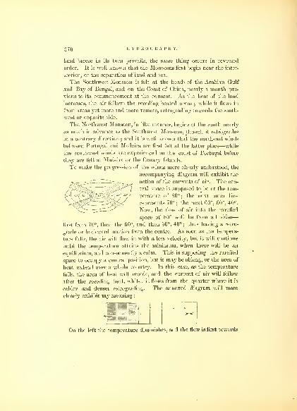
370 HYDROGRAPHY.
land breeze in its turn prevails, the same thing occurs in reversed
order. It is well known that the Monsoons first begin near the inter-
section, or the separation of land and sea.
The Southwest Monsoon is felt at the heads of the Arabian Gulf
and Bay of Bengal, and on the Coast of China, nearly a month pre-
vious to its commencement at the equator. As the heat of the land
increases, the air follows the receding heated areas ; while it flows in
from areas yet more and more remote, retrograding towards the south-
west or opposite side.
The Northwest Monsoon, in like manner, begins at the south nearly
as much in advance as the Southwest Monsoon, though it retrogrades
in a contrary direction ; and it is well known that the northeast winds
between Portugal and Madeira are first felt at the latter place—while
the southwest winds are experienced on the coast of Portugal before
they are felt at Madeira or the Canary Islands.
To make the progression of the winds more clearly understood, the
accompanying diagram will exhibit the
action of the currents of air. The cen-
tral space is supposed to be at the tem-
perature of 80° ; the next outer line
represents 70°; the next 60°, 50°, 40°.
Now, the flow of air into the rarefied
space of 80° will be from all sides
—
first from 70°, then the 60°, and then 50°, 40° ; thus having a retro-
grade or backward motion from the centre. As soon as the tempera-
ture falls, the air will flow in with a less velocity, but it will continue
until the temperature attains the minimum, when there will be an
equilibrium, and consequently a calm. This is supposing the rarefied
space to occupy a central position, but it may be oblong, or the area of
heat extend over a whole country. In this case, as the temperature
falls, the area of heat will recede, and the current of air will follow
after the receding heat, whilst it flows from the quarter where it is
colder and denser retrograding. The annexed diagram will more
clearly exhibit my meaning :
On the left the temperature diminishes, and the flow is first towards

WINDS. 371
the 80° ; when it falls to 70°, the more rarefied space has receded to
1, which in its turn is reduced, the air following and flowing into 2
;
thence in like manner the flow of air follows to 3 and 4. In this wayextensive tracts of country are swept over by the same winds, and
according to the difference of temperature will be the velocity of the
currents.
As the land and sea breezes are familiar to all, and are well known
to be caused by the alternate heating and cooling of the atmosphere
over the land and sea, an illustration of their action, perhaps, will
make the progression more clearly understood :
The shore, or dividing line, is that of the greatest heat. In the sea
breeze the flow is first from 1 to 0, which brings the to its tempera-
ture ; then recedes to 1, followed by the cooler air of ; and so on
to 2, 3, and 4, until the temperature of the land is reduced to the
temperature over the sea. Then, the same operation takes place
from the land, and the air over the sea attains a like temperature;
at the changes, be it of short or long duration, a calm ensues.
Before proceeding to the consideration of the subject of the winds
and vapors, I shall show what is the actual state of the earth's surface
as to temperature, the great cause, admitted by all, of the aerial
currents.
For this purpose, I have divided the earth into five zones (see
annexed map), viz.: two frigid, two temperate, and one torrid zone.
The frigid zones are those from the Poles to the 60th parallel ; the
temperate zones are those between the 30th and 60th parallels, north
and south ; and the torrid zone embraces 30 degrees on each side of
the Equator, or the space between the Tropics. The extreme differ-
ence between these is more than 80° Fah. ;—that of the frigid zones
being considered as the seat of perpetual congelation, while that of the
torrid rises to a temperature above 80°. It is impossible to inspect
this map without being struck by the width of the belt of heated water
which surrounds the earth, comprising nearly the entire space within

372 HYDROGRAPHY.
the Tropics. At the same time, it will be observed that the prepon-
derance of these heated waters lies in the northern hemisphere.
It would be foreign to the subject in this place, to institute the
inquiry, Whence do these waters derive their heat ? But the question
may be so far answered, that this heat cannot be wholly from the
sun ; and it may be questioned if his heating rays have any other effect
upon them than to increase the evaporation.
Many philosophers assert that what heat is derived from the sun's
rays is again returned to the air by radiation. If such is the case, it
is not by accumulation from that source that this heat can have been
originated.
How great must be the evaporation which is constantly taking
place, both by day and by night, from these heated waters ; and what
an immense rarefied area is here exhibited to view, to destroy the
equilibrium in the atmosphere, and generate the vapors ! In it we see
ample cause for the wonderful effects which we witness in the pheno-
mena under consideration, and which must continue so long as the
same cause prevails.
It is thus evident that on this planet we have a continuous belt of
heated water around the globe.
If we recur to authorities, we are informed that the air is an elastic
fluid, acted upon by the same laws of gravitation as the more solid
particles of matter. Consequently it will remain at rest from its vis
inertia, provided an equilibrium of temperature is insured, and will be
carried with the earth in its revolution.
That the rotary motion of the earth cannot have any effect upon
the surface currents of air, is also fully evident, by the fact of the
prevalence of westerly winds at the same time that we have easterly
winds within the Tropics moving in opposite though parallel direc-
tions. Now, if this rotary motion was felt in one direction, it ought to
operate in the other, and to produce a westerly wind, to be felt on the
surface at the Equator, moving at the rate of 1000 miles per hour, it
would be necessary for the wind to have greater velocity. This will
be readily seen to be impossible ; for the greatest velocity that wind
has been known to attain in a hurricane, is short of a hundred miles
in the same time. We therefore consider that the earth must
carry with it in its revolution a large part of the atmosphere, which,
undisturbed by heat, would remain quiescent, and be free to move in
any direction. If this were not the case, none but easterly winds
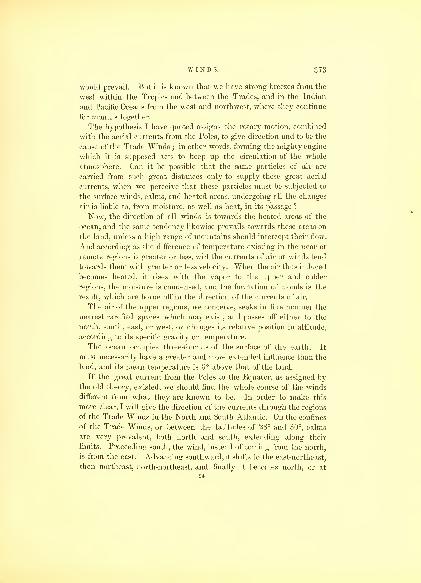
WINDS. 373
would prevail. But it is known that we have strong breezes from the
west within the Tropics and between the Trades, and in the Indian
and Pacific Oceans from the west and northwest, where they continue
for months together.
The hypothesis I have quoted assigns the rotary motion, combined
with the aerial currents from the Poles, to give direction and to be the
cause of the Trade Winds ; in other words, forming the mighty engine
which it is supposed acts to keep up the circulation of the whole
atmosphere. Can it be possible that the same particles of air are
carried from such great distances only to supply these great aerial
currents, when we perceive that these particles must be subjected to
the surface winds, calms, and heated areas, undergoing all the changes
air is liable to, from moisture, as well as heat, in its passage ?
Now, the direction of all winds is towards the heated areas of the
ocean, and the same tendency likewise prevails towards these areas on
the land, unless a high range of mountains should intercept their flow.
And according as the difference of temperature existing in the near or
remote regions is greater or less, will the currents of air or winds tend
towards them with greater or less velocity. When the air thus induced
becomes heated, it rises with the vapor to the upper and colder
regions, the moisture is condensed, and the formation of clouds is the
result, which are borne off in the direction of the currents of air.
The air of the upper regions, we conceive, seeks in like manner the
nearest rarefied spaces which may exist, and passes off either to the
north, south, east, or west, or changes its relative position in altitude,
according to its specific gravity or temperature.
The ocean occupies three-fourths of the surface of the earth. It
must necessarily have a greater and more extended influence than the
land, and its mean temperature is 6° above that of the land.
If the great current from the Poles to the Equator, as assigned by
the old theory, existed, we should find the whole course of the winds
different from what they are known to be. In order to make this
more clear, I will give the direction of the currents through the regions
of the Trade Winds in the North and South Atlantic. On the confines
of the Trade Winds, or between the latitudes of 28° and 30°, calms
are very prevalent, both north and south, extending along their
limits. Proceeding south, the wind, instead of coming from the north,
is from the east. Advancing southward, it shifts to the east-northeast,
then northeast, north-northeast, and finally it becomes north, or at
94
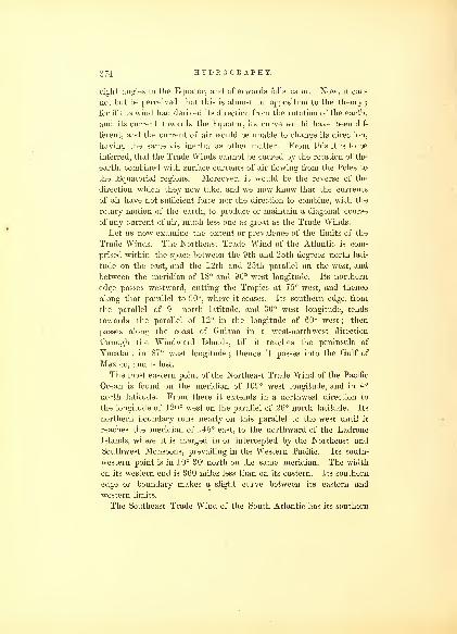
374 HYDROGRAPHY.
right angles to the Equator, and afterwards falls calm. Now, it can-
not but be perceived that this is almost in opposition to the theory;
for if the wind had derived its direction from the rotation of the earth,
and its current towards the Equator, its curve would have been dif-
ferent, and the current of air would be unable to change its direction,
having the same vis inertia as other matter. From this it is to be
inferred, that the Trade Winds cannot be caused by the rotation of the
earth, combined with surface currents of air flowing from the Poles to
the Equatorial regions. Moreover, it would be the reverse of the
direction which they now take, and we now know that the currents
of air have not sufficient force nor the direction to combine, with the
rotary motion of the earth, to produce or maintain a diagonal course
of any current of air, much less one as great as the Trade Winds.
Let us now examine the extent or prevalence of the limits of the
Trade Winds. The Northeast Trade Wind of the Atlantic is com-
prised within the space between the 9th and 28th degrees north lati-
tude on the east, and the 12th and 25th parallel on the wTest, and
between the meridian of 18° and 90° west longitude. Its northern
edge passes westward, cutting the Tropics at 75° west, and thence
along that parallel to 90°, where it ceases. Its southern edge, from
the parallel of 9° north latitude, and 30° west longitude, tends
towards the parallel of 12° in the longitude of 60° west ; then
passes along the coast of Guiana in a west-northwest direction
through the Windward Islands, till it reaches the peninsula of
Yucatan, in 87° west longitude ; thence it passes into the Gulf of
Mexico, and is lost.
The most eastern point of the Northeast Trade Wind of the Pacific
Ocean is found on the meridian of 109° west longitude, and in 4°
north latitude. From there it extends in a northwest direction to
the longitude of 120° west on the parallel of 26° north latitude. Its
northern boundary runs nearly on this parallel to the west until it
reaches the meridian of 145° east, to the northward of the Ladrone
Islands, where it is merged in or intercepted by the Northeast and
Southwest Monsoons, prevailing in the Western Pacific. Its south-
western point is in 10° 30' north on the same meridian. The width
on its western end is 360 miles less than on its eastern. Its southern
edge or boundary makes a slight curve between its eastern and
western limits.
The Southeast Trade Wind of the South Atlantic has its southern

WINDS. 375
and eastern limit in 28° south latitude, and 10° east longitude. Its
southern boundary tends westward to the meridian of 15° west longi-
tude, where its western boundary begins;turning north, extending to
where the 35th meridian west cuts the Equator, it thence continues
as far as 3° north latitude. Its northeast terminus lies between the
longitude of 15° and 36° west, in the latitude of 5° north and the
Equator.
The Southeast Trade Winds of the Pacific are distant from the coast
of South America 300 to 350 miles. The extreme southern limit maybe given in 30° south latitude, in the longitude of 80° west. On its
eastern boundary it has the same curve as the western coast of South
America. It passes to the west of the Gallipagos to the latitude of
4° north. Its southern edge varies as much as 10° in latitude during
the opposite seasons of the year. The southern limit runs from the
parallel of 30° to 26°, and between the longitude of 90° and 180°
west. This boundary is oftentimes much contracted and disturbed.
It sometimes describes a curve as far as the parallel of 15° south, in
the longitude of 140° west; thence towards the Equator in 170° east;
there it is bounded by the Northwest Monsoons of the Pacific Ocean
;
and during the period of the Southeast Monsoon of New Holland,
this Trade Wind becomes apparently merged in it. At times it mayexceed these limits to the west, but does not so usually. The winds
near the western terminus are light, with frequent calms, and varia-
ble at all seasons. The northern and western boundary extends
across the Equator to 3° 30' north latitude, and on that parallel
easterly to the meridian of 95° west. Of all the Trade Winds, this
is the most uncertain ; it blows for several days together strong, whenit intermits, and is succeeded by calms or light westerly winds.
The Northwest Monsoon, and the southwest wind of the Southern
Pacific, when the sun is in southern declination, prevent these winds
from extending to the south, and confine them to the limits above
described.
The Southeast Trade Wind of the Indian Ocean is found to prevail
at the distance of 350 miles from the west coast of New Holland,
between 11° and 30° of south latitude. On the latter parallel, it con-
tinues to the west as far as 43° east longitude, or nearly to the meri-
dian of Madagascar. Its northern limit describes a curve from the
90th degree of east longitude to the middle of that island, touching
the 11th degree of south latitude ; the north and south sides approach
nearly to a point, forming the western terminus.

376 HYDROGRAPHY.
Having thus given the extent of the several Trade Winds of the
Oceans, I shall give those of the Monsoons, which will also be found
represented on the map.
The Monsoons differ materially in character from the Trade Winds.
They are more equable, without the squalls, and undergo little varia-
tion during the day and night. They have their regular increase
and decrease until they cease. They are more allied to the land and
sea breezes, and result from the same cause. Indeed, they may be
said to be such on a large scale, having a duration of several months?
instead of occurring daily. Every one who has experienced the Mon-
soons, cannot fail to have been struck with the great difference be-
tween them and the Trade Winds. The most remarkable Monsoons
are those of the China Seas and Indian Ocean, called the Northeast
and Southwest. They prevail between the Equator and the latitude
of 30° north, extending on the land as well as over the neighboring
seas. Each, on an average, has a duration of five months in either
direction ; at the changes, which occupy two months, variable winds
occur.
There appears to be much exaggeration about their constancy and
their course. The cause assigned for them is undoubtedly the true
one,—that of the heating of the immense areas of land of the Asiatic
continent by the sun, rarefying them, and thus drawing towards
them currents of air from the southwest to restore the equilibrium.
It may occur to others, as it has to myself, why should not this air
be supplied from the cold countries of the north, which are nearer,
and should be induced to seek these warm and rarefied areas ?
By an inspection of the map, we find ample reason why this cannot
take place. We will there perceive that the highest chain of moun-
tains in the wrorld stretches across the whole of Asia, from east to
west, creating an insuperable barrier to the winds coming from the
cold regions of the north beyond ; and therefore the air is induced
from the southwest, to flow towards the heated areas of Hindostan
to restore the equilibrium ; further it cannot go.
To the north of this range of mountains also lies the Desert of
Gobi, and on the west is the high table-land of Iran, as well as that
of Syria, and the Sahara of Africa. These all induce the denser and
colder air from the mountains on the east, and from the north, to
supply the rarefied area which exists in those places. On the sun's
return to southern declination, these parts become cooled, when the

WINDS. 377
air flows back from the northeast to supply the areas, which in their
turn become heated, forming the Northeast Monsoon.
The Northeast and Southwest Monsoons extend from the east coast
of Africa over the China Seas, and as far as the Marianne Islands in
the Pacific. The former has more strength than the latter. In the
northern parts of the China Seas, the Southwest Monsoon is but feeble.
There the cold and denser currents from the northeast seek the rare-
fied areas with more force. They prevail generally three-fourths of
the year.
In the Gulf of Bengal, Arabian Sea, as well as the Bight of China,
the Monsoons are not so regular as they are in the open sea. Theyare often light and changeable, and frequently calms prevail. This is
particularly the case within the Straits of Malacca, where variable
winds are almost constantly found.
The Northeast Monsoon is confined to the north of the Equator.
It has many interruptions to its course from the high islands which
lie within its range, and create many disturbing causes, diverting it
from its direction, being at times influenced by the heated areas
which prevail on the large islands.
Between the Equator and the eleventh parallel of south latitude,
there are two other Monsoons, known as the Northwest and Southeast.
These are coincident in point of time with the former, undergoing
their changes about the same time of the year. They blow nearly at
right angles to the direction of the first, but are divided by calms
;
though one appears to be derived from the other, that is to say,
during the prevalence of the Southwest Monsoon north of the Equator,
we have the Southeast Monsoon south of the Equator ; and when the
Northeast Monsoon blows north of the Equator, the Northwest
Monsoon prevails south.
This latter Monsoon extends from the 50th degree of east longitude
to the east, across the Indian Ocean, through the Banda and Java
Seas, passes by New Guinea, and into the Pacific, at times as far as
the longitude of 140° west.
The boundary of this Monsoon in the Indian Ocean is not
throughout on the 11th parallel ; but towards the Island of Mada-
gascar, and at its extreme eastern limit in this ocean it extends
several degrees farther to the south, forming a considerable curve ; a
calm belt lies between it and the Southeast Trade Wind. This95

:;7s HYDROGRAPHY.
Monsoon, in part, is diverted towards the centre of New Holland,
where a large rarefied area exists during the presence of the sun.
The Southeast Monsoon appears in like manner linked with the
Southwest. That current of air extends from the Pacific Ocean, east
of New Holland, and flows to the westward in the Indian Ocean, side
by side with the Southeast Trade Wind. Although this wind is often
designated as the Southeast Monsoon, its direction is not at all times
from that quarter, but it frequently comes from east-northeast.
The Monsoons which prevail in the Mozambique Channel, between
the Coast of Africa and the high land of Madagascar, lie between
latitude 30° south, extending across the Equator to the north, along
the east coast of Africa to Cape Jeddah, and half-way up the Red
Sea. These Monsoons pass under the Northwest Monsoon to the
west of longitude 50° ; the winds are light, and calms often take
place. The direction is from the north-northeast and south-south-
west, parallel with the coast of Africa. Their period is nearly coin-
cident with the Southwest and Northeast Monsoons, north of the
Equator, which causes them to be considered by some as an exten-
sion of the former ; but in reality they are separated by a region of
calms. They ought therefore to be viewed as distinct.
Although the great Monsoons are confined to the Indian and
Pacific Oceans and China Seas, yet there are several of lesser note
and extent, which exist on the east and west coasts of North and
South America. That which claims particular interest from naviga-
tors, is on the coast of Brazil. It is experienced from the neighbor-
hood of Cape St. Roque to the Island of St. Catharine. Properly
speaking, however, these are not Monsoons, though they have been
classed and considered as such. They do not interchange their
direction periodically, like the others, but only veer through several
points of the compass. These changes on the coast of Brazil are
from the north-by-east round to the south, on the southern parts of
the coast. They show most conclusively that the currents of air are
induced towards the heated areas of the land, which become rarefied
from the action of the sun's heat upon the surface of South America.
As the sun changes towards the south, in declination, the land of
South America becomes more and more heated. The air is drawn
towards these areas from the north and northeast, along the whole
ocean bordering on the east coast. It flows from the different points
of the compass towards the land ; in general, perpendicular to the

WINDS. 079
part of the coast, but always directed towards the heated area. This
is what is called the Northeasterly Monsoon, which begins in Septem-
ber, and continues till February.
When the sun is returning to the north, the wind veers back
again through the several rhombs of the compass, and becomes settled
along the whole coast, from east-by-north to east-southeast ; still
blowing towards the heated areas, they flow in almost the same
direction with the Southeast Trades, for which they are often mis-
taken.
In the immediate vicinity of the land of South America, there are
also land and sea breezes. It is remarkable, when these coincide
with the direction of the Monsoons, the latter are increased in
strength, and the land wind which ensues after the sea breeze is also
much stronger. It may be as well here to call attention to the fact,
that the winds which flow into the large rarefied areas of South
America, may be said to be constant, although they vary very much
in strength and direction ; unlike other areas, the land is never cooled
below ocean temperature, so as to produce a return current from the
land to the sea.
These heated areas are supplied from the north and south, as well
as from the east. The high mountain range near the Pacific coast,
like those of Asia, intercepts the current of air from the east, until it
rises over their barrier.
.Next in importance are the Monsoons on the west coast of Mexico.
The duration of the Northern Monsoon is from the month of December
to May. The currents of air are from the north and northwest, nearly
parallel with the coast. They seek the heated waters of the Gulf and
Bay of Panama. During its prevalence, fine weather is experienced;
whence this season, although the winter of the northern hemisphere,
has been denominated the summer of these regions. In the offing,
they blow with more strength and steadiness than near the land.
When the sun advances to northern declination, heating the land
of North America, from the month of May to September, the currents
of air are from the south and southwest. These are the stormy
months, attended with great explosions of electricity, and copious and
constant precipitation, which is produced and evolved by evaporation
and condensation. This causes great irregularity in these currents of
air, from the colder temperature being in such close proximity to the
heated waters of the ocean. Squalls and tempests prevail, which

;;su HYDROGRAPHY.
come from the high land of the Isthmus, and rush with great violence
over the sea, though they are of short duration.
Connected with this Monsoon, a southerly wind, an extension of
the Southwest Monsoon, prevails from the Gallipagos Islands to the
Bay of Panama. The cause here is also quite evident. The water of
the ocean surrounding the Gallipagos Islands is some fifteen degrees
colder than those of the Bay of Panama;consequently, the air in
contact with it is cooler, and we should naturally expect, as we find
to be the case, the air constantly seeking this rarefied area. Thecurrent of air, therefore, between these two points, prevails throughout
the year; although it is a region subject to calms and very light airs;
but when there is any wind, it is from the southwest.
I conceive that these are strong and sufficient proofs of the theory
to which I wish to call attention.
There are also Monsoons on the west coast of South America,
extending from Chili to Peru, which prevail from the northward from
May to August, and from September to April, from the south. The
former period is designated the rainy season. During the latter, the
winds are considered to be allied to the Southeast Trade. No rain
falls during this period.
The extent of this northerly Monsoon is through 23 degrees of lati-
tude, from the 12th to the 35th degree south. This apparently is from
a warmer to a colder latitude ; but if we examine the temperature of
the land, we shall find that it is warmer than the sea to the north-
ward of it, and produces the same effect as in other cases. The north-
erly Monsoon takes place when the sun is in northern declination.
It is characterized by being light and inconstant, and as it approaches
the parts of Chili south of the rainless district which exists on this
coast, the condensation and precipitation are immense, evolving heat
and moderating the climate. The cold and dense atmosphere of the
tropical parts of Peru, which comprises the rainless district before
mentioned, is then induced towards the south ; the resulting current
of air is therefore from the northward, and nearly parallel to the
coast.
This current of air is seldom experienced in the northern parts of
Peru. When it does take place, the vapor which exists in the atmo-
sphere is made evident in the form of mist, or the "garua" of Peru.
The heat engendered by the sun when in southern declination,
causes the air to become rarefied on the coast of Peru; and the influx

WINDS. 381
of it from the south, to fill up and restore the equilibrium, produces
the southerly Monsoon, which blows with great regularity.
The Monsoons of the West Coast of Africa prevail from the latitude
of Madeira to the Cape de Verdes ; thence south, extending into the
Bight of Benin, and as far as the Cape of Good Hope, and are the
next to claim attention.
They are divided into the northwesterly, westerly, southwesterly,
and northeasterly Monsoons. The first three blow towards the land,
whilst the last, called by the natives the "harmattan," blows from the
land to the sea.
The duration of these Monsoons is very unequal ; the former lasting
some nine months, from March to December, while the latter rarely
endures three months. Like the Monsoons of the coast of Brazil, the
direction of these winds depends somewhat on the trend of the coast
and the position of the sun in declination, by which the continent of
Africa is heated and the rarefied areas maintained. The current
of air rushes towards the heated areas which are nearest ; and con-
sequently, on different parts of the coast, the wind changes its direction,
so that it is found to flow from the south to the northwest by the west.
The flow from the west under the equator extends nearly across
the Atlantic Ocean, between the two continents, in a cuneiform shape,
from the month of June to September; after which time it ceases,
calms, and then the " harmattan" prevails from December till March,
with occasional intermissions.
The character of these Monsoons is different ;—that from the south-
ward and westward is always attended with rain, while the northeast
is a cold and very dry wind, flowing from the highlands of Africa.
It seeks the heated areas of the ocean, but does not extend more than
a hundred and fifty to two hundred miles from the coast.
There are other periodical winds, which have an extensive range,
but of which our knowledge is as yet very limited. I have reference
to the winds which sweep across the great deserts of Africa, Asia, and
America. In order to trace these, we require many more observa-
tions than we have ; but enough is known to establish the fact that
the easterly and northerly winds in Africa and Asia prevail during
nine months of the year, and are succeeded by those from an opposite
direction. In the Mediterranean these winds which flow towards
Africa have been long known by the name of the iEtesian winds.
A denser and colder aerial current also flows from the Caucasus, in
96

382 HYDROGRAPHY.
Southern Europe, towards the rarefied areas of the Great Desert,
while the sun pours his vertical rays on it; but, on the sun's return
to southern declination, the Desert becomes cooled, and light airs at
times flow from it towards the heated waters of the Mediterranean.
In Egypt, a cold current of air flows from the south during the winter
months, towards that sea.
A peculiarity exists in the currents of air on the Red Sea. They
flow in from the north and northwest ; but their limits do not extend
beyond half of the length of that sea, where they become neutralized
by the high temperature;
and, as has been observed, the currents
from the Southwest Monsoon of the Indian Ocean prevail in the
southern half.
Although we believe that the heated waters of the Tropics, which
we have shown to exist, are sufficient to account for the flow of the
aerial currents towards the Equatorial regions, we are far from deny-
ing the action and influence of the sun.
It will be seen by the map, that these heated waters occupy a muchgreater area in the northern than in the southern hemisphere, which
we think is the cause of the unequal prevalence of the Trade Winds,
as respects their extent in latitude. It is a well-established fact that
the Northeasterly Trade Wind rarely if ever reaches the Equator
;
while the Southeast Trade, coming from the South Atlantic, passes at
times several degrees to the north of that line. The anomalies and
vibrations of the Trade Winds, we conceive, are caused by the sun's
heat. These have been for a long time noticed by all navigators
;
and we think it quite clear that the diurnal increase and decrease of
the Trade Winds which always follows or precedes the sun's course,
renders these winds fitful and unsteady. The temporary heated belt
and greater evaporation which is created by his rays, has an imme-
diate influence, causing a rarefied area to follow, as it were, in his
wake, into which the denser air rushes with velocity, giving rise to
the extension of the Trade Winds in latitude by drawing the air
from more remote parts, and sudden squalls, condensation, and con-
sequent precipitation, and not unfrequently a change of wind through
several points for a short time, occurs in what is supposed to be the
very strength of the Trade Winds. When the sun is in the opposite
hemisphere, the Trade Winds are more steady and regular, having
less of a fitful character ; and the squalls of wind and rain are rarely
experienced.
The calm areas have been for a long time a terror to navigators, and
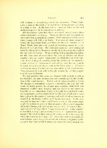
WINDS. ns3
will continue to be until they are better understood. I have desig-
nated a calm as the result of an equilibrium of temperature, whether
it be high or low. In the first case, it is more or less a rarefied and
moist atmosphere : in the second, dense and dry.
All observations show that there are several areas of ocean where
calms exist almost constantly. There are others which are periodical,
and result from geographical position ; while some have a daily recur-
rence, though well defined in limits. The areas of calms comprised
within the Equatorial limit, and those on the outer borders of the
Trade Winds, have also their periods of vibrations, caused by the in-
fluence of the sun's heat. The periodical calms are those consequent
upon the change of the Monsoons, and the diurnal ones are the result of
the land and sea breezes. Those resulting from geographical position,
are the large areas of ocean where the heat has induced an almost
constant high and equable temperature, to which the flow of the cur-
rents of air is sluggish, resulting from the velocity of the ascending
current, and where large areas are reduced to a very low and equable
temperature by the ice which exists in the Polar regions. All calms
continue as long as the surrounding atmosphere remains undisturbed.
Many instances of these will be brought to mind by the daily experi-
ence of every individual.
We thus perceive that calms are frequent both in high as well as
low latitudes, and play an important and essential part in the circula-
tion of the aerial currents. Were it not for calms, in order to secure
the changes of atmosphere to insure a circulation, the heat and cold
would be much greater, the changes more constant, whirlwinds and
disastrous conflicts more frequent, and the shocks to our senses un-
bearable, or the atmosphere would be brought to a stand-still under
one temperature, and we deprived of the blessings which a free circu-
lation gives in the constant recurring cool and refreshing breezes, so
essential to the health, welfare, and happiness of man. In the first
case, neither man nor nature would know repose ; in the second, there
would be nothing to prevent that stagnation which would engender
all kinds of disease, and both animal and vegetable life would suffer,
—
and that order of things which "tempers the wind to the shorn lamb,"
so beautiful, so simple, and so wisely ordained in the progressive move-
ments of the winds in their retrograde action, would be destroyed, by
which the temperature is made to increase and decrease gradually, its
accumulation prevented, and not suffered to become stagnant, by the
one great law under which it acts,—the denser and colder atmosphere

384 HYDROGRAPHY.
seeking the heated or rarefied areas. Knowing where the areas of the
heated waters are, where calms usually take place, it will at once be
perceived how these vexatious visitations to the navigator are to be
avoided, and they will serve as a means by which he will be enabled
to pursue his voyage and preserve his wind. All that is required of
him is to regard those parts of the ocean where the high temperatures
exist at certain seasons of the year, and so to navigate his vessel as to
pass either on one side or the other, by which he may be assured that
he will be able to take advantage of the current of air that may be
flowing towards them.
It now remains to treat of the variable winds of the temperate
zones, or those spaces which I have included between the latitudes of
30° and 60° north and south. It is well known in these northern
and southern zones, in both hemispheres, that the winds prevail from
the belt of calms on the borders of the Trades in the summer months,
and towards them in the winter months. This is the general course
of the variables. By the old theory as quoted, it will be recollected
that these winds were assumed as the return current towards the
Poles, and that their direction resulted from the action of the rotary
motion of the earth, and the flow to the north and south was the
return current to the Poles, which they had supplied to the Trades
;
and were it not for this interchange, the wind, it is argued, " would
cease to blow for want of air to make wind of." The modification of
this system, since adopted, I regard as equally inconsistent with what
takes place, viz., that the heated air which rises from within the Tropics
flows over towards the calm areas on the outer borders of the Trade
Winds, there meets with another upper current from the Poles, de-
scends to the surface, and reissues in two surface currents in opposite
directions—the one to the south, the other to the north—the former
to supply the Trades, the latter to restore to the Poles what had been
taken from them for that purpose. This modification of the old
theory removes one obstacle,—that of the winds coming in actual
contact on every successive parallel ; but it creates another, and, in
my opinion, a greater one, viz. : a meeting and crossing at the area of
calms of opposite currents of air of different temperatures without
commingling. I can see no reason why the air should flow towards
these belts by the upper current, descend, and reissue in different and
opposite directions, affected, as it is represented to be, by the rotary
motion of the earth, united with a flow to and from the Poles, whilst

WINDS. 385
the impulse of motion in either direction is changed or ceases, and
the vis inertia of the body of air destroyed.
Now, in the region lying to the north and south of these areas of
calm, it is found that the temperature of the ocean is higher in the
summer months of the two hemispheres, and that there is in conse-
quence a flow of air from it towards the parallels a few degrees to the
north and south ;—those in the northern hemisphere veering from
the southwest to the southeast by the south, whilst those in the
southern veer from the northwest to the northeast by the north.
These currents of air frequently coincide with the general direction
of the variable winds in higher latitudes, the flow of which is simply
induced by the difference or variations of temperature, as shown by
the isothermal lines of the oceans lying between the old and new con-
tinents in either hemisphere, combined with the heating of the sur-
faces of those continents during one portion of the year, which
induces the flow towards them to be the greater. When they cool, the
flow returns from them to the ocean, and this creates as well as gives
direction to the alternate flow of currents of air familiarly called the
variables, and with which the rotation of the earth can have nothing
to do. The Polar winds, in like manner, circulate, caused by the
unequal distribution of heat, and by the rays of the sun during his
semi-annual sojourn, as well as the evolvement of heat in the con-
densation of vapors, and the changes of water into ice. The order
of these movements is simple and effective in producing a thorough
interchange and commingling of the atmosphere, and results wholly
from the one great natural law which has been given to it by an All-
wise Providence.
Having traced out the aerial currents on the surface, we will now
take up those of the upper regions, which the theories quoted in the
first part of this chapter represent as setting towards the Pole, " for
the purpose of restoring the equilibrium, and drawing off the accumu-
lation which would soon exist at the Equator, as well as to ameliorate
the climate by diffusing heat around the Poles."
In confirmation of this upper-current theory, it is stated that the
winds pass in a constant current from the southwest and northwest
;
but this, it appears, is only an inference from induction,—that there
must be a return current to replace the air coming from the Poles,
which otherwise would soon be without atmosphere. Where is the
proof that these winds do prevail, and are constant ?
97
386 HYDROGRAPHY.
The observations which have been made are too few to establish it,
or that the air has any particular direction in the upper region. Mystay of three weeks on the top of Mauna Loa, 14,000 feet above the
level of the sea, did not show it. It is true the most stormy and vio-
lent winds came from the southwest, but a great part of the time the
winds were light and variable, and from every point but southwest.
The temperature of this wind was low, and doubtless induced to some
warmer area.
Much stress has also been laid on the fact of the descent of ashes
from the volcano of St. Vincent, in Barbadoes, in the year 1812, as
proving that the upper current was from west to east in the upper
regions. I think it by no means conclusive. The vast amount of
heat evolved may have caused a change in the aerial currents of the
upper atmosphere, or the ashes been attracted to Barbadoes by an
electrical current ; and full as plausible a solution may be advanced,
that the ashes remained in the upper atmosphere till the earth had
performed her revolution, during which period they may have imbibed
sufficient moisture and loss of heat to become heavier, and descend
over the region to the east, on the parallel with the two islands.
In recurring to the eruption of Cosiquina, in Nicaragua, in 1835,
we find that the ashes were carried in all directions and to great
distances.
It may indeed be doubted whether any continuous upper current
does move from the Equator to the Poles. I have found no proof of
it whatever. The upper clouds, which must move with the upper
currents, have always the appearance of moving from east to west,
within the Tropics. The opportunities for making these observations
rarely occur. I speak, at least, from the experience I have had. I
am not prepared to say that their absolute motion is such, but it is
the most reasonable supposition ; and if we admit that the air, in
rising to the higher atmosphere, loses a part of the earth's velocity, it
must fall behind, and have the appearance of moving in a contrary
direction to the earth in her rotation.
Should this be the case, and all analogy would lead us to believe
that it is so, yet, when we refer to the aerial voyages which have
been made, we do not find anything that establishes the fact of the
existence of an upper current in any particular direction.
In the celebrated voyage of Gay-Lussac and Biot, they rose to the
height of 13,000 feet, and were up, in their ascension, three and a

WINDS. 387
half hours. The aerial current was found to prevail strong to the
southeast. In the second voyage of Gay-Lussac, when he ascended to
the extraordinary height of 23,940 feet, and continued up for six
hours, the aerial current was then from the northwest, directly oppo-
site to the former. On this voyage, Gay-Lussac, at the immense
height he reached, had still the cirrous clouds above him, pointing in
various directions. In both of these voyages, the most remarkable
on record, we have a contradiction of the theory of the southwest
upper current towards the Pole, as well as the slipping of the earth
under its atmosphere. Had it been so, Gay-Lussac would have landed
nearly one-quarter of the earth's circumference to the westward. Hereturned to mother earth a little over fifty miles from where he set
out.
The voyages of Mr. Wise, the aeronaut, as well as others, do not
prove that the aerial current is flowing from the west to the east.
During the period of the year when his ascensions took place, there
is generally a flow from the southwest and northwest to the eastward;
that is, from the land towards the ocean ; and although he states
that there exists a westerly current within an elevation of 12,000 feet,
I can find no proof in the publication of the voyages on which this
bold and intrepid aeronaut bases his remark.
The cirrous clouds ought to afford us some indication of the course
of the aerial currents in the upper atmosphere. The forms which
these suspended vapors assume must be more or less shaped by the
aerial currents in which they exist. Frequently they are seen to
undergo rapid changes. Every one who has watched these clouds,
knows that they tend in all directions. These facts go to prove that
although upper currents prevail, they do not follow the tbeory, viz. :
flow from the Equator towards the Poles, or in any particular direc-
tion.
It is impossible that the air of the Tropics should carry any heat to
the Poles, to modify and lessen the rigor of the northern and southern
climates, as held by the old theory ;—for the air, on ascending, is
reduced to the low temperature of the freezing-point, within the Tro-
pics, at the height of 16,000 feet above the sea, at which altitude the
snow-line is constant. It is therefore evident that there is nothing to
support the theory that there are " return currents in the upper
atmosphere flowing from the Equator to the poles and it is utterly
impossible, if they did exist, that they could carry any of the heat

8SS HYDROGRAPHY.
with them which they had acquired when within the lower Equato-
rial limits.
To return to the surface currents. Although the map which ac-
companies this chapter exhibits the flow of the aerial currents in the
different seasons, it is necessary to state from whence these currents
are supplied. In order to understand their action more fully, I shall
endeavor to explain their flow.
Having satisfactorily proved that the Trade Winds do not receive
their supply of air in a continuous current from the Poles, and that
the return or upper current does not exist, it is incumbent to show
whence they receive the vast supply and the circulation.
Lest I may not have made the interchange of the atmosphere fully
understood by those who may not be familiar with the action of the
currents of air, I shall now explain how great Equatorial currents are
supplied and maintained. Prior to tracing them out, I will give what
I conceive to be the progression of the atmosphere around the globe,
from the cooler to the heated area, then ascending to the cooler upper
strata, and onward to the heated area again. This may be better
understood by the annexed diagram.
A represents a part of the earth's surface over which the great cur-
rent is passing; «, a', a" are the cold areas of the upper strata
;b, b',
b", the heated ones of the surface ; the long arrow shows the direction
of the cold or dense wind passing from a to b. It then rises in the
direction of the short arrow to a', becomes cooled, and flows off to the
warm area b' ; thence it again rises to a", and follows the same alter-
nating course to b" ; but always towards the direction where it is most
strongly induced. Now, these lines are all tangents to the earth's
surface, and the shortest distance between the two areas. The cur-
rents of air, in this way, pass over a mountain chain, rising up to its
top, and leap over the lesser Monsoons, which flow underneath,
parallel to the line of the coast or mountain range.
In examining the position of the heated areas of the ocean, we find
that they generally lie, within the Tropics, to the westward of the
WINDS. 389
Trade Winds, with the exception of that towards which the Southeast
Trade Wind of the South Atlantic blows.
Let us take, for instance, the Northeast Trade Wind.
The heated areas of the land (the Sahara) lie to the east of the
Trade Winds. Vast currents of air are passing towards these, almost
throughout the year. They come from the north and south as well
as the east. On becoming heated over this area, they rise, lose their
temperature, and are thence induced towards the nearest warmer area
of the ocean lying to the west, on which they descend, some three
hundred miles from the Coast of Africa, in about the longitude of 30°
west, leaping, as it were, over the currents of air and calms which
prevail between it and that coast. They thence pursue their course,
rising and descending, to the warm regions of the Gulf of Mexico, are
lost in calms, or intercepted by coming in contact with the highland
of Mexico, rise again, become cold, and pass to the west, losing their
moisture by condensation before reaching the elevated and dry plains
of Mexico; thence, leaping the lesser Monsoons of the west coast,
they flow towards the warm areas of the Pacific, constituting a part
of the Northeast Trade Wind of that ocean.
The Northeast, as well as the Southeast Trade Winds of the Pacific
derive their great supply from the currents of air which rush, in a
constant stream, of greater or less velocity, over the vast plains of
South America, towards the Andes ; in ascending to escape, they are
deprived of their heat and moisture, and are induced towards the
heated waters of the Pacific, which they reach, some three to four
hundred miles from the coast, in the longitude of 90° to 120°; and
thence onwards to the heated areas on the western part of this ocean.
The wide belt between these winds and the coast of South America
is occupied by the lesser Monsoons of the west coast, over which they
have passed. These winds in their onward progress, seek the area
which is the nearest and most heated, and tend mostly towards the
part of the Pacific which is affected by the direct rays of the sun, at
the season.
As we have stated before, the Northeast Trade Winds are found, on
the eastern side of the Atlantic Ocean, to be various in their direc-
tions. They are almost entirely different from the western portion;
and this is considered to be a strong argument against the old theory
of the Trade Winds, that they do not, where they begin, indicate by
their direction the forces that are thought to produce them. In some98
390 HYDROGRAPHY.
places we see the Trade Winds checked by the temperature of other
winds, or lost in calms. In others, we find them merging in a perio-
dical Monsoon, obeying other influences, and flowing towards other
areas of higher temperature. In some cases, these are but temporary,
while in others, they are permanent ;—both the Northeast and South-
east Trade Winds of the Pacific are found to deviate towards the oppo-
site Tropic when it is warmed by the sun's rays.
The Southeast Trade Wind of the Indian Ocean derives its great
supply from the heated air which rises above New Holland, is cooled,
and seeks in like manner the warmest area of the ocean to the west.
It passes over, also, a wide tract of ocean, before it descends and
becomes the surface Trade Wind.
As the sun reaches high northern and southern declination, the air
is induced towards the great currents beyond their northern and
southern edges ; it is drawn in, as before mentioned in the explana-
tion of the progression of wTind, from beyond the belt of calms ; but
the supply is but temporary, and very small, compared to the vast
volume that is required to keep up the circulation.
The Southeast Trade Wind of the South Atlantic derives its supply
from the air which rises above and flows over the southern part of
Africa, and then descends at some distance from its west coast, and
pursues its route towards the Equator.
In regarding the movements of winds, we invariably find, where
the greatest difference of temperature exists in close proximity, there
its greatest violence is experienced. Perhaps the best known
instances of this are found in countries where the mountains and
plains lie in juxtaposition. If we take, for instance, the winds in the
South of Europe, between the Alps and the Mediterranean Sea, these
are, according to Dove, " celebrated for their violence and severity."
We find that this extreme rapidity of the aerial current is due to the
great difference of temperature. At the same time, the wind is
known to blow very strong down the north side of the Alps, being
induced towards the higher temperature of the plains. In NewHolland, it not unfrequently occurs that the wind flows from the
northwest and west, from the interior, towards the east coast. This,
we suppose, to be owing to the cold and higher air being induced to
flow towards the heated area of the east coast. These winds are dry
and cold, the temperature often falling from 100° to 70° Fah.;yet they
are felt to be almost suffocating to the feelings—and everything
WINDS. 391
within their range parts quickly with its moisture, leaving it entirely
blighted.
Hot winds, so called, are liable to mislead us. If they could be
traced, they would be found to be tending to areas of still higher tem-
perature ; and it is well known that they are comparatively local ;
—
but many are so called from being dry and suffocating, rather than
hot. We judge of them from our feelings, rather than test them by
means of our instruments.
At other times, the Monsoons often unite with the Trades, and
flow in a common direction, and, where the one wind is warmer than
the other, they are found to commingle and produce precipitation.
On the ocean, where the areas of high temperature exist, the air
generally flows towards them from all sides, though with greater or
less velocity. In the Atlantic and Pacific Oceans, we have two very
remarkable nuclei of heated water, where the temperature ranges
nearly to 90°, and through which the Equator of heat passes. To
these the air tends, although only a few degrees above the surround-
ing temperature; and the currents of air, after the equilibrium is
restored, cease to move in any horizontal direction, when calms
ensue. These areas of calms have various positions, but they always
exist where the heat is equable, and generally hold a midway position
between the Trade Winds, or between these and the variables. In
both cases, they change to and fro, vibrating through a few degrees of
latitude.
The calms, therefore, are the result of the restored equilibrium, and
they endure as long as there is no disturbance produced by a change
of temperature. These calms are another proof that the earth in her
rotation produces no friction to affect motion on the air, and that the
air moves with it. In the northern hemisphere, where they prevail
during the summer months, the temperature is generally equable. In
all places where they exist within the Equatorial belt, frequent local
gusts of wind, of short duration, are experienced from every quarter.
There the warm air ascends rapidly, evaporation and condensation
take place, and explosions of electricity, with rain, are frequent. Theperiod when these occur most frequently is during the season whenthe sun is vertical, and his action most powerful.
The intertropical seas being occupied by these large areas of
heated water, light winds and calms must prevail, as the air can flow
no faster towards them than it ascends to the upper atmosphere.

HYDROGRAPHY.
During the period when the lands adjacent to these areas become
intensely heated, then the air of this Equatorial region is induced
towards them in gentle breezes, in pursuance of what we believe to
be the true theory.
On the land there is no difficulty in pointing out where the highest
temperature exists. In some cases, however, this is more apparent
than in others. In none more so than in New Holland, surrounded
as it is by the ocean. During the period when the sun is in southern
declination, imparting its heat to that sterile land, the air flows towards
its centre from all sides.
Travellers in the interior of New Holland are overcome with the
excessive heat, and make frequent mention of the long calms which
prevail. The rainless districts offer several other instances in which
the winds in like manner are concentrated ; but as some of these
occupy high table-lands instead of a depression, they change somewhat
the character and direction of the air rushing towards them in the
different seasons, and become quickly cooled in the absence of the
sun
Wherever extended plains exist, and the surrounding country is
high, the cold currents of air are drawn towards these areas,—and
the greater the difference of temperature, the faster will be the flow.
In all these localities calms and sudden squalls predominate, and the
rain frequently falls in torrents, with great explosions of electricity.
If the theory I wish to establish, of the circulation of the atmo-
sphere, be correct, we ought to find the winds pursuing their regular
route towards the areas of ocean and land. This is the case. The
ocean differs but a few degrees in temperature during the year;—the
land often undergoes great changes within a day.
The great outlines of these currents on the ocean and land are given
on the map; and it must be apparent to all that the circulation of the
atmosphere cannot be reconciled with the old theory.
It is remarkable that the effects we witness in the northern hemi-
sphere during the summer, do not take place in the Southern Pacific
;
the sun's action upon the Southeast Trade Winds contracts rather than
expands their limits, and causes them to veer to the northward of east,
even on what is supposed to be the parallel where they should blow
strongest, and with the most regularity.
Instead of the summer being the fine season of the South Pacific,
it is the most boisterous part of the year; violent gales come from the
southwest and northwest.

WINDS. 393
The Southeast Trade Winds are interrupted by the Northwest Mon-
soon, and their limits encroached upon by the southwest winds ; both
denser winds. All these winds seek the areas which are most rarefied
by the temperature of the ocean and the sun's heat, in order to restore
the equilibrium of temperature.
In all countries there are local winds, but they are chiefly those
which approximate to the general direction. For instance, in Eng-
land, and perhaps throughout all Europe, the westerly winds are most
common in the summer months. In the winter months, they have
those from the north, northeast, and east; which prove, so far as Europe
is concerned, that the great aerial currents flow from the colder to the
warmer regions.
We now perceive that there can be no accumulation at the Equator,
nor deficiency at the Poles ; and consequently, that we need not recur
to any hypothesis to supply the one or carry off the other, to maintain
the equilibrium throughout the earth's surface, or secure the circula-
tion and supply the great currents. Under the Equatorial limits the
temperature is high ;—under the areas on the outer border of the
Trade Winds, the thermometer stands at temperate heat throughout
the year; while within the Polar Circle, during the long nights, calms
prevail : then the temperature is always low and generally equable.
When the atmosphere is highly heated, the weight of its column is
decreased ;—hence the barometer stands low. Along the area of
calms, between the Trades and Variables, it stands higher throughout
the year, owing to the mean temperature being lower; but at the
Poles there is less height of atmosphere ;—consequently its standing is
lower.
The supply for these great Equatorial currents comes from the
north and south Variables and Polar regions, through the Monsoons, and
alternately with greater or less force during the presence of the sun
in either hemisphere. These currents of air do not flow towards the
regions of the calm areas, or from them. The calm areas maintain
nearly an equable temperature throughout the year. They confine
the Equatorial currents to their bounds, and their limits only extend
along the Trade Winds; they do not cross the Monsoons. These
move freely to the north and south between them and the continents,
and flow almost continuously. Short calms take place, but they are
altogether transitory in their character, and confined to small spaces,
where the temperature acquires a temporary equilibrium. But the
99

394 HYDROGRAPHY.
flow is not hindered ; it is free from all barriers, and passes onward in
a steady and sometimes strong gale towards the heated area, varying
in duration, interchanging its particles, and ever acting under the
simple but efficient law impressed upon it.
But to return to the circulation. Let us take an atom of the South-
east Monsoon of the Pacific, found in the southern hemisphere, south-
ward of the Tropic of Capricorn, near the 180th degree of longitude,
during the winter season (from May to October). It will flow to the
northwest, west-northwest, or west, passing through Torres Straits,
over part of New Holland on the south, or New Guinea on the north;
thence over the Banda and Java Seas into the Indian Ocean, where it
will pass to the Equator at the calm area; it has then become heated,
is specifically lighter, and rises to the upper strata, where its tempera-
ture is lost ; thence it is induced to the northeast towards the heated
areas of Hindostan, China, or Arabia, in the Southwest Monsoon, and
onward to the Himalaya Mountains, which intercept its course.
Being unable to pass this high barrier, it must flow towards the east
or the west ; as it is induced, most probably in the latter direction, to-
wards the heated deserts of Iran, Syria, or the great Sahara of Africa,
it unites with the great current which passes over it, and flows onward
to the west, to join the Northeast Trade Wind. But if this atom
should have been induced, in the first part of its route, toward the
central heated area of New Holland, to restore the equilibrium, it
would then have flowed into the Southeast Trade Wind of the Indian
Ocean, thence across the South of Africa have joined the Southeast
Trade Wind of the South Atlantic, and with it passed to the Equatorial
calms north of the Equator ; thence westward over the continent of
America, to join the flow over the ocean whence it set out,—having
performed more than an entire revolution ; and at the average rate of
six miles per hour, it would have required just the half year to have
completed this circulation. In the same way it may be shown that
other atoms pass in various directions from the Variables, through the
Monsoons, make the circuit without interfering with each other, flow-
ing in the utmost order and harmony. These routes may be readily
seen by an inspection of the map, and traced from the Polar Circle into
the Variables, and through the Monsoons, to the Equatorial currents,
—
and by noticing the mark on the arrow, it may be seen whether their
flow is in the summer or winter season of the hemisphere. Thus the
connection is formed and kept up between the Polar and Equatorial

WINDS. nil 5
regions—not through one great current, but innumerable ones, in all
directions, serving to intermingle the whole as it approaches the
Equatorial heats. The Variables flow toward the continents in
summer, when they are heated by the sun, and from them towards
the sea in the winter. The Polar winds are in like manner circulated
during half the year ; in the long period of night, they lie quiet in
consequence of the equable temperature which prevails. Nor must
we fail to give our attention to the areas of calm. They prevent the
access between the Trade Winds and Variables except by the Monsoons.
They constitute the barriers, or walls which confine these currents of
air to their proper limits, and prevent them flowing directly to the
heated area : on examination, we shall readily see that, if they were
permitted to do so, the circulation would soon cease, and everything
become stagnant. How beautiful and how simple is the arrangement
by which these barriers are maintained through an equable tempera-
ture, and the circulation kept within its proper limits !
The Monsoons form the great links of the circulation between the
Trade Winds and Variables; and as each hemisphere in its turn
becomes heated, the Variables alternate with each other, and with the
atmosphere of the regions of the Polar Circles. All move in perfect
harmony, exhibiting the wisdom and wonderful simplicity by which
the whole is governed.
As the origin and cause of all winds is to be found at the area to
which they blow, it follows that the indications in that quarter are to
be regarded. The appearances to leeward, therefore, determine what
the weather is to be,—the reverse of the practice of sailors, and all
who claim to be weatherwise.
VAPOli S.
Although I have contended that the rotary motion of the earth
had no influence upon the surface currents of air in producing the
direction of the Trade Winds,. I am not disposed to deny that the
rotary motion has no effect upon the Vapor surrounding the globe.
Vapor, like other matter, obeys and is subject to the same laws of
gravity, decreasing with the distance from the surface.
If we suppose the earth a sphere, surrounded by water of the same
temperature, it would be enveloped in vapor, in equilibrium and at

390 HYDROGRAPHY.
rest, over the whole surface, and the pressure would be equal to the
elastic force of vapor at its constant temperature. This pressure
would prevent the formation or increase of vapor. No precipitation
would take place, and the whole mass would be clear and transpa-
rent. If, however, the temperature should be changed, and become
unequal, and the increase to take place at the Equator, the tension of
vapor would be that of the minimum temperature ; but as the evapo-
ration would be in proportion, and go on continually, the condensa-
tion in like manner would be equally as rapid and as great, and the
vapor would flow from the Equator towards the Poles, where the con-
densation would take place, the heat be given out, and the precipita-
tion flow back to the Equator.
Now, this cannot take place so freely where the vapor is combined
with the atmosphere, for it offers great resistance to the free passage
of vapor, which is compelled, as it were, to filter through the air
;
but, notwithstanding it is retarded, the interchange takes' place, and
evaporation and condensation goes on.
The temperature of an aerial atmosphere diminishes much more
rapidly with increasing elevation than one of vapor ; as the relations
of air to heat under different pressures varies from that of vapor in
the higher regions, a new cause of precipitation and an increased
evaporation beneath would be created. If the earth were covered
with water, perpetual clouds would be experienced everywhere but on
the Equator. The earth's surface, however, is divided into one-fourth
land and three-fourths water ; and as the land supplies but a small
quantity of vapor, it produces a great change. Vapor tends to distri-
bute itself according to temperature and tension over the whole sur-
face. Vapor formed over the ocean will therefore press towards the
laYid, and towards the colder parallels, in order to obtain an equili-
brium. Now, if this vapor, in its progress, be influenced by the rotary
motion of the earth, it must distribute itself more freely and in greater
quantity to the west, in opposition to rotation ; or it will flow, so to
speak, to the west, without interruption;
or, which is the same thing,
the earth glides under it and leaves it behind. When it encounters
the land, if the temperature is sufficiently low, it will be condensed;
but if it should be higher, then it will be expanded and pass over the
land until it meets with a change of temperature. It will then be
condensed and precipitated. This generally occurs when it comes in
contact with any high mountain range.

WINDS. 397
The natural course of vapor is then from the east to the west—con-
sequently, the vapor from the oceans, seas, and lakes, which lie to the
east, supply the vapor or moisture to the land on the west ;—hence it
follows that the continent of North and South America receives its
great supplies of rain from the North and South Atlantic Ocean, while
Asia, Europe, and Africa derive theirs from the Pacific and Indian
Oceans, and inland seas.
The particles of vapor move over each other without friction, and
vapor is impelled by the law of its distribution from the Equator
towards the Poles. It meets with resistance in the atmosphere,
whether the latter is at rest or in motion. If the course of the wind
coincides with the direction of the vapor under its own pressure, it
will be accelerated ; but if adverse, it will be somewhat retarded.
Nevertheless, it would seek to distribute itself agreeably to its own
laws, from the Equator towards the Poles, for the purpose of main-
taining the equilibrium.
The law by which vapor disseminates itself is in direct opposition
to what the currents of air are known to follow, viz. : from the warmer
areas to the colder ones, instead of the reverse. We are not aware of
the great flow of vapor, as it passes almost in an invisible state, and
is not developed until the temperature is so far decreased as to cause
condensation, when it becomes evident in the form of clouds, fog, &c.
It has been shown satisfactorily that the atmosphere cannot carry
any heat to the Poles, if the upper current did exist. Therefore, it
can have no influence in ameliorating the climate there. But with
vapor it is different. It carries its heat in a latent form, and retains
it till it reaches the areas where it is required, and there it is given
out by condensation. This, we think, moderates the cold of the
northern and southern hemispheres.
It is almost impossible to obtain by experiment the height at which
vapor exists. I have made many attempts to ascertain the height of
the vapor plain by the vegetation, which varies in different latitudes
from 1200 to 4000 feet. Whether it maintains a constant position,
has not yet been determined ; but that it does so, is very probable.
In calms and during easterly winds, high peaks or mountains are seen
capped with clouds, which mark the vapor plain. These are only
observed in calms or easterly winds. With westerly winds, their out-
line is clear and well defined,—another proof, if it were wanting, of
the flow of vapor from the east to the west.
100

39 s HYDROGRAPHY.
As we ascend from the surface, as gravitation decreases, we believe
that the atmosphere of vapor is retarded, or falls behind ; or that the
earth slips from under it, leaving it to the west. If this is so, the
several meteorological phenomena connected with vapor can be readily,
simply, and, we think, satisfactorily, explained.
.The phenomenon of rain, it is well known, is produced by the com-
mingling of two masses of atmosphere of different temperatures, whenprecipitation takes place. This is more or less copious, according to
the quantity of moisture or vapor Avhich is held in suspension by them.'
The question as to how this vapor is carried, and whence it is brought,
and how so equally divided, has excited the curiosity and admiration
of all.
It has been very naturally supposed that the clouds transport this
moisture from one place to another; but, when we come to investigate,
they are but the outward evidence that there is vapor in the atmo-
sphere : the immense quantity of rain which falls, and the small
amount which the clouds can hold suspended, satisfies us that but a
part of the vapor can be borne by the clouds, and that the large sup-
ply must be held suspended in the atmosphere : though invisible, weknow it exists there.
We do not entertain the opinion that the clouds, carried by the cur-
rents of air, can bear the moisture or rain from distant regions to fer-
tilize a country ; the local influences prevailing on the route would
controvert, in our opinion, such a theory ; it would be impossible for
so large a quantity of water as frequently falls to remain so long sus-
pended in the form of vapor through the various climates, without
undergoing condensation and precipitation ; and the time necessary to
transport it, under the ordinary velocity of the winds, forbids it
;
besides, the supply would be at all times precarious, from the varying
temperature of the climates which it would have to pass through on
its transition from one parallel to another. On this account, and for
other reasons, it seems impossible to subscribe to the theory of " rain-
bearing winds." It must be distributed in other ways.
We have already referred to the distribution of vapor under its ownlaw, and can readily account for the supply of rain ; nor are we at a
loss to point out the reservoir which affords such copious supplies.
The evaporation from the great oceans whence the supply of vapor
comes, takes place at all seasons of the year, particularly when the
sun is vertical. It flows to the west, under its law of distribution,
WINDS. .7/19
and may possibly be assisted by the rotation of the earth. This flow
continues constant, though invisible, throughout the year, from the
water to the land. The temperature of the ocean, we know, remains
nearly the same, but the land is subject to great variations. So long
as the temperature continues the same, the vapor is held suspended;
consequently, we have but little rain on the ocean ; but when it en-
counters the land, if the heat over it is greater, it is expanded and
passes on ; if less, condensation takes place, and precipitation ensues.
Thus the supply is afforded in inexhaustible quantities in the most
simple way,—one that is alone dependent upon a change of tempera-
ture. From these causes a greater quantity of rain falls near the
coasts, decreasing towards the interior of continents, and rains of
shorter or longer periods are produced. Local winds and even fresh
gales are the result of the heat evolved by the condensation of the
vapor, which forms large rarefied areas, into which the denser air
flows with greater or less velocity.
According as the air is more or less surcharged with vapor, are weliable to have rain. The clouds are the evidence of the presence of
vapor; they form and disappear at times rapidly. This is the result
of the ascending and descending currents.
Within the tropics, when the sun is passing over the zenith of any
parallel, it has been found that the rainy season prevails. It is ex-
plained by the fact that the evaporation at that time is greater, and
the atmosphere more saturated; condensation takes place more easily,
and the rain is more copious. It is remarkable, that when it is the
rainy season in the Tropics, the rains occur only during certain hours
of the day, and that the nights are cloudless. The part of the twenty-
four hours in which the condensation and precipitation take place, is
after the sun has passed the meridian. Now, under the hypothesis
that the vapor is left behind by the rotary motion of the earth, we have
a ready explanation of this phenomenon, and some idea may be had
of the velocity of the retardation of vapor. Let us suppose the width
of the ocean which lies to the eastward of the place where this pheno-
menon occurs, an arc of the earth's surface, from which the evapora-
tion has arisen ; and the time the rains fall, to represent the condensa-
tion of the same vapor—the difference between these will give the
time of the retardation.
There are several localities within the Tropics where this phenome-
non occurs, and where the rain falls for five hours. The width of the

400 HYDROGRAPHY.
ocean, or. the distance to the coast of Africa, is 2000 miles;—a place
on the coast of America would be two hours in passing through this
arc. The difference is therefore three hours, and the retardation of
the vapor to the west about 400 miles an hour.
As the effect of the sun decreases, these rains diminish, until they
cease altogether, when the dry season ensues. The atmosphere being
no longer surcharged with vapor, and the land more heated, precipita-
tion does not take place. The vapor, then, which is held suspended,
passes onward to the high mountain ranges of the western coast, where
it is condensed, and supplies the extensive rivers of South America.
That the vapor is derived from the east, is well established, from
the fact that condensation is more evident when the current of air
flows from that direction ; and it is shown by the prevalence of more
copious rains, which take place on the eastern side of mountains and
on the west side of seas and lakes. The Caspian Sea is a well-known
instance of this. On the east side it is a barren, sandy waste, and
rain rarely falls; while on the west it is fertile, with much rain. The
rainless districts may also be cited as an evidence that vapor passes
over a high plateau, such as the deserts of Gobi, Iran, and Syria, where
the temperature is elevated, and the vapor cannot undergo condensa-
tion; and that it does not, is proved by the fact that metals of all kinds
never oxidate when exposed to the atmosphere ; that vast quantities
of vapor pass over them, we know, for it is condensed on the Hima-
laya Mountains, and supplies the large rivers of Asia with their waters.
The cause of the rainless and barren district, stretching entirely over
the African Continent, 3000 miles from east to west, by 1000 miles
wide, north to south, may also be readily accounted for. The Hima-
laya Mountains have condensed the vapor flowing over them from the
east ; the cold and dry air is thence induced onward to the heated
areas of the Sahara, having its capacity for moisture greatly increased.
On its route it takes up all the moisture which evaporation has left,
leaving it perfectly dry and unsusceptible of cultivation. While this
continues, it must ever remain a desert.
But it is not my intention to deny that vapor may permeate towards
the east; its tendency, as before remarked, is to distribute itself to-
wards the land, and its province is to restore the equilibrium in all
directions. This tendency is increased by the wind, particularly
when it prevails from the water to the land ; its action, however, is
very limited. The great precipitation which is observed on many

WINDS. 401
coasts is said to be owing to the moisture brought by the winds. Wethink this is produced by the descent of the cold currents of air flow-
ing from the upper strata to the warmer surface areas, condensing the
vapor which has arisen from evaporation over a small extent of ocean
near to the coast. The action of the Southwest Monsoon, particularly,
is often referred to, as transporting the vapors which cause the copious
rains on the coast of India;—but according to the theory, the currents
of air seeking this coast are cold, and comparatively dry ; but descend-
ing into the vapor plain, to the wrarmer areas, they produce condensa-
tion, and great precipitation follows. The effect may be increased by
the height of the Western -Ghauts, which rise immediately above the
line of coast, and act to retard and condense a portion of the vapor as
it is left behind.
It has been thought that winds from certain directions always bring
rain ; but in places not far distant from each other, they are altogether
from opposite quarters wdiich produce this phenomenon. It often
happens that the wind from the same direction at one season produces
rain, while at another it is attended with fine weather. This is the
case with the northeast winds of Europe, and also with the northeast
winds on our own coasts. Everyone is familiar with the name of dry
northeaster. In Europe, at one season, the moisture is condensed on
the Ural Mountains, lying perpendicular to the flow of vapor, by
which the rivers flowing to the north and south from them are sup-
plied ;—consequently, none can flow onward to the west. At other
times, the vapor passes onward, and is condensed farther to the west,
in the centre of Europe. Many instances could be cited to show that
this is the case in other places. In Germany, more rain falls than on
the coast of France in the same latitude.
It has been often observed that the rains of one wind are different
in character from another. This evidently depends upon the rapidity
of the condensation : if the air which flows in be but a few degrees
cooler, the condensation will be slower, and the precipitation more
nearly allied to mist. As the difference in temperature is greater and
more sudden, there will be violent rains, and often hail,—and this
latter extends in narrow widths over areas ; while beyond them, the
temperature not falling so low, rain only will take place.
101

402 HYDROGRAPHY.
HURRICANE STORMS.
The fifth postulate which I have laid down, viz., that currents of
air are influenced and disturbed by electricity, will, I think, be readily
admitted.
The sudden changes in the atmospheric currents during thunder-
storms, water-spouts, and whirlwinds, have been perceived by every
one; and none fail to notice that they usually rise against opposing
currents of air, which they overcome and entirely divert from their
course.
The ordinary storms we consider as the result of the accumulation
of heat and vapor over an extended area. The duration and violence
depend upon the difference of temperature between the heated area
and the denser air by which it is surrounded. They may have
greater or less extent. Observation proves their route to be in the
order of progression of the currents of air, as heretofore explained.
The hurricane storm is similar, but with the addition of intense
electrical action, which produces the local whirl. In other words, the
true hurricane storm is to be regarded as an electrical meteor. These
we intend to describe.
Although electricity has not been admitted as the great agent
which causes the hurricane storms, that carry destruction and leave
devastation in their track, yet it is well known to be one of the
accompaniments, and its effect afterwards is always seen. It will be
my endeavor to show that it is the cause of their origin, and, com-
bined with heat and dynamical forces, sufficient to explain all the
phenomena which are witnessed in their local as well as progressive
motion.
My purpose is first to treat of the general character of these
meteors, endeavor to explain the cause, give their direction, and the
areas to which they are confined.
In the first place, these storms, in various parts of the earth's
surface, arise from the same' causes, and have the same signs and
appearances. From the observations of navigators, as well as
observers on land, we learn that their characteristics in both hemi-

WINDS. 4 03
spheres resemble each other. They are engendered on the sea in the
heat of the Tropical regions. While confined to the ocean, they enlarge
as they progress; but coming in contact with the land, they often
divide, or contract to narrow limits, exhibiting all the marks of
intense electrical action within short distances and confined spaces,
as is often witnessed in our own country.
Their origin appears to be nearly on the same parallels, the 10th
degree of latitude, in both hemispheres, and they have a whirling
motion, but reversed. They are preceded by calms and shifting
winds, or light and fitful breezes. Near the centre of action, or
within their vortex, a high temperature always prevails. The atmo-
spheric pressure is increased beyond their limits, but diminished
within. Their approach is accompanied by a feeling of languor and
exhaustion, apparently from a want of elasticity in the air. Their
progress is from east to west. Their route forms a portion of an ellipse
of greater or less diameter, recurving towards the pole of that hemi-
sphere where they originate.
During their formation, the sky becomes overcast, of a deep leaden
color—assumes a lowering aspect. The horizon is surrounded by a
dense bank of clouds, from ten to fifteen degrees in altitude, with
ragged edges, which tear off in vapors, moving rapidly, not as if borne
by any wind, but attracted in various directions. The sun appears
blood red—the clouds tinged with a lurid red, which gradually spreads
itself over the whole sea; lightnings dart upwards from these clouds
in columns, composed of separate rays, of a dull hue, and of long
duration. The wind gradually freshens, blowing towards a central
point or line. The clouds overhead decrease in height, as though a
powerful attraction was operating to depress them, and to confine the
approaching storm to the narrowest limits, causing a most appalling
apprehension of danger to both man and beast.
The route of these meteors has been traced, from the minimum line
of pressure, by very many observations ; it is found that it coincides
with the central line of maximum heat and vapor. It is known that
between the first and last parts of a hurricane, a calm of longer or
shorter duration takes place. At times it appears perfect, and often
sudden ; at others, more or less accompanied by fitful airs and light
breezes from various quarters. The extent of these calms is also
remarkable. They have been found to be equal in some cases to one-
third the diameter of the storm. During the continuance of the
404 HYDROGRAPHY.
calms, various moanings, and loud roarings are heard from the front
of the storm, which has passed, and from its rear, which is to come.
The last part of the storm, though not of so long duration as the
first, is generally considered more violent, and vessels are reported as
receiving more damage after the change of wind, which rushes in
from an opposite quarter to restore the equilibrium.
The sudden change of wind from the opposite quarter which follows
the calm, is preceded by sharp flashes of lightning ; the tempera-
ture falls, the barometer rises, and fair weather ensues, with a pure
and wholesome atmosphere. The utmost devastation is apparent on
every side, and both animate and inanimate objects show the effect of
the action of the electric fluid. During the whole period, the storm
is accompanied by excessive and copious falls of rain ; that which falls
in the latter portion is very much reduced in temperature, and fre-
quently hail is precipitated.
The effect of electricity is seen in the burnt appearance of vegeta-
tion,—and in some cases, the crews of vessels have found the effects
of it upon their persons, although they had not been aware of having
seen any.
The first part of the storm, which precedes the calm, is of muchlonger duration than the latter part. The rise of the barometer is
more rapid than its fall. The change of temperature is equally great.
Where these meteors have taken place, their approach, direction, and
end, exhibit the above characteristics.
To explain these phenomena, it is requisite to have recourse to all
the facts that have been established, and the localities where these
hurricanes originate;comparing them with each other, to show the
directions in which they move, and in what particulars they corre-
spond. From them we derive what we believe to be the true expla-
nation of the phenomena ; and where these causes do not exist or
prevail, there are no hurricanes, or even storms, to disturb the atmo-
sphere; we may then be justified in ascribing to them the hurricanes.
The great and predominating causes which we assign for these meteors,
are therefore the accumulation of heat and electricity. They are en-
gendered on the sea, where the temperature has attained its maximum.From evaporation, the atmosphere has become surcharged with vapor,
and an accumulation of electricity has taken place. At these periods
of the year, the winds have in a measure ceased over these areas, or
become fickle and uncertain. There is no way in which these accu-

WIND S. 405
initiations can be carried off. The atmosphere over the sea has
become, as it were, a vast reservoir or well-charged battery. The
development of it in many places gives evidence of its existence in
vast quantities, and is looked upon as a precursor of these storms.
The temperature of the sea has reached its maximum, and the greatest
heat of the atmosphere coincides with it, and prevails throughout the
route these storms take. The appearances which we have given, as
immediately preceding these tempests, also show very clearly powerful
electrical action. On their development, a discharge, or successive
discharges, either disruptive or convective, take place, and a great
repulsion of the atmosphere, by electricity, causes the displacement
of the atmosphere from the surface of the earth to take place, baring-
it or exposing its surface, creating a large rarefied area, into which
the surrounding air rushes with great force, which, coming in contact
with the earth's surface, moving from west to east, receives the im-
pulse of its rotary motion, producing a horizontal whirl or volute
from right to left in north, and from left to right in south latitude.
This whirl continues until friction overcomes its velocity, when it dies
away into calm. This is the local effect of the discharge.
The storm continues to advance along the line or route of highest
temperature, coinciding with the line of minimum pressure, and pro-
gresses in the direction I have named as retrograde on our coast, from
the southwest to the northeast, first having originated, as was observed
by our celebrated countryman, Franklin, at the south.
As the electric fluid accumulates along the line of heat, it makes
successive discharges, either disruptive or convective, producing the
same effect as in the first instance, and the same results, more or less
violent, according to the intensity of the action of the fluid. Thus
the route of the storm follows the line of greatest heat. At each
point of accumulation and discharge, the whirls form and continue
until their action is exhausted by friction; or, when the equilibrium
of temperature is restored, they cease.
Other causes, no doubt, tend to increase the effects which take
place,—the expansion of vapor, its condensation, and the evolvement
of large quantities of heat, and great precipitation, which always ac-
company these hurricanes.
The falling of the barometer at the central line is the result of its
being the line of maximum heat ; the expansion of the column and
the upward tendency of the air may increase the effect. Too much102

406 HYDROGRAPHY.
attention has been given to the barometrical pressure. This is an
effect, not a cause, of the storm ; and in future, I trust that the tem-
perature, or thermometrical observations, may claim the attention of
those who have the misfortune to encounter them. I am well satis-
fied that it is a far better guide than the barometer,—and by noting
the standing, rising, or falling of the temperature of the air and water,
ample time will be allowed to prepare for these hurricanes. In every
case where I have found the observations of the thermometer recorded,
they show the clearest indications of the approach of a tempest ; and
by avoiding the line of the greatest heat, you may escape the discharges
of electricity and the whirlwinds caused by them.
The part of the great Ocean where these meteors occur, lies between
the parallels of 10° and 30° north and south of the Equator. They
only take place in the North Atlantic, between America, Europe, and
Africa, and are first developed near to and about the longitude of 50°
west, to the eastward of the Leeward Islands, whence they sweep
along towards the coast of America, in a west and northwest direction,
as far as the longitude of 75° west, recurving to the northeast in the
latitude of 35°, and cease in about the longitude of 60° west, near the
45th parallel north.
In the North Pacific, they begin near the Marianne Islands, in the
longitude of 140° east; from thence they extend to the coast of China,
in 100° east, turning to the northeast along the east coast of Japan.
In a few cases, they have been known to sweep across the Burmah
peninsula to Hindostan, where they are dissipated; others are con-
fined to the Bay of Bengal, from the Andaman Islands to the coast of
Coromandel. None of" these appear to recurve. Their course is pro-
bably short, and, coming in contact with the land, they are soon dis-
persed.
In the Indian Ocean, they originate near the 90th degree of east
longitude; thence they pursue a course to the southwest to 40° east,
in the latitude of 27° south, where they recurve to the southward and
eastward.
In the South Pacific, their limits seem to be between 140° west and
165° east. Their extent in latitude is over 25 degrees. Those that
have been experienced in the Southern Pacific recurve, but in what
direction the observations have not yet been sufficiently numerous to
establish.
In examining the route which these meteors take, it will be found

WINDS. 4 07
that they extend along the line of the highest temperature of both air
and ocean, at the season when they take place. When they recurve,
they follow the warm currents of the ocean, or the highest temperature
of the atmosphere.
The action and effect of these storms are well understood by the
inhabitants of the countries which are subject to them. They find it
necessary to secure their doors and windows from being burst open by
the expansion of the air within, and barricade them on the outside to
prevent it. This tends to prove, that within the vortex a partial
vacuum is produced. In some of the hurricanes which have taken
place in our own country, we find every indication that the same
effects take place. The falling of trees shows most conclusively intense
electrical action, with which the wind has "no connection.

CHAPTER XX.
GEOGRAPHICAL POSITIONS.
The following Table embraces the Geographical Positions fixed by
the Expedition. I have already alluded, in Chapter I, to the manner
in which the latitudes and longitudes of the capes, islands, and reefs
in the Pacific Ocean have been determined. A number of the islands
reported by the older navigators have not been found, though repeat-
edly searched for in the positions assigned them. Great confusion has
resulted from the names which were given to these supposed discoveries,
oftentimes very inappropriate, and they are still found on many charts,
long after they have been proved to have no existence. From this and
other causes, the navigation of the Pacific Ocean has been made more
complex than it ought or would have been. The difference a navi-
gator finds in his position, when compared with the islands and reefs
he encounters, frequently leads him to suppose that he has made a
new discovery, from not taking into consideration the initial point
from whence his meridian distance may have been calculated ; these
discrepancies add much to the anxieties and dangers which navigators
experience in crossing a space so wide and trackless. It therefore
became important, in the search that was to be undertaken by the
Expedition, to adopt a system by which these difficulties would be
avoided, and that all the points visited should be determined in a
uniform manner, be referred to initial points, and identified by the
native names, whenever they could be ascertained, to the exclusion of
some of the names heretofore given to them : this has been done, except
where the names appear to have become well established, when they
have been retained. In this I may apparently have done injustice
to some navigators who have preceded us. It has been very far from
my desire or intention to detract from them, but solely to disencumber
GEOGRAPHICAL POSITIONS. 409
the charts from unnecessary names. In many cases, the determina-
tions of the positions by the discoverers have been so erroneous, that
the names only are left to confuse and mislead ; the positions assigned
them have been frequently examined, without any vestiges of land or
dangers of any kind being found.
The plan I adopted was to divide the whole area of the Pacific into
triangles; at their angles to make the best series of astronomical ob-
servations, for latitude and longitude, which lay in our power, and our
time would permit ; these were the initial points : the meridian distances
were measured by chronometers, passing and repassing between them
and the minor points, by which means the determination of the initial
points were compared one with another.
The shortest elapsed time between all points has been used, to avoid
the liability to accumulations of errors from rate, although the chro-
nometers performed well. The observations, at the initial stations,
to avoid error, have been several times calculated by different methods,
as upon these positions all the others would depend; those at the
minor points were made, when possible, on shore. Should any of them
hereafter receive determinations more reliable than our record will
show, it will only be necessary to add or subtract the difference to the
stations with which they are connected.
In some cases we differ materially from those who have preceded
us, but in others the differences are small, resulting probably from the
manner in which the positions have been determined.
In a previous part of this volume I have mentioned that, at mysuggestion, the Hon. Secretary of the Navy appointed Mr. William C.
Bond, of Dorchester, Massachusetts, since the distinguished observer,
astronomer, and Director of the Observatory at Cambridge, and Lieut.
James Gillis, of the Navy, who succeeded me in charge of the Depot
at Washington, to make a continuous series of observations on the
Moon Culminating Stars, during the absence of the Expedition ; from
these, as well as those calculated for Greenwich, contained in the Nau-
tical Almanac, our longitudes have been determined. Those from
actual observations at Greenwich are marked with an asterisk, and
the results are embraced in the following tables. Table I shows the
longitudes of Dorchester, Cambridge, and Washington, determined from
the corresponding observations. Table II, the observations made at
the initial stations for longitude and latitude.
103

410 HYDROGRAPHY.
TABLE I.
LONGITUDE OF CAMBRIDGE, DORCHESTER, AND WASHINGTON, DEDUCED FROM COR-
RESPONDING OBSERVATIONS OF MOON CULMINATING STARS IN CONNECTION WITH
THE EXPLORING EXPEDITION,
DURING THE YEARS 1838, '39, '40, 41, AND '42.
DATE. NAME OF STAR. CAMBRIDGE. DORCHESTER. WASHINGTON.
1838. h. m. s."'
h. m. s."'
h. m. s.
Dec. 25, 0' Arietis, I 4 43 56-82
" 26, 8 Arietis, I 4 43 35-29 5 07 53 18
" 27, e Arietis, I 5 08 16-63
8 Arietis, I 5 07 54-63
rj Tauri, I 5 07 47-63
.4' Tauri, I 5 07 59-63
" 30, K Aurigae, II 5 07 57-55
t Geminorum, II 4 44 07 -ll 5 07 59-55
" 31, <5 Geminorum, IIA A 14: <±-± Zi) U (
rj Cancri, II 4 44 40-67 5 07 46-86
1839.
Dec. 17, rj Tauri, I 4 43 48 09
1840.
May 17, 6 Scorpii, II 4 44 34-99 5 07 46-99
a Scorpii, II 4 44 32 99 5 08 12-99
« « A' Ophiuchi, II 4 44 34-99 5 08 07-49
Ophiuchi, II 4 44 27-99 5 08 09 99
June 13, 8 Scorpii, I 4 44 23-33 5 07 55-83
a Scorpii, I 4 44 14 83 5 07 54-33
A Ophiuchi, I 4 44 13-33 5 08 00-33
6 Ophiuchi, I 5 08 03-83
" 16, h a Sagittarii, II 5 08 05-91
c Sagittarii, II 4 44 15 10 5 08 04-41
Nov. 2, u Capricorni, I 5 08 08-93
y Capricorni, I 4 44 30 57 5 07 45 93
8 Capricorni, I 4 44 18-37 5 08 02-43
" 6>
n Pisciunj, I 4 43 57-76 5 07 39 79
w Piscium, I 4 44 07-76 5 07 55-29
(JPiscium, I 5 07 53-29
e Piscium, I 5 07 59-79
" 13, d Geminorum, II 5 07 55-94
X Cancri, II 5 07 41-94
Cancri, II 4 44 17-03 5 07 56-14
a Piscis Australia, II 4 43 55-03

GEOGRAPHICAL POSITIONS.
TABLE I.— Continued.
411
DATE. NAME OF STAR.
. .
g s CAMBRIDGE. DORCHESTER. WASHINGTON.
1841. h. TO. s."'
h. TO. s."'
Feb. 7, d Leonis, II 4 44 18-19 5 07 55-19
v Leonis, II 4 44 13-19 5 07 54-19
u « /? Virginis, II 4 44 19 19 5 07 59-19
« 10, Virginis, II 5 07 28-28
a a A Virginis, II 4 43 40-18
June 28, 20 Libra, I 5 08 07-50
« « £ Libra, I 4 44 11-85
" 29, 20 Libra, I 5 07 54-87
u u t Libra, I 5 08 04-32
U (( 5 Scorpii, I 4 44 37-87 5 07 48-87
July 1, r Scorpii, I 4 44 16-19 5 07 48-19
u a D Cphiuchi, I 4 44 27-19 5 07 57-19
a (t 3 Opliiuchi, I 4 44 12-19
" 3, h 2 Sagittarii, II 5 08 20-02
c< « 57 Sagittarii, II 5 08 20 02
Aug. 29, e Aquarii, I 5 08 17-35
« « yS Aquarii, I 5 08 10-35
Aquarii, I 5 08 06-34
C Aquarii, I 5 08 00-00
" 31, Aquarii, 5 08 00-63
£ Aquarii, 5 07 55-63
Sep. 25, /52 Gapricorni, 4 44 02-85
" 26, X Aquarii, 5 08 04-02
( Capricorni, 4 44 15-42 5 08 05-12
/j. Capricorni, 5 08 01-92
( Aquarii, 4 44 15-42 5 08 04-42
" 27, u Capricorni, 4 44 26-59 5 07 57-59
) Aquarii, 4 44 22 09 5 08 00-09
V Aquarii, 5 08 00-59
i Aquarii, 4 44 29-59 5 07 57-09
Oct. 6, H Geminorum, 5 07 41-52
e Geminorum, 5 07 52-52
6 Stars, 3 W. and 3 E. L., gi
29 Stars, 19 W. and 10 E. L., gi
56 Stars, 38 W. and 18 E.
he long, of Dorchester, 4 44 06-27 = 71 ,01 34-05.
he long, of Cambridge, 4 44 17-65 = 71 04 24-75.
he long, of Washington, 5 07 58"76 = 76 59 41-40.
Note.—The predominance of the observations being of the I Limb in the two latter
places, may account for the longitude being less than that assumed from more recent and
larger series by the same observers.

412 HYDROGRAPHY.
TABLE II.
ENXADOS ISLAND, RIO DE JANEIRO.
DATE. NAME OF STAR.
T
1 a
§^GREENWICH INTS. DORCHESTER INTS. WASHINGTON INTS.
1838. h. m. s. h. m. s. h. m. s.
Dec. 25, H Arietis, 2 52 28-58 2 52 52-57
52 33T7it u d Arietis, I 2 51 53-17 2 51 53-02
« 27, o Ai-ietis, 52 22-16 52 47-60
$ Tauri, 52 24 15 52 32-40
A' Tauri, 52 29-15
" 28, v Tauri, 52 29-71
A' Tauri, 52 20-31
! Tauri, 52 29-31
" 30, K Aurigae, 52 27-
p. Gerninorum, 52 28 05
t Grerninorum, 52 19-40
" 31, S Geniinorum, 52 21-58 2 52 19-07
1839.
Jan. 3, y Leonis, 52 10-36
x Leonis, 52 45 66
2 52 26-75 2 52 21-60 2 52 24-34
Greenwich Ints., 14 stars, 2 52 26-75
Dorchester Ints., 3 stars, 2 52 21-60
Washington Ints., 3 stars, 2 52 24-34
Mean longitude, ....Longitude by Chronometer, .
X 14 = 374-50, 10 sts. W., 4 sts. B.
X 3 = 64-80, 2 sts. W., 1 st. E.
x 3 = 73-02, 3 sts. W.
5T2"iT-=- 20
2 52 25-61 = 43 06 24-30.
2 52 20 10 = 43 05 01-50.
LATITUDE.
NAME OF STAR.
1838. 1838.
Dec. 20, a Tauri, 22 52 58-92 14 Dec. 22, a Auriga;, 22 53 01-20 14
a Aurigae, 53 02-80 20 a Argus, 52 59-45 8
a Argus, 52 59-60 14 a Argus, 52 57-85 10
a Canis Minoris, 52 56-25 10 a 2 Geminorum, 53 04-22 10
" 22, a Tauri, 52 57-06 18 a Leonis, 53 05-43 18

TABLE II.— Continued.
LATITUDE.
NAME OP STAR.
1838. 1838.
Dec. 24, B Tauri, 22 53 06 00 16 Dec. 25, a Argus, 22 53 02-70 16
a 1 Geminorum, 52 58-24 12 " 26, a Tauri, 53 03-36 46
a Hydra, 53 01-22 10 a Argus, 53 05-33 40
a Leonis, 53 03 68 a 1 Geminorum, 53 03-17 48" 25, a Tauri, 53 04-90 24 « 27, a Aurigae, 53 07-12 38
a Auriga;;, 53 09-90 36 « 30, a Aurigae, 53 01-67 36
Mean Latitude, 22 53 02-27
LEVUKA, ISLAND OF OVOLAU, FEEJEE GROUP.
LONGITUDE.
NAME OF STAR. GREENWICH INTS. CAMBRIDGE INTS.
1840. h. m. s. h. m. s. h. m. s.
May 17, t Scorpii, II 11 55 45-2 11 55 47 9
a Scorpii, II 11 55 52-28
A Ophiuchi, II 11 55 38 1 55 35-
" 18, d Sagittarii, II 55 15 65 55 22-6
X Sagittarii, II 55 11-28 55 12-3
" 23, i Aquarii, II 55 17-59
June 9, g Virginis, I 55 35-29
« 13, (T Scorpii, I 55 45-8 11 55 23-8 55 20-4
a Scorpii, I 55 28-68 11 55 31-8 55 28-5
« 14, y2 Sagittarii, I 55 32-77
d Sagittarii, I 55 32 74" 16, ff Sagittarii, II 55 44-21
r Sagittarii, II 55 11-25
h 2 Sagittarii, II 55 08 61 55 17 3
" 17, h' Sagittarii, II 55 27 21 55 32-1
c Sagittarii, II 55 28-92 55 26-2
" 20, Aquarii, II 55 42 9
11 55 '8 02 11 55 34-72 11 55 28-52
10 1

414 HYDROGRAPHY.
TABLE 11.— Continued.
Greenwich Ints., 14 stars, 11 55 28-02 X 14 = 392-28, 5 W. sts., 9 East.
Cambridge Ints., 4 stars, 11 55 34-72 X 4 = 138-9, 2 W. sts., 2 East.
Washington Ints., 10 stars, 11 55 28-52 X 10 = 282-2, 3 W. sts., 7 East.
Mean Longitude,
Longitude by Chronometer,
816-38 4- 28
11 55 29-156 = 178 52 17-340.
11 55 30-71 = 178 52 40-78.
LATITUDK.
1840.
May 17, a Centauri, 17 40 20- 10
« 18, Y Draconis, 40 57-8 12
a Lyrae, 40 50-74 14
« 21, 7j Ursae Majoris, 41 21- 18
rj Bootes, 40 40- 6
/? Centauri, 41 10-3 10
a Bootes, 40 19- 10
a Centauri, 40 58-7 20
a Coro. Borealis, 41 10- 4" 29, rj Ursa? 31 aj oris, 40 15-5 4
rj Bootes, 40 25-4 4
j3 Centauri, 40 24-6 6
A Bootes, 40 25- 10
A Centauri, 41 05 8 s
June 24, a Tri. Australis, 40 44-4 20
1840.
June 24,
May 18,
" 19,
Junel8,
: Ophiuchi,
: Cygni,
By Sun,
" Stars,
17 40 45- 20
40 32-8 20
17 40 43-88 190
17 41 09 3 20
40 50 1 30
40 43 6 18
4U 40- 16
40 55-75 14
40 48-7 10
40 28-3 25
17 40 48 82 134
17 40 43-88 19(3
Mean Latitude by Sun and Stars, 17 40 46-35 330
LON jITTJDE.
CAMBRIDGE INTS.
1840. h. m. s. h. m. S. h. m. s.
Nov. 2, Y Capricorni, 10 31 31-2 10 31 20-
d Capricorni, 10 31 08-13 31 24-8 31 36-
" 4, Aquarii, 31 55-49 31 32-9
rrAquarii, 31 34-19 31 30-1
x'2 Pisciutn, 31 28- 31 28 9
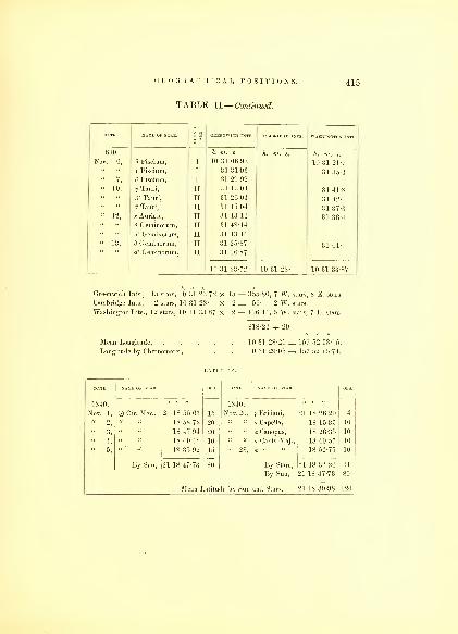
GEOGRAPHICAL POSITIONS.
TABLE II.— Continued.
415
DATE.
§3
1840. h. m. s. h. m. s. h. m. s.
Nov. 6, 8 Piscium, I 10 31 06-93 10 31 21-7
s Piscium, I 31 31-93 31 35-4
8 Piscium, I 31 29 92
« 10, 5j Tauri, II 31 13 04 31 41-8
A' Tauri, II 31 26 04 31 42-
/3 Tauri, II 31 15 04 31 37-3« 12, * Aurigfe, II 31 1314 31 36-4
8 Geminorum, II 31 48-14
a2 Genii norum, II 31 1314" 13, ') Geminorum, II 31 25-87 31 44-
dl G-eminoruui, II 31 06-87
10 31 23-72 10 31 28- 10 31 33-87
Greenwich Ints., 15 stars, 10 31 23 72 X 15 =
Cambridge Ints., 2 stars, 10 31 28- X 2 =
Washington Ints., 12 stars, 10 31 33 87 X 12 =
: 355-80, 7 W. stars, 8 E. stars.
: 56- 2 W. stars.
406-44, 5 W. stars, 7 E. stars.
Mean Longitude,
Longitude by Chronometer,
10 31 28-21 = 157 52 03-15.
10 31 29-05 = 157 52 15-74.
LATITUDE.
1840. 1840.
Nov. 1, Cir. Mer., 21 18 55-67 15 Nov. 20, y Eridani, 21 18 26-20 4
18 58-72 20 a Capella, 18 15-35 10
" 3, 18 47 94 20 a Canopus, 18 26-35 10
18 40-42 10 a Canis Maj., 18 40-57 10
" b, 18 35-92 15 " 28, 18 52-75 10
By Sun, 21 18 47 73 80 By Stars, 21 18 32-24 44
By Sun, 21 18 47-73 80
Mean Latitude by Sun and Stars, 21 18 39-98 124

416 HYDROGRAPHY.
TABLE II.— Continued.
HILO, HAWAII, HAWAIIAN GROUP.
LONGITUDE.
GREENWICH INTS. WASHINGTON INTS.
1841. h. to. s. h. to. s. h. TO. s.
Feb. 7, 48 Leonis, II 10 20 06 29
d Leonis, II 20 08-49 10 20 18-6 10 20 20-8
u Leonis, 11 20 35-49 20 34- 20 31-5
/? Virginis, II 20 03-49 20 14-3 20 12-8
« 10, Virginis, II 20 26-28 20 26-6
a Virginis, II 20 35-28 20 17-2
A Virginis, II 20 09-28 20 30-7
" 11, X Virginis, II 20 12 88
Mar. 1, a Canis Maj., I 20 31 52
10 20 18-8 10 20 14 1 10 20 23-266
122 19-6, 1 W. 8 E. stars.
80 56-4, 4 E. stars.
182 49-2, 6 E. stars.
386 05 2 -~ 19
10 20 19 22 = 155 04 48-3.
10 20 17- =155 04 15-
OBS. DATE.
1841. 1841.
Feb. 7, a Orionis, 19 43 48-88 4 Feb. 8. a Spica, 19 43 58-33 12
Polaris, 43 45-86 6 a Orionis, 43 45-26 8
a Canopus, 43 41 62 20 a Canopus, 43 35-26 20
a Canis Maj., 44 20 8 « 9, a Canis Maj., 43 45-30 18
" 8, a' Crucis, 43 55-90 14
Polaris, 43 42 92 6 Mean Latitude, 19 43 49-9 116
Greenwich Ints., 9 stars, 10 20 18 8 X 9 =Cambridge Ints., 4 stars, 10 20 14-1 X 4 =Washington Ints., 6 stars, 10 20 23 266 X 6 =
Mean Longitude, . ...Longitude by Chronometer,
LATITUDE.

GEOGRAPHICAL POSITIONS. 417
TABLE II.— Continued.
NISQUALLY, OREGOX TERRITORY.
LONGITUDE.
NAME OF STAR t «
1 3GREENWICH INTS C S.MBRIDGE INTS WASHINGTON INTS
1841. h. m. s. h. m. s. h. m. s.
May 30, a. Virginis, j 8 10 16 28
x Virginis, j 10 11-28
" 31, I 10 46-83
x Virginis, j 10 35-83
u u X Virginis, T 10 52-83
June 1 A Virginis, I 10 29-7
u t't
y1 Librae, I 10 29-7
" 4; ij Ophiuchi, II 10 25-73 8 10 37-6
Ophiuchi, n 11 28-26 10 49 1
IC uy~ Sagittarii, II 11 20-26 10 51-
a u,,} Sairittarii 11 15-26
" 26, B Librae, j 10 06 14
09 48 -U" 28 /S LibrL"' 09 54-14
« tl 20 Libra? 10 10-95
u u 10 29 95 8 10 20-9 10 31" 29, i
1 Libras, I 10 31-3
b Scorpii, 1 10 12-4
10 38-95
« 30, b Scorpii, 10 26-41 10 15-7
8 Scorpii, 10 11-41 10 24-6
July 1, t Scorpii, 10 47- 10 37-9
D Ophiuchi, 10 30-78 10 31-8 10 40-6
y2 Sagittarii, 10 35-78
8 Ophiuchi, 10 03-78
» 2 D Ophiuchi, 10 23-84 10 37-5
y- Sagittarii, 10 20-84
Sagittarii, 10 25-84 10 28-4
6 Sagittarii, 10 28-84 10 43-2
« 3, <p Sagittarii, 10 17-9
3 Sagittarii, 10 15-9
h2 Sagittarii, 10 23-45 10 30-2
57 Sagittarii, 10 29- 10 28-5
8 10 28-46 8 10 34-8 8 10 33 87
105

418 HYDROGRAPHY.
TABLE II.— Continued.
853-8, 20 sts. W., 10 E.
208-8, 4 " W., 2 E.
440-31, 7 " W., 6 E.
1502 91 4- 49
Mean Longitude, 8 10 30 67 = 122 37 40-05.
Longitude by Chronometer, . . . 8 10 3] -74 = 122 37 56-15.
LATITUDE.
OBS.
1841. 1841.
June 27, Polaris, 17 07 20- 8 June 28, Polaris, 47 08 00-74 8
a Scorpii, 06 57-51 14 a Aquilla, 06 55-88 20
Jupiter, 07 25-85 12 July 2, a Scorpii, 07 45-17 20
a Aquilla, 07 11-64 12 Jupiter, 07 22-38 20
" 28, a Scorpii, 07 25 92 10 Polaris, 07 30- 8
Jupiter, 07 53-53 Saturn, 08 05-47 16
a Lyras, 07 10-28 4 " 8, a Aquilla, 07 05-20 16
Mean Latitude, 47 07 26-35 190
SAUSALITO, SAN FRANCISCO BAY, CALIFORNIA.
LONGITUDE.
NAME OP STAR. GREENWICH INTS.
1841. h. m. s. h. in. s.
Aug. 26, f Sagittarii, 8 09 41-75
d Sagittarii, 09 25-76
- Sagittarii, 09 16-76
" 27, o Sagittarii, 10 40-
" 28, <r Capricorni, 09 53 -45
a Cephei, 10 44-45
« 29, v Capricorni, 10 16-50
e Aquarii, 09 59-5 8 09 51-7
t Capricorni, 10 01-5 09 57-1
" 30, t Capricorni, 10 06-34 10 09-8
Greenwich Ints., 30 stars, 8 10 28-46 X 30 =Cambridge Ints., 6 stars, 8 10 34-8 X 6 =Washington Ints., 13 stars, 8 10 33-87 X 13 =

GEOGRAPHICAL POSITIONS.
TABLE II.—Continued.
410
DATE NAME OF STAR GREENWICH INTS CAMBRIDGE INTS WASHINGTON INTS
1 3
1841. h. m. a. h. m. s. h. m. s.
Aug. 30, ft Aquarii, I 8 09 54-34 8 09 52-
u u # Aquarii, I 09 42-34 09 49-5
u «£ Aquarii, I 09 37-34 09 52-
" 31, Aquarii, II 09 19-8 09 30-9
a a C Aquarii, II 09 40-8
Sept. 6, e Arietes, n 09 3(3-12
it u(5 Arietes, ii 09 40 12
« u 4' Tauri, ii 09 40 12
« 23, jo1 Sagittarii, i 09 15-70
(l u h 2 Sagittarii, i 09 37-70
" 24, Sagittarii, i 09 48-
« it h- Sagittarii, i 09 56-a «
ft2 Capricorni, i 10 01-
« a o Capricorni, i 09 45-
« 25, o Aquarii, i 09 03-76 09 18-3
" "t Capricorni, i 09 20 76 09 33-8
" 26, ij. Capricorni,
j
09 58 64 10 04-7
t Aquarii, 10 23-64 10 07-6
" 27, H Capricorni, 09 28-5 8 09 35-2 09 42-7
{ Aquarii, 09 44- 09 48-2 09 48-2
7] Aquarii, 09 14-5
X Aquarii, 09 26- 09 30- 09 38-1
" 28, 7j Aquarii, 09 31-65
X Aquarii, 09 38 65t Pisciura, 09 33-65
Oct. 3, rj Tauri, 09 20 65 10 01-3
A' Tauri. 09 36 65 09 58-1
ij. Geminorum, 09 48-52 10 07.3
e Geminorum, 09 54-52 10 10-6
8 09 44-31 8 09 37-8 8 09 55-5
Greenwich Into., 38 stars, 8 09 44-31 X 38 = 1683-78, 30 sts. W., 8 E.
Cambridge Ints., 3 stars, 8 09 37-8 X 3 = 113-4, 3 « W.Washington Ints., 19 stars, 8 09 55-5 X 19 = 1054-5, 13 « W., 6 E.
Mean Longitude,
Longitude by Chronometer,
2851-78 -=- 60
8 09 47-52 = 122 26 52-8.
8 09 47-34 = 122 26 50-15.

42Q HYDROGRAPHY.
TABLE II.— Continued.
LATITUDE.
NAME OP STAR.
1841. 1841.
Aug. 21, Cir. Mer., 37 50 48- 10 Oct. 28, a Pise. Aust. 37 51 06- 14
" 24, 50 43- 10 f Pegasi, 50 42- 8
" 28, 50 55- 10 a Aquarii, 50 48- 20
Sept. 11, 51 12- 10 e Pegasi, 50 40-5 12
Oct. 21, 50 49- 10 j3 Aquarii, 51 09- 16
51 14- 10 a2 Capricorni, 51 04- 10
" 23, 50 44- 10 a Andromedas, 50 58- 12
" 28, a Pegasi, 51 12-9 12 a Cassiopeae, 50 47- 14
Mean Latitude by Sun and Stars, 37 50 52-1 188
The following stations have been determined through Meridian
distances, several times repeated. The unpropitious state of the
weather, and the limited time of our stay, did not permit us to obtain
a fall series of astronomical observations to give them an independent
determination. But through the combined observations, I feel every
confidence in the accuracy of the positions assigned them, and have
adopted them as initial points.
Latitude. Longitude.
Orange Harbor, Terra del Fuego,* 55 31 25. s., 68 02 40- W.33 01 35- 71 39 20- «
11 03 40- 77 11 10- «
17 29 30- 149 31 13 05 «
Pago Pago, Tutuila Island, Samoan Group, . 14 18 06- 170 38 18- "
Sydney, Fort Macquarie,^ .... 33 51 30- 151 12 00- E.
Bay of Islands, Clendon's wharf, N. Zealand, 35 10 10- 174 04 17- "
Manilla, end of quay, .... 14 35 34-41 N., 120 54 19-39 "
Soung Roads, Observatory Point, Sooloo Islan d, . 6 01 00- 120 55 51- "
Singapore, quay, ..... 1 17 37- 103 54 30- «
Cape of Good Hope, Observatory, 33 56 03- s. 18 28 45- «
* Longitude of Orange Harbor, by moon culmi lations, . G7 39 09 30 S.
f " Valparaiso, fort," 71 40 25-65 W.
% " Fort Macquarie, " 151 16 26-25 E.
Should any of these points at a future time receive more accurate determinations, the differ-
ences may be applied to the points determined by the Expedition.
SIGNS
TO DENOTE HOW THE
LATITUDES, LONGITUDES, AND HEIGHTS
HAVE BEEN DETERMINED.
O Meridian altitude, or circummeridian observation of sun.
tk " " " " stars.
© Observation on tbe parallel.
\l" " meridian.
A Triangulation.
% Equal or double altitude of sun.
T " " stars.
Altitude and azimutb of sun and stars.
H Azimutbal bearing.
X Meridian distance by cbronometers.
• Eclipses or occupations.
Moon-culminating stars.
Dt£ Lunar observations,
f Barometer.
X Sympiesometer.
$ Altitude and base.
9 Dip.
§ Determination on shore.
The Capital Letters are used to denote the name of the observer, where
other authority than our own has been adopted for positions. D.R., where
there has been no observation but the ship's reckoning.
10G

422 HYDROGRAPHY.
TABLE III.
LATITUDES, LONGITUDES, AND HEIGHTS,
BY THE EXPLORING EXPEDITION, DURING 1838, 39, 40, 41, 42.
Islands, Capes, &c. &c. Latitude. i&
Longitude. s>
aHeight. Remarks
PATJMOTU GROUP. S. W.
Adventure or Motutunga. 17 0100 144 17 00 X Low coral. Centre.
Ahii or Peacock. 14 27 20 A 146 13 24 A n it East End.
14 34 00 Ol 146 25 00 ©H West End.
14 28 16 A 146 21 20 a' " " Ent. to Lag.
Ahangatou or Arackcheeff. 15 52 00 140 52 00 X Low, inhabited. Centre.
Akiaki or Queen Charlotte. 19 17 40 B 138 42 00 II " " Centre.
Akahaina or Predpriatie. 15 58 00 K 140 11 38 X Centre.
Amanu or Moller. 17 43 00 % 140 39 00 n Low. N. E. Pt.
17 54 00 A 140 50 00 A "S. W. Pt.
Anaa or Chain. 17 23 00 © 145 38 30 X Low, with trees, inhab. N. W. Ex.
It It 17 32 00 145 28 00 X " "S. E. Ex.
Apataki. 15 14 00 © 146 32 00 II Inhabited, low. N. W. Pt.
" 15 18 10 A 146 12 00 A N. E. Pt.
15 35 00 K 146 13 00 H " "S. E. Ex.
Aratica or CarlshofF. 15 28 20 % 145 20 05 X Low, with trees 50 to 60 N. E. Pt.
15 26 17 A 145 28 00 A feet high, inhabited. N. Pt.
145 39 00 ^ West End.
15 40 40 O 145 29 30 X S. Pt.
Archangel or Heretua. 20 24 40 143 30 00 X Low. E. End.
20 25 20 143 32 25 X Inhabited. W. End.
20 24 57 143 31 12 X Centre.
Arackcheeff or Ahangatou. 15 52 00 140 52 00 X Low, inhabited. Centre.
Arutua or Rurick. 15 29 30 146 47 30 X Low, lagoon island, with S. Pt.
15 16 00 A 146 51 50 tt trees, inhabited, 20 W. End.
15 10 00 A 146 49 20 A feet in height. N. W. Ex.
Aurora or Metia Island. 15 49 35 02; 148 13 15 X 200 feet, inhabited. N. Ex.
15 53 15 A 148 10 11 HA 50 feet. S. E. Ex.
15 51 15 148 12 42 A Village.
Batist St. Juan. 24 00 00 B 139 00 00 B Low. Centre.
Barrow or Teku. 20 45 00 B 139 03 00 X Centre.
Barclay de Tolly or Raroia. 16 13 00 % 142 29 00 X Low. S. W. Pt.
15 56 00 A 142 22 00 A N. Pt.

TABLE III.— Continued.
LATITUDES, LONGITUDES, AND HEIGHTS,
BY THE EXPLORING EXPEDITION, DURING 1838, 39, 40, 41, 42.
Islands, Capes, &c. &c. Latitude.1
Height. Remarks.
s. w.o / //
Bacon or Tipotu. 16 43 45 O 144 03 20 B Reef low, iulia.liiU'd. S. E. Pt.
16 41 40 A 144 05 48 A N. W. Pt.
Belero or Ebrilles Reef. 22 28 00 E 133 30 00 E Awash. Centre.
Bird or Hekuera. 17 48 00 © 143 04 o'l K Low, inhabited. S. E. Ex.
Bl i'_rh's or Hereberetua. 21 40 00 B 140 38 00 XBow or Hau. 18 0G IS O B 140 51 15 it It N. Ex.
Is 2 ( i HI! 140 40 00 ^ u u
Buyer's or Reitoue. 18 18 00 © 143 05 00 X u it Centre.
J! vain Martin or Nganaiti. 19 40 22 B 140 22 28 x it a N. W. Ex.
Crescent or Temoe. 23 20 00 B 134 34 10 B feet, trees, inhabited. S. Ex.
23 17 00 B 134 34 10 B N. E. Ex.
Oidmus 23 08 00 A 137 20 00 A Low
CarLshoff or Aratica. 15 28 20 % 145 20 05 x Low coral N. E. Pt,
15 26 17 A 145 28 00 A Trees 50 to 60 feet high. N. Pt.
it it 15 33 25 A 145 39 00 A Inhabited. West End.
a 15 40 40 145 29 30 X S. Pt.
Carysfort or Turcie. 20 44 00 B 138 19 30 B Low. E. Ex.
20 44 00 B 138 26 30 B Wooded. W. Ex.
Chain or Anaa. 17 23 00 145 38 30 X Low, trees 35 feet, N. W. Ex.
17 32 00 © 145 28 00 K inhabited. S. E. Ex.
Clermont de Tonnerre. 18 32 49 136 21 12 X 12 feet, trees, inhabited. S. E. End.
18 27 42 A 136 29 08 A N. W. End.
Clerke or Pukapuka. 17 23 00 M 138 35 00 \\ Low, wooded, S. part W. End.
17 23 00 A 138 25 00 A bare reef.E. End.
Clute or Ohiti. 16 49 52 © 144 16 18 \\ Low, inhabited. S. W. Pt.
16 48 33 144 14 45 X N. E. Pt.
Cockburn. 22 17 00 B 138 39 53 B Low. S. W. Ex.
22 14 00 B 138 35 10 B N. E. Ex.
Croker or Heraiki. 17 28 00 W 143 23 42 W Centre.
Cumberland or Manuwangi. 19 11 00 © 141 10 00 X Low, inhabited. East End.
19 12 00 141 19 06 % West End.
Dawhaida. 17 55 00 © 142 17 00 X Low. N. Pt.

424 HYDROGRAPHY.
TABLE III.— Continued.
LATITUDES, LONGITUDES, AND HEIGHTS,
BY THE EXPLORING EXPEDITION, DURING 1838, 39, 40, 41, 42.
Islands, Capes, Ac. &c. Latitude. 153
Longitude. i Heights. Remarks.
S. W.o / //
Dawhaida.
o / //
18 02 40 142 12 20 X Low. S. Pt.
Dean's or Nairsa. 15 16 30 JC 147 13 40 X Low, inhabited. East End.
" " 15 05 15 JC 147 58 28 X South side bare reef. W. Ex.
" " 14 56 00 JC 147 53 00 X Clump of trees. N. W. Ex.
1 lisappointment, Wytoohee. 14 10 40 141 12 50 X Wooded, inhabited. East End.
" " 14 09 30 A 141 17 48 A 12 feet. West End.
" Otooho. 14 05 00 141 30 00 X Wooded, inhabited. Centre.
Doubtful or Tekareka. 17 19 46 B 142 22 10 X Very low. Centre.
Ebrilles or Bertero Reef. 22 28 00 E 133 30 00 X Awash. Centre.
Egmont or Tatukoto. 19 24 26 M 139 34 14 X \Large clump of trees S. W. Ex.
" " 19 22 30 A 139 28 00 A / on N. W. End inhabN. E. Ex.
Elizabeth or Toau. 15 58 00 B 145 49 30 X Low, inhabited. S. E. Pt.
15 43 30 B 146 08 00 % Low. N. W. Pt.
15 43 30 A 146 00 00 A N. E. Pt.
Eucarnacion. 24 45 00 ? 137 42 00 ? Centre.
Faith. 21 10 00 0- 138 55 00 X Centre.
J£ 145 33 00 N. E. Pt.
16 33 00 K 145 22 00 X S. Pt.
16 07 00 K 145 38 00 A N. End.
Faaite or Myloradowitch. 16 43 00 145 19 30 X W. End.
16 48 00 JC 145 06 00 X E. End.
Four Crowns or Teku. 20 27 39 O 143 18 17 X Low, wooded. Centre.
Furneaux or Marutea. 17 05 00 142 44 00 X Low, inhabited. East End.
17 05 00 JC 143 05 00 8 West End.
Gambier's or Mangareva. 23 08 00 B 134 55 30 B Mt. Duff, 1248 ft. inhab Pk.
Gambler's Reef. 23 02 00 B 134 55 00 B N. E. Ex.
Gloucester or Hariri. 19 08 00 B 140 40 00 B Inhabited. Centre.
Good Hope. 16 48 00 JC 141 35 00 X Low, coral. Centre.
Greig or Niau. 16 11 00 146 22 00 X Low, wooded. Centre.
Hau or Bow. 18 06 18 BO 140 51 15 BX Low, inhabited. N. Ex.
18 26 00 A 140 40 00 A S. E. Ex.
Hairiri or Gloucester. 19 08 00 B 140 40 00 B S. W. Ex.

GEOGRAPHICAL POSITIONS. 425
TABLE 111.— Continued.
LATITUDES, LONGITUDES, AND HEIGHTS,
BY THE EXPLORING EXPEDITION, DURING 1838, 89, 40, 41, 42.
Islands, Capes, to. &c. Latitude. | Longitude. |8
Height. Remarks.
s. W.
Hereheretua or Bligh's.
c / „21 40 00 B
o / //
140 38 00 B Low, inhabited. Centre.
Heraika or Croker. 17 28 30 W 143 23 42 W Centre.
Hekuera or Bird. 17 48 00 B 143 04 52 X S. E. Ex.
Heretua or Archangel. 20 24 4( 143 30 00 X Low. E. End.
20 25 20 H 143 32 25 X Inhabited. W. End.
20 24 57 143 31 12 li Centre.
Henuake or Honden or Dog. 14 54 55 A 138 49 15 A Low. W. End.
14 55 54 O 138 4.3 48 X Wooded. E. End.
14 50 55 A 138 46 33 A S. End.
Honden or Henuake or Dog. 14 55 54 A 138 45 48 A No inhabitants. E. End.
14 54 55 O 138 49 15 X W. End.
Holt or Taenga. 16 18 00 O 143 17 00 X Low, inhabited. N. W. Pt.
16 20 00 A 143 03 00 A E. Pt.
Katiu or Saken. 16 31 00 O 144 12 10 X Low. S. E. Pt.
16 25 00 A 144 20 00 JX Inhabited. N. W. Pt.
u a 16 27 00 A 144 14 00 AKawahe or Vincennes. 15 59 48 O 145 09 30 X Clump of trees, E. side. S. Pt.
15 46 50 2[0 145 11 50 x§ Low, inhabited. N. Pt.
15 06 30 A 145 12 43 A Entrance.
Kaukura. 15 50 00 © 146 27 00 i\ E. End.
15 43 00 146 49 00 \\ N. W. Ex.
King's or Taiara. 15 42 30 %i 144 37 30 x§ Low, wooded. E. End.
15 41 05 A 144 39 38 A N. W. End.
King George's Group. 14 22 10 O 144 58 30 * Trend S.S.VV. & N.N.E. N. End.
KoiitousolT, Makemu, or 1
phiiiips.(
;
14 44 20
16 26 00
16 36 00
K
H
145 20 00
143 56 00
143 24 00
KX
Low, wooded.
Inhabited.
S. End.
W. End.
E. End.
Krusenstern's or Tikehau. 15 00 00 148 20 30 X Low, wooded. W. End.
14 52 00 ® 148 15 15 A N. Pt.
14 56 00 A 148 08 3011 E. Ex.
15 06 30 A 148 17 45 A S. End.
Lagoon or Nukutawake. 18 43 19 D 138 47 13 D Centre.
107

426 HYDROGRAPHY.
TABLE III.— Continued.
LATITUDES, LONGITUDES, AND HEIGHTS,
BY THE EXPLORING EXPEDITION, DURING 1838, 39, 40, 41, 42.
Islands, Capes, &c. &c. Latitude. Longitude..1
Height. Remarks.
s. W.
Lazareff or Mataiwa.
o / //
14 53 30
o / //
1 48 43 30 X Low, wooded. W. Side.
14 51 40 A 148 41 40 A N. Ex.
14S .'
! S 00 E. End.
L rd Hood's or Marutea°r
((
°° SOT 21 30 00 B 1 35 32 (M) y( Low wooded W. Pt.
21 30 00 B j ;
; •1
1 ) at. Inhibited
'
M n^areva or 6 mbier'a 23 08 00 B 1 34 55 30 B Mt Duft' l''4S feet Pk.
MarrReTf
01"
•)]
-
t;i
()( ) A.
Marutea or or^
oo s. B 1 35 '!'' 00 Low wooded W. Pt.
21 30 00 B 1.'-!."> 'Ml 00 Inhabited
6
'
E. End.
anuwangi or urn ei an . ® 141 10 00 y( "low
6 '
E. End.
19 12 00 X Inhabited W. End.
arutea or urneaux. 17 05 00 IP' 1 Mill X Low inhabitedow, in a ite . E. End.
17 05 00 ! 43 05 (10 W. End.
Manaka. Two Groups. o X ((
is 03 oo 142 11 15 a N. Pt.
Matilda or Osnaburgh. 21 50 00 B 138 45 00 X East side wooded, west E. End.
21 51 00 B 139 00 00 X reef awash. W. End.
Makemu, Pheilips, or Kou- )
tousoff. $
16 26 00 K 143 56 00 K f Low, N. wooded, S W. End.
16 36 00 143 24 00 X { chain of reefs, inhab.E. End.
Margaret's or Nukutipipi. 20 42 21 143 03 48 X Low, wooded. Centre.
Manhii or Wilson. 14 24 00 145 52 00 H E. Ex.
14 26 25 V 146 04 20 Inhabited. W. Ex.
14 27 15 A 140 03 12 A Ent. to Lag.
Mataiwa or Lazareff. 14 53 30 O 148 43 30 X Low. W. Side.
14 51 40 A 148 41 40 A Wooded. N. Ex.
14 55 00 JC 148 38 00 11E. End.
Matia or Osnaburgh. 17 55 00 B 148 02 00 X Inhabited, 1500 feet. Centre.
Metia or Aurora. 15 49 35 148.13 15 X £ 200 feet, wooded. N. End.
15 53 15 A 148 10 11 HA £ Inhabited, 50 feet. S. E. Ex.
15 51 15 A 14812 42 A Village.
Melville or Tekukota. 17 35 00 B 142 39 00 X Low, wooded. N. W. Ex.
17 41 00 A 142 35 00 A S. E. Ex.

TABLE III.— Continued.
LATITUDES, LONGITUDES, AND HEIGHTS,
BY THE EXPLORING EXPEDITION, DURING 1838, 39, 40, 41, 42.
Islands, Capes, &c. &c. Latitude.
1Longitude. Height. Remarks.
o
S/"
//
W; „
Moller or Amami. 17 43 00 % 140 39 00 8 Low. N. E. Pt.
« 17 54 00 A 140 50 00 A »S. W. Pt.
Motutunga or Adventure. 17 04 00 O 144 17 00 X Low, coral. Centre.
Myloradowitch or Faaite. 1G 43 00 145 19 30 X Low, wooded. AV. End.
U16 48 00 145 06 00 X « E. End.
Nairsa or Dean's. 15 1G 30 O 147 30 40 X « E. End.
«15 05 15 147 58 28 X Inhabited. W. Ex.
u
Nengo Nengo or Prince
)
\\ ilham Henry.^
14 56 00
18 43 00
18 49 00
Dup.
147 53 00
141 40 00
141 40 00
XXX
Clump of trees.
Low.
N. AV. Ex.
N. Ex.
S. Pt.
Niau or Greig. 16 11 00 O 146 22 00 X Low, wooded. Centre.
Niheri or Negeri. 16 42 00 B 142 48 00 X N. Pt.
16 45 00 A 142 48 00 A aS. Ex.
Nganaiti or Byam Martin. 19 40 22 B 140 22 28 X N. AV. Ex.
Nukutipipi or Margaret's. 20 42 21 143 03 48 X u Centre.
Nukutawake or Lagoon. 18 43 19 D. 138 47 13 D Centre.
Ohiti or Clute. 16 49 52 144 16 18 X Low, inhabited. S. AV. Pt.
16 48 33 144 14 45 X N. E. Pt.
Oura. 14 32 08 O 145 14 30 X Low, wooded. N. Pt.
14 44 20 A 145 20 00 A Inhabited. S. Pt.
Osnaburgh or Matia. 17 55 00 B 148 02 00 X 1500 feet. Centre.
Osnaburgh or Matilda. 21 50 00 B 138 45 00 X East side wooded. E. End.
21 51 00 B 139 00 00 X West reef, awash. AV. End.
Otooho. 14 05 00 141 30 00 X Low, wooded, inhab.
Pablo, St. 19 51 20 144 58 25 X Low, inhabited. N. Ex.
19 53 20 145 00 0(. X AV. Islet.
19 55 22 A 144 58 00 A S. End.
Peacock's or Ahii. 14 27 20 A 146 13 24 A Low. E. End.
Phillips, Makemu, or Kou- }
tousoflf.j
14 34 00
16 26 00
0§M
146 25 00
143 56 00
©XX
1 Wooded.
Low, wooded.
AV. End.
AV. End.
16 36 00 M 143 24 00 X E. End.
Prcdpriatie or Akahaina. 15 58 00 K 140 11 30 X Low, inhabited. Centre.

428 HYDROGRAPHY.
TABLE III.— Continued.
LATITUDES, LONGITUDES, AND HEIGHTS,
BY THE EXPLORING EXPEDITION, DURING 1838, 39, 40, 41, 42.
Islands, Cafes, Ac, &c. Latitude..1
Longitude. 5> Height. Remarks.
S. w.
Prince William Henry or)Nengo Nengo.
j
Is 4:5 on Dup. 141 40 00 Low. N. Ex.
18 49 00 Dup. 141 40 00 x S. Pt.
Pukerua or Thrum Cap. 18 30 00 B 139 08 00 B u N. W. Ex.
Pukapuka or Clerke. 17 23 00 138 35 00 || Low inhabited W. End.
138 25 00 u u E. End.
Queen Charlotte or Akiaki. 19 17 40 B 138 42 00 Low.
16 06 25 144 57 40 HI Ente^Lag(( 144 52 50
N°rt
g2e
e
rJef
0ded '
( Apex S.
\ pt.of reef.
16 10 00 144 46 50 Inhabited'
A'x S. E. pt
uIII ii- no A 145 00 40
Raroia or Barcla de Tollaroia or arc ay e o y. Bel. 1 12 29 Oil x Low inhabited S.W. Pt.
15 56 00 Bel. 1 1 2 22 (Mi Bel. u a N. Pt.
Resolution or St. Simeon, )
or Taweree.J
17 22 21 141 29 39 X ( Near| Sand Spit
17 23 35 141 26 05 X Inhabited. S. E. pt.
« u u 17 24 00 141 28 45 u S W. clump.
Reitoue or Buyer's. 18 18 00 143 05 00 X Low. Centre.
Ried or Tuinaka. 16 40 00 144 10 28 X S. Pt.
16 37 17 A 144 13 00 A N. W. Pt.
16 37 00 144 09 30 X N. E. Pt.
Romantzoff or Tike. 14 57 00 Koz. 144 35 30 K Low, wooded. Centre.
Rurick or Arutua. 15 29 30 146 47 30 X S. Pt.
15 16 00 A 146 51 50 K Inhabited. W. End.
15 10 00 A 146 49 20 A N. W. Ex.
Saken or Katiu. 16 31 00 144 12 10 X S. E. Pt.
16 25 00 A 144 20 00 Low. N. W. Pt.
16 27 00 A 144 14 00 A Entrance.
Serle. 18 21 10 O 137 04 20 X Inhabited. S. E. Pt.
18 16 50 A 137 09 06 A Low. N.W. End.
St. Juan Baptist. 24 00 00 139 00 00 Centre.
St. Simeon, Taweree, or Re-
j
solution,j
17 22 21 141 29 39 X JNear
\ Sand Spit
17 23 35 141 26 05 X Low, inhabited. S. E. Pt.
17 24 00 A 141 28 45 A Low. S.W. clump.

GEOGRAPHICAL POSITIONS. 429
TABLE III.— Continued.
LATITUDES, LONGITUDES, AND HEIGHTS,
BY THE EXPLORING EXPEDITION, DURING 1838, 39, 40, 41, 42.
Islands, Capes, Ac. &c. Latitude..1
Longitude.
IHeight. Remarks.
S. W.
St. Pablo. 19 51 20 o 144 \ X Low, inhabited.
19 53 20 00 X W. Islet,
19 55 22 A 1 II "S A U u
Large clump of trees on
N. W. end, inhab.
S. End.
Tatukoto or E<Tinoiit. 19 24 26 M l-'r'i9.4 14 x S. W. Ex.
19 22 30 A 139 28 A N. E. Ex.Taweree, St. Simeon or Re-
j
solution.)
17 22 21 O 141 29
'
!
,:
.
x Low, inhabited. Sand Spit.
17 23 35 O 141 26 o., x S. E. Pt.
17 24 00 A'.!'
A u u S.W. clump
Takurea or Wolconsky. 15 48 00 O 142 V x Inhabited, low. S.End.
15 39 30 A 142 06
" (
.
of'
x East side wooded, west
side bare.N.E. End.
Taenga or Holt. 1G 18 00 O 143 17 0( x Low, inhabited. N. W. Pt.
16 20 00 A
1
I I'-v'
A E. Pt.
Tahanea or Tckitshagoff. 16 52 00 K 00 x Low. W. End.
16 57 00 K 144 48 00 x „ E. End.
Taiara or King's. 15 42 30 O? 144 37 30 x? u E. End.
15 41 05 A 144 39 38 A Wooded. N. W. End.
Teku or Barrow. 20 45 00 B 139 03 00 X Low. Centre.
Tematu-Leiwuwau or Whit-
1
Sunday.j
19 23 38 Bel. 138 36 48 X 6 ft. above sea, wooded. Centre.
Tekareka or Doubtful. 17 19 46 B 142 22 10 X Very low. Centre.
Tekukota or Melville. 17 35 00 B 142 39 00 X Low, wooded. N. W. Ex.
17 41 00 B 142 35 00 X S. E. Ex.
Temoe or Crescent. 23 20 00 B 134 34 10 B 6 feet, trees, inhabited. S. Ex.
23 17 00 B 134 34 10 B N. E. Ex.
Teku or Four Crowns. 20 27 39 O 143 18 17 X Low, wooded. Centre.
Thrum Cap or Pukerau. 18 30 00 B 139 08 00 B Low, inhabited. N. W. Ex.
Tike or Rotnantzoff. 14 57 00 K 144 35 30 K Low, wooded. Centre.
Tiokea. 14 22 10 144 58 30 X N.Pt.
1431 12 H 145 09 30 X S. W. Pt.
14 29 00 A 145 06 00 A Ent. to Lag.
Tipotu or Bacon. 16 43 45 O 144 03 20 B Reef, low, inhabited. S. E. Pt.
16 41 40 A 144 05 48 A Wooded. N. W. Pt.
Tikehau or Krusenstern's. 15 00 00 148 20 30 X Low, wooded. W. End.
10*

430 HYDROGRAPHY.
TABLE III.— Continued.
LATITUDES, LONGITUDES, AND HEIGHTS,
BY THE EXPLORING EXPEDITION, DURING 1838, 39, 40, 41, 42.
Islands, Capes, fte. Ac. Latitude. S Longitude. a
1He.ghts. Remarks.
s. W.
Tikehau or Krusenstern's. 14 52 00 ® 148 15 15 A Low, wooded. N. Pt.
u 14 56 00 A 148 08 30 11u E. Ex.
Toau or Elizabeth. 15 58 00 B 145 49 30 X Low, inhabited. S. E. Pt.
15 43 30 B 146 08 0011
a it N. W. Pt.
Tuinaka or Reid. 16 40 00 144 10 28 X Low. S. Pt.
u 16 37 17 A 144 13 00 A N. W. Pt.
a 16 37 00 O 144 09 30 X N. E. Pt.
Turcei or Carysfort. 20 44 00 B 138 19 30 B Low, wooded. E. End.
20 44 00 B 138 26 30 B W. Ex.
Vincennes or Kawahe. 15 59 48 145 09 30 X Clump of trees, E. side. S. Pt.
a 15 46 50 %Q 145 11 50 X? Low, inhabited. N. Pt.
u 15 06 30 A 145 12 43 A a Entrance.
Wilson's or Manhii. 14 24 00 145 52 00 8 Low, wooded. E. Ex.
U 14 26 22 A 146 04 20 A? Inhabited. W. Ex.
u 14 27 15 A 146 03 12 A u a Ent. to Lag.
Wittgenstein or Fakarawa. 16 05 00 K 145 33 00II
" N. E. Pt.
16 33 00 K 145 22 00 X S. Pt.
16 07 00 K 145 38 00 A N. End.
Whitsunday or Tematu. 19 23 38 Bel. 138 36 48 X 6 ft. above sea, wooded. Centre.
Wolconsky or Takurea. 15 48 00 142 15 30 X | Inhabited, low, E. side S. End.
15 39 30 A 142 06 15 X (wooded, W. side bare.
N. E. End.
Wytoohee. 14 10 40 141 12 50 X Low, wooded, inhab. E. End.
14 09 30 A 141 17 48 A Low, reef. W. End.
SOCIETY GROUP.
Aorai. Tahiti. 17 38 00 A 149 33 00 A 6979 feet. Peak.
Borabora. 16 22 00 K 151 40 00 High. N. End.
Eimeo. 17 29 30 ® 149 55 00 X 2500 feet. N. E. End.
17 34 15 150 00 30 X S. End.
Eimeo, Oroo Peak. 17 30 00 A 149 49 00 A 4045 feet. £ Peak.
Huahine. 16 42 10 151 11 00 High. N. End.
16 54 20 ® 151 08 00 S. End.
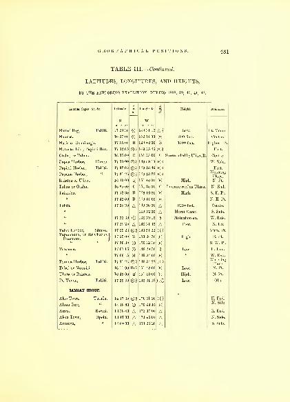
GEOGRAPHICAL POSITIONS. 431
TABLE III.— Continued,
LATITUDES, LONGITUDES, AND HEIGHTS,
BY THE EXPLORING EXPEDITION, DURING 1838, 39, 40, 41, 42.
Islands, Capes, &c. Ac. Latitude. I Longitude..1
Height. Remarks.
s. W.
Matavi Bay, Tahiti. 17 29 30 149 31 13 A2 Pt. Venus
Maurua. 16 27 00 152 14 00 X 800 feet. Centre.
1 !s 02 on B 1500 feet Highest Pt.
Motmitu hlrt^apieti Har 17 32 05 0§ 1 I 9 35 4ii XIOtaha, or Tahaa. 16 35 00 C 151 35 00 c Surrounded by Ulitea R. Centre.
Pa^eti^HarbOT Tahiti"
17 30 00 1 149 58 10 XI W. Side.
§ 1 1
1
) 35 III X
1
Papaoa Harbor^«
^
17 31 26 \ 149 33 22 X §WateringPlace.
Raiatea or Ulieta. 16 40 00 H 151 40 00 X High. N. Pt.
Tahaa or Otaha. 16 35 00 c 151 35 00 c In same reef as Ulitea. N. End.
Taiarabu. 17 52 30 B 149 10 30 X High. S. E. Pt.
17 42 00 B 149 07 00 X N. E. Pt.
Tahiti. 17 38 30 A 149 30 00 A 8250 feet. Centre.
149 32 00 A Morai Oamo. S. Side.
1 7 33 30 ® i 19 39 1 5 \\ Motuahou-na. W. Side.
« 17 28 20 A 149 31 15 A Reef. N. Ex.
Taloo Harbor, Eimeo.Tajiamanoa, or Sir Charles)
Saunders.)
17 29 23
17 29 00
17 30 30
0§W
149 51 22
150 24 30
150 32 30
XIXX
High.
Vinn. Pt.
E. Pt.
S. W. Pt.
Tetuaroa. 17 07 15 149 29 30 1 Low. E. End.
Toauoa Harbor, Tahiti.
17 06 45
17 31 26 0§
149 34 00
149 34 22
Xxi
W. End.WateringPlace.
Tubai or Motu-iti. 16 11 00 Bel. 151 48 00 X Low. N. Pt.
Ulieta or Raiatea. 16 40 00 H 151 40 00 X High. N. Pt.
Pt. Venus, Tahiti. 17 29 30 0§ 149 31 13 xo Low. Obs.
SAMOAN GROUP.
Alao Town, Tutuila.
Aluau Bay, "
14 17 30
14 1800
02 170 31 30
170 44 15
XIX
E. End.N. Side.
Amoa, Savaii. 13 38 40 A 172 07 00 A E. End.
Alofa Town, Opolu. 13 47 00 A 171 46 00 A N. Side.
Anfanga, " 14 00 00 A 171 26 20 A S. Side.

432 HYDROGRAPHY.
TABLE III.— Continued.
LATITUDES, LONGITUDES, AND HEIGHTS,
BY THE EXPLORING EXPEDITION, DURING 1838, 39, 40, 41, 42.
Islands, Capes, &c. &c. Latitude. i Longitude. 1X
Height. Remarks.
s. W.o / „
Apolima, Upolu. 13 49 30 0§ 172 03 00 X $ 547 feet. Centre.
Apia, " 13 48 56 02 171 41 09 K« Obs.
Apia Peak, "
Island.|
Anuu, Id., S. E. side Tutuila.
13 51 00
13 31 45
AAA
171 41 00
172 35 40
170 30 15
AAII
£ 960 feet.
Rocky.
Centre.
E. Pt.
14 18 40 ® 170 30 40 A 230 feet. Centre.
« 1419 10 170 30 40 Rocky. S. Pt.
Atoa Town, Fangaloa Har. 13 56 00 170 29 00{ Musumusu"
Ana Ifarbor, Tutuila. 14 17 00 0§ 170 33 00 XS West Pt.
Bat Point, " 14 17 00 A 170 34 45 A Rocky bluff. N. side.
Bartlett's Point, " 14 16 35 A 170 35 00II
"
Bird Point, " 14 17 40 A 170 42 45 X Rocky. "
Black Rock, " 14 17 05 A 170 31 10 X 85 feet. East End.
Black's Bay, " 14 20 30 A 170 39 00 X S. Side.
Cockscomb Pt., " 14 15 20 A 170 38 20 A Rocky. N. Side.
" Islet. 13 49 50 A 172 02 00 A In the Upolu Reef. E. End.
• me 1 1 ill, Savaii. 13 47 00 ® 172 10 00 £ 530 feet. S. E. Pt.
Cocoanut Point, Tutuila.
Cocoanut Islet, Falealili Har.
14 20 00
14 00 13
H02
170 39 00
171 35 38
AX2
Low, sandy.
1
S. side.
S. Side of
Upolu.
N. Side.Craggy Point, Tutuila 14 16 30 A 170 37 40 A Rocky bluff.
Devil's Own Point, " 14 18 45 A 170 37 25 Af Low, sandy coral ex-
\ tends f mile beyondRocky.
S. Side.
Deceit " "
Double " "
1421 10
14 19 25
AA
170 40 10
170 38 00
AA
1 S. Side.
S. Side.
Elliott " " 14 17 25 A 170 42 15 A Rocky Point. N. Side.
Eld's " Upolu. 13 53 30 A 171 28 10 A Rocky. N.Side.
Emmons Point, " 13 54 00 A 171 27 10 A N. Side.
Faluasofia, Town, " 13 51 10 171 58 50 A West End.
Falilati, " « 13 53 00 0§ 171 55 00 Hi S. Side.
Falealili " 13 59 00 O 171 36 00 AFanganga Peak,
Fanuatapu Id.,"
Fangaloa Bay, "
13 59 25
13 58 20
13 55 00
AA02
171 23 30
171 20 25
171 28 00
AAX?
1750 feet. £| In the Upolu Reef,
{ East end.
S. E. End.
Centre.
Centre.

TABLE III.— Continued.
LATITUDES, LONGITUDES, AND HEIGHTS,
BY THE EXPLORING EXPEDITION, DURING 1838, 39, 40, 41, 42.
Islands, Capes, Ac &c. Latitude. ia
Longitude. ia
Height. Remarks.
s. W.o / //
Fao Peak, Upolu.
o / //
13 54 45 A 171 29 25 A 2900 feet. $Falifa Harbor, 13 52 33 § 171 31 46 XI Centre.
Falifa Town, 13 53 00 A 171 32 20 AFalooloo Pt. and Town, 13 47 00 A 171 44 45 A N. Side.
Fasetootai, Town, 13 48 30 A 171 52 25 A N. Side.
Faleatii, 13 48 30 O 171 53 45 A N. Side.
Fagaitua Bay, Tutuila. 14 18 00 O 170 33 42 X S. Side.
Felialupo Point, Savaii. 13 30 40 AO 172 44 50 A 1 Rocky. W. Pt.
Fouci Town, Upolu. 13 5145 A 17134 15 A N. Side.
Fungasa Harbor, Tutuila. 1418 00 § 170 42 3d X2 Centre.
Faleapuna, Upolu. 13 51 05 A 171 33 21 A N. Side.
Greyhound Point, Tutuila. 1418 00 A 170 44 15 A Rocky. N. Side
Hardie Point, Savaii. 13 28 45®A 172 13 4a A N. E. Pt.
Kidd's Point, Tutuila. 14 16 35 A 170 32 20 A N. Side.
Lauto Pk. or Crater 13 54 30 A A 2570 feet. J Centre of I.
Lauli Point, Savaii. 13 28 00 A 172 20 00 A Rocky. N. Side.
Laulii Harbor, Upolu. 13 49 42 O 171 38 25 X Anchorage.
Laulii Town, 13 50 50 A 171 38 00 A N. Side.
Latonga, 13 50 30 O 171 39 00 ALepa, 14 00 00 A 171 23 30 A S. Side.
Lafanga, Boat Har. Upolu. 1355 00 A 171 53 00 ALeopard Point, Tutuila. 14 19 00 A 170 47 15 A Rocky. N. W. Part.
Upolu. 13 55 30 A 171 27 30 A N. Side.
Lion's Head, Tutuila. 14 18 25 A 170 34 30 A Rocky. S. Side.
Leone Point, 14 22 20 O 170 43 15 XLotofanga, Upolu. 14 00 00 A 171 29 40 A S. Side.
Luatuanua Town, 13 51 00 A 17137 15 A N. Side.
Manono Id. 13 50 00 A 172 01 00 A In Upolu Reef. Centre.
Masina Town, 13 56 30 A 171 28 15 A N. Side.
Malata Peak, 13 57 00 A 171 30 00 A 2631 feet. $ East End.
Matafongatele Poin 13 48 30 AO 171 40 30 AX Low. N. Side.
Mataatu Har. Savaii. 13 28 00 0§ 172 18 00 X§ Obs.
109
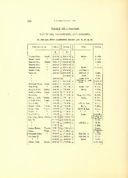
434 HYDROGRAPHY.
TABLE III.— Continued.
LATITUDES, LONGITUDES, AND HEIGHTS,
BY THE EXPLORING EXPEDITION, DURING 1838, 39, 40, 41, 42.
Islands, Capes, Ac. &c. Latitude. Longitude. Height. Remarks.
Maletun Point, Savaii.
Maury's Point, "
Massacre Bay, Tutuila.
Massefao Bay, "
Matutula Cape, "
Matafao Peak, "
Manua Id.
Missionary Point, Savaii.
Mole Point, "
Mosquito Point, Tutuila.
Mutiatele Town, Upolu.
Musumusu,
Murray's Point, Tutuila.
Naf'avalii Point, Upolu.
Namua Islet,
Nelson's Point, Tutuila.
Nuutele Islet, Upolu.
Nuulua « "
Naneivi Point, "
Observatory Point, Tutuila.
Ofoo Id.
Oafuno Harbor, Tutuila.
Oluna, Upolu.
Olemanga Crater, "
Oloosinga Id.
Paluale Point, Savaii.
S.
13 28 30
13 40 40
14 18 10
14 16 35
14 16 25
14 19 30
14 15 00
14 17 20
14 13 15
13 43 15
13 29 40
14 16 45
13 58 25
13 55 30
14 21 20
13 47 50
13 58 40
14 16 30
14 01 00
14 01 30
13 52 20
14 18 06
14 11 00
14 11 35
1412 15
1416 48
13 55 15
13 58 00
14 11 00
14 12 20
13 47 40
AA0§02AA@0
@0%%AA
AAAA@%A0§%iA
0AAAOA©
w.
172 23 00
172 06 00
170 43 20
170 35 00
170 31 15
170 40 00
169 26 30
169 24 00
169 28 40
172 33 25
172 44 00
170 33 00
171 21 50
171 28 50
170 44 40
171 50 30
171 21 20
170 39 40
171 21 40
171 20 50
17131 15
170 38 18
169 36 00
169 33 20
170 37 15
171 28 40
171 24 40
169 32 00
169 32 00
172 11 40
'A
AX§XXAit
1!
XAAAXXAAAA!!
II
AXImA
XAAAAXA
Rocky.
Rocky.
2327 feet. J
2500 feet. £
Bluff.
Rocky Bluff.
( 300 feet. A Rocky1 Bluff.
Rocky Bluff.
Rocky.
Fangaloa Harbor.
Rocky.
In Upolu Reef.
Rocky.
Off S. E. End.
Rocky.
1020 feet. £
2720 feet. £
1220 feet. &Rocky.
N. Side.
E. End.
N. Side.
N. E. Pt.
Centre.
E. Pt.
S. Pt.
JN. W. Pt.
S. W. Side.
W. End.
N. Side.
E. End.
W. Side.
S. Side.
N. Side.
Centre.
N. Side.
Centre.
Falifa Har.Harbor of
Pago Pago.
W. Pt.
E. Pt.
S. Side.
Centre.
( Fangaloa
IBay.
E. End.
N. Pt.
S. Pt.
E. Pt. Bay.

GEOGRAPHICAL POSITIONS. 435
TABLE III.— Continued.
LATITUDES, LONGITUDES, AND HEIGHTS,
BY THE EXPLORING EXPEDITION, DURING 1838, 39, 40, 41, 4:
Islands, Capes, & .Ac. Latitude. 1S
Longitude. i Height.
S.
o , „w.
Paluale Point, Savaii. 13 46 50 Oo , „
172 15 15 APago Pago Harbor Tutuila. 14 18 06 0* 178 38 18
Pickering Peak, Savaii. 13 40 00 A 172 11 20 A 1120 feet. $
Pyramid Rock, Tutuila. 14 18 40 A 170 35 15 ARed Point, 14 18 00 A 170 31 25 A Rocky.
Rocky Point, 14 21 10 A 170 47 00 ARose Island. 14 31 30 168 08 30 X§
f Clump of trees, 60
{ feet, low coral.
Round Bluff, Tutuila. 14 18 30 A 170 33 20 A Rocky.
Round Point, Upolu. 13 57 30 A 171 48 40 A II
Samatou Point, 13 52 30 A 171 58 30 ASanaapu Town, 13 56 40 0§ 171 43 4C
" Harbor, 13 57 47 O 171 44 27 X Entrance.
Salany, 1',
!'> !i .'11 A 171 32 20 A
Salamanu Peak, 13 56 10 A 171 25 30 A 2570 feet. £Satitoa, 13 59 00 A 171 22 00 ASaleaaumua, 13 57 50 A 171 22 00
Saruusu Town, 13 56 40 O 171 22 40 ASamamea Town, 13 54 30 A 171 27 20 ASauano Town, 13 54 00 A 171 29 30 ASaluafata Harbor, 13 51 24 O 171 34 18 XSaluafata Town, 13 51 55 A 171 33 40 ASalelese, 13 5140 A 171 34 30 ASangana or Alofa, 13 47 00 A 171 46 00 ASalamoa Church, 13 47 10 A 171 47 45 ASasava, 13 49 00 A 171 55 21 AXalafuata Point, 13 48 25 OA 171 56 30 XASavaii. 13 30 35 172 44 50 a x Inhabited.
13 40 45 172 06 00ii
13 48 40 172 28 40 A f Rocky iron bound
{ coast.
13 27 30 O 172 17 30 A Low.
13 48 30 172 08 30 A Rocky.
Sapapale, Savaii. 13 42 00 O 172 06 25 X
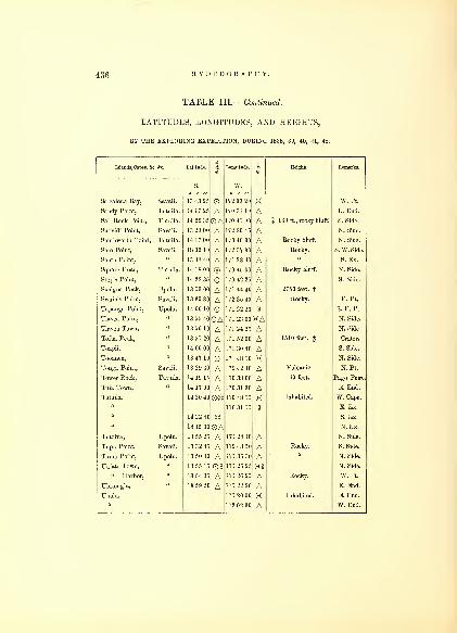
436 HYDROGRAPHY.
TABLE III.— Continued.
LATITUDES, LONGITUDES, AND HEIGHTS,
BY THE EXPLORING EXPEDITION, DURING 1838, 39, 40, 41, 42.
Islands, Capes, &c. &c. Latitude.
S3
Longitude.
IHeight. Remarks.
o ', „Salealoua Bay, Savaii. 13 43 25 O
W „172 33 20 X W. Pt.
Sandy Point, Tutuila. 14 17 25 A 170 31 10 A E. End.
Sail Rock Point, Tutuila. 14 22 35 OA 170 41 00 A $ 160 ft., rocky bluff. S. Side.
Suovidi Point, Savaii. 13 29 00 A 172 30 45 A N. Side.
Southworth Point, Tutuila. 14 17 00 A 170 40 30 A Rocky bluff. N. Side.
Soto Point, Savaii. 18 39 10 A 172 37 30 A Rocky. S. W. Side.
South Point, u 13 48 40 A 171 28 40 A S. Ex.
Square Head, Tutuila. 14 18 00 ® 170 45 00 A Rocky bluff. N. Side.
Step's Point, a 14 22 35 O 170 42 25 A S. Side.
Susigna Peak, Upolu. 13 53 00 A 17144 40 A 2750 feet, f
Swain's Point, Savaii. 13 30 30 A 172 35 40 A Rocky. E. Pt.
Tapanga Point, Upolu. 14 00 10 O 171 22 20 \\ S. E. Pt.
Tiavea Point, « 13 55 40 OA 171 23 00 KA N. Side.
Tiavea Town, 13 56 10 A 171 24 25 A N. Side.
Tofua Peak, 13 51 20 A 171 52 00 A 1510 feet, g Crater.
Toapii, 14 00 00 A 171 30 40 A S. Side.
Tooanea, 13 47 10 O 171 48 10 X N. Side.
Tonga Point, Savaii. 13 29 30 A 172 42 40 A Volcanic. N. Pt.
Tower Rock, Tutuila. 14 19 15 A 170 38 00 A 60 feet. Pago Pago.
Tula Town, 14 17 00 A 170 31 30 A E. End.
Tutuila. 14 20 40 O® 170 48 15 X Inhabited. W. Cape.
170 31 15 H E. Ex.
14 22 40 © S. Ex.
14 15 30 OA N.Ex.
Tutoiva, Upolu. 13 55 25 A 171 2410 A N. Side.
Tupu Point, Savaii. 13 32 45 A 172 43 50 A Rocky. S. Side.
Tumo Point, Upolu. 13 50 30 A 171 36 30 A N. Side.
Uafato Town, 13 55 15 0§ 171 26 25 X§ N. Side.
" Harbor, 13 54 35 A 171 26 25 A Rocky. W. Pt.
Ulutongia, 13 59 20 A 171 22 20 A E. End.
Upolu. 171 20 00 X Inhabited. E. End.
172 02 30 A W. End.
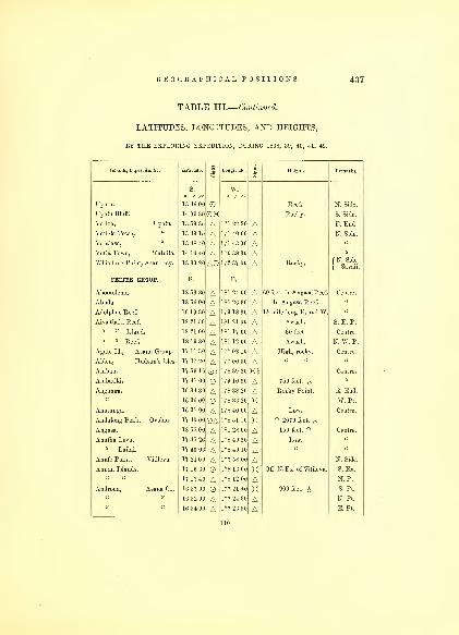
GEOGRAPHICAL POSITIONS. 437
TABLE III.— Continued,
LATITUDES, LONGITUDES, AND HEIGHTS,
BY THE EXPLORING EXPEDITION, DURING 1838, 39, 40, 41, 42.
Islands, Capes, &c. &c. Latitude.
ILongitude. Height. Remarks.
Upolu.
S.
13 46 00
w.
Reef. N. Side.
Upolu Bluff. 14 00 30 OK Rocky. S. Side.
Vailoa, Upolu. 13 59 35 A 171 22 20 A E. End.
Vailele Town, " 13 49 15 A 171 40 00 A N. Side.
Vaialasa, " 13 48 40 A 171 43 00 AVatia Town, Tutulla. 14 16 40 A 170 38 30 A u
f N. Side
\ Savaii.Whilstone Point, Asau Bay. 13 30 20 AO 172 37 00 A Rocky.
FEEJEE GROUP. S. E.
Abootolema. 18 53 30 A 181 24 00 A 60 feet. In AngasaReef. Centre
Abuda. 18 56 00 A 181 26 30 A In Angasa Reef. u
Adolplms Reef. 16 19 30 A 179 18 30 A 1£ mile long E. and W. u
Aiva-tliaki Reef. 18 21 50 A 181 21 00 A S. E. Pt.
18 21 00 A 181 17 00 A 30 feet.
" " Reef. 18 19 30 A 181 12 00 A N. W. Pt.
Agate Id., Asaua Group. 17 11 30 A 177 08 10 A High, rocky.
Alden, Hudson's Isles. 17 37 20 A 177 00 00 AAmbau. 17 59 16 02 178 39 20 XS Centre.
Ambatiki. 17 47 00 179 10 30 A 750 feet. £Anganga. 16 34 30 A 178 38 20 A Rocky Point. E. End.
16 36 00 178 33 20 X W. Pt.
Anutuuga. 16 37 00 A 178 40 00 A Low. Centre.
Andulong Peak, Ovolau. 17 40 00 OA 178 51 10 X $ 2070 feet. $18 55 00 A 181 28 00 A 150 feet. ? Centre.
Anutha Levu. 17 45 26 A 178 49 30 A Low.
" Lailai. 17 46 06 A 178 49 10 AAnufe Point, Vitilevu. 17 21 00 A 177 58 00 A N. Side.
Annan Islands. 17 16 30 178 13 00 X Off. N. Ex. of Vitilevu. S. Ex.
17 13 40 A 178 12 00 A N. Pt.
Androna, Asaua Gr. 16 57 00 177 21 40 X 900 feet. £ S. Pt.
16 52 00 A 177 24 30 A N. Pt.
16 54 00 A 177 26 30 A E. Pt.
110
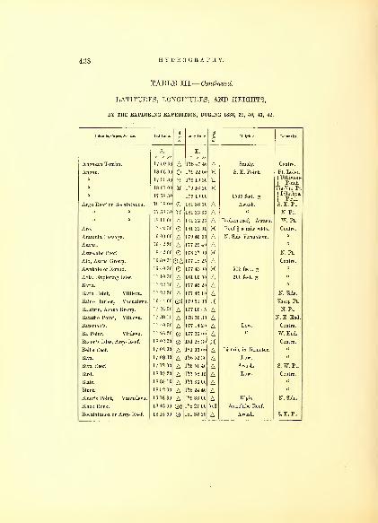
438 HYDROGRAPHY.
TABLE III.— Continued.
LATITUDES, LONGITUDES, AND HEIGHTS,
BY THE EXPLORING EXPEDITION, DURING 1838, 39, 40, 41, 42.
Latitude S
SLongitude 3
5?
Heights Remarks
S.
o / //
E.
17 50 0G A 178 47 40 A Sandy. Centre.
18 06 00 179 22 Of X S. E. Point. Pt. Lobo.
17 55 80
18 01 00
17 58 30
18 18 00
tf- 179 19 30
179 16 20
179 19 00
181 38 30
X
A1560 feet. £
Awash.
| Point.
Via-Via Pt.
|
DlPe
t
ak.
a
S. E. Pt.
17 58 30 181 33 30 A " N. Pt.
18 11 00 A 181 22 20 A Broken reef, Awash. W. Pt.
17 42 30 181 22 00 X Reef \ a mile wide. Centre.
16 09 00 A 179 46 00 A N. Side Vanualevu.
16 42 20 A 177 29 40 A18 42 00 178 27 00 X N. Pt.
16 59 3*J OA 177 18 25 A Centre.
16 40 30 177 43 00 X 515 feet. £17 10 30 A 181 06 00 A 200 feet. £17 22 10 A 177 45 20 A17 22 20 N Side
16 44 00 03 179 51 00 X Sharp Pt.
17 26 50 A 177 00 45 A N. Pt.
17 38 15 A 178 36 30 A N. E. End.
17 40 30 A 177 14 20 A Low. Centre.
17 26 20 177 36 00 A W. End.
18 02 00 181 28 30 X Centre.
17 02 30 A 1H1 03 00 A \\ mile in diameter.
17 08 30 A 176 52 30 A Low.
17 12 00 A 176 51 40 A Awash. S. W. Pt.
18 19 20 A 177 58 15 A Low. Centre.
18 30 10 A 177 36 00 A18 52 00 A 178 24 40 A16 13 30 A 179 33 00 A High. N. Side.
18 43 00 02 178 27 00 X§ Astrolabe Reef.
18 18 00 181 38 30 A Awash. S. E. Pt.
Islands, Capes, &o. ftc.
Angasau Tonibu.
Angau.
Argo Reef or Bocatatanoa.
Aro.
Aramula Passage.
Asaua.
Astrolabe Reef.
Ato, Asaua Group.
Awakalo or Round.
Avia, Exploring Isles.
Batia.
Batia Point, Vitilevu.
Baino Harbor, Vanualevu.
Baldwin, Asaua Group.
Batatho Point, Vitilevu.
Ba Point, Vitilevu.
Bacon's Isles, Argo Reef.
Bell's Reef.
Biva.
Biva Reef.
Bird.
Blair.
Blunt.
Blunt's Point, Vanualevu.
Black Rock.
Bocatatanoa or Argo Reef.

GEOGRAPHICAL POSITIONS. 439
TABLE III.— Continued.
LATITUDES, LONGITUDES, AND HEIGHTS,
BY THE EXPLORING EXPEDITION, DURING 1838, 39, 40, 41, 42.
Islands, Capes, &c. Ac. Latitude. i Longitude. ImUeight. Remarks.
S.
Bocatatanoa or Ar^o Reefocaaanoaor rgo^ ee . 17 58 30 1813330 A Awash
18 11 01 ~* 1 S ]
''> •>! Br k ^ ABolin Point Vanualevu 16 12 51 17') .".8 1 ( A
r° ^
HVh'
.
lg."
N Sid'1 e.
Brown' 'f Rin^W'Ts' 1G 16 m A 2 miles in diameter.
BrlcTenrid^e'
S
1 6 '.',',) d( I 7 v 1 7 2 A Low. s iTe*
BuddC' Riittold's Isles 2 1 s ( ) 23 'Hi X§ 800 feet. ^ J Centr"
'
entre.^
" ^ FarthTst Vitilevu 17 48 0t ABuia Town Vuna. 16 57 3t 17M -'-'iO ABuia Point, Vanualevu 17 01 30 u u 178 46 00 X§ . n-
.
Bukalau. 16 12 20 A 179 45 50 A Low. E. Pt.
Case
1 Peak'
Vanualevu - 16 15 05 179 44 45 N. Side.
A A High. Centre.
Cabeva. 16 11 20 ~" 179 34 45 ACarr, Hudson s Isles. 17 36 25 A 1 77 ()'' ()(( A High.
17 36 00 177 00 'Ki A« 17 35 00 A 177 01 30 A N. Pt.
Carr's Harbor, Matuku. 19 11 00 O 179 43 40 X Centre.
Casangha Town, Vitilevu. 18 01 50 A 178 34 00 AChichia. 17 44 30 180 42 00 X6 300 feet. N. W. Pt.
17 48 30 A 180 44 00 A S. E. Pt.
Chicobea. 15 49 30 HA 180 11 30 HA S. Knoll.
15 47 40 A 180 09 00 A N. Knoll.
Charlie's Har., Moala I. 18 37 30 02 179 54 00 X2 Centre.
Chicondua Reef. 18 54 30 A 181 29 30 AChick's Reef. 18 38 30 A 181 14 20 A 2 miles longE. and W.
Clark's. 16 22 24 A 179 11 32 A Low.Corolib or Goat, Somu )
Sotnu Straits.J
16 46 20 OQi 180 01 40 X2 High.
Cocoanut. 16 2954 178 51 42 X Low.
Cocoanut Point, Vanualevu. 16 59 00 A 178 43 30 A S.W. End.
Colvoeoressis. 18 49 30 A 178 25 40 A High. Centre.
Cobu Rock. 17 51 30 02 179 29 00 A t 500 feet. Mothea R.
Craven. 17 39 00 A 177 01 30 A High. Centre.

440 HYDROGRAPHY.
TABLE III.— Continued.
LATITUDES, LONGITUDES, AND HEIGHTS,
BY THE EXPLOKING EXPEDITION, DURING 1838, 39, 40, 41, 42.
Islands, Capes, &c. &c.
aLong.tude. Height. Remarks.
Cumming's.
S.
16 2140 A
E.
179 08 47 A Low. Centre.
Davis, Asaua Group. 17 27 40 A 177 00 30 A High.
Dana's Peak, Vanualevu. 16 45 10 A 178 49 20 A 1765 feet. W. End.
Day's. 16 24 24 A 179 09 20 A Low. N. E. Pt.
De Haven, Ringgold's Isles. 16 30 20 A 180 21 30 A High. N. End.
Dibble's Reef. 16 59 00 A 181 02 00 ADimba-dimba Pt.,Vanualevu. 16 48 18 A 178 30 30 A West End.
Direction or Nemena. 17 06 00 0% 179 06 00 K2 310 feet. Obs. Bluff. N. End.
Dille-ovolau Pk., Ovolau. 17 40 30 A 178 50 00 A 2300 feet. $
Dongaloa. 17 24 00 A 177 39 30 A Low. Centre.
Doughty's Reef. 16 20 00 A 180 40 00 A 1 mile long.
Druau or Ndrundrua. 16 11 24 OS 179 35 37 X 156 feet. N. E. Pt.
16 12 24 A 179 35 20 A Centre.
Drayton's Peak, Vanualevu. 10 33 00 A 179 24 00 A 1575 feet. E. End.
Duff's Reef. 10 48 00 A 180 58 00 A N. W. Pt.
16 52 40 A 181 02 00 A S. E. Pt.
16 23 00 ^ 180 34 0C ^Eagleston's House, Vitilevu. 17 25 00 177 40 30 XI W. Side.
Eld. 17 09 40 0§ 177 10 10 X? High. N. Pt.
17 10 40 A 177 10 30 A S. E. Pt.
Elliot. 18 51 00 A 178 24 00 A Centre.
Elliot Harbor, M'Benga. 18 23 20 0§ 178 06 15 XS f Pt. Rob-
{ inson.
Emmons, Hudson's Isles. 17 38 20 A 177 06 00 A High. Centre.
Emmons Bay, Ya Asaua. 16 44 00 03 177 30 00 mEnkaba. 18 50 00 181 06 30 Surrounded by a reef. N. End.
18 52 00 A 181 05 40 A S. End.
Exploring Isles Reef. 17 04 00 A 181 15 00 A N. E. Pt.
17 08 30 A 180 57 00 A N. W. Pt.
17 2440 A 181 09 00 A S. Pt.
Faliki Harbor, Androna. 16 55 18 177 24 30 X Ita I.
Fawn Harbor, Vanualevu. 16 43 42 A#179 47 11 X Tukonreva.
Fenno Point," 1615 24 A* 179 39 22 A High. N. Side.
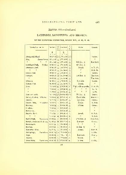
GEOGRAPHICAL POSITIONS. 441
TABLE WL— Continued.
LATITUDES, LONGITUDES, AND HEIGHTS,
BY THE EXPLORING EXPEDITION, DURING 1838, 39, 40, 41, 42.
Islands, Capes, &c. &c. Latitude. 1m
Longitude. 1to
Height. Remarks.
s. E.
Flying-Fish Shoal.
/ //
18 37 01 O I
/ //
177 45 30 X % Centre.
Fox, Asaua < !i'ou|i 17 11 00 A U 7 09 30 A1 1140 A A 363 feet East End.
Forefinger Peak, Ovolau. 17 43 16 A 178 52 10 A 627 feet. J
Freeman's Reef, 17 4a 3C A 181 23 0( A Awash. S. W. Pt.
17 43 30 A 181 24 0( A N. E. Pt.
Frost's Reef. 17 23 00 A 180 48 3C A u Centre.
Fulanga. 19 04 30 O 181 19 40 X 150 f150 eet. £ East End.
19 03 35 A 181 15 40 A West End.
Gibson's. 16 22 34 A (9 11 '0 A L ' 1ow is et. Centre.
Gordon Reef. 17 40 00 A 181 25 30 X Awash.
Goro. 17 16 00 O h9 21 00 X High, with no peaks. N. W. Pt.
17 13 30 A A N. Pt.
17 23 00 A 179 25 5C A S. Pt.
Goat or Corolib. 16 46 20 0'4 180 01 40 X I 214 feet. ^ Centre.
Granby Harbor, Vitilevu. 18 13 50 O 177 50 55 X South Side. Beacoii I.
Green's. 16 24 24 A 179 05 27 A Low islet. Centre.
Graves Point, Vanualevu. 16 1424 A 179 31 30 A Rocky. N. Side.
Hanbury. 16 13 24 A 179 35 00 A 87 feet. Centre.
Harrison. 18 51 00 A 178 24 20 AHamersley. 18 30 15 A 177 36 20 AHawkins Reef. 17 47 30 A 181 20 40 A Awash. S. End.
17 45 30 H 181 20 40 H N. End.
Hale's Peak, Vanualevu. 16 22 30 A 179 34 00 A 1783 feet. £ East End.
Henry's, Underwood's Group. 17 41 30 O 177 17 30 X Low islet. Centre.
Henderson's. 16 13 30 A 179 32 00 AHowison. 18 51 00 A 178 25 30 A 36 feet. $
Horse-Shoe Reef. 17 37 15 A 179 20 15 A Awash. Crust Pt.
Hot Springs, Vanualevu. 16 45 20 OS 178 19 20 XS S. Side.
Hope. 16 48 00 A 179 34 10 A Low islet. Centre.
Hudson. 18 52 00 A 178 26 00 A 75 feet.
Hupo Point, Vanualevu. 16 45 50 O 179 15 00 X 20 feet. S. Side.
Ill

442 HYDROGRAPHY.
TABLE III.— Continued.
LATITUDES, LONGITUDES, AND HEIGHTS,
BY THE EXPLORING EXPEDITION, DURING 1838, 39, 40, 41, 42.
Islands, Capes, Ac. &e. Latitude.
1Longitude.
»
1Height. Remarks.
g Eo
',
//
Ielalu Point, Vitilevu. 17 22 00 A 178 18 00 A 30 feet. N. E. Side.
Indimbi Town, " 18 09 00 A 178 10 00 A S. Side.
Inamara Bay, " 17 29 30 A 178 23 30 A N. Side.
Ivaca Peak, Vanualevu. 16 36 00 A 178 33 30 A 1160 feet. £ W. End.
Johnson, Hudson's Isles. 17 36 30 A 177 00 20 A 70 feet. Centre.
Kambara. 18 58 30 181 03 00 X 350 feet. £ S. End.
18 55 00 A 181 03 00 X a a a N. End.
Karoni. 18 39 00 A 181 27 00 A Reef extends S. l£ mile. Centre.
Katafanga. 17 30 30 A 181 19 30 A 150 feet. £ E. Pt.
« 17 31 00 181 18 00 X W. Pt.
Kanathia. 17 14 30 O 180 51 30 X N. W. Pt.
« 17 17 30 K 180 52 30 S. W. Pt.
" Peak. 17 16 30 A 180 53 00 A 330 feet. $" Reef. 17 12 00 A 180 58 00 A N. E. Pt.
Kamia. 16 45 00 A 180 17 00 A N. W. Pt.
16 48 00 180 15 30 X W. Pt.
16 47 00 A 180 18 00 A 1875 feet. Highest Pt.
Kamba Point. Vitilevu. 18 01 16 0§ 178 45 00 X§ Low. E. End.
Kantavu. 19 00 00 178 24 00 \\ E. Pt.
19 05 00 JC 177 57 00 W. Pt.
" Peak. 19 05 00 A 177 58 00 A 2879 feet. £ W. End.
Kanusi Point, Vitilevu. 17 41 30 A 177 22 00 A Low.
Karoni. 18 40 00 A 181 28 40 A High. Centre.
Kasonoola Peak, " 17 32 30 A 177 39 00 A 1320 feet. £ W. End.
Kea. 16 39 00 A 179 57 20 A 570 feet. £ Holmes' Pk
Kendi-Kendi Mtn., Lakemba. 18 14 00 A 181 10 30 A 900 feet, f
Kie. 16 13 54 A 179 05 00 A 760 feet. $ Centre.
Kiusick, Asaua Group. 16 41 00 A 177 33 00 A 40 feet.
Kneass Reef. 17 48 00 A 180 39 10 A Awash.
Knox. 17 26 00 A 177 02 00 A 47 feet. Centre.
Korotuna. 16 04 00 A 180 37 30 A Inhabited. Centre.
Korotuna Reef. 16 04 00 A 180 29 30 I W. End.
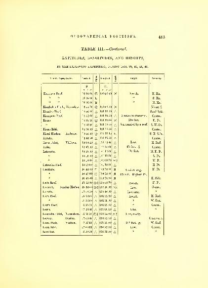
GEOGRAPHICAL POSITIONS. 443
TABLE III.— Continued.
LATITUDES, LONGITUDES, AND HEIGHTS,
BY THE EXPLORING EXPEDITION, DURING 1838, 39, 40, 41, 42.
Islands, Capes &c. &c. Latitude. 1ia
Longitude. i
KIleight. Remarks.
s. E.
Korotuna Reef.
/ //
16 03 00
/ //
180 39 30 X Awash. E. Ex.
1 1 1 05 ','A H S. Ex.
16 01 00 n N. Ex.
Kombelau Harb. Vanualevu 16 55 10 179 02 30 X Mbure I.
Konaivo Reef. 18 56 00 A 181 33 30 A Sand Spit.
Konapatu Reef. 18 42 00 A 1x 1 29 .'ill A 2 miles in diameter. Centre.
Komo. 18 37 30 1-1 20 00 X 2/0 feet. E. Pt.
18 38 30 A 181 18 40 A Surrounded by a reef. S. W. Pt.
Komo Riki. 18 38 00 A 181 18 30 A Centre.
Korai Harbor, Androna. 16 56 00 O 177 23 15 X S. E. Side.
Kotuho. 16 48 50 A 179 25 30 A Centre.
Kuva Point, Vitilevu. 18 04 40 A 178 43 40 A ow. E. End.
Kuku. 17 47 00 A 177 07 00 A 87 feet. J Centre.
Lakemba. 18 13 00 A 181 12 00 A 435 feet. N. E. Pt.
18 16 30 A 181 11 30 A S. Pt.
u 18 14 00 A 181 08 30 XS W. Pt.
Lakemba Reef. 18 13 00 A 181 18 30 A E. Pt.
Lauthala. 16 44 00 H 180 23 00 H 4 miles long. N. Pt.
16 47 00 180 23 00 1740 ft. Highest Pt.
16 45 30 A 180 24 00 ri E. Side.
Lada Reef. 17 32 30 GH 178 53 20 A Awash. N. Pt.
Lekoo I., Sur. day Harbor. 18 04 00 08 177 16 00 X§ Centre.
Leiuvia. 17 48 30 A 178 46 00 A Low islet.
Levu Reef. 18 53 00 A 181 32 30 A Awash. E. End.
18 53 00 A 181 30 00 A W. End.
Lewis Reef. 16 55 30 A 181 09 30 A Centre.
17 28 40 A 177 00 10 A Islet.
Lecumba Point, Vanualevu. 16 51 38 02 178 35 06 X§ Low, sandy.
Levuka, Ovolau. 17 40 46 A 178 52 40 A Observat'y.
Lewa Peak, Vitilevu. 17 37 00 A L77 29 00 A 987 feet, g W. End.
Lewa Islet. 17 09 00 A 176 52 00 A Centre.
Leonidas. 16 39 24 A 178 36 50 A

444 HYDROGRAPHY.
TABLE III.— Continued.
LATITUDES, LONGITUDES, AND HEIGHTS,
BY THE EXPLORING EXPEDITION, DURING 1838, 39, 40, 41, 42.
Islands, Capes, &c. &c. Latitude.
35
Longitude. i
1Height. Remarks.
Linthicum, Underwood's Gr.
s.
17 44 00®%
Eo / //
177 15 10 H'i Low. Centre.
Like-Like Reef. 18 30 40 A 181 27 00 A 1J mile in diameter. "
Lloyd Point, Vanualevu. 16 16 54 A 179 26 20 A Bluff. N. Side.
Lookout Reef. 16 54 00 A 181 17 30 A Awash. E. Pt.
16 55 00 181 12 00 X W. Pt.
a 16 52 30 A "N. Ex.
"16 56 00 A S. Ex.
Lotu, Vanualevu. 16 48 00 A 179 25 30 A S. Side.
Lokomi Peak, Vitilevu. 17 35 30 A 177 32 00 A 1127 feet. & W. End.
Lukimoa Peak, " 17 30 00 A 177 44 30 A 1240 feet. $ N. Side.
Mango. 17 28 30 '0 180 55 00 X S. E. Pt.
17 26 30 K 180 52 00 H 300 feet. £ N. W. Pt.
17 27 30 A 180 53 30 A Centre.
Malatta, Exploring Isles. 17 20 30 A 181 01 00 A 270 feet. £ "
Malevuvu Reef. 17 22 30 181 18 00 Awash. N. Pt.
" " 17 25 00 181 18 00 X S. Pt.
A 180 50 00 A Centre.
" Reef. 17 11 00 A 180 51 30 A Awash.S. E. Pt.
Mali Peak, Vanualevu. 16 24 24 A 179 24 30 A 1672 feet. £ N. Side.
Mali. 16 20 54 0§ 179 19 42 X§ 350 feet. £ Highest Pt.
16 21 00 A 179 18 00 A W. End.
" Passage. 16 19 14 179 16 00 X Entrance.
Malitu Bay, Mali. 16 20 14 A 179 21 00 Anchorage.
Maury. 16 28 30 A 180 21 30 A 60 feet. Centre.
Mambualau. 17 57 10 A 178 48 15 AMalatta Bay, Kantavu. 18 58 00 178 05 48 X Anchorage.
May. 18 51 45 A 178 27 00 A 60 feet. Centre.
Malolo Passage. 77 52 30 A 177 09 30 X?Malolo Island. 17 46 10 A 177 08 40
11 400 feet. £17 44 20 A 177 09 00 A Bluff, 50 feet. N. Pt.
17 46 30 A 177 07 20 A S. W.Pt.
Malolo Lailai. 17 46 30 A 177 10 30 A 30 feet. N. Pt.
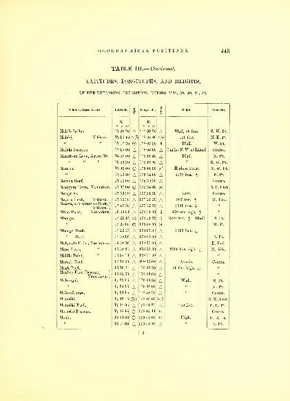
GEOGRAPHICAL POSITIONS. 445
TABLE III.— Continued.
LATITUDES, LONGITUDES, AND HEIGHTS,
BY THE EXPLORING EXPEDITION, DURING 1838, 39, 40, 41, 42.
Islands, Capes, Ac. &c. Latitude. im
Longitude.
mHeight. Remarks.
S. E.
Malolo Lailai.
o / „17 49 20 A
o / //
177 08 20 A Bluff, 50 feet. S. W. Pt.
Malaki, Vitilevu. 17 16 10 AO 178 08 40 AK 150 feet. N. E. Pt.
17 17 20 ® 178 07 30 11 Bluff. W. Pt.
Malaki Passage. 17 15 00 A 178 06 00 A 2 miles N.W. of Island. Centre.
Matatboni Levu, Asaua Gr. 16 57 00 A 178 18 45 A Bluff. N. Pt.
16 59 30 A 178 18 45 A S. W. Pt.
Matuku. 19 09 00 L79 44 00 X Highest Point. N. W. Pt.
19 13 30 A 179 44 00 A 1179 feet. $ S. Pt.
Mamoa Reef. 17 16 00 A 178 39 30 A Centre.
Matagora Town, Vanualevu. 17 37 00 O 178 34 40 X N. E. End.
Mangrove. 17 50 30 A 177 21 00 A Low. Centre.
Mayula Peak, Vitilevu.
Maawa, or Vitirauran Peak,)
Vitilevu.j
Mbua Point, Vanualevu.
17 56 30
17 47 30
16 39 24
AAA
177 25 20
177 32 00
178 31 30
AA\\
987 feet. $1540 feet. $
470 feet high. £
W. End.
Mbeuga. 18 22 45 ® 178 11 00 \\ 1289 feet. $ Bluff. E. Pt.
18 24 00 O 178 06 00 X W. Pt.
Mbenga Peak. 18 22 15 A 178 07 30 A 1400 feet. £" Reef. 18 30 00 A 178 05 30 A S. Pt.
Melamela Point, Vanualevu. 16 39 00 A 179 53 00 A E. End.
Mitre Peak, 16 39 20 A 178 53 30 A 2300 feet high. £ N. Side.
Middle Point, " 16 24 14 A 179 11 20 AMorse's Reef. 17 19 00 A 180 52 00 A Awash. Centre.
Monk Rock.Monkey-Face Passage, 1
Vanualevu.J
10 10 24
16 37 50
AA
179 35 20
178 33 00
AA
80 feet high. £
Mokungai. 17 27 16 A 179 00 30 A High. S. Pt.
17 24 16 A 179 01 00 A N. Pt.
Mokundranga. 17 24 16 A 178 58 50 A Centre.
Moturiki. 17 42 46 O? 178 46 00 m N. W. End.
Moturiki Peak. 17 47 06 A 178 48 25 A. 450 feet. S. E. Pt.
Moturiki Passage. 17 48 16 O 178 46 44 X Centre.
Moala. 18 34 30 179 56 00 X High. N. E. Pt.
18 41 00 A 179 53 00 A S. Pt.
112

446 HYDROGRAPHY.
TABLE III.— Continued.
LATITUDES, LONGITUDES, AND HEIGHTS,
BY THE EXPLORING EXPEDITION, DURING 1838, 39, 40, 41, 42.
Islands, Capes, &c. Ac. Latitude.
1Longitude. i Height. Remarks.
o „
.
Moala. 18 37 30 A 179 49 30 A High. W. Pt.
Mothea Reef, Nairai. 17 55 30 179 30 00 X Awash. S. Pt.
Moramba.
Motha.
Monersab Point, Vitilevu.
18 56 30
18 36 30
17 16 20
AAA
181 09 00
181 26 00
178 10 50
AAA
Surrounded by a reef.
| 2 miles in diameter,
{ inclosed in a reef.
Centre.
N. End.
Mania, Exploring Isles. 17 22 00 A 181 07 30 A Telanicolo, 1054 ft. £ Centre.
Mukalau. 18 11 00 A0 178 30 10 A Low.
Mumbolithe Reef. 18 12 30 O 179 21 30 XMuthuata. 16 25 51 O 179 03 02 X Cemetery.
16 25 00 A 179 03 51 A 1005 feet. £ E. End.
" Peak. 16 25 34 A 179 03 01) AMuthuata Town, Vanualevu. 16 27 20 A 179 03 20 ANaiau. 17 57 30 A 180 58 00 A High. N. W. Pt.
« 18 01 20 180 59 30 X « S. E. Pt.
Naitamba. 17 04 30 A 180 47 20 A S. E. Pt,
17 02 00 180 45 30 X N. W. Pt.
17 03 30 A 180 46 00 A Centre.
Namuka. 18 47 00 A 181 21 30 A 165 feet. $ E. Pt.
18 46 30 181 18 00 K W. Pt.
Navutu Harbor, Vanualevu. 16 28 54 O 178 56 20 X N. Side.
Naloa. 16 37 24 A L78 41 .32 A High. Centre.
Narangi. 16 48 30 A 179 29 20 ANanuia, Asaua Group. 16 58 30 A 177 19 50 A High.
Naviti, " " 17 04 00 177 16 40 X Tapau Point. N. E. Pt.
17 09 00 177 09 30 Jt Baruma Point. S. W. Pt.
17 05 00 177 14 00 A Vaka Bay. Centre.
Navula Point, Vitilevu. 17 58 30 0§ 177 13 00II
Low. S. W. Pt.
Nanggara Point, " 18 15 30 A 177 59 00 A S. Side.
Naisilai Point, " 18 06 00 A 178 42 00 A S. E. End.
Nasilai, Town, " IS 01 00 A 178 33 00 A Peale's Rr.
Navumbalavu Islets. 17 37 30 178 37 00 X 122 feet. £ Centre.
17 33 40 178 43 00 X 420 feet. $ N. Pt.
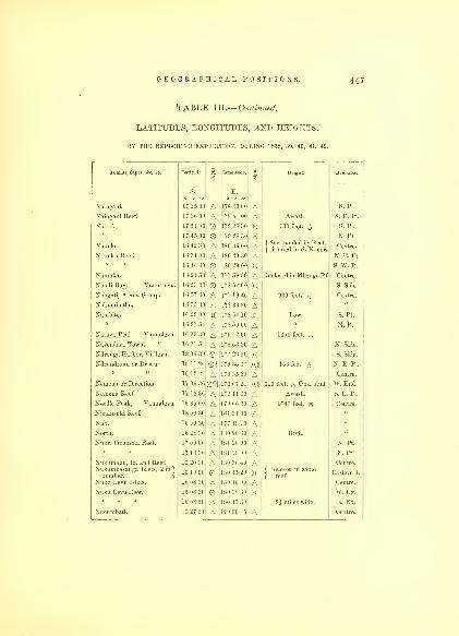
GEOGRAPHICAL POSITIONS. 447
TABLE III.— Continued.
LATITUDES, LONGITUDES, AND HEIGHTS,
BY THE EXPLORING EXPEDITION, DURING 1838, 39, 40, 41, 42.
Islands, Capes, &c. &c. Latitude. Eto
Longitude. 1CO
Height. Remarks.
s.
' "E./ //
Naingam. 17 ''<> in A 178 43 0( A S. Pt.
N;i mgaui Reef. 17 36 00 A 17*41 III A Awash. S. E. Pt.
Nairai. 1 51 00 179 2 s ."> I K 730 feet. ^ S. Pt,
Nanuku.
Nanuku Reef.
17 45 00
16 42 30
1 r. 31 01
AA
179 28 3C
1 s ; ; 1 ; in
1 so 40 31
KAA
( Surrounded by Reef,
j situated in S. E. cor.
N. Pt.
Centre.
N. E. Pt.
O 1 S II '1
1
1 III X S. W. Pt.
Namuka.
j
8 21 A 177 7) s ~i I A Inclosed in MbengaRf Centre.
N audi ]>av, A an ualcvu. O 178 57 00 X S. Side
Nangati, Asaua Group. 16 57 3C A 17 7 19 11 A 930 feet. ^ Centre.
Nakuinbutha. 16 35 30 A 178 36 30 ANambite. 16 29 00 H 178 50 10 H Low. S. Pt.
16 27 54 A 1 7 s 50 01 A N. Pt.
Natava Peak, Vanualevu. A 1 79 -12 On A 1350 feet. ^
Navcnilara Town, " 16 31 "4 A 178 53 30 ANdronga Harbor, Vitilevu. 18 06 30 O 177 23 00 X S. Side.
Ndrundruau or Druau. 16 11 24 OS 179 35 37 m 156 feet. £ N. E. Pt.
16 12 24 A 179 35 20 A Centre.
Nernena or Direction. 17 06 36 Q% 179 07 21 X2 310 feet. £ Obs. bluff. W. End.
Nemena Reef. 17 12 36 A 179 11 30 A Awash. S. E. Pt.
Needle Peak, Vanualevu. 16 39 00 A 179 06 30 A 1747 feet. $ Centre.
Nisukisuki Reef. 18 59 30 A 181 31 00 ANifo. 16 59 30 A 177 19 10 ANorth. 16 28 30 A 180 20 30 A High.
Nuku Ticurubia Reef. 17 09 00 A 181 20 00 A N. Pt.
17 13 30 A 181 19 00 A S. Pt.
Nukumanu, Id. and Reef.
Nukumliasanga Islets, 2 in )
number.j
Nuku Levu Islets.
16 20 30
10 19 00
16 08 30
AOA
180 36 40
180 45 20
180 46 00
AKA
j Inclosed in same
( reef.
Centre.
Eastern I.
Centre.
Nuku Levu Reef. 16 08 30 180 38 30 X W. Ex.
16 08 50 A 180 47 30 2i miles wide. E. Ex.
Nucumbati. 16 27 54 A 179 00 45 A Centre.

448 HYDROGRAPHY.
TABLE III.— Continued.
LATITUDES, LONGITUDES, AND HEIGHTS,
BY THE EXPLORING EXPEDITION, DURING 1838, 39, 40, 41, 42.
Islands Capes &c &o Latitude. 3
S.
N thila Point Vanualevu 16 33 14
Nuvera. 16 32 10
16 28 50 ANugu-ongea Reef. 19 09 25
Nukulevu. 17 41 16 0§Nukatimba Bay, Vitilevu. 17 26 00
Nunga. 16 55 00 ANukumurry Har., Vanualevu. 16 42 40 OANugutobe Islets, 3 in number. 17 18 00
Nukalau. 18 10 23
Oandrou. 16 34 30 AObservatory Islet. 18 24 40
Ogle, Underwood's Group. 17 40 00 AOkimbo, 3 islets. 17 03 00 A
" Reef. 17 03 00
17 00 30 A
17 04 30 AOlenea or Ularua. 18 33 30
Ombo. 17 30 30 AOmene. 17 45 16 AOno. 18 55 30 AOneata. 18 24 30
18 24 30 AOneata Reef. 18 2410 AOngea Levu. 19 03 00 AOngea Reef. 19 02 30 AOngea, Port Refuge, 19 05 50 AOngea riki. 19 07 00 AOne Tree Islet, Ya Asaua I 16 47 09 0§Orana Pt., Vanualevu. 16 39 14 AOsubu I., Exploring Isles, 17 10 00 A
Longitude g
sHeights Remarks
E.
178 50 00 A Rocky Point. N. Side.
178 46 40 X Low. S. W. Pt.
178 48 30 A " N. Pt.
181 32 50 X Sand Spit.
178 39 10 XS Centre.
178 21 00 A177 20 30 A Rock.
178 32 00
180 29 00
178 30 30
X§AX?
Trend F N E a d
Low.
Island.
Centre.
178 47 0'J A "
181 28 00 X 250 feet high. £177 14 30 A Low islet.
180 59 00 A Low.
181 02 00 X E. Pt.
180 59 00 A Awash. N. Pt.
W Side
181 00 00 A S. Ex.
181 14 00 X Surrounded by a reef. N. End.
177 04 00 A Centre.
178 38 00 A Low.
178 24 00 A High.
181 27 30 X Highest. E. Pt.
181 25 00 A 330 feet. $ W. Pt.
181 32 30 A E. End.
181 30 00 A High. N. End.
181 31 00 A N. E. Pt.
181 28 50 A Inside of Reef.
181 29 00 A 178 feet. £ Centre.
177 26 08 X§ Low.
178 42 30 A N. Side.
181 10 00 A Centre.

GEOGRAPHICAL POSITIONS. 449
TABLE III.— Continued.
LATITUDES, LONGITUDES, AND HEIGHTS,
BY THE EXPLORING EXPEDITION, DURING 1838, 39, 40, 41, 42.
Islands, Capes, 4c. 4c. Latitude.
1Longitude.
»
1Height. Remarks.
o / „ o
E/ „
Otovawa I. Asaua Group. 16 55 30 177 19 20 X N. W. Pt.
16 50 40 A 177 19 20 A S. Pt.
Ovolau. 17 45 16 A 178 49 00 A a
17 39 00 A 178 47 10 A W. Pt.
" Observatory. 17 40 46 0* 178 52 40 E. Side.
17 37 16 O 178 50 20 A N. Pt.
Ovalu, or Passage I. 17 22 30 0% 178 48 00 m High. Centre.
Ovawa. 16 47 30 A 177 25 00 A «
Passage, or Ovalu I. 17 22 30 0§ 178 48 00 A «
Palmer's. 17 45 00 A 177 07 00 A «
Papa Pt., Ya Asaua. 16 48 20 A 177 25 00 A High.
Perry's. 17 41 30 A 177 05 00 A Centre.
Peka. 16 52 54 A 177 26 00 A »
Piuer's. 16 23 54 A 179 08 25 A Low.
Pickering's Pk.fVitilevu. 17 57 00 A 177 36 30 A 1240 feet.
Poukeepsie Reef. 16 27 30 A 180 33 10 A Centre.
Porpoise Reef. 16 28 3C A 180 34 30 A" Shoal. 17 0100 on 176 57 00 XH
Poto Bay. Waia I. 17 1840 A 177 05 30 APolotu Harbor, Peka I. )
Asaua Group.)
16 52 54 177 26 06 XLow.Pully's I. 16 25 24 A 179 07 00 A Centre.
Rambe. 16 24 40 A 180 08 00 A High. N. Pt.
16 30 30 A 180 01 00 A S. W. Pt.
16 30 30 O 180 07 30 X S. E. Pt.
Rativa. 16 44 20 179 40 30 X Centre.
Rabi-Rabi. 16 57 25 O 178 43 20 X Low.
Raki-Raki. 17 20 20 O 177 59 30 X High.
Raritona Har. YVAsaua. 16 47 09 O 177 26 08 X ( One Tree
[ Islet.
Ravu Ravu. 16 27 24 A 178 56 10 A Centre.
Revareva Reef. 18 58 00 A 181 32 30 A Awash.
Reynold's. 18 48 00 A 178 25 10 A High.
Red Bluff. Vitilevu. 18 16 00 A 177 44 00 A 52,500 feet. S. Side.
113

450 HYDROGRAPHY.
TABLE ILL— Continued.
LATITUDES, LONGITUDES, AND HEIGHTS,
BY THE EXPLORING EXPEDITION, DURING 1838, 39, 40, 41, 42.
Islands, Capes, &c. &c. Latitude. 1 Longitude. 1mHeight. Remarks.
Rewa Roads, Vitilevu.
s.
/ //
18 10 23
—E.
° ' "X2 N 1
Vitilevu.
U
812 30 AReynold's, Underwood's Gr. 1 43 10 A 177 12 10 I Centr
'
entre.
Reid's, Largest. 17 57 20 A * 30 A High.
" Reef.
17 % 00
A®
18142 10
181 37 00
AS Ex
17 56 30 A 181 33 20 w pt
007 54 O 1 81 37 00
Ridgely Tort, Vanua Valayo. 02 181 02 20 X2Rich's Peak, Vitilevu. 17 43 30 A 178 26 00 A EastEnd
Richmond's. 1G 25 24 A 179 07 50 A Low. Centre.
Robert's Point, Vanualevu. A A High.
Rock. 1 G 39 24 A 178 39 00 A Craft*"
Round Point, Vitilevu. 18 13 45 1 77 54 00 X JWhippy
{ Harbor.
Round, or Awakalo. 02 X2 515 feet,jjj
Robinson's Reef. 16 25 30 A 1 HO 32 30 ARuke Ruke Bay, Vanualevu. 16 40 18 O 178 32 36 A Sleepy Pt.
Saddle Peak, 16 39 00 A 179 20 00 A 1140 feet. S. Side.
16 15 54 A 179 35 00 A N. Side.
Safety Port, Kea I. 16 37 30 O 179 58 30 X Anchorage
Sac's Point, Vanualevu. 16 24 34 A 179 14 00 A High. N. Side.
Sarapeu Peak, Vitilevu. 17 41 10 A 177 29 00 A W. Side.
Sam. 17 35 30 O 177 25 20 X Centre.
Sakau Point, Vitilevu. 17 24 00 A 177 55 40 A N. Side.
Sandford. 18 50 00 O 178 24 00 A High. Centre.
Sail Rock, Largest. 16 1054
10 38 00
AA
179 33 00
178 16 10
AA
Savu Savu Pt., Vanualevu. 16 49 30 02 179 16 00 X2 S. Side.
Sawau Harbor, M'benga, 18 22 00 02 178 09 30 X2 Pt. Leavett.
Sau-Sau. 16 16 24 O 179 25 20 X Centre.
Sau-Sau Passage. 16 10 54 O 179 28 45 X|Opening
| N.W.SideShylock Reef. 19 53 30 A 178 21 48 A

TABLE III.— Continued,
LATITUDES, LONGITUDES, AND HEIGHTS,
BY THE EXPLORING EXPEDITION, DURING 1838, 39, 40, 41, 42.
Islands, Capes, &c. Ac. Latitude.
.
Longitude..1
Height. Remarks.
S. E.
Sinclair, Asaua Gr. 17 12 30 A 177 08 30 A High. Centre.
Sleepy Point, Vanualevu. 1G40 18 A 178 32 36 A | Ruke-( Ruke B.
Smith, or Mamonku Reef. 17 43 30 A 181 O'.)30 A Centre.
" Island, Underwood's Gr 17 43 00 A 177 16 20 A Low. u
17 40 00 A 177 14 00 ASoangi. 1 C 32 54 A 178 46 00 A u a
Southworth Pt., Vanualevu. 16 42 48 A 178 32 06 A High. W. End.
Soni. 17 44 00 A 177 07 40 A Centre.
Somu-SomuTown, Vuna. 16 46 40 X§ 180 04 0(1 X§ W. Side.
Speideivs. 17 52 00 A 177 10 30 A Low. Centre.
Stuart's. 18 24 20 X 178 05 25 X High. «
Storm. 18 20 20 X 178 10 15 X u
Susui. 17 21 00 A 181 03 00 A 74 feet. $«
Suva Harbor, Vitilevu. 18 06 40 X 178 23 30 X Anchorage.
" Point," 18 09 00 A 178 27 00 A Low. S. Side.
Sualib Bay, 17 00 08| K2 178 48 00 X§ Centre.
Sunday Harbor, " 18 04 00 X§ 177 16 00 Kl Lekoo I.
Tauthake Peak, Ya Asaua. 16 50 40 177 24 30 X 581 feet. $f S. End.
Taki. 17 07 00 A 176 52 50 A Low. Centre.
Tambaukan Pk , Vitilevu. 17 39 40 A 177 32 50 A W. Side.
Taboa Town, " 17 25 00 O 177 54 50 X N. Side.
Talatala Point, " 17 45 40 A 177 21 00 A Low. W. Side.
Tavunuku Reef. 18 36 30 A 181 15 10 A 1 mile in diameter. Centre.
Talouno Reef. 18 43 30 A 181 42 00 ATabutha. 17 40 00 181 12 00 X $ 350 feet, the cap.
17 41 30 A 181 13 00 A S. E. Pt.
17 39 00 A 181 11 00 A N. W. Pt.
Tabuca Bay, Kantavu I. 19 02 06 O? 178 05 00 X2 Anchorage.
Tabooa Point, Vitilevu. 17 30 00 A 177 30 10 A High. W. Side.
Taunava. 17 47 16 A 178 39 10 ATavea. 16 38 24 178 43 30 XTasman's Straits. 16 48 00 180 14 30 X

452 HYDROGRAPHY.
TABLE III.— Continued.
LATITUDES, LONGITUDES, AND HEIGHTS,
BY THE EXPLORING EXPEDITION, DURING 1838, 39, 40, 41, 42.
Islands, Capes, 4c. &c. Latitude..1TO
Longitude. 1«j
Height. Remarks.
S. E.
Teilau, Bay of Ambau.
o / //
17 55 16 Ao / //
1 78 39 40 A Centre.
Teteka Reef. 19 01 50 A 181 32 10 AThompson's. 18 30 45 A 177 36 45 AThangala. 17 47 46 A 1 78 46 40 A Low.
Ticumbia, Exploring Isles. A 181 1 2 30 A High.
Tibethe Point, Vanualevu. 16 1125 O 1 79 44 00 A n s'-
'a
Tilingitha. 16 1050 179 47 00 X§ Centre.
Timboor, Asaua Gr. 16 40 00 O 177 30 30 X High.
Tokonova Point, Vanualevu. 16 46 30 A 179 54 40 A S. E. End.
Totten. A 177 01 15 X Centre.
Tombarua. 17 59 46 A 1,8 45 10 A Low.
Toba Peak. Vitilevu. 17
3^25A 178 29 40 A 756 feet. E.End.
Point, 17 33 25 O 178 31 00 X High.
Totoia. * 1 H 1 II! X N. W. Pt.
18 57 0C A 180 07 3C AA 180 05 3C A 1 1 48 feet. Notch Pk
Tova Reef. 18 38 00 O 180 24 00 X Entrance.
Tokotusi Peak, Vitilevu. 17 24 00 177 43 00 A N. W. Side.
Toki Point, " 17 29 40 A 178 25 00 A N. E. Side.
Tua " " 17 36 15 A 178 34 00 ATub. 17 19 00 O 178 03 30 X Centre.
Tuki.
Tubanaielli.
Turtle, or Vatoa Id.
Tye, Town, Vanualevu.
17 19 40
18 42 30
19 47 00
16 59 40
AAAO
178 02 00
180 56 00
18143 42
178 47 21
AAAX
f 150 feet. $[ Reef surrounded.
Pt.Porpoise
f Sualib
t Bay.
N. End.Ularua, or Olenea. 18 33 30 O 181 13 00 Surrounded by a Reef.
Ulunikora Mountains.Vitilevu 17 55 30 A 177 56 00 1 4126 feet. Centre Pk.
Umea Point, " 17 24 10 A 177 46 00 A N. W. Side.
Unda Point. Vanualevu. 16 06 30 O 180 07 00 X N. E. Pt.
Underwood's Tower, Ovolau. 17 37 36 O 178 51 40 X N. E. Pt.
Vanua Vatu. 18 21 38 © 180 38 45 X Surrounded by a Reef. N. Pt.,reef
18 22 50 A 180 38 45 A S. Pt.

TABLE III.— Continued.
LATITUDES, LONGITUDES, AND HEIGHTS,
BY THE EXPLORING EXPEDITION, DURING 1838, 39, 40, 41, 42.
Islands, Capes, &o. &c. Latitude..1
Longitude. 1 Height. Remarks.
Vatu
VatuKera
"
s.
18 22 00
—
A
E.
1 SO 39 00
180 31 30
500 feet £
230 feet.
f Mt. Otty,
( Centre.
17 29 00 A i s ! ] : ! i
)
s* Pt
17 27 30 180 31 30 Centre
Vanua Vahvo Ex lorino- Ianua a avo, xp onng 17 10 00 1 s .") s (id
181 04 30 750 feet
N. W. Pt.
j M.Totten1 E. Pt.
17 19 30 A 180 09 30 A S. Pt.
Vanualevu. 16 OS 30 O 180 07 00
1 79 5s (Ml
X~\
f Unda,
[ N. E. Pt.
Lon^S E Pt
1G 4G 08 1 7* 30 1(1 W. Pt.
ur;X Buie S. Pt.
Vatou 16 33 24 178 44 ^0 N. Pt.
1-^ 42 47
Vatoa or Turtle 19 47 00 is 1 4:; 42 P^Pot oise
Va la'Point" Vanualevu A 179 58 30 E E^d
^
Vavula " Vitilevu. 17 53 30 A 177 14 20 A Low. S. W. End.
Vuso " Vanualevu. 16 48 30 A 179 20 40 A High. S. Side.
Vatungili. 16 34 54 O 178 42 00 A Centre.
Vao Reef. 18 34 00 A 181 30 20 AVatu-Lele. 18 31 30 O 177 34 30 X 70 feet. $
f Remo-{ rerao Pt
18 37 30 A 177 38 30 A Tokelau Pt
Vatu. 17 16 00 A 177 07 00 A High. Centre.
Yanderford, Underwood's Gr.
Vekai.
Veleraria.
17 38 00
17 33 00
10 52 00
AAA
177 21 30
181 11 00
181 00 45
AAA
( Reef extends 1 mile
{ to the South.
Low sandy.
Vendrala. 16 36 54 A 178 42 45 A High.
Veraki Point, Vanualevu. 16 36 34 O 178 45 30 X Low. N. Side.
Vela Bay, Vitilevu. 17 28 00 O 178 22 00 X Centre.
Verata Point, " 17 50 16 A 178 39 40 A Low. E. End.
Vitonga " "17 3140 O? 177 26 30 X§ High. W. End.
Viti-rau-rau Peak, " 17 47 30 A 177 32 00 AVitilevu Bay, "
17 2100 A 178 15 00 A Centre.
114
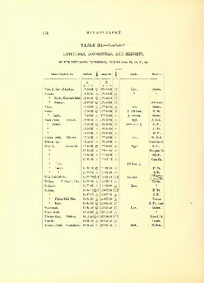
454 HYDROGRAPHY.
TABLE III.— Continued.
LATITUDES, LONGITUDES, AND HEIGHTS,
BY THE EXPLORING EXPEDITION, DURING 1838, 39, 40, 41, 42.
Islands, Capes, 4c. &c. Latitude. i
£Longitude. i
3Height. Remarks.
s. E.
o / //
Viwa I., Bay of Ambau.
o / //
17 56 56 O 178 39 25 X Low. Centre.
Vicuna. 16 1185 A 179 50 25 A " "
" Harb., Haycock Islet. 16 11 20 179 52 10 X" Passage. 16 09 20 O 179 50 00 X Entrance.
Votia. 17 33 30 A 177 26 20 A Low. Centre.
Vorao. 17 30 00 O 177 15 00 X £ 250 feet. S. Pt.
" Lailai. 17 29 00 A 177 13 00 A £ 60 feet. Centre.
Vuna Point, Vuna I. 17 0150 A 179 57 50 A High. S. End.
" Island. 16 41 30 O 180 11 00 X 2050 feet. $ N. Pt.
" 16 48 30 A 180 14 00 A E. Pt.
" 16 57 00 A 179 56 00 A W. Pt.
Vunda Point, Vitilevu. 17 38 30 A 177 22 40 A Low. W. End.
Wailea Bay. 16 38 25 A 178 36 50 A Leonidas I.
Waia I., Asaua Gr. 17 16 00 O 177 05 00 X High. N. Ex.
17 19 20 A 177 04 00 A BompotePt.
I
17 16 00 A 177 03 30 A Sifo Pt.
17 17 30 177 07 10
" Peak. 664 feet. £" Lailai. 17 19 40 O 177 06 00 A N. Pt.
17 22 10 A 177 07 30 A S. Pt.
Waia Lailaithnke. 17 22 20 O § 177 06 10 X3 555 feet, ff Observa-
1 tory Hill
Walker, Hudson's Isles. 17 34 30 A 177 03 10 A Centre.
Waldron. 17 51 00 A 177 09 30 A Low.
Wakaia. 17 35 16 03 179 02 00 X3 N. Pt.
17 42 16 A 179 02 50 A S. Pt.
" Flying-Fish Har. 17 35 25 A 179 02 30 A Centre.
" Reef. 17 41 30 O 179 05 30 X S. Pt., reef.
Watmough. 17 45 50 177 20 40 X Centre.
White Rock. 17 22 20 A 177 12 50 AWhippy Har., Vitilevu. 18 13 45 03 177 54 00 X3 Round Pt.
Whittle. 18 50 30 A 178 25 30 A Centre.
Winns's Point, Vanualevu. 16 30 54 A 178 53 30 A High. N. Side.

GEOGRAPHICAL POSITIONS. 455
TABLE III.— Continued.
LATITUDES, LONGITUDES, AND HEIGHTS,
BY THE EXPLORING EXPEDITION, DURING 1838, 39, 40, 41, 42.
Islands, Capes, &c. Ac. Latitude.
1Longitude.
IHeight. Remarks.
S. E.
Williams 16 24 45 A 179 06 22 A Low Centre
Williamson's Reef 16 59 20 180 57 20
yIasiui
S
' Ilau 16 51 40 A 177 26 40 A 6 437 feet. High Bluffs. ((
Yalangalala.
" Reef.
16 49 30
16 4G30
16 48 30
AAA
180 57 20
180 55 40
180 52 00
AAA
( N. Ex. of
{ Reef.
W. Ex.
Ya Asaua. 10 43 00 O 177 30 05 A High.
16 51 40 A 177 24 10 A S. Pt.
u 16 50 10 A 177 28 30 A Sari Pt.
Yan-ati
16 44 50
16 59 40
jj;
A177 33 00
177 18 00
j(
A High.
f E. Ex.1 OvioviPt.
N. Pt.
17 03 00 A 177 17 30 A S. Pt.
Ythata. 17 17 00 O 179 34 30 High. E. Pt.
17 17 00 A 180 31 30 A W. Pt.
Yenduaen ua. 16 47 43
16 49 00
AA
178 14 20
178 16 00
AAS
Madonovi
875 feet. Loto Peak.
N. Pt.
f Highest
{ Peak.16 49 40 A 178 17 00 A E. Pt.
16 50 00 0§ 178 1441 X§ Observat'y.
" Strahan's Har. 16 49 10 A 178 15 00 A Centre.
" Porpoise Har. 16 50 15 A 178 15 10 A
TARAWAN, OR KINGSMILLGROUP.
N. E.
Apamama, or Hopper. 20 00 O 174 01 00 X Low. S. E. Pt.
30 20 173 54 00 N. Pt.
25 40 A 173 51 00 A W. Pt.
Apia, or Charlotte. 1 44 10 A 173 07 00 S. E. Pt.
1 53 40 172 55 10 X W. Pt,
1 58 00 A 172 58 50 A' N.Pt.
" " Passage. 1 48 40 A 173 01 30 A S. W. Side.
Kuria or Woodle, 14 50 OA 173 27 00 AX S. Pt.
" Reef. 19 30 A 173 25 00 A N. Pt.

456 HYDROGRAPHY.
TABLE III.— Continued.
LATITUDES, LONGITUDES, AND HEIGHTS,
BY THE EXPLORING EXPEDITION, DURING 1838, 39, 40, 41, 42.
Islauds, Capes, &c. Ac. Latitude. 1 Longitude. 1at
Height. Remarks.
N.o / //
Maina, or Hall's. 00 51 20 173 03 30 X Low. S. Pt.
00 58 00 A 173 08 30 A E. Pt.
01 02 00 A 173 04 00 A N. Pt.
" " Reef. 00 55 40 A 172 59 10 A Awash. W. Pt.
Maraki, or Matthews. 1 58 00 O 173 24 4*0 X Low. S. W. Pt.
A 173 25 30 N. Pt.
Makin, or Pitt's I. Tari-Tari. 3 01 30 O 172 45 35 X u S. Pt.
3 09 30 A 172 55 50 A E. Pt.
3 14 00 A 172 40 25 A N. W. Pt.
" " Makin. 3 15 45 172 55 00 S. Pt.
3 21 00
S.
A 172 58 00 A
Nanouti, or Sydenham I. 45 30 174 32 30 X Low. S. E. Pt.
" " 29 50 A 174 20 00 A N. W. Pt.
" Reef. 45 00 174 15 45 Awash. W. Ex.
N.
Nanouki, or Henderville I. 08 25 173 40 30 X Low. S. Pt.
13 30 A 173 41 25 A N. Pt.
11 50 173 35 40\\ W. Pt.
Tarawa, or Knox I. 1 22 00 173 12 30 A S. E. Pt.
1 21 30 A 173 00 30 A S. W. Pt.
1 38 40
S.
A 173 02 30 A N. Pt.
Taputeouea, or Drummond I. 1 28 00 A 175 13 00 A Low. S. E. Pt.
1 08 00 A 174 50 50 A N. W. Pt.
Uteroa Town. 1 12 30 AH 174 54 15 A f Tapute-
touea I.
1 13 38 O 174 51 34 X Anchorage.
PHCENIX GROUP. S. W.
Uirnie's I. 3 35 15 171 39 00 X Centre.
Enderbury I. 3 06 35 171 1425 X2 N. Pt.
3 09 20 A 171 14 20 A S. Pt.

GEOGRAPHICAL POSITIONS. 457
TABLE III.— Continued.
LATITUDES, LONGITUDES, AND HEIGHTS,
BY THE EXPLORING EXPEDITION, DURING 1838, 39, 40, 41, 42.
Islands, Capes, &c. &
Gardner's or Kemiss I.
Hull's I.
Mary Baloout I.
McKean's I.
Sydney I.
UNION GROUP.
Bowditeh or Fakaafo.
Oatafu, or Duke of York.
ELLICE'S GROUP.
Ellice's, or Funafuti I.
Nukufetau, or DePeyster's I.
Oaitupu, or Tracy I.
4 37 30
430 00
4 30 00
4 31 25
4 28 30
3 05 20
251 10
3 36 00
4 25 30
9 23 10 OH9 20 00
9 12 45
9 09 50
9 05 20
8 39 30
8 36 00
8 38 00
8 38 50 G8 31 30 £8 26 30 U7 59 10 S (
8 01 00 £7 56 00 £8 04 00 J]
7 29 00 <Z
Longitude
W.
174 39 00
172 15 30
172 20 10
172 18 15
172 17 00
171 44 00
171 46 30
174 16 00
171 21 40
171 03 15
171 07 10
171 03 50
171 38
171 42 50
171 38 15
172 22 10
172 23 50
172 21 15
179 14 35
179 21 00
179 13 30
178 31
178 24 00
178 27 00
178 28 40
178 46 30
Height.
Low Sandy.
Low.
Awash.
Low.
Awash.
Low.
E. Pt.
W. Pt.
S. Pt.
N. Pt.
S. End.
N. Pt.
Centre.
S. Pt.
W. Pt.
N. Pt.
S. Pt.
W. Pt.
N. Pt.
S. Pt.
N. Pt.
E. Pt.
S. Pt.
E. Pt.
N. W. Pt.
E. Pt.
W. Pt.
N. Pt.
S. Pt.
Centre.
115

458 HYDROGRAPHY.
TABLE III.— Continued.
LATITUDES, LONGITUDES, AND HEIGHTS,
BY THE EXPLORING EXPEDITION, DURING 1838, 39, 40, 41, 42.
Islands, Capes, Ac. Ac. Latitude. 1 Longitude. Height. Remarks.
ISLANDS^Il^THE SOUTH s.
—E.
Auckland. 50 38 00 02 166 28 00 X2 High. | Sarah's
} Bosom.W.
Bellinghausen. 15 48 00 02 154 30 00 X2 Low. Centre.
Curtis. 30 36 00 179 14 00 a u
Esperance Rocks. 31 27 00 178 54 30.<
Flint's. 11 25 43 151 48 00 X Low. «
Gardner's, or Kemiss. 4 37 30 174 39 00 X « «
Wollaston I., Tierra del)
Fuego. j
55 37 00 67 32 00 X Anchorage. jSeagull
Hoorn. 14 14 20 178 10 30 X High. VV. End.
Jarvis. 00 22 30 159 51 20 X Low. Centre.
Kemiss, or Gardner's. 4 37 30 O 174 39 00 X u «
Matthew's Rock. 22 27 00 OE.
172 10 33 X High. Centre.
Macquarie. 54 44 00 159 49 00 X 1370 feet. S. End.
W.
Macauley. 30 16 00 It 178 32 00 750 feet. Centre.
McKean's. 3 36 00 174 16 00 X Low.
Minerva Reef. 23 55 00 K 178 28 00 K S. W. Ex.
23 30 00 178 00 00 N. E. Ex.
Tierra del Fuego. 55 31 25 68 02 40 X Observatory.f Orange
| Har.
Penrhyn's. 8 55 35 158 07 00 X Low. N. W. Pt.
9 06 25 158 02 10 A S. W. Pt.
Pylstart. 22 35 00 176 04 00 X Centre.
Raoul. 29 20 00 178 10 00 XRosarette Rock. 30 20 00 179 20 00
Siminoff. 21 03 00 178 50 0C XStaver's, or Wostock. 10 05 50 152 20 00 XSwain's. 11 10 20 170 52 30 X
Tongataboo. 21 07 00
E.
175 11 00 Xf Pangai-
( motu I.
W.
Uea, or Wallis. 13 24 00 176 09 22 X High. Elan Islet.

GEOGRAPHICAL POSITIONS. 459
TABLE III.— Continued.
LATITUDES, LONGITUDES, AND HEIGHTS,
BY THE EXPLORING EXPEDITION, DURING 1838, 39, 40, 41, 42.
Islands, Capes, &c. Ac. 3
MLongitude. g He.ght.
N. E.
ISLANDS IN THE NORTHPACIFIC.
( Position
Abajos.
Arrowsmith.
19 45 00
7 05 00 O128 50 00
171 23 54
?
XNot seen.
Low.
|passed
S. E. End.
Assumption. 19 43 30 144 48 00
W.
X 2090 feet. $ Centre.
Avon. 13 05 00 O 168 30 00
E.
X Low. Centre.
Baring, or Ebou. 5 34 42 O 168 26 24 X No Lagoon. Centre.
Batan, Straits of Balintang. 20 30 00 X 122 10 00 Inhabited.
Bigini, or Pescadores. 11 25 20 167 28 10 X Awash. N. End.
11 1440 A 167 30 15 A "S. End.
11 23 20 A 167 36 30 A Low. E. End.
Bird. 23 02 00 A 168 10 00 A Centre.
Bonham, or Namurik, 5 53 45 169 36 16
W.
X Low. Inhabited.
Brothers (Two), or ReefShoal. 24 14 00 O 168 30 00
E.
X Centre.
Byer's. 28 32 00 177 04 00
W.
X Centre.
Christmas Island. 1 59 00 157 32 00 Low. N. End.
Cooper " 25 24 00 X 131 26 00 X ( Position
< passedCopper " 20 06 00 0? 131 54 00
E.
X? / over.
20 05 00 0? 131 50 00 X? Low.
Cornwallis " 16 50 00 169 30 00
W.
?
Cure " 28 27 00 O 178 23 30 X Low. Centre.
Daniel "7 27 00 172 07 00 X
Fauning's " 3 53 00 158 23 00
E.
X W. Side.
Faroilep "8 36 00 144 36 00 X Low. Centre.
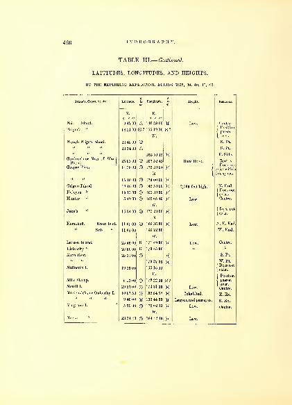
460 HYDROGRAPHY.
TABLE III.— Continued.
LATITUDES, LONGITUDES, AND HEIGHTS,
BY THE EXPLORING EXPEDITION, DURING 1838, 39, 40, 41, 42.
Islands, Capes, &c. &c. Latitude.if
Longitude.
N. E.
9 47 00 A 140 38 00
18 21 00 0? 155 19 00 X?W.
23 45 00
23 34 00 A165 59 15 X
25 03 00 167 52 45
14 30 00 175 30 00 XE.
15 10 00 174 00 00 X18 48 00 145 50 00 X19 1300 163 30 00 X5 42 00 169 05 46 X
W.
1G 34 00 173 20 00 XE.
11 05 00 166 36 00 X11 08 00 166 22 00
W.
25 46 00 K 171 49 00 X2G 00 00 K 173 45 00
25 21 00 X170 37 36 X
19 26 00 165 15 00
E.
6 12 00 172 22 00 X?29 57 00 174 31 00 X10 07 53 139 54 58 X9 46 00 139 44 00
5 59 00 172 02 33 XW.
23 34 40 164 42 40 X
Height.
Feis Island.
Folger's "
French Frigate Shoal.
Gardner's or Man of War )
Shoal.j
Gaspar Rico.
Grigan Island.
Halcyon "
Hunter "
Korsakoff. Knox Islet.
Sifo "
Layson Island.
Lisiansky "
Maro Reef.
Malloon's I.
Mille Group.
Morell I.
McKenzie's, or Oulouthy I.
Mulgi 3 I.
2,500 feet h:
Low.
Low.
Inhabited.
Lagoon and passages.
Low.
Low.
N. Pt.
S. Pt.
E. Side.
Centre.
Does not
exist within
this space.
N. End.
At E. End.
W. End.
Centre.
S. Pt.
W. Pt.
| Does not
( exist.
( Position
-I passed
Centre.
E. Ex.
S. Ex.
Centre.
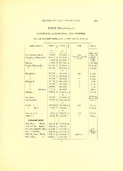
TABLE III.— Continued.
LATITUDES, LONGITUDES, AND HEIGHTS,
BY THE EXPLORING EXPEDITION, DURING 1838, 39, 40, 41, 42.
Islands, Capes, &c. &c. Lat.tude.
ILongitude. I Height. Remarks.
N. w.
New Nantucket Island.
Oulouthy, or McKenzie's I.
1 00 00
10 07 53
174 34 00
139 54 58
?
XLow.
Two islands 8 miles
f The posi-
jaminciTE. Ex.
9 4G 00 H 139 44 00 K S. Ex.
Palmyra. 5 50 00 1G2 23 00 x N. W. Side.
Pearl and Hermes Reef. 28 22 00 O 177 32 00 X N. W. Ex.
27 31 00 A 176 28 00
E.
167 28 30
x S. E. Ex.
Pescadores I. 11 25 20 A A Low. N. End.
11 1440 O 1G7 30 15 X "S. End.
ARodo ala I° 11 11 00 166 58 00 x S. Pt.
11 22 30 A 167 10 20 A E. Pt.
11 33 00 166 54 00 „ N. Pt.
" Tufa Islet. 11 14 30 166 47 00 Centre.
20 18 00 O 121 50 11 LT E W. End.
San Pablo I. 16 07 00
W.
179 00 00 ?W j Position
{ examinedSmyth's Island. 1G 48 00 O 169 45 36
E.
166 30 00
XW Centre.
Wake's " 19 15 00 X I Low. Centre.
" Reef. 17 40 00 K 172 40 00
W.
K Doubtful.
Washington's I. 4 41 35 160 15 37 X Low. E. End.
Walker's I. 3 54 00 K 149 25 00 K Centre.
HAWAIIAN GROUP.
Alena Point, Maui I. 20 32 00 H 156 21 00
Anahula Point, Kaiau I. 22 10 30 A 159 20 00 ADiamond, or LeahiPt. Oahul. 21 15 00 69 157 49 00 X S. Pt.
Ewa, or Pearl River.
Ifaleukia, Crater, Maui I.
21 20 00
20 43 00
O 157 59 33
15G 18 00
XX 10,200 feet, f
f Hammer{ Point.
Haueoo Point, " 20 44 00 A 150 03 00 A
nfi

462 HYDROGRAPHY.
TABLE III.— Continued.
LATITUDES, LONGITUDES, AND HEIGHTS,
BY THE EXPLORING EXPEDITION, DURING 1838, 39, 40, 41, 42.
Islands, Capes &c. &c. Latitude. 1B
Longitude. 1is
Height. Remarks.
N.o / //
W.o / //
Haiku Point, Maui. 20 56 00 A 156 19 00 A N. Side.
Haalua, Oahu I. • 21 39 00 O 157 56 00 XHaleaha, 21 36 00 A 157 54 00 A N. E. Side.
Hanapapea Har. Kauai I. 21 49 00 O 159 36 00 XHaalea Point, u 22 12 00 A 159 42 00 AHalelea Harbor, 22 13 00 B 159 34 00 AHalaua Point,
Hilo Bay,
Molokai.
Hawaii.
21 09 00
19 43 51
A0*
156 45 00
155 03 06
A E. Pt.
{ tory.
N. W. End.Honokohau, Maui I. 21 03 00 156 39 00
Honolulu, Oahu. 21 1840 0* 157 52 15 €* f Observa-
{ tory.
Huilua Point, Maui I. 20 34 00 A 156 14 00 AHubaia Harbor, Kauai I. 21 56 54 O 159 21 15 XKalae Point, Hawaii I. 18 53 30 A 156 45 00 A S. Pt.
Kalaua Point, Molokai. 21 06 00 O 157 18 00 X W. Pt.
Kailua Bay, Hawaii I. 19 39 00 O 156 04 30 XKawili Point, 19 11 30 A 156 05 00 A
20 03 00 155 56 30 nKaholalele, 20 05 30 155 13 30 KKapaho, 19 34 00 O 154 54 00 X E. Pt.
Kaaha, 19 13 00 A 155 16 00 AKaena Point, Oahu. 21 35 00 158 15 00 XA S. W. Pt,
Kahikinui, Maui I. 20 31 00 O 156 23 00 AKaikamaalaea, 20 43 00 tt 156 28 00 KKahoolawe I. 20 31 00
20 31 30
20 36 30
HOA
156 33 00
156 42 00
156 34 00
1 8
XA
• {
E. Pt.
W. Pt., Ke-alaikahiki
N. Pt.
Kaluaaha Town, Molokai I. 21 05 00 157 00 00 HKalaua Point, 21 0G 00 O 157 18 00 X W. Pt.
Kawaihoa Point Oahu I. 21 15 00 A 157 43 00 AKaena, 21 35 00 158 15 00 X W. Pt.
Kaliana, 21 33 00 O 157 51 00 XKahuku, 21 43 30 O 158 00 00 x N.Pt.
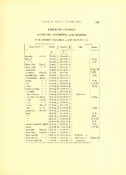
GEOGRAPHICAL POSITIONS. 4G3
TABLE III.— Continued.
LATITUDES, LONGITUDES, AND HEIGHTS,
BY THE EXPLORING EXPEDITION, DURING 1838, 39, 40, 41, 42.
Latitude. 3> Longitude. Height. Remarks.
N. w.
21 29 00 157 48 00 x22 15 00 A 159 30 00 A N. Pt.
21 48 00 A 159 38 00 A S. Pt.
21 54 00 A 159 19 00 'H22 08 00
21 40 00
22 15 00
A 159 18 30
160 34 30
160 17 00
AA f Near Nii-
( hau I.
S. Pt.
20 42 00 A 156 57 00 A S. Pt.
20 03 00 155 57 00 x20 45 00 A 156 48 00 A E. Pt.
20 58 00 A 157 03 00 JX N. W. Pt.
20 55 00 ft 157 09 00 ft W. Pt.
19 28 12 156 00 00 X§20 12 00 A 155 58 00 n19 26 06 155 28 05 x 3,970 feet, f
21 01 00 R 156 32 00 R N. Side.
21 48 30 159 29 00 X22 05 00 A 159 52 00 A21 56 00 A 160 17 00 A20 45 00 H 156 32 00 xc S. Side.
19 54 00 A 155 06 00 A20 42 00 A 156 57 00 A S. Pt.
20 45 00 A 150 48 00 A E. Pt.
20 58 00 A 157 03 00 tt N. W. Pt.
20 55 00 157 09 00 W. Pt.
21 15 00 © 157 49 00 X S. Pt.
21 17 00 158 06 30 S. W. Pt.
22 02 00 A 160 10 30 A19 43 00 A 156 10 30 A20 28 00 155 36 00 X 13,760 feet, f 6
19 54 00 A 155 30 00 A 13,883 feet. £ Highest Pt.
19 45 00 A 155 55 00 A 10,320 feet,
Is, Capes, Ac. &
Kaneohe,
Kauai I.
Kawai Point,
Kapaa Point,
Kaula Rock.
Kaiwaihoa,
Kamaiki Point,
Kawaihae Ba}',
Kaohai,
Kaa,
Kaena,
Kcalakeakua Bay,
»i Point,
Kilauea Volcano,
Kohakuloa Point,
Koloa,
Kolo,
Koolau,
Kula,
Laupahoeboe,
Niihau I.
Hawaii I„
Maui I.
Kauai I.
Niihau I.
Maui I.
Hawaii I.
Leohi or Diamond Pt., Oahu I,
ma Islet, Niihau I.
Mano Point, Hawaii I.
Mauna Loa Mt., " "
Mauna Kea Mt., " "
Mauna Hualailai Mt.

461 HYDROGRAPHY.
TABLE III.— Continued.
LATITUDES, LONGITUDES, AND HEIGHTS,
BY THE EXPLORING EXPEDITION, DURING 1838, 39, 40, 41, 42.
Islands, Capes, &c. &c. Latitude. i Longitude. a Height. Remarks.
N. w.
Maui Island. 20 40 00
21 03 00 A15G 03 00
156 39 00
HA
JPapaau-
(hao,E.Pt.
W. Pt.
Makapua, Oahu I. 21 19 00 157 40 00II II E. Side.
Makupupu, " " 21 20 00 H 157 39 00 II II E. Pt.
Molokoni Islet, Maui I. 20 37 00 A 156 30 00 AfIlaliiwa,
| E.Pt.Pailolo,S.Pt
Molokai Island. 21 09 00
21 03 00
AO
156 45 00
156 51 00
AK
21 06 00 O 157 18 00 X W. Pt.
21 12 00 H 157 16 00 N. W. Pt.
Nanavalie, Hawaii I. 19 37 30 O 154 56 00 X Sandhills.
Napili Point, Maui I. 20 57 00 A 156 43 00 ANahaina Fort, " " 20 51 50 A 156 39 41 ANiulu Point, Hawaii I. 20 20 00 A 155 46 00
Niihau Island.
" "
22 00 00
21 45 00
21 52 00
AB
K
160 05 00
160 21 00
160 08 00
AX
II II
Oku.N.E.Pt
f Kaiwai-
(hoa, S.Pt.
Pueo, E. Pt.
o i"
"
Oku Point.
Papaauhao Point, Maui I.
21 20 00
21 15 00
21 17 00
21 36 00
21 43 30
22 00 00
20 40 00
OK
OA
157 39 00
157 49 00
158 06 30
158 15 00
158 00 00
160 05 00
156 03 00
II II
XHKXA
\Mukupu-
( ku, E. Pt.
Leahi, S.Pt.
f Laeloa,S.
[ W. Pt.
Kaena,WPtf Kahuku,1 N. Pt.
j N. E. Pt.,
{ Niihau.
E. Pt.
Pacalui, " " 20 40 00 A 156 27 00 APailolo, Molokai I. 21 03 00 A 156 51 00 A S. Pt.
Pohue, Hawaii I. 19 03 00 156 03 00 APueo, Niihau I. .21 52 00 i 160 08 00 A E. Pt.
Upolu, Hawaii I. 20 19 30 A 155 58 00II II
( Observa-
\tory.
Waiakea Creek, " "
Wainanalu, " "
19 43 51
19 55 00
O*A
155 03 06
156 06 00
a*A
Waipio, " " 20 15 30 A 155 25 00 AWaipunalei Point, " " 20 00 00 H 155 09 00 X

GEOGRAPHICAL POSITIONS. 4G5
TABLE III.— Continued,
LATITUDES, LONGITUDES, AND HEIGHTS,
BY THE EXPLORING EXPEDITION, DURING 1838, 39, 40, 41, 42.
Waiahole, Maui I.
Wailuku, " "
Waianae Town, Oahu I.
Waimea " " "
Waimanalo Point, " "
Wahaiwa Harbor, Kaiau I.
Waimea Bay, " "
Wailua Town, " "
Wikili Point, Molokai.
OREGON AND CALIFORNIA.
Adams Point.
Alcatrayas Island.
Allshouse.
Allen Point.
Allan's Island.
Anderson Island.
Angelos Point.
Ano Nuevo.
Apple Cove.
Argus Bay.
Ariel Point.
Arena Point.
Astoria.
Ayock's Point.
Barnes Island.
Bell's Chain.
Beal's Point.
Bird Rocks.
N.
20 48 00 H20 53 00 O21 24 00 O21 39 00 O21 24 00 A21 49 30 O215G00 O22 02 00 ©21 12 00 A
46 12 40 OA37 49 20
47 20 00
48 02 30
48 27 45
47 11 35
47 07 50
47 09 10
47 09 00
48 07 15
36 58 00
47 47 10
48 28 00 OA47 58 00
40 44 00
46 12 10
47 30 40
48 41 00
48 50 20
47 28 00
48 29 10
02
Longitude
W.
156 09 00
156 30 00
158 10 30
158 05 00
157 45 00
159 32 30
159 43 00
159 21 00
157 16 00
123 57 15
122 30 00
122 39 00
122 20 20
122 40 00
122 41
122 40 35
122 43 00
122 09 40
H 123 23 20 HA122 08 00
122 27 50
122 39 30 KA122 31 50
124 11 00
124 52 15
123 02 20
122 44 30
123 08 10
122 24 30
122 43 50
KA
Height.
Stetson'sPt.
RussianFort.
f S.Pt.,Co-
( lumbiaR.Bay SanFrancisco.
Carr's Inlet.
S. Pt., Mc-Donough I,
Centre.
Otso, N. Pt.
( Trouble,
1 W. Pt.
E. Pt.
California.
Pippin Pt.
Anchorage.
Centre.
E. Pt,l!ro\vn"sI
O. T.
117

466 HYDROGRAPHY.
TABLE III.— Continued.
LATITUDES, LONGITUDES, AND HEIGHTS,
BY THE EXPLORING EXPEDITION, DURING 1838, 39, 40, 41, 42.
Islands, Capes, &c. &c. i
MLon itude. 3
SHeight.
N. w.
Blanco Cape. 42 55 00 O 124 25 00 XBlakely Island. 48 32 10 A 122 49 30 A Centre.
48 35 20 O 122 46 00 X S. Pt.
48 33 20 A 122 46 30 A N. Pt.
Port.
Blake's Island.
47 35 40
47 31 40
OOA
122 29 00
122 27 40
XXA
{ bridge I.
S. Pt.
" " 47 32 50 A 122 28 00 A N. Pt.
Blunt's Island. 48 18 30 OA 122 49 30 XA Centre.
Blue Mountain. 37 45 30 A 122 24 10 A 1087 feet.
Bonita Point. 37 48 45 A 122 28 1C A California.
Bolin Point. 47 41 10 A L22 34 00 ABodega Port. 38 18 00 B 123 03 20 XBrown's Island. 48 33 00 A 122 57 40 A Centre.
" Point. 47 45 00 122 44 20 X47 08 10 A 122 53 00 A O. T.
Briscoe Point. 47 09 45 A 122 51 30 A Hartstein I.
Budd's Inlet.
Burrows' Island.
39 1130
47 00 30
48 29 00
AOO
121 40 30
122 53 00
122 41 00
AXX
( 'alil'oriiia.
fSaringa
1 Falls.
W. End.
48 29 00 A 122 39 00 A E. End.
Case's Inlet. 47 24 30 OA 122 48 30 XA Ex. N. Pt.
Camp Point. 47 09 00 ©A 122 58 00 XA O. T.
Carroll Point. 48 0G 00 A 122 40 20 AChauney's Island. 48 34 25 OA 122 50 30XA N. Pt.
Chikiles Point. 46 55 30 OA 124 11 30 XA Gray's Har.
Clark's Island. 48 42 50 O 122 43 30 A N. Pi,
Colsee-ed Harbor. 47 46 58 122 50 11 X f Rose Pt.,
1 O.T.Cooper Point. 47 08 40 A 122 54 30 A O. T.
Cook's. 47 11 40 A 122 55 00 ACommencement Bay. 47 17 40 © 122 25 00 X Centre.
Colvo Rocks. 47 57 10 OA 122 30 00XAConstitution Mountain. 48 39 30 A 122 47 00 A 2356 feet.

GEOGRAPHICAL POSITIONS. 4G7
TABLE III.— Continued.
LATITUDES, LONGITUDES, AND HEIGHTS,
BY THE EXPLORING EXPEDITION, DURING 1838, 39, 40, 41, 42.
Cone Hill.
Cowas.
Crowlie Point.
Cum tilings Point.
Cyprus Island.
Day's "
Dabop Bay.
I >adah Point.
Defiance "
Demock.
Deception Passage.
Decatur Island.
Destruction Island.
Disappointment Cape.
Dickcrson Point.
Discovery Port.
Dougal Point.
jglas Island.
I loiiglity's Point.
Duncan Rocks.
Dye's Inlet, head of.
Eagle Harbor,
mind's Islet.
" Point.
Eld's Inlet, P. Sound.
Elliot Bay.
Kli/.a's Island.
43 28 00
47 22 10
47 33 :
48 36 20
48 32 20
47 11
47 17 20
47 50 15
OoAO
7 27 00 A47 19 30 OA48 14 40 A48 23 50 ©A48 28 25
48 31 40
47 38 20
oAO
46 16 16 OA47 09 40
48 03 1
6
47 18 30
48 45 00
48 42 00
48 20 40
47 27 30 OA47 37 00
48 45 20
47 48 00
47 03 40 OA47 35 40
47 39 10
48 38 30
48 39 40
124 08 00,
122 05 30.
123 oi oo;
122 41 00.
122 38 40;
122 32 10;
122 34 40,
122 47 20:
123 04 00.
122 31 15 >
122 30 40,
122 38 00 >
122 46 00 ;
122 45 00,
124 23 20 ;
124 01 43 y
122 49 40,
122 50 45;
122 50 00,
123 07 40,
122 54 45,
124 43 30;
122 40 30
122 28 20
122 47 00
122 22 10
122 58 00 >
122 21 30
122 24 30
122 32 00
122 32 20
N. Pt.
S. Pt.
W. Pt.
{Vander-voort Pt.
Entrance.
S. Pt.
N. Pt.
O. T.
Carr's Pt.
O. T.
Entrance.
Centre.
Ex. S. Pt.
f Pt. More,
j O. T.
W. Pt.
S. Pt.
N. Pt.

4GS HYDROGRAPHY.
TABLE III.— Continued.
LATITUDES, LONGITUDES, AND HEIGHTS,
BY THE EXPLORING EXPEDITION, DURING 1838, 39, 40, 41, 42.
fee &C Latitude. i
aLongitude i
aHeight. Remarks
N. w.
Ellice Point. 40 15 00 O 123 54 00 XErie Mountain. 43 28 00 A 122 35 00 A Perry's I.
Farallones, North 37 44 00 O 122 00 30 X" South 37 3G 00 3X 122 58 00 Jt
Feather River, California. 38 47 20 O 121 29 00 X Mouth.
Flat-top Island. 48 39 00 A 123 03 40 AFlattery Cape, 0. T. 48 25 00 124 41 40 X
" Rocks, 48 1G 00 124 43 00 XSan Fran
Fort Point, California. 37 48 30 A 122 25 24 AFosdick Point, 0. T. 47 1G 00 A 122 33 45 A O. T.
Fox Island, P. Sound. 47 14 40 A 122 34 00 A N. E. Pt.
" " 47 17 15 A 122 39 00 A W. Pt.
Foulweather Cape 45 45 00 A 123 54 20
Francis Point. 48 42 00 A 122 34 00 AFrazer's River. 49 07 05 O 123 08 57 X N. Bluff.
Frost's Island. 48 32 30 A 122 48 10 A Centre.
122 17 20 )_(
Gamble Port. 47 51 23 OA 122 33 42 XA Totten's Pt.
Gig Harbor. 47 19 50 O 122 33 00 X O. T.
Gibson Point. 47 13 40 A 122 35 00 A Fox I.
Glover Point. 47 35 00 A 122 31 30 A ( Port Or-
| chard.
Gordon Point. 47 35 00 A 122 27 20 A Bainbrid'e I
Gourd Island. 48 48 50 A 122 54 20 A E. Pt.
OA 122 56 00XA W. Pt.
Gordon Island. 48 44 30 A 122 56 30 Centre.
Gonzales Point. 48 27 20 O 123 10 50 KGrenville Point. 47 22 00 O 124 12 00
Gregory Cape. 44 04 20 A 124 05 00
Green's Point. 47 17 00 A 122 40 00 A Carr's Inlet.
Guerriere Bay. 48 36 30 O 122 55 00 W. Pt.
Hautboy Island. 48 33 56 A 122 42 00 Centre.
Hamersley Inlet, 0. T. 47 10 30 O 123 05 00 X Ex. W. Pt.
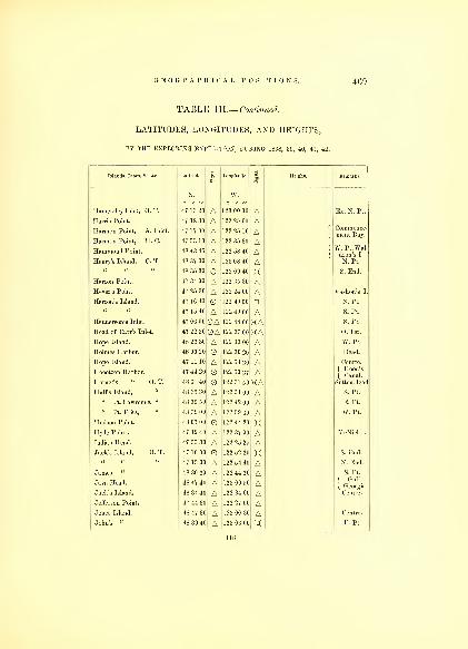
GEOGRAPHICAL POSITIONS. 4(59
TABLE III.— Continued.
LATITUDES, LONGITUDES, AND HEIGHTS,
BY THE EXPLORING EXPEDITION, DURING 1838, 39, 40, 41, 42.
Islands, Capes, &c. &c. Latitude..1
Longitude..1
Height. Remarks.
N. w.
Hamersley Inlet, 0. T. 47 13 20 A 123 00 00 Ex. N. Pt.
Commence-ment Bay.
Hamon Point A Inlet
Harmon Point' H C
6'
47 17 00 12^25 10 A f
I47 5310 ~~ 122 35 30 A
W. Pt.Wal-dron's I.
H™ond Point
HeT's Island"
'
T
48 43 45 A |I
e"rys s
r ' «' 48 37 30 A 123 08 40 A
O 123 09 40 Xrron point 47 34 00 ~~ i 35 no A
Heir's Point 47 25 30 |'*
( llll A Ias ons
nTron' I landerrons san . 47 1G 40 O 122 49 00 )X
A 122 1',
• ( M
)
A SPt"
Henderson's Inlet. 47 06 00 0A 122 48 00 KA S. Pt.
^ead °f °a" S Inlet ' OA 122 37 (Hi KA O. Ter.
48 23 30 A 122 33 00 AHolmes' Harbor 48 00 20 O A Head^
Hope Island. 47 11 10 A 122 54 30 A Centre.
Hooetzen Harbor. 47 44 20 122 50 37 A f Hood's
{ Canal.
Hornet's « 0. T. 48 31 40 122 31 50 KA Suttonllead
Hull's Island," 48 35 30 A 122 51 00 A S. Pt.
" Pt. Lawrence, " 48 39 50 A 122 42 00 A E. Pt.
" Pt. Fritz," 48 39 00 A 122 59 30 A W. Pt.
Hudson Point. 48 07 00 O 122 44 20 XHyde Point. 47 12 40 A 122 37 00 A McNiel I.
Indian Head. 47 55 30 A 122 25 25 AJack's Island, 0. T. 47 10 00 122 52 20 X S. End.
47 13 30 A 122 54 40 A N. End.
James " 48 30 30 A 122 44 20 A S. Pt.
Java Head. 48 47 40 A 123 00 50 A f Gulf
(Georgia.
Jack's Island. 48 34 40 A 122 34 00 A Centre.
Jefferson Point. 47 44 30 A 122 27 00 AJones Island. 48 47 30 A 123 00 30 A Centre.
John's " 48 39 40 A 123 06 00 E. Pt.
118

470 HYDROGRAPHY.
TABLE III.— Continued.
LATITUDES, LONGITUDES, AND HEIGHTS,
BY THE EXPLORING EXPEDITION, DURING 1838, 39, 40, 41, 42.
Islands Ca es &c Acs an s, apes, c. c. Latitude.»
Longitude. 3
EHeight. Remarks.
N. W.o / //
John's Island. 48 40 30 A 123 08 00 A W. Pt.
Karquines Straits. 38 03 30 O 122 13 00 X California.
Kalmunt Island. 48 16 00 A 122 36 00 A Centre.
Katslum " 48 24 00 A 122 38 00 AKetron " 47 10 25 A 122 36 40 A N. Pt.
U u 47 09 10 A 122 37 00 A S. Pt.
Killinas Lake. 47 24 00 A 122 52 30 A Centre.
Killamook Head. 45 54 20 A 123 57 00 AKlamath River. 41 34 00 B 123 58 30 AKwaatz Point. 47 0G40 A 122 09 30 A f Puget's
1 SoundLawrence (Port). 48 00 00 O 122 41 00 X Anchorage.
Lawrence Point. 48 39 50 A 122 42 00 A ( E. Point,
j Hull's I.
Lawrence Island. 48 35 30 A 122 36 00 A N. Pt.
48 31 30 O 122 36 40 X S. Pt,
Leavitt Point. 48 02 00 A 122 35 25 A f Admiral-
{ ty Inlet.
Liplip Point. 48 00 20 A 122 39 20 ALittle Belt Passage. 48 28 40 XLookout Cape. 45 23 30 ® 123 53 40 XLowell Point. 48 07 00 A 122 28 00 ALobos Point. 37 46 40 A 122 27 30 ALos Angelos Island. 37 51 30 A 122 22 55 A
{
Bay of SanFrancisco.
Ludlow (Port). 47 55 20 O 122 39 53 X Tit Pt.
Lynch Cove. 47 26 00 A 122 52 00 A Hood's Ca'l.
Marsh Landing. 37 59 30 AO 121 40 00 XA f Sacra-
{ mento R.
Madison (Port). 47 42 15 OA 122 30 00 XA Centre.
M;tk:i h Point. 48 31 20 A 124 32 00 AMcLaughlin Island. 48 45 30 A 122 40 10 A f Pt. Nei-
1 ghy,N.Pt.
Cardinal Pt.48 38 30 A 122 34 00 AMcNeil Island. 47 12 40 A 122 37 00 A E. Pt.
47 12 25 A 122 42 00 A W. Pt.
47 14 20 A 122 40 30 A N.Pt.
Mendocino Cape. 40 27 00 124 25 00 x California.
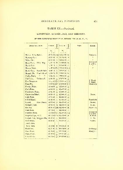
GEOGRAPHICAL POSITIONS. 471
TABLE III.— Continued,
LATITUDES, LONGITUDES, AND HEIGHTS,
BY THE EXPLORING EXPEDITION, DURING 1838, 39, 40, 41, 42.
Islands, Capes, Ac. &c. Latitude.I"
Longitude.I
Height. Remarks.
N. w.
Mission of San Rafael 37 58 00 AO 122 2D 00 X California
Mmitere For" 3G 36 00 B 121 52 30 B u
MdatTTslet"
'
37 55 00 A 122 22 40 A u
f Admiral-
\ ty Inlet.Moore Point, Eliiott Bay. 47 35 40 O 122 21 30 x
47 10 40 A 122 48 00 AMunroe Point. 47 42 00 O? 122 30 00 K2Morris Cove, Ironside Inlet. 48 40 40 A 122 52 00 AMusquiti Pt. Hood's Canal. 47 24 20 O 123 06 00 xNeclim Point, " " 47 23 30 A 123 08 00 A
47 20 10 A 122 28 00 ANew Dunieness^
811011 S 1
N?^ual"y
geneSS ' 48 11 37
47 07 12
O I
0^-
123 04 55
122 38 09
X3f Fuca's
( Strait,
serva yNopoint Point. 47 54 30 A 122 30 30 ANorth Point. 48 25 20 A 124 39 00 A
47 41 00 A 122 47 30 AObstruction Island. 48 35 30 A 122 46 30 A Centre.
Olele Point. 47 58 00 A 122 40 00 AO'Neil Island. 48 3G 30 A 123 03 20 A Puget's Sd.
Oxford, Cape Blanco. 42 55 00 © 124 25 00 X Oregon.
Orchard (Port). 47 32 00 122 39 30 X S. Ex.
Oro Bay. 47 08 30 on 122 40 00 H Puget's Sd.
Park Point.
Partridge Point.
47 10 00
48 13 00
AOA
122 44 30
122 45 20
AAH f Admiral-
) ty Inlet.
Perpetua Cape, 0. T. 44 12 30 cs 123 59 00 X N. Bluff.
Peapod Rock, Ringgold (Mia. 48 38 30 A 122 42 00 A N. Ex.
Pearl Island. 48 37 20 A 123 07 30 A Centre.
Penn's Cove.
Pinos Point. 36 38 00 B 121 54 30 B
Pilot Cove. 47 51 50 122 29 10 X Anchorage.
Piner Point. 47 20 50 A 122 25 30 A Maury's I.
Pilash Point. 47 48 30 A 122 47 50 APolnell Point. 48 16 00 122 32 00 XA
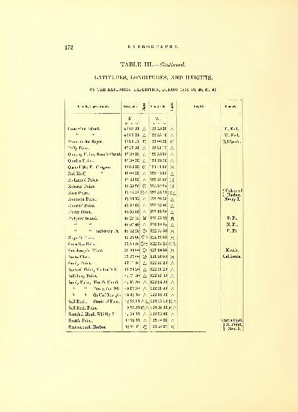
472 HYDROGRAPHY.
TABLE III.— Continued.
LATITUDES, LONGITUDES, AND HEIGHTS,
BY THE EXPLORING EXPEDITION, DURING 1838, 39, 40, 41, 42.
Islauds, Capes, &c. &c. Latitude. 1TO
Longitude. iTO
Height. Remarks.
N.o / //
W.o / //
Protection Island. 48 08 00 A 122 53 00 A E. End.
48 07 30 A 122 55 10 A W. End.
Punte de los Reyes. 38 01 15 JX 123 00 30 X California.
Pully Point. 47 27 00 A 122 21 15 AQuatsap Point, Hood's Canal. 47 39 00 A 122 53 00 AQuadra Point. 48 30 30 A 124 29 30 ' AQueenhithe Pt. Oregon. 48 03 00 124 41 00 XRed Bluff,
" 48 09 20 A 122 40 00 ARichmond Point. 47 23 20 A 122 31 00 XRoberts' Point. 48 58 20 123 02 24 X
f Colsee-etl
| Harbor.Rose Point. 47 46 58 OA 122 50 11 XARobinson Point. 47 23 15 ,A 122 20 30 A Maury I.
Roberts' Point. 47 34 30 A 122 23 40 ARocky Point. 48 05 30 A 122 30 20 ARodgers' Island. 48 27 15 122 55 20 tf S. Pt.
48 07 40 A 123 04 15 A N. Pt.
" " Salisbury Pt. 48 32 20 122 55 30 x E. Pt.
Rogue's River. 42 25 00 cs 124 20 00 XSausalito Point. 37 50 50 Otf 122 25 2G €*San Joaquin River. 38 04 00 121 34 00 X Mouth.
Santa Clara. 37 25 00 121 56 00 X California.
Sandy Point. 47 11 10 A 122 55 20 ASanford Point, Vashon's I. 47 24 20 A' 122 30 20 ASalisbury Point. 47 51 30 A 122 55 30 ASandy Point, Hood's Canal. 47 37 50 A 122 54 00 A
" " Possession Sd. 48 01 30 A 122 20 40 A" " Gulfof Georgia. 48 48 00 A 122 41 00 A
Sail Rock, Strait of Fuca. 48 23 10 AH 124 33 10 HASail Rock Point. 48 23 30 OA 124 34 00 XAScatchel Head, Whidby I. 47 54 00 A 122 53 40 AScott's Point. 47 18 30 A 122 40 00 A Carr's Inlet
Scarborough Harbor. 48 24 41 O 124 36 08 X f N. Point,
{ Neall.
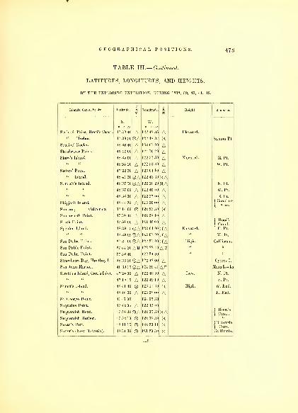
GEOGRAPHICAL POSITIONS. 473
TABLE III.— Continued.
LATITUDES, LONGITUDES, AND HEIGHTS,
BY THE EXPLORING EXPEDITION, DURING 1838, 39, 40, 41, 42.
Islands, Capes, &c. Ac. Longitude. Height. Remarks.
Scabock Point, Hood's Canal.
" Harbor.
Sentinel Rocks.
Shoalwater Point.
Shaw's Island.
Sisters' Point.
" Island.
Sinclair's Island.
Skipjack Island.
Sonoma, California.
Southworth Point.
South Point.
Spciden Island.
San Pedro Point.
San Pablo Point.
San Pedro Point.
Strawberry Bay, Hautboy I.
San Juan Harbor.
Stretch's Island, Carr's Inlet.
Stuart's Island.
St. George Point.
Suqualus Point.
Suquamish Head.
Suquamish Harbor.
Susan's Port.
Sutter's (New Helvetia).
N.
4? 39 40
47 39 30
48 38 40
46 42 00
48 35 00
48 35 20
47 22 30
48 41 30
48 37 50
48 37 00
48 36 30
48 44 30
38 14 00
47 30 40
47 50 00
48 38 1
5
48 38 01)
37 34 00
37 57 20
37 58 40
4 8 33 56
48 30 37
47 20 00
47 19 15
48 41 40
48 40 30
41 47 00
47 42 00
47 56 30
47 52 10
48 11 15
38 34 30
AOAAAAAAOAOAAAAOAAOAOAOAAH
OAOAAAOA
AOAOOO
w.
122 48 35
122 48 32
123 07 00
124 10 20
122 51 50
122 58 30
123 01 10
122 43 30
122 38 20
122 40 00
122 37 00
123 00 00
122 23 30
122 28 10
122 40 00
123 04 00
123 07 20
122 27 00
122 22 40
122 24 00
122 42 00
124 29 41
122 48 00
122 49 10
123 11 30
123 08 00
124 05 30
122 45 00
1 22 35 30
122 38 39
122 20 11
121 20 30
AKAAAAAKAHAAAAKAAKAKAKAAH
AAHAAKA
KAKKK
Elevated.
Elevated.
Elevated.
High.
Low.
High.
Sanum Pt.
E. Pt,
W. Pt.
N. Pt.
W. Pt.
E. Pt.
f Canal de
{ Arro.
|
Hood's
E. Pt.'
W. Pt.
California.
Cypres I.
Mash Rocks
N. Pt.
S. Pt.
W. End.
E. End.
f Hood's
{ Canal.
f Triangle
1 Cove.California.
119

474 HYDROGRAPHY.
TABLE III.— Continued.
LATITUDES, LONGITUDES, AND HEIGHTS,
BY THE EXPLORING EXPEDITION, DURING 1838, 39, 40, 41, 42.
Height.
Sylopash Point.
Table Hill.
Tala Point, Hood's Canal
Tatuocho Island.
Tchinom Point, Hood's Canal.
Vkiu Point, " "
Termination Pt. " "
Tetusi Bay.
Tongue Point.
Thompson Point.
Tumbow Island.
Toliva Shoal, Puget Sound.
Totten's Inlet, " "
Treble Point, McNeil I.
on Head, Hood's Canal.
Trinidad Bay.
Tskulsko Point, Hood's Canal.
Tzu-sa ted Cove.
Umpqua River.
Vashon's Point.
Vendovi Island.
Viti Rocks.
Watmaugh Head.
Wasp Islets.
Waldrou's Island.
Wepusec Inlet.
White Point.
Whitehorn Point.
Wilson Point.
Wilson Point, Hartstene's I.
A
N.
47 41 30 A37 55 00
47 56" 00
48 3G 00
47 32 20
47 35 40
47 52 00
47 12 30
48 58 30
48 42 00
48 40 0(1
47 12 40
47 05 25 OA47 09 10
47 36 30
41 05 40
47 41 30
47 49 00
44 43 30
47 30 40 ©A48 36 30
48 38 00
48 25 00 @A48 36 00
48 41 00 OA48 43 45
48 30 00
47 06 30 ©A47 35 20
48 54 00
48 08 39
47 12 30
W.
122 52 00.
122 31 30,
122 38 40,
124 43 20;
123 00 00,
122 57 00,
122 37 51,
122 43 00:
122 45 30,
122 51 00,
123 02 00;
122 35 00,
123 04 00 )n
122 43 00,
122 57 40,
124 03 30,
122 48 40,
122 50 37;
124 06 45;
122 26 40 )h
122 03 30,
122 35 00,
122 47 20,
122 58 30,
123 00 30,
122 58 40,
123 02 10;
122 52 00 h
122 33 00
1 22 46 30
122 44 43
122 49 30
2569 feet.
Low.
Low.
High.
Rocky.
California.
N. Pt.
Hull's I."
Anchorage.
f N.Pt.Vu-
} shon's I.
Centre.
South Pt..
}Chauncy'sl
Disney Pt.
fHam-
[ mond PtW. Pt.
fBudd's
I Inlet.
Sandy.
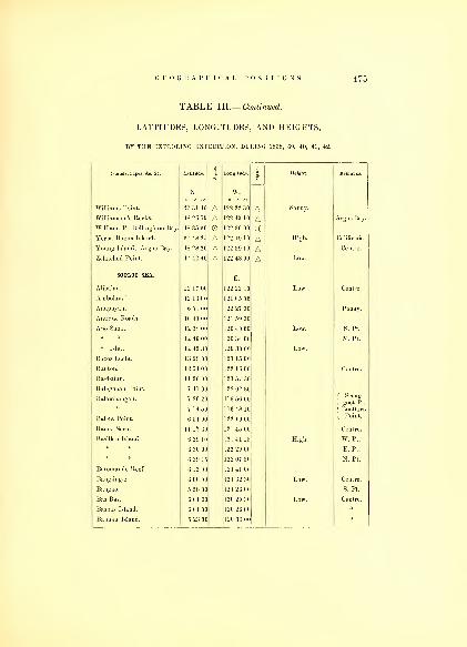
TABLE III.— Continued,
LATITUDES, LONGITUDES, AND HEIGHTS,
BY THE EXPLORING EXPEDITION, DURING 1838, 39, 40, 41, 42.
Islands, Capes, &c. Ac. Latitude. 1 Longitude. 1 Height. Remarks.
N. W.
Williams Point. 47 31 40 A 122 22 30 A Sandy.
Williamson's Rocks. 48 26 50 A 122 40 10 A Argus Bay.
William. Pt. Bellingham Bay. 48 35 30 122 30 00 xVerba Buena Island. 37 48 25 A 122 19 10 A High. California.
Young Island, Argus Bay. 48 28 20 A 122 39 10 A Centre.
Zelatched Point. 47 42 40 A 122 48 00 A Low.
SOOL0O SEA.E.
Alibalau. 12 17 00 122 22 10 Low. Centre.
Ambolau. 12 13 00 121 05 00
Anapuyan. 6 51 00 122 27 30 p
Antique R.oads. 10 40 00 121 59 30
Apo Shoal. 12 38 00
1 2 46 00
120 40 00
120 34 00
Low. S. Pt.
N. Pt.
" Islet. 12 42 30 120 30 00 Low.
Baeos Islets. 13 20 00 121 15 00
Bauton. 12 54 00 122 16 00 Centre.
Bagbatan. 11 20 00 121 57 3(
ISalagoiiau Point. 7 47 00 122 02 30
f ^oofpt.
| Boottorn
| Point.
Balambaugau.
Baleta Point.
7 20 20
7 14 50
6 51 00
116 56 00
116 48 10
122 10 00
Banco Seco. 11 17 30 121 45 00 Centre.
Basillan Island. 6 29 10
6 30 00
6 39 15
121 41 15
122 29 00
122 07 50
High. W. Pt.
E. Pt.
N. Pt.
Batomande Reef. 6 12 00 121 41 CO
Bang-ing-e. 6 00 00 121 32 30 Low.
Bangao. 5 58 00 121 26 00 S. Pt.
Bas Bas. 6 01 30 120 25 30 Low. Centre.
Hasbas Island. 6 01 00 120 26 00
Babuan Island. 5 23 00 120 33 00
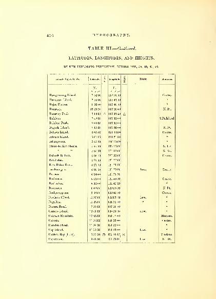
47G HYDROGRAPHY.
TABLE III.— Continued.
LATITUDES, LONGITUDES, AND HEIGHTS,
BY THE EXPLORING EXPEDITION, DURING 1838, 39, 40, 41, 42.
Island8, Capes, Ac. &c. Latitude. S
1Longitude.
1Height. Remarks.
o ', „Bawgennang Island. 7 52 00
o / „118 50 00 Centre.
Bancoran Island. 7 55 00 118 47 00
Bajos Nuevos. 8 00 00 117 40 00 »
Banguey. 17 20 30 117 20 00 N. Pt.
Banguey Peak. 7 1G05 A 117 05 40 ABalabac. 7 49 00 117 00 00 S.Pt.Island.
Balabac Peak. 8 00 00 117 02 00
Bugsok Island. 8 15 00 117 20 00 S. Pt.
Belawn Island. G 05 00 121 43 00 Centre.
Bilinan Island. G 01 15 121 21 30 «
Billanggaan. 5 45 00 120 10 00
Biche de Mar Shoals. 7 44 00 117 16 00 N. Ex.
a7 35 00 117 1800 S. Ex.
Ballook Ballook. G 33 40 121 35 00 Centre.
Botobalon. 6 28 00 121 22 00
Boto Balon Rock. G 27 30 121 21 30
Bookoongan. 6 30 30 121 29 30 Low. Centre.
Boosoo. 6 34 00 121 27 00
Boobooan. G 15 00 121 50 00 Centre.
Bookooloo. G 06 06 121 42 30
Boobooan. 6 09 00 120 53 00 N.Pt.
Hoohpongpong. 5 38 00 120 45 00 Centre.
Brothers (Two). 12 57 00 122 07 30 Low.
Buyalloa. 12 25 00 121 32 00
Bueara Shoal. 7 55 00 117 20 00
Camelo Island. 13 41 00 120 24 30 Low.
Calapan Mountain. 13 25 00 121 1800 Mindoro.
Caluhia. 11 56 00 121 35 00 Centre.
Camden Shoal. 11 50 00 121 22 00
Cap Island. 11 35 00 121 45 00 Low.
Caldera Bay (Fort). 6 55 00 O 122 00 45 X Mindano.
Cagayanes. 9 42 00 121 20 00 Low. N. Ex.

GEOGRAPHICAL POSITIONS. 477
TABLE III.— Continued.
LATITUDES, LONGITUDES, AND HEIGHTS,
BY THE EXPLORING EXPEDITION, DURING 1838, 39, 40, 41, 42.
Islands, Capes, &c. Ac. Latitude. 1CO
Longitude. 1m
Height. Remarks.
N. E.
/ // O / //
Cagayanes. 9 30 00 121 19 00 Low. S. Ex.
Caluja. 9 28 00 121 OoOO Centre.
Cavalh. 9 15 00 1 20 42 (Hi
Carandaga Island. 10 55 00 120 20 30 E. Pt.
Cap Island. 6 04 00 119 58 00 Low. Centre.
Cagayan Sooloo. 7 02 00 118 38 00 High. E. Pt.
7 02 00 1 1 s 32 0( W. Pt.
Cadalamar. 7 53 00 117 10 21 Centre.
Cama Reef. 7 27 00 117 17 00 E. End.
7 27 20 11 7 12 00 W. End.
Calavite Peak. 13 30 00 120 24 10 2080. Mindoro.
" Point. 13 28 30 120 18 00
Carabao Island. 12 06 00 122 00 00 Low. Centre.
Cnyos Island. 10 51 00 121 11 30 W. Pt.
I»av:ig:m Point, Mindoro. 12 39 00 121 40 00 Low. E. Side.
Datu Point. 6 00 25 120 54 40 Sooloo.
Damaloc Point, Mindanao. 6 58 00 121 55 00
Dafaan Island. 6 37 30 121 21 00 Low. Centre.
Damay Island. 5 48 00 120 22 00
Datu Shoal. 7 23 00 118 43 00
Deolo-Batas. 5 55 00 120 13 00 Low.
Diporlool Islands. 6 07 30 121 45 00
Dog Kan Island. 5 57 30 120 03 00 Centre.
Duobolod. 6 12 00 121 30 00
Dumaran. 10 28 00 120 04 00 S. Pt.
10 40 00 120 15 00 E. Pt.
Dumah Point. 13 07 00 121 40 00 High. Mindoro.
I lyangappik Point. 6 02 20 120 56 30 Sooloo.
East Island. 8 55 00 118 25 00 Centre.
Escarceo Point. 13 33 00 121 05 00 Mindoro.
Falmouth Bank. 11 56 00 121 05 00 Centre.
Galera Point. 13 34 30 121 02 00 Mindoro.
120

478 HYDROGRAPHY.
TABLE III.— Continued.
LATITUDES, LONGITUDES, AND HEIGHTS,
BY THE EXPLORING EXPEDITION, DURING 1838, 39, 40, 41, 42.
Islands, Capes, Sc. &c. Latitude. i Longitude. i
CD
Height. Remarks.
N.
—E.
Galera Mount. 13 25 00 120 49 00 Mindoro.
Golconda Shoal. 10 00 00 125 35 00 Centre.
Goopooan West. 7 21 30 117 16 30 Low. "
" East. 7 21 HO 117 20 00"
Griffin Rock. 6 40 00 121 20 00 "
Guimari Island. 10 27 00 122 25 00 Low. S. W. Pt.
Hegad Island. 6 06 50 120 55 30" Centre.
Helix Shoal. 7 24 00 117 17 30
Influenza Island. 12 08 00 121 35 00 «
Kalublub Island. 6 37 00 121 22 00 Low.
Kapooal. 5 59 30 121 20 00 High.
Kabingaan Island. 5 41 00 120 58 00 Low. "
Kanlipiara. 5 29 00 120 08 00
Kenaposan.
Kinapoossan.
7 11 00
5 15 00
118 32 00
120 28 00
«
"
Kisand Patch. 7 27 00 118 12 00 "
Koohangan Island. 121 11 30
Koolassian. 6 20 00 120 40 00
Kooneelaan. 6 04 00 120 28 00
Laminlao Point. 12 29 00 121 00 00 Mindoro.
Lapak Island. 5 30 00 120 40 00 W. End.
Libagao. 12 12 00 121 27 00 Centre.
Loombooean Islet. 7 49 00 117 10 00
Luban Island. 13 45 30
13 59 00
120 16 00
120 06 00
S. Pt.
N. Pt.
Maricaban. 13 40 00 120 53 30 Centre.
Marcolot Peak. 13 44 00 121 10 00 Luzon.
Maestro de Campo Island. 12 59 00 121 50 00 Low. Centre.
Maranduque Island. 13 32 30
13 22 30
121 54 00
122 15 00
f St. Andre,
1 N. Pt.
E. Pt.
Masin Islet. 12 10 00 121 25 00 Centre.
Mangsee Great. 7 29 15 117 1800
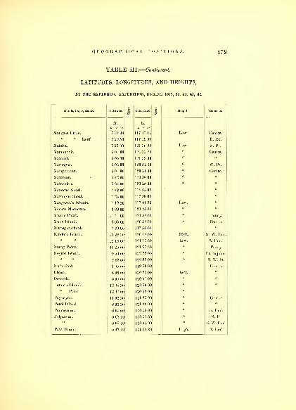
TABLE III.— Continued,
LATITUDES, LONGITUDES, AND HEIGHTS,
BY THE EXPLORING EXPEDITION, DURING 1838, 39, 40, 41, 42.
Islands, Capes, &c. &c. Latitude.1
Longitude.I
Height. Remarks.
N. E.
angsee itt e.
° '
Q 11°7 17 11 Low Centre
7 29 50 117 1 9 00 FEx"Mataha 6 27 00 121 36 00 Low S. Pt.
Mamanool- 6 04 00 121 32 00 uCentre.
ManiTd
^
1 ''I
;;•> 0(1u
mT"'
arongas.
6
3 00 1 20 52 30 u W Pt
1 20 21 00 u Centre
5 42 00 1'' 16 00 u u
19 29 00 u
MMOcanShoal
5
48 00 118 53 00
M^ron*! Shoal 7 2525 00 1 17 58 00 u
Man" oath's Islands 7 19 30 117 01 30 Low
MeeneTnV Tn 6 30 00 u
M^ddiT pJilt
esan
1215800 u
Minis Island*'
l
\ 03 00 1 'Mi ."is ';nu
Centre'
Midnight Shoal. 7 30 00 117 55 00 «
Mindoro Island. 13 28 30 120 18 00 High. N. W. End.
12 13 00 121 17 30 Low. S. End.
Nasog Point. 10 25 00 121 57 30 Pan ay.
Negros Island. 9 54 00 122 22 00 Pt. Sojolon.
9 32 00 122 23 00 S. W. Pt,
Nuln Rock. 7 45 00 118 50 00 Centre.
Obian. 6 06 00 120 25 00
Oosadda. 6 05 00 120 31 00
Pandan Island. 12 48 30 120 50 00
" Point. 12 47 00 120 52 00
Paguayan. 11 02 30 121 25 00 Centre.
Parol Island. 6 02 30 121 33 00
Pancasinan. 6 05 00 120 56 00 E. End.
Palyanean. 6 07 00 120 51 30 N. Pt.
6 05 00 120 48 00 S. W.End.
Pata Island. 5 47 30 121 09 30 High. E. End

480 HYDROGRAPHY.
TABLE III.— Continued
LATITUDES, LONGITUDES, AND HEIGHTS,
BY THE EXPLORING EXPEDITION, DURING 1838, 39, 40, 41, 42.
Islands, Capes, Ac. Ac. Latitude. 1m
Longitude. 1 Height. Remarks.
N.o / //
E.
o / „Pata Island. 5 45 00 121 04 00 High. W. End.
Pandookan. 6 12 00 120 35 00 Low. S. Pt.
Pangootaaraang. 6 12 30 120 25 00 W. Pt.
6 18 00 120 31 00 N. Pt.
Parangan. 5 30 00 120 38 00 Centre.
Papuan Shoal. 7 16 00 118 05 00
Pagoda Island. 8 24 00 1 17 35 00
Panay. 3000 feet. N. End.
S. End.
Pearl Bank. 6 55 00 119 50 00 N. E. Ex.
5 40 00 1 19 30 00 S. W. Ex.
Piedra Blanca Rock. 10 30 30 121 14 00
Pilas Island. 6 34 00 121 30 00 Low. N. End.
6 27 30 121 30 00 S. End.
Polalu Shoal. 7 26 00 118 20 00 Centre.
Pole, Sooloo I. 5 51 00 120 53 00 S. W. Pt.
Potol. 11 59 00 122 00 00 Panay.
Quinilubam. 11 35 00 121 07 00 Low. Centre.
Santiago Point. 13 46 00 120 40 30 Luzon.
Samboangan (Town). 6 52 30 122 07 00 Mindoro.
Santa Cruz Island. 6 50 00 122 05 50 Low. Centre.
Saddle Island. 6 42 30 122 27 00
Sangboys Island. 6 40 00 121 27 20
Sallecollakkit. 6 35 00 121 20 00
Saanga Reef. 6 08 00 121 35 00
Sangampamatte. 6 20 00 121 40 00 Low.
5 45 00 120 23 00
Salinsingan Island. 7 32 00 117 17 00
Sandy Isle. 7 41 30 116 40 00
Semarara. 12 10 00 121 25 00 N. Pt.
12 00 00 121 26 30 S.End.
Semeepa. 5 55 00 121 28 00 Centre.

GEOGRAPHICAL POSITIONS. 481
TABLE III.— Continued.
LATITUDES, LONGITUDES, AND HEIGHTS,
BY THE EXPLORING EXPEDITION, DURING 1838, 39, 40, 41, 42.
Islands, Capes, &c. &c. Latitude. 1 Lcmgitude. 1 Height. Remarks.
N. E.
Serroogang, Sooloo.
o / //
5 50 20
/ //
120 59 30 High. S. End.
Seeajj-goot, Balatnbaiigan. 7 20 00 1 16 56 00 N. Pt.
Sinanahan Island. 7 33 30 117 21 30 Low. Centre.
Sigboye. 5 25 00 120 22 30
Sirloon. 5 38 00 120 40 00
Siassi. 5 28 00 120 45 00 W. Pt.
Silangaan, Sooloo. ooo 00 1 20 48 00 \V. End.
Sibago. 6 40 00 122 22 00 Low. Centre.
Silueco Point, Mindanao. 7 0o 00 121 54 00 W. Ex.
Siam Shoal. 1] 51 00 1 20 46 00 N. Pt.
Simara Islet. 12 48 00 122 14 00 S. E. Pt.
Sigayan Point, Luzon. 13-10 00
Silonay Islets. 13 28 00 121 20 00 ow.
Sombrero. 121 24 00 Centre.
Soung Roads, Sooloo. ^ 01 00 120 55 51 Obser. Pt.
Sooloo Island. 5 57 20 121 21 00 High. E. Pt.
Soladdle Island. 5 48 10 120 23 00 Centre.
St. Miguel Shoal. 7 50 00 118 25 00
Table Mount, Marauduque I. 13 17 00 122 08 00
Tablas Island. 12 31' 00 122 15 00 N. Pt.
12 30 00 122 00 00 W. Pt.
Tambaron. 12 16 00 121 25 00 Centre.
Talabasi Point. 13 04 00 120 47 00 Mindoro.
Tab Taboon. 6 50 30 122 12 30 S. E. Pt.
Taykela. 23 00 121 41 30
Tapeantaua. 6 1 3 00 121 50 00
Tamook. <i 17 oo 121 42 00
Tattaran. (i 10 00 121 43 00
Tappool 5 42 00 120 50 00 High.
Tarabagan. 5 25 00 120 17 00 Low.
Tawi Tawi. 5 24 00 120 15 00 E. End.
5 13 00 110 45 00 YV. End.
121
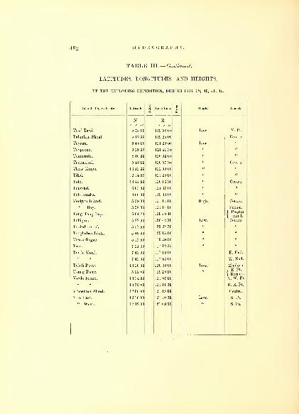
482 H YDRO G II A P [1 V.
TABLE III.— Continued.
LATITUDES, LONGITUDES, AND HEIGHTS,
BY THE EXPLORING EXPEDITION, DURING 1838, 39, 40, 41, 42.
Islands, Capis. 4c. 4c. i
ILongitude. i
sHeight.
N. E.
Tawi Tawi. 5 25 00 119 58 00 Low. N. Pt.
Talanlam Shoal. 5 4:s 00 1 1 9 25 00 Centre.
Teynga. G 44 00 121 29 00 Low.
Teypoono. G 28 00 121 41 30 " "
Temerario. 8 40 00 120 00 00 " "
Teoomabal. 5 48 00 120 57 30 Centre.
Three Kings. 13 12 00 122 00 00 " "
Tilad. 12 1400 121 20 00 " "
Tolo. 13 44 00 120 1G 30 " Centre.
Tong-kil. G 03 00 121 37 00 " "
Tob Bataha. 8 00 00 1 1 9 38 00 " "
Toolyan Island. 5 59 00 121 1400 High. Centre.
" Bay. 5 58 00 121 14 00 Sooloo.
Tong Tong Bay. G 04 20 120 49 40{<BFTobigan. 6 22 00 120 42 30 Low.
Toobaboobook. 5 57 00 120 22 30
Tosan-Bagao. 5 12 00 119 38 00
Tree. 7 21 30 117 12 30
Turtle Shoal. 7 43 00 117 10 00 E. End.
7 43 00 117 0G 00 W. End.
Tubili Point. 13 20 00 120 30 00 Mindoro.
Usang Point. 5 22 00 129 20 00 fE. Pt.,
{ Borneo.
Verde Island. 13 34 00 121 07 00 N. W. Pt.
13 32 00 121 11 30 S. E. Pt.
Vincennes Shoal. 12 0G 00 121 15 00 Centre.
Ylin East. 12 10 00 121 10 30 S. Pt.
" West. 12 12 30 121 08 00 S. Pt.

CURRENTS.

TABLE IV.
In the Introduction to this volume, I have stated that I should
combine, in this Table, the currents and magnetic variations;but, as
I found it would become necessary to place the variations with the
magnetic results, and these could not be introduced in the present
volume, I therefore preferred separating the tables, rather than re-
peating a part of them, thereby avoiding an extra expense at a slight
inconvenience to the navigator, who can refer to them in the next
volume, where the actual observations are given, and the variations
divested of local attraction of the ship. The local attraction of a vessel
is so intimately connected with correct navigation, that it seems almost
incredible how much it has been disregarded. The endeavors to
rectify it, by patent compasses and appliances to overcome the effect of
the subtle fluid, have all proved failures. The deviation, caused by
the iron, should always be practically ascertained by swinging the
vessel before leaving port, noting the bearings of some very distant
object, or that of a compass on shore, where an observer may be
stationed, to take the opposite bearing of the observer on board ship.
The differences found in these sets of observations, will be the correc-
tions, to be applied to the compass on board. When the latitude is
changed from North to South, the corrections are to be applied with a
contrary sign.
The Table of Currents will readily point out to the navigator the set
of the current, its force, and how determined. These, combined with
the variation at the position, with the direction of the ship's head,
will enable him to compare his own results with those recorded.
C. W.

CURRENTS OF THE OCEAN. 485
TABLE IV.
CURRENTS,BY THE EXPLORING EXPEDITION, DURING 1838, 39, 40, 41, 42.
BETWEEN 38° AND 14° N. LATITUDE.
CurienDate. Longitude. Ship s Head.
Direction. Velocity.
N. w.1838. Miles.
August 30. 37 43 54 36 N. E. i E. East. 16
" 31. 38 00 51 24 E. by S.
Septem. 1.
2.
38 00
38 00
46 53
43 50
E. N. E.
E. by S.
" 3. 37 23 42 30 S. by E. \ E. S. 48° E. 12
" 4. 35 53 41 34 S. W. 7
5.
" 6.
36 44
37 04
41 00
40 06
N. by E. i E.
E. by N.
None.
"
7. 37 20 36 34 E. by S. S. J W. 19
" 8. 37 15 34 08 S. W. i w. 12
" 9. 37 19 32 03 E. by S. 22
" 10. 37 39 29 29 East. South. 6
" 11. 37 55 25 44 N. E. by E. W. £ N.f per hour, experiment.
} Near St. Michael's." 12. 38 08 24 57 N. by E. \ E.
" 13. 37 08 23 42 S. E. by S. E. S. E. i per hour, experiment.
" 14. 36 21 22 38 S. E. S. s. w. $ w.
N. W. J W.
14
31
Madeira.
Septem. 25. 31 09 17 58 South. 20 Left Madeira.
" 2G. 28 57 19 00 S. W. West. 11
" 27. 27 17 19 40 N. E. by E. i per hour, experiment.
" 28. 25 00 20 03 I
" 29. 24 32 20 53
" 30. 21 47 21 00 S. W. by S.
October 1. 18 59 20 52 s. s. w. South. 18
" 2. 17 22 20 36 S. by W.
" 3. 16 31 20 39 E. i S. N. E. by N. i per hour, experiment.
" 4. 16 03 21 56 w. s. w. E. N. E. 1
" 5. 15 26 22 49 West. N. by W. 1
Porto Praya.
October 9. 11 36 24 20 S S. W.
" 10. 11 02 24 35 S. W.
122

486 HYDROGRAPHY.
TABLE IV.— Continued.
CURRENTS,BY THE EXPLORING EXPEDITION, DURING 1838, 39, 40, 41, 42.
BETWEEN 12° AND 0° N. LATITUDE.
Date. Latitude. Longitude. Ship's Head.Current.
Remarks.VC'°C 'ty "
1838. o^'
// T'/ Miles.
October 11. 9 36 24 32 S. by E.
" 12. 9 27 24 21 s. w.
" 13. 9 21 24 02 S. £ E. S. E. by E. \ per hour, experiment.
" 14. 8 41 23 40 S. S. W. S. E. by S. |u
" 15. 7 20 22 30 S. E. by E.
" 16.
" 17. 6 36 20 22 East.
" 18. 6 48 20 35 N. E. by E. S. W. by S. per hour, experiment.
" 19. 6 39 20 38 E. by S.
" 20. 6 30 21 35 w. s. w. East. f
" 21. 5 34 22 32 S. W. by W. 12
" 22. 5 40 21 39 S. E. by E. S. E. by E. per hour, experiment.
« 23. 5 39 20 14 S. E. by S.
" 24.
" 25.
5 14
5 07
21 24
21 40
W. by S.
S. W. 1 S.
$. W. u
" 26. 4 00 21 37 E. by S. i S. Sd. & Ed. 10
" 27. 4 05 N. W. i W. i per hour, experiment.
" 28. 3 55 19 21 S. E. by E. No ne.
" 29. 3 42 16 54 No ne.
" 30. 3 37 15 53 No" 31. 3 37 16 59 S. W. by S.
Novem. 1.
" 2.
" 3.
2 51
2 40
1 40
S.
15 11
14 11
15 40
S. by E. i E.
S. W. by W.
Novem. 4. 08
18
34
15 30
17 01
17 25
18 02
18 47
S. W. by W.
W. N. W.
N. W. by W.
W. N. W.
per hour, experiment.
" 8. 18 19 05 E. N. E. West.
9. 1 16 20 26 S. W. i s.
" 10. 2 53 21 03 s. w. Sd. & Wd. 8
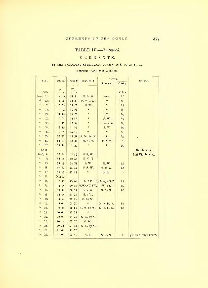
CURRENTS OF THE OCEAN. 4 87
TABLE IV.— Continued.
CURRENTS,BY THE EXPLORING EXPEDITION, DURING 1838, 39, 40, 41, 42.
BETWEEN 0° AND 40° S. LATITUDE.
Date. Latitude. Longitude. Ship's Head. Remarks.Direction. Velocity.
1838.s.
Miles
Nov. 11. 2 35 20 41 N. N. W. West. 25
" 12. 4 25 22 31 S. W. | w. 25
" 13. 5 55 24 25 s. w. « 28
" 14. 8 35 26 29 30
" 15. 11 13 28 27 u 30
" 16. 13 34 30 18 «s. w. 27
" 17. 16 17 32 06 «S. W. A w. 20
" 18. 17 45 34 22 s. w. 20
" 19. 19 57 35 18
" 20. 21 11 36 58 S. W. by W. 15
" 21. 21 51 38 39 w. s. w. S. i w. 12
" 22. 22 48 41 27 « 10
1839. Rio Janeiro.
Jan'y 8. 23 34 43 12 s. s. w. Left Rio Janeiro.
9. 24 02 42 58 E. N. E.
" 10. 24 59 44 31 s. w. s. w. 12
" 11. 27 11 45 47 s. s. w. S. 38 W. 22
" 12. 29 29 47 11 N. E.
" 13.
" 14. 32 02 49 46 W. i s. 2days,S.60W. 60
" 15. 32 38 50 15 S.W.byW.JW. w. is. 15
" 16. 33 31 50 57 S. S. W. N. by W. 12
" 17. 34 48 51 35 S. i W.
" 18. 3G 50 52 42 S. by W.
" 19. 39 00 54 39 N. E. by E. 12
" 20. 39 26 56 01 S. W. by W. N. E. by N. 12
" 21. 40 03
40 04
55 51
57 16 S. W. by S.
" 23. 40 14 59 25 s. w.
" 24. 40 51
41 04
61 32
62 57
S. W. by S.
" 26. 41 o:; 62 46 N. E. w. s. w. per hour, experiment.

<1SS HYDROGRAPHY.
TABLE IV.— Continued.
CURRENTS,' THE EXPLORING EXPEDITION, DURING 1838, 39, 40, 41, 42.
BETWEEN 40° AND 58° S. LATITUDE.
Date. Latitude. Longitude.
1839. o' / o
W'/
Jan. 27. None.
" 28. 41 03 62 32
Feb. 2. 41 26 62 23
" 3. 42 45 61 46
« 4. 43 42 61 27
" 5.
" 6. 44 32 57 55
" y. 45 32 59 05
" 8. 46 35 59 42
" 9. 47 14 59 31
" 10. 48 23 61 38
" 11. 49 04 62 32
" 12. 50 54 65 37
" 13. 51 58 65 02
" 14. 53 11 65 35
" 15. 55 30 66 16
" 1G. 55 48 66 44
April 22. 56 09 69 48
" 23.
« 24.
" 25.
" 2G. 57 28 75 03
" 27. 55 40 76 18
" 28. None.
" 29. 50 40 80 52
May 1.
" 2. 46 12 78 52
" 3. 42 59 77 05
" 4. 42 12 78 08
1
" 6. 40 23 78 03
S. W. by S.
S. E.
S. W. by W.
South.
S. E.
S. W.
S. W. by S.
S. S. E.
S. S. W.
S. W.
S. S. W.
S. W. by S.
S. W.
N. W.
W. N. W.
E. N. E.
North.
W. I N.
N. W. by W.
N. by E.
N. by E.
W. S. W.
N. by W.
per hour, experiment.
Straits of Le Maire.
f Tierra del Fuego.
[per hour, experiment.
Orange Harbor.
S. by E. per hour, experiment.

CURRENTS OF THE OCEAN. 489
TABLE IV.— Continued,
CURRENTS,BY THE EXPLORING EXPEDITION, DURING 1838, 89, 40, 41, 42.
BETWEEN 40° AND 15° S. LATITUDE.
Date. Latitude. Longitude. Ship's Head.Current.
Remarks.Direction. Ve.ocity.
1839.S. w.
o / Miles.
May 7. 40 20 76 37 N.E.byE.i E.
" 8.
« 9. 39 07 75 43 w. i S. N. E. i N. i per hour, experiment.
'< 10. 38 33 75 02 W. by S.
" 11.
" 12. } N.N. E. 1
Off Island of Mocha,per hour, experiment.
" 13. 36 12 74 36 N. E. E. i S. i« 11
" 14. 34 08 73 13 N. by E. East.
June 8. 32 30 73 43 N. E.Valparaiso.
" 9. 32 38 74 48 N. E. by E. J per hour, experiment.
" 10. 32 12 74 21 E. N. E.
" 11. 31 05 74 40 N. E.
" 12. 28 15 74 54 N. W. by W.
" 13.
" 14.
25 20
22 13
76 38
76 39
N. by W.
" 15. No observations.
" 16. 19 23 76 40 N. by W.
" 17. 17 12 76 51
" 18. 15 17 77 02 Westerly set.
" 19. 12 59 77 06 N. i W.
" 20. 12 05 77 12 N. N. W. Off San Lorenzo.
San Lorenzo Island.
July 19. 13 02 88 44 W. by S.
" " P.M. 13 06 86 40 W. S. W.
" 20," 13 38 89 15 S. E. 6i
" 21, A.M. 14 04 91 10 S. 76° W.
" 22, m. 14 26 93 55
« 23, A.M. 14 59 96 47 S. 77° W. 9
" " P.M. 97 14
" 24, A.M. 15 35 99 39 W. by S. N. 59° E. 8
" 25, p.m. 15 40 103 11 S. 72° E.
123

490 HYDROGRAPHY.
TABLE IV.— Continued.
CURRENTS,BY THE EXPLORING EXPEDITION, DURING 1838, 39, 40, 41, 42.
BETWEEN 15c AND 18° S. LATITUDE.
Date. Lat.tude. Longitude. Ship's Head. Remarks.Direction. Velocity.
1839.s. w.
Miles.
July 26, a.m. 15 51 105 56 W. by S.
" " P.M. 15 53 106 08
" 27, A.M. 10 56 108 15 S. W. by W. S. 78° W. 8
" " P.M. W. i S.
" 29, A.M. 17 54 112 53 S. W. by W. S. 72° W.
" " P.M. 112 59 "
" 30, A.M. 17 35 113 31 N. W. i W. N. 80° W. 10
" " P.M. 113 48 W. N. W.
" 31, A.M. 17 05 115 04 w. s. w. N. 31° E. 11
Aug. 2, A.M. 18 08 118 43 West. S.'E. by E. 3
" " P.M. 118.52 W. by S. S. 37° W. 10
" 3, A.M. 18 05 119 40 West. N. 28° W. 10
" " P.M. 120 05 "
" 4, A.M. 18 09 121 03 W. by S. S. 37° W. 20 North i knot,
" " P.M. 121 19 West. per hour, experiment.
" 5, A.M. 18 07 122 31 "S. S. W. 10 N. E. i knot,
" " P.M. 122 47 N. W. per hour, experiment.
" 6, A.M. 18 03 124 19 West. S. 75° E. 7
" " P.M. 124 35 W. by S.
" 7, A.M. 18 14 125 00 S. S. W. S. 31° W. 15 N. E. i knot,
" " P.M. S. S. E. per hour, experiment.
" 8, A.M. 18 09 125 39 West. S. 21° W. 12 N. E. i knot,
" " P.M. 126 20 W. J S. per hour, experiment.
" 9, A.M. 18 10 128 27 S. 16° W. 12 N. E. i knot,
'"' " P.M. per hour, experiment.
" 10, A.M. 18 22 131 15 S. 5° W. 20
" " P.M. 131 36
" 11, A.M. 18 21 133 22
" " P.M. 134 01 W. S. W.
" 12, A.M. 18 33 135 08
" " P.M. 135 23 W. J s.
" 13, A.M. 18 30 136 00

CURRENTS OF THE OCEAN. 491
TABLE IV.— Continued.
C IT II R E N T S,
BY THE EXPLORING EXPEDITION, DURING 1838, 39, 40, 41, 42.
BETWEEN 18° AND 15° S. LATITUDE.
Date. Latitude Longitude Ship's Head.Current.
RemarksDirection. Velocity.
S. w.1839. Miles.
Aug. 13, p.m. 136 10 W. i S.
" 14, P.M. 18 28 136 26 S. W. 4 S. < IfYCleriniiut Tonnerre.
" IG, A.M. 18 21 137 04 W. by N. ( Ml' Searle Island.
" 17, A.M. 18 05 137 12 N. E.
" 18, P.M. 10 30 137 59 N. N. W.
" 19, A.M. 15 23 138 4G " Off Honden.
" " P.M. N.
" 20, A.M. 14 55 138 47 "
" 21, A.M. 14 47 13S 55 S. E. by S.
" 22, A.M. 14 14 140 04 VV. i S. S. 33° W. 9 Honden Island.
" " P.M. w." 23, A.M. 14 02 140 59 " N. 57° W. 15
" " P.M. w. s. w.
" 24, A.M. 14 10 141 17 S. S.E.Off D' x/ntm nt I( jsappointment
" 25, A.M. 14 14 141 10 N. by E. S. 78° W." 2C, A.M. 14 04 141 32 N. i W.
a
" 27, A.M. 14 53 142 34 S. W." 28, A.M.
" <:P.M.
15 4G 143 49 N. 20° W. 8
" 29, A.M. 15 44 144 37 W. N. W. N. 40° W. 15
" " P.M. N. E.
" 30, A.M. 16 04 144 57 S. by W. N. 10° W. 13 Off Raraka.
" 31, A.M. 1G 01 144 59
Sept. 2. 15 52 145 14 N. by E. N. 22° W. 8 Off Carlshoff.
" 3, P.M. 15 29 145 39 N. by W." 4, A.M. 14 38 145 36 N. i E. S. 54° W. 12
" " P.M. S.W.byW.^W.
" 5, A.M. 14 28 145 53 S. E. S. 52° W. 16 Off Waterland.
" 7, A.M. 14 34 146 25 N.
" " P.M. Nairsa Island.
" 8, A.M. 15 00 147 31 S. W. by W. N. 72° E. 11
" 9, A.M. 15 53 148 13 S. S. E.
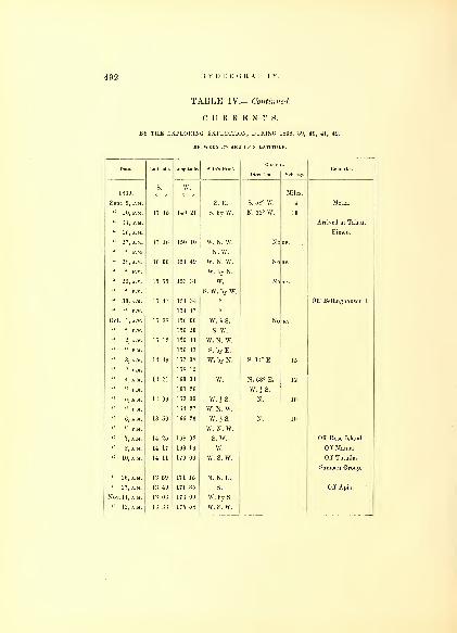
492 HYDROGRAPHY.
TABLE IV.— Continued.
CURRENT S,
BY THE EXPLORING EXPEDITION, DURING 1838, 39, 40, 41, 42.
BETWEEN 17° AND 10° S. LATITUDE.
Date. Latitude. Longitude. Ship's Head.Current.
Remarks.Telocity.
1839.S. W.
Miles
Sept. 9, p.m. S. E. S. 58° W. 4 Metia.
" 10, P.M. 17 15 149 21 S. by W. N. 32° W. 10
« 11, P.M. Arrived at Tahiti.
" 26, A.M. Eimeo.
" 27, A.M. 17 16 150 10 W. N. W. No
" " P.M. N.W." 28, A.M. 16 06 151 49 W. N. W. No
" " P.M. W. by N.
" 29, A.M. 15 55 153 31 W. No
" " P.M. S. W. by \V.
" 30, A.M. 15 47 154 34 Off Bellinghausen I.
" " P.M. 154 47
Oct. 1,A.M. 15 38 156 06 W. i S. No
" " P.M. 156 20 S. W." 2, A.M. 15 12 156 41 W. N. W.
" " P.M. 156 43 S. by E.
" 3, A.M. 14 49 157 38 W. by N. S. 14° E. 15
" " P.M. 158 12
" 4, A.M. 14 21 160 34 W. N. 68° E. 12
" " P.M. 161 26 W. i S.
" 5, A.M. 14 09 163 39 W. i S. N. 10
" " P.M. 164 27 W. N. W.
" 6, A.M. 13 56 166 26 W. iS. N. 10
" " P.M. W. N. W.
" 7, A.M. 14 25 168 02 S. W. Off Rose Island.
" 8, A.M. 14 17 169 16 w. Off Manua.
" 10, A.M. 14 11 170 06 w. s. w. Off Tutuila.
Sarnoan Group.
" 26, A.M. 13 59 171 15 N. N. E.
" 27, A.M. 13 49 171 35 S. Off Apia.
NOV. 11, A.M. 13 06 173 09 W. by S.
" 12, A.M. 13 33 175 58 w. s. w.

CURRENTS OF THE OCEAN. 493
TABLE IV.— Continued.
CURRENTS,BY THE EXPLORING EXPEDITION, DURING 1838, 39, 40, 41, 42.
BETWEEN 14° AND 38° S. LATITUDE.
Date. Latitude. Longitude. Ship's Head.t.
Remarks.Direction. Velocity.
.s. W.Miles
Nov 13 A
M
14 U 17°8 36 S. W. IT« » 14 57 179 35
E.
W. by S.
« 15 A M 15 40 S. W. by W.« (( 10 08 177 13 S. S. W.
" 1G AM 17 47 175 51
u it 18 20 175 35 S. by W.
« 17 AM" " P M 21 14 P4 00 S. W. by S.
" 18, A.M. 22 41 171 55 W. N. W. N. 10° W. 10 S. S. W. 6 fathoms,
" " P.M. 23 11 171 22 S. W. by S. per hour, experiment.
" 19, P.M. 25 08 169 12
w. s. w.
« 2i'am 27 10 l
68
43 S. W. by S. N 15
« "'
P M 16G 26
" 22, A.M. 29 01 164 37« N. 5° W. 10
" 23, A.M. 30 51 1G3 09 N. W. N. 15
" " P.M. S. W. by S.
" 24, A M. 32 10 161 18 S. 17° W. 20
" " P.M. 160 20 w. s. w.
" 25, p.m. 32 5G 160 22 W. N. \V. N. 17° E. 15
" 26, A M. 31 55 159 11 N. 01° E. 10
" " P.M. 158 31 W. by N.
" 28, A.M. 32 15 155 0G S. W. by W. E. 7
" " P.M. 32 30 154 24 S. W. % W.
" 29, A.M. 33 07 152 46 S. 2* per hour, experiment.
" " P.M. 151 58
Dec. 27, p.m. 35 42 151 04 S. by E.
Port Jackson.
" 28, A.M. 36 48 151 00 S. S. 30
" " P.M. 37 04 S. S. E.
" 29, A.M. 38 35 150 54 S. by E. s. s. w. 17
124

494 HYDROGRAPHY.
TABLE IV.— Continued.
CURRENTS,BY THE EXPLORING EXPEDITION, DURING 1838, 39, 40, 41, 42.
Date. Long.tude. Sh.p's Head.Curren
Direction. Velocity.
s. E1839. a
'
/ Miles.
Dec. 29, p.m. 39 04 S. S. E.
" 30, A.M. 40 41 151 03 "S. W. 20
" " P.M. 41 15
" 31, A.M. 42 47 151 47 N. \V. 10
" « P.M. 43 10 S. by E. S. 85° E. 7
1840.
Jan. 1, p.m. 46 20 151 50 S. 10° E. 10
" 2, A.M. 48 11 151 48 "
" « P.M. S. E.
" C, A.M. 53 24 157 15 8. E. by E. N. 48° E. 30
" 7, A.M. 54 20 160 47 S. S. E. 15
" 8, P.M. 56 02 162 40 E. 8. E. 20
" 9, A.M. 57 54 162 56 S. S. E.
« " P.M. 58 38 163 11 S. E. by S.
" 10, AM. 61 04 162 42
" 11, P.M. 64 11 164 53 S. by E.
" 13, A.M. 64 52 164 37 S. W. i S.
N.
" 14, A.M. 63 55 164 01 N. by W. \ W.-3
" 15, A.M. 64 59 160 32 S. by W.
Go 37 159 25
« 16, A.M. 66 00 158 56 E. by N.
W. by N.
" 17, P.M. 65 54 157 05 s. s. w.
" 18, A.M. 65 45 156 07 S. | w.
« 19, A.M. 66 19 154 12 W. N. W." 20, A.M. 65 41 153 46 N. W. i N.
66 09 152 34 S. S. W. i W." 21, A.M. 66 07 151 25 S. W. by S. H
06 27 151 05 S. E.
" 22, A.M. 66 12 149 43 W. N. W.« 23, AM. 66 46 148 04 N. W. by N.

CURRENTS OF THE OCEAN. 495
TABLE IV.— Continued.
CURRENTS,BY THE EXPLORING EXPEDITION, DURING 1838, 39, 40, 41, 42.
BETWEEN 67° AND 49° S. LATITUDE.
Date. Latitude. Longitude. Ship's Head.Direct
Currei
on. Velocity.
Remarks.
S.
o /
E.1840. / Miles.
Jan. 25, 67 04 147 42 S. W. by W.
« 27, A.M. 142 20 VV. N. W. % W.
" " P.M. 65 45 141 56 W. N. W.
" 28. S. S. E.
« u 66 32 140 24 s. s. w.
" 29. 63 30 140 50 S. S. E.
" 30. 66 13 140 02 S. S. W.
Feb. I.a.m. 65 52 138 02 "
" " P.M. 66 12 137 22 N. i W.
" 5, A.M. 64 06 133 42 W. N. W.
" 6. 63 40 134 35 S. S. W.
" 7. 64 19 131 12 s. w.
" 8. 65 03 128 50 N. W. by W.
"1), A.M. 65 03 125 19 W. N.W. J W.
%tarcl
" " P.M. 65 08 124 20 W.% <
E.
" 10, A.M. 65 27 121 35
" " P.M. 66 44 120 06 W.'1
alo
E.
" 11, A.M. 65 04 116 20 N. W. £ W.
" 12, A.M. 64 57 112 16
111 20 W.
" 14, A.M. 65 59 106 18 E. N. E.
" 18, A.M. 63 31 98 50 s. s. w." 20, A.M. 62 08 101 43 N. N. E.
" 21. 61 34 100 49 W. N. W." 22, A.M. 59 42 101 57 N. E. by N. N. 50 E. 10
" 23, a.m. 56 04 105 16 E. N. E. N. 60 c E. 10
" 29, A.M. 50 01 133 10 E. N. 84 E. 15
Mar. 1,a.m. 49 25 135 45 E. by N. N. 61 E. 17

496 HYDROGRAPHY.
TABLE IV.— Continued.
CURRENTS.BY THE EXPLORING EXPEDITION, DURING 1838, 39, 40, 41, 42.
BETWEEN 49° AND 28° S. LATITUDE.
Date. Latitude. Longitude. Ship's Head.CurreD t.
Remarks.Direction. Velocity.
1840.8°
E.Miles.
Mar. 1,p.m. 136 49 E. i N. N. 61° E.
" 2. 49 32 139 45 S. 90° E. 12
" 3. 49 42 143 35 N. E. S. 50° E. 13
" 4, P.M. 46 56 146 34„ W. N. 55° E. 10
" 5, A.M. 147 40 N. N. 12
« C, A.M. 43 36 149 51 N. by E. N. 65° E. 25
41 58 151 32 N. N. 12° E. 35
" 8. 40 13 151 09 W. N. W. N. 75° E. 12
" 9, P.M. 38 151 15 N. 1 W. N. 83° E. 20
" 10. 36 30 150 43 N. N. W. S. 17
" 11. Arrived at Sydney.
" 20.
" 21. 154 26 N. bv E. S. 43° W. 15
" 22. 34 54 156 41 N. E. by E. S. 62° E. 10
" 23. 34 14 157 17 E. N. E. N. 5° W. 15
" 24. 34 00 159 42 E. by N. S. 17° E. 23
" 25. 34 23 161 09 E.N.E.^E. S. 51° E. 17
" 2G. 34 24 163 25 S. 53° E. 19
" 27. 34 15 166 10 N. 22° W. 15
" 28. 33 49 170 39 E. N. 60° W. 25
" 29. 33 45 173 44 S. E. by E. S. 59° E. 15
" 30. 35 07 174 18 S. E. by S. Anchored at Bay of Isl-
ands, New Zealand.
April 7. 33 50 175 58 N. S. 60° E. 10
" 8. 32 48 177 07 N. by E. N. 65° W. 12
" 9. 32 24 177 51 N. S. 20° E. 7
" 10. 31 11 178 06 S. 50° E. 9
" 11. 29 16 178 22 E. S. E. N. 45° W. 10
" 12. 30 19 178 52 E. N. E. S. 55° W. 22
" 13. 29 36 179 41
W.
N. E. by N. E. 12 Off Raoul Island.
" 14. 28 58 178 35 E. E. 10
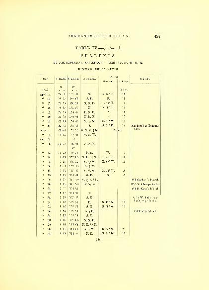
CURRENTS OF THE OCEAN. 497
TABLE IV.— Continued.
CURRENTS,BY THE EXPLORING EXPEDITION DURING 1838, 39, 40, 41, 42.
BETWEEN 28° AND 4° S. LATITUDE.
Date. Latitude. Longitude. Ship's Head.Current.
Remarks.Direction. Velocity.
S. w.1840. o / o / Miles
April 15. 28 41 177 46 N. N. 66° E. 12
16. 28 27 177 03 S. E. S. 10
" 17. 176 20 N. N. E. S. 85° E. 8
18. 2Q
r
07 17o 2a * N. 33° E. 12
19. 2a (. 1,4 4a <. . <. 10
20. 24 6 174 47 N. by E. 15
22 . 9 174 49 N. by A\
.
S. 31° W. 15
" 23. 21 36 175 10 S. S. 61° E. 10 Anchored at Tongata-
May 4. 20 o4 17o 32 W. N. Wr. & W. No tie.
boo.
19 51 1,7 43 W. N. A\
.
Aug. 11.
12. 14 45 179 4a N. N. E.
N. E. W. 7
« 14 ^ 56 rr 03 N. E. by N. S. 45° E. 12
" 15. 7 25 176 22 N. by W. N. 85° W. 15
" 16. 5 49 175 48 N. i W.
" 17. 5 35 175 15 N. N. W. N. 32° W. 18
" 18. 5 58 174 41 S. E. S. 15
" 19. 4 37 174 40 N. by E. 1 E. Off Gardner's Island.
" 20. 3 41 174 20 N. by E. W. 1 N. 6 fras.pr.br. ex.
" 21. 3 11 174 22 Off McKean's Island.
2 47 174 12 E.
" 23. 3 28 173 42 S. E. S. by W. 4 fms. per
" 24. 3 33 172 57 E. S. 35° W. 15hour, experiment.
" 25. 3 46 172 30 S. E. S. 30° W. 12
" 26. 4 29 172 21 S. h E. Off Hull's Island.
" 27. 5 02 172 14 S. E.
" 28. 4 40 172 03 N. N. E.
" 29. 3 08 171 08 N. E. by N.
" 30. 3 48 171 50 S. S. W. S. 35° W. 24
" 31. 4 45 171 43 N. E. S. 32° W. 20
125

49S HYDROGRAPHY.
TABLE IV.— Continued.
CURRENTS,BY THE EXPLORING EXPEDITION DURING 1838, 39, 40, 41, 42.
BETWEEN L° S. AND 2-1 N. LATITUDE.
Date. Latitude. Longitude. Ship's Head.Current.
Remarks.
1840.s. w.
Miles.
Sept. 1. 5 47 170 35 E. i S. No
" 2. 4 44 169 46 N. E. No le
::. 1 50 168 23 a N. 54° W. 20
N.
" 5. 3 13 167 25 N. E. by N. N. 10
" G. 4 40 165 57 E. N. E. N. 19° W.
7. 6 12 164 09 N. E. by E. N. 40° E.
" 8. G 48 163 03 N. E N. 76° E. 20
" 9. 7 10 162 33 S. 70° E. 15
" 10. 8 00 161 10 S. 80° E.
" 11. 10 00 161 13 N. i W. N. 85° W. 10
" 12. 12 12 161 02 N. i E. N. 40° W. 12
" 13. 13 58 161 22 N. i W. N. 42° W. 10
" 14. 15 56 161 27 N. by W. N. 28° W. 10
" 15. 17 39 161 35 N. i E. N. 80° W. 8
" 16. 19 52 161 27 N. % W. N. 35° W.
" 17. 21 33 161 31 S. E. by E. N.
" 18. 20 12 160 26 W. 13
" 19. 20 21 159 40 N. N.
" 20. 21 13 158 54 Current setting to the
" 21. 21 11 158 42 westward, but of no
Dec. 4.
" G.
li7.
22 03
22 52
22 12
156 16
154 30
153 18
N. N. E.
E. i S.
S. E. by E.
Westward. strength.
Anchored at Hilo.
1841.
April 7. 22 10 159 11 N. W. by N. Variable.
" 8. 23 38 160 09 N. 52° W. 25
" 9. 24 08 160 39 W. N. W. S. 25° W. 15
" 10. 24 46 161 54 N. W. N. W. 5
" 11. 24 46 160 31 E. N. E. S. 28° E. 20

CURRENTS OF THE OCEAN. 4!)!)
TABLE IV.— Continued.
C U 11 II E N T S,
BY TOE EXPLORING EXPEDITION DURING 1838, 39, 40, 41, 42.
BETWEEN AND 20° N. LATITUDE.
Date. Latitude. Longitude. Ship's Head.Curreti
Direction. Velocity.
Remarks.
1841. Miles.
April 12. 25 34 1G0 23 N. W. by N. N. 8 S. E. 2 fms. per boar,
" 13. 25 55 1G0 43 N. N. 37° W. 10experiment.
" 14. 2G 43 KiO 25 N. by E. W * 10
" 15. 28 28 lo9 3.2 S. 33° E. 8
" 1G. 30 14 157 0G N. E. by N. N. 84° E. 15
" 17. 31 11 155 30
" 18. 32 11 154 1G
" 19. 33 12 152 3G N. 12
" 20. 34 42 lo3 42 N. W. S. 52° W. 10
" 21. 37 14 152 21 S. 33° E. 8
" 22. 40 01 149 30 E. 10
" 23. 43 01 14G 07 N. E.
" 24. 44 32 142 10 N. E. by N. S. 23° E. 4o
" 25. 4o 5t> 137 0G N.E.
" 27. 4G 10 128 13 40
May 2. Anchored in Port Dis-
Nov. 5. 32 11 12G 05 S. 25° W. 33
" 7. 27 01 131 47 S. 41° W.
" 8. 25 02 134 01 S. 73° E. 10
" 9. 23 15 13G 03 S. 5° E. 8
" 10. 21 09 138 30 S. 41° W. 8
" 11. 21 02 141 35 N. 50° W. 20
" 12. 20 50 144 37 N. G3° E. 12
" 13. 20 44 148 29 S. 61° E. 10
" 14. 20 08 150 49 N. 85° W. 8
" 15. 20 07 153 23 N. 42° W. 15
" 16. 21 05 15G 37 W. 10
" 17. Ancliored at Honolulu.
" 28. 21 19 158 4G
" 29. 20 2G 1G0 27 N. 82° W. 22

500 HYDROGRAPHY.
TABLE IV.— Continued:.
CURRENTS,BY THE EXPLORING EXPEDITION, DURING 1838, 39, 40, 41, 42.
BETWEEN 19° AND 14° N. LATITUDE.
Date. Latitude. Longitude. Ship's Head. Remarks.
1841. o
N'/
o'/ Miles.
Nov. 30. 19 02 162 31 N. 65° W. 8
Dec. 1. 19 19 165 25 S. 81° E. 7
" 2. 19 21 167 36 N. 71° W. 12
" 3. 18 21 171 04 N. 65° W. 8
" 4. 1C 34 173 20 N. 14° W. 25
" 5. 15 18 175 25 N. 22° W. 17
" 6. 15 07 176 58 W. by S. N. 66° W. 25
7. 15 08 178 20
E.
N. 39° W.
" 9. 14 55 179 57 » *N. 86° W. 32 * Two days.
" 10. 14 56 178 52 S. 84° W. 19
" 11. 14 58 177 44 « N. 84° W. 19
" 12. 14 47 176 45 W. N. W. S. 81° W. 25
" 13. 14 57 175 39 w. s. w. N. 85° W. 13
" 14. 15 00 174 50 W. by S. N. 10° W. 6
" 15. 15 33 172 34 W. *N. N. 55° W. 13
" 16. 16 02 170 55 W. by S. S. 49° W. 11
" 17. 16 54 168 55 N. W. by N. N. 83° W. 16
" 18. 18 29 168 25 N. by W. 1 W N. 35° W.
" 19. 19 04 167 36 W. by N. S. 11° W.
" 20. 19 14 166 30 W. by S. S. 88° W. 27
" 21. 19 24 165 04 Off Wake's Island.
" 22. 19 13 163 40 ST. 56° w. 15
» 23. 18 54 162 11 N. 50° W. 10
" 24. 18 42 159 44 S. 50° E. 13
" 25. 18 15 155 41 w. s. w. 4
" 26. 18 48 152 28 w. E. 2
" 27. 18 57 150 02 S. 67° E. 8
" 28. 19 13 147 50 w. \ s. N. 35° W. 17
l:29. 19 15 145 25 S. 84° W. 11
" 30. 19 32 144 48 Off Assumption T.
" 31. 19 34 114 20 W. by N. N. 2

CURRENTS OF THE OCEAN. 501
TABLE IV.— Continued.
CURRENTS,BY THE EXPLORING EXPEDITION, DURING 1838, 39, 40, 41, 42.
BETWEEN 19° AND 2° N. LATITUDE.
Date latitude longitude 'hip's Head Rem kDirection. Velocity.
N. E.1842. Miles.
Jan. 1
.
19 40 140 54 W. N. 73° W. 8
" 2. 19 59 138 08 W. S. W. E.
" 3. 19 35 134 28 VV. by N. i N. N. E. 3
" 4. 20 11 131 24 W. i N. W. 9
20 17 129 20 S. 80° W. 22
" G. 20 23 126 30 W. N. 35° W. 10
" 7. 20 26 124 28 W. by S. N. 5° E. 15
" 8. 20 10 121 33 " N. 21° W. 23 Bashee Passage.
" 9. 19 08 119 35 S. N. 17° W. 25
« 10. 15 5G 119 29 "
" 12. Anchored in Manilla
" 24, A.M. 12 03 121 08 S. E. by E.
" " P.M. 12 13 120 58 N. by W. 1 W.
" 25, A.M. 12 0G 12L 09 S. E.
" " P.M. 12 13 121 21 N. N. W.
10 55 121 51
" 30. Anchored at Caldera.
In the Straits of ISasi-
Feb. 2. 6 37 121 12 S. by E. &N. N. W.
lan, tides set N.N.W.and S. by W.
" G. G 07 120 41 W. i N. Anchored at Soung. Off
" 7. 7 03 118 49 N. W. by W. w. s. w. 3 per hr.Soung tidi;s irregular,
influenced by winds.
Current sets in Feb'y
north vv'd and westw'd.
" 13. 7 3G 115 07 W. N. 5° E. 18 Anchored near Mang-
" 14. G 50 112 52 W. by S. N. 22see Islands.
Current setting to the
" 15. G 35 110 30 13 W.S.W. G fms.pr.hr.
" 16. 5 48 108 44 S.W.byW.JW W. 12Tide sets S. S. E. andN. W. by N.
« 17. 4 50 106 41 S. W. s. w. 10
" 18. 2 59 104 45 Anchored at Singa-
pore.
Straits of Banca. Cur-
rent in Straits S.W.JS. 1 mile per hour.
126
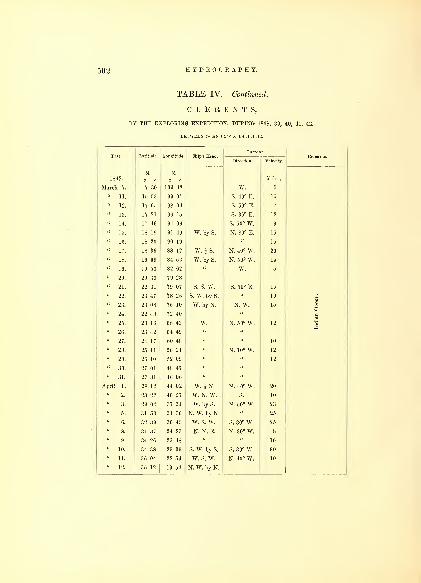
502 HYDROGRAPHY.
TABLE IV— Continued.
CURRENTS,BY THE EXPLORING EXPEDITION, DURING 1838, 39, 40, 41, 42.
BETWEEN 7° AND 35° S. LATITUDE.
Date. Latitude. Longitude. Ship's Head. Remarks.Velocity.
1842.S. E.
Miles
March 7. 7 30 103 42 W. 5
" 11. 15 53 99 07 S. 40° E.
" 12. 17 05 98 04 7
" 13. 17 21 96 15 S 35° E ] 2
" 14. 17 4G 94 06 S. 50° W.
18 19 91 49 W. by S. N. 80° E. 15
" 10. 18 20 90 19 15
" 17. 18 3G 88 12 W. } S. N. 40° W. 20
" 18. 19 09 84 56 W. by S. N. 50° W.
" 19. 19 53 82 02 W.
" 20. 20 33 79 28
" 21. 22 31 79 07 S. S. W. S 50° E 15
" 22. 23 47 78 2G S. W. by S. u 10
" 23. 23 08 76 10 W. by N. N. W. |O
" 24. 22 48 72 40
" 25. 23 1G 68 43 W. N. 50° W. l" 26. 23 42 64 49
" 27. 24 17 60 48 10
" 28. 25 11 56 24 N. 10° W. 12
" 29. 2G 10 52 09 12
" 30. 27 01 48 47
" 31. 27 31 4G 06
April 1. 28 12 44 02 W. i N. N. 40° W. 20
2. 28 22 40 57 W. N. W. S. 10
" 3. 29 04 37 31 W. by S. N. 50° W. 23
31 53 31 30 N. W. by N.
" G. 32 39 30 45 w. s. w. S. 30° W. 25
" 8. 34 37 24 23 N. N. E. N. 30° W. 8
" 9. 34 2G 23 48 10
" 10. 34 38 23 39 S. W. by S. S. 30° W. 30
" 11. 3G 04 22 54 w. s. w. N. 40° W. 10
" 12. 35 12 19 54 N. W. by N.

CURRENTS OF THE OCEAN. 503
TABLE IV'.— Continued.
CURRENTS,BY THE EXPLORING EXPEDITION, DURING 1838, 39, 40, 41, 42.
BETWEEN 32° S. AND 1° N. LATITUDE.
Date. Latitude. Longitude. Ship's Head.Curre
Direction.
t.
Velocity.
Remarks.
s. E.1842. o / o / Miles.
April 14. Anchored in Table
" 19. 32 37 15 25 W. by S.Bay.
" 20. 31 22 13 45 N. W. by W. N. 35° W. 20
'•'
21. 30 50 12 36 N. W. by N. 13
" 22. 29 53 11 34 W. i S. N. 10° E. 15
" 23. 28 25 8 51 N. W. by N. 12
" 24. 2G 48 6 25 N. N. W. N. 10° W. 12
" 25. 25 25 4 53 N. by E. 7
" 2(3. 24 45 4 0G N. N. W. N. 5° W. 10
" 27. 23 30 2 42 10
" 28. 22 23 1 17 10
W.
" 29. 20 33 50 10
" 30. 18 20 2 41 N. by W. i W. N. 15
" 3.
1G 18 5 17 N. N. W. i W. Anchored at St. He-
14 41 7 14 S. W. 13lena.
" 4. 13 22 9 10 N. W. by N. N. 15° W. 10
12 01 11 04 10
" G. 10 5G 12 34 N. 10° E. 10
" 7. 9 46 14 02 N. W. by W. 10
" 8. 9 19 16 00
" 9. 8 53 17 15
" 10. 8 24 18 48 E. 10
" n- 7 09 21 11 N. W.
" 12. 23 37
" 13. 4 12 25 26 N. W. by W.
« 14. 3 10 27 51 N. W. by N. S. 8
" 15. 1 4G 29 31 N. N. W. s. w. 30
" 16. 30 30 30 S. 67° W. 28
N.
" 17. 33 31 02 N. W. by W. S. 49° W. 30
" 19 - 1 44 32 57 N. byW.i W. S. 10° W. 10
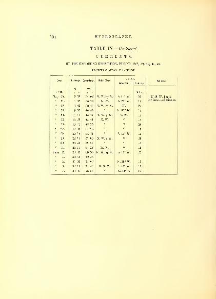
504 HYDROGRAPHY.
TABLE IV.— Continued.
CURRENTS,BY THE EXPLORING EXPEDITION, DURING 1838, 39, 40, 41, 42.
BETWEEN 2° AND 34° N. LATITUDE.
Date. Latitude. Longitude. Ship's Head. Remarks.Velocity.
1842.N. W.
Miles
May 20. 2 58 34 02 N. W. by N. S. 14° W. 30 W. S. W. 1 mile
« 2J. 4 37 36 19 N. W. S. 20° W. 10per hour, experiment.
" 22. 6 40 38 46 N. W. by N. W. 25
" 23. 8 52 40 56 N. 85° W. 10
" 24. 11 17 43 17 N. W. i W. S. W. 15
" 25. 13 22 45 44 N. W. 18
" 2G. 15 47 48 29 20
« 27. 18 02 51 25 10
" 28. 20 18 54 17 S. 15° W. 10
" 29. 22 16 57 09 N. W. J- W. 10
" 30. 23 50 59 26 12
" 31. 25 13 61 23 N. W. 10
June 2. 29 35 68 39 N. W. by W. S. 10° W. 25
" 4. 30 40 70 16
3.1 00 71 03 N. 20° W. 10
" 6. 32 18 71 49 N. N. W. S. 40° W. 15
7. 34 01 72 50 N. 50° E.
INDEX.
Abajos, 287 Astronomical Observations, 16
Admiralty Islands, 361 Astrolabe Gut, 77
Inlet, 308 Eeef, 178
Adams' Point, 333 Asaua Islands, 232
Adolphus Eeef, 164 Assumption, 286
Agulhas Bank, 97 Asau Bay, 125
Agate, 239 Astoria, 338
Abii, 101 Auckland Islands, 252
Alden, 236 Avia, 160, 162
Aliki Point, 233 A via, 155
Alota Islet, 147 Avon, 278
Alcantras Island, 347 Avau Passage, 299
Alaki Creek, 310 Awakalo, 231
Ambatiki, 175 Bellaco, 55
Ambolau, 359 Barometer, 60
Ampuyan, 361 Bay of Islands, 76
Antarctic Cruise, 73 Balabac, 89
Angau, 172 Basilan, 91
Annan Islands, 196 Bashee Islands, 88
Anganga Islands, 205 Bataka, 92
Androna, 234 Bancoran, 92
Anna, 138 Bajo Nuevo, 92
Angelos Point, 308 Balabac, 94
Antique Point, 356 Bangney, 94
Roads, 356 Banca, Straits of, 94
Apolima, 135 Bacon's Isles, 157
Apo Sboal, 90 Ba Bay, 194
Apia, 135 Batia Bay, 194
Apataki, 105 Baldwin, 241
Apamama, 262 Bateman, 244
Apia, 265 Baring Island, 282
Aratica, 105 Batan, 287
Arutua, 107 Baker's Bay, 335
Aro;158 Bag Island, 340
Arrowsmitb, 281 Basaltic Cliff, 340
Argus Bay, 310 Balota Point, 361
Asaua Group, 232 Basillan, 363
127

500 INDEX.
Balabac, 364
Banguey, 364
Bagabatan, 358
Baloganon (Kamposon), 359
Bassillan Straits, 360
Balcouts, 118
Batan, 290
Bellinghausen, 247
Bellingham Bay, 308
Bee Point, 339
Bell's Bluff, 340
Bell's Beef, 163
Bird Island, 189
Biva Island, 240
Bird Island, 273
Bigini Island, 284
Blunt's Island, 311
Blake's Island. 318
Bonqueron Channel, 65
Borobora, 111
Bocatanoa, 156
Bonham Island, 282
Boston Channel, 339
Borneo Island, 362
Bonetta Point, 352
Bowditch, 122
Brothers Two, 95
Brown's Beef, 165
Breekenridge Bluff, 329
Brown's Point, 332
Buyers, 101
Budd Island, 165
Buia Passage, 209
" Point, 228
Budd's Harbor, 312
Busvagan, 357
Birnie, 119
Byer's Island, 277
Byron's Island, 271
Case, 236
Capes of Virginia, 39
Cape de Verdes, 44
Callao, 65
" to Tahiti, 66
Cavite, Port of, 89
Caldera, Port of, 91
Caga}Tan Sooloo, 92
Cayanes Isle, 92
Cayos, 92
Cape Town, 98
Carr, 236
Carr's Harbor, 170
Cabeva, 213
Canal de Arro, 307
Cabras, 354
Calaviti, 354
Cavallos, 350
Cama, 354
Calamines, 354
Camden Shoal, 357
Caluhia Island, 358
Cabreja, 360
Cavili, 360
Caldera Bay, 360
Caponi Point, 364
Celebes, 362
Chronometer Makers, 4
Bates in Tables, 20, 37
Charlotte Ship, 43
Chichia, 158
Chicks, 154
Charley's Harbor, 171
Chicobea, 245
Christmas Island, 271
Charlotte, 261
Chinook, 332
Chikeelis Biver, 332
Clatsop Channel, 332
Clerment de Tonnere, 102
Coral Island Surveys, 5
Coxs'comb, 57
Cook's Straits, 71
Corregidor, 88
Cold Water, 98
Colvo Harbor, 170
Corobatoo Pk., 203
Copper Island, 272
Cooper Island, 272
Cornwallis Island, 279
Copper Island, 286
Commencement Bay, 319
Corobamba, 177
Cobu-rock, 177
Cocoanut Island, 133

Corobata, 177 Ellice Pt., 332
Cochinos, 354 Mid Islet, 339
< 'i>
11 1ml ua 1 > i ver, 333 Ellice's Group, 457
<(
o\\ itchen Pk., 329 Elliot's Harbor, 189
Crossing the Equator, Pacific, 80, 81 Eld 239
( h'ockatoa, 95 1 .11 li i' >S 1 SIH1H1S,
(' raven , 236 Km m on s, 236
Currents, 19, 46 Embarcadero, 89, 353
Current, 57 Fnkaha, 153
Current, 62, 65 Pn/lni.Kiii.i.T-11 HQljiHK'i inn rj s, i lo
ourient, oi En o--~y"ai °'ht 250
ourtis, jOU Enfant Perdu, 253riiii.Q Tela OT7 Eoa, 146
Cuyos, 357 Eooa, 77
Currents 484 Lquatoiial Passage, o53
jjamoioo n., sou l'.i[iial<»i' ( rossing, 4b
Davis Isle, 236 Esperance, 256
Datcr Pt., 362 Esperance, 250
Davis, 211 rjVailkl, Lit
Daniels, 281 Evva, 300
1 luckboard, 6 Fxploring Isles, 160
Deception Passage, 311 Farallarones, 251
Destruction Islet, 84 Falmouth Bank, 354
DeHaven, 168 Fafo Reef, 234
Depeysters, 255 Fagaitua Bay, 138
Disappointment Cape, 333 Fangaloa, 127
Diva, 236 Fanuatupu, 132
Dille Ovolau, 184 Falifa, 127
Dimba Dimba, 233 1' alcahli, loo
Diamond Hill, 298 Falialupu, 129
UibDies Keer, loo Faleaufo, 122
Dilathoa Peak, 173 Fulanga Passage, 78, 166
Dillon's Rock, 206 Farallones, 348
Drummond's, 259 Faliki Harbor, 236
Druau Islet, 213 Fasoilup, 282
Dick's Run 339
Doughty Reef, 161 Feejee Group, 78, 437
Duke of Clarence, 122 Feis, 282
Duncan Rock, 306 Flint's Island, 246
Dyes' Reef, 165 Flattery Cape, 84
Eagle, 339 Flyingfish Shoal, 177
Eclipse of Sun, 16 Flattery Cape, 306, 329
Eimeo Island, 117 Forefinger, 184
Eimeo, 68 Folger, 87
Eimeo, 111 Folgers, 284
Ellice's Group, 256 Fox Island, 236
Eld, 236 Fort Pt., 350

508
Francis I., 268 Hales' Passage, 308
Frazer's Eiver, 329 Huahine, 111
Framboise Bluff, 340 Hawkins, 158
Friar Eoeks, 354 Hanson Pt., 332
Francis, 271 Haycock Islet, 215
Frio Cape, 50 Helix Beef, 361
French Shoal, 45 Hermit Islands, 57
Fronton Isle, &c, 65 Henderville, 261
French Frigate Shoal, 274 Helaron Pt., 300
Funchall, 40 Herchell, 109
Garnctt, John, 47 Henrietta, 209
Gardner's Island, 248, 275 Henry, 244
Gaspar Rico, 279 Hilo, 292
Good Hope, Cape of, 98 Honolulu, 30, 293
Gordon, 158 Homes Pt., 354
Goat Island, 219 Horsburg, 354
Goree Eoads, 58 Hoorn Island, 253
Good Success Bay, 57 Hood's, 261
Golcouda Shoal, 92, 359 Horadada Bock, 65
Goro, Sea of, 177 Hopper's, 262
Goro, Island of, 177 Houses, Portable, 4
Green Pt., 233 Honga Tonga, 78
Gran Coral, 256 Hout's Island, 95
Gray's Bay, 336 Holmes, 165
Harbor, 329 Hornet Harbor, 310
Grenville Pt., 332 Horseshoe Reef, 177
Green Water, 42 Honden Island, 101
Great Circle, Sailing, 47 Hormes, 274
Groups, Two, 110 Hornet Harbor, 310
Granby Harbor, 190 Hudson, 256
Gretton Bay, 58 Hualailai, 292
Grigan, 88, 289 Hull's, 119
Great Western Beef, 232 Hupo Point, 225
Gulf Stream, 39 Hudson Isles, 242
Guiniari, 359 Hunter, 282
Hawaii, 290 Huahine, 111
Hawaian Group, 291 Hydrographical Atlas, 93
Haabai, 147 Ice Islands, 52
Halls, 261 Indian Ocean, 96
Hawaian Islands to Coast of Oregon, 82 Islands of South Pacific, 458
Halcyon Island, 87 Islands of North Pacific, 459
Hawaian Islands to Manilla, 87 Ivaca Pk., 205
Halcon, Captain, Spanish Navy, 89 Jaspar Straits, 94
Hawaian Group, 461 Jarvis Island, 247
Hau or Bow Island, 101 Jane's, 278
Hartwell Beef, 43 Johnson's Island, 240
Halcyon Island, 284 Juan de Fuca, 300

Katalemet Hd., 339 Kapoho, 290
Island, 339 Kuisick, 233
Kaula, 305 Kuria;, 261, 262
Kalulawe, 298 Loudolib, 182
Kawaihua, 291 Lanagi, 177
Kalua, 300 Latonga, 127
Kawaib.ee, 294 Laulii, 127
Kailau, 291 Ladrones, 88, 290
Kawili, 293 Lanai, 296
Kalae, 293 Labua, 291
Kan las, 291 Labaina Boads, 294
Kauai, 301 Labaina, 293
Kai, 335 Lala Beef, 234
Karkuines, 349 Labna, 305
Kambara, 78, 153 Laeloa Ft,, 300
Kawahe, 104 Lanii, 299
Katafanga, 159 Langley Fort, 330
Kamba, 184 Lawrie's Bay, 255
Kasoa Beefs, 192 Latitudes, 15
Kahoolawe, 292 Lakemba, 157
Kauai, 301 Lanthaula, 210
Kealakeakua Bay, 291 Layson's Island, 276
Kermadec Island, 253 Lanai, 296
Kendikendi, 156 Land and Sea Breezes, 371
Kealaikabiki, 293 Lada Beef, 182
Kantavu, 177, 180 Levu, 236
Kanathia, 162 Leeki, 300
Kealaikabiki, 293 LeadiDg-in Cliff, 335
King's Mill Group, 258 Loueonia, 256
" Chart, 70 Lewis, 236
Kintsbolta, 340 Leven, EL B. S., 43
Kiole, 236 Lewis' Beef, 163
Knox, 241, 261 Leonidas Island, 206
Koltze, 340 Lewis, 241
Kohala. 292 Lisiansky Isle, 276
Komo, 154 Leluvia, 183
Komorike, 154 Lima, 350
Konapotu, 154 Little Finger, 339
Korotuna, 165 Libraries, 4
Korsakoff, 285 Lingin Island, 94
Kombelan, 227 Likelike, 154
Korai, 236 Leku Island, 191
Kutzule Bay, 335 Linthicum, 214
Kuset, 307 Lovita Hd., 340
Kuia, 296 Lower Flats, 338
Kutoo, 147 Longitudes, 15
128

510 INDEX.
Loo Eock, 41 Moala, 171
Long of Wharf, Sau Lorenzo, 06 Motuutu Islet, 113
Lord Howe's Island, 09 Moturiki Passage, 182
Long Pt., 218 Mokangi, 200
Luzon, 88 Mokundranga, 200
Lucepara Passage, 95 Mokungai Passage, 200
Mauritius, 96 Monkey-Face Passage, 205
Manhii, 106 Morrell, 280
Mataiwa, 108 Monsoons, 276
Metia, 108 Monk Rock, 213
Malata, 160 Moku, 214
Matau Reef, 154 Mumbolithe Reef, 173
Maury, 165 Munia, 161
Matuku, 170 Mukulau, 185
Maurua, 111 Murderer's Bay, 208
Matia, 111 Mulgrave, 282
Matavia Bay, 112 Nalico Pt., 177
Malatta, 161 Nanouki, 263
Malina, 163 Namea, 133
Malcvouron Reef, 150 Nairai, 177
Mango, 150 Nangati, 236
Madono, 189 Naviti, 236
Malaki Tsland, 195 Nasog Pt., 357
" Passage, 197 Nameless, 261
Marina Reefs, 201 Naisa, 106
Mali Passage, 211 Naitamba, 163
" Shoals, 211 Nanuku, 164
Matangi, 220 " Passage, 164
Matathoni, Levu, 238 Naiau, 157
Malolo, 242 Nukulau, 185
Malololailai, 242 Nam, 159
Malolo Passage, 243 Navula Passage, 191
Maiana Island, 263 Naingani, 199
Maraki, 266 Natu, 207
Man-of-War Rock, 275 Nanuia, 237MoT./-l Poof OTKm ;u o \\ eer, s i o N augat i, 237
Malloon's Island, 277 Naviti Passage, 238
Mamuki, 291 Narrows, 319
Maury's Island, 318 Nacussa Pt,, 215
M'Benga Island, 188 Naloa Bay, 207
Reef, 189 Navy Archipelago, 306
Minerva Rock, 90 'Ndronga, 191
Midshipmen's Group, 178 Nederlanditch, 256
Mirikoff, 248 Negros, 359
Mille Group, 281 New Dunginess Roads, 305
M'Kensie's Group, 282 Neah Island, 307
Motha, 154 New Island, 57

I N D E X. 511
New Holland, G9
Neckar, 274
New Nantucket, 280
Nemena Eeef and Island, 201
Niahatufo, 147
Niihau, 291
Niulu, 295
Niihau, 305
Niou, 111,
Nison's Pt., 208
Niihau, 301
Northumberland Passage, 357
North Channel, 339
North Spit, 334
Northeast Trades, 44
Noir Island, 62
Northers, 63
North, 165
Nukueran, 291
Nukunono, 129
Nuahia, 133
Nufato, 127
Nakufetan, 256
Nuahia, 133
Nucualofa, 77
Nucutipipi, 109
Nukubasanga, 164
Nukumanu, 164
Nukulevu, 165
Nucombati, 209
Nukufetau, 255
Oak Pt , 340
Oahu, 300
Oaitupu, 256
Oatafa, 121
Oaitupu, 255
Observatory Pt., 184
Islet, 155
Ocean, 271
Ofoo, 144
Ogle, 244
Ohiti, 109
Okimbo, 163
01 u man, 340
Oloosinga, 144
Ombi, 236
Ombi, 241
Oneata, 160
" Passage, 155
Orange Harbor, 58
Orohena, 112
Oregon Territory, 303
Oregon and California, 465
Otovawa, 236
Otaha, 111
Otovawa, 237
Oulouthy, 282
Ovawa, 235
Ovolau, 181
Hille, 181
Eeef, 181
Ovolu Passage, 197
Osubo, 160
Palmyra, 276
Pangamotu, 140
Pagopago, 136
Papoa, 117
Paluale, 124
Pailolo Passage, 296
Paannd Pt,, 357
" Island, 357
Pangootaran, 363
Panay, 355
Paloan Bay, 356
Palmers, 236
Passages, 38
Patty's Overfalls, 45
rangaimotu, 77
Paumotu Group, 422
Panay Island, 92
Paumotu Group, 100
Papaoa, 113
Papeiti, 114
Palmyra, 273
Penrhyn's, 246
Perry Island, 310
Penguin Harbor, 309
Pearl Eeef, 276
Pedder, 281
Piscadores, 204
Phoebe, 291
Phcenix Group, 79
Philippine Islands, 88
Pilas Channel, 352

512
Pishak Passage, 338
Pillar Eoek, 337
Pineca, 308
Pil as, 91
Piedra Blanco, 92
Pitohiti, 112
Pig- Islets, 220
Pokua Pt,, 293
Potol Pt., 358
Porto Praya, 44" Supply, 217
Porpoise Shoal, 241
Port Discovery. 312
Punch Bowl, 298
Puget Island, 337
Puget's Sound, 320
Punta De Los Reyes, 85
Pulo Bessy, 95
Pylstart Islands, 249
Quadra Islands, 357
Quintabau, 358.
Raoul, 250, 254
Rainfall, 45
Race, 56
Rajah Bassa, 95
Raraka, 104
Raki Raki, 195
Ravu-ravu, 209
Rambe Island, 216
Raritona, 234
Relief Passage, 70
Reported Islands, 71
Rewa, 195
" Roads, 186
Reynolds, 244
Ringgold's Channel, 306
Richmond, 287, 290
Rio Janeirio, 51
Rio de la Plata, 52
Rio Negro Harbor, 53
Robinson's, 165
Rotu, 209
Round Island, 231, 236
Passage, 232
Rosetta Shoal, 76
Rotches, 271
Rose, 142
Rosarette Rock, 254
Royal Company's Isle, 252, 255
Sand Island, 337
Sausalito Bay, 347
Sacramento, 349
San Pablo Bay, 349
San Francisco, 345
San Jose, 356
Sailing Directions, 361
Saddle Island, 361
Santa Cruz, 361
Samboanga, 358
Sakau Reef, 234
Sarah's Bosom, 255
Sabtau, 290
Samoan Group, 123, 431
Savaii,124
Salealoua, 124
Sanaapu, 127
Saluafata, 127
Sable Island, 263
San Augustin, 257
San Pablo, 280
Sau-Sau Passage, 212
Sandboys, 91
Savu-Savu Bay, 225
San Mathias, 54
Sailing Directions, 66
Scarborough Harbor, 303
Scapenham Bay, 58
Salinsingan Island, 361
Sea Gull Harbor, 58
Serle Island, 67
Semarara, 354
Shoal Water Island Bay, 333
Siara Shoal, 357
Siapi, 363
Sinclair, 233
Sifo, 233
Sidney Isle, 119
Swains, 248
Signs, 421
Sisters, Two, 207
Sleepy Point, 205
Smith's, 244
Smyth's, 278
South Channel, 336

INDEX. 513
Sooloo, 353
" Sea, 475
Soung, 363
Society Group, 430
Solomon Group, 363
Soni, 233
South Entrance, 244
South Pacific Islands, 246
Somo-Somo, 219
South Coast Yanua Levu, 221
Society Islands, 111
Sooloo (see directions), 92
Sound, 13
Space. 16 and 18 lat., 270
Speiden, 233
St. Helen's Beach, 340
St. Juan, 307
St. Nicholas Shoals, 354
Strahans, 233
Stavers, 246
Strahan's Harbor, 230
Straits of Mindoro, 90
St, Anne's Shoal, 40
Straits of LeMaire, 55
Staten Land, 62
Sunday Point, 339
Suisigna Peak, 134
Surveys, 5
Swash, 339
Swan Bay, 338
Sydenham, 260
Sydney, 76
Table I, 410
II, 412
III, 422
IV, 485
Taritari, 261
Tarawa, 264
Tapateeka, 261
Tarawan, 261
Tauloa, 177
Taloo, 117
Tafua, 127
Tablas, 258
Talabasi, 357
Tabuti, 357
Talone, 361
Tawittawi, 363
Tatouch Island, 306
Tamana, 261
Tahiti, 67
Taiara, 104
Tawaree, 110
Tapamanoa, 111
Tabutha, 158
Taluno Eeef, 153
Tavemuka Eeef, 154
Tasman's Strait, 221
Tarawan Climate, 267
or Kingshill, 455
Termination Islets, 336
Teku, 109
Tetuaroa, 111
Telanicolo, 161
Ticumbia, 162
Thake, 236
Tides, 18, 54, 116, 295
Timboor, 236
Temerario, 92
Tikchau, 104
Tiokea, 106
Tipotu, 108
Timboor, 233
Tova Eeef, 177
Tonga Isle, 143
Tongatabou, 143
Totten, 36
Tongue Point, 336
Tob, 92
Toau, 101
Toanoa, 113
Totoia, 170
Toba Pt., 198
" Pk, 198
Tracy's Island, 255
Triangulations, diagram, 8
Triton Bank, 46
Trade Winds. 368
Tuburoro Pt., 177
Tutuila, 136
Tulloch Eeef, 40
Tuinaka, 108
Takurca, 110
Tubai, 111
129

514 INDEX.
Tubunielli, 153
Typhoons, 96
Uea, 249
Ulieta, 111
Umasia, 357
Union Group, 121, 457
Underwood's Tower, 184
Underwood Group, 244
Unda Pt., 216
Upper Flats, 338
Upolu, 127
Useless Bay, 332
Uteroa, 259
Vavao, 147
Valdes Port, 147
Vanau-levu, 234
Yatnrera, 159
Vanua-vatu, 157
Vao, 154
Vatulele, 179
Valparaiso, 63
Vasqez, 77
Vashon's Island, 318
Venus Pt., 112
Verde Island, 90
Verde, Cape de, 43
Vitonga, 193
Vincennes, 357
Vitflhira, 197
Vicuna Harbor, 214
Vicuna Passage, 216
Vekai, 159
Villella, 83
Viti Group, 148
Vomo, 183
Vunda, 192
Watmore, 308
Waimea, 301
Waipeo, 295
Waimea, 301
Waldron's Bluff, 238
Walker, 236
Waia, 240
Waialailai, 240
Waialea, 292
Warley's Shoals', 45
Watchman's Cape, 56
Wallis, 69
Wake's Island, 67
Waicama, 226
Wallis, 219
Walker's, 270
Washington Island, 271
Wake's Eeef, 283
Weapus Islet, 240
Western Islands, 232
White Eock, 241
Winds, 41, 55
Williwaws, 56
Wippy Harbor, 190
Winds, 366
Woodle, 261
Yamasilan, 236
Yanduatomba, 233
Yandria, 233
Yangata, 236
Yallow Bluff, 338
Yangati, 238
Ya-asaua, 233
Yalangalala, 164
Yerba Buena, 348
Ylin, East and West, 237
Ylin Island, 90
Young's Point, 335'
Ythata, 160
Yupat Island, 340
Zutphin Island, 90
^ 3
M 1H8