International Ocean Discovery Program Expedition 384 ...
19
International Ocean Discovery Program Expedition 384 Scientific Prospectus Engineering Testing Bill Rhinehart Operations Engineer International Ocean Discovery Program Texas A&M University USA Peter Blum Expedition Project Manager/Staff Scientist International Ocean Discovery Program Texas A&M University USA
-
Upload
khangminh22 -
Category
Documents
-
view
4 -
download
0
Transcript of International Ocean Discovery Program Expedition 384 ...

International Ocean Discovery ProgramExpedition 384 Scientific Prospectus
Engineering Testing
Bill RhinehartOperations Engineer
International Ocean Discovery ProgramTexas A&M University
USA
Peter BlumExpedition Project Manager/Staff Scientist
International Ocean Discovery ProgramTexas A&M University
USA

Publisher’s notesThis publication was prepared by the JOIDES Resolution Science Operator (JRSO) at Texas A&M
University (TAMU) as an account of work performed under the International Ocean Discovery Program (IODP). This material is based upon work supported by the JRSO, which is a major facility funded by the National Science Foundation Cooperative Agreement number OCE1326927. Funding for IODP is provided by the following international partners:
National Science Foundation (NSF), United StatesMinistry of Education, Culture, Sports, Science and Technology (MEXT), JapanEuropean Consortium for Ocean Research Drilling (ECORD)Ministry of Science and Technology (MOST), People’s Republic of ChinaKorea Institute of Geoscience and Mineral Resources (KIGAM)Australia-New Zealand IODP Consortium (ANZIC)Ministry of Earth Sciences (MoES), IndiaCoordination for Improvement of Higher Education Personnel (CAPES), Brazil
Portions of this work may have been published in whole or in part in other IODP documents or publications.
This IODP Scientific Prospectus is based on precruise JOIDES Resolution Facility advisory panel discussions and scientific input from the designated Co-Chief Scientists on behalf of the drilling proponents. During the course of the cruise, actual site operations may indicate to the Co-Chief Scientists, the Expedition Project Manager/Staff Scientist, and the Operations Superintendent that it would be scientifically or operationally advantageous to amend the plan detailed in this prospectus. It should be understood that any substantial changes to the science deliverables outlined in the plan presented here are contingent upon the approval of the IODP JRSO Director and/or JOIDES Resolu-tion Facility Board.
DisclaimerThe JOIDES Resolution Science Operator is supported by the National Science Foundation. Any
opinions, findings and conclusions or recommendations expressed in this material do not necessarily reflect the views of the National Science Foundation, the participating agencies, TAMU, or Texas A&M Research Foundation.
CopyrightExcept where otherwise noted, this work is licensed under the Creative Commons
Attribution 4.0 International (CC BY 4.0) license (https://creativecommons.org/ licenses/by/4.0/). Unrestricted use, distribution, and reproduction are permitted, provided the original author and source are credited.
CitationRhinehart, B., and Blum, P., 2020. Expedition 384 Scientific Prospectus: Engineering Testing. International Ocean Dis-
covery Program. https://doi.org/10.14379/iodp.sp.384.2020
ISSNWorld Wide Web: 2332-1385
July 2020

B. Rhinehart and P. Blum Expedition 384 Scientific Prospectus
AbstractExpedition 384 is scheduled to begin in Kristiansand, Norway,
on 20 July 2020 and end in Las Palmas, Spain, on 5 September and is dedicated to engineering testing as it relates to deep (>1 km) drilling and coring in igneous ocean crust. The Deep Crustal Drilling Engi-neering Working Group convened in 2017 to discuss recent issues with crustal drilling and recommended a number of technologies and tools for potential testing. The JOIDES Resolution Facility Board further prioritized the testing opportunities in 2018. The top priority of all recommendations was an evaluation of drilling and coring bits because coring bit wear, tear, and failure is the prevalent issue in deep crustal drilling attempts, requiring an excessive amount of fishing and hole cleaning time. The primary objective of Expedition 384 is to drill “pilot holes” using three types of drill bits: two tungsten carbide insert (TCI) tricone bits, a polycrystalline dia-mond compact (PDC) bit, and a TCI/PDC hybrid bit. Additional tests include the deployment of an underreamer as well as a PDC coring bit to obtain samples for engineering testing. The results may lead to an initiative toward developing a better performing coring bit for future use by the International Ocean Discovery Program (IODP).
The site location for these tests has evolved with the multiple postponements of Expedition 384 for various reasons. The current primary site is Proposed Site REYK-13A (1520 m water depth) from postponed IODP Expedition 395; this site has ~210 m of recent to Pliocene clay or ooze overlaying basaltic basement that has not been drilled or cored to date. The plan is to drill 6 holes to ~100 m into the basement each. A second site was selected for operations shouldtime and equipment remain to do so: Integrated Ocean Drilling Program Site U1309 (1653 m water depth), where basaltic and gab-broic rocks are exposed at the seafloor, has been cored to 102 m in Hole U1309B and 1415 m in Hole U1309D. The plan is drill one hole to ~200 m. Operations at Sites REYK-13A and U1309 are pro-jected to take 22.4 days.
Additional operating time became available for Expedition 384 as a result of the latest schedule changes. A secondary objective therefore includes the assessment and potential improvement of current procedures for advanced piston corer (APC) core orienta-tion. A total of 4.6 days is allocated to triple-coring the top 70 m of sediment at Proposed Site REYK-6A (postponed Expedition 395), located 54 nm east of Proposed Site REYK-13A.
Schedule for Expedition 384Expedition 384 is an engineering testing opportunity based on
community requests, primarily those formulated in the Deep Crustal Drilling Engineering Working Group report (DCDEWG, 2017) and additional JOIDES Resolution Facility Board (JRFB) ad-vice (JRFB, 2018). At the time of publication of this Scientific Pro-spectus, the expedition is scheduled to start in Kristiansand, Norway, on 20 July 2020 and to end in Las Palmas, Spain on 5 Sep-tember. The plan currently calls for ~47 days of operations: ~2 days in port, ~18 days in transit, and ~27 days on site. For the current detailed schedule, see http://iodp.tamu.edu/scienceops. Further details about the facilities aboard the R/V JOIDES Resolution can be found at http://iodp.tamu.edu/publicinfo/drillship.html.
IntroductionChallenges of crustal drilling
Advancing fundamental scientific objectives such as investiga-tions of the evolution of oceanic crust, hydrothermal circulation and material exchanges between crust and seawater, and the nature and extent of the deep biosphere requires drilling and coring deep (>1 km) into oceanic crust. Deep crustal drilling using JOIDES Res-olution continues to face significant challenges in achieving such deep holes. A major part of these challenges is related to the level of resources allocated to crustal drilling by the scientific community and funding agencies, including operational time, money for equip-ment, full-time personnel, and long-term planning. These types of challenges are outside the scope of what the JOIDES Resolution Sci-ence Operator (JRSO) can address and therefore outside the scope of this project. The other part of the challenges is related to the per-formance and operation of drilling, coring, and casing equipment. This includes primary performance metrics such as the rate of pen-etration when coring or drilling, hole cleaning, casing, and so forth, as well as the risk of equipment failure, which requires extensive fishing and hole remediation time and is perhaps the most detri-mental issue facing crustal drilling. The use of real-time data col-lected on the rig or at the bit to optimize drilling operations and analyze and troubleshoot problems presents an additional ongoing operational challenge. Some of these engineering and operational challenges can be addressed when engineering expeditions such as Expedition 384 are placed on the JOIDES Resolution schedule, test priorities are established, and adequate funding is allocated.
The two most recent JOIDES Resolution expeditions attempting to core deep holes into oceanic crust were Integrated Ocean Drill-ing Program Expedition 335, Superfast Spreading Rate Crust 4 (13 April–3 June 2011; Teagle, Ildefonse, Blum, and the Expedition 335 Scientists, 2012; see Expedition 335 Scientists [2011] for a detailed operational assessment), and International Ocean Discovery Pro-gram (IODP) Expedition 360, Southwest Indian Ridge Lower Crust and Moho (30 November 2015–30 January 2016; MacLeod, Dick, Blum, and the Expedition 360 Scientists, 2017; see Dick et al. [2016] for a detailed operational assessment). Outcomes from these two expeditions motivated the JRFB in May 2017 to recommended that a Deep Crustal Drilling Engineering workshop be held (JRFB, 2017). That workshop was held in October 2017 (DCDEWG, 2017), and the reports from Expeditions 335 and 360 were the main references for its deliberations and recommendations. The operational and technical challenges of these two expeditions are therefore briefly summarized here.
Expedition 335Expedition 335 was the fourth occupation of Ocean Drilling
Program (ODP) Hole 1256D and had the objective of advancing Hole 1256D (Guatemala Basin, Cocos plate) from 1507 meters be-low seafloor (mbsf) into lower crust gabbroic rocks by as much as several hundred meters. Three major issues forced us to spend 93% of operational time with hole remediation and stabilization. Only ~4% of the time were spent on coring and advanced Hole 1256D a mere 15 m from 1507 to 1522 mbsf in 4 weeks. First, we encoun-tered an obstruction in the open hole at 920–950 mbsf, and it took a total of 16 days and 8 reentries to attempt to drill through, cement the interval, drill a fresh hole through the cemented problem inter-
3

B. Rhinehart and P. Blum Expedition 384 Scientific Prospectus
val, and reach the bottom of the hole. After coring an ~13 m in <30 h with a Rock Bit International (RBI) C9 hard formation coring bit, penetration came to a grinding halt and a problem was suspected at the bit. Upon recovery of the drill string, we found that the bit was ground and honed to a smooth stump with all four cones, four legs, and core guides gone. The following 19 days were spent cleaning (and reaming) the hole, primarily driven by the need to remove metal debris before coring could continue. In this process, we en-countered a huge amount of rock debris from previous and current drilling and coring in Hole 1256D. The debris not only filled junk baskets deployed with fishing magnets, mill shoes, reverse circula-tion junk baskets (RCJBs) and flow-through junk baskets, but also bit subs and up to five drill collars (through the float valve). The junk recovery also included cobble-sized rocks from near the bot-tom of the hole, assumed to have been water-jetted from the bore-hole wall as a result of the intense cleaning action. After five fishing trips, we still had not reached the bottom of the hole by a few meters and decided to ream to the bottom with a tricone bit. Upon recov-ery of the bit, we found that it had virtually no wear but was under gauge, indicating that it had been squeezed into a smaller diameter hole. After reaming the lowermost ~3 m with another tricone bit, six more milling, fishing, and cleaning trips were conducted. After a logging run, the twenty-fourth and final reentry during Expedition 335 was dedicated to coring with a new Ulterra 9⅞ inch rotary core barrel (RCB) bit for the last ~6 h available and advanced the hole 1.4 m to a final depth of 1520.2 mbsf. Hole 1256D finally seemed clear and ready for further coring.
Expedition 360Expedition 360 was the second return to Atlantis Bank, and the
objective was to drill a third hole in the vicinity of existing ODP Holes 735B and 1105A with the ultimate multiexpedition goal to drill and core to the Mohorovicic seismic discontinuity (Moho) at ~3 km depth. Hole 735B was successfully cored to 1508 mbsf during two previous expeditions and was terminated only because the en-tire drill string failed at the rig and fell into the hole, obstructing it for good. Based on the advice of the scientific advisory panel, the new hole was to be located a few kilometers away from Hole 735B and cored from the top to learn about the lateral variability of the crustal architecture and evolution on Atlantis Bank. The new IODP Hole U1473A was established ~2 km away from Holes 735B and 1105A. The reentry system was installed efficiently and successfully into the bare rock seafloor in <2 days. This was followed by success-ful coring to 410 mbsf in ~10 days. Coring at this rate would have allowed us to reach a respectable 1200 mbsf in the remaining time. However, at this point three of the four roller cones were lost in problematic hole conditions associated with faults. We deployed two fishing magnets followed by two RCJBs for 3 days without re-covering any cones. To everyone’s surprise, the last RCJB recovered an unprecedented 0.5 m (18 cm diameter) core, which made it ex-tremely unlikely that we had roller cones at the bottom of the hole. We continued coring for 5 days, advancing the hole to 482 mbsf. Penetration rates were high and recovery was low in a highly frac-tured formation, and we lost another roller cone. The second of two subsequent RCJB runs recovered one roller cone. We continued coring but soon came to a grinding halt. Upon recovery of the drill string, the bit showed damage clearly attributable to having been grinding on a lost cone. We deployed a fishing magnet and recov-ered a highly abraded roller cone. At that point, we decided to drill ahead without coring for a couple of days. We advanced the hole to 519 mbsf at a rate that was not significantly better than that of cor-
ing. The subsequent 10 days were spent coring with excellent recov-ery in less fractured gabbroic rock (similar to Hole 735B), reaching a total depth for Hole U1473A of 789 mbsf. With a week of operations left, we dropped the spent coring bit on the seafloor using a me-chanical bit release (MBR) and conducted two successful logging runs. Our plan was to spend the remaining time coring; however, when the logging bit arrived back on the rig floor, a retainer sleeve was missing from the MBR and had to be assumed left in the hole. This situation was indirectly confirmed with a subsequent RCJB fishing run recovering two large gravel pieces with characteristic marks.
Half a year later (July 2016) during its transit from a tie-up pe-riod in Cape Town, South Africa, to Colombo, Sri Lanka, on a 33 day transit, JOIDES Resolution passed by Hole U1473A. The JRFB approved a plan in March 2016 to spend 9 days out of that transit to remediate Hole U1473A (Blum et al., 2017): (1) fish for the lost MBR retainer sleeve, (2) core up to 20 m to confirm the viability for future deepening of the hole, and (3) complete cementing the fault zones between 420 and 580 mbsf to stabilize the hole for future penetra-tion (a lesson learned from Expedition 335). We quickly determined that the MBR sleeve was not in the hole; it must have been recov-ered with the last RCJB fishing trip during Expedition 360 and fallen to the seafloor when the bit was recovered without leaving any op-erational evidence. Subsequent coring successfully deepened Hole U1473A to 809.4 mbsf and cleared it for future deepening. The ce-ment job to stabilize the hole was partially completed; the fault zone accommodated more cement than anticipated. We succeeded in ce-menting the lowermost fault zone (584–500 mbsf) and partly ce-mented the second lowest and most intense fault zone (484–443 mbsf). The upper two less severe fault zones were not cemented at all. Additional cementing attempts were limited by the quantity of cement on board that could be utilized for hole remediation.
Two types of challenges of deep crustal drillingBased on the experiences during Expeditions 335 and 360 as
well as other similar operations, the challenges of deep crustal drill-ing must be differentiated into those that can and those that cannot be addressed with an engineering expedition. The following are critical but nontechnical challenges:
• Deep crustal drilling takes time and patience and requires a sub-stantial resource commitment by the scientific drilling commu-nity. Drilling a new frontier is guaranteed to face known and un-known operational problems. Both Holes 1256D and U1473A could have been deepened further with existing technology if more than 4–6 weeks of operations had been allocated.
• Principal investigators tend to expect immediate scientific return from any drilling or coring operations. That expectation may be in conflict with the need to spend time for proper engineering or conditioning of a top hole if deep penetration is the objective, as exemplified with the decision for Hole U1473A. Proper engineer-ing with existing technology may include fast drilling (without coring) or reaming and subsequent casing of a hole, preferably close to an existing pilot hole such as Holes 1256D and 735B, so that deeper coring has a fair chance of success.
• IODP Expedition 362T was an example of how to use a cost-ef-fective opportunity to remediate and condition a hole. Few or no scientists are required to be on board to execute such standard operational tasks. The few cores we recovered to establish via-bility for future deepening were described and analyzed by a sci-ence team on shore.
4

B. Rhinehart and P. Blum Expedition 384 Scientific Prospectus
The challenges that can be addressed with engineering projects such as Expedition 384 include the following:
• Coring bit failure is by far the biggest problem. It is hard to de-tect and requires time consuming fishing and milling opera-tions. Better use of rig instrumentation data may (and has been demonstrated to) allow operators to detect bit failure earlier, but in most cases detection still happens after the failure has oc-curred. The spectacular destruction of the coring bit in the gra-noblastic dike formation at the bottom of Hole 1256D in hours may have been the result of a tight hole, or it may point to an absolute limit of what available coring bits are able to do. Bit fail-ures in Hole U1473A were attributed to the more common problem of rubble in fault zones, both ahead of the bit and fall-ing onto the bit from above. Unfortunately, the coring bit mar-ket appears to be vanishing, and we do not know of the existence of suitable alternatives to our coring bits that would alleviate these problems.
• The tricone drilling bits commonly used on JOIDES Resolution are in general more robust than coring bits but have been shown to be “squeezed” in Hole 1256D in an interval previously cored under gauge. Drilling bits are mainly deployed to open (and po-tentially case) a hole in the vicinity of a pilot hole that was previ-ously cored in preparation for deep drilling or to remediate var-ious types of problems such as hole collapse (and potential cementing of the interval), coring bit failure follow-up, under gauge intervals, and so forth. Drilling bit alternatives do exist on the market, and an engineering expedition is a good opportunity to evaluate some in a systematic fashion. Identification of better drill bit technology may eventually lead to the development of more robust coring bits.
• Casing a hole is one principal way to stabilize a hole and mini-mize the risk of coring bit failure. If Hole 1256D had been cased to 1000 mbsf instead of 263 mbsf (sediment section only), the two weeks spent to get past the ledge at 920–950 mbsf during Expedition 335 could probably have been avoided. We have suc-cessfully deployed casing strings from JOIDES Resolution up to 1100 m long in sedimentary systems. Deploying casing is expen-sive, time consuming, and bears its own operational risk, but it’s a reasonable if not unavoidable trade-off for successful deep drilling. Importantly, casing will also improve the hydraulic con-ditions for hole cleaning.
• Cleaning debris from the hole will be an increasingly challenging issue the deeper a hole is advanced. The sepiolite and attapulgite used safely in open hole drilling appears to be an adequate agent; however, large quantities are required, and the necessary time must be invested so as not to leave an overwhelming amount of debris for a future expedition (see Expedition 335). Failure to keep up with rigorous hole cleaning will compromise a hole. Casing as much as possible of the top hole is the best way to en-sure effective hole cleaning, especially if challenging hole condi-tions are encountered (e.g., Hole U1473A) at borehole depths where casing can be deployed. Cleaning may also have side ef-fects. During Expedition 335, the intense, high-powered clean-ing of the lowermost portion of Hole 1256D resulted in water-jetted cobble-sized rocks that had to be fished, ground, and flushed with a large investment of time. The enlarged hole re-sulting from this operation may compromise future operations in Hole 1256D.
Scoping of Expedition 384 engineering testsAt their May 2017 meeting, the JRFB made the following recom-
mendation (JRFB, 2017):
“Consensus 7: The JRFB recommends the immediate formation of a “Deep Crustal Drilling Engineering” workgroup at the JOIDES Resolution Science Operator (JRSO) with representatives of the JRFB and JRSO, Siem Offshore drilling engineers, and the principal proponents, in order to review the results of Expedition 360 “SW Indian Ridge Lower Crust and Moho, Leg 1” and Expedition 355 “Superfast Spreading Rate Crust, Leg 4” and make recommenda-tions on how to successfully achieve drilling, coring, and logging deeper than 1.5 km into ocean crust hard rock environments. . . .”
The Deep Crustal Drilling Engineering Working Group work-shop was subsequently held on 16–18 October 2017 and recom-mended the following testing opportunities for Expedition 384, which at that time was still scheduled for 2019 (DCDEWG, 2017):
“Recommendation 5: Engineering Expedition 2019. This engi-neering opportunity should be conducted in the shallowest water possible in the eastern Pacific region in order to minimize time for tripping pipe and retrieving core. This expedition should employ a Project Coordination Team to develop the protocol for application to complex drilling expeditions. Technologies to be tested that could dramatically improve deep crustal drilling and coring include:
• Sensor subs at the drill bit• Different bits (PDC, hybrid, etc.) for drilling and coring• Lined core barrels• Expandable casing• Biodegradable additives to drilling fluid”
The workshop recommendation was further prioritized by the JRFB at their May 2018 meeting (JRFB, 2018) in light of the available time frame and budget:
“Consensus 6: The JRFB recommends the following engineering tests to be carried out during Expedition 384 by the JRSO in order of priority:
1) New drilling bits for improved advancement, opening and re-mediation of drill holes in hard rock formations.
2) New underreamers for opening up holes in hard rock forma-tions.
3) New coring bits for coring in hard rock formations.4) New biodegradable drilling fluid additives for improved hole
cleaning.5) New bottom-driven XCB based on current Chikyu XCB de-
signs.6) Continued testing of the Turbine Driven Coring System
(TDCS) depending on the outcome of first tests during Ex-pedition 376 and discussions with CDEX.
7) MDHDS testing in conjunction with the T2P system.”
Schedule historyOn 4 December 2017, Expedition 384 was scheduled for 20
July–19 September 2019, from Valparaiso, Chile, to San Diego, Cal-ifornia (USA). This would have provided for ~42 days of on-site op-erations, including ~5 days for the objectives of Ancillary Program Letter 796-APL2 in Deep Sea Drilling Project Hole 504B.
5

B. Rhinehart and P. Blum Expedition 384 Scientific Prospectus
In April 2018, the JRSO received National Science Foundation (NSF) guidance that engineering testing would not happen in FY19 because of budget constraints. On 30 May 2018, Expedition 384 was rescheduled to February–March 2020 (with details to be worked out).
On 27 August 2018, an inspection of the JOIDES Resolution’spropellers during dry dock revealed cracks in both the port and starboard propellers. New propellers were required. On 18 Septem-ber, several JOIDES Resolution schedule adjustments were made to accommodate propeller repairs in Hong Kong. As part of this ad-justment, the 796-APL2 work became IODP Expedition 385T (18 August–16 September 2019) and engineering testing remained Ex-pedition 384, which was rerouted from Papeete, Tahiti, to Barbados, shortened by a week, and slightly postponed to 4 March–26 April 2020. The total allocated time (53 days) was apportioned to 5 days in port, 25 days in transit, and 23 days on site. The significantly shortened operational time required a strict prioritization of testing objectives.
On 25 December 2019, it became official that the JOIDES Reso-lution derrick would not support deployment of drill strings in ex-cess of 2 km. Repairs began immediately and were to be completed in Panama after a shortened IODP Expedition 378. Expedition 384 was canceled.
On 28 February 2020, it was determined that the seals on at least three of the JOIDES Resolution’s thrusters were leaking and had to be repaired. The repair work would have to be done in dry dock, possibly in Mobile, Alabama, with earliest availability in May. IODP Expedition 387 had to be postponed as a result of the schedule change, and instead an abbreviated Expedition 384 in the North At-lantic was to follow the dry dock.
On 3 March, it was determined that Mobile, Alabama, was not an option for the dry dock, and Amsterdam became the next target. This would affect the schedule and site selection for Expedition 384. Travel restrictions due to COVID-19 started to become an issue.
On 9 March, IODP Expedition 388 was pulled from the sched-ule because drilling permits in Brazilian water could not be ob-tained. Instead, Expedition 384 was to start in May after the dry dock (possibly in Amsterdam) and before IODP Expedition 395 starting in Reykjavik, Iceland, on 26 June.
On 23 April, COVID-19 policies and protocols mitigating the risk of COVID-19 infections on board JOIDES Resolution begin to be developed by Siem Offshore and the JRSO. Expedition 384 per-sonnel were to board on 19 May.
On 1 May, Expedition 384 activities were suspended because of COVID-19 related travel issues. Parts of the engineering tests were to be accommodated somehow after Expedition 395, which would likely begin in Amsterdam instead of Reykjavik.
On 19 May, Expedition 395 was officially postponed because of travel restrictions into the EU to mitigate the COVID-19 pandemic. Expedition 384 operations were back in consideration.
On 8 June, Expedition 384 was formally rescheduled for 20 July (Kristiansand, Norway) to 5 September (Las Palmas, Spain). This opened a somewhat larger time window for the engineering tests, with significant contingency time, which led to the addition of a second site for the primary objectives as well as a secondary test ob-jective that could be staged on this short notice.
Test objectivesPrimary objectives
Based on the JRFB guidance, the JRSO project team developed a plan that addresses Recommendations 1 (drilling bits) and 2 (under-reamers) (JRFB, 2018; Table T1).
Recommendation 3 (coring bit design) was postponed with the expectation that new coring technology may best be developed from the best-performing drilling bits from Expedition 384. Recom-mendation 4 (drilling mud alternatives) was considered, but the leading biodegradable mud enhancer, recommended during the deep crustal workshop, is no longer being manufactured. Also, the shallow depths for this expedition would not be an adequate test for drilling mud alternatives. Recommendation 6 (Japan Agency for Marine-Earth Science and Technology’s turbine-driven coring sys-tem) figured in an earlier version of the plan but ultimately could not be added because of the travel and shipping complications asso-ciated with the expedition rescheduling. Recommendation 5 (bot-tom-drive extended core barrel [XCB]) was dropped because of time considerations and because the tool could likely be tested during the course of normal operations or during a transit. Recom-mendation 7 (Motion Decoupled Hydraulic Delivery System [MDHDS]) was dropped because the tool will be replaced by the probe deployment tool (PDT) currently under development, and to be tested, by the same third-party team that developed the MDHDS.
Drilling bitsThe first primary objective is to test and compare the perfor-
mance of three types of drill bits: (1) the conventional tungsten car-bide insert (TCI) tricone (roller cone) bit, but a model of a more robust grade than previously used on JOIDES Resolution; (2) a rug-gedized polycrystalline diamond compact (PDC) bit with some “harder rock” success according to Schlumberger, using a new, more robust cutter shape; and (3) a hybrid bit that combines roller cone crushing efficiency with fixed cutter elements and may offer the best of both the TCI and PDC approaches. We decided to focus on one size (12¼ inches, an industry standard) for drilling bits of multi-ple types rather than buying multiple sizes of one type, which seems to be a more prudent use of limited resources and promises better comparable test results. The following are the models and vendors of the equipment purchased with links to marketing material:
• TCI bit: Vanguard VM-DPDS68DVHX1 IADC 647, 12¼ inches(Baker Hughes Energy; https://www.bhge.com/sys-tem/files/2018-06/vanguard1-bro.pdf);
• Hybrid bit: Kymera Xtreme, 12¼ inches (Baker Hughes Energy;https://www.bakerhughes.com/drilling/drill-bits/hybrid-drill-bits/kymera-xtreme-hybrid-drill-bit); and
• PDC bit: StingBlade 67597A, 12¼ inches (Schlumberger;https://www.slb.com/drilling/bottomhole-assemblies/drill-bits/blade-family-bits/stingblade-conical-diamond-ele-ment-bit).
UnderreamerOur second primary objective is to conduct performance tests
on an underreamer that could open the 12¼ inch hole to 14½
6

B. Rhinehart and P. Blum Expedition 384 Scientific Prospectus
inches. At this time, the contractors agree with our cautionary as-sessment that opening holes in igneous rocks may not be a promis-ing approach. It is noteworthy that Baker Hughes preferred not to quote us on an underreamer; they felt it would not handle the rock we specified. Schlumberger reluctantly suggested we could give their industry standard “Rhino reamer” a try:
• Underreamer: Rhino XS 11625, 12¼ inches × 14½ inches, outfit-ted with StingBlock CZ913, 12¼ inches × 14½ inches (Schlum-berger; https://www.slb.com/drilling/bottomhole-assem-blies/reamers-and-stabilizers/rhino-integrated-borehole-enlargement-system).
PDC coring bitThe third primary objective is to deploy one or more of the 4
standard PDC-cutter coring bits available on JOIDES Resolution, which were built for our RCB coring bottom-hole assembly (BHA) for a project with another operator several years ago. These bits have never been used, and we are planning to test them during Ex-pedition 384.
Secondary objectivesSchedule changes related to JOIDES Resolution repairs as well as
the COVID-19 pandemic opened an opportunity on short notice to conduct core orientation tests during Expedition 384. Prior at-tempts to orient advanced piston corer (APC) cores using magnetic orientation tools (MOTs), like the currently used Icefield MI-5 core orientation tool and the previously used FlexIT tool, have had mixed results, working consistently during some expeditions and failing repeatedly on others. The origin of the problem has yet to be found but could be caused by a number of factors including the fol-lowing:
• Failure of the MOTs to give accurate orientations,• Large ambient magnetic fields from the drill string that interfere
with the MOTs,• Misalignment or improper attachment of the MOTs relative to
the core barrel,• Misalignment of the core liner relative to the MOT,• Relative rotation (twisting) of the core liner along the core bar-
rel, perhaps arising from when the liner is inserted in the core barrel or from it twisting as the core is collected, or
• Progressive twisting of the sediment as it fills the core liner.
To investigate these factors further, we plan to test the existing Icefield core orientation tools under more controlled conditions than is typically possible during expeditions when the focus is on maximizing core recovery.
Operations planTest sites
Sites for primary objectives: drilling igneous rocksTest sites for the primary objectives had to meet the following
requirements:
• Logistics: The site has to be located in the area where JOIDES Resolution is projected to be located to avoid unreasonable tran-sits.
• Water depth: Relatively shallow water depth (<2 km) is ideal be-cause it minimizes pipe tripping time between tests.
• Sediment cover: Because the objective is to drill in basaltic or gabbroic rock, a sediment cover of ~200 m is preferred because it allows burial of the entire BHA before the actual test begins.
• Available coring and logging data: Engineering testing benefits from the knowledge of rock type and structures from a hole pre-viously cored and logged at the location.
• Given the short time frame associated with rescheduling, the site has to be in international waters to avoid a lengthy permit-ting process.
Because Expedition 384 was to precede the currently postponed Expedition 395 in an earlier schedule, we decided to use Proposed Site REYK-13A as the test site (Parnell-Turner et al., 2020; Figures F1, F2, F3). The site perfectly meets the logistics, water depth, and sediment thickness requirements, and it is in the relatively small area of international waters in the region. The fact that no core data exist yet for the expected basalt basement was to be mitigated a few weeks later during Expedition 395. Now that Expedition 395 had to be postponed because of the COVID-19 pandemic, we firmly plan to deploy our PDC coring bits, which will hopefully provide the sample needed for an engineering analysis. Should that coring at-tempt be unsuccessful, we will use an RCB coring bit to recover a few meters of core.
Given the extra time available for Expedition 384 due to the postponement of Expedition 395, we selected Integrated Ocean Drilling Program Site U1309 as a second test site for the primary objectives (Figures F4, F5, F6). This site is essentially on the way south to Las Palmas, the tie-up port following Expedition 384. The advantage of Site U1309 is that it offers testing in gabbroic rocks(Blackman, Ildefonse, John, Ohara, Miller, MacLeod, and the Expe-dition 304/305 Scientists, 2006). The site is also in relatively shallow water, and abundant core information already exists (Figure F6). The fact that the hole has to be spudded into bare rock, possibly through a very thin sediment cover, poses some extra risk; however, that feat has already been accomplished at this location (Hole U1309B). The exact location of the test site is tentatively 10 m east of Hole U1309D based on a map of the seafloor drawn from camera surveys (Expedition 340T Scientists, 2012; Figure F4), an ultrahigh-resolution bathymetric map of the same area (D. Blackman, pers. comm., 2020), and advice from past and potential future Co-Chief Scientists of JOIDES Resolution expeditions to Site U1309 (D. Black-man, B. John, and A. McCaig, pers. comm., 2020).
Sites for secondary objectives: APC core orientationThe site chosen for the primary engineering objective happens
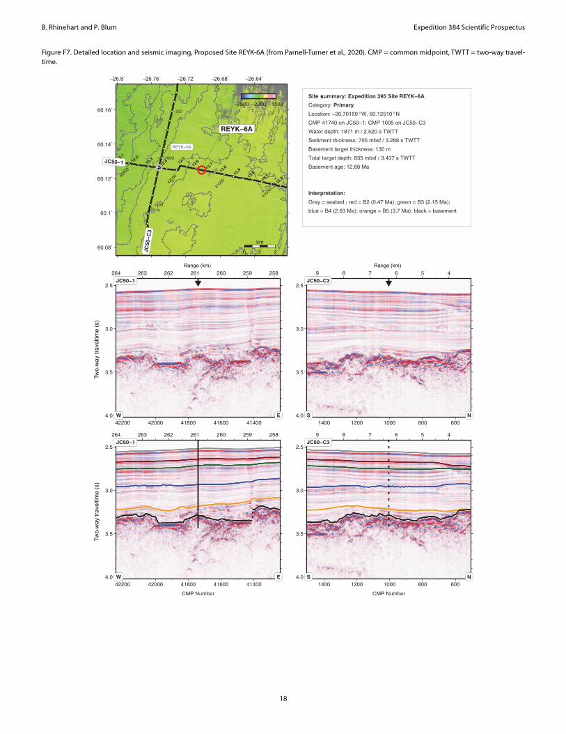
to have a companion site (Proposed Site REYK-6A; Parnell-Turner et al., 2020; Figure F7) <100 km away that has the requisite young sediments expected to be good paleomagnetic recorders based on results from nearby drift sediments cored ~150 km to the northeast during ODP Leg 162 (Sites 983 and 984; Channell, 1999). The paleo-magnetic declination for these Brunhes age sediments should aver-age to approximately due north, providing the reference declination against which the orientation tools can be tested.
Preliminary test planPlan for secondary objectives
Operations will begin with coring three APC holes to ~70 m depth (8 cores) at Proposed Site REYK-6A for the secondary objec-tives (Table T2). This will give the JOIDES Resolution staff time to carry out measurements and stratigraphic correlation and identify
7

B. Rhinehart and P. Blum Expedition 384 Scientific Prospectus
any potential issues while the primary objective tests are being con-ducted. This is estimated to take 2.3 days. Coring multiple holes at the site allows multiple tools to be tested, should help avoid biases from coring deformation, and will be useful for identifying if orien-tation issues arise randomly or for specific reasons. APC coring at this site will be repeated following the engineering tests at Site REYK-13A if results from the initial coring at Site REYK-6A identify issues that are possible to resolve with additional core orientation tests.
Setup of tools on the rig floor will be done slowly and methodi-cally with a paleomagnetist on the rig floor. All steps will be docu-mented with images taken by dedicated staff. The core liner will be oriented carefully, with the screw installed to hold the liner in place, and the orientation line confirmed to be aligned (not twisted) over the length of the nonmagnetic core barrel. If possible, methods of restraining the opposite end of the core liner (the end without the screw in it) will be devised and tested. Results from using different liners could potentially be compared.
The recovered cores will be processed using standard curatorial procedures, including sectioning followed by whole-round core log-ging with the Whole-Round Multisensor Logger (WRMSL) and Natural Gamma Radiation Logger (NGRL) and splitting of the sec-tions followed by archive section half logging with the Section Half Imaging Logger (SHIL), Section Half Multisensor Logger (SHMSL), and superconducting rock magnetometer (SRM). Stratigraphic cor-relation will be carried out as soon as the data are available to allow comparison of paleomagnetic results from different holes.
Plan for primary objectives: drilling and coring basalt and gabbro
After a 3 h transit to Proposed Site REYK-13A, a series of test holes will be drilled and cored ~50 m from each other, washing through ~210 m of sediment and penetrating up to ~100 m into ba-saltic basement (Table T2). The first hole will establish a baseline using the TCI tricone bit. This hole will be drilled to 100 m into basement or up to 40 h, whichever comes first. This hole will estab-lish the performance baseline, from both the rate of penetration and bit wear perspectives. The second BHA will use the Baker Hughes Kymera hybrid bit, and the third hole will use the Schlumberger PDC bit, repeating the performance test to 100 m basement pene-tration or ~40 h. The fourth hole will be drilled using the Rhino reamer paired with a new TCI bit of the same design as that used for Run 1. We expect that the underreamer will be the limiting factor for this run. The fifth hole will be dedicated to coring with the PDC coring bit, and samples obtained would be made available to the drilling engineers analyzing the test results. Two more holes are scheduled for contingency, either to run the best-performing bit a second time to greater depth to test its durability and/or any other follow-up test.
Should coring bits and time remain to carry out additional tests, we will transit to Site U1309 and attempt to drill a hole up to ~200 m deep.
Sampling and curationThe material recovered during Expedition 384 will be registered
in the JRSO database, handled, measured, and sampled according to standard JOIDES Resolution procedures. Shipboard sampling during Expedition 384 will be limited to what is needed to meet the above described primary and secondary testing objectives. Repre-sentative igneous rock samples of appropriate shape and size will be
sent to the drill bit vendors for analysis. The APC cores will be mea-sured and sampled for the assessment of the core orientation proce-dures and quality. The cores may initially be shipped to the Gulf Coast Repository and will ultimately end up in the Bremen Core Re-pository.
It is likely that substantial APC core material representing the complete 70 m stratigraphic sequence to be cored at Site REYK-6A and possibly a limited amount of igneous rock material from Site REYK-13A will be available for scientific research. If so, access to these materials will be shared with the Expedition 395 science party through a coordinated sampling plan to be prepared after Expedi-tion 384. Moratorium questions will be addressed at that time.
Risks and contingencyThe risk in testing the performance of different drill bits in a
known environment is very small. Some bits may fail earlier than anticipated, which would be an important test result. The under-reamer will have a greater likelihood of failing, but it will be tested after the results of regular drilling have been obtained.
In case certain bits or underreamers fail, we will have other drill-ing and coring bits to test, or we may push successful bits to greater depths.
Weather can always play a role. It would be unfortunate if the comparative aspect of our testing were compromised by extremely different weather conditions for different equipment. On the other hand, excellent weather conditions across the entire testing period might skew our results and future expectations.
ReferencesBlackman, D.K., Ildefonse, B., John, B.E., Ohara, Y., Miller, D.J., MacLeod, C.J.,
and the Expedition 304/305 Scientists, 2006. Proceedings of the Integrated Ocean Drilling Program, 304/305: College Station, TX (Integrated Ocean Drilling Program Management International, Inc.). https://doi.org/10.2204/iodp.proc.304305.2006
Blum, P., MacLeod, C.J., Dick, H.J.B., Abe, N., Blackman, D.K., Bowles, J.A., Cheadle, M.J., Cho, K., Ciążela, J., Deans, J.R., Edgcomb, V.P., Ferrando, C., France, L., Ghosh, B., Ildefonse, B.M., Kendrick, M.A., Koepke, J.H., Leong, J.A.M., Liu, C., Ma, Q., Morishita, T., Morris, A., Natland, J.H., Nozaka, T., Pluemper, O., Sanfilippo, A., Sylvan, J.B., Tivey, M.A., Tribuzio, R., and Viegas, L.G.F., 2017. Hole U1473A remediation opera-tions, Expedition 362T. In MacLeod, C.J., Dick, H.J.B., Blum, P., and the Expedition 360 Scientists, Southwest Indian Ridge Lower Crust and Moho. Proceedings of the International Ocean Discovery Program, 360: College Station, TX (International Ocean Discovery Program). https://doi.org/10.14379/iodp.proc.360.105.2017
Channell, J.E.T., 1999. Geomagnetic paleointensity and directional secular variation at Ocean Drilling Program (ODP) Site 984 (Bjorn Drift) since 500 ka: comparisons with ODP Site 983 (Gardar Drift). Journal of Geo-physical Research: Solid Earth, 104(B10):22937–22951. https://doi.org/10.1029/1999JB900223
DCDEWG, 2017. Deep Crustal Drilling Engineering Working Group Final Report. https://www.iodp.org/deep-crustal-drilling-engineering-working-group/file
Dick, H.J.B., MacLeod, C.J., Blum, P., and the Expedition 360 Scientists, 2016. Expedition 360 Preliminary Report: Southwest Indian Ridge Lower Crust and Moho. International Ocean Discovery Program. https://doi.org/10.14379/iodp.pr.360.2016
Expedition 335 Scientists, 2011. Superfast spreading rate crust 4: drilling gab-bro in intact ocean crust formed at a superfast spreading rate. Integrated Ocean Drilling Program Preliminary Report, 335. https://doi.org/10.2204/iodp.pr.335.2011
8

B. Rhinehart and P. Blum Expedition 384 Scientific Prospectus
Expedition 340T Scientists, 2012. Atlantis Massif Oceanic Core Complex: velocity, porosity, and impedance contrasts within the domal core of Atlantis Massif: faults and hydration of lithosphere during core complex evolution. Integrated Ocean Drilling Program Preliminary Report, 340T. https://doi.org/10.2204/iodp.pr.340T.2012
JRFB, 2017. JOIDES Resolution Facility Board (JRFB) meeting summary of consensus statements and action items, 16–17 May 2017. https://www.iodp.org/jrfb-minutes/380-jrfb-2017-may-minutes/file
JRFB, 2018. JOIDES Resolution Facility Board (JRFB) meeting summary of consensus statements and action items, 15–16 May 2018. https://www.iodp.org/jrfb-minutes/507-jrfb-2018-may-minutes/file
MacLeod, C.J., Dick, H.J.B., Blum, P., and the Expedition 360 Scientists, 2017. Southwest Indian Ridge Lower Crust and Moho. Proceedings of the International Ocean Discovery Program, 360: College Station, TX (Inter-national Ocean Discovery Program). https://doi.org/10.14379/iodp.proc.360.2017
Parnell-Turner, R., Briais, A., and LeVay, L., 2020. Expedition 395 Scientific Prospectus: Reykjanes Mantle Convection and Climate. International Ocean Discovery Program. https://doi.org/10.14379/iodp.sp.395.2020
Teagle, D.A.H., Ildefonse, B., Blum, P., and the Expedition 335 Scientists, 2012. Proc. IODP, 335: Tokyo (Integrated Ocean Drilling Program Management International, Inc.). https://doi.org/10.2204/ iodp.proc.335.2012
9

B. Rhinehart and P. Blum Expedition 384 Scientific Prospectus
Table T1. Expedition 384 test objectives relative to JOIDES Resolution Facility Board (JRFB) recommendations. PDC = polycrystalline diamond compact, XCB = extended core barrel, MarE3 = Institute for Marine-Earth Exploration and Engineering, MDHDS = Motion Decoupled Hydraulic Delivery System, T2P = tempera-ture dual pressure probe.
Priority JRFB recommendations Objective Expedition 384 plan
1 New drilling bits for improved advancement, opening, and remediation of drill holes in hard rock formations.
1.1 As recommended.
2 New underreamers for opening up holes in hard rock formations. 1.2 As recommended.3 New coring bits for coring in hard rock formations. 1.3 Although this is arguably the most important issue to the IODP community,
the market for coring is problematical. We plan to test an existing PDC coring bit for the first time, though.
4 New biodegradable drilling fluid additives for improved hole cleaning. Low priority, sepiolite and attapulgite work fine, hard to find other product that is safe for open hole drilling.
5 New bottom-driven XCB based on current D/V Chikyu XCB designs. Low priority based on preliminary experience.6 Continued testing of the Turbine Driven Coring System (TDCS) depending on
the outcome of first tests during IODP Expedition 376 and discussions with MarE3.
We were planning on this in a previous expedition schedule— the unusual circumstances this year did not allow for the required shipping and staffing.
7 MDHDS testing in conjunction with the T2P system. Not urgent at this time.
10

B. Rhinehart and P. Blum Expedition 384 Scientific Prospectus
Table T2. Expedition 384 operations plan and schedule. EPSP = Environmental Protection and Safety Panel, APC = advanced piston corer, TCI = tungsten car-bide insert, PDC = polycrystalline diamond compact, U/R = underreamer, FFF = free-fall funnel, RCB = rotary core barrel.
Site No. Location(LatitudeLongitude)
SeafloorDepth(mbrf)
Operations Description Transit(days)
DrillingCoring(days)
Logging(days)
Kristiansand Begin Expedition 0.0 port call days
Transit ~1080nmi to REYK-6A @ 10.5 4.3
REYK-6A 60° 7.5060' N 1882 Hole A - APC to 70m w/ Orient 0 1.1 0.0
EPSP 26° 42.0960' W Hole B - APC to 70m w/ Orient 0 0.5 0.0
to 0 mbsf Hole C - APC to 70m w/ Orient 0 0.7 0.0
Sub-Total Days On-Site: 2.3
Transit ~54nmi to REYK-13A @ 10.5 0.2
REYK-13A 60° 13.6860' N 1531 Hole A - Baseline 01 - TCI - Drill 40h/100m of basement 0 2.6 0.0
EPSP 28° 30.0240' W Hole B - Hybrid - Drill 40h/100m of basement 0 2.5 0.0
to 0 mbsf Hole C - PDC - Drill 40h/100m of basement 0 2.5 0.0
Hole D - TCI with U/R - Drill 20h/50m of basement 0 1.9 0.0
Hole E - PDC Core 0 1.9 0.0
Hole F - Best Bit - 40h, Degraded Performance, or Destruction 0 2.7 0.0
Hole G - Contingency 0 2.7 0.0
Sub-Total Days On-Site: 16.8
Transit ~54nmi to REYK-6A @ 10.5 0.2
REYK-6A 60° 7.5060' N 1882 Hole D - APC to 70m w/ Orient 0 1.1 0.0
EPSP 26° 42.0960' W Hole E - APC to 70m w/ Orient 0 0.5 0.0
to 0 mbsf Hole F - APC to 70m w/ Orient 0 0.7 0.0
Sub-Total Days On-Site: 2.3
Transit ~1901nmi to U1309 @ 10.5 7.5
U1309 30° 10.1100' N 1653 Hole I - Baseline 01 - TCI - Drill 200m of basement; FFF; RCB 0 5.6 0.0
EPSP 42° 7.1100' W
to 0 mbsf
Sub-Total Days On-Site: 5.6
Transit ~1401nmi to Las Palmas @ 10.5 5.6
Las Palmas End Expedition 17.8 26.9 0.0
Port Call: 0.0 Total Operating Days: 44.7Sub-Total On-Site: 26.9 Total Expedition: 44.7
11

B. Rhinehart and P. Blum Expedition 384 Scientific Prospectus
Figure F1. Location of ports and test sites, Expedition 384.
12

B. Rhinehart and P. Blum Expedition 384 Scientific Prospectus
Figure F2. Location of test Sites REYK-6A and REYK-13A on site map for postponed Expedition 395 (from Parnell-Turner et al., 2020). Yellow circles = proposed drill sites, black circles = Ocean Drilling Program/Deep Sea Drilling Project boreholes, solid black lines = seismic reflection profiles, gray lines = magnetic polar-ity chrons, A. Bathymetry. Box = location of B. Red star = Iceland plume center, red dashed line = Mid-Atlantic Ridge, dotted black lines = deepwater currents. WBUC = Western Boundary Undercurrent, DSOW = Denmark Strait Overflow Water, ISOW = Iceland-Scotland Overflow Water, DS = Denmark Strait, IFR = Ice-land-Faroe Ridge, BFZ = Bight Fracture Zone. B. Satellite free-air gravity anomaly map. Dashed line = Reykjanes Ridge (RR), VSR = V-shaped ridge, VST = V-shaped trough, open circles/triangles = dredged basalt samples.
B
13

B. Rhinehart and P. Blum Expedition 384 Scientific Prospectus
Figure F3. Detailed location and seismic imaging, Proposed Site REYK-13A (from Parnell-Turner et al., 2020). CMP = common midpoint, TWTT = two-way travel-time.
Range (km) Range (km)
Two-
way
trav
eltim
e (s
)Tw
o-w
ay tr
avel
time
(s)
s
14

B. Rhinehart and P. Blum Expedition 384 Scientific Prospectus
Figure F4. Location of planned test Site U1309 on base map of Atlantis Massif showing geological and geophysical data coverage and location of Integrated Ocean Drilling Program drill sites (from Blackman, Ildefonse, John, Ohara, Miller, MacLeod, and the Expedition 304/305 Scientists, 2006). Bathymetry is con-toured at 100 m intervals, based on a 100 m grid. Seismic reflection and refraction lines and seafloor mapping/sampling sites are shown. MCS = multichannel seismic. OBH = ocean bottom hydrophone.
15

B. Rhinehart and P. Blum Expedition 384 Scientific Prospectus
Figure F5. Seismic sections indicate subsurface structure of Atlantis Massif, Site U1309 (from Blackman, Ildefonse, John, Ohara, Miller, MacLeod, and the Expe-dition 304/305 Scientists, 2006). A. Deep source refraction (Line NOBEL9) recorded by ocean bottom hydrophone shows arrivals indicating a high-velocity body (8 km/s, assuming plane-layered structure) at very short range. B. Velocity gradient determined from refraction analysis. MARK = Mid-Atlantic Ridge (MAR) just south of Kane Fracture Zone, SWIR = Southwest Indian Ridge. C. Portion of multichannel seismic (MCS) Line Meg-10 across central dome. CMP = common midpoint. D. Portion of MCS Line Meg-4, north–south across central dome.
16

B. Rhinehart and P. Blum Expedition 384 Scientific Prospectus
Figure F6. Lithostratigraphy, Holes U1309B and U1309D (from Blackman, Ildefonse, John, Ohara, Miller, MacLeod, and the Expedition 304/305 Scientists, 2006).
U1309B U1309D
17
B. Rhinehart and P. Blum Expedition 384 Scientific Prospectus
Figure F7. Detailed location and seismic imaging, Proposed Site REYK-6A (from Parnell-Turner et al., 2020). CMP = common midpoint, TWTT = two-way travel-time.
s
Range (km) Range (km)
Two-
way
trav
eltim
e (s
)Tw
o-w
ay tr
avel
time
(s)
18

B. Rhinehart and P. Blum Expedition 384 Scientific Prospectus
Site summariesProposed Site REYK-13A
Proposed Site REYK-6A
Legacy Site U1309Priority: Primary Position: 28.50040°W, 60.22818°NWater depth (m): 1520Target drilling depth
(mbsf):340
Approved maximum penetration (mbsf):
410
Survey coverage (track map; seismic profile)
Common Midpoint (CMP) 57881 on JC50−1; CMP 3720 on JC50−C7 (Figure F2).
Objective(s): Test new types of drill bits, underreamer and PDC coring bit for advancing, opening and coring in holes in igneous rock, respectively.
Drilling program: Drill and core ~6 holes to ~340 m.Logging/Downhole
measurements program:
Not applicable.
Nature of rock anticipated:
Recent to Pliocene clay or ooze. Olivine basalt flows.
Priority: Primary Position: 26.70160°W, 60.12510°NWater depth (m): 1871Target drilling depth
(mbsf):70
Approved maximum penetration (mbsf):
905
Survey coverage (track map; seismic profile)
CMP 41740 on JC50−1; CMP 1005 on JC50−C3(Figure F2).
Objective(s): Test protocols for APC core orientation.Drilling program: Core three holes to ~70 m on each of two site visits.Logging/Downhole
measurements program:
Not applicable.
Nature of rock anticipated:
Pleistocene to Pliocene clay or ooze.
Priority: Alternate Legacy hole: Hole U1309D for reference, exact position to be determined.Position: 30°10.1195′N, 42°7.1131′W (reference Hole U1309D)Water depth (m): 1642Target drilling depth
(mbsf):200
Approved maximum penetration (mbsf ):
Not applicable.
Objective(s): Test new types of drill bits for advancing holes in igneous rock.
Drilling program: Drill 1 or 2 holes to 100-200 m into gabbro.Logging/Downhole
measurements program:
Not applicable.
Nature of rock anticipated:
Gabbroic and basaltic rocks.
19