Unit 6: Solubility and Geology - Duxbury Public Schools
119
-
Upload
khangminh22 -
Category
Documents
-
view
0 -
download
0
Transcript of Unit 6: Solubility and Geology - Duxbury Public Schools


Unit 6: Solubility and Geology
Cheryl LewisDana Desonie, Ph.D.Jean Brainard, Ph.D.
Ck12 Science
Say Thanks to the AuthorsClick http://www.ck12.org/saythanks
(No sign in required)

www.ck12.org
To access a customizable version of this book, as well as otherinteractive content, visit www.ck12.org
CK-12 Foundation is a non-profit organization with a mission toreduce the cost of textbook materials for the K-12 market bothin the U.S. and worldwide. Using an open-content, web-basedcollaborative model termed the FlexBook®, CK-12 intends topioneer the generation and distribution of high-quality educationalcontent that will serve both as core text as well as provide anadaptive environment for learning, powered through the FlexBookPlatform®.
Copyright © 2013 CK-12 Foundation, www.ck12.org
The names “CK-12” and “CK12” and associated logos and theterms “FlexBook®” and “FlexBook Platform®” (collectively“CK-12 Marks”) are trademarks and service marks of CK-12Foundation and are protected by federal, state, and internationallaws.
Any form of reproduction of this book in any format or medium,in whole or in sections must include the referral attribution linkhttp://www.ck12.org/saythanks (placed in a visible location) inaddition to the following terms.
Except as otherwise noted, all CK-12 Content (including CK-12Curriculum Material) is made available to Users in accordancewith the Creative Commons Attribution-Non-Commercial 3.0Unported (CC BY-NC 3.0) License (http://creativecommons.org/licenses/by-nc/3.0/), as amended and updated by Creative Com-mons from time to time (the “CC License”), which is incorporatedherein by this reference.
Complete terms can be found at http://www.ck12.org/terms.
Printed: September 17, 2013
AUTHORSCheryl LewisDana Desonie, Ph.D.Jean Brainard, Ph.D.Ck12 Science
iii

Contents www.ck12.org
Contents
1 Weathering and Erosion 1
2 Mechanical Weathering 4
3 Chemical Weathering 8
4 Influences on Weathering 13
5 Rocks and Processes of the Rock Cycle 16
6 Soil Erosion 20
7 Erosion by Streams 26
8 Deposition by Streams 32
9 Erosion by Groundwater 37
10 Deposition by Groundwater 40
11 Erosion by Waves 43
12 Deposition by Waves 47
13 Protecting Shorelines 52
14 Erosion by Wind 56
15 Deposition by Wind 60
16 Erosion by Glaciers 64
17 Deposition by Glaciers 68
18 Landforms from Erosion and Deposition by Gravity 72
19 Solutions 79
20 Solutions 84
21 Solution Concentration 86
22 How Temperature Influences Solubility 88
23 Properties of Solutions 91
iv

www.ck12.org Contents
24 Saturated and Unsaturated Solutions 94
25 Solute-Solvent Combinations 97
26 Location on the Earth 100
27 Elevation on the Earth 105
28 Maps 108
v

www.ck12.org Chapter 1. Weathering and Erosion
CHAPTER 1 Weathering and Erosion• Define weathering and erosion.
What is the history of this rock face?
Walnut Canyon, just outside Flagstaff, Arizona, is a high desert landscape displaying cliff dwellings built 700 yearsago by a long gone people. On the opposite side from the trail around the mesa is this incredible rock. In thisrock you can see that the rock has slumped, and also see signs of mechanical weathering (fractures) and chemicalweathering (dissolution). If you get a chance, go see the rock (and the cliff dwellings) for yourself.
Weathering
Weathering is the process that changes solid rock into sediments. Sediments were described in the chapter "Ma-terials of Earth’s Crust." With weathering, rock is disintegrated. It breaks into pieces. Once these sediments are
1

www.ck12.org
separated from the rocks, erosion is the process that moves the sediments.
While plate tectonics forces work to build huge mountains and other landscapes, the forces of weathering graduallywear those rocks and landscapes away. Together with erosion, tall mountains turn into hills and even plains. TheAppalachian Mountains along the east coast of North America were once as tall as the Himalayas.
Weathering Takes Time
No human being can watch for millions of years as mountains are built, nor can anyone watch as those samemountains gradually are worn away. But imagine a new sidewalk or road. The new road is smooth and even. Overhundreds of years, it will completely disappear, but what happens over one year? What changes would you see?(Figure 1.1). What forces of weathering wear down that road, or rocks or mountains over time?
• Animations of different types of weathering processes can be found here: http://www.geography.ndo.co.uk/animationsweathering.htm#.
FIGURE 1.1A once smooth road surface has cracksand fractures, plus a large pothole.
Summary
• Weathering breaks down Earth materials into smaller pieces.• Erosion transports those pieces to other locations.• Weathering and erosion modify Earth’s surface landscapes over time.
Vocabulary
• Weathering: process that changes solid rock into sediments• Erosion: process that moves the sediments
Practice
Use this resource to answer the questions that follow.
http://www.ux1.eiu.edu/ cfjps/1300/weathering.html
2

www.ck12.org Chapter 1. Weathering and Erosion
1. What is weathering?
2. What is mechanical weathering?
3. What is chemical weathering?
4. What is erosion?
5. Describe frost wedging.
6. What is abrasion?
7. List the types of chemical weathering.
8. What factors can influence weathering?
Review
1. What is weathering?
2. How is weathering different from erosion?
3. Why does weathering take so much time?
References
1. Coolcaesar. . GNU-FDL 1.2
3

www.ck12.org
CHAPTER 2 Mechanical Weathering• Define mechanical weathering.• Describe the various processes of mechanical weathering.
Who broke those rocks?
In extreme environments, where there is little moisture and soil development, it’s possible to see rocks that havebroken by mechanical weathering. This talus in Colorado’s Indian Peaks broke from the jointed rock that is exposed.
Mechanical Weathering
Mechanical weathering (also called physical weathering) breaks rock into smaller pieces. These smaller pieces arejust like the bigger rock, but smaller. That means the rock has changed physically without changing its composition.The smaller pieces have the same minerals, in just the same proportions as the original rock.
Ice Wedging
There are many ways that rocks can be broken apart into smaller pieces. Ice wedging is the main form of mechanicalweathering in any climate that regularly cycles above and below the freezing point (Figure 2.1). Ice wedging worksquickly, breaking apart rocks in areas with temperatures that cycle above and below freezing in the day and night,and also that cycle above and below freezing with the seasons.
Ice wedging breaks apart so much rock that large piles of broken rock are seen at the base of a hillside, as rockfragments separate and tumble down. Ice wedging is common in Earth’s polar regions and mid latitudes, and also athigher elevations, such as in the mountains.
Abrasion
Abrasion is another form of mechanical weathering. In abrasion, one rock bumps against another rock.
4

www.ck12.org Chapter 2. Mechanical Weathering
FIGURE 2.1Ice wedging.
• Gravity causes abrasion as a rock tumbles down a mountainside or cliff.• Moving water causes abrasion as particles in the water collide and bump against one another.• Strong winds carrying pieces of sand can sandblast surfaces.• Ice in glaciers carries many bits and pieces of rock. Rocks embedded at the bottom of the glacier scrape
against the rocks below.
Abrasion makes rocks with sharp or jagged edges smooth and round. If you have ever collected beach glass orcobbles from a stream, you have witnessed the work of abrasion (Figure 2.2).
FIGURE 2.2Rocks on a beach are worn down byabrasion as passing waves cause them tostrike each other.
5

www.ck12.org
Organisms
Now that you know what mechanical weathering is, can you think of other ways it could happen? Plants and animalscan do the work of mechanical weathering (Figure 2.3). This could happen slowly as a plant’s roots grow into acrack or fracture in rock and gradually grow larger, wedging open the crack. Burrowing animals can also break apartrock as they dig for food or to make living spaces for themselves.
Humans
Human activities are responsible for enormous amounts of mechanical weathering, by digging or blasting into rockto build homes, roads, and subways, or to quarry stone.
FIGURE 2.3(a)Humans are tremendous agents of mechanical weathering. (b) Salt weathering of building stone on the islandof Gozo, Malta.
Summary
• Mechanical weathering breaks down existing rocks and minerals without changing them chemically.• Ice wedging, abrasion, and some actions of living organisms and humans are some of the agents of mechanical
weathering.
Vocabulary
• Mechanical weathering: (physical weathering) breaks rocks into smaller pieces• Ice wedging: A form of mechanical weathering. Water seeps into cracks in a rock. When the water freezes, it
expands. The rock then wedges apart over time.• Abrasion: A form of mechanical weathering. When one rock bumps agains another rock.
Practice
Use this resource to answer the questions that follow.
6

www.ck12.org Chapter 2. Mechanical Weathering
MEDIAClick image to the left for more content.
1. What is weathering?
2. What are the agents of weathering?
3. What is mechanical weathering?
4. Explain frost wedging.
5. Explain root wedging.
6. What is abrasion?
7. Explain the two types of abrasion.
8. What is exfoliation? What is it unique to?
9. What is differential weathering? What can be created with differential weathering?
10. What role does climate play in physical weathering?
Review
1. Describe the process of ice wedging.
2. Describe the process of abrasion.
3. How do plants and animals cause mechanical weathering?
References
1. Julie Sandeen/CK-12 Foundation. . CC-BY-NC-SA 3.02. Stan Zurek. . CC-BY-SA 2.53. (a) MathKnight; (b) Dr SM MacLeod (Bagamatuta). . (a) CC-BY 2.5; (b) Public Domain
7

www.ck12.org
CHAPTER 3 Chemical Weathering
• Define chemical weathering.• Describe the various processes of chemical weathering.
How do rocks turn red?
In the desert Southwest, red rocks are common. Tourists flock to Sedona, Arizona to see the beautiful red rocks,which are set off very nicely by the snow in this photo. What makes the rocks red? The same process that makesrust red!
Chemical Weathering
Chemical weathering is the other important type of weathering. Chemical weathering may change the size of piecesof rock materials, but definitely changes the composition. So one type of mineral changes into a different mineral.Chemical weathering works through chemical reactions that cause changes in the minerals.
No Longer Stable
Most minerals form at high pressure or high temperatures deep in the crust, or sometimes in the mantle. Whenthese rocks are uplifed onto Earth’s surface, they are at very low temperatures and pressures. This is a very differentenvironment from the one in which they formed and the minerals are no longer stable. In chemical weathering,minerals that were stable inside the crust must change to minerals that are stable at Earth’s surface.
Clay
Remember that the most common minerals in Earth’s crust are the silicate minerals. Many silicate minerals form inigneous or metamorphic rocks. The minerals that form at the highest temperatures and pressures are the least stableat the surface. Clay is stable at the surface and chemical weathering converts many minerals to clay (Figure 3.1).
There are many types of chemical weathering because there are many agents of chemical weathering.
8

www.ck12.org Chapter 3. Chemical Weathering
FIGURE 3.1Deforestation in Brazil reveals the under-lying clay-rich soil.
Chemical Weathering by Water
A water molecule has a very simple chemical formula, H2O, two hydrogen atoms bonded to one oxygen atom. Butwater is pretty remarkable in terms of all the things it can do. Remember that water is a polar molecule. The positiveside of the molecule attracts negative ions and the negative side attracts positive ions. So water molecules separatethe ions from their compounds and surround them. Water can completely dissolve some minerals, such as salt.
FIGURE 3.2Weathered rock in Walnut Canyon nearFlagstaff, Arizona.
• Check out this animation of how water dissolves salt: http://www.northland.cc.mn.us/biology/Biology1111/animations/dissolve.html.
Hydrolysis is the name of the chemical reaction between a chemical compound and water. When this reaction takesplace, water dissolves ions from the mineral and carries them away. These elements have been leached. Throughhydrolysis, a mineral such as potassium feldspar is leached of potassium and changed into a clay mineral. Clayminerals are more stable at the Earth’s surface.
9

www.ck12.org
Chemical Weathering by Carbonic Acid
Carbon dioxide (CO2) combines with water as raindrops fall through the atmosphere. This makes a weak acid,called carbonic acid. Carbonic acid is a very common in nature, where it works to dissolve rock. Pollutants, such assulfur and nitrogen from fossil fuel burning, create sulfuric and nitric acid. Sulfuric and nitric acids are the two maincomponents of acid rain, which accelerates chemical weathering (Figure 3.3). Acid rain is discussed in ConceptHuman Impacts on Earth’s Systems.
FIGURE 3.3This chimera at Notre Dame Cathedral in Paris exhibits damage from acidrain.
Chemical Weathering by Oxygen
Oxidation is a chemical reaction that takes place when oxygen reacts with another element. Oxygen is very stronglychemically reactive. The most familiar type of oxidation is when iron reacts with oxygen to create rust (Figure 3.4).Minerals that are rich in iron break down as the iron oxidizes and forms new compounds. Iron oxide produces thered color in soils.
FIGURE 3.4When iron-rich minerals oxidize, they pro-duce the familiar red color found in rust.
10

www.ck12.org Chapter 3. Chemical Weathering
Plants and Animals
Now that you know what chemical weathering is, can you think of some other ways chemical weathering mightoccur? Chemical weathering can also be contributed to by plants and animals. As plant roots take in soluble ionsas nutrients, certain elements are exchanged. Plant roots and bacterial decay use carbon dioxide in the process ofrespiration.
Mechanical and Chemical Weathering
Mechanical weathering increases the rate of chemical weathering. As rock breaks into smaller pieces, the surfacearea of the pieces increases Figure 3.5. With more surfaces exposed, there are more surfaces on which chemicalweathering can occur.
FIGURE 3.5Mechanical weathering may increase the rate of chemical weathering.
Summary
• Chemical weathering changes the composition of a mineral to break it down.• The agents of chemical weathering include water, carbon dioxide, and oxygen.• Living organisms and humans can contribute to chemical weathering.
Vocabulary:
• Chemical weathering: changes the composition of at least one of the rock materials and may change the sizeof the pieces as well. works through a chemical
Practice
Use this resource to answer the questions that follow.
11

www.ck12.org
MEDIAClick image to the left for more content.
1. What is chemical weathering?
2. What are the three ways chemical weathering occurs?
3. What is oxidation? What does it produced?
4. What is carbonation? What does it create?
5. What is hydration? What does it do?
Review
1. How does the structure of the water molecule lead to chemical weathering?
2. Describe how carbon dioxide and oxygen cause chemical weathering.
3. How does mechanical weathering increase the effectiveness of chemical weathering processes?
References
1. Alex Rio Brazil. . Public Domain2. Miles Orchinik. . Used with permission from the author3. Image copyright dibrova, 2012. . Used under license from Shutterstock.com4. Image copyright Dmitriev Lidiya, 2012. . Used under license from Shutterstock.com5. Julie Sandeen/CK-12 Foundation. . CC-BY-NC-SA 3.0
12

www.ck12.org Chapter 4. Influences on Weathering
CHAPTER 4 Influences on Weathering
• Identify and explain factors that influence the rate and intensity of weathering.
What circumstances allow for the most intense weathering?
The rate and intensity of weathering depend on the climate of a region and the rocks materials that are beingweathered. Material in Baraboo, Wisconsin weathers a lot more readily than similar material in Sedona, Arizona.
Rock and Mineral Type
Different rock types weather at different rates. Certain types of rock are very resistant to weathering. Igneous rocks,especially intrusive igneous rocks such as granite, weather slowly because it is hard for water to penetrate them.Other types of rock, such as limestone, are easily weathered because they dissolve in weak acids.
Different minerals also weather at different rates. Some minerals in a rock might completely dissolve in water, butthe more resistant minerals remain. In this case, the rock’s surface becomes pitted and rough. When a less resistantmineral dissolves, more resistant mineral grains are released from the rock. A beautiful example of this effect is the"Stone Forest" in China, see the video below:
MEDIAClick image to the left for more content.
13

www.ck12.org
FIGURE 4.1The Shiprock formation in northwest NewMexico is the central plug of resistant lavafrom which the surrounding rock weath-ered and eroded away.
Climate
A region’s climate strongly influences weathering. Climate is determined by the temperature of a region plus theamount of precipitation it receives. Climate is weather averaged over a long period of time. Chemical weatheringincreases as:
• Temperature increases: Chemical reactions proceed more rapidly at higher temperatures. For each 10oCincrease in average temperature, the rate of chemical reactions doubles.
• Precipitation increases: More water allows more chemical reactions. Since water participates in both mechan-ical and chemical weathering, more water strongly increases weathering.
So how do different climates influence weathering? A cold, dry climate will produce the lowest rate of weathering. Awarm, wet climate will produce the highest rate of weathering. The warmer a climate is, the more types of vegetationit will have and the greater the rate of biological weathering (Figure 4.2). This happens because plants and bacteriagrow and multiply faster in warmer temperatures.
Summary
• Different materials weather at different rates and intensities under the same conditions.• Different climate conditions cause the same materials to weather different intensities.
Practice
Use this resource to answer the questions that follow.
Rock types on the Isle of Sky - Geological Landforms
http://www.youtube.com/watch?v=l-Y6588DnQg
14

www.ck12.org Chapter 4. Influences on Weathering
FIGURE 4.2Wet, warm tropical areas have the most weathering.
MEDIAClick image to the left for more content.
1. What type of rocks make up most of the Isle of Skye?
2. What other types of rocks are found on the island?
3. What two processes shape the landscape of the island?
4. What are the primary sources of weathering on Skye?
5. How is scree produced?
6. How does weathering effect granite?
7. What is responsible for the topography of the island?
8. Which rocks are more resistant to weathering?
Review
1. What types of rocks weather most readily? What types weather least readily?
2. What climate types cause more intense weathering? What climate types cause less intense weathering?
3. How does bauxite form?
References
1. Image copyright Mike Norton, 2012. . Used under license from Shutterstock.com2. Image copyright Rudy Umans, 2012. . Used under license from Shutterstock.com
15

www.ck12.org
CHAPTER 5 Rocks and Processes of theRock Cycle
• Explain the processes of the rock cycle.
Is this what geologists mean by the rock cycle?
Okay, very punny. The rock cycle shows how any type of rock can become any other type of rock. Some rocks maystay the same type for a long time, for example, if they’re at the base of the crust, but other rocks may relativelyrapidly change from one type to another.
The Rock Cycle
The rock cycle, illustrated in Figure 5.1, depicts how the three major rock types – igneous, sedimentary, and meta-morphic - convert from one to another. Arrows connecting the rock types represent the processes that accomplishthese changes.
Rocks change as a result of natural processes that are taking place all the time. Most changes happen very slowly.Rocks deep within the Earth are right now becoming other types of rocks. Rocks at the surface are lying in placebefore they are next exposed to a process that will change them. Even at the surface, we may not notice the changes.The rock cycle has no beginning or end.
The Three Rock Types
Rocks are classified into three major groups according to how they form. These three types will be described inmore detail in other lessons in this concept, but here is an introduction.
• Igneous rocks form from the cooling and hardening of molten magma in many different environments. Thechemical composition of the magma and the rate at which it cools determine what rock forms. Igneous rocks
16

www.ck12.org Chapter 5. Rocks and Processes of the Rock Cycle
FIGURE 5.1The Rock Cycle.
can cool slowly beneath the surface or rapidly at the surface. These rocks are identified by their compositionand texture. More than 700 different types of igneous rocks are known.
• Sedimentary rocks form by the compaction and cementing together of sediments, broken pieces of rock-likegravel, sand, silt, or clay. Those sediments can be formed from the weathering and erosion of preexistingrocks. Sedimentary rocks also include chemical precipitates, the solid materials left behind after a liquidevaporates.
• Metamorphic rocks form when the minerals in an existing rock are changed by heat or pressure below thesurface.
A simple explanation of the three rock types and how to identify them can be seen in this video: http://www.youtube.com/watch?v=tQUe9C40NEE&feature=fvw.
This video discusses how to identify igneous rocks: http://www.youtube.com/watch?v=Q0XtLjE3siE&feature=channel.
This video discusses how to identify a metamorphic rocks: http://www.youtube.com/watch?v=qs9x_bTCiew&feature=related.
The Processes of the Rock Cycle
Several processes can turn one type of rock into another type of rock. The key processes of the rock cycle arecrystallization, erosion and sedimentation, and metamorphism.
Crystallization
Magma cools either underground or on the surface and hardens into an igneous rock. As the magma cools, differentcrystals form at different temperatures, undergoing crystallization. For example, the mineral olivine crystallizes outof magma at much higher temperatures than quartz. The rate of cooling determines how much time the crystals willhave to form. Slow cooling produces larger crystals.
17

www.ck12.org
Erosion and Sedimentation
Weathering wears rocks at the Earth’s surface down into smaller pieces. The small fragments are called sediments.Running water, ice, and gravity all transport these sediments from one place to another by erosion. During sedimen-tation, the sediments are laid down or deposited. In order to form a sedimentary rock, the accumulated sedimentmust become compacted and cemented together.
Metamorphism
When a rock is exposed to extreme heat and pressure within the Earth but does not melt, the rock becomes meta-morphosed. Metamorphism may change the mineral composition and the texture of the rock. For that reason, ametamorphic rock may have a new mineral composition and/or texture.
Summary
• The three main rock types are igneous, metamorphic and sedimentary.• The three processes that change one rock to another are crystallization, metamorphism, and erosion and
sedimentation.• Any rock can transform into any other rock by passing through one or more of these processes. This creates
the rock cycle.
Vocabulary
• Rock cycle: depicts how the three major rock types–igneous, sedimentary, and metamorphic–convert fromone to another
• Igneous rocks: form from the cooling and hardening of molten magma• Sedimentary rocks: form from the compactions and cementing of sediments, gravel, sand, silt, or clay• Metamorphic rocks: form when minerals in an existing rock are changed by heat or pressure below the surface
of the Earth• Crystallization: the process of crystals forming as magma cools• Metamorphism: the process of heat and pressure from within the Earth changes the composition and texture
of the rock
Making Connections
MEDIAClick image to the left for more content.
Practice
Use these resources to answer the questions that follow.
This Science Made Fun video discusses the conditions under which the three main rock types form (3c): http://www.youtube.com/watch?v=G7AWGhQynTY&feature=related (3:41).
18

www.ck12.org Chapter 5. Rocks and Processes of the Rock Cycle
MEDIAClick image to the left for more content.
1. How do igneous rocks form?
2. What are the two types of igneous rocks and how do they differ?
3. What are metamorphic rocks?
4. How do metamorphic rocks form?
5. How do sedimentary rocks form?
6. List three examples of igneous rocks.
7. List three examples of sedimentary rocks.
8. What forms coal?
9. List three examples of metamorphic rocks.
10. Can an igneous rock become an igneous rock? Can a sedimentary rock become a sedimentary rock? Can ametamorphic rock become a metamorphic rock?
11. Draw an diagram of the rock cycle and include the processes that transform rocks from one type to another.
Review the rock cycle - click a rock to begin.
http://www.phschool.com/atschool/phsciexp/active_art/rock_cycle/index.html
Test your rock identification skills with this activity:
Name that Rock - http://library.thinkquest.org/J002289/rocks.html
Review
1. What processes must a metamorphic rock go through to become an igneous rock?
2. What processes must a sedimentary rock go through to become a metamorphic rock?
3. What types of rocks can become sedimentary rocks and how does that happen?
References
1. Woudloper/Woodwalker; modified by CK-12 Foundation. The Rock Cycle. Public Domain
19

www.ck12.org
CHAPTER 6 Soil Erosion• Explain how human activities cause soil erosion.
What would cause such a tremendous dust storm?
Farmers were forced off their lands during the Dust Bowl in the 1930s when the rains stopped and the topsoil blewoff these former grasslands. A wind storm blew huge amounts of soil into the air in Texas on April 14, 1935. Thisscene was repeated throughout the central United States.
Causes of Soil Erosion
The agents of soil erosion are the same as the agents of all types of erosion: water, wind, ice, or gravity. Runningwater is the leading cause of soil erosion, because water is abundant and has a lot of power. Wind is also a leadingcause of soil erosion because wind can pick up soil and blow it far away.
Gravity is another agent of erosion. The steeperthe slope, the less likely material will be able to stay in place to formsoil. Material on a stepp slope is likely to go downhill due to gravity. Materials will accumulate and soil will formwhere land areas are flat or gently undulating.
Activities that remove vegetation, disturb the ground, or allow the ground to dry are activities that increase erosion.What are some human activities that increase the likelihood that soil will be eroded?
Farming
Agriculture is probably the most significant activity that accelerates soil erosion because of the amount of land thatis farmed and how much farming practices disturb the ground (Figure 6.1). Farmers remove native vegetation andthen plow the land to plant new seeds. Because most crops grow only in spring and summer, the land lies fallowduring the winter. Of course, winter is also the stormy season in many locations, so wind and rain are available towash soil away. Tractor tires make deep grooves, which are natural pathways for water. Fine soil is blown away bywind.
The soil that is most likely to erode is the nutrient-rich topsoil, which degrades the farmland.
20

www.ck12.org Chapter 6. Soil Erosion
FIGURE 6.1(a) The bare areas of farmland are especially vulnerable to erosion. (b) Slash-and-burn agriculture leaves landopen for soil erosion and is one of the leading causes of soil erosion in the world.
Grazing
Grazing animals (Figure 6.2) wander over large areas of pasture or natural grasslands eating grasses and shrubs.Grazers expose soil by removing the plant cover for an area. They also churn up the ground with their hooves. If toomany animals graze the same land area, the animals’ hooves pull plants out by their roots. A land is overgrazed iftoo many animals are living there.
FIGURE 6.2Grazing animals can cause erosion if theyare allowed to overgraze and remove toomuch or all of the vegetation in a pasture.
21

www.ck12.org
Logging and Mining
Logging removes trees that protect the ground from soil erosion. The tree roots hold the soil together and the treecanopy protects the soil from hard falling rain. Logging results in the loss of leaf litter, or dead leaves, bark, andbranches on the forest floor. Leaf litter plays an important role in protecting forest soils from erosion (Figure 6.3).
FIGURE 6.3Logging exposes large areas of land toerosion.
Much of the world’s original forests have been logged. Many of the tropical forests that remain are currently the siteof logging because North America and Europe have already harvested many of their trees (Figure 6.4). Soils erodedfrom logged forests clog rivers and lakes, fill estuaries, and bury coral reefs.
Surface mining disturbs the land (Figure 6.5) and leaves the soil vulnerable to erosion.
Construction
Constructing buildings and roads churns up the ground and exposes soil to erosion. In some locations, nativelandscapes, such as forest and grassland, are cleared, exposing the surface to erosion (in some locations the landthat will be built on is farmland). Near construction sites, dirt, picked up by the wind, is often in the air. Completedconstruction can also contribute to erosion (Figure 6.6).
Recreational Activities
Recreational activities may accelerate soil erosion. Off-road vehicles disturb the landscape and the area eventuallydevelops bare spots where no plants can grow. In some delicate habitats, even hikers’ boots can disturb the ground,so it’s important to stay on the trail (Figure 6.7).
Soil erosion is as natural as any other type of erosion, but human activities have greatly accelerated soil erosion. Insome locations soil erosion may occur about 10 times faster than its natural rate. Since Europeans settled in NorthAmerica, about one-third of the topsoil in the area that is now the United States has eroded away.
22

www.ck12.org Chapter 6. Soil Erosion
FIGURE 6.4Deforested swatches in Brazil show up asgray amid the bright red tropical rainfor-est.
FIGURE 6.5(a) Disturbed land at a coal mine pit in Germany. (b) This coal mine in West Virginia covers more than 10,000acres (15.6 square miles). Some of the exposed ground is being reclaimed by planting trees.
Summary
• Although soil erosion is a natural process, human activities have greatly accelerated it.• The agents of soil erosion are the same as of other types of erosion: water, ice, wind, and gravity.• Soil erosion is more likely where the ground has been disturbed by agriculture, grazing animals, logging,
mining, construction, and recreational activities.
23

www.ck12.org
FIGURE 6.6Urban areas and parking lots result in lesswater entering the ground. Water runsoff the parking lot onto nearby lands andspeeds up erosion in those areas.
FIGURE 6.7(a) ATV’S churn up the soil, accelerating erosion. (b) Hiking trails may become eroded.
Practice
Use this resource to answer the questions that follow.
http://www.scalloway.org.uk/phye6.htm
1. What is soil erosion?
2. Where is soil erosion common?
3. How can soil erosion be reduced?
4. What are good farming techniques?
5. What are some natural causes for soil erosion?
24

www.ck12.org Chapter 6. Soil Erosion
Review
1. What is soil erosion? Why did soil erosion accelerate so greatly during the Dust Bowl?
2. How do human activities accelerate soil erosion? Since soil erosion is a natural process, is this bad?
3. What is the consequence of the acceleration of soil erosion?
References
1. (a) Courtesy of Lynn Betts, US Department of Agriculture; (b) Image copyright Frank Fennema, 2010. . (a)Public Domain; (b) Used under license from Shutterstock.com
2. Courtesy of the National Resources Conservation Service. . Public Domain3. historicair. . CC-BY-SA 2.54. Courtesy of NASA/GSFC/METI/ERSDAC/JAROS and US/Japan ASTER Science Team. . Public Domain5. (a) Markus Schweiß; (b) Courtesy of Robert Simmon and NASA. . (a) GNU-FDL 1.2; (b) Public Domain6. Ingolfson. . Public Domain7. (a) Royalbroil; (b) Image copyright Neil Bradfield, 2010. . (a) CC-BY-SA 2.5 Generic, (b) Used under license
from Shutterstock.com
25

www.ck12.org
CHAPTER 7 Erosion by Streams
• Describe different types of stream erosion.
What’s different about these landscapes?
Both of these rivers run through Yellowstone National Park. The Firehole River is a tributary of the Madison. In thisphoto, it’s flowing over flat ground. The Yellowstone River on the right is cascading over Yellowstone Falls. Whichriver is doing the most erosion? In what direction is the stream eroding?
Erosion by Surface Water
Water that flows over Earth’s surface includes runoff, streams, and rivers. All these types of flowing water can causeerosion and deposition.
Erosion by Runoff
When a lot of rain falls in a short period of time, much of the water is unable to soak into the ground. Instead, itruns over the land. Gravity causes the water to flow from higher to lower ground. As the runoff flows, it may pickup loose bits of soil and sand.
Runoff causes more erosion if the land is bare. Plants help hold the soil in place. The runoff water pictured below(Figure 7.1) is brown because it eroded soil from a bare, sloping field. Can you find evidence of erosion by runoffwhere you live? What should you look for?
Much of the material eroded by runoff is carried into bodies of water, such as streams, rivers, ponds, lakes, or oceans.Runoff is an important cause of erosion. That’s because it occurs over so much of Earth’s surface.
Erosion by Streams
Streams erode sediment from their banks. They pick up and transport sediments.
As a stream erodes its banks, it creates a V-shaped valley (Figure 7.2). This contrasts with the U-shaped valleyscreated by glaciers.
26

www.ck12.org Chapter 7. Erosion by Streams
FIGURE 7.1Runoff has eroded small channelsthrough this bare field.
FIGURE 7.2A stream in the desert rushes past itsbanks. The power of the water erodes thecliff face.
Erosion and Water Speed
Erosion by a stream depends on the velocity of the water. Fast water erodes more material than slow water.Eventually, the water deposits the materials. As water slows, larger particles are deposited first. As the waterslows even more, smaller particles are deposited. The graph pictured below (Figure 7.3) shows how water velocityand particle size influence erosion and deposition.
Erosion in the Mountains
Streams often start in mountains, where the land is very steep (Figure 7.4). A mountain stream flows very quicklybecause of the steep slope. This causes a lot of erosion and very little deposition. The rapidly falling water digsdown into the stream bed and makes it deeper. It carves a narrow, V-shaped channel.
27

www.ck12.org
FIGURE 7.3Flowing water erodes or deposits parti-cles depending on how fast the water ismoving. It also depends on how big theparticles are.
FIGURE 7.4This mountain stream is in Whitney Portal in the Sierra Nevada ofCalifornia. The slope is so steep that water cascades down in a waterfall.
How a Waterfall Forms
Mountain streams may erode waterfalls. A waterfall forms where a stream flows from an area of harder to softerrock (Figure 7.5). The water erodes the softer rock faster than the harder rock. This causes the stream bed to dropdown, like a step. This creates a waterfall. As erosion continues, the waterfall gradually moves upstream.
28

www.ck12.org Chapter 7. Erosion by Streams
FIGURE 7.5How a waterfall forms and moves. Whydoes a waterfall keep moving upstream?
Erosion by Slow-Flowing Rivers
Streams eventually run onto flatter ground. Rivers flowing over gentle slopes erode the sides of their channels morethan the bottom. Large curves, called meanders, form because of erosion and deposition by the moving water. Thecurves are called meanders because they slowly “wander,” or meander, over the land. Below, you can see how thishappens (Figure 7.6.
As meanders erode from side to side, they create a floodplain. This is a broad, flat area on both sides of a river.Eventually, a meander may become cut off from the rest of the river. This forms an oxbow lake (Figure 7.7).
Vocabulary
• floodplain: Flat land along the sides of a stream where flood waters go.• meander: Bend in a stream usually along flat land.• oxbow lake: Lake that forms when a bend is cut off from the stream.
Summary
• Faster water carries more and larger sediment.• Streams erode their banks to create V-shaped valleys.• A river on flat ground meanders. When a meander is cut off it may become an oxbow lake.• A floodplain is where the extra water goes when the river is in flood.
Practice
Use the resource below to answer the questions that follow.
• Meanders and Oxbow Lakes at http://www.youtube.com/watch?v=4qKS_Nk7UmY (2:17)
29

www.ck12.org
FIGURE 7.6Meanders form because water erodes theoutside of curves and deposits erodedmaterial on the inside. Over time, thecurves shift position.
FIGURE 7.7An oxbow lake forms in the MackenzieRiver Delta, Canada
30

www.ck12.org Chapter 7. Erosion by Streams
MEDIAClick image to the left for more content.
1. What are meanders?2. What can meanders form?3. What does fast flowing water carry?4. What happens to the bank over time?5. What is an oxbow lake?6. Explain how oxbow lakes form.
Review
1. How does a meandering river erode its banks?2. How does a waterfall form?3. How does stream erosion in the high mountains differ from that on flat ground?4. How does erosion by runoff differ from stream erosion?
References
1. Image courtesy of the USDA Natural Resources Conservation Service. . Public Domain2. Image copyright Gary Whitton, 2012. . Used under license from Shutterstock.com3. CK-12 Foundation - Christopher Auyeung. . CC-BY-NC-SA 3.04. Image copyright lafoto, 2011. . Used under license from Shutterstock.com5. CK-12 Foundation - Jodi So. . CC-BY-NC-SA 3.06. CK-12 Foundation - Christopher Auyeung. . CC-BY-NC-SA 3.07. Courtesy of GSFC/METI/ERSDAC/JAROS, and the US/Japan ASTER Science Team. . Public Domain
31

www.ck12.org
CHAPTER 8 Deposition by Streams
Why is there a pile of cobbles in that stream?
A river meanders causing erosion on one side of its bank. On the other side, sediments are deposited. In this photoof a meander, where is there erosion and where is there deposition?
Sediment Transport
The size of particles determines how they are carried by flowing water; this is illustrated below (Figure 8.1).
FIGURE 8.1How Flowing Water Moves Particles. Howparticles are moved by flowing water de-pends on their size.
Sediments are carried as:
32

www.ck12.org Chapter 8. Deposition by Streams
• Dissolved load: Dissolved ions are carried in the water. These ions usually travel all the way to the ocean.• Suspended load: Sediments carried as solids as the stream flows are suspended load. The size of particles
that can be carried is determined by the stream’s velocity (Figure 8.2).
FIGURE 8.2The Connecticut River is brown from thesediment it carries. The river dropsthe sediment offshore into Long IslandSound.
• Bed load: Some particles are too large to be carried as suspended load. These sediments are bumped andpushed along the stream bed as bed load. Bed load sediments do not move continuously. This intermittentmovement is called saltation. Streams with high velocities that flow down steep slopes cut down into thestream bed. The sediments that travel as bed load do a lot of the downcutting.
• An animation of saltation is found here: http://www.weru.ksu.edu/new_weru/multimedia/movies/dust003.mpg.
• A video of bedload transport is found here: http://faculty.gg.uwyo.edu/heller/SedMovs/Sed%20Movie%20files/bdld.mov.
Deposition by Streams and Rivers
When a stream or river slows down, it starts dropping its sediments. Larger sediments are dropped in steep areas,but smaller sediments can still be carried. Smaller sediments are dropped as the slope becomes less steep.
Alluvial Fans
In arid regions, a mountain stream may flow onto flatter land. The stream comes to a stop rapidly. The deposits forman alluvial fan (Figure 8.3).
Deltas
Deposition also occurs when a stream or river empties into a large body of still water. In this case, a delta forms. Adelta is shaped like a triangle. It spreads out into the body of water. An example is pictured below (Figure 8.3).
33

www.ck12.org
FIGURE 8.3An alluvial fan in (A) Death Valley, Califor-nia, (B) Nile River Delta in Egypt.
Deposition by Flood Waters
A flood occurs when a river overflows it banks. This might happen because of heavy rains.
Floodplains
As the water spreads out over the land, it slows down and drops its sediment. If a river floods often, the floodplaindevelops a thick layer of rich soil because of all the deposits. That’s why floodplains are usually good places forgrowing plants. For example, the Nile River in Egypt provides both water and thick sediments for raising crops inthe middle of a sandy desert.
Natural Levees
A flooding river often forms natural levees along its banks. A levee (Figure 8.4) is a raised strip of sedimentsdeposited close to the water’s edge. Levees occur because floodwaters deposit their biggest sediments first whenthey overflow the river’s banks.
Vocabulary
• alluvial fan: Curved, fan-shaped, coarse-sediment deposit that forms when a stream meets flat ground.• bed load: Sediments moved by rolling or bumping along the stream bed.• delta: Triangular-shaped deposit of sediments that forms where a river meets standing water.• dissolved load: Elements carried in solution by a stream.• floodplain: Flat area around a stream where water flows when the stream is in flood.• saltation: Intermittent movement of bed load particles.• suspended load: Solid particles that are carried in the main stream flow.
Summary
• Streams carry dissolved ions and sediments. The sizes of the sediments a stream can carry, its competence,depend on the stream’s velocity.
• Particles that are too large to be suspended move along the stream bed by saltation.• Rivers deposit sediments on levees, floodplains, and in deltas and alluvial fans.
Practice
Use the resource below to answer the questions that follow.
34

www.ck12.org Chapter 8. Deposition by Streams
FIGURE 8.4This diagram shows how a river buildsnatural levees along its banks.
• Running Water: How it Erodes and Deposits at http://www.youtube.com/watch?v=_HFmxRicX4o (2:56)
MEDIAClick image to the left for more content.
1. What is laminar flow?2. What is turbulent flow?3. What is jet flow?4. Where does jet flow occur?5. What is water velocity?6. What factors can influence the stream velocity?
Review
1. If the amount of water in a stream in flood starts to go down, what will happen to sediments the stream iscarrying? What will be deposited and where?
2. Describe what happens when a river floods? How are natural levees created?3. How do alluvial fans form?
35

www.ck12.org
References
1. CK-12 Foundation - Christopher Auyeung. . CC-BY-NC-SA 3.02. Courtesy of Robert Simmon, NASA’s Earth Observatory. . Public Domain3. (A) Image copyright Kara Jade Quan-Montgomery, 2011; (B) Courtesy of NASA. . (A) Used under license
from Shutterstock.com; (B) Public Domain4. CK-12 Foundation - Hana Zavadska. . CC-BY-NC-SA 3.0
36

www.ck12.org Chapter 9. Erosion by Groundwater
CHAPTER 9 Erosion by Groundwater• Describe how groundwater erodes rock.• Describe the features that form from groundwater erosion.
What resources does a coastal city need?
Tulum is a walled city that was once inhabited by the Maya people. Tulum is on the Yucatan Peninsula of Mexico.The beautiful blue Caribbean supplied the Maya with abundant fish. What else would the Maya people have needed?Fresh water is found in cenotes, sinkholes that are common in the Yucatan limestone.
Groundwater Erosion
Some water soaks into the ground. It travels down through tiny holes in soil. It seeps through cracks in rock.The water moves slowly, pulled deeper and deeper by gravity. Water in an underground rock or sediment layer isgroundwater. Underground water can also erode and deposit material.
Rainwater absorbs carbon dioxide (CO2) as it falls. The CO2 combines with water to form carbonic acid. The slightlyacidic water is especially good at dissolving the rock limestone. Groundwater creates landforms by dissolving awayrock.
Florida is unique for groundwater erosion. The state is extremely flat and is made mostly of limestone. Due tothe wet climate, groundwater surfaces in many locations. In the Everglades, rivers create a wide floodplain andgroundwater comes to the surface (Figure 9.1).
Caves
Caves are one of the types of landforms created by groundwater erosion. Working slowly over many years, ground-water travels along small cracks. The water dissolves and carries away the solid rock. This gradually enlarges thecracks. Eventually, a cave, like the one pictured below (Figure 9.2), may form.
You can explore a fantastic cave, Kartchner Caverns, in Arizona, by watching this video: http://video.nationalgeographic.com/video/player/science/earth-sci/exploring-kartchner-sci.html.
Sinkholes
As erosion by groundwater continues, the ceiling of a cave may collapse. The rock and soil above it sink into theground. This forms a sinkhole on the surface. Some sinkholes are large enough to swallow up a home or severalhomes in a neighborhood.
37

www.ck12.org
FIGURE 9.1A cypress forest in Everglades NationalPark needs water to thrive.
FIGURE 9.2Water flows through a limestone cave.
Vocabulary
• groundwater: Fresh water that moves through pore spaces and fractures in soil and rock beneath the landsurface.
• sinkhole: Circular hole in the ground that forms as the roof of a cave collapses.
Summary
• Groundwater erodes rock beneath the ground surface. Limestone is a carbonate and is most easily eroded.• Groundwater dissolves minerals and carries the ions in solution.• Groundwater erosion creates caves and sinkholes.
38

www.ck12.org Chapter 9. Erosion by Groundwater
Practice
Use the resource below to answer the questions that follow.
• Kartchner Caverns State Park, Arizona at http://www.youtube.com/watch?v=uF75q4vzbAY (3:11)
MEDIAClick image to the left for more content.
1. What is under Arizona?2. When were they discovered?3. When did this area become a state park?4. How long did it take the caverns to form?5. What makes caves interesting?
Review
1. How does groundwater erode rock?2. Why is groundwater acidic?3. How does a cave become a sinkhole?
References
1. Image copyright Jose Antonio Perez, 2012. . Used under license from Shutterstock.com2. Image copyright Totajla, 2012. . Used under license from Shutterstock.com
39

www.ck12.org
CHAPTER 10Deposition by Groundwater• Describe how groundwater deposits solid materials.• Describe the features that groundwater deposits.
Where would you look for a spectacular cave like this one?
Groundwater dissolves minerals and rocks into ions. Groundwater deposits those ions into different types ofstructures. Limestone caves are the best place to see these structures. Water erodes the cave and it has depositsstructures like stalactites and stalagmites. The cave pictured here is Carlsbad Caverns in New Mexico.
Cave Deposits
Caves are known for their spectacular mineral structures. Caves are likely to be found in limestone where thegroundwater level has gone down. This exposes the cave and its features. Stalactites are beautiful icicle-likeformations. They form as water containing calcium carbonate drips from the ceiling of a cave. The word stalactite
40

www.ck12.org Chapter 10. Deposition by Groundwater
has a c, and it forms from the ceiling. Stalagmites form as calcium carbonate drips from the ceiling to the floor ofa cave. The stalagmite grow upward. The "g" in stalagmite means it forms on the ground. You can see examples ofboth stalactites and stalagmites below (Figure 10.1).
FIGURE 10.1Stalactites hang from the ceiling and sta-lagmites rise from the floor of a cave. Thetwo together form a column.
If a stalactite and stalagmite join together, they form a column. One of the wonders of visiting a cave is to witnessthe beauty of these amazing and strangely captivating structures.
Giant Crystals
Some of the largest, and most beautiful, natural crystals can be found in the Naica mine, in Mexico. These gypsumcrystals were formed over thousands of years. Groundwater that is rich in calcium and sulfur flowed through anunderground cave. Check it out:
• Naica Mine-Gypsum-Selenite at http://www.youtube.com/watch?v=6drrYFj91Ko (2:40)
MEDIAClick image to the left for more content.
Vocabulary
• column: Solid cave feature formed when a stalactite and a stalagmite grow together.• stalactite: Icicle-like formation of calcium carbonate; forms from water dripping from the ceiling of a cave.• stalagmite: Deposit of calcium carbonate that grows upward in caves as water drips onto the floor.
Summary
• Groundwater dissolves minerals and carries the ions in solution.
41

www.ck12.org
• Groundwater deposits the material in caves as stalactites, stalagmites, and columns.• Giant crystals may be found in caves.
Practice
Use the resource below to answer the questions that follow.
• Earth: The Skinny on Cave Formations at http://news.discovery.com/videos/earth-the-skinny-on-cave-formations.html (2:03)
MEDIAClick image to the left for more content.
1. How does a cave form?2. What can cause caves to form?3. What is a stalactite?4. What is a stalagmite?5. How does a column form?6. Why is it important to watch your step in caves?
Review
1. Describe how groundwater creates depositional features.2. What are stalactites, stalagmites and columns?3. What conditions are best for cave formation?
References
1. Image copyright Joshua Haviv, 2012. . Used under license from Shutterstock.com
42

www.ck12.org Chapter 11. Erosion by Waves
CHAPTER 11 Erosion by Waves• Learn how waves cause erosion.• Describe the landforms caused by wave erosion.
Is this erosion or deposition?
The power of the ocean modifies landforms by erosion and deposition. Landforms modified by both erosion anddeposition are seen in this photo. The cliff is being eroded by incoming waves. The beach is being created as sandis being deposited.
Wave Erosion
Wave energy does the work of erosion at the shore. Waves erode sediments from cliffs and shorelines. The sedimentin ocean water acts like sandpaper. Over time, they erode the shore. The bigger the waves are and the more sedimentthey carry, the more erosion they cause (Figure 11.1).
Wave refraction either concentrates wave energy or disperses it. In quiet water areas, such as bays, wave energy isdispersed. This allows sand to be deposited. Land that sticks out into the water is eroded by the strong wave energy.The wave energy concentrates its power on the wave-cut cliff.
Landforms From Wave Erosion
Erosion by waves can create unique landforms (Figure 11.2).
• Wave-cut cliffs form when waves erode a rocky shoreline. They create a vertical wall of exposed rock layers.• Wave-cut platforms are level areas formed by wave erosion. Since they are exposed, sea level was higher
relative or the rock was lower.
43

www.ck12.org
FIGURE 11.1Waves erode sediment from sea cliffs.The sediment is then deposited onbeaches. These sandy cliffs are inGreece.
FIGURE 11.2A wave-cut platform is exposed in Pem-brokeshire, South Wales.
• Sea arches form when waves erode both sides of a cliff. They create a hole in the cliff, like the one picturedbelow (Figure 11.3).
• Sea stacks form when waves erode the top of a sea arch. This leaves behind pillars of rock.
Sediment Transport
Rivers carry sediments from the land to the sea. Sometimes the sediments are deposited in a delta. But if the wavesare powerful, the water will transport the sediments along the coastline. Sediments eroded from cliffs near theshoreline may also be transported.
Wave Refraction
Most waves approach the shore at an angle. The part of the wave that is nearer the shore reaches shallow watersooner than the part that is farther out. The shallow part of the wave "feels" the bottom first. This slows down theinshore part of the wave and makes the wave "bend." This bending is called refraction.
44

www.ck12.org Chapter 11. Erosion by Waves
FIGURE 11.3A sea arch creates a natural bridge inCalifornia.
• In this animation, notice how the wave refracts as it comes into the beach. http://www.grossmont.edu/garyjacobson/Oceanography%20112/Wave%20Model.htm
Most waves strike the shore at an angle. This creates longshore currents, which are described in the concept, FreshWater.
Vocabulary
• arch: Erosional landform that is produced when waves erode through a cliff.• refraction: Change in the direction of a wave caused by a change in speed; waves refract when they travel
from one type of medium to another.• sea stack: Isolated tower of rock that forms when a sea arch collapses.• wave-cut cliff: Sea cliff cut by strong wave energy.• wave-cut platform: Level area formed by wave erosion as waves undercut cliffs.
Summary
• Ocean waves have a tremendous amount of energy and so they may do a great deal of erosion.• Some landforms created by erosion are platforms, arches, and sea stacks.• Longshore currents are created because water approaches the shore at an angle.
Practice
Use the resource below to answer the questions that follow.
• What is Coastal Erosion? at http://www.youtube.com/watch?v=zUh3WeilFN4 (4:12)
45

www.ck12.org
MEDIAClick image to the left for more content.
1. What is coastal erosion?2. What causes coastal erosion?3. What is accretion?4. What causes erosion to increase?5. What determines the rate of erosion?6. What are landslips?7. Why are rates of erosion expected to increase?
Review
1. Describe how a set of waves erodes a rocky headland.2. How does wave refraction affect a shore?3. What are the sources of sediment at a beach?
References
1. Image copyright Samot, 2012. . Used under license from Shutterstock.com2. Image copyright Chris Pole, 2012. . Used under license from Shutterstock.com3. Image copyright Andrew Zarivny, 2012. . Used under license from Shutterstock.com
46

www.ck12.org Chapter 12. Deposition by Waves
CHAPTER 12 Deposition by Waves
• Waves and currents carry sediment that they deposit on the shore.• Describe the landforms created by sediment deposition at the shore.
Which came first: erosion or deposition?
Both erosion and deposition are seen in this photo. The beach sands were deposited but waves are now eroding themaway. At the shore, there’s always a battle between the two types of forces. What happens when deposition is greaterthan erosion? What happens when erosion is greater than deposition?
47

www.ck12.org
Wave Deposition
The transport of sediments by longshore currents is called longshore drift. Longshore drift is created in this way:Sediment is moved up the beach by an incoming wave. The wave approaches at an angle to the shore. Water thenmoves straight offshore. The sediment moves straight down the beach with it. The sediment is again picked up bya wave that is coming in at an angle. So longshore drift moves sediment along the shore. This zig-zag motion ispictured below (Figure 12.1) and can also be seen at the link below.
• http://oceanica.cofc.edu/an%20educator’sl%20guide%20to%20folly%20beach/guide/driftanimation.htm
FIGURE 12.1Longshore drift carries particles of sandand rock down a coastline.
Landforms Deposited by Waves
Longshore drift continually moves sand along the shore. Deposition occurs where the water motion slows. Thesmallest particles, such as silt and clay, are deposited away from shore. This is where the water is calmer. Largerparticles are deposited onshore. This is where waves and other motions are strongest.
In relatively quiet areas along a shore, waves deposit sand. Sand forms a beach (Figure 12.2).
FIGURE 12.2Manhattan Beach in Southern Californiahas a pier coming off of a sandy beach.
48

www.ck12.org Chapter 12. Deposition by Waves
Waves also move sand from the beaches on shore to bars of sand offshore as the seasons change. In the summer,waves have lower energy so they bring sand up onto the beach. In the winter, higher energy waves bring the sandback offshore.
FIGURE 12.3Examples of features formed by wave-deposited sand.
A spit is a ridge of sand that extends away from the shore. The end of the spit may hook around toward the quieterwaters close to shore.
Waves may also deposit sediments to form sandbars and barrier islands. Pictured below are examples of theselandforms (Figure 12.4); also, an example of all the different landforms waves create (Figure 12.3).
In its natural state, a barrier island acts as the first line of defense against storms such as hurricanes. A natural barrierisland is a vegetated sandy areas in which sand can move. When barrier islands are developed, hurricanes damagehouses and businesses. A large hurricane brings massive problems to the urbanized area.
Vocabulary
• barrier island: Long, narrow island composed of sand; nature’s first line of defense against storms.• beach: Sediments on a shore.• longshore drift: Movement of sand along a shoreline.• spit: Long, narrow bar of sand that forms as waves transport sand along shore.
Summary
• The shore may have a lot of sediment washed from land or eroded from cliffs. The sediment is transported bycurrents.
• Transported sand will eventually be deposited on beaches, spits, or barrier islands.
Practice
Use the resource below to answer the questions that follow.
• Spits Marshes-Coastal Deposition at http://vimeo.com/346559 (2:28)
49

www.ck12.org
FIGURE 12.4A barrier island is a long strip of sand. Thesand naturally moves in the local currents.People try to build on barrier islands.
MEDIAClick image to the left for more content.
1. What is longshore drift?2. What is a spit?3. How do spits form?4. List three examples of spits.5. What forms behind a spit?
Review
1. Where does the sediment come from that is found at the shore?
50

www.ck12.org Chapter 12. Deposition by Waves
2. What processes cause spits and barrier islands to form?3. What is longshore drift?
References
1. Yefi. . Public Domain2. Image copyright trekandshoot, 2012. . Used under license from Shutterstock.com3. Feydey. . Public Domain4. Image copyright FloridaStock, 2012. . Used under license from Shutterstock.com
51

www.ck12.org
CHAPTER 13 Protecting Shorelines• Describe the barriers humans construct to protect beaches.
Why do you see man-made structures on some beaches?
When you go to a beach, you may see man-made structures like these. Most attempt to keep the sand where peoplewant the sand to be. A smaller number keep the sand from coming into an area where it is not wanted.
Protecting Shorelines
Shores are attractive places to live and vacation. But development at the shore is at risk of damage from waves.Wave erosion threatens many homes and beaches on the ocean. This is especially true during storms, when wavesmay be much larger than normal. People build several types of structures to protect beaches.
Breakwaters
Barrier islands provide natural protection to shorelines. Storm waves strike the barrier island before they reachthe shore. People also build artificial barriers, called breakwaters. Breakwaters also protect the shoreline fromincoming waves. The breakwater pictured below (Figure 13.1) runs parallel to the coast like a barrier island.
Groins
Longshore drift can erode the sediment from a beach. To keep this from happening, people may build a series ofgroins. A groin (Figure 13.2) is wall of rocks or concrete. The structure juts out into the ocean perpendicular to theshore. A groin stops the longshore movement of sand. Sand collects on the up-current side of the groin. Sand onopposite of side of the groin erodes. This reduces beach erosion.
52

www.ck12.org Chapter 13. Protecting Shorelines
FIGURE 13.1This rocky breakwater protects the beachat Tenerife in the Canary Islands, Spain.
FIGURE 13.2This groin slows sand on the up-currentside. Can you determine which way thewater is moving based on where the sandis collecting?
53

www.ck12.org
Seawalls
A seawall is also parallel to the shore. However, a seawall is built onshore. Seawalls (Figure 13.3) protect the shorefrom incoming waves.
FIGURE 13.3This seawall protects a beach in Vancou-ver.
Does Protection Work?
People do not always want to choose safe building practices, and instead choose to build a beach house right on thebeach. Protecting development from wave erosion is difficult and expensive.
Protection does not always work. The northeastern coast of Japan was protected by anti-tsunami seawalls. Yet wavesfrom the 2011 tsunami that resulted from the Tohoku earthquake washed over the top of some seawalls and causedothers to collapse. Japan is now planning to build even higher seawalls to prepare for any future (and inevitable)tsunami.
Vocabulary
• breakwater: Structure built in the water parallel to the shore to protect from strong incoming waves.• groin: Long, narrow piles of stone or timbers built perpendicular to the shore; a groin will trap sand.• seawall: Structure built parallel to the shore on the beach to protect against strong waves.
Summary
• People love the shore, so they develop these regions and then must protect them.• Seawalls and breakwaters are built parallel to the shore.• Groins are built perpendicular to the shore. They trap sand.
Practice
Use the resource below to answer the questions that follow.
• Methods Used to Slow Down Coastal Erosion at http://www.youtube.com/watch?v=nujYG_b8lI8 (1:52)
54

www.ck12.org Chapter 13. Protecting Shorelines
MEDIAClick image to the left for more content.
1. What are the two methods to stop coastal erosion?2. What is a sea wall?3. What is a jetty?4. What is a groin?5. What are breakwaters?6. Why don’t people like most of the methods to prevent coastal erosion?7. What is beach nourishment?8. What problems does beach nourishment cause?
Review
1. How does a groin protect a beach?2. How does a seawall protect a beach?3. How does a breakwater protect a beach?
References
1. Image copyright nito, 2012. . Used under license from Shutterstock.com2. Rev Stan. . CC-BY 2.03. Image copyright JamesChen, 2012. . Used under license from Shutterstock.com
55

www.ck12.org
CHAPTER 14 Erosion by Wind• Describe how wind erodes sediments.• Describe the features wind erosion creates.
Is wind the greatest erosional force in the desert?
Wind can do remarkable things. It can erode rock to make beautiful shapes. Wind has eroded this rock so that itlooks like a rabbit. This limestone formation is in the Sahara Desert in Egypt. Water is the most important erosionalforce even in the desert. But wind makes its mark in many ways.
Sediment Transport by Wind
Like flowing water, wind picks up and transports particles. Wind carries particles of different sizes in the same waysthat water carries them (Figure 14.1).
• Tiny particles, such as clay and silt, move by suspension. They hang in the air, sometimes for days. Theymay be carried great distances and rise high above the ground.
• Larger particles, such as sand, move by saltation. The wind blows them in short hops. They stay close to theground.
• Particles larger than sand move by creep. The wind rolls or pushes them over the surface. They stay on theground.
Wind Erosion
Dust storms (Figure 14.2) are more common in dry climates. The soil is dried out and dusty. Plants may be fewand far between. Dry, bare soil is more easily blown away by the wind than wetter soil or soil held in place by plantroots.
56

www.ck12.org Chapter 14. Erosion by Wind
FIGURE 14.1Wind transports particles in different waysdepending on their size.
FIGURE 14.2When winds whip up in the desert, theycan create tremendous dust storms.
Deflation
Wind blows small particles away. As a result, the ground surface gets lower and rockier; this is called deflation. Therocks that are left are called desert pavement. Desert pavement is a surface covered by gravel-sized particles thatare not easily moved by wind.
Abrasion
Did you ever see workers sandblasting a building to clean it? Sand is blown onto the surface to scour away dirt anddebris. Wind-blown sand has the same effect. It scours and polishes rocks and other surfaces. Wind-blown sandmay carve rocks into interesting shapes (Figure 14.3). This form of erosion is called abrasion. It occurs any timerough sediments are blown or dragged over surfaces. Can you think of other ways abrasion might occur?
57

www.ck12.org
FIGURE 14.3Bryce Canyon in Utah has incredible rockformations that are the result of wind ero-sion.
Desert Varnish
Exposed rocks in desert areas often develop a dark brown or black coating called desert varnish (Figure 14.4).Wind transports clay-sized particles that chemically react with other substances at high temperatures. The coating isformed of iron and manganese oxides.
FIGURE 14.4Ancient people carved these petroglyphsinto desert varnish near Capital Reef Na-tional Park in Utah.
Vocabulary
• creep: Larger particles are rolled along the surface by wind.• deflation: Wind removes finer grains of silt and clay, causing the ground surface to subside.• desert pavement: Rocky, pebbled surface created as finer silts and clays are removed by wind.• desert varnish: Dark mineral coating that forms on exposed rock surfaces as windborne clays are deposited.• saltation: Fine particles are lifted into the air for a short distance and then fall. The particles hop along the
surface.
58

www.ck12.org Chapter 14. Erosion by Wind
• suspension: Tiny particles of dirt and dust are lifted into the air where they may remain for days.
Summary
• Wind moves sediments by suspension, saltation, or creep.• In deserts, wind picks up small particles and leaves behind larger rocks. This forms desert pavement.• Moving sand may sand blast rocks and other materials causing abrasion.
Practice
Use the resource below to answer the questions that follow.
• Wind Erosion at http://www.youtube.com/watch?v=PQmon7Rj6ns (3:04)
MEDIAClick image to the left for more content.
1. What causes erosion?2. Why is soil erosion a problem?3. How does wind erosion occur?4. What are the three types of wind erosion?5. What type of wind erosion moves 50% of the soil?6. What is creep?7. What is saltation?8. What is suspension?9. When is suspension easily seen?
10. What has accelerated erosion?
Review
1. How does desert varnish form?2. Why are dust storms more common in deserts than in wetter regions?3. How does wind transport the smallest sediments? How does wind transport sand? How does wind transport
particles somewhat larger than sand?
References
1. Courtesy of NASA. . Public Domain2. Image copyright cholder, 2012. . Used under license from Shutterstock.com3. Image copyright dibrova, 2012. . Used under license from Shutterstock.com4. Image copyright IrinaK, 2012. . Used under license from Shutterstock.com
59

www.ck12.org
CHAPTER 15 Deposition by Wind
• Describe how wind transports sediments.• List the types of deposits wind creates.
How does deposition by wind modify landscapes?
On the right is a desert mountain in Arizona. The surface in the foreground is desert pavement. How did windmodify this landscape? On the left is a desert mountain with sand dunes in Death Valley, California. How did windmodify this landscape? Erosion and deposition by wind leave very different landscapes behind.
Wind Deposition
Like water, when wind slows down it drops the sediment it’s carrying. This often happens when the wind has tomove over or around an obstacle. A rock or tree may cause wind to slow down. As the wind slows, it deposits thelargest particles first. Different types of deposits form depending on the size of the particles deposited.
Sand Dunes
When the wind deposits sand, it forms small hills. These hills are called sand dunes (Figure 15.1). For sand dunesto form, there must be plenty of sand and wind. Sand dunes are found mainly in deserts and on beaches.
How Sand Dunes Form
What causes a sand dune to form? It starts with an obstacle, such as a rock. The obstacle causes the wind to slowdown. The wind then drops some of its sand. As more sand is deposited, the dune gets bigger. The dune becomesthe obstacle that slows the wind. This causes more sand to drop. The hill takes on the typical shape of a sand dune(Figure 15.2).
Migration of Sand Dunes
Once a sand dune forms, it may slowly migrate over the land. The wind moves grains of sand up the gently slopingside of the dune. This is done by saltation. When the sand grains reach the top of the dune, they slip down thesteeper side. The grains are pulled by gravity. The constant movement of sand up and over the dune causes the duneto move along the ground. A dune moves in the same direction that the wind usually blows. Can you explain why?
60

www.ck12.org Chapter 15. Deposition by Wind
FIGURE 15.1A runner strides across sand dunes.Sand is picked up by her foot as it leavesthe dune.
FIGURE 15.2A sand dune has a gentle slope on theside the wind blows from. The oppositeside has a steep slope. This side is calledthe slip face.
Loess
When the wind drops fine particles of silt and clay, it forms deposits called loess (Figure 15.3). Loess deposits formvertical cliffs. Loess can become a thick, rich soil. That’s why loess deposits are used for farming in many parts ofthe world.
FIGURE 15.3Loess hills in Missouri are home to theSquaw Creek Wildlife Refuge.
61

www.ck12.org
Seafloor Mud
Fine-grained mud in the deep ocean comes from silts and clays brought from the land by wind. The particles aredeposited on the sea surface. they slowly settle to the deep ocean floor, forming brown, greenish, or reddish clays.Volcanic ash may also settle on the seafloor.
Vocabulary
• loess: Extremely fine-grained, wind-borne deposit of silts and clays; forms nearly vertical cliffs.• sand dunes: Sand deposit formed in regions of abundant sand and frequent winds.
Summary
• The sand is transported until it is deposited in a sand dune.• Sand is blown up a slope. Gravity pulls it down the other side. This is how dunes migrate.• Loess is very fine wind-blown deposits.
Practice
Use the resource below to answer the questions that follow.
• Wind Erosion and Deposition at http://www.youtube.com/watch?v=9pi0isxZfcg (6:42)
MEDIAClick image to the left for more content.
1. What size particles can wind move?2. What is deflation?3. What is a ventifact?4. What are sand dunes?5. What is cross bedding?
Review
1. Describe how wind deposits sediments as it slows.2. Describe how sand dunes move.3. What is loess?
References
1. Image copyright Pete Saloutos, 2012. . Used under license from Shutterstock.com
62

www.ck12.org Chapter 15. Deposition by Wind
2. Courtesy of National Park Service, US Geological Survey. . Public Domain3. Image copyright Sharon Day, 2012. . Used under license from Shutterstock.com
63

www.ck12.org
CHAPTER 16 Erosion by Glaciers• Describe the erosional landforms created by glaciers.
In what ways is this glacier creating distinctive landforms?
This glacier is modifying the landscape it’s flowing through. Glaciers erode and deposit telltale landforms. Theyshow the direction a glacier flowed and how far it advanced. They create fantastic and unique features in mountainareas. Did glaciers leave clues where you live? If you live in the northern part of the United States, you might beable to find some. Would you know what to look for?
Erosion by Glaciers
Like flowing water, flowing ice erodes the land and deposits the material elsewhere. Glaciers cause erosion in twomain ways: plucking and abrasion.
• Plucking is the process by which rocks and other sediments are picked up by a glacier. They freeze to thebottom of the glacier and are carried away by the flowing ice.
• Abrasion is the process in which a glacier scrapes underlying rock. The sediments and rocks frozen in the iceat the bottom and sides of a glacier act like sandpaper. They wear away rock. They may also leave scratchesand grooves that show the direction the glacier moved. These grooves are called glacial striations.
Valley Glaciers
Valley glaciers create several unique features through erosion.
• As a valley glacier flows through a V-shaped river valley, it scrapes away the sides of the valley. It carves aU-shaped valley with nearly vertical walls (’Figure 16.1}).
64

www.ck12.org Chapter 16. Erosion by Glaciers
FIGURE 16.1The glacier on the left is carving out the sides of a valley. The U-shaped valley on the right is what will be leftwhen the glacier melts away.
FIGURE 16.2The waterfall on the right flows througha glacial valley. A larger glacier carvedthe valley the water falls into. There is awaterfall because this is a hanging valley.
• A hanging valley was cut off from the main valley by a larger glacier (Figure 16.2).
• A cirque is a rounded hollow carved near the top of a mountain by a glacier (Figure 16.3). This is where theglacier begins. The highest cliff of a cirque is called the headwall.
• An arête is a jagged ridge that remains when cirques form on opposite sides of a mountain. A low spot in anarête is called a col.
• A horn, like the one pictured below (Figure 16.4), is a sharp peak that is left behind when glaciers erode allsides of a mountain.
65

www.ck12.org
FIGURE 16.3On the left, there are several cirques where glaciers are originating. A glacier melted and left behind cirques inthe mountains on the right.
FIGURE 16.4The Matterhorn in Switzerland is the clas-sic glacial horn.
Vocabulary
• Abrasion: Process in which a glacier scrapes underlying rock.• arête: Sharp ridge created by cirques on two sides.• cirque: Bowl near the top of a mountain where a valley glacier begins.• glacial striations: Long, parallel scratches carved into underlying bedrock by moving glaciers.• hanging valley: Cliff where a large glacier cut off the U-shaped valley of a tributary glacier.• horn: Pointy peak created by cirques on three or more sides.• plucking: Removal of blocks of underlying bedrock as meltwater seeps into cracks and freezes.
66

www.ck12.org Chapter 16. Erosion by Glaciers
Summary
• Glaciers are incredibly powerful agents of erosion.• Valley glaciers create very distinctive landforms like horns, cirques, and hanging valleys.• Glaciers pluck rocks from valley walls. This turns a V-shaped river valley into a U-shaped glacial valley.
Practice
Use the resource below to answer the questions that follow.
• Read Glacial Erosion at http://nsidc.org/cryosphere/glaciers/questions/land.html
1. Describe glaciated valleys.2. What are fjords?3. What are cirques?4. What are arêtes?5. What are horns?
Review
1. Why do glacial striations show the direction a glacier moved?2. Describe how these erosional features form: hanging valley, cirque, arete, and horn.3. How does plucking create a U-shaped valley?
References
1. (”left”) Image copyright totophotos, 2012; (”right”) Image copyright alet, 2012. . Used under licenses fromShutterstock.com
2. Image copyright deckard_73, 2012. . Used under license from Shutterstock.com3. (”left”) Image copyright Lizard, 2012; (”right”) Image copyright Volker Rauch, 2012. . Used under licenses
from Shutterstock.com4. Image copyright Alex Emanuel Koch, 2012. . Used under license from Shutterstock.com
67

www.ck12.org
CHAPTER 17 Deposition by Glaciers• Describe the erosional landforms created by glaciers.• Describe the depositional landforms created by glaciers.
How could those rocks on the glacier modify the landscape?
Glaciers modify the landscape by erosion. They also modify the landscape by deposition. Glaciers carry anenormous amount of material and dump it. The features they leave behind show where they were and what happenedas they were melting away.
Deposition by Glaciers
As glaciers flow, mechanical weathering loosens rocks on the valley walls. These rocks falls onto the glacier.Glaciers can carry rocks of any size, from giant boulders to silt. The glacier may carry the rocks for many kilometersover many years. Glaciers deposit the sediment when they melt. They drop and leave behind whatever was oncefrozen in their ice.
Erratics
Giant rocks carried by a glacier are eventually dropped. These glacial erratics, like the one pictured below (Figure17.1), are noticeable because they are huge. Also, they are usually a different rock type from the surroundingbedrock.
Glacial Till
The material dropped by a glacier is usually a mixture of particles and rocks of all sizes. This unsorted pile is calledglacial till. Water from the melting ice may form lakes or other water features. The figure below (Figure 17.2)shows some of the landforms glaciers deposit when they melt.
68

www.ck12.org Chapter 17. Deposition by Glaciers
FIGURE 17.1This glacial erratic, called Bubble Rock, isat Acadia National Park in Maine.
• A moraine is sediment deposited by a glacier. A ground moraine is a thick layer of sediments left behind bya retreating glacier. An end moraine is a low ridge of sediments deposited at the end of the glacier. It marksthe greatest distance the glacier advanced.
FIGURE 17.2The hiker is standing on a moraine. Whaterosional feature is the hiker looking at?
• A drumlin is a long, low hill of sediments deposited by a glacier. Drumlins often occur in groups calleddrumlin fields. The narrow end of each drumlin points in the direction the glacier was moving when it droppedthe sediments.
• An esker is a winding ridge of sand deposited by a stream of meltwater. Such streams flow underneath aretreating glacier.
• A kettle lake occurs where a chunk of ice was left behind in the till of a retreating glacier. When the icemelted, it left a depression. The meltwater filled it to form a lake. You can see examples of kettle lakes below(Figure 17.3).
• Try to pick out some of the glacial features seen in this Glacier National Park video: http://www.visitmt.com/national_parks/glacier/video_series/part_3.htm.
Varves
Several types of stratified deposits form in glacial regions but are not formed directly by the ice. Varves form wherelakes are covered by ice in the winter. Dark, fine-grained clays sink to the bottom of the lake in winter. Melting ice
69

www.ck12.org
FIGURE 17.3Kettle lakes are found where ice sheetsonce covered the land. These are inSiberia.
in the spring brings running water that deposits lighter colored sands. Each alternating dark/light layer representsone year of deposits.
Vocabulary
• drumlin: Long, low hill of till deposited by a glacier that points in the direction the glacier went.• esker: Sinuous ridge of sediment deposited by meltwater beneath a glacier.• glacial erratic: Large boulder with a different rock type or origin from the surrounding bedrock.• glacial till: Any unsorted sediment deposited by glacial ice.• kettle lake: Lake that forms when a chunk of ice in glacial till melted.• moraine: Linear deposit of unsorted, rocky material on, under, or left behind by glacial ice.• varve: Paired deposit of light-colored, coarser sediments and darker, fine-grained sediments, deposited in a
glacial lake, that represent an annual cycle.
Summary
• Glaciers dump glacial till. Glacial moraines outline a glacier’s extent.• Drumlins, eskers, and kettle lakes are features made of glacial till.• Varves form in lakes covered by ice. Varves are useful to scientists for understanding climate.
Practice
Use the resource below to answer the questions that follow.
• Read Glacial Landforms at http://nsidc.org/cryosphere/glaciers/questions/land.html
1. What are created when a glacier cuts away at the landscapes?2. What is till?3. What is a moraine?
70

www.ck12.org Chapter 17. Deposition by Glaciers
4. What are karnes?5. How are kettle lakes formed?6. What are erratic boulders?7. What are drumlins?
Review
1. Describe how these depositional features form: moraine, drumlin, esker, and kettle lake.2. Why are varves important to scientists?3. Why does the presence of glacial till mean there was a glacier in the area?
References
1. Image copyright Doug Lemke, 2012. . Used under license from Shutterstock.com2. Image copyright Daniel Prudek, 2012. . Used under license from Shutterstock.com3. Courtesy of Jesse Allen, NASA’s Earth Observatory. . Public Domain
71

www.ck12.org
CHAPTER 18 Landforms from Erosionand Deposition by Gravity
• Describe how gravity erodes and deposits sediments.
Would you live here?
La Conchita, California is in a beautiful location, nestled between a Southern California beach and a hillside. Thathillside, though, is prone to landslides, and the town has lost several homes, a banana plantation, and 10 residents tolandslides in 1995 and 2005. Despite these problems people stay in the community. Would you?
Landforms and Gravity
Gravity shapes the Earth’s surface by moving weathered material from a higher place to a lower one. This occurs ina variety of ways and at a variety of rates, including sudden, dramatic events as well as slow, steady movements thathappen over long periods of time. The force of gravity is constant and it is changing the Earth’s surface right now.
Downslope Movement by Gravity
Erosion by gravity is called mass wasting. Mass wasting can be slow and virtually imperceptible, or rapid, massive,and deadly.
Weathered material may fall away from a cliff because there is nothing to keep it in place. Rocks that fall to the baseof a cliff make a talus slope. Sometimes as one rock falls, it hits another rock, which hits another rock, and beginsa landslide.
Landslides
Landslides are the most dramatic, sudden, and dangerous examples of Earth materials moved by gravity. Landslidesare sudden falls of rock; by contrast, avalanches are sudden falls of snow.
72

www.ck12.org Chapter 18. Landforms from Erosion and Deposition by Gravity
When large amounts of rock suddenly break loose from a cliff or mountainside, they move quickly and withtremendous force (Figure 18.1). Air trapped under the falling rocks acts as a cushion that keeps the rock fromslowing down. Landslides can move as fast as 200 to 300 km/hour.
FIGURE 18.1This landslide in California in 2008blocked Highway 140.
Landslides are exceptionally destructive. Homes may be destroyed as hillsides collapse. Landslides can even buryentire villages. Landslides may create lakes when the rocky material dams a stream. If a landslide flows into a lakeor bay, they can trigger a tsunami.
Landslides often occur on steep slopes in dry or semi-arid climates. The California coastline, with its steep cliffsand years of drought punctuated by seasons of abundant rainfall, is prone to landslides.
• Rapid downslope movement of material is seen in this video: http://faculty.gg.uwyo.edu/heller/SedMovs/Sed%20Movie%20files/dflows.mov.
Mudflows and Lahars
Added water creates natural hazards produced by gravity (Figure 18.2). On hillsides with soils rich in clay, littlerain, and not much vegetation to hold the soil in place, a time of high precipitation will create a mudflow. Mudflowsfollow river channels, washing out bridges, trees, and homes that are in their path.
• A debris flow is seen in this video: http://faculty.gg.uwyo.edu/heller/SedMovs/Sed%20Movie%20files/Moscardo.mov.
A lahar is mudflow that flows down a composite volcano (Figure 18.3). Ash mixes with snow and ice melted bythe eruption to produce hot, fast-moving flows. The lahar caused by the eruption of Nevado del Ruiz in Columbia in1985 killed more than 23,000 people.
Slump and Creep
Less dramatic types of downslope movement move Earth materials slowly down a hillside. Slump moves materialsas a large block along a curved surface (Figure 18.4). Slumps often happen when a slope is undercut, with nosupport for the overlying materials, or when too much weight is added to an unstable slope.
73

www.ck12.org
FIGURE 18.2Mudflows are common in southern California.
FIGURE 18.3A lahar is a mudflow that forms from vol-canic ash and debris.
FIGURE 18.4Slump material moves as a whole unit,leaving behind a crescent shaped scar.
74

www.ck12.org Chapter 18. Landforms from Erosion and Deposition by Gravity
Creep is the extremely gradual movement of soil downhill. Curves in tree trunks indicate creep because the base ofthe tree is moving downslope while the top is trying to grow straight up (Figure 18.5). Tilted telephone or powercompany poles are also signs of creep.
FIGURE 18.5The trunks of these trees near Mineral King, California, were bent by snowcreeping downhill when the trees were saplings.
Contributing Factors
There are several factors that increase the chance that a landslide will occur. Some of these we can prevent and somewe cannot.
Water
A little bit of water helps to hold grains of sand or soil together. For example, you can build a larger sand castle withslightly wet sand than with dry sand. However, too much water causes the sand to flow quickly away. Rapid snowmelt or rainfall adds extra water to the soil, which increases the weight of the slope and makes sediment grains losecontact with each other, allowing flow.
Rock Type
Layers of weak rock, such as clay, also allow more landslides. Wet clay is very slippery, which provides an easysurface for materials to slide over.
Undercutting
If people dig into the base of a slope to create a road or a homesite, the slope may become unstable and movedownhill. This is particularly dangerous when the underlying rock layers slope towards the area.
• Ocean waves undercut cliffs and cause landslides on beaches, as in this video: http://faculty.gg.uwyo.edu/heller/SedMovs/Sed%20Movie%20files/Cliff_retreat.mov.
When construction workers cut into slopes for homes or roads, they must stabilize the slope to help prevent alandslide (Figure 18.6). Tree roots or even grasses can bind soil together. It is also a good idea to provide drainageso that the slope does not become saturated with water.
75

www.ck12.org
FIGURE 18.6A rock wall stabilizes a slope that has been cut away to make a road.
Ground Shaking
An earthquake, volcanic eruption, or even just a truck going by can shake unstable ground loose and cause a slide.Skiers and hikers may disturb the snow they travel over and set off an avalanche.
A very good introduction to the topic, “Landslide 101,” is a video seen on National Geographic Videos, EnvironmentVideo, Natural Disasters, Landslides, and more: http://video.nationalgeographic.com/video/player/environment/.
Prevention and Awareness
Landslides cause $1 billion to $2 billion damage in the United States each year and are responsible for traumatic andsudden loss of life and homes in many areas of the world.
Some at-risk communities have developed landslide warning systems. Around San Francisco Bay, the NationalWeather Service and the U.S. Geological Survey use rain gauges to monitor soil moisture. If soil becomes saturated,the weather service issues a warning. Earthquakes, which may occur on California’s abundant faults, can also triggerlandslides.
To be safe from landslides:
• Be aware of your surroundings and notice changes in the natural world.• Look for cracks or bulges in hillsides, tilting of decks or patios, or leaning poles or fences when rainfall is
heavy. Sticking windows and doors can indicate ground movement as soil pushes slowly against a house andknocks windows and doors out of alignment.
• Look for landslide scars because landslides are most likely to happen where they have occurred before.• Plant vegetation and trees on the hillside around your home to help hold soil in place.• Help to keep a slope stable by building retaining walls. Installing good drainage in a hillside may keep the
soil from getting saturated.
Hillside properties in the San Francisco Bay Area and elsewhere may be prone to damage from landslides. Geologistsare studying the warning signs and progress of local landslides to help reduce risks and give people adequatewarnings of these looming threats.
See more at http://science.kqed.org/quest/video/landslide-detectives/.
76

www.ck12.org Chapter 18. Landforms from Erosion and Deposition by Gravity
MEDIAClick image to the left for more content.
Summary
• Landslides are sudden and massive falls of rock down a slope that may be very destructive or even deadly.Mudflows or lahars, which are volcanic mudflows, are mass movements that contain a lot of water. Slump andcreep are slower types of mass wasting.
• Mass movements are more likely to occur on slopes that are wet, have weak rock, or are undercut. Anearthquake or other ground shaking can trigger a landslide.
• To avoid being in a landslide, be aware of signs in a hillside, such as cracks or bulges and old landslide scars.• To keep a slope stable, install good drainage or build retaining walls.
Vocabulary
• Mass wasting: erosion by gravity. It can be slow or fast.• Landslide: fast erosion by gravity. Sudden falls of rock.• Talus slope: Is created when rocks fall to the base of a cliff.• Mudflow: Occurs when a lot of rain washes out a hill of clay without a lot of vegetation• Lahar: Mudflow that flows down a composite volcano• Slump: Materials that move as a large block along a curved surface, such as an ocean cliff• Creep: very slow movement of soil downhill, evidenced by the curve of a tree trunk• Undercutting: The digging out of the bottom of a slope for construction purposes. It destabilizes the slope.
Practice
Use these resources to answer the questions that follow.
http://video.nationalgeographic.com/video/environment/environment-natural-disasters/landslides-and-more/landslides/
1. Where do landslides occur?
2. How many people are killed by landslides each year?
3. What can cause landslides to become more frequent?
MEDIAClick image to the left for more content.
4. What is creep?
5. How do trees compensate for creep?
77

www.ck12.org
Review
1. How would installing drainage pipes in a slope change that slope’s chance of a landslide?
2. If you look at a hillside, how can you tell that it’s vulnerable to landslides? How can you tell that it’s vulnerableto creep?
3. What is the scenario that creates a mudflow that kills 23,000 people?
References
1. Richard E. Ellis. . CC-BY 3.02. Courtesy of US Geological Survey. . Public Domain3. Courtesy of Tom Casadevall/US Geological Survey. . Public Domain4. JimChampion. . CC-BY-SA 3.05. Courtesy of US Geological Survey. . Public Domain6. Eurico Zimbres. . CC-BY-SA 2.5
78

www.ck12.org Chapter 19. Solutions
CHAPTER 19 Solutions
• Describe solutions.• Identify the parts of a solution.• Define soluble and insoluble.• Give examples of solutions in different states of matter.
It can be really exciting to explore a big underground cave like the one in this picture. Do you know how cavesform? Believe it or not, water is the answer. Water slowly dissolves rocks, especially certain types of rocks such aslimestone. When rocks or other substances dissolve in water, they form a solution.
79

www.ck12.org
What Is a Solution?
A solution is a mixture of two or more substances, but it’s not just any mixture. A solution is a homogeneousmixture. In a homogeneous mixture, the dissolved particles are spread evenly through the mixture. The particlesof the solution are also too small to be seen or to settle out of the mixture. To put solutions in context as a type ofmixture, watch the video at this URL: http://www.youtube.com/watch?v=z2vM-G5I92U&feature=related
Parts of a Solution
All solutions have two parts: the solute and the solvent. The solute is the substance that dissolves, and the solventis the substance that dissolves the solute. Particles of solvent pull apart particles of solute, and the solute particlesspread throughout the solvent. Salt water, such as the ocean water in the Figure 19.1, is an example of a solution.In a saltwater solution, salt is the solute and water is the solvent.
FIGURE 19.1
80

www.ck12.org Chapter 19. Solutions
Q: A scientist obtained a sample of water from the Atlantic Ocean and determined that the sample was about 3.5percent dissolved salt. Predict the percent of dissolved salt in a sample of water from the Pacific Ocean.
A: As a solution, ocean water is a homogeneous mixture. Therefore, no matter where the water sample is obtained,its composition will be about 3.5 percent dissolved salt.
Soluble or Insoluble?
Not only salt, but many other solutes can dissolve in water. In fact, so many solutes can dissolve in water that waterhas been called the universal solvent. Even rocks can dissolve in water, which explains the cave that opened thisarticle. A solute that can dissolve in a given solvent, such as water, is said to be soluble in that solvent. Conversely,a solute that cannot dissolve in a given solvent is said to be insoluble in that solvent.
Although most solutes can dissolve in water, some solutes are insoluble in water. Oil is an example. Did you evertry to mix oil with water? No matter how well you mix the oil into the water, after the mixture stands for a while,the oil separates from the water and rises to the top. You can see how oil floats on ocean water in the Figure 19.2.
FIGURE 19.2Oil from an oil spill floats on ocean waternear shore.
Solutions and States of Matter
Like salt water in the ocean, many solutions are normally in the liquid state. However, matter in any state can forma solution. An alloy, which is a mixture of a metal with one or more other substances, is a solid solution at roomtemperature. For example, the alloy bronze is a solution of copper and tin. Matter in the gaseous state can also formsolutions.
Q: What is an example of a gaseous solution?
A: Air in the atmosphere is a gaseous solution. It is a mixture that contains mainly nitrogen and oxygen gases,with very small amounts of several other gases. The circle graph in the Figure 19.3 shows the composition of air.Because air is a solution, it is homogeneous. In other words, no matter where you go, the air always contains thesame proportion of gases that are shown in the graph.
81

www.ck12.org
FIGURE 19.3
Summary
• A solution is a homogeneous mixture of two or more substances in which the dissolved particles are too smallto be seen or to settle out of the mixture.
• In a solution, the substance that dissolves is the solute, and the substance that dissolves the solute is the solvent.• A solute that can dissolve in a given solvent is said to be soluble in that solvent. A solute that cannot dissolve
in a given solvent is said to be insoluble in that solvent.• Solutions may be liquids such as salt water, solids such as alloys, or gases such as air.
Vocabulary
• insoluble: Unable to dissolve in a given solvent.• soluble: Able to dissolve in a given solvent.• solution: Homogeneous mixture in which particles are too small to reflect light and too small to settle or be
filtered out of the mixture.
Practice
Listen to the solutions song at the following URL, and then fill in the blanks in the sentences below. http://www.youtube.com/watch?NR=1&feature=endscreen&v=3G472AA3SEs
1. The best-mixed mixtures of two or more substances are __________.2. The term that means the same throughout is __________.3. A solution in which the solvent is water is called a(n) __________ solution.4. The lesser portion of a solution is the __________.5. The greater portion of a solution is the __________.
Review
1. What is a solution?2. Identify and describe the two parts of a solution.
82

www.ck12.org Chapter 19. Solutions
3. Give an example of a substance that is soluble in water and a substance that is insoluble in water.4. Steel is an alloy of iron and carbon. What can you infer about steel based on the fact that it is a solution?5. Which of the following statements about solutions is false?
a. All solutions are mixtures.b. All solutions are homogeneous.c. All solutions contain two or more compounds.d. All solutions contain at least two substances.
References
1. 1971yes. . Used under license from Shutterstock.com2. Frontpage. . Used under license from Shutterstock.com3. CK-12 Foundation. . CC-BY-NC-SA 3.0
83

www.ck12.org
CHAPTER 20 Solutions• Define solution.• Define solute.• Define solvent.• Give examples of solutions.
Solute and Solvent
When one substance dissolves into another, a solution is formed. A solution is a homogeneous mixture consistingof a solute dissolved into a solvent. The solute is the substance that is being dissolved, while the solvent is thedissolving medium,solvent is in excess compare the solute. Solutions can be formed with many different types andforms of solutes and solvents.
We know of many types of solutions. Here are a few examples:
TABLE 20.1: Types of Solutions
Type Solvent Solute Example
gas/gas nitrogen oxygen airgas/liquid water carbon dioxide soda popliquid/liquid water ethylene glycol antifreezesolid/liquid water salts seawater
We want to focus on solutions where the solvent is water. An aqueous solution is water that contains one or moredissolved substances. The dissolved substances in an aqueous solution may be solids, gases, or other liquids. Someexamples are listed in the table above.
Summary
• A solution is a homogeneous mixture of a solute in a solvent.• A solute is the material present in the smaller amount in the solution.• A solvent is the material present in the larger amount in the solution.
Practice
See the video below to answer the following questions:
MEDIAClick image to the left for more content.
1. How does sugar dissolve in water?
84

www.ck12.org Chapter 20. Solutions
Vocabulary
TABLE 20.2:
Solubility: The saturated concentration of a solution.Solution: A mixture of a liquid and a dissolved solid.Solute: The substance being dissolved.Solvent: The liquid dissolving the solid.Concentration: Mass of solid per unit volume of liquid: g/100cm3.Saturation: The maximum amount of solid that can be dissolved per volume per temperature.Precipitate: A solid that forms and comes out of a solution due to a change in either solubility, volume, ortemperature.
Characteristic Properties of solutions
• Solute is evenly distributed• Solute is invisible• Solutions are clear• Solutions will not precipitate out when standing• The color cannot be filtered out of a solution.• Temperature affects solubility of a solid:↑T = ↑S and ↓T = ↓S(Increase temperature = increase solubility, and vice versa)*
• Changing the solvent changes the solubility.*• Changing the temperature of a gas solution changes the solubility.
– For a gas in solution, ↑T = ↓S, and ↓T = ↑S. This is opposite of a solid as a solute.*
* All solutions are affected this way, but not all solutions are equally affected - some are more, some less.
Review
1. What is a solution?2. What is the solute?3. What is the solvent?4. Look at he composition of the air.Why is nitrogen the solvent in air?
• solution: A homogeneous mixture consisting of a solute dissolved into a solvent. Formed one substancedissolves into another.
• solute: The material present in the smaller amount in the solution.• solvent: The material present in the larger amount in the solution.
85

www.ck12.org
CHAPTER 21 Solution Concentration• Define the concentration of a solution.• Contrast concentrated and dilute solutions.• Show how to calculate the concentration of a solution.
Dante was shopping for juice and saw a bottle of juice concentrate. He read the label and learned that some of thewater had been removed from the juice before it was bottled, so the concentrate had to be mixed with water beforedrinking. Next to the bottle of juice was a can of juice. The canned juice was ready to drink. Juice concentrate is anexample of a concentrated solution. Ready-to-drink juice is an example of a dilute solution.
Concentrated and Dilute Solutions
A solution is a mixture of two or more substances in which dissolved particles are distributed evenly throughout thesolution. The substance that dissolves in a solution is called the solute, and the substance that does the dissolving iscalled the solvent. The concentration of a solution is the amount of solute in a given amount of solution. A solutionwith a lot of dissolved solute has a high concentration and is called a concentrated solution. A solution with littledissolved solute has a low concentration and is called a dilute solution.
Calculating the Concentration of a Solution
The concentration of a solution represents the percentage of the solution that is the solute. You can calculate theconcentration of a solution using this formula:
Concentration = Mass (or volume) of SoluteMass (or volume) of Solution ∗100%
For example, if a 100-gram solution of salt water contains 3 grams of salt, then its concentration is:
Concentration = 3g100g ∗100% = 3%
Q: A 1000 mL container of brand A juice drink contains 250 mL of juice and 750 mL of water. A 600 mLcontainer of brand B juice drink contains 200 mL of juice and 400 mL of water. Which brand of juice drink ismore concentrated, brand A or brand B?
A: Concentration(A) = 250 mL1000 mL ∗100% = 25%
Concentration(B) = 200 mL600 mL ∗100% = 33%
You can conclude that brand B is more concentrated.
At the following URLs, you can learn how to solve concentration problems that are a little more challenging.
http://www.youtube.com/watch?v=RCbhk3yyM88
http://www.youtube.com/watch?v=dHxXtkH8ILs&feature=relmfu
Summary
• The concentration of a solution is the amount of solute in a given amount of solution. A concentrated solutionhas more solute in a given amount of solvent than a dilute solution.
86

www.ck12.org Chapter 21. Solution Concentration
• The concentration of a solution can be calculated with this formula:
Concentration = Mass (or volume) of SoluteMass (or volume) of Solution ∗100%
Vocabulary
• concentration: Number of particles of a substance in a given volume, or ratio of solute to solution in asolution.
Practice
At the following URL, solve problems 1–6. You can check your answers at the end of the worksheet. http://instruct.westvalley.edu/harrison/chem30A/worksheets/soultionsworksheet.pdf
Review
1. What is the difference between a dilute and a concentrated solution?2. What is the concentration of a 500 mL solution that contains 5 mL of solute?3. James mixed added 25 grams of solute with 75 grams of solvent. Then he calculated the concentration of the
solution as:
Concentration(B) = 25 g75 g ∗100% = 33%
What error did James make in his calculation? What is the correct concentration of this solution?
87

www.ck12.org
CHAPTER 22 How TemperatureInfluences Solubility
• Describe the influence of temperature on the solubility of solids in water.• Describe the influence of temperature on the solubility of gases in water.
What happens to the fish in the water next to a nuclear power plant?
Nuclear power plants require large amounts of water to generate steam for the turbines and to cool the equipment.They will usually be situated near bodies of water to use that water as a coolant, returning the warmer water back tothe lake or river. This increases the overall temperature of the water, which lowers the quantity of dissolved oxygen,affecting the survival of fish and other organisms.
How Temperature Influences Solubility
The solubility of a substance is the amount of that substance that is required to form a saturated solution in a givenamount of solvent at a specified temperature. Solubility is often measured as the grams of solute per 100 g ofsolvent. The solubility of sodium chloride in water is 36.0 g per 100 g water at 20°C. The temperature must bespecified because solubility varies with temperature. For gases, the pressure must also be specified. Solubility isspecific for a particular solvent. We will consider solubility of material in water as solvent.
The solubility of the majority of solid substances increases as the temperature increases. However, the effect isdifficult to predict and varies widely from one solute to another. The temperature dependence of solubility can bevisualized with the help of a solubility curve, a graph of the solubility vs. temperature (see Figure 22.1).
Notice how the temperature dependence of NaCl is fairly flat, meaning that an increase in temperature has relativelylittle effect on the solubility of NaCl. The curve for KNO3, on the other hand, is very steep and so an increase intemperature dramatically increases the solubility of KNO3.
88

www.ck12.org Chapter 22. How Temperature Influences Solubility
FIGURE 22.1Solubility curves for several compounds.
Several substances – HCl, NH3, and SO2 – have solubility that decreases as temperature decreases. They are allgases at standard pressure. When a solvent with a gas dissolved in it is heated, the kinetic energy of both the solventand solute increases. As the kinetic energy of the gaseous solute increases, its molecules have a greater tendency toescape the attraction of the solvent molecules and return to the gas phase. Therefore, the solubility of a gas decreasesas the temperature increases.
Solubility curves can be used to determine if a given solution is saturated or unsaturated. Suppose that 80 g of KNO3is added to 100 g of water at 30°C. According to the solubility curve, approximately 48 g of KNO3 will dissolve at30°C. This means that the solution will be saturated since 48 g is less than 80 g. We can also determine that there willbe 80 - 48 = 32 g of undissolved KNO3 remaining at the bottom of the container. Now suppose that this saturatedsolution is heated to 60°C. According to the curve, the solubility of KNO3 at 60°C is about 107 g. Now the solutionis unsaturated since it contains only the original 80 g of dissolved solute. Now suppose the solution is cooled all theway down to 0°C. The solubility at 0°C is about 14 g, meaning that 80 - 14 = 66 g of the KNO3 will recrystallize.
Summary
• The solubility of a solid in water increases with an increase in temperature.
89

www.ck12.org
• Gas solubility decreases as the temperature increases.
Practice
Read the material at the link below and answer the questions. Try not to look at the answers until you do your ownwork:
http://chemwiki.ucdavis.edu/Physical_Chemistry/Physical_Properties_of_Matter/Solutions/SOLUBILITY/Temperature_Effects_On_The_Solubility_Of_Gases
Review
1. Why does the solubility of a gas decrease as the temperature increases?2. Is the solubility of NaCl affected by solvent?3. What is the solubility of KNO3 at 50°C?
• solubility: The amount of a substance that is required to form a saturated solution in a given amount of solventat a specified temperature.
• solubility curve: A graph of the solubility of substances as a function of temperature.
References
1. User:EaglesFanInTampa/Wikipedia. http://commons.wikimedia.org/wiki/File:Hope_Creek-Salem_Nuclear.jpg. Public Domain
2. CK-12 Foundation - Christopher Auyeung. . CC-BY-NC-SA 3.0
90

www.ck12.org Chapter 23. Properties of Solutions
CHAPTER 23 Properties of Solutions• Describe how solutes affect the properties of solvents in solutions.• Give examples of freezing point depression and boiling point elevation.
Why hasn’t the ocean water in this photo turned to ice? The water in the glacier on shore is frozen solid, but thewater in the ocean is still in a liquid state.
Q: What is it about ocean water that keeps it from freezing when the temperature falls below the freezing point ofpure water?
A: Ocean water is salty.
How Solutes Affect Solvents
Salt water in the ocean is a solution. In a solution, one substance, called the solute, dissolves in another substance,called the solvent. In ocean water, salt is the solute and water is the solvent. When a solute dissolves in a solvent,it changes the physical properties of the solvent. In particular, the solute generally lowers the freezing point of thesolvent, which is called freezing point depression, and raises the boiling point of the solvent, which is called boilingpoint elevation. For example, adding either salt to water lowers the freezing point and raises the boiling point of thewater. To learn the why these effects occur, watch the excellent video at this URL: http://www.youtube.com/watch?v=z9LxdqYntlU&feature=fvwrel
Freezing Point Depression
Pure water freezes at 0 °C, but the salt water in the ocean freezes at -2.2 °C because of freezing point depression.We take advantage of the freezing point depression of salt in water by putting salt on ice to melt it. That’s why thetruck in the Figure 23.1 is spreading salt on an icy road.
Did you ever see anyone add a fluid to their car radiator, like in the Figure 23.2? The fluid might be antifreeze.Antifreeze lowers the temperature of the water in the car radiator so it won’t freeze, even when the temperature fallsfar below 0 °C. For example, a 50 percent antifreeze solution won’t freeze unless the temperature goes below -37°C.
91

www.ck12.org
FIGURE 23.1
FIGURE 23.2
Boiling Point Elevation
Antifreeze could also be called “antiboil” because it also raises the boiling point of the water in a car radiator.Hot weather combined with a hot engine can easily raise the temperature of the water in the radiator above 100 °C,which is the boiling point of pure water. If the water boils, it could cause the engine to overheat and become seriouslydamaged. However, if antifreeze has been added to the water, the boiling point is much higher. For example a 50percent antifreeze solution has a boiling point of 129 °C. Unless the water gets hotter than this, it won’t boil and ruinthe engine.
Summary
• When a solute dissolves in a solvent, it changes the physical properties of the solvent.• A solute generally lowers the freezing point of a solvent, which is called freezing point depression. For
example, spreading salt on an icy road melts the ice.• A solute generally raises the boiling point of a solvent, which is called boiling point elevation. For example,
92

www.ck12.org Chapter 23. Properties of Solutions
adding antifreeze to the water in a car radiator prevents the water from boiling.
Practice
Do the animated experiment at the following URL. First, select water as the solvent and sodium chloride as thesolute. Then, determine the boiling and freezing points of a solution containing different masses of the solute, whileholding the mass of solvent constant at 200 grams. Test at least five different masses of the solute, and record yourresults in a data table. Finally, write a brief summary of what your data reveal about boiling point elevation andfreezing point depression of saltwater solutions. http://group.chem.iastate.edu/Greenbowe/sections/projectfolder/flashfiles/propOfSoln/colligative.html
Review
1. What is freezing point depression?2. Give an example of boiling point elevation.3. Assume you are going to boil water to cook spaghetti. If you add salt to the water, how will this affect the
temperature at which the water boils? How might it affect the time it takes the spaghetti to cook?
References
1. Michael Pereckas. . CC-BY 2.02. EvelynGiggles [Flickr: EvelynGiggles, http://www.flickr.com/people/23797059@N02]. . CC-BY 2.0
93

www.ck12.org
CHAPTER 24Saturated and UnsaturatedSolutions
• Define saturated solution.• Define unsaturated solution.• Define solution equilibrium.
How do you make sure a compound is pure?
When compounds are synthesized, they often have contaminating materials mixed in with them. The process ofrecrystallization can be used to remove these impurities. The crystals are dissolved in a hot solvent, forming asolution. When the solvent is cooled the compound is no longer as soluble and will precipitate out of solution,leaving other materials still dissolved.
Saturated and Unsaturated Solutions
Table salt (NaCl) readily dissolves in water. Suppose that you have a beaker of water to which you add some salt,stirring until it dissolves. So you add more and that dissolves. You keep adding more and more salt, eventuallyreaching a point that no more of the salt will dissolve no matter how long or how vigorously you stir it. Why? Onthe molecular level, we know that action of the water causes the individual ions to break apart from the salt crystaland enter the solution, where they remain hydrated by water molecules. What also happens is that some of thedissolved ions collide back again with the crystal and remain there. Recrystallization is the process of dissolvedsolute returning to the solid state. At some point the rate at which the solid salt is dissolving becomes equal to therate at which the dissolved solute is recrystallizing. When that point is reached, the total amount of dissolved saltremains unchanged. Solution equilibrium is the physical state described by the opposing processes of dissolutionand recrystallization occurring at the same rate. The solution equilibrium for the dissolving of sodium chloride canbe represented by one of two equations.
NaCl(s)� NaCl(aq)
94
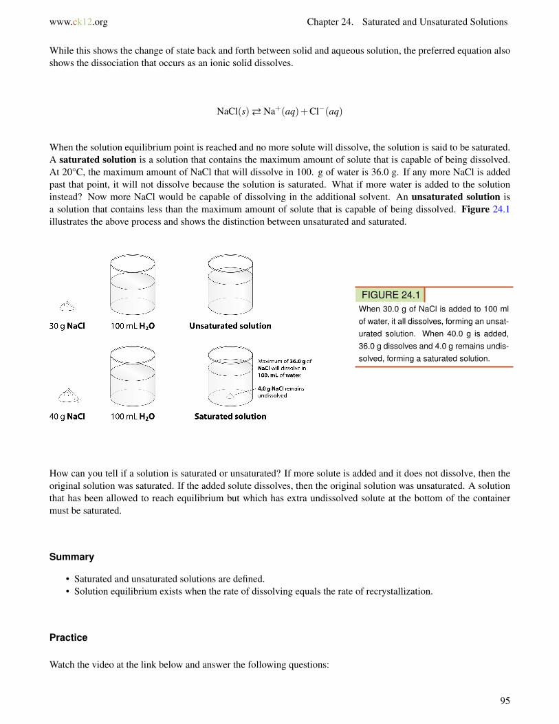
www.ck12.org Chapter 24. Saturated and Unsaturated Solutions
While this shows the change of state back and forth between solid and aqueous solution, the preferred equation alsoshows the dissociation that occurs as an ionic solid dissolves.
NaCl(s)� Na+(aq)+Cl−(aq)
When the solution equilibrium point is reached and no more solute will dissolve, the solution is said to be saturated.A saturated solution is a solution that contains the maximum amount of solute that is capable of being dissolved.At 20°C, the maximum amount of NaCl that will dissolve in 100. g of water is 36.0 g. If any more NaCl is addedpast that point, it will not dissolve because the solution is saturated. What if more water is added to the solutioninstead? Now more NaCl would be capable of dissolving in the additional solvent. An unsaturated solution isa solution that contains less than the maximum amount of solute that is capable of being dissolved. Figure 24.1illustrates the above process and shows the distinction between unsaturated and saturated.
FIGURE 24.1When 30.0 g of NaCl is added to 100 mlof water, it all dissolves, forming an unsat-urated solution. When 40.0 g is added,36.0 g dissolves and 4.0 g remains undis-solved, forming a saturated solution.
How can you tell if a solution is saturated or unsaturated? If more solute is added and it does not dissolve, then theoriginal solution was saturated. If the added solute dissolves, then the original solution was unsaturated. A solutionthat has been allowed to reach equilibrium but which has extra undissolved solute at the bottom of the containermust be saturated.
Summary
• Saturated and unsaturated solutions are defined.• Solution equilibrium exists when the rate of dissolving equals the rate of recrystallization.
Practice
Watch the video at the link below and answer the following questions:
95

www.ck12.org
MEDIAClick image to the left for more content.
http://www.youtube.com/watch?v=gawS3sBHMQw
1. What is the initial solution used?2. What is the heat source for evaporation?3. Why does the salt precipitate out of solution?
Review
1. Why is the preferred equation for solution equilibrium of NaCl an equilibrium between solid NaCl and theions.
2. If I add water to a saturated sucrose solution, what will happen?3. If I heat a solution and remove water, I see crystals at the bottom of the container. What happened?
• recrystallization: The process of dissolved solute returning to the solid state.• saturated solution: A solution that contains the maximum amount of solute that is capable of being dissolved.• solution equilibrium: The physical state described by the opposing processes of dissolution and recrystal-
lization occurring at the same rate.• unsaturated solution: A solution that contains less than the maximum amount of solute that is capable of
being dissolved.
References
1. User:Ragesoss/Wikimedia Commons. http://commons.wikimedia.org/wiki/File:MSG_crystals.JPG. Public Do-main
2. CK-12 Foundation - Christopher Auyeung. . CC-BY-NC-SA 3.0
96

www.ck12.org Chapter 25. Solute-Solvent Combinations
CHAPTER 25 Solute-SolventCombinations
• Describe different types of solutions and give an example of each.
A unique sound.
Dixieland music arose in New Orleans in the early 1900s. This driving style of music emphasized improvisationon the basic musical theme. Much of the sound quality associated with this music is due to the brass instruments(including the trumpet, trombone, and tuba). New Orleans is still the home of Dixieland, and the French Quarterechoes nightly to the sounds of this exciting music.
Solute-Solvent Combinations
The focus in the last chapter was on water and its role in the formation of aqueous solutions. We examined theprimary characteristics of a solution, how water is able to dissolve solid solutes, and we differentiated between asolution, a suspension, and a colloid. There are many examples of solutions that do not involve water at all, or thatinvolve solutes that are not solids. The Table 25.1 summarizes the possible combinations of solute-solvent states,along with examples of each.
97

www.ck12.org
TABLE 25.1: Solute-Solvent Combinations
Solute State Solvent State Exampleliquid gas water in airgas gas oxygen in nitrogen (gas mixture)solid liquid salt in waterliquid liquid alcohol in watergas liquid carbon dioxide in watersolid solid zinc in copper (brass alloy)liquid solid mercury in silver and tin (dental
amalgam)
Gas-Gas Solutions
Our air is a homogeneous mixture of many different gases and therefore qualifies as a solution. Approximately 78%of the atmosphere is nitrogen, making it the solvent for this solution. The next major constituent is oxygen (about21%), followed by the inert gas argon (0.9%), carbon dioxide (0.03%) and trace amounts of neon, methane, helium,and other gases.
Solid-Solid Solutions
Solid-solid solutions such as brass, bronze, and sterling silver are called alloys. Bronze (composed mainly of copperwith added tine) was widely used in making weapons in times past dating back to at least 2400 B.C. This metal alloywas hard and tough, but was eventually replaced by iron.
Liquid-Solid Solutions
Perhaps the most familiar liquid-solid solution is dental amalgam, used to fill teeth when there is a cavity. Approxi-mately 50% of the amalgam material is liquid mercury to which a powdered alloy of silver, tin and copper is added.Mercury is used because it binds well with the solid metal alloy. There appears to be no toxic issues associated withthe use of mercury for this purpose.
Summary
• Solutions may be composed of a variety of solid, liquid, or gaseous materials.
Practice
Read the material and answer questions 1-3 on the following website:
http://www.science.uwaterloo.ca/ cchieh/cact/c120/solution.html
Review
1. Does a solution have to have water as the solvent?2. Is there an example of a solution where water is the solute?3. When we mix ethylene glycol with the water in our car radiator to prevent freezing, which is the solvent and
which is the solute?
98

www.ck12.org Chapter 25. Solute-Solvent Combinations
References
1. Courtesy of Mass Communication Specialist 2nd Class Michael Hight, US Navy. http://commons.wikimedia.org/wiki/File:US_Navy_081119-N-5476H-007_Sailors_from_the_U.S._Pacific_Fleet_Dixieland_Band_perform_for_students_and_faculty_during_Kalihi_Elementary_School%27s_4th_Annual_Red_Ribbon_Week.jpg. Pub-lic Domain
99

www.ck12.org
CHAPTER 26 Location on the Earth• Identify and define latitude and longitude.• Understand how coordinates are used on a map.
How could you locate this feature?
Geologists, hikers, and many other people need to be able to say where they are. Or where they want to go. Theyneed to be able to mark a location on a map. The opening photo is of Old Faithful Geyser in Yellowstone NationalPark. It is located at 44o30’N and 110o150’W. Let’s explore what that means.
Location
To describe your location, you could use a coordinate system. To do this you need two points. For example, youcould use streets. Maybe you are at the corner of Maple Avenue and Main Street. Or you could use a point ofreference, a distance and an angle for direction. If you want to meet up with a friend, you could tell him “I am twoblocks due north of your apartment.” Can you identify the point of reference, the distance, and the angle?
Map Coordinates
Most maps use a grid of lines to help you to find your location. This grid system is called a geographic coordinatesystem. Using this system you can define your location by two numbers, latitude and longitude. Both numbers areangles between your location, the center of Earth, and a reference line (Figure 26.1).
Latitude
Lines of latitude circle around Earth. The equator is a line of latitude right in the middle of the planet. Latitudeis divided into degrees - 90o north of the equator and 90o south of the equator. One degree is subdivided into 60minutes. One minute is subdivided into 60 seconds. The equator is at 0o. The equator is an equal distance from boththe North and South Pole. If you know your latitude, you know how far you are north or south of the equator.
100

www.ck12.org Chapter 26. Location on the Earth
FIGURE 26.1Lines of latitude start with the equator.Lines of longitude begin at the primemeridian.
Longitude
Lines of longitude are circles that go around Earth from pole to pole, like the sections of an orange. Longitudeis also measured in degrees, which are subdivided into minutes and seconds. Lines of longitude start at the PrimeMeridian, which is 0o. The Prime Meridian is a circle that runs north to south and passes through Greenwich,England. Longitude tells you how far you are east or west from the Prime Meridian (Figure 26.2). On the oppositeside of the planet from the Prime Meridian is the International Date Line. It is at 180o. This is the place where a newday first arrives.
You can remember latitude and longitude by doing jumping jacks. When your hands are above your head and yourfeet are together, say longitude (your body is long!). When you put your arms out to the side horizontally, saylatitude (your head and arms make a cross, like the “t” in latitude). While you are jumping, your arms are going thesame way as each of these grid lines: horizontal for latitude and vertical for longitude.
Using Latitude and Longitude on a Map
If you know the latitude and longitude of a place, you can find it on a map. Simply place one finger on the latitudeon the vertical axis of the map. Place your other finger on the longitude along the horizontal axis of the map. Moveyour fingers along the latitude and longitude lines until they meet. For example, say the location you want to find isat 30oN and 90oW. Place your right finger along 30oN at the right of the map. Place your left finger along the bottomat 90oW. Move your fingers along the lines until they meet. Your location should be near New Orleans, Louisiana,along the Gulf coast of the United States. Now can you locate Old Faithful, 44o30’N and 110o150’W, on a map?
What if you want to know the latitude and longitude of your location? If you know where you are on a map, pointto the place with your fingers. Take one finger and move it along the latitude line to find your latitude. Then moveanother finger along the longitude line to find your longitude.
101

www.ck12.org
FIGURE 26.2Lines of latitude and longitude form convenient reference points on a map.
Global Positioning System
In order to get latitude, longitude, and elevation you need several instruments. What if you could do the same thingwith only one instrument? A Global Positioning System (GPS) receiver is all that is needed to locate your positionon the Earth’s surface in many places.
By 1993, the United States military had launched 24 satellites to help soldiers locate their positions on battlefields.This system of satellites was called the Global Positioning System (GPS). Later, the United States governmentallowed the public to use this system. Here’s how it works.
FIGURE 26.3(a) You need a GPS receiver to use theGPS system. (b) It takes signals fromfour GPS satellites to find your locationprecisely on the surface.
You must have a GPS receiver to use the system. You can buy many types of these in stores. The GPS receiverdetects radio signals from nearby GPS satellites. There are precise clocks on each satellite and in the receiver. Thereceiver measures the time for radio signals from satellites to reach it. The receiver uses the time and the speed ofradio signals to calculate the distance between the receiver and the satellite. The receiver does this with at least fourdifferent satellites to locate its position on the Earth’s surface (Figure 26.3). GPS receivers are now being built into
102

www.ck12.org Chapter 26. Location on the Earth
many items, such as cell phones and cars.
You can use a GPS meter to tell you how to get to Old Faithful.
Vocabulary
• coordinate system: Numbers on a grid that locate a particular point.• equator: Line connecting all the points equal distance between the North and South Poles. The zero degree
line.• global positioning system (GPS): System of satellites designed to give location information. Satellite signals
are picked up by special devices that use triangulation.• gravity: the attraction of two masses to one other. Large masses havr higher values of gravitational accellera-
tion than smaller masses.• latitude: Location of a place between the north and south pole relative to the equator.• longitude: Location of a place relative to the Prime Meridian, which runs north-south through Greenwich,
England.• Prime Meridian: Zero degree line for longitude; goes through Greenwich, England.
Summary
• Latitude is the distance north or south of the equator. It is expressed as a number between 0o and 90o north orsouth.
• Longitude is the distance east or west of the Prime Meridian. It is expressed as a number between 0o and 180o
east or west.• The global positioning system uses satellites to display very accurate location information on a special re-
ceiver.
Practice
Use the resource below to answer the questions that follow.
• Latitude and Longitude at http://www.youtube.com/watch?v=swKBi6hHHMA (3:15)
MEDIAClick image to the left for more content.
1. What are lines of latitude?2. How far apart are the lines of latitude, in degrees, in miles?3. What are the latitudes of the Equator, the Tropic of Cancer, and the Tropic of Capricorn? What are the
characteristics of the regions found between the Tropic of Cancer and Tropic of Capricorn?4. Where are the Arctic and Antarctic circle? What are the characteristics of the regions that are found poleward
of these circles?5. What are lines of longitude?6. Where do the meridians meet?
103

www.ck12.org
7. What is the Prime Meridian? Where is it located?8. How are longitude and latitude measured?
Practice your skills at identifying latitude and longitude at Latitude and Longitude Map Match Game at Kids-Geo.com. The game is simple to start but becomes more challenging (and fun!) as you progress through the levels.Can you get to level 10? http://www.kidsgeo.com/geography-games/latitude-longitude-map-game.php
Review
1. What would a latitude number in the southern hemisphere look like?2. Define latitude and longitude.3. Why are GPS devices so accurate?
References
1. Courtesy of nationalatlas.gov. . Public Domain2. Courtesy of the Central Intelligence Agency. . Public Domain3. (a) Courtesy of the US Geological Survey; (b) Courtesy of the National Oceanic and Atmospheric Adminis-
tration. . (a) Public Domain; (b) Public Domain
104

www.ck12.org Chapter 27. Elevation on the Earth
CHAPTER 27 Elevation on the Earth• Define elevation.• Understand topography.
Where are you in the third dimension?
Mt. Sheridan in Yellowstone National Park is higher above sea level than most locations. It is at 10,250 ft (3124 m).When you’re up at that elevation, you definitely think about the third dimension. It is, of course, elevation, or heightabove sea level. You can see Mt. Sheridan in the opening image and on the map.
Elevation
As you know, the surface of Earth is not flat. Some places are high, and some places are low. For example, mountainranges like the Sierra Nevada in California or the Andes in South America are high above the surrounding areas. Anaccurate location must take into account the third dimension. Elevation is the height above or below sea level. Sealevel is the average height of the ocean’s surface. This is the midpoint between high and low tide. Sea level is thesame all around Earth.
Topography
We can describe the topography of a region by measuring the height or depth of that feature relative to sea level(Figure below). You might measure your height relative to your classmates. When your class lines up, some kidsmake high “mountains,” while others are more like small hills!
Relief, or terrain, includes all the landforms of a region. For example, the image below shows the San FranciscoPeaks in northern Arizona (Figure 27.2). Features on the map include mountains, hills, and lava flows. You canrecognize these features from the differences in elevation.
Vocabulary
• elevation: Height of a feature measured relative to sea level.• relief: Difference in height of landforms of a region.• sea level: Average height of the ocean, midway between high and low tides; sea level is the same around the
world• topography: Changes in elevation for a given region.
105

www.ck12.org
FIGURE 27.1This is a satellite image of California. Thehighs, like the Sierra Nevada mountains,are rocky looking. During the winter, thepeaks are capped with snow. The lows,like the San Joaquin Valley, are lighter andsmoother. Green indicates forest.
FIGURE 27.2This image was made from data of theLandsat satellite. It shows the topographyof the San Francisco Peaks and surround-ing areas.
Summary
• Elevation is the height above sea level.• The topography of a region describes its highs and lows.• Sea level is the same around the world. It is the mid point between high and low tides.
Practice
Use the resource below to answer the questions that follow.
• How do scientists determine elevation? at
106

www.ck12.org Chapter 27. Elevation on the Earth
MEDIAClick image to the left for more content.
1. Why is elevation important?2. What is digital elevation data used for?3. What are DEMs?4. What is the source of the elevation data?5. What else is LIDAR used for?6. Why is the continued funding of this project important?
Review
1. What is elevation, and what is its reference point?2. How is topography different from relief?3. Why is sea level used as a reference point?
References
1. Courtesy of the MODIS Rapid Response Team at NASA GSFC. . Public Domain2. Courtesy of NASA/GSFC/METI/ERSDAC/JAROS, and U.S./Japan ASTER Science Team. San Francisco
Mountain and surrounding areas. Public Domain
107

www.ck12.org
CHAPTER 28 Maps• Identify and define types of maps common in Earth science.• Use maps to find information about a location.
What information does a map show?
Maps can convey a lot of different types of information. They can tell you where you are, or they can tell yousomething about a location. Maps can display the relief of an area. They can indicate something about the societythat lives in the area. Different types of maps show many different types of things.
Maps as Models
Imagine you are going on a road trip. Perhaps you are going on vacation. How do you know where to go? Mostlikely, you will use a map. A map is a picture of specific parts of Earth’s surface. There are many types of maps.Each map gives us different information. Let’s look at a road map, which is the probably the most common map thatyou use (Figure 28.1).
Map Legends
You can see the following on this road map of Florida (Figure 28.1):
• The boundaries of the state show its shape.• Black dots represent the cities. Each city is named. The size of the dot represents the population of the city.• Red and brown lines show major roads that connect the cities.• Blue lines show rivers. Their names are written in blue.• Blue areas show lakes and other waterways—the Gulf of Mexico, Biscayne Bay, and Lake Okeechobee.
Names for bodies of water are also written in blue.
108

www.ck12.org Chapter 28. Maps
FIGURE 28.1A road map of the state of Florida. Whatinformation can you get from this map?
• A line or scale of miles shows the distance represented on the map—an inch or centimeter on the maprepresents a certain amount of distance (miles or kilometers).
• Look for the legend on the top left side of the map. The legend explains other features and symbols on themap.
• It is the convention for north to be at the top of a map. For this reason, a compass rose is not needed on mostmaps.
You can use this map to find your way around Florida and get from one place to another along roadways.
Types of Maps
There are many other types of maps other than road maps. Some examples include:
• Political or geographic maps show the outlines and borders of states and/or countries.• Satellite view maps show terrains and vegetation—forests, deserts, and mountains.• Relief maps show elevations of areas. They are usually on a larger scale, such as the whole Earth, rather than
a local area.• Topographic maps show detailed elevations of features on the map.• Climate maps show average temperatures and rainfall.• Precipitation maps show the amount of rainfall in different areas.• Weather maps show storms, air masses, and fronts.• Radar maps show storms and rainfall.• Geologic maps detail the types and locations of rocks found in an area.
These are but a few types of maps that various Earth scientists might use. You can easily carry a map around inyour pocket or bag. Maps are easy to use, because they are flat or two-dimensional. However, the world is three-dimensional. So, how do map makers represent a three-dimensional world on flat paper?
109

www.ck12.org
Topographic Maps
The topography of a region can be shown on a map. Topographic mapsrepresent geographical features, such ashills and valleys. Topographic maps use contour lines to show geographical features. A contour line is a line ofequal elevation. If you walk along a contour line, you will not go uphill or downhill. Topographic maps are alsocalled contour maps. The rules of topographic maps are:
• Each line connects all points of a specific elevation.• Contour lines never cross. After all, a single point can only have one elevation.• Every fifth contour line is bolded and labeled.• Adjacent contour lines are separated by a constant difference in elevation (such as 20 feet or 100 feet). The
difference in elevation is the contour interval. The contour interval is indicated in the map legend.• Scales indicate horizontal distance and are also found on the map legend.
INTERPRETING CONTOUR MAPS
How does a topographic map tell you about the terrain? Let’s consider the following principles:
1. The spacing of contour lines shows the slope of the land. Contour lines that are close together indicate a steepslope. This is because the elevation changes quickly in a small area. Contour lines that seem to touch indicate a verysteep slope, like a cliff. When contour lines are spaced far apart, the slope is gentle. So contour lines help us see thethree-dimensional shape of the land.
Look at the topographic map of Stowe, Vermont (Figure below). There is a steep hill rising just to the right of thecity of Stowe. You can tell this because the contour lines there are closely spaced. The contour lines also show thatthe hill has a sharp rise of about 200 feet. Then the slope becomes less steep toward the right.
FIGURE 28.2
2. Concentric circles indicate a hill. Pictured below is another side of the topographic map of Stowe, Vermont(Figure below). When contour lines form closed loops, there is a hill. The smallest loops are the higher elevations
110

www.ck12.org Chapter 28. Maps
on the hill. The larger loops encircling the smaller loops are downhill. If you look at the map, you can see Cady Hillin the lower left and another, smaller hill in the upper right.
FIGURE 28.3
3. Hatched concentric circles indicate a depression. The hatch marks are short, perpendicular lines inside thecircle. The innermost hatched circle represents the deepest part of the depression (Figure below). The outer hatchedcircles represent higher elevations.
FIGURE 28.4
4. V-shaped portions of contour lines indicate stream valleys. The “V“ shape of the contour lines point uphill.There is a V shape because the stream channel passes through the point of the V. The open end of the V representsthe downstream portion. A blue line indicates that there is water running through the valley. If there is not a blue line,the V pattern indicates which way water flows. Below, you can see examples of V-shaped markings (Figurebelow).Try to find the direction a stream flows.
111

www.ck12.org
FIGURE 28.5
5. Like other maps, topographic maps have a scale so that you can find the horizontal distance. You can usethe horizontal scale to calculate the slope of the land (vertical height/horizontal distance). Common scales used inUnited States Geological Service (USGS) maps include the following:
• 1:24,000 scale – 1 inch = 2000 feet• 1:100,000 scale – 1 inch = 1.6 miles• 1:250,000 scale – 1 inch = 4 miles
Including contour lines, contour intervals, circles, and V-shapes allows a topographic map to show three-dimensionalinformation on a flat piece of paper. A topographic map gives us a good idea of the shape of the land.
Geologic Maps
A geologic map shows the different rocks that are exposed at the surface of a region. The geology is often put ona contour map. Rock units are shown in a color identified in a key. On the geologic map of the Grand Canyon,for example, different rock types are shown in different colors. Some people call the Grand Canyon “layer cakegeology“ because most of the rock units are in layers. Rock units show up on both sides of a stream valley.
A geologic map looks very complicated in a region where rock layers have been folded. Faults are seen on thisgeologic map cutting across rock layers. When rock layers are tilted, you will see stripes of each layer on the map.There are symbols on a geologic map that tell you which direction the rock layers slant. Often there is a cut awaydiagram, called a cross section or profile. A cross section shows what the rock layers look like below the surface. Alarge-scale geologic map will just show geologic provinces. They do not show the detail of individual rock layers.
112

www.ck12.org Chapter 28. Maps
FIGURE 28.6
Vocabulary
• benchmark: A surveying mark made as a reference point for elevation• contour interval: Difference in elevation between two contour lines.• contour line: Line of constant elevation on a topographic map.• geologic map: Map showing the geologic features, such as rock units and structures, of a region.• hachures: a method of representing relief on a map.• index contour: Every fourth or fifth contour line that is marked with an elevation.• map: Two-dimensional representation, usually of some part of Earth’s surface.• profile: A cross-section of a three-dimensional object; especially a topographic map.• slope: The inclination of a land form to the horizontal. The larger the number indicates the increasing
steepness of the tilt.• topographic map: Map that shows elevations above sea level to indicate geographic feature; also called
contour map;• topography: Changes in elevation that create geographic features.
Summary
• Maps are two-dimensional representations of a surface, usually Earth’s.• Maps use symbols and have legends. This is so they can display the most amount of information in the least
amount of space.• There are many types of maps. They can show social and political information; they can show scientific
information.• Topographic maps reveal the shape of a landscape. Elevations indicate height above sea level.• Contour lines are lines of equal elevation.• Contour intervals are the difference in elevation between two contour lines.• Geologic maps show rock units and geologic features, like faults and folds.
Practice
Use the resource below to answer the questions that follow.
http://www.mywonderfulworld.org/toolsforadventure/usingmaps/index.html
1. What are maps?2. What is cartography?3. What is GPS?4. What is GIS?5. What are the two main types of maps? Explain each.
113

www.ck12.org
Use the resource below to answer the questions that follow.
MEDIAClick image to the left for more content.
Understanding Topographic Maps at http://www.youtube.com/watch?v=EqyfJMgFL-U (2:49)
1. What is sea level?2. How far apart are topographic lines?3. What do the contour lines represent?4. How do you know that there’s a crater at the top of the volcano rather than a peak?5. What is the purpose of a topographic map?
Review
1. Using the map of Florida above, in what direction would you go to get from Fort Lauderdale to Tampa?2. Why do most maps begin with a portion of Earth’s surface? When might they use something different as their
base?3. What types of maps are most useful to Earth scientists?4. What is a contour line? What is a contour interval?5. What will a hill look like on a topographic map? How will a basin look different from a hill?6. How do contour lines indicate a steep slope? How do they indicate a stream?7. Why might a geologic map be useful to geologists?
References
1. Courtesy of nationalatlas.gov. . Public Domain
114