Detection of metallic and plastic landmines using the GPR and 2-D resistivity techniques
Upload
independentCategory
view
0download
0
Ž .Journal of Applied Geophysics 47 2001 227–240www.elsevier.comrlocaterjappgeo
Two Brazilian archaeological sites investigated by GPR:Serrano and Morro Grande
Gloria da Silva Cezara,), Paula Lucia Ferrucio da Rochaa, Angela Buarqueb,´Ariovaldo da Costac
a Department of Geology, Geoscience Institute, Federal UniÕersity of Rio de Janeiro, AÕ Brigadeiro Trompowksi, srn 21945-970,Rio de Janeiro, Brazil
b Department of Anthropology, National Museum, Federal UniÕersity of Rio de Janeiro, Rio de Janeiro, Brazilc Research and DeÕelopment Center, PETROBRAS, Brazil
Accepted 8 May 2001
Abstract
Ž .The application of the ground penetrating radar GPR at two archaeological sites, Serrano and Morro Grande, situated inAraruama County, Rio de Janeiro, Brazil, aids the study of a prehistoric indigenous culture, associated with theATupinambaB that inhabited the region during prehistoric times.´
The archaeological remains of the study area are mainly characterized by pottery artifacts for several uses, includingfunerary urns, which were buried within layers of sand and clay. Several profiles were acquired using a RAMAC system,with a 200 and 400 MHz frequency antennae. At the Serrano site, the profiles were acquired around some partially exposedpottery shards, due to sand exploitation. The resultant profiles provided a response model to guide the interpretation of newprofiles acquired at other sites in the area, which present similar characteristics.
The results showed the great importance of the dielectric permittivity contrast which exists between the targets and thehost media, in order for possibly significant features to be identified in radar data.q2001 Elsevier Science B.V. All rightsreserved.
Keywords: Ground penetrating radar; Archaeology; Cultural heritage; Pottery
1. Introduction
The results of an investigation are presented con-Ž .cerning the use of ground penetrating radar GPR as
a tool to improve the identification and recovery ofburied archaeological artifacts, and so establish theirspatial distribution at two archaeological sites situ-ated in the coastal lowland region, known as Lake
) Corresponding author. Fax:q55-21-590-8091.Ž .E-mail address: [email protected] G. da Silva Cezar .
Ž .Region, Rio de Janeiro, Brazil Fig. 1 . The researchproject’s main purpose is to analyze the settlement ofthe Tupinamba, prehistoric agricultural and pottery´making people, with reasonable cultural and linguis-tic homogeneity. The more accepted theory on theorigin of the Tupinamba people would be at Medio´ ´
Ž .Amazonas region, northern Brazil Brochado, 1984 .Due to demographic expansion, they moved in thedirection of the Amazon River mouth, and thenalong the littoral shoreline up to Sao Paulo county,˜reaching interior areas by following fluvial valleysŽ .Noelli, 1996 .
0926-9851r01r$ - see front matterq2001 Elsevier Science B.V. All rights reserved.Ž .PII: S0926-9851 01 00067-2
()
G.da
SilÕa
Cezar
etal.r
JournalofA
ppliedG
eophysics47
2001227
–240
228
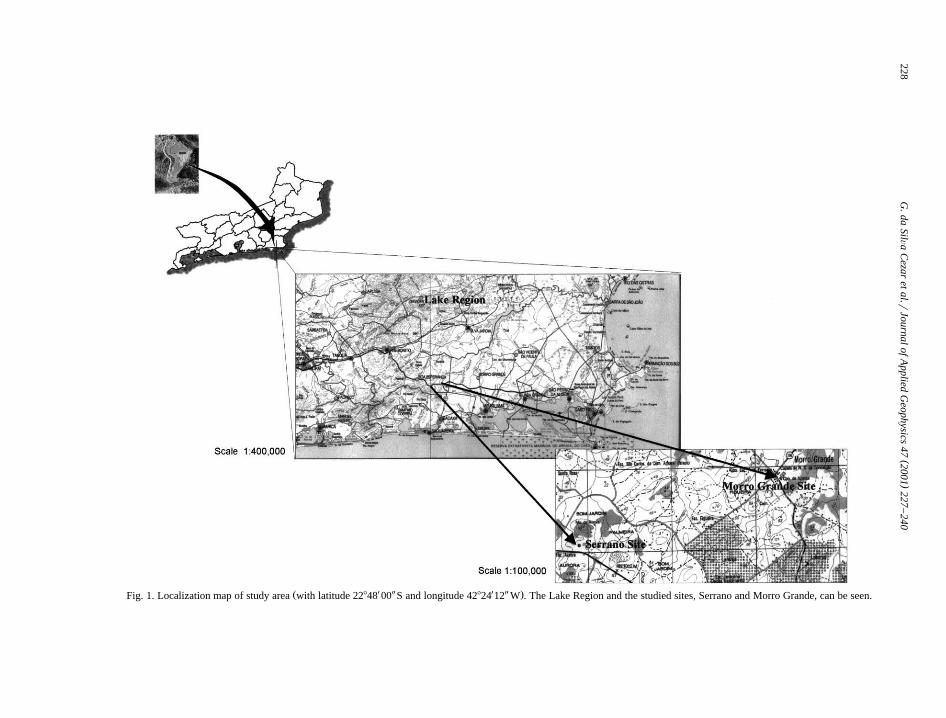
Ž X Y X Y .Fig. 1. Localization map of study area with latitude 22848 00 S and longitude 42824 12 W . The Lake Region and the studied sites, Serrano and Morro Grande, can be seen.

( )G. da SilÕa Cezar et al.rJournal of Applied Geophysics 47 2001 227–240 229
The ATupinambaB culture indigenous groups had´extensively occupied Brazilian territory since thethird century and several sites have been identifiedŽ .Buarque, 1999 . When explorers landed in BrazilŽ .15th century , the culture had spread out along theshoreline, searching for rivers and forests. Eventhough intense occupation by theATupinambaB indi-´ans along the Brazil shoreline was noted by 16th and
Ž17th century religious chroniclers and travelers forexample, Hans Staden, Jean de Lery and Gabriel´
ŽSoares de Souza Staden, 1974; de Lery, 1980; Sousa,´..1987 there is no reliable archaeological register of
the culture’s extensive occupation. Cultural andtaphonomic processes had altered the preservation ofany remains due to several cycles of cultivation thathas led to a systematic soil alteration. The sites areweakly perceptible due to small thickness horizons
Žand the archaeological artifacts are fragile Buarque.and Martins, 1999 . Nowadays, the area is host to a
commercial sand mining operation, which is causingan almost complete destruction of archaeological
Ž .remains Rocha et al., 2000 . Due to the changes inthe landscape many of the archaeological sites havebeen destroyed, leading to a irreparable loss of theregion’s cultural heritage.
In general, the ceramic sites are marginally per-ceptible on the landscape, contrary to the more easily
ŽobservableAshellmoundsB that are the result of
Fig. 2. An assemblage of urns with lid and ceremonial bowlsrepresentative of remains of the remains at the archaeologicalsites. The bowls dimensions varies from 0.15 to 0.50 m wide and
Ž0.10 to 0.25 m height, and shows several shapes circular, oval,. Žsquared or rectangular , with policromic colors red and black on
.a white base and geometric decoration within their internal partsŽ .Buarque, 1999 .
fishermen, collectors and hunters that occupied the.shoreline 5000 to 1000 BP in the Lake Region
ŽSaquarema, Marica, Arraial do Cabo, Cabo Frio and´Ž . .Buzios Fig. 1 ; Kneip, 1987; Gaspar, 1991 . The´
principal archaeological remains at ceramic sites arepottery and in general they are found at depths of
Ž .0.30–1.00 m. There are bowls without decorationŽ .for daily use cooking and storage of foods , andŽ .funerary urns with or without decoration , which are
associated with burial rituals, were found. The urnshave average dimensions of 0.70 m in height and2.00 m in circumference, and in several, bones were
Žpreserved. There were also decorated bowls three or.four found in association with urns, which are inter-
Žpreted as forming a ceremonial structure Buarque,.1999 . Fig. 2 shows an assemblage of urns with lid
and ceremonial bowls, found within settlements.
1.1. Application of geophysical methods to archaeo-logical sites
Geophysical techniques provide an increased ca-pability in situations where it is necessary to performnon-destructive archaeological investigations.
For archaeological purposes, geophysics has con-tributed widely, for example in Europe since the
Ž .1940s Wynn, 1986 . A great advantage of the appli-cation of geophysics to archaeology is the fact that itcan aid in the location of subsurface remains andmay reduce research cost.
Many publications are available that discuss theuse of geophysics for archaeological investigations.
Ž .Wynn 1986 discusses several geophysical methodswhich already have been, or are being applied toarchaeological sites: sonic spectroscopy, acousticreflection, reflection and refraction seismic, gravi-metry, magnetometry, electroresistivity, inducedpolarization, self potential, radiometry and electro-
Ž .magnetic methods Slingram and GPR . For archaeo-logical investigations, the geophysical methods morecommonly used are the electrical, magnetic and theelectromagnetic methods. In Brazil, the applicationof geophysics to archaeology is just beginning, be-cause scientific archaeological research has only be-
Ž .gun in the 1960s Meggers, 1963; Evans, 1967 .Another reason for this late beginning was the pre-conception that some geophysical methods would
( )G. da SilÕa Cezar et al.rJournal of Applied Geophysics 47 2001 227–240230
Žnot be efficient when applied to tropical areas Tel-.ford et al., 1990; Roosevelt, 1991 .
Presently, the use of GPR for archaeological in-vestigations shows increasing use in relation to othertechniques, due to its capacity for offering highresolution images which allow the identification offeatures that are relatively small in comparison to thedimensions of the geological targets. Another advan-tage of GPR is the possibility of processing data inthe field so that the anomalies can be identified
Ž .quickly Conyers, 1996 .
1.1.1. Application of geophysical methods to archae-ological sites in Brazil
The first geophysical surveys with archaeologicalpurpose in Brazil occurred in 1977 and it consistedin applying magnetic and electroresistivity methodsat AAreaoB and AAterro dos BichosB archaeological˜sites, located in Para state, northern Brazil. The´
Ž .results were presented by Alves 1979 and AlvesŽ .and Lourenc¸o 1981 . The data acquired in that
research provided subsurface information that al-lowed the identification of features correlated toarchaeological artifacts. First, the authors had estab-lished mathematical models in order to aid the mag-netic data interpretation. The models made it possi-ble to determine the probable magnetic anomalyappearance from archaeological features normallyfound at the sites. One of the settled sites waslocated on a clay soil and the other on a sandy soil.The main results achieved at the first site were the
Židentification of charred structures hearths, kiln,.clay material lenses , a funerary urn, cavities filled
Žwith organic matter rich in sediments interpreted as.food wastes and occupation stratum. At the other
site, on sandy soil, the data did not allow significantmagnetic anomalies to be identified.
Ž .Roosevelt 1991 has revisited the research ofŽ .Alves and Lourenc¸o 1981 , atATeso dos BichoB
archaeological site by detailed geophysical prospect-ing. Besides using the previous techniques, electro-magnetic techniques such as EM-38 and GPR werealso applied. The purpose of the research was tosystematically test the applicability of the methods asa guide to excavation. The subsurface features that
Žcould indicate archaeological structures kilns,hearths, ceramic artifacts, dwelling floor, waste dis-
.posing areas and stratigraphic array originated fromthe ancient occupation were identified.
The GPR survey at the above site used a 180MHz antennae frequency. The identified anomalieswere verified as being recent excavations filled withsand. The features were also identified by electrore-sistivity and EM-38. Other anomalies observed in themagnetic survey corresponded to charred structuresand compacted archaeological clay lenses. The elec-trorresistivity survey revealed the interface betweenthe archaeological stratum and the sterile bed below.
Ž .The Serrano site described later , which is on asandy soil, was destroyed in 1999 due to sand min-ing. The National Museum archaeologist team begana rescue of the preserved materials and GPR wasused as an important tool for the location of artifacts.
ŽThe first results were presented in 1999 Buarque,.1999 with follow-up research presented in 2000
Ž .Rocha et al., 2000 .At Cacoal archaeological site, located on Marajo´
Ž .Island, Para northern Brazil, Barradas et al. 1999´also performed a geophysical survey with a magne-tometer and GPR in order to identify archaeologicalfeatures that could guide future excavations. Basedon magnetic data characteristics and spatial distribu-tion of ceramic fragments observed on the surface,some areas were chosen for GPR surveys, using the400 MHz antennae. The first technique, magnetome-try, showed good results due to clay composition ofthe target and fired processes in the materials. Theresults obtained by GPR were considered less satis-factory and provided the depth and extension of theanomalies identified by magnetometry. The studyconcluded that GPR used alone would not be able to
Židentify anomalies within the study site Barradas et.al., 1999 . Another study applying GPR to archaeo-
logical sites was performed at the Santa Marinaceramic site, associated to Tupiguarani tradition, lo-
Žcated at Jacareı, Sao Paulo Robranh-Gonzalez and´ ˜ ´.Zanettini, 1999 . Some areas were intended for exca-
vation and GPR surveys were made in order to betterselect areas to be excavated. An effective equipment
Žcalibration was made by burying some objects bot-.tles and metallic artifacts . However, it was not
specified if materials were similar to the archaeologi-cal remains which normally are found within that
Žsite in relation to electrical properties and dimen-.sions . Other GPR sections had not presented the

( )G. da SilÕa Cezar et al.rJournal of Applied Geophysics 47 2001 227–240 231
same good result as shown by the section obtained inthe calibration.
The similarity between the previous studies andthe present one is that both of the sites consideredhere are ceramic sites. The project intends to con-tribute in recovering of archaeological sites by veri-fying the applicability of GPR for the conditions ofthe study area, Serrano and Morro Grande sites,which are distinct from those of the previous studies.
1.2. GPR as a tool to archaeological research
GPR is a geophysical method based on applica-Žtion of high frequency electromagnetic waves radio
. Ž .waves . The technique offers high resolution cm–m ,which allows one to locate underground electromag-netic anomalies at relatively shallow depths.
When the electromagnetic pulse transmitted bythe antenna intercepts an interface of different mate-rials with contrasting electromagnetic propertiesŽ .conductivity and dielectric constant , it partially re-flects back to the surface. At the surface the pulse isdetected by the receiver antenna and registered withinthe control unit.
The electromagnetic properties of the media de-termine the velocity, signal attenuation and reflectedenergy. The first applications of radar to under-ground surveys had the purpose of identifying thick-ness of ice sheet in permafrost environment and
Žlocate unexploded ordinance Young and Peters,.1996 . The continuous improvement on the GPR
technique allows one to obtain results with highresolution in various subsurface applications whichmay include, geology, civil engineering, geography
Ž .and archaeology Parasnis, 1997 .The use of GPR for characterizing archaeological
sites comprises the identification of building andŽarchaeological artifacts. To identify small targets in
ceramic sites, where the targets usually are found.broken and scattered it is necessary to use higher
Ž .frequencies )200 MHz . It is difficult for higherfrequencies to locate a small target lying at relativelylarge depths due to signal attenuation at higher fre-quencies. Another limitation of GPR is in locationswhere there is an absence of or a weak electricalproperty contrast between the target and the sur-rounding material, which is the case in many of the
Ž .reported sites ceramic artifacts within clay soils .
In order to define the target depth, it is importantto establish the average velocity of the wave propa-gating in the subsurface medium. When this velocityis known, it is possible to determine the reflectiondepths since the travel time of the propagating pulseis registered during data acquisition. There are sev-eral ways to determine the wave propagation veloc-ity in a medium, for example, using a commonmidpoint survey or the determination of the dielec-tric permittivity of the media. However, it is difficultto accurately obtain the wave propagation velocity
Ž .for geological materials Vaughan, 1986 , and for theinvestigation of shallow targets, as in the case of thepresent study where the depths do not need to bedetermined with precision, velocity values recordedin the literature can be used.
2. Area descriptions
The study area encompass two archaeologicalsites, Serrano and Morro Grande, located on uncon-solidated materials, sand and clay. Samples of ar-chaeological coal from the studied sites reveal for
ŽSerrano an age of 280 years BP by termolumines-.cence at UFFrCBPF laboratory and for Morro
Ž . ŽGrande an age of 1740"90 years BP by C14,.Beta Analytic 84333 .
The Serrano archaeological site, described byŽ .Buarque and Martins 1999 , is located 27.5 km
Žalong the RJ-124 highway, in Araruama county Fig..1 . The site was found in 1997 during an environ-
mental impact project done for a highway project.The pottery fragments were scattered within an or-
Fig. 3. Archaeological remains partially exposed, consist of pot-tery fragments disposed in a circular geometry, completely filledwith clay sediments.

( )G. da SilÕa Cezar et al.rJournal of Applied Geophysics 47 2001 227–240232
Fig. 4. Archaeological remains presented at surface as a circularcavity.
ange crop. Even though anthropogenic alterationsdue to local agriculture lead to partial destruction ofartifacts, this site had not destroyed archaeologicalstructures. However, a later sand exploitation causedsuch destruction and left some archaeological re-
Žmains partially exposed bowls and urns, Figs. 3 and.4 .
The Morro Grande Tupinamba site, located in the´center of the district of the same name, is partiallydestroyed due to urbanization. It is possible, how-ever, to find untouched archaeological structuresŽ .urns, bowls, hearths , scattered in an area of about90,000 m2, especially at a school external patio andat the church plaza.
3. Methodology
The choice of the archaeological sites, Serranoand Morro Grande, to be studied in the survey arebased on systematic research in the Lake Region,which began in 1993 as performed by the Federal
Ž .University of Rio de Janeiro UFRJ National Mu-seum researchers. Due to the imminent destruction ofthe region’s archaeological sites, by urbanization andsand mining, the application of GPR has became animportant tool to improve the recovery of artifactsexisting within the research sites.
The location of the GPR survey was indicated byarchaeologists based on their previous knowledge.The Serrano site was the first area where GPRtechnology was applied and the first component of
the GPR project was the insertion of pottery artifactswith dimensions similar to the artifacts of archaeo-logical origin.
Due to a total absence of geophysical data for thestudy area, it was necessary to perform a systematicstudy to observe if there exists a contrast between
Ž . Ž .the target pottery and the environment soil .The stratigraphic array and the spatial distribution
of artifacts at the site were known. Buarque andŽ .Martins 1999 comment about the occupation stra-
tum that occurs at 0.60 m depth within the sandysediment. The presence of archaeological artifacts
Ž .below this depth to 1.20 m , within a clay bed, isrestricted to funerary urns. The entire occupation
Ž .stratum sandy sediment had been removed duringsand mining processes. Fig. 3 shows pottery frag-ments disposed in a circular geometry, completelyfilled with clay sediments and quartz fragments andindicates the presence of partially destroyed urns.Another remnant was present at the surface as a
Ž .circular cavity Fig. 4 , with no filling or water.Morro Grande was chosen as a site that is par-
tially settled and within a school. Previous re-Ž .searchers Buarque, 1999 and dwellers have regis-
tered the presence of large amounts of archaeologicalmaterial. Unlike the Serrano site, there were nosurface remains which could indicate the presence ofartifacts.
3.1. Data acquisition
The study was carried out with a common offsetsurvey, by using a RAMACrMala GPR system, but˚the methodology used for data acquisition at eachsite was different due to the site characteristics.
When data were collected at Serrano site, twoperpendicular directions were chosen, crossing thecenter of the partially exposed archaeological re-mains. Other profiles parallel to these directions and1.00 m distant from them were also run, with a stepsize of 0.30 m used in each profile. Taking intoaccount field experience and achieved results at Ser-rano site, a grid of 70 parallel lines spaced 0.80 mapart was established in a area corresponding to the
Ž .school patio at Morro Grande Fig. 10 . The lengthof the lines varied accordingly to the area geometry.

( )G. da SilÕa Cezar et al.rJournal of Applied Geophysics 47 2001 227–240 233
Data were taken at a step size of 0.10 m. The totalsurvey comprised about 2600 m2. At the MorroGrande site, 400 MHz antennas were used in order toachieve better resolution.
In order to check the depths of the reflectioninterfaces, two boreholes 1.00 m deep were drilled,and the subsurface samples were macroscopicallydescribed. Analysis of the borehole stratigraphy as-sociated with previous archaeology analysisŽ .Buarque, 1996; Buarque and Martins, 1999 pro-vided a very important step for the modeling process.
ŽFive distinct beds were identified. Fig. 5 Rocha et.al., 2000 shows a schematic section and the position
where the archaeological remains are usually found.The material description was made as an archaeolog-ical stratigraphy, from the top to bottom.
Using the results of drill core analysis, it waspossible to estimate the velocity and the contrasts ofconductivity properties among the materials that sur-round the pottery. Consequently, it was possible tocalculate the depths of the reflection interfaces andthe disturbed zones, as will be presented at Section3.2.
Ž .The uppermost bed bed 1 , is intensively alteredby anthropogenic intervention and has a thicknessvarying from 0.10 to 0.20 m. It is composed of dark
Ž .gray due to organic matter silty sand, fine tomedium with coarser grains and quartz fragments ofup to 3.0 mm in size. Bed 1 usually has a highnumber of archaeological material remains, mixedwith present-day material. Bed 2 is generally wellpreserved and has a thickness ranging from 0.20 to0.30 m. Its grain size is similar to that of bed 1, its
Žcolor is light gray with black lenses of coal originat-.ing from archaeological hearths . The largest amount
Žof archaeological material ceremonial and dairy-use.bowls, upper portion of urns and lids occurs in bed
2.The continuity of bed 3 is irregular. Its composi-
Žtion is essentially quartzose from iron-oxidized.quartz veins with some iron concretions and an
average thickness of 0.25 m. Some quartz fragmentsare well crystallized and associated with tourmaline.Bed 3 is coarsering upward.
Bed number 4 consists of fine sand with clay,whose top is generally 0.60 to 0.70 m below thesurface with a thickness of about 0.25 m.
Bed 5 is a sandy clay whose sand grains are muchfiner than those from the beds above.
From archaeological surveys it is known thatarchaeological materials within beds 3, 4 and 5 areonly funerary urns, similar to the Serrano site. Fur-
Ž .Fig. 5. Schematic section of the archaeological stratigraphy of the area and the position where remains were found Rocha et al., 2000 .

( )G. da SilÕa Cezar et al.rJournal of Applied Geophysics 47 2001 227–240234
thermore, holes used for wood sticks with 0.10 mdiameter can be found and are interpreted as build-ings roof supports.
The deepest level where archaeological material isat sites where funerary urns are present is up to 1.10m deep.
3.2. Data processing
The GPR anomalies can be identified in somesituations even in the field. However, it is oftenessential to process the data for further interpretation.During processing it is possible to improve the qual-ity of the images derived from subsurface features.In general there is a decrease in signal amplitude athigher return times due to theAearth filterB attenua-
Ž .tion Telford et al., 1990 .The processing allows the elimination of features
corresponding to radar wave reflection from surfaceŽ .targets noise while enhancing signals originating
from subsurface features.The radar data were imported into Focus software
Ž .Paradigm Geophysical , a geophysical package forseismic data processing that offers solutions to prob-lems with multiples, velocity analysis, migration,deconvolution, static corrections and enhancement ofsignals. The GPR technique has similar principles to
Ž .reflection seismic and sonar Davis and Annan,1989Žand several attempts Fisher et al., 1992, Maijala,
1992; Rees and Glover, 1992; Tillard and Dubois,.1995 have shown that radar data processing can be
performed by software packages traditionally usedfor reflection seismic data. Focus particularly showedgreat efficiency for visualization and treatment ofdata acquired with RAMACrMala GPR. The reason˚for using this software is its capability of imageresolution and signal enhancement, a necessary stagefor visualization of archaeological structures thatcould be present in GPR profiles. The radar sectionsacquired at Serrano and Morro Grande sites wereprocessed by applying bandpass trapezoidal filter,with frequency of 100 to 300 MHz, and an AGC.The features identified within the Serrano GPR pro-files provide an aid to interpret the radar sectionsacquired at the Morro Grande site. The data process-ing used wave propagation velocities for the materi-
Ž .als found in the area clay and sand , identified from
previous stratigraphic knowledge. The estimated ve-Žlocities from reference values, 0.15 mrns for dry
.sand and 0.06 mrns for clay allow us to roughlycalculate the underground reflection depths. A com-mon midpoint survey was not done in the presentstudy, because the targets were positioned very shal-low and the main purpose was to determine theirspatial distribution. So it was not necessary to accu-rately determine the depths.
4. Results
Ž .Fig. 6 a, b and c shows radar profiles acquiredduring the construction of the pattern model of GPRresponse at the Serrano site.
The results are representative of the contrast be-Ž .tween target archaeological pottery and the envi-
Ž .ronment sediments . In all profiles in Fig. 6, verticalscales at left show the two-way travel time innanoseconds, vertical scales at right are indicative ofdepths, in meters. As stated early, the depths werecalculated from the estimated velocities values forwave propagation on the media. All the profiles inFig. 6 and the other ones that are shown later,contain a well-marked reflector that is associated
Ž .with the interface observable in the field betweensand and clay. The depths were calculated by usingdry sand velocity at times shallower than the reflec-tor and for deeper times the clay velocity was used.The horizontal scale represents the length of theprofiles, in meters.
Within Fig. 6a, it is possible to observe a weakŽ .feature about 1.5 m distant and 30 ns correspond-
ing to an electromagnetic signal due to an archaeo-logical artifact. In Fig. 6c, as also indicated, theanomaly in observed with less clarity.
Fig. 6b crosses the center of a funerary urn thatŽ .could be observed at ground surface Fig. 4 . It
shows features corresponding to the investigated tar-get. However, within the radar profile, at position 1.5m and time 20–35 ns, one can identify two anoma-lies. The interpretation suggested the possibility oftwo superposed pottery artifacts, which was con-firmed during excavation. Those artifacts were anurn about 0.60 m in height and 0.45 m in diameter

()
G.da
SilÕa
Cezar
etal.r
JournalofA
ppliedG
eophysics47
2001227
–240
235
Ž .Fig. 6. Radar sections acquired on and nearby the remains shown in Fig. 4. In the central profile an anomaly as indicated associated with the urn is clearly observed.

( )G. da SilÕa Cezar et al.rJournal of Applied Geophysics 47 2001 227–240236
Fig. 7. The archaeological artifact shown in Fig. 4 after excava-Ž .tion, an urn about 0.60 m height and its broken lid.
Ž .upper part associated with a broken lid, 0.40 m inheight and 0.70 m in diameter, constituting an as-
Ž .semblage characteristic of funerary structure Fig. 7 .During excavation, the lid was shown to be tilted.The tilting could explain the weak anomaly showedin Fig. 6c, because this profile was more distant fromthe urn, in comparison with profile Fig. 6a. Based onthe results, a smaller spacing between profile lineswould generate better detection of anomalies be-tween parallel profiles. Therefore, for archaeologicalpurposes, the application of the technique demands
Fig. 8. Radar section acquired on the urn shown in Fig. 3. Theanomaly is indicated.
Ž .Fig. 9. The archaeological remains shown in Fig. 3 after excava-tion. It is an urn with about 0.35 m diameter.
small spacing between profile lines, due to the gener-ally small dimensionrdepth of targets.
Fig. 8 shows a profile acquired across potteryŽ .shards of an urn Fig. 3 . The urn was completely
filled with sediments, unlike that of Fig. 4. TheŽprofiles in Fig. 8 shows a target about 1.5 m and 20
.ns with lower clarity as compared to profiles fromFig. 6. The reason for the poor image resolutioncould be due to weak contrast between the sediment
Žand target, as occurred at Cacoal site, Para Barradas´et al., 1999; since the sediments surrounding the urn
.were mainly composed of clay . Fig. 9 shows thaturn after excavation. The data of Fig. 8 show theimportance of dielectric property contrast betweenurn and host sediments, in order to achieve goodresults. The urn of Fig. 6 was air-filled while the urnof Fig. 8 was filled with clay material,1 which madeit difficult to obtain a good image. Thus, the twofactors that restrict good results when applying GPRare absence of very weak contrast between target andsediment electrical and dielectric properties, and tar-get dimension. Experience acquired at the Serranosite survey was a model for interpretation of GPRprofiles acquired at Morro Grande. The interpreta-tions of Morro Grande data showed that some pro-
Ž .files Fig. 11 contain anomalies that could be due tothe presence of archaeological artifacts. Five areas,with dimensions of 1.5 m=1.5 m were picked up, at
1 Velocity in air taken equal to vacuum, 0.3 mrns; velocity inclay about 0.06 mrns and velocity in sand ranging from 0.06 to
Ž .0.15 mrns saturated and dry sand, respectively .

()
G.da
SilÕa
Cezar
etal.r
JournalofA
ppliedG
eophysics47
2001227
–240
237
Fig. 10. Sketch with profiles location at Morro Grande site, totaling 70 parallel lines equally spaced by 0.80 m. The length of the lines varied according to area geometry.

()
G.da
SilÕa
Cezar
etal.r
JournalofA
ppliedG
eophysics47
2001227
–240
238
Fig. 11. The radar sections corresponding to the excavated sectors. The anomalies interpreted as archaeological features are indicated.

( )G. da SilÕa Cezar et al.rJournal of Applied Geophysics 47 2001 227–240 239
the Morro Grande site. Each area or sector involvedpart of two consecutive lines: 22–23, 27–28, 32–33,
Ž .39–40 and 44–45 as indicated in Fig. 10 . Withinsector 27–28 it was necessary to enlarge the excava-tion by another 0.50 m, due to evidence of ceramicmaterials. In general, excavations reached 0.70 mdepth, surpassing the occupation horizon. In sector44–45, the depth excavated reached 0.95 m. Theradar profiles corresponding to above described ex-cavations are shown in Fig. 11. Results obtained atthe Morro Grande site can be divided into twogroups: the first one corresponds to sectors 32–33,39–40 and 44–45, which did not show good correla-tion between identified anomalies and archaeologicalmaterials. In sector 32–33 and 39–40, some scat-tered ceramic fragments were found. At sector 44–45,no archaeological remains were found.
The second group consists of sectors 22–23 and27–28 where artifacts were found that could justifythe anomalies observed. Within sector 27–28, at0.10 m depth, ceramic fragments were found. Con-tinuing excavation revealed the presence of two largeclusters of coal at depths of 0.20 and 0.40 m. Thefirst occurrence was interpreted as a hearth, 0.30 mwide and 0.10 m thick. No further remains werefound below.
The anomalies identified within radar profiles ofsector 27–28 originated from hearth carbon. Based
Ž .on results from Parkhomenko 1967 and Davis andŽ .Annan 1989 , there is an apparent difference in
Ž . Ž .dielectric constant from sand 3–5 to coal 10 thatcould cause the anomaly in sectors 27–28.
Sector 22–23 was characterized by a large amountŽof quartz fragments of large dimensions about 0.20
.m at 0.05 m depth, but according to the archaeolo-gists, the quartz fragments do not present character-istics indicative of archaeological origin. These oc-currences are interpreted as the anomaly on the radarprofile.
5. Discussions
The Serrano site data showed detailed featurescorresponding to presence of pottery urns, which wasnot verified at Morro Grande site, where the identi-fied anomalies do not correspond to ceramic struc-
tures with the same characteristics as previouslyrecovered ones.
Absence of ceramic structures may be explainedŽ .by Buarque 1996 , which shows the spatial distribu-
tion of Morro Grande site to be the village centralplaza or its neighborhood, and archaeological studiesindicate these areas to beAempty spacesB. The de-
Ž .tected hearth line 27–28 could be associated toarchaeological dwellings nearby the plaza center andprobably associated with the structure recoveredshown in Fig. 2. Several urns were recovered fromthe area surrounding the space surveyed by GPR, butat the time of recovering, that wide space was notinvestigated.
The next stage of the research will be a three-di-mensional processing comprising all profiles ac-quired at the Morro Grande site, with the purpose ofinterpreting more details about the features presentedwithin radar profiles, which will then guide newexcavations.
6. Conclusions
Ground penetrating radar may be a powerful toolfor archaeological investigations because it is a non-destructive technique and can provide high resolu-tion data for the subsurface. However, GPR hassome limitations and before deciding to carry outGPR survey at a specific site, it is fundamental to getsome knowledge of the electrical conductivity of thematerials constituting the environment of study, anddetermine if there will be dielectric permittivity con-trast between the target and the media.
The best results obtained in this study confirm theabove statement, a radar section acquired on an urnfilled with air showed a well-marked feature. Theother example was a reflection interface, present inall radar sections shown in this paper. The interfaceis associated with materials that have a strong con-trast in their dielectric constant, dry sand and clay.
Acknowledgements
We would like to thank C.E. de Morais Fernandeswho revised this text, and Carlos Jorge de Abreu,Eloısa Rangel, Jefferson da Silveira Martins, Maria´

( )G. da SilÕa Cezar et al.rJournal of Applied Geophysics 47 2001 227–240240
Dulce Gaspar, Marcia Barbosa, Helder Manuel,´Flavia G. Castro, Suely Ferreira and Marcelo Mar-´ques for their fundamental contributions. The Geol-ogy and Anthropology Departments of Rio de Janeiro
ŽFederal University and FINEP government institu-.tion are also thanked for the support of the project
titled AEstudo da Colonizac¸ao e Desenvolvimento do˜Sistema Socio Cultural das Sociedades Ceramicas do´ ˆLitoral Centro-Norte do Estado do Rio de JaneiroB.
References
Alves, J.J.A., 1979. Metodos geofısicos aplicados a arqueologia´ ´ `no estado do Para. MSc thesis, Federal University of Para,´ ´Brazil.
Alves, J.J.A., Lourenc¸o, J.S., 1981. Metodos geofısicos aplicados´ ´a arqueologia no estado do Para. Boletim do Museu Paraense` ´Emılio Goeldi 26, 1–52.´
Barradas, J.A., Schaan, D.P., Luiz, J.G., 1999. Magnetic and GPRsurvey to identify archaeological features on Cacoal Site,Anajas River, Marajo Island, Para, Brazil. Proceedings of the´ ´ ´sixth International Congress of the Brazilian Geophysical So-ciety, Rio de Janeiro. SBGf, Rio de Janeiro, Brazil, availableonly in CD-ROM.
Brochado, J.P., 1984. An ecological model of the spread ofpottery and agriculture into Eastern South America. DSc The-sis, University of Illinois, USA.
Buarque, A., 1996. Uma aldeia tupinamba em Morro Grande.´Proceedings of VIII Reuniao da Sociedade de Arqueologia˜Brasileira, vol. 2. PUCRS, Rio Grande do Sul, Brazil, pp.207–220.
Buarque, A., 1999. A cultura tupinamba no estado do Rio de´Ž .Janeiro. In: Tenorio, M.C. Ed. , 1999. Pre-Historia da Terra´ ´ ´
Brasilis, vol. 2, UFRJ Press, Rio de Janeiro, Brazil, pp.307–320.
Buarque, A., Martins, J.S., 1999. Os sıtios arqueologicos e a´ ´ocupacao do espac¸o na regiao dos lagos. Proceedings of XIX˜ ˜Congresso Brasileiro de Cartografia. ReciferOlinda-PE, Per-nambuco, Brazil, available in CD-ROM.
Conyers, L.B., 1996. The use of ground penetrating radar to mapthe archaeology and paleogeography of Ceren Site, El Sal-vador. Proceedings of 6th International Conference on GroundPenetrating Radar. Tohoku University, Sendai, Japan, pp. 89–94.
Davis, J.L., Annan, A.P., 1989. Ground Penetrating Radar forhigh-resolution mapping of soil and rock stratigraphy. Geo-phys. Prospect. 37, 531–551.
De Lery, J., 1980. Viagem a terra do Brasil, Editora Itatiaia,´ `Editora da USP Brazil.
Evans, C., 1967. Introduc¸ao, PRONAPA I, Museu Paraense Emılio˜ ´Goeldi, Para, Brazil 6, 7–12.´
Fisher, E., McMechan, G.A., Annan, A.P., 1992. Acquisition and
processing of wide-aperture ground penetrating radar profiles.Ž .Geophysics 57 3 , 495–504.
Gaspar, M.D., 1991. Aspectos da organizac¸ao social de grupos de˜pescadores, coletores e cac¸adores: regiao compreendida entre a˜Ilha Grande e o Delta do Paraıba do Sul, Estado do Rio de´Janeiro. DSc thesis, University of Sao Paulo, Brazil.˜
Kneip, L., 1987. Coletores e Pescadores Pre-historicos de Guarat-´ ´iba, Rio de Janeiro. Editora UFRJrUFF, Rio de Janeiro,Brazil.
Maijala, P., 1992. Application of some seismic data processingmethods to ground penetrating radar data. Proceedings ofFourth International Conference on Ground Penetrating Radar,Geological Survey of Finland, Rovaniemi, Finland, SpecialPaper 16.
Meggers, B.J., 1963. Cultural development in Latin America: anŽ .interpretative overview. In: Meggers, B., Evans, C. Eds. ,
Aboriginal Cultural Development in Latin America: An Inter-pretative Review. Smithsonian Institution, USA, pp. 13–145.
Noelli, F.S., 1996. As hipoteses sobre o centro de origem e rotas´Ž .de expansao dos Tupi. Revista de Antropologia 39 2 , 7–53.˜
Parasnis, D.S., 1997. Principles of Applied Geophysics. Chapman& Hall, London.
Parkhomenko, E.I., 1967. Electrical Properties of Rocks. Plenum,New York, USA.
Rees, H.V., Glover, J.M., 1992. Digital enhancement of groundŽ .probing radar data. In: Pilon, J. Ed. , Ground Penetrating
Radar. Paper 90-4. Geological Survey of Canada, pp. 187–192.Robrahn-Gonzalez, E.M., Zanettini, P.E., 1999. Jacareı as vesperas´ ´ ` ´
do descobrimento: a pesquisa arqueologica no sıtio Santa´ ´Marina. O Expresso, Brazil.
Rocha, P.L., Cezar, G.S., Buarque, A., Costa, A., 2000. Thearchaeological sites at Rio de Janeiro State, Brazil with theircontents enhanced by the use of the ground penetrating radar.
Ž .In: Noon, D.A., Stickley, G.F., Longstaff, D. Eds. , SPIE,4084, USA, pp. 607–610.
Roosevelt, A., 1991. Moundbuilders of the Amazon: geophysicalarchaeology on Marajo Island, Brazil. Academic Press, USA.
Sousa, G.S., 1987. Tratado Descritivo do Brasil em 1587. Com-panhia Editora Nacional, Brazil.
Staden, H., 1974. Duas Viagens ao Brasil. Livraria Itatiaia Edi-tora, Brazil.
Telford, W.M., Geldart, L.P., Sheriff, R.E., 1990. Applied Geo-physics. Cambridge Univ. Press, England.
Tillard, S., Dubois, J.C., 1995. Analysis of GPR data: waveŽ .propagation velocity determination. In: Owen, T.E. Ed. ,
1995. Journal of Applied Geophysics, Special Issue: GroundŽ .Penetrating Radar, vol. 33 1–3 , pp. 77–91.
Vaughan, C.J., 1986. Ground Penetrating Radar surveys used inŽ .archaeological investigations. In: Wynn, J.C. Ed. , 1986.
Geophysics, Special Issue: Geophysics in Archaeology, vol.Ž .51 3 , pp. 595–604.
Wynn, J.C., 1986. Archaeological prospection: an introduction tothe special issue. Geophysics, Special Issue: Geophysics in
Ž .Archaeology 51 3 , 533–537.Young, J.D., Peters Jr., L., 1996. A brief history of GPR funda-
mentals and applications. Proceedings of 6th InternationalConference on Ground Penetrating Radar. Tohoku University,Sendai, Japan, pp. 5–14.
Copyright © 2022 FDOKUMEN