TRG papers 6 04
150
OUTPUT FROM THE UNIVERSITY OF HONG KONG, TIBET RESEARCH GROUP (HKUTRG) GEOLOGICAL INVESTIGATIONS IN TIBET 1997-2003 Papers published 1. Aitchison, J. C., Badengzhu, Davis, A. M., Liu, J., Luo, H., Malpas, J., McDermid, I., Wu, H., Ziabrev, S., and Zhou, M. F., 2000, Remnants of a Cretaceous intra-oceanic subduction system within the Yarlung-Zangbo suture (southern Tibet): Earth and Planetary Science Letters, v. 183, p. 231-244. 2. Aitchison, J. C., Abrajevitch, A., Ali, J. R., Badengzhu, Davis, A. M., Luo, H., Liu, J. B., McDermid, I. R. C., and Ziabrev, S., 2002, New insights into the evolution of the Yarlung Tsangpo suture zone, Xizang (Tibet), China: Episodes, v. 25, p. 90-94. 3. Aitchison, J. C., Davis, A. M., Badengzhu, and Luo, H., 2002, New constraints on the India-Asia collision: The Lower Miocene Gangrinboche conglomerates, Yarlung Tsangpo suture zone, SE Tibet: Journal of Asian Earth Sciences, v. 21, p. 253-265. 4. Davis, A. M., Aitchison, J. C., Badengzhu., Luo, H., and Zyabrev, S., 2002, Paleogene island arc collision-related conglomerates, Yarlung-Tsangpo suture zone, Tibet: Sedimentary Geology, v. 150, p. 247-273. 5. Liu, J. B., and Aitchison, J. C., 2002, Upper Paleocene radiolarians from the Yamdrok mélange, south Xizang (Tibet), China: Micropaleontology, v. 48, p. 145-154. 6. McDermid, I. R. C., Aitchison, J. C., Davis, A. M., Harrison, T. M., and Grove, M., 2002, The Zedong terrane: A Late Jurassic intra-oceanic magmatic arc within the Yarlung-Zangbo suture zone, southeastern Tibet: Chemical Geology, v. 187, p. 267-277. 7. Ziabrev, S. V., Aitchison, J. C., Abrajevitch, A., Badengzhu, Davis, A. M., and Luo, H., 2003, Precise radiolarian age constraints on the timing of ophiolite generation and sedimentation in the Dazhuqu terrane, Yarlung- Tsangpo suture zone, Tibet.: Journal of the Geological Society, v. 160, p. 591- 599. 8. Zyabrev, S. V., Aitchison, J. C., Badengzhu., Davis, A. M., Luo, H., and Malpas, J., 1999, Radiolarian biostratigraphy of supra-ophiolite sequences in the Xigaze area, Yarlung-Tsangpo suture, Southern Tibet (preliminary report): Radiolaria, v. 17, p. 13-19. Papers accepted and currently in press 1. Aitchison, J. C. and Davis, A. M., 2003 in press, Geological development of the Tibet-Qinghai Plateau, China: constraints on models provided by new observations, in Malpas, J. G., Fletcher, C. J. N., Ali, J. R., and Aitchison, J. C., editors, Tectonic Processes in the Evolution of China: London, The Geological Society of London Special Publication. 2. Aitchison, J. C., Davis, A. M., Ali, J. R., Badengzhu, Liu, J. B., Hui, L., McDermid, I. R. C., and Ziabrev, S. V., 2003 in press, Stratigraphic and sedimentological constraints on the age and tectonic evolution of the
Transcript of TRG papers 6 04

OUTPUT FROM THE UNIVERSITY OF HONG KONG, TIBETRESEARCH GROUP (HKUTRG) GEOLOGICAL INVESTIGATIONS IN
TIBET 1997-2003
Papers published
1. Aitchison, J. C., Badengzhu, Davis, A. M., Liu, J., Luo, H., Malpas, J.,McDermid, I., Wu, H., Ziabrev, S., and Zhou, M. F., 2000, Remnants of aCretaceous intra-oceanic subduction system within the Yarlung-Zangbo suture(southern Tibet): Earth and Planetary Science Letters, v. 183, p. 231-244.
2. Aitchison, J. C., Abrajevitch, A., Ali, J. R., Badengzhu, Davis, A. M., Luo, H.,Liu, J. B., McDermid, I. R. C., and Ziabrev, S., 2002, New insights into theevolution of the Yarlung Tsangpo suture zone, Xizang (Tibet), China:Episodes, v. 25, p. 90-94.
3. Aitchison, J. C., Davis, A. M., Badengzhu, and Luo, H., 2002, Newconstraints on the India-Asia collision: The Lower Miocene Gangrinbocheconglomerates, Yarlung Tsangpo suture zone, SE Tibet: Journal of AsianEarth Sciences, v. 21, p. 253-265.
4. Davis, A. M., Aitchison, J. C., Badengzhu., Luo, H., and Zyabrev, S., 2002,Paleogene island arc collision-related conglomerates, Yarlung-Tsangpo suturezone, Tibet: Sedimentary Geology, v. 150, p. 247-273.
5. Liu, J. B., and Aitchison, J. C., 2002, Upper Paleocene radiolarians from theYamdrok mélange, south Xizang (Tibet), China: Micropaleontology, v. 48, p.145-154.
6. McDermid, I. R. C., Aitchison, J. C., Davis, A. M., Harrison, T. M., andGrove, M., 2002, The Zedong terrane: A Late Jurassic intra-oceanic magmaticarc within the Yarlung-Zangbo suture zone, southeastern Tibet: ChemicalGeology, v. 187, p. 267-277.
7. Ziabrev, S. V., Aitchison, J. C., Abrajevitch, A., Badengzhu, Davis, A. M.,and Luo, H., 2003, Precise radiolarian age constraints on the timing ofophiolite generation and sedimentation in the Dazhuqu terrane, Yarlung-Tsangpo suture zone, Tibet.: Journal of the Geological Society, v. 160, p. 591-599.
8. Zyabrev, S. V., Aitchison, J. C., Badengzhu., Davis, A. M., Luo, H., andMalpas, J., 1999, Radiolarian biostratigraphy of supra-ophiolite sequences inthe Xigaze area, Yarlung-Tsangpo suture, Southern Tibet (preliminary report):Radiolaria, v. 17, p. 13-19.
Papers accepted and currently in press
1. Aitchison, J. C. and Davis, A. M., 2003 in press, Geological development ofthe Tibet-Qinghai Plateau, China: constraints on models provided by newobservations, in Malpas, J. G., Fletcher, C. J. N., Ali, J. R., and Aitchison, J.C., editors, Tectonic Processes in the Evolution of China: London, TheGeological Society of London Special Publication.
2. Aitchison, J. C., Davis, A. M., Ali, J. R., Badengzhu, Liu, J. B., Hui, L.,McDermid, I. R. C., and Ziabrev, S. V., 2003 in press, Stratigraphic andsedimentological constraints on the age and tectonic evolution of the

Neotethyan ophiolites along the Yarlung Tsangpo suture zone, Tibet, in Dilek,Y., and Robinson, P. T., editors, Ophiolites in Earth History: London, TheGeological Society of London Special Publication.
3. Davis, A. M., Aitchison, J. C., Badengzhu, and Hui, L., 2003 in press,Conglomerates of the Yarlung Tsangpo suture zone, southern Tibet, inMalpas, J. G., Fletcher, C. J. N., Ali, J. R., and Aitchison, J. C., editors,Tectonic Processes in the Evolution of China: London, The GeologicalSociety of London Special Publication.
Papers submitted and in review
1. Abrajevitch, A., Aitchison, J. C., Ali, J. R., Badengzhu, Davis, A. M., Liu, J.B., and Ziabrev, S. V., submitted, Neotethys and the India-Eurasia collision -new insights following a palaeomagnetic investigation of the Dazhuqu Terrane(southern Tibet): submitted to Geophysical Journal International.
2. Ziabrev, S. V., Aitchison, J. C., Abrajevitch, A., Badengzhu, Davis, A. M.,and Luo, H., submitted, Bainang Terrane, Yarlung-Tsangpo suture, southernTibet: a trace of intra-Tethyan subduction on the Roof of the World: submittedto Journal of the Geological Society.
Theses
1. Liu, J. B., 2001, Yamdrok Melange, Gyantze district, Xizang (Tibet), China,M. Phil. thesis, Department of Earth Sciences: University of Hong Kong, p.228.
2. Abrajevitch, A., 2002, Paleomagnetism of the Dazhuqu Terrane, YarlungZangbo Suture Zone, Southern Tibet, M. Phil. thesis, Department of EarthSciences: University of Hong Kong, p. 111.
3. McDermid, I. R. C., 2002, Zedong terrane, south Tibet, Department of EarthSciences: Ph. D. thesis, University of Hong Kong, p. 403.
4. Ziabrev, S., 2001, Tectonic evolution of Dazhuqu and Bainang terranes,Yarlung Zangbo suture, Tibet as constrained by radiolarian biostratigraphy,Ph. D. thesis, Department of Earth Sciences: University of Hong Kong, p.347.
Conference Abstracts
1. Abrajevitch, A., Aitchison, J. C., and Ali, J. R., 2001, Paleomagnetism of theDazhuqu Terrane, Yarlung Zangbo Suture Zone, Southern Tibet: EOS,Transactions, American Geophysical Union Fall Meet. Suppl., Abstract, p.GP11A-0188.
2. Abrajevitch, A., Aitchison, J. C., and Ali, J. R., 2002, Paleomagnetism of theDazhuqu Terrane, Yarlung Zangbo Suture Zone, Southern Tibet, TectonicProcesses in the Evolution of China. Croucher Advanced Studies Institute:University of Hong Kong , Hong Kong, Department of Earth Sciences,University of Hong Kong.
3. Aitchison, J. C., Badengzhu, Davis, A. M., Luo, H., Malpas, J., Zhou, M. F.,and Zyabrev, S., 1999, Tectonic significance of ophiolites in the Yarlung-Tsangpo suture zone (Tibet): Active subduction and collision in southeastAsia: Data and models. International conference and 4th France-Taiwan

Symposium Program and extended abstracts Memoires Geosciences-Montpellier, p. 189-191.
4. Aitchison, J. C., Badengzhu, Davis, A. M., Luo, H., Malpas, J., Zhou, M. F.,and Zyabrev, S., 1999, Tectonostratigraphy of the Yarlung-Tsangpo suturezone, Tibet, in Evenchick, C. A., Woodsworth, G. J., and Jongens, R., editors:Terrane Paths 99 Circum Pacific Terrane Conference Abstracts and Program,p. 14-15.
5. Aitchison, J. C., Badengzhu, Davis, A. M., Liu, J. B., Luo, H., Malpas, J.,McDermid, I., Zhou, M. F., Wu, H. Y., and Zyabrev, S., 2000, Accretion of aLate Cretaceous intra-oceanic island arc to India: evidence from the YarlungTsangpo suture zone: 15th Himalaya-Karakorum-Tibet workshop abstracts.Earth Science Frontiers, p. 94-96.
6. Aitchison, J. C., Abrajevitch, A., Ali, J. R., Badengzhu, Davis, A. M., Luo, H.,Liu, J. B., McDermid, I. R. C., and Ziabrev, S., 2001, HKU Tibet ResearchGroup: Results of five years of investigations along the Yarlung Tsangposuture zone, The 3rd Two Coasts-Three Regions & World Chinese Conferenceon Geological Sciences: Supplementary Abstracts, Geological Society ofHong Kong and Department of Earth Sciences HKU, p. 118-122.
7. Aitchison, J. C., and Davis, A. M., 2001, Orogenic conglomerates indicatetiming of collision in Tibet, Journal of Asian Earth Sciences: 16th Himalaya-Karakorum-Tibet workshop abstracts. Journal of Asian Earth Sciences, p. 1-2.
8. Aitchison, J. C., and Davis, A. M., 2001, When did the India - Asia collisionreally happen?, International Symposium and Field Workshop on theAssembly and Breakup of Rodinia and Gondwana, and Growth of Asia:Gondwana Research: Osaka City University, Japan, p. 560-561.
9. Aitchison, J. C., Davis, A. M., Badengzhu, and Luo, H., 2001, The ‘Gangdesethrust’ was not Responsible for Uplift of Southern Tibet: EOS, Transactions,American Geophysical Union Fall Meet. Suppl., Abstract, p. T12F-08.
10. Aitchison, J. C., 2002, Geological development of Tibet-Qinghai Plateau,China, Tectonic Processes in the Evolution of China Croucher AdvancedStudies Institute: University of Hong Kong , Hong Kong, Department of EarthSciences, University of Hong Kong.
11. Aitchison, J. C., 2002, On the importance of testing models as new databecome available, GEOCON2002 15th Annual Convention of the GeologicalSociety of the Philippines: Manila, p. 67-68.
12. Aitchison, J. C., Davis, A. M., Badengzhu, Hui, L., Luo, H., and Marquez, E.J., 2003, Preliminary report on geological investigations on the centralBangong-Nujiang suture at Dong Tso (84°E), Tibet, 18 Himalaya-Karakoram-Tibet workshop: Ascona, Switzerland, p. 16-17.
13. Aitchison, J. C., Davis, A. M., Badengzhu, and Luo, H., 2003, The Gangdesethrust: a phantom structure that did not raise Tibet: Terra Nova, v. 15, p. 155-162.
14. Aitchison, J. C., Davis, A. M., and Pointing, S., 2003, Life in the extreme:Halophilic and Thermophilic Organisms from Tibet, 18 Himalaya-Karakoram-Tibet workshop: Ascona, Switzerland, p. 16.
15. Aitchison, J. C., and Davis, A. M., 2003 in press, Mesozoic radiolarians fromthe Yarlung Tsangpo and Bangong-Nujiang suture zones in western Tibet,INTERRAD X: Lausanne, Switzerland.
16. Davis, A. M., Aitchison, J. C., Badengzhu., H., L., Malpas, J., and Zyabrev,S., 1999, Eocene oblique-slip basin development, Tibet: terrane tracks on the

roof of the world, in Evenchick, C. A., Woodsworth, G. J., and Jongens, R.,editors, Terrane Paths 99, p. 28.
17. Davis, A. M., Aitchison, J. C., Badengzhu, Luo H., and Zyabrev, S., 2000,Liuqu Conglomerate: oblique-slip basin development during arc collision insouth Tibet: 15th Himalaya-Karakorum-Tibet workshop abstracts. EarthScience Frontiers.
18. Davis, A. M., Aitchison, J. C., Badengzhu, and Lui, H., 2001, Late Cretaceous- Paleocene island arc collision related conglomerates, Yarlung-Tsangposuture zone, Tibet, 16th Himalaya-Karakorum-Tibet workshop: Graz, Austria,16th HKT abstracts, p. 13.
19. Davis, A. M., Aitchison, J. C., Badengzhu, and Hui, L., 2002, Conglomeratesof the Yarlung Tsangpo suture zone, southern Tibet, Tectonic Processes in theEvolution of China Croucher Advanced Studies Institute: University of HongKong, Hong Kong, Department of Earth Sciences, University of Hong Kong.
20. Liu, J., Aitchison, J. C., Badengzhu, Davis, A. M., Ziabrev, S. V., Luo, H.,and McDermid, I., 2000, Yamdrok Melange, South Tibet: 15th Himalaya-Karakorum-Tibet workshop abstracts. Earth Science Frontiers, p. 127.
21. Liu, J. B., Aitchison, J. C., Badengzhu, A.M., D., S.V., Z., Luo Hui, and I.,M., 2000, Radiolarian age constraints on development of the YamdrokMélange, South Tibet, in Carter, E. S., Whalen, P., Noble, P. J., and Crawford,A. E. J., editors: Ninth Meeting, The International Association of RadiolarianPaleontologists INTERRAD 2000 Program with Abstracts, p. 47-48.
22. Liu, J. B., Aitchison, J. C., Badengzhu, Davis, A. M., and Ziabrev, S. V.,2002, Origin and tectonic significance of the Yamdrok Melange, SouthXizang (Tibet), China, Tectonic Processes in the Evolution of China CroucherAdvanced Studies Institute: University of Hong Kong , Hong Kong,Department of Earth Sciences, University of Hong Kong.
23. Malpas, J., Aitchison, J. C., Badengzhu, Davis, A. M., Luo, H., Zhou, M. F.,and Zhyabrev, S., 2000, Ophiolites of the Yarlung-Tsangpo suture zone(Tibet): 31st International Geological Congress RIO 2000 abstracts.
24. Marquez, E. J., and Aitchison, J. C., 2003 in press, Distribution patterns ofradiolarians within Tethys, INTERRAD X: Lausanne, Switzerland.
25. McDermid, I., Aitchison, J. C., Badengzhu, Davis, A. M., Liu, J., Luo, H.,Wu, H., and Ziabrev, S. V., 2000, Zedong Terrane, a mid Cretaceous intra-oceanic arc, South Tibet: 15th Himalaya-Karakorum-Tibet workshopabstracts. Earth Science Frontiers, p. 265.
26. McDermid, I., Aitchison, J. C., Badengzhu, and Davis, A. M., 2001, TheZedong Terrane: an intra-oceanic magmatic arc assemblage Tibet, 16thHimalaya-Karakorum-Tibet workshop abstracts. Journal of Asian EarthSciences: Graz, Austria, Journal of Asian Earth Sciences, p. 44.
27. McDermid, I., Aitchison, J. C., Davis, A. M., Harrison, T. M., and Grove, M.,2001, The Zedong Terrane: A Jurassic Intra-Oceanic Magmatic Arc within theYarlung-Zangbo Suture Zone of Southeastern Tibet: 16th Himalaya-Karakorum-Tibet workshop abstracts. Journal of Asian Earth Sciences, p. 44-45.
28. McDermid, I. R. C., Aitchison, J. C., Davis, A. M., Harrison, T. M., andGrove, M., 2002, The Zedong Terrane: a Jurassic intra-oceanic magmatic arcwithin the Yarlung Zangbo Suture Zone, southeastern Tibet, TectonicProcesses in the Evolution of China Croucher Advanced Studies Institute:University of Hong Kong , Hong Kong, Department of Earth Sciences,

University of Hong Kong.29. Zhou, M. F., Aitchison, J. C., Malpas, J., and Robinson, P. T., 1998, The
Nylong Metamorphic Core Complex, southern Tibet, GAC/MAC 1998:Quebec.
30. Ziabrev, S., Aitchison, J., Badengzhu, Davis, A. M., Luo, H., and Liu, J.,2000, Tethyan relics in the Yarlung-Tsangpo suture, Tibet: structural setting,radiolarian ages and their tectonic significance, in Carter, E. S., Whalen, P.,Noble, P. J., and Crawford, A. E. J., editors: Ninth Meeting, The InternationalAssociation of Radiolarian Paleontologists INTERRAD 2000 Program withAbstracts, p. 72.
31. Ziabrev, S. V., Aitchison, J. C., Badengzhu, Davis, A. M., Luo, H., Liu, J., I.,M., and Malpas, J., 2000, Oceanic deposits in the Yarlung-Tsangpo suturezone: structural setting, radiolarian ages and their tectonic implications: 15thHimalaya-Karakorum-Tibet workshop abstracts. Earth Science Frontiers, p.118.
32. Ziabrev, S. V., Aitchison, J. C., Badengzhu, Davis, A. M., Luo, H., and Liu,J., 2001, More about the missing Tethys: Bainang terrane Tibet, 16thHimalaya-Karakorum-Tibet workshop abstracts. Journal of Asian EarthSciences, p. 82-83.
33. Ziabrev, S., Aitchison, J. C., Abrajevitch, A., Badengzhu, Davis, A. M., andH., L., 2002, Remnants of the Tethys in the Yarlung Zangbo suture, TectonicProcesses in the Evolution of China Croucher Advanced Studies Institute:University of Hong Kong , Hong Kong, Department of Earth Sciences,University of Hong Kong.
34. Ziabrev, S., Abrajevitch, A., Aitchison, J. C., Dumitrica-Jud, R., Guex, J., andO'Dogherty, L., 2003 in press, Correlation of mid-Cretaceous sections fromthe East and West Tethyan regions by means of the Unitary AssociationsMethod, INTERRAD X: Lausanne, Switzerland.
35. Ziabrev, S., Aitchison, J. C., and McDermid, I., 2003 in press, Radiolarianbiostratigraphy of the Yarlung-Tsangpo suture, Tibet - a key to understandingthe evolution of eastern Tethys., INTERRAD X: Lausanne, Switzerland.

Remnants of a Cretaceous intra-oceanic subduction systemwithin the Yarlung^Zangbo suture (southern Tibet)
Jonathan C. Aitchison a;*, Badengzhu b, Aileen M. Davis a, Jianbing Liu a,Hui Luo a, John G. Malpas a, Isabella R.C. McDermid a, Hiyun Wu b,
Sergei V. Ziabrev a, Mei-fu Zhou a
a Tibet Research Group, Department of Earth Sciences, University of Hong Kong, Pokfulam Rd, Hong Kong, SAR, Chinab Geological Team No 2, Tibetan Geological Survey, Lhasa, Tibet, China
Received 10 April 2000; received in revised form 21 September 2000; accepted 23 September 2000
Abstract
Extensive field investigations along the Yarlung^Zangbo suture zone in southern Tibet reveal the presence of nowfragmented remnants of a south-facing intra-oceanic subduction system. This system developed within Tethys duringthe Cretaceous. The associated arc, forearc ophiolite, and subduction complex were emplaced onto the leading edge ofIndia at the end of the Cretaceous. Rapid sedimentation in oblique-slip basins and disruption of water-saturatedsediments into melange was widespread and concomitant with ophiolite emplacement. We describe the tectonic entitiesthat developed during this previously unrecognized phase of Tethys^Tibet evolution and present a new model for theevolution of this portion of Tibet. ß 2000 Elsevier Science B.V. All rights reserved.
Keywords: Xizang China; Cretaceous; Tethys; Indus^Yarlung Zangbo suture zone; island arcs; ophiolite; subduction zones;melange
1. Introduction
The Yarlung^Zangbo suture zone (YZSZ)marks where the Tethys Ocean was consumed asIndia approached and ultimately collided withAsia. The most widely accepted tectonic modelfor this event is one in which the entire N^S ex-tent of the Tethyan oceanic crust was subductedalong the southern margin of the Lhasa terrane.Existing models for India^Asia collision suggest
the existence of a south-facing subduction systemalong the continental margin of Asia at which thenorthern margin of Tethys was consumed [1,2].We note, the early suggestion by Allegre et al.[3] of the existence within Tethys of a `hypothet-ical island arc which would have to have beencompletely obliterated'. Prost et al., [4], presentedthree models two of which allowed for the possi-bility of intra-Tethyan subduction. Searle et al.,[2], however, suggested that an important di¡er-ence between Tibet and the western Himalaya wasthe absence of evidence for the former existence ofan intra-oceanic island arc in Tibet. Detailed in-vestigation of the YZSZ during the past foursummer ¢eld seasons reveals the presence of rem-
0012-821X / 00 / $ ^ see front matter ß 2000 Elsevier Science B.V. All rights reserved.PII: S 0 0 1 2 - 8 2 1 X ( 0 0 ) 0 0 2 8 7 - 9
* Corresponding author. Tel. : +852-28598047;Fax: +852-25176912; E-mail : [email protected]
EPSL 5641 3-11-00
Earth and Planetary Science Letters 183 (2000) 231^244
www.elsevier.com/locate/epsl

nants of an Early to mid-Cretaceous, intra-Te-thys, south-facing subduction system comprisingan intra-oceanic arc, ophiolite and subductioncomplex. We suggest that the presence of threecoeval mid-Cretaceous terranes of intra-oceanica¤nity is unlikely to be a chance occurrence.We describe these rocks and other units withinthe YZSZ and present a model to explain theirco-occurrence.
The YZSZ is the southernmost and youngestamongst the sutures which subdivide the TibetanPlateau into several east^west trending blocks [5].It is geographically located along and/or justsouth of the Yarlung Zangbo (River) in the TibetAutonomous Region of the Peoples Republic ofChina. The YZSZ separates continental rocks ofthe Lhasa terrane to the north from those of theIndian superterrane to the south and is marked bya nearly continuous, but tectonically disrupted,ophiolite belt [6]. Timing of the ¢nal closure ofthis suture is generally accepted to be Eocene[2,7,8]. During the convergence, and ultimatelythe collision, of India and Eurasia much of the
geology which originally developed and lay be-tween these two continental blocks was sub-ducted, smeared out, or otherwise destroyed. Allthat remains of this once extensive oceanic realmnow lies within the few kilometers (maximum)width of the suture zone. This zone provides us,not only with our only evidence of what was onceseveral thousand kilometers of ocean, but alsowith vestiges of what once lay within the Tethys.The study area has been the focus of numerousinvestigations and, because of its location withinthe India^Asia collision zone, is a subject of con-siderable interest. Much of the early complexstructural history of the YZSZ is overprinted byEocene and younger structures associated withthe Himalaya^Tibet orogen [9]. Rocks within theYZSZ are everywhere tectonically disrupted butalmost complete ophiolite sequences are foundat Zedong^Luobusa and Xigaze to the southeastand southwest of Lhasa respectively (see Fig. 1).Several important works synthesizing the resultsof geological traverses across Tibet are alreadypublished (e.g. [2,3,5,10^16]).
Fig. 1. Simpli¢ed geological map of the Zedong area showing the distribution of terranes related to the Early Cretaceous intra-oceanic subduction system (drafted from Tibet Ministry of Geology 1:5000 base maps). All contacts between terranes are faultsand where known the sense of displacement is shown.
EPSL 5641 3-11-00
J.C. Aitchison et al. / Earth and Planetary Science Letters 183 (2000) 231^244232

Six lithotectonic units (terranes) can be di¡er-entiated within, and bounding, the YZSZ and weconsider their origins and potential relationshipsin the hope of better constraining the tectonicevolution of the zone as a whole. We assignnames in accord with common usage in the re-gion. In addition, three new names are introducedin order to further discriminate amongst rocksthat may be genetically unrelated. We limit ourassociation of the geographic name Xigaze tothe sedimentary succession present in the XigazeGroup ( = Xigaze terrane, see Fig. 2). Ophioliticrocks near Xigaze are faulted against the southernmargin of this unit and, together with the Luobu-sa ophiolite, are assigned to the newly namedDazhuqu terrane. Two further new names are in-troduced: the Bainang terrane, which encom-passes a fault-bound unit of predominantly redradiolarian cherts and ¢ne-grained siliciclastics ly-ing to the south of the Dazhuqu terrane; and theZedong terrane for an assemblage of intra-oceanicvolcanic arc rocks that lies north of the ophioliticrocks. We describe the terranes and other impor-tant associated units from north to south.
2. Regional geology
2.1. Lhasa terrane
The Lhasa terrane has a variably deformed andmetamorphosed basement of Paleozoic to Creta-ceous sediments and igneous rocks and is subdi-vided into two structural domains [17]. North-ward subduction of Tethyan ocean crust beneaththe Lhasa terrane is inferred to have been contin-uous from at least the mid-Cretaceous until colli-sion between India and Asia in the Eocene [2].Subduction resulted in the production of a hugevolume of magma now represented by the An-dean-type Gangdese batholith and its extrusiveequivalents which are mostly located along thesouthern margin of the Lhasa terrane [2,3]. Clas-sic studies of radiometric ages for rocks of theGangdese batholith indicate an age range of atleast between 94 and 41 Ma [18]. Recent studies,however, suggest the possibility of an even longertime range from as old as 153 þ 6 Ma [19] to
30 Ma [20]. Radiometric dating studies withinthe Lhasa terrane have not been extensive and itis unclear if subduction was continuous from LateJurassic through Eocene or if hiatuses exist. Fieldevidence for Late Jurassic to Early Cretaceoussubduction occurs along the southern margin ofthe Lhasa terrane in the form of an extensive zoneof andesitic volcanics and associated sedimentswithin the Sanri Group [21], a unit which extendsfrom east of Xigaze to east of Zedong.
2.2. Xigaze terrane
The Xigaze terrane incorporates well-exposedsiliciclastic turbidites that ¢lled a sedimentary ba-sin which developed to the south of the Lhasaterrane [1,22]. These mid- to Late Cretaceous sedi-mentary rocks are widely interpreted as forearcbasin deposits that developed in association witha northward subduction of oceanic crust underthe Lhasa terrane. They are best exposed in theXigaze district where they form spectacular con-tinuous outcrops but are not seen in the Zedongarea further to the east. Either they were neverpresent in this region or they have been over-thrust by other rocks and are obscured [23]. Anal-ysis of clast lithologies and paleocurrent data im-plicate the Lhasa terrane as a likely source [1]. Anin£ux of volcaniclastic detritus began at approx-imately the Aptian^Albian boundary [1] coevalwith regionally extensive magmatism within theGangdese Belt. Younger rocks of the Xigaze ter-rane have been removed by erosion in the Xigazedistrict but may exist further to the west betweenLhatse and Sangsang. Fossiliferous Eocene mo-lasse of the Quiwu Formation locally forms anoverlap assemblage with the Lhasa terrane.
2.3. Zedong terrane
The Zedong terrane is a previously undescribedunit that incorporates island arc volcanic and vol-caniclastic rocks comprising basaltic-andesites,andesites, andesitic breccias, rare dacites and oth-er intrusives. This fault-bound unit crops out overapproximately 25 km2 near Zedong extending atleast as far west as Samye. Another occurrence ofthese rocks is located further east near Luobusa.
EPSL 5641 3-11-00
J.C. Aitchison et al. / Earth and Planetary Science Letters 183 (2000) 231^244 233

Preliminary investigations indicate that tholeiiticisland arc volcanics developed above a basementof basaltic pillow lavas overlain by radiolarianchert. Andesitic breccias intruded by numerousandesitic dikes dominate much of the terrane.This terrane is in tectonic contact with ophioliticrocks to its south and continental margin arc vol-canics and intrusives of the Gangdese batholithand other rocks of the Lhasa terrane to its north.Rare marine fossils occur in volcaniclastic strataand together with radiometric age dating (M.F.Zhou unpublished data) indicate Early Creta-ceous development of this unit. Zedong terranevolcanics are of tholeiitic a¤nity and are thusdissimilar to any calc^alkaline volcanics associ-ated with coeval continental margin magmatic ac-tivity in the Lhasa terrane. These rocks have notpreviously been examined in detail by westerngeologists because the Zedong area lies well tothe east of the Lhasa^Kathmandu highway andhas received little attention although adjacentareas have been mapped on a regional scale[9,23]. We regard this terrane as being highly sig-ni¢cant as it represents a possible intra-oceanicisland arc that we suggest may have similarity tothe Kohistan island arc.
2.4. Dazhuqu terrane
The Dazhuqu terrane incorporates ophiolite se-quences that occur along the YZSZ. These rocksare everywhere tectonically disrupted. However,almost complete sequences are found at Ze-dong^Luobusa to the east and Xigaze to thewest. At Luobusa a well-preserved mantle sectionand a transition zone sequence has been thrustnorthwards over Oligo^Miocene molasse depositsof the Luobusa Formation or onto Cretaceousplutonic rocks of the Gangdese batholith. Thebase of the ophiolite is marked by a tectonic me-lange containing blocks of harzburgite, dunite,gabbro, amphibolite, basaltic-andesite, andesite,siltstone, etc in a serpentinite matrix. The melange
is overlain by dunites and gabbros of the transi-tion zone over which is thrust the mantle sequencewhich consists chie£y of harzburgite with abun-dant podiform chromitites enveloped by dunite.The ophiolite is itself tectonically overlain by Tri-assic £ysch deposits derived from further southand is therefore part of a northward-directedthrust stack. This thrust faulting is associatedwith Miocene development of the Renbu^Zedongthrust system [9]. Petrographic and geochemicaldata [24] suggest that the ophiolitic associationat Luobusa comprised the basement of an islandarc, formed by intra-oceanic subduction in theNeo-Tethyan Ocean during Cretaceous time. Re-melting of depleted mantle peridotites above thesubduction zone formed boninitic magmas thatmoved upward and reacted with the harzburgites,producing podiform chromitites that are of signif-icant economic value [24].
Correlative ophiolitic rocks are well known inthe Xigaze district southwest of Lhasa where theyare exposed over a distance of approximately 150km. Several sections have been studied in detailand this ophiolite has been the focus of consider-able work [6,25^31]. Harzburgite, dunite, gabbro,diabase, basalt and chert are all present. In mostareas the section is north-facing and locally expo-sure is up to 25 km in width. Radiolarian biostra-tigraphy [32] indicates formation of the ophioliticrocks before the late Barremian^early Aptian.Although all elements of an ophiolite are present,the section has been tectonically attenuated byearly normal faulting and later dismembermentalong strike^slip faults. Serpentinite-matrix me-lange along the southern margin of the ophioliteis dominated by harzburgite blocks but locallyincorporates blocks of garnet amphibolite. Pet-rography and geochemistry [14,29,30] are compat-ible with formation in an intra-oceanic setting.Although Cr-mineralization is not of the sameeconomic signi¢cance as that at Luobusa it isknown from outcrops throughout the Xigaze dis-trict and in regions further west along the suture.
CFig. 2. Simpli¢ed geological map of the Xigaze area showing the distribution of terranes related to the Early Cretaceous intra-oceanic subduction system. Note also the distribution of other units implicated in the collision of this system with the Indian pas-sive margin. All contacts between terranes are faults and where known the sense of displacement is shown.
EPSL 5641 3-11-00
J.C. Aitchison et al. / Earth and Planetary Science Letters 183 (2000) 231^244234

EPSL 5641 3-11-00
J.C. Aitchison et al. / Earth and Planetary Science Letters 183 (2000) 231^244 235

The presence of dolerite dykes cutting serpenti-nized ultrama¢c rocks suggests more than onephase in the evolution of this ophiolite. It is pos-sible that supra-subduction zone ophiolitic rocksdeveloped within, and upon, a crust of older, pre-existing, oceanic material. Structural data indicatesouthward emplacement of the ophiolite [26].
Supra-ophiolite deposits include chert, siliceousmudstone, felsic tu¡s and ¢ne-grained volcaniclas-tic turbidites. Several sections with di¡erent de-grees of completeness have been examined. De-tailed studies of radiolarians [32] in siliceoussediments from several localities, where deposi-tional contacts with underlying pillow lava or pil-low breccia are unequivocal, indicate late Barre-mian to late Aptian^early Albian deposition of asuccession of supra-ophiolite sediments.
The original relationship of the ophiolitic rocksto other subduction-related rocks located nearbyis uncertain. The existing interpretation [21] sug-gests that turbidites of the Xigaze terrane to thenorth were deposited conformably on ophioliticbasement. However, our detailed ¢eld investiga-tions show that the contact between Dazhuqu ter-rane ophiolitic rocks and Xigaze terrane turbiditesis everywhere either faulted or not exposed.Where exposed the contact is almost always at asouth-dipping, north-directed thrust surface.Where the Dazhuqu terrane supra-ophiolite sedi-ments themselves grade up-section into turbidites(e.g. at Querung) the sandstones are volcaniclasticand locally contain appreciable quantities of de-trital magnetite. As fossils within the overlyingsupra-ophiolite sediments are as young as Albianthey seem to preclude the possibility of a deposi-tional contact with lowermost stratigraphic unitsof the Xigaze terrane if these are older. We alsonote that late Early Cretaceous sediments withinthe supra-ophiolite succession are commonly tu¡-aceous with abundant devitri¢ed felsic tu¡s andvolcaniclastic turbidites. A detailed study of sand-stones of the Xigaze terrane [1], however, demon-strated that a volcanogenic component did notappear until around the Aptian^Albian boundarysynchronous with the initiation of volcanism inthe Lhasa terrane. Leucocratic dikes intrude theXigaze terrane near its boundary with the Dazhu-qu terrane but do not intrude the latter. Units
within the Xigaze terrane are mappable overmany kilometers of strike length whereas tectonicdisruption of rocks within the Dazhuqu terranewhich it supposedly overlies is extensive. We sug-gest that although Dazhuqu terrane supra-ophio-lite sediments may have formed in a forearc basinsetting similar to that in which Xigaze terranesediments accumulated the two sedimentary suc-cessions are genetically unrelated.
2.5. Bainang terrane
The Bainang terrane is an imbricate thruststack containing numerous tectonic slices of redribbon-bedded cherts of Tethyan origin and ¢ne-grained siliciclastics. It crops out in a zone lyingimmediately south of, but in fault contact with,the Dazhuqu terrane. A zone of radiolarites isparticularly well exposed in the Donghla, Xialu,Bainang and Zedong districts. The unit is clearlyfault-bounded and original relations with adjacentunits remain uncertain. We choose to identify thisassemblage as a separate terrane and have namedit after a town located near some of the best ex-posures. A consistent internal stratigraphy can bedetermined from individual thrust slices withinthis terrane. Slices contain all, or parts of, an up-ward younging basalt, red ribbon-bedded chert,siliceous mudstone, ¢ne-grained clastic sequence.In general these slices dip steeply to the north orare overturned. The internal stratigraphy of indi-vidual slices youngs northwards but the overallyounging direction is to the south. Investigationsof conodont and radiolarian biostratigraphy([10,33] and our own research) have revealed theages of some of the material within this zone.Most of the red ribbon-bedded cherts are of lateTriassic to Jurassic and even Early Cretaceousage. Where biostratigraphic control exists (S.Ziabrev, unpublished data) ¢ne-grained clasticsediments interpreted to represent trench-¢ll sedi-ments that overlie the cherts are typically mid-Cretaceous (mid-Aptian).
The structural style of the terrane is reminiscentof subduction complexes [34] and few other loca-tions exist where a succession of rocks such as thismight assemble. However, where we have exam-ined it in detail the Bainang terrane di¡ers from
EPSL 5641 3-11-00
J.C. Aitchison et al. / Earth and Planetary Science Letters 183 (2000) 231^244236

well-studied continental margin subduction com-plexes which are dominated by clastic sedimentshed o¡ an eroding continental margin arc. Wesuggest that such Bainang terrane-style assem-blages might develop in subduction complexes as-sociated with intra-oceanic island arc systems. Todate, no such system has been investigated in de-tail by ocean drilling and our hypothesis awaitstesting. It is possible that sections of low-grademetamorphic rocks, such as those located imme-diately south of the Dazhuqu terrane in the Ren-bung valley and south of Bainang terrane radio-larites along the Xianbuqu River, may representthe missing, more clastic-dominated, successionsthat might be expected to have developed in asubduction complex. These sections await detailedinvestigation from this viewpoint. If the Bainangterrane does represent a subduction complex thenit appears that oceanic crust of at least Late Tri-assic to Jurassic age has been subducted north-wards during the mid-Cretaceous beneath a con-vergent margin starved of clastic sediment. Wenote that the ages of radiolarians within the hemi-pelagic siliceous mudstones associated with arc-derived tu¡aceous clastic sediments of the subduc-tion complex are as young as mid-Aptian and atleast partially constrain the timing of subduction^accretion.
2.6. Indian terrane
Continentally derived siliciclastic sedimentaryrocks of the Indian (Himalayan) block are en-countered south of the Bainang terrane subduc-tion complex [35]. Within the study area thesesediments include passive continental margin ma-rine rocks (passive paleo-margin [36]) of Permianto Cretaceous age [35,37]. Sediments become in-creasingly proximal to the south [38] whereas tothe north they are more distal and have oceaniccharacteristics. Local occurrences of limestone-topped basaltic seamounts occur immediatelysouth of the YZSZ and are particularly notablewest of Liuqu.
2.7. Liuqu conglomerate
Numerous zones of rapidly deposited polymict
coarse clastic sediments crop out in a series oftectonically disrupted oblique-slip basins [39]within, and marginal to, the three Early to mid-Cretaceous intra-oceanic terranes. We interpretthese sediments as evidence of latest Cretaceous^Paleocene oblique convergence and translation ofterranes along the YZSZ (Figs. 3 and 4). Thethick successions of rapidly deposited clastic stra-ta are locally referred to as the Liuqu Conglom-erate. Sedimentary facies and clast petrographywithin this unit vary considerably from one areaof outcrop to another and the conglomeratescommonly occur between tectonically distinctunits of the suture zone. The unit is distributedin a series of narrow elongate basins along theYZSZ from Lhatse in the west to Bainang inthe east. Margins of the Liuqu basins are typicallyfaulted although rare depositional contacts existlocally. Liuqu Conglomerate is syn-collisional andaccumulated during the convergence of at leastsome of the terranes found along the YZSZ. Crit-ically, detrital clasts do not include any materialwith compositions consistent with derivation fromany source north of the Dazhuqu or Zedong ter-ranes (e.g. Xigaze terrane or Gangdese batholith).This suggests interaction between the Himalayan(Indian) plate and the intra-oceanic subductionassemblage only and that conglomerate deposi-tion occurred prior to any communication be-tween India and the Lhasa terrane.
The age of the Liuqu Conglomerate is broadlyconstrained by Late Cretaceous to Early Tertiaryfossils and the unit clearly pre-dates the main In-dia-Asia collision. It is dominated by proximalcoarse clastic sediments. Basin margin faults cutoutcrops of Yamdrok melange which contain ra-diolarians as young as late Paleocene (J.B. Lui,unpublished data) yet conglomerates do not con-tain any of the hydro-fractured clasts common inthis melange. We tentatively infer that formationof the Liuqu Conglomerate and Yamdrok me-lange was penecontemporaneous.
Other coarse-grained clastic units occur alongthe length of the YZSZ and are known by a vari-ety of local stratigraphic names. They are notnecessarily coeval and have di¡erent clast con-tents in sedimentary packages that record expo-sure of various source terranes at particular times.
EPSL 5641 3-11-00
J.C. Aitchison et al. / Earth and Planetary Science Letters 183 (2000) 231^244 237

Fig. 3. Time^space plot showing the development of lithotectonic units distributed along the YZSZ both to the southwest andsoutheast of Lhasa.
EPSL 5641 3-11-00
J.C. Aitchison et al. / Earth and Planetary Science Letters 183 (2000) 231^244238

Thus each unit needs to be examined carefullyand caution should be exercised when attemptingcorrelations. The Eocene Quiwu Formation liesbetween Xigaze and Lhasa terranes in the Xigaze
area and the oldest sediments in this unit weremostly sourced from the Lhasa terrane to itsnorth. Dazhuqu, Xigaze, Bainang and Indian ter-ranes to the south of the unit became the domi-
Fig. 4. Simpli¢ed model for the tectonic evolution of rocks exposed along the YZSZ in Cretaceous time. The relative positionsof various terranes are indicated but the scale is arbitrary. Lh = Lhasa terrane; Z = Zedong terrane; D = Dazhuqu terrane;B = Bainang terrane; Ind = Indian terrane.
EPSL 5641 3-11-00
J.C. Aitchison et al. / Earth and Planetary Science Letters 183 (2000) 231^244 239

nant source terranes later in its deposition. In theZedong^Luobusa area the Luobusa Formationcontains clasts of all terranes near the YZSZ. No-tably, a similar pattern of initial derivation ofsediment from the north then later from moresoutherly terranes is observed. Quiwu Formation(Eocene) and Luobusa Formation (Oligo^Mio-cene) both postdate collision of the intra-oceanicisland arc with India and their developmentchronicles phases of the India^Asia collision.
2.8. Yamdrok melange
A few kilometers south of and sub-parallel to,the mid-Cretaceous intra-oceanic island arc rockslie passive margin and more distal sediments re-lated to the Indian terrane. They are extensivelydisrupted into a region-scale mud-matrix melangeknown as the Yamdrok melange [12]. Various de-grees of stratal disruption range from broken for-mation to areas where huge rafts of sediment ap-pear to be £oating in a pervasively shearedmudstone matrix. These rocks were previously de-scribed as `wild£ysch with exotic blocks' [16]. Themud-matrix of this melange contains Late Creta-ceous foraminifera [40] and locally contains radio-larians as young as late Paleocene (J.B. Lui, un-published data). Strike^slip faults associated withdevelopment of the Liuqu Conglomerate locallytruncate exposures of the melange. We interpretthe melange as having developed in response tocollision of India with an intra-oceanic subduc-tion system during which time water-saturatedsediments along the leading edge of the Indianplate were overridden and structurally telescoped.This resulted in over-pressuring and the develop-ment of both tectonic and diapiric melange.
3. Discussion
Three mid-Cretaceous tectonic entities, of intra-oceanic island arc a¤nity, the Zedong, Dazhuquand Bainang terranes, are recognizable within theYZSZ. As the original relations between theseunits remain indeterminate they are best regardedas discrete terranes. Nevertheless their coeval de-velopment suggests that they once comprised dif-
ferent portions of a single tectonic entity. Thepresent N^S distribution of an arc, forearc ophio-lite, subduction complex, and, in particular, theinternal structural geometry of the subductioncomplex are interpreted to indicate the former ex-istence of a south-facing intra-oceanic island arcwithin Tethys. This interpretation is compatiblewith the suggestion [41] based on seismic tomog-raphy, that such a system once existed within Te-thys in this region. Recognition, and in somecases revised interpretation, of these rocks permitsthe identi¢cation of the products of an intra-oce-anic subduction system, the existence of whichwas suggested previously [2^4].
Available age data indicate intra-oceanic sub-duction had began by the Early Cretaceous. Thetemporal duration of arc activity is uncertain butvolcanism likely ceased with emplacement of thearc assemblage onto the Indian passive margin inlatest Cretaceous^Paleocene time. We note thatonly fragments of this former arc remain in thestudy area as collision-related crustal shorteninghas been extreme [23]. Tomographic imaging ofthe mantle from India northwards across Tibet[41] permits the recognition of slabs of oceaniccrust several thousands of kilometers in lengththat were subducted during Tethys closure andthus may provide clues as to the likely temporalduration of this intra-oceanic island arc system.As a considerable length of lithospheric materialappears to have been associated with this system[41] it may have been long-lived.
Development of the intra-oceanic island arcwas likely complex and is di¤cult to interpret indetail from the highly fragmented record pre-served along the YZSZ. Present data suggestthat subduction and arc volcanism may havecommenced ¢rst. Substantial slab collapse duringphases of subduction likely led to large scale ex-tension in the overriding plate and ophiolite gen-eration. Arc volcanism continued through themid-Cretaceous and is indicated by the presenceof mid-Aptian tu¡s in both Dazhuqu and Bai-nang terranes. Radiolarian data from inferredtrench-¢ll sediments indicate growth of the sub-duction complex during at least the mid-Creta-ceous.
If such an intra-oceanic subduction system ex-
EPSL 5641 3-11-00
J.C. Aitchison et al. / Earth and Planetary Science Letters 183 (2000) 231^244240

isted then the questions of when it accreted andwhat it accreted to arise. Key units in, and near,the YZSZ may help to resolve these questions.These units include amphibolite knockers in ser-pentinite-matrix melanges of the YZSZ, LiuquConglomerate and Yamdrok melange. The devel-opment of each of these latest Cretaceous^Paleo-cene units is regarded herein as syn-collisional.Ar^Ar geochronology on amphibole and biotiteseparates from amphibolites (M.F. Zhou, unpub-lished data) in the basal melange zone at Luobusaand near Xigaze yield Late Cretaceous ages. Anamphibolite sample from serpentinite-matrix me-lange developed along the southern margin of theDazhuqu terrane SE of Xigaze, near Bainang, wasdated at 84 Ma [42]. These ages record the timingof cooling during the uplift of high-pressureblocks to upper crustal levels. Similar ages arereported from potentially correlative units else-where in the western Himalaya [43]. The narrowspread of ages for amphibolite samples (70^90Ma) is herein interpreted to represent the timingof emplacement of the intra-oceanic subductionsystem onto the passive margin of northern India.This occurred in the Late Cretaceous when all ofthe oceanic crust that once existed between theintra-oceanic island arc and India had been con-sumed. The timing of the collision of the intra-oceanic island arc with India is also possibly re-corded in major changes in sedimentation pat-terns within Indian passive margin sediments insouth-central Tibet [44,45]. Notably this emplace-ment event signi¢cantly predates closing of theTethys and the initial India^Asia collision eventin the Eocene (55 Ma).
The Liuqu Conglomerate records the rapiddeposition of coarse-grained clastic sediments ina variety of proximal sedimentary environmentsunder an overall oblique-slip regime [39]. Clastswere sourced variously from Indian, Bainang andDazhuqu terranes and indicate that the Indianterrane and intra-oceanic subduction systemwere in close proximity. Despite the present-dayjuxtaposition of Liuqu Conglomerate and the Xi-gaze terrane no clasts that would indicate thepresence of Xigaze or Lhasa terranes within thesource areas have been observed. This unit is in-terpreted [39] as having been deposited in an en-
vironment similar to the present-day Longitudinalvalley of eastern Taiwan where a narrow elongatevalley marks a zone of oblique slip displacementbetween rocks of the recently accreted intra-oce-anic Luzon arc and the continental margin ofChina.
Collision of the intra-oceanic island arc systemwith the Indian continental margin resulted in thedevelopment of SW-directed compressional struc-tures in the Indian terrane [36]. Over-pressuring ofwater-saturated sediments distal to the Indiancontinental margin and the development of thetectonic and diapiric melange seen in the Yam-drok melange was widespread. Similar rocks aretoday seen in southern Taiwan where the Kentingand Lichi melanges have developed in response tothe collision of the Philippine arc with the Chinesecontinental margin [46]. Yamdrok melange isanalogous to other Tethyan melanges where rocksdistal to the margins of Gondwana have beentelescoped during collision. Correlative disruptedzones of sediment occur in the western Himalayaaround Ladakh but reportedly retain more oftheir original internal stratigraphy [47]. Whenoverridden during the ¢nal stages of collisionand loaded by a large volume of clastic sedimentwide tracts of melange developed south of theYZSZ.
The products of an Early Cretaceous intra-oce-anic subduction system that developed within Te-thys are thus partially preserved along the YZSZ.Oceanic crust between India and this system wasentirely consumed and the system was emplacedonto the Indian margin by the end of the Creta-ceous. The remaining oceanic crust that lay to thenorth of this system was subducted under theLhasa terrane resulting in on-going developmentof the Gangdese batholith and associated eruptiverocks during the Late Cretaceous and Eocene.During the Eocene the Indian Plate, upon whichthe intra-Tethyan arc was now a passenger, col-lided with the Lhasa terrane to initiating the Hi-malaya^Tibet orogeny.
The western continuation of the YZSZ suturein Kohistan and Ladakh regions is more compli-cated as it includes the Kohistan^Dras islandarc(s) between Karakoram microplate to thenorth and Indian plate to the south [2]. The
EPSL 5641 3-11-00
J.C. Aitchison et al. / Earth and Planetary Science Letters 183 (2000) 231^244 241

south-facing nature of the Yarlung^Zangbo arc issimilar to that suggested for the Dras [48] andKohistan [43] arcs in the western Himalaya. TheKohistan^Dras intra-oceanic island arc(s) are fur-ther examples of intra-Tethyan subduction. Ear-lier interpretations of these arc assemblages sug-gest that although they might have been south-facing they docked with continental margins totheir north before colliding with India in the Eo-cene. It has also been proposed that the KohistanArc developed on oceanic crust due to an embay-ment in the oceanic^continental margin [49]. Arecent study [43] has suggested that the Kohistanarc may have accreted to the Indian margin ¢rst.An alternative model [50] envisages an additionalimmature arc developing south of the Kohistanarc and accreting to India. Exposures are moreextensive and reveal di¡erent deeper crustal levelsin the western Himalaya but it appears that theYarlung^Zangbo arc terranes might be fragmentsof a once contiguous system.
Acknowledgements
We thank the Hong Kong Research GrantsCouncil for their on-going ¢nancial support. Con-structive reviews by Philippe Matte and T. MarkHarrison helped to improve the manuscript. Driv-ers and other personnel of Geological Team no. 2of the Tibetan Geological Survey are all thankedfor the many ways in which they have assistedwith our ¢eldwork.[RV]
References
[1] S.B. Du«rr, Provenance of Xigaze fore-arc basin clasticrocks (Cretaceous, South Tibet), Geol. Soc. Am. Bull.108 (1996) 669^684.
[2] M.P. Searle, B.F. Windley, M.P. Coward, D.J.W. Cooper,A.J. Rex, D. Rex, T. Li, X. Xiao, M.Q. Jan, V.C. Thakur,S. Kumar, The closing of Tethys and the tectonics of theHimalaya, Geol. Soc. Am. Bull. 98 (1987) 678^701.
[3] C.J. Alle©gre, V. Courtillot, P. Tapponnier, A. Hirn, M.Mattauer, C. Coulon, J.J. Jaeger, J. Achache, U. Scha«rer,J. Marcoux, J.P. Burg, J. Girardeau, R. Armijo, C. Gar-iepy, C. Go«pel, T. Li, X. Xiao, C. Chang, G. Li, B. Lin,J.W. Teng, N. Wang, G. Chen, T. Han, X. Wang, W.Den, H. Sheng, Y. Cao, J. Zhou, H. Qiu, P. Bao, S.
Wang, B. Wang, Y. Zhou, X. Ronghua, Structure andevolution of the Himalaya^Tibet orogenic belt, Nature307 (1984) 17^22.
[4] F. Proust, J.P. Burg, P. Matte, P. Tapponnier, T. Li, G.Li, G. Chen, Succession des phases de plissement sur unetransversale du Tibet meridional, implication geodyna-miques, in: J.L. Mercier, G.C. Li (Eds.), Mission Fran-co-Chinoise au Tibet 1980. Etude geologique et geophysi-que de la crouªte terrestre et du manteau superieur duTibet et de l'Himalaya, CNRS, Paris (1984) 385^392.
[5] A. Gansser, The great suture zone between Himalaya andTibet; a preliminary account, Colloq. Int. CNRS 268(1977) 181^191.
[6] A. Nicolas, J. Girardeau, J. Marcoux, B. Dupre, X. Wan,Y. Cao, H. Zheng, X. Xiao, The Xigaze ophiolite (Tibet);a peculiar oceanic lithosphere, Nature 294 (1981) 414^417.
[7] J.F. Dewey, J.M. Bird, Mountain belts and the new globaltectonics, J. Geophys. Res. 75 (1970) 2625^2647.
[8] P. Molnar, P. Tapponnier, Cenozoic tectonics of Asia;e¡ects of a continental collision, Science 189 (1975) 419^426.
[9] A. Yin, T.M. Harrison, M.A. Murphy, M. Grove, S. Nie,F.J. Ryerson, X.F. Wang, Z.L. Chen, Tertiary deforma-tion history of southeastern and southwestern Tibet dur-ing the Indo-Asian collision, Geol. Soc. Am. Bull. 111(1999) 1644^1664.
[10] A.W. Bally, C.R. Allen, R.B. Geyer, W.B. Hamilton,C.A. Hopson, P.H. Molnar, J.E. Oliver, N.D. Opdyke,G. Plafker, F.T. Wu, Notes on the geology of Tibet andadjacent areas; report of the American plate tectonicsdelegation to the People's Republic of China, U.S. Geol.Surv., Reston, VA, 1980, 101 pp.
[11] M.P. Coward, W.S.F. Kidd, Y. Pan, R.M. Shackleton, H.Zhang, The structure of the 1985 Tibet Geotraverse, Lha-sa to Golmud, Phil. Trans. R. Soc. Lond. A 327 (1988)307^336.
[12] M.P. Searle, Cooling history, erosion, exhumation, andkinematics of the Himalaya^Karakorum^Tibet orogenicbelt, in: A. Yin, T.M. Harrison, (Eds.), The TectonicEvolution of Asia, Cambridge University Press, Cam-bridge (1996) 110^137.
[13] A. Hirn, A. Nercessian, M. Sapin, G. Jobert, Z.X. Xu,E.Y. Gao, D.Y. Lu, J.W. Teng, Lhasa Block and border-ing sutures; a continuation of a 500-km Moho traversethrough Tibet, Nature 307 (1984) 25^27.
[14] J.A. Pearce, W. Deng, The ophiolites of the Tibet Geo-traverses, Lhasa to Golmud (1985) and Lhasa to Kath-mandu (1986), Phil. Trans. Roy. Soc. Lond. A 327 (1988)215^238.
[15] R.M. Shackleton, Structure of southern Tibet; report ona traverse from Lhasa to Khatmandu organised by Aca-demia Sinica, J. Struct. Geol. 3 (1981) 97^105.
[16] P. Tapponnier, J.L. Mercier, F. Proust, J. Andrieux, R.Armijo, J.P. Bassoullet, M. Brunel, J.P. Burg, M. Col-chen, B. Dupre, J. Girardeau, J. Marcoux, G. Mascle,P. Matte, A. Nicolas, T. Li, X. Xiao, C. Chang, P. Lin,G. Li, N. Wan, G. Chen, T. Han, X.B. Wang, W. Den, H.
EPSL 5641 3-11-00
J.C. Aitchison et al. / Earth and Planetary Science Letters 183 (2000) 231^244242

Zheng, H. Sheng, Y. Cao, J. Zhou, H. Qin, The Tibetanside of the India^Eurasia collision, Nature 294 (1981)405^410.
[17] J.P. Burg, F. Proust, P. Tapponnier, G.M. Chen, Defor-mation phases and tectonic evolution of the Lhasa Block(southern Tibet, China), Eclogae Geol. Helv. 76 (1983)643^665.
[18] U. Schaerer, H.X. Rong, C.J. Allegre, U^Pb geochronol-ogy of Gangdese (Transhimalaya) plutonism in the Lha-sa^Xigaze region, Tibet, Earth Planet. Sci. Lett. 69 (1984)311^320.
[19] M.A. Murphy, A. Yin, T.M. Harrison, S.B. Durr, Z.Chen, F.J. Ryerson, W.S.F. Kidd, X. Wang, X. Zhou,Did the Indo^Asian collision alone create the Tibetanplateau?, Geology 25 (1997) 719^722.
[20] T.M. Harrison, A. Yin, M. Grove, O.M. Lovera, F.J.Ryerson, X. Zhou, The Zedong Window: A record ofsuperposed Tertiary convergence in southeastern Tibet,J. Geophys. Res. 105 (2000) 19211^19230.
[21] Tibetan Ministry of Geology and Mineral Resources Geo-logical Team number 2, Regional Geological report forZhanang^Sanri, County Tibet Autonomous Region(1979) 68.
[22] G. Einsele, B. Liu, S. Duerr, W. Frisch, G. Liu, H.P.Luterbacher, L. Ratschbacher, W. Ricken, J. Wendt, A.Wetzel, G. Yu, H. Zheng, The Xigaze forearc basin; evo-lution and facies architecture (Cretaceous, Tibet), Sed.Geol. 90 (1994) 1^2.
[23] A. Yin, T.M. Harrison, F.J. Ryerson, W.J. Chen, W.S.F.Kidd, P. Copeland, Tertiary structural evolution of theGangdese thrust system in southeastern Tibet, J. Geo-phys. Res. 99 (1994) 18175^18201.
[24] M.F. Zhou, P.T. Robinson, J. Malpas, Z. Li, Podiformchromitites in the Luobusa Ophiolite (southern Tibet);implications for melt-rock interaction and chromite segre-gation in the upper mantle, J. Petrol. 37 (1996) 3^21.
[25] A. Nicolas, J. Girardeau, X.B. Wang, Y.G. Cao, H.Zheng, Complete ophiolitic sequences in southern Xizang(Tibet); discovery of cumulates, dike and sill layers, DizhiLunping (Geol. Rev.) 27 (1981) 457^459.
[26] J. Girardeau, J. Marcoux, Y.G. Cao, Lithologic and tec-tonic environment of the Xigaze ophiolite (Yarlung Zang-bo suture zone, southern Tibet, China), and kinematics ofits emplacement, Eclogae Geol. Helv. 77 (1984) 153^170.
[27] J. Girardeau, J.C.C. Mercier, Y.G. Cao, Structure of theXigaze Ophiolite, Yarlung Zangbo suture zone, southernTibet, China; genetic implications, Tectonics 4 (1985)267^788.
[28] J. Girardeau, J.C.C. Mercier, Y.G. Cao, Origin of theXigaze Ophiolite, Yarlung Zangbo suture zone, southernTibet, Tectonophysics 119 (1985) 1^4.
[29] J. Girardeau, J.C. Mercier, X.B. Wang, Petrology of thema¢c rocks of the Xigaze ophiolite, Tibet; implicationsfor the genesis of the oceanic lithosphere, Contrib. Min-eral. Petrol. 90 (1985) 309^321.
[30] H. Rejean, G. Beaudoin, V. Varfalvy, F. Huot, C.S.Wang, Z.F. Liu, Yarlung Zangbo ophiolites, southern
Tibet revisited, in: 15th Himalaya-Karakorum-Tibetworkshop abstracts Earth Science Frontiers vol. 7, Suppl.118 (2000) 124^126.
[31] Y. Zhou, H. Wu, X. Zheng, D. Wang, Q. Zhang, D. Li,X. Zhang, Geology of the ophiolite of Xigaze Prefecturein South Xizang (Tibet), China, Dizhi Kexue (Sci. Geol.Sin.) 11 (1982) 30^40.
[32] S.V. Zyabrev, J.C. Aitchison, Badengzhu, A.M. Davis, H.Luo, J. Malpas, Radiolarian biostratigraphy of supra-ophiolite sequences in the Xigaze area, Yarlung^Zangbosuture, Southern Tibet (preliminary report), Radiolaria 17(1999) 13^19.
[33] H.R. Wu, Upper Jurassic and Lower Cretaceous radio-larians of Xialu chert, Yarlung Zangbo ophiolite belt,southern Tibet, in: J.R. Blueford, B.L. Murchey, (Eds.),Radiolaria of giant and subgiant ¢elds of Asia, NazarovMemorial Volume, Micropaleontology Press, AmericanMuseum of Natural History, New York, Micropal.Spec. Pap. 6 (1993) 115^136.
[34] Y. Makovsky, S.L. Klemperer, L. Ratschbacher, D. Als-dorf, Midcrustal re£ector on INDEPTH wide angle pro-¢les: An ophiolitic slab beneath the India^Asia suture insouthern Tibet?, Tectonics 18 (1999) 793^808.
[35] G. Liu, Permian to Eocene sediments and Indian passivemargin evolution in the Tibetan Himalayas, Tu«b. Geo-wiss. Arb. 13 (1992) 1^268.
[36] J.P. Burg, A. Leyreloup, J. Girardeau, G.M. Chen, Struc-ture and metamorphism of a tectonically thickened con-tinental crust; the Yalu Zangbo suture zone (Tibet), Phil.Trans. R. Soc. Lond. A 321 (1987) 67^86.
[37] G. Liu, G. Einsele, Sedimentary history of the Tethyanbasin in the Tibetan Himalayas, Geol. Rundsch. 83 (1994)32^61.
[38] F. Jadoul, F. Berra, E. Garzanti, The Tethys Himalayanpassive margin from Late Triassic to Early Cretaceous(south Tibet), J. Asian Earth Sci. 16 (1998) 173^194.
[39] A.M. Davis, J.C. Aitchison, Badengzhu, L.H.,J. Malpas,S. Zyabrev, Eocene oblique-slip basin development, Ti-bet: terrane tracks on the roof of the world, in: C.A.Evenchick, G.J. Woodsworth, R. Jongens (Eds.), TerranePaths 99, Circum Paci¢c Terrane Conference Abstractsand Program (1999) 28.
[40] J.L. Mercier, P. Tapponnier, F. Proust, J. Andrieux, R.Armijo, J.P. Bassoullet, M. Brunel, J.P. Burg, M. Col-chen, B. Dupre, J. Girardeau, J. Marcoux, G. Mascle,P. Matte, A. Nicolas, T. Li, X. Xiao, C. Chang, B. Lin,G. Li, N. Wang, G. Chen, T. Han, X. Wang, W. Den, H.Zheng, H. Sheng, Y. Cao, J. Zhou, H. Qiu, La collisionInde-Asie coªte Tibet, in: J.L. Mercier, G.C. Li (Eds.),Mission Franco-Chinoise au Tibet 1980. Etude geologiqueet geophysique de la crouªte terrestre et du manteau super-ieur du Tibet et de l'Himalaya, CNRS, Paris (1984) 1^13.
[41] R. Van der Voo, W. Spakman, H. Bijwaard, Tethyansubducted slabs under India, Earth Planet. Sci. Lett. 171(1999) 7^20.
[42] X.B. Wang, P.S. Bao, W.M. Deng, F.G. Wang, (Eds.),Tectonic Evolution of the Lithosphere of the Himalayas:
EPSL 5641 3-11-00
J.C. Aitchison et al. / Earth and Planetary Science Letters 183 (2000) 231^244 243

Xizang (Tibet) Ophiolite, People's Republic of ChinaMin. Geol. Mineral Res. Geol. Mem. Ser. 3, vol. 8, Geo-logical Publishing House, Beijing (1987) 336.
[43] M.P. Searle, M.A. Khan, J.E. Fraser, S.J. Gough, M.Q.Jan, The tectonic evolution of the Kohistan^Karakoramcollision belt along the Karakoram Highway transect,north Pakistan, Tectonics 18 (1999) 929^949.
[44] H. Willems, Z. Zhou, B. Zhang, K.U. Graefe, Stratigra-phy of the Upper Cretaceous and lower Tertiary strata inthe Tethyan Himalayas of Tibet (Tingri area), China,Geol. Rundsch. 85 (1996) 723^754.
[45] X.Y. Shi, J.R. Yin, C.P. Jia, Mesozoic to Cenozoic se-quence stratigraphy and sea-level changes in the northernHimalayas, southern Tibet, China, Newslett. Stratigr. 33(1996) 15^61.
[46] W.S. Chen, Mesoscopic structures developed in the LichiMelange during the arc^continent collision in the Taiwanregion, J. Geol. Soc. China 40 (1997) 415^434.
[47] A.H.F. Robertson, P.J. Degnan, Sedimentology and tec-tonic implications of the Lamayuru Complex; deep-waterfacies of the Indian passive margin, Indus suture zone,Ladakh Himalaya, Geol. Soc. Lond. Spec. Publ. 74(1993) 299^321.
[48] A.H.F. Robertson, P. Degnan, The Dras arc complex;lithofacies and reconstruction of a Late Cretaceous ocean-ic volcanic arc in the Indus suture zone, Ladakh Hima-laya, Sed. Geol. 92 (1994) 117^145.
[49] A. Yin, T.M. Harrison, Geologic evolution of the Hima-layan^Tibetan Orogen, Annu. Rev. Earth Planet. Sci. 28(2000) 211^280.
[50] G. Maheo, H. Bertrand, S. Guillot, G. Mascle, A. Pecher,C. Picard, S.J. De, Evidence of a Tethyan immature arcwithin the South Ladakh ophiolites (NW Himalaya, In-dia), C. R. Acad. Sci. Paris 330 (2000) 289^295.
EPSL 5641 3-11-00
J.C. Aitchison et al. / Earth and Planetary Science Letters 183 (2000) 231^244244

Paleogene island arc collision-related conglomerates,
Yarlung–Tsangpo suture zone, Tibet
Aileen M. Davis a, Jonathan C. Aitchison a,*, Badengzhub, Hui Luo a, Sergei Zyabrev a
aTibet Research Group, Department of Earth Sciences, James Lee Bldg., University of Hong Kong, Pokfulam Road, Hong Kong SAR, ChinabTibet Geological Survey, Lhasa, Tibet, China
Received 18 December 2000; accepted 30 August 2001
Abstract
Coarse clastic rocks in the Liuqu Conglomerate, formed in both terrestrial and subaqueous settings, record a Paleogene
phase in the tectonic evolution of Tibet. Facies changes are commonly abrupt with rapid changes in clast types, grain size and
stratal patterns. Sediments were derived from the leading (northern) edge of the Indian margin and a Late Jurassic–Cretaceous
intraoceanic island arc that lay within Tethys. The coarse clastic sedimentary rocks of the Liuqu conglomerates are extremely
proximal, but are locally offset relative to their original source terranes. They record aspects of the history of collision between
these terranes and are interpreted to have been deposited in oblique–slip basins that developed along the zone of collision. The
absence of clasts derived from terranes to the north of the Yarlung–Tsangpo suture suggests that basins associated with
deposition of the Liuqu Conglomerate developed prior to the final collision between India and Asia. D 2002 Elsevier Science
B.V. All rights reserved.
Keywords: Tibet; Yarlung–Tsangpo suture zone; Conglomerate; Collision; Sedimentation; Paleogene
1. Introduction
The Yarlung–Tsangpo suture zone (YTSZ) lies
between two crustal-scale continental fragments that
collided as a result of the tectonic migration of India
towards China (Fig. 1). This zone is southernmost and
youngest amongst the sutures that subdivide the
Tibetan Plateau into several east –west-trending
blocks (BGMRXAR, 1993; Chang and Zeng, 1973;
Chang et al., 1986; Gansser, 1977). It is geographi-
cally located along and just south of the Yarlung–
Tsangpo (Tsangpo =River) in the Tibet Autonomous
Region of the Peoples Republic of China. This zone
provides, not only evidence for reconstruction of the
history of what was once several thousand kilometres
of ocean, but also evidence for collisional plate
tectonic events. Numerous important works synthesiz-
ing the results of geological traverses and establishing
the regional geological framework of Tibet have
already been published (Allegre et al., 1984; Chang
et al., 1986; Coward et al., 1988; Gansser, 1977; Hirn
et al., 1984; Hodges, 2000; Mercier et al., 1984;
Pearce and Deng, 1988; Searle, 1996; Searle et al.,
1987; Shackleton, 1981; Tapponnier et al., 1981; Yin
and Harrison, 2000). The YTSZ separates the Lhasa
terrane to the north from the Indian terrane to the
south and is marked by a discontinuous belt of
ophiolitic rocks (Girardeau et al., 1984). Contact
between these two blocks of continental lithosphere
0037-0738/02/$ - see front matter D 2002 Elsevier Science B.V. All rights reserved.
PII: S0037 -0738 (01 )00199 -3
* Corresponding author. Fax: +852-2517-6912.
E-mail address: [email protected] (J.C. Aitchison).
www.elsevier.com/locate/sedgeo
Sedimentary Geology 150 (2002) 247–273

is widely regarded as having occurred in the Eocene
(Chang et al., 1986; Dewey and Bird, 1970; Molnar
and Tapponnier, 1975). During convergence, and
ultimately, the collision of India and China, whatever
terranes that had originally developed and lain
between the two continental blocks were telescoped,
smeared out, or destroyed. All that remains of these
rocks now lies within the suture zone.
Our work indicates that several lithotectonic units
are recognizable within, and bounding, the YTSZ
(Fig. 2) (Aitchison et al., 2000). These units are
typically separated by north-vergent thrust faults that
comprise part of the Miocene Renbu–Zedong thrust
system (Yin et al., 1999). The nature of these terranes
suggests that the tectonic evolution of this area was
more complex than previously envisaged. An assem-
blage of three coeval supra-subduction zone terranes
recently recognized along the suture (Aitchison et al.,
2000; Corfield et al., 1999; Maheo et al., 2000) is
interpreted to represent fragments of a Late Jurassic–
Cretaceous intraoceanic island arc system that col-
lided with, and was obducted onto, the Indian margin
some time in the latest Cretaceous to Paleogene.
Various conglomerates that crop out along the
Yarlung–Tsangpo suture zone (YTSZ) in southern
Tibet record phases in the history of collision between
India and Asia. Despite the significance of this suture,
the conglomerates associated with its development
have never been examined in detail. Research has
concentrated on older rocks that have been brought
together along the suture. Over the past five field
seasons, we have examined various units in order to
better understand their development and regional
significance. Results of our work indicate that the
Liuqu conglomerates developed during the Paleogene
and that more than one phase of molasse sedimenta-
tion occurred along the suture. Other units, such as
Kailas, Qiuwu, Dazhuqu and Luobusa conglomer-
ates, are all significantly younger (Aitchison and
Davis, 2001; Harrison et al., 1993) and record later
(Late Oligocene–Miocene) tectonic events. In this
paper, we present the first detailed descriptions of
rocks assigned to the Liuqu Conglomerate and dis-
cuss a possible tectonic model for the evolution of
this unit.
2. Geological setting
Subduction of Tethyan oceanic lithosphere beneath
the Lhasa terrane commenced in the Jurassic and
lasted through until the Oligocene (Aitchison et al.,
Fig. 1. Geological sketch map of the greater Himalaya and Tibet region indicating the major tectonic features and locations mentioned in the
text. YTSZ=Yarlung–Tsangpo suture zone; IS = Indus suture; BNS=Bangong–Nujiang suture; JS = Jinsa suture AKMS=Anyimaqen–
Kunlun–Muztagh suture; MCT=Main central thrust of the Himalaya; MBT=Main boundary thrust of the Himalaya. Location of map shown in
Fig. 2 is indicated as a box.
A.M. Davis et al. / Sedimentary Geology 150 (2002) 247–273248

Fig. 2. Location map indicating the distribution of Liuqu Conglomerate and terranes that lie within the Yarlung–Tsangpo suture zone, near Xigaze, Tibet. Note that the south-verging
faults thrust faults that characterize the internal structure of the Bainang terrane are not shown at this scale. Thrust faults seen on this map are mostly north-directed structures of
Miocene age associated with the Renbu–Zedong thrust system (Yin et al., 1999).
A.M
.Davis
etal./Sedimentary
Geology150(2002)247–273
249

2000; Harrison et al., 2000). This subduction resulted
in the production of a huge volume of magma now
represented by the Gangdese batholith and its extru-
sive equivalents along the southern margin of the
Lhasa terrane (Allegre et al., 1984; Searle et al.,
1987).
During the Late Cretaceous, predominantly deep-
water turbidite sedimentation occurred in a continental
margin forearc basin (Xigaze terrane; Aitchison et al.,
2000) located to the south of the Lhasa terrane. Depo-
sition in the Xigaze terrane was dominated by turbidite
sedimentation by the Late Albian and lasted until at
least the Coniacian (Durr, 1996; Einsele et al., 1994).
Erosion has removed all rocks younger than this from
the terrane. Clastic sediment within the Xigaze terrane
was largely derived from coeval volcanic rocks develo-
ping upon the Lhasa terrane.
Ophiolitic rocks within the suture near the city of
Xigaze were examined in detail as part of a Sino–
French collaboration (Girardeau et al.,1984, 1985a,b,c;
Nicolas et al., 1981a,b). Together with other ophiolitic
rocks along the suture, they are assigned to the
Dazhuqu terrane (Aitchison et al., 2000). The terrane
contains all elements of an ophiolite complex although
much of section is missing due to tectonic attenuation
along low-angle normal faults and later strike–slip
faulting. Although earlier interpreted as mid-ocean
ridge rocks (Nicolas et al., 1981a), more recent work
has revealed a characteristic supra-subduction zone
chemistry (Hebert et al., 2000; Zhou et al., 1996).
Detailed radiolarian biostratigraphy (Zyabrev et al.,
1999) indicates formation of the ophiolite in the
Barremian.
The Bainang terrane (Aitchison et al., 2000) is
internally characterized by an imbricate thrust zone
containing numerous south-verging thrust slices,
which preserve an ocean floor stratigraphy, and lies
south of the ophiolite. Tectonic slices of radiolarian
chert, and locally basalt, dominate the northern por-
tions of the terrane. To the south, the quantity of chert
diminishes and the terrane is characterised by fine-
grained, thinly bedded, deep marine sediments. Struc-
turally, the unit is reminiscent of subduction com-
plexes, such as those seen in the Circum-Pacific
region. However, the coarse-grained volcaniclastic
turbidites that typically dominate such terranes where
they have developed along active continental margins
are not widespread. The Bainang terrane mostly con-
sists of material interpreted to have been off-scraped
from the down-going slab (Ziabrev et al., 2001).
Preliminary results of detailed systematic sampling of
the terrane indicate that Triassic to Early Cretaceous
cherts and other oceanic sediments were accreted into
this subduction complex during the Late Early Creta-
ceous (Zyabrev et al., 2000; Ziabrev et al., 2001).
A vast zone of predominantly passive margin-
derived siliciclastic sedimentary rocks and carbonates
lies south of the Bainang terrane (Jadoul et al., 1998;
Liu, 1992; Liu and Einsele, 1994). These rocks
constitute the leading edge of the Indian terrane and
range from Lower Paleozoic to Paleogene. Locally,
along the northern margin of the terrane, they are
disrupted into extensive zones of mud-matrix mel-
ange. Radiolarians in the Yamdrok melange indicate
its formation in the latest Paleocene–earliest Eocene
(Liu et al., 2000).
The tectonic juxtaposition of the ophiolitic Daz-
huqu terrane against the Bainang terrane subduction
complex and the Zedong terrane, a Late Jurassic–
Cretaceous island arc sequence (McDermid et al.,
2000; 2001), is regarded as unlikely to have been
random. Together, these terranes suggest the former
existence of a south-facing intra-oceanic subduction
system (Aitchison et al., 2000). This arc is inferred to
have collided with, and been obducted onto, the
Indian margin in the latest Cretaceous to Paleogene.
The formation of two significant units, the Yamdrok
melange and the Liuqu Conglomerate, was coeval
with this collision. In this paper we discuss the content
of the Liuqu Conglomerate and the significance of this
unit to understanding the tectonic evolution of the
YTSZ.
3. Liuqu Conglomerate
Thick clastic successions, known as the Liuqu
Conglomerate, crop out over a 150-km strike length
along, and restricted to, the YTSZ near Xigaze. We
have examined all areas of Liuqu Conglomerate from
along the Yarlung Tsangpo north of Lhaze to south of
Bainang. The thickness of Liuqu Conglomerate pre-
served varies from one area of outcrop to another, but
it is a distinctive and coherent mappable unit. Coarse-
grained mineralogically and texturally immature sedi-
ments indicate deposition proximal to source.
A.M. Davis et al. / Sedimentary Geology 150 (2002) 247–273250

The precise age of the Liuqu Conglomerate re-
mains, to some degree, uncertain. Depositional con-
tacts are observed between Liuqu Conglomerate and
rocks of the Dazhuqu terrane SWof Sagui (Fig. 1). The
youngest rocks known from the Dazhuqu terrane are
tuffaceous cherts that contain mid-Aptian (Turbocap-
psula costata-zone) radiolarian faunas. The Dazhuqu
terrane section at Sagui represents the upper portion of
an intact ophiolitic succession, but is itself overturned.
Liuqu Conglomerate was deposited directly upon
overturned sheeted dikes at the structural base of this
succession. Deposition of the Liuqu Conglomerate
should, thus, have postdated lithification of any
supra-ophiolite sedimentary succession. Blocks of
garnet amphibolite from serpentinite-matrix melange
along the southern margin of the ophiolite located NE
of Bainang have been dated at f70 Ma (Wang et al.,
1987) and potentially constrain the timing of structural
inversion and disruption of the ophiolitic succession.
Numerous north-directed thrust faults associated with
the Great Counter thrust system (Heim and Gansser,
1939) or Renbu–Zedong thrust system (Yin et al.,
1994, 1999) disrupt the Liuqu Conglomerate succes-
sion. They are themselves cut by felsic dikes dated at
18.3F 2.7 Ma (Yin et al., 1994; Williams et al., 2001)
and place a younger limit on the timing of Liuqu
Conglomerate sedimentation. Immediately north of
the Lhasa–Kathmandu road near the Shanghai 4998
km road marker, tightly folded Liuqu Conglomerate
rocks are overlain with angular unconformity by a
NW-dipping homoclinal succession of Neogene con-
glomerates and serpentinitic breccias. Plant fossils
have been reported from Liuqu Conglomerate expo-
sures approximately 8 km west of Liuqu village (Tao,
1988a). Several genera and species of plant are
described and figured by Tao (1988b) and they appear
to have greatest affinity with Paleogene floras known
from outside Tibet. Thus, our best estimate for the
timing of formation of the Liuqu Conglomerate is at
sometime during the Paleogene. Sedimentation post-
dated tectonic disruption of the Late Jurassic–Creta-
ceous intraoceanic arc assemblage (Aitchison et al.,
2000) and predated final India–Asia convergence. We
note that other conglomeratic units, which are com-
monly correlated in error together with the Liuqu
Conglomerate in genetic models for development of
the YTSZ, occur elsewhere along the length of the
suture and are known by a variety of different local
stratigraphic names. Clast compositions and the tec-
tonic significance of these units, most of which are
Oligocene–Miocene, are not necessarily the same as
for the Liuqu Conglomerate (Aitchison and Davis,
2001; Harrison et al., 1993).
Liuqu Conglomerate exposures are typically ori-
ented E–W with faults along the margins of basins
subparallel to the overall trend of the YTSZ. The
regional strike of conglomerate units is closely paral-
lel to the orientation of basin margins. It is common
for clast lithologies in basal conglomerate units to
differ from any lithologies exposed in immediately
adjacent basement terranes although rare depositional
contacts exist locally. These depositional contacts
occur upon rocks of the Indian, Bainang and Dazhuqu
terranes. No depositional contact with any rocks of the
Xigaze terrane was observed and the Liuqu Conglom-
erate always lies to the south of this unit. Where these
two units are in contact the Liuqu Conglomerate has
been thrust northwards over the Xigaze terrane. The
original geometries of any depositional basins have
been modified by Miocene north-directed thrust fault-
ing along basin margins.
Numerous sections across exposures of this unit
were measured during the summers of 1998 and 1999
in order to try to establish its depositional setting and
tectonic significance. Further field investigations were
carried out in the summers of 2000 and 2001 such that
all areas where Liuqu Conglomerate is exposed have
now been examined. Several lithofacies are recognised
and they are assigned letter codes based on Eyles et al.
(1983) and Lee and Chough (1999). The lithofacies
classification is based on bedding, grain size and
sorting characteristics (Table 1).
4. Facies associations and architecture
Lithofacies are grouped into associations that are
interpreted in terms of major depositional environ-
ments.
4.1. Facies Association 1 (FA1)—alluvial fan
4.1.1. Dominant facies Gcs(m), Gcs(g), Gms(m), Sm,
St, Sp
This association comprises predominantly poorly
sorted, clast- and matrix-supported, conglomerates
A.M. Davis et al. / Sedimentary Geology 150 (2002) 247–273 251

Table 1
Descriptions and interpretations of lithofacies present in the Liuqu Conglomerate (modified after Lee and Chough, 1999)
Facies code Facies Description Interpretation
Gcs(m) Massive clast-supported
conglomerate
Poorly to v. poorly sorted granule to boulder grade clasts (max. clast size 1.5 m).
Clasts are angular and/or platy to well rounded. Bed thickness ranges from 10 cm
to 4.5 m. Beds are laterally persistent with erosional or nonerosional bases. Relief
on erosional bases is up to 30 cm. Beds are commonly channelized and commonly
crudely stratified. Bedding is defined by thin sand layers, or alternation between
sand rich and clast rich layers. Vague imbrication is apparent in some beds—more
commonly, clasts are randomly oriented.
Subaqueous debris-flow deposits
(Lowe, 1982; Ineson, 1989)
cohesive flow deposits (Mulder
and Alexander, 2001); braided
river channel deposits
(Miall, 1977, 1996)
Gcs(g) Graded clast-supported
conglomerates
Poorly to v. poorly sorted granule to boulder grade clasts (max. clast size 1.5m).
Clasts are angular and platy to well rounded often with a haematitic coating. Bed
thickness ranges from 10 cm to 4.5 m. Beds are laterally persistent with erosional
or nonerosional bases. Erosional bases are usually channelised. Normal grading
from cobbles to granules occurs in some units. More than one cycle of grading is
common within individual beds.
Debris-flow deposits; high-density
turbidity current deposits (Lowe,
1982; Lee and Chough, 1999)
concentrated density-flow deposits
(Mulder and Alexander, 2001)
Gcs(i) Inversely graded
clast-supported conglomerates
Poorly to v. poorly sorted granule to boulder grade clasts (max. clast size 1.5 m).
Clasts are angular and platy to well rounded and commonly have haematitic coatings.
Bed thickness ranges from 10 cm to 4.5 m. Beds are laterally persistent with erosional
or nonerosional bases. Inversely graded from granules to cobbles—repeated cycles
within individual beds are common.
Debris-flow deposits
(Lee and Chough, 1999); gravity-
flow deposits (Lowe, 1982; Ineson,
1989)
Gms Matrix-supported
conglomerate
Poorly to v. poorly sorted granule to boulder grade clasts in a medium to coarse
sandy matrix. Clasts are angular to sub rounded (max. clast size 30 cm) and randomly
oriented. Bed thickness ranges from 10 cm to 3 m with erosional and nonerosional bases.
Beds are massive and laterally persistent and may be channelised. Smaller channels are
commonly nested. Vague imbrication and cryptic horizontal lamination are developed in
some beds. Normal grading occurs towards the top of some beds.
Debris-flow deposits (Ineson, 1989);
cohesive flow deposits (Mulder and
Alexander, 2001) braided river
channel deposits (Miall, 1977, 1996)
Dcs Clast-supported diamictite Unsorted to very poorly sorted sand to cobble grade clasts. Clasts are angular and
platy to subrounded. Max. clast size 12 cm. Bed thickness 10 cm to 2.5 m. Beds
have sharp upper and lower boundaries. Grading (12–5-cm clasts) and inverse grading
(1–10-cm clasts) occur in some beds.
Debris-flow deposits (Lowe, 1982);
cohesive flow deposits (Mulder and
Alexander, 2001)
A.M
.Davis
etal./Sedimentary
Geology150(2002)247–273
252

Dms Matrix-supported diamictite Unsorted to very poorly sorted sand to cobble grade clasts in a mud/sandy matrix. Clasts
are angular to well rounded and randomly oriented. Clasts are rare or occur as ‘floating’
pebbles or pebble stringers within beds. Bed thickness < 10 cm to 6 m. Beds are massive
with sharp upper and lower boundaries. Vague large scale cross-bedding is present locally.
Cross-bedding is defined by pebble horizons.
Marine debris-flow deposits (Lowe, 1982);
submarine debris-flow deposits
(Eyles, 1990)
Sm Massive sand Poorly to well sorted very fine to very coarse sandstone. Bed thickness ranges from 3 cm
to 3.5 m. Beds are laterally persistent with sharp bases. Rare floating pebbles or gravel
stringers are observed.
Overbank deposits (Brierley et al., 1993);
suspension settling
Sg Graded sand Poorly to well sorted medium to very coarse sandstone. Bed thickness 20 cm. Beds are
laterally persistent with sharp bases. Normally graded gravel to medium sand and
granules to coarse sand. Grading may be repeated within individual beds.
Rapid suspension settling; high-density
turbidity-flow deposits (Lowe, 1982; Lee
and Chough, 1999)
Sp Planar cross-bedded sand Poorly to well sorted fine to very coarse sandstone. Bed thickness ranges from 12 cm
to 4 m. Beds are laterally persistent with sharp boundaries. Planar lamination is locally
developed. Rare thin grit lenses are interbedded.
Alluvial channel fill deposits (Miall,
1977, 1996)
St Trough cross-bedded
sandstone
Poorly to well sorted fine to very coarse sandstone. Bed thickness is up to 30 cm. Beds
are laterally persistent with sharp boundaries or may be amalgamated and nested.
Lower flow regime, braided river
(Miall, 1977, 1996)
Ssc Swaley cross-stratified sand Well sorted coarse to medium sandstone. Bed thickness approximately 20 cm. Well
developed swales 1 m� 9 cm deep. Swales are filled with a basal lag deposit.
Subaqueous storm deposits (Dott and
Bourgeois, 1982; Walker et al.,
1983; Leckie and Walker, 1982; Duke
et al., 1991; Myrow and Southard, 1996)
Sl Laminated sand,
silt and mud
Thinly bedded alternating units of coarse to medium sandstone, siltstone and mudstone.
Bed thickness of the sandstone units ranges from 10 to 30 cm. Siltstone and mudstone
units range in thickness from 10 to 20 cm. Lenses of coarse grained diamictite occur
locally within the sandstone units. Rip-up clasts of mudstone are also present locally
within the sandstones.
Floodplain deposits or abandoned channel
fill (Miall, 1977, 1996)
Mh Homogeneous mud Thinly bedded homogenous mudstone. Red/brown in colour with rare rip-up mud clasts
and grit clasts.
Suspension settling
A.M
.Davis
etal./Sedimentary
Geology150(2002)247–273
253

(Facies Gcs and Gms). Clasts are angular and of
pebble to boulder grade. Beds are massive, disorgan-
ised, or normally graded, and are interbedded with
subordinate sandstone units. Facies Gcs units have
sharp and/or erosional bases and commonly rest on
concave-up bases. These hollows may be filled with
amalgamated beds up to several metres thick. Facies
Gcs units typically grade upwards into sandstone
units. Sections (up to 15 m thick) composed of
amalgamated beds of Facies Gms are also present.
Randomly distributed pebble lenses and/or pebble
stringers are present throughout the poorly sorted,
massive matrix-supported conglomerate units. Trough
crossed-bedded sandstone units (Facies St) and pla-
nar-bedded sandstone (Facies Sp) are a subordinate
component of this facies association. They are com-
posed of poorly sorted, red or brown sand and are
interbedded between both Facies Gcs and Gms units.
Sandstone beds are discontinuous.
4.1.2. Interpretation
The association of poorly sorted, immature coarse-
grained Facies Gcs and Gms interbedded with minor
Facies St and Sp indicates deposition in a proximal
debris flow dominated alluvial fan environment (Sta-
nistreet and McCarthy, 1993). Concave-up bases of
Facies Gcs(m) and Gcs(g) units indicate channelised
debris flows, whereas Facies Gms units were probably
deposited from unchannelised debris flows (Lee and
Chough, 1999).
4.2. Facies Association 2 (FA2) — shallow gravel-
dominated braided river
4.2.1. Dominant facies Gcs(m), Gms(m), Sm, St, Sp
This facies association is volumetrically the most
significant and is dominated by thick sequences of
Facies Gcs(m) and Gms with subordinate sandstone
units (Facies Sm). The conglomerates are composed
of well-rounded pebble to boulder-sized clasts. The
matrix-supported conglomerate (Facies Gms) units
typically consist of amalgamated beds. Beds are
laterally continuous with minor sandstone troughs or
lenses. The bases of some units are trough-shaped
hollows up to 2 m deep and 4–5 m wide and
commonly occur as offset nested packages. Facies
Gms units are interbedded with boulder-filled Facies
Gcs units 1–2 m thick. Hollows contain higher
concentrations of well-rounded clasts. Planar and
trough cross-bedded sandstones occur at the top of
many units. Trough cross-bedded sandstones occur
both in isolated troughs and as amalgamated pack-
ages.
4.2.2. Interpretation
The dominance of well-rounded boulder conglom-
erates (Facies Gcs and Gms) in nested channels
interbedded with sandy lenses suggests deposition in
an unconfined channel environment, such as a shallow
gravel-dominated ‘‘Scott-type’’ braided river system
(Best and Bristow, 1993; Miall, 1996). The laterally
continuous amalgamated units of Facies Gms are
interpreted as sequences of superimposed longitudinal
bars (Miall, 1977, 1996), whereas the clast-supported
conglomerates (Facies Gcs) may represent channel-fill
deposits. The trough cross-bedded sandstones are
interpreted as dune migration structures that formed
in low-flow regimes (Miall, 1977, 1996). Occurrences
of poorly sorted angular Facies Gms and Gcs units
that cut across channels may represent the products of
rare debris flows of alluvial fan material that flowed
out onto the braidplain.
4.3. Facies Association 3 (FA3) — distal braided river
4.3.1. Dominant facies Gcs(m), Gms, Sm, St, Sp, Sl,
Dcs, Mh
This association is characterised by fining-upward
sequences from basal well-rounded boulder-domi-
nated clast-supported conglomerates (Facies Gcs)
through trough cross-bedded (Facies St), planar-bed-
ded (Facies Sp) and massive sandstones (Facies Sm)
to homogeneous mudstone (Facies Mh) at the top.
The sandstones are very coarse to medium-grained
and commonly contain rip-up clasts of mudstone and
other outsize clasts. Bed thickness ranges from 10 to
75 cm. Rare lenses of Facies Dcs are present within
some of the sandstone units and have erosional bases
and gradational tops. They contain angular to sub-
angular gravel-sized clasts. Mudstone units have a
maximum thickness of 100 cm and are massive or
finely laminated. Although these units are dominated
by mudstone they contain numerous outsize clasts.
Alternations of laminated sandstone and mudstone
also occur in this association as sequences composed
of coarse sandstone beds (10–30 cm thick) and
A.M. Davis et al. / Sedimentary Geology 150 (2002) 247–273254

slightly thinner mudstone units (10–20 cm thick) in
sections that are up to 5 m thick.
4.3.2. Interpretation
The fining-upwards sequences are interpreted to
record progressive decrease in flow strength during
deposition. Repetition of these sequences in the man-
ner seen at Bainang possibly reflects development of
more distal segments of a braided river environment,
than that represented by Facies Association 3, over a
period of time. The laminated sandstone, siltstone and
mudstone are interpreted as floodplain deposits or
abandoned channel deposits (Miall, 1977, 1996).
Facies Dcs lenses probably represent trough-filling
lag deposits. We interpret these deposits as having
developed as longitudinal fill along a valley floor that
lay between terranes of the YTSZ and India.
4.4. Facies Association 4 (FA4) — upper shoreface
4.4.1. Dominant facies Gcs, Dms, Scs, Sm, Mh
This is the least common facies association occur-
ring at only one locality. It is represented by thinly
bedded sandstones (Facies Sm), swaley cross-bedded
sandstones (Facies Scs), and matrix-supported con-
glomerates (Facies Gms). A clast-supported conglom-
erate containing well-rounded quartzite boulders and
rare limestone boulders forms the base of the unit. The
conglomerate is overlain by a thin layer of homoge-
neous mudstone. Swaley cross-bedded sandstone with
swales of 100 cm wavelength and approximately 10-
cm amplitude succeeds this unit. The overlying
sequence is progressively coarser-grained up-section
with conglomerates becoming dominant.
4.4.2. Interpretation
Swaley cross-bedded sandstone interbedded with
poorly sorted mud-matrix conglomerates and homo-
geneous mudstone units is interpreted as having been
deposited in a shallow water environment under storm
conditions. The preservation of swales indicates the
combined effects of high-speed oscillatory bottom
motions and long-period shoaling waves (Dott and
Bourgeois, 1982; Duke et al., 1991; Leckie and
Walker, 1982; Myrow and Southard, 1996). The
preservation of swaley as opposed to hummocky
cross-stratification may indicate deposition in an
upper rather than lower shoreface setting. Units below
this section are terrestrial, whereas those above are
interpreted as subaqueous deposits. The quartzite
boulder conglomerate underlying the swaley cross-
bedded sandstone potentially represents either a storm
lag or a beach deposit. Facies Scs has been described
from shallow marine (Dott and Bourgeois, 1982;
Duke et al., 1991; Leckie and Walker, 1982; Myrow
and Southard, 1996) and lacustrine deposits (Eyles
and Clark, 1986). It is indicative of water depth, but
cannot be used to discriminate between marine or
lacustrine environments.
4.5. Facies Association 5 (FA5) — subaqueous debris
flows — below wave base
4.5.1. Dominant facies Gcs(m), Dcs, Gcs(g), Gcs(i),
Dms, Sm, Sg
This facies association is characterised by poorly
sorted, angular to subrounded, granule to boulder
conglomerates and diamictites. Coarse-grained beds
are laterally extensive and are interbedded with Facies
Sm and Sg, massive and graded sandstones. A wide
range of clast sizes exists from granules to large
angular boulders, up to 2 m in length. Normal and
inverse grading is common and individual beds show
large variations in grain size and facies with abrupt
changes from initial deposition of basal Facies Dcs to
Dms or Gcs to Dms towards the top of the bed.
Normal and inverse grading is observed in Facies
Gcs units with repeated or multiple cycles common in
individual beds. Sandstone beds occur as tabular
horizons intercalated between coarser units. The
matrix of conglomerates and sandstones is predom-
inantly red or purple.
4.5.2. Interpretation
Coarse-grained sheet-like nonchannelised diamic-
tite units are poorly sorted and graded. This, together
with sharp boundaries between laterally persistent
beds, is interpreted to indicate that units were rapidly
deposited out of cohesive debris flows. Diamictites
(Facies Dms and Dcs) with uniformly dispersed clasts
are interpreted to have been deposited from cohesive
debris flows (Lowe, 1982; Mulder and Alexander,
2001) with low dispersive pressure. Multiple graded
units are interpreted as having been deposited from
complex individual debris flows rather than from a
number of amalgamated flows (Ineson, 1989). The
A.M. Davis et al. / Sedimentary Geology 150 (2002) 247–273 255

lateral continuity of these units indicates that deposi-
tion of these debris flows occurred in a large standing
body of water of considerable extent and depth rather
than in a subaerial environment (Mulder and
Alexander, 2001). Whether or not this body of water
was a lake or marine environment remains indetermi-
nate as no fossils have been recovered from this facies
association.
5. Clast petrography
Liuqu Conglomerate is dominated by source prox-
imal coarse clastic sediments and outcrops in a narrow
elongate zone entirely restricted to the YTSZ. Many
of the clast types that occur in the Liuqu Conglom-
erate are terrane specific and can be used to give a
clear indication of the likely source (Table 2). The
distinction between clast types is readily apparent in
hand specimen and obviates any necessity for micro-
petrographic investigation. Indeed, many clast types
are more easily recognised at boulder scale rather than
when comminuted to sand grade material as at this
size many of the distinctive features associated with
their structural history are eliminated. All potential
source terranes lie in close proximity to the Luiqu
Conglomerate. Depositional contacts occur upon all
likely source terranes and, given the preponderance of
large clasts (cobble to boulder size grades), there is
little logical need to infer any influence of distal
source terranes. Liuqu Conglomerate, notably, does
not contain any detritus from Xigaze or Lhasa terranes
that lie immediately to its north. No depositional
contacts exist with these terranes and, from the
existence of numerous north-directed thrust faults in
the region, we can infer that their present day prox-
imity developed in response to India–Asia collision-
related crustal shortening across the YTSZ during the
Miocene.
The Bainang terrane has contributed the most
material to the Liuqu Conglomerate and abundant
red radiolarian chert clasts characterize and visually
dominate much of this unit. Voluminous green colored
psammite and phyllite and tuffaceous chert clasts were
also derived from this terrane. These metasedimentary
clasts are distinguished from those in other potential
source areas by their green color attributed to low-
grade (prehnite–pumpellyite facies) metamorphism
and abundant quartz veins, which criss-cross the
clasts. Radiolarians from both red chert and green
metasedimentary clasts are of Jurassic age consistent
with their being sourced from the Bainang terrane
(Wu, 1993; Matsuoka et al., 1999; Ziabrev et al.,
2001).
Schistose serpentinite, serpentinised ultramafic
rocks, gabbro, basalt and other detritus were clearly
derived from an ophiolitic source area. Liuqu Con-
glomerate locally lies in depositional contact upon
rocks of the Dazhuqu terrane ophiolite and this the
only potential source for such clasts within the
region. Other ophiolitic rocks exist considerably
further north along the Bangong–Nujiang suture,
but it is highly unlikely that clasts from this area
would have survived several hundred kilometres of
transportation without being accompanied by more
weathering-resistant lithologies over which they
would have to have traveled.
Quartzites, sublitharenites, rare limestones, and
phyllitic red, brown and purple mudstones are all
typical components of the Indian margin that lies to
the south of the Liuqu Conglomerate. Luiqu Con-
glomerate is also locally deposited directly upon the
Indian terrane and we, thus, regard it as unlikely that
these clasts had any other source area.
Limestones are also known as a minor constituent
of the Xigaze terrane, but given the absence of any
other clasts with a potential Xigaze terrane source we
consider that the simplest explanation for the presence
of limestone clasts in the Liuqu Conglomerate is that
they were derived from the same terrane as other
accompanying rock types.
We note that despite the present-day proximity of
Liuqu conglomerates to the Lhasa and Xigaze ter-
ranes, no detritus that could be unequivocally attrib-
uted to any source north of the Dazhuqu terrane was
observed. Studies of sandstone petrography in the
Xigaze terrane (Durr, 1996) indicate that any sand-
stone clasts derived from it would likely be arkoses,
volcanolithic arenites, and feldspathic and volcano-
lithic wackes. Such sandstones would likely be domi-
nated by volcanic components and, thus, distinctly
different from either the mature quartzose sandstones
derived from the Indian terrane or the green colored
metasedimentary clasts shed from the Bainang ter-
rane. Xigaze terrane has not experienced widespread
low-grade regional metamorphism like the Bainang
A.M. Davis et al. / Sedimentary Geology 150 (2002) 247–273256

Table 2
Clast count data for 1-m2 grids recorded at various levels in sections measured through the Liuqu Conglomerate
Section m above Number of clasts Indian Bainang Dazhuqu %
base countedquartzite psammite phyllite limestone vein
qtz
red
chert
green
chert
green
metased
basalt ultramafic gabbro Indian Bainang Dazhuqu
Liuqu 815 179 96 16 13 – – 37 17 – – – – 69.8 30.2 –
680 171 101 29 23 – – 18 – – – – – 89.5 10.5 –
665 198 9 3 5 – – 146 23 12 – – – 8.6 91.4 –
580 179 97 33 29 – – 11 9 – – – – 88.8 11.2 –
520 159 23 12 10 – – 57 38 19 – – – 28.3 71.7 –
390 151 9 3 4 – – 86 31 18 – – – 10.6 89.4 –
280 149 3 8 4 2 – 107 25 – – – – 11.4 88.6 –
265 197 14 39 119 – – 16 9 – – – – 87.3 12.7 –
195 165 39 21 32 – – 21 28 – 3 8 13 55.8 29.7 14.5
95 173 28 25 27 1 – 43 31 – 3 4 11 46.8 42.8 10.4
55 200 65 19 26 – – 35 25 – 5 11 14 55.0 30.0 15.0
25 192 42 24 27 2 – 39 35 – 7 5 11 49.5 38.5 12.0
Donghla 33 167 – – – – – 11 – – – 156 – – 6.6 93.4
30.5 172 – – – – – 61 27 9 – 52 23 – 56.4 43.6
22 178 – – – – – 63 55 31 2 11 16 – 83.7 16.3
20.5 153 – – – – – 37 45 50 4 – 17 – 86.3 18.7
13.5 164 – – – – – 49 53 34 5 8 15 – 82.9 17.1
8.5 191 – – – – – 69 71 35 – 7 9 – 91.6 8.4
1.7 152 – – – 71 39 29 2 3 8 – 91.4 8.6
Xialu 215 137 – 56 48 – 13 12 8 – – – – 85.4 14.6 –
206 153 – 55 53 – 31 6 8 – – – – 90.8 9.2 –
183 172 – 71 53 – 26 22 – – – – 87.2 12.8 –
165 185 – 96 53 – 19 17 – – – – 90.8 9.2 –
161 163 15 88 35 11 – 3 11 – – – – 91.4 8.6 –
135 177 9 82 63 – – 23 – – – – 87.0 13.0 –
105 165 43 89 14 – – 5 14 – – – – 88.5 11.5 –
85 171 41 68 46 – – 8 8 – – – – 90.6 9.4 –
73 167 37 65 45 – – 11 9 – – – – 88.0 12.0 –
53 155 76 21 24 – – 19 15 – – – – 78.1 21.9 –
34 185 47 68 57 – – 13 – – – – – 93.0 7.0 –
7 201 25 87 78 – – 11 – – – – – 94.5 5.5 –
Bainang 92 181 – 61 35 2 7 13 12 – 11 21 19 58.0 13.8 28.2
85 164 – 31 28 3 9 5 12 – 11 39 26 43.3 10.4 46.3
33 173 – 38 29 1 9 16 11 – 6 37 26 44.5 15.6 39.9
5 169 – 29 23 2 15 21 12 – 15 29 23 40.8 19.5 39.6
Raw counts of different clast types are presented together with the (interpreted) percentages of clasts from particular source terranes. Note the up-section changes in clast types at
some localities.
A.M
.Davis
etal./Sedimentary
Geology150(2002)247–273
257

terrane and quartz veins are rare. Furthermore the
Jurassic ages of radiolarians within the metasedimen-
tary clasts is entirely incompatible with derivation
from the mid to Late Cretaceous Xigaze terrane.
Estimates of the percentage content of clasts from
various sources, based on pebble counts within a 1-m2
grid, are presented on the measured sections and raw
clast count data are presented in Table 2.
Fig. 3. Measured section through Liuqu conglomerate at Liuqu (29j 09.936VN 088j 09.405VE). Inferred clast sources (from counts of 1 m2 grids)
are indicated as percentages on pie diagrams shown to the left of columns. Lithofacies codes are indicated to the right.
A.M. Davis et al. / Sedimentary Geology 150 (2002) 247–273258

In several areas, the composition of clasts within
stratigraphically lowermost proximal sediments of the
Liuqu Conglomerate does not match the petrography
of rocks in terranes immediately adjacent the basins.
Furthermore, not all clast types are present in each
section or at all stratigraphic levels of individual
sections. This is interpreted to represent a depositional
environment in which different source terranes were
exposed at various times during sedimentation. The
coarse-grained nature of clasts indicates source prox-
imal deposition. As progressive unroofing of a single
source is not indicated by the clasts present, we
suggest that syn-depositional lateral translation of
basins with respect their sediment sources occurred.
This is a common feature of sedimentation in obli-
que–slip settings (Ballance and Reading, 1980; Bid-
dle and Christie-Blick, 1985).
6. Measured sections
6.1. Liuqu
The Liuqu Conglomerate takes its name from a
village approximately 90 km west of Xigaze located
on the ‘‘Friendship Highway’’ to Nepal. The best
exposures of the formation occur in this area. The
conglomerate is exposed over several km2 and lies
between ophiolite of the Dazhuqu terrane to the
north and continental margin sedimentary rocks of
the Indian terrane to the south. The northern contact
is locally a steeply dipping strike–slip fault and
elsewhere is typically a steep south-directed thrust
fault. The southern contact is a steep north-directed
thrust fault although rare depositional contacts upon
Indian terrane rocks are locally preserved. The main
Fig. 4. Laterally extensive conglomerates and diamictites of Facies Association 5 deposited from debris flows into a subaqueous environment.
The foreground of the photograph shows approximately 5 m of vertical section exposed on hillsides west of Liuqu. Photograph taken looking
northwards with beds dipping gently to the west (left).
A.M. Davis et al. / Sedimentary Geology 150 (2002) 247–273 259

exposure forms an east–west trending shallow west-
plunging synclinorium. The estimated total thickness
of the section is more than 3500 m. Uppermost
(western) sections of Liuqu Conglomerate are over-
lain with angular unconformity by a Neogene homo-
clinal succession of coarse serpentinite boulder
breccias and conglomerates. North–South-oriented
normal faults with minor displacement cut the out-
crop at many locations. A wide variety of facies is
exhibited in the most complete section. Four of the
Fig. 5. Measured section from Liuqu containing numerous subaqueous debris-flow deposits. See Fig. 3 for legend.
A.M. Davis et al. / Sedimentary Geology 150 (2002) 247–273260

five main facies associations described from the
Liuqu Conglomerate occur here. Vertical facies
changes are commonly abrupt.
The most complete section logged (Fig. 3) lies a
now indeterminable distance above whatever was the
original basement/sediment unconformity and starts
immediately north of the Liuqu Bridge (29j09.936’ N088j 09.405’ E). The section begins with 40 m
of massive matrix-supported conglomerate (Facies
Gms). The matrix is composed of red sand and
well-rounded pebble to small boulder-sized clasts
are dispersed throughout. Clast lithologies present
include red chert, green tuffaceous chert, serpentinite,
gabbro, psammite, phyllite and quartzite. No distinct
internal bedding features were observed. Sand lenses
are common within the conglomerate. The Facies
Gms units are overlain by 5 m of graded Facies
Gcs. Clasts within this Facies Gcs section are domi-
nated by quartzites. The next 15 m of section is com-
posed of well-bedded Facies Gms with clasts up to
small boulder size. Beds are laterally persistent and
typically 2–3 m thick with sharp upper and lower
boundaries, which are locally erosional and concave
up. The Gms units pass upwards into 14 m of matrix-
supported diamictites (Dms) in which sparse well-
rounded pebble to cobble-sized clasts are randomly
distributed. Clast lithologies are the same as the
underlying Gms units. These units are assigned to
FA2 and are interpreted as having been deposited in a
braided river environment.
An abrupt change in depositional style occurs at
80 m above the base of the section and is marked
by approximately 180 m of poorly sorted diamic-
tites Facies Dcs and conglomerates Facies Gcs
(Figs. 4, 5). Clasts are mostly pebble to cobble-
sized, angular to subangular, and include red and
green chert, quartzite, phyllite, psammite, gabbro
and serpentinite. Beds are massive or exhibit normal
and/or inverse grading. Bounding surfaces generally
have sharp bases. These diamictites and conglom-
erates are assigned to FA5. Beds are 1–3 m thick,
laterally persistent and tabular rather than lobate and
are interpreted to have been deposited from cohe-
sive debris flows (Mulder and Alexander, 2001) into
Fig. 6. Laterally continuous clast-supported diamictite (Facies Dcs) unit 3 m thick, dominated by large angular boulders (1–1.5 m maximum
size) of purple Bainang terrane-derived phyllite exposed in gullies west of Liuqu. Photograph taken looking westwards with beds dipping gently
to the west (into the photograph).
A.M. Davis et al. / Sedimentary Geology 150 (2002) 247–273 261

a standing body of water, such as a substantial lake
or a sea.
The next 10 m of this part of the section grades into
clast-supported (Facies Dcs) diamictite dominated by
large angular boulders (1–1.5 m) of purple phyllite
(Fig. 6). This part of the section belongs to FA1 and
possibly represents the result of progradation of an
alluvial fan directly into a standing body of water.
The next 50 m of section consists of Facies Gms
units with red matrix and abundant red chert clasts.
Clasts are mostly well-rounded pebbles to boulders
with clast size decreasing up-section. Beds are laterally
persistent with hollows at their bases. These hollows
are slightly offset from one another and are approx-
imately 50 m wide and up to 4 m deep. Interbedded
Facies Gms and Gcs continue for the next 50 m. Facies
Gms units are laterally continuous (1–3 m thick).
Facies Gcs occurs amongst the Facies Gms units as
basal lag deposits within nested channels. Red and
green chert pebbles to small boulder-sized clasts are
dominant. Beds become more sandstone dominated
towards the top of this 50 m section. Overall, clast size
decreases and the Facies Gcs gives way to isolated
individual pebble lags and stringers within sandstones.
The laterally continuous beds of Facies Gms and Gcs
belong to FA2 and are indicative of deposition in a
braided river setting. Clast imbrication indicates sedi-
ment transport to the east.
At 370 m above the base of the section, an ero-
sional depositional contact is observed between the
underlying Facies Gms units and a 3.5-m-thick clast-
supported conglomerate (Facies Gcs) composed of
well-rounded small boulder-sized clasts of predomi-
nantly quartzite with subordinate gabbro and rare
limestone. A 1.5-m-thick interval of interbedded
homogeneous mudstones, planar (Facies Sp) and
swaley cross-bedded (Facies Scs) sandstones and
massive diamictites (Facies Dms) follows (Fig. 7).
These units are all thinly bedded and are between 10
and 50 cm thick. This facies association (FA4) is the
least well developed of all those described. It is
thought to represent a shallow subaqueous environ-
ment with the quartzite boulder conglomerate repre-
senting a beach or storm lag deposit. The Facies Scs
unit formed under subaqueous conditions between
fair- and storm-weather wave-bases. This part of the
section represents a transition from fluvial to subaqu-
eous sedimentation.
The matrix-supported diamictites pass upwards
into 160 m of coarsening- and thickening-upward
clast-supported diamictites. Clasts are pebble to
cobble-sized, angular to subangular and comprise
Fig. 7. Measured section from Liuqu showing stratigraphic position
of swaley cross-stratified shallow subaqueous sediments. This
section marks a transition through a shoreline from subaerial to
subaqueous deposition. See Fig. 3 for legend.
A.M. Davis et al. / Sedimentary Geology 150 (2002) 247–273262

red and green chert, psammite and phyllite. Beds are
massive, normally or inversely graded. These units
are assigned to FA5 and are, thus, interpreted to
represent a further period of deposition of cohesive
debris flows into a relatively deep standing body of
water.
The Facies Dcs gives way to 30 m of massive
breccia with angular boulders of 1–1.5 m in length.
Clasts are mostly purple phyllite and red siltstone, with
minor red and green chert and schist. Over the next
6 m, the abundance of phyllite clasts diminishes and
the section becomes dominated by Facies Gcs units
containing rounded pebbles. This part of the section
belongs to FA1 and possibly represents another phase
during which there was progradation of an alluvial fan
directly into a standing body of water.
From 586 m above the base of the section, the
next 95 m of section contains interbedded Facies
Gms and Gcs units of pebble to boulder-sized clasts.
Clasts present include red and green chert, green
psammite and some green phyllite. The Facies Gms
and Gcs units were deposited in nested channels.
Beds are approximately 1–2 m thick and generally
have erosive bases. Sandy lenses and stringers are
common within beds. These units are assigned to
FA2 and are thought to represent braided river
deposits.
The final 150 m of section measured is dominated
by brown/red Gcs (Fig. 8). Clasts are well rounded to
subrounded pebbles to boulders and composed pre-
dominantly of quartzite with subordinate red chert,
green psammite and green phyllite. Beds are laterally
persistent and are locally channelised. Lenses of
Facies Gms and sandstone are interbedded with the
Facies Gcs units. Quartzite boulder Facies Gcs
becomes more dominant towards the top of the
section indicating a change in the nature of the pre-
dominant source terrane. Maximum clast size is 2 m
although most clasts are cobble to small boulder-
sized. The domination of this part of the section by
facies assigned to Facies Association FA2 is inter-
preted to indicate deposition in a braided river envi-
ronment. Similar sediments (FA2) continue up-section
for several hundreds of metres.
Fig. 8. Brownish red colored clast-supported conglomerates exposed in roadside outcrops along the Lhasa–Nepal highway to the west of Liuqu.
Clasts are well rounded to subrounded pebbles to boulders and composed predominantly of quartzite with subordinate red chert, psammite and
phyllite. Rocks in this outcrop are locally channelized and are assigned to Facies Association 2 and represent braided river deposits. Similar
sediments continue for several hundreds of meters up section.
A.M. Davis et al. / Sedimentary Geology 150 (2002) 247–273 263

6.2. Donghla
Liuqu Conglomerate is exposed along a hillside on
the eastern side of the Xianbuqu River (Fig. 2). It is
bounded to both the north and south by ophiolitic
rocks of the Dazhuqu terrane. The succession is cut by
a steeply dipping fault that parallels strike and was
only measured north of this fault. The northern con-
tact between the lowermost Liuqu Conglomerate beds
and pillow basalts to their north is mostly faulted, but
a depositional contact can be observed locally. Con-
glomerate is deposited on pillow basalts of the Daz-
huqu terrane/ophiolite, however, it is not part of a
supra-ophiolite sequence. Rather, it lies on top of an
overturned succession of pillow basalts that face away
(north) from the contact. The sequence here (Fig. 9) is
dominated by coarse-grained matrix- and clast-sup-
ported diamictites Facies Dms and Dcs with some
coarser Facies Gcs units also present. Clasts low in the
section are pebble to cobble-sized and lithologies are
predominantly red chert and green tuffaceous chert
with subordinate microgabbro, serpentinite and basalt.
Towards the top of the measured section the propor-
tion of gabbro and serpentinite increases up to f50%
of the clasts present. This part of the section is
dominated by FA5 and is interpreted as having been
deposited from gravity driven cohesive debris flows
(Mulder and Alexander, 2001) in a subaqueous envi-
ronment. Clast imbrication, where observed, indicates
sediment transport to the east.
South of a landslide a fault is crossed and the
nature of the Liuqu Conglomerate is somewhat differ-
ent. Synclinally folded sediments here are similar to
those that crop out 10 km to the east near Sagui. They
contain the same clast lithologies and can be assigned
to FA2. The section here is folded in a large open
syncline. The southern margin is a north-dipping
normal with serpentinised harzburgites of the Daz-
huqu terrane outcropping in the footwall. Although
the section is disrupted by faulting, the rocks present
have the character of braided-river deposits and are
dominated by abundant quartzite green psammite and
phyllite and red chert pebbles.
6.3. Sagui
Outcrops form the shoulders of several steep
north-facing hillsides (Fig. 10). Approximately
1400 m of conglomerate is exposed. The northern
boundary is locally a high-angle fault contact against
serpentinised ultramafic rocks (Dazhuqu terrane).
Elsewhere along this basin margin depositional con-
tacts are preserved and Liuqu Conglomerate lies
nonconformably above and sheeted dikes that com-
prise part of an overturned section of Dazhuqu terrane
ophiolitic rocks.
The entire section is dominated by FA2 with
thick units of Facies Gms and Gcs interbedded with
Fig. 9. Measured section through Liuqu conglomerate at Donghla
(29j 07.994VN 088j 09.405VE). See Fig. 3 for legend.
A.M. Davis et al. / Sedimentary Geology 150 (2002) 247–273264

Fig. 10. Panoramic photograph view looking eastwards from a ridge located to the south of Sagui. Liuqu Conglomerate is typically well exposed in a section approximately 1400 m
thick. The architecture of matrix- and clast-supported conglomerates of Facies Association 2 that predominate in this section is readily visible. Erosive bed bases can clearly be seen
for some of the coarse grained units. The lenticular or channelized nature of Facies Gcs and Gms beds can also be seen. Many of the conglomerates are dominated by quartzose
sandstone clasts derived from the Indian terrane and are lighter colored than units dominated by red chert clasts. Rocks in the far left background of the panorama are assigned to the
Xigaze terrane. Liuqu Conglomerate has been overthrust by ultramafic rocks of the Dazhuqu terrane that has, in turn, been overthrust by the Indian terrane.
A.M
.Davis
etal./Sedimentary
Geology150(2002)247–273
265

subordinate sandstone. The clasts are dominated by
small boulders of quartzite, red chert, green meta-
sandstone and green phyllite. Conglomerate beds are
massive, normally graded or inversely graded and
are laterally continuous. Bed thickness ranges from
50 to 400 cm. The sandstones have sharp and/or
erosive bases. Pebble lenses and stringers are com-
mon within the sandstone beds. For most of the
section sediments are younger southward, however,
close to the top of the southern margin of outcrop a
syncline axis is crossed and thereafter beds become
younger northwards. No depositional contacts with
adjacent basement were observed. On the southern
margin of outcrop Liuqu Conglomerate is overthrust
northwards by serpentinised ultramafic rocks (Daz-
huqu terrane) that are, in turn, overthrust by Triassic
continental margin sediments (Indian terrane).
Slightly further to the east near Gadui the Liuqu
Conglomerate is itself thrust northwards over
sheared volcaniclastic sediments of the Xigaze ter-
rane. The sequence preserved at Sagui is dominated
by FA2 and is, thus, interpreted to indicate deposi-
tion in a shallow gravel-dominated braided river
setting.
6.4. Xialu
Liuqu Conglomerate outcrops at Xialu (west)
occur south of exposures of Bainang terrane rocks
(Fig. 2). At the northern contact red chert of the
Bainang terrane is thrust southwards over the Liuqu
Conglomerate. On the east side of the river that flows
through Xialu, a rare depositional contact can be
observed at one location. A breccia of angular red
chert clasts (FA1) lies with depositional contact upon
steeply dipping red ribbon-bedded cherts of the Bai-
Fig. 11. Depositional contact at Xialu with red chert clast-dominated breccia at the base of the Liuqu Conglomerate lying with angular
unconformity upon red ribbon-bedded chert of the Bainang terrane.
A.M. Davis et al. / Sedimentary Geology 150 (2002) 247–273266

nang terrane (Fig. 11) and is succeeded by a sedi-
mentary sequence (FA2) similar to the section more
completely exposed on the west side of the river. The
southern margin is a steep south-dipping thrust fault
with Triassic metasediments in the hanging wall. The
Indian terrane is here composed of Triassic carbona-
Fig. 12. Measured section through Liuqu conglomerate at Xialu (29j 09.255VN 088j 24.599VE). See Fig. 3 for legend.
A.M. Davis et al. / Sedimentary Geology 150 (2002) 247–273 267

ceous shales, psammites (metaquartzarenites) and pel-
ites with abundant thick metamorphic quartz veins.
The Liuqu Conglomerate dips steeply and becomes
younger towards the south.
The lowermost part of the section (Fig. 12) is
composed of red, matrix-supported, conglomerate
with angular pebble to cobble-sized clasts of red chert
and green tuffaceous chert. Although highly sheared,
we interpret this to be a disrupted original basement-
Liuqu depositional contact similar to that exposed east
of the river. The basal beds are abruptly succeeded by
clast-supported conglomerate with rounded pebble to
cobble-sized clasts. The dominant clast lithologies are
quartzite, psammite and low-grade metasediments.
Where present, matrix is brownish red. Facies Gcs
occurs in beds 1–2 m thick. Bed bases are sharp or
erosive with localised occurrences of nested channels.
In the section measured, the Facies Gcs sequence is 16
m thick and is succeeded by 2 m of Facies Gms and 6
m of brown, medium- to coarse-grained, trough cross-
bedded sandstone (Facies St). The next 86 m of
section is composed of interbedded Facies Gcs, Sm
and St and is, in turn, followed by 48 m of matrix-
supported conglomerate (Facies Gms). This conglom-
erate has abundant pebble lenses and lags throughout.
Clasts include quartzite, quartzose psammite and
green tuffaceous chert. The uppermost part of the
section is composed of 8 m of Facies Gcs followed
by 50 m of interbedded Facies Gcs, Gms and Sm.
Channels are less prominent in this part of the section.
Beds have a more composite and sheet-like nature.
Lowermost portions of the Xialu sequence are brec-
cias, which are entirely derived from the Bainang
terrane upon which they are deposited and are, thus,
interpreted as having been deposited proximally on an
alluvial fan. Later sedimentation is dominated by FA2
and likely occurred in a shallow gravel-dominated
braided river setting. Pebble imbrication within Facies
Gcs units of this section indicates transportation of
sediment from east to west.
6.5. Bainang
Outcrops of the Liuqu Conglomerate are exposed
3 km to the south of the township of Bainang in a
valley developed on the southern side of the Nianqu
River (Fig. 2). The section (Fig. 13) is well exposed
in a series of narrow gullies. The northern and
stratigraphically lowermost contact is a steeply
north-dipping thrust fault with ultramafic rocks of
the Dazhuqu terrane in the hanging wall. Triassic
sediments of the Indian terrane have been thrust
northwards over the conglomerates at the southern
contact.
Fig. 13. Measured section through Liuqu conglomerate at Bainang.
See Fig. 3 for legend.
A.M. Davis et al. / Sedimentary Geology 150 (2002) 247–273268

The Liuqu Conglomerate at Bainang is character-
ised by a series of fining-upward sequences starting
with massive well-rounded boulder conglomerates
(Facies Gcs) with very little matrix. The dominant
clast lithologies are gabbro, green psammite, phyllite,
serpentinite, chert, green tuffaceous chert, rare lime-
stone and vein quartz. Within individual sequences the
conglomerates pass upwards into very coarse massive
(Facies Sm) and trough cross-bedded (Facies St)
sandstones, which are extremely poorly sorted. These
sandstones are red and green in color. They are, in
turn, succeeded by alternations of poorly sorted sand-
stone and mudstone. The sandstones beds are between
10 and 30 cm thick and the mudstone beds are
between 10 and 20 cm thick. Careful examination
reveals that the sandstone and mudstone beds also
contain numerous outsize clasts. At least 10 repeti-
tions of this type of sequence, assigned to FA3, have
been identified in the Bainang section. These sequen-
ces appear to become progressively thinner up sec-
tion. The Bainang section is dominated by FA3 and is,
thus, interpreted to have developed in a braided river
setting, which was likely more distal than that asso-
ciated with the deposition of FA2 as seen elsewhere.
Pebble imbrication in this section indicates transpor-
tation of sediment to both the northeast and northwest.
7. Discussion
Liuqu Conglomerate was deposited in a variety of
settings from fluvial to subaqueous. Lithofacies
present indicate that sedimentation was voluminous
and suggest that both erosion and sedimentation rates
were very high. The majority of Liuqu Conglomerate
can be assigned to FA2 and was deposited in a braided
river setting. In some sections, substantial thicknesses
of FA5 are observed indicating considerable subaque-
ous deposition of debris flows into a standing body of
water. We cannot be certain, however, if this was a
lake or a marine embayment. In the measured section
at Liuqu two transitions from fluvial to subaqueous
and back to fluvial sedimentation are present. The
geometry of individual basins is presently elongate
and narrow and basin margins are delineated by faults
along which there may have been several phases of
displacement. However, as the nature of the coarse-
grained sediments changes little across the strike of
these remnant basins we consider that their present
geometry likely mimics the original shape. Although
depositional contact are locally preserved, strikingly
obvious mismatches of clast types in lowermost
depositional units against the petrography of rocks
in units immediately adjacent basin margins are not
uncommon. Rapid deposition of coarse clastic sedi-
ments in narrow elongate basins accompanied by
mismatches between clast types and the rocks types
exposed on immediately adjacent basin margins is
comparable to features observed elsewhere in obli-
que–slip basins (Ballance and Reading, 1980; Biddle
and Christie-Blick, 1985).
Liuqu Conglomerate was deposited upon, and
contains clasts of, Late Jurassic–Cretaceous intra-
oceanic arc-related terranes and the Indian passive
margin. These conglomerates are the oldest sedimen-
tary rocks in Tibet in which a mixture of clasts derived
from these various terranes is present. As clast pet-
rography indicates the close proximity of source
terranes, which must have developed in strikingly
different tectonic settings, any depositional model
needs to explain their juxtaposition. Notably no detri-
tus that can unequivocally be assigned a Xigaze or
Lhasa terrane source has been observed anywhere
within the Liuqu Conglomerate. Distinctive clast
types, such as granite, and feldspar–porphyry ande-
sites of Lhasa terrane origin that are common in
conglomerates of the Xigaze terrane located within
metres of Liuqu conglomerate exposures (e.g. south of
Gadui), are entirely absent from the Luiqu Conglom-
erate as are any volcaniclastic sandstones of Xigaze
terrane origin. Such clasts are readily identifiable in
hand specimen and are notably abundant in the Qiuwu
Formation, another younger (Miocene) conglomerate
unit, which lies between Xigaze and Lhasa terranes.
This suggests that Xigaze and Lhasa terranes were not
present at the time of Liuqu deposition, or that they
had considerably subdued relief. We suggest that the
latter is the least likely explanation as these terranes
were on the over-riding plate during India–Asia
collision. It is more likely that Liuqu deposition
predates consumption of the remainder of the Tethyan
oceanic crust that lay north of the Late Jurassic–
Cretaceous intraoceanic arc and south of the Lhasa
terrane. Development of the Liuqu Conglomerate,
thus, may have been contemporaneous with collision
between an intraoceanic arc and India. The few age
A.M. Davis et al. / Sedimentary Geology 150 (2002) 247–273 269

constraints that are available suggest that deposition
of the Liuqu Conglomerate may have been coeval
with the development of the collision-related Yam-
drok melange and that the conglomerates significantly
predate the widespread Neogene Luobusa, Dazhuqu,
Qiuwu and Kailas conglomerate units that contain
detritus sourced from both north and south of the
YTSZ.
8. Interpretation
Our model for accumulation of the Liuqu Con-
glomerate is that it developed in association with the
formation of alluvial fans, and braided rivers within an
intermontane valley, or series of valleys and a possible
nearby marine embayment or lake. The Paleogene
collision of a Tethyan intraoceanic island arc with the
margin of India is an increasingly widely recognised
event (Aitchison et al., 2000; Corfield et al., 1999;
Maheo et al., 2000). We suggest that the Liuqu
intermontane valley system most probably developed
along the collisional axis between this intraoceanic arc
approaching from the north and the more southerly
Indian continent to which the arc was being accreted.
Other syn-collisional sediments that might have
developed in association with the collision event
include foreland basin deposits in northern India and
Pakistan. The uppermost Paleocene–middle Eocene
Subathu Formation in northern India contains coarse-
grained detritus derived from an uplifted ophiolitic
and volcanic arc source terrane to its north (Najman
and Garzanti, 2000). Subsequent to deposition of this
unit suture zone input was drastically reduced. No
sediments derived from any collision zone are seen
again in the Himalayan region until the end of the
Oligocene. The Upper Paleocene to Lower Eocene
Ghazij Formation in central Pakistan (Warwick et al.,
1998) also contains volcanic rock fragments and
detrital chromite grains indicative of arc (including
ophiolite)–continent collision.
A modern intraoceanic island arc–continent colli-
sional system, analogous to that envisaged for Paleo-
gene Tibet, occurs in the Longitudinal Valley of
Taiwan. This valley lies between the accreting Luzon
Arc built on the Philippine Sea Plate and the leading
edge of the Eurasian Plate (Lundberg and Dorsey,
1990; Lundberg et al., 1999). High mountains flank
this valley and voluminous clastic sediment is being
shed across alluvial fans onto the braidplain that fills
the central depression of the valley. Depending on the
slope of the valley, sediment is then transported by
braided rivers flowing either to the north or south. A
similar pattern of axial sediment transport is recorded
in clast imbrication from braided river sediments in
Liuqu basins. The northern and southern ends of the
Longitudinal Valley abruptly terminate at the Philip-
pine Sea, where clastic sediments are shed offshore
into deep marine basins. The Markham Valley of
Papua New Guinea along which parts of the Bismarck
Arc are colliding with the leading edge of the Austral-
ian continental margin (Brierley et al., 1993; Crook,
1989; Whitmore et al., 1999) is a further example of
such a system. Sediments, such as those present in the
foreland basin deposits of the Subathu and Ghazij
formations, are akin to those in the foreland basin
offshore western Taiwan developing in front of the
active arc–continent collision in Taiwan.
Acknowledgements
We thank our drivers (Mr. Wang and Mr. Wang),
and others in the Tibetan Geological Survey and
Tibetan Geological Society who helped to make this
research possible and assisted with arranging logistics
and permission. The work described in this paper was
supported by grants from the Research Grants Council
of the Hong Kong Special Administrative Region,
China (Project Nos. HKU7102/98P and HKU 7299/
99P). We thank S.B. Durr, S.K. Chough and K.A.W.
Crook for helpful comments on the text.
References
Aitchison, J.C., Davis, A.M., 2001. Orogenic conglomerates indi-
cate timing of collision in Tibet, 16th Himalaya–Karakorum–
Tibet workshop. Journal of Asian Earth Sciences 19/3A, 1–2
Graz, Austria.
Aitchison, J.C., Badengzhu, Davis, A.M., Liu, J., Luo, H., Malpas, J.,
McDermid, I., Wu, H., Ziabrev, S., Zhou, M.F., 2000. Remnants
of a Cretaceous intra-oceanic subduction system within the
Yarlung–Zangbo suture (southern Tibet). Earth and Planetary
Science Letters 183, 231–244.
Allegre, C.J., Courtillot, V., Tapponnier, P., Hirn, A., Mattauer, M.,
Coulon, C., Jaeger, J.J., Achache, J., Schaerer, U., Marcoux, J.,
Burg, J.P., Girardeau, J., Armijo, R., Gariepy, C., Goepel, C., Li,
A.M. Davis et al. / Sedimentary Geology 150 (2002) 247–273270

T., Xiao, X., Chang, C., Li, G., Lin, B., Teng, J.W., Wang, N.,
Chen, G., Han, T., Wang, X., Den, W., Sheng, H., Cao, Y.,
Zhou, J., Qiu, H., Bao, P., Wang, S., Wang, B., Zhou, Y., Rong-
hua, X., 1984. Structure and evolution of the Himalaya–Tibet
orogenic belt. Nature (London) 307 (5946), 17–22.
Ballance, P.F., Reading, H.G. (Eds.), 1980. Sedimentation in Obli-
que–Slip Mobile Zones International Association of Sedimen-
tologists, Special Publication, vol. 4, 264 pp.
Best, J.L., Bristow, C.S. (Eds.), 1993. Braided Rivers. Geological
Society Special Publication, vol. 75. The Geological Society,
London, 419 pp.
BGMRXAR (Bureau of Geology and Mineral Resources of Xizang
Autonomous Region), 1993. Regional geology of Xizang
(Tibet) autonomous region. Geological Memoir of the Peoples
Republic of China, Ministry of Geology and Mineral Resources
31 (1), 1–707.
Biddle, K.T., Christie-Blick, N. (Eds.), 1985. Strike–Slip Deforma-
tion, Basin Formation, and Sedimentation. Society of Economic
Paleontologists and Mineralogists, Special Publication, vol. 37,
386 pp.
Brierley, G.J., Liu, K., Crook, K.A.W., 1993. Sedimentology of
course-grained alluvial fans in the Markham Valley, Papua
New Guinea. Sedimentary Geology 86, 297–324.
Chang, C.F., Zeng, S.L., 1973. Tectonic features of the Mount
Jolmo Lungma region in southern Tibet, China. Dizhi Kexue
(Scientia Geologica Sinica) 1, 1–12.
Chang, C., Chen, N., Coward, M.P., Deng, W., Dewey, J.F., Ganss-
er, A., Harris, N.B.W., Jin, C., Kidd, W.S.F., Leeder, M.R., Li,
H., Lin, J., Liu, C., Mei, H., Molnar, P., Pan, Y., Pan, Y., Pearce,
J.A., Shackleton, R.M., Smith, A.B., Sun, Y., Ward, M., Watts,
D.R., Xu, J., Xu, R., Yin, J., Zhang, Y., 1986. Preliminary
conclusions of the Royal Society and Academia Sinica 1985
geotraverse of Tibet. Nature (London) 323 (6088), 501–507.
Corfield, R.I., Searle, M.P., Green, O.R., 1999. Photang thrust sheet;
an accretionary complex structurally below the Spontang Ophio-
lite constraining timing and tectonic environment of ophiolite
obduction, Ladakh Himalaya, NW India. Journal of the Geo-
logical Society of London 156 (Part 5), 1031–1044.
Coward, M.P., Kidd, W.S.F., Pan, Y., Shackleton, R.M., Zhang, H.,
1988. The structure of the 1985 Tibet Geotraverse, Lhasa to
Golmud. Philosophical Transactions of the Royal Society of
London, Series A: Mathematical, Physical and Engineering
Sciences 327 (1594), 307–336.
Crook, K.A.W., 1989. Suturing history of an allochthonous terrane
at a modern plate boundary traced by flysch-to-molasse facies
transitions. Sedimentary Geology 61, 49–79.
Dewey, J.F., Bird, J.M., 1970. Mountain belts and the new global
tectonics. Journal of Geophysical Research 75, 2625–2647.
Dott Jr., R.H., Bourgeois, J., 1982. Hummocky stratification: sig-
nificance of its variable bedding sequences. Geological Society
of America Bulletin 93, 663–680.
Duke, W.L., Arnott, R.W.C., Cheel, R.J., 1991. Shelf sandstone and
hummocky cross-stratification: new insights on a stormy debate.
Geology 19, 625–628.
Durr, S.B., 1996. Provenance of Xigaze fore-arc basin clastic rocks
(Cretaceous South Tibet). Geological Society of America Bul-
letin 108 (6), 669–684.
Einsele, G., Liu, B., Durr, S., Frisch, W., Liu, G., Luterbacher, H.P.,
Ratschbacher, L., Ricken, W., Wendt, J., Wetzel, A., Yu, G.,
Zheng, H., 1994. The Xigaze forearc basin; evolution and facies
architecture (Cretaceous, Tibet). Sedimentary Geology 90, 1–2.
Eyles, N., Clark, B.M., 1986. Significance of hummocky and swa-
ley cross-stratification in Late Pleistocene lacustrine sediments
of the Ontario Basin, Canada. Geology 14, 679–682.
Eyles, N., Eyles, C.H., Miall, A.D., 1983. Lithofacies types and
vertical profile models; an alternative approach to the descrip-
tion and environmental interpretation of glacial diamict and
diamictite sequences. Sedimentology 30, 393–410.
Gansser, A., 1977. The great suture zone between Himalaya and
Tibet; a preliminary account. Colloques Internationaux du
Centre National de la Recherche Scientifique 268, 181–191.
Girardeau, J., Marcoux, J., Zao, Y., 1984. Lithologic and tectonic
environment of the Xigaze ophiolite (Yarlung Zangbo suture
zone, southern Tibet, China), and kinematics of its emplace-
ment. Eclogae Geologicae Helvetiae 77 (1), 153–170.
Girardeau, J., Mercier, J.C., Xibin, W., 1985a. Petrology of the
mafic rocks of the Xigaze ophiolite, Tibet; implications for the
genesis of the oceanic lithosphere. Contributions to Mineralogy
and Petrology 90 (4), 309–321.
Girardeau, J., Mercier, J.C.C., Yougong, Z., 1985b. Origin of the
Xigaze Ophiolite, Yarlung Zangbo suture zone, southern Tibet.
Tectonophysics 119, 1–4.
Girardeau, J., Mercier, J.C.C., Zao, Y., 1985c. Structure of the Xi-
gaze Ophiolite, Yarlung Zangbo suture zone, southern Tibet,
China; genetic implications. Tectonics 4 (3), 267–788.
Harrison, T.M., Copeland, P., Hall, S.A., Quade, J., Burner, S.,
Ohja, T.P., Kidd, W.S.F., 1993. Isotopic preservation of Hima-
layan/Tibetan uplift, denudation, and climate histories of two
molasse deposits. Journal of Geology 100, 157–175.
Harrison, T.M., Yin, A., Grove, M., Lovera, O.M., Ryerson, F.J.,
Zhou, X., 2000. The Zedong window: a record of superposed
tertiary convergence in southeastern Tibet. Journal of Geophys-
ical Research 105 (B8), 19211–19230.
Hebert, R., Beaudoin, G., Varfalvy, V., Huot, F., Wang, C.S., Liu,
Z.F., 2000. Yarlung Zangbo ophiolites, southern Tibet revisited,
15th Himalaya–Karakorum–Tibet, Chengdu, China, abstracts.
Earth Science Frontiers 7 (118), 124–126.
Heim, A., Gansser, A., 1939. Central Himalaya; Geological Obser-
vations of the Swiss Expedition 1936. Gebruder Fretz, Zurich,
246 pp.
Hirn, A., Nercessian, A., Sapin, M., Jobert, G., Xu, Z.X., Gao, E.Y.,
Lu, D.Y., Teng, J.W., 1984. Lhasa Block and bordering sutures;
a continuation of a 500-km Moho traverse through Tibet. Nature
(London) 307 (5946), 25–27.
Hodges, K.V., 2000. Tectonics of the Himalaya and southern Tibet
from two perspectives. Geological Society of America Bulletin
112, 324–350.
Ineson, J.R., 1989. Coarse-grained submarine fan and slope apron
deposits in a Cretaceous back-arc basin, Antarctica. Sedimentol-
ogy 36, 793–819.
Jadoul, F., Berra, F., Garzanti, E., 1998. The Tethys Himalayan
passive margin from Late Triassic to Early Cretaceous (South
Tibet). Journal of Asian Earth Sciences 16, 173–194.
Leckie, D.A., Walker, R.G., 1982. Storm- and tide-dominated shore-
A.M. Davis et al. / Sedimentary Geology 150 (2002) 247–273 271

lines in Cretaceous Moosebar–Lower Gates Interval-outcrop
equivalents of deep Basin gas trap in Western Canada. American
Association of Petroleum Geologists Bulletin 66, 138–157.
Lee, S.H., Chough, S.K., 1999. Progressive changes in sedimen-
tary facies and stratal patterns along the strike–slip margin,
northeastern Jinan Basin (Cretaceous), southwest Korea: impli-
cations for differential subsidence. Sedimentary Geology 123,
81–102.
Liu, G., 1992. Permian to Eocene sediments and Indian passive
margin evolution in the Tibetan Himalayas. Tubinger Geowis-
senschaftliche Arbeiten 13, 1–268.
Liu, G., Einsele, G., 1994. Sedimentary history of the Tethyan basin
in the Tibetan Himalayas. Geologische Rundschau 83, 32–61.
Liu, J., Aitchison, J.C., Badengzhu, Davis, A.M., Ziabrev, S.V.,
Luo, H., McDermid, I., 2000. Yamdrok Melange, South Tibet,
15th Himalaya–Karakorum–Tibet workshop, Chengdu, China
abstracts. Earth Science Frontiers 7, 127.
Lowe, D.R., 1982. Sediment gravity flows: II. Depositional models
with special reference to the deposits of high-density turbidity
currents. Journal of Sedimentary Petrology 52, 279–297.
Lundberg, N., Dorsey, R.J., 1990. Rapid quaternary emergence,
uplift, and denudation of the Coastal Range, eastern Taiwan.
Geology 18, 638–641.
Lundberg, N., Reed, D.L., Liu, C.-S., Lieske, J.J., 1999. Forearc-
basin closure and arc accretion in the submarine suture zone
south of Taiwan. Tectonophysics 274, 5–23.
Maheo, G., Bertrand, H., Guillot, S., Mascle, G., Pecher, A., Picard,
C., De, S.J., 2000. Evidence of a Tethyan immature arc within
the South Ladakh ophiolites (NW Himalaya, India). Comptes
Rendus de l’Academie des Sciences, Series IIa: Sciences de la
Terre et des Planetes 330, 289–295.
Matsuoka, A., Yang, Q., Kobayashi, K., Nagahashi, T., Zeng, Q.,
Wang, Y., 1999. Radiolarian dating of siliceous sediments in and
around the Yarlung Zangpo Suture Zone, Xizang (Tibet), China.
In: Sobel, E., Appel, E., Strecker, M., Ratschbacher, L., Blis-
niuk, P. (Eds.), 14th Himalaya–Karakorum–Tibet Workshop,
Kloster Ettal, Germany Abstracts Terra Nostra Schriften der
Alfred–Wegener-Stiftung 99/2, 96–97.
McDermid, I., Aitchison, J.C., Badengzhu, Davis, A.M., Liu, J.,
Luo, H., Wu, H., Ziabrev, S.V., 2000. Zedong Terrane, a mid
Cretaceous intra-oceanic arc, South Tibet, 15th Himalaya– Kar-
akorum–Tibet workshop, Chengdu, China abstracts. Earth Sci-
ence Frontiers 7, 265.
McDermid, I., Aitchison, J.C., Badengzhu, Davis, A.M., 2001. The
Zedong Terrane: an intra-oceanic magmatic arc assemblage Ti-
bet, 16th Himalaya–Karakorum–Tibet workshop. Journal of
Asian Earth Sciences, pp. 44, Graz, Austria.
Mercier, J.L., Tapponnier, P., Proust, F., Andrieux, J., Armijo, R.,
Bassoullet, J.P., Brunel, M., Burg, J.P., Colchen, M., Dupre, B.,
Girardeau, J., Marcoux, J., Mascle, G., Matte, P., Nicolas, A.,
Li, T., Xiao, X., Chang, C., Lin, B., Li, G., Wang, N., Chen, G.,
Han, T., Wang, X., Den, W., Zheng, H., Sheng, H., Cao, Y.,
Zhou, J., Qiu, H., 1984. La collision Inde-Asie cote Tibet. In:
Mercier, J.L., Guangcen, L. (Eds.), Mission Franco–Chinoise
au Tibet 1980. Etude geologique et geophysique de la croute
terrestre et du manteau superieur du Tibet et de l’Himalaya
CNRS, Paris, pp. 1–13.
Miall, A.D., 1977. A review of the braided-river depositional envi-
ronment. Earth Science Reviews 13, 1–62.
Miall, A.D., 1996. The Geology of Fluvial Deposits: Sedimentary
Facies, Basin Analysis, and Petroleum Geology. Springer-Ver-
lag, 583 pp.
Molnar, P., Tapponnier, P., 1975. Cenozoic tectonics of Asia; effects
of a continental collision. Science 189 (4201), 419–426.
Mulder, T., Alexander, J., 2001. The physical character of subaqu-
eous sedimentary density flows and their deposits. Sedimentol-
ogy 48, 269–299.
Myrow, P.M., Southard, J.B., 1996. Tempestite deposition. Journal
of Sedimentary Research 66 (5), 875–887.
Najman, Y., Garzanti, E., 2000. Reconstructing Early Himalayan
tectonic evolution and paleogeography from Tertiary foreland
basin sedimentary rocks, northern India. Geological Society of
America Bulletin 112 (3), 435–449.
Nicolas, A., Girardeau, J., Marcoux, J., Dupre, B., Wan, X., Cao, Y.,
Zheng, H., Xiao, X., 1981a. The Xigaze ophiolite (Tibet); a
peculiar oceanic lithosphere. Nature (London) 294 (5840),
414–417.
Nicolas, A., Girardeau, J., Wang, X.B., Cao, Y.G., Zheng, H.X.,
1981b. Complete ophiolitic sequences in southern Xizang
(Tibet); discovery of cumulates, dike and sill layers. Dizhi Lunp-
ing (Geological Review) 27 (5), 457–459.
Pearce, J.A., Deng, W., 1988. The ophiolites of the Tibet Geotra-
verses, Lhasa to Golmud (1985) and Lhasa to Kathmandu
(1986). Philosophical Transactions of the Royal Society of Lon-
don, Series A: Mathematical, Physical and Engineering Sciences
327 (1594), 215–238.
Searle, M.P., 1996. Cooling history, erosion, exhumation, and kine-
matics of the Himalaya–Karakorum–Tibet orogenic belt. In:
Yin, A., Harrison, M. (Eds.), The Tectonic Evolution of Asia.
Cambridge Univ. Press, pp. 110–137.
Searle,M.P.,Windley, B.F., Coward,M.P., Cooper, D.J.W., Rex, A.J.,
Rex, D., Li, T., Xiao, X., Jan, M.Q., Thakur, V.C., Kumar, S.,
1987. The closing of Tethys and the tectonics of the Himalaya.
Geological Society of America Bulletin 98 (6), 678–701.
Shackleton, R.M., 1981. Structure of southern Tibet; report on a
traverse from Lhasa to Khatmandu organised by Academia
Sinica. Journal of Structural Geology 3 (1), 97–105.
Stanistreet, I.G., McCarthy, T.S., 1993. The Okavango fan and clas-
sification of subaerial fan systems. Sedimentary Geology 85,
115–133.
Tao, J., 1988a. The Paleogene flora and palaeoclimate of Liuqu
Formation in Xizang. In: Whyte, P., et al. (Eds.), The Paleo-
environment of East Asia from the mid-Tertiary. Occasional
Papers and Monographs-Centre of Asian Studies. Centre of
Asian Studies. University of Hong Kong, Hong Kong, Hong-
Kong, pp. 520–522.
Tao, J., 1988b. Plant fossils from Lepequ formation in Lhaze
County, Xizang and their palaeoclimatological significances.
Academia Sinica Geological Institute Memoir 3, 223–238, 3
plates.
Tapponnier, P., Mercier, J.L., Proust, F., Andrieux, J., Armijo, R.,
Bassoullet, J.P., Brunel, M., Burg, J.P., Colchen, M., Dupre, B.,
Girardeau, J., Marcoux, J., Mascle, G., Matte, P., Nicolas, A.,
Li, T., Xiao, X., Chang, C., Lin, P., Li, G., Wan, N., Chen, G.,
A.M. Davis et al. / Sedimentary Geology 150 (2002) 247–273272

Han, T., Wang, X.B., Den, W., Zheng, H., Sheng, H., Cao, Y.,
Zhou, J., Qin, H., 1981. The Tibetan side of the India–Eurasia
collision. Nature (London) 294 (5840), 405–410.
Walker, R.G., Duke, W.L., Leckie, D.A., 1983. Hummocky strat-
ification: significance of its variable bedding sequences: discus-
sion and reply. Geological Society of America Bulletin 94,
1245–1251.
Wang, X.B., Bao, P.S., Deng, W.M., Wang, F.G. (Eds.), 1987. Tec-
tonic Evolution of the Lithosphere of the Himalayas: Xizang
(Tibet) Ophiolite. People’s Republic of China Ministry of Geol-
ogy and Mineral Resources Geological Memoirs Series 3, Vol.
8. Geological Publishing House, Beijing, 336 pp.
Warwick, P.D., Johnson, E.A., Khan, I.H., 1998. Collision-induced
tectonism along the northwestern margin of the Indian subcon-
tinent as recorded in the Upper Paleocene to Middle Eocene
strata of central Pakistan (Kirthar and Sulaiman Ranges). Palae-
ogeography, Palaeoclimatology, Palaeoecology 142, 201–216.
Whitmore, G.P., Crook, K.A.W., Johnson, D.P., 1999. Sedimenta-
tion in a complex convergent margin: the Papua New Guinea
collision zone of the western Solomon Sea. Marine Geology
157, 19–45.
Williams, H., Turner, S., Kelley, S., Harris, N., 2001. Age and
composition of dikes in Southern Tibet: new constrains on the
timing of east –west extension and its relationship to postcolli-
sional volcanism. Geology 29 (4), 339–342.
Wu, H.R., 1993. Upper Jurassic and Lower Cretaceous radiolarians
of Xialu chert, Yarlung Zangbo ophiolite belt, southern Tibet.
Radiolaria of giant and subgiant fields of Asia, Nazarov Memo-
rial Volume, Micropaleontology Special Papers 6, 115–136.
Yin, A., Harrison, T.M., 2000. Geologic evolution of the Hima-
layan–Tibetan Orogen. Annual Review of Earth and Planetary
Sciences 28, 211–280.
Yin, A., Harrison, T.M., Ryerson, F.J., Chen, W.J., Kidd, W.S.F.,
Copeland, P., 1994. Tertiary structural evolution of the Gangd-
ese thrust system in southeastern Tibet. Journal of Geophysical
Research 99, 18175–18201.
Yin, A., Harrison, T.M., Murphy, M.A., Grove, M., Nie, S., Ryer-
son, F.J., Wang, X., Chen, Z., 1999. Tertiary deformation history
of southeastern and southwestern Tibet during the Indo–Asian
collision. Geological Society of America Bulletin 111 (11),
1644–1664.
Zhou, M.F., Robinson, P.T., Malpas, J., Li, Z., 1996. Podiform
chromitites in the Luobusa Ophiolite (southern Tibet); implica-
tions for melt– rock interaction and chromite segregation in the
upper mantle. Journal of Petrology 37 (1), 3–21.
Ziabrev, S.V., Aitchison, J.C., Badengzhu, Davis, A.M., Luo, H.,
Liu, J., 2001. More about the missing Tethys: Bainang terrane
Tibet. Journal of Asian Earth Sciences 19/3A, 82–83 (16th
Himalaya–Karakorum–Tibet workshop abstracts).
Zyabrev, S.V., Aitchison, J.C., Badengzhu, Davis, A.M., Luo, H.,
Malpas, J., 1999. Radiolarian biostratigraphy of supra-ophiolite
sequences in the Xigaze area, Yarlung–Tsangpo suture, South-
ern Tibet (preliminary report). Radiolaria 17, 13–19.
Zyabrev, S.V., Aitchison, J.C., Badengzhu, Davis, A.M., Luo, H.,
Liu, J.B., 2000. Tethyan relics in the Yarlung–Tsangpo suture,
Tibet: structural setting, radiolarian ages and their tectonic sig-
nificance. Ninth Meeting of the International Association of
Radiolarian Paleontologists INTERRAD 2000 Program with
Abstracts 72.
A.M. Davis et al. / Sedimentary Geology 150 (2002) 247–273 273

New constraints on the India–Asia collision: the Lower Miocene
Gangrinboche conglomerates, Yarlung Tsangpo suture zone, SE Tibet
Jonathan C. Aitchisona,*, Aileen M. Davisa, Badengzhub, Hui Luoa,c
aTibet Research Group, Department of Earth Sciences, University of Hong Kong, Pokfulam Road, Hong Kong SAR, People’s Republic of ChinabGeological Team#2, Tibet Geological Survey, Lhasa, Tibet, People’s Republic of China
cLaboratory of Palaeobiology & Stratigraphy, Nanjing Institute of Geology and Palaeontology, Academia Sinica, Nanjing 210008, People’s Republic of China
Received 5 September 2001; revised 30 November 2001; accepted 10 April 2002
Abstract
Lower Miocene conglomerates crop out along the length of the Yarlung Tsangpo suture zone on the southern margin of the Lhasa terrane.
These conglomerates, known by various local names, are correlated herein as the Gangrinboche conglomerates. All units exhibit broadly
similar stratigraphic histories and a basal depositional contact upon an eroded surface of rocks of the Lhasa terrane is ubiquitous. At most
localities the tops of sections are either removed by erosion or truncated by north-directed thrusts. These conglomeratic molasse units
developed in response to the India/Asia collision and record aspects of its development. In all units initial clast derivation was from the Lhasa
terrane on the northern margin of the Yarlung Tsangpo suture zone. Up-section the first appearance of clasts derived from terranes within the
suture zone and the northern margin of India, all of which lie to the south of any outcrops of Gangrinboche conglomerates, is observed.
Although these units were previously thought to be Eocene, analysis of fossil and structural constraints indicates Early Miocene deposition.
As development of the Gangrinboche conglomerates records a significant phase in the evolution of the India–Asia collision understanding of
their age and stratigraphic evolution has wider implications for regional tectonic models.
q 2002 Elsevier Science Ltd. All rights reserved.
Keywords: Miocene; conglomerates; Yarlung Tsangpo suture zone; Indian-Asia collision
1. Introduction
The Yarlung Tsangpo suture zone (YTSZ) marks the
tectonic boundary between India and Asia (Fig. 1). The
rocks within, and along, this suture record the history of
what was once several thousand kilometres of Tethyan
ocean expanse. Most research in the area has concentrated
on the older rocks that have been brought together along the
suture. However, as well as the remnants of these oceanic
terranes, various conglomeratic ‘molasse’ units also crop
out along the suture. These conglomerates record phases in
the history of the India–Asia collision and the establishment
of the Tibetan Plateau. Despite the significance of the suture
the conglomerates have never been examined in detail. The
interpretation that their development was associated with
collisional orogensis has resulted in application of an
inferred Eocene age as an important constraint on models
relating to the timing of collision (Searle et al., 1987).
Over the past five field seasons we have examined
various conglomeratic units along the suture in order to
better understand their development and regional signifi-
cance. Significantly, results of our work indicate that more
than one phase of molasse sedimentation occurred along the
suture with two temporally and spatially distinct conglom-
erate facies being recognizable. The ‘Liuqu conglomerates’
developed during the Paleogene (Davis et al., 1999, 2002).
They crop out along the suture, entirely south of the Xigaze
terrane, for approximately 150 km from near Lhaze to SE of
Xigaze. These conglomerates are polymict and contain
abundant distinctive red chert cobbles but do not contain
any detritus from Xigaze or Lhasa terranes. They likely
record the history of collision between an intra-oceanic
island arc and the continental margin of India (Davis et al.,
1999, 2002).
Another significant and more laterally extensive con-
glomerate facies (‘Gangrinboche conglomerates’ herein)
crops out semi-continuously along the entire length of the
suture. The conglomerates extend from at least as far west
(818E) as Mt Kailas where they outcrop spectacularly to
1367-9120/02/$ - see front matter q 2002 Elsevier Science Ltd. All rights reserved.
PII: S1 36 7 -9 12 0 (0 2) 00 0 37 -8
Journal of Asian Earth Sciences 21 (2002) 251–263
www.elsevier.com/locate/jseaes
* Corresponding author. Tel.: þ852-859-8047; fax: þ852-2517-6912.
E-mail address: [email protected] (J.C. Aitchison).

near Namche Barwa (958E) at the eastern Himalayan
syntaxis. From west to east, this facies includes several
units known by a variety of local stratigraphic names
(Kailas, Qiuwu, Dazhuqu and Luobusa formations) applied
by geologists mapping independently in different areas
(Badengzhu, 1979, 1981; Gansser, 1964; Wei and Peng,
1984; Zhang and Fu, 1982). These units are nonetheless
correlatives and each records a similar depositional history.
Gangrinboche, meaning precious jewel of snows, is the
Tibetan name for Mt Kailas. The latter term is common in
western literature, presumably because this mountain is also
regarded as holy in other non-Tibetan cultures/religions that
Fig. 1. Geological sketch map of the YTSZ indicating the position of major tectonic features and locations mentioned in the text. The Gangrinboche
conglomerates (shaded) crop out intermittently along almost the entire length of the northern margin of the YTSZ from west of Gangrinboche (Mt Kailas) to
Namche Barwa. BNS ¼ Bangong–Nujiang suture; YTSZ ¼ Yarlung Tsangpo suture zone; MCT ¼ Main Central thrust of the Himalaya; MBT ¼ Main
Boundary thrust of the Himalaya.
Fig. 2. A: Geological map of the Zedong–Luobusa area indicating the disposition of the main tectonic entities and, in particular, the Gangrinboche
conglomerate (Luobusa Formation) in this region (modified after Badengzhu, 1979, 1981). The locations of sections measured and unconformity upon Lhasa
terrane at Zhu Mai Sha (Fig. 3) are indicated. RZT ¼ Renbu–Zedong thrust. B: Geological map of the Xigaze–Renbung area (modified after Wang et al.,
1987) indicating the disposition of the main tectonic entities and, in particular, the Gangrinboche conglomerate (Qiuwu Formation-west of Dazhuqu and
Dazhuqu Formation-east of Dazhuqu) in this region. The locations of sections measured and outcrop photos (Fig. 5B and C) are indicated. GCT ¼ Great
Counter thrust.
J.C. Aitchison et al. / Journal of Asian Earth Sciences 21 (2002) 251–263252

predominate in the areas from which Western geologists
have generally approached the mountain. However, we feel
it is somewhat inappropriate given the location of the
mountain in Tibet and suggest nomenclatural unification of
the conglomerate units under the name ‘Gangrinboche
conglomerates’. Units correlated under this name are
significantly younger than the Liuqu Formation conglom-
erates and record later, Early Miocene, tectonic events
(Aitchison and Davis, 2001a; Harrison et al., 1993; Miller
et al., 2000). In this paper we present the first detailed
descriptions of the stratigraphy of rocks assigned to the
Gangrinboche conglomerates and discuss the implications,
of the way in which this unit developed, for models of
regional tectonics. Locations mentioned were measured
using a Garmin GPS II Plus personal navigator with
manufacturers accuracy specifications of ^15 m.
2. Suture zone geology
Numerous important works synthesizing the results of
geological traverses and establishing the regional geological
framework of Tibet have already been published (Allegre
et al., 1984; Chang et al., 1986; Coward et al., 1988;
Gansser, 1977; Hirn et al., 1984; Hodges, 2000; Mercier
et al., 1984; Pearce and Deng, 1988; Searle, 1996; Searle
et al., 1987; Shackleton, 1981; Tapponnier et al., 1981). The
YTSZ is marked by a discontinuous belt of ophiolitic rocks
(Girardeau et al., 1984) and is the southernmost and
youngest amongst a southward younging series of similar
features that subdivide the Tibetan Plateau into several
east–west trending blocks (Bureau of Geology and Mineral
Resources of Xizang Autonomous Region, 1993; Chang
et al., 1986; Chang and Zeng, 1973; Gansser, 1977). It is
geographically located along, and just south of, the Yarlung
Tsangpo (Tsangpo ¼ River) in the Tibet Autonomous
Region of the People’s Republic of China where it separates
the Lhasa terrane to the north from the Indian terrane to the
south.
Remnants of oceanic terranes are recognizable (Fig. 2)
within, and bounding, the YTSZ (Aitchison et al., 2000) and
they provide evidence for reconstruction of the history of
Tethys in this region. Subduction of Tethyan oceanic
lithosphere along the YTSZ led to collision between India
and Asia and development of the Himalaya and Tibetan
Plateau. Based on several lines of indirect evidence,
collision between the continental masses of India and Asia
is widely regarded as having initiated in the Eocene (Chang
et al., 1986; Dewey and Bird, 1970; Molnar and Tapponnier,
1975). Subduction of Tethyan oceanic lithosphere beneath
the Lhasa terrane resulted in the production of a huge
volume of magma now represented by the Gangdese
batholith and its extrusive equivalents along the southern
margin of the Lhasa terrane (Allegre et al., 1984; Searle
et al., 1987). Radiometric age data from subduction-related
granites along the southern margin of the Lhasa terrane
indicate that subduction commenced in the Jurassic and
lasted through until at least the Oligocene (30 Ma) (Harrison
et al., 2000; Yin and Harrison, 2000).
During the Late Cretaceous predominantly deep-water
sedimentation occurred in a continental margin forearc
basin [Xigaze terrane; (Aitchison et al., 2000)] located to the
south of the Lhasa terrane. Deposition in the Xigaze terrane
was dominated by turbidite sedimentation by the late Albian
and lasted until at least the Coniacian (Durr, 1996; Einsele
et al., 1994; Wang et al., 1999). Erosion has removed all
rocks younger than this from the terrane. Clastic sediment
within the Xigaze terrane was largely derived from coeval
volcanic rocks developing upon the Lhasa terrane.
Ophiolitic rocks within the YTSZ, near the city of
Xigaze, were examined in detail as part of a Sino-French
collaboration (Girardeau et al., 1984, 1985a–c; Nicolas
et al., 1981a,b). Together with other ophiolitic rocks along
the suture they are assigned to the Dazhuqu terrane
(Aitchison et al., 2000). The terrane contains all elements
of an ophiolite complex although much of section is missing
due to tectonic attenuation along low angle normal faults
and later strike–slip faulting (Wang et al., 1987). Although
earlier interpreted as mid ocean ridge rocks (Nicolas et al.,
1981a) more recent work has revealed a characteristic
supra-subduction zone chemistry (Hebert et al., 2000; Zhou
et al., 1996). Detailed radiolarian biostratigraphy (Zyabrev
et al., 1999) indicates formation of the ophiolite in the
Barremian.
The Bainang terrane (Aitchison et al., 2000) is internally
characterised by an imbricate thrust zone containing
numerous south-directed thrust slices, which preserve an
ocean floor stratigraphy and lies south of the ophiolite.
Tectonic slices of radiolarian chert, and locally basalt,
dominate the northern portions of the terrane. To the south,
the quantity of chert diminishes and the terrane is
characterised by fine-grained, thinly bedded, deep marine
sediments. Structurally the unit is reminiscent of subduction
complexes such as those seen in the Circum-Pacific region.
However, the coarse-grained volcaniclastic turbidites, that
typically dominate such terranes where they have developed
along active continental margins, are not widespread and the
Bainang terrane mostly consists of material interpreted to
have been off-scraped from the down-going slab (Ziabrev
et al., 2001). Preliminary results of detailed systematic
sampling of the terrane indicate that Triassic to Early
Cretaceous cherts and other oceanic sediments were
accreted into this subduction complex during the late
Early Cretaceous (Ziabrev et al., 2001; Zyabrev et al.,
2000).
Liuqu Conglomerate is an Upper Cretaceous–Paleogene
molasse unit that crops out intermittently along the YTSZ
from Bainang to Lhaze. It contains detritus shed from
Indian, Tethyan and intra-oceanic terranes but not from
Xigaze and Lhasa terranes. Development of these thick
rapidly-deposited clastic strata is interpreted to have
occurred in response to collision of an intra-oceanic island
J.C. Aitchison et al. / Journal of Asian Earth Sciences 21 (2002) 251–263 253

arc with India and predates final India/Asia collision (Davis
et al., 2002).
A vast zone of predominantly passive margin-derived
siliciclastic sedimentary rocks and carbonates lies south of
the Bainang terrane (Jadoul et al., 1998; Liu, 1992; Liu and
Einsele, 1994). These rocks constitute the leading edge of
the Indian terrane and range from Lower Paleozoic to
Paleogene. Locally, along the northern margin of the
terrane, they are disrupted into extensive zones of mud-
matrix melange (Liu and Einsele, 1996). Radiolarians in the
Yamdrok melange indicate its formation in the latest
Paleocene–earliest Eocene (Liu et al., 2000).
The order in which the ophiolitic Dazhuqu terrane is
tectonically juxtaposed against the Bainang terrane subduc-
tion complex to its south and the Zedong terrane, a Late
Jurassic–Cretaceous island arc sequence (McDermid et al.,
2000, 2001), to its north is consistent along strike. Together,
the arrangement of these coeval terranes suggests the former
existence of a south-facing intra-oceanic subduction system
inferred to have collided with, and been obducted onto, the
northern margin of India in the latest Cretaceous to
Paleogene (Aitchison et al., 2000). The formation of
significant units such as the Yamdrok melange and Liuqu
Conglomerate, appears to have been coeval with this
collision.
3. The Gangrinboche conglomerate
3.1. Lithostratigraphy
Four conglomerate units, known by a variety of local
geographic names (Luobusa, Dazhuqu, Qiuwu and Kailas
formations) crop out along over 2000 km of the strike length
of the suture from west of Mt Kailas (6714 m 318040N
0818190E) to near the eastern Himalayan syntaxis at Namche
Barwa (7782 m 298400N 0958100E). Each unit records the
Miocene cf. Eocene (Searle et al., 1987) deposition of
coarse clastic sediments and all record a broadly similar
stratigraphic evolution. The Gangrinboche conglomerates
formed after closure of the Tethyan Ocean in this region and
indicate the establishment of considerable relief in the area.
A basal depositional upon a basement of Lhasa terrane
rocks, which initially was the sole source of sediment, is
ubiquitous. Up-section the first appearance of southerly-
derived clastic detritus is observed and this material
gradually becomes dominant. Major changes in overall
source petrography may indicate the history of activity on
north-directed thrust faults. More local variations are likely
related to the immediate proximity of distinctive rock types
in localised source areas. In many areas these rocks are
folded and steeply dipping indicating they have been further
affected by on-going Tibetan orogenesis.
Fig. 3. Photo of the depositional unconformity between basal granitic
breccias of the Luobusa Formation (member R1) and felsic rocks of the
Gangdese batholith (Lhasa terrane). The contact between the southern
margin of the Lhasa terrane and rocks to its south was previously mapped in
this area (Yin et al., 1999) as the south-directed ‘Gangdese thrust’ for which
no evidence can be seen. This exposure is located on the south bank of the
Yarlung Tsangpo immediately below the road leading up to the Luobusa Cr
mine at a locality where a large rock within the river is named Zhu Mai Sha
(29814.6820N 092811.7870E 3580 m) and lies several metres below the
normal summer (flood) level of the Yarlung Tsangpo. Luobusa Formation
lies to the left (south) and is deposited directly on a weathered surface of
Lhasa terrane rocks that lie closer to the river (north).
Fig. 4. Measured logs through representative sections of Gangrinboche facies conglomerates. Inferred clast sources, listed in order of relative abundance, are
indicated on the left of the columns. Individual bed thicknesses are not shown. K1–K2: Kailas Formation observed in the Kuglung Chu (valley) (30858.3720N;
081829.9870) immediately north of old Barka a small hamlet on the northern side of Mapham Tso (Lake Manasarovar) located a few kilometres east of
Gangrinboche. The left column (K1) shows sediments representative of the lower member exposed on the western side of the valley. Column K2 is measured
over the transition from lower to middle members, as well as, the transition from the middle to upper members; G1–G3: Qiuwu Formation exposed along the
south side of the Yarlung Tsangpo between Giabulin and Xigaze. Section G1 was measured near Guibulin and shows sediments typical of units immediately
above and below the transition from lower to middle members. G2 shows the transition from middle to upper members and G3 shows sediments typical of the
upper member; Sections Z1–Z3 are from the Luobusa Formation near Zedong. Z1: from 20 km east of Zedong at Jerung where the basal member (R1) is
exposed; Z2: 2.5 km east of Zedong where member R2 is well exposed, Z3: from immediately east of Zedong where mid (R2) and upper (R3) members are
exposed.
J.C. Aitchison et al. / Journal of Asian Earth Sciences 21 (2002) 251–263254

J.C. Aitchison et al. / Journal of Asian Earth Sciences 21 (2002) 251–263 255

3.2. Luobusa Formation
The Luobusa Formation, which crops out along the
YTSZ south east of Lhasa, is a thick (1270 m at Luobusa)
succession of coarse clastic strata. Semi-continuous outcrop
can be traced eastwards for approximately 100 km along the
suture from Zedong township past Luobusa Cr-mine to
beyond Jindong. Rocks near Zedong are undeformed but as
the Namche Barwa syntaxis is approached the unit becomes
progressively more deformed. Distinct changes in sediment
sources are observed up-section. A depositional contact
upon a Lhasa terrane surface, represented by Late Cretac-
eous to Oligocene intrusives of the Gangdese batholith or
Late Jurassic to Early Cretaceous meta-sedimentary and
meta-volcanic units of the Sangri Group, can be observed
clearly (Fig. 3) at many localities (Badengzhu, 1979, 1981).
Coarse (boulder) conglomerates at the base of the formation
are dominated by clasts derived locally from the Lhasa
terrane such as Gangdese granites, porphyry volcanics,
limestone (marble), and chloritic meta-sediments and meta-
volcanics (lower member R1—360 m thick at Luobusa).
Up-section, overlying conglomerates (R2—270 m thick at
Luobusa) record the arrival of a conspicuous influx of
Dazhuqu and Bainang terrane-derived clasts (red chert,
ultramafic, diabase). While feldspar porphyritic volcanics of
Lhasa terrane origin are present they become less common
up-section (Fig. 4). Towards the top of the middle member
(R2) pebbly conglomerates, in which clasts are dominantly
Lhasa terrane-derived porphyritic volcanics (.75% of
clasts), are interbedded with finer-grained siltstones and
sandstones. Subordinate amounts of red chert and gabbro,
sourced from Bainang and Dazhuqu terranes, respectively,
are also present. Coarse conglomerates return in the
uppermost member (R3—640 m thick at Luobusa). This
member is polymict and sees the appearance of Indian
terrane-derived quartzite clasts. Clasts are derived from all
nearby terranes including the Zedong terrane. The upper
levels of the conglomerates are truncated by the north-
directed Renbu–Zedong thrust (Yin et al., 1994, 1999).
Luobusa Formation typically lies in the footwall of this fault
and locally exhibits asymmetrical folds associated with
north-directed thrusting. At some localities Luobusa
Formation is overthrust by constituent rocks of the YTSZ
such as those of the Zedong or Dazhuqu terranes (e.g. at
Luobusa; Zhou et al., 1996). Elsewhere shortening is greater
and it is overthrust by the Indian terrane.
3.3. Dazhuqu Formation
Dazhuqu Formation crops out to the southwest of
Lhasa and has its type area in the Yarlung Tsangpo
gorge near Renbung where it is over 1500 m thick. The
conglomerates were originally named Dazhuqu For-
mation by local geologists who mapped in this region as
part of a base metal exploration program along the
YTZS. They can be traced eastwards along strike to
south of Daga near the road bridge crossing the Yarlung
Tsangpo (Wei and Peng, 1984) where an extremely
small outcrop (a few m2) of these distinctive conglom-
erates occurs where the YTSZ passes through a small
col, Jiangdan Yako (visible from Lhasa airport). An
unconformable depositional contact upon rocks of the
Lhasa terrane (Sangri Group metamorphics) is particu-
larly obvious east of the summit of a major (6126 m)
glaciated peak (Burg, 1983) which, when not enveloped
in cloud, is clearly visible to the west of the main road
bridge over the Yarlung Tsangpo (Fig. 5A). Few
outcrops of Gangrinboche facies conglomerates or any
other suture zone rocks are seen between Lhasa Airport
and Zedong as the YTSZ is largely obscured by
Quaternary alluvium in the floor of the Yarlung
Tsangpo valley.
Dazhuqu Formation is dominated by coarse clastic strata
and was deposited directly on an eroded surface of Lhasa
terrane rocks such as intrusives of the Gangdese batholith or
Sangri Group metamorphics (Fig. 5B). Large boulder-sized
Lhasa terrane-derived clasts are common lower in the
formation and YTSZ ophiolitic, and subduction complex-
derived detritus then becomes abundant higher in the
section. Deposition was evidently very proximal. Near the
top of the preserved section Dazhuqu Formation grades
upwards into red and brown pebbly mudstones. Although
the northern contact is depositional upon the Lhasa terrane
all contacts with units to the south are faulted. Time and
weather constraints precluded the measurement of any
section through these rocks.
Fig. 5. A: Conglomerates of the Dazhuqu Formation observed on peak 6126 m looking west from the Lhasa–Xigaze highway a few km west of the main bridge
over the Yarlung Tsangpo. The other peak hidden in clouds to the left (south) of the pass is composed of Triassic rocks of Indian terrane affinity which have
been thrust northwards along the Great Counter (Renbu–Zedong) thrust system. Serpentinite and ultramafic rocks of the Dazhuqu terrane (um) crop out in the
saddle between the two peaks. The top of peak 6126 m consists of Dazhuqu Formation conglomerates which dip moderately to the south (left). A non-
conformable contact where these conglomerates rest depositionally upon an eroded surface of Sangri Group metamorphic rocks and granites (Lhasa terrane)
occurs on the slopes in shade below the summit of this peak. B: Dazhuqu Formation at 29818.3450N;089848.2620E east of Renbung observed looking up stream
(west) along the Yarlung Tsangpo. On the left hand (south) side of the photo a thick succession of Dazhuqu Formation unconformably overlies Sangri Group
metamorphic rocks (Lhasa terrane). Dazhuqu Formation dips gently to the south. The peak in the middle of the photo is capped by ophiolitic rocks of the
Dazhuqu terrane. C: Outcrop of Qiuwu Formation located on the south bank of the Yarlung Tsangpo east of Giabulin at 29819.7330N;088834.4380E observed
looking downstream (east). The contact between lower and middle members of the formation can be seen sloping from the saddle in the right of the photo down
towards the 4WD vehicle. D: Gangrinboche (6714 m—Mt Kailas), western Tibet. A thick succession of thickly-bedded conglomerate beds crops out as the flat-
lying horizons that form this holy mountain.
J.C. Aitchison et al. / Journal of Asian Earth Sciences 21 (2002) 251–263256

J.C. Aitchison et al. / Journal of Asian Earth Sciences 21 (2002) 251–263 257

3.4. Qiuwu Formation
Qiuwu Formation crops out from about 15 km east of
Xigaze (898E) and extends westwards for hundreds of km
beyond Saga (858E) (Zhang and Fu, 1982). The easternmost
outcrops of Qiuwu Formation are essentially continuous
with the westernmost outcrops of the Dazhuqu Formation
with the area intervening between these two units obscured
by Quaternary alluvium in the Yarlung Tsangpo valley. The
base of the formation lies at a depositional contact upon
rocks of the Lhasa terrane. The uppermost levels of the
formation lie in the footwall of a major north-directed thrust
fault with Cretaceous turbidites of the Xigaze terrane in the
hanging wall thrust northwards over the Qiuwu Formation.
A maximum thickness of over 4000 m is attained west of
Xigaze.
As with the Luobusa Formation, the Qiuwu Formation
can be subdivided into three distinctive members. Distinct
changes in sediment sources are observed up-section (Wang
et al., 2000). Above the basal unconformity, where beds are
characterised by locally derived boulder beds, the formation
consists of tabular horizons of sandstone and pebble
conglomerates occur in more or less equal proportions.
The lower member is approximately 650 m thick in the
Giabulin area west of Xigaze. Sandstones and conglomer-
ates contain clasts of serpentinite and mafic pebbles within
an arkosic matrix. The middle member of the formation
(2800 m thick) contains a series of fining-upward sequences
(Fig. 5C) with more or less equal proportions of conglom-
erate and finer-grained lithologies. A variety of clast types
are present with: gabbro, serpentinite, and diabase;
volcaniclastic sandstone, and tuffaceous mudstones; green
tuffaceous chert, and red chert; granite and porphyritic
volcanics derived from the Dazhuqu, Xigaze, Bainang and
Lhasa terranes, respectively. The upper member of the
formation (600 þ m thick) consists of fining-upward
sequences in which sandstone and red shale are predominant
and minor conglomerate also occurs. Conglomerates clasts
are mostly derived from the Bainang terrane and are
typically tuffaceous chert and red chert. Lesser amounts of
porphyritic volcanics, serpentinite, sandstone, mudstone,
limestone, quartzite, and vein quartz derived from Lhasa,
Dazhuqu, Xigaze, and Indian terranes are also present.
3.5. Kailas Formation
Conglomerates similar to those of the Qiuwu Formation
can be traced westwards from Xigaze at least as far
(1500 km) as the 6714 m peak of Gangrinboche (Mt Kailas)
where they outcrop spectacularly as thick flat-lying beds on
the upper slopes of the mountain (Fig. 5D). The Kailas
Formation is another thick succession of clastic strata with a
basal depositional contact, readily observed on the Kailas
Kora, upon the Gangdese batholith. It was first described by
Gansser (1964) who reported a thickness of approximately
4000 m. Distinct changes in sediment sources are obser-
vable up-section. Although lowermost sediments were
derived from the north, southerly-derived clasts become
increasingly dominant up-section.
As with other Gangrinboche conglomerate units, the
Kailas Formation can be subdivided into three members
(Yin et al., 1999). Locally derived Kailas granite boulders
occur in basal beds immediately above the unconformity. In
the lower member thick laterally extensive tabular beds of
sandstone and conglomerate predominate. Minor internal
unconformities are locally present. Clasts compositions are
dominated by porphyritic volcanics derived from the Lhasa
terrane to the north. A middle member consists of massive
conglomerates stacked in coarsening-upwards cycles.
Southerly-derived quartzose sandstone clasts of Indian
terrane origin are common and Lhasa terrane porphyritic
volcanics become subordinate up-section. A transition to the
upper member is observed with the gradual influx of beds of
extremely proximal breccia derived from terranes that lie to
the south of the Kailas Formation. Some clasts in the
breccias are more than 1 m in size and by the top of the
upper member breccias predominate. Most clasts are of
Tethyan origin with an abundance of Indian terrane-derived
boulders. Subordinate quantities of basalt, pelagic lime-
stone, and red siliceous mudstone clasts are also present.
Material derived from the Lhasa terrane is absent in the
upper member. The top of the formation is either faulted or
removed by erosion. The conglomerates are locally over-
thrust by the north-directed Great Counter thrust (Gansser,
1964; Heim and Gansser, 1939). This fault is also referred to
as the South Kailas thrust (Yin et al., 1999).
4. Age constraints
The ages of various Gangrinboche facies conglomerate
units along the YTSZ are of great significance to regional
tectonic models. The presence of these molasse units has
previously been used as geological evidence for the
development of relief associated with the India–Asia
collision and mass wasting of large volumes of coarse
sediments. These rocks have previously been accorded an
Eocene age and the timing of their accumulation has been
cited (Searle et al., 1987) as one of the main lines of
evidence in support of models invoking early Eocene
collision. Therefore any data which may better constrain the
ages of these rocks should provide important constraints for
testing the timing of collision inferred in models that are
based on more indirect geophysical lines of evidence
(Klootwijk et al., 1992; Molnar and Tapponnier, 1975;
Searle et al., 1987).
The age of the Luobusa Formation is constrained by the
presence of non-marine fossils reported by local workers on
map legends and in written reports accompanying these
maps. Fossils reported (Badengzhu, 1979, 1981) include:
Bivalvia Sphaerum aff. S. rivicolum Lamarck, Acuticosta
sp., Sphaerum sp., Lepidodesma sp; Gastropoda Planorbis
J.C. Aitchison et al. / Journal of Asian Earth Sciences 21 (2002) 251–263258

cf. P. rotundata Brong, Microlaminatus sp., Bitnynia sp.,
Planorbarius sp., Binynia? sp. cf. limbata (Deshayes),
Gyraulus sp., Fluminicola sp., Amnicola sp., Lymnaea sp;
Algae Charophyta gen. et sp. indet., Crofiella sp.,
Rhabdochara? sp., Ambnychara sp., Tectachara sp., and
Plantae Quecus cf. tofina, Colutea sp., Salix sp., Viburnum
spp. Palmocarpon? sp. and Rhododendron? sp. All known
fossils occurrences are in rocks of member R2 in the vicinity
of Luobusa and are regarded as indicative of an Oligocene–
Miocene depositional age (Badengzhu, 1981).
Stratigraphic relations can be used to further constrain
the age of the conglomerates. A basal depositional contact
where conglomerates are directly deposited upon strongly
foliated meta-sedimentary rocks within the Lhasa terrane, as
well as elements of the Gangdese batholith such as the Yaga
granodiorite, is clearly observable. This contact can be
walked for many kilometres in the field from east of Zedong
to beyond Luobusa. Emplacement of the Yaga granodiorite
at an estimated crustal depth of 13 km is constrained by
radiometric dates of 30.4 ^ 0.4 Ma (Harrison et al., 2000).
The deposition of the basal horizons of the Luobusa
Formation directly upon this mid Oligocene granodiorite
clearly indicates its surface exposure prior to sediment
accumulation. Harrison et al. (1992) and Copeland et al.
(1995) suggested that rapid cooling of Lhasa terrane plutons
occurred in this region between 29 and 24 Ma with uplift
completed by 23 Ma. Apatite fission track data indicate that
the nearby Dagze pluton passed through the apatite cooling
window (110 8C) by 22 Ma (Pan, 1993; Pan et al., 1993).
Thus development of the Luobusa Formation should
postdate this cooling event and deposition most likely
began in the Early Miocene. Additional radiometric
constraints on displacement along the Renbu Zedong thrust,
a structure that truncates the Luobusa Formation, indicate
that north-directed thrusting occurred between 18 and
10 Ma in this region (Yin et al., 1999). Fossil and
radiometric ages are therefore in accord with one another
and the best estimate for the timing of deposition of the
Luobusa Formation is during the Early Miocene.
No fossils have been reported from the Dazhuqu
Formation but the nature of its relationship to the Lhasa
terrane and the sedimentary succession within this unit
strongly support correlation with Luobusa, Qiuwu and
Kailas units. Were it not for the considerable quantity of
alluvium in the Yarlung Tsangpo valley the Dazhuqu
Formation would likely be continuous with Luobusa and
Qiuwu formations to the east and west, respectively.
Stratigraphy and sedimentology of rocks of the Qiuwu
Formation have been described in some detail (Wang et al.,
1999, 2000). On the basis of paleontological data they
excluded many rocks from the Qiuwu Formation referring
to them as a separate entity, the Giabulin Formation for
which a Cretaceous age was inferred. Wang et al. (1999,
2000) reported chert cobbles near the base of their Giabulin
Formation (lower Qiuwu Formation) that contain a
Turbocapsula costata zone (mid Cretaceous-Aptian) radi-
olarian fauna. They further reported Lower Cretaceous
gastropods from the upper part of the formation more than
3000 m above the lowermost reported cobbles containing
the radiolarian fauna. As the upper levels of the formation
cannot possibly be older than clasts in conglomerates within
the lower part of the formation we suggest that the presence
of older fossils at higher stratigraphic levels may be
explained by the fact that the gastropod fossils were
derived. The Qiuwu Formation contains red chert clasts
throughout and cannot be older than these clasts. The chert
clasts represent deep marine siliceous biogenic sediments
that must have experienced lithification, low-grade meta-
morphism and alteration prior to their being uplifted, eroded
and shed into a succession of fluvial sediments. Recent work
(Ziabrev et al., 2001; Zyabrev et al., 1999, 2000), which
provides new age constraints on various terranes and their
constituent lithologies within the YTSZ, indicates that the
ages of the radiolarian faunas in chert pebbles within the
Qiuwu Formation are entirely compatible with Bainang or
Dazhuqu terranes as possible sources for these clasts.
Lithologically, the clasts have greatest affinity with the
Bainang terrane in which red ribbon-bedded radiolarian
cherts are abundant. The presence of cobble-sized clasts of
serpentinite within the Qiuwu (Giabulin) Formation indi-
cates minimal transportation and the Dazhuqu terrane seems
an eminently likely local source candidate. Having
examined sections from west of Giabulin to east of Xigaze
we see no stratigraphical or sedimentological reason to
regard the so-called Giabulin Formation as anything other
than part of the Qiuwu Formation. We therefore suggest that
there is no longer any need to invoke a ‘paleo-ophiolite’
source (Wang et al., 1999, 2000) and the so-called Giabulin
Formation should be regarded, as it is by most other
workers, as an integral part of the Qiuwu Formation.
Age estimates for deposition of the Qiuwu Formation,
rather than the ages of clasts within it, that are based on the
presence of fossils are imprecise and best estimated within
the range of late Eocene to Early Miocene. Non-marine
fossils include the plant fossils Ficeus, Palacocycas,
Yuceites, Rhamnites emines, Viburnum esperum sp. Fossils
locally occur in association with thin carbonaceous horizons
and numerous conflicting age calls exist. A minimum age
can be constrained from felsic dikes, which intrude both the
Qiuwu Formation and the Xigaze terrane. These dikes have
been radiometrically (40Ar/39Ar) dated at 18.3 ^ 0.5 Ma
(Yin et al., 1994). The dikes cross-cut folds in the Qiuwu
Formation, as well as the major north-directed thrust that
truncates the top of the formation, thus indicating
deformation prior to their intrusion in the late Early
Miocene. Thus, based on correlation with Gangrinboche
conglomerates elsewhere, we suggest that the Qiuwu
Formation is also Lower Miocene.
The age of the Kailas Formation is constrained both
paleontologically and radiometrically. The upper member
contains mid Eocene foraminifera Fasciolites Sheng et
Zhang, Fasciolites tibeticus Sheng et Zhang, Fasciolites
J.C. Aitchison et al. / Journal of Asian Earth Sciences 21 (2002) 251–263 259

nuttalli Davies, Nummulites rotularius Deshayes (unpub-
lished data Tibet Geological Survey). These fossils occur
within limestone clasts and thus indicate the ages of rocks
within the source area rather than the timing of Kailas
deposition. Misunderstanding of this may be a reason for
previous incorrect assignment of an Eocene age. In situ
fossils occur in the form of plant fossils known from the
lower part of the formation and these include Populus
balsamoicles, Populus latior, Populus glanulifera, Populus
sp., Allbizzia sp., Lequminosites sp. (unpublished data Tibet
Geological Survey). Non-marine Unionidae bivalve fossils
reported from the middle part of the formation indicate
Miocene deposition (Miller et al., 2000).
Kailas conglomerates were deposited directly upon rocks
of the Kailas Igneous Complex which is dated radiometri-
cally at 38 ^ 1.3 Ma Rb–Sr; (Honegger et al., 1982).
Igneous clasts from this basement dominate conglomerates
low in the formation. Radiometric age constraints (Harrison
et al., 1993) indicate that these igneous rocks were not
uplifted, and thus not exposed and available for erosion,
until the late Oligocene. Thus fossil ages are in accord with
radiometric constraints on the timing of deposition.
Displacement on the South Kailas thrust, which truncates
the upper levels of the conglomerates, is bracketed between
20 and 4 Ma (Yin et al., 1999) thereby providing a minimum
age constraint. Thus the Kailas Formation must also be
Lower Miocene.
At all localities with fossil, radiometric or structural
constraints on the timing of deposition of the Gangrinboche
conglomerates a latest Oligocene to Early Miocene age is
indicated.
5. Discussion
Lower Miocene Gangrinboche facies conglomerates
within the Luobusa, Dazhuqu, Qiuwu and Kailas formations
are correlative molasse units that crop out in a narrow
elongate zone along the YTSZ and record aspects of the
history of the India/Asia collision. Sedimentary rocks in all
sections exhibit characteristics compatible with an interpret-
ation of their having accumulated in alluvial fan and braid-
plain environments (Wang et al., 1999, 2000; Yin et al.,
1999). Many of the sediments present are extremely
proximal and clast petrography is influenced strongly by
the nature of rocks in adjacent source terranes. A similar
stratigraphic history is recorded over a 1500 km strike
length. Each formation is subdivisible into three members
and the broad pattern of up-section evolution is correlative.
A depositional contact upon an eroded surface of Lhasa
terrane rocks with all sedimentary detritus being locally
derived from north of the suture zone is ubiquitous. Initial
clast derivation in all sections is very localised and is from
the north. Up-section the first arrival of clasts derived from
suture zone terranes and the northern margin of India, all of
which lie to the south of the Gangrinboche conglomerates, is
observed. Clasts derived from southern portions of, or south
of the suture zone, then become increasingly abundant until
they predominate in upper levels of the conglomerates. The
top of each unit either, lies at the present day erosional
surface or, is truncated by a north-directed thrust. This
structure is regionally extensive and constitutes part of the
Great Counter thrust system (Gansser, 1964; Heim and
Gansser, 1939). The same structure has been recognised
further east along the YTSZ where it is referred to as the
Renbu–Zedong thrust (Yin et al., 1994, 1999).
Late Oligocene regional uplift of the Lhasa terrane
(Harrison et al., 1992) must have created a landscape with
considerable relief with initial deposition of these conglom-
erates on alluvial fans and braided rivers that developed
along and parallel to the southern front of a cordilleran-type
mountain range. South-directed thrust faulting along a
structure referred to as the Gangdese thrust was suggested as
a mechanism to explain this uplift (Yin et al., 1994). This
hypothesis is of significance to any assessment of develop-
ment of the Gangrinboche conglomerates as, not only does it
suggest a mechanism for uplift of the Lhasa terrane, the
proposed Gangdese thrust reportedly places rocks of the
Lhasa terrane southwards over Tertiary conglomerates
(Harrison et al., 2000; Yin et al., 1994, 1999). Our
investigations (Aitchison et al., 2001) indicate, however,
that the conglomerates in question are not Tertiary. They are
pervasively foliated and metamorphosed, contain mostly
andesitic and limestone (marble) clasts, and constitute part
of an Upper Jurassic–Lower Cretaceous zone of meta-
sediments and meta-volcanics (Sangri Group) that com-
prises the basement of the southern part of the Lhasa terrane
(Burg, 1983). Observations along 1500 km strike length of
the Gangrinboche conglomerate indicate that the Gang-
rinboche conglomerates are everywhere in depositional
contact upon rocks of the Lhasa terrane. Detailed investi-
gations in the Zedong–Luobusa area indicate that this
depositional contact can be mapped along the entire strike
length of the proposed Gangdese thrust and we have not
seen Lhasa terrane rocks thrust over Gangrinboche
conglomerates at any locality. This observation is in
accordance with numerous other regional investigations
(Badengzhu, 1979, 1981; Bureau of Geology and Mineral
Resources of Xizang Autonomous Region, 1993; Burg,
1983; Gansser, 1964; Wei and Peng, 1984; Zhang and Fu,
1982) along the entire length of the suture zone. Thus,
although considerable relief must have been present within
the southern Lhasa terrane when Gangrinboche conglomer-
ates accumulated the mechanism for this uplift remains
enigmatic.
The gradual, then overwhelming, influx of detritus
derived from terranes that lie to the south of present day
outcrops of the Gangrinboche conglomerates provides
evidence for development of relief to the south of the
suture zone and is seen in all sections. While we see no
evidence for the existence of a south-directed ‘Gangdese
thrust’ we agree with the suggestion of Yin et al. (1999) that
J.C. Aitchison et al. / Journal of Asian Earth Sciences 21 (2002) 251–263260

these conglomerates, and coarse breccias in some localities
such as Mt Kailas, may reflect the development of north-
directed thrust systems such as the north-directed Great
Counter thrust or Renbu–Zedong thrust systems. Upper
levels of the Gangrinboche conglomerates presumably
developed in the foreland of a northward advancing
mountain front that lay to the south of the Lhasa terrane.
The elongate zone along which the Gangrinboche con-
glomerates are distributed reflects their original deposition
along a valley system axial to two sub-parallel, active,
mountain ranges.
It is presently a widely held, and remarkably unques-
tioned hypothesis that India–Asia collision occurred during
the latest Paleocene/early Eocene. The main lines of
evidence given in support of a latest Paleocene/early
Eocene collision (Searle et al., 1987) are: the slowdown in
the convergence rate between India and Asia; the initiation
of compressional tectonics along, and south of, the Indus–
Yarlung Tsangpo suture; a lack of data indicating subduc-
tion-related magmatic activity north of the suture between
India and Asia; and the accumulation of ‘Eocene’ molasse
deposits along the suture. From detailed studies of ‘molasse-
style’ conglomerate units that crop out along the YTSZ
(Aitchison and Davis, 2001a; Davis et al., 1999, 2002; this
paper) we recognize the existence of two discrete pulses of
sedimentation, one Paleogene, the other late Oligocene–
Early Miocene, but none of Eocene age. It is thus obvious
that not all conglomerates should, or can, be correlated.
Although a depositional contact of Indus Molasse upon
granitic rocks of the Ladahk Batholith can be observed in
Pakistan (Clift et al., 2001; Garzanti and Van Haver, 1988)
conglomerates in that area also rest depositionally upon
other terranes along and south of the Indus suture zone. We
therefore remain cautious about any direct correlation
between Indus and Gangrinboche conglomerates and
suggest further detailed work is required to resolve this
matter.
In other aspects of our investigations along the YTSZ we
have recognised evidence for the Late Cretaceous to
Paleocene collision of an intra-oceanic island arc with the
northern margin of India (Aitchison et al., 2000). We
suggest that the removal of the subduction zone associated
with this intra-oceanic island arc within Tethys would
provide an effective mechanism to slow what was an
anomalously high (20 cm/yr) convergence rate if a single
plate boundary existed between India and Asia. Paleogene
conglomerates of the Liuqu Formation are interpreted
(Aitchison et al., 2000; Davis et al., 1999, 2002) as having
developed in association with this collision which also
provides a plausible explanation for the initiation of
compressional tectonics along, and south of, the YTSZ.
If, as has been suggested by Searle et al. (1987), the
Gangrinboche conglomerates provide evidence for collision
between India and Asia then previous incorrect assumptions
of an Eocene age and potential misinterpretation of other
data may have lead to significant error in estimates of the
timing of collision between India and Eurasia. The timing of
deposition of these conglomerates can be well constrained
to the latest Oligocene–Early Miocene. Recently published
radiometric age data (Harrison et al., 2000) for granodiorites
in the southern Lhasa terrane indicate subduction-related
magmatism occurring as late as 30.4 ^ 0.4 Ma (end early
Oligocene), considerable later than previously known.
While the Gangrinboche conglomerates do not necessarily
constrain the timing of the initiation of collision they
certainly provide unequivocal evidence that it had hap-
pened. Their maximum age is considerably younger than
previously thought, as are the youngest known subduction-
related magmatic rocks in the Lhasa terrane and the
youngest known marine sediments in the Tethyan Himalaya
north of Qomolangma (the Zhaguo member of the Pengqu
Formation contains late Priabonian NP20 zone nannofos-
sils; Wang et al., 2002), thereby opening the possibility that
collision itself was later than presently believed. If two
continents were colliding in this region then we suggest
(Aitchison and Davis, 2001b) that the Eocene and much of
the Oligocene were times of remarkable sedimentary
quiescence in terms of the near absence of any succession
that could possibly be attributed to having developed in
association with collision. We further suggest that reassess-
ment of any models for the development of the India–Asia
collision should be on-going with no model more important
than any newly available data. Models for the tectonic
evolution of the India–Asia collision require on-going
modification to reflect complexity indicated by any newly
available data.
Acknowledgments
We thank members of the Tibetan Geological Survey
(Team 2) and Tibetan Geological Society whose efforts
have helped to make this research possible. Many of these
friends have assisted with arranging logistics and per-
mission. We thank Yani Najman, Erich Draganits and Kurt
Stuwe for their reviews and constructive comments on the
manuscript. The work described in this paper was supported
by grants from the Research Grants Council of the Hong
Kong Special Administrative Region, China (Project Nos.
HKU 7102/98P and HKU 7299/99P).
References
Aitchison, J.C., Davis, A.M., 2001a. Orogenic conglomerates indicate
timing of collision in Tibet. 16th Himalaya–Karakorum–Tibet work-
shop abstracts. Journal of Asian Earth Sciences 19/3A, 1–2.
Aitchison, J.C., Davis, A.M., 2001b. When did the India–Asia collision
really happen?, International Symposium and Field Workshop on the
Assembly and Breakup of Rodinia and Gondwana, and Growth of Asia.
International Symposium and Field Workshop on the Assembly and
Breakup of Rodinia and Gondwana, and Growth of Asia, Gondwana
Research, 4. Osaka City University, Japan, pp. 560–561.
J.C. Aitchison et al. / Journal of Asian Earth Sciences 21 (2002) 251–263 261

Aitchison, J.C., Badengzhu, Davis, A.M., Liu, J., Luo, H., Malpas, J.,
McDermid, I., Wu, H., Ziabrev, S., Zhou, M.F., 2000. Remnants of a
Cretaceous intra-oceanic subduction system within the Yarlung-Zangbo
suture (southern Tibet). Earth and Planetary Science Letters 183,
231–244.
Aitchison, J.C., Davis, A.M., Badengzhu, Luo, H., 2001. The ‘Gangdese
thrust’ was not responsible for uplift of southern Tibet. EOS,
Transactions, American Geophysical Union Fall Meeting Abstracts
Supplement, T12F-08.
Allegre, C.J., Courtillot, V., Tapponnier, P., Hirn, A., Mattauer, M.,
Coulon, C., Jaeger, J.J., Achache, J., Scharer, U., Marcoux, J., Burg,
J.P., Girardeau, J., Armijo, R., Gariepy, C., Gopel, C., Li, T., Xiao, X.,
Chang, C., Li, G., Lin, B., Teng, J.W., Wang, N., Chen, G., Han, T.,
Wang, X., Den, W., Sheng, H., Cao, Y., Zhou, J., Qiu, H., Bao, P.,
Wang, S., Wang, B., Zhou, Y., Ronghua, X., 1984. Structure and
evolution of the Himalaya–Tibet orogenic belt. Nature 307, 17–22.
Badengzhu, 1979. (Compiler) Xizang Autonomous Region Zhanang–
Sangri Regional Geology Reconnaissance Map 1:50,000. Xizang
Geological Survey Geological Team # 2, Group 2, Lhasa.
Badengzhu, 1981. (Compiler) Xizang Autonomous Region Sangri–Jiacha
Regional Geology Reconnaissance Map 1:50,000. Xizang Geological
Survey Geological Team # 2, Lhasa.
Bureau of Geology and Mineral Resources of Xizang Autonomous Region,
1993. Regional geology of Xizang (Tibet) autonomous region.
Geological Memoir of the Peoples Republic of China, Ministry of
Geology and Mineral Resources Series 1 31, 1–707.
Burg, J.P., 1983. Carte Geologique du Sud du Tibet, scale 1:500,000,
CNRS, Paris.
Chang, C., Chen, N., Coward, M.P., Deng, W., Dewey, J.F., Gansser, A.,
Harris, N.B.W., Jin, C., Kidd, W.S.F., Leeder, M.R., Li, H., Lin, J., Liu,
C., Mei, H., Molnar, P., Pan, Y., Pearce, J.A., Shackleton, R.M., Smith,
A.B., Sun, Y., 1986. Preliminary conclusions of the Royal Society and
Academia Sinica 1985 geotraverse of Tibet. Nature 323, 501–507.
Chang, C.F., Zeng, S.L., 1973. Tectonic features of the Mount Jolmo
Lungma region in southern Tibet, China. Dizhi Kexue, Scientia
Geologica Sinica 1, 1–12.
Clift, P.D., Shimizu, N., Layne, G.D., Blusztajn, J., 2001. Tracing patterns
of erosion and drainage in the Paleogene Himalaya through ion probe
Pb isotope analysis of detrital K-feldspars in the Indus Molasse, India.
Earth and Planetary Science Letters 188, 475–491.
Copeland, P., Harrison, T.M., Yun, P., Kidd, W.S.F., Roden, M., Zhang, Y.,
1995. Thermal evolution of the Gangdese Batholith, southern Tibet; a
history of episodic unroofing. Tectonics 14, 223–236.
Coward, M.P., Kidd, W.S.F., Pan, Y., Shackleton, R.M., Zhang, H., 1988.
The structure of the 1985 Tibet Geotraverse, Lhasa to Golmud.
Philosophical Transactions of the Royal Society of London, Series A:
Mathematical and Physical Sciences 327, 307–336.
Davis, A.M., Aitchison, J.C., Badengzhu, Luo, H., Malpas, J., Zyabrev, S.,
1999. Eocene oblique-slip basin development, Tibet: terrane tracks on
the roof of the world. In: Evenchick, C.A., Woodsworth, G.J., Jongens,
R. (Eds.), Terrane Paths 99 Terrane Conference, Okanagan Valley,
Canada, September 26–October 1, 1999, pp. 28.
Davis, A.M., Aitchison, J.C., Badengzhu, Luo, H., Zyabrev, S., 2002.
Paleogene island arc collision-related conglomerates, Yarlung Tsangpo
suture zone, Tibet. Sedimentary Geology 150, 247–273.
Dewey, J.F., Bird, J.M., 1970. Mountain belts and the new global tectonics.
Journal of Geophysical Research 75, 2625–2647.
Durr, S.B., 1996. Provenance of Xigaze fore-arc basin clastic rocks
(Cretaceous, South Tibet). Geological Society of America Bulletin 108,
669–684.
Einsele, G., Liu, B., Durr, S., Frisch, W., Liu, G., Luterbacher, H.P.,
Ratschbacher, L., Ricken, W., Wendt, J., Wetzel, A., Yu, G., Zheng, H.,
1994. The Xigaze forearc basin; evolution and facies architecture
(Cretaceous, Tibet). Sedimentary Geology 90, 1–2.
Gansser, A., 1964. The Geology of the Himalayas, Wiley, New York, pp.
289.
Gansser, A., 1977. The great suture zone between Himalaya and Tibet; a
preliminary account. Colloques Internationaux du Centre National de la
Recherche Scientifique 268, 181–191.
Garzanti, E., Van Haver, T., 1988. The Indus clastics: forearc basin
sedimentation in the Ladakh Himalaya (India). Sedimentary Geology
59, 237–249.
Girardeau, J., Marcoux, J., Zao, Y., 1984. Lithologic and tectonic
environment of the Xigaze ophiolite (Yarlung Zangbo suture zone,
southern Tibet, China), and kinematics of its emplacement. Eclogae
Geologicae Helvetiae 77, 153–170.
Girardeau, J., Mercier, J.C., Xibin, W., 1985a. Petrology of the mafic rocks
of the Xigaze ophiolite, Tibet; implications for the genesis of the
oceanic lithosphere. Contributions to Mineralogy and Petrology 90,
309–321.
Girardeau, J., Mercier, J.C.C., Yougong, Z., 1985b. Origin of the Xigaze
Ophiolite, Yarlung Zangbo suture zone, southern Tibet. Tectonophysics
119, 1–4.
Girardeau, J., Mercier, J.C.C., Zao, Y., 1985c. Structure of the Xigaze
Ophiolite, Yarlung Zangbo suture zone, southern Tibet, China; genetic
implications. Tectonics 4, 267–788.
Harrison, T.M., Copeland, P., Kidd, W.S.F., Yin, A., 1992. Raising Tibet.
Science 255, 1663–1670.
Harrison, T.M., Copeland, P., Hall, S.A., Quade, J., Burner, S., Ohja, T.P.,
Kidd, W.S.F., 1993. Isotopic preservation of Himalayan/Tibetan uplift,
denudation, and climate histories of two molasse deposits. Journal of
Geology 100, 157–175.
Harrison, T.M., Yin, A., Grove, M., Lovera, O.M., Ryerson, F.J., Zhou, X.,
2000. The Zedong window: a record of superposed Tertiary
convergence in southeastern Tibet. Journal of Geophysical Research
105, 19211–19230.
Heim, A., Gansser, A., 1939. Central Himalaya; Geological observations of
the Swiss Expedition 1936, Gebruder Fretz, Zurich, 246 pp.
Hebert, R., Beaudoin, G., Varfalvy, V., Huot, F., Wang, C.S., Liu, Z.F.,
2000. Yarlung Zangbo ophiolites, southern Tibet revisited, 15th
Himalaya–Karakorum–Tibet workshop, Chengdu, China abstracts.
Earth Science Frontiers 7, 124–126.
Hirn, A., Nercessian, A., Sapin, M., Jobert, G., Xu, Z.X., Gao, E.Y., Lu,
D.Y., Teng, J.W., 1984. Lhasa block and bordering sutures; a
continuation of a 500 km Moho traverse through Tibet. Nature 307,
25–27.
Hodges, K.V., 2000. Tectonics of the Himalaya and southern Tibet from
two perspectives. Geological Society of America Bulletin 112,
324–350.
Honegger, K., Dietrich, W., Frank, A., Gansser, M., Thoni, M.,
Trommsdoff, V., 1982. Magmatism and metamorphism in the Ladakh
Himalayas (the Indus–Tsangpo suture zone). Earth and Planetary
Science Letters 60, 253–292.
Jadoul, F., Berra, F., Garzanti, E., 1998. The Tethys Himalayan passive
margin from Late Triassic to Early Cretaceous (South Tibet). Journal of
Asian Earth Sciences 16, 173–194.
Klootwijk, C.T., Gee, J.S., Peirce, J.W., Smith, G.M., McFadden, P.L.,
1992. An early India–Asia contact; paleomagnetic constraints from
Ninety east Ridge, ODP Leg 121; with Suppl. Data 92-15. Geology 20,
395–398.
Liu, G., 1992. Permian to Eocene sediments and Indian passive margin
evolution in the Tibetan Himalayas. Tubinger Geowissenschaftliche
Arbeiten 13, 1–268.
Liu, G., Einsele, G., 1994. Sedimentary history of the Tethyan basin in the
Tibetan Himalayas. Geologische Rundschau 83, 32–61.
Liu, G.H., Einsele, G., 1996. Various types of olistostromes in a closing
ocean basin, Tethyan Himalaya (Cretaceous, Tibet). Sedimentary
Geology 104, 203–226.
Liu, J., Aitchison, J.C., Badengzhu, Davis, A.M., Ziabrev, S.V., Luo, H.,
McDermid, I., 2000. Yamdrok Melange, South Tibet, 15th Himalaya–
Karakorum–Tibet workshop, Chengdu, China abstracts. Earth Science
Frontiers 7, 127.
McDermid, I., Aitchison, J.C., Badengzhu, Davis, A.M., Liu, J., Luo, H.,
Wu, H., Ziabrev, S.V., 2000. Zedong Terrane, a mid Cretaceous
J.C. Aitchison et al. / Journal of Asian Earth Sciences 21 (2002) 251–263262

intra-oceanic arc, South Tibet, 15th Himalaya–Karakorum–Tibet
workshop, Chengdu, China abstracts. Earth Science Frontiers 7, 265.
McDermid, I., Aitchison, J.C., Badengzhu, Davis, A.M., 2001. The Zedong
Terrane: an intra-oceanic magmatic arc assemblage Tibet. 16th
Himalaya–Karakorum–Tibet workshop abstracts. Journal of Asian
Earth Sciences 19/3A, 44.
Mercier, J.L., Tapponnier, P., Proust, F., Andrieux, J., Armijo, R.,
Bassoullet, J.P., Brunel, M., Burg, J.P., Colchen, M., 1980. La collision
Inde–Asie cote Tibet. In: Mercier, J.L., Guangcen, L. (Eds.), Mission
Franco–Chinoise au Tibet 1980. Etude geologique et geophysique de la
croute terrestre et du manteau superieur du Tibet et de l’Himalaya,
CNRS, Paris, pp. 1–13.
Miller, C., Schuster, R., Klotzli, U., Frank, W., Grasemann, B., 2000. Late
Cretaceous–Tertiary magmatic and tectonic events in the Transhima-
laya batholith (Kailas area, SW Tibet). Schweizerische Mineralogische
und Petrographische Mitteilungen 80, 1–20.
Molnar, P., Tapponnier, P., 1975. Cenozoic tectonics of Asia; effects of a
continental collision. Science 189, 419–426.
Nicolas, A., Girardeau, J., Marcoux, J., Dupre, B., Wan, X., Cao, Y., Zheng,
H., Xiao, X., 1981a. The Xigaze ophiolite (Tibet); a peculiar oceanic
lithosphere. Nature 294, 414–417.
Nicolas, A., Girardeau, J., Wang, X.B., Cao, Y.G., Zheng, H.X., 1981b.
Complete ophiolitic sequences in southern Xizang (Tibet); discovery of
cumulates, dike and sill layers. Dizhi Lunping (Geological Review) 27,
457–459.
Pan, Y., 1993. Unroofing history and structural evolution of the southern
Lhasa Terrane, Tibetan Plateau. Implications for the continental
collision between India and Asia. PhD Thesis, State University of
New York, Albany, 395 pp.
Pan, Y., Copeland, P., Roden, M.K., Kidd, W.S.F., Harrison, T.M., 1993.
Thermal and unroofing history of the Lhasa area, southern Tibet—
Evidence from apatite fission track thermochronology. Nuclear Tracks
and Radiation Measurements 21, 543–554.
Pearce, J.A., Deng, W., 1988. The ophiolites of the Tibet Geotraverses,
Lhasa to Golmud (1985) and Lhasa to Kathmandu (1986). Philosophi-
cal Transactions of the Royal Society of London, Series A:
Mathematical and Physical Sciences 327, 215–238.
Searle, M.P., 1996. Cooling history, erosion, exhumation, and kinematics
of the Himalaya–Karakorum–Tibet orogenic belt. In: Yin, A.,
Harrison, M. (Eds.), The Tectonic Evolution of Asia, Cambridge
University Press, New York, pp. 110–137.
Searle, M.P., Windley, B.F., Coward, M.P., Cooper, D.J.W., Rex, A.J., Rex,
D., Li, T., Xiao, X., Jan, M.Q., Thakur, V.C., Kumar, S., 1987. The
closing of Tethys and the tectonics of the Himalaya. Geological Society
of America Bulletin 98, 678–701.
Shackleton, R.M., 1981. Structure of southern Tibet; report on a traverse
from Lhasa to Khatmandu organised by Academia Sinica. Journal of
Structural Geology 3, 97–105.
Tapponnier, P., Mercier, J.L., Proust, F., Andrieux, J., Armijo, R.,
Bassoullet, J.P., Brunel, M., Burg, J.P., Colchen, M., Dupre, B.,
Girardeau, J., Marcoux, J., Mascle, G., Matte, P., Nicolas, A., Li, T.,
Xiao, X., Chang, C., Lin, P., Li, G., Wan, N., Chen, G., Han, T., Wang,
X.b., Den, W., Zheng, H., Sheng, H., Cao, Y., Zhou, J., Qin, H., 1981.
The Tibetan side of the India–Eurasia collision. Nature 294, 405–410.
Wang, C.S., Liu, Z.F., et al., 1999. Xigaze Forearc Basin and Yarlung
Zangbo Suture Zone, Tibet, Geological Publishing House, Beijing, pp.
237.
Wang, C.S., Liu, Z.F., Herbert, R., 2000. The Yarlung-Zangbo paleo-
ophiolite, southern Tibet: implications for dynamic evolution of the
Yarlung-Zangbo Suture Zone. Journal of Asian Earth Sciences 18,
651–661.
Wang, C.S., Li, X.H., Hu, X.M., Jansa, L.F., 2002. Latest marine horizon
north of Qomolangma (Mt Everest): implications for closure of Tethys
seaway and collision tectonics. Terra Nova 14, 114–120.
Wang, X.B., Bao, P.S., Deng, W.M., Wang, F.G. (Eds.), 1987. Tectonic
Evolution of the Lithosphere of the Himalayas: Xizang (Tibet)
Ophiolite, People’s Republic of China Ministry of Geology and
Mineral Resources Geological Memoirs Series 3, 8. Geological
Publishing House, Beijing, p. 336.
Wei, B.J., Peng, Y.H., 1984. (Compilers) Xizang Autonomous Region
Xigaze — Qushui Geological Traverse Map 1:200,000. Xizang
Geological Survey Geological Team # 2, Lhasa.
Yin, A., Harrison, T.M., 2000. Geologic evolution of the Himalayan–
Tibetan orogen. Annual Review of Earth and Planetary Sciences 28,
211–280.
Yin, A., Harrison, T.M., Ryerson, F.J., Chen, W.J., Kidd, W.S.F.,
Copeland, P., 1994. Tertiary structural evolution of the Gangdese
thrust system in southeastern Tibet. Journal of Geophysical Research
99, 18175–18201.
Yin, A., Harrison, T.M., Murphy, M.A., Grove, M., Nie, S., Ryerson, F.J.,
Wang, X., Chen, Z., 1999. Tertiary deformation history of southeastern
and southwestern Tibet during the Indo-Asian collision. Geological
Society of America Bulletin 111, 1644–1664.
Zhang, S.M., Fu, X.L., 1982. (Compilers) Xizang Autonomous Region
Xigaze — Saga Geological Traverse Map 1:200,000. Xizang
Geological Survey Geological Team # 2, Lhasa.
Zhou, M.F., Robinson, P.T., Malpas, J., Li, Z., 1996. Podiform chromitites
in the Luobusa Ophiolite (southern Tibet); implications for melt-rock
interaction and chromite segregation in the upper mantle. Journal of
Petrology 37, 3–21.
Ziabrev, S.V., Aitchison, J.C., Badengzhu, Davis, A.M., Luo, H., Liu, J.,
2001. More about the missing Tethys: Bainang terrane Tibet. 16th
Himalaya–Karakorum–Tibet workshop abstracts. Journal of Asian
Earth Sciences 19/3A, 82–83.
Zyabrev, S.V., Aitchison, J.C., Badengzhu, Davis, A.M., Luo, H., Malpas,
J., 1999. Radiolarian biostratigraphy of supra-ophiolite sequences in the
Xigaze area, Yarlung Tsangpo suture, Southern Tibet (preliminary
report). Radiolaria 17, 13–19.
Zyabrev, S.V., Aitchison, J.C., Badengzhu, Davis, A.M., Luo, H., Liu, J.B.,
2000. Tethyan relics in the Yarlung Tsangpo suture, Tibet: structural
setting, radiolarian ages and their tectonic significance. Ninth Meeting
of the International Association of Radiolarian Paleontologists
INTERRAD 2000 Program with Abstracts 72.
J.C. Aitchison et al. / Journal of Asian Earth Sciences 21 (2002) 251–263 263


The Zedong terrane: a Late Jurassic intra-oceanic magmatic arc
within the Yarlung–Tsangpo suture zone, southeastern Tibet
Isabella R.C. McDermid a,*, Jonathan C. Aitchison a, Aileen M. Davis a,T. Mark Harrison b, M. Grove b
aTibet Research Group, Department of Earth Sciences James Lee Science Bldg., University of Hong Kong,
Pokfulam Road, Hong Kong, SAR, ChinabDepartment of Earth and Space Sciences and IGPP, University of California, Los Angeles, CA 90095, USA
Received 1 October 2001; accepted 21 March 2002
Abstract
An overturned sequence of igneous and volcaniclastic rocks crops out along the Yarlung–Tsangpo suture zone (YTSZ), in
southeastern Tibet. These rocks are remnants of an intra-oceanic island arc, the Zedong terrane, that once lay between India and
Asia. 40Ar/39Ar dating and U–Pb ion microprobe analyses reported here reveal that this arc was active during the Jurassic. U–
Pb dating of zircon from a dacite breccia from the middle portion of the Zedong terrane, yields an age of 161F 2.3 Ma (1r).40Ar/39Ar dating of hornblende from a cross-cutting andesite dyke yields the youngest age of 152.2F 3.3 Ma (1r). 40Ar/39Arresults from hornblende from andesite dykes and an andesite breccia from the upper portion yield a mean age of 156F 0.3 Ma
(1r). Additional U–Pb and 40Ar/39Ar dating of zircon and hornblende from quartz diorite yields a mean age of 156.8F 0.8 Ma
(1r). Geochronological data reported here and other published work indicate that the intra-oceanic subduction system to which
the Zedong terrane belonged was active from at least Late Jurassic to Early to mid Cretaceous.
D 2002 Published by Elsevier Science B.V.
Keywords: Tethys; Yarlung–Tsangpo suture zone; Island arc; Zedong terrane; Jurassic; Geochronology
1. Introduction
The Yarlung–Tsangpo suture zone (YTSZ), of
southeastern Tibet, is the youngest and southernmost
suture that formed during the Indo-Asian collision and
it contains remnants of material that once lay between
India and Asia prior to continental collision (Fig. 1).
The three terranes that have been recognized within
the YTSZ appear to comprise remnants of a Tethyan
intra-oceanic convergent margin (Aitchison et al.,
2000). These entities, the Zedong, Dazhuqu and
Bainang terranes, are respectively interpreted to rep-
resent the magmatic arc, fore-arc ophiolite and sub-
duction complex that developed above a northward
subducting slab. Arc volcanic rocks exposed near
Zedong are believed to be remnants of the magmatic
arc (Fig. 2). As rocks within the YTSZ have been
mapped in detail only between Lhaze and Luobusa
(Fig. 1), it is not known if additional Zedong terrane
0009-2541/02/$ - see front matter D 2002 Published by Elsevier Science B.V.
PII: S0009 -2541 (02 )00040 -2
* Corresponding author. Tel.: +852-28578558; fax: +852-
25176912.
E-mail address: [email protected] (I.R.C. McDermid).
www.elsevier.com/locate/chemgeo
Chemical Geology 187 (2002) 267–277

rocks occur elsewhere along the suture. Other rocks of
island arc affinity have been identified further west
along the Indus suture zone, in Kohistan (Dras and
Chalt groups) and in Ladakh (Spong arc). The oldest
arc volcanics from the Kohistan island arc and Spong
arc are Cretaceous (Searle et al., 1999; Corfield et al.,
2001; Pedersen et al., 2001) and considerably younger
than those reported herein.
Previous studies of the intra-oceanic subduction
system associated with the Zedong terrane indicated
that this system was active in the Early to mid Creta-
ceous (Aitchison et al., 2000 and references therein).
Geochronologic evidence presented in this paper from
igneous rocks of the Zedong terrane extends the
known duration of intra-oceanic magmatic arc activity
back to the Late Jurassic. Our new geochronological
data combined with previous palaeontological data
suggest that the associated subduction system was
longer-lived than previously thought and is in accord
with the interpretation of tomographic imaging
beneath the area, which indicates the presence of a
considerable length of subducted oceanic lithosphere
(Van der Voo et al., 1999).
2. Geological setting
Intra-oceanic island arc rocks of the Zedong terrane
are exposed south of the Yarlung Tsangpo in a
discontinuous pattern that extends eastward from the
Sam Ye ferry crossing past the Zedong township (Fig.
2). Lithologies typical of the Bainang and Dazhuqu
terranes are also exposed in this area. Similar rocks
correlative to those of the Zedong terrane are also
exposed further to the east around Luobusa (Zhou et
al., 1996).
Suture zone rocks are exposed south of the Lhasa
terrane and north of a series of overlying thrust sheets,
which developed during the India–Asia collision and
elsewhere obscure Tethyan remnants (Badengzhu,
1979). These thrusts are associated with the Great
counter thrust system (Heim and Gansser, 1939;
Gansser, 1964), which marks the southern boundary
of the YZSZ in southeastern Tibet and separates
Tethyan rocks from those representing the distal
northern continental margin of India (Fig. 1). This
fault system is locally referred to as the Renbu–
Zedong thrust system (RZTS) (Yin et al., 1994,
Fig. 1. Simplified map of southern Tibet showing the position of the Yarlung–Tsangpo suture zone (YTSZ), the Bangong-Nujiang suture zone
(BNS) and key localities within the suture. The YTSZ is the southern most suture separating the Indian and Asian microcontinental fragments.
I.R.C. McDermid et al. / Chemical Geology 187 (2002) 267–277268

Fig. 2. Simplified geological map of the Zedong area showing the distribution of terranes and sample localities (drafted from Tibet Ministry of Geology 1:50,000 base maps and own
field observations (Badengzhu, 1979; Aitchison et al., 2000). All contacts between terranes are faults and where known the sense of displacement is shown. Cross sections A–AV andB–BVshow the geometry of the Zedong, Dazhuqu and Bainang terranes relative to the Lhasa (Asian) and Indian terranes. i – iv refer to the locations of schematic stratigraphic sections
in Fig. 3.
I.R.C.McD
ermid
etal./Chem
icalGeology187(2002)267–277
269

1999). At Zedong it consists of a series of south-
dipping thrusts that place Upper Triassic sandstones
and phyllites of Indian affinity over fragments of the
intra-Tethyan subduction system and syn-India–Asia
collision-related sediments (Badengzhu, 1979; Yin et
al., 1994, 1999). The Zedong area has been inter-
preted as a structural window framed, to the north,
by the Gangdese thrust (GT) and to the south by the
Renbu–Zedong thrust system (RZTS) (Harrison et
al., 2000; Quidelleur et al., 1997; Yin et al., 1994,
1999).
Detailed geochronological studies around Zedong
constrain the timing of displacement on the RZTS and
uplift of Gangdese granitoids (Harrison et al., 2000;
Quidelleur et al., 1997; Yin et al., 1994, 1999).40Ar/39Ar thermochronology and U–Pb geochronol-
ogy along the RZT near Lang Xian (Fig. 2), east of
Zedong, indicate that the RZT was active between 19
and 11 Ma (Quidelleur et al., 1997). Harrison et al.
(2000) systematically sampled granitoids from east of
the Zedong township where U–Pb dating of zircon
from the Yaja granodiorite, overlain by conglomerates
of the Luobusa Formation, yielded a crystallization
age of 30.4F 0.4 Ma.
Rocks exposed between those of Asian affinity
(Lhasa terrane) and those of Indian affinity have
previously been mapped as undifferentiated chert-
dominated melange (Yin et al., 1999). They describe
the melange as consisting of chert, shale, marble,
andesite, diorite, serpentinite, gabbro, limestone,
phyllite and volcanic breccia. However, detailed
mapping by the Xizang Geological Survey (Badeng-
zhu, 1979) and as part of this investigation reveals
that, although zones of both serpentinite-matrix and
mud-matrix melange exist locally, many suture zone
rocks within the Zedong area are generally strati-
graphically coherent. Specifically, three intra-oceanic
terranes (the Zedong, Dazhuqu, and Bainang terrane)
and a post-collision sedimentary unit (the upper
Oligocene–lower Miocene Luobusa Formation) can
be recognized within the YTSZ at Zedong. All are
juxtaposed against one another along south-dipping
thrusts associated with the RZTS. Locally, Miocene
conglomerates of the Luobusa Formation unconform-
ably overlie the Lhasa terrane and suture zone rocks.
Elsewhere it has been thrust northward over suture
zone rocks along the RZTS (Aitchison et al., in
press).
3. Intra-Tethyan convergent plate boundary
The Dazhuqu, Bainang and Zedong terranes rep-
resent an ophiolite, a subduction complex and a
magmatic arc of a formerly active, south-facing,
intra-oceanic arc subduction system that formed
within Tethys. Vestigial remnants of this plate boun-
dary have been identified at Zedong and elsewhere
along the Yarlung–Tsangpo suture in southern Tibet.
3.1. Dazhuqu terrane—ophiolite
Ophiolitic rocks that occur along the YTSZ in
southern Tibet are assigned to the Dazhuqu terrane
(Aitchison et al., 2000). Almost complete ophiolitic
sequences occur in the vicinity of Zedong, Luobusa
and Xigase (Fig. 1) (Aitchison et al., 2000; Herbert et
al., 2000; Zhou et al., 1996). Serpentinised harzbur-
gite, gabbro, dunite and rare pillow lavas crop out in
the Zedong area. Petrographic and geochemical data
suggesting that these rocks once comprised a supra-
subduction assemblage basement formed during intra-
oceanic subduction are in agreement with studies of
similar rocks at Luobusa and Xigase (Girardeau et al.,
1985; Pearce and Deng, 1988; Herbert et al., 2000;
Zhou et al., 1996). Radiolarian biostratigraphy indi-
cates late Barremian–early Aptian deposition of
supra-ophiolite sediments at several localities in the
vicinity of Xigase (Zyabrev et al., 1999). Paleomag-
netic studies of the Cretaceous supra-ophiolite depos-
its at Dazhuqu (Fig. 1) indicate the Dazhuqu terrane
formed at a subequatorial location (Abrajevitch et al.,
2001).
3.2. Bainang terrane—subduction complex
The Bainang terrane is an imbricate thrust stack
containing numerous tectonic slices of red ribbon-
bedded cherts, fine-grained siliciclastics and tuffa-
ceous cherts of Tethyan origin. The terrane is well
exposed in the Donghla, Xialu, Bainang and Zedong
districts. At Zedong and elsewhere, it is always
positioned to the south of the Dazhuqu terrane, and
is in fault contact with both the Dazhuqu terrane and
rocks of Indian affinity. Unlike exposures of the
Bainang terrane studied elsewhere (Ziabrev et al.,
2001), a clastic-dominated succession is also present
at Zedong.
I.R.C. McDermid et al. / Chemical Geology 187 (2002) 267–277270

Radiolarian and conodont biostratigraphy (Ziabrev
et al., 2001; Bally et al., 1980; Wu, 1993) have
revealed that most of the red ribbon-bedded cherts
are Triassic to Jurassic and even Lower Cretaceous.
Fine-grained clastic sediments overlying the cherts at
Bainang are typically mid Cretaceous (mid Aptian)
(Zyabrev et al., 2000). The structural style of the
Bainang terrane is similar to that of a subduction
complex associated with a south-facing convergent
margin (Aitchison et al., 2000).
3.3. Zedong terrane—magmatic arc
The Zedong terrane, first described by Aitchison et
al. (2000), is a fault-bounded unit that incorporates
igneous and volcaniclastic rocks including basaltic–
andesitic pillow lavas, breccias, tuffs, flows, cherty
tuffs, dacites, rhyolites, gabbros, diorites and quartz
diorites. Rare crystalline limestone blocks also occur
within highly deformed andesitic tuffs. Most rocks
have experienced sub-greenschist grade metamor-
phism. Autoclastic and epiclastic andesitic breccias
are the dominant rock type within the Zedong terrane.
These breccias are locally intruded by numerous
basaltic–andesite, and dacite dykes. Basaltic andesites
are hornblende-phyric and are unlike the plagioclase-
phyric andesites typical of the Lhasa terrane exposed
on the north side of the Yarlung Tsangpo. Preliminary
geochemistry indicates that volcanic rocks formed in
an intra-oceanic island arc setting (McDermid et al.,
2001; 2002, in preparation).
Two representative stratigraphic sections within the
Zedong terrane reveal characteristics of formation in
an oceanic setting. At Lu Lang (f 15 km west of
Fig. 3. Schematic stratigraphic sections illustrating the age and relationships of volcanic and intrusive units within the Zedong terrane and
samples analyzed herein. The locations of i– iv are shown in Fig. 2.
I.R.C. McDermid et al. / Chemical Geology 187 (2002) 267–277 271

Zedong), a sequence of flows and tuffs with limestone
blocks occurs above gabbro. The most continuous
sequence lies on a mountain range located immedi-
ately west of Zedong township (Fig. 3(ii)). Here
exposures of the Zedong terrane continue for 10 km
along strike parallel to the Yarlung Tsangpo River.
This overturned section begins with approximately
100 m of pillow lavas overlain by recrystallised red
ribbon-bedded cherts. These are in turn conformably
overlain by f 700 m of hornblende-phyric basaltic–
andesite breccias, flows, dykes and rare tuff beds.
Granodiorite intrudes green cherty tuff at one
locality near Zedong city (ZT-92) but at all other
localities, contacts between plutons and volcanic units
are either faulted or not exposed. Field relations
nevertheless suggest that the plutonic rocks were co-
magmatic with basaltic–andesite magmatism. Dacite
dykes also intrude the basaltic–andesite breccia and
tuff units (Fig. 3).
3.4. Sampling strategy and preparation
Approximately half of the samples examined are
volcanic in origin. The rest are from calc-alkaline
plutons that either intrude the volcanic section (ZT-92)
or are in fault contact with it. Basaltic–andesite dykes
appear to be co-magmatic with a hornblende gabbro
(sample ZT-224) that they cut.
Most of the zircon-poor volcanic strata from the
Zedong terrane are metamorphosed to sub-greenschist
facies (prehnite–calcite–epidote–albite–quartz) and
hence unsuited for geochronologic study. Although
we were able to identify one relatively unaltered
hornblende-phyric autoclastic andesitic breccia, most
of our effort has focused upon coarser grained, co-
magmatic rhyolitic and andesitic dikes that are less
affected by the metamorphism and are ubiquitous
throughout the upper portion of the section (Aitchison
et al., 2000). The plutonic rocks examined range from
hornblende gabbro to quartz diorite and are represen-
tative of the intrusions found within this portion of
the Zedong terrane. The relative stratigraphic posi-
tions of samples are shown on the schematic sections
in Fig. 3.
Zircon and hornblende were extracted from sam-
ples using conventional crushing, sizing, magnetic
and density methods. Six samples were selected for
U–Pb analysis (see Fig. 4). Samples ZT-629 (daciteFig. 4. Representative U–Pb concordia plot for ion–microprobe
zircon analyses from the Zedong terrane and adjacent terranes.
I.R.C. McDermid et al. / Chemical Geology 187 (2002) 267–277272

breccia) and ZT-261 (dacite dyke) are volcanic while
ZT-92, ZT-637, ZT-703 and ZT-698 are all plutonic.
Zircons extracted from these samples are typically
50–150 Am in length and vary in habit from prismatic
euhedral grains (ZT-629, ZT-703, ZT-698) to irregular
fragments. Only three of the samples produced abun-
dant zircons. Zircon is sparse in the remaining sam-
ples and several additional rocks that we attempted to
extract zircons from yielded no usable grains.
Seven samples were selected for 40Ar/39Ar analysis
of hornblende. Most of these are andesitic dikes from
which no zircon was observed. The hornblende grains
(180–250 Am) were ultrasonically cleaned and hand-
selected to assure purity. Based upon binocular micro-
scope inspection, they appeared > 99% pure of con-
taminant phases with adhering quartz and plagioclase
feldspar representing the chief impurity. No K-rich
mica was observed.
3.5. Ion microprobe analysis
U–Pb zircon analysis of zircon was performed
using the UCLA CAMECA ims 1270 ion microprobe
(Harrison et al., 2000; Quidelleur et al., 1997). Zircon
grains were mounted in epoxy, polished to 1 Am, and
coated with f 100 A of Au. These analyses utilized a
5 nA primary O � beam focused to a f 15� 25 Amspot. The ion microprobe was operated at a mass
resolving power of 6000 with an energy window of 50
eV. A 10-eV offset was used for 238U + relative to
UO + and the Pb + peaks to compensate for contrast-
ing energy distributions. Oxygen flooding of the
sample surface at 3� 10� 5 Torr was employed to
increase Pb + yields. U–Pb relative sensitivity factors
were determined from a working curve (UO/U vs. Pb/
U) defined by the measurement of standard zircon
AS-3 which yields concordant 206Pb/238U and207Pb/235U ages of 1099.1F 0.5 Ma by conventional
methods (Paces and Miller, 1993).
3.6. 40Ar/39Ar step-heating
Hornblende concentrates (f 20 mg) were wrapped
in copper foil and packed along with Fish Canyon
sanidine flux monitors in quartz tubes that were
evacuated and sealed. Samples were irradiated for 45
hours in the L67 position of the Ford reactor (Univer-
sity of Michigan). Values of J calculated assuming an
age of 27.8F 0.3 Ma for Fish Canyon sanidine varied
between 0.00721 and 0.00719 depending upon sample
position. Correction factors determined from K2SO4
and CaF2 were 40Ar/39ArK = 0.0234,38Ar/39ArK =
0.0118, 36Ar/37ArCa = 0.00029 and 39Ar/37ArCa =
0.00085. Typical m/e 36, 37, 38, 39 and 40 back-
groundswere1.1�10� 17, 1.6� 10� 17, 1.2� 10� 17,
3.1�10 � 17 and 24� 10 � 17 mol, respectively.
Measured atmospheric 40Ar/36Ar was 297.4F 0.8.
Step-heating was conducted with a double vacuum
Ta furnace. Argon isotopic measurements were per-
formed using an automated VG1200S mass spectrom-
eter (Quidelleur et al., 1997). Apparent ages are
calculated using conventional decay constants and
isotopic abundances (Steiger and Jager, 1977).
4. Results
Analytical results are summarized in Table 1. Com-
plete data tables and supplementary plots are available
from http://oro.ess.ucla.edu/labdata/data_repository.
html.
4.1. U–Pb ion microprobe analysis of zircon
Zircon results are summarized in Fig. 4. For
samples for which sufficient data could be gathered,
we have calculated U–Pb ages in two ways. Weighted
mean 206Pb/238U ages were determined from individ-
ual analyses that were corrected using 204Pb as a
proxy for common lead (see Table 1). The calculated
uncertainties have been scaled by the square root of
the MSWD to ensure that they reflect a realistic age
dispersion. We have also calculated concordia inter-
cept ages by least squares regression of individual
analyses uncorrected for common lead (see Harrison
et al., 2000). Provided that the U–Pb systematics
within the zircons are concordant, the intercept of this
array with concordia yields the crystallization age
while the slope is proportional to common 207Pb/206Pb
contaminating the analysis. For samples in which less
than three analyses could be obtained, we report only
the mean age.
In the case of ZT-92, the dispersion of ages is
similar to our ability to reproduce U–Pb data for the
standard AS-3 zircon on this day (F 1%). The sig-
nificantly greater dispersion associated with ZT-629
I.R.C. McDermid et al. / Chemical Geology 187 (2002) 267–277 273

reflects both a more poorly defined calibration
(F 3%) but also potentially unresolved contamination
from inherited component. More than one third of the
analyses from ZT-629 yield a 206Pb/238U age of
199F 3 Ma (1r). Although only a few results were
obtained from the two remaining samples, the calcu-
lated ages are consistent with hornblende 40Ar/39Ar
ages from adjacent rocks. Finally, results from faulted
plutonic rocks from adjacent terranes are well defined
and well resolved, in terms of their U–Pb age, from
rocks of the Zedong terrane.
U–Pb ages were also obtained for zircons from
two samples of unknown tectonic affinity (ZT-698
and ZT-703). The first sample, ZT-703, is from an
alkali feldspar granite that is tectonically juxtaposed
between the Zedong terrane and the Luobusa Forma-
tion. It has a U–Pb age of 92.4F 1.4, which is within
the range of previously reported ages for Gangdese
type granitoids (Harrison et al., 2000). The second
sample, ZT-698, is from a gabbro block that is
tectonically overlain by sheared pillow lavas within
the fault zone between the Bainang and Indian ter-
ranes. The U–Pb age of zircons contained within it
(273F 6 Ma) is significantly older than any Tethyan
oceanic material previously reported from the YTSZ.
4.2. 40Ar/39Ar step-heating of hornblende
Hornblende step-heating results from Zedong ter-
rane samples are summarized in Fig. 5 with total
fusion ages listed in Table 1. At low temperature, all
samples yield gas characterized by low Ca/K, which
we interpret as originating from an intergrown K-rich
phase formed during lower grade metamorphism
(Baldwin and Harrison, 1992; Ross and Sharp,
1988). The segment of 39Ar release affected varies
from less than 5% to over 40%. As expected for calcic
amphiboles affected by subsequent recrystallization
producing K-rich mica, the form of the Ca/K spectra
correlate strongly with the age spectra. Specifically,
apparent ages yielded by low-temperature gas release
tend to be significantly younger than those yielded by
subsequent higher temperature degassing). Accord-
ingly, we have ignored the low-temperature steps in
interpreting igneous ages from our 40Ar/39Ar results.
Weighted mean ages presented in Table 1 are calcu-
Table 1
Summary of geochronologic results from the Zedong
Sample Lithology U–Pb age 40Ar/39Ar age
Ni/Naa Weighted mean
206Pb/238UF 1r(Ma)b
Concordia
interceptF 1r(Ma)c
Total gas
(Ma)dWeighted mean
(high Ca/K)F 1r(Ma)e
Zedong terrane
ZT-19 basalt autobreccia – – – 150.8 154.2F 2.1
ZT-261 dacite dyke 2/2 162.5F 5.9 – – –
ZT-229 basaltic-andesite dyke – – – 153.0 155.8F 1.7
ZT-367 basalt dyke – – – 155.1 156.1F 0.4
ZT-629 dacite breccia clast 13/22 161.9F 2.3 162F 2.6 – –
ZT-629a basalt dyke – – 144.6 152.2F 3.3
ZT-715 basaltic-andesite dyke – – 143.9 155.0F 1.1
ZT-92 quartz diorite 10/11 157.2F 1.8 157.9F 1.9 154.0 158.8F 1.2
ZT-224 hornblende gabbro – – – 154.7 155.8F 2.0
ZT-637 quartz diorite 1/1 163.3F 5.0 – – –
Faulted blocks from other terranes incorporated in melange
ZT-698 gabbro (Bainang) 4/4 273F 6 269F 6 – –
ZT-703 alkali-feldspar
granite (Lhasa)
7/7 92.4F 1.4 92.6F 1.8 – –
a Ni = grains included, Na = grains analyzed.b Corrected using 204Pb to estimate common lead (206Pb/204Pbcommon = 18.7).c Intercept age determined by least squares regression through data uncorrected for common lead.d Determined by weighting ages of individual steps by amount of 39Ar released.e Considers only high-temperature gas characterized by high Ca/K.
I.R.C. McDermid et al. / Chemical Geology 187 (2002) 267–277274

Fig. 5. 40Ar/39Ar age spectra for cumulative 39Ar release (solid lines) and Ca/K ratio for 39Ar release (dashed lines), from Zedong terrane
samples.
I.R.C. McDermid et al. / Chemical Geology 187 (2002) 267–277 275

lated only from steps with high Ca/K typical of
igneous hornblende [Ca/K>f 10; (McDougall and
Harrison, 1999)]. Note that we have scaled standard
errors in Table 1 by the square root of the MSWD to
more accurately represent the variability of the results.
The resulting ages range from 152 to 159 Ma and
yield an overall weighted mean age of 156.1F 0.3
(F 1r) with an MSWD of 1.4.
5. Discussion
The Zedong terrane was previously reported to be
Lower Cretaceous on the basis of fossil evidence
reported by local workers (Badengzhu, 1979). Sim-
ilarly, Lower Cretaceous fossils have been obtained
from the Dazhuqu and Bainang terranes. For example,
an upper Barremian to upper Aptian–lower Albian
succession of supra-ophiolite sediments dated by
radiolarian fossils overlies pillow lavas and pillow
breccias of the Dazhuqu terrane at Xigaze (Zyabrev et
al., 1999). While radiolarians and conodonts from red
ribbon-bedded cherts from the Bainang terrane are
Triassic to Jurassic and even Lower Cretaceous (Ziab-
rev et al., 2001; Bally et al., 1980; Wu, 1993), fine-
grained clastic sediments overlying the cherts at
Bainang are typically mid Cretaceous (mid Aptian)
(Zyabrev et al., 2000). This evidence led Aitchison et
al. (2000) to conclude that the arc and related intra-
oceanic subduction system was active from at least the
Early to mid Cretaceous.
Our new results indicate that subduction-related
volcanism was active much earlier. The reported
Lower Cretaceous fossils from the Zedong terrane
were collected from volcaniclastic units that overlie
the andesitic volcanics we have studied (Badengzhu,
1979). The 40Ar/39Ar and U–Pb results presented
here indicate ages between 152 and 156 Ma for the
dominant basaltic-andesite lithologies of the Zedong
terrane. These results clearly indicate that arc con-
struction was ongoing during the Late Jurassic. In
fact, because the samples were taken from near the top
of the sequence, the results seem to require that the
Zedong terrane is Late Jurassic or older. Hornblende
and quartz diorites that yield 155–159 Ma ages
intrude or are faulted against andesite, indicating that
pluton emplacement and basaltic-andesite magmatism
were concurrent.
Once the oceanic lithosphere between India and the
intra-Tethyan subduction zone was consumed, rem-
nants of the island arc were emplaced onto the Indian
margin. Additional oceanic lithosphere lay north of
the accreting arc and subduction of this material
continued beneath the Asian margin. During the Late
Cretaceous through Mid-Oligocene this continued
north-directed subduction resulted in the formation
of the Gangdese batholith and eruptive rocks of the
Lhasa terrane. In the late Paleogene the Indian Plate,
now carrying the extinct intra-oceanic arc, collided
with the Asian margin, initiating the Himalayan–
Tibet orogeny, and ultimately creating the Yarlung–
Tsangpo suture zone.
Finally, this new evidence for long-lived oceanic
subduction (Middle Jurassic–Middle Cretaceous)
may have important implications for the heterogeneity
of the mantle underlying the Indo-Asian collision
zone. For example, a considerable length of now-
abandoned lithospheric material that is interpreted to
exist beneath the Indo-Asian collision zone on the
basis of tomographic imaging studies (Van der Voo et
al., 1999) may have been produced by intra-oceanic
subduction in Tethys.
Acknowledgements
The work described in this paper was supported by
grants to J. Aitchison from the Research Grants
Council of the Hong Kong Special Administrative
Region, China (Project nos. HKU7102/98P and HKU
7299/99P). T.M. Harrison and M. Grove wish to
acknowledge funding from NSF and the DoE. We also
wish to thank Jessica D’Andrea, Eric Cowgill and
Chris Coath who assisted in sample preparation and
ion microprobe analysis. We appreciate the construc-
tive reviews from Bradley Hacker and Philippe Matte,
who helped improve the manuscript.
References
Abrajevitch, A., Aitchison, J.C., Ali, J.R., 2001. Paleomagnetism
of the Dazhuqu Terrane, Yarlung–Zangbo Suture Zone, South-
ern Tibet. EOS, Transactions, American Geophysical Union Fall
Meeting Supplement. Abstract GP11A-0188.
Aitchison, J.C., Badengzhu, Davis, A.M., Liu, J., Luo, H., Malpas,
J., McDermid, I., Wu, H., Ziabrev, S., Zhou, M.F., 2000. Rem-
I.R.C. McDermid et al. / Chemical Geology 187 (2002) 267–277276

nants of a Cretaceous intra-oceanic subduction system within
the Yarlung–Zangbo suture (southern Tibet). Earth Planet. Sci.
Lett. 183, 231–244.
Aitchison, J.C., Davis, A.M., Badengzhu, Luo, H., 2002. The Low-
er Miocene Gangrinboche conglomerates, Yarlung–Tsangpo su-
ture zone, SE Tibet. J. Asian Earth Sci., in press.
Badengzhu, 1979. (Compiler) Xizang Autonomous Region Zha-
nang–Sangri Regional Geology Reconnaissance Map 1:50,000.
Xizang Geological Survey Geological Team #2, Group 2. Lhasa.
Baldwin, S.L., Harrison, T.M., 1992. The P–T– t history of blocks
in serpentinite-matrix melange, west-central Baja California.
Geol. Soc. Am. Bull. 104, 18–31.
Bally, A.W., Allen, C.R., Geyer, R.B., Hamilton, W.B., Hopson,
C.A., Molnar, P.H., Oliver, J.E., Opdyke, N.D., Plafker, G.,
Wu, F.T., 1980. Notes on the geology of Tibet and adjacent
areas; report of the American plate tectonics delegation to the
People’s Republic of China. Open-File Rep.-U. S. Geol. Surv.
U.S. Geological Survey, Reston, VA, United States 101 pp.
Corfield, R.I., Searle, M.P., Pederson, R.B., 2001. Tectonic Setting,
Origin, and Obduction History of the Spontang Ophiolite, La-
dakh Himalaya, NW India. J. Geol. 109, 715–736.
Gansser, A., 1964. The Geology of the Himalaya. Wiley, New York,
289 pp.
Girardeau, J., Mercier, J.C., Xibin, W., 1985. Petrology of the mafic
rocks of the Xigaze ophiolite, Tibet; implications for the genesis
of the oceanic lithosphere. Contrib. Mineral. Petrol. 90 (4),
309–321.
Harrison, T.M., Yin, A., Grove, M., Lovera, O.M., Ryerson, F.J.,
Zhou, X., 2000. The Zedong Window: a record of superposed
Tertiary convergence in southeastern Tibet. J. Geophys. Res.
105 (B8), 19211–19230.
Heim, A., Gansser, A., 1939. Central Himalaya; Geological Obser-
vations of the Swiss Expedition 1936. Gebruder Fretz, Zurich,
246 pp.
Herbert, R., Beaudoin, G., Varfalvy, V., Huot, F., Wang, C.S., Liu,
Z.F., 2000. Yarlung Zangbo ophiolites, southern Tibet revisited.
15th Himalaya-Karakorum-Tibet workshop abstracts. Earth Sci.
Front. 7 (118), 124–126.
McDermid, I.R.C., Aitchison, J.C., Badengzhu, Davis, A.M., 2001.
The Zedong terrane: an intra-oceanic magmatic arc assemblage,
Tibet. 16th Himalaya-Karakoram-Tibet workshop abstracts. J.
Asian Earth Sci. 19 (3A), 44.
McDermid, I.R.C., Aitchison, J.C., Badengzhu, Davis, A.M., Lou,
H., Ziabrev, S., 2002. A Jurassic intra-oceanic are rift, south
Tibet, in preparation.
McDougall, I., Harrison, T.M., 1999. Geochronology and Thermo-
chronology by the 40Ar/39Ar Method. Oxford Univ. Press, New
York, 261 pp.
Paces, J.B., Miller, J.D., 1993. Precise U–Pb age of Duluth Complex
and related mafic intrusions, northeastern Minnesota: Geochro-
nological insights into physical, petrogenetic, paleomagnetic, and
tectonomagmatic processes associated with the 1.1 Ga midconti-
nent rift system. J. Geophys. Res. 98, 13997–14013.
Pearce, J.A., Deng, W., 1988. The ophiolites of the Tibet Geotra-
verses, Lhasa to Golmud (1985) and Lhasa to Kathmandu
(1986). Philos. Trans. R. Soc. London, Ser. A 327 (1594), 215–
238.
Pedersen, R.B., Searle, M.P., Corfield, R.I., 2001. U–Pb zircon
ages from the Spontang Ophiolite, Ladakh Himalaya. J. Geol.
Soc. (London) 158, 513–520.
Quidelleur, X., Grove, M., Lovera, O.M., Harrison, T.M., Yia, A.,
Ryerson, R.J., 1997. Thermal evolution and slip history of the
Renbu Zedong Thrust, southeastern Tibet. J. Geophys. Res., B
102 (2), 2659–2679.
Ross, J.A., Sharp, W.D., 1988. The effects of sub-blocking temper-
ature metamorphism on the K/Ar systematics of hornblende:40Ar/39Ar dating of hornblende of polymetamorphic garnet am-
phibolite from the Franciscan Complex, California. Contrib.
Mineral. Petrol. 10, 213–221.
Searle, M.P., Asif, M., Khan, M., Fraser, J.E., Gough, S.J., Qasim
Jan, M., 1999. The tectonic evolution of the Kohistan–Karakor-
am collision belt along the Karakoram Highway transect, north
Pakistan. Tectonics 18 (6), 929–949.
Steiger, R.H., Jager, E., 1977. Convention on the use of decay
constants in geo- and cosmochronology. Earth Planet. Sci. Lett.
36, 359–362.
Van der Voo, R., Spakman, W., Bijwaard, H., 1999. Tethyan sub-
ducted slabs under India. Earth Planet. Sci. Lett. 171, 7–20.
Wu, H.R., 1993. Upper Jurassic and Lower Cretaceous radiolarians
of Xialu chert, Yarlung Zangbo ophiolite belt, southern Tibet.
In: Blueford, J.R., Murchey, B.L. (Eds.), Radiolaria of Giant
and Subgiant Fields of Asia, Nazarov Memorial Volume. Mi-
cropaleontology, Spec. Pap., vol. 6. Micropaleontology Press,
American Museum of Natural History, New York, USA, pp.
115–136.
Yin, A., Harrison, T.M., Ryerson, F.J., Chen, W.J., Kidd, W.S.F.,
Copeland, P., 1994. Tertiary structural evolution of the Gangd-
ese thrust system in southeastern Tibet. J. Geophy. Res. 99,
18175–18201.
Yin, A., Harrison, T.M., Murphy, M.A., Grove, M., Nie, S., Ryer-
son, F.J., Wang, X.F., Chen, Z.L., 1999. Tertiary deformation
history of southeastern and southwestern Tibet during the Indo-
Asian collision. Geol. Soc. Am. Bull. 111, 1644–1664.
Zhou, M.F., Robinson, P.T., Malpas, J., Li, Z., 1996. Podiform
chromitites in the Luobusa Ophiolite (southern Tibet); implica-
tions for melt-rock interaction and chromite segregation in the
upper mantle. J. Petrol. 37 (1), 3–21.
Ziabrev, S.V., Aitchison, J.C., Badengzhu, Davis, A.M., Luo, H.,
Liu, J.B., 2001. More about the missing Tethys in the Yarlung–
Tsangpo. 16th Himalaya-Karakoram-Tibet workshop abstracts.
J. Asian Earth Sci. 19 (3A), 82–83.
Zyabrev, S.V., Aitchison, J.C., Badengzhu, Davis, A.M., Luo, H.,
Malpas, J., 1999. Radiolarian biostratigraphy of supra-ophiolite
sequences in the Xigaze area, Yarlung–Tsangpo suture, South-
ern Tibet (preliminary report). Radiolaria 17, 13–19.
Zyabrev, S.V., Aitchison, J.C., Badengzhu, Davis, A.M., Luo, H.,
Liu, J.B., 2000. Tethyan relics in the Yarlung–Tsangpo suture,
Tibet: structural setting, radiolarian ages and their tectonic sig-
nificance. Ninth Meeting of the International Association of
Radiolarian Paleontologists, INTERRAD 2000, Program with
Abstracts 72.
I.R.C. McDermid et al. / Chemical Geology 187 (2002) 267–277 277
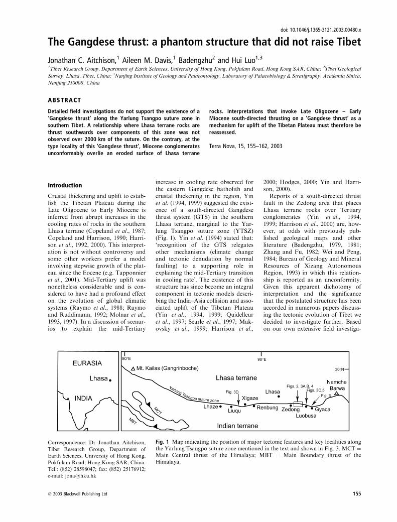
The Gangdese thrust: a phantom structure that did not raise Tibet
Jonathan C. Aitchison,1 Aileen M. Davis,1 Badengzhu2 and Hui Luo1,3
1Tibet Research Group, Department of Earth Sciences, University of Hong Kong, Pokfulam Road, Hong Kong SAR, China; 2Tibet Geological
Survey, Lhasa, Tibet, China; 3Nanjing Institute of Geology and Palaeontology, Laboratory of Palaeobiology & Stratigraphy, Academia Sinica,
Nanjing 210008, China
Introduction
Crustal thickening and uplift to estab-lish the Tibetan Plateau during theLate Oligocene to Early Miocene isinferred from abrupt increases in thecooling rates of rocks in the southernLhasa terrane (Copeland et al., 1987;Copeland and Harrison, 1990; Harri-son et al., 1992, 2000). This interpret-ation is not without controversy andsome other workers prefer a modelinvolving stepwise growth of the plat-eau since the Eocene (e.g. Tapponnieret al., 2001). Mid-Tertiary uplift wasnonetheless considerable and is con-sidered to have had a profound effecton the evolution of global climaticsystems (Raymo et al., 1988; Raymoand Ruddimann, 1992; Molnar et al.,1993, 1997). In a discussion of scenar-ios to explain the mid-Tertiary
increase in cooling rate observed forthe eastern Gangdese batholith andcrustal thickening in the region, Yinet al. (1994, 1999) suggested the exist-ence of a south-directed Gangdesethrust system (GTS) in the southernLhasa terrane, marginal to the Yar-lung Tsangpo suture zone (YTSZ)(Fig. 1). Yin et al. (1994) stated that:‘recognition of the GTS relegatesother mechanisms (climate changeand tectonic denudation by normalfaulting) to a supporting role inexplaining the mid-Tertiary transitionin cooling rate’. The existence of thisstructure has since become an integralcomponent in tectonic models descri-bing the India–Asia collision and asso-ciated uplift of the Tibetan Plateau(Yin et al., 1994, 1999; Quidelleuret al., 1997; Searle et al., 1997; Mak-ovsky et al., 1999; Harrison et al.,
2000; Hodges, 2000; Yin and Harri-son, 2000).Reports of a south-directed thrust
fault in the Zedong area that placesLhasa terrane rocks over Tertiaryconglomerates (Yin et al., 1994,1999; Harrison et al., 2000) are, how-ever, at odds with previously pub-lished geological maps and otherliterature (Badengzhu, 1979, 1981;Zhang and Fu, 1982; Wei and Peng,1984; Bureau of Geology and MineralResources of Xizang AutonomousRegion, 1993) in which this relation-ship is reported as an unconformity.Given this apparent dichotomy ofinterpretation and the significancethat the postulated structure has beenaccorded in numerous papers discuss-ing the tectonic evolution of Tibet wedecided to investigate further. Basedon our own extensive field investiga-
ABSTRACT
Detailed field investigations do not support the existence of a‘Gangdese thrust’ along the Yarlung Tsangpo suture zone insouthern Tibet. A relationship where Lhasa terrane rocks arethrust southwards over components of this zone was notobserved over 2000 km of the suture. On the contrary, at thetype locality of this ‘Gangdese thrust’, Miocene conglomeratesunconformably overlie an eroded surface of Lhasa terrane
rocks. Interpretations that invoke Late Oligocene – EarlyMiocene south-directed thrusting on a ‘Gangdese thrust’ as amechanism for uplift of the Tibetan Plateau must therefore bereassessed.
Terra Nova, 15, 155–162, 2003
Fig. 1 Map indicating the position of major tectonic features and key localities alongthe Yarlung Tsangpo suture zone mentioned in the text and shown in Fig. 3. MCT ¼Main Central thrust of the Himalaya; MBT ¼ Main Boundary thrust of theHimalaya.
Correspondence: Dr Jonathan Aitchison,
Tibet Research Group, Department of
Earth Sciences, University of Hong Kong,
Pokfulam Road, Hong Kong SAR, China.
Tel.: (852) 28598047; fax: (852) 25176912;
e-mail: [email protected]
� 2003 Blackwell Publishing Ltd 155
doi: 10.1046/j.1365-3121.2003.00480.x

5000
m
4000
m
3000
m
15
01
2
SC
ALE
1:5
0 00
0
34
5
The Gangdese thrust • J. C. Aitchison et al. Terra Nova, Vol 15, No. 3, 155–162
.............................................................................................................................................................
156 � 2003 Blackwell Publishing Ltd

tions along the length of the sutureacross southern Tibet we too arecompelled to question the existenceof this tectonic feature.
Gangdese thrust – type area
As the existence of theGTS is crucial tothe hypothesis that this south-directedthrust system was an important mech-anism for Late Oligocene – Early Mio-cene uplift of the Tibetan Plateau, thetype area for this structure east of
Zedong was carefully examined. Fieldobservations of numerous outcropswere made along tens of kilometres ofthe mapped (Yin et al., 1994, 1999;Harrison et al., 2000) strike of thestructure. Our investigations con-firmed the accuracy of existing detailedgeological mapping compiled at1 : 50 000 scale (Badengzhu, 1979,1981) (Fig. 2). Additional mapping at1 : 500 scale together with trenchingwas undertaken in the type area of theGTS during investigations of skarn
Fig. 2 Geologicalmap and cross-sectionsof the type area for the thrust proposedbyYin et al. (1994, 1999). Note the contactbetween Upper Oligocene – Lower Mio-cene Luobusa Conglomerates, which restwith unconformity upon an eroded sur-face of Sangri Group metamorphics andfelsic Gangdese intrusives. Section lineA–B has the same orientation and can becompared with section lines C–C¢ [sic] onfigure 4 of Yin et al. (1999) and A–A¢ onPlate 3 of Harrison et al. (2000).
Fig. 3 (A) The unconformity between Lower Miocene Luobusa Formation conglomerates (LC) and rocks of the Lhasa terraneexposed east of Zedong. The photograph is taken looking west along the strike of the contact. The 4375.2 m peak on the right handside is Yaja Peak, the type locality for the Yaja granodiorite (YG) (Harrison et al., 2000). An unconformity (NC) lies to the south(left) of the peak and Miocene conglomerates, overlying the contact, occupy the pass and dip moderately to the south (left ofphoto; strike and dip of bedding S0 115� ⁄37�S). The higher ground further south is underlain by the Indian terrane (IT), which hasbeen thrust northwards along the Renbu Zedong thrust over various rocks within the Yarlung Tsangpo suture zone (SZ). Theunconformity surface can be traced towards the photographer. It is clearly visible on the secondary ridge in the middle distancewhere Luobusa conglomerates depositionally overlie Bima Formation (Sangri Group SG) marbles and conglomerates that exhibita strongly developed north-dipping foliation. The surface in the right middle foreground is a dip-slope of Luobusa conglomerates.(B) Photograph taken looking east from pass located to the south of Yaja Peak. A depositional contact between Mioceneconglomerates (LC; strike and dip of bedding S0 108� ⁄40�S) and Lhasa terrane (LT; strike and dip of foliation S1 045� ⁄40�NW)rocks can be observed everywhere along the mapped (Yin et al., 1999) trace of the GT. A close-up of the contact in this figure isgiven in Fig. 4. (C) A depositional contact (not a south-directed thrust fault) between Miocene Luobusa Conglomerate (LC strikeand dip of bedding S0 087� ⁄51�S) and Lhasa terrane granodiorites (LtG) is exposed in the banks of the Yarlung Tsangpo at ZhuMai Sha (location: 29�14.682¢N, 092�11.787¢E, alt. 3580 m), near Luobusa Cr mine. A close-up of the contact in this figure is givenin Fig. 5. (D) A north (cf. south)-directed thrust fault (strike and dip of thrust plane 102� ⁄24�S) places shallow-dipping Liuquconglomerate and Dazhuqu terrane ophiolite in the hangingwall over a footwall of steeply dipping Xigaze terrane (XT) turbiditesexposed near Gadui SW of Xigaze (location: 29�07.498¢N, 088�36.758¢E, alt. 4180 m).
Terra Nova, Vol 15, No. 3, 155–162 J. C. Aitchison et al. • The Gangdese thrust
.............................................................................................................................................................
� 2003 Blackwell Publishing Ltd 157

mineralization associatedwith theYajagranodiorite. These observations indi-cate that contacts between the Lhasaterrane and Tertiary (Lower Mio-cene) conglomerate units mapped as asouth-directed, north-dipping thrust(Yin et al., 1999) are everywhere anunconformity with the conglomeratesresting depositionally upon a nowsouth-dipping eroded surface of var-ious Lhasa terrane lithologies (Burget al., 1983; Aitchison et al., 2002b).A 200-m-thick mylonitic shear zone
and a faulted contact where hanging-wall rocks of Lhasa terrane affinity arethrust over Tertiary conglomerates wasreported at the type locality (Yin et al.,1994, 1999). Regional mapping (Bade-ngzhu, 1979, 1981; Burg et al., 1983)indicates that the ‘mylonitic’ fabric ismore likely part of a strongly developedregional foliation present within theUpper Jurassic to Lower CretaceousSangri Group. This group is subdivi-ded, in ascending order, into theMamusha, Bima and Tiansutin forma-tions that contain variously deformedand metamorphosed andesites, fossil-iferous limestones (marbles), conglom-erates and other sedimentary units(Badengzhu, 1979). Metamorphism isas high as amphibolite facies and loc-ally reaches granulite facies (Burget al., 1983, 1987). The developmentof regional-scale isoclinal folds andattendant foliation has obliterated S0at many localities. This foliation ispervasive throughout much of thesouthern Lhasa terrane (Burg et al.,1983), and can be clearly observed inrocks exposed for over 300 km fromLuobusa (092�E) westwards along theYarlung Tsangpo to near Renbung(089�E). South-verging mesoscopicfolds in the ‘mylonite’ zone at theGTS type locality (Yin et al., 1994)are asymmetric structures possiblyrelated to large-amplitude regional iso-clinal folds. Deformation fabrics areparticularly well developed in marblesexposed at this locality (Figs 3A,Band 4). The foliation can be mappedup-dip to where it is truncated at anerosional surface where the SangriGroup is unconformably overlain bythe Lower Miocene Luobusa Forma-tion (29�14.706¢N, 091�55.902¢E, alt.4135 m Figs 3B and 4) (Badengzhu,1979; Aitchison et al., 2002b). Devel-opment of the regional foliation andfeatures of ductile deformation presentwithin the Sangri Group pre-dates
intrusion of plutonic rocks of the rel-atively undeformed Gangdese batho-lith. This deformation must thereforebe of (mid to late) Cretaceous age.Various conglomerate units occur
along the YTSZ (Davis et al.,2002a,b; Aitchison et al., 2002a,b)with more than one unit present nearthe GTS type locality. Although Yinet al. (1994, 1999) suggested that Ter-
tiary conglomerates lie in the footwallof the GTS at the type locality, boththe matrix and clasts of andesite andmarble in these conglomerates aredeformed and they exhibit a foliationidentical to other Sangri Group rocks.These misidentified rocks comprisepart of the Upper Jurassic – LowerCretaceous Mamusha Formation.Miocene conglomerates of the Luo-
S N
BFm
LC
40
Fig. 4 Close up of the contact exposed on the hill-slope in the middle distance ofFig. 3(B), where Luobusa Conglomerate (LC – strike and dip indicated) non-conformably overlies foliated marbles of the Bima Formation (BFm), Sangri Group(Lhasa terrane) (location: 29�14.706¢N, 091�55.902¢E, alt. 4135 m).
The Gangdese thrust • J. C. Aitchison et al. Terra Nova, Vol 15, No. 3, 155–162
.............................................................................................................................................................
158 � 2003 Blackwell Publishing Ltd

busa Formation do crop out nearbybut at considerably higher elevationsthan the Mesozoic conglomerates atthe GTS type locality, which is muchnearer the road and the valley floor.The Lower Miocene conglomeratescontain clasts of Sangri Group origintogether with other locally derivedmaterial and are unaffected by SangriGroup deformation. They uncon-formably overlie the Sangri Group, arelationship observable for many kilo-metres along strike and dip moder-ately to the south (Fig. 2). Thisimplies that the north-dipping meta-morphic foliation in the Sangri Groupwas subvertical during Early Miocenedeposition of fluvial sediments. Thesuggestion (Harrison et al., 2000) thatthe steep north-dipping fabric in theunderlying Sangri Group metamor-phic rocks is a result of rotation oforiginally lower angle fabrics is there-fore unsustainable.Skarn mineralization within folia-
ted marbles of the locally conglomer-atic Sangri Group occurs peripheral tothe Yaja granodiorite, indicating anintrusive rather than a tectonic rela-tionship between these units. Threemain zones of mineralization, theinnermost of which is currently beingmined, are marked by the presence ofdiopside and garnet in the marblestogether with Cu (bornite, azurite andmalachite) and Au mineralization.Abundant geochronologic data
have been provided (Yin et al., 1994;Harrison et al., 2000) for rocks in theZedong area. The crucial age con-straints for displacement on the GTScome from the Yaja granodiorite,which lies in the inferred hangingwallof this thrust. However, as statedabove, our observation is that thisintrusive body is part of the Lhasaterrane. It is not thrust over Tertiaryconglomerates; rather it is uncon-formably overlain by Lower MioceneLuobusa conglomerates. This uncon-formity can be observed SW of the4375.2-m Yaja Peak (Fig. 3A). Unfor-tunately, no dates from any metamor-phic minerals in deformed SangriGroup rocks are published. Age datafrom the Yaja granodiorite neverthe-less provide an excellent maximum ageconstraint (30.4 ± 0.4 Ma; Harrisonet al. 2000) for overlying Luobusaconglomerates.Complex interpretation of several
other granite bodies as thrust sheets
within the suture zone (Harrison et al.,2000) is unnecessarywhen these bodies,all of which lie north of any rocks ofsuture zone affinity, are recognized aspart of the Lhasa terrane. Luobusaconglomerates are deposited directlyupon these rocks as well as others ofthe Lhasa terrane and we have notyet observed any depositional contactbetween Luobusa conglomerates and
rocks south of the Lhasa terrane. Allthe faults which delineate the YTSZ inthe Zedong–Luobusa region are north-directed and constitute part of theRenbu–Zedong thrust system (RZT)(Yin et al., 1994; Quidelleur et al.,1997). Without a GTS the so-called‘Zedong window’ (Harrison et al.,2000) lacks a frame and, at best,becomes the ‘Zedong louvre’.
LCLtG
S N
Fig. 5 Close up of the contact seen in Fig. 3(C) at Zhu Mai Sha (location:29�14.682¢N, 092�11.787¢E, alt. 3580 m). Breccias at the base of the LuobusaConglomerate (LC) overlie granodiorite (LtG) of the Lhasa terrane and dip to thesouth (left) of the photograph.
Terra Nova, Vol 15, No. 3, 155–162 J. C. Aitchison et al. • The Gangdese thrust
.............................................................................................................................................................
� 2003 Blackwell Publishing Ltd 159

The GTS is mapped (Yin et al.,1999) continuing along strike morethan 50 km from Zedong to beyondthe Cr-mine at Luobusa. However,our detailed investigation suggestsotherwise. Although some minorsouth-directed reverse faults occur inthe Lhasa terrane (Badengzhu, 1979,1981) no GTS exists in this area.Instead the non-conformity betweenthe Lhasa terrane and the LowerMiocene Luobusa Formation can befollowed semicontinuously for manykilomtres (Badengzhu, 1979, 1981;Zhou et al., 1996; Aitchison et al.,2002b). This contact is superblyexposed in the banks of the YarlungTsangpo at ZhuMai Sha (29�14.682¢N,092�11.787¢E, alt. 3580 m Figs 3C and5), where basal granitic breccias of theLuobusa Formation non-conformably
overlie felsic plutonic rocks of theGangdese batholith (Lhasa terrane).We note that this particular exposurelies several metres below the normalsummer level of the Yarlung Tsangpoand, as it can only be observedat times of low river levels, earlierworkers may not have had the oppor-tunity to observe it. Further east ofLuobusa, near Gyaca, the unconform-ity where the Luobusa Formationrests upon an eroded Lhasa terranesurface is well exposed and can be seenclearly on satellite imagery of theregion (Fig. 6).
Elsewhere along the YarlungTsangpo suture zone
Despite published field evidence to thecontrary (Zhang and Fu, 1982; Burg,
1983), the existence of the GTS wasextended westwards 250 km fromZedong to the Xigaze region, SW ofLhasa. Here, the fault delineating thesouthern margin of the Xigaze terranewas interpreted as a south-directedthrust regarded as part of the GTS(Yin et al., 1994). Our examinationof this structure for over 150 km,both west and east of Xigaze, fromRenbung to Lhaze (Fig. 1) indicatesotherwise. Ophiolitic rocks of theDazhuqu terrane (Aitchison et al.,2000) and other suture zone unitssuch as the Palaeogene Liuqu Con-glomerate (Davis et al., 2002b), whichoutcrop south of the Xigaze terrane,ubiquitously lie in the hangingwallof a north-directed reverse fault ⁄thrust, with Xigaze terrane turbiditesin the footwall (e.g. Fig. 3D). Other
1 0.5 10 2 3 4 5
KILOMETRES
92˚ 30'E
N
LtG
LC
IT
LC
LtG
ITIT
Fig. 6 The unconformity (arrowed) between south-dipping Upper Oligocene – Lower Miocene Luobusa Conglomerates (LC) andthe southern Lhasa terrane is marked by an eroded surface developed on granitoid instrusions (LtG) seen here in part of a falsecolour NASA ASTER satellite image of an area along the Yarlung Tsangpo further downstream (east) of Luobusa near Gyaca.This style of contact is typical of that which is observable for over 2000 km along the northern side of the Yarlung Tsangpo suturezone. Elements of the suture zone lie to the south of the distinctive conglomerate dip slopes. The southern boundary of the suture ismarked by the north-directed, east–west-striking Renbu Zedong thrust which carries Triassic rocks of the Indian terrane (IT) in itshangingwall.
The Gangdese thrust • J. C. Aitchison et al. Terra Nova, Vol 15, No. 3, 155–162
.............................................................................................................................................................
160 � 2003 Blackwell Publishing Ltd

north-directed thrusts in the region,such as that separating the Xigazeterrane and Lower Miocene Qiuwuconglomerates to its north, are notbackthrusts related to a GTS butare more likely components of theGreat Counter thrust system (Heimand Gansser, 1939; Gansser, 1977), asenior synonym of the RZT (Yinet al., 1994, 1999).The possibility that the GTS exists
throughout southern Tibet was sug-gested (Yin et al., 1999; Yin andHarrison, 2000) with further extrapo-lation of its likely existence to near MtKailas. Our investigations in this area,however, indicate a relationship sim-ilar to that observed elsewhere insouthern Tibet. Lower Miocene boul-der-bearing Kailas conglomerateswere deposited directly on the KailasIgneous Suite at the southern marginof the Lhasa terrane (Gansser, 1964;Aitchison et al., 2002b). Althoughrelief in the Lhasa terrane must havebeen considerable for these massiveunits to develop, we have found nofield evidence for the existence of theGTS near Mt Kailas.Deep seismic reflection profiling
across the southern Lhasa terraneindeed reveals a north-dipping struc-ture but this is located at between 40and 60 km depth below the Gangdesebatholith (Alsdorf et al., 1998). Such astructure might be expected given thepolarity of subduction between theIndian and Eurasian plates prior tocollision. However, the suggested ageof the ‘GTS’ considerably post-datescollision and it is unlikely that thisstructure is a ‘Gangdese thrust’.Cross-sections, such as those presen-ted by Burg and Chen (1984, theirFig. 2), remain the most appropriateinterpretations of the structure ofsouthern Tibet.
Discussion
A substantial body of evidence indi-cates rapid uplift of theTibetanPlateauin the Late Oligocene to EarlyMiocene(Copeland et al., 1987; Copeland andHarrison, 1990; Harrison et al., 1992).Our work, however, casts doubt on theexistence of the GTS proposed as amechanism responsible for uplift of thesouthern Lhasa terrane at that time. Ifa crustal-scale south-directed fault wasresponsible for regional uplift of theLhasa terrane then this structure is not
the so-called GTS. Consequently, ther-mal modelling (Yin et al., 1994; Harri-son et al., 2000) of the uplift history ofLhasa terrane rocks and calculation ofminimum slip and slip rates for such astructure are premature. Interpreta-tions invoking uplift of the TibetanPlateau along the GTS are not sub-stantiated by field investigations andthemechanism(s) for rapid uplift of theTibetan Plateau remains conjectural.
Acknowledgments
We are grateful to members of the TibetanGeological Survey (Team 2) and TibetanGeological Society who helped to make thisresearch possible and assisted with arran-ging logistics and permission. We thankJean Pierre Burg and Robin Lacassin fortheir constructive reviews and commentsthat helped to strengthen this manuscript.The work described in this paper wassupported by grants to J.C.A. from theResearchGrants Council of theHongKongSpecial Administrative Region, China (Pro-ject Nos. HKU 7102 ⁄98P, HKU 7299 ⁄99Pand HKU 7069 ⁄01P).
References
Aitchison, J.C., Abrajevitch, A., Ali, J.R.,Badengzhu, Davis, A.M., Luo, H., Liu,J.B., McDermid, I.R.C. and Ziabrev, S.,2002a. New insights into the evolution ofthe Yarlung Tsangpo suture zone,Xizang (Tibet), China. Episodes, 25,90–94.
Aitchison, J.C., Badengzhu, Davis, A.M.,Liu, J., Luo, H., Malpas, J., McDermid,I., Wu, H., Ziabrev, S. and Zhou, M.F.,2000. Remnants of a Cretaceous intra-oceanic subduction system within theYarlung-Zangbo suture (southernTibet). Earth Planet. Sci. Lett., 183,231–244.
Aitchison, J.C., Davis, A.M., Badengzhuand Luo, H., 2002b. New constraints onthe India–Asia collision: The LowerMiocene Gangrinboche conglomerates,Yarlung Tsangpo suture zone, SE Tibet.J. Asian Earth Sci. 21, 253–265.
Alsdorf, D.E., Brown, L., Nelson, K.D.,Makovsky, Y., Klemperer, S. and Zhao,W., 1998. Crustal deformation of theLhasa Terrane, Tibet Plateau from Pro-ject INDEPTH deep seismic reflectionprofiles. Tectonics, 17, 501–519.
Badengzhu, 1979. Xizang AutonomousRegion Zhanang – Sangri RegionalGeology Reconnaissance Map, 1: 50,000.Xizang Geological Survey GeologicalTeam # 2, Group 2, Lhasa.
Badengzhu, 1981. Xizang AutonomousRegion Sangri – Jiacha Regional GeologyReconnaissance Map, 1: 50,000. Xizang
Geological Survey Geological Team # 2,Lhasa.
Bureau of Geology and Mineral Resourcesof Xizang Autonomous Region, 1993.Regional Geology of Xizang (Tibet)Autonomous Region. GeologicalPublishing House, Beijing.
Burg, J.P., 1983. Carte Geologique Du SudDu Tibet, 1: 500,000. Centre National dela Recherche Scientifique, Paris.
Burg, J.P. and Chen, G.M., 1984. Tecton-ics and structural zonation of southernTibet, China. Nature, 311, 219–223.
Burg, J.P., Leyreloup, A., Girardeau, J.and Chen, G.M., 1987. Structure andmetamorphism of a tectonically thick-ened continental crust; the Yalu Tsan-gpo suture zone (Tibet). Phil. Trans.Roy. Soc. London, Series A. MathematPhys Sci., 321 (1557), 67–86.
Burg, J.P., Proust, F., Tapponnier, P. andChen, G.M., 1983. Deformation phasesand tectonic evolution of the LhasaBlock (southern Tibet, China). Eclog.Geol. Helv., 76, 643–665.
Copeland, P. and Harrison, T.M., 1990.Episodic rapid uplift in the Himalayarevealed by 40Ar ⁄ 39Ar analysis ofdetrital K-feldspar and muscovite,Bengal Fan. Geology (Boulder), 18,354–357.
Copeland, P., Kidd, W.S.F., Xu, R. andZhang, Y., 1987. Rapid early Mioceneacceleration of uplift in the GangdeseBelt, Xizang (southern Tibet), and itsbearing on accommodation mechanismsof the India-Asia collision. Earth Planet.Sci. Lett., 86, 240–252.
Davis, A.M., Aitchison, J.C. and Bade-ngzhu and Hui, L., 2002a. Conglomer-ates of the Yarlung Tsangpo suture zone,southern Tibet. In: Tectonic Processes inthe Evolution of China CroucherAdvanced Studies Institute Abstracts,April, 23–28, 2002, University of HongKong, Hong Kong. Department of EarthSciences, University of Hong Kong.
Davis, A.M., Aitchison, J.C., Badengzhu,Luo, H. and Zyabrev, S., 2002b.Paleogene island arc collision-relatedconglomerates, Yarlung-Tsangpo suturezone, Tibet. Sediment. Geol., 150,247–273.
Gansser, A., 1964, The Geology of theHimalayas. Wiley-Interscience,New York.
Gansser, A., 1977. The great suture zonebetween Himalaya and Tibet; a prelim-inary account. Colloques InternationauxDu Centre Natl la Recherche Scientifique,268, 181–191.
Harrison, T.M., Copeland, P., Kidd,W.S.F. and Yin, A., 1992. Raising Tibet.Science, 255, 1663–1670.
Harrison, T.M., Yin, A., Grove, M.,Lovera, O.M., Ryerson, F.J. and Zhou,X., 2000. The Zedong Window: a recordof superposed Tertiary convergence in
Terra Nova, Vol 15, No. 3, 155–162 J. C. Aitchison et al. • The Gangdese thrust
.............................................................................................................................................................
� 2003 Blackwell Publishing Ltd 161

southeastern Tibet. J. Geophys Res.,105 (19), 211–19230.
Heim, A. and Gansser, A., 1939. CentralHimalaya; Geological Observations of theSwiss Expedition 1936. Gebruder Fretz,Zurich.
Hodges, K.V., 2000. Tectonics of theHimalaya and southern Tibet from twoperspectives. Geol. Soc. Am. Bull., 112,324–350.
Makovsky, Y., Klemperer, S.L., Rats-chbacher, L. and Alsdorf, D., 1999.Midcrustal reflector on INDEPTH wideangle profiles; an ophiolitic slab beneaththe India-Asia suture in southern Tibet?Tectonics, 18, 793–808.
Molnar, P., England, P. and Martinod, J.,1993. Mantle dynamics, uplift of theTibetan Plateau, and the Indianmonsoon. Rev. Geophysics, 31,357–396.
Molnar, P., England, P. and Martinod, J.,1997. The rise of the Tibetan Plateau;from mantle dynamics to the Indianmonsoon. Astronomy Geophysics, 38,10–15.
Quidelleur, X., Grove, M., Lovera, O.M.,Harrison, T.M. and Yin, A., 1997.Thermal evolution and slip history ofthe Renbu Zedong Thrust, southeastern
Tibet. J. Geophys. Res., 102,2659–2679.
Raymo, M.E. and Ruddimann, W.F.,1992. Tectonic forcing of late Cenozoicclimate. Nature, 359, 117–122.
Raymo, M.E., Ruddimann, W.F. andFroelich, P.N., 1988. Influence of lateCenozoic mountain building on oceangeochemical cycles. Geology (Boulder),16, 649–653.
Searle, M.P., Corfield, R.I.B., S. andMcCarron, J., 1997. Structure of theNorth Indian continental margin in theLadakh-Zanskar Himalayas: implica-tions for the timing of obduction ofthe Spontang ophiolite, India-Asiacollision and deformation events in theHimalaya. Geol. Mag., 134, 297–316.
Tapponnier, P., Zhiqin, X., Roger, F.,Meyer, B., Arnaud, N., Wittlinger, G.and Jingsui, Y., 2001. Oblique StepwiseRise and Growth of the Tibet Plateau.Science, 294, 1671–1677.
Wei, B.J. and Peng, Y.H., 1984. XizangAutonomous Region Xigaze – QushuiGeological Traverse Map, 1: 200,000.Xizang Geological Survey GeologicalTeam # 2, Lhasa.
Yin, A. and Harrison, T.M., 2000.Geologic evolution of the Himalayan-
Tibetan Orogen. Annu. Rev. EarthPlanet. Sci., 28, 211–280.
Yin, A., Harrison, T.M., Murphy, M.A.,Grove, M., Nie, S., Ryerson, F.J., Wang,X. and Chen, Z., 1999. Tertiary defor-mation history of southeastern andsouthwestern Tibet during the Indo-Asian collision. Geol. Soc. Am. Bull.,111, 1644–1664.
Yin, A., Harrison, T.M., Ryerson, F.J.,Chen, W.J., Kidd, W.S.F. and Cop-eland, P., 1994. Tertiary structural evo-lution of the Gangdese thrust system insoutheastern Tibet. J. Geophys. Res., 99,18175–18201.
Zhang, S.M. and Fu, X.L., 1982. XizangAutonomous Region Xigaze – Saga Geo-logical Traverse Map, 1: 200,000. XizangGeological Survey Geological Team # 2,Lhasa.
Zhou, M.F., Robinson, P.T., Malpas, J.and Li, Z., 1996. Podiform chromitites inthe Luobusa Ophiolite (southern Tibet);implications for melt–rock interactionand chromite segregation in the uppermantle. J. Petrol., 37, 3–21.
Received 6 June 2002; revised versionaccepted 14 March 2003
The Gangdese thrust • J. C. Aitchison et al. Terra Nova, Vol 15, No. 3, 155–162
.............................................................................................................................................................
162 � 2003 Blackwell Publishing Ltd

Journal of the Geological Society, London, Vol. 160, 2003, pp. 591–599. Printed in Great Britain.
591
Precise radiolarian age constraints on the timing of ophiolite generation and
sedimentation in the Dazhuqu terrane, Yarlung–Tsangpo suture zone, Tibet
SERGEY V. ZIABREV 1, JONATHAN C. AITCHISON1,
ALEXANDRA V. ABRAJEVITCH 1, BADENGZHU 2, AILEEN M. DAVIS 1 & HUI LUO 1,3
1Tibet Research Group, Department of Earth Sciences, University of Hong Kong, Pokfulam Road, Hong Kong SAR, P.R.
China (e-mail: email: [email protected])2Geological Team # 2, Tibet Geological Survey, Lhasa, Tibet, P.R. China
3Present address: Nanjing Institute of Geology and Palaeontology, Laboratory of Palaeobiology & Stratigraphy, Academia
Sinica, Nanjing 210008, P.R. China
Abstract: Well-preserved, abundant radiolarians provide high-precision biostratigraphic age constraints on the
timing of the eruption of ophiolitic basalts exposed along the Yarlung–Tsangpo suture zone in southern Tibet.
Dazhuqu terrane ophiolites were generated in an intra-oceanic supra-subduction zone setting within a
relatively short (,10 Ma) interval from late Barremian to late Aptian. Accumulation of sediments upon the
newly generated ophiolite initially occurred in a series of discrete rift-controlled sub-basins associated with
various spreading centres. An increasing flux of arc-derived volcaniclastic sediment up-section indicates
nearby volcanic arc activity. The Dazhuqu terrane developed in an intra-oceanic setting within Tethys where it
was isolated from any continental influence.
Keywords: Radiolaria, Yarlung–Tsangpo suture, Tibet, ophiolites, biostratigraphy.
The Yarlung–Tsangpo suture zone in Tibet marks the tectonic
boundary between Eurasia and India. The previously vast Tethys
ocean finally closed along the suture during their Cenozoic
collision. Most of this ocean was lost through subduction during
convergence or was overridden during collision. All that remains
now occurs within a suture zone of a few kilometres width. A
belt of ophiolitic bodies is the most traceable feature along the
Yarlung–Tsangpo suture zone, in south Tibet and beyond.
Several ophiolitic massifs form a nearly continuous exposure that
stretches east–west over a distance of c. 150 km near Xigaze,
250 km SW of Lhasa. These rocks are assigned to the Dazhuqu
terrane and interpreted as having originated in an intra-oceanic
supra-subduction zone setting (Aitchison et al. 2000, 2002a).
This interpretation of the origin of the Dazhuqu ophiolite is
supported by detailed mineralogical and geochemical studies in
the Xigaze area (Hebert et al. 2000; 2001). The presence of these
rocks together with other intra-oceanic terranes along the suture
led to the suggestion of Aitchison et al. (2000) that a south-
facing intra-oceanic subduction system once lay within the
Tethys.
Knowledge of the timing of generation of the Dazhuqu
ophiolite is a significant issue for understanding regional geology
and has implications for development of models for Tethys
evolution. Marine sedimentary cover on mafic volcanic rocks
was previously dated as late Albian to possibly early Cenomanian
(Marcoux et al. 1982) or early Cenomanian (Wu 1986) on the
basis of radiolarians reported from the Xigaze district. These
ages appeared to be some 20 Ma younger than a radiometric age
of 120 � 10 Ma inferred from U–Pb whole-rock analyses of
gabbros, dolerites and basaltic lavas reported from the same area
(Gopel et al. 1984). Until now, no further biostratigraphic study
of the Dazhuqu terrane has been published. Meanwhile, Cret-
aceous radiolarian biostratigraphy for the Tethyan regions
has developed significantly (Jud 1994; O’Dogherty 1994;
Baumgartner et al. 1995). This opens the possibility for obtaining
more accurate biostratigraphic information that will permit better
recognition of any sequence of events related to development of
the ophiolite. In the course of our study of the Dazhuqu terrane,
we obtained new data on the lithostratigraphy and radiolarian
biostratigraphy of the sedimentary succession overlying the
ophiolite. These results constrain the timing of ophiolite forma-
tion and permit a better understanding of the development of
sedimentary basins on this newly generated supra-subduction
zone crust.
Regional tectonic framework
Six tectonostratigraphic units (terranes) that developed before
India–Eurasia collision are recognized (Aitchison et al. 2000)
within and bounding the Yarlung–Tsangpo suture zone (Fig. 1).
The northern side of the suture is delineated by the Lhasa
terrane, a microcontinental block that had detached from the
northern periphery of Gondwana and docked with Asia by the
Late Jurassic (Allegre et al. 1984; Yin & Harrison 2000).
A 5000–8000 m succession of volcaniclastic turbidites (Xi-
gaze terrane) lies to the south of the Lhasa terrane. The Xigaze
terrane is thrust northwards over upper Oligocene–lower Mio-
cene Gangrinboche facies conglomerates (Aitchison et al.
2002b). At its southern boundary the terrane lies in the footwall
of another north-directed thrust with Dazhuqu terrane ophiolitic
rocks or Paleogene Liuqu Conglomerate (Davis et al. 2002) in
the hanging wall. Rare fossils indicate that the turbidites have a
late Albian to Coniacian stratigraphic range (Wiedmann & Durr
1995; Wan et al. 1998). As the oldest known fossils are not from
the base of the section it is possible that sedimentation may have
commenced before the late Albian. The top of the Xigaze
turbidite sequence is truncated by erosion. Xigaze terrane rocks
are interpreted as a forearc succession that developed in associa-
tion with north-directed subduction beneath the Lhasa terrane
(Shackleton 1981; Burg & Chen 1984; Girardeau et al. 1984;

Einsele et al. 1994; Durr 1996). Development of the terrane was
related to evolution of the magmatic arc along the southern edge
of the Lhasa terrane (Einsele et al. 1994; Durr 1996). Although
the Xigaze terrane is conventionally regarded as being floored by
the Dazhuqu ophiolite (e.g. Burg & Chen 1984; Girardeau et al.
1984; Einsele et al. 1994; Durr 1996), these two units are
ubiquitously in tectonic contact and have recently been inter-
preted as separate terranes (Aitchison et al. 2000, 2002a).
A tectonic sliver of intra-oceanic island arc rocks (Zedong
terrane) crops out between Lhasa and Dazhuqu terranes near
Zedong and Luobusa. This terrane is bounded by north-directed
thrusts related to the Renbu–Zedong thrust system of Yin et al.
(1994). The basal contact of the section lies at a fault and begins
with a thin (several metres) succession of arc tholeiitic lavas
overlain by a c. 15 m sequence of red ribbon-bedded chert
followed by 1000 m or more of volcaniclastic breccias. The
succession is cut by numerous basaltic–andesite dykes and minor
intrusions of diorite and leucogranite (McDermid et al. 2001a).
Both radiometric and biostratigraphic data indicate the onset of
magmatism in late Mid-Jurassic time. Radiometric ages deter-
mined by U/Pb ion microprobe zircon analysis together with40Ar/39Ar ages for hornblende (McDermid et al. 2001b, 2002)
are in accord with radiolarian faunas of Bajocian–early Callo-
vian age in the underlying chert. The terrane is interpreted as
remnants of intra-oceanic magmatic arc (Aitchison et al. 2000,
2002a; McDermid et al. 2001a) similar to other terranes known
from elsewhere along the suture in NW India and Pakistan.
The Dazhuqu terrane consists of a series of ophiolitic bodies
traceable along the Yarlung–Tsangpo suture zone with a major
zone of outcrops near Xigaze (Aitchison et al. 2003). In this area
the ophiolite is thrust northwards over the Xigaze terrane (Burg
1983; Wang et al. 1987). The southern margin of the terrane is
defined, in many areas, by the Miocene north-directed Renbu–
Zedong thrust (Yin et al. 1994, 1999), which places Indian Plate
rocks over the ophiolite. In the Bainang district, where there is a
sigmoidal bend in the Yarlung–Tsangpo suture zone, earlier
contacts with the Bainang terrane can be observed at south-
directed thrusts that are in places truncated by strike-slip faults
(Girardeau et al. 1985a; Ratschbacher et al. 1994).
Several ophiolitic massifs in the Xigaze area form a nearly
continuous belt over 175 km long and up to 25 km wide.
Ophiolitic sections are mostly north-side up with the sequence
repeated across dextral strike-slip faults. Although tectonically
disrupted and heavily attenuated, sections locally display a
complete ophiolitic sequence from fresh Cr diopside-rich harz-
burgites to marine sedimentary cover on mafic volcanic rocks
(Nicolas et al. 1981; Girardeau et al. 1984, 1985a, 1985b).
Aitchison et al. (2000, 2002a) interpreted the Dazhuqu terrane
ophiolite as having originated in an intra-oceanic supra-subduc-
tion zone setting and this is supported by detailed mineralogical
and geochemical studies in the Xigaze area (Hebert et al. 2000,
2001). Palaeomagnetic study of the sedimentary succession over-
lying mafic rocks of the Dazhuqu terrane indicates its deposition
in an equatorial area, 1000–1500 km south of Asia’s margin
(Abrajevitch et al. 2001).
The Bainang terrane, on the southern side of the suture zone,
was recently discriminated by Aitchison et al. (2000), who
interpreted it as a subduction complex. The terrane lies between
ophiolitic rocks of the Dazhuqu terrane to the north and the
Indian terrane to the south. It contains units previously referred
to as infra-ophiolitic thrust sheets of radiolarites (Burg & Chen
1984) or Upper Jurassic to Lower Cretaceous red radiolarites
(Girardeau et al. 1984). Good exposures exist near Donglha,
Xialu and Bainang. In most sections studied the terrane is chert
dominated and is characterized by an overall south-younging
tectonic pile of oceanic lithologies in which north-younging
successions are stacked by a series of south-verging thrusts.
Radiolarians reported from siliceous rocks near Xialu range in
age from Mid-Jurassic to Early Cretaceous (Aptian) (Wu 1993;
Matsuoka et al. 2001, 2002). Our detailed geological mapping
and investigations of radiolarian biostratigraphy elucidate the
structure, stratigraphy and evolution of the terrane (Ziabrev et al.
2000; Ziabrev 2002). Radiolarians allow reconstruction of a
relict stratigraphy that records a long history of sedimentation in
different portions of Tethys since the Late Triassic. Stratigraphy
within the terrane records the northward travel of an oceanic
plate and its approach towards a south-facing intra-oceanic
subduction zone where accretion occurred from late Aptian to at
Fig. 1. Simplified geological map showing distribution of Dazhuqu terrane rocks near Xigaze (modified from Wang et al. 1987) and localities of the
sections studied.
S . V. ZIABREV ET AL .592

least the Campanian (Ziabrev 2002). Variations in structural style
across the terrane indicate deformation at different depths and
vertical growth of the wedge dominant over lateral accretion.
Tectonostratigraphic features specific to the Bainang terrane
reflect its development in a remote intra-oceanic setting (Ziabrev
2002).
Passive margin rocks of the Indian terrane or Tethyan
(Tibetan) Himalaya lie south of the suture. Thick Permian to
Paleogene continental rise deposits (Liu & Einsele 1994) merge
southward into a continuous Ordovician to Eocene shelf sedi-
mentary succession of marine carbonates, sandstone, siltstone
and shale (Bureau of Geology and Mineral Resources of Xizang
Autonomous Region 1993; Jadoul et al. 1998). Disruption of
northern Indian margin rocks into widespread regional melange
zones accompanied Paleogene collision between an intra-oceanic
island arc and the northern margin of India (Liu et al. 2000; Liu
& Aitchison 2002). Passive margin sedimentation finally ceased
with the Cenozoic India–Asia collision.
The original disposition of terranes within the suture zone has
been greatly disrupted and former relations between terranes are
not well constrained, making reconstruction of the tectonic
evolution of the area difficult. Most early models (Allegre et al.
1984; Searle et al. 1987) invoked the existence of a single
Andean-type convergent plate margin along the northern side of
Tethys, although the possibility of additional subduction zones
was considered by some workers (Proust et al. 1984). The co-
occurrence and north–south distribution of the Zedong (mag-
matic arc), Dazhuqu (forearc ophiolite) and Bainang (subduction
complex) terranes led to their interpretation as evidence for a
south-facing intra-oceanic subduction system that lay within the
Tethys (Aitchison et al. 2000), and the existence of more than
one convergent margin. Analogy with the modern western Pacific
and SE Asia suggests that reality may have been even more
complex. As more details and constraints on the evolution of
terranes within the Yarlung–Tsangpo suture zone become avail-
able the complexity and sophistication of models for this zone is
likely to increase.
Previous work
Most of the marine siliceous and fine-grained clastic deposits
that cover the ophiolite crop out along the northern margin of the
Dazhuqu terrane. These deposits are referred to as the Chongdu
Formation (Cao (1981) cited by Bureau of Geology and Mineral
Resources of Xizang Autonomous Region 1993). The first litho-
and biostratigraphic information became available in reports of
Sino-French expeditions to this area in the early 1980s (Marcoux
et al. 1982; Girardeau et al. 1984, 1985a, 1985b). Previously the
cherts as well as fine-grained clastic deposits have been accorded
late Albian and possibly early Cenomanian ages based on
radiolarians (Marcoux et al. 1982). Other radiolarian fossils
described from these deposits were interpreted as being of late
Albian to early Cenomanian age (Li & Wu 1985) or of early
Cenomanian age (Wu 1986) based on correlation with the
Archaeospongoprunum techamaensis Zone (Pessagno 1976) of
California. As the precision of Upper Mesozoic radiolarian
biostratigraphy has greatly improved since these pioneering stud-
ies it is now possible to reassess the biostratigraphy and
sedimentary evolution of the Dazhuqu ophiolitic terrane. Radi-
olarian ages from deposits immediately overlying the ophiolite
should constrain the timing and duration of the ophiolite
generation event.
Methods
The sedimentary cover of the ophiolite has been studied at seven sections
(Fig. 2) in the Xigaze area, most of which were reported by Sino-French
expeditions to this area in the early 1980s (Girardeau et al. 1984). A
detailed log was made of each section. Special attention was paid to the
nature of contacts between pillow basalt or breccia and overlapping
deposits, to recognize any tectonic disruption. Seventy-five samples were
collected for micropalaeontological investigation and treated in dilute HF
� HCl to extract radiolarians. Species identification and age assignments
are chiefly based on recent taxonomic studies and biostratigraphic
zonation of Mid-Cretaceous Tethyan radiolarians (Jud 1994; O’Dogherty
1994). The first and last occurrences of some species are derived from an
unpublished composite range chart of O’Dogherty snf Jud (O’Dogherty
& Guex, pers. comm.). These range charts utilize the Unitary Association
(UA) method (Guex 1991), and numerical UA ages calibrated to the
Gradstein et al. (1994) time scale are applied herein. Over 50 radiolarian-
based ages were thus acquired in the course of this study. To test the
appropriateness of the western Tethys Mid-Cretaceous radiolarian range
chart (O’Dogherty 1994) to our far eastern Tethyan study area as many
taxa as possible were identified from each sample. The absence of
unexpected co-occurrences indicates no detectable diachroneity in the
distribution of taxa between western and eastern Tethys regions, suggest-
ing that the range chart of O’Dogherty (1994) is applicable all along the
Tethys.
Stratigraphy
Sedimentary sections exposed along 175 km strike length of the ophiolite
were examined in detail. The sections are either situated along the
northern boundary of the Dazhuqu terrane (Donglha-1, Polio and
Dazhuqu) or tectonically interleaved within the ophiolite (Donglha-2,
Qunrang and Zagapu) (Fig. 2). Various marine sedimentary lithologies
overlie the ophiolite and include chert, siliceous mudstone and fine-
grained volcaniclastic rocks. Exposure is near-continuous, with the
uppermost levels of sections truncated by faults. Minor normal faulting
within sections has locally eliminated small portions of some sections.
Undisturbed depositional contacts with underlying pillow lavas or pillow
breccias were recognized in most sections, although some minor shearing
locally occurs near the contact. Sections adjacent to the Xigaze terrane
are everywhere in fault contact with turbiditic rocks of the Xigaze Group.
Near the village of Donglha, 50 km SW of Xigaze a well-exposed
section (Donglha-1, 29808.3929N, 088824.5759E) crops out on a hill slope
beside an irrigation canal. Purplish red bedded (4–12 cm) chert is the
dominant lithology although some intercalated (2–5 cm) chert and
siliceous mudstone occurs at the top of the section. Sparse tuffaceous
laminae and thin (0.5–4 cm) layers of felsic tuff become more abundant
up-section. The chert depositionally overlies basaltic pillow breccia, the
uppermost 20 cm of which is encrusted by massive chert. Two thin
(5 cm) chert layers occur within the pillow breccia, 3 m and 6 m below
the contact. The lower portion (14 m) of the chert crops out in a steeply
north-dipping to vertical east–west-trending succession. Small-scale (tens
of centimetres) south-verging intrafolial asymmetric folds indicate south-
directed thrusting with a dextral strike-slip component. The upper portion
of the sequence is folded and separated from lower parts of the section
by 10 m of non-exposure. Many samples yielded abundant and well-
preserved radiolarians (Table 1; Fig. 3) that allow precise age determina-
tion. The lower chert (samples 2–7) ranges from upper Barremian (UA1
H. asseni Zone) to lower Aptian (UA5/6 H. verbeeki Subzone) and both
the upper and folded cherts (samples 7–20) are upper Aptian (UA6/7 to
UA8 T. costata Subzone). The total range of the Donglha-1 section (c.
16 m thick) is upper Barremian to upper Aptian.
A tectonic sliver (100 m thick) of purplish red and greenish grey
siliceous mudstones with minor greenish grey chert (Donglha-2,
29806.9549N, 088825.5189E) crops out 4 km SE of Donglha-1. This
section is bounded by north-directed thrusts and structure is complicated
by folds and shear zones with the possibility of tectonic repetitions,
making it difficult to establish the original stratigraphy. Ten samples were
collected and most possess similar radiolarian assemblages. Three
assemblages with the widest stratigraphic range are used for correlation.
RADIOLARIANS, TIBET 593

Fig. 2. Lithological columns of the sedimentary sections overlying pillow breccia of the Dazhuqu terrane, with the positions of samples and their
correlation with Unitary Associations (UA) and zones or subzones. Details of some sections or their lower portions are shown at a larger scale on the
right.
S . V. ZIABREV ET AL .594

Table 1. Occurrence of radiolarian species in the Dazhuqu terrane and the ages of radiolarian assemblages with respect to Unitary Associations
d, species identified with certainty; s, species identified with some doubt; Unitary Association numbers 1–9 refer to the biozonation of O’Dogherty (1994) and J34, J35 to thatof Jud (1994); 1–3 indicates that the sample ranges from UA1 to UA3, 6/7 indicates that the sample lies between UA6 and UA7; sample series SZ-98-Do-, JA-98-, SZ-98-Q-,JA-00-, SZ-99-Z-, SZ-98-P- and SZ-98-D- are collected from sections Donglha-1, Donglha-2, Qunrang-1, Qunrang-2, Zagapu, Polio and Dazhuqu, respectively.
RADIOLARIANS, TIBET 595

S. V. ZIABREV ET AL .596

The succession ranges from upper Barremian (chert, sample 19; UA1 H.
asseni Zone) to upper Aptian (sample 11; UA7-8 T. costata Subzone).
A steeply dipping north-younging sedimentary succession (Qunrang-1,
29809.3039N, 089802.7029E) conformably overlies pillow breccias within
the ophiolite section on the hillside above the village of Qunrang. Three
lithostratigraphic units are recognizable: purplish red bedded (2–7 cm)
chert (12 m), purplish red siliceous mudstone (12 m) and thin-bedded
(5–20 cm) fine- to medium-grained volcaniclastic turbidites (130 m).
Chert and siliceous mudstone contain tuffaceous laminae and thin (0.5–
3 cm) layers of felsic tuff, sparse at the bottom and abundant at the top
(Fig. 2). Sand-sized lithic fragments in the turbidites are mostly of
basaltic to andesitic composition. Four matrix-supported conglomerates
(0.2–1.3 m) composed mostly of basalt and less abundant chert clasts
sourced from underlying rocks occur in the upper portion of siliceous
mudstone. Two clast-supported conglomerates (tens of centimetres) of
similar composition lie within turbidites. Outcrop-scale asymmetric folds
indicate south-directed thrusting with a sinistral strike-slip component.
Rare layer-parallel shear zones traverse the section. To the north, the
succession is faulted against a further section of ophiolitic basalt.
Abundant well-preserved radiolarians indicate that the Qunrang-1 section
ranges from uppermost Barremian to upper Aptian. Chert samples range
from upper Barremian (UA1 H. asseni Zone) to lower Aptian (UA5 H.
verbeeki Subzone). Overlying siliceous mudstones and volcaniclastic
turbidites are upper Aptian (T. costata Subzone).
The thickest section (Qunrang-2, 29808.7509N, 089801.7239E) of
purplish red siliceous mudstone (40 m) and overlying thinly bedded, fine-
to medium-grained volcaniclastic turbidites (310 m) crops out 2 km SW
of Qunrang-1. It rests conformably on basaltic pillow breccia and dips
558 SSW. Turbiditic sandstones are lighter in colour and appear more
felsic than in the previous section. Some volcaniclastic conglomerates
and thick devitrified tuffs occur near the top of the turbidites. The section
above the conglomerates is intensely disturbed and folded in the footwall
of a north-directed thrust where it is in contact with ultramafic rocks to
the south. The entire sequence is assigned to the upper Albian (T. costata
Subzone).
A thin sequence (Zagapu, 29809.1139N, 089815.4199E) of chert, tuff
and siliceous mudstone within a pile of pillow breccia (.300 m thick)
conformably overlain by 30 m of tuff is exposed near Zagapu village
along the road from Bainang to Zagapu. Siliceous rocks (4 m thick)
occur 40 m below the tuff and dip 70–858 NW. Dark grey to purplish red
thinly bedded chert (2.5 m) conformably overlies pillow breccia. Above a
shear surface, the chert is overlain by tuff (1.35 m) covered by thin
(0.2 m) red siliceous mudstone, which is succeeded by pillow breccia.
Two radiolarian assemblages recovered indicate that the chert (sample B)
is upper Barremian–lower Aptian (UA1–5 H. asseni Zone to H. verbeeki
Subzone) and the siliceous mudstone (sample D) is upper Aptian (UA7 T.
costata Subzone).
Four kilometres south of the road from Lhasa to Xigaze in a creek near
the village of Polio, a steeply south-dipping overturned sequence (Polio,
29817.0969N, 089825.2869E) of cherts (10.5 m) depositionally overlies
pillow breccia. Although minor layer-parallel shearing is present it does
not affect the contact. The northern limit of the sequence is tectonically
juxtaposed against strongly sheared turbidites of the Xigaze terrane.
Black and dark grey chert (0.9 m) above pillow breccia becomes pale
grey up-section where individual chert beds (2–10 cm) are commonly
separated by sepiolitic layers (3–10 cm), especially abundant between
4 and 9 m above the base. Abundant and moderately well-preserved
radiolarians indicate that the lower 2.1 m of chert (samples 1–7) is upper
Barremian (UA J34/J35 or J34/1).
Four hundred metres upslope from Dazhuqu village, 3 km south of the
road from Lhasa to Xigaze, a 10–12 m thick sequence (Dazhuqu,
29818.8289N, 089832.0589E) of laminated greenish grey tuffs and
reworked basaltic material (3–15 cm) depositionally overlies pillow
breccia. Minor silicified tuff and mudstone (2–4 cm) and scarce bluish
green chert (4 cm) occur together with fine-grained reworked basaltic
detritus. The section is overturned and dips 65–808 south. No top to the
sequence is exposed but nearby turbidites of the Xigaze terrane to the
north are strongly sheared and folded, suggesting a tectonic contact with
the Xigaze terrane. A radiolarian assemblage from the base of the
sequence is upper Barremian (UA J34/J35 or UA J34/1).
Discussion
Well-preserved radiolarian faunas, thorough sampling and en-
hanced resolution of radiolarian biostratigraphy (Jud 1994;
O’Dogherty 1994) allow reassessment of the ages of the
sedimentary successions overlying the ophiolite and the accurate
dating of sedimentary packages within these successions. This
places important temporal constraints on the generation of the
Dazhuqu terrane ophiolite and provides a basis for detailed
sequence correlation (Fig. 4). The oldest deposits are well
constrained as upper Barremian in sections at Polio, Dazhuqu,
Donghla-1, Donghla-2 and Qunrang-1. The base of the Qunrang-
2 section is upper Aptian. This indicates that eruption of
ophiolitic basalt occurred before the late Barremian (c. 123 Ma
in the Gradstein et al. (1994) time scale) to the late Aptian (c.
117 Ma). Although the pillow basalt–chert contact is diachro-
nous throughout the terrane over a 175 km long zone of outcrop
it appears that the sediments intercalated with, and immediately
overlying, the ophiolitic basalts were deposited within a relatively
short (i.e. ,10 Ma) interval. With the exception of younger ages
for sediments associated with basalts at Qunrang-2 and probably
Zagapu, this event, along the length of the terrane, was
completed within an even shorter (1–2 Ma) interval.
Investigation of supra-ophiolite deposits in the Yarlung–
Tsangpo suture zone provides a picture of the patterns of early
sedimentation upon a newly built oceanic floor within an
extensional zone that was part of an intra-oceanic subduction
system. While the ophiolite was being generated deposition
began with accumulation of pillow breccia several hundreds of
metres thick. Development of pillow breccia probably occurred
along the scarps of normal faults in this extensional setting. A
few thin (5 cm) chert layers were deposited towards the end of
pillow breccia accumulation. Background biogenic pelagic sedi-
Fig. 3. Radiolarians from the Dazhuqu terrane (scale bars represent 100 �m). 1, Acaeniotyle umbilicata (Rust); 2, A. diaphorogona Foreman; 3,
Aurisaturnalis carinatus (Foreman); 4, Becus gemmatus Wu; 5, B. helenae (Schaaf); 6, B. horridus (Squinabol); 7, Cecrops sp. cf. C. septemporatus
(Parona); 8, Crolanium puga (Schaaf); 9, Crucella euganea (Squinabol); 10, C. gavalai O’Dogherty; 11, C. hispana O’Dogherty; 12, Cryptamphorella
clivosa (Aliev); 13, C. crepida O’Dogherty; 14, Cyclastrum infundibuliforme Rust; 15, Dactyliodiscus lenticulatus Jud; 16, Dactyliosphaera maxima
(Pessagno); 17, Deviatus diamphidius (Foreman); 18, Dicerosaturnalis amissus (Squinabol); 19, Dictyomitra communis (Squinabol); 20, D. excellens
(Tan); 21, Godia decora (Li & Wu); 22, Hexapyramis pantanellii Squinabol; 23, Hiscocapsa asseni (Tan); 24, H. grutterinki (Tan); 25, H. kaminogoensis
(Aita); 26, H. orca Foreman; 27, H. uterculus (Parona); 28, Obeliscoites perspicuus (Squinabol); 29, O. vinassai (Squinabol); 30, Pantanellium lanceola
(Parona); 31, Parvicingula boesii (Parona); 32, P. usotanensis Tumanda; 33, Podobursa tytthopora (Foreman); 34, Pseudoaulophacus (?) florealis Jud; 35,
Pseudodictyomitra carpatica (Lozyniak); 36, P. hornatissima (Squinabol); 37, P. leptoconica (Foreman); 38, P. lilyae (Tan); 39, P. pentacolaensis
Pessagno; 40, Pseudoeucyrtis hanni (Tan); 41, Stichomitra communis Squinabol; 42, S. mediocris (Tan); 43, Thanarla brouweri (Tan); 44, T.
carboneroensis O’Dogherty; 45, T. lacrimula (Foreman); 46, T. pacifica Nakaseko & Nishimura; 47, T. pseudodecora (Tan); 48, Torculum bastetani
O’Dogherty; 49, Triactoma hybum Foreman; 50, Trisyringium capellinii Vinassa; 51, Turbocapsula costata (Wu); 51, Ultranapora praespinifera Pessagno;
53, Xitus alievi (Foreman); 54, X. clava (Parona); 55, X. elegans (Squinabol); 56, X. spicularius (Aliev).
RADIOLARIANS, TIBET 597

mentation was established along the terrane by the late Barre-
mian after the cessation of pillow breccia development. In the
easternmost sections, the earliest (late Barremian) accumulation
of pelagic chert was swamped by deposition of glassy basaltic
detritus that is now locally altered to sepiolite. In the central and
western portions of the terrane, chert deposition continued until
the late Aptian (Donglha-1) or had terminated by then (other
sections). It was interrupted by ash falls from an adjacent
volcanic arc and bottom traction currents that reworked tuffac-
eous materials. Pelagic sedimentation progressed into accumula-
tion of hemipelagic siliceous mudstone in the late Aptian at
Donglha-2, Qunrang-1 and Zagapu. At Qunrang-2, sedimentation
started with deposition of siliceous mudstones in the late Aptian.
The frequency of ash falls and activity of bottom traction
currents varied through space and time. Hemipelagic sedimenta-
tion at Qunrang-1 was interrupted by deposition, from mudflows,
of several matrix-supported conglomerates composed of basalt
and chert clasts sourced from stratigraphically lower rocks.
During the late Aptian, development of pillow breccia resumed
at Zagapu, and later switched to thick tuff accumulation. At
Qunrang, volcaniclastic turbidite sedimentation took over from
hemipelagic sedimentation in the beginning of the late Aptian,
when up to 300 m of fine- to medium-grained turbidites were
deposited during a short period. The absence of carbonate
deposits in the marine sedimentary veneer on the ophiolite
indicates sedimentation below the carbonate compensation depth.
Sequences and ages of lithologies in the sedimentary succes-
sion vary between sections even where they are only separated
by a few kilometres. We interpret such variations as a result of
sediment accumulation in small semi-isolated basins on the
ophiolitic basement. This is in accord with the interpretation of
the ophiolite belt in the Xigaze area as a tectonic collage of
individual massifs genetically related to locally different settings
within an overall supra-subduction zone environment (Hebert
et al. 2000, 2001). Sections in the western and central parts of
the study area exhibit coarsening-upward tendencies, which is
especially clear at Qunrang-1. The upper portion of this section
(above the pillow breccia) documents a change from pelagic
(chert) to hemipelagic (siliceous mudstone) and finally to
volcaniclastic turbidite sedimentation. This marked coarsening
up-section tendency probably reflects development of a sediment
dispersal system associated with a volcanic arc and its prograda-
tion onto a zone of newly built supra-subduction zone oceanic
floor. The basaltic to andesitic source of volcaniclastic turbidites
in the Dazhuqu terrane differs from the source of the Xigaze
terrane sandstones, which are considerably more felsic (Durr
1996). Examinations of the sedimentology and radiolarian
assemblages in sections overlying pillow basalts of the Dazhuqu
terrane ophiolite indicate the rapid development of the ophiolite
over a short mid-Cretaceous interval in a Tethyan intra-oceanic
island arc setting isolated from any continental landmass such as
that inferred to have existed within Tethys in the model of
Aitchison et al. (2000).
We thank members of the Tibetan Geological Survey (Team # 2) and
Tibetan Geological Society, whose efforts have helped to make this
research possible. Many of these friends have assisted with arranging
logistics and permission. We thank L. O’Dogherty, R. Jud and J. Guex for
their kind permission to use their unpublished data and for fruitful
discussions of the nature and applications of Unitary Associations and
discrete biostratigraphic scales. This work was supported by grants (to
J.C.A.) from the Research Grants Council of the Hong Kong Special
Administrative Region, China (Projects HKU7102/98P, 7299/99P and
7069/01P). The constructive reviews of T. Danelian and T. Argles helped
to improve the manuscript and are gratefully acknowledged.
References
Abrajevitch, A., Aitchison, J.C. & Ali, J.R. 2001. Paleomagnetism of the
Dazhuqu Terrane, Yarlung Zangbo Suture Zone, Southern Tibet. EOS
Transactions, American Geophysical Union, 82(47), F314.
Aitchison, J.C., Badengzhu, & Davis, A.M. et al. 2000. Remnants of a
Cretaceous intra-oceanic subduction system within the Yarlung–Zangbo
suture (southern Tibet). Earth and Planetary Science Letters, 183, 231–244.
Aitchison, J.C., Abrajevitch, A. & Ali, J.R. et al. 2002a. New insights into the
evolution of the Yarlung Tsangpo suture zone, Xizang (Tibet), China.
Episodes, 25, 90–94.
Aitchison, J.C., Davis, A.M., Badengzhu, & Luo, H. 2002b. New constraints on
the India–Asia collision: the Lower Miocene Gangrinboche conglomerates,
Yarlung Tsangpo suture zone, SE Tibet. Journal of Asian Earth Sciences,
21(3), 253–265.
Aitchison, J.C., Davis, A.M. & Ali, J.R. et al. 2003. Stratigraphic and
sedimentological constraints on the age and tectonic evolution of the
Neotethyan ophiolites along the Yarlung Tsangpo suture zone, Tibet. In:
Dilek, Y. & Robinson, P.T. (eds) Ophiolites in Earth History. Geological
Society, London, Special Publications, in press.
Fig. 4. Correlation chart of the Dazhuqu terrane radiolarian-bearing deposits with lithologies plotted against biostratigraphic (after O’Dogherty 1994; Jud
1994) and chronostratigraphic (after Gradstein et al. 1994) scales. Non-horizontal boundaries indicate uncertainties in age. (For key see Fig. 2.)
S . V. ZIABREV ET AL .598

Allegre, C.J., Courtillot, V. & Tapponnier, P. et al. 1984. Structure and
evolution of the Himalaya–Tibet orogenic belt. Nature, 307, 17–22.
Baumgartner, P.O., O’Dogherty, L., Gorican, S., Urquhart, E., Pillevuit,
A., De Wever, P. (eds) 1995. Middle Jurassic to Lower Cretaceous
Radiolaria of Tethys: Occurrence, Systematics, Biochronology. Memoires de
Geologie, Universite de Lausanne, 23.
Bureau of Geology and Mineral Resources of Xizang Autonomous
Region 1993. Regional Geology of Xizang (Tibet) Autonomous Region.
People’s Republic of China, Ministry of Geology and Mineral Resources
Geological Memoirs Series 1, 31.
Burg, J.P. 1983. Carte Geologique du Sud du Tibet, scale 1:500,000. CNRS, Paris.
Burg, J.P. & Chen, G.M. 1984. Tectonics and structural zonation of southern
Tibet, China. Nature, 311, 219–223.
Davis, A.M., Aitchison, J.C., Badengzhu,, Luo, H. & Zyabrev, S. 2002.
Paleogene island arc collision-related conglomerates, Yarlung–Tsangpo suture
zone, Tibet. Sedimentary Geology, 150, 247–273.
Durr, S.B. 1996. Provenance of Xigaze fore-arc basin clastic rocks (Cretaceous,
South Tibet). Geological Society of America Bulletin, 108, 669–684.
Einsele, G., Liu, B. & Durr, S. et al. 1994. The Xigaze forearc basin; evolution
and facies architecture (Cretaceous, Tibet). Sedimentary Geology, 90, 1–32.
Girardeau, J., Marcoux, J. & Zao, Y. 1984. Lithologic and tectonic environment
of the Xigaze ophiolite (Yarlung Zangbo suture zone, southern Tibet, China),
and kinematics of its emplacement. Eclogae Geologicae Helvetiae, 77,
153–170.
Girardeau, J., Mercier, J.C.C. & Zao, Y. 1985a. Structure of the Xigaze
Ophiolite, Yarlung Zangbo suture zone, southern Tibet, China; genetic
implications. Tectonics, 4, 267–788.
Girardeau, J., Mercier, J.C.C. & Zao, Y. 1985b. Origin of the Xigaze Ophiolite,
Yarlung Zangbo suture zone, southern Tibet. Tectonophysics, 119, 407–433.
Gopel, C., Allegre, C.J. & Rong, H.X. 1984. Lead isotopic study of the Xigaze
ophiolite (Tibet); the problem of the relationship between magmatites
(gabbros, dolerites, lavas) and tectonites (harzburgites). Earth and Planetary
Science Letters, 69, 301–310.
Gradstein, F.M., Agterberg, F.P., Ogg, J.G., Hardenbol, J., van Veen, P.,
Thierry, J. & Huang, Z. 1994. A Mesozoic time scale. Journal of
Geophysical Research, 99, B24051–B24074.
Guex, J. 1991. Biochronological Correlations. Springer, Berlin.
Hebert, R., Beaudoin, G., Varfalvy, V., Huot, F., Wang, C.S. & Liu, Z.F.
2000. Yarlung Zangbo ophiolites, southern Tibet revisited, 15th Himalaya–
Karakorum–Tibet workshop, Chengdu. Earth Science Frontiers, 7, 124–126.
Hebert, R., Wang, C. & Varfalvy, V. et al. 2001. Yarlung Zangbo ophiolites,
southern Tibet revisited, 16th Himalaya–Karakorum–Tibet workshop, Graz,
Austria 16th HKT abstracts. Journal of Asian Earth Sciences, 19(3a)), 27–28.
Jadoul, F., Berra, F. & Garzanti, E. 1998. The Tethys Himalayan passive
margin from Late Triassic to Early Cretaceous (South Tibet). Journal of
Asian Earth Sciences, 16, 173–194.
Jud, R. 1994. Biochronology and Systematics of Early Cretaceous Radiolaria of the
Western Tethys. Memoires de Geologie, Universite de Lausanne, 19.
Li, H.-s. & Wu, H.-r. 1985. Radiolaria from the Cretaceous Congdu Formation in
southern Xizang (Tibet). Acta Micropalaeontologica Sinica, 2, 61–76.
Liu, G. & Einsele, G. 1994. Sedimentary history of the Tethyan basin in the
Tibetan Himalayas. Geologische Rundschau, 83, 32–61.
Liu, J.B. & Aitchison, J.C. 2002. Upper Paleocene radiolarians from the Yamdrok
melange, south Xizang (Tibet), China. Micropaleontology, 48(Suppl. 1),
145–154.
Liu, J.B., Aitchison, J.C., Badengzhu,, Davis, A.M., Ziabrev, S.V., Luo, H. &
McDermid, I. Badengzhu, Davis, A.M., Ziabrev, S.V., Luo, H. & McDermid,
I. 2000. Yamdrok Melange, South Tibet, 15th Himalaya–Karakorum–Tibet
workshop, Chengdu. Earth Science Frontiers, 7, 127.
Marcoux, J., de Wever, P. & Nicolas, A. et al. 1982. Preliminary report of
depositional sediments on top of volcanic member; Xigaze Ophiolite (Yarlung
Zangbo suture zone); South Xingang (Tibet). Ofioliti, 2/3, 395–396.
Matsuoka, A., Kobayashi, K., Nagahashi, T., Yang, Q., Wang, Y.J., Takei,
M. & Zeng, Q.G. 2001. Early Middle Jurassic (Aalenian) radiolarian fauna
from the Xialu chert in the Yarlung Zangbo Suture Zone, southern Tibet. In:
Metcalfe, I., Smith, J.M.B., Morwood, M. & Davidson, I. (eds) Faunal
and Floral Migrations and Evolution in SE Asia–Australasia. Balkema, Lisse,
105–110.
Matsuoka, A., Yang, Q., Kobayashi, K., Takei, M., Nagahashi, T., Zeng, Q.G.
& Wang, Y.J. 2002. Jurassic–Cretaceous radiolarian biostratigraphy and
sedimentary environments of the Ceno-Tethys: records from the Xialu Chert
in the Yarlung–Zangbo Suture Zone, southern Tibet. Journal of Asian Earth
Sciences, 20, 277–287.
McDermid, I., Aitchison, J.C., Badengzhu, & Davis, A.M. 2001a. The Zedong
Terrane: an intra-oceanic magmatic arc assemblage Tibet, 16th Himalaya–
Karakorum–Tibet workshop, Graz, Austria 16th HKT abstracts. Journal of
Asian Earth Sciences, 19(3a), 44.
McDermid, I., Aitchison, J.C., Davis, A.M., Harrison, T.M. & Grove, M.
2001b. The Zedong Terrane: a Jurassic intra-oceanic magmatic arc within the
Yarlung–Zangbo Suture Zone of Southeastern Tibet, 16th Himalaya–
Karakorum–Tibet workshop, Graz, Austria 16th HKT abstracts. Journal of
Asian Earth Sciences, 19(3a), 44–45.
McDermid, I., Aitchison, J.C., Davis, A.M., Harrison, T.M. & Grove, M. 2002.
The Zedong terrane: a Late Jurassic intra-oceanic magmatic arc within the
Yarlung–Zangbo suture zone, southeastern Tibet. Chemical Geology, 187,
267–277.
Nicolas, A., Girardeau, J. & Marcoux, J. et al. 1981. The Xigaze ophiolite
(Tibet); a peculiar oceanic lithosphere. Nature, 294, 414–417.
O’Dogherty, L. 1994. Biochronology and Paleontology of Mid-Cretaceous
Radiolarians from Northern Apennines (Italy) and Betic Cordillera (Spain).
Memoires de Geologie, Universite de Lausanne, 21.
Pessagno, E.A. 1976. Radiolarian zonation and stratigraphy of the Upper
Cretaceous portion of the Great Valley Sequence, California Coast Ranges.
Micropaleontology, Special Publication, 2, 1–95.
Proust, F., Burg, J.P., Matte, P., Tapponnier, P., Li, T., Li, G. & Chen, G.
1984. Succession des phases de plissement sur une transversale du Tibet
meridional, implication geodynamiques. In: Mercier, J.L. & Guangcen, L.
(eds) Mission Franco-Chinoise au Tibet 1980. Etude geologique et geophysi-
que de la Croute terrestre et du Manteau superieur du Tibet et de l’Himalaya.
CNRS, Paris, 385–392.
Ratschbacher, L., Frisch, W. & Liu, G. 1994. Distributed deformation in
southern and western Tibet during and after the India–Asia collision. Journal
of Geophysical Research, 99, 19917–19945.
Searle, M.P., Windley, B.F. & Coward, M.P. et al. 1987. The closing of
Tethys and the tectonics of the Himalaya. Geological Society of America
Bulletin, 98, 678–701.
Shackleton, R.M. 1981. Structure of southern Tibet; report on a traverse from
Lhasa to Khatmandu organised by Academia Sinica. Journal of Structural
Geology, 3, 97–105.
Wan, X., Wang, L., Wang, C. & Jansa, L. 1998. Discovery and significance of
Cretaceous fossils from the Xigaze forearc basin, Tibet. Journal of Asian
Earth Sciences, 16, 217–223.
Wang, X.B., Bao, P.S., Deng, W.M. & Wang, F.G. (eds) 1987. Tectonic
Evolution of the Lithosphere of the Himalayas: Xizang (Tibet) Ophiolite.
People’s Republic of China Ministry of Geology and Mineral Resources
Geological Memoirs Series 3, 8.
Wiedmann, J. & Durr, S.B. 1995. First ammonites from the Mid- to Upper
Cretaceous Xigaze Group, South Tibet, and their significance. Newsletters on
Stratigraphy, 32, 17–26.
Wu, H.R. 1986. Some new genera and species of Cenomanian Radiolaria from
southern Xizang (Tibet). Acta Micropalaeontologica Sinica, 3, 347–360.
Wu, H.R. 1993. Upper Jurassic and Lower Cretaceous radiolarians of Xialu chert,
Yarlung Zangbo ophiolite belt, southern Tibet. In: Blueford, J.R. &
Murchey, B.L. (eds) Radiolaria of Giant and Subgiant Fields of Asia,
Nazarov Memorial Volume. Micropaleontology Special Paper, 6, 115–136.
Yin, A. & Harrison, T.M. 2000. Geologic Evolution of the Himalayan–Tibetan
Orogen. Annual Review of Earth and Planetary Sciences, 28, 211–280.
Yin, A., Harrison, T.M., Ryerson, F.J., Chen, W.J., Kidd, W.S.F. & Copeland,
P. 1994. Tertiary structural evolution of the Gangdese thrust system in
southeastern Tibet. Journal of Geophysical Research, 99, 18175–18201.
Yin, A., Harrison, T.M. & Murphy, M.A. et al. 1999. Tertiary deformation
history of southeastern and southwestern Tibet during the Indo-Asian
collision. Geological Society of America Bulletin, 111, 1644–1664.
Ziabrev, S.V. 2002. Tectonic evolution of Dazhuqu and Bainang terranes,
Yarlung–Zangbo suture, Tibet as constrained by radiolarian biostratigraphy.
PhD thesis, University of Hong Kong.
Ziabrev, S.V., Aitchison, J.C. & Badengzhu, et al. 2000. Oceanic deposits in
the Yarlung–Tsangpo suture zone: structural setting, radiolarian ages and
their tectonic implications, 15th Himalaya–Karakorum–Tibet workshop,
Chengdu 15th HKT abstracts. Earth Science Frontiers, 7, 118.
Received 2 September 2002; revised typescript accepted 7 March 2003.
Scientific editing by Anthony Cohen
RADIOLARIANS, TIBET 599

Journal of the Geological Society, London, Vol. 161, 2004, pp. 523–538. Printed in Great Britain.
523
Bainang Terrane, Yarlung–Tsangpo suture, southern Tibet (Xizang, China):
a record of intra-Neotethyan subduction–accretion processes preserved on the roof
of the world
SERGEY V. ZIABREV 1,2, JONATHAN C. AITCHISON 1,
ALEXANDRA V. ABRAJEVITCH 1,3, BADENGZHU 4, AILEEN M. DAVIS 1 & HUI LUO 1,5
1Tibet Research Group, Department of Earth Sciences, University of Hong Kong, Pokfulam Road, Hong Kong SAR, China
(e-mail: [email protected])2Present address: Institute of Tectonics and Geophysics, Russian Academy of Sciences, Kim-Yu-Chen St., 65, Khabarovsk,
680000, Russia3Present address: Department of Geological Sciences, University of Michigan, 425 E. University Ave., Ann Arbor, MI
48109-1063, USA4Geological Team No. 2, Tibet Geological Survey, Lhasa, Tibet, China
5Present address: Nanjing Institute of Geology and Palaeontology, Laboratory of Palaeobiology and Stratigraphy,
Academia Sinica, Nanjing 210008, China
Abstract: The Bainang terrane, an intra-oceanic island arc subduction complex into which Tethyan oceanic
rocks were accreted during the Cretaceous, is preserved within the Yarlung–Tsangpo suture zone of Tibet. The
lithostratigraphic succession established from field mapping records a long history of sedimentation in
different portions of the central Tethyan domain from Late Triassic to mid-Cretaceous time. These rocks are
preserved within a south-verging imbricate thrust stack of thin (�1 km thick) northward younging tectonic
slices. Five lithotectonic units were mapped in the terrane and these units are assigned to two distinct tracts.
The northern tract, which accumulated on the north side of Neotethys, was probably separated from its
southern counterpart by a mid-ocean ridge. Detailed radiolarian biostratigraphy is used to constrain the timing
of depositional events within each tract. Oceanic plate stratigraphy of the northern tract records its northward
travel and mid-Cretaceous (late Aptian) approach towards a south-facing intra-oceanic subduction zone. Rocks
in the southern tract developed closer to the Indian subcontinent and experienced thermotectonic subsidence
and Mid-Jurassic basic alkaline intraplate magmatism. They were probably accreted late in the Cretaceous.
Variations in structural style across the terrane indicate deformation at different depths and vertical growth of
the wedge rather than lateral accretion. The overall tectonostratigraphy of the terrane reflects its development
in a remote intra-oceanic setting.
Keywords: Tibet, Mesozoic, accretionary wedges, subduction, accretion, Indus– Yarlung–Zangbo suture
zone, radiolarians.
The Yarlung–Tsangpo suture zone in Tibet marks the zone of
collision between India and Eurasia. The once vast Tethyan
Ocean closed along this suture during Cenozoic continent–
continent collision. Much of what lay within this ocean was
subducted, smeared out or otherwise destroyed through subduc-
tion during convergence between India and Asia or disappeared
during the collision. All that remains is now trapped within the
few kilometres width of the suture zone. Investigations of
terranes within the suture provide insights into the architecture
and evolution of the Tethyan Ocean interior.
The evolutionary history of the Neotethys has been inferred
from the continuous sedimentary record preserved in the north-
ern Indian passive margin series (Gaetani & Garzanti 1991; Liu
& Einsele 1994). However, this interpretation addresses only the
sedimentary response to multiple rifting events along the south-
ern Neotethyan margin. The depositional history and architecture
of the central Neotethyan domain remains unexplored. Although
the movement of India towards Eurasia is well documented from
magnetic anomalies on the Indian Ocean floor and other
magnetic data (Klootwijk et al. 1992), the sequence of events
that accompanied India–Asia convergence is thus far poorly
understood especially in the eastern (Tibetan) segment of
Neotethys. In spite of an early suggestion (Allegre et al. 1984;
Proust et al. 1984) of the possibility of intra-Tethyan subduction
in this sector of Tethys, the later and more widely accepted
model (Searle et al. 1987) assumes that the entire north–south
extent of oceanic lithosphere was subducted along the southern
margin of the Lhasa terrane. Summaries of the structure and
evolution of this region appear somewhat dissimilar to those for
areas further west (Kohistan and Ladakh), where the Spontang
and Kohistan–Dras volcanic arcs, associated with intra-oceanic
subduction, are well documented (Searle et al. 1987, 1999;
Corfield et al. 1999). The simplified account of the eastern part
of the Neotethys has recently been reassessed with the recogni-
tion of remnants of an intra-oceanic subduction system
(Aitchison et al. 2000; McDermid et al. 2002) and seismic
tomographic images under the region (Van der Voo et al. 1999).
In this paper, we present the results of detailed geological
mapping, and structural and radiolarian biostratigraphic studies
of the Bainang terrane. The terrane developed as a subduction

complex, on the southern edge of a south-facing intra-oceanic
subduction system, which grew above a northward-subducting
slab of Neotethyan ocean lithosphere. Facies of the central
Neotethyan domain were accreted into this subduction complex.
New data elucidate the tectonic setting and evolution of this
terrane, and they are interpreted in terms of depositional setting
and the mode and timing of subduction-related accretion. We
contrast the geological development of the Bainang terrane with
that of other terranes in the region and consider this in the
broader context of Neotethys evolution.
Regional tectonic framework
Six tectonostratigraphic units (terranes) that developed prior to
India–Eurasia collision are recognized within and bounding the
Yarlung–Tsangpo suture zone (Fig. 1). From north to south, we
briefly outline their nature and key features related to the
evolution of the Tethys, following the nomenclature introduced
by Aitchison et al. (2000).
The Lhasa terrane is a microcontinental block that had
detached from the northern periphery of Gondwana and docked
with Asia by the Late Jurassic–Early Cretaceous (Allegre et al.
1984; Yin & Harrison 2000). Middle Proterozoic to Lower
Cambrian metamorphic basement is overlain by Palaeozoic to
middle Cretaceous shallow-marine and terrestrial deposits. The
southern margin of the terrane bounds the Yarlung–Tsangpo
suture zone and consists of an Upper Jurassic–Lower Cretaceous
metasedimentary and metavolcanic basement (Sangri Group)
overprinted by Andean-type intrusive and volcanic rocks of the
Gangdese batholith (Badengzhu 1979; Burg & Chen 1984).
These igneous rocks record the extensive magmatism that
resulted from northward subduction of Neotethyan oceanic litho-
sphere beneath the Lhasa terrane. Radiometric ages from
Gangdese plutons range from 153 � 6 Ma (Murphy et al. 1997)
to 30.4 � 0.4 Ma (Harrison et al. 2000). Sangri Group andesites
are intercalated with clastic and carbonate deposits bearing
Upper Jurassic–Lower Cretaceous fossils (Badengzhu 1979;
Pearce & Mei 1988; Bureau of Geology and Mineral Resources
of Xizang Autonomous Region 1993). Radiometric ages for the
andesites, rhyolites and ignimbrites of the Takena and Lingzi-
zong formations range from 119 to 38 Ma (Maluski et al. 1982;
Xu et al. 1985; Miller et al. 2000). Both radiometric and
biostratigraphic data appear to indicate that subduction-related
magmatism along the southern margin of the Lhasa terrane
commenced in the Late Jurassic and lasted until mid-Oligocene
time.
The Xigaze terrane incorporates a 5000–8000 m thick succes-
sion of volcaniclastic turbidites (Xigaze Group flysch) deposited
to the south of the Lhasa terrane. Rare fossils indicate an upper
Albian (Wiedmann & Durr 1995) to Coniacian (Wan et al. 1998)
stratigraphic range although younger deposits have probably been
removed by erosion. These rocks are interpreted as a forearc
succession that developed in association with north-directed
subduction beneath the Lhasa terrane (Shackleton 1981; Burg &
Chen 1984; Girardeau et al. 1984; Einsele et al. 1994; Durr
1996).
The Zedong terrane was recognized by Aitchison et al. (2000)
near Zedong and Luobusa. It occurs as a tectonic sliver between
the Lhasa and Dazhuqu terranes and is bounded by north-
directed thrusts related to the Renbu–Zedong thrust system of
Harrison et al. (2000). The terrane incorporates a succession of
arc tholeiitic lavas overlain by a thin (c. 15 m) sequence of red
ribbon-bedded chert then c. 1000 m of volcaniclastic breccias cut
by numerous andesite dykes and minor intrusions of diorite and
leucogranite (McDermid et al. 2001; McDermid 2002). Rocks
within the terrane have been interpreted as remnants of an intra-
oceanic volcanic arc (Aitchison et al. 2000; McDermid et al.
2001; McDermid 2002) similar to other terranes known from
elsewhere along the suture in the NW India and Pakistan arc
(Corfield et al. 2001). Both radiometric and biostratigraphic data
indicate the onset of magmatism in the late Mid-Jurassic. Radio-
metric ages (McDermid et al. 2002) are in accord with
Bajocian–lower Callovian radiolarian faunas in the underlying
chert. Complexity is indicated by reports (Badengzhu 1979) of
rare Lower Cretaceous marine fossils from volcaniclastic strata
and confirmed by our investigations of radiolarian faunas.
The Dazhuqu terrane comprises a series of ophiolitic bodies
traceable along the Yarlung–Tsangpo suture zone with major
outcrops in the Xigaze and Luobusa areas (Aitchison et al.
2004). Near Zedong and Luobusa ophiolitic rocks are faulted
Fig. 1. Tectonic zonation of the central part
of the Yarlung–Tsangpo suture zone,
southern Tibet, and location of study area.
Modified from Geological Map of Xizang
(Tibet) Autonomous region, PRC (Bureau
of Geology and Mineral Resources of
Xizang Autonomous Region 1993) and
figures of Le Fort (1996) and Yin &
Harrison (2000). RZT, Renbu Zedong
Thrust (or Great Counter Thrust); NHT,
North Himalayan Thrust; STDS, South
Tibet Detachment System.
S. V. ZIABREV ET AL .524

against the Zedong terrane or thrust northwards over lowermost
Miocene conglomerates developed along the southern margin of
the Lhasa terrane (Aitchison et al. 2002). In the Xigaze district,
the ophiolite is thrust northwards over the Xigaze terrane (Burg
1983; Wang et al. 1987). The southern margin of the terrane lies,
in most areas, at the Miocene north-directed Renbu–Zedong
thrust (Yin et al. 1994, 1999), which places Indian terrane rocks
over the ophiolite. In the Bainang district, where there is an S-
shaped sigmoidal bend in the Yarlung–Tsangpo suture zone,
earlier contacts can be observed at south-directed thrusts that are
locally truncated by strike-slip faults (Girardeau et al. 1985a;
Ratschbacher et al. 1994).
Several ophiolitic massifs, in the Xigaze area, form a nearly
continuous belt over 150 km long and up to 25 km wide.
Ophiolitic sections are mostly north-facing with the sequence
repeated across dextral strike-slip faults. Although tectonically
disrupted and heavily attenuated, sections locally display a
complete ophiolitic sequence from fresh Cr-diopside-rich harz-
burgites to marine sedimentary cover on mafic volcanic rocks
(Nicolas et al. 1981; Girardeau et al. 1984, 1985a, b). Radiolar-
ian biostratigraphy constrains the timing of eruption of ophiolitic
basalt to the late Barremian–early Aptian (Zyabrev et al. 1999;
Ziabrev et al. 2003). Aitchison et al. (2000) interpreted the
Dazhuqu terrane ophiolite as having originated in an intra-
oceanic suprasubduction zone setting and this is supported by
detailed mineralogical and petrochemical studies in the Xigaze
area (Hebert et al. 2000, 2001).
The Bainang terrane, on the southern side of the suture zone,
was interpreted by Aitchison et al. (2000) as a subduction
complex, and is the subject of this paper. It contains units
previously referred to as infra-ophiolitic thrust sheets of radiolar-
ites (Burg & Chen 1984) or Upper Jurassic–Lower Cretaceous
red radiolarites (Girardeau et al. 1984). The terrane is bounded
to the north by ophiolitic rocks of the Dazhuqu terrane and to
the south by the Indian terrane. Good exposures exist near
Donglha, Xialu and Bainang (Fig. 1). In most sections studied,
the terrane is chert dominated and is characterized by a north-
facing tectonic pile of oceanic lithologies repeated by a series of
south-verging imbricated slices. Radiolarians reported from silic-
eous rocks near Xialu range in age from the Mid-Jurassic to mid-
Cretaceous (Aptian) (Wu 1993; Matsuoka et al. 2001, 2002).
Passive margin rocks of the Indian terrane or Tethyan
(Tibetan) Himalaya lie south of the suture. Thick Permian to
Cretaceous continental rise deposits (Liu & Einsele 1994) merge
southward into a continuous Ordovician to Eocene shelf sedi-
mentary succession of marine carbonate, sandstone, siltstone and
shale (Bureau of Geology and Mineral Resources of Xizang
Autonomous Region 1993; Jadoul et al. 1998). Ordovician–Early
Permian epicontinental deposition in shallow seas linked to
Tethys terminated with rifting that evolved into detachment of
Peri-Gondwana microcontinents and, ultimately, the opening of
Tethys. The Mesozoic sequence records increased tectonic
subsidence in the Carnian–Norian, followed by building of
carbonate platforms. Drowning along the entire length of the
carbonate platform occurred in the early Callovian with deposi-
tion of oolitic ironstone superseded by Late Jurassic deposition
of black shales (Gaetani & Garzanti 1991; Jadoul et al. 1998).
The development of the passive continental margin facing the
Tethyan domain was punctuated by a series of rifting episodes
related to Gondwana disintegration and associated with intraplate
volcanism (Gaetani & Garzanti 1991). In correlative sections of
the western Himalaya, the Zanskar shelf merges northward with
Mesozoic slope–rise deep-sea deposits of the Lamayuru Com-
plex and its distal equivalent, the Karamba Complex (Danelian
& Robertson 1997; Robertson & Sharp 1998).
The original disposition of terranes within the Yarlung–
Tsangpo suture zone has been greatly disrupted and former
relations between terranes are not well constrained. Therefore,
reconstruction of the tectonic evolution of the area is difficult.
Most early models invoked the existence of a single Andean-type
convergent plate margin along the northern side of Neotethys but
analogy with the modern western Pacific and SE Asia suggests
that reality may have been considerably more complex. Develop-
ment of the Xigaze terrane is interpreted as having been related
to evolution of the magmatic arc along the southern edge of the
Lhasa terrane (Einsele et al. 1994; Durr 1996). The Xigaze
terrane was formerly regarded as being floored by the Dazhuqu
ophiolite (e.g. Burg & Chen 1984; Girardeau et al. 1984; Einsele
et al. 1994; Durr 1996), but these two units are ubiquitously in
tectonic contact and there is no a priori reason why they should
have been genetically related (Aitchison et al. 2000). The co-
occurrence and remarkably consistent north–south distribution of
the broadly coeval Zedong (magmatic arc), Dazhuqu (forearc
ophiolite) and Bainang (subduction complex) terranes led to their
interpretation as evidence for a south-facing intra-oceanic sub-
duction system that lay within the Neotethys (Aitchison et al.
2000) and the existence of more than one convergent margin. As
more details and constraints on the evolution of terranes within
the Yarlung–Tsangpo suture zone become available the complex-
ity and sophistication of models for this zone increase.
Methods
Preliminary examination of the Bainang terrane at several sections
revealed a structural style and lithologies reminiscent of subduction
complexes. The most complete section occurs near Bainang and this was
selected for detailed study because of excellent exposures. This area was
mapped in detail (1:25 000) to discern map-scale structures and obtain a
solid basis for structural and biostratigraphic data and interpretations.
Special attention was paid to the nature of contacts between different
lithologies. Depositional contacts are locally preserved and these were
used to reconstruct an oceanic plate stratigraphy. Radiolarian biostrati-
graphy was applied as a key method to constrain ages and as a means of
cross-checking the reconstructed lithostratigraphic succession established
during field-mapping. All prospective lithologies were extensively
sampled with sedimentological features and details of mesoscopic
structural patterns documented. Individual traverses were sampled sys-
tematically along continuous profiles to clarify structure and trace
possible age progressions. Radiolarians were picked from dilute HF and/
or HCl acid residues, and imaged using a Hitachi SEM. Identification of
taxa and age assignment for Middle Jurassic to middle Cretaceous
radiolarian assemblages are based on recent taxonomic study and
biostratigraphic zonation of Tethyan radiolarians (Jud 1994; O’Dogherty
1994; Baumgartner et al. 1995). For Lower Jurassic and Triassic
assemblages other zonal schemes (Pessagno & Whalen 1982; Kishida &
Hisada 1985; Yeh 1987; Carter et al. 1988; Hori 1990; Carter 1993) were
applied. Over 130 radiolarian-based ages were acquired in the course of
this study.
Bainang terrane
A NE–SW-oriented, 35 km long tectonic lens of Bainang terrane
rocks is preserved at a well-developed bend in the trace of the
Yarlung–Tsangpo suture zone located east of the township of
Bainang. Exposure pinches out tectonically near Bainang in the
west and eastwards towards Dazhuqu. The terrane is bounded to
the NW by the Dazhuqu terrane. The contact is a south-directed
thrust that dips 60–708 NW and places an ophiolitic assemblage
in the hanging wall over the Bainang terrane. To the south, the
BAINANG TERRANE, TIBET 525

Bainang terrane is juxtaposed, along another moderately to
steeply (45–858) dipping south-directed thrust, over a footwall of
Indian terrane lithologies. The overall geological structure within
the terrane is that of an imbricate thrust stack containing
numerous north-facing and chiefly south-verging tectonic slices.
Slices incorporate oceanic pelagic and hemipelagic lithologies
such as chert, siliceous, calcareous and tuffaceous mudstone,
limestone, and siliceous and calcareous shale. Individual thrust
slices are thin (5–60 m) and pinch out over short distances. Units
shown on the geological map and cross-sections (Fig. 2)
represent distinctive packages of these slices in which similar
lithologies are tectonically stacked. Some packages are internally
deformed by folds on various scales and shearing is widespread.
Deformation intensity increases progressively from NW to SE
across strike. The abundance of widely spaced layer-parallel
shear zones increases until an anastomosing cleavage peaks with
development of a strong foliation in the SE. An east–west-
striking sinistral strike-slip fault locally truncates the southern
margin of the Bainang terrane where it offsets 1 km3 size
fragments of the Dazhuqu terrane by at least 20 km. Four NW–
SE-striking faults diagonally crosscut the western part of the
mapped area with sinistral offsets of 250–500 m and are
synthetic to the sinistral strike-slip fault along the southern flank
of the terrane. Late strike-slip faulting is interpreted as related to
collisional deformation (Ratschbacher et al. 1994).
Stratigraphy and structure
Original lithostratigraphic sections within the terrane are heavily
disrupted but this is compensated for by exceptional exposure.
Sufficient original contacts between lithologies can be locally
observed such that the original stratigraphic succession is
determinable with reasonable confidence. Much of the terrane is
structurally disrupted but block-in-matrix style melange is rare.
Detailed field investigation permits the recognition of five
mappable lithotectonic units in the Bainang area. Their discrimi-
nation is based on the proportions of characteristic lithologies,
and structural style (Table 1). From north to south, the units are
the Bangga, Zongxia, Maniga, Yalongmai and Renchingang
units. Structural variation permits recognition of the Sakabu and
Tsashibu subunits within the Maniga unit and the Chiangdui and
Baigang subunits in the Yalongmai unit. All names are taken
from local villages situated close to outcrops of each unit. In
general, units trend NE–SW. Overlap between consecutive units
is somewhat discordant and individual units wedge out along
strike (Fig. 3). The two northern units have similar stratigraphic
records that differ noticeably from the other three. Accordingly,
units are combined into the northern and southern tracts.
Bangga unit. The structurally highest unit is oriented ENE and
crops as a narrow (0.5–0.7 km) zone. Much of the northwestern
extent of the unit, and its contact with the Dazhuqu terrane, is
covered by Quaternary alluvium. Red radiolarian chert is over-
whelmingly dominant, mostly ribbon-bedded (1–12 cm, average
3–5 cm bed thickness), and occurs as monotonously repeated
couplets of chert and thin siliceous claystone. Some rare, thin
(0.5–1 m) chert horizons are greyish green. Subordinate massive
or thickly (20–50 cm) layered olive–grey to greenish grey
siliceous mudstone occurs throughout the unit. Mudstones are
locally tuffaceous. Purplish red siliceous mudstone consists of
thin (2–7 cm) layers of clay and siliceous material. Layering is
commonly accentuated by tuffaceous laminae and thin (0.5–
4 cm) felsic tuffs. Structural disruption is intense and only
portions of any sections are stratigraphically coherent; neverthe-
less, where rare original depositional contacts are preserved,
siliceous mudstones overlie the red radiolarian cherts.
Scattered shear zones bounding relatively coherent chert lenses
characterize the structure of the Bangga unit. On slopes where
exposure is excellent, these cherts crop out in thick (tens of
metres) slices or conjugate tectonic lenses. Contacts between
chert and siliceous mudstones are typically tectonic. Shear
surfaces parallel bedding on outcrop and map scales (Fig. 3).
Bedding and shear surfaces typically dip moderately to steeply
(50–858) NNW. Rare south-dipping sections represent overturned
limbs of large open recumbent folds interpreted to be associated
with ramps and flats of thrusts. Small-scale asymmetric S- and
Z-shaped intrafolial folds deform layering in the cherts. Fold
morphologies and hinge orientations indicate south-directed
thrusting with components of sinistral or dextral along-strike
displacement. Some folds display pure dextral or sinistral
displacement.
Red radiolarian cherts are characterized by poorly to moder-
ately preserved radiolarian assemblages, whereas preservation is
generally better in siliceous mudstones. Radiolarians were identi-
fied from 47 chert samples mostly collected along two traverses,
and from 10 samples of overlying siliceous mudstones at various
localities. Biostratigraphic data (Figs 4 and 5) establish the age
ranges of units within the lithostratigraphy. They indicate that the
cherts range from Rhaetian (Upper Triassic) to lower Barremian
(Lower Cretaceous). Siliceous mudstones occupy a narrow mid-
dle Aptian (mid Cretaceous) stratigraphic interval. No systematic
progression in ages was observed across the unit and large age
Table 1. Characteristics of lithotectonic units
Unit Lithological characteristic Structural style
Northern tractBangga Predominant red radiolarian cherts; subordinate siliceous mudstone Scattered shear zones bounding tectonic slices and lensesZongxia Predominant greenish grey (rare varicoloured) siliceous mudstone;
subordinate red radiolarian chertsConjugate tectonic lenses bounded by shear zones
Southern tractManiga Predominant varicoloured tuffaceous chert and mudstone; common
varicoloured mudstones; subordinate red radiolarian cherts,ferruginous chert, calciturbidite and micritic limestone
Intense shearing with phacoidal and S–C fabrics; intensity ofshearing progressively increases southwards (across strike)
Yalongmai Predominant varicoloured calcareous shales; common varicolouredsiliceous shales and sheared red radiolarian chert; subordinatecalciturbidite and micritic limestone
Zonal to penetrative foliation with stretching lineation deformedby later sporadically developed crenulation and abundant kinkbands
Renchingang Predominant grey and yellowish grey calcareous shales; subordinatevaricoloured calcareous shales, calciturbidite and red radiolarian chert
Penetrative foliation with stretching lineation deformed by latersporadically developed crenulation and abundant kink bands
S. V. ZIABREV ET AL .526

0 50
010
00 m
kine
mat
ic s
ense
of a
sym
met
ric in
tra-
folia
l fol
dsso
uth-
dire
cted
thru
stso
uth-
dire
cted
thru
st w
ith d
extr
al s
trik
e-sl
ip c
ompo
nent
sout
h-di
rect
ed th
rust
with
sin
istr
al s
trik
e-sl
ip c
ompo
nent
dext
ral s
trik
e-sl
ipsi
nist
ral s
trik
e-sl
ip
larg
e is
oclin
al s
ynfo
rmla
rge
isoc
linal
ant
iform
thru
st
sini
stra
l str
ike-
slip
faul
t
over
turn
ed li
mb
ofop
en r
ecum
bent
fold
LEG
EN
D
N S
BA
NG
GA
UN
IT
ZO
NG
XIA
MA
NIG
A U
NIT
SU
B-U
NIT
TS
AS
HIB
U S
UB
-UN
IT
Y A
L O
N G
M A
I
U N
I T
RE
NC
HIN
GA
NG
UN
IT
CH
IAN
GD
UI
SU
B-U
NIT
BA
IGA
NG
SU
B-U
NIT IN
DIA
N T
ER
RA
NE
DA
ZHU
QU
TE
RR
AN
E
S0
n =
305
S1
n =
35S
0
n =
314
S1
n =
176
S1
n =
132
S0
n =
260
S1
n =
368
S0
n =
596
S1
n =
489
S0
n =
330
L1 n =
156
L 2C
R
n =
89L2
KB
n =
35
S0
n =
31S
1
n =
70L1 n
= 44
L2C
R
n =
21L2
KB
n =
29
S1
n =
101
S0
n =
10
L1 n =
80L2
KB
n =
40
SA
KA
BU
UN
IT
Fig.3.
Str
uct
ura
lg
eolo
gy
of
the
Bai
nan
gte
rran
ein
the
Bai
nan
gar
ea,
Yar
lun
g–
Tsa
ng
po
sutu
rezo
ne,
sou
ther
nT
ibet
;S
0,
bed
din
g;
S1,
tect
onic
layer
ing;
L1,
stre
tch
ing
lin
eati
on
;L
2C
R,
cren
ula
tio
ncr
est;
L2
KB
,
kin
kb
and
axis
.
BAINANG TERRANE, TIBET 527

Fig.4.
Bio
stra
tig
rap
hic
dat
ap
lott
edag
ain
stsa
mp
lep
osi
tio
ns
tog
ether
wit
hre
con
stru
cted
stra
tig
rap
hic
colu
mn
sfo
rth
eB
ain
ang
terr
ane
inth
eB
ain
ang
area
,Y
arlu
ng
–T
san
gp
osu
ture
zon
e,so
uth
ern
Tib
et;
inse
tis
loca
tion
of
syst
emat
ical
lysa
mple
dpro
file
s.U
AZ
95,
unit
ary
asso
ciat
ion
zone
afte
rB
aum
gar
tner
etal.
(1995);
UA
,unit
ary
asso
ciat
ion
afte
rO
’Dogher
ty(1
994);
RC
H,
red
radio
lari
anch
ert;
SM
,
sili
ceous
mudst
one;
MS
,var
icolo
ure
dm
udst
ones
;L
S,
mic
riti
cli
mes
tone
and
calc
iturb
idit
e;T
CH
,var
icolo
ure
dtu
ffac
eous
cher
t;JC
H,
jasp
eroid
alch
ert.
S . V. ZIABREV ET AL .528

offsets probably occur within lithologically homogeneous chert
sections.
Zongxia unit. This unit contains lithologies similar to those of
the Bangga unit but in different proportions. Rare depositional
contacts indicate a similar lithostratigraphic succession although
original relations between the red radiolarian chert and other
lithologies could not be confirmed. Olive-grey to greenish grey,
massive to faintly layered, siliceous mudstones predominate.
These mudstones are up to 10–15 m thick although shearing
precludes accurate estimation of the original thickness. Intercala-
tions of thin (2–4 cm) layers of dark green chert locally occur
within the mudstones. Fine parallel, wavy, or small-scale ripple
cross-laminations indicate the influence of bottom traction
currents. Some siliceous mudstones are tuffaceous. Layers (4–
20 cm thick) of felsic tuff with graded bedding occur and are
most abundant in the central portion of the unit, where thicker
(1–2.5 m) composite tuff layers contain rip-up clasts and lamina-
tion indicative of turbidity current deposition. Stratigraphically
underlying, purplish red siliceous mudstones are up to 5–6 m
thick and thinly (2–7 cm) layered. Thin tuffs accentuate layering.
Horizons of centimetre-thick purplish grey chert with abundant
radiolarians occur within this mudstone. Multiple repetitions of
the succession are tectonic rather than depositional. Red radiolar-
ian chert occurs within tectonic lenses a few tens of centimetres
to 50 m thick. Chert is mostly ribbon-bedded and identical to
that in the Bangga unit. Shearing and development of quartz
veins is common, especially in smaller bodies.
Structural style is characterized by the development of numer-
ous shear zones bounding conjugate tectonic lenses and is
observable on both outcrop and larger scales. It is accentuated by
abundant chert lenses of various sizes within the siliceous
mudstones. Shear zones bound chert lenses and are extensive
within tectonically thickened sections of siliceous mudstones.
Shear surfaces mostly parallel bedding and dip moderately to
steeply (50–808) NNW. Local overturning occurs on the limbs of
large, open recumbent folds. Fold closures are angular or
complicated by smaller folds of the same morphology. Small-
scale S- and Z-shaped intrafolial folds similar to those in the
Bangga unit are also present.
Siliceous mudstones (45 samples) and chert lenses (four)
yielded well-preserved, datable radiolarians. The distribution of
ages is complex, with numerous repetitions across the unit
indicating tectonic imbrication, which characterizes the structural
style. Although biostratigraphic data for the red cherts are scarce,
they constrain the oldest known chert as Upper Triassic (Rhae-
tian) with a total range for this lithology to Upper Jurassic. All
siliceous mudstones occupy a narrow middle Aptian stratigraphic
interval. The transition from chert to siliceous mudstone accumu-
lation lies within the lowermost Aptian. The reconstructed
stratigraphic column for the Zongxia unit is similar to that for
the Bangga unit. A more continuous Lower Cretaceous chert
sequence is well preserved along strike in correlatives of this unit
near Xialu 25 km west of Bainang (Wu 1993; Matsuoka et al.
2001, 2002) and confirms our interpretation of the original
lithostratigraphic succession. Our samples of siliceous mudstone
from near Xialu have also yielded well-preserved middle Aptian
radiolarians.
Maniga unit. This unit has a maximum width of about 3 km and
is oriented at a slight angle to the structurally higher Zongxia
unit such that its NW flank is progressively overlapped in an
ENE direction. Lithologies differ from those in units to the north,
although red radiolarian chert is also present. It is further
subdivided into the Sakabu and Tsashibu subunits based on
differing structural styles and proportions of constituent litholo-
gies. Three lithological associations are present: (1) varicoloured
mudstones intercalated with micritic limestones and calciturbi-
dite; (2) varicoloured tuffaceous cherts intercalated with jasper-
oidal chert, tuffaceous mudstone and tuff; (3) red radiolarian
chert. Tuffaceous chert and mudstone predominate with jasper-
oidal cherts more abundant in the Sakabu subunit and varico-
loured mudstones and calcareous rocks forming up to 20% of the
Tsashibu subunit.
Red (purplish red) or bluish grey varicoloured, locally calcar-
eous, mudstones occur in roughly equal proportions and exhibit
multiple fault repetitions. Rare thin (0.5–1.5 cm) layers of chert
are also present. Micritic pale pink or bluish grey limestones are
massive or thinly bedded and occur as rare individual beds or
horizons (0.4–5 m thick) within successions of varicoloured
mudstones. Calciturbidite beds (5–20 cm) occur in successions
up to 10 m thick. Ripple cross-laminations indicate sediment
transportation from the south. Layers (3–8 cm) of micritic lime-
stones and fine-laminated siliceous–calcareous rocks occur with-
in calciturbidites. Most contacts between these lithologies and
those described below are tectonic.
Ribbon-bedded varicoloured tuffaceous chert occurs as cou-
plets of tuffaceous chert (,15 cm) and thinner mudstone layers
in sequences ,20 m thick. Radiolarians are scarce. Tuffaceous
mudstones and tuffs occur in thick layers (20–300 cm) inter-
calated within tuffaceous chert sequences. Coarse-grained
(lapilli) tuff is of basic composition. Jasperoidal chert crops out
as thin (2–7 m) zones of clay and hematite-rich layers (1–4 cm)
within varicoloured tuffaceous cherts, and is mostly red with rare
dark grey layers and devoid of radiolarians. Some primary
depositional contacts between red jasperoidal chert, tuffaceous
mudstone and varicoloured tuffaceous chert remain. Red radi-
olarian cherts are the uppermost stratigraphic units. They are
similar to those in the Bangga unit and typically occur as
tectonic lenses.
Anastomosing shear zones bounding conjugate tectonic lenses
several metres thick characterize the Sakabu subunit. Lenses
incorporate varicoloured tuffaceous cherts intercalated with
tuffaceous mudstone and tuff. Zones (0.5–10 m) of intensely
sheared calciturbidites are commonly sandwiched between these
lithologies. Shear intensity increases southward and tectonic
lenses become smaller. A prominent thrust with a large synform
in its footwall marks the boundary between subunits. In the
Tsashibu subunit, more intense and pervasive shearing is asso-
ciated with development of phacoidal and S–C fabrics in
tectonically interleaved lithologies. Foliation is locally developed
in the SE.
Dips to the NNW predominate amongst both shear surfaces
and bedding. Local variations and overturning indicate the
presence of large open folds. Small-scale S- and Z-shaped
intrafolial folds occur throughout the unit. Morphology and hinge
orientations indicate south-directed thrusting with components of
sinistral or dextral along-strike displacement. Intrafolial folds
developed during different phases of deformation, as some
deform bedding and shear surfaces whereas others deform only
bedding and predate tectonic layering. This probably reflects
non-uniform differential movements of particular tectonic slices
rather than discrete stages of homogeneous deformation of the
entire unit. Large tight or isoclinal folds with limbs several tens
of metres long occur locally. They deform both bedding and
shear surfaces, and usually warp tectonic slices. These folds are
usually complicated by parasitic folds and are characterized by
north-dipping axial planes and near-horizontal hinge lines. They
BAINANG TERRANE, TIBET 529

S. V. ZIABREV ET AL .530

appear as solitary synforms or multiple folds. Within conjugate
synform–antiform pairs, synforms are always structurally lower,
consistent with large Z-shaped folds (as seen from the west)
indicating south-directed thrust displacement. Development of
such folds was related to progressive thrusting after wedge
imbrication.
Although the Maniga unit was extensively sampled, it yielded
few well-preserved radiolarians. When scarce biostratigraphic
data are combined with field observations of lithostratigraphy,
they confirm our interpretation of the original succession.
Varicoloured upper Norian–Rhaetian to upper Aalenian mud-
stones are intercalated with micritic limestones and calciturbi-
dites and overlain by varicoloured upper Aalenian to Bathonian
tuffaceous cherts intercalated with jasperoidal cherts, tuffaceous
mudstone and tuff. Callovian to Oxfordian–lower Tithonian red
radiolarian chert is the youngest lithology but is older than the
youngest cherts in units to the north.
Yalongmai unit. This unit crops out in two zones, which are
separated by a north–south-trending valley. Each zone has a
characteristic structural trend and they are assigned to separate
subunits c. 2 km wide. The Chiangdui subunit occurs as a NE–
SW-oriented strip that structurally overlaps the east–west-trend-
ing Baigang subunit. Although lithologies are similar to those in
the Maniga unit, they are more intensely sheared and/or foliated.
Most (about 80%) of the unit is composed of intercalations of
differently coloured, pervasively foliated, purplish red or bluish
grey varicoloured calcareous shales. Calciturbidites are common
and primary sedimentary structures remain. Sheared varicoloured
tuffaceous cherts are purplish red or greenish grey. Locally chert
is intercalated with intensely sheared tuffaceous mudstones. Red
radiolarian chert similar to that elsewhere throughout the Bai-
nang terrane occurs in several tectonic slices up to 20 m thick
and is less sheared than adjacent lithologies. No identifiable
radiolarian fossils were extracted and the intensity of tectonic
disruption precludes the confirmation of the lithostratigraphic
succession. Some chert in the southern portion of the unit
includes centimetre-thick layers of pink micritic limestone and
thinly interbedded chert and limestone laminae indicating that it
accumulated at, or just above, the carbonate compensation depth
(CCD).
The Yalongmai unit is characterized by repetitions of intensely
sheared and foliated tectonic slices composed of different
lithologies. Bedding and tectonic layering dip in a manner
similar to that seen in other units. Tectonic layering is subparallel
to bedding. Shearing patterns are lithologically controlled. Some
chert is tectonically dissociated into lenses, assemblages of
which are mappable over several kilometres. Cherts exhibit S–C
or phacoidal fabrics and are rarely foliated whereas foliation in
calcareous shales is typically penetrative. Foliation becomes
more pervasive to the SE. Stretching lineation, crenulation and
kink bands are also associated with foliation. Lineation is
manifested by fine penetrative mineral fibres. Sporadically devel-
oped crenulation occurs on some foliation surfaces as small
patches of closely spaced wrinkles. Kink bands are more
abundant in the SE part of the unit and are locally arranged into
swarms of conjugate bands. Stretching lineations are deformed
by both crenulation and kink bands. In each subunit they plunge
gently to moderately to the north and are strongly grouped
around mean values of 3528/318 and 3528/388 (Fig. 3). Crenula-
tion crests are almost horizontal and their orientations vary from
west to SSW with mean values of 2448/058 and 2508/048 for each
subunit. Kink band axes are oriented WSW and are nearly
horizontal with close mean values 2558/058 and 2538/048 in both
subunits. Orientations of all linear structural elements indicate
NNW–SSE transport. Rare secondary fine-scale asymmetric
cleavage associated with crenulation indicates south-directed
thrusting. Small-scale S and Z intrafolial folds (more common in
the Chiangdui subunit) deform both bedding and tectonic layer-
ing. Stretching lineation and crenulation are warped in one of
these folds. Morphologies and hinge orientations of the folds
indicate south-directed thrusting with components of either
sinistral or dextral strike slip.
Renchingang unit. This southernmost and structurally lowermost,
1750 m wide unit is oriented ENE–WSW, parallel to the Baigang
subunit, and is thrust southwards over the Indian terrane. Yellow-
ish grey calcareous shale characterizes the unit. In the north, it
contains lenticular fragments of normally graded yellowish grey
calcarenites. The unit also incorporates lithologies characteristic
of the Yalongmai unit, such as varicoloured calcareous shale and
red radiolarian chert, which occur in metre-thick tectonic lenses
Fig. 5. Representative radiolarian assemblages from the Bainang terrane (scale bar represents 100 �m). 1–4, Upper Triassic, Rhaetian, red radiolarian
chert, Zongxia unit: 1, Livarella sp.; 2, Livarella sp. cf. L. validus Yoshida; 3, 4, Canoptum spp. 5–11, Lower Jurassic, upper Pliensbachian, limestone,
Maniga unit: 5, Parahsuum ovale Hori & Yao; 6, Praeconocaryomma immodica Pessagno & Poisson; 7, Paronaella sp. cf. P. bona (Yeh); 8) Naporasp. cf.
N. cerromesaensis Pessagno, Whalen & Yeh; 9, Broctus ruesti Yeh; 10, Parahsuumsp. cf. Lupheriumsp. A sensu Pessagno & Whalen, 1982; 11, Canoptum
sp. 12–15, Middle Jurassic, upper Aalenian (UAZ95 2), red radiolarian chert, Bangga unit: 12, Ristola(?) praemirifusus Baumgartner & Bartolini; 13,
Hsuumsp. cf. H. matsuokai Isozaki & Matsuda; 14, Transhsuum sp. cf. T. hisuikyoense (Isozaki & Matsuda); 15, Laxtorum sp. cf. L. jurassicum Isozaki &
Matsuda. 16–22, Middle Jurassic, Bajocian (UAZ95 3–4), tuffaceous chert, Maniga unit: 16, Dictyomitrella (?) kamoensis Mizutani & Kido; 17,
Transhsuum maxwelli (Pessagno); 18, T. brevicostatum (Ozvoldova); 19, Unuma latusicostatus(Aita); 20, U. typicus Ichikawa & Yao; 21, Stichocapsa
japonica Yao; 22, Parvicingula dhimenaensiss.l. Baumgartner. 23–25, Middle Jurassic, uppermost Bajocian to lower Bathonian (UAZ95 5) tuffaceous
chert, Maniga unit: 23, Tricolocapsa tetragonaMatsuoka; 24, T. plicarum Yao; 25, Tricolocapsa sp. S sensu Baumgartner et al. 1995. 26–33, Middle
Jurassic, upper Bathonian–lower Callovian (UAZ95 7), tuffaceous chert, Maniga unit, Bainang terrane: 26, Obesacapsula morroensis Pessagno; 27,
Acanthocircus suboblongus (Yao); 28, Palinandromeda podbielensis (Ozvoldova); 29, Mirifusus guadalupensis Pessagno; 30, Sethocapsasp. cf. S.
dorysphaeroides (Neviani); 31, Ristolasp. cf. R. altissima altissima (Rust); 32, Stichocapsa (?) tsunoensis (Aita); 33, Spongocapsula palmerae Pessagno.
34–39, Upper Jurassic; Tithonian (UAZ95 12), red radiolarian chert, Bangga unit: 34, Dictyomitra minoensis (Mizutani); 35, D. apiarium (Rust); 36,
Cinguloturris cylindra Kemkin & Rudenko; 37, Protunumasp. cf. P. japonicus Matsuoka & Yao; 38, Dicerosaturnalis sp. cf. D. dicranacanthos
(Squinabol); 39, Hiscocapsasp. cf. H. uterculus (Parona). 40–44, Upper Jurassic, upper Tithonian to Lower Cretaceous, middle Valanginian (UAZ95 13–
16), red radiolarian chert: 40, Dictyomitra excellens (Tan); 41, Crolanium sp. cf. C. puga (Schaaf); 42, Thanarla brouweri (Tan); 43, Syringocapsasp. cf.
S. longitubusJud; 44, Parvicingulaboesii (Parona). 45–54, Middle Aptian (U.A. 7) siliceous mudstone, Bangga unit: 45, Pseudodictyomitrasp. cf. P.
hornatissima (Squinabol); 46, Dictyomitra communis (Squinabol); 47, Torculumsp. cf. T. bastetani O’Dogherty; 48, Xitus clava (Parona); 49, X.
spicularius (Aliev); 50, Turbocapsula costata (Wu); 51, Acaeniotyle umbilicata (Rust); 52, Godia decora (Li & Wu); 53, Triactoma hybum Foreman; 54,
Trisyringiumsp. cf. T. capellinii Vinassa.
BAINANG TERRANE, TIBET 531

and slices disseminated within calcareous shale. Chert is thin-
bedded and includes layers (1–3 cm) of pink to red micritic
limestone as well as finely laminated chert and limestone,
amounting to c. 25% of the succession. The presence of thin
pelagic limestones intercalated with chert indicates sedimentation
above or near the CCD.
The southern part of the unit consists of structurally homo-
geneous shales. To the north, thin slices of different lithologies
are tectonically repeated. Penetrative foliation accompanied by
stretching lineation characterizes the unit. Abundant kink bands
deforming foliation and stretching lineation occur in swarms.
Crenulation is rare. Foliation generally dips north (mean 3598/
408) with local overturning. Stretching lineations generally dip
north (mean 0028/468). Kink band axes are nearly horizontal
(mean 2628/048). Linear structural elements indicate north–south
transport. Small intrafolial S-shaped folds deform foliation and
stretching lineation and indicate sinistral along-strike displace-
ment.
Intrusions. Sills of high-Ti alkaline basalt up to tens of metres
thick are abundant in the southern tract. They are particularly
abundant in the Maniga unit, where they form up to 50% of the
unit’s volume. Baked contacts with host rocks indicate that
metamorphism associated with intrusion predates shearing. The
sills are structurally disrupted by the same tectonic features that
imbricate other elements of the Bainang terrane stratigraphy.
They intrude most lithologies, except the youngest red radiolar-
ian cherts. Thus, basic magmatism probably predates deposition
of this chert, and is inferred to be pre-Callovian. As the sills have
intruded all other lithologies, including upper Aalenian–Bath-
onian tuffaceous chert, intrusion is constrained to a narrow
interval in the late Mid-Jurassic. We note that coeval intraplate
basic alkaline magmatism is known from potentially correlative
rocks in the Western Ladakh Himalaya (Danelian & Robertson
1997; Robertson & Sharp 1998) where Middle Jurassic lavas and
volcaniclastic deposits occur in the Karamba Complex, and
diabase sills are common in the adjacent Lamayuru Complex.
Synthesis: a model for Neotethys evolution
Detailed examination of the Bainang terrane elucidates two
distinct aspects of Neotethyan evolution: (1) the history of the
floor of this ocean is preserved in fragments of material that have
been accreted into the terrane; (2) consumption of oceanic
lithosphere and the nature of subduction–accretion processes at
an intra-oceanic subduction system are recorded in the accre-
tionary wedge.
Depositional setting and travel history of accretedmaterial
The remnant stratigraphy of an oceanic plate fragment preserved
in an accretionary wedge provides temporal constraints on the
travel history of subducted oceanic material and its accretion
(Isozaki et al. 1990; Matsuda & Isozaki 1991). Few remnants of
any subduction complexes are well preserved along the length of
the suture between India and Asia. Rocks within the Bainang
terrane provide constraints on accreted Neotethyan oceanic
material. They are interpreted in terms of depositional settings
and compared with rocks from the modern ocean floor or
exposed on land in accretionary wedges. Where the Bainang
terrane record is incomplete, correlation with other units
described from further west along the suture permits reconstruc-
tion of the history of sedimentation upon the now subducted
floor of Neotethys.
Northern tract: travel and approach towards a convergent
margin. A similar mix of lithologies and stratigraphy occurs in
the Bangga and Zongxia units. It therefore seems plausible that
they accumulated in close proximity. The oldest rocks are red
radiolarian chert, a distinctive oceanic pelagic lithology that is
well known from many accretionary wedges preserved on-land
(Isozaki et al. 1990; Matsuoka & Yao 1990; Zyabrev 1996;
Kusky & Bradley 1999) as well as from drilling on the oceanic
floor in the western Pacific (Matsuoka 1992). This lithology
accumulated below the CCD far from the influence of any
terrigenous sedimentary input.
Siliceous mudstones contain fine-grained clastic and biogenic
components. They are hemipelagic and resemble modern sedi-
ments from oceanic swells and outer trench slope settings
(Moore et al. 1982). In ancient accretionary wedges elsewhere,
they typically overlie chert sequences and are commonly inter-
preted to have accumulated upon oceanic crust close to a
convergent margin (Matsuoka & Yao 1990; Matsuda & Isozaki
1991). Increasing proximity to a subduction zone during plate
convergence is indicated by the appearance of felsic tuff. Thicker
tuff layers are turbidites containing volcanogenic material rede-
posited from the inner trench slope.
Northern tract stratigraphy indicates deposition in two differ-
ent sedimentary environments. Initially, sedimentation occurred
in an open ocean pelagic environment from at least Rhaetian to
early Aptian. This was followed by a short interval of hemi-
pelagic sedimentation until the late Aptian. The succession
records a long (100 Ma) period of north-directed travel within an
open ocean setting towards a convergent margin, the final
approach to which is recorded in hemipelagic siliceous mud-
stones with abundant tuff layers.
Southern tract: thermotectonic subsidence in proximity to India.
From Late Triassic to Bathonian time, evolution of the southern
tract appears to have differed from that of its northern counter-
part. During the Rhaetian to late Aalenian, hemipelagic varico-
loured mudstone and limestone was deposited north of a source
of fine-grained clastic and calcareous detritus. Micritic lime-
stones indicate periods of low clastic input above the CCD. The
late Aalenian until the end of the Bathonian was characterized by
basaltic volcanism and the deposition of aquagene tuffs. The
absence of carbonates suggests that siliceous pelagic background
sedimentation continued below the CCD. Callovian sedimenta-
tion was dominantly pelagic with accumulation of radiolarian
chert below the CCD continuing until the Oxfordian–early
Tithonian. No younger deposits are preserved and the oceanic
plate stratigraphy is incomplete. The succession records a change
from hemipelagic to pelagic deposition apparently accompanied
by oceanic floor subsidence below the CCD. This may reflect
drowning of the source of carbonate and terrigenous clastic
detritus, and/or retreat of a sediment dispersal system. Coin-
cidence of thermotectonic (cooling-induced) subsidence of the
adjacent Neotethyan ocean floor below the CCD and drowning of
the source area allowed pelagic siliceous sedimentation to
become dominant. If Mid-Jurassic basaltic magmatism impeded
the regional trend of subsidence, it did not leave any sign of such
a change in the stratigraphic record, although the possibility of
CCD fluctuations cannot be excluded. Elsewhere, lithologies and
patterns of magmatism in the southern tract closely resemble
those in the Maniga unit but correlation remains tentative
without age control. Proximity to a detrital source area located to
S. V. ZIABREV ET AL .532

the south is indicated by calciturbidites within varicoloured
calcareous mudstones–shales in all three units.
Lithologies, stratigraphy and magmatism in the southern tract
compare well with those described from the Karamba Complex
in the Ladakh Himalaya, further west along the suture zone. This
complex accumulated on a continental rise and contains distal
equivalents of continental slope deposits in the Lamayuru
Complex (Danelian & Robertson 1997; Robertson & Sharp
1998). These complexes are in turn distal equivalents of the
Zanskar shelf succession on the Indian passive margin. The
uppermost Triassic–Lower Jurassic Karamba Complex is mud-
stone-dominated, and possesses pelagic limestone and calciturbi-
dites with basic volcaniclastic rocks and within-plate basalts in
the Middle Jurassic range. Reduction of clastic input and
subsidence below the CCD occurred during the Jurassic
(Robertson & Sharp 1998). In the Late Cretaceous the Karamba
and Lamayuru complexes were thrust southwestwards over the
Zanskar shelf (Searle et al. 1988; Robertson & Sharp 1998).
Santonian chert (Danelian & Robertson 1997) and Campanian
pelagic carbonate (Robertson & Sharp 1998) constrain emplace-
ment to the post-Campanian. Comparison with the Karamba
Complex supports interpretation that the southern tract accumu-
lated in close proximity to the northernmost edge of India.
Although the oldest sedimentary rocks in the Bainang terrane
are Upper Triassic, by the time they were deposited, Tethys,
which had opened in the Permian, was a relatively wide ocean
with a well-established area of pelagic sedimentation (Stampfli &
Borel 2002). This is documented in red ribbon-bedded cherts of
the northern tract, which were deposited below the CCD. No
fragments of Permian to Mid-Triassic, Jurassic or Cretaceous
oceanic crust can be easily recognized. Whether it never existed,
was tectonically eroded off frontal parts of the wedge, or was
overridden during collision (e.g. Boutelier et al. 2003) is
uncertain.
Deposition of sedimentary successions in the two Bainang
terrane tracts appears to have geographically separated locations
within Tethys. A simple explanation is that the two tracts were
separated by an oceanic spreading ridge (Fig. 6). Detritus shed
into the southern tract from the northern margin of the Indian
subcontinent constrains its position. Progressively younger sec-
tions of oceanic crust should have lain north of it towards the
ridge (Stampfli & Borel 2002). Therefore, Upper Triassic oceanic
cherts in the northern tract probably developed north of the ridge
and travelled further northwards during the Jurassic whereas the
southern tract remained under the influence of sediment derived
from the northern margin of continental India.
Temporal constraints on ocean-floor evolution. A remarkable
change in the course of evolution of the Neotethys occurred by
the beginning of the Late Jurassic. Subduction of Neotethyan
oceanic lithosphere began, possibly resulting from reorganization
of plate boundaries in response to events elsewhere in Tethys. It
occurred both along the southern margin of Eurasia and at an
equatorially located subduction system within Tethys. Intra-
oceanic subduction at a south-facing intra-Neotethyan subduction
system was associated with late Mid-Jurassic–Early Cretaceous
volcanism in the Zedong terrane (McDermid et al. 2001, 2002;
McDermid 2002) whereas continental margin subduction beneath
Eurasia was associated with Late Jurassic–Early Cretaceous
Sangri Group volcanism in the Lhasa terrane and later magma-
tism associated with the Gangdese belt (Badengzhu 1979).
In the Mid-Jurassic (pre-Callovian time) volcaniclastic sedi-
mentation and intrusion of basic alkaline sills was widespread in
the southern tract. This magmatism may have been a precursor to
break-up and eventual development of the Argo abyssal plain off
NW Australia, where the oldest oceanic crust is 163 Ma (Callo-
vian–Oxfordian; Sager et al. 1992). Rifting within eastern
Neotethys occurred north of India and propagated southward,
leading to separation of India from Gondwana and opening of
the Indian Ocean (von Rad et al. 1992). A change in background
sedimentation probably occurred in response to cooling-induced
subsidence of Neotethyan lithosphere below the CCD and
drowning of the source area. Mid-Jurassic drowning of the
northern Indian shelf further indicates this thermotectonic sub-
sidence.
In accreted sedimentary sections the boundary between pelagic
and hemipelagic deposits typically records the time of approach
towards a subduction zone. The transition between hemipelagic
and trench-fill deposits marks the arrival of oceanic lithosphere
at a trench immediately prior to its accretion (Isozaki et al.
1990). If trench-fill turbidites are not preserved the age of the
youngest hemipelagic material provides a maximum constraint
on the timing of accretion.
An almost complete stratigraphy is preserved in the northern
tract of the Bainang terrane. The change from pelagic chert to
hemipelagic siliceous mudstone accumulation records the initial
influence of subduction zone-related sedimentation. The oldest
hemipelagic siliceous mudstone in the northern tract provides the
best approximation of the timing of this latest early Aptian (mid-
Cretaceous) event. As trench-fill turbidites are absent, the age of
the youngest siliceous mudstones (early late Aptian) is the
maximum constraint on the timing of accretion into the wedge.
Detailed radiolarian studies provide age control on the progres-
sive younging of accreted units in other subduction complexes
studied elsewhere (Matsuoka & Yao 1990). However, this is
discernible on a scale of tens of kilometres, which is greater than
the total width of exposure of the Bainang terrane. Nevertheless,
radiolarian biostratigraphy indicates coeval accretion of Bangga
and Zongxia units.
The upper portion of the oceanic plate stratigraphy in the
southern tract was probably off-scrapped, and, as it is not
preserved, no temporal constraint on accretion can be deter-
mined. As this tract originated closer to the Indian subcontinent
it should have been to the south of units accreted earlier,
suggesting that accretion of the southern tract probably followed
that of its northern counterpart. A more complete stratigraphic
section has been described from along strike in NW India within
the correlative Karamba Complex, which contains a similar
sequence with few turbidites that developed in front of the intra-
oceanic Spontang arc (Corfield et al. 2001). Studies of these
rocks have indicated that pelagic sedimentation may have
persisted there until the Campanian (Robertson & Sharp 1998).
If the Bainang terrane is similar and the southern tract also
accreted in post-Campanian time, then an overall trenchward-
younging succession of landward-dipping slices is preserved
across the terrane and a significant temporal gap exists between
the accretion of northern and southern tracts.
Subduction–accretion
Bainang terrane units that accumulated in different parts of
Neotethys are now juxtaposed within a 10 km wide imbricate
thrust stack. Oceanic pelagic (cherts, micritic limestones) and
hemipelagic (mudstones, siliceous and calcareous mudstones)
lithologies dominate. The most likely explanation for assembly
of various oceanic lithologies in such a complex is subduction-
related accretion. The overall structure of the terrane represents
an imbricate thrust stack of multiple north-younging, south-
BAINANG TERRANE, TIBET 533

Fig. 6. Interpretation of oceanic plate stratigraphies in the Bainang terrane, southern Tibet, and updated evolutionary scenario for the closure of the
Tethys. Jurassic subduction underneath Asia is shown after Allegre et al. (1984) and Van der Voo et al. (1999). The mid–Late Cretaceous subduction of a
mid-ocean ridge (MOR) may involve either an active or a fossil spreading ridge. Intra-oceanic subduction system is shown after Aitchison et al. (2000).
S . V. ZIABREV ET AL .534

verging tectonic slices. Structural and stratigraphic aspects of the
Bainang terrane point to assembly in a subduction zone with
major tectonostratigraphic patterns and partially preserved ocea-
nic plate stratigraphies comparable with those observed in
modern and ancient accretionary wedges. Fabrics within the
terrane are similar to those described from accretionary com-
plexes elsewhere (e.g. Alaska; Kusky et al. 1997; Kusky &
Bradley 1999). Small-scale intrafolial folds and large thrust-
related isoclinal folds, stretching lineations, crenulation and kink
bands together with other kinematic criteria from shear zones
such as phacoidal and S–C fabrics indicate overall south-directed
thrusting.
Structural styles vary progressively across the terrane, with a
SSE increase of shear intensity from higher to lower structural
levels indicating different depths of deformation and probably
reflecting vertical growth rather than lateral accretion. It is
widely accepted that accretion may occur in two modes: (1) off-
scrapping at the toe of an accretionary wedge; (2) underplating
at deeper levels (Silver et al. 1985; Moore & Silver 1987; Isozaki
et al. 1990; Kimura & Ludden 1995; Kusky et al. 1997).
Although no diagnostic criteria for unequivocal discrimination
between these two modes exist, some inferences as to the mode
of accretion within the Bainang terrane can be made through
analysis of structural styles and the nature of the preserved
oceanic plate stratigraphies. Important temporal constraints can
be extracted to determine the approximate timing of Bainang
accretion events. The absence of decollement-related melanges
and trench-fill turbidites complicates interpretation of the mode
and time of accretion.
The structural style and stratigraphy preserved in the Bangga
unit do not permit easy discrimination of the mode of accretion.
It may represent the off-scrapped portion of the accretionary
wedge. Off-scrapping of pelagic–hemipelagic sections on the
incoming oceanic plate occurs at the Barbados Ridge accretion-
ary wedge, where no trench-fill sediments are present (Moore
et al. 1995). The relatively simple structure exhibited within this
unit might have originated by off-scrapping numerous thin
(hundreds of of metres) slices. Their extent is comparable with
the zone of initial accretion in modern accretionary wedges
(Brown et al. 1990; Moore et al. 1995). Later shear zones that
cut these slices may be out-of-sequence thrusts that developed in
the zone of subsequent thickening (Brown et al. 1990; Moore
et al. 1995) but the density of biostratigraphic data is insufficient
to test this hypothesis. Turbidites, which might be expected as
trench-fill sediments above more distal siliceous mudstones, are
rare, suggesting they may have been off-scraped at higher levels
of the accretionary wedge with the chert–siliceous mudstone
sections being underplated later. Some clastic-dominated zones
of turbidites that occur in the region (Aitchison et al. 2000) may
represent such material. If the Bangga unit was underplated, the
absence of extensive decollement-related shearing may be ex-
plained by down-stepping versus gradual propagation through
thickening of the decollement (Moore & Byrne 1987).
The Zongxia unit appears to better fit the mode of under-
plating, rather than off-scrapping. Numerous tectonic slices of
coeval siliceous mudstones occur within a unit .1 km thick. The
tectonic 5–20 m thick slices are comparable with those in other
on-land accretionary wedges (Matsuoka & Yao 1990; Matsuda &
Isozaki 1991). The nature of the accreted slices and the degree
of shortening are inconsistent with the types of structures
observed in the zone of initial accretion in modern accretionary
wedges where off-scrapping occurs. The unit is thus inferred to
have been underplated immediately underneath the Bangga unit,
as both probably accumulated in relative proximity. Shearing
occurs in scattered zones and is locally more penetrative,
suggesting both down-stepping and gradual downward propaga-
tion (through thickening) of the decollement during accretion.
Tectonic lenses of chert represent fragments of the original
stratigraphic section that underlay the mudstones. The cherts are
considerably older than adjacent mudstones and depositional
transitions between these lithologies were not observed. Thus,
they were probably juxtaposed during out-of-sequence thrusting
or duplexing.
Intense shearing, with development of metre-scale lenses and
phacoidal and S–C fabrics in the Maniga unit, is interpreted to
be decollement related. Together with the absence of upper levels
of the expected stratigraphic section, this is consistent with
underthrusting and underplating. Shear patterns point towards
possible shear zone thickening and gradual downward propaga-
tion of the decollement. A downward increase in the intensity of
shearing may indicate a longer pathway along the decollement
with a progressive increase in the depth of deformation. Out-of-
sequence duplexing similar to that recognized in the Shimanto
terrane, SW Japan (Hashimoto & Kimura 1999) is the most
probable mechanism through which underplating occurred.
Lithological differences with the Zongxia unit suggest consider-
able original separation between depositional sites.
Underplating by duplexing of sheared sections is also inferred
for the Yalongmai and Renchingang units. The development of
penetrative foliation and stretching lineation reflects decolle-
ment-related deformation at greater depths than for the Maniga
unit. Gradual downward propagation of the decollement through
thickening of the associated shear zone probably occurred during
underplating. The disposition of these three neighbouring units
probably corresponds to their original relations in the growing
accretionary wedge.
It is likely that many of the distinctive features the Bainang
terrane displays are intrinsic to development in an intra-oceanic
subduction setting and not merely artefacts of fragmentary
preservation. The absence of trench-fill turbidites appears to be
an inherent feature of the Bainang terrane. Accretionary wedges
associated with continental convergent margins typically are
dominated by voluminous arc-derived trench-fill turbidites
(Dickinson & Seely 1979) although rare exceptions exist, both
on-land (Zyabrev 1996) and offshore (Moore et al. 1995). As
many underplated sections of other accretionary wedges contain
such turbidites it seems unlikely that Bainang terrane turbidites
were removed by off-scraping. Unless forearc basin growth was
prodigious, entrapment of arc-derived volcanic detritus can also
be ruled out, as the forearc region would have been over-topped.
The Barbados Ridge region is the only modern accretionary
wedge studied by Ocean Drilling Program drilling in an intra-
oceanic island arc where pelagic and hemipelagic sediments are
being delivered on a subducting plate (Moore et al. 1995).
Despite the oceanic setting, the incoming Atlantic Plate carries
significant sedimentary and biogenic influxes derived from
nearby South America (Mascle & Shipboard Scientific Party
1988; Moore et al. 1995). Although most accreted sedimentary
sections are terrigenous, the locally sourced sediment influx at
the deformation front and within the wedge is minimal. Older
on-land portions of this wedge also appear to contain scant
volcanogenic material (Westbrook 1982). In an intra-oceanic arc
setting, where there is limited detrital sediment supply from a
chain of widely spaced and largely submerged volcanoes, it
seems likely that the trench might be starved of sediment.
The development of melanges is widely regarded as a hall-
mark of subduction–accretion complexes (Dickinson & Seely
1979; Kusky & Bradley 1999). This can be related to shearing
BAINANG TERRANE, TIBET 535

along the decollement during underthrusting (Moore & Byrne
1987; Hashimoto & Kimura 1999; Kusky & Bradley 1999) or to
mud diapirism (Orange 1990). Despite widespread structural
disruption, the Bainang terrane is devoid of extensive zones of
classic block-in-matrix melange. We suggest that because the
upper portion of underthrust sections lacked any thick, water-
saturated clastic deposits this did not favour the formation of
melanges. As the sedimentary veneer upon subducting Neoteth-
yan lithosphere was thin, this probably predetermined shear
strain distribution, resulting in the development of thin tectonic
slices (Kusky et al. 1997) in the imbricate thrust stack. Out-of-
sequence thrusting and duplexing further accentuated the already
thin-skinned imbrication. Elements of the structure within the
Bainang terrane exhibit characteristics of duplexes and the entire
terrane might be described as a complex imbricate duplex thrust
system.
Although some structural overprinting and tectonic telescoping
within the Bainang terrane might have occurred during the arc–
continent and later continent–continent collisions, little evidence
for this is seen. Despite its position within the Yarlung–Tsangpo
suture zone, only the faults that bound the terrane and rare
strike-slip faults cutting the terrane are clearly related to
collision. As shearing, folding and associated small-scale fabrics
described herein are restricted to the Bainang terrane we interpret
these features as products of compound diachronous deformation
during accretion, rather than a complex polyphase history.
When the Indian passive margin arrived at the subduction
zone, deformation affected the continental rise. Southward
progradation of thrusting resulted in the development of a
regional imbricate thrust stack. Early deformation within the
Indian passive margin has been interpreted as syncollisional
stacking, and was accompanied by low-grade metamorphism
dated at around 50 Ma (Burg 1983; Burg & Chen 1984; Burg
et al. 1987; Ratschbacher et al. 1994). The only post-accretion-
ary features mapped within the Bainang terrane are NNW–SSE-
trending cross-faults that cut the terrane. As these faults do not
extend across adjacent terranes they are inferred to have devel-
oped prior to terrane bounding faults.
Distinctly dissimilar sedimentary histories are recorded by the
northern and southern tracts of the Bainang terrane, which are
most simply interpreted as having developed in separate areas
within Tethys. As differences in structural styles preclude the
interpretation that these two tracts are juxtaposed along an out-
of-sequence thrust, it seems probable that the northern tract
developed to the north of its southern counterpart and was the
first to be accreted into the terrane. Existing models for the
northward transit of India and consumption of Neotethyan litho-
sphere along the southern margin of Asia suggest that conver-
gence was approximately trench-normal. The Bainang terrane,
however, did not develop in association with this particular
convergent (continental margin) plate boundary. Its development
was instead associated with a south-facing intra-oceanic subduc-
tion system within Neotethys. The orientation of this plate
boundary is not particularly well constrained, but magnetic data
from volcanic rocks that developed above the subduction zone
indicate that portions preserved in central Tibet developed at
near equatorial latitudes (Abrajevitch et al. 2001).
The earliest subduction-related accretion in the Bainang
terrane closely post-dates suprasubduction zone generation of
ophiolite in the Dazhuqu terrane (Ziabrev 2001; Ziabrev et al.
2003). Biostratigraphic data indicate that the northern tract had
been accreted by the end of the Aptian. The youngest hemi-
pelagic deposits, especially those in the Zongxia unit, include
abundant felsic tuff layers indicating that related volcanic arc
activity persisted until at least the late Aptian. The rest of the
Bainang terrane was accreted some time later, with the three
units of the southern tract being consecutively underplated. By
correlation with the Karamba Complex in NW India, we infer
post-Campanian accretion prior to arrival of Indian continental
crust at the subduction zone.
Although fragmentary preservation of terranes characterizes
many collision zones, there appears to be a temporal gap
between the two episodes of accretion. Seismic tomography
suggests continuous, rather than episodic, subduction of a single
slab of oceanic lithosphere beneath the intra-Neotethyan oceanic
island arc (Van der Voo et al. 1999). Thus, some explanation
must be sought for the gap between accretion events. Rare,
isolated blocks of foliated garnet-bearing amphibolite in serpenti-
nite melange at the base of the Dazhuqu terrane ophiolitic suite,
as well as mylonitic peridotites (base of the West Dazhuqu
massif), have been interpreted to indicate early intra-oceanic
southward thrusting (Girardeau et al. 1984). The amphibolites
have been dated using Ar/Ar methods (84 Ma; Wang et al. 1987)
and development of such rocks has traditionally been interpreted
as an indicator of when an ophiolite is emplaced onto a
continental margin. However, it has recently been suggested that
analogous high-temperature metamorphic rocks associated with
Tethyan ophiolites potentially reflect the subduction of a mid-
ocean ridge rather than emplacement (Shervais 2001). If so, this
could explain the presence of two distinct tracts of accreted
material within the Bainang terrane. However, other potential
indicators of ridge subduction such as near-trench magmatism
have not been reported from the region. Some of the intervening
frontal portions of the Bainang terrane that had been accreted by
the time of a ridge subduction event may have been tectonically
eroded. Accretion of new oceanic fragments resumed only after
subduction of buoyant segments of the mid-ocean ridge. Under-
plating of the southern tract units was rapidly followed by
collision with the Indian subcontinent. Collision of the intra-
oceanic island arc system, comprising the Bainang, Dazhuqu and
Zedong terranes, and its emplacement onto the Indian passive
margin occurred during the Paleocene (Aitchison et al. 2000;
Davis et al. 2002). Further removal of the rock record may have
occurred then and we note that recent models for arc–continent
collision suggest that the preservation potential of arc, forearc
and subduction complexes during such events is not high
(Chemenda et al. 2001; Boutelier et al. 2003). Together, the
units, which accreted to India, travelled northwards as passengers
to witness and participate in the final India–Eurasia collision.
We thank members of the Tibetan Geological Survey (Team No. 2) and
Tibetan Geological Society, whose efforts have helped to make this
research possible. Many of these friends have assisted with arranging
logistics and permission. Many villagers also helped and made life in the
field more comfortable. We appreciate suggestions of E. S. Carter on
identification of some Triassic radiolarians. Reviews by P. Kapp, T.
Kusky and Y. Dilek helped to improve the manuscript. This work was
supported by grants (to J.C.A.) from the Research Grants Council of the
Hong Kong Special Administrative Region, China (Project Nos.
HKU7102/98P, HKU 7299/99P and HKU 7069/01P).
References
Abrajevitch, A., Aitchison, J.C. & Ali, J.R. 2001. Paleomagnetism of the
Dazhuqu Terrane, Yarlung Zangbo Suture Zone, Southern Tibet. EOS,
transactions, American Geophysical Union Fall Meeting Supplement, GP11A-
0188.
Aitchison, J.C., Badengzhu & Davis, A.M. et al. 2000. Remnants of a
Cretaceous intra-oceanic subduction system within the Yarlung–Zangbo
suture (southern Tibet). Earth and Planetary Science Letters, 183, 231–244.
S . V. ZIABREV ET AL .536

Aitchison, J.C., Davis, A.M., Badengzhu & Luo, H. 2002. New constraints on
the India–Asia collision: the Lower Miocene Gangrinboche conglomerates,
Yarlung Tsangpo suture zone, SE Tibet. Journal of Asian Earth Sciences, 21,
253–265.
Aitchison, J.C., Davis, A.M. & Ali, J.R. et al. 2004. Stratigraphic and
sedimentological constraints on the age and tectonic evolution of the
Neotethyan ophiolites along the Yarlung Tsangpo suture zone, Tibet. In:
Dilek, Y. & Robinson, P.T. (eds) Ophiolites in Earth History. Geological
Society, London, Special Publications, 218, 147–164.
Allegre, C.J., Courtillot, V. & Tapponnier, P. et al. 1984. Structure and
evolution of the Himalaya–Tibet orogenic belt. Nature, 307, 17–22.
Badengzhu 1979. Zhanang–Sangri County, Xizang (Tibet) Autonomous Region
1:50 000 Geological Reconnaissance Map. Bureau of Geology and Mineral
Resources of Xizang Autonomous Region Geological Team No. 2 Regional
Geological Report, 10, 1-88.
Baumgartner, P.O., O’Dogherty, L., Gorican, S., Urquhart, E., Pillevuit,
A. & De Wever, P. 1995. Middle Jurassic to Lower Cretaceous Radiolaria
of Tethys: Occurrence, Systematics, Biochronology. Memoires de Geologie,
Universite de Lausanne, 23.
Boutelier, D., Chemenda, A. & Burg, J.-P. 2003. Subduction versus accretion
of intra-oceanic volcanic arcs: insight from thermo-mechanical analogue
experiments. Earth and Planetary Science Letters, 212, 31–45.
Brown, K.M., Mascle, A. & Behrmann, J.H. 1990. Mechanisms of accretion and
subsequent thickening in the Barbados Ridge accretionary complex; balanced
cross sections across the wedge toe. In: Moore, J.C., Mascle, A. et al.
(eds) Proceedings of the Ocean Drilling Program, Scientific Results, 110.
Ocean Drilling Program, College Station, TX, 209–227.
Bureau of Geology and Mineral Resources of Xizang Autonomous
Region 1993. Regional Geology of Xizang (Tibet) Autonomous Region.
Geological Publishing House, Beijing.
Burg, J.P. 1983. Carte Geologique du Sud du Tibet, scale 1:500 000. CNRS, Paris.
Burg, J.P. & Chen, G.M. 1984. Tectonics and structural zonation of southern
Tibet, China. Nature, 311, 219–223.
Burg, J.P., Leyreloup, A., Girardeau, J. & Chen, G.M. 1987. Structure and
metamorphism of a tectonically thickened continental crust; the Yalu Tsangpo
suture zone (Tibet). Philosophical Transactions of the Royal Society of
London, Series A, 321, 67–86.
Carter, E.S. 1993. Biochronology and Paleontology of Uppermost Triassic
(Rhaetian) Radiolarians, Queen Charlotte Islands, British Columbia, Canada.
Memoires de Geologie, Universite de Lausanne, 11.
Carter, E.S., Cameron, B.E.B. & Smith, P.L. 1988. Lower and Middle Jurassic
radiolarian biostratigraphy and systematic paleontology, Queen Charlotte
Islands, British Columbia. Geological Survey of Canada, Bulletin, 386,
1–109.
Chemenda, A.I., Yang, R.K., Stephan, J.F., Konstantinoskaya, E.A. &
Ivanov, G.M. 2001. New results from physical modelling of arc–continent
collision in Taiwan: evolutionary model. Tectonophysics, 333, 159–178.
Corfield, R.I., Searle, M.P. & Green, O.R. 1999. Photang thrust sheet; an
accretionary complex structurally below the Spontang Ophiolite constraining
timing and tectonic environment of ophiolite obduction, Ladakh Himalaya,
NW India. Journal of the Geological Society, London, 156, 1031–1044.
Corfield, R.I., Searle, M.P. & Pedersen, R.B. 2001. Tectonic setting, origin,
and obduction history of the Spontang Ophiolite, Ladakh Himalaya, NW
India. Journal of Geology, 109, 715–736.
Danelian, T. & Robertson, A.H.F. 1997. Radiolarian evidence for the
stratigraphy and palaeo-oceanography of the deep-water passive margin of the
Indian Plate (Karamba Formation, Indus suture zone, Ladakh Himalaya).
Marine Micropaleontology, 30, 171–195.
Davis, A.M., Aitchison, J.C., Badengzhu, Luo, H. & Zyabrev, S. 2002.
Paleogene island arc collision-related conglomerates, Yarlung–Tsangpo suture
zone, Tibet. Sedimentary Geology, 150, 247–273.
Dickinson, W.R. & Seely, D.R. 1979. Structure and stratigraphy of forearc
regions. AAPG Bulletin, 63, 2–31.
Durr, S.B. 1996. Provenance of Xigaze fore-arc basin clastic rocks (Cretaceous,
South Tibet). Geological Society of America Bulletin, 108, 669–684.
Einsele, G., Liu, B. & Durr, S. et al. 1994. The Xigaze forearc basin; evolution
and facies architecture (Cretaceous, Tibet). Sedimentary Geology, 90, 1–32.
Gaetani, M. & Garzanti, E. 1991. Multicyclic history of the northern India
continental margin (Northwestern Himalaya). AAPG Bulletin, 75, 1427–1446.
Girardeau, J., Marcoux, J. & Zao, Y. 1984. Lithologic and tectonic environment
of the Xigaze ophiolite (Yarlung Zangbo suture zone, southern Tibet, China),
and kinematics of its emplacement. Eclogae Geologicae Helvetiae, 77,
153–170.
Girardeau, J., Mercier, J.C.C. & Zao, Y.G. 1985a. Structure of the Xigaze
Ophiolite, Yarlung Zangbo suture zone, southern Tibet, China; genetic
implications. Tectonics, 4, 267–788.
Girardeau, J., Mercier, J.C.C. & Zao, Y.G. 1985b. Origin of the Xigaze
Ophiolite, Yarlung Zangbo suture zone, southern Tibet. Tectonophysics, 119,
407–433.
Harrison, T.M., Yin, A., Grove, M., Lovera, O.M., Ryerson, F.J. & Zhou, X.
2000. The Zedong Window: a record of superposed Tertiary convergence in
southeastern Tibet. Journal of Geophysical Research, 105(B8), 19211–19230.
Hashimoto, Y. & Kimura, G. 1999. Underplating process from melange formation
to duplexing: example from the Cretaceous Shimanto Belt, Kii Peninsula,
southwest Japan. Tectonics, 18, 92–107.
Hebert, R., Beaudoin, G., Varfalvy, V., Huot, F., Wang, C.S. & Liu, Z.F.
2000. Yarlung Zangbo ophiolites, southern Tibet revisited. In: Wan, X.Q.
(ed.) 15th Himalaya–Karakorum–Tibet Workshop, Abstract volume, Earth
Science Frontiers, 7, Chengdu, China, 124–126.
Hebert, R., Wang, C. & Varfalvy, V. et al. 2001. Yarlung Zangbo ophiolites,
southern Tibet revisited. In: Grasemann, B. & Stuewe, K. (eds) Special
abstract issue: 16th Himalaya–Karakorum–Tibet Workshop, Journal of Asian
Earth Sciences, 19/3A, 27–28.
Hori, R. 1990. Lower Jurassic Radiolarian Zones of SW Japan. Transactions and
Proceedings of the Palaeontological Society of Japan, New Series, 159,
562–586.
Isozaki, K., Maruyama, S. & Furuoka, F. 1990. Accreted oceanic materials in
Japan. Tectonophysics, 181, 179–205.
Jadoul, F., Berra, F. & Garzanti, E. 1998. The Tethys Himalayan passive
margin from Late Triassic to Early Cretaceous (South Tibet). Journal of
Asian Earth Sciences, 16, 173–194.
Jud, R. 1994. Biochronology and Systematics of Early Cretaceous Radiolaria of the
Western Tethys. Memoires de Geologie, Universite de Lausanne, 19.
Kimura, G. & Ludden, J. 1995. Peeling oceanic crust in subduction zones.
Geology, 23, 217–220.
Kishida, Y. & Hisada, K. 1985. Late Triassic to Early Jurassic radiolarian
assemblages from the Ueno-mura area, Kanto Mountains, central Japan.
Memoirs of Osaka Kyoiku University, Series III, 34, 103–129.
Klootwijk, C.T., Gee, J.S., Peirce, J.W., Smith, G.M. & McFadden, P.L. 1992.
An early India–Asia contact; paleomagnetic constraints from Ninetyeast
Ridge, ODP Leg 121; with Supplementary Data 92-15. Geology, 20,
395–398.
Kusky, T.M. & Bradley, D.C. 1999. Kinematic analysis of melange fabric:
examples and applications from the McHugh Complex, Kenai Peninsula,
Alaska. Journal of Structural Geology, 21, 1773–1796.
Kusky, T.M., Bradley, D.C., Haeussler, P.J. & Karl, S. 1997. Controls on
accretion of flysch and melange belts at convergent margins: evidence from
the Chugach Bay thrust and Iceworm melange, Chugach accretionary wedge,
Alaska. Tectonics, 16, 855–878.
Le Fort, P. 1996. Evolution of the Himalaya. In: Yin, A. & Harrison, T.M. (eds) The
Tectonic Evolution of Asia. Cambridge University Press, New York, 95–106.
Liu, G. & Einsele, G. 1994. Sedimentary history of the Tethyan basin in the
Tibetan Himalayas. Geologische Rundschau, 83, 32–61.
Maluski, H., Proust, F. & Xiao, X.C. 1982. 39Ar/40Ar dating of the trans-
Himalayan calc-alkaline magmatism of southern Tibet. Nature, 298, 152–154.
Mascle, A. & Shipboard Scientific Party 1988. Synthesis of shipboard results;
Leg 110 transect of the northern Barbados Ridge. In: Mascle, A., Moore,
J.C. et al. (eds) Proceedings of the Ocean Drilling Program, Part A: Initial
Reports 110. Ocean Drilling Program, College Station, TX, 577–591.
Matsuoka, A. 1992. Jurassic and Early Cretaceous radiolarians from Leg 129,
Sites 800 and 801, western Pacific Ocean. In: Larson, R.L. & Lancelot, Y.
et al. (eds) Proceedings of the Ocean Drilling Program, Scientific Results
129. Ocean Drilling Program, College Station, TX, 203–220.
Matsuda, T. & Isozaki, Y. 1991. Well-documented travel history of Mesozoic
pelagic chert in Japan; from remote ocean to subduction zone. Tectonics,
10(2), 475–499.
Matsuoka, A. & Yao, A. 1990. Southern Chichibu Terrane. In: Ichikawa, K.,
Mizutani, S., Hara, I., Hada, S. & Yao, A. (eds) Pre-Cretaceous Terranes
of Japan. Publication of IGCP Project No. 224: Pre-Jurassic Evolution of
Eastern Asia. IGCP, Osaka, 203–216.
Matsuoka, A., Kobayashi, K., Nagahashi, T., Yang, Q., Wang, Y.J., Takei,
M. & Zeng, Q.G. 2001. Early Middle Jurassic (Aalenian) radiolarian fauna
from the Xialu chert in the Yarlung Zangbo Suture Zone, southern Tibet. In:
Metcalfe, I., Smith, J.M.B., Morwood, M. & Davidson, I. (eds) Faunal
and Floral Migrations and Evolution in SE Asia–Australasia. Balkema,
Rotterdam, 105–110.
Matsuoka, A., Yang, Q., Kobayashi, K., Takei, M., Nagahashi, T., Zeng, Q.G.
& Wang, Y.J. 2002. Jurassic–Cretaceous radiolarian biostratigraphy and
sedimentary environments of the Ceno-Tethys: records from the Xialu Chert
in the Yarlung–Zangbo Suture Zone, southern Tibet. Journal of Asian Earth
Sciences, 20(3), 277–287.
McDermid, I. R. C. 2002. Zedong terrane, south Tibet. PhD thesis, University of
Hong Kong.
McDermid, I.R.C., Aitchison, J.C., Badengzhu, & Davis, A.M. 2001. The
Zedong Terrane: an intra-oceanic magmatic arc assemblage. In: Grasemann,
B. & Stuewe, K. (eds) Special abstract issue: 16th Himalaya–Karakorum–
BAINANG TERRANE, TIBET 537

Tibet Workshop, Journal of Asian Earth Sciences, 19/3A, 44.
McDermid, I.R.C., Aitchison, J.C., Davis, A.M., Harrison, T.M. & Grove, M.
2002. The Zedong terrane: a Late Jurassic intra-oceanic magmatic arc within
the Yarlung–Zangbo suture zone, southeastern Tibet. Chemical Geology,
187(3-4), 267–277.
Miller, C., Schuster, R., Klotzli, U., Frank, W. & Grasemann, B. 2000. Late
Cretaceous–Tertiary magmatic and tectonic events in the Transhimalaya
batholith (Kailas area, SW Tibet). Schweizerische Mineralogische und
Petrographische Mitteilungen, 80, 1–20.
Moore, G.F., Zhao, Z., Shipley, T.H., Bangs, N. & Moore, J.C. 1995. Structural
setting of the Leg 156 area, northern Barbados Ridge accretionary prism. In:
Shipley, T.H., Ogawa, Y., Blum, P. et al (eds) Proceedings of the Ocean
Drilling Program, Part A: Initial Reports, 156. Ocean Drilling Program,
College Station, TX, 13–27.
Moore, J.C. & Byrne, T. 1987. Thickening of fault zones: a mechanism of
melange formation in accreting sediments. Geology, 15, 1040–1043.
Moore, J.C. & Silver, E.A. 1987. Continental margin tectonics: submarine
accretionary prisms. Reviews of Geophysics, 25, 1305–1312.
Moore, J.C., Watkins, J.S. & McMillen, K.J. et al. 1982. Facies belt of the
Middle America trench and forearc region, southern Mexico: results from
Leg 66 DSDP. In: Leggett, J.K. (ed.) Trench–Forearc Geology: Sedimenta-
tion and Tectonics of Modern and Ancient Active Plate Margins. Geological
Society, London, Special Publications, 10, 77–94.
Murphy, M.A., Yin, A. & Harrison, T.M. et al. 1997. Did the Indo-Asian
collision alone create the Tibetan plateau? Geology, 25, 719–722.
Nicolas, A., Girardeau, J. & Marcoux, J. et al. 1981. The Xigaze ophiolite
(Tibet); a peculiar oceanic lithosphere. Nature, 294, 414–417.
O’Dogherty, L. 1994. Biochronology and paleontology of Mid-Cretaceous
radiolarians from Northern Apennines (Italy) and Betic Cordillera (Spain).
Memoires de Geologie, Universite de Lausanne, 21.
Orange, D.L. 1990. Criteria helpful in recognizing shear zone and diapiric
melanges: example from the Hoh accretionary complex, Olympic Peninsula,
Washington. Geological Society of America Bulletin, 102, 935–951.
Pearce, J.A. & Mei, H. 1988. Volcanic rocks of the Tibet Geotraverse: Lhasa to
Golmud. Report of the Royal Society–Academia Sinica geotraverse of the
Qinghai–Xizang Plateau. Philosophical Transactions of the Royal Society of
London, Series A, 327, 215–238.
Pessagno, E.A. & Whalen, P. 1982. Lower and Middle Jurassic Radiolaria
(multicyrtid Nassellariina) from California, east–central Oregon and the
Queen Charlotte Islands, B.CO Micropaleontology, 28, 111–169.
Proust, F., Burg, J.P., Matte, P., Tapponnier, P., Li, T., Li, G. & Chen, G.
1984. Succession des phases de plissement sur une transversale du Tibet
meridional, implication geodynamiques. In: Mercier, J.L. & Guangcen, L.
(eds) Mission Franco-Chinoise au Tibet 1980. Etude geologique et geophysi-
que de la croute terrestre et du manteau superieur du Tibet et de l’Himalaya.
CNRS, Paris, 385–392.
Ratschbacher, L., Frisch, W. & Liu, G. 1994. Distributed deformation in
southern and western Tibet during and after the India–Asia collision. Journal
of Geophysical Research, 99, 19917–19945.
Robertson, A.H.F. & Sharp, I. 1998. Mesozoic deep-water slope rise sedimenta-
tion and volcanism along the North Indian passive margin; evidence from the
Karamba Complex, Indus suture zone (western Ladakh Himalaya). Journal of
Asian Earth Sciences, 16, 195–215.
Sager, W.W., Fullerton, L.G., Buffler, R.T. & Handschumacher, D.W.
1992. Argo abyssal plain magnetic lineations revisited; implications for the
onset of seafloor spreading and tectonic evolution of the Eastern Indian
Ocean. In: Gradstein, F.M., Ludden, J.N. et al. (eds) Proceedings of the
Ocean Drilling Program, Scientific Results, 123. Ocean Drilling Program,
College Station, TX, 659–669.
Searle, M.P., Windley, B.F. & Coward, M.P. et al. 1987. The closing of
Tethys and the tectonics of the Himalaya. Geological Society of America
Bulletin, 98, 678–701.
Searle, M.P., Cooper, D.W.J. & Rex, A.J. 1988. Collision tectonics of the
Ladakh–Zanskar Himalaya. Philosophical Transactions of the Royal Society
of London, Series A, 326, 117–150.
Searle, M.P., Khan, M.A., Fraser, J.E., Gough, S.J. & Jan, M.Q. 1999. The
tectonic evolution of the Kohistan–Karakoram collision belt along the
Karakoram Highway transect, north Pakistan. Tectonics, 18, 929–949.
Shackleton, R.M. 1981. Structure of southern Tibet; report on a traverse from
Lhasa to Khatmandu organised by Academia Sinica. Journal of Structural
Geology, 3, 97–105.
Shervais, J. W. 2001. Birth, death, and resurrection: the life cycle of suprasubduc-
tion zone ophiolites. Geochemistry, Geophysics, Geosystems, 2, Paper number
2000GC000080.
Silver, E.A., Ellis, M.J., Breen, N.A. & Shipley, T.H. 1985. Comments on
growth of accretionary wedges. Geology, 13, 6–9.
Stampfli, G.M. & Borel, G.D. 2002. A plate tectonic model for the Paleozoic
and Mesozoic constrained by dynamic plate boundaries and restored synthetic
oceanic isochrons. Earth and Planetary Science Letters, 196(1-2), 17–33.
Van der Voo, R., Spakman, W. & Bijwaard, H. 1999. Tethyan subducted slabs
under India. Earth and Planetary Science Letters, 171, 7–20.
von Rad, U., Exon, N.F. & Haq, B.U. 1992. Rift-to-drift history of the Wombat
Plateau, Northwest Australia; Triassic to Tertiary Leg 122 results. In: von
Rad, U., Haq, B.U. et al. (eds) Proceedings of the Ocean Drilling Program,
Scientific Results, 122. Ocean Drilling Program, College Station, TX, 765–800.
Wan, X., Wang, L., Wang, C. & Jansa, L. 1998. Discovery and significance of
Cretaceous fossils from the Xigaze forearc basin, Tibet. Journal of Asian
Earth Sciences, 16, 217–223.
Wang, X.B., Bao, P.S., Deng, W.M. & Wang, F.G. 1987. Tectonic evolution of
the lithosphere of the Himalayas: Xizang (Tibet) ophiolite. In: Chinese
Academy of Geological Sciences, (ed.) People’s Republic of China
Ministry of Geology and Mineral Resources Geological Memoirs Series 3. 8,
1–336.
Westbrook, G.K. 1982. The Barbados Ridge Complex: tectonics of a mature
forearc system. In: Leggett, J.K. (ed.) Trench–Forearc Geology: Sedimenta-
tion and Tectonics of Modern and Ancient Active Plate Margins. Geological
Society, London, Special Publications, 10, 275–290.
Wiedmann, J. & Durr, S.B. 1995. First ammonites from the Mid to Upper
Cretaceous Xigaze Group, South Tibet, and their significance. Newsletters on
Stratigraphy, 32(1), 17–26.
Wu, H.R. 1993. Upper Jurassic and Lower Cretaceous radiolarians of Xialu chert,
Yarlung Zangbo ophiolite belt, southern Tibet. In: Blueford, J.R. &
Murchey, B.L. (eds) Radiolaria of Giant and Subgiant Fields of Asia,
Nazarov Memorial Volume. Micropaleontology Special Paper, 6, 115–136.
Xu, R.H., Schaerer, U. & Allegre, C.J. 1985. Magmatism and metamorphism in
the Lhasa Block (Tibet); a geochronological study. Journal of Geology, 93,
41–57.
Yeh, K.Y. 1987. Taxonomic Studies of Lower Jurassic Radiolaria from East–
Central Oregon. National Museum of Natural Science, Taiwan, Special
Publication, 2.
Yin, A. & Harrison, T.M. 2000. Geologic evolution of the Himalayan–Tibetan
Orogen. Annual Review of Earth and Planetary Sciences, 28, 211–280.
Yin, A., Harrison, T.M., Ryerson, F.J., Chen, W.J., Kidd, W.S.F. & Copeland,
P. 1994. Tertiary structural evolution of the Gangdese thrust system in
southeastern Tibet. Journal of Geophysical Research, 99, 18175–18201.
Yin, A., Harrison, T.M. & Murphy, M.A. et al. 1999. Tertiary deformation
history of southeastern and southwestern Tibet during the Indo-Asian
collision. Geological Society of America Bulletin, 111, 1644–1664.
Ziabrev, S. 2001. Tectonic evolution of Dazhuqu and Bainang terranes, Yarlung
Zangbo suture, Tibet as constrained by radiolarian biostratigraphy. PhD
thesis, University of Hong Kong.
Ziabrev, S.V., Aitchison, J.C., Abrajevitch, A., Badengzhu, Davis, A.M. &
Luo, H. 2003. Precise radiolarian age constraints on the timing of Dazhuqu
terrane ophiolite generation and sedimentation, Yarlung–Tsangpo suture
zone, Tibet. Journal of the Geological Society, London, 160, 591–600.
Zyabrev, S.V. 1996. Cretaceous radiolarian fauna from the Kielyovsky subterrane,
the youngest accretionary complex of the Russian continental far east:
paleotectonic and paleogeographic implications. Island Arc, 5, 140–155.
Zyabrev, S.V., Aitchison, J.C., Badengzhu,, Davis, A.M., Luo, H. & Malpas,
J. 1999. Radiolarian biostratigraphy of supra-ophiolite sequences in the
Xigaze area, Yarlung–Tsangpo suture, Southern Tibet (preliminary report).
Radiolaria, 17, 13–19.
Received 12 June 2003; revised typescript accepted 17 October 2003.
Scientific editing by Yildirim Dilek
S . V. ZIABREV ET AL .538

Quaternary deposits
siliceous mudstone
red radiolarian chert
clayey red radiolarian chert
tuffaceous red chert
tuffaceous green chert
jasperoidal chert
coarse-grained tuff
varicolored shale, mostly calcareous
predominantly bluish-gray shale, mostly calcareous
predominantly purplish shale, mostly calcareous
calciturbidites and micritic limestones
varicolored tuffaceous chert, tuffaceous mudstone and tuff
sheared tuffaceous chert, tuffaceous mudstone and tuff
varicolored mudstone, partly calcareous
predominantly bluish-gray mudstone, partly calcareous
yellowish-gray calcareous shales
yellowish-gray calcareous shales with lenses of calciturbidites
basic sills
Indian terrane
serpentinite
tectonic boundary within litho-tectonic unit
sinistral strike-slip fault
thrust bounding litho-tectonic unit, observed (a) and inferred (b)
thrust bounding litho-tectonic unit (on cross-section)
major thrust within litho-tectonic unit (on cross-section)
turn point of cross-section
ab
ab strike and dip of bedding (a) and tectonic layering (b)
CDEF
Bangga
ChiangduiTsashibu Yalongmai
Zongxia
Maniga
Baigang
Dangga
Renchingang
Sakabu
)lanac ni( reviR uhcgnayN
4060 60
75
50 6560
55
60
50
60
80
60
50
4552
50
70
60
70
6047
74
62
67
75
80
8080
53
73
70 45
5075
75 6540
75
45
68
50
40
50
50
85 6075
6555
80
65
60
7070
7083
7065
75
7560
70
75
80
65
528560
40
6057
52
6360
5565
4555
48
5765
80
68
78
66
58
30
7776
60
45
65
75
5060
6845
45
4540
4750
6560
60
60
55
6855
45
4580
45
706072
75
70
80
80
80
85
7561
6070
7055
48
5570
44
80
83
54
80
5465
63
7080
77
556070
60
7060
64
72
67
88
6060
8070
67
57
5070
62
65 60
55
65
63
8050
48
43
60
60
53
35
43
6538
50
25
15
52
5330
47
52
75
355585
25
32
40
65 63
4040
37
2010
3230
53
3445
37
4042
5777
30
55
20
60
50
18
40 55
45
10 40
20 47
19
50
28
70
70
78
60
45
40
55
63
72
6053
65
45
6848
55
67
53
40
55
45
65
35
27
49
55
47
20
62
62
87
40
75
37
72
60
35
60
3070
7263
63
70
50
62
45
52
50
62 55
70
53
58
40
38
4035
72
8430
74
87
3844
52
38
53
60
47
35
45
6030
50
25
40
35
35
6375
40
5375
77
64
40
40
35
45
60
30
50
64 50
57
70
75
8938
70
55
35
40
55 43
65
55 37
20
70
63 53
87 5563
20
35
35
30
43
50
25
3925
47
50
40
70
43
59
40
22
85
43
5585
67
25
4854
45
7045
85
60
75
72
60
34
29
455582
3721
47
50
6640
80
72
82
70
6545
67
26
28
2731
2643
44
38
4340
684655
46384846
50
60
72
60
5437
3038
30
60
6460
60
5475 45
7340
34
3651
7770
52
61
4760
42
2940
58
48
47
35
46
37
47
64
3059
4550
80
6033
7570
80
54
55
50
65
49
51
6362
28
5630
28
A
B
C
D
E
F
4250
4500
4000
3800
4750
5000
5250
m a.s.l.
B A
4250
4500
4000
3800
4750
5000
m a.s.l.
GEOLOGICAL MAP OF THE BAINANG DISTRICT, YARLUNG-TSANGPO SUTURE ZONE, SOUTHERN TIBET (XIZANG), CHINA
0500 1000
metres
1000
N
Fig. 2. Geological map and cross-sections of the Bainang terrane in the Bainang area, Yarlung–Tsangpo suture zone, southern Tibet.


Problem of Positioning Paleogene Eurasia: a Review;Efforts to Resolve the Issue; Implications for the
India–Asia Collision
Jason R. Ali and Jonathan C. Aitchison
Department of Earth Sciences, University of Hong Kong, Pokfulam Road, Hong Kong, P.R. China
Limitations with the ‘stable Eurasia’ paleomagnetic database (temporal and geo-graphic coverage) create problems for tracing the Paleogene and Cretaceous posi-tion of Earth’s largest continental plate. Consequently, modeling its punctuatedgrowth and assessing the associated tectonic processes, including basin formationalong the southeastern and eastern margins, is hampered. A solution is presented inthe form of a hybrid early Paleogene paleomagnetic pole (72.0°N, 177.9°E, A95 =7.9°) derived from three sets of newly generated data; 58–55 Ma and 50 ±15 Mabasaltic lavas respectively from the Faroe Islands and Kyrgyzstan, and ~52 Ma sed-imentary rocks from southern England. The India–Asia collision model is reviewedin light of the new stable Eurasia pole, seismic tomography data from the mantle belowthe Indian Ocean–Central Asia region, and recently published, largely field-based,data from the Yarlung-Tsangpo Suture Zone, Tibet. We suggest firstly that between65–55 Ma India collided with an equatorially located intra-oceanic arc. Secondly,India continued to move north, although at a slower rate, eventually colliding withEurasia ~30 Ma. Thirdly, as a result of the collision, maximum shortening in Tibetwas probably around 700 km. The principal benefit of a late Paleogene India–Asiacollision concerns the reduced time between causal-event and orogenic responsein East–SE Asia (the early-contact model, has a delay of >20 m.y., for example ini-tiation of the Red River Fault). The late-collision scenario overcomes this problem,the response time being more similar to the young-active orogens operating today(e.g., Central Japan, Taiwan, New Guinea and Timor).
1. INTRODUCTION
Paleomagnetic studies have provided a vast amount of infor-mation to quantitatively constrain the Phanerozoic motion ofEarth’s tectonic plates. Underpinning this modelling is theassumption that at formation rocks acquire a magnetization that
parallels the ambient geomagnetic field, which when aver-aged over about 104 years has the geometry of a simple geo-centric axial dipole. From the two directional components ofmagnetization, inclination and declination, it is possible todeduce the latitude at which a rock unit formed, and howmuch it may have subsequently rotated. In terms of compar-ing data from within and between lithospheric plates, direc-tional data from a single location/restricted area (and satisfyingseveral key criteria, e.g., Van der Voo [1990]) are converted intoan apparent paleomagnetic pole. The position of the pole rel-
Book TitleBook SeriesCopyright 2004 by the American Geophysical Union10.1029/Series#LettersChapter#
1

ative to any location on the plate, the crustal block being fixedin its present-day position, can be used to deduce the sense ofmovement at any point on the plate (Figure 1).
The southern and eastern parts of Asia provide a superbplace to examine a variety of young and active plate tectonicprocesses, e.g., continent–continent collision in the Himalayas–Tibet, arc-continent collision in Taiwan, ocean–continent sub-duction along the Java–Sumatra trench, and continental extru-sion in Indochina. Tectonic reconstructions of the region areachieved largely through the integration of paleomagneticand marine magnetic anomaly data with basic geologicalinformation [e.g., Hall, 2002]. For Asia, convergence/colli-sion tectonism has largely involved Gondwana-derived blocksfrom the south/southeast colliding with a rigid “backstop”.This basic process has been in operation since the middlePaleozoic (e.g., amalgamation of the East Asia blocks), and hasled to the incremental construction of the Asian continent[e.g., Audley-Charles, 1983; Enkin et al., 1992; Metcalfe,1996, 1999].
The Eurasia backstop over the last 70 million years is con-sidered to have undergone only limited motion with respect tothe geographic spin axis [e.g., Besse and Courtillot, 1991,2002; Torsvik et al., 2001]. However, a large body of paleo-magnetic data from Upper Cretaceous and Cenozoic rocks incentral, eastern and southern Asia are in conflict with this
model. The essence of the problem is that the observed incli-nations are shallower than expected based on the availablereference poles from western Eurasia. Various explanationshave been proposed (see below), but differentiating betweenthese is somewhat difficult due to limitations with the Late Cre-taceous–Cenozoic paleomagnetic data-set. Many investiga-tors working in East–SE Asia do not realise that the LateCretaceous–Cenozoic position of “stable” Eurasia is basedlargely on studies of the British early Paleogene North AtlanticIgneous Province (NAIP) (Figure 2); there are basically nodata available from other parts of stable Eurasia (central andeastern Europe and western, central and northern Asia). Facedwith such a situation (from the NAIP to eastern Eurasia inTaiwan is almost ~90° along a great circle), even small errorsin the NAIP pole position, and to a lesser extent their ages,could improperly position the distal parts of the continent andlead to erroneous interpretations concerning block collisionsand basin openings that characterize southern and easternAsia’s evolution over the past 100 m.y.
2. RELIANCE ON THE NAIP POLES
Paleomagnetic studies of the European part of the NAIP(part of the terrain is also present to the west of the NE Atlanticspreading ridge in Greenland) were first reported more than
2 POSITIONING EURASIA; INDIA–ASIA COLLISION
Figure 1. Pole positions and effective motions for small (A) and large (B) crustal blocks. With small crustal blocks, polesplotting on the near, right-hand, far and left-hand side of the north pole respectively indicate southward, clockwise, north-ward and counter-clockwise motions. For large plates (e.g., Eurasia) a pole plotting ‘near-sided’ relative to a sample loca-tion at the western end of the plate requires counter-clockwise rotation of its eastern end. Similarly a pole plotting ‘far-sided’relative to the western end requires clockwise rotation at its eastern end.

thirty-five years ago [e.g., Smith, 1966; Abrahamsen, 1967;Dagley and Mussett, 1986]. The bulk of the rocks forming
large igneous provinces (LIPs) are basalts and these are attrac-tive to paleomagnetic researchers, being strongly magnetized
ALI AND AITCHISON 3
Figure 2. Position of early Paleogene Eurasia, with Indochina–western Sundaland restored to their approximate pre-extru-sion location, using the Torsvik et al. [2001] stable Eurasia compilation pole (largely NAIP derived) for 55 Ma. Inset boxshows areas where the western Eurasia pole-generating rocks are (NAIP and Sheppey etc). The Kyrgyzstan location in theBazhenov and Mikolaichuk [2002] paper is also shown, as are the Ural Mountain Belt and Tornquist Tesserye Lines aboutwhich intra-continental deformation [see Cogne et al., 1999] may have taken place in the middle-late Cenozoic.

and excellent geomagnetic field recorders. The age of variousvolcanic and intrusive suites associated with the NAIP is alsowell constrained from radiometric studies, often carried out inparallel with the paleomagnetic research, and/or accurate tiesof the sequences to the geomagnetic polarity time-scale [e.g.,Saunders et al., 1998].
Outside of the European NAIP there are effectively no ‘sta-ble-Eurasia’ poles for the Cretaceous and Paleogene, essentiallybecause the unconsolidated lithologies that formed on thispart of the plate during this period are considered inappro-priate for tectonic studies and have thus not been investigated.Therefore, the pole that has recently been calculated by Torsviket al. [2001, Table 2] for the late Paleocene–early Eocene(77.4°N, 165.8°E, where A95 = 2.8°), when used to constructthe Eurasia apparent polar wander path, effectively constrainsthe motion of Earth’s largest continental plate for the latterpart of the Cretaceous and the early and middle Cenozoic.
3. SYSTEMATIC INCLINATION SHALLOWING INCENTRAL AND EAST ASIA CONTINENTAL RED
BEDS
The past decade or so has seen numerous paleomagneticinvestigations of Cretaceous and Cenozoic formations insouthern, central and eastern Asia (see compilations in Cogneet al. [1999], and Si and Van der Voo [2001]. The aim of manystudies has been to determine quantitatively the crustal defor-mation Asia experienced as a result of the India collision,including shortening to the north [e.g., Molnar and Tappon-nier, 1975], as well as tests [e.g., Yang et al.,1995; Richterand Fuller, 1996] of the Tapponnier et al. [1982] extrusionmodel. However, a persistent feature of these studies is thatmany of the recorded magnetizations are considerably shal-lower than would be expected from an essentially tectonicallycoherent, slowly moving Eurasia [e.g., Chauvin et al., 1996;Gilder et al., 2001]. The most obvious explanation for sucherrors, particularly as the works have used mainly sedimentaryrocks, is that the primary remanence was deflected (inclina-
tion flattening), either as a result of the flow regime during dep-osition or that the sediment pile was subsequently compressedduring diagenesis [e.g., Dupont-Nivet et al., 2002; Thomaset al., 2002]. Such ideas build upon work presented by Rees[1961], Stamatkos et al. [1989], Arason and Levi [1990], andDeamer and Kodama [1990].
In addition to the ‘disturbed remanence’ hypothesis, twoappreciably more radical explanations have been put forwardto explain the shallowed inclinations. Firstly, Cogne et al.[1999] argued that the magnetizations are primary, reliablyrecording the geomagnetic field at or shortly after deposi-tion. They instead proposed that stable Eurasia had acted as twoor three semi-discrete blocks separated by mobile belts mark-ing the Tornquist-Tesseyre Line and/or Ural Mountain belt(Figure 2). Although this idea could explain the available data,and would require surprisingly small amounts (around oneor two hundred kilometres) of Cenozoic extension/conver-gence along either or both of the two belts to reconfigure thecontinent, no direct geological evidence has been presented tosupport large-scale reactivation of these Paleozoic sutures.
A second proposal is that a simple geocentric axial dipolefield did not sit over central and eastern Eurasia for much ofthe Late Cretaceous and Cenozoic [Si and Van der Voo, 2001].These authors argued for an octupole deforming the simpledipole field in the region. However, as Dupont-Nivet et al.[2002] point out, the non-dipole behaviour would have beenvery unusual lasting between 80–0 Ma, and is inconsistentwith global paleomagnetic data which indicate that no sig-nificant octupole component was present during the Ceno-zoic [e.g., Livermore et al., 1984].
4. RECENTLY PUBLISHED DATA
The results of three studies (summarized in Table 1) havebeen published in the past year or so which might provide anew means of assessing the position of early Paleogene Eura-sia and ideas concerned with an incoherent Eurasia and thedeformed fields.
4 POSITIONING EURASIA; INDIA–ASIA COLLISION

4.1. New 58–55 Ma Pole From the NAIP in the FaroeIslands
Riisager et al. [2002] reported the first “modern” studycarried out on NAIP rocks. They suggested that the old NAIPdata-set, based on works from the mid 1960s to mid 1980s, ispotentially suspect as the old studies commonly used “spot-demagnetizations” to determine characteristic magnetizationdirections (ChRMs). Such studies would not be publishedtoday as detailed step-wise demagnetization is the norm, andChRMs are calculated from vector end point plots [Zijderveld,1967] using principal component analysis [e.g., Kirsvinck,1980]. A second issue raised by Riisager and colleagues isthat the NAIP pole compilation of Torsvik et al. [2001] isbased on sixteen poles (the mean pole position being 164°E,77°N), and although the associated A95 is rather small (2.6°),many of the individual poles have confidence circles that donot overlap [Riisager et al., 2002, Figure 6a] when in factthey should. A possible explanation is that secular variation wasincompletely averaged in these studies.
The new pole reported from the Faroe Islands is from lavaserupted during Chrons C26n–C24r (58–55 Ma). A total offorty-three independent readings of the geomagnetic fieldwere obtained and an excellent quality pole (71.4°N, 154.7°E,A95 = 6.0°, paleomagnetic co-latitude = 47.2°) was gener-ated (Figure 3, Table 1). When compared with the old NAIPdata-set pole compilation, the pole implies a small clockwise,rather than negligible, rotation of western Eurasia (8° at theFaroe Islands), as well as an appreciable northward drift ofthis part of the plate since the early Paleogene.
4.2. New Early Eocene pole (~52 Ma) From SouthernEngland
The assumption that outside of the NAIP there are no solidcore-drillable rocks of Cretaceous and Paleogene age on sta-ble western Eurasia [e.g., Torsvik et al., 2001] is false. Sev-eral Paleogene formations in the southern North Sea Basin(e.g., lower Eocene Harwich and London Clay Formationsin southeast England [King, 1981, 1984] and the lowerOligocene Boom Clay Formation in Belgium [Vandenbergheand Laga, 1986]), whilst essentially unlithified, each con-tain a number of cemented nodule horizons (typically 20–40cm thick) that can be sampled. Ali et al. [2003] recentlyreported a high-quality paleomagnetic pole (63.7°N, 178.6°E,where A95 = 6.8°, Figure 3, Table 1) from ~52 Ma nodulesin the London Clay Formation on Sheppey, southeast England.Although the mean magnetization direction (Dec = 1.1°, Inc= 43.2°, where N = 9, a95 = 6.8° and K = 58.5) appears tohave suffered from compaction shallowing, the declinationangle potentially provides useful information, a point that
will be explored below. One of the key features of the Shep-pey pole is that it is derived from rocks which have an excel-lent chance of recording stable western Eurasia’s motion asthey are tectonically undisturbed. They accumulated approx-imately 1400 km from the NE Atlantic’s Ypresian spreadingcentre and dip at no more that 0.5° sitting just to the north ofthe Alpine deformation front, which runs east–west acrosssouthern England.
4.3. New Early–Middle Eocene (50 ±15 Ma) Basalt-FlowPole From Kyrgyzstan
Bazhenov and Mikolaichuk [2002] recently published animportant early Cenozoic paleomagnetic result (Dec = 14.6°,I = 54.0°, a95 = 3.8°) from basalt flows in Kyrgyzstan(~40.7°N, 76.2°E, Figure 2). This represents one of the veryfew results obtained from a reasonable number of lava flowsin Central–East Asia. The lavas preserve an inclination morein keeping with a coherent Eurasia-simple dipole, and thepossibility of compaction shallowing can obviously be dis-counted with such rocks. The age of the rocks is slightlyambiguous as the biostratigraphic constraints provided bybracketing sedimentary sequences is limited, as is the con-trol provided by radiometric dating. Bazhenov and Miko-
ALI AND AITCHISON 5
Figure 3. Positions of the recently published high-quality stableEurasia apparent poles (large circular dots—see Table 1 for the asso-ciated statistics). Related great and small paths are shown by theblack dots (also see Table 2). SGCP: Sheppey great circle path;FISCP/KSCP: small circle paths for the Faroe Islands and Kyrgyzs-tan poles. Site locations are shown by the black squares.

laichuk [2002] tentatively assigned the volcanic rocks anage of 50 Ma, but with a possible error of ±15 m.y. They alsoavoided generating an apparent paleomagnetic pole, pre-sumably on the basis that the sampling site is bounded by anumber of young or active faults (strike-slip and thrust) thataffect the Tien Shan region and that the location may haveexperienced related vertical axis rotation. The inclinationdata can, however, be used as it gives the magnetic co-lati-tude (55.5°), indicating how far this site was from the NorthPole in the early Paleogene (the calculated pole of 76.9°N,189.6°E, A95 = 4.6° is plotted in Figure 3, see also Table 1).
5. NEW LATE PALEOCENE–EARLY EOCENE (55–52 MA) POLE FOR EURASIA
Using data from the studies outlined above, a new stableEurasia pole is generated from the Faroe Islands and Shep-pey data with the Kyrgyzstan basalt flow data used as a test.The one problem with the Riisager et al. [2002] Faroe Islandspole is that western Eurasia is required to have experienceda discernable clockwise rotation (9.8° in north Kent, UK)since 55 Ma, but the data from Sheppey indicate this isunlikely. The other explanation is that Faroe Islands area has
locally rotated (slightly clockwise). These rocks formed atthe central point of the NAIP, on the very flank of the NEAtlantic mid-ocean ridge, so a tectonic disturbance of thelocality is a distinct possibility. On the other hand, the meaninclination of the Faroe Islands basalt flow sites is much moreuseful than is the result from Sheppey, the latter almost cer-tainly having experienced inclination shallowing. However,it is possible to generate a paleomagnetic pole from the tworesults. Firstly, a great circle path linking the Sheppey sam-ple site and pole was constructed (Figure 3, Table 2). Secondly,a small circle path was calculated using the Faroe Islands’ polerotated about the Faroe Islands. Intersection of the two circlesoccurs at 72.0°N, 177.9°E and the translated a95 value asso-ciated with Sheppey direction (6.8°) generates a pole withan A95 = 7.9°. If the pole is valid, we would expect a smallcircle path defined by the Kyrgyzstan pole-sample site topass through/close to this point, which is exactly what hap-pens when the Kyrgyzstan pole is progressively rotated clock-wise (Figure 3, Table 2) (with a clockwise rotation of 7.0° thepole is <0.2° from the Sheppey-Faroe pole). The analysisalso suggests, when errors are considered, that the Kyrgyzs-tan locality has rotated (net) relative to stable Eurasia by a neg-ligible to very small counterclockwise amount. We therefore
6 POSITIONING EURASIA; INDIA–ASIA COLLISION

ALI AND AITCHISON 7
suggest that the hybrid pole may be a useful estimate of sta-ble Eurasia’s late Paleocene–early Eocene apparent pole posi-tion (see Appendix for a related discussion concerning afurther test of the new pole using a set of similar age polesfrom “stable” North America).
6. IMPLICATIONS FOR THE INDIA COLLISION
The India–Asia collision is one of the most important geo-logical events to have taken place on Earth in the last 100m.y. The collision was directly responsible for the elevation ofthe Tibetan Plateau, and many researchers believe that theepisode directly induced tectonism several thousand kilome-ters from the suture zone [e.g., Molnar and Tapponnier, 1975].Many workers consider the collision and its resultant effect tohave played a key role in the tectonic development of East–SEAsia and its immediately adjacent marginal basins, for exam-ple in Indochina and the South China Sea [Tapponnier et al.,1982; Briais et al., 1993] and possibly as far away as theBohai Basin (NE China, Figure 4) and the Japan Sea [e.g.,Jolivet et al., 1990, 1994]. Therefore, as far as understand-ing continent–ocean interactions in East–SE Asia, then a fullappreciation of the India collision is critical to workers exam-ining directly induced tectonism (e.g., extrusion model, upliftof Tibet, active fault systems in central Asia) and second-order related phenomenon (e.g., changes in East Asia’s landsurface drainage, sediment input to the marginal seas, changesin deep and surface ocean current circulation in the marginalseas, initiation of the monsoon climate).
Most models, consider contact between India and Asia tohave begun in the Paleocene–early Eocene [e.g., Molnar, 1984;Patriat and Achache, 1984; Searle et al., 1987; Dewey et al.,1989; Klootwijk et al., 1991, 1992; Harrison et al., 1992;Molnar et al., 1993; Beck et al., 1995; Butler, 1995; Le Fort,1996; Rowley, 1996; Acton, 1999; Hodges, 2000; Yin andHarrison, 2000]. Several pieces of information are used asevidence, principally a marked reduction in the India–Asiaconvergence rate, initiation of compressional tectonics alongand south of the Indus-Yarlung-Tsangpo suture, lack of dataindicating continuing subduction-related magmatic activitynorth of the suture between India and Asia, and accumula-tion of molasse deposits along the suture.
Prior to the collision, the generally accepted scenario is oneof a geometrically simple tectonic system with a passive mar-gin forming the northern edge of the Indian subcontinent. AsIndia migrated northwards during the Cretaceous, oceaniclithosphere to the north subducted beneath the southern mar-gin of Eurasia in Tibet. However, a more complex picture isnow emerging because of recent work and the generation ofnew data. The seismic tomography study of Van der Voo etal. [1999] indicates that three oceanic slabs occupy the man-
tle beneath the northern Indian Ocean–southern Central Asiaregion. Recycling a model presented by Allegre [1984], thenorthern slab (I) was considered to represent Meso-Tethys,the ocean that once lay between the Lhasa and Qiangtang Ter-ranes (Figure 4), the southern slab (III) was interpreted to beoceanic lithosphere that once lay directly to the north of India.This material was subducted beneath an intra-Tethyan oceanicarc in the Cretaceous, whilst the central slab (II) marks the lith-osphere subducted beneath Tibet prior to the India’s collisionwith Eurasia. Aitchison et al. [2000] presented field evidencefrom the eastern Yarlung-Tsangpo Suture Zone, Tibet (Fig-ure 4), in support of the intra-Tethyan oceanic arc system. Apaleomagnetic study by Abrajevitch [2002] indicates that theintra-oceanic arc terrane (Dazhuqu) formed near the equator,consistent with the relevant portion of slab III in the Van derVoo [1999] model.
Investigation of conglomerate units in the Yarlung-TsangpoSuture Zone provides evidence to constrain the timing of col-lisions. Two such packages are recognized along the length ofthe suture. One is a lower Paleogene suite (Liuqu Conglom-erate) that contains clasts exclusively of Indian continent andisland arc affinity and developed in response to collisionbetween the India and the intra-Tethyan arc [Davis et al.,2002]. A regionally extensive upper Oligocene–lower Miocenefacies termed the Gangrinboche conglomerates) containsmaterial from India, the intra-oceanic arc and the Lhasa Ter-rane, and records suturing of the India composite terrane withAsia in the late Oligocene to early Miocene [Aitchison et al.,2002]. Clearly the new ideas concerning India’s interactionwith Eurasia in the Cenozoic warrant detailed scrutiny, as inPopper [1977 (1934)].
7. EARLY PALEOGENE RECONSTRUCTION
The new pole generated above allows a form of testingbecause it is directly applicable to the time at which theIndia–Eurasia collision is considered by many to have takenplace. Using the GMAP plotting package, Eurasia has beenplaced on a globe (Indochina–western Sundaland beingrestored to their approximate pre-extrusion site), and rotatedinto its early Eocene position using the pole (Figure 5). Inthis model, the southern edge of Eurasia in Tibet is positionedbased on our 30 Ma reconstruction (see Figure 6). A “noisy”southern Asia, as modeled for example by Schettino andScotese [2001], is probably not necessary as the Lhasa Terranehad already amalgamated with the Qiantang Terrane-Eurasiaby the Early Cretaceous [Metcalfe, 1999]. Another importantreference guide is the southern edge of Asia in the GMAP“Eurasiayoung” continent template, which in our reconstruc-tion lies on the 30th parallel. Note that if the Torsvik et al.[2001] and Riisager et al. [2002] poles are used, this feature

8 POSITIONING EURASIA; INDIA–ASIA COLLISION
Figure 4. Map showing the crustal blocks and sutures of eastern Asia, based on Metcalfe [1999].

ALI AND AITCHISON 9
is located respectively at 33–34°N and 37–39°N (the relevantpoles of Acton [1999] and Besse and Courtillot [2002] placethis boundary respectively at ~36°N and ~32°N), therebyincreasing the distance between India and Eurasia in the earlyPaleogene. The Indian subcontinent is fixed using the well-con-strained model of Schettino and Scotese [2001] (c.f. Acton’s[1999] 55 Ma Indian plate south pole (96.3°E, 59.9°S), placesthe continent at an almost identical position). India at 65 Mais also shown because some workers believe that the initial con-tact of the block and Eurasia (or as we will argue some otherblock) may have occurred at this time [Tonarini et al., 1993;Smith et al., 1994; Klootwijk et al., 1992, 1994; Genser andBogl, 2001]. The high-velocity mantle anomaly-subductedslab III of Van der Voo et al. [1999] is also included.
Claims for an India–Eurasia collision starting in the inter-val 65–55 Ma appear somewhat difficult to justify. For instance,with a 55 Ma event, northern Greater India would haveextended a distance approximately equivalent to thenorth–south dimension (~3100 km) of the shield-shaped Indiancontinental block that is present today. Not only does such aprotrusion require a huge amount of continental subduction toachieve the present-day plate configuration, but it also creates
major problems with the restoration of India to its pre-Gond-wana break-up position alongside Antarctica and sandwichedbetween Africa–Madagascar and western Australia. We there-fore suggest that a more obvious mechanism for generatingearly Paleogene tectonism and metamorphic overprinting onIndian plate rocks now in the Himalayas, and the slowdownin the rate of northward motion of the Indian plate, is a col-lision with an equatorially located intra-oceanic arc, for whichample direct [e.g., Aitchison et al., 2000; Abrajevitch, 2002;Davis et al., 2002] and circumstantial evidence [Van der Vooet al., 1999] now exists.
8. LATE PALEOGENE RECONSTRUCTION
A reconstruction for the mid-Oligocene (at 30 Ma) is shownin Figure 6. Eurasia is positioned using a pole at 80°N,177.9°E, assuming the continent underwent steady motion toits present position since 55 Ma. Indochina and western Sun-daland have been extruded slightly, left-lateral motion on theRed River Fault (Figure 4) likely having started shortly beforethis time [Wang et al., 2000; Leloup et al., 2001]. India isonce again located using the Schettino and Scotese [2001]model (Acton’s [1999] 30 Ma Indian Plate south pole (86.4°E,80.6°S) places the continent at a similar position). The high-velocity anomaly-subducted slab II of Van der Voo et al. [1999]is also positioned, and this is used as a fix on the more likely
Figure 5. Postulated positions of the India and Eurasia continents at55 Ma (see text for details). The NW–SE oriented band marks the1325 km depth high velocity mantle anomaly III, defined follow-ing the tomographic studies of Van der Voo et al. [1999]. The innerdashed line of this body defines the basic geometry of the slab in theupper mantle just after subduction (effectively a ~20% angular widthreduction). The polka dotted swath in the Tibet area fills the gapbetween Eurasia and the northern edge of mantle anomaly II in the30 Ma reconstruction (see Figure 5), marking shortening within theEurasia plate. The 65 Ma position of India is also shown.
Figure 6. Postulated positions of the India and Eurasia continents inthe late Paleogene (~30 Ma) (see text for details). The NW–SE ori-ented band marks the 1325 km depth high velocity mantle anomalyII based on Van der Voo et al. [1999]. See Figure 5 for explanationof the other elements to this figure.

10 POSITIONING EURASIA; INDIA–ASIA COLLISION
southern edge of the Eurasia continent for this period. With thisreconstruction India’s position is more in keeping with boththe seismic tomography data and the sedimentological-struc-tural observations [Aitchison et al., 2002], the continent hav-ing just migrated into the subduction zone south of the LhasaTerrane. The model also provides some constraints on short-ening within northern India (5° north–south) and southernEurasia in Tibet (about 7° north–south). The latter value issimilar to recent estimates [Johnson, 2002] of shorteningacross Tibet.
9. CONSEQUENCES OF A LATE, RATHER THANEARLY, INDIA–ASIA COLLISION
Perhaps the most interesting aspect of an early Paleogenecontact between India and Asia was the protracted delay (>20m.y.) before the associated collision processes and phenom-enon began to operate (e.g. initiation of extrusion ofIndochina, uplift-mountain building and concomitant responsereflected in erosion-sedimentation in the adjacent marinebasins and epicontinental seas). However, our knowledge ofother young-active collision systems (e.g., central Japan [Niit-suma, 1999]; Taiwan [Huang et al., 2000]; Timor [Richard-son and Blundell, 1996]; northern Papua New Guinea [Hilland Raza, 1999]) is that the initial contact-response is geo-logically instantaneous, even when the convergence rate of theplates bringing the buoyant pieces together is low to moder-ate (~3 cm/yr). Acknowledging the dramatic slowdown inIndia’s northward motion at around 57 Ma [e.g., Klootwijk etal.,1992], the continent was still travelling as fast (~5 cm/yr)if not faster, into/towards Asia than the four above mentionedsystems. In such a case, why was the orogenic response mutedfor so long?
The modeling presented here argues for a late PaleogeneIndia–Asia collision. One of the attractions of this model is thesubstantially reduced time lag between contact of the twocontinents and their orogenic response. Thus tectonic andrelated secondary episodes that have taken place in East–SEAsia and the adjacent marginal basins over the last 30-oddmillion years, and have as their ultimate driving force theIndia collision-indentation, appear, at least to us, to now makemore sense.
10. CONCLUSIONS
Accurate modeling of the past position of the Eurasia con-tinent is critical if the tectonic processes associated with theIndia collision-regional shortening, crustal block extrusionand the marginal basin formation in East and SE Asia are tobe fully understood. Many geologists working on the tecton-ics of East–SE Asia are unaware of the uncertainties in the
way the continent has been positioned in the Paleogene. Wehave revisited this problem, and have generated a new earlyPaleogene pole (72.0°N, 177.9°, A95 = 7.9°) that is estimatedfor stable Eurasia from the results of three recently publishedstudies [Riisager et al., 2002; Bazhenov and Mikolaichuk,2002; Ali et al., 2003], each of which have attempted to addressvarious critical problems associated with the positioning ofPaleogene Eurasia.
Aspects of the India–Asia collision have been assessed onthe basis of the new pole and new information indicating thatthe event occurred in the late Paleogene (rather than at 65–55Ma). The modeling is consistent with the new hypothesis, andhighlights problems with the early Cenozoic collision model.For example, the 55 Ma reconstruction indicates that the sub-ducted portion of India would have needed to have extended2,500–3,000 km ahead of the present-day plate for it to havemade contact with Eurasia in the late Paleocene (suggestionsthat initial collision started at 65 Ma requires the plate to beextended by a further 1,300 km). We favor collision of India,with a relatively small northern extension, to have been withan intra-oceanic arc in the early Paleogene. Collision of thecomposite India and accreted intra-oceanic arc terrane withEurasia more likely occurred in the late Oligocene–earlyMiocene. Such an event is recorded as geophysical anomalieswithin the deep mantle beneath the region and sedimentarypackages along the Yarlung-Tsangpo Suture Zone. An addi-tional advantage of a late (rather than early) Paleogene colli-sion is that the orogenic response is much quicker, and avoidshaving a 20–25 m.y. delay that is an implicit feature of theolder model.
Acknowledgements. Paleomagnetic and plate modelling softwarepackages written by Mark Hounslow (Pmag Tools), Trond Torsvik(GMAP) and A Schettino (Plate tectonics-online data and softwaretools) were used in processing data and generating figures. Ian Met-calfe kindly supplied an electronic version of his ‘terranes andsutures’ map which we have made minor modifications to and pre-sented as Figure 4. Input from David Ward and Chris King helpedwith the Sheppey study. Peter Riisager and Mikhail Bazhenov kindlymade available their respective work on the Faroe Island and Kyr-gyzstan basalts prior to publication. Information generated by col-leagues working on the Yarlung-Tsangpo Suture Zone underpinsmuch of the discussion on the India collision for which we thankAlexandra Abrajevitch, Badengzhu, Aileen Davis, Jianbing Liu, HuiLuo, Isabella McDermid, Sergei Ziabrev and friends in the Geolog-ical Society of Tibet. The comments and suggestions of reviewersGary Acton and Trond Torsvik, and editor Peter Clift greatly improvedthe manuscript. Decibel Faustino helped during the latter stages ofediting. JRA is grateful to Myrl Beck, Lung Chan and Richard Gor-don for answering questions concerning the “stable” North Americaearly Paleogene pole data-set. Aspects of the presented work werefunded by grants to JRA (CRCG 10204530) and JCA (RGC HKU7069/01P and RGC HKU 7090/00P).

ALI AND AITCHISON 11
REFERENCES
Abrahamsen, N., Some paleomagnetic investigations in the FaroeIslands, Meddeleser Danske Geol. Forhandling, 17, 371–354,1967.
Abrajevitch, A., Paleomagnetism of the Dazhuqu Terrane, YarlungTsangpo suture zone southern Tibet, Unpubl. MPhil thesis, Univ.Hong Kong, pp. 111, 2002.
Acton, G. D., Apparent polar wander of India since the Cretaceouswith implications for regional tectoncis and true polar wander, inThe Indian Subcontinent and Gondwana: a palaeomagnetic androck magnetic perspective edited by T. Radhakrishna and J. D. A.Piper, Mem. Geol. Soc. India, No. 44, 129–175, 1999.
Acton, G. D. and R. G. Gordon, Paleomagnetic tests of Pacific Platereconstructions and implications for motion between hotspots,Science, 263, 1246–1254, 1994.
Aitchison, J. C., Badengzhu, A. M. Davis, J. Liu, H. Luo, J. Malpas,I. McDermid, H. Wu, S. Ziabrev, and M. F. Zhou, Remnants of aCretaceous intra-oceanic subduction system within the Yarlung-Zangbo suture (southern Tibet), Earth Planet. Sci. Lett., 183,231–244, 2000.
Aitchison, J. C., A. M. Davis, Badengzhu, and H. Luo, New con-straints on the India–Asia collision: The Lower Miocene Gan-grinboche conglomerates, Yarlung Tsangpo suture zone, SE Tibet,J. Asian Earth Sci., 21, 253–265, 2002.
Ali, J. R., D. J. Ward, C. King and A. Abrajevitch, First Palaeogenesedimentary rock palaeomagnetic pole from stable western Eura-sia and tectonic implications, Geophys. J. Int., 154, 463–470,2003.
Allegre, C., The behaviour of the Earth, Harvard University Press,Cambridge, MA, pp 272, 1984.
Arason, P., and S. Levi, Compaction induced shallowing in deep seasediments from the Pacif ic Ocean, J. Geophys. Res., 95B,4501–4510, 1990.
Audley-Charles, M. G., Reconstruction of eastern Gondwanaland,Nature, 306, 48–50, 1983.
Bazhenov, M. L., and A. V. Mikolaichuk. Paleomagnetism of Pale-ogene basalts from the Tien Shan, Kyrgyzstan: rigid Eurasia andthe dipole geomagnetic field, Earth Planet. Sci. Lett., 195, 155–166,2002.
Beck, R. A., D. W. Burbank, W. J. Sercombe, G. W. Riley, J. K.Barndt, J. R. Berry, J. Afzal, A. M. Khan, H. Jurgen, J. Metje, A.Cheema, N. A. Shafique, R. D. Lawrence, and M. A. Khan, Strati-graphic evidence for an early collision between northwest India andAsia, Nature, 373, 55–58, 1995.
Besse, J. and V. Courtillot, Revised and synthetic apparent polarwander paths of the African, Eurasian, North American and IndianPlates, and true polar wander since 200 Ma, J. Geophys. Res.,96B, 4029–4050, 1991.
Besse, J. and V. Courtillot, Apparent and true polar wander and thegeometry of the geomagnetic field over the last 200 Myr, J. Geo-phys. Res., 107B, doi:10.1029/2000JB000050. 2002.
Briais, A., P. Patriat, and P. Tapponnier, Updated interpretation ofmagnetic anomalies and seafloor spreading stages in the SouthChina Sea: implications for the Tertiary tectonics of Southeast
Asia, J. Geophys. Res., 98B, 6299–6328, 1993.Butler, R. When did India hit Asia? Nature, 373, 20–21, 1995.Chauvin, A., H. Perroud, and M. L. Bazhenov, Anomalous low palaeo-
magnetic inclinations from Oligocene–lower Miocene red bedsof the southwest Tien Shan, Central Asia, Geophys. J. Int., 126,303–313, 1996.
Cogne, J. P., N. Halim, Y. Chen, and V. Courtillot, Resolving theproblem of shallow magnetizations of Tertiary age in Asia: insightsfrom paleomagnetic data from the Qiangtang, Kunlun, and Qaidamblocks (Tibet, China), and a new hypothesis, J. Geophys. Res.,104B, 17715–17734, 1999.
Dagley, P., and A. E. Mussett, Palaeomagnetism and radiometricdating of the British Tertiary Igneous Province: Muck and Eigg,Geophys. J. Royal Astron. Soc., 85, 221–242, 1986.
Davis, A. M., J. C. Aitchison, Badengzhu, H. Luo, and S. Zyabrev,Paleogene island arc collision-related conglomerates, Yarlung-Tsangpo suture zone, Tibet, Sed. Geol., 150, 247–273, 2002.
Deamer, G. A. and K. P. Kodama, Compaction-induced inclinationshallowing in synthetic and natural clay-rich sediments, J. Geophys.Res., 95B, 4511–4530, 1990.
Dewey, J. F., Cande, S. C., and Pitman, W. C., III., Tectonic evolutionof the India/ Eurasia collision zone, Eclogae Geologicae Helvetia,82, 717–734, 1989.
Dupont-Nivet, G., Z. Guo, R. F. Butler, and C. Jia, Discordant palaeo-magnetic direction in Miocene rocks from the central Tarim Basin:evidence for local deformation and inclination shallowing, EarthPlanet. Sci. Lett., 199, 473–482, 2002.
Enkin, R. J., Z. Yang, Y. Chen, and V. Courtillot. Paleomagnetic con-straints on the geodynamic history of the major blocks of Chinafrom the Permian to the present, J. Geophys. Res., 97B,13953–13989, 1992.
Genser, J., and P. Bogl, Ar/Ar data from the Shergol-Baltikarblueschists, Indus suture zone, Ladakh: Record of mid-Cretaceoussubduction to Tertiary collision, J. Asian Earth Sci., 19, 22, 2001.
Gilder, S., Y., Chen, and S. Sen, Oligo-Miocene magnetostratigraphyand rock magnetism of the Xishuigou section, Subei (GansuProvince, western China) and implications for shallow inclina-tions in central Asia, J. Geophys. Res., 106B, 30505–30521, 2001.
Gordon, R. G., Diffuse oceanic plate boundaries: strain rates, verti-cally averaged rheology, and comparisons with narrow plate bound-aries and stable plate interiors, in The history and dynamics ofglobal plate motions edited by M. A. Richards, R. G. Gordon,and R. D. van der Hilst, AGU Geophys. Monog., 121, 143–159,2000.
Hall, R., Cenozoic geological and plate tectonic evolution of SEAsia and the SW Pacific: computer-based reconstructions, modeland animations, J. Asian Earth Sci., 20, 353–431, 2002.
Harrison, T. M., P. Copeland, W. S. F. Kidd, and A. Yin. RaisingTibet, Science, 255 (5052), 1663–1670, 1992.
Hill, K. C. and A. Raza, Arc-continent collision in Papua NewGuinea: Constraints from fission track thermochronology, Tec-tonics, 18, 950–966, 1999.
Hodges, K. V. Tectonics of the Himalaya and southern Tibet fromtwo perspectives, Geol. Soc. Am. Bull., 112, 324–350, 2000.
Huang, C. Y., P. B. Yuan, C. W. Lin, T. K. Wang, and C. P. Chang, Geo-dynamic processes of Taiwan arc-continent collision and com-

12 POSITIONING EURASIA; INDIA–ASIA COLLISION
parison with analogs in Timor, Papua New Guinea, Urals and Cor-sica. Tectonophysics, 325, 1–21, 2000.
Johnson, M. R. W., Shortening budgets and the role of continentalsubduction during the India–Asia collision, Earth-Sci. Rev., 59,101–123, 2002.
Jolivet, L., P. Davy, and P. Cobbold, Right lateral shear along theNorthwest Pacific margin and the India–Eurasia collision, Tec-tonics, 9, 1409–1420, 1990.
Jolivet, L., K. Tamaki, and M. Fournier, Japan Sea, opening historyand mechanisma synthesis, J. Geophys. Res., 99B, 22237–22259,1994.
King, C., The stratigraphy of the London Clay and associateddeposits, Tertiary Research Spec. Paper No. 6, pp 158, 1981.
King, C., The stratigraphy of the London Clay Formation and VirginiaWater Formation in the coastal sections of the Isle of Sheppey(Kent, England), Tert. Res., 5, 121–160. 1984.
Kirschvink, J. L., The least squares line and plane analysis of pale-omagnetic data, Geophys. J. Royal Astron. Soc., 62, 699–718,1980.
Klootwijk, C. T., J. S. Gee, J. W. Peirce, and G. M. Smith, Constraintson the India–Asia convergence; paleomagnetic results from Nine-tyeast Ridge, in Proc. ODP Sci. Res. Leg 121 edited by Stewart,N. et al.,121, 777–882, 1991.
Klootwijk, C. T., J. S. Gee, J. W. Peirce, G. M. Smith, and P. L.McFadden, An early India–Asia contact; paleomagnetic constraintsfrom Ninetyeast Ridge, ODP Leg 121; with Suppl. Data 92–15.Geology, 20, 395–398, 1992.
Klootwijk, C. T., P. J. Conaghan, R. Nazirullah, and K. A. de Jong,Further palaeomagnetic data from Chitral (eastern Hindukush); evi-dence for an early India–Asia contact. Tectonophys., 237, 1–25,1994.
Livermore, R. A, F. J. Vine and A. G. Smith, Plate motions and thegeomagnetic-field 2. Jurassic to Tertiary, Geophys. J. Royal Astron.Soc., 79, 939–961, 1984
Le Fort, P., Evolution of the Himalaya, in The Tectonics of Asia editedby A. Yin, and T. M. Harrison, Cambridge University Press, NewYork, 95–106, 1996.
Leloup, P. H., N. Arnaud, R. Lacassin, J. R. Kienast, T. M. Harri-son, T. P. Trong, A. Replumaz, P. Tapponnier, New constraints onthe structure, thermochronology, and timing of the Ailao Shan-Red River shear zone, SE Asia, Jour. Geophys. Res. 106B,6683–6732, 2001.
Metcalfe. I., Pre-Cretaceous evolution of SE Asian terranes, in Tec-tonic evolution of SE Asia edited by R. Hall, and D. J. Blundell,Geol. Soc. London Spec. Pub. No. 106, 97–122, 1996.
Metcalfe, I., Gondwana dispersion and Asian accretion: an overview,in Gondwana dispersion and Asian accretion, Final Results Vol-ume for IGCP Project 321 edited by I. Metcalfe, I., A. A. Balkema,Rotterdam, 9–28, 1999.
Molnar, P., Structure and tectonics of the Himalaya; constraints andimplications of geophysical data, Ann. Rev. Earth Planet. Sci.,12, 489–518, 1984.
Molnar, P., England, P., and J. Martinod, Mantle dynamics, uplift ofthe Tibetan Plateau, and the Indian monsoon, Rev. Geophys., 31,357–396, 1993.
Molnar, P., and P. Tapponnier, Cenozoic tectonics of Asia—effects of
a continental collision, Science, 189, 419–426, 1975.Niitsuma, N., Rupture and delamination of arc crust due to the arc-
arc collision in the South Fossa magna, central Japan. The IslandArc, 8, 441–458, 1999.
Patriat, P., and J. Achache, India–Eurasia collision chronology hasimplications for crustal shortening and driving mechanism ofplates, Nature, 311 (5987), 615–621, 1984.
Popper, K. R., The Logic of Scientific Discovery (14th Printing),Routledge, 1977.
Rees, A. I., The effect of water currents on the magnetic remanenceand anisotropy of susceptibility of some sediments, Geophys. J.Royal Astron. Soc., 5, 235–251, 1961.
Richardson, A. N., and D. J. Blundell, Continental collision in theBanda Arc, in Tectonic evolution of SE Asia edited by R. Hall,and D.J. Blundell, Geol. Soc. London Spec. Pub. No. 106, 47–60,1996.
Richter, B., and M. Fuller. Palaeomagnetism of the Sibumasu andIndochina blocks: implications for the extrusion tectonic model,in Tectonic evolution of SE Asia edited by R. Hall, and D. J. Blun-dell, Geol. Soc. London Spec. Pub. No. 106, 203–224, 1996.
Riisager, P., J. Riisager, N. Abrahamsen, and R. Waagstein, Newpaleomagnetic pole and magnetostratigraphy of Faroe Islandsflood volcanics, North Atlantic igneous province, Earth Planet. Sci.Letters, 201, 261–276, 2002.
Rowley, D. B., Age of initiation of collision between India and Asia;a review of stratigraphic data, Earth Planet. Sci. Letters, 145,1–13, 1996.
Saunders, A. D., H. C. Larsen, and J. G. Fitton, Magmatic develop-ment of the southeast Greenland margin and evolution of the Ice-land plume: geochemical constraints from Leg 152, in Proc. ODPSci. Res. 152 edited by A. D. Saunders, H.-C. Larsen et al., 152,479–501, 1998.
Schettino, A., and Scotese, C. R., New internet software aids pale-omagnetic analysis and plate tectonic reconstructions, Eos Trans.AGU, 82(45), 2001 (http://www.itis-molinari.mi.it/intro-recon-str.html).
Searle, M. P., B. F. Windley, M. P. Coward, D. J. W. Cooper, A. J.Rex, D. Rex, T. Li, X. Xiao, M. Q. Jan, V. C. Thakur, and S. Kumar,The closing of Tethys and the tectonics of the Himalaya, Geol.Soc. Am. Bull., 98, 678–701, 1987.
Si, J., and R. Van der Voo, Too-low magnetic inclinations in centralAsia: an indication of a long-term Tertiary non-dipole field, TerraNova, 13, 471–478, 2001
Smith, H. A., C. P. Chamberlain, and P. K. Zeitler, Timing and dura-tion of Himalayan metamorphism within the Indian plate, north-west Himalaya, Pakistan, J. Geol., 102, 493–508, 1994.
Smith, P. J. Tertiary geomagnetic field reversal in Scotland, EarthPlanet. Sci. Letters, 1, 341–347, 1966.
Stamatakos, J. A., K. P. Kodama, L. F. Vittorio, and T. L. Pavlis,Paleomagnetsim of Cretaceous and Paleocene sedimentary rocksacross Castle Mountain fault, south central Alaska, in Deep struc-tures and past kinematics of accreted terranes edited by J. W. Hill-house, AGU Geophysical Monograph Series, 50, 151–177, 1989.
Tapponnier, P., G. Peltzer, A. LeDain, R Armijo, and P. Cobbold,Propagating extrusion tectonics in Asia: new insights from simpleexperiments with plasticine, Geology, 10, 611–616, 1982.

ALI AND AITCHISON 13
Thomas J. C., R. Lanza, A. Kazansky, V. Zykin, N. Semakov, D.Mitrokhin, and D. Delvaux, Paleomagnetic study of Cenozoicsediments from the Zaisan basin (SE Kazakhstan) and the Chuyadepression (Siberian Altai): tectonic implications for central Asia,Tectonophysics, 351, 119–137, 2002.
Tonarini, S., I. M. Villa, F. Oberli, M. Meier, D. A. Spencer, U. Pog-nante, and J. G. Ramsay, Eocene age of eclogite metamorphism inPakistan Himalaya: implications for India–Eurasia collision, TerraNova, 5, 13–20, 1993.
Torsvik, T. H., R. Van der Voo, J. G. Meert, J. Mosar, J. and H. J.Walderhaug, Reconstructions of the continents at about the 60thparallel, Earth Planet. Sci. Letters, 187, 55–69, 2001.
Van der Voo, R., The reliability of paleomagnetic data, Tectonophys.,184, 1–9, 1990.
Van der Voo, R., W. Spakman, and H. Bijwaard, Tethyan subductedslabs under India. Earth Planet. Sci. Letters, 171, 7–20, 1999.
Vandenberghe, N., and P. Laga, The septaria of the Boom Clay(Rupelian) at its type area in Belgium, Aardkundige Mededelin-gen, 3, 229–238, 1986.
Wang, P.-L., C.-H. Lo, S. L. Chung, T.-Y. Lee, and C.-Y. Lan, Onsetof the movement along the Ailao Shan-Red River shear zone:Constraint from 40Ar/39Ar dating results for Nam Dinh Area,northern Vietnam, J. Asian Earth Sci., 18, 85–96, 2000.
Yang Z. Y., J. Besse, V. Sutheetorn, J. P. Bassoullet, H. Fontaine, andE. Buffetaut, Lower–Middle Jurassic paleomagnetic data fromthe Mae Sot area (Thailand): Paleogeographic evolution and defor-mation history of southeastern Asia, Earth Planet. Sci. Lett., 136,325–341, 1995.
Yin, A., and T. M. Harrison, Geologic Evolution of the Himalayan-Tibetan Orogen. Ann. Rev. Earth Planet. Sci., 28, 211–280, 2000.
Zijderveld, J. D. A., AC demagnetization of rocks: analysis of results,in Methods in Palaeomagnetism, edited by D. W. Collinson, K.M. Creer, and S. K. Runcorn, Elsevier, New York, 254–286, 1967.
Jonathan C. Aitchison, and Jason R. Ali, Department of EarthSciences, University of Hong Kong, Pokfulam Road, Hong Kong, P.R. China.
APPENDIX
One of the reviewers of the manuscript, Trond Torsvik, suggestedthat a further test of the hybrid pole presented herein would be to com-pare it with the “stable” North America early Paleogene poles rotatedinto a European reference frame. Based on the eleven 51–64 Mapoles listed in Torsvik et al. [2001, Table 1a], the rotated mean poleis 79.6°N, 140.5°, where A95 = 4.4°. The implications of these datais that the hybrid pole would, in the early Paleogene, position west-
ern Eurasia at a lower latitude than North America, thereby requir-ing a major component of strike-slip motion between the two blocksfrom the middle Eocene onwards, for which there is no evidence.Being unfamiliar with the North American data-set and the samplelocations from which poles were obtained, we undertook additionalresearch, namely: examining the original studies cited in the Torsviket al. [2001] compilation, and consulting with specialists familiarwith (1) the geology and tectonic setting of the areas from whichthe poles were obtained, and (2) the “stable” North America paleo-magnetic pole data-set.
With regards to the former, it is clear that many of the studies areold (pre mid-1980s) and may therefore suffer from some of the prob-lems Riisager et al. [2002] thought might affect the NAIP data-set(spot rather than systematic stepwise demagnetization, ChRMs cal-culated without PCA). Our perusal of the original literature suggeststhat on the whole a large proportion of the studies/poles appear reli-able, but that three or four of the eleven listed poles are “weak”.Interestingly, Besse and Courtillot [2002] support our basic con-tention: in their compilation they use just seven of the 64–51 Mapoles, two of which were not used by Torsvik et al. [2002] compila-tion. This indicates, at least to us (and Myrl Beck [pers comm.,2003]), that although there is still some debate as to what exactlyconstitutes reliable “stable” North America data, a reasonable num-ber of the original studies contain valuable basic tectonic modelinginformation.
A more pressing problem emerged following our examination ofthe geography and tectonic setting of the stable North America earlyPaleogene pole data-set sample site locations (and it is on this basisthat we have not carried out a comparison of the new pole with therotated North American pole). First, all are from a geographicallyrestricted part of the North American Plate in the eastern foothills,flanks and even inner parts of the Rocky Mountains (in Alberta, Mon-tana, Wyoming, Colorado, New Mexico and Arizona). Tectonicallyspeaking, all sites are from within the wide diffuse plate boundary zonethat separates the cratonic part of the plate in the east from the PacificPlate to the west [Gordon, 2000, Fig 1], thus the potential for their dis-turbance (relative to “stable” North America) must be a real possibility.In their Pacific Plate reconstruction study Acton and Gordon [1994]noted (#70) “The largest confidence limit on the poles from the restof the globe is for the pole at 46 Ma. It would have been much smallerif we had omitted the 49-Ma poles from North America, which we sus-pect as being unrepresentative of stable North America.” Recent cor-respondence with Richard Gordon [pers comm., 2003] indicates thatsome workers believe the existing “stable” North America early Pale-ogene pole data-set may not actually represent the North Americacraton and that additional vertical-axis rotations (possibly at regionalgeographic scales) need to be applied to “correct” the data.