TRACK 1. SPATIAL PLANNING AND URBAN DESIGN
198
7 th International Aesop Sustainable Food Planning Conference Proceedings, Torino, 7‐9 October 2015 1 TRACK 1. SPATIAL PLANNING AND URBAN DESIGN The track focuses on the ways to include food in spatial planning and design practices, policies, services and research.
-
Upload
khangminh22 -
Category
Documents
-
view
3 -
download
0
Transcript of TRACK 1. SPATIAL PLANNING AND URBAN DESIGN

7th International Aesop Sustainable Food Planning Conference Proceedings, Torino, 7‐9 October 2015 1
TRACK 1. SPATIAL PLANNING AND URBAN DESIGN
The track focuses on the ways to include food in spatial planning and design practices, policies, services and research.

Andrea Oyuela, Arnold van der Valk, “The ‘Collaborative planning via urban agriculture: the case of Tegucigalpa (Honduras)”, In: Localizing urban food strategies. Farming cities and performing rurality. 7th International Aesop Sustainable Food Planning Conference Proceedings, Torino, 7‐9 October 2015, edited by Giuseppe Cinà and Egidio Dansero, Torino, Politecnico di Torino, 2015, pp 2‐21. ISBN 978‐88‐8202‐060‐6
7th International Aesop Sustainable Food Planning Conference Proceedings, Torino, 7‐9 October 2015 2
COLLABORATIVE PLANNING VIA URBAN AGRICULTURE: THE CASE OF TEGUCIGALPA (HONDURAS)
Andrea Oyuela1, Arnold van der Valk2 Keywords: Sustainable development, Urban agriculture, Collaborative planning, Bottom‐up development
Abstrac:. The city of Tegucigalpa has been subject to an accelerated growth due to the country’s rural‐urban migration phenomenon triggered in the 1950’s decade, which accompanied by the blueprint Northern models of urban development at the time, produced a city dominated by social disparity, urban violence, and environmental degradation. As the top‐down planning system continues to be unresponsive to the situation, we question whether an alternative bottom‐up strategy could present solutions to the complex social, environment, and political problems in this city. Thus, we explore the topic of urban agriculture (UA) in this paper as a multi‐faceted lever that can provide with building blocks for an emerging bottom‐up movement. Two case studies are presented: the first being representative of top‐down programs, while the latter illustrates a case of collaborative bottom‐up initiatives, followed by windows of opportunity and challenges in the integration of UA in the urban area. Noteworthy among our discoveries is the potential of school gardens as a channel for strategically achieving community goals. UA is undertaken through the people’s need to overcome the issue of food insecurity and under‐development in the city. Still, the topic of active citizenship or bottom‐up development is not yet consolidated under the context set by Tegucigalpa. Moreover, the city poses challenges regarding the resources (land and water) needed for practicing UA and the diffusion of knowledge to the population. Nevertheless, effort must be placed considering that the social assets of UA may compensate for the unfavorable access to resources in the area.
1. Introduction
“Tegucigalpa keeps growing… but is there space for more people?” (La Tribuna, 2013)
“51.5% of Tegucigalpa’s inhabitants are living under poverty conditions.” (El Heraldo, 2015)
“Tegucigalpa’s topography is telling us something.” (Interview with an architect working on revitalization projects in Tegucigalpa)
Tegucigalpa the capital of Honduras faces huge (poverty related) challenges such as a steady influx of poor peasants, income inequality, food insecurity, health problems, widespread criminal practices, scarcity of safe drinking water and environmental pollution (AMDC, 2008). Over the last fifty years conventional top‐down urban planning strategies have failed to provide any comprehensive solutions to a web of ever‐growing problems. The problems are thus complex, interrelated and widespread that some observers may simply shrug and look away, others may feel tempted to come up with all encompassing solutions which may eventually prove to be overly simplistic and not befitting the complexities and dynamism of the complex system of (un)sustainable development in Tegucigalpa. In this paper we try to avoid these traps by exploring the contours of a promising
1Wageningen University. Corresponding author, [email protected] 2 Full professor of Land Use Planning at Wageningen University

7th International Aesop Sustainable Food Planning Conference Proceedings, Torino, 7‐9 October 2015 3
strategy of urban development via the advocacy of urban agriculture and education tailor‐made to the special needs and constraints of Tegucigalpa. The quotes on top point out risks and uncertainties that throw shadows over the future of Tegucigalpa. Like many cities of the global South, in Latin America and the Caribbean region, the Honduran capital has been subject to an urban explosion2, due to the rural‐urban migration process triggered in the 1950’s decade. Shifts from agricultural to industrial bases across Honduras encouraged the rural‐to‐urban movement, along with the national trade policy reform and international business agreements, in the quest of modernizing the country’s economy. The Honduran population employed in agricultural activities declined from 43% to 34% between 1983 and 2003, while the capital simultaneously received 32,179 immigrants from rural areas in the period from 1988 to 2001 (Angel et al., 2004; AMDC, 2014b). Yet, even though this process was initiated in the mid‐20th century, it was not until the 1970’s decade when the larger migration flows and urban expansion affected the capital’s area; for the latter, it means that the city grew in size from 2,360 ha to 6,020 ha in the period from 1975‐1987 (Angel et al., 2004). The planning system at the time, driven by blueprint‐Northern models of urban development, failed to adapt to this growth and was unable to provide the people with proper housing and basic services (Angel et al., 2004; Cálix, 2008); a situation that along the social services crisis and the lack of employment during the 1980’s aggravated the city’s conditions. This in turn produced the informal economy phenomenon, an issue that is enhanced throughout the years by the constant migration and the absence of urban planning practices that respond to the use of the territory and the population’s needs (Martín, 2010). Between the years from 1974 to 2013, the city’s population tripled from 302,483 to 1,094,720 inhabitants3, mainly composed of the already established inhabitants and newcomers seeking for better livelihoods in the urban area. Tegucigalpa has been subject to a process of urban‐rural convergence, meaning that the rural society that has been so characteristic in the country is disappearing, while the urban society’s consolidation remains to be seen (Martín, 2010). Today, the city is an area characterized by social inequality, driven by market forces and the predominant informal economy of the urban poor. The expansion of vulnerable areas and the increasing population has led to problems in informal settlements, public services, land ownership, public health, environmental management, and the most recent and pressing issue of urban violence. In terms of insecurity, the capital city presented in 2014 the second highest amount of homicide incidents in the country (987 homicides), after the city of San Pedro Sula in the North with 1084 incidents, an issue that is also represented in the following Figure 1 (UNAH‐IUDPAS, 2015). The authors of this paper, one of them a resident and student of Tegucigalpa, the other a professor in land use planning from the Netherlands, have questioned the adequacy of Tegucigalpa's recent top‐down urban planning strategies and explored seeds of an alternative bottom‐up strategy. The paper starts from the observation that the conventional blueprint approach has failed to provide any comprehensive solutions so far. In this respect, Tegucigalpa like so many other Latin American cities has applied planning models imported from the global North to no avail. So the question is on the table: What could be an alternative direction to make the planning system more responsive to the complex social, environmental and political problems addressed in the opening sentences? We feel that urban agriculture (UA) can provide building blocks for an emerging alternative bottom‐up
2 As labeled in UN‐Habitat. (2012). Chapter 1, Population and urbanization. The State of Latin American and Caribbean Cities 2012: Towards a new urban transition. 3 National Statistics Institute (INE), Censuses 1974‐2013. The statistics presented depict the population in the Central District municipality identified as ‘urban population’ according to the INE.

7th International Aesop Sustainable Food Planning Conference Proceedings, Torino, 7‐9 October 2015 4
strategy of sustainable urban development (e.g. Redwood, 2012; Dubbeling, 2011; Mubvami et al., 2006; Quon, 1999).
Homicides Transit
San Pedro SulaTegucigalpaLa Ceiba
Mortality rate per 100,000 inhabitants
Type of Incident
Cas
es R
epor
ted
020
4060
8010
012
014
0
Figure 1. Mortality rates in three major cities of Honduras, represented by the two main
motives for death in the country. Source: UNAH‐IUDPAS. The global North has adapted its planning discourses to the urban issues produced by modern society, yet, many developing countries continue to be driven by blueprint approaches; a type of planning characterized by inflexibility and unresponsiveness to societal issues (Mubvami et al., 2006). Planning systems are based on particular features from the time and place in which they are constructed, and thus, this “borrowing” of ideas results inappropriate (and even outdated) to the context in which they are imitated (Watson, 2009). In the case of Tegucigalpa, where North‐American development practices were adopted, this meant a zoning or organization of spatial activities that did not correspond to a rural, poor, and uneducated population (Cálix, 2008). Still, nowadays the need to evolve into a different scheme arises in the global South, and thus begins to take part in the bottom‐up development trend that has grown in the developed world over the last decades, as seen in examples across Brazil, Peru, and Tanzania, among others (see Watson, 2009; Green, 2000). As urban planners and developers attempt to keep pace with the increasing problems produced by urbanization, individuals might start seeking their own solutions. Within this setting, urban agriculture comes into the picture as a historical survival strategy for urban dwellers and an integral part of urban systems (Quon, 1999; Mougeot, 1994). Apart from its food production component, UA is a topic that is being addressed in the literature as a medium that aids the transition into more collaborative forms of city‐making. Moreover, it is a practice that pertains to societal issues (e.g. household economics, public health, and the urban environment), and that empowers citizens with the share of responsibilities between top‐down actors and the public when it comes to urban development. Hence, UA may serve as a starting point to actively engage the problems of modern urban society and for vulnerable populations to come out of under‐development (FAO, 2014; Mubvami et al., 2006; Wekerle, 2004; Bryld, 2003). Nonetheless, UA is a context‐specific activity in terms of its progress and outcomes. Models and practices have to be created or adapted to the economic, social, and political circumstances each setting presents (Bryld, 2003). Therefore, this paper addresses conditions for the advancement of UA and its possible outcomes in urban development on the specific case of the city of Tegucigalpa by exploring its application around two main themes. First, its possible contribution for transitioning the city's planning system into a more collaborative‐adaptive approach that works under sustainability
7th International Aesop Sustainable Food Planning Conference Proceedings, Torino, 7‐9 October 2015 5
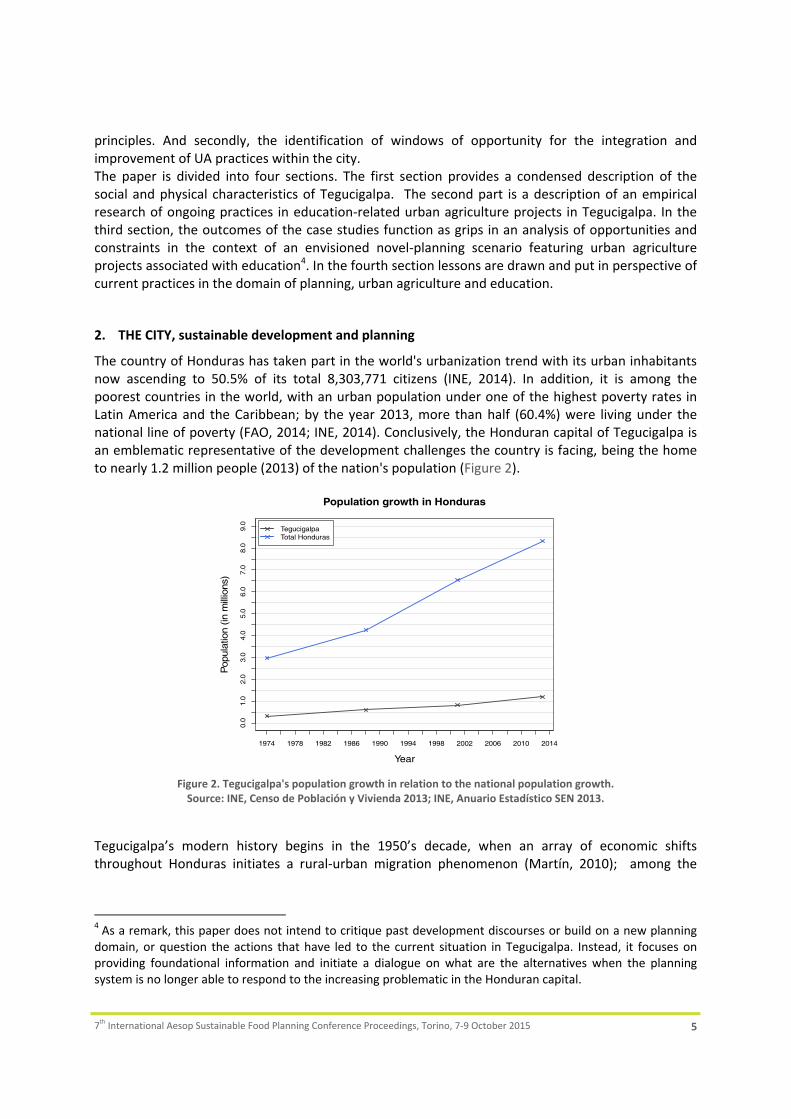
principles. And secondly, the identification of windows of opportunity for the integration and improvement of UA practices within the city. The paper is divided into four sections. The first section provides a condensed description of the social and physical characteristics of Tegucigalpa. The second part is a description of an empirical research of ongoing practices in education‐related urban agriculture projects in Tegucigalpa. In the third section, the outcomes of the case studies function as grips in an analysis of opportunities and constraints in the context of an envisioned novel‐planning scenario featuring urban agriculture projects associated with education4. In the fourth section lessons are drawn and put in perspective of current practices in the domain of planning, urban agriculture and education.
2. THE CITY, sustainable development and planning
The country of Honduras has taken part in the world's urbanization trend with its urban inhabitants now ascending to 50.5% of its total 8,303,771 citizens (INE, 2014). In addition, it is among the poorest countries in the world, with an urban population under one of the highest poverty rates in Latin America and the Caribbean; by the year 2013, more than half (60.4%) were living under the national line of poverty (FAO, 2014; INE, 2014). Conclusively, the Honduran capital of Tegucigalpa is an emblematic representative of the development challenges the country is facing, being the home to nearly 1.2 million people (2013) of the nation's population (Figure 2).
1974 1978 1982 1986 1990 1994 1998 2002 2006 2010 2014
0.0
1.0
2.0
3.0
4.0
5.0
6.0
7.0
8.0
9.0
Population growth in Honduras
Year
Pop
ulat
ion
(in m
illio
ns)
TegucigalpaTotal Honduras
Figure 2. Tegucigalpa's population growth in relation to the national population growth. Source: INE, Censo de Población y Vivienda 2013; INE, Anuario Estadístico SEN 2013.
Tegucigalpa’s modern history begins in the 1950’s decade, when an array of economic shifts throughout Honduras initiates a rural‐urban migration phenomenon (Martín, 2010); among the
4 As a remark, this paper does not intend to critique past development discourses or build on a new planning domain, or question the actions that have led to the current situation in Tegucigalpa. Instead, it focuses on providing foundational information and initiate a dialogue on what are the alternatives when the planning system is no longer able to respond to the increasing problematic in the Honduran capital.

7th International Aesop Sustainable Food Planning Conference Proceedings, Torino, 7‐9 October 2015 6
most recent evidence is the Ley para la Modernización y Desarrollo del Sector Agrícola (LMDSA)5 in 1992, which marked the end of the cooperative (ejidal) lands in the country (Angel et al., 2004). Even though the first initiatives for planned development are in place years later, the results are not as expected due to massive land occupations and the authorities’ lack of capacity to provide basic needs (AMDC, 2014a). Later in the 1980’s decade, a national revision of the last century’s Liberal views takes place; an ideology under which the State, as the main driver, aimed to modernize the economy and place it in the global market. The result is a Neoliberal doctrine that establishes a need to revive the country’s political and economic structure, by removing the State’s position of leading developer, and opening opportunities for other initiatives. In addition, this economic adjustment is further influenced by the financial support from international organizations (e.g. The World Bank and the International Monetary Fund) and the private market (Cálix, 2008; Zelaya y Ferrera, 2012). The sum of the economic and political reforms over these last decades led to the privatization of agricultural land, with the transfer of State land to individuals, and its industrialization, which introduced new production technologies and techniques such as crop switching for an increased export‐oriented production. Consequently, the rural environment was disrupted since less labor force was needed; it is in this last point where the greatest migration flow affected the country’s main urban areas: Tegucigalpa in the central region and San Pedro Sula in the North, as shown in Figure 3 (Angel et al., 2004).
Figure 3. Location of major cities in Honduras.
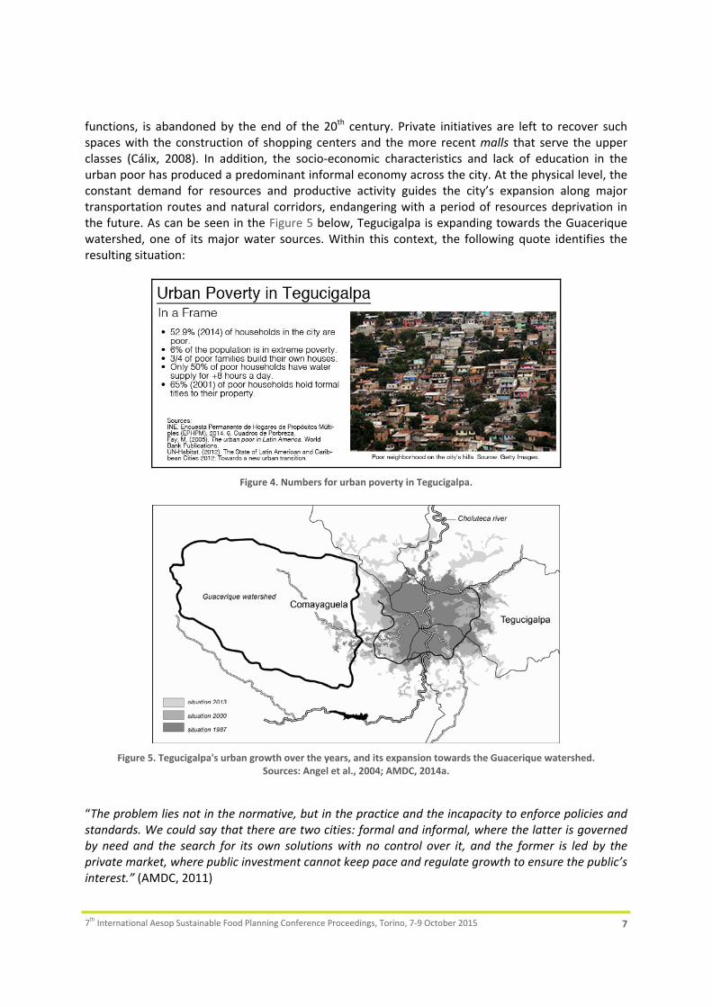
In the timespan of decades, the city doubled in size with a series of poverty strips that now encircle the central city (AMDC, 2008; FAO, 2014). An estimated half of the population (52.9% of households6) lives in vulnerable barrios and slums, over inappropriate land for settlements such as steep hills and riverbanks where they become exposed to the natural hazards posed by the physical conditions of the region, and with no access to urban services (e.g. water or roads), as can be seen in the Figure 4 below (Martín, 2010); adding to other issues such as health, education, transportation, environmental degradation, food access, and insecurity. Regarding the economic dimension, market forces continue to become stronger by a retreating local government from public investment, and with the privatization of public services. An example of this withdrawal is the capital’s historical district, once the center for political, economic, and recreational
5 This law encourages land market liberalization, and privately owned lands to apply modern farming techniques, all with the purpose of competing in the international market. 6 INE, Encuesta Permanente de Hogares de Propósitos Múltiples (EPHPM), 2014. Cuadros de Pobreza.
7th International Aesop Sustainable Food Planning Conference Proceedings, Torino, 7‐9 October 2015 7
functions, is abandoned by the end of the 20th century. Private initiatives are left to recover such spaces with the construction of shopping centers and the more recent malls that serve the upper classes (Cálix, 2008). In addition, the socio‐economic characteristics and lack of education in the urban poor has produced a predominant informal economy across the city. At the physical level, the constant demand for resources and productive activity guides the city’s expansion along major transportation routes and natural corridors, endangering with a period of resources deprivation in the future. As can be seen in the Figure 5 below, Tegucigalpa is expanding towards the Guacerique watershed, one of its major water sources. Within this context, the following quote identifies the resulting situation:
Figure 4. Numbers for urban poverty in Tegucigalpa.
Figure 5. Tegucigalpa's urban growth over the years, and its expansion towards the Guacerique watershed.
Sources: Angel et al., 2004; AMDC, 2014a.
“The problem lies not in the normative, but in the practice and the incapacity to enforce policies and standards. We could say that there are two cities: formal and informal, where the latter is governed by need and the search for its own solutions with no control over it, and the former is led by the private market, where public investment cannot keep pace and regulate growth to ensure the public’s interest.” (AMDC, 2011)

7th International Aesop Sustainable Food Planning Conference Proceedings, Torino, 7‐9 October 2015 8
Today, Tegucigalpa’s future is highly dependent on sustainable development, which can be understood under this setting as the simultaneous pursuit of a just society, economic growth and its fair distribution, and the promotion of a “green” city. Moreover, sustainable development should be thought of as a comprehensive path or strategy, which aims to overcome or avoid the problems presented in Tegucigalpa (e.g. urban poverty, inequality, food insecurity, lack of basic services, and substandard housing, to name a few) in the progression towards a better city. Within this backdrop, urban agriculture becomes a multi‐faceted lever (Van Veenhuizen, 2006) that addresses the components and the overall problem itself. Still, whether or not sustainable development can be planned remains to be seen. The planning scene does not present the conditions for this scenario through its model of conventional‐top down development. A rupture of the current system is needed in order to transition into a more innovative and collaborative approach in planning, and promote the sustainability of the area and its citizens.
3. The Research
In order to answer our questions on Tegucigalpa’s spatial planning and development scene and the potential for UA in this setting, this research was carried out as the Master’s thesis of one of the authors of this paper, inspired by the problematic in the city and the increasing importance of food movements worldwide (e.g. Amsterdam, New York, Havana, and Dar es Salaam, among others). An initial literature review provided the basis for understanding the concept of sustainable development and the role of urban agriculture in city‐making, followed by a one‐month visit to the city of Tegucigalpa to collect data through interviews, site visits, and documentation. The identified UA projects were later taken through a case study analysis, which consisted of a total of five formal UA initiatives and two cases of spontaneous UA activities in the urban area. The reflection phase of the research, in the end, allowed pinpointing major themes and topics that compose the UA scene in Tegucigalpa.
4. Urban Agriculture In Tegucigalpa
Urban agriculture is not a wide‐spread practice in Tegucigalpa as yet. At least it is not visible from the public roads and it is not a popular theme in the local press and the dominant political discourse7. Nevertheless after careful and targeted inspection of websites, press releases and interviews with different professionals, our explorative search in Tegucigalpa revealed some interesting cases dispersed over various parts of the city. Their collaborators, participants, and methodologies vary in origin; however, they present common characteristics and goals for their development. This paper focuses on two of the selected case studies for the research, as the first is representative of the topic of conventional top‐down programs while the latter illustrates a case of collaboration and bottom‐up development in the city. Further on, two spontaneous UA initiatives are briefly presented in order to provide with an initial idea of the types of activities taking place in other neighborhoods of Tegucigalpa besides the projects stated beforehand.
Case 1. The Project: “Family agriculture for a better life” This urban farming project is a household and school garden initiative proposed by the Honduran central government at the beginning of 2014, as part of their “Generation of Opportunities” Program. It aims at tackling food insecurity by improving the diets of children and adults in
7 According to the interviewees of this research and a review of local press and documentation.

7th International Aesop Sustainable Food Planning Conference Proceedings, Torino, 7‐9 October 2015 9
vulnerable conditions, and who fall under the national and extreme poverty indicators. The target groups are families and public pre‐ and elementary schools across the country; who enter the program if they hold the prerequisite of water access, and land availability (50m2 in the case of households, and 200m2 for schools). The program is responsible for selecting the participants, as well as delivering the inputs for the development of their corresponding garden model (a drip irrigation system, seeds, fertilizers, and tools). Simultaneous to the installation of the garden, government technicians are responsible for training the participants in the preparation, maintenance, and harvest of the allotment. The main produce obtained is carrots, radishes, beets, beans, and corn. In addition, nutritionists give workshops on how to efficiently prepare the harvested products and improve the dietary intake of the families and school attendees. Furthermore, it is worth highlighting that the program has a strong educational component, as the gardens not only serve to improve the children’s nutritional intake but also aim at the recovery of agricultural traditions in the country’s youth (Figure 6). By the end of the first year, there were 55 schools involved in Tegucigalpa’s municipality, and hundreds more throughout the country. An active involvement from the parents, teachers, and students has been key for managing, developing the gardens, and for the use of the crops. The produce is added to the School Meal Program8 of each institution, contributing with the provision of vegetables that are not yet included in this program’s diet.
Figure 6. Harvesting in a school garden. Source: SEDIS.
Although this initiative has proven successful, there are socio‐political limitations that constrain its development, and on a greater scale, the legal status of the program (a feature that determines its financial support and continuation in future administrations). Thus, sustainability practices are also encouraged within this program, as the government only holds the capacity to provide for the initial inputs, and the participants must provide for themselves afterwards. Moreover, the development of the program in urban areas has been limited by the participants’ knowledge of agricultural practices. Even though a large portion of the population is a subject of rural‐urban migration, techniques in
8 The School Meal (Merienda Escolar) is a central government plan that aims at improving children’s health and academic performance, currently attending to 1.4 million children across the country. Rice, beans, eggs, milk, soy, and corn is delivered to schools with support from the World Food Programme, and parents and teachers must organize themselves to prepare the meals and distribute them to the children on a daily basis.

7th International Aesop Sustainable Food Planning Conference Proceedings, Torino, 7‐9 October 2015 10
urban areas vary greatly from those in their places of origin; meaning that training must start from an elementary level, resulting in a longer implementation process.
Case 2. The Cerro Grande School The Cerro Grande neighborhood school initiated a small academic entrepreneurship program in 2004, to which they added a small agricultural enterprise in 2010, aiming to educate the children in cultivation practices and their values. With a teacher’s interest in a FAO household project9 in the city, a school gardening program was adopted with the support from this organization, who provided the infrastructure and technical assistance for the implementation of the farming project (FAO, 2013; Fletes Ramos, 2012). In this case, teachers, who would later diffuse the knowledge among the students, were offered training. The garden was built on recycled materials such as tires, and developed through organic farming practices. Among the main products obtained are radishes, lettuce, spinach, onions, peppers, tomatoes, and a variety of herbs. The produce is later used in the preparation of the School Meal, and for food processing in another one of the school’s enterprises where the children learn to prepare pickled goods, jams, and tortillas mejoradas, to name a few products. Moreover, an important characteristic of this initiative is its particular irrigation system. Since the school receives water for only two days a week from the municipal drinking water system, irrigation could not be dependent on this service. The school had to become self‐sustainable in this aspect; and with the support from private sector foundations, a rainwater collection system with a storage tank and its distribution infrastructure was developed. Nowadays, the school has a vegetable garden, a water storage system, a greenhouse for producing aromatic herbs (Figure 7), and a small food processing enterprise. Therefore, such education center stands out for its entrepreneurship and sustainability, and for illustrating the value of integrating these types of activities in the children's curriculum. Likewise, the school is an example of the alliances these types of projects form to promote more sustainable development, due to the active involvement of NGOs, private sector, the school’s teachers, and the parents.
Figure 7. School greenhouse and cultivation tires at the Cerro Grande School. Source: Fletes Ramos, 2012.
It is expected that this particular initiative can be later replicated in other educational institutions of the country. Agreements have been signed between NGOs and government representatives to promote the incorporation of school gardens in the educational system, with the goal of tackling hunger and unsustainable practices (FAO, 2013). In the meantime, it is forecasted that by teaching
9 UA Pilot Project in Tegucigalpa from the local municipality, in cooperation with FAO, for household gardening in three of the city’s neighborhoods. See FAO, 2014.

7th International Aesop Sustainable Food Planning Conference Proceedings, Torino, 7‐9 October 2015 11
the value of gardening to children, they can later diffuse it in their own households and motivate other family and community members into the practice, resulting in a "domino" effect across small communities of the urban population.
Case 3. Spontaneous UA in Tegucigalpa. Apart from the formal projects mentioned before, a small number of informal UA initiatives were identified in Tegucigalpa. In order to discover other urban gardens in the city, a scouting of neighborhoods was done in accordance to the recommendations provided by the interviewees, and visual inspection throughout the fieldwork. These activities are labeled as "informal" as they receive no external support for their development and are solely implemented by their gardeners. Their spontaneous origin and purpose are among the main characteristics of these initiatives; however, their nature also affects their development and degree of resilience, and possibilities for future expansion. The first enterprise consists of a few UA activities taking place in the small public Preschool Amilcar Rivera Calderón in the inner city. Due to the achievements accomplished by their successful School Meal program, the school is now focusing on improving its academic curriculum by integrating field activities during classes, and not limit themselves to the classroom. Hence, the development of a program composed of small UA initiatives where the students get in contact with domestic animals and exercise cultivation. Similar to their School Meal program, “this project is dependent on the collaboration between parents and teachers for its success”, as expressed by the school’s director. As a result, an aviculture project is taking place in the school’s backyard, where the parents and faculty collected the materials for the construction of a henhouse (Figure 8). Fruit trees and a corn garden also take part in this agricultural initiative, of which the produce is included in the School Meal and the surplus (if any) is sold to the community as well. The sum of the activities contributes to the School Meal’s purpose of educating children on the importance of nutrition. In addition, it teaches the students the value and benefits of producing and using their own food. However, this initiative is limited by the space in the school grounds, narrowing its possibilities for expansion.
Figure 8. Left: henhouse built by the parents and teachers at the pre‐school.
Right: corn cultivation in an empty lot.
The second set of informal UA activities is the temporary use of vacant land in the peri‐urban zone around the city. Even though Tegucigalpa continues to expand its area, it is still common to find empty lots throughout the city, particularly in residential neighborhoods that are considered as "more recent" urban developments. The lots are private property that is still unoccupied by their owners. The gardeners involved are usually the neighborhood guards or laborers working nearby,

7th International Aesop Sustainable Food Planning Conference Proceedings, Torino, 7‐9 October 2015 12
who start cultivating after permission to use the land is granted. The crops are mainly corn and beans, which are used in the gardener’s household or for commercialization in their own communities. Lastly, an important characteristic of these gardens is their temporary nature, since they are subject to the plot owners’ decisions and the gardener’s available time, resulting in dispersed cultivation sites across residential neighborhoods that tend to just last a few months.
4.1. What do the cases suggest?
Considering the statements provided by the interviewees, the collected data, and the discoveries from the fieldwork used in the analysis phase of the study, the following sections build upon the common elements, strengths, and limitations of the recorded UA activities, as perceived by the collaborators and authors of this research. Firstly, it can be observed that different types of UA activities are already taking place in Tegucigalpa; refer to Table 1 below. From these initiatives we can see models of urban farming that range from household gardens to school gardens, and in which a variety of stakeholders participate: families (parents and children), professionals, NGOs, the government, and private foundations. However, one common element stands out from these experiences: the participating schools. Even though it is not required from the academic curriculum, UA has been added to the educational activities to motivate children and their families to take part in this movement.
Table 1. Description of UA activities discussed in this paper.
For the concerns expressed at the beginning of this paper, the value of school gardens relies on their potential for community building and development in the city. Throughout the research, schools were represented as a medium to achieve common goals and encourage interaction between different stakeholders. In the process of developing the gardens, which in these cases are taken alongside the existing School Meal program, school teachers and families in the community come together with the goal of improving the children’s personal development, and consequently, their family’s situation. The focus on working for the children is stated by a representative of the School Meal program as: “Children are the future, it is an investment. Even though the parents do not have the ideal opportunities, investing on such activities improves their children’s chance for a better future.” Moreover, this should be thought of as investing in the city’s forthcoming society, meaning a long‐term effect in the path towards the improvement of the urban area.

7th International Aesop Sustainable Food Planning Conference Proceedings, Torino, 7‐9 October 2015 13
For planners, the strong presence of schools in the city (1,089 centers in the Central District Municipality10) represents a starting point for the integration of UA activities in Tegucigalpa, as all public schools participate in the School Meal program and hold the potential for the development of a school garden. Similarly, as UA initiatives become visible in the city, other neighborhoods or citizens start adopting these practices in their respective area; such was the case of the Cerro Grande School. As expressed by the interviewees, the increasing network of UA activities spread throughout the capital should be viewed as a “ripple effect” or “domino effect” system (Figure 9), in which the school becomes the focus point of a community and later influences its surroundings to become involved in UA for the neighborhood’s social, economical, and environmental improvement. Given the socio‐political context in the city under the predominance of urban individualism and lack of communal space (refer to Section 4.5), schools in this case would hold the potential of becoming the entrance point to a community from the perspective of planners and developers, and a meeting point for its respective members.
Figure 9. Location of the recorded UA initiatives and their starting dates,
including a representation of a ripple effect over Tegucigalpa. Image: Google Earth.
4.2. Windows of opportunity for UA
Based on the idea that the city’s schools serve as a starting point for the integration of UA in Tegucigalpa, the following paragraphs describe the conditions and aspects that planners and developers (or even citizens) could take advantage of in the quest of implementing UA as a strategy for sustainable and participatory development in the city: A multi‐stakeholder process. The first aspect to observe, and one of the most repetitive points throughout the research, is the need for inter‐institutional collaboration and alliances among the stakeholders of UA in Tegucigalpa. UA is best achieved through a multi‐stakeholder mechanism that
10 Secretaría de Educación. Data includes public schools and educational centers under a private administration.

7th International Aesop Sustainable Food Planning Conference Proceedings, Torino, 7‐9 October 2015 14
adds a comprehensive and dynamic character to the planning process (Dubbeling & Merzthal, 2006), and which may include government agencies, municipalities, international and local NGOs, the private sector, educational centers, and the citizens themselves. Within the case studies presented, UA was successful through good community organization (schools‐families‐neighbors) and institutional collaboration (public and private sector) for its socialization process and application. Furthermore, an active participation from stakeholders improves the quality of decision‐making, raises the level of trust among them, and increases the credibility of projects. Cooperation also enables the coordination of different mechanisms towards an effective use of human, financial, and environmental capital. A strong example of such alliances was the work between the Cerro Grande School, FAO, and the private sector in the acquisition of resources for the development of the school garden. Thus, within this framework, institutions or other fellow stakeholders become facilitators of the practice and empower the population towards city‐making. The existing initiatives. Existing initiatives serve as a starting point for UA in Tegucigalpa. The socio‐political context in the city limits the application of new programs without a previous exploration of the issue at hand; therefore, the case studies represent pilot projects of which best practices can be extracted from and adapted to improve strategy‐building in the city. Likewise, the school initiatives can also be expanded (e.g. taking the school gardens to private schools) and their best practices can be adapted to other UA models (household or community gardens) to increase their reach and effects on the urban population. The School Meal venture especially demonstrates the potential of using an existing initiative for the implementation of UA: as the garden produce is added to the meals to improve the children’s daily nutritional intake, the community increases their interest in adopting a gardening program, and thus, a faster development of school gardens by the public and the gain of its benefits. Motivation from the participants. The case studies display there is strong motivation and interest from the participants in becoming involved in UA activities, meaning there is a general positive acceptance towards the practice to take advantage of. An example of such interest is the teachers who played the role as initiators of UA in their respective institutions, such as the case of the Cerro Grande School and the pre‐school, and their respective community members and institutions. However, such interest is triggered when UA becomes visible and accessible to other citizens through knowledge. The documentation illustrates how UA is an activity that can be undertaken by anyone who holds the prerequisite of knowledge (becoming aware of the practice and its techniques), and thus can be targeted at different groups. In the case of children, they show an eagerness to learn that can prove beneficial to UA’s implementation.
4.3. What to expect?
Even though the impact of UA practices is expected over aspects that range from the ecological to social dimensions (Deelstra & Girardet, 2000; Smit & Nasr, 1992), we continue to focus on UA’s impact over Tegucigalpa’s particular features, and more specifically, on the effects of integrating UA in the urban area through the schools perspective. In the Honduran capital, UA practices would influence the city’s social and environmental setting, while raising awareness in the population on the value of UA over these aspects. And so, the following themes are showcased as perceived by the socio‐political context in the city, and as the immediate expectations of implementing a UA program in the area. Community building & citizen empowerment. First is the topic of empowering the population, in which citizens practicing UA appropriate their urban environment to improve their situation. This issue concerns more to lower‐income households, and more specifically women, who are generally

7th International Aesop Sustainable Food Planning Conference Proceedings, Torino, 7‐9 October 2015 15
the household managers and providers. As could be seen in the schools (and household gardens as well), women have an important role to play. UA practices become a form of occupation for them, besides being a medium to provide nourishment and reduce household expenses. Likewise, UA has shown to have an effect on improving a community's social relations throughout the examples. Cooperation has been key for the development of urban farms, produce harvesting, improving the School Meal (Figure 10), and commercializing any surplus. Within this context, UA is becoming a strategy that initiates social change, as it targets vulnerable groups and has a range of benefits on the long‐term. By improving livelihoods, and specifically children’s development, citizens may also become less exposed to the present issue of poverty and its consequent violence in the city, which has been rapidly increasing over the last years. Therefore, a transition into an improved quality of life for the city's inhabitants may be encouraged with the social, economic, and environmental benefits of UA.
Figure 10. Mothers preparing and distributing the School Meal to the children. Source: SEDIS.
Food security & nutrition. Most importantly, UA activities in the city tackle food insecurity and malnutrition, being the main driver for this practice in schools. In the area of Tegucigalpa, the main problem with food is the access (purchasing power), and not necessarily the food supply, especially for the urban poor. The application of UA in the examples shows food security as the priority, with the goal of producing for self‐consumption and sustainability. The result is an improvement of consumption habits and the level of nutrition of the beneficiaries through the diversification of their diets. In addition, involving children in UA “makes them value and understand the importance of producing their own food, and additionally, make an efficient use of water, considering it is the most valuable resource for food production”, as expressed by a government agent.
4.4. Impacts over the urban area
Apart from small‐scale impacts mentioned before, the sum of the UA initiatives can generate substantial economic and environmental impacts at the city scale. Economic impact. On a general level, UA brings the recovery of agricultural practices and traditions that have been lost in the country, considering that Honduras is still a place where 37.8% of the economically active population is involved in agriculture and food chains (Consejo Económico y Social, 2005). At the smallest scale, UA can become a form of subsistence for vulnerable groups,

7th International Aesop Sustainable Food Planning Conference Proceedings, Torino, 7‐9 October 2015 16
where its contribution can be seen in household savings by reducing food purchases and the commercialization of surplus. Still, the economic impact of UA is dependent on the size of the garden, type of production, household members and income, among others. To provide a base idea of this impact, a study by the FAO (2012) in three vulnerable neighborhoods of Tegucigalpa shows a household garden's impact may be an estimated USD 20.00 per month, a 13‐25% of the amount families assign to food expenses, meaning that low‐income households can now allocate the savings to healthcare, education, or housing improvements. Moreover, the economical impact of UA is translated into the healthcare and productivity sector, through the phenomenon labeled as "the cost of hunger". Improving people's nutrition and personal development makes them build the capacities needed for education and employment opportunities, becoming a productive asset for the economical sector. Also, they become less prone to illness, which asides from benefiting their personal development, aids the country’s public healthcare system. For example, an average of 201 thousand cases in Honduras (2004) were in need of healthcare due to the exposure to malnutrition, resulting in a cost of USD 47.6 M for the country (Martínez & Fernández, 2007). Environmental impact. Firstly, vulnerable populations are the most affected by the impacts of climate change on agricultural yields and the subsequent food price fluctuations. In addition, climate influences natural phenomena such as water availability and quality, and increases the exposure to hazards and sanitation problems in the most vulnerable settlements. Thus, UA may serve as a strategy for climate change adaptation for inhabitants of the urban environment. Secondly, although urban agriculture makes use of resources (land and water) for its development, it can be deemed as an opportunity for the conservation and efficient use of such capital through strategic programs and practices for land, water, and waste management in urban areas, as could be seen in the case of the Cerro Grande School where rainwater is collected to irrigate the crops and solid waste is recycled for the construction of the vegetable garden.
4.5. Challenges for UA in Tegucigalpa
Asides from the effects of implementing a UA initiative, it is important for city‐makers to also consider the limitations, in order to identify lessons‐to‐be‐learned and improve its future progress. Regarding the discipline of spatial planning, addressing these obstacles would mean to identify the conditions of the urban context that could constrain the application of such practice. Political context. The absence of UA from the national and municipal agenda limits the allocation of resources for its support and the channels for its promotion. Support from NGOs and private foundations becomes challenging without a solid demand or development scheme from the government, and for achieving inter‐institutional collaboration. In the case of the schools, UA cannot be guaranteed without the involvement of the Ministry of Education, and is therefore subject to a continuous interest from the teachers and parents. Furthermore, the issue of continuation affects its development, since there is little interest and political will to reinforce existing initiatives or commence new ones; thus, projects are interrupted every administration (four years), without gaining the benefits of a long‐term operation. Cultural context. Tegucigalpa's culture is shaped by different factors that include political ideologies, religion, and social status, among others. These points of view should be taken into account as they determine the acceptance and interest in UA across different society groups. An example is the government program in the first case study, where several school teachers have difficulties in adopting the initiative as their political perspectives contrast the current administration. Thus, the implementation of UA is attached to overcoming ideologies for its success.

7th International Aesop Sustainable Food Planning Conference Proceedings, Torino, 7‐9 October 2015 17
Similarly, urban culture tends to be less sensible to collective problems in comparison to rural communities. Individualist thinking challenges community building and empowerment, which adds to the issue of urban insecurity in the city, and consequently limiting UA as well. Insecurity affects people's reception towards outdoor activities, Moreover, society's response to insecurity has been the reinforcement of the privatization of property (e.g. enclosures and gated communities), reducing the interest in community interaction and intensifying urban individualism (Figure 11).
Figure 11. Children playing inside a gated community. Source: hondudiario.
Knowledge & diffusion. It is worth highlighting the topic of knowledge as the strongest limitation for the development of a UA movement in Tegucigalpa. As expressed by one interviewee: “people cannot practice it if they don’t know it”, and so the training phase within the case studies depicts the importance of knowledge for target groups to start practicing UA. Understanding the potential of the practice for changing their livelihoods will empower people to exercise it, regardless of their social group and context. Likewise, the type and level of knowledge determines the type of UA practices, regarding farming techniques (e.g. organic‐inorganic) and management of inputs, as well as the commercialization of products. In addition, knowledge defines the consumer culture, through which the demands that shape the urban environment are established. However, social stratum determines the opportunities for acquiring such knowledge, for which it is therefore important to address the issue of diffusion among the city’s diverse population. Planning context. Tegucigalpa's spatial development scene continues to be driven by past Neo‐liberal discourses and thus continues to be unresponsive to the urban problematic in the area. UA does not take part in urban development activities, meaning it is not a permitted land use in the area. Taking into account that land is the first resource on which UA depends on, the allocation of plots and other space possibilities (e.g. vertical surfaces for gardening) must take place to enable the population to practice UA. Additionally, land tenure is a common problem in the city due to the illegal occupations and ownership insecurity, where only an estimated 65% (2001) of poor household hold formal titles to their land or property (Fay & Wellenstein, 2005). Hence, a clarification of land property and enabling the availability of space could encourage the rise in UA initiatives across the urban area. Yet, achieving this stage of formalization of UA requires time and effort from the local government. In the meantime, planners can contribute as the "enablers" or "mediators" in the process (Mubvami et al., 2006), by guiding UA's consolidation in the form of small initiatives, such as the schools cases, in which the citizens drive the activity along with the support from fellow stakeholders. Inputs of UA. An additional observation derived from the case studies is the participants' dependence on state agencies and NGOs for the provision of UA inputs (e.g. seeds, tools, or water) and instruction. Sustainability of the practice must be achieved to develop it independently from
7th International Aesop Sustainable Food Planning Conference Proceedings, Torino, 7‐9 October 2015 18
institutions or charities, and ensure the resilience of projects when external support becomes unavailable or the urban conditions change. Furthermore, the limited availability and the situation of resources in the area produces a need to adapt technologies that efficiently use land and water resources; for the latter, it involves addressing one of the biggest problems of Tegucigalpa (see The World Bank, 2012; Brand & Bradford, 1991; UNICEF, 1990). Planning then, must facilitate and manage the use of such resources, in order to ensure a sustainable development of UA and the revitalization of the city's urban environment.
4.6. Complementary strategies promoting healthy urban lifestyles
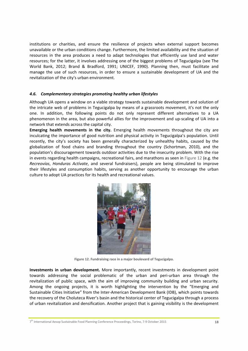
Although UA opens a window on a viable strategy towards sustainable development and solution of the intricate web of problems in Tegucigalpa by means of a grassroots movement, it's not the only one. In addition, the following points do not only represent different alternatives to a UA phenomenon in the area, but also powerful allies for the improvement and up‐scaling of UA into a network that extends across the capital city. Emerging health movements in the city. Emerging health movements throughout the city are inculcating the importance of good nutrition and physical activity in Tegucigalpa’s population. Until recently, the city’s society has been generally characterized by unhealthy habits, caused by the globalization of food chains and branding throughout the country (Schortman, 2010), and the population’s discouragement towards outdoor activities due to the insecurity problem. With the rise in events regarding health campaigns, recreational fairs, and marathons as seen in Figure 12 (e.g. the Recreovías, Honduras Actívate, and several fundraisers), people are being stimulated to improve their lifestyles and consumption habits, serving as another opportunity to encourage the urban culture to adopt UA practices for its health and recreational values.
Figure 12. Fundraising race in a major boulevard of Tegucigalpa.
Investments in urban development. More importantly, recent investments in development point towards addressing the social problematic of the urban and peri‐urban area through the revitalization of public space, with the aim of improving community building and urban security. Among the ongoing projects, it is worth highlighting the intervention by the “Emerging and Sustainable Cities Initiative” from the Inter‐American Development Bank (IDB), which points towards the recovery of the Choluteca River’s basin and the historical center of Tegucigalpa through a process of urban revitalization and densification. Another project that is gaining visibility is the development

7th International Aesop Sustainable Food Planning Conference Proceedings, Torino, 7‐9 October 2015 19
of parks and communal space by the Fundación Convive Mejor, who aims at constructing a park network throughout several municipalities affected by crime and poverty; among which the first area to intervene is the capital city (Figure 13). Consequently, public space is becoming a medium for communities to converge, interact, and appropriate their urban environment in the search for community development. Hence, public or communal space is a potential mechanism for UA to take part in such initiatives that focus on the renewal of the urban area as well, and that will make it a more visible practice within and across the different communities.
Figure 13. Left: IDB proposal for the Choluteca area. Source: ESCI. Right: Completed park in San José de la Vega. Source: El Heraldo.
5. Reflections & Conclusions
In the city of Tegucigalpa, UA has developed under a very specific context due to the socio‐political conditions and the overall urban development of the capital over the years. As the planning scene is not able to cope with the increasing urban problems, alternative solutions focused on social cohesion and urban security are now in the making. Likewise, international agencies (seen in the examples of the IDB and FAO) are setting the framework for achieving the population's sustainability, among which UA can be included as a development strategy. Therefore, a rupture of the more traditional top‐down approach has commenced with the increasing participation of numerous stakeholders and multi‐party collaboration in the transition towards a better capital. However, the topic of active citizenship or bottom‐up development is not yet consolidated under this context, as the general population is not in a position to manifest their needs due to the limitations posed by the issue of knowledge. The case studies outlined a type of UA movement in Tegucigalpa where most examples showcase a willingness from "top‐downers" to improve the conditions of the urban area with the development of programs based on food production aimed at improving the inhabitants' livelihoods. Thus, the population has a certain level of dependence on support from external actors, leading to a passive demand from the population, instead of the expected spatial appropriation illustrated by other cases around the world (see Miazzo & Kee, 2014). Nevertheless, UA holds the potential for contributing to a citizen’s quality of life. Although it is not expected to become a medium for absolute self‐sustainability, it has provided the target groups with more benefits than setbacks, such as improved nutritional intake, skill building and empowerment, monetary savings, and social cohesion, among others. The food gardens have also demonstrated to have an impact on the topic of equity, as women are the outstanding participants in the cases, even though the gender issue does not necessarily hold the strongest stance among the examples. In addition, there is strong interest in the instruction to children as it is viewed as the qualification and development of the city's upcoming society, aiming at the long‐term benefits of these actions and securing a positive social change in the future of the urban area.

7th International Aesop Sustainable Food Planning Conference Proceedings, Torino, 7‐9 October 2015 20
UA is not and cannot become the ultimate solution to the myriad of urban problems in Tegucigalpa. Tegucigalpa's conditions present multiple challenges regarding the availability of inputs (land and water) for practicing agriculture in the urban area. Effort must be placed on this issue, considering the social assets of UA may compensate for the unfavorable access to resources in the city. Therefore, it must be complemented by other initiatives that focus on managing the resources needed for developing urban gardens, considering there are several windows of opportunity for its strategic development and inclusion. Nonetheless, a different challenge for UA stakeholders arises. As the historical evolution of the city and its planning system shows, Tegucigalpa does not present the ideal scenario for continuing a top‐down development of UA programs. In order to achieve a degree of self‐sustainability in the population and establish a bottom‐up demand of UA, it appears that the first issue to address is the topic of knowledge and diffusion, considering knowledge is a driver for empowerment and social exchange. Further on, collective action may strengthen the people's identity, and their sense of self‐determination in the face of hardship (Smit et al., 1996). Hence, UA represents both an end (food production) and a channel for strategically achieving community goals. Lastly, the application of UA is not a matter of tackling the increasing urbanization, but improving the quality of life of the people that have been affected by this phenomenon throughout the years. Like so many other exploding urban agglomerations in developing countries, the city of Tegucigalpa is in need of a comprehensive urban strategy which may eventually create a resilient physical and socio‐economic environment. Urban agriculture can provide with building blocks for an adaptive bottom‐up strategy, conceived and carried out by its populace in the face of constantly changing conditions.
6. REFERENCES
AMDC 2008. Capital 450, La Ciudad Que Queremos. Tegucigalpa M.D.C.: Alcaldía Municipal del Distrito Central. AMDC 2011. ¡Arriba Capital! Plan Municipal de Ordenamiento teritorial 2011‐2028. Tegucigalpa M.D.C.: AMDC,
PNUD, CAH. AMDC 2014a. Diágnostico Integral Multidimensional. Borrador ‐ Plan de Desarrollo Municipal con Enfoque en
Ordenamiento Territorial. Municipio del Distrito Central, Tegucigalpa M.D.C. AMDC 2014b. Subsistema Social. Borrador ‐ Plan de Desarrollo Municipal con Enfoque en Ordenamiento Territorial.
Municipio del Distrito Central, Tegucigalpa M.D.C. ANGEL, S., BARTLEY, K., DERR, M., MALUR, A., MEJIA, J., NUKA, P., PERLIN, M., SAHAI, S., TORRENS, M. & VARGAS, M.
2004. Rapid Urbanization in Tegucigalpa, Honduras. Preparing for the doubling of the city’s population in the next twenty‐five years. Report from Woodrow Wilson School of Public and International Affairs, Princeton University.
BRAND, A. & BRADFORD, B. 1991. Rainwater harvesting and water use in the barrios of Tegucigalpa, UNICEF/Honduras' Water Supply and Environmental Sanitation Program.
BRYLD, E. 2003. Potentials, problems, and policy implications for urban agriculture in developing countries. Agriculture and human values, 20, 79‐86.
CÁLIX, D. N. 2008. Tegucigalpa, espejismo de la modernidad: el impacto de los discursos liberal y neoliberal sobre la capital de Honduras (siglos XIX y XX). Amérique Latine Histoire et Mémoire. Les Cahiers ALHIM. Les Cahiers ALHIM.
CONSEJO ECONÓMICO Y SOCIAL. 2005. Diagnóstico: Producción y Empleo de Rubros de Exportación No Tradicionales (Sandía, Melón, Maranón y Camarón) [Online]. Available: http://www.trabajo.gob.hn/organizacion/dgt‐1/direccion‐general‐de‐empleo/oml/diagnosticoproduccionyempleo.pdf [Accessed February 16, 2015].
DEELSTRA, T. & GIRARDET, H. 2000. Urban agriculture and sustainable cities. Bakker N., Dubbeling M., Gündel S., Sabel‐Koshella U., de Zeeuw H. Growing cities, growing food. Urban agriculture on the policy agenda. Feldafing, Germany: Zentralstelle für Ernährung und Landwirtschaft (ZEL), 43‐66.
DUBBELING, M. & MERZTHAL, G. 2006. 2. Sustaining Urban Agriculture Requires the Involvement of Multiple Stakeholders. Cities farming for the future: Urban agriculture for green and productive cities, IDRC.

7th International Aesop Sustainable Food Planning Conference Proceedings, Torino, 7‐9 October 2015 21
DUBBELING, M. 2011. Integrating urban agriculture in the urban landscape. Urban Agriculture Magazine, 25, 43‐46. FAO 2012. Sistematización del Proyecto Piloto AUP en Honduras. La agricultura urbana y su contribución a la
seguridad alimentaria. Tegucigalpa M.D.C. FAO. 2013. Huertos se utilizarán como herramientas pedagógicas en los centros escolares [Online]. Available:
http://fao.org.hn/l/noticias/73‐huertos‐se‐utilizar%C3%A1n‐como‐herramientas‐pedag%C3%B3gicas‐en‐los‐centros‐escolares.html [Accessed February 04, 2015].
FAO 2014. Ciudades más verdes en Américca Latina y el Caribe. Roma: Food and Agriculture Organization of the United Nations.
FAY, M. & WELLENSTEIN, A. 2005. 3. Keeping a Roof over One's Head: Improving Access to Safe and Decent Shelter,. The urban poor in Latin America. World Bank Publications.
FLETES RAMOS, Y. 2012. Sistematización de Cosecha de Agua para Riego de Huerto Escolar, Sistematización de Buenas Prácticas: Diplomado en Cambio Climático UNAH‐IHCIT.
GREEN, M. 2000. Participatory development and the appropriation of agency in southern Tanzania. Critique of anthropology, 20, 67‐89.
INE. 2014. Población y Empleo, Inicio [Online]. Available: http://www.ine.gob.hn/ [Accessed January 21, 2015]. LA TRIBUNA. 2013. Tegucigalpa crece… Pero, ¿hay espacio para más gente? La Tribuna. [Online]. Available:
http://www.latribuna.hn/2013/12/09/tegucigalpa‐crece‐pero‐hay‐espacio‐para‐mas‐gente/ [Accessed August 30, 2015]
MARTÍN, M. 2010. La Complejidad Urbana y Ambiental de Tegucigalpa. Proyecto "Tegucigalpa 2010", Capítulo 1. Tegucigalpa M.D.C.: Comité de Desarrollo Sostenible de la Capital, CCIT.
MARTÍNEZ, R. & FERNÁNDEZ, A. 2007. El costo del hambre: impacto social y económico de la desnutrición infantil en Centroamérica y República Dominicana.
MIAZZO, F. & KEE, T. 2014. Introduction. We Own The City: Enabling Community Practice in Architecture and Urban Planning. The Netherlands: Trancity.
MOUGEOT, L. J. 1994. CFP Report 8: Urban Food Production: Evolution, Official Support and Significance. MUBVAMI, T., MUSHAMBA, S. & DE ZEEUW, H. 2006. Integration of agriculture in urban land use planning. Cities
Farming for the Future: Urban Agriculture for Green and Productive Cities. RUAF, IIRR and IDRC, Silang, the Philippines, 54‐74.
QUON, S. 1999. Planning for urban agriculture: A review of tools and strategies for urban planners. Cities Feeding People Report, 28.
REDWOOD, M. 2012. Introduction. Agriculture in urban planning: generating livelihoods and food security. Routledge.
SCHORTMAN, A. 2010. “The Children Cry for Burger King”: Modernity, Development, and Fast Food Consumption in Northern Honduras. Environmental Communication, 4, 318‐337.
SMIT, J. & NASR, J. 1992. Urban agriculture for sustainable cities: using wastes and idle land and water bodies as resources. Environment and urbanization, 4, 141‐152.
SMIT, J., NASR, J. & RATTA, A. 1996. Urban agriculture: food, jobs and sustainable cities. New York, USA. THE WORLD BANK 2012. Integrated Urban Water Management. Case Study: Tegucigalpa. Blue water, green cities.
Washington DC: The World Bank UNAH‐IUDPAS 2015. Boletín Nacional Enero‐Diciembre 2014. Mortalidad y Otros. Edición No. 36. Observatorio de la
Violencia. UNICEF 1990. Urban example prospective for the future: water supply and sanitation to urban marginal areas of
Tegucigalpa, Honduras. Urban example prospective for the future: water supply and sanitation to urban marginal areas of Tegucigalpa, Honduras. UNICEF.
VAN VEENHUIZEN, R. 2006. 1. Introduction, Cities Farming for the Future. Cities farming for the future: Urban agriculture for green and productive cities, IDRC.
WATSON, V. 2009. ‘The planned city sweeps the poor away…’: Urban planning and 21st century urbanisation. Progress in planning, 72, 151‐193.
WEKERLE, G. R. 2004. Food justice movements policy, planning, and networks. Journal of Planning Education and Research, 23, 378‐386.
ZELAYA Y FERRERA. 2012. La Reforma Liberal [Online]. Available: http://historiadehondurasenlinea.blogspot.nl/2012/06/la‐reforma‐liberal.html [Accessed September 15, 2015].

Magda Rich, Andre Viljoen, Karl Rich, “The ‘Healing City’ – social and therapeutic horticulture as a new dimension of urban agriculture?”, In: Localizing urban food strategies. Farming cities and performing rurality. 7th International Aesop Sustainable Food Planning Conference Proceedings, Torino, 7‐9 October 2015, edited by Giuseppe Cinà and Egidio Dansero, Torino, Politecnico di Torino, 2015, pp 22‐35. ISBN 978‐88‐8202‐060‐6
22
THE ‘HEALING CITY’ – SOCIAL AND THERAPEUTIC HORTICULTURE AS A NEW DIMENSION OF URBAN AGRICULTURE?
Magda Rich1, Andre Viljoen2, Karl M. Rich3 Keywords: urban agriculture, social and therapeutic horticulture, urban planning, CPUL, group model building
Abstract: The healing effects of nature and natural environments have been known for centuries. Recent studies suggest that the incorporation of horticulture into therapeutic activities benefits people with diverse social and health problems. This knowledge has engendered the development of a large number of facilities offering horticulture‐based therapeutic activities, mostly in rural areas in Western Europe and the US. However, as a significant majority of their potential beneficiaries live in urban environments, the rural location of these facilities might significantly lower their accessibility for certain disadvantaged groups. Developing a network of public areas used for urban agriculture for therapeutic purposes could thus be an important policy strategy that combines the accessibility to city‐based services with the health benefits of nature‐based therapeutic activities and social and environmental benefits of urban agriculture. In developed countries where populations are rapidly ageing and policies ensuring the provision of affordable good quality healthcare will be increasingly needed, horticulture‐based therapeutic activities might offer an interesting alternative. This paper discusses the possibilities of practicing therapeutic horticultural activities as a new dimension of urban agriculture. It raises questions to be addressed in order to develop strategies that would successfully integrate therapeutic horticulture activities in urban planning using the concept of Continuous Productive Urban Landscapes. The paper further highlights the use of participatory systems methods of group model building as a means of collecting data and developing decision tools with diverse sets of stakeholders to successfully implement such policies in practice.
1. Introduction
In recent years, cities around the world have witnessed a growing number of urban‐based initiatives that reflect the demands, needs, and values of current urban dwellers (such as access to affordable healthy food, a need for enjoyable healthy leisure activities and social contacts, or a desire to re‐connect with nature and the basic process of growing one’s own food) through urban agriculture (UA). Even though various UA initiatives address different goals and are established to pursue different purposes, they face common complications and challenges arising from their location in urban areas. Concomitant with the rising numbers of UA initiatives in urban areas, a significant number of facilities providing horticulture‐based therapies have been established in recent years in rural areas and urban fringes, mostly in Western Europe and the US. Therapeutic activities offered at these establishments belong to what is termed ‘green care’, a group of therapeutic practices using activities such as horticulture or taking care of animals, and conducted in natural or farm settings to 1 Magda Rich (University of Brighton), [email protected] 2 Andre Viljoen (University of Brighton), [email protected] 3 Karl M. Rich (Lab 863 Ltd), [email protected]

Magda Rich, Andre Viljoen, Karl Rich, “The ‘Healing City’ – social and therapeutic horticulture as a new dimension of urban agriculture?”
7th International Aesop Sustainable Food Planning Conference Proceedings, Torino, 7‐9 October 2015 23
improve the health and well‐being of people with a wide range of health and social problems (Hine et al., 2008). However, while opportunities to participate in such activities are mostly located in rural areas, a significant majority of their potential beneficiaries live in urban environments where formal healthcare and other services are more accessible. The distance between urban areas and rural care farms could potentially limit the access of certain disadvantaged groups to partake in nature‐ and horticulture‐based therapies to improve their quality of life. Developing a network of public areas in urban settings that could be used for UA for therapeutic purposes could thus be an important policy strategy that combines the accessibility to city‐based services, the benefits of nature‐based therapeutic activities, and other benefits of UA such as social and environmental ones (Viljoen et al., 2005). In developed countries where populations are rapidly ageing and policies ensuring the provision of affordable good quality healthcare will be increasingly needed, horticulture‐based therapeutic activities might offer a useful alternative. In this paper, we aim to identify and address some of the common problems faced by initiatives that provide nature‐ and horticulture‐based therapies by introducing the idea of incorporating horticulture‐based therapies into UA and urban planning. We conducted case studies of four UA initiatives, each of which differed in terms of the degree of horticulture‐based therapeutic activities on offer and the diversity of beneficiary groups. The case studies were conducted using semi‐structured interviews with managers or therapists. Three case studies were located in the US and one in the Czech republic. We suggest that the integration of horticulture‐based therapies into the concept of Continuous Productive Urban Landscapes (CPULs) could create a potential win‐win policy situation that would benefit a wide array of stakeholders. To successfully implement such policies in practice, we propose using appropriate participatory systems methods of group model building as a means of collecting data and developing decision tools with diverse sets of stakeholders (Rich, Rich, and Hamza 2015). The paper is organized as follows. First, we provide background information and a summary of the state‐of‐the art of research on horticulture‐based therapies. We then summarize our findings from the four case studies and provide arguments supporting the integration of horticulture‐based therapies in UA and urban planning. In the following section, we suggest the spatial integration of areas used for therapeutic purposes in urban environments through their incorporation into the CPUL concept and explain appropriate participatory systems methods that could be used as a tool for developing and implementing such policies. In the last section, we summarize our paper and draw conclusions.
2. State of the art of green care and horticulture‐based therapies
2.1 Definition of green care
The healing effects of nature and interaction with natural elements and the environment have been known for centuries. Recognition on a formal clinical level first occurred in the 19th century when psychiatrists in the UK and the US observed the positive influence of farming and gardening activities on their patients. Mental health asylums thus often included farms or gardens where patients could improve their health and wellbeing through manual labour (Relf, 2006; Sempik and Aldridge, 2006).

Magda Rich, Andre Viljoen, Karl Rich, “The ‘Healing City’ – social and therapeutic horticulture as a new dimension of urban agriculture?”
7th International Aesop Sustainable Food Planning Conference Proceedings, Torino, 7‐9 October 2015 24
However, during the 20th century, following the technical and scientific progress in agriculture and medicine, nature‐ and farm‐based rehabilitation programs were gradually replaced by pharmacological treatments (Relf, 2006). Scientific interest in the therapeutic effects of active interaction with natural elements re‐emerged in the 1990s, followed by the rise in the number of facilities established to offer these kinds of services. However, even though both the body of research and the number of such facilities have been growing steadily, no unified classification of these therapies has been developed. One of the most widely‐used classifications of nature‐ and horticulture‐based therapies uses the term ‘green care’ as an over‐arching term for an array of therapies such as social and therapeutic horticulture (STH), animal assisted interventions, care farming, or ecotherapy (Pretty, 2006; Hine et al., 2008). Bragg et al. (2014) later refined the green care definition as consisting of “a facilitated, regular and specific intervention, for a particular participant (or group of service users), rather than simply a ‘natural’ experience for the general public” (Bragg et al., 2014, p.1). In this paper, we focus on two of the most common green care practices – care farming and social and therapeutic horticulture, as their implementation in urban areas appears more feasible than other segments of green care.
2.2 Care farming
Care farming is defined as “the use of commercial farms and agricultural landscapes as a base for promoting mental and physical health, through normal farming activity” (Hine et al., 2008, p.6). Care farms target diverse groups of clients and patients with health problems (mental illnesses, addictions, intellectual disabilities), social problems (young offenders, long‐term unemployed), and older persons to whom they offer an informal and non‐institutionalized form of care (Hassink et al., 2012). The positive effects of care farming on human health and wellbeing have been demonstrated by a number of studies (Elings and Hassink, 2008; Hine et al., 2008; De Bruin, 2009) and include psychological benefits of increased self‐esteem and self‐respect; social benefits of improved social skills; and an improved physical state of the participants. Care farms have been established in rural areas, mostly in the US and Western Europe, in a grass‐roots process primarily initiated by farmers interested in the diversification of their activities and sources of income (Hassink and van Dijk, 2006). The flagship countries in care farming in Europe are the Netherlands with more than 1000 care farms (Haubenhofer et al., 2010) and Norway with more than 500 care farms (Hassink and van Dijk, 2006). Other countries with significant numbers of care farms include Switzerland, Belgium, UK, Germany, Austria, Sweden, and Italy. The major differences between care farms in different countries are associated with the target groups of their clients/patients. While Norwegian care farms mostly target people with mental health problems, farms in Sweden and Switzerland focus on children with social problems, while care farms in the Netherlands and Italy serve a wide range of people with both health and social problems (Haubenhofer et al., 2010).
2.3 Social and therapeutic horticulture
There are many diverse ways in which horticultural activities are used for the therapeutic purpose of enhancing human health and wellbeing. While all these activities are often generally referred to as horticultural therapy, there are significant differences between these activities and require a more

Magda Rich, Andre Viljoen, Karl Rich, “The ‘Healing City’ – social and therapeutic horticulture as a new dimension of urban agriculture?”
7th International Aesop Sustainable Food Planning Conference Proceedings, Torino, 7‐9 October 2015 25
precise classification. The American Horticultural Therapy Association lists four basic types of horticulture‐based activities and interventions: horticultural therapy; therapeutic horticulture; social horticulture; and vocational horticulture (AHTA, 2012). In our study, we focus on horticultural therapy and therapeutic horticulture. According to AHTA (2012, p.1), horticultural therapy is “the engagement of a client in horticultural activities by a trained therapist to achieve specific and documented treatment goals.” The same association gives us a definition of therapeutic horticulture as “a process that uses plants and plant‐related activities through which participants strive to improve their wellbeing through active or passive involvement” (AHTA, 2012, p.1). In contrast with horticultural therapy, therapeutic horticulture focuses more on improving wellbeing more generally as it does not aim to achieve any specific treatment goals. However, the role of a trained specialist is a common feature of both therapeutic practices. Since we are analyzing these two practices together, we will use the umbrella term ‘social and therapeutic horticulture’ (STH) which is broadly used in the UK, one of the leading countries in the implementation of such therapeutic practices (Sempik et al., 2014). The literature based predominantly on research using questionnaires and observational methods indicates various positive effects of STH on mental and physical wellbeing as well as in the social interaction of participants. The major impact on mental health is in the form of reduced symptoms of depression and anxiety, and improved emotional wellbeing and self‐esteem (Chatworthy et al., 2013; Lee et al., 2008). Sempik (2010) stresses that the overall positive impacts of STH arise from enhancing the social functioning of participants, which can lead to an improved quality of life. Major groups of potential STH beneficiaries include people with mental or physical illnesses and disabilities, learning disabilities, older people, offenders, and people with a history of drug or alcohol addiction (Aldridge and Sempik, 2002). The country with the best‐documented implementation of STH is the UK. According to a survey carried out by Sempik (2010), there are more than 800 active projects of diverse scales and forms providing STH services in a diverse set of environments including urban areas. There is no common concept or platform that these projects follow, but they all belong to a network began by charity called Thrive that enables them to share useful information. However, as most of these initiatives are related to facilities such as hospitals or schools, there is no evidence that STH gardens and practices could be incorporated into urban public areas and urban planning in general.
2.4 Common features, problems, challenges
Care faming and social and therapeutic horticulture share a number of common features as they are both based on an active interaction with natural elements and they also target similar groups of clients/patients. As a result, they face multiple common challenges and difficulties. One of these challenges lies in their location. Specialized services targeting potential clients of STH and care farming facilities are typically concentrated in cities. This means that a significant number of people in need of their services are located in urban areas. Since care farming and STH facilities are typically established in rural and peri‐urban areas, they might be difficult to reach for some disadvantaged groups who are unable to travel out of the city in order to participate in such activities. Developing urban areas dedicated to STH and care farming thus might be a means to provide benefits to the city and its inhabitants on multiple levels.

Magda Rich, Andre Viljoen, Karl Rich, “The ‘Healing City’ – social and therapeutic horticulture as a new dimension of urban agriculture?”
7th International Aesop Sustainable Food Planning Conference Proceedings, Torino, 7‐9 October 2015 26
A substantial part of the positive impacts of STH and care farming in an urban environment correspond with the positive impacts of UA in general. These include, inter alia, ecological benefits such as improved water retention, localized food‐production and elimination of food miles, improvement of neglected or otherwise unused urban sites, potential economic advantages of saving money by growing one’s own food, and the social benefits associated with supporting communities and social contacts in general. However, the social aspect of UA takes greater importance in the case of STH and care farming. People in need of these therapies generally suffer from problems that can potentially isolate them from the rest of the society. Thus, providing such groups with the opportunity to participate in activities that provide contact with other people, whether by direct cooperation or simply by sharing space, can have strong positive effects and greatly help in social inclusion. In addition, practising STH and care farming in urban environments could represent an alternative means of providing cost‐effective healthcare. A survey conducted in the UK by Sempik et al. in 2004 compared the costs of day care for multiple client groups at facilities providing STH and day care at conventional facilities run by the NHS. The survey revealed only a fractional difference between these costs, as the price for a full day of care at an STH facility averaged at 53.68 GBP, compared to 54 GBP paid by clients at NHS‐run facilities (Sempik et al., 2004). The results of this study suggest that STH‐oriented day care can be provided at a similar cost of conventional day care. However, considering all the other intangible benefits of STH (i.e. ecological, social, etc.), the overall value provided by STH could be significantly higher than the value created by conventional facilities. At present, there are a number of projects providing STH in an urban environment, such as Kokoza in Prague, Czech Republic, or Digging for Dementia in Salford, UK. These projects have been typically started through a grassroots process at an individual level, without or with only limited support from formal planning or healthcare authorities. In the absence of policies that could support such projects, they operate as stand‐alone initiatives, typically dependent on charities, grants, and private donors as sources of funding. Creating a system that can integrate these initiatives both spatially into an urban fabric and its network of public spaces, and formally into urban planning policies could leverage the full potential of STH in an urban environment and strengthen its overall resilience.
3. Existing STH and care farming initiatives in urban settings: four case studies
3.1 Case studies
3.1.1 Overview and methodology
While there is a significant and growing body of literature on care farming, the literature on STH practices has been more limited. However, in both cases research has mainly focused on the effects of therapies provided for clients/patients, the types of clients these facilities serve, or the state of the art of these therapeutic practices in different countries. Studies depicting practical information (i.e. concrete therapeutic practices and their demands for space, material and staff, every‐day organization, and management) that could be used by policy makers and planners have been largely neglected. In addition, the existing body of research that focuses on these therapeutic practices has only focused on a limited number of countries, mostly in Western Europe.

Magda Rich, Andre Viljoen, Karl Rich, “The ‘Healing City’ – social and therapeutic horticulture as a new dimension of urban agriculture?”
7th International Aesop Sustainable Food Planning Conference Proceedings, Torino, 7‐9 October 2015 27
In order to obtain insights into more practical issues associated with care farming and STH, we conducted four case study visits of facilities providing these services in urban settings. An overview of basic information about the case studies is provided below in Table 1. Two of these were urban farms located in the USA, while the other two were community gardens, one located in the USA and the other in the Czech Republic: ‐ Growing Power Community Food Center and Urban Farm, Milwaukee, USA (urban farm) ‐ Growing Solutions Farm, Chicago, USA (urban farm) ‐ City Slicker Farms, West Oakland, USA (community garden) ‐ Kokoza, Prague, Czech Republic (community garden) The case study of Growing Power Urban Farm was conducted through participation in a public tour of the facility, while the other three case studies were conducted as semi‐structured interviews with managers and/or therapists directly involved in STH activities.
Table 1. Description of the case study facilities
Total area (acres)
Client groups Produce Livestock Other services Source of income / funding
Growing Power Urban Farm
2 Youth Vegetables, herbs Goats, hens, turkeys, fish
Training in sustainable agricultural practices, education, vermicompost production
Income from own commercial activities
Growing Solutions Farm
1.2 Young people with autism spectrum
Vegetables, fruits, herbs
None None Grants; donations
City Slicker Farms
34 Children with autism spectrum, people recovering from trauma
Vegetables Chickens Services of starting a garden for individuals and organizations, conventional community garden services
Grants and donations from government, individuals, corporate and local business; in‐kind donations; income from own commercial activities
Kokoza 1.25 Adults with psychotic illnesses (schizophrenia)
Vegetable, herbs, flowers
None Conventional community garden services; Services of starting a garden; workshops
Local employment bureau; EU funds focused on employment of disadvantaged people; income from own commercial activities
3.1.2 Growing Power Urban Farm, Milwaukee, USA
Growing Power Urban Farm was founded by Will Allen in 1993 and became a flagship facility of the Growing Power organization that now manages more than 20 locations in the city of Milwaukee with 4 Total area of three sites belonging to City Slicker Farms 5 Kokoza runs two community gardens, however, in our case study we only involved the community garden where STH is conducted.

Magda Rich, Andre Viljoen, Karl Rich, “The ‘Healing City’ – social and therapeutic horticulture as a new dimension of urban agriculture?”
7th International Aesop Sustainable Food Planning Conference Proceedings, Torino, 7‐9 October 2015 28
farm sizes ranging from 0.25 to 34 acres. Growing Power also runs more than ten other UA sites in Chicago and Madison. From its inception, Growing Power focused on community engagement and training, with a special emphasis on urban youth. It cooperates with public schools by setting up their productive school gardens and provides training on sustainable food production to students. For many years, the organization was dependent on funding through grants. However, in the last two years, it has managed to fully sustain its operation without the need for external grants. Growing Power Urban Farm houses a highly diverse set of agricultural production activities, including horticulture, aquaponics, vermiculture, and vermicompost production, and a small section of animal husbandry. Horticultural production of vegetables and herbs, and aquaponic production of fish take place in greenhouses where the interior is organized in a vertical production system to maximize the space inside the greenhouses. Most of the other types of production are located outdoors. As soil in urban areas can be of variable quality and with a danger of environmental contamination, significant efforts have been made at Growing Power Urban Farm to produce high quality compost that is both used internally and sold to customers. Growing Power Urban Farm has succeeded in developing a portfolio of a large variety of products for sale. The main segment of its marketed production is in fresh produce, fish, and vermicompost. These products are sold both in an unsubsidized market in shops and to restaurants, and as subsidized products to poorer households as a means of providing affordable healthy food. In addition, Growing Power offers a variety of training courses and services for those interested in starting a productive garden.
3.1.3 Growing Solutions Farm, Chicago, USA
Growing Solutions Farm was established by the Julie and Michael Tracy Family Foundation, which supports young people with autism spectrum. It is located in Chicago on a site belonging to the Illinois Medical District that was made available through a long‐term lease. The total area of the farm is 1.2 acres which houses raised beds and smaller containers with a total growing area of 6000 ft2. The farm employs two full‐time gardeners who are joined from Monday to Friday by up to 30 young people with autism spectrum accompanied by volunteers and caregivers for about two hours. As the produce is only grown in outdoor raised beds and containers, the production period when the farm can operate is from April to the end of October (i.e., until Halloween). However, this period is likely to be extended and the production capacity increased in the future as a new hoop house is being constructed at the moment. The farm produces more than 20 kinds of fruits, vegetables, and herbs. Half of the products grown at the farm are sold to restaurants and the remainder is donated to food pantries. Income from these sales does not cover the running costs of the urban farm, which it is vitally dependent on external funding in the form of grants and donations.
3.1.4 City Slicker Farms, West Oakland, USA
City Slicker Farms was established in 2001 and currently manages three community gardens with a total area of three acres. The sites where the community gardens are located belong to a private owner, the municipality, and a local school district, respectively, who all made them available for the

Magda Rich, Andre Viljoen, Karl Rich, “The ‘Healing City’ – social and therapeutic horticulture as a new dimension of urban agriculture?”
7th International Aesop Sustainable Food Planning Conference Proceedings, Torino, 7‐9 October 2015 29
purposes of community gardening. City Slicker Farms runs two programs: a farm program and a garden program. The farm program consists of managing the three community gardens mentioned beforehand. They are organized partly as conventional community gardens where people rent a raised bed to grow food individually, and partly as collective gardens where volunteers work together to grow food. Products from the collective parts of the gardens are sold at weekly farm stands. These farm stands maintain a policy of people only paying as much as they can, as one of the major goals of the organization is to provide affordable healthy food to the local community in areas where supermarkets or other sources of healthy food are scarce. The garden program includes services for starting backyard productive gardens for individual clients as well as for organizations, institutions, and companies. So far, City Slicker Farms have started about 300 gardens through this program. A substantial part of the clients of the garden program are the elderly who constitute about 30% of its clientele, including 15 elderly care homes. As the manager of City Slicker Farms noted, one of the main reasons why the elderly are interested in having a productive garden is that they usually have gardening experience or memories related to horticulture. City Slicker Farms does not run any special STH program. However, their community gardens are regularly visited by students with autism spectrum who participate through working in the collective parts of the gardens. In addition, people recovering from trauma are among the community gardening participants, although there is not a special program for them and the garden managers do not have any special education in providing STH.
3.1.5 Kokoza, Prague, Czech Republic
Kokoza is an organization that aims to promote ecological practices such as composting and UA, social inclusion, and training of disadvantaged people. Since 2013, they have run a vocational training program for people with psychotic illnesses, mainly schizophrenia, during which their clients are trained in gardening. This program is conducted at a community garden run by Kokoza and which consists of three parts. Similar to City Slicker Farms, a part (about one third) of the garden is used as a conventional community garden with raised beds rented by individuals. Another third is run as a collective garden were people work together. In this case, the collective part is used for therapeutic purposes. The rest of the space is a common area used for socializing and other activities. The therapeutic program is co‐financed by EU funds supporting the employment of disadvantaged people and by a local employment authority. It is designed as a work training for people with psychotic illness, especially for those who have been unemployed for a longer period of time. Each participant is required to fulfil 300 hours of work in the garden while the intensity with which this amount of work is completed depends on the abilities of each participant. The produce that is grown at the garden mainly includes vegetables and herbs. Products are not sold and are instead available for participants or other users of the garden. People who rent raised beds in the community part of the garden are mostly seniors, young people, and women on maternity leave. Both the therapeutic program and the community garden services currently operate at full capacity and there are waiting lists of people who would like to participate. Other services offered by

Magda Rich, Andre Viljoen, Karl Rich, “The ‘Healing City’ – social and therapeutic horticulture as a new dimension of urban agriculture?”
7th International Aesop Sustainable Food Planning Conference Proceedings, Torino, 7‐9 October 2015 30
Kokoza include workshops focused on composting and other ecological UA practices, and starting a garden for individuals who would like to begin to grow their food.
3.2 Levels of STH services and their correlation with funding sources
The level of STH implementation provided at the case study facilities differs greatly. While Growing Power focuses on services with local youth which have more of a social character rather than a therapeutic one, Growing Solutions Farm focuses solely on therapeutic activities and does not include any other services. Kokoza and City Slicker Farms are somewhere between these two extremes as their activities combine community gardening with different levels of STH. As mentioned above, about one third of the space in the community garden run by Kokoza is used for STH while in case of City Slicker Farms there is no space dedicated solely to STH but students with autism regularly visit the collectively maintained gardens. An interesting comparison emerges when we consider the levels of STH activities provided at these facilities and their sources of funding. While Growing Power Urban Farm is highly production‐oriented and has managed to be independent of any external funding sources and fully self‐sufficient, it appears that the more therapy‐oriented an initiative is, the higher level of external funding is needed. Figure 1 shows a schematic diagram of this comparison. The question is whether it would be possible to pick the best‐working elements and practices from existing projects and combine them in a way that would enable such initiatives to provide intense STH therapies while being financially self‐sustainable with no or very limited dependence on external funding.
Figure 1. Correlation between the level of STH services and independence from external funding. Magda Rich.
3.3 Site location and connection of the case study facilities with their environment
All case study facilities are located in urban areas with a different urban density. Table 2 shows the ownership situation of these sites. As we can see in the table, only Growing Power Urban Farm is

Magda Rich, Andre Viljoen, Karl Rich, “The ‘Healing City’ – social and therapeutic horticulture as a new dimension of urban agriculture?”
7th International Aesop Sustainable Food Planning Conference Proceedings, Torino, 7‐9 October 2015 31
located on a site that belongs to the project itself. This situation increases its resilience and independence from other entities such as the public authorities. Other case study projects operate on sites that are leased from others. Even though such leases are long‐term, this situation depends on many aspects such as local politics that puts these facilities in a more vulnerable long‐term position. The public sites that are used for STH purposes by the case study projects are mostly unused open spaces such as areas between a parking lot and a road or an unused park/garden belonging to the building of a city district town hall (table 2). While the sites of all the case study facilities are clearly marked and fenced, this physical disconnection is partly reconciled by their attempts to connect with their surroundings on a social level by being open for the public in several ways. This can take the form of public tours, an opportunity to volunteer and participate in their activities, or simply by allowing people to spend time and take a walk around the facility.
Table 2. Land ownership characteristics of the case study facilities
Growing Power Urban Farm
Growing Solutions Farm
City Slicker Farms Kokoza
Site is a property of the farm/garden
Yes No No No
Site is provided to the farm/garden (by who)
Not Applicable Yes (Illinois Medical District)
Yes (private owner, the city, local school district)6
Yes (city district – the garden is adjacent to the city district townhall)
One of the objectives of our study was to identify ways in which local planning authorities could support the case study project. Growing Power is located in a city where the social and environmental benefits of UA initiatives are appreciated by the mayor who thus acts supportively to facilitate more projects of this kind (Viljoen and Bohn, 2014). Growing Power Urban Farm thus reportedly has not experienced any complications from the formal planning authority and did not suggest any need for more formal support. However, in the other three cases, the interviewees stated a need of more land with appropriate technical infrastructure such as water supply and fencing. These projects operate on very tight budgets so any additional expense they need to make means a complication. In general, it is possible to say that our case studies mostly confirmed the information obtained from the literature on STH and care farming. They were all initiated from a bottom‐up process with a very diverse (yet usually fairly limited) level of formal support. Growing Power Urban Farm is unique as after more than ten years when external funding was necessary, it is now capable of generating enough income to sustain its operation and growth. It is apparent that while the other projects mostly focus on the input side in the sense of activities provided, Growing Power focuses just as much if not more on agricultural output and productivity which is reflected by the high level of diversification of their products and activities. Such a strategy makes the project more resilient as it is capable of adjusting to changes and not dependent on unreliable sources of funding.
6 City Slicker Farms operate on three sites in total.

Magda Rich, Andre Viljoen, Karl Rich, “The ‘Healing City’ – social and therapeutic horticulture as a new dimension of urban agriculture?”
7th International Aesop Sustainable Food Planning Conference Proceedings, Torino, 7‐9 October 2015 32
4. Spatial integration of STH and care farming in urban areas: Continuous Productive Urban Landscape (CPUL)
4.1 CPUL introduction
The Continuous Productive Urban Landscape concept was first introduced by Bohn and Viljoen more than 10 years ago in 2004, as a result of the authors’ extensive work and research on urban agriculture (Viljoen and Bohn, 2014; Viljoen and Bohn, 2009). It represents a strategy combining diverse types of UA practices and public spaces into one integrated system on a citywide scale. While the places where UA is practiced are typically scattered and function individually, in a CPUL concept they become interconnected with other green open spaces to create a continuous network of public spaces serving multiple purposes, inter alia, production of food, leisure, and circulation of people (Bohn and Viljoen, 2005). The basic elements of CPUL networks are “urban agriculture, outdoor spaces for people (leisure and commercial), natural habitats, ecological corridors and circulation routes for non‐vehicular traffic” (Bohn and Viljoen, 2011, pp. 150). CPUL thus can be explained as a continuous network of interconnected green spaces running through a city and connecting urban areas to the surrounding landscape. The continuity of CPULs is a crucial feature as it enhances its positive ecological impact by becoming a natural bio‐corridor, as well as creating a pleasant passage for urban dwellers. Since it runs through and connects different parts and districts of the city, it has the capacity to connect a very diverse set of stakeholders with a wide range of needs and demands, some of which can be addressed by one of the many forms of UA.
4.2 Integration of STH and care farming into CPULs
Given the great diversity of spaces belonging to CPULs, this concept appears to be a natural way to spatially integrate areas for therapeutic purposes into a network of public spaces at the scale of a whole city. Such integration could lead into the incorporation on other levels as well, such as in the form of information and material exchange. In such an integrated network, some common projects and strategies (e.g. waste management strategy, composting strategy, etc.) could be developed which would be impossible to realize by individual initiatives for reasons such as lack of financial resources. Within a CPUL framework, these could be implemented to enhance the productivity and efficiency of all partners involved. In addition, just as inclusive school education has been recognized as beneficial for all parties involved, both the literature and our case studies suggest that inclusive urban planning might be an objective worth following. As a therapist from Kokoza pointed out, working in the community garden not only helps people with mental health problems learn how to cope with other people in an every day environment but also enables other city dwellers to meet and communicate with people with such problems and remove certain social barriers. As part of a CPUL, such a community garden would be integrated into a network of green corridors especially designated for non‐vehicular circulation and potentially used by people from broader surroundings. Activities conducted and organized in the community garden thus could reach a further circle of people. An example of using circulation pathways to efficiently extend its reach and involvement of people in an UA project is Spiel/Feld Marzahn in Berlin (Viljoen and Bohn, 2014). In this project, an unused brownfield surrounded by large blocks of flats was turned into an urban garden, while carefully respecting and sustaining existing pathways. In this way, people can keep using the same circulation pathways as they are used to, while the surroundings are improving. As the project aimed to include
Magda Rich, Andre Viljoen, Karl Rich, “The ‘Healing City’ – social and therapeutic horticulture as a new dimension of urban agriculture?”
7th International Aesop Sustainable Food Planning Conference Proceedings, Torino, 7‐9 October 2015 33
the community to the highest possible extent, existing pathways were used from the beginning as a communication tool for sharing ideas and information (e.g. design plans were displayed along the pathways before they were publicly discussed at the site). In this way, it was possible to reach not only residents living in immediate surroundings of the site but anyone using the pathways in question.
5. Formal integration of STH and care farming in urban planning: the role of participatory methods and GMB
An important constraint in the development of UA‐friendly policies is the dissonance between urban planners and planning authorities that are in charge of planning activities, and those that initiate UA activities on the ground. While the number of UA initiatives has grown substantially in the past few decades, planners have only realized the importance of UA and food planning during the past fifteen years (Lovell, 2010; Morgan, 2015) . This delay has led to a situation whereby UA initiatives have appeared and worked in spite of the lack of support and assistance of planning authorities. In order to integrate spaces for therapeutic purposes, as well as to support UA in general, it will be important to reconcile the top‐down approach of urban planners with the bottom‐up character of UA initiatives to identify common goals and develop efficient policies to reach these goals. Rich, Rich, and Hamza (2015) recently highlighted the role that system dynamics modelling could play to support the development of UA. System dynamics models are dynamic models (qualitative or quantitative) of complex systems that allow the simulation of alternative policy and planning interventions to assess their impact over time and among different stakeholders. An important component in such modelling efforts is a participatory process known as group model‐building (GMB) that can be used to conceptualize and parameterize such planning models through participatory means. Jac Vennix, one of the leading experts on GMB defines it as “a system dynamics model‐building process in which a client group is deeply involved in the process of model construction” (Vennix, 1999, pp. 1). Vennix suggests that GMB is a suitable method in “situations in which there are large differences of opinion on the problem or even on the question of whether there is a problem” (Vennix, 1999, pp. 2). In the context of integrating UA and STH, where stakeholders come from diverse backgrounds (planning, health, agriculture, community work) and perceptions about space and location mediate different views, a GMB process would provide stakeholders a platform to discuss issues, set goals, and develop strategies together which could play a critical role in a successful implementation of such policies. It would further provide a process through which planning models could be developed for long‐term resource allocation purposes that has been validated through participatory means. The GMB process is based on a cyclical repetition of group model‐building sessions during which divergent thinking is induced in brainstorming exercises. This is followed by facilitated discussions encouraging convergent thinking and defining outcomes (Vennix, 1999). The GMB process for implementing UA and STH could consist of two stages: preliminary sessions to identify goals, means, and stakeholders; and main policy development/oriented sessions of stakeholders identified earlier. Fig. 2 shows a diagram of such a process. In each stage, there would be several iterations of interaction, depending on how many cycles are needed to reach a mutually desired output.

Magda Rich, Andre Viljoen, Karl Rich, “The ‘Healing City’ – social and therapeutic horticulture as a new dimension of urban agriculture?”
7th International Aesop Sustainable Food Planning Conference Proceedings, Torino, 7‐9 October 2015 34
Figure 2. Stages of the GMB process. Magda Rich.
A crucial issue to consider before initiating a GMB process would be defining roles of the different stakeholders. Even if the initial impulse (and most likely funding) comes from a municipality or its planning department, they should not direct or manage the GMB process but rather participate as stakeholders, as a GMB facilitator should be a strictly neutral third party to the subject of discussion (Vennix, 1999).
6. Conclusions
In this paper, we have introduced STH as a potential new dimension of UA. We have highlighted some of the problems in the implementation of STH from the literature and addressed these in the analysis of four case studies of STH facilities found in urban areas. We propose the spatial integration of STH into an urban fabric through the CPUL concept and its formal integration into urban planning policies through GMB processes. By integrating STH in CPULs, areas suitable for STH could potentially reach more people, and enhance information exchange and cooperation with other CPUL components. Similarly, as STH and UA are both processes that involve a diverse set of stakeholders, their successful implementation requires a wide range of participation in the process. GMB has potential in this vein. In particular, GMB provides stakeholders with the means to jointly develop platforms for evaluating alternative strategies and adjusting them as situations evolve. Such an approach would thus not be imposed on stakeholders from above but rather “owned” by them. Such flexible participatory approaches could significantly enhance the potential of successful STH and UA implementation and lead to better urban and food planning in general.
7. References
Aldridge, J. and Sempik, J., 2002. Social and therapeutic horticulture: evidence and messages from research. Thrive (in association with the Cebtre for Child and Family Research): Reading.
American Horticultural Therapy Association, 2012. Definitions and positions. Final HT Position Paper. Bohn, K. and Viljoen, A., 2005. More space with less space: An urban design strategy. In Viljoen, A., Bohn, K.
and Howe, J., eds.: CPULs: Continuous Productive Urban Landscapes. Architectural Press Oxford, pp.15‐17. Bohn, K. and Viljoen, A., 2011. The edible city: Envisioning the continuous productive urban landscape (CPUL).
FIELD, 4(1), pp.149‐161. Bragg, R., Egginton‐Metters, I., Elsey, H. and Wood, C., 2014. Care farming: Defining the ‘offer’ in England.
Natural England Commissioned Reports, Number 155.

Magda Rich, Andre Viljoen, Karl Rich, “The ‘Healing City’ – social and therapeutic horticulture as a new dimension of urban agriculture?”
7th International Aesop Sustainable Food Planning Conference Proceedings, Torino, 7‐9 October 2015 35
Bruin, S.R.D., Oosting, S.J., Kuin, Y., Hoefnagels, E.C., Blauw, Y.H., Groot, L.C.D. and Schols, J.M., 2009. Green care farms promote activity among elderly people with dementia. Journal of Housing for the Elderly, 23(4), pp.368‐389.
Chatworthy, J., Hinds, J. and Camic, P.M., 2013. Gardening as a mental health intervention: a review. Mental Health Review Journal, 18(4), pp.214‐225.
Elings, M. and Hassink, J., 2008. Green care farms, a safe community between illness or addiction and the wider society. Journal of therapeutic communities, 29(3), pp.310‐322.
Hassink, J. and van Dijk, M., 2006. Farming for Health across Europe: comparison between countries, and recommendations for a research and policy agenda. In: Hassink, J. and van Dijk, M. eds. Farming for health. Springer Netherlands, pp.345‐357.
Hassink, J., Hulsink, W. and Grin, J., 2012. Care farms in the Netherlands: An underexplored example of multifunctional agriculture – Toward an empirically grounded, organization‐theory‐based typology. Rural Sociology, 77(4), pp.569‐600.
Haubenhofer, D.K., Elings, M., Hassink, J. and Hine, R.E., 2010. The development of green care in western European countries. EXPLORE: the Journal of Science and Healing, 6(2), pp.106‐111.
Hine, R., Peacock, J., Pretty, J., 2008. Care farming in the UK: Evidence and Opportunities. Report for the National Care Farming Initiative (UK). University of Essex.
Hine, R., Peacock, J., Pretty, J., 2008. Care farming in the UK: contexts, benefits and links with therapeutic communities. Journal of therapeutic communities, 29(3), pp.245‐260.
Lee S., Kim, M.S. and Suh, J.K., 2008. Effects of horticultural therapy of self‐esteem and depression of battered women at a shelter in Korea. Acta Horticulturae, 790, pp.139–142.
Lovell, S.T., 2010. Multifunctional urban agriculture for sustainable land use planning in the United States. Sustainability, 2(8), pp.2499‐2522.
Morgan, K., 2015. Nourishing the city: The rise of the urban food question in the Global North. Urban Studies, 52(8), pp;1379‐1394.
Pretty, J., 2006. From Green Exercise to Green Care: A New Opportunity for Farming in the UK? Colchester:University of Essex.
Rich, K.M., Rich, M. and Hamza, K., 2015. From response to resilience: the role of system dynamics approaches in analysing and developing value chains from urban and peri‐urban agriculture.
Sempik, J., Aldridge, J. and Finnis, L., 2004. Social and therapeutic horticulture: the state of practice in the UK. Leicestershire: Centre for Child and Family Research, Loughborough University.
Sempik, J., 2010. Green care and mental health: gardening and farming as health and social care. Mental Health and Social Inclusion, 14(3), pp.15‐22. Sempik, J., Rickhuss, C. and Beeston, A., 2014. The effects of social and therapeutic horticulture on aspects of
social behaviour. The British Journal of Occupational Therapy, 77(6), pp.313‐319. Vennix, J.A.M., 1999. Group model‐building: tackling messy problems. System Dynamics Review, 15 (4), pp.
379‐401. Viljoen, A. and Bohn, K., 2009. Continuous productive urban landscape (CPUL): Essential infrastructure and
edible ornament. Open house international, 34 (2), pp.50‐60. Viljoen, A. and Bohn, K., eds., 2014. Second nature urban agriculture. Routledge.

Mario Artuso, “Urban agriculture, food production and city planning in a medium sized city of Turin metropolitan area: a preliminary note which compares geography and local policies”, In: Localizing urban food strategies. Farming cities and performing rurality. 7th International Aesop Sustainable Food Planning Conference Proceedings, Torino, 7‐9 October 2015, edited by Giuseppe Cinà and Egidio Dansero, Torino, Politecnico di Torino, 2015, pp 36‐41. ISBN 978‐88‐8202‐060‐6
36
URBAN AGRICULTURE, FOOD PRODUCTION AND CITY PLANNING IN A MEDIUM SIZED CITY OF TURIN METROPOLITAN AREA: A PRELIMINARY NOTE WHICH COMPARES GEOGRAPHY AND LOCAL POLICIES Mario Artuso 1 Keyword: urban agriculture, food supply, local development, planning, institutions
Abstract: This research is stated on a main question: do urban and periurban agriculture be considered a valuable source for food supply, environmental, economic and social development in a medium sized city? This question has been addressed considering urban agriculture management in the planning policies of Nichelino, a 48.000 inhabitants city in the Turin Metropolitan area. The results addressed the issue of urban and periurban agriculture considering their spatial distribution and relationships with citizens and users in their environmental, economic and social implications.
1. Nichelino urban area, framework overview.
Nichelino is a 48,000 inhabitants city (2011 census) spread over an area of 20.6 square kilometers south of the Turin metropolitan area.
Figure 1. Torino and his metropolitan area . Source : web torinostrategica
http://www.torinostrategica.it/territori/ The proximity to the factory called "Mirafiori" one of the main industrial areas of production of FIAT, is one of the reasons why the city has undergone a rapid process of urbanization between 1961 (population 10,000 inhabitants) and 1971 (40,000) up to the 48.000 inhabitants today.
1 Mario Artuso, Politecnico di Torino, [email protected]

Mario Artuso, “Urban agriculture, food production and city planning in a medium sized city of Turin metropolitan area: a preliminary note which compares geography and local policies”
7th International Aesop Sustainable Food Planning Conference Proceedings, Torino, 7‐9 October 2015 37
The city has a high density residential housing area, a more spread rural area and a large park around one of the main Savoy residences: the Castello di Stupinigi that is a national historical heritage and a local landscape landmark. The urban area, for mostly flat, is crossed in the north by the river Sangone and, inside its borders, by the railroad network and the Turin highway ring road. The city has experienced over the past ten years the economic crisis due to the industry lack of production and job, as evidenced by the data of the population employed in the industrial sector that fall down from 9.207 employees (19% of employed population) in 2001 to 5.950 employees (12 % of employed population) to date. A similar pattern occurs if we consider commercial and service sector employees that fell from 11.131 (2001) to 7.500 to date. If we consider the agricultural sector, however, the pattern remains stable and occupies only 1.3% of the population. This is a low figure when compared with the large extension of agricultural area in total 95.5% of the city surface and fully exploited2. In the following paragraphs we try to understand how it is organized the rural area within the city, its resources and potential of economic, environmental and social opportunities, considering the role of urban and regional planning.
2. The Green city
Urban geography consists of a high residential density area that comes close to the river and the regional park. This geographical framework affected local urban policies regarding the green city. Contextually to the Nichelino’s case study, green city is used here to show urban, peri‐urban agriculture , agriculture inside the park, agriculture outside the urbanized area. It may be helpful to clarify meanings and content of each of these categories. Urban agriculture is here stated as the presence of gardens areas inside the residential urban area. These gardens, located along the river at the north of the city (Area C in Figure 2) are nevertheless an integral part of urban planning being regulated by the appropriate authorizations allowed by the municipality to the citizens users. The peri‐urban agriculture, instead, refers to areas in which there are forms of agricultural production spread on more extensive land, whether they are localized within the city or at the edge of it (Area B in Figure 2). These areas can be both private and public property, with a food production large enough to be marketed. Agriculture inside the park, refers to farms located into the park (Area A in Figure 2). Agriculture external to the urbanized area refers to farms in the city administrative boundaries but within the predominantly rural landscape. If we consider the geographical distribution of these three forms of agriculture it comes out a well defined pattern and specific urban policies. The Urban agriculture consists mainly of urban gardens whose surfaces have been identified in the Urban Plan mainly along the coastal strip of the river Sangone. This choice is based on both the availability of open spaces in this area (which over the years have not been built for geomorphologic reasons), the proximity to the river and the ease of access for users as very close to the urbanized area. These areas have surfaces of an average about 4000 square meters. and granted by the city to individuals with specific public tenders. It is appropriate to point out one of this area particularly important both for its size, with its 30.000 square meters it is much more extensive than average, but also because – as a private property ‐ it markets its products by selling them directly to consumers. The peri‐urban agriculture is instead located in the south eastern end of the city where there are private activities of agricultural production. 2 Data refers to national census of 2001 and 2011 and to the updates of the Italian Institute of Statistics (ISTAT). Source : www.istat.it

Mario Artuso, “Urban agriculture, food production and city planning in a medium sized city of Turin metropolitan area: a preliminary note which compares geography and local policies”
7th International Aesop Sustainable Food Planning Conference Proceedings, Torino, 7‐9 October 2015 38
Figure 2. Nichelino urban area and its rural surfaces . Source : City of Nichelino, data processed by the author The Agriculture inside the Stupinigi Park, refers to historical farms located within the Park of Stupinigi, which are more than 60 distributed among the three cities that are covered by the area of the Park3. The city of Nichelino has 10 of these farms which 4 are particularly significant due to their spatial extension, and others are located close to the historical building. We are in the presence of farms with surfaces rather extended from 30 to 160 hectares. The farms in the Park and in the areas closest to the city are largely cereal culture with two exceptions: a livestock enterprise that for several years has initiated direct sales system of the product (and therefore direct link production consumption within ); and a farm that for many years has started commercial and tourist hospitality with differentiated production of honey corn etc.
3. Local policies for urban and peri‐urban agriculture
The local urban policies identify three main topics: 1. Farms and resources of the Stupinigi Park. 2. Peri Urban Agriculture. It considers the farms located in south east of the populated area for
the production of fruit and vegetable 3. Urban agriculture located along the river Sangone. The complex of Stupinigi is considered in relation to its historical, cultural and artistic features. Planning policies promoting accessibility, through the improvement of internal routes to the park, the restoration of trails and bike paths and the support of tourist attractions that can become a potential reference also to enhance existing rural activities. The weak point of this operation is that Stupinigi is out of the main tourist circuits. A policy to address this deficiency considers Stupinigi in network with the Venaria complex (another important
3 Besides the city of Nichelino, the Stupinigi park extends also over the boundaries of the cities of Orbassano (23.000 inhabitants) and Candiolo (5.600 inhabitants).

Mario Artuso, “Urban agriculture, food production and city planning in a medium sized city of Turin metropolitan area: a preliminary note which compares geography and local policies”
7th International Aesop Sustainable Food Planning Conference Proceedings, Torino, 7‐9 October 2015 39
former Royal residence and historical heritage in the Torino metropolitan area) that, newly refurbished, has become an important tourist attraction. This policy, however, needs two local planning operations, the support to the system of territorial links (especially transports) between the two tourist centers and the building of an adequate logistics area that has been identified in a former industrial area located at the beginning of the Stupinigi park. The urban policies for the peri‐urban agriculture aims to safeguard the production areas and to enhance green areas along the ring road. These policies are in synergy with the Torino metropolitan master plan. Meaningful is the focus on productive areas inside the city where are supported local direct selling activities (in Italy called Km0) with a growing focus on biological agriculture Urban agriculture is supported by allocating to citizens areas including basic services mainly along the axis of the river, having an important social function but especially an economic role for food supply at the household level. These arguments highlights how urban and periurban agriculture policies promoting environmental, social and, also, economic benefits, as it should be considered not only – as we stated – the household benefits of urban gardens, but it should be emphasized as most businesses farms located in the South East produces and sells directly agricultural products with consequents benefits for the local economy . We have to consider the danger of food contamination due to proximity with urban areas. This is often one of the main opposition to urban agriculture that needs to be properly addressed with appropriate measures of monitoring by the public health authorities.
4. Conclusions
What relationships bind the case of Nichelino with the two initial questions of these notes: how the urban and suburban agriculture can be considered a source of agricultural supply for the city and how do they influences the local economy. Results show that the preservation of these soils used for rural activities it is important not only for environmental reasons ‐ as appropriately underlined by the provincial and regional plans (and also in the Italian scientifically debate about urban agriculture) ‐ but as they encourage significant business operations in terms of agricultural production, socio‐environmental items and local economy. What the urban master plan (in Italian Piano regolatore generale comunale) can do to enhance these resources? At present the master plan, as well as conceived today and reported only to the city boundaries, does not seem to have great leeway. It would be rather useful to consider the issue of rural development as a structural element of the area in order to enhance the economic potential with an intermunicipal structural planning. For example a plan that includes more cities in a single structural plan for large areas might be the tool to enhance the urban transport systems and the regional connections in order to network among themselves the various Savoy residences and harness their potential, as for instance, the potential due to the rural farms inside the parks. In the case of touristic and cultural issues as said would be interesting to strengthen the network and related services between tourist areas and, therefore, promoting the attractiveness of rural potential through cultural rather than market‐oriented policies with the so‐called Slow Food network that for a few years has been getting good results as a tourist attraction. This topic can be traced back to the recent reform of urban and regional planning, considering the inclusion of the agricultural issue between the structural parameters of a possible structural plan of the metropolitan area. The problem is therefore more topical than ever and can not be managed only in terms of protecting the rural landscape, but also, and perhaps above all, to improve the rural

Mario Artuso, “Urban agriculture, food production and city planning in a medium sized city of Turin metropolitan area: a preliminary note which compares geography and local policies”
7th International Aesop Sustainable Food Planning Conference Proceedings, Torino, 7‐9 October 2015 40
heritage located in the interstices and margins of the city, as in the case of the city of Nichelino. The objective of a structural design for large areas goes however beyond the single issue of urbanism and directly calls into question the role of institutions and relationships between regional institutions and municipalities. It is undoubtedly a key issue that, in addition to plans, programs require effective implementation strategies in which urban and periurban agriculture can be part of meaningful planning policy program supported by technical planning tools appropriates to carry out the provisions of the strategic plan for the metropolitan area. A further consideration concerns the possibility of converting into rural areas the brownfields and the former public spaces no longer in use. Nichelino, as most of cities of Turin metropolitan area, has several abandoned industrial areas. One in particular is a major problem both for its large size and for its proximity to the urbanized area. In this regard there are two difficulties. The first consist in verifying the status of land after that the area will be reclaimed, because industries may have polluted areas where they stood and, consequently, this areas needs priority actions for soils recovery. The second difficulty is related to the economic interests of privates subjects who will inevitably be involved in the area reclaimed activities. However, other areas, although smaller, can be detected by the city and turned into rural areas, or in areas of service for support to activities related to the rural sector (markets etc). Similar reasoning is valid for any public areas that are no longer used and can be transformed into urban and rural areas. In these instances it becomes significant the role of the municipal development plan and of the possible relationships between public and private entities considering urban agriculture (and services associated such as local markets etc) among the possible land use destination for soils that are released following the sale and end of productive assets rather then of public services areas no longer in use.
5. References
AA.VV.,2009, Per un'altra campagna. Riflessioni e proposte sull’agricoltura periurbana, Bologna, Maggioli editore
Bit Edoardo, 2014, Come costruire la città verde, dalla riqualificazione edilizia all’urban farming, Napoli, Simone editore
Bocchi Stefano, 2009, Per una nuova reciprocità citta/campagna, in AA.VV.,2009, Per un'altra campagna. Riflessioni e proposte sull’agricoltura periurbana, Bologna, Maggioli editore, pagg.: 35‐43.
Boughton, J.M., 2002. The Bretton Woods proposal: an indepth look. Political Science Quarterly, 42(6), pp.564‐78. Città di Nichelino, 2014, Piano regolatore generale comunale, norme tecniche di attuazione, Ufficio Urbanistica,
Nichelino Città di Nichelino, 2014, Master plan, rapporto ambientale, Available at: <
http://www.regione.piemonte.it/ambiente/valutazioni_ambientali/dwd/MasterplanNichelino/Sintesi_non_Tecnica.pdf> [Accessed 2 September2015]. <http://www.regione.piemonte.it/ambiente/valutazioni_ambientali/dwd/MasterplanNichelino/Rapporto_Ambientale.pdf > [Accessed 2 September 2015].
Città metropolitana di Torino, 2015, Comune di Nichelino, schede comunali, Available at : <http://www.cittametropolitana.torino.it/cms/risorse/territorio/dwd/urbanistica/schede_comunali/1164.pdf>[Accessed 2 September 2015].
Girardet Herbert, 2008, Cities, people, planet, urban development and climate change, Chester, UK, John Wiley and son’s
International Transport Forum, 2010. Transport Outlook 2010: The potential for innovation. [online] Available at: <http://www.internationaltransportforum.org/Pub/pdf/10Outlook.pdf>
Istituto nazionale di statistica (ISTAT), 2015, Censimento nazionale sull’agricoltura, Available at : < http://dati‐censimentoagricoltura.istat.it/?lang=it>[Accessed 2 September 2015].

Mario Artuso, “Urban agriculture, food production and city planning in a medium sized city of Turin metropolitan area: a preliminary note which compares geography and local policies”
7th International Aesop Sustainable Food Planning Conference Proceedings, Torino, 7‐9 October 2015 41
Mazzocchi Chiara, 2009, Rischio di perdita del suolo: il ruolo dell’agricoltura urbana, in AA.VV.,2009, Per un'altra campagna. Riflessioni e proposte sull’agricoltura periurbana, Bologna, Maggioli editore, pagg.: 77‐81
Olivari Stefano, 2015, Nichelino fertile, Available at : http://www.stefanoolivari.it/NICHELINO‐FERTILE [Accessed 2 September 2015].
Pareglio Stefano, 2009, L’insufficienza del piano. Ovvero: governare il territorio agricolo tra forza e limiti del piano urbanistico, in AA.VV.,2009, Per un'altra campagna. Riflessioni e proposte sull’agricoltura periurbana, Bologna, Maggioli editore, pagg.:87‐94
Sala Giovanni, 2009, Agricoltura, tassello vitale nella strategia pianificatoria del milanese , in AA.VV.,2009, Per un'altra campagna. Riflessioni e proposte sull’agricoltura periurbana, Bologna, Maggioli editore, pagg.: 105‐110.
Silverman, D.F. and Propp, K.K. eds, 1990. The active interview. Beverly Hills, CA: Sage. Samson, C., 1970. Problems of information studies in history. In: S. Stone, ed. Humanities information research.
Sheffield: CRUS, pp. 44‐68. Torino Internazionale, 2015, Torino metropoli 2025: il piano strategico dell’area metropolitana di Torino,
Available at: < www.torinostrategica.it/wp‐content/uploads/2015/04/Torino_Metropoli_2025.pdf > [Accessed 2 September 2015].

Christoph Kasper, Juliane Brandt, Katharina Lindschulte, Undine Giseke, “Food as an infrastructure in urbanizing regions”, In: Localizing urban food strategies. Farming cities and performing rurality. 7th International Aesop Sustainable Food Planning Conference Proceedings, Torino, 7‐9 October 2015, edited by Giuseppe Cinà and Egidio Dansero, Torino, Politecnico di Torino, 2015, pp 42‐56. ISBN 978‐88‐8202‐060‐6
42
FOOD AS AN INFRASTRUCTURE IN URBANIZING REGIONS
Christoph Kasper1, Juliane Brandt1, Katharina Lindschulte1, Undine Giseke1 Keywords: urban food systems, urban agriculture, food infrastructure, urban rural spheres, urban metabolism, spatialization Abstract: This paper focuses on urban food systems, examining spatial structures and potentials of food in the city as part of the urban metabolism as well as part of an urban infrastructure. The article assesses linkages and interactions between urban food system components in order to foster integrated, multi‐dimensional food planning approaches for a better management of urbanizing regions. The first part of the paper poses the following questions: How to describe an urban (contextualised) food system? What are its components and what role does urban agriculture play? These issues require a theoretical and methodological discussion. At the same time there is a need to generate contextualised and site specific knowledge on the spatial dimension of urban food systems, as well on systemic relations between the identified components. Taking the spatial dimension – as a significant part of planning – into consideration, geographies of urban food systems will be identified, described and analysed. Beside the above mentioned theoretical approach, this paper expands in a second part on concrete cases of urbanizing regions in the context of two research projects. Selected findings and results of the inter‐ and transdisciplinary research project “Urban Agriculture Casablanca” (2005‐2014) led to a definition of urban agriculture and the knowledge generation on urban agriculture´s (UA) contribution to the urban food system of the urbanizing region Greater Casablanca. The paper further examines the components of urban food systems using the example of Kigali (Rwanda) and Da Nang (Vietnam), which are case cities of the trans‐sectoral research project “Rapid Planning” (2012‐2019). In conclusion, the paper offers a contribution to a more holistic understanding of urban food systems as well as related theoretical and methodological approaches by linking relevant contemporary debates on urban food systems and infrastructures.
1. Introduction
Urban growth centres face particular challenges in urban infrastructure development, both with regard to creating new and adjusting existing infrastructures to changed conditions. In contrast, urban growth centres with their high concentration of people, knowledge, resources, political power and built environment allow for identifying beneficial interfaces and creating synergies between the spatial distribution of resources (water, waste, energy and food), their flows and actors. A systemic approach is required to target the complex issues of urban growth centres towards developing new and interactive infrastructures that respond to the needs of a changing urban system. Food and the city is an increasing issue especially in urbanizing regions. Not only a rising number of research activities, but also several international initiatives and policies are dealing with the topic of urban growth with regard to food planning. A very first step is to understand and describe urban food systems (UFS) in an integrated, trans‐sectoral way in order to overcome traditional sectoral 1Technische Universität Berlin, Chair of Landscape Architecture . Open Space Planning christoph.kasper@tu‐berlin.de, juliane.brandt@tu‐berlin.de, lindschulte@tu‐berlin.de, undine.giseke@tu‐berlin.de

Christoph Kasper, Juliane Brandt, Katharina Lindschulte, Undine Giseke, “Food as an infrastructure in urbanizing regions”
7th International Aesop Sustainable Food Planning Conference Proceedings, Torino, 7‐9 October 2015 43
approaches. Applying a systemic view and considering the region as a demarcated area supports this step. Regional food production and access to food are dimensions to be as well analysed as part of the UFS. This is a challenging task due to the need to develop a general method to investigate the different components of an urban regional food system in their multiple dimensions (economic, social, cultural, ecological and/or spatial) without neglecting the context specific variations. This paper offers a methodological approach for understanding, describing and modelling an urban food system through the use of spatialization. The description of the UFS in its spatial manifestation offers a new perspective to methodologically assess urban food systems in relation to spatial development and urban growth. The spatial conceptualisation of the UFS and its components (from production to reuse) serves to understand and assess processes, actors, scales and flows within UFS. The systemic view of food serves as a lens to analyse food as part of the urban metabolism with flows between components and interfaces with other relevant thematic fields of urban planning in growth centres. The spatialization of the UFS enables to: ‐ structure and localize resource flows within an urban system and make linkages and interfaces
visible, ‐ address and localize actors and stakeholders' roles within the food system, ‐ identify and generate possible synergies and interlinkages between related sectors, ‐ address the administrative and governance needs of territorial urban planning and discuss the
question of appropriate scale for food system components in the context of urban growth centres.
2. An approach to describe the urban food system
Urban Agriculture (UA) as part of the Urban Food System (UFS) Within our research, urban agriculture served as a starting point towards understanding and analyzing the urban food system. The 9‐year inter‐ and transdisciplinary research project “Urban Agriculture as an Integrated Factor of Climate‐Optimized Urban Development, Casablanca/Morocco (UAC)” (2005‐2014, funded by the Federal Ministry of Education and Research) focused on conceptualizing and operationalizing urban agriculture as part of the UFS. Urban Agriculture is defined as comprising primary or secondary agriculture. In this definition primary agriculture refers to land uses that are primarily focusing on the activity of agriculture whereas secondary agriculture comprises all land uses that integrate agricultural activities as an add‐on to their primary land use including vertical farming, roof‐top gardens on residential or commercial buildings or window sill and house gardens (Giseke et al., 2015, pp.34). The urban region of Greater Casablanca was used as reference location to investigate and test linkages between agriculture and the urban sphere in form of pilot projects. These linkages served as lenses to understand the spatial manifestation of urban agriculture as part of the UFS. Four pilot projects focused on different synergies between agriculture and urban processes with regard to industry, informal settlements, tourism and health. For instance, the pilot project “Urban Agriculture and healthy food production” used the location of an educational farm at the western periphery of Casablanca to establish a linkage to the core city through a delivery system of food baskets to urban dwellers. These food baskets were supplied by a cooperative of 14 farmers working in close vicinity of the educational farm, using it as a platform for networking and training in agro‐ecological farming. The multi‐facetted processes of urban‐rural linkages within the demarcated areas
Christoph Kasper, Juliane Brandt, Katharina Lindschulte, Undine Giseke, “Food as an infrastructure in urbanizing regions”
7th International Aesop Sustainable Food Planning Conference Proceedings, Torino, 7‐9 October 2015 44
of the pilot projects presented a first step towards understanding and investigating the systemic and spatial relations between the components of the food system within the urban system. The spatialized Urban Food System Using the interaction of rural and urban spheres as a starting point, the UAC approach to the urban food system is based on the understanding of food systems in their complexity of interrelated process components and social, political, economic and natural context (Giseke et al 2015, Nourishlife.org 2012). The UAC project used a revised systemic approach that was broadened to the food system components and spatialized within the context of Casablanca. In the UAC action‐research approach, spatialization was an inherent part of the pilot projects, serving to generate knowledge about the implications of urban agriculture to the "life‐world" (Giseke et al., 2015, p.40‐49). The analysis of the pilot projects, being part of the urban food system, enabled a greater embedding of the knowledge generated. Six food system components, partly including the spatial manifestation (production; processing; distribution; access/acquisition; consumption / food culture; input‐/output processes and resource flows) (Giseke et al. 2015, pp. 396‐407) were identified. These component followed the process chain from the production place at the educational farm, the packing in food baskets by the cooperative farmers, the distribution through the delivery system from the farm to the selling point in the core city, serving as an access point for consumption in the households. In addition the educational farm offers composting facilities. Food in the city as part of the urban metabolism With regards to rapid urban growth and spatial fragmentation, the UAC project was based on a systemic approach towards the integration of urban agriculture as an integrated factor of urban development. This was reflected in the research design and methodologies of the transdisciplinary UAC project, which viewed urban agriculture as a transversal topic dealing with governance, agriculture, climate change and urban development and focused on interfaces between sectors and (im‐)material flows of people, information/knowledge, goods and money within the urban system. The approach towards the city as an urban metabolism was, among others, translated into the developing of sub concepts. These concepts form a bridge for transformation through operationalizing urban agriculture (action plan) and analyzing it as part of the urban metabolism with interfaces to other sectors, spheres, structural levels and scales. The project developed five sub concepts addressing relations between: ‐ UA and regional food production (1), targeting UAs contribution to the city´s food supply, ‐ UA and beautiful, productive and recreational spaces (2), targeting the development of a city‐
regional green and open space system ‐ UA and resource‐efficient urban rural cycles (3), targeting water as key resource for UA within
the urban system in order to establish resource‐efficient cycles, ‐ UA and climate regulative services (4),targeting the role of UA in light of climate variations and
climate change, ‐ UA and rurban living spaces (5),targeting the integration of the inhabitants, their practices and
relations to UA on the interface between the urban and the rural sphere (Kasper et al., 2015, pp.330‐345)

Christoph Kasper, Juliane Brandt, Katharina Lindschulte, Undine Giseke, “Food as an infrastructure in urbanizing regions”
7th International Aesop Sustainable Food Planning Conference Proceedings, Torino, 7‐9 October 2015 45
BOX. THE RAPID PLANNING PROJECT While the findings and results of the UAC project have been published in a project publication written in a transdisciplinary process (Giseke et al., 2015), the systemic approach towards food in urbanizing regions is currently being further developed by TU Berlin – Chair of Landscape Architecture . Open Space Planning within the research project “Rapid Planning ‐ Sustainable infrastructure, environmental and resource management for highly dynamic metropolises” (2014‐2019). “The Rapid Planning (RP) Project is an action oriented research project that has been developed under the umbrella of the Future Megacities Research Program of the German Federal Ministry for Education and Research (BMBF)” (Rapid Planning Consortium, 2015, p.6).This research project follows a transsectoral approach integrating energy, water, waste and urban agriculture/food into a nexus and investigates synergies between these sectors in a metabolistic understanding of the urban system. “The objective of the Rapid Planning project is to develop and test a rapid trans‐sectoral urban infrastructure planning methodology, with the focus on supply and disposal infrastructure. […] This has to be developed for specific contexts and urban patterns” (Rapid Planning Consortium, 2015, p. 10). The approaches, methods and solutions towards trans‐sectoral urban planning are being tested in the three case cities Da Nang/Vietnam, Kigali/Rwanda, Assiut/Egypt, Frankfurt/Germany is used as a reference city.
Figure 1.The Rapid Planning Consortium.
The research work is based on practical experiences in the case cities and in cooperation with 12 German research institutions, local stakeholders in city administration, regional governments, universities and other partners in the three cities as well as UN‐Habitat as a partner from a trans‐national organization.

Christoph Kasper, Juliane Brandt, Katharina Lindschulte, Undine Giseke, “Food as an infrastructure in urbanizing regions”
7th International Aesop Sustainable Food Planning Conference Proceedings, Torino, 7‐9 October 2015 46
Figure 2. The Rapid Planning case cities: Da Nang / Vietnam, Kigali / Rwanda and Assiut / Egypt.
2.1 The components of the urban food system and their spatialisation
As mentioned above, this paper introduces a systemic approach for the description of an UFS within a demarcated area (Giseke et al., 2015), a hypothetical urban growth centre, based on the findings and experience of the two above described inter‐ and transdisciplinary research projects. There are various approaches to UFS from different perspectives, such as an agro‐economic or nutritional perspective, which will not be the focus here. We refer to a systemic reflection, focussing on the localization and spatialisation of existing components (Stierrand, 2008, Pinstrup‐Anderson, 2012) developed within the UAC Project (cf. Giseke et al., 2015, pp. 396‐407). The systemic approach indicates the cross‐scale consideration of links, exchange processes and urban metabolic flows within the urban food system with reference to its components. Given to the

Christoph Kasper, Juliane Brandt, Katharina Lindschulte, Undine Giseke, “Food as an infrastructure in urbanizing regions”
7th International Aesop Sustainable Food Planning Conference Proceedings, Torino, 7‐9 October 2015 47
multidimensionality of the UFS a variety of (im‐)material urban‐rural linkages and interactions should be taken into consideration, such as "ecological interactions (energy, water, waste, other resources, pollution), social interactions (people, information, innovation, practices, ideas)and economic interactions (material, commodities capital, production, goods) (Kasper et al., 2015, p. 191)". The integrative UAC approach is adapted within the context of the RP project applying a stronger focus on interactions and flows between different infrastructure sectors. With regard to the examination of the four sectors (see bottom) we distinguish five spatialized components of the UFS, namely production, processing, distribution, access/consumption and reuse (see chapter 2.2). As another key component resource flows are investigated that span across scales and integrate multifaceted structures of practices, techniques, values, norms and systems (Giseke et al., 2015, p. 397). Assuming the urban food system is a spatialized system with related food geographies (Pothukuchi and Kaufman, 1999, Wiskerke and Viljoen, 2012), requires first the definition of a demarcated area and the system boundaries. Consequently, some urban food system components as well as sub‐components of the urban system are situated outside the system boundaries (like large scale mono‐culture production sites). Starting from the understanding of urban food systems as a food supply system (cf. Stierrand, 2008) or as part of the supply and disposal infrastructure food is further conceptualised as an interactive infrastructure. The following section briefly presents the five spatialized UFS components. Apart from labour, food production requires active input of different resources, leading to their transformation into agricultural products. Production mainly takes place in the areas previously described or perceived as rural, but can also take place within the system boundaries of the UFS. Here, urban agricultural activities have a particular role as part of food production that takes place in close interaction with the urban system. A farmer who produces food within an urban region for export is an urban farmer that practices urban agriculture with a low degree of interaction. In contrast, both the local commercialization of his products and the integration of his production within urban resource flows like water and waste reuse can increase the degree of interaction with the urban system. The production of food through urban agriculture enables other input possibilities where inputs are partially outputs from other urban processes (e.g. use of reused urban waste water for urban agriculture, cf. nourishlife 2012). Processing describes the transformation process of agricultural products, comprising methods of preservation, industrial food processing and food preparation (cf. Moubarac et al., 2014). Food processing is neither bound to the place of production nor to the place of consumption. Taking the system boundaries into consideration, places of processing are highly dependent on the mode of agricultural production and products. With regard to health related food planning aspects, we differentiate between food industry for highly processed food and locally refined products coming from urban agricultural activities within city‐regional economies. Distribution describes the process of transport of raw and processed food products and organic waste between the places of food production, processing, sale, consumption, disposal and reuse respectively. It describes not only the process of transport and arrival of agricultural products to the access points for consumption; it also marks the connection between industry, farmers and consumers on household level and commercial consumption in restaurants or canteens. Therefore, distribution can be viewed both as flow and as spatial manifestations. In a spatial manner, the component distribution can use a service of other spatial infrastructures (e.g. the transport roads) or has own specific spatial typologies (e.g. distribution hubs).

Christoph Kasper, Juliane Brandt, Katharina Lindschulte, Undine Giseke, “Food as an infrastructure in urbanizing regions”
7th International Aesop Sustainable Food Planning Conference Proceedings, Torino, 7‐9 October 2015 48
Food access and acquisition spans from small scale typologies such as mobile street vendors to large scale typologies such as megastores. It comprises public, commercial and private acquisition places. Consumption includes the preparation of food, food culture aspects and the transformation into organic waste. Notably the food access component of the UFS is highly visible in the urban system and many different forms/typologies exist. Consumption itself is mainly taking place on household level and bound to the same actors. Therefore – from the spatialized viewpoint – access and consumption are part of only one component of the UFS. Organic waste, including food waste is either disposed or reused by transforming it into a resource for further use in agricultural production. Spatially, this component can take place on different levels, ranging from collecting systems on household level up to large dumping sites.
2.2 Understanding food as an infrastructure
The Rapid Planning project focuses on the question how to provide urban systems with adequate infrastructure services. The project “seeks to develop a rapid trans‐sectoral urban planning methodology, specifically targeting supply and disposal infrastructure. The service sectors covered by the project include energy, water, […] waste and urban agriculture/food” (Rapid Planning Consortium 2015, p.6). The project gives the possibility to think and treat food as an equal and "new" infrastructure. Urban Agriculture as an urban infrastructure First integrated approaches dealing with these aspects were developed within the UAC research project, which conceptualizes urban agriculture as a productive green infrastructure within the urban region of Greater Casablanca. Nine spatial categories of urban‐rural morphologies were identified within the region with respect to scale and actor appropriate urban agriculture (Giseke et.al, 2015, pp. 316‐329). Furthermore, these concepts were operationalized through the common development of an action plan for the implementation of urban agriculture in the Greater Casablanca region, locating existing and planned activities beneficial to support the integration of urban and rural spheres (Giseke et al., 2015). The conceptualization of urban agriculture as a productive green infrastructure encompasses the different practices attributed to the urban food system components from food production to reuse of food waste. It is understood as a first step towards assessing the systemic inter‐connections of urban food system processes as part of the urban metabolism using urban agriculture as a lens. Food as an urban infrastructure The RP project attempts to qualitatively and quantitatively assess, structure and localize resource flows within the four mentioned infrastructure systems. In this approach the components of the urban food system are considered as an infrastructure with spatial manifestations of flows and knots in the form of material infrastructure, people (as actors), practices and process components. This approach is used to develop a framework to identify and investigate flows between urban food system components. The generated knowledge serves for a comprehensive view and understanding of the urban food system, its interfaces and the set screws that have the potential to transform the UFS. Through defining aggregated typologies of the UFS components, the Rapid Planning Project aims to pinpoint the spatial manifestation of these components from production to reuse. The typologies refer to extension and spatial context, scale, actors and economic level. This framework

Christoph Kasper, Juliane Brandt, Katharina Lindschulte, Undine Giseke, “Food as an infrastructure in urbanizing regions”
7th International Aesop Sustainable Food Planning Conference Proceedings, Torino, 7‐9 October 2015 49
will be tested and used to qualitatively and quantitatively assess the UFS as an infrastructure in the three case cities and to identify, localize and address the roles actors and stakeholders play. In a broader framework it also responds to administrative and governance needs of territorial urban planning that use spatialized approaches. Traditional definitions on infrastructure Traditionally, infrastructure is defined as the foundation of an economy, a prerequisite for the production, distribution and use of goods and services. In other words, infrastructure encompasses the entirety of physical, institutional and human facilities and institutions an economy relies on (Jochimsen, 1966). From a classical point of view, physical infrastructures include transport facilities, equipment of power generation and distribution, water supply, disposal (supply and disposal; waste water treatment plants) and news transmission ‐ as well as the facilities of education, culture, health and leisure, including public space such as parks and playgrounds (Jochimsen, 1966, Libbe et al., 2010). Characteristic features are the indivisibility of its facilities, its durability and being some kind of network (Frey 2005). According to the German Institute of Urban Affairs, infrastructure can be distinguished in network‐Infrastructure such as all sorts of pipes and mains for gas, water, electricity and transport infrastructure in terms of roads, canals and railways ‐ or point‐infrastructure, technical elements as electrical substations, wastewater treatments plants, or airports and train stations or social institutions such as schools, hospitals, public space etc. (Libbe et al. 2010). Until the 1980s, it was mainly the government’s duty to build and maintain infrastructure. Since then, notably the maintenance part has slowly shifted to the private sector, while the government ensures a fair access to infrastructure services for the public (Frey, 2005). Discourses about broadening the definition Due to globalization, process‐decoupling and bottom‐up approaches as well as dealing with generally decreasing resources, the definition of infrastructure has become more flexible. Particularly in professional circles of urban theories and landscape theories the comprehension of infrastructures has changed. Along with a new understanding of nature, infrastructures are addressed with a systemic approach of connecting relations between nature, infrastructure and urban space, which leads to multidimensional and transformative landscapes (Wieck, 2015). “Extending the view of interaction and exchange processes as cooperation with the natural sphere means assigning agency to nature as well as accepting its hybridization through technical infrastructure and social entities” (Giseke et al., 2015, p. 308). Rapid urbanization appears to necessitate a broadening of the idea of infrastructure. Perrotti (2015) argues, that basic urban services have to be re‐bundled and re‐designed as living landscapes, which adjust to transforming, urbanizing cities. Interestingly, she considers food cultivation along water resources, waste cycling, and energy generation as one of the major urban services. “These viewpoints focus on synergies and geographical, economic, and ecological interconnections between green, gray, and blue networks within metropolitan regions. Indeed, these synergies seem to better support fluid, dynamic patterns of urban growth (i.e., the flow of water, waste, energy, and food, which mostly transcend geopolitical borders) instead of reproducing or consolidating the vertical, centralized, and inflexible structure of modern `industrial´ cities.” (Perrotti, 2015, p.72) To put it simply, the broadening comprehension of infrastructure takes place on two levels. The so far immanent feature of being a structure made and managed by the government ‐ or influential companies ‐ is fading, while cooperation with urban‐social actors appear who maintain decentralized solar panels, constructed wetlands, backyard compost facilities and roof top gardens. Instead of

Christoph Kasper, Juliane Brandt, Katharina Lindschulte, Undine Giseke, “Food as an infrastructure in urbanizing regions”
7th International Aesop Sustainable Food Planning Conference Proceedings, Torino, 7‐9 October 2015 50
linear networks or points, grids or mini grids are frequently mentioned. On the other hand, infrastructures are no longer solely physical, spatial elements, but also exist as flows or processes. Multifunctional land use structures are upcoming elements in today’s cities that serve as infrastructures. Planners, sociologists and scientists have recently come up with a whole variety of new concepts and scopes for different infrastructure structures. There are soft infrastructures concerning civic activities (BIG et al., 2014), smart infrastructures that are interconnected and technology/software‐orientated (Bunschoten and Pahl‐Weber, 2013), green infrastructures that highlight capabilities, potentials and services of any kind of natural systems (Benedict and McMahon, 2006; Karhu, 2010; Lennon, 2014), blue and green infrastructure taking natural water cycles into account (Blue‐Green Cities Research Project, 2015) as well as productive green infrastructure highlighting urban agriculture as part of the supply system (Giseke et al., 2015) in an interactive way.
3. From theory to practice and back
One important goal within the Rapid Planning research project is the design of a methodology towards the development and optimisation of resilient infrastructure systems for growing city regions, taking the site specific conditions into consideration. The innovation is not only to pay attention to the “traditional” infrastructure sectors, but also introducing food as an infrastructure. Here, it is the challenge to identify the site specific food system and to describe the four infrastructures in a comparable methodological way by using a systemic approach. The four infrastructures are captured as equally important infrastructures including different actors, physical facilities and metabolic flows. As an interim result, it can be stated that the four examined infrastructure sectors can be qualitatively and quantitatively assessed and surveyed in a comparable structure that includes the process components production/generation, distribution, access/consumption, and disposal/reuse. Trans‐sectoral interfaces are identified at an early stage in order to point out potential synergies and set screws to influence the urban system. As mentioned above the first step is the generation of knowledge concerning the spatialization of the food system. For that, the team of Technische Universität Berlin develops a methodology by using mapping sheets (field research) for the identification of typologies of existing UFS components. The following chapter 3.1 gives examples of the first findings. The second step is the knowledge generation and quantification of the (metabolistic) flows between the identified components. A series of trans‐sectoral interviews on household level (approx. 500 per case city) was conducted by the whole RP team to give answers on the demand side. In addition, specific studies will be prepared, e.g. what are the in‐ and outputs of food in wholesale markets or other food supplying components of the UFS, with the goal to generate further quantitative data on the side of the producers, processors, distributors and re‐users. By modelling material flows, synergies will be identified in a further step towards an optimised infrastructure system. This is only possible by working simultaneously in different scales within the system boundaries. A very important additional part of the research poses the question, how to link sectors and how to implement new trans‐sectoral solutions in the life‐world context? Chapter 3.2 gives an example by presenting the concept of the so called “entry projects” taking a community compost module in Da Nang/Vietnam as an example.

Christoph Kasper, Juliane Brandt, Katharina Lindschulte, Undine Giseke, “Food as an infrastructure in urbanizing regions”
7th International Aesop Sustainable Food Planning Conference Proceedings, Torino, 7‐9 October 2015 51
3.1 Identification of concrete and contextualised urban food system components
Within the Rapid Planning Project, the urban food system is treated like any other major infrastructure and can therefore be tracked down in its spatial manifestation with its components production, processing, distribution, access & consumption and reuse. TU Berlin is working on segmenting these components into spatial typologies that are accurate and suitable to describe the urban food system of the three case cities. The importance of the relations between these typologies and their inherent logic will vary by case cities. The typologies are distinguished by means of defined parameters, which are subjected to adaption as the final setting is work in progress. To give an idea for the component „production“, the parameters include location within the urban system, size, format and formality. An agricultural plot can for example be located in urban core areas, the urban fringe, in urban‐rural affected areas or rural core areas (Kasper et al. 2015 296‐297). The size can vary from huge fields larger than 5 ha for the production of cereals or medium to small urban plots around or less than 1 ha to micro productive elements that are not detached to the ground. The format can vary significantly depending on whether it is primary or secondary urban agriculture (Giseke et al., 2015, p.34) and whether its purpose is for subsistence or commercial. An additional parameter looks at the legal status and whether land use is formal (with permission) or whether it is undertaken informally, such as the temporary use of future building sites (without permission). As an example, the following figure shows the typology of “large scale primary urban agriculture” in three different locations within the production component of an UFS. This typology is attributed to the category primary agriculture for commercial purposes mostly with a legal status in mono‐culture production.
Figure 3. Three Examples of “large scale primary UA in rural core areas” in Kigali, Da Nang and Casablanca. As a second example for a typology within the production component of the UFS the following figure is showing three sites of medium scale primary UA activities located in urban‐rural affected areas. These plots are integrated into the urban structure that produce mainly vegetables and fruit trees. The purpose can be both, for subsistence or sale, as well as the legal status.
Figure 4. Three Examples of “medium scale primary UA in urban‐rural affected areas” in Kigali, Da Nang and Casablanca.

Christoph Kasper, Juliane Brandt, Katharina Lindschulte, Undine Giseke, “Food as an infrastructure in urbanizing regions”
7th International Aesop Sustainable Food Planning Conference Proceedings, Torino, 7‐9 October 2015 52
The typologies and their inherent logic dependent on local cultural and environmental conditions are documented in each case city. There are not only differences between the case cities. The following figure gives an idea of the band of one specific typology, using Da Nang as an example. All three photographs assigning the same typology: a medium‐scale temporary and informal production. Here, the type of production is informal as it takes place on the plentitude of fallow land or temporarily non‐used land of future constructions sites that occur through rapid urbanization of Da Nang. Vegetable growing activities on temporary flooded riverbanks also belong to that typology, as Da Nang is located at the Hàn river delta. The locally popular morning glory is mainly produced at the riverbanks.
Figure 5. Three examples of “medium‐scale temporary and informal production” in Da Nang The assessment of the spatial manifestation through typologies helps to understand the systemic nexus of the urban food system, to structure and classify different occurring spatial phenomena according to the food system process components and to identify corresponding scales and actors through aggregated information gathering. It also serves to identify interfaces with other urban metabolistic systems. This classification of the food infrastructure in typologies helps to show the spatial elements of the UFS in the different cities with broad enough clusters to present their similarities but that also allow for showing the differing compositions through typologies that refer to local specific contexts. As a further step linkages (resource flows) between typologies will be qualitatively and quantitatively assessed according to their specific importance in each case city in order to reveal a characteristic picture of the respective UFS with its potentials and challenges.
3.2 Entry Projects
The Rapid Planning project is an action‐research oriented project with the broader aim to develop resource efficient infrastructure management including food as an infrastructure. On the one hand the project generates knowledge on site specific conditions. On the other hand, the question arises how to fill the gap between planning and reality (implementation) and how to create synergies between different sectors and stakeholders. In the context of the Rapid Planning project we work with the concept of “entry projects”, which are defined as follows: “Entry projects”should: ‐ be spatially visible, tangible and to provide an experience, ‐ be a catalyst between the “real world” and the researcher, ‐ be stakeholder driven and problem oriented, address actual problems and focus on them, ‐ take up existing programs and activities (funding) ‐ use the door opener function to generate cooperation and communication, ‐ be different in the case cities but address all RP infrastructure sectors and be trans‐sectoral, ‐ generate knowledge and access to data for the RP methodology

Christoph Kasper, Juliane Brandt, Katharina Lindschulte, Undine Giseke, “Food as an infrastructure in urbanizing regions”
7th International Aesop Sustainable Food Planning Conference Proceedings, Torino, 7‐9 October 2015 53
‐ be transferrable, and ‐ have limited time frame (2 years) For a more in‐depth understanding, this article illustrates this concept by a concrete example. The selected showcase is situated in the Hoa Minh Ward in Da Nang/Vietnam, a densely populated quarter. The reduction of organic waste on the household level by activating the social capacity of a neighbourhood community and based on existing capital and resources without external funding was the focus of the “entry project”. The "entry project" thus creates knowledge about trans‐sectoral linkages and synergies (the interface of the sectors waste and food), about flows between urban food system components (reuse and production) as well as about the interactions between people, nature and the urban. Da Nang city generates about 674 tons of waste per day, with 93.5% coming from households, and on average organic waste accounts for more than 70% (Otoma et al., 2013, pp.187–194). In addition the “entry project” aimed at small scale income generation, compost production and the demonstration of possible further synergies, like small scale food production units.
Figure 6. Different steps of implementation of the entry project “community compost” in Da Nang, Hoa Minh
Ward: 1. Discussion of the design and construction on site 2. Neighbourhood involvement during the construction phase (Storch, H., 2015) 3. Workshop and training on site (Storch, H., 2015)
The integration of public institutions on different levels (e.g. Peoples Committee, Da Nang Institute for Socio‐Economic Development, Department of Agriculture and Rural Development, Environmental Protection Agency, Urban Environment Company) and members of the community themselves was a crucial point. In the preparation phase a series of discussions with the main stakeholders took place during several networking missions and the core group of the community was identified. In the further process a cooperative group named “Cooperative group for Environment and Community” under Hoa Minh Ward was established. The identification of a site for implementation was organised entirely through the active members of the cooperative, which allowed the cooperative to rent a plot of vacant land from the Peoples Committee Hoa Minh Ward for the purpose of setting up a compost. The intervention of a low cost roofing of the site using local building materials, designed by TUB, was successfully realised with the help of teachers and students from Da Nang University of Architecture within a period of 5 days in July 2015. Subsequent a training workshop concerning composting techniques for the community members, farmers and involved local institutions was successfully organised. Up to this point the project was very successful. Though very intensive stakeholder involvement, especially in the neighbourhood, at this point the RP team decided to stop the entry project, due to arising fear and worries from few neighbours within the community related to expected negative health impacts of the composting process. In the sense of mutual learning and collaboration in transdisciplinary processes this is a brilliant example for facing and dealing with difficulties and challenges towards successful implementation. The presented project is one part of

Christoph Kasper, Juliane Brandt, Katharina Lindschulte, Undine Giseke, “Food as an infrastructure in urbanizing regions”
7th International Aesop Sustainable Food Planning Conference Proceedings, Torino, 7‐9 October 2015 54
developing a module catalogue for an actor generated blue green infrastructure. This experience will be used as a process to identify and initiate further necessary steps. The guidance of this process, the design and technical training was mainly done by a trans‐sectoral working group of the RP Consortium, in particular BTU Cottbus (Department of Environmental Planning and focal point Vietnam), AT Verband Stuttgart (RP project management and waste sector responsible), the local RP Office managed by UN Habitat and TU Berlin.
4. Conclusion and outlook
The article provided a conceptual framework and methodological assessment for a spatialized urban food system and a theoretical linking of systemic approaches including urban metabolism and infrastructure discourses. A practical approach of bringing these discourses together and qualitatively and quantitatively investigating them was shown in the context of two long term research projects (Urban Agriculture Casablanca and Rapid Planning). This knowledge can serve to identify set screws and in a methodological approach to adapt or transform (parts of) the UFS in the long term towards better working food systems that are more integrated, interactive and resilient. With regard to further research it can be stated that the urban food system with its multiple trans‐sectoral interfaces, different actors and practices, central and de‐central structures and transversal components offers an extra wide range of possible linkages in terms of urban metabolism. Food infrastructure as one way to understand the urban food system within the urban metabolism inherently deals with the complexity of urban growth centres. It can be assumed to play a key role in further developing urban infrastructure systems in the context of changing urban regions that face complex problems and require new scale‐appropriate and flexible infrastructures. Spatializing food infrastructure as a trans‐sectoral and interactive infrastructure has the potential to foster new ways of thinking towards methods and concepts. This kind of infrastructure is not necessarily technology‐orientated but has a strong focus on (civil) actors and their social practices, trans‐sectoral planning and metabolistic flows and processes related to spatial entities. Interactive infrastructure indicates a general endeavour for networking and exchanging in different dimensions ‐ between people on a cultural and economic level, between physical infrastructure and social actors, between the urban and natural system and between other infrastructures ‐ actively enabling an urban metabolism by seeking for trans‐sectoral linkages.
5. References
Benedict, M.A., McMahon, E.T., 2006. Green Infrastructure: Smart Conservation for the 21st Century, Sprawl Watch Cleearinghouse Monograph Series. The Conservation Fund, Washington.
BIG (BjarkeIngels Group), One Architecture, Starr Whitehouse, 2014. The Big “U”. Rebuild by Design. Promoting Resilience Post‐Sandy through Innovative Planning, Design, & Programming.
Blue‐Green Cities Research Project, 2015. What is a Blue‐Green City? Bunschoten, R., Pahl‐Weber, E., 2013. Smart City Dokumentation der Auftakttagung des TU Urban Lab. Berlin. Frey, R.L., 2005. Infrastruktur, in: Handwörterbuch Der Raumordnung. ARL Akademie für Raumforschung und
Landesplanung, Hannover, pp. p.469–475. Giseke, U., Gerster‐Bentaya, M., Benabdenbi, F., Brand, C., Prystav, G., Helten, F., Derouiche, A., 2015, E3
Urban Agricultures Contribution to the urban food system. in: Giseke U. et.al. Urban Agriculture for Growing City Regions. Connecting Urban‐Rural Spheres in Casablanca, Routledge, Oxon, Abingdon, New York, pp.396‐407

Christoph Kasper, Juliane Brandt, Katharina Lindschulte, Undine Giseke, “Food as an infrastructure in urbanizing regions”
7th International Aesop Sustainable Food Planning Conference Proceedings, Torino, 7‐9 October 2015 55
Giseke, U., Gerster‐Bentaya, M., Helten, F., Kraume, M., Scherer, D., Spars, G., Adidi, A., Amraoui,F., Berdouz, S., Chlaida, M., Mansour, M., Mdafai, M., (eds), 2015, Urban Agriculture for Growing City Regions. Connecting Urban‐Rural Spheres in Casablanca, Routledge, Oxon, Abingdon, New York
Giseke, U., Gerster‐Bentaya, M., Helten, F., Kraume, M., Scherer, D., Spars, G., Adidi, A., Amraoui,F., Berdouz, S., Chlaida, M., Mansour, M., Mdafai, M., 2015, A2 The UAC Research Approach – A2.1 Problems, questions and definitions in: Giseke U. et.al. Urban Agriculture for Growing City Regions. Connecting Urban‐Rural Spheres in Casablanca, Routledge, Oxon, Abingdon, New York, pp.28‐37
Giseke, U., Kasper C., Mansour M., Moustanidi Y., 2015. E1 Connecting Spheres. Urban Agriculture as a Strategy ‐ E1.4 Nine urban‐rural morphologies in: Giseke U. et.al. Urban Agriculture for Growing City Regions. Connecting Urban‐Rural Spheres in Casablanca, Routledge, Oxon, Abingdon, New York, pp.316‐329
Giseke, U., Wieck K., Kasper, C., 2015. E1 Connecting Spheres. Urban Agriculture as a Strategy ‐ E1.3 Connecting spheres. Stimulating interaction, creating synergies. in: Giseke U. et.al. Urban Agriculture for Growing City Regions. Connecting Urban‐Rural Spheres in Casablanca, Routledge, Oxon, Abingdon, New York, pp.307‐315
Giseke, U., Wieck, K., Jessen, B., Martin Han, S., Gerster Bentaya, M., Helten, F., 2015, A3 The Methodology – A3.2 The UAC project: doing transdisciplinarity. in: Giseke U. et.al. Urban Agriculture for Growing City Regions. Connecting Urban‐Rural Spheres in Casablanca, Routledge, Oxon, Abingdon, New York, pp.40‐49
Jochimsen, R., 1966. Theorie der Infrastruktur. Grundlagen der marktwirtschaftlichen Entwicklung. Tübingen. Karhu, J., 2010. Green Infrastructure Implementation, Proceedings of the European Commission Conference.
Brüssel. Kasper, C., Giseke U., Brand C., Brandt J., Gerster‐Bentaya M., Helten F., Kraume M. Scherer D., Mansour M.,
Chlaida M. 2015. C4 Deepening the problem analysis – C4.1 Urban‐rural linkages and interacting spheres.in: Giseke U. et.al. Urban Agriculture for Growing City Regions. Connecting Urban‐Rural Spheres in Casablanca, Routledge, Oxon, Abingdon, New York, pp.180‐191
Kasper, C., Giseke U., Brand C., Brandt J., Gerster‐Bentaya M., Helten F., Kraume M. Scherer D., Mansour M., Chlaida M., 2015. E1 Connecting Spheres. Urban Agriculture as a Strategy – E1.5 Five integrative sub‐concepts. in: Giseke U. et.al. Urban Agriculture for Growing City Regions. Connecting Urban‐Rural Spheres in Casablanca, Routledge, Oxon, Abingdon, New York, pp.330‐345
Kasper, C., Giseke, U., Spars, G., Heinze, M., Feiertag, P., Naismith, I.‐C., Berdouz, S., 2015. E1 Connecting Spheres. Urban Agriculture as a Strategy ‐ E1.2 A model approach to urbanizing regions and their rural. in: Giseke U. et.al. Urban Agriculture for Growing City Regions. Connecting Urban‐Rural Spheres in Casablanca, Routledge, Oxon, Abingdon, New York, pp.292‐303
Lennon, M., 2014. Green infrastructure and planning policy: a critical assessment. Local Environ. 1–24. doi:10.1080/13549839.2014.880411
Libbe, J., Köhler, H., Beckmann, K.J., 2010. Infrastruktur und Stadtentwicklung ‐ Technische und soziale Infrastrukturen ‐ Herausforderungen und Handlungsoptionen für Infrastruktur‐ und Stadtplanung. Deutsches Institut für Urbanistik.
Moubarac, J.‐C., Parra, D. C., Cannon, G., Monteiro, C. A. (2014) ‘Food Classification Systems Based on Food Processing: Significance and Implications for Policies and Actions: A Systematic Literature Review and Assessment’, Springer, New York
nourishlife (2012) ‘The Nourish Food System Map’, http://www.nourishlife.org/, accessed 15 March 2014 Otoma, S., Hoang, H., Hong, H., Miyazaki, I. and Diaz, R. (2013). A Survey on Municipal Solid Waste and
Residents’ Awareness in Da Nang City, Vietnam. Journal of Material Cycles Waste Management, 15, 187‐194. http://dx.doi.org/10.1007/s10163‐012‐0109‐2
Perrotti, D., 2015. Landscape as Energy Infrastructure Ecologic Approaches and Aesthetic Implications of Design, in: Revising Green Infrastructure.
Pinstrup‐Andersen, P. (2012b) ‘The Food System and Its Interaction with Human Health and Nutrition’, in S. Fan and R. Pandya‐Lorch, Rajul (eds) Reshaping agriculture for nutrition and health, International Food Policy Research Institute (IFPRI), pp.21–28
Pothukuchi, K., and J. Kaufman (1999) ‘Placing the food system on the planning agenda: The role of municipal institutions’, Agriculture and Human Values, vol 16, pp.213–24

Christoph Kasper, Juliane Brandt, Katharina Lindschulte, Undine Giseke, “Food as an infrastructure in urbanizing regions”
7th International Aesop Sustainable Food Planning Conference Proceedings, Torino, 7‐9 October 2015 56
Rapid Planning Consortium, 2015, Rapid Planning – Sustainable Infrastructure Environmental and Resource Management for Highly Dynamic Metropolisis, available at: http://rapid‐planning.net/brochure.html, accessed 15 September 2015
Stierand, P. (2008) Stadt und Lebensmittel. Die Bedeutung des städtischen Ernährungssystems für die Stadtentwicklung, PhDthesis, Technische Universität Dortmund, Dortmund
Wieck, K., 2015. Die Interaktivität von Raum informeller Siedlungen. unpublished doctoral dissertation, TU Berlin.
Wiskerke, J.S.C. and Viljoen, A. (2012) ‘Sustainable urban food provisioning: challenges for scientists, policymakers, planners and designers’, in A. Viljoen and S.C. Wiskerke (eds) Sustainable Food Planning. Evolving theory and practice, Wageningen Academic‐Publishers, Wageningen, pp.19–35

Giuseppe Cinà, “Somewhere the city slows down and the country comes back. Figures of a starting change of course in many Italian urban fringes”, In: Localizing urban food strategies. Farming cities and performing rurality. 7th International Aesop Sustainable Food Planning Conference Proceedings, Torino, 7‐9 October 2015, edited by Giuseppe Cinà and Egidio Dansero, Torino, Politecnico di Torino, 2015, pp 57‐66. ISBN 978‐88‐8202‐060‐6
57
SOMEWHERE THE CITY SLOWS DOWN AND THE COUNTRY COMES BACK. FEATURES OF A STARTING CHANGE OF COURSE IN MANY ITALIAN URBAN FRINGES
Giuseppe Cinà1 Keywords: Peri‐urban agricultural areas, sustainable food planning, multifunctional agriculture, relegation of buildable area
Abstract: This paper addresses an important topic within the process of reviewing the town planning approach into the Italian urban fringes: the relegation or retrocession of areas planned to be urbanized in areas for farming activity. The relevance of this topic consists in facing two of the main problems of rural peri‐urban areas, namely the scarcity and the fragmentation of agricultural land, caused by the urban‐sprawl policies occurred during the so called "the glorious thirty”, when these areas were conceived as a reserve for new urbanization. Nowadays this status is more and more questioned, according to the contradictory pathways of urban transition and the new priorities postulated by the sustainable planning. Following this trend this paper intends to argue to which extent a return to farming in peri‐urban areas can be helped out by an overall review of their land use. To this end, the paper presents the results of a survey conducted on a sample of 30 municipalities of small, medium and large scale, located in many Italian Regions, that are implementing planning operations in order to convert some peripheral areas from urban to agricultural uses. Referring to this sample the paper discusses the impact of the transition in place and the conditions under which it may be effective. It follows that the present process of re‐zoning buildable areas into farming areas, although still limited to local experiences and policies, is a large‐scaled phenomenon that deserves a major attention from the public planning agencies at urban and regional level. In fact, at these levels more important results might be achieved by reviewing some regulatory and technical tools of urban planning till now not enough exploited. In conclusion, the paper highlights how an 'other' urban planning is possible, indeed it is already being implemented, and provides some points of reference for the work that remains to be done.
In agriculture and food planning many things have changed in the last twenty years and a heightened awareness of the importance of food quality has revealed a phenomenon that seems to mark a turning point or at least a shift towards a Sustainable Food Planning (SFP). This phenomenon, being itself the result of a high innovation at the conceptual, scientific and cultural levels, and able to change many habits of thinking and acting for the food, is impeded by a strongly limiting obstacle: the powerful prevalence of buildable land values on agricultural land values and the consequent preference to plan as developable large peri‐urban agriculture areas (PAA). As known, this phenomenon is related to the planning policies of the 'glorious thirty years' of urban sprawl, which relegated the PAA to the role of reserve for new urbanization. Since then it has been put in place an building production system that has no longer been able to restrain his race. Only the last economic recession, still in progress, and not a change of policy choices in the frame of a more sustainable development, has produced and is still producing a tangible containment of city growth.
1 Giuseppe Cinà, Politecnico di Torino, [email protected]

Giuseppe Cinà, “Somewhere the city slows down and the country comes back. Figures of a starting change of course in many Italian urban fringes”
7th International Aesop Sustainable Food Planning Conference Proceedings, Torino, 7‐9 October 2015 58
Despite for decades "The unbearable weight of the building rights supply" (Mazza, 1994) was considered among the major causes of the weakness of urban policies, still today this unbearable weight hampers every possible perspective of sustainable development, including that based on PAA. It is worth mentioning that the above phenomenon is not the expression of a prevailing economic determinism, but rather the result of the concatenation of a number of factors, one of which consists of the long‐standing separation between the operational field of the planning discipline and the agricultural world.
1. The planning discipline from urban to food system
The city planning was born as a discipline pointed towards the organization of the urban growth (Cerda, 1867; Unwin, 1909; CIAM, 1933‐1941). As such it developed a vision of the agricultural land not as a problem to deal with but rather as a resource to be exploited. Yet, very soon the dizzying development of the city will raise the question of a proper use of PAA in order to reduce its negative effects. For that reason some proposals that put the rural territory in a different vision of development came to light, from the Garden city by Howard (1902) to the bio‐region by Geddes (1915, 1925) until the various forms of sustainable development occurred after the 1970s. As well known all these proposals except some landscape aspects of the City garden remained marginal. As a consequence, still in 2000, it is possible to assert that "Most planning literature [including physical planning and urban design, land use, real estate development, public infrastructure, environmental planning, urban transportation, historic preservation, AN], ignores food issues” (Pothukuchi, Kaufman, 2000); on the other hand there are those who claim that "much of the urban studies literature is symptomatically silent about the physical‐environmental foundations on which the urbanization process rests" (Heynen, Kaika, Swyngedouw, 2006). Although this lateness of urban planning is far from being overcome, today we are witnessing the maturation of many experiences that are facing a 'food equation' that has now become a global problem (Morgan, Sonnino, 2010), especially with "The rise of the urban food question in the Global North" (Morgan, 2009). As a result, an extensive system of networks, associations, research centers and training institutes, technical and regulatory instruments has developed, whence the following lines of development are emerging among others: - The formulation of analysis and development strategies at global scale (Smit, Nasr, 1992;
UNDP, 1996); - The acknowledgement of the role of spatial planning in food planning (Morgan, 2009); - The implementation of urban policies through planning processes (Toronto: Blay‐Palmer, 2009;
London: Reynolds, 2009); - The formulation of guidelines (APA, 2007); - The proposal of innovative practices with a technological approach, from aquaponic food
system to the e‐farming (Jenkins, Keeffe, Hall, 2014); - The attempt to built new agro‐cities, such as Almere Oosterwold, where the challenging
objectives (to provide 50% of urban / agricultural areas) is associated with a bottom‐up implementation model (Jansma et al., 2013);
- The development of non‐profit international networks for consulting and action research specialized in City Region Food Strategies, such as RUAF foundation (http://www.ruaf.org);
- The development of high education and research centers specialized on the issues of food planning, mainly related to agronomic and economic disciplines, such as Wageningen University (http://www.wageningenur.nl) and the Institute of High Education Montpellier
Giuseppe Cinà, “Somewhere the city slows down and the country comes back. Figures of a starting change of course in many Italian urban fringes”
7th International Aesop Sustainable Food Planning Conference Proceedings, Torino, 7‐9 October 2015 59
SupAgro (http://www.supagro.fr). Furthermore, within this list an important place must be given to the development of policies for the management of land use and landholding system, based on specific instruments integrating urban planning projects and eco‐agronomic planning. In this field the French experience proves to be among the most advanced, including the issues of agricultural function in both local and regional planning tools, like the Plan Local d'Urbanisme and the Schéma de Cohérence Territorial (Jarrige et al., 2013).
2. The hesitant and yet significant return of agriculture in Italian urban fringes
Besides the evolution of the food planning, mostly referring to the global North, also in Italy are underway tangible advances in terms of urban, social, economic and agronomic studies, but the current policies remain still set back in terms of land use planning and governance. In fact, the long‐standing separation between urban planning and agricultural policies, present at the various levels of local government as well as in education and research, remains untouched. To explain this phenomenon it deserves to be recalled that in Italy the classification of agricultural areas in the city planning has suffered since the 1950s from the setting of Law 1150/42, which assigned to the city plan the task of "zoning the territory" (Art. 7) mainly within the framework of the housing needs, shifting the emphasis from areas earmarked for other functions. This division remained in DM. 1444/68 on urban standards (areas for public facilities supply) and until the 1980s (apart from the Piedmont Regional Law 56/77, art. 25). Only later, the planning was gradually leaving the mere bounds of urban growth. Since the early 1980s, when the environmental policies and the landscape protection gradually matured, for almost thirty years a growing interest in sustainable planning developed, and yet without affecting the issues of agriculture, still remaining a reserve for new urbanization; they remain apart a few exceptions, such as the Agricultural South Park of Milan. All this has meant that the agricultural land on the one hand has been crossed by forms of planning largely extraneous to it (urban, infrastructural, commercial, services, etc.) or mildly converging in terms of environmental and landscape planning; on the other hand has been supported by policies for farming development totally embedded in the corporate vision promoted by the CAP and the corresponding Regional plans of rural development. However, in the context of actual urban transition, which redefines the urban functions at all levels within new prospects for sustainable development, the role of PAA as a reserve for new urbanization is questioned from many points of view. In particular, a phenomenon is taking on great importance in the review of urban policies at municipal level with regard to peripheral areas: the relegation or retrocession of areas planned for new development into agricultural areas. It should be said that this phenomenon is due to the fact that these areas are subject to a taxation corresponding to their building potential (building rights) and not to the current use (unused or still agricultural). Therefore, since the housing market is stagnant and the prospects of urban development in the short‐term are lacking, the owners prefer to ask formally the relegation of their land from "building area" to "agricultural area" in order to pay lower taxes. So we are in front of a phenomenon not originated by bold urban policies but by the sum of particular interests; if we want to turn it in a meaningful device for the PAA development we must overcome its mere fiscal sphere and intercept its substantial relationships with the city planning policies. Its importance lies in the fact that it acts on the ground of two of the main problems of PAA: their scarcity and their fragmentation. So, working to reduce this scarcity and this fragmentation is the degree zero of each PAA policy.

Giuseppe Cinà, “Somewhere the city slows down and the country comes back. Figures of a starting change of course in many Italian urban fringes”
7th International Aesop Sustainable Food Planning Conference Proceedings, Torino, 7‐9 October 2015 60
Table 1. Planning tools and local authorities having provided a procedure of relegation
Plans/tools Municipalities Content
1 ‐ Plans at the Municipal scale
PRG‐ General Regulatory Plans (in progress)
Spoleto
General or partial ‘Variants to PRG’ (in progress, adopted or approved)
Asti, Pinerolo, Rivalta di Torino, Balangero, San Mauro di Torino, Bardonecchia, Pessinetto, Chieri, Bellante, Fermignano, Mosciano, Pescara, Pollutri, Teramo, Torino, Velletri, Bellante, Gorgonzola, Avio, Frassilongo, Pomarolo, Ruffre' Mendola, Sover, Storo, Terragnolo
Specific ‘Variants to Prg’ (adopted or approved)
Chieti Reggio Emilia Senigallia
Programs and Detailed plans (in progress, adopted or approved)
Ravenna (POC‐ Operational municipal plan) San Benedetto del Tronto (PORU‐ Operational program for urban rehabilitation)
Prescriptive rules on the property rights and the land use
2 ‐ Large‐scale plans
Province of Teramo. Territorial Plan for Provincial Coordination. Variant to the Operational and technical reglementation (NtA).
Descriptive rules for the property rights and the land use
Some features of the relegation of buildable estates into agricultural areas In Italy the over‐sizing of urban growth, linked primarily to an overestimated population growth has been the perverse mechanism through which the practices of real estate speculation have been fuelled. However, we would make a mistake if we interpreted this phenomenon only under this connection, which shows political and entrepreneurial interests as directly tied through distorted and sometimes illegal modes to make planning. The construction sector in fact, while linked to big business and big political lobbies, ended up affecting a wide range of activities and social groups, with a huge impact in the production of work and wealth. Moreover, the excessive size of the buildable areas, while was producing a rise of land value, was also pushing for a general increase in financial assets, generating a corresponding growth of bank credit, trade and industrial revenues. This explains why the ‘brick industry’ it has been so successful. Today, with the repositioning of the real estate market on the basis of higher taxes and lower demand, the over‐sizing of building areas is called into question again. In Italy, the taxation of real estate, recently updated (D.lgs 201/2011) requires the payment of a tax in proportion to the value of real estate as established by the Municipal plan through the building rights, even if the building capacity has not been implemented. Therefore, the owners of buildable areas are required to pay high taxes even if the real market does not foster any implementation (Bisulli, 2013). Consequently many owners, whose buildable areas are not built up, ask the municipality to relegate them to agricultural areas in order to pay a much lower IMU (municipal tax); among these owners

Giuseppe Cinà, “Somewhere the city slows down and the country comes back. Figures of a starting change of course in many Italian urban fringes”
7th International Aesop Sustainable Food Planning Conference Proceedings, Torino, 7‐9 October 2015 61
only a few, encouraged by new production opportunities, combine the convenience of paying less IMU with the start of a new farming activity or the consolidation of an existing one. The consequences of the relegation are therefore of two types: (i) areas that remain unused; (ii) areas that become or remain agricultural areas and evolve in terms of farm production. The latter is still marginal in terms of quantity, but involves a growing number of municipalities and is expected to grow. So what is the real effect of transformations produced by the relegation, to which extent it is able to foster the development of the PAA within a framework of multi‐functionality? To answer this question, this study presents the results of a survey carried out on a sample of 30 municipalities of small, medium and large‐scale, distributed over 5 regions, that have implemented administrative and planning procedures to accomplish the transformation of some peripheral areas from urban to agricultural uses (Table 1). The goal of the survey was mainly meant to assess the extent of the phenomenon and its capacity to affect on a review of urban policies in favor of PAA; in particular the capacity to identify some qualitative and quantitative aspects, useful to address this review. The results of the analysis can be summarized as follows: - The relegations are validated only within the municipal urban plans, the only tools entitled to
define the land use and the building rights of each property; besides, they may be addressed by planning tools at higher scale, such as the provincial plans;
- The processing of planning tools including the relegations are dependent on the political conditions that make the related procedures more or less demanding from the political point of view;
- The relegations can be introduced through different types of planning tools at the municipal level: (i) a General regulatory plan (Prg), (ii) a general or partial modification to Prg, (iii) a specific modification to Prg (Table 1);
- Requests of relegations may concern areas for residential, industrial or service uses; apart the taxation, the reasons for the request may be three: (i) to transfer the building rights in another urban areas and (ii) to start an agricultural activity or consolidate the existing one, (iii) to pay less taxes;
- The size of the areas affected by relegations is only in a few cases significant; - In some cases, a requested relegation can change the setting of the surrounding urban context;
for this reason it can be rejected or lead to a revision of scheduled planning measures; - The relegations introduce a change in the Municipal budget, as they reduce the tax income; - The phenomenon of over‐sizing the building areas, and the reduction that comes through the
procedures of relegation, highlights the need for a harmonization of the municipal tax policy with the town planning instruments.
The survey reveals the presence of a diverse set of procedures that testifies the different ways of approaching the problem of land use change. Moreover, it is worth mentioning on the one hand the absence of addresses at national scale, and on the other hand the presence of some common characters which give to this phenomenon a meaning to some extent generalizable. In fact, a partial re‐zoning of PAA is now underway at national scale, largely limited to administrative procedures of the land use 'maintenance' in the existing planning instruments. This process, when considered on the basis of individual proceedings, which lead to punctual changes, has a limited impact; on the contrary, if considered in its potentiality ‐ to process the individual transformations in an overall reframing of land uses ‐ it appears likely to favor important developments2. 2 The results of the analysis here presented are referable to a first screening of the phenomenon. However, a continuation of the work is underway in order to deepen the following aspects: the disciplinary context in which the practice of

Giuseppe Cinà, “Somewhere the city slows down and the country comes back. Figures of a starting change of course in many Italian urban fringes”
7th International Aesop Sustainable Food Planning Conference Proceedings, Torino, 7‐9 October 2015 62
Fig. 1 – Municipalities of Rivalta (top) and Pinerolo (below). Relegation of periurban areas from buidable (left, blue lines) to agricultural use (right, red lines). Source: G. Fiora, Città Metropolitana di Torino, Life
SAM4CP, 2015
3. Synergies between reduction of land consumption and peri‐urban agriculture
The relegation of the building estates into agricultural areas and more generally the increase of agricultural uses in peri‐urban areas has a formidable supporter in the movement for the reduction of land consumption. This latter, originated from an instance primarily environmentalist, has an increasing recognition from the scientific, social and political point of views, as it is supported by a strong mobilization of the scientific community (Gardi, Dall'Olio, Salata, 2013; Munafò, Salvati, Zitti, 2013; Arcidiacono et alii, 2014; ISPRA, 2015) and by specific political orientations, at national and EU level (EEA, 2006; European Commission, 2012). Many disciplines have long been engaged on this front, from natural sciences to economic and agronomic sciences, just to mention the most relevant. Several initiatives to raise awareness and develop actions and proposals are in the field by the initiative of public authorities and the third sector. Numerous legal instruments, not only referring to the planning field, are already in force and others are on the way. Among them it is worth mentioning the Regional planning law of Tuscany which establishes that the rural land is a common good and, as such, it must be protected and preserved for its productive and ecological functions (Lr 65/2014, "Rules for the governance of the territory”, art. 3 and 5). Additionally, the advancements on eco‐system services assessment are the ram's head of research in view of the reduction of land consumption. In fact from this research is maturing a knowledge that allow us to more directly evaluate the costs and benefits associated with soil saving/consumption, so helping to take well‐founded decisions to properly identify the areas to be urbanized or preserved. However, it remains to be verified how much a better understanding of eco‐system services will be
relegation take on relevance; its possible development; the measures adopted; the amount of the areas involved; the role of actors involved; the changes produced by taxation in the new landholding regime.

Giuseppe Cinà, “Somewhere the city slows down and the country comes back. Figures of a starting change of course in many Italian urban fringes”
7th International Aesop Sustainable Food Planning Conference Proceedings, Torino, 7‐9 October 2015 63
able to counter the system of interests related to the use and exploitation of the soil. In other words, to which extent it will be able to influence the battleground of the exploitation dynamics, considered that the lower income of agricultural areas usually can oppose only a weak resistance to hinder the advance of urban growth. In Italy still there is neither a national law3 nor specific regional laws limiting the land consumption4, yet many municipalities, through new urban schemes, are reconsidering their territorial policies under this point of view. The ways in which this approach is being experiencing are still controversial and include, among others, laws with effects at times contradictory with the reduction of urban growth, such as the Regional Law of Lombardy, and planning tools that adopt rough quantitative measures of containment posing no secondary problems of application, such as in the Regional Spatial Plan of the Piedmont5. The decision to adopt quantitative measures to limit to growth is in some way simplistic ‐ it's hard to put it into practice ‐ but it is appropriate from another point of view: in fact, although it does not solve the problem at least it introduces a first mode, of course to improve, to address it. In this direction a few small municipalities have come forward taking the "zero growth" as their political banner, as in the cases of Solza (BG), Camigliano (EC), Ronco Briantino (MI), Ozzero (MI), Pregnana Milanese ( MI). In the case of Cassinetta di Lugagnano (MI), also with the involvement of local community, the problem of how to compensate the reduction of tax income produced by the reduction of new buildings has been made clear to the resident community: reduced revenues entail a lower availability of funds to ensure the public services. To bypass this problem the Municipality chose to forgo the revenues generated by new construction taxes in favor of the landscape protection, considering that its economic added value could offset the lower tax revenues. However, the city planning for "zero growth" will not have an easy life, unless this objective will not be pursued within a project able to ensure the necessary measures to stand up to the challenges of the market. In this sense the consistency between the tax regime and the real estate market remains at the heart of the political debate, and on this ground economists still have much work to do. In conclusion the policies for the containment of land use trigger a dynamic parallel and in many ways in line with that of relegation: by focusing on land saving, they work in favor of the agriculture keeping. However, we can not think that the soil saved might be left only to leisure uses and other facilities under the public authority or the third sector. On the contrary, where sustained in order to operate in the market system by avoiding the conventional food production in favor of a sustainable one, the agricultural income might provide the economic conditions to contain the urban growth in a more durable condition. In many cases the suburbs of our cities show this relation clearly: where agriculture activities were weaker the urban sprawl had no obstacles, where they were stronger the city grew less untidily.
3 It is currently under discussion, and subject to much criticism, the DdL_2039 "Containment of land use and reuse of built soil", approved in 2015 by the Council of Ministers and the Parliamentary Commissions VIII and XIII. 4 In the field of regional legislation the following documents are being discussed: (i) Draft laws specially designed to complement the current legislation on territory government (in Tuscany, Lombardy, Veneto); (ii) Specific regulatory tools for the production of sectoral plans or programs oriented, even indirectly, to limit the land consumption (Puglia and Marche); (iii) Other proposals or specific draft laws for the reduction of land waste (Abruzzo, Campania, Basilicata, Calabria). 5 The Regional Law of Lombardy is the Lr 31/2014 "Measures for the reduction of land consumption and the rehabilitation of degraded soils”. The Regional Spatial Plan of the Piedmont is approved by DCR n. 122‐29783/2011.

Giuseppe Cinà, “Somewhere the city slows down and the country comes back. Figures of a starting change of course in many Italian urban fringes”
7th International Aesop Sustainable Food Planning Conference Proceedings, Torino, 7‐9 October 2015 64
Table 2‐ Soil consumption in Italy. Trends between 1952 and 2012. Source: ISPRA 2014
Table 3 ‐ Housing crisis and land use. Building permits for residential dwellings 2005‐2012. Source: ISTAT 2014
Soil consumption in Italy In Italy from WWII to date the irreversibly urbanized territory has quadrupled and is estimated around 7.5% of total area (Table 2). Nearly 20% of the Italian coastline, over 500 km2, is now irrevocably lost. Also 34,000 ha in protected areas, 9% of flood‐risk zones and 5% of the banks of rivers and lakes have been consumed. Road infrastructures are a major cause of land degradation, which reached (in 2013) about 40% of the total area consumed. This explains why the growth of land consumption does not decrease even face to the substantial decline of building permits for residential uses in recent years (Table 3). Source: ISPRA (Institute for the Protection and Environmental Research), Report 2015
4. From land use ‘maintenance‘ to a new urban project
The inherent multiplicity of the food system entails that the issues of food planning are addressed by multiple disciplinary approaches, with crossing policies and practices. In this new and busy research border the spatial planning is struggling to define its own function. Yet it is at the forefront of a number of issues in which the specificity of its tools, mainly analysis and design, has a pivotal role. Just think of the issues of multi‐functionality, the landholding regime, the accessibility, the land regrouping, and the possibility of partially considering the PAA as a public interest asset: these are issues that can not be left to the individual negotiations among owners, investors and public officials. On the contrary they must be addressed by planning tools and rehabilitation projects capable of harmonizing objectives and effectiveness, public action and private initiative, incentives and regulatory measures.

Giuseppe Cinà, “Somewhere the city slows down and the country comes back. Figures of a starting change of course in many Italian urban fringes”
7th International Aesop Sustainable Food Planning Conference Proceedings, Torino, 7‐9 October 2015 65
Well, the process of relegation in place, which is growing exponentially at national scale, can provide new opportunities to enrich in this sense the proactive and regulatory function of planning. It should however be taken into account that at present the role of local administrations is much more reactive than proactive, and piecemeal rather than comprehensive. In other words, in most cases local councils do not take on far‐reaching commitments; and so, without a strong involvement of local governments the phenomenon of relegation is likely to remain the action field of a few best practices without a significant influence on the urban growth containment and the related distortions on land uses. It is therefore necessary to change step. Every municipality should rethink its planning policy by activating the relegation to agricultural uses not as just a land use ‘maintenance’ of scattered lots, but from the perspective of a new urban and territorial project. Finally, a project able to establish influential choices on the land uses and to face the contradictions marking the discourse on agriculture and food, where alarming basic data (e.g. about a coming global food shortage) are opposed to positive counter‐indicators (e.g. about the growing number of young farmers in several countries); and where beside the success figures of the Milan Expo "Feed the Planet" (e.g. 18.4 million tickets sold), which location sacrificed 100 ha of mostly agricultural land, arises the suspicion of a planetary green‐washing operation.
5. References
American Planning Association (2007). Policy Guide on Community and Regional Food Planning. https://www.planning.org/policy/guides/adopted/food.htm
Arcidiacono, A., Di Simine, D., Oliva, F., Pileri, P., Ronchi, S. and Salata, S. (2014). Politiche, strumenti e leggi per il contenimento del consumo di suolo in Italia. Roma: INU Edizioni.
Bisulli, M., (2003). Processi di pianificazione, conformazione della proprietà, valutazione: un modello per la stima a fini fiscali delle aree edificabili. Thesis, PhD School ‘Ingegneria gestionale ed estimo’, Università di Padova.
Blay‐Palmer, A. (2009).The Canadian Pioneer: The Genesis of Urban Food Policy in Toronto. International Planning Studies Vol. 14, n. 4, 401‐416. Cerdà, I. (1867). Teoría General de la Urbanización (General Theory of Urbanization). Madrid: Imprenta
Española. Congress Internationaux d'Architecture moderne (1933‐1941). The Athens Charter. The Library of the Graduate
School of Design, Harvard University, 1946. European Environmental Agency (2006). Urban sprawl in Europe – the ignored challenge (Report no. 10),
OPOCE, Copenhagen. European Commission (2012). Guidelines on best practices to limit, mitigate or compensate soil sealing. ISBN
978‐92‐79‐26210‐4. http://ec.europa.eu/environment/soil/pdf/guidelines/pub/soil_en.pdf Gardi, C., Dall'Olio, N. and Salata, S. (2013). L'insostenibile consumo di suolo. Monfalcone: Edicom Edizioni. Geddes, P. (1915). Cities in evolution. Londres: Williams and Norgate. Geddes P. (1925). The Valley Plan of Civilization. Survey, LIV. Heynen, N., Kaika, M. and Swyngedouw, E. (eds), (2006). In the Nature of Cities. Urban political ecology and the
politics of urban metabolism. Routledge: London. ISBN‐13: 978‐0415368285 Howard, E. (1902). Garden cities of tomorrow. London: Swan Sonnenschein. ISPRA (2015). Il consumo di suolo in Italia, Rapporto 218. Edizione 2015. ISBN 978‐88‐448‐0703‐0 Jansma, J.E., Veen E.J., Dekking, A.G.J., Visser, A.J. (2013). Urban Agriculture: How to Create a Natural
Connection between the Urban and Rural Environment in Almere Oosterwold (NL). Proceedings REAL CORP 2013 Tagungsband, 20‐23 May, Rome. ISBN: 978‐3‐9503110‐5‐1.
Jarrige, F., Chery J.P., Buyck J., Gambier J.P. (2013). The Moltpellier agglomeration. New approaches for the territorial coordination in the periurban. In: Nilsson, K., Pauleit, S., Bell, S., Aalbers, C., & Nielsen, T. A. S.

Giuseppe Cinà, “Somewhere the city slows down and the country comes back. Figures of a starting change of course in many Italian urban fringes”
7th International Aesop Sustainable Food Planning Conference Proceedings, Torino, 7‐9 October 2015 66
(eds.). Peri‐urban futures: Scenarios and models for land use change in Europe. Springer Science & Business Media, pp 241‐274.
Jenkins, A., Keeffe, G., Hall, N. (2014). Planning Urban Food Production into Today's Cities. In: R. Roggema and G. Keeffe (eds), Finding Spaces for Productive Cities, Proceedings of 6th AESOP SFP conference.
Kevin, M. (2015). Nourishing the city: The rise of the urban food question in the Global North. Urban Studies, Vol. 52(8) 1379–1394. DOI: 10.1177/0042098014534902
Mazza, L. (1994). L'insostenibile peso dell'offerta residua [The insupportable heaviness of residual supply]. Urbanistica n. 103, pp. 88‐91.
Morgan, K. (2009). Feeding the City: The Challenge of Urban food planning. International Planning Studies (Special Issue), 14:4, 341‐348. DOI: 10.1080/13563471003642852
Morgan, K., Sonnino, R. (2010). The urban foodscape: world cities and the new food equation. Cambridge Journal of Regions, Economy and Society, Vol. 3 Issue 2.
Munafò, M., Salvati, L., Zitti, M. (2013). Estimating soil sealing rate at national level – Italy as case study. Ecological Indicators XXVI, pp.137‐140.
Pothukuchi, K., Kaufman, L.J (2000). The Food System: A Stranger to the Planning Field. Journal of the American Planning Association, v. 66, no. 2, Spring.
Smit, J., Nasr J. (1992). Urban Agriculture for Sustainable Cities: Using Waste and Idle Land and Water Bodies as Resources. Environment and Urbanization 4, n. 2¸ pp. 141‐151.
Undp (1996). Urban Agriculture: Food, Jobs, and Sustainable Cities. Publication for Habitat II, Vol. 1. Reynolds, B. (2009). Feeding a World City: The London Food Strategy. International Planning Studies, 14:4, 417‐
424. DOI: 10.1080/13563471003642910 Unwin, R. (1909). Town planning in practice; an introduction to the art of designing cities and suburbs. London:
Adelphi Terrace.

Megan Heckert, Joseph Schilling, Fanny Carlet, “Greening us legacy cities—a typology and research synthesis of local strategies for eclaiming vacant land”, In: Localizing urban food strategies. Farming cities and performing rurality. 7th International Aesop Sustainable Food Planning Conference Proceedings, Torino, 7‐9 October 2015, edited by Giuseppe Cinà and Egidio Dansero, Torino, Politecnico di Torino, 2015, pp 67‐82. ISBN 978‐88‐8202‐060‐6
67
GREENING US LEGACY CITIES—A TYPOLOGY AND RESEARCH SYNTHESIS OF LOCAL STRATEGIES FOR RECLAIMING VACANT LAND
Megan Heckert1, Joseph Schilling2, Fanny Carlet3
Keywords: urban greening, legacy cities, vacancy management
Abstract: Dozens of older US industrial “legacy” cities are repurposing vacant lots into community gardens and urban farms, pocket parks, and green infrastructure projects as part of longer‐term strategies to address concentrations of neighborhood abandonment. Recent research documents that public, private and nonprofit entities are leading initiatives to green post‐industrial landscapes that can achieve a wide range of public goals while offering local governments and neighborhood residents potential health, economic, and social benefits. Part of the challenge for planners and policymakers is how to select the most appropriate urban greening strategies and implement them in an effective and equitable manner. For researchers, the challenge is reaching beyond individual disciplines and individual projects to better investigate and simultaneously assess numerous benefits of various greening strategies. In May 2015, the Metropolitan Institute’s Vacant Property Research Network4 concluded a yearlong inventory and synthesis of social science and public health research on the greening of vacant land from peer reviewed academic journals. It then developed web‐based policy brief to help make the research more accessible and digestible for practitioners and policymakers, so they can more readily identify strategies and extract insights from the growing field of urban greening research to support their local programs. The following paper offers a typology of urban greening strategies commonly used in legacy cities. It also highlights the academic research that explores the benefits from these strategies along with the planning and policy challenges that legacy cities typically confront when reforming existing plans, development processes, and zoning codes to promote urban agriculture and other green uses.
1. Introduction
Urban greening research follows the evolution of different planning and greening movements in response to a wide array of urban challenges. Many community greening programs to address blight began in the 1960s and 1970s as cities lost population to the suburbs, leaving empty spaces behind. Several of today’s most successful community greening programs were established in the 1970’s, including Green Guerillas in New York City, Tree People in Los Angeles, Philadelphia Green in Philadelphia, P‐Patch in Seattle, and many more (J. Blaine Bonham et al., 2002, Wiland and Bell, 2006, Schmelzkopf, 1995). Within the last five years, there has been mounting interest by policymakers about how urban greening strategies can address long‐term challenges from large inventories of vacant and abandoned properties often found in older industrial “legacy cities.” The so‐called legacy cities, or cities in transition, are older industrial cities that have experienced manufacturing decline and population loss over the past few decades, and have had a difficult time bouncing back (The American Assembly, 2011, Mallach and Brachman, 2013). High rates of vacancy created a series of problems including reduced tax base, reduced property values for remaining 1 M. Heckert, West Chester University, [email protected] 2 J. Schilling, Metropolitan Institute at Virginia Tech, [email protected] 3 F. Carlet, Sustainable Urban Solutions, LLC, [email protected] 4 For more information visit http://vacantpropertyresearch.com/

Megan Heckert, Joseph Schilling, Fanny Carlet, “Greening us legacy cities—a typology and research synthesis of local strategies for eclaiming vacant land”
7th International Aesop Sustainable Food Planning Conference Proceedings, Torino, 7‐9 October 2015 68
homes and increased crime as well as giving the general appearance of neglect and disuse. In several older industrial cities such as Baltimore, Buffalo, Cleveland, Detroit and Youngstown, communities are creating networks of gardens and urban farms, pocket parks, and other green settings on vacant lots as a means of addressing their blighting influence. Building on the early research about property value increasing from basic greening of vacant land, researchers have renewed their examination of a wider array of urban greening interventions and treatments, attempting to explore the impacts of these various greening programs. Contemporary research on urban sustainability examines environmental, public health, and social benefits of greening, including the use of green infrastructure to address new storm water mandates, of expansion and maintenance of healthy tree canopies as part of urban forestry strategies, and the resurging urban agriculture movement, not to mention mitigating the effects of climate change. Much has been learned with each of these different urban greening policy waves about the impacts of greening and green spaces on surrounding communities. The wide range of program types has been both a boon and a challenge for researchers, as it provides both a lot of subjects to study and makes it quite hard to generalize from any single study. Most research in this domain focuses on a single program and the benefits or drawbacks of any one program may not be generalizable to all given inevitable differences in context and implementation. This research translation paper is designed to help practitioners, policymakers, and researchers better develop and use applied research to further urban greening initiatives. While its primary focus is on the greening efforts within the context of legacy cities, it also discusses relevant research from the broader field of urban greening, summarizing key findings and observation, and offering suggestions for further research in the field (see Appendix A).
2. What is Urban Greening?
Practitioners and researchers use the term urban greening to refer to a wide range of projects – from minor and temporary landscaping improvements using plants to the development of large‐scale projects, permanent parks, and recreation areas. Greening, while often connected to environmental and sustainability initiatives, can loosely include the production, preservation and development of parks, public green spaces, gardens, natural habitats, greenways, etc. (De Sousa, 2014). More than individual sites or strategies, urban greening often encompasses a network of natural and engineering elements that work together in providing ecosystem services—which often means the socio‐economic, cultural, and environmental benefits that people derive from such natural systems (Eisenman, 2013). Within the context of regenerating older industrial legacy cities, urban greening takes on a special meaning, often referring to diverse treatments and interventions for reclaiming hundreds or thousands of vacant and abandoned properties (e.g., lots, homes, businesses, and industrial plants) left behind by decades of depopulation and decline (Schilling and Logan, 2008). Among the many potential interventions that meet the definition of urban greening, a number of strategies are commonly used to activate underutilized lots in urban settings (note these urban greening strategies are not necessarily mutually exclusive as particular projects or programs may involve one or more of these interventions): 1. Conversion of neglected urban parcels and public rights‐of‐way into parks, trails, and open
space. The abundance of underutilized land offers great potential to create new permanent parks and green spaces. Particularly in densely populated cities or low‐income areas with scarce access to parkland, repurposing of small vacant lots to green space can provide important social and ecological benefits for urban residents.
Megan Heckert, Joseph Schilling, Fanny Carlet, “Greening us legacy cities—a typology and research synthesis of local strategies for eclaiming vacant land”
7th International Aesop Sustainable Food Planning Conference Proceedings, Torino, 7‐9 October 2015 69
2. Community gardening or greening (e.g., street landscaping, tree plantings, etc.). Community gardening has been often used as a strategy to address the abundance of vacant land within cities and to provide access to fresh produce to underserved urban residents.
3. Vacant land/lot greening as neighborhood stabilization strategies. Basic cleaning and greening strategies applied to urban vacant lots, including removing debris and trash, overgrown vegetation, and planting grass and flowers to make the parcel green and beautiful, add beauty and amenities to the community, fight urban blight, and provide neighborhood stabilization.
4. Temporary pop‐up interventions. Pop‐up gardens, parklets, guerilla interventions, “open streets” are forms of community‐focused tactical urbanism strategies that aim to activate vacant spaces, connect people and places, and transform the identity of the city. Many of these strategies have green elements or involve urban greening activities while others focus more on neighborhood revitalization, community engagement, and economic development.
5. Business/Productive Harvesting, such as urban agriculture and urban forests. Larger parcels of vacant land can be put to use for developing commercial enterprises that grow fresh food to be sold to local restaurants, retailers or the general public. Urban agriculture is becoming a way to increase access to locally grown food and a mean to reconnect urban dwellers to the food system and to the different aspects of food productions. While some urban farms may focus on community development goals, such as community education, consumption or workforce training, others are created to improve food access in a particular neighborhood. Because food production and selling are almost always regulated activities, zoning laws dictate the environment for urban agriculture, and urban farms may require special land use, health, and business permits and licenses.
6. Green infrastructure. The term green infrastructure refers to greening projects designed for the primary purpose of reducing stormwater runoff. There are many types of green infrastructure projects, ranging from simple contouring to redirect and hold the flow of stormwater to highly engineered rain gardens with complex infiltration or holding systems. The ultimate goal of these programs is improved water quality through reducing the frequency of combined sewer overflow events, during which stormwater overwhelms the sewer system leading to the discharge of raw sewage into waterways.
Each of these categories includes a range of primarily local programs and policies and diverse blends of urban greening strategies and treatments (in the traditional context of landscape architecture and urban ecology, treatment means the site‐specific design techniques and tools used to implement the broader urban greening policies, programs). With so many different types of urban greening interventions, what it means to be effective or successful varies among these different types of programs and policies. Local context and ecological conditions matter when reviewing research findings and determining how they may or may not apply to other places.
3. Research Approach
This paper relies on a general scan of the academic literature primarily in the fields of planning, urban policy, public health, environmental/ecological studies, and landscape architecture. It is not an in‐depth literature review. We identified over 80 articles based on our own publications and dissertations, searches of academic databases, and contributions from colleagues and peer reviewers of this document. The majority of these sources were published in well respected and relevant, peer‐reviewed journals, such as the American Planning Association, Planning Education Research, Landscape and Urban Planning, American Journal of Public Health, Environment and Behavior, etc.
Megan Heckert, Joseph Schilling, Fanny Carlet, “Greening us legacy cities—a typology and research synthesis of local strategies for eclaiming vacant land”
7th International Aesop Sustainable Food Planning Conference Proceedings, Torino, 7‐9 October 2015 70
Our research also includes several books and studies/reports by government agencies and nongovernmental organizations. Most of the existing urban greening research studies the impacts and influences of a particular urban greening strategy, intervention or specific treatment. Successful greening projects, whether temporary or permanent in nature, can bring underused land back into productive use and reduce or eliminate many undesirable community problems (e.g., crime, litter, junk, rodents, dangerous buildings, etc.) often associated with abundance of vacant lots. The research often focuses on one or more of benefits (environmental, social/health, and economic development). Research on economic benefits is perhaps more prevalent than the other two measures. Some researchers are now exploring how to document and measure multiple benefits from the same intervention or treatment. Scholars typically examine a particular program in a particular city or neighborhood and document the benefits using a variety of research methods, such as econometric analysis and environmental data from a sample of individual sites or projects. Most of the current research does not examine the impacts and influences of deploying multiple greening strategies over the course of time. What is critical for practitioners and policymakers is to recognize that research about one program intervention or policy may not directly translate to another intervention. Thus, practitioners should carefully understand the context of a particular study—the dynamics of a particular practice and how it compares with their local context, such environmental, political, legal, and social and community conditions. This research and policy paper bridges the traditional divide between research and practice by explaining the methods behind recent research along with the context and findings so that practitioners and community leaders can better understand what the research says, what the research does not say, and how it might be relevant to their respective vacant property initiatives. By understanding how current research may or may not apply to local efforts, we believe practitioners and policymakers will be better equipped to make better decisions, improve policy and program, implementation, and ultimately facilitate the regeneration of their communities.
4. Research Findings
Most of the contemporary urban greening research can be classified according to the type of intervention/strategy, the benefit(s) it can or has provided, and the methods that researchers use to assess or document those benefits. Successful greening projects can return underutilized land back into productive use, generate a range of socio‐economic benefits, reduce or eliminate many undesirable externalities often associated vacant lots and contribute to broader neighborhood revitalization initiatives. In a special issue of Cities devoted to vacant land, guest editors Hamil Pearsall and Susan Lucas observed that urban greening efforts are transforming the traditional problems of vacant land into a wide range of positive opportunities for older industrial cities (Pearsall and Lucas, 2014). Below we organize the key research findings from our literature scan into three general categories of how urban greening affects communities: 1) community and economic development; 2) social and public health; and 3) environment and ecosystem. This framework offers a convenient way to organize the range of impacts and benefits that researchers have found from programs, projects, and policies designed to green vacant land.

Megan Heckert, Joseph Schilling, Fanny Carlet, “Greening us legacy cities—a typology and research synthesis of local strategies for eclaiming vacant land”
7th International Aesop Sustainable Food Planning Conference Proceedings, Torino, 7‐9 October 2015 71
4.1 Community and Economic Development
Because of decades of population loss, many older industrial legacy cities have thousands of vacant lots and abandoned buildings that drive down property values and serve as a major barrier for future reinvestment. With a substantial surplus of vacant and abandoned properties, US legacy cities, often through specialized land reutilization corporations, have launched extensive initiatives to demolish vacant homes as a planning strategy to rebalance dysfunctional real estate markets (Johnson et al., 2014). With continual population decline and thus weak demand for housing, urban greening emerged as a viable community and economic policy to propel the regeneration of legacy cities (Schilling and Logan, 2008). Researchers have been exploring the greening of postindustrial landscapes through the lens of brownfields redevelopment programs (De Sousa, 2014) and more recently through city wide regeneration initiatives such as Detroit Future City and Reimagining a More Sustainable Cleveland. Our European colleagues are also tracking urban greening strategies and the potential eco‐system services they can provide postindustrial shrinking cities with declining populations (Haase et al., 2014). One of the well‐established research areas is the economic impacts from the greening of vacant land, such as increases in property values, that can help stabilize dysfunctional real estate markets and serve as catalysts to attract residents and investment back into declining neighborhoods (Schilling and Logan, 2008). Beyond property values, more scholars are beginning to take a broader look at the social benefits from neighborhood greening efforts as well as jobs created or the value of food produced from urban agriculture. Within the community development literature, we also noted a trend with a handful of Community Development Corporations (CDCs) and Community Based Organizations (CBOs) shifting their programming from housing to include different dimensions of urban greening and sustainability (Schilling and Vasudevan, 2012). Below we summarize and synthesis several articles and studies about the community and economic development potential from the greening of vacant land.
4.1.1 Increases in Surrounding Property Values
With respect to vacant lots and the management of urban vacant land, existing research demonstrates that even simple greening of vacant lots can increase surrounding property values. Much of the groundbreaking research on urban greening has been done in Philadelphia with a focus on the treatments and urban greening strategies pioneered by the Pennsylvania Horticultural Society (PHS). ‐ Three studies of the PHS LandCare program’s simple clean and green treatment—where they
remove debris, plant grass and trees, and construct a split rail fence to prevent dumping—showed increases in property values located nearby the greened lots. One neighborhood study examined homes immediately adjacent to the green lot and found that they were worth 30% more than other homes in the same neighborhoods (Wachter, 2005). A subsequent city‐wide replication of the original study found adjacent property values increased 11% (Wachter and Gillen, 2006). The third study looked at price differences for properties within 500 feet of green lots before and after greening and compared these to changes in price for lots that were not greened. Results showed that values increased more rapidly for properties in the vicinity of the greened lots (Heckert and Mennis, 2012).
‐ In New York City they compared property values around vacant lots before and after they became community gardens and found a significant increases in property values within 1,000 feet of the garden with positive gains increasing over time (Voicu and Been, 2008).

Megan Heckert, Joseph Schilling, Fanny Carlet, “Greening us legacy cities—a typology and research synthesis of local strategies for eclaiming vacant land”
7th International Aesop Sustainable Food Planning Conference Proceedings, Torino, 7‐9 October 2015 72
‐ A study of community gardens in St. Louis found that rents increased in close proximity to newly established community gardens more than they did in the larger surrounding communities, indicating a willingness to pay more to live near community gardens (Tranel and Handlin, 2006).
Two of these five studies further found that these impacts of greening vacant land are stronger in some neighborhoods than others, and that greening may have no impact on property values in some areas. ‐ One study of the Philadelphia LandCare program found that property values increased in
distressed neighbourhoods more than they did in more stable real estate markets, but that the most distressed areas of the city did not see property value improvements as a result of greening. It further found that increases in property values also seemed to be contingent on the percentage of vacant land that had been greened, with higher rates of greening associated with increased property values (Heckert and Mennis, 2012).
‐ The study of community gardens in New York also found that neighborhood conditions influenced the effect of garden establishment, with gardens increasing property values in low‐income but not high‐income areas. It further found that garden quality influenced the garden impact, with high quality gardens leading to higher property value increases (Voicu and Been, 2008).
These findings are consistent with the general literature on parks and green spaces. Numerous studies have found that parks, trees, and vegetation are all associated with higher property values. However, though the “proximate principle” that parks increase property values in close proximity is widely accepted, other studies have shown that these impacts may vary based on both neighborhood and park characteristics, such as crime rates (in high crime areas, parks are associated with lower property values (Troy and Grove, 2008), park amenities and park maintenance levels (Troy and Grove, 2008, Crompton, 2001).
4.1.2 Supplements Food Security Initiatives
Another new area of research examines the economic and community development potential from urban agriculture and other types of productive urban greening strategies. In recent years, urban agriculture has received increasing support as a strategy for food security and urban sustainability. Using vacant land as a resource for local production is expanding worldwide as a response to community food insecurity and urban food deserts (Colasanti et al., 2012, Gardiner et al., 2013). Many community gardeners see economic benefits to gardening in the food that is produced, either for their own consumption, sharing, or sale in local communities. Below we highlight some of the recent research about urban agriculture and community gardening from a broader sample of cities. ‐ An ethnographic study of gardens in New York City’s Loisada neighbourhood noted that many
gardeners see economic resources as the primary motivation for growing food (Schmelzkopf, 1995).
‐ Estimates of the agricultural potential of Oakland, California’s vacant lots, open space, and underutilized parks found, in the most conservative scenario, that these sites could potentially contribute between 2.9 and 7.3% of current consumption of recommended vegetables, depending on production methods, or 0.6–1.5% of recommended consumption (McClintock et al., 2013).

Megan Heckert, Joseph Schilling, Fanny Carlet, “Greening us legacy cities—a typology and research synthesis of local strategies for eclaiming vacant land”
7th International Aesop Sustainable Food Planning Conference Proceedings, Torino, 7‐9 October 2015 73
‐ Early data suggest that in some markets urban specialty crop cultivation could yield 2‐7 kg/m2 depend on the type of crop and conditions (Beniston and Lal, 2012).
‐ A study of the Mantua neighbourhood in Philadelphia ‐‐using observations and interviews with gardeners‐‐ noted that gardeners tended to share their produce with neighbours and members of their churches (Hanna and Oh, 2000).
4.2 Public and Social Health
Green space is widely regarded as a health‐promoting characteristic of residential environments, and has been linked to health benefits such as reduced stress, increased positive emotions, and increased physical activity (Tzoulas et al., 2007). The evidence, however, mainly concerns the short‐term restorative benefits of single experiences with nature, while consistent and objective measurement of both exposure to nature and long term health‐related outcomes remains elusive. Nonetheless, research findings bear potentially important implications for the future study of urban vacant lot greening as a tool to enhance health. With respect to individual health, long standing environmental psychology research suggests that green space availability can contribute significantly to the physical and psychological well‐being of individuals (Lafortezza et al., 2009). Most of this evidence concerns short‐term restorative health benefits from a particular place and surveys of participants from a single visit or experience with nature, as opposed to consistent and objective measures of both exposure and long‐term health related outcomes (e.g., working in a particular community garden over two years reduced certain health risks or risk factors, etc.). For example, a study of participants in one community gardening organization in Salt Lake City, Utah found that active men and women community gardeners’ s had lower BMIs than non‐participating neighbors, spouses and siblings. Women community gardeners had significantly lower BMIs compared to their sisters and men community gardeners compared to their brothers. Even though findings may not generalize to gardening organizations elsewhere, results of this study suggest that community gardens could be a neighborhood feature that promotes health (Zick et al., 2013). Passive experience of a green environment has been linked to a greater sense of safety and wellness, reduced stress, and diminished driving frustration (Ward Thompson et al., 2012, Cackowski and Nasar, 2003, Kuo et al., 1998b). Exercising while being directly exposed to nature has a positive effect on self‐esteem and mood (Pretty et al., 2005). Furthermore, living and playing in a green space can improve children school performance and lessen the symptoms of Attention Deficit and Hyperactivity Disorder (ADHD) (Taylor and Kuo, 2008, Wells, 2000).
4.2.1 Facilitates Social Interactions
Several studies also document the role of greening projects in facilitating social interaction. The general idea is that green spaces can provide both physical space and a purpose for neighborhood cohesion and identity. A survey of community gardeners of four greening sites in Chicago found positive outcomes, a sense of ownership in the neighborhood and feelings of empowerment, but that social cohesion does not automatically happen at the community garden but organizers and participants must be mindful and active in creating the right atmosphere and activities that can support and nurture social cohesion. Methods of implementation and degree of participation of many diverse community members are part of the recipe for success. When residents felt involved and received support, they felt empowered and thus it enhanced a sense of community (Westphal, 2003). Of course, the social dynamics of greening can be complex and may lead to disagreements or resentments within communities.
Megan Heckert, Joseph Schilling, Fanny Carlet, “Greening us legacy cities—a typology and research synthesis of local strategies for eclaiming vacant land”
7th International Aesop Sustainable Food Planning Conference Proceedings, Torino, 7‐9 October 2015 74
Another Chicago study found that residents living closer to common green spaces, in comparisons with those that do not, tended to enjoy and engage in more social activities, know their neighbors, etc. Common green spaces facilitate the development and preservation of social ties (Okvat and Zautra, 2011, Kuo et al., 1998a).
4.2.2 Supports Social Justice & Equity
Environmental gentrification is the process of environmental quality renewal accompanying the influx of affluent people often displacing old time residents that find themselves priced out of their own neighborhoods as they become more sought‐after and valuable. An emerging view in the literature is that environmental improvements, such as vacant lots beautification and creation of community gardens, can become a catalyst for or contribute to gentrification of the neighborhoods they aim to revitalize. Most of the studies, however, have been conducted in areas with strong real estate markets. Research findings, in fact, appear to suggest that gentrification tends to happen in cities with tight housing markets and in a select number of neighborhoods. In legacy cities that have suffered from extensive housing vacancy and abandonment, the modest levels of community revitalization brought by environmental improvements do not lead to significant levels of displacement pressure. While some recent research also calls into question the potential negative impacts from urban greening related to social justice, affordable housing and gentrification, other research from legacy cities seems to support positive influences on social justice and social equity. A study of the Philadelphia LandCare program found that more than 45,000 people of diverse racial and ethnic backgrounds and 16,000 households in the city now have access to green space within a half mile of their residences (Heckert, 2013). Research on displacement and gentrification from high profile, large‐scale urban greening projects (such as the Highline in New York City) seem more prevalent in cities and neighborhoods already undergoing rapid growth and redevelopment. However, the lessons from these projects raise legitimate concerns about social justice if greening leads to neighborhood change that causes displacement of existing residents (Wolch et al., 2014).
4.2.3 Positive Impacts on Neighborhood Crime
Another strand of the social/public health literature is urban greening’s positive impact on neighborhood crime. While greening vacant spaces cannot reduce crime per se, changing the physical appearance of a neighborhood can make it more difficult for people to conduct illegal activities, creating a neighborhood where people feel safer. This is consistent with social and psychological research on physical and social disorder under the rubric of the Broken Window Theory (Pitner et al., 2012). A study of the impacts of the PHS LandCare program in Philadelphia found that incidence of police‐reported crimes decreased around greened lots when compared to areas surrounding vacant lots that had not been greened. Regression modeling showed that vacant lot greening was linked with consistent reductions in gun assaults across four sections city (Branas et al., 2011). Interviews to residents surrounding green and non‐green lots in Philadelphia found the residents felt safer after greening had occurred. The Philadelphia study is consistent with the literature that examples the relationship between vegetation and crime in inner city neighborhoods under the concept of Crime Prevention Through Environmental Design (CPTED). For example, crime rates for 98 apartment buildings with varying levels of nearby vegetation found that public housing buildings with high levels of vegetation has 48% fewer report property crimes and 56% fewer violent crimes than buildings with low levels of vegetation (Kuo et al., 1998b, Kuo and Sullivan, 2001).

Megan Heckert, Joseph Schilling, Fanny Carlet, “Greening us legacy cities—a typology and research synthesis of local strategies for eclaiming vacant land”
7th International Aesop Sustainable Food Planning Conference Proceedings, Torino, 7‐9 October 2015 75
4.3 Environment & Ecosystem
The expanding field of urban greening continues to include new studies that document the environmental and ecosystem benefits of greening vacant land. Ecosystem services are direct and indirect benefits provided to humans by functioning ecological systems (Farber et al., 2006). These services encompass provisioning of food and water, as well as regulating climate, air and water quality, cultural services, such as recreation and aesthetic enjoyment, and supporting services, i.e. activities that contribute supporting ecosystems, such as pollination and soil formation (Costanza et al., 1997, de Groot et al., 2010). Stormwater management is one of a wide range of “ecosystem” services that vacant lot greening specifically can provide. In many “legacy” cities, green infrastructure is emerging as a viable strategy to address policy challenges associated with stormwater runoff and aging combined‐sewer systems (Shuster et al., 2014, Jaffe, 2010). Vacant lots can be transformed into lot‐scale rain gardens or aggregated into larger scale landscape features such as constructed wetlands providing stormwater mitigation and alleviating combined sewer overflows (Barkasi et al., 2012). A study of 52 vacant lots (former urban demolition sites) in Cleveland, OH demonstrated that properly designed and managed infiltration type green infrastructure on vacant lots can have sufficient capacity for detention of average annual rainfall volume (Shuster et al., 2014). Other potential environmental and ecosystem benefits include habitat for local wildlife and addressing aspects of climate change, such as mitigating urban heat island effects. Much of this research, however, does not take place only on vacant lots, but in a wide variety of urban settings. It is important to recognize and leverage these expanding areas of urban greening and urban sustainability research that could apply to the context of reclaiming vacant land in legacy cities. Underutilized urban land can be converted into vegetated open space that serve multiple functions and provide multiple ecosystem services; community gardens support biodiversity and habitat conservation and allow residents to cultivate for flowers, fruit, and vegetables (Gardiner et al., 2013). Functionality provided by green space in urban environments has becoming increasingly relevant in the context of planning for mitigation and adaptation to climate change. Conversion of underutilized vacant land into green infrastructure with combined social–ecological amenities could provide increased resilience to predicted near‐term effects of climate change, such mitigate urban heat island effects and provide biological benefits by the recycling of carbon to help reduce GHG emissions (Nowak et al., 2013, McPherson and Simpson, 2003, Lovell and Taylor, 2013). Urban forested areas contribute to carbon sequestration and storage and to air temperature reduction (Nowak et al., 2013, Haase et al., 2014). In addition, vegetation can be used to cost‐effectively remediate mildly contaminated brownfields sites. A whole body of literature exists on brownfields remediation techniques using plants (phytoremediation) and fungi (mycoremediation) to stabilize or reduce soil pollution (Wilschut et al., 2013, LaCroix, 2010).
4.4 Implementation Opportunities and Challenges
Within the fields of community development and urban regeneration, we also found research on emerging examples of pioneering community‐based organizations expanding their neighborhood stabilization and vacant property efforts to include a wide array of urban greening strategies. Community development corporations (CDCs) in the US have a long history of leading neighborhood revitalization projects, such as housing development and rehabilitation for low to moderate‐income residents, along with rebuilding the civic infrastructure and capacity of distressed communities. For many legacy city neighborhoods, it makes little sense to build or rehabilitate homes in light of weak demand and declining property values caused by on‐going population loss.

Megan Heckert, Joseph Schilling, Fanny Carlet, “Greening us legacy cities—a typology and research synthesis of local strategies for eclaiming vacant land”
7th International Aesop Sustainable Food Planning Conference Proceedings, Torino, 7‐9 October 2015 76
A new type of green CDC is emerging as new organizations such as the Youngstown Neighborhood Development Corporation (YNDC) or People United Sustainable Housing (PUSH) Buffalo deploy a variety of urban greening strategies to stabilize transitional and severely distressed neighborhoods. In many respects, these nonprofits, working in collaboration with the city government, are filling a critical void caused by a dwindling city revenues and capacity to intervene. They also have great potential to reverse the social dynamics of declining neighborhoods by rebuilding social capital that could be especially critical for the regeneration legacy cities and districts (Nassauer and Raskin, 2014). For example, a yearlong case study of Groundwork USA—a national network of 20 community‐based intermediaries or “trusts” examines how the Groundwork model integrates the physical restoration of brownfields, vacant lots, and polluted urban rivers with community renewal programs, such as training youth in urban natural resources stewardship (Schilling and Vasudevan, 2012). Acting as green intermediaries, the Groundwork Trust model offers researchers, policymakers, and practitioner’s new insight. Recent research further documents that formally chartered public gardens, as cultural institutions, are emerging as a nontraditional community development partner in providing resources for urban greening interventions, engagement, and education (Gough and Accordino, 2013). For example, the Cleveland Botanical Garden, thanks to research grant from the Great Lakes Protection Fund, is testing the green infrastructure capacity of different urban greening treatments in Cleveland and Milwaukee. Beyond these opportunities, researchers are also documenting the common policy challenges that prevent the scaling of urban greening initiatives, such as complex vacant land acquisition processes, out dated zoning regulations, and inadequate resources for long‐term ownership and maintenance (Courtney Kimmel et al., 2013, LaCroix, 2010). While more legacy cities have adopted special zoning ordinances and development regulations for urban agriculture, these new rules remain relatively untested and can create conflicts with remaining residents. Maintenance of vacant lots has also become a major public policy challenges for the expanding number of land bank authorities and land reutilization corporations in Michigan, New York, and Ohio. Demolition techniques (e.g., burying of foundations and debris) and common household strategies for mowing and gardening (e.g., use of chemicals) can pose unforeseen threats to the vacant lot’s ecosystem and perhaps negatively impact the health of local residents (Schilling and Vasudevan, 2012). Interventions on vacant lands are typically decided on a case by case basis, with specific greening strategies depending upon environmental and social characteristics of the community (Colbert et al., 2010). Given the contamination problems common in urban soils, for example, a soil quality assessment is necessary to optimize use for crop production and functional green space (Beniston and Lal, 2012). Because of the complexities associated with the greening of vacant, urban land, Nassauer and Raskin stress the necessity for transdisciplinary research about the planning and policy implications of transforming vacant land as “socio‐ecological systems” (Nassauer and Raskin, 2014). It is critical to recognize that research about one program intervention or policy in one community may not directly translate to another community or another type of urban greening strategy, as ecological and social outcomes of greening projects may vary greatly across neighborhoods and thus need to be managed through informed planning policies (Jenerette et al., 2011). Despite this limitation, the recent urban greening research, as described in the previous sections, documents that many of these strategies and techniques are working.

Megan Heckert, Joseph Schilling, Fanny Carlet, “Greening us legacy cities—a typology and research synthesis of local strategies for eclaiming vacant land”
7th International Aesop Sustainable Food Planning Conference Proceedings, Torino, 7‐9 October 2015 77
5. Conclusions
Urban greening bridges many divides. Fast growing cities and legacy cities are each adopting and adapting urban greening strategies and treatments as part of broader initiatives to create more sustainable, healthy and just communities. Legacy cities can deploy urban greening to reclaim vacant lots and abandoned properties that help stabilize declining neighborhoods and dysfunctional economic markets while many growing cities, especially those on the coasts, are beginning to view urban greening as a front line response to mitigate the impacts of a changing climate. Urban greening work and research also involves diverse fields (e.g., public health, planning, policy, design, engineering, etc.) and seems to span the divide of academic inquiry and practice. As a specialty field, urban greening now has a strong following among groups of local leaders, CBOs, NGOs, and academic institutions. Much of the research discussed in this paper documents what practitioners know first‐hand—that planning and implementation of urban greening projects is complex, difficult, and sometimes controversial; thus urban greening initiatives require the meaningful engagement from various levels of government, the private sector, and local NGOs. Ecological and social outcomes of greening projects may vary greatly across neighborhoods and thus should be managed through informed planning policies. Given the wide range of urban greening strategies and the complex and dynamic nature of implementing initiative for greening vacant land in urban areas (e.g., the community, political, strategic, and technical dimensions of urban greening initiatives, etc.), only truly holistic planning processes can help ensure that green reuse of urban vacant areas will happen in ways that are suitable and useful for the entire community. Any time researches and practitioners explore the landscape of such a complex and dynamic topic as urban greening our thoughts drift to posing outstanding questions to which existing research does not or has not yet given us clear answers. In some fields of inquiry, the gap is wide between intriguing intellectual questions and those issues that plague practitioners and policymakers. With respect to urban greening, its practical nature and emerging community of practice has a strong connection between academic inquiry and work on the ground. We have compiled a preliminary list of Future Research Topics that we believe would be relevant for practitioners and researchers to work together to answer (see Appendix A). Many of these ideas again are derived from our own research activities and publications along with a few contributions from our colleagues and peer reviewers. It is neither comprehensive nor complete, but this list could serve as the preliminary foray into developing a more robust urban greening in legacy cities research agenda. One major conclusion from our research is the promise of urban greening to deliver multiple benefits to communities from increasing property values and reducing stormwater runoff to facilitating social cohesion. Certainly some of the findings in this paper merely confirms what practitioners perhaps intuitively already know—the collaborative power of urban greening as diverse communities coalesce around its ethos and goals. In many respects this body of research provides an objective and reliable second opinion that practitioners and policymakers can point to when making the case for supporting or expanding urban greening initiatives in their communities. Despite the positive news from these studies, it becomes critical to ensure the reliability of the data, acknowledge the limitations of the research, and document the problems and potential negative impacts along with the benefits. In order to unleash the environmental, economic and social psychological benefits of greening urban spaces, practitioners and researchers will need to develop a common understanding about the research itself and find new partnerships for expanding the research on policy analysis and decision‐making. We believe this paper is one major step in that direction.

Megan Heckert, Joseph Schilling, Fanny Carlet, “Greening us legacy cities—a typology and research synthesis of local strategies for eclaiming vacant land”
7th International Aesop Sustainable Food Planning Conference Proceedings, Torino, 7‐9 October 2015 78
6. References
Barkasi, A. M., Dadio, S. D., Shuster, W. D. & Losco, r. L. 2012. Urban soils and vacant land as stormwater resources. World environmental and water resources congress 2012.
Beniston, J. & Lal, R. 2012. Improving soil quality for urban agriculture in the north central U.S. In: Lal, r. & Augustin, b. (eds.) Carbon sequestration in urban ecosystems. Springer Netherlands.
Branas, C. C., Cheney, R. A., Macdonald, j. M., tam, v. W., Jackson, t. D. & ten have, t. R. 2011. A difference‐in‐differences analysis of health, safety, and greening vacant urban space. American journal of epidemiology.
Cackowski, J. M. & Nasar, j. L. 2003. The restorative effects of roadside vegetation: implications for automobile driver anger and frustration. Environment and Behavior, 35, 736‐751.
Colasanti, K. J. A., Hamm, m. W. & Litjens, c. M. 2012. The city as an "agricultural powerhouse"? Perspectives on expanding urban agriculture from Detroit, Michigan. Urban geography, 33, 348‐369.
Colbert, C., Dickerson, J., Hanada, J., Kraisithsirin, S., Kuo, S., Li, P., Miller, A., Sweere, C., Swiss, J. & Mehalik, m. Seeding prosperity and revitalizing corridors decision tools for community engagement and urban vacant land remediation. ystems and information engineering design symposium (sieds), 2010 IEEE, 23‐23 April 2010 2010. 73‐77.
Costanza, R., D'arge, R., De Groot, R., Farber, S., Grasso, M., Hannon, B., Limburg, K., Naeem, S., O'neill, R. V., Paruelo, J., Raskin, R. G., Sutton, P. & Van Den Belt, m. 1997. The value of the world's ecosystem services and natural capital. Nature, 387, 253‐260.
Courtney Kimmel, Robertson, D., Hull, R. B., Mortimer, M. & Wernstedt, k. 2013. Greening the grey: an institutional analysis of green infrastructure for sustainable development in the Us. Center for leadership in global sustainability (Cligs) at virginia tech,
The national association of regional councils (narc). Crompton, J. L. 2001. The impact of parks on property values: a review of the empirical evidence. Journal of
Leisure Research, 33, 1‐31. De Groot, R. S., Alkemade, R., Braat, l., Hein, l. & Willemen, l. 2010. Challenges in integrating the concept of
ecosystem services and values in landscape planning, management and decision making. Ecological complexity, 7, 260‐272.
De Sousa, c. 2014. The greening of urban post‐industrial landscapes: past practices and emerging trends. Local Environment, 19, 1049‐1067.
Eisenman, T. S. 2013. Frederick law olmsted, green infrastructure, and the evolving city. Journal Of Planning History.
Farber, S., Costanza, R., Childers, D. L., Erickson, J. O. N., Gross, K., Grove, M., Hopkinson, C. S., Kahn, J., Pincetl, S., Troy, A., Warren, P. & Wilson, m. 2006. Linking ecology and economics for ecosystem management. Bioscience, 56, 121‐133.
Gardiner, M. M., Burkman, C. E. & Prajzner, S. P. 2013. The value of urban vacant land to support arthropod biodiversity and ecosystem services. Environmental Entomology, 42, 1123‐1136.
Gough, M. Z. & Accordino, j. 2013. Public gardens as sustainable community development partners: motivations, perceived benefits, and challenges. Urban affairs review.
Haase, D., Haase, a. & rink, d. 2014. Conceptualizing the nexus between urban shrinkage and ecosystem services. Landscape and Urban Planning, 132, 159‐169.
Hanna, A. K. & Oh, P. 2000. Rethinking urban poverty: a look at community gardens. Bulletin of Science, Technology & Society, 20, 207‐216.
Heckert, m. 2013. Access and equity in greenspace provision: a comparison of methods to assess the impacts of greening vacant land. Transactions in Gis, 17, 808‐827.
Heckert, M. & Mennis, j. 2012. The economic impact of greening urban vacant land: a spatial difference‐in‐differences analysis. Environment and Planning A, 44, 3010‐3027.
J. Blaine Conham, J., Spilka, G. & Rastorfer, d. 2002. Old cities/green cities: communities transform unmanaged land., Chicago, Il, American planning association.
Jaffe, M. S. 2010. Using green infrastructure to manage urban Stormwater quality a review of selected practices and state programs. Springfield, ill.: illinois environmental protection agency.

Megan Heckert, Joseph Schilling, Fanny Carlet, “Greening us legacy cities—a typology and research synthesis of local strategies for eclaiming vacant land”
7th International Aesop Sustainable Food Planning Conference Proceedings, Torino, 7‐9 October 2015 79
Jenerette, G. D., Harlan, S. L., Stefanov, W. L. & Martin, C. A. 2011. Ecosystem services and urban heat riskscape moderation: water, green spaces, and social inequality in Phoenix, USA. Ecological Applications, 21, 2637‐2651.
Johnson, M. P., Hollander, J. & Hallulli, .A 2014. Maintain, demolish, re‐purpose: policy design for vacant land management using decision models. Cities, 40, part b, 151‐162.
Kuo, F., Sullivan, W., Coley, R. & Brunson, L. 1998a. Fertile ground for community: inner‐city neighborhood common spaces. American Journal of Community Psychology, 26, 823‐851.
Kuo, F. E., Bacaicoa, M. & Sullivan, W. C. 1998b. Transforming inner‐city landscapes: trees, sense of safety, and preference. Environment and Behavior, 30, 28‐59.
Kuo, F. E. & Sullivan, W. C. 2001. Environment and crime in the inner city: does vegetation reduce crime? Environment and Behavior, 33, 343‐367.
Lacroix, C. J. 2010. Urban agriculture and other green uses: remaking the shrinking city. The Urban Lawyer, 42, 225‐285.
Lafortezza, R., Carrus, G., Sanesi, G. & Davies, c. 2009. Benefits and well‐being perceived by people visiting green spaces in periods of heat stress. Urban Forestry & Urban Greening, 8, 97‐108.
Lovell, S. & Taylor, J. 2013. Supplying urban ecosystem services through multifunctional green infrastructure in the united states. Landscape Ecology, 28, 1447‐1463.
Mallach, A. & Brachman, l. 2013. Regenerating America’s legacy cities. Cambrige, Ma: Lincoln Institute of Land Policy.
Mcclintock, N., Cooper, J. & Khandeshi, S. 2013. Assessing the potential contribution of vacant land to urban vegetable production and consumption in Oakland, California. Landscape and Urban Planning, 111, 46‐58.
Mcpherson, E. G. & Simpson, J. R. 2003. Potential energy savings in buildings by an urban tree planting programme in California. Urban Forestry & Urban Greening, 2, 73‐86.
Nassauer, J. I. & Raskin, J. 2014. Urban vacancy and land use legacies: a frontier for urban ecological research, design, and planning. Landscape and Urban Planning, 125, 245‐253.
Nowak, D. J., Greenfield, E. J., Hoehn, R. E. & Lapoint, e. 2013. Carbon storage and sequestration by trees in urban and community areas of the united states. Environmental Pollution, 178, 229‐236.
Okvat, H. & Zautra, A. 2011. Community gardening: a parsimonious path to individual, community, and environmental resilience. American Journal of Community Psychology, 47, 374‐387.
Pearsall, H. & Lucas, S. 2014. Vacant land: the new urban green? Cities, 40, part b, 121‐123. Pitner, R. O., Yu, M. & Brown, E. 2012. Making neighborhoods safer: examining predictors of residents’
concerns about neighborhood safety. Journal of Environmental Psychology, 32, 43‐49. Pretty, J., Peacock, J., Sellens, M. & Griffin, M. 2005. The mental and physical health outcomes of green
exercise. International journal of Environmental Health Research, 15, 319‐337. Schilling, J. & Logan, J. 2008. Greening the rust belt: a green infrastructure model for right sizing America's
shrinking cities. Journal of the American Planning Association, 74, 451‐466. Schilling, J. & Vasudevan, R. 2012. The promise of sustainability planning for regenerating older industrial
cities,. In: Margaret Dewar, J. M. T. (ed.) The city after abandonment. Philadelphia: University of Pennsylvania press.
Schmelzkopf, K. 1995. Urban community gardens as contested space. Geographical Review, 85, 364‐381. Shuster, W. D., Dadio, S., Drohan, P., Losco, R. & Shaffer, J. 2014. Residential demolition and its impact on
vacant lot hydrology: implications for the management of stormwater and sewer system overflows. Landscape and Urban Planning, 125, 48‐56.
Taylor, A. F. & Kuo, F. E. 2008. Children with attention deficits concentrate better after walk in the park. Journal of attention Disorders.
The American Assembly 2011. Reinventing America's legacy cities: Strategies for cities losing population. Detroit, Mi.
Tranel, M. & Handlin, L. B. 2006. Metromorphosis: Documenting change1. Journal of Urban Affairs, 28, 151‐167.
Troy, A. & Grove, J. M. 2008. Property values, parks, and crime: a hedonic analysis in Baltimore, Md. Landscape and Urban Planning, 87, 233‐245.

Megan Heckert, Joseph Schilling, Fanny Carlet, “Greening us legacy cities—a typology and research synthesis of local strategies for eclaiming vacant land”
7th International Aesop Sustainable Food Planning Conference Proceedings, Torino, 7‐9 October 2015 80
Tzoulas, K., Korpela, K., Venn, S., Yli‐Pelkonen, V., Kaźmierczak, A., Niemela, J. & James, P. 2007. Promoting ecosystem and human health in urban areas using green infrastructure: a literature review. Landscape and Urban Planning, 81, 167‐178.
Voicu, I. & Been, V. 2008. The effect of community gardens on neighbouring property values. Real estate Economics, 36, 241‐283.
Wachter, S. 2005. The determinants of Neighborhood transformation in Philadelphia: identification and analysis—the new Kensington pilot study. Philadelphia: William Penn Foundation.
Wachter, S. M. & Gillen, K. C. 2006. Public investment strategies: how they matter for neighbourhoods in Philadelphia, Philadelphia, PA, Wharton School of Business, University of Pennsylvania.
Ward Thompson, C., Roe, J., Aspinall, P., Mitchell, R., Clow, A. & Miller, d. 2012. More green space is linked to less stress in deprived communities: evidence from salivary cortisol patterns. Landscape and urban Planning, 105, 221‐229.
Wells, N. M. 2000. At home with nature: effects of “greenness” on children’s cognitive functioning. Environment and Behavior, 32, 775‐795.
Westphal, L. M. 2003. Social aspects of urban forestry: urban greening and social benefits: a study of empowerment outcomes. Journal of arboriculture 29, 137‐147.
Wiland, H. & Bell, D. 2006. Edens lost & found: how ordinary citizens are restoring our great American cities, white river junction, Vt, Chelsea Green Publishing Company.
Wilschut, M., Theuws, P. A. W. & Duchhart, I. 2013. Phytoremediative urban design: transforming a derelict and polluted harbour area into a green and productive neighbourhood. Environmental Pollution, 183, 81‐88.
Wolch, J. R., Byrne, J. & Newell, J. P. 2014. Urban green space, public health, and environmental justice: the challenge of making cities ‘just green enough’. Landscape and Urban Planning, 125, 234‐244.
Zick, C. D., Smith, K. R., Kowaleski‐Jones, L., Uno, C. & Merrill, B. J. 2013. Harvesting more than vegetables: the potential weight control benefits of community gardening. American Journal of Public Health, 103, 1110‐1115.
Appendix A. What do we not know? What would we like to know more about? Implications for the Design and Development of Future Research Projects and Collaborations
Below is a list of future research issues and questions that we believe would be relevant for practitioners and researchers to work together to answer. Many of these ideas again are derived from our own research activities and publications along with a few contributions from our colleagues and peer reviewers of this paper. It is neither comprehensive nor complete, but certainly this list could serve as the preliminary step into developing a more robust urban greening in legacy cities research agenda. ‐ Characteristics of Successful Urban Greening Projects and Programs: Few studies examine how
neighborhood characteristics/dynamics affect results (in other words, do programs have the same effect in all places). ‐ What are the critical variables or ingredients to success, both from a technical sense and from a policy
and planning perspective? ‐ What effect, if any do urban greening interventions have on the longer term trajectory of vacant land?
Do they not only stabilize markets or neighborhoods, but do they contribute to the slowing of the vacant land inventory.
‐ Are lots that get interim vacant land management treatments (greened), more likely to be redeveloped or used for productive reuse (such as urban Ag or GI) compared with vacant lots that do not get greened?
‐ Green Jobs and Green Businesses: What kinds of jobs do urban greening initiatives generate? Are they worthwhile investments and can they be taken to scale?
‐ Land Banking and Urban Greening: How effective or productive are land bank urban greening strategies and interventions? Existing research on land banks tends to focus on the economic benefits from the acquisition and demolition of surplus housing and other types of vacant properties. As land banks, particularly in Michigan and Ohio, seem to be the primary legal entity involved in developing and

Megan Heckert, Joseph Schilling, Fanny Carlet, “Greening us legacy cities—a typology and research synthesis of local strategies for eclaiming vacant land”
7th International Aesop Sustainable Food Planning Conference Proceedings, Torino, 7‐9 October 2015 81
maintaining vacant lots in legacy cities, practitioners could benefit from new research that compares the environmental and social benefits derived from these land bank greening programs, especially the perplexing policy problem of how to finance and maintain increasing inventories of green vacant lots over time.
‐ Resources for Urban Greening and Green Infrastructure: Within the past several years the federal and state governments have created new avenues for local governments to access dollars for demolishing vacant homes caused by the mortgage foreclosure crisis. While some of these programs, such as the US Treasury’s Hardest Hit Funds, provide for post demolition greening and maintenance, they come with fairly prospective eligibility rules and at this point these funds are short term and temporary. In light of the scale of property abandonment, legacy cities certainly need more consistent and flexible resources for demolishing thousands of vacant properties. These resources must acknowledge that in many legacy cities demolition is a precondition to many urban greening strategies and treatment; however, many current demolition funds do not typically support the property maintenance responsibly or urban greening treatments/interventions. Thus, local governments, land banks, and green CBOs would benefit from new research on the funding challenges for converting, maintaining and monitoring vacant lots with green stabilization treatments; perhaps such research might help advocate for reallocating demolition resources to cover such property maintenance costs. Any new research should also explore ways of leveraging private‐sector financial resources and expertise to support a range of urban greening projects.
‐ Comparison and Suitability/Feasibility of Urban Greening Interventions across Different Cities: Urban greening research could create a framework for comparing different urban greening interventions and the inherent tradeoffs that could arise between multiple desired outcomes. From a planning perspective, the research might help communities better understand the goals, potential outcomes and benefits from various urban greening interventions. Not every vacant lot can become a revenue‐ and food‐generating urban farm, thus more research on the design and development of different types (a menu) of urban greening interventions could help communities more clearly articulate the goals/benefits of urban greening strategies at different scales (e.g., regional, city wide, neighborhood) and test the feasibility of such approaches. As part of the Reimagining a More Sustainable Cleveland, Kent State facilitated a working group that developed a preliminary decision tree to help guide city planners and neighborhood leaders in making informed decisions about the what type of urban greening treatment might be best suited for particular properties in particular neighborhood. By articulating the goals (short‐term stabilization vs. permanent installation) and benefits based on existing research, local governments and urban greening intermediaries could strategically leverage their resources and engage the community residents in a more thoughtful understanding about the potential benefits, tenure and placement of urban greening interventions in their community. ‐ In order to realize the true potential that urban greening can provide, especially to better document
the environmental and social benefits, longer term research projects are necessary that can track results over time.
‐ Comparing similar urban greening programs and policies across cities would better facilitate and solidify a community of practice and facilitate the transfer of lessons learned across cities.
‐ Urban Agriculture Economic Costs and Benefits: what does the research show on the current and potential economic returns on investment in urban farms and urban forestry businesses as many current farms receive grants and other types of support from foundations and government along with in‐kind support from and community groups? Can Urban Agriculture become a productive and economically viable business? Can it help create private sector green jobs? How does Urban Agriculture contribute to the creation/development of jobs in associated regional or local businesses, such as restaurants and food service industries?
‐ Urban Greening Applied to Suburbia: What are lessons learned from urban greening models that could be applied or adapted successfully to more isolated, poverty‐stricken suburban neighborhoods? For example, urban greening organizations, such as Groundwork Trust USA are working on large scale vacancy and abandonment challenges in several suburban neighborhoods that are part of their network of 21 local trusts. Compared with their work in urban communities, they note the lack of a critical mass of people, neighborhoods engaged along with lower community awareness about the benefits of greening vacant

Megan Heckert, Joseph Schilling, Fanny Carlet, “Greening us legacy cities—a typology and research synthesis of local strategies for eclaiming vacant land”
7th International Aesop Sustainable Food Planning Conference Proceedings, Torino, 7‐9 October 2015 82
spaces; thus, these preliminary greening efforts seem somewhat isolated compared with the high‐impact, high visibility transformative projects they have managed in traditional urban neighborhoods. Community based organizations may need to approach urban greening in declining suburbs differently.
‐ Roles of CBOs and NGOs: New research should explore in more depth the pivotal roles that CBOs are playing in providing local governments and communities with supplemental capacity to organize and lead urban greening initiatives; perhaps develop a typology of CBO models to understand how they are funded, their technical expertise and their linkages to other policy dimensions of urban greening such as the potential for green jobs; use social network analysis to examine cross sector collaboration among institutions, foundations, and urban greening groups in a particular city or across cities.

Daniela Poli,“Sustainailble food, spatial planning and agro‐urban public space in bioregional city”, In: Localizing urban food strategies. Farming cities and performing rurality. 7th International Aesop Sustainable Food Planning Conference Proceedings, Torino, 7‐9 October 2015, edited by Giuseppe Cinà and Egidio Dansero, Torino, Politecnico di Torino, 2015, pp 83‐97. ISBN 978‐88‐8202‐060‐6
83
SUSTAINABLE FOOD, SPATIAL PLANNING AND AGRO‐URBAN PUBLIC SPACE IN THE BIOREGIONAL CITY
Daniela Poli1 Keywords: planning, multifunctional agriculture, river contracts, integrated project, agricultural park.
Abstract: Although the recent settlement dynamics show urbanisation as a still ongoing process (OECD 2007), qualitative analyses point out resistance phenomena in rural areas (Barberis 2009) and the emergence of an intermediate ‘urban‐rural’ territory in which a large part of the population lives (Espon 2011). In the urban bioregion (Magnaghi 2014) such intermediate territory gets a new identity through the relationship and spatial design of the primary physical components of the ecosystem services, beginning with polyvalent ecological networks (Malcevschi 2010). Such networks may be‐come the backbone of a ‘rururban public space’ defined in relation to flooding risks for river areas, soft mobility, historical buildings, proximity farming, agro‐forestry areas. This paper illustrates the case study, currently in progress, of the project for the Riverside agricultural park of Arno’s Left side, involving three municipalities in the Florentine plain through the support of Regione Toscana for the participatory processes (Regional Law no. 46/2013), and aimed at signing a ‘river contract’ for the construction of a riverside agricultural park. Its final goal is to define a strategic integrated scenario project aimed at encouraging and supporting multi‐functionality for agricultural areas through a mani‐fold system (measures of the new CAP, management of hydro‐geological risks, tourism, etc.) apt to grant the farmers an active role in the restoration of territorial public space at the bioregional level.
1. From periurban areas to the urban bioregion
The attention to the periurban, considerably amplified in the recent years (Bianchetti 2002; Brueg‐mann 2005; Dal Pozzolo 2002; Gillmann 2002; Ingersoll 2004; Venier 2003), has produced so far no metaphors or actions apt to overcome the problems of the open territories located in the fringes of urban expansions, but has in a way dignified them, identifying in their own features (ambiguity, con‐fusion, disorder) the peculiar code of contemporary living, caught between the persistent trends of urbanisation (OECD 2007) and increasing phenomena of 'rural resistance’, currently noticeable not only in qualitative terms (Barberis 2009; ESPON 2011). Today’s intermediate territories, placed "in between the cities" (Sieverts 1997), with shifting borders and fragile textures, has been built without a project, without any reference to the long‐lasting territorial rules, nay, ignoring them to embrace a settlement model which is directly hostile to local traditions, to contact sociability (Delbaere 2010) and which, most of all, keeps marginalising rural areas. Such intermediate territories are the canoni‐cal environment for areas at severe risk from several points of view (food security, hydro‐geo‐morphological safety, loss of cultural identity, loss of landscape values, etc.) that, however, offer a great regeneration potential due to their important endowment of agro‐forestry. In this country, about 10% of the population (about 6 million people) live in 29,500 sq. Km consid‐ered at higher geological risk, while 1.2 million buildings are in danger for potential landslides and floods (CNG 2010). It is a situation out of control, caused by an urban‐centred development model, polarised in large metropolitan areas and which, in parallel, produced the mechanisation and indus‐trialisation of plains and valleys (the so‐called 'green revolution') and the abandonment of rural con‐
1 University of Florence, Department of Architecture, [email protected].

Daniela Poli,“Sustainailble food, spatial planning and agro‐urban public space in bioregional city”
7th International Aesop Sustainable Food Planning Conference Proceedings, Torino, 7‐9 October 2015 84
texts, marginal and not easy to cultivate. A drop in the maintenance of the hydraulic lattice com‐pletes the picture of the abandonment of rural areas, and motivates increasingly frequent and devas‐tating flooding in many Italian regions, where an area of 24,358 sq. Km (8.1% of the national terri‐tory) at high danger of flooding is home to about 2 million residents (ISPRA 2014), with the greatest risks obviously concentrated in urban and suburban areas due to the amount of buildings and people they contain. Such weaknesses cannot be overcome with just technical sector‐based actions, they require a wider bioregional approach aimed at reopening the structural relationships between territorial systems and at strengthening emotional and identity relationships with places (Iacoponi 2001; Thayer 2003; Calthorpe, Fulton 2001), while at the same time rediscovering the centrality of food. The urban bioregion is then the conceptual reference for an integrated territorial project enhancing all the different components ‐ economic (related to the territorial local system), political (self‐government of life‐ and work‐places), agri‐environmental (territorial ecosystem) and related to living (functional life‐places of a set of cities, towns and villages) ‐ of a socio‐territorial system pointing to a balanced co‐evolution between human settlements and the environment and to territorial fairness (Magnaghi 2014; 2014ta). A sustainable planning of local food production has the potential to re‐weave structural links between the different systems and to provide criteria for the spatial redevel‐opment of people's life‐places, mainly of urban areas. To manage a project having the social compo‐nent as the main reference point, planning contracts between public administrations and private individuals may be useful, as they seem to be best placed to define a strategic framework of shared rules between associations, citizens, stakeholders, with the objective of put in value the multiverse features of territorial heritage, founding nucleus of the identity code of a place‐aware living.
2. Territorial public space in the urban bioregion
In the recent years, in urban environments, we have attended the birth of two archetypal figures: the rural city and the urban countryside, fruitfully meeting each other exactly in the fringe territories (Mougeot 2005; Donadieu 2006; 2011). Activating a new pact between town and countryside (Mag‐naghi, Fanfani 2010) means returning a clear sense both to the city and the countryside, triggering a process aimed at a "re‐peasantization" (Ploeg 2009) of periurban countryside and at a ‘re‐cityzation’ of the urban edge territories (Poli 2014). Along this way, periurban areas lose their ambiguity and uncertainty to be put back into the countryside realm: a countryside which remains countryside, but which now carries out innovative, multifunctional and multidimensional services for the city while still keeping its rural role and functions (see Art. 4 of the Tuscan Regional Law 65/2014).2 The power‐ful relationship between these two worlds lets us rethink the periurban as a public space at the terri‐torial scale, where it becomes possible to design new views for revitalised urban edges. The switch from a periurban as a mere surface for urban development to an intermediate territory to live requires putting in value the ecosystem services that open territories offer to the public (Co‐stanza et Al. 1997; MEA 2005),3 on which set new multidimensional standards for territorial govern‐
2 Art. 4, paragraph 2: “Transformations involving commitment of underdeveloped land for settlement or infra‐structure purposes are permitted only within the urbanised area as identified by the Structure Plan”. 3 The United Nations programme “Millennium Ecosystem Assessment” (2005) has systematically declined the roles of utility that ecosystems play for mankind, listing the goods and services they provide. Based on this definition, MEA has provided a classification dividing eco‐systemic functions into four main categories: Support‐ing, Regulating, Provisioning, Cultural services. Supporting services sustain and allow all the others to be per‐formed; among these: the formation of soil, the availability of mineral elements such as nitrogen, phosphorus and potassium which are essential for the growth and development of the organisms allowing and maintaining

Daniela Poli,“Sustainailble food, spatial planning and agro‐urban public space in bioregional city”
7th International Aesop Sustainable Food Planning Conference Proceedings, Torino, 7‐9 October 2015 85
ment, following the direction of the "proximity farming green" scheme proposed by the regional Master plan of Ile de France, with 10 square meters per person of neighbourhood green in the heart of the agglomerations (SDRIF 2008). In this view, agro‐urban intermediate territories achieve a ‘public’ role through several aspects: ‐ the various activities related to the category of ecosystem services: risk reduction (landslides
and floods); supply of food and biomass; biodiversity and landscape; cultural, sports and lei‐sure functions;
‐ the presence of agricultures already multifunctional or in transition towards multi‐functionality (Deelstra et Al. 2001) producing public goods and services;
‐ the definition of fair proximity and network economies pointed at common goods; ‐ the care for territorial heritage and the active citizenship actions.
3. Multi‐functional and contractual nature of the project “Farming with the Arno. Riverside agricultural park”
Fig. 1. Location of the project (yellow) with respect to other projects for the revitalisation of agro‐urban ter‐
ritories currently in progress.
The project "Farming with the Arno. Riverside agricultural park" is sponsored by the Metropolitan City of Florence (leading institution) together with the municipalities of Florence, Scandicci and La‐stra a Signa and the Department of Architecture of the University of Florence (Research Unit “Project Urban Bioregion”).4 Operations started in 2009 with a Memorandum of Understanding (Butelli 2015) and currently rely on the support of the Authority for the guarantee and promotion of participation of the Regional Council of Tuscany (Regional Law 46/2013) co‐funded by the institutions involved. habitat, reproduction, nutrition and regeneration. Their impacts on people’s life are often indirect or become visible over a very long time. Provisioning services are products directly supplied by ecosystems such as food, raw materials, biodiversity, fresh water. The ones belonging to the regulating system are the benefits obtained from the regulation of eco‐systemic processes ensuring habitability such as regulation of climate, water, ero‐sion, soil, pollination, biodiversity. Cultural services are intangible and relate to the benefits that the population gets through cognitive development, reflection, recreation and aesthetic experiences. 4 See <http://www.dida.unifi.it/vp‐323‐probiur.html>.

Daniela Poli,“Sustainailble food, spatial planning and agro‐urban public space in bioregional city”
7th International Aesop Sustainable Food Planning Conference Proceedings, Torino, 7‐9 October 2015 86
The duration of the project is planned for a period of nine months from April 2015 to January 2016.5 The area affected by the work falls within the periurban territory of Florence on the left bank of the Arno, a crucial area for the Metropolitan City. The work is aimed at designing in participatory form a strategic plan for local action, a pilot project of integrated and multi‐sector enhancement of the rural environment, from periurban fringes to waterways, pointed at regenerating territories in accordance with the European Convention on Landscape and with the Regional Landscape Plan recently ap‐proved (from geology to ecology, food production, fruition). The project is now taking the road of combination between the contractual dimension of the river contract and the integrated planning of the multifunctional agricultural park through the develop‐ment of a River Contract with the function of Riverside agricultural park. The actions related to river contracts (Bastiani 2011), at present appreciably widespread in Italy thanks also to the recent ac‐knowledgement by the Ministry of Environment, 6 show the effectiveness of an agreement design put into practice through a dense participatory and negotiating path among the different actors, able to achieve the signing of an agreement with public administrations that producing public utility, by integrating social value, environmental sustainability and economic viability. 7
Fig. 2. The project area.
The project intends to build a public‐private governance both horizontal (among local actors) and vertical (between local actors, administrations and associations) with a wide range of funding institu‐
5 Already in 2009, Regione Toscana, Province of Florence (leading institution) and the three municipalities in‐volved, with the Faculties of Architecture and Agriculture, had signed a three‐year memorandum of under‐standing for the development of periurban agriculture. The writer is the head scientist of the research. The working group includes Riccardo Bocci, Elisa Butelli, Elisa Caruso, Maddalena Rossi, Adalgisa Rubino, Alessandro Trivisonno, and is accompanied by a Multidisciplinary Scientific Committee of the University of Florence with city planners, agronomists, foresters, naturalists, economists coordinated by Alberto Magnaghi. 6 The Italian Ministry of Environment acknowledged River Contracts in the Art. 24bis of the Environmental Code (d.lgs 152/2006). 7 Referring to the European Convention on Landscape, river restoration is here understood in a very broad sense and provides for a multi‐sector approach interrelating several aspects (hydro‐geo‐morphological, eco‐logical, settlement, rural, fruition, participatory, aesthetic, etc.) in order to design durable development scenar‐ios.
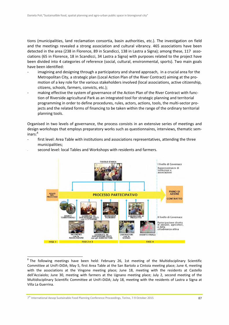
Daniela Poli,“Sustainailble food, spatial planning and agro‐urban public space in bioregional city”
7th International Aesop Sustainable Food Planning Conference Proceedings, Torino, 7‐9 October 2015 87
tions (municipalities, land reclamation consortia, basin authorities, etc.). The investigation on field and the meetings revealed a strong association and cultural vibrancy. 465 associations have been detected in the area (238 in Florence, 89 in Scandicci, 138 in Lastra a Signa); among these, 117 asso‐ciations (65 in Florence, 18 in Scandicci, 34 Lastra a Signa) with purposes related to the project have been divided into 4 categories of reference (social, cultural, environmental, sports). Two main goals have been identified: ‐ imagining and designing through a participatory and shared approach, in a crucial area for the
Metropolitan City, a strategic plan (Local Action Plan of the River Contract) aiming at the pro‐motion of a key role for the various stakeholders involved (local associations, active citizenship, citizens, schools, farmers, convicts, etc.);
‐ making effective the system of governance of the Action Plan of the River Contract with func‐tion of Riverside agricultural Park as an integrated tool for strategic planning and territorial programming in order to define procedures, rules, actors, actions, tools, the multi‐sector pro‐jects and the related forms of financing to be taken within the range of the ordinary territorial planning tools.
Organised in two levels of governance, the process consists in an extensive series of meetings and design workshops that employs preparatory works such as questionnaires, interviews, thematic sem‐inars:8 ‐ first level: Area Table with institutions and associations representatives, attending the three
municipalities; ‐ second level: local Tables and Workshops with residents and farmers.
8 The following meetings have been held: February 26, 1st meeting of the Multidisciplinary Scientific Committee at UniFi‐DiDA; May 5, first Area Table at the San Bartolo a Cintoia meeting place; June 4, meeting with the associations at the Vingone meeting place; June 18, meeting with the residents at Castello dell’Acciaiolo; June 30, meeting with farmers at the Ugnano meeting place; July 2, second meeting of the Multidisciplinary Scientific Committee at UniFi‐DiDA; July 18, meeting with the residents of Lastra a Signa at Villa La Guerrina.

Daniela Poli,“Sustainailble food, spatial planning and agro‐urban public space in bioregional city”
7th International Aesop Sustainable Food Planning Conference Proceedings, Torino, 7‐9 October 2015 88
Fig. 3. Structure of the participatory process. As well as by the institutional representatives of the project, the first Area Table was attended by many other actors deploying a potential network of supporters of the first action plan of the River Contract with function of Riverside Agricultural Park.9 The specificity of the project lays therefore in facilitating local planning with residents and farmers, but also in being able to avoid the widespread distrust of citizens and associations active towards the ‘rhetoric of participation’, unable to produce binding decisions for the public operator. The contract, signed between associations and institutions, is aimed at overcoming this frequent deadlock through an agreement committing to transpose all the decisions taken into the ordinary instruments of government of each public authority. Once signed, the River Contract ‐ acknowledged as a territorial government tool and included in the Environ‐mental Code as well as in plans like the Water Management Plan and the Hydraulic Risk Manage‐ment Plan ‐ requires the adjustment also of the governmental acts in force (Structural Plan, Town Planning Regulations, Sector Plans, sector EU/Region funding, etc.).
4. The active role of farmers in managing and restoring territories
The participatory project aims at encouraging and supporting (through the measures of the new CAP,10 the agreements between public administrations and farmers, local incentives, etc.) multi‐functionality for the agricultural areas of plains and hills, granting the residents and farmers an active role in feeding the city, reducing the ecological footprint, taking care of the river banks, promoting the development of biodiversity and the production of goods and services respond to an increasingly visible public demand for nature, leisure, health and sociability. Bringing the periurban back to the rural realm, then, means granting farmers (the present and the potential ones, who the project intends to reinstall) a key role in providing ecosystem services essen‐tial to all citizens and in building, on this base, build new forms of sociality and local economies ori‐ented towards local self‐sustainability. The project focuses on a new type, multi‐functional and landscape‐aware farms (Poli 2013), which are linked in network, make education, are open to direct harvesting and sales and part of the GPO (group purchase organisations) network, produce healthy food, build vegetables supply chains by marketing and processing products, supply canteens and so on; and which, along with the small and big heritage elements (abbeys, churches, palaces, ancient towns, etc.), play the role of keystones of the territorial public space and, for this reason, will be encouraged in restoring structures and tech‐nological systems (greenhouses) as in sharing working tools in order to create a pleasant life envi‐ronment enjoyable for tourists and locals, who will support and accompany the great transformation with voluntary activities and by creating civil and proximity economies (Bruni, Zamagni 2009). To achieve this result it is necessary to encourage, through various sources of funding (from the RDP measures,11 public canteens and activities for territorial safety, tourism, renewable energy, etc.), the multi‐functionality of both the agricultural areas, to allow farmers to supplement income with the many activities possible in densely populated areas, and the built spaces, which along this way can go back to being real life‐places for people, and not mere aggregates of functions.12 For example, the
9Among others: the Basin Authority, the Water Resources Consortium, the Prison, the Agricultural School, na‐tional associations like CAI (Italian alpine club), UISP (popular sports association), Legambiente and Italia Nostra (environmental associations), the Pro Loco’s, Slow Food, the Italian Centre for the River Redevelopment, to‐gether with several local and national farmers, residents and citizens committees. 10 “Common Agricultural Policy” of the EU countries. 11 Rural Development Plans. 12 Just to mention a few activities: management of riverbank vegetation, access to the river and beaches, rental

Daniela Poli,“Sustainailble food, spatial planning and agro‐urban public space in bioregional city”
7th International Aesop Sustainable Food Planning Conference Proceedings, Torino, 7‐9 October 2015 89
cycle and pedestrian paths crossing the park, thoroughly equipped with buffer strips, while serving for tourism and citizens’ health, at the same time become part of the ecological network in connec‐tion to the ecological corridor of the Arno river, while mowing feeds the local energy network and mellifluous hedges serve for beekeeping. For the management of hedgerows farmers are subsidized by the RDP measures, while for the maintenance of trails specific contracts with public bodies seem recommended. In all the meetings held a clear concern has emerged about the high land consumption and the planned and expected steps of urbanisation (e.g. new hypermarkets, the completion of a technologi‐cal incubator, scrapping areas, new road infrastructure, camps, saturated urban land), which averts land to agriculture and break the minor hydrographical network.
5. Spatial translation of the participatory agro‐urban project
Starting with the research results already emerged within the memorandum of understanding signed with the municipalities in 2009 (Butelli 2015) some primary integrated goals have been identified and then verified during the meetings of the Area Table with associations and the Open Space Technol‐ogy with residents and farmers: ‐ creating the Local Food System by building a system of local governance (Brunori et Al. 2007)
with organisations, protection consortiums, GPOs, local governments and authorities, people, schools, associations, managers and officials of public and territorial services;
‐ encouraging new styles of life and consumption, the inclusion in agriculture of disadvantaged people (convicts, people with disabilities, etc.) strengthening the local market, short supply chains and fair and collaborative forms of civil economy (Bruni, Zamagni 2009) with the assur‐ance of a fair income for farmers;
‐ identifying and equipping the agricultural park from the logistical point of view with new ser‐vices useful to the activities related to multi‐functionality of agriculture (farmers' markets, park gates, service centres, signage, cycle and pedestrian paths, promotion of cultural heritage, etc.);
‐ supporting the green public procurement in agri‐food, first by connecting the food demand of public canteens (hospitals, schools, barracks, etc.) with the offer of local agricultural products;
‐ returning to cities and urban centres the river view through the reconstruction of urban fronts supported also by the mediation of periurban agriculture and the social and community activi‐ties it plays;
‐ securing the streams and making them accessible through a recovery of morpho‐dynamics, a reduction of the banks slope, the shaping of the riverbed, the reconstitution of different depths;
‐ recovering and recycling for farming purposes the waste water from the San Colombano puri‐fier through phyto‐remediation, and the ones from industries by building an industrial canal and establishing closed loops in permanent greenhouses;
‐ abandoning the 'rhetoric of participation' by identifying positive ways to make effective the actions chosen in the participatory process, supporting the project actions in progress and pro‐viding in each municipality 'pilot projects' able to start by the end of the process;
‐ strengthening social and network activities already in progress in the territories of the future park to spread from below new awareness throughout the population.
of canoes, bicycles, horses, implementation and management of areas for fishing, of the cycle and pedestrian trails crossing and surrounding their possessions, canal cleaning, management of the multifunctional ecological network along the roads, home and tent hosting, education, floods control, social agriculture and so on.

Daniela Poli,“Sustainailble food, spatial planning and agro‐urban public space in bioregional city”
7th International Aesop Sustainable Food Planning Conference Proceedings, Torino, 7‐9 October 2015 90
The process allowed the emergence of a few lines of action that outline a significant reorganisation of the agro‐forestry and urban edge territories; I will point out three: 1. The multidimensionality of the Arno river, its tributaries and its multipurpose ecological networks; 2. New forms of community and multifunctional agriculture; 3. The restoration of edges and the creation of agro‐urban central‐ities.
5.1 The multidimensionality of the Arno river, its tributaries and its multipurpose ecological networks
Representing the element of continuity across the three municipalities, the Arno has been identified in all the meetings as the main axis, the very core of the 'new public space at the territorial scale’ on which the new urban fronts will have a view. The old towns, once closely linked to the river, today turn away from it with marginal areas built with no attention to its presence. During the meetings, the river has been always perceived as the backbone of the redevelopment, a multifunctional eco‐logical corridor from which the soft mobility paths will spring out to radiate throughout the region from the plain to the hills. This network will reclaim and revitalise the paths leading to the crossing point of the many 'ferries' once active on the river which, after the deletion without replacement of all the crossings, became blind roads stopping unnaturally in front of the ancient docks. It is also be‐ing built a bike path along the river, from its source in the province of Arezzo to its mouth near Pisa via the Florence area, which will introduce to the metropolitan area a significant amount of cycle‐tourists careful about landscape and environment. The territory will have to gear up to accommo‐date these visitors, who may find great accommodations in rural hospitality that the park territories could offer. Companies play a key role for the activities they can play along the river in relation to recreation and tourism: hospitality, catering, direct sales, management of parking areas, rental of canoes or bicycles (possibly agreeing with other companies to allow pick and return at different points). The Arno has also many weaknesses from the ecological point of view, represented by the pollution of its surrounding areas, the presence of alien species floating on the river and destroy the native vegetation, by soil sealing (with buildings, road infrastructure, greenhouses, etc.) that threatens not only the functionality of the river but also the lives of people and the very economic activity. Given the significant presence of built‐up areas along the urban part of the river course, it is now accepted the impossibility of ‘securing’ its territories. The attention, even in the Flood Risk Management Plans (Basin Authority) are now facing especially the participatory management of risk, through the identi‐fication of activities that can be carried out by farmers and regulated in the plans pertaining each jurisdiction. The Flood Risk Management Plan in the Middle Valdarno, e.g., introduces the notion of areas in river context, quite exceeding the purely hydraulic vision of adjacent lots and enhancing agricultural activities consistent with the context. “The areas in river context represent areas of par‐ticular interest for the management of flood risks, the protection of the good regime of outflows, the safeguard of the environmental, cultural and landscape peculiarities associated with the hydraulic lattice” (art. 6, paragraph b). Significant are also memoranda of understanding between the bodies in charge for the maintenance of waterways and the agricultural professional organisations which as‐sign to local farms a permanent role in monitoring their status. In this regard it is worth mentioning the successful pilot programme "Custodians of territories" in the Province of Lucca, similar to River Contracts in involving farmers in the monitoring and maintenance of the river Serchio and remuner‐ates them for the provision of ecosystem services (Vanni et Al. 2013). Thanks to the opportunities offered by cooperation contracts with public administrations (Art. 14 of Decree 228/2001), the pro‐
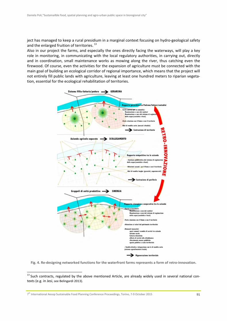
Daniela Poli,“Sustainailble food, spatial planning and agro‐urban public space in bioregional city”
7th International Aesop Sustainable Food Planning Conference Proceedings, Torino, 7‐9 October 2015 91
ject has managed to keep a rural presidium in a marginal context focusing on hydro‐geological safety and the enlarged fruition of territories. 13 Also in our project the farms, and especially the ones directly facing the waterways, will play a key role in monitoring, in communicating with the local regulatory authorities, in carrying out, directly and in coordination, small maintenance works as mowing along the river, thus catching even the firewood. Of course, even the activities for the expansion of agriculture must be connected with the main goal of building an ecological corridor of regional importance, which means that the project will not entirely fill public lands with agriculture, leaving at least one hundred meters to riparian vegeta‐tion, essential for the ecological rehabilitation of territories.
Fig. 4. Re‐designing networked functions for the waterfront farms represents a form of retro‐innovation.
13 Such contracts, regulated by the above mentioned Article, are already widely used in several national con‐texts (e.g. in Jesi, see Belingardi 2013).

Daniela Poli,“Sustainailble food, spatial planning and agro‐urban public space in bioregional city”
7th International Aesop Sustainable Food Planning Conference Proceedings, Torino, 7‐9 October 2015 92
The main focus is then to reconcile general goals at the regional scale (ecological corridor) with local targets concerning production and fruition, through the definition of multipurpose ecological net‐works (Malcevschi 2010): ‐ building a true and powerful ecological corridor at the regional scale, connected to the local
ecological network through the combs of the tributaries, which is also a local reference for landscape and fruition, possibly preferring crops consistent with the effectiveness of the eco‐logical network (food‐forestry, etc.);
‐ making the Arno the ecological backbone of the territory, with perpendicular ecological net‐works crossing the plains and rejoining the Arno with the hills on the left and right bank, creat‐ing ecological gaps in the continuum of buildings;
‐ defining cycle and pedestrian paths consistent with the ecological functions of the river; ‐ fostering an active role of agriculture in supporting the fruition of territories through sports,
culture, tourism; making the farm a service centre for the users (stables, restaurants, bicycle and canoe rental, management of river access, small wharfs, crossings, etc.);
‐ managing the functionality of the embankments in line with the riverside gardens, the beaches that can be created on the natural bars, the boat quays, etc .;
‐ establishing the category of the 'farmers custodians of the river' assigning them the monitor‐ing and maintenance of riparian vegetation, canals, the management of boats on the river, as of bicycles, crossings, places of rest.
5.2 New forms of community and multifunctional agriculture
This is a crucial topic for the project's success. The future agricultural park stretches both in a hilly area and in a plain. Types of farms are very different. In the hills there are small and large farms in a valuable landscape context, with crops dominated by vineyards and olive trees. There is a noticeable presence of farmhouses, stables and organic farms. Here the production of landscape is one of the distinctive features of farming activity, which brings of course an attention to the environment. Dra‐matically different is the situation in the plain, hosting residual activities on the one hand, with small plots managed by hobbyists or elderly farmers, and on the other large production companies, mainly horticultural. In either case, there is little interest to multi‐functionality, due both to the lack of en‐trepreneurship for the former and an attitude markedly oriented to production for the latter. An action taken is aimed at networking farmers in the area in order to activate the cooperation pos‐sibilities in ambits ranging from the common management of farming machinery and technological infrastructure (especially greenhouses), the inter‐farm crop rotation in the transition to organic pro‐duction, to the transfer of products for public canteens and so on. One of the main opportunities in this context is the strong presence of public canteens ‐ schools and other services such as prison, hospitals etc. ‐ calling for local and organic products. The meetings let emerge the demand for a re‐organisation of canteens apt to return as much as possible to autonomous and integrated form fo‐cused on the use local products mixed with the ones from the school gardens. This goal requires a coordination of local production, which seems not so easily achievable especially in plain areas, due to fragmentation and the lack of uniformity of enterprises. A crucial issue on which, conversely, the project is investing a lot of energy is directed to the social use of wastelands ‘awaiting urbanisation’, mainly located just in the plain areas. In Italy the Law 440/1978 "Rules for the use of uncultivated, abandoned or inadequately cultivated land" authorises the Regions to allocate abandoned land in usufruct to other subjects in order to protect territories against hydro‐geological instability. Moreover, Article 838 of the Civil Code provides for the auto‐matic return to the collective ownership of "abandoned land". Regione Toscana has promoted a cen‐

Daniela Poli,“Sustainailble food, spatial planning and agro‐urban public space in bioregional city”
7th International Aesop Sustainable Food Planning Conference Proceedings, Torino, 7‐9 October 2015 93
sus and established a Bank of the Land to provide for the allocation of wasteland. The municipalities, in agreement with the owners, can in fact enter the idle land in the Bank expecting to assign them in foster care to farmers through a call. The Metropolitan City of Florence has carried out a census of the uncultivated areas in the agricul‐tural territories of the park falling in the three municipalities, census which the project has further refined. On about 5,500 hectares of agro‐forestry and in the face of about 3,650 hectares of UAA (Utilised Agricultural Area: arable 1181; olive grove 1743; vineyard 373; orchard 46; complex particle 327), about 250 are uncultivated and among them approximately 35 hectares are public property. Thus an important territorial capital emerges which can play a strategic role in the success of the project. The most of the properties consist in land without residence, outcome of de‐ruralisation, which has divided land from rural residence to place the latter on the housing market. The plain area abounds in disconnected land portions which are uncultivated or devoted to precarious farming, with no con‐tract or assigned in loan for use at very short term. Although the recent urban development plans do not provide for new development in the plains, and the new Regional Law of territorial government (no. 65/2014) prohibits to build outside the urban areas, there is still a widespread expectation for being to put in value the land rent due to urbanisation. In situations like this a land consolidation is usually invoked in order to bring the broken land and boost the agricultural activity of farms. In this particular context, however, consolidating means en‐couraging land grabbing by companies operating at the expense of access to land for new farmers. The project is thus experiencing the chance of a creative solution to the problem, defining with the concerned social players a new type of ‘patchy’ farm, with divided plots with an appropriate size that, although spaced, can be easily reached on foot or by bike. On these plots it should be possible to build modular buildings (equipment shelters, barns, chicken coops, etc.) located in their different portions and collectively managed as much as possible. The lack of residence in the farmland can be remedied through public investment in social housing for farmers in the new urban‐rural fronts, that the same Regional Law on territorial government asks to restore. For these new farms companies it is being studied a specific call allowing access to differ‐ent categories of farmers (farms, new farmers, associations, non‐EU citizens, young people, etc.) with a specification requiring the performance of activities and public services related to the agricultural park, like supplying vegetables to public canteens, networking, recruitment of disadvantaged people (convicts, former drug addicts, refugees etc.), guaranteeing access to the paths crossing the farms for all users, willingness to do teaching, organic farming through the presence of buffer strips, care of trails, canals and ditches, etc.. The project also finds in the non‐EU population an opportunity to create supply chains for fresh or processed food that, passing through ethnic shops and restaurants, come directly from the field to the table (e.g. soybeans, soy milk, tofu, etc.). In parallel to the request for access to land by farmers (irrespective of age) there is a substantial de‐mand of hobby agriculture coming from disparate categories not necessarily included in the elderly people, who still appear to be the main reference of the lending standards for social vegetable gar‐dens. In the municipalities involved, moreover, just few are currently the public areas devoted to gardens, even if social demand is strong. As a proof of this interest, there are several private areas used as gardens (parcelled agricultural land rented or sold) and other public (and private) areas actu‐ally occupied by gardens. The project intends to use part of the idle land to locate public horticultural spaces outsourced to disparate subjects (migrants, unemployed, young people, students, families, etc.) that can benefit of agriculture as a supplementary income, and to properly design those areas to develop new forms of contact sociality (Delbaere 2010). To give effect to this goal, the planning discipline should define new standards for urban agriculture.
Daniela Poli,“Sustainailble food, spatial planning and agro‐urban public space in bioregional city”
7th International Aesop Sustainable Food Planning Conference Proceedings, Torino, 7‐9 October 2015 94
The substantial presence of wasteland and the obligation of putting them in culture represent a con‐siderable opportunity that, when coupled with the preparation of the call for assignment and of a specific discipline, can make social planning effective again. The management of this important chal‐lenge should use a strategic project integrated to the various forms of financing that can be acti‐vated. In this context, in order to enable public planning apt to stimulate the agricultural park pro‐ject, it is essential to play the game of idle plots, as they can become ‘multifunctional periurban model farms’ triggering emulation processes. This requires to: ‐ define the calls for the Bank of the Land so that all the categories of farmers are widely repre‐
sented; ‐ establish rules based on the delivery of those community ecosystem services apt to obtain
direct and indirect funding; ‐ promote the temporary assignment of land for a time allowing new farmers to install and in‐
vest; ‐ provide agricultural units also patchy with new residences in the margin and a modular logis‐
tics; ‐ promote the landscape production of agriculture, in particular in peri‐monumental areas, apt
to enhance and restore the local patrimonial elements (trees, rows, extension of the plots, etc.) to return landscape dignity to the periurban;
‐ promote the integration of agriculture and fruition, town and countryside by introducing a new civic use (the ‘fruitatico’) granting all users the right to walk, run, ride a bike or a horse in some paths within the farm.
5.3 The restoration of edges and the creation of agro‐urban centralities
The bioregional design of periurban territories is based on the reactivation of sociality and forms of local self‐government. Periurban territories are thought of as a large public space at the territorial scale, organised in activity nodes and connecting ecological networks which regenerated urban fronts overlook. A margin area is not just the separation line between internal and external, which can be identified by the term 'urban edge', but regards a more extensive range consisting both of the urbanised and the rural area (Resource Management Branch 2006; Ministry of Agriculture and Lands 2009). The fruition and economic proximity relationships are exactly what defines this amplitude, placed on the two sides of the edge. This is the everyday territory, identified by the time spent to walk or cycle a certain route. The line marking the border is often jagged, irregular, consisting of mixed fabrics of poor quality, often with no public space (Socco et Al. 2005; Maciocco, Pittaluga 2001; Palazzo, Treu 2006). The margin is the potential diaphragm where exchanges concentrate. In these areas to be regenerated, to be transformed into new fronts, the project intends to place new urban‐rural complex public spaces, new marketplaces, places for meeting and sociability revolv‐ing around the food production and exchange. The OST with the farmers has shown the difficulty for many small producers to sell their products. Not only participation in markets, but also direct sale or harvesting in the field is sometimes too expensive. A small producer often works alone and when committed to selling he cannot cultivate at the same time. In most situations farmers have remarked the need to identify areas where producers can deliver their products while someone else takes care of the sale. This issue has immediately appeared as a keystone, a strategic opportunity to solve many social problems described by the residents, individually or in groups, in the meetings. Gradually, dur‐ing the work, the space began to take on increasingly clear features. A composite space should not be confined to buying and selling, such as a store or a supermarket, but has to be a complex place

Daniela Poli,“Sustainailble food, spatial planning and agro‐urban public space in bioregional city”
7th International Aesop Sustainable Food Planning Conference Proceedings, Torino, 7‐9 October 2015 95
where it is possible to perform many diverse functions, including purchase and sale; an outdoor area for the external market, but containing indoor spaces where to allocate activities related to new trades, the peasant school, the farmers' time bank (where one shares and exchanges farm work), with dining venues and short chain ethnic restaurants which use the products of the park and where also disadvantaged people work; an area jointly and self‐managed by the promoters which can also play the role of ‘park gate’, with information offices on the activities and the sightseeing opportuni‐ties, which also offer directions for the accommodation in B&B, guest houses, farmhouses in the park. In such marketplaces or nearby even the farmers ‘custodians of the park’ could find an accom‐modation to work in the recovered wastelands. Several actions are then necessary: ‐ identifying brownfield sites that could be used for the construction of agro‐urban public spaces
located in the margin; ‐ designing, together with farmers and operators, their multifunctional definition; ‐ identifying new farmers from countries inside and outside EU to be installed in the wastelands; ‐ detailing a space project.
6. Conclusion
The bioregional perspective allows to approach the transition of the periurban from a mere surface where to allocate housing, services and metropolitan functions to territorial public space redevel‐oped and dense in life revolving around the production of food. Bringing the periurban to a new complex condition in the rural realm means recognising the regenerative centrality of agro‐urban contexts and encouraging a transition of agriculture towards a multi‐functionality able to make the most of its location near the urban. Multifunctional farms should become the new varied keystones of territorial public space, integrating the productive dimension through contractual tools of govern‐ance that convey funding from different items of expenditure on the provision of ecosystem services (RDP, water safety, tourism, school , etc.). These actions will characterise the first action plan of the River Contract with function of Riverside Agricultural Park with a strategic plan that includes spatial guidelines for the municipal urban plans concerning: ‐ the boundaries of the urban buildings and the treatment of margins; ‐ the agricultural green standard for the suburbs; ‐ the soft infrastructure between the river and the hills; ‐ the gaps in the multifunctional corridors between the river and the hills; ‐ the river context and its particular planning properties; ‐ the design of the nodes and networks in the project (new urban centralities or agro‐urban
centres, local markets, schools, prison, outskirts, multifunctional areas in the park); ‐ corridors, cycle paths, waterways, footpaths, bridleways. In its multi‐dimensionality and multi‐functionality, the farming activity can thus be put in condition, through a careful management of local heritages, to rehabilitate territories, build landscape, regen‐erate the urban form integrating with other proximity activities (catering, food trade, social agricul‐ture, tourism, sports, etc.), thus reversing a process of peripheralization which is still in progress.

Daniela Poli,“Sustainailble food, spatial planning and agro‐urban public space in bioregional city”
7th International Aesop Sustainable Food Planning Conference Proceedings, Torino, 7‐9 October 2015 96
7. References
Barberis, C. ed, 2009. Ruritalia: la rivincita delle campagne. Roma: Donzelli. Bastiani, M., 2011. Contratti di fiume. Pianificazione strategica e partecipata dei bacini idrogeografici. Palermo:
Flaccovio. Belingardi, C., 2013. Abitanti attivi nella cura del territorio. Il caso di Jesi. Scienze del Territorio, 1/2013, pp.
315‐318. Bianchetti, C., 2002. Spazio e pratiche nei territori della dispersione. Urbanistica, 119. Bruegmann, R., 2005. Sprawl. Chicago: University of Chicago Press. Bruni, L. and Zamagni, S., 2009. Economia Civile. Efficienza, equità, felicità pubblica. Bologna: Il Mulino. Brunori, G., Marangon, F. and Reho, M., 2007. La gestione del paesaggio rurale tra governo e governance terri‐
toriale. Continuità e innovazione. Milano: Franco Angeli. Butelli, E., 2015. Tra Arno e colline: agricoltura qui vicino. Alimentazione sana, qualità della vita, rispetto
dell’ambiente e del paesaggio. Un progetto di parco agricolo in riva sinistra d’Arno. Firenze: SdT Edizioni. Calthorpe, P. and Fulton, W., 2001. The regional city. Washington DC: Island Press. CNG ‐ Consiglio Nazionale dei Geologi, 2010. Rapporto sullo stato del territorio italiano. Roma: Centro studi del
Consiglio nazionale dei Geologi e CResMe. Costanza, R., et Al., 1997. The value of the world’s ecosystem services and natural capital. Nature, 387. Dal Pozzolo, L. ed, 2002. Fuori città, senza campagna. Paesaggio e progetto nella città diffusa. Milano: Franco
Angeli. Deelstra, T., Boyd D., Biggelaar (van den), M., 2001. Multifunctional land use: an opportunity for promoting
urban agriculture in Europe. Urban Agriculture Magazine, 4. Delbaere, D., 2010. La fabrique de l’espace public. Ville, paysage et démocratie. Paris : Ellipses. Donadieu, P., 2006. Campagne urbane. Una nuova proposta di paesaggio della città. Roma: Donzelli. Donadieu, P., 2011. Agripolia, la città per i nostri figli. Eddyburg [online], Available at:
<http://eddyburg.it/article/articleview/17618/0/307> [Accessed September 2015]. Gillmann, O., 2002., The limitless city. A primer on the urban Sprawl debate. Washington DC: Island Press. Iacoponi, L., 2001. Sviluppo sostenibile e bioregione. Milano: Franco Angeli. Ingersoll, R., 2004. Sprawltown. Roma: Meltemi. ISPRA, 2014. Rapporto di sintesi sul dissesto idrogeologico in Italia 2014 [online]. Available at:
<http://www.isprambiente.gov.it/it/temi/suolo‐e‐territorio/dissesto‐idrogeologico/sintesi_dissesto_idrogeologico_ispra_marzo_2015.pdf> [Accessed September 2015].
Maciocco, G. and Pittaluga, P. eds, 2001. La città latente: il progetto ambientale in aree di bordo. Milano: Fran‐co Angeli.
Magnaghi, A. and Fanfani, D. eds, 2010. Patto città campagna. Un progetto di bioregione urbana per la Toscana centrale. Firenze: Alinea.
Magnaghi, A. ed, 2014. La regola e il progetto. Un approccio bioregionalista alla pianificazione territoriale. Fi‐renze: Firenze University Press.
Magnaghi, A., (2014a. La biorégion urbaine. Petit traité sur le territoire bien commun. Paris: Eterotopia France. Malcevschi, S., 2010. Reti ecologiche polivalenti. Infrastrutture e servizi ecosistemici per il governo del territo‐
rio. Milano: Il Verde Editoriale. MEA ‐ Millennium Ecosystem Assessment, 2005. Ecosystems and Human Well‐being: Synthesis. Washington
DC: Island Press. Ministry of Agriculture and Lands (British Columbia), 2009. Guide to Edge Planning. Promoting compatibility
along urban‐agricultural edges, British Columbia. Mougeot, L.J.A. ed, 2005. Agropolis. The Social, Political and Environmental Dimensions of Urban Agriculture.
London: Earthscan and the International Development Research Centre (IDRC), UK‐USA. OECD, 2007. What Policies for Globalising Cities? Rethinking the Urban Policy Agenda [online]. Available at: <
http://www1.oecd.org/gov/regional‐policy/49680222.pdf> [Accessed September 2015]. Palazzo, D. and Treu, M.C. eds, 2006. Margini: descrizioni, strategie, progetti. Firenze: Alinea. Ploeg (van der), J.D., 2009. I Nuovi contadini. Le campagne e le risposte alla globalizzazione. Roma: Donzelli. Poli, D. ed, 2013. Agricoltura paesaggistica. Visioni, metodi, esperienze. Firenze: Firenze University Press.

Daniela Poli,“Sustainailble food, spatial planning and agro‐urban public space in bioregional city”
7th International Aesop Sustainable Food Planning Conference Proceedings, Torino, 7‐9 October 2015 97
Poli, D., 2014. Per una ridefinizione dello spazio pubblico nel territorio intermedio della bioregione urbana. In: A. Magnaghi, ed. La regola e il progetto. Un approccio bioregionalista alla pianificazione territoriale. Firenze: Firenze University Press.
Resource Management Branch, Ministry of Agriculture and Lands (British Columbia, 2006. Edge Planning Areas. Promoting compatibility along urban‐agricultural edges. British Columbia.
SDRIF ‐ Schéma Directeur de la Région Ile‐de‐France, 2008 [online]. Available at : <http://www.durable.gouv.fr/le‐schema‐directeur‐de‐la‐region‐r1651.html> [Accessed September 2015].
Socco, C., Cavaliere, A., Guarini, M. and Montrucchio, A., 2005. La natura nella città. Il sistema del verde urbano e periurbano. Milano: Franco Angeli.
Thayer, R.L. jr., 2003. Life Place: Bioregional Thought and Practice. Berkeley CA: University of California Press. Vanni, F., Rovai, M. and Brunori, G., 2013. Agricoltori come ‘custodi del territorio’: il caso della Valle del Serchio
in Toscana. Scienze del Territorio, 1/2013, pp. 455‐462. Venier, M., 2003. Le périurbain à l’heure du crapaud buffle: tiers espace de la nature, nature du tiers espace.
Revue du Géographie Alpine, 91 (4).

Andre Viljoen, Katrin Bohn, “Pathways from Practice to Policy for Productive Urban Landscapes”, In: Localizing urban food strategies. Farming cities and performing rurality. 7th International Aesop Sustainable Food Planning Conference Proceedings, Torino, 7‐9 October 2015, edited by Giuseppe Cinà and Egidio Dansero, Torino, Politecnico di Torino, 2015, pp 98‐106. ISBN 978‐88‐8202‐060‐6
98
PATHWAYS FROM PRACTICE TO POLICY FOR PRODUCTIVE URBAN LANDSCAPES
Andre Viljoen1, Katrin Bohn2 Keywords: productive urban landscapes, policy, urban agriculture, urban planning, sustainable design
Abstract: This paper aims to disseminate and outline primary research emerging from an international network supported by the UK Arts and Humanities Research Council. The paper is experimental in that its aim is to direct readers to the networks more extensive website found at: http://arts.brighton.ac.uk/projects/utppp The network is exploring how policy at various levels has impacted on the implementation of six European urban agriculture projects, led in main by architects, artists or researcher activists. From the perspective and experience of these practitioners, the network aims to identify future pathways towards policy that will support the implementation of urban agriculture (UA) within the context of a productive urban landscape infrastructure. The network has run a workshop in Amsterdam (Netherlands) and in Brighton (UK) plus a seminar in Sheffield (UK) to explore these questions amongst the network’s core group of nine partners as well as invited guests. An overarching question is if policy can be developed that becomes embedded as a norm, thus moving beyond the current reliance on interpretations by informed individuals of broad policies focused on sustainability, health, urban regeneration or community engagement? These questions will be contextualised in relation to urban agriculture policy innovations occurring in selected European cities.
1. Introduction
This paper follows on from the paper presented at last year’s 6th AESOP Sustainable Food Planning Conference held in Leeuwarden, the Netherlands. The paper presented in Leeuwarden (available at: http://arts.brighton.ac.uk/projects/utppp/draft‐papers‐and‐publications) provided an overview of the UK Arts and Humanities Research Council supported International Research network, titled, “Urban Transformations: Pathways from Practice to Policy for Productive Urban Landscapes”. The format of this paper is experimental in that it aims to direct readers to the Network’s website (http://arts.brighton.ac.uk/projects/utppp), where a more complete overview of primary research is being made available, including a series of live presentations made by network members, practitioners and those involved with policy development and implementation. It presents an overview of findings from two research led workshops and a seminar, exploring how policy at various levels has impacted on the implementation of six European urban agriculture projects, led in main by architects, artists or researcher activists. Drawing on and expanding the perspective and experience of these practitioners, the network aims to identify future research to facilitate policy that will support the evident emergence of a spectrum of urban agriculture (UA) practices. Furthermore it wishes to evaluate the possibilities for giving these practices policy and spatial coherence and within the context of a sustainable productive urban landscape infrastructure.
1 Andre Viljoen (University of Brighton), [email protected] 2 Katrin Bohn (Bohn&Viljoen Architects), [email protected]

Andre Viljoen, Katrin Bohn, “Pathways from Practice to Policy for Productive Urban Landscapes”
7th International Aesop Sustainable Food Planning Conference Proceedings, Torino, 7‐9 October 2015 99
The network has run a workshop in Amsterdam (Netherlands) and in Brighton (UK) plus a seminar in Sheffield (UK) to explore these questions amongst the network’s core group of nine partners as well as twenty eight invited guests.
2. Practitioner workshop held in Amsterdam
2.1 Workshop Outline
Held during November 2014 and hosted by the Amsterdam Academy of Architecture, this workshop was designed as a forum for core participants to frame their understanding of the relationships between practice and policy. The first part of the workshop enabled participants to diagrammatise their experience and understanding of where policy aided, hindered or was lacking in relation to their practice and research. With input from ten invited practitioners and post graduate research students from Amsterdam participants reflected on and compared their varied experiences.
2.2 Workshop findings
An overriding conclusion from this workshop was that, at least within Europe, there is a lack of policy specifically targeting the implementation of productive urban landscapes, and that they are not commonly defined as a strategic goal within institutional or organizational policy. The network did not identify specific barriers put in place to prevent their implementation. It became evident that there is a complex array of policies at work that influence the realization of any one project. These policies may be those of a major organization, such as a municipal planning department or local policies with the organization that controls the land or budget related to a particular project. In addition to the various policies at play, it was found that projects are very often reliant on the interpretation of policy by gate keeper officials within city/municipal authorities or institutions. Urban regeneration, community building and empowerment, land use policy, public health or sustainable development strategies are often the overarching policy goals that make the case for implementing urban agriculture and more extensive productive landscape projects. In pursuing the network’s goal of utilizing arts and design methods to obtain insights into practice and policy relationships the network has begun to map different types of urban agriculture project and the types of policy associated with it. Tables 2 and 3, when read alongside each other, provide an overview of policy and practice. Readers are referred to the network website for a more detailed overview of each project. A primary question is if productive urban landscape policy can be developed to become embedded as a norm, thus moving beyond the current reliance of interpretations of broad policies by informed individuals focused on sustainability, health, urban regeneration or community engagement? Readers are referred to the paper being presented at this conference by Rich et. al., titled “The ‘Healing City’ – Social and Therapeutic Horticulture as a New Dimension of Urban Agriculture?” for an example of how evidence is being gathered and evaluated in ways that could provide an evidence base for future policy specifically related to productive urban landscapes from a health perspective.

Andre Viljoen, Katrin Bohn, “Pathways from Practice to Policy for Productive Urban Landscapes”
7th International Aesop Sustainable Food Planning Conference Proceedings, Torino, 7‐9 October 2015 100
Table 1. Urban agriculture projects and the types of policy associated with them.
Table 2. Urban agriculture projects and the types of policy associated with them.

Andre Viljoen, Katrin Bohn, “Pathways from Practice to Policy for Productive Urban Landscapes”
7th International Aesop Sustainable Food Planning Conference Proceedings, Torino, 7‐9 October 2015 101

Andre Viljoen, Katrin Bohn, “Pathways from Practice to Policy for Productive Urban Landscapes”
7th International Aesop Sustainable Food Planning Conference Proceedings, Torino, 7‐9 October 2015 102
3. Policy professionals workshop held in Brighton.
3.1 Workshop outline
This workshop was held in Brighton during March 2015 and was hosted by the University of Brighton’s School of Arts Design and Media, it focused on policy developed at the city planning level. It brought together network members who had led projects, policy implementers, project commissioners who had to interpret policy and academics with policy knowledge related to food or productive urban landscapes. A representative from Brighton and Hove City council’s sustainability team and from the UK’s leading NGO advancing more sustainable, equitable and resilient food systems, SUSTAIN (http://www.sustainweb.org/about/) also attended.
3.2 Workshop findings
This was a revealing and rich event for the network with some unexpected outcomes. We had speculated that those involved with policy at the level of city planning or food policy at a strategic level would be able to help define policy pathways that design led practitioners could pursue. During workshop it became clear that, at least within the UK context (but apparently across Europe), civil servants did not have the capacity to contribute to this detailed discussion because the “productive urban landscape” agenda was not a targeted policy objective. The workshop highlighted the exemplary work undertaken by SUSTAIN, in in exploring England’s National Planning Policy Framework in relation to the development of food growing as part of a healthy city strategy, but this did not identify a pathway by which practitioners could engage directly in policy development. The foregoing tended to confirm the network’s speculation that for productive urban landscapes, “practice is outstripping policy, but policy is being developed”. What is clear is that policy in relation to urban agriculture and productive landscapes is being developed as an ambition within open urban space planning, although with the exception of Paris, specific targets and pro‐active outreach programs remain to be developed. A number of urban planning policy related trends are becoming evident such as: ‐ Explicitly naming productive landscapes as a desired typology within open urban space
planning for example in Almere, Berlin, Birmingham, and Detroit. Implicitly there are many examples such as in Sheffield, Lisbon and Leeds.
‐ Digital platforms for urban agriculture, mapping the location of fruit and vegetable growing sites within cities, generally using online interactive maps. These initiatives may be led by individuals within social enterprises (e.g. in Birmingham) or supported by city authorities (e.g. Amsterdam).
‐ The increasingly significant role of Food Policy Councils, although their remit is much wider than productive urban landscapes.
‐ The emergence of “constellations of agents” within cities. Major policy relevant actions in cities related to the network’s activities may be summarised as follows:

Andre Viljoen, Katrin Bohn, “Pathways from Practice to Policy for Productive Urban Landscapes”
7th International Aesop Sustainable Food Planning Conference Proceedings, Torino, 7‐9 October 2015 103
Berlin
In 2012 Berlin’s Senate Department for Urban Development and the Environment have adopted a “Green Vision for Open Space Planning” with an urban landscape strategy named: “NATURAL. URBAN. PRODUCTIVE”.
The concepts underpinning this strategy were prepared by two Landscape Architectural Practices supported by “think tanks”, and a draft was prepared for public commentary prior to adoption. The strategic objectives remain goals rather than legally binding commitments.
The Green vision is underpinned by the notion of “urban cultured landscapes”, a concept well attuned to Berlin’s established inter‐cultural and community gardens movements.
Amsterdam
The City provides a digital platform for urban agriculture utilizing interactive mapping websites, and general information about community food growing activities.
The city has an established and active constellation of partners, including organizations such as the Amsterdam Institute for Advanced Metropolitan Solutions, the Cities Foundation, URBANIAHOEVE, Farming the City, etc.
“Living Labs” have been used by the city administration as “no cost” temporary demonstration project, with diverse aims: bio‐based circular economy / improved biodiversity / improved business environment /related to the cities sustainability policy. One of these has tested the production of flax within an industrial estate.
Milwaukee
Presents another constellation of agents – Will Allen – Growing Power / the legacy of the late Prof. Jerry Kaufman / IBM Smart Cities Award 2011 / Mayor Tom Barratt / Centre For Resilient Cities / Fondy Food Market / Growing Food and Justice for all.
The city’s policy under Mayor Barratt tends towards an enabling and permissive planning policy approach for productive landscapes, removing barriers but not directly managing projects. It works on a win – win principle.
Detroit
Detroit’s problems arising from the loss of the automobile industry and population are well known. An extensive constellation of agents are active in the city including: The greening of Detroit / Detroit Black Community Food Security Network / Earth Works Farm / Wayne State University – SEED Wayne / Corporate interests / Hants Farms / SHAR Foundation / Eastern Market.
Ambitious Co Design processes, multidisciplinary and multiagency, sponsored by the Detroit Economic Growth Association, resulted in the 2013 publication of the “ Detroit Future City Plan”, explicitly stating that Productive Landscapes should be utilized as the basis for a sustainable city, and

Andre Viljoen, Katrin Bohn, “Pathways from Practice to Policy for Productive Urban Landscapes”
7th International Aesop Sustainable Food Planning Conference Proceedings, Torino, 7‐9 October 2015 104
advocating a new land use type, innovative productive characterised as being networked / agricultural and recreational. The plan includes precisely demarcated areas for innovative productive landscapes within a coherent and comprehensive spatial plan.
The Future City Plan is run by a team being set up as a not for profit organisation – and its remit is facilitation rather than implementation.
Paris Jacque Oliver Bled, representing the Sustainable Development Strategy Division of the Agency for Urban Ecology, located within the Town Hall of Paris’s department responsible for the management of green spaces and environment, presented the city’s uniquely comprehensive plan for implementing urban agriculture.
This urban agriculture plan is the result of Mayor Anne Hidalgo’s initiative to canvass public opinion regarding certain policy priorities. The policy being followed in relation to urban agriculture recognises three sectors of activity, economic, environmental and social and the value of the space in which these activities overlap, it furthermore it recognises how urban agriculture can contribute to urban planning and design.
As far as we are aware the Paris urban agriculture initiative is the most comprehensive currently undertaken within Europe and North America, it is characterised by a comprehensive policy plan connecting local government agencies and representatives from, the business community, schools, property owners and associations. The entire network of actors is focused on the realization of deliverable projects appropriate to specific spaces.
A programme of outreach activities including knowledge sharing and research into levels of productivity and urban pollution underpin an ambitious target to increases the current area of cultivation on roofs and walls from 0.56 ha (1.6 acres) to 33 ha (82 acres) by 2020.
4. Policy pathway partners
Through a process of dissemination partners for advancing the network’s research agenda are being found, and an open invitation exists to increase the networks effectiveness in finding innovative pathways to policy. Fruitful dialogues are currently underway with the EU COST action on Allotment Gardens, within which the long history of allotments and community gardens in Europe is being discussed as part of an expanding spectrum of urban food growing practices that cover a range of scales and aims, together constituting, productive urban landscapes. Collaborations across this spectrum of practices have the potential to be mutually beneficial, while furthermore making the case that productive urban landscapes should be understood as an essential element of a sustainable urban infrastructure. This enquiry is undertaken in a spirt that acknowledges that in this highly dynamic situation there is much scope for optimism, but it is also the case that innovative urban agriculture projects and productive urban landscape initiatives are far from the norm. Emerging projects have much to learn from the allotment garden movement, with respect to building their own capacity and claiming their right to urban space. But working together urban agriculture and the allotment movement have the capacity to produce cities that are more resilient sustainable, equitable and enjoyable.

Andre Viljoen, Katrin Bohn, “Pathways from Practice to Policy for Productive Urban Landscapes”
7th International Aesop Sustainable Food Planning Conference Proceedings, Torino, 7‐9 October 2015 105
Another strand of investigation led by one of our network members who is also active in the EU COST action urban agriculture is exploring opportunities for collaborative work in advancing our related agendas. Alongside the dialogues referred to above, the network is exploring research opportunities working in Letchworth, the “original” garden city, sited north of London in North Hertfordshire. This strand of research will consider opportunities for action based research and possible prototyping of spatial interventions within Letchworth, working towards innovations within Howard’s and subsequent interpretations of the Garden City concept. Central to this future work will be the co‐designing of research agendas with the Letchworth Garden City Heritage Foundation and the newly founded International Garden Cities Institute. In developing future work several key grass roots / civic organisations have indicated their willingness to help shape and critique future research undertaken by the network, with the aim of maximising its potential relevance and impact.
5. Policy users and developers seminar held in Sheffield
5.1 Seminar outline
This seminar, held during July 2015 and hosted by the University of Sheffield’s School of Architecture, brought together core participants from the network and the policy pathway partners identified in paragraph 4. The aim was to shape follow on activities to be undertaken by the network.
5.2 Seminar findings
A facilitated seminar explored the following two questions with a focus on helping to understand guest’s expertise and identify what research could usefully assist practitioners advance the case for urban agriculture. 1) Policy and urban agriculture: What are the policy areas most relevant to advancing UA within
the UK? What would be needed to implement a “Paris like” policy, or do we need something else? How can polices like Brighton’s planning advisory note promoting urban agriculture be ensured to deliver more than token gestures? What are the shortcuts to policy?
2) How does urban agriculture contribute to a resilient and sustainable urban food system? What is its productive role? Where are the outlets for produce? Where is the space? What are the urban / rural connections? Can it become part of a waste collection system (urban composting)?
At the time of writing the conclusions from the seminar have yet to be fully evaluated, but they will be developed within the formulation of two planned academic papers and the shaping of future research. Headline questions raised by the seminar include: Framing research into productive urban landscapes in the contexts of urbanization pressures. Building the evidence base for productive urban landscapes beneficial impacts and the challenges that they introduce to cities.

Andre Viljoen, Katrin Bohn, “Pathways from Practice to Policy for Productive Urban Landscapes”
7th International Aesop Sustainable Food Planning Conference Proceedings, Torino, 7‐9 October 2015 106
Better understanding urban metabolisms and how productive landscapes contribute to the creation of closed loop metabolisms. Which are the receptive existing “policy drivers” relevant to productive urban landscapes?
6. Conclusions
A rich body of practice exists and policy is emerging in support of productive urban landscapes, but in general this remains aspirational rather than being embedded with binding targets and commitments. From the perspective of design led researchers and practitioners, building robust theoretical models as well as design strategies evaluated and tested against policy relevant criteria remain significant methods for opening up politicians and decision makers to the need for robust policy. In working towards these goals the following questions are important: In advancing the spectrum of practices that together constitute productive urban landscapes, will allotment holders, community gardeners and their associations benefit from joining forces with other urban food growers, including commercially driven urban food growers? Do we need a European wide working group for small scale agriculture? Who will collect the data to make the case for urban agriculture and productive urban landscapes? Who can? Can we? Who needs to listen (elected representatives?) and how do we get them to listen?
7. References
This paper draws on primary findings of the UK Arts and Humanities Research Council supported Urban Transformations Network: Pathways from practice to policy, an international network of practitioners and academics exploring how policy impacts on the development of productive urban landscapes and how policy may be developed to support this development. For further information readers are directed to: http://arts.brighton.ac.uk/projects/utppp

Jacques Abelman, “Cultivating the city: infrastructures of abundance in urban Brazil”, In: Localizing urban food strategies. Farming cities and performing rurality. 7th International Aesop Sustainable Food Planning Conference Proceedings, Torino, 7‐9 October 2015, edited by Giuseppe Cinà and Egidio Dansero, Torino, Politecnico di Torino, 2015, pp 107‐117. ISBN 978‐88‐8202‐060‐6
107
CULTIVATING THE CITY: INFRASTRUCTURES OF ABUNDANCE IN URBAN BRAZIL
Jacques Abelman 1 Keywords: landscape architecture, urban agriculture, multifunctional green infrastructure, landscape democracy, food systems Abstract: Urban agriculture, if it is to become integrated into the city, needs landscape architectural thinking in order to be woven into the larger urban fabric. Thinking at the scale of ecosystems running through a city creates a framework for spatial change; thinking in assemblages of stakeholders and actors creates a framework for social investment and development. These overlapping frameworks are informed and perhaps even defined by the emergent field of landscape democracy. Cultivating the City is a prospective design project seeking to embody landscape democratic principles. The intention is to reclaim the meaning of landscape as the relationship between people and place, both shaping each other. The design in question is a proposed network of urban agriculture typologies in Porto Alegre, Brazil. These hypothetical designs, emphasizing agroforestry with native species, serve as a basis for dialogue between potential stakeholders and as catalysts for future projects. This landscape architecture project sets out to be a mediator in processes of spatial evolution in order to envision just and sustainable urban landscapes.
1. The potential of green infrastructures in the context of rapid growth
Cities have the capability of providing something for everybody, only because, and only when, they are created by everybody.
― Jane Jacobs The economic boom in recent years in Brazil has brought with it a complex array of social and environmental challenges. Continued growth has added to the pressure on informal housing areas or favela neighbourhoods in urban areas. Although the general rate of favela formation has decreased in the last several years (IBGE, 2011) cities are increasingly stratified according to wealth. Currently over 50 million people still live in urban slums (Blanco,2008). Together these urban inhabitants would form the fifth largest state in Brazil (Carta Capital, 2013). Public space is a contested zone where the urban poor compete for resources and economic opportunity. On the level of health and prosperity, growing obesity in the general population has greatly increased while malnutrition continues among the poorest. In 1974, the obesity level was 2.8% in men and 8% in women over twenty, compared with 12.4% and 16.9% respectively in 2009. Obesity rates have grown far more quickly amongst people of lower incomes although since 2003 this trend has stabilized, with the difference in obesity rates between the wealthy and lower income currently quite narrow (Monteiro, Conde, and Popkin, 2007). The Brazilian Department of Health Analysis has projected that Brazil will match the United States' obesity levels by 2022 (Telegraph, 2010). As urban populations continue to expand, cities in Brazil must adapt to the spatial as well as the social needs of all their inhabitants in order to move towards just and sustainable urban models. New spatial practices must therefore be articulated to in order to offer successful strategies for attaining these goals. Urban agriculture is a practice which can potentially address urban spatial quality and access to food simultaneously. UA can create a secondary food network in the city,
1 Amsterdam Academy of Architecture, [email protected]

Jacques Abelman, “Cultivating the city: infrastructures of abundance in urban Brazil”
7th International Aesop Sustainable Food Planning Conference Proceedings, Torino, 7‐9 October 2015 108
simultaneously creating opportunities for livelihood and new economic activities (FAO, 2008). The Food and Agriculture Organization cites UA as an important factor in helping cities reach the Millennium Development Goals (FAO, 2010). At the same time, networks of food producing spaces can potentially increase the spatial quality of the city. Urban agriculture, if it is to become integrated into the city, needs landscape architectural thinking in order to be woven into the larger urban fabric. Thinking at the scale of ecosystems running through a city creates a framework for spatial change; thinking in assemblages of stakeholders and actors creates a framework for social investment and development. These overlapping frameworks are informed and perhaps even defined by the emergent field of landscape democracy. Landscape democracy understands landscape as an embodiment of differing forms of energy, labor, and organization. Landscape is also understood as a basic infrastructure of society.
Figure 1. An agroforestry "palette" of the native fruit species of Southern Brazil across a section of Porto
Alegre. Image Jacques Abelman Cultivating the City explores and reclaims the meaning of landscape as the relationship between people and place, both shaping each other. The project is based on a network of productive urban green spaces in the southern Brazilian capital of Porto Alegre in the state of Rio Grande do Sul. The plant species are selected from the hundreds of food bearing and medicinal tree, shrub, and plant varieties present in southern Brazil's Atlantic Forest ecosystem. Different typologies of plantings, based on orchard or forest patterns, compose a lace‐like network of productive and aesthetic green infrastructure in the urban fabric. Each typology is a scenario of different actors in a specific short‐food production chain. These narratives, as explorations of potential stakeholders working together on specific sites, illustrate the larger strategy of a adding a productive and multifunctional green infrastructure to the city.
1.1 Observing places and practices
In order to propose a project built on people and place it is essential to study the city first‐hand. In March and April of 2013 I lived in and conducted site research in Porto Alegre. My research methodology in this context was to explore the city on foot, by public transport, by bike and by car, and to observe and engage in dialogue wherever and whenever possible. I immersed myself in the processes of the city and discovered relationships and tensions present in a variety of different sites. Over the course of my city explorations and while attending classes at the Universidade Federal do Rio Grande do Sul (URFGS) in the Rural Sociology, Agronomy, and Urbanism departments, I met many engaging people who introduced me to their city. Through them, as well as people I encountered on the street, I discovered sites and observed practices that became the foundation of Cultivating the City.

Jacques Abelman, “Cultivating the city: infrastructures of abundance in urban Brazil”
7th International Aesop Sustainable Food Planning Conference Proceedings, Torino, 7‐9 October 2015 109
Figure 2. "Food Forest" agroforestry section with seven productive zones of indigenous species.
Image: Jacques Abelman
2. Fieldwork: exploring three urban sites
2.1 Praça Bernardo Dreher
My hosts, the Endres family, are gaúchos2 with German and Portuguese origins. Oscar Endres ran a large market stall in the Mercado Central of Porto Alegre for over fifty years. He prides himself on knowing the origins and culture surrounding Brazilian food and its multitude of regional products, processes and recipes. Now retired, Oscar is an avid gardener. He and his family have lived in the Ipanema suburb of Porto Alegre since the late sixties, a middle class neighborhood far away from the bustle of downtown. Ipanema's tree lined streets frame well maintained homes with fences and gardens. Security is an issue here, as slums are not far away and break‐ins, sometimes at gunpoint or carjacking are not uncommon. Neighborhood security guards watch from the shelter of small sheds on street corners, surveiling passers‐by day and night through tidy lace curtains. At the end of the street, there is a small park, Praça Bernardo Dreher. The park has lawns, some swing sets, large trees, and a football terrain. I walk there with Oscar, who shows me with pride a leafy shoot protected by broom handles and pieces of wood. It is a goiaba3 tree that he has raised from seed in his own backyard and transplanted into the park. He treats it with care, and visits it regularly. Other residents have begun to do the same. A seed of pitanga4 or araça,5 for example, will quickly grow into a shrub, then a tree in the favorable sub‐tropical conditions. The trees yield abundant fruit and in this neighborhood the harvest is free for all who care to pick it. The municipal workers who come to mow 2 In Brazil, gaúcho is also the main gentilic of the people from the state of Rio Grande do Sul. 3 Acca sellowiana 4 Eugenia uniflora 5 Psidium cattleianum

Jacques Abelman, “Cultivating the city: infrastructures of abundance in urban Brazil”
7th International Aesop Sustainable Food Planning Conference Proceedings, Torino, 7‐9 October 2015 110
the park lawns steer clear of the protected seedlings, and once they are established they seem to be absorbed into the design of the park. A dozen new fruit trees planted here over the years augment this neighborhood landscape. Small acts of guerilla gardening have become a shared neighborhood practice, bringing residents out to meet each other. Eyes and ears in the vicinity are on the trees, also creating a safe area for children to play. An atmosphere of unease sometimes reigns in the suburbs, as though danger or violence could erupt if the wrong conditions arise. My hosts' accounts of incidents of crime confirmed this. However, small children playing in the park with no parents to watch over them attests to the network of awareness around the Praça.
Figure 3. Site visit and interview at the Praça Bernardo Dreher reveal incipient urban agriculture practices.
Photos: Jacques Abelman

Jacques Abelman, “Cultivating the city: infrastructures of abundance in urban Brazil”
7th International Aesop Sustainable Food Planning Conference Proceedings, Torino, 7‐9 October 2015 111
Figure 4. The social context of the park is an essential first step to supporting design and planning.
Image: Jacques Abelman
2.2 Vila São José
"Spontaneous occupation" is the term used to qualify urban slums in Brazil. Cities are their own ecosystem; whatever niche that can support life is soon filled by an individual or family whose concern is food, shelter, and the business of survival. The pressure on empty urban land is great; spaces are quickly claimed by those arriving to the city who cannot afford conventional housing. However, over time favela areas can come to be thriving neighborhoods of ingenious architectures as residents climb the economic ladder out of poverty. Temporary shelters solidify into lower middle or middle class housing made of brick and masonry. I toured an area of spontaneous occupation with Pedro, a man responsible for the nearest posto de saude, or neighborhood health clinic. The favela niches in an empty band of land behind a row of wealthy villas with impenetrable razorwire and glass shard topped walls. Together we met many of the inhabitants, Pedro's clients, whom he knows closely after years of attending to their health needs. Tiny manicured gardens are attached to many houses, often with similar plantings of medicinal, culinary, and religious plants. For example, Espada de São Jorge, Sanseveria, is thought to protect houses from evil spirits.6 Mature fruit trees planted intentionally or as remnants of natural areas peppered the housing areas, and were carefully maintained as sources of extra food. In other favelas in peri‐urban areas on the outskirts of the city the favela housing transitions into farmland or natural areas or aggregates along infrastructures such as highways. Although there were no new trees planted in common areas in this favela, the residents
6 Espada de São Jorge (sword of Saint George) is also associated with the god Ogoun in Brazilian syncretic religions.

Jacques Abelman, “Cultivating the city: infrastructures of abundance in urban Brazil”
7th International Aesop Sustainable Food Planning Conference Proceedings, Torino, 7‐9 October 2015 112
rely on free sources of food such as fruit trees. Across the city the locations of mature fruit trees are known, for instance many of the trees of the university campus in the downtown area.
2.3 Praça dos Açorianos
Praça dos Açorianos is the heart of the central administrative district in downtown Porto Alegre. Most public transportation networks take passengers by this plaza, whose center features a monument to the first Azorean settlers of the city. The wide spaces of the pristine plaza are kept constantly clean by municipal workers. Their job is to remove any litter that accumulates there, on the lawns or beaten earth tracks and pavement. Public space is kept free of debris to the point of sterility. These spaces are free of bushes or clumps of weeds or anything that might possibly create shelter for humans or other creatures. Some people take to sleeping in relatively unpoliced areas. At night these spaces become dangerous. The noteworthy practice here, from a spatial point of view, is the manpower required in such a central, public space to keep not only humans but all extra vegetation out. In Portuguese, the word mata means forest. Mato is a closely related word meaning an uncultivated area covered in wild plants, but implies overgrowth and potential vermin. Thus spontaneous vegetative growth, even of useful plants which happens without human help in the sub‐tropical climate, is something to be kept under tight control rather than to be encouraged. People as well as plants are carefully kept out of public space.
3. Top down meets bottom up: potential scenarios for networking urban agriculture
What the sites above share in common is intensive human use shaping urban space. The obvious problems in these sites belie their potential; the potential of nature as well as the human potential. If the relationship between people and place could be augmented, challenged, and reimagined, Cultivating the City could take shape. If we think of landscape democracy as an exploration of the relationship between people, place, and power, then we can begin to trace outlines for landscape democratic practices in the contexts described above. It is beyond the scope of the project to provide an accurate critique of Brazil's politics and socio‐economic complexities in terms of urbanism. However; some landscape democratic practices can be traced in this context which lay the ground for further work. One key issue is how the economic disparity increasingly present in Brazilian society is creating more economically stratified spaces in the city. Who has access to public space? In the capitalist market system, those without the capacity to buy or sell, and those who are not owners, are quickly and literally pushed to the margins. Landscape democracy in this context means an emphasis on inclusivity and connection. Opportunities for the disadvantaged must be created in addition to designing new leisure and recreational spaces. Human power can be coupled with ecological power (rich biodiversity, rapid growth) to create a motor for new projects. The four examples that follow, based on the sites described above, illustrate new configurations that become elements in a city‐wide network.

Jacques Abelman, “Cultivating the city: infrastructures of abundance in urban Brazil”
7th International Aesop Sustainable Food Planning Conference Proceedings, Torino, 7‐9 October 2015 113
Figure 5. Short food supply chains illustrated above describe a broad range of food production‐distribution‐
consumption configurations, such as farmers’ markets, farm shops, collective farmers’ shops, and community‐supported agriculture, all dependent on the spatial and urban potential of the city.
Image Jacques Abelman.
3.1 Praça Bernardo Dreher: suburban food forest park
Figure 6. A vision of the Praça as an intersection of recreational, community, and food production space.
Image: Jacques Abelman The Praça Bernardo Dreher is a good example of bottom‐up and top‐down meeting halfway. As the act of neighborhood guerilla fruit tree planting is integrated into the life of the park, social cohesion is increased. The results are accepted and even maintained by municipal workers. Augmenting this

Jacques Abelman, “Cultivating the city: infrastructures of abundance in urban Brazil”
7th International Aesop Sustainable Food Planning Conference Proceedings, Torino, 7‐9 October 2015 114
practice could mean providing seedlings for free to those who want to plant them; almost all native fruit trees and medicinal plants are available at the botanical garden or the municipal plant nursery. A landscape architect or planner's role could be to coordinate these plantings into better designs than haphazard planting. It would take a small number of interventions to achieve this; information could even be posted on site. The resulting food production could be distributed between neighbors, or simply left to those who need or want it. Harvest moments create occasions for people to meet each other around meals or celebrations. Fruit can also be gathered for sale in other areas, from a cart or a small stand, or even brought to the farmer's market. Processed fruits become fresh juices, preserves, and a variety of other products with potential small‐scale market value.
3.2 Vila São José: new partnerships for intensive production
Many residents in favelas have come to the city from rural areas to look for opportunity or are from families who left agricultural production to benefit from the economic possibilities of the city. Favelas are reservoirs of human labor and knowledge. The location of peri‐urban favelas next to agricultural or public land makes agricultural projects potentially possible. Public projects could be created with land belonging to the University in collaboration with experts from agronomy and horticulture. The city could encourage entrepreneurs to start peri‐urban agricultural projects by donating land, offering tax breaks, offering social support for worker training, etc. Here high intensity fruit production could create jobs as well as large quantities of fresh food to be brought to market in the normal distribution chains. Many of the native fruit varieties are not commercialized because they are either too labor intensive to pick, or too fragile to travel long distances. In a short food supply chain this problem is avoided. Fruits and berries could also be processed into a variety of products, from juices to cosmetics, to be sold locally.
Figure 7. A vision of a redeveloped peripheral urban space as a communal base for new economic and
environmental projects. Image: Jacques Abelman

Jacques Abelman, “Cultivating the city: infrastructures of abundance in urban Brazil”
7th International Aesop Sustainable Food Planning Conference Proceedings, Torino, 7‐9 October 2015 115
3.3 Praça dos Açorianos: a flagship project for the heart of the city
Cidades sem fome,7 or Cities without Hunger, as well as the Zero Hunger Project (FAO, 2011) relate to a governmental program called the National Food and Nutritional Security Policy (Chmielewska &Souza, 2011) concerning projects to combat hunger in cities across Brazil. In Belo Horizonte, the capital of the state of Minas Gerais, several farmer's markets allowing direct sales were established, as well as public kitchens serving extremely low cost nutritional meals. Nutritious and affordable food is deemed a right for all. These policies changed the identity of the city. In Porto Alegre, large and empty urban plazas could serve as the sites for urban orchards whose beauty and productivity, seen by all, would become a new badge of identity. Rows of native fruit trees would increase the beauty and leisure value of areas that were previously lawn or concrete, creating a new form of urban park. Because the maintenance of the trees and the harvesting of the fruit is labor intensive, many new jobs could be created not requiring intensive training or education but instead relying on basic agricultural skills.
Figure 8. Praça dos Açorianos as a reimagined showcase of native food bearing botanicals celebrating urban
agriculture and giving a new identity to Porto Alegre's urban core. Image: Jacques Abelman
3.4 Downtown destination: an ephemeral market at the heart of the network
Every Saturday a farmer's market takes place in the Parque de Redenção, the major urban park of Porto Alegre. The masses of people coming to attend the market every weekend suggest that the city could support another market. There is a strong interest in health and food in Brazil; organic food is a strongly growing market. The central urban plaza of the Praça dos Açorianos could support an ephemeral urban agriculture market‐ a farmer's market for all the food and herbs grown around the city. The new market would be a vital link in the organization of the various food production projects across the city. As a platform bringing together many of the actors in the larger project, the market would become an anchor point and destination in a network that emphasizes economic opportunity and inclusivity across the city, as well as improving the overall urban spatial quality.
7 http://cidadessemfome.org
Jacques Abelman, “Cultivating the city: infrastructures of abundance in urban Brazil”
7th International Aesop Sustainable Food Planning Conference Proceedings, Torino, 7‐9 October 2015 116
4. First conclusions
The practice of landscape architecture in this context moves from fieldwork and analysis to normative illustration of spatial change. The images and scenarios created through the design process are boundary objects, what Susan Star and James Griesemer (1989, pp. 387‐420) define as "entities that enhance the capacity of an idea, theory or practice to translate across culturally defined boundaries, for example, between communities of knowledge or practice." The intention of Cultivating the City is to frame the landscape architecture project as creative research endeavor that understands an urban context and makes a projection– through design– about best‐practice scenarios. Large scale urban and landscape analysis create a framework for establishing the structure and linkages of the network. The network relies and reacts to the ecological as well as human capacity found within it. The project works on not only one site's potential but on many sites' potential, and how these differing assemblages of site and actors could be linked together in one system. The principles of the emergent field of landscape democracy allow us to see urban space as a field of negotiation between people, places, and power. Within this field, finding the every day practices that link people and place make it possible to augment and connect these practices into a larger strategy. In this way the project has the potential to catalyze processes of urban evolution, with the landscape architect acting as a mediator. Based on dialogue, design, and the democratic ideal of inclusion, Cultivating the City works toward this vision for change as one piece of a complex process.
5. Acknowledgements
This project was made possible by the generous contributions of the NH BOS Foundation for landscape architecture and the Amsterdam Academy of Architecture Internationalization fund.
6. References
Blanco C., Jr. (2008) The Slums in Brazil. Brasilia: Brazilian Ministry of Cities Botkin, D. (1990). Discordant Harmonies: A New Ecology for the Twenty‐first Century. New York: Oxford
University Press. The Brazilian Institute of Geography and Statistics (IBGE). (2011) "6% da população brasileira vivia em favelas
em 2010" Retreived from http://www.jcnet.com.br/Nacional/2011/12/ibge‐6‐da‐populacao‐brasileira‐vivia‐em‐favelas‐em‐2010.html
Carta Capital. (2013) Retrieved from http://www.cartacapital.com.br/sociedade/unidas‐favelas‐e‐comunidades‐formariam‐o‐5o‐maior‐estado‐do‐pais/
Chmielewska, D., & Souza, D. (2011) 'The food security policy context in Brazil', Country Study No. 22. Brasilia: International Policy Centre for Inclusive Growth
Egoz, S., Makhzoumi, J., and Pungetti, G. (2011) The Right to Landscape: Contesting Landscape and Human Rights. London: Ashgate
Groundcondition. (2013) http://groundcondition.tumblr.com (Author's visual essay and record of fieldwork in Porto Alegre)
Monteiro C.A., Conde W.L., Popkin B.M. (2007) Income‐specific trends in obesity in Brazil: 1975‐2003. American Journal of Public Health 97:1808–12
Cohen, B. (2006) Urbanization in developing countries: current trends, future projections, and key challenges for sustainability. Technology and Society 28:63–80
Davis, M. (2006). Planet of Slums. London: Verso Press.

Jacques Abelman, “Cultivating the city: infrastructures of abundance in urban Brazil”
7th International Aesop Sustainable Food Planning Conference Proceedings, Torino, 7‐9 October 2015 117
Deming, E., & Swaffield, S. (2011). Landscape Architecture Research. Hoboken, NJ: Wiley & Sons. Drescher, A.W. (2004) Food for the Cities: Urban Agriculture in Developing Countries. In: Junge‐Berberovic, R., J.B. Bächtiger & W.J. Simpson: Proceedings of the International Conference on Urban Horticulture, Acta
Horticulae 63: 227–231 Food and Agriculture Organization of the United Nations. (2005) Farming in urban areas can boost food
security. FAO Newsroom. Retrieved from www.fao.org/newsroom/en/news/2005/102877/index.html Food and Agriculture Organization of the United Nations. (2010) Food, agriculture and cities – Challenges of
food and nutrition security, agriculture and ecosystem management in an urbanizing world. Rome: FAO Food and Agriculture Organization of the United Nations. (2004) Globalization of food systems in developing countries: impact on food security and nutrition. Rome: FAO
Food and Agriculture Organization of the United Nations. (2011) The Fome Zero (Zero Hunger) Program: The Brazilian experience. Brasília: FAO Food and Agriculture Organization of the United Nations. (2001) Aragrande M., Argenti O., Studying Food Supply and Distribution Systems to Cities in DevelopingCountries and Countries in Transition ‐ Methodological and Operational Guide. Rome: FAO
FAO and World Bank. (2008) Urban Agriculture For Sustainable Poverty Alleviation and Food Security. Rome: FAO and World Bank
Lyle, J. T. (1995). Design for Human Ecosystems. Washington D.C.: Island Press. McHarg, I. L. (1971). Design with Nature. Garden City: Doubleday/Natural History Press. Oudewater, N., de Vries, M., Renting, H., Dubbeling, M. (2013). Innovative experiences with short food supply
chains in (peri‐) urban agriculture in the global South. Wageningen: Supurbfood Research Group. Orr, D. (2004). The Nature of Design, Ecology, Culture and Human Intention. New York, NY:Oxford University
Press. Santandreu, A. and Merzthal, G. (2011) Agricultura Urbana e sua Integração em Programmeas e Políticas
Públicas: A Experiência do Brasil. In: Fome Zero: Uma história brasileira, Vol III, MDS. Brasília: Banco do Brasil and FAO
Star, S. and and Griesemer, J. (1989) Institutional Ecology, 'Translations' and Boundary Objects. Social Studies of Science 19 (3): 387–420
The Telegraph. (2010) Retreived from http://www.telegraph.co.uk/news/worldnews/ southamerica/brazil/8204625/Brazils‐obesity‐rate‐could‐match‐US‐by‐2022.html
Veja São Paulo. (2010) Retreived from http://veja.abril.com.br/multimidia/ infograficos/ obesidade‐no‐brasil. Whiston Spirn, A. (2005) Restoring Mill Creek: landscape literacy, environmental justice and city planning and
design. Landscape Research 30(3): 395–413 Zezza, A. and Tasciotti, L. (2010) Urban agriculture, poverty, and food security. Food Policy 35 (4): 265–273

Susan Parham, “The productive periphery: food space and urbanism on the edge”, In: Localizing urban food strategies. Farming cities and performing rurality. 7th International Aesop Sustainable Food Planning Conference Proceedings, Torino, 7‐9 October 2015, edited by Giuseppe Cinà and Egidio Dansero, Torino, Politecnico di Torino, 2015, pp 118‐130. ISBN 978‐88‐8202‐060‐6
118
THE PRODUCTIVE PERIPHERY: FOODSPACE AND URBANISM ON THE EDGE
Susan Parham1 Keywords: urbanism, periphery, foodspace, productive, edge
Abstract: The paper focuses on the way that food interacts at two nested design and urbanism scales – the edge and the conurbation – with rapidly expanding urban settlements and the development of megalopoli. It asks if these urban forms are instrumental in undercutting productive urban food regions and sustainable food‐sheds, can they conversely be designed and planned in ways that contribute to more sustainable food‐centred urbanism? The paper draws on research in Food and Urbanism (Parham, Bloomsbury: 2015), to reflect on contemporary developments in relation to food on the urban edge and in burgeoning conurbations. It argues that there is significant scope to support ‘gastronomic landscapes’ (Hardy, 1993) in the face of a post‐productivist agricultural model and the presumption of primacy for urban development, with a range of design‐based tools including food‐centred sprawl repair and retrofitting techniques now available for remaking edge and conurbation space. It concludes that there are increasing possibilities to integrate design for food as part of a more conscious approach to sustainable urbanism at a range of scales from the very local to the megalopolis. Recognising the role of spatial design to support productive peripheries, more food‐centred conurbations and localised rural regions is one key to this transformation.
1. Introduction
The following paper is largely based on Food and Urbanism (Bloomsbury, 2015), which explores the interplay of food and city design and urbanism from the scale of the table to the agricultural region. Just as in last year’s Aesop conference paper I explored the notion of convivial green space in cities (Parham, 2014), this year the particular focus is on the interplay between food and space on the edge which for purposes of analysis I divide into two nested spatial scales: the productive periphery and the megalopolitan food realm. Space did not permit writing here about more traditional forms of suburbanization that preceded the conurbation nor the wider food region within which these scales sit, but both these scales (suburb and region) should be kept in mind as relevant to any interrogation of food at the contemporary urban edge. I suggest that urban peripheries, and the wider regions influenced by, or becoming urban settlements, are the loci for a series of food‐related, spatialized issues. Among others these include problems of urban sprawl, the presumption of primacy for urban development in the context of the changing nature of farming on urban edges with the advent of a post‐productivist agricultural model, the argued need to protect and localise food‐sheds, and the transforming practices of peripheral, conurbation and rural food consumption and gastronomic tourism. Conceptually, scale is important to this investigation. Not only is human scale central to thinking about food and cities in urbanist terms (Talen, Bohl and Hardy, 2008) but scale has been widely recognized as a central concept for understanding space in a number of disciplines and thematic areas with a bearing on food. Considerations of scale's implications are found within the design literature (Cullen, 1961: 144; Jabareen, 2006), in the geography of food (Valentine, 1998; Mandelblatt, 2012), and in synthesizing ideas about city design, planning and sustainability (Jenks
1 University of Hertfordshire, mailto:[email protected]

Susan Parham, “The productive periphery: food space and urbanism on the edge”
7th International Aesop Sustainable Food Planning Conference Proceedings, Torino, 7‐9 October 2015 119
and Dempsey, 2005). Responding to food and place issues means working at and across scales: 'each scale depends on the others and…only a whole systems approach, with each scale nesting into the other, can deliver the kind of transformation we now need to confront climate change' (Calthorpe, 2011: 3). I suggest that for the purposes of this paper’s explorations, scale acts as a useful construct for framing the analysis of food's interplay with urbanism, as it allows not only detailed examination of food ‘s spatial elements, but for themes that link different scales, or cut across them, to be teased out. The paper asks if urban forms and practices evolving at these two spatial scales are instrumental in undercutting productive urban food regions and sustainable food‐sheds, with negative implications for sustainability and conviviality, can they conversely be designed and planned in ways that contribute to more sustainable food‐centred urbanism in future? Metropolitan or peri‐urban planning and design arrangements for food have not necessarily kept up with rapid urbanism transformations in developing conurbations. While it is acknowledged that there have been useful developments in understanding and responding methodologically to the complex interplays between food and space at these scales, including the development of a number of technical tools for analysing aspects of change in food terms, these insights are not sufficient. Transformations in urban (and rural) space and in food systems themselves have profound implications for the design of what can be broadly delineated as ‘peripheral’ foodspace and these need to be properly understood. To respond to these analytic challenges the paper is structured around two scalar contexts I refer to here – peripheral and megalopolitan. It looks first at the way in which some cities and towns have maintained and strengthened the gastronomic landscape of their urban peripheries, and in so doing contemplates the complex, interrelated elements that support positive peri‐urban food design and planning. It contrasts success with other less desirable experience of edge food space, investigating whether an aspect of declining conviviality and sustainability is an urban failure to achieve a close knit physical, social and economic relationship to the surrounding productive land (Hough, 1984, 1990). Next, the paper explores food related urbanism implications of the so‐called 'megalopolitan' scale (Psomopoulos, 1987: 41) of urban expansion; considering some of their food related socio‐spatial effects of new urban forms developing through megalopolis, including obesity, food deserts and obesogenic environments. Examples of land uses and practices related to food are drawn from a variety of locations, from apparently welcoming dystopia to an emphasis on more place‐specific, vernacular and traditional design solutions. Insights into transforming food space include those from urban design and urbanism which focus on retrofitting sprawl. In its concluding section, the paper briefly draws together the urbanist threads from these scales and suggests some potential ways forward to integrate food‐centred spatial and design and planning into broader food space strategies for more convivial and sustainable places. It argues that there is significant scope to support ‘gastronomic landscapes’ (Hardy, 1993, 1994) in the face of a post‐productivist agricultural model and the presumption of primacy for urban development, with a range of design‐based tools including food‐centred sprawl repair and retrofitting techniques and other urbanism techniques now available for remaking edge and conurbation space. It demonstrates how these approaches are starting to be reflected in spatial planning and design practices, policies, services and research, and concludes that there are increasing possibilities to integrate design for food as part of a more conscious approach to sustainable urbanism at a range of scales from the very local to the regional. Recognizing the role of spatial design to support productive peripheries, more food‐centred conurbations and localized bioregions is one key to this transformation.

Susan Parham, “The productive periphery: food space and urbanism on the edge”
7th International Aesop Sustainable Food Planning Conference Proceedings, Torino, 7‐9 October 2015 120
2. Urbanism on the edge
The interaction between urban development and food on the periphery of cities is important because the nature of agricultural production, food distribution, retailing, consumption and waste arrangements on the edge of urban space over the long term represent critical gastronomic resources for cities and citizens (Parham, 1992, 1993). Yet transformations of peri‐urban space do not reflect a straightforward causative relationship between urban expansion and the decline of food space. Urban edge food resilience is the result of a complex interplay between critical shifts in the nature of urban expansion and also of changes that are internal to the evolution of productive landscapes. Much peri‐urban food practice can clearly be seen to operate within the modern food system whereby spatially expressed relationships are highly unequal (Freidberg, 2004) and predicated on a conventional, industrialised 'agro‐food complex' (Maye et al, 2007: 1). Yet there are urban edge food policy makers and producers, retailers, restaurateurs and consumers who are attempting to maintain more place‐based food strategies and practices, and some of the design and urbanism issues this struggle raises are touched on in this section. The city and its surrounding productive countryside have historically enjoyed a symbiotic relationship, which has been critical in shaping urban growth and development. Driven by poverty, the rural poor came to cities or towns, while urban wealth creation allowed town dwellers to buy country houses and land. Conversely, rural wealth has provided the basis for acquiring and expressing urban power. The spatial relationships created by this interplay have given rise to an extraordinarily diverse range of landscape circumstances at the urban edge, but a near constant has been the presence of food growing and other food‐related land uses. In fact, 'city' and 'wall' are interchangeable terms in some languages, with the circumspection of the urban edge and food spaces just beyond the walls offering principal characteristics of city form (Kostof, 1992: 11). The critical role of the urban edge for food production has given rise to sometimes unique land forms like Amiens’ hortinollages. Such edge spaces have also been places of pleasure, as in the historic form of the guinguette in France (Brennan, 1984) or England’s more upmarket pleasure gardens which spawned 'les Wauxhalls' in Europe (Conlin, 2008: 25). There have been notable attempts to bring cities and surrounding agricultural fringes into a kind of symbiosis, including Ebenezer Howard’s food related proposals for garden cities (1902; 9). Certain edge‐of‐town food growing forms have remained robust despite urban change round them (Marsh, 1998: 9; Laquian, 2005: 317) such as the green zones around French towns, which can be situated spatially and culturally somewhere between the big city allotment and the rural family's home garden (Jones, 1997: 65). In contemporary practice, however, evidence from a very wide variety of regions and city fringes demonstrates that a process of alienation from food productivity (and other kinds of traditional food space along the food chain) is a dominant spatial condition: small market gardens, orchards and viticultural areas are being destroyed or fragmented as peri‐urban land becomes more desirable for both formal and informal settlements of housing, large‐scale retailing, distribution and customer fulfillment centres, than for food and wine production, processing, food distribution, shops and markets (Parham, 1990, 1991, 1993b, Deelstra and Girardet, 2000; Aguilar, Adrián, Ward and Smith, 2003; Couch et al, 2007; Leontidou et al, 2007; Huang, Wang and Budd, 2009). Today, the urban edge remains a critical food space, but is hard to capture theoretically given the complex interweaving of town and country as a distinctive, contested space (Hidding et al, 2003; Boume, Bunce, Taylor, Luka and Maurer, 2003; Simon, McGregor and Thompson, 2006; Qviström,

Susan Parham, “The productive periphery: food space and urbanism on the edge”
7th International Aesop Sustainable Food Planning Conference Proceedings, Torino, 7‐9 October 2015 121
2007). Both the scale and changing spatial, social and economic nature of city edge urbanisation since the second half of the 20th century in particular has required new ways to conceptualise this space, some of which directly reference its heterogeneous food nature as a dynamic spatial 'jumble' of different kinds of land uses blurred into an unstable relation with one another (Audirac, 1999: 13; Lapping and Furuseth, 1999). Given the huge scale of such burgeoning zones globally; such as around megacities like Beijing, this has significant food implications (Zhao, 2010). The notion of the foodshed seems conceptually helpful in tracing food transformations in productive space wrought by suburbanisation in this fringe zone (Getz, 1991). Peters et al (2009: 2) define the foodshed as 'the geographic area from which a population derives its food supply' and can act as both a conceptual and methodological unit of analysis for understanding not only the way that food growing around an urban area is spatially organised but how it can be better aligned to needs for food resilience and conviviality (as per Kloppenburg et al, 1996: 33; Peters et al, 2005). Similarly, the framing design principles of the Transect allow peri‐urban areas to be conceptualized as part of a complex spatial design configuration of conditions that range from city to country, urban and semi‐urban, through semi‐rural to rural, and suggest particular forms of urbanity with intensity generally decreasing with distance from the city centre (Duany, 2002; Talen, 2002; Dunham‐Jones, 2009: 37). Edge‐of‐town locations around western cities have often comprised a predominantly food‐focused landscape in the twentieth century, as part of modernism's spatial project. Some urban hinterlands have acquired complex land use combinations in which food is just one of many elements, as for instance, in the peri‐urban mix of urban, industrial and rural landscapes around Tuscan cities and towns (as reported in Parham, 1996). Peri‐urban areas around cities in developing countries are often suffering strains induced by massive urbanisation, while retaining a critical role in food security, as found around Hubli‐Dharwad in southwest India (Brook and Dávila, 2000). Evidence from Central and sub‐Saharan city edges (for example), shows the critical importance of urban agriculture as a survival strategy (Cofie et al, 2003; Trefon, 2009). Food growing has not disappeared from the peri‐urban zone even around western cities either, although rurality is being reconfigured and reconstituted (Murdoch and Marsden, 1994). Around many cities a substantial grey area of land uses has grown up of semi‐urban—semi‐rural development, including small‐scale hobby farms run by those deriving income from primarily urban sources. In this peri‐urban patchwork a range of competing interests are at work, leaving food space vulnerable and environmental quality undermined. Hough (1990: 126), has referred to a 'perverse energy system' in which (to paraphrase) resources are taken from the country, through agriculture occurring at huge environmental cost, exploited for city needs and then expelled as waste into a hinterland constituting a polluted sink for urban excess. Notions such as the ecological footprint, ecosystem services and the urban metabolism have been developed to help conceptualise, and offer applied tools to better understand and measure, how far into its own region (and beyond) a city absorbs food and other resources and creates carbon and other negative outputs (Rees, 1992; Wackernagel and Rees, 1996; Giradet, 1999; Roberts et al, 2009: 122). Concern for the health of the city’s countryside has been sharped by urbanisation often of a sprawling complexion, and sometimes massive in scale as in China and elsewhere (Bryant and Johnston, 1992; Chen, 2007). The so‐called 'presumption of primacy' for urban development results in an 'impermanence syndrome' whereby farmland is viewed as 'suburbs in waiting' by farmers believing they have development rights to sell farm land for urban development prices (Bunker and Holloway, 2001: 13; Cook and Harder, 2013). In relation to farming itself, these changes are

Susan Parham, “The productive periphery: food space and urbanism on the edge”
7th International Aesop Sustainable Food Planning Conference Proceedings, Torino, 7‐9 October 2015 122
connected to the move to a post‐productivist mode in which constant modernisation and industrialisation is undertaken, there are reduced farm outputs and greater integration with non‐farm activities, in line with wider economic and environmental objectives (Ilbery and Bowler, 1998). From a variety of perspectives; environmental, social justice, gastronomic and economic, a it seems clear that approaches to peri‐urban food planning, design and management need reconfiguration. Yet the question remains whether there is a right balance to be achieved? Is it possible to ensure a productive diversity of land uses, encompassing farms, houses, business, shops and services as a sound basis for gastronomic and broader health? Research reported on from Italy and Australia offers examples of regionally‐based, locationally‐specific and urban design‐conscious food strategies to protect and enhance such peri‐urban foodspace but clearly these are not yet mainstream approaches (Parham, 2015). In spatial terms, of course there are techniques to call on including the use of urban growth boundaries (green belts have been employed over the long term in this way), while fully‐costed development charges reflecting the real costs of growth can also be employed. The gastronomic costs and benefits, measured in implications for conviviality and sustainability of urban settlement growth, need to be more adequately factored into discussion of peripheral food production and other foodscapes. The urban edge is also a gastronomic tourism landscape that can be situated as a growing subset of cultural tourism, with visitors primarily interested in a peri‐urban region for its diversity of good quality local food and wine products and the landscapes that support them (Parham, 1995, 1996; Bessière, 1998; Richards, 2002; Hjalager, 2002; Hjalager and Richards, 2004; Kivela and Crotts; 2006). This is reflected in increasing numbers of visitors who are primarily motivated by the opportunities to experience peri‐urban landscapes, enjoy locally focused restaurants, taste regional wines, and purchase products from wineries, mills, farm shops, nurseries, apiaries and markets, among others. Such tourism is often associated with high food quality (overlapping with artisan and organic approaches) that is produced through alternatives to dominant production modes. This is in turn connected to embeddedness in particular locations through alternative food networks and producer groupings (Ilbery and Kneafsey, 2000). Such networks cover newly emerging combinations of producers, consumers, and other actors who embody alternatives to the more standardised industrial mode of food supply (Murdoch et al, 2000, in Renting et al: 394). Similarly, the rise of the slow food and slow cities movement has been critical in foregrounding the peri‐urban as a critical food region given that these are intended to counter 'the loss of local distinctiveness as it relates to food, conviviality, sense of place, and hospitality' (Mayer and Knox, 2006: 322; Pink, 2008; Parasecoli et al, 2012). Of course it may well be the case that at least some peri‐urban representations of wonderful foodspaces remain in the realm of aspirational food fantasy, depicted in apparently pristine circumstances, with any uncomfortable or unsightly features, context and details erased. Actual threats to fragile gastronomic resources at real urban edges may be underplayed or ignored. However, despite such readings, as Boniface (2003) notes, such tourism can act in synchronicity with edge space agriculture and other food related land uses that challenge industrialised food approaches. The growth of alternative food networks and spaces such as producer markets at edge space locations may be an indicator of an economically subversive gastronomic approach insofar as these bypass the vertically integrative economic arrangements of conglomerate food suppliers, wholesalers and retailers. Food purchased here is also likely to be fresher, may be cheaper and will almost always be economically more supportive of small‐scale growers. Peri‐urban foodspace

Susan Parham, “The productive periphery: food space and urbanism on the edge”
7th International Aesop Sustainable Food Planning Conference Proceedings, Torino, 7‐9 October 2015 123
research conducted by the author around Florence certainly found evidence of such positive interplay between visitors and gastronomic resources and landscapes, and more recent study around Pisa seems to have similar findings (Parham, 1995; Orsini, 2013). Foodspace design has important but I argue under‐explored implications for both conviviality and sustainability on the urban edge as it deals with an essential design paradox: how to give people the access they desire to both a wild and productive countryside without continuously sprawling into that space, and thereby destroying valuable food landscapes and built forms. It is worth remembering that historically there have been attempts to plan settlements with such ideas in mind. The Garden City, for instance, was designed to positively connect city and countryside through a productive edge of allotments, orchards and diary farms. More recently designers informed by landscape ecology have been alert to the importance of design’s role in connecting and shaping the urban edge in biodiversity terms, with green belts, green fingers, wedges and corridors. This supports the 'biophilic city' configured for biodiversity while in certain places supporting 'food webs' and reducing ecological footprints (Beatley, 2010; Ignatieva et al, 2011: 17). Cities including Helsinki and Copenhagen have instigated substantial, long term, formal 'green fingers' plans which create a green backbone to structure urban form.
3. Exploring the megalopolitan food realm
Cities' outward growth used to be conceived broadly as taking the form of suburban expansion giving way to the peripheries that were discussed in the previous section. However these spatial assumptions no longer hold. The rise of vast settled regions around cities has provoked a great deal of theoretical attention in geography and related disciplines, but research into such spaces’ food implications has been somewhat circumscribed. Although Pillsbury (1998: 209) has identified ‘cuisine regions’ based on particular megalopolitan conditions across the United States, there is an understandable emphasis on food poverty and obesity in the interrogation of post‐urban and post‐suburban sprawl. Some of the food implications of the larger 'megalopolitan' scale (Psomopoulos, 1987: 41) are sketched here. The new urban forms developing through megalopolis are having food related socio‐spatial effects including creating the conditions for obesity, food deserts and obesogenic environments. It is argued that urban design focused on retrofitting sprawl is among the most helpful urbanism techniques for helping respond to and ameliorate these conditions. To be better understood, food space transformations wrought by massive urbanisation, need to be situated in relation to large (and arguably unsustainable) levels of population growth forecast within the next fifty to one hundred years. These in turn are expected to result in the development of vast urbanised regions stretching across much of the globe (Laquian, 2005). There are currently twenty‐three megacities with over ten million inhabitants. While 3.3 billion people lived in urban areas in 2009, an estimated growth in numbers will increase that to five billion by 2030 (Roberts et al, 2009: 69). By 2025, we can expect to see around one hundred and thirty‐five giant urbanised regions along coastal edges and inland plains across the world. Of particular note is that in the post Second World War era huge metropolitan regions have grown outside traditional urban centres and the twenty‐first century will see a continuation of this trend worldwide (Perlman, 2005: 169). A huge range of neologisms has been coined to describe these 'uncentred' places and the boundedness of Ebenezer Howard’s Garden City again has a particular resonance. As Fishman (2002: 59) points out, 'Now our challenge is to escape from the low density 'anti‐city' (to use Mumford’s term) that has sprawled out

Susan Parham, “The productive periphery: food space and urbanism on the edge”
7th International Aesop Sustainable Food Planning Conference Proceedings, Torino, 7‐9 October 2015 124
over whole regions and has de‐concentrated the central cities far more radically than the garden city activists ever envisioned'. As suburbs are replaced by a post‐urban world that provides jobs, housing and food services to its residents, but without the presence of traditional urban forms, everyday life in relation to food has also changed. In the edge cities that were identified in the late 1980s, the more recent 'privetopia' of gated communities, and other versions of sprawl, social life, including in relation to food takes place in privately owned spaces including indoor malls, business and office park atriums, gyms and airports (Garreau, 1991; McKenzie, 1994). Not just an American phenomenon, we now see such spatiality around a number of cities globally, including in Europe in a process dubbed ‘euro‐sprawl’ (Hardy, 2004: npr; Pumain, 2004; Bontje and Burdack, 2005). This fast growing post‐urban context offers an array of foodspaces that reflect settlement forms revolving around (and as far is food is concerned often experienced in) gated communities, distribution and customer fulfilment centres including ‘dark stores’, business and office parks, big box food stores, hypermarkets, fast food outlets and chain restaurants, petrol station forecourt 'road pantries' and the food courts of outlet and megamalls (Parham, 2005; Basker et al, 2012; Benedictus, 2014; Butler, 2014). Food spaces associated with gated communities are thinly represented in the research literature but include onsite 'gourmet restaurants' and other restaurants and supermarkets. As Pow Choon‐Piew, (2009) notes, Bourdieu's notion of the habitus appears well suited to describing lifestyles which model distinction through luxurious food consumption within such developments, often in the context of great inequality in the surrounding society. Meanwhile, other food spaces, with their seeds in suburban landscapes, have come to be seen as representative of the post‐urban. Emerging most strongly from the 1980s, very large supermarkets, superstores and hypermarkets became central features in the post‐urban retailing environment in Europe and elsewhere. Large‐scale superstores have shown a great deal of resilience and their market penetration has continued apace, despite intriguing examples of local rejection of the model's crude spatiality in places including Korea (Halepete et al, 2008). Similarly, 'superregional malls at freeway interchanges...became catalysts for new suburban mini cities, attracting a constellation of typically urban functions' (Crawford, 1992: 24‐26). As earlier regional malls lost their appeal, a variety of niche malls developed, some of which 'eliminate social and public functions to allow more efficient shopping' (ibid) while others have attempted to build in more food consumption elements to increase dwell times and spend. Two food‐related consumption spaces of increasing importance have been implicated in the decline of regional malls: these are the hybrid mall and the big box retail store. Sometimes understood as predominantly a western phenomenon, the trend has also been noted in places including India, where malls have become ubiquitous as middle class customers move from traditional ‘kirana’ stores to mall‐based food consumption (Goswami and Mishra, 2009). It is possible to argue that in megalopolis, an urban form has been created that starves its inhabitants of opportunities for sociability and conviviality in relation to food while given its vast spatial extent, rendering more of them subject to this narrowing down effect. One way that this has been conceptualised is as a broad process of McDonaldization in which 'the principles of the fast food restaurant are coming to dominate more and more sectors of American society as well as the rest of the world' (Ritzer, 1995: 1; 2008). This closely connects to the ubiquity of the car which has played a critical role in supporting post‐urban development and shaping its relationship to food in the context of a posited 'hyperautomobility' (Frumkin, 2002; Freund and Martin, 2007). One of megalopolis’s

Susan Parham, “The productive periphery: food space and urbanism on the edge”
7th International Aesop Sustainable Food Planning Conference Proceedings, Torino, 7‐9 October 2015 125
salient characteristics is that foodscapes and practices are often disconnected from the public realm or civic engagement; in part because the spaces for that engagement have been excised. This situation is associated with a rejection of design principles that govern traditional cities. With the rise of privately owned ‘public’ spaces, what really constitutes public space in relation to food is often blurred or elided. Yet, from an architectural perspective, Gastil and Ryan (2004: 9) advise that we cannot ‘ignore the inevitable’ but need to accept that these are ‘the real conditions of public space’ today: spaces that may cost to enter, or only be open for part of the day. The developing landscapes of megalopolitan space have created both winners and losers in food terms. Of course gastronomic marginalisation does not only arise in peripheral areas, yet the shaping of food access in megalopolitan regions has identified rising levels of obesity which have been correlated with changing foodscapes including an increase in out‐of‐home food outlets (Burgoine et al, 2009). Poverty, food insecurity, food deserts (or swamps) and obesity, are all evident in post‐urban space and it has an argued role in causing or supporting obesity through the creation of obesogenic environments (Lake and Townshend, 2006). In spatial terms, while food deserts were originally conceptualised as occurring in urban neighbourhoods that had been left behind by transforming urbanised space, they have also been found in suburban areas, rural locations and megalopolitan regions (Clarke et al, 2002). Links to city design that undercuts opportunities for active travel on foot or by bicycle, and the increasing prevalence of fast food, have also been recognised as implicated in obesity production (Frumkin et al, 2010). As Guthman (2011: 77) notes of her fieldwork sites in megalopolitan California, the nature of the place is implicated in the levels of obesity experienced by her participants. Various health theorists and designers have proposed techniques to remodel the sprawl conditions of conurbations to help retrofit places that are more civilised and convivial; essentially referencing principles of urbanism that governed earlier placemaking processes in traditional cities. Dunham‐Jones and Williamson (2009), for example, offer specific proposals for redesigning a range of post‐urban spaces to improve individual outcomes including achieving obesity reduction, but also to institute sustainable and convivial urbanism with other food benefits including creating the conditions for food markets and small food shops. Their design approaches include for regional mall re‐use to create public space focused downtowns; edge city infill to repair fragmentation and improve walkability and interconnectivity; and office and industrial park retrofits to mend car dependent, land wasting spatiality (ibid). Duany's (2011) proposals for urban agriculturally focused retrofits too offer valuable ways to reintegrate food into dysfunctional post‐urban spaces, using transect based principles to remake more convivial food‐centred urbanism.
4. Conclusions
At the scale of the peri‐urban edge, the city and its hinterlands have always been strongly interconnected in food terms, both for production and pleasure. In certain places traditional food production has continued or been revived to considerable gastronomic and landscape benefit; however the dominant trend has been towards foodspace decline on the edge. While capturing theoretically exactly what constitutes the productive periphery has proved difficult – spatially, economically and culturally – it does seem clear that the alienation of peri‐urban foodspace as a gastronomic landscape became a marker of twentieth century attitudes and practices with largely negative food effects. With a presumption of primacy for urban development, foodspace on the urban fringe suffered in many places; paradoxically at the same time as its crucial role in urban food

Susan Parham, “The productive periphery: food space and urbanism on the edge”
7th International Aesop Sustainable Food Planning Conference Proceedings, Torino, 7‐9 October 2015 126
resilience became increasingly evident. Contemporary peri‐urban farming and tourism practice centred on food can help maintain or reshape peripheral locations as gastronomic landscapes, increasing both their conviviality and sustainability. With sensitive planning, management and design all critical to this process, designers have conceived a variety of schema for supporting food‐centred urbanism, with the most promising emerging from transect inspired sprawl repair and agricultural urbanism perspectives. Similarly, the development of enormous sprawling regions around cities both challenges our notion of what constitutes urban space and present some difficult food issues in design terms. Driven by a variety of demographic, economic and cultural changes, megalopolitan settlement patterns are the setting for many peoples' interaction with food, yet the dispersed, fragmented and splintered foodspaces of the post‐urban region are often problematic in terms of both conviviality and sustainability. Loss of connection to location may be offset by new ways of expressing belonging in food terms. Yet the so‐called McDonaldization of foodspace evidenced through megamall food courts, gated communities, business parks, and distribution centres, among other foodscapes of megalopolis, has created sites for interaction that have turned their back on the public realm. These may also be predicated on most unequal economic relationships and judged as uncivil and unsustainable in relation to food as a result. Although not traditionally researched as locations for food poverty, food deserts and obesogenic environments, megalopolitan spatial design is implicated in their development, and thus substantially contributes to the pandemic of 'globesity', which is set to cause massive social and economic disruption and is already blighting many individual lives. An overarching conclusion from this discussion is that various peripheral urban forms are instrumental in undercutting productive urban food regions and convivial, healthy and sustainable food relations and practices in a range of ways foregrounded here. More attention is required to identify what is shaping foodspace in design and urbanism terms at these scales and how this plays out in specific peripheral contexts. That would act as a platform for better supporting food‐centred urbanism through a range of methods and structures, including urban food policy and strategy, land use and transport planning, urban design and architecture, and fiscal and economic instruments, among others. The paper concludes that such burgeoning urban scales can be designed and planned in ways that contribute to more sustainable food‐centred urbanism ‐ and processes of retrofitting foodspace along convivial and sustainable urbanist lines seem particularly important. Design proposals that remake space towards more gastronomic ends are to be welcomed as a positive response to food problems generated at peripheral post‐urban scales.
5. References
Aguilar, A. G., Ward, P. M., & Smith Sr, C. B., 2003. Globalization, regional development, and mega‐city expansion in Latin America: Analyzing Mexico City’s peri‐urban hinterland. Cities, 20(1), pp.3‐21.
Audirac, I., 1999. "Unsettled views about the fringe: rural‐urban or urban‐rural frontiers?" in O. J. Furuseth & M. B. Lapping (Eds.) Contested Countryside: The Rural Urban Fringe in North America, Aldershot, UK. Ashgate.
Basker, Emek., Shawn Klimek., & Pham Hoang Van., 2012. "Supersize It: The Growth of Retail Chains and the Rise of the “Big Box” Store." Journal of Economics & Management Strategy 21.3 pp.541‐582.
Beatley, Timothy., 2010. Biophilic cities: integrating nature into urban design and planning. Island Press. Benedictus, Leo., 2014. "Inside the Supermarkets' dark stores". The Guardian 7 January 2014 [Accessed online
10 March 2014].

Susan Parham, “The productive periphery: food space and urbanism on the edge”
7th International Aesop Sustainable Food Planning Conference Proceedings, Torino, 7‐9 October 2015 127
Bessière, Jacinthe., 1998. "Local development and heritage: traditional food and cuisine as tourist attractions in rural areas" Sociologia ruralis 38.1 pp.21‐34.
Boniface, 2003 Boniface, Priscilla., 2003. Tasting tourism: Travelling for food and drink. Ashgate Publishing. Bontje, Marco & Burdack, Joachim., 2005. "Edge cities, European‐style: examples from Paris and the Randstad."
Cities 22.4 pp.317‐330. Brennan, Thomas., 1984. "Beyond the barriers: Popular culture and Parisian guinguettes." Eighteenth‐Century
Studies 18.2 pp.153‐169. Brook, Robert M., & Dávila, Julio D. Eds., 2000. The peri‐urban interface: a tale of two cities. School of
Agricultural and Forest Sciences, University of Wales. Bryant, C.R. & Johnston, T.R.R., 1992. Agriculture in the City's Countryside London. Belhaven Press. Bunker, Raymond & Holloway, Darren., 2001. “Fringe City and Contested Countryside: Population Trends and
Policy Developments Around Sydney” Issues Paper No. 6 Urban Frontiers Program: University of Western Sydney.
Burgoine, T., Lake, A. A., Stamp, E., Alvanides, S., Mathers, J. C., & Adamson, A. J., 2009. “Changing foodscapes 1980–2000, using the ASH30 Study.” Appetite, 53(2) pp.157‐165.
Butler, Sarah., 2014. "Grocers rush to open 'dark stores' as online food shopping expands", The Guardian, Monday 6 January 2014 20.04 GMT [Accessed online 10th March, 2014].
Calthorpe, Peter., 2010. Urbanism in the age of climate change. Island Press. Chen, Jie., 2007. "Rapid urbanization in China: A real challenge to soil protection and food security." Catena
69.1 pp.1‐15. Clarke, Graham, Eyre, Heather & Guy, Cliff., 2002. “Deriving indicators of access to food retail provision in
British cities: Studies of Cardiff, Leeds and Bradford” Urban Studies 39 (11) pp.2041–60 Cofie, Olufunke O., Rene van Veenhuizen, & Pay Drechsel., 2003. "Contribution of urban and peri‐urban
agriculture to food security in sub‐Saharan Africa." Africa session of 3rd WWF, Kyoto 17. Conlin, J., 2008. Vauxhall on the boulevard: pleasure gardens in London and Paris, 1764–1784. Urban History,
35(01), pp.24‐47. Cook, N., & Harder, S., 2013. “By accident or design? Peri‐urban planning and the protection of productive land
on the urban fringe.” In Food Security in Australia. Springer US. pp.413‐424. Couch, Chris; Leontidou, Lila; Petschel‐Held. Gerhard Eds., 2007. Urban Sprawl in Europe. Landscapes, Land‐Use
Change and Policy Blackwell. RICS Research. Cullen, Gordon., 1961. The Concise Townscape Architectural Press. Deelstra, Tjeerd, & Girardet, Herbert., 2000. "Urban agriculture and sustainable cities" in Bakker, Nico, et al.
Growing cities, growing food: urban agriculture on the policy agenda. A reader on urban agriculture. DSE, pp.43‐65.
Duany, Andrés & DPZ., 2011. Theory and Practice of Agricultural Urbanism Duany Plater‐Zyberk and Co. and The Prince’s Foundation.
Duany, Andrés., 2002. "Introduction to the special issue: the transect." Journal of Urban Design Volume 7, Issue 3, pp.251‐260.
Fishman, Robert., 2002. “The Bounded City” in Parsons and Schuyler (Eds.) From Garden City to Green City The Johns Hopkins Press Baltimore and London.
Freidberg, Susanne., 2004. French beans and food scares: Culture and commerce in an anxious age. Oxford. Oxford University Press.
Freund, Peter & George Martin., 2007. "Hyperautomobility, the social organization of space, and health." Mobilities 2.1 pp.37‐49.
Frumkin, Howard., 2002. "Urban sprawl and public health." Public health reports 117.3 pp.201. Frumkin, Howard, Lawrence Frank, & Richard J. Jackson., 2004. Urban sprawl and public health: Designing,
planning, and building for healthy communities. Island Press. Garreau, Joel., 1991. Edge City: Life on the New Urban Frontier New York: Doubleday. Gastil, Raymond W. & Ryan, Zoë., 2004. Open: new designs for public space. Vol. 16. New York. Princeton
Architectural Press. Getz, Arthur., 1991. Urban Foodsheds. Permaculture Activist 24:26. Girardet, Herbert., 1999. Creating sustainable cities (No. 2). Chelsea Green Publishing.

Susan Parham, “The productive periphery: food space and urbanism on the edge”
7th International Aesop Sustainable Food Planning Conference Proceedings, Torino, 7‐9 October 2015 128
Goswami, Paromita & Mridula S. Mishra., 2009. "Would Indian consumers move from kirana stores to organized retailers when shopping for groceries?" Asia Pacific Journal of Marketing and Logistics 21.1 pp.127‐143.
Greenwood, J. & Standford, J., 2008. “Preventing or improving obesity by addressing specific eating patterns”, Journal of the American Board of Family Medicine 21, pp.135‐140.
Guthman, Julie., 2011. Weighing in: obesity, food justice, and the limits of capitalism. Berkeley, Calif. London: University of California Press.
Halepete, Jaya, KV; Seshadri Iyer & Soo Chul Park., 2008. "Wal‐Mart in India: a success or failure?" International Journal of Retail & Distribution Management 36.9 pp.701‐713.
Hardy, Matthew., 2004. “The Renaissance of the Traditional City”, in Axess Vol 1, No 10. Stockholm. Hardy, Matthew., 1994. ‘The Future of Food & Dining in Post‐modern France’. Gastronomic Symposiette Series,
University of Adelaide. Hardy, Matthew., 1993. “The gastronomic landscape: food production and the cultural value of the
countryside”. Gastronomic Symposiette Series, University of Adelaide. Hidding, Marjan, Barrie Needham & Johan Wisserhof., 2000. "Discourses of town and country", Landscape and
Urban Planning, Vol. 48. No.3 pp.121‐130. Hjalager, Anne‐Mette., 2002. "A typology of gastronomy tourism." In Hjalager, Anne‐Mette, & Greg Richards
(Eds.) Tourism and gastronomy. Psychology Press pp.21‐35. Hjalager, Anne‐Mette & Richards, Greg Eds., 2004. Tourism and gastronomy. Psychology Press. Hough, Michael., 1984. City Form and Natural Process. Towards a New Urban Vernacular London. New York.
Routledge. Hough, Michael., 1990. Out of place, restoring identity to the regional landscape New Haven, London: Yale
University Press. Howard, Ebenezer., 1902. Garden Cities of Tomorrow London. Dodo Press (Facsimile of 2nd edition). Huang, S. L., Wang, S. H., & Budd, W. W., 2009. Sprawl in Taipei’s peri‐urban zone: Responses to spatial
planning and implications for adapting global environmental change. Landscape and urban planning, 90(1), pp.20‐32.
Ignatieva, Maria; Glenn H. Stewart & Colin Meurk., 2011. "Planning and design of ecological networks in urban areas." Landscape and ecological engineering. Vol 7, No.1. pp.17‐25.
Ilbery, B. W. & Bowler, I. R., 1998. “From Agricultural Productivism to Post‐productivism.” in: Ilbery, B. W. (Ed.) The Geography of Rural Change. Essex. Longman pp.57‐84.
Ilbery, B. & Kneafsey, M., 2000. “Producer constructions of quality in regional speciality food production: a case study from south west England” Journal of Rural Studies, 16(2) pp.217‐230.
Jabareen, Y. R., 2006. Sustainable urban forms their typologies, models, and concepts. Journal of planning education and research, 26(1), pp.38‐52.
Jenks, M., & Dempsey, N., 2005. The language and meaning of density. Future forms and design for sustainable cities, 287‐309.
Jones, Louisa., 1997. Kitchen Gardens of France London. Thames and Hudson. Kivela, Jakša & John C. Crotts., 2006. "Tourism and gastronomy: Gastronomy's influence on how tourists
experience a destination." Journal of Hospitality & Tourism Research 30.3 pp.354‐377. Kloppenburg Jr, Jack, John Hendrickson & George W. Stevenson., 1996. "Coming in to the foodshed."
Agriculture and human values 13.3 pp.33‐42. Kostof, Spiro., 1992. The city assembled: the elements of urban form through history. London. Thames and
Hudson. Lake, Amelia A & Townshend, Tim G., 2006. “Obesogenic Environments: Exploring the Built and Food
Environments” The Journal of the Royal Society for the Promotion of Health, Issue 126, pp.262‐267. Lapping, M. B. & Furuseth, O. J., 1999. "Introduction and overview", in O. J. Furuseth and M. B. Lapping (Eds.)
Contested Countryside: The Rural Urban Fringe in North America, Ashgate: Aldershot, UK, pp.1‐5. Laquian, Aprodicio A., 2005. Beyond metropolis: the planning and governance of Asia's mega‐urban regions.
Johns Hopkins University Press.
Susan Parham, “The productive periphery: food space and urbanism on the edge”
7th International Aesop Sustainable Food Planning Conference Proceedings, Torino, 7‐9 October 2015 129
Leontidou, Lila, et al., 2007. "Infrastructure related urban sprawl: mega‐events and hybrid peri‐urban landscapes in southern Europe." In Couch, C., Petschel‐Held, G., & Leontidou, L. Urban Sprawl in Europe. Oxford: Blackwell. pp.71‐98.
Mandelblatt, Bertie., 2012. Geography of food" in Jeffrey M. Pilcher (Ed.) The Oxford Handbook of Food History Oxford. New York. Oxford University Press
Marsh, Robin., 1998. "Building on traditional gardening to improve household food security." Food Nutrition and Agriculture pp.4‐14.
Maye, D., Holloway, L. & Kneafsey, M. Eds., 2007. Alternative food geographies: Representation and practice. Oxford: Elsevier.
Mayer, Heike, & Knox, Paul L., 2006. "Slow cities: Sustainable places in a fast world" Journal of urban affairs 28.4 pp.321‐334.
McKenzie, Evan., 1994. Privatopia: Homeowner associations and the rise of residential private government. Yale University Press.
Murdoch, J., & Marsden, T., 1994. Reconstituting rurality: class, community and power in the development process. London: UCL Press.
Orsini, Stefano., 2013. "Landscape polarisation, hobby farmers and a valuable hill in Tuscany: understanding landscape dynamics in a peri‐urban context." Geografisk Tidsskrift‐Danish Journal of Geography ahead‐of‐print pp.1‐12.
Parasecoli, Fabio & de Abreu e Lima, Paulo., 2012. "Eat Your Way Through Culture: Gastronomic Tourism as Performance and Bodily Experience" in Fullagar, Simone, Markwell, Kevin and Wilson, Erica (Eds.) Slow tourism: Experiences and mobilities, Bristol. Buffalo. Toronto. Channel View Publications
Parham, Susan., 2015. Food and urbanism: towards the convivial city and a sustainable future London. Bloomsbury.
Parham, Susan., 2014. “Convivial Green Space” Conference Paper, 'Finding Spaces' Sustainable Food Planning Conference, November 2014, Leeuwarden, The Netherlands (unpublished).
Parham, Susan., 1996. Productive Land‐Use on the Urban Fringe: A Comparative Study in Planning for Regional Economic Development in Languedoc and Tuscany, Report, Department of Housing and Urban Development, South Australia.
Parham, Susan., 1995. “Megalopolis” Arena 16 April/May Melbourne. Parham, Susan., 1993. “Convivial green space” Proceedings, Canberra: Seventh Australian Symposium of
Gastronomy. Parham, Susan., 1992. Gastronomic strategies for Australian cities, Urban Futures, 2, 2, Canberra. Perlman, J. E., 2005. “The Myth of Marginality Revisited: The Case of Favelas in Rio De Janeiro.” Becoming
global and the new poverty of cities. Peters, C. J., Bills, N. L., Wilkins, J. L., & Fick, G. W., 2009. "Foodshed analysis and its relevance to sustainability"
Renewable Agriculture and Food Systems, 24(01) pp.1‐7. Peters, Christian J., Arthur J. Lembo, and Gary W. Fick., 2005. A Tale of Two Foodsheds: Mapping Local Food
Production Capacity Relative to Local Food Requirements. http://crops.confex.com/crops/viewHandout.cgi?uploadid=226
Pink, Sarah., 2008. "Sense and sustainability: The case of the Slow City movement." Local Environment 13.2 pp.95‐106.
Pothukuchi, Kameshwari., 2009. "Community and regional food planning: Building institutional support in the United States." International Planning Studies 14.4 pp.349‐367.
Psomopoulos, Panayotis., 1987. "Toward Megalopolis" in Galantay, Ervin Y. (Ed.) The Metropolis in Transition, New York. Paragon.
Pow, Choon‐Piew., 2009. Gated communities in China: the politics of the good life. Routledge, London and New York.
Pumain, Denise., 2004. "Urban Sprawl: Is There a French Case?" In Richardson, Harry W and Bae, Chang‐Hee Christine (Eds.) Urban Sprawl in Western Europe ad the United States, Asghate, Aldershot pp.137‐157.
Qviström, M., 2007. Landscapes out of order: Studying the inner urban fringe beyond the rural‐urban divide. Geografiska Annaler. Series B. Human Geography, pp.269‐282.

Susan Parham, “The productive periphery: food space and urbanism on the edge”
7th International Aesop Sustainable Food Planning Conference Proceedings, Torino, 7‐9 October 2015 130
Rees, W., 1992. “Ecological footprints and appropriate carrying capacity: what urban economics leaves out”, Environment and Urbanization Vol.4, No.2, pp.121‐130.
Richards, 2002 Richards, Greg., 2002. "Gastronomy: an essential ingredient in tourism production and consumption." In Anne‐Mette Hjalager & Greg Richards (Eds.) (2004) Tourism and gastronomy. Psychology Press pp.2‐20.
Ritzer, George., 2008. The McDonaldization of society Los Angeles. London. Pine Forge Press. Roberts Paul., 2008. The end of food. The coming crisis in the world food industry Houghton Mifflin Harcourt. Shaw, Hillary J., 2006. "Food deserts: towards the development of a classification", Geografiska Annaler: Series
B, Human Geography 88.2 pp.231‐247. Simon, David; McGregor, Duncan; & Thompson, Donald., 2006. "Contemporary perspectives on the peri‐urban
zones of cities in developing areas." In Duncan F. M. McGregor (Ed.) The Peri‐urban Interface: Approaches to sustainable natural and human resource use London. Earthscan. pp.3‐17.
Tachieva, Galina., 2010. Sprawl repair manual. Island Press. Talen, Emily., Bohl, Charles & Hardy, Matthew., 2008. Statement of Journal Aims. Journal of Urbanism:
International Research on Placemaking and Urban Sustainability Volume 1 Issue 1. Trefon, Theodore., 2009. “Hinges and Fringes: Conceptualising the Peri‐Urban” in Francesca Locatelli & Paul
Nugent (Eds.) Central Africa in African Cities: Competing Claims on Urban Spaces Leiden Konicklijke Brill. Valentine, Gill., 1998. “Food and the Production of the Civilised Street” in Nicholas R. Fyfe (Ed) Images of the
Street: Planning, Identity, and Control in Public Space London. New York. Routledge. Viljoen, Andre and Wiskerke, Johannes S. C. (eds., 2012. Sustainable food planning: Evolving theory and
practice The Netherlands. Wageningen Academic Publishers. Wackernagel, M. & W. Rees., 1996. Our Ecological Footprint: Reducing Human Impact on the Earth, Gabriola.
New Society Publishers.

Matthew Potteiger, “Eating Ecologies: Integraging productive ecologies and foraging at the landscape scale”, In: Localizing urban food strategies. Farming cities and performing rurality. 7th International Aesop Sustainable Food Planning Conference Proceedings, Torino, 7‐9 October 2015, edited by Giuseppe Cinà and Egidio Dansero, Torino, Politecnico di Torino, 2015, pp 131‐145. ISBN 978‐88‐8202‐060‐6
131
EATING ECOLOGIES: INTEGRATING PRODUCTIVE ECOLOGIES AND FORAGING AT THE LANDSCAPE SCALE
Matthew Potteiger1 Keywords: urban ecology, foraging, ecological urbanism, design
This paper explores a fundament shift in urban agriculture based on a model of productive urban ecologies and cultural practices of foraging. The first part identifies the extent and growth of urban foraging as a significant yet largely unrecognized cultural practice. It summarizes the findings of ethnographic research on urban foraging in Syracuse, NY, as well as a multi‐city study conducted by the USDA Forest Service. The result is a typology of urban ecologies and a narrative of the spatial practices of appropriating often marginal spaces of advanced capitalism (vacant lots, brownfields) as well as de‐commodified spaces such as parks or rights‐of‐ways. The second part focuses on design strategies for responding to the challenges and opportunities for urban foraging and productive ecologies. Since foraging is a dynamic and often transgressive practice, crossing boundaries of public/private property, as well as conceptual ones (culture/nature, cultivated/wild) it serves as a provocation for new ways of conceptualizing urban spaces, ecologies, urban agriculture, and design. Case studies and design proposals for Syracuse, NY and New York City provide a set of strategies for re‐describing the potential edible ecologies of urban landscapes and intervening in shaping those novel ecologies. It outlines a paradigm shift in design and planning thinking that works with the provisional tactical practices of foraging necessary to shape the emergent nature of new urban ecologies. These productive, edible ecologies integrate urban agriculture with critical landscape systems and re‐localize urban metabolism in fundamental ways.
1. Introduction
In the short span of two decades urban agriculture has significantly transformed the fundamental notion of the city, inverting the urban/rural dichotomy of the global north by inserting food production‐‐ practices normally relegated to areas outside the city‐‐into vacant lots, parks, alleyways, rooftops, and practically every type of urban space. Regardless of the scale of these efforts, urban agriculture effectively reimagines the city as a productive system structuring flows of nutrients, water, labor, knowledge, capital, and all the dynamics involved in food systems. While this is a remarkable achievement, urban agriculture relies primarily on an agronomic model that requires significant inputs of physical resources, labor, capital and knowledge to radically transform urban conditions. An alternative model for the productive city and one that is ultimately complimentary to the agronomic model of urban agriculture starts with the recognition that there are already ecological processes at work in the urban landscape producing a diverse array of edible plants. Using an urban ecological model breaks down the urban/rural dichotomy even further to redescribe the urban landscape as a mosaic of hybrid and novel ecological systems. In addition, an increasing number of people are already eating from the unique plant communities of urban ecologies, gathering a great diversity of wild edibles and “weeds” through practices of foraging.
1 Department of Landscape Architecture, State University of New York, [email protected]

Matthew Potteiger, “Eating Ecologies: Integraging productive ecologies and foraging at the landscape scale”
7th International Aesop Sustainable Food Planning Conference Proceedings, Torino, 7‐9 October 2015 132
An initial glimpse of the potential significance of this shift is suggested in the excerpt below from the author’s field notes taken during a project to document the production metrics of community gardens in Syracuse, New York (Figure 1).
Met with the three Bhutanese gardeners at 7:00pm for follow‐up interview When I got there one of them was in the lot behind the back fence and she was harvesting Betu and other “weeds.” The house is vacant so the lot was overgrown. She came back into the garden through a gap in the chain link fence carrying an armful of greens! We continued with the interview. They showed us the different “weeds” they harvest (phonetic translations): Betu – lambs quarters Palungi – pig weed, they compare it to Swiss Chard Kali Sag – looks like nightshade (Kali=black) Kangi Sag – purslane Karela (?) – Jaringo ‐‐ looks like Pokeweed, they must cook it, I know the berries, at least, are poisonous. We asked where they get these weeds, vacant lots? “Yes,” wherever they find them around houses, or vacant lots.
Figure 1. Bhutanese gardeners in Syracuse, NY, with greens foraged
from vacant lots behind the community garden. This incident revealed the fact that the gardeners were gathering more fresh greens from the vacant lots and sidewalks of the neighborhood than were being produced in the compost‐filled raised beds that had been built by the coordinated effort of several non‐profit organizations. This revelation was

Matthew Potteiger, “Eating Ecologies: Integraging productive ecologies and foraging at the landscape scale”
7th International Aesop Sustainable Food Planning Conference Proceedings, Torino, 7‐9 October 2015 133
also a provocation to follow the very elusive yet extensive practices of foraging by “New American” refugee groups as well as many other urban foragers representing a diverse range of ethnic, income, and other social groups. This growing cadre of urban foragers are doing the ground work of discovering wild edibles and “weeds” in unique ecological niches on the verge of roads, in the cracks of sidewalks, hidden in plain sight in the matrix of lawns, or discovered in public parks. Through this very direct engagement they are building new knowledge of urban ecosystems, constructing new values, and staking out new potential for the productive city. Taken together the model of urban ecologies and the cultural practices of foraging offer a conceptual framework as well as immediate practices to reimagine the urban landscape as a mosaic of “productive ecologies.”
1.1 Goal
This paper explores the reciprocity of foraging and productive ecologies for designing sustainable urban food systems in two parts. It begins at the ground level with an ethnographic study of foraging practices in order to establish baseline knowledge of who is foraging, how much, why and where. These narratives of the social, ecological, and spatial practices of foraging help to map a typology of urban productive ecologies as well as define the issues and challenges associated with them. The second part responds to these challenges and potentials with a series of design and planning propositions ranging from small‐scale site‐design to larger landscape scale strategies. It is based on a paradigm shift in ecological thinking that views urban ecology not as a disturbed version of ideal natural systems, but rather emergent, hybrid systems that produce novel multifunctional ecologies. Seeing the city as a mosaic of potentially edible ecologies also requires a paradigm shift in design and planning thinking that works with the provisional, tactical qualities of foraging necessary to shape the emergent and indeterminate nature of these new urban ecologies.
1.2 Context and Methods
The overall approach is to ground design and planning of edible urban ecologies in and understanding of the cultural practices of foraging, to learn from these vital practices as they provide very particular knowledge and direct engagement with urban ecologies. Contemporary ecological discourse that focuses on hybrid and novel urban ecologies is applied to redescribe urban landscapes and the potential for new design interventions in these spaces and systems. The first section of this paper summarizes a multi‐year effort to document foraging practices in Syracuse, New York, as well as a collaborative effort to share protocols and results with a multi‐city study conducted by the USDA Forest Service in New York City, Philadelphia, and Seattle. This on‐going study by the USDA is perhaps the most extensive documentation of urban foraging to date. Using mixed methods of research, including interviews, focus group meetings, and “foraging walks,” information was gathered on who forages in these urban landscapes, what they forage, their motivations, and the types of places and urban ecologies that are critical for their practice. While the primary focus in Syracuse was on New American groups, specifically Bhutanese, Burmese, and Congolese, other foragers were identified through snowball sampling as well as contacts from engagement in community‐based projects. The Syracuse sample includes people ranging in ages from nineteen to eighty‐two, different neighborhoods, a diversity of ethnic groups, and a variety of income levels. Another part of the sample was drawn from the students in the College of Environmental Science and Forestry (ESF) part of the State University of New York (SUNY) system. This research is also part of on‐going participation action projects with New American groups in

Matthew Potteiger, “Eating Ecologies: Integraging productive ecologies and foraging at the landscape scale”
7th International Aesop Sustainable Food Planning Conference Proceedings, Torino, 7‐9 October 2015 134
Syracuse for developing community gardens and the Salt City Harvest Farm (SCHF), a community farm at the urban edge of Syracuse. This project‐based and community‐engaged scholarship approach helps to establish a strong working relationship and shared purpose with New American groups. The primary context of the study, Syracuse, a city in central New York, with a population of 150,000, is a rust‐belt city with a declining industrial base, aging infrastructure and high rates of poverty. In 2009‐2013, 34.6% people were living below poverty level in Syracuse (US Census Bureau 2014). The industrial history of Syracuse with waves of immigrant labor helped to create a culturally diverse city and that diversity continues to grow. As one of the target cities for refugee resettlement, Syracuse offers low‐cost housing and an infrastructure of support agencies for New Americans (Onondaga Citizens League, 2013). This context of a post‐industrial landscape with increasing areas of vacant land has implications for foraging that will be discussed below. The medium size scale of the city, the emerging cultural diversity, and new ecologies of this formerly urban landscape (Czerniak, 2013) also present new opportunities for developing models of sustainable urban systems (Marris, 2011; Tumber, 2013). In particular the city was a leader in developing one of the first urban forestry plans in the country, which begins to re‐describe the urban landscape from a systems perspective (Nowak and O’Connor 2001).
2. Part I: Foraging Practices in Productive Ecologies
Foraging crosses not only physical but conceptual boundaries, making it difficult to define. What is offered here is a provisional definition of foraging that is qualified and expanded by the experiences and language used by the people engaged in the practices of foraging. These practices extend across a spectrum based on degrees of intervention in ecologies. At one end of the spectrum is minimal intervention where people gather just what they find from an existing system while at the other end of the spectrum are the intensive alteration of the components of soil, water, structures and other systems found in gardens and agricultural plots. However, in between foragers intervene in landscape processes to varying degrees such as harvesting only a percentage of a species, spreading seeds or pruning vegetation. Harvesting in some cases actually helps to propagate certain plants. It is the intention of working with existing systems that distinguishes foraging from the model of gardening or agronomy. Foraging is also a temporal strategy based on flexible use rather than fixe land tenure. As a result it often manifests as a temporary overlay on existing productive spaces – foraging between rows of a managed orchard or garden for example.
2.1 Who is foraging and why?
This elusive practice also makes the task of finding foragers a difficult one. Yet, a multi‐city study of urban foraging conducted by McLain et al. (2014) reveals foraging as a widespread and increasingly popular practice engaged by people across economic levels, ethnicities, and ages. This range is also evident in the sample of foragers interviewed in Syracuse which includes a retired engineer who forages wild grapes (Vitis vinifera L. subsp. Sylvestris Hegi) and sells them at the regional farmers market, someone who leads foraging walks for the local Slow Food chapter, and a Korean grandmother foraging for the family restaurant. Until recently there has been little to no recorded data of the numbers and types of plants being gathered in cities. However, documentation of this study shows an extensive list of edible species. A preliminary inventory in New York City revealed over sixty varieties of plants and fungi are being gathered, whereas in Seattle, interviewees report over 400 species gathered (McLain et al., 2014;

Matthew Potteiger, “Eating Ecologies: Integraging productive ecologies and foraging at the landscape scale”
7th International Aesop Sustainable Food Planning Conference Proceedings, Torino, 7‐9 October 2015 135
Poe, et al., 2013). In Syracuse, the New American refugee groups alone, find a dozen types of plants familiar to them from their original home landscapes and subsequent refugee camps in their otherwise unfamiliar surroundings of a North American city. The motivations for foraging are as diverse as the plants found and groups engaged in this practice. In all cases foraged food is highly value through different discourses including those of heath, ecological sustainability, culinary performance, or cultural identity. Foraging by students at SUNY ESF, for instance, is linked to broader environmental concern for reducing carbon footprint and performing certain bonds with nature. Foraging has also become a highly valued and popularized practice in the local food movement. Some of the world’s leading chefs such as Rene Redzepi of NOMA in Copenhagen advocate foraging and orient their cuisine around wild harvests. However, in a Korean restaurant in Syracuse the Grandmother of this multi‐generational space forages year‐round for an extensive variety of greens and ferns, yet all of the wild greens in the banchan bowls go unmarked on the menu. Foraging greens is such a common practice embedded in Korean culture that it does not need a premium designation. In no instance did the research find that foraging was devalued as the last resort for subsistence. While this may be a result of the populations sampled it does suggest an important corrective of the perception of foraging as a marginal practice that people would engage in only if they were poor and starving. Even for the New Americans living in parts of Syracuse identified as “food deserts,” foraging aligned with values of cultural identity and health rather than compensating for hunger or poverty. The most frequent and abundant type of plants that New Americans forage are “greens,” particularly lambsquarters, American polkweed (Phytolacca americana L.), pigweed (Amaranthus palmeri, S.Wats or A retroflexus L.), and purslane (Portulaca oleracea L.). Most of what they gather is simply not available in the grocery stores. Plants such as lambquarters, which wilt very shortly after harvesting, would have a very brief shelf‐life in a grocery store. According to New Americans the few culturally specific varieties of plants found in the one grocery store in the neighborhood or in the multiple small ethnic markets, are not fresh, or often frozen. Those interviewed also emphasize the healthiness of the fresh foraged greens. Stinging nettle (Urtica dioica L.), or “sishnu” as Bhutanese refer to it, has multiple medicinal uses for maintaining general health but also as a cure for digestive problems. As one Bhutanese man explained, when they were in the refugee camps, they had limited access to doctors or hospitals and “these plants were our medicine.”
2.2 The Spatial and Ecological Discourses of Foraging
Foraging as spatial practice seeks edibles anywhere a plant or mushroom will grow. In an urban landscape this means finding edibles in the cracks of sidewalks and median strips, as well as creek corridors, park woodlands and lawns, vacant lots, yards, and institutional grounds. Searching for plants in these spaces inevitably crosses physical and social boundaries and blurs the distinctions between private/public spaces. This crossing reveals conflicts as well as the potential for new relationships to place, ownership, and common use. Foraging as an ecological practice also transcends the dichotomies of urban/wild, or culture/nature. In the urban context vegetation is as much a human construct – managed or neglected, invasive or ornamental ‐‐ as a natural process (Pickett et al., 2001). Instead of seeing these urban spaces as degraded natural systems, new paradigms of ecological systems acknowledge that there is no ideal state of balance but rather more dynamic processes of disturbance, adjustment, and change in which humans have played a significant role(Ellis, 2014). The management practices of private property, institutions, parks, and open spaces maintain certain ecological process while suppresses others

Matthew Potteiger, “Eating Ecologies: Integraging productive ecologies and foraging at the landscape scale”
7th International Aesop Sustainable Food Planning Conference Proceedings, Torino, 7‐9 October 2015 136
(mowing, weeding, etc.) and these spaces in turn reproduce and reinforce certain values (Pickett et al, 2001; Del Tredici, 2014). Human interaction with ecologic systems ‐‐ altering species distribution, hydrologic patterns, soil compaction, and micro as well as global climates‐‐ produces ecologies characterized by their heterogenaety and multifunctionality (Ellis). In Syracuse and cities across the rust‐belt, the economic downturns, loss of industry, and shrinking tax‐base that results in abandonment and cut‐backs on maintenance represent regime shifts in both social‐political and ecological systems. From an ecological perspective, the regime shift in the social/economic systems opens up opportunities for the emergence of new ecological systems. The vacant lots which are emblematic of this process, are actually quite full in terms of soils with latent seed banks and emergent vegetation processes, as well as toxins. Ruderal species, plants with adaptive strategies that enable them to colonize disturbed sites, quickly reclaim the formerly urban spaces of vacant lots, channelized waterways, and decaying infrastructure of sidewalks, walls, streets, roofs, and fences. The scale of this new urban ecology can be significant as in one estimate of Detroit, 40% of the total land area has been abandoned and reclaimed by “spontaneous vegetation” (Del Tredici, 2014). As these processes occur at different degrees and intersect with different sites at different scales new, and diverse ecologies emerge. Foraging leads the way in directly engaging and finding value in these unique, emerging patterns. The intersection of these social‐political and ecological regimes produces a rich mosaic of urban spaces for foraging. A typological analysis of the diversity of foraging spaces in Syracuse includes vacant lots, public spaces (parks), rights‐of‐way (including sidewalks), institutional grounds (schools, campuses, hospitals), cemeteries, natural forms/elements (creeks, steep slopes), and interstitial spaces (cracks, medians, boundaries). Each type varies according to spatial characteristics (scale, etc.), as well as degrees of access and management (or lack there of) practices that influence plant ecologies (mowing regimes, soil compaction). For example, cemeteries are spaces favored by many groups because they allow a high degree of access similar to a public park, as well as a diversity of plants. The long‐term land tenure of a cemetery and pastoral aesthetic favor mature trees and shrubs and undisturbed soils with extensive mycorrhizal development.
2.2.1 Parks and Public Spaces as Edible Ecological Infrastructure
In Syracuse, as in most North American cities, the urban park system provides an infrastructure for larger scale and connected spaces dedicated to ideas of recreation and representations of nature. Since many parks were established as a counter narrative to the conditions of the industrial city, they protect open, relatively uncontaminated areas, and only herbicide use impacts the quality of edibles. Foragers also use park spaces for gathering mushrooms, fruits, and nuts, as well as sources for “invasive” edibles such as garlic mustard (Alliaria petiolata M.Bieb.) and goutweed (Aegopodium podagraria L.). In Syracuse, the parks preserve remnant and significant landforms and waterways, including drumlins with their particular soil profile. However, the park system is also shaped by the aesthetic ideology of a pastoral landscape that provides services of recreation, but not products such as food (Byrne and Wolch 2009; McLain et al. 2012). When they were originally planned, pastoral urban parks served as a refuge from the productive industrial city. Even though new attention to the ecological functions of open spaces has expanded the role of parks to provide multiple services such as stormwater retention and reduction of urban heat island effect, their potential as productive food spaces is still unrecognized and often prohibited. Syracuse city ordinances are typical in their prohibitions for anyone to “peel, cut, deface, remove, injure or destroy… pluck, break, trample upon or interfere with… take, dig, remove or carry away” any trees, shrubs, grass, or flowers in the parks (Syracuse Municipal code, Sec. 17.8).

Matthew Potteiger, “Eating Ecologies: Integraging productive ecologies and foraging at the landscape scale”
7th International Aesop Sustainable Food Planning Conference Proceedings, Torino, 7‐9 October 2015 137
2.2.2 Foraging the In‐between: Interstitial Spaces
Figure 2. Typology of interstitial spaces across multiple scales.
The interstitial spaces, the spaces between socio‐political boundaries of property and land uses, as well as the edges between ecological zones, are critical sites of foraging (Figure 2). It is the very ambiguity of these spaces between authorities that create openings for behavior that is considered transgressive in most contexts (Galt et al., 2014). At the margins of the community garden or Salt City Harvest Farm at the urban edge, maintenance regimes (mowing, plowing, weed whacking) end, and weeds find space to flourish. At these margins, New Americans find stinging nettle, black nightshade (Solanum nigrum L.), and more lambsquarters. Around acres of Syracuse’s Inner Harbor area, an extensive brownfield once known locally as “oil city,” a chain‐link fence supports a spontaneous linear vineyard of wild grapes. For foragers interstitial spaces allow them to gain access to plants growing there, yet they can quickly retreat back to a safe public or private space. The interstices also operate across scales ranging from the cracks in the sidewalk to the borders between land uses and the successive and complex edges of urban development.
3. Part II: Designing Edible Ecologies at the Landscape Scale
The foraging practices discovered in Syracuse aligns with studies in other North American cities (McLain et al. 2014, Poe, et al. 2013; Wehi and Wehi, 2009 ) to reveal the diverse values and its deep relational ties to nature, community, and place. Yet, despite these values and the growth in popularity, foraging remains a surreptitious, tactical operation that transgresses property boundaries and is often prohibited by management policies and/or subject to varying degrees of tolerance. The conflict between property management and the common practices that more or less transgress or trespass is just one of several tensions that foraging invokes. Foragers consume vegetation, potentially putting pressure on plant communities, and yet they are also knowledgeable stewards and advocates for protecting these resources. Paradoxically, the very sites that are most attractive for foraging, the interstitial spaces or highly productive ecologies such as wetland, are also some of the most toxic sites – the very processes and relationship that make for productive ecologies can also concentrate toxins. While these ecological and social tensions are at the root of the conflicts

Matthew Potteiger, “Eating Ecologies: Integraging productive ecologies and foraging at the landscape scale”
7th International Aesop Sustainable Food Planning Conference Proceedings, Torino, 7‐9 October 2015 138
between foragers and land managers, they can also serve to identify important motivations and critical processes at work that can inform and generate change. The following set of design projects and proposals offer ways not only for resolving conflicts but also for realizing the unique potential of foraging to change fundamental relationships with urban ecology, place, and community. The design approach outlined here is grounded in the understanding of foraging as a set of creative cultural practices that can then be leveraged and extended in new ways to shape urban spaces. This approach is also grounded in the realities of emerging urban ecologies often found in the interstitial spaces of post‐industrial landscapes, and infrastructure corridors, as well as conventional managed spaces of parks, institutional grounds, or even the urban farm and community garden. However, to design for foraging and new urban ecologies also requires a paradigm shift in design thinking. The transgressive and opportunistic strategies of foraging that respond to the dynamics of changing urban ecologies pose challenges for conventional approaches to design, planning, and policy development. For instance, regulating land‐based resources is a fundamental practice of urban planning; however, foraging is more knowledge‐based and adaptive to changing land‐based conditions, emphasizing rights of use rather than property ownership. However, contemporary landscape design theory that embraces systems thinking and engages the novel ecologies of urban sites offers new strategies for meeting the challenges and potentials posed by urban foraging (Marris, 2011; Waldheim, 2006). The following examples begin with the design of individual sites that provide direct, comprehensible models of productive ecologies for foraging. However, since foraging and urban ecologies involve shifting relationships across multiple sites, it follows that design for foraging need not be bounded by a single site, but instead seeks to develop frameworks that link systems across multiple sites and scales. Working on the institutional scale of the ESF campus provides a model that is then expanded and applied to the landscape scale of the city.
3.1 Designing Comprehensible Systems at the Site Scale
A basic starting point for engaging the complexities of foraging is the design of small‐scale sites: the immediate point of contact between people, plants, and place. Working at this scale provides comprehensible models of systems that can then be scaled‐up and expanded to a larger urban landscape. Since the vacant lot is such a common space in post‐industrial cities such as Syracuse, prototypical designs for this space can then be repeated and multiplied to have significant impact on food access and the ecology of the city. Instead of seeing vacant lots as representing loss, degradation, and other negative conditions to overcome or transform, foraging practices help to discover the existing and emerging values of these sites that can be leveraged into new designs. Minimal interventions such adding soil that contains a rich seed bank, selectively removing certain species such as Buckthorn (Rhamnus cathartica L.), or establishing varieties of plants that can self‐propagate or create favorable conditions for other species, all tend to work with the emergent nature of these sites. Rather than controlling form through typical garden design approaches, here the intention is to “set the site in motion,” creating the conditions for change and guiding the indeterminate processes.

Matthew Potteiger, “Eating Ecologies: Integraging productive ecologies and foraging at the landscape scale”
7th International Aesop Sustainable Food Planning Conference Proceedings, Torino, 7‐9 October 2015 139
Figure 3. Rhama Clinic Forest Garden, Syracuse, NY, with “wild” edibles at initial planting (left) and four years
later (right). The Rahma Clinic garden in Syracuse exemplifies a design for foraging (foraging‐driven design). A local non‐profit, the Alchemical Nursery Institute, collaborated with the Muslim American Care and Compassion Alliance (Rahma means “mercy” in Arabic) to manage the vegetation succession of this vacant lot that lies adjacent to a health care clinic to create a “food forest.” The food forest concept uses principles of permaculture to mimic in a very general way the layered structure of a forest plant community – canopy, sub‐canopy, shrub, herbaceous, groundcover, underground (root crops), and vertical/climber layers. The site continues to evolve as certain plants spread by rhizomes or seeds from birds that find suitable habitat in the garden (Figure 3). The Rahma Clinic Garden, just is one example of growing popularity of “forest gardens.” The Beacon Food Forest in Seattle or the Edmonton River Valley Food Forest in Alberta, are two of the more well‐known projects in this genre. These edible ecologies involve a sprawling, even messy‐looking diversity that appears in stark contrast to a manicured lawn or even the conventions of a community garden. However, by framing what many perceive as unruliness within a field of care ordered by pathways, signs, and borders, these sites help to focus public attention the value of these systems (Nasseaur 1995) and re‐shape perceptions of aesthetics, functionality, and their social. In addition, these sites offer the opportunity for direct community engagement in the creation and maintenance of the system, as well the experience of eating from these systems, all of which contribute to the understanding how these new urban ecologies work.
3.2 Connecting Sites: The Edible Campus
While small‐scale actions on individual sites help to change the texture of vacancy, it is difficult to consolidate the fragmented distribution of vacant lots to create spatial patterns such as corridors or patches of any significant scale that can function as landscape ecology (Forman 1986; Pickett 2001). Focusing on institutional spaces, instead, offers a means of creating these larger‐scale patterns. Institutions have already assembled significant land resources and, somewhat paradoxically for foraging, they offer the authoritative control to develop these spaces into edible ecologies. Most importantly they can serve as significant public spaces with varying degrees of access and inclusion.

Matthew Potteiger, “Eating Ecologies: Integraging productive ecologies and foraging at the landscape scale”
7th International Aesop Sustainable Food Planning Conference Proceedings, Torino, 7‐9 October 2015 140
On the campus of The College of Environmental Science and Forestry(ESF), part of the State University of New York system, student groups initiated a project for an “edible campus” – an overlay of edible ecologies on the existing campus landscape. The goals of this multi‐year project are: 1. gradually transform under‐utilized spaces on ESF’s main campus into delicious and more
ecologically functional habitats 2. create an experiential learning environment for students and visitors that integrates ideas from
many disciplines already taught on campus (Green Campus Initiative 2015). The project reflects the cultural discourse of sustainability, native plants, restoration, and other values one would expect at this environmentally focused college. The initiation and on‐going planning and development of the edible campus project involves these groups as well as other stakeholders, including the head of grounds maintenance, director of the Office of Sustainability, various faculty, and interested students. Students in the landscape architecture Food Studio at ESF developed conceptual plans that went through various reviews by stakeholders. The design works with the idea of novel ecologies. The campus already has several such situations: a roof garden originally planted with sedums, which has shifted to a massive field of chives (Allium schoenoprasum L.), and an innovative project for the green roof of the Gateway Center, which adapts the plant communities of the regional dune ecology of Lake Ontario to the extreme conditions of wind, sun exposure, and fluctuating moisture episodes of the rooftop. This garden also addresses university administrators’ aesthetic concerns. The Gateway Center roof garden is visually stunning in all seasons, illustrating the concept of how “messy” systems are more acceptable if viewed within ordered frames (Nassauer 1995).
Figure 4. Concept for creating a connected series of edible ecologies along the edge of the campus of the
College of Environmental Science and Forestry, Syracuse, NY. The organizing concept for the edible campus is to develop a corridor along the edge of campus that is adjacent to a large historic cemetery designed by the Olmsted office (Figure 4). This edge is an

Matthew Potteiger, “Eating Ecologies: Integraging productive ecologies and foraging at the landscape scale”
7th International Aesop Sustainable Food Planning Conference Proceedings, Torino, 7‐9 October 2015 141
interstitial space composed in some sections of mature hardwoods and in others invasive buckthorn, lawn, or meadow dominate. A broken chain‐link fence does little to impede the flow of people between campus and cemetery, a space where many students also forage for mushrooms, acorns, raspberries, and other foods. As a corridor, this space links distinctive landforms that define the city, extending from a drumlin on the upper part of campus down to an interstate highway embankment that separates the still‐expanding campus from the Southside neighborhood of Syracuse. The strategies for developing this into an edible foraging landscape involve a sequence of actions – mapping existing plants, clearing invasives, establish new plant communities ‐‐ led by student groups, faculty, and the campus maintenance. As it developes the edible ecologies of this campus project will provide a tangible model for linking multiple spaces into a publicly accessible system that can be applied to the landscape scale of the city.
3.3 Scaling‐out: Mapping Foraging at the City Scale
Working at the landscape scale involves more diverse groups and greater complexities in land uses and intersecting ecologies. The critical knowledge about how these cultural and ecological systems interrelate is gathered from two sources. First, since knowledge of urban ecologies is constructed and maintained through the very act of foraging and resides in the experience of foragers, it is essential that foragers be interviewed and engaged in the process to track patterns of use, intensities, and critical areas. Second, this knowledge must be linked to more conventional land‐based mapping and documentation. In Syracuse, GIS mapping is used to identify the patterns of foraging typologies that can be correlated with other demographic and land use layers. Even the mapping practices can be collaborative and open to foragers who increasingly employ social media and smart phone apps to document and share information. For example, In California, researchers with the Berkeley Open Source Food project (BOSF) document wild edibles in the East Bay Area food deserts in a field guide and post current field observations on their iNaturalist project site (Berkeley Open Source Food).
3.4 Foraging a New Productive Ecology as Urban Infrastructure
Synthesizing this kind of systemic knowledge and mapping the spatial patterns provide the basis for larger‐scale spatial planning that can serve as ecological infrastructure for the city. The GIS mapping of foraging typologies and their distribution across the city provides data that can be integrated with other city planning programs for promoting innovative land use. One such opportunity is to coordinate with the recently established land bank in Syracuse, which has the authority to seize tax‐delinquent properties and offer them back to individuals or organizations at below market rates. The land bank is a means of managing the marketplace to make changes in the urban landscape in the absence of strong regulations or public financing. The land bank’s Green Lots program provides funding for community gardens, which could be used to acquire and consolidate vacant lots and develop edible ecologies as an alternative to the conventional raised bed community gardens. At the macro‐scale, urban landscapes represent a hybrid of biophysical systems and cultural infrastructure. Transportation infrastructure, for instance, often follows river corridors. These macro patterns can also serve as the framework for developing productive ecologies integrated with urban infrastructures of open space, transportation, water, and housing. This is the objective for a proposal to scale‐up urban foraging by creating an edible ecology for the Onondaga Creek corridor in Syracuse. This creek corridor cuts a north/south transect through the city of Syracuse linking open spaces through various neighborhoods of different income levels, race, and ethnicity, as well as the

Matthew Potteiger, “Eating Ecologies: Integraging productive ecologies and foraging at the landscape scale”
7th International Aesop Sustainable Food Planning Conference Proceedings, Torino, 7‐9 October 2015 142
downtown business and entertainment district. For most of its journey through the city, Onondaga Creek is fenced and forgotten. The fence has removed this riparian zone from park maintenance, and the resulting vegetation succession is rich in edible species including walnut (Jugans nigra L.), American basswood (Tilia americana L.), wild grape, chokecherry (Prunus virginiana L.), raspberry, elderberry(Sambucus nigra L. ssp. Canadensis (L.) R. Bolli), Queen Anne’s lace (Daucus carota L.), mugwort (Artemisia vulgaris L.), sumac, and nannyberry (Viburnum lentago L.). The proposed design strategy leverages this hidden asset as a resource for the larger system and to encourage significant public engagement with the city’s ecological infrastructure. Instead of removing the whole fence, the alternative strategy is to create a varied edge condition that mediates the abrupt fence line, and, in certain areas where slope and water quality permit, realigning or even removing the fence to allow limited access to the creek. Along this more complex edge, a public trail provides access to different foraging potentials. Immediately adjacent to the trail, orchards and mass plantings of popular berry‐producing shrubs extend the riparian edge. To compliment this concentration, plants that are more sensitive to foraging pressures are dispersed in less accessible locations requiring more knowledge and effort to forage them (Figure 6).
Figure 5. Design strategy for Onondaga Creek Corridor as a productive ecology that provides seed sources for
the dispersion of plants through the larger neighborhood (credit: Ella Braco). Concentration and dispersion also work at the landscape scale. The stream corridor as “source site” provides habitat for birds that then disperse seeds throughout the adjoining neighborhoods that have the highest vacancy rates in the city. To aid this process, the design provides guidelines for organizations (schools, churches, community centers) in these neighborhoods to adopt vacant lots through the land bank program and develop them to serve as “receptor sites.” The guidelines help establish the basic conditions for vegetation succession including compost and elements that attract birds, which serve as starting points for novel systems to emerge. The Design Trust for Public Space in partnership with New York City’s Department of Parks and Recreation (DPR) recently proposed a similar concept for a continuous corridor of native plant infrastructure along the Bronx River Greenway. The proposal includes the recommendation for planting edible native species, which diverges from the official DPR policy against foraging in public

Matthew Potteiger, “Eating Ecologies: Integraging productive ecologies and foraging at the landscape scale”
7th International Aesop Sustainable Food Planning Conference Proceedings, Torino, 7‐9 October 2015 143
spaces. The Five Borough Farm II publication describes this new recommendation for native plant infrastructures: Native plant infrastructures, including edible species, could be reestablished in New York City’s parks and parkland over time by DPR by identifying appropriate areas, researching the preexisting local ecology of each place, and diverting investments to improve the native ecology of the areas. Foraging could be incorporated to a greater extent within DPR maintenance regimes. DPR could explore the potential for designated foraging zones and/or foraging days within parks. (Design Trust for Public Spaces, p. 63) Using the proposal for Onondaga Creek as a model, students from ESF’s Food Studio took these recommendations and developed more specific plans to illustrate how this shift in policy could be implemented in design. (Figure 6)
Figure 6. Design straties for edible ecology along the Bronx River in New York City

Matthew Potteiger, “Eating Ecologies: Integraging productive ecologies and foraging at the landscape scale”
7th International Aesop Sustainable Food Planning Conference Proceedings, Torino, 7‐9 October 2015 144
4. Conclusions: Toward Productive Urban Ecologies
Foraging across a diverse typology of spaces offers an expanded conception of the productive city. While urban agriculture has played an important role of reinserting productive functions into urban space, breaking down the dichotomy of rural vs. urban, it still separates out production as a discrete space relegated to vacant lots, rooftops, or raised planting beds. The Continuous Productive Urban Landscape (CPUL) is significant in integrating urban agriculture with the larger landscape systems of the city (Bohn and Viljoen, 2014). The model of productive urban ecologies and foraging compliments this spatial strategy and links it to the emerging ecological realities and cultural practices of urban landscapes. Foraging as an opportunistic, flexible practice attuned with the emergent and novel ecologies of urban landscapes. The mix of native and exotic vegetation thriving in the urban voids, on compacted soils, within chain‐link fences, or in the margins of roads is not the idealized rural nature represented in parks or the Arcadian ideal of pure or even restored nature. Foraging is key to understanding and finding critical values in these hybrid urban ecologies which have been unrecognized or misunderstood. The very challenges that foraging in these places poses for planning and design also helps to focus attention and engage these critical realities. The design approach outlined above advocates a process of learning from foragers, building a knowledge base of not only information about urban vegetation systems but also strategies for interventions. Design, as an on‐going, adaptive process, provides flexible frameworks to integrate vital ecological processes and cultural practices into the infrastructure of the city.
5. References
Berkeley Open Source Food. http://forage.berkeley.edu/. [Accessed on June 7, 2015]. Bohn, K. and Viljoen, A. 2014. Second Nature Urban Agriculture: Designing Productive Cities. Routledge,
London. Byrne, J. and Wolch, J., 2009. Nature, race, and parks: past research and future directions for geo‐graphic
research. Progress in Human Geography, 33 (6), 743–765. City of Seattle, 2011. Parks and Recreation Department, Beacon Food Forest Project Information,
http://www.seattle.gov/parks/projects/jefferson/food [accessed March 3rd, 2015]. City of Syracuse, Department of Parks. http://www.codepublishing.com/ut/syracuse/. [Accessed on March 21,
2015]. CNY Vital/Onondaga Webpage. Refugees Demographics. (Without date).
http://cnyvitals.org/onondaga/demographics/refugees [Accessed on March 3rd, 2015]. Czerniak, J. 2013. Formerly Urban: Projecting Rustbelt Futures. Princeton Architectural Press, New York. Del Tredici, P. 2014. The Flora of the Future, in Projective Ecologies, edited by N. Lister, N. and C. Reed, pp. 338‐
257. Actar Publishers, New York. Design Trust for Public Space. 2014. Five Borough Farm II: Growing the Benefits of Urban Agriculture in New
York City, Vanguard Printing, New York. Ellis, E., 2014. (Anthropogenic Taxonomies): A Taxonomy of the Human Biosphere, in Projective Ecologies.
Lister, N. and Reed, C., eds. Actar Publishers, New York. Forman, R.T.T., and Godron, M., 1986. Landscape Ecology. John Wiley and Sons, Inc., New York. Galt, R.E., Gray, L., and Hurley, P., 2014. Subversive and interstitial food spaces: transforming selves, societies,
and society–environment relations through urban agriculture and foraging, Local Environment: The International Journal of Justice and Sustainability, 19:2, 133‐146, DOI: 10.1080/13549839.2013.832554
Gibson‐Graham, J.K. (2008). Diverse economies: performative practices for “other worlds”. Progress in Human Geography, 32 (5), 613–632.
Green Campus Initiative. College of Environmental Science and Forestry. 2015. ESF’s Edible Landscape: Vision and Values. Unpublished manuscript.

Matthew Potteiger, “Eating Ecologies: Integraging productive ecologies and foraging at the landscape scale”
7th International Aesop Sustainable Food Planning Conference Proceedings, Torino, 7‐9 October 2015 145
Jacke, D. and Toensmeier, E., 2005. Edible Forest Gardens. Vol. 1. Chelsea Green Publishing, New York. Jorgensen, A. and Keenan, R. (eds.). 2012. Urban Wildscapes. Routledge, New York. Marris, E., 2011. Rambunctious Garden: Saving Nature in a Post‐Wild World. Bloomsbury, New York. McLain, D.J., Poe, M.R, Hurley, P.T., Lecompte‐Mastenbrook, J., and Emery, M.R. 2012. Producing edible
landscapes in Seattle’s urban forest, Urban Forestry and Urban Greening 11. 187‐194. McLain, D.J., Hurley, P.T., Emery, M.R., and Poe, M. R. 2014. Gathering “wild” food in the city: rethinking the
role of foraging in urban ecosystem planning and management, Local Environment: The International Journal of Justice and Sustainability 19:2. 220‐240. DOI: 10.1080/13549839.2013.841659.
Nasseaur, J.I. 1995. Messy ecosystems, orderly frames, Landscape Journal, 14(2): 161‐170. Nowak, D.J. and O’Connor, P.R., 2001.Syracuse Urban Forest Master Plan: Guiding the City’s Forest Resource
into the 21st. Century. USDA Forest Service. General Technical Report NE‐287. Onondaga Citizens League. 2013. The World at Our Doorstep. Pickett, S.T.A., Cadenasso, M.L., Grove, J.M., Nilon, C.H., Pouyat, R.V., Zipperer, W.C. and Costanza, R. 2001.
“Urban Ecological Systems: Linking Terrestrial Ecological, Physical, and Socioeconomic Components in Metropolitan Areas,” Annual Review of Ecological Systems. 32:127—57.
Poe, M.R., McLain, R.J., Emery, M.R., and Hurley, P.T. 2013. Urban forest justice and the rights to wild foods, medicines, and materials in the city. Human Ecology. 40:6. _ D0I 10.1007/s10745‐013‐9572‐1
Syracuse Community Geography. 2014. “Putting Down Roots: Refugee Agricultural Practices in Syracuse, NY.” GIS Story Map. http://bit.ly/1wLWiwh. [Accessed on March 3, 2015].
Syracuse Community Geography. 2014. “Syracuse Hunger Project, Executive Report,” http://communitygeography.org/wp‐content/uploads/2013/10/Hunger‐Project‐ Report.pdf. [Accessed March 12, 2015].
Tumber, C. 2013. Small Gritty and Green: The Promise of America’s Smaller Industrial Cities in a Low‐Carbon World. MIT Press, Cambridge.
United States Census Bureau. (2014). State & County Quick Facts; Syracuse (city), New York. http://quickfacts.census.gov/qfd/states/36/3673000.html. [Accessed on January 18, 2015.]
Waldheim, C. (ed.) 2006. The Landscape Urbanism Reader. Princeton Architectural Press, New York. Wehi, P. M., and Wehi, W. L. (2009). Traditional Plant Harvesting in Contemporary Fragmented and Urban
Landscapes. Conservation Biology 24: 594–604.

David Fanfani, Sara Iacopini, Michela Pasquali, Massimo Tofanelli, “Sustain‐edible city: Challenges in designing agri‐urban landscape for the ‘proximity’ city. The case of Prato, Tuscany”, In: Localizing urban food strategies. Farming cities and performing rurality. 7th International Aesop Sustainable Food Planning Conference Proceedings, Torino, 7‐9 October 2015, edited by Giuseppe Cinà and Egidio Dansero, Torino, Politecnico di Torino, 2015, pp 146‐155. ISBN 978‐88‐8202‐060‐6
146
SUSTAIN‐EDIBLE CITY: CHALLENGES IN DESIGNING AGRI‐URBAN LANDSCAPE FOR THE ‘PROXIMITY’ CITY. THE CASE OF PRATO, TUSCANY1
David Fanfani•, Sara Iacopini••, Michela Pasquali∗∗∗, Massimo Tofanelli∗∗∗∗ Abstract: ‘Intermediate domains’ represented by farmland in strong contact with urban environment result pivotal in pursuing interwoven and integrated goals, where basic functionings ‐as food production or land taking containment‐ merge with aims for a general improvement of the quality and attractiveness of built and social urban environment. Such intermediate urban‐rural spaces allow also to address and reflect, in terms of process development, on some new requirements and guidelines to be introduced in physical planning tools in order to better interact with the manifold urban policies and stakeholders. These requirements, starting from urban design codes and principles, encompass the management of environmental resources and use of agri‐urban area as well as citizens, institutions and private parties involvement and further regulatory and incentives tools for land owners commitment as well as the matter of food production as a social matter. The paper accounts for two bottom‐up ongoing jont experiences carried on in Prato municipal area (Tuscany) where two agri‐urban close and semi‐enclosed area are concerned respectively, by a project for the creation of an agri‐urban public park and by a participative neighbourhood laboratory aimed to share integrated and community design goals between citizens, associations, public subjects and ongoing urban farming initiatives. In these two connected contexts two different actions, ‘socially produced’, try to cross and relate with urban policies and planning tools accordingly with an innovative approach.
1. Foreword
Remaining farmland allotments in the city proximity, or semi‐secluded in urban areas, although usually neglected in public policies and vision, represent a strong opportunity for built environment improvement and regeneration and in triggering a new and integrated urban design and planning approach. Moreover this matter could be placed in the frame a new bioregional approach on planning and urban design in which new local and place‐based (bio)economies construction processes fit and co‐evolve (Norgaard 1997) with a wider set of community self‐reliance, ‘transition’ and resilience design goals (Thayer, 2013, Magnaghi 2014). In such a prospect food production recovery or enhancement practices often represent the ‘generative’ factor in triggering and supporting bottom‐up processes of agri‐urban spaces protection, stewardship and improvement. Although experiences of local food chains and system productions are widespreaded adopted (Viljooen, Bhom 2014), policies and design guidelines for local food systems are issued (ERC 2011, Redwood 2009, Donovan et. Al 2011, Morgan. Sonnino 2010,), this ‘movement’ encounters many difficulties and obstacles in integrating and framing with ordinary planning and urban design tools
1 Altough the shared and unitary conceiving of the paper, the paragraphs 1, 2, 3.1. and 4 are to be attributed to David Fanfani, the 3.2.1 to Massimo Tofanelli, the 3.2.2. to Sara Icopini and the 3.2.3. to Michela Pasquali. • Associate Professor in Urban and Regional Planning, Architecture Department, Florence University •• Phd student in migration studies and researcher at the Institute of research and social actions (i.R.I.S., Prato) ∗∗∗ Landscape architect, director of the non profit association Linaria ∗∗∗∗ Urban planner and researcher at the Institute of research and social actions (i.R.I.S., Prato)
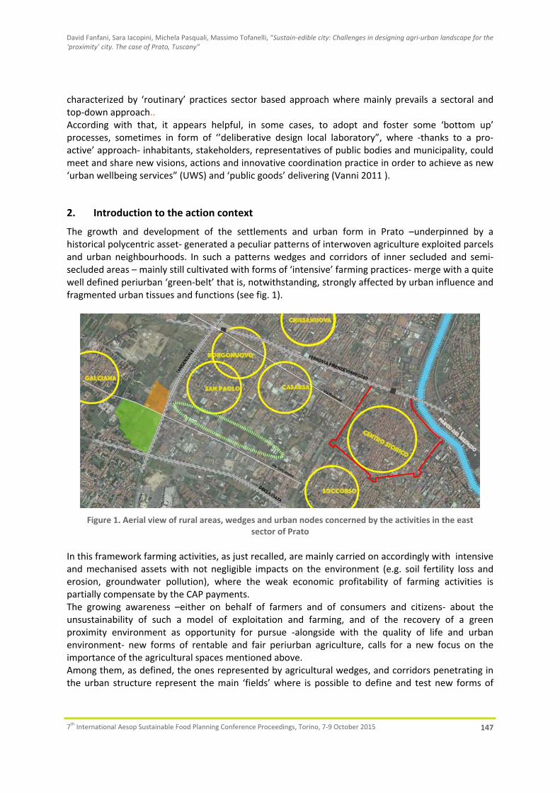
David Fanfani, Sara Iacopini, Michela Pasquali, Massimo Tofanelli, “Sustain‐edible city: Challenges in designing agri‐urban landscape for the ‘proximity’ city. The case of Prato, Tuscany”
7th International Aesop Sustainable Food Planning Conference Proceedings, Torino, 7‐9 October 2015 147
characterized by ‘routinary’ practices sector based approach where mainly prevails a sectoral and top‐down approach.. According with that, it appears helpful, in some cases, to adopt and foster some ‘bottom up’ processes, sometimes in form of ‘’deliberative design local laboratory”, where ‐thanks to a pro‐active’ approach‐ inhabitants, stakeholders, representatives of public bodies and municipality, could meet and share new visions, actions and innovative coordination practice in order to achieve as new ‘urban wellbeing services” (UWS) and ‘public goods’ delivering (Vanni 2011 ).
2. Introduction to the action context
The growth and development of the settlements and urban form in Prato –underpinned by a historical polycentric asset‐ generated a peculiar patterns of interwoven agriculture exploited parcels and urban neighbourhoods. In such a patterns wedges and corridors of inner secluded and semi‐secluded areas – mainly still cultivated with forms of ‘intensive’ farming practices‐ merge with a quite well defined periurban ‘green‐belt’ that is, notwithstanding, strongly affected by urban influence and fragmented urban tissues and functions (see fig. 1).
Figure 1. Aerial view of rural areas, wedges and urban nodes concerned by the activities in the east
sector of Prato In this framework farming activities, as just recalled, are mainly carried on accordingly with intensive and mechanised assets with not negligible impacts on the environment (e.g. soil fertility loss and erosion, groundwater pollution), where the weak economic profitability of farming activities is partially compensate by the CAP payments. The growing awareness –either on behalf of farmers and of consumers and citizens‐ about the unsustainability of such a model of exploitation and farming, and of the recovery of a green proximity environment as opportunity for pursue ‐alongside with the quality of life and urban environment‐ new forms of rentable and fair periurban agriculture, calls for a new focus on the importance of the agricultural spaces mentioned above. Among them, as defined, the ones represented by agricultural wedges, and corridors penetrating in the urban structure represent the main ‘fields’ where is possible to define and test new forms of

David Fanfani, Sara Iacopini, Michela Pasquali, Massimo Tofanelli, “Sustain‐edible city: Challenges in designing agri‐urban landscape for the ‘proximity’ city. The case of Prato, Tuscany”
7th International Aesop Sustainable Food Planning Conference Proceedings, Torino, 7‐9 October 2015 148
urban agriculture that, although not tailored by the prevalence of social goals and practices, follows very different principles by the ‘intensive’ model. In these spaces it seems to be room to create and innovate in the domain of consumption‐production schemes and in spatial planning tools as well. That in designing a new pivotal role for these areas, no more conceived as ‘urban waste’ but as key elements for the recovery a new urban form and relation/articulation between urban and rural domains.
3. The study cases
The two following study cases presented account for a bottom‐up design process referred just to two close context encompassing the pointed out features and where ‘social shared visions’ call for integrated projects where environmental, economic, social, design, policies innovative issues merge, as well as, for strong innovation in urban design practices.
3.1. Capezzana social farm: from an urban ‘green park’ to an agriurban public park
The area interested by the first ongoing process is placed in the west fringe side of the municipal area (see. Fig.2) and is a farmland area inherited –with many other farmland and rural goods‐ by the Prato municipality including an old farm building badly preserved dating from the fifteenth century.
Figure 2. Aerial view of the Capezzana agricultural area and of the old farm to recover (red circle)
The farm as the fields, until few years ago, were occupied by the family of the last renting farmer that exploited the property leading jointly a little breeding activity and cultivation of arable. Such activities allowed to the farm, thanks to the renters attitude, to perform the function of a didactic

David Fanfani, Sara Iacopini, Michela Pasquali, Massimo Tofanelli, “Sustain‐edible city: Challenges in designing agri‐urban landscape for the ‘proximity’ city. The case of Prato, Tuscany”
7th International Aesop Sustainable Food Planning Conference Proceedings, Torino, 7‐9 October 2015 149
centre of environmental education, open to the primary and elementary schools of the quarter as well as to the neighbourhood citizens. It is worth noting that the exploitation of the farm was ‘nature e based’, mainly dedicated to the breeding of a native local cow race called “calvana” and to organic cultivations of traditional wheat cultivars for ‘food mile’ bread production. Six years ago the municipality, according with a peculiar conception of public goods economic enhancement of a certain success in Italy, decided to sell the farm building and to change the urban plan, envisioning a residential estate development for a part of the area and the role of public urban park for remaining 10 hectares . The crisis that stroke the real estate sector after 2009 hampered the realization of such previsions and created the conditions for the proposition of quite different project idea on behalf of some social actors, including the last farmers family that carried on the activities. Starting from the position of the previous and present administrations, not available to rent again the farm, the last family that occupied the building participated to a public call for the building purchase and won the public call itself2. That, anyway, with the aim to had the opportunity to develop again the multifunctional agricultural activity leaded in past, featured by some important social functions. In such a prospect the destination of the arable land as urban park needs to be overcome or ‘re‐interpreted’ in such a way to maintain and coalesce the public access and benefits with the development of entrepreneurial farming activities although in a ‘nature based’ way. With this aim of public interest and periurban agriculture promotion the Agricultural Park of Prato Association3 supported and fostered the project of farming activity recovery in defining, jointly with the farmer family, a strategic project for an periurban public agricultural park that innovated the ordinary and routinary idea of ‘public urban green’. The idea underpinning the project –submitted to the administration with the aim to start a procedure of public call for the agri‐park management‐ is based on the conception of private farming activity conducted according with goals of public interest and producing ‘public goods’ and activity that develop synergies with farming exploitation itself. That means that ‘public goods’ and functionings of public utility are delivered not only as by‐products or positive externalities of private activity –as in the economic ordinary conception‐ but are, alongside with market goals, constitutive of the farming plan. In such a vision the private role is conceived as collaborative with public action in achieving results of public utility and community fairness accordingly an intentional scheme. Coherently with this framework the project submitted to the public administration foresee the protection, maintainment and enhancement of periurban public green spaces in an active way. That with the development of agricultural activities mainly carried on accordingly with the principle of ‘agroecology’ and organic agriculture, allowing to visitors and citizens, thanks to rural paths, access to the fields and services and utilities delivered by the farm itself. It is evident that such a farming setting allows either the production of ‘public’ and ‘non market’ goods (e.g. ecosystem services, landscape regeneration and amenities, environmental education and awareness, etc.) and the delivering and development of proximity services and economies more market oriented, although in a fair way (e.g. selling of fresh food locally produced, rural hospitality and leisure services, didactic programs for agriculture and crafts). The project for the agricultural public park in the area of the neighbourhood –more properly called “village”‐ of Capezzana, is at the moment under the assessment of new public administration elected
2 The purchasing procedure definition, at the moment this paper is wrote, is still ongoing. 3 The non for profit association ‘Prato Agricultural Park’ constituted in 2010, is a voluntary partnership that includes associations of environmental and cultural promotion, of professional farmers, and of social promotion. The statutory goals of the association are aimed to promote, through cultural initiatives and operative projects, the protection and values of periurban rural areas through a sustainable agriculture form there developed in such a way to foster forms of local endogenous development.

David Fanfani, Sara Iacopini, Michela Pasquali, Massimo Tofanelli, “Sustain‐edible city: Challenges in designing agri‐urban landscape for the ‘proximity’ city. The case of Prato, Tuscany”
7th International Aesop Sustainable Food Planning Conference Proceedings, Torino, 7‐9 October 2015 150
in 2014‐ especially for the matters that relate to a new vision and conception of the urban public green spaces management.
3.2. The project. “Trame di Quartiere”4: an urban agricultural park for a new sense of place stewardship and belonging
The Capezzana project is strongly related and substantially in physical continuity with the bottom up process that concerns the ‘green corridor’ that originates from the area described, overcomes the west urban freeway and flanks the dense residential neighbourhood of S.Paolo, reaching out the urban historical centre (see again fig. 1, right side ).
3.2.1. The context and the goals of the laboratory
The action‐research project “Neighbourhood Plots”, developed together with the residents of San Paolo, Borgonuovo and Casarsa (recently renamed Macrolotto 0), introduces the study and practice of diversity management into these neighbourhoods of Prato through a series of workshops, urban walks, interviews and narrations. The goal, on the one hand, is to collect and reconstruct the historical memory of the two neighbourhoods, whether that of collecting large or small stories that happened in these places or those that strengthen residents’ awareness of neighbourhood events and characteristics. The project also intends to stimulate critical attention of professionals about the pitfalls of processes of participation and urban planning as well as the opportunities that are typical to an approach oriented to diversity management at a neighbourhood level.
The change in recent decades has had a significant effect on the social and economic structure of the city of Prato. Recent research has documented a widespread feeling among residents of disorientation and helplessness in the face of urban transformation, driven by global forces beyond local control, yet with concrete effects on the lives of citizens. Notable changes have occurred in both the physical transformation of the neighbourhood, in its daily functions, in the network of services and public goods distributed, as well as in the social attributes of residents. The increasing concentration of the presence of citizens of Chinese nationality intermingles with a local context whose signs of past development are tangible: San Paolo and Macrolotto 0 are markedly isolated as a result of being encircled by the railway and a major thoroughfare, which renders them difficult to access. In addition, both neighbourhoods are full of dead‐end roads that although they bear the label cul‐de‐sacs have virtually nothing in common with their suburban American counterparts. Pointing to this urban reality engages a theme very much neglected by urban planning processes—that of diversity management, which is not only characterized by the presence of a mixité of residential and commercial zones, society and economy, subcontracting and industry, Southern Italian migrants, rural Tuscan transplants, and long‐time Pratesi, but that is shot through with global flows of migration and international trade. The central theme/challenge for Prato is not so much how to design neighbourhoods that are different, but rather how to intervene in neighbourhoods in which diversity and separation coexist. San Paolo and Macrolotto 0, which are icons of the factory city, are located to the west of the ancient wall, between the railway to the north and the beltway. Within these districts exists a wide range of forms, functions, and populations.
4 Neighbourhood plots

David Fanfani, Sara Iacopini, Michela Pasquali, Massimo Tofanelli, “Sustain‐edible city: Challenges in designing agri‐urban landscape for the ‘proximity’ city. The case of Prato, Tuscany”
7th International Aesop Sustainable Food Planning Conference Proceedings, Torino, 7‐9 October 2015 151
Needless to say, especially from a social point of view, the two districts have distinct characteristics. The “Macrolotto 0” can be seen as a zone of transition—the historic port of entry into the city for many families of Italian heritage and more recently of non‐European immigrants, with a particularly high concentration of residents of Chinese nationality. Within these linear barriers, the city includes a wide area of concentration of manufacturing activities and a vibrant commercial activity along Via Pistoiese and up to the historic centre. On the far side of the centre, to the west, is the compact core residential neighbourhood of San Paolo, from Via Donizetti until the beltway and south to Via Galcianese through areas with remnants of rural‐turned‐urban green spaces. San Paolo maintains a greater residential presence, with a good network of services and a lively social environment, most related to the components of the original Italian population, with roots as Tuscan sharecroppers and Southern transplants.
3.2.2. Activities and methodological matters of the project
More specifically, the project structure consists of two series of activities:
1) research, which refers to the study of characteristics of the local society and the neighbourhood in response to changes in its physical, social, and cultural features; 2) action, embodied in the creation of public seminars and workshops with the involvement of experts who bring specific skills, among which the documentation and collection of narratives, whether photographic, video, audio or text, in the management of public space, particularly in the reuse of industrial spaces, abandoned factories and warehouses, as well as remaining rural and urban green spaces. The latter goal stems from the residents’ perception of a lack of strategic plans and integrated urban planning models at the local administrative level. Conversely, they were proposing a forward‐looking bottom‐up approach based on the innovative reuse of abandoned industrial buildings, the recognition of the biological food production and important social functions played by this “green corridor” (e.g. promoting sociality and civic engagement out of the encounter between people of diverse backgrounds, ethnicity and social status; educational, cultural and outdoor activities).
To bring together the ideas emerged during the first phase of the project, two workshops, supported even by experts5 were organized. Together with the inhabitants, local‐based associations and stakeholders, existing valuable resources and opportunities (e.g. disused or historical buildings, undeveloped land, schools, strategic structures, etc.) were discussed and eventually identified. During the design process, the outcomes of the didactic laboratory led by an environmental teacher6 with the pupils of the primary school “V. Frosini” located in the San Paolo neighbourhood, were also taken into consideration. Working with the children enabled us to grasp their perspectives and wishes on the city as well as to include local actors that are too often neglected in the urban planning processes. During these outdoor activities, the pupils interviewed residents of different ethnic backgrounds, learnt how to recognize plants, flowers and insects, developed a more ecological worldview and sensitivity to human‐environment interrelationships.
5 The workshops were coordinated by Michela Pasquali, landscape architect and director of the non profit association Linaria, and David Fanfani, Associate Professor in Urban and Regional Planning at the University of Florence. 6 Serena Maccelli, Legambiente.

David Fanfani, Sara Iacopini, Michela Pasquali, Massimo Tofanelli, “Sustain‐edible city: Challenges in designing agri‐urban landscape for the ‘proximity’ city. The case of Prato, Tuscany”
7th International Aesop Sustainable Food Planning Conference Proceedings, Torino, 7‐9 October 2015 152
The ongoing idea arose from these laboratories is to design an urban agricultural park inspired by similar worldwide experiences (Barcelona, Nordhavnen, Los Angeles), whose main functions are:
1. Increasing food supply and city resilience to climate changes; 2. Creating public spaces enhancing social interactions; 3. Providing public services for the residents; 4. Connecting the neighbourhood with the farmland area, to the west, and the urban historical
centre, to the east, ‐ thanks to pedestrian and bicycle paths; 5. Improving the quality of urban life. A third workshop, which will be held in autumn, aims at designing a strategic plan constituting the starting point for a discussion on the future of the area between residents, local stakeholders and the present administration.
3.2.3. Design practice and principles
Accordingly with the context feature and project goals the design activity starts from the awareness that open spaces are considered necessary as open‐air amenities of great value for the future of Prato, whose extremely varied forms and statuses are the basis for the quality of life and the daily landscape. TramediQuartiere with the help of a multidisciplinary team that combines expertise in landscape design, architecture and urban planning, has taken a comprehensive approach to an urban planning and development project in the area, considering the site’s geographical and physical setting, the project’s satisfaction of users’ needs and expectations, its appropriation by users, and its ability to evolve. Considering the city as a real living organism that is constantly changing, spatially and socially, TramediQuartiere public workshops has oriented urban design towards other horizons than just functional and spatial composition, considering urban planning as a process in which dialogue with the site, with time and with the partners involved become fundamentals of the project. The workshops aim to design a major urban development centre which is a place of work and leisure at the same time; aimed at innovation, a diversity of urban forms, and social mix objectives devised through a very active, creative consultation process. This kind o multiplicity space would play a role in social cohesion, education, and cultural activities, becoming a community hubs that celebrate and raise awareness about and thanks local food production, sport and cultural activities. Events such as festivals, harvest dinners, cooking, or growing demonstrations, and educational programs can inspire DIY activities involving schools, local associations, including ethnic communities, low income families, seniors, and children. The benefits extend to many facets of the health and wealth of a city. TramediQuartiere proposes an ecological and biological based city‐planning model that would focus on community, health and ecosystem. Through the workshops has emerged an integrative process focusing on solutions based on the interconnectedness of the systems as a whole unit, rather than separate parts where the design strategy would integrate social, economic, estetic, ecological, and economic values to achieve the best results. The interest of the proposal in the area is rather like a restoration, a reappropriation of a green space and by being part of projects that are more rooted in the local fabric. TramediQuartiere aims to create a new regenerative landscape that promote biodiversity and social sustainability to organize the area in a hierarchy which ranges from large extensive pieces of

David Fanfani, Sara Iacopini, Michela Pasquali, Massimo Tofanelli, “Sustain‐edible city: Challenges in designing agri‐urban landscape for the ‘proximity’ city. The case of Prato, Tuscany”
7th International Aesop Sustainable Food Planning Conference Proceedings, Torino, 7‐9 October 2015 153
landscape to the intimacy of the gardens, orchards, vegetable plots, squares and sport amenities and infrastructures with recreation ‐sports and cultural activities. (see figg. 3,4)
Figure 3. The project concept of the whole areas
Figure 4. vision sketch of integrated landscape and use in the agricultural wedge of TramediQuartiere
The proposal is based on the development of the agricultural potential and the activities related to it, like production, processing, treatment, and local shop and farm markets. The idea is based on a rationale use that ensures harmony between future uses and long‐term respect for the existing agricultural identity: diversity could be maintained with local crops that identifies the regional area, but also with the inclusion of multicultural fruit and vegetable already cultivated in the vegetable garden of the Chinese community, and open to other communities. The design will be based on a search for contemporary expression of nature in the city; on the natural dynamic of existing ecological systems and the application of differentiated maintenance. An experimental playground and laboratory shape all the park space to take landscape architecture and urbanism in new directions and for a new type of productive open‐space system (see Viljoen 2006,cit. 2014). In this way Tramediquartiere explores an alternative to the urban traditional park

David Fanfani, Sara Iacopini, Michela Pasquali, Massimo Tofanelli, “Sustain‐edible city: Challenges in designing agri‐urban landscape for the ‘proximity’ city. The case of Prato, Tuscany”
7th International Aesop Sustainable Food Planning Conference Proceedings, Torino, 7‐9 October 2015 154
and garden that integrated design with nature and agriculture with aesthetic, in a long term and a sustainable development.
4. Conclusions
Although at their very early stage and their differences, the two laboratories we accounted for allows to underscore some relevant matter in dealing with planning and design of in‐between spaces (Sievert, 2003) accordingly with sustainability and food production goals. First of all the multidimensionality of the issues at stake calls for the overcoming of the traditional ‘functional’, ‘zoning oriented’ and sectorial approach in physical planning. Planner and urban design skills have to be integrate and collaborate with other competences, especially concerning agri‐environmental, landscape and socio‐economic approaches. Furthermore this entails the necessity, in order to achieve planning results effectiveness, to involve, in a participative and ‘bottom‐up’ process, stakeholders, inhabitants, associations in order to reframing the context problems framework and better address the more relevant issues for the area regeneration. The process of integration between urban and agriurban domains that stems form this kind of approach, especially considering the enhancement of short food supply chains and CSA schemes, seems to fit with the fostering of new local economies, social integration and well‐being, place awareness on behalf of citizens and stakeholders. That also allowing for the enhancing and appreciation of the not negligible market and not market values generated from periurban open spaces agricultural use (Brinkley 2102). On behalf of public bodies and policies the multidimensionality of this kind of design processes calls for the overcoming of a ‘command and control’ attitude and for the better integration and coordination between the different sectors and administrative levels concerned, that in such a way to better unfold a real governance process. In this framework the regulatory role of public seems to be pivotal in addressing land revenue expectations on behalf of land owners that usually hinder the possibility of a common goods oriented use of urban and periurban open spaces. Public owned land also turn out to be a key success factor as the contexts examined reveals an alternative strategy opportunity at the mainly recently practiced by public administrations in Italy that conceive and identify the ‘public goods’ and properties value enhancement with their selling to private operators. In that contrasting and misconceiving the nature of goods itself (Maddalena 2014). Finally is worth noting as this kind of contexts allows to better sound and deal with the calls for innovative planning and design methods and solutions in order to recovery a fair and sustainable relationship between urban domain and its surrounding region for the sustainable ‘relocalization’ (Thayer 2013) of the city itself.
5. References
Brinkley C., 2012, Evaluating the benefits of periurban agriculture, in Journal of planning literature. Sage, 0‐11 Donovan J., Larsen K., Mc Winnie J., 2011, Food sensitive Planning and urban design: a conceptual framwork
for achieving a sustainable and healthy food system. Melburne: Report commissioned by the National Hearth Foundation of Australia (Victorian Division) at www.heartfoundation.org.au/ SiteCollectionDocuments/Food‐sensitive‐planning‐urban‐design‐full‐report.pdf > (accessed August, 2015)
European Regions Commitee, 2011, Opinion of the Regions on ‘Local food systems’ (outlook opinion), (2011/C 104/01), at http://eur‐lex.europa.eu/legal‐ content/EN/TXT/PDF/?uri=CELEX:52010AR0341& from=EN, (accessed September 2015)
Maddalena P., 2014, Il terriotrio bene commune degli italiani. Proprietà collettiva, proprietà private e interesse pubblico. Roma: Donzelli
Magnaghi A., ed, 2014, La regola e il progetto. Firenze, : Firenze University Press

David Fanfani, Sara Iacopini, Michela Pasquali, Massimo Tofanelli, “Sustain‐edible city: Challenges in designing agri‐urban landscape for the ‘proximity’ city. The case of Prato, Tuscany”
7th International Aesop Sustainable Food Planning Conference Proceedings, Torino, 7‐9 October 2015 155
Morgan K., Sonnino R., 2010, The urban foodscape. World cities and the new food equation. Cambridge Journal of Regions, Economy and Society, pp.209‐224
Norgaard R.B, 1994, Development betrayed. The end of progress and a co‐evolutionary view of the future. New York: Routledge
Redwood M, ed, 2009, Agriculture in Urban Planning: Generating Livelihoods and Food Security. Milton Park, Oxon, (UK): Earthscan
Sievert T., 2003, Cities without cities. Between place and world, space and time, town and country. London: Taylor & Francis,
Thayer R.L., 2004, LifePlace. Bioregional Though and practice. Berkeley: California University Press, Thayer R. Jr., 2013, The world shrinks the world expands: information, energy and relocalization, in, Cook E.,
Lara J.J., (eds), Remaking metropolis. Milton Park, Abingdon (UK): Routledge, 39‐59 Vanni F., 2011, Agricoltura e beni pubblici: una proposta di riorientamento della PAC, in AgriregioniEuropa,
Anno 7, n. 26, p.63. at: <http://agriregionieuropa.univpm.it/content/article/31/26/ agricoltura‐e‐beni‐pubblici‐una‐proposta‐di‐ri‐orientamento‐della‐pac>, (accessed, September 2015)
Viljoen A., Bohme K., Howe J., eds. 2005, CPUL’S, Continous productive urban landscapes. London: Elsevier Viljoen A., Bohme K., eds, 2014, Second nature. Designing productive cities. Milton Park, Oxon (UK):
Routledge,

Radu Mircea Giurgiu, Fritz‐Gerald Schröder, Nico Domurath, Daniel Brohm, “Vertical farms as sustainable food production in urban areas. Addressing the context of developed and developing countries. Case study: brick born farming, Dresden, Germany”, In: Localizing urban food strategies. Farming cities and performing rurality. 7th International Aesop Sustainable Food Planning Conference Proceedings, Torino, 7‐9 October 2015, edited by Giuseppe Cinà and Egidio Dansero, Torino, Politecnico di Torino, 2015 pp 156‐170. ISBN 978‐88‐8202‐060‐6
156
VERTICAL FARMS AS SUSTAINABLE FOOD PRODUCTION IN URBAN AREAS. ADDRESSING THE CONTEXT OF DEVELOPED AND DEVELOPING COUNTRIES CASE STUDY: BRICK BORN FARMING, DRESDEN, GERMANY
Radu Mircea Giurgiu1, Fritz‐Gerald Schröder, Nico Domurath2, Daniel Brohm2 Keywords: food security, vertical farm, global balance, sustainability, urbanization
Abstract: Food is one of the essential thing for human existence. Population growth, urbanization and climate change put big pressure on space and resource utilization. Traditional farming and strategy for food supplying are not sustainable anymore. Urban Farming is a response to these challenges, by finding alternatives of utilising the urban space as a platform for plant cultivation. One of the ways is through Vertical Farms which are enclosed facilities with absolute control of environment, producing high qualities and quantities of fresh food, all year round. In spite of the advantages, there are only a few of such facilities in the world. Initial investment and maintaining costs are the biggest issues. This put in the context of Global North and Global South gap, turn the economic disadvantage into a very difficult thing to overcome. This paper is analysing Vertical Farming as a complex concept that can be decompose in many constitutive parts and it’s looking on how this parts can be translated for other contexts, where economy is unstable. For this purpose the case study of BrickBorn Farming project from Dresden, Germany is discussed. The progress of the project and the development to this time shows potential for knowhow that can be fitted in many economic and social contexts. This way the global problems are addressed to possible global solutions which can lead to a better global stability and equal chances of development, with the main goal of achieving food security.
1. Context of the problem
We live in a time of fast pacing and continuous development of societies. In the last centuries, humankind used the cognitive qualities to use the planet for its own progress. The better quality of life is searched by everybody but self‐actualization, as the popular theory of Arthur Maslow says, can be reached just by solving the other layers of the pyramid. The psychological needs are the base of Maslow’s pyramid. Food and water are among the things that people need in order to survive and both are interconnected and not infinite. Progress for humankind leads to accelerated growth in numbers. It is predicted that by the year 2050, there will be 9 billion people on the planet. In this context the basic needs like food, seem challenging. Food security is an urgent topic at the moment, and challenges that face the planet seem to be non‐eluding. Agriculture and horticulture are the motors of food producing in the World. Global diversity is, of course, important to understand how significant, food security as an issue is, but the global problems are always the same. Beside the increasing number of the population, urbanization is also a factor to be considered. Not only that we will be more people on the planet, but also around 80 percent will live in urban spaces. That can be translated as more land required for leaving places and less farmland. There is already predicted that we will need more land than available, in order to sustain in the future, but this urban sprawl puts even more pressure on the challenge. Human impact on the nature in the race of fast economic success, has led to a number of negatives effects on the environment. Rapid Climate Change (RCC) is a result of human non‐sustainable
1 University of Applied Science, Dresden, Germany, [email protected] 2 Institute of Horticulture Technologies, Dresden, Germany, [email protected]
Radu Mircea Giurgiu, Fritz‐Gerald Schröder, Nico Domurath, Daniel Brohm, “Vertical farms as sustainable food production in urban areas. Addressing the context of developed and developing countries. Case study: brick born farming, Dresden, Germany”
7th International Aesop Sustainable Food Planning Conference Proceedings, Torino, 7‐9 October 2015 157
intervention and development. This is a process that has only one way and people are trying to slow it down to gain more time to act, but the effects are visible and can lead to catastrophic events. Especially from the food security point of view. Draughts and floods, among other major weather events can jeopardize entire farmlands and have huge negative impact for economics and health of the people (Aubry, et.al. 2012). The problem of feeding the world in 2050 is one of the biggest challenge humanity has to face. This lead to focus energy of researchers, practitioners, governments and communities in order to find solutions, to prevent more damage, reduce exacerbation and apply new sustainable, long term thinking solutions.
2. Urban Farming
Some keywords that define the problems that humanity will face, are interconnected. This means that the problems have some identical centre points, which means that solutions focused on the centre point can bring good results for multiple issues. We identify this centre points as population growth, big demand of food and urbanization. A possible solution can be that getting food inside of the cities will solve demand for high number of people without having to think how to stop urbanization (Grawel S. and Grawel P., 2012). This solution is defined as Urban Farming (UF) and it gets more and more attention. UF can be applied in different ways. The most popular are roof gardens, living walls, community gardens, urban allotments, vertical farms etc. All have in common efficient use of space and resources in order to produce food in the cities with no negative impact on the environment. Locally grown food is getting higher in demand as people wanting to know more about where and how the plants are grown. This is a good thing for encouraging involvement, but also has some limitations (Sigrid, 2002). Climate remains a big risk factor of cultivating the crops in unprotected horticulture. The Vertical Farm (VF) is a way of Urban Farming that adds the controlled environment in the equation. This means that the crops are grown inside buildings where all parameters that are needed for cultivation are controlled and is independent of the weather events. Vertical Farms have a number of advantages that puts this alternative agriculture approach in the spotlight. Firstly, growing plants indoor, independent of the weather and the seasons, allows year‐round cultivation of vegetables, herbs etc. (Despommier, 2011). It is very important to provide fresh food in so called “off season” and helps avoiding high prices and fluctuations. The transportation and logistics for getting fresh food out of season is not only bad for economy but also impacts negatively the environment. VF is defined by high technology applied in crop cultivation. LED lighting (Fan, et.al. 2013), controlled fertirrigation, soilless cultures, sensors and software that allow the growers to check and manipulate the environment are some of the features that give the users so much flexibility and mobility, obtaining high yields in shorter time. This alternative way of agriculture shows that it can be a way to tackle the future challenges for food security (Fischetti, 2008).
3. Vertical Farming – developed and developing countries
3.1 Current state
As stated in the previous chapter, VF has become a centre piece in the discussion on food security and urban planning for sustainable food production. Although all the advantages show good ways of facing the threats of urban sprawl, growing population and scarcity of resources, there are not many function facilities at the moment. That might stand as a surprising fact but the keys are the costs. VF

Radu Mircea Giurgiu, Fritz‐Gerald Schröder, Nico Domurath, Daniel Brohm, “Vertical farms as sustainable food production in urban areas. Addressing the context of developed and developing countries. Case study: brick born farming, Dresden, Germany”
7th International Aesop Sustainable Food Planning Conference Proceedings, Torino, 7‐9 October 2015 158
is a highly technologized edifice that uses resources efficiently and also produce more in less space, but the initial investments are too high for many growers to start. The costs can be recovered in some years, but the initial investment is simply too high. The features used in the VF are as expensive as effective (Zhang, et.al. 2002). LED lighting although getting more and more popularity and increasing competitively of producers, is still a high end product. As all new technologies, development and higher demand will eventually lower the prices and become more affordable. Until we reach that point, time should be used as a beneficial factor and solutions should be implemented in order to develop progressively. Even if there are funds enough for starting a VF facility, the maintaining of a fully functioning food producing facility at this scale is costly. And this varies worldwide which shows the potential or the challenge of this technology to be applied (Fig.1).
Figure 1. Energy prices comparative worlwide. (NUS Consulting statista, 2015).
The Vertical Farms existing today can be found in USA, Japan, Singapore or Korea. The advantages of having this technology in order to produce food are already explained from the environmental, and economical point of view. The geographic localisation of these facilities can be explained from the kilowatt prices and availability of the vegetables. In USA, electricity is rather cheap in comparison with other countries, even with those ones that have a stable economy. This allows maintaining and operating a VF. There are more and more VF appearing in the US, showing that the first ones proved

Radu Mircea Giurgiu, Fritz‐Gerald Schröder, Nico Domurath, Daniel Brohm, “Vertical farms as sustainable food production in urban areas. Addressing the context of developed and developing countries. Case study: brick born farming, Dresden, Germany”
7th International Aesop Sustainable Food Planning Conference Proceedings, Torino, 7‐9 October 2015 159
to be successful. This is encouraging for researchers, practitioners and governments all over the world to focus more energy in this topic and make possible that this facilities can be implemented worldwide. In far east, there are also a few VFs. In Korea and Japan, for example, there is low availability of fresh vegetables coming from open field cultivation (Beghin, et.al. 2003). There are many greenhouses that produce food, but VF gets more attention because of the total control and independency of weather and seasons. Also, in this part of the world the acceptance for this kind of high technology applied is very big, and so it can enter the market and get the approval of the consumer very fast.
3.2 Challenges for developing countries
As we stated, the food security problems are global and are affecting countries worldwide. The vertical farming, can respond to this problems, but until now, there are more theoretical principles. The research on this theme is wide enough to be translated into practice, but high cost of implementation still need to be solved in order for practice to be achievable. This can be done by common effort from industry, academia, research and governments (Iles and Marsh, 2012). If key players in the field join forces, the cost can be assured in the name of sustainability and long term thinking (Rickby and Caceres, 2001). There are already discussions, ongoing projects and even associations worldwide in order to make lobby for the technology and help implementing as fast as possible. The countries that will suffer the most from the climate change and food insecurity are actually the poorest ones (Fig.2). Developing countries are already struggling to produce food and secure the wellbeing of their citizens. Low technology traditional agriculture is not a good match for the adverse weather events and for the increasing population and urbanization (Pauchard, et.al. 2006).
Figure 2. UN Human Development Report (2014)
In this article we focus on how VF can respond to future challenges in regard to food security and urbanization. We already stated that developed countries intensify their efforts to implement this facilities of food producing in the cities. The high initial investments and electricity prices are the biggest factors that stop the initiation. This means that developing countries have no potential of such strategy to take place in the cities. Food producing at the developing countries level is lacking technology and it’s rarely intense agriculture. The adaptability of these countries to climate change and unpredictability of the weather put them in a dark spot for the challenges of the future. More

Radu Mircea Giurgiu, Fritz‐Gerald Schröder, Nico Domurath, Daniel Brohm, “Vertical farms as sustainable food production in urban areas. Addressing the context of developed and developing countries. Case study: brick born farming, Dresden, Germany”
7th International Aesop Sustainable Food Planning Conference Proceedings, Torino, 7‐9 October 2015 160
research projects have to be developed with regard to the applicability and poorer countries too (Cohen and Garett, 2010). Adaptability, flexibility and scalable The VF represents one of the possible solution of producing food inside cities with positive impact on the environment, and smart and efficient use of space and resources. This factors qualifies VF as a sustainable way of food producing. The biggest challenge until now is the economic one (Zezza and Tasciotti, 2010). Although year‐round production, with increased yield and less resources needed can return in important profits. But the obstacle represent the initial investment. Developing countries have less competitive economical background than developed countries. Costs are a big factor that can make some strategies seem unsuitable for them.
Table 1. Motivation for Urban Agriculture listed by developed countries, newly industrialized countries and
developing countries (Brohm, et.al. 2012)
Developed countries Newly industrialized countries Developing countries
Recreation/rehabilitation Self‐made local food Environmental education Decrease of crime Waste land use Social integration Improvement of micro‐climate Increase of biodiversity Sustainable urban development Organic food Consolidation of communities Neighbourhoods City beautification Less CO2 emissions
Fresh local food Auxiliary income Ruin use/ waste land use Shortening of transport distance Decrease of crime
Healthy fresh self‐made food Source of income
It is a fact that the problems are global so the solutions should be as well; there is interdependency between Global North and Global South (McClintock, 2010). The first is using the most of the world’s resources that are in many part in Global South. But the biggest discrepancy relies in economic development. Quantity is a normal dependent of the economic factor, but quality should not be the same. Scale is very important when we discuss novel strategies for food security. If the projects are scalable, then countries with less strong economies can apply them in a smaller scale. This can allow them to build up in a progressive way, using the time as an advantage. Profit reinvested can lead to succession development and so help shrinking the gap. To discuss the flexibility and adaptability of VF, we do not have to think of the facility as a whole, but to decompose and apply just the things that will add value to those who use it. Going back on the advantages of this technology VF is an alternative to traditional plant cultivation, through offering alternatives for resources needed. LED can mimic and replace sunlight, water is recycled and more than 90% can be saved, no pesticides are used etc. A fully equipped VF will have all this features in state of the art fashion. But in some parts of the world some resources are enough so the focus can be tuned towards other. This strategy in terms of resource efficient use is part of the VF ideology. The elements that compose the complex facility can be understood separately and just the ones that can bring value and are affordable should be priority and others should come later as an update of

Radu Mircea Giurgiu, Fritz‐Gerald Schröder, Nico Domurath, Daniel Brohm, “Vertical farms as sustainable food production in urban areas. Addressing the context of developed and developing countries. Case study: brick born farming, Dresden, Germany”
7th International Aesop Sustainable Food Planning Conference Proceedings, Torino, 7‐9 October 2015 161
the features. If more people will design this kind of modular and flexible projects, the flow of knowhow between countries will be faster and more achievable.
4. Case Study – BrickBorn Farming, Dresden, Germany
4.1 Site
BrickBorn Farming (Fig.3) is a project of a proposed Vertical Farm in the city of Dresden, the capital of Saxony, in Germany. The project begun in 2013 lead by Prof. Dr. Fritz‐Gerald Schröder from University of Applied Sciences, Dresden.
Figure 3. BrickBorn Farming (original)
Dresden is one of the greenest cities in all of Europe, with 63% of the city being green areas and forests. Having this reputation, the contrast of the small industrial area in the west part of the city strikes one and give a sence of alteration in the urban canvas of the capital of Saxony. In this part of the city, there is an abandoned factory that was intended as a food production facility.
4.2 Background
The building was designed by the german architect Kurt Bärbig, and was constructed between 1927 and 1930. Although the function of the building was to produce processed food, and the building is empty since 1991, time until some tried to use the space, for other functions. The building is important for the city of Dresden because it represents a historical heritage from one of the important architects of Germany. Kurt Bärbig that lived between 1889 and 1968. In 1923 he was appointed as the sole architect of Dresden in the German Academy for Town Planning. Bärbig’s progressive thinking, characterized by social aspects of urban and landscape design pays homage to the spirit of the times of objectivity, material relatedness and an effort to "period of promoterism". Born in Dresden in 1889, he immigrated to Brazil in 1934 and came back to the ruined city that was a result of the World War II. In 1952, he was head of freelance architects in the competition for the redesign of Dresden. He had an important involvement in rebuilding the city as we know today. The food factory he designed, has particular features that make it as an important edifice of the urban space. He designed it as a processed food production facility including bakery, brewery and

Radu Mircea Giurgiu, Fritz‐Gerald Schröder, Nico Domurath, Daniel Brohm, “Vertical farms as sustainable food production in urban areas. Addressing the context of developed and developing countries. Case study: brick born farming, Dresden, Germany”
7th International Aesop Sustainable Food Planning Conference Proceedings, Torino, 7‐9 October 2015 162
distillery, but it was not completed due to the world economic crisis from 1920s. The one that were accomplished by that time were the meat factory and the vehicle hall on the other side of the street. The building has 12.000 square meters available space and was designed according to functional principles, and defines the space in the street with the curved façade. There was a six sided glass tower, typical for the 1920s architecture that was lid from inside, and served as advertisement and attention drawing tool, towards the site.
4.3 Construction specifications
Sandstone, stone, plaster are known as typical facade materials in Saxony. Actually brick, clinker are associated with north Germany, Hanseatic cities such as Lübeck and Hamburg. In the Saxon cities of Dresden, Leipzig and Chemnitz there are several notable buildings, ensembles and settlements in the early decades of the 20th century, which are influenced by the material of clinker with its various ochers, reds, browns ‐ a building material that can be considered more sustainable.
4.4 BrickBorn Farming – Vertical Farm in Dresden
In 2013 BrickBorn Farming (BBF) project was started as an idea of Vertical Farm in the abandoned food production factory designed by Kurt Bärbig. The project aims to find suitable solutions for implementing plant cultivation technology in the building, in order to produce fresh food in the city while starting a pioneer project in the field that can stand as a model of future food production and planning in the urban areas. Since then, the project went to more developing phases and the idea was repeatedly communicated, gathering experts and potential stake holders in a common discussion about the possibility of implementation. Nevertheless, there is still a high level of research and development work needed, in order to achieve a profitable solution when the market is ready for this technology. A special challenge is the high technical complexity as well as large energy demand. Various aspects regarding food production in urban areas should be linked, which is an objective of the project.
4.4.1 Guidelines of the project (http://www.brickborn‐farming.de/)
Coordination cooperation The most fundamental challenge, however, lies in the common dialogue between all workspaces. The focus is on plants and animals. In order to produce food and sustain the business, it requires the best possible optimization of the production factors use such as energy, water, fertilizers, feed, etc. Complex relationships, which can be solved only through a holistic interdisciplinary property development. Plants, mushrooms and algae cultivation The cultivation of plants is naturally taken place outdoors. Cultures which are not adapted to the respective prevailing cultivation climate, yet can be produced in greenhouses. However, the year‐round cultivation of any plant can be carried out only under absolutely controlled conditions. Greenhouses under central European conditions are optimal only partially, since it is often too hot in summer and in winter, the insulation performance of the glass is not sufficient to be able to grow profitably. The protected cultivation in buildings prevents bad influences on plant growth under expert supervision and efficient use of cultivation factors. Particularly suitable for building bound

Radu Mircea Giurgiu, Fritz‐Gerald Schröder, Nico Domurath, Daniel Brohm, “Vertical farms as sustainable food production in urban areas. Addressing the context of developed and developing countries. Case study: brick born farming, Dresden, Germany”
7th International Aesop Sustainable Food Planning Conference Proceedings, Torino, 7‐9 October 2015 163
growing systems, different leaf and fruit vegetables, strawberries, herbs, precious mushrooms and algae can be cultivated. Development potential exists primarily in the fields of optimization and adaptation of cropping systems, automation and plant monitoring. Aquaculture Controlled breeding in water living organisms (fish, molluscs, crustaceans and algae) will progress in the coming years. There were problems so far especially with the water treatment and the high heat demand of some plants. It is increasingly trying to provide circuits to further increase the profitability of the systems, for example, in combination with the growing plants. As a module in a building‐related food production, aquaculture is intended to represent the main focus in the field of animal production. However, these circuits can make sense only when there is a design that will not make any compromises for any of the participants in it. Plant culture Not every plant culture is entirely suitable for the protected cultivation in buildings. However, the classical plant breeding offers the potential to create modern, adapted varieties, their characteristics are not only the best growth but also healthy products, and they may also follow new trends quickly, and realize consumer requirements specifically. Supplemental lighting The development of efficient high‐performance LEDs is at the centre of numerous experiments. However, the use is not yet fully suitable for large‐scale crop production. The lamps commonly used are not optimally adapted to its range of plant growth, and consume a lot of energy (Fan et.al. 2013). The combination of reinforced and novelty in conjunction with intelligent lighting control and tuned light recipes can lead to a successful and profitable possibility. Energy Energy is the central issue in the production of plants and animals in protected cultivation. Electricity and heat are really intensive production factors which denotes a friendly environment approach in order to have the best impact. Energy saving, energy recovery, energy storage and transport must be pursued. The building‐bound production offers a variety of options. So waste heat harvested from lamps, can be used to temper water in the fish production. Production waste can flow in the energy recovery and facades are also used as solar power areas. Important here is the development of systems for transferring heat energy in transport and storage media. Architecture, urban development and conversion There are number of municipal buildings possible for the production of food. Vacant industrial buildings, skyscrapers, unused military facilities represent just a small selection. In addition to the preservation of monuments, revitalization effects surroundings of the production facility and can have positive effects on urban development. The construction of new buildings can be useful. Monitoring systems All cultural processes must be constantly checked for compliance with optimum parameters. One of the most difficult challenges in the projects is monitoring living organisms and obtaining meaningful derivation of the health from their vital functions, but results in a higher guarantee of success for the production. This creates a need to develop new sensors connected to intelligent regulation and control algorithms for the protected production.

Radu Mircea Giurgiu, Fritz‐Gerald Schröder, Nico Domurath, Daniel Brohm, “Vertical farms as sustainable food production in urban areas. Addressing the context of developed and developing countries. Case study: brick born farming, Dresden, Germany”
7th International Aesop Sustainable Food Planning Conference Proceedings, Torino, 7‐9 October 2015 164
Marketing, acceptance, Education New methods of cultivation can arouse mistrust among consumers. The numerous advantages of the urban, building‐related food production, must be conveyed transparently and comprehensibly. The insight into the production building and the exact explanation of the modern methods are probably the best tools to achieve the necessary acceptance form. Can be relined confidence through the compilation of studies on the ecological balance and the safety of the processes and products. Project Development The planning and implementation of a complex project requires a comprehensive preparation. Starting with the determination of a suitable property, the find operators, investors and marketers to concepts of financing a high degree of networking and advocacy is needed. The project development has to lie in competent hands that can consider all aspects in advance. Hygiene, food safety In the open field cultivation and water bound aquaculture, the organisms are exposed to every imaginable influences. Animals absorb these situations better, because they have an immune system and possibly able to escape from negative influences. However, plants need protection in order to achieve optimum growth. The protected cultivation in buildings allows the maximum optimization of plant growth claims, and so no residues occur. The mandatory hygienic measures has to be observed for humans, so plants and animals can be significantly better enforced here.
4.4.2 Communication of the project
Part of the challenge of starting such a project, is getting acceptance from the community. This can be done through consistent and progressive communication efforts where the ones that worked to develop the project should be transparent and present the advantages of implementing this technology. Food security is not influenced just from producer to receiver, but also customer behaviour is an important factor (Sharp and Smith, 2003). In the future, the growing population will create a high demand for food, but also the expectations are high. Of course, this varies on the global scale, but always the end user of the products has as important role as the producer. On the other hand, communication, marketing and making the concept as visible as possible leads to future collaboration with industry, academia, scientific areas and governments, which can further develop and help implementing the project. In the first year, after the concept was developed, it was presented in a number of conferences and symposiums at a national and international level, where the new ideas were shown and put for discussions. This returned important feedback from specialists in the field coming from industry, academia, science or politics and positioned the project on the map of future technologies to be applied. Among this conferences, there was Future Horticulture Conference, under the auspices of the Federal Ministry of Food, Agriculture and Consumer Protection of Germany, "Regional Concepts for the Energy Change" that took place on the central campus of BTU Cottbus‐Senftenberg and was a cooperation between German and Polish governments. Then, the project was presented also in China, at “BIT's World Congress of Agriculture" that took place in the garden city of Hangzhou 200 km south‐east of Shanghai, where there were more than 1000 participants from 63 countries. These communication efforts were important to establish new targets for further developing and optimizing the project, as well as building networks in the field that can lead to future collaborations or more focused efforts head into this subject.

Radu Mircea Giurgiu, Fritz‐Gerald Schröder, Nico Domurath, Daniel Brohm, “Vertical farms as sustainable food production in urban areas. Addressing the context of developed and developing countries. Case study: brick born farming, Dresden, Germany”
7th International Aesop Sustainable Food Planning Conference Proceedings, Torino, 7‐9 October 2015 165
4.4.3 Further development
The initial concept presented strengths and challenges in term of implementation in the near future. This lead to a number of workshops that aimed to debate the BrickBorn Farming from as many perspectives as possible, in order to tackle the challenges and understand all the implications and effects. International workshop ‐ Concurrent Engineering This workshop was organised at the University of Applied Sciences from Dresden. It took place in three intensive days, with participants from the Master Course of Horticulture of the host University, PhD students, and developers of BBF with partners from Germany, Romania and Japan. The objectives were set prior to the meeting and a common ground of documentation was set, where everybody could contribute with ideas and references that could be used in the workshop. In the "concurrent engineering process" so‐called experts work simultaneously on a common technical development. The tasks and objectives were set and distributed to ones that had expertise in the certain field. This type of working together in the same room with different task but common goals, sped up the process, compressing the time and reducing the risk of later becoming necessary changes and also, improves coordination between experts involved in the workshop. The entire process was coordinated by Prof.Dr. Fritz‐Gerald Schröder, and the information and progress was shared between participants on a common data set, while the direct verbal and media communication are characteristic to very positive results. In the workshop the focus was on technology applied, product development, investment, profitability and studying what are the needs for this project to be successful and how can be further developed and implemented. The teams were working on crop and crop systems, climate and irrigation control, economy, design, supplemental light and facility management. In the end all information was ad in a common report that gives perspectives for the upcoming steps. The results showed that the biggest challenge is the supplemental lighting with LEDs, which will become the highest costs of production. More research on better optimization, and implementation of supplemental lighting must be done in order to raise the affordability for large scale production. But the strategies developed and analysed both environmentally and economically, show the flexibility of the project with modular growing systems (Fig. 4).
Figure 4. Lettuce growing A‐frame system. (INTEGAR, 2014, drawn by R.M. Giurgiu)

Radu Mircea Giurgiu, Fritz‐Gerald Schröder, Nico Domurath, Daniel Brohm, “Vertical farms as sustainable food production in urban areas. Addressing the context of developed and developing countries. Case study: brick born farming, Dresden, Germany”
7th International Aesop Sustainable Food Planning Conference Proceedings, Torino, 7‐9 October 2015 166
Green Infrastructure Seminar “As urban sprawl and landscape fragmentation continues worldwide, the concept of green infrastructure has recently been gaining increased attention from policy, research and practice. In a nutshell, green infrastructure (GI) aims at enhancing the connectivity, stability and productivity of green in its widest sense. The scope ranges from agricultural spots in the urban fringe, via urban brownfields to rooftop gardens in condensed city centers” (Green Infrastructure seminar, Nürtingen‐Geislingen University, 2014). The seminar was organized by Nürtingen‐Geislingen University, Germany and Kassel University, Germany, and it was 100 % online with participants as international students dealing with landscape architecture and neighboring disciplines, from all over the world. Teams of 4 were formed and from October 2014 to January 2015, the students had the opportunity to see weekly presentation of case studies relevant to the topic, both from research and practice. A multidisciplinary engagement was encouraged. The teams had to firstly prepare a personal case study and present the threats and the solutions on a wiki page format. Interaction between students and cases was also allowed and encouraged. The second phase was working on collaborative project. One team formed from students from Romania, Macedonia, India and Jordan have selected brick Born Farming as a challenge to study and think of ideas in term of green infrastructure through Vertical Farming. The students identified some threatening issues that can be addressed in the following design process. Food Security: The floods or other climatic events can result in poor crop yields and threaten the food security of the city. Lack of Green in Industrial Area: Although projects of GI techniques are planned on a long term, the industrial area is still dominated by big buildings, lack of green space, and an uninviting environment for the community and visitors. History and Culture: The Food Production factory failed due to the World Economic Crisis from 1920, but the fact that is not now active with any function, may lead to losing the cultural heritage that the Architect Kurt Bärbig left behind. The second approach was through a number of analytical drawings of the site from different point of view. Urban context, attractions of the city and the dynamic of the use of space (Fig.5) was noted. On a more micro level, activities and functions of the neighborhood were analyzed. Urban allotments were also found and mapped to see which the opening of the community to urban farming is. To address the flooding problem, the river systems were mapped with flooding dams and reservoirs. The environmental parameters like sun, wind, precipitation schemes were analyzed. The building site and structure was studied as a potential space for food production, research and community engagement. This documentation was used for further projective analyzes.
For the projective drawings, each participant made some drawings related to what each found most significant as a potential for development in this case study. There were ideas about a food production combined with research in the field and also focus on education and community engagement. The surroundings of the building were also proposed as sustainable green infrastructure by applying a strategy for development with permeable pavement, greenery and linking to nearby park and other green zones from the city. The other means of urban farming, like urban allotments were linked to this case study with focus on education, innovation, rejuvenation of a “non interesting” area with the ending result of food produced in a clean and novel way that sustains the city. Deeper in the green infrastructure area, were proposed strategies of site valuable waste produce that can be reused. For example waste of heat or water from the active factories nearby the building can be headed towards the food production Vertical farm (Fig.6), which can use heat to lower costs and use hydroponics to phytoremediation of the water and reuse it in the process.

Radu Mircea Giurgiu, Fritz‐Gerald Schröder, Nico Domurath, Daniel Brohm, “Vertical farms as sustainable food production in urban areas. Addressing the context of developed and developing countries. Case study: brick born farming, Dresden, Germany”
7th International Aesop Sustainable Food Planning Conference Proceedings, Torino, 7‐9 October 2015 167
Figure 5. Mapping of functionalability in the neighbourhood of BrickBorn Farming (Ivana Lilikj, 2014)
The final step was to make a collaborative design synthesis where the main ideas and approaches were coagulated into a singular project outline. Here were highlighted the important of the BrickBorn Farming project as food production facility in the city, but also it would become a new social node in the city, where innovation, education and research would be valued and shared. And though becoming a model of other facilities that can be developed for a more sustainable future. Agricultural systems of the future BrickBorn Farming was selected as a case study to be debated in the competition of visions 2015 entitled Agricultural Systems of the Future, from the Federal Ministry of Education and Research of Germany. The aim of the competition was to interview as many representatives from research, industry, organizations, politics, administration or the media about their ideas and about future

Radu Mircea Giurgiu, Fritz‐Gerald Schröder, Nico Domurath, Daniel Brohm, “Vertical farms as sustainable food production in urban areas. Addressing the context of developed and developing countries. Case study: brick born farming, Dresden, Germany”
7th International Aesop Sustainable Food Planning Conference Proceedings, Torino, 7‐9 October 2015 168
developments of agricultural systems, in order to derive research and technology policy‐relevant innovation fields for agricultural research. Until mid‐July total of 96 visions and concepts were received, of which 31 were selected by the Expert Advisory Group. The Brick Born Farming consortium was able to convince with its submitted sketch and was invited to present the concept as part of the creative workshops conducted in Potsdam. The workshop was the follow‐up of the contest of the visions to further develop in a creative process innovative future models and solutions for the agricultural systems of the future. Using the Design Thinking approach led by moderators and coaches of the Hasso Plattner Institute Potsdam (HPI Academy). The ideas were developed in intense teamwork following common understanding of the issue and objectives.
Figure 6. Projective drawing. Srategies proposed (Radu Giurgiu, 2014)
4.4.4 BrickBorn Farming – conclusions
Urban farming is a response to the food insecurity challenge and rapid urbanization. Vertical farming is a way of food production within cities, while using the resources efficient, and having most possible control over the environment with no independency of outdoor events. BrickBorn Farming is such a concept, developed for an abandoned building from Dresden, Germany. Although it is designed on a specific site, the development progress shows the flexibility of the systems, which can be adapted to other buildings and scenarios. The project is looking continuously to new ways of helping to bridge the theory with practice and stands as a case study that can be replicated in other areas (Vandermeulen, et.al. 2009). At this moment, the facility needs a big investment and many

Radu Mircea Giurgiu, Fritz‐Gerald Schröder, Nico Domurath, Daniel Brohm, “Vertical farms as sustainable food production in urban areas. Addressing the context of developed and developing countries. Case study: brick born farming, Dresden, Germany”
7th International Aesop Sustainable Food Planning Conference Proceedings, Torino, 7‐9 October 2015 169
players involved in order to make it function. But the efforts to diminish this gap could be used as knowhow for other small scale facilities in other parts of the world.
5. Conclusions
Food Security is an important topic on a Global level. Rapid Climate change, urbanization and population rise, together with the scarce resources bring new challenges for the humanity to face in the future. The gap between the Global North and the Global South ads more difficulties into the equation because the solution designed for addressing the challenges must be adaptable and scalable. The flexibility of the new ideas and concepts is an important factor if we can respond globally. Urban farming grows in popularity because it has a number of advantages. The environmental one is the biggest advantage, with low impact in this regard, but also is defined as a solution to sustain mega cities with fresh food. Urban farming can have many applications and ways to do it, but should always respond to the local challenges and global ones and use the site information to adapt them. Vertical farming is one of the ways of producing food, but differing from the other ways through independency of weather events. This brings the technology in the spotlight as the rapid climate change make the weather unpredictable and strategies for traditional agriculture can fail and produce huge negative effects for food security. Although all the advantages listed bring Vertical Farms as optimal solution, there are very few facilities functioning. The reason is the initial price of investment and the maintaining prices, especially in the countries with high price of electricity. This challenge can be overcome if we understand the Vertical Farm as a complex concept constructed from many different parts that act together as a sustainable long term food production facility. This will give the flexibility needed to use the key elements and adapt to the existing potential of investment. BrickBorn Farming is a case study from Dresden, Germany, where an abandoned building show a high potential of becoming a Vertical farm. This project is on continuous developing and search of innovation, ideas and partners to get from theoretical concept to practice. Communication efforts and developing workshops are done in a time that the debate is more acute and more are becoming interested in a novel way of food production, in the cities. The development and guidelines of the project can be taken out of context, understood and adapted for other sites and scenarios. The international approach has led to a good transfer of know‐how and even from today it can inspire other projects as it. Countries that face problems not just from the global challenges regarding food security but also economic instability (Cohen, 2004), can use the knowledge and develop projects that use the time as a factor for progressive development. Parts of Vertical Farming concepts can be adapted and used in developing and semi‐industrialized countries. There should be more collaboration on this level and research experiments should start in such countries, too. The global threats over food security have to be address on a Global level with efforts from many countries and societies.

Radu Mircea Giurgiu, Fritz‐Gerald Schröder, Nico Domurath, Daniel Brohm, “Vertical farms as sustainable food production in urban areas. Addressing the context of developed and developing countries. Case study: brick born farming, Dresden, Germany”
7th International Aesop Sustainable Food Planning Conference Proceedings, Torino, 7‐9 October 2015 170
6. References
Atkinson S.J., 1995, Approaches and actors in urban food security in developing countries, Habitat International, 19(2), pp151‐163
Aubry C., J. Ramamonjisoa, M.H. Dabat, J. Rakotoarisoa, J. Rakotondraibe, L. Rabeharisoa, 2012, Urban agriculture and land use in cities: An approach with the multi‐functionality and sustainability concepts in the case of Antananarivo (Madagascar), Land Use Policy, 29(2), pp429‐439
Beghin J.C., J.C. Bureau, S.J. Park, 2003, Food security and agricultural protection in South Korea, American Journal of Agricultural Economics, 85(3), 618‐632
Brohm D., N. Domurath, F.G. Schröder, 2012, Urban Agriculture, A Challenge and a Chance, Conference: 13th Scientific Days Gyöngyös
Cohen B., 2004, Urban growth in developing countries: A review of current trends and a caution regarding existing forecasts, World Development, 32(1), pp23‐51
Cohen, M.J. and J. L., Garrett, 2010, The food price crisis and urban food (in)security, Environment and Urbanization, 22(2), pp467‐482
Despommier D., 2011, The vertical farm: Controlled environment agriculture carried out in tall buildings would create greater food safety and security for large urban populations, Journal fur Verbraucherschutz und Lebensmittelsicherheit, 6(2), pp233‐236
Fan X.X., Z.G. Xu, X.Y. Liu, C.M. Tang, L.W. Wang, X.L. Han, 2013, Effects of light intensity on the growth and leaf development of young tomato plants grown under a combination of red and blue light, Scientia Horticulturae, 153, pp50‐55
Fischetti M., 2008, Growing Vertical, Scientific American, 18(4), pp74‐79 Grewal S. and P. Grewal, 2012, Can cities become self‐reliant in food?, Cities, 29(1), pp1‐11 Hertwich E. and G. Peters, 2009, Carbon footprint of nations: A global, trade‐linked analysis, Environmental
Science and Technology, 43(16), pp 6414‐6420 Iles A. and R. Marsh, 2012, Nurturing Diversified Farming Systems in Industrialized Counries: How Public Policy
can contribute, Ecology and society, 17(4), pp1‐32 McClintock N., 2010, Why farm the city? Theorizing urban agriculture through a lens of metabolic rift,
Cambridge Journal of Regions, Economy and Society, 3(2), pp191‐207 Pauchard A., M.Aguayo, E. Peña, R. Urrutia, 2006, Multiple effects of urbanization on the biodiversity of
developing countries: The case of a fast‐growing metropolitan area (Concepción, Chile), Biological Conservation, 127(3), pp 272‐281
Rigby D. and D. Cáceres, 2001, Organic farming and the sustainability of agricultural systems, Agricultural Systems, 68(1) pp21‐40
Sigrid S., 2002, Local organic food markets: Potentials and limitations for contributing to sustainable development, Empirica, 29(2), 145‐162
Sharp J.S.and M.B. Smith, 2003, Social capital and farming at the rural‐urban interface: The importance of nonfarmer and farmer relations,
Vandermeulen V., X. Gellynck, G. Van Huylenbroeck, J. Van Orshoven, K. Bomans, 2009, Farmland for tomorrow in densely populated areas, Land Use Policy, 26(4), pp 859‐868
Zezza A. anfood L. Tasciotti, 2010, Urban agriculture, poverty, and food security: Empirical evidence from a sample of developing countries, Food Policy, 35(4), pp265‐273
Zhang N., Wang M., Wang N., 2002, Precision agriculture—a worldwide overview, Computers and Electronics in Agriculture, 36(2‐3), pp113‐132
Green Infrastructure seminar, 2014, Nürtingen‐Geislingen University Available at: < https://fluswikien.hfwu.de/index.php?title=Landscape_Democracy_2015/>, [Accessed 28
September 2011]. BrickBorn Farming [online] Available at: < http://www.brickborn‐farming.de/ [Accessed 27 September 2011]. Electricity prices comparative World wide, NUS Consulting, [online] Available at:
<http://www.statista.com/statistics/263492/electricity‐prices‐in‐selected‐countries/> [Accessed 14 September 2011]

Dirk Wascher, Leonne Jeurissen, “Metropolitan Footprint Tools for Spatial Planning. At the Example of Food Safety and Security in the Rotterdam Region”, In: Localizing urban food strategies. Farming cities and performing rurality. 7th International Aesop Sustainable Food Planning Conference Proceedings, Torino, 7‐9 October 2015, edited by Giuseppe Cinà and Egidio Dansero, Torino, Politecnico di Torino, 2015, pp 171‐184. ISBN 978‐88‐8202‐060‐6
171
A METROPOLITAN FOOTPRINT TOOL FOR SPATIAL PLANNING AT THE EXAMPLE OF FOOD SAFETY AND SECURITY IN THE ROTTERDAM REGION
D.M Wascher1, Leonne Jeurissen1
Keywords: food consumption, ecological footprint, spatial planning, sustainable cities
Abstract: Recognizing that food production and consumption is not only linked via one‐directional food chains in terms of processing and logistic pathways, but also part of cross‐sectoral and hence multi‐directional value chains associated with bio‐economy, the EU project FOODMETRES has explored the role of metropolitan footprint assessments as decision support tools for spatial planning at the regional and European level, estimating self‐sufficiency at the level of metropolitan regions. The tools are also able to derive spatial zoning with an urban core area, followed by a green buffer reserved for nature and recreation, a metropolitan food production zone differentiating a plant‐based and a protein‐based supply zone, and a transition zone, which is meant to provide food for adjacent urban areas. Within this zoning strategy, food safety aspects are incorporated by placing livestock farming at a remote position following the need to reduce direct expose of core urban population to this sector’s impacts (health, odours and food safety issues). Central to these efforts has been the attention to metropolitan regions. As global hotspots for trade, transport and tourism, metropolitan regions hold extremely high stakes in food logistics, safety and quality. At the same time they are places where local, regional and global agro‐food processes have a great potential for generating synergy. Therefore, metropolitan regions can be considered as being privileged for agro‐food system innovation. This paper illustrates possible applications of this tool in the context of the Metropolitan Region Rotterdam‐DenHaag (MRDH) and puts forward spatial planning recommendations for food safety and food security targets.
1. Background: Food Safety
Conventional food production operates in a global food supply network, which has been increasing exponentially since the 1960s. Figure 1 illustrates that the per‐capita trade activity at the level of Global Agro‐Food Systems (GAS) is largest for The Netherlands and hence a case in point to act as a potential vector for microbiological or chemical contaminations. Ercsey‐Ravasz et al. (2012) stress the need to monitor, understand, and control food trade flows as it becomes “an issue no longer affecting just single countries, but the global livelihood of the human population”. At the level of Local Agro‐Food Systems (LAS), food safety and quality usually depends largely on one person, or a small team and are therefore prone to conflict with other daily activities or transparency issues. Production of healthy food requires avoiding excessive accumulation of undesirable – or even harmful – substances like heavy metals or nitrates in food products, which can be a problem in urban agriculture. Most food produced in cities is consumed directly by the growers themselves, without having passed any safety assurance system. More analyses, more evidence, targeted professional advice to practitioners, and better media information are crucial on these issues. On the other hand, with raw materials usually coming from local sources and food storage, processing or transactions being clearly restricted, food safety risks associated with LAS must be considered as rather marginal, certainly when compared to the inevitable delays when tracing contamination pathway within the complex nature of GAS. The really limiting factor of LAS, however, is the size of the area available for
1 Alterra, Wageningen UR, Droevendaalsesteeg 3, 6708 PB Wageningen

Dirk Wascher, Leonne Jeurissen, “Metropolitan Footprint Tools for Spatial Planning. At the Example of Food Safety and Security in the Rotterdam Region”
7th International Aesop Sustainable Food Planning Conference Proceedings, Torino, 7‐9 October 2015 172
food production: the 105 urban agricultural initiatives within the Municipality of Rotterdam cover about 31.5 hectare in total (Kirsima, 2013) which amounts to less than 0.05% of the area needed for 600.000 citizens (see Figure 2).
Figure 1. International trade activities in 2007 at the level of GAS (Ercsey‐Ravasz et al., 2012).
Figure 2: Local Agricultural Food Systems of Rotterdam

Dirk Wascher, Leonne Jeurissen, “Metropolitan Footprint Tools for Spatial Planning. At the Example of Food Safety and Security in the Rotterdam Region”
7th International Aesop Sustainable Food Planning Conference Proceedings, Torino, 7‐9 October 2015 173
Being the global hotspot for agricultural world trade, the Metropoolregio Rotterdam – Den Haag (MRDH) holds extremely high stakes in food logistics, safety and quality. At the same time it is a place where local, regional and global agro‐food processes have a great potential for generating synergy. To date, food safety problems are often directly related to the fact that many people live in high population density areas, animals are intensively kept, transport networks are complex and pathogenic vectors affecting human health are extremely mobile by air, water and organisms. At the same time, the ongoing ‘transition’ toward a ‘low carbon’ society calls for a new ‘re‐localisation’ of energy and matter flows, especially between urban and rural domain. In this context, The FOODMETRES project seeks to contribute with spatial and functional assessment tools that are based on the principles of coherent ‘food sheds’ or zones. Such an approach needs to adhere to the following principles: (1) resource efficiency measures for saving energy, water, nutrients and space, (2) circular economy to minimize waste and optimise value chains, and (3) spatial zonation to better manage health risks associated with intensive livestock farming, such as Q‐fever, MRSA, ESBL, and the threat of an H5N1 pandemic (CEG, 2012).
2. Ecological Footprint as a Conceptual Framework
The European Sustainable Development Strategy (CEC, 2009) addresses a broad range of ‘unsustainable trends’ ranging from public health, poverty and social exclusion to climate change, energy use and management of natural resources. A key objective of the SDS is to promote development that does not exceed ecosystem carrying capacity and to decouple economic growth from negative environmental impacts. A report commissioned by the European Commission (2008) came to the conclusion that the Ecological Footprint should be used by EU institutions within the
Table 1: Ecological footprints in global and local hectares based on the population figures for the six case study areas
Sources: * EUREAPA online scenario modelling and policy assessment tool (Briggs, 2011) ** National references and estimates based on EFSA (2011) *** EUREAPA data for S‐Africa & estimates
Sustainable Development Indicators (SDI) framework. The Ecological Footprint measures how much biologically productive land and water area is required to provide the resources consumed and absorb the wastes generated by a human population, taking into account prevailing technology. The annual production of biologically provided resources, called

Dirk Wascher, Leonne Jeurissen, “Metropolitan Footprint Tools for Spatial Planning. At the Example of Food Safety and Security in the Rotterdam Region”
7th International Aesop Sustainable Food Planning Conference Proceedings, Torino, 7‐9 October 2015 174
bio‐capacity, is also measured as part of the methodology. The Ecological Footprint and bio‐capacity are each measured in global hectares, a standardized unit of measurement equal to 1 hectare with global average productivity (CEC, 2008).
Figure 3: Ecological footprint (EF) in global and local hectares for London, Rotterdam City Region, Berlin,
Milano, Ljubljana and Nairobi2. Large dark circles as global hectares and small blue circles as local hectares showing the land requirements in terms of food production areas based on national accounts.
However, due to a fragmented research history with simultaneous and largely uncoordinated efforts across sectors, research institutes and regions, ecological footprint calculations are manifold and differ substantially in terms of underlying data and methodologies. While the ecological footprint is still considered as a key reference and communication tool when comparing environmental impacts at highly aggregated levels, the above mentioned inconsistencies have been a matter of concern for both research and policy. With the emergence of the European Footprint Tool (Briggs, 2011) this situation has clearly improved. The new, internet‐based assessment tool offers a harmonized methodology for all 27 EU countries plus another 16 countries and regions of the world which allows statistical modelling and even scenario developments for different sectors, among which food consumption impacts, as global hectares (see Table 1). Another challenge of the ecological footprint approach is the abstract dimension of its currency – the global hectares which represent the total impact of certain economic sectors and activities as the sum of all processes along the production chain – in this case the food chain from farm to fork. This includes all energy, water, land and material input resources such as fertilizers, machinery and packing material that occur along the full food chain. Using global hectares as a normalized unit
2 Calculations of both global and local hectares for Milano, Ljubljana and Nairobi are based on estimates.

Dirk Wascher, Leonne Jeurissen, “Metropolitan Footprint Tools for Spatial Planning. At the Example of Food Safety and Security in the Rotterdam Region”
7th International Aesop Sustainable Food Planning Conference Proceedings, Torino, 7‐9 October 2015 175
allows Ecological Footprints to be expressed in comparable area terms, despite differences in bio‐productivity among land types, regions and countries. EUREAPA tracks the use of six categories of productive areas: cropland, grazing land, fishing grounds, forest area, built‐up land, and carbon demand on land. The translation into global hectares uses yield factors and equivalence factors, which relate the bio‐productivity of each land type to the global average bio‐productivity. Because the bio‐productivity of land types varies by country, yield factors are used to relate national yields in each category of land to the global average yields. Equivalence factors adjust for the relative productivity of the six categories of land and water area. EUREAPA figures have been used to illustrate the global hectare requirements of the six case study areas in comparison to local hectares based on different references (see Table 1 and Figure 1). The annual production of biologically provided resources, called bio‐capacity, is also measured as part of the Ecological Footprint methodology, and is also accounted for in terms of global hectares. While global hectares can be considered as a typical dimension of evidence‐based impact assessments, the associated land demands appear rather virtual in terms of their spatial‐geographic explicitness.
3. Methodology of the Metropolitan Foodscape Planner (MFP)
Here is where the FOODMETRES Metropolitan Foodscape Planner tool come in. Rather than relying on global hectares as the basis for communicating the impacts of urban food consumption, this tool is designed to translate the principles of the available ‘bio‐capacity’ into a spatially explicit reference base that manages both ‘demand’ and ‘supply’ data simultaneously at the scale of metropolitan regions. MFP thrives largely on European data making it – to a certain degree – independent from national/regional data sources (see Table 2). The latter must be considered as a pre‐requirement for European‐wide applications at virtually all metropolitan regions with the European Union.
Table 2: Data Layers applied in the MFP model. Data Layer Source Cities_startpoint_Berlin
Corine Land Cover 2006
www.eea.europa.eu/data‐and‐maps/data/corine‐land‐cover‐2006‐raster‐3 version 8 april 2014, download 13 jan 2015 in arccat export .tiff als esrigrid in MFT.gdb
Natura2000
www.eea.europa.eu/data‐and‐maps/data/natura‐5#tab‐gis‐data shapefile Natura2000_end2013_rev1.shp
Lanmap2v1
European Landscape Typology LANMAP (Mücher et al. 2006) lanmap2_v1_level_4_ls‐cod
Multi‐ring‐buffer around city_startpoint: first calculate radii based on:
combine distance‐raster and 3 rasters with the correct legenda and greyed areas total demand per ring
HSMU
Homogenous Soil Mapping Units (HSMU) as modelled by CAPRI (Kempen et al. 2005) and Eurostat crop area data desaggregated to hsmu’s by CAPRI. Year per country: NL 2008, BL 2008, DE 2008, PL 2004.
Building MFP requires a series of data management and GIS operations to be performed in Excel and Arc‐Info. Using the example of the Rotterdam Metropolitan Region procedure, we will illustrate the following sequence of steps that are required: ‐ Creating the dynamic footprint‐driven spatial zoning framework (von Thünen, 1826);
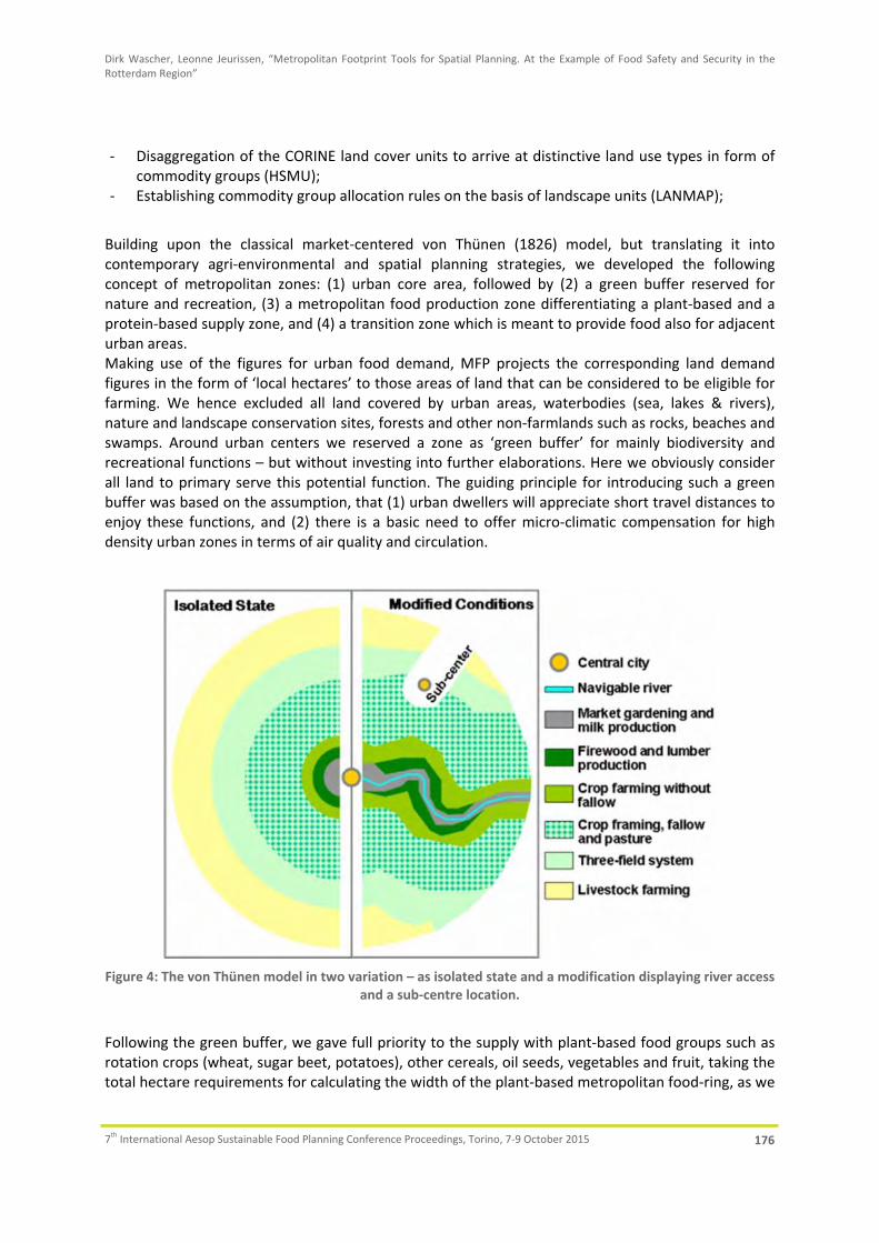
Dirk Wascher, Leonne Jeurissen, “Metropolitan Footprint Tools for Spatial Planning. At the Example of Food Safety and Security in the Rotterdam Region”
7th International Aesop Sustainable Food Planning Conference Proceedings, Torino, 7‐9 October 2015 176
‐ Disaggregation of the CORINE land cover units to arrive at distinctive land use types in form of commodity groups (HSMU);
‐ Establishing commodity group allocation rules on the basis of landscape units (LANMAP);
Building upon the classical market‐centered von Thünen (1826) model, but translating it into contemporary agri‐environmental and spatial planning strategies, we developed the following concept of metropolitan zones: (1) urban core area, followed by (2) a green buffer reserved for nature and recreation, (3) a metropolitan food production zone differentiating a plant‐based and a protein‐based supply zone, and (4) a transition zone which is meant to provide food also for adjacent urban areas. Making use of the figures for urban food demand, MFP projects the corresponding land demand figures in the form of ‘local hectares’ to those areas of land that can be considered to be eligible for farming. We hence excluded all land covered by urban areas, waterbodies (sea, lakes & rivers), nature and landscape conservation sites, forests and other non‐farmlands such as rocks, beaches and swamps. Around urban centers we reserved a zone as ‘green buffer’ for mainly biodiversity and recreational functions – but without investing into further elaborations. Here we obviously consider all land to primary serve this potential function. The guiding principle for introducing such a green buffer was based on the assumption, that (1) urban dwellers will appreciate short travel distances to enjoy these functions, and (2) there is a basic need to offer micro‐climatic compensation for high density urban zones in terms of air quality and circulation.
Figure 4: The von Thünen model in two variation – as isolated state and a modification displaying river access
and a sub‐centre location.
Following the green buffer, we gave full priority to the supply with plant‐based food groups such as rotation crops (wheat, sugar beet, potatoes), other cereals, oil seeds, vegetables and fruit, taking the total hectare requirements for calculating the width of the plant‐based metropolitan food‐ring, as we

Dirk Wascher, Leonne Jeurissen, “Metropolitan Footprint Tools for Spatial Planning. At the Example of Food Safety and Security in the Rotterdam Region”
7th International Aesop Sustainable Food Planning Conference Proceedings, Torino, 7‐9 October 2015 177
call it. This means that the amount of available farmland within this ring matches exactly the total amount for land needed for all plant‐based food groups, but that actual distribution of these food groups within this ring shows of course large deficits and surpluses, thus the type of expected imbalance we consider as an important reference when exploring potentials for optimizing the supply with regional food on the basis of the available land. Directly following the plant‐based ring, follows the protein‐based food production ring which extension corresponds exactly to the amount of hectares requires for fodder crops and dairy farming. The decision to place livestock farming at a remote position follows the need to reduce direct expose of core urban population to this sector’s impacts (health, odors, food safety issues). Figure 4 shows the von Thünen model in two variations with market gardening and milk production in the direct periphery of the central city. This corresponds in the MFP approach with the concept of the urban agriculture as part of the central core area and extensive dairy farming at the fringe and in the green buffer. Not being part of the agro‐food sector, firewood and lumber production has not been taken up in the scheme. Crop farming and three‐field system corresponds with the plant‐ based food ring, so does the location of livestock farming at the outer periphery in line with the MFP’s zoning concept. In the following we explain the step‐wise approach towards building the MFP zoning framework for Rotterdam (see Figure 5).
3.1 Green buffer
Determining the green buffer is the only step that is not driven by the ecological footprint data derived from EFSA/national data. This is because the area demand for recreation and nature experience is not considered to be directly related to matters of food consumption. At the same time research has shown that urban dwellers benefit from a certain minimum of available open green space to compensate for urban density, noise and pollution. However, technical references differ quite largely and given the fact that the urban buffer is not the only space offered preserved for nature and recreation – all existing protected areas, forests and water bodies are exempt from food planning objectives – we decided to establish a certain minimum distance as the rule of thumb: namely 50% of the urban core’s average radius between its periphery and the subsequent metropolitan food rings dominated by high agricultural production. For Rotterdam the radius of the Urban Core is 10km. For the Green Buffer half that distance – thus 5 km – has been taken. Within this Green Buffer we did not consider existing land use areas to be eligible for land use change/food group allocation plans. We did though consider to maintain existing grasslands to contribute to extensive livestock farming as in the past. Remaining areas are meant to be successively converted to extensive cultural landscapes, nature areas and recreational parks.
3.2 Metropolitan food rings (plant‐ and protein‐based)
The radii of the “Metro‐Food‐Ring veg”, the “Metro‐Food‐Ring prot” and the “Transition Zone” are calculated based on the total demand in ha for the population and the total area available for agriculture per ring. For Rotterdam the city population for the Metro‐Food‐Ring is 1.2 million and the region population for the Transition Zone is 6.6 million (see Table 3). The demand per capita can differ for different zones and for vegetable products and animal products. Table 3 shows the demands we used to calculate the rings. The total area available for agriculture is the area classified in Corine Land Cover as agricultural areas, sport and
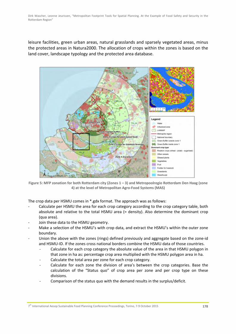
Dirk Wascher, Leonne Jeurissen, “Metropolitan Footprint Tools for Spatial Planning. At the Example of Food Safety and Security in the Rotterdam Region”
7th International Aesop Sustainable Food Planning Conference Proceedings, Torino, 7‐9 October 2015 178
leisure facilities, green urban areas, natural grasslands and sparsely vegetated areas, minus the protected areas in Natura2000. The allocation of crops within the zones is based on the land cover, landscape typology and the protected area database.
Figure 5: MFP zonation for both Rotterdam city (Zones 1 – 3) and Metropoolregio Rotterdam Den Haag (zone
4) at the level of Metropolitan Agro‐Food Systems (MAS)
The crop data per HSMU comes in *.gdx format. The approach was as follows: ‐ Calculate per HSMU the area for each crop category according to the crop category table, both
absolute and relative to the total HSMU area (= density). Also determine the dominant crop (qua area).
‐ Join these data to the HSMU geometry. ‐ Make a selection of the HSMU’s with crop data, and extract the HSMU’s within the outer zone
boundary. ‐ Union the above with the zones (rings) defined previously and aggregate based on the zone‐id
and HSMU‐ID. If the zones cross national borders combine the HSMU data of those countries. ‐ Calculate for each crop category the absolute value of the area in that HSMU polygon in
that zone in ha as: percentage crop area multiplied with the HSMU polygon area in ha. ‐ Calculate the total area per zone for each crop category. ‐ Calculate for each zone the division of area’s between the crop categories. Base the
calculation of the “Status quo” of crop area per zone and per crop type on these divisions.
‐ Comparison of the status quo with the demand results in the surplus/deficit.

Dirk Wascher, Leonne Jeurissen, “Metropolitan Footprint Tools for Spatial Planning. At the Example of Food Safety and Security in the Rotterdam Region”
7th International Aesop Sustainable Food Planning Conference Proceedings, Torino, 7‐9 October 2015 179
Table 3: Calculations for the MFP zoning distances for the City Region and OECD Region of Rotterdam.
Ring types (zones) Distance (km)
Surface area of rings (ha) Demand factor (ha/p) Population
Arable or grass
Arable Grass (includ. protected)
Arable or grass
Arable Grass‐land
surface (ha)
land use type
Rotterdam city region 1,200,000 Rotterdam OECD region 7,800,000 Urban Core 0‐10 12642Green Buffer 10‐15 25608Organic dairy in UC & GB 0‐15 38250 14,436 0.05 288,720 grass, irrespective
of protectionMetro‐Food‐Ring (plant‐based)
15‐24 68930 41,129 0.0341 1,200,000 40,920 arable, not protected
Metro‐Food‐Ring (protein‐based)
24‐40 163,445 0.178 911,280 162,208 arable and grass, not protected
Transition‐Zone 40‐150 1,402,085 0.2121 6,600,000 1,399,860 arable and grass, not protected
Required surface area (population x demand factor)
3.3 Landscape allocation rules
Since the objective is to actively change land use on the basis of ecological footprint data, there was need to ensure that the changes that are being proposed are taking into account aspects like elevation, soils and climate. For this purpose we introduced the LANMAP (Mücher et al 2006) layer to the approach which offers a European landscape classification with the above features (see Figure 6). Based on expert judgment we established allocation rules that would prevent users from implementing changes that must be considered as not suitable given the corresponding landscape type. A lookup table was created containing suitability values for LANMAP‐Corine combinations. For each combination the table provides a suitability value (‐1 unsuitable, 0, 1 suitable) for each of the seven crop types (see example in Table 4). The tool generates initial suitability values for the start crop type situation. As soon as a new crop is ‘painted’ to one or several grid cells within the study area, the tool utilizes the lookup table to grab the suitability value of this new crop type on the basis of the background layers for land use, HSMU, etc.
Table 4: Landscape allocation rules for the Rotterdam region.
LANMAP CORINE WhPoSu OthCer Oils Fodd Veget Fruit Grass GTB
Atlantic lowlands on organic materials with pastures (Alo_pa)12 Non‐irrigated arable land ‐1 ‐1 0 0 ‐1 ‐1 1 ‐118 Pastures ‐1 ‐1 ‐1 0 ‐1 ‐1 1 ‐1
Atlantic lowland sediments with arable land (Als_al)12 Non‐irrigated arable land 0 0 0 0 0 0 1 ‐118 Pastures ‐1 ‐1 ‐1 ‐1 ‐1 ‐1 1 ‐120 Complex cultivation patterns 0 0 1 0 1 1 1 0
888 Glastuinbouw ‐1 ‐1 ‐1 ‐1 ‐1 ‐1 1Atlantic lowland sediments with hetrogenous agri (Als_ha)
12 Non‐irrigated arable land 1 1 1 1 1 1 1 120 Complex cultivation patterns 1 1 1 1 1 1 1 1
Atlantic lowland sediments with pastures (Als_pa)12 Non‐irrigated arable land ‐1 ‐1 ‐1 0 0 0 1 018 Pastures ‐1 ‐1 ‐1 ‐1 ‐1 ‐1 1 0
Atlantic lowland sediments with water bodies (Als_wa)12 Non‐irrigated arable land ‐1 ‐1 ‐1 ‐1 ‐1 ‐1 1 ‐1

Dirk Wascher, Leonne Jeurissen, “Metropolitan Footprint Tools for Spatial Planning. At the Example of Food Safety and Security in the Rotterdam Region”
7th International Aesop Sustainable Food Planning Conference Proceedings, Torino, 7‐9 October 2015 180
The abovementioned check is performed for all crop types. A ‘suitability’ layer is generated for each crop type. Each of these seven layers generated contains the selection of grid cells marked as ‘suitable’ according to the check for a given crop type. Such grid cells are highlighted by way of colouring the outlines with the same colour used to code crop types. The result is a layer with outlines that can be overlaid on the drawing layer to visualize high suitability on top of dominant crops. Each of these can be toggled on and off whenever the focus is given to a particular crop type.
Figure 6: Boundaries and codes of the LANDMAP units for the Rotterdam region.
Figure 7: Demand‐Supply analysis for 8 food groups of the Metropolitan Food Zone 2 (crops for plant‐based
food) for 1.2 million people (in hectares)
4. Tool results from Rotterdam
Zone 2 (Figure 7) is between 15 and 24 km distance from the city centre and can be entirely dedicated to producing crops for plant‐based food: all the consumption needs arising from the 1.2

Dirk Wascher, Leonne Jeurissen, “Metropolitan Footprint Tools for Spatial Planning. At the Example of Food Safety and Security in the Rotterdam Region”
7th International Aesop Sustainable Food Planning Conference Proceedings, Torino, 7‐9 October 2015 181
million Rotterdam people can theoretically be satisfied within this zone. However, Figure 7 shows that the current land use is still focusing strongly on livestock farming and that there are clear deficits fruit (15.000 ha missing) and slight deficits for rotation crops, other cereals and oilseed plants. Exceptional, certainly when comparing to other European metropoles, is the major surplus for vegetables (more than 3000 ha). This can be explained with the presence of the extensive areas of Dutch glasshouse production in Westland and Oostland (see Figure 7). Today this production is dedicated to 90% for food export and is strongly dominated by a few lead crops such as tomatoes, zucchini and bell paprika. Zone 3 (Figure 8) follows between 24 and 40 km distance from the city centre. According to our scheme, this zone is entirely dedicated to crops supporting the city’s demand for livestock such as dairy and meat products. Given the resource intensity of animal‐based food products it is not surprising that this zone requires a surface area four times as large as the one for plant‐based food products in Zone 2: more than 160.000ha. In this zone the largest deficit is for fodder crops (almost 100.000 ha). Today these fodder crops are being imported from more remote Dutch locations and of course in the form of soya feedstuff from oversee amounting to about 20% of the total (van Gelder and Herder 2012). On the other hand we see a clear surplus of grassland production for dairy farming. In terms of the zones diameter (16km) it should be kept in mind that this is also a consequence of the city’s location close to the North Sea where no land‐based food production is possible.
Figures 8: Demand‐Supply analysis for 8 food groups of the Metropolitan Food Zone 3 (crops for livestock
farming) for 1.2 million people (in hectares)
Zone 4 (Figure 9) spans over a distance from 40km to 150km measures from the city centre. This means that the Transition zone spans well into Belgium and Germany. Applying the OECD scheme as a reference (7.8 million people) means that such a region covers almost half of amount of the total Dutch population (16 million). Also here it is important to acknowledge the fact that the sea‐side location of this region almost doubles the distance of the zone towards the inland. Even so, the large area demands in terms of local hectares (almost 1.4 million) demonstrates the realities of densely populated regions here and elsewhere in the world. In terms of the demand‐supply relationship, the

Dirk Wascher, Leonne Jeurissen, “Metropolitan Footprint Tools for Spatial Planning. At the Example of Food Safety and Security in the Rotterdam Region”
7th International Aesop Sustainable Food Planning Conference Proceedings, Torino, 7‐9 October 2015 182
transition zone mirrors the situation of Zone 3: the biggest deficit is for fodder crops required for livestock farming.
Figure 9: Demand‐Supply analysis for 8 food groups of crops in Zone 4 (Transition) providing crops for plant‐
based food and livestock farming for 6.6 million people of the OECD region (in hectares)
The MFP out presented in figure 5 to 8 are not only meant as assessment results for framing the impact of urban food production on the different metropolitan zones, but are also providing operational input to a stakeholder‐oriented foodscape‐planning device. For this purpose we introduce the data into the so‐called ‘digital maptable’ which allows users to perform land use allocations by means of a digital pen. Addressing the surplus/demand figures resulting from the assessment, users can than make proposals for where and how to change the existing land use (food crops) in order to more properly meet the demands identified by the tool. Please see for further illustrations of the maptable approach Wascher et al., 2015.
5. Conclusions and Recommendations
Tools have been developed to assess food security and food safety at local and metropolitan regions. These tools showed that, depending on the region, areas can be self‐ sufficient. However, more densely populated areas limit the possibilities for metropolitan food supply. Spatial planning of activities should take various aspects, such as food safety, into account. The food safety questionnaire proved to be successful in pinpointing critical areas that need further attention to improve food safety at the local level.
Recommendations Food Safety:
‐ Introduce spatial planning modules as a pre‐cautionary food safety principle according to which food chain operations are managed within clearly defined zones.
‐ Increase the resource efficiency of food system operations within dedicated regional zones that separate livestock farming from vegetable production.

Dirk Wascher, Leonne Jeurissen, “Metropolitan Footprint Tools for Spatial Planning. At the Example of Food Safety and Security in the Rotterdam Region”
7th International Aesop Sustainable Food Planning Conference Proceedings, Torino, 7‐9 October 2015 183
‐ Make use of tools developed within the project (Sustainability Impact Assessment & Metropolitan Footprint Tools) to support policy makers in establishing optimal spatial planning of metropolitan food production.
‐ A food safety questionnaire derived in the project can be used by actors within the food supply to assess possible critical points for food safety and quality.
‐ Enable more research into the food safety consequences of a transition from global to metropolitan or local food production.
Recommendations Food Security: ‐ Integrate the notion of metropolitan regions into Rural Development programmes and funding
schemes. It is crucial to achieve a common understanding on how metropolitan regions are triggers for sustainable development in rural regions, and that funding instruments and rules require appropriate consideration in territorial eligibility settings.
‐ Provide incentives and financial support for the agro‐food sector where system innovation including aspects of governance and social embedding are properly addressed at the level of metropolitan food sheds.
‐ Establish European Cross‐border Partnerships between policy makers, spatial planners and entrepreneurs to share experiences and to build up cross‐border food shed activities for metropolitan regions.
‐ Make RIS 3 (Regional Innovation Strategies of Smart Specialization) an approach to develop metropolitan innovation strategies targeting at Agrofood clusters that act as technological, infrastructural and economical hubs.
‐ Use footprint assessment tools in knowledge brokerage session to raise the awareness regarding impacts of urban food consumption;
‐ Monitor and report on innovation impacts on the ecological footprints at the level of metropolitan regions metropolitan regions at a regular base.
The Metropolitan Foodscape Planner (MFP) offers (1) hands‐on impact assessment tool for balancing commodity surpluses and deficits, (2) a visual interface that depicts food zones to make impacts spatially explicit, (3) landscape‐ecological allocation rules to base land use decisions on sustainable principles, and (4) European data such as EFSA, LANMAP, HSMU and CORINE Land Cover to allow future top‐down tool applications for all metropolitan regions throughout the EU. Though less accurate as the national land use survey data, HSMU is available for the whole of Europe, allowing direct top‐down assessments without resource‐consuming data gathering procedures. The concept of spatially allocating specific food groups for which a certain supply deficit has been recognised – e.g. vegetables or oil seeds are typically underrepresented in the metropolitan surroundings of cities – to areas with clear food supply surplus coverage, for example grasslands, points at the need to guide such stakeholder decisions by offering additional land use related references. We are aware that introducing clear spatial demarcations for different food groups in the forms of zones is drastically contrasting with the everyday situation in our current metropolitan regions. In order to provide further guidance during this process, MFP offers the spatial references of the European Landscape Typology (LANMAP) to ensure that stakeholders receive ‘alert’ messages if their changes they propose are in conflict with the allocation rules laid down as part of the landscape‐ ecological references. Both the MFP‐zoning concept and the LANMAP‐

Dirk Wascher, Leonne Jeurissen, “Metropolitan Footprint Tools for Spatial Planning. At the Example of Food Safety and Security in the Rotterdam Region”
7th International Aesop Sustainable Food Planning Conference Proceedings, Torino, 7‐9 October 2015 184
based allocation rules are in principle open to stakeholder revisions. This way, a high level of tool transparency and flexibility can be achieved – the basis for gaining trust and ownership throughout the process.
6. References:
Briggs, J., 2011. The EUREAPA Technical Report. Stockholm Environment Institute, University of York. UK. One Planet Economy Network, 38 pages
CEC, 2009. Mainstreaming sustainable development into EU policies: Review of the European Union Strategy for Sustainable Development. , Communication of the European Community, Brussels, COM(2009) 400 final, 16 pages
CEC, 2008. Potential of the Ecological Footprint for monitoring environmental impacts from natural resource use: Analysis of the potential of the Ecological Footprint and related assessment tools for use in the EU’s Thematic Strategy on the Sustainable Use of Natural Resources. Report to the European Commission, DG Environment.
CEG, 2012. Health policy in consideration of good care for animals and environment ‐ With a select ion of three essays. Ethics en Heal th Monitoring 2012. Centre for Ethics and Health of the Netherlands. 32 pages.
EFSA, 2011. Chronic food consumption statistics. Avaialble at http://www.efsa.europa.eu/en/datexfoodcdb/datexfooddb.htm
Ercsey‐Ravasz, M., Toroczkai, Z., Lakner, Z., and Baranyi, J., 2012. Complexity of the International Agro‐Food Trade Network and Its Impact on Food Safety. PLoS ONE 7, e37810.
Kempen, M., 2012. EU wide analysis of the Common Agricultural Policy using spatially disaggregated data. Doctoral Thesis, Rheinischen Friedrich‐Wilhelms‐Universität Bonn, 96 pp.
Kirsimaa, K., 2013. Urban farming in Rotterdam: an opportunity for sustainable phosphorus management? An approach for linking urban household waste management with urban farming. Paper written in contribution to an MSc Internship Land Use Planning (LUP‐70424), Wageningen University, 76 pages
Mücher, C.A., Wascher, D.M., Klijn, J.A.,. Koomen, A.J.M, Jongman, R.H.G., 2006. A new European Landscape Map as an integrative framework for landscape character assessment. R.G.H. Bunce and R.H.G. Jongman (Eds) Landscape Ecology in the Mediterranean: inside and outside approaches. Proceedings of the European IALE Conference 29 March – 2 April 2005 Faro, Portugal. IALE Publication Series 3, 233‐243.
Van Gelder J and Herder A., 2012. Sojabarometer 2012 [Soya barometer 2012 (in Dutch)], Amsterdam: Profundo.
Von Thünen, J.H., 1826. The Isolated State. (English translation by Carla M. Wartenberg, with an introduction by the editor), Pergamon Press. 1966
Wascher, D.M., Kneadsey, M. and Pintar, M. (eds), 2015. FoodMetres ‐ Food Planning and Innovation for Sustainable Metropolitan Regions. Preliminary Report 2015. Wageningen, 44 pages

Bruno Monardo, Anna Laura Palazzo, “Healthy Works. Food System and Land Use Planning in San Diego Region”, In: Localizing urban food strategies. Farming cities and performing rurality. 7th International Aesop Sustainable Food Planning Conference Proceedings, Torino, 7‐9 October 2015, edited by Giuseppe Cinà and Egidio Dansero, Torino, Politecnico di Torino, 2015, pp 185‐198. ISBN 978‐88‐8202‐060‐6
185
HEALTHY WORKS. FOOD AND LAND USE PLANNING IN SAN DIEGO REGION∗
Bruno Monardo1, Anna Laura Palazzo2 Keywords: Healthy food policies, Land use planning, Urban Agriculture
Abstract: Across the US, where ‘food deserts’ heavily shape access to fresh, local and healthy food, institutions, NGOs and private citizens are committed to designing and implementing measures aimed at getting a greater control over the food daily supplied to million people. This paper will focus on the case study of the San Diego Region (CA), where the goals of ‘a sustainable, secure and resilient food system’ addressed by an array of instruments ranging from food policies to land use tools and municipal and zoning codes are mobilizing from the very beginning community at large: producers, brokers, consumers. The account is twofold. On the one hand, it aims to highlight a sort of ‘value chain’ within the approach in linking traditionally separate issues, on the other hand, it prompts for new meanings and uses for vacant land, that can result in a strategically planned and delivered green infrastructure comprising the broadest range of open spaces and other environmental features.
1. Food concerns across the US. The institutional framework and beyond On the backdrop of the latest general policies addressing local food issues in the US, this paper aims to explore the experience of San Diego County and San Diego City, where for over a decade now, several influential non‐governmental organizations have been lobbying for framing the food issue within a comprehensive range of guidelines, policies and plans. A main focus will be devoted to the match (or mismatch) between the claim for food supplies reasonably next to communities and planning and design strategies tackling urban agriculture at large, notably within vacant and derelict urban areas. The movement to create a healthier food and agriculture policy has been slowly and steadily gaining ground across the US, thanks to seminal work of an array of non‐governmental bodies experiencing common paths towards more sustainable lifestyles. Food concerns, even related to the highest rates of overweight and obesity held by the US among the industrialized nations (over one third of US adults are obese), couple with a widespread stand for food democracy: food justice and social inclusion, along with individual freedoms and citizenship, are at stake within the march for the human rights. Statements of principle do matter (Neff, 2014), still public opinion is far more concerned about everyday perspectives and solutions. It has been calculated that the average food item in the US travels between 1,500 and 2,500 miles from farm to fork (Mansvelt, 2011), whereas around 40% of food produced on US farms is not consumed (San Diego County, 2012). The growing consensus around ‘local’, rather than ‘sustainable’ or ‘organic’ food, is witnessed by more than three quarters of American consumers actively seeking out and buying products they perceive to be local (Feagan, ∗ This paper is related to the dissemination of the EU research project ‘MAPS‐LED’ (Multidisciplinary Approach to Plan
Specialization Strategies for Local Economic Development), Horizon 2020, Marie Sklodowska‐Curie RISE, 2015‐2019. The program implementation is based on networking universities from EU (Mediterranea Reggio Calabria, “Sapienza” Roma, Aalto Helsinki, Salford Manchester) and USA (Northeastern University Boston, San Diego State University). 1 ‘Sapienza’ University of Rome. 2 ‘Roma Tre’ University of Rome.
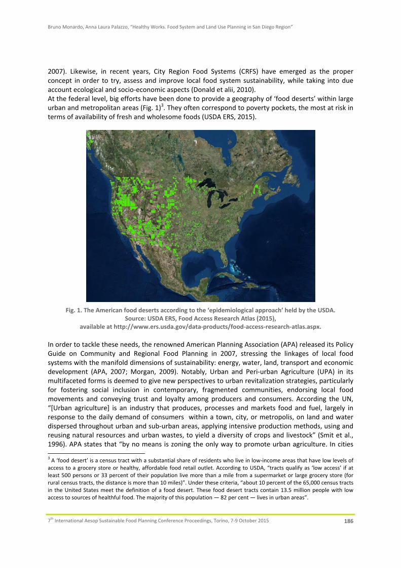
Bruno Monardo, Anna Laura Palazzo, “Healthy Works. Food System and Land Use Planning in San Diego Region”
7th International Aesop Sustainable Food Planning Conference Proceedings, Torino, 7‐9 October 2015 186
2007). Likewise, in recent years, City Region Food Systems (CRFS) have emerged as the proper concept in order to try, assess and improve local food system sustainability, while taking into due account ecological and socio‐economic aspects (Donald et alii, 2010). At the federal level, big efforts have been done to provide a geography of ‘food deserts’ within large urban and metropolitan areas (Fig. 1)3. They often correspond to poverty pockets, the most at risk in terms of availability of fresh and wholesome foods (USDA ERS, 2015).
Fig. 1. The American food deserts according to the ‘epidemiological approach’ held by the USDA.
Source: USDA ERS, Food Access Research Atlas (2015), available at http://www.ers.usda.gov/data‐products/food‐access‐research‐atlas.aspx.
In order to tackle these needs, the renowned American Planning Association (APA) released its Policy Guide on Community and Regional Food Planning in 2007, stressing the linkages of local food systems with the manifold dimensions of sustainability: energy, water, land, transport and economic development (APA, 2007; Morgan, 2009). Notably, Urban and Peri‐urban Agriculture (UPA) in its multifaceted forms is deemed to give new perspectives to urban revitalization strategies, particularly for fostering social inclusion in contemporary, fragmented communities, endorsing local food movements and conveying trust and loyalty among producers and consumers. According the UN, “[Urban agriculture] is an industry that produces, processes and markets food and fuel, largely in response to the daily demand of consumers within a town, city, or metropolis, on land and water dispersed throughout urban and sub‐urban areas, applying intensive production methods, using and reusing natural resources and urban wastes, to yield a diversity of crops and livestock” (Smit et al., 1996). APA states that “by no means is zoning the only way to promote urban agriculture. In cities 3 A ‘food desert’ is a census tract with a substantial share of residents who live in low‐income areas that have low levels of access to a grocery store or healthy, affordable food retail outlet. According to USDA, “tracts qualify as ‘low access’ if at least 500 persons or 33 percent of their population live more than a mile from a supermarket or large grocery store (for rural census tracts, the distance is more than 10 miles)”. Under these criteria, “about 10 percent of the 65,000 census tracts in the United States meet the definition of a food desert. These food desert tracts contain 13.5 million people with low access to sources of healthful food. The majority of this population — 82 per cent — lives in urban areas”.

Bruno Monardo, Anna Laura Palazzo, “Healthy Works. Food System and Land Use Planning in San Diego Region”
7th International Aesop Sustainable Food Planning Conference Proceedings, Torino, 7‐9 October 2015 187
that have ambitions to rapidly expand urban agricultural opportunities, it may be necessary to make land and funding available. In many cases, the demand for urban agriculture, such as community garden plots, is not nearly being met” (APA, 2010). To sum up, the American way to address agriculture and related labor, food costs, food quality issues, stays in a set of federal, national and local level policies involving public bodies along with nongovernmental organizations such as community groups, producers’ representatives, businesses and land trusts. In the last few years, an increasing number of local bodies (to date some 200) have been provided with Food Policy Councils (Fig. 2), in order to manage food matters at large (APA, 2010). In the next sections, we will go deeper into significant experiences at regional and city level addressed by an array of instruments ranging from food policies to land use tools and zoning codes mobilizing from the very beginning the community at large.
Fig. 2. Urban strategies and food policy councils.
Source: http://www.jhsph.edu/research/centers‐and‐institutes/johns‐hopkins‐center‐for‐a‐livable‐future/projects/FPN/directory/index.html
2. Integrating the local food system in Regional Plans. The experience of Chicago
Among the most virtuous and innovative strategies, tools and practices carried on across the country, land inventories, such as the ones conducted in Portland and Detroit, are being employed by municipal governments to support Urban and Peri‐urban Agriculture (UPA) projects. In the past four years large cities including Atlanta, Boston, Minneapolis, Portland revised policies and zoning ordinances to accommodate changing land‐use patterns. Non‐profit organizations and municipal governments in many cities across US have also begun creating food policy councils, which often include items for strengthening UPA. As pointed out by the last American Planning Association report on these topics (APA, 2012), UPA continues to grow as a planning priority and several Counties are including its strategies in their Comprehensive Plans. As already mentioned, the issue of local food is often defined by strategies dealing with UPA and specific connected initiatives as farmers’ markets, community gardens, animal husbandry, commercial kitchens, culinary art training centers, ethnic grocery stores and restaurants, connected

Bruno Monardo, Anna Laura Palazzo, “Healthy Works. Food System and Land Use Planning in San Diego Region”
7th International Aesop Sustainable Food Planning Conference Proceedings, Torino, 7‐9 October 2015 188
peri‐urban agri‐farms, and so on. These activities are important, but they represent only some aspects of the larger ‘Local Food System’ issue. A Local Food System is more than the physical produce and includes the land the food grows on, processing, packaging, distribution, market creation, retail and waste management (Fig. 3). The decision of including the dimension of Local Food System in a Comprehensive Regional Plan usually stems from a combination of factors. There may be support from community stakeholders, an explicit endorsement triggered either by the general interest or the prioritization of specific community issues, such as lack of access to healthy nutritious food. Sometimes interest in local food may be generated from municipal policy makers, who may be committed to pursue local food strategies as a means to achieve other primary goals such as economic development, land preservation and community identity. In the Chicago Region case, during the Comprehensive Plan building process, issues surrounding local nutrition, such as healthy food access and the environmental impacts of eating choices, exerted a great influence on the main strategies to be followed by the community. Based on this feedback, the Chicago Metropolitan Agency of Planning (CMAP) elevated the ‘Local Food System’ to one of core keys in the Chicago Comprehensive Regional Plan “Go to 2040. Invent the Future”, one of the most significant regional tools in the last years in US. The recommendations of Chicago Plan reflect the breadth of challenges and opportunities that the Region faces, but also provide specific, implementable actions to address them. Responding to the critical issues of the Region, the plan offers recommendations identifying four great themes (Livable Communities, Human Capital, Efficient Governance, Regional Mobility) that are structured through twelve axes as a whole. The ‘Local Food’ one, belonging to the first theme (Livable Communities) is strongly related to the other items of the general strategy and particularly to the environmental and anthropic issues (water management, ecosystem preservation, land‐use and density pattern, mobility networks and transportation systems). In order to identify the benefits the community aims to achieve by including ‘Local Food’ in regional strategy, the Plan rationale argues on issues why it has become a priority.
Fig. 3. Scheme of the Food System Cycle. Source: San Francisco Planning Urban Research Association (SPUR, 2013)
Chicago's Comprehensive Plan calls to strengthen the regional food systems. If local food production were increased in the seven counties of metropolitan Chicago, it could create over 5,000 jobs and generate $6.5 billion a year in economic activity. Over the last fifteen years, regional demand for

Bruno Monardo, Anna Laura Palazzo, “Healthy Works. Food System and Land Use Planning in San Diego Region”
7th International Aesop Sustainable Food Planning Conference Proceedings, Torino, 7‐9 October 2015 189
local food has grown 260 percent, and recent surveys show that three‐quarters of Americans care that their food is grown locally. By producing more of the food consumed locally, it keeps money in the region, supports local businesses, strengthens communities, and delivers delicious, fresh produce to eat. Local food systems offer many economic, environmental, and quality‐of‐life benefits that apply to businesses, residents, and the Chicago urban region as a whole. As consumers, individuals benefit from having more opportunities to buy fresh produce to cook at home or eat at restaurants, tackling ‘food deserts’. Local entrepreneurs benefit from increased business opportunities. Local communities benefit from stronger, more diverse local economies where they grow and buy their food from a local farmer, which increases farm income and jobs and circulates money within the same Region and State, rather than sending it elsewhere. In fact, fruit and vegetable production has the potential to generate three to seven times more jobs and farm income than corn and soybean production. Highly valuing Chicago rich agricultural land for its potential to feed, UPA can also exert preservation of the existing farmland, joining as well the rural character that some of residents prefer, more economically viable. The amount of agricultural land and the size of farms in northeastern Illinois are shrinking due to urban growth and development, but the number of smaller farming operations is on the rise. A shift towards food production could help address a number of challenges that the region's agricultural system faces. Commodity crop production typically requires large acreages and expensive inputs and equipment, presenting barriers to entry for most people interested in farming. Because over 90% of food consumed in Illinois is produced elsewhere, food purchases support jobs and economies where the food is produced and processed remotely rather than in Illinois, where much of food demand could be met. The Chicago region and surrounding counties are well‐positioned to meet the demand for local food because the majority of the direct‐to‐consumer supply comes from metropolitan areas and collar counties. Farms across the nation earned $1.3 billion from direct sales in 2012. By supporting and strengthening the ‘Local Food System’, northeastern Illinois is poised to tap into this economic potential. Challenges remain, however, and the Plan delivers a significant role for local governments for: ‐ providing access to land, facilities and infrastructure to give farmers, distributors, and food
entrepreneurs a chance to become established; ‐ adopting or modifying policies and standards to encourage local food operations and to reduce
the cost and uncertainty of projects; ‐ encouraging the market, innovation, businesses, and entrepreneurs through policies such as
local food procurement targets for schools, workforce development opportunities, and hunger assistance programs;
‐ supporting and participating in forum to discuss and address ‘Local Food System’ issues, to coordinate policy initiatives, programs, events and to connect buyers and sellers.
3. The San Diego County Agenda on local food
California is long since well placed in the battle for healthy food. ‘Roots of Change’, a San Francisco‐based non‐profit organization, released the homonymous report in 2001 commissioned by the Columbia, Clarence E. Heller Charitable and W.K. Kellogg foundations (Roots of Change, 2001). Its core concept, developed in ‘The New Mainstream: A Sustainable Food Agenda for California’ (2005), was strategically decisive in shifting the State’s goals related to food and agriculture by providing new values and principles into production and distribution practices, government policies and

Bruno Monardo, Anna Laura Palazzo, “Healthy Works. Food System and Land Use Planning in San Diego Region”
7th International Aesop Sustainable Food Planning Conference Proceedings, Torino, 7‐9 October 2015 190
business models. As a result, the ‘California Food Policy Council’ (CAFPC) was established as a collaborative of local food policy groups working to ensure that California’s food system address relevant policy priorities, generate public support for those policies, educate policymakers on food system issues, and advocate for change in California. The CAFPC, currently collecting 26 ratified members representing local communities across the State, strives to bring transparency to food systems legislation, and to re‐envision a political process that includes a more diverse range of food and farming interests to the table. The ‘Declaration for Healthy Food and Agriculture’ (2008), was a further step endorsed by a broad base of organizations and thousands of individuals with a long‐established commitment to a healthier food and agriculture. A major critical issue lies in translating these principles into land use regulation policies: as a matter of fact, despite State standards4 and retention policies carried out by several counties and cities, farmland conservation programs have been only marginally effective. Major efforts were in the direction of regulating the allowable residential density in suburban and rural areas, depending on soil fertility. A by far wider range of perspectives is met by San Diego County that released the ‘San Diego County Farming Program Plan’ (2009), the Strategic Plan ‘Healthy Works. San Diego Regional Healthy Food System’ (2012) and the ‘County General Plan’ (2011). Such challenging array of tools address food regional systems in a place‐based perspective, tackling land use policies. Despite large tracts of rocky and stony soil and serious water shortage, San Diego County boasts of sound agricultural economy with more than 5 Billion dollars annual impact and praises itself on having the highest proportion of small scale growers in the State and the largest number of certified organic growers of any California County5. It ranks first in the US for its proportion of farmers with off‐farm income, witnessing for a peculiar lifestyle that will probably be winning in the long run (Fig. 4). Yet, almost all food grown in San Diego County is exported beyond its borders, whereas about 95% of the food locally consumed comes from outside its boundaries. Furthermore, the vast majority of farming operations by volume are dedicated to only a few crops, among which avocados and citrus take up 70% of all land area dedicated to farming. Nonfood crops, such as flowers, ornamental plants, and turf, make up for two‐thirds of annual agricultural value. These figures account for the larger economic return that ornamental and nursery crops, largely offsetting the high water costs, provide in comparison to other agriculture commodities. The ‘Farming Program Plan’ takes over two primary goals: promote economically viable farming in Unincorporated San Diego County6, and encourage land use policies and programs that recognize the value of working to regional conservation efforts. A majority of the unincorporated County’s land, in excess of 90 percent, is either open space or undeveloped, including several large federal, state, and regional parklands that encompass much of the eastern portion of the County. As a matter of fact, unsustainably high water rates failing to differentiate between residential, commercial or agricultural uses are putting at risk farmland in cultivation, driving farmers out of 4 The California Environment Quality Act requires lead agencies to evaluate whether a proposed project may have adverse effect on the environment and, if so, if that effect can be reduced or eliminated by pursuing an alternative course of action or through mitigation. Projects subject to review under CEQA include the development of vacant land into residential, commercial or agricultural uses or the conversion of agricultural land to residential or commercial uses and potential impacts that could result from a project on environmental resources such as farmland, natural habitat, archaeological sites. 5 In the US, small farms are defined in terms of their gross revenues: the farms with less than 250 thousand dollars are considered small (USDA, 2007). The average size of a farm in California is equal to 126.6 hectares (313 acres), while in Europe the average size is 12.6 acres and Italy is only 7.9 hectares. 6 An unincorporated area is a region of land that is not governed by its own local municipal corporation, but rather is administered as part of larger administrative divisions, such as township, parish, borough, county, city, canton, state, province or country. The unincorporated land encompasses 2,600 sq. miles, that is around 57% of the surface area of San Diego County.

Bruno Monardo, Anna Laura Palazzo, “Healthy Works. Food System and Land Use Planning in San Diego Region”
7th International Aesop Sustainable Food Planning Conference Proceedings, Torino, 7‐9 October 2015 191
farming, and limiting any potential increase in the supply of local food. A major result, strongly backed by the San Diego County Farm Bureau representing farmers, growers, and producers, would be to lower water rates for agriculture to a more sustainable cost ($900 per acre‐foot) by 20157. Subsequent ‘Healthy Works. San Diego Regional Healthy Food System’, was enforced following the newly‐established San Diego Urban‐Rural Roundtable collecting over 100 leaders and stakeholders from around the San Diego region to develop a set of recommendations aimed at building a healthy, fair, economically thriving, and environmentally sustainable food system. ‘Healthy works’ plays a major role, focusing on several objectives on a regional scale, examining the barriers and analyzing the opportunities to meet an increasing demand for high quality local food by providing daily consumers with healthy and fresh produce.
Fig. 4. Farmland in San Diego County is proximate to –even integrated with– urban land.
Source: San Diego County, Health and Human Services Agency, 2012. Healthy Works San Diego Regional Healthy Food System, Strategic Plan.
In turn, the San Diego General Plan (2011) reflects the County’s commitment to a sustainable growth model that facilitates efficient development near infrastructure and services, while respecting sensitive natural resources and protection of existing community character in its extensive rural and semi‐rural communities8. The General Plan, tackling seven state‐mandated topical areas ‐ Land Use, Mobility, Housing, Safety, Conservation, Open Space, and Noise ‐, is specifically in charge of unincorporated areas, providing a renewed basis for the County’s diverse communities to develop Community Plans that are specific to and reflective of their unique character and environment consistent with the County’s vision for its future. Due to water scarcity, the majority of new development—approximately 80 percent—is planned in the County’s western areas within the County Water Authority (CWA) boundary. The overall philosophy of the General Plan is to promote the wise use of the land resources including encouraging urban growth to be contiguous with existing urban areas and maximizing urban infill
7 Established in 1913, the San Diego County Farm (part of the network of the Bureau California Farm Bureau Federation) represents San Diego agriculture through public relations, education, and public policy advocacy in order to promote the economic viability of agriculture balanced with appropriate management of natural resources. 8 A major concern is related to significant reduction in farmland in San Diego County from nearly 530,000 acres in 1987 to 304,000 in 2007, depending on the rising cost of water coupled with development pressure.

Bruno Monardo, Anna Laura Palazzo, “Healthy Works. Food System and Land Use Planning in San Diego Region”
7th International Aesop Sustainable Food Planning Conference Proceedings, Torino, 7‐9 October 2015 192
while also encouraging agricultural use and retaining the natural character of non‐urban lands. Consequently, the so‐called Community Development Model is to be implemented by three regional categories – Village, Semi‐Rural and Rural Lands – that broadly reflect the different character and land use development goals, reported in the document. As a broad set of development classifications, these regional categories do not specify allowable land uses, but rather the regional structure, character, scale and intensity of development (Fig. 5). Within this frame, the Land Use Designations are defined by the land use type and the maximum allowable residential density or nonresidential building intensity.
Fig. 5. Regional categories map. Chapter 3. Land use element Available at: www.sandiegocounty.gov/pds/generalplan.html
Settlement patterns for community development in the unincorporated areas are based on a physical structure defining communities by a ‘village center’ surrounded by semirural or rural land. In communities inside the CWA boundary, higher density neighborhoods and a pedestrian oriented commercial center would provide a focal point for commercial and civic life. Medium density, single family neighborhoods, as well as a broad range of commercial or industrial uses, would surround the commercial core. As for semirural neighborhoods surrounded by greenbelts, agricultural uses, or other rural lands would be located outside the more urbanized portion of the communities (Fig. 6). Site design methods that reduce on‐site infrastructure costs and preserve contiguous open space or agricultural operations are encouraged. The Rural Lands category is applied to large open space and very‐low‐density private and publicly owned lands that provide for agriculture, managed resource

Bruno Monardo, Anna Laura Palazzo, “Healthy Works. Food System and Land Use Planning in San Diego Region”
7th International Aesop Sustainable Food Planning Conference Proceedings, Torino, 7‐9 October 2015 193
production, conservation, and recreation and thereby retain the rural character for which much of unincorporated County is known. The County’s rural character is to preserve by retaining and protecting farming and agricultural resources, while supporting long‐term presence and viability of agricultural industry as an important component of the region’s economy and open space linkage. As for open spaces, they are split between managed open space and functional open space (Fig. 7). The latter comprises agricultural lands (grazing, orchards, vineyards, and other crops), scenic corridors, and areas of steep terrain). Conservation is primarily applied to large tracts of land, undeveloped and usually dedicated to open space, that are owned by a jurisdiction, public agency, or conservancy group. Allowed uses include habitat preserves, passive recreation, and reservoirs. Recreation, applied to large existing recreational areas, allows for active and passive recreational uses such as parks, athletic fields, and golf courses. Forest conservation Initiative Lands applies where land use designations are addressed by specific policies. The County has funded a voluntary pilot program for purchasing agricultural easements, in order to promote long‐term preservation of agriculture (a Purchase of Development Rights). Interest in this program on the part of farmers and land owners has been very high. Funding is eligible in case the property actively farmed or ranched for a minimum of two years prior to applying for the program, and/or realized a density reduction as a result of the General Plan.
Figs. 6/7. San Diego County General Plan. Julian Rural Village Boundary (left) and Julian Community Plan Open Space. Available at: www.sandiegocounty.gov/pds/generalplan.html
In turn, the City of San Diego amended its zoning code (2012) by enhancing the ‘zero food miles’ approach. Specific goals were introduced in order to increase opportunities for urban agriculture, seen as a powerful tool for urban regeneration and social inclusion, namely for immigrants and refugee groups from Somalia, Vietnam, Cambodia, who tend to prefer food from their own culture by accommodating urban agriculture and urban farming in vacant lands (Monardo, Palazzo, 2014).
4. Natural resources, vacant land, sustainable mobility: building a healthy network
In 1974 Kevin Lynch and Donald Appleyard were commissioned by the Marston family a scientific report on San Diego area, whose title (‘Temporary Paradise?’) emblematically focused on the extraordinary ‘Mediterranean’ climate and the environmental quality and vulnerability, suggesting

Bruno Monardo, Anna Laura Palazzo, “Healthy Works. Food System and Land Use Planning in San Diego Region”
7th International Aesop Sustainable Food Planning Conference Proceedings, Torino, 7‐9 October 2015 194
‘ex ante sustainable’ future visions for the city. The report was divided into two parts: an analysis of the regional landscape (Fig. 8) and a technical appendix (An environmental planning process for San Diego) that “recommends the organizational means, and the assignment of functions required to carry on a continuous process for planning for environmental quality in the region”. However, many recommendations did not come true: after more than 40 years it is evident that the soil consumption and the urban sprawl phenomenon has not been prevented, as well as the transit network has not been developed and coordinated with the land use design. The huge Mission Valley and other valleys in the core urban area have been massively urbanized: shopping malls, business activities and housing enclaves have been built within the downtown and the weak ring of few tramway lines (locally known as ‘Trolley’). Nowadays, impressive canyons still rhythmically crisscross all the territory and the grid of urban fabric is fragmented on the edges of the canyon layout; mobility is mainly based on private automobiles and the major valley bottoms are crossed by urban freeways.
Fig. 8. The core of San Diego urban region according to the interpretation by Lynch & Appleyard
Source: Lynch, K., Appleyard, D., 1974, Temporary Paradise? The rationality of the infrastructure network, together with the comfortable freeway and ordinary road section, encourage the private mobility with limited traffic bottlenecks. Basically, car users can choose at every node whether using the main local boulevards or avenues (at a reduced speed because of the many traffic lights), or a longer path on the major axes. Nevertheless, given the relevant potential of territory assets, the peculiar combination of geomorphology and urban imprinting allows focusing on the conception and possible implementation of an outstanding infrastructural/environmental network. This could be achieved preserving the incredibly rich canyon system, particularly in the most natural parts, utilizing their edges as ecological corridors. In many places the lush and attractive natural areas around and between the infrastructural ribbons offer intriguing opportunities for creating local green systems and leisure areas. The canyon network is undoubtedly the most important natural resource with over 150 items engraving the Greater San Diego (Fig. 9). It provides urban residents and users with valuable open space delivering a wide range of benefits. The canyon domain harbors incredible biodiversity and its ‘green infrastructure’ provides valuable ecosystem services, as air cleaning and filtering, as well as

Bruno Monardo, Anna Laura Palazzo, “Healthy Works. Food System and Land Use Planning in San Diego Region”
7th International Aesop Sustainable Food Planning Conference Proceedings, Torino, 7‐9 October 2015 195
mitigating the ‘heat island’ effect. This asset also offers an escape to nature from an otherwise completely paved, low density urbanized pattern. Development around these areas has often left a legacy of neglect and degradation. These precious open spaces are in need of care and enhancements, including safe and enjoyable access (physical and/or visual), wetland and upland habitat restoration and opportunities of strengthening nature into the urban fabric. The ‘canyon vector’ is the key for conceiving and creating a complex backbone system for embracing an integrated vision of significant layers representing an explicit green interstitial network regenerating the urban and peri‐urban matrix in San Diego. The vision of the future suggested by the city plans is a complex structure of alternative mobility (pedestrian paths and bicycle lanes) around the built areas, bringing the margins to a new life and connecting the canyon and creek network at high environmental value to the main local functions, as well as promoting the development of urban farming and connected activities.
Fig. 9. The main canyon system engraving the urban fabric in San Diego. Source: Google Earth, 2015
So, the canyon structure through the overlay with local parks, vacant land and plots, sport areas, urban farms and community gardens, neighborhood and urban facilities (schools, libraries, markets, cultural centers, etc) can reveal all its synergic potential for building innovative healthy and virtuous dimensions of sustainable lifestyles for the numerous civic communities in the city (Fig. 10). Despite the overwhelming favor to the automobile mobility, many Californians, including San Diego citizens, are interested in walking and bicycling as a means of alternative, ‘sweet mobility’. Across the US, following the best practice in developed countries, pedestrian and bike modes are gaining consensus as healthy, efficient, low cost, and available to nearly everyone. ‘Sweet mobility’ styles achieve the larger goals of developing and maintaining ‘livable communities’ making neighborhoods safer and friendlier, reducing transportation‐related environmental impacts, mobile emissions and noise, preserving land for open space, peri‐urban agriculture and wildlife habitat.
5. Open issues. Pursuing a holistic approach
What is the incremental value of San Diego experience ‐ within the dynamic US context ‐ for focusing the role of Local Food System within the policies of urban regeneration? And could it be used to foster virtuous environmental strategies in contemporary fragmented communities? As it was argued, there is no doubt of the increasing success of UPA initiatives, considered within the general framework of the ‘Healthy Food Policy’, at the moment a core issue not only in developing
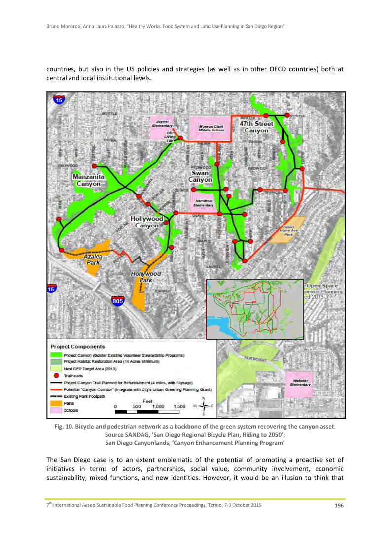
Bruno Monardo, Anna Laura Palazzo, “Healthy Works. Food System and Land Use Planning in San Diego Region”
7th International Aesop Sustainable Food Planning Conference Proceedings, Torino, 7‐9 October 2015 196
countries, but also in the US policies and strategies (as well as in other OECD countries) both at central and local institutional levels.
Fig. 10. Bicycle and pedestrian network as a backbone of the green system recovering the canyon asset.
Source SANDAG, ‘San Diego Regional Bicycle Plan, Riding to 2050’; San Diego Canyonlands, ‘Canyon Enhancement Planning Program’
The San Diego case is to an extent emblematic of the potential of promoting a proactive set of initiatives in terms of actors, partnerships, social value, community involvement, economic sustainability, mixed functions, and new identities. However, it would be an illusion to think that

Bruno Monardo, Anna Laura Palazzo, “Healthy Works. Food System and Land Use Planning in San Diego Region”
7th International Aesop Sustainable Food Planning Conference Proceedings, Torino, 7‐9 October 2015 197
such a ‘recipe’ can be imported ‘sic et simpliciter’ into other contexts. In fact, its relevance as best practice is obviously related to specific conditions of space, time, and civic culture. The current impetus in the US – and particularly in California – is clearly different from the European context. US communities are operating in a post‐crisis context, and a new horizon of project initiatives with a moderately confident vision for boosting local economies and pursuing ‘fair redevelopment’ is emerging. San Diego City General Plan (2008) was honoured by the American Planning Association (APA) in 2010 for emphasizing the vision of the ‘City of Villages’ and the multifaceted nature of communities. Its sensitivity towards the Food System and UPA approach was stressed in the latest amendments (2012) permitting the spontaneous creation of ‘Community gardens’ and ‘Retail farms’ to encourage a ‘new deal’ in terms of green, smart and socially inclusive urban and peri‐urban spaces. The quality of the County Plan, in terms of complexity, assured its relevant potential as a catalyst for regional and urban revitalization in its multifaceted interpretations, emphasizing eco‐environmental, physical, cultural and symbolic dimensions without neglecting concurrent economic and social aspects. In some respects this new generation of Plans (in California, as well as Illinois and other States) is part of a more systemic vision that emphasizes the priority of revitalization programs in urban regions. In terms of regeneration impact of the initiative, the UPA phenomenon may be considered only the ‘tip of the iceberg’. More complex ‘critical mass’ can be found in the potential of complex relationships emerging in the Healthy Food System domain. The success of the initiative is mirrored through the potential to implement virtuous forms of dialogue between the fragmented identities of the Community: healthy and ethnic food implications can be a powerful vector in terms of programs and perspectives of environmental values, landscape assets, social inclusion, proactive education, and limited but socially significant economic rebounds. Conversely, however, the ongoing experiences in San Diego (and Chicago as well with different profiles) reveal some critical issues. Sometimes the risk of delaying or paralyzing the ‘plan cycle’ is evident, due to ‘difficulties in dialog’ between non‐professional proponents (e.g. some specific non‐profits or local civic associations) and the public authorities. The plan follow‐up by the public administration (Counties and Municipalities) has the typical advantages and limits of the ‘common law’ juridical culture: in general, the public sector represents a ‘referee’, limiting its action to the definition of policy frameworks and the management of rules, letting the different actors play the game. Coming back to the main issue about the role of Local Food System strategies in regional and local planning, looking at the general dynamics within US, and in particular at the lesson of San Diego and Chicago, it is possible to underline that this approach may take on a concurrent, complementary role with intriguing potential, if – and only if – some specific conditions are respected. Land and plots devoted to UPA should be conceived and planned as integrated activities, not in competition with ‘powerful land uses’, in terms of development rights. Looking towards a post‐crisis horizon it is not unlikely that community gardens or urban and retail farms in the inner parts of settlements could quickly be replaced with new urban development projects as soon as the economic cycle will allow developers to pursue new profit by filling ‘vacant’ in‐between or fringe land resources. From this point of view, a low density urban and peri‐urban fabric with a relatively large amount of vacant ‘interstitial’ land can represent an advantage, keeping together urban agriculture patterns, open space systems and denser areas. The spaces dedicated to UPA and its connected activities should be conceived and planned within a holistic approach, as part of the overall ‘greening strategy’ of settlements. Community gardens,

Bruno Monardo, Anna Laura Palazzo, “Healthy Works. Food System and Land Use Planning in San Diego Region”
7th International Aesop Sustainable Food Planning Conference Proceedings, Torino, 7‐9 October 2015 198
urban farms, farmers’ markets and so on should be designed as elements of a complex open space system, included within the great natural assets of public parks, private gardens, urban and peri‐urban woods, hydrographical and environmental systems of the city and its metropolitan domain.
6. Acknowledgements
Issues and contents of this paper were discussed and shared by the Authors. Sections 1 and 5 were written by both Authors. Sections 2 and 4 were written by Bruno Monardo; section 3 was written by Anna Laura Palazzo.
7. References
American Planning Association, 2007. Policy Guide on Community and Regional Food Planning. Available at http://www.planning.org/policy/guides/pdf/foodplanning.pdf
American Planning Association, 2010. Practice urban agriculture. I: Zoning Practice, Issue n. 3. American Planning Association, 2012. Planning for Food Access and Community‐based Food Systems: National
Scan and Evaluation of Local Comprehensive and Sustainability Plans. Available at https://www.planning.org/research/foodaccess/pdf/foodaccessreport.pdf
City of San Diego, 2008. San Diego City General Plan. Available at: http://www.sandiego.gov/planning/genplan/ Donald, B., Gertler, M., Gray, M., Lobao, L., 2010. Re‐regionalizing the Food System? Cambridge Journal of
Regions, Economy and Society, Issue n. 3, pp. 171‐175. Feagan, R. 2007. The place of food: mapping out the ‘local’ in local food systems, Progress in Human
Geography, 31(1), pp. 23‐42. Mansvelt J. (2011) Green Consumerism: an A‐to‐Z guide. Los Angeles: SAGE. Monardo, B., Palazzo, A.L., 2014. Challenging Inclusivity. Urban Agriculture and Community Involvement in San
Diego. Advanced Engineering Forum, Vol. 11, pp 356‐363. Morgan, K., 2009. Feeding the City: The Challenge of Urban Food Planning, International Planning Studies, 14:4,
pp. 341‐348. Neff R., 2014. Introduction to the US Food System. Public Health, Environment, and Equity. Centre for a Livable
future Johns Hopkins University. Roots of Change, 2001. Agriculture, Ecology and Health in California. Available at:
http://www.rootsofchange.org/projects/california‐food‐policy‐council/ San Diego County, 2009. San Diego County Farming Program Plan. Available at:
http://www.farmlandinfo.org/san‐diego‐county‐ca‐farming‐program‐plan San Diego County, 2011. San Diego County General Plan. Available at:
www.sandiegocounty.gov/pds/generalplan.html San Diego County, Health and Human Services Agency, 2012. Healthy Works San Diego Regional Healthy Food
System, Strategic Plan. San Diego County, 2013. San Diego County Implementation Plan. Smit, J., Nasr, J., Ratta, A., 1996. Urban Agriculture: Food, jobs and sustainable cities. United Nations
Development Program, The Urban Agriculture Network, Inc. USDA ERS, 2015. Food Access Research Atlas. Available at http://www.ers.usda.gov/data‐products/food‐
access‐research‐atlas.aspx.