Town of Caledon Archaeological Management Plan - eScribe
389
Schedule A to Staff Report 2021-0407
-
Upload
khangminh22 -
Category
Documents
-
view
1 -
download
0
Transcript of Town of Caledon Archaeological Management Plan - eScribe

Schedule A to Staff Report 2021-0407

Images
Front cover photo credit: Paleohunters. Watercolour by Shelley Huson.
Back cover photo credit: Forks of the Credit c. 1886, Region of Peel Archives Photograph Collection

Town of Caledon Archaeological Management Plan
Submitted to:
Planning Department
Town of Caledon
October 2021

Town of Caledon Archaeological Management Plan Page 1
Project Personnel Senior Project Managers: Ronald F. Williamson, PhD, Senior Associate, ASI.
Robert I. MacDonald, PhD, Managing Partner, ASI.
Project Managers: Eric Beales, MA, Archaeologist and Project Manager - Planning Assessment Division, ASI
Martin Cooper, MA, Senior Associate, ASI
Geomatics Technicians: Jonas Fernandez, MSc, Lead Archaeologist and Geomatics Department Manager, Operations Division
Adam Burwell, MSc, Archaeologist and Geomatics Specialist - Operations Division, ASI
Eric Beales
Project Historian: Brian Narhi, MA, Project Historian, ASI
Environmental Archaeologist: Robert I. MacDonald,
Report Preparation: Ronald F. Williamson
Robert I. MacDonald
Brian Narhi
Marcus Letourneau, PhD, MCIP, RPP, CAHP, Letourneau Heritage Consulting Inc.
Eric Beales
Report review: Ronald F. Williamson
Robert I. MacDonald
Eric Beales
Andrea Carnevale, BSc (Hon), NEW, RT-Level 1, Senior Archaeologist and Assistant Manager - Special Projects, ASI.

Town of Caledon Archaeological Management Plan Page 2
Table of Contents PROJECT PERSONNEL 1
TABLE OF CONTENTS 2
EXECUTIVE SUMMARY 6
1. INTRODUCTION 9
1.1. DEFINING ARCHAEOLOGICAL RESOURCES 10
PART 1: ARCHAEOLOGICAL POTENTIAL MODEL 12
2. PRE-CONTACT INDIGENOUS ARCHAEOLOGICAL SITE POTENTIAL LAYER 13
2.1. INTRODUCTION 13
2.2. DEDUCTIVE MODEL 14
2.2.1. Paleo Period 14
2.2.2. Archaic Period 15
2.2.3. Early to Late Woodland Period 17
2.3. INDUCTIVE MODEL 21
2.3.1. Distance to Water 23
2.3.2. Soils 24
2.3.3. Slope 25
3. HISTORICAL ARCHAEOLOGICAL SITE POTENTIAL LAYER 26
3.1. INTRODUCTION 26
3.2. RECORDING LOCATION OF FEATURES PRESENT ON HISTORICAL MAPS 26
3.3. RECORDING LOCATION OF FEATURES IDENTIFIED THROUGH THEMATIC HISTORY 29
3.4. SUMMARY OF HISTORICAL ARCHAEOLOGICAL POTENTIAL 29
4. CREATING THE ARCHAEOLOGICAL POTENTIAL PLANNING LAYER 30
4.1. INTEGRITY LAYER 30
4.2. COMPOSITE ARCHAEOLOGICAL POTENTIAL LAYER 30
4.3. ARCHAEOLOGICAL POTENTIAL PLANNING LAYER 36
4.4. SUMMARY 36
PART 2: ARCHAEOLOGICAL RESOURCE MANAGEMENT 38
5. PLANNING FOR ARCHAEOLOGICAL SITE CONSERVATION 39
6. THREATS TO ARCHAEOLOGICAL RESOURCES 40
7. PROVINCIAL LEGISLATIVE FRAMEWORK 42
7.1. PROVINCIAL LEGISLATION 42

Town of Caledon Archaeological Management Plan Page 3
7.2. PLANNING ACT & PROVINCIAL POLICY STATEMENT 42
7.3. ENVIRONMENTAL ASSESSMENT ACT 45
7.4. ONTARIO HERITAGE ACT 46
7.5. RENEWABLE ENERGY APPROVALS REGULATION 49
7.6. AGGREGATE RESOURCES ACT 50
7.7. FUNERAL, BURIAL AND CREMATION SERVICES ACT 50
7.8. GREENBELT ACT AND GREENBELT PLAN 51
7.9. NIAGARA ESCARPMENT PLANNING AND DEVELOPMENT ACT AND NIAGARA ESCARPMENT
PLAN 52
7.10. PLACES TO GROW ACT AND GROWTH PLAN FOR THE GREATER GOLDEN HORSESHOE 52
7.11. OAK RIDGES MORAINE CONSERVATION ACT AND OAK RIDGES MORAINE CONSERVATION
PLAN 53
7.12. REGIONAL CONSERVATION AUTHORITIES 53
8. MUNICIPAL POLICY 55
8.1. OFFICIAL PLAN 55
9. INDIGENOUS ENGAGEMENT IN THE ARCHAEOLOGICAL ASSESSMENT PROCESS 56
9.1. LEGISLATIVE CONTEXT 56
9.2. INDIGENOUS TREATY HISTORY AND TRADITIONAL TERRITORIES 59
9.3. INDIGENOUS COMMUNITIES WITH RIGHTS AND INTERESTS IN THE TOWN OF CALEDON 61
9.4. RECOMMENDED STAGE 4 MITIGATIONS BASED ON CULTURAL HERITAGE VALUE OF
INDIGENOUS SITES 62
10. INTEGRATING ARCHAEOLOGICAL ASSESSMENTS AND THE DEVELOPMENT REVIEW PROCESS 63
10.1. ARCHAEOLOGICAL REVIEW PROCESS IN ONTARIO – ROLES AND RESPONSIBILITIES 63
10.1.1. Role of Province 63
10.1.2. Role of Consultant Archaeologists 65
10.1.3. Role of the Development Proponent 66
10.1.4. Role of Town 67
10.2. WHEN DOES THE ARCHAEOLOGICAL POTENTIAL PLANNING LAYER APPLY? 69
10.2.1. Official Plan Amendments 70
10.2.2. Secondary Plans 70
10.2.3. Zoning By-law Amendments 71
10.2.4. Site Plans 72

Town of Caledon Archaeological Management Plan Page 4
10.2.5. Plans of Subdivision and Plans of Condominium 72
10.2.6. Consent Applications 73
10.2.7. Minor Variance Applications 73
10.2.8. Building Permits 73
10.2.9. Site Alteration 74
10.2.10. Town of Caledon Engineering Services Department 74
10.3. MUNICIPAL ARCHAEOLOGICAL REVIEW PROCESS 75
10.3.1. The Archaeological Assessment Process 78
10.3.2. Sample Wording for the Archaeological Condition applied to Planning and Development Applications 78
10.3.3. Town of Caledon Planning Department – Implementation Process 79
10.3.4. Determining the Cultural Heritage Value of Archaeological Resources 83
10.3.5. Assessing Archaeological Resource Impacts and Identifying Mitigation Strategies 86
10.4. ARCHAEOLOGICAL RESOURCE MANAGEMENT – OPERATIONAL AND ADMINISTRATIVE
MATTERS 91
10.4.1. Managing Geospatial Data 91
10.4.2. Contingency Planning 92
10.4.3. Site Locations and Reports – Constraints in Sharing Information 93
10.4.4. Ownership of Artifacts 93
10.4.5. Artifact Curation 94
10.4.6. Periodic Update to the Plan 95
11. REFERENCES 96
11.1. GOVERNMENT DOCUMENTS 96
11.2. OTHER STATUTORY DOCUMENTS 97
11.3. BOOKS 99
12. GLOSSARY 101
13. APPENDICES 105
APPENDIX A: PRE-CONTACT INDIGENOUS ARCHAEOLOGICAL SITE POTENTIAL
APPENDIX B: COLONIAL PERIOD SETTLEMENT AND LAND USE
APPENDIX C: CONTINGENCY PLAN FOR THE PROTECTION OF ARCHAEOLOGICAL RESOURCES IN
URGENT SITUATIONS

Town of Caledon Archaeological Management Plan Page 5
APPENDIX D: PROPOSED POLICY REVISIONS TO THE CALEDON OFFICIAL PLAN RELATED TO
CULTURAL HERITAGE
List of Tables
Table 1: Summary of Pre-contact Indigenous Archaeological Site Potential Modelling Criteria 31
Table 2: Summary of Historical Archaeological Site Potential Modelling Criteria 32
Table 3: Indicators Showing Cultural Heritage Value or Interest (reproduced from Standards and Guidelines for Consultant Archaeologists) 83
List of Figures
Figure 1: View Shed Analysis of the Logan Site .................................................... 20
Figure 2: Pre-Contact Indigenous Archaeological Site Potential Layer ................. 22
Figure 3: Historical Archaeological Site Potential Layer ........................................ 27
Figure 4: Composite Archaeological Potential Layer ............................................ 33
Figure 5: Previously Assessed Lands Layer (to March 2021) ................................. 34
Figure 6: Composite Archaeological Potential Layer with Integrity ...................... 35
Figure 7: Archaeological Potential Planning Layer ................................................ 37
Figure 8: Archaeological Review in the Planning and Development Application Process .......................................................................................................... 77
Town of Caledon Archaeological Management Plan Page 6
Executive Summary The archaeological sites that are the physical remains of the Town of Caledon’s 13,000-year settlement history represent a fragile and non-renewable cultural heritage resource that must be conserved and protected. This document and associated mapping, developed on a geographical information system (GIS) platform, provide an Archaeological Management Plan based on best practices in archaeological resource management. With this Archaeological Management Plan in hand, the Town of Caledon can more easily identify where archaeological assessments should be required in the land use planning and development process and manage archaeological resources within its jurisdiction.
Through its GIS mapping of known archaeological sites and areas of archaeological potential, the Archaeological Management Plan allows the Town of Caledon’s Planning Department and Engineering Services Department, along with property owners, developers, and prospective land buyers, to know whether archaeological investigations are necessary prior to land disturbing activities. Thus, the Archaeological Management Plan reduces the risk of unfortunate surprises occurring during land altering activities (such as disturbing an Indigenous burial site or a 19th century building foundation), and considerably enhances public awareness of archaeological resources. An Archaeological Management Plan also allows residents to know their community’s history better; careful planning for the conservation and interpretation of archaeological resources offer opportunities for improving local quality of life through knowledge mobilisation.
More specifically, the Town of Caledon’s Archaeological Management Plan has three major objectives:
• the compilation of detailed, reliable inventories of registered archaeological sites within the Town;
• the development of an archaeological site potential model specific to the Town of Caledon, based on known site locations, past and present land uses, environmental and cultural-historical data, and assessment of the likelihood for survival of archaeological resources in various contexts; and,

Town of Caledon Archaeological Management Plan Page 7
• the provision of recommendations concerning the preparation of archaeological resource conservation and management guidelines for the Town of Caledon.
The development of an archaeological site potential model was undertaken based on both an inductive and deductive approach to predicting where additional pre-contact Indigenous sites are most likely situated and detailed historical research to map historical archaeological potential. It was determined that the pre-contact Indigenous archaeological site potential layer captures all previously identified non-findspot pre-contact Indigenous sites in the Town.
The identification of areas in the historical archaeological site potential layer involved the digitization of residential, commercial and industrial features and transportation routes from historical mapping and cemeteries. The historic archaeological potential layer captures all the historical archaeological sites previously discovered in the Town.
The role of the Town of Caledon in the conservation of cultural heritage resources is crucial. Although matters of provincial interest, planning and land use control are predominantly municipal responsibilities and the impact of municipal land use decisions on archaeological resources is substantial. This is particularly the case since municipally approved developments constitute most land disturbing activities in the Province. The primary means by which these resources may be protected is through the planning and development approval process.
The Archaeological Management Plan provides a series of policy recommendations within the planning and development approvals process, to be integrated into the Town’s new Official Plan, that will ensure the conservation of these valuable cultural heritage resources within the overall process of change and growth in the Town. The Archaeological Management Plan policy recommendations are consistent with the Provincial Policy Statement (2020) and the Ontario Heritage Act (2005).
Development of the Town of Caledon’s Archaeological Management Plan also benefitted from engagement with Indigenous communities. The land which comprises the Town of Caledon was ceded in 1818 as part of the Ajetance purchase, signed with the Mississaugas of the Credit First Nation, and is within the traditional territories of the Haudenosaunee People (The Six Nations of the Grand

Town of Caledon Archaeological Management Plan Page 8
River), the Huron-Wendat Nation, and the Métis Nation of Ontario (Region 8). The Archaeological Management Plan recommends continued engagement with Indigenous communities in the Town’s archaeological review and planning application processes.
In summary, in having developed this Archaeological Management Plan, the Town of Caledon joins with other major municipalities in Ontario in adopting the best approach available to ensuring archaeological site conservation within its jurisdiction.

Town of Caledon Archaeological Management Plan Page 9
1. Introduction The Town of Caledon Archaeological Management Plan represents a comprehensive approach to the conservation of archaeological resources. The most effective means of protecting archaeological sites is through adoption of planning and management guidelines that are informed by both the known distribution and character of archaeological sites and by assessment of the potential location of additional sites that have yet to be discovered.
This report presents an archaeological potential model and planning and management guidelines that are consistent with provincial legislation. The archaeological potential model was developed using an ArcGIS® Geographic Information System to summarize and map various data sets as separate, but complementary layers. Modelling criteria specific to Caledon were then derived through analysis of these layers and applied to produce a final Archaeological Potential Planning Layer. This layer will be used by Town staff to evaluate planning applications and other municipal infrastructure projects for the necessity of carrying out archaeological resource assessments.
The report is divided into two main parts: Part l presents the archaeological potential model for both pre-contact Indigenous and historical sites; and Part II addresses archaeological resource management, including outlines of the threats to archaeological resources and the legislative framework at the provincial and municipal levels to address those threats; how the Town will apply the archaeological potential model across departments that participate in planning and development processes and infrastructure projects; and an explanation of the various roles that different agencies play in these processes. The report also addresses contingency planning for unexpected archaeological emergency finds, ownership and curation of archaeological artifacts, and periodic review of the archaeological potential model.
There are four appendices to the report as follows:
• Appendix A: Pre-contact Indigenous Archaeological Site Potential;
• Appendix B: Colonial Period Settlement and Land Use;

Town of Caledon Archaeological Management Plan Page 10
• Appendix C: Contingency Plan for the Protection of Archaeological Resources in Urgent Situations;
• Appendix D: Proposed Policy Revisions to the Caledon Official Plan related to Cultural Heritage.
1.1. Defining Archaeological Resources
Archaeological resources are scarce, fragile, and non-renewable and therefore must be managed in a prudent manner if they are to be conserved. The Government of Ontario, through various statutes and policies, asserts the stewardship interests of the provincial Crown on behalf of its citizens with respect to archaeological resources. In addition, the land which comprises the Town of Caledon was ceded in 1818 as part of the Ajetance purchase, signed with the Mississaugas of the Credit First Nation, and is within the traditional territories of the Haudenosaunee People (The Six Nations of the Grand River), the Huron-Wendat Nation, and the Métis Nation of Ontario (Region 8). These rights-holding communities similarly assert their interests with respect to archaeological heritage conservation.
Effectiveness in incorporating archaeological heritage conservation within the overall land-use planning and development process requires a clear understanding of the physical nature, variety of forms, and overall significance and value to society of archaeological resources.
The Provincial Policy Statement (2020), which is issued under the authority of Section 3 of the Planning Act, defines archaeological resources (Section 6.0, Definitions) as including “artifacts, archaeological sites, and marine archaeological sites.”
Individual archaeological sites are distributed in a variety of locational settings across the landscape, being locations or places that are associated with past human activities, endeavours, or events. These sites may occur on or below the modern land surface or may be submerged under water. The physical forms that these archaeological sites may take includes the following: surface scatters of artifacts; subsurface strata which are of human origin or incorporate cultural deposits; the remains of structural features; or a combination of these attributes.

Town of Caledon Archaeological Management Plan Page 11
The Ontario Heritage Act (Ontario Regulation 170/04) provides the following definitions:
• “archaeological site” is “any property that contains an artifact or any other physical evidence of past human use or activity that is of cultural heritage value or interest;”
• “artifact” is “any object, material or substance that is made, modified, used, deposited or affected by human action and is of cultural heritage value or interest;”
• “marine archaeological site” is “an archaeological site that is fully or partially submerged or that lies below or partially below the high-water mark of any body of water;” and,
• Archaeological fieldwork is “any activity carried out on, above or under land or water for the purpose of obtaining and documenting data, recovering artifacts and remains or altering an archaeological site and includes monitoring, assessing, exploring, surveying, recovering, and excavating.”

Town of Caledon Archaeological Management Plan Page 12
Part 1: Archaeological Potential Model Archaeological potential is defined in the Provincial Policy Statement (2020) as:
…areas with the likelihood to contain archaeological resources. Criteria to identify archaeological potential are established by the Province.
For more than twenty-five years, municipalities across Ontario have been creating detailed archaeological potential models for their jurisdictions, usually within the context of developing archaeological management plans. Since the mid-1990s, these models have been undertaken on a geographical information system (GIS) platform to best manipulate and analyse site location attribute data. The result is a simple to use digital map of terrestrial archaeological potential, which can be used by municipal staff to determine the need for archaeological assessment in advance of soil disturbance.
The model comprises the creation of five layers of geo-referenced data specific to the Town of Caledon that have been integrated into a single and final Archaeological Potential Planning Layer:
• Pre-contact Indigenous Archaeological Site Potential Layer;
• Historical Archaeological Site Potential Layer;
• Composite Archaeological Potential Layer;
• Previously Assessed Lands Layer; and,
• Composite Archaeological Potential Layer with Integrity.
A description of how the layers were created for Caledon follows below.

Town of Caledon Archaeological Management Plan Page 13
2. Pre-contact Indigenous Archaeological Site Potential Layer
2.1. Introduction
Only limited locational data exist for pre-contact Indigenous archaeological sites in the Town of Caledon. While access to distributional information for all sites would be a significant advantage to land-use planners and heritage resource managers, the undertaking of a comprehensive archaeological survey of the Town to compile a complete inventory is clearly not feasible. As an alternative, therefore, staff must depend on a model which predicts how sites are likely to be distributed throughout the municipality.
Archaeological site potential modelling can trace its origins to a variety of sources, including human geography, settlement archaeology, ecological archaeology, and paleoecology. The basic assumption is that pre-contact Indigenous land use was constrained by ecological and socio-cultural parameters. If these parameters can be discovered, through archaeology and paleoecology, pre-contact Indigenous land-use patterns can be reconstructed.
Two basic approaches to predictive modelling can be described. The first is an empirical or inductive approach, sometimes referred to as correlative (Sebastian and Judge 1988) or empiric correlative modelling (Kohler and Parker 1986). This method employs known site locations, derived from either extant inventories or through sample surveys, as a guide for predicting additional site locations. The second is a theoretical or deductive approach, which predicts site locations based on expected behavioural patterns as identified from suitable ethnographic, historical, geographical, ecological, and archaeological analogues. While data requirements or availability tend to influence the orientation of the study, every modelling exercise will incorporate both inductive and deductive elements. Foremost is the need to employ all available data effectively and expeditiously.
Appendix A presents the detailed model of pre-contact Indigenous archaeological site potential developed for the Town of Caledon. It begins with a brief review of the method and theory associated with pre-contact Indigenous site potential modelling and is followed by delineation of the modelling approach, which

Town of Caledon Archaeological Management Plan Page 14
employs a descriptive reconstruction of pre-contact landscapes in Caledon together with a reconstruction of pre-contact Indigenous land-use patterns informed by both known site locations as well as archaeological and ethnographic analogues. This information is brought together in a list of criteria, which are used to define a zone of pre-contact Indigenous archaeological potential on GIS mapping of the Town.
2.2. Deductive Model
Throughout much of pre-contact Indigenous history, the inhabitants of Caledon were hunter-gatherers who practiced an annual subsistence round to exploit a broad range of natural resources for food and raw materials for such needs as shelter construction and tool manufacture. Assuming that access to natural resources influenced and constrained the movement and settlement of Indigenous peoples, the goal was to understand what these resources were, how they may have been distributed, how their use and distribution may have changed over time, and how the landscape itself may have constrained movement and access to resources as well as settlement location. The investigation proceeded chronologically, since certain aspects of Caledon have changed dramatically through the period of human occupation.
2.2.1. Paleo Period
It was concluded that hunter-gatherer bands have occupied Caledon beginning as early as 13,000 years ago, as indicated by the discovery of early Paleo-Indian artifacts along the upper reaches of the Humber River. At this time, the open boreal woodlands likely offered a rather limited selection of floral resources; hence subsistence would have been primarily oriented towards hunting and fishing. The southern shores of glacial Lake Algonquin, which occupied the Huron-Simcoe basin, would have been only about 10 kilometres northeast of Caledon. These earliest hunters with base camps in proximity to Lake Algonquin would have ranged throughout the interior hinterland in pursuit of game and perhaps riverine fish. It is expected that Paleo-Indian archaeological sites in Caledon will be like those already documented, namely isolated finds of flaked stone projectile points lost while hunting or small scatters of flaked stone debitage indicative of ephemeral campsites. Five Paleo-Indian archaeological sites have been registered in Caledon to date, all in the Humber River watershed. Two are Late Paleo-Indian

Town of Caledon Archaeological Management Plan Page 15
findspots. The other three are possible campsites. All are in the uplands of the Oak Ridges Moraine or South Slope physiographic regions in areas of complex terrain near wetlands.
2.2.2. Archaic Period
By Early Archaic times (circa 11,000 to 9,000 years ago), the current shoreline of Lake Simcoe became established more than 30 kilometres northeast of Caledon, while the shore of Lake Ontario was roughly the same distance to the south. Hunter-gatherer bands likely established warm-weather base camps adjacent to these lakeshores where resources such as spawning fish could support populations of 50 or more people. The lower reaches and mouths of the Credit and Humber rivers, especially around complex shorelines, would have been the best localities to sustain such population aggregations. During the warm season, Caledon may have only been occasionally visited during hunting expeditions. The archaeological evidence of this would tend to be ephemeral campsites situated along watercourses.
The late fall, winter, and early spring may have been the seasons when Caledon saw more activity, as Early Archaic bands —probably at the nuclear family level—dispersed into interior hunting territories, much as Indigenous people of the boreal forest have done until recent generations. Such hunting territories would likely have been organized on a sub-watershed basis with individual bands occupying adjacent stream catchment areas. Winter occupations may have been more focused within the larger valleys, encouraged by the protection they offered from winter storms and by access to any conifer grove deer yards, where ungulates congregate to avoid heavy snows and have access to abundant browse. Riparian wetlands and swamps would have also provided fuel, building materials, roots and tubers, and small game. Archaeological evidence of such sites may be difficult to distinguish from warm season hunting camps, although the sustained occupation of a site over several months would likely leave a more substantial artifact assemblage. Currently there are nine Early Archaic sites registered in Caledon, only two of which have been identified as campsites. One campsite is situated in the South Slope on a terrace overlooking Etobicoke Creek. The other is situated on a headwater tributary of the Humber River in an area of complex terrain near wetlands. Of importance to predicting the location of additional sites within Caledon, there is a cluster of eight Early Archaic sites situated along the Credit River about ten kilometres south of the Town.

Town of Caledon Archaeological Management Plan Page 16
As the inland drainage system matured through the Early and Middle Archaic periods (circa 9,000 to 5,000 years ago), and adaptive patterns shifted in response to the establishment of northern mixed deciduous forest and its associated fauna, the major valleys and adjacent uplands may have increased in importance, particularly where camps could be situated on river terraces with well-drained soils. These corridors would have provided access to rich riparian habitat, such as occurred along the glacial spillways of the central Credit River valley. Scarps and terraces may have also retained importance as travel corridors between the uplands and lowlands. Further inland, the highest central portions of the Oak Ridges Moraine, with their hummocky terrain and many wetland pockets, kettle ponds and headwater streams, would have had much to offer Indigenous hunter-gatherers, especially in the fall when stands of mast-producing trees (e.g., oak, beech, hickory) would have provided nuts to both Indigenous foragers and the game this mast crop attracted, including deer, raccoons, squirrels, turkeys, and passenger pigeons. In contrast to the Oak Ridges Moraine and the Niagara Escarpment, the closed-canopy hardwood forests of the South Slope and Peel Plain may not have attracted much settlement during any season, except perhaps where kettle lakes, ponds, wetlands, and headwater streams would have created locally rich micro-environments.
Currently there are fifteen registered Middle Archaic sites in Caledon. Three have been identified as campsites. Two of the campsites are situated on the South Slope by tributary streams in complex uplands adjacent to the main Humber River valley. The third is situated on the Peel Plain on a plateau overlooking the West Humber River. Additionally, one burial within the Town has been dated to approximately 6,500 years ago (Katzenberg and Sullivan 1977). This Burial was found on a high point of land near Mount Wolfe and further excavations in the area indicated that this was an isolated burial with no other artifacts or features present.
The lifestyle of Late Archaic (circa 5,000 to 3,000 years ago) period hunter-gatherers seems to have been relatively unchanged from that practiced by their Middle Archaic ancestors. Major base camps were likely situated outside of Caledon near Lake Ontario or Lake Simcoe in riverine venues where abundant local resources could sustain the band. Smaller seasonal camps, representing the temporary occupation of small family groups or specialized hunting or collecting parties, were likely distributed throughout Caledon in areas of higher biotic diversity and productivity. Given the general continuity in environmental and

Town of Caledon Archaeological Management Plan Page 17
cultural practices after about 5,000 years ago, it is suggested that the land-use patterns described above for the Early and Middle Archaic periods, and based on ethnohistorical analogues, continued with only local variation up to the end of the Late Archaic period and beyond.
Currently there are fifteen registered Late Archaic sites in Caledon, seven of which have been identified as campsites. Three are located on the Oak Ridges Moraine in complex terrain near kettle ponds or wetlands. Four are on the South Slope: two on terraces overlooking the main Humber River, and two more on headwaters of Etobicoke Creek. Additionally, there are currently eight indeterminate Archaic period sites in the Town consisting of four campsites and four findspots. Generally, these sites were attributed to the Archaic period based on the sole presence of lithic artifacts or their geographic location in proximity to hydrological features known to be present during the Archaic period. However, given the lack of information about these sites, it is difficult to attribute these sites to any larger cultural or temporal processes.
2.2.3. Early to Late Woodland Period
The Early and Middle Woodland periods can be characterized as one of population increase and increasing interregional interaction, but with little change from the Archaic period in subsistence pursuits. The use of clay to form and fire water containers and cooking vessels appears in the Early Woodland period.
There are fifteen Early and Middle Woodland sites in Caledon, five of which have been identified as campsites. Of these, two are situated on the Oak Ridges Moraine in complex terrain near kettle ponds or wetlands; one is on the South Slope on a terrace overlooking the main Humber River; and two more are within the spillway of the Guelph Drumlin Field on terraces overlooking the main Credit River. One of the campsites, the Graham site (AkGx-41), is a ceremonial site of the Early Woodland period specifically the Meadowood Complex, (circa 2,000 years ago), excavated in advance of construction of a stormwater management pond. These site types invariably include deposits containing limited remains of calcined bone, often attributed to human or animal cremations. The Graham site yielded many native copper artifacts including 84 native copper beads, one copper awl, one copper awl tip, one copper fishhook, 141 chert biface tools, and a unique animal cremation burial.

Town of Caledon Archaeological Management Plan Page 18
The adoption of maize agriculture during the Late Middle Woodland period introduced the need for suitable farmland into the suite of factors that influenced pre-contact Indigenous land use. Initially, during the experimentation phase with agriculture, intensive gardening was simply an adjunct to macroband camps, most of which seem to have been located outside of Caledon near the Lake Ontario shore in the lower reaches of the major sub-watersheds. As gardening evolved into full-scale farming and community populations grew in response to better nutrition and a more secure food supply, settlements moved up-stream to expand their catchment areas for hunting, gathering, and fishing. Suitability of farmland became an important land-use criterion, including adequate drainage, adequate moisture and moisture-holding capacity, adequate natural fertility and low to moderate slope. Eventually, community populations grew beyond the capacity of their socio-political institutions, resulting in a period when communities were splitting, and social groups were moving around between communities. At this point, settlements moved farther upstream, spreading out into various sub-watersheds.
This process of up-stream migration eventually led to the colonization of new lands north to the Oak Ridge Moraine and beyond in Simcoe County and ultimately the virtual abandonment of the lands south of the Oak Ridges Moraine around the beginning of the seventeenth century. This time-transgressive distribution of Late Woodland settlement can be seen throughout south-central Ontario (MacDonald 2002, Williamson 2014). In contrast, smaller, special purpose (e.g., fishing, hunting, gathering) camps of the Late Woodland period tend to be situated in much the same locations as were the earlier sites where these traditional foraging activities were pursued.
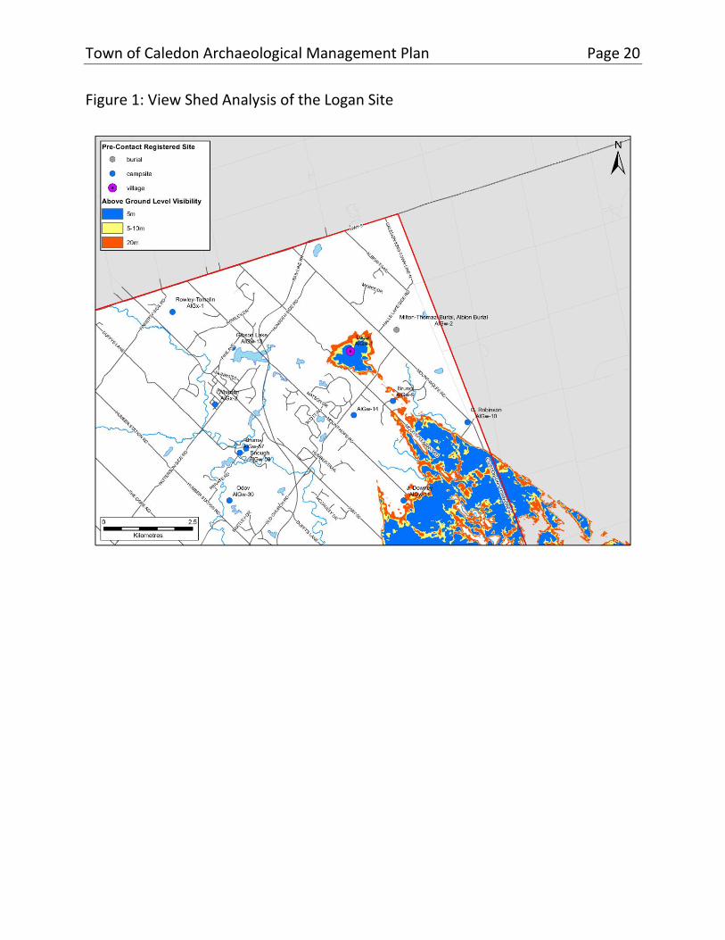
Currently there are three Late Woodland sites registered in Caledon, including one findspot, one campsite and one village. The campsite is situated on the South Slope on a terrace overlooking a tributary of the West Humber River. The single village (the Logan site; Figure 1) is situated in a rather extraordinary location. Perched on the southern flank of a knob of Newmarket Till, which stands above the surrounding hummocky deposits of the Oak Ridges Moraine, the site is adjacent to the headwaters of a small Humber River tributary. The soils of this till knob, which measures 2.25 kilometres across, are rated Class 4 for agricultural capability, in contrast to the Class 5 soils which surround it. Composed of well-drained clay loam, with good moisture retention, the primary limitation to agriculture is adverse terrain, although in this case it would be more of a
Town of Caledon Archaeological Management Plan Page 19
limitation to modern commercial agriculture than to pre-contact Indigenous maize farming. Its location was also advantageous for monitoring possibly hostile parties approaching from the south along the Humber River valley as demonstrated by a view shed analysis around the site (Figure 1).
Three other Late Woodland sites are situated just outside of the west boundary of Caledon. The ancestral Wendat occupation of the Credit River drainage ends with two of these sites, the Emmerson Springs and Wallace sites, both of which have been subject to very limited excavations and are largely unknown. Both sites date to the mid-sixteenth century and have yielded European items. Nearby is the Glen Williams cemetery, which dates to the 14th century based on radiocarbon dating and is likely an ancestral Huron-Wendat burial place.
Town of Caledon Archaeological Management Plan Page 20
Figure 1: View Shed Analysis of the Logan Site

Town of Caledon Archaeological Management Plan Page 21
2.3. Inductive Model
While the preceding deductive model paints a general picture of pre-contact Indigenous land use in the region throughout the millennia, the significant number of registered pre-contact Indigenous sites within Caledon also allows for the development of an inductive model from which to extrapolate pre-contact Indigenous archaeological potential based on locations of known sites. This requires some understanding of site types and ages, since land-use patterns changed over time. The inductive modeling also included observations based on distance to water, soil types and slope.
The total number of archaeological sites in Caledon is 269, of which 146 have pre-contact Indigenous components. Seventy of the pre-contact Indigenous sites, however, are isolated finds of flakes or projectile points lost while traveling through the landscape and are therefore not useful in the modeling exercise. Thus, the total number of pre-contact Indigenous sites used for modeling was 76.
Figure 2 presents the Pre-contact Indigenous Archaeological Site Potential Layer.

Town of Caledon Archaeological Management Plan Page 22
Figure 2: Pre-Contact Indigenous Archaeological Site Potential Layer

Town of Caledon Archaeological Management Plan Page 23
2.3.1. Distance to Water
For pre-contact Indigenous sites, the proximity of major waterways is considered to have always been a significant factor influencing land-use patterns in Caledon. Entrenchment and floodplain evolution of regional watercourses notwithstanding, the fundamental layout of the major drainage systems in Caledon has remained the same since the late Pleistocene, and the waterways have likely acted as travel and settlement corridors ever since. The middle and upper reaches of the inland drainage systems may have comprised warm season hunting and fishing grounds and late fall and winter microband hunting and fishing territories analogous to those recorded historically throughout the Great Lakes-St. Lawrence region. Throughout these waterways, stream confluences may have been routinely used as stop-over spots, leaving traces in the archaeological record. While wintertime land use would not have been constrained by access to well-drained campsites or the limits of navigable waterways, such routes would have still provided familiar, vegetation-free corridors for travel.
While the main source of hydrographic data used in the inductive site potential model was modern watercourse data, recorded at a scale of 1:250,000, retrieved through Land Information Ontario, the dataset was found to under-represent third-order streams compared to various historical map sources. Tertiary streams are particularly important in Caledon, which contains the headwaters for the Humber, Credit and Nottawasaga river watersheds. To improve the resolution of the hydrographic dataset, three additional sources were consulted: Tremaine’s 1859 Map of the County of Peel; the 1877 Illustrated Historical Atlas of Peel County; and Department of Militia and Defense topographic maps between 1909 and 1937, recorded at a scale of 1:50,000. Digital versions of these maps were imported into Geographic Information Systems software and georeferenced using present lot boundaries, as well as modern landmarks, such as roads. The 1:250,000 watercourse dataset was then cross-referenced against historical mapping, whereby any streams not present in the modern dataset but shown on historical maps were added. Furthermore, the 1877 County Atlas illustrated the location of freshwater springs within lots—something not generally represented in modern hydrographic data. Given the importance of potable water sources to sustained human settlement, these locations were added to the hydrographic data. Alluvial soils were also added to account for migration of major rivers and the tops of banks were used to establish buffers for widely cut ravines (two-line rivers).

Town of Caledon Archaeological Management Plan Page 24
Based on the above data, it was determined that a buffer of 250 metres from water sources captures 100% of the modellable registered pre-contact Indigenous sites in Caledon. Of these, 47 pre-contact Indigenous sites (61%) were within 100 metres of a historical or current water source, 57 pre-contact Indigenous sites (75%) were within 150 metres, 68 pre-contact Indigenous sites (89%) were within 200 metres, and 100% (76) of the sites were within 250 metres of a current or former watercourse.
To evaluate the efficacy of this buffer against the background landscape (i.e., any location in the landscape would be within 250 metres of water), the GIS was employed to generate 322 random points. Of the randomly generated points, only 72% were captured by the 250 metres buffer. The fact that over 100 of the randomly generated points in the landscape were more than 250 metres from water confirms the applicability of the proximity to water model to the Caledon landscape.
In light of these considerations, four water-based criteria were used to create the Pre-contact Indigenous Archaeological Site Potential Layer, as follows: all current and former watercourses; all waterbodies, including kettle lakes and ponds; all spring locations as identified on available mapping; and all evaluated wetlands. First, all river and major stream segments—defined as those represented by two lines (i.e., banks) on the hydrographic layer—were buffered at 250 metres from the top of bank. Second, all subordinate streams—defined as those watercourses represented by a single line on the hydrographic layer—were buffered by 250 metres on both sides of the line. Third, all kettle lakes, ponds, wetlands, and springs were buffered at 250 metres. The 250-metre buffer was employed since it captures 100% of the sites employed for inductive modeling within Caledon.
2.3.2. Soils
Further discrimination of the potential modeling was achieved using digital soils data acquired from the Geomatics Service Centre, Ontario Ministry of Agriculture, Food and Rural Affairs, dated to 2007. This layer is essentially a digital version of the soils mapping contained in the Ontario Soil Survey Reports. The soil information provides relatively high resolution of soil variability across the region. At the same time, however, this complex array of mapped soils made it difficult to interpret gross regional trends. Accordingly, the soil series were re-grouped in order to provide mapped summaries of relevant attributes, including soil texture,
Town of Caledon Archaeological Management Plan Page 25
drainage, and agricultural capability. This was accomplished by adding new texture, drainage, and capability fields to the attribute database from the digital soils map, and then using the Geographic Information Systems to produce maps based on these attribute sets. The soil texture layer discriminated between the following: exposed rock, gravely sandy loam, fine sandy loam, sand, silt loam, loam, clay loam, clay, and organic. The soil drainage layer discriminated between the following: well drained, imperfectly drained, and poorly drained. The soil capability for agriculture layer discriminated between: Class 1, having no significant limitations for agriculture; Class 2, having moderate limitations for agriculture; Class 3, having moderately severe limitations to agriculture; Class 4, having severe limitations to agriculture; Class 5, having very severe limitations to agriculture; Class 6, being only capable of producing perennial forage crops; and Class 7, having no capability for arable culture or permanent pasture. However, much of Caledon can be classified as having soils with few limitations for agriculture except for the Oak Ridges Moraine and the Niagara Escarpment, which have large areas unsuitable for agriculture. The objective in aggregating the soils data in this manner was to identify those soils where pre-contact Indigenous settlement would have been unlikely to have occurred. Thus, the above water buffers were only applied where they crossed well- or imperfectly drained soils.
2.3.3. Slope
Finally, using a digital elevation model, areas of slope exceeding 20 degrees were similarly excluded from the pre-contact Indigenous archaeological potential zone since such areas are considered unsuitable for settlement.

Town of Caledon Archaeological Management Plan Page 26
3. Historical Archaeological Site Potential Layer
3.1. Introduction
The County of Peel was created through land purchases in 1806 and 1818 by the British Crown of the Mississauga Tract. The former townships of Albion, Caledon and Chinguacousy were established in 1818 with lots typically granted in square 100-acre parcels, a configuration intended to facilitate farming and access to transportation corridors.
Established in 1974 with the creation of regional government, the Town of Caledon was created from the amalgamation of Albion, Caledon, and the northern half of Chinguacousy townships, as well as the incorporated villages of Bolton and Caledon East. The first settlement centres developed around water-powered mill sites on the Credit and Humber rivers, and at various crossroads; still later communities developed with the arrival of early railways in the 1870s (see Appendix B).
In contrast to the deductive and inductive modelling employed to create the Pre-contact Indigenous Archaeological Site Layer, the Historical Archaeological Site Potential Layer (Figure 3) was created primarily from historical mapping, historical thematic research, and the application of buffers to some features of historical interest. While it is primarily a terrestrial model, certain features (e.g., water-powered mills) may have marine archaeological components associated with them.
3.2. Recording Location of Features Present on Historical Maps
Three sources of historical mapping were used to identify the location of historical features of interest as well as settlement centres within the Town of Caledon: Tremaine’s 1859 Map of the County of Peel, the 1877 Illustrated Historical Atlas of Peel County and the 1854 Prosser Map of Bolton. Digital versions of these maps were imported into Geographic Information Systems software and

Town of Caledon Archaeological Management Plan Page 27
Figure 3: Historical Archaeological Site Potential Layer

Town of Caledon Archaeological Management Plan Page 28
georeferenced using present lot boundaries as well as modern landmarks. The locations of historical features of interest identified on these maps were then digitized into geographic space in order to be included in the Historical Site Potential Layer.
While every effort was made to reduce potential errors, there are numerous potential sources of error inherent in such a process. These include the vagaries of map production (both past and present), the need to resolve differences of scale and resolution, and distortions introduced by reproduction of the sources. To a large degree, the significance of such margins of error is dependent on the size of the feature being plotted, the constancy of reference points, the distances between them, and the consistency with which both they and the target feature are depicted on the period mapping.
One such issue present in historical mapping of the Town of Caledon relates to the representation of the individual lots in Tremaine’s 1859 Map of the County of Peel. While the 1818 surveys for Albion, Caledon and Chinguacousy townships utilized the “double front” system, this was not reflected in Tremaine’s illustration of these lots. Tremaine’s mapping shows these lots as 200-acre rectangular parcels, rather than two 100-acre square parcels with numerous jogs in the concession lines—as shown in the 1877 Illustrated Historical Atlas of County of Peel. While the relative location of these lots is consistent between the two historical map sources, Tremaine’s map ultimately misrepresents the location of the lot boundaries in those portions where the two 100-acre parcels are slightly staggered, leading to a difference of location of upwards of 300 metres. To rectify this illustration error, present lot locations were overlaid on the georeferenced Tremaine’s mapping of the Town. For those areas where a significant difference exists between the representation of the lot within the 1859 mapping and its true shape, the approximate location of the historical feature was interpolated by measuring the distance of this feature from the lot boundaries as represented on the 1859 map and transferring this location to the same relative distance from the actual lot boundaries.

Town of Caledon Archaeological Management Plan Page 29
3.3. Recording Location of Features Identified through Thematic History
A thematic history of the Town of Caledon was compiled to identify extant or former historical features that might yield associated archaeological deposits (Appendix B). This resulted in the identification of 2,205 features of historical interest (e.g., residential, commercial, and industrial structures), 57 settlement centres, and 62 cemeteries. Each of these was checked against the historical site archaeological potential layer generated from Tremaine’s 1859 Map of the County of Peel and the 1877 Illustrated Historical Atlas of Peel County to ensure that they were included in the mapping. For those sites that were not represented by either the 1859 or 1877 maps, further research was conducted to ascertain the true location of the features so that they could be included in the historical site potential layer. The 1854 Prosser Map of Bolton was also reviewed as part of this analysis. However, given that the limits of the Prosser map are within the extent of the digitized historical settlement centre boundary for Bolton, individual features identified within this map were not included in this analysis as the entire settlement area informs archaeological potential.
All cemeteries identified on the historical mapping and the Ontario Genealogical Society and Town databases were added to the Historical Archaeological Site Potential Layer.
3.4. Summary of Historical Archaeological Potential
All sites of historical archaeological potential have been digitised. All properties designated under the Ontario Heritage Act within the Town with cultural heritage attributes recognized in the designation that predate 1900 fall within the Historical Archaeological Site Potential Layer. A cut-off of 1900 is used here as archaeological resources associated with a twentieth century occupation of a property are generally not considered to have intrinsic cultural heritage value or interest under the Ontario Heritage Act.

Town of Caledon Archaeological Management Plan Page 30
4. Creating the Archaeological Potential Planning Layer
4.1. Integrity Layer
An archaeological Integrity Layer was compiled based on a review of present land uses within the Town gained from Google Maps Satellite View and the Town’s property parcel data. The objective of this task was to distinguish between those lands upon which modern development activities have likely destroyed any archaeological resources and those lands where resources potentially remain wholly or primarily undisturbed, such as parking lots, schoolyards, parks and golf courses. Settlement centres and registered archaeological sites that have not been completely excavated were considered to retain integrity.
Areas deemed to have no remaining archaeological integrity were subsequently excluded from the zone of archaeological potential. Buffers extending from paved road centrelines, sufficient to capture standard roadbeds (7.5 metres), are considered to have been disturbed and not retaining integrity. Additionally, those portions of active quarry sites which have been subject to deep excavation were considered to not retain integrity.
It should be noted that refinements to the Integrity Layer may result from a detailed Stage 1 archaeological resource assessment which demonstrates clearly that a study area has been severely disturbed, thereby negating archaeological potential.
4.2. Composite Archaeological Potential Layer
The Composite Archaeological Potential Layer consolidates the Pre-contact Indigenous Archaeological Sites Potential Layer, the Historical Archaeological Sites Potential Layer, and the Integrity Layer, as defined through application of the various modelling criteria (Tables 1-2; Figures 4-6). All areas lacking integrity were excluded from this composite layer.

Town of Caledon Archaeological Management Plan Page 31
Table 1: Summary of Pre-contact Indigenous Archaeological Site Potential Modelling Criteria
Environmental or Cultural Feature
Buffer Distance (metres)
Buffer Qualifier
Rivers and streams 250 • from top of bank for former; from centreline for latter; on all soil types
Lakes and ponds 250 • exterior buffer from current limits, all soil types
Wetlands 200 • 200m exterior buffer and 50m interior buffer. Only for verified wetlands
Registered Indigenous archaeological sites
100
250
• Camps and other small sites
• Villages and other large settlements
Slope > 20 degrees 0 • removed from potential zone

Town of Caledon Archaeological Management Plan Page 32
Table 2: Summary of Historical Archaeological Site Potential Modelling Criteria
Environmental or Cultural Feature
Buffer Distance (metres)
Buffer Qualifier
Historical settlement centres
polygon as mapped
• no buffer, override integrity
Domestic sites 100 • none
Breweries and distilleries
100 • none
Hotels/taverns 100 • none
Historical schools and churches
100 • none
Historic mills, forges, extraction industries
100 • none
Early settlement roads
100 • both sides
Early railways 50 • both sides
Cemeteries 10
100
• Registered cemeteries with known limits. 10 m beyond limits of cemetery
• Suspected cemetery or pioneer cemetery. 100m around point
Registered historical archaeological sites
100 • none

Town of Caledon Archaeological Management Plan Page 33
Figure 4: Composite Archaeological Potential Layer

Town of Caledon Archaeological Management Plan Page 34
Figure 5: Previously Assessed Lands Layer (to March 2021)

Town of Caledon Archaeological Management Plan Page 35
Figure 6: Composite Archaeological Potential Layer with Integrity

Town of Caledon Archaeological Management Plan Page 36
4.3. Archaeological Potential Planning Layer
The Archaeological Potential Planning Layer (Figure 7) will be the layer that appropriate Town staff employs when assessing a planning application or municipal infrastructure project for archaeological potential. This layer is the composite archaeological potential layer minus areas that have previously been subject to archaeological assessments and require no further work (Figure 5).
4.4. Summary
The Town has furthered the conservation of its archaeological resources by developing an archaeological potential model. The next section of the Archaeological Management Plan will outline how this model will be used to conserve the archaeological record of the Town.

Town of Caledon Archaeological Management Plan Page 37
Figure 7: Archaeological Potential Planning Layer
Town of Caledon Archaeological Management Plan Page 38
Part 2: Archaeological Resource Management It is the principal objective of Caledon’s Archaeological Management Plan to judiciously and uniformly apply the archaeological potential model across the Town. The archaeological resource review and management approaches presented in this part of the Archaeological Management Plan are consistent with provincial legislation regulating archaeological resource conservation.
This part of the Archaeological Management Plan also addresses site identification and mitigation through excavation, as well as wider issues of Indigenous community engagement in the planning process, artifact care and the encouragement of greater awareness on the part of Caledon’s residents of the Town’s archaeological record.

Town of Caledon Archaeological Management Plan Page 39
5. Planning for Archaeological Site Conservation In Ontario, the conservation of cultural heritage resources is an objective of planning activity, as it is in many other provinces and countries. As Section 2 of the Planning Act (1990) states, “the conservation of features of significant architectural, cultural, historical, archaeological, or scientific interest” is a matter of provincial interest. This is echoed in the Provincial Policy Statement (2020):
The Province’s natural heritage resources, water resources, including the Great Lakes, agricultural lands, mineral resources, and cultural heritage and archaeological resources provide important environmental, economic and social benefits. The wise use and management of these resources over the long term is a key provincial interest. The Province must ensure that its resources are managed in a sustainable way to conserve biodiversity, protect essential ecological processes and public health and safety, provide for the production of food and fibre, minimize environmental and social impacts, and meet its long-term needs (Provincial Policy Statement, Ministry of Municipal Affairs and Housing 2020:6).
This provincially mandated planning requirement provides a key mechanism for protecting archaeological resources in Caledon to ensure that future development (e.g., residential, industrial, recreational and infrastructure construction) clearly respects and follows provincial policy. In response to this provincial direction, the conservation of archaeological resources is addressed in Caledon’s Official Plan, which sets the goals and priorities to shape the future growth, conservation, and evolution of the Town.

Town of Caledon Archaeological Management Plan Page 40
6. Threats to Archaeological Resources Protecting archaeological sites has become especially important in southern Ontario where landscape change has been occurring at an ever-increasing rate since 1950, resulting in substantial losses to non-renewable archaeological resources.
The scale of the threats facing the finite and non-renewable archaeological record of southern Ontario was considered in a study in which rates of demographic and agricultural change were examined over the last century for south-central Ontario, and estimates generated of the number of archaeological sites that have been destroyed (Coleman and Williamson 1994). The period of initial disturbance to sites was from 1826 to 1921 when large tracts of land were deforested and cultivated for the first time. During this period, disturbance typically resulted in only partial destruction of archaeological data as most subsurface deposits remained intact.
Unprecedented population growth in the post-World War II period, however, resulted in large amounts of cultivated land being consumed by urban growth, significantly threatening Ontario’s archaeological resources. It is possible that more than 10,000 sites were destroyed in the period between 1951 and 1991. Of these, 25% represented significant archaeological features that would have merited some degree of archaeological investigation since they could have contributed meaningfully to an understanding of the past (Coleman and Williamson 1994: Tables 2 and 3).
Archaeological sites also face a less direct, but equally serious threat from man-made changes to the landscape that inadvertently alter or intensify destructive natural processes. Increased run-off of surface water in the wake of forest clearance, for example, or hydrological fluctuations associated with industrial and transportation development may result in intensified rates of erosion on certain archaeological sites due to natural processes such as inundation. The amount of land (and hence the potential number of archaeological sites) which has been subjected to these destructive forces is impossible to quantify but is likely considerable.
There has been a marked reduction in the rate of archaeological site destruction since provincial planning regulations were strengthened in the 1990s and almost

Town of Caledon Archaeological Management Plan Page 41
all municipalities in the Greater Toronto Area have carried out archaeological management plans and adopted progressive planning policies concerning archaeological site conservation. The potential for the loss of archaeological resources in the future remains great, however, due to continuing growth and development.
In the process of landscape change, archaeological resources may be affected in several ways. Change may result from some action that is purposefully induced in the environment, such as development activities (e.g., road construction, residential building). Change may also be a gradual and natural process of aging and degeneration, independent of human action, which affects artifacts, building materials, human memories or landscapes. One objective of land use planning is to ensure that change, when it does result from human activity, is controlled. Any impacts upon archaeological resources resulting from land disturbing activities must be either averted or minimized.

Town of Caledon Archaeological Management Plan Page 42
7. Provincial Legislative Framework One of the objectives of the preparation of this Archaeological Management Plan was to review and ensure the Town of Caledon is compliant with all current applicable provincial legislation and policy. This section outlines this legislation and policy, and Section 12 of the Archaeological Management Plan provides guidance on how the Town will adhere to it.
7.1. Provincial Legislation
The specific provincial legislation governing planning decisions is complex but provides for several opportunities for the integration of archaeological conservation at the municipal level. The two principal pieces of provincial legislation pertaining to archaeological resource assessment are the Planning Act (1990) and the Environmental Assessment Act (1997), while the Ontario Heritage Act (2005) regulates archaeological practice and conservation and protection of cultural heritage resources. However, many other pieces of legislation, such as the Greater Growth Plan for the Golden Horseshoe and the Greenbelt Plan, address archaeology either directly or indirectly. The Planning Act and the Provincial Policy Statement (2020) enable municipalities to establish their own tailor-made cultural heritage conservation policies within their Official Plans. One tool suggested within these documents is the creation of an Archaeological Management Plan. Approximately 500 to 800 archaeological sites have been documented annually in southern Ontario since 1990 because of municipalities implementing this provincial legislation.
7.2. Planning Act & Provincial Policy Statement
Archaeology is identified as a matter of provincial interest under Section 2 of the Planning Act. This is reinforced through the Provincial Policy Statement, which is issued under Section 3 of the Planning Act. Section 3(1) of the Planning Act also lays out municipal responsibilities in regard to the Provincial Policy Statement:

Town of Caledon Archaeological Management Plan Page 43
a decision of the council of a municipality, a local board, a planning board, a minister of the Crown and a ministry, board, commission or agency of the government, including the Municipal Board, in respect of the exercise of any authority that affects a planning matter, “shall be consistent” with this policy statement.
Thus, all decisions made during the land development process, regardless of the nature of the proposed development or site alteration, should address known or potential impacts to archaeological resources. The statements in the Planning Act make it clear that archaeological resources must be conserved on public or private lands prior to the approval of a planning or development application.
The Planning Act states that an archaeological assessment must be completed and submitted with an application for approval of a plan of subdivision. Section 51 (17) of the Planning Act, Part VI (Subdivision of Land), delineates under Schedule 1 the information and material to be provided by an applicant for approval of a plan of subdivision (O. Reg. 544/06, s. 2). This section states the applicant shall provide the approval authority (i.e., Town of Caledon) with the following prescribed information and material:
Section 23. Whether the subject land contains any areas of archaeological potential.
Section 24. If the plan would permit development on land that contains known archaeological resources or areas of archaeological potential:
a) an archaeological assessment prepared by a person who holds a license that is effective with respect to the subject land, issued under Part VI (Conservation of Resources of Archaeological Value) of the Ontario Heritage Act; and
b) a conservation plan for any archaeological resources identified in the assessment.
Additionally, Section 34 (3.3) of the Planning Act stipulates that Zoning by-laws may be passed by the councils of local municipalities for “prohibiting any use of land and the erecting, locating or using of any class or classes of buildings or structures on land that is the site of a significant archaeological resource.”

Town of Caledon Archaeological Management Plan Page 44
The Provincial Policy Statement states that all development and site alteration must be consistent with the Provincial Policy Statement. This vision and policy statement now guide all provincial and local planning authorities in their land use planning decisions. With respect to archaeological resources, the Provincial Policy Statement states that:
Development and site alteration shall not be permitted on lands containing archaeological resources or areas of archaeological potential unless significant archaeological resources have been conserved…. [Conservation]“means the identification, protection, management and use of built heritage resources, cultural heritage landscapes and archaeological resources in a manner that ensures their cultural heritage value or interest is retained under the Ontario Heritage Act. This may be achieved by the implementation of recommendations set out in a conservation plan, archaeological assessment, and/or heritage impact assessment. Mitigative measures and/or alternative development approaches can be included in these plans and assessments (Provincial Policy Statement, Ontario Ministry of Municipal Affairs and Housing, 2020:29, 40).
For this policy statement, significant archaeological resources are defined as those “that have been determined to have cultural heritage value or interest for the important contribution they make to our understanding of the history of a place, an event, or a people.” The identification and evaluation of such resources are based on archaeological fieldwork and determined by a consultant archaeologist.
The Provincial Policy Statement also includes policies recognizing Indigenous interests in the land use planning and development process. This recognition acknowledges the importance of Indigenous peoples’ history and cultural heritage when planning decisions are made that “may affect their rights and interests” (Provincial Policy Statement 2020:4) and the need to consult with Indigenous communities when planning decisions “may affect their rights and interests” (Provincial Policy Statement 2020:4) (See Section 5 below). This represents a significant change in the language around Indigenous rights and interests in the planning and development process from the previous Provincial Policy Statement (2014).

Town of Caledon Archaeological Management Plan Page 45
7.3. Environmental Assessment Act
The Environmental Assessment Act (1997) applies to public sector projects and designated private sector projects. Private sector projects that are designated by the Province as subject to the Environmental Assessment Act are usually major projects such as landfills. The purpose of the Environmental Assessment Act is “the betterment of the people ... by providing for the protection, conservation and wise management in Ontario of the environment” (Section 2).
Environment is very broadly defined to include “the social, economic and cultural conditions that influence the life of man or a community” [Section 1(c) (iii)] and “any building, structure, machine or other device or thing made by humans” [Section 1(d) (iv)]. Within this definition, archaeological artifacts are included in the “things” made by humans, and archaeological remains of residential structures, for example, fall within the “buildings” and “structures” made by humans.
The Environmental Assessment Act requires the preparation of an environmental assessment document, containing inventories, alternatives, evaluations and mitigation. It is subject to formal government review and public scrutiny and, potentially, to a tribunal hearing. In Section 6.1 (2), it is noted that “the environmental assessment must consist of ,” among other things, “(i) a description of the environment that will be affected or that might reasonably be expected to be affected, directly or indirectly; (ii) the effects that will be caused or that might reasonably be expected to be caused to the environment, and (iii) the actions necessary or that may reasonably be expected to be necessary to prevent, change, mitigate or remedy the effects upon or the effects that might reasonably be expected upon the environment.” Studies of archaeological resources, as well as built heritage resources and cultural landscapes, are therefore necessary to address the requirements of the Environmental Assessment Act.
The Municipal Class EA process is a streamlined environmental assessment used for proposed municipal infrastructure projects like water supply, sanitary sewage and road/transportation projects. These projects are categorized under four schedules according to their impacts on the environment; Schedule A and A+ projects are anticipated to have negligible to minimal effect on the environment and do not often require cultural heritage or archaeological assessments. Archaeological assessments are more commonly undertaken as part of Schedule

Town of Caledon Archaeological Management Plan Page 46
B and Schedule C Municipal Class EA projects, where environmental impacts range from adverse to significant. Impacts to the Cultural Environment (archaeological resources and built heritage resources) must be inventoried to adequately consider the effects of a project on the environment. Archaeological assessments are a critical piece in the suite of considerations that inform the Municipal Class EA process, as it reviews existing conditions and develops and assesses alternatives for the proposed infrastructure project.
Various provincial ministries are establishing protocols related to activities subject to the environmental assessment process in order to ensure that cultural heritage resource conservation in their respective jurisdictions is addressed. The Ontario Ministry of Transportation’s Environmental Reference for Highway Design (2006), for example, ensures that archaeological assessments are undertaken in advance of all new road construction to ensure that no archaeological sites will be unknowingly damaged or destroyed. Similarly, the Ontario Ministry of Natural Resources and Forestry prepared the Forest Management Guide for Cultural Heritage Values (2014) to help protect archaeological sites, areas of archaeological potential, cultural heritage landscapes, historical Indigenous values and cemeteries during forest operations.
7.4. Ontario Heritage Act
The Ontario Heritage Act governs the general practice of archaeology in the province to maintain a professional standard of archaeological research and consultation.
The Ministry of Heritage, Sport, Tourism and Culture Industries1 is charged under Section 2 of the Ontario Heritage Act with the responsibility to “determine policies, priorities and programs for the conservation, protection and preservation
1 Provincial management of cultural heritage resources has been carried out by operation units attached variously to the Ministry of Citizenship, Culture and Recreation (1993-1998), the Ministry of Tourism, Culture and Recreation (1998-2002), the Ministry of Culture (2002-2010), the Ministry of Tourism, Culture and Sport (2011 to 2019), and now the Ministry of Heritage, Sport, Tourism and Culture Industries (present).

Town of Caledon Archaeological Management Plan Page 47
of the heritage of Ontario”, and so fills the lead provincial government role in terms of directing the conservation and protection of cultural heritage resources. The Minister is responsible for determining policies, priorities, and programs for the conservation, protection, and preservation of the cultural heritage of Ontario. These goals are generally accomplished through other legislated processes, such as those required by the Planning Act and Environmental Assessment Act, rather than directly through the Ontario Heritage Act itself, which is enabling legislation and not prescriptive.
The Program and Services Branch, Culture Division of the Ministry of Heritage, Sport, Tourism and Culture Industries has the primary administrative responsibility under the Planning Act and Ontario Heritage Act for matters relating to heritage conservation. The Archaeology Program Unit is responsible for licensing archaeologists and reviewing archaeological assessments. The Heritage Planning Unit provides advisory services related to conservation of cultural heritage resources (built heritage and cultural heritage landscapes) within the land use planning framework. Under the Planning Act, it is the responsibility of the Approval Authority (e.g., municipality) to ensure that land development applicants have undertaken archaeological resource identification and mitigation in advance of development through an archaeological assessment carried out by an archaeologist licensed under the Ontario Heritage Act.
Under Section 48 (1) of the Ontario Heritage Act, no person shall carry out archaeological fieldwork or knowing that a site is a marine or other archaeological site, within the meaning of the regulations, alter the site or remove an artifact or any other physical evidence of past human use or activity from the site unless the person applies to the Minister and is issued a licence that allows the person to carry out the activity in question.
In changes to the Ontario Heritage Act, outlined in the Government Efficiency Act (2002), it became illegal for any person or agency to alter2 an archaeological site (see Section 1.1 for definition) without a license. This, in effect, offers automatic protection to all archaeological sites. Accordingly, the Town should exercise due
2 The term “alteration” covers unsanctioned disturbance or destruction of archaeological resources brought about by any means (i.e., either archaeological excavation, site looting, or development).

Town of Caledon Archaeological Management Plan Page 48
diligence in all planning contexts to ensure that archaeological features are protected from disturbance of any nature.
The Ontario Heritage Act also contains significant penalties for altering an archaeological site without a permit. Under Section 69 (1) of the Ontario Heritage Act, anyone who disturbs or alters an archaeological site or removes an artifact from a site without a licence can be fined or imprisoned. A person or a director of a corporation found in violation of the act or its regulations can face a fine of up to $50,000 or imprisonment for up to one year or both. A corporation found in violation of the act or the regulations can face a fine of up to $250,000.
While the filing of charges is at the discretion of the Ontario Provincial Police, Section 62 (1) of the Ontario Heritage Act empowers the Minister, should they and the Ontario Heritage Trust be of the opinion that property is of archaeological or historical significance and is likely to be altered, damaged, or destroyed by reason of commercial, industrial, agricultural, residential or other development, to issue a stop order directed to the person responsible for such commercial, industrial, agricultural, residential or other development and prohibit any work on the property for a period of no longer than 180 days. Within that period the Minister or any person authorized by the Minister in writing may examine the property and remove or recover artifacts from the property.
All archaeological assessment reports are submitted to the Ministry of Heritage, Sport, Tourism and Culture Industries as a condition of an archaeological license and are reviewed by Ministry of Heritage, Sport, Tourism and Culture Industries staff to ensure that the activities conducted under a license meet current technical guidelines, resource conservation standards, and the regulations of the Ontario Heritage Act.
It should be noted that in October 2017, Ministry of Heritage, Sport, Tourism and Culture Industries posted a proposed new guidance document to the Environmental Registry, entitled A Guide to Cultural Heritage Resources in the Land Use Planning Process, Review Draft. This new guide is intended to assist municipalities and other partners when considering cultural heritage resources and land use planning. It will replace an older ministry info sheet series that provided advice and best practices in managing heritage resources under the land use planning process. The new guide provides additional advice and best practices related to cultural heritage resources and engagement with Indigenous

Town of Caledon Archaeological Management Plan Page 49
communities and has similarly been reflected in recent policy changes to the new Provincial Policy Statement (2020). The content of this Archaeological Management Plan is entirely consistent with Ministry of Heritage, Sport, Tourism and Culture Industries’ draft guide.
7.5. Renewable Energy Approvals Regulation
The Renewable Energy Approvals regulation (O. Reg. 359/09), issued under the Environmental Protection Act (1999), sets out the cultural heritage resource identification and mitigation requirements for obtaining approval to proceed with a renewable energy project. The regulation provides a streamlined approvals process, while simultaneously ensuring that the proposed project considers and avoids or mitigates impacts to the environment, including the cultural environment. O. Reg. 359/09 separates cultural heritage resources into “archaeological resources” and “heritage resources” (including both built heritage and cultural heritage landscapes) and addresses each separately (Sections 19 through 23 of O. Reg. 359/09). Ministry of Heritage, Sport, Tourism and Culture Industries has also issued a bulletin entitled Cultural Heritage Resources: An Information Bulletin for Projects Subject to Ontario Regulation 359/09 – Renewable Energy Approvals (2013).
The Renewable Energy Approvals regulation requires the development proponent to conduct archaeological and heritage assessments that identify and consider potential impacts to cultural heritage resources and propose strategies for mitigation of those impacts. Applicants may choose to undertake a self-assessment if there is reason to believe that there is low likelihood for archaeological and heritage resources to be present at the project location. The “self-assessment” is undertaken using Ministry of Heritage, Sport, Tourism and Culture Industries checklists to determine if there is potential for archaeological resources present (see Section 12.1.1.), although use of the Town’s Archaeological Management Plan and completion of a Stage 1 archaeological resource assessment is preferable.

Town of Caledon Archaeological Management Plan Page 50
7.6. Aggregate Resources Act
The Ministry of Natural Resources and Forestry, which administers the Aggregate Resources Act (1990), recognizes the potential impact quarrying activities may have on cultural heritage resources such as archaeological sites. Under the Aggregate Resources Act, the process for addressing archaeological concerns is similar to that outlined for Planning Act related projects. A background study, field survey and detailed archaeological investigations are all identified as required Technical Reports under Part 2.2 of the Provincial Standards for Bill 53 under the Aggregate Resources Act. Furthermore, the development of a pit or quarry will often require an Official Plan Amendment or Zoning By-law Amendment, and thus would require involvement by the municipality.
7.7. Funeral, Burial and Cremation Services Act
The Funeral, Burials and Cremation Services Act (formerly the Cemeteries Act, which was repealed in 2012) addresses the need to protect human burials, both marked and unmarked, which are yet another valuable link to the past. Burial locations uncovered on archaeological sites constitute “unregistered cemeteries” that are, in essence, in violation of the Funeral, Burials and Cremation Services Act. The discovery of such burials requires further archaeological investigation in order to define the extent and number of interments, and either the registration of the burial location as a cemetery, or the removal of the remains for re-interment in an established cemetery. The actual workings of this process are complex and vary depending on the nature of the burial(s) (e.g., isolated occurrence or part of a more formal cemetery) and on the cultural affiliation of the remains. In all cases, the success of the process is dependent upon the co-operation of the property owner, the next of kin (whether biological or prescribed), and the Registrar of Burial Sites, War Graves, Abandoned Cemeteries and Cemetery Closures in the Ministry of Government and Consumer Services. The role of the Ministry of Heritage, Sport, Tourism and Culture Industries is to assist in co-ordinating contact and negotiation between the various parties and ensuring that archaeological investigations of such burial sites meet provincial standards.
Town of Caledon Archaeological Management Plan Page 51
7.8. Greenbelt Act and Greenbelt Plan
Land use planning in the Greater Golden Horseshoe area of southern Ontario is guided by a set of provincial policy documents and enabling legislation, each of which addresses archaeological resource conservation in various ways. These are reviewed in this and the following sections.
The Greenbelt Act (2005) authorizes the Greenbelt Plan to provide opportunities and open spaces for the recognition of cultural heritage.
The Greenbelt Plan (2017) provides for protection and conservation of cultural heritage resources including archaeological resources. Under the goals of the Protected Countryside designation, the Plan encourages municipalities to consider the Greenbelt’s vision and goals in preparing archaeological management plans and municipal cultural plans and in their land use planning decision-making.
For lands within the Protected Countryside designation, the Greenbelt Plan stipulates that cultural heritage resources shall be conserved in order to foster a sense of place and benefit communities. This Plan also stipulates that municipalities shall work with stakeholders, as well as First Nations and Métis communities, in developing and implementing official plan policies and strategies for the identification, wise use and management of cultural heritage resources.
Under this Plan, cultural heritage resources are identified as built heritage resources, cultural heritage landscapes, and archaeological resources. Conservation is defined as “the identification, protection, management and use of built heritage resources, cultural heritage landscapes and archaeological resources in a manner that ensures their cultural heritage value or interest is retained.” This may be achieved by the implementation of recommendations set out in a conservation plan, archaeological assessment, and/or heritage impact assessment, including mitigation plans.

Town of Caledon Archaeological Management Plan Page 52
7.9. Niagara Escarpment Planning and Development Act and Niagara Escarpment Plan
The Niagara Escarpment Planning and Development Act (1990) authorizes the Niagara Escarpment Plan is to conserve cultural heritage resources in the natural areas of the Escarpment, including significant built heritage resources, cultural heritage landscapes, and archaeological resources.
The Niagara Escarpment Plan (2017) stipulates that development shall not be permitted on lands containing archaeological resources or areas of archaeological potential unless significant archaeological resources are conserved. Furthermore, the Plan stipulates that where proposed development is likely to impact cultural heritage resources or areas of archaeological potential, the proponent shall undertake a heritage impact assessment and/or archaeological assessment. The proponent must demonstrate that heritage attributes will be conserved through implementation of proposed mitigative measures and/or alternative development approaches.
7.10. Places to Grow Act and Growth Plan for the Greater Golden Horseshoe
The Places to Grow Act (2005) authorizes the Growth Plan for the Greater Golden Horseshoe (2020) in which Section 4.2.7 deals specifically with cultural heritage resources. In particular, the Plan notes that cultural heritage resources will be conserved in order to foster a sense of place and benefit communities. Furthermore, the Plan states that municipalities will work with stakeholders and First Nations and Métis communities in developing and implementing official plan policies for the identification and management of cultural heritage resources. Finally, the Plan recommends that municipalities prepare an archaeological management plan and consider these plans for decision-making.
Under the Plan, cultural heritage resources are identified as built heritage resources, cultural heritage landscapes, and archaeological resources. Conserved is defined as “the identification, protection, management and use of built heritage resources, cultural heritage landscapes and archaeological resources in a manner that ensures their cultural heritage value or interest is retained under the

Town of Caledon Archaeological Management Plan Page 53
Ontario Heritage Act.” This may be achieved by the implementation of recommendations set out in a conservation plan, archaeological assessment, and/or heritage impact assessment, including mitigation plans.
7.11. Oak Ridges Moraine Conservation Act and Oak Ridges Moraine Conservation Plan
The primary purpose of the Oak Ridges Moraine Conservation Act (2001) is to protect the ecological and hydrological integrity of the Oak Ridges Moraine by authorizing the Oak Ridges Moraine Conservation Plan (2017), which addresses the conservation of cultural heritage resources. In particular, the Plan supports “the identification, conservation, use and wise management of cultural heritage resources, including archaeological resources, to support the social, economic and cultural well-being of all communities, including First Nations and Métis communities.” Furthermore, the Plan refers the reader to other provincial legislation and Plans, such as those listed above, when enacting portions of the Plan.
7.12. Regional Conservation Authorities
There are currently four Conservation Authorities with jurisdiction within the Town of Caledon: Credit Valley Conservation , the Lake Simcoe Region Conservation Authority, the Nottawasaga Valley Conservation Authority, and the Toronto and Region Conservation Authority. Of these conservation authorities, only the Toronto and Region Conservation Authority has developed its own pre-contact Indigenous archaeological potential model for use by TRCA planners prior to approving any land alteration activities or projects undertaken by TRCA on lands within its jurisdiction (Burgar 1990, 2003). Similar to Caledon’s and other regional pre-contact Indigenous archaeological potential models (e.g., Toronto, York Region), the Toronto and Region Conservation Authority pre-contact Indigenous archaeological potential model uses a variety of environmental and cultural data to determine potential, including: all known pre-contact Indigenous archaeological sites within one kilometre of the Toronto and Region Conservation Authority’s jurisdictional boundaries; hydrographic data representing distance to water by order; various edaphic variables related to soil texture, type, and drainage; and topographic variables such as slope and terrain relief. The resulting

Town of Caledon Archaeological Management Plan Page 54
model classifies all Toronto Region Conservation Authority-owned lands into three nominal categories representing high, medium, and low archaeological potential. Importantly, this model does not consider impacts due to previous development. This differs from Caledon’s and almost all other archaeological potential models, which define lands as either having or not having archaeological potential. Neither Credit Valley Conservation, the Lake Simcoe Region Conservation Authority, nor the Nottawasaga Valley Conservation Authority have any policies in place regarding the identification or protection of lands with archaeological resources. This includes any requirements for an archaeological assessment as part of a complete Permit Application. However, the Nottawasaga Valley Conservation Authority manages the lands where the historic Fort Willow archaeological site is located and actively conduct archaeological fieldwork, restorations, and public education to maintain the character of the site and increase public awareness of its context within the Province’s history.
Town of Caledon Archaeological Management Plan Page 55
8. Municipal Policy
8.1. Official Plan
The Town of Caledon Official Plan enables the implementation of the Archaeological Management Plan. Currently under review, Caledon’s New Official Plan (“Future Caledon: Our Official Plan”) will include new and revised policies for identifying and conserving archaeological resources.
The current (2018) Official Plan’s general objectives and cultural heritage policies (Section 3.3 Cultural Heritage Conservation) include ones that recognise the interest of Indigenous communities in the Town’s lands, obligate the Town to identify and designate archaeological sites in accordance with the Ontario Heritage Act, interpret the Town’s cultural heritage, and adhere to provincial legislation regarding the conservation of archaeological resources, including consulting with the relevant Indigenous communities. For reference, these policies are included here in Appendix D, Section 2.
These policies provide a strong foundation for the protection and sound management of archaeological resources in the Town of Caledon. Since development of this archaeological management plan is being undertaken in coordination with review of the Official Plan, it is recommended that the Town of Caledon take advantage of this opportunities to undertake a thorough review of existing policies and consider changes. Accordingly, suggested revisions to some of the existing policies are presented in Appendix D, Section 3, of this report.

Town of Caledon Archaeological Management Plan Page 56
9. Indigenous Engagement in the Archaeological Assessment Process
9.1. Legislative Context
Section 17 of the Planning Act requires that the Chief of every First Nation Council on a Reserve within one kilometer of proposed official plan or official plan amendments is circulated on notices for those applications, as part of the public notice process (O. Reg. 543/06, s. 3 (9); O. Reg. 467/09, ss. 2, 3).
While there are no Reserves that fall within that distance of the boundaries of the Town of Caledon, planning authorities in Ontario are further required to engage with Indigenous groups having interest in the area in the planning approvals process. This is affirmed in the Provincial Policy Statement (2020), which states that:
“The Province recognizes the importance of consulting with Aboriginal communities on planning matters that may affect their rights and interests” (Part IV, Vision for Ontario’s Land Use Planning System, 4).
The Provincial Policy Statement also states the following:
• Planning authorities are encouraged to coordinate planning matters with Aboriginal communities (Policy 1.2.2, Section 1.2, Coordination, 12);
• This Provincial Policy Statement shall be implemented in a manner that is consistent with the recognition and affirmation of existing Aboriginal and treaty rights in Section 35 of the Constitution Act, 1982 (Policy 4.3, Section 4.0, Implementation and Interpretation, 33).
“The Indigenous consultation/engagement process should be distinct and separate from the general public engagement process. While Indigenous communities may be invited to the public engagement meetings, they will expect to discuss these matters on a government-to-government basis. “
With respect to archaeological resources, the Provincial Policy Statement states that:

Town of Caledon Archaeological Management Plan Page 57
• Planning authorities shall consider the interests of Aboriginal communities in conserving cultural heritage and archaeological resources (Policy 2.6.5, Section 2.6, Cultural Heritage and Archaeology, 29).
It is therefore recommended that the Town adopt an administrative process for engagement with the Indigenous communities identified in Section 9.3 for the following types of land use planning projects and applications:
• Official Plan reviews as well as Secondary Plans (also Area Specific Policies);
• Plans of Subdivision;
• Site Plan Applications; and,
• Zoning By-law Amendments undertaken in greenfield contexts as well as any other context where an Indigenous archaeological site is or has been identified and site mitigation is contemplated.
The above-noted applications and projects have the greatest potential for impacting land use decisions and therefore would benefit from meaningful engagement with Indigenous communities. In turn, Indigenous input can ultimately influence the development of plans which protect ecologically sensitive lands, significant archaeological sites, and other important areas, as well as the development of interpretation plans.
Also, the Ministry of Heritage, Sport, Tourism and Culture Industries’ Standards and Guidelines for Consultant Archaeologists includes standards for engagement with Indigenous communities during specific stages of the archaeological assessment process:
• In Stage 3, when assessing the cultural heritage value or interest of an Indigenous archaeological site that is known to have or appears to have sacred or spiritual importance or is associated with traditional land uses or geographic features of cultural heritage interest or is the subject of Indigenous oral histories. [Section 3.4]
• At the end of Stage 3, when formulating a strategy to mitigate the impacts on the following types of Indigenous archaeological sites through avoidance and protection or excavation [Sections 3.4 and 3.5]:

Town of Caledon Archaeological Management Plan Page 58
1. When investigating rare Indigenous archaeological sites;
2. When dealing with sites identified as sacred or known to contain human remains;
3. When working with Woodland period Indigenous sites;
4. When working with Indigenous archaeological sites where topsoil stripping is contemplated;
5. When working with undisturbed Indigenous sites; and,
6. When working with sites previously identified as of interest to an Indigenous community.
These standards are emphasized in the Ministry of Heritage, Sport, Tourism, and Culture Industries’ bulletin entitled Engaging Aboriginal Communities in Archaeology: a Draft Technical Bulletin for Consultant Archaeologists (2011b), which provides additional resources and guidelines to help licensed archaeologists fulfill their statutory obligation for engagement with Indigenous communities.
Much has changed since this engagement obligation came into effect and the engagement process continues to evolve as Indigenous communities seek to participate more fully in all stages of archaeological assessment and mitigation. For example, many Indigenous communities now seek funding from development proponents to assign Indigenous monitors to Stages 2 through 4 archaeological fieldwork and this becoming common practice throughout the province. It is expected that the engagement process will continue to develop through the coming years as Canadian society seeks to rebalance its relationship with Indigenous peoples in accordance with developing case law and other guiding declarations and principles (e.g., the Crown Duty to Consult and Accommodate Indigenous communities, the Truth and Reconciliation Commission Calls to Action (2015), and the United Nations Declaration on the Rights of Indigenous Peoples (UNDRIP) with its tenet of Free, Prior and Informed Consent (FPIC)). All those involved in managing archaeological resources in the land-use planning process—including rights-holding Indigenous communities, municipal planning approval authorities, development proponents, and licensed archaeologists—have
Town of Caledon Archaeological Management Plan Page 59
important roles in proactively developing an engagement process that best serves the needs of all concerned.
It is often assumed that the Indigenous community that is geographically closest to a given project is the most suitable group with whom to consult. However, the complex histories of the Indigenous peoples of Caledon and region, both before and after European contact and colonial settlement, means that such assumptions can be simplistic and detrimental to the success of the entire engagement/consultation process. Under these circumstances there should be an effort to identify all groups that are appropriate (on culture-historical grounds) to act as the designated descendants of those who occupied the region in the past, and who are willing to participate. This identification process is best achieved through communication with a variety of Indigenous communities in order that they may arrive at the final decision. In this way, ancient sites are represented by several communities together.
9.2. Indigenous Treaty History and Traditional Territories
The land which comprises the Town of Caledon was ceded in 1818 as part of the Ajetance purchase, signed with the Mississaugas of the Credit First Nation, and is within the traditional territories of the Haudenosaunee People (The Six Nations of the Grand River), the Huron-Wendat Nation, and the Métis Nation of Ontario (Region 8).
The advent and significance of historic treaties are rooted in the Royal Proclamation of 1763, issued by King George III. The Proclamation affirmed that Indigenous people lived under the protection of the Crown and that they were not to be “molested or disturbed in the Possession of such Parts of Our Dominions and Territories as, not having been ceded to, or purchased by Us, are reserved to them, or any of them, as their Hunting Grounds....”. This statement recognized the existence of Aboriginal rights and title to vast areas within North America and beyond. In particular, the Royal Proclamation identified the lands west of the Appalachian Mountains, not including Rupert’s Land in the north as being Indigenous land, and therefore subject to land acquisition agreements between the Crown and the affected nations. Between 1764 and 1815, the government acquired the lands of the shoreline of the upper St. Lawrence as well as the lower Great Lakes. While the earliest treaties were related to the use of
Town of Caledon Archaeological Management Plan Page 60
land for military and defensive purposes, following the American Revolutionary War many treaties were for the purposes of settling the roughly 30,000 United Empire Loyalists who refused to accept American rule. After the War of 1812, the colonial administration of Upper Canada focused on greater settlement of the colony, and land purchases were then concerned with those lands beyond this first range of settlement. These involved a swath of about 7 million acres from the Ottawa River to the eastern shores of Georgian Bay. After 1836, many portions of the northern and northwestern sections of the province were acquired, including the Saugeen Peninsula, Manitoulin Islands and the north shores of Lake Huron and Lake Superior (Indigenous and Northern Affairs Canada 2010; Hall 2019; Surtees 1984).
The Ajetance purchase, or Treaty #19, included 648,000 acres of land occupying portions of present-day Halton and Peel Region as well as Dufferin and Wellington County. This area was the last large tract of land ceded by the Mississaugas of the Credit First Nation, following the settlement of the Head of the Lake purchase (Treaty 14) in 1806, and is surrounded by Treaty #3 (1784/1792) to the west, Treaty 13 (1788/1805) to the east, and Treaty 18 (1818) to the north (Government of Canada 2016). By 1818, the Mississaugas were experiencing a rapid decline in population due to increased encroachment by settlers and declining resources, and the area to the north had just been ceded by Chippewa nations (Mississaugas of the Credit First Nation 2017a).
On October 23, 1818, Deputy Superintendent William Claus met with Chief Ajetance and other delegates of the Mississaugas of the Credit First Nation to negotiate the sale of this tract of land. The payment offered for this land consisted of the yearly sum of five hundred and twenty-two pounds ten shillings in goods annually. By 1820, the Mississaugas of the Credit had negotiated the sale of the remainder of their lands except for a 200 acre parcel near the mouth of the Credit River (Surtees 1984; Mississaugas of the Credit First Nation 2017b; Crown-Indigenous Relations and Northern Affairs 2016).
The Ajetance Purchase is also significant due to its relationship to the Haldimand Tract. On October 25, 1784, the Governor of Quebec Sir Frederick Haldimand signed a proclamation that allotted land six miles (10 km) on either side of the Grand River to the Six Nations People for their assistance during the American revolutionary war (Filice 2018; Surtees 1984). Upon review of the Haldimand Proclamation, however, politician and Indian Department official Sir John Johnson

Town of Caledon Archaeological Management Plan Page 61
noted an error involving the location of the northern boundary of the tract. Governor Haldimand had mistakenly assumed in 1784 that the headwaters of the Grand River resided within the area negotiated under Treaty #3. However, the headwaters of the Grand River extend to the present-day community of Dundalk, Ontario, in Grey County, which was not negotiated until 1818 under Treaty #18. Additionally, the northern reach of the Grand River crosses through the northwestern corner of the Ajetance Purchase lands in Dufferin and Wellington County (Government of Canada 2016; Filice 2018; Surtees 1984). Due to this inconsistency, the northern boundaries of the Haldimand Tract were redefined under the 1793 Simcoe Patent to end at Jones Base Line in Fergus, Ontario – at the boundary of Treaty #3 and Treaty #19. This decision to end the Haldimand Tract within Treaty #3 lands rather than continuing the tract up to the headwaters of the Grand River is still disputed by Six Nations of the Grand River, and the community continues to contest the redefined territory with the Government of Canada (Filice 2018).
9.3. Indigenous Communities with Rights and Interests in the Town of Caledon
There are currently five rights-bearing Indigenous nations or communities that have an expressed interest in the Town of Caledon. Determination of rights as it relates to development applications within the Town can be based on existing Treaty rights within the Town or on historical interest and traditional territories identified by a specific community or nation. This is consistent with the affirmation of existing Aboriginal and Treaty rights in Section 35 of the Constitution Act (1982). The five Indigenous communities or nations that have established or potential Aboriginal or Treaty rights within the Town are:
• The Mississaugas of the Credit First Nation
• The Haudenosaunee Confederacy Chiefs Council
• The Huron-Wendat Nation
• The Métis Nation of Ontario
• The Six Nations of the Grand River

Town of Caledon Archaeological Management Plan Page 62
These Indigenous nations or communities have been provided the opportunity to comment on this project. At present the Town of Caledon has met with the Mississaugas of the Credit First Nation on two occasions throughout the project. This draft report and any preliminary mapping and policies will be circulated to these communities prior to finalization.
9.4. Recommended Stage 4 Mitigations Based on Cultural Heritage Value of Indigenous Sites
During the preparation of archaeological policies and guidelines for York Region (2013), a discussion was held with thirteen Indigenous communities that resulted in an outline of Stage 4 mitigative recommendations for sites of various time periods and types. The indicators for cultural heritage value that these Indigenous communities communicated for Indigenous sites were not based in any way on the provincial indicators outlined in Table 3 in Section 12.3.2. In their view, any Indigenous site should be deemed to be of significant cultural heritage value. As such, there is a preference by Indigenous communities in favour of protection and preservation of all Indigenous sites. In any case, engagement with rights-holding Indigenous communities is a statutory requirement of licensed archaeologists, whether pursuing avoidance and protection or excavation as Stage 4 mitigative options (see Section 10.3.5).
While conversation is ongoing as it relates to policies and protocols within the Town of Caledon, the Town’s archaeological policies similarly encourage protection as the preferred option to mitigate the impacts of proposed development on any archaeological feature.

Town of Caledon Archaeological Management Plan Page 63
10. Integrating Archaeological Assessments and the Development Review Process
Heritage conservation planning and management is generally concerned with ensuring that valued cultural heritage resources are conserved and protected in a sound and prudent manner in the continuing and unavoidable process of change in the environment. The role of custodian and steward of these resources generally falls to the private property owner, as it is neither possible nor desirable that all resources be brought into public ownership. Therefore, cultural heritage conservation management is undertaken by a variety of actors, and it is necessary, through legislation and education, to bring all of these actors together in pursuit of a common goal. In many instances, it is traditional planning mechanisms that seek to ensure that cultural heritage resources are conserved and/or maintained within the process of land use change.
10.1. Archaeological Review Process in Ontario – Roles and Responsibilities
10.1.1. Role of Province
Under the Planning Act, the Ministry of Heritage, Sport, Tourism and Culture Industries has only limited responsibility for matters relating to cultural heritage including archaeological resources. Where the provincial government is involved in a process under the Planning Act (for example when a municipal planning document is circulated for provincial review through the Ministry of Municipal Affairs and Housing’s One Window service), MHSTCI’s Heritage Planning Unit is the government’s lead with respect to cultural heritage including archaeological resources. Otherwise, the role of MHSTCI with respect to archaeology is defined primarily by the Heritage Act, under which the Archaeology Program Unit of MHSTCI is responsible for issuing archaeological consulting licenses to qualified individuals. All consultant archaeologists who undertake Stage 1 to 4 archaeological assessments in Ontario must be licensed by Ministry of Heritage, Sport, Tourism and Culture Industries. All work conducted by the consultant archaeologist must conform to the standards set forth in the most current Standards and Guidelines for Consultant Archaeologists authorized by the

Town of Caledon Archaeological Management Plan Page 64
Ministry of Heritage, Sport, Tourism and Culture Industries and the accompanying bulletins, such as, but not limited to:
• Engaging Aboriginal Communities in Archaeology: A Draft Technical Bulletin for Consultant Archaeologists in Ontario (2011);
• Land-Based Archaeological Licensing: A Bulletin for Archaeologists in Ontario (2017);
• Archaeological Reports: An Administrative Bulletin for Archaeologists in Ontario (2017);
• The Archaeology of Rural Historical Farmsteads: A Draft Technical Bulletin for Consultant Archaeologists in Ontario (2014);
• Project Information Forms: Protocols and Support for Licensed Archaeologists using Ontario’s Past Portal (2013);
• Winter Archaeology: A Technical Bulletin for Consultant Archaeologists in Ontario (2013); and
• Forest Operations on Crown land: A Draft Technical Bulletin for Consultant Archaeologists in Ontario (2009).
Ministry of Heritage, Sport, Tourism and Culture Industries also has numerous fact sheets and memoranda on its website for explaining the process of consultant archaeology in the Province including Criteria for Evaluating Marine Archaeological Potential: A Checklist for Non-Marine Archaeologists (http://www.mtc.gov.on.ca/en/archaeology/archaeology.shtml).
The Standards and Guidelines for Consultant Archaeologists, as well as these supporting documents provided by the Ministry of Heritage, Sport, Tourism and Culture Industries forms the basis for evaluating archaeological fieldwork and determining whether it is compliant with the terms and conditions of the specific archaeological licence and the Ontario Heritage Act. In order to determine where archaeological assessments are required, the Ministry of Heritage, Sport, Tourism and Culture Industries has prepared a checklist entitled Criteria for Evaluating Archaeological Potential: A Checklist for the Non-Specialist (2015), which provides generic criteria for municipal planners to use to assess archaeological potential.
Town of Caledon Archaeological Management Plan Page 65
However, those municipalities that have undertaken detailed archaeological potential studies or archaeological management plans, like the Town of Caledon, have access to much more detailed information specific to their jurisdictions. Such plans provide more effective and accurate means of determining archaeological potential and the need for archaeological assessments than the provincial checklist.
Most approval authorities rely on Ministry of Heritage, Sport, Tourism and Culture Industries’ review of archaeological assessment reports when deciding whether concerns for archaeological sites have been addressed by a development proponent. After reviewing an archaeological assessment report, Ministry of Heritage, Sport, Tourism and Culture Industries staff will provide the consultant archaeologist with a review letter. If the archaeological assessment report complies with the Ontario Heritage Act, specifically the terms and conditions for archaeological licences and Ministry of Heritage, Sport, Tourism and Culture Industries requirements for archaeological fieldwork and reporting, the letter will inform the consultant archaeologist that the archaeological assessment report has been accepted and entered into the Ontario Public Register of Archaeology Reports. Ministry of Heritage, Sport, Tourism and Culture Industries provides a copy of the review letter to the approval authority and development proponent, as identified by the consultant archaeologist, when submitting the report. The letter, in conjunction with the archaeological assessment report, can be used by the Town of Caledon to verify that concerns for archaeological sites have been addressed for the property that was assessed or that further work is required.
Ministry of Heritage, Sport, Tourism and Culture Industries is also ultimately responsible for all matters related to the management of the archaeological resources documented, mitigation strategies proposed, and any disputes arising from the conservation of archaeological resources under the land use planning and development process.
10.1.2. Role of Consultant Archaeologists
As part of the land use planning and development process, development proponents rely on consultant archaeologists who hold a professional license issued by Ministry of Heritage, Sport, Tourism and Culture Industries. Consultant archaeologists carry out archaeological assessments to ensure that requirements for archaeological sites and features have been addressed and that previously

Town of Caledon Archaeological Management Plan Page 66
unknown archaeological sites are identified. They also provide technical advice on appropriate measures for the mitigation and conservation of archaeological sites.
Only consultant archaeologists may determine the significance of archaeological sites or define the extent to which archaeological potential has been affected by land use on a parcel of land or underwater. Only consultant archaeologists have the skills to evaluate archaeological potential and integrity.
10.1.3. Role of the Development Proponent
When an archaeological assessment is required by the Town for planning or development applications, it is the responsibility of the development proponent to retain a consultant archaeologist to carry out the requisite archaeological work. In order to carry out any necessary archaeological work (typically Stage 1 and/or 2 assessments to begin with), the consultant archaeologist will usually require the following from the development proponent:
• signed consent to enter the property and carry out the fieldwork;
• a copy of the most recent development plan, if available, or plan of topographic survey, ideally in AutoCAD or editable PDF format; and,
• the study area limits clearly marked on the plan/survey; this map should show existing conditions, including contour lines, trees and treelines, fence lines, property lines, structures, driveways, watercourses, etc.
Should an archaeological resource be found during Stage 2 field assessment, it must be subject to Stage 3 investigations prior to its protection or mitigative excavation (Stage 4). However, a Stage 3 assessment of that resource is not required should the development proponent decide to not proceed with the development that triggered the Stage 2 assessment. In such an instance, the archaeological resource will be protected from further disturbance by Section 48(1) of the Ontario Heritage Act.
It is the responsibility of the development proponent to provide copies of all archaeological assessment reports conducted as part of proposed development to the Town as part of a complete application.

Town of Caledon Archaeological Management Plan Page 67
For all licensed archaeological activities, consultant archaeologists must follow the Ministry of Heritage, Sport, Tourism and Culture Industries Standards and Guidelines for Consultant Archaeologists when undertaking their work.
Frequent issues that arise between development proponents, their consultant archaeologists, and Ministry of Heritage, Sport, Tourism and Culture Industries include whether consultant archaeologists are able to undertake field assessments when there is snow on the ground (including Stage 1 assessments), whether a consultant archaeologist can provide a summary letter to Ministry of Heritage, Sport, Tourism and Culture Industries rather than a full Stage 1 report, whether a marine archaeological assessment is required, and if there is built-in flexibility in the Standards and Guidelines for Consultant Archaeologists which allows for a consultant archaeologist to deviate from the provincial requirements. Resolution to these issues often requires communication between the consultant archaeologist, the proponent, the Approval Authority, and the Ministry of Heritage, Sport, Tourism and Culture Industries.
The Standards and Guidelines for Consultant Archaeologists includes standards for reporting, and notes that all licensed activity for which a Project Information Form (PIF) has been submitted to Ministry of Heritage, Sport, Tourism and Culture Industries necessitates the filing of an archaeological assessment report. As such, Stage 1 archaeological assessments cannot be satisfied by the submission of a letter. The Approval Authority should refuse to issue clearance to a property until an archaeological assessment report has been submitted and reviewed by Ministry of Heritage, Sport, Tourism and Culture Industries and a letter of review issued.
10.1.4. Role of Town
An approval authority “is any public body (municipality, conservation authority, provincial agency, and ministry) that has the authority to regulate and approve development projects that fall under its mandate and jurisdiction (Standards and Guidelines for Consultant Archaeologists: 162).” It approves those planning applications where development proponents have met all local by-laws, other legislated requirements, and public concerns, including whether the lands to be developed contained archaeological potential that merited an archaeological assessment.
Town of Caledon Archaeological Management Plan Page 68
For the Town of Caledon, municipal Council is the Approval Authority for land use planning and development applications. The Town’s Planning Department is responsible for advising and assisting municipal Council on matters concerning the mitigation and protection of archaeological resources related to the planning and development process and is responsible for approving draft plans of subdivision and condominium and site plans. Planning Department staff, in particular a Heritage Planner, will also review archaeological assessment reports submitted by consultant archaeologists to ensure that the Town’s policies have been met.
If the Town of Caledon determines that a property has archaeological potential using the Archaeological Potential Planning Layer (and the MHSTCI Criteria for Evaluating Marine Archaeological Potential checklist, if applicable; see Section 10.3), it will advise the development proponent to retain a consultant archaeologist to carry out an archaeological assessment before any soil disturbance, development, and/or site alteration occurs. This requirement will be communicated during the pre-application meeting with the Development Application Review Team (DART) as part of any application for Official Plan Amendments, Zoning By-law Amendments, Site Plan Control, or Plans of Subdivision or Condominium.
The Town of Caledon must receive copies of all archaeological assessment reports conducted as part of proposed development as part of a complete application, including the Ministry of Heritage, Sport, Tourism and Culture Industries; letter(s) of review for those reports. All archaeological assessment reports will be submitted to the Town of Caledon by the development proponent once completed. Providing that the appropriate contact at the Town of Caledon is identified by the consultant archaeologist when submitting the report to the Ministry of Heritage, Sport, Tourism and Culture Industries, the Ministry will copy the review letter to the identified contact at the Town of Caledon at the same time as submitting it to the consultant archaeologist and the development proponent.
It is also the responsibility of the Town of Caledon that any department that is involved in soil disturbance, development, and/or site alteration activities associated with project work in an area of archaeological potential will retain a consultant archaeologist to carry out an archaeological assessment before any soil disturbance occurs.

Town of Caledon Archaeological Management Plan Page 69
All public works projects must also be consistent with the Town’s Official Plan; this includes its cultural heritage and archaeological resources policies. Works must also be consistent with the Provincial Policy Statement. It is understood that there are instances where public works may have an impact on known archaeological sites or lands identified within the Archaeological Potential Planning Layer in the Archaeological Management Plan, such as the development or replacement of infrastructure (e.g., roads, bridges, sewage and water systems), the construction and maintenance of municipal assets (e.g., public service facilities), and public realm improvements including urban cores, as well as in parks and open spaces within the Town’s jurisdiction. While many of these examples are regulated by other legislation, such as the Environmental Assessment Act, the Archaeological Potential Planning Layer as well as the Archaeological Management Plan can be instructive in determining when an archaeological assessment may be required.
10.2. When Does the Archaeological Potential Planning Layer Apply?
An archaeological assessment may be required for the following types of development applications, if any portion of the subject lands is within the Archaeological Potential Planning Layer:
• Official Plan Amendments (including Secondary Plans/ Secondary Plan Amendments) (as per Planning Act Part III);
• Zoning By-law Amendments (as per Planning Act Part V);
• Site Plans (as per Planning Act Part V);
• Plans of Subdivision (including Plans of Condominium) (as per Planning Act Part VI);
• Consents or Minor Variance applications (where there is soil disturbance) (as per Planning Act Part VI);
• Site Alteration Permits (as per the Provincial Policy Statement Section 2.6.2); and,
Town of Caledon Archaeological Management Plan Page 70
• Town of Caledon Engineering Services Works (as per Planning Act Part III, Section 24).
At a minimum, a Stage 1 archaeological assessment is required for the above. Only a consultant archaeologist, undertaking a Stage 1 assessment, can determine that no archaeological potential survives within an area identified within the Archaeological Potential Planning Layer in the Archaeological Management Plan. In cases where it is clear that a property has archaeological potential, and it is assumed that a Stage 2 archaeological assessment will be required as part of the complete development application, it is recommended that the development proponent retain a consultant archaeologist to undertake a Stage 1-2 archaeological assessment.
10.2.1. Official Plan Amendments
If a property owner or development proponent wishes to use, alter, or develop a property in a way that does not conform to the Official Plan, they must apply for an Official Plan Amendment. These applications require archaeological assessments of the subject lands if any portion of those lands fall within the Archaeological Potential Planning Layer identified in the Archaeological Management Plan. The resultant report may recommend further archaeological assessment to be completed prior to soil disturbance, development, and/or site alteration.
10.2.2. Secondary Plans
Secondary Plans establish local development policies to guide growth and change in a defined area of a municipality. Secondary Plan policies adapt and implement the objectives, policies, land use designations and overall planning approach of the Official Plan to fit local contexts and are adopted as amendments to the Official Plan. Archaeological assessments undertaken at the Secondary Plan stage provide the best opportunity for protecting significant archaeological sites through development design. Typically, this is conducted as a Stage 1 archaeological assessment where any future assessment is the responsibility of the development proponent; a Stage 1-2 archaeological assessment can also be conducted if feasible.

Town of Caledon Archaeological Management Plan Page 71
10.2.3. Zoning By-law Amendments
Under Section 34 of the Planning Act, the Town has the authority to implement land use controls through Zoning By-laws. The Zoning By-law is the legal document that implements policies and objectives described in the Official Plan and regulates the use and development of buildings and land by:
1. stating what types of land uses are permitted in various areas. Examples of these uses are residential, commercial, mixed commercial-residential, institutional, and industrial; and,
2. outlining how the land can be developed by establishing precise standards for factors such as lot size and frontage, building setbacks, the height and built form of structures, the number and dimensions of parking and loading spaces and requirements for open space.
If a property owner wishes to make changes to a property that deviates from the permitted uses or the regulations of the Zoning By-law, the owner must apply for a Zoning By-law Amendment. A Zoning By-law Amendment could be used to manage a known archaeological resource.
Holding Provision By-laws
In order to protect known archaeological resources, where an archaeological assessment cannot be undertaken immediately, a municipality can use its ability under Section 36 of the Planning Act to enact a holding provision by-law. As the Section states:
36. (1) The council of a local municipality may, in a by-law passed under section 34, by the use of the holding symbol “H” (or “h”) in conjunction with any use designation, specify the use to which lands, buildings or structures may be put at such time in the future as the holding symbol is removed by amendment to the by-law. R.S.O. 1990, c. P.13, s. 36 (1).
The wording of the holding provision by-law should be consistent with the objective to ensure that known archaeological resources are conserved in accordance with the provisions of the Ontario Heritage Act, the Planning Act, and/or the Provincial Policy Statement, such as:

Town of Caledon Archaeological Management Plan Page 72
• that the development proponent shall complete required archaeological assessment(s);
• that the development proponent shall conserve significant archaeological resources identified through the completed archaeological assessments;
• that the development proponent shall complete required engagement with rights-bearing Indigenous communities; and,
• that no soil disturbance, development, and/or site alteration shall take place on the subject property prior to the issuance of a letter of review by Ministry of Heritage, Sport, Tourism and Culture Industries.
10.2.4. Site Plans
Section 41 of the Planning Act grants the Town the authority to include in its Official Plan areas to be designated as areas of Site Plan Control. In Caledon these areas have been established through the Town’s Official Plan and its Site Plan Control By-law, which designates all lands within Town limits as a Site Plan Control Area. Site Plan Control ensures that new developments meet provincial and federal regulations as well as the municipal standards, policies, and guidelines. This authority provides a process that examines the design and technical aspects of a proposed development to ensure it is compatible with the surrounding area. Features such as building designs, site access and servicing, waste storage, parking, loading, and landscaping are all subject to review. Should a property subject to site plan application approval fall within an area of archaeological potential and ground disturbance is contemplated, an archaeological assessment report will be required at time of submission.
10.2.5. Plans of Subdivision and Plans of Condominium
When a property owner wants to divide a piece of land into two or more parcels and offer one or more for sale, the provisions of the Planning Act are applicable and therefore the archaeological assessment provisions are mandatory.
Accordingly, applications for plans of subdivision and condominiums require archaeological assessments of the entire property if any portion of the property

Town of Caledon Archaeological Management Plan Page 73
falls within the Archaeological Potential Planning Layer in the Archaeological Management Plan. The resultant report may recommend further archaeological assessment to be completed prior to any soil disturbance, development, and/or site alteration.
10.2.6. Consent Applications
Consents provide property owners with some flexibility within the land subdivision control process. A consent application is required to sever land into new lots, add land to an abutting lot, establish easements or rights-of-way, and lease land or register a mortgage in excess of 21 years.
All consent applications that fall within the Archaeological Potential Planning Layer in the Archaeological Management Plan, and where soil disturbance will occur or might be reasonably anticipated, should be subject to a condition requiring that an archaeological assessment be completed prior to registration. For Consents to create 2 or more new lots where the intent is to develop both the severed and retained lands, all lands shall be subject to a supporting archaeological assessment. Where the intent is to develop the severed lands and not the retained lands, only the severed lots need to be assessed.
10.2.7. Minor Variance Applications
For projects that do not conform to the Zoning By-law, a site–specific by-law amendment is required. This is achieved through a Zoning By-Law Amendment application (rezoning) or a Minor Variance application. Minor variances are used, for example, for issues relating to small changes to building setback or parking requirements.
All minor variance applications that fall within the Archaeological Potential Planning Layer in the Archaeological Management Plan, and where soil disturbance will occur or might be reasonably anticipated, should be subject to a condition requiring that an archaeological assessment be completed prior to approval.
10.2.8. Building Permits
Building Permits do not require archaeological assessments given that they are not subject to applicable law. However, during the Building Permit process, the

Town of Caledon Archaeological Management Plan Page 74
Town of Caledon should advise any property owner of a registered archaeological site of the provincial statute prohibiting their disturbance. It is in the best interest of the Town to inform such a property owner of this legal responsibility. This would protect the Town from any potential litigation should such a property owner, having altered an archaeological site, find themselves charged under the Ontario Heritage Act.
10.2.9. Site Alteration
Section 2.6.2 of the Provincial Policy Statement stipulates that development and site alteration shall not be permitted on lands containing archaeological resources or areas of archaeological potential unless significant archaeological resources have been conserved. Section 48.1 of the Ontario Heritage Act prohibits alteration of an archaeological site by anyone without an archaeological license.
Site alteration is defined as activities such as grading, excavation, and the placement of fill that would change the landform and natural vegetative characteristics of a site. As a result, any activities beyond normal gardening such as landscaping, work on existing or new driveways and sidewalks, and the installation of patios, decks, pools, sheds, outbuildings, and utilities, may be considered as “site alterations.”
Site alteration would also include any construction activities requiring permits or approvals under legislation including the Building Code Act; this includes, but is not limited to, Fill Permits, Foundation Permits, and Site Alteration Permits. Should site alteration be contemplated in an area that falls within the Archaeological Potential Planning Layer in the Archaeological Management Plan, and this work has not been captured by one of the other triggers above, a condition requiring that an archaeological assessment be completed should be placed on the issuance of the permit.
10.2.10. Town of Caledon Engineering Services Department
All public works must be consistent with Caledon’s Official Plan; this includes its cultural heritage policies. Works must also be consistent with the Provincial Policy Statement. It is understood that there are instances where public works may have an impact on known archaeological sites or lands identified within the Archaeological Potential Planning Layer in the Archaeological Management Plan.

Town of Caledon Archaeological Management Plan Page 75
These include the development or replacement of infrastructure (e.g., roads, sidewalks), the construction and maintenance of municipal assets, and public realm improvements including urban cores as well as in all parks and open spaces within the Town.
In particular, where any soil disturbance, development, and/or site alteration is proposed, the projects should be reviewed by the Planning Department to identify if any lands associated with the project are within the Archaeological Potential Planning Layer in the Archaeological Management Plan. If so, the Town must retain a consultant archaeologist to undertake the requisite archaeological assessments prior to soil disturbance. Infrastructure projects must therefore include adequate budgets to address any archaeological requirements.
With specific reference to road construction or reconstruction and bridge replacement or rehabilitation, regardless of whether the project is subject to Schedule A or A+ or to Schedules B or C of the Municipal Class Environmental Assessment process, an archaeological assessment will be required should the project lands be situated within the Archaeological Potential Planning Layer in the Archaeological Management Plan and proposed excavation affect land beyond the previously disturbed portion of the existing right-of-way or easement. For projects abutting known archaeological sites or cemeteries, an archaeological assessment is also required.
Asset Management Plans and similar Lifecycle renewal studies/plans must ensure that areas of archaeological potential are clearly identified within the areas of their concern and include adequate budgets to undertake the necessary archaeological assessments prior to any work that will result in soil disturbance, development, and/or site alteration beyond existing rights-of-way.
10.3. Municipal Archaeological Review Process
Figure 8 outlines the basic decision flow recommended for use in the development review process for all land development applications within the Town. This is followed by an outline of the archaeological assessment process and its stages and the standard condition that can be applied to all planning and development applications where a portion of the property falls within the

Town of Caledon Archaeological Management Plan Page 76
Archaeological Potential Planning Layer defined in the Archaeological Management Plan.

Town of Caledon Archaeological Management Plan Page 77
Figure 8: Archaeological Review in the Planning and Development Application Process
Town of Caledon Archaeological Management Plan Page 78
10.3.1. The Archaeological Assessment Process
The archaeological assessment process in Ontario is a staged process with the results of each stage determining the requirements, if any, for the subsequent stage.
A Stage 1 assessment consists of background research concerning registered sites on the subject lands or within close proximity, as well as the environmental character of the property and its land use history, in order to evaluate and map its archaeological potential.
A Stage 2 assessment consists of field survey to document any sites that may be present on a property. Field survey and sampling methods may vary depending on the environmental character of the property.
Stage 3 investigations are designed to secure a detailed understanding of the nature and extent of a site and may involve complete or partial systematic surface collection and test excavation.
Stage 4 undertakings comprise extensive excavation; comparative analysis and interpretation of content and contextual information.
10.3.2. Sample Wording for the Archaeological Condition applied to Planning and Development Applications
The development proponent shall retain an archaeologist, licensed by the Ministry of Heritage, Sport, Tourism and Culture Industries under the provisions of the Ontario Heritage Act (R.S.O 2005 as amended) to carry out a Stage 1 (or Stage 1-2) archaeological assessment of the entire property and follow through on recommendations to mitigate, through preservation or resource removal and documentation, adverse impacts to any significant archaeological resources found (Stages 3-4). The archaeological assessment must be completed in accordance with the most current Standards and Guidelines for Consultant Archaeologists, Ministry of Heritage, Sport, Tourism and Culture Industries.
All archaeological assessment reports, in both hard copy format and as a PDF, will be submitted to the Town of Caledon by the development proponent once completed. This also includes the letter from Ministry of Heritage, Sport, Tourism and Culture Industries stating that the report is compliant with the terms and

Town of Caledon Archaeological Management Plan Page 79
conditions of the Ontario Heritage Act and has been entered into the Public Registry.
Significant archaeological resources will be incorporated into the proposed development through either in situ preservation or interpretation where feasible or may be commemorated and interpreted through exhibition development on site including, but not limited to, commemorative plaquing.
No demolition, construction, grading or other soil disturbances shall take place on the subject property prior to the Town receiving the Ministry of Heritage, Sport, Tourism and Culture Industries review letter indicating that all archaeological licensing and technical review requirements have been satisfied.
10.3.3. Town of Caledon Planning Department – Implementation Process
The archaeological review procedure, as it relates to planning and development, requires close co-operation between the Planning Department and staff of the Archaeology Program Unit of the Ministry of Heritage, Sport, Tourism and Culture Industries, as well as the development and archaeological consulting communities.
The general sequence of actions is as follows:
1. As part of the pre-application consultation process, the Planning Department will determine if an archaeological assessment is required by means of review of the Archaeological Potential Planning Layer. This will be done by reviewing the proposed development parcel against the Archaeological Potential Planning Layer. Should any portion of the property fall within that layer, a Stage 1 or Stage 1-2 archaeological assessment of the entire property is required. The archaeological assessment would be undertaken by the consultant archaeologist for the development proponent and submitted by the proponent as part of the complete planning or development application. If required, the Planning Department will recommend that the completion of further archaeological assessments (e.g., a Stage 3 archaeological assessment) be made a condition of approval.
Town of Caledon Archaeological Management Plan Page 80
2. If impacts are proposed within a waterbody or watercourse, the Planning Department will complete MHSTCI’s Criteria for Evaluating Marine Archaeological Potential checklist. The study area to evaluate is the proposed project impact plus the extent of any construction impacts. Data about registered archaeological sites can be obtained from the Town’s GIS or from the data coordinator of the Archaeology Program Unit, MHSTCI.
3. Provincial regulations require that the development proponent retain a licensed consultant archaeologist (and/or marine archaeologist). The consultant archaeologist will conduct a Stage 1 or Stage 1-2 archaeological assessment of the entire subject property, not simply the portion(s) that falls within the Archaeological Potential Planning Layer. The assessment of the entire subject property addresses any vagaries between the Archaeological Potential Planning Layer and the actual conditions of the subject property. This is consistent with the Town mapping and the requirements of the most current Standards and Guidelines for Consultant Archaeologists and associated Bulletins issued by Ministry of Heritage, Sport, Tourism and Culture Industries.
4. All work conducted by the consultant archaeologist must conform to the standards set forth in the most current Standards and Guidelines for Consultant Archaeologists and associated Bulletins issued by Ministry of Heritage, Sport, Tourism and Culture Industries.
5. Once a Stage 1-2 archaeological assessment, consisting of background research and a field survey, has been completed, the consultant archaeologist will submit a report to the Archaeology Program Unit of the Ministry of Heritage, Sport, Tourism and Culture Industries. The staff of the Archaeology Program Unit of the Ministry of Heritage, Sport, Tourism and Culture Industries will review the report to determine if the assessment has met current licensing and technical standards. If this is not the case, Ministry of Heritage, Sport, Tourism and Culture Industries will require the consultant archaeologist to carry out additional field work, and/or provide more extensive documentation.
6. If the archaeological assessment complies with licensing and technical standards and did not result in the identification of any intact archaeological potential within the property (in the case of a Stage 1

Town of Caledon Archaeological Management Plan Page 81
assessment) or did not result in the documentation of any significant archaeological resources (in the case of a Stage 1-2 or Stage 2 assessment), the staff of the Archaeology Program Unit of the Ministry of Heritage, Sport, Tourism and Culture Industries will provide a review letter to the consultant archaeologist and the Town in its capacity as Approval Authority, which will serve to notify them that all provincial concerns with respect to archaeological resource conservation and archaeological licensing have been met. Upon receipt of this notification of Ministry of Heritage, Sport, Tourism and Culture Industries approval and copies of the archaeological assessment report(s) by the development proponent, consultant archaeologist, or the Ministry of Heritage, Sport, Tourism and Culture Industries, the Town may then clear the subject property/site of any further archaeological concern.
7. Upon receipt of the archaeological review letter from the Ministry of Heritage, Sport, Tourism and Culture Industries that archaeological conservation and licensing concerns have been addressed, and receipt of the necessary copies of archaeological assessment report(s) by the development proponent, consultant archaeologist, or the Ministry of Heritage, Sport, Tourism and Culture Industries, the Town may then clear the subject property/site of any further archaeological concern.
8. Should the development proponent choose not to proceed with all necessary Stage 3 and Stage 4 assessments prior to submitting a planning and development application, the completion of these activities to the satisfaction of Ministry of Heritage, Sport, Tourism and Culture Industries must be made a holding provision and/or a condition of approval (e.g., draft plan condition of approval for a Plan of Subdivision).
It should be noted that completion of an archaeological assessment of a particular development property, no matter how rigorous, does not fully guarantee that all significant archaeological resources on that property will be identified prior to land disturbance. This is particularly the case in areas where natural processes, such as flooding or erosion, have resulted in the burial of original ground surfaces, or with respect to isolated human burials that are typically small features that can escape detection.

Town of Caledon Archaeological Management Plan Page 82
Therefore, every archaeological assessment report should contain the statement that should deeply buried archaeological remains be found on a property during construction activities, all ground-altering activities should be stopped, the Ministry of Heritage, Sport, Tourism and Culture Industries should be notified immediately, and a licensed archaeologist should be retained to assess the situation (see Appendix C: Contingency Plan for the Protection of Archaeological Resources in Urgent Situations for more details). It should further specify that if human remains are encountered during construction, the development proponent must immediately contact the police, Ministry of Heritage, Sport, Tourism and Culture Industries, and the Registrar of Burial Sites, War Graves, Abandoned Cemeteries and Cemetery Closures, Ministry of Government and Consumer Services (see Appendix C: Contingency Plan for the Protection of Archaeological Resources in Urgent Situations for best practices protocol).
Additional Considerations When Archaeological Resources are Identified
If the Stage 1-2 assessment resulted in the documentation of one or more significant archaeological resources as determined by the consultant archaeologist, appropriate mitigation and/or preservation options must be recommended by the consultant archaeologist and approved by Ministry of Heritage, Sport, Tourism and Culture Industries. Upon completion of the mitigation, the consultant archaeologist must provide a report detailing this work and its results to Ministry of Heritage, Sport, Tourism and Culture Industries. Ministry of Heritage, Sport, Tourism and Culture Industries will review the work and provide the consultant archaeologist, and the Town in its capacity as approval authority, with a review letter that there are no further archaeological concerns, or that additional mitigations be undertaken.
It should be noted, in this regard, that once Stage 3 assessments have been completed on the archaeological sites requiring further investigation, it is generally possible to secure partial clearance for the property, in that the archaeological requirement may be removed from the balance of the subject lands not encompassed by the archaeological site(s) and the protective buffer zones surrounding it/them, which are defined in the Standards and Guidelines for Consultant Archaeologists.

Town of Caledon Archaeological Management Plan Page 83
Similarly, as the final report of a comprehensive Stage 4 archaeological excavation may take many months to complete, final clearance for the property may be available upon the consultant archaeologist completing the fieldwork and submitting a preliminary Stage 4 excavation report to Ministry of Heritage, Sport, Tourism and Culture Industries. The preliminary excavation report process allows the Ministry to assess whether the fieldwork and reporting is compliant prior to the full evaluation and reporting of the archaeological resources.
10.3.4. Determining the Cultural Heritage Value of Archaeological Resources
The Standards and Guidelines for Consultant Archaeologists sets out criteria for determining the cultural heritage value of archaeological resources, including information value, value to a community, and value as a public resource. They define a set of indicators based on these criteria, outlined below, which helps to determine which archaeological resources are significant and therefore must be preserved or conserved. Indigenous communities may also identify values not captured in this Table.
Table 3: Indicators Showing Cultural Heritage Value or Interest (reproduced from Standards and Guidelines for Consultant Archaeologists)
Criteria Indicators
Information Value The archaeological site contributes to local, regional, provincial, or national archaeological history.

Town of Caledon Archaeological Management Plan Page 84
Criteria Indicators
Cultural Historical Value
Information from the archaeological site advances
an understanding of:
• Cultural history – locally, regionally,
provincially, or nationally
• Past human social organization at family,
household, or community level
• Past material culture – manufacture, trade, use
and disposal
Historical Value
The archaeological site is associated with:
• Oral histories of a community, Indigenous community, or specific group or family
• Early exploration, settlement, land use or other aspect of Ontario’s history
• The life or activities of a significant historical figure, group, organization, or institution
• A significant historical event (cultural, economic, military, religious, social, or political)
Scientific Value
The archaeological site contains important evidence that contributes to:
• Paleo-environmental studies
• Testing of experimental archaeological techniques

Town of Caledon Archaeological Management Plan Page 85
Criteria Indicators
Rarity or Frequency
The archaeological site is:
• Unique – locally, regionally, provincially, or nationally
• Useful for comparison with similar archaeological sites in other areas
• A type that has not been studied or has rarely been studied, and is therefore under-represented in archaeological research
Productivity
The archaeological site contains:
• Large quantities or artifacts, especially diagnostic artifacts
• Exotic or rare artifacts demonstrating trade or other exchange patterns
Integrity The archaeological site is well preserved and retains a large degree of original material.
Value to a Community The archaeological site has intrinsic value to a particular community, Indigenous community or group.

Town of Caledon Archaeological Management Plan Page 86
Criteria Indicators
The archaeological site
has traditional, social, or
religious value.
The archaeological site:
• Contains human remains
• Is identified as a sacred site
• Is associated with a traditional recurring event in the community, Indigenous community or group (e.g., an annual celebration)
• Is a known landmark
Value as a Public
Resource
The archaeological site contributes to enhancing the public’s understanding and appreciation of Ontario’s past.
The archaeological site
has potential for public
use for education,
recreation, or tourism
The archaeological site:
• Is or can be made accessible to tourists, local residents or school groups
• Is or can be incorporated into local education, recreation or tourism strategies and initiatives
10.3.5. Assessing Archaeological Resource Impacts and Identifying Mitigation Strategies
If no adverse impacts to an archaeological resource will occur, then development may proceed as planned. Many of the archaeological sites routinely encountered will prove to be of little or no significance and will not require further investigation, beyond the mapping, measuring, and photographing of the surface attributes of the archaeological site that occurred during the Stage 2 archaeological assessment.

Town of Caledon Archaeological Management Plan Page 87
Indigenous Archaeological Sites
Should a significant Indigenous archaeological resource be discovered during an archaeological assessment, provincial regulations require the development proponent, the consultant archaeologist, and the affiliated Indigenous communities, or those identified in Section 11.3, to assess the potential impact(s) to it and arrive at rational decisions regarding potential mitigative options. Those may involve protection and avoidance of the archaeological site within the context of the proposed development, its mitigation by excavation, or a combination of these approaches. These decisions are subject to review and approval by the Ministry of Heritage, Sport, Tourism and Culture Industries.
The relevant Indigenous community or communities must also be consulted throughout the agreed upon site mitigation process. Typically, engagement with Indigenous communities as it relates to archaeological assessment is undertaken by the consultant archaeologist as well as the development proponent. Engagement with Indigenous communities through the archaeological assessment process is defined by the Ministry of Heritage, Sport, Tourism and Culture Industries’ Standards and Guidelines for Consultant Archaeologists as well as the Ministry’s draft Bulletin entitled Engaging Aboriginal Communities in Archaeology. Under all circumstances there should be an effort to identify the group(s) that are the most appropriate (on cultural-historical and legislative grounds) to act as the designated descendants of those who occupied the project area in the past, and who are willing to participate and ensure that cultural heritage remains are treated in an appropriate and seemly manner.
This identification process is best achieved through communication with a variety of Indigenous communities in order that they may themselves arrive at the final decision. It should also be noted that the Ministry of Heritage, Sport, Tourism and Culture Industries has produced a draft Bulletin entitled Engaging Aboriginal Communities in Archaeology (2011) that minimally requires Indigenous consultation at the end of Stage 3 archaeological investigations on significant Indigenous sites, to solicit input regarding Stage 4 mitigation strategies, and recommends consultation before Stages 2 and 3. Section 11 of this Archaeological Management Plan identifies those Indigenous communities that should be consulted as part of this process.

Town of Caledon Archaeological Management Plan Page 88
Euro-Canadian Archaeological Sites
In the case of historical Euro-Canadian archaeological sites, the same process is involved as with Indigenous archaeological sites.
In the process of determining appropriate mitigation strategies on a historical Euro-Canadian archaeological site, it is always possible that other heritage stakeholders or interest groups (e.g., Heritage Caledon) may express a desire to participate.
Archaeological Site Mitigation Options
There are several mitigative options for Indigenous or historical Euro-Canadian archaeological sites, including avoidance, modifications to construction techniques, long-term protection, and various degrees of documentation and/or excavation, as discussed below. Appropriate options for addressing the interpretive and educational potential of the site should be documented by the Town through consultation with the development proponent and the consultant archaeologist. It should also be noted that detailed information regarding a site is frequently required to make a more accurate assessment of significance and to determine the potential for adverse effects. This may involve several stages of on-site investigations by the consultant archaeologist.
Avoidance and protection of archaeological sites is the preferred form of mitigation and is most viable when the cultural heritage value or interest of the archaeological site is determined early in the planning process. There are both short- and long-term components to the process of site protection, as outlined in the Standards and Guidelines for Consultant Archaeologists. The decision to avoid and protect a site is generally made by the development proponent in consultation with the consultant archaeologist and the Ministry of Heritage, Sport, Tourism, and Culture Industries.
By following this process, development proponents will have sufficient time to plan for archaeological site protection, rather than mitigation through excavation, by considering alternative site plan designs.
Effective avoidance and protection strategies will include both avoidance measures to protect the archaeological site from impacts during construction and

Town of Caledon Archaeological Management Plan Page 89
long-term protection measures to ensure that the site is not impacted during any future activities on the site.
In cases in which the avoidance and protection option is pursued, the limits of the site must have been fully defined through completion of Stage 3 archaeological assessment. The avoidance and protection area defined for the site must include the entire archaeological site and a minimum 20 metre buffer zone in the case of Late Woodland village sites or a minimum 10 metre buffer zone for all other site types. The buffer zone may be reduced in areas where pre-existing, permanent physical constraints to the extent of the site are present.
To ensure there are no impacts to the avoidance and protection area in the short term, during development of contiguous lands, the limits of the avoidance and protection area must be fenced (snow fencing or similar type) by the development proponent under the supervision of a consultant archaeologist prior to any soil disturbance, development, and/or site alteration. The protective fencing must remain in place for the duration of any development work resulting in land disturbance and instructions issued to all on-site contractors that there are to be no impacts of any sort within avoidance and protection area. It is a “no go” area. The avoidance and protection area must also to be identified on all project mapping.
Written confirmation from the development proponent regarding their commitment to implement this strategy and confirmation that any ground alterations will avoid the avoidance and protection area must be submitted to Ministry of Heritage, Sport, Tourism and Culture Industries prior to initiation of any such work and copied to the Town as the approval authority.
The maintenance and efficacy of the fencing must be confirmed through monitoring on the part of a consultant archaeologist and a report documenting this process must be submitted to Ministry of Heritage, Sport, Tourism and Culture Industries and the Town upon completion.
In terms of long-term protection, the most effective mechanisms are a restrictive covenant on title or a Zoning By-law Amendment, and preferably, the transfer of ownership to the Town or another public landholder. The allowable uses of the protected area, under the terms of the covenant or by-law amendment, must not

Town of Caledon Archaeological Management Plan Page 90
include any activities that would result in even minor soil disturbances or alterations, such as tree removal, minor landscaping, and installation of utilities.
Should transfer of ownership be part of the long-term protection strategy, the new property owner must provide documentation to Ministry of Heritage, Sport, Tourism and Culture Industries demonstrating that they are aware of their obligations with respect to the archaeological site and its protection and their ability to fulfil those obligations. It is also often recommended that this documentation include a proviso acknowledging that any future alterations or soil disturbances that may ultimately be proposed within the protection zone must be preceded by further Stage 3 archaeological assessment and Stage 4 mitigation of impacts in accordance with the Ministry of Heritage, Sport, Tourism and Culture Industries Standards and Guidelines for Consultant Archaeologists.
In summary, when extensive archaeological mitigation is required, recommended mitigative options may take numerous forms, including:
• Preservation: the preferred mitigative option. Preservation may involve long-term protective measures such as project design changes (archaeological site protection) that integrate the resource within the overall development plan. To further avoid both accidental impact and intentional vandalism and looting, additional protective measures may include fencing, screening, or in special circumstances, capping. The Town must determine whether preservation is to occur on the landscape scale (e.g., areas of high cultural landscape heritage integrity combined with high archaeological potential are to be preserved as a whole), or at the scale of individual sites that are deemed to be particularly significant or sensitive (e.g., Late Woodland settlements that may contain human burials).
The site preservation/avoidance option has both short- and long-term components. The short-term component involves both the redesign of the development plan (e.g., lot layouts, parkland, road, and service alignments) and ensuring that the resource(s) to be preserved are physically protected during construction by means of fencing or other visible barriers. The long-term protective measures entail the use of prohibitive zoning by-laws, as permitted by subsection 34(1) of the Planning Act, or through other conditions or orders that prohibit any future land use activities that might result in soil disturbance for the avoidance and protection area of the site.

Town of Caledon Archaeological Management Plan Page 91
Consideration should be given for Site Management Plans for archaeological resources retained in situ, as well as funding for perpetual care of sites transferred into public ownership.
• Stabilization: may be required in the case of eroding archaeological deposits. This may involve the mitigative excavation of the eroding area and/or the construction of retaining walls or barriers.
• Systematic Data Recovery: involves the recovery of data from significant archaeological sites when other mitigative options are not feasible. It includes a complete or partial systematic surface collection, excavation, or both; a comparative analysis and interpretation of site content and contextual information; and production of an investigative report. This mitigation strategy ultimately results in the destruction of the archaeological site and the elimination of its archaeological potential.
• Monitoring: monitoring may be undertaken in specific circumstances (e.g., deeply buried deposits which cannot be assessed prior to construction) to ensure that adverse impacts on archaeological sites which could not be predicted or evaluated prior to construction are addressed. Monitoring requires the presence of a consultant archaeologist during the construction phase of a project. This takes the form of scheduled site visits and on-call availability during a long-term project.
All decisions regarding mitigative options or preservation strategies are subject to Ministry of Heritage, Sport, Tourism and Culture Industries review and approval.
10.4. Archaeological Resource Management – Operational and Administrative Matters
10.4.1. Managing Geospatial Data
The layers used to create the composite archaeological potential layer are stored in the Town's geospatial database. Access to these individual layers is granted only by permission of the Town Heritage Planner. These individual layers should not be publicly accessible due to the sensitivity of the information related to

Town of Caledon Archaeological Management Plan Page 92
archaeological sites. Only the final Archaeological Potential Planning Layer should be publicly accessible through the Town’s website.
The Planning Department should update these layers annually by adding all new archaeological sites with their Borden number and ensuring that all properties that have been subject to archaeological assessment and cleared of further archaeological concern are removed from the archaeological assessments layer as appropriate. Where archaeological sites are protected permanently, only the balance of the assessed property in which the site was found is removed from the archaeological assessments layer; the site and its avoidance and protection area retain their archaeological potential.
10.4.2. Contingency Planning
There exist certain situations in which unforeseen and deeply buried archaeological deposits may be discovered during construction. There are also redevelopment contexts when the Town may have limited planning control, thus being restricted in its ability to implement the Archaeological Management Plan.
In any case in which deeply buried archaeological remains (including burials) are encountered, all construction activity in the vicinity of the discovery must be suspended immediately until an appropriate mitigation strategy is identified and executed. A consultant archaeologist may be required to visit the site and assess the resource prior to the development of the mitigation strategy.
In light of these considerations, the Town has developed a “Contingency Plan for the Protection of Archaeological Resources in Urgent Situations” (Appendix C). While a Contingency Plan is not required by legislation, it represents best planning practice. The Contingency Plan addresses:
• Notification process, involving the Town of Caledon, relevant Indigenous communities, and the Ministry of Heritage, Sport, Tourism and Culture Industries;
• Investigation and reporting process undertaken by a consultant archaeologist;
• Financial responsibility structured according to the ability to pay of public sector, private sector, and individual landowners. In the case of individual

Town of Caledon Archaeological Management Plan Page 93
landowners, a recommendation to establish a municipal contingency fund; and,
• A recommendation that, in the community interest, the Town establish greater latitude and flexibility in assisting individual landowners by extending them inducements of various types (e.g., rebates, temporary assessment freezes, etc.).
10.4.3. Site Locations and Reports – Constraints in Sharing Information
Archaeological site locations are considered sensitive information. To protect these sensitive resources from damage and looting, the Town shall not provide information concerning archaeological site locations. This information can only be provided externally for a given property to an agent of the property owner, such as consultant archaeologists retained by the owner of a property for the purpose of site mitigation or preservation. In all other circumstances, consultant archaeologists should be referred to the Ministry of Heritage, Sport, Tourism and Culture Industries for site information, as should any other external requests to the Town for information about site locations.
Archaeological license reports are no longer subject to the Freedom of Information and Protection of Privacy Act, or copyright restrictions, except for sensitive information concerning still extant archaeological site locations. The Town may use archaeological assessment reports for internal purposes and provide copies to consultant archaeologists.
10.4.4. Ownership of Artifacts
The question of ownership of archaeological resources, whether they be sites or individual artifacts, remains unresolved in Ontario. Consequently, issues of ownership have often complicated the protection or conservation of the resource.
The Ontario Heritage Act governs matters related to the care and curation of artifacts. Under Section 66 (1), the Ontario Heritage Act stipulates that, “The Minister may direct that any artifact taken under the authority of a license or a permit be deposited in such public institution as the Minister may determine, to be held in trust for the people of Ontario” (2002, c. 18, Sched. F, s. 2 (43)).

Town of Caledon Archaeological Management Plan Page 94
Moreover, under O. Reg. 8/06, pertaining to licensing under the Ontario Heritage Act, “It is a term and condition of a license that the licensee keep in safekeeping all objects of archaeological significance that are found under the authority of the license and all field records that are made in the course of the work authorized by the license, except where the objects and records are donated to Her Majesty the Queen in right of Ontario or are directed to be deposited in a public institution under subsection 66 (1) of the Act.”
The application of this section of the Ontario Heritage Act and O. Reg. 8/06 typically involves the curation of recovered artifacts by the consultant archaeologist until such time that the analyses are complete and that a place for ultimate disposition can be arranged, usually a fully accredited public repository, such as a regional museum.
10.4.5. Artifact Curation
It is generally preferable that material from an archaeological site is ultimately deposited in a public institution located in the same community, provided that adequate storage and curatorial facilities for both artifacts and field records are available, that the institution's collections are accessible to researchers, and that the material is not transferred or disposed of without provincial approval.
It is an Official Plan policy of the Town that all artifacts found on Town-owned property are to be deposited with the Peel Art Gallery Museum and Archives. It is understood that the Peel Art Gallery Museum and Archives may also accept donations of significant artifacts found on private land.
The Museum of Ontario Archaeology and Sustainable Archaeology (Western University) already houses collections of material from southern Ontario, including Caledon, and are willing to accept additional material according to their policies. A large amount of material from sites in the Town, however, is currently curated elsewhere. Indeed, most collections derived from the activities of private archaeological consulting firms, remain in the care of those firms.
It is recommended that archaeological assemblages resulting from future archaeological investigations within the Town of Caledon be curated at either the Peel Art Gallery Museum and Archives or the Museum of Ontario Archaeology/Sustainable Archaeology facility at Western as they have available capacity.

Town of Caledon Archaeological Management Plan Page 95
It is recommended that the Town consider preparing an accurate and comprehensive inventory of the archaeological collections recovered from archaeological sites within the Town currently held by consulting archaeologists and public agencies and plan for their curation.
10.4.6. Periodic Update to the Plan
To ensure the long-term viability of the Archaeological Management Plan, it should be subject to comprehensive review in co-ordination with the review of the Town’s Official Plan as required by the Planning Act. Such a review should consider any changes in Ministry of Heritage, Sport, Tourism and Culture Industries criteria for site significance, any data gaps in the site inventory, changes required to the composite archaeological potential and archaeological potential planning layers, and all procedures and guidelines related to the implementation of the Archaeological Management Plan.
It is recommended that the site inventory and repository of archaeological assessments within the Town of Caledon is subject to review and updating on an annual basis, or at a schedule which aligns with processes at the Town of Caledon.

Town of Caledon Archaeological Management Plan Page 96
11. References
11.1. Government Documents
Ontario Heritage Act (1990). Retrieved from https://www.ontario.ca/laws/statute/90o18 Accessed 06, April, 2017.
Ontario Ministry of Municipal Affairs and Housing. (2011). Ontario Planning Act. Retrieved from https://bit.ly/2YAWC4v. Accessed 06 April 2017.
Ontario Ministry of Municipal Affairs and Housing. (2020). Provincial Policy Statement, Queens Park, Ontario. Retrieved from https://www.ontario.ca/page/provincial-policy-statement-2020. Accessed 06 April 2017.
Ontario Ministry of Heritage, Sport, Tourism and Culture Industries. (2011a). Standards and Guidelines for Consultant Archaeologists. Retrieved from http://www.mtc.gov.on.ca/en/publications/SG_2010.pdf. Accessed 06 April 2017.
Ontario Ministry of Heritage, Sport, Tourism and Culture Industries. (2011b). Engaging Aboriginal Communities in Archaeology: A Draft Technical Bulletin for Consultant Archaeologists in Ontario. Retrieved from http://www.mtc.gov.on.ca/en/publications/AbEngageBulletin.pdf. Accessed 06 April 2017.
Ontario Ministry of Heritage, Sport, Tourism and Culture Industries. (2013). Winter Archaeology: A Technical Bulletin for Consultant Archaeologists in Ontario. Retrieved from http://www.mtc.gov.on.ca/en/archaeology/WinterArchGuidelines-(2015-09-10).pdf. Accessed 06 April 2017.
Ontario Heritage Policy Report. (1990). A Strategy for Conserving Ontario’s Heritage, The Report of the Ontario Heritage Policy Review. Ontario Ministry of Culture and Communications, Caledon.

Town of Caledon Archaeological Management Plan Page 97
11.2. Other Statutory Documents
Canada Shipping Act. (2001). Retrieved from http://laws-lois.justice.gc.ca/eng/acts/C-10.15/. Accessed 06 April 2017.
Canadian Environmental Assessment Act. (2012). Retrieved from http://laws-lois.justice.gc.ca/eng/acts/c-15.21/index.html. Accessed 06 April 2017.
Canadian Environmental Assessment Act, Reference Guide on Physical and Cultural Heritage Resources. (1996). Retrieved from https://ceaa-acee.gc.ca/default.asp?lang=En&n=1BE75513-1&printfullpage=true. Accessed 06 April 2017.
Cultural Property Export and Import Act. (1985). Retrieved from http://laws-lois.justice.gc.ca/eng/acts/C-51/. Accessed 08 June, 2017.
Department of Canadian Heritage, Archaeological Heritage Policy Framework. (1990). Retrieved from https://www.pc.gc.ca/en/docs/pc/poli/arch. Accessed 06 April 2017.
Ontario Aggregate Resources Act. (1990). Retrieved from https://www.ontario.ca/laws/statute/90a08. Accessed 06 April 2017.
Ontario Building Code Act. (1992). Retrieved from https://www.ontario.ca/laws/statute/92b23. Accessed 06 April 2017.
Ontario Environmental Assessment Act. (1990). Retrieved from https://www.ontario.ca/laws/statute/90e18. Accessed 06 April 2017.
Ontario Environmental Protection Act. (1990). Retrieved from https://www.ontario.ca/laws/statute/90e19. Accessed 06 April 2017.
Ontario Freedom of Information and Protection of Privacy Act. (1990). Retrieved from https://www.ontario.ca/laws/statute/90f31. Accessed 06 April 2017.
Ontario Funeral, Burial and Cremation Services Act. (2002). Retrieved from https://www.ontario.ca/laws/statute/02f33. Accessed 06 April 2017.

Town of Caledon Archaeological Management Plan Page 98
Ontario Government Efficiency Act. (2002). Retrieved from https://www.ontario.ca/laws/statute/S02018. Accessed 06 April 2017.
International Council on Monuments and Sites, Charter for the Conservation and Restoration of Monuments and Sites – Venice Charter. (1964). Retrieved from https://www.icomos.org/charters/venice_e.pdf, Accessed 06 April 2017.
International Council on Monuments and Sites, Charter on the Conservation of Places of Cultural Significance – Burra Charter. (1979). revised 2013. Retrieved from http://australia.icomos.org/publications/burra-charter-practice-notes/illustrated-burra-charter/. Accessed 06 April 2017.
International Council on Monuments and Sites, Charter for the Protection and Management of the Archaeological Heritage – Lausanne. (1990). Retrieved from http://www.icomos.org/en/practical-information/179-articles-en-francais/ressources/charters-and-standards/160-charter-for-the-protection-and-management-of-the-archaeological-heritage. Accessed 06 April 2017.
International Council on Monuments and Sites, Charter for the Protection and Management of the Underwater Cultural Heritage. (1996). Retrieved from http://www.icomos.org/charters/underwater_e.pdf. Accessed 06 April 2017.
National Energy Board Act. (1985). Retrieved from http://laws-lois.justice.gc.ca/eng/acts/N-7/. Accessed 06 April 2017.
Ontario Ministry of Natural Resources and Forestry, Forest Management Guidelines for Cultural Heritage Values (Cultural Heritage Values Guide). (2014). Retrieved from https://www.ontario.ca/document/forest-management-cultural-heritage. Accessed 06 April 2017.
Ontario Ministry of Transportation. (2006). Environmental Reference for Highway Design (Part of the Environmental Standards and Practices), Ministry of Transportation, Toronto, Ontario. Retrieved from http://www.raqsb.mto.gov.on.ca/techpubs/eps.nsf/0/e58d9ad002155fed85257f24005f3824/$FILE/Environmental%20Guide%20for%20Highway%20Design%20Final%202013_ACC.pdf. Accessed 06 April 2017.
Parks Canada, Cultural Resource Management Policy. (1994). Retrieved from https://www.pc.gc.ca/en/docs/pc/poli/grc-crm. Accessed 06 April 2017.

Town of Caledon Archaeological Management Plan Page 99
Parks Canada, Guidelines for the Management of Archaeological Resources. (2005). Retrieved from https://www.pc.gc.ca/en/docs/pc/guide/gra-mar/index. Accessed 06 April 2017.
Parks Canada, Standards and Guidelines for the Conservation of Historic Places in Canada. (2011). Retrieved from https://www.pc.gc.ca/en/culture/rclp-crhp/standards. Accessed 06 April 2017.
United Nations Educational, Scientific and Cultural Organization, Convention Concerning the Protection of the World Cultural and Natural Heritage – World Heritage Convention. (1972). Retrieved from http://whc.unesco.org/en/conventiontext/. Accessed 06 April 2017.
United Nations Educational, Scientific and Cultural Organization, Convention on the Means of Prohibiting and Preventing the Illicit Import, Export and Transfer of Ownership of Cultural Property. (1970). Retrieved from http://portal.unesco.org/en/ev.php-URL_ID=13039&URL_DO=DO_TOPIC&URL_SECTION=201.html. Accessed 06 April 2017.
York Region. (2013 Draft Archaeological Management Plan.). Retrieved from http://www.york.ca/wps/wcm/connect/yorkpublic/447f5fca-d587-41cd-9030-72b432548ba3/draft+amp+for+public+march+6,+2013.pdf?MOD=AJPERES. Accessed 06 April 2017.
11.3. Books
Coleman, Derek and R.F. Williamson (1994). Landscapes Past to Landscapes Future: Planning for Archaeological Resources. In Great Lakes Archaeology and Paleoecology: Exploring Interdisciplinary Initiatives for the Nineties, edited by R.I. MacDonald, Quaternary Sciences Institute, University of Waterloo. pp. 61-80.
C.J. Ellis and N. Ferris (editors). (1990). The Archaeology of Southern Ontario to A.D. 1650, Occasional Publications of the Caledon Chapter No. 5. The Ontario Archaeological Society, Caledon, 1990.
Marit K. Munson and Susan Jamieson (editors). (2015). Before Ontario: The Archaeology of a Province. McGill-Queens University Press, Montreal

Town of Caledon Archaeological Management Plan Page 100
Williamson, Ronald F. (2010). Planning for Ontario’s Archaeological Past: Accomplishments and Continuing Challenges. Revista de Arqueologia Americana. Pan-American Institute of Geography and History, Mexico Town. Volume 28: 1-45.
Williamson, Ronald, F. (2014). The Archaeological History of the Wendat to AD 1651: An Overview. Ontario Archaeology 94:3-64,
Town of Caledon Archaeological Management Plan Page 101
12. Glossary Indigenous (Aboriginal)
Used inclusively in this document to refer to First Nation or Indigenous communities (also known as “bands” under the Indian Act), Métis communities, and communities of other Aboriginal peoples who identify themselves as a community, such as those living in urban centres or those belonging to an Indigenous Nation or tribe that encompasses more than one community (e.g., the Pottawatomi, Mississauga, Mohawk).
Approval Authority
In the land use and development context, this includes any public body (e.g., municipality, conservation authority, provincial agency, and ministry) that has the authority to regulate and approve development projects, that fall under its mandate and jurisdiction (e.g., Planning Act, Environmental Assessment Act, Aggregate Resources Act).
Archaeological Assessment
For a defined project area or property, a survey undertaken by a licensed archaeologist within those areas determined to have archaeological potential in order to identify archaeological sites, followed by evaluation of their cultural heritage value or interest, and determination of their characteristics. Based on this information, recommendations are made regarding the need for mitigation of impacts and the appropriate means for mitigating those impacts.
Archaeological Resources
In the context of the Standards and Guidelines for Consulting Archaeologists, objects, materials and physical features identified by licensed archaeologists during a Stage 2 archaeological assessment as possibly possessing cultural heritage value or interest. Analysis using the criteria set out in the Standards and Guidelines for Consulting Archaeologists determines whether those objects, materials and physical features meet the definition of an archaeological site under the Ontario Heritage Act and whether Stage 3 archaeological assessment is required. In various planning and development contexts, the term may refer to any or all of archaeological potential, artifacts, and archaeological sites.

Town of Caledon Archaeological Management Plan Page 102
Archaeological Site
Defined in Ontario regulation (Ontario Heritage Act, O. Reg. 170/04) as “any property that contains an artifact or any other physical evidence of past human use or activity that is of cultural heritage value or interest.”
Artifact
Defined in Ontario regulation (Ontario Heritage Act, O. Reg. 170/04) as “any object, material or substance that is made, modified, used, deposited or affected by human action and is of cultural heritage value or interest.”
Avoidance
The process by which alterations to an archaeological site are preserved during the short-term time period during which development activities are undertaken.
Borden number
Since 1974, all archaeological sites for the Province of Ontario have been registered with the Ontario Archaeological Sites Database (OASD), maintained by the Heritage Branch and Libraries Branch of the Ontario Ministry of Heritage, Sport, Tourism and Culture Industries, Toronto. This database is the official, central repository of all site information for the Province collected under the Ontario Heritage Act (1990). An associated Geographic Information System has been developed by the Ministry of Heritage, Sport, Tourism and Culture Industries. Within the OASD, registered archaeological sites are organized within the “Borden” system and based on blocks of latitude and longitude, each measuring approximately 13 kilometres east-west by 18.5 kilometres north-south. Each block is assigned a unique four-letter designator and sites within each block are numbered sequentially.

Town of Caledon Archaeological Management Plan Page 103
Consultant archaeologist
An archaeologist who enters into an agreement with a client to carry out or supervise archaeological fieldwork on behalf of the client, produce reports for or on behalf of the client and provide technical advice to the client. In Ontario, these people also are required to hold a valid professional archaeological license issued by the Ministry of Heritage, Sport, Tourism and Culture Industries.
Cultural heritage value or interest
For the purposes of the Ontario Heritage Act and its regulations, archaeological resources that possess cultural heritage value or interest are protected as archaeological sites under Section 48 of the Ontario Heritage Act. Where analysis of documented artifacts and physical features at a given location meets the criteria stated in the Standards and Guidelines for Consulting Archaeologists, that location is protected as an archaeological site and further archaeological assessment may be required.
Development Proponent
An entity, consisting of individuals, private corporations, or government bodies, which is undertaking a development project.
Diagnostic artifact
An artifact that indicates by its markings, design or the material from which it is made, the time period it was made, the cultural group that made it or other data that can identify its original context.
Greenfield
Outlying locations of the Town, within the Town’s Urban Growth Boundary, on lands that have never previously been developed.
Marine archaeological site
An archaeological site that is fully or partially submerged or that lies below or partially below the high-water mark of any body of water.

Town of Caledon Archaeological Management Plan Page 104
Project Information Form (PIF)
The form archaeological license-holders must submit to the Ministry of Heritage, Sport, Tourism and Culture Industries upon deciding to carry out fieldwork.
Protection
Measures put in place to ensure that alterations to an archaeological site will be prevented over the long-term period following the completion of a development project.
Restrictive covenants
Section 119 of the Land Titles Act (subject to imminent revision) defines restrictive covenants being placed “upon the application of the owner of land that is being registered or of the registered owner of land, the land registrar may register as annexed to the land a condition or restriction that the land or a specified part thereof is not to be built upon, or is to be or is not to be used in a particular manner, or any other condition or restriction running with or capable of being legally annexed to land. R.S.O. 1990, c. L.5, s. 119 (1).” The land registrar may register as annexed to the land a condition, restriction or covenant that is included in a transfer of registered land that the land or a specified part thereof is not to be built upon, or is to be or is not to be used in a particular manner, or any other condition, restriction or covenant running with or capable of being legally annexed to land. R.S.O. 1990, c. L.5, s. 119 (2).

Town of Caledon Archaeological Management Plan Page 105
13. Appendices

Town of Caledon Archaeological Management Plan Appendix A: Pre-contact Indigenous Archaeological Potential
Submitted to:
Planning Department
Town of Caledon
October 2021

Appendix A: Pre-contact Indigenous Archaeological Site Potential Page 1
ASI
Table of Contents TABLE OF CONTENTS 1
LIST OF FIGURES 2
LIST OF TABLES 2
1.0 INTRODUCTION 3
2.0 BACKGROUND AND THEORY 4
2.1 SCALE AND RESOLUTION 6
2.2 MODELING CRITERIA 7
3.0 RECONSTRUCTING PALEOENVIRONMENT 9
3.1 RESEARCH DESIGN 10
3.2 PALEOENVIRONMENTAL CONTEXT 12
3.3 PHYSIOGRAPHY AND GEOLOGY 12
3.3.1 Bedrock Geology 15
3.3.2 Quaternary Geology 16
3.3.3 Hydrography 22
3.3.4 Soils 26
3.3.5 Paleoclimatology 37
3.3.6 Paleovegetation 39
3.3.7 Plant and Animal Subsistence Resources 48
4.0 DEDUCTIVE SITE POTENTIAL MODEL: GEOGRAPHIC INFORMATION SYSTEM LAYERS AND ANALYSIS 53
4.1 ENVIRONMENTAL LAYERS 53
4.1.1 Hydrography 53
4.1.2 Soils 53
4.2 INDIGENOUS ARCHAEOLOGICAL SITE POTENTIAL LAYER 55
4.2.1 Archaeological Sites Data Used for Modeling 55
4.2.2 Paleo-Indian Period 56
4.2.3 Early Archaic Period 56
4.2.4 Middle Archaic Period 57
4.2.5 Late Archaic, Early Woodland and Middle Woodland periods 58
4.2.6 Late Woodland Period 60
4.2.7 Summary and Conclusions 61
4.3 MODEL EVALUATION 63
Appendix A: Pre-contact Indigenous Archaeological Site Potential Page 2
ASI
5.0 REFERENCES 65
List of Figures Appendix A – Figure 1: Physiography of the Town of Caledon 14
Appendix A – Figure 2: Bedrock Geology of the Town of Caledon 17
Appendix A – Figure 3: Quaternary (Surficial) Geology of the Town of Caledon 18
Appendix A – Figure 4: Hydrography of the Town of Caledon 25
Appendix A – Figure 5: Soil texture of the Town of Caledon 27
Appendix A – Figure 6: Soil drainage of the Town of Caledon 28
Appendix A – Figure 7: Texture and drainage if the Town of Caledon 29
Appendix A – Figure 8: Agricultural Capability of the Town of Caledon 30
Appendix A – Figure 9: Historic Vegetation of the Town of Caledon 44
List of Tables Appendix A - Table 1: Physiographic Regions of the Town of Caledon 12
Appendix A - Table 2: Watersheds associated with the Town of Caledon 22
Appendix A - Table 3: Soils and Physiographic Regions of the Town of Caledon 31
Appendix A - Table 4: Characteristic Tree Species - Site Relationships in Site Region 6E Lake Simcoe 42
Appendix A - Table 5: Characterization of Historic Vegetation by Physiographic Regions 45

Appendix A: Pre-contact Indigenous Archaeological Site Potential Page 3
ASI
1.0 Introduction Pre-contact Indigenous archaeological sites in the Town of Caledon represent an important heritage resource for which only limited locational data exist. While access to such distributional information is imperative to land-use planners and heritage resource managers, the undertaking of a comprehensive archaeological survey of the town in order to compile a complete inventory is clearly not feasible. As an alternative, therefore, planners and managers must depend on a model that predicts how sites are likely to be distributed throughout the municipality. Such a model can take many forms depending on such factors as its desired function, the nature and availability of data used in its development, the geographic scope of the project, and the financial resources available. Ideally these constraints are balanced in order to produce a model of maximum validity and utility.
In the following sections, a model of pre-contact Indigenous site potential is developed for the Town of Caledon. It begins with a brief review of the method and theory associated with site potential modelling. A strategy has been selected which employs a descriptive reconstruction of pre-contact landscapes in Caledon together with a reconstruction of pre-contact land-use patterns informed by both known site locations as well as archaeological and ethnographic analogues. This information is brought together in the definition of a list of criteria which are used to define a zone of archaeological potential on Geographic Information System-based mapping of the town. The final section discusses how periodic updating of the model with accumulating archaeological site data will facilitate its evaluation and improvement over time.

Appendix A: Pre-contact Indigenous Archaeological Site Potential Page 4
ASI
2.0 Background and Theory Archaeological site potential modelling can trace its origins to a variety of sources, including human geography, settlement archaeology, ecological archaeology, and paleoecology. The basic assumption is that pre-contact land use was constrained by ecological and socio-cultural parameters. If these parameters can be discovered, through archaeology and paleoecology, pre-contact land-use patterns can be reconstructed.
Two basic approaches to predictive modelling can be described. The first is an empirical or inductive approach, sometimes referred to as correlative (Sebastian and Judge 1988) or empiric correlative modelling (Kohler and Parker 1986). This method employs known site locations, derived from either extant inventories or through sample surveys, as a guide for predicting additional site locations. The second is a theoretical or deductive approach which predicts site locations on the basis of expected behavioural patterns as identified from suitable ethnographic, historical, geographical, ecological, and archaeological analogues. While data requirements or availability tend to influence the particular orientation of the study, every modelling exercise will incorporate both inductive and deductive elements. Foremost is the need to employ any and all available data effectively and expeditiously.
It is important to note that, while heritage planners and resource managers generally prefer to work with specific inventories of resource locations, predictive models do not provide this degree of resolution. Instead they classify the environment into zones of archaeological potential. Three major factors limit the resolution of our images of the past and hence our ability to predict pre-contact site locations with precision.
First, our knowledge of the structure of the socio-political environment in the past is limited by both the inadequacies of the existing archaeological database and the inherent difficulties in interpreting extinct socio-political systems. With respect to the database, the coverage of archaeological survey in Ontario remains spotty at best. Comprehensive survey, using officially sanctioned methods, has only recently been implemented for three decades in the context of various pre-development approval processes and archaeological master plans. Areas that have been the object of such comprehensive surveys are relatively few. Although coverage in some other areas may be adequate, through the
Appendix A: Pre-contact Indigenous Archaeological Site Potential Page 5
ASI
cumulative efforts of both professional and avocational archaeologists over time, there is currently no quantification of this work that would permit analysis of the province-wide quality of coverage. It is known, however, that vast tracts, including most of the Town of Caledon, have never been systematically surveyed.
Second, our knowledge of the pre-contact natural environment is limited by both the inadequacies of the existing paleoenvironmental database and the inherent difficulties in interpreting extinct ecosystems. Just as reconstruction of past social environments minimally requires a basic understanding of the structure of pre-contact social networks, so does reconstruction of past natural environments require some minimal direct evidence of the structure of extinct biotic communities. Although evidence from early historic land surveys, pollen cores, floral and faunal remains, and other sources is slowly accumulating, it remains difficult to carry paleoenvironmental reconstruction past a fairly general level. As in archaeology, stochasticity, or randomness, imposes interpretive limits on the data since the dynamic character of biotic systems makes them increasingly difficult to reconstruct at larger scales. More importantly, it is clear that the distribution of natural resources on the landscape merely constrained rather than strictly determined pre-contact land use.
Third, from a modern perspective it is probably not reasonable to assume that decisions made in pre-contact cultural contexts necessarily followed the same lines of economic logic that we might employ today. Indigenous people possessed a world view that was both structurally and substantively different than our own. Therefore, our own concepts of rational behaviour may not completely apply to the pre-contact case. Moreover, there are certain classes of sites, for example rock art sites or burial grounds, that were situated primarily for ideological or aesthetic reasons and are therefore impossible to assess using economically based methods of spatial analysis.
In spite of these limitations, predictive modelling efforts to date have proven successful to the extent that they can permit site potential assessments at a level of probability that is useful in the context of heritage resource assessment and planning.

Appendix A: Pre-contact Indigenous Archaeological Site Potential Page 6
ASI
2.1 Scale and Resolution
The portrayal of land use patterns, in either a modern or pre-contact context, must also address the limitations imposed by mapping scales. Specifically, one must consider the requirements of accuracy and resolution of the intended analysis. In southern Ontario, archaeological sites typically range between about 10 and 250 metres in diameter, although most are probably around 25 metres. It is therefore possible to place known sites on existing 1:50,000 topographic base maps, and in fact the Ontario Archaeological Sites Database employed this format for many years. In recent years site locations have been increasingly determined through global positioning system technology and the Ontario Archaeological Sites Database is now maintained on a digital GIS platform.
Whether working with analogue or digital maps for purposes of mapping archaeological sites, one must consider both the accuracy of the base map and the accuracy with which additional features can be added to it. For example, the accuracy ratings of Class A Standard 1:50,000 National Topographic System Maps are as follows: horizontal—90% ± 25 metres; vertical—90% ± 0.5 metres of contour interval (Surveys and Mapping Branch 1976; Geomatics Canada 1996, 2003). In other words, a feature mapped at this scale has a 90% chance of being within 25 metres (0.5 millimetres on the map) of its actual location on the ground. Displacement of archaeological sites, due to inaccuracies of the base map alone, could therefore range from 250% of the site diameter for the smallest sites to 10% for the largest. Additional displacement, stemming from difficulties in accurately relating the site to existing features on the map, can be expected to be equally, if not more, severe. Such distortion may be entirely acceptable in the context of evaluating broad categories of archaeological site potential. In contrast, it would clearly be unacceptable as the basis for locating the majority of sites in the field.
In addition to accuracy, one must consider the implications of generalization that pertain to various scales. Since maps are abstractions of reality, and given the constraints of accuracy noted above, maps at different scales exhibit different degrees of resolution. In other words, a feature visible on a 1:2,000 scale map may be too small to represent at 1:50,000. Resolution standards are arbitrary and subject to cartographic licence, however published guidelines are available. For example, National Topographic System Maps 1:50,000 series maps employ

Appendix A: Pre-contact Indigenous Archaeological Site Potential Page 7
ASI
the following minimum dimensions for topographic features: islands—15 metres (width); eskers—500 metres (length); lakes—60 metres (width); marshes—150 metres (width) (Surveys and Mapping Branch 1974). The ramifications of generalization apply primarily to the utility of various mapping scales as sources of physiographic data. For instance, at a scale of 1:50,000 one might have difficulty relating known sites to all parts of a drainage system since springs and smallest water courses might not be represented.
For purposes of this study, custom digital base mapping compiled at a scale of 1:2,000 and based on Ontario Base Map standards was employed. This provided very high resolution of all topographic and hydrographic features. Scaling of the soils data to the 1:2,000 base will have resulted in some distortion since the original soils mapping was compiled at a scale of 1:63,360. Any such distortion was deemed to be acceptable, given that the original soils mapping depicts relatively gross generalizations.
2.2 Modeling Criteria
A useful analogy can be drawn between the criteria used to construct predictive models and the optical filters used in photography: each is used to clarify an image by screening out nonessential information. In predictive modelling, we seek to improve our image of past land-use patterns by focusing on places with a positive attractive value to humans and filtering out places with a neutral or negative value. Some filters are designed to admit a very narrow spectrum while others are less discriminating. Since the efficacy of each filter is in part determined by what is being viewed, none are truly all-purpose. The best image is often achieved by selectively combining several filters. Proper use, therefore, requires knowledge of both the characteristics of the filters and the proposed context of application.
In Ontario, most criteria for predicting pre-contact site potential modelling can be considered narrow-spectrum filters. The best broad-spectrum filter to date, and by far the most methodologically developed, is the one implemented in the “Ontario Hydro Distance to Water Model,” also known as simply “The Hydro Model.” The success of this model can be attributed to its focus on a criterion that is arguably the most fundamental human resource: water. Regardless of a group's subsistence economy, whether based on hunting herds of caribou or

Appendix A: Pre-contact Indigenous Archaeological Site Potential Page 8
ASI
growing corn, it will require access to water. The universality of the need for this resource makes its consideration a logical point-of-departure for most predictive modelling exercises.
Having considered proximity to water there are a variety of narrow-spectrum filters that can be considered. Examples include access to siliceous toolstone for flintknapping, habitat and seasonality of prey species (e.g., fish, migratory waterfowl, fur-bearing mammals), and location of soils and terrain suitable for maize agriculture. Selection of additional criteria will depend on consideration of the context of use as well as a cost-benefit analysis of their application. For example, if arable farmland is widespread, an in-depth analysis of its distribution would probably not be useful. While the layering of various criteria will improve the filtering effect, there will always be residual sites that cannot be isolated by modelling. The objective, therefore, is to implement a logical series of criteria until one reaches a threshold of diminishing returns that is determined by the needs of the particular study.

Appendix A: Pre-contact Indigenous Archaeological Site Potential Page 9
ASI
3.0 Reconstructing Paleoenvironment Even before modelling criteria can be invoked, however, it must be recognized that the biotic landscape of southern Ontario has not been static during the span of human occupation. Since deglaciation, it has progressed through a sequence of stages in response to climatic warming. In addition to these broad paleoenvironmental trends, fluctuations in regional and local microenvironments have continued up to the present. Fluctuations in the water levels of the Great Lakes basins, for example, had profound effects upon early pre-contact settlement and subsistence patterns, alternately opening up and then covering vast land areas which, being at different stages of ecological development, would have been the locale of alternative sets of resources (Lovis and MacDonald 1999; Monaghan and Lovis 2005). Therefore, when implementing site potential modelling criteria, it is necessary to reconstruct the pre-contact environment at time intervals and degrees of resolution appropriate to the study requirements. In the case of Caledon, the objective is to understand the geo-physical environment as it has evolved since the arrival of Indigenous peoples at the end of the Pleistocene around 13,000 years ago. Over these millennia, the bio-physical environment has also changed. Accordingly, environmental changes on the order of centuries or millennia within the context of eco-zones of Caledon and environs (south-central Ontario) will be the focus.
The geological history and structure of the landscape, particularly with respect to the distribution of water, is perhaps the most fundamental aspect of site potential modelling since it not only influenced the distribution of sites in the past but also may have affected the survival or accessibility of those sites in the present. Related to geology is the distribution of soil types. Soil distribution affected the distribution of past floral communities and, in turn, faunal communities. Moreover, soils can be considered a resource which to some extent influenced the distribution of groups that practised horticulture (MacDonald and Pihl 1994).
Climate is another important determinant of the distribution of biotic communities. Ideally archaeologists would like to be able to resolve climatic changes in the past within the range of a century or even a few decades. Although such relatively fine-grained climatic change may have had few recognizable effects in terms of vegetative distributions, it may have caused significant changes in floral, faunal, and agricultural productivity. At present, however, the resolution of climatic change lies more in the range of centuries. In southern

Appendix A: Pre-contact Indigenous Archaeological Site Potential Page 10
ASI
Ontario, paleoclimatic reconstruction is further complicated by the influences of the Great Lakes. Modern climatic data for Ontario are published, although detailed mapping of microclimatic variability, a potentially useful source of analogues for paleoclimatic reconstruction, is very limited (MacDonald and Pihl 1994).
The botanical features of the landscape are extremely difficult to reconstruct in detail, while at the same time they may have most directly influenced settlement in the past. Various efforts have been directed at using early historical records, such as surveyors’ notes, to reconstruct the distribution of botanical communities immediately prior to the onset of land clearance and logging by European settlers (e.g. Francescut 1980a; Heidenreich 1971; 1973). Modelling of forest composition and dynamics in earlier periods has also been undertaken, largely through the compilation of fossil pollen profiles (e.g., McAndrews 1981). Yet in most cases the spatial and temporal resolution of these reconstructions is either coarser or more geographically restricted than archaeologists would hope for (MacDonald and Pihl 1994).
Zoological landscapes of the past may be the most difficult of all to reconstruct in detail given the constant flux of animal populations. Moreover, as Semken (1983:182) has noted, this difficulty is exacerbated by a general lack of interest in the Holocene among vertebrate paleontologists. Archaeologists have therefore depended on the reconstruction of pre-contact habitats and modern analogues from wildlife ecology to retrodict the availability of faunal resources. Unfortunately, this evidence remains circumstantial and zooarchaeologists have yet to supersede paleontologists with a paleoecological programme of their own. Ironically, archaeological sites offer one of the best paleofauna data sources, albeit in a culturally selected form (MacDonald and Pihl 1994; Sadler and Savage 2003).
3.1 Research Design
Pre-contact land-use interpretation and modelling has traditionally been conducted on an intuitive and implicit level. This has been possible since it usually involved fairly localized contexts: a single site or a small constellation of
Appendix A: Pre-contact Indigenous Archaeological Site Potential Page 11
ASI
regional sites. In recent decades, attempts been made to make these intuitive concepts explicit and to design predictive models for broader geographic and temporal contexts. Although the work to date has been encouraging, the extant models must still be considered as prototypes requiring field assessment and on-going development. Two basic approaches can be identified in these modelling exercises: a qualitative approach, wherein the paleoenvironment of the study area is characterized in as much detail as possible as a basis for presenting a narrative description of hypothesized Indigenous land use, and a quantitative approach, which attempts to derive site potential probabilities from the statistical correlations between known sites and quantified environmental attributes. While the former approach may be primarily inductive or deductive in character, the reliance of the latter approach on known site locations results in a decidedly inductive character.
In southern Ontario, most modelling exercises have employed a qualitative approach which is predominantly deductive, although they have been informed by the reflection of pre-contact land use afforded by known site locations (e.g. MacDonald and Pihl 1994). Only in regions with robust inventories of registered archaeological sites have quantitative approaches been attempted, and these have been facilitated by the advent of Geographic Information System technology and digital environmental and archaeological data (for example: Archaeological Services Inc. 1998).
In the case of the Town of Caledon, the possibility of adopting a purely quantitative approach is denied by the very modest inventory of known archaeological sites in the town. As a result, while Geographic Information System technology has been used to quantify and map environmental data, the modelling approach employed in this study was primarily deductive. Nevertheless, the registered sites in the town did inform the interpretive process by providing a sample against which to test the capture rate of various modeling parameters.
The modelling process involved a deductive assessment of the paleoenvironmental constraints which may have affected pre-contact land use in the town. This assessment began with a review of the most fundamental determinants of the landscape, namely bedrock and Quaternary geology, and proceeded through considerations of soils, climate, flora, and fauna. From this set of geo-physical and bio-physical attributes, modelling criteria were established through the consideration of both paleoenvironmental and cultural

Appendix A: Pre-contact Indigenous Archaeological Site Potential Page 12
ASI
data to assess the degree to which they may have influenced pre-contact Indigenous settlement and land use. Using these criteria, zones of archaeological potential were then digitally mapped using GIS software.
3.2 Paleoenvironmental Context
In the sections which follow, key aspects of Caledon’s landscape and natural history are reviewed in order to provide a context for evaluating human land use through time and the associated archaeological site potential.
3.3 Physiography and Geology
To investigate regional landforms and how they may have influenced human land-use trends over time, Caledon has been subdivided into six physiographic regions (based on Chapman and Putnam 1984) which are described in the following discussion of regional geology (Appendix A – Table 1; Figure 1).
Appendix A - Table 1: Physiographic Regions of the Town of Caledon
Physiographic Region Uplands Lowlands
Hillsburgh Sandhills kame moraines glacial spillway valleys
Guelph Drumlin Field • drumlinized till plains
• till moraines
glacial spillway valleys
Niagara Escarpment bedrock cliffs and terraces glacial spillway valleys

Appendix A: Pre-contact Indigenous Archaeological Site Potential Page 13
ASI
Physiographic Region Uplands Lowlands
Oak Ridges Moraine • till moraines
• kame moraines
• outwash fans & deltas
kettles, headwater streams
South Slope drumlinized till plains incised stream and river
valleys
Peel Plain bevelled till plain incised stream and river
valleys

Appendix A: Pre-contact Indigenous Archaeological Site Potential Page 14
Appendix A – Figure 1: Physiography of the Town of Caledon

Appendix A: Pre-contact Indigenous Archaeological Site Potential Page 15
ASI
3.3.1 Bedrock Geology
A basic knowledge of the geological context of Caledon is important as it not only helps to frame our understanding of landforms in the area and the degree to which they may have changed and influenced human settlement, but also helps to evaluate the availability of critical resources. The best example of the latter would be siliceous toolstone (e.g., chert) from which Indigenous peoples fabricated essential items such as projectile points, knives, drill bits, and hide scrapers. Throughout most of Caledon, the only visible evidence of the underlying bedrock is the Niagara Escarpment, which forms the so-called Caledon Mountain west of Inglewood. It also outcrops occasionally around the perimeter of the uplands northeast of Caledon Village. The two lobes of the Escarpment along its roughly north-south alignment indicate the presence of a re-entrant valley between Brimstone and Cataract (Appendix A – Figure 2). At a regional scale, the bedrock of south-central Ontario is relatively flat-lying and slopes gently south-westward towards Lake Ontario. A notable exception is the Laurentian Channel, a large, buried valley running southerly through Caledon that connects the Huron and Ontario lake basins. Locally, the bedrock topography and overlying Quaternary sediment thickness is quite variable (Sharp et al. 1997). The latter ranges up to about 200 metres in depth in the Laurentian valley (Russell et al. 1997), thus the bedrock contributes relatively little to the local relief except at the Niagara Escarpment.
The Town of Caledon is underlain by a sequence of sedimentary Paleozoic bedrock of Upper Ordovician, Lower and Upper Silurian age (circa 472 to 444 million years ago) which trends from oldest in the northeast to youngest in the southwest. The oldest of these, underlying the eastern quarter of Caledon, are Upper Ordovician rocks of the Blue Mountain Formation, composed of blue-gray calcareous shales, gradationally overlain by the Georgian Bay Formation, composed of gray shale interbedded with fossiliferous limestone and siltstone (Armstrong and Dodge 2007; Johnson et al. 1992: 934-935). The central portion of Caledon, to the base of the Niagara Escarpment, is underlain by red Queenston shale which also contains red siltstone, minor green shale and siltstone, as well as variable calcareous siltstone to sandstone and limestone interbeds (Johnson et al. 1992). Ascending the terraces of the Niagara Escarpment from east to west one encounters a mix of shale, sandstone, and carbonate strata of Lower Silurian age forming the Clinton-Cataract Group. Capping and to the west of the

Appendix A: Pre-contact Indigenous Archaeological Site Potential Page 16
ASI
Niagara Escarpment are the white to blue-grey, thick- to massive-bedded dolostones of the Amabel Formation (Armstrong and Dodge 2007:7). While there are no documented quarries of siliceous toolstone in Caledon, the Amabel Formation is chert bearing (Eley and von Bitter 1989:20-21) so there could be as-yet undiscovered outcrop sources.
3.3.2 Quaternary Geology
Throughout Caledon, except at the Niagara Escarpment, the bedrock is mantled with Quaternary deposits of Late Pleistocene age (Appendix A – Figure 3). These have been laid down in a sequence of depositional and erosional events producing a palimpsest topography, that is, “a landscape that ‘inherited’ its surface form from previous, now underlying, surface landforms Karrow” (2005: 12). The earliest documented Quaternary deposits are those of the York till which date to the Illinoian glacial period of approximately 300,000 to 150,000 years ago. These, as well as overlying deposits of the subsequent Sangamon interglacial period and later deposits of the early and middle Wisconsinan period, were revealed by a deep railroad cut done about 10 kilometres southeast of Caledon near Woodbridge in the 1960s for the construction of a Canadian National Railways line (Karrow et al. 2001). Still earlier deposits of Illinoian or earlier age were found immediately above the bedrock below the York till at the Woodbridge site through borehole investigation. Although considered to be widespread (Sharpe 1980), these ancient deposits are rarely exposed, as they are usually covered by more recent deposits dating to the Late Wisconsinan glacial period.

Appendix A: Pre-contact Indigenous Archaeological Site Potential Page 17
Appendix A – Figure 2: Bedrock Geology of the Town of Caledon

Appendix A: Pre-contact Indigenous Archaeological Site Potential Page 18
Appendix A – Figure 3: Quaternary (Surficial) Geology of the Town of Caledon

Appendix A: Pre-contact Indigenous Archaeological Site Potential Page 19
ASI
Glacial Till
The earliest Quaternary deposit of Late Wisconsinan age is the Newmarket till, the deposition of which is thought to span the period from roughly 25,500 to 14,500 years ago (Karrow 2005: 21). The upper surface of the Newmarket till is characterized by a regional unconformity which has been interpreted as an erosional surface extending both north and south of Lake Ontario (Barnett et al. 1998; Sharpe et al. 2004). This surface features a drumlinized till plain dissected by deep, wide valleys. It has been suggested that this terrain is the result of massive subglacial meltwater flood events (Sharpe et al. 2004), although erosion by subglacial deformation has also been suggested as the process which created the drumlins (Boyce and Eyles 1991).
Moraines and Drumlins
In Caledon, Newmarket till comprises the hummocky uplands of the Singhampton and Gibraltar moraines on the northeastern edge of the Guelph Drumlin Field between Caledon Village and Mono Mills. It also comprises an outcrop northeast of Palgrave, within the Albion Hills section of the Oak Ridges Moraine, known as Mount Wolfe. The other major constituent of the Guelph Drumlin Field is Port Stanley till, a stoney to bouldery sandy silt till estimated to be up to 30 metres thick. It is thought to have been laid down during the Port Bruce Stadial around 15,750 years ago (Cowan 1976:26-27). A third till fabric, Wentworth till, makes up the segment of the hummocky Paris moraine which extends north-easterly through The Grange towards Sleswick. The Grange Side Road and Escarpment Side Road both run along the centre of this feature.
In the South Slope physiographic region, the drumlins and valleys of this till plain were subdued by a late Pleistocene re-advance of the Ontario lobe of the Laurentide ice sheet which laid down silty Halton till around 14,000 years ago (Barnett 1998: 1156; Karrow 2005: 26-27). Later still, during de-glaciation, pro-glacial Lake Peel added a thin (<1 metre to 4 metre), discontinuous veneer of glacio-lacustrine deposits, ranging from deep-water silts and clays to near-shore deposits of sand.

Appendix A: Pre-contact Indigenous Archaeological Site Potential Page 20
ASI
Oak Ridges Moraine
Overlying the drumlinized till plain is the central Quaternary landform of Caledon, the Oak Ridges Moraine. From its western terminus at the Niagara Escarpment in Caledon, this sandy ridge extends easterly approximately 160 kilometres to beyond Rice Lake. Comprising extensive areas of hummocky topography, smaller areas of elevated plains, and narrow ridges, this feature forms the drainage divide between Lake Simcoe and Georgian Bay to the north and Lake Ontario to the south across most of southcentral Ontario. In Caledon, however, it primarily drains to Lake Ontario via the Humber and Credit rivers. Four large, elevated, wedge-shaped bodies have been identified as the principal components of the Oak Ridges Moraine. The westernmost of these, the Albion Hills, comprises the principal unit within Caledon.
The formation of the Oak Ridges Moraine has been interpreted as a four-stage process which began as the Laurentide ice sheet withdrew from the Niagara Escarpment. Subglacial meltwater conduits, flowing southerly along the toe of the escarpment, opened a growing west to east re-entrant valley between the Georgian Bay and the Ontario ice lobes. Early sedimentation within this valley may have occurred in sub-glaciofluvial environments, but quickly transitioned to a glaciolacustrine environment as meltwater was ponded against the Niagara Escarpment. Later, when a lower outlet opened at Campbellville (290 metres at sea level), glaciolacustrine fan deposition changed to deltaic deposition. Meanwhile, smaller subaqueous fans continued to be built by localized meltwater streams flowing off the ice margins. In the final stage of formation, ice-marginal diamicton was laid down in shallow lakes and a minor (2-3 kilometres) re-advance of the Ontario ice lobe deposited Halton Till and created the Palgrave Moraine. This band of hummocky terrain and numerous kettle depressions has buried earlier fan and deltaic deposits along the southern flank of the Oak Ridges Moraine. The entire formation process is thought to have taken a few hundred years at most and to have

Appendix A: Pre-contact Indigenous Archaeological Site Potential Page 21
ASI
occurred sometime prior to around 13,500 years ago (Barnett et al. 1998; Sharpe et al. 2004).1
Meltwater Channels
During de-glaciation, several meltwater channels or spillways carved substantial valleys into the unconsolidated Quaternary sediments and even into the underlying bedrock in some areas. The earliest of these is a channel which extends from the Caledon Lakes westerly to meet the Grand River valley at Waldemar. Cowan (1976:36) suggests that this channel developed at a time when the Lake Ontario ice lobe, the Georgian Bay ice lobe, and the Lake Simcoe ice sublobe were at the position of the Orangeville Moraine. Retreat of the Georgian Bay lobe and breaching of the moraine initially allowed meltwater from the Ontario and Simcoe lobes to flow westerly. Later, as the Ontario lobe began to retreat, flow was directed southerly through the Hillsburgh meltwater channel. Then, as the Ontario lobe retreated further, a series of channels were cut into the Guelph Drumlin Field and the Orangeville Moraine was breached to initiate drainage via the Credit River channel from Orangeville to Alton and onward to the Hillsburgh channel. Once the Ontario lobe had retreated to Cataract, drainage to the south moved into the Eramosa River valley. When the Ontario lobe paused to form the Paris Moraine during the Port Huron Stadial, meltwater flowing southerly in the Credit Valley spillway from ice in the Hockley Valley (Cowan 1976:36) would have joined with meltwater from the smaller Caledon meltwater channel (White 1975:37-38), which starts as a narrow valley draining the hummocky uplands of the Singhampton Moraine near Sleswich and then widens as it trends westerly south of Caledon Village. Like many glacial spillways, this valley is now drained by an underfit stream, Caledon Creek.
1Sharpe and Russell (2016) have proposed a substantially revised model for deposition of the Halton sediment, which they view as a complex assortment of facies laid down in an ice marginal subglacial lake. This model also seeks to create a more unified understanding of formerly separate geological facies, such as Halton and Wildfield till. While this model may ultimately revise the geological history of Caledon and southcentral Ontario, the resulting geological landscape which concerns this study remains the same.

Appendix A: Pre-contact Indigenous Archaeological Site Potential Page 22
ASI
Analogous to the Caledon meltwater channel is the Caledon East meltwater channel, which more or less parallels the former between Albion and Inglewood. It appears to have formed somewhat later when the Ontario lobe was standing at the Palgrave Moraine and its tributaries likely drained the morainic and escarpment uplands to the north. The ice lobe may have blocked the eastern end, directly all flow to the west, at today the drainage divide between the Credit and Humber Rivers occurs roughly in the centre of this feature just to the west of Caledon East village. Finally, there is a small channel which once directed meltwater northerly from Sleswick through Mono Mills into the Nottawasaga watershed. Currently this feature is drained by the Humber River (White 1975:38).
In summary, the landforms of Caledon have been relatively stable since they were formed during and immediately following the last glaciation over 13,000 years ago. Accordingly, the geo-physical factors influencing pre-contact Indigenous settlement and land use can be considered to have remained relatively unchanged through time. The exception, occurring on a local scale, is ongoing erosion and deposition of sediments, especially on the upland slopes and active floodplains. These tend not to be areas suitable for human settlement so are unlikely to have influenced the distribution of archaeological sites except to the extent that seasonal hunting or fishing sites on the floodplains may have been erased by erosion or sedimentation.
3.3.3 Hydrography
The Town of Caledon is primarily drained by the Credit River watershed in the west and the Humber River watershed in the east, with a minor portion of the south drained by Etobicoke Creek (Appendix A – Figure 6). All these drainage systems are themselves sub-watersheds of Lake Ontario to the south. Two small areas east of Palgrave are drained to the north by the Nottawasaga River into Lake Huron (Georgian Bay) and to the northeast by the Holland River into Lake Simcoe, respectively (Appendix A – Table 2). In all cases, it is the headwaters and upper reaches of these watersheds that occur in Caledon.
Appendix A - Table 2: Watersheds associated with the Town of Caledon

Appendix A: Pre-contact Indigenous Archaeological Site Potential Page 23
ASI
Watershed Sub-watershed
(total drainage area) Major Tributaries
Lake Huron via Lake Simcoe
West Holland River
(352 square kilometres)
West Holland River
Lake Huron Nottawasaga
(3361 square kilometres)
Beeton Creek
Lake Ontario Humber River
(903 square kilometres)
• Upper Main Humber River
• Centreville Creek
• Cold Creek
• Rainbow Creek
• West Humber River
Lake Ontario Credit River
(1,000 square kilometres)
• Credit River
• Caledon Creek
• East Credit River
• Shaw’s Creek
• West Credit River
• Fletcher’s Creek
• Huttonville Creek
Lake Ontario Etobicoke Creek
(211 square kilometres)
Etobicoke Creek
Etobicoke Creek and the West Humber River arise on the drumlinized till plain which spans the southeastern portion of Caledon. Their dendritic drainage

Appendix A: Pre-contact Indigenous Archaeological Site Potential Page 24
ASI
systems exhibit a strong northwest to southeast flow pattern consistent with the prevailing slope and the orientation of the drumlins and related elements of the Quaternary landscape. The main Humber River arises in the vast network of kettles and wetland pockets which characterize the hummocky terrain atop the Oak Ridges Moraine. It also occupies the eastern half of the Caledon East meltwater channel.
Descending to the South Slope till plain, the main Humber has carved two deeply entrenched, meandering valleys which converge at Bolton. The western half of the Caledon East meltwater channel contains the East Credit River which joins the main branch of the Credit at Inglewood. The tributaries of this watercourse drain the uplands of the Oak Ridges Moraine to the north and the Palgrave Moraine to the south. Caledon Creek similarly occupies the Caledon meltwater channel joining the Credit west of Caledon Village. It drains the Oak Ridges moraine to the south and the uplands of the Guelph drumlin field, including the Singhampton and Gibraltar moraines, to the north.

Appendix A: Pre-contact Indigenous Archaeological Site Potential Page 25
Appendix A – Figure 4: Hydrography of the Town of Caledon

Appendix A: Pre-contact Indigenous Archaeological Site Potential Page 26
ASI
Caledon Lake is the largest (approximately 37.5 hectares) of a cluster of kettles and ponds surrounded by extensive wetland deposits on the western edge of Caledon southwest of Orangeville. Relatively shallow, with an average depth of only two metres, it has a catchment area of about 26 square kilometres. Shaw’s Creek drains Caledon Lake and its adjacent lowlands and uplands. It joins the main Credit River at Alton. In the Town of Caledon, the main branch of the Credit River flows through its ancestral spillway valley from Orangeville southerly to Melville, Alton, and Cataract, draining the uplands of the Guelph Drumlin Field via its tributaries along the way. At the Forks of the Credit, east of Belfountain, it is joined by the West Credit River. It is here that the river is deflected easterly by the Niagara Escarpment and where it also traverses the Paris Moraine. Skirting the toe of Caledon Mountain, the Credit River turns southerly again at Inglewood, draining the uplands of the escarpment and the Paris Moraine. It leaves the Town of Caledon near Terra Cotta on its way to Georgetown and, ultimately, Lake Ontario.
Finally, two other tributaries of the Credit River, Huttonville Creek and Fletcher’s Creek, have their headwaters just inside the southern boundary of Caledon, south of the Etobicoke Creek watershed. These tributaries drain the South Slope till plain and join the main Credit River near Huttonville and Meadowvale, respectively.
3.3.4 Soils
A wide array of soils has developed on the Quaternary deposits of Caledon (Appendix A – Figures 5-8). These have been mapped according to 25 soil series together with organic soil (muck), bottom land, and water (see Appendix A – Table 3) (Hoffman and Richards 1953).
Geological Sedimentary Origins
With respect to soil texture, the distribution (Appendix A – Figure 5) is strongly correlated with the geological origins of the parent materials (Appendix A – Figure 3), with fine-grained materials primarily derived from glacio-lacustrine silts and clays and coarser materials derived from sandy glacial till and sandy to gravelly glacio-fluvial outwash deposits. On the Peel Plain the predominant soils have

Appendix A: Pre-contact Indigenous Archaeological Site Potential Page 27
Appendix A – Figure 5: Soil texture of the Town of Caledon

Appendix A: Pre-contact Indigenous Archaeological Site Potential Page 28
Appendix A – Figure 6: Soil drainage of the Town of Caledon
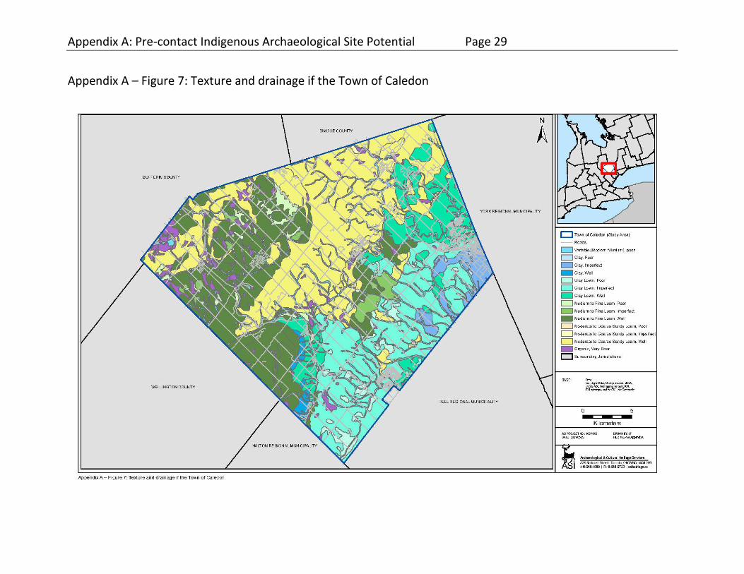
Appendix A: Pre-contact Indigenous Archaeological Site Potential Page 29
Appendix A – Figure 7: Texture and drainage if the Town of Caledon

Appendix A: Pre-contact Indigenous Archaeological Site Potential Page 30
Appendix A – Figure 8: Agricultural Capability of the Town of Caledon

Appendix A: Pre-contact Indigenous Archaeological Site Potential Page 31
ASI
Appendix A - Table 3: Soils and Physiographic Regions of the Town of Caledon
Parent Materials Soil Series % of Soils Canadian System of Soil Classification Taxon
Texture Drainage Agriculture Capability Class
Agriculture Limitation
Medium textured shale and limestone till Woburn loam 1.77 Brunisolic Gray Brown Luvisol
loam good 1 none
Milliken loam 1.03 Gleyed Gray Brown loam imperfect 1 none
Lyons loam 0.05 Orthic Humic Gleysol loam poor 2 excess moisture
Harriston loam 5.10 Brunisolic Gray Brown
Luvisol loam good 2 topography
Listowel loam 0.50 Gleyed Gray Brown loam imperfect 1 none
Parkhill loam 1.05 Orthic Humic Gleysol loam poor 2 excess moisture
Dumfries loam 4.10 Brunisolic Gray Brown
Luvisol loam good 4 stoniness; topography
Dumfries sandy loam 1.15 Brunisolic Gray Brown
Luvisol loam good 4 stoniness; topography
Lily loam 0.12 Orthic Humic Gleysol loam poor 5 excess moisture
Heavy textured shale and limestone till Oneida clay loam 3.92 Brunisolic Gray Brown Luvisol
clay loam good 1 none
Chinguacousy clay loam 20.88 Gleyed Gray Brown clay loam imperfect 1 none
Jeddo clay loam 1.68 Orthic Humic Gleysol clay loam poor 3 excess moisture

Appendix A: Pre-contact Indigenous Archaeological Site Potential Page 32
ASI
Parent Materials Soil Series % of Soils Canadian System of Soil Classification Taxon
Texture Drainage Agriculture Capability Class
Agriculture Limitation
Heavy textured limestone till King clay loam 5.74 Brunisolic Gray Brown Luvisol
clay loam good 4 topography
Monaghan clay loam 1.14 Gleyed Gray Brown clay loam imperfect 1 none
Poorly sorted sands Pontypool sandy loam 23.25 Brunisolic Gray Brown Luvisol
sand good 6 low moisture; steep terrain
Well sorted sandy outwash Brighton sandy loam 1.38 Orthic Melanic Brunisol sandy loam
good 2 low natural fertility
Fox sandy loam 0.09 Brunisolic Gray Brown
Luvisol loam good 2 low natural fertility; low
moisture
Brady sandy loam 0.05 Gleyed Brunisolic Gray
Brown Luvisol sandy loam
imperfect 3 excess moisture
Well sorted gravelly outwash Caledon loam 5.64 Brunisolic Gray Brown Luvisol
loam good 2 low natural fertility; low moisture
Gilford loam 0.42 Orthic Humic Gleysol loam poor 4 excess moisture
Sands over clay till Bookton sandy loam 0.32 Brunisolic Gray Brown Luvisol
sandy loam
good 2 low natural fertility; low moisture
Lacustrine clay over clay till Peel clay 5.62 Podzolic Gray Brown Luvisol
clay imperfect 1 none
Shallow soil over limestone bedrock Malton clay 0.06 Orthic Humic Gleysol clay poor 3 excess moisture
Shallow soil over red shale bedrock Farmington loam 1.75 Orthic Melanic Brunisol loam good 6 shallow depth to bedrock

Appendix A: Pre-contact Indigenous Archaeological Site Potential Page 33
ASI
Parent Materials Soil Series % of Soils Canadian System of Soil Classification Taxon
Texture Drainage Agriculture Capability Class
Agriculture Limitation
Organic materials Lockport clay 0.67 Orthic Gray Brown Luvisol clay good 7 topography
Recent alluvium muck (Humisol) 2.69 n/a organic poor 7 excess moisture
Water bottom land 9.75 n/a variable variable 5 flooding
Total
100

Appendix A: Pre-contact Indigenous Archaeological Site Potential Page 34
ASI
formed on lacustrine clay overlying clay till (5.7% - Peel, Malton). On the South Slope Till Plain the predominant soils have developed on medium-textured till derived from shale and limestone (2.9% - Woburn, Milliken, Lyons), heavy textured shale and limestone till (26.5% - Oneida, Chinguacousy, Jeddo), heavy textured limestone till (6.9% - King, Monaghan), and a few pockets of sand overlying clay till (0.3% - Bookton). On the Oak Ridges Moraine, the predominant soils have developed on poorly sorted sand (23.3% - Pontypool). On the uplands of the Guelph Drumlin Field soils have developed on medium-textured shale and limestone till (12.0% - Harriston, Listowel, Parkhill, Dumfries, Lily), while in the adjacent glacial spillways the same soils occur along with well-sorted sandy outwash (1.5% - Brighton, Fox, Brady) and gravelly outwash (6.1% - Caledon, Gilford). The balance of the study area is composed of shallow soils over bedrock (2.4% - Farmington, Lockport), organic muck (Humisol) deposits (2.7%), alluvium in bottom land (9.8%), and water (0.9%).
Soil Taxonomy
The mineral soils of Caledon are dominated by those of the luvisolic soil order, accounting for about 81% of the study area. The remainder includes gleysols (3%), brunisols (3%), and organic humisols (3%), while 10% of lands are unclassified bottom lands and water (Appendix A – Table 3).
Luvisols are well to imperfectly drained mineral soils that have developed on calcareous parent materials under the influence of the growth and decomposition of forest vegetation in subhumid to humid, mild to very cold climates. Luvisols are characterized by eluvial Ae horizons and illuvial Bt horizons with silicate clay as the main accumulation product. The A and B horizons are slightly to moderately acidic, and the C horizons are usually neutral to alkaline. The Luvisolic soils of Caledon belong to the Gray Brown Luvisol great group. Gray brown luvisols have developed under deciduous or mixed forest vegetation where high biological activity has resulted in the rapid incorporation of forest litter (L, F, H horizons) to form dark humic Ah horizons. The parent materials are typically till, glaciofluvial, or glaciolacustrine deposits. Loamy textures predominate but clayey and sandy loams also occur. The morphological characteristics of the eluvial Ae horizon and textural Bt horizon are most strongly expressed on medium to fine textured soils. On coarser, sandy soils the properties of the profile tend to intergrade with those of brunisolic or podzolic soils. Luvisolic soils usually develop on gently

Appendix A: Pre-contact Indigenous Archaeological Site Potential Page 35
ASI
to moderately rolling lands, especially on adequately drained, middle and upper slopes (Agriculture Canada Expert Committee on Soil Survey 1987: 78-79).
Brunisols are a broad group of well to imperfectly drained mineral soils that have developed under vegetative regimes ranging from forest to alpine to tundra. They occur in varying climatic zones, from Mesic to Arctic and from semiarid to perhumid. Their distinguishing characteristic is a prominent brownish Bm horizon which has developed in situ and hence mostly lacks the illuviation that typifies podzolic and luvisolic soils. Since leaching and weathering are relatively poorly developed in brunisolic soils, their chemical characteristics tend to reflect those of the parent material. In Caledon, soils of the Melanic Brunisol great group, formerly referred to as Brown Forest soils, are the only representatives of the brunisolic order. Developed under deciduous or mixed forests, these soils exhibit a pronounced humic A horizon as a result of the degradation of forest litter by soil fauna. Parent materials are most frequently loamy to clayey, moderately to strongly calcareous, glacial till and lacustrine deposits. Topography is typically gently to moderately rolling. Fertility limitations of melanic brunisols are generally slight to moderate and productivity is often high. While structural limitations are generally not a problem, low natural fertility and shallowness of bedrock are limitations of melanic brunisols in Caledon (Clayton et al. 1977:1:124-131; Hoffman and Richards 1953).
The poorly drained mineral soils of Caledon are orthic humic gleysols. Gleysolic soils are poorly drained mineral soils that are saturated with water and are under reducing conditions, due to lack of aeration, for some or all of the year. Vegetative regimes are hydrophytic and range from tundra to forest and meadow. By definition these soils include dull, greenish to bluish grey gleyed horizons, although surface horizons may vary from organic O horizons to organic-mineral Ah and Ae horizons, with or without a B horizon. In Caledon all gleysolic soils belong to the Humic Gleysol great group. These have well-developed humic A horizons, over 8 centimetres in depth, overlying gleyed B or C horizons. Parent materials are typically alluvial, glacio-lacustrine, or resorted till deposits. Where humic gleysols are dominant, the topography is usually level to gently rolling. Where they are subordinate, they often occupy local depressions or kettles. Fertility limitations of humic
Fertility limitations of humic gleysols are minor and productivity can be high for a variety of crops if drainage is artificially improved. Meadow grasses and sedges

Appendix A: Pre-contact Indigenous Archaeological Site Potential Page 36
ASI
are commonly supported in the natural state (Clayton et al. 1977:1:136-140). Organic soils contain more than 30% organic matter by weight and meet certain criteria of thickness within a defined control section. Unless artificially drained, they are water saturated or nearly saturated throughout the year, and as such are derived from the decomposition of hydrophytic vegetation. Organic soils are classified on the basis of degree of decomposition within the control section, which is divided into an upper tier (30-60 centimetres), middle tier (60 centimetres thick or to contact with water or sediment/bedrock), and lower tier (40 centimetres thick or to contact with water or sediment/bedrock). Fibric layers are composed of poorly decomposed fibres which are readily identifiable to botanical origin, and soils with predominant middle or middle and upper tier fibric layers are termed fibrisols. Mesic layers are composed of organic matter in an intermediate stage of decomposition, and soils with predominant middle or middle and upper tier mesic layers are termed mesisols. Fibrisols and mesisols are commonly referred to as peat. Humic layers are composed of highly decomposed organic material, and soils with predominant middle or middle and upper tier humic layers are termed humisols (formerly known as muck soils) (Agriculture Canada Expert Committee on Soil Survey 1987: 82-92; Clayton et al. 1977:1:142-143).
Drainage and Agricultural Capability
More than half of soils are well drained (52%), while about a third (30%) are imperfectly drained, a small portion (5%) are poorly drained, and the remainder are chronically wet organic soils (3%) and variably drained bottomlands (10%) (Appendix A – Figures 6-8). The Canada Land Inventory (1965) has rated the majority (35%) of soils in Caledon as Class 1 for agriculture, with an additional 14% rated as Class 2 and 2% rated as Class 3 (Appendix A – Figure 9), thus 51% can be considered arable farmland. The main limitations of the Class 2 and 3 soils are low natural fertility, low moisture holding capacity, excess moisture, or adverse topography. The remaining soils are divided between Class 4 (11%), Class 5 (10%), Class 6 (25%), Class 7 (3%). As illustrated in Figure 9, the soils least suited to agriculture are found on the steep, porous uplands of the Oak Ridges Moraine, on the shallow soils of the Niagara Escarpment area, and in wetlands and bottomlands.

Appendix A: Pre-contact Indigenous Archaeological Site Potential Page 37
ASI
The predominance of rich, well- to imperfectly drained soils in Caledon, interspersed with poorly drained bottomland soils, would have supported a range of mixed northern hardwood forest communities on the uplands separated by lowland swamps, bogs, marshes, and riparian wetlands. The lowland biomes would have been rich, diverse, and attractive to Indigenous foragers, whereas the uplands would have been more monotonous and limited in game habitat. Accordingly, upland margins adjacent to lowland areas would have offered the best settlement locations in the warm seasons. In winter, however, the broad valleys may have been more sheltered and appealing. During the Late Woodland period, when Indigenous farming became widespread, the abundance of arable land would not have been a limiting factor to settlement.
3.3.5 Paleoclimatology
The climate of southern Ontario is described as having warm summers, mild winters and a long growing season with usually reliable rainfall. Precipitation is fairly evenly distributed throughout the year. Regional climatic variations are due primarily to elevation and topography, prevailing winds and proximity to the Great Lakes. Year to year variability is attributable to the nature and frequency of weather systems which cross the area (Brown et al. 1980:1-2).
The fossil pollen record of south-central Ontario provides an outline of the regional paleoclimate. After adjustments are made for the differential dispersion of pollen by various species, a reconstruction of the prevailing climatic conditions through time can be undertaken on the basis of the preferred habitats of those species.
During the period of initial deglaciation (circa 14,000 years ago), a harsh climate characterized by cool and extremely dry conditions prevailed in the study area. Mean annual temperatures in the study region were probably less than -3° Celsius (McAndrews 1981). Some have attributed these low temperatures throughout the Great Lakes-St. Lawrence region to the inflow of large volumes of glacial meltwater or proglacial lake water (Lewis and Anderson 1989).
In southern Ontario, a trend towards warming temperatures has been interpreted for the period from around 12,500 to 11,500 years ago as the glacial lake levels receded in the Huron basin. The period between about 11,000 and

Appendix A: Pre-contact Indigenous Archaeological Site Potential Page 38
ASI
9,000 years ago, however, witnessed an apparent climatic reversal with winters becoming longer and more severe, and summers warmer and drier than previously. This trend has traditionally been seen a result of the extremely low water levels in the Great Lakes basins, which reduced the moderating effects of the evolving Great Lakes, however, it has more recently been suggested that this deterioration was also caused by a new influx of cold waters from Glacial Lakes Agassiz and Ojibway during the brief “Mattawa flood” (Lewis and Anderson 1989). From around 9,000 to 7,500 years ago, the regional climate became more moderate, experiencing warmer mean annual temperatures and greater precipitation. At their maximum, during the Hypsithermal, temperatures probably exceeded present levels by 1° to 2° Celsius. It is unlikely, however, that this climatic amelioration was sufficient to affect the zonal vegetation (McAndrews 1981). Essentially modern mean annual temperatures (7° Celsius) and precipitation levels were reached by around 7,000 years ago.
Climatic trends and fluctuations play a significant role in determining the character of the natural environment to which human populations must adapt. As the shift in climatic conditions which occurred following deglaciation was very gradual, the concomitant changes which were necessary to the subsistence modes of Indigenous populations were also gradual. While long-term climatic trends did not directly influence the subsistence practices of a population in the short term, there are many short-term climatic factors that had significant implications for local settlement-subsistence practices, the most critical of which were temperature, precipitation, potential evapotranspiration, frost-free days, snowfall, and wind-speed and direction. Short-term climatic irregularities may have been most keenly felt during the last millennium before European contact, as Indigenous groups became increasingly reliant upon agriculture to supplement their dietary requirements.
The number of frost-free days, which represents the effective length of the growing season for agriculture, would have been of importance to Indigenous horticulturalists. The mean length of the frost-free period is about 135 to 145 days in the Caledon area (Brown et al. 1980:60), which is more than adequate for traditional Indigenous agriculture. Moreover, Caledon lies within the 2500 - 2700 range for corn heat units (CHU), a measure of capacity for corn maturation based on maximum and minimum daily temperatures. Grain corn is typically
Appendix A: Pre-contact Indigenous Archaeological Site Potential Page 39
ASI
grown in areas exhibiting >2500 CHU, while corn can be grown for sileage in areas of only 2100 CHU (Brown et al. 1980: 37-38).
The mean annual precipitation in the Caledon area is about 76-81 centimetres, with monthly means fairly evenly distributed at about 6.5 centimetres. Factors influencing precipitation at the mesoclimatic scale in southern Ontario are slope, elevation, proximity to the large lakes, and the prevailing winds (Brown et al. 1980: 39). The last two variables exert considerable influence on local precipitation patterns. For Indigenous horticulture the amount of precipitation during the growing season would have been sufficient throughout Caledon, except in areas with poor moisture retention such as parts of the Oak Ridges Moraine with porous soils and steep terrain. In several areas, these xeric conditions likely contributed to the development of oak- and pine-dominated forests.
While the inland location of Caledon would have diminished the influence of large bodies of water, local topography and prevailing winds would have influenced the Caledon mesoclimate with respect to temperature. For example, valleys provide channels for both up-valley and down-valley air flow under certain conditions (Greenland 1977: 23-27, 63-73; Munn et al. 1999).
Climatic conditions have been far from constant over the last millennium. Of particular importance is a climatic period characterized by cooling and referred to as the "Little Ice Age" (Bryson and Murray 1977; Grove 2004). This episode, which is conventionally dated to between A.D. 1550 and 1880, may have reduced average daily temperatures in southern Ontario by about one-half degree Celsius. In addition, early fall temperatures may have been reduced by about 1.5 degrees Celsius (Bryson and Murray 1977). This trend may have increased the risk of crop failure for Late Woodland period Indigenous farmers.
3.3.6 Paleovegetation
While a comprehensive discussion of the pre-contact vegetation of the study area is beyond the scope of this study, it is possible to draw some general conclusions regarding the development of Caledon’s plant communities since the Pleistocene. In addition, as the nature of understorey and forest floor vegetation is often dependent on the same factors which determine forest cover, and on

Appendix A: Pre-contact Indigenous Archaeological Site Potential Page 40
ASI
the forest cover itself, an understanding of these factors may be useful in the recognition of particular floral resources within the environment which may have been actively sought out by past populations. The identification of these potential resources, and the determination of their general spatial and temporal variation within the study area, will further assist in reconstructing the subsistence strategies of Caledon’s pre-contact Indigenous occupants and the changes these practices may have undergone over time.
Pollen spectra from regional sites like Van Nostrand Lake (Appendix A – Figure 11) and Wilcox Lake in Richmond Hill (Westgate et al. 1999: Figure 1.18) indicate that spruce (Picea sp.) and pine (likely Jack pine (Pinus banksiana)) dominated the regional forest in the period following deglaciation until around 13,000 years ago. White pine (Pinus strobus) assumed dominance at that time and was joined by subordinate taxa including birch (Betula sp.), oak (Quercus sp.), ash (Fraxinus sp.), and elm (Ulmus sp.). Around 9,500 years ago the dominance of pine went into decline as the northern hardwood taxa became established. Beech (Fagus grandifolia) quickly achieved a dominant position, while elm, sugar maple (Acer saccharum), cedar (Thuja occidentalis), and especially hemlock (Tsuga canadensis) gained in importance. Hemlock declined dramatically after about 7,000 years ago, rebounding somewhat thereafter (Bennett 1987; Karrow and Warner 1990: 29-31; Westgate et al. 1999:26-27). Although this northern mixed hardwood forest has prevailed in Caledon until the land clearances of the nineteenth century (Eckenwalder 1999), there have been fluctuations in forest composition due to climatic change and regional processes of forest succession.
Over the past 200 years, the forest-cover of Caledon has been severely reduced with only isolated remnants still extant. A number of sources are available to permit the reconstruction of local vegetation immediately prior to Euro-Canadian settlement in the early nineteenth century. These include historical descriptions, early land surveyors notes and maps, phytosociological reconstruction based on soils, and extrapolation from extant forest stands in, and adjacent to, the study area.
Under the widely used ecological land classification system developed for Ontario by Hills (1958) and revised by Burger (1993), Caledon lies within Site Region 6E. Characteristic tree species for various soil moisture and ecoclimatic regimes within these site regions are presented in Appendix A – Table 4.

Appendix A: Pre-contact Indigenous Archaeological Site Potential Page 41
ASI
Under normal temperature conditions and on moist (fresh) soils, one would expect to find climax forests dominated by sugar maple and beech in association with basswood (Tilia Americana), hemlock, white pine and white ash (Fraxinus Americana). The imperfectly drained clays and clay loams of the Peel Plain and South Slopes till plain would likely have supported this sort of climax forest. Common pioneering taxa under such conditions would include white birch (Betula papyrifera), red oak (Quercus rubra), and black cherry (Prunus serotina).
On drier soils, such as the porous sands of the Oak Ridges Moraine, one might expect to find the co-dominant maple and beech increasingly associated with red oak, white pine, and white ash.
On poorly drained soils, swamps of eastern white cedar, white spruce (Picea glauca), tamarack (larch) (Larix laricina), balsam fir (Abies balsamea), and eastern hemlock would have been common (Burger 1993).
The use of historical survey data involves the reconstruction of vegetation based on the observations of early land surveyors. These surveyors routinely recorded information about trees located along their survey lines. These data are found in the surveyor's notebooks, diaries, and maps, compiled when the original land surveys were carried out in the early nineteenth century. The quantity and quality

Appendix A: Pre-contact Indigenous Archaeological Site Potential Page 42
ASI
Appendix A - Table 4: Characteristic Tree Species - Site Relationships in Site Region 6E Lake Simcoe
Eco-climate
Hotter
Eco-climate
Normal
Eco-climate
Colder
Soil Moisture
Drier
Soil Moisture
Fresh
Soil Moisture
Wetter
Soil Moisture
Drier
Soil Moisture
Fresh
Soil Moisture
Wetter
Soil Moisture
Drier
Soil Moisture
Fresh
Soil Moisture
Wetter
Climax species:
Red, White and Black Oak
Hard and Red Maple
Climax species:
Hard Maple
Beech
White and Red Oak
Bittternut Hickory
Butternut
Climax species:
Red and Silver Maple
White and Red Ash
Climax species:
White Pine
Hard and Red Maple
Red Oak
White Ash
These species represent a high proportion in the site region.
Climax species:
Hard Maple
Beech
Eastern Hemlock
White Pine
Basswood
White Ash
These species represent a high proportion in the site region.
Climax species:
Eastern Hemlock
Yellow Birch
Black Ash
White Elm
Eastern Whites Cedar
Climax species:
Red and White Pine
Climax species:
White Spruce
Black Fir
White Pine
Eastern Hemlock
Climax species:
Balsam Fir
White Spruce
Eastern Larch
Eastern White Cedar
Pioneer species:
Red and White Pine
Trembling and Largetooth Aspen
Pioneer species:
Black Cherry
Rock Elm
Pioneer species:
Red Pine
Trembling and Largetooth Aspen
Pioneer species:
White Birch
Red Oak
Black Cherry
Pioneer species:
White Spruce
Balsam Fir

Appendix A: Pre-contact Indigenous Archaeological Site Potential Page 43
ASI
of information regarding vegetation in these notebooks, however, is quite variable (Gentilcore and Donkin 1973). The procedure for transcribing vegetational data from the notebooks to topographic maps has been outlined by Heidenreich (1973). A comprehensive reconstruction of historical vegetation for Caledon, using Geographic Information System technology to both map data from early land surveys and model forests based on substrate and other parameters, has been completed by Puric-Mladenovic (2003; Puric-Mladenovic et al. 2011).
As illustrated in Appendix 1 – Figure 12, there is a strong correlation between historical forest communities and substrate in Caledon, particular with respect to edaphic conditions. Overall, the predominant historical forest cover was climax northern mixed hardwood forest dominated by beech and sugar maple in primary association with basswood and hemlock. In its mature state, this closed canopy forest would have had a heavily shaded understorey of limited biotic diversity and productivity. As habitat for game animals or plant resources it would been relatively impoverished. Locally, though, the relative complexity of the vegetation is linked to the relative complexity of the terrain and to historical contingencies, such as windthrow, which created gaps in the forest canopy. This variability can be best characterized with reference to the physiographic regions of the study area and to the various substrates within those regions (Appendix A – Table 5).
The greatest contrast in vegetation communities, and hence the highest biotic diversity and productivity, was likely to be found in the Hillsburgh Sandhills. Extensive wetlands surrounding Caledon Lake were dominated by cedar in pure stands or mixed with hemlock. Beyond these swampy lowlands were well-drained uplands of relatively coarse-grained kame sands which supported communities dominated by beech and maple intermixed with basswood, hemlock, and elm. The latter two species prefer moist soils so would have intergraded with the cedar swamps and upland forests. The rolling terrain no doubt contributed to considerable local variation in edaphic conditions and hence forest community composition.
A similar range of communities occurred throughout the Guelph Drumlin Field, especially with respect to the variability in edaphic conditions up and down the drumlin slopes. Wetland communities, though, tended to be smaller and

Appendix A: Pre-contact Indigenous Archaeological Site Potential Page 44
Appendix A – Figure 9: Historic Vegetation of the Town of Caledon

Appendix A: Pre-contact Indigenous Archaeological Site Potential Page 45
ASI
Appendix A - Table 5: Characterization of Historic Vegetation by Physiographic Regions
Physiographic Region
Substrate and Historical Forest Taxa
Hillsburgh Sandhills
• well-drained uplands (sandy loam kame)
• Dominant: beech, maple, hemlock
• Subordinate: basswood, elm
• poorly drained depressions and kettles (organics)
• Dominant: cedar, hemlock
• Subordinate: beech, maple, elm
Guelph Drumlin Field
• well-drained uplands (sandy and loamy till)
• Dominant: beech, maple, basswood
• Subordinate: hemlock
• poorly drained depressions and valleys (organics)
• Dominant: cedar, hemlock
• Subordinate: beech, maple, elm
Niagara Escarpment
• steep slope and shallow bedrock (clay & clay loam till)
• Dominant: beech, maple
• Subordinate: pine, oak, basswood, hickory, chestnut

Appendix A: Pre-contact Indigenous Archaeological Site Potential Page 46
ASI
Physiographic Region
Substrate and Historical Forest Taxa
Oak Ridges Moraine
• well-drained uplands (sandy loam kame)
• Dominant: beech, maple, hemlock
• Subordinate: pine, oak, basswood, hickory, chestnut
• poorly drained depressions, valleys and kettles (alluvium, organics)
• Dominant: cedar, hemlock
• Subordinate: beech, maple, elm
South Slope • well and imperfectly drained upland (clay loam and loam till)
• Dominant: beech, maple, basswood
• Subordinate: pine, oak, hickory, chestnut
• poorly drained depressions and valleys (alluvium, organics)
• Dominant: beech, maple, hemlock, pine, oak, elm
• Subordinate: cedar, basswood, pine, hickory
Peel Plain • well, imperfectly, and poorly drained upland (clay till)
• Dominant: beech, maple, pine, hickory
• Subordinate: basswood, elm, chestnut
• poorly drained valleys (alluvium, organics)
• Dominant: beech, maple, pine, hickory
• Subordinate: hemlock, elm
distributed throughout the valleys between the drumlins and within the glacial spillway valleys. Some riparian wetlands also occurred. Cedar was again the dominant wetland community, with some intermixing with hemlock. The majority of the Guelph Drumlin Field was dominated by beech and maple with significant associations of basswood, especially in the moister spillway valleys such as the Caledon meltwater channel. Hemlock was not a significant component of the upland forest in this area.

Appendix A: Pre-contact Indigenous Archaeological Site Potential Page 47
ASI
The Albion Hills segment of the Oak Ridges Moraine exhibited a very intricate distribution of forest communities, which is consistent with the physiographic complexity of this feature. Contrary to its name, oak was not the predominant forest community, although there were certainly areas where oak was significant. Locally, forest communities graded from swamp dominated by cedar through moist-adapted communities of beech, maple and hemlock mixed with elm, to beech and maple co-dominant stands in the mesic range, to beech and maple mixed with pine, hickory and chestnut on drier soils to mixed pine and oak at the xeric end of the spectrum. The most common forest community comprised beech, maple, hemlock, and elm, no doubt reflecting the hummocky terrain containing numerous wetland pockets and minor watercourses. Cedar would also have been ubiquitous around the margins of the kettle lakes which dot the Oak Ridges Moraine, and was likely common together with hemlock, elm, and red maple in mixed riparian wetland communities along the tributaries of the Credit and Humber Rivers. The largest area of dry-adapted forest, composed of large areas of mixed pine and oak, smaller oak stands, and mixed forest of beech and maple with pine, hickory, and chestnut, was situated in the northern corner of Caledon on and around Mount Wolfe.
The Niagara Escarpment physiographic region includes both the scarp itself as well as the upland area immediately behind the brow and the talus slopes below. The quality of the soils in this region are impaired by their shallowness to the underlying bedrock and by the slope and porosity of the underlying talus. Overall, this created more variability in growing conditions and thus a more complex forest community, including areas where taxa such as oak, pine, hickory and chestnut could better cope with the xeric conditions than could the dominant species such as maple, beech and basswood.
The rich clay loam soils of the South Slope supported predominantly maple-beech-basswood communities on the well to imperfectly drained uplands, especially towards the centre of the drainage divides. Closer to the watercourses, where the soil conditions were likely a bit moister and edaphic toposequences occurred down the gradient from upland to lowland, the communities were more diverse, including subordinate upland taxa such as pine, hickory, and ash. These graded into lowland communities of with hemlock and cedar in the stream valleys.

Appendix A: Pre-contact Indigenous Archaeological Site Potential Page 48
ASI
The forests of the Peel Plain very much resembled those of the South Slope, being predominantly maple-beech forest but with somewhat more pine and hickory along the drainage divides and more elm and basswood along the watercourses.
3.3.7 Plant and Animal Subsistence Resources
A wide variety of wild plant resources was available to indigenous populations residing in Caledon. Of particular importance to this study were plant species that appear to have been integral to subsistence. Nut-bearing trees were abundant in parts of the study area and could have provided an important and storable source of protein and fat. High in calories and rich in oil, nuts may have provided an important diet supplement. However, certain nuts required a considerable expenditure of energy for collection and processing, and nut masts are not consistent from one year to another. Common nut-bearing trees found in the study area include butternut (Juglans cinerea), hickory (Carya sp.), oak and beech. The floodplains of major watercourses and associated wetlands also would have offered a wide variety of resources, including foods such as roots, tubers, greens, as well as fibre and building materials, such as bark and cedar poles.
Fleshy fruits were an important resource in Indigenous subsistence systems, as they are high in energy and are a good source of Vitamin C, an antiscorbutic. Elderberry (Sambucus canadensis), serviceberry (Amelanchier sp.), hawthorn (Crataegus sp.), cherry (Prunus sp.), plum (Prunus nigra), currant (Ribes sp.), strawberry (Fragaris sp.), viburnum (Viburnum sp.), and bramble (Rubus sp.) all flourished within the study area, the majority favouring disturbed or forest-edge habitats. The remains of these species are commonly recovered from archaeological sites where conditions have favoured their preservation.
As with vegetation, a comprehensive discussion of fauna within Caledon is not relevant to this modeling exercise, however, local fauna did provide an extensive resource base for pre-contact populations and are worthy of consideration. Different vegetation communities can be considered as micro-environments to which certain animal species may be principally adapted, although clearly, faunal habitats are not discrete. Generally, biotic diversity tends to be greatest where topography, drainage, and soils are most variable, resulting in a broader range of habitats per unit area. In contrast, areas with uniform topography, adequate

Appendix A: Pre-contact Indigenous Archaeological Site Potential Page 49
ASI
drainage, and suitable soils tend to produce closed canopy climax forest with an impoverished under-storey that is less attractive to many animals.
In Caledon, it is expected that the greatest habitat diversity and biotic productivity would be found in the uplands surrounding Caledon Lake and its associated wetlands. These areas contained ecotones of higher biodiversity and ecological richness between uplands, moist lowlands, riparian wetlands, watercourses, and the shore of Caledon Lake.
The next most biotically productive landscapes were likely the upper reaches of the Ontario sub-watersheds where ecotones between the upland plains, kettle wetlands, lakes, and ponds, riparian wetlands, and the watercourses would have increased habitat diversity and biotic productivity. The hummocky terrain of the Albion Hills section of the Oak Ridge Moraine, where hemlock seems to have been a significant component of the regional forest, exemplifies this environment.
The middle reaches of the Ontario sub-watersheds, where they spread out across the uplands of the Peel Plain and South Slopes till plain, would have been much less biotically productive. While local variations in drainage, soil quality, as well as agents of forest opening such as windthrow, would have introduced some patchiness to the vegetation cover, overall, these uplands would have comprised relatively monotonous climax northern hardwood forests dominated by maple, beech, and basswood with closed canopies and an impoverished understorey.
For the vast majority of the pre-contact period, ungulates represent a potentially significant game species in Caledon. During the Late Pleistocene and Early Holocene, herds of caribou (Rangifer tarandus) may have traversed the upland spruce parklands. Woodland caribou range over areas of 200 to 4000 square kilometres, territories five to 100 times larger than moose and deer. In part, they require such large areas because they prefer relatively un-fragmented patches of open, mature forest through which they can navigate relatively easily and where they can find adequate supplies of ground lichen, especially in the winter when this is their primary food. Such areas tend to support little browse for moose and deer, and relatively low densities of predators such as wolves (Banfield 1974: 383-388; Rothfels and Russell 2005; Species at Risk Public Registry 2010).
Archaeological evidence indicates that elk or wapiti (Cervus elaphus) were present in southern Ontario throughout the Holocene, preferring early

Appendix A: Pre-contact Indigenous Archaeological Site Potential Page 50
ASI
successional communities with conifers such as red pine, white pine, cedar, and balsam fir that provided shelter, security, and good browse. Dense conifer forests, though, are not preferred by elk. Similar to woodland caribou, elk are not migratory, yet range over relatively large areas of about 500 to 1000 square kilometres (Ministry of Natural Resources 2010; Telfer 1990). Since ridge habitats seem to be important to elk, the scarps and spillway terraces of the Credit Valley may have provided suitable habitat.
Moose (Alces alces) have similar habitat needs, preferring a mix of early successional—especially conifer—forest to provide browse and cover, as well as late successional conifer forest to provide shelter and protection in winter. In summer they also require lakes and rivers with aquatic vegetation. Unlike caribou and elk, though, moose are relatively solitary, with population densities on the order of 10 to 30 per 100 square kilometres and ranges of only about 40 square kilometres (Banfield 1974: 395-398; Telfer 1997). Caledon Lake and vicinity would appear to have provided the best moose habitat, with its complex mix of hemlock and cedar, communities, although the mixed hemlock forests and kettle ponds of the Oak Ridges Moraine may also have attracted moose, especially in the winter.
White-tailed deer (Odocoileus virginianus) are browsers adapted to forest edge environments. As such, they would have been attracted to wetland margins for spring and summer forage, to stands of mast-producing trees such as oak during the fall, and to conifer groves for winter browse and shelter. Large areas of windfall or otherwise open canopy would also have provided a shifting habitat for deer. Otherwise, the closed canopy mixed hardwood forest would have provided very limited browse opportunities for deer. The highly variable forest communities of the Oak Ridges Moraine would seem to have provided the best potential deer habitat, especially in the fall when deer may have been attracted to crops of mast in the mixed oak and beech forests.
Forest and swamp edges would also have attracted snowshoe hare (Lepus americanus) and eastern cottontail (Sylvilagus floridanus), while marshes, swamps, kettle ponds and riparian wetlands would have provided suitable habitat for beaver (Castor canadensis) and muskrat (Ondatra zibethica). Wetland margins, stream valleys, and river floodplains, especially those with access to mast-producing beech forest, would also attract raccoon (Procyon lotor). Black bears (Ursus americanus), are wide-ranging omnivores with home territories of between 10 and 100 square kilometres and typical densities of about two per 10

Appendix A: Pre-contact Indigenous Archaeological Site Potential Page 51
ASI
square kilometres. They prefer heavily wooded areas with access to food sources such as berry patches and mast-producing forest and would have occurred throughout Caledon in small numbers.
Caledon Lake and the major rivers and streams would have provided an important fishery to Indigenous peoples (Credit Valley Conservation 2002; Ministry of Natural Resources 2002). Resident populations of such species as brook trout (Salvelinus fontinalis) in the cold in-land streams and freshwater drum (Aplodinotus grunniens), brown bullhead (Ictalurus nebulosus), and smallmouth bass (Micropterus dolomieui) in the weedy river shallows, would have been available through much of the year. More important, however, may have been seasonal spawning shoals and runs of species such as Atlantic salmon (Salmo salar), American eel (Anguilla rostrata), walleye (Stizostedion vitreum), and sucker (Catostomus sp.). Until the advent of dams for milling in the nineteenth century, the Credit River was included amongst the watercourses of the Lake Ontario basin with a sizeable salmon fishery, especially during the fall run (Smith 1946:40). Along the main branch of the Credit, salmon could be found up to the falls at Cataract (Ministry of Natural Resources 2002:3:4).
Three principle fish habitats can be identified within the Caledon watersheds: the shallow waters of Caledon Lake and various other kettle lakes and ponds; the pool and riffle sequences of headwater streams; and the larger channels and riparian wetlands of the upper and middle reaches of the Credit and Humber rivers. Although it is likely that all these habitats would have been exploited, fish productivity would have been highest in the larger stretches of the rivers, especially where waterfalls would have constrained and concentrated fish movements. The higher fish productivity of these areas can be attributed to the high primary production of riparian wetlands and the greater area and diversity of the habitat structure.
Archaeological investigations of several Late Woodland villages southeast of Caledon help to characterize the two major seasonal fisheries available to Indigenous populations within the Lake Ontario watershed (e.g. Needs-Howarth 2010; Williamson et al. 2003). The first group, including American eel, Atlantic salmon, lake whitefish, and lake trout, are typically harvested during spawning runs in the fall. Scadding (1966: 161) and Lizars (1913) report that hundreds of salmon were annually taken from the Don and Humber rivers, respectively, often by the aid of jack lighting using torches made from resinous pine knots

Appendix A: Pre-contact Indigenous Archaeological Site Potential Page 52
ASI
mounted on the front of fishing skiffs to attract the fish. On one such fishing expedition, Scadding and friends speared twenty large salmon in an hour. Sauriol (1981: 92) similarly reports on a settler in 1793 having harvested ninety salmon from the Don River. As noted above, the Credit River salmon fishery was similarly productive. The second fishery comprises brown bullhead, northern pike, sunfish, yellow perch, and sucker. Of these, resident populations of brown bullhead, sucker, and yellow perch were likely available in most of the larger rivers and streams of the Lake Ontario sub-watersheds. Other populations of suckers and yellow perch, which were resident in the lower Lake Ontario sub-watersheds or the littoral zone, may also have been harvested during their spawning runs in the spring (Credit Valley Conservation 2002; Ministry of Natural Resources 2002; Scott and Crossman 1979).

Appendix A: Pre-contact Indigenous Archaeological Site Potential Page 53
ASI
4.0 Deductive Site Potential Model: Geographic Information System Layers and Analysis
This section considers the human paleoecology of the Town of Caledon in order to develop a deductive narrative which outlines probable pre-contact Indigenous land-use trends through time.
The archaeological potential model was developed using the project GIS to summarize and map various data sets as separate, but complementary layers. Modelling criteria were then derived through analysis of these layers, and these criteria were applied to produce a final, composite layer, which is a map of archaeological site potential within the Town of Caledon.
Digital data for the initial base layer was provided by the Town of Caledon; included on this layer were hydrographic features, including watercourses, lakes, ponds, and wetlands; the road network; and current vegetation.
4.1 Environmental Layers
4.1.1 Hydrography
Hydrographic features, including major rivers, creeks and their tributaries, as well as other bodies of water, such as ponds and wetlands already existed as layers on the digital base mapping, yet when overlaid on the ortho-imagery, there are clearly historical or intermittent watercourses that are not included. Therefore, it became necessary to improve the resolution of hydrographic features by digitizing data from other sources, such as historical maps. While these efforts greatly improved the resolution of the hydrographic layer, it was recognized that a small percentage of site locations may have been influenced by water sources than could not be practically resolved through available mapping.
4.1.2 Soils
Digital soils data were acquired from the Geomatics Service Centre, Ontario Ministry of Agriculture, Food and Rural Affairs. This layer is essentially a digital

Appendix A: Pre-contact Indigenous Archaeological Site Potential Page 54
ASI
version of the soils mapping contained in the Ontario Soil Survey Report for Peel County (Hoffman and Richards 1953).
The soil survey for Peel County had mapped some 411 discrete soil series polygons within Caledon at 1:63,360 scale (Hoffman and Richard 1953), providing relatively high resolution of soil variability across the region. At the same time, however, this complex array of mapped soils made it difficult to interpret gross regional trends. Accordingly, the soil series were re-grouped in order to provide mapped summaries of relevant attributes, including soil texture, drainage, and agricultural capability. This was accomplished by adding new texture, drainage, and capability fields to the attribute database from the digital soils map, and then using the Geographic Information System to produce maps based on these attribute sets. The soil texture layer discriminated between sandy loam, loam, clay loam, clay, organic, and bottomland. The soil drainage layer discriminated between well drained, imperfectly drained, poorly drained, very poorly drained, and water. The soil capability for agriculture layer discriminated between: Class 1, having no significant limitations for agriculture; Class 2, having moderate limitations that restrict the range of crops or require moderate conservation practices; Class 3, having moderately severe limitations that restrict the range of crops or require special conservation practices; Class 4, having severe limitations that restrict the range of crops or require special conservation practices; Class 5, having very severe limitations that restrict their capability in producing perennial forage crops, and improvement practices are feasible; Class 6, which are capable only of producing perennial forage crops, and improvement practices are not feasible; and Class 7, having no capability for arable culture or permanent pasture (Canada Land Inventory 1965).
The objective in aggregating the soils data this way was to facilitate its use as proxy measures for physiographic attributes for which there was no digital mapping, such as preferred growing conditions for various tree species (Burger 1993; Hills 1958; Maycock 1963). The soil texture layer reveals the strong correlation between parent materials associated with certain surficial (Quaternary) deposits and soils.
As noted in Section 3.3.4, the soil capability for agriculture layer reveals that the majority (51%) of the land in Caledon is arable farmland (Class 1 to 3), much of it (35%) of the highest rank (Class 1). This indicates that soil quality would generally not have been a concern for any agricultural pursuits in the study area,

Appendix A: Pre-contact Indigenous Archaeological Site Potential Page 55
ASI
whether by pre-contact Indigenous farmers or Euro-Canadian pioneers. It also indicates that the substrate would generally have not been a significant constraint on the development of climax forest, although as noted in Section 3.3.6, edaphic variation due to slope and/or texture may have locally favoured certain vegetative associations over others.
4.2 Indigenous Archaeological Site Potential Layer
4.2.1 Archaeological Sites Data Used for Modeling
For the purposes of using registered pre-contact Indigenous archaeological sites to inductively modeling potential for the discovery of additional sites, 127 Indigenous sites were considered out of the 232 registered sites of all kinds in Caledon. Eighty of these Indigenous sites are isolated finds of flakes or projectile points randomly lost while traveling through the landscape and were therefore deemed inappropriate for modeling purposes. Such finds, while reflecting widespread Indigenous use of the land, cannot inform us about pre-contact Indigenous settlement patterns and decision making. So, having reviewed all the sites with Indigenous components, the total number of Indigenous sites used for inductive modeling was 47. Nevertheless, all 127 registered, pre-contact Indigenous archaeological sites were included in the project Geographic Information System as a discrete layer.
While the number of registered Indigenous sites within Caledon was sufficient to permit development of an inductive model to extrapolate archaeological potential based on locations of known sites, they should nevertheless be expected to conform to expectations arising from deductive modeling. The following deductive model paints a general picture of pre-contact Indigenous land use throughout the millennia in Caledon, based on an understanding of regional site types, ages, and evolving land-use patterns.
Throughout much of prehistory, the inhabitants of Caledon were hunter-gatherers who practised an annual subsistence round to exploit a broad range of natural resources for food and raw materials for such needs as shelter construction and tool fabrication. Assuming that access to natural resources influenced and constrained the movement and settlement of Indigenous

Appendix A: Pre-contact Indigenous Archaeological Site Potential Page 56
ASI
peoples, our goal was to understand what these resources were, how they may have been distributed, how their use and distribution may have changed over time, and how the landscape itself may have constrained movement and access to resources as well as settlement location. Given the requirements of this study, and our limited ability to precisely resolve details of past environments, we began by considering the relative merits of the physiographic areas, as it could be demonstrated that these represented certain constellations of environmental attributes. We proceeded chronologically in this investigation since certain aspects of Caledon had changed dramatically through the period of human occupation.
4.2.2 Paleo-Indian Period
Hunter-gatherer bands have occupied Caledon beginning as early as 13,000 years ago, as indicated by the discovery of early Paleo-Indian artifacts along the upper reaches of the Humber River. At this time, the open boreal woodlands likely offered a rather limited selection of floral resources, hence subsistence would have been primarily oriented towards hunting and fishing. The southern shores of glacial Lake Algonquin, which occupied the Huron-Simcoe basin (Eschman and Karrow 1985; Jackson et al. 2000), would have been only about 10 kilometres northeast of Caledon. To the south, the shore of a much smaller early Lake Ontario was approximately 40 kilometres away. Paleo-Indians with base camps situated in proximity to Lake Algonquin would have ranged throughout the interior hinterland in pursuit of game and perhaps riverine fish. It is expected that Paleo-Indian archaeological sites in Caledon will be similar to those already documented, namely isolated finds of chipped stone projectile points lost while hunting or small scatters of chipped stone debitage indicative of ephemeral campsites. Four Paleo archaeological sites have been registered in Caledon to date, all in the Humber watershed. Two are Late Paleo-Indian find spots. The other two are possible campsites. All are in the uplands of the Oak Ridges Moraine or South Slope in areas of complex terrain near wetlands.
4.2.3 Early Archaic Period
By Early Archaic times (circa 11,500 - 9,000 years ago), the current shoreline of Lake Simcoe became established more than 30 kilometres to the northeast,

Appendix A: Pre-contact Indigenous Archaeological Site Potential Page 57
ASI
while the shore of Lake Ontario was perhaps 35 kilometres or so to the south. Hunter-gatherer bands likely established warm-weather base camps adjacent to these lakeshores where resources such as spawning fish could support populations of 50 or more people. The lower reaches and mouths of the Holland, Credit and Humber rivers, especially around complex shorelines, would have been the best localities to sustain such population aggregations. During the warm season, Caledon may have only been occasionally visited during hunting expeditions. The archaeological evidence of this would tend to be ephemeral campsites situated along watercourses.
The late fall, winter, and early spring may have been the seasons when Caledon saw more activity, as Early Archaic bands dispersed into interior—probably nuclear family—hunting territories, much as Indigenous people of the boreal forest have done until recent generations. Such hunting territories would likely have been organized on a sub-watershed basis, with individual bands occupying adjacent stream catchment areas. Winter occupations may have been more focussed within the larger valleys, encouraged by the protection they offered from winter storms and by access to any conifer grove deer yards, where ungulates congregate to avoid heavy snows and have access to abundant browse. Riparian wetlands and swamps would have also provided fuel, building materials, roots and tubers, and small game. Archaeological evidence of such sites may be difficult to distinguish from warm season hunting camps, although the sustained occupation of a site over several months would likely leave a more substantial artifact assemblage. Currently there are seven Early Archaic sites registered in Caledon, only two of which have been identified as campsites. One campsite is situated in the South Slope on a terrace overlooking Etobicoke Creek. The other is situated on a headwater tributary of the Humber River in an area of complex terrain near wetlands.
4.2.4 Middle Archaic Period
As the inland drainage system matured through the Early and Middle Archaic (circa 9,000 - 5,000 years ago) periods, and adaptive patterns shifted in response to the establishment of northern mixed deciduous forest and its associated fauna, the major valleys and adjacent uplands may have increased in importance, particularly where camps could be situated on river terraces with well-drained soils. These corridors would have provided access to rich riparian

Appendix A: Pre-contact Indigenous Archaeological Site Potential Page 58
ASI
habitat, such as occurred along the glacial spillways of the central Credit River valley. Scarps and terraces may have also retained importance as travel corridors along the ecotone between the uplands and lowlands. Further inland, the highest central portions of the Oak Ridges Moraine, with hummocky terrain and many wetland pockets, kettle ponds and headwater streams, would have had much to offer Indigenous hunter-gatherers, especially in the fall when stands of mast-producing trees (for example; oak, beech, hickory) would have provided nuts to both Indigenous foragers and the game this mast crop attracted, including deer, raccoons, squirrels, and passenger pigeons. In contrast to the Oak Ridges Moraine, the closed-canopy hardwood forests of the South slope and Peel plain may not have attracted much settlement during any season, except perhaps where kettle lakes, ponds, wetlands, and headwater streams would have created locally rich micro-environments. Currently there are twelve registered Middle Archaic sites in Caledon. Three have been identified as campsites. Two are situated on the South Slope by tributary streams in complex uplands adjacent to the main Humber River valley. The other is situated on the Peel Plain on a plateau overlooking the West Humber River.
4.2.5 Late Archaic, Early Woodland and Middle Woodland periods
These sites highlight the significance of proximity to major waterways as a factor influencing Indigenous land-use patterns in Caledon throughout human history. Entrenchment and floodplain evolution of regional watercourses notwithstanding, the fundamental layout of the major drainage systems in the study area has remained the same since the late Pleistocene, and the waterways have likely acted as travel and settlement corridors ever since. The middle and upper reaches of the inland drainage systems may have comprised warm season hunting and fishing grounds and late fall and winter microband hunting and fishing territories analogous to those recorded historically throughout the Great Lakes-St. Lawrence region. Throughout these waterways, stream confluences may have been routinely used as stop-over spots, leaving traces in the archaeological record. While wintertime land use would not have been constrained by access to well-drained campsites or the limits of navigable waterways, such routes would have still provided familiar, vegetation-free corridors for travel.

Appendix A: Pre-contact Indigenous Archaeological Site Potential Page 59
ASI
By about 9,000 years ago, the biotic landscape of Caledon was essentially similar to that which existed immediately prior to European settlement. While the environment continued to fluctuate and evolve up to the historic period as a result of natural processes such as forest fire and windthrow, re-modelling of waterways, organic in-filling of wetlands, animal population cycles, and others, these generally cannot be resolved with currently available paleoenvironmental data. Nor is it necessary to do so given the scope and analytical scale of this study. The lifestyle of Late Archaic (circa 5,000 - 3,000 years ago) and Woodland (circa 3,000 – 400 years ago) period hunter-gatherers seems to have been relatively unchanged from that practised by their Middle Archaic ancestors, although certain technological changes are noted, such as the advent of ceramic vessels during the Early Woodland period (circa 3,000 to 2,300 years ago). Most major base camps were likely situated outside of Caledon near Lake Ontario or Lake Simcoe in riverine venues where abundant local resources could sustain the band. However, as regional populations grew and bands began to compete for a land base that could sustain them, some likely established permanent residency within the middle and upper reaches of the major river valleys, such as the Humber and Credit. Smaller seasonal camps, representing the temporary occupation of small family groups or specialized hunting or collecting parties, were likely distributed throughout Caledon in areas of higher biotic diversity and productivity. Given the general continuity in environmental and cultural practices after about 5,000 years ago, it is suggested that the land-use patterns described above for the Early and Middle Archaic periods, and based on ethnohistoric analogues, continued with only local variation up to the end of the Middle Woodland period.
Currently there are fourteen registered Late Archaic sites in Caledon, seven which have been identified as campsites. Three are located on the Oak Ridges Moraine in complex terrain near kettle ponds or wetlands. Two are on the South Slope on terraces overlooking the main Humber River, while two more on the South Slope are on headwaters of Etobicoke Creek. There are fifteen Early and Middle Woodland sites, five of which have been identified as campsites. Two are situated on the Oak Ridges Moraine in complex terrain near kettle ponds or wetlands. One is on the South Slope on a terrace overlooking the main Humber River, while two are within the spillway of the Guelph Drumlin Field on terraces overlooking the main Credit River.

Appendix A: Pre-contact Indigenous Archaeological Site Potential Page 60
ASI
4.2.6 Late Woodland Period
The adoption of maize agriculture during the Late Woodland period introduced the need for suitable farmland into the suite of factors that influenced Indigenous land use. Initially, during the experimentation phase with agriculture, intensive gardening was simply an adjunct to macroband camps, most of which were likely located outside of Caledon near the Lake Ontario shore in the lower reaches of the major sub-watersheds. As gardening evolved into full-scale farming, and community populations grew in response to better nutrition and a more secure food supply, settlements moved up-stream in order to expand their catchment areas for hunting, gathering, and fishing. Suitability of farmland became an important land-use criterion, including adequate drainage, adequate moisture and moisture-holding capacity, adequate natural fertility and low to moderate slope. Eventually, community populations grew beyond the capacity of their socio-political institutions, resulting in a period when communities were splitting, and social groups were moving around between communities. At this point, settlements moved farther upstream, spreading out into various sub-watersheds. This process of up-stream migration eventually led to the colonization of new lands north to the Oak Ridge Moraine and beyond in Simcoe County and ultimately the virtual abandonment of the lands south of the Oak Ridges Moraine around the beginning of the sixteenth century. This time-transgressive distribution of Late Woodland settlements can be seen throughout south-central Ontario (MacDonald 2002). In contrast, smaller, special purpose (e.g. fishing, hunting, gathering) camps of the Late Woodland period tend to be situated in much the same locations as were the earlier sites where these traditional foraging activities were pursued. Currently there are three Late Woodland sites registered in Caledon, including one campsite and one village. The campsite is situated on the South Slope on a terrace overlooking a tributary of the West Humber River. The single village is situated in a rather extraordinary location. Perched on the southern flank of the knob of Newmarket Till known as Mount Wolfe, it stands above the surrounding hummocky deposits of the Oak Ridges Moraine and is adjacent to the headwaters of a small Humber River tributary. The soils of this till knob, which measures roughly 2.25 kilometres across, are rated Class 4 for agricultural capability, in contrast to the Class 5 soils which surround it. Composed of well-drained clay loam, with good moisture retention, the primary limitation to agriculture is adverse terrain, although in this case it would be more of a limitation to modern commercial agriculture than to Indigenous maize farming.

Appendix A: Pre-contact Indigenous Archaeological Site Potential Page 61
ASI
4.2.7 Summary and Conclusions
Water Proximity
To summarize our inductive modelling observations, the proximity of major waterways is considered to have always been a significant factor influencing land-use patterns in Caledon. Entrenchment and floodplain evolution of regional watercourses notwithstanding, the fundamental layout of the major drainage systems in the study area has remained the same since the late Pleistocene, and the waterways have likely acted as travel and settlement corridors ever since. The middle and upper reaches of the inland drainage systems may have comprised warm season hunting and fishing grounds and late fall and winter microband hunting and fishing territories analogous to those recorded historically throughout the Great Lakes-St. Lawrence region. Throughout these waterways, stream confluences may have been routinely used as stop-over spots, leaving traces in the archaeological record. While wintertime land use would not have been constrained by access to well-drained campsites or the limits of navigable waterways, such routes would have still provided familiar, vegetation-free corridors for travel.
While the main source of hydrographic data used in the site potential model was modern watercourse data, recorded at a scale of 1:250,000, retrieved through Land Information Ontario, the dataset was found to under-represent third-order streams compared to various historical map sources. Tertiary streams are particularly important in areas such as Caledon which contain the headwaters for several watersheds. In order to improve the resolution of the hydrographic dataset, three additional sources were consulted: Tremaine’s 1859 Map of the County of Peel; the 1877 Illustrated Historical Atlas of the County of Peel; and the 1919 Department of Militia and Defense topographic maps, recorded at a scale of 1:50,000. Digital versions of these maps were imported into Geographic Information System software and georeferenced using present lot boundaries, as well as modern landmarks, such as roads. The 1:250,000 watercourse dataset was then cross-referenced against historical mapping, whereby any streams absent in the modern dataset but shown on historical maps were added. Furthermore, the 1877 historical atlas illustrated the location of freshwater springs within lots—something not generally represented in modern hydrographic data. Alluvial soils were also added to account for migration of major rivers and the tops of banks

Appendix A: Pre-contact Indigenous Archaeological Site Potential Page 62
ASI
were used to establish buffers for widely cut ravines (two-line rivers). Given the importance of potable water sources to sustained human settlement, these locations were added to the hydrographic data.
Having done so, it was determined that a buffer of 250 metres captures 100% of the pre-contact Indigenous archaeological sites that qualified for modeling (see Section 4.2.1. It was also noted that the capture rate exhibits significantly diminishing returns as the distance to water increases. For example, while forty pre-contact sites (85%) are located within the first 100 metres from water, the zone between 100 and 150 metres yielded only one additional site (2%), four additional sites (8.5%) were added by expanding the zone from 150 metres to 200 metres, and two more sites (4%) by expanding to the full buffer at 250 metres.
To test the null hypothesis that archaeological sites were distributed randomly with respect to proximity to water, the GIS was employed to generate 400 random points to serve as a comparative sample. Of these, 78 points fell in the water so were excluded, leaving a working sample of 322 random points distributed across the Caledon landscape. If archaeological sites are randomly distributed with respect to proximity to water, then the capture rates of the archaeological sites and the random points should be similar. Instead, the relative capture rates are as follows: 250 metre buffer captures all sites but only seventy-two percent of random points; 100 metre buffer captures eighty-five percent of sites but only forty-eight percent of random points. This result refutes the null hypothesis and confirms that pre-contact Indigenous archaeological sites are positively correlated with sources of water and thus water proximity is a useful factor for defining a zone of archaeological potential.
Selected Modeling Criteria
In light of the considerations detailed above, four criteria were used to create the pre-contact archaeological potential layer. First, all river and major stream segments—defined as those represented by two lines (for example, banks) on the hydrographic layer—were buffered at 250 metres from the top of bank. Second, all subordinate streams—defined as those watercourses represented by a single line on the hydrographic layer—were buffered by 250 metres from the centre line. Third, all kettle lakes, ponds, wetlands, and springs were buffered at 250 metres. The 250 metre buffer was employed since it captures 100% of the sites employed for inductive modeling within Caledon. Given the soil analysis above,

Appendix A: Pre-contact Indigenous Archaeological Site Potential Page 63
ASI
the above water buffers were only applied where they crossed well- or imperfectly drained soils.
4.3 Model Evaluation
The modelling exercise undertaken above presents a first approximation of the overall distribution of Indigenous archaeological resources in the Town of Caledon. The purpose of this exercise has been to provide land-use planners and heritage resource managers with a theoretically supported estimate of the scope of a resource for which there is limited substantive data available. Given the hypothetical nature of such a model, however, potential users must be fully aware of its limitations in order to employ it appropriately.
The unknown but undoubtedly complex distribution of sites in Caledon can be described in terms of a geographical continuum of density, or potential for discovery, ranging from none to very high. In this study, the continuum has been subdivided into two classes: areas that demonstrate archaeological potential and areas that do not demonstrate potential. Through a deductive and inductive modelling procedure, involving interpretation of the changing pre-contact landscape and the expected land-use patterns of its pre-contact Indigenous occupants, Caledon has been tentatively partitioned into zones representing these archaeological potential classes. Since the principal orientation of the model revolves around access to water for travel and subsistence, it is anticipated that certain site classes, sacred sites for example, may not conform to the mapped zones. Residual sites of this kind, and sites in localized zones of potential that could not be resolved at this mapping scale, can be expected to occur throughout the Town of Caledon.
The validity and utility of archaeological site potential models can be assessed in terms of predictive capacity or gain. Predictive gain has been explicitly defined as follows (Kvamme 1988:329):
−=
area model withinsites totalof percentage
modelby coveredarea totalof percentage1Gain
where the total sites variable would represent all known and unknown archaeological sites within the Town of Caledon. Of course, since the total

Appendix A: Pre-contact Indigenous Archaeological Site Potential Page 64
ASI
number of sites is never known, the evaluation of gain cannot be based on a random sample of sites. One way of dealing with this problem is to undertake a random sample of the study area in the hope that this will constitute a suitable proxy for a random sample of sites (for example, Wilson and Horne 1995). In most cases, where there is reason to believe that site distributions may be non-random, the confidence of this approach can often be improved by stratifying the sample into hypothetical density classes. For example, the site potential model for Caledon has suggested that sites may be non-randomly distributed and has defined two classes to predict the nature of the distribution. A random sample of the town suggested the model was effective at this point for capturing Indigenous sites.
An alternative approach for evaluating gain is to employ relatively large samples or data acquired through some sort of preliminary investigation (cf. Altschul and Nagle 1988:265-268; Kvamme 1988:403-404; Rose and Altschul 1988:205). Systematic archaeological survey, undertaken in the Town of Caledon in the context of the pre-development approvals process, will provide just this sort of information, and once the site sample has grown even further, the gain statistic can eventually be evaluated. This is one reason why our report recommends that, where any part of a development application falls into the zone of archaeological potential, the entire application should be subject to assessment. This will continue to afford the opportunity of examining lands beyond the archaeological potential zone, thereby improving the site sample and avoiding the self-fulfilling prophesy of only finding sites where one looks for them.

Appendix A: Pre-contact Indigenous Archaeological Site Potential Page 65
ASI
5.0 References Agriculture Canada Expert Committee on Soil Survey. (1987). The Canadian system of soil classification. In Agriculture Canada Publication No. 1646.
Altschul, J. H., & Nagle, C. L. (1988). Collecting new data for the purpose of model development. Quantifying the Present and Predicting the Past: Theory, Method, and Application of Archaeological Predictive Modelling, 257-300.
Anderson, T. W., & Lewis, C. F. M. (1985). Postglacial water-level history of the Lake Ontario basin. Quaternary evolution of the Great Lakes, 30, 231-251.
Archaeological Services Inc. (1998). The Master Plan of Archaeological Resources of the Regional Municipality of Halton. Two Volumes. Unpublished report submitted to the Regional Municipality of Halton.
Armstrong, D. K., & Dodge, J. E. P. (2007). Paleozoic geology of southern Ontario. Ontario Geological Survey, Miscellaneous Release—Data, 219, 2007.
Banfield, A. W. F. (1974). The Mammals of Canada. University of Toronto Press, Toronto.
Barnett, P. J., Sharpe, D. R., Russell, H. A. J., Brennand, T. A., Gorrell, G., Kenny, F., & Pugin, A. (1998). On the origin of the Oak Ridges Moraine. Canadian Journal of Earth Sciences, 35(10), 1152-1167.
Bennett, K.D. (1987). Holocene history of forest trees in southern Ontario. Canadian Journal of Botany 65: 1792-1801.
Boyce, J. I., & Eyles, N. (1991). Drumlins carved by deforming till streams below the Laurentide ice sheet. Geology, 19(8), 787-790.
Brown, D.M., G.A. McKay and Chapman, L.J. (1980). The climate of southern Ontario. Canada Department of Transport, Meteorological Branch, Climatological Studies No. 5.
Bryson, A. and T.J. Murray. (1977). Climates of Hunger: Mankind and the World's Changing Weather. Madison: University of Wisconsin Press.

Appendix A: Pre-contact Indigenous Archaeological Site Potential Page 66
ASI
Burger, D. (1993). Revised Site Regions of Ontario: Concepts, Methodology and Utility. Ontario Forest Research Institute, Forest Research Report 129.
Canada Land Inventory. (1965). Soil Capability Classification for Agriculture. Report No. 2. Department of Forestry and Rural Development. ARDA.
Chapman, L. J., & Putnam, D. F. (1973). Physiography of southern Ontario. Published for the Ontario Research Foundation by University of Toronto Press.
Clayton, J.S., W.A. Ehrlich, D.B. Cann, J.H. Day, and Marshall I.B. (1977). Soils of Canada. 2 volumes. Research Branch, Canada Department of Agriculture.
Cowan, W. Richard. (1976). Quaternary Geology of Orangeville Area, Southern Ontario. Ontario Division of Mines, Geological Report 141.
Credit Valley Conservation. (2002). Fishes of the Credit River Watershed. Credit Valley Conservation.
Eckenwalder, James E. (1999). Chapter 7, Vascular Plants. Special Places, the Changing Ecosystems of the Toronto Region, B. I. Roots, D. A. Chant, & C. E. Heidenreich, eds. Pp. 102-115. Vancouver: University of British Columbia Press.
Eley, Betty E. and Peter H. von Bitter. (1989). Cherts of Southern Ontario. Royal Ontario Museum.
Eschman, Donald F. and Paul F. Karrow. (1985). Huron Basin Glacial Lakes: A Review. Quaternary Evolution of the Great Lakes, P.F. Karrow and P.E. Calkin, eds. Pp. 79-93. Geological Association of Canada Special Paper 30.
Francescut, Nevio. (1980). Forest Associations and Drainage Patterns 1790-1865 (1:506,880 scale map). Heritage Studies on the Rideau-Quinté-Trent-Severn Waterway, David Skene Melvin, general editor. Ontario Ministry of Culture and Recreation, Historical Planning and Research Branch, Heritage Planning Study No. 6.
Gentilcore, Louis and Kate Donkin. (1973). Land Surveys of Southern Ontario: An Introduction and Index to the Field Notebooks of the Ontario Land Surveyors 1784-1859. Cartographica Monograph No. 8, Supplement No. 2 to Canadian Geographer 10.

Appendix A: Pre-contact Indigenous Archaeological Site Potential Page 67
ASI
Geomatics Canada. (1996). Standards and Specifications of the National Topographic Data Base, Edition 3.1. Minister of Supply and Services Canada. Catalogue No M52-70/1996E.
Geomatics Canada. (2003). National Topographic Data Base, Edition 3.1 Simplified User's Guide. Centre for Topographic Information, Customer Support Group, Sherbrooke, QC.
Greenland, D. (1977). Aspects of the Mesoclimatology of the Toronto Area. Fisheries and Environment Canada, Atmospheric Environment, Climatological Studies Number 29.
Grove, Jean M. (2004). Little Ice Ages: Ancient and Modern. Second edition. Routledge, London.
Heidenreich, C.E. (1971). Huronia. Toronto: McClelland and Stewart.
Heidenreich, C.E. (1973). Appendix: A Procedure for Mapping the Vegetation of Northern Simcoe County from the Ontario Land Survey. Land Surveys of Southern Ontario: An Introduction and Index to the Field Notebooks of the Ontario Land Surveyors, 1784-1859, by Louis Gentilcore and Kate Donkin, pp. 105-113. Cartographica Monograph No. 8, Supplement No. 2 to the Canadian Geographer Volume 10.
Hills, G. Angus. (1958). Soil-forest Relationships in the Site Regions of Ontario. Proceedings of the First North American Forest Soil Conference , Pp. 190-212. Michigan State University, East Lansing, MI.
Hoffman, D.W. and N.R. Richards. (1953). Soil Survey of Peel County. Ontario Soil Survey Report No. 18. Experimental Farms Service, Canada Department of Agriculture and the Ontario Agricultural College.
Jackson, L.J., C. Ellis, A.V. Morgan and J.H. McAndrews, (2000). Glacial Lake Levels and Eastern Great Lakes Palaeo-Indians. Geoarchaeology 15(5): 415-440.
Johnson, M.D., D.K. Armstrong, B.V. Sanford, P.G. Telford & Rutka, M.A. (1992). Paleozoic and Mesozoic Geology of Ontario. Geology of Ontario, P.C. Thurston, H.R. Williams, R.H. Sutcliffe and G.M. Stott, eds. Pp. 907-1008. Ontario Geological Survey, Special Volume 4, Part 2.

Appendix A: Pre-contact Indigenous Archaeological Site Potential Page 68
ASI
Karrow, P.F., J.H. McAndrews, B.B. Miller, A.V. Morgan, K.L. Seymour and O.L. White. (2001). Illinoian to Late Wisconsinan Stratigraphy at Woodbridge, Ontario. Canadian Journal of Earth Sciences 38: 921-942.
Karrow, P.F. (2005). Quaternary Geology of the Brampton Area. Ontario Geological Survey, Report 257.
Karrow, P.F. and B.G. Warner. (1990). The Geological and Biological Environment for Human Occupation in Southern Ontario. The Archaeology of Southern Ontario to A.D. 1650, C.J. Ellis and N. Ferris, eds. Occasional Publication of the London Chapter, Ontario Archaeological Society No. 5.
Kohler, T.A. and S.C. Parker. (1986). Predictive Models for Archaeological Resource Location. Advances in Archaeological Method and Theory 9:397-452. Toronto: Academic Press.
Kvamme, K.L. (1988). Development and Testing of Quantitative Models. Quantifying the Present and Predicting the Past: Method, Theory, and Application of Archaeological Predictive Modelling, W.J. Judge and L.W Sebastian (eds.). Pp. 325-428. Denver: U.S. Department of the Interior, Bureau of Land Management Service Center.
Lewis, C.F.M. and T.W. Anderson. (1989). Oscillations of levels and cool phases of the Laurentian Great Lakes caused by inflows from glacial Lakes Agassiz and Barlow-Ojibway. Journal of Paleolimnology 2:99-146.
Lizars, K.M. (1913). The Valley of the Humber. William Briggs, Toronto.
Lovis, William A. and Robert I. MacDonald. (1999). Archaeological Implications of Great Lakes Paleoecology at the Regional Scale. Taming the Taxonomy: Toward a New Understanding of Great Lakes Archaeology, Ronald F. Williamson and Christopher M. Watts, eds. Pp. 125-149. The Ontario Archaeological Society/Eastendbooks, Toronto.
MacDonald, R.I. and R. H. Pihl. (1994). Prehistoric Landscapes and Land Uses: The Role of Predictive Modelling in Cultural Resource Management. Great Lakes Archaeology and Paleoecology: Exploring Interdisciplinary Initiatives for the Nineties, R.I. MacDonald (ed.), pp. 25-59. Quaternary Sciences Institute Publication No. 10.

Appendix A: Pre-contact Indigenous Archaeological Site Potential Page 69
ASI
Maycock, P.F. (1963). The Phytosociology of the Deciduous Forests of Extreme Southern Ontario. Canadian Journal of Botany 41(3): 379-438.
McAndrews, J.H. (1981). Late Quaternary Climate of Ontario: Temperature Trends from the Fossil Pollen Record. Quaternary Paleoclimate, W.C. Mahaney (ed.), pp. 319-333. Norwich: GeoAbstracts.
Ministry of Natural Resources. (2002). Credit River Fisheries Management Plan. Ministry of Natural Resources and Credit Valley Conservation.
Ministry of Natural Resources. (2010). Backgrounder on Elk in Ontario. Toronto: Ontario Ministry of Natural Resources.
Monaghan, G. William and William A. Lovis. (2005). Modeling Archaeological Site Burial in Southern Michigan: A Geoarchaeological Synthesis . Environmental Research Series Volume 1, David L. Ruggles, series editor. Michigan State University Press, East Lansing, MI.
Munn, R.E.(Ted), Morley Thomas and David Yap. (1999). Climate. Special Places: The Changing Ecosystems of the Toronto Region, Betty I. Roots, Donald A. Chant and Conrad E. Heidenreich, eds. Pp. 33-49. UBC Press, Toronto.
Needs-Howarth, Suzanne. (2010). Zooarchaeological Material. Stage 4 Archaeological Excavation of the New Site (AlGt-36), Ibrans Box Grove Property, Draft Plan of Subdivision 19TM-04001, Town of Markham, Town of Caledon, Ontario. Unpublished license report submitted to the Ontario Ministry of Tourism and Culture.
Puric-Mladenovic, D. (2003). Predictive vegetation modeling for forest conservation and management in settled landscapes. Unpublished Ph.D. Thesis, Faculty of Forestry, University of Toronto.
Puric-Mladenovic, Danijela, Julia Buck, and Alex MacIntosh. (2011). Pre-settlement Landscape Vegetation Modeling and Mapping for the Southwestern Golden Horseshoe, including Hamilton, Halton, Peel, Toronto and York Regions and the Credit Valley Watershed: Frequently Asked Questions. Pamphlet published by the Ontario Ministry of Natural Resources, Science and Information Branch.

Appendix A: Pre-contact Indigenous Archaeological Site Potential Page 70
ASI
Rothfels, M. and D. Russell. (2005). Caribou. Ministry of the Environment, Hinterland Who’s Who. http://www.hww.ca/hww2p.asp?id=85&cid=0 Accessed 06, April, 2017.
Rose, M.R. and J.R. Altschul. (1988). An Overview of Statistical Method and Theory for Quantitative Model Building. Quantifying the Present and Predicting the Past: Method, Theory, and Application of Archaeological Predictive Modelling, W.J. Judge and L.W Sebastian (eds), pp. 173-255. Denver: U.S. Department of the Interior, Bureau of Land Management Service Center.
Russell, H.A.J., Moore, A., Logan, C., Kenny, F., Brennand, T.A., Sharpe, D.R. and Barnett, P.J. (1997). Sediment Thickness of the Greater Toronto and Oak Ridges Moraine NATMAP areas; southern Ontario; Geological Survey of Canada, Open File 2892, scale 1:200,000.
Sadler, Douglas C. and Howard G. Savage. (2003). Birds from the Ground: The Record of Archaeology in Ontario. Trent University Occasional Papers in Anthropology No. 15.
Sauriol, Charles. (1981). Remembering the Don: A Rare Record of Earlier Times within the Don River Valley. Consolidated Amethyst Communications Inc., Scarborough.
Scadding, Henry. (1966). Toronto of Old: Collections and Recollections Illustrative of the Early Settlement and Social Life of the Capital of Ontario . Abridged and edited by F.H. Armstrong. Oxford University Press, Toronto. [Unabridged edition originally published in 1873 by Adam, Stevenson & Co., Toronto].
Scott, W.B. and E.J. Crossman. (1973). Freshwater Fishes of Canada. Fisheries Research Board of Canada, Bulletin 184. Ottawa.
Sebastian, L.W. and J. Judge. (1988). Predicting the Past: Correlation, Explanation, and the Use of Archaeological Models. Quantifying the Present and Predicting the Past: Method, Theory, and Application of Archaeological Predictive Modelling, W.J. Judge and L.W Sebastian (eds), pp. 1-18. Denver: U.S. Department of the Interior, Bureau of Land Management Service Center.

Appendix A: Pre-contact Indigenous Archaeological Site Potential Page 71
ASI
Semken, H.A., Jr. (1983). Holocene Mammalian Biogeography and Climatic Change in the Eastern and Central United States. Late-quaternary Environments of the United States, Volume 2, The Holocene, H.E. Wright (ed.), pp. 182-207. Minneapolis: University of Minnesota Press.
Sharpe, D.R., Barnett, P.J., Brennand, T.A., Finley, D., Gorrell, G., Russell, H.A.J. and Stacey, P. (1997). Surficial Geology of the Greater Toronto and Oak Ridges Moraine Area, Southern Ontario. Geological Survey of Canada, Open File 3062, Scale 1:200,000
Sharpe, David, André Pugin, Susan Pullan, and John Shaw. (2004). Regional Unconformities and the Sedimentary Architecture of the Oak Ridges Moraine Area, Southern Ontario. Canadian Journal of Earth Sciences 41: 183-198.
Sharpe, D.R. and H.A.J. Russell. (2016). A revised depositional setting for Halton sediments in the Oak Ridges Moraine area, Ontario. Canadian Journal of Earth Sciences 53: 281-303.
Smith, Wm. H. (1846). Smith’s Canadian Gazetteer. Toronto: H. & W. Rowsell.
Species at Risk Public Registry. (2010). Species Profile: Woodland Caribou (Boreal population). Environment Canada, Species at Risk Act (SARA) Public Registry. http://www.sararegistry.gc.ca/species/speciesDetails_e.cfm?sid=636 Accessed 06 April 2017.
Surveys and Mapping Branch, E.M.R. (1974). Topographic Mapping Manual of Compilation Specifications and Instructions. Compiled by the Topographic Mapping Division, Surveys and Mapping Branch, Ministry of Energy, Mines and Resources, Ottawa.
Surveys and Mapping Branch, E.M.R. (1976). A Guide to the Accuracy of Maps. Surveys and Mapping Branch, Technical Report Series. M52-46/1976.
Telfer, E.S. (1990). North American Elk. Ministry of the Environment, Hinterland Who’s Who. http://www.hww.ca/hww2.asp?id=98. Accessed 06 April 2017.
Telfer, E.S. (1997). Moose. Ministry of the Environment, Hinterland Who’s Who. http://www.hww.ca/hww2p.asp?id=93&cid=0. Accessed 06 April 2017.

Appendix A: Pre-contact Indigenous Archaeological Site Potential Page 72
ASI
Westgate, John A., Peter H. von Bitter, Nicholas Eyles, John H. McAndrews, Vic Tanner, and Ken W.F. Howard. (1999). The Physical Setting: A Story of Changing Environments Through Time. Special Places: The Changing Ecosystems of the Toronto Region, Betty I. Roots, Donald A. Chant and Conrad E. Heidenreich, eds. Pp. 11-31. UBC Press, Toronto.
White, Owen L. (1975). Quaternary Geology of the Bolton Area, Southern Ontario. Ontario Division of Mines, Geological Report 117.
Wilson, Jim and Malcolm Horne. (1995). The City of London Archaeological Master Plan. Volume 1. Unpublished report on file, Department of Planning and Development, City of London.
Ronald F. Williamson, Stephen Cox Thomas, and Robert I. MacDonald. (2003). The Archaeology of the Moatfield Village Site. Bones of the Ancestors: The Archaeology and Osteobiography of the Moatfield Ossuary , Ronald F. Williamson and Susan Pfeiffer, eds. Pp. 19-88. Canadian Museum of Civilization, Mercury Series, Archaeology Paper 163.

Town of Caledon Archaeological Management Plan Appendix B: Colonial Period Settlement and Land Use
Submitted to:
Planning Department
Town of Caledon
October 2021
Appendix B – Colonial Period Settlement and Land Use Page 1
TABLE OF CONTENTS
TABLE OF CONTENTS 1
1. INTRODUCTION 7
2. EUROPEAN-CANADIAN SURVEY AND SETTLEMENT 8
2.1. TRANSPORTATION NETWORKS: SURVEY ROADS AND RAILWAYS 9
2.2. BRIEF HISTORY OF ALBION TOWNSHIP 14
2.3. BRIEF HISTORY OF CALEDON TOWNSHIP 17
2.4. BRIEF HISTORY OF CHINGUACOUSY TOWNSHIP 20
3. SETTLEMENT CENTRES 22
3.1. ALBION TOWNSHIP VILLAGES 22
3.1.1. Albion (see Centreville) 22
3.1.2. Black Horse (Part Lot 27, Concession 9, Albion) 22
3.1.3. Bolton (Part Lots 7-10, Concessions 6-8, Albion) 23
3.1.4. Castlederg (Part Lot 15 Concession 7, Albion) 24
3.1.5. Cedar Mills (Part Lot 20, Concession 6, Albion) 24
3.1.6. Centreville (Part Lots 22-23, Concessions 3 and 4, Albion) 25
3.1.7. Columbia (Part Lots 10 & 11, Concession 8, Albion) 25
3.1.8. Coventry (see Columbia) 25
3.1.9. Glasgow (Part Lot 10 Concession 6, Albion) 25
3.1.10. Gooseville (see Wildfield) 26
3.1.11. Grantsville (see Wildfield) 26
3.1.12. Gribbin (see Wildfield) 26
3.1.13. Humber (Part Lot 16, Concession 4, Albion) 26
3.1.14. Humber Grove (Part Lot 16, Concession 4, Albion) 26
3.1.15. Lockton (Part Lots 25 & 26, Concessions 3 & 4, Albion) 26
3.1.16. Macville or “Mackville” (Part Lots 10 & 11, Concession 4, Albion) 26
3.1.17. Market Hill Village (see Mono Mills) 27
3.1.18. McDougall’s Corners (see Macville) 27
3.1.19. Mono Mills (Pt. Lots 39 & 40, Conc. 1, Albion, Pt. Lots 22 & 23 Conc. 6 E., Caledon) 27
3.1.20. Mount Hurst (see Castlederg) 28
3.1.21. Munsie’s Corners (see Caledon East) 28
3.1.22. Nunnville (Part Lot 7 Concession 7, Albion) 28
3.1.23. Paisley (see Caledon East) 28
Appendix B – Colonial Period Settlement and Land Use Page 2
3.1.24. Palgrave (Part Lots 26 & 27, Concessions 6 & 7, Albion) 28
3.1.25. The Pines (see Lockton) 29
3.1.26. Sandhill (Pt. Lots 27 & 28, Conc. 6 East, Chinguacousy; Pt. Lot 10, Albion) 29
3.1.27. Sleswick (Part Lot 31, Concession 1, Albion) 30
3.1.28. Tarbox Corners (see Caledon East) 30
3.1.29. Tormore (Part Lot 1, Concession 7, Albion) 30
3.1.30. Wildfield (Part Lot 1, Concession 3, Albion) 30
3.2. CALEDON TOWNSHIP VILLAGES 31
3.2.1. Adjuda (see Forks of the Credit) 31
3.2.2. Alton (Part Lots 22-24, Concessions 3 & 4 West, Caledon) 31
3.2.3. Belfountain/Bellefountain (Pt. Lots 9 & 10, Conc. 5 West, Caledon) 32
3.2.4. Bell’s Mills (Part Lot 15, Concession 3 West, Caledon) 33
3.2.5. Brimstone (Part Lots 10-11, Concession 3 West, Caledon) 33
3.2.6. Caledon East (Pt. Lots 20-21 Conc. 1, Albion; Pt. Lot 4 Conc. 6 East, Caledon) 33
3.2.7. Caledon Village (Pt. Lots 15 & 16, Conc. 1 East and West, Caledon) 34
3.2.8. Cardwell Junction (Part Lot 3 Concession 5 East) 35
3.2.9. Cataract (Part Lots 14 & 15, Concession 4 West, Caledon) 36
3.2.10. Charleston/Charles Town (see Caledon Village) 37
3.2.11. Church’s Falls (see Cataract) 37
3.2.12. Corbett’s Mills (see Inglewood) 37
3.2.13. Coulterville (Part Lot 16, Concession 3 West, Caledon) 37
3.2.14. Craiges’ Corners (see Claude) 37
3.2.15. Dark Corners (Part Lot 1, Concessions 4 and 5 West, Caledon) 38
3.2.16. Forks of the Credit (Part Lot 9 Concessions 3 and 4 West) 38
3.2.17. Glencoe Corners (Part Lot 1, Concessions 3 and 4 West, Caledon) 38
3.2.18. Gleniffer (see Cataract) 38
3.2.19. Grange (Part Lot 5 Concession 4 West, Caledon) 38
3.2.20. Greenlaw (Part Lot 6 Concession 5 and 6 West, Caledon) 39
3.2.21. Inglewood (Part Lots 1 & 2 Concession 1 West, Caledon) 39
3.2.22. McLeodville (Part Lots 22 & 23, Concession 1 West, Caledon) 39
3.2.23. Melville (Part Lots 25-26, Concession 2 West, Caledon) 39
3.2.24. Mono Mills (see listing under Albion Township) 40
3.2.25. Orangeville (Part Lot 31, Concessions 1 & 2 West, Caledon) 40
3.2.26. Purple Hill (Part Lots 30 & 31, Concession 1 East, Caledon) 40
3.2.27. Raeburn’s Corners (See Caledon Village) 41
3.2.28. Riverdale (see Inglewood) 41
Appendix B – Colonial Period Settlement and Land Use Page 3
3.2.29. Rockside (Pt. Lot 1, Conc. 6 W., Caledon, and Pt. Lot 34 Conc. 6 W., Chinguacousy) 41
3.2.30. Rosehill (Part Lot 25, Concession 1 East, Caledon) 41
3.2.31. Silver Creek (Part Lot 8 Concession 1 East, Caledon) 42
3.2.32. Sligo (Part Lot 3 Concession 1 East, Caledon) 42
3.2.33. Speersville (Part Lots 20 & 21, Concessions 3 and 4 East, Caledon) 42
3.2.34. Wright’s Corners (Part Lot 31, Concession 3 West, Caledon) 43
3.3. CHINGUACOUSY TOWNSHIP VILLAGES 43
3.3.1. Alloa (Part Lot 18 Concession 3 West, Chinguacousy) 43
3.3.2. Boston or Boston Mills (Part Lots 32 and 33 Concessions 2 & 3 West, Chinguacousy) 43
3.3.3. Campbell’s Cross (Pt. Lots 27 & 28 Conc. 1E. and Pt. Lot 27 Conc. 2E., Chinguacousy) 44
3.3.4. Caslor’s Corners (see Boston Mills) 44
3.3.5. Cheltenham (Part Lots 29 & 30, Concessions 3 & 4 West, Chinguacousy) 44
3.3.6. Claude (Part Lots 32 & 33 Conc. 1 W., and part Lot 33 Conc. 1 E., Chinguacousy) 45
3.3.7. The Credit (see Boston Mills) 46
3.3.8. Dublin (see Campbell’s Cross) 46
3.3.9. Ferndale (Part Lot 32, Concession 3 West, Chinguacousy) 46
3.3.10. Jamestown (see Campbell’s Cross) 46
3.3.11. Kilmanagh (Part Lot 34 Concessions 3 & 4 East, Chinguacousy) 46
3.3.12. “Lot 32 Concession 5 West” Chinguacousy 46
3.3.13. Mayfield (Pt. Lot 18 Conc. 4 E., Chinguacousy, Dixie Rd. and 17 Sideroad) 47
3.3.14. Mono Road (Part Lot 34, Concession 6, Chinguacousy and Lot 17, Concession 1, Albion) 47
3.3.15. Newton Hewitt (see Sand Hill) 48
3.3.16. Phoenixville (Part Lots 30 & 31, Concessions 5 and 6 West, Chinguacousy) 48
3.3.17. Plewes’ Mills (see Salmonville) 48
3.3.18. Riverside (see Ferndale) 48
3.3.19. Salmonville (Part Lot 27 Concession 6 West, Chinguacousy) 48
3.3.20. Sandhill (see listing under Albion Township) 49
3.3.21. Snelgrove (see Edmonton) 49
3.3.22. Terracotta (see Salmonville) 49
3.3.23. Troughton’s Corners (see Alloa) 49
3.3.24. Tucker’s Mills (see Salmonville) 49
Appendix B – Colonial Period Settlement and Land Use Page 4
3.3.25. Tullamore (Part Lots 17-18 Concession 6 East, Chinguacousy) 49
3.3.26. Victoria (Part Lot 27, Concessions 1 East and 1 West, Chinguacousy) 49
4. HISTORICAL FEATURES WITH POTENTIAL ARCHAEOLOGICAL CORRELATES 51
4.1. BLACKSMITH SHOPS 51
4.1.1. Albion Blacksmith and Wagon Shops 51
4.1.2. Caledon Blacksmiths and Wagon Shops 53
4.1.3. Chinguacousy Blacksmith and Wagon Shops 54
4.2. BREWERIES 55
4.3. BRICKYARDS/BRICKWORKS 55
4.3.1. Albion Brickyards 55
4.3.2. Caledon Brickyards 56
4.3.3. Chinguacousy Brickyards 56
4.4. CEMETERIES 57
4.4.1. Albion Cemeteries 57
4.4.2. Caledon Cemeteries 68
4.4.3. Chinguacousy Cemeteries 75
4.5. CABINET MAKERS 79
4.6. CARPENTERS 80
4.7. CHEESE FACTORIES 80
4.8. CHURCHES 80
4.8.1. Albion Churches 80
4.8.2. Caledon Churches 86
4.8.3. Chinguacousy Churches 89
4.9. COOPERAGES 94
4.10. FACTORIES 94
4.11. GRIST MILLS 96
4.11.1. Albion Grist Mills 97
4.11.2. Caledon Grist Mills 98
4.11.3. Chinguacousy Grist Mills 100
4.12. HOTELS, TAVERNS AND INNS 100
4.12.1. Albion Hotels, Taverns and Inns 100
4.12.2. Caledon Hotels, Taverns and Inns 103
4.12.3. Chinguacousy Hotels, Taverns and Inns 106

Appendix B – Colonial Period Settlement and Land Use Page 5
4.13. LOG HOUSES AND OTHER EARLY RESIDENCES 107
4.13.1. Albion Residences 107
4.13.2. Caledon Residences 111
4.13.3. Chinguacousy Residences 114
4.14. LIME KILNS 115
4.14.1. Albion Lime Kilns 115
4.14.2. Caledon Lime Kilns 115
4.14.3. Chinguacousy Lime Kilns 117
4.15. OTHER MILLS 117
4.15.1. Albion Mills 117
4.15.2. Caledon Mills 118
4.16. OTHER INDUSTRIES 118
4.17. MISCELLANEOUS STRUCTURES AND SITES 119
4.18. POST OFFICES 120
4.18.1. Albion Post Offices 120
4.18.2. Caledon Post Offices 123
4.18.3. Chinguacousy Post Offices 124
4.19. QUARRIES 126
4.19.1. Caledon Quarries 126
4.19.2. Chinguacousy Quarries 129
4.20. RAILWAYS, RAILWAY STATIONS AND RAILWAY RELATED FEATURES 129
4.20.1. Albion Railway Features 130
4.20.2. Caledon Railway Features 130
4.20.3. Chinguacousy Railway Features 132
4.21. RECREATIONAL SITES 132
4.22. SAWMILLS 134
4.22.1. Albion Sawmills 135
4.22.2. Caledon Sawmills 136
4.22.3. Chinguacousy Sawmills 138
4.23. SCHOOLS 139
4.23.1. Albion Schools 140
4.23.2. Caledon Schools 143
4.23.3. Chinguacousy Schools 146
Appendix B – Colonial Period Settlement and Land Use Page 6
4.24. BOOT AND SHOEMAKERS 147
4.25. STORES 148
4.25.1. Albion Stores 148
4.25.2. Caledon Stores 149
4.25.3. Chinguacousy Stores 150
4.26. TANNERIES 151
4.26.1. Albion Tanneries 152
4.26.2. Caledon Tanneries 152
4.26.3. Chinguacousy Tanneries 153
4.27. TELEGRAPHS 153
4.28. WEAVERS 154
4.29. CLOTH OR WOOLLEN FACTORIES 154
4.29.1. Albion Woollen Mills 154
4.29.2. Caledon Woollen Mills 154
4.29.3. Chinguacousy Woollen Mills 156
5. REFERENCES 156
5.1. BOOKS AND MANUSCRIPTS 156
5.2. MAPS 163

Appendix B – Colonial Period Settlement and Land Use Page 7
1. Introduction This document is not intended to be an exhaustive history of the Town of Caledon (the former townships of Albion, Caledon, and the north half of Chinguacousy), although the main focus of the text is historical in terms of subject matter. Rather, it serves to identify the extant or formerly present historical features that might yield associated archaeological deposits and that were mapped for the GIS layer of historical features. To standardize the documentation process, maps ranging in date from 1806 to 1903 were consulted, although the prime sources, in terms of their level of detail, are the Tremaine’s Map of the County of Peel, Canada West (Tremaine 1859) and the Illustrated Historical Atlas of the County of Peel (Pope 1877—hereafter “Peel Historical Atlas”). The boundaries of the settlement centres were plotted based on the above maps and serve to indicate those areas where most of the building activity was concentrated at the time the source maps were produced. Individual public buildings and homes were not mapped within these centres, although the settlement centre overlay is indicative of those areas that exhibit potential for the presence of meeting halls, schoolhouses, blacksmith shops, stores, grain warehouses, hotels, taverns, and other commercial service buildings. All schools, places of worship and commercial buildings, such as inns, that occur outside of the major settlement centres have also been mapped individually, if their locations were shown on the historical maps. All mill locations, manufacturers, lime kilns, quarries and mines were also mapped based on the nineteenth century surveys and maps, as well as all transportation routes such as early settlement roads or railways, established by the 1870s. Isolated rural homesteads and cemeteries were also mapped.

Appendix B – Colonial Period Settlement and Land Use Page 8
2. European-Canadian Survey and Settlement It is not known with any certainty the extent to which the Town of Caledon and environs was visited by or known to French explorers, traders, and missionaries. Tradition relates that the missionary Etienne Brule travelled along the Holland-Humber River portage in September 1615, and therefore he undoubtedly would have passed through part of Albion Township. Fathers Brebeuf and Chaumonot may have travelled along this same system in 1640, and perhaps LaSalle and Hennepin in the latter part of the 17th century. The French did eventually establish a small, fortified trading post near the mouth of the Humber River, but no known outposts or habitations were established in Caledon. In the summer of 1749, Chaussegros de Léry stopped at the mouth of the Credit River, and he proposed the establishment of a trading house at that place (Robinson 1965:91; Heyes 1961:6-9). French maps of southern Ontario which were produced between the mid-seventeenth and mid-eighteenth centuries generally showed features such as Fort Rouillé, Teiaiagon, and the Humber River. Some maps showed the inlets or mouths of the various rivers and creeks that emptied into Lake Ontario (aka, Lake St. Ludovici/St. Louis, Lake Catarakui, or Lake Frontenac), between the Humber River and the Head of the Lake. By 1757, the inlets of the “R[iviere] au Credit,” the “R. des deux follie” (Sixteen Mile Creek) and the “R. au gravois” (Bronte Creek) are clearly identified and labelled on a map of Lake Ontario (La Broquerie 1757). There are no known permanent seventeenth- or eighteenth- century French sites within the Town of Caledon. The land which now includes the Town of Caledon formed part of a tract that was not originally ceded to the British. D’Arcy Boulton described it in 1805: “Further to the westward [that is, between the Humber Rivre and the head of Lake Ontario] the Tobicoake, the Credit, and two other rivers, with a great many smaller streams, join the main waters of the lake; they all abound with fish, particularly salmon...The tract between the Tobicoake and the head of the lake is frequented only by wandering tribes of Missassagues” (Boulton 1805:48). The lands that would become Albion, Caledon, and Chingucousy townships were provisionally surrendered to the British in October 1818 by the native Mississaugas under Treaty No. 19. Under the terms of this document, referred to as the “Mississauga Purchase,” the British acquired approximately 648,000 acres of land in

Appendix B – Colonial Period Settlement and Land Use Page 9
exchange for the yearly payment of £522.10.0 “in goods at the Montreal price” (Indian Treaties vol. 1 [1891] pp. 47-48). Albion, Caledon and Chingucousy townships were originally included within the limits of the “District of Nassau,” which was governed from Niagara between 1788 and 1796. This name was changed to that of the “Home” District upon the arrival of Lieutenant-Governor John Graves Simcoe in Upper Canada in 1792. The “Niagara District” was separated away from the Home District in 1800, and thereafter York (Toronto) became the administrative centre for Home and the provincial capital. In 1851-52 a new county, named “Peel” was created, which retained a judicial union with York and Ontario Counties. This judicial union was dissolved in 1866-67, at which time Peel was elevated to independent county status. In 1973-74, Peel County was abolished and replaced by the Regional Municipality of Peel (Armstrong 1985:137-140, 152; Jonasson 2006:191-209).
2.1. Transportation Networks: Survey Roads and Railways
The first transportation routes to be established through Ontario followed early Indigenous trails and waterways. Local roads were initially cleared by the grantees of adjacent land as part of their settlement duties, although the many creeks, steep terrain, and swampy areas posed a challenge to the gridded road system. The nineteenth-century maps detail the many jogs and detours necessary to avoid bad crossing points. After Simcoe established York as the capital of Upper Canada, he commissioned the Queen’s Rangers to build the Dundas Highway (also known as the Governor’s Road) running west to Ancaster and east toward Kingston along the Danforth or Kingston Road. This important transportation corridor was intended to provide an overland military route. Dundas Street (Highway 5) was intended to serve a dual purpose—to support settlement in Upper Canada and as a deterrent to expansionist American interests. Work on the Governor’s Road commenced in 1793 but the rocky and heavily treed landscape made progress slow, and the route was still barely passable when Simcoe returned to England in 1796. Eventually, however, Dundas Street served the purpose of supporting settlement in southern Ontario once the colonial government purchased new lands adjacent to it. In 1806, the British government purchased lands from the Mississaugas which extended as far north as the Credit River in Toronto Township, where five concessions and a broken front were surveyed. A strip of land on either side of the Credit River was reserved for fishing rights by the Mississaugas. The

Appendix B – Colonial Period Settlement and Land Use Page 10
Mississauga name given to the Credit River was “Mes-sin-ni-ke” or “Trusting Place” (Wilmot 1806; Trimble 1975:9; Byer and McBurney 1982). Patent plans for Albion, Caledon and Chinguacousy townships show the regular grid of roads that were laid down at the time of the first surveys in 1818-19. The network of roads that were established by these early surveys still governs in most instances today. Road allowances were created between each concession which ran the full depth of the township, whereas the sideline roads (between individual lots) were spaced at the interval of every fifth lot. Any new roads that were established, that differed from the fabric of the original survey, became “forced” roads. The survey system that was employed in Albion, Caledon, and Chinguacousy townships was the “double front” system, which was noted on the patent plans by the Surveyor General’s office as being the “new method.” This method of surveying created two 100 acre lots (40.47 ha), rather than one large 200-acre lot. Each of these “half lots” faced or fronted onto a different concession road allowance. The benefit to the early settlers was that a “double front” survey eased the burden of road clearance and maintenance since landowners responsible for these duties were distributed on both sides of the concession line. The drawback to this system was that it caused numerous jogs within the township survey, which in turn created questionable boundary lines and sometimes costly disputes over ownership. These jogs in the property lines and the sideline roads are quite evident when one examines the township maps, particularly in the Peel Historical Atlas (Pope 1877). The “double front” survey of the townships in Caledon reduced, theoretically, the number of roads that would be created and require future maintenance. Roads of any sort were expensive to build and maintain. Despite the regularity of the survey grid, roads often needed to overcome natural barriers such as steep terrain, lakes and swampy areas, and creeks and rivers. In some instances, bridges could be built, or hillsides levelled. In other cases, it was easier to build a road diversion (a “forced road”) around the obstacle, while in some locations the road allowance was simply left unopened and untraveled. The patent plans show the various watercourses that exist within these townships, as well as the Crown and Clergy Reserve lots, but there is no indication at that early date of any of the road diversions that would later be needed to avoid these obstacles. The DeRottenburg map of 1850 shows the existing network of the principal communication

Appendix B – Colonial Period Settlement and Land Use Page 11
roads within Albion, Caledon, and Chinguacousy townships, as well as some of the settlement centres and landmark buildings such as mills and taverns. The Tremaine map of 1859 also shows relatively few road diversions. In a few instances the route of the surveyed road allowance was altered in order to avoid a naturally occurring feature in the terrain, such as a creek or steep incline. Some examples of these types of road diversions include the road between Lots 21 and 22 in Concession 3 in Albion, through part of the farms of John Sullivan and James Wilson; Lots 23 and 24 Concession 8 in Albion, through the farms of Henry Hannah and Thomas Boyce; Lots 9 and 10 in Concession 6 in Albion, through the farms of James Moore; and between Lot 1 Concession 4 West in Caledon and Lot 34 Concession 4 West in Chinguacousy between the farms of John McDonald and George Wilson. In some of these cases, the surveyed road allowance was also open, so the road diversion provided an alternate access in addition to the “old road.” Similar forced roads were developed later in the nineteenth century, such as a major diversion through Lots 11 and 12 in Concession 5 in Albion, across the farms of James Duffy and William Goodfellow, which thereby avoided the necessity of crossing the Humber River at that location (Tremaine 1859; Pope 1877:26-27). The 1877 township maps show more forced road diversions, some of which not only avoided physical obstacles but also provided a more direct line of access to local businesses, particularly gristmills, sawmills, or other factories. The 1859 Tremaine map shows a road diversion across Lots 27 and 28 Concession 6 West in Chinguacousy, across the land of James Sinclair, which avoided a creek crossing and provided direct access to a sawmill just outside of Salmonville. By 1877, this forced road had been extended across Lot 29 Concession 6. Similarly, a forced road across part Lot 29 Concession 4 West in Chinguacousy provided a shorter route into the village of Cheltenham and the local sawmill. The road also led from the village towards the schoolhouse situated to the north-west of the village in the same concession. A large “jog” in the road was created on the east half of Lot 27 Concession 6 in Albion, across the land of Robert Campbell on the northern outskirts of Palgrave. This road diversion was required to avoid the mill pond, which covered part of the surveyed concession line, but it also conveniently brought travellers using this road past the door of the mill, which was located on the south side of the road (Tremaine 1859; Pope 1877:10, 26). The Peel Historical Atlas of 1877 shows another forced road across the south-west corner of Lot 1 Concession 1 West in Caledon near Inglewood, providing access to and from the Riverdale Woollen factory and to the nearby hotel kept by Mr. J. Murphy. This road, Maple Avenue, still exists today near the intersection of McLaughlin Road and

Appendix B – Colonial Period Settlement and Land Use Page 12
the Olde Base Line Road. Another forced road diversion appearing on this same map is Mississauga Road where it navigates the steep slopes of the Credit River valley south-east of Belfountain (Pope 1877:6). The earliest roads were little more than dirt trails that had been blazed through the forest, and undoubtedly included trails used by Indigenous peoples. As the rate of settlement and land clearance progressed, farmers wished to transport their produce to markets, which required better roads. During the early 1830s, the government of Upper Canada allocated funding to improve some of the major roads leading into Toronto (Yonge Street, Dundas Street, Kingston Road). These roads were provided with a macadamized (rock and gravel) bed and surface. During the 1850s and 1860s, a number of “joint stock” companies were incorporated in the province for road improvement purposes. These companies constructed planked (wooden) road surfaces and were authorized to collect tolls from travellers using the roads in order to recoup the cost of these road improvements. Hurontario Street or the Centre Road is known to have been planked some distance north of Brampton by the early 1850s. The toll roads proved to be unpopular, and travellers often attempted to avoid the payment of tolls. The plank road companies began to fall out of favour, and the responsibility for local road maintenance was gradually assumed by the county or township in which the road was located. It is interesting to note that no toll gates were shown within the Town of Caledon on any nineteenth century maps. The advent of the automobile era in the early twentieth century witnessed the birth of the “Good Roads” movement in the province of Ontario. During the first quarter of the twentieth century, several of the major travelled roads and provincial highways were provided with concrete surfaces and later still by tarmac paving. Despite these improvements, the majority of the roads within Chinguacousy Township remained dirt roads or with a gravel surface in 1913. There are still some rural roads in Caledon which retain their gravel surfaces (Scheinman 2003, 2006, 2009). The local transportation network was further augmented in the 1870s when the construction of railway lines enhanced community development adjacent to stops along the route. Connection to the growing rail network supported the development of commercial institutions and amenities of village life, population growth, diversified industries, and a consolidation of a strong agricultural base. This allowed villages to flourish beyond their initial agricultural economies.

Appendix B – Colonial Period Settlement and Land Use Page 13
The first railways to be built across Peel County during the mid-1850s were the Great Western and the Grand Trunk. These railways were located in the south half of the county, closer to the shore of Lake Ontario, and by-passed the townships of Albion, Caledon, and Chinguacousy. These lines did provide passenger service, but more importantly they supplied transportation to domestic and foreign markets for agricultural produce, particularly wheat, during the period of the Crimean War (1854-56). The rights-of-way and the tracks laid down for these early railways crossed the relatively flat “Peel plain” near the shoreline of Lake Ontario; therefore, aside from the necessity of building bridges at creek and river crossings, few major obstacles were encountered. Later, the Town of Caledon was served by the Toronto, Grey and Bruce Railway, the Hamilton and North Western Railway,1 and by the Credit Valley Railway. All these railways began service during the 1870s, providing transportation for both passengers and freight between Toronto and Orangeville, and from Hamilton to various destinations. The Credit Valley line also provided service to Brampton and Streetsville. Passengers could make connections with the Hamilton and Northwestern Railway or with the Grand Trunk Railway. The TG&B and the CVR also carried significant volumes of cut stone to customers from the various quarry sites in Caledon, as well as bricks. Gradually the supply of the attractive Credit Valley sandstone was exhausted, and the brickworks eventually fell into disuse which meant that regular shipments of these commodities were no longer required. The TG & B made operational agreements with the Grand Trunk which were in effect until 1883. At that point the Grand Trunk transferred its interest in the TG&B to the Ontario and Quebec Railway, which in turn leased these lines to the Canadian Pacific for a term of 999 years. The CVR also amalgamated with CP (Beaumont 1974; Nelles 1975). The HNW was taken over by Canadian National (CN). Unlike the GTR and the Grand Trunk lines, the CVR and the TG & B encountered significant engineering obstacles that had to be overcome during construction. These included the ascent of the Niagara Escarpment, crossing over other railways, and a
1 The Hamilton & North Western was originally chartered in 1835 as the Hamilton & Port Dover Railway. This railway was intended to keep Hamilton competitive with Toronto, but due to the line was never built and the charter was allowed to lapse. The idea of a railway originating from Hamilton was revived in 1853, when the Hamilton & North Western was chartered. This company encountered tremendous expenses associated with the construction of its line up the Niagara Escarpment. A separate railway company, the Hamilton & Lake Erie Railway, was chartered in 1869 to link Hamilton with Port Dover. This company merged with the H&NW in 1875. Eventually the line to Port Dover was completed in 1878. Through a merger in 1879, the H&NW formed part of a new company known as the Northern & Northwestern Railway. The assets of this company were acquired by the Grand Trunk in 1887, which itself became part of the Canadian National in 1923.

Appendix B – Colonial Period Settlement and Land Use Page 14
number of steep creek and river valley crossings, particularly near Cataract and Forks of the Credit in Caledon Township. Of particular note was the curving wooden trestle at the Forks, which measured approximately 350 metres (1,100 feet) in length and stood 26 metres (85 feet) in height. Bridges were required at some locations, especially where the TG & B crossed over the Hamilton & North Western line (Lot 3 Concession 5 East, Caledon Township). The Niagara Escarpment required an ascent of approximately 120 metres. The TG & B constructed the “Horseshoe Curve” at that point, located near Horseshoe Hill Road and the Escarpment Sideroad. This was the site of the famous Horseshoe Curve train wreck, which occurred on September 5, 1907, when a seven car TG & B passenger train bound for Toronto jumped the tracks. There were seven fatalities and 114 injured on that day (Trimble 1975:138-139; Ross 1999:33-34). The age of the automobile and the network of paved highways which were developed under the “Good Roads” movement during the first quarter of the twentieth century made an impact upon train service. Eventually regular rail service along the TG & B line to and from villages such as Mono Road was discontinued during the early 1930s and the tracks removed. Some of the other rail lines fell into disuse following a decline after WW2 in the volume of passengers and freight that was being carried. The last passenger train on the HNW line passed through Caledon in July 1960, and freight traffic ceased several years later. The tracks were removed in 1986. Passenger service along the CVR was discontinued in 1970, although limited freight traffic continues under new ownership. The CN tracks (formerly HNW) were pulled up in 1986, and the right-of-way purchased by the Town of Caledon in 1989 for conversion to a recreational trail known as the Caledon Trailway. Other rail lines remain in place today, having been absorbed by the SL&H (St. Lawrence & Hudson) and by the CP (Canadian Pacific) lines, and are still occasionally used for transporting freight.
2.2. Brief History of Albion Township
Instructions were issued for the first survey of Albion on May 15, 1819. This work appears to have been completed by provincial land surveyor James Chewett before October of that same year when the first patent plans were produced. The first settlers arrived in the township in 1819-20 to take up their lands. History has recorded the names of the first intrepid settlers in 1819 as William Downey, Joseph Hudson, and William Roadhouse Sr. and Jr. They were followed shortly thereafter by George and James Bolton, Thomas Coats, John Grant, and “Messrs. Wilson, Squires and Shevins.” Other very early settlers were Jacob Rawn and Mary Horan who was later married to

Appendix B – Colonial Period Settlement and Land Use Page 15
Simon Scully (Pope 1877:64; Heyes 1961:20-23, 29, 32-33, 105; Armstrong 1985:141; Winearls 1991:455-456). The first township meeting of the inhabitants of Albion took place in 1822. Although the township had been settled a few years earlier, there does not appear to have been a sufficiently large population to warrant holding a meeting before this. The first township meetings, where officials such as path masters and fence viewers were elected, were held in conjunction with neighbouring Caledon Township. The first census and assessment records show that the population of Albion numbered 110 inhabitants in 1821, and that 62 acres (25 ha) had been cleared which was assessed at £1,631 (Pope 1877:59; Trimble 1975:129). The population of Albion continued to increase, and by 1837 it contained 1,233 inhabitants and by 1841 it had risen to 2,015. That number more than doubled within one decade, and the 1851-52 census returns show a population of 4,281. This increased yet again to 5,078 in 1861, but by 1871 this number had decreased slightly to 4,875 (Walton 1837:59; Smith 1851:282; Pope 1877:59). By 1842, a total of 41,829 acres (16,928 ha) of land had been taken up in Albion. Approximately one quarter of that, or 10,000 acres (4,047 ha), was under cultivation and assessed at £26,279. The northern part of the township was “hilly and broken, with a great deal of pine land.” The southern part of the township contained better land and farms. The township then contained two sawmills, four grist mills and two distilleries (Smith 1846:2). By the early 1850s, Albion was described as being an “English township,” although “there are natives of other countries scattered in amongst the English emigrants.” By 1851, the township contained four grist mills and six sawmills. The primary crops included wheat, oats, peas, potatoes and turnips. Important farm produce included maple sugar and wool. Records such as census data and maps from the 1870s show that there was some fruit (“orchard and garden”) production in this region. The census generally listed data for crops of apples, pears and plums and, to a lesser degree, grapes (Smith 1851:282). The extant census returns from 1851, 1861 and 1871 provide a detailed picture of Albion Township during those decades. These returns contain “personal” census schedules, which list the names of all individuals present in the household on the day of enumeration. The personal census also lists the age, birthplace, year of immigration,

Appendix B – Colonial Period Settlement and Land Use Page 16
marital status or relationship to the head of the household, religious affiliation, ethnic origin, occupation and degree of literacy for each person recorded. The personal census was augmented by a number of separate schedules, referred to as the “agricultural census,” which provided details about the quantity of crops harvested, livestock raised, additional farm products (e.g., cloth, butter, cheese, honey, maple sugar, etc.), the type of farm equipment that each family owned, the number of barns and sheds, and the assessed value of the real estate, tools and livestock. The 1871 census also contains a schedule that provides data with respect to the various small businesses within the rural areas, such as blacksmith shops, mills, coopers, etc. This kind of statistical information was also collected for the 1842 census, which has not survived for the majority of the province (aside from an “aggregate” return or summation). The census returns also note the existence of schools and churches within each enumeration district, as well as incidental remarks (e.g., if the crops were damaged by frost or attacked by insects). The 1851 and 1861 census returns in particular note the kind of house occupied by each family and refer to the number of storeys and the construction material. Many families around the mid-nineteenth century still occupied the original settler’s log cabin or frame dwelling. During the third quarter of that century, many prosperous farmers either built their “second” house—which was often of brick construction using locally sourced material—or the original house was enlarged and given an exterior veneer of clapboard or brick. The houses built during this period often utilized the popular Italianate style of architecture, or the more modest “Ontario cottage” or “Carpenter’s Gothic” style. The Classical Revival and Second Empire styles were also popular during the 1870s and 1880s, although few examples of the latter exist in Caledon. During this period families no longer struggled to eke out an existence, and thoughts turned towards domestic comforts and the visual appearance of their properties. The front yards of many farms were landscaped with ornamental trees, shrubs and flower gardens, and were often enclosed with ornamental wood or iron fences. A number of properties on the rocky lands atop the Niagara Escarpment in Caledon Township were enclosed by dry stone walls, built without the use of mortar. The lanes or driveways leading to these family homes were frequently tree-lined, which provided shade, shelter and visual appeal. Some of these century old heritage trees still survive within the Town of Caledon. As the various farms prospered and diversified, larger frame barns with “gambrel” style roofs were constructed. These permitted extra storage for farm tools and equipment, as well as for feed and livestock during the winter months.

Appendix B – Colonial Period Settlement and Land Use Page 17
The northern portion of Albion Township is located on the Oak Ridges Moraine and contains soil of a lesser quality than that found in the more fertile Peel Plain at the south end of the township. During the 19th century, the soils along the Moraine were quickly depleted due to the large-scale clearing of the land for agricultural purposes, as well as harvesting trees for lumber. The inevitable result was soil instability and erosion. The loss of trees and soil had a direct impact upon the watershed of the Humber River, which was susceptible to flooding at certain times of the year. Reforestation programs have been undertaken during the twentieth century by private landowners and other agencies such as the Toronto Region Conservation Authority (TRCA). The TRCA was formed in 1957, through the amalgamation of four Toronto-area conservation authorities, as a direct response to the destructive force of Hurricane Hazel in 1954, and to find solutions for the better management of this watershed. Today, the TRCA and the Credit Valley Conservation Authority managed their respective watersheds to mitigate the destructive effects of flooding and provide the added benefit of outdoor recreational venues for the residents of Caledon and visitors from other parts of the province.
2.3. Brief History of Caledon Township
Instructions were issued for the first survey of Caledon on May 15, 1819. The work appears to have been completed by provincial land surveyor Samuel Ryckman before October of that same year when the first patent plans were produced. The first settlers, primarily from Scotland and Ireland, arrived in the township in 1819-20 to take up their lands (Heyes 1961:105; Armstrong 1985:142; Winearls 1991:473-474). The first township meeting of the inhabitants of Caledon took place in 1822. Although the township had been settled a few years earlier, there does not appear to have been a sufficiently large population to warrant holding a township meeting before then. The first township meeting, where officials such as path masters and fence viewers were elected, was held in conjunction with neighbouring Albion Township. The first “census” and assessment records show that the population of Caledon numbered 100 inhabitants in 1821. There is no record of how much land had been cleared by that time (Pope 1877:59; Trimble 1975:129; Crichton 1977).

Appendix B – Colonial Period Settlement and Land Use Page 18
The population of Caledon continued to increase, and by 1837 the township contained 1,488 inhabitants and by 1841 it had risen slightly to 1,511. That number more than doubled within one decade, and the 1851-52 census returns showed a population of 3,707. This increased yet again to 4,588 in 1861, and by 1871 this number had increased slightly to 4,785 (Walton 1837:62, 66; Pope 1877:59). By 1842, 43,661 acres (17,669 ha) of land had been taken up in Caledon. Less than one quarter of that total, or 9,307 acres (3,766 ha), was under cultivation and assessed at £25,587. The topography of the northern part of the township was described as being “hilly and broken” and timbered with pine, whereas the better land and farms were situated in the southern part of Caledon below the Niagara Escarpment. This portion of the township primarily contained hardwood. The township then contained one sawmill and three grist mills. By 1851, this number had increased to two sawmills and three grist mills. The principal crops grown in the township included wheat, oats, peas and potatoes. Additional farm produce included maple sugar, butter and wool (Smith 1846:27; Smith 1851:280). In 1851, an eyewitness noted that Caledon was a township “as beyond the verge of civilization or habitable country.” It was settled by “a rough and hardy set” who had retained their “old backwoods, divil-me-care manners.” When these people came to town to transact their business, it was necessary to give themselves airs, to show their independence. Nothing pleases them; nothing is as good as they get in Caledon! There are no potatoes on the table; they can get potatoes for supper in Caledon. They do not like bread; they get hot cakes for supper in Caledon. The beef is not as good as they get in Caledon. The tea is not as good. The salt is not as salt, the sugar as sweet, nor is the mustard, (even when it brings tears into their eyes) as strong as they can get in Caledon! And should anyone at table possessing a little more sense of propriety, attempt good naturedly to check their grumbling, they will probably become sulky, and exclaim loudly that they can talk as much as they like in Caledon. Caledon, being in their opinion, the ne plus ultra of everything that is desirable or worthy of admiration, and they themselves the “pink of perfection.” It was thought that this attitude was brought about due to their isolation, but on the plus side many of these settlers had greatly improved their farms. It was then hoped that the proposed plank road from Brampton across the township (Hurontario Street) would not only improve the economy of the township, but also the outlook and attitude of its inhabitants (Smith 1851:279-280; Pope 1877:64).

Appendix B – Colonial Period Settlement and Land Use Page 19
During the late nineteenth and early twentieth centuries, farms that had produced cereal crops such as wheat began to diversify, and a gradual shift began towards mixed farming. A variety of root and vegetable crops were grown, in addition to profitable dairy and cattle farming, as well as the raising of poultry and pigs and other livestock. During the latter half of the twentieth century, many farmers found that it was difficult to remain competitive with cheaper produce being brought to markets from growers outside of the province. As a result, many of the farms became “hobby farms,” while others were converted to specialized uses such as horse farms and riding clubs. Caledon made up for its agricultural deficiencies by the fact that it contained the Credit River. This watershed was recognized for its great hydraulic potential during the first half of the nineteenth century. It is estimated that there were more than forty mills and other factories (textiles, tanneries, distilleries, hydro generating stations, etc.) located along the Credit River. These grist and sawmills were of great benefit to the early settlers and the development of the various towns and villages which sprang up along the length of the river. Unfortunately, the mills had an adverse effect upon the river by slowing its flow. This hindered fish spawning, and the industrial waste by-products (such as saw dust) which were released into the stream had a further negative impact upon the natural eco-system. From time to time the dams which created the mill ponds gave way, with catastrophic damage to nearby buildings and occasional loss of life. A particularly good example of this was the torrent of water that was released when the mill dam was breached at Alton in 1889 (Beaumont 1974). Other important industries which sprang up in Caledon Township during the late nineteenth and early twentieth centuries included stone quarry operations, lime kilns, and brick making operations. These industries took advantage of the outcroppings of dolostone (useful for building materials and for the manufacture of lime), Credit Valley sandstone (for decorative building materials), and clay and shale deposits (brick making). The sandstone from the quarries supplied building materials for some of the most important and recognizable buildings in Ontario, such as the Provincial Legislature at Queen’s Park. Unfortunately, the supply of sandstone from these quarries was soon exhausted, and they ceased operations in the early twentieth century. The lime kilns were shut down at around the same time, although some of the brick making facilities near Cheltenham and at Terra Cotta remained operational well into the twentieth century.

Appendix B – Colonial Period Settlement and Land Use Page 20
2.4. Brief History of Chinguacousy Township2
The name “Chinguacousy” was given to this township in 1819 by Sir Peregrine Maitland, possibly in honour of a Chippewa chief named Shinguaccose or Chinguacose (ca. 1773-1854). Historical records describe him as being a “Christian Chippewa,” or Ojibwa chief and medicine man, the “son of a Scotch officer by a Chippewa woman. Shinguacose distinguished himself in battle at the taking of Fort Michilimackinac during the War of 1812. He converted to Christianity after the war and was christened Levi Shingaux or Levi Cedar. In later life he lived on the north shore of Lake Huron. “Chinguacousy” is also said to have been a corruption of the word “Shing-wauk-ons-e-ka,” which signifies a “pinery, or a place where young pines grow” (Gardiner 1899:234; Curnoe 1996:122; Rayburn 1997:68). Instructions were issued for the first survey of Chinguacousy on February 8, 1819. This survey work was carried out by provincial land surveyor Richard Bristol and completed sometime between August and October of that same year when the first patent plans were produced. The first settlers arrived in the township in 1819-20 to take up their lands. They were described as being from New Brunswick, the United States, and the Canadian-born children of United Empire Loyalists. (Pope 1877:65; Heyes 1961:105; Armstrong 1985:142; Winearls 1991:480). The first township meeting of the inhabitants of Chinguacousy took place in 1822. Although the township had been settled a few years earlier, there does not appear to have been a sufficiently large population to warrant holding a meeting prior to then. The first township meetings, where officials such as path masters and fence viewers were elected, were held in conjunction with neighbouring Toronto Gore Township. The first “census” and assessment records show that the combined population for these two townships numbered 412 inhabitants in 1821, and that 230 acres had been cleared which were assessed at £5,110 (Pope 1877:59; Trimble 1975:129). The population of Chinguacousy continued to increase, and by 1837 it had reached 3,793. This number decreased slightly, and in 1841 the township population was 3,721 inhabitants. That number nearly doubled within one decade, and the 1851-52 census
2 When Peel County became the Regional Municipality of Peel in 1973, Chinguacousy Township was divided, with the northern half, comprising Lots 18-34, becoming part of the Town of Caledon, and the southern half, along with the township of Toronto Gore, becoming part of the City of Brampton.

Appendix B – Colonial Period Settlement and Land Use Page 21
returns showed a population of 7,469. This number decreased in the subsequent census years, to 6,897 in 1861, and 6,129 in 1871 (Walton 1837:71,75; Pope 1877:59). By 1842, there were 74,977 acres (30.343 ha) of land that had been taken up in Chinguacousy. Approximately thirty-five percent of that total, or 26,266 acres (10,629 ha), was under cultivation and assessed at £59,952. The township was described as being “one of the best settled townships in the Home District, containing excellent land, and many good farms.” Excellent wheat was grown in the township, as well as large quantities of oats, peas, potatoes and turnips. Additional farm products included wool, maple sugar, butter and cheese. The topography was described as “rolling,” timbered in hardwood and pine. Chinguacousy then contained seven sawmills and one grist mill. By 1851, this number had changed to eight sawmills and two grist mills (Smith 1846:32; Smith 1851:279). By the late 1870s, Chinguacousy was considered to be a “first class agricultural township.” The township was noted for its “beautiful and substantial farm residences and commodious barns. The farms also are generally in the highest state of cultivation, while the grounds in front of the residences are for the most part tastefully arranged with beautiful flowers and shade trees, giving each place and the country generally a handsome appearance” (Pope 1877:65).

Appendix B – Colonial Period Settlement and Land Use Page 22
3. Settlement Centres The earliest settlement centres during the nineteenth century were often located at a crossroads. Houses sprang up in the vicinity of businesses which served the needs of the local, agrarian community, and included stores, taverns, churches, blacksmith shops and schools. Other settlements were located along the various watercourses in close proximity to grist and sawmill sites. The businesses located in these communities provided goods and services to the inhabitants of the surrounding areas of the township, as well as a limited market for farm produce. In short, the earliest settlements served the needs of the subsistence, agriculturally based economy during the early period of settlement as “rural service centres.” Today, the Town of Caledon’s remaining settlement centres may be classified as examples of former rural service centres, post office villages, crossroads hamlets, and industrial/commercial centres. Others are vanished or “ghost” settlements that appear on historic maps but no longer exist today. Some of these communities contain many significant examples of nineteenth-century built heritage. The following sections present an alphabetical listing of former and extant settlement centres grouped by township. The listings include various names that these centres have been given over time.
3.1. Albion Township Villages
3.1.1. Albion (see Centreville)
3.1.2. Black Horse (Part Lot 27, Concession 9, Albion)
This community was located at “Sandy Hollow” at the intersection of present Mount Wolfe Road and Highway 9. Little is known about Black Horse, which was established sometime around 1857. It is said to have been named in reference to a local farmer who had a black horse, but it was probably named after the local tavern which was named the “Black Horse.” The settlement contained a few houses, an Orange Lodge, a Methodist Church and cemetery. The church and cemetery appear to have been located on the Simcoe County side of the road, on Lot 1 Concession 4 in Tecumseth Township. The cemetery is also reported to have existed on Lot 28 Concession 9 in Albion. Further research would be required to determine if this or another cemetery was located on the Albion side of the settlement (Heyes 1961:68; Speers & Holt 1980; Ross 1999:81).

Appendix B – Colonial Period Settlement and Land Use Page 23
3.1.3. Bolton (Part Lots 7-10, Concessions 6-8, Albion)
This village, situated upon the Humber River, was originally named “Bolton Mills.” It was first settled in 1821 by George Bolton, who emigrated from Norfolk, England. The growth of the village commenced after 1824, when George Bolton and his brother James (who had settled in the area in 1819) erected the first grist mill in the area on Lot 9 Concession 7. A store was built here by the Boltons during the early 1830s and a post office was opened in 1832, followed by the first school which was opened in 1842 and a Congregationalist Church in 1843. In 1859, the principal streets in the community included: King, Queen, Glasgow, Mill, Willow, Elm, Hemlock, Anne and a smaller street named “Brick Lane.” By the mid-1870s, this street had been renamed as David Street, possibly in honour of the brickmaker David Norton. The principal buildings, in addition to several houses, then included: Christ Church, Congregational Church, Dr. Hickman’s house, a tin shop, a tannery, two inns, George Evan’s Hotel, a school, store, the town hall, Wesleyan Methodist Church, a cabinet shop and a steam sawmill. Other businesses in Bolton at that time included: a real estate conveyancer (L.R. Bolton), a boot and shoe maker (John J. Bell), a merchant tailor (Thomas Mills), a builder (Samuel Bolton), merchants (Samuel Elliott, W. Jaffery, Edward Lawson), butcher (John Tinsdale), leather manufacturer (J.F. Warbuck), the land surveyor T.C. Prosser, Dr. John C. Warbrick (coroner), weavers (John Donnelly, Duncan Taylor), two plasterers, painters, book store (Samuel Walford, who was also a teacher and municipal clerk), a brick maker (John Norton) and baker (Edward Lawson). During the early 1850s Bolton was described as being a “picturesque looking village” and it was deemed to be “a busy little place” on account of its various shops and factories. “Many of the settlers in the village are emigrants from England and brought with them the old country fondness for horticulture; consequently, gardening is the amusement of the inhabitants, and the appearance of the village in summertime is much improved by the refined and cultivated taste of the residents.” Bolton was elevated to the status of an incorporated village in 1872, and the first municipal elections were held in 1873. By the late 1870s, the industries and principal businesses in Bolton included an Agricultural Works (plough and farm equipment manufactory) operated by William Dick, Buist’s Woollen Factory, Buist’s saw mill, the Guardhouse grist mill, Guardhouse’s store, bakery, Dodd’s carriage and wagon factory, McDonald’s cooperage, “Walford & Son” soap and candle factory, Warbrick’s tannery, Alexander’s furniture factory and shop, Graham’s pump factory, Stork’s drug store,

Appendix B – Colonial Period Settlement and Land Use Page 24
Pearcy’s harness shop, five hotel, town hall, Masonic Temple, Orange Hall, Temperance Lodge, four churches (Anglican, Congregational, Primitive Methodist and Canada Methodist), a printing establishment and two physicians. The population of the village numbered approximately 1,000 inhabitants. One nearby settlement centre, named “Glasgow” was eventually amalgamated with Bolton. A plan of Bolton showing the streets and building lots was published in the 1877 Peel Historical Atlas. This plan also shows the location of four mill or factory buildings (one on Slancy Street, a second on the Humber River between James and John Streets, and two in the Glasgow neighbourhood just off Francis Street). One of the structures at Glasgow is identified as a sawmill, while a small nearby structure is labelled as a “shop.” The location of the T G &B grounds is clearly marked. Due to its location on the Humber River, Bolton has been susceptible to periodic flooding. One of the most notable of these spring freshets flooded part of the town on April 7, 1912 (Mackay 1851:32; Smith 1851:281-282; Prosser 1854; Lovell 1857:63; 1859 Tremaine; Crossby 1873:38-39; Pope 1877:18, 56-57, 64; Heyes 1961:59-61, 236-255, 303-348; Rayburn 1997:37; Scott 1997:29; E.R.A. 2014).
3.1.4. Castlederg (Part Lot 15 Concession 7, Albion)
This village was located at the north-east corner of the intersection of the 8th Line (Mount Hope Road) and the 15th Sideroad (Castlederg Sideroad). The name of this post office village was originally “Mount Hurst” in 1861 but was changed to Castlederg in 1875. It was named after a place in Ireland. It was incorrectly shown as “Castleder’s” on the 1877 map of Albion. The village then contained little more than a school, post office, church and blacksmith’s shop (Pope 1877:27).
3.1.5. Cedar Mills (Part Lot 20, Concession 6, Albion)
This hamlet was located at the south-west corner of the intersection of the 7th Line (Highway 50) and the 20th Sideroad (Old Church Road). Its name is said to have been inspired by the heavy growths of cedar trees here along the Humber River. The location of this community is not shown on the 1877 map of Albion. A Methodist church and cemetery were established here in 1857, and in 1862 a grist mill was built on the banks of the river. A post office was opened in 1865 under the name ‘Cedar Mills’ and housed initially in the mill. (Pope 1877:26).

Appendix B – Colonial Period Settlement and Land Use Page 25
3.1.6. Centreville (Part Lots 22-23, Concessions 3 and 4, Albion)
In 1859, this crossroads village contained a church, inn, blacksmith and two grist mills. James Dwyre was the innkeeper, and Hector McQuarry was the blacksmith. It was named for being equidistant to the four corners of Albion Township and was said to have been nick-named “Helltown.” It was re-named “Albion” in 1907 to avoid confusion with another post office by the same name. It contained a “new” Roman Catholic Church, the Church of St. John, erected in 1901 (). It also featured a carding mill, a grist mill built by Thomas Hockley on Lot 22 Concession 4 in 1857, a tavern which was kept by Michael Dwyer, a small Methodist Chapel, and the nearby St. John the Evangelist Roman Catholic Church. The population numbered about 50 inhabitants in the early 1870s. Centreville was once a station stop on the H & NW (Crossby 1873:81; Heyes 1961:209-210, 282-285; Ross 1999:35; Tremaine 1859).
3.1.7. Columbia (Part Lots 10 & 11, Concession 8, Albion)
The original name of this village was “Coventry.” Columbia was a flourishing settlement located on Cold Creek, a tributary of the Humber River, which contained a tannery, sawmill, grist mill, store, post office, shoemaker, blacksmith, wagon shop, church and school. It is recorded that Thomas Swinarton suggested the name “Columbia” after a place that he had visited in California during the “Gold Rush” period. Thomas Swinarton was the owner of the mills, and George Lambert was referred to as being the miller and “flour merchant.” Robert Elliott was a “leather manufacturer” in the village. This community also included two hotels (the “Exchange” and the “Columbia,”) a wagon maker and a shoemaker. By the 1870s, the population numbered about 250 (Smith 1851:282; Lovell 1857:111; Tremaine 1859; Crossby 1873:94; Pope 1877:64).
3.1.8. Coventry (see Columbia)
3.1.9. Glasgow (Part Lot 10 Concession 6, Albion)
This settlement was located on the Humber River, and eventually formed part of Bolton. It contained a few streets (Glasgow Road; Francis, Ellen and Ormiston streets), as well as a sawmill, factory, shop and mill pond. It was named after the Glasgow Woollen Mills which was located here from the 1860s until it was destroyed by fire in 1923 (Pope 1877:57).

Appendix B – Colonial Period Settlement and Land Use Page 26
3.1.10. Gooseville (see Wildfield)
3.1.11. Grantsville (see Wildfield)
3.1.12. Gribbin (see Wildfield)
3.1.13. Humber (Part Lot 16, Concession 4, Albion)
This hamlet is located in Concession 4 in Albion, on the west side of Humber Station Road between Old Church Road and Castlederg Sideroad. The location for this community is not labelled on the 1877 map of Albion (Pope 1877:26-27).
3.1.14. Humber Grove (Part Lot 16, Concession 4, Albion)
This hamlet is located at the south-east corner of Duffy’s Lane and the Castlederg Sideroad (15th Sideroad). The location for this community is not shown on the 1877 map of Albion (Pope 1877:27).
3.1.15. Lockton (Part Lots 25 & 26, Concessions 3 & 4, Albion)
This small village was originally known as “The Pines” and contained a store, tavern, flour mill, cabinet maker, carpenter, shoemakers, milliner, soap and candle maker, wagon maker, lumber merchant, post office, three physicians, and a blacksmith shop. It was named after the family of Archibald Locke, a Scottish veteran of the Napoleonic Wars who settled in Albion in 1820. He was the first postmaster appointed to serve here in 1857. Locke also kept a store, was the village butcher, and operated the “Rossney Hotel” which housed a “dancing academy.” The “Lockton Hotel” was kept by Barney McCann. The population numbered approximately 80 inhabitants in 1873, but this number had decreased to about 50 inhabitants by 1877. At one time the population reached a high of 150 residents (Lovell 1857:263; Tremaine 1859; Crossby 1873:175; Pope 1877:65; Heyes 1961:282-283).
3.1.16. Macville or “Mackville” (Part Lots 10 & 11, Concession 4, Albion)
The original name for this settlement was “McDougall’s Corners.” It was named after Daniel and John McDougall, who settled here during the 1820s. This “flourishing”

Appendix B – Colonial Period Settlement and Land Use Page 27
nineteenth- century settlement once contained a school, store, church, shoemaker, wagon maker, blacksmith and tavern. John Toase was the blacksmith, and Robert H. Booth was the innkeeper and auctioneer in the village. The first settler in the village was said to have been John “Macdougald,” who arrived in 1829. By the 1870s, the population numbered approximately 150 inhabitants (Lovell 1857:292; Tremaine 1859; Crossby 1873:181; Pope 1877:65; Heyes 1961:277-280).
3.1.17. Market Hill Village (see Mono Mills)
3.1.18. McDougall’s Corners (see Macville)
3.1.19. Mono Mills (Pt. Lots 39 & 40, Conc. 1, Albion, Pt. Lots 22 & 23 Conc. 6 E., Caledon)
Mono Mills is a crossroads community that developed where Albion, Caledon, and Mono Townships meet. The first settlers who took up land at Mono Mills are said to have been William Frank, who arrived here in 1819, and the Rev. Alexander Lewis. They were soon followed by Michael and John McLaughlin, from Ireland, who erected the first grist mill around 1820, and by George McManus (1823). The community was named “Mono Mills” on account of the fact that the mill was located in the Mono Township portion of the village. Other suggested theories are that the community was named after “Mona,” a daughter of Chief Tecumseh, or that Sir Peregrine Maitland suggested the Spanish name “Mona” signifying “monkey.” The community was elevated to the status of a post office village in 1839. One of the first structures built at Mono Mills was the Orange Hall (Lodge 192), a log building erected in 1835. The subdivision plan for the east part of this community was surveyed by Patrick Callaghan (PLS) in September 1855 for the landowner Richard Holmes. The development was first known as “Market Hill Village.” This plan laid out a number of residential and commercial building lots, several streets and lanes, some industrial properties along the Nottawasaga River and six large “blocks” (lettered “A” to “F”) which contained no structures in 1858-59. Some of the streets on the original survey (Victoria, Moss, Sarah, Patrick, Mary, Elizabeth and Phillip) are not shown on a later map from 1877. The “County line” was named “King Street” and the village was bisected by Main Street (Airport Road). In 1859, the village contained several houses, a “Free Church,” three stores, two hotels, a school, one physician, a grist mill, woollen mill and a tannery. The 1877 Peel Historical Atlas shows an enlarged and amended plan for this “thriving” settlement, laid out into 137 building lots of various sizes on either side of the Town

Appendix B – Colonial Period Settlement and Land Use Page 28
Line Road between Albion and Caledon Townships. The plan includes four streets named Palace, Church, Richmond and Simcoe, as well as one laneway. No structures are shown within the limits of the survey. Mono Mills once contained three stores, post office, telegraph office, woollen mill, grist mill, sawmill, carding mill, Presbyterian Church, blacksmith, carriage factory, wagon shops, saddler, harness shops, joiners, mason and bricklayer, shoe makers, tailors, milliners, tannery, school, four hotels and three churches. The population numbered approximately 500 inhabitants in 1871. The business and population of the village began to decline when it was by-passed by the railways in favour of Orangeville (Lovell 1857:307; Tremaine 1859; Crossby 1873:197; Pope 1877:4, 65; Heyes 1961:272-275; Winearls 1991:744; Stephens 1993:45; Rayburn 1997:226; Scott 1997:147-148; Ross 1999:89).
3.1.20. Mount Hurst (see Castlederg)
3.1.21. Munsie’s Corners (see Caledon East)
3.1.22. Nunnville (Part Lot 7 Concession 7, Albion)
The original plan of subdivision for this settlement was surveyed by T.C. Prosser for the landowner, Henry Nunn, in March 1852. It was eventually amalgamated into the nearby village of Bolton (Winearls 1991:618).
3.1.23. Paisley (see Caledon East)
3.1.24. Palgrave (Part Lots 26 & 27, Concessions 6 & 7, Albion)
The 1877 Peel Historical Atlas shows that the post office village of Palgrave was situated in the vicinity of where the line of the Hamilton and Northwestern Railway crossed the 7th Line Road or present Highway 50. Palgrave was initially settled during the second quarter of the nineteenth century. A hotel was constructed here by John Boyle in 1846, which was called the “Western Hotel.” This establishment was managed by Brian (or Barney?) Dolan, also known as “Buck” Dolan. As a result, the hotel came to be known as “Buck’s Inn” or “Buck’s End.” As the settlement grew and buildings were erected, the community acquired the name of “Buck’s Town” or “Buckston.” By 1861, this settlement contained five houses, two stores, two hotels, blacksmith, and a sawmill. The mill, which stood on Lot 27, had been erected by J.L. Card sometime prior

Appendix B – Colonial Period Settlement and Land Use Page 29
to 1859. It was purchased from him by Robert Campbell in 1873 and remained in the possession of Campbell until at least 1877. This mill did “an extensive lumber business.” A second hotel, known as the “Dominion Hotel,” was constructed in 1861 by Robert Matson, and was a short distance to the south on the east half of Lot 24 Concession 6. The village continued to grow when a Primitive Methodist Church was built, and a school was constructed in 1869. A post office which served this part of the township was opened in Matson’s store in 1869. The name of the village was changed to “Palgrave” when the post office was opened, and it is thought to honour an English poet, critic and editor named Francis Turner Palgrave. The Hamilton and Northwestern Railway was constructed across Albion Township in 1877, and by 1878 this community contained a railway station, grain elevator, stock yard and potato grading station. A “chopping mill” was built here in 1892, as well as a shingle mill. The population of Palgrave was estimated at approximately 300 inhabitants in 1878. This place then contained “a splendid large saw mill,” and “business is looking up wonderfully” (Crossby 1873:244; Pope 1877:65; Heyes 1961:271-272; McLean & Mundy 1978:9, 15; Rayburn 1997:263; Scott 1997:172-173).
3.1.25. The Pines (see Lockton)
3.1.26. Sandhill (Pt. Lots 27 & 28, Conc. 6 East, Chinguacousy; Pt. Lot 10, Albion)
This crossroads village was originally settled by the family of John Hewitt and was then named “Newton Hewitt.” It must not be confused with the community of “Sandy Hill”, which was located in Toronto Township and later renamed as “Burnhamthorpe.” Newton Hewitt was re-named “Sandhill” when the post office by that name was moved from Toronto Township to this location in 1844 on the line between Albion and Chinguacousy townships. Settlement began here during the late 1830s, when the first store, church and houses were erected. The district cattle fair was held at Sandhill four times each year during the 1850s. In 1851, Sandhill was described as being “a neatly built, and fresh-looking little village” which was in marked contrast to nearby Tullamore. In 1859, the principal businessmen in this village included: Robert Dwyre (merchant and “issuer of marriage licences,”) Dr. Thomas Henry (physician and surgeon), George Parker (merchant) and Robert Hodgson (blacksmith). Business within the village began to decline after it was bypassed by following the railways being constructed across the region in the 1870s. The main businesses during the 1870s included: two stores, a telegraph office, tailor, painter, plasterer, tannery, carriage and

Appendix B – Colonial Period Settlement and Land Use Page 30
wagon factory, three blacksmiths, saddler, shoe store, hotel, and carpentry shop. The tavern kept by Alexander McKee between 1840 and 1865, known as the “Four Alls,” is reputed to have had the most unusual tavern sign. It displayed the figures of a farmer (“I feed all”), a soldier (“I fight all”), a clergyman (“I pray for all”) and a banker (“I pay for all”), thus giving rise to the name of the tavern. Sandhill contained three churches (Anglican, Presbyterian and Methodist), an Orange Hall. The population numbered approximately 200 inhabitants (Smith 1851:281; Lovell 1857:643; Tremaine 1859; Crossby 1873:307; Pope 1877:65; Heyes 1961:280-282).
3.1.27. Sleswick (Part Lot 31, Concession 1, Albion)
One of the first settlers of this crossroad hamlet was James Killeen, an Irish immigrant, who arrived here in 1825. He operated a tavern, store and blacksmith shop that became the nucleus of the village. He was followed by Thomas Speers in 1831. The Finnerty family kept a hotel on Lot 30. Magistrate’s courts and township meetings were held here at various times. The population of this village numbered approximately 50 inhabitants during the early 1870s. (Crossby 1873:315; Heyes 1961:275-276).
3.1.28. Tarbox Corners (see Caledon East)
3.1.29. Tormore (Part Lot 1, Concession 7, Albion)
This crossroads post office “village” was located on part Lot 1 Concession 7, on the east side of Highway 50 at Mayfield Road. The post office was opened here in June 1861, when William Graham was appointed to serve as the first postmaster. This site for the post office was closed sometime around April 1874, when it was relocated to the Toronto Gore (Heyes 1961:285-287).
3.1.30. Wildfield (Part Lot 1, Concession 3, Albion)
This crossroads hamlet is located at the north-west corner of the intersection of The Gore Road and Mayfield Road. It was originally called “Grantsville” during the 1830s in honour of an early settler named Simon Peter Grant. It was also named “Gooseville” during the 1850s. When it became a post office village in 1873, it was renamed “Gribbin” after the postmaster and parish priest, Father John J. Gribbin. In 1891 it was renamed after the “Wildfield” estate of James A. Ellis, which was itself a reference to a place in Kilkenny, Ireland (Rayburn 1997:374).

Appendix B – Colonial Period Settlement and Land Use Page 31
3.2. Caledon Township Villages
3.2.1. Adjuda (see Forks of the Credit)
3.2.2. Alton (Part Lots 22-24, Concessions 3 & 4 West, Caledon)
This village, once known as Williamstown, is situated on Shaw’s Creek, a tributary of the main branch of the Credit River and was first settled by the Middaugh family in the 1820s. Other families arrived during the 1830s and into the 1840s, and the first church was built here in 1846. The settlement did not “open up lively” until a grist mill was constructed by Messrs. Shrigley and Farr in 1851, and a store was opened there by Robert Meek in that same year. A post office, operated by John Meek, was established in 1855 under the name Alton’. A new name was required for the village since the name “Williamstown” was already in use by another post office. It is said that Mr. Meek proposed the name “Alton” after a town in Illinois, on the Mississippi north of St. Louis. The original plan of subdivision for this village was surveyed by Charles J. Wheelock in November 1857 for the landowner, John Morris. A lithographed copy of the plan shows several streets, building lots, the available water “privileges,” and some structures. By 1859, the village contained several buildings which were centred along Queen Street, Main Street (between Queen and Margaret), John Street and Bridge Street. Some of the businesses here included a woollen factory, an axe factory, sawmill, tannery, chair and bedstead factory, stores (William Clark, Wright Bros., J.P. Lacey, John McQuarrie), and the “Dixie House” and the “Alton Hotel.” By 1877, Alton contained three churches (Congregational, Canada Methodist and Presbyterian), a brick school, five stores, tin shop, harness shop, shoe store, blacksmith, wagon shops, two lime kilns, three grist and flour mills, three saw mills, the King Bros. “steam furniture factory,” tannery, a “steam shingle and lath factory,” foundry, two hotels, telegraph office, and the Toronto, Grey & Bruce Railway station; this railway had been routed one mile east of the village adjacent to a limestone quarry. By 1879, a second railway, the Credit Valley, had arrived, routed much closer to the east edge of the village. Alton was described as being “one of the smartest villages of its size.” The 1857 plan of the village shows the nine original mill privileges. A plan of the village showing the streets and building lots was also published in the Peel Historical Atlas. This plan also shows the location of four mills or factories on Shaw’s Creek, between Main and John Streets. Several homes and businesses in Alton were severely damaged in a flood in November 1889, when the McClellan(d) mill dam burst. Despite the force of the

Appendix B – Colonial Period Settlement and Land Use Page 32
water that was unleashed, the only casualties on that day were an elderly couple named Mr. and Mrs. John Harris. Local legend recounts that a meteorite landed in one of the millponds in 1920, and temporarily “boiled” the water making it too hot for bathing. (Lovell 1857:37; Tremaine 1859; Crossby 1873:18; Pope 1877:40, 64; Beaumont 1974; Winearls 1991:262, 597; Hudson 1992:15-16; Rayburn 1997:10; Scott 1997:10).
3.2.3. Belfountain/Bellefountain (Pt. Lots 9 & 10, Conc. 5 West, Caledon)
This settlement on the West Credit River was also known by the variant names of “Tubtown” and “McCurdy’s Village.” Tubtown was a name supposedly given in reference to large water tubs in the village which the local blacksmith (named Henderson) used to cool metal. Another variation of this tale refers to the village cooper, named Peter McNaughton, whose shop was shaped like a twelve-foot diameter tub. It was known as McCurdy’s Village until at least 1852 and had been changed to Belfountain by 1857. One of the first settlers here was William Frank who erected a gristmill which he sold to “Grize” McCurdy, who added a sawmill to the complex. A tannery was built here by James Steel. The original plan of subdivision for this village was surveyed by Hugh Black in 1846 for the landowner, J. McCurdy. This plan shows some streets and the position of a grist mill. The 1877 Peel Historical Atlas shows that this settlement was laid out into 65 building lots as well as one “reserve” lot. The plan laid out several streets which were named Bush, Credit, Fork, Main, McDonalds, Mill and Pinacle. No structural footprints are depicted within the limits of the survey. In 1859, the village contained a blacksmith (William McDonald), tannery (James Steel), sawmill (George Leonard Hughson), grist mill (Noah Herring) and a post office kept by Thomas J. Bush. By the 1870s, the village contained a hotel and a few stores, two sawmills, one grist mill and the tannery. The population numbered approximately 300. Some of the early families that settled in the vicinity of Belfountain included: Brock, McTaggart, Bush, Blair, Jacques, MacDonald (William) and Ramsay. The history of this community and some of its note-worthy businesses during the early twentieth century (Trimble’s garage, John Homer’s Butcher Shop, Hepworth’s shoe repair, the “Wayside Inn,” etc.) has been chronicled by Bernice Trimble. It is related that Belfountain experienced a “silver rush,” caused by the supposed discovery of silver at “McCurdy’s Mine,” which was similar to the “gold rush” discovery at the Forks of the Credit. The former was simply small deposits of galena, and the latter was the discovery of

Appendix B – Colonial Period Settlement and Land Use Page 33
chalcopyrites in the area (Tremaine 1859; Crossby 1873:31; Pope 1877:40, 65; Trimble 1975:43-49, 58-72; Whiteside 1975; Winearls 1991:608; Hudson 1992:47; Stephens 1993:43-44; Rayburn 1997:28; Scott 1997:25).
3.2.4. Bell’s Mills (Part Lot 15, Concession 3 West, Caledon)
The original alignment of Charleston Sideroad jogged south to cross the Credit River where it had been dammed for a mid-nineteenth century mill site that was later known as Bell’s Mills. In 1854, Irish immigrant James Hammond was granted the 200 acres of Lot 15 Concession 3 WHS, Caledon Township and by 1859 he had established a sawmill on the east bank of the river. In 1877, Thomas Bell added a grist mill and blacksmith shop on the west bank. The dam and seventeen-acre mill pond were badly damaged by the flood of 1912, and never rebuilt (Tremaine 1859; Pope 1877).
3.2.5. Brimstone (Part Lots 10-11, Concession 3 West, Caledon)
Little is known about this place, which was located on Dominion Road, north of the Forks of the Credit, around the western ends of Lots 10 and 11 in Concession 3 West, except that it was a residential area developed in response to the quarrying industry that developed at Forks of the Credit after the arrival of the Credit Valley Railway in the late 1870s. At least one stone quarry—the “Big Hill Quarry”—was located here, atop the hill east of Dominion Road, and the quarry workers lived in this area. It is said that local religious leaders and Temperance activists named this area Brimstone on account of the raucous lifestyle of the quarrymen who lived there. The surrounding land was the property of David and John Johnson (Lot 10) and Richard Church (Lot 11) during the 1870s (Pope 1877:6; Ross 1999:50, 52).
3.2.6. Caledon East (Pt. Lots 20-21 Conc. 1, Albion; Pt. Lot 4 Conc. 6 East, Caledon)
This post office village was established on either side of the town line road between Albion and Caledon Townships, at the T-junction of Airport Road and Old Church Road. The original name for this village was “Tarbox Corners,” but “Munsie’s Corners” and “Paisley” were also later used. The first family to settle in the vicinity of this community was that of Elisha Tarbox in 1821, who was a farmer and tavern keeper. Other families arrived soon after during the early 1830s, including those of Young, Greer, Flannagan and Higgins. The original plan of subdivision for this village occurred on the Caledon Township side and was surveyed by T.C. Prosser in June 1855 for the landowner, James Munsie. The first Albion Township portion of the village was surveyed by R.W. Hermon in October 1863 for the landowner, Rebecca Greer and her sons. In 1859, the principal

Appendix B – Colonial Period Settlement and Land Use Page 34
businessmen included: James Munsie (postmaster and general merchant), Henry Pettigrew (saddle and harness maker, and clerk of the division court), and William Stone (general merchant). The 1877 Peel Historical Atlas shows that the community was laid out into a number of building lots, as well as one street named as “Greer Street.” By the 1870s, it was described as being a “lively and enterprising village” with a population approaching 250 inhabitants. For a number of years following the construction in 1871 of the Toronto, Grey & Bruce Railway through the village of Mono Road to the south, some of the business was diverted away from Caledon East. However, in the late 1870s, Caledon East became a station stop on the Hamilton & Northwestern Railway, which secured its economic future. In 1877, the village contained a sawmill, wagon and carriage factory, harness and saddle shop, two stores, blacksmith, cabinet maker, boot and shoe stores, three churches (Anglican, Presbyterian and Methodist), a physician named Samuel Allison, an Orange Lodge, a creamery, and two hotels. The village was susceptible to periodic flooding from spring freshets. Caledon East was incorporated as a police village in 1913 and as an urban municipality in 1956 (Lovell 1857:82; Crossby 1873:53; Pope 1877:4, 65; Heyes 1961:256-271; Winearls 1991:632; Rayburn 1997:51; Scott 1997:39-40).
3.2.7. Caledon Village (Pt. Lots 15 & 16, Conc. 1 East and West, Caledon)
A crossroads community (Hurontario Street and Charleston Sideroad), the original plan of subdivision for Caledon village, then named “Charles Town” or “Charleston” was surveyed by Chisholm Miller in September 1851 for the landowner, James Neelands. This plan shows several streets and building lots. A second survey, for an extension of “Charleston” was surveyed by A.B. Scott in May 1865 for the landowner, Thomas Bell. The principal businessmen included: John Neeland (general merchant and deputy postmaster), George Bell, J.P. (postmaster and commissioner at the Court of Queen’s Bench), and the Rev. Alexander McPaul, who was the Superintendent of Schools for Caledon Township. By 1873, this village was also referred to as “Charleston Station.”, likely because it was a station stop on the TG&B Railway. The 1877 Peel Historical Atlas shows that this settlement was laid out into 27 numbered building lots as well many unnumbered building lots. The named streets included Brock, Elizabeth, George, James, John, McFaul and Troiless. No structural footprints are shown within the limits of the survey. The first settlers at Charleston were George Bell and William Stubbs who took up their lands in 1821. The first house in the village was constructed in 1826 by John Raeburn, and the community was known for a time on that account as “Raeburn’s Corners.” A Presbyterian Church was erected “about the year 1829.” The first store

Appendix B – Colonial Period Settlement and Land Use Page 35
was opened by George Wright, and the settlement became a post office village in 1838 or 1839 named Charleston. The name was changed to “Caledon” in 1853. By the 1870s, Caledon contained three stores, wagon shop, blacksmith, two harness makers, three hotels, three churches (Anglican, Presbyterian and Methodist), school, two Orange Lodges, and a “Good Templars Lodge.” The population numbered approximately 350 inhabitants. It was noted that the village was “surrounded by good wheat county” (Tremaine 1859; Crossby 1873:53; Pope 1877:41, 65; Winearls 1991:632; Rayburn 1997:51; Scott 1997:40).
3.2.8. Cardwell Junction (Part Lot 3 Concession 5 East)
This small community once existed on the east side of St. Andrew’s Road, where the lines of the Toronto Grey & Bruce Railway (1871) and the Hamilton & Northwestern Railway (1879) crossed. These railways later became parts of the CPR and the Grand Trunk/CNR respectively. When the HNW came through in 1879, the embankment was cut away and replaced by a wooden trestle bridge. This allowed trains on both lines to cross safely. This section of the TG&B was elevated on an earthen embankment to help the trains manage the steep change of grade in Caledon Township. When the HNW came through, the embankment was replaced with cut limestone abutments at the junction point and the tracks of the TG&B were carried over the H&NW line by means of a wooden trestle. In 1925 the stone abutments and wooden trestle were replaced by concrete abutments. In 1882, a curving spur was constructed connecting the two railways, with Cardwell Junction Station between the lines of track. The station grounds contained two water tanks located side by side. One of them was an octagonal structure, built in 1904. A map of the “Junction” prepared in August 1903 shows the location of the tracks, station and the original water tank. With the spur line, Caledon East and area residents could travel the short distance from the village on the HNW line and then change lines to head to Toronto or north to Owen Sound. Cardwell Junction was a bustling place, serving up to eight passenger trains a day. In 1890, Lawson’s lunch counter opened at the junction to serve the train crews and passengers. In 1893, the population of the community numbered 29 inhabitants, which fell to 20 by 1907. In 1914 there was renewed activity at the Junction with the construction of the Bowlby Sand, Lime and Brick Company. Cardwell Junction was well situated for this type of industry, providing railway access, water from the East Credit River and a nearby source of clay known as marl. Local residents Thomas Coulter and Joseph Proctor ran the brickyard, using a steam engine to run the machinery which formed the bricks. Although the marl contained a large amount of calcium carbonate, not ideal for brickmaking, the company produced bricks intermittently until 1920,

Appendix B – Colonial Period Settlement and Land Use Page 36
some of which were used in homes in Caledon East. The CPR line was abandoned, and the overhead tracks removed in the early 1930s. The 1925 concrete abutments of the overpass still exist. The station and water towers are no longer standing. The CN right-of-way now forms part of a popular hiking trail known as the Caledon Trailway. The name “Cardwell” refers to the federal electoral district in which Caledon was located in the late nineteenth century. (Pope 1877:6; Cardwell Junction 1903).
3.2.9. Cataract (Part Lots 14 & 15, Concession 4 West, Caledon)
This village on the Credit River was previously known as “Gleniffer” and “Church’s Falls.” The earliest settlement occurred here in 1818, when rumors circulated that gold had been discovered in the vicinity of the Devil’s Pulpit and other locations along the Credit River; it turned out to be ‘fools gold’. The land around Cataract was purchased by a Scottish settler named Grant, who erected a sawmill at that location. A salt spring was also discovered in the same area. Mr. Grant hoped to create a new “gold rush” town at Cataract, which was to have been called “Gleniffer.” The project failed after a few years, and this location was not developed until after 1858 when the land was purchased by Robert Church from Cooksville for $100. He expended a large amount of money in road construction to this site, where he erected a brewery and flour mill. The settlement was renamed as “Cataract” during the 1870s, in order to avoid confusion with another village to the south named “Churchville.” By the mid-1870s, this settlement included Howard’s general store and post office, a telegraph, two woollen factories, broom factory, cooperage, sawmill, grist mill, flax mill, brewery, two hotels, and several residences. The population numbered approximately 200 inhabitants in 1873. The 1877 Peel Historical Atlas shows that this settlement was laid out into 130 building lots, distributed within ten numbered blocks or ranges. The plan includes several streets named Albert, Church, John, Main, Robert, Thomas and William, which are thought to have been named after the children of Robert Church. No structural footprints are depicted within the limits of the survey. The original mill erected by Church burned down in 1881 but was replaced by a three-storey stone structure. It was damaged in a blaze in 1885. Afterwards the building was sold to John Deagle, who added two more storeys to the building. Deagle began experimenting with generating electricity at the mill, and in November 1899 the first hydro-electric power was transmitted to various subscribers in Caledon, Erin, Alton and eventually as far away as Orangeville. This plant was damaged in a flood in 1912, and in an ice storm in 1917. Generators were installed as a back-up supplement during those times of the year when there was low water flow in the Credit River. The plant was finally closed in 1946-7, and the mill dam was dynamited by Ontario Hydro in 1953 (Crossby 1873:80;

Appendix B – Colonial Period Settlement and Land Use Page 37
Pope 1877:41, 64-65; Trimble 1975:29, 135-137; Hudson 1992:39; Stephens 1993:44-45).
3.2.10. Charleston/Charles Town (see Caledon Village)
3.2.11. Church’s Falls (see Cataract)
3.2.12. Corbett’s Mills (see Inglewood)
3.2.13. Coulterville (Part Lot 16, Concession 3 West, Caledon)
This crossroads hamlet is located north of Cataract, at the intersection of Cataract Road (Peel Road 136) and Charleston Sideroad (Peel Road 24) on part Lot 16 Concession 3 West. The settlement was named after the Coulter family, who owned this lot and donated land for the local school. There were several members of the Coulter family who had settled in Etobicoke, and the Caledon family appears to have been part of that same branch. Charles and Sarah (Hayes) Coulter were the first members of the family to settle in Caledon in the 1840s. William Coulter (ca. 1841-1895), the son of Andrew and Martha Coulter, was married in June 1867 to Mary McNichol (1845-1924) who was a native of Caledon. William farmed this land, and he and his wife raised a family of at eight children. William died in Brampton, and Mary’s residence was listed as Lot 17 Concession 3 West at the time of her death. There were a few stone quarries in this area (Forks of the Credit), and a grist and sawmill at nearby Bell’s Mills on the Credit River, which cut across the east end of the farm. The crossroads gained a reputation in the 1930-1940s when the Coulter family established a summer garden festival on their farm that attracted notable musical groups and hundreds of guests from far afield. (Pope 1877:6; Caledon Canada West Marriage Register, June 28, 1867; Ontario Vital Statistics, death registrations #13827/1895 and 25134/1924).
3.2.14. Craiges’ Corners (see Claude)

Appendix B – Colonial Period Settlement and Land Use Page 38
3.2.15. Dark Corners (Part Lot 1, Concessions 4 and 5 West, Caledon)
This crossroads settlement once existed around Lot 1 at the 4th Line West. There were a couple of lime kilns near this intersection. It is not named on historic maps. It is said to have derived its name on account of the heavy growth of trees once found here that gave the place a “foreboding” atmosphere (Pope 1877:6).
3.2.16. Forks of the Credit (Part Lot 9 Concessions 3 and 4 West)
This place is shown on the 1859 Tremaine map where it was named Adjuda. The subsequent name of the settlement was derived from the west and main branches of the Credit River which unite at this spot and thus form a fork. The community became known as the Forks once the Credit Valley Railway passed through the area in 1879. The primary employment in the vicinity of the settlement was quarrying during the late nineteenth and early twentieth centuries. The former name of the Forks was remembered until at least the 1890s, through the operations of the Adjuda Quarry Co. The location of this settlement is shown on the 1877 map of the township and named as the “Credit Forks” (Pope 1877:6; Blue 1892:98).
3.2.17. Glencoe Corners (Part Lot 1, Concessions 3 and 4 West, Caledon)
This vanished or “ghost” crossroads settlement existed around Lot 1 at the 3rd Line West. There was a blacksmith shop, cemetery, nearby lime kilns and quarries located here during the 1870s. It is not shown on historic maps. It was named after Glencoe in Scotland (Pope 1877:6).
3.2.18. Gleniffer (see Cataract)
3.2.19. Grange (Part Lot 5 Concession 4 West, Caledon)
This was the name given to the post office, which was located in the “McLaren Castle” at this site. Other amenities such as a church and blacksmith shop were found a short distance away in the crossroads hamlet of Greenlaw. The name was derived from the agricultural “Society of Grangers” who sometimes met at McLaren Castle (Pope 1877:6).
Appendix B – Colonial Period Settlement and Land Use Page 39
3.2.20. Greenlaw (Part Lot 6 Concession 5 and 6 West, Caledon)
Also known as Greenlaw’s Corners, this crossroads settlement was comprised of a small cluster of houses, shops, post office, blacksmith, temperance hall, a church, parsonage and cemetery. Some of the early families that settled here included those of Baker, Brock and Meadows. The location of this hamlet, and some of its buildings, is shown on the 1859 Tremaine map and the 1877 Peel Historical Atlas map. The rough-cast church in this hamlet was demolished around 1940; the Greenlaw cemetery is the only remaining feature (Pope 1877:6; Trimble 1975:108-109).
3.2.21. Inglewood (Part Lots 1 & 2 Concession 1 West, Caledon)
The earliest part of this community is situated on the Credit River at the north-east corner of McLaughlin Road and the Olde Base Line. It was settled in the 1830s and was originally known as “Corbett’s Mills.” It was later named “Riverdale” after the Riverdale Woollen Mills which were built there by Thomas Corbett in the 1840s. A sawmill and carding mill were later built here. The mill became a blanket factory when taken over in 1880 by Ward & Algie from Ancaster. In 1879 the routes of the Credit Valley Railway and Hamilton and Northwestern Railway crossed just north of the river and mill, and in 1882 a village plan was laid out around the junction, renaming this place “Riverdale Junction.” This caused confusion since there was already another community in Ontario with that name. One suggestion that was rejected was that the community be named “Sligo Junction.” The name “Inglewood,” after a place in England, was proposed in 1885 by Thomas White, who was the local M.P. at that time. The village that quickly expanded around the railway junction and soon eclipsed nearby Boston Mills in terms of its importance. The present population is approximately 578 (Hudson 1992:57-58; Stephens 1993:41; Rayburn 1997:166; Scott 1997:107; Ross 1999:69, 106).
3.2.22. McLeodville (Part Lots 22 & 23, Concession 1 West, Caledon)
This is a mid-20th century settlement located on the west side of Hurontario Street, around Lots 22 or 23 in Concession 1 West. This property was developed during the 1950s by John McLeod. The name came in general use during the 1960s.
3.2.23. Melville (Part Lots 25-26, Concession 2 West, Caledon)
Situated on the Credit River, this village was laid out during the 1830s for landowner Jesse Ketchum. The name is said to have been derived from the maiden name of a certain Mrs. Watson who resided there. The settlement contained grist and sawmills as

Appendix B – Colonial Period Settlement and Land Use Page 40
well as a post office, Orange Lodge and lime kilns. The population numbered about 100 inhabitants. In the late 1870s, it became the site of a junction of the Credit Valley Railway and the Toronto Grey & Bruce Railway, as a result of which the place was re-named as “Melville Cross” in 1881, and it was known later still as “Melville Junction.” The post office was closed in 1916, and the TG&B Railway stopped running here during the early 1930s. At that point the village reverted back to its former name of Melville (Crossby 1873:192; Rayburn 1997:237).
3.2.24. Mono Mills (see listing under Albion Township)
3.2.25. Orangeville (Part Lot 31, Concessions 1 & 2 West, Caledon)
Although most of Orangeville is situated in Dufferin County, the south-eastern part of the town was surveyed and laid out in Caledon Township. The surveys for the various plans of subdivision show that the Dufferin County portion was laid out between October 1851 and October 1861. The Caledon Township part of the town contained several streets (Orange, Chisholm, Elliott, Burwell, Ontario, Cardwell, Princess, Victoria and Dufferin). Both the Credit Valley Railway and the Toronto, Grey & Bruce Railway crossed through this part of town. The TG&B station yard is shown on maps as being located between Elliott and Chisholm streets. The name “Cardwell” suggests that this part of Orangeville was subdivided after 1867, following the establishment of Cardwell County for political (electoral) purposes. The settlement was originally named “The Mill” after the mills which were set up there during the 1830s, but it was quickly changed to honour Orange Lawrence (1796-1861), who was an early settler, miller and the local postmaster (Lovell 1857:480; Crossby 1873:239-240; Pope 1877:48, 63; Winearls 1991:761; Rayburn 1997:256; Scott 1997:166-167).
3.2.26. Purple Hill (Part Lots 30 & 31, Concession 1 East, Caledon)
This community was located on part Lots 30-31 in Concession 1 East. The name is said to have been given to this place due to the abundance of purple berries in the area. It is not indicated or named on the 1877 map of the township. The name may not have been officially sanctioned by government authorities, due to the fact that a post office bearing this name was opened in Durham County which remained in business from 1882 until it was closed in 1913 (Pope 1877:7).

Appendix B – Colonial Period Settlement and Land Use Page 41
3.2.27. Raeburn’s Corners (See Caledon Village)
3.2.28. Riverdale (see Inglewood)
3.2.29. Rockside (Pt. Lot 1, Conc. 6 W., Caledon, and Pt. Lot 34 Conc. 6 W., Chinguacousy)
Situated atop the Niagara Escarpment, the first settler at Rockside is said to have been John MacDonald, an immigrant from Renfrewshire, Scotland, who took up his land grant in 1820. Other settlers in the vicinity hailed from Argyllshire, Scotland. It is recorded that the first settlers here, who were unfamiliar with the country, were duped by the Crown Lands Department into taking up their grants in this part of the province which was then considered to be on the fringes of civilization. Other early Scottish settlers included the Crichton, McEachern, McLaren, McLaughlin, Patullo and Davidson families, who became known as the Rockside Pioneers. They were soon joined by others such as the Brown, Frank, Teeter, Eagles, Sharp and Hunter families. This settlement is said to have been named after a place on the Isle of Islay. Robert Crichton, an early resident in the area, recalled that some of the Scottish settlers were unfamiliar with the use of an axe, and therefore the initial work of clearing their farms was an arduous undertaking. Fortunately, they were given assistance and practical advice by some of the Loyalist families in the area (e.g., Teeter and Frank), who had more experience in clearing the land. Although Rockside proper was a crossroads settlement, it also referred to an extended area in the southwest corner of Caledon Township and part of the northwest corner of Chinguacousy. Rockside at one time contained a store, black smith shop, tavern, post office, shoemaker, and a Temperance Hall, as well as a nearby school and Presbyterian Church. The population numbered approximately 60 inhabitants. This settlement did not increase beyond providing a limited number of local services, mainly due to the fact that it was by-passed by the railways during the second half of the nineteenth century (Tremaine 1859; Crossby 1873:278; Pope 1878:6; Trimble 1975:13, 33-39; Ross 1999:52; Scheinman 2006).
3.2.30. Rosehill (Part Lot 25, Concession 1 East, Caledon)
This informal crossroads community was located at the intersection of Kennedy Road and Highpoint Sideroad. The area is said to have been given its name due to the “lovely rolling hills in the area and the roses that grew along the roadsides.” There was

Appendix B – Colonial Period Settlement and Land Use Page 42
a school located here at the north-east corner of Lot 25 Concession 1 East (Pope 1877:7; Ross 1999:40).
3.2.31. Silver Creek (Part Lot 8 Concession 1 East, Caledon)
Settled in the 1820s, this place name is shown on the 1859 Tremaine map and named after Silver Creek which is a tributary of the Credit River. The principal residents in Silver Creek then included: Patrick Murphy (postmaster and general merchant), Isaac Harris (general merchant and hotel keeper), and Timothy W. Chambers (merchant, miller and lumber dealer). By the 1870s, the population numbered approximately 150 inhabitants. The village businesses included: a grist mill, general store, and Roman Catholic Church. By the early 1870s, the population numbered approximately 90 inhabitants, which had increased to 150 by the close of that decade (Tremaine 1859; Crossby 1873:314; Pope 1877:65).
3.2.32. Sligo (Part Lot 3 Concession 1 East, Caledon)
Situated next to Silver Creek on the east side of Hurontario Street, this place name is shown on the 1859 Tremaine map. The principal inhabitant in the community was then Isaac Hunter, postmaster, general merchant, fire insurance agent and “issuer of marriage licenses.” The settlement was named after his birthplace in Ireland, Other businesses included: a fulling mill, flour and grist mill, taverns, lumber merchant, general store, shoemaker. By the 1870s, the population numbered approximately 70 inhabitants. When Hunter resigned as postmaster in 1863, miller Thomas Bell became postmaster and the Sligo post office was relocated to the mill on Bell’s property, nearer Forks of the Credit. “Sligo Hill” on Centre Road/Hurontario Street is a reminder of this early settlement (Lovell 1857:651; Tremaine 1859; Crossby 1873:315; Ross 1999:69, 106).
3.2.33. Speersville (Part Lots 20 & 21, Concessions 3 and 4 East, Caledon)
This settlement was located at the intersection of Horseshoe Hill Road and Beech Grove Sideroad, on Lots 20 and 21 in Concessions 3 and 4 East. There was a sawmill and a school nearby. The settlement took its name from the fact that the Speers family owned land on three corners of this intersection. Speersville is not named on any historic maps (Pope 1877:7).

Appendix B – Colonial Period Settlement and Land Use Page 43
3.2.34. Wright’s Corners (Part Lot 31, Concession 3 West, Caledon)
This settlement was named after the Wright family, and once contained a hotel, shoemaker’s shop, and half a dozen residences. The location of this community is not marked or named on the 1877 map of the township (Pope 1877:7).
3.3. Chinguacousy Township Villages
3.3.1. Alloa (Part Lot 18 Concession 3 West, Chinguacousy)
Part of this village extended outside of the current borders of Caledon into part Lot 17 in Concessions 3 and 4 West (now Brampton). It was originally named “Troughton’s Corners” after one of the early families. The name Alloa is said to have been suggested by local merchant William Sharp, in honour of his birthplace in Scotland. The Alloa Inn was located on part Lot 17 in Concession 3. The settlement, established in 1828, also contained a school, a Methodist Church (the “Home Church”) and cemetery. The land for these buildings was donated to the community by William Clarridge. A “new” church was built in 1862, and a “new” school (S.S. No. 6 Chinguacousy) was constructed there in 1870. The population in 1873 numbered approximately 50 inhabitants. At the time of church union in 1925, a new “Home Church” was built at the north-east corner of Mayfield and Creditview roads. The old Home Church Cemetery is located south of Mayfield Road on part Lot 15 Concession 4, Chinguacousy Township (Tremaine 1859; Crossby 1873:18; Mann 2000:1).
3.3.2. Boston or Boston Mills (Part Lots 32 and 33 Concessions 2 & 3 West, Chinguacousy)
This settlement is situated on the Credit River and was originally named “The Credit” and also “Caslor’s Corners.” The principal businesses in the village during the second half of the nineteenth century were the grist and sawmills. The grist mill was a frame building, 3½ storeys in height, which was erected by Henry Caslor “in 1860” and sold to Charles D. Spalding in the mid-1870s. Both mills did a considerable amount of business. The village also contained a tailoring shop, owned by Mr. N. Clark, and a carding mill. This settlement was expected to become one of the stations on the Hamilton & Northwestern Railway, which passed close by to the west, with a nearby station stop at Cheltenham; the Credit Valley Railway passed close by to the east. The name “Boston” is said to have been selected after a popular song, “The Road to Boston,” which was sung by revellers on their return home from dances in Cheltenham. The name was

Appendix B – Colonial Period Settlement and Land Use Page 44
officially changed to Boston Mills in 1880. The population of Boston Mills was estimated to number approximately 75 inhabitants during the late 1870s. The gradual decline of Boston Mills began during the 1880s, due in part to the growth and importance of nearby Inglewood which became a station stop for the two railways. The flour mills were totally destroyed by fire in October 1910 and not rebuilt, and the hotel closed sometime thereafter. The grain elevator was also destroyed by fire. The mill dam was then used by the Cataract Light and Power Company for generating electricity from 1911 until it was washed out by a flood in 1931 (Pope 1877:33, 66; Filby 1976; Hudson 1992:57-58; Stephens 1993:41; Rayburn 1997:39-40; Mann 2000:3).
3.3.3. Campbell’s Cross (Pt. Lots 27 & 28 Conc. 1E. and Pt. Lot 27 Conc. 2E., Chinguacousy)
Early names for this crossroads village were “Dublin,” as well as “Jamestown.” This is one of the oldest settlements in Caledon, the first landowners being the Campbell family (Loyalists from St. Catharines) and the McCollum family. The name “Jamestown” was given in honor of James Campbell. The village contained a general store, post office, blacksmith, steam sawmill, wagon shop, shoemaker, tailor, druggist, veterinary surgeon (F.M. Penny), the “Dublin House” or “Dublin Castle” hotel, a Temperance Hall, Orange Lodge, and a Primitive Methodist Church. The principal businessmen in 1859 included: E.T. Hagyard (postmaster and general merchant), James Robson and William Newhouse. By 1873, the population numbered approximately 150 inhabitants. A plan of the village showing the streets (Andrew, Matthew and Victoria) and building lots was published in the Peel Historical Atlas (Lovell 1857:83; Tremaine 1859; Crossby 1873:54; Pope 1877:5, 66; Mann 2000:26).
3.3.4. Caslor’s Corners (see Boston Mills)
3.3.5. Cheltenham (Part Lots 29 & 30, Concessions 3 & 4 West, Chinguacousy)
This place was first settled by Charles Haines, an English settler and millwright, who arrived in the Town of York (Toronto) in 1817. He took up lands and moved to Chinguacousy Township in 1820 with his family. Haines constructed the first grist mill here in 1827, which was later enlarged and named the “Cheltenham Mill.” The village was named after the English birthplace of Mr. Haines. The original plan of subdivision for this village was surveyed by W. Sanders in June 1859 for the landowner, Ebenezer

Appendix B – Colonial Period Settlement and Land Use Page 45
Haines (son of Charles). The plan shows various structures along Main Street (Creditview Road), as well as a bridge, dam, grist and sawmills, and a lot reserved for a foundry. The village was situated on either side of the Credit River, which was crossed here by four bridges during the mid-nineteenth century. The main streets in the community were John, North, Mill and Main, as well as a few lanes and one shown as the “road to the farm.” The village was originally laid out into at least 69 building lots of various sizes. The principal businesses within the village included: a grist and saw mill, two hotels (the “Cheltenham Inn” and the “North American Hotel”), a Temperance Hall, Orange Lodge, a “Good Templars Lodge,” telegraph office, Baptist Church, Presbyterian Church, brick school, two stores, a druggist, post office, lath and planing mills, steam tannery, carriage and wagon factory, cabinet maker, carpenters, boot and shoe shops, two dressmakers and milliners, a boarding house kept by Mrs. Horatio Haines, and a “bedstead and chair factory.” The village had two railway stations (Hamilton and Northwestern to the northwest, and Credit Valley to the east). The population numbered approximately 350. A plan of the village showing the streets and building lots was published in the 1877 Peel Historical Atlas. This plan also shows three bridge crossings within the village, as well as the location of a grist and sawmill on Mill Street south of John Street. The prosperity of Cheltenham began to decline following the two World Wars and the economic downturn of the Great Depression. For a number of years, it became a “bedroom community” for workers employed in larger centres such as Malton and Brampton. A major employer in the community was the Interprovincial Brick Company, located west of the village on Mississauga Road, which was operational between 1914 and 1958 (Mackay 1851:60; Smith 1851:279; Lovell 1857:97; Tremaine 1859; Crossby 1873:85; Pope 1877:12, 65; Nelles 1975; Winearls 1991:640; Hudson 1992:58; Stephens 1993:41; Rayburn 1997:67; Scott 1997:47).
3.3.6. Claude (Part Lots 32 & 33 Conc. 1 W., and part Lot 33 Conc. 1 E., Chinguacousy)
This crossroads settlement at Hurontario Street and Boston Mills Sideroad was established on land that a settler named George Robinson had purchased in 1832. The village was shown on the 1859 Tremaine map. The principal businessmen at that time included: Hugh Craig or “Craige” (postmaster, general merchant, and proprietor of the “Steam and Water Saw Mills”) and John Embrey, boot and shoemaker. Another early name for the settlement was “Craiges’ Corners,” named in honor of Hugh Craige. The name was changed to Claude when the “Claude Mission” of the Presbyterian Church was established here. In 1877, the village contained a two saw and grist mills, hotel,

Appendix B – Colonial Period Settlement and Land Use Page 46
store, post office, blacksmith, carpenter, two churches and a brick school. The population numbered approximately 150 inhabitants. The location of this village is shown on the 1877 map of the township, but no name assigned to it (Tremaine 1859; Crossby 1873:88; Pope 1877:10, 66; Mann 2000:42).
3.3.7. The Credit (see Boston Mills)
3.3.8. Dublin (see Campbell’s Cross)
3.3.9. Ferndale (Part Lot 32, Concession 3 West, Chinguacousy)
This hamlet is located at the south-west corner of the intersection of Boston Mills Road and Chinguacousy Road. During the late 1870s, it became a stop on the Credit Valley Railway. It was a popular summer resort during the 1930s until the 1950s and became a recreational spot for camping and fishing. It actually consisted of two separate cottage developments on either side of the Credit River, one was called “Riverside” and the other “Ferndale.” This spot contained a number of cottages, a pavilion and tearoom, dance hall, the “Riverside Inn” and a general store. Many of the cottages have been renovated and are now used as permanent, private homes (Filby 1976).
3.3.10. Jamestown (see Campbell’s Cross)
3.3.11. Kilmanagh (Part Lot 34 Concessions 3 & 4 East, Chinguacousy)
This crossroads community at Dixie Road and Old Base Line Road was settled during the 1830s and named in honor of the Irish birthplace of Hugh McTaggart, an early settler in this area. By the 1870s, the population numbered approximately 40 inhabitants (Crossby 1873:157; Mann 2000:59).
3.3.12. “Lot 32 Concession 5 West” Chinguacousy
The 1877 Peel Historical Atlas shows that the west half of this lot had been laid out into twelve building lots, and the plan contained a street named “Maple Street.” No name was then assigned to this plan of subdivision, and no structural footprints are shown within the boundaries of this survey. The township map shows that this land was owned by a “non-resident.” This subdivision may not have been developed due to the

Appendix B – Colonial Period Settlement and Land Use Page 47
fact that it was land locked. The 1877 map of the township shows that what is now Boston Mills Road had not been opened through to the 5th Line West, and this subdivision was therefore inaccessible without trespassing across private land (Pope 1877:5, 10).
3.3.13. Mayfield (Pt. Lot 18 Conc. 4 E., Chinguacousy, Dixie Rd. and 17 Sideroad)
Part of this crossroads village extended beyond the study area boundaries into part Lot 17 in Concessions 3 and 4 East. It was named after a place either in England or Scotland, apparently at the suggestion of William Spiers. In 1859, two of the principal businessmen in this village were Thomas Archdekin (proprietor of the “Bay Horse Inn,”) and William Spiers (postmaster and general merchant). The businesses located on part Lot 17 included the post office, store, and inn. By the 1870s, the village also contained a blacksmith shop, a “good brick school,” and two nearby churches. The population remained static at approximately 50 inhabitants from the 1850s until the 1870s (Lovell 1857:298; Tremaine 1859; Pope 1877:66; Mann 2000:61).
3.3.14. Mono Road (Part Lot 34, Concession 6, Chinguacousy and Lot 17, Concession 1, Albion)
This community, also known as Mono Road Station, was located on part Lot 34 Concession 6 East in Chinguacousy Township, and partly on Lot 17 Concession 1 in Albion Township. It is depicted on a township map in the Peel Historical Atlas. It was described in the 1870s as being a “very young” community, laid out around 1872 by Robert Shields at the spot where the Toronto, Grey & Bruce Railway (1871) crossed Airport Road, just north of Olde Base Line Road. The village “seemed to spring up all at once” and a large and growing number of businesses were established there. It was noted that several substantial brick buildings had been erected in the village. The primary businesses included: stores, the “Wellington Hotel” kept by David Rowntree, a telegraph office, two stores, the TG&B station, a “large grain warehouse,” a steam sawmill built by Robert Shields, wagon and carriage factory, blacksmith, cheese factory, saddler, tinsmith and tailor. Large quantities of grain and timber were shipped from the Mono Road station. The population numbered approximately 300 inhabitants. It was believed that the Mono Road would “grow so rapidly” that it would one day petition for independent municipal status separate from the surrounding townships (Crossby 1873:197; Pope 1877:10, 65; Heyes 1961:276-277; Rayburn 1997:226; Mann 2000:66).

Appendix B – Colonial Period Settlement and Land Use Page 48
3.3.15. Newton Hewitt (see Sand Hill)
3.3.16. Phoenixville (Part Lots 30 & 31, Concessions 5 and 6 West, Chinguacousy)
This name of this informal community is said to have been derived from the local school section and its debating society, which each spring would “arise Phoenix-like.” The location of this community is not marked or named on the 1877 map of the township (Pope 1877:10).
3.3.17. Plewes’ Mills (see Salmonville)
3.3.18. Riverside (see Ferndale)
3.3.19. Salmonville (Part Lot 27 Concession 6 West, Chinguacousy)
When Henry Tucker built the first grist and sawmill here in 1855 on the banks of the Credit River, the community was named “Tucker’s Mill” in his honor. The 1859 Tremaine map shows that the settlement contained one grist mill and two sawmills. The mill was later taken over by Janet Plewes and her son, Simon, at which time the place was renamed “Plewes’ Mills.” It was changed yet again to “Salmonville” when the new post office was opened in 1866. That name was changed to “Terracotta” in 1890. This was in reference to the local deposits of hard, red clay used in the manufacture of bricks. Salmonville was described as being a “rising place” during the 1870s. It contained a post office, store, telegraph office, cooperage, two sawmills and a grist mill. Simon Plewes, referred to as a “most active, energetic and talented gentleman,” died at an early age by which the settlement “suffered a great loss.” By the 1870s, the population numbered approximately 70 inhabitants. A plan of the village showing the streets (Pine, Isabella, Mill and High) and building lots was published in the 1877 Peel Historical Atlas. This plan also shows the location of the grist and sawmills, just to the north-east of the intersection of High and Mill streets. The brickworks here was closed during the Great Depression (Tremaine 1859; Crossby 1873:307; Pope 1877:12, 66; Hudson 1992:58; Stephen 1993:39-41; Rayburn 1997:339; Ross 1999:53; Mann 2000:98).

Appendix B – Colonial Period Settlement and Land Use Page 49
3.3.20. Sandhill (see listing under Albion Township)
3.3.21. Snelgrove (see Edmonton)
3.3.22. Terracotta (see Salmonville)
3.3.23. Troughton’s Corners (see Alloa)
3.3.24. Tucker’s Mills (see Salmonville)
3.3.25. Tullamore (Part Lots 17-18 Concession 6 East, Chinguacousy)
The name for the post office for this crossroads settlement was suggested by Abraham Odlum in honor of his birthplace in Ireland. In 1851, Tullamore was described as being a “small settlement...a miserable, tumble-down, dilapidated looking place.” It then contained an Episcopal Church and about 100 inhabitants. The original plan of survey for this village was surveyed by Messrs. Bristow and Fitzgerald in November 1856 for the landowner I.M. Chafee. The plan shows a number of buildings and building lots, laid out along three streets (Hurontario, King and King William). In 1859, the village contained at least two stores (Joseph Mulligan, J & J Lindsay), a post office, wagon maker, two shoemakers, two tailors, and a blacksmith shop kept by John Duncan. The amount of business carried out in this village began to diminish during the 1870s, following the construction of the railroads. The businesses in the 1870s included: a cabinet factory, three stores, a blacksmith, wagon shop, harness shop, hotel, school, and the Church of England (St. Mary’s, located on Lot 17). By the 1870s, the population numbered approximately 250 inhabitants. A plan of the village showing the streets and building lots was published in the Peel Historical Atlas (Smith 1851:281; Lovell 1857:860; Tremaine 1859; Crossby 1873:340; Pope 1877:5, 66; Winearls 1991:440, 847; Mann 2000:102).
3.3.26. Victoria (Part Lot 27, Concessions 1 East and 1 West, Chinguacousy)
Situated at Hurontario and King streets, this crossroads settlement is said to have acquired its name after Dr. Williams placed a sign over his store with the name

Appendix B – Colonial Period Settlement and Land Use Page 50
“Victoria,” in honour of the English Queen. The original plan of survey for this village was surveyed by Messrs. Bristow and Fitzgerald in October 1856 for the landowner Andrew Crawford. The plan shows a number of building lots, laid out along four streets (Queen, Main, Adelaide and Elizabeth). It was described as being a small settlement, with no stores and the residents relied upon the stores and post office in nearby Campbell’s Cross. By the 1870s, the population numbered approximately 50 inhabitants. The hotel in Victoria was popular place for travellers and farm teams to stop. This village also contained a sawmill and a tile manufactory. A plan of the village showing the streets and building lots was published in the 1877 Peel Historical Atlas (Crossby 1873:347; Pope 1877:5, 66; Winearls 1991:851).

Appendix B – Colonial Period Settlement and Land Use Page 51
4. Historical Features with Potential Archaeological Correlates
The historical features that are described in the following sections have been identified from depictions on early maps or other primary sources on the basis that archaeological deposits associated with their use or occupation may be of cultural heritage value or interest. In some cases, structures may survive to the present and may be either listed in the Town of Caledon’s Heritage Register and/or designated under Part IV or Part V of the Ontario Heritage Act. However, not all inventoried and designated properties will necessarily be captured by the historical potential model (e.g., post-nineteenth century features).
4.1. Blacksmith Shops
Blacksmith shops were among the most important businesses found in any area of settlement during the nineteenth century. They manufactured a variety of necessary items for the local community, such as nails, hinges, horseshoes, rims for wagon wheels, etc. Blacksmiths often operated wagon shops in connection with their smithies, and many were farriers. Agricultural equipment and carpentry tools could also be repaired by the local blacksmith.
4.1.1. Albion Blacksmith and Wagon Shops
Blacksmith Shop: located at the north-west angle of Lot 36 Concession 4. The surrounding land was the property of “J.C.” (Pope 1877:26). Blacksmith Shop: located at Palgrave on the south side of the Hamilton & North Western Railway, near the north-west corner of Lot 26 Concession 7. The surrounding land was the property of “R.N.” (Pope 1877:26). Bolton Blacksmith Shop: located in the village of Bolton, on the east side of Queen Street just north of Mill Street. The name of the owner is not known (Tremaine1859).

Appendix B – Colonial Period Settlement and Land Use Page 52
Bradley’s Blacksmith Shop: located on the west half of Lot 24 Concession 7. The surrounding land was the property of Edward Bradley (Pope 1877:26). Centreville Blacksmith Shop: located at the south-west corner of Lot 23 Concession 4. Hector McQuarry was the owner of this business in the mid-nineteenth century (Tremaine 1859). Columbia Blacksmith and Wagon Shop: located on the south side of Lot 11 Concession 8. The surrounding land was the property of Thomas Swinerton (Tremaine 1859). Hart’s Blacksmith Shop: located at Castlederg at the north-west corner of Lot 15 Concession 8. The surrounding land was the property of B. Hart (Pope 1877:27). Hodgson’s Blacksmith Shop: located in Sandhill, on part Lot 10 Concession 1 and was operated by Robert Hodgson (Tremaine 1859). Jones’ Blacksmith and Wagon Shop: located in the north-east quarter of Lot 16 Concession 7. The surrounding land was the property of George Jones (Tremaine 1859). Lockton Blacksmith Shop: located at the south-east corner of Lot 26 Concession 3 in (Tremaine 1859). Macville Blacksmith Shop: located at the north-east corner of Lot 10 Concession 3. It was operated by John Toase. The surrounding land was the property of William Williams (Tremaine 1859). Palgrave Blacksmith Shop: located on the west side of Lot 26 Concession 7, directly adjacent to the spot where the Hamilton and North Western Railway crossed present Highway 50. The surrounding land was the property of “Buck” Dolan (Pope 1877:26). Squier’s Blacksmith Shop. This shop was operated by William Squier, Sr. near Centreville on the west half of Lot 22 Concession 4. The Squier farm was located near this shop on Lot 23 (Heyes 1961:107). William Roger’s Blacksmith Shop: located at the north-east corner of Lot 5 Concession 4. The surrounding land was the property of Peter Rogers (Tremaine 1859).

Appendix B – Colonial Period Settlement and Land Use Page 53
Wagon Shop: located in the north part of Lot 10 Concession 1. The surrounding land was the property of William Hewitt (Tremaine 1859). Wolfe’s Blacksmith Shop: located at the north-east corner of Lot 15 Concession 6 and owned by James Wolfe. The surrounding land was the property of Mr. Wolfe (Tremaine 1859). Wood’s Blacksmith Shop: located near the south-west corner of Lot 15 Concession 9 and owned by James Wood. The surrounding land was the property of Mr. Wood (Tremaine 1859).
4.1.2. Caledon Blacksmiths and Wagon Shops
Belfountain Blacksmith Shop: located on the west half of Lot 10 Concession 5 West. This may have been the shop owned by Gordon McCurdy during the 1870s (Tremaine 1859; Trimble 1975:65) Henderson’s Blacksmith Shop: located in Mono Mills, on the west side of Main Street opposite to and below Simcoe Street. It was owned and operated by Thomas & W. Henderson (Tremaine 1859). Kearn’s Blacksmith Shop: located at 18420 Hurontario Street. It was built by Simon Kearns around 1880 and used by his family until 1956. Melville Blacksmith Shop: located at the south-west corner of Lot 26 Concession 1 West. (Tremaine 1859; Scheinman 2009:3-3). Blacksmith Shop: located at the north-east corner of Lot 25 Concession 2 West. The surrounding land was the property of William Stubbs (Pope 1877:7). Blacksmith Shop: located on the line between Lots 26 and 27 Concession 4 East. The surrounding land was the property of John Robinson (Pope 1877:7). Blacksmith Shop: located at the south-east corner of Lot 16 Concession 6 West. The surrounding land was the property of James Pinkney (Pope 1877:6).

Appendix B – Colonial Period Settlement and Land Use Page 54
Blacksmith Shop: located at the south-west corner of Lot 1 Concession 5 West. The surrounding land was the property of Duncan Smith (Pope 1877:6). Blacksmith Shop: located near Greenlaw on part Lot 6 Concession 5 West (Pope 1877:6). Blacksmith Shop: located near the south-east corner of Lot 1 Concession 4 West. The surrounding land was the property of David McDonald (Pope 1877:6). Blacksmith Shop: located near the south-west corner of Lot 9 Concession 2 East. The surrounding land was the property of Isaac Harris (Pope 1877:6). Caldwell Blacksmith Shop: located on the west half of Lot 7 Concession 2 East, just south of Silver Creek. The surrounding land was the property of Patrick Murphy (Pope 1877:6). Rockside Blacksmith Shop: located at the south-east corner of Lot 1 Concession 6 West. The surrounding land was the property of John Kirkwood (Tremaine 1859).
4.1.3. Chinguacousy Blacksmith and Wagon Shops
Cesar’s Blacksmith Shop: located at the north-east corner of Lot 32 Concession 3 East. The surrounding land was the property of Matt Cesar (Tremaine 1859). Hearn’s Blacksmith Shop: located at the south-west corner of Lot 18 Concession 4 East. The surrounding land was the property of William Hearn (Tremaine 1859). McKechnie’s Blacksmith Shop: located in the village of Claude, near the north-west corner of Lot 32 Concession 1 East. The surrounding land was the property of Neil McKechnie (Tremaine 1859). Stubbing’s Blacksmith Shop: located on the west side of Lot 19 Concession 5 East. The surrounding land was the property of John Stubbing in 1859, and that of Mrs. Maria Carr in 1877 ((Tremaine 1859; Pope 1877:10).

Appendix B – Colonial Period Settlement and Land Use Page 55
4.2. Breweries
There appear to have been very few large-scale, commercial breweries established during the nineteenth century within the limits of the Town of Caledon. Church’s Brewery: located at “Church’s Falls” (or Cataract) on the east half of Lot 14 Concession 4 West in Caledon Township. It was operated by Richard Church but had ceased regular operations by the late 1870s (Tremaine 1859; Pope 1877:64)
4.3. Brickyards/Brickworks
The earliest bricks manufactured in Upper Canada/Canada West were produced on-site by itinerant brick makers, often for use in domestic house construction for the property owner. These operations were relatively small, and the bricks were fired over several days in a clamp. These bricks also required a slow cooling period which often lasted several days. During the latter half of the nineteenth century large scale brick manufacturing facilities sprang up in various locations in southern Ontario, such as those found at Todmorden in Toronto, and the Price brickworks. Brick making was established in Caledon, due to the proximity of suitable clay deposits near Cheltenham and Terra Cotta, and also due to the availability of shale (a “mudstone”) which was used as an additive to the clay. The crushed stone inclusions provided extra strength to the brick, and also helped to produced bricks of various colours. As the clay deposits were depleted, bricks were manufactured entirely using finely pulverized shale and water. As noted in Section 2.1, the advent of the railways in Caledon made transportation of these heavy commodities to market feasible.
4.3.1. Albion Brickyards
Norton Brickworks: established in Bolton by Matthew Grey, who sold it during the 1850s to David Norton. The location of the brickworks is shown on the Prosser survey of 1854, on the east side of Brick Lane (David Street) south of Ann Street. The brickyard is also shown on the Tremaine map of 1859. It was later operated by Alsey Norton (Prosser 1854; Tremaine 1859; Heyes 1961:239).

Appendix B – Colonial Period Settlement and Land Use Page 56
4.3.2. Caledon Brickyards
Bowlby Sand, Lime and Brick Company: established in 1914 at Cardwell Junction, just west of Caledon East. The brickyard was located on the north side of the HNW tracks, between the HNW spur line and the TG&B line. Cardwell Junction was well situated for this type of industry, providing railway access, water from the East Credit River and a nearby source of clay known as marl. Local residents Thomas Coulter and Joseph Proctor ran the brickyard, using a steam engine to run the machinery which formed the bricks. Although the marl contained a large amount of calcium carbonate, not ideal for brickmaking, the company produced bricks intermittently until 1920, some of which were used in homes in Caledon East. The Credit Forks Tile & Brick Co.: opened in Caledon by two business partners named Proctor and McKnight around 1913-14 on the site of a former quarry. This company closed during the early part of the Great Depression. The property once owned by this company contains a quarry pond (Trimble 1975:100; Hudson 1992:48; Ross 1999:52). Shale Products Ltd., Inglewood: In 1890, prominent Inglewood landowner and entrepreneur David Graham went into partnership with his son Thomas H. and son-in-law J.M. Scott to form a company called D. Graham & Sons, & Co., which later became Shale Products Limited. D. Graham bought the south half of Lot 1, Concession 2 in April of 1911 from H. Fudge and wife. A plan from August 1912 shows a spur line from the Grand Trunk Railway into a triangular parcel of land between the Grand Trunk and Credit Valley Railway lines west of their junction where the brickyard was established. The shale pit was located further west on the face of the Escarpment. Likely due to WW1, Shale Products Ltd. did not start making brick until 1920-21 and apparently closed in 1926. The brick is reputed to have been of inferior quality and colour – examples can still be found locally, including at the Riverdale Woolen Mill (Fisher Archaeological Consulting 2015).
4.3.3. Chinguacousy Brickyards
Brown’s Brickyard: established at Tullamore by Henry Brown (Ross 1999:88). Halton Brick Co.: opened in Caledon in 1911. Interprovincial Brick Co.: opened in Caledon around 1914 when a large deposit of Medina shale was discovered. Located adjacent to the Hamilton & Northwestern

Appendix B – Colonial Period Settlement and Land Use Page 57
Railway, the complex contained the factory buildings, an underground railway kiln as well as 13 cottages built to house the staff. During the Second World War, German POWs were employed here. Domtar purchased this property in 1928, and it continued in operation until 1964. The property was bought by the Township of Chinguacousy in 1972, and then acquired by the Ministry of Natural Resources in 1975. Licences were granted to a brick making company for the continued removal of clay from the site. The historic brickworks buildings have been preserved and the property designated under the Ontario Heritage Act. (Nelles 1975; Hudson 1992:58; Ross 1999:53-54, 83). Terra Cotta Press Brick Co.: established in Caledon in 1903 (Ross 1999:53).
4.4. Cemeteries
The Ontario Genealogical Society (OGS) database notes that there are at least 41 known or suspected, historical (Euro-Canadian) cemeteries in Albion Township, 29 in Caledon Township, and 9 in Chinguacousy Township. Some are classified as “abandoned,” while others remain in active use. Many of the headstones in these cemeteries have been transcribed and published by the OGS. A rich source of information with regard to these early cemeteries and the family names found in them are the William Perkins Bull papers on microfilm at the Region of Peel Archives. This collection is arranged by cemetery and also by family surnames and comprises several thousand pages of notes and transcriptions.
4.4.1. Albion Cemeteries
Abandoned Cemetery (un-named, Lot 16 Concession 2): not transcribed by the OGS. This cemetery is not shown on historical maps. No information could be found with respect to this cemetery. It has been assigned an identification number (#2339) by the OGS. Abandoned Cemetery: located at 6830 Old Church Road. This cemetery has not been transcribed by the OGS. Albion Congregational Cemetery (Lot 9 Concession 7, east side of Highway 50 north of Warbrick Lane): transcribed by the OGS as AL25. This cemetery is not shown on historical maps. The congregation was organized during the 1840s, and the land for the

Appendix B – Colonial Period Settlement and Land Use Page 58
cemetery was donated by Dr. J.C. Warbrick in 1850. Most of the burials were removed from this site in 1962 to the Laurel Hill cemetery when Highway 50 was widened. This spot contains a small cairn, into which the fragments of four tombstones have been mounted, including those of Dr. Warbrick who died in August 1854 aged 36 years, and that of Mary Carbert who died in July 1854 aged 23 years. It is not known how many burials remain here in situ. Albion Presbyterian (Caven) Cemetery (north-east corner of Lot 5 Concession 5, 12984-12992 Coleraine Dr.): also known as the “Collins,” “Caldwell” or the “Old Presbyterian” Cemetery. This cemetery is shown on the 1877 Peel Historical Atlas map. The surrounding land was the property of James Goodfellow, who donated this site to the congregation. The original frame church was erected in 1856-57 and was replaced by a brick church constructed in 1875-76. The cemetery is said to have been established in 1856, but several of the grave markers predate that year. This suggests that the cemetery was in use prior to 1856, and that some of the earlier burials were transferred here at some later time. Some of the early interments include: John Caldwell, who died in May 1837 aged 49, and his wife Catherine who died in February 1852 aged 62; Peter Rogers, died April 1848 aged 36; Maria Graham, died September 1848 aged 4 years; Robert Rogers (2 years and 8 months) and his sister, Jane (1 year and 7 months) who both died in October 1854 and were interred in the same grave; John Read (June 1846 age 46), Eliza Rogers (Oct. 1847 age 21), Mary Rogers (April 1848 age 35), James Mitchell, died October 1855 aged 66, William Caldwell, died April 1856 aged 1year and 6 months, and Dr. William Munsie who died in August 1854 aged 67 years. Other names found in this cemetery include the following: Colter, Calder, Dick, Goodfellow, Graham, McDougal, Lynass, McCutcheon, Munsie, Murray, Phillips, Read, Smart and others. Many of the stones have been placed in a memorial cairn which was erected in 1975, while other nineteenth century tombstones remain freestanding and in situ presumably on the original gravesites. This cemetery was transcribed by the OGS as AL12 (Pope 1877:27; Heyes 1961:226). Beetham Family Farm Cemetery, (aka, Bethel Methodist, Centreville, Lot 28 Concession 6): this cemetery is not registered, and there are no visible tombstones. The history of the site was issued as a publication by the OGS as AL24. This cemetery is not shown on historical maps. OGS I.D. #4996. Black Horse Tavern Cemetery (Primitive Methodist, Lot 28 Concession 9): a cemetery is said to have existed on this site, which is shown as the property of J. Kidney in 1877. The Peel Historical Atlas map does not indicate the presence of a church or cemetery

Appendix B – Colonial Period Settlement and Land Use Page 59
on this lot at that time. There is, however, a cemetery referred to as the Black Horse or Churchill Cemetery, located at 8638 Highway 9, located on part Lot 1 Concession 4 in Tecumseth Township (Simcoe County). This is approximately at the intersection of Mount Wolfe Road and Highway 9. The tombstones within that cemetery have been mounted into a central cairn on the site, and these markers show that most of the burials at Blackhorse occurred between 1865 and 1909. The earliest burial was that of Sarah McLaughlin, who died in March 1865 at the age of 64. One burial occurred as recently as 1953. Some of the names found in this cemetery are familiar names in Albion Township, such as Brown, Dixon, Gott, Kidney, Lipsett, Lowery, Woulfe and others. There is the possibility that the church and cemetery may have originally been located on the Albion side of the town line, and that they were relocated to the opposite side of the road at some later date. This cemetery is not shown on historical maps (Speers & Holt 1980). Bolton Anglican and Old Methodist Cemetery (Lot 29 Block 14, 166 Centennial Drive): associated with the first Anglican Church erected in Bolton in 1845 and contains a cairn into which some of the older tombstones have been mounted. The cemetery is said to have been established in 1848, but a few burials pre-date that year. This suggests that the cemetery was in use prior to 1848, or that earlier burials were transferred to this site at some later time. The oldest marked burial appears to be that of Margaret, the wife of George Acheson, who died in November 1834 aged 66 years. Other early burials include those of Ralph Caldwell (September 1846 aged 21 years), Joseph Devlin (August 1847 aged 7 years) and Andrew Shore (October 1847 aged 47). One notable burial is that of Bolton Switzer, who was killed by a train in November 1855 aged 32 years. Other names found in this cemetery include Boyle, Brownlee, Dixon, Fuller and Strowger. This cemetery was transcribed by the OGS as AL14. In the early 1960s it was described as being in a “crumbling” condition with many “fallen” tombstones (Heyes 1961:218). Castlederg Cemetery (aka, Wesleyan Methodist/United Church, aka Briggs): located on the east half of Lot 15 Concession 7, at 14968 Mount Hope Road near Castlederg Sideroad. The cemetery appears to have been used in association with a Methodist Chapel which was built in 1894. The site contains a small cairn, into which the white marble date stone from the church has been mounted. The church became a United Church in 1925, and the last services were held there in 1965. The cemetery is located a short distance away, and contains one visible tombstone within a low, wrought iron enclosure. The tombstone was erected in memory of John Briggs, who died in December 1859 aged 79 years. The location of the church connected with this

Appendix B – Colonial Period Settlement and Land Use Page 60
cemetery was shown on the 1877 Peel Historical Atlas map. This cemetery was transcribed by the OGS as AL18 (Pope 1877:27). Centreville (Bethel Methodist) Cemetery (Lot 26 Concession 6): does not appear to have been transcribed by the OGS. This cemetery is not shown on historical maps. Centreville (Primitive Methodist) Cemetery, aka. Speir’s Methodist (south-west corner of Lot 23 Concession 4): located at 16433 The Gore Road north of Old Church Road. It is said to have been established in 1853. Two of the earliest dated burials are those of Hannah Hockley and her newborn daughter, who both died in May 1857. One of the later burials was that of John Little, who died in November 1892 aged 72 years. The last burial appears to have been that of Celina Squier, who died in March 1896 aged 96 years. Other names found in this cemetery include Agar, Clarridge, Grant, Kennedy, Spinks and Squier. The surrounding land was the property of “William Squires.” This church and cemetery are shown on the 1877 Peel Historical Atlas map. The alternate name may be in error and should be “Squier’s Methodist.” The remaining headstones have been placed in a memorial cairn. This cemetery was transcribed by the OGS as AL10 (Pope 1877:26; Heyes 1961:232). Chevin’s “Suspected” Cemetery: thought to exist on part Lot 24 Concession 2, at 16399 Innis Lake Road. This cemetery does not appear to be included in the OGS database. Columbia Primitive Methodist Cemetery, aka, “Coventry Old Methodist,” “Patterson” or “Swinarton.” (East half Lot 11 Concession 8): located at 9950 Columbia Way. It contains a small cairn with a number of headstones, as well as one freestanding tombstone. The one legible inscription is for William Barry, who died in July 1897 aged 72 years. This cemetery was transcribed by the OGS as AL11. This cemetery is not shown on historical maps. Crawford (Wesleyan Methodist) Cemetery, aka “Stinson’s Wesleyan Methodist” or “Zion Wesleyan Methodist” (North-east corner of Lot 28 Concession 2): located northwest of Lockton at 17584 Centreville Creek Road and is said to have been established in 1836. The earliest dated burials here are those of brothers William and George Spence who died in 1839 aged 41 and 39 years. Their mother, Margaret Spence, died in August 1838 aged 80 years and their father, George Spence died in November 1845 aged 87 years. Other early burials included Archibald Locke, who died in December 1845 aged 32, and four infant children of Robert and Susannah Crawford

Appendix B – Colonial Period Settlement and Land Use Page 61
who died between 1849 and 1855. Later burials include those of Dorothy Kearns (July 1892 age 91) and John Irwin who died in February 1896 aged 69. Other nineteenth century surnames found in this cemetery include Fallis, Holmes, Jobbitt, Stinson and Wiley. The surrounding land was the property of William Crawford. This cemetery was transcribed by the OGS as AL19 and is shown on the 1877 Peel Historical Atlas map (Pope 1877:26). Currer or Wilson Family Farm Cemetery, aka Abandoned Unger Farm Cemetery, Gott Farm Cemetery or Erwin’s (east half of Lot 21 Concession 2): located at 6830 Old Church Road. This cemetery contains just three tombstones, which mark the burials of the four infant children of James Wilson who died from diphtheria. This cemetery was transcribed by the OGS as AL22 and has been assigned an identification number by the OGS, I.D. #5841. It is not shown on historical maps (Heyes 1961:268). Godbolt’s Primitive Methodist Cemetery (abandoned, east half of Lot 14 Concession 9): located at 14686 Caledon-King Townline near the Castlederg Sideroad. It contains a cairn into which at least seven tombstones have been mounted. This cemetery is said to have been established in 1856, but several burials pre-date that year. This suggests that the cemetery was used before 1856, or that the earlier burials were moved to this site. The oldest dated burials are those of Samuel Fuller, who died in December 1833 aged 54 years, and Maria Fuller who died in May 1838 aged 54 years. William Henry Fuller died in March 1854 aged 7 months, and George Godbolt died in December 1855 aged 72 years. The cemetery was used until at least March 1868 when Rachel Godbolt was interred here. Another tombstone commemorates Henry Nunn, who died in March 1857 aged 49 years. The surrounding land was owned by Edward Brandon. This cemetery was transcribed by the OGS as AL07. This cemetery is not shown on historical maps. Goodfellow’s Cemetery: thought to exist on the west half of Lot 7 Concession 5. In 1877 the surrounding land was the property of James Goodfellow. This cemetery does not appear to be listed in the OGS database. Kearns/Kearnes Anglican Cemetery (abandoned, east half Lot 25 Concession 2): located at 16952Centreville Creek Road west of Lockton. It dates back to the 1820s and is said to have contained nine burials. Three of the tombstones mounted in a cairn were erected in memory of the various members of the Kearns family. One old and badly weathered tombstone is that of Matthew Kearns, who died in August 182(2?) aged 65, and his wife and children. Another is in memory of Thomas Kearns (died

Appendix B – Colonial Period Settlement and Land Use Page 62
October 1857 aged 48) and his young son Richard. The third tombstone fragment contains no name but appears to bear the date March 21, 1834. This cemetery was transcribed by the OGS as AL08 but is not shown on historical maps (Heyes 1961:268). “Kidd Vault” (Lot 39 Concession 1, 45 Simcoe Street): established at Mono Mills for the use of the Kidd family, and in addition to tombstones the site also contains a mausoleum or vault constructed out of stone, with the words “Kidd 1892” carved over the doorway. The first marked burial here is that of Ann Kidd, who died in December 1854 aged 16 years. One of the later burials is that of John Kidd, the family patriarch, who died in March 1895 aged 97 years. It is recorded that Kidd was buried in this vault in a glass-lidded coffin. This cemetery was transcribed by the OGS as AL03. This cemetery is not shown on historical maps (History of Peel 1967:230). Laurel Hill Cemetery (east half Lot 10 Concession 7, Bolton): situated on the west side of Queen Street North at 389 Centennial Street. One of the early burials was that of William Blain who died in February 1863 aged 40 years. Burials from the Albion Congregational Church Cemetery were relocated to this site in 1962 when Highway 50 was widened. Laurel Hill was transcribed by the OGS as AL17. This cemetery is not shown on historical maps. One of the unique architectural features in this cemetery is an octagonal “deadhouse,” which was used to store human remains during inclement weather when burials were not possible. The cemetery is designated under Part IV of the Ontario Heritage Act. “Methodist on the Hill” Cemetery: located at 166 Centennial Drive in Bolton, behind the Anglican cemetery cairn and across the street from Laurel Hill cemetery. The cemetery has sometimes been referred to as part of the Bolton Anglican and Old Methodist Cemetery. The oldest tombstone here appears to be that of Eliza Caldwell, who died in November 1845 aged 41 years. Other early tombstones mark the resting places of Andrew Shore (October 1847 age 47), Fannie Shore (September 1848 age 20), Eliza Jane Booth (June 1854 age 59), and Eliza Beamish (September 1863 age 23). One of the later burials was that of Elisa Euphemia Caldwell, who died in September 1893 aged 25 years. Some of the other nineteenth century surnames found in this cemetery include Dixon, Duffy, Hall, Hersent, Johnston, Laceby, Lougheed, McWade, Parr, Shaw, Williamson, Wilson and others. Monkman’s Old Methodist Cemetery (Lots 17-18, Concession 7): there is some confusion in the records about this cemetery, since there is also reference to Monkman’s Primitive Methodist Cemetery which is located nearly beside this burial

Appendix B – Colonial Period Settlement and Land Use Page 63
ground. This cemetery is situated on the south side of the golf course, at 15290 Mount Hope Road between Castlederg and Old Church Roads. It contains a cairn into which the remnants of six tombstones have been mounted. The cemetery is said to have been established in 1842, but some burials pre-date that year. This suggests that the cemetery was either in use at an earlier date, or some burials were removed to this site from other locations. The oldest dated tombstone is that of Joseph Wardel, who died in February 1835 aged 66, and his wife, Tamer, who died in September 1837 aged 62. Another monument commemorates John Shore who died in December 1849 aged 65. James Monkman died in March 1852 aged 77 and was interred here. One of the later burials was that of Ann (Monkman) Noble, who died in March 1882 aged 38 years. Other nineteenth century surnames found in this cemetery include Harper, Kellington, Reynar, Shore and Wilson. This cemetery was transcribed by the OGS as AL09 and is shown on the 1877 Peel Historical Atlas map (Pope 1877:27). Monkman’s Primitive Methodist Cemetery (aka, Castlederg Old Methodist/United Cemetery, Lot 18 Concession 7): there is some confusion in the records about this cemetery, since there is also reference to Monkman’s Old Methodist Cemetery which is located nearly beside this one. This cemetery is located on the north side of the golf course, at 15410 Mount Hope Road between Castlederg and Old Church roads. It contains a cairn into which the remnants of various tombstones have been mounted. The oldest dated tombstone appears to be that of William Devlin, who died in August 1841 aged 7 months. Other tombstones were erected in memory of Jane Devlin (August 1842 aged 4 months) and Archibald Devlin (April 1855 aged 11 months). One of the later interments was for a member of the Barker family. The badly weathered tombstone appears to bear the date 1894. Other nineteenth century surnames found in this cemetery include Allen, Archibald, Clark, Garbutt/ Gearbutt, and Long. This cemetery is shown on the 1877 Peel Historical Atlas map and was assigned an identification number by the OGS, I.D. #5819 (Pope 1877:27). Morningside (“New” Palgrave) Public Cemetery (east half of Lot 27 Concession 7): located at 384 Pine Avenue in Palgrave and established in 1925. A church is shown on the north-east corner of this lot in 1877. It has been transcribed by the OGS as AL20 (Pope 1877:26). Mount Pleasant Wesleyan Methodist Cemetery (abandoned, west half Lot 22 Concession 9): located at 16381 Mount Pleasant Road near Old Church Road. This cemetery contains a cairn, into which the remnants of fourteen tombstones have been mounted, a family plot surrounded by decorative wrought iron fencing, and several

Appendix B – Colonial Period Settlement and Land Use Page 64
free-standing monuments. This cemetery is said to have been established around 1830, which appears to be correct since the oldest dated tombstone is that of Sarah Roadhouse who died in January 1830 aged 34 years. Other early burials include those of Eliza Roadhouse (August 1842 age 68), Henry Roadhouse (February 1848 age 73), and James Woulfe (April 1848 age 41). Two of the last burials are those of Walter Brown (1905) and John Wolfe, who died in September 1906 aged 76 years. Another burial was that of Jane Wolfe, the wife of the aforementioned John Wolfe. Her tombstone inscription is badly weathered but appears to be April 1891. Other surnames found in this cemetery include: Brown, Chapman, Elliott, Gessop (Jessop), Gowling, Maybee, McAuley, McCabe, McKinnon, Nailor, Rowley, St. John, Wagner and several others. This cemetery was transcribed by the OGS as AL02 (Ontario Vital Statistics, death registration #12485/1891). Mount Wolfe (“Coates” Primitive Methodist; “Dacre”) Cemetery (south-east corner of Lot 23 Concession 8): located at 16434 Mount Pleasant Road near Old Church Road and contains a large rock onto which three tombstones have been mounted. This cemetery was established in 1842 and was used until at least 1870. The first dated burials are those of John Coates (or Coats) who died on May 25, 1842, aged 62 years, and Kezia Coates who died just two days earlier aged 1 year. Maria (Davison) Coates, the wife of John, died in May 1848 aged 40 years. Another broken and barely legible tombstone was erected in memory of James Lipsett and his wife. One of the later burials is that of Eliza Duckering, who died in December 1870 aged 59 years. The surrounding land on Lot 22 was the property of T. Boyes during the mid-19th century. This cemetery is shown on the 1877 Peel Historical Atlas map and was transcribed by the OGS as AL01 (Pope 1877:26). Old Methodist Cemetery (Lot 17 Concession 4): listed in some records, but not transcribed by the OGS. This cemetery is not shown on historical maps. Old Methodist Cemetery (Lot 11 Concession 9): listed in some records, but not transcribed by the OGS. This cemetery is not shown on historical maps. Palgrave United (St. Alban’s Primitive Methodist) Cemetery (Lot 27 Concession 7): located at 34 Pine Avenue. The church associated with this cemetery is shown on the 1877 Peel Historical Atlas map, but it may have been an earlier structure since the construction date for the present brick building is given as 1878. The earliest known burial found here is that of William Gower, who died in February 1879 at the age of 77. His widow, Mary Ann, died in 1881 aged 82. Other burials here include the following:

Appendix B – Colonial Period Settlement and Land Use Page 65
Margaret (Dale) Zimmerman, who died in August 1883 aged 21 years, Mary Rowley (October 1888 age 62) and Benjamin Rowley (February 1908 age 88). One of the last burials is that of Eliza Pettinger (1848-1918). Another surname found in this burial ground is that of Barry. This cemetery was transcribed by the OGS as AL04 (Pope 1877:26; Ontario Vital Statistics, death registration #11443/1879). Providence Primitive Methodist Cemetery (Sandhill, Lot 13 Concession 1): located at 14580 Innis Lake Road (west side), between King Street and Castlederg Sideroad. It is one of the oldest burial grounds in Albion Township, yet its location is not depicted on the early township maps. The land for this cemetery was donated to the congregation by a settler named “Mr. Finch” ca. 1823. The first known, dated burial was that of Thomas Blakeny in 1825. This cemetery has been transcribed, but the transcription should be used with caution. It contains several errors, with some burials dated as early as 1800 (Thomas Pinch), and others from 1813 (Eliza Farley), 1815 (Margaret Newlove) and 1819 (Jane Newlove). The Farley and Newlove burials undoubtedly date from the 1840s. Other early burials include those of George Bowles (1830), Jane Canham (1828), George Corkett (1834), Eleanor Elliott (1833), Michael Henry (1836), Thomas McCartney (1839), Maria Maw (1840), Eliza Needands (1844), Love Newlove (1854) who was a contractor on the 1st Welland Canal, Jane Jaffray Rogers (1831), Ann Williamson (1829) and George Wilson (1835). The site is said to have contained a log church, built around 1860, which was replaced by the present red brick building in 1906. It contains a white marble date stone in the gable, inscribed “Providence Cemetery Co., 1906.” The cemetery contains wrought iron gates, with the name “Providence Cemetery” in the overhead arch, and a brick ‘deadhouse’. This cemetery remains in active use, with interments having been made as recently as 2012. Providence was transcribed by the OGS as AL16. This cemetery is not shown on historical maps (Pope 1877:27). Rawn Family Farm Cemetery (Lot 35 Concession 1): located on the farm of John Rawn (aka, Rahn) who was of Pennsylvania Dutch ancestry. The Rawn family originally settled in Markham, but then moved to Albion at an early date. The family burial ground is located on a small knoll. Tradition relates that the Rawn family instructed a hired man “not to bury a horse on the knoll, but he did just that, and disinterred a strong wooden box in which were the remains of a woman with a baby on her breast.” The cemetery is not registered, but it has been transcribed by the OGS as AL23. This plot has also been assigned an identification number by the OGS, I.D. #8516. This cemetery is not shown on historical maps (Heyes 1961:273).

Appendix B – Colonial Period Settlement and Land Use Page 66
Robb Abandoned Cemetery: is said to have existed on Lot 14 Concession 6, on the west side of Highway 50. Its location is not shown on any historical maps. Salem United (Primitive Methodist) Cemetery (west half, Lot 2 Concession 2): located at 12295 Innis Lake Road. The small, red brick church contains a date stone which shows that it was erected in 1862. The cemetery contains a number of Victorian era white marble tombstones, as well as several granite monuments from the 20th century. The first marked burial was for a member of the Laughlin family, who was interred here in December 1862. Other early burials include those of Richard Wilson (d. Feb. 1863 aged 78), John Shaw (d. Nov. 1865 aged 25), and John Ewing (d. July 1869 aged 39). Other names found inscribed on the monuments in this cemetery include Bailey, Brown, Fox, Lindsey, Lougheed, Tucker and several others. This cemetery remains in active use. The cemetery was transcribed by the OGS as AL13. This cemetery is shown on the 1877 Peel Historical Atlas map (Pope 1877:27). The property is designated under Part IV of the Ontario Heritage Act. Shiloh (Cedar Mills) Wesleyan Methodist Cemetery (east half Lot 20 Concession 6): located at 3 Cedar Mills Drive near Old Church Road. This cemetery is said to have been established in 1857, but the earliest marked burial is that of John Robb who died in 1843. Some of the later burials include those of Ethel Irene Robb, who died in May 1885 aged 1 year, and Thomas McCabe who died in December 1897 aged 86 years. Other nineteenth century surnames found in this cemetery include the following: Harrison, Jefferson, Linn, McCabe, Nimmons, Parker, Proctor, Robb, Verner, Whitmell and Young. The church associated with this cemetery is shown on the 1877 Peel Historical Atlas map. This cemetery was transcribed by the OGS as AL06 (Pope 1877:26). It is designated under Part IV of the Ontario Heritage Act. St. Alban’s Anglican Church Cemetery (west half Lot 27 Concession 7): located at 17219 Highway 50 in Palgrave. A church associated with this cemetery is shown on the 1877 Peel Historical Atlas map; the current brick church structure was built in 1882. The majority of burials at St. Albans cemetery were reinterred in Morningside Cemetery following a typhus scare in the village. The cemetery was formally closed in 2007 and the one remaining monument and burial reinterred elsewhere. This cemetery was transcribed by the OGS as AL05 (Pope 1877:26). St. Alphonsus Roman Catholic Cemetery (south-east corner Lot 21 Concession 3): established on five acres of land, in the hamlet of Centreville (later Albion), donated by Michael Dwyer for the use of a church and burying ground ca. 1845. Dwyer stipulated

Appendix B – Colonial Period Settlement and Land Use Page 67
that all plots were free, which gave rise to the saying that “everyone will return to Albion---alive or dead.” This cemetery was originally enclosed within rows of cedar hedge. It is said that the first burial that took place here was that of Daniel Callaghan, and that nearly 90% of the names were Irish Catholics. This cemetery is not shown on historical maps, nor has it been transcribed by the OGS (Heyes 1961:206). St. James’ Anglican Church Cemetery (Lot 20 Concession 2, 15995 Innis Lake Road): located at the south-east corner of Old Church and Innis Lake Roads. The land for the church and cemetery was donated to the congregation in 1837, and the church was erected in 1848. Some of the early marked burials include those of Frances Rainsbottom who died in January 1854 aged 23 years, and Elisha Tarbox who died in October 1862 aged 80 years. St. James’ remains in active use, and burials were made as recently as 2002 (Stan Taylor). This cemetery is shown on the 1877 Peel Historical Atlas map. It was transcribed by the OGS as AL15 (Pope 1877:26; Heyes 1961:221). This cemetery is designated under Part IV of the Ontario Heritage Act. St. John the Evangelist Roman Catholic Church Cemetery (Lot 21 Concession 3, 16065 The Gore Road); this congregation dates back to about 1834. The first church was erected in that year at Lockton. The second church was built in 1847 on five acres of land donated to the congregation by Michael Dwyre. It was in turn replaced by the present church which was built in 1901-02. The oldest marked burial at this site appears to be that of Margaret Sullivan, the daughter of John and Mary, who died in September 1835. Other early burials include three of the children of Michael Dwyre (Samuel, August 1842, age 3; Catherine, January 1846 age 16; and Eliza, February 1847 age 13). Michael Dwyer died in September 1860 aged 63 and is also buried here. The number of burials increased during the 1850s, and the site is still actively used for interments at the present time. Many of the family names found here are Irish in origin. Some of the nineteenth century surnames found in this cemetery include Carroll, Deegan, Finnerty, Gormigan, Haragan, Horan, Keenagh, Kileen, McGrath, Moore, O’Keefe, Pepper, Quinn, Rossney and several others. The church associated with this cemetery was shown on the 1877 Peel Historical Atlas map. This cemetery was transcribed by the OGS as AL21, and a plaque was unveiled at the site in 1984 (Pope 1877:26). “Suspected Cemetery,” aka “Dolan’s Graveyard” (west part of Lot 26 Concession 7): thought to exist on Pine Avenue in Palgrave. The surrounding land was the property of “B. Dolan” in 1877. There do not appear to be any stones on the site, and this cemetery is not included in the OGS database (Pope 1877:26).

Appendix B – Colonial Period Settlement and Land Use Page 68
“Suspected Cemetery” (west half of Lot 26 Concession 9): thought to exist on the north side of the Hunsden Sideroad east of Mount Pleasant Road. In 1877 the surrounding land was the property of the Brown family. This cemetery does not appear to be included in the OGS database. “Suspected Cemetery” (east half of Lot 10 Concession 4): thought to exist on the west side of Humber Station Road on the south side of the historical rail line. In 1877 the surrounding land was the property of the Goodfellow family. This cemetery does not appear to be included in the OGS database. “Suspected Cemetery” (west half of Lot 13 or 14 Concession 4): thought to exist on the east side of the Gore Road. In 1877 the surrounding land was the property of the Newlove and Shore families. This cemetery does not appear to be included in the OGS database. Wakeley Family Farm Cemetery (aka, Plummer Cemetery): located on part Lot 8 Concession 6, at 2 Plummer Road (near the intersection of Station and Ridge roads). This small burial plot contains a cairn with remains of one tombstone. The first burial here was that of Ralph Plummer, who died in March 1834 aged 69 years. His wife Eliza died in April 1840 aged 69 years. It is recorded that they are interred in this plot beneath the grove of lilac bushes near the cairn. It is not known how many others were buried at this site. This cemetery was transcribed by the OGS as AL26 (Plummer) and AL27 (Wakeley). This cemetery is not shown on the 1877 Peel Historical Atlas map (Pope 1877:27).
4.4.2. Caledon Cemeteries
Alton (Congregational) Cemetery (Lot 22 Concession 4 West, 19692 Main Street): Likely established about 1839 when the Congregational Church was founded in the village. It was the site of a Congregational chapel between 1846 and 1885. The earliest dated tombstones found here include those of Henry Madill (March 1843 age 2) and his sister Maria (September 1848), Eliza McClellan (April 1843 age 30), and John McClellan (October 1849 age 38). The majority of the interments date from the 1850s and extend into the twentieth century. Other nineteenth century surnames found in this cemetery include the following: Abelson, Barber, Cameron, Denison, Dodds,

Appendix B – Colonial Period Settlement and Land Use Page 69
Erskin, Goss, Johnson, Limebeer, McClellan, Nelson, Pinkney, Rawcliffe, Smith, Steele and many others. This cemetery has been transcribed by the OGS as CA09. Alton “Suspected” Cemetery (part Lot 22 Concession 3): thought to exist on, near Charles Street in Alton. A tombstone is reported to have been found at this site. This cemetery does not appear to be included in the OGS database. Alton “Suspected” Cemetery (part Lot 26 Concession 4): thought to exist on the Highpoint Sideroad near Alton. A tombstone is reported to have been found at this site. This cemetery does not appear to be included in the OGS database. Bacon Farm Cemetery: located on the east half of Lot 23 Concession 1 West in Caledon. This burial ground is clearly shown on the 1877 Peel Historical Atlas. The surrounding land was the property of James Bacon. Little information is available about this cemetery. It does not appear to be included in the OGS database of cemeteries (Pope 1877:7). Barber Cemetery: said to be located on Lot 9, Concession 4 West. This cemetery has not been transcribed by the OGS, but the history of the site has been published as CA10. Barber Cemetery (Lot 24 Concession 3 West): location of this cemetery is not shown on any historical maps. It has not been registered, nor has it been transcribed. The Barber cemetery was given an identification number by the OGS, I.D. #5000. The surrounding land was the property of George Morris (west half) and Miles Bacon (east half) in 1877 (Pope 1877:7). Blair (Belfountain Community) Cemetery (Lot 8 Concession 4 West, 17025 Mississauga Road): located near the west corner of the lot. This cemetery was established upon the death of Peter Blair (1802-1857), who was the first person known to have been interred there. Other early burials include three infant children of Noah and Margaret Herring who died in 1864, 1865 and 1866. A board of trustees was established for this cemetery in 1943. Additional land was purchased to enlarge the grounds in 1960, and the cemetery remains active. This cemetery has been transcribed by the OGS as CA11 (Trimble 1975:56).

Appendix B – Colonial Period Settlement and Land Use Page 70
Brown’s Wesleyan Methodist Cemetery (Lot 9 Concession 6 East): now comprises part of the Caledon East Public Cemetery at 17022 Airport Road. It has been transcribed by the OGS as CA02. Caledon East Public Cemetery (Lot 9 Concession 6 East, 17022 Airport Road): cemetery is surrounded by a fence with stone pillars and an iron gate. It contains a cairn into which some of the oldest stones have been mounted. Part of the cemetery includes the former Brown’s Wesleyan Methodist Cemetery. The oldest dated burial in this cemetery appears to be that of John Smith, who died in October 1855 aged 61 years. Other early interments include those of Ann Brown (March 1857 age 43), Mary Ann Glassford (July 1858 age 42), and Benjamin Christner (August 1859 age 26). One of the more unusual given names found in this cemetery is that of Oklo Baxter, who died in May 1887 aged 1 year. Other nineteenth-century surnames found in this cemetery include: Cheavins, Hebden, Judge, Kearns, Kirk, Love, Mustard, Perry, Richardson, Sanderson, Shannon, Stinson, Whitlam and several others. This cemetery remains in active use, and burials have been made as recently as 2014. It has been transcribed by the OGS as CA01. Caledon United/Knox Presbyterian Church Cemetery (Lot 17 Concession 1 East, 18605 Hurontario Street or Highway 10): the oldest marked burials in this cemetery are those of Catherine Stubbs who died in January 1832 aged 39 years; Daniel McFaul (May 1834 age 46), and James Robertson (October 1834 age 18 months). Interments at this site increased in numbers after the mid-1840s. One of the unique given names found on at least gravestones is that of “Crozier.” Crozier Dodds died in August 1848 aged 9 months, and Crozier Rutledge died in August 1858 aged 43 years. There is evidence here of mid-Victorian childhood mortality: three children in the Lindsay family (Samuel, Susannah and Jane) died between August and October 1848, aged between two and eleven years. They are all commemorated on the same tombstone. Other nineteenth-century surnames found in this cemetery include: Arkell, Bracken, Baird, Bates, Chambers, Dodds, Galbraith, Gibson, Hammond, Harris, Lundy, Maxwell, Neelands, Porterfield, Rutledge, Stinson, Trickey, Vogan and others. The location of this cemetery is shown on the 1877 Peel Historical Atlas map, at the south-west corner of this lot. The surrounding land was the property of George Bell in 1859, and that of William Bell in 1877. This cemetery continued to be used for burials until at least 1977 but is now closed. It has been transcribed by the OGS as CA05 (1859 Tremaine; Pope 1877:6).

Appendix B – Colonial Period Settlement and Land Use Page 71
Caledon Wesleyan Methodist Cemetery (Lot 8 or Lot 9 Concession 6 East): location of this cemetery is not shown on any historical maps. It may now form part of the Caledon East Public Cemetery. Caledon Wesleyan Methodist & Presbyterian Cemetery (Lot 17 Concession 1 East): now forms part of the Caledon United/Knox Presbyterian Cemetery. Chambers Family Cemetery: said to be located on the east half of Lot 8 Concession 1 East. This was the farm of Phillip Chambers, who owned the Lot 8 in Concession 2 East where a grist mill was in existence during the 1870s. It has been transcribed by the OGS as CA13 (Pope 1877:6). Frank Cemetery: located at the north-west corner of Lot 8 Concession 4 West. The location of the cemetery is clearly shown on the Peel Historical Atlas map. The surrounding land was the property of E. Frank. It is not certain whether this forms part of the Blair- Belfountain Cemetery, which is also located on Lot 8 Concession 4 West (Pope 1877:6). Glassford Cemetery (part Lot 22 Concession 2 West): thought to have existed on Porterfield Road. A tombstone or partial tombstone was found at this location while landscaping work was being carried out in 2003. It is not included on the OGS database of cemeteries. Greenlaw (Baker’s) Cemetery: located near the south-east corner of Lot 6 Concession 5 West, at 990 Grange Sideroad. It was used in connection with the Greenlaw Congregational Church. The date of establishment for this cemetery is usually recorded as ca. 1850. Its location is clearly shown on the 1877 Peel Historical Atlas map. An 1876 map of the burials at this cemetery has been donated to the Region of Peel Archives. One of the earliest marked burials here is that of Minervie Maxwell, who died in July 1869 aged 2 years. Other interments in this cemetery include the following: Michael Baker (June 1873 age 77), Robert Galbraith (March 1873 age 65), Rachel Trout, the wife of Daniel MacDonald, and their young daughter, Rachel, who both died in 1878, and John Brown (1880) and his wife, Elizabeth (1884). This site was used for interments until at least 1956. Some of the surnames found in this cemetery include Baird, Bielby, Davidson, Ferguson and others. The cemetery was restored in 1974 at which time all the remaining tombstones were repositioned on a concrete base at the north end of the site; they were separated and individually

Appendix B – Colonial Period Settlement and Land Use Page 72
restored in 2015.The cemetery has been transcribed by the OGS as CA12 (Pope 1877:6; Trimble 1975:109). Harris Burial Plot (north-east corner of the south-east quarter, Lot 9 Concession 1 East): this small burial plot contains a new granite tombstone, which records another common example of mid-Victorian child mortality: Leverton Harris (1854-Oct. 25, 1861), Emma Ada Harris (1852-Oct. 27, 1861) and Charlotte Harris (1847-Nov. 5, 1861) were the three eldest of the four children of the merchant Isaac Harris and his wife, Harriet. The four-year old baby of the family, Caroline (b. 1857) survived, and a fifth child, Minnie, was born in 1863. The surrounding land was the property of Isaac Harris during the 1870s. It has been transcribed by the OGS as CA15 (1861 Caledon Census, division 2 p. 15/23; 1871 Caledon Census, division A1 p. 52; Pope 1877:6). McDonald “Pioneer” Cemetery: located in Rockside on the east half of Lot 1 Concession 4 West in Caledon (15586 Creditview Road). The cemetery was established for use by the McDonald family in 1839. It is a well-maintained cemetery with a dry-stone wall on the east side. The oldest marked burial appears to be that of John McDonald who died in 1840 aged 76 years. Other early burials include those of Daniel McDonald (April 1843 aged 10), Margaret McDonald (1845, aged 78) and James McDonald (June 1849 aged 20). Some of the other surnames found in this cemetery include: Brown, Campbell, Davidson, Patterson, Ramsay, Smeaton and Wilson. This cemetery was used for interments as recently as 1998 and 2002, when Iona and Alfred Thrower were buried here. The surrounding land was the property of David McDonald. It has been transcribed by the OGS as CA14 (Pope 1877:6; Trimble 1975:15). Melville United (White Church) Cemetery (Lot 3 Concession 5 West, 15962 Mississauga Road): the land for this former Presbyterian Church cemetery was acquired from Daniel McLachlan sometime before 1837, when the church was built, even though the property deed itself was not registered until 1866. The land was transferred at that time to David Kirkwood and others as trustees. The date of establishment for the cemetery is believed to be 1828. The oldest dated burial at this site is that of Alexander Pattullo, a settler from Scotland, who died in December 1828 aged 55 years. Several burials are dated from the 1830s and ‘40s: Barbara Leitch (June 1833 age 47), Archibald McNaughton (March 1834 age 49), Ann Dawson (1836 age 33), William Martin (January 1839 age 29), and John Foster (May 1840 age 4). Tragic instances of child mortality are recorded on the tombstones, such as five children in the Binnie family who died between March 1847 and 1852, three of whom (Simon,

Appendix B – Colonial Period Settlement and Land Use Page 73
James and an unnamed infant son) died within days of one another in September 1848. Drains were installed at this site in 1901-02, and a stone wall and iron gates were constructed along Mississauga Road. A cedar windbreak was planted around the sides and rear of the site. The last burial took place in 2007, and the cemetery is now inactive. This cemetery has been transcribed by the OGS as CA08 (Trimble 1975:107; Crichton 1977). St. Andrew’s (Stone Church) Presbyterian Cemetery (south-west corner of Lot 12 Concession 5 East): the date of establishment for this cemetery is given as “1853,” the year in which the stone church on the site was constructed, but the number of interments which pre-date that year suggests that this location was used for burials prior to that time. Some sources have referred to it as being the family burial plot for Allan McKinnon, and that this land was subsequently deeded to the congregation. The earliest dated burial in this cemetery is that of Christian (McLeven) Cameron, the wife of Donald Cameron, who died on Oct. 7, 1823, aged 30 years. This burial and the tombstone are known to have been moved to this site from a burial plot on the Cameron farm (“two fields” to the south of the church) in 1855. Mr. Cameron sold his farm in that year, and although he reserved the right to the farm burial plot his deed did not provide for a right-of-way or access to that spot. Therefore he “thought that it was best to remove... the dust of my wife Christian to Mrs. Allan McKinnon’s burying ground at the church on Lot No. 12 of the 5th Concession.” Presumably there were no other burials on the Cameron property. Other early burials at St. Andrew’s include those of: Sarah McKinnon (June 1835 age 42), Duncan Ferguson (September 1835 age 86), Duncan Ferguson (Feb. 1836 age 15 days), Archibald Campbell (August 1837 age 18), Mary Brown (January 1840 age 38), Margaret Campbell (December 1841 age 6) and Nancy McCallum (February 1847 age 34). Many of the early interments found here are for settlers from Scotland and Ireland, and include names such as Anderson, Armstrong, Baxter, Graham, Lamont, McBride, McLeish, Muir, Murdoch, Stewart and many others. The surrounding land was the property of Archibald McKinnon in 1858. This cemetery remains in active use, and recent burials have taken place here in 2011, 2012 and 2015. It has been transcribed by the OGS as CA04 (Pope 1877:6; Heyes 1961:188, 190-191, 193). St. Cornelius’ Church Cemetery (south-west corner Lot 7 Concession 2 East, 16631 Kennedy Road, east side north of Grange Sideroad): the name of this Catholic church and cemetery appears to have been formerly that of “St. Constantine,” and has been in

Appendix B – Colonial Period Settlement and Land Use Page 74
use since 1834. Two of the earliest burials are those of Sophia (Farley) Hillock, who died in Feb. 18(35?) aged 21, and Cornelius Murphy who died in June 1836 aged 39. A son of Cornelius Murphy was buried here in June 1843 aged 14 years, and Francis McAneney died in March 184[5?] aged 16 years. Many of the burials date from the 1850s until the present time, and the cemetery continues to be in active use. The tombstone inscriptions from this cemetery reveal that sickness and child mortality continued to devastate families even during the late Victorian period. For example, among the burials are found those of: Mary D’Arcy Phillips (November 1891 age 58), James Phillips (December 1891 age 10 months), Wilfred Phillips (1895-Nov. 7, 1901) and Mary Vida Phillips (1893- Nov. 11, 1901). The Victorian era tombstones in this cemetery contain some interesting Catholic iconography, and several of them exhort that the viewer “pray for the soul” of the deceased individual. One of the more interesting tombstones is that of Mary Goodman, who died in October 1872 aged (86?) years. The decorative motifs on her stone depicted Christ crucified, surrounded by roses and ivy. Interments have been made here as recently, such as that of David William Young in 2003. Other Victorian era surnames found in this cemetery include: Battersby, Boylan, Canty, Carberry, Deneen, Gervey, Loghrin, McCluskey, Tighe and many others. The majority of these early names were Irish in origin. The surrounding land was the property of Patrick Murphy during the 1870s. It has been transcribed by the OGS as CA06 (Pope 1877:6). St. George’s Anglican Church Cemetery (aka, Glassford’s Abandoned Cemetery): located at the north-west corner Lot 20 Concession 1 West, at 19355 Willoughby Road, this cemetery is believed to have been established ca. 1845. The surrounding land was the property of William Willoughby. The oldest tombstones found at this site date from the early 1850s and include those of the following: William Willoughby (age 61) and William Willoughby (age 1 day), who both died within a week of one other in August 1853; Sarah Willoughby (Oct. 1854 age 3 months), Caroline Willoughby (May 1858 age 3 months) and George Ellis, who died in November 1857 aged 11 days. Other nineteenth century surnames found in this cemetery include the following: Atkinson, Chambers, Drake, Eakins, Eelis/Ellis, Emack, Giles, Glassford, Heley, Leslie, Reaburn, Scott, Shields and Warnock among others. The tombstone inscriptions show that interments continued to be made in this cemetery until at least 1959 after which the remaining tombstones were gathered together on a concrete base in a central location. The tombstones were restored in 2015. The cemetery has been transcribed by the OGS as CA07 (Pope 1877:7).
Appendix B – Colonial Period Settlement and Land Use Page 75
St. Jude’s Anglican Church Cemetery (aka, Wilson’s or McLeish’s): located upon the west half of Lot 9 Concession 4 East, at 17211 Horseshoe Hill Road north of the Grange Sideroad. It contains a new cairn erected in 2016, into which a number of the nineteenth-century tombstones from an earlier cairn have been mounted. The cairn and several freestanding monuments are enclosed within a low wrought iron fence. One of the early tombstones found here is that of Hannah Gray, who died in May 1850 aged 36 years. Some of the other tombstones commemorate Thomas Wilson (September 1857 age 35), William Wilson (July 1859 age 14), John Dodds (December 1865 age 70), and Mary Ann Rutherford who died in July 1893 aged 67 years. The total number of interments at this site is not known. The surrounding land was the property of Hector McLeish. It has been transcribed by the OGS as CA03 (Pope 1877:6). Unidentified Early Historic Burial: reported to exist on Bramalea Road on part Lot 24 Concession 4. This cemetery is not included in the OGS database. Unidentified Farm Burial: reported to exist on Shaw’s Creek Road in Concession 5 near Belfountain. This cemetery is not included in the OGS database. Unidentified Farm Burial: reported to exist near King Street at Terra Cotta, on part Lot 27 Concession 6. This cemetery is not included in the OGS database. Unidentified Farm Burial: reported to exist on Winston Churchill Blvd., and contains five tombstones. The location of the cemetery is not clearly specified. This cemetery does not appear to be included in the OGS database. Wilson (Wesleyan Methodist) Cemetery: said to have been located on part Lot 17 Concession 4 East. Its location is not shown on any historical maps. The landowners of this property were named Boyland and McQuarrie during the 1870s. This cemetery is not included in the OGS database (Pope 1877:6).
4.4.3. Chinguacousy Cemeteries
Boston Mills Community Cemetery (1942 Boston Mills Road, east part Lot 33 Concession 3 West): shown to be overlooking the Credit River, at the south-east corner of this lot. The formal cemetery entrance at the east end of the property is marked by stone gateposts with iron gates, with the name of the cemetery in an overhead iron arch. The gate posts have the dates “1823” and “1931” on either side of the entrance.
Appendix B – Colonial Period Settlement and Land Use Page 76
The rest of the property is enclosed by a wooden rail fence. The first marked burial in this cemetery was that of David Williams, a young Welsh settler, who was killed while he was felling a tree in May 1823 at the age of 29. It is said that Williams was buried wrapped up in the bark of the tree that killed him. The next marked burials at this site date from the 1830s, and include those of: Eve Nunn (October 1833 age 27), Malcolm McCannell (November 1833 age 80), his wife Margaret Ferguson McCannell (March 1834 age 75), Anna Wilson (October 1834 age 25), Alex McDougal Jr. (October 1834 age 21), Agnes Davison (December 1834 age 32), Ann Campbell (June 1835 age 70), James Campbell (March 1836 age 45), Alex McNab (April 1836 age 8 months), his brother Duncan McNab (April 183[?], age 9 months), Lachlan Campbell (October 1837 age 1), Isabella Frank (July 1839 age 7 months) and Robert Keys (October 1840 age 42). The land for the old part of the cemetery was donated by John Marshall, in exchange for three grains of wheat representing “past, present and future.” This cemetery was laid out into plots in 1858. It was originally used by the nearby Baptist Church, and possibly by the small Mormon congregation (Latter Day Saints). The cemetery was subsequently enlarged by land acquisitions from the Mountain family (1896, 2002), the Graham family (1908) and the Clark family (1908). The cemetery came under perpetual care in 1921. In 1969, the adjoining one room schoolhouse and schoolyard were purchased and added to the site. The schoolhouse has been used as a “mortuary” or “dead house” during the cold winter months when burials were not possible. This cemetery has been transcribed by the OGS as CH10. It is designated under Part IV of the Ontario Heritage Act. (Pope 1877:10; Trimble 1975:32; Filby 1976; Crichton 1977; Hudson 1992:59; Mann 2000:5). Caesar’s Cemetery (aka, “Cesar” or “Ceasar’s,” Lot 32 Concession 4 East, 14999 Dixie Road at the corner of Boston Mills Road): shown at the north-west corner of this lot along with a church, this cemetery is believed to date from ca. 1835. It contains a cairn into which at least twelve tombstones have been mounted. Other monuments remain freestanding within the cemetery. The oldest dated burial here appears to be that of Catherine Perdue, who died in November 1835 aged 63 years. Other early interments include the following: Eliza Perdue (January 1841 age 12), Catherine Ceasar (June 1841 age 8), Jane Davis (August 1841 age 1) and Ann Davis (Feb. 1843 age 5 months), Thomas Perdue (May 1852 age 63), Eliza Dosson (May 1852 age 3), Anna Falconer (November 1852 age 61), Jane Mills (August 1855 age 58), George Glazier (1856 age 77) and Hamilton Adams who died in October 1859 aged 20 years. Other nineteenth century surnames found within this cemetery include: Alexander, Benson, Calbeck, Copeland, Cunnington, Currie, Hewitt, Hodgson, Judge, Kelly, McFarlane, Nelson, Nixon, Sparrow, Ward and many others. The surrounding land was the property of

Appendix B – Colonial Period Settlement and Land Use Page 77
Hugh Wilson. Interments were made in this cemetery as recently as 1978. This cemetery has been transcribed by the OGS as CH11 (Pope 1877:10). Cheltenham Cemetery (Lot 29 Concession 3 West, 14255-14355 Creditview Road, east side north of King Street): the original ¼ acre of land (0.10 ha) for this cemetery was donated by Charles Haines in 1847. Haines donated a similar amount of land in order to enlarge the cemetery in 1863. The first known burial that took place here was that of Alfred Haines, the nephew of Charles, who died in 1847 aged 3 years. Other early burials include the following: Julia A. Haines (1857 age 2), Fred Haines (May 1860 age 9), Roland C. Haines (died 1865 age 5) and Margaret Jane Dolson who died in 1868 aged 4 years. The majority of the burials here date from the 3rd quarter of the nineteenth century until the present time. Recent interments include those of Dorothy Watts (2007), and Judith Moody and Helen Thompson, both of whom died in 2010. This cemetery is surrounded by a neat, white picket fence, and a plaque has been erected just outside the enclosure in honour of Charles Haines. It has been transcribed by the OGS as CH14 (Mann 2000:36). Cork Cemetery, aka, the “Norris Farm Cemetery” (south-east corner of Lot 25 Concession 2 West, 13402 McLaughlin Road): small cemetery is said to have been established in 1837, and some of the burials found in this cemetery may be associated with the nearby Lipsett’s Wesleyan Methodist Church. The site is enclosed by an old post and wire farm fence, and an overgrown lilac hedgerow obstructs the view of the interior of the enclosure from the road. The few remaining tombstones have been mounted onto a centrally placed cairn. This cemetery has not been registered, nor has it been transcribed by the OGS, but the publication will be CH27. Some of the early surnames found in this cemetery include the following: Lindsay, Norris, Stephens, Wiggins and McClelland. It has been assigned an identification number by the OGS, I.D. #2377 (Mann 2000:130). Dixon’s Primitive Methodist (Union) Cemetery (Lot 22 Concession 2 East; 12851 Kennedy Road, east side): church and cemetery shown near the south-west corner of this lot in 1877. The cemetery is enclosed by a chain link fence, and the red and buff brick church (built in 1875) still stands within the enclosure. Land for the original portion of the burial ground was donated to the congregation by Robert and Mary Ann Norris. The cemetery was enlarged through a further donation of land made by Margaret Snell. The earliest marked burial at this location is that of Susan Young Newhouse, who died in October 1837 aged 37 years. This burial may have been relocated to this site, since the next marked and dated burial did not occur until 1847.

Appendix B – Colonial Period Settlement and Land Use Page 78
Some of the other early interments include the following: James Smith (Sept. 1847 age 14 months), Mary Ann Smith (Nov. 1852 aged 13 months) and James Smith (Sept. 1855, aged 18 months), who were the infant children of Andrew Smith; Agnes Newhouse (Oct. 1853), Susan Palester (Oct. 1857 age 7 months) and Anthony Palester (Oct. 1858 age 10 days). The majority of the burials found here date from the 1860s until the present time. Recent burials include those of Lorne Wilson (2009) and Marion Allen in 2013. Other nineteenth-century surnames found in this cemetery include Bell, Copeland, Grant, Hagyard, Lightheart, Smith and many others. This cemetery has been transcribed by the OGS as CH15 (Pope 1877:10; Mann 2000:117). Haines Cemetery: location shown marked as a “G. Yd.” at the north-west corner of Lot 28 Concession 3 West in 1859, but its’ location is not shown on the 1877 Peel Historical Atlas map. The surrounding land was the property of Charles Haines Jr. There is the possibility that it now forms part of the Cheltenham Cemetery located on the adjoining Lot 29, or that any early Haines family burials were transferred from this family plot to the Cheltenham site. This cemetery is not included in the OGS database (Tremaine 1859; Pope 1877:10). Mayfield United (Presbyterian) Church Cemetery (East half Lot 20 Concession 3 East): located beside the church, at 12495 Dixie Road north of Mayfield Road. This church congregation was established around 1830, and land was donated by Patrick Spiers, Sr. for the use of a church and burial ground in 1842. The first church was built in 1842, which was replaced by the present red and buff brick building which was erected in 1874-75. The date stone in the building refers to “A.D. 1874.” It became a United Church in 1925. Many of the remaining stones were mounted onto two cairns at this site, which were built in 1980, while others remain free standing. The first known burial at this site was that of Patrick, the son of Patrick Spiers, who died in February 1836 aged 26 years. The next marked burials are for those of Eliza Smith Cartwright (Nov. 1840 age 38), followed by Margaret and Alexander Gibbon in August and October 1842. Burials became more common at this location after the mid-1840s, and the site was used for interments as late as 1958. Other nineteenth century surnames found in this cemetery include Armstrong, Barbour, Buckham, Caldwell, Coutts, Dodgson, Hartley, Learmont, Lightheart, McKechnie and many others. Examples of mid-Victorian childhood mortality are found in this cemetery. One example is that of the four McLean children (David, Isabelle, Margaret and David II), who died between September 1849 and March 1851 and are all commemorated on the same tombstone. This cemetery has been transcribed by the OGS as CH09 (Mann 2000:63).

Appendix B – Colonial Period Settlement and Land Use Page 79
Snider’s [Snyder’s] Methodist Cemetery, aka, Tobin’s farm (Lot 30 Concession 2 East): located along the southside of the west half of this lot, west of one of the tributaries of the Humber River midway between Kennedy and Heart Lake roads. This land originally comprised part of the farm of Phillip Snyder. The first known burial at this site was that of Mary Snyder, the wife of Phillip, who died in 1827. Phillip Snyder was interred here in 1828. This cemetery also appears to have been used by members of the Methodist congregation from the nearby Sitzer’s Church in Campbell’s Cross. Many of the early stones have been mounted in a cairn; other later monuments remain free standing. This cemetery has been transcribed by the OGS as CH17 (Pope 1877:10; Mann 2000:130). Union Cemetery (Lot 22 Concession 6 West): cemetery is shown in some inventories, but it is not found in the OGS database. The location of this cemetery is not found on historical maps. In the 1870s the surrounding land was owned by the Petch family. The name of this cemetery may actually be in reference to the Union Presbyterian Church and its cemetery, located on the opposite side of the road on Lot 23 Concession 11 in Esquesing Township in Halton County (16789 22nd Sideroad, near Glen Williams). It is unclear whether that church and cemetery were once located in Peel and later moved to Halton, but that the database compiled by Speers and Holt has included the previous site (Pope 1877:10; Speers & Holt 1980).
4.5. Cabinet Makers
Cabinet makers manufactured larger pieces of furniture, such as cupboards, and armoires (clothespresses) for the storage of clothing during the period before closets came into general use. Some cabinet makers also branched out into the manufacture of coffins and caskets and served as the first undertakers in their respective communities. Alexander’s Cabinet Shop: established by Robert Alexander in Bolton, Albion Township. It was located on King Street in Sheldrake’s former harness shop. Mr. Alexander had been employed by Jacques and Hayes in Toronto before he opened his own business (Heyes 1961:241). Bolton Cabinet Shop: located in Bolton, Albion Township, on the south side of King Street just to the east of Brick Lane (later known as David Street). The landowner was named as W.C. Hughes. Its location is shown on the Prosser map of 1854, as well as on the 1859 Tremaine map.

Appendix B – Colonial Period Settlement and Land Use Page 80
Brock’s Cabinet Shop: located near the south-east corner of Lot 6 Concession 5 West in Caledon Township. It was operated by Meadows Brock. The surrounding land was the property of Michael Baker (Tremaine 1859). Cabinet Shop: located on part Lot 18 in Concession [2 or 3] West in Chinguacousy Township. The surrounding land was the property of either William Craig or Patrick McLoun (Tremaine 1859). Haines’ Undertaking establishment: opened in Cheltenham, Chinguacousy Township, in the latter part of the nineteenth century by Alfred and James Haines. The family-owned sawmill supplied lumber for the cabinet making shop, and the Haines family eventually branched out into the manufacture of coffins. The peak period of operation for this business was ca. 1890-1910 (Nelles 1975).
4.6. Carpenters
The directories published during the 1850s refer to a number of carpenters found in what is now the Town of Caledon. Few were specified by their occupation on the historical maps. Thomas Hainsworth. Hainsworth was employed as a carpenter on part Lot 15 Concession 5 in Albion Township (Tremaine 1859).
4.7. Cheese Factories
Mono Road Cheese Factory: described as being a “large” factory that was established at Mono Road, Albion Township, during the early 1880s (Heyes 1961:276).
4.8. Churches
4.8.1. Albion Churches
Albion Presbyterian Church: located at the north-east corner of Lot 5 Concession 5 in Albion Township. It was erected in 1856, on land donated by James Goodfellow. There was a burial ground located on this same land. This church was replaced by the Caven Church in Bolton in 1875. The Albion structure was later sold and moved across the

Appendix B – Colonial Period Settlement and Land Use Page 81
road, where it was renovated and turned into the home of the Howard Codlin family (Tremaine 1859; Pope 1877:27; Heyes 1961:225-226). Bolton Wesleyan Methodist Church: located in Bolton, on the south side of King Street, about one block west of Queen Street and directly opposite the old school. Its location was shown on the 1859 Tremaine map. This may be the Zion Church that was built in 1852. A brick church was opened in Bolton in 1876, which became the Wesley United Church in 1925 (Heyes 1961:233). Bolton Primitive Methodist Chapel: located in Bolton, at the north-east corner of King and Chapel streets (15 King Street East). Its location was shown on the Prosser survey of 1854, and on the 1859 Tremaine map. The frame church was later moved across the street and was used as the Orange Hall. The frame chapel was replaced by a brick building, constructed in 1873. It was later purchased by the corporation in 1901 for use as the Bolton Town Hall. A small, two-cell jail was added to the town hall site in 1906 (Prosser 1854; Tremaine 1859; Heyes 1961:234). Bolton Primitive Methodist Society: located at the south-east corner of King and John Streets in Bolton (Prosser 1854). Bolton Anglican Church: the first Anglican church in Bolton was a mud-brick structure, built “high on the hill at the north end of the village” (Lot 29 Block 14) in 1845. This land (slightly more than two acres) was donated to the congregation by James Bolton and Samuel Sterne. It was replaced by a frame building in 1848, and then by Christ Church “in the heart of Bolton.” There was also a cemetery established at this location, which was used both by the Anglicans and the Methodists (Heyes 1961:212, 218-219). Bolton Primitive Methodist Brethren: a splinter group that formerly met for divine worship in the Bolton Gospel Hall (Heyes 1961:234). Bolton Congregationalist Church: a mud-brick church was the first church erected in Bolton in 1843. It was located on the north side of Queen Street on the Pexham property. It was later replaced by a frame church. This congregation joined with the United Church in 1925 (Heyes 1961:234-236). Brown’s Wesleyan Methodist Church: an early log church mentioned as being “north of the cemetery” on the 1st Line in Albion (17022 Airport Road). It later joined with the Caledon East Primitive Methodist congregation (Heyes 1961:228, 296).

Appendix B – Colonial Period Settlement and Land Use Page 82
Caledon East Primitive Methodist (United) Church (6046 Old Church Road): a congregation in Caledon East dating to about 1863, that met for worship at various locations such as the Court House and Orange Hall. The first church was a rough-cast building which was erected in 1880 on land donated “by the Misses Greig.” The church was enlarged in 1884 when it was joined by the congregation of Brown’s Wesleyan Methodist Church. The building was later bricked. It became a United Church at the time of Church Union in 1925 (Heyes 1961:230). Caven Presbyterian Church (110 King Street West): brick building erected in Bolton in 1875, and the successor to the Albion Presbyterian Church, aka “Goodfellow’s church” (Heyes 1961:225-227). Centreville Primitive Methodist Church: located near the south-west corner of Lot 23 Concession 4, on land donated by William Squier (aka Squires) for the use of a church and burial ground. The church was completed and opened for service in late November 1854. The original church not longer stands, but the cemetery remains in situ (Tremaine 1859; Pope 1877:26; Heyes 1961:232). Christ Church: located in Bolton, on the west side of Queen Street north of Glasgow Street (later named Hickman Street). Its location is shown on the 1859 Tremaine map. Church: located at the south-east corner of Lot 11 Concession 3. The surrounding land was the property of Charles Jeffrey (Pope 1877:27). Church: located on the north-east corner of the south half of Lot 3 Concession 4. The surrounding land was the property of Robert Beatty (Pope 1877:27). Church: was located at the north-east corner of Lot 27 Concession 7. The surrounding land was the property of Benjamin Rowley (Pope 1877:26). Church: located at the south-west corner of the north-west quarter of Lot 28 Concession 3. The surrounding land was the property of William Stinson (Pope 1877:26). Church: was located on the east half of Lot 23 Concession 1. The surrounding land was the property of Richard Sargent (Pope 1877:26).

Appendix B – Colonial Period Settlement and Land Use Page 83
Church of Adolphus (Roman Catholic): located at the south-east corner of Lot 21 Concession 3 (see St. Alphonsus). It is shown on the 1877 Peel Historical Atlas map (Pope 1877:26). Church of England Lot: located just outside of Bolton, on the west half of Lot 7 Concession 7. This land was diagonally bisected by the line of the Toronto, Grey & Bruce Railway. It is not known what use the Diocese made of this property (Pope 1877:27). Crawford’s Wesleyan Methodist Church: also known as Stinson’s or Zion Wesleyan Methodist Church, was located northwest of Lockton, initially situated on the east half of Lot 28, Concession 2. The property was owned by Robert Crawford and the church is shown on Tremaine’s map of 1859. The original log church was built in 1842. Owing to the swampy nature of the land, it was replaced by a brick building in 1869 on property across the road provided by Margaret and William Stinson on the west half of Lot 28, Concession 3. St. Alban’s Church (Church of England): small, polychrome brick church is located in Palgrave at 17219 Highway 50 (Lot 26 Concession 7, Albion) between Pine and Birch Avenues. The congregation was established by Henry Bath Osler during the 1850s. This structure was erected in 1882 and was designated as being historically and architecturally significant in 2012. The building has been converted for use as a pub/restaurant (Heyes 1961:219). St. James’ Church (Church of England): located at the north-west angle of Lot 20 Concession 2 in Albion Township, on land that was donated to the congregation by William Matthews. The original log building was erected in 1843, but it was replaced by a frame (rough-cast) building in 1848. A burial ground was established at this site at that time. The surrounding land was the property of John Matthews in 1859, and it was owned by his estate in 1877. This church was demolished in 1901 and replaced by a Gothic style brick building at 6025 Old Church Road in Caledon East. The timbers from the demolished church were used n the construction of a barn on the Mond farm on the 5th Line in Caledon (Tremaine 1859; Pope 1877:26; Heyes 1961:220-221; Ross 1999:88). Church of St. John (Roman Catholic): built at Albion (Centreville) in 1901 on two acres of land. This building was the successor to the Church of Adolphus which had been

Appendix B – Colonial Period Settlement and Land Use Page 84
erected during the 1840s. The congregation numbered about 450 at the time that this new building was constructed. (Heyes 1961:209-210). Columbia Church: located on the south side of Lot 11 Concession 8. The surrounding land was the property of Thomas Swinerton (Tremaine 1859). Congregational Church: located in Bolton on the east side of Queen Street just north of Glasgow Street (later known as Hickman Street). It was under the care of the Rev. James Wheeler during the mid-nineteenth century. Its location is shown on the 1859 Tremaine map. Macville Wesleyan Methodist Church: located near the south-west corner of Lot 11 Concession 4. The “circuit” or “class” at Macville appears to have been in existence by 1829-30, but the first church was not built until 1867. The surrounding land was the property of John McDougall in 1859. The new church was located at the south-east corner of Lot 11 Concession 3 (Tremaine 1859; Pope 1877:27; Heyes 1961:228-229). Monkman’s Methodist Church: located at the south-east corner of Lot 18 Concession 7. The surrounding land was the property of John Monkman. This building is shown on the 1877 Peel Historical Atlas map. A second Methodist Church is said to have been located on the James Monkman farm, on Lot 17 Concession 7, which is not shown on the 1877 map (Tremaine 1859; Pope 1877:27; Heyes 1961:232). Mono Mills Free Church: located in Mono Mills, at the corner of Church and Richmond streets. The position of this building is shown on the 1859 Tremaine map. Mount Pleasant Wesleyan Methodist Church: located at Mt. Wolfe at the north-west corner of Lot 22 Concession 9. The land for the church was donated to the congregation by William Roadhouse. This congregation was formed about 1830, when services were held in the Roadhouse home. The log church was “one of the first” to be constructed in Albion in 1842, and a Sunday School was regularly as early as 1842-45 (Pope 1877:26; Heyes 1961:25, 232). Providence Primitive Methodist Church: church and cemetery located at 14508 Innis Lake Road (west side), between King Street and Castlederg Sideroad. The cemetery is one of the oldest burial grounds in Albion Township, yet its location is not depicted on the early township maps. This land was donated to the congregation by a settler “Mr. Finch” ca. 1823. This site is said to have contained a log church, built around 1860. This

Appendix B – Colonial Period Settlement and Land Use Page 85
building was replaced by the present red brick structure which contains a white marble date stone in the gable inscribed “Providence Cemetery Co., 1906.” The cemetery contains wrought iron gates, with the name “Providence Cemetery” in the overhead arch. The first known, dated burial was that of Thomas Blakeny in 1825. This cemetery remains in active use, with interments having been made as recently as 2012 (Pope 1877:27). Salem Primitive Methodist (United) Church: the original log church on this lot was constructed in 1848, on land donated by Isaac Wilson. This small red brick church is located on the west part of Lot 2 Concession 2 in Albion Township, at 12295 Innis Lake Road. A white marble date stone in the gable of the building shows that this church was erected in 1862. There is a small, well-maintained active cemetery located behind the church. The marked interments show that this burial ground has been in use since 1862. The surrounding land was the property of William Wilson in 1859, and that of Isaac Wilson in 1877 (Tremaine 1859; Pope 1877:27; Heyes 1961:230; Ross 1999:87). The property is designated under Part IV of the Ontario Heritage Act. Sandhill Wesleyan Methodist [United] Church: located at 13889 Airport Road near the south-west corner of Lot 10 Concession 1. The congregation at Sandhill was organized around 1837, and initially met for divine services in a log school (S.S. #5) which was later accidentally burned. The congregation then met for a time in a log meeting house which was later burned. The land for the use of a church and burial ground was donated to the congregation by Mary Hewitt in May 1840 and so it was referred to as “Hewitt’s class.” The new brick chapel was opened for service and dedicated by the Rev. Egerton Ryerson in October 1841. This structure was replaced by another larger brick building in November 1900, which was built at a cost of $2,800. The congregation entered into church union in 1925. It is not known whether any interments were made within this churchyard (1859 Tremaine; Heyes 1961:228-229; Mann 2000:81-82). St. Mark’s Anglican Church: shown near the south-west corner of Lot 11 Concession 1 on the 1877 Peel Historical Atlas map. The surrounding land was the property of William Rutherford. Situated at 6060 King Street in the crossroads hamlet of Sandhill, this church was built in 1871 and is now known as the North Peel Community Church. It is designated under the Ontario Heritage Act (Sally Drummond, personal communication; Pope 1877:26). St. Alphonsus Roman Catholic Church: located in Lockton on part Lot 25 Concession 3. The land upon which it was built was granted to the congregation in 1831, and the

Appendix B – Colonial Period Settlement and Land Use Page 86
building was constructed the following year. Work on the building was interrupted during the cholera outbreak of 1832. It was replaced by a larger rough-cast building, 60 x 40 feet (m), which was built in 1845-46 on five acres donated by Michael Dwyer at the south-east corner of Lot 21 Concession 3. The deed from Dwyer was given for a church and burying ground. This building, which cost $2,000, was known as the Church of Adolphus. Its construction was interrupted by an outbreak of typhus. The surrounding land was the property of William Dwyre in 1859, and Charles Dwyre in 1877. This building was replaced by the Church of St. John at Centreville which was built in 1901-02 (1859 Tremaine; Pope 1877:26; Heyes 1961:203, 205; Ross 1999:85). St. John’s Anglican Church: located at Mono Mills and constructed in 1867. It is no longer used for services and has been converted for use as a private residence (Heyes 1961:48; Ross 1999:88). The property is designated under Part IV of the Ontario Heritage Act. Wesleyan Methodist Church: located at the north-east corner of Lot 20 Concession 6. The surrounding land was the property of Samuel Robb in 1859, and Robert Robb in 1877 (Tremaine 1859; Pope 1877:26) The property is designated under Part IV of the Ontario Heritage Act. Wesleyan Methodist Church: located at Castlederg near the north-east corner of Lot 15 Concession 7. The surrounding land was the property of Charles Noble in 1859, and G. Noble in 1877 (Tremaine 1859; Pope 1877:26; Heyes 1961:232). Zion Wesleyan Methodist Church: plank and rough-cast church was built in Bolton in 1852. Prior to the construction of this building, the congregation had met in the town hall (Heyes 1961:232-233).
4.8.2. Caledon Churches
Alton Baptist Church: located at 10 Station Street. Built in 1926. Designated under Part IV of Ontario Heritage Act. Alton Congregational Church: located at 19739 Main Street. It was later used as the Alton Town Hall. Designated under Part IV of Ontario Heritage Act.

Appendix B – Colonial Period Settlement and Land Use Page 87
Alton Methodist Church: built in 1850 (Beaumont 1974; Hudson 1992:16). Alton Presbyterian Church: polychrome brick church and adjacent manse built around 1873. The church was eventually closed and renovated for use as a private dwelling (Beaumont 1974). Belfountain Baptist Church (now Belfountain Community Church): said to have been located at the north-east angle of Lot 10 at the 5th Line, but this appears to equate to the south-west corner of Lot 10 Concession 5 West. The congregation was organized ca. 1835, with the Rev. Hugh Reid serving as the first minister. A frame church was opened for services on this lot in January 1859. A new stone church was erected at 17258 Main Street by the congregation in 1889, and a manse was acquired in 1910. The surrounding land in 1859 was the property of Noah Herring (Tremaine 1859; Pope 1877:6; Trimble 1975:111-112). Designated under Part IV of Ontario Heritage Act. Belfountain Methodist Church: built at the corner of Main and MacDonald Streets in 1893. It was later sold to the “Holiness Workers” in 1910, and then closed and demolished to the foundation level at some point during the 1920s. The remaining part of the structure was purchased in 1933 by John Oliviero of Toronto, the head of Tip-Top Tailors, who converted the remaining part of this structure into a summer home (Trimble 1975:115-116). Caledon Presbyterian: located near the south-east angle of Lot 16 Concession 1 East in Caledon Township, as shown on the 1859 Tremaine map. Cataract Church: located on William Street in Cataract, was built in 1890. It has been restored for use as a private home (Stephens 1993:45). Church of Scotland: located at the south-west corner of Lot 12 Concession 5 East. The surrounding land was the property of the McKinnon family. There is no symbol for a church here on the 1877 Peel Historical Atlas map, although a cemetery is indicated on this corner (Tremaine 1859; Pope 1877:6). Greenlaw Union (Congregational) Church: located at the south-east corner of Lot 6 Concession 5 West. The building, which was of rough cast construction, is marked on the 1877 Peel Historical Atlas map. The congregation is said to have disbanded “around 1900,” and many of the parishioners joined the church at Melville. This church was sold

Appendix B – Colonial Period Settlement and Land Use Page 88
in 1940 and demolished. The usable timber was taken to the nearby McArthur farm where it was used to build a drive shed (Pope 1877:6; Trimble 1975:106, 108). Inglewood United (Methodist) Church (15672 McLaughlin Road): red brick church erected in 1894. It contains lancet windows, brick buttresses, and a small belfry. The whole structure rests upon a high stone foundation. This congregation entered into church union in 1925. Knox Presbyterian Church: located at the south-west angle of Lot 17 Concession 1 East, as shown on the 1859 Tremaine map. The surrounding land was the property of George Bell (J.P.) in 1859, and that of William Bell in 1877. The present stone church at 2976 Charleston Sideroad at the corner of McFaul Street was erected between 1870 and 1872 and was opened for services in early 1873. The church Manse was built opposite to the church at 29 Elizabeth Street in 1905. It is a two storey, two bay, red brick structure (Tremaine 1859; Pope 1877:6). Knox Presbyterian Church (aka Munsie’s): located at 16078 Airport Road. Believed to be the oldest standing church in Caledon East, it was erected in 1860 on land obtained from James Munsie and Thomas Cranston. Originally a frame building, it was enlarged and clad in a brick veneer in 1926. The church was closed and converted for commercial use in 2002. Melville “Free” (Presbyterian) Church: also known as the “White Church,” was located at the north-east corner of Lot 3 Concession 5 West. This congregation had met since ca. 1831 in a log school on the opposite side of the road. Land for a new church and burial ground was donated to the congregation by Daniel McLachlan around 1837. The new frame building was constructed by Daniel McMillan. This became a United church at the time of church union in 1925 and served as a three-point parish with Erin and Ballinafad. This church was closed permanently in 1964 and was purchased by the Credit Valley Conservation Authority in 1966. Later given to the Town of Caledon and restored by the Belfountain Heritage Society. Some special services continued to be held there afterwards. The surrounding land was the property of Alexander McLaughlin in 1877 (Tremaine 1859; Pope 1877:6; Trimble 1975:105-107; Crichton 1977). Designated under Part IV of Ontario Heritage Act. Melville Methodist Church: located at the north-west corner of Lot 25 Concession 1 West. The surrounding land was the property of Miles Bacon (Pope 1877:7).

Appendix B – Colonial Period Settlement and Land Use Page 89
St. Cornelius Catholic Church: located, along with its associated cemetery, at 16631 Kennedy Road, at the south-west corner of Lot 7 Concession 2 East, on land donated to the congregation in 1834 by Cornelius Murphy. The surrounding land was the property of Patrick Murphy. It was referred to as “The Catholic Church of Caledon” (Tremaine 1859; Pope 1877:6). Union Church: located at the south-west corner of Lot 6 Concession 4 West in Caledon Township. The surrounding land was the property of George Walker (Tremaine 1859). Wilson’s Methodist Church: located near the south-east corner of Lot 7 Concession 3 East. The surrounding land was the property of George Wilson (Pope 1877:6).
4.8.3. Chinguacousy Churches
Boston Mills: there appear to have been several congregations that were active in the vicinity of this settlement during the nineteenth century which did not erect permanent places of worship. They included an Anglican congregation, which is said to have met in a space in the drive shed for the mill during the 1870s. The Rev. Mr. Sprague was in charge of this congregation ca. 1878. The early Baptist congregation at Boston Mills held divine services in the school, under the Rev. Mr. Pickle, ca. 1836. The Wesleyan Methodists at Boston Mills were referred to in Circuit Registers dating from the 1860s and 1870s. The small Mormon (Latter Day Saints) congregation met in the home of John Standing between 1843 and 1874 (Mann 2000:3-5). Campbell’s Cross Wesleyan Methodist Church: located on ½ acre at the corner of Andrew and Victoria streets (17 Andrew Street) on the east half of Lot 27 Concession 1 East. This land was donated to the congregation by James and Mary Neelands. The church itself was constructed in 1851. It was described as being a fame building, 32 x 44 feet in size (9.75 x 13.41 metres), which was capable of holding 300 worshippers. The church fell within various circuits between 1872 and 1898. The church was closed in 1908 and sold in 1919 to the Dublin Loyal Orange Lodge. It was used as an Orange Hall until 2020. (Tremaine 1859; Mann 2000:28). Campbell’s Cross Anglican Church: first Anglican Church services at Campbell’s Cross are believed to have been conducted by itinerant clergyman or missionaries who visited the area during the 1830s and 1840s. The Rev. George Hill settled at Tullamore

Appendix B – Colonial Period Settlement and Land Use Page 90
in 1843, and he provided services for the residents at Campbell’s Cross. Services were regularly held in this settlement in the Orange Hall and in the schoolhouse on the 1st Line (Kennedy Road) starting in 1874. William and Hannah Knox donated land for a church, located at 3515 King Street on the west half of Lot 27 Concession 2 East. This red brick church was constructed in 1899 (Mann 2000:26-27). Cheltenham Baptist Church: located on Main Street on the east half of Lot 30 Concession 4 West. The surrounding land was the property of John Lyons. This congregation was formed during the early 1840s, possibly as an off shoot of the congregation at Boston Mills. It was originally under the care of the Rev. J. Campbell, and then under Hugh Reid when a “Regular Baptist” congregation was formed. The congregation originally met in the schoolhouse on Lot 31, but in 1851 John and Sarah Eastbury donated land for the use of the church on Lot 30. The first church was a rough cast building that was ready for services in November 1851. That building was shown on maps from the fourth quarter of the nineteenth century. It was replaced by a new church in 1893, which was damaged in a windstorm in 1959. This building was totally razed by fire in 1962 and replaced with the current church (Tremaine 1859; Pope 1877:10; Mann 2000:32). Cheltenham Presbyterian Church: located on the east side of Main Street in Cheltenham (14309 Creditview Road), at the south-west corner of the north-west quarter of Lot 29 Concession 3 West. The surrounding land was the property of John Campbell who also donated the land to this congregation. This new station was opened in November 1866, and a brick chapel was ready for services one year later. It was capable of seating 300 worshippers. It was a two-point parish with Mount Pleasant. A new brick church with “Roman stone” trim was built on the same site in 1907. It measured 34x64 feet in size (10.36 x 19.50 m) and contained a “massive tower.” It was ready for service in early 1908. This congregation became a United Church at the time of church union in 1925 (Pope 1877:10; Mann 2000:34). Claude Presbyterian Church: located at 15175 Hurontario Street on the north-west corner of Lot 33 Concession 1 East in Chinguacousy Township. The surrounding land was the property of James Campbell. Divine worship by the Presbyterians in and around Claude was first held by the Rev. David Coutts as early as 1843. The congregation met in barns and at private homes. This congregation was officially established around 1849, and the first church was built in the following year on land donated by George and Isabella Robinson. This wooden church measured 50’ x 80’ (15.24 x 24.38 m). That church was shown on various maps. It was replaced by a brick

Appendix B – Colonial Period Settlement and Land Use Page 91
church built in 1870, which seated 300. A church hall was added in 1880. This church became United at the time of church union in 1925. It has recently been renovated and is one of the landmark buildings in the area (Tremaine 1859; Pope 1877:10; Ross 1999:86; Mann 2000:44-45). This property is designated under the Ontario Heritage Act. Dixon’s Primitive Methodist Church: located at 12895 Kennedy Road near the south-west corner of Lot 22 Concession 2 together with its associated burial ground. Early services were held in the store of Thomas Cunnington. Land for the use of a church was donated by Robert and Mary Ann Norris to the congregation in the early 1850s. A new frame church was completed and opened in 1855. Unfortunately, this structure was “damaged beyond repair in a storm” in 1874. A new buff brick and stone edifice was erected on the same site and was completed in July 1875. This church was temporarily closed between 1886 and 1889, and then reopened until it was permanently closed in 1932. Most of the parishioners joined the congregation at Mayfield. This building is still standing (Pope 1877:10; Mann 2000:117). Grove Primitive Methodist Church: located on part Lot 34 Concession 6 East, on the south side of Olde Base Line Road. It is believed to have been constructed in 1853 and is shown on the 1877 Peel Historical Atlas map (Pope 1877:10; Mann 2000:122). Hope (Grove) Primitive Methodist Church: the land for the use of a church and burial ground was donated to this congregation by George Wilson. This church was located at the south-east corner of Lot 25 Concession 4 East. This congregation is mentioned in records from as early as 1854, and the name “Hope” remained in use until it was changed to “Grove” in 1866. A parsonage also seems to have been built at or near this location. The congregation appears to have moved to a new site, at the north-east corner of Lot 22 Concession 4 East in that year. This building appears to have closed permanently in 1888. It is not known whether any burials were made on Lot 22 (Tremaine 1859; Pope 1877:10; Mann 2000:122). Hutchinson’s Methodist Episcopal Church: located at the south-west corner of Lot 23 Concession 3 West. It was also known as “Cain’s Church” and named in honor of William Cain in 1859. The land for the use of the church (“chapel, meeting house and burial ground”) was donated to the congregation by William and Margaret Hutchinson in October 1862. This building was sometimes also referred to as the “Brick Church.” It was closed in 1884, and possibly sold in 1885. No interments are believed to have been made at this site (Pope 1877:10; Mann 2000:123-124).

Appendix B – Colonial Period Settlement and Land Use Page 92
Kilmanagh (Ebenezer) Primitive Methodist Church: located at the north-west corner of Lot 32 Concession 4 East beside the Wesleyan Methodist Burial Ground. The land for the church and burial ground was donated to the congregation by Henry Cesar in 1866. This church closed in 1884. No structure remains (Pope 1877:10; Mann 2000:59-60). Kilmanagh (Cesar’s) Wesleyan Methodist Church: located on part Lot 32 Concession 4 East. The surrounding land was the property of James Cesar in 1859, and that of Hugh Wilson in 1877. The land for the church was donated to the congregation by James Cesar in 1846, and the land for the burial ground was the gift of John Cesar. Prior to that time, church services were held in a nearby schoolhouse. Construction on this rough cast church building commenced in 1846, and it was dedicated in 1848. A new church was built on this site in 1866. The congregation entered into church union in 1925, but due to declining numbers this church was forced to close in 1943. The building was dismantled and removed from the site in 1947 (Tremaine 1859; Pope 1877:10; Mann 2000:60). Laidlaw (Ledlow’s) Primitive Methodist Appointment: there are references to this congregation briefly existing near Mayfield, between ca. 1864 and 1870. The congregation met for services in the home of the Laidlaw family, but no church was ever built (Mann 2000:65). Lipsett’s Wesleyan Methodist Church: land for this church, at the north-east angle of Lot 24 Concession 2 West, was donated to the congregation by John and Ann Lipsett in September 1856. A brick chapel, measuring 26 x 36 feet, was built at a cost of £202. This building was opened in February 1857. The location of this church was shown on the Peel Historical Atlas map of 1877. It was closed in 1884 and sold in 1887 (Pope 1877:10; Mann 2000:125). Mayfield Presbyterian [United] Church: located at 12496 Dixie Road on the north-east corner of the south-east quarter of Lot 20 Concession 3 East. The land for the church was donated to the congregation either by William or by Patrick Spiers. The congregation was established here possibly as early as the 1820s. At that time, divine services were provided by itinerant missionaries in the log schoolhouse at the corner of the 17th Sideroad and the 3rd Line. The new frame church was opened for services in January 1842, and a manse was built across the street two years later. The church was replaced by a Gothic style brick building which was constructed in 1874-75. This

Appendix B – Colonial Period Settlement and Land Use Page 93
congregation entered into church union in 1925 (Tremaine 1859; Pope 1877:10; Mann 2000:61-63). Mono Road Wesleyan Methodist [United] Church: located on Olde Base Line Road at the north-east corner of Lot 34 Concession 6 East in the late 19th century hamlet of Mono Road. Tradition relates that it may have originally been a Primitive Methodist Church which was moved from one side of the street to the other in 1888, when it was discovered that the congregation did not own the land upon which the church stood. It is believed to have been an off shoot of the nearby Cesar’s WM Church. This building was erected at a cost of $400 and dedicated in December 1876. This congregation entered into church union in 1925, but the building was closed in 1944. It was purchased by a local resident, William Slack, and converted into a private residence (Pope 1877:10; Mann 2000:66-67). Presbyterian Church Lot: situated at the north-east corner of 31 Concession 1 West in Chinguacousy. There is no church shown on this lot in 1877, although a structure—possibly a house—is located at the south-east corner of the property. Perhaps this building was used as a manse or was leased by the church as income property. The surrounding land was described as being the property of the estate of John Shipley (Pope 1877:10). Salmonville Baptist Church: records suggest that there was a small Baptist congregation in this settlement, but little is known about the activities of this church (Mann 2000:98). Salmonville Wesleyan Methodist Church: the congregation for this church was organized and met for worship at the home of miller Simon Plewes, therefore it was also known as the “Plewes’ Mills Wesleyan Methodist Church.” Plewes donated land for the use of the church, being part of Lot 27 Concession 6 West. The new frame church, which measured 24 x 32 feet (7.31 x 9.75 m) was dedicated in January 1863. This building was closed as a church at the time of church union in 1925 but was repurposed for use as a Sunday School for awhile and has been used as a Community Hall since 1984 (Mann 2000:98). This property is designated under the Ontario Heritage Act. Sandhill Presbyterian Church: located on the east part Lot 27 Concession 6 East. The congregation was organized around 1868 and shared the use of a church with the Wesleyan Methodists until a frame church could be constructed during the early

Appendix B – Colonial Period Settlement and Land Use Page 94
1870s. Land for the use of a church and burial ground was donated to the congregation by James and Ann Clark. This church was closed in 1884 and is thought to have been sold and removed from the site. It is not known whether any burials were made on this property (Mann 2000:84). Sitzer’s Methodist Episcopal Church (aka, “Switzer’s” Church): located in Claude, at the south-west corner of Lot 33 Concession 2 East. The surrounding land was the property of Martin Sitzer who donated land for the use of the church in 1851. The congregation was actually much older, having been formed in the late 1830s. Prior to the construction of the church on Lot 33, the congregation met for services in a nearby log schoolhouse on Lot 32. The frame church, built in 1851, was capable of seating 350. That building was replaced by a brick structure on the same site in 1872, which was used until it was finally closed in 1887. The church building was sold and removed to Inglewood in 1890 (Tremaine 1859; Pope 1877:10; Mann 2000:42).
4.9. Cooperages
During the nineteenth century coopers provided an essential service within their communities. They manufactured barrels of various sizes, which were used to store and ship a variety of goods. Their products were used on a large scale by brewers, distillers and flour merchants, but barrels were a strong and secure method for shipping other items such as hardware (nails, screws, etc.), glass, china, dry goods etc. Cured meat and salted fish were often stored in barrels, and farm produce such as apples, cabbages, grain and various root vegetables could be stored and/or safely shipped to market in them. A number of coopers are listed in directories published during the 1850s, but only one can be mapped in terms of its location. McClellan’s Cooperage: operated by Robert McClellan, was located at the south-east corner of Lot 21 Concession 4 West in Caledon Township, as shown on the 1859 Tremaine map.
4.10. Factories
Alton Axe and Tool Factory: was located on Shaw’s Creek in Alton, Caledon Township, on the north side of Queen Street immediately west of Amelia Street. The proprietor during the mid-nineteenth century was George Dodds. The location of the factory was shown on the 1859 Tremaine map. This business was later taken over by Alexander

Appendix B – Colonial Period Settlement and Land Use Page 95
Dick, when it was renamed as Dick’s Foundry. This firm specialized in the building and repair of farm machinery. This building was the location of the “Alton Iron Works” during the later part of the nineteenth century, and a few iron bridges were manufactured by this firm. The stone building was gutted by fire in 1901 and not rebuilt (Beaumont 1974). Barber Bros. Carriage Shop: was established in Alton, Caledon Township, by Messrs. Boggs and Rowcliffe, but was taken over by James Barber in 1870. This business manufactured quality carriages, buggies and sleighs. Production could number around 500 or more units per year. The carriages manufactured by this firm sold for about $150-200. The original frame carriage shop was burned in 1892 and replaced by a stone structure. The firm was closed in 1910 and was used as a shell and munitions factory during the Great War. It was later used as a paint shop and warehouse (Beaumont 1974). The building was demolished in 1994. Bolton Agricultural Works: this business was housed in a frame building in the Bolton, with a later one-storey brick addition. It was established in 1869 by William Dick. This water-powered structure was located on the south side of the Humber River west of Ann Street near the unopened Slancy Street. It was depicted in a lithographic view published in the 1877 Peel Historical Atlas, but historic photos indicate it was never as large as depicted Its location is now marked by a commemorative plaque (Pope 1877:18; Heyes 1961:240). Bolton Carriage Works: business was housed in a large, two storey frame structure at the south-east corner of King and Elizabeth streets in Bolton, Albion Township. It was established by Albert Dodds in 1873 and had a reputation for producing high quality carriages and buggies. The building was depicted in a lithographed vignette published in the 1877 Peel Historical Atlas. This factory was later purchased by a Mr. Egan and continued on in business until at least the time of the Great War (Pope 1877:35; Heyes 1961:240-241). Cheltenham Bedstead and Chair Factory: exact location unknown, although it was probably situated near the sawmill on Lot 29 Concession 4 West in Chinguacousy Township. Both the sawmill and this factory were owned and operated by Ebenezer Haines (Tremaine 1859).

Appendix B – Colonial Period Settlement and Land Use Page 96
Church’s Peg and Last Factory: located at “Church’s Falls,” on part Lot 13 Concession 4 West in Caledon Township (later named Cataract). It was owned and operated by Richard Church (Tremaine 1859). Last factory: located near Cataract on the east half of Lot 13 Concession 4 West in Caledon Township, as shown on the 1859 Tremaine map. This factory appears to have manufactured wooden blocks used as forms for shoe making and other purposes. McLaughlin’s Bottling Works: set up around 1910 by J.J. McLaughlin of Toronto “near the C.P.R. tracks” west of Cataract, Caledon Township, at the site of a spring now known as the McLaughlin Spring. Known as the McLaughlin-Hygea Water Co., this factory was used to bottle “White Mountain Spring Water.” This company later became part of “Canada Dry.” The plant was closed here around 1920, but the spring water is still used for the production of “Crystal Springs” bottled water (Trimble 1975:79; Hudson 1992:39; Stephens 1993:44).
4.11. Grist Mills
Grist mills were among the most important of the early industrial buildings that were erected in Upper Canada/Canada West during the nineteenth century. They provided a convenient location where the local farmers could have their wheat ground into flour, which often saved them a journey of several days in order to reach the nearest mill. Prior to the establishment of grist mills in Caledon, the early settlers had to travel to mills in places such as Weston in order to have their grinding done. The millers prospered due to provincial legislation which permitted them to keep 1/10th of the flour they ground as their “fee.” During the 1830s and 1840s, the British “Corn Laws” established a tariff that gave preference to Canadian wheat and flour. Shipments of American wheat to Britain were heavily taxed, and in order to avoid this levy American grain was first shipped to Canada, where it was milled and then sent to Britain as “Canadian” flour. The surplus flour was then shipped back to the United States. The most lucrative period for the production of Canadian wheat and flour was during the Crimean War (1854-56) when the supply to Europe of inexpensive wheat from the Russian empire was cut off. As a result, many Canadian millers became wealthy men, and established other businesses near their grist mills such as chopping mills, sawmills and distilleries. This period of prosperity ended in 1857, when Russian wheat once again became available, and prices fell. In the late 1850s and 1860s, Canadian wheat crops were severely damaged by various diseases and insects forcing farmers to diversify into mixed agriculture. During the third quarter of the nineteenth century, the

Appendix B – Colonial Period Settlement and Land Use Page 97
agricultural census records show that farmers began to grow a wider variety of grains, root crops, fruits and vegetables, and rearing of livestock. The grist mill frequently became the nucleus for the villages that sprang up during the nineteenth century, which in turn attracted other businesses to the area such as tanneries, woollen mills, etc.
4.11.1. Albion Grist Mills
Bolton Grist Mill: located adjacent to the Humber River on Lot 9 Concession 7 in Bolton. It was built by George Bolton in 1823 or 1824, and taken over by his nephew, James Bolton in 1842. The mill dam was damaged in a flood in 1845 but repaired. By 1846 James Bolton had converted the original grist mill to a sawmill and built a new grist mill further downstream on the north side of the river. The mill was enlarged in 1850, at which time it was described as a large, five storey frame building. The mill and is shown on Prosser’s 1854 map of Bolton, as is the original mill site (indicated as sawmill). The mill passed into the possession of Edward Lawson in 1854, and then it was sold to John Gardhouse in 1859. The mill was purchased by Andrew McFall in 1881 and was finally sold to the Hayhoe Brothers in the 1940s. It was demolished in the 1960s (Prosser 1854; Heyes 1961:54-57). Columbia (aka, Coventry) Grist Mill: located on Cold Creek on the north side of Lot 10 Concession 8 and appears to have been owned by Thomas Swinarton. The surrounding land was the property of John Bennar[?] (Tremaine 1859). Hockley’s Grist Mill: located near Centreville on the west half of Lot 22 Concession 4. It was operated by Thomas Hockley (Tremaine 1859). Little’s Grist Mill: located near Centreville, on the east half of Lot 22 Concession 4. The surrounding land was the property of John Little (Tremaine 1859; Pope 1877:26). McLaughlin’s Grist and Oat Mill: located in Mono Mills, at the point where Main Street (now Airport Road) met the Nottawasaga River. This land, which appears to have been historically included within the limits of the village of Mono Mills, was within Simcoe County. It was owned and operated by Michael McLaughlin who owned other mills in the vicinity. The location of this grist mill is shown on the 1859 Tremaine map.

Appendix B – Colonial Period Settlement and Land Use Page 98
Millburn Mills (aka, Allendale Mills): complex established by Thomas Millburn around 1840 on part Lot 23 Concession 2. Millburn’s businesses included a grist mill, sawmill, store and distillery. Millburn became wealthy through the sale of bitters and “Millburn Pills.” The location of the mills was shown on the 1877 Peel Historical Atlas map. Both the grist mill and the distillery remained operational in 1911 (Pope 1877:26; Heyes 1961:58, 297).
4.11.2. Caledon Grist Mills
Alton Grist Mills: by the late 1870s, Alton contained “three large grist and flouring mills.” The largest of them was owned and operated by D. & L. McKinnon. The other two mills were owned by Walter McClelland and George Alanham. Alanham’smill site also contained a sawmill. “These mills together make a fine wheat market and do much toward the property [sic, prosperity?] of the place (Pope 1877:64). Belfountain Grist Mill: located on the west branch of the Credit River, on part Lot 10 Concession 5 West in Caledon Township (Tremaine 1859; Pope 1877:6). Bell’s Grist Mill: located on the east half of Lot 9 Concession 2 West; on the site of a former sawmill (1859 Tremaine map). The surrounding property had been purchased by Thomas Bell in 1866, at which time the mill also became the site of the Sligo Post Office as Thomas Bell was postmaster from 1863 to 1883 (Pope 1877:6). Bush & Story’s Grist Mill: located near Mono Mills on part Lot 24 in Concession 6 East, as shown on the 1859 Tremaine map. Church’s Grist Mill: the original mill was erected by Richard Church on Lot 14 Concession 4 West in 1858 and burned in 1881, to be replaced by a three-storey stone structure. It was damaged in a blaze in 1885. Afterwards the building was sold to John Deagle, who added two more storeys to the building. Deagle began experimenting with generating electricity at the mill, and in November 1899 the first power was transmitted to various subscribers in Caledon, Erin, Alton and eventually as far away as Orangeville. This company was named “The Cataract Electric Co. Ltd.” in 1905. The plant was damaged in a flood in 1912, and also in an ice storm in 1917. Generators were installed as a back-up supplement during those times of the year when there was low water flow in the Credit River. The company was sold and re-named as the “Caledon Electric Co.” in 1925, which was bought out by Ontario Hydro in 1944. The

Appendix B – Colonial Period Settlement and Land Use Page 99
plant was finally closed in 1947, and the mill dam was dynamited. The bank of the Credit River beside the mill was reinforced by a concrete retaining wall in order to provide stability for the railway line. The ruins of the mill and power plant exist in situ at the site (Pope 1877:6; Trimble 1975:135-137; Hudson 1992:40). Grist Mill: located on Lot 14 Concession 4 West, as shown on the 1859 Tremaine map (Pope 1877:6). Grist Mill: located on the Credit River on the south side of Lot 9 Concession 3 West. The surrounding land was the property of Samuel Nunn (Pope 1877:6). Grist Mill (aka, Bell’s Mills: located on the Credit River on the west side of the east half of Lot 15 Concession 3 West. In 1877, Thomas Bell built a grist mill and blacksmith shop on the west bank of the river, across from James Hammond’s c.1855 sawmill, and the site became known as ‘Bell’s Mills’. The dam and seventeen-acre mill pond were badly damaged by the flood of 1912, and never rebuilt. The surrounding land was the property of James Martin; Thomas Bell owned the west half of Lot 15. The mill pond covered parts of Lots 15 and 16 in the same concession (Pope 1877:6). Melville Grist Mill: located near the south-west corner of Lot 26 Concession 1 West, as shown on the 1859 Tremaine map. The mill dam and its pond were evident on this property until recently when the dam burst, and the pond drained. This lot was originally owned by Jesse Ketchum Jr., who was the son of the wealthy Toronto tanner Jesse Ketchum Sr. (Pope 1877:7). Robinson’s Grist Mill: located on the east side of Green Lake on the west half of Lot 15 Concession 2 West. The surrounding land was the property of George Robinson (Pope 1877:6). Silver Creek Mill (aka, Chamber’s Mill): located near the south-west corner of Lot 8 Concession 2 East in Caledon Township. The surrounding land was the property of Timothy W. Chambers during the 1850s and was then owned by Philip Chambers during the 1870s (Tremaine 1859; Pope 1877:6). Wright Bros. Grist Mill: located near Alton on the 3rd Line West (Hudson 1992:15).
Appendix B – Colonial Period Settlement and Land Use Page 100
4.11.3. Chinguacousy Grist Mills
Boston Mills (aka Caslor’s Mills): located on the Credit River on part Lot 33 Concession 2 West. This three-storey frame building was originally erected by Hiram Caslor “ca. 1860.” It later became the property of Charles D. Spaulding, who settled here in 1873. The mill, the mill race, and several nearby structures were depicted in a lithographed vignette published in the Peel Historical Atlas (Pope 1877:33; Filby 1976). Haines’ Grist Mill: located on Lot 29 Concession 4 West and built by Charles Haines in 1827. The mill was enlarged in 1847 when it acquired three runs of stones. The mill was accidentally burned down in 1945 (Tremaine 1859; Nelles 1975). Tucker’s (aka Plewe’s) Grist Mill: located on the Credit River in the north-east quarter of Lot 27 Concession 6 West (Tremaine 1859; Walker & Miles 1877:14).
4.12. Hotels, Taverns and Inns
Hotels and taverns were among the first businesses established in any settlement area. They not only provided venues for hospitality and entertainment, but were frequently used for township meetings, for the election of local officials, and for the local magistrates’ courts. Many landlords were often elected or appointed by the courts to serve as local constables during the nineteenth century.
4.12.1. Albion Hotels, Taverns and Inns
Albion Hotel: located on the southeast corner of Airport Road and Old Church Road, Caledon East. The two-storey frame hotel was built in 1851 by Joseph Carter, a carpenter and farmer; a four-bay stable and livery were located to the south of the hotel. The first innkeeper was James Munsie. After a frequent turnover of innkeepers, Thomas Hanton took over in 1881. A large hall over the stables capable of holding 300 people became known as Hanton’s Hall and was the site of banquets, dances, township council meetings and elections. Hanton’s Hall was demolished in 1918; the hotel was demolished in 1987.

Appendix B – Colonial Period Settlement and Land Use Page 101
Beehive Inn: located near the north-west corner of Lot 26 Concession 7. It was operated by Charles Dwyre. The surrounding land was the property of Byron Dolan (Tremaine 1859). Bolton Inn: located in Bolton near the north-east corner of Queen and Mill streets. The name of the proprietor is not presently known. Its location is shown on the 1859 Tremaine map. Sterne’s Inn (2): located in Bolton, on the west side of Queen Street opposite Mill Street. Built by 1839 by local landowners and entrepreneurs Ann and Samuel Sterne, this two-storey mud brick building was the first hotel in the village. Its location is shown on the 1859 Tremaine map. Son William Sterne sold the inn in 1871 and it was replaced by the commercial ‘Doig block. Booth’s Inn, also known as the Alma Inn: located at the north-west corner of Lot 10 Concession 3. It was operated by Robert H. Booth during the mid-nineteenth century. The surrounding land was the property of Alexander Munsie (Tremaine 1859). Dwyre’s Inn: located in Centreville, at the north-east corner of Lot 22 Concession 3. The surrounding land was the property of James Dwyre who was the proprietor of the inn (Tremaine 1859). Elm Tree Hotel: built in Palgrave during the second half of the nineteenth century. It is a large, two storey frame building located at 17201 Highway 50 at the corner of Pine Avenue. It has recently been restored and part of the building is used as a dental office. Evan’s Inn: located at the south-west corner of Lot 26 Concession 1. The surrounding land was the property of John Evans (Tremaine 1859; Pope 1877:26). Evan’s or Exchange Hotel (later Queen’s Hotel): located in Bolton, on the west side of Queen Street and north of King Street. Its location is shown on the 1854 Prosser map and 1859 Tremaine map. It was reputed to have been the “finest and largest” hotel in the village with the “biggest bar.” Evans was a magistrate who sometimes heard cases in his hotel. The hotel burned down in 1881, and was replaced with the Queen’s Hotel, a three-storey brick building that was lost to fire in 1969 (Heyes 1961:112). Hewitt’s Inn: located at the south-west corner of Lot 9 Concession 1. The surrounding land was the property of William Hewitt (Tremaine 1859).

Appendix B – Colonial Period Settlement and Land Use Page 102
Kidd’s Inn: located near Mono Mills on the west side of Lot 38 Concession 1. It was owned by John Kidd. The surrounding land was the property of Mr. Kidd. It was a focal point for the community, where various public meetings and events were held (Tremaine 1859; Heyes 1961:47). Macville Inn: located at the north-west corner of Lot 10 Concession 4. The surrounding land was the property of Alexander Munsie (Pope 1877:27). Masonic Arms Hotel (later Balmoral): located on the southeast corner of King and Queen streets, Bolton, Lot 8, Concession 7. Built circa 1848 by James Johnson, an Irish innkeeper, this two-storey hotel contributed much to the social and economic life of the village of Bolton in the latter half of the nineteenth century. After brief ownerships by Thomas C. Starrett and Edward Hill in the late 1850s, the hotel was purchased in 1860 by another Irishman, William Curliss, who remained its proprietor for almost 40 years. Curliss had come to Bolton in 1846, working initially as a stone mason. By 1851, he had become an innkeeper, possibly working for James Johnson at the Masonic Arms Hotel. In 1899, William Curliss sold the Masonic Arms Hotel to Thomas D. Elliott, then-owner of Bolton’s Queen’s Hotel. Renamed the Balmoral Hotel, the building was eventually demolished in 1906. Matson’s Inn: located at the north-east corner of Lot 24 Concession 6. The surrounding land was the property of Isaac Matson (Pope 1877:26). Ontario House Hotel: a two-storey brick hotel built on the east side of Queen Street North, Bolton, opposite of Sterne Street. The hotel was noted for its extremely good meals. It was owned and run by several individuals including a Mr. McKnee, Richard Beamish, J. Squires, T. Linfoot and W. Tedor. Daniel Small, father of Ambrose Small, a Toronto millionaire who mysteriously disappeared, also owned it at one point. The hotel eventually burned down in 1916 (Albion Bolton Historical Society). Railroad Hotel: operated by William Sterne at Bolton during the 1870s (Heyes 1961:212). Rossney’s Inn: located in Lockton at the north-east corner of Lot 25 Concession 3 and owned by Edward Rossney. The surrounding land was the property of John Wallace. By 1877, the hotel was operated by Barney McCann (Tremaine 1859; Pope 1877:65).

Appendix B – Colonial Period Settlement and Land Use Page 103
Squire’s Inn: located in Mono Mills. It was one of the focal points for the community, where various public meetings and events were held (Tremaine 1859; Heyes 1961:47). Tullamore Inn: located in the village of Tullamore, at the south-west corner of Lot 1 Concession 1 (Tremaine 1859). Wolfe’s Inn: may have been located at the north-east corner of Lot 15 Concession 6. James Wolfe, the local blacksmith, was also described as being an “innkeeper” during the 1850s. The word “inn” appears on the 1859 Tremaine map at the north-west corner of Lot 15 Concession 7, on the property of William Noble, which may have been the location of the inn kept by Mr. Wolfe (Tremaine 1859).
4.12.2. Caledon Hotels, Taverns and Inns
Alton Hotel: located in Alton near the intersection of Queen and Main streets. It was managed by John S. Meek (Tremaine 1859). Caldwell Hotel and Store: located at the north-west corner of Lot 7 Concession 2 East. The surrounding land was the property of Patrick Murphy (Pope 1877:6). California Exchange: located near the south-east corner of Lot 9 Concession 1 West, in the rural hamlet of Silver Creek. The surrounding land was the property of Isaac Harris (Tremaine 1859). Cataract or Horseshoe Inn: built in Cataract in 1855 and is one of the earliest surviving buildings from that village (Stephens 1993:45). Chamber’s Inn: located at the south-east corner of Lot 8 Concession 1 East, in the rural hamlet of Silver Creek. The surrounding land was the property of Philip Chambers (Tremaine 1859). Robert Raeburn’s Inn (later New Charleston House): located in Caledon Village on the northwest corner of Hurontario Street and Charleston Sideroad, at the south-east corner of Lot 16 Concession 1 West, as shown on the 1859 Tremaine map. Built by Robert Raeburn Sr. and taken over by Robert Raeburn Jr. by 1858, this large frame inn evolved into a ‘magnificent’ 2 ½ storey hotel. In 1861 it was renamed New Charleston

Appendix B – Colonial Period Settlement and Land Use Page 104
House by innkeeper William Phillips; Isaac Harris was the lessee. The hotel burned down in 1862 (Heritage Caledon). Charleston House (later Exchange Hotel, Vogan House, Arlington House): located in Caledon Village on the northeast corner of Hurontario Street and Charleston Sideroad, at the south-west corner of Lot 16 Concession 1 East. The hotel was built about 1863 by Isaac Harris. William Phillips was the first innkeeper, his third such post in the village. In 1865 innkeeper Ed Dawson renamed it the Exchange Hotel. In 1876 it was owned by blacksmith Joe Vogan, who renamed it Vogan house. In 1890 it was renamed Arlington House by owner John L. Dodds. The building was operated as a hotel until 1915 (Heritage Caledon). Crown Inn: located at the north-east corner of Lot 10 Concession 1 West. The surrounding land was the property of Allen Maxwell (Tremaine 1859). Dixie House: built around 1850 at the intersection of Queen and Main streets in Alton. It was burned around 1890, but a new, two-storey brick hotel was built on the site which was named the “Palmer House” (Beaumont 1974; Hudson 1992:16). Glover’s Tavern: rough cast and frame tavern located at the corner of Main and Bush streets in the village of Belfountain. It was replaced by a general store, built on the same site ca. 1881 (Trimble 1975:63; Hudson 1992:47). Harris House Hotel: built in 1872 by land owner and hotelier Isaac Harris beside the Toronto, Grey & Bruce Railway station in Caledon Village, on part Lot 15 Concession 1 West. The hotel burned down in 1889(Pope 1877:6). McLaughlin’s Hotel: located in Mono Mills, at the intersection of King and Main streets. The hotel was owned and operated by Daniel McLaughlin. The site of this building was shown on the 1859 Tremaine map. Mono Mills Inn: located in Mono Mills, beside Moore’s saddle and harness shop on the west side of Main Street (nearly opposite Simcoe Street). The exact name of the inn, and its proprietor, is not presently known. The site of this building is shown on the 1859 Tremaine map. Murphy’s Inn: located at the south-east corner of Lot 1 Concession 1 West. It was operated by a Mr. J. Murphy. The surrounding land was the property of John McDevitt.

Appendix B – Colonial Period Settlement and Land Use Page 105
It is not certain whether this building was the same structure as Oliver’s Tavern of the 1850s (Pope 1877:6). Oliver’s Inn: located on the south side of the east half of Lot 1 Concession 1 West. The surrounding land was the property of Robert Oliver (Tremaine 1859). Queen’s Hotel (later Moore’s Hotel): located in Caledon Village on the southwest corner of Hurontario Street and Charleston Sideroad, at the northeast corner of Lot 15 Concession 1 West. This two-store frame hotel was built in the mid-1860s on the site of the Western Hotel (see below). It had various owners including Weymouth Schneider, Isaac Harris, John L. Dodds, and John F. Burrell. In 1897 it was renamed Moore’s Hotel. It burned down in 1898 (Heritage Caledon). Rockside Inn: located at the south-west corner of Lot 1 Concession 5 West. The surrounding land was the property of John Smith (Tremaine 1859). Rockview or Rock Hotel: located near Alton on the west half of Lot 23 Concession 2 West. The hotel was built just to the west of the station house for the TG & B Railway. It was owned and operated by Dan Milloy. This hotel was burned and was never rebuilt (Pope 1877:6; Beaumont 1974; Hudson 1992:16). Royal Oak Hotel: was situated in Mono Mills, on Main Street opposite to Victoria Street. It was owned by a Mr. M. Donnelly. The location of the hotel was shown on the 1859 Tremaine map. Sligo Inn: located at the south-west corner of Lot 3 Concession 1 East. The surrounding land was the property of Isaac Hunter (Tremaine 1859). Sutton House (later Caledon Hotel): two storey, three bay, polychrome brick building located at 18372 Hurontario Street in Caledon. It was built in 1900 by William Sutton on the former site of the Queen’s Hotel which had burned down in 1898 (see above). It was sold in 1945 and renamed the Caledon Hotel. The building was later converted for restaurant use. (Ross 1999:61). Temperance Hotel: Located at 14 Emma Street in Caledon East, this hotel was built in 1878 by John Parsons shortly after the Hamilton & Northwestern Railway came through the village in 1877. The hotel had a series of owners starting with Dr. Samuel Allison. The hotel, now a private residence, still stands facing what were the railway

Appendix B – Colonial Period Settlement and Land Use Page 106
tracks (now the Caledon Trailway) and is the only remaining example of the once thriving hotel business in Caledon East (Heritage Caledon). Union Hotel (later Charleston House): Built c.1844 on the southeast corner of Hurontario Street and Charleston Sideroad in Caledon Village by the Stubbs family. In 1855 it was renamed the Charleston House by innkeeper William Phillips. Property owner William Stubbs closed the hotel in 1860 and the site became Stubb’s Store (Heritage Caledon). Western Hotel: located in Caledon Village on the southwest corner of Hurontario Street and Charleston Sideroad, at the northeast corner of Lot 15 Concession 1 West. Built c.1854 for local blacksmith Edward Morris, this two-storey hotel was run by innkeeper John van Wyck. The hotel was enlarged in 1863 but burned down in 1864 (Heritage Caledon).
4.12.3. Chinguacousy Hotels, Taverns and Inns
American Hotel: located in Cheltenham and owned by William Allan. The hotel was eventually sold to Jacob Tracy and the name was changed to the Ontario Hotel. This substantial, two-storey, brick hotel was located in Cheltenham. The building was depicted in a lithographic view printed in the 1877 Peel Historical Atlas. This building was destroyed by fire around 1892 and was not rebuilt (Pope 1877:18; Nelles 1975). Henry’s or the Cheltenham Inn: located at 14396 Creditview Road (Main Street) on the south-east side of the bridge, on the west part of Lot 30 Concession 3 West. It was originally operated in a frame building, built by William Henry in 1848. This building was destroyed by fire in 1887 but rebuilt. The present building is a two storey, five bay, polychrome brick structure, and is designated under Part IV of the Ontario Heritage Act (Tremaine 1859; Nelles 1975; Caledon Bylaw 91-18). Claude Inn: located near the north-east corner of Lot 32 Concession 1 West. The surrounding land was the property of David Craig (Tremaine 1859). Dublin Castle Inn: located in the village of Campbell’s Cross, at the south-east corner of Lot 28 Concession 1 East in Chinguacousy Township. During the 1870s this hotel was operated by Mr. P. Walsh “who keeps a good house.” The surrounding land was the property of John Bradley (Tremaine 1859; Pope 1877:66).

Appendix B – Colonial Period Settlement and Land Use Page 107
North American Hotel: located on Main Street in Cheltenham, on the west part of Lot 30 Concession 3 West. It was built directly beside the Cheltenham Inn. The proprietor of the North American was J.S. Tracy. This would appear to be the same building as the “American” referred to above (Tremaine 1859). Saville Hotel: the third of the early hotels located in Cheltenham. It was owned by John Saville (Nelles 1975). Wellington Hotel: located in the village of Mono Road, near the Toronto, Grey & Bruce Railway. Further research is required in order to determine whether the hotel was situated in Albion or Chinguacousy Township. It was a two-storey, six-bay structure which appears to have been of frame or rough cast construction. The building had two front entrances, with a bell-cast roof covering the front porch. The rear of the building contained a one storey lean-to. The hotel was owned and operated by David Rowntree. This hotel was depicted in a lithographed view published in the 1877 Peel Historical Atlas. A separate building, which appears to have served as a “music hall” stood to the rear of the hotel (Pope 1877:35).
4.13. Log Houses and Other Early Residences
Log houses were commonly constructed during the first and second quarters of the nineteenth century. Several of them have survived and have been restored for use as private residences or for commercial purposes. There is a concentration of log houses on the Gore and Centreville roads, south of Finnerty, including 16775 Centreville, 16401 Gore Road, and 17243 Gore Road. The following list highlights a few of the log houses and other early residences in the Town of Caledon but is not intended to be an exhaustive inventory. Listings of properties of high significance have been compiled in previous studies by Peter Stewart (2008), Andre Scheinman (2003, 2006, 2009), in addition to the register of designated and non-designated structures maintained by the Town of Caledon. Some of these houses were local landmarks when they were newly built, and the names given to these houses are included on some the historical maps.
4.13.1. Albion Residences
Appendix B – Colonial Period Settlement and Land Use Page 108
Balsam Villa: polychrome brick house at 19179 Centreville Creek Road was built by James Patterson in 1887 at a cost of $1,800. The house was given this name due to its site within a “cool, tangy grove of balsam firs.” The house contained seven bedrooms. The oak balustrade and carved newel post were made in Durham. The property remained in the possession of the Patterson family for 117 years. It was designated by the Town of Caledon in 1996. It has recently been used as the “Peace Ranch” (Heyes 1961:49; Caledon By-law 96-31). Chiltern: log house was built on the east half of Lot 29 Concession 4. It is not known who constructed it, but it was believed to have been “more than a century old” in the early 1960s. The land was patented in December 1830 by Major John Paul. By the 1870s, this property had been sold to Robert Longworth. The 1877 Peel Historical Atlas shows the location of this house. It contained elm beams and a massive stone fireplace (Pope 1877:26; Heyes 1961:297-299). Copswood Cottage: owned by town clerk William Switzer and located on the east half of Lot 14 Concession 4. The name of the estate is shown on the 1859 Tremaine map. Duffy-Murray House: 2-storey log farmhouse located on part Lot 11 Concession 5, on the east side of Duffy’s Lane. The house is thought to date from ca. 1833. Its location, as well as Duffy’s Lane, is shown on the farm of James Duffy in 1877. The house was designated by the Town of Caledon in 1996 (Pope 1877: 27; Caledon By-law 96-31). Finnerty House: a two-storey log house at 7936 Finnerty Sideroad, near the south-east corner of Lot 31 Concession 4. Built c.1840s-50s by Irish settler John Finnerty, it abuts an earlier c.1830s one-storey log cabin also built by the Finnertys. The 1877 Peel Historical Atlas shows a house at this location. The farmhouse is among a remnant concentration of two storey, squared timber dwellings built by Irish settlers in this part of Albion Township. The property was owned by the Finnerty family until 1937, when it was bought as a rustic summer retreat for sisters Edith, Mary, and Beatrice, the daughters of William John Alexander, the first professor of English at University College, University of Toronto. It remained with the Alexander family for more than 30 years., during which time the property was replanted with 35,000 trees, many of which were “rare types,” in a reforestation project. It was designated under Part IV of the Ontario Heritage Act in 2016 (Pope 1877:26; Heyes 1961:300; Caledon bylaw 2016-044).

Appendix B – Colonial Period Settlement and Land Use Page 109
Hawthorne Dale: This house owned by Walter Taylor and located on the west half of Lot 9 Concession 4. The name of the estate is shown on the 1859 Tremaine map. Hutchinson House: log house thought to have been built by George Hutchinson near the south-east corner of Lot 16 Concession 4. The 1877 Peel Historical Atlas shows a house on this property. It was restored for use as a home by the Culham family (Pope 1877:26; Heyes 1961:300-301). Jefferson House: log house thought to have been built ca. 1850 by Samuel Jefferson, near the south-west corner of Lot 24 Concession 6. This property had been purchased or patented by Henry Jefferson in November 1833. The Tremaine map shows that the west half of this lot was in the possession of Samuel Jefferson, but no structural footprint is shown on this site. The 1877 Peel Historical Atlas shows a house on the property which was then in the possession of John Jefferson. The house is located within the Albion Hills Conservation Area on Highway 50 near Palgrave, on land which the TRCA acquired in 1955. The house was restored for interpretive use and opened to the public in 1961. This house was erroneously referred to by Heyes as the “Boyce” cabin. The confusion may have resulted in part due to the fact that a nearby house on the AHCA property was built at a later date by T. Dewitt Boyce (Pope 1877:26; Heyes 1961:301). Knowlsdale: owned by the Rev. Eugene O’Reilly (aka, “O’Riley”) was located on the west half of Lot 1 Concession 4. The name of the estate is shown on the 1859 Tremaine map. Lilac Grove: owned by Robert Godbolt and located just outside of Bolton on part Lot 9 Concession 7. The name of the estate is shown on the 1859 Tremaine map. Maple Grove Farms: located on Lots 35-36 Concession 1 and owned by several generations of the Rawn family. The property was occupied for a number of years by the family before Frederick Rawn obtained the Crown patent to the land. The Rawn family was renowned for maple syrup and maple sugar products (Pope 1877:26; Heyes 1961:29-30). McFall House: located at 97 King Street East in Bolton. It is a one storey, four bay, hipped roof “Regency” style frame cottage, and comprises two houses pulled together and reclad as one. The original core of the house was built using a frameless “plank-on-plank” method of construction. The windows are six-over-six, and the main entrance is
Appendix B – Colonial Period Settlement and Land Use Page 110
sheltered by a columned portico. The house was built by the Guardhouse family at an early date, possibly during the 1840s or early 1850s when plank construction was most popular in Ontario. The property was designated under Part IV of the Ontario Heritage Act in 1980 (Caledon bylaw 80-36). Minnock House: log house built by William R. Minnock, on the Sixth Line at the 25th Sideroad. The 1877 Peel Historical Atlas shows a house on the west half of Lot 27 Concession 5. This house was later restored and became the home of the Ogilvie family (Pope 1877:26; Heyes 1961:292). Mount Hope: owned by John Monkman and located on the east half of Lot 18 Concession 7. The name of the estate was shown on the 1859 Tremaine map. Mount Pleasant: owned by William Roadhouse and located on the west half of Lot 22 Concession 9 in Albion Township. The name of the estate was shown on the 1859 Tremaine map. Parsons’ House: built by John Parsons near the south-west corner of Lot 22 Concession 1, near the village of Paisley. It was a two-storey, frame, Gothic Revival styled structure with ornate gingerbread trim and bargeboards. The property contained various out-buildings, such as a barn and shed. It is depicted in a lithographed vignette, published in the Peel Historical Atlas (Pope 1877:18). Smith house: log house was built by John Smith, on the Third Line. The 1877 Peel Historical Atlas shows a house on the east half of Lot 23 Concession 2. This house was later restored and became the home of the Tow family. This property contained the remains of an earlier log homestead built by the parents of John Smith (Pope 1877:26; Heyes 1961:295). Stinson House: house constructed by Edward Stinson using hemlock logs sometime prior to May 1849. It is located on the west half of Lot 33 Concession 2 and has been used by the Albion Trout Club (Heyes 1961:123). Sullivan House: log house built by Daniel Sullivan on Lot 32 Concession 5. The 1877 Peel Historical Atlas shows a house on the west half of this lot. It was restored for use as a home by the Harris family. This property contained a spring fed lake known as “Sullivan’s Pond” (Pope 1877:26; Heyes 1961:293).

Appendix B – Colonial Period Settlement and Land Use Page 111
Wallace House: log house thought to have been built by John Wallace near the north-east corner of Lot 22 Concession 2. The 1877 Peel Historical Atlas shows a house on this property, held by the “estate of Thomas Clarage.” It was restored for use as a home by the Dowsley family (Pope 1877:26; Heyes 1961:299). Wildfield: owned by James A. Ellis and located on the east half of Lot 1 Concession 3. The name of the estate is shown on the 1859 Tremaine map. The hamlet of “Wildfield” at the north-west corner of The Gore Road and Mayfield Road is named after this estate.
4.13.2. Caledon Residences
Atkinson-Staite House: 1½ storey, three-bay, frame “Ontario cottage” located at 18346 Hurontario Street. It was built around 1870. The Atkinson family grew a wide variety of herbs on their property which they marketed between 1945 and 1975. The property was designated by the Town of Caledon in 1997 (Caledon by-law 97-07). Cherry Grove: owned by justice of the peace George Bell and located on the east half of Lot 17 in Concession 1. The name of the estate is shown on the 1859 Tremaine map. Robert Clark House: 1½ storey, Neo-Classical style frame house built by Clark around 1855. It was moved from the south side of the village to its current location at 17 George Street. It is presently used as a Mennonite furniture showroom. Frank House: log house was built sometime during the 1830s, on the west half of Lot 4 Concession 4 West. It is presently located beside the second (stone) house built for the family by Archibald Frank in 1886. Davidson House: log house is located near Rockside on the west half of Lot 2 Concession 3 West, on land that was owned by Thomas Davidson from the 1850s through to the 1880s. The location of the house is shown on the 1877 map of Caledon (Tremaine 1859; Pope 1877:6). Archibald Ferguson House: two-storey, three bay stone structure located on the west half of Lot 13 Concession 5 East (at 17797 St. Andrew’s Road). It was built by Archibald Ferguson in the classical “Georgian” style and contains massive chimneys at either end of the house. The date of the building is not known but based upon its style and choice

Appendix B – Colonial Period Settlement and Land Use Page 112
of materials it is believed to have been built sometime during the second quarter of the nineteenth century. The ruins of a stone barn are located near the house. Isaac Harris House: two-storey, Gothic style, red brick house at 18260 Hurontario Street built ca. 1880 by Isaac Harris. Ownership then passed to his son-in-law, Dr. Duncan McFayden, and then in 1912 to Dr. John Thomas who occupied the premises until 1960. Johnson House: 1½-storey, three-bay, frame house located at 18338 Hurontario Street. It was built around 1855 and is said to have once housed the Bell Telephone exchange for the town. McLaren Castle (aka Rockside Castle) constructed by Alexander McLaren, on the east half of Lot 5 Concession 4 West. McLaren’s father, James, emigrated from Scotland to Upper Canada in 1820. Work on this house is said to have commenced in 1860 and was completed by the end of the year 1864. Limestone blocks cut in the nearby quarries were used in its construction. The masonry was done by a worker named McGregor and the joinery by John Muir. The design of the house is said to have been based upon a castle in Perthshire, Scotland. Vintage photographs show that the two-storey house was Gothic in style and had two 50-foot-high Norman style towers, one round and the other square. This house contained 18 rooms and was constructed on a 300-acre (121 ha) estate. The house remained in the possession of the McLaren family until 1937, when it was sold to a lumber company. The house was used by the company as a bunkhouse for its workmen. It was later sold to a family who turned it back into a private residence. It was twice damaged by fire—in 1963 and again in 1964. The “Castle” was heavily damaged in the last fire, and the towers have been removed. A new house was built on the site in the 1970s, which incorporated what remained of the walls and the tower. Efforts were made in the 2010s to restore the towers and roofline. The position of the house, using a symbol suggestive of a large house, is shown on the 1877 Peel Historical Atlas map. This house was used as the “Grange” post office for more than 40 years (Pope 1877:6; Trimble 1975:23-27; Ross 1999:49, 53; Brown 2001:21-23). Mack’s Park: located on the Credit River near Belfountain and owned by Charles H. Mack, a Toronto businessman, who invented the rubber stamp. This property was purchased by Mack from Angus Blair in 1908. The Credit River was dammed at this point, and a “swing bridge” spanned the river. The main house was named “Luck-e-nuf,” (some sources spell this name as “Lucke-neuf”) and a large guest house was

Appendix B – Colonial Period Settlement and Land Use Page 113
named “Bide-a-Wee.” A large, ornamental cast iron fountain, which paid homage to the name Belfountain, was installed here. The Credit Valley Conservation Authority purchased this property in 1959 and removed all of the buildings, although the dam and fountain, and the stone gates and steps that led to the Mack house still remain in situ. It was designated by the Town of Caledon in 2020 (Trimble 1975:75-78; Whiteside 1975; Hudson 1992:48; Stephens 1993:43; Caledon By-law 2020-110). Maple Hill Farm: situated on Lot 2 Concession 5 West, on land that was originally granted to Daniel MacDonald in 1834. The property was renamed “Maple Hill” by his son, James MacDonald. The property remained in the possession of this family until 1954 (Trimble 1975:37). Pattullo/Kirkwood House: log house located on the west half of Lot 5 Concession 4 West, which was the farm of James Pattulo in 1859, and of James Kirkwood in 1877. The location of the log house is shown on the Tremaine map of 1859. The location of the second house on this property, built by Kirkwood, is shown on the 1877 map of the township slightly to the north-east of the original log house (Tremaine 1859; Pope 1877:6). Robinson-Schafer House: two-storey, four-bay, polychrome brick and stone house located at 15024 Hurontario Street at the intersection of Boston Mills Road. It was originally built for Dr. Charles Robinson during the 1870s. It was designated by the Town of Caledon in 1989 (Caledon By-law 1989-23). Rockfort: two-storey, four-bay, stone dwelling on the west half of Lot 1 Concession 6 West. This building was erected during the 1850s and heavily renovated during the mid-1870s by John Kirkwood. The surrounding farm contains two barns constructed during the mid-1860s (one of all-stone construction), dry stone fences, the remnants of a domestic quarry and a limekiln. It has been described as “one of the most intact...and most historically significant farmsteads in the area” (Scheinman 2009:12-19). Stonehouse: 1½-storey, three-bay, stone cottage was built on the east half of Lot 2 Concession 6 West sometime during the mid-nineteenth century by Alexander McArthur. The property contains a stone fence, a barn and a pond (Scheinman 2009:12-20). Teeter house: located on the west half of Lot 6 Concession 5 West. It is believed to have been built at an early date by Aaron Teeter who settled in Caledon in 1822. This
Appendix B – Colonial Period Settlement and Land Use Page 114
farm complex also contains what is believed to be one of the earliest timber framed barns in the township (Scheinman 2006:24). Warnock’s Cottage: one-storey, three-bay, polychrome brick house at 2 George Street. It was probably built during the 1870s. Westerveld Farm: on the west half Lot 2 Concession 6 West, one of the earliest houses in Caledon, believed to have been built by William Kirkwood ca. 1830. The farm also contains other significant early structures, including a stone barn, a timber frame barn, stone carriage house and a stone outbuilding that was either a dairy or smokehouse (Scheinman 2009:12-19). All structures were demolished about 2010. The White House: modest farmhouse erected by John Smith on part Lot 15 Concession 5 West around 1864. It was referred to as the “White House” because of the colour of its roughcast plaster exterior (Trimble 1975:84).
4.13.3. Chinguacousy Residences
Campbell Residence: owned by Francis Campbell, J.P., and located in the village of Campbell’s Cross. Unfortunately, the exact lot and concession numbers are not known. The house is depicted in an engraved vignette which is inset into the border of the Tremaine map. The house appeared to be a one-storey, three-bay, “Regency” style cottage, with hipped roof, and chimneys at either end of the building. It appears to have contained a bell-cast style of front verandah, supported by slender, trellised columns. The front yard was planted with ornamental trees and shrubs and was enclosed with a picket fence (Tremaine 1859). Haines-Lyons House: two-storey, six-bay, Georgian style frame house located at 14318 Creditview Road near Mill Street in Cheltenham. It is one of the earliest houses in the area, possibly being constructed in the 1830s. It was designated by the Town of Caledon in 1996 (Caledon by-law 96-31). Perdue Residence: the house of Michael Perdue “Esq.” is depicted in an engraved border vignette on the Tremaine map. It was a two-storey, three-bay brick house with a rear ell. The house had two chimneys (one in each end gable), and corner quoins made out of patterned brick. The front of the house had a bell-cast verandah supported on slender, trellised columns. The engraving also shows that the property

Appendix B – Colonial Period Settlement and Land Use Page 115
contained mature trees and was enclosed by a post and rail fence. The house was located on the west side of Lot 26 Concession 3 East. The location of this house is shown on the 1859 and 1877 maps (Tremaine 1859; Pope 1877:10). Wiggins Residence: the house of John Wiggins is depicted in an engraved vignette inset into the border of the Tremaine map. The house stood on the east half of Lot 33 Concession 1 East. This building appears to have been a two-storey, three-bay, stone structure with a brick chimney in each of the end gables. An ell was located at the rear of the house. The front of the house contained a bell-cast porch, supported on slender, trellised columns. The location of the house was shown on both the Tremaine map and on the 1877 Peel Historical Atlas map (Tremaine 1859; Pope 1877:10).
4.14. Lime Kilns
Numerous lime kilns existed during the mid- to late nineteenth century within what is today the Town of Caledon. The owners of the lands upon which these kilns were located took advantage of the availability of local limestone, in order to manufacture quicklime, a product that was necessary for domestic use (in mortar, whitewash, and for use as fertilizer or as a soil conditioner for “sweetening” the ground), but one which could also be sold and provided additional household income. Other lime kilns were established in conjunction with stone quarrying operations. The majority of the known kilns were located in Caledon Township, where limestone and sandstone outcroppings were found along the edge of the Niagara Escarpment. The peak period for lime kiln operations in Caledon was during the 1870s and 1880s, although the burning continued until the late 1890s.
4.14.1. Albion Lime Kilns
There are no lime kilns shown on any of the historic maps for Albion which were examined for this report, although the local historian Esther Heyes noted that “old lime kilns [are] still in evidence on Albion farms” (Heyes 1961:154).
4.14.2. Caledon Lime Kilns
Alton Lime Kilns: it was noted in 1877 that there were two “very large patent lime kilns” near Alton, owned by Jameson & Carroll, and operated/managed by William Hawkins. These kilns were noted for the quality of lime that was produced, which was “eagerly sought after in consequence of its beautiful whiteness.” Rail service to and

Appendix B – Colonial Period Settlement and Land Use Page 116
from these kilns was provided by the T G & B. These kilns were probably located on the west half of Lot 23 Concession 2 West, on the east side of the railway. The surrounding land was then the property of Samuel Nelson. A two-storey, three-bay stone building was located near the kiln and limestone quarry which housed the workers. The structures are still standing, but in a ruined condition (Pope 1877:7, 64; Beaumont 1974; Hudson 1992:16). Lot 1 Concession 5 West: located near Rockside at the south-east corner of the lot, which was the property of Alexander McDonald (Pope 1877:6). Lot 1 Concession 4 West: located near Rockside at the south-west corner of the lot, which was the property of William Foster (Pope 1877:6). Lot 27 Concession 1 West: located near Melville on the west half of the lot, adjacent to the west side of the line of track for the Toronto, Grey & Bruce Railway. The surrounding land was the property of Thomas Porterfield (Pope 1877:7; Scheinman 2009:3-3). Lot 30 Concession 1 West: located on the west half of the lot, adjacent to the east side of the line of track for the Toronto, Grey & Bruce Railway. The surrounding land was the property of Samuel Kinney (Pope 1877:7). Lot 30 Concession 1 East: located on the east half of the lot, near the County line. The surrounding land was the property of John Huston (Pope 1877:7). Lot 1 Concession 4 East: located on the east half of the west half of the lot. The surrounding land was the property of William Ward (Pope 1877:6). Lot 13 Concession 4 East: located on the west half of the lot. The surrounding land was the property of Archibald McKinnon (Pope 1877:6). Lot 13 Concession 4 East (2): located on the east half of the lot. The surrounding land was the property of Hugh McKinnon (Pope 1877:6). Hoffman Lime Kiln: the remains of this “Ring Kiln” are located at the Forks of the Credit, opposite to the “Devil’s Pulpit.” It is situated on the south slope of the valley, accessed by a spur line of the Credit Valley Railway, west of Chisholm Street. This kiln was a secondary industry to the sandstone quarries, burning the limestone cap that

Appendix B – Colonial Period Settlement and Land Use Page 117
was removed to access the sandstone. The site is now part of a side trail of the Bruce Trail.
4.14.3. Chinguacousy Lime Kilns
Lot 31 Concession 5 West: located within the west half of the lot and operated by Henry Townsend (Pope 1877:10). Lot 34 Concession 5 West: located on the north side of the lot, at the half-way point. The surrounding land was the property of the Canada Company (Pope 1877:10).
4.15. Other Mills
Numerous mills are shown on the Peel Historical Atlas map published in 1877 for which no specific function is identified, although they were probably either grist or sawmills.
4.15.1. Albion Mills
Mill: south-east corner of Lot 10 Concession 8. Surrounding land owned by Thomas Keating (Pope 1877:27). Mill: east half of Lot 19 Concession 1. Surrounding land owned by Thomas Goodeave (Pope 1877:27). Mill: east half of Lot 22 Concession 4. Surrounding land owned by John Little (Pope 1877:26). Mill: located near Palgrave on the east half of Lot 27 Concession 6. Surrounding land owned by Robert Campbell (Pope 1877:26). Mill: east half of Lot 23 Concession 2. Surrounding land owned by John Smith (Pope 1877:26). Mill: west half of Lot 31 Concession 3. Surrounding land owned by Robert Waines (Pope 1877:26).

Appendix B – Colonial Period Settlement and Land Use Page 118
4.15.2. Caledon Mills
Mill: part of Lot 26 Concession 1 West. The surrounding land was owned or occupied by the Scott Bros. (Pope 1877:6).
4.16. Other Industries
Porritt’s Potash Works: a potash works was established by Edward Porritt at Bolton, opposite to Bolton’s Mill, in 1868. His factory manufactured lye and potash. The centre contained leaches which ran around the building, in the centre of which was a furnace with three large kettles for cooking the lye into potash. It remained in business until it was closed around 1885 (Heyes 1961:154). The manufacture of potash came about as a direct result of the large-scale clearance of the forest cover by farmers during the first half of the nineteenth century. Broadleaf hardwood trees that were not required for timber or building purposes were burned and the white ashes that were not worked back into the ground as fertilizer were collected. Water was passed through the ashes several times (“leaching”), and the resulting liquid was known as “lye water.” Lye was an important household commodity in nineteenth century Canada, since it was used in soap production, and for dying and bleaching textiles. This lye solution could be boiled or evaporated off using large kettles or cauldrons. The end result of this boiling process was the production of a white powder residue known as potash (potassium carbonate). This powder was a useful ingredient in the manufacture of fertilizer, glass and gunpowder. Potash could be further refined at high temperatures in kilns which burned off impurities. The end result of that process was the production of a white salt which was called “pearl ash” or “salt of tartar.” This was used as leavening ingredient in baking, but it was gradually replaced by common baking soda and baking powders later in the nineteenth century. The home manufacture of potash provided income for many families, and it was a commodity that could be bartered with local merchants. The production of potash from wood ashes gradually declined as the forests were cleared. “Crockery” Kiln: a pottery located on part Lot 2 Concession 4 East in Caledon Township, on the north side of the tracks for the Hamilton & North Western Railway. The surrounding land was the property of Edward Ward, Jr. (Pope 1877:6).

Appendix B – Colonial Period Settlement and Land Use Page 119
4.17. Miscellaneous Structures and Sites
Bolton Bake House: shown beside the Humber River on Lot 31 in the village of Bolton, south of King Street and east of James Street on the 1854 Prosser plan of Bolton. Bolton Town Hall: located in Bolton, on the south side of King Street, and about one block west of Queen Street. Its location was shown on the 1859 Tremaine map. Old Caledon Township Hall: one-storey, three-bay, polychrome brick building located in Caledon Village at 18365 Hurontario Street. This structure was built in 1875 and housed the library for a number of years. The building was used by the Township of Caledon until 1963. It was designated by the Town of Caledon in 1982 (Caledon By-law 82-10). Caledon Village Creamery: two- storey, three-bay, frame structure built in Caledon village ca. 1850. It is located at 18314 Hurontario Street and was designated by the Town of Caledon in 2000 (Caledon By-law 00-13). Division Court House: located at the north-west corner of Lot 8 Concession 1 in Albion Township. The surrounding land was the property of William Atchison (1859 Tremaine). Harness Shop: located at the north-east corner of Lot 27 Concession 6 East in Chinguacousy Township. The surrounding land was the property of James Clark (1859 Tremaine). Meeting House: located near the south-east corner of Lot 3 Concession 2 East in Caledon Township. The surrounding land was the property of Robert Heggiston (1859 Tremaine). Moore’s Saddle & Harness Shop: located in Mono Mills, on the west side of Main Street opposite Simcoe Street, Caledon Township. It was owned and operated by James Moore. The site of the building was shown on the 1859 Tremaine map. Octagonal Barn: erected ca. 1880 by Ira Lefler, on part Lot 15 Concession 6 West, Caledon Township. It was a two-storey, frame building which once had a third-storey cupola which provided additional light and ventilation. It was sometimes referred to as

Appendix B – Colonial Period Settlement and Land Use Page 120
the “Round Barn” and also as the “Pepper Pot” (Trimble 1975:90). It burned down in 1982. Scott Brothers Nursery: operated by the Scott brothers during the late nineteenth century. It was situated at Melville on the north side of the mill pond, on the west half of Lot 26 Concession 1 West, Caledon Township. The Scott Bros. are shown as the owners of this land in 1877 (Pope 1877:7; Scheinman 2009:3-3). Tin and Copper Shop: located in Bolton at the south-west corner of Queen and Glasgow (Hickman) streets. The proprietor was Joseph Bates Jr. during the mid-nineteenth century. Its location is shown on the 1859 Tremaine map. This may be the same structure that was later restored and moved to Black Creek Pioneer Village in 1968.
4.18. Post Offices
The first post office in the Town of Caledon was established at Bolton in 1832, followed by Caledon, Caledon East and Mono Mills in 1839 and Sand Hill in 1841. As settlement centres became sufficiently populous, additional offices were opened as required. These early post offices were not located in purpose-built structures but were often opened in village stores or in the private residence of the local postmaster. One particularly notable example was the “Grange” post office, which was located for many years in “McLaren Castle” in Caledon Township. The location of some of these offices could therefore change upon the death or resignation of the local postmaster. Mail was carried to the various offices by stagecoaches or by private mail contractors during the early years. Records show that post offices continued to be opened in various settlements throughout the nineteenth century, particularly after 1851when the provincial government assumed responsibility for this service. The communities in which these new offices were opened were then elevated to the status of a “post office village.” During the second half of the nineteenth century, arrival of the mail in some communities was greatly improved through the use of the railways. In 1908, rural mail delivery was established in Canada by the Dominion government. The ensuing decline in business at some of the small village post offices resulted in the closure of many of them, particularly during the period of the Great War (1914-18).
4.18.1. Albion Post Offices

Appendix B – Colonial Period Settlement and Land Use Page 121
Albion Post Office: the last of the “historic” post offices to be established in the township. It was opened in 1907 on the Third Concession (Lot 21 Concession 3 West), with Miss Mary Sullivan serving as post mistress until 1949. She was succeeded in office by Vincent Joseph Hayes, who served as postmaster until the office was closed in 1958 (Heyes 1961:141). Bolton Post Office (aka, Albion Post Office): the first post office in Albion Township, opened in a log store on October 6, 1832. George Bolton was appointed to serve as the first postmaster, and George Taylor served as the first mail carrier from 1832 until 1878. It is recorded that Taylor also drove a stagecoach between Bolton and Weston. An early map of Bolton dated 1854 shows the location of the post office at the south-west corner of King Street and Brick Lane (David Street). The name of this office was officially changed to “Bolton” in 1892. This office remained open until at least 1947, when Calvert Frederick Daines was appointed to serve as the postmaster (Prosser 1854; Heyes 1961:136, 138). Castlederg Post Office: located at the north-east corner of Lot 15 Concession 7. It was incorrectly labelled as the “Castleder P.O.” on the 1877 Peel Historical Atlas map. This office was opened in September 1861 when it was named “Mount Hurst.” This name was changed to Castlederg in 1875. The first (and only) postmaster to serve here was John Wallace. This office was closed in 1918 (Pope 1877:27; Heyes 1961:140). Centreville Post Office: located on part Lot 23 Concession 4 (Pope 1877:26). Coventry Post Office: located in the village of Columbia on part Lot 10 Concession 8. This office was established in 1858, when Thomas Swinarton was appointed to serve as the first postmaster. The office closed in 1913, during the tenure of John Barry (Pope 1877:27; Heyes 1961:139-140). Hunsden Post Office: the exact location of this post office is not known. It was opened in July 1863, with William Prest appointed to serve as the first postmaster. The Hunsden office was short-lived and closed in May 1876 during the tenure of Henry Fry. Lockton Post Office: the exact location of the post office within this community is not known, although it was probably housed in the village store or hotel on part Lot 26 Concession 4. It was opened on Jan. 1, 1857, with Archibald Locke appointed to serve as the first postmaster. This office was managed by seven postmasters, the last of

Appendix B – Colonial Period Settlement and Land Use Page 122
whom was Mrs. Ellen Kenny. This office was closed on December 15, 1915 (Crossby 1873:175; Pope 1877:26, 65; Heyes 1961:139). Macville Post Office: located at the south-west corner of part Lot 11 Concession 4. This office was opened in 1855, with Robert H. Booth appointed to serve as the first postmaster. The office closed in 1921, during the tenure of William Little (Pope 1877:27; Heyes 1961:139). Mono Mills Post Office: the second post office in the township, established in October 1839. The first postmaster was the Rev. Alexander Lewis. It remained operational until at least January 1970, when Mrs. Priscilla M. Cass was appointed to serve as the postmistress (Heyes 1961:138-139). Mount Wolfe Post Office: located on part Lot 22 Concession 9. It was opened in 1869 under John Wolfe, Jr. This office was closed in 1916, during the tenure of Mrs. Robert Crisp (Pope 1877:26; Heyes 1961:140-141). Palgrave Post Office: located on Lot 26 in Concession 6. This office was originally opened in October 1869 in the store of Robert Matson, who was appointed to serve as the first postmaster. This office was originally named “Buckstown” or “Buckston.” This office remained open until at least 1988, when William McMinn was appointed to serve as postmaster (Pope 1877:26; Heyes 1961:140; McLean & Mundy 1978:9). Palgrave Station Post Office: opened in July 1908 and closed in May 1913. The one and only postmaster was John Wilson. Little information is known about this office. Sandhill Post Office: established in July 1841. It is not certain whether this post office was located in Albion or Chinguacousy. Henry Yeoman was appointed to serve as the first pos master. This office was closed in January 1916, the last postmaster being Caine Hubble (Heyes 1961:139). Sleswick Post Office: located on Lot 30 Concession 1. It was opened in 1863, when Peter Campbell was appointed to serve as the first postmaster. The office was temporarily closed in 1878 but re-opened under postmaster William Parkhill in 1881. The office was closed during the tenure of Mary Kileen in 1915 (Pope 1877:26-27; Heyes 1961:140).

Appendix B – Colonial Period Settlement and Land Use Page 123
Tormore: the original name for this community was Hart’s Corners” or Hartville, in honour of one of the first settlers Robert Hart. It was also referred to for a time as Gaffney’s Corners after the family that ran the blacksmith shop. The post office was in the village was located on part Lot 1 Concession 7, Albion Township on the east side of Highway 50. It was opened in Graham’s general store in June 1861, when William Graham was appointed to serve as the first postmaster and was named after a place in Ireland. The office was closed at this site around April 1874, when it was relocated to Toronto Gore Township. It was moved still later to Vaughan Township, where it was permanently closed in October 1915 during the tenure of postmistress Mary Ann Smyth (Heyes 1961:285).
4.18.2. Caledon Post Offices
Alton Post Office: first opened in March 1854 when John S. Meek was appointed to serve as the first postmaster. Belfountain Post Office: located on the west half of Lot 10 Concession 5 West. The surrounding land was the property of “Thomas J. Bush, Esq.” The office was opened prior to 1859, when Thomas J. Bush was appointed to serve as the first postmaster and was located in his home at 673 Bush Street. The Belfountain office remained open until at least the 1980s, when Francis Borisenko was appointed to serve as the postmaster (Tremaine 1859; Trimble 1975:141-143). Caldwell Post Office: located at the north-west corner of Lot 7 Concession 2 East. It was opened in October 1858, when Patrick Murphy was appointed to serve as the first postmaster. The Caldwell office was closed in December 1915 during the tenure of George Henry (Tremaine 1859; Pope 1877:6). Caledon East Post Office: located in the east half of Lot 3 Concession 6 East, in the village of Paisley. By 1877, it had been moved to the south-east corner of Lot 4 Concession 6 East. It was officially opened on July 7, 1851, with James and Joseph McDougall serving as the first post masters until 1857.3 The office remains open (Tremaine 1859; Pope 1877:6; Heyes 1961:139).
3 The LAC website lists James Munsie as the first postmaster for Caledon East.

Appendix B – Colonial Period Settlement and Land Use Page 124
Caledon Village Post Office: located at the north-west corner of Lot 15 Concession 1 East. It was opened in October 1839, when George Bell was appointed to serve as the first postmaster. The Caledon office was closed in February 1970 during the tenure of Perry Reid Thompson (Tremaine 1859; Crichton 1977). Cataract Post Office: located on Lot 14 Concession 4 West. It was opened in June 1865, with Richard Church appointed to serve as the first postmaster. This office was closed in September 1943, during the tenure of Edward Thomas McDevitt (Trimble 1975:142). Forks of the Credit Post Office: opened in May 1884 when George G. Smith was appointed to serve as the first postmaster. It was closed in April 1918 but reopened in June 1923. The office was closed for good in May 1961 during the tenure of James Ivan McDonald (Trimble 1975:142). Grange Post Office located on the east half of Lot 5 Concession 4 West, in “McLaren Castle” which was the home of Alexander McLaren (Pope 1877:6; Trimble 1975:142). Inglewood Post Office: opened in May 1882 when James Graham was appointed to serve as the first postmaster. The office remains open. Rockside Post Office: located near the north-west corner of Lot 1 Concession 6 West, on land owned by James Kirkwood. This office was opened in November 1863, when David Kirkwood was appointed to serve as the first postmaster. The location of the office was shown on the 1877 Peel Historical Atlas map. The Rockside office closed in April 1913, during the tenure of G.S. Kirkwood (Pope 1877:6; Trimble 1975:142). Sligo Post Office: located near the south-west corner of Lot 3 Concession 1 East in 1859. It was opened in May 1853, when Isaac Hunter was appointed to serve as the first postmaster. Thomas Bell was appointed as postmaster in 1863, and in 1866 it was moved to his grist mill site on the south-east corner of Lot 9 Concession 2 West (Tremaine 1859). This post office was closed in February 1884 during the tenure of Thomas Bell.
4.18.3. Chinguacousy Post Offices
Alloa Post Office: exact location is not known, although it was either on Lot 17 or Lot 18 in Concession 3 or 4 West. It was opened in April 1863 when William Sharp was

Appendix B – Colonial Period Settlement and Land Use Page 125
appointed to serve as the first postmaster. The office was temporarily closed in 1870 but reopened in November 1871. It was temporarily closed again in October 1894, reopened in May 1895, and closed for good in January 1918 during the tenure of Harry Hilts. Boston Post Office (aka, Boston Mills): opened in July 1879, when Neil Clark was appointed to serve as the first postmaster. The office was closed in October 1913 during the tenure of J.M. McCauley (Filby 1976). Campbell’s Cross Post Office: located near the north-east corner of Lot 27 Concession 1 East. It was opened in January 1848 when R.C. McCollum was appointed to serve as the first postmaster. The office was closed in July 1915 during the tenure of Mrs. Mary Armstrong (Tremaine 1859). Cheltenham Post Office: opened in February 1852, when William Allan was appointed to serve as the first postmaster. The office remained operational until at least July 1969, when Robert Footitt was appointed postmaster. This office appears to have been located on part Lot 30 Concession 4 West in 1877 (Pope 1877:10). Claude Post Office: located at the south-east corner of Lot 33 Concession 1 West. It was opened in August 1857, when Hugh Craig was appointed to serve as the first postmaster. This office was closed in September 1915 during the tenure of John Halliburton (Tremaine 1859). Kilmanagh Post Office: located at the north-east corner of Lot 34 Concession 3 East in 1859, but by 1877 it had been moved to the south-east corner of Lot 1 Concession 3 East in Caledon Township. The surrounding land was the property of Hugh Wilson. The office was opened in June 1858, when Peter F. Slater was appointed to serve as the first postmaster. This office was closed in August 1913, during the tenure of John Carruthers (Tremaine 1859; Pope 1877:6). Mayfield Post Office: opened in July 1853, when William Speers was appointed to serve as the first postmaster. The Mayfield office was closed in June 1915 during the tenure of Joseph McGuirk. Mono Road Post Office: opened in June 1872 in the village of Mono Road, near the spot where the Toronto, Grey & Bruce Railway crossed present Airport Road. John Judge was appointed to serve as the first postmaster. It is related that all of the post

Appendix B – Colonial Period Settlement and Land Use Page 126
masters in this office between 1872 and 1956 were members of the Judge family “either by birth or by marriage.” This office remained in use until it was closed during the tenure of James Nelson in August 1970 (Heyes 1961:141; Mann 2000:66). Salmonville Post Office: opened in September 1866, when William Watkins was appointed to serve as the first postmaster. Its name was changed to “Terracotta” in January 1891 during the tenure of James Carroll. The Terracotta post office remained open until at least 1973 when Heather A. Wain was appointed to serve as postmistress. This office appears to have been located on part Lot 28 Concession 6 West in 1877 (Pope 1877:10; Trimble 1975:142; Mann 2000:98). Terracotta Post Office (see Salmonville). Tullamore Post Office: location is not known, but it was either in Albion or Chinguacousy. It was opened in August 1851, when Reid Wright was appointed to serve as the first postmaster. The Tullamore office was closed in August 1914 during the tenure of James Duncan.
4.19. Quarries
4.19.1. Caledon Quarries
There were a number of quarries established in Caledon during the nineteenth century. The early quarries (mid-century) were primarily used for extracting limestone which was used for building purposes. Limestone was also burned over wood fires in kilns to produce lime, which was used in the manufacture of plaster, whitewash, or in mortar. The quarries that were operated in the late nineteenth century primarily extracted Credit Valley sandstone, which was much in demand as a decorative building stone, and for the extraction of shale which was used in the production of bricks and terracotta items such as flowerpots. Forks of the Credit Quarries: during the late nineteenth century there were at least seven quarries in operation at the Forks of the Credit. The “first” was located on the 2nd Line and owned by a man named Myers. Quarry number 2 (owned by Mr. Patullo) and quarry number 3, which was named the “York Quarry,” were located on the 3rd Line. The fourth quarry, also known as the “Crow’s Nest,” was actually a group of three smaller quarries. The fifth, similar to the “Crow’s Nest,” was a group of four quarries and known as the “York Estate Quarry.” Quarry Six was located “above the old train station,” and Quarry 7, the “Big Hill Quarry,” was owned by Kenneth Chisholm and was

Appendix B – Colonial Period Settlement and Land Use Page 127
located on the eastern side of Brimstone. Many of these sites produced Credit Valley stone which was used in many important public buildings (Queen’s Park, Toronto’s Old City Hall) that were constructed during the 1880s and 1890s. Quarries 2-7 inclusive were purchased by the Carrol and Vick Co. of Toronto who commenced extracting building stone in May 1890. Other quarries (e.g., Patullo’s No. 6) were leased by Carrol and Vick in the following year (March 1891). During the next few years, Carrol & Vick expanded their business by adding lime and brick kilns to the quarry operations. The kilns were not successful due to downdraft problems and ceased operation in 1893-94. Houses for the quarry workers were scattered around near the various quarry sites. It is estimated that between 300 and 400 men were employed at the Forks of the Credit quarries during their peak years (Blue 1892:98-99; Trimble 1975:95-101; Whiteside 1975; Hudson 1992:48; Ross 1999:51-52). Small Forks of the Credit Quarry Operations: the 1st Report of Mines for the Province of Ontario, printed in 1892, refers to a number of small-scale quarry operations found near the Forks of the Credit. Their exact location is described in terms of their proximity to the larger quarries. They were as follows: the John Price quarry, leased by him from Mr. Pattulo; the Armstrong & Dent quarry; the William McLaren quarry “south side of the west branch of the Credit,” and “Murray’s quarry at Inglewood below the Forks.” The stone removed at these locations was of an inferior quality than that which was found in the larger operations both in terms of its hardness and in the colour of the rock. These stones were primarily used in the manufacture of smaller architectural elements such as windowsills, or for use as foundation stones (Blue 1892:99). Lot 12 Concession 4 East: located on the east half of this lot, on property that was owned by James McKinnon (Pope 1877:6). Lot 13 Concession 4 East: located on the east half of this lot, on property that was owned by Hugh McKinnon (Pope 1877:6). Lot 14 Concession 4 East: located on the west half of this lot, on property that was owned by Duncan McQuarrie (Pope 1877:6). Lot 12 Concession 5 East: located on the west half of this lot, on property that was owned by Mrs. McKinnon (Pope 1877:6).

Appendix B – Colonial Period Settlement and Land Use Page 128
Lot 13 Concession 5 East: located on the west half of this lot, on property that was owned by Angus McLeod (Pope 1877:6). Lot 15 Concession 1 West: located on the west half of this lot, on the south side of the line of tracks of the Toronto, Grey & Bruce Railway. The surrounding land was the property of William Fines (Pope 1877:6). Shale Products Ltd.: located on the south west half of Lot 1, Concession 2 West, west of the Hamilton & Northwestern and Credit Valley railways, on land purchased by David Graham in 1911. In operation from 1920-1926, this shale quarry provided Cabot Head for the nearby Shale Products brickyard. Unlike the Queenston shale found at the Cheltenham and Terra Cotta brickyards, Cabot Head shale is unsuitable for brickmaking, and produced inferior product. Lot 3 Concession 2 West: located on the west half of this lot, on property that was owned by John McGregor (Pope 1877:6). Lot 4 Concession 2 West: located on the west half of this lot, on property that was owned by George Balmer (Pope 1877:6). Lot 5 Concession 2 West: located on the west half of this lot, on property that was owned by Thomas Sharp (Pope 1877:6). Lot 6 Concession 2 West: located on the west half of this lot, on property that was owned by Samuel Nunn (Pope 1877:6). Lot 7 Concession 2 West: located on the west half of this lot, on property that was owned by Isaac Nunn. This may have been the same quarry that was later operated by a Mr. M.M. Elliott (Mathew Elliott?) of Brampton during the late 1880s, and then sold to Alexander Myers of Toronto in April 1890. It was referred to as “Myer’s Quarry” (Pope 1877:6; Blue 1892:99). Lot 1 Concession 3 West: located near Inglewood on the east half of this lot, on property that was owned by Joachim Hagerman. A nearby quarry operation was established by Reid & MacFarlane of Toronto (Pope 1877:6; Hudson 1992:57). Lot 7 Concession 3 West: located on the east half of this lot, on property that was owned by Mathew Elliott (Pope 1877:6).

Appendix B – Colonial Period Settlement and Land Use Page 129
Lot 15 Concession 3 West: located on the west half of this lot, on the west side of the Credit Valley Railway tracks, on property that was owned by Thomas Bell (Pope 1877:6). Lot 16 Concession 3 West: located on the west half of this lot, on the west side of the Credit Valley Railway tracks, on property that was owned by the “estate” of G. Coulter (Pope 1877:6).
4.19.2. Chinguacousy Quarries
Townsend (aka Rogers, Credit Valley) Quarry: Located on the east half of Lot 30, Concession 6 West, this sandstone quarry was established by Edward Townsend in the 1850s and is believed to be the oldest quarry in the Town of Caledon. The Townsends sold it in 1898 to Jack Murray, who in turn sold it to Francis and William Rogers in 1909. William Norrie purchased the quarry in 1930 and it Credit Valley Quarries. It was in operation and provided badly needed employment during the Great Depression of the 1930s. The quarry has remained in the same family since 1930 and continues to produce stone for government restoration projects (Nelles 1975).
4.20. Railways, Railway Stations and Railway Related Features
Caledon was provided with railway service during the 1870s and 1880s. The first railway built in Caledon was the Toronto, Grey and Bruce line, which was chartered in 1868. Construction commenced in 1869 and was completed through Caledon in 1871. The TG&B provided service from Toronto to Bolton and north to Orangeville. The line was leased to the Ontario & Quebec Railway in 1883 and was absorbed by the Canadian Pacific in 1884. The service between Bolton and Orangeville was discontinued in 1933. The Hamilton and North Western Railway was constructed in 1876, linking the City of Hamilton to Georgetown. Branch lines were extended to Barrie (1878) and to Collingwood (1879). This company was acquired by the Grand Trunk in 1887-88, which was in turn became part of the Canadian National in 1923. The third railway which crossed through the Town of Caledon was the Credit Valley Railway, which was built in 1879 and provided service between Toronto and St.

Appendix B – Colonial Period Settlement and Land Use Page 130
Thomas. A branch line was constructed north from Streetsville to Orangeville, with another junction at Cataract to Elora. The assets of this company were acquired by the Canadian Pacific in 1883, which continued to operate the Credit Valley branch. In at least one instance, a community sprang up in Caledon on account of the railways: the village of Inglewood developed around the junction of the Hamilton & North Western Railway and the Credit Valley Railway. Similarly, the construction of a spur line linking the Hamilton & North Western with the Toronto, Grey & Bruce railways where they crossed just west of Caledon East resulted in a station stop known as Cardwell Junction, which later became the site of a brickyard. Other communities, such as Terra Cotta, Mono Road, Caledon East, Caledon Village, Alton, Cataract, Melville, Palgrave and Bolton benefitted economically from the railways which passed directly through them. A number of industrial spur lines were built during the 1880s and 1890s, which served the stone quarries and brick making facilities around Cheltenham, Terra Cotta, Inglewood, Alton and the Forks of the Credit. In 1900, an aerial tramway, or inclined railway, was built to transport stone from the quarries at the Forks of the Credit to the CPR line. Many railway-related features, such as station houses and water towers, are shown on historic maps but have since been accidentally destroyed by fire or demolished once they were no longer required. These include the following: railway station houses at Terra Cotta (Salmonville), Inglewood, Centreville, Palgrave and at other locations.
4.20.1. Albion Railway Features
Bolton Station: the first railway station was opened in Bolton by the Toronto, Grey & Bruce in 1871. It contained an express and telegraph office, as well as the first telephone exchange. One of the first station masters there was named Bryan Dowling. The station grounds were located on the west side of Queen Street, between Short and Martha streets (Pope 1877:56; Heyes 1961:242).
4.20.2. Caledon Railway Features

Appendix B – Colonial Period Settlement and Land Use Page 131
Credit Valley Railway Trestle: spanned the Credit River at Forks of the Credit near the Devil’s Pulpit. Its projected size was 900 feet long and 89 feet high (274 x 27 m); passengers on the trains “will enjoy a rare treat, as there is hardly such a view of wild scenery to be found in Canada” (Pope 1877:65; Trimble 1975:138). Mayfield Railway Bridge: located near Mayfield near 12461 McLaughlin Road. Toronto, Grey & Bruce: the line of this railway serving the village of Mono Road closed in 1933 and the tracks were removed (Mann 2000:66). Toronto, Grey & Bruce Station: located in the village of Caledon at 18 Troiless Street (part Lot 15 Concession 1 West). This frame structure was built ca. 1873, and the adjacent property also contained stockyards and a grain elevator. Service was discontinued here in 1932, the tracks were taken up and the stockyard and elevator were demolished. The property was sold in 1934, and the old station house was renovated for use as a private residence (Pope 1877:7). Toronto, Grey & Bruce Station: located in Orangeville on part Lot 31 Concession 1 West in Caledon (Pope 1877:7). Toronto, Grey & Bruce Station: located at Alton on part Lot 23 Concession 2 West in Caledon (Pope 1877:7). Toronto, Grey & Bruce Water Tank: located on part Lot 4 Concession 4 East in Caledon (Pope 1877:6). Toronto, Grey & Bruce Water Tank: located on part Lot 14 Concession 1 East in Caledon (Pope 1877:6). Toronto, Grey & Bruce Water Tanks: located on the Cardwell Junction station grounds on part Lot 3 Concession 5 East in Caledon. One tank was octagonal in shape and constructed in 1904. They are no longer standing (Pope 1877:6; Cardwell Junction 1903). Cardwell Junction Station: passenger and freight station on part Lot 3 Concession 5 East, providing service for both the TG&B and the H&NW lines. The station was built in 1882. It was closed in 1907 due to low usage (Cardwell Junction 1903).

Appendix B – Colonial Period Settlement and Land Use Page 132
Toronto, Grey & Bruce overpass abutments. This feature is found on part Lot 3 Concession 5 East, in the former settlement of Cardwell Junction, where the TG & B crossed overhead at the intersection of the line of the Hamilton & North Western. The deck of the bridge and the tracks are no longer there, but the 1876 cut stone and 1925 concrete abutments remain in situ (Ross 1999:34).
4.20.3. Chinguacousy Railway Features
Cheltenham Station: the one-storey, frame, Cheltenham Station house for the Hamilton & North Western Railway still survives. Probably built in the late 1870s, it has been moved and restored for use as a private home (Ross 1999:30, 34).
4.21. Recreational Sites
The category of historical recreational sites includes parks, agricultural grounds, libraries and Temperance Halls. Other locations along the Credit and Humber rivers have long been recognized as “beauty spots,” and were promoted as recreational or tourist destinations. In order to increase ridership during the 1870s and 1880s the Credit Valley Railway referred to various points along its route, particularly near the Forks of the Credit and the “Devil’s Pulpit,” as scenic wonders. The company offered inexpensive fares for day trips in order to allow passengers to view them. Portions of the abandoned railway lines have been acquired by the Town of Caledon, and by Conservation Authorities, and are now used as recreational/hiking trails. Agricultural Grounds: located on part Lot 15 Concession 1 West in Caledon Township (Pope 1877:6). Alton Mechanic’s Institute and Library one storey, three-bay, Regency style, polychrome brick building located at 1456 Queen Street (at the intersection of Amelia) in Alton. This structure was built by mill owner William Algie for the inhabitants of the village in 1882 and was an early “purpose built” library. It is thought to be the “last” remaining Mechanic’s Institute building within the Town of Caledon. The building was designated by the Town of Caledon in 1990 (Caledon By-law #90/58). Alton Science Hall: one-storey, two bay, stone building was located directly opposite to the woollen mill in Alton, now known as 1398 Queen Street West in Alton. It was

Appendix B – Colonial Period Settlement and Land Use Page 133
built by William Algie in 1885, as a venue for concerts, plays and lectures. It has been renovated for use as a private dwelling (Beaumont 1974). Beaver Hall: located at 14409 Creditview Road, Cheltenham, and built in 1884 by John Edward Harris. It was used for a variety of community functions during the next half century. The building was designated by the Town of Caledon in 1991 (Caledon By-law 91-18). Belfountain Mechanic’s Institute: early library was housed in Peter McTaggart’s general store on Main Street in the village of Belfountain during the 1880s (Trimble 1975:145). Black Horse Orange Hall: log structure located in the settlement known as Black Horse, at “Sandy Hollow,” possibly on Lot 26 Concession 10 in Albion (near present Mount Wolfe Road and Highway 9). It was built prior to 1859 (Heyes 1961:68-69). Caledon Agricultural Society Exhibit Hall Building: large, wooden, barn-like structure located at 18297 Hurontario Street south of Charleston Sideroad. It was built around 1863 and moved to this site in 1903. It was designated by the Town of Caledon in 1985 (Caledon By-law 85-96). Caledon Lake Club: “fishing and aquatic club” organized at Shaw’s Lake (Caledon Lake) in 1885. The site was used for regattas during the summer and contained at least 25 cottages and a dance pavilion by the early part of the twentieth century (Bull 1934:103). Caledon Mountain Trout Club organization established in 1899, and continued to meet in a large, frame, Queen Anne style clubhouse which was built in 1903 at 2400 Forks of the Credit Road, Caledon Township (Ross 1999:45-46). Cedar Mills Orange Lodge: located near Palgrave, Albion Township, and was also used as an early school (Heyes 1961:168). Cheltenham Temperance Hall located on Main Street, near the Credit River, on the west half of Lot 30 Concession 3 West in Chinguacousy Township. It was built prior to 1859 (Tremaine 1859).

Appendix B – Colonial Period Settlement and Land Use Page 134
Ferndale: located at the south-east corner of the intersection of Boston Mills Road and Chinguacousy Road. During the late 1870s, it was a stop on the Credit Valley Railway line, but it evolved into a popular summer resort from the 1930s until the 1950s. It became a recreational spot for camping and fishing and consisted of two separate sections on either side of the Credit River. One was called “Riverside” and the other “Ferndale.” This site contained a number of cottages, a pavilion and tearoom, dance hall, the “Riverside Inn” and a general store. Several of the cottages have been renovated and are now used as permanent, private homes (Filby 1976). Grange Institutions: a number of “Grange Institutions” were established during the second half of the nineteenth century in the former townships within the Town of Caledon. The “Grangers” opened a central lodge in the county, but meetings were also held at the various local or “subordinate” Grange lodges. This organization was “a source of great help” to farmers and provided practical assistance in all branches of agriculture and husbandry. The lodges within Caledon included: Edmonton branch #130, Mountain branch #149 at Belfountain, Dublin branch #175 at Campbell’s Cross, Mono Road branch #177, Cheltenham branch #187, Macville branch #225, Tullamore branch #386, and the Mount Hurst branch #493 at Castlederg and Mount Wolfe (Pope 1877:61). Mono Mills Agricultural Hall: an early building that was located at Mono Mills and which was a focal point for the community. Banquets and various public meetings were frequently held there (Heyes 1961:47). Mono Mills Orange Hall (Lodge 192): log building said to have been one of the first structures erected in the village of Mono Mills in 1835, Albion Township. It was capable of seating 50 people. This hall was later replaced by a rough-cast structure in 1870 (Heyes 1961:45). Temperance Hall: located on part Lot 1 Concession 6 West in Caledon Township (Pope 1877:6).
4.22. Sawmills
During the nineteenth century, one of the first tasks which faced farmers was the clearance of trees from their land. This work was necessary in order to open up lands for agricultural production, and it was also part of the pre-patent “settlement duties” required by the government. The timber that was cut could be used for a variety of

Appendix B – Colonial Period Settlement and Land Use Page 135
domestic purposes (house, barn and fence construction), and part of the timber could also be burned to produce potash. The ashes could be worked into the ground as fertilizer, used for the manufacture of lye, or sold for cash. Surplus logs could be dressed (the branches removed) and hauled to nearby sawmills where they could be cut into lumber. Many farmers augmented their household incomes by felling trees and teaming them to the mills during the winter months when the ground was frozen and transporting them was easier. The earliest sawmills were water driven, and the hydraulic power of the Credit and Humber rivers were quickly harnessed by enterprising sawyers. One of the draw backs to these mills was the fact that the millponds altered the natural flow of the watercourses, and waste products, such as saw dust, was released into the stream. The inevitable result was that salmon began to disappear from the Humber and Credit rivers by the mid-nineteenth century. Steam powered mills were commonly found during the second half of the nineteenth century and had the advantage that they could be erected in areas that did not possess good mill streams. These mills could also be fueled, in part, with the waste wood, bark and saw dust that was produced when the logs were squared and cut into lumber. Sawmills attracted other businesses to settlement centres which relied upon a supply of wood, such as cabinet makers, coopers, lath and stave manufacturers, and wagon and carriage makers to name but a few. The number of sawmills began to decline during the latter half of the nineteenth century once the land in the various townships had been cleared of the standing timber. Large scale land clearance also caused the levels of rivers and streams to fluctuate. Water levels could drop significantly at certain times of the year, while spring freshets could release torrential amounts of water into the streambeds with the result that mill dams could be breached and communities flooded sometimes with heavy property damage and loss of life. Newspapers reported on these disastrous floods during the 1850s, 1880s, 1912, and 1954 following Hurricane Hazel.
4.22.1. Albion Sawmills
Bolton Steam Sawmill: located in the town of Bolton, on part Lot 8 Concession 7, slightly to the south-west of the intersection of James and Hemlock streets. It appears to have been operated by Edward Lawson during the mid-nineteenth century (Tremaine 1859). Bolton Sawmill: located in Bolton, north of Mill Street and directly beside the cloth factory on the south bank of the Humber River (Prosser 1854).

Appendix B – Colonial Period Settlement and Land Use Page 136
Card’s Sawmill: located on the east half of Lot 27 Concession 6. The mill was built before 1859 and operated by John L. Card, who was the owner of the surrounding land. Card sold this mill to Robert Campbell in 1873, and he retained possession of it until at least 1877. The location of the mill and pond were shown on historic maps, and the Campbell house, barn and sawmill complex, as well as some workers cottages, were pictured in a special lithographic view printed in the 1877 Peel Historical Atlas (Tremaine 1859; Pope 1877:26, 44). Columbia Sawmill: located on the south side of Lot 11 Concession 8. The surrounding land was the property of Thomas Swinarton who was the owner of the sawmill (Tremaine 1859). Glasgow Sawmill: located on the east part of the west half of Lot 10 Concession 6 (Tremaine 1859). Mellow’s Sawmill: located on the east side of the Humber River, near the south-east corner of Lot 17 Concession 5 and operated by John Mellow (Tremaine 1859; Pope 1877:26). Monkman’s Sawmill: located near the south-west corner of Lot 19 Concession 8 and owned by Duke Monkman. The surrounding land was the property of Mr. Monkman (Tremaine 1859). Watson’s Sawmill: located on the east half of Lot 19 Concession 1. The surrounding land was the property of James Watson. The location of this mill was still marked in 1877, when the surrounding land was the property of Thomas Goodeave (Tremaine 1859; Pope 1877:27).
4.22.2. Caledon Sawmills
Alton Sawmill: located on the Credit River in Alton, north of Queen Street between Bridge and Credit streets. The name of the proprietor has not been determined at this point, since William Clark and Richard S. Wilkinson are both listed as sawmill “proprietors” here during the mid-nineteenth century (Tremaine 1859).
Appendix B – Colonial Period Settlement and Land Use Page 137
Alton Sawmill (2): located on the Credit River in Alton, north of Queen Street between Main and Amelia streets (Tremaine 1859; Pope 1877:40). Belfountain Sawmill: located on the west branch of the Credit River, on the west part of Lot 10 Concession 5 West (Tremaine 1859; Pope 1877:6). Belfountain Sawmill (2): located on the west branch of the Credit River, on the east part of Lot 10 Concession 5 West. One of the sawmills in Belfountain was built by “Grise” McCurdy and was located between Credit and Mill streets or the River Road (Tremaine 1859; Pope 1877:6; Hudson 1992:47). Caldwell Sawmill: located near the south-west corner of Lot 8 Concession 2 East. The surrounding land was the property of Timothy W. Chambers. This mill is shown as a “grist mill” on the 1877 Peel Historical Atlas map (Tremaine 1859; Pope 1877:6). Church’s Sawmill: located at “Church’s Falls,” either on Lot 13 or Lot 14 Concession 4 West. The mill was owned and operated by Richard Church (Tremaine 1859). Clark’s Sawmill: located just to the west of Alton, at the south-west corner of Lot 24 Concession 4 West. The surrounding land was the property of John Clark. This may have been the mill referred to as McClellan’s mill, which was built near Alton in 1840. In 1859, the south-west corner of this lot was the property of John McClellan. The Tremaine map does not show the location of a mill on this land in 1859 (1859 Tremaine; Pope 1877:7). Craig Sawmill: located on one of the tributaries of the Credit River near the south-east corner of Lot 9 Concession 2 West. The surrounding land was the property of Hugh Craig. This site was shown as the location of a grist mill in 1877 (Tremaine 1859; Pope 1877:6). Forks of the Credit Sawmill: located at the Forks of the Credit, near the south-east corner of Lot 9 Concession 4 West (Pope 1877:6). Glassford Sawmill: located on part Lot 26 Concession 5 West. The surrounding land was the property of William Glassford. Although the mill is no longer standing, the mill pond may still be discerned at this location (Pope 1877:7; Scheinman 2009:2-2).

Appendix B – Colonial Period Settlement and Land Use Page 138
McClellan’s Sawmill said to have been built by William McClellan on Queen Street in Alton in 1840 (Beaumont 1974; Hudson 1992:15). McDevitt’s Sawmill: located at the north-west corner of Lot 2 Concession 1 East. The surrounding land was the property of Daniel McDevitt (Tremaine 1859). McKiney’s Steam Sawmill: located on the west half of Lot 15 Concession 2 West, on the east side of “Green Lake.” This is shown as the site of a grist mill in 1877 (Tremaine 1859; Pope 1877:6). Melville Sawmill: located near the south-west corner of Lot 26 Concession 1 West. The surrounding land was owned by Jesse Ketchum Jr., who was the son of the wealthy Toronto tanner, Jesse Ketchum Sr. (Tremaine 1859; Pope 1877:7). Nunn’s Sawmill: located near the Forks of the Credit, on part Lot 9 Concession 3 West. It was operated by Samuel Nunn, who owned the surrounding land. In 1877, a grist mill is shown on this lot in Concession 3, whereas the sawmill was in Concession 4 (Tremaine 1859; Pope 1877:6). Unnamed sawmill: located on part Lot 15 Concession 3 West. The mill may have been operated by a Mr. J. Hammond. The surrounding land was the property of James Martin (Pope 1877:6). Unnamed sawmill: located on part Lot 16 Concession 3 East. The surrounding land was the property of James Speers (Pope 1877:6). Unnamed sawmill: located near the north-west corner of Lot 19 Concession 4 East. The surrounding land was the property of Alexander and Hector McLeish (Pope 1877:7).
4.22.3. Chinguacousy Sawmills
Caslor’s Sawmill: located on the west side of the Credit River near the south-west corner of Lot 33 Concession 2 West. It was operated by Hiram Caslor (Tremaine 1859; Pope 1877:10; Filby 1976).

Appendix B – Colonial Period Settlement and Land Use Page 139
Craig’s Steam Sawmill: located near the north-east corner of Lot 32 Concession 1 West. The surrounding land was the property of David Craig (Tremaine 1859). Crawford’s Steam Sawmill: located near the north-west corner on the east half of Lot 27 Concession 2 West. The surrounding land was the property of Andrew Crawford (Tremaine 1859). Haines’ Sawmill built at Cheltenham on Lot 29 Concession 4 West in 1847 and operated by Ebenezer Haines. This business prospered by supplying lumber for the local market during the period of Cheltenam’s greatest expansion between the 1850s and the 1870s. The present two-storey frame sawmill dates from 1886 and is located at 14360 Creditview Road (Tremaine 1859; Nelles 1975). Sharp’s Steam Sawmill: located near the south-east corner of Lot 18 Concession 3 West. The surrounding land was the property of William Sharp (Tremaine 1859). Tucker’s Sawmill located on the Credit River was located in the north-east quarter of Lot 27 Concession 6 West (Tremaine 1859). Tucker’s Sawmill (2): located on the Credit River near the south-west corner of Lot 27 Concession 6 West. The surrounding land was the property of James Stringer (Tremaine 1859). Wilkinson Sawmill: located upon the Credit River, at the north-east corner of Lot 32 Concession 3 West. The surrounding land was the property of William Wilkinson, Jr. (Tremaine 1859).
4.23. Schools
The townships of Albion, Caledon and Chinguacousy contained a number of public (elementary) schools and a few separate schools during the nineteenth century, the majority of which were one-room schoolhouses. The earliest of these schools were of log or frame construction, and several of them are known to have been accidentally burned. They were later replaced by brick or stone one- or two-room structures, often on the same site. Some of these schools were “Union” Schools, which served two or more sections of a township, or two adjoining townships, if the population was insufficient for the support of two individual schools. Following the introduction of rural centralized schooling in the early 1960s, the one-room schoolhouses were

Appendix B – Colonial Period Settlement and Land Use Page 140
abandoned. Some were demolished by the township councils, while a number of others still survive, most of which have been readapted for use as private residences. The schools listed below are referred to either by their location (e.g., Alton), or by the name of the land donor. The School Section number is referred to if it is known.
4.23.1. Albion Schools
Albion Township had been divided into 13 “School Sections” by 1855. Some of these schools were also referred to by the name of the family that donated the land upon which these schools were constructed (Heyes 1961:170). Bolton School (S.S. No. 3): located near the mill in Bolton on part Lot 9 Concession 7. It was erected about 1831, on land donated by George Bolton. It was described as being a simple log building, with a “hole in the roof to let the smoke out.” It was replaced by a mud-brick structure in 1842, located on the south-west corner of King and George streets. The school was later held in the Town Hall on the south side of King Street west of Queen in 1852, and in a building on the north side of King Street west of Queen Street, in 1859. The location of the school is shown on the 1859 Tremaine map. The school was located in the Temperance Hall between 1869 and 1874, at which time a new school building was opened on Albert Street. This school burned down in the 1960s (Tremaine 1859; Heyes 1961:168, 172; Ross 1999:40). Caldwell School (S.S. No. 2): log school thought to have been built around 1841. Original location was the north-west corner of Lot 3 Concession 5 in 1859; it was then moved to Lot 5, Concession 5; a second school was built on this same site. The land for the school is said to have been donated by Charles Caldwell, although the Tremaine map shows the surrounding land as the property of William Caldwell. The location of this school is not shown on the 1877 Peel Historical Atlas map. Local historian Esther Heyes states that this school was located on Lot 4 Concession 5 (Tremaine 1859; Pope 1877:27; Heyes 1961:171). Caledon East School (S.S. No. 14): located on the west half of Lot 19, Concession 1. Two-storey brick schoolhouse converted into a restaurant. Lost to fire in 1980s. Castlederg School (S.S. No. 6): original location was the west half of Lot 15, Concession 8, as shown on 1859 Tremaine map. This school was replaced by a second school located at Castlederg at the south-east corner of the west half of Lot 16 Concession 7. The surrounding land was the property of Thomas C. Townrow (Pope 1877:27).

Appendix B – Colonial Period Settlement and Land Use Page 141
Centreville School (S.S. No. 8): located at the north-east corner of Lot 20 Concession 3. The teacher here during the mid-nineteenth century was named Henry Tearle. The surrounding land was the property of Michael Dwyre. First school location: north of St. John's Catholic Church; second and third school locations: NE corner Lot 20 Concession 3. (Tremaine 1859; Pope 1877:26). Coventry School (S.S. No. 13): this brick schoolhouse located on the south end of triangular Lot 11 Concession 8. The surrounding land was the property of Thomas Swinerton (Tremaine 1859). It is currently used as a private residence. Dingle School (S.S. No. 11): log school located near the north-west corner of Lot 33 Concession 2. The surrounding land was the property of William Stinson in 1859. It was replaced by a new frame building in 1872. The school was considered to be on the edge of “the wilderness,” and it is recorded that “youngsters carried rifles to school to take care of the abundance of game they encountered on the trail.” During recess, as late as 1897, pupils went out “in the woods looking for deer or bear.” The Irish word “Dingle” signifies a “wooded gulch shaded from the sun” which was appropriate for this particular area. The school was used for more than a century, from the 1840s until it was finally closed in 1950. It was then purchased by Rosemary Kilbourn, a Toronto artist, who converted the building into a studio (Tremaine 1859; Pope 1877:26; Heyes 1961:176-178). Finnerty School (S.S. No. 12): located in the south-east quarter of Lot 31 Concession 4. The surrounding land was the property of John Finnerty who donated the site for the school. After centralization, the schoolhouse was demolished and replaced with a modern residence (Tremaine 1859; Pope 1877:26; Heyes 1961:175, 300). Kee School (S.S. No. 4): First school location was on west 1/2 Lot 12 Concession 1. Second location was at Sandhill near the south-west corner of Lot 13 Concession 1. The surrounding land was the property of John Dean (Pope 1877:27; Heyes 1961:219). Macville School (S.S. No. 5): first schoolhouse located near the south-west corner of Lot 11 Concession 4. The surrounding land was the property of John McDougall (Tremaine 1859The second, frame schoolhouse located west half Lot 10 Concession 4. After centralization it was converted into a workshop. Moffat’s School (S.S. No. 7) original schoolhouse located at the north-east corner of Lot 24 Concession 1. The surrounding land was the property of George Evans. The

Appendix B – Colonial Period Settlement and Land Use Page 142
second, brick schoolhouse was built in 1900 on the southwest corner of Lot 26 Concession 1. The property was designated by the Town of Caledon in 2018 (Tremaine 1859; Caledon bylaw 18-61). Monkman School: located at the north-east corner of Lot 22 Concession 7. The surrounding land was the property of James Monkman (Tremaine 1859). Mono Mills School: log building that was the first school at Mono Mills. The teacher was Thomas McLaughlin. McLaughlin, who was a Catholic, came under criticism from the parents of his Protestant pupils for teaching them Roman numerals. These parents wanted him to teach their children “Protestant numerals” (Heyes 1961:168-169). Mount Wolfe School (S.S. No. 10): located at the south-east corner of Lot 23 Concession 9. The surrounding land was the property of William Brack (Tremaine 1859; Pope 1877:26). Munsie’s School: located near the north-west corner of Lot 10 Concession 4. The surrounding land was the property of Alexander Munsie (Pope 1877:26). Palgrave School (S.S. No. 9): the first school at Palgrave was held in the local Orange Hall until a permanent building was constructed. The Palgrave school (S.S. No. 9) was originally located at the south-west corner of the north half of Lot 25 Concession 7 (see Robb School below). It is recorded that 70 students were taught in the one room school in 1868. The surrounding land was the property of Hugh Cargo (Pope 1877:26; Heyes 1961:174). Parker School: located on Lot 11 Concession 9. The surrounding land was the property of R. Parker (Pope 1877:27). Robb School (S.S. No. 9): located at the north-west corner of Lot 21 Concession 7. The surrounding land was the property of Samuel Robb (Tremaine 1859). Strong’s School (S.S. No. 1): located at the north-west corner of Lot 5 Concession 2. The land was donated by Henry Strong. It was originally a log structure that was later replaced by a brick building. Its location is not shown on the 1877 Peel Historical Atlas map on this lot, although a school is located across the road at the south-east corner of Lot 6 Concession 2 (Tremaine 1859; Pope 1877:27; Heyes 1961:171).

Appendix B – Colonial Period Settlement and Land Use Page 143
School: located at the south-east corner of Lot 6 Concession 2. The name of the adjoining property owner is not shown on the 1877 map (Pope 1877:27).
4.23.2. Caledon Schools
Alton School (S.S. No. 15): the first schoolhouse was a log structure, which was replaced by a rough cast building that was burned. It was replaced by a brick one-room schoolhouse erected in 1875; described as being a “beautiful” and “commodious” building, the “pride” and “ornament” of the village. A second one-room schoolhouse was built beside it in 1876. These buildings were amalgamated under one roof in 1908; high school ‘continuation’ classes were held there during the 1920s. This schoolhouse was designated by the Town of Caledon in 2013 (Beaumont 1974; Caledon bylaw-2013-088; Hudson 1992:16; Pope 1877:64). Balmer School (S.S. No. 4): located at the north-east corner of Lot 4 Concession 2 West. The surrounding land was the property of James Balmer (Tremaine 1859). Balmer School (2): (S.S. No. 4): located on the west half of Lot 5 Concession 1 West. The surrounding land was the property of George Balmer (Pope 1877:6). Belfountain School (S.S. No. 6): located at the north-east angle of the south half of Lot 10 Concession 6 West. The surrounding land was the property of John Longstreet. The early log school erected in the 1820s (?) appears to have been replaced by a new brick building, S.S. #6, built in 1864 and enlarged in 1876. This school was closed permanently in 1964 and was remodelled for use as a private home (Tremaine 1859; Trimble 1975:122-125). Caledon School located at the north-east corner of Lot 24 Concession 2 East in Caledon Township. The surrounding land was the property of Isaac Chambers (Tremaine 1859). Cataract School (S.S. No. 14): located at the south-west corner of Lot 16 Concession 3 West. The surrounding land was owned by G. Coulter during the 1870s. The present brick structure, built in 1879, replaced an earlier structure on this same site. This school was closed in 1963 and was renovated for use as a private home (Pope 1877:6; Trimble 1975:120).

Appendix B – Colonial Period Settlement and Land Use Page 144
Ferguson School (S.S. No 1): located at the north-east corner of Lot 5 Concession 5 East. The surrounding land was the property of Peter and Duncan Ferguson (Pope 1877:6). This frame schoolhouse was demolished. Fifth Line West School (S.S. No. 13): red brick school located at 20885 Shaw’s Lake Road, on the west half of Lot 27 Concession 5 West. It is believed to have been built sometime between 1877 and 1885. Converted for residential use after closure. Forks of the Credit School (S.S. No. 19): a 30 x 50’ (9.14 x 15.24 m) red brick building on Chisholm Street, completed in 1884, on land donated by Kenneth Chisholm. It was closed in 1963 and renovated for use as a private home. It bears a round date stone which notes the School Section, date of the building, and the Latin inscription “Pro Bono Publico” or “For the Good of the People” (Trimble 1975:120). Hunter School (S.S. No. 5): located of first log schoolhouse at the north-east corner of Lot 3 Concession 6 West. The surrounding land was the property of James Hunter. The original log or frame building, described as a “cottage almost square,” was built around 1845. It was replaced two later buildings, the last was a stone structure built around 1890 on Lot 4, Concession 4 West (see Rockside School, below). The school was closed in 1963 and was renovated for use as a summer home (Tremaine 1859; Pope 1877:6; Trimble 1975:119; Crichton 1977). Kilmore College School: located at the south-east corner of Lot 6 Concession 3 East. The surrounding land was the property of James Nelson (Tremaine 1859; Pope 1877:6). The Maples School (S.S. No. 9): Brick schoolhouse built in 1893, located at the north-east corner of Lot 15 Concession 2 East. The surrounding land was the property of Daniel Lemon in 1859, and that of Donald Lamont in 1877. Converted for residential use after closure. Designated by the Town of Caledon in 2000 (Tremaine 1859; Pope 1877:6). McGregor’s School (S.S. No. 7): located on the north side of the east half of Lot 20 Concession 5 West. The school was taught by Alexander McGregor. The surrounding land was the property of John McGregor (Tremaine 1859). Melville Cross School (S.S. No. 12): one storey, polychrome brick school located on part Lot 26 Concession 2 West. The surrounding land was the property of James Maxwell. Converted for residential use after closure (Pope 1877:7).

Appendix B – Colonial Period Settlement and Land Use Page 145
Mono Mills School (S.S. No. 16): located in Mono Mills on King Street (aka, the “County Line”) about one block west of Main Street. This school was erected upon a strip of land situated between King Street and the Humber River which was included within the historical boundaries of Mono Mills but was actually on the Simcoe County side of the village. Its position is shown on the 1859 Tremaine map. Nesbitt School: located at the south-west corner of Lot 27 Concession 6 West. The surrounding land was the property of Stephen Nesbitt (Tremaine 1859). Rockside School (S.S. No. 5): stone schoolhouse constructed on the west half Lot 4 Concession 4 West in 1890 and located at 16015 Mississauga Road. It is a well-preserved building, with a cupola for the bell in the end gable. The property is surrounded by a split rail fence. This site may have contained an earlier log school that was also used for church services. Converted for residential use after closure (Scheinman 2009:12-22). Rosehill School (S.S. No. 11): built in 1872, this stone schoolhouse is located at the north-east corner of Lot 25 Concession 1 East. During the late 1870s, the surrounding land was the property of Michael Armstrong. The area was named because of the “lovely rolling hills in the area and the roses that grew along the roadsides.” The school was closed in 1963 and was converted into use as a private residence in 1964. It was designated in 1980 as being of architectural and historical significance (Pope 1877:7; Ross 1999:40; Caledon bylaw 80-36). Silver Creek School (S.S. No. 3): located at the south-west corner of Lot 6 Concession 2 East Township, at present day 16419 Kennedy Drive (at the Grange Sideroad). The surrounding land was the property of William McDonald in 1859, and that of James McDevitt in 1877. This site contained an earlier school built in 1850 which burned, and the present polychrome brick building replaced it ca. 1885. It is thought that some timbers were salvaged from the earlier structure and were used in the present building. This school was closed in 1963 and has been renovated for use as a private residence. The school was designated in 1985 as being of architectural and historical significance (Tremaine 1859; Pope 1877:6; Ross 1999:39; Caledon By-law 85-47). Shannon School (S.S. No. 10): located at the north-west corner of Lot 15 Concession 6 East. The surrounding land was the property of Alexander Henry between 1859 and 1877 (Tremaine 1859; Pope 1877:6).

Appendix B – Colonial Period Settlement and Land Use Page 146
Speers (Speersville) School (S.S. No. 18): polychrome brick school built in 1882 on the east half of Lot 21 Concession 3 (near present day Horseshoe Hill Road and Beechgrove Sideroad). The land for the school was donated by Alexander Speers, who owned the surrounding property. The school was used for classes until 1964 when it was closed. The building has been renovated for use as a private home (Ross 1999:38).
4.23.3. Chinguacousy Schools
4th Line/Phoenixville Academy School (S.S. No. 16): located at the north-west corner of Lot 30 Concession 5 East. The surrounding land was the property of James Alexander (Tremaine 1859; Pope 1877:10) Boston Mills School (S.S. No. 8): located on the west side of the Credit River, near the north-east corner of Lot 32 Concession 3 West. The earliest log school at Boston Mills is said to have been built in 1833 and was also used for religious services. Its location is thought to have been around the entrance to the Boston Mills Cemetery. It was destroyed by fire in 1853 and replaced by a building that also served as a temporary community hall. It was later sold and removed to a site near Ferndale. The third school, built out of stone, was erected in 1888 and was a Union School known as S.S. No. 18 Chinguacousy and S.S. No17 Caledon. It now serves as the mortuary for the Boston Mills Cemetery (Pope 1877:10; Filby 1976). Campbell’s Cross School: a separate school, marked “S.S.H.” located on the west half of Lot 27 Concession 2 East. The surrounding land was the property of James Campbell (Tremaine 1859). Cheltenham School (S.S. No. 4): located on the south side of Lot 30 Concession 4 West. The surrounding land was the property of John Lyons. This school may have later moved across the road, to Lot 29 Concession 4 West (Tremaine 1859; Pope 1877:10). Chinguacousy School (S.S. NO. 11): located at the north-east corner of Lot 22 Concession 1 West. The surrounding land was the property of William McGill (Pope 1877:10). Claude School (S.S. No. 12): located at the north-west corner of Lot 30 Concession 2 East. The surrounding land was the property of William Snyder (Pope 1877:10).

Appendix B – Colonial Period Settlement and Land Use Page 147
Elmvale Academy (U.S.S. No 19): located on the south side of Lot 23 Concession 6 East. The surrounding land was the property of John Kennedy in 1859, and that of Johnston Kennedy in 1877 (Tremaine 1859; Pope 1877:10). Frazer’s School: school located at the south-east corner of Lot 25 Concession 6 West. The surrounding land was the property of James Frazer (Tremaine 1859). Henderson School (S.S. No. 7): located at the south-east corner of Lot 23 Concession 4 West. This is the present-day intersection of Creditview and Old School Road (1488 Old School Road). The land for the school was donated by David Henderson, who owned the surrounding property. This school was rebuilt as a stone structure in 1879, and it has now been converted for use as a private home. It contains some notable features, such as a belfry with an ogee roof, and an oculus or small window in the gable beneath the belfry. Converted for residential use following closure. Designated by the Town of Caledon in 1987 (Tremaine 1859; Pope 1877:10; Ross 1999:39; Scheinman 2009:6-3; Caledon Bylaw 87-239). Marshall School: located at the south-west corner of Lot 23 Concession 1 East. The surrounding land was the property of Robert Marshall (Tremaine 1859). McKane School: located at the south-east corner of Lot 23 Concession 6 West. The surrounding land was the property of Thomas McKane (Pope 1877:10). Upper Mayfield School (S.S. No. 15): located of second and third schoolhouses at the south-east corner of Lot 23 Concession 3 East. The surrounding land was the property of Joshua Cunnington. This school is depicted at this same location in 1877 (Tremaine 1859; Pope 1877:10).
4.24. Boot and Shoemakers
Some of the early directories (1851, 1857) which include listings for the towns and villages within the Town of Caledon list various boot and shoemakers. The names listed below are only for those boot and shoemakers who were specified under this description and who were shown as landowners on the Tremaine map of 1859.

Appendix B – Colonial Period Settlement and Land Use Page 148
Newlove’s Boot and Shoe Shop: located at the south-west corner of Lot 16 Concession 4 in Albion Township and owned by Robert Newlove. The surrounding land was the property of George Carberry (Tremaine 1859). Shoe Shop: located at the north-east corner of Lot 27 Concession 3 East in Chinguacousy Township. The surrounding land was the property of John Nixon (Tremaine 1859). Rockside Shoe Shop: appears to have been located near the north-east corner of Lot 34 Concession 6 West in Chinguacousy Township. The surrounding land was the property of John Smith (Tremaine 1859).
4.25. Stores
4.25.1. Albion Stores
Bolton Store: located in Bolton at the north-east corner of King and Queen streets (Tremaine 1859). “Bolton Bros. & Co.” Store: located in Bolton on the east side of Queen Street between King and Mill streets, as shown on the 1859 Tremaine map. It was described as being a “general” store, opened by George Bolton in 1836 (Heyes 1961:237). Columbia Store: located on the north side of Lot 10 Concession 8. It may have been the store that was kept there by Robert Brown in the mid-nineteenth century. The surrounding land was the property of John [Bennar?] (Tremaine 1859). Ellis’s Store: located at the south-east corner of Lot 1 Concession 3 and kept by James A. Ellis. The surrounding land was the property of Mr. Ellis (1859 Tremaine). Graham’s Store: located on Lot 1, either in Concession 6 or 7. The surrounding land was the property of William Graham (Tremaine 1859). Irwin’s Store: located at the north-east corner of Lot 15 Concession 7 and owned by George Irwin. The surrounding land was the property of Charles Noble (Tremaine 1859).

Appendix B – Colonial Period Settlement and Land Use Page 149
Lockton Store: located in Lockton at the north-west corner of Lot 25 Concession 4. The surrounding land was the property of Gabriel Lock. The store remained in business until at least the 1870s (Tremaine 1859; Crossby 1873:175; Pope 1877:65). Macville Store: located near the south-west corner of Lot 11 Concession 4. The surrounding land was the property of John McDougall (Tremaine 1859). McLaurin’s Store: located in Mono Mills, on the east side of Main Street near Victoria Street. It was owned by Mr. A. McLaurin. The position of the store was shown on the 1859 Tremaine map. Parker’s (Sanderson’s) Store: located at Sand Hill in the north part of Lot 10 Concession 1. The surrounding land was the property of William Hewitt (Tremaine 1859). Joseph Willson (tailor shop): located in the south-east quarter of Lot 15 Concession 5.4 The surrounding land was the property of Mr. Willson (Tremaine 1859).
4.25.2. Caledon Stores
Belfountain General Store: two-storey, four-bay, red brick store was built in Belfountain on the former site of Glover’s Tavern. The date stone shows that this store was constructed in 1888 and is located on the north-west corner of Main and Bush streets (Trimble 1975:63). Caledon Village Store: two-storey structure located at 18424 Hurontario Street. It was built around 1871. It was owned by W.J. Stubbs for many years, and once had a gas pump in front of the building. Inglewood General Store: two-storey, two-bay, Italianate style brick building is located at 15612 McLaughlin Road. A date stone shows that this former store was erected in 1886.
4 The list of “subscribers” to the Tremaine map describes Willson’s shop as being in Concession 5, but the map of Albion Township shows his land and shop in Concession 6.

Appendix B – Colonial Period Settlement and Land Use Page 150
McArthur’s Store: located near the north-west corner of Lot 15 Concession 3 East. The store was operated by Colin McArthur, who was the owner of the surrounding land (Tremaine 1859). McLaughlin’s Store: located in Mono Mills, at the north-west corner of the intersection of King and Main streets. It was built on a strip of land between the street and the Humber River which was included within the historic boundaries of the village but was actually on the Simcoe County side of the settlement. It was owned by James McLaughlin, who was also the village postmaster. The position of the store is shown on the 1859 Tremaine map. McLaughlin’s Store: located in Mono Mills, on the west side of Main Street below Elizabeth Street. It was owned by Patrick McLaughlin. The position of the store is shown on the 1859 Tremaine map. McTaggart’s Store: located at 17426 Old Main Street in Belfountain, in a 1½-storey frame building, which was constructed by Peter McTaggart during the 1850s. It housed the village “Mechanic’s Institute” (library) during the 1880s. After passing through the hands of various owners, it was purchased by sisters Florence Hudson and Annie Riley, who remodelled it and operated it as the “Wayside Inn” (Trimble 1975:72, 145; Whiteside 1975). Murphy’s Store: located near the north-west corner of Lot 7 Concession 2 East. The surrounding land was the property of Patrick Murphy. The store is still shown at this location in 1877 (Tremaine 1859; Pope 1877:6). Sligo Store: located on the west side of Lot 3 Concession 1 East. The surrounding land was the property of Isaac Hunter (Tremaine 1859). Stone’s Store: located near the village of Paisley on the east half of Lot 3 Concession 6 East. The surrounding land was the property of William Stone (Tremaine 1859).
4.25.3. Chinguacousy Stores
Campbell’s Cross Store: located near the north-east corner of Lot 27 Concession 1 East (Tremaine 1859).

Appendix B – Colonial Period Settlement and Land Use Page 151
Cheltenham Stores: there appear to have been at least two general stores in this community by the mid-nineteenth century. One was kept by Ebenezer Haines, who also owned the local sawmill and a bedstead and chair factory, and the other was kept by C. Hagyard. Mr. Hagyard was also the village druggist in 1859. These stores were located on Main Street and burned in 1887. The Haines store was rebuilt as a two-storey, five-bay, brick building, now 14386 Creditview Road (Tremaine 1859). Claude Store: located at the south-east corner of Lot 33 Concession 1 West (Tremaine 1859). Craig’s Store: located on the east side of Lot 21 Concession 3 East. The surrounding land was the property of Stephen Craig (Tremaine 1859). Hewson’s Store: located at the south-east corner of Lot 18 Concession 6 East. The surrounding land was the property of Nicholas Hewson (Tremaine 1859). Rockside Store: located at the north-east corner of Lot 34 Concession 6 West. The surrounding land was the property of John Smith (Tremaine 1859). Sandhill Store: located near the north-east corner of Lot 27 Concession 6 East (Tremaine 1859).
4.26. Tanneries
During the nineteenth century a number of commercial tanneries were established within what is now the Town of Caledon. Local farmers would augment the income of their households by selling the skins of their slaughtered livestock to a tanner. This also solved the problem of where to dispose of the skins which was otherwise considered to be a waste product. Tanning is a chemical process which alters the protein structure of the skin and prevents its decomposition. The hides sold to a tannery would be un-haired and degreased, and then soaked in a variety of solutions. These could include salt, urine, dung or lime solutions, but the most common method for treating skins was known as “vegetable tanning.” In this process, the hides were soaked after the initial preparation in large vats containing water and a mixture of “tan bark.” Tannin, from which the process of “tanning” takes its name, is found in the bark of chestnut, oak and hemlock trees. Tanneries also provided a service through the consumption of tree bark which was a waste product at the local sawmills. After the tanning process had been completed, the leather could also be dyed in a variety of colours. The tanned

Appendix B – Colonial Period Settlement and Land Use Page 152
leather was important for other trades, such as shoemakers, harness and saddle makers, and in bookbinding. Tanning was generally a time-consuming and rather odoriferous business, and therefore many tanneries were situated away from the central core of towns and villages. Many early tanners, such as Jesse Ketchum and the Davis family of Toronto, became wealthy through this industry.
4.26.1. Albion Tanneries
Columbia Tannery: located on the south side of Lot 11 Concession 8 and may have been operated by Robert Elliott who was described as being a “leather manufacturer” in this village. The surrounding land was the property of Thomas Swinarton (Tremaine 1859). Warbrick’s Tannery: established in Bolton by Joseph Warbrick in 1848. It is said that the tanbark alone covered a quarter acre of ground (0.10 ha) to a depth of twenty feet (6.09 m). The bark was ground up and processed by a horse driven mill (Heyes 1961:111).
4.26.2. Caledon Tanneries
Beatty’s Tannery: located at the north-east corner of Lot 2 Concession 1 East. The surrounding land was the property of George Beatty (Tremaine 1859). Bellefountain Tannery: located on the west branch of the Credit River, on the west part of Lot 10 Concession 5 West in Caledon Township (Tremaine 1859). Campbell’s Tannery: located opposite to Lot 24 Concession 6 East, on land between King Street (aka. the “County Line”) and the Humber River. It was owned and operated by William Campbell, J.P. The location of this building is shown on the 1859 Tremaine map. Melville Tannery: located on the west half of Lot 26 Concession 1 West, which was owned and operated by Jesse Ketchum Jr., who was the son of the wealthy Toronto tanner, Jesse Ketchum Sr. It appears to have been operational during the mid-nineteenth century (Scheinman 2009:3-3).

Appendix B – Colonial Period Settlement and Land Use Page 153
Pollock’s Tannery: located at the south-east corner of Lot 7 Concession 1 West. It was owned and operated by John C. Pollock. This building may have been shown on the 1877 Peel Historical Atlas map, although it is not labelled (Tremaine 1859; Pope 1877:6). Rayburn’s Tannery: located on the Credit River in Alton and operated by Robert Rayburn (Tremaine 1859). Watson’s Tannery: operated by James Watson and located near the village of Melville on the “Centre Road.” More specifically, it was situated on the west side of Lot 26 Concession 1 East, on the south side of the Credit River. The Watson home was located on the opposite side (east end) of the lot. The locations of both structures are shown on the 1859 Tremaine map.
4.26.3. Chinguacousy Tanneries
McKee’s Tannery: operated by A. McKee and located at the north-east corner of Lot 24 Concession 6 East (Tremaine 1859).
4.27. Telegraphs
The telegraph was an invention that greatly facilitated the fast communication of news and information during the nineteenth century. The first commercially viable electric telegraphs were developed in England during the mid-1830s. In North America, telegraphy was greatly improved through the invention of Morse code and the Morse key in 1837-38. Further improvements to the equipment meant that the long-distance transmission of messages was possible by the mid-1840s. The first telegraph lines were installed in Ontario by the Toronto, Hamilton and Niagara Electro-Magnetic Telegraph Co., and the first messages were transmitted in December 1846. The telegraph poles and lines were commonly set up along the railway corridors, and telegraphy keys and trained operators were found at most railway stations. In 1855, a “printing telegraph” was invented which gradually came into use. By the 1870s, telegraph offices had been established at Alton, Bolton, Cataract, Cheltenham, Mono Mills, Mono Road, Salmonville (Terra Cotta) and Sandhill.

Appendix B – Colonial Period Settlement and Land Use Page 154
4.28. Weavers
Weaving was an industry that was sometimes carried out as a domestic occupation, if a family was affluent enough to afford a loom, otherwise textiles were produced by professional weavers. Some skilled weavers were noted as landowners, and others were recorded in the various directories. The demand for weavers declined in the second and third quarters of the nineteenth century as large-scale water powered cloth and woollen factories were established in Caledon. Robert Goldsmith was the owner of a weaving establishment at the south-west corner of Lot 18 Concession 5 in Albion Township. The surrounding land was the property of Charles Dwyre. The 1877 Peel Historical Atlas map shows the corner of this lot marked as the property of “R.G.,” with a structure, but it was not specifically labelled as a weaving shop (Tremaine 1859; Pope 1877:27).
4.29. Cloth or Woollen Factories
4.29.1. Albion Woollen Mills
Bolton Woollen Mills: located on Glasgow Road, on the east part of the west half of Lot 10 Concession 6 (Tremaine (1859). It was originally constructed by John McIntosh in 1855 and sold to Joshua Walshaw in 1882. The mill was damaged by fire and repaired in August 1896 and again in March 1903. The building was enlarged in 1904. The structure was totally razed by fire in July 1923. Bolton Cloth Factory: located in Bolton on the north side of Mill Street, just east of Elm Street (Prosser 1854).
4.29.2. Caledon Woollen Mills
Beaver Woollen Mills: large, three-storey, five-bay stone structure located in Alton on the north side of Shaw’s Creek west of Amelia Street. It was built by William Algie in 1881 and was also known as the “Alton Woollen Mills” or the “Lower Mill.” It was damaged in a blaze in November 1908 but repaired and continued in operation until 1935. The building was then purchased by the Stubbs family, who owned and operated the “Western Rubber Co.” here until the 1982. This stone industrial complex was

Appendix B – Colonial Period Settlement and Land Use Page 155
designated by the Town of Caledon in 2004 (Beaumont 1974; Caledon bylaw 2004-201). Cataract Woollen Factory: located on the Credit River, at Cataract, at the south-east corner of Lot 14 Concession 4 West. The surrounding land was the property of Richard Church (Pope 1877:6, 64). Corbett’s Woollen Mills/Riverdale Woollen Factory/Graham’s Mills: the original frame factory and mill pond on this site (102-104 Maple Street at the Olde Base Line) were located on the East Credit River, on the west half of Lot 1 Concession 1 West. The factory was built by Thomas Corbett in 1843, who was the owner of the surrounding lands. Around 1860, Corbett entered into partnership with his son-in-law, David Graham. The frame factory was destroyed by fire in 1871, and replaced by the present two-storey, two-bay factory which occupies the site. The factory was enlarged by an addition which was built in 1884. These mills produced woollen cloth, blankets and undergarments. During the late 1920s, the factory switched to producing yarn. This factory is still used for manufacturing purposes. Maple Street was shown as a “forced road” leading directly to this map on maps as early as 1859. This factory building was designated by the Town of Caledon in 2000 (Tremaine 1859; Pope 1877:6; Stephens 1993:41; Caledon By-law 2000-13). Dodd’s Upper Mill: Mr. J.M. Dodds established this mill on Queen Street at Alton around 1845. This factory produced a wide assortment of blankets (Beaumont 1974; Hudson 1992:16). McClure’s Woollen Factory: located in Alton on the Credit River, between John and Bridge streets. The proprietor of the works during the mid-nineteenth century was Robert McClure. The location of this factory is shown on the 1859 Tremaine map. Mono Mills Woollen Mill: located in Mono Mills, near the spot where Main Street met the Humber River. The mill was included within the historic boundaries of Mono Mills, even though it was constructed on the opposite side of the Simcoe County line. This mill may have operated by Michael McLaughlin, who owned other mills in the same vicinity. Among his other businesses, McLaughlin is known to have owned a “fulling and carding” mill, which may have been another reference to the “woollen mill.” The location of this mill is shown on the 1859 Tremaine map.

Appendix B – Colonial Period Settlement and Land Use Page 156
Ward’s Woollen Mill: two-storey, six-bay, limestone structure was built by Benjamin Ward in Alton in 1881. The structure was purchased and renovated during the 1970s for use as a hotel. A third-storey addition was added to the building. It is now operated as the “Millcroft Inn & Spa.” It is located at 55 John Street in Alton. This stone industrial complex was designated by the Town of Caledon in 1991 (Ross 1999:61-64; Caledon bylaw 91-121).
4.29.3. Chinguacousy Woollen Mills
Caslor’s Woollen Mill: located on the Credit River, at the south-west corner of Lot 33 Concession 2 West (Tremaine 1859; Filby 1976).
5. References
5.1. Books and Manuscripts
[anon.] 1967 A History of Peel County to Mark Its’ Centenary as a Separate County 1867-1967. Brampton: printed by the Charters Publishing Co. Ltd. for the Corporation of the County of Peel. 1842 Albion, Caledon and Chinguacousy Census (aggregate returns only, personal and agricultural schedules missing), NAC microfilm C1344. 1851 Albion Township Census (agricultural census missing). NAC microfilm C11746. 1851a Caledon Township Census (agricultural census missing). NAC microfilm C11746. 1851b Chinguacousy Township Census (agricultural census missing). NAC microfilm C11746. 1861 Albion Township Census NAC microfilm C1062. 1861a Caledon Township Census NAC microfilm C1062-1063.

Appendix B – Colonial Period Settlement and Land Use Page 157
1861b Chinguacousy Township Census NAC microfilm C1063. 1871 Albion Township Census NAC microfilms C9958-9959. 1871a Caledon Township Census NAC microfilm C9958. 1871b Chinguacousy Township Census NAC microfilm C9957-9958. Armstrong, Frederick H. 1985 Handbook of Upper Canadian Chronology. Toronto: Dundurn Press. Beaumont, Ralph. 1973 Cataract and the Forks of the Credit (Credit Valley Series #2). Cheltenham: Boston Mills Press. 1974 Alton: A Pictorial History (Credit Valley series #5). Cheltenham: Boston Mills Press. 1974a The Great Horseshoe Wreck (Credit Valley Series #4). Cheltenham: Boston Mills Press. Berry, Gordon (ed). 1997 Oak Ridges Moraine. Compiled by the Storm Coalition. Erin: Boston Mills Press (Stoddart Publishing Co. Ltd). Blue, Archibald (ed). 1892 1st Report of the Bureau of Mines 1891. Toronto: Warwick & Sons. Boulton, D’Arcy. 1805 Sketch of His Majesty’s Province of Upper Canada. London: C. Rickaby (reprinted by the Baxter Publishing Company, Toronto, 1961). Brown, Ron. 2001 Castles & Kings: Ontario’s Forgotten Palaces. Toronto: Polar Bear Press. Bull, William Perkins. n.d. Peel Cemeteries Collection, Archives of Ontario, fonds F332 series “F.”

Appendix B – Colonial Period Settlement and Land Use Page 158
1934 From Rattlesnake Hunt to Hockey: the History of Sports in Canada and the Sportsmen of Peel, 1798 to 1934. Toronto: Perkins Bull Foundation. Carter, Florence Ellen. 1984 Place Names of Ontario. London: Phelps Publishing Company. Cook, William C. 1975 Cook’s History of Inglewood (Credit Valley Series #6). Cheltenham: Boston Mills Press. Crichton, Robert. 1977 The Rockside Pioneers (Credit Valley series #13). Cheltenham: Boston Mills Press. Crossby, P.A. 1873 Lovell’s Gazetteer of British North America. Montreal: John Lovell. Curnoe, Greg. 1996 Deeds/Nations. Occasional Publications #4. London: printed by Coach House Printing for the London Chapter, Ontario Archaeological Society. E.R.A. Architects Inc. 2014 Village of Bolton: Heritage Conservation District Study. Toronto: E.R.A. Filby, James. 1974 Credit Valley Railway. (Credit Valley series #1). Cheltenham: Boston Mills Press. 1976 The Road to Boston Mills. (Credit Valley series #10). Cheltenham: Boston Mills Press. Fisher Archaeological Consulting 2015 Stage 1 & 2 Archaeological Assessment of 2300 Olde Base Line Road, 8 November 2015, PIF# P042-0439-2015. Gagan, David. 1981 Hopeful Travellers: Families, Land and Social Change in Mid-Victorian Peel County, Canada West. Toronto: University of Toronto Press. Gardiner, Herbert Fairbairn.

Appendix B – Colonial Period Settlement and Land Use Page 159
1899 Nothing But Names: An Inquiry into the Origin of the Names of the Counties and Townships of Ontario. Toronto: George N. Morang & Co. Ltd. Heyes, Esther. 1961 The Story of Albion. Bolton: Bolton Enterprise. Historica Research Ltd., Michael McClelland Designs and Archaeological Services Inc. 1993 Cultural Heritage Study of the Town of Caledon. Toronto: Historica/McClelland/ASI. Hudson, Noel (ed). 1992 Credit River Valley. Erin: Boston Mills Press (Stoddart Publishing Co. Ltd). Jonasson, Eric. 2006 “The Districts and Counties of Southern Ontario, 1777-1979, Two Centuries of Evolution,” Families 45.4 191-209. Lovell, John. 1857 The Canada Directory for 1857-58: Containing Names of Professional and Business Men, and of the Principal Inhabitants, in the Cities, Towns and Villages Throughout the Province. Montreal: John Lovell. Lynch, John. 1998 Directory of the County of Peel for 1873-74. Mississauga: Halton-Peel Branch, Ontario Genealogical Society. MacKay, Robert W.S. 1851 The Canada Directory: Containing the Names of the Professional and Business Men of Every Description, in the Cities, Towns, and Principal Villages of Canada. Montreal: John Lovell. Mann, Trudy. 2000 Early Churches of Chinguacousy and Toronto Gore Townships in Peel County (Brampton). Mississauga: Trudy Mann. Mann, Trudy and Jan Speers. 1981 People of Peel: Indexes to Genealogical Source Material. Mississauga: Mann & Speers.

Appendix B – Colonial Period Settlement and Land Use Page 160
Mika, Nick and Helma. 1977 Places in Ontario, volume I (A-E) Belleville: Mika Publishing Company. 1981 Places in Ontario, volume II (F-M) Belleville: Mika Publishing Company. 1983a Places in Ontario, volume III (N-Z) Belleville: Mika Publishing Company. 1987a Historic Mills of Ontario. Belleville: Mika Publishing Company. Nelles, Frank. 1975 Cheltenham: A Credit Valley Mill Town (Credit Valley Series #8). Cheltenham: Boston Mills Press. Pope, J.H. 1877 Illustrated Historical Atlas of Peel County, Ontario. Compiled and Drawn from Official Plans and Special Surveys. Toronto: Walker & Miles. Rayburn, Alan. 1997 Place Names of Ontario. Toronto: University of Toronto Press. Robertson, John Ross. 1911 The Diary of Mrs. John Graves Simcoe, Wife of the First Lieutenant-Governor of the Province of Upper Canada, 1792-6. Toronto: William Briggs. Robinson, Percy J. 1965 Toronto During the French Régime: A History of the Toronto Region from Brûlé to Simcoe, 1615-1793. Toronto: University of Toronto Press. Ronnow, Verna. 1987 Inventory of Cemeteries in Ontario: A Genealogical Research Guide (1987 Edition). Toronto: Ontario Genealogical Society. Ross, Nicola and Gord Handley. 1999 Caledon. Erin: Boston Mills Press. Russell, Victor L.

Appendix B – Colonial Period Settlement and Land Use Page 161
1979 Ontario’s Heritage: A Guide to Archival Resources. Volume 7: Peel Region. Cheltenham: Boston Mills Press. Scheinman, Andre. 2003 Criteria for the Identification of Cultural Heritage Landscapes. Etobicoke: ENVision (the Hough Group). 2006 Rockside Cultural Heritage Landscape Study. Etobicoke: ENVision (the Hough Group). 2009 Town of Caledon South Albion Bolton Community Plan, Employment Lands Study and North Hill Supermarket. Cultural Heritage Landscapes and Built Heritage Resources Assessment. Etobicoke: ENVision (the Hough Group). 2009a Town of Caledon Cultural Heritage Landscapes Inventory. Etobicoke: ENVision (the Hough Group). Scott, David. 1997 Ontario Place Names: The Historical, Offbeat or Humorous Origins of More Than 1,000 Communities. Edmonton: Lone Pine Publishing. Smith, W.H. 1846 Smith’s Canadian Gazetteer, Comprising Statistical and General Information Respecting All Parts of the Upper Province, or Canada West. Toronto: H. & W. Rowsell. 1851 Canada: Past, Present and Future, Being a Historical, Geographical, Geological and Statistical Account of Canada West (volume II) Toronto: Thomas Maclear. Speers, Jan and Ruth Holt. 1980 Research in Halton and Peel: A Genealogy Handbook. Oakville: Halton-Peel Branch, Ontario Genealogical Society. Stephens, Lorina and Gary. 1993 Touring the Giant’s Rib: A Guide to the Niagara Escarpment. Erin: Boston Mills Press (Stoddart Publishing Co. Ltd).

Appendix B – Colonial Period Settlement and Land Use Page 162
Stewart, Peter (et. al). 2008 Town of Caledon Built Heritage Resources Inventory of Findings. Prepared for the Town of Caledon. Trimble, Bernice. 1975 Belfountain: Caves, Castles and Quarries in the Caledon Hills. Belfountain: Rockside Women’s Institute. Walton, George. 1837 The City of Toronto and the Home District Commercial Directory and Register with Almanack and Calendar for 1837. Toronto: T. Dalton & W.J. Coates. Whiteside, Margaret. 1975 Belfountain and the Tubtown Pioneers (Credit Valley series #7). Cheltenham: Boston Mills Press. Winearls, Joan. 1991 Mapping Upper Canada, 1780-1867: An Annotated Bibliography of Manuscript and Printed Maps. Toronto: University of Toronto Press. [----------] 1891 Canada: Indian Treaties and Surrenders from 1680 to 1890. Ottawa: Brown Chamberlin (Queen’s Printer). [----------] n.d. “Albion Township Papers,” Archives of Ontario RG1-58 (formerly RG1 C-IV), microfilm MS658 reels 5-6. n.d. “Caledon Township Papers,” Archives of Ontario RG1-58 (formerly RG1 C-IV), microfilm MS658 reels 56-57. n.d. “Chinguacousy Township Papers,” Archives of Ontario RG1-58 (formerly RG1 C-IV), microfilm MS658 reels 78-80. 1819 Field Notes and Memo, Survey of Chinguacousy Township, July-September 1819. Archives of Ontario, RG1-59 (formerly RG1-CB-1), microfilm MS924 reel 5.

Appendix B – Colonial Period Settlement and Land Use Page 163
5.2. Maps
[anon.] 1827? Albion in the County of York, Surveyed after the New Method, Plan “A1.” Plan refers to copy date of Sept. 11, 1827 (Winearls A29) Archives of Ontario RG1-100-0-0-34 (DO28502, jpg image I0043021). 1819? Albion, Home District, Plan “A2.” Plan appears to be dated Oct. 27, 18[19?] with annotations from ca. 1825 (Winearls A27) Archives of Ontario RG1-100-0-0-32 (DO28499, jpg image I0043019). 1819 Albion, Plan “A3.” Plan dated Oct. 27, 1819, with subsequent annotations (Winearls A26) Archives of Ontario RG1-100-0-0-33 (DO28500, jpg image I0043020). 1903 Cardwell Junction, August 1903. McMaster University Library: Lloyd Reeds map collection, accession #170343. Black, Hugh. 1846 Plan of Belfountain. Plan dated 1846, plan filed July 8, 1853, in the Brampton/Peel Land Registry Office as Registered Plan CAL-2. Bristow & Fitzgerald. 1856 Plan of Building Lots in the Village of Tullamore, the Property of I.M. Chafee, Esq. Toronto: lithographed by Maclear & Co. Plan dated Nov. 24, 1856, plan filed in the Brampton/Peel Land Registry Office on May 4, 1857, as Registered Plan CH4 and as TORG-2. 1856a Plan of Victoria, Lot 27 Concession 1 East and West (Centre Road). Plan dated Oct. 10, 1856, plan filed in the Brampton/Peel Land Registry Office on Nov. 20, 1856, as Registered Plan CH-3. Callaghan, P. 1855 Plan of Market Hill Village (Mono Mills). Plan dated Sept. 2, 1855, plan filed in the Brampton/Peel Land Registry Office on May 6, 1856, as Registered Plan ALB-3. Chewett, James G. 1820? Caledon, Home District, Surveyed after the New Method “Plan 6 (part 2).” Plan notes that the “west part” surveyed by S. Ryckman, and the “east part” by J.G.

Appendix B – Colonial Period Settlement and Land Use Page 164
Chewett, with subsequent changes and annotations dated Jan. 1843 (Winearls A316) Archives of Ontario RG1-100-0-0-3667 (DO12307). 1827 Albion in the County of York, “Plan 3.” Office plan copy dated Sept. 11, 1827, with subsequent notations (Winearls A30) Archives of Ontario RG1-100-0-0-31 (DO28498, jpg image I0043018). 1843? Caledon, Home District, “Plan 6 (part 1).” Plan notes that the “west part” surveyed by S. Ryckman, and the “east part” by J.G. Chewett, with subsequent changes and annotations. This plan appears to be a revised office copy, possibly dated Jan. 1843 (Winearls A315) Archives of Ontario RG1-100-0-0-3666 (DO12308). Goad, Charles. 1894 Plan of Alton. Archives of Ontario C234-1-9-1 (F005511). 1898 Plan of Cheltenham. Archives of Ontario C234-1-78-1 (F005772). Hermon, R.W. 1863 Plan of Paisley, Part Lot 21 Concession 1, Albion. Plan dated Oct. 14, 1863, plan filed in the Brampton/Peel Land Registry Office on Dec. 4, 1863, as Registered Plan ALB-5. La Broquerie. 1757 Carte Du Lac Ontario Nouvellement Relleve Avec Ces Port a Grand Poid. British Library Map Collection, K. Top.121.14. Miller, Chisholm. 1851 Plan of Charles Town (Caledon), plan dated September 1851, plan filed in the Brampton/Peel Land Registry Office in April 1854 as Registered Plan CAL-3. Prosser, Thomas Chevalier. 1852 Plan of Bolton. Plan dated Mar. 10, 1852, plan filed in the Brampton/Peel Registry Office on Apr. 10, 1852, as Registered Plan ALB-2. 1854 [Plan of Bolton] in [the Township of] Albion in the County of Peel. Plan dated 1854. Toronto: lithographed by Maclear & Co.

Appendix B – Colonial Period Settlement and Land Use Page 165
1855 Plan of Paisley, Part Lot 4 Concession 6 Caledon. Plan dated June 1855, plan filed in the Brampton/Peel Land Registry Office on June 14, 1855, as Registered Plan CAL-4. 1856 Map of Nunnville Adjoining Bolton, Being the East Half of Lot VII Con. VII of Albion in the County of Peel. Plan dated 1856, plan filed in the Brampton/Peel Registry Office on Aug. 22, 1856, as Registered Plan ALB-4. 1860 Plan of Bolton. Plan dated Feb. 21, 1860, plan filed in the Brampton/Peel Registry Office on Feb. 28, 1860, as Registered Plan BOL-1. 1860 Plan of Bolton. Plan dated Apr. 10, 1860, plan filed in the Brampton/Peel Registry Office on July 25, 1861, as Registered Plan BOL-2. Ridout, Thomas. 1822 Chinguacousy, Home District, “Plan 51.” Survey dated Sept. 11, 1819; plan signed by Ridout in 1822 (Winearls A426) Archives of Ontario RG1-100-0-0-1906 (DO12428). Tremaine, George. 1859 Tremaine’s Map of the County of Peel, Canada West. C.R. and G.M. Tremaine, Toronto. Sanders, W. 1859 Plan of Cheltenham, Part Lot 29 Con. 4 West, Chinguacousy. Plan dated June 1859, plan filed in the Brampton/Peel Land Registry Office on July 8, 1859, as Registered Plan CH-6. Scott, A.B. 1861 Plan of Part Lot 3 Concession 1 East in Caledon. Plan dated Feb. 1861, plan filed in the Brampton/Peel Land Registry Office on March 8, 1861, as Registered Plan CAL-6. 1865 Plan of Charleston (Caledon). Plan dated May 30, 1865, plan filed in the Brampton/Peel Land Registry Office on Aug. 5, 1865, as Registered Plan CAL-7. Walsh, Robert. 1864 Plan of Bolton. Plan dated 1864, plan filed in the Brampton/Peel Registry Office on Feb. 29, 1864, as Registered Plan BOL-3.

Appendix B – Colonial Period Settlement and Land Use Page 166
Wheelock, Charles J. 1857 Plan of the Village of Alton, Situated in Lots 22 & 23 in 3rd & 4th Concessions West of Hurontario Street in the Township of Caledon. Toronto: lithographed by Maclear & Co. Plan dated Nov. 1857, plan filed in the Brampton/Peel Land Registry Office on Jan. 30, 1858, as Registered Plan CAL-5. Wilmot, Samuel. 1806 Plan of the First or East Township or Toronto Township, in the Tract of Land Lately Purchased from the Mississauga Indians. Surveyed by order of Charles Burton Wyatt, Esquire, Surveyor General. Plan A35, dated June 28, 1806.

Town of Caledon Archaeological Management Plan Appendix C: Contingency Plan for the Protection of Archaeological Resources in Urgent Situations
Submitted to:
Planning Department
Town of Caledon
October 2021

Appendix C: Contingency Plan for the Protection of Archaeological Resources in Urgent Situations Page 2
ASI
Table of Contents TABLE OF CONTENTS 2
LIST OF FIGURES 2
1 INTRODUCTION 3
2 ARCHAEOLOGICAL RESOURCES (NON-HUMAN REMAINS) 5
2.1 DEFINING ARCHAEOLOGICAL RESOURCES 5
2.2 POLICIES AND PROTOCOLS IN OTHER JURISDICTIONS REGARDING CONTINGENCY PLANS 5
2.3 ROLE OF PROVINCE 7
2.4 ROLE OF TOWN 9
2.5 ROLE OF CONSULTANT ARCHAEOLOGIST 9
2.6 ROLE OF PROPERTY OWNER 10
2.7 MITIGATIVE OPTIONS 10
3 THE DISCOVERY OF HUMAN REMAINS – BEST PRACTICES PROTOCOL 12
3.1 INTRODUCTION 12
3.2 MEDIA 12
3.3 ROLE OF CONSULTANT ARCHAEOLOGIST 13
3.4 CORONER NOTIFICATION 13
3.5 FUNERAL, BURIAL AND CREMATION SERVICES ACT REQUIREMENTS 17
4 RECOMMENDATIONS 20
5 REFERENCES 22
6 APPENDICES 23
6.1 APPENDIX A: INSTRUCTION SHEET – ACCIDENTAL DISCOVERIES OF ARCHAEOLOGICAL SITES 24
6.2 APPENDIX B: ACCIDENTAL DISCOVERIES OF ARCHAEOLOGICAL SITES – EXAMPLES 26
6.3 APPENDIX C: INSTRUCTION SHEET – ACCIDENTAL DISCOVERIES OF HUMAN REMAINS 28
List of Figures Figure 1: Emergency response process in the event of the accidental discovery of an archaeological site. 11
Figure 2: The emergency response process in the event of the discovery of human remains. 16

Appendix C: Contingency Plan for the Protection of Archaeological Resources in Urgent Situations Page 3
ASI
1 Introduction The archaeological sites that are the physical remains of the Town of Caledon’s 13,000-year settlement history represent a fragile and non-renewable cultural heritage resource that must be conserved and protected.
An archaeological management plan (AMP) for the Town has now been completed and represents a comprehensive approach to the conservation of its archaeological resources.
While the AMP reduces the risk of unexpected discovery of archaeological remains during construction (such as disturbing a burial site or nineteenth century building foundation), the Town’s Official Plan calls for the preparation of a contingency plan to be adopted by by-law. This document therefore addresses a process for dealing with such discoveries:
• A notification process involving the Town of Caledon, relevant Indigenous communities, and Ministry of Heritage, Sport, Tourism and Culture Industries;
• An investigation and reporting process undertaken by a consultant archaeologist;
• Recommendations for financial responsibility, structured according to the ability to pay of public sector, private sector, and individual landowners. In support of individual landowners, it may be advisable for the Town to establish a contingency fund; and,
• Recommendations for the consideration of greater latitude and flexibility in assisting individual landowners by extending inducements of various types to the private owner/developer in the community interest (e.g., rebates, temporary assessment freezes).
One of the underlying premises of this Contingency Plan is that upon discovery of an archaeological resource in an urgent situation, it is illegal for any person or agency to alter that archaeological site, whether registered or not, without an archaeological license issued by the Province of Ontario. This offers automatic protection to all archaeological sites and the Town must exercise due diligence

Appendix C: Contingency Plan for the Protection of Archaeological Resources in Urgent Situations Page 4
ASI
in all contexts, including emergency situations, such as broken water mains, to ensure that archaeological features are protected from disturbance of any nature.
While the nature of the emergency must obviously be balanced with the needs of archaeological resource conservation, the identification of human remains in such situations requires an immediate cessation of work in the area of the remains.
This Contingency Plan is divided into two main parts, the first of which presents a process for dealing with urgent situations concerning non-burial archaeological resources. The second part includes a best practice approach to situations involving the unanticipated discovery of human remains. These parts are followed by recommendations and references.

Appendix C: Contingency Plan for the Protection of Archaeological Resources in Urgent Situations Page 5
ASI
2 Archaeological Resources (Non-Human Remains)
2.1 Defining Archaeological Resources
The 2020 Provincial Policy Statement defines archaeological resources (Section 6.0, Definitions) as including “artifacts, archaeological sites, and marine archaeological sites.” Individual archaeological sites are distributed in a variety of locational settings across the landscape, being locations or places that are associated with past human activities, endeavours, or events. These sites may occur on or below the modern land surface or may be submerged under water. The physical forms that these archaeological sites may take includes the following: surface scatters of artifacts; subsurface strata which are of human origin or incorporate cultural deposits; the remains of structural features; or a combination of these attributes.
As such, archaeological sites are both highly fragile and non-renewable. The Ontario Heritage Act (Ontario Regulation 170/04) defines “archaeological site” as “any property that contains an artifact or any other physical evidence of past human use or activity that is of cultural heritage value or interest;” “artifact” as “any object, material or substance that is made, modified, used, deposited or affected by human action and is of cultural heritage value or interest;” and “marine archaeological site” as “an archeological site that is fully or partially submerged or that lies below or partially below the high-water mark of any body of water.” Archaeological fieldwork is defined as “any activity carried out on, above or under land or water for the purpose of obtaining and documenting data, recovering artifacts and remains or altering an archaeological site and includes monitoring, assessing, exploring, surveying, recovering, and excavating.”
2.2 Policies and Protocols in other Jurisdictions Regarding Contingency Plans
Relevant planning policies do exist within infrastructure agreements between environmental monitoring agencies in association with, or separately from,

Appendix C: Contingency Plan for the Protection of Archaeological Resources in Urgent Situations Page 6
ASI
Indigenous communities in Canada and large infrastructure construction corporations (e.g., TransCanada Pipelines, Enbridge). The policies in such agreements follow a similar direction to those presented here, although they are also consistent with the corporate consultation and contingency planning policies of those corporations and those of the planning jurisdiction(s) within which the project is located.
Thus, there are numerous models upon which to base the creation of specific emergency procedures in terms of the course of actions to take upon the discovery of archaeological resources. Such protocols are found applied to specific projects, such as state- or sometimes city-level infrastructure works in the United States (i.e., New York City, Minnesota, Wyoming and Washington State). These are all situations in which the funding and legislative context has triggered archaeological requirements. Some American state departments of transportation, such as California, also maintain a roster of contractors qualified to carry out the cultural resource management components of their development projects.
For major projects undertaken by the Town, special clauses might be inserted in agreements with the contractors to allow for emergency discoveries of archaeological resources. In New Zealand, for example, the Heritage Places Trust may require that an “Accidental Discovery Protocol” be applied to private development projects, and the protocol may form part of the original archaeological assessment report(s) completed for the initiative. Such documents are generally comparable with Ontario’s “Discovery of Human Remains – Best Practices Protocol” (see Section 3.0) in terms of the manner in which they outline the steps to be followed (e.g., stop work → secure area of concern → notify authorities → consult with relevant stakeholders and experts to evaluate significance → develop suitable mitigation plan, etc.). Such plans may also identify specific individuals who will serve as project management and supervisory personnel, agency and stakeholder contacts and archaeological consultants who are responsible for implementing the procedures, should they be required during the execution of the project.

Appendix C: Contingency Plan for the Protection of Archaeological Resources in Urgent Situations Page 7
ASI
2.3 Role of Province
The Ministry of Heritage, Sport, Tourism and Culture Industries is charged under Section 2 of the Ontario Heritage Act with the responsibility to “determine policies, priorities and programs for the conservation, protection and preservation of the heritage of Ontario” and so fills the lead provincial government role in terms of direct conservation and protection of cultural resources. The Minister is responsible for determining policies, priorities, and programs for the conservation, protection, and preservation of the heritage of Ontario. These goals are generally accomplished through other legislated processes, such as those required by the Planning Act and Environmental Assessment Act, rather than directly through the Ontario Heritage Act itself.
The Culture Division of the Ministry of Heritage, Sport, Tourism and Culture Industries has the primary administrative responsibility under the Planning Act and Ontario Heritage Act for matters relating to cultural heritage resource conservation including archaeological resource identification and mitigation in advance of land development, specifically the Archaeology Programs Unit with respect to the latter.
The Ontario Heritage Act governs the general practice of archaeology in the province in order to maintain a professional standard of archaeological research and consultation. The Minister is responsible for issuing licenses to qualified individuals. All consultant archaeologists who undertake Stage 1 to 4 archaeological assessments must be licensed by Ministry of Heritage, Sport, Tourism and Culture Industries. All work conducted by the consultant archaeologist must conform to the standards set forth in the most current Standards and Guidelines for Consulting Archaeologists (2011) authorized by the Ministry of Heritage, Sport, Tourism and Culture Industries and the accompanying bulletins, such as Engaging Aboriginal Communities in Archaeology. All archaeological fieldwork in Urgent Situations must be carried out by consultant archaeologists.
In the case of the discovery of unanticipated archaeological remains, under Subsection 48(1) of the Ontario Heritage Act, it is illegal for any person or agency to knowingly alter an archaeological site without a license. Alteration of an archaeological site is deemed to include any form of unsanctioned

Appendix C: Contingency Plan for the Protection of Archaeological Resources in Urgent Situations Page 8
ASI
disturbance or destruction of an archaeological resource brought about by any means (e.g., construction, archaeological excavation, or soil disturbance of any nature on the site). This in effect offers automatic protection to all archaeological sites and the Town should help in all accidental discovery contexts to ensure that archaeological features are protected from further disturbance of any nature.
The Ontario Heritage Act allows the Ministry to issue a stop work order that will protect any newly discovered feature while arrangements are made by the development proponent to have the archaeological feature investigated by a consultant archaeologist. Should a significant archaeological resource be discovered, and the development proponent or property owners not stop work that may damage the resource, the Town should contact the Ministry of Heritage, Sport, Tourism and Culture Industries to request a stop work order.
Ceasing work is far better accomplished, however, by the contractor voluntarily stopping work in the vicinity of a find until a consultant archaeologist is on the scene. It is likely that most discoveries will be found by a contractor, a pedestrian observer, a private citizen on their own property, or a Town official. In any of these cases, once authorities have been alerted, any further disturbance to the archaeological resource should stop. Once the Town has adopted this plan with a by-law, the Town’s by-law enforcement staff can issue a stop work order in such situations.
All reports on archaeological investigations concerning accidental discoveries will be submitted to the Ministry of Heritage, Sport, Tourism and Culture Industries by the consulting archaeologist, as a condition of an archaeological license. These will be reviewed by Ministry of Heritage, Sport, Tourism and Culture Industries staff to ensure that the activities conducted under a license meet current technical guidelines, resource conservation standards, and the regulations of the Ontario Heritage Act. The reports must also be provided to the Town of Caledon’s Planning Department. Figure 1 outlines the basic process to be followed in a development context.

Appendix C: Contingency Plan for the Protection of Archaeological Resources in Urgent Situations Page 9
ASI
2.4 Role of Town
Figure 1 charts the steps in the process of dealing with an accidental discovery of archaeological remains and Appendix A of this Contingency Plan includes one page instruction sheets for handling the accidental discovery of archaeological resources or human remains. In the event that a municipal employee observes archaeological deposits during a property inspection, he or she should consult the one-page instruction sheet and make the necessary calls to alert officials to the discovery. The person discovering or reporting the deposit can seek assistance from a Heritage Planner in the Planning Department, should they require help in identifying whether a feature is archaeological in nature and/or determining next steps. A roster of pre-qualified consultants can also be used to secure professional help immediately in the case of either private property projects or public sector projects (see Recommendation 4 in Section 4).
2.5 Role of Consultant Archaeologist
Once a consultant archaeologist has attended to the scene, retained by either the Town or a private proponent/landowner, the consultant archaeologist will define the nature and extent of the deposit and direct arrangements for the protection of the precise area of concern. Should a stop work order have been placed by the Town, arrangements can be made to have it rescinded to allow a development proponent or property owner to carry on without impact to the archaeological resource. The consultant archaeologist will then investigate the archaeological resource and assess the potential impact to the archaeological resource posed by the soil disturbance, development, and/or site alteration.
The development proponent or property owner, the consultant archaeologist, the Ministry of Heritage, Sport, Tourism and Culture Industries, and the Town of Caledon as the approval authority must then arrive at rational decisions regarding integration of that resource into the development plan or the implementation of mitigative options. In the case of the discovery of Indigenous archaeological resources, the consultant archaeologist is required to engage with the appropriate First Nations (see Section 11.3 of the Town of Caledon AMP report) to seek their input into this process.

Appendix C: Contingency Plan for the Protection of Archaeological Resources in Urgent Situations Page 10
ASI
2.6 Role of Property Owner
Should the resource be further threatened on a construction site, the two options available are to immediately integrate the resource into the development plan, such as through the allocation of the area as non-parkland open space, or undertake mitigative procedures to salvage excavate the resource. In the case of a private property owner, the decision will generally be to either abandon the project or undertake mitigative removal of the feature. These decisions will most likely be subject to a cost-benefit analysis where the mitigative option involves input from all of the stakeholders (i.e., the Town, Ministry of Heritage, Sport, Tourism and Culture Industries, First Nations, and the property owner). In the case of a private property owner, the financial implications of an unexpected find may be onerous (see Recommendation 3 in Section 4. All participants in any consultation process undertaken in the event of an unexpected discovery must enter into it with the understanding that it will take some time to complete.
2.7 Mitigative Options
Section 7.2 of the Town of Caledon AMP sets out the criteria for determining the cultural heritage value of archaeological resources, including information value, value to a community and value as a public resource. There is also a set of indicators based on these criteria, which helps to determine which archaeological resources are significant and therefore must be preserved or conserved. Section 7.3 of the AMP describes a number of mitigative options, including avoidance, modifications to construction techniques, long-term protection, and various degrees of documentation and/or excavation.
It should be noted that detailed information regarding a site is frequently required in order to make a more accurate assessment of significance and to determine the potential for adverse effects. This may involve different levels of intensity and phases of on-site investigations.

Appendix C: Contingency Plan for the Protection of Archaeological Resources in Urgent Situations Page 11
ASI
Figure 1: Emergency response process in the event of the accidental discovery of an archaeological site.

Appendix C: Contingency Plan for the Protection of Archaeological Resources in Urgent Situations Page 12
ASI
3 The Discovery of Human Remains – Best Practices Protocol
3.1 Introduction
The following is designed to assist all those involved in responding to and addressing unanticipated discoveries of human skeletal remains outside of a licensed cemetery. This is presented as a series of best practices among the many overlapping interests and jurisdictions of several ministries, agencies, police services and other government bodies that are triggered when human skeletal remains are uncovered. This approach was developed originally for the Toronto region with the support and approval of many Indigenous representatives from across Ontario and is equally applicable to discoveries of human remains elsewhere in the province.
These best practices support the existing regulatory and statutory mechanisms in Ontario. Responsibility for previously unknown human remains passes through a number of jurisdictions (i.e., Police, Coroner, and the Registrar of Burials in the Ministry of Government and Consumer Services), and the intent of this section is to ensure this flow is effective and as seamless as possible.
3.2 Media
Getting through the entire discovery and disposition process when human remains are found will see the authority for the issue shift among several agencies. As such, until all investigations have been carried out and the disposition resolved, formal press releases or contacting the media should only occur if all affected authorities have concurred (i.e., Police, Coroner, First Nations and Registrar of Burials). In addition, after all investigations have been completed, the concerns of the landowner and group acting as representative for the deceased should be considered before media contact. Premature media notification, particularly prior to having accurate identification of the deceased, will lead to misinformation, misplaced concerns being raised, and potentially a

Appendix C: Contingency Plan for the Protection of Archaeological Resources in Urgent Situations Page 13
ASI
hardening of attitudes. This can make a final disposition agreement more difficult to reach.
Any media interest should be directed to the agency that has authority over the burial site at the time of the media contact (i.e., Police, Coroner’s Office or Registrar of Burials). Media photography of the remains, particularly if they are of Indigenous peoples, should be avoided. A publicly displayed photograph of skeletal remains may be offensive to representatives of the deceased.
3.3 Role of Consultant Archaeologist
It is important to note that the discovery of human remains will occur in two basic contexts: either through accidental discovery by an individual in unexpected circumstances such as construction or through discovery as part of an archaeological examination/excavation of a locale by a consultant archaeologist. In any case, a Burial Site Investigation ordered by the Registrar of Burials, Ontario Ministry of Government and Consumer Services, under the provisions of the Funeral, Burials and Cremation Services Act must be conducted by the holder of a Professional-class archaeological license issued by the Ministry of Heritage, Sport, Tourism and Culture Industries under the Ontario Heritage Act. The work must also be done under a Project Information Form (PIF) issued by MHSTCI with all the attendant license reporting obligations. The consulting archaeologist must have the necessary skills, knowledge and expertise to assist both the Police and Coroner in determining the age of the interment, as well as to assist the property owner in generating the information required by the Registrar to determine the nature, extent and cultural affiliation of the person(s) buried. His or her presence at the front end of the discovery process is required by law and will greatly aid all authorities in making quick and accurate determinations and should be relied on as much as possible in such circumstances.
3.4 Coroner Notification
A person finding any skeletal material that may be human is required to immediately report the find to the local police or coroner. An appropriate contact list (e.g., police, regional coroner’s offices, Registrar of Burials, Ministry

Appendix C: Contingency Plan for the Protection of Archaeological Resources in Urgent Situations Page 14
ASI
of Heritage, Sport, Tourism and Culture Industries) should be maintained by all municipal divisions involved in or managing land disturbing activities, including municipal law enforcement officers, property and building inspectors, and contractors working on behalf of the Town who may be the first contact with such a discovery. Figure 2 outlines the process that will be followed from the time of discovery onward.
When the police are first contacted, they will attend the scene, protect the site and contact the local coroner. The coroner, or the police on behalf of the coroner, will investigate to determine if the remains are human and if foul play is involved. The investigator will need to obtain all the information required to make a determination. Efforts should be made at this stage to minimize site disturbance. All bone and associated grave goods still embedded in the ground should not be disturbed. Poking, pulling, and digging up the bone in an uncontrolled manner can quickly destroy critical data essential to making accurate identifications.
The police and coroner will typically rely on their forensic anthropologists in conducting the investigation. Burials are archaeological deposits in their own right and are often found as part of more extensive archaeological deposits. The consultant archaeologist can help ensure that the larger cultural heritage resource is not destroyed or damaged during investigation of the skeletal material as well as determine whether or not the human remains are part of a crime scene.
If the burial is found in the course of an archaeological site investigation, or if other archaeological evidence is immediately available without further disturbing the burial, consultant archaeologists may be able to assist with the coroner’s initial determination. Such evidence may include the following: the condition and discoloration of the bone; presence of artifacts around the discovery site, such as the presence/absence of a coffin, grave goods, etc.; knowledge of known archaeological sites at or in the vicinity of the burial; intact archaeological features, such as a grave shaft; depth of and position of remains. Such evidence will also be collected in the course of a subsequent Burial Site Investigation (see Section 3.5).
When skeletal material is found and it is not readily obvious that this material is either a burial or crime scene, coroners will often employ the services of a

Appendix C: Contingency Plan for the Protection of Archaeological Resources in Urgent Situations Page 15
ASI
forensic anthropologist to examine the bone in detail. While the coroner requires only a basic determination of age (i.e., recent vs. historic/ancient) and nature of the interment, the forensic anthropologist’s examination can also determine cultural affiliation (based on the presence/absence of specific skeletal traits), age of the individual at death, sex and even funerary practices. This information will be essential for both the investigations for the Registrar of Burials, as well as for the deceased’s representative in determining the appropriate re-interment requirements. Allowing the forensic anthropologist to complete a descriptive analysis of the skeletal material as part of the coroner’s investigation will greatly aid in addressing remaining issues associated with this process.
When the coroner decides that no foul play is involved, they will contact the Registrar of Burials who may choose to order a Burial Site Investigation. It is essential that the Registrar of Burials and the Town of Caledon are notified of the discovery, and given any relevant information (e.g., contacts, results of any analyses). The property owner is legally required to preserve and protect the site when the police are no longer involved until a disposition is made under Regulation O. Reg. 30/11 of the Funeral, Burial and Cremation Services Act.

Appendix C: Contingency Plan for the Protection of Archaeological Resources in Urgent Situations Page 16
ASI
Figure 2: The emergency response process in the event of the discovery of human remains.

Appendix C: Contingency Plan for the Protection of Archaeological Resources in Urgent Situations Page 17
ASI
3.5 Funeral, Burial and Cremation Services Act Requirements
As detailed in Section C of O. Reg. 30/11, issued in accordance with the Funeral, Burial and Cremation Services Act , the Registrar of Burials will be required to determine and formally declare whether the discovery constitutes an Aboriginal peoples burial ground, a burial ground, or an irregular burial site, as defined in the Act. To support this determination, the Registrar of Burials will issue an order to the property owner requiring the submission of a Burial Site Investigation report prepared by a licensed professional archaeologist.
The objectives of the Burial Site Investigation include the following: whether or not the interment(s) were intentional, and the basis on which this is conclusion made; the cultural affiliation of the deceased; the defined limits of the area containing burials; the style and manner in which the remains are interred; a description of the artifacts determined to form part of the burial site; and any other information relevant to the preparation of a site disposition agreement as determined by the Registrar (O. Reg. 30/11 s174(2)6.). It may also be necessary to determine the exact number of discrete burials present in the area. Excavation methods should maximize recovery of these data, while minimizing disturbances to the remains. At the conclusion of the investigation, a report must be submitted to the Registrar of Burials, the Ministry of Heritage, Sport, Tourism and Culture Industries and to the Town’s Planning Department.
During the investigation, the remains must be treated with respect and care. All artifacts found in the burial are to be considered grave goods and should be treated as part of the burial and kept with the skeletal remains. Burials must not be unnecessarily exposed to the elements or to casual viewing and must be covered over as soon as possible following identification. The property owner continues to be responsible for preserving and protecting the site during this investigation and until a disposition is made under the Funeral, Burial and Cremation Services Act.
Once the Registrar of Burials makes a declaration, attempts will be made to locate a representative for the deceased. If the locale is deemed to be an

Appendix C: Contingency Plan for the Protection of Archaeological Resources in Urgent Situations Page 18
ASI
Aboriginal Peoples Burial Ground, the Registrar of Burials will contact the appropriate First Nation(s).
The following First Nations have self-identified as having an interest in land use planning and development process in the Town of Caledon given that the Town is situated within their traditional territories:
• The Mississaugas of the Credit First Nation
• The Haudenosaunee Confederacy Chiefs Council
• The Huron-Wendat Nation
• The Métis Nation of Ontario
• The Six Nations of the Grand River
If the burial is non-Indigenous, the Registrar of Burials will attempt to find a representative. Where no descendant is identified, a representative of the same religious denomination as the person buried can act for the deceased. If religious affiliation cannot be determined, the Registrar of Burials will determine the appropriate representative.
For Aboriginal Peoples Burial Grounds and Burial Grounds, the property owner and the representative for the deceased will reach a disposition agreement outlining what is to be done with the burials. Where there is no agreement, binding arbitration is provided under the Funeral, Burial and Cremation Services Act. Typically, there are three options:
1. leave the remains intact and establish the site as a cemetery;
2. establish a cemetery nearby, remove the remains and re-inter them there;
3. remove the remains and re-inter them in an existing cemetery in the same or adjacent municipality.
If the discovery is declared to be an irregular burial site, there are three options:
1. leave the remains intact and establish the site as a cemetery;
Appendix C: Contingency Plan for the Protection of Archaeological Resources in Urgent Situations Page 19
ASI
2. establish a cemetery nearby, remove the remains and re-inter them there;
3. remove the remains and re-inter them into an existing cemetery.
The property owner is responsible for all costs, although claims of financial hardship will be evaluated by the Registrar in cases where the landowner cannot pay.
The option selected with respect to an Aboriginal Peoples Burial Ground will be negotiated between the property owner and representative for the deceased.
With respect to an Aboriginal Peoples Burial Ground, if a disinterment/reburial option is ordered by the Registrar, the Registrar will direct this process. Costs associated with a disposition agreement will be negotiated by the property owner and representative of the deceased. While the time it takes to complete this work will be subject to the terms laid out in the site disposition agreement, factors such as the number and nature of interments and level of observations prescribed in the site disposition agreement will affect the length of time needed to complete the removal and re-interment.

Appendix C: Contingency Plan for the Protection of Archaeological Resources in Urgent Situations Page 20
4 Recommendations The major recommendations resulting from the Contingency Plan for the Protection of Archaeological Resources in Urgent Situations include:
1. It is recommended that the Town of Caledon’s Planning Department offer training opportunities to all Town inspection officers concerning the archaeology of southern Ontario with a focus on material culture, so that these personnel might better be able to recognize deposits of potential concern or significance.
2. In the case of private property projects, it is recommended that municipal staff provide the landowner with a list of those consultant archaeologists capable of responding immediately. In the case of public sector projects, the roster of pre-qualified consultants can be used to secure professional help immediately.
3. It is recommended that the Town of Caledon establish an Urgent Archaeological Conservation Grants Program in order that private property owners might apply for financial aid in these situations. This will have the added benefit of enhancing the conservation of cultural heritage resources within the Town. A fund of $20,000 should be established (and replenished when used). The intent of the Urgent Archaeological Conservation Grants Program is to assist individual property owners with financial difficulty in urgent situations of unintended discovery of archaeological resources. The grant program could be managed by the Planning Department as they would also be aware of the emergency context. It would be essential that allocations from the fund be approved promptly (within one week) so as to allow timely resolution of conservation of fragile archaeological remains.
4. The Town of Caledon should develop a roster of pre-qualified consulting archaeologists capable of responding immediately to contingent situations. The key criteria for the roster are the ability of the consultant archaeologist to attend a site within 24 hours or less and demonstration that the consultant archaeologist has an appropriate Health and Safety Plan in place for use under all circumstances. The roster and use of
ASI

Appendix C: Contingency Plan for the Protection of Archaeological Resources in Urgent Situations Page 21
ASI
archaeologists could be accessed through a Heritage Planner in the Planning Department.

Appendix C: Contingency Plan for the Protection of Archaeological Resources in Urgent Situations Page 22
ASI
5 References Ontario Funeral, Burial and Cremation Services Act. (2002). Retrieved from https://www.ontario.ca/laws/statute/02f33. Accessed 06 April 2017.
Ontario Heritage Act. (1990). Retrieved from https://www.ontario.ca/laws/statute/90o18 Accessed 06, April 2017.
Ontario Ministry of Municipal Affairs and Housing. (2011). Ontario Planning Act. Retrieved from http://www.e-laws.gov.on.ca/html/statutes/english/elaws_statutes_90p13_e.htm. Accessed 06 April 2017.
Ontario Ministry of Municipal Affairs and Housing. (2013). Growth Plan for the Greater Golden Horseshoe, 2006. Office Consolidation June 2013. Retrieved from https://www.placestogrow.ca/index.php?option=com_content&task=view&id=9 Accessed 06 June 2017.
Ontario Ministry of Municipal Affairs and Housing. (2014). Provincial Policy Statement (PPS), Queens Park, Ontario. Retrieved from http://www.mah.gov.on.ca/AssetFactory.aspx?did=10463. Accessed 06 April 2017.
Ontario Ministry of Heritage, Sport, Tourism and Culture Industries. (2011). Standards and Guidelines for Consultant Archaeologists. Retrieved from http://www.mtc.gov.on.ca/en/publications/SG_2010.pdf. Accessed 06 April 2017.
Ontario Ministry of Heritage, Sport, Tourism and Culture Industries. (2011). Engaging Aboriginal Communities in Archaeology: A Draft Technical Bulletin for Consultant Archaeologists in Ontario. Retrieved from http://www.mtc.gov.on.ca/en/publications/AbEngageBulletin.pdf. Accessed 06 April 2017.

Appendix C: Contingency Plan for the Protection of Archaeological Resources in Urgent Situations Page 23
ASI
6 Appendices

Appendix C: Contingency Plan for the Protection of Archaeological Resources in Urgent Situations Page 24
ASI
6.1 Appendix A: Instruction Sheet – Accidental Discoveries of Archaeological Sites
The Town of Caledon has developed a Contingency Plan for the Protection of Archaeological Resources in Urgent Situations.
Archaeological Sites
The Ontario Heritage Act is intended to ensure the protection of heritage buildings and archaeological sites. Under Subsection 48(1) of the act, it is illegal for any person or agency to knowingly disturb an archaeological site without a license. The Town must exercise due diligence in all contexts, including emergency situations, to ensure that this requirement is enforced.
Evidence of an Indigenous archaeological site may include stone (flint or chert) tools or flakes, burnt and unburnt animal bone, reddish-brown unglazed earthenware-like pottery, burnt stones and spreads of charcoal. Evidence of later Euro-Canadian archaeological sites may include bottle glass, crockery, iron/metal items, old foundations, wells, drains or similar structures. Examples of some of these types of remains are provided in the photographs overleaf.
In the event that the property owner/proponent believes that such remains have been uncovered and are being destroyed by actions not being carried out by licensed archaeologists, the property owner/proponent should:
1. Request work stop on the property.
2. Ensure that the area is secured.
3. Notify the appropriate authorities: the Ministry of Heritage, Sport, Tourism and Culture Industries and the Town of Caledon Planning Department (see contact information below).
Arrangements will then be made with the development proponent or property owner to have qualified archaeological personnel investigate the remains.

Appendix C: Contingency Plan for the Protection of Archaeological Resources in Urgent Situations Page 25
ASI
If in doubt about potential archaeological remains, take a photograph of the site/finds and send it to the Heritage Planner in the Planning Department.
Contact Information
Heritage Resource Officer
Planning Department
Town of Caledon
T: 905-584-2272
Archaeology Program Unit
Ministry of Heritage, Sport, Tourism and Culture Industries
email: [email protected]
Include “Urgent” in subject line.

Appendix C: Contingency Plan for the Protection of Archaeological Resources in Urgent Situations Page 26
ASI
6.2 Appendix B: Accidental Discoveries of Archaeological Sites – Examples
Examples of Indigenous stone tools.
An example of a charcoal and dark soil stain that is an archaeological feature.
An example of a field stone foundation.
An example of a well.

Appendix C: Contingency Plan for the Protection of Archaeological Resources in Urgent Situations Page 27
ASI
An example of a stone foundation
An example of a stone and brick foundation
An example of a wood drain
Examples of nineteenth-century ceramics

Appendix C: Contingency Plan for the Protection of Archaeological Resources in Urgent Situations Page 28
ASI
6.3 Appendix C: Instruction Sheet – Accidental Discoveries of Human Remains
The process to be followed regarding unanticipated discoveries of human skeletal remains outside of a licensed cemetery is laid out in the Funeral, Burial and Cremation Services Act. If human remains should be encountered during construction, the following must steps must be followed by those individuals who discover the remains:
1. Work must cease immediately.
2. The area must be secured.
3. The discovery must be reported to the O.P.P. Detachment in the Town of Caledon and the Coroner (note that the police may do this themselves). The police/coroner may call in specialists in forensic or biological anthropology to determine whether or not the bones are human.
4. In the event that the police/coroner determine that the remains do not constitute a crime scene, Town of Caledon Planning Department, the Ministry of Heritage, Sport, Tourism and Culture Industries and the Registrar of Burials (see contact information below) should be contacted by the property owner.
5. The Abandoned Cemeteries and Cemetery Closures unit at the Ministry of Government and Consumer Services, which is the senior agency in this process, will order a formal burial investigation to be carried out by a licensed archaeologist and osteological or anthropological specialists.
If in doubt about potential human remains, take a photo and send it to the Heritage Resource Office in the Town of Caledon’s Planning Department.

Appendix C: Contingency Plan for the Protection of Archaeological Resources in Urgent Situations Page 29
ASI
Contact Information
OPP Caledon Detachment
15924 Innis Lake Road,
Caledon East, Ontario, L7C 3B3
Phone: (905) 584-2241
Office of the Chief Coroner
Regional Supervising Coroner's Office, Central West Region
Forensic Services and Coroners Complex
25 Morton Shulman Avenue, 2nd Floor
Toronto, ON M3M 0B1
647-329-1825
To contact the Coroner on Call -Coroners Dispatch -- 1-855-299-4100
Crystal Forrest
Registrar of Burials
T: 647-233-4033
Email: [email protected]
Manager
Archaeology Program Unit
Ontario Ministry of Heritage, Sport, Tourism and Culture Industries
T: 416-314-7132
Heritage Resource Office
Planning Department
T: 905-584-2272

Town of Caledon Archaeological Management Plan Appendix D: Proposed Policy Revisions to Town’s Official Plan
Submitted to:
Planning Department
Town of Caledon
October 2021
Appendix D: Proposed Policy Revisions to Town’s Official Plan Page 1
ASI
Table of Contents TABLE OF CONTENTS 1
1 INTRODUCTION 2
2 CURRENT OFFICIAL PLAN POLICIES PERTAINING TO ARCHAEOLOGICAL RESOURCES 3
3 PROPOSED REVISIONS OR ADDITIONS TO THE TOWN’S OFFICIAL PLAN POLICIES 7

Appendix D: Proposed Policy Revisions to Town’s Official Plan Page 2
ASI
1 Introduction The following appendix provides a presentation of the Town of Caledon’s current policies in the Official Plan related to the identification and conservation of archaeological resources.
The Town of Caledon Official Plan enables the implementation of the Archaeological Management Plan. Currently under review, Caledon’s New Official Plan (“Future Caledon: Our Official Plan”) will include new and revised policies for identifying and conserving archaeological resources.
The current Official Plan’s general objectives and cultural heritage policies include ones that recognise the interest of Indigenous communities in the Town’s lands, obligate the Town to identify and designate archaeological sites in accordance with the Ontario Heritage Act, interpret the Town’s cultural heritage, and adhere to provincial legislation regarding the conservation of archaeological resources, including consulting with the relevant Indigenous communities.

Appendix D: Proposed Policy Revisions to Town’s Official Plan Page 3
ASI
2 Current Official Plan Policies Pertaining to Archaeological Resources
The current policies relevant to conservation and management of archaeological resources in the Town of Caledon Official Plan, as consolidated in April 2018, are presented below. The numbered headings of these policies follow that of the Official Plan, not this report.
3.3.1 Introduction
Cultural heritage resource conservation is required by various pieces of Provincial legislation to be recognized in the land use planning process.
The Town seeks to wisely manage cultural heritage resources within its municipal boundaries that are of historical, architectural and archaeological value. Caledon’s cultural heritage resources represent many thousands of years of human settlement history, and may be of local, regional, provincial or national interest.
This section establishes a number of policies for cultural heritage organized around its three key components:
• Archaeology;
• Built heritage; and,
• Cultural heritage landscapes.
These policies recognize that the archaeological remains of past human activities are fragile and non-renewable, that the heritage character of the Town derives primarily from a variety of tangible nineteenth and twentieth century-built forms, materials, open spaces, streetscapes and land uses, as well as the intangible cultural perceptions and oral histories of its citizens. These policies, equally, recognize that cultural heritage landscapes and built heritage resources need to be identified, and that cultural heritage landscapes and significant built heritage resources need to be

Appendix D: Proposed Policy Revisions to Town’s Official Plan Page 4
ASI
conserved. Furthermore, these policies are based on a recognition that cultural heritage resources are interrelated with the Town’s natural heritage resources. For instance, much of the Town's cultural history involves the use of natural resources and the modification of the natural environment. Current attitudes toward the Town's outstanding natural features reflect a continuing evolution that is based on the historical connection between cultural heritage resources and natural heritage resources.
3.3.2 Objectives
3.3.2.1 To identify and conserve the Town’s cultural heritage resources, in balance with the other objectives of this Plan, through the implementation of appropriate designations, policies and programs including public and private stewardship and partnering and other heritage organizations and agencies in the community.
3.3.2.2 To promote the continuing public and private awareness, appreciation and enjoyment of Caledon’s cultural heritage through educational activities and by providing guidance on sound conservation practices.
3.3.2.3 To develop partnerships between various agencies and organizations to conserve and promote cultural heritage resources.
3.3.2.4 To use as appropriate all relevant Provincial legislation that references the conservation of cultural heritage resources, particularly the provisions of the Ontario Heritage Act, the Planning Act, the Environmental Assessment Act, the Municipal Act, the Cemeteries Act and the Niagara Escarpment Planning and Development Act in order to conserve Caledon’s cultural heritage.
3.3.3.2 Archaeology
3.3.3.2.1 Archaeological Master Plan
The Town has initiated compilation of a Geographic Information Systems-based inventory of registered archaeological sites and areas of archaeological potential within municipal limits. Further

Appendix D: Proposed Policy Revisions to Town’s Official Plan Page 5
ASI
work is required which, together with the existing documentation, may be incorporated into an Archaeological Master Plan. The purpose of an Archaeological Master Plan, among other matters, will be to assist in the identification of areas of archaeological potential. The Archaeological Master Plan may provide the basis for the establishment of additional Official Plan policies or other initiatives for the conservation of archaeological resources.
3.3.3.2.2 Archaeological Assessment Requirements and Proposed Development
Where an acceptable Cultural Heritage Survey, carried out in accordance with Section 3.3.3.1.4, identifies archaeological sites or areas of archaeological potential on lands proposed for development or redevelopment, or on adjacent lands, the Town shall require archaeological assessments of the lands proposed for development to be undertaken by a licenced archaeologist as a condition of approval. The archaeological assessment shall be carried out in accordance with current Provincial guidelines.
3.3.3.2.3 Where it is demonstrated that an identified archaeological site, feature or artifacts cannot be left undisturbed, appropriate mitigation will be required on the advice of a licenced archaeologist according to current Provincial guidelines.
3.3.3.2.4 In order to ensure that archaeological sites are protected, the Town may consider zoning restrictions, density bonuses, site purchases, acceptance of archaeological sites under parkland dedication, and/or designation under the Ontario Heritage Act.
3.3.3.2.5 Unmarked Burials
When unmarked burials are encountered, the advice of a licenced archaeologist and the Cemeteries Branch of the Ontario Ministry of Government and Consumer Services will be obtained by the land owner to ensure that the identified burial site is suitably conserved subject to the provisions of the Cemeteries Act and any other relevant legislation, policies or protocols. The Town will seek to establish a memorandum of understanding with the appropriate

Appendix D: Proposed Policy Revisions to Town’s Official Plan Page 6
ASI
provincial ministries to enable the Town to work in conjunction with the appropriate parties to ensure that such archaeological resources are conserved.
3.3.3.2.6 Artifact Storage
All artifacts found on Town-owned property are to be reported and submitted to the Town. The Town shall ensure that the appropriate Provincial Ministry is informed of any additions made to the Town’s archaeological collection. The Town, in consultation with the Region of Peel Heritage Complex, will accept donations of significant artifacts found on private land. These artifacts will be held normally by the Peel Heritage Complex, as the Region’s designated repository.
3.3.3.2.7 Archaeological Contingency Planning
The Town shall prepare, with the advice of a licenced archaeologist and/or the appropriate Provincial Ministry and adopt by by-law a Contingency Plan for the Protection of Archaeological Resources in Urgent Situations. This plan shall provide guidelines for immediate action where accidental discoveries or imminent threats of damage to archaeological sites occur.
3.3.3.2.8 In order to protect archaeological resources from vandalism and intentional disturbance, the Town will not publish or release information from archaeological inventories or registries except to appropriate agencies or property owners where archaeological resources are found and only in appropriate circumstances.

Appendix D: Proposed Policy Revisions to Town’s Official Plan Page 7
ASI
3 Proposed Revisions or Additions to the Town’s Official Plan Policies
The following additions are recommended as the Town undertakes an update to its New Official Plan (“Future Caledon: Our Official Plan”). New sections are indicated by the letter X.
3.3.2 Objectives
3.3.2.4 To use as appropriate all relevant Provincial legislation that references the conservation of cultural heritage resources, particularly the provisions of the Ontario Heritage Act, the Planning Act, the Environmental Assessment Act, the Municipal Act, the Funeral, Burials and Cremation Services Act, the Niagara Escarpment Planning and Development Act, and the Growth Plan for the Greater Golden Horseshoe in order to conserve Caledon’s cultural heritage.
3.3.2.X To recognize that the lands within its jurisdiction are of interest to a number of Indigenous communities. As such, the Town will make every effort to ensure the notification and involvement of all such communities in the land development process.
3.3.2.XX To conserve the Town’s archaeological resources in situ wherever possible and encourage development that respects the Town’s archaeological heritage. Through an understanding of, and measures to protect archaeological heritage, the Town can incorporate the past into planning for the future.
3.3.3.2 Archaeology
3.3.3.2.1 Archaeological Master Plan
The Town will maintain an Archaeological Management Plan that identifies known archaeological resources and areas of archaeological potential and that provides direction and requirements for the identification, evaluation, conservation and management of archaeological resources in accordance with the Ontario Heritage Act. The Archaeological Management Plan may be

Appendix D: Proposed Policy Revisions to Town’s Official Plan Page 8
ASI
subject to review and shall be updated in conjunction with a comprehensive review of the Official Plan.
3.3.3.2.2 Archaeological Assessment Requirements and Proposed Development:
Development and site alteration shall not be permitted on lands containing archaeological resources or areas of archaeological potential unless significant archaeological resources have been conserved. Preservation of the archaeological resources on site is the preferred method, but in some cases, conservation can occur by removal and documentation. Where significant archaeological resources must be preserved in situ, only development and site alteration that maintains the heritage integrity of the site may be permitted.
An archaeological assessment is required as part of a complete application for any development or site alteration application, including municipal projects, if it is determined using the Archaeological Management Plan potential model that any part of a subject area possesses archaeological resource potential or known archaeological resources. Projects involving in-water works may require a marine archaeological assessment, if determined using the MHSTCI Criteria for Evaluating Marine Archaeological Potential checklist
Archaeological assessments shall be undertaken to the applicable level of assessment by a consultant archaeologist in compliance with provincial requirements and standards.
All archaeological assessments reports shall be provided to the Ministry of Heritage, Sport, Tourism and Culture Industries in accordance with the Ontario Heritage Act and a review letter issued by the Ministry if appropriate. The assessment report shall be provided to the Town for comment to ensure that the scope is adequate and consistent with the conservation objectives of the Town. A copy of the review letter will be provided to the Town by the licensed archaeologist who completed the assessment. The

Appendix D: Proposed Policy Revisions to Town’s Official Plan Page 9
ASI
Town will maintain copies of all reports and review letters for information purposes.
Where archaeological resources are documented and found to be Indigenous in origin, a copy of the assessment report shall be provided by the consultant to the appropriate Indigenous communities.
3.3.3.2.3 Where it is demonstrated that an identified archaeological site, feature or artifacts cannot be left undisturbed, appropriate mitigation will be required on the advice of a licenced archaeologist according to current Provincial guidelines.
Where Stage 3 or Stage 4 archaeological assessments are being undertaken on Indigenous archaeological resources, the consultant archaeologist shall notify the appropriate Indigenous community(s) in advance of on-site assessment work. Provision may also be made by the development proponent to include First Nations representative(s) for the assessment work.
Where significant Indigenous archaeological resources are to be preserved on site, the Town, the development proponent and the consultant archaeologist shall engage with the appropriate Indigenous community(s) to identify approaches to the landscaping and interpretation of the site.
Where significant Indigenous archaeological resources are identified and preservation on site is not possible, the Town, the development proponent and the consultant archaeologist shall engage with the appropriate Indigenous community(s) to identify interpretive and commemorative opportunities relating to the resource.
3.3.3.2.5 In the event that unexpected human remains or cemeteries are identified or encountered during assessment, development, or site alteration, all work must immediately cease, and the site must be secured. The appropriate provincial and municipal authorities must be notified. Required provisions under the Funeral, Burial and Cremation Services Act, the Ontario Heritage Act, and other applicable protocols and policies must be followed. Where there

Appendix D: Proposed Policy Revisions to Town’s Official Plan Page 10
ASI
are Indigenous burials, they will be addressed in consultation with the relevant Indigenous community(s). Licensed archaeologists will be required to assess and/or monitor the property and recommend conservation strategies.
3.3.3.2.6 All artifacts found on Town-owned property are to be reported and submitted to the Town. It is an Official Plan policy of the Town that all artifacts found on Town-owned property are to be deposited with the Peel Art Gallery Museum and Archives. The Town shall ensure that the appropriate Provincial Ministry is informed of any additions made to the Town’s archaeological collection. The Town, in consultation with the Peel Art Gallery Museum and Archives, will also accept donations of significant artifacts found on private land. These artifacts will be held normally by the Peel Art Gallery Museum and Archives, as the Region’s designated repository.