TOWARD SERIOUS GAMING FOR ARCHAEOASTRONOMICAL SIMULATION
11
Mediterranean Archaeology and Archaeometry, Vol. 14, No 3, pp. 271-281 Copyright © 2014 MAA Printed in Greece. All rights reserved. TOWARDS SERIOUS GAMING FOR ARCHAEOASTRONOMICAL SIMULATION Georg Zotti 1 1 Ludwig Boltzmann Institute for Archaeological Prospection and Virtual Archaeology Hohe Warte 38, 1190 Vienna, Austria [email protected] ABSTRACT In the last years an ever-increasing number of virtual models has been developed for research and communication of archaeological knowledge and hypotheses about cultural heritage monuments. Nowadays whole archaeological landscapes with temples and oth- er buildings can be digitally reconstructed in virtual space. A virtual walk through such a landscape provides a proper view of the past as good as it can be derived from archaeo- logical knowledge. Together with advances in character animation this allows the crea- tion of increasingly popular lively and eye-catching installations for public education in museum installations. There are many archaeological remains which have also been interpreted in an astro- nomical context. Accurate virtual models combined with a correctly modeled sky allow an immediate archaeoastronomical investigation and interpretation, and can then also be used to display the potential finds to a wider audience. However, there is a gap between good sky simulations and good architectural simulations, in that the first are usually not able to render three-dimensional architecture, and the latter usually only allow very sim- ple or at best present-day sky simulations. This paper discusses the use of the popular Unity game engine for the presentation of the archaeological landscape around the two Neolithic circular ditch systems near today’s Pranhartsberg (Lower Austria), where one shows a very accurate solstitial entrance orien- tation. KEYWORDS: virtual archaeology, archaeoastronomy, dissemination
Transcript of TOWARD SERIOUS GAMING FOR ARCHAEOASTRONOMICAL SIMULATION
Mediterranean Archaeology and Archaeometry, Vol. 14, No 3, pp. 271-281 Copyright © 2014 MAA
Printed in Greece. All rights reserved.
TOWARDS SERIOUS GAMING FOR ARCHAEOASTRONOMICAL SIMULATION
Georg Zotti 1
1Ludwig Boltzmann Institute for Archaeological Prospection and Virtual Archaeology Hohe Warte 38, 1190 Vienna, Austria
ABSTRACT In the last years an ever-increasing number of virtual models has been developed for
research and communication of archaeological knowledge and hypotheses about cultural heritage monuments. Nowadays whole archaeological landscapes with temples and oth-er buildings can be digitally reconstructed in virtual space. A virtual walk through such a landscape provides a proper view of the past as good as it can be derived from archaeo-logical knowledge. Together with advances in character animation this allows the crea-tion of increasingly popular lively and eye-catching installations for public education in museum installations.
There are many archaeological remains which have also been interpreted in an astro-nomical context. Accurate virtual models combined with a correctly modeled sky allow an immediate archaeoastronomical investigation and interpretation, and can then also be used to display the potential finds to a wider audience. However, there is a gap between good sky simulations and good architectural simulations, in that the first are usually not able to render three-dimensional architecture, and the latter usually only allow very sim-ple or at best present-day sky simulations.
This paper discusses the use of the popular Unity game engine for the presentation of the archaeological landscape around the two Neolithic circular ditch systems near today’s Pranhartsberg (Lower Austria), where one shows a very accurate solstitial entrance orien-tation.
KEYWORDS: virtual archaeology, archaeoastronomy, dissemination
272 GEORG ZOTTI
© University of the Aegean, 2014, Mediterranean Archaeology & Archaeometry, 14, 3 (2014) 271-281
1. INTRODUCTION In the last decades, the presentation of
archaeological knowledge in books and museum displays has seen a progression from pencil sketches and plaster models to computer-generated virtual reconstructions based on digital plans that were derived from accurate surveys. The progress in visualization technology allows nowadays not only the static display of singular buildings, but a reconstruction of whole antique cities, and an interactive virtual walk through such a city, sometimes even enriched with animated virtual characters, can provide a lively imagination of life in past cultures.
Some archaeologists scorn such efforts of dissemination with photorealistic recon-structions as mere “Hollywood” works of fantasy and would like to see at best very sketchy, colorless or transparent models displayed over photographs of the un-earthed remains, in order not to implant an unproven reconstruction into the minds of the unsuspecting visitor. On the other hand, virtual reconstructions allow the simple construction of variants, maybe even a time series of buildings, as knowl-edge about unearthed structures grows, which at some sites may even be better suited than the physical reconstructions of archaeological structures which are necess-arily limited to only one phase. For almost every reconstruction, physical or virtual, it should be clear that only a best guess of the exact appearance can be approached.
Virtual reconstructions can also be used not just for visualization. For orientation studies in archaeoastronomy they seem especially well suited if utmost care is ob-served to create geometrically exact models with proper orientation, so that these mod-els can be combined with a likewise exact model of the sky. This should even allow the simulation of long-time changes in the sky like the changing tilt of Earth’s axis (reflected in a change of ecliptic obliquity and therefore the directions of solstitial sunrise and sunset). The creation of simple models doesn’t require much graphic art-
istry and can be made with simple tools, often closely linked with the digital docu-mentation inside a geographical inform-ation system (GIS).
There are even archaeological remains buried in the ground where nothing is visi-ble above the surface. Such structures can still be detected by aerial archaeology and then mapped by means of geophysical ar-chaeological prospection: geomagnetic surveys detect tiny changes in Earth’s magnetic field caused by buried ceramics or even by different soils that fill pits and ditches previously cut into the ground, and with ground penetrating radar it is even possible to record the 3D structure of stone and brick walls and other buried objects.
A group of prehistoric monuments parti-cularly well suited for geomagnetic surveys and the visualization with the aid of virtual reconstructions are the Neolithic circular ditch systems (Kreisgrabenanlagen, KGA) built during a rather short period (approxi-mately 4850 to 4550 B.C.) by several arch-aeologically defined culture groups of cen-tral Europe. One particularly large group, belonging to the Lengyel culture, has been found and surveyed in Lower Austria north of Vienna (Melichar and Neubauer 2010). These consisted of 1-3 palisade rings surrounded by 1-3 almost circular ditches. Access was provided by usually 2 or 4 op-posing entrances. Their large size makes a complete excavation mostly too expensive, so that only a few sections have been un-earthed so far, showing a very character-istic, strange, V-shaped cross-section of the ditches, which were often several meters wide and deep.
Not the slightest depression of the ditch-es remains visible in the surface of the fields where the KGA have once been erected, and the erosion by millennia of land use caused the loss of the upper meter or so of the soil, now usually still under the plough, so that any structures which may have been placed in shallow founds are entirely lost.
Accompanying a large exhibition in 2005 (Daim and Neubauer 2005), several KGA were made visible again by planting and
TOWARDS SERIOUS GAMING FOR ARCHAEOASTRO. SIMULATION 273
© University of the Aegean, 2014, Mediterranean Archaeology & Archaeometry, 14, 3 (2014) 271-281
mowing patterns, so that at least the im-pressive size of the circles became again accessible to the visitors in the field. The purpose of KGA is still under discus-sion. The inner area is devoid of buildings, but traces of settlements can often be seen nearby. Some sort of gathering place for certain rituals is currently a popular as-sumption. A physical reconstruction erect-ed 2005 in the open-air museum provided valuable insights into wood-working tech-nique and surprised the visitors with unex-pected theatre-like acoustic effects inside the closed-off palisade ring.
Since the 1980s, the orientation of the en-trances has been discussed as related to directions of solstitial sunrise or sunset (e.g. Iwaniszewski 1996, Becker 1996, Bertemes and Schlosser 2004), while entrances of KGA in Moravia are discussed as being connected to lunistices (Pavúk and Karlov-ský 2004). A preliminary investigation for 28 KGA in Lower Austria (Zotti 2010) had indicated only few potential solar relations, but a stellar orientation scheme seemed possible for a considerable number of the KGA, provided that the horizon altitudes, unknown for the first study, would not contradict these results.
The measurement of horizon altitudes and study of many of the KGA in virtual
models was the purpose of the ASTROSIM project (2008-12). The result was however quite sobering. Most of the 32 KGA turned out to lie on sloped terrain with the en-trance orientation usually either following the slope lines or the steepest path (Zotti and Neubauer 2011). Although a few “stel-lar” entrance orientations can still be shown on the measured horizon lines, most were excluded by elevated horizons, and they always follow the prevalent slope pat-tern, entirely invalidating the earlier as-sumptions. Also the 7 entrances (at 6 KGA, out of a total of 87 entrances) that previous-ly had been interpreted as having possibly been directed towards the 4 solar cross-quarter directions turned out to point to declinations as much as two degrees from cross-quarter, but always again reasonably well coincide with the slope orientation. (The deviation from exact slope of today may be even a few degrees more, but this should not be seen too critical: we still don’t know the exact purpose of the mon-uments and therefore how precise – by eye measure or with some instrument – the steepest path would have been observed on a slight slope during construction. Also, small deviations in the slope orientation can have been caused by erosion and land use.) While it is still possible that the re-
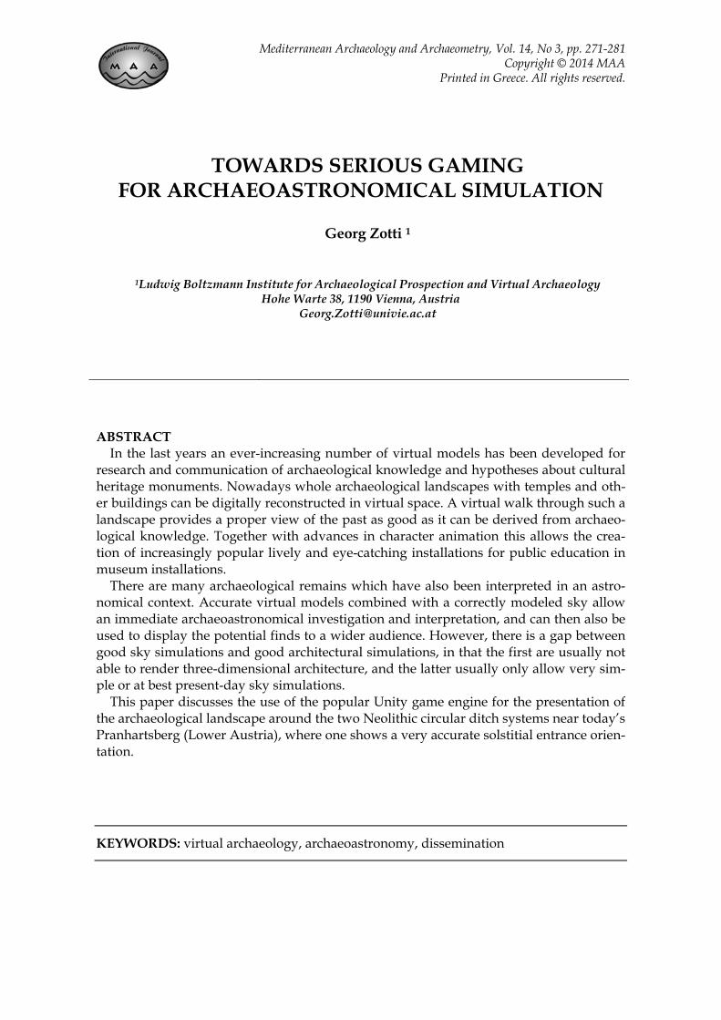
Figure 1: Virtual reconstruction of the Neolithic site near Pranhartsberg, Lower Austria.
274 GEORG ZOTTI
© University of the Aegean, 2014, Mediterranean Archaeology & Archaeometry, 14, 3 (2014) 271-281
spective sites were chosen because the slope was tilted towards cross-quarter rises or settings, the rather small number, the alternative topographic explanation that fits to the majority of other sites, and the fact that we have no other indication that this date was important to inhabitants of Neolithic Central Europe, all help to cast doubts on the applicability of this calendri-cal concept mostly reported from the much later British megalithic sites.
There remained only one KGA which shows a perfect orientation of an entrance towards summer solstice sunset – a direct-ion genuinely provided by nature and not by calendric concepts like the cross-quarters – that cannot be explained by topographical orientation: Pranhartsberg 2. At least for the Pranhartsberg site (which includes two KGA) we wanted to create a high-quality virtual model for dissemin-ation of archaeological knowledge about KGA in general, and for a visually im-pressive public demonstration of the ar-chaeoastronomical results in particular (Figure 1). 2. BRIDGING A SOFTWARE GAP
Desktop planetarium programs have been popular since the 1980s. They dis-played the sky above the horizon with stars and planets for some selected day and time, and programs that are more sophisti-cated allowed the inclusion of a horizon line, which defined the mountains along the horizon. Current desktop planetaria like Stellarium (Stellarium, n.d.) allow the inclusion of photographic panoramas. If properly done, such photographical pano-ramas can provide an accurate simulation of the visible sky surrounding an archaeo-logical site, although limited to just one view point. If the horizon is close, walking around a site will cause a shift in the hori-zon profile. Still, such a panorama, taken on the right spot at an archaeological site, can be used to impressively demonstrate some astronomical alignment just viewing along one particular sight axis. The astro-nomical simulation must be accurate enough to show details like the shift of the
solstitial directions due to the different obliquity of the ecliptic in the time when the site was in use.
Contemporary architectural planning involves CAD and 3D computer graphics, often also mixed with a simulation of the views of planned buildings surrounded by existing buildings in a GIS or other virtual environment. Sometimes such simulation programs are also capable of simulating sunshine and even compute the sun’s posi-tion in the sky for any given date in the projected lifetime of the building. How-ever, too often the simulation time frame is limited to either post-1900 or even the UNIX era (post-1970).
To bridge the gap, we either have to im-plement at least basic 3D rendering cap-ability in a good sky simulation, or add at least the necessary astronomical elements in an otherwise good architectural and landscape visualization system. The first path has been followed earlier (Zotti and Neubauer 2012) with a 3D rendering plug-in for Stellarium that allows the loading of a 3D model and a bit of surrounding ter-rain, so that orientation of building axes or other sightlines can be studied during a virtual walkaround. This paper describes the second strategy, using a game engine for archaeoastronomical simulation. 3. GAME ENGINES
Many computer games share some basic requirements: a first-person character (con-trolled by the player) moves around some frequently unknown territory which can include large swaths of undulating terrain, steep mountains, caves, and polygonal arti-ficial structures like buildings and roads. Players interact with objects and other characters, which may be artificial char-acters driven by some algorithm, or even avatars of other players connected via net-work. In order not to re-invent the wheel for every new game, the basic elements for such games have been published separate-ly for prospective game developers in form of game engines, e.g. the Cry engine (Cry n.d.), Unreal UDK (Unreal n.d.) or Unity (Unity n.d.). The highly competitive com-
TOWARDS SERIOUS GAMING FOR ARCHAEOASTRO. SIMULATION 275
© University of the Aegean, 2014, Mediterranean Archaeology & Archaeometry, 14, 3 (2014) 271-281
puter game market drives the development of stunning effects like realistic grass and trees, real-time shadows, even volumetric beams of sunlight radiating through a steamy jungle or into a dusty dungeon, or directional surround sound effects. Some of the engines are even available for free for non-profit applications. 3.1 Serious Gaming
The use of computer game technology for not purely recreational applications is termed Serious Gaming. Classical examples are flight simulators. Applications for mov-ing in a larger model of a real-world land-scape include diverse fields such as milit-ary operation planning, landscape archi-tecture, or cultural heritage applications that include the representation of archaeo-logical landscapes. Marketing decisions often weaken the boundary between scien-tifically sound reconstruction, edutainment and pure gaming, so that we find combat games in representations of WW2 battle-fields, or adventure games in often ex-aggerated or idealized antique landscapes.
Our focus was on a reconstruction of the archaeological finds in combination with the surrounding landscape and an astro-nomically correct model of the sky, espe-cially of the solar position.
Based on our requirements, the Unity engine appeared to provide the most useful functionality. In the last few years this mul-tiplatform framework, free for non-commercial use (with some limitations in functionality), has gained popularity in many cultural heritage applications. One example even of an archaeoastronomical visualization that demonstrated the inci-dence of a patch of sunlight through a light duct during summer solstice sunset, has been created for the Roccabruna structure of Hadrian’s Villa. Instead of computing the solar position within the program, it was found via lookup at NASA’s Horizon system (Frischer and Fillwalk 2012).
Although definitely not a tool for casual users coming into contact with 3D com-puter graphics for the first time, Unity al-lows the creation of larger virtual worlds
with reasonable effort, also with a very helpful online user community. The advan-ces in graphics software allow very good control of the appearance of the various game elements with the use of shader pro-grams. These allow fine-tuning of the visual appearance and turned out to be crucial for a successful combination of all required elements.
Given the scientific, artistic and aesthetic requirements and the required skills and experience to create the simulation, we decided to collaborate with professional graphic developers experienced with arch-aeological projects. In order to reach a po-tential maximum number of users, we de-veloped the simulation mostly targeted towards a web-player version which can be visited on the project website. 4. GAME TERRAIN
One important component of most games is the terrain. The developer often can sculpt the terrain according to the game demands. However, it is also possib-le to load real-world data, e.g., a digital terrain model (DTM) raster based on air-borne laser scanning (ALS), which can pro-vide meter-class or better lateral resolution and centimeters of vertical accuracy.
The DTM’s grid coordinate system likely defines the Cartesian model coordinate axes, causing a slight mismatch between the true geographic and astronomical card-inal directions due to the meridian conver-gence. This must definitely be taken into account for astronomical simulation, i.e., buildings that may have been constructed in another project coordinate system may have to be slightly rotated, and also celes-tial computations must account for this offset.
In an early test, I loaded 5x5 tiles of 2049x2049 pixels, i.e., more than 100km² of ALS-based DTM. On a hi-end “gaming” notebook (Intel i7, NVidia GTX580M) this appeared to work, but it turned out to be too demanding for “ordinary” hardware, so the far-away terrain was reduced in spa-tial resolution to pixels 5x5m in size, and only the central area is represented in full

276 GEORG ZOTTI
© University of the Aegean, 2014, Mediterranean Archaeology & Archaeometry, 14, 3 (2014) 271-281
resolution. The KGA ditches were later formed by “stamping” the imported mo-dels into the ground and were painted to show the bright loess color that is cha-racteristic for the area. This terrain has fur-ther been augmented with grass, bushes and trees, the river and some small details which can of course not be archaeologically known but which help to create a believ-able atmosphere. 5. MODEL IMPORT
Unity allows the import of several 3D model formats, making it suitable for bringing together creations made with dif-ferent programs like Maya, 3D Studio, Blender, or SketchUp.
The original KGA models had been made by exporting a small piece of terrain with the magnetogram texture and outline of the ditches from ArcGIS to SketchUp. This created the basis for simple but solidly georeferenced models which could already be studied inside SketchUp with embed-ded panorama horizons that were augmen-ted with diagrams that showed various astronomical information and with its
built-in solar illumination (Zotti and Neu-bauer 2010), which is however limited to the UNIX epoch (post-1970). The models built in SketchUp included the palisades made from lots of multi-faceted tree trunks and ditches.
The SketchUp models turned out to be too geometry-rich for the game engine. Skilled developers usually try to minimize the number of faces for buildings to in-crease performance. The KGA were re-modelled in 3D Studio and placed in the virtual landscape in place of the previous models, and the terrain was re-sculpted to reach a credible representation of the ditch-es as they likely have appeared shortly after their physical construction. Several archaeologically sound models of houses and other elements like pottery were also put in place to provide a better cultural context, although the exact location of houses on site is currently not known.
Figure 2: The astronomical diagram split and attached onto 5 sides of a transparent cube that always surrounds the player. The cubic distortion only appears in this editor view. During the game the cube is centered on the player and the diagram appears to be on the sky dome, providing valuable astronomical
information like azimuths and altitudes, declinations, or solstitial and lunistitial paths.
TOWARDS SERIOUS GAMING FOR ARCHAEOASTRO. SIMULATION 277
© University of the Aegean, 2014, Mediterranean Archaeology & Archaeometry, 14, 3 (2014) 271-281
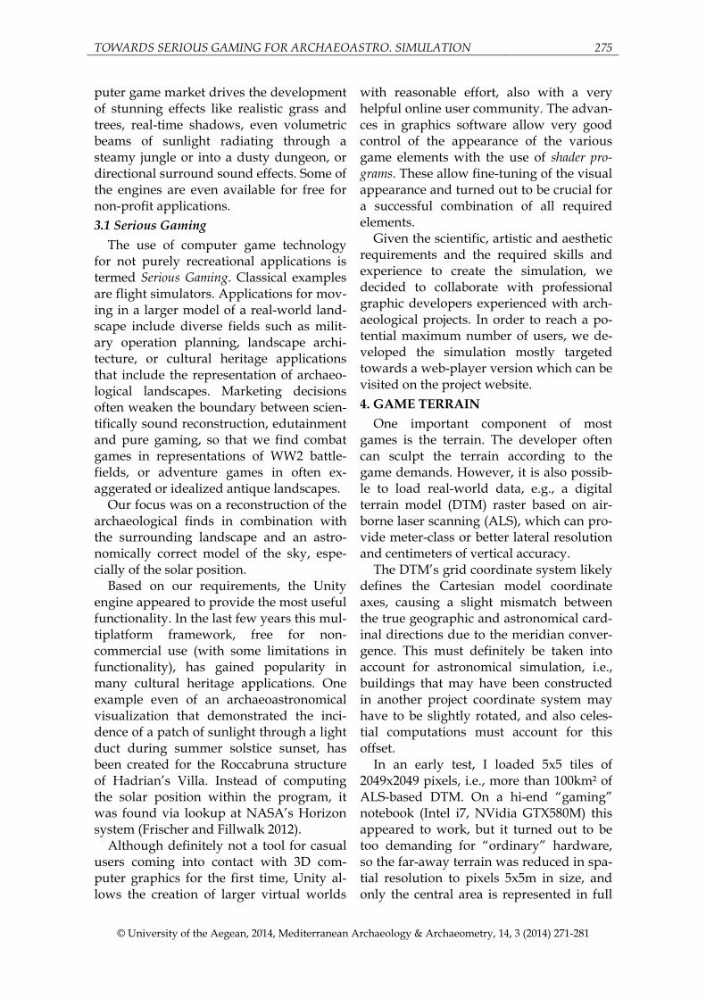
Figure 3: The earth bridge of the northwestern entrance of KGA Pranhartsberg 2 accurately points towards
summer solstice sunset (highest chain of solar disks). The possible postholes (discussed in section 8.1) hold simple posts in this reconstruction, which again indicate the same view direction. This element can be switched away. The measured horizon line can be seen in the background above the edge of the DTM because it is farther away than the far clipping plane, which also shows the importance of the measured
line. The simulated solar glare is visible but does not interfere in recognising the solar disk.
6. THE SKY BACKGROUND Typical game environments require up
to several km viewing distance, and the camera model also clips away scene con-tent beyond a certain distance (the far clip-ping plane). For archaeoastronomical simu-lation, just those far mountains may be important and therefore require the inclu-sion of a background horizon that can ei-ther be made from a panorama photo or computed from a digital terrain model. Unity provides a translation invariant Sky Box element, which allows the rendering of static textures onto the six sides of a cube that is displayed behind all scene content. If the textures are created properly, the viewer located in the center of the cube will not see any distortion or edges while the simple cube geometry can be displayed very fast.
The astronomical diagram which had been developed for the earlier modeling and simulation efforts in SketchUp com-bines an altazimuth grid with declination lines, diurnal tracks of the stars, tracks of the sun at solstices, cross-quarter days and
equinox, lunar tracks at the lunistices, and a measured horizon line, where the pano-rama photograph was fit in to provide the necessary background. This diagram, de-veloped in equirectangular projection, was adapted to cover the whole sky and con-verted into the cubical planes with tools from the Hugin panorama suite (Hugin n.d.). In an attempt to make the 5 astro-nomical components of the diagram switchable, 25=32 versions of the diagram had to be created, mixed with a blue sky that showed a few clouds to make the sce-ne appear more natural.
A pretty terrain simulation for an ar-chaeoastronomical simulation calls for an at least equally nice sky simulation, how-ever, and the static cloudy-afternoon sky did not mix well with the moving sun that also should be demonstrated to set. Also, the many textures significantly increased project size. Therefore, a sky component was developed, consisting of a spherical skydome with moving clouds adapted from a previous project where however the core parts of the sky color shader code had
278 GEORG ZOTTI
© University of the Aegean, 2014, Mediterranean Archaeology & Archaeometry, 14, 3 (2014) 271-281
to be rewritten; a replacement for the sky cube that holds the diagram panels remade with transparent background, and a shader program that creates the required combi-nation of the 5 celestial diagram elements from just 3 different textures per cube side; a particle system that models the stars of the Bright Star Catalog which are visible at night; and a luminous sphere that repre-sents the sun with a diameter that can be scaled to either correctly show the apparent solar diameter or be slightly enlarged for illustrative purposes. All elements are ren-dered ahead of the terrain so that they ap-pear infinitely far away. A computation module controls the movements of the starry sky sphere, placement of the sun along the ecliptic and the obliquity of the latter, and also feeds the parameters for the sky color computation. The sun’s color changes with altitude above ground, and the altitude also is corrected for refraction. Solar glare is simulated in a strength that does not prevent seeing the position of the solar disk. The sun also controls the place-ment and color of a directional light source that illuminates the scene and casts shad-ows in real-time. This group of elements is linked to the position of the user in the vir-tual scenery so that the viewpoint is always located in the center of the diagram cube and star sphere and the user can never ex-perience any parallax distortion. 7. USER INTERFACE
Motion in most PC-based computer games is still controlled with keyboard and mouse, making this the natural choice also for our application. The average visitor expects to switch elements by mouse-click on buttons, while the expert user may want to switch off the graphical user interface altogether and present the application with key presses exclusively. We therefore cre-ated a mix of mouse-click and hotkey inter-face for visitors and expert users. A min-imap shows the location of the game char-acter in the virtual world, and information panels provide details that change depend-ing on the viewer location. In addition to a ground-based walk, it is also possible to
overview the landscape from a bird’s eye perspective.
For the solar position in the Neolithic, a calendar interface that uses what would be found in astronomy software, i.e., the Jul-ian calendar (for dates before 1582) with our month names for users with general knowledge about the begin dates of the seasons would not make any sense. Even a proleptic Gregorian calendar is off by sev-eral days when it comes to dates in the Ne-olithic. Therefore the sun is just placed along the ecliptic by its longitude, and the whole sky can be moved around Earth’s axis.
An important bit of information for ex-pert users of such an explorative system may also be a coordinate output, so that observing points of possible sight lines can be recorded. This information is available on a fold-out panel. 8. DISCUSSION
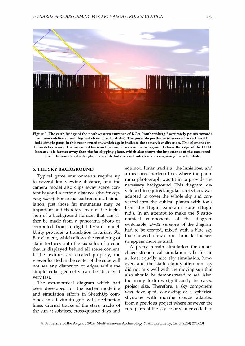
The mostly non-astronomical result of the horizon surveys was understandably a disappointment but also showed possible pitfalls of earlier attempts in understanding the purpose of the KGA. The idea of astro-nomical relations was tested with the only justifiable means, lots of virtual recon-structions in a three-dimensional virtual landscape, and was by and large falsified. KGA Pranhartsberg 2 has a few archi-tectural features that may be enough to claim a special role and was thus still se-lected for public presentation.
Figure 4: Magnetogram of KGA Pranhartsberg 2
(Melichar and Neubauer 2010)

TOWARDS SERIOUS GAMING FOR ARCHAEOASTRO. SIMULATION 279
© University of the Aegean, 2014, Mediterranean Archaeology & Archaeometry, 14, 3 (2014) 271-281
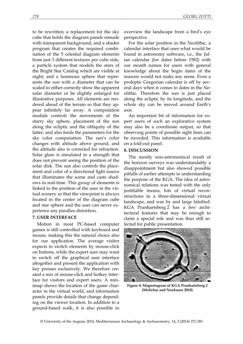
Figure 5: Detail of the north-western entrance
showing two posthole-like anomalies.
8.1 Posthole traces?
The magnetogram derived from the measurements provides a map accurate to within about ±25cm (Zotti and Neubauer 2010). The straight earth bridge that pro-vides the narrow entrance corridor in the north-west with its unique outer extensions is almost 30m long and is not on the same line as the opposing entrance, but it seems to point towards a diffuse large central anomaly (pit?). In the area where the earth bridge crosses the inner, wider ditch there are two small anomalies which could indi-cate postholes. These have been modeled as vertical posts and would have provided an additional perfect sight line towards the sunset.
These posts can be switched away in the model and so also demonstrate that ar-chaeologist cannot be sure about certain details. While the earth bridge alone had already been perfectly aligned with solstice sunset and makes this site stand out against the others, the interpretation of the anomalies as postholes can likely only be verified by excavation. 8.2 Model Quality vs. Quantity?
Is a modeling effort like the one pre-sented here better than cheap models for the research on KGA? The answer is simple: no. The research results were gained with a large number of simple models which were entirely self-made, and therefore much faster and cheaper to create. The big differ-ence is when it comes to dissemination.
Nowadays the interested public almost expects colorful and vivid animations when it comes to explanations of the re-mote past, and while there is nothing in the fields to be seen, virtual reconstructions provide an excellent way to explain this class of monument. As much as we would have liked to create even a multitude of polished models with “working” align-ments, when it became obvious that facts are against wide-spread astronomically oriented monuments, we decided to still show the astronomically most interesting site which includes, after all, two KGA, but we always must point out that the solar relation found at this site is very untypical and not found elsewhere in the KGA in our region. 9. CONCLUSIONS
The virtual reconstruction effort delivers a credible model of the KGA in its land-scape as far as can be said from the mag-netic prospection and today’s digital ter-rain model. The model is suitable for ar-chaeoastronomical analysis and demon-stration to a wider audience.
How can this technology be applied for future, similar problems? This depends mostly on the quality of survey data and on how far the knowledge about the site in question is suitable to allow development into more elaborate educative applications, and also how far into gaming applications we want to go. Currently the scenery is set up almost like a dormant open-air mu-seum, free of any inhabitants, but with in-formation panels, although graphic eye candy like burning camp fires indicates inhabitance. It is possible to put virtual characters or animals into the scenery, which may be available for interaction, interrogation, or as “virtual tour guides”. We could create a learning game where players have to explore every corner of the model and collect knowledge bits and pieces, or maybe even allow a team of players explore an archaeological land-scape and experience sites and sights of archaeoastronomical significance, or at least study archaeoastronomical concepts

280 GEORG ZOTTI
© University of the Aegean, 2014, Mediterranean Archaeology & Archaeometry, 14, 3 (2014) 271-281
illustrated by three-dimensional models. Such more advanced (and costly) require-ments will clearly depend on the budgets of potential customers like museums or exhibitions.
A path not yet explored with KGA is the application of augmented reality with mo-bile devices, which could be brought on-site and where virtual models would be placed onto the screens, mixed with images of the current landscape taken by the built-in cameras. This could allow a user to wit-ness the considerable sizes of the monu-ments and gain a better appraisal of the enormous effort the creation of these enig-
matic monuments must have meant to the builders.
Our application can be freely visited at http://astrosim.univie.ac.at, the project website. ACKNOWLEDGEMENTS
The geomagnetic surveys and magneto-gram data have been provided by Wolf-gang Neubauer.
The Unity application was developed in collaboration with 7reasons, Vienna.
Project ASTROSIM was funded by the Austrian Science Fund (FWF, P21208-G19).
REFERENCES Becker, Helmut (1996), Kultplätze, Sonnentempel und Kalenderbauten aus dem 5. Jahr-
tausend vor Chr. − Die mittelneolithischen Kreisanlagen in Niederbayern, Ar-beitshefte des Bayrischen Landesamtes für Denkmalpflege, 59, 1996.
Bertemes, F. and Schlosser, W. (2004) Der Kreisgraben von Goseck und seine astro-nomischen Bezüge, in Meller, H. (ed.), Der Geschmiedete Himmel − Die weite Welt im Herzen Europas vor 3600 Jahren, Theiss Verlag, pp. 48-51.
Cry Engine website (n.d.). URL: http://www.crydev.net. Last visited 2013-11-27. Daim, F. and Neubauer, W. (eds) (2005) Geheimnisvolle Kreisgräben – Niederöster-
reichische Landesausstellung 2005 (Exhibition Catalog), Horn and Wien, Verlag Berger.
Frischer, B. and Fillwalk, J. (2012) The Digital Hadrian’s Villa Project: Using Virtual Worlds to Control Suspected Solar Alignments, in G. Guidi & A. C. Addison (eds), Proc. VSMM2012 (Virtual Systems in the Information Society), IEEE, Milano, 49–55.
Hugin website (n.d.) Panorama photo stitcher. URL: http://hugin.sourceforge.net/. Last visited 2013-11-28.
Iwaniszewski S. (1996) Neolithic and Eneolithic Structures in Central Europe: Calendric-Astronomical Implications. In Schlosser W. (ed.), Proc. of the Second SEAC Confer-ence 1994. Bochum.
Melichar, P. and Neubauer, W. (eds) (2010) Mittelneolithische Kreisgrabenanlagen in Nieder-österreich. Geophysikalisch-archäologische Prospektion - ein interdisziplinäres For-schungsprojekt. Mitteilungen der prähistorischen Kommission der Österreichi-schen Akademie der Wissenschaften, Wien.
Pavúk, J. and Karlovský, V. (2004) Orientacia Rondelov Lengyelskej Kultury na Smery Vysokeho a Nizkeho Mesiaca (Orientation of Lengyel rondels to directions of High and Low Moon). In: Slovenská Archeológia vol. LII(2), 211–280.
Stellarium website (n.d.). URL: http://stellarium.org Last visited 2013-11-28. Unity website (n.d.). URL: http://unity3d.com. Last visited 2013-11-27. Unreal Engine website (n.d.). URL: http://unrealengine.com. Last visited 2013-11-27. Zotti G. (2010). Astronomische Aspekte der Kreisgrabenanlagen in Niederösterreich. In
Melichar and Neubauer 2010, 136-167.

TOWARDS SERIOUS GAMING FOR ARCHAEOASTRO. SIMULATION 281
© University of the Aegean, 2014, Mediterranean Archaeology & Archaeometry, 14, 3 (2014) 271-281
Zotti G. and Neubauer W. (2010) Kreisgrabenanlagen: Expressions of Power Linked to the Sky. In Astronomy and Power (Proc. SEAC2010, Gilching/Munich, Germany), BAR international (to appear).
Zotti, G. and Neubauer, W. (2011) Astronomical and Topographical Orientation of Kreis-grabenanlagen in Lower Austria, F. Pimenta et al. (eds), Stars and Stones (Proc. SEAC2011, Evora, Portugal), BAR international (to appear).
Zotti G. and Neubauer W. (2012) Virtual Reconstructions in a Desktop Planetarium for Demonstrations in Cultural Astronomy. In Ioannides M., Fritsch D., Leissner J., Davies R., Remondino F., and Caffo R. (eds), Progress in Cultural Heritage Preser-vation (Proc. 4th International Conference EuroMed 2012, Limassol, Cyprus, Oct. 29-Nov. 3, 2012), volume 7616 of Lecture Notes in Computer Science, 170-180, Hei-delberg, November 2012. Springer. http://dx.doi.org/10.1007/978-3-642-34234-9_17
Zotti G. and Neubauer W. (2013) Elements for the construction of 3d models for archaeo-astronomical analysis. In Neubauer W., Trinks I., Salisbury R. B., and Einwöger-er C. (eds), Archaeological Prospection. Proceedings of the 10th International Confer-ence, Vienna, May 29th-June 2nd 2013, 354-356.