TOPPENISH PLANNING COMMISSION JUNE 29, 2021, 6:00 ...
322
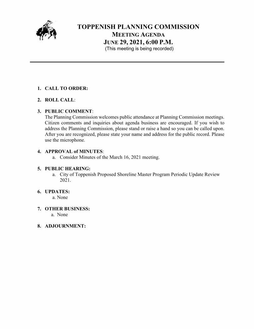
TOPPENISH PLANNING COMMISSION MEETING AGENDA JUNE 29, 2021, 6:00 P.M. (This meeting is being recorded) 1. CALL TO ORDER: 2. ROLL CALL: 3. PUBLIC COMMENT: The Planning Commission welcomes public attendance at Planning Commission meetings. Citizen comments and inquiries about agenda business are encouraged. If you wish to address the Planning Commission, please stand or raise a hand so you can be called upon. After you are recognized, please state your name and address for the public record. Please use the microphone. 4. APPROVAL of MINUTES: a. Consider Minutes of the March 16, 2021 meeting. 5. PUBLIC HEARING: a. City of Toppenish Proposed Shoreline Master Program Periodic Update Review 2021. 6. UPDATES: a. None 7. OTHER BUSINESS: a. None 8. ADJOURNMENT:
-
Upload
khangminh22 -
Category
Documents
-
view
0 -
download
0
Transcript of TOPPENISH PLANNING COMMISSION JUNE 29, 2021, 6:00 ...
TOPPENISH PLANNING COMMISSION MEETING AGENDA
JUNE 29, 2021, 6:00 P.M. (This meeting is being recorded)
1. CALL TO ORDER:
2. ROLL CALL:
3. PUBLIC COMMENT:
The Planning Commission welcomes public attendance at Planning Commission meetings. Citizen comments and inquiries about agenda business are encouraged. If you wish to address the Planning Commission, please stand or raise a hand so you can be called upon. After you are recognized, please state your name and address for the public record. Please use the microphone.
4. APPROVAL of MINUTES: a. Consider Minutes of the March 16, 2021 meeting.
5. PUBLIC HEARING:
a. City of Toppenish Proposed Shoreline Master Program Periodic Update Review 2021.
6. UPDATES: a. None
7. OTHER BUSINESS:
a. None
8. ADJOURNMENT:
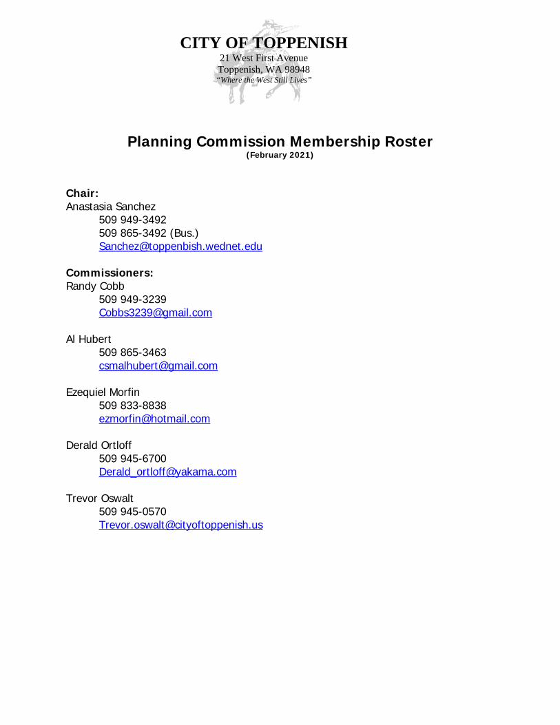
CITY OF TOPPENISH 21 West First Avenue Toppenish, WA 98948 “Where the West Still Lives”
Planning Commission Membership Roster (February 2021)
Chair: Anastasia Sanchez 509 949-3492 509 865-3492 (Bus.) [email protected] Commissioners: Randy Cobb 509 949-3239 [email protected] Al Hubert 509 865-3463 [email protected] Ezequiel Morfin 509 833-8838 [email protected] Derald Ortloff 509 945-6700 [email protected] Trevor Oswalt 509 945-0570 [email protected]
TOPPENISH PLANNING COMMISSION Meeting Minutes March 16, 2021
Chair Anastasia Sanchez called the meeting to order at 6:00 p.m.
REMOTE MEETING INSTRUCTIONS PC Shaul recited the remote meeting instructions for the record pursuant to Governor Inslee’s Emergency Proclamation with the temporary suspension of certain provisions of the Open Public Meetings Act during the COVID-19 Outbreak that prohibit all in-person public comments. She recited the instructions to attend the meeting in “listen-only” mode by using the call-in phone number.
ROLL CALL Remote Attendees: Chair Anastasia Sanchez, and Commissioners Randy Cobb, Al Hubert, and
Ezequiel Morfin. Absent: Commissioners Derald Ortloff and Trevor Oswalt. Remote Staff: City Manager Lance Hoyt, Permit Coordinator Victor Shaul (PC Shaul), and
Community TV Manager Judy Devall. Remote Others: Jacob Liddicoat Digital Design and Development PC Shaul conducted a roll call for each Commissioner to respond to their attendance at the remote meeting. Chair Anastasia Sanchez and Commissioners Cobb, Hubert and Morfin responded to their remote attendance during roll call. Commissioners Ortloff and Oswalt were not present at the meeting.
PUBLIC COMMENT
PC Shaul noted the City received no public comments by the 3:00 p.m. deadline before the meeting.
APPROVAL OF MINUTES Motion by Commissioner Hubert, seconded by Commissioner Cobb to amend March 2, 2021, Meeting Minutes to delete “Chair Sanchez arrived in the meeting after roll call.” Motion carried unanimously. Motion by Commissioner Hubert, seconded by Commissioner Morfin to approve the March 2, 2021 meeting minutes as amended. Motion carried unanimously.
DESIGN REVIEW A. Ideal Lumber remodel and expansion. Chair Sanchez gave a briefing to the commission about the proposed Ideal Lumber remodel and expansion proposal at 827 West 1st Avenue. This is a request from the Digital Design and
2
Development represented by Jacob Liddicoat to approve the design of a 4,950-foot addition to the Ideal Lumber building as meeting the Western Theme Criteria as established in Chapter 17.26 TMC. YVCOG Senior Planner Lynn Deitric presented the Staff Report explaining the scope of the Ideal Lumber addition project and a new sign, reviewing the code requirements that need to be met, and the analysis of the proposal meeting the code requirements of the Westen Theme. He then presented the staff recommendations to the Commission which were:
It is the staff’s recommendation to the City of Toppenish Planning Commission to approve the proposed Ideal Lumber addition and new sign as presented in the proposal.
Jacob Liddicoat gave a brief overview of the proposal and answered questions.
The commissioners had a general discussion concerning Ideal Lumber addition.
Commissioner Hubert moved to approve the Western Theme design of the Ideal Lumber addition as meeting the Western Theme criteria in Chapter 17.26 TMC. Commissioner Morfin seconded the motion. The motion passed unanimously.
UPDATE A. None
OTHER BUSINESS
A. None
ADJOURNMENT
There being no further business the meeting was adjourned at 6:21 p.m. __________________________ __________________________ Anastasia Sanchez, Chair Victor Shaul, Permit Coordinator
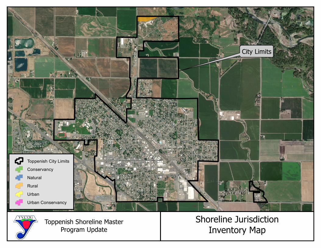
Toppenish Shoreline MasterProgram Update
Shoreline JurisdictionInventory Map
City Limits
Toppenish City Limits
Conservancy
Natural
Rural
Urban
Urban Conservancy
YVCOG Jurisdictional SMP Page 1 Draft
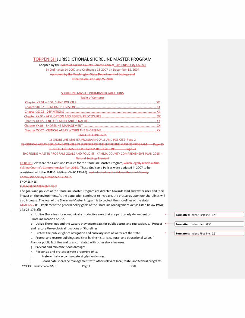
TOPPENISH JURISDICTIONAL SHORELINE MASTER PROGRAM Adopted by the Board of Yakima County CommissionersTOPPENISH City Council
By Ordinance 14-2007 and Ordinance 13-2007 on December 18, 2007
Approved by the Washington State Department of Ecology and
Effective on February 25, 2010
SHORELINE MASTER PROGRAM REGULATIONS
Table of Contents
Chapter XX.01 – GOALS AND POLICIES……………………………………………………………………………………………XX
Chapter XX.02 - GENERAL PROVISIONS .............................................................................................. XX
Chapter XX.03 - DEFINITIONS ............................................................................................................. XX
Chapter XX.04 - APPLICATION AND REVIEW PROCEDURES ................................................................. XX
Chapter XX.05 - ENFORCEMENT AND PENALTIES ............................................................................... XX
Chapter XX.06 - SHORELINE MANAGEMENT ....................................................................................... XX
Chapter XX.07 - CRITICAL AREAS WITHIN THE SHORELINE……………………………………………………………….XX
TABLE OF CONTENTS
1) SHORELINE MASTER PROGRAM GOALS AND POLICIES - Page 2
2) CRITICAL AREAS GOALS AND POLICIES IN SUPPORT OF THE SHORELINE MASTER PROGRAM - Page 15
3) SHORELINE MASTER PROGRAM REGULATIONS Page 24
SHORELINE MASTER PROGRAM GOALS AND POLICIES - YAKIMA COUNTY COMPREHENSIVE PLAN 2015 –
Natural Settings Element
XX.01.01 Below are the Goals and Policies for the Shoreline Master Program, which legally reside within
Yakima County’s Comprehensive Plan 2015. These Goals and Polices were updated in 2007 to be
consistent with the SMP Guidelines (WAC 173-26). and adopted by the Yakima Board of County
Commissioners by Ordinance 14-2007.
SHORELINES
PURPOSE STATEMENT NS 7
The goals and policies of the Shoreline Master Program are directed towards land and water uses and their
impact on the environment. As the population continues to increase, the pressures upon our shorelines will
also increase. The goal of the Shoreline Master Program is to protect the shorelines of the state.
GOAL NS 7.01: Implement the general policy goals of the Shoreline Management Act as listed below (WAC
173-26-176(3)):
a. Utilize Shorelines for economically productive uses that are particularly dependent on
Shoreline location or use.
b. Utilize Shorelines and the waters they encompass for public access and recreation. c. Protect
and restore the ecological functions of Shorelines.
d. Protect the public right of navigation and corollary uses of waters of the state.
e. Protect and restore buildings and sites having historic, cultural, and educational value. f.
Plan for public facilities and uses correlated with other shoreline uses.
g. Prevent and minimize flood damages.
h. Recognize and protect private property rights.
i. Preferentially accommodate single-family uses.
j. Coordinate shoreline management with other relevant local, state, and federal programs.
Formatted: Indent: First line: 0.5"
Formatted: Indent: Left: 0.5"
Formatted: Indent: First line: 0.5"
YVCOG Jurisdictional SMP Page 2 Draft
GOAL NS 7.02: Protection measures for local Shorelines should use the following Shoreline
Management Act principles in order of preference as listed below (RCW 90.58.020):
1. Recognize and protect the state-wide interest over local interest;
2. Preserve the natural character of the shoreline;
3. Result in long term over short term benefit;
4. Protect the resource and ecology of the shoreline;
5. Increase public access to publicly owned areas of the shorelines;
6. Increase recreational opportunities for the public in the shoreline;
7. Provide for any other element as defined in RCW 90.58.100 deemed appropriate or necessary.
GOAL NS 7.03: Maintain, restore and where necessary improve the shoreline terrestrial and aquatic
ecosystems so that they maintain viable, reproducing populations of plants and animals while
providing the maximum public benefit of limited amounts of shoreline areas. Accomplish this through the
policies in the required shoreline elements listed below.
SHORELINE ENVIRONMENTS
GOAL NS 7.04: Shorelines areas should be classified into specific environmental designations. The
designation system should be based on the existing and future land use pattern as well as the biological
and physical character of the shoreline. These environments should include the Urban, Rural,
Conservancy, Urban Conservancy, Natural and Floodway / Channel Migration Zone (CMZ) environments.
Land uses and activities should be limited to those that are consistent with the character of the
environment designation.
Urban Environment Policies
NS 7.05 The Urban environment is to be used for the most intensely developed areas, or areas where
intensive development is desirable or tolerable. The basic principle in an Urban Environment is oriented
toward quality of development in harmony with the shoreline. The Urban Environment should
insureensure optimum utilization of shorelines occurring within urbanized areas by providing for public
access and by managing development so that it enhances and maintains the shorelines for a multiplicity of
uses.
NS 7.06 The following criteria should be used for the designation of Urban Environments:
1. Areas presently supporting high intensity land use including residential, commercial, industrial
and recreational uses.
2. Areas which are planned to accommodate urban expansion of residential, commercial,
industrial and recreational uses.
3. High land values.
4. Major public or private capital investments.
5. Close proximity to services and utilities.
6. Few biophysical limitations to development.
7. Potentially low flood hazard.
Formatted: Indent: First line: 0.5"
Formatted: Indent: Left: 0.5"
Formatted: Indent: First line: 0.5"
YVCOG Jurisdictional SMP Page 3 Draft
NS 7.07 Water-oriented commercial, industrial, and recreation uses should be given high priority in the
Urban Environment, and may be accompanied by non-water oriented uses in mixed-use developments.
Residential uses should be discouraged. Recreational uses are preferred uses within the urban
environments
Rural Environment Policies
NS 7.08 The Rural Environment should restrict intensive development along undeveloped shoreline areas
that might interfere with the normal operations or economic viability of an agricultural activity located on
adjacent associated shoreline areas. The Rural Environment maintains open spaces and provides
opportunities for recreational uses compatible with agricultural activities.
NS 7.09 The following criteria should be used for the designation of Rural Environments:
1. Intensive agricultural or recreational uses.
2. Those areas with potential for agricultural use.
3. Those undeveloped natural areas that lie between agricultural areas.
4. Low-density residential development.
5. Moderate land values.
6. Potential low demand for services.
NS 7.10 Generally, allowed uses in the Rural environment should focus on resource and recreation uses.
Commercial and industrial uses should be carefully limited. Residential uses should sustain shoreline
functions.
Conservancy Environment Policies
NS 7.11 The Conservancy Environment classification should be used for areas where maintenance of the
existing character of the area is desirable. This does not necessarily mean preservation, but rather a use of
natural resources on a sustained yield basis. Thus, the harvesting of timber as well as recreational activities
are to be the primary uses permitted Also, areas that are isolated from services, have poor drainage, high
flood danger, poor ground for septic tanks, unstable earth, or steep slopes should be designated
Conservancy
NS 7.12 The following criteria should be used for the designation of Conservancy
Environments:
1. Very low intensity land uses; primarily sustained-yield activities or pasture-range land.
2. Larger acreages.
3. Relatively low land values.
4. Relatively minor public or private capital investment.
5. Considerable biophysical limitations, making commercial, industrial, or medium to high-density
residential development unsuitable.
NS 7.13 Generally, commercial and industrial uses should not be allowed in the Conservancy
Environment, except when they are water oriented. Resource uses should be of low enough intensity to
sustain shoreline functions with preference for non-permanent structures. Low-density residential
Formatted: Indent: First line: 0.5"
Formatted: Indent: First line: 0.5"
Formatted: Indent: Left: 0.5"
YVCOG Jurisdictional SMP Page 4 Draft
development should sustain the character of the shoreline. Diffuse recreational uses are preferred use.
Uses should avoid hazardous areas.
Natural Environment Policies
NS 7.14 The Natural Environment should protect those shoreline areas which are considered unique by
virtue of their existence and valuable only to the extent that the natural integrity is preserved for the
benefit of future, as well as, present generations. Prime targets for classification into the Natural
Environment will be certain shorelands owned or controlled by the various Federal and Tribal wildlife
management agencies with limited access and certain private lands which are seen to be proper for Natural
classification, and the owner of which will be interested in the promise of very low taxation.
NS 7.15 The following criteria should be used for the designation of Natural Environments:
1. The presence of a natural, historical, cultural, scientific, or educational feature considered
valuable by virtue of its existence in a natural or original state and thereby warranting preservation
for the benefit of present and future generations.
2. Those areas generally intolerant of intensive human use.
3. Areas with severe biophysical limitations.
4. Natural areas with strong limits on access.
NS 7.16 Generally, commercial, industrial, mining, non-water oriented recreation, roads, utilities, and
parking areas should not be located in Natural Environment. Other uses, including residential, should be
carefully limited in the Natural environment. Restrict activities that may degrade the actual or potential
value of this environment, and severely restrict development in hazardous areas.
Floodway / Channel Migration Zone (CMZ) Environment Policies
NS 7.17 The Floodway/Channel Migration Zone environment should protect the water areas; islands,
associated overflow channels, and channel migration areas. This environment acknowledges the
river’s need to move within parts of its floodplain, and emphasizes the preservation of the natural
hydraulic, geologic and biological functions of the county’s shorelines that are constrained by severe
biophysical limitations.
NS 7.18 A Floodway/Channel Migration Zone designation should be assigned to shoreline areas that are
within mapped Channel Migration Zones and/or within a designated FEMA Floodway. The extent of the
Floodway/Channel Migration Zone should never extend beyond the 100-year flood plain.
NS 7.19 Generally, commercial, industrial, mining, non-water oriented recreation, roads, utilities,
parking areas, and residences should not be located in the Floodway/Channel Migration Zone Environment.
Other uses (recreation, resource uses, etc.) should be carefully limited to protect shoreline functions.
Restrict activities that may degrade the actual or potential value of this environment, and severely restrict
development in hazardous areas. Modifications that harden or fix stream banks and channels should be
discouraged.
Urban Conservancy Environment Policies
Formatted: Indent: Left: 0.5"
Formatted: Indent: First line: 0.5"
YVCOG Jurisdictional SMP Page 5 Draft
NS 7.20 The Urban Conservancy environment should protect and restore ecological functions of open
space, floodplain and other sensitive lands where they exist in urban and developed settings, while
allowing a variety of compatible uses.
NS 7.21 The following criteria should be used for the designation of Urban Conservancy
Environments;
1) areas that lie in incorporated municipalities and urban growth areas;
2) areas appropriate and planned for development that is compatible with maintaining or
restoring of the ecological functions of the area;
3) areas that are suitable for water-enjoyment uses;
4) areas that are open space or floodplain, or that retain important ecological functions that
should not be more intensively developed;
NS 7.22 Generally, allowed uses should focus on recreational uses. Commercial, industrial and
residential uses should be carefully limited, and when allowed should result in restoration of ecological
functions. Uses that preserve the natural character of the area or promote the preservation of open
space, floodplain or sensitive lands (either directly or over the long term) should be the primary allowed
uses. Public access and public recreation objectives should be implemented whenever feasible and
significant ecological impacts can be mitigated.
GENERAL SHORELINE POLICIES
Critical Areas, Restoration, and Vegetation Conservation Policies
NS 7.23 New development or new uses, including the subdivision of land, should not be established when
it would be reasonably foreseeable that the development or use would require structural flood hazard
reduction measures within the channel migration zone or floodway.
NS 7.24 Only allow new structural flood hazard reduction measures in shoreline jurisdiction when it can
be demonstrated that they are necessary to protect existing development, that nonstructural measures are
not feasible, that impacts on ecological functions and priority species and habitats can be successfully
mitigated so as to assure no net loss, and that appropriate vegetation conservation actions are undertaken.
NS 7.25 Protect all shorelines of the state so that there is no net loss of ecological functions from both
individual permitted development and individual exempt development.
NS 7.26 In development of the Shoreline Master Program, evaluate and consider cumulative impacts of
reasonably foreseeable future development on shoreline ecological functions and other shoreline functions
to ensure no net loss of ecological function. Develop a means to allocate the burden of addressing
cumulative effects.
NS 7.27 Provide, where feasible and desirable, restoration of degraded areas along the shorelines of
Yakima Countythe City of Toppenish.
Formatted: Indent: First line: 0.5"
Formatted: Indent: Left: 0.5"
Formatted: Indent: First line: 0.5"
Formatted: Indent: Left: 0.5"
YVCOG Jurisdictional SMP Page 6 Draft
NS 7.28 Critical areas within shoreline jurisdiction should be protected with the critical area policies and
standards protecting all of the County’s City’s critical areas, including those for CMZs and Flood Control.
NS 7.29 Protect shoreline streams, lakes, ponds, and wetlands with a vegetative buffer as described in the
Critical Areas Ordinance.
NS 7.30 For existing agriculture encourage through a variety of voluntary means the maintenance of
a permanent vegetative buffer between tilled areas and associated water bodies to reduce bank erosion,
retard surface runoff, reduce siltation, improve
water quality and provide habitat for fish and wildlife. For new agriculture, buffer requirements should be
applied.
NS 7.31 Natural vegetation within shoreline jurisdiction should be retained to the greatest extent
feasible. This should be accomplished by applying the stream corridor and wetland buffer requirements.
Activities covered by the State Forest Practices Act should not be subject to vegetation conservation
standards, but should be subject to buffer requirements when under County City jurisdiction. Require
developers to indicate how they plan to preserve shore vegetation and control erosion.
NS 7.32 Selective pruning of trees for safety and view protection, and the removal of noxious weeds
should be allowed.
NS 7.33 Upon completion of construction/maintenance projects on shorelines, disturbed areas should at
a minimum be restored to pre-project configuration wherever possible, replanted with native species and
provided maintenance care until the newly planted vegetation is established.
Public Access Policies – Physical and Visual
NS 7.34 Protect navigation of waters of the state, the space needed for water-dependent uses, and views
of the water through development standards.
NS 7.35 Transportation and parking plans within Shoreline jurisdiction shall include systems for public
access, including pedestrian, bicycle, and public transportation where appropriate.
NS 7.36 The city limits of Toppenish at their closest point to the Yakima river are approximately 450 feet
away from the water’s edge. While the city will encourage visual and physical public access to the river to
the extent possible under WAC 173-26-221(4) it has no direct jurisdictional control over the actual
shoreline. The shoreline property that is proximate to the small amount of shoreline jurisdiction within the
City limits of Toppenish is Yakama Nation Trust property and not subject to the SMA To provide public
access planning in conformance with WAC 173-26-221(4), Yakima
County uses the following approach to provide public access to Shoreline areas:
1) Yakima County has a very high proportion of federal, state and other publicly owned or conservancy
owned lands in Shoreline areas. These publicly owned Shoreline areas constitute a large portion of the
county’s total shoreline area. Yakima County emphasizes the use of those public lands to provide public
access.
2) Many of the above lands have improved sites and locations to promote physical access to shorelines.
YVCOG Jurisdictional SMP Page 7 Draft
Yakima County relies on these agencies to develop new public access facilities as they deem appropriate.
3) Many of the above lands are open to unimproved public access, as well.
4) Many Shoreline areas are also along transportation corridors which provide visual access to much of the
County’s shoreline areas.
5) Due to the nature of Yakima County’s shorelines, commercial water oriented uses, existing and new,
tend to be highly related to water enjoyment uses and recreation.
6) Due to the nature of Yakima County’s shorelines, recreational uses, existing and new, tend to be highly
oriented toward the water, thereby providing access to shoreline areas.
(7) Yakima County relies on the development of commercial water oriented uses and recreational uses to
provide additional public access opportunities.
(8) Development standards for dedicated and improved public access to the shoreline and visual quality
should be required for public developments, with few exceptions.
All projects should provide public access, except where it is demonstrated to be infeasible due to reasons
of safety, security, and impact to the shoreline environment, or constitutional or legal limitations.
NS 7.37 Promote and enhance diversified types of public access to shorelines in Yakima County which
may accommodate intensified use without significantly impacting fragile natural areas intolerant of human
use and without infringing on rights of private ownership.
NS 7.38 Access to recreational areas should emphasize both areal and linear access (parking areas and
trails or bicycle paths, for example) to prevent concentrations of use at a few points. Linkage of shoreline
parks and public access points by means of linear access should be encouraged.
NS 7.379 Development standards should be established to assure preservation of unique, fragile,
and scenic elements and to protect existing views from public property or large numbers of residences.
Where aesthetic impacts are not avoidable, provide mitigation.
NS 7.40 Where there exists a conflict between public access or a water-dependent use, and the
maintenance of an existing view from adjacent properties, the physical public access or water dependent
use should have priority unless there is a compelling reason to the contrary.
NS 7.41 Proper design, location, and construction of road and railroad facilities should be exercised to
provide to the degree practical, scenic corridors, rest areas, view points, and other public oriented facilities
in public shoreline areas.
NS 7.3842 Wherever feasible, utility facilities should be placed underground.
Signs and Billboards
NS 7.3943 Outdoor sign size, spacing and lighting should conform to the Scenic Vistas Act
(RCW 47.42) and standards in the Zoning Ordinance.
Archaeological and Historic Resources
POLICIES
YVCOG Jurisdictional SMP Page 8 Draft
NS 7.404 Encourage the protection and restoration of areas and sites in The City of Toppenish Yakima
County having historic, archaeological, cultural, educational or scientific value. Wherever possible, sites
should be permanently preserved for scientific study and public observation.
NS 7.415 Development along shorelines should include consultation with professional
archaeologists, historians, and biologists to identify areas containing potentially valuable data, and to
establish procedures for salvaging the data or maintaining the area in an undisturbed condition.
NS 7.426 Shoreline permits should contain special provisions which require developers to immediately
stop work and notify local governments, the Office of Archeological and Historic Preservation, and affected
tribes, if any possible archaeological or historic resources are uncovered during excavations.
NS 7.437 Development which would destroy archaeological or historical sites or data may be delayed for
a reasonable time to allow the appropriate agency or organization to purchase the site or to recover the
data.
Water Quality, Stormwater and Pollution
POLICIES
NS 7.448 Shoreline water quality should be protected as follows:
1. Rely on a County City stormwater program meeting state and federal stormwater control
requirements where possible;
2. Use Critical Aquifer Recharge Area protection measures in the Critical Areas
Ordinance;
3. Control drainage and surface runoff from all non-agricultural facilities requiring large quantities
of fertilizers and pesticides (such as golf courses and play fields) to prevent contamination of water
areas;
4. All developments shall comply with County Health regulations, when applicable;
5. Handle and dispose of pesticides in accordance with provisions of the Washington
Pesticide Application Act (RCW 17.21) and the Washington Pesticide Act (RCW
14.47);
6. Proper design, location, and construction of all facilities should be exercised to prevent the
entry of pollutants or waste materials into the water body.
7. When earthen materials are moved within shoreline areas, measures to adequately protect
water quality should be provided.
8. Water quality protection measures should not impact recreation opportunities.
NS 7.459 Agricultural erosion control measures should conform to rules and standards established
by the Conservation Districts of Yakima County.
NS 7.50 In planning for marina location and design, special water quality considerations should be given
to:
1. Fuel handling and storage facilities to minimize accidental spillage;
2. Proper water depth and flushing action for any area considered for overnight or long-term moorage
facilities;
Formatted: Indent: Left: 0.5"
Formatted: Indent: First line: 0.5"
Formatted: Indent: Left: 0.5"
Formatted: Indent: First line: 0.5"
Formatted: Indent: Left: 0.5"
Formatted: Indent: First line: 0.5"
YVCOG Jurisdictional SMP Page 9 Draft
3. Adequate facilities to properly handle wastes from holding tanks.
NS 7.4651 Prohibit sanitary landfills along shoreline areas. Otherwise the disposal of all solid wastes
should proceed in accordance with the Yakima County Solid Waste Management Plan.
SHORELINE USE POLICIES
General Use Policies
NS 7.4752 Establish a system of shoreline uses that:
1. Gives preference to uses with minimal impacts and that are dependantdependent on the proximity to
the water;
2. Protects the public’s health, safety, and welfare; ecological functions; and property rights;
3. Establishes conditional uses to provide extra protection for the shoreline.
NS 7.4853 Assure that new shoreline development in The City of Toppenish Yakima County is consistent
with a viable pattern of use suitable to the character and physical limitations of the land and water.
NS 7.4954 Encourage sound management of renewable and nonrenewable natural resources.
Recreation
NS 7.55 Assure the preservation and expansion of diverse, convenient recreational opportunities
along the public shorelines of Yakima County for public use, consistent with the capacity of the land to
accommodate such activity. Accomplish this by ensuring that shoreline recreational development is given
priority and is primarily related to access, enjoyment and use of the water and Shorelines of the State
NS 7.5056 Where the uses designated for a specific recreational area are planned to satisfy a diversity of
demands, these uses must be compatible with each other and the environment of the area.
NS 7.57 Where feasible and desirable, encourage the use of public lands for recreational facilities as a
more economical alternative to new acquisitions by local agencies.
NS 7.518 Locate, design, construct and operate recreational facilities to prevent undue adverse impacts
on natural resources of an area and on adjacent or nearby private properties.
Transportation and Parking
NS 7.529 Encourage a transportation network in The City of Toppenish Yakima County capable of
delivering people, goods, and services, and resulting in minimal disruption of the shorelines’ natural
system.
NS 7.60 When it is necessary to locate major highways, freeways and railways along stream drainages or
lake shores, such facilities should be sufficiently set back so that a useable shoreline area remains. Care
should also be taken to insure that a minimum land area is consumed.
NS 7.61 To avoid wasteful use of the limited supply of shore land, locate access roads and parking areas
YVCOG Jurisdictional SMP Page 10 Draft
upland, away from the shoreline whenever such options are available. Access to the water should be
provided by pathways or other methods. Parking
facilities in shorelines are not a preferred use and should be allowed only as necessary to support an
authorized use.
NS 7.5362 Proper design, location, and construction of road and railroad facilities should be exercised to:
1. Minimize erosion and permit the natural movement of water;
2. Use existing topography to maximum advantage and preserve natural conditions to the greatest
practical extent.
NS 7.63 Extensive loops or spurs of old highways with high aesthetic quality or bicycle route potential
should be kept in service as pleasure bypass routes.
Agriculture
NS 7.5464 Allow lawfully established agricultural activities occurring on agricultural lands to continue as
they historically have. New agricultural activities on land not currently used for agriculture, conversion of
agricultural lands to other uses, and other development on agricultural land that does not meet the
definition of agricultural activities (including any agricultural development not specifically exempted by the
provisions of RCW 90.58.030(3)(e)(iv)) should meet shoreline requirements.
NS 7.5565 Encourage animal feedlot operations to locate away from shorelines.
Aquaculture
NS 7.66 Consider aquaculture a preferred shoreline use when consistent with the control of pollution and
prevention of damage to the environment.
NS 7.67 Ensure that aquacultural uses do not conflict with other water-dependent uses or navigation,
spread disease, establish non-native species that cause significant ecological impact, or significantly impact
the aesthetic qualities of the shoreline. Protect spawning areas designated by the Department of Fish and
Wildlife from conflicting uses.
Boating Facilities and Marinas
NS 7.68 Ensure that boating facilities are located only at sites with suitable environmental conditions,
shoreline configuration, access, and neighboring uses. All marinas should be developed and operated in
accordance with all state and local requirements.
NS 7.69 In planning for marina location and design, special consideration should be given to necessary
facilities such as adequate access, parking, and restroom facilities for the public. Such facilities should be
located away from the immediate water's edge.
Forest Practices
Formatted: Indent: First line: 0.5"
Formatted: Indent: Left: 0.5"
YVCOG Jurisdictional SMP Page 11 Draft
NS 7.70 Shoreline areas having well-known scenic qualities (such as those providing a diversity of
views, unique landscape contrasts, or landscape panoramas) should be maintained as scenic views in
timber harvesting areas. Timber harvesting practices, including road construction and debris removal,
should be closely regulated so that the quality of the view and viewpoints along shorelines of statewide
significance in the region are not degraded.
NS 7.71 Forest management shall proceed in accordance with regulations established by the Washington
State Forest Practices Act, including coordination with Yakima County on forest practice conversions and
other Class IV-forest practices where there is a likelihood of conversion to non-forest uses.
NS 7.72 Ensure that timber harvesting on shorelines of statewide significance does not exceed the
limitations established in RCW 90.058.150 (regarding selective harvest requirements), except as provided
in cases where selective logging is rendered ecologically detrimental or is inadequate for preparation of
land for other uses.
Mining
NS 7.5673 Remove sand, gravel, and minerals from only the least sensitive shoreline areas. Due to the
risk of avulsion and mine pit capture by the river, mining within the stream channel and channel migration
zone should not be allowed. In special cases where it is allowed, it should be a conditional use.
Restoration or enhancement of ecological function is encouraged.
NS 7.5774 Require land reclamation plans of any mining venture proposed within a shoreline.
Mining reclamation shall be done in conformance with the Washington State Surface
Mining Act (RCW 78.44).
NS 7.5875 Ensure that mining and associated activities are designed and conducted consistent with the
applicable environment designation and the applicable critical areas ordinance.
NS 7.5976 Ensure that proposed subsequent use of mined property and the reclamation of disturbed
shoreline areas is consistent with the applicable environment designation and that appropriate ecological
functions are provided consistent with the setting.
Residential Development
NS 7.6077 Design subdivisions at a density, level of site coverage, and occupancy compatible with the
physical capabilities of the shoreline and water, and locate them to prevent the need for new shore
stabilization or flood hazard reduction measures.
NS 7.6178 Restrict subdivisions in areas subject to flooding.
NS 7.6279 Encourage cluster development wherever feasible to maximize use of the shorelines by
residents, maximize both on-site and off-site aesthetic appeal, and minimize disruption of the natural
shorelines.
YVCOG Jurisdictional SMP Page 12 Draft
Commercial Development
NS 7.6380 Limit commercial development to those activities that are particularly dependent upon a
shoreline location. Other commercial uses should be encouraged to locate upland. Give first preference to
water-dependent commercial uses over non-water- dependent commercial uses; and give second
preference to water-related and water- enjoyment commercial uses over non-water-oriented commercial
uses. Allow non- water-oriented commercial uses in limited situations.
Utilities
NS 7.6481 New utility production and processing facilities, such as power plants and sewage treatment
plants, or parts of those facilities that are non-water-oriented should not be allowed in shoreline areas
unless it can be demonstrated that no other feasible option is available. Expansion, updating, and
maintenance of existing facilities is allowed but should be designed to minimize the impacts as much as
possible.
NS 7.6582 Wherever possible, transmission facilities for the conveyance of services, such as power lines,
cables, and pipelines, should be located outside of the shoreline area. If location within the shoreline
cannot be prevented, confine utilities in a single corridor or within an existing right-of-way.
NS 7.6683 Locate new sewage treatment, water reclamation, and power plants where they do not
interfere with and are compatible with recreational, residential or other public uses of water and shore
lands. New waste treatment ponds for industrial waste should be located upland when feasible.
Industry
NS 7.6784 Allocate sufficient quantities of suitable land for water related industry. Give preference
to water-dependent industrial uses over non-water-dependent industrial uses; and second, give preference
to water-related industrial uses over non-water- oriented industrial uses. Allow non-water-oriented
industrial development in limited situations.
NS 7.6885 Discourage industries which have proven to be environmentally hazardous from locating
along the shorelines.
In-stream Structural Uses
NS 7.86 The location and planning of in-stream structures should give due consideration to the full range
of public interests, watershed functions and processes, and environmental
concerns, with special emphasis on protecting and restoring priority habitats and species.
NS 7.87 All in-stream structures should provide for the protection and preservation of ecosystem-
wide processes, ecological functions, and cultural resources, including, but not limited to, fish and fish
passage, wildlife and water resources, shoreline critical areas, hydrogeological processes, and natural
scenic vistas.
YVCOG Jurisdictional SMP Page 13 Draft
SHORELINE MODIFICATION POLICIES
General Shoreline Modification Policies
NS 7.6988 Allow shoreline modifications only where they are shown to be necessary to support or protect
an allowed primary structure or a legally existing shoreline use that is in danger of loss or substantial
damage, or they are necessary for mitigation or enhancement work.
NS 7.7089 Limit shoreline modifications to the minimum necessary to accomplish the objective, while still
protecting ecological functions. Give preference to shoreline modifications that have a lesser impact on
ecological functions.
Shore Stabilization
NS 7.90 New structural stabilization measures should only be allowed for the following instances,
and then only when meeting specific criteria:
1. When necessary to protect an existing primary structures;
2. In support of new and existing development;
3. To protect projects for the restoration of ecological functions or hazardous substance remediation
projects.
NS 7.91 Avoid flood protection and stabilization measures which result in or tend toward channelization
of streams such as, hardening of stream banks, or fixing channel locations.
NS 7.92 All shore stabilization activities must be designed and constructed to accepted engineering
standards.
Landfill
NS 7.7193 Allow normal and reasonable land grading and filling where necessary to develop a land area
for a permitted use. There should be no substantial changes made in the natural drainage patterns and no
reduction of flood water storage capacity that might endanger other areas. Allow fill within the ordinary
high water mark only when necessary to support water dependent uses, public access, transportation
facilities, mitigation, restoration, enhancement, and certain special situations listed in WAC
173-26-231(3)(c).
NS 7.7294 In evaluating fill projects, such factors as total water surface reduction, navigation restriction,
impediment to water flow and circulation, impediment to irrigation systems, reduction of water quality,
and destruction of fish and wildlife habitat should be examined.
NS 7.7395 Locate and design shoreline fills or cuts to avoid creating a hazard to adjacent life, property,
and natural resources systems, and to provide all perimeters of fills with vegetation, retaining walls, or
other mechanisms for erosion prevention.
Dredging
YVCOG Jurisdictional SMP Page 14 Draft
NS 7.96 Dredging should only be permitted for maintaining existing navigation uses, not for obtaining fill
material or mining.
NS 7.97 Permit deposit of spoils in water areas only to improve habitat or when the alternative is more
detrimental than depositing in water areas.
Piers and Docks
NS 7.98 Piers and docks should only be allowed for water dependent uses and public access, except that
water enjoyment and water related uses may sometimes be included as part of a mixed use development.
New piers and docks must have a specific need and must be the minimum size necessary. Encourage the
cooperative use of shared docks.
CRITICAL AREAS GOALS AND POLICIES IN SUPPORT OF THE SHORELINE MASTER PROGRAM - YAKIMA
COUNTYCity of Toppenish COMPREHENSIVE PLAN 2015 2018 – Natural Settings Element
Below are the Goals and Policies for Critical Areas which are retained in support of the SMP consistent with
Policy NS 7.28. These Goals and Policies also legally reside within Yakima County’sthe City of Toppenish
Comprehensive Plan 20152018. These Goals and Polices were updated in 2007 to be consistent with the
GMA (WAC 365-190, 365-195) and the SMP Guidelines (WAC 173-26), which were adopted by the Yakima
Board of County Commissioners by Ordinance 13-2007.
CRITICAL AREAS PURPOSE STATEMENT 8
Critical Areas are an important part of the natural setting in Yakima CountyThe City of Toppenish. Their
protection is required by the Growth Management Act and important to the quality of life of the residents
of this the countycity. Critical Areas include groundwater, fish and wildlife habitat (which includes surface
waters), wetlands, frequently flooded areas, and geologic hazards. The protection of critical areas must
include certain general approaches, which are provided for in the goals and policies below.
Goal NS 18: Establish critical areas protection measures to protect environmentally sensitive areas, and
protect people and property from hazards.
GENERAL POLICIES
NS 8.1Policy 1.1 Use the best available science in a reasonable manner to develop regulations to protect
the functions and values of critical areas (WAC 365-195-900).
NS 8.2Policy 1.2 Ensure proposed subdivisions, other development, and associated infrastructure are
designed at a density, level of site coverage, and occupancy to preserve the structure, values and functions
of the natural environment or to safeguard the public from hazards to health and safety WAC 365-195-
825(2)(b))..
NS 8.3Policy 1.3 Use a preference-based system of mitigation sequencing for the County’s stream, lake,
pond, wetland, floodplain, and fish and wildlife habitat critical areas that reduces impacts using
approaches ranging from avoidance to replacement. See section 16+A.03.10 Mitigation requirements WAC
197-11-768
YVCOG Jurisdictional SMP Page 15 Draft
NS 8.4Policy 1.4 In order to encourage Critical Area protection and restoration, the density and lot size
limits stipulated in other policies may be adjusted or exceeded to accomplish clustering and bonus
provisions adopted under the CAO. The use of incentive- based programs is encouraged.
WATER QUALITY AND QUANTITY
Groundwater and Critical Aquifer Recharge Areas (CARAs)
PURPOSE STATEMENT NS 9
WATER QUALITY AND QUANTITY
Groundwater is the primary source of drinking water for most rural County residents. The City of Yakima is
the only city within Yakima County that uses surface water as a primary source (Naches River). All other
jurisdictions currently use groundwater (wells) as their primary source
of water. Once groundwater is contaminated it is difficult, costly, and often impossible to clean
up. Some contaminants like microbial organisms can cause sickness and discomfort while others like
organic chemicals, inorganic metals, and radio-nuclides can cause neurological disorders, cancer, mutations
and death.
Wells provide a potential source of contamination of both the shallow and deeper aquifers. The
proliferation of individual domestic and irrigation wells increases the risk that contamination may find its
way into the groundwater. Although the quality of groundwater resources used for drinking water in
Yakima County is generally good, the potential for problems exists because many wells tap shallow aquifers
(less than 100 feet) which are extremely susceptible to surface contamination. The following goal and
policies address these concerns by encouraging the identification of aquifers and taking steps to reduce
potential contamination.
GOAL NS 92: Maintain and manage the quality of the groundwater resources in Yakima Countythe City of
Toppenish as near as possible to their natural conditions and in compliance with state water quality
standards.
POLICIES:
NS 9.1 Policy 2.1 Identify and map important aquifers, critical aquifer recharge areas, and surface
waters.
NS 9.2Policy 2.2 Develop performance standards and regulate uses for activities which adversely
impact water quantity and quality in aquifers, wetlands, watersheds and surface waters.
NS 9.3Policy 2.3 Evaluate the potential impact of development proposals on groundwater quality, and
require alternative site designs to reduce contaminant loading where site conditions indicate that the
proposed action will measurably degrade groundwater quality.
NS 9.4Policy 2.4 Continue data collection and evaluation efforts to better understand the County’s City’s
groundwater system and its vulnerability to contamination.
YVCOG Jurisdictional SMP Page 16 Draft
NS 9.5Policy 2.5 Encourage the retention of natural open spaces in development proposals overlying
areas highly susceptible for contaminating groundwater resources.
NS 9.6Policy 2.6 Conduct and support educational efforts which inform County citizens of measures they
can take to reduce contaminant loading of groundwater systems.
NS 9.7Policy 2.7 Encourage development and expansion of community public water systems within the
Urban Growth Area to lessen the reliance on individual wells.
NS 9.8Policy 2.8 Ensure that abandoned wells are closed properly.
NS 9.9Policy 2.9 Ensure sufficient water quantity exists to support land use activities.
SURFACE WATER
PURPOSE STATEMENT NS 10, 11 & 12
The Yakima River and its many tributaries are perhaps the most dynamic and used natural features in
Yakima County. Throughout its 200-mile course, water from the Yakima is withdrawn to feed
agricultural operations that drive our economy. Irrigation and other water uses developed both inside and
outside the Yakima Irrigation Project, developed under the 1903
Reclamation Act, are relatively unique in that all of the water for irrigation is generated, stored and
distributed in the Valley. The tributaries, the Naches River and the Yakima River are used as the conduit for
the water distributions system in the Valley. The Yakima River is used as the trunk of the water
distributions system, is the most important component of the Yakima Project, and probably is the most
important piece of infrastructure in the Valley. Agriculture, industry, recreation and the Cities within the
basin are dependent on this distribution system for water supply for domestic, industrial, agricultural and
residential uses. The demands of this economy are continuing to increase, while existing operations return
flows of a far lesser quality. The combined historic actions of over- withdrawal, pollution and vegetation
removal have produced a waterway that exits Yakima County completely altered from the condition in
which it begins near Snoqualmie Pass. To deal with the situation, efforts by many parties have been made
to improve stream corridors within the County, especially in the areas of water quality and habitat. The
following goals and policies address actions and attitudes that should guide decisions related to surface
water.
GOAL NS 10Goal 3: Enhance the quantity and quality of surface water.
POLICIES:
NS 10.1Policy 3.1 Improve water conservation through education and incentives.
NS 10.2Policy 3.2 Protect water quality from the adverse impacts associated with erosion and
sedimentation.
NS 10.3Policy 3.3 Encourage the use of drainage, erosion and sediment control practices for all
construction or development activities.
GOAL NS 11Policy 3.4: Identify future needs and promote increased water supplies through
Formatted: Font: Bold
Formatted: Font: Bold
YVCOG Jurisdictional SMP Page 17 Draft
coordinated development and conservation efforts.
POLICY:
NS 11.1Policy 3.5: Support local and regional cooperative efforts which help to accomplish this goal.
GOAL NS 12Goal 4: Restore, maintain, or enhance the quality of the Yakima River Basin’s surface
water.
POLICIES:
12.1Policy 4.1: Maintain local control over water quality planning by: 1) providing guidance to state and
federal agencies regarding water quality issues, priorities and needs; and 2) demonstrating progress in
accomplishing the goals and objectives of locally developed water quality plans, thereby pre-empting
externally-imposed solutions to water quality problems as much as possible.
NS 12.2Policy 4.2: Make use of local and regional data sources to assess water quality progress.
NS 12.3Policy 4.3 Participate in water quality improvement planning and implementation efforts by local,
regional, state, federal, and tribal agencies, as well as coalitions such as local watershed planning efforts.
FLOOD HAZARDS AND STORMWATER
PURPOSE STATEMENT NS 13 and 14
While stormwater management may be of less concern in Yakima County than in areas that receive more
precipitation, localized flooding does occur in certain areas, such as Wide Hollow Creek, Ahtanum Creek,
and Cowiche Creek. If the amount of impervious area in a watershed increases, and provisions are not
made for retaining stormwater on-site, up-watershed areas can contribute to the flooding hazards of their
down-stream neighbors, and flooding becomes more frequent and more severe. If the natural drainage
courses are obstructed with fill material, buildings, or roads that lack adequately-sized culverts, storm
water can cause localized flooding, with property damage and disruption of services.
Yakima CountyThe City of Toppenish is subject to state and federal water quality and Underground
Injection Control (UIC) regulations. Some Urban Areas within Yakima County the City of Toppenish are also
subject to state and federal stormwater regulations.
GOAL NS 13Goal 5: Prevent increased flooding from stormwater runoff.
POLICIES:
NS 13.1Policy 5.1 Require on-site retention of stormwater.
NS 13.2Policy 5.2 Preserve natural drainage courses.
NS 13.3Policy 5.3 Minimize adverse storm water impacts generated by the removal of vegetation
and alteration of land forms.
GOAL NS 14Goal 6: Improve water quality through improved stormwater management.
Formatted: Font: Bold
Formatted: Font: Bold
Formatted: Font: Bold
YVCOG Jurisdictional SMP Page 18 Draft
POLICIES:
NS 14.1Policy 6.1 Review the recommendations of locally adopted stormwater management plans,
and develop a realistic implementation schedule.
NS 14.2Policy 6.2 Control stormwater in a manner that has positive or neutral impacts on the quality
of both surface and groundwater, and does not sacrifice one for the other.
FISH AND WILDLIFE HABITAT, WETLANDS, AND FREQUENTLY FLOODED AREAS
PURPOSE STATEMENT NS 15, 16, 17 and 18
The area surrounding Toppenish Yakima County contains some of the most diverse and unique fish and
wildlife habitat found anywhere in the country. These environments provide places where animals can
find food, water, shelter, and security, and act as gene pools to assure continued genetic diversity. The
following goal and supporting policies encourage the protection of fish and wildlife habitat in
order to protect the environment for multiple uses. While fish and wildlife habitat includes upland habitat,
state administrative code (WAC 365-190-080(5)) focuses on habitat that is related to water. The
Shoreline Management Act at RCW 90.58.020 contemplates protecting against adverse impacts to “…the
land its vegetation and wildlife, and the waters of the state and their aquatic life”. Thus the standard for
protecting existing ecological function, expressed in fish and wildlife and their habitats, is more
comprehensive than the Growth Management Act.
Stream corridors, lakes, ponds, wetlands, flood plains and other areas subject to flooding perform
important hydrologic functions including storing and slowly releasing flood waters, reducing floodwater
velocities, settling and filtering of sediment and nutrients, shading surface waters, and other functions.
These areas also provide natural areas for wildlife and fisheries habitat, recreation areas and rich
agricultural lands. Development in these areas diminishes their functions and values and can present a
risk to persons and property on the development site and/or downstream from the development. Building
in frequently flooded areas also results in high costs for installing flood protection measures to protect life
and property and to repair flood damages.
Wetlands are an economically, biologically, and physically valuable resource. They are the most biologically
productive ecosystems in nature, even though they constitute only a small percentage of the total
landscape. They provide important nursery and spawning areas, which in
turn support a strong commercial and recreational industry. Wetlands also play an important function in
local and regional hydrologic cycles.
The following goals and policies work toward preserving, protecting, and managing fish and wildlife
habitat and wetlands by adopting, boundaries, and a data system to track them, and establishing
development regulations for their protection. These goals and policies also seek to reduce the hazards and
impacts of development through comprehensive flood control planning, directing facility development
away from these areas, and developing site development standards.
FISH AND WILDLIFE HABITAT
GOAL NS 15Goal 7: Provide for the maintenance and protection of habitat areas for fish and wildlife. Formatted: Font: Bold
Formatted: Font: Bold
YVCOG Jurisdictional SMP Page 19 Draft
POLICIES:
NS 15.1Policy 7.1 Encourage the protection of aquatic, riparian, upland and wetland fish and wildlife
habitat from a region-wide perspective. This can be approached from both a region-wide and site
specific perspective to ensure that the best representation and distribution of habitats remains to protect
the natural values and functions of those habitats. Fish and wildlife habitat protection considerations
should include:
1. The physical and hydrological connections between different habitat types to prevent isolation
of those habitats;
2. Diversity of habitat types both on a local and regional scale;
3. Large tracts of fish and wildlife habitat;
4. Areas of high species diversity;
5. Locally or regionally unique and rare habitats; and
6. Winter range and migratory bird habitat of seasonal importance.
NS 15.2Policy 7.2 Direct development away from areas containing significant fish and wildlife habitat
areas, especially areas which are currently undeveloped or are primarily dominated by low intensity types
of land uses such as forestry.
NS 15.3Policy 7.3 Encourage the retention of sustainable natural resource based industries such as
forestry and agriculture in order to protect important fish and wildlife habitat.
NS 15.4Policy 7.4 Coordinate fish and wildlife protection efforts with state and federal agencies and the
Yakama Nation to:
1. Avoid duplication of effort;
2. Ensure consistency in protecting fish and wildlife habitat which crosses political boundaries;
3. Facilitate information exchanges concerning development proposals which may impact fish and
wildlife habitat; and
4. Take advantage of any available financial, technical, and project review assistance.
NS 15.5 Policy 7.5 Protect the habitat of Washington State Listed Species of Concern and Priority
Habitats and Species in order to maintain their populations within City of Toppenish.Protect fish and
wildlife habitat for all native species in Yakima County, so as to maintain current populations over time.
Protect the habitat of Washington State
Listed Species of Concern and Priority Habitats and Species in order to maintain their populations within
Yakima County.
NS 15.6Policy 7.6 Work with the resource agencies to prioritize habitats and provide appropriate
measures to protect them according to their relative values.
GOAL NS 16Goal 8: Conserve, protect and enhance the functions and values of stream corridors to
provide for natural functions and protect hydrologic connections between features. (WAC
17326-221(2)(C)(iv)(b))
POLICIES:
NS 16.1Policy 8.1 Development projects should not be authorized if they obstruct fish passage or result in
Formatted: Indent: Left: 0.5"
Formatted: Indent: First line: 0.5"
Formatted: Indent: First line: 0.5"
Formatted: Indent: Left: 0.5"
Formatted: Indent: First line: 0.5"
Formatted: Font: Bold
Formatted: Font: Bold
Formatted: Font: Bold
YVCOG Jurisdictional SMP Page 20 Draft
the unmitigated loss or damage of fish and wildlife resources.
NS 16.2Policy 8.2 Encourage and support the retention of natural open spaces or land uses which
maintain hydrologic functions and are at low risk to property damage from floodwaters within
frequently flooded areas.
NS 16.3Policy 8.3 Protect public and private properties by limiting development within hazardous areas of
the stream corridor.
NS 16.4Policy 8.4 Give special consideration to conservation and protection measures necessary to
preserve or enhance anadromous fisheries. (RCW 36.70A.172, WAC 365-195-925)
NS 16.5Policy 8.5 Establish a system of vegetative buffers landward from the ordinary high water mark of
streams, lakes and ponds and the edge of wetlands.
FREQUENTLY FLOODED AREAS
GOAL NS 17Goal 9: Prevent the loss of life or property and minimize public and private costs associated
with repairing or preventing flood damages from development in frequently flooded areas.
POLICIES:
NS 17.1Policy 9.1 Support comprehensive flood control planning.
NS 17.2 Yakima County Policy 9.2 City of Toppenish should conduct additional analysis and mapping
of frequently flooded areas in cases where the 100-year floodplain maps prepared by the Federal
Emergency Management Agency do not adequately reflect the levels of risk or the geographic extent of
flooding.
NS 17.3Goal 9.3 Direct new critical facility development away from areas subject to catastrophic, life-
threatening flood hazards where the hazards cannot be mitigated.
NS 17.4Goal 9.4 Where the effects of flood hazards can be mitigated require appropriate standards for
subdivisions, parcel reconfigurations, site developments and for the design of structures. {Amended 12/98}
NS 17.5Policy 9.5 Plan for and facilitate returning Shoreline rivers to more natural
hydrological conditions, and recognize that seasonal flooding is an essential natural process.
(WAC 173-26-221(3)(b)(v))
NS 17.6Policy 9.6 When evaluating alternate flood control measures on Shoreline rivers:
1) consider the removal or relocation of structures in the FEMA 100-year floodplain;
2) where feasible, give preference to nonstructural flood hazard reduction measures over
structural measures;
3) structural flood hazard reductions measures should be consistent with the County’s
comprehensive flood hazard management plan.
WETLANDS
Formatted: Font: Bold
Formatted: Font: Bold
Formatted: Indent: Left: 0.09", Right: 0.4", Line
spacing: Multiple 1.06 li
Formatted: Font: (Default) Times New Roman, 11.5 pt
Formatted: Indent: First line: 0.5"
Formatted: Indent: Left: 0.5"
YVCOG Jurisdictional SMP Page 21 Draft
GOAL NS 18Goal 10: Provide for long-term protection and no net loss of wetland functions and values.
POLICIES:
NS 18.1Policy 10.1 Preserve, protect, manage, and regulate wetlands for purposes of promoting public
health, safety and general welfare by:
1. Conserving fish, wildlife, and other natural resources of City of ToppenishYakima County;
2. Regulating property use and development to maintain the natural and economic benefits
provided by wetlands, consistent with the general welfare of the CountyCity;
3. Protecting private property rights consistent with the public interest; and
4. Require wetland buffers and building setbacks around regulated wetlands to preserve vital
wetland functions and values.
NS 18.2Policy 10.2 Adopt a clear definition of a regulated wetland and a method for delineating
regulatory wetland boundaries.
NS 18.3Policy 10.3 Classify regulated wetland areas to reflect their relative function, value and
uniqueness.
NS 18.4Policy 10.4 Develop a wetlands database.
NS 18.5Policy 10.5 Manage and mitigate human activities or actions which would have probable adverse
impacts on the existing conditions of regulated wetlands or their buffers.
NS 18.610.6 Require mitigation for any regulated activity which alters regulated wetlands and their
buffers. Develop ratios, performance standards, monitoring, and long-term protection. (WAC 173-26-
221(2)(c)(i)(F), Existing CAO principle)
GEOLOGIC HAZARDS
PURPOSE STATEMENT NS 19
Geologic hazards pose a threat to the health and safety of County City of Toppenish citizens when
incompatible commercial, residential, or industrial development and associated infrastructure is sited in
areas of significant hazard. The following goal and policies address the risk associated with these
areas by encouraging engineering designs or modified construction practices that will mitigate problems,
and prohibiting building where problems cannot be mitigated.
GOAL NS 19Goal 11: Protect the public from personal injury, loss of life or property damage from
geologic hazards.
POLICIES:
NS 19.1:Policy 11.1 Ensure that land use practices in geologically hazardous areas do not cause
or exacerbate natural processes which endanger lives, property, or resources.
NS 19.2Policy 11.2 Locate development within the most environmentally suitable and naturally stable
Formatted: Indent: First line: 0.5"
Formatted: Indent: Left: 0.5"
Formatted: Indent: First line: 0.5"
Formatted: Font: Bold
Formatted: Font: Bold
YVCOG Jurisdictional SMP Page 22 Draft
portions of the site.
NS 19.3Policy 11.3 Classify and designate areas on which development should be
prohibited, conditioned, or otherwise controlled because of danger from geological hazards.
NS 19.4Policy 11.4 Prevent the subdividing of known or suspected landslide hazard areas, side slopes
of stream ravines, or slopes 40 percent or greater for development purposes.
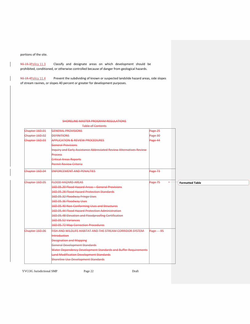
SHORELINE MASTER PROGRAM REGULATIONS
Table of Contents
Chapter 16D.01
Chapter 16D.02
Chapter 16D.03
GENERAL PROVISIONS
DEFINITIONS
APPLICATION & REVIEW PROCEDURES
General Provisions
Inquiry and Early Assistance Abbreviated Review Alternatives Review
Process
Critical Areas Reports
Permit Review Criteria
Page 25
Page 30
Page 44
Chapter 16D.04 ENFORCEMENT AND PENALTIES Page 73
Chapter 16D.05 FLOOD HAZARD AREAS
16D.05.20 Flood Hazard Areas – General Provisions
16D.05.28 Flood Hazard Protection Standards
16D.05.32 Floodway Fringe Uses
16D.05.36 Floodway Uses
16D.05.40 Non-Conforming Uses and Structures
16D.05.44 Flood Hazard Protection Administration
16D.05.48 Elevation and Floodproofing Certification
16D.05.52 Variances
16D.05.72 Map Correction Procedures
Page 75
Chapter 16D.06 FISH AND WILDLIFE HABITAT AND THE STREAM CORRIDOR SYSTEM
Introduction
Designation and Mapping
General Development Standards
Water Dependency Development Standards and Buffer Requirements
Land Modification Development Standards
Shoreline Use Development Standards
Page 95
Formatted Table
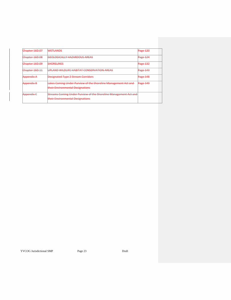
YVCOG Jurisdictional SMP Page 23 Draft
Chapter 16D.07 WETLANDS Page 120
Chapter 16D.08 GEOLOGICALLY HAZARDOUS AREAS Page 124
Chapter 16D.09 SHORELINES Page 132
Chapter 16D.11 UPLAND WILDLIFE HABITAT CONSERVATION AREAS Page 143
Appendix A Designated Type 2 Stream Corridors
Page 148
Appendix B Lakes Coming Under Purview of the Shoreline Management Act and
their Environmental Designations
Page 149
Appendix C Streams Coming Under Purview of the Shoreline Management Act and
their Environmental Designations
YVCOG Jurisdictional SMP Page 24 Draft
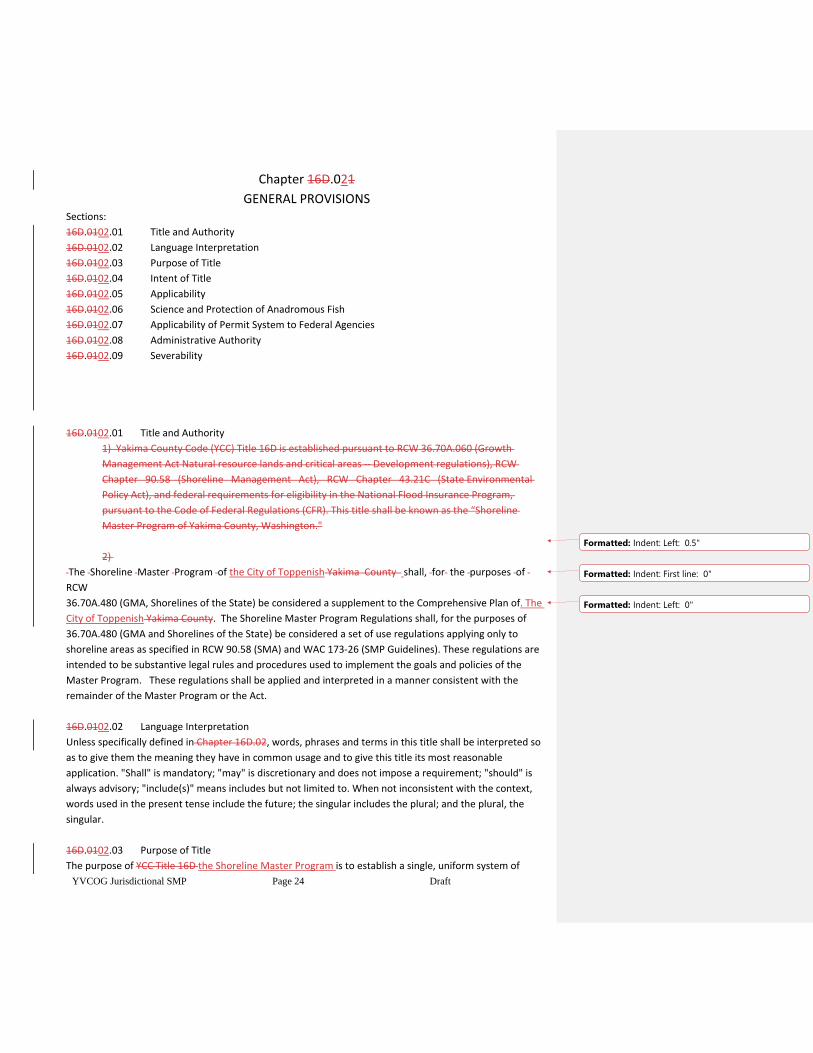
Chapter 16D.021
GENERAL PROVISIONS Sections:
16D.0102.01 Title and Authority
16D.0102.02 Language Interpretation
16D.0102.03 Purpose of Title
16D.0102.04 Intent of Title
16D.0102.05 Applicability
16D.0102.06 Science and Protection of Anadromous Fish
16D.0102.07 Applicability of Permit System to Federal Agencies
16D.0102.08 Administrative Authority
16D.0102.09 Severability
16D.0102.01 Title and Authority
1) Yakima County Code (YCC) Title 16D is established pursuant to RCW 36.70A.060 (Growth
Management Act Natural resource lands and critical areas -- Development regulations), RCW
Chapter 90.58 (Shoreline Management Act), RCW Chapter 43.21C (State Environmental
Policy Act), and federal requirements for eligibility in the National Flood Insurance Program,
pursuant to the Code of Federal Regulations (CFR). This title shall be known as the “Shoreline
Master Program of Yakima County, Washington."
2)
The Shoreline Master Program of the City of Toppenish Yakima County shall, for the purposes of
RCW
36.70A.480 (GMA, Shorelines of the State) be considered a supplement to the Comprehensive Plan of. The
City of Toppenish Yakima County. The Shoreline Master Program Regulations shall, for the purposes of
36.70A.480 (GMA and Shorelines of the State) be considered a set of use regulations applying only to
shoreline areas as specified in RCW 90.58 (SMA) and WAC 173-26 (SMP Guidelines). These regulations are
intended to be substantive legal rules and procedures used to implement the goals and policies of the
Master Program. These regulations shall be applied and interpreted in a manner consistent with the
remainder of the Master Program or the Act.
16D.0102.02 Language Interpretation
Unless specifically defined in Chapter 16D.02, words, phrases and terms in this title shall be interpreted so
as to give them the meaning they have in common usage and to give this title its most reasonable
application. "Shall" is mandatory; "may" is discretionary and does not impose a requirement; "should" is
always advisory; "include(s)" means includes but not limited to. When not inconsistent with the context,
words used in the present tense include the future; the singular includes the plural; and the plural, the
singular.
16D.0102.03 Purpose of Title
The purpose of YCC Title 16D the Shoreline Master Program is to establish a single, uniform system of
Formatted: Indent: Left: 0.5"
Formatted: Indent: First line: 0"
Formatted: Indent: Left: 0"
YVCOG Jurisdictional SMP Page 25 Draft
procedures and standards to be applied to development within Shoreline jurisdiction of unincorporated
Yakima County and municipalities in Yakima County the City of TOPPENISHwhich have adopted this regional
SMP.
16D.0102.04 Intent of Title
1) The Shoreline Master ProgramYCC Title 16D establishes goals, policies, standards, and
regulations pertaining to projects, uses and development within Shoreline jurisdiction,. Shorelines
of the state shall not be considered critical areas under this chapter except to the extent that
specific areas located within shorelines of the state qualify for critical area designation based on
the definition of critical areas provided by RCW 36.70A.030(5) and have been designated as such by
a the City of TOPPENISH pursuant to RCW 36.70A.060(2 development within critical areas or other
areas under Shoreline jurisdiction as provided in the Shoreline Management Act (RCW90.58) and
the Growth Management Act (RCW 36.70A), and development regulated under the National Flood
Insurance Program. Additional purpose and intent for the protection of critical areas is provided in
the chapter on each subject. Stream corridors, flood hazard areas, wetlands, critical aquifer
recharge areas, geologically hazardous areas and fish and wildlife habitat areas constitute Yakima
County's critical areas. These areas are of special concern to the people of Yakima County and the
state of Washington because they are environmentally sensitive lands, or hazardous areas, which
comprise an important part of the county's natural resource base. The policies, standards and
procedures of this title are intended to:
a) Preserve development options within designated critical areas where such development
will not adversely impact critical area values and functions; and
b) Prevent further degradation of critical areas; and
c) Conserve, protect and, where feasible, restore essential or important natural resources;
and
d) Protect the public health, safety, and general welfare; and
e) Further the goals and objectives of the Yakima County City of TOPPENISH
Comprehensive Plan and all of its elements; and
f) Implement the goals and requirements of the Washington Growth Management Act
(RCW Chapter 36.70A) as it applies to Shoreline jurisdiction, the Shoreline Management Act
(RCW Chapter 90.58), and the National Flood Insurance Program; and
g) Recognize and protect private property rights; and
h) Provide development options for landowners of all existing lots to the greatest extent
possible, through the establishment of Variance, Reasonable Use provisions and Non-
Conforming Use and Facility provisions; and
i) Manage for no net loss of ecological function within Shoreline jurisdiction to protect
against adverse effects to the public health, the land and its vegetation and wildlife, and
the waters of the state and their aquatic life; and.
j) Establish a consistent foundation of regulations that apply to similar issues whether they
are inside or outside Shoreline jurisdiction. Additional pProtection measures required as a
result ofbecause of Shoreline Master Program updates to this title are identified as
applying within Shoreline jurisdiction and are not intended to be applied outside Shoreline
Formatted: Space After: 6 pt
Formatted: Indent: Left: 1", First line: 0", Space After: 6
pt
Formatted: Space After: 6 pt
YVCOG Jurisdictional SMP Page 26 Draft
jurisdiction; and
k) Recognize that mining is a unique use as a result ofbecause of its inherent linkage to
geology.
Therefore, mining and related activities may be an appropriate use when conducted
consistent with the policies and provisions of WAC 173-26-241(h), within all Shoreline
Designations, except the Natural and Floodway/CMZ Environments.
2) In addition, the policies, standards, and procedures of this title:
a) Are not intended to regulate the operation and maintenance of existing, legally
established uses and structures, including but not limited to vegetative buffers on existing
uses that have been reduced in width prior to the effective dates of provisions in the
Critical Areas Ordinance (YCC Title 16C City CAO) or Shoreline Master Program (YCC
Title16D).;
b) Are not intended to result in an unconstitutional taking of private property.;
c) Are not intended to retroactively require the restoration of degraded critical areas for
properties in a degraded condition prior to the effective dates of provisions in the Critical
Areas Ordinance (YCC Title 16C) or Shoreline Master Program (YCC Title 16D); but rather to
use compensatory mitigation as a tool to mitigate impacts of new development.;
d) Are not intended to presume that regulatory tools are the only mechanism for
protection, but rather integrated with non-regulatory tools in as balanced a manner as
possible.;
e) Are not intended to prohibit the use of valid water rights.
16D.0102.05 Applicability
1) 1) The provisions of this title shall apply to any new development, construction or use within
the unincorporated portion of Yakima County City of TOPPENISH and municipalities in Yakima
County which have adopted this regional SMP designated as a critical area inside Shoreline
jurisdiction, designated as Shoreline jurisdiction. and designated as a special flood hazard area
under the National Flood Insurance Program. Those shorelines within the City of TOPPENISH
and its Urban Growth Area which have been inventoried and found to meet the criteria as a
shoreline of the state are as follows:,
a. The Yakima River however, this title does not apply to the situations below, except that
the Flood Hazard protection provisions of Chapter 5 will continue to apply as
determined by the applicability provision in 16D.05.20:
a) Within critical areas and shorelines designated by this title or amendments that may
later be adopted, there may exist lots, structures and uses which were lawfully established
before this title was initially adopted, amended or readopted, as provided below, but
which would be subsequently prohibited, regulated or restricted under this ordinance. It is
the intent of this title to permit these pre-existing legal non-conformities to continue
without requirement to change said non-conformity until such time as conformance is
required through permits for development in the future. The adoption and amendment
dates of the relevant regulations are provided below:
Formatted: Indent: Left: 1", First line: 0", Space After: 6
pt
Formatted: Space After: 6 pt
Formatted: Space After: 6 pt
Formatted: List Paragraph, Numbered + Level: 2 +
Numbering Style: a, b, c, … + Start at: 1 + Alignment:
Left + Aligned at: 1" + Indent at: 1.25"
YVCOG Jurisdictional SMP Page 27 Draft
i) Shoreline Master Program adopted September 5, 1974;
ii) Shoreline Master Program amended March 26, 1981;
iii) Shoreline Master Program amended November 1, 1981;
iv) Critical Areas Ordinance adopted July 12, 1994;
v) Critical Areas Ordinance amended October 1, 1995;
vi) Flood Hazard Ordinance adopted June 5, 1985.
b) Critical areas on federally owned lands that are outside shoreline jurisdiction are not
subject to this title;
c) Critical areas on federally owned lands within Shoreline jurisdiction in situations that do
not have to obtain permits or follow the permit system, as provided in 16D.01.07
(Applicability to Federal Agencies), are not subject to this title;
d) Forest practices, as defined by this title, carried out under a Washington Department of
Natural Resources Forest Practice permit are not subject to this title, except those that
involve Shoreline jurisdiction, involve a conversion of forest land to a non-forestry use,
involve a conversion option harvest plan, or take place on lands platted after January
1,1960;
e) Livestock grazing on publicly owned land, when carried out under an agreement that
includes a resource management plan that will be monitored by a public entity is not
subject to this title;
f) Changing agricultural crops within an existing farming operation is not considered new
development, construction or use, provided that the existing area under agricultural
production is not extended further into a vegetative buffer identified under 16D.06.16, and
provided that the natural contour of the land subject to this title is not altered by
excavation and filling;
g) Minor, temporary or transient activities, including those of a recreational nature, that
do not alter the environment or require a dedicated staging area, use area, or route are not
subject to this title, and including temporary signs (election, sale, rent, etc.);
h) Critical Areas within the exterior boundaries of the Yakama Nation that are located
within the designated Closed Areas or not under County jurisdiction as a result of the
Supreme Court decision COUNTY OF YAKIMA et. al. v. CONFEDERATED TRIBES AND BANDS
OF THE YAKIMA INDIAN NATION (1991) are not subject to this title.
i) Mining, as defined by this title, that is carried out under a Washington Department of
Natural Resources reclamation permit is not subject to the geologically hazardous areas
provisions of this title for erosion hazard areas, oversteepened slope hazard areas,
landslide hazard areas and suspected geologic hazard areas. Other critical areas
provisions continue to apply.
2) 2) Other rules and regulations, including the Yakima County City of TOPPENISH Subdivision
Ordinance (YCC Title14), the Yakima County the City of TOPPENISH Zoning Ordinance (YCC Title
15), the Yakima Urban Area Zoning Ordinance (YCC Title 15A), and the City of TOPPENISH
Building and Construction Ordinance (YCC Title 13), shall remain in full force and effect as they
apply to a designated critical area or Shoreline. Wherever the requirements of YCCthe City
of TOPPENISH Title 16DNEW SMP CITATION HERE conflict with the requirements of the
applicable Zoning Ordinance, the Subdivision Ordinance or any other lawfully adopted County
City rules or regulations, the most restrictive standards shall govern.
YVCOG Jurisdictional SMP Page 28 Draft
16D.01.06 Science and Protection of Anadromous Fish
This title has been updated consistent with the requirements for:
1) Using the best available science as required by RCW 36.70A.172 (Critical areas --
Designation and protection -- Best available science to be used) and WAC 365-195-900 through
WAC 365-195-920 (BAS Background and purpose);
2) An integrated use of the natural and social sciences, and the environmental design arts, and
utilization of all available information regarding hydrology, geography, topography, ecology,
economics, and other pertinent data, as required by RCW 90.58.100 (Programs as
constituting use regulations);
3) Giving special consideration to conservation or protection measures necessary to preserve or
enhance anadromous fish and their habitat, (salmon, steelhead, etc.) as required by
RCW36.70A.172 (Best available science to be used) and WAC 365-195-925 (Criteria for
demonstrating "special consideration" has been given to anadromous fisheries).
16D.0102.067 Applicability of Permit System to Federal Agencies
The permit system shall be applied in the following manner to federal agencies on lands within
Shoreline jurisdiction:
1) Areas and uses in those areas that are under exclusive federal jurisdiction as established through
federal or state statutes are not subject to the jurisdiction of this title or chapter 90.58 RCW.
Federal agencies shall not be required to obtain permits for developments undertaken by the
federal government on lands owned in fee by the federal government, or on easements obtained
by the federal government for a specified purpose where the proposed development is consistent
with the specified purpose, unless under either circumstance the federal government grants or
reserves to the state or City of TOPPENISH Yakima County, substantial jurisdiction over activities on
those lands.;
2) The permit system shall apply to all nonfederal developments and uses undertaken on federal
lands and on lands subject to nonfederal ownership, lease, or easement, even though such lands
may fall within the external boundaries of a federal ownership.;
3) The permit system shall apply to developments undertaken on lands not federally owned but
under lease, easement, license, or other similar federal property rights short of fee ownership, to
the federal government.;
4) The above paragraphs shall be controlling for the purposes of Shoreline permits for federal land
or federal projects; however, the following attempts to clarify these limits for practical use:
a) Federal development on federally owned land is not required to obtain a permit.;
b) Federal development on a federally owned lease is not required to obtain a permit, as
long as the development is consistent with the purpose of the lease.;
Formatted: List Paragraph, Indent: Left: 0.75"
Formatted: Indent: Left: 0", Space After: 10 pt
Formatted: Space After: 6 pt
YVCOG Jurisdictional SMP Page 29 Draft
c) Development on federally owned land under a non-federal lease or easement must
obtain a Shoreline permit.;
d) Non-federal development or use on federally owned land must obtain a Shoreline
permit.;
e) Development on non-federal land must obtain a Shoreline permit, even if it is leased,
rented, etc. to the federal government, or it is within the boundaries of federal ownership.
16D.0102.078 Administrative Authority
1) The City of Toppenish Public WorksYakima County Public Services Department - Planning
Division and the appropriate authorities of municipalities which have adopted this regional
SMP shall be responsible for the general administration of this title. The PlanningPublic Works
Division ManagerDirector or the Manager’s Director’s designee shall serve as the
Administrative Official of this title. , except as noted in Chapters16D.05.20 through 16D.05.72.
The Administrative Official shall establish procedures for implementation of this title.
a) Where the provisions of these regulations may be unclear in special circumstances, or
where judgment must be made because of the nature of the language used, the
Administrative Official shall make such interpretations. Such interpretation shall specify
whether the issue is under Shoreline jurisdiction or not. A separate record of all
interpretations shall be kept. To avoid arbitrariness, any earlier interpretation that may
relate to a pending action shall be examined by the Administrative Official for its effect or
influence on the pending action.
b) A written request for interpretation of any provision of this title, or any rule or
regulation adopted pursuant to this title may be submitted to the Administrative Official.
Each request shall set forth the specific provision or provisions to be interpreted and the
facts of the specific situation giving rise to the request for an interpretation. Interpretations
shall be processed administered in accordance with YCC Title 16B.03.070.03.09 of this Title.
(c) The City shall consult with the Department of Ecology (Ecology) to ensure that any
formal written interpretations are consistent with the purpose and intent of the SMA (RCW
90.58), pursuant to WAC 173-26-140.
16D.021.089 Severability
If any provision of the ordinance codified in this title, or its application to any person or legal entity or
circumstances is held to be invalid, the remainder of said ordinance or the application of the provision to
other persons or legal entities or circumstances shall not be affected.
.02.09 Effective Date
The effective of this Shoreline Master Program, and any future amendments therein, is 14 days from
Ecology’s written notice of final action.
Formatted: Space After: 6 pt
Formatted: Not Highlight
YVCOG Jurisdictional SMP Page 30 Draft
Chapter 16D.032
DEFINITIONS
16D.02.0003.0011 Definitions Generally
1a) Whenever the words and terms set forth in this chapter appear in this title, they shall be given the
meaning attributed to them by this chapter. References to specific provisions of YCC Title
13 the City of TOPPENISH building code and the International Building Codes, statutes and Washington
Administrative Code provide greater detail for purposes of administering this title.
b) Definitions listed in this chapter shall be applied to all critical areas, including Flood Hazard Areas,
whether they occur inside or outside Shoreline jurisdiction, unless the definition itself identifies the term as
applying to Shoreline or Flood Hazard administration, in which case the definition only applies to that
situation.
16D.032.005 Abutting
"Abutting" means bordering upon, to touch upon, or in physical contact with. Sites are considered
abutting even though the area of contact may be only a point.
16D.032.010 Adjacent
"Adjacent" means to be nearby and not necessarily abutting.
16D.02.012 Administrative Official
"Administrative Official" means the duly appointed Planning Division Director of the Public
ServicesPlanning/Public Works Department, or his designee, or the relevant decision maker identified in
YCC Title 16BCITATION HERE (Project Permit Administration); synonymous with "administrator" or
"director."
16D.02.03.015 Agricultural Activities
For purposes of administering the Shoreline Master Program "Agricultural activities" means
agricultural uses and practices including, but not limited to: Producing, breeding, or increasing agricultural
products; rotating and changing agricultural crops; allowing land used for agricultural activities to lie
fallow in which it is plowed and tilled but left unseeded; allowing land used for agricultural activities to lie
dormant as a result of adverse agricultural market conditions; allowing land used for agricultural activities
to lie dormant because the land is enrolled in a local, state, or federal conservation program, or the land is
subject to a conservation easement; conducting agricultural operations; maintaining, repairing, and
replacing agricultural equipment; maintaining, repairing, and replacing agricultural facilities, provided that
the replacement facility is no closer to the shoreline than the original facility; and maintaining agricultural
lands under production or cultivation. Agricultural activities include plowing, discing, harrowing,
compacting, planting, and harvesting, spraying, etc.;
1) "Agricultural products" includes but is not limited to horticultural, viticultural,
floricultural, vegetable, fruit, berry, grain, hops, hay, straw, turf, sod, seed, and apiary products;
feed or forage for livestock; Christmas trees; hybrid cottonwood and similar hardwood trees grown
as crops and harvested within twenty years of planting; and livestock including both the animals
YVCOG Jurisdictional SMP Page 31 Draft
themselves and animal products including but not limited to meat, upland finfish, poultry and
poultry products, and dairy products;
2) "Agricultural equipment" and "agricultural facilities" includes, but is not limited to:
i) The following used in agricultural operations: Equipment; machinery; constructed
shelters, buildings, and ponds; fences; upland finfish rearing facilities; water diversion,
withdrawal, conveyance, and use equipment and facilities including but not limited to
pumps, pipes, tapes, canals, ditches, and drains; and/or
ii) corridors and facilities for transporting personnel, livestock, and equipment to, from,
and within agricultural lands; and/or
iii) farm residences and associated equipment, lands, and facilities; and/or
iv) roadside stands and on-farm markets for marketing fruit or vegetables.; and
3) "Agricultural land" means those specific land areas on which agriculture activities are conducted
as of the date of adoption of a local master program as evidenced by aerial photography or other
documentation. After the effective date of the master program land converted to agricultural use is
subject to compliance with the requirements of the master program.
16D.02.03.025 Alluvial fan
“Alluvial fan” is a low, outspread, relatively flat to gently sloping feature, shaped like an open fan or a
segment of a cone, deposited by a stream at the place where it issues from a valley upon a plain or broad
valley, or where a tributary stream is near or at its junction with the main stream, or wherever a
constriction in a valley abruptly ceases or the gradient of the stream suddenly decreases; it is steepest near
the mouth of the valley where its apex points upstream, and it slopes gently and convexly outward with
gradually decreasing gradient.
16D.02.03.030 Applicant
"Applicant" means a person, party, firm, corporation, or other legal entity that proposes a development,
construction or use on a site.
16D.02.03.033 Aquaculture
For purposes of administering the Shoreline Master Program "Aquaculture" means the culture
and/or farming of food fish, shellfish, and other aquatic plants and animals in fresh water. Aquaculture
practices may include but are not limited to hatching, seeding or planting, cultivating, feeding,
raising, harvesting of planted crops or of natural crops so as to maintain an optimum yield, and processing
of aquatic plants or animals.
16D.02.03.035 Aquifer
"Aquifer" means a saturated geologic formation which will yield a sufficient quantity ofenough water to
serve as a private or public water supply.
16D.02.03.040 Critical Aquifer Recharge Area
"Critical Aquifer Recharge Area" means an area with a critical recharging effect on aquifers used for potable
water, or areas where a drinking aquifer is vulnerable to contamination that would affect the potability of
Formatted: Space After: 6 pt
YVCOG Jurisdictional SMP Page 32 Draft
the water.
16D.02.03.042 Bank
"Bank" means the land surface above the ordinary high- water mark that abuts a body of water and
contains it to the bankfull depth.
16D.02.03.043 Bankfull depth
"Bankfull depth" means the average vertical distance between the channel bed and the estimated water
surface elevation required to completely fill the channel to a point above which water
would enter the floodplain or intersect a terrace or hillslope. In cases where multiple channels exist, the
bankfull depth is the average depth of all channels along the cross-section.
16D.02.044 Base Flood
“Base Flood” for purposes of administering 16D.05 means the flood having a 1-percent chance of being
equaled or exceeded in any given year. (Ref. IBC 1612.2)
16D.02.045 Base Flood Elevation
“Base flood elevation” for purposes of administering 16D.05 means the elevation of the base flood,
including wave height, relative to the National Geodetic Vertical Datum (NGVD), North American Vertical
Datum (NAVD) or other datum specified on the Flood Insurance Rate Map (FIRM). (Ref. IBC1612.2)
16D.02.046 Basement
“Basement” for purposes of administering 16D.05 means any area of the building having its floor subgrade
(below ground level) on all sides. (Ref. IBC 1612.2)
16D.02.03.055 Bed
"Bed" means the land below the ordinary high- water lines of state waters. This definition shall not include
irrigation ditches, canals, storm water run-off devices, or other artificial watercourses except where they
exist in a natural watercourse that has been altered by man.
16D.02.03.060 Bedrock
"Bedrock" means in-place solid rock.
16D.02.03.065 Berm
"Berm" means a mound of earth material used as a protective barrier or to control the direction of
water flow.
16D.02.03.067 Best Management Practices
"Best Management Practices" or "BMPs" means schedules of activities, practices, maintenance procedures,
and structural and/or managerial practices that, when used singly or in a combination prevent or reduce
adverse impacts to the environment.
16D.02.03.070 Bioengineering
"Bioengineering" means project designs or construction methods which use live woody vegetation or a
combination of live woody vegetation and specially developed natural or synthetic materials to establish a
YVCOG Jurisdictional SMP Page 33 Draft
complex root grid within the existing bank which is resistant to erosion, provides bank stability, and
maintains a healthy riparian environment with habitat features important to aquatic and terrestrial wildlife.
Bioengineered or biotechnical bank protection designs may incorporate limited use of armored toes and
wood structural elements.
16D.02.03.075 Breakwater
"Breakwater" means a fixed or floating off-shore structure that protects the shore from wave action or
currents.
16D.02.03.080 Bulkhead
"Bulkhead" means a vertical or nearly vertical erosion protection structure placed parallel to the shore
consisting of concrete, timber, steel, rock, or other permanent material not readily subject to erosion.
16D.02.03.082 Cabin
For purposes of administering the Shoreline Master Program “Cabin” means a small single- family
residence of 800 square feet or less, without a garage or carport and without large accessory buildings.
Small accessory buildings, such as detached storage sheds or accessory structures totaling 120 square feet
or less, may be allowed. Dwellings not meeting these standards are considered standard single -family
residences.
16D.02.03.085 Channel
"Channel" means an open conduit, either naturally or artificially created, which periodically or continuously
contains moving water, or which forms a connecting link between two bodies of water.
16D.02.03.090 Channel Migration Zone
For purposes of administering the Shoreline Master program "Channel migration zone (CMZ)" means the
area along a river within which the channel(s) can be reasonably predicted to migrate over time as a result
of natural and normally occurring hydrological and related processes when considered with the
characteristics of the river and its surroundings.
16D.02.03.092 Chief Building Official
"Chief Building Official" or “building official” means the manager of the Building and Fire
Safety Division of the Department of Public Services Planning or designee.
16D.02.03.095 Classification
"Classification" means the definition of value and hazard categories to which critical areas and natural
resource lands will be assigned.
16D.02.03.100 Clearing
"Clearing" means the removal of timber, brush, grass, ground cover or other vegetative matter from a site.
16D.02.03.110 Compaction
"Compaction" means compressing soil through some mechanical means to make it denser.
16D.02.03.115 Confinement Feeding Operation
YVCOG Jurisdictional SMP Page 34 Draft
"Confinement feeding operation" means the use of structures or pens for the concentrated feeding or
holding of animals or poultry, including but not limited to horses, cattle, sheep, or swine. This definition
includes dairy confinement areas, slaughterhouses, shipping terminal holding pens, poultry and/or egg
production facilities and fur farms, but does not include animal husbandry and normal farming practices.
16D.02.03.120 Construction
"Construction" means the assembly, placement, or installation of structures, roadways, transmission lines,
and other improvements within a project site.
16D.02.03.125 Designated
"Designated" means formal legislative action to identify and describe a critical area.
16D.02.03.130 Department
"Department" means the Yakima County Public ServicesCity of TOPPENISH Planning/Public Works
Department, Planning Division.
16D.02.03.135 Development
"Development" means any use as defined under RCW 90.58.030(3)(d) (definitions), or the division of land
into lots or parcels in accordance with the county City of TOPPENISH Subdivision Ordinance (YCC Title
14CITATION HERE), and any clearing, excavation, dredging, drilling, filling, dumping, removal of earth and
mineral materials, or other permanent or temporary modification of a site up to, but not including,
construction as defined in this chapter. For the purpose of Chapters 16D.05.20 through 16D.05.72,
"development" also means any manmade change to improved or unimproved real estate located within
the special flood hazard area, including but not limited to buildings or other structures, mining, dredging,
filling, grading, paving, excavation, drilling, temporary or permanent storage of equipment and works
defined in this chapter. “Development” does not include dismantling or removing structures if there is no
other associated development or re-development.(Ref. IBC G 201.2)
16D.02.03.140 Dike
"Dike" means an embankment to prevent flooding by a stream or other water body. A dike is also referred
to as a levee.
16D.02.03.145 Dock
“Dock" means a structure built over or floating upon the water and used as a landing place for boats and
other marine transport, fishing, swimming, and other recreational uses.
16D.02.03.150 Dredging
"Dredging" means removal of earth from the bed of a stream, lake, or pond for the purpose of
increasing the depth of surface water or obtaining minerals, construction aggregate, or landfill materials.
This definition does not include excavation for mining within a pond created by a mining operation
approved under this title or under a local zoning ordinance, or a mining operation in existence before
Zoning, Shorelines, or Critical Areas permits were required for such operations.
16D.02.03.160 Earth Material
"Earth material" means any rock, natural soil, or combination thereof.
Formatted: Font: 11 pt, Font color: Auto
YVCOG Jurisdictional SMP Page 35 Draft
16D.02.03.163 Ecological functions
For purposes of administering the Shoreline Master Program "Ecological functions" or "shoreline
functions" means the work performed or role played by the physical, chemical, and biological processes
that contribute to the maintenance of the aquatic and terrestrial environments that constitute the
shoreline’s natural ecosystem.
16D.02.03.166 Ecosystem-wide processes
For purposes of administering the Shoreline Master Program "Ecosystem-wide processes" means the suite
of naturally occurring physical and geologic processes of erosion, transport, and deposition; and specific
chemical processes that shape landforms within a specific shoreline ecosystem and determine both the
types of habitat and the associated ecological functions.
16D.02.03.170 Enhance
"Enhance" means to strengthen any of the basic functional properties of a riparian area listed in Section
16D.06.05 that exist but do not perform at optimum efficiency. "Optimum" refers to the most favorable or
best performance of each function achievable for a specific segment of stream corridor.
16D.02.03.175 Ephemeral Stream
“Ephemeral stream” means a stream that flows only in response to precipitation with no groundwater
association, usually less than 30 days per year. The lack of any groundwater association results in a lack of
a distinctive riparian vegetation compared to the surrounding landscape.
16D.02.03.180 Erosion
"Erosion" means the wearing away of the earth's surface as a result ofbecause of the movement of wind,
water, or ice.
16D.02.03.185 Events and Temporary Uses
For purposes of administering the Shoreline Master Program “Events and Temporary Uses” means a social
or community occasion or activity lasting for a limited time. Events and Temporary Uses within permitted
facilities or legally non-conforming facilities that are designed for such uses are not included in this
definition, as long as they do not materially interfere with the normal public use of the water or shorelines
of the state.
16D.02.03.190 Excavation
"Excavation" means the mechanical removal of earth material.
16D.02.03.195 Feasible
For purposes of administering the Shoreline Master Program "Feasible" means that an action,
such as a development project, mitigation, or preservation requirement, meets all of the following
conditions:
a) The action can be accomplished with technologies and methods that have been used in the past
in similar circumstances, or studies or tests have demonstrated in similar circumstances that such
approaches are currently available and likely to achieve the intended results;
b) The action provides a reasonable likelihood of achieving its intended purpose; and
Formatted: Indent: Left: 0.5", Space After: 6 pt
Formatted: Indent: First line: 0.5", Space After: 6 pt
YVCOG Jurisdictional SMP Page 36 Draft
c) The action does not physically preclude achieving the project's primary intended legal use.
16D.02.03.200 Fill
"Fill" means the addition of any material, such as (by way of illustration) earth, clay, sand, rock, gravel,
concrete rubble, wood chips, bark, or waste of any kind, which is placed, stored or dumped upon the
surface of the ground resulting in an increase in the natural surface elevation. The physical structure of a
shore stabilization structure shall not be considered fill. However, fill placed behind the structure is
considered fill. Stream bed manipulation for irrigation diversions shall not be considered fill.
16D.02.03.205 Flood
"Flood" means a general and temporary condition of partial or complete inundation of normally dry land
areas from the unusual and rapid accumulation of runoff of surface waters from any source.
16D.02.03.206 Flood Hazard Permit
"Flood hazard permit" means written approval applied for and obtained in accordance with such rules and
regulations as are established under this title.
16D.02.03.207 Flood Insurance Rate Map
"Flood insurance rate map (FIRM)" means the official map on which the Federal Emergency Management
Agency has delineated both the areas of special flood hazards and the risk premium zones applicable to the
community.
16D.02.03.208 Flood Insurance Study
"Flood insurance study" means the official report provided by the Federal Emergency Management Agency
that includes flood profiles, the flood boundary-floodway map, and the water surface elevation of the base
flood.
16D.02.03.210 Floodplain
"Floodplain" means a land area adjoining a river, stream, watercourse, or lake which has been determined
likely to flood. The extent of the floodplain may vary with the frequency of flooding being considered.
"Flood plain" is synonymous with the one hundred-year floodplain and means that land area susceptible to
inundation with a one percent chance of being equaled or exceeded in any given year.
16D.02.03.215 Flood-prone
"Flood-prone" means a land area for which a floodway and floodplain has not been determined with
respect to any specific flood frequency, but for which the potential for flooding can be identified by
information observable in the field such as soils or geological evidence, or by materials such as flood
studies, topographic surveys, photographic evidence or other data.
16D.02.03.216 Flood-proofing
"Flood-proofing" for purposes of administering 16D.05 means any combination of structural and
nonstructural additions, changes, or adjustments to structures which reduce or eliminate flood damages to
lands, water and sanitary facilities, structures, and contents of buildings.
16D.02.03.220 Floodway
YVCOG Jurisdictional SMP Page 37 Draft
"Floodway" means “Floodway” means the area that has been established in effective federal emergency
management agency flood insurance rate maps or floodway maps. The floodway does not include lands
that can reasonably be expected to be protected from flood waters by flood control devices maintained by
or maintained under license from the federal government, the state or a political subdivision of the state.
the regular channel of a river, stream, or other watercourse, plus the adjacent land areas that must be
reserved in order to discharge the base flood without cumulatively increasing the water surface elevation
more than one foot.
16D.02.225 Floodway Fringe
"Floodway fringe" for purposes of administering 16D.05 means that portion of a floodplain which is
inundated by floodwaters but is not within a defined floodway. Floodway fringes serve as temporary
storage for floodwaters.
16D.02.03.230 Forest Land
"Forest land" means land primarily devoted to forest practices activities.
16D.02.03.240 Forest Practices
"Forest practices" means activities conducted under federal forest practices approval or under a
Forest Practices permit reviewed and approved by the Washington Department of Natural Resources
pertaining to the management of forest land , including growing, managing, harvesting, and interim
storage of merchantable timber for commercial value, as well as incidental activities reviewed under
federal or state approval, such as road construction and maintenance (including bridges) and mining
activities.
16D.02.03.250 Grade
"Grade" means the vertical location of the ground surface. "Natural grade" is the grade as it exists or may
have existed in its original undisturbed condition. "Existing grade" is the current grade in either its
undisturbed, natural condition or as disturbed by some previous modification. "Rough grade" is a stage
where grade conforms approximately to an approved plan. "Finish grade" is the final grade of the site
which conforms to an approved plan.
16D.02.03.255 Grading
"Grading" means any excavation, filling, or combination thereof.
16D.02.03.260 Groundwater
"Groundwater" means water that occurs beneath the land surface, also called subsurface water or
subterranean water. Groundwater includes water in the zone of saturation of a water-bearing formation.
16D.02.263 Hydrologically Related Critical Areas (HRCA)
"Hydrologically Related Critical Areas (HRCA)" include all those areas identified in section
16D.06.03, within Yakima County which are important and deserving of protection by nature of their value
for the functional properties found in Section 16D.06.05.
16D.02.03.266 Hyporheic
"Hyporheic" means” means a groundwater area adjacent to and below channels where water is
YVCOG Jurisdictional SMP Page 38 Draft
exchanged with channel water and water movement is mainly in the downstream direction.
16D.023.270 Intermittent Streams
"Intermittent stream" means a stream which flows only during certain times of the year, with inputs from
precipitation and groundwater, but usually more than 30 days per year. The groundwater association
generally produces an identifiable riparian area. This definition does not include streams that are
intermittent because of irrigation diversion or other manmade diversions of the water.
16D.02.03.275 Lake or pond
"Lake or pond" means at inland body of standing water. The term includes the reservoir or expanded part
of a river behind a dam.
16D.02.281 Lowest Floor
Lowest floor" for purposes of administering 16D.05 means the lowest floor of the lowest enclosed
area (including basement). An unfinished or flood-resistant enclosure, usable solely for parking of vehicles,
building access or storage, in an area other than a basement area, is not considered a building's lowest
floor, provided that such enclosure is not built so as to render the structure in violation of the applicable
nonelevation design requirements of this title.
16D.02.03.282 Manufactured Home
"Manufactured home" means a structure fabricated on a permanent chassis that is transportable in one or
more sections; is designed to be used with or without a permanent foundation when connected to the
required facilities; has sleeping, cooking, and plumbing facilities or any combination thereof; and is
intended for human occupancy or is being used for residential purposes. Although Washington
Administrative Code (WAC) and City of TOPPENISH Code Yakima County Code Titles13 and 15 separately
define and distinguish between "manufactured home" and "mobile home" according to federal or state
construction codes for such dwellings, the term "manufactured home" shall include "mobile home" for
regulatory purposes under this chapter. The term shall not include "recreation vehicle." "commercial
coach," "camping vehicle," "travel trailer," "park trailer," "tip-out," and any other similar vehicle which is
not intended, designed, constructed or used for residential purposes for use as a single-family dwelling and
is not otherwise labeled as a manufactured or mobile home under any federal or state law. For floodplain
management purposes only under this chapter, park trailers, camping vehicles, travel trailers, tip-outs, and
other similar vehicles shall be considered manufactured homes when placed on a site for greater than one
hundred eighty days.
16D.02.03.283 Manufactured Home Park or Subdivision
"Manufactured home park or subdivision" means a parcel (or contiguous parcels) of land divided into two
or more manufactured home lots for rent or sale in accordance with YCC Title 15LAND USE CITATION HERE
of this Code.
16D.02.03.284 Manufactured Home Park or Subdivision, Existing
"Existing manufactured home park or subdivision" means a manufactured home park or subdivision for
which the construction of facilities for servicing the lots on which the manufactured homes are to be
affixed (including, at a minimum, the installation of utilities, the construction of streets, and either final site
grading or the pouring of concrete pads) is completed before October 1, 1995, the effective date of these
YVCOG Jurisdictional SMP Page 39 Draft
floodplain management regulations.
16D.02.03.285 Minerals
"Minerals" means gravel, sand, and metallic and non-metallic substances of commercial value.
16D.02.03.290 Mining
"Mining" means the removal of naturally occurring minerals and materials from the earth for commercial
value. Mining includes processing and batching. Mining does not include large excavations for structures,
foundations, parking areas, etc. Also see Dredging and Excavation (.05.1516D.06.20). Also see introduction
to Appendix B.
16D.02.03.295 Native
"Native" means indigenous to, or originating naturally within theYakima County City of TOPPENISHX.
16D.02.03.300 Natural Conditions
"Natural conditions" means those conditions which arise from or are found in nature and not modified by
human intervention; not to include artificial or manufactured conditions.
16D.02.302 New Construction
"New construction" for purposes of administering 16D.05 means structures for which the start of
construction commenced on or after June 5, 1985, the date Yakima County enacted Ordinance 3-
1985 in order to meet the requirements of the National Flood Insurance Program. October 1,
1995, the effective date of the ordinance codified in this title shall be used for defining the term new
construction as it applies to all other Critical Areas requirements established under this Title by Ordinance
8-1995.
16D.02.03.3023 Nonconforming Development or Nonconforming Structure
"Nonconforming structure" for purposes of administering 16D.05 means an existing structure that was
lawfully constructed at the time it was built which was legally constructed prior to October 1, 1995prior to,
the effective date of the Shoreline Master Program but is no longer fully consistent with present
regulations such as setbacks, buffer or yards; area; bulk; height or density standards due to subsequent
changes to the master program this title, but which would not be permitted as a new structure under the
terms of this title because the structure is not in conformance with the applicable elevation and/or flood-
proofing requirements.
.03.303 Non-conforming Lot.
“Nonconforming lot” means a lot that met dimensional requirements of the applicable master program at
the time of its establishment but now contains less than the required width, depth or area due to
subsequent changes to the master program.
16D.02.03.304 Nonconforming Use
"Nonconforming use" for purposes of administering 16D.05 means the an existing shoreline use of a
building, structure or land which was lawfully established prior to, existing and maintained at the effective
date of provisions of the SMA or this title Shoreline Master Program but which, because of the application
of this title to it, no longer conforms to the present use regulations due to subsequent changes to the
YVCOG Jurisdictional SMP Page 40 Draft
SMP.or applicable elevation and/or flood-proofing requirements of this title and which would not be
permitted as a new use under the terms of this title.
16D.02.03.305 Ordinary High -Water Mark (OHWM)
"Ordinary High- Water Mark" means that mark on lakes and streams which will be found by examining the
bed and banks and ascertaining where the presence and action of waters are so common and usual, and so
long continued in ordinary years, as to mark upon the soil a character distinct from that of the abutting
upland.
16D.02.03.310 Perennial Stream
"Perennial stream" means a stream that flows year -round in normal water years. Groundwater is a source
of much of the water in the channel.
16D.02.03.320 Project Site
"Project site" means that portion of any lot, parcel, tract, or combination thereof which encompasses all
phases of the total project proposal.
16D.02.321 Qualified Professional
"A qualified Professional" shall meet the following criteria:
a) A qualified professional for wetlands must have a bachelors degree or higher in biology, ecology,
soil science, botany, or a closely related field, and a minimum of five years of professional
experience in wetland identification and assessment in the Pacific Northwest.
b) A qualified professional for stream corridors must have a bachelors degree or higher in wildlife
biology, ecology, fisheries, or closely related field, and a minimum of five years professional
experience related to the subject species/habitat type.
c) A qualified professional for geologically hazardous areas and preparation of geo-technical
reports must be a professional engineering geologist or civil engineer, licensed in the state of
Washington.
d) A qualified professional for critical aquifer recharge areas must be a professional hydrogeologist,
or environmental engineer licensed in the state of Washington.
e) A qualified professional for channel migration zone reports must be a professional engineering
geologist, civil engineer or geologist licensed in the state of Washington, with a minimum of five
years of professional experience in geomorphology.
f) A qualified professional for flood studies must be a professional engineering geologist or civil
engineer licensed in the state of Washington.
g) A qualified professional for economic studies must have a bachelors degree or higher in
economics or business administration with 5 years of professional experience. The five year
standard shall be waived for professionals with a PhD degree.
h) A qualified professional for habitat assessments and habitat management plans must have a
bachelors degree or higher in biology and professional experience related to the subject species or
habitat.
i) Or other person/persons with experience, training, expertise and related work experience
appropriate for the relevant critical area subjects determined acceptable to the Administrative
Official.
YVCOG Jurisdictional SMP Page 41 Draft
16D.02.03.322 Recreation Vehicle
"Recreation vehicle" means a vehicle which is:
1) Built on a single chassis; and
2) Four hundred square feet or less when measured at the largest horizontal projection; and
3) Designed to be self-propelled or permanently towable by a light-duty truck; and
4) Designed primarily not for use as a permanent dwelling but as temporary living quarters for
recreational, camping, travel, or seasonal use.
16D.02.03.325 Restore
"Restore" means to re-establish the basic functional properties listed in Section 16D.06.05 that have been
lost or destroyed through natural events or human activity. This may be accomplished through measures
including but not limited to re-vegetation, removal of intrusive structures and removal or treatment of
toxic materials. Restoration does not imply a requirement for returning the site to aboriginal or pre-
European settlement conditions.
16D.02.03.330 Revetment
"Revetment" means a facing placed on a bank or bluff to protect a slope, embankment, or shore structure
against erosion by wave action or currents.
16D.02.03.335 Riparian Vegetation
“Riparian Vegetation” means the terrestrial vegetation that grows beside rivers, streams, and other
freshwater bodies and that depends on these water sources for soil moisture greater than would otherwise
be available from local precipitation.
16D.02.03.340 Riprap
"Riprap" means a layer, facing, or protective mound of stones randomly placed to prevent erosion, scour,
or sloughing of a structure or embankment; also, the stone used for this purpose.
16D.02.03.345 Scour
"Scour" means the removal of underwater material by waves and currents, especially at the base or toe of
a shore stabilization structure.
16D.02.03.355 Shoreline
For purposes of administering the Shoreline Master Program "Shoreline," means those water areas, the
associated features, and the land areas within the Yakima CountyCity of TOPPENISH that are subject to the
State Shoreline Management Act, especially as defined in RCW 90.58.030 (definitions), and as further
identified in .05.02 16D.10.03 (Shoreline Jurisdiction).
16D.02.03.360 Shore Stabilization
"Shore stabilization" means the construction or modification of bulkheads, retaining walls, dikes, levies,
riprap, breakwaters, jetties, groins, weirs, and other structures along the shore, for the purpose of
controlling stream undercutting, stream erosion or lake shore erosion.
16D.02.03.363 Single Improved Recreational Vehicle Site
Formatted: Space After: 6 pt
YVCOG Jurisdictional SMP Page 42 Draft
For purposes of administering the Shoreline Master Program “Single Improved Recreational Vehicle Site”
means a site on which a recreational vehicle, as defined in 16D .02.03.322, may be parked with minimal
services (such as electricity, well and septic system), without a garage or carport, and without large
accessory buildings (small detached storage sheds or accessory structures totaling 120 square feet or less
may be allowed). Recreational vehicle sites not meeting these criteria are considered single family
residences.
16D.02.03.365 Slope
"Slope" means an inclined ground surface the inclination of which is expressed as a ratio of horizontal
distance to vertical distance.
16D.02.03.366 Solid Waste
"Solid waste" means all putrescible and non-putrescible solid and semisolid wastes including, but not
limited to, garbage, rubbish, wood waste, ashes, industrial wastes, swill, demolition and construction
wastes, abandoned vehicles or parts thereof, and discarded commodities. Solid waste shall not include
earth, clay, sand, or gravel.
16D.02.03.367 Special Flood Hazard Areas
"Special flood hazard area" means the land in the floodplain identified by the Federal Emergency
Management Agency that is subject to a one-percent or greater chance of flooding in any given year;
commonly known as the 100-year floodplain.
16D.02.368 Start of Construction
"Start of construction" for purposes of administering 16D.05, means the first placement of permanent
construction of a structure (other than a manufactured home) on a site, such as the pouring of slabs or
footings or any work beyond the stage of excavation. "Permanent construction" does not include land
preparation, such as clearing, grading and filling, nor does it include the installation of streets or walkways;
nor does it include excavation for a basement, footings, piers or foundations, or the erection of temporary
forms; nor does it include the installation on the property of accessory buildings, such as garage, or sheds
not occupied as dwelling units or not as part of the main structure. For a structure (other than a
manufactured home) without a basement or poured footings, the "start of construction" includes the first
permanent framing or assembly of the structure or any part thereof on its piling or foundation. For
manufactured homes not within a manufactured home park, "start of construction" means the affixing of
the manufactured home to its permanent site. For manufactured homes within manufactured home parks,
"start of construction" is the date on which the construction of facilities for servicing the site on which the
manufactured home is to be affixed (including, at a minimum, the construction of streets, either final site
grading or the pouring of concrete pads, and installation of utilities) is completed.
16D.02.03.370 Stream
"Stream" means water contained within a channel, either perennial, intermittent or ephemeral. Streams
include natural watercourses modified by man, for example, by stream flow manipulation, channelization,
and relocation of the channel. They do not include irrigation ditches, wasteways, drains, outfalls,
operational spillways, canals, stormwater runoff facilities, or other artificial watercourses.
16D.02.380 Stream Corridor
YVCOG Jurisdictional SMP Page 43 Draft
"Stream corridor," as used in this title, means those features listed and described in Chapter
16D.06.03 and related appendices to this title.
16D.02.03.390 Structure
"Structure" means anything constructed or erected which requires location on the ground, or attached to
something having a location on the ground, but not including fences or walls used as fences less than six
feet in height. The term also includes gas or liquid storage tanks when located principally above ground.
16D.02.395 Substantial Improvement
"Substantial improvement" for purposes of administering 16D.05 means any repair, reconstruction, or
improvement of a structure, the cost of which equals or exceeds fifty percent of the assessed value of the
structure either:
1) Before the improvement or repair is started; or
2) Before the damage occurred to a structure that has been damaged and is being restored.For the
purposes of this definition "substantial improvement" occurs when the first alteration of any wall,
ceiling, floor, or other structural part of the building commences, whether or not that alteration
affects the external dimensions of the structure. The total value of all improvements to an
individual structure undertaken subsequent to October 1, 1995, the effective date of this title, shall
be used to define "substantial improvement" for said structure. The term does not, however,
include either:
1) Any project for improvement to a structure to comply with existing state or local health, sanitary
or safety code specifications which are solely necessary to assure safe living conditions; or
2) Any alteration of a structure listed on the National Register or Historic Places or a state inventory
of historic places.
16D.02.03.400 Use
"Use" means the activity to which land or a building is devoted and for which either land or a building is or
may be occupied or maintained.
16D.02.03.415 Vegetative Buffer or Buffer
"Vegetative buffer or Buffer" means an area extending landward from the ordinary high water mark of a
lake or stream and/or from the edge of a wetland which is maintained or otherwise allowed to provide,
under optimal conditions, adequate soil conditions and native vegetation for the performance of the basic
functional properties of a stream corridor, wetland and other hydrologically relatedshorelines or critical
areas as set forth in Chapter 16D.06.05 (Functional Properties) and16D.07.04 (Wetland Functions and
Rating)CRITICAL AREAS MUNICIPAL CODE CITATION HERE. It is understood that optimal conditions do not
always exist due to degradation of the vegetative buffer before establishment of this title, or due to
colonization by non-native species. Such conditions still provide functional properties, though at a lower
level, depending on the difference from natural conditions.
16D.02.03.425 Wetland
“Wetland" or "wetlands" means that area inundated or saturated by surface water or groundwater at a
frequency and duration sufficient to support, and under normal circumstances does support, a prevalence
of vegetation typically adapted for life in saturated soil conditions. Wetlands generally include
swamps, marshes, bogs, and similar areas. Wetlands do not include those artificial wetlands intentionally
YVCOG Jurisdictional SMP Page 44 Draft
created from non-wetland sites, including, but not limited to, irrigation and drainage ditches, grass-lined
swales, canals, detention facilities, wastewater treatment facilities, farm ponds, and landscape amenities,
or those wetlands created after July 1, 1990, that were unintentionally created as a result of the
construction of a road, street, or highway. However, wetlands may include those artificial wetlands
specifically intentionally created from non-wetland areas to mitigate conversion of wetlands.
16D.02.03.430 Wildlife
"Wildlife" means all species of the animal kingdom whose members exist in Washington in a wild state. The
term "wildlife" includes, but is not limited to, any mammal, bird, reptile, amphibian, fish, or invertebrate, at
any stage of development. The term "wildlife" does not include feral domestic mammals or the family
Muridae of the order Rodentia (old world rats and mice).
16D.02.03.435 Wildlife Habitat
"Wildlife habitat" means areas which, because of climate, soils, vegetation, relationship to water, location,
and other physical properties, have been identified as of critical importance to maintenance of wildlife
species.
16D.02.03.440 Works
"Works" means any dam, wall, wharf, embankment, levee, dike, berm, pile, bridge, improved road,
abutments, projection, excavation, channel rectification, or improvement attached to, or affixed upon, the
realty.
YVCOG Jurisdictional SMP Page 45 Draft
Chapter 16D.043
ARTICLE I APPLICATION AND REVIEW PROCEDURES
Sections:ARTICLE I GENERAL PROVISIONS Formatted: Centered
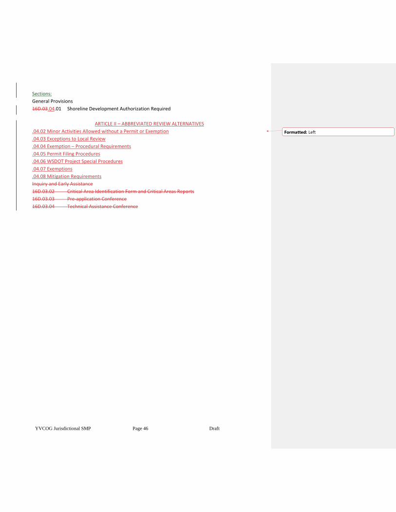
YVCOG Jurisdictional SMP Page 46 Draft
Sections:
General Provisions
16D.03.04.01 Shoreline Development Authorization Required
ARTICLE II – ABBREVIATED REVIEW ALTERNATIVES
.04.02 Minor Activities Allowed without a Permit or Exemption
.04.03 Exceptions to Local Review
.04.04 Exemption – Procedural Requirements
.04.05 Permit Filing Procedures
.04.06 WSDOT Project Special Procedures
.04.07 Exemptions
.04.08 Mitigation Requirements
Inquiry and Early Assistance
16D.03.02 Critical Area Identification Form and Critical Areas Reports
16D.03.03 Pre-application Conference
16D.03.04 Technical Assistance Conference
Formatted: Left
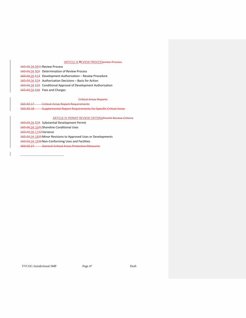
YVCOG Jurisdictional SMP Page 47 Draft
ARTICLE III REVIEW PROCESSeview Process
16D.03.04.0911 Review Process
16D.03.04.102 Determination of Review Process
16D.03.04.113 Development Authorization – Review Procedure
16D.03.04.124 Authorization Decisions – Basis for Action
16D.03.04.135 Conditional Approval of Development Authorization
16D.03.04.146 Fees and Charges
Critical Areas Reports
16D.03.17 Critical Areas Report Requirements
16D.03.18 Supplemental Report Requirements for Specific Critical Areas
ARTICLE IV PERMIT REVIEW CRITERIAPermit Review Criteria
16D.03.04.159 Substantial Development Permit
16D.03.04.1621 Shoreline Conditional Uses
16D.03.04.1722 Variance
16D.03.04.1825 Minor Revisions to Approved Uses or Developments
16D.03.04.1926 Non-Conforming Uses and Facilities
16D.03.27 General Critical Areas Protective Measures
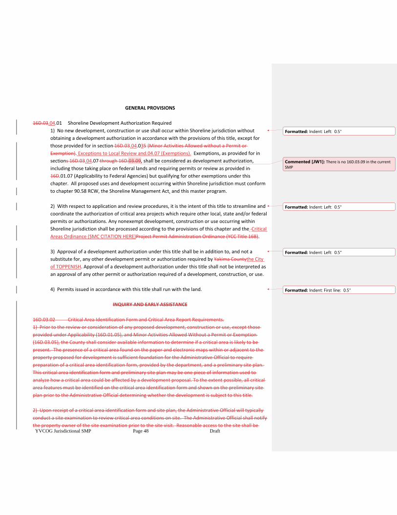
YVCOG Jurisdictional SMP Page 48 Draft
GENERAL PROVISIONS
16D.03.04.01 Shoreline Development Authorization Required
1) No new development, construction or use shall occur within Shoreline jurisdiction without
obtaining a development authorization in accordance with the provisions of this title, except for
those provided for in section 16D.03.04.035 (Minor Activities Allowed without a Permit or
Exemption). Exceptions to Local Review and.04.07 (Exemptions). Exemptions, as provided for in
sections 16D.03.04.07 through 16D.03.09, shall be considered as development authorization,
including those taking place on federal lands and requiring permits or review as provided in
16D.01.07 (Applicability to Federal Agencies) but qualifying for other exemptions under this
chapter. All proposed uses and development occurring within Shoreline jurisdiction must conform
to chapter 90.58 RCW, the Shoreline Management Act, and this master program.
2) With respect to application and review procedures, it is the intent of this title to streamline and
coordinate the authorization of critical area projects which require other local, state and/or federal
permits or authorizations. Any nonexempt development, construction or use occurring within
Shoreline jurisdiction shall be processed according to the provisions of this chapter and the Critical
Areas Ordinance (SMC CITATION HERE)Project Permit Administration Ordinance (YCC Title 16B).
3) Approval of a development authorization under this title shall be in addition to, and not a
substitute for, any other development permit or authorization required by Yakima Countythe City
of TOPPENISH. Approval of a development authorization under this title shall not be interpreted as
an approval of any other permit or authorization required of a development, construction, or use.
4) Permits issued in accordance with this title shall run with the land.
INQUIRY AND EARLY ASSISTANCE
16D.03.02 Critical Area Identification Form and Critical Area Report Requirements.
1) Prior to the review or consideration of any proposed development, construction or use, except those
provided under Applicability (16D.01.05), and Minor Activities Allowed Without a Permit or Exemption
(16D.03.05), the County shall consider available information to determine if a critical area is likely to be
present. The presence of a critical area found on the paper and electronic maps within or adjacent to the
property proposed for development is sufficient foundation for the Administrative Official to require
preparation of a critical area identification form, provided by the department, and a preliminary site plan.
This critical area identification form and preliminary site plan may be one piece of information used to
analyze how a critical area could be affected by a development proposal. To the extent possible, all critical
area features must be identified on the critical area identification form and shown on the preliminary site
plan prior to the Administrative Official determining whether the development is subject to this title.
2) Upon receipt of a critical area identification form and site plan, the Administrative Official will typically
conduct a site examination to review critical area conditions on site. The Administrative Official shall notify
the property owner of the site examination prior to the site visit. Reasonable access to the site shall be
Formatted: Indent: Left: 0.5"
Commented [JW1]: There is no 16D.03.09 in the current SMP
Formatted: Indent: Left: 0.5"
Formatted: Indent: Left: 0.5"
Formatted: Indent: First line: 0.5"
YVCOG Jurisdictional SMP Page 49 Draft
provided by the property owner for the site
examination during any proposal review, restoration, emergency action, or monitoring period.
3) The Administrative Official shall review available information pertaining to the site and the proposal and
make a determination as to whether any critical areas may be affected by the proposal. If so, a more
detailed critical area report shall be submitted in conformance with section 16D.03.17 (Critical Areas
Reports) and section 16D.03.18 (Supplemental Report Requirements for Specific Critical Areas), except as
provided below:
a) No critical areas present. If the Administrative Official is able to sufficiently determine that a
critical area does not exist within or adjacent to the project area, then a critical area report is not
required.
b) Critical areas present, but no impact. If the Administrative Official is able to determine
the existence, location and type of critical area sufficiently to indicate that the project area is not
within or adjacent to the critical area and that the proposed activity is unlikely to degrade the
functions or values of the critical area, then the Administrative Official may waive the requirement
for a critical area report. A summary of the determination shall be included in any staff report or
decision on the permit or review.
c) Critical areas may be affected by proposal. If the project area is within or adjacent to a critical
area or buffer the Administrative Official may waive the requirement for a critical areas report if:
i) the Administrative Official is sufficiently able to determine the existence, location and
type of the critical area;
ii) The project is of a small scale or uncomplicated nature, such that a specialist is not
needed to identify impacts and mitigation. Work within a wetland or stream channel
would generally not meet this provision;
iii) The applicant agrees to provide mitigation that the Administrative Official deems
adequate to mitigate for anticipated impacts. Restoration of degraded areas may serve as
mitigation; and,
iv) A summary of the determination shall be included in any staff report or decision on the
permit or review.
d) If the applicant wants greater assurance of the accuracy of the critical area review
determination, the applicant may choose to hire a qualified professional to provide such
assurances.
e) As guidance on the practical application of the requirement for critical areas reports, reports
will generally fall into the following groups based on increasing complexity and cost of the report:
i) Determining the absence of a critical area (sometimes resulting when initial indicators
show the likely presence of a critical area);
ii) Determining the existence, location and type of a critical area;
iii) Determining impacts of an encroachment on a critical area and general mitigation
measures;
iv) Developing a compensatory mitigation plan for replacement or mitigation of lost
wetland or stream channel area.
16D.03.03 Pre-application Conference
Any new development, construction or use falling under the provisions of this title shall be subject to a pre-
YVCOG Jurisdictional SMP Page 50 Draft
application conference, except that project review for flood hazards shall follow the pre-application
requirements established to administer chapter 16D.05 (Flood Hazard Areas).The department shall
schedule a pre-application conference for as soon as is reasonably possible to allow attendance by the
project proponent and necessary staff. To assist in project review and discussion, prior to the pre-
application conference, the project proponent must submit a preliminary site plan showing the nature and
scope of the proposed project along with any existing features of the property having a relationship to the
project. The pre-application conference is intended to allow the Administrative Official to:
1) Establish the scope of the project, development or use and the critical area features and
shoreline resources involved or potentially impacted;
2) Consider the degree to which the project, development or use within shoreline jurisdiction may
affect or impair a designated critical area or shoreline resource and identify potential concerns that
may arise;
3) Identify other permits and authorizations which the project proponent may need to obtain;
4) Determine whether the project will be processed through the development authorization
procedures of this title or coordinated through the review and approval procedures of another
development permit or authorization required of the project from Yakima County;
5) Provide the proponent with resources and technical assistance (such as maps, scientific
information, other source materials, etc.) to assist the proponent in meeting the provisions of this
title and any applicable rules and regulations of other agencies and jurisdictions;
6) Determine whether there is a need for a preliminary site assessment or a technical assistance
conference to better define the critical area issues and alternatives;
7) Determine whether the project can be processed as an exemption, or if not, what type of
permits or reviews may be needed. Final determination of necessary permits will be made based
on the project design and submittal materials;
8) Consider whether a preliminary site assessment may be scheduled in the field to determine the
applicability of the development standards of this title to the project, based on information
contained in the preliminary site plan.
16D.03. 04 Technical Assistance Conference
If requested by the project proponent or otherwise determined necessary, the department will arrange a
meeting of representatives of those agencies and organizations with expertise, interest, or jurisdiction in
the project. In conjunction with the invitation to attend the technical assistance conference, the
department will provide the potential participants with a project summary compiled from the pre-
application conference. The technical assistance conference may also involve a preliminary site
assessment, if it is determined that resolution of issues related to the project can be achieved through an
on-site review. The purpose of the technical assistance conference will be to:
1) Confirm and define the requirements of any other applicable local, state or federal
YVCOG Jurisdictional SMP Page 51 Draft
regulations;
2) Clarify any identified procedural or regulatory conflicts and define the alternative courses of
action available to the applicant in addressing project requirements;
3) Determine whether compliance with other existing statutes and regulations will adequately
address the provisions of this title;
4) Provide the proponent with guidance, available data and information that will assist in
complying with the provisions of this title and other ordinances and regulations;
5) Provide the proponent with guidance concerning project modifications or site enhancements
that would eliminate or minimize impacts to the critical area;
6) Provide the proponent with alternatives for securing data, information, or assistance
necessary to the project but not available through the pre-application conference;
7) Determine whether a critical area report is necessary, and if so, the qualifications, skills and
expertise required of a consultant to perform the special study.
ABBREVIATED REVIEW ALTERNATIVES
16D.03.04.025 Minor Activities Allowed without a Permit or Exemption.
1) The following activities are included under 16D.021.05(1) (Applicability) and are allowed
without a permit or exemption:
a) Maintenance of existing, lawfully established areas of crop vegetation, landscaping
(including paths and trails) or gardens within a regulated critical area or its buffer.
Examples include, harvesting or changing crops, mowing lawns, weeding, harvesting, and
replanting of garden crops, pruning, and planting of non-invasive ornamental vegetation or
indigenous native species to maintain the general condition and extent of such areas.
Cutting down trees and shrubs within a buffer is not covered under this provision.
Excavation, filling, and construction of new landscaping features, such as concrete work,
berms, and walls, are not covered in this provision and are subject to review.;
b) Minor maintenance and/or repair of lawfully established structures that do not involve
additional construction, earthwork or clearing. Examples include painting, trim or facing
replacement, re-roofing, etc. Construction or replacement of structural elements is not
covered in this provision, but may be covered under an exemption. Cleaning canals,
ditches, drains, wasteways etc. without expanding their original configuration is not
considered additional earthwork, as long as the cleared materials are placed outside the
stream corridor, wetlands, and buffers.;
c) Low impact activities such as hiking, canoeing, viewing, nature study, photography,
hunting, fishing, education, or scientific research;.
Formatted: Indent: Left: 0.5"
Formatted: Indent: Left: 1", Space After: 6 pt
YVCOG Jurisdictional SMP Page 52 Draft
d) Creation of unimproved private trails that do not cross streams or wetlands that are
less than two (2) feet wide and do not involve placement of fill or grubbing of vegetation.;
e) Planting of native vegetation,;
f) Noxious weed control outside vegetative buffers identified in Chapter 16D.06.16, except
for area wide vegetation removal/grubbing,;
g) Noxious weed control within vegetative buffers, if the criteria listed below are met.
Control methods not meeting these criteria may still apply for a restoration exemption, or
other authorization as applicable:
i) Hand removal/spraying of individual plants only; or
ii) No area wide vegetation removal/grubbing.
.04.03 Exceptions to Local Review.
Requirements to obtain a Substantial Development Permit, Conditional Use Permit, Variance, letter of
exemption, or other review to implement the Shoreline Management Act do not apply to the following:
(1) Remedial actions. Pursuant to RCW 90.58.355, any person conducting a remedial action at a
facility pursuant to a consent decree, order, or agreed order issued pursuant to chapter 70.105D
RCW, or to the department of ecology when it conducts a remedial action under chapter 70.105D
RCW. Periodic Review Checklist Guidance 6 September 2019
(2) Boatyard improvements to meet NPDES permit requirements. Pursuant to RCW 90.58.355, any
person installing site improvements for storm water treatment in an existing boatyard facility to
meet requirements of a national pollutant discharge elimination system storm water general
permit.
(3) WSDOT facility maintenance and safety improvements. Pursuant to RCW 90.58.356,
Washington State Department of Transportation projects and activities meeting the conditions of
RCW 90.58.356 are not required to obtain a Substantial Development Permit, Conditional Use
Permit, Variance, letter of exemption, or other local review.
(4) Projects consistent with an environmental excellence program agreement pursuant to RCW
90.58.045.
(5) Projects authorized through the Energy Facility Site Evaluation Council process, pursuant to
chapter 80.50 RCW.
16D.03.04.046 Exemption–Procedural Requirements
Certain activities and uses are exempt from some permit processes and shall instead be reviewed using the
procedures below., except that Flood Hazard exemptions provided in 16D.05.20.06, shall follow
procedures established to administer Chapter 16D.05 (Flood Hazard Areas).
1) Exemptions shall be construed narrowly, and any exempted development shall be consistent
with the policies and provisions of this title.
2) Only those developments that meet the precise terms of one or more of the listed exemptions
Formatted: Indent: Left: 0.5", Space After: 6 pt
Formatted: Indent: Left: 1", First line: 0", Space After: 6
pt
Formatted: Indent: Left: 0.5", Space After: 6 pt
Formatted: Indent: Left: 1", Space After: 6 pt
Formatted: Indent: Left: 0.5", Space After: 6 pt
Formatted: Indent: Left: 0", First line: 0"
YVCOG Jurisdictional SMP Page 53 Draft
may qualify for review under these provisions.
3) If any part of a proposed development is not eligible for exemption, then a development permit
is required for the entire proposed development project.
4) The burden of proof that a development or use is exempt from the development permit process
is on the applicant.
5) When a development or use is proposed that does not comply with the bulk, dimensional and
performance standards of this title, such development must also obtain a Variance
(16D.03.04.2217).
6) All activities exempt from the requirement for a substantial development permit shall use
reasonable methods to avoid impacts to critical areas within shoreline jurisdiction. To be exempt
from the requirement for a substantial development permit does not give permission to degrade a
critical area or Shoreline or ignore risk from natural hazards. Any incidental damage to, or
alteration of, a critical area that is not a necessary outcome of the exempted activity shall be
restored, rehabilitated, or replaced at the responsible party’s expense, according to section
16D.0605.1823 (Reclamation).
7) The proponent of an exempt activity shall submit a written request for permit exemption to the
Administrative Official that describes the activity and states the exemption requested. The
applicant shall submit to the Administrative Official a written description of the project that
demonstrates compliance with applicable standards.
8) The Administrative Official shall review the exemption request to verify that it complies with
this title.
9) The Administrative Official shall approve or deny the exemption.
10) A formal letter of exemption shall be provided where an exempt activity is approved under this
title. A copy of the exemption shall be kept on file by the Administrative Official. If an exemption
cannot be granted, the Administrative Official shall notify the applicant in writing of the reason, at
which time the applicant may pursue other permit processes under this title.
11) Conditions may bemay be attached to the approval of exempted developments and/or uses
as necessary to assure continued consistency of the project with this title.
12) Exempt activities are identified in the following locations. Such activities are stated as exempt
from the substantial development permit or flood hazard permits. However, this provision does
not exempt an activity from other permits or reviews that may be required under this title.
a) Those activities listed in WAC 173-27-040, and summarized in sections 16D.03.04.097
(Exemptions from HRCA, Wetlands, and Shorelines) are exempt from the substantial
development permit requirements for Wetlands (16D.07), Hydrologically Related Critical
YVCOG Jurisdictional SMP Page 54 Draft
Areas Features (16D.06.03) and Shorelines (16D.10);
b) Those activities listed in sections 16D.05.20.060 are exempt from the Flood Hazard
Permit requirements for Flood Hazard Areas (16D.05).
.04.05 Permit Filing Procedures.
After all local permit administrative appeals or reconsideration periods are complete and the permit
documents are amended to incorporate any resulting changes, the City will mail the permit using return
receipt requested mail to the Department of Ecology regional office and the Office of the Attorney
General. Projects that require both Conditional Use Permits and or Variances must be mailed
simultaneously with any Substantial Development Permits for the project.
(1) The permit and documentation of the final local decision will be mailed together with the
complete permit application; a findings and conclusions letter; a permit data form (cover sheet);
and applicable SEPA documents.
(2) Consistent with RCW 90.58.140(6), the state’s Shorelines Hearings Board twenty-one-day
appeal period starts with the date of filing, which is defined below:
(a) For projects that only require a Substantial Development Permit: the date that Ecology
receives the City’s decision.
(b) For a Conditional Use Permit (CUP) or Variance: the date that Ecology’s decision on the
CUP or Variance is transmitted to the applicant and the City.
(c) For SDPs simultaneously mailed with a CUP or Variance to Ecology: the date that
Ecology’s decision on the CUP or Variance is transmitted to the applicant and the City.
.04.06 WSDOT Project Special Procedures.
(1) The City will conduct permit reviews for WSDOT projects on state highways within 90 days,
pursuant to RCW 47.01.485.
(2) Pursuant to RCW 90.58.140, WSDOT projects that address significant public safety risks may
begin twenty-one days after the date of filing if all components of the project will achieve no net
loss of shoreline ecological functions.
16D.03.04.077 Exemptions for Hydrologically Related Critical Areas, Wetlands and
Shorelines
The following development activities identified in WAC 173-27-040, and summarized below, are exempt
from substantial development permits that are required within Shoreline jurisdiction designated in chapter
16D.10.0305.02 (Shoreline Jurisdiction):
1) Construction by an owner, lessee, or contract purchaser of a single-family residence for his own
use or the use of his family, which residence meets all requirements of the state agency or local
government having jurisdiction thereof, other than requirements imposed pursuant to this title.
"Single-family residence" means a detached dwelling designed for and occupied by one family
including those structures and developments within a contiguousa contiguous ownership which
are a normal appurtenance. An "appurtenance" is necessarily connected to the use and enjoyment
of a single-family residence and is located landward of the ordinary high- water mark andmark and
Formatted: Indent: Left: 0"
Formatted: Indent: Left: 0.5", Space After: 6 pt
Formatted: Indent: Left: 1", Space After: 6 pt
Formatted: Space After: 6 pt
Formatted: Indent: Left: 0.5", Space After: 6 pt
YVCOG Jurisdictional SMP Page 55 Draft
the perimeter of a wetland. Normal appurtenances include a garage; deck; driveway;
utilities; fences; installation of a septic tank and drainfield and grading which does not exceed two
hundred fifty cubic yards and which does not involve placement of fill in any wetland or waterward
of the ordinary high water mark. Construction authorized under this exemption shall be located
landward of the ordinary high- water mark.;
2) Construction of the normal protective bulkhead common to single-family residences. A "normal
protective" bulkhead includes those structural and nonstructural developments installed at or
near, and parallel to, the ordinary high water mark for the sole purpose of protecting an existing
single-family residence and appurtenant structures from loss or damage by erosion. A
normalA normal protective bulkhead is not exempt if constructed for the purpose of creating dry
land. When a vertical or near vertical wall is being constructed or reconstructed, not more than
one cubic yard of fill per one foot of wall may be used as backfill. When an existing bulkhead is
being repaired by construction of a vertical wall fronting the existingthe existing wall, it shall be
constructed no further waterward of the existing bulkhead than is necessary for construction
of new footings. When a bulkhead has deteriorated such that an ordinary high water mark has
been established by the presence and action of water landward of the bulkhead then the
replacement bulkhead must be located at or near the actual ordinary high water mark.
Bioengineered erosion control projects may be considered a normal protective bulkhead when any
structural elements are consistent with the above requirements and when the project has been
approved by the department of fish and wildlife.;
3) Development and construction for which the total cost or fair market value, whichever is
higher, does not exceed five thousand 7,047 dollars (adjusted for inflation as determined by the
Washington Office of Financial Management using methods provided in
RCW90.58.030(3)(e) and WAC 173-27-040(2)(a)), provided such development and construction
does not involve excavation, fill, or other work which is not consistent with the
functionalproperties of stream corridors and other hydrologically related critical areas as set forth
in Section 16D.06.05 of this title, and provided that any such development and construction within
Shoreline jurisdiction does not materially interfere with the public use of the water or shorelines of
the state. The total cost or fair market value of the development shall include the fair market
value of any donated, contributed or found labor, equipment, or materials;.
4) Construction or practices normal or necessary for farming, irrigation, and ranching activities,
including agricultural service roads and utilities, construction of a barn or similar agricultural
structure, and the construction and maintenance of irrigation structures including but not limited
to head gates, pumping facilities, and irrigation channels; provided, that a feedlot of any size, all
processing plants, other activities of a commercial nature, and/or alteration of the contour of the
land by leveling or filling other than that which results from normal cultivation, shall not be
considered normal or necessary farming or ranching activities. A "feedlot" shall be an enclosure or
facility used or capable of being used for feeding livestock hay, grain, silage, or other livestock feed,
but shall not include land for growing crops or vegetation for livestock feeding and/or grazing,
nor shall it include normal livestock wintering operations.;
YVCOG Jurisdictional SMP Page 56 Draft
5) Normal maintenance or repair of existing structures or developments, including damage by
accident, fire, or elements. "Nnormal maintenance" includes those usual acts to prevent a decline,
lapse, or cessation from a lawfully established condition. "Nnormal repair" means to restore a
development to a state comparable to its original condition, including but not limited to its size,
shape, configuration, location and external appearance, within a reasonable period after
decay or partial destruction, except where repair involves total replacement which is not common
practice or causes substantial adverse effects to the shoreline resource or environment.
Replacement of a structure or development may be authorized as repair where such replacement
is the common method of repair for the type of structure or development and the replacement
structure or development is comparable to the original structure or development including but not
limited to its size, shape, configuration, location and external appearance, and the replacement
does not cause additional substantial adverse effects to shoreline resources or environment. The
need for replacement resulting from a neglect of maintenance and repair is not considered a
common method of repair. Replacement of non-conforming uses or facilities may also be subject
to section 16D.03.04.26 19 (Non-conforming Uses and Facilities).;
6) Emergency construction necessary to protect property from damage by the elements, Aan
"emergency" is an unanticipated and imminent threat, which requires immediate action or
response within a time period too brief to allow full compliance with this title. The following
criteria must exist to qualify any action under an emergency provision:
a) There must be an immediate threat to life, public or private property, or an immediate
threat of serious environmental degradation arising from a natural condition or technical
incident; and
b) The emergency response must be confined to the action necessary to protect life or
property from damage; and
c) The scope of the emergency response must be limited to the work necessary to relieve
the immediate threat; and
d) The emergency response applies only to the period of time in which the actual
emergency exists; and
e) The request must be accompanied by a paid permit application or a request for a non-
emergency exemption. Submittal requirements beyond normal exemption submittal
requirements are waived until after the emergency is deemed abated. As soon as the
emergency is deemed abated by appropriate authorities, compliance with the
requirements of this title is required, and may include removal of the emergency
construction if non- structural construction measures can adequately deal with site issues.
7) Construction of a dock, including a community dock, designed for pleasure craft only, for the
private noncommercial use of the owners, lessee, or contract purchaser of a single-family and
multiple-family residence. A dock is a landing and moorage facility for watercraft and does not
include recreational decks, storage facilities or other appurtenances. This exception applies if the
fair market value of the dock does not exceed ten thousand dollars, but if subsequent construction
having a fair market value exceeding two thousand five hundred dollars occurs within five years of
completion of the prior construction, the subsequent construction shall be subject to a substantial
development permit;
YVCOG Jurisdictional SMP Page 57 Draft
(a) In fresh waters the fair market value of the dock replacement does not exceed twenty-
two thousand five hundred ($22,500), and are of equal or lesser square footage than the
existing dock being replaced, or
(b) The fair market value of new docks constructed in fresh waters does not exceed eleven
thousand two hundred ($11,200) dollars
However, subsequent construction having a fair market value exceeding the amount above occurs
within five years of completion of the prior construction, the subsequent construction must be
considered a substantial development for the purpose of these regulations.
8) The operation, maintenance or construction of canals, waterways, drains, reservoirs, or other
manmade facilities that now exist or are hereinafter created or developed as a part of an irrigation
system for the primary purpose of making use of system waters, including return flow and
artificially stored ground water from the irrigation of lands;
9) Operation and maintenance of any system of dikes, ditches, drains, or other facilities existing on
September 8, 1975, effective date for this Shoreline Master Program, for land within Shoreline
jurisdiction, which were created, developed, or utilized primarily as a part of an agricultural
drainage and diking system.;
10) Construction or modification, by or under the authority of the Coast Guard or a designated port
management authority, of navigational aids such as channel markers and anchor buoys.;
11) Any project with a certification from the governor pursuant to chapter 80.50 RCW (Energy
facilities -— site locations);.
12) Watershed restoration projects that are authorized by the sponsor of a watershed restoration
plan and that implements the plan or a part of the plan, and meets the requirements of WAC 173-
27-040(6), as amended.;
13) Site explorationSite exploration and investigation activities that are prerequisite to
preparation of an application for development authorization under this chapter, if:
a) The activity does not interfere with the normal public use of surface waters within
Shoreline jurisdiction.;
b) The activity will have no significant adverse impact on the environment including but
not limited to fish, wildlife, fish or wildlife habitat, water quality, and aesthetic values,;
c) The activity does not involve the installation of any structure, and upon completion of
the activity the vegetationthe vegetation and land configuration of the site are
restored to conditions existing before the activity.;
d) A private entity seeking development authorization within Shoreline jurisdiction must
first posts a performance bond or provides other evidence of financial responsibility to the
local jurisdiction to ensure that the site is restored to preexisting conditions.
Formatted: Indent: Left: 1", Space After: 6 pt
Formatted: Space After: 6 pt
Formatted: Indent: Left: 1"
Formatted: Space After: 6 pt
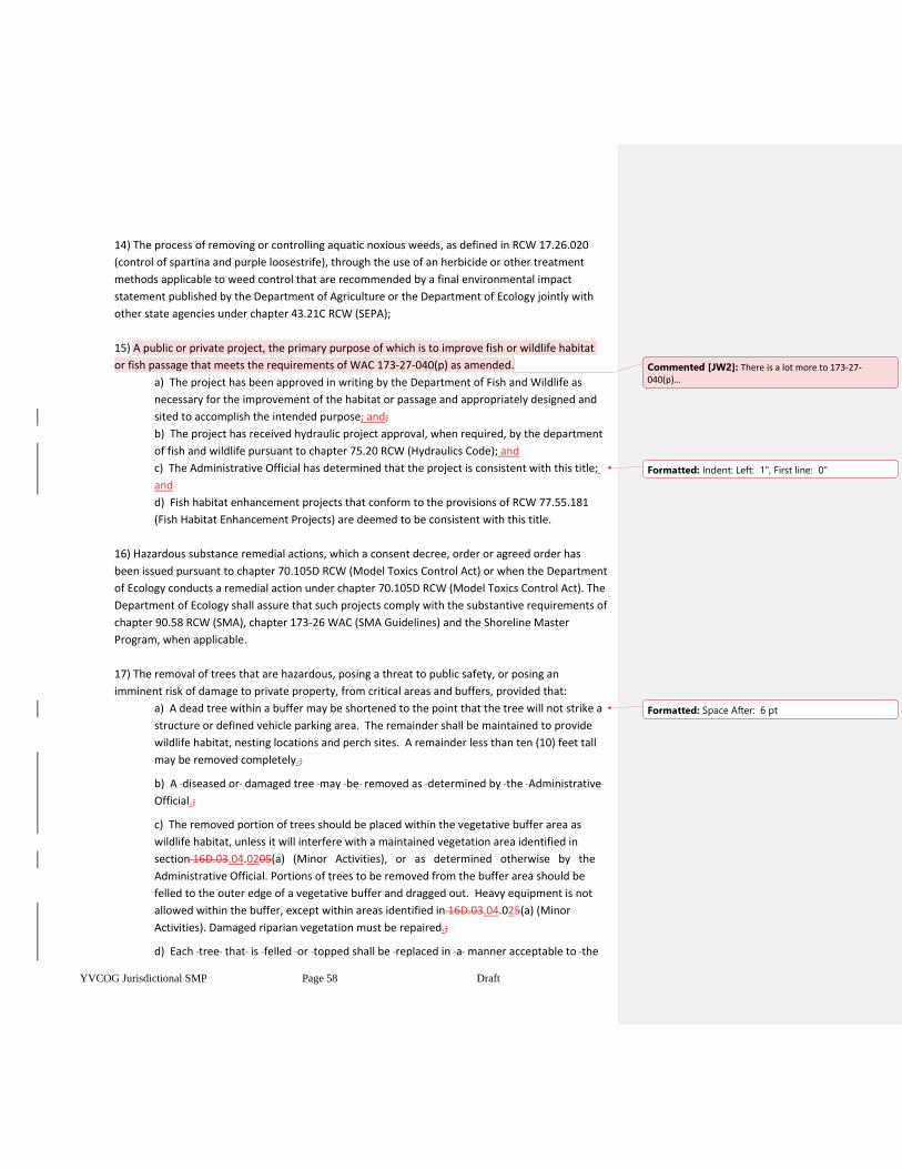
YVCOG Jurisdictional SMP Page 58 Draft
14) The process of removing or controlling aquatic noxious weeds, as defined in RCW 17.26.020
(control of spartina and purple loosestrife), through the use of an herbicide or other treatment
methods applicable to weed control that are recommended by a final environmental impact
statement published by the Department of Agriculture or the Department of Ecology jointly with
other state agencies under chapter 43.21C RCW (SEPA);
15) A public or private project, the primary purpose of which is to improve fish or wildlife habitat
or fish passage that meets the requirements of WAC 173-27-040(p) as amended.
a) The project has been approved in writing by the Department of Fish and Wildlife as
necessary for the improvement of the habitat or passage and appropriately designed and
sited to accomplish the intended purpose; and;
b) The project has received hydraulic project approval, when required, by the department
of fish and wildlife pursuant to chapter 75.20 RCW (Hydraulics Code); and
c) The Administrative Official has determined that the project is consistent with this title;
and
d) Fish habitat enhancement projects that conform to the provisions of RCW 77.55.181
(Fish Habitat Enhancement Projects) are deemed to be consistent with this title.
16) Hazardous substance remedial actions, which a consent decree, order or agreed order has
been issued pursuant to chapter 70.105D RCW (Model Toxics Control Act) or when the Department
of Ecology conducts a remedial action under chapter 70.105D RCW (Model Toxics Control Act). The
Department of Ecology shall assure that such projects comply with the substantive requirements of
chapter 90.58 RCW (SMA), chapter 173-26 WAC (SMA Guidelines) and the Shoreline Master
Program, when applicable.
17) The removal of trees that are hazardous, posing a threat to public safety, or posing an
imminent risk of damage to private property, from critical areas and buffers, provided that:
a) A dead tree within a buffer may be shortened to the point that the tree will not strike a
structure or defined vehicle parking area. The remainder shall be maintained to provide
wildlife habitat, nesting locations and perch sites. A remainder less than ten (10) feet tall
may be removed completely.;
b) A diseased or damaged tree may be removed as determined by the Administrative
Official.;
c) The removed portion of trees should be placed within the vegetative buffer area as
wildlife habitat, unless it will interfere with a maintained vegetation area identified in
section 16D.03.04.0205(a) (Minor Activities), or as determined otherwise by the
Administrative Official. Portions of trees to be removed from the buffer area should be
felled to the outer edge of a vegetative buffer and dragged out. Heavy equipment is not
allowed within the buffer, except within areas identified in 16D.03.04.025(a) (Minor
Activities). Damaged riparian vegetation must be repaired.;
d) Each tree that is felled or topped shall be replaced in a manner acceptable to the
Commented [JW2]: There is a lot more to 173-27-040(p)…
Formatted: Indent: Left: 1", First line: 0"
Formatted: Space After: 6 pt
YVCOG Jurisdictional SMP Page 59 Draft
Administrative Official.
(18) The external or internal retrofitting of an existing structure with exclusive purpose of
compliance with the Americans with Disabilities Act (ADA) of 1990 or to otherwise provide physical
access to the structure by individuals with disabilities.
16D.03.08 Exemptions for Geologically Hazardous Areas
The following development activities are exempt from substantial development permits that are required
for Geologically Hazardous Areas designated in chapter 16D.08:
1) Additions to or alteration of existing single family residences;
2) Uses and surface disturbances (clearing and grubbing) that do not include excavation, fill or
irrigation;
3) Structures less than 200 square feet that are not used as a place of employment or residence
(fences, sheds, gazebos, etc.);
4) Oil, gas, wind or other exploration that does not include explosions, roads, excavation or fill.
16D.03.04.0810 Mitigation requirements
1) All developments shall demonstrate that all reasonable efforts have been examined with the
intent to avoid and minimize impacts to critical areas. When an alteration to a critical area is
proposed, such alteration shall be avoided, minimized, or compensated for in the following order
of preference:
a) Avoiding the impact altogether by not taking a certain action or parts of an action.;
b) Minimizing impacts by limiting the degree or magnitude of the action and its
implementation, by using appropriate technology, or by taking affirmative steps, such as
project redesign, relocation, or timing, to avoid or reduce impacts.;
c) Rectifying the impact by repairing, rehabilitating, or restoring the affected
environment;.
d) Reducing orReducing or eliminating the impact over time by preservation and
maintenance operations during the life of the action.;
e) Compensating for the impact by replacing, enhancing, or providing substitute resources
or environments.;
f) Monitoring the impact and taking appropriate corrective measures.
2) Mitigation for individual actions may include a combination of the above measures.
3) Unless otherwise provided in this title, if alteration to the critical area is unavoidable, all
adverse impacts to or from critical areas and buffers resulting from a development proposal or
alteration shall be mitigated in accordance with an approved Mitigation Plan and best available
science in accordance with an approved critical areas report and SEPA documents. Mitigation shall
Formatted: Indent: Left: 0.5"
Formatted: Space After: 6 pt
Formatted: Indent: Left: 1", First line: 0", Space After: 6
pt
Formatted: Space After: 6 pt
Formatted: Indent: Left: 1"
Formatted: Indent: Left: 0.5"
YVCOG Jurisdictional SMP Page 60 Draft
not be implemented until after approval of the Mitigation Plan.
3) 4) Mitigation shall be in-kind and on-site, when possible, and sufficient to maintain the
functions and values of the critical area, and to prevent risk from a hazard posed by a critical
area. When necessary, mitigation may be provided that is out-of-kind and/or off-site so as to
result in no net loss of critical areas functions and values.
4) Mitigation shall not be implemented until after the administrator’s approval of a critical area
report that includes a mitigation plan, and mitigation shall be in accordance with the provisions
of the approved critical area report.
5) Mitigation sequencing. Applicants shall demonstrate that all reasonable efforts have been
examined with the intent to avoid and minimize impacts to critical areas in the following order.
When an alteration to a critical area is proposed, such alteration shall be avoided, minimized, or
compensated for in the following sequential order of preference:
a. Avoiding the impact altogether by not taking a certain action or parts of an action;
b. Minimizing impacts by limiting the degree or magnitude of the action and its
implementation, by using appropriate technology, or by taking affirmative steps, such as
project redesign, relocation, or timing, to avoid or reduce impacts;
c. Rectifying the impact to wetlands, critical aquifer recharge areas, frequently flooded
areas, and habitat conservation areas by repairing, rehabilitating, or restoring the
affected environment to the conditions existing at the time of the initiation of the project;
d. Compensating for the impact to wetlands, critical aquifer recharge areas, frequently
flooded areas, and habitat conservation areas by replacing, enhancing, or providing
substitute resources or environments; and
e. Mitigation for individual actions may include a combination of the above measures.
(Ord. 2011-6 § 2 (Exh. A), 2011).
6) Mitigation plan requirements. When mitigation is required, the applicant shall submit for
approval by the city a mitigation plan as part of the critical area report. The mitigation plan shall
include:
a. Environmental Goals and Objectives. The mitigation plan shall include a written report
identifying environmental goals and objectives of the compensation proposed and
including:
i. A description of the anticipated impacts to the critical areas and the mitigating
actions proposed and the purposes of the compensation measures, including
the site selection criteria; identification of compensation goals; identification of
resource functions; and dates for beginning and completion of site
compensation construction activities. The goals and objectives shall be related
to the functions and values of the impacted critical area;
ii. A description of the report author’s experience to date in restoring or creating
the type of critical area proposed
Formatted: List Paragraph, Numbered + Level: 1 +
Numbering Style: 1, 2, 3, … + Start at: 1 + Alignment:
Left + Aligned at: 0.5" + Indent at: 0.75"
Formatted: Font: (Default) Calibri, 11 pt, Font color:
Auto
Formatted: Font: (Default) Arial, 10 pt, Font color: Black
Formatted: Font: Bold
Formatted: Font: (Default) Arial, 10 pt, Font color: Black
Formatted: Font: Bold
Formatted: Font: (Default) Arial, 10 pt, Font color: Black
Formatted: Font: Bold
Formatted: Font: (Default) Arial, 10 pt, Font color: Black
Formatted: Font: Bold
Formatted: Font: (Default) Arial, 10 pt, Font color: Black
Formatted: Font: Bold
Formatted: Font: (Default) Arial, 10 pt, Font color: Black
Formatted: Level 3, Space Before: 12 pt, After: 0 pt,
Numbered + Level: 2 + Numbering Style: a, b, c, … +
Start at: 1 + Alignment: Left + Aligned at: 1" + Indent
at: 1.25"
Formatted: Font: (Default) Arial, 10 pt, Bold, Font color:
Black
Formatted: Font: (Default) Arial, 10 pt, Font color: Black
Formatted: Font: (Default) Arial, 10 pt, Font color: Black
Formatted: Font: (Default) Arial, 10 pt, Font color: Black
Formatted: Font: (Default) Arial, 10 pt, Font color: Black
YVCOG Jurisdictional SMP Page 61 Draft
iii. A review of the best available science supporting the proposed mitigation; and
iv. An analysis of the likelihood of success of the compensation project.
b. Performance Standards. The mitigation plan shall include measurable specific criteria
for evaluating whether or not the goals and objectives of the mitigation project have
been successfully attained and whether or not the requirements of this chapter have
been met.
c. Detailed Construction Plans. The mitigation plan shall include written specifications and
descriptions of the mitigation proposed, such as:
i. The proposed construction sequence, timing, and duration;
ii. Grading and excavation details;
iii. Erosion and sediment control features;
iv. A planting plan specifying plant species, quantities, locations, size, spacing, and
density; and
v. Measures to protect and maintain plants until established.
d. These written specifications shall be accompanied by detailed site diagrams, scaled
cross-sectional drawings and topographic maps showing slope percentage and final
grade elevations, and any other drawings appropriate to show construction techniques
or anticipated final outcome.
e. Monitoring Program. The mitigation plan shall include a program for monitoring
construction of the compensation project and for assessing a completed project. A
protocol shall be included outlining the schedule for site monitoring (for example,
monitoring shall occur in years one, three, five, and seven after site construction), and
how the monitoring data will be evaluated to determine if the performance standards are
being met. A monitoring report shall be submitted as needed to document milestones,
successes, problems, and contingency actions of the compensation project. The
compensation project shall be monitored for a period necessary to establish that
performance standards have been met, but not for a period less than five years, but
monitoring of sensitive target communities such as forested and scrub-shrub
communities may be required for 10 years or more.
f. Contingency Plan. The mitigation plan shall include identification of potential courses of
action, and any corrective measures to be taken if monitoring or evaluation indicates
project performance standards are not being met.
g. Estimates of Cost. The mitigation plan shall include an estimate of the costs to
implement the required activities under the proposed plan to include both labor and
materials. Any required financial guarantees shall be posted in accordance with
TMC 17.70.390, Bonds to ensure mitigation, maintenance, and monitoring. (Ord. 2011-6
§ 2 (Exh. A), 2011).
Formatted: Font: (Default) Arial, 10 pt, Font color: Black
Formatted: Font: (Default) Arial, 10 pt, Font color: Black
Formatted: Font: (Default) Arial, 10 pt, Font color: Black
Formatted: Font: (Default) Arial, 10 pt, Font color: Black
Formatted: Font: (Default) Arial, 10 pt, Font color: Black
Formatted: Font: (Default) Arial, 10 pt, Font color: Black
Formatted: Font: (Default) Arial, 10 pt, Font color: Black
Formatted: Font: (Default) Arial, 10 pt, Font color: Black
Formatted: Font: (Default) Arial, 10 pt, Font color: Black
Formatted: Font: (Default) Arial, 10 pt, Font color: Black
Formatted: Font: (Default) Arial, 10 pt, Font color: Black
Formatted: Font: (Default) Arial, 10 pt, Font color: Black
Formatted: Font: (Default) Arial, 10 pt, Font color: Black
Formatted: Font: (Default) Arial, 10 pt
Formatted: Font: (Default) Arial, 10 pt
Formatted: Font: (Default) Arial, 10 pt, Font color: Black
YVCOG Jurisdictional SMP Page 62 Draft
7) Innovative mitigation.
a. The city should encourage, facilitate, and approve innovative mitigation projects that are
based on the best available science. Advance mitigation and mitigation banking are
examples of alternative mitigation projects allowed under the provisions of this section
wherein one or more applicants, or an organization with demonstrated capability, may
undertake a mitigation project together if it is demonstrated that all of the following
circumstances exist:
i. Creation or enhancement of a larger system of critical areas and open space is
preferable to the preservation of many individual habitat areas;
ii. The applicant(s) demonstrates the organizational and fiscal capability to act
cooperatively;
iii. The applicant(s) demonstrates that long-term management of the habitat area
will be provided; and
iv. There is a clear potential for success of the proposed mitigation at the identified
mitigation site.
b. Conducting mitigation as part of a cooperative process does not reduce or eliminate the
required replacement ratios.
8) Determination. The administrator shall make a determination as to whether the proposed
activity and mitigation, if any, are consistent with the provisions of this chapter. The
administrator’s determination shall be based on the criteria of TMC 17.70.280, Review criteria.
9) Review criteria.
a. The review of any alteration to a critical area, unless otherwise provided for in this
chapter, shall be based on the following criteria.
i. The proposal minimizes the impact on critical areas in accordance with
TMC 17.70.240, Mitigation sequencing.
ii. The proposal does not pose an unreasonable threat to the public health, safety,
or welfare on or off the development proposal site;
iii. The proposal is consistent with the general purposes of this chapter and the
public interest.
iv. Any alterations permitted to the critical area are mitigated in accordance with
TMC 17.70.230, Mitigation requirements.
v. The proposal protects the critical area functions and values consistent with the
best available science and results in no net loss of critical area functions and
values; and
vi. The proposal is consistent with other applicable regulations and standards.
Formatted: Font: (Default) Arial, 10 pt, Bold, Font color:
Black
Formatted: Font: Not Bold
Formatted: Font: (Default) Arial, 10 pt, Font color: Black
Formatted: Font: (Default) Arial, 10 pt, Font color: Black
Formatted: Font: (Default) Arial, 10 pt, Font color: Black
Formatted: Font: (Default) Arial, 10 pt, Font color: Black
Formatted: Font: (Default) Arial, 10 pt, Font color: Black
Formatted: Font: (Default) Arial, 10 pt, Font color: Black
Formatted: Font: (Default) Arial, 10 pt, Bold, Font color:
Black
Formatted: Font: (Default) Arial, 10 pt, Font color: Black
Formatted: Font: (Default) Arial, 10 pt
Formatted: Font: (Default) Arial, 10 pt
Formatted: Font: (Default) Arial, 10 pt, Font color: Black
Formatted: Font: (Default) Arial, 10 pt, Bold, Font color:
Black
Formatted: Font: Not Bold
Formatted: Font: (Default) Arial, 10 pt, Font color: Black
Formatted: Font: (Default) Arial, 10 pt
Formatted
Formatted: Font: (Default) Arial, 10 pt
Formatted: Font: (Default) Arial, 10 pt
Formatted: Font: (Default) Arial, 10 pt
Formatted: Font: (Default) Arial, 10 pt, Font color: Black
Formatted: Font: (Default) Arial, 10 pt, Font color: Black
Formatted: Font: (Default) Arial, 10 pt, Font color: Black
Formatted: Font: (Default) Arial, 10 pt
Formatted: Font: (Default) Arial, 10 pt
Formatted: Font: (Default) Arial, 10 pt, Font color: Black
Formatted: Font: (Default) Arial, 10 pt, Font color: Black
Formatted: Font: (Default) Arial, 10 pt, Font color: Black
YVCOG Jurisdictional SMP Page 63 Draft
b. The city may approve a project application and attach such conditions necessary to
mitigate impacts to critical areas in order to conform to the standards required by this
chapter.
c. Except as provided for by this chapter a project shall be denied if impacts to critical
areas cannot be adequately mitigated in the sequencing order of preferences of
TMC 17.70.240.
10) Report acceptance. If the administrator determines that the report together with proposed
mitigation meets the criteria in TMC 17.70.280 (Review criteria) and complies with the
applicable provisions of this chapter, the administrator shall prepare a written notice of
determination and identify any required conditions of approval. Any conditions of approval
included in a notice of determination shall be attached to the underlying permit or approval. Any
subsequent changes to the conditions of approval shall void the previous determination pending
re-review of the proposal and conditions of approval by the administrator. A favorable
determination should not be construed as endorsement or approval of any underlying permit or
approval. (Ord. 2011-6 § 2 (Exh. A), 2011).
11) Report rejection.
a. If the administrator determines that the report and/or proposed mitigation does not
adequately mitigate impacts of the proposed project in accordance with the criteria set
forth in TMC 17.70.280 (Review criteria) and the provisions of this chapter, the
administrator shall prepare written notice of the determination that includes findings of
noncompliance. No proposed activity or permit shall be approved or issued if it is
determined that the proposed activity does not adequately mitigate its impacts on the
critical areas and/or does not comply with the provisions of this chapter.
b. Following notice of determination that the proposed activity does not meet the review
criteria and/or does not comply with the applicable provisions of this chapter, the
applicant may request consideration of a revised critical area report. If the revision is
found to be substantial and relevant to the critical area review, the administrator may
reopen the critical area review and make a new determination based on the revised
report. (Ord. 2011-6 § 2 (Exh. A), 2011).
12) Completion of the critical area review.The city’s determination regarding critical areas
pursuant to this chapter shall be final concurrent with the final decision to approve, condition, or
deny the development proposal or other activity involved.
REVIEW PROCESS
16D.03.04.0911 Application Submittal
1) Application for a development authorization under this title shall be made on forms provided by
theby the department. The applicationThe application submittal shall include a site plan
Formatted: Font: (Default) Arial, 10 pt, Font color: Black
Formatted: Font: (Default) Arial, 10 pt, Font color: Black
Formatted: Font: (Default) Arial, 10 pt
Formatted: Font: (Default) Arial, 10 pt
Formatted: Font: (Default) Arial, 10 pt, Font color: Black
Formatted: Font: (Default) Arial, 10 pt, Bold, Font color:
Black
Formatted: Font: (Default) Arial, 10 pt, Font color: Black
Formatted: Font: (Default) Arial, 10 pt
Formatted: Font: (Default) Arial, 10 pt
Formatted: Font: (Default) Arial, 10 pt, Font color: Black
Formatted: Font: (Default) Arial, 10 pt, Font color: Black
Formatted: Font: (Default) Arial, 10 pt
Formatted: Font: (Default) Arial, 10 pt
Formatted: Font: (Default) Arial, 10 pt, Font color: Black
Formatted: Font: Bold
Formatted: Font: (Default) Arial, 10 pt, Font color: Black
Formatted: Font: Bold
Formatted: Font: (Default) Arial, 10 pt, Bold, Font color:
Black
Formatted: List Paragraph, Level 3, Space Before: 12 pt,
Line spacing: At least 18 pt, Numbered + Level: 1 +
Numbering Style: 1, 2, 3, … + Start at: 1 + Alignment:
Left + Aligned at: 0.5" + Indent at: 0.75", Font
Alignment: Baseline
Formatted: Font: (Default) Arial, 10 pt, Font color: Black
Formatted: Font: (Default) Arial, 10 pt, Bold, Font color:
Black
YVCOG Jurisdictional SMP Page 64 Draft
consisting of maps and elevation drawings, drawn to an appropriate scale to depict clearly all
required information, photographs and text which shall include:
(a) The boundary of the parcel(s) of land upon which the development is proposed.
(b) The ordinary high water mark of all water bodies located adjacent to or within the
boundary of the project. This may be an approximate location provided, that for any
development where a determination of consistency with the applicable regulations
requires a precise location of the ordinary high water mark the mark shall be located
precisely and the biological and hydrological basis for the location as indicated on the plans
shall be included in the development plan. Where the ordinary high water mark is neither
adjacent to or within the boundary of the project, the plan shall indicate the distance and
direction to the nearest ordinary high water mark of a shoreline.
(c) Existing and proposed land contours. The contours shall be at intervals sufficient to
accurately determine the existing character of the property and the extent of proposed
change to the land that is necessary for the development. Areas within the boundary that
will not be altered by the development may be indicated as such and contours
approximated for that area.
(d) A delineation of all wetland areas that will be altered or used as a part of the
development.
(e) A general indication of the character of vegetation found on the site.
(f) The dimensions and locations of all existing and proposed structures and improvements
including but not limited to; buildings, paved or graveled areas, roads, utilities, septic tanks
and drainfields, material stockpiles or surcharge, and stormwater management facilities.
(g) Where applicable, a landscaping plan for the project.
(h) Where applicable, plans for development of areas on or off the site as mitigation for
impacts associated with the proposed project shall be included and contain information
consistent with the requirements of this section.
(i) Quantity, source and composition of any fill material that is placed on the site whether
temporary or permanent.
(j) Quantity, composition and destination of any excavated or dredged material.
(k) A vicinity map showing the relationship of the property and proposed development or
use to roads, utilities, existing developments and uses on adjacent properties.
(l) Where applicable, a depiction of the impacts to views from existing residential uses and
public areas.
(m) On all variance applications the plans shall clearly indicate where development could
occur without approval of a variance, the physical features and circumstances on the
property that provide a basis for the request, and the location of adjacent structures and
uses. (WAC 197-27-180)drawn to scale showing:
a) the actual shape and dimensions of the property site to be used;
b) existing and proposed structures;
c) excavation, fill, drainage facilities, topography, slope, and;
d) such other information as is needed to determine the nature and scope of the proposed
development, including the maximum extent of the project site with respect to construction,
excavation, equipment and material storage, and other project related work.
Formatted: Indent: First line: 0.5"
Formatted: Indent: Left: 1"
Formatted: Indent: First line: 0.5"
Formatted: Indent: Left: 1"
Formatted: Indent: First line: 0.5"
Formatted: Indent: Left: 1"
Formatted: Indent: First line: 0.5"
Formatted: Indent: Left: 1"
Formatted: Indent: First line: 0"
Formatted: Space After: 6 pt
YVCOG Jurisdictional SMP Page 65 Draft
2) The site plan should also show the location of all critical areas, such as those identified in
sections 16D.03.02 (Critical Areas Identification Form and Critical Areas Reports) and 16D.03.17
(Critical Areas Report Requirements), CITATION TO CAO include all required critical areas reports
prepared in conformance with 16D.03.17CITATION TO CAO, and include the permit information
required either in YCC Title 16B (Project Permit Administration) or in chapter 16D.05.44 (Flood
Hazard Protection Administration), as appropriate.
3) To be accepted as complete, a critical area development authorization application must include
all maps, drawings and other information or data specified by this title. or requested on the basis
of the pre-application conference (16D.03.03), or technical assistance conference (16D.03.04).
16D.03.04.102 Determination of Review Process
1) The AdministrativeThe Administrative Official shall determine from the application
submittal, and other available information what type of permit or review is required under this
title. The Administrative Official shall make such determination as early in the application process
as is possibleis possible and shall inform the project applicant in writing of any application
needs. Available information used in this determination may include:
a) critical areas identification form;
b) pre-application conference information;
c) technical assistance conference information.
3) 2)Specific information on when a permit or review is required, its review process type and
review criteria are found in the section for each permit or review. However, a brief description of
each type of permit or review is provided in Table 3-1 below. Some permits or reviews are
generalgeneral, and all projects will have a general review. Some permits are more specialized and
apply only in specific cases or situations. More than one (1) permit or review may be needed for a
project.
Table 3-1
General Permits or Reviews
Substantial Development. Shoreline Substantial development projects include any development subject to RCW Chapter 90.58, the Shoreline Management Act.
Exemptions. Exemptions are generally minor activities that do not need to go through the permit process.
Specific Permits
Conditional Use Permit. Shoreline Conditional Uses are those uses within Shoreline jurisdiction that are identified in Table 16D.1005.105 as conditional uses, and that are usually seen as uses that either do not need a Shoreline location, are considered not to be suitable for siting in shoreline locations, or have impacts that need closer scrutiny
Variance. A Shoreline Variance may be used within Shoreline jurisdiction to grant relief from specific performance standards where there are extraordinary circumstances that will impose unnecessary hardships
Non-conforming Use or Facility Alteration. Non-conforming Use or Facility Alterations are necessary when an existing legal use that currently does not conform to this title is to be altered.
Minor revisions to an Existing Permit. Minor Revisions to an Existing Permit allow simplified review of
Formatted: Normal, Indent: Left: 0.5", No bullets or
numbering
YVCOG Jurisdictional SMP Page 66 Draft
certain changes to a project that has previously received a permit
Flood Hazard Permit. A Flood Hazard Permit is required for activities within floodplains. It is different in that it has special administrative provisions, and may include many of the specific permit types noted above within it, which are described in chapters 16D.05.20 through 16D.05.72. It is focused mainly on construction methods, but may include site design to minimize impacts to adjacent properties or resources, or to locate the proposed development in areas where depth and velocity of floodwaters during the base flood do not exceed the current standards for construction of human occupied structures or safe access.
16D.03.04.113 Development Authorization – Review Procedure
Upon submittal and acceptance of a completed development authorization application, the
Administrative Official shall process and review the application as follows, except that permits or reviews
required for critical areas under chapter 16D.05 (Flood Hazard) shall be processed using the permit
development standards, approval criteria and other provisions established in chapter 16D.05.
1) Development authorizations shall be processed consistent with review procedures provided in
CITATION TO PERMIT REVIEW PROCESS CODE YCC Title 16B (Project Permit Administration), and
with any specific processe’s requirements provided in 16D.03.04.159 through 16D.03.04.1926
(specific permit descriptions), including but not limited to:
a) Ssubmittals;
b) Ccompleteness Rreview;
c) Nnotices;
d) Reviewing Official’s Decision
ed) hHearings;
fe) dDecisions; and,
gf) ..Decision Aappeals.
2) Development authorizations shall be reviewed for conformance with the applicable
development standards provided in 16D.03.27 (General Critical Areas Protection Measures), and in
chapters 16D.06 through 16D.10, except that:
a) Forest practices under a state or federal approval lying within Shoreline jurisdiction,
which meet the standards of 16D.06.24(1) (Forest Practices), shall be deemed to be
meeting acceptable critical areas protection measures and are only subject to the
development standards of 16D.10 (Shorelines), when applicable;
b) For rangeland livestock grazing operations, both inside and outside Shoreline
jurisdiction, the Administrative Official may waive compliance with development
standards in Chapter 16D.06 (Fish and Wildlife Habitat and the Stream Corridor), 16D.07
(wetlands), 16D.08 (Geologically Hazardous Areas), and 16D.09 (CARA), but not for
Chapter 16D.10 (Shorelines) or those uses and activities listed in section 16D.06.10
(Prohibited Uses). To qualify for this provision, a Resource Management Plan must be
provided that has been prepared using all applicable US Department of Agriculture -
National Resource Conservation Service best management practices designed to protect
streams, wetlands, vegetative buffers, erosion hazards, and floodplains from grazing
operations. An acceptable Resource Management Plan is deemed to consist of acceptable
critical areas protection measures capable of dealing with impacts of grazing activities
YVCOG Jurisdictional SMP Page 67 Draft
dispersed across large areas. This provision is not intended to apply to pasture grazing,
hobby farms, or confinement feeding operations.
23) Decisions on a development authorization shall be consistent with section 16D.03.04.124
(Authorization Decisions – Basis for Action), 16D.03.04.135 (Conditional Approval of Development
Authorization) and with any specific decision criteria provided under the sections for each relevant
permit type, as provided in 16D.03.04.159 through 16D.03.04.1926 (specific permit descriptions).
34) In addition to the review procedures of YCC Title 16B ADMINISTRATIVE CODE CITATION, the
following additional procedures shall apply to development authorizations within Shoreline
jurisdiction:
a) The public comment period for Shoreline permits shall conform to WAC 173-27-110 (30
days), except that the public comment period for limited utility extensions and shoreline
stabilization measures for bulkheads to protect a single- family residence and its
appurtenant structures shall conform to WAC 173-27-120 (20 days);
b) For limited utility extensions and bulkheads for a single- family residence, the time for
the County City to issue a decision shalldecision shall conform to WAC 173-27-120 (21
days from the last day of the comment period);
c) The effective date of a Shoreline permit shall conform to WAC 173-27-90 (the later of
the permit date, or the date of final action on subsequent appeals of the Shoreline permit,
unless the applicant notifies the Department of delays in other necessary construction
permits);
d) The expiration dates for a shoreline permit regarding start of construction and
completion, and the extension of deadlines for those dates shall conform with WAC 173-
27-090 (start construction within 2 years, complete construction within 5 years, 1 year
extensions of those dates, and allowance for the administrative official to set alternative
permit expiration dates with a showing of good cause).
e) For limited utility extensions and bulkheads for single family residences, the time for
the County City to complete any local appeal shall conform to WAC 173-27-120 (30 days).;
f) The Department shall send its decision and the application materials to the Department
of Ecology after the local decision and any local appeal procedures have been completed in
conformance with WAC 173-27-130;.
g) For Substantial Development permits, the Department of Ecology will file the permit
without additional action according to WAC 173-27-130.;
h) For Conditional Use and Variance permits, the Department of Ecology will follow WAC
173-27-130 and WAC 173-27-200 (issue a decision within 30 days of the date of filing);
i) The appeal period of a Department of Ecology action to the Shoreline Hearings Board
will follow WAC 173-27-190 (21 days from the date of filing for a Substantial Development
permit, or issuing a decision on a Conditional Use or Variance permit).;
j) The Shorelines Hearings Board will follow the rules governing that body (RCW 90.58).
Formatted: Indent: Left: 0.5"
Formatted: Space After: 6 pt
YVCOG Jurisdictional SMP Page 68 Draft
16D.03.04.124 Authorization Decisions – Basis for Action
The action on any development authorization under this title shall be based upon the following criteria:
1) Danger to life and property that would likely occur as a result of the project; and
2) Compatibility of the projectthe project with the critical area features on, adjacent to, or near
the property; and
3) Shoreline values and ecological functions; and public access and navigation; and
4) 3) Conformance with the applicable development standards in this title; and
54) Requirements of other applicable local, state, or federal permits or authorizations, including
compliance with flood hazard mitigationdamage preventions requirements of Chapters
16D.05.20 through 16D.05.72FLOOD DAMGE CITATION; and
65) Adequacy of the information provided by the applicant or available to the department; and
76) Ability of the project to satisfy the purpose and intent of this title; and
87) Based upon the project evaluation, the decision maker shall take one of the following actions:
a) Grant the development authorization; or
b) Grant the development authorization with conditions, as provided in 16D.03.04.135
(Conditional Approval), to mitigate impacts to the critical area feature(s) present on or
adjacent to the project site; or
c) Deny the development authorization.
98) The decision by the Administrative Official on the development authorization shall include
written findings and conclusions stating the reasonsthe reasons upon which the decision is
based.
16D.03.04.135 Conditional Approval of Development Authorization
In granting any development authorization, the decision maker may impose conditions to:
1) Accomplish the purpose and intent of this title; and/or
2) Eliminate or mitigate any identified specific or general negative impacts of the project on the
critical area, and on Shoreline ecological functions; and/or
3) Restore important resource features that have been degraded or lost because of past or
present activities on the project site; and/or
4) Protect designated critical areas and Shoreline jurisdiction, from damaging and incompatible
development; and/or
5) Ensure compliance with specific development standards in this title.
Formatted: Indent: Left: 0", First line: 0.5"
Formatted: Space After: 10 pt
Formatted: Space After: 6 pt
YVCOG Jurisdictional SMP Page 69 Draft
16D.03.04.146 Fees and Charges
The board of county commissionersCity Council establishes the schedule of fees and charges listed in
Yakima County CodeCity of XXXX, Title CITY FEE TITLE HERE 20 (Yakima CountyCity of XXXXX Fee
Schedule), for development authorizations, variances, appeals and other matters pertaining to this title.
CRITICAL AREAS REPORTS
16D.03.17 Critical Areas Report Requirements
1) The Administrative Official may require a critical areas report, paid for by the applicant in
accordance with YCC Title 16B.04, where determined necessary through the critical area
identification form, technical assistance conference, site investigation, or other portion of the
project review.
2) A qualified professional, as defined by this title, shall prepare the report utilizing best available
science. The intent of these provisions is to require a reasonable level of technical study and
analysis sufficient to protect critical areas. The analysis shall be commensurate with the value or
sensitivity of a particular critical area and relative to the scale and potential impacts of the
proposed activity.
3) The critical area report shall:
a) Demonstrate that the submitted proposal is consistent with the purposes and specific
standards of this title;
b) Describe all relevant aspects of the development proposal; all critical areas adversely
affected by the proposal including any geologic or flood hazards; all risks to critical areas,
the site, and other public and private properties and facilities resulting from the proposal;
and assess impacts on the critical area from activities and uses proposed; and
c) Identify proposed mitigation and protective measures as required by this title.
4) The critical areas report shall include information to address the Supplemental Report
Requirements for Specific Critical Areas (16D.03.18).
5) The Administrative Official shall review the critical areas report for completeness and accuracy,
and shall consider the recommendations and conclusions of the critical areas report to assist in
making decisions on development authorizations and to resolve issues concerning critical areas
jurisdiction, appropriate mitigation, and protective measures.
6) Critical areas reports shall generally be valid for a period of five (5) years, unless it can be
demonstrated to the satisfaction of the Administrative Official that the previously prepared report
is adequate for current analysis. Future land use applications may require preparation of new,
amended, or supplemental critical area assessment reports. Reports prepared for nearby lands
may be deemed acceptable by the Administrative Official, in whole or in part, if relevant to the
current analysis and meeting the above standards. The Administrative Official may also require the
preparation of a new critical area assessment report or a supplemental report when new
YVCOG Jurisdictional SMP Page 70 Draft
information is found demonstrating that the initial assessment is in error. If the Administrative
Official requires more information in the report, he/she shall make the request in writing to the
applicant stating what additional information is needed and why.
7) The Administrative Official may reject or request revision of the critical areas report when the
Administrative Official can demonstrate that the assessment is incomplete, or does not fully
address the critical areas impacts involved.
8) To avoid duplication, the reporting requirements of this chapter shall be coordinated if more
than one critical area report is required for a site or development proposal.
9) Applicants should provide reports and maps to the County in an electronic format that allows
site data to be incorporated into the County critical areas database, provided that the County may
waive this requirement for single-family developments. Applicants are encouraged to coordinate
with the Administrative Official regarding electronic submittal guidelines. This requirement shall
not be construed as a requirement to use specific computer software.
10) At a minimum, a critical areas report shall include the following information:
a) A site plan showing the proposed development footprint and clearing limits, and all
relevant critical areas and buffers within and abutting the site, including but not limited
toeffects related to clearing, grading, noise, light/glare, modification of surface or
subsurface flow, drilling, damming, draining, creating impervious surface, managing
stormwater, releasing hazardous materials, and other alterations. Projects in frequently
flooded areas must comply with the requirements of section 16D.05.20 through
16D.05.72. For projects on or adjacent to geologically hazardous areas or areas subject to
high floodwater depth or velocity the report shall identify the type of hazard and assess
the associated risks posed by the development to critical areas, the site, and other public
and private properties and facilities that are the result from the proposal, and assess
impacts on the critical area from activities and uses proposed;
b) A written description of the critical areas and buffers on or abutting the site, including
their size, type, classification or rating, condition, disturbance history, and functions and
values. For projects on or adjacent to geologically hazardous areas or areas subject to high
floodwater depth or velocity the description shall identify the type and
characteristics of the hazard;
c) An analysis of potential adverse critical area impacts associated with the proposed
activity. For geologically hazard areas, also assess the risks posed by the development to
critical areas, the site, and other public and private properties and facilities that are the
result from the proposal, and assess impacts on the critical area from activities and uses
proposed;
d) An explanation of how critical area impacts or risks will be avoided and/or minimized,
how proposed mitigation measures will prevent or minimize hazards, why the proposed
activity requires a location on or access across a critical area, the on-site design
alternatives, and why alternatives are not feasible.
e) When impacts cannot be avoided, the report shall include a plan describing mitigation
YVCOG Jurisdictional SMP Page 71 Draft
to replace critical area functions and values altered as a result of the proposal, or to reduce
flood or geologic hazards to critical areas, the site, and other public and private
properties. For projects on or adjacent to geologically hazardous areas or areas subject to
high floodwater depth or velocity the plan shall address mitigation for impacts to critical
areas, the site, and other public and private properties and facilities that are the result
from the proposal, and assess impacts on the critical area from activities and uses
proposed;
f) The dates, names, and qualifications of the persons preparing the report and
documentation of analysis methods including any fieldwork performed on the site; and
g) Additional reasonable information requested by the Administrative Official for the
assessment of critical areas impacts or otherwise required by the subsequent articles of
this title.
11) A critical area report may be supplemented by or composed, in whole or in part, of any reports
or studies required by other laws and regulations or previously prepared for and applicable to the
development proposal site, as approved by the Administrative Official.
12) The Administrative Official may limit the required geographic area of the critical area report as
appropriate.
13) Compensatory Mitigation Plans - When compensatory mitigation, as described in section
16D.03.10 (Mitigation Requirements) is required or proposed for wetland areas or stream
channels, the applicant shall submit for approval by Yakima County a mitigation plan as part of the
critical area report, which includes:
a) Environmental Goals and Objectives. The mitigation plan shall include a written report
identifying environmental goals and objectives of the proposed compensation including:
i. A description of the anticipated impacts to the critical areas, mitigating actions
proposed, and the purposes of the compensation measures, including the site
selection criteria, identification of compensation goals and objectives,
identification of desired resource functions, dates for beginning and completion of
site compensation construction activities, and an analysis of the likelihood of
success of the compensation project. The goals and objectives shall be related to
the functions and values of the impacted critical area.
b) A review of the best available science supporting the proposed mitigation;
c) A description of the report author’s experience to date in restoring or creating the type
of critical area proposed;
d) Performance Standards. The mitigation plan shall include measurable specific criteria
for evaluating whether or not the goals and objectives of the mitigation project have been
successfully attained;
e) Detailed Construction Documents. The mitigation documents shall include written
specifications and plans describing the mitigation proposed, such as:
i) The proposed construction sequence, timing, and duration;
ii) Grading and excavation details;
iii) Erosion and sediment control features;
YVCOG Jurisdictional SMP Page 72 Draft
iv) A planting plan specifying plant species, quantities, locations, size, spacing, and
density, and;
v) Measures to protect and maintain plants until established, and;
vi) Documents should include scale drawings showing necessary information to
convey both existing and proposed topographic data, slope, elevations, plants and
project limits.
f) Monitoring Program. The mitigation plan shall include a program for monitoring
construction of the compensation project and for assessing a completed project. A
protocol shall be included outlining the schedule for site monitoring (for example,
monitoring shall occur in years 1, 3, 5, and 7 after site construction), and how the
monitoring data will be evaluated to determine if the performance standards are being
met. A monitoring report shall be submitted as needed to document milestones,
successes, problems, and contingency actions of the compensation project. The
compensation project shall be monitored for a period necessary to establish that
performance standards have been met, but not for a period less than five (5) years.
g) Contingency Plan. The mitigation plan shall include identification of potential courses of
action, and any corrective measures to be taken if monitoring or evaluation indicates
project performance standards are not being met.
h) Financial Guarantees. The mitigation plan shall include financial guarantees, if
necessary, to ensure that the mitigation plan is fully implemented. Financial guarantees
ensuring fulfillment of the compensation project, monitoring program, and any
contingency measures shall be posted in accordance with section 16D.03.27(1)
(Financial Guarantees).
14) Innovative Mitigation.
a) Yakima County encourages innovative mitigation projects that are based on the best
available science. The mitigation plan shall be used to satisfy the requirements of this
chapter and provide relief and/or deviation as appropriate from the specific standards and
requirements thereof. Advance mitigation or mitigation banking are examples of
alternative mitigation projects allowed under the provisions of this Section wherein one or
more applicants, or an organization with demonstrated capability, may undertake a
mitigation project together if it is demonstrated that all of the following circumstances
exist:
i) Creation or enhancement of a larger system of critical areas and open space is
preferable to the preservation of many individual habitat areas;
ii) The group demonstrates the organizational and fiscal capability to act
cooperatively;
iii) The group demonstrates that long-term management of the habitat area
will be provided;
iv) There is a clear potential for success of the proposed mitigation at the identified
mitigation site;
v) There is a clear likelihood for success of the proposed plan based on supporting
scientific information and demonstrated experience in implementing similar plans;
vi) The proposed project results in equal or greater protection and conservation of
YVCOG Jurisdictional SMP Page 73 Draft
critical areas than would be achieved using parcel-by parcel regulations and/or
traditional mitigation approaches;
vii) The plan is consistent with the general purpose and intent of this chapter;
viii) The plan shall contain relevant management strategies considered
effective and within the scope of this chapter and shall document when, where,
and how such strategies substitute for compliance with the specific standards
herein; and
ix) The plan shall contain clear and measurable standards for achieving compliance
with the purposes of this chapter, a description of how such standards will be
monitored and measured over the life of the plan, and a fully funded contingency
plan if any element of the plan does not meet standards for compliance.
b) Conducting mitigation as part of a cooperative process does not reduce or eliminate the
required wetland replacement ratios.
c) Projects that propose compensatory wetland mitigation shall also use the standards in
sections 16D.07.05 (Compensatory Mitigation Requirements). For those situations where a
mitigation bank may provide an opportunity for mitigation, then the requirements in
section 16D.07.06 (Wetland Mitigation Banks) shall apply.
16D.03.18 Supplemental Report Requirements for Specific Critical Areas
1) Stream Corridors. When a critical areas report is required for a stream corridor or
hydrologically related critical area, it shall include the following:
a) A habitat and native vegetation conservation strategy that addresses methods to
protect and enhance the functional properties listed in section 16D.06.05 (Functional
Properties);
b) Where there is evidence that proposed construction lies within an immediate zone of
potential channel migration, representing a future hazard to the construction, a hydrologic
analysis report may be required. The report shall assume the conditions of the one-
hundred-year flood, include on-site investigative findings, and consider historical
meander characteristics in addition to other pertinent facts and data.
2) Upland Wildlife When a critical areas report is required for Upland Wildlife Habitat
Conservation Areas, it shall include the following:
a) Habitat Assessment: A habitat assessment is an investigation of the project area to
evaluate the presence or absence of such species, and areas with which such species have
a primary association. The presence or absence assessment shall incorporate the time
sensitive nature of species use. The landowner may submit an assessment prepared by the
state or federal agency with jurisdiction over the species. This assessment is time sensitive
and the assessment must be completed no more than 36 months prior to the date the
critical areas application is deemed complete.
b) If the habitat assessment determines that such habitat area is present on site, a
management plan is required that follows published federal, or state, management
recommendations. The Administrative Official shall confer with the appropriate agency
and consider their comments through the review process.
YVCOG Jurisdictional SMP Page 74 Draft
3) Wetlands When a critical areas report is required for Wetlands, it shall include the
following:
a) The exact location of a wetland's boundary and wetland rating shall be determined
through the performance of a field investigation by a qualified wetland professional
applying the Washington State Wetlands Identification and Delineation Manual (Ecology
Publication #96-94 - http://www.ecy.wa.gov/pubs/9694.pdf) as required by RCW
36.70A.175 (Wetlands to be delineated in accordance with manual), and the Washington
State Wetland Rating System for Eastern Washington (Ecology Publication # 04-06-15), as
amended;
b) All delineated wetlands and required buffers within two hundred (200) feet of the
project area shall be depicted on the site plan. For areas off-site of the project site,
wetland conditions within 200 feet of the project boundaries may be estimated using the
best available information. Best available information should include, but not be limited to
aerial photos, land based photos, soils maps, or topographic maps;
c) A critical area report for wetlands shall contain an analysis of the wetlands including the
following site- and proposal-related information:
i) A statement specifying all assumptions made and relied upon;
ii) Documentation of any fieldwork performed on the site, including field data
sheets for delineations, the wetland rating form, baseline hydrologic data, etc.;
iii) A description of the methodologies used to conduct the wetland delineations,
or impact analyses including references;
iv) Wetland category, including vegetative, faunal, and hydrologic characteristics;
d) For projects that will affect the wetland or it’s buffer, provide the following:
i) A habitat and native vegetation conservation strategy that addresses
methods to protect and enhance on-site habitat and wetland functions and values
listed in section 16D.07.04(1) (Wetland Functions and Rating), and section
16D.06.05 (FunctionalProperties);
ii) Mitigation sequencing pursuant to section 16D.03.10 (Mitigation Requirements)
to avoid, minimize, and mitigate impacts. Mitigation shall result in no net loss of
wetland functions and values. Mitigation ratios may be necessary and should
follow the guidance provided in section 16D.07.05 (Compensatory Mitigation)
of the wetland chapter.
e) For category II and III wetlands with wetland rating habitat scores over 20 points, a
wildlife habitat survey report and a habitat protection plan specific to wildlife using the
wetland shall be submitted by a qualified professional. If a contiguous 100-foot wide
protected habitat corridor exists between the existing wetland buffer complex and another
adjacent wetland habitat found in the survey, this provision may be waived.
f) Wetland buffers set forth in Table 6-1 shall only be minimized through application of the
shoreline variance permit process and its provisions and criteria.
4) Geologically Hazardous Areas When a critical areas report is required for a Geologically
Hazardous Area, it shall include the following, provided that the Administrative Official may
determine that any portion of these requirements is unnecessary given the scope and/or scale of
the proposed development:
YVCOG Jurisdictional SMP Page 75 Draft
a) A description of the site features, including surface and subsurface geology. This may
include surface exploration data such as borings, drill holes, test pits, wells, geologic
reports, and other relevant reports or site investigations that may be useful in making
conclusions or recommendations about the site under investigation;
b) A description of the geologic processes and hazards affecting the property, including a
determination of the actual hazard types for any Suspected and Risk Unknown hazards
identified in the affirmative determination of hazard (16D.08.04);
c) A description of the vulnerability of the site to seismic and other geologic processes and
hazards;
d) A description of any potential hazards that could be created or exacerbated as a result
of site development;
e) For developments in or affecting landslide hazard areas the report shall also include:
i) Assessments and conclusions regarding slope stability including the potential
types of landslide failure mechanisms (e.g., debris flow, rotational slump,
translational slip, etc.) that may affect the site. The stability evaluation shall also
consider dynamic earthquake loading, and shall use a minimum horizontal
acceleration as established by the current version of the YCC Title 13 (Building
Code);
ii) An analysis of slope recession rate shall be presented in those cases where
stability is impacted or influenced by stream meandering, or other forces acting on
the toe of the slope;
iii) Description of the run-out hazard of landslide debris to the proposed
development that starts up-slope (whether part of the subject property or on
a neighboring property) and/or the impacts of landslide run-out on down-
slope properties and critical areas.
5) Flood Hazards
a) Prior to authorization of any major construction project within a floodplain which can
be anticipated to displace floodwaters or alter the depth or velocity of floodwaters during
the base flood, an engineering report shall be prepared that establishes any new flood
elevations that would result for the one-hundred-year flood frequency if the project were
implemented.
6) Geotechnical Analysis for Flood Hazard Reduction and Shore Modification within
Shoreline Jurisdiction
a) When a "Geotechnical report" or "geotechnical analysis" is required within Shoreline
jurisdiction, it shall include:
i) a description of the ground and surface hydrology and geology, the affected
land form and its susceptibility to mass wasting, erosion, and other geologic
hazards or processes;
ii) conclusions and recommendations regarding the effect of the proposed
development on geologic conditions, the adequacy of the site to be developed, the
impacts of the proposed development, alternative approaches to the proposed
development, and;iii) measures to mitigate potential site-specific and
YVCOG Jurisdictional SMP Page 76 Draft
cumulative geological and hydrological impacts of the proposed development,
including the potential adverse impacts to adjacent and down-current properties.
b) A geotechnical analysis for structural stabilization measures must demonstrate the
necessity for shore stabilization by estimating time frames and rates of erosion and report
on the urgency associated with the specific situation. As a general matter, hard armoring
solutions should not be authorized except when a report confirms that there is a
significant possibility that such a structure will be damaged within three years as a result of
shore erosion with out such hard armoring measures, or where waiting until the need is
that immediate would foreclose the opportunity to use measures that avoid impacts on
ecological functions. Thus, where the geotechnical report confirms a need to prevent
potential damage to a primary structure, but the need is not as immediate as three years;
the report may still be used to justify more immediate authorization to protect against
erosion using soft measures.
c) A geotechnical analysis for structural flood hazard reduction measures must also
demonstrate, by a scientific and engineering analysis, feasible alternatives to structural
improvements that:
i) Such measures are necessary to protect existing development;
ii) That nonstructural measures are not feasible;
iii) That impacts to ecological functions and priority species and habitats can
be successfully mitigated so as to assure no net loss, and;
iv) That appropriate vegetation conservation actions are undertaken consistent
with WAC 173-26-221(5) (General master program provisions - Shoreline
vegetation conservation).
PERMIT REVIEW CRITERIA
16D.03.04.159 Substantial Development Permit
1) Classification criteria - Substantial Development permits include any development subject to
RCW Chapter 90.58 (Shoreline Management Act).
2) Process - Substantial Development permits shall be processed as an Administrative Class 1 non-
exempt permit Type II review in accordance with YCC Title 16B (Project Permit Administration)
TMC 14.08.010(B).
3) Decision Criteria – Decisions on Substantial Development permits shall be based on the general
decision criteria found in section 16D.03.04.124 (Authorization Decisions – Basis for Action).
16D.03.04.1621 Shoreline Conditional Uses
1) Classification Criteria - Shoreline Conditional Uses are those uses within Shoreline jurisdiction
that are identified in section 16D.10.05.1 (Shoreline Land Use table) as Conditional Uses, and
that are usually seen as uses that either do not need a shoreline location are considered not to be
suitable for siting in shoreline locations, or have impacts that need closer scrutiny. Unclassified
Conditional projects, uses and development are uses which may be proposed in the future, but
were not considered during development of the SMP. It is understood, however, that there may
YVCOG Jurisdictional SMP Page 77 Draft
be special circumstances or a special type or style of conditional use that would make shoreline
siting of special cases acceptable to the goals, policies, and intentions of the Master Program. The
purpose of a conditional use permit is to provide a system which allows flexibility in the application
of use regulations in a manner consistent with the policies of RCW 90.58.020 (Legislative
findings). In authorizing a conditional use, special conditions may be attached to the permit by
the Yakima CountyCity of TOPPENISH or the Department of Ecology to prevent undesirable effects
of the proposed use and/or to assure consistency of the project with the act and the master
program.
2) Process – All applications for a conditional use shall be processed as a Class 2 permit in
accordance with the procedures described in TMC 14.08.020a Type II review in accordance with
YCC Title 16B (Project Permit Administration).
3) Decision Criteria - The decision on a conditional use shall be based upon the criteria established
in Section 16D.03.04.124 (Authorization Decisions – Basis for Action) together with the criteria
established below. The burden of proving that the project is consistent with the applicable criteria
shall be upon the applicant, who must supply evidence or information demonstrating to the
satisfaction of the Administrative Official that all of the following criteria will be met.
a) Failure to satisfy any one of the criteria below shall result in denial of the conditional
use.
i) That theThe proposed use will be consistent with the policies of RCW
90.58.020(Legislative findings); and.
ii) That theThe proposed use will not interfere with the normal public use of
public shorelines; and.
iii) That tThe proposed use of the site and design of the project will be compatible
with other permitted uses within the area; and.
iv) That tThe proposed useproposed use will cause no significant adverse effects
to the shoreline environment designation in which it is located.; and
v) That the public interest suffers no substantial detrimental effect.
b) Consideration shall be given to the cumulative impact of additional requests for like
actions in the area. For example, if conditional use permits were granted for other
developments in the area where similar circumstances exist, the total of the conditional
uses shall also remain consistent with the policies of RCW 90.58.020 (Legislative findings)
and shall not produce substantial adverse effects to the shoreline environment.
16D.03.04.1722 Variance
1) Classification Criteria - A Variance may be used within Shoreline jurisdiction to grant relief from
specific bulk, dimensional or performance standards where there are extraordinary
circumstances relating to the physical character or configuration of property such that the strict
implementation of the standards will impose unnecessary hardships on the applicant or thwart the
policies set forth in RCW 90.58.020 (Legislative findings). Shoreline variances from the use
Formatted: Space After: 6 pt
YVCOG Jurisdictional SMP Page 78 Draft
regulations of the master program are prohibited.
2) Process – Requests for a Variance permit shall be processed as a Class 2 permit in
accordance with the procedures described in TMC 14.08.020Type II review in accordance with
YCC Title 16B (Project Permit Administration). Each request for a Variance shall be
considered separately and prior to any decision on an application for development authorization.
Any decision to approve or conditionally approve the development authorization will include and
specifically cite only those variances approved for inclusion with the project.
3) Decision Criteria - The decision on a Variance shall be based upon the criteria established in
WAC 173-27-170Section 16D.03.14 (Authorization Decisions – Basis for Action) together with the
criteria established below. Variance requests shall cite the specific standard or condition from
which relief is requested and be accompanied by the evidence necessary to demonstrate the
variance is in conformance with all of the criteria below. Failure to satisfy any one of the criteria
shall result in denial of the variance.
a) Special Conditions. There is a hardship identified in (b) below, that is specifically related
to a unique natural or physical condition associated with the project site, such as irregular
lot shape, size, or natural features, which is not the result of a deed restriction, a lack of
knowledge of requirements involved when the property was acquired, or other actions
resulting from the proponent's own actions; and
b) Unnecessary Hardship. The strict application of a standard would deprive the
proponent of a reasonable use of the land or rights commonly enjoyed by other properties
in the same area. That greater profit would result if a variance were granted is not
evidence of a hardship; and
c) General Compatibility. The project is generally compatible with other permitted or
authorized uses in the immediate project area and with uses planned for the area under
the comprehensive plan and/or the Shoreline Master Program and granting the variance
will not cause adverse effects to abutting and adjacent properties or the critical area; and
d) Special Privilege. The requested variance would not constitute a grant of special
privilege not enjoyed by other abutting and adjacent properties and the variance is the
minimum necessary to afford the requested relief; and
e) Public Interest. The requested variance will not endanger the public safety or health
and that the public interest will not be compromised; and
f) Cumulative Impact. In the granting of any variance, consideration shall be given to the
cumulative impact of additional requests for like actions in the area. For example, if other
variances were to be granted in the area where similar circumstances exist, the total
cumulative effect of the variances shall also remain consistent with the policies of this
chapter and shall not produce substantial adverse impacts to the designated critical area;
and
g) That the public rights of navigation and use of the shorelines will not be adversely
affected.
Formatted: Space After: 6 pt
YVCOG Jurisdictional SMP Page 79 Draft
16D.03.04.1825 Minor Revisions to Approved Uses or Developments
1) Classification Criteria – Minor revisions to a project that has been approved under a permit are
allowed in certain circumstances.
a) Changes that are not substantive are not required to obtain a revision and may be
allowed as activities to implement the original permit. Examples of such include minor
changes in facility orientation or location, minor changes in structural design that does not
change the height or increase ground floor area, and minor accessory structures (such as
equipment covers or small sheds near the main structure, etc.).
b) Substantive changes are those that materially alter the project in a manner that relates
to its conformance with the permit requirements, or with the Shoreline Master Program.
Such changes may be approved as a minor revision, if the Administrative Official
determines that the proposed revision and all previous revisions are within the scope and
intent of the original permit, and meet the criteria listed below. Changes not able to meet
the criteria must obtain a new permit.
c) No additional over water construction will be involved, except that pier, dock, or float
construction may be increased by five hundred square feet or ten percent from the
provisions of the original permit, whichever is less.;
Formatted: Space After: 6 pt
YVCOG Jurisdictional SMP Page 80 Draft
d) Lot coverage and height may be increased a maximum of ten percent from the provisions of
the original permit: PROVIDED, that revisions involving new structures not shown on the
original site plan shall require a new permit, and: PROVIDED FURTHER, that any revisions
authorized under this subsection shall not exceed height, lot coverage, setback or any other
requirements of these regulations.;
e) Landscaping may be added to a project without necessitating an application for a new
permit: PROVIDED, that the landscaping is consistent with conditions (if any) attached to the
original permit and is consistent with the this title for the area in which the project is located.;
f) The use authorized pursuant to the original permit is not changed.;
g) No additional significant adverse environmental impact will be caused by the project
revision.
2) Process – Minor revisions to existing permits shall be processed as a Class 1 Exempt PermitType I
review, as provided under TMC 14.08.010(A)YCC Title 16B (Project Permit Administration). Parties of
record to the original permit shall be notified of the revision, though a comment period is not required.
A revision for a project within Shoreline jurisdiction shall follow state filing, appeal and approval
standards as provided in WAC 173-27-100 (Revisions to Permits).
3) Decision Criteria - Decisions on permit revisions shall be based on the general decision criteria
found in section 16D.03.04.124 (Authorization Decisions – Basis for Action).
16D.03.04.1926 Non-Conforming Uses and Facilities
Non-conforming uses and facilities are classified as either conforming uses with non-conforming structures or
areas, or as non-conforming uses, as described in subsection 1 below. Both types have different review
processes and decision criteria, as provided below in subsections 2 and 3.
1) Classification Criteria – There may be situations that do not conform to the standards or regulations
of this title. These situations are characterized as:
a) Non-conforming uses. Uses of a structure or land that were lawfully established at the time
of their initiation but are currently prohibited by this title are non-conforming uses, and may
utilize structures or land areas that are also non-conforming. A non-conforming use that is
discontinued for any reason for more than one year shall have a presumption of intent to
abandon, shall not be re-established, and shall lose its non-conforming status, unless a
Variance is obtained to extend the length of time, based on documentation showing that an
intent to abandon did not exist during the period of discontinuance. Such a Variance request
may be submitted after the deadline has passed. In the case of destruction or damage where
reconstruction costs exceed 50% of the assessed value, the structure shall not be rebuilt.
b) Conforming Uses with Non-conforming Structures or Areas are structures or areas for
conforming uses that were lawfully established at the time of their initiation, but currently do
not conform to the bulk, dimensional or other development standards of this title. Structures
or areas in locations approved under a permit shall not be considered non- conforming. Non-
conforming outdoor areas that have not been used or maintained for 5 consecutive years shall
lose their non-conforming status and may not be reestablished.
Formatted: Space After: 6 pt
Formatted: Space After: 6 pt
YVCOG Jurisdictional SMP Page 81 Draft
c) Any non-conforming structure, area, or use may be maintained with ordinary care according
to the provisions in 16D.01.05 (Applicability) and 16D.03.05 (Minor Activities Allowed without
a Permit or Exemption) and 16D.03.04.046 (Exemptions – Procedural Requirements), and
do not require additional review under these Non-Conforming provisions.
2) Process
a) Alterations to conforming uses with non-conforming structures or areas shall be allowed
under the following process requirements with the understanding that other permits or
reviews may also be required under this title:
i) Those that do not increase the existing non-conformity and otherwise conform to all
other provisions of this title are allowed without additional review under these non-
conforming provisions;.
ii) Those that increase the non-conformity, including establishing additional square
footage within a buffer, are allowed without additional review under these non-
conforming provisions; however, a Variance must be obtained for the increased non-
conformity;.
iii) Reconstruction or repair of a structure damaged less thaen 75% of the assessed
value shall be processed as provided in subsections i) and ii) above.
iv) A nonconforming structure which is moved any distance shall be processed as
provided in subsections 1 and 2 above.
v) Reconstruction or repair of structures destroyed or damaged 75% or more of the
assessed value of the structure (not the whole property), including that resulting from
neglect of maintenance or repair, shall be processed under these non-conforming
provisions as a Class 1 non-exempt permit as provisioned in TMC 14.08.010(B)Type II
review under YCC Title16B (Project Permit Administration).
b) Alterations to Non-Conforming Uses
i) Those involving expansion or alteration within an existing structure, but do not
include alterations to outdoor areas, or expansions of the building’s height or square
footage are allowed without additional review under these non-conforming
provisions.
ii) Alterations to non-conforming uses, including their non-conforming structures or
areas that do not qualify under paragraph i) above, shall be processed under these
non-conforming provisions as a Class 1 Exempt Permit, as provided under TMC
14.08.010(A)Type II review, as provided under YCC Title 16B (Project Permit
Administration).
iii) Within Shoreline jurisdiction, and only within the Urban and Rural Shoreline
Environments, a non-conforming use as listed in section 16D.10.05.1 (Shoreline Land
Use Table) may convert to another non-conforming use; although, a non-conforming
use shall not change to any use prohibited in section 16D.056.0510 (Prohibited Uses).
Conversion from one non-conforming use to another within the Urban and Rural
Formatted: Space After: 6 pt
YVCOG Jurisdictional SMP Page 82 Draft
Shoreline environments shall be processed under these non-conforming provisions as
a Class 1 non-exempt permit as provisioned in TMC 14.08.010(B)Type II review, as
provided under YCC Title16B.
3) Decision Criteria
a) Decisions on projects that require review under the non-conforming provisions, as identified
under subsection (2) above shall be based on the general decision criteria found in section
16D.03.04.124 (Authorization Decisions – Basis for Action) together with the criteria below.
b) Applications forApplications for conforming uses with non-conforming structures or
areas that are subject to subsection 2(a)(v) above, shall not be approved unless a finding is
made that the project meets all of the following criteria:
i) Using the original location will not place the structure or people in danger of a
hazard; and
ii) The previous structure and any structural shore modification used to protect the
structure did not increase hazards or damage to other properties; and
iii) The previous structure and any shore modification used to protect the structure did
not cause significant impacts to the functions and values of the critical area.
c) Decisions on non-conforming uses:
i) A non-conforming use may not be altered or expanded in any manner that would
bring that use into greater non-conformity; and
ii) Within Shoreline jurisdiction, Nnon-conforming uses shall meet the decision criteria
for Conditional Use permits in section 16D.03.04.1621(3) (Shoreline Conditional Uses);
and
iii) Within Shoreline jurisdiction, and only within the Urban and Rural Shoreline
Environments, conversion from one non-conforming use to another may be approved
if the replacement use is more conforming with the intent of the applicable Shoreline
Environment Policies of Plan 2015 (Policies NS.7.05 through NS.7.22) the
Comprehensive Plan, and if the impacts to the shoreline environment from the
existing use are reduced by changing the use.
16D.03.27 General Critical Areas Protective Measures
The standards below apply to all permits and reviews performed under this title.
1) Financial guarantees to ensure mitigation, maintenance, and monitoring.
a) When mitigation required pursuant to a development proposal is not completed prior to
the Yakima County’s final permit approval, such as final plat approval or final building
inspection, the Administrative Official may require the applicant to post a financial guarantee
to ensure that the work will be completed. If the development proposal is subject to
compensatory mitigation for wetlands and streams, the applicant must post a financial
guarantee to ensure mitigation is fully functional. Where financial guarantees are required by
other state or federal agencies for specific mitigation features, additional financial guarantees
Formatted: Space After: 6 pt
YVCOG Jurisdictional SMP Page 83 Draft
for those features are not required under this provision.
b) The financial guarantee shall be in the amount of one hundred and twenty-five percent
(125%) of the estimated cost of the uncompleted actions and/or the estimated cost of
restoring the functions and values of the critical area that are at risk.
c) The financial guarantee may be in the form of a surety bond, performance bond,
assignment of savings account, an irrevocable letter of credit guaranteed by an acceptable
financial institution, or other form acceptable to the Administrative Official, with terms and
conditions acceptable to the Yakima County attorney.
d) The financial guarantee shall remain in effect until the Administrative Official
determines, in writing, that the standards bonded for have been met. Financial guarantees for
wetland or stream compensatory mitigation shall be held for a minimum of five (5) years after
completion of the work to ensure that the required mitigation has been fully implemented and
demonstrated to function, and may be held for longer periods when necessary.
e) Public development proposals shall be relieved from having to comply with the bonding
requirements of this Section if public funds have previously been committed for mitigation,
maintenance, monitoring, or restoration.
f) Any failure to satisfy critical area requirements established by law or condition, including
but not limited to the failure to provide a monitoring report within thirty (30) days after it is
due or comply with other provisions of an approved mitigation plan, shall constitute a default,
and the Administrative Official may demand payment of any financial guarantees or require
other action authorized by the Yakima County code or any other law.
g) Any funds recovered pursuant to this Section shall be used to complete the required
mitigation. Such funds shall not be deposited in the County General Fund, but rather provided
with a separate account. The County will use such funds to arrange for completion of the
project or mitigation, and follow-up corrective actions.
h) Depletion, failure, or collection of financial guarantees shall not discharge the obligation of
an applicant or violator to complete required mitigation, maintenance, monitoring, or
restoration.
2) Declarative Covenants
a) When a development is authorized by a critical areas permit or review, a declarative
covenant shall, unless determined not to be necessary by the Administrative Official, be filed
with the Yakima County Auditor to inform future owners of the existence of a critical areas
decision that runs with the land and contains limits relating to critical areas on the property.
The declarative covenant shall read substantially as follows:
“This declarative covenant is intended to reduce the incidence of unintentional
violation of the Critical Areas Ordinance and/or Shoreline Master Program. Please
be informed about your property and the laws that apply to it.
This declarative covenant is provided by Yakima County to the current and future
owners of the property described as [enter property description] to inform them that,
at the time of this notice, [enter Critical Areas or Shorelines present] existed within or
YVCOG Jurisdictional SMP Page 84 Draft
adjacent to the property which are protected and regulated by the Yakima County
Critical Areas Ordinance and/or Shoreline Master Program. Development has taken
place on the property under permit or review number [enter permit file number],
which includes requirements that run with the land. Current and future owners should
obtain copies of the permit and also inform themselves about the critical areas, and/or
Shoreline jurisdiction that exists on the property.
This declarative covenant may be removed or modified if critical areas conditions change, or if
the permit is no longer applicable. Contact the Yakima County Public Services for assistance in
doing so.”
b) The declarative covenant shall not be required for a development proposal by a public
agency or public or private utility:
i) Within a recorded easement or right-of-way;
ii) Where the agency or utility has been adjudicated the right to an easement or right-
of- way; or
iii) On the site of a permanent public facility.
c) The applicant shall submit proof that the declarative covenant has been filed for public
record before the Administrative Official approves any development proposal for the property
or, in the case of subdivisions, short subdivisions, planned unit developments, and binding site
plans, at or before recording.
3) Subdivision Standards - The following standards apply to all permits or reviews under the
Subdivision Ordinance (YCC Title 14) that contain critical areas:
a) All subdivisions that contain critical areas shall be eligible for density bonuses or other
development incentives, as provided in the Subdivision Ordinance (YCC Title 14) and Zoning
Ordinances (YCC Titles 15 and 15A);
b) Critical areas shall be actively protected through the following:
i)..Roads and utilities for the subdivision shall avoid critical areas and their buffers, as
much as possible;
ii) When Geologically Hazardous Areas (excluding Erosion, Oversteepened Slopes of
Intermediate Risk, Stream Undercutting, and Earthquake hazards), FEMA Floodway,
Channel Migration Zone (CMZ), Streams, Wetlands and/or Vegetative Buffers fall
within the boundary of a subdivision.
(1) Said critical areas shall be protected by placing them entirely within a
separate critical area tract, or by including them entirely within one of the
developable parcels. Other options, such as conservation easements and
building envelopes may be deemed by the Administrative Official as meeting
this provision when special circumstances obstruct the viability of this
provision;
(2) For those new lots that do contain said critical areas, useable building
envelopes (5,000 square feet or more for residential uses) shall be provided on
the plat that lie outside said critical areas.
iii) New lots partially within the floodplain shall provide a usable building envelope
YVCOG Jurisdictional SMP Page 85 Draft
(5,000 square feet or more for residential uses) outside the floodplain;
iv) New lots entirely within the floodplain shall be at least one (1) acre in area;
v) For new lots containing streams, wetlands, and/or vegetative buffers, outdoor use
envelopes (such as lawns, gardens, play areas, gazebos, etc.) shall be provided on the
plat that lie outside said critical areas;
vi) Degraded vegetative buffers shall be restored, or provided with protection
measures that will allow them to recover;
vii) Floodplains and critical areas shall be depicted on preliminary subdivision plats and
relevant information about them disclosed on the final plat.
YVCOG Jurisdictional SMP Page 86 Draft
Chapter 16D.054
ENFORCEMENT AND PENALTIES
Sections:
16D.04.05.01 Enforcement Responsibilities Generally
16D.04.02 Enforcement Responsibilities – Chapters 16D.05.20 through 16D.05.72, Flood Hazard Permits
16D.04.05.032 Penalties
16D.04.05.01 Enforcement Responsibilities Generally
It shall be the duty of the Administrative Official or his their designee to enforce the provisions of the Shoreline
Master Program pertaining to all development within the jurisdiction of this title, except as expressly noted in
Section 16D.04.02 below pertaining to flood hazard permits. Whenever any development is found to be in
violation of this title or a development authorization issued pursuant to this title, the administrative official
or his their designee may order any work on such development stopped by serving written notice on any
person engaged in the wrongdoing or causing such development to be done. The notice shall state the nature
of the violation and order all violation activities to stop. The order shall state the corrective actions necessary
to fulfill authorization conditions and/or terms of this title and the time within which such corrections shall
occur. The order shall identify the parties responsible to take the corrective actions mandated in order. No
further development shall be authorized unless and until compliance with the development authorization
conditions and/or terms of this title has been achieved to the satisfaction of the administrative official.
Violations of this chapter constitute a public nuisance and Yakima Countythe City of XXXXX may take such
actions as are authorized in Yakima Countythe City of TOPPENISH ordinancemunicipal code and State statute
to abate such nuisances.
16D.04.02 Enforcement Responsibilities – Chapters 16D.05.20 through 16D.05.72, Flood
Hazard Permits
It shall be the duty of the chief building official or his designee to enforce the provisions of Chapters 16D.05.20
through 16D.05.72. Whenever any development is found to be in violation of said chapters or a permit issued
pursuant to said chapters, the chief building official may order any work on such development stopped and the
responsible parties to take such actions as required to correct such violation by serving written notice on any
persons engaged in the doing or causing such development or substantial development to be done. Any such
persons shall forthwith stop such work until authorized by the chief building official to proceed with the work.
16D.04.05.023 Penalties
1) Any person, firm, or corporation violating any of the provisions of this Title, or failing to comply
therewith, or violating or failing to comply with any order issued or made pursuant to its provisions
shall severally and for each and every violation and non-compliance respectively, be guilty of a
misdemeanor or shall be subject to a civil infraction as provided for by Chapter 7.80 RCW or any other
remedy provided by law. Any person who violates or fails to comply with any of its requirements shall,
upon conviction of a misdemeanor in a court of competent jurisdiction, be fined not more than one
thousand dollars or be imprisoned for not more than ninety days, or both, and in addition shall pay all
costs and expenses involved in the case. A person found to have committed a civil infraction shall be
assessed a monetary penalty. All violations of this chapter shall be denominated Class I civil infractions.
The maximum penalty and default amount for a Class I civil infraction shall be two hundred fifty
Formatted: Indent: First line: 0"
Formatted: Indent: Left: 0", First line: 0"
Formatted: Indent: First line: 0"
YVCOG Jurisdictional SMP Page 87 Draft
dollars, not including statutory assessments. Each day such violation continues shall be considered a
separate offense; however, no additional action will be initiated pending the disposition of any
previous suit or complaint.
2) It shall be the affirmative duty of the county City prosecutor’s office to seek relief under this section
for violations of this title.
3) Nothing herein shall prevent the county City prosecutor’s office from taking such other lawful
action, legal and/or equitable, as is necessary to prevent or remedy any violation.
4) In addition to any criminal proceedings brought to enforce this title and in addition to any fine or
imprisonment provided for therein, continuing violations of this title may be enjoined or ordered
abated in a civil proceeding for injunction or for abatement. For purposesFor purposes of
abatement actions, such violations are declared to be public nuisances. Any person, firm, or
corporation violatingcorporation violating the provisions of this title shall be liable for all costs
of such proceedings, including reasonable attorney’s fees and expenses of abatement. The provisions
of this subsection are in addition to any other remedies available at law or equity.
5) Nothing inNothing in this Chapter shall be constructed as requiring the County City to enforce
the prohibitions in this Chapter against all or any properties which may violate the Ordinance. The
County City has the discretion to enforce and prosecute violations of this ordinance as the County’s
City’s resources permit. Exercise of such discretion may result in the enforcement and prosecution of
a limited number of violations at any given time. Nothing in this Section or the absence of any similar
provision from any other County City law shall be constructed to impose a duty upon the County City
to enforce such other provision of law.
YVCOG Jurisdictional SMP Page 88 Draft
Chapter .065 Shoreline Management
Article I - Introduction
Sections:
.05.06.01 Intent and Purpose
.05.06.02 Shoreline Jurisdiction
.05.06.03 Shoreline Environments
Article II General Development Standards
.05.06.04 Shoreline Land Use Table
.05.06.05 Prohibited Uses
.05.06.06 General Policies and Standards
Article III - Water Dependency Development Standards and Buffer Requirements
.05.06.07 Use Classifications
.05.06.08 Water Dependent Uses
.05.06.09 Water Related Uses
.05.06.10 Water Enjoyment and Non-Water Uses
.05.06.11 Vegetive Buffers
Article IV – Shoreline Modification Development Standards
.05.06.12 Roads, Railroads, and Parking
.05.06 13 Utility Transmission Lines and Facilities
.05.06.14 Shore Stabilization
.05.06.15 Dredging and Excavation
.05.06.16 Filling
.05.06.17 Commercial Mining of Gravels
.05.06.18 Reclamation
Article V – Shoreline Use Development Standards
.05.06.19 Forest Practices
.05.06.20 Commercial and Community Services
.05.06.21 Industrial Activities
.05.06.22 Residential
.05.06.23 Recreation
.05.06.24 Agriculture
.05.06.25 Aquaculture
.05.06.26 Piers and Docks
YVCOG Jurisdictional SMP Page 89 Draft
Article I - Introduction
.05.06.01 Purpose and Intent
The SMP regulations are intended to carry out the responsibilities imposed on the City of XXXXXXTOPPENISH
by the Shoreline Management Act (RCW 90.58) and its Administrative Rules (WAC 173-18, WAC 173- 20, WAC
173- 22, WAC 173- 26 and WAC 173- 27) insofar as regulations can, and the adoption of these regulations does
not remove other responsibilities imposed by the Act. The purpose of the Shoreline Master Program
Regulations are to:
1) Promote reasonable and appropriate use of the shorelines that will protect the public and private interest;
and
2) Protect against adverse effects to the public health, the land, its vegetation and wildlife and the waters and
their aquatic life within City of XXXXXXTOPPENISH; and
3) Protect public rights of navigation; and
4) Recognize and protect private property rights consistent with public interest; and
5) Maintain or re-create a high quality of environment along the shorelines; and
6) Preserve and protect fragile natural resources and culturally significant features; and
7) Increase public access to publicly owned areas of the shorelines where increased use levels are desirable;
and
8) Protect public and private properties from adverse effects of improper development in hazardous
shorelines areas; and
9) Recognize and protect statewide interest; and
10) Give preference to uses that result in long-term over short-term benefits; and
11) Provide for no net loss of ecological functions from both individual permitted development and individual
exempt development.
.05.06.02 Shoreline Jurisdiction
Pursuant to the authority of RCW 90.58.030(2)(f) and WAC 173-22-040(2-3), the jurisdictional limits of the
Shoreline Master program within the City of XXXXXXTOPPENISH for areas that are subject to these regulations,
are listed below. The City of XXXXXXTOPPENISH has developed maps to generally depict the extent of
Shoreline jurisdictional boundaries for all Shorelines within the City. These maps are for informational and
YVCOG Jurisdictional SMP Page 90 Draft
illustrative purposes only and are not regulatory in nature. Where such maps are not available or do not
correspond with physical features on the ground, jurisdictional boundaries shall be controlled by the criteria
listed below, WAC l73-22, and the Act itself. It is understood when the maps and the actual physical features
do not correspond, the physical features will dictate the extent of the jurisdictional boundaries. It is
understood that the actual physical features may change. The physical features will dictate the extent of the
Shoreline jurisdictional boundaries. Shoreline jurisdictional area shall include:
1) Those Shoreline lakes, ponds and stream lengths identified in Appendix B and C of this title.
2) Subject to Subsection 7 below, wherever the "floodway" has been established by a flood insurance
study prepared by the Federal Emergency Management Agency (FEMA), shorelines jurisdiction
shall be the floodway plus 200 feet, measured on a horizontal plane, or the l00-year floodplain,
whichever is lesser.
3) Subject to Subsection 7 below, whenever the l00-year floodplain has been identified by a flood
insurance study prepared by the Federal Emergency Management Agency but where no "floodway"
has been identified, shorelines jurisdiction shall be the l00-year floodplain boundary or 200 feet,
measured in a horizontal plane, from the ordinary high water mark, whichever is greater.
4) Whenever there are no detailed floodplain or floodway studies, shoreline jurisdiction shall be
200 feet, measured on a horizontal plane, from the ordinary high-water mark.
5) Where a Channel Migration Zone (CMZ) has been identified and extends beyond the jurisdiction
established by sub-section (2) above, jurisdiction shall extend to the extent of the CMZ, but not beyond
the limits of sub-section (3).
6) Those wetlands and river deltas which are in proximity to and either influence or are influenced by
the Shorelines. This influence includes, but is not limited to, one or more of the following: periodic
inundation, location within a floodplain, or hydraulic continuity.
7) Under no circumstances shall shoreline jurisdiction be less than 200 feet, measured on a horizontal
plane, from the ordinary high-water mark of the Shoreline water body.
(8) The City may grant relief from shoreline master program development standards and use
regulations resulting from shoreline restoration projects within urban growth areas consistent with
criteria and procedures in WAC 173-27-215.
.05.06.03 Shoreline Environments
The following Shoreline Environments listed below are used as a system of categorizing shoreline areas
according to management objectives and the character of the shoreline. The Shoreline Environments are
based on the goals and policies found in the comprehensive plan Six (6) environments are hereby established,
as listed below. It is understood that the actual physical features may change. The physical features shall
YVCOG Jurisdictional SMP Page 91 Draft
dictate the extent of the environmental boundaries. These changes are hereby incorporated by reference into
this document so that the Environments will shift with river changes. Shoreline Environments are shown on
the map entitled "Shoreline Environment Map of City of XXXXXXTOPPENISH". This map is for informational
and illustrative purposes only and is not regulatory in nature.
1) Urban Environment: This environment is characterized by high intensity land uses, high land values,
major public and private capital investments, and/or few biophysical development limitations where
intensive development is desirable or tolerable. The management objective is one of optimum future
utilization of land and public investment. In view of the intensity of present and future development
and consequent population densities, there is a correspondingly high requirement for open space and
access to the water in this environment. The basic principle in an Urban Environment is oriented
toward quality of development in harmony with the shoreline. The Urban Environment should ensure
optimum utilization of shorelines occurring within urbanized areas by providing for public access, and
by managing development so that it enhances and maintains the shorelines for a multiplicity of uses.
2) Rural Environment: This environment is characterized by agricultural and recreational uses,
moderate land values, moderate public and private capital investment (roads, utilities, etc.), and/or
some biophysical development limitations. The management objectives are to protect agricultural
land, maintain open space, and provide for recreational uses compatible with agricultural production.
3) Conservancy Environment: This environment is characterized by very low intensity land uses
primarily related to natural resources use and diffuse recreational development, relatively low land
values, relatively minor public and private capital investment, and/or relatively major biophysical
development limitations. Management objectives are oriented toward establishing a balance between
sustained-yield natural resource utilization and low-density recreational uses in this environment, with
restriction of development in hazardous areas.
4) Natural Environment: This environment is characterized by severe biophysical limitations, presence
of some unique natural, historic, or archeologic features intolerant of intensive human use, and/or its
value is retained only in its natural condition. Management objectives are oriented toward preserving
unique features, restricting activities that may degrade the actual or potential value of this
environment, and severely restricting development in hazardous areas.
5) Urban Conservancy Environment: This environment is characterized by low intensity land uses
primarily related to public access, diffuse recreational development, and relatively major biophysical
development limitations. This environment should protect and restore ecological functions of open
space, floodplain, and other sensitive lands where they exist in urban and developed settings, while
allowing a variety of compatible uses. The Urban Conservancy environment designation should be
assigned to shoreline areas appropriate and planned for development that is compatible with
maintaining or restoring the ecological functions of the area and that lie in incorporated municipalities,
urban growth areas, or commercial or industrial rural areas of more intense development.
6) Floodway/Channel Migration Zone Environment: This environment is characterized by deep/fast
YVCOG Jurisdictional SMP Page 92 Draft
floodwaters and a shifting channel and is the most hazardous Shoreline area. The Floodway/Channel
Migration Zone environment should protect the water areas, islands and associated overflow channels
found within designated floodways, and mapped channel migration areas. This environment
acknowledges the river’s need to move within parts of its floodplain, and emphasizes the preservation
of the natural hydraulic, geologic, and biological functions of the City’s shorelines that are constrained
by severe biophysical limitations.
Article II – General Development Standards
.05.06.04 Shoreline Land Use Table
Table.05.06.1 lists the uses and activities for each Shoreline Environmental designation that are allowed by
Substantial Development Permit and/or Conditional Use Permit or are prohibited. Such uses shall be processed
in accordance with chapter.03 (Application and Review Procedures). This table does not change those
situations of when this title does not apply to a development (.01.05 Applicability), or when a use or activity
listed as needing a Substantial Development permit may qualify for an exemption instead (.03.07
Exemptions). Definitions for some uses are provided in chapter.02. The provisions in Table.05.06.1 apply to
specific common uses and types of development only to the extent they occur within shoreline jurisdiction.
Symbols in the table have the following meanings:
• (S) means a Substantial Development Permit is required.
• (C) means a Conditional Use Permit is required.
• (X) means the use is prohibited.
• (N/A) means the entry is not applicable and the entry in the Activity column provides information to
redirect the reader to another Activity.
Table 05.1
Activity Environments
S = Substantial Development
C = Conditional Use
X = Prohibited
N/A = Not Applicable
Review section.01.05 (Applicability) to see
if this Title applies to the project. Review
section
.03.07 (Exemptions) to see if the project
qualifies for an exemption from a
Substantial Development permit. For
existing uses that are
prohibited, see section.03.19 Non-
Conforming Uses and Facilities.
Urban
Rural
Conservancy
Natural
Floodway
/ CMZ
Urban
Conserv.
GENERAL
Commented [JW3]: These will be limited to the designations within each jurisdiction
YVCOG Jurisdictional SMP Page 93 Draft
Activities listed in..05.06.05 Prohibited
Uses
X
X
X
X
X
X
AGRICULTURE
Agriculture, including accessory
agricultural
structures, but excluding grazing.
S
S
C
X
C
S
Grazing,
S
S
S
S
S
S
Confinement Feeding Operations (CFO) X C X X X X
Ag. Related Industry (Feed Mills,
Processing/
Packing Plants, Storage Facilities, etc.)
C C X X X C
AQUACULTURE
Rearing
Rearing
C S C X C C
Processing
Processing
C S X X X C
Packing & storage C S X X X C
FOREST PRACTICES UNDER STATE PERMIT
YVCOG Jurisdictional SMP Page 94 Draft
All federal forest practices or non-federal
forest practices meeting the criteria
below:
1. harvest/treat at least 5 acres of
forestland, or supporting such an
operation,
2. all harvesting w/in 200’ of OHWM of
Shoreline of Statewide Significance uses
methods meeting RCW 90.58.150
(selective harvest)
3. activities are not associated with a
Conversion Option Harvest
4. approved under a WDNR Forest
Practices
Permit
5. not associated with a harvest under a
Class IV–General application to convert
forest land to non-forestry use
S S S C S S
Non-federal forest practices NOT meeting
criteria (1), (2), or (3) above
C C C C C C
YVCOG Jurisdictional SMP Page 95 Draft
Activity Environments
S = Substantial Development C =
Conditional Use
X = Prohibited N/A = Not Applicable
Review section.01.05 (Applicability) to see
if this Title applies to the project. Review
section
.03.07 (Exemptions) to see if the project
qualifies for an exemption from a
Substantial Development permit. For
existing uses that are prohibited, see
section.03.19 Non- Conforming Uses and
Facilities.
Urban
Rural
Conservancy
Natural
Floodway
/ CMZ
Urban
Conserv.
Non-federal forest practices NOT meeting
criteria (4) above (Class 1 forest practices,
activities not requiring WDNR review,
etc.)
shall be reviewed as separate uses or
activities.
N/A
N/A
N/A
N/A
N/A
N/A
Non-federal forest practices NOT meeting
criteria (5) above shall be reviewed as the
new proposed use
N/A
N/A
N/A
N/A
N/A
N/A
MINING
Surface Mining C C C X X C
Underground Mining X X X X X X
Mining for habitat restoration S S S S S S
ARCHEOLOGICAL
Interpretive center S C C X X S
Restoration of historic structures S S C C C S
Archeological excavation C C C C C C
RESIDENTIAL USE
Cabin (see definition; 800 sq. ft.) or Single
Improved RV Site where other single
family residences are not permitted.
X
X
X
X
X
S
YVCOG Jurisdictional SMP Page 96 Draft
Single-Family Residence, including:
- Family Home Services
- Accessory Apartment
- Mobile Home for Aged/Infirm Relative
(or equivalent uses listed in the zoning
ordinance)
S
S
S
X
X
X
Duplex S S X X X X
Multi-family C X X X X X
Rooming & boarding houses C X X X X X
Fraternity or sorority houses C X X X X X
Manufactured Home Park or subdivision
outside floodplain
C
X
X
X
X
X
Manufactured Home Park or subdivision
w/in
Floodplain
X
X
X
X
X
X
RV park with units remaining year-round –
review as mobile home park
N/A N/A N/A N/A N/A N/A
RV park with units NOT remaining year-
round – see recreational use section,
Moderate Intensity.
N/A
N/A
N/A
N/A
N/A
N/A
Activity Environments
S = Substantial Development C = Conditional
Use
X = Prohibited N/A = Not Applicable
Review section.01.05 (Applicability) to see if
this Title applies to the project. Review
section
.03.07 (Exemptions) to see if the project
qualifies for an exemption from a Substantial
Development permit. For existing uses that
are prohibited, see section.03.19 Non-
Conforming Uses and Facilities.
Urban
Rural
Conservancy
Natural
Floodway
/ CMZ
Urban
Conserv.
Houseboats & over-water residential uses X X X X X X
COMMERCIAL AND COMMUNITY SERVICE
USES
YVCOG Jurisdictional SMP Page 97 Draft
Large Commercial uses (more than 1/2 acre
of use area) of a Water Oriented nature,
including commercial boating facilities,
marinas, and extended moorings. Boat
Launches shall be treated as a Recreational
use.
C
C
C
X
X
C
Small Commercial uses (1/2 acre or less of
use area) of a Water Oriented nature
S S C X X S
Non-Water Oriented Commercial Uses,
except for instances below
X X X X X X
Non-Water Oriented Uses, when set back
from OHWM or wetland edge by either a
public right of way or 100’+ of a separate
parcel
C
C
C
X
X
C
Non-Water Oriented Uses in a mixed-use
project that includes a Water Dependent
Commercial, Industrial, Aquaculture, or
Recreational Use
C
C
C
X
X
C
Events and temporary uses involving public
interest (see definition) that do not impair
the
shoreline environment Note: Definition to
be added to Administrative Sections
C
C
C
C
C
C
INDUSTRIAL
Water Oriented Uses C C X X X X
Non-Water Oriented Uses, except for
instances below
X X X X X X
Non-Water Oriented Uses, when set back
from the OHWM or wetland edge by either a
public right of way or 100’ + of a separate
parcel
C
C
X
X
X
X
Non-Water Oriented Uses in a mixed-use
project that includes a Water Dependent
Commercial, Industrial, Aquaculture, or
Recreational Use
C
C
X
X
X
X
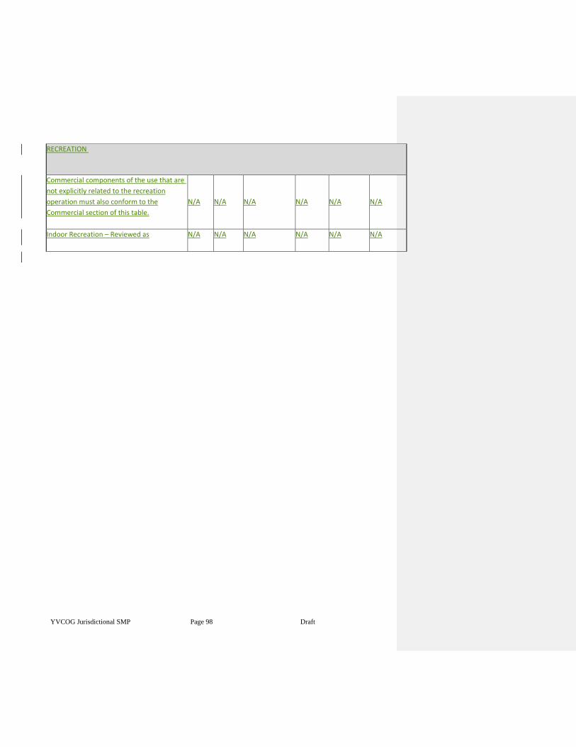
YVCOG Jurisdictional SMP Page 98 Draft
RECREATION
Commercial components of the use that are
not explicitly related to the recreation
operation must also conform to the
Commercial section of this table.
N/A
N/A
N/A
N/A
N/A
N/A
Indoor Recreation – Reviewed as N/A N/A N/A N/A N/A N/A
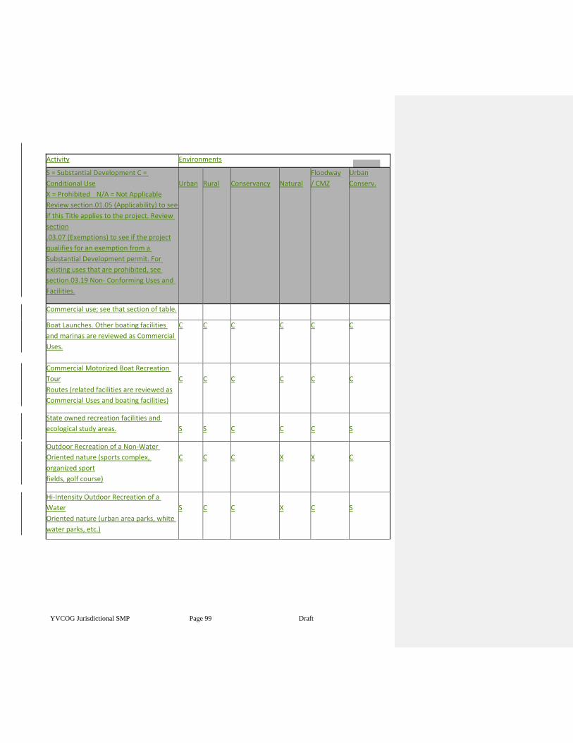
YVCOG Jurisdictional SMP Page 99 Draft
Activity Environments
S = Substantial Development C =
Conditional Use
X = Prohibited N/A = Not Applicable
Review section.01.05 (Applicability) to see
if this Title applies to the project. Review
section
.03.07 (Exemptions) to see if the project
qualifies for an exemption from a
Substantial Development permit. For
existing uses that are prohibited, see
section.03.19 Non- Conforming Uses and
Facilities.
Urban
Rural
Conservancy
Natural
Floodway
/ CMZ
Urban
Conserv.
Commercial use; see that section of table.
Boat Launches. Other boating facilities
and marinas are reviewed as Commercial
Uses.
C C C C C C
Commercial Motorized Boat Recreation
Tour
Routes (related facilities are reviewed as
Commercial Uses and boating facilities)
C
C
C
C
C
C
State owned recreation facilities and
ecological study areas.
S
S
C
C
C
S
Outdoor Recreation of a Non-Water
Oriented nature (sports complex,
organized sport
fields, golf course)
C
C
C
X
X
C
Hi-Intensity Outdoor Recreation of a
Water
Oriented nature (urban area parks, white
water parks, etc.)
S
C
C
X
C
S
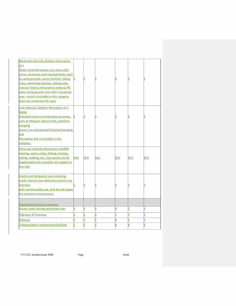
YVCOG Jurisdictional SMP Page 100
Draft
Moderate-Intensity Outdoor Recreation
of a
Water Oriented nature (use areas with
minor structures and improvements, such
as camp grounds, picnic facilities, hiking
trails, swimming beaches, fishing sites,
nature/ history interpretive centers); RV
park/ camping with units NOT remaining
year- round is included in this category
(also see residential RV uses)
S
S
S
X
C
S
Low-Intensity Outdoor Recreation of a
Water
Oriented nature (unimproved use areas,
such as hiking or nature trails, primitive
camping
areas,); an unimproved Personal Camping
and
Recreation Site is included in this
category.
S
S
S
C
S
S
Very-Low-Intensity Recreation (wildlife
viewing, scenic vistas, fishing, hunting,
rafting, walking, etc.) See section.01.05
(Applicability) for activities not subject to
this title.
N/A
N/A
N/A
N/A
N/A
N/A
Events and temporary uses involving
public interest (see definition) which may
interfere
with normal public use, that do not impair
the shoreline environment.
C
C
C
C
C
C
TRANSPORTATION & PARKING
Access roads serving permitted uses S S S X C S
Highways & freeways C C C C C C
Railways C C C X C C
Transportation maintenance facilities C C C X X C
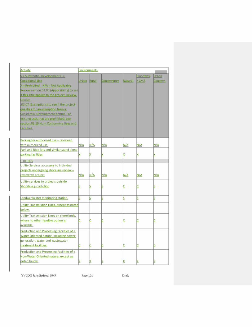
YVCOG Jurisdictional SMP Page 101 Draft
Activity Environments
S = Substantial Development C =
Conditional Use
X = Prohibited N/A = Not Applicable
Review section.01.05 (Applicability) to see
if this Title applies to the project. Review
section
.03.07 (Exemptions) to see if the project
qualifies for an exemption from a
Substantial Development permit. For
existing uses that are prohibited, see
section.03.19 Non- Conforming Uses and
Facilities.
Urban
Rural
Conservancy
Natural
Floodway
/ CMZ
Urban
Conserv.
Parking for authorized use – reviewed
with authorized use.
N/A
N/A
N/A
N/A
N/A
N/A
Park and Ride lots and similar stand alone
parking facilities
X
X
X
X
X
X
UTILITIES
Utility Services accessory to individual
projects undergoing Shoreline review –
review w/ project
N/A
N/A
N/A
N/A
N/A
N/A
Utility services to projects outside
Shoreline jurisdiction
S
S
S
C
C
S
Land/air/water monitoring station. S S S S S S
Utility Transmission Lines, except as noted
below.
X
X
X
X
X
X Utility Transmission Lines on shorelands,
where no other feasible option is
available.
C
C
C
C
C
C
Production and Processing Facilities of a
Water Oriented nature, including power
generation, water and wastewater
treatment facilities.
C
C
C
C
C
C
Production and Processing Facilities of a
Non-Water Oriented nature, except as
noted below.
X
X
X
X
X
X
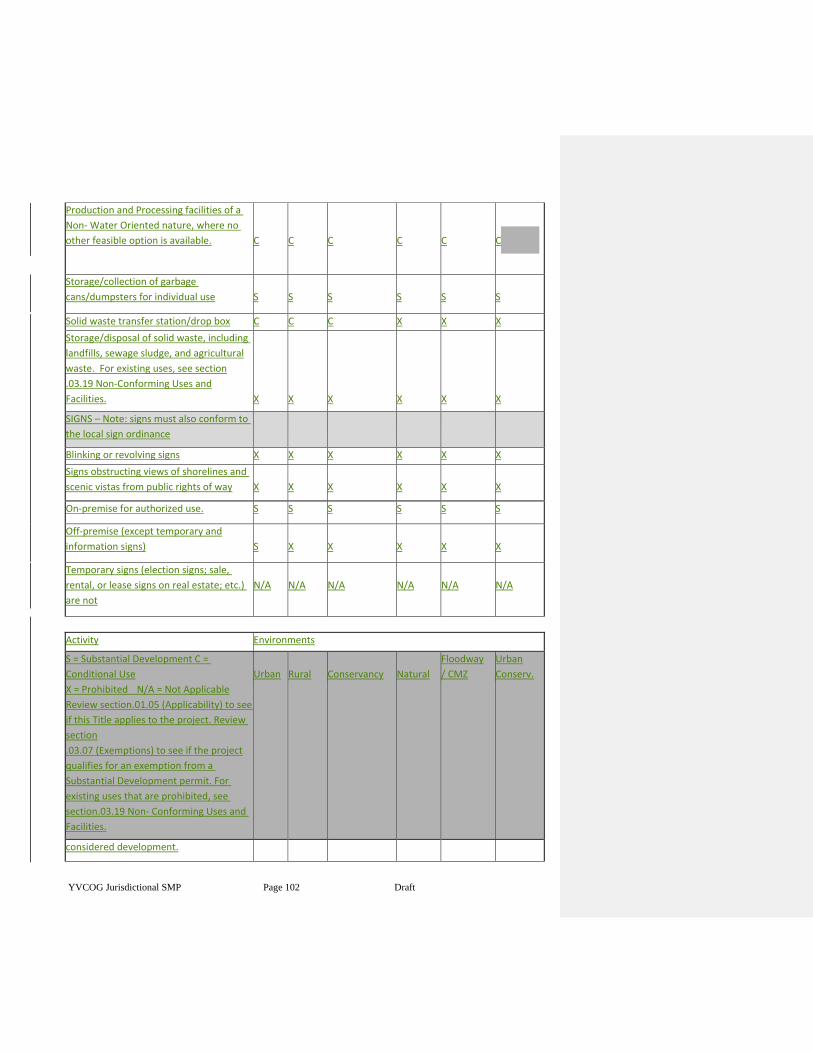
YVCOG Jurisdictional SMP Page 102 Draft
Production and Processing facilities of a
Non- Water Oriented nature, where no
other feasible option is available.
C
C
C
C
C
C
Storage/collection of garbage
cans/dumpsters for individual use
S
S
S
S
S
S
Solid waste transfer station/drop box C C C X X X
Storage/disposal of solid waste, including
landfills, sewage sludge, and agricultural
waste. For existing uses, see section
.03.19 Non-Conforming Uses and
Facilities.
X
X
X
X
X
X
SIGNS – Note: signs must also conform to
the local sign ordinance
Blinking or revolving signs X X X X X X
Signs obstructing views of shorelines and
scenic vistas from public rights of way
X
X
X
X
X
X
On-premise for authorized use. S S S S S S
Off-premise (except temporary and
information signs)
S
X
X
X
X
X
Temporary signs (election signs; sale,
rental, or lease signs on real estate; etc.)
are not
N/A
N/A
N/A
N/A
N/A
N/A
Activity Environments
S = Substantial Development C =
Conditional Use
X = Prohibited N/A = Not Applicable
Review section.01.05 (Applicability) to see
if this Title applies to the project. Review
section
.03.07 (Exemptions) to see if the project
qualifies for an exemption from a
Substantial Development permit. For
existing uses that are prohibited, see
section.03.19 Non- Conforming Uses and
Facilities.
Urban
Rural
Conservancy
Natural
Floodway
/ CMZ
Urban
Conserv.
considered development.
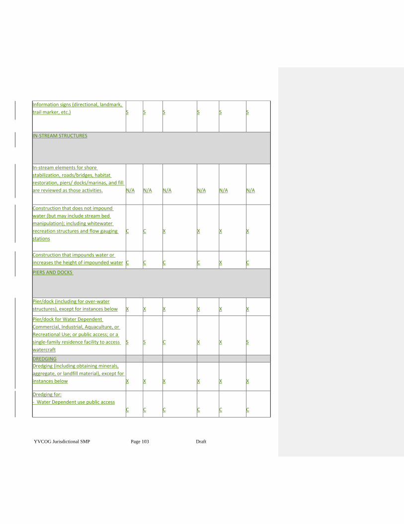
YVCOG Jurisdictional SMP Page 103 Draft
Information signs (directional, landmark,
trail marker, etc.)
S
S
S
S
S
S
IN-STREAM STRUCTURES
In-stream elements for shore
stabilization, roads/bridges, habitat
restoration, piers/ docks/marinas, and fill
are reviewed as those activities.
N/A
N/A
N/A
N/A
N/A
N/A
Construction that does not impound
water (but may include stream bed
manipulation); including whitewater
recreation structures and flow gauging
stations
C
C
X
X
X
X
Construction that impounds water or
increases the height of impounded water
C
C
C
C
X
C
PIERS AND DOCKS
Pier/dock (including for over-water
structures), except for instances below
X
X
X
X
X
X
Pier/dock for Water Dependent
Commercial, Industrial, Aquaculture, or
Recreational Use; or public access; or a
single-family residence facility to access
watercraft
S
S
C
X
X
S
DREDGING
Dredging (including obtaining minerals,
aggregate, or landfill material), except for
instances below
X
X
X
X
X
X
Dredging for:
- Water Dependent use public access
C
C
C
C
C
C
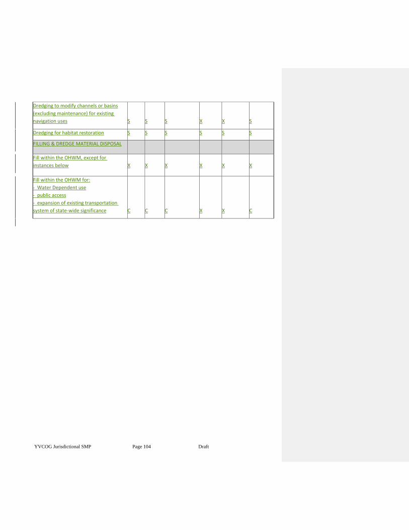
YVCOG Jurisdictional SMP Page 104 Draft
Dredging to modify channels or basins
(excluding maintenance) for existing
navigation uses
S
S
S
X
X
S
Dredging for habitat restoration S S S S S S
FILLING & DREDGE MATERIAL DISPOSAL
Fill within the OHWM, except for
instances below
X
X
X
X
X
X
Fill within the OHWM for:
- Water Dependent use
- public access
- expansion of existing transportation
system of state-wide significance
C
C
C
X
X
C
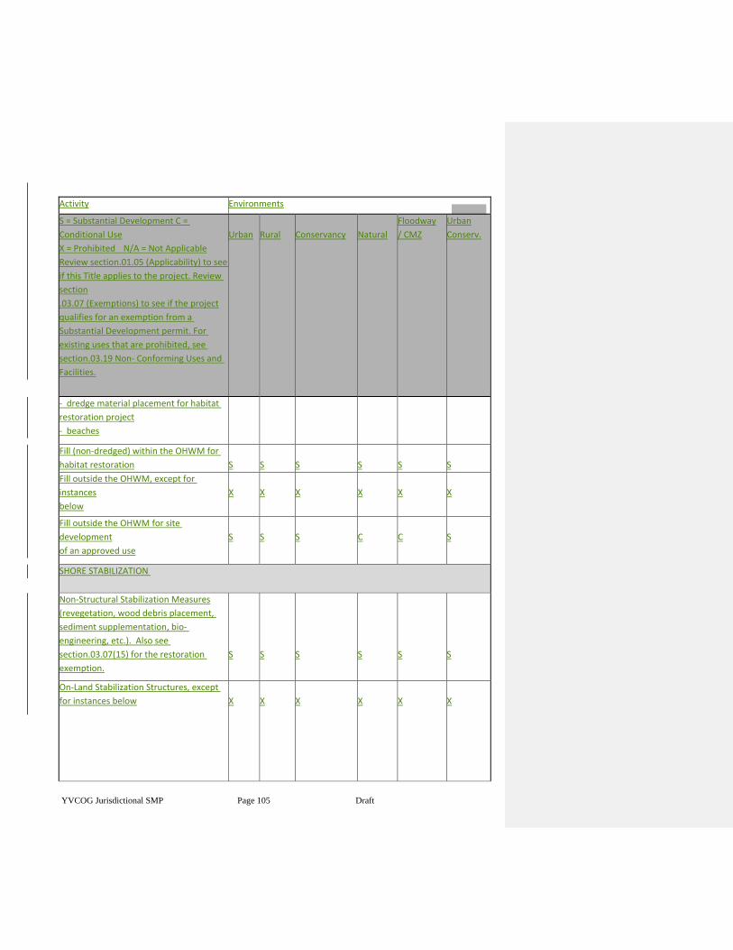
YVCOG Jurisdictional SMP Page 105 Draft
Activity Environments
S = Substantial Development C =
Conditional Use
X = Prohibited N/A = Not Applicable
Review section.01.05 (Applicability) to see
if this Title applies to the project. Review
section
.03.07 (Exemptions) to see if the project
qualifies for an exemption from a
Substantial Development permit. For
existing uses that are prohibited, see
section.03.19 Non- Conforming Uses and
Facilities.
Urban
Rural
Conservancy
Natural
Floodway
/ CMZ
Urban
Conserv.
- dredge material placement for habitat
restoration project
- beaches
Fill (non-dredged) within the OHWM for
habitat restoration
S
S
S
S
S
S
Fill outside the OHWM, except for
instances
below
X
X
X
X
X
X
Fill outside the OHWM for site
development
of an approved use
S
S
S
C
C
S
SHORE STABILIZATION
Non-Structural Stabilization Measures
(revegetation, wood debris placement,
sediment supplementation, bio-
engineering, etc.). Also see
section.03.07(15) for the restoration
exemption.
S
S
S
S
S
S
On-Land Stabilization Structures, except
for instances below
X
X
X
X
X
X
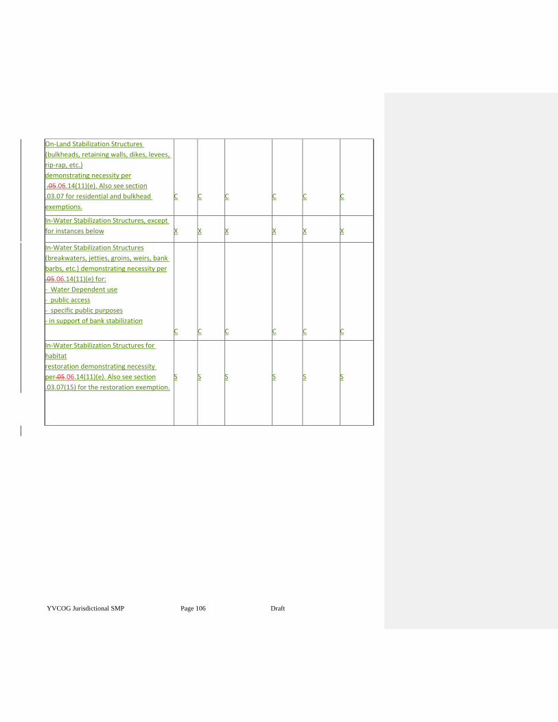
YVCOG Jurisdictional SMP Page 106 Draft
On-Land Stabilization Structures
(bulkheads, retaining walls, dikes, levees,
rip-rap, etc.)
demonstrating necessity per
.05.06.14(11)(e). Also see section
.03.07 for residential and bulkhead
exemptions.
C
C
C
C
C
C
In-Water Stabilization Structures, except
for instances below
X
X
X
X
X
X
In-Water Stabilization Structures
(breakwaters, jetties, groins, weirs, bank
barbs, etc.) demonstrating necessity per
.05.06.14(11)(e) for:
- Water Dependent use
- public access
- specific public purposes
- in support of bank stabilization
C
C
C
C
C
C
In-Water Stabilization Structures for
habitat
restoration demonstrating necessity
per.05.06.14(11)(e). Also see section
.03.07(15) for the restoration exemption.
S
S
S
S
S
S
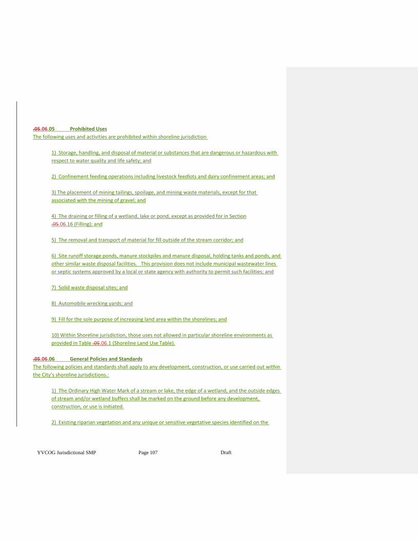
YVCOG Jurisdictional SMP Page 107 Draft
.05.06.05 Prohibited Uses
The following uses and activities are prohibited within shoreline jurisdiction
1) Storage, handling, and disposal of material or substances that are dangerous or hazardous with
respect to water quality and life safety; and
2) Confinement feeding operations including livestock feedlots and dairy confinement areas; and
3) The placement of mining tailings, spoilage, and mining waste materials, except for that
associated with the mining of gravel; and
4) The draining or filling of a wetland, lake or pond, except as provided for in Section
.05.06.16 (Filling); and
5) The removal and transport of material for fill outside of the stream corridor; and
6) Site runoff storage ponds, manure stockpiles and manure disposal, holding tanks and ponds, and
other similar waste disposal facilities. This provision does not include municipal wastewater lines
or septic systems approved by a local or state agency with authority to permit such facilities; and
7) Solid waste disposal sites; and
8) Automobile wrecking yards; and
9) Fill for the sole purpose of increasing land area within the shorelines; and
10) Within Shoreline jurisdiction, those uses not allowed in particular shoreline environments as
provided in Table .05.06.1 (Shoreline Land Use Table).
.05.06.06 General Policies and Standards
The following policies and standards shall apply to any development, construction, or use carried out within
the City’s shoreline jurisdictions.:
1) The Ordinary High Water Mark of a stream or lake, the edge of a wetland, and the outside edges
of stream and/or wetland buffers shall be marked on the ground before any development,
construction, or use is initiated.
2) Existing riparian vegetation and any unique or sensitive vegetative species identified on the
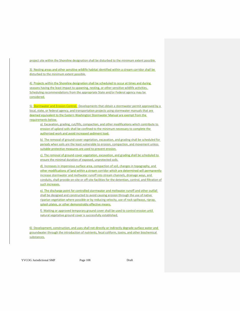
YVCOG Jurisdictional SMP Page 108 Draft
project site within the Shoreline designation shall be disturbed to the minimum extent possible.
3) Nesting areas and other sensitive wildlife habitat identified within a stream corridor shall be
disturbed to the minimum extent possible.
4) Projects within the Shoreline designation shall be scheduled to occur at times and during
seasons having the least impact to spawning, nesting, or other sensitive wildlife activities.
Scheduling recommendations from the appropriate State and/or Federal agency may be
considered.
5) Stormwater and Erosion Control. Developments that obtain a stormwater permit approved by a
local, state, or federal agency, and transportation projects using stormwater manuals that are
deemed equivalent to the Eastern Washington Stormwater Manual are exempt from the
requirements below.
a) Excavation, grading, cut/fills, compaction, and other modifications which contribute to
erosion of upland soils shall be confined to the minimum necessary to complete the
authorized work and avoid increased sediment load.
b) The removal of ground-cover vegetation, excavation, and grading shall be scheduled for
periods when soils are the least vulnerable to erosion, compaction, and movement unless
suitable protective measures are used to prevent erosion.
c) The removal of ground-cover vegetation, excavation, and grading shall be scheduled to
ensure the minimal duration of exposed, unprotected soils.
d) Increases in impervious surface area, compaction of soil, changes in topography, and
other modifications of land within a stream corridor which are determined will permanently
increase stormwater and meltwater runoff into stream channels, drainage ways, and
conduits, shall provide on-site or off-site facilities for the detention, control, and filtration of
such increases.
e) The discharge point for controlled stormwater and meltwater runoff and other outfall
shall be designed and constructed to avoid causing erosion through the use of native
riparian vegetation where possible or by reducing velocity, use of rock spillways, riprap,
splash plates, or other demonstrably effective means.
f) Matting or approved temporary ground cover shall be used to control erosion until
natural vegetative ground cover is successfully established.
6) Development, construction, and uses shall not directly or indirectly degrade surface water and
groundwater through the introduction of nutrients, fecal coliform, toxins, and other biochemical
substances.
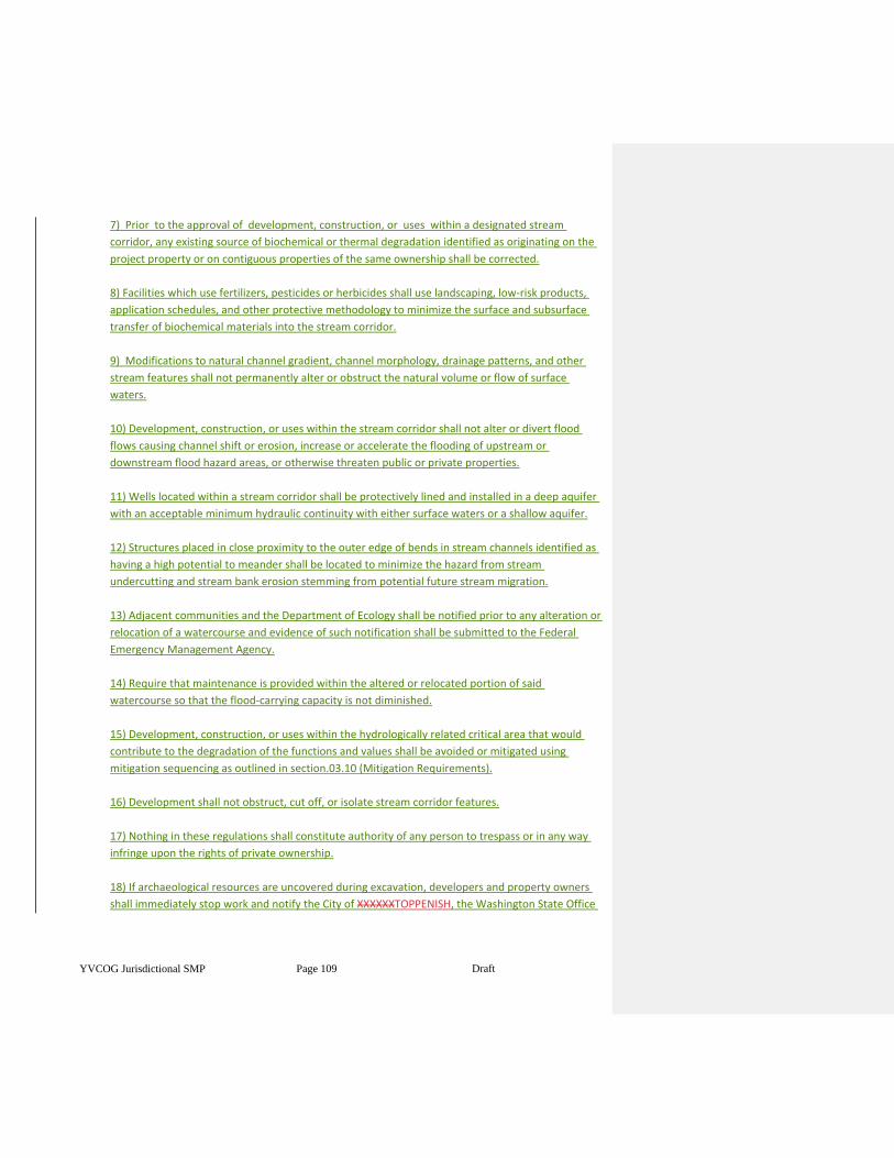
YVCOG Jurisdictional SMP Page 109 Draft
7) Prior to the approval of development, construction, or uses within a designated stream
corridor, any existing source of biochemical or thermal degradation identified as originating on the
project property or on contiguous properties of the same ownership shall be corrected.
8) Facilities which use fertilizers, pesticides or herbicides shall use landscaping, low-risk products,
application schedules, and other protective methodology to minimize the surface and subsurface
transfer of biochemical materials into the stream corridor.
9) Modifications to natural channel gradient, channel morphology, drainage patterns, and other
stream features shall not permanently alter or obstruct the natural volume or flow of surface
waters.
10) Development, construction, or uses within the stream corridor shall not alter or divert flood
flows causing channel shift or erosion, increase or accelerate the flooding of upstream or
downstream flood hazard areas, or otherwise threaten public or private properties.
11) Wells located within a stream corridor shall be protectively lined and installed in a deep aquifer
with an acceptable minimum hydraulic continuity with either surface waters or a shallow aquifer.
12) Structures placed in close proximity to the outer edge of bends in stream channels identified as
having a high potential to meander shall be located to minimize the hazard from stream
undercutting and stream bank erosion stemming from potential future stream migration.
13) Adjacent communities and the Department of Ecology shall be notified prior to any alteration or
relocation of a watercourse and evidence of such notification shall be submitted to the Federal
Emergency Management Agency.
14) Require that maintenance is provided within the altered or relocated portion of said
watercourse so that the flood-carrying capacity is not diminished.
15) Development, construction, or uses within the hydrologically related critical area that would
contribute to the degradation of the functions and values shall be avoided or mitigated using
mitigation sequencing as outlined in section.03.10 (Mitigation Requirements).
16) Development shall not obstruct, cut off, or isolate stream corridor features.
17) Nothing in these regulations shall constitute authority of any person to trespass or in any way
infringe upon the rights of private ownership.
18) If archaeological resources are uncovered during excavation, developers and property owners
shall immediately stop work and notify the City of XXXXXXTOPPENISH, the Washington State Office
YVCOG Jurisdictional SMP Page 110 Draft
of Archaeology and Historic Preservation and any affected Indian Tribes. Archaeological sites are
subject to RCW 27.44 (Indian graves and records) and RCW 27.53 (Archaeological sites and records),
and development or uses that may impact such sites shall comply with WAC
25-48 (Archaeological Excavation and Removal Permit).
19) The provisions of CITATION (Flood Damage Prevention) and CITATION (Frequently Flooded
Areas) shall also apply to the development of lots and the placement, construction, or installation of
structures in floodways and floodplains.
20) Any portion of the vegetative buffer temporarily damaged or disturbed because of construction
activities (excluding approved permanent use areas) shall be repaired at the completion of
construction using reclamation standards in section05.18 (Reclamation).
21) Changing from an existing use or development which does not meet the provisions of this
chapter to a new use shall be reviewed to ensure that the conversion will demonstrably reduce
impacts to stream corridor and other hydrologically related critical area features
22) Additional General Shoreline Standards. The requirements below shall apply to all activities
within Shoreline jurisdiction.
a)22) Individual projects or actions that, if continued as a pattern, would accumulatively result in
the degradation or impairment of the Shoreline environment, shall be avoided.
b)23 Individual projects or actions shall provide for no net loss of Shoreline ecological functions.
c)24 Shoreline development shall not interfere with public access and enjoyment of any nearby
publicly owned land areas.
d)25 Outdoor advertising signs must conform to size, spacing and lighting provisions of the
Washington State Scenic Vistas Act of 1971, where applicable.
e)26 There shall be a thirty-five (35) foot maximum building height for all structures, except that
utility towers and poles, dams, concrete and asphalt batching plants, water treatment towers,
wastewater treatment facilities and bridges are not required to meet this standard, and specific
height limitations for residential structures are as follows:
i) 25 feet above average grade level in the conservancy environment.
ii) 20 feet above average grade level in the natural environment.
iii) 25 feet above average grade level in the urban conservancy environment.
iv) 20 feet above average grade level in the floodway/channel migration zone.
f)27 New development within Shoreline jurisdiction shall be located and designed to:
i) avoid the need for future shore stabilization, to the extent feasible.
Formatted: Indent: Left: 0.5"
Formatted: Indent: Left: 0.5"
Formatted: Indent: Left: 1"
Formatted: Indent: First line: 0"
YVCOG Jurisdictional SMP Page 111 Draft
ii) avoid or, if that is not possible, to minimize the need for new and maintenance dredging.
iii) assure that subdivision lots created will not require shore stabilization in order for
reasonable development to occur. The standards should be accomplished using
geotechnical analysis of the site and shoreline characteristics, as provided in section
.05.06.14(11) (Additional Shoreline Standards for Shore Stabilization);
iv) setback new development on steep slopes or bluffs sufficiently to ensure that shore
stabilization is unlikely to be necessary during the life of the structure, as
demonstrated by a geotechnical analysis, as provided in section .05.06.14(11) (Additional
Shoreline Standards for Shore Stabilization).
v) New development that would require shore stabilization which causes significant impacts
to adjacent or down-current properties and shoreline areas shall not be allowed.
Article III - WATER DEPENDENCY DEVELOPMENT STANDARDS AND BUFFER REQUIREMENTS
.05.06.07 Use Classifications
For purposes of this chapter, the components of any development, construction, or use requiring a critical
area development authorization shall be classified as provided below and shall conform with the
development standards applicable to the classification provided in .05.06.08 through
05.10 except for those listed in Section.03.02 (Minor Activities Allowed without a
Permit or Exemption):
1) Water Oriented Uses are one of the following three (3) categories of uses:
a) Water-dependent uses include dams, water diversion facilities, marinas, boat launching
facilities, water intakes and outfalls, aquaculture, log booming, stream and wetland
crossings for roads and railroads, stream and wetland crossings for utilities, swimming
beaches, fishing sites, in-water or on-land shore stabilization structures, livestock
watering sites, and other uses that cannot exist in any other location and are dependent on
the water by reason of the intrinsic nature of their operations. This provision applies only to
the specific portion of a project that is demonstrably dependent upon the water or shore.
b) A Water-related use is one not intrinsically dependent on a waterfront location but
whose economic viability is enhanced by a waterfront location either because it requires
large quantities of water, or because it provides services for water dependent uses and the
proximity to its customers makes such services less expensive and/or more convenient.
Examples would include thermal power plants, wastewater treatment plants, water
processing and treatment plants, support services for fish hatcheries or aquaculture, fly
shops and boat rental shops.
c) A Water enjoyment use is a recreational or other use that facilitates public access within
Shoreline jurisdiction as a primary characteristic of the use, or provides for recreational use
or aesthetic enjoyment of the shoreline for a substantial number of people as a general
Formatted: Indent: Left: 1"
YVCOG Jurisdictional SMP Page 112 Draft
characteristic of the use; and which through location, design, and operation ensures the
public's ability to enjoy the physical and aesthetic qualities of the shoreline. Within
Shoreline jurisdiction the use must be open to the general public and the shoreline-
oriented space within the project must be devoted to the specific aspects of the use that
fosters shoreline enjoyment in order to qualify as a water-enjoyment use within Shoreline
jurisdiction. Examples include recreational uses orientated to the Shorelines water features,
and restaurants with water viewing.
2) Non-water-oriented uses include any use not qualifying as uses in subsection (1) above.
.05.06.08 Water-dependent Uses
The following provisions shall apply to water-dependent uses:
1) Structures shall be clustered at locations on the water's edge having the least impact to the
surface water and shore.
2) Use areas and structures which require direct shore locations shall be located and constructed to
minimize impacts to the shore area and the vegetative buffer specified in Section
.05.06.11 (Vegetative Buffers).
3) Use areas and structures requiring direct shore locations shall minimize any obstruction or
impairment of normal public navigation of the surface water.
.05.06.09 Water-related Uses
The following provisions shall apply to the water-related uses:
1) Structures and use areas shall be located as far landward from the ordinary high-water mark or
wetland edge as is possible and still preserve the essential or necessary relationship with the
surface water.
2) Structures and use areas shall not be located within the vegetative buffer specified in Section
.05.06.11 (Vegetative Buffers) except where existing development or the requirements associated
with the use make such a location unavoidable.
.05.06.10 Water-enjoyment and Non-water Oriented Uses
The following provisions shall apply to water enjoyment and non-water-oriented uses:
1) Structures and use areas shall be set back so as not to be located within the vegetative buffer
specified in Section .05.06.11 (Vegetative Buffers).
2) Construction abutting the vegetative buffer specified in Section .05.06.11 (Vegetative Buffers)
shall be designed and scheduled to ensure there will not be permanent damage or loss of the
vegetative buffer.
YVCOG Jurisdictional SMP Page 113 Draft
.05.06.11 Vegetative Buffers
Establishment. There is hereby established a system of vegetative buffers that are necessary to protect the
ecological functions and values of shorelines. The vegetative buffer for shoreline streams and lakes shall be
100 feet. For wetlands, based on a review of the best available science, buffers are listed in table
6-1.
1) Vegetative buffers shall be measured from the Ordinary High-Water Mark (OHWM) for streams,
lakes, and ponds.
2) Buffer width may be reduced through the Variance permit process.
3) The adequacy of these standard buffer widths presumes the existence of a relatively intact
native vegetation community in the buffer zone adequate to protect the stream functions and
values at the time of the proposed activity. If the vegetation is degraded, then no adjustment to
the buffer width should be granted and re-vegetation should be considered. Where the use is being
intensified, a degraded buffer should be re-vegetated to maintain the standard width.
Article IV Shoreline Modification Standards
.05.06.12 Roads, Railroads, and Parking
The following provisions shall apply to the location and construction of roads, railroads, and parking within
shorelines.
1) Roads and railroads shall not be located within a designated stream corridor except where it is
necessary to cross the corridor, or where existing development, topography, and other conditions
preclude locations outside the stream corridor.
a) Construction of roadways across stream corridors shall be by the most direct route
possible having the least impact to the stream corridor.
b) Roadways that must run parallel to stream or wetland edges shall be along routes having
the greatest possible distance from stream or wetland and the least impact to the corridor.
c) Roadways within the stream corridor shall not hydrologically obstruct, cut-off or isolate
stream corridor features.
2) Material excavated from the roadway area to achieve the design grade shall be used as fill where
necessary to maintain grade or shall be transported outside the corridor.
3) Necessary fill to elevate roadways shall not impede the normal flow of floodwaters or cause
displacement that would increase the elevation of flood waters such that it would cause properties
not in the floodplain to be flood prone.
4) Spoil, construction waste, and other debris shall not be used as road fill or buried within the
YVCOG Jurisdictional SMP Page 114 Draft
stream corridor.
5) Bridges and water-crossing structures shall not constrict the stream channel or impede the flow
of the ordinary high water, sediment, and woody debris.
6) Natural stream channels and drainage ways shall be preserved through the use of bridges for
crossings, unless the use of culverts is demonstrated to be the only technically feasible means for
crossing. The use of bridges shall be the preferred means to preserve natural streams and
drainageways. Where bridges are not feasible, large, natural bottom culverts, multi-plate pipes
and bottomless arches shall be used.
7) The alignment and slope of culverts shall parallel and match the natural flow of streams or
drainage ways, unless doing so conflicts with subsection (1) and (2), and shall be sized to
accommodate ordinary high water, and shall terminate on stable, erosion-resistant materials.
8) Where fish, amphibian or other wildlife passage is present, culverts shall be designed and
constructed to specifications provided through the Washington State Aquatic Habitat Guidelines or
a comparable source of expertise.
9) At least one end of a wood stringer bridge shall be anchored to prevent it from being washed
away during high water.
10) Roads must be designed and constructed using established flood resistant and design and
construction methods when they may be subject to damage by flood waters.11) Roads and bridges
within floodways must meet the requirements of the City of XXXXXXTOPPENISH XMC FLOOD
HAZARD MITIGATION CODE HERE.
12) Additional Shoreline Standards for Roads, Railroads and Parking – the standards in this section
only apply to new uses within Shoreline jurisdiction.
a)11 Parking areas shall be located upland of the areas they serve.
b)12 Owners of two or more adjoining uses, structures or parcels of land may utilize jointly the
same parking area when the hours of operation do not overlap.
c)13 A Conditional Use Permit for roads, railroads or parking areas must demonstrate through and
engineering studies that a shoreline location is the most feasible of the available options.
.05.06.13 Utility Transmission Lines and Facilities
The following provisions shall apply to the location, construction, or installation of utility transmission lines
and facilities (such as those for wastewater, water, communication, natural gas, etc.) within a designated
hydrologically related critical area:
1) Utility transmission lines and facilities shall be permitted within the stream corridor only where it
Formatted: Indent: First line: 0"
Formatted: Indent: Left: 0.5"
YVCOG Jurisdictional SMP Page 115 Draft
is necessary to cross the corridor or where existing development, topography, and other conditions
preclude locations outside the stream corridor. Utility transmission lines and facilities across
stream corridors shall be by the most direct route possible having the least impact to the stream
corridor.
2) Utility lines under streams and wetlands shall be placed in a sleeve casing to allow easy
replacement or repair with minimal disturbance to the stream corridor.
3) Buried utility transmission lines crossing a stream corridor shall be buried a minimum of four feet
below the maximum scour or 1/3 of the bankfull depth of the waterway, whichever is greater, and
for a similar depth below any associated floodway and floodplain to the maximum extent of
potential channel migration as determined by hydrologic analysis.
4) Wherever possible, new aboveground installations shall use available, existing bridge and utility
locations and stream corridor crossings as opposed to creating new locations and stream corridor
crossings.
5) Aboveground electrical support towers and other similar transmission structures shall be located
as far upland as is practical.
6) Transmission support structures shall be located clear of high flood velocities, located in areas of
minimum flood depth which require the least floodproofing, and shall be adequately floodproofed.
7) Underground utility transmission lines shall be constructed so they do not alter, intercept, or
dewater groundwater patterns that support streams, wetlands and hyporheic flow.
8) All new and replacement water supply systems and wastewater systems within a special flood
hazard area must meet the requirements of FLOOD HAZARD CITATION HERE.
9) Utility transmission lines within the Floodway and the Floodway Fringe shall meet the standards
of Flood Hazard Citation of City Code
10) Additional Shoreline Standards for Utility Transmission Lines and Facilities-
The requirements below shall apply to all utility transmission lines and facilities within Shoreline
jurisdiction. Utility services to individual projects undergoing Shoreline review, including those
where the primary use may be in a different Shoreline environment than the utility service shall not
require separate Substantial Development Permits for utility service installations, but are subject to
all of the provisions in .05.06.13, except those listed below. Utility service to projects outside
Shoreline jurisdiction are subject to normal Shoreline permitting and are subject to all of the
provisions in .05.06.13 (Utility Transmission Lines and Facilities), except those listed below.
YVCOG Jurisdictional SMP Page 116 Draft
a) Where feasible utilities shall be placed underground unless such undergrounding would
be economically or technically prohibitive.
b) New utility facilities shall be designed and located to preserve the natural landscape and
minimize conflicts with present and planned land and shoreline uses, especially recreation,
residential and public access.
c) Expansion, updating, and maintenance of existing facilities is allowed but shall be
designed to be located to avoid adverse impacts to shoreline resources as much as possible.
d) Permit applications shall meet the following submittal review standards:
e) Applications shall submit studies (social, economic, environmental, engineering, etc.) to
demonstrate that a shoreline location is the most feasible of the available options.
f) Applications to locate transmission lines shall submit a location plan that shows existing
utility routes in the vicinity of the proposed transmission line. Failure of utility lines to
follow existing routes, where feasible, shall cause denial of the application.
g) Applications shall include a reclamation plan that provides for re-vegetation and
protection of shoreline areas from erosion and siltation. A re-vegetation or erosion
protection plan judged by the Administrative Official to be insufficient for the protection or
restoration of the Shoreline environment shall cause denial of the application.
.05.06.14 Shore Stabilization
The following provisions shall apply to shore stabilization projects:
1) Shore stabilization projects shall be allowed only where there is evidence of erosion which
clearly represents a threat to existing property, structures, or facilities, and which stabilization will
not jeopardize other upstream or downstream properties.
2) Stabilization projects shall be developed under the supervision of, or in consultation with,
agencies or professionals with appropriate expertise.
3) Stabilization projects shall be confined to the minimum protective measures necessary to
protect the threatened property.
4) The use of fill to restore lost land may accompany stabilization work, provided the resultant shore does
not extend beyond the new ordinary high water mark, finished grades are consistent with abutting
properties, a restoration plan is approved for the area, and the fill material is in compliance with
Section .05.06.16 (Filling).
5) Stabilization projects shall use design, material, and construction alternatives that do not require
YVCOG Jurisdictional SMP Page 117 Draft
high or continuous maintenance, and which prevent or minimize the need for subsequent
stabilization to other segments of the shore. Junk car bodies and other unsuitable debris are not to
be used in shore stabilization projects.
6) Stream bank and lakeshore protection shall be accomplished using bioengineered (biotechnical)
designs employing living plant materials as primary structural components of resistance to erosion
and mass wasting, unless a report prepared by a qualified engineer experienced in soil
bioengineering (biotechnical) and shoreline protection demonstrates that conventional structural
armoring is the only feasible means of stabilizing the subject stream bank or lakeshore.
7) Applications to construct or enlarge dikes or levees shall meet the requirements of
FLOOD HAZARD CODE CITATION HERE
8) Revetments and bulkheads shall be no higher than necessary to protect and stabilize the shore.
9) Breakwaters shall be constructed of floating or open pile designs rather than fill, riprap, or other
solid construction methods.
10) All new flood control projects shall define maintenance responsibilities and a funding source for
operations, maintenance, and repairs for the life of the project.
11) Additional Shoreline Standards for Shore Stabilization - The requirements below shall apply to
all shore stabilization activities within Shoreline jurisdiction.
a)11 Where feasible, dikes and levees shall be located outside of the floodway or channel migration
zone of the river or stream in order to minimize any attendant increase in water stage and stream
flow velocity over existing conditions.
b)12 Rip-rapping and other shore stabilization measures shall be designed, located, and
constructed in such a manner as to minimize the disruption of natural channel characteristics.
c)13 Demonstration of necessity. New structural shore stabilization measures shall not be allowed
except when necessity is demonstrated in the following manner:
i) New or enlarged structural stabilization measures for an existing primary
structure, including residences, shall not be allowed unless there is conclusive
evidence, documented by a geotechnical analysis that the structure is in danger
from shoreline erosion caused by currents or waves. Normal sloughing, erosion of
steep bluffs, or demonstration of need. The geotechnical analysis should evaluate
on-site drainage issues and address drainage problems away from the shoreline
edge before considering structural shore stabilization.
ii) Erosion control structures in support of new non-water-dependent
Formatted: Indent: Left: 0.5"
YVCOG Jurisdictional SMP Page 118 Draft
development, including single-family residences, when all of the conditions below
apply:
(1) The erosion is not being caused by upland conditions, such as the loss of
vegetation and drainage; and
(2) Nonstructural measures, such as placing the development further from
the shoreline, planting vegetation, or installing on-site drainage
improvements, are not feasible or not sufficient; and
(3) The need to protect primary structures from damage due to erosion is
demonstrated through a geotechnical report. The damage must be caused
by natural processes, such as tidal action, currents, and waives.
iii) Erosion control structures in support of water-dependent development when all
of the conditions below apply:
(1) The erosion is not being caused by upland conditions, such as the loss of
vegetation and drainage; and
(2) Nonstructural measures, planting vegetation, or installing on-site
drainage improvements, are not feasible or not sufficient; and
(3) The need to protect primary structures from damage due to erosion is
demonstrated through a geotechnical report.
d)14 Erosion control structures to protect projects for the restoration of ecological functions or
hazardous substance remediation projects pursuant to the Model Toxics Control Act (70.105D RCW)
shall not be allowed unless there is conclusive evidence, documented by a geotechnical analysis
that demonstrates that nonstructural measures such as planting vegetation, or installing on-site
drainage improvements, is not feasible or not sufficient.
e)15 An existing shore stabilization structure may be replaced with a similar structure if there is a
demonstrated need to protect principal uses or structures from erosion. For purposes of this
section standards on shore stabilization measures, "replacement" means the construction of a new
structure to perform a shore stabilization function of an existing structure which can no longer
adequately serve its purpose. Additions to or increases in size of existing shore stabilization
measures shall be considered new structures under paragraph (g) above.
i) Replacement walls or bulkheads shall not encroach waterward of the ordinary
high- water mark or existing structure unless the residence was occupied prior to
January 1, 1992, and there are overriding safety or environmental concerns. In such
cases, the replacement structure shall abut the existing shore stabilization
structure.
ii) Soft shore stabilization measures that provide restoration of shoreline ecological
functions may be permitted waterward of the ordinary high-water mark.
Formatted: Indent: Left: 0.5"
YVCOG Jurisdictional SMP Page 119 Draft
.05.06.15 Dredging and Excavation
The following provisions shall apply to dredging and excavation within a designated hydrologically related
critical area:
1) Dredging in surface waters shall be allowed only where necessary because of existing navigation
needs, habitat restoration or improvement maintenance or construction of water- dependent uses.
2) (2) Dredging and excavation shall be confined to the minimum area necessary to accomplish the
intended purpose or use.
3) Hydraulic dredging or other techniques that minimize the dispersal and broadcast of bottom materials
shall be preferred over agitation forms of dredging.
4) Curtains and other appropriate mechanisms shall be used to minimize widespread dispersal of sediments
and other dredge materials.
5) Entries across shore and wetland edges to accomplish dredging or excavation shall be confined to the
minimum area necessary to gain entry and shall be confined to locations with the least potential for site
disturbance and damage.
6) Dredging and excavation shall be scheduled at times having the least impact to fish spawning, nesting
patterns, and other identified natural processes.
7) Dredge spoils are also considered fill and shall not be deposited within the stream except where such
deposit is in accordance with approved procedures intended to preserve or enhance wildlife habitat,
natural drainage, or other naturally occurring conditions.
8) Additional Shoreline Standards for Dredging and Excavation - The requirements below shall apply to all
dredging and excavation activities within Shoreline jurisdiction.
a)8 All applications for Substantial Development Permits that include dredging shall supply a dredging plan
that includes the following information:
i) The quantity of material to be removed.
ii) The method of removal.
iii) Location of spoil disposal sites and measures that will be taken to protect the
environment around them.
iv) Plans for the protection and restoration of the shoreline environment during and after
dredging operations.
b)9 A dredging operation judged by the Administrator to be insufficient for protection or restoration of the
shoreline environment shall cause denial of a Substantial Development permit.
Formatted: Indent: Left: 0"
Formatted: Indent: Left: 0"
YVCOG Jurisdictional SMP Page 120 Draft
.05.06.16 Filling
The following provisions shall apply to filling activities within shorelines:
1) Fill within surface waters or wetlands shall be allowed only where necessary in conjunction with
water-dependent uses, or an approved reclamation plan under Section.06.23 (Reclamation)
2) Fill for the purpose of increasing elevation may be permitted if such can be accomplished in a
manner consistent with the policies of this chapter.
3) Fill shall be the minimum necessary to accomplish the use or purpose and shall be confined to
areas having the least impact to the stream corridor. Other alternatives should be preferred over fill
to elevate new homes in the floodplain, such as increasing foundation height or zero- rise methods
such as piers, posts, columns, or other methods.
4) Fill in floodplains shall meet the requirements of chapter Flood Hazard Plan Code Citation).
5) Pile or pier supports shall be preferred over fill for water-dependent uses and facilities.
6) Unless site characteristics dictate otherwise, fill material within surface waters or wetlands shall
be sand, gravel, rock, or other clean material, with a minimum potential to degrade water quality.
7) Fill placement shall be scheduled at times having the least impact to fish spawning, nesting
patterns, and other identified natural processes.
8) Fill shall be stabilized with native vegetation where appropriate to prevent erosion, migration of
sediments and other material from the fill area to surrounding water, shore, and wetlands, unless
technical consultation with other regulating agencies indicates alternative means are required.
9) Projects that propose fill shall make every effort to acquire fill onsite (also known as
compensatory storage) where appropriate.
10) Fill should not obstruct, cut off, or isolate stream corridor features.
11) Additional Shoreline Standards for Fill - The requirements below shall apply to all filling activities
within Shoreline jurisdiction.
a)11 Fill projects shall be evaluated for effects on total water surface reduction, navigation
restriction, impediment to water flow and circulation, impediment to irrigation systems, reduction
of water quality, and destruction of fish and wildlife habitat.
b)12 Applications shall include a reclamation plan that provides for re-vegetation and protection of
Formatted: Indent: Left: 0.5"
Formatted: Indent: Left: 0.5"
YVCOG Jurisdictional SMP Page 121 Draft
shoreline areas from erosion and siltation. A re-vegetation or erosion protection plan judged by
the Administrative Official to be insufficient for the protection or restoration of the Shoreline
environment shall cause denial of a Substantial Development Permit.
.05.06.17 Commercial Mining of Gravels
The following provisions shall apply to the commercial mining of gravels within shorelines:
1) Prior to the authorization of a commercial gravel mining operation, the project proponent shall
provide maps to scale which illustrate the following:
2)
a) The extent to which gravel excavation and processing will affect or modify existing
stream corridor features, including existing riparian vegetation; ; and
b) The location, extent and size in acreage of any pond, lake, or feature that will be created
as a result of mining excavation; ; and
c) The description, location, and extent of any proposed subsequent use that would be
different than existing uses.
2) The operations and any subsequent use or uses shall not cause permanent impairment or loss of
floodwater storage, wetland, or other stream corridor features. Mitigation shall provide for the
feature's replacement at equal value.
3) Any surface mining allowed within the floodway shall meet the standards FLOOD HAZARD
CODE CIOTATION HERE
4) Except where authorized by the City of XXXXXXTOPPENISH in consultation with the State
Department of Fish and Wildlife and Department of Ecology, the following shall apply:
a) The excavation zone for the removal of gravels shall be located a minimum of one
hundred feet upland from the ordinary high-water mark (OHWM) of the stream channel.
b) Equipment shall not be operated, stored, refueled, or provided maintenance within one
hundred feet of the OHWM.
c) Gravel washing, rock-crushing, screening, or stockpiling of gravels shall not occur within
one hundred feet of the OHWM.
5) Mining proposals shall be consistent with the Washington Department of Natural Resources
Surface Mine Reclamation standards (WAC 332-18, RCW 78.44).
6) Additional Shoreline Standards for Industrial Mining of Gravels .The requirements below shall
apply to all mining activities within Shoreline jurisdiction.
YVCOG Jurisdictional SMP Page 122 Draft
a)6 Applicants shall submit a mining and reclamation plan to the Administrator describing the
proposed site, quantity of material to be removed, method of removal, and measures that will be
taken to protect lakes and streams from siltation and sedimentation. A surface mining plan or a
reclamation plan judged by the Administrative Official to be insufficient for protection or
restoration of the shoreline environment shall cause denial of a Substantial Development Permit.
b)7 Mining processing activities and stockpiles shall be sited in such a manner so as to avoid
damage or loss resulting from flooding.
c)8 Mining processing activities shall utilize existing and/or new vegetation where necessary to
minimize visual and noise impacts.
d)9 New mining and associated activities shall assure that proposed subsequent use of the mined
property is consistent with the provisions of the environment designation and that reclamation of
disturbed shoreline areas provides appropriate ecological functions consistent with the setting.
.05.06.18 Reclamation
The following guidelines shall apply to the reclamation of disturbed sites resulting from development
activities within a designated hydrologically related critical area:
1) Development, construction, or uses shall include the timely restoration of disturbed features to a natural
condition or to a stabilized condition that prevents degradation within the stream corridor.
2) Large-scale projects or projects extending over several months shall be phased to allow reclamation of
areas where work or operations have been completed.
3) Reclamation shall be scheduled to address precipitation, meltwater runoff, growing season, and other
seasonal variables that influence restoration and recovery.
4) Topography shall be finished to grades, elevations, and contours consistent with natural conditions in
adjacent and surrounding areas.
5) Where existing development and construction prevent the return of a site to its natural condition, sites
may be finished to conditions comparable to surrounding properties provided suitable protective measures
are used to prevent stream corridor degradation.
6) Cut-and-fill slopes shall be stabilized at, or at less than the normal angle of repose for the materials
involved.
7) The replacement or enhancement of vegetation within wetlands and required vegetative buffers shall
use naturally occurring, native plant species. In other parts of the stream corridor, naturally occurring,
native plant species shall be used, unless a showing of good cause acceptable to the Administrative Official
is provided, in which case self-maintaining or low-maintenance plant species compatible with native
Formatted: Indent: Left: 0.5"
YVCOG Jurisdictional SMP Page 123 Draft
vegetation shall be preferred over non- native and high-maintenance species.
Article V SHORELINE USE DEVELOPMENT STANDARDS
.05.06.19 Forest Practices - The following provisions shall apply to Forest Practices, as defined,
within Shoreline jurisdiction.
1) All federal forest practices or non-federal forest practices meeting the criteria below shall qualify
for the exemption from development standards provided in 16D.03.13(2)(a). All forest practices
qualifying for this provision shall demonstrate compliance by providing a copy of the federal
approval or state Forest Practices Permit. Other forest practices must conform to all applicable
development standards.
a) harvest/treat at least 5 acres of forestland, or supporting such an operation; ; and
b) all harvesting w/in 200’ of OHWM of Shoreline of Statewide Significance uses methods
meeting RCW 90.58.150 (selective harvest), as amended; ; and
c) activities are not associated with a Conversion Option Harvest; ; and
d) approved under a forest practices permit; ; and
e) not associated with a harvest under a Class IV–General application to convert forest land
to non-forestry use.
2) Non-federal forest practices NOT meeting criteria (a), (b), or (c) above are designated as a
Conditional Use.
3) Non-federal forest practices NOT meeting criteria (d) above (Class 1 forest practices, activities
not requiring DNR review, etc.) shall be reviewed as separate uses or activities.
4) Non-federal forest practices NOT meeting criteria (e) above shall be reviewed as a new proposed
use.
.05.06.20 Commercial and Community Services – The following provisions apply to any development,
construction, or use of land for commercial and commercial service purposes within Shoreline jurisdiction.
1) Developers shall insure that utility lines including electricity and communications will be
underground, except where presence of bedrock or other obstructions make undergrounding
impractical. Above ground lines in existence at the time of adoption of the Master Program shall be
undergrounded during normal replacement processes.
2) Water oriented commercial and community services uses shall be designed to facilitate public
access to and enjoyment of nearby shoreline areas.
Commented [JW4]: This whole section needs to be reviewed in the light of 16D.03.13(2)(a and b being removed
YVCOG Jurisdictional SMP Page 124 Draft
3) Application for new commercial or community services shall demonstrate either:
a) How the use qualifies as a water-oriented use and how facilities function as such, or;
b) That a non-water oriented use is part of a mixed use development that includes a water
dependent use, and that it will provide a significant public benefit towards meeting SMA
objectives, such as providing public access and ecological restoration, or;
c) That a non-water-oriented use is setback from the OHWM or wetland edge by either a
public right-of-way or by 100 feet or more of a separate parcel.
4) Boating facilities, marinas and extended mooring sites shall:
a) comply with the health, safety and welfare standards of State and local agencies for such
facilities; ; and
b) be so located and designed as not to obstruct or cause danger to normal public
navigation of water bodies; ; and
c) be restricted to suitable locations; ; and
d) avoid or mitigate for aesthetic impacts; ; and
e) mitigate special impacts of live-aboard vessels; ; and
f) mitigate impacts to existing public access and navigation; ; and
g) provide documentation of ownership or authorization to use associated water areas;
and
h) demonstrate that state and local regulations will be met. Agencies responsible for such
regulations shall be consulted as to the viability of the proposed design; ; and
i) submit an operations and site plan demonstrating:
i) location and design of fuel handling and storage facilities to minimize accidental
spillage and protect water quality; ; and
ii) proper water depth and flushing action for any area considered for overnight or
long-term moorage facilities; ; and
iii) adequate facilities to properly handle wastes from holding tanks; ; and
iv) that boating facilities are located only at sites with suitable environmental
conditions, shoreline configuration, and access; ; and
v) adequate access, parking, and restroom facilities for the public. Such facilities
should be located away from the immediate water's edge.
.05.06.21 Industrial Activities The following provisions apply to any development, construction, or
YVCOG Jurisdictional SMP Page 125 Draft
use of land for industrial purposes within Shoreline jurisdiction:
1) Facilities and structures shall be designed and screened with vegetation to minimize degradation
of shoreline aesthetic qualities.
2) Industries which have proven to be environmentally hazardous shall be discouraged from
locating along the shorelines.
3) Industrial uses and redevelopment of industrial uses shall provide for environmental cleanup
and restoration in degraded or contaminated locations.
4) Application for new industrial activities shall demonstrate either:
a) How the use qualifies as a water-oriented use and how facilities function as such; or
b) That a non-water oriented use is part of a mixed use development that includes a water
dependent use, and that it will provide a significant public benefit towards meeting SMA
objectives, such as providing public access and ecological restoration, or;
c) That a non-water-oriented use is setback from the OHWM or wetland edge by either a
public right-of-way or by 100 feet or more of a separate parcel.
.05.06.22 Residential - The following provisions apply to any development, construction, or use of land
for residential purposes within Shoreline jurisdiction.
1) Developers in the Urban, Natural and Urban Conservancy environments shall ensure that utility
lines including electricity and communications will be underground, except where the presence of
bedrock or other obstructions makes undergrounding impractical. Above ground lines in existence
at the time of adoption of the Master Program shall be undergrounded during normal replacement
processes.
2) Plats of subdivisions containing land adjacent to publicly owned or controlled bodies of water
shall allow for pedestrian access to such water bodies for residents of upland lots within the
subdivision.
3) Residential development and preliminary plats shall contain plans indicating how shore
vegetation will be preserved and erosion controlled. A vegetation protection and/or erosion
control plan judged by the Administrator to be insufficient for protection of the shoreline
environment shall cause denial of an application.
4) Subdivisions within the jurisdiction of the Master Program shall maintain an overall project
density of one dwelling unit per one-half acre. Subsequent re-subdivision of any portion of the
Commented [JW5]: Check with individual city to make sure they have these environments
Commented [JW6]: Check with Jurisdiction
YVCOG Jurisdictional SMP Page 126 Draft
property contained in the original plat in order to increase density above that specified herein is
prohibited.
.05.06.23 Recreation - The following provisions apply to any development, construction, or use of land for
recreational purposes within Shoreline jurisdiction.
1) Recreational activities in the Urban and Rural Environment must be compatible with existing or
proposed uses in the area and must not create a noise, traffic, visual or similar problem.
2) No permanent structures are allowed in the natural environment.
3) The location, design, and operation of recreational facilities shall be consistent with the purpose
of the environmental designation.
4) Access to recreational areas should emphasize both areal and linear access. Linkage of shoreline
parks and public access points by means of linear access should be encouraged.
5) Different uses within a specific recreational facility must be compatible with each other.
6) Commercial components of the use that are not explicitly related to the recreational operation
must also conform to the Commercial use standards of section .05.06.20 (Commercial and
Commercial Services).
.05.06.24 Agriculture - For Shoreline purposes, WAC 173-26-020 (Definitions) and WAC173-26-
241(3)(a) (Agriculture) shall determine the need for shoreline review for agricultural activities. To
summarize, existing agricultural activities, including maintenance, repair, and replacement of existing
facilities, may continue as they historically have and may include changes in crops. New agricultural
activities on land not currently in agricultural use are subject to shoreline review. New facilities (roads,
buildings, etc.) are subject to shoreline review, or exemption when applicable. The following provisions
apply to any development, construction, or use of land for agricultural purposes.
1) Confinement feeding operations shall meet the following standards:
a) Applicants shall submit a proposed site plan that indicates:
i) Maximum number and type of livestock to be kept on the site; ; and
ii) Existing and proposed contour of the land and topographic features; ; and
iii) Groundwater profiles, streams and drainage ways; ; and
iv) Soil types; ; and
v) Existing and proposed building locations; ; and
Commented [JW7]: Check to see if city has theses environments
Commented [JW8]: Check to see if city has theses environments
YVCOG Jurisdictional SMP Page 127 Draft
vi) Waste disposal facilities including: Site runoff storage ponds, location of manure
stockpiles, holding tanks and ponds, ultimate manure disposal sites; ; and
vii) Other use areas such as feed storage, animal movement routes and animal
pens.
b) A site plan judged by the Administrative Official to be insufficient for the protection of
the shoreline environment shall cause denial of the application.
2) New agricultural activities and facilities shall utilize best management practices established by
the USDA Natural Resources Conservation Service or other similar agency.
.05.06.25 Aquaculture - The following provisions apply to any development, construction, or use of
land for aquacultural purposes within Shoreline jurisdiction.
1) All structures located within water bodies shall not preclude navigability of those waters at any
time and shall be clearly marked so as to provide no hazard to navigation on those waters.
2) Aquaculture facilities shall avoid significant conflict with water-dependent uses, the spreading of
disease, introduction of non-native species, or impacts to shoreline aesthetic qualities.
.05.06.26 Piers and Docks - The following provisions apply to any development, construction, or use of
land for piers and docks within Shoreline jurisdiction.
1) Pier and dock construction shall be the minimum size necessary to meet the needs of the use.
2) New pier or dock construction, excluding docks accessory to single-family residences must
demonstrate that a specific need exists to support the intended water-dependent or public access
use.
3) New residential development of two or more dwellings must provide joint use or community
dock facilities, when feasible, rather than allow individual docks for each residence.
4) Docks, piers, and any other over-water structures for similar purpose, are prohibited in free-
flowing streams and rivers in Yakima County. Bridge and trestle piers, flow measuring gauges, and
existing irrigation diversion facilities are excluded from the prohibition in this section.
YVCOG Jurisdictional SMP Page 128 Draft
Chapter XX.07 Critical Areas within Shorelines
XX.07.010 Applicability.
1. This section establishes standards and regulations pertaining to development within designated
critical areas associated with shorelines regulated under the provisions of this chapter. Streams,
stream corridors, and rivers, frequently flooded areas, wetlands, critical aquifer recharge areas,
geologically hazardous areas and fish and wildlife habitat areas constitute the City of Toppenish’s
critical areas. These areas are of special concern to the people of Toppenish and the State of
Washington because they are environmentally sensitive lands, or hazardous areas, which comprise
an important part of the city’s natural resource base. The policies, standards and procedures of this
title are intended to:
a. Preserve development options within designated critical areas where such development
will not adversely impact critical area values and functions; and
b. Prevent further degradation of critical areas; and
c. Conserve, protect and, where feasible, restore essential or important natural resources;
and
d. Protect the public health, safety, and general welfare; and
e. Further the goals and objectives of the City of TOPPENISH Comprehensive Plan and all of its
elements; and
f. Implement the goals and requirements of the Washington Growth Management Act (RCW
Chapter 36.70A) as it applies to Shoreline jurisdiction, the Shoreline Management Act (RCW
Chapter 90.58), and the National Flood Insurance Program; and
g. Recognize and protect private property rights; and
h. Provide development options for landowners of all existing lots to the greatest extent
possible, through the establishment of Variance, Reasonable Use provisions and Non-
Conforming Use and Facility provisions; and
i. Manage for no net loss of ecological function within Shoreline jurisdiction to protect against
adverse effects to the public health, the land and its vegetation and wildlife, and the waters
of the state and their aquatic life; and
j. Establish a consistent foundation of regulations that apply to similar issues whether they
are inside or outside Shoreline jurisdiction. Additional protection measures required
because of Shoreline Master Program updates to this title are identified as applying within
Shoreline jurisdiction and are not intended to be applied outside Shoreline jurisdiction; and
k. Recognize that mining is a unique use because of its inherent linkage to geology. Therefore,
mining and related activities may be an appropriate use when conducted consistent with
the policies and provisions of WAC 173-26-241(h), within all Shoreline Designations, except
the Natural and Floodway/CMZ Environments.
2. In addition, the policies, standards and procedures of this title are not intended to:
a. Are not intended to regulate the operation and maintenance of existing, legally established
uses and structures, including but not limited to vegetative buffers on existing uses that
YVCOG Jurisdictional SMP Page 129 Draft
have been reduced in width prior to the effective dates of provisions in the Critical Areas
Ordinance (YCC Title 16C) or Shoreline Master Program (YCC Title 16D);
b. Are not intended to result in an unconstitutional taking of private property;
c. Are not intended to retroactively require the restoration of degraded critical areas for
properties in a degraded condition prior to the effective dates of provisions in the Critical
Areas Ordinance (YCC Title or of the Shoreline Master Program (YCC Title 16D); but rather
to use compensatory mitigation as a tool to mitigate impacts of new development;
d. Are not intended to presume that regulatory tools are the only mechanism for protection,
but rather integrated with nonregulatory tools in as balanced a manner as possible;
e. Are not intended to prohibit the use of valid water rights
XX.07.030 Relationship to other regulations.
1. Any individual critical area adjoined by another type of critical area shall have the buffer and meet the
requirements that provide the most protection to the critical areas involved. When any provision of
this chapter or any existing regulation, easement, covenant, or deed restriction conflicts with this
chapter, that which provides more protection to the critical areas shall apply.
2. These critical areas regulations shall apply concurrently with review conducted under the State
Environmental Policy Act (SEPA), as locally adopted. Any conditions required pursuant to this
chapter shall be included in the SEPA review and threshold determination.
XX.07.090 Jurisdiction – Critical areas.
1. The city shall regulate all uses, activities, and developments within, adjacent to, or likely to affect one
or more critical areas, consistent with the best available science and the provisions herein.
2. Critical areas regulated by this chapter include:
a. Wetlands;
b. Frequently flooded areas;
c. Critical aquifer recharge areas;
d. Fish and wildlife habitat conservation areas;
e. Habitats and species of local importance as established in TMC 17.70.095.
3. All areas within the city meeting the definition of one or more critical areas, regardless of any formal
identification, are hereby designated critical areas and are subject to the provisions of this chapter.
XX.07.100 Protection of critical areas.
1. Any action taken pursuant to this chapter shall result in at least equivalent functions and values of the
critical areas associated with the proposed action, as determined by the best available science. All
actions and developments shall be designed and constructed in accordance with TMC 17.70.240,
Mitigation sequencing. Applicants must first demonstrate an inability to avoid impacts before
restoration and compensation of impacts will be allowed. No activity or use shall be allowed that
results in a net loss of the functions or values of critical areas.
YVCOG Jurisdictional SMP Page 130 Draft
2. This chapter shall be interpreted to ensure, among other things, that no harm shall occur in critical
areas as a result of activities and developments, but it shall not require enhancement of critical areas
where such critical areas were degraded prior to the proposed land use activity or development, or
where previously existing critical areas no longer exist.
XX.07.110 Best available science.
1. Protect Functions and Values of Critical Areas with Special Consideration to Anadromous Fish.
Critical area reports and decisions to alter critical areas shall rely on the best available science to
protect the functions and values of critical areas and must give special consideration to conservation
or protection measures necessary to preserve or enhance anadromous fish, such as salmon and bull
trout, and their habitat.
2. Best Available Science to Be Consistent with Criteria in WACs. The best available science is that
scientific information applicable to the critical area prepared by local, state, or federal natural
resource agencies, a qualified scientific professional, or team of qualified scientific professionals, that
is consistent with criteria established in WAC 365-195-900 through 365-195-925.
a. Characteristics of a Valid Scientific Process. In the context of critical areas protection, a valid
scientific process is one that produces reliable information useful in understanding the
consequences of a local government’s regulatory decisions, and in developing critical areas
policies and development regulations that will be effective in protecting the functions and
values of critical areas. To determine whether information received during the permit review
process is reliable scientific information, the director shall determine whether the source of
the information displays the characteristics of a valid scientific process. Such characteristics
are as follows:
3. Peer Review. The information has been critically reviewed by other persons who are qualified
scientific experts in that scientific discipline. The proponents of the information have addressed the
criticism of the peer reviewers. Publication in a refereed scientific journal usually indicates that the
information has been appropriately peer-reviewed;
4. Methods. The methods used to obtain the information are clearly stated and reproducible. The
methods are standardized in the pertinent scientific discipline or, if not, the methods have been
appropriately peer-reviewed to ensure their reliability and validity;
5. Logical Conclusions and Reasonable Inferences. The conclusions presented are based on
reasonable assumptions supported by other studies and consistent with the general theory
underlying the assumptions. The conclusions are logically and reasonably derived from the
assumptions and supported by the data presented. Any gaps in information and inconsistencies with
other pertinent scientific information are adequately explained;
YVCOG Jurisdictional SMP Page 131 Draft
6. Quantitative Analysis. The data have been analyzed using appropriate statistical or quantitative
methods;
7. Context. The information is placed in proper context. The assumptions, analytical techniques, data,
and conclusions are appropriately framed with respect to the prevailing body of pertinent scientific
knowledge; and
8. References. The assumptions, analytical techniques, and conclusions are well referenced with
citations to relevant, credible literature and other pertinent existing information.
a. Nonscientific Information. Nonscientific information may supplement scientific information,
but it is not an adequate substitute for valid and available scientific information. Common
sources of nonscientific information include the following:
9. Anecdotal Information. One or more observations that are not part of an organized scientific effort
(for example, “I saw a grizzly bear in that area while I was hiking”);
10. Nonexpert Opinion. Opinion of a person who is not a qualified scientific expert in a pertinent scientific
discipline (for example, “I do not believe there are grizzly bears in that area”); and
11. Hearsay. Information repeated from communication with others (for example, “At a lecture last week,
Dr. Smith said there were no grizzly bears in that area”).
a. Absence of Valid Scientific Information. Where there is an absence of valid scientific
information or incomplete scientific information relating to a critical area leading to
uncertainty about the risk to critical area function of permitting an alteration of or impact to
the critical area, the director shall:
12. Take a precautionary or a no-risk approach that strictly limits development and land use activities
until the uncertainty is sufficiently resolved; and
13. Require application of an effective adaptive management program that relies on scientific methods to
evaluate how well regulatory and nonregulatory actions protect the critical area. An adaptive
management program is a formal and deliberate scientific approach to taking action and obtaining
information in the face of uncertainty. An adaptive management program shall:
a. Address funding for the research component of the adaptive management program;
b. Change course based on the results and interpretation of new information that resolves
uncertainties; and
c. Commit to the appropriate timeframe and scale necessary to reliably evaluate regulatory and
nonregulatory actions affecting protection of critical areas and anadromous fisheries.
Article II. Applicability, Exemptions, Exceptions and General Standards
YVCOG Jurisdictional SMP Page 132 Draft
XX.07.170 General requirements.
1. As part of this review, the city shall:
a. Verify the information submitted by the applicant;
b. Evaluate the project area and vicinity for critical areas;
c. Determine whether the proposed project is likely to impact the functions or values of critical
areas; and
d. Determine if the proposed project adequately addresses the impacts and avoids impacts to
the critical area associated with the project.
2. If the proposed project is within or is likely to impact a critical area, the city shall:
a. Require a critical area report from the applicant that has been prepared by a qualified
professional;
b. Review and evaluate the critical area report;
c. Determine whether the development proposal conforms to the purposes and performance
standards of this chapter, including the criteria in TMC 17.70.280, Review criteria;
d. Assess the potential impacts to the critical area and determine if they can be avoided or
minimized;
e. Determine if mitigation proposed by the applicant is sufficient to protect the functions and
values of the critical area and public health, safety and welfare concerns consistent with the
goals, purposes, objectives, and requirements of this chapter; and
f. Assess all residential and commercial redevelopment according to the following criteria and
requirements. Standard buffer widths on legal lots or parcels recorded prior to the effective
date of the ordinance codified in this chapter may be reduced by the administrator upon the
receipt and consideration of a critical area report as required under
TMC 17.70.210 and 17.70.220. In addition to the requirements of such critical area report,
the report shall include recommendations for the buffer width and mitigation from the
experienced, qualified professional who produced the critical area report, provided the
applicant for a development permit or other city approval demonstrates:
i. The lot was improved with a legally constructed structure prior to the effective date of
the ordinance codified in this chapter. Current or continued occupancy is not
required to meet this standard.
ii. The legally constructed structure is currently present on the lot or was removed
pursuant to a demolition permit approved by the city prior to the effective date of the
ordinance codified in this chapter.
iii. The existing buffer or critical area has been degraded by past legal land uses and is
currently in a degraded state.
YVCOG Jurisdictional SMP Page 133 Draft
iv. The applicant mitigates for the proposed buffer to result in no net loss of buffer
functions per best available science.
v. The applicant provides in the critical areas report a discussion comparing the
functions provided by the existing buffer and the functions provided by the proposed
buffer with mitigation demonstrating no net loss of function.
vi. The applicant provides for the protection of the reestablished buffer and critical area
in perpetuity through one or more of the following measures:
1. Subdivisions, commercial developments, and multifamily residential
developments completed under this section shall dedicate all buffers and
critical areas as a critical area tract recorded prior to the issuance of an
occupancy permit or other final city approval.
2. Single-family development and boundary line adjustments shall record a
notice of the title of affected properties identifying the presence and location
of buffer widths and adjoining critical areas. Recording the notice on title
shall occur prior to occupancy permits or other final city approvals and follow
the procedure and requirements contained in TMC 17.70.360.
XX.07.180 Critical area pre-application consultation.
Any person preparing to submit an application for development or use of land that may be regulated by the
provisions of this chapter may request a consultation meeting with the administrator prior to submitting an
application for development or other approval. At this meeting, the administrator shall discuss the
requirements of this chapter; provide critical area maps, scientific information, and other source materials;
outline the review process; and work with the activity proponent to identify any potential concerns that might
arise during the review process, in addition to discussing other permit procedures and requirements.
XX.07.190 Critical area information form.
1. Submittal. Prior to the city’s consideration of any proposed activity not found to be exempt under
TMC 17.70.130, Exemptions, or allowed pursuant to TMC 17.70.160, Allowed activities, the applicant
shall submit to the department complete information regarding the critical area on the application for
the underlying development, on forms provided by the city.
2. Site Inspection. Upon receipt of a project application and the necessary information regarding the
critical area, the administrator shall conduct a site inspection to review critical area conditions on site.
The administrator shall notify the property owner of the inspection prior to the site visit. Reasonable
access to the site shall be provided by the property owner for the purpose of inspections during any
proposal review, restoration, emergency action, or monitoring period.
YVCOG Jurisdictional SMP Page 134 Draft
3. Critical Area Information Review Process. The administrator and/or his/her designee shall review the
critical area information form, conduct a site inspection, and review other information available
pertaining to the site and the proposal and make a determination as to whether any critical areas
may be affected by the proposal and if a more detailed critical area report shall be submitted.
a. Decision Indicators. The administrator may use the following indicators to assist in
determining the need for a critical area report:
i. Indication of a critical area on the city critical areas maps that may be impacted by
the proposed activity;
ii. Information and scientific opinions from appropriate agencies, including but not
limited to the Washington State Department of Fish and Wildlife and the Yakama
Nation;
iii. Documentation, from a scientific or other reasonable source, of the possible
presence of a critical area;
iv. A finding by a qualified professional, or a reasonable belief by the administrator, that
a critical area may exist on or adjacent to the site of the proposed activity.
4. Decision on Critical Area.
a. No Critical Areas Present. If after a site visit the administrator’s analysis indicates that the
project area is not within or adjacent to a critical area or buffer and that the proposed activity
is unlikely to degrade the functions or values of a critical area, then the administrator shall
rule that the critical area review is complete and note on the underlying application the
reasons that no further review is required. A summary of this information shall be included in
any staff report or decision on the underlying permit.
b. Critical Areas Present, But No Impact – Waiver. If the administrator determines there are
critical areas within or adjacent to the project area, but that the best available science shows
that the proposed activity is unlikely to degrade the functions or values of the critical area,
the administrator may waive the requirement for a critical area report. A waiver may be
granted if there is substantial evidence that all of the following requirements will be met:
i. There will be no alteration of the critical area or buffer;
ii. The development proposal will not impact the critical area in a manner contrary to
the purpose, intent, and requirements of this chapter; and
iii. The proposal is consistent with other applicable regulations and standards. A
summary of this analysis and the findings shall be included in any staff report or
decision on the underlying permit.
c. Critical Areas May Be Affected by Proposal. If the administrator determines that a critical
area or areas may be affected by the proposal, then the administrator shall notify the
YVCOG Jurisdictional SMP Page 135 Draft
applicant that a critical area report must be submitted prior to further review of the project,
and indicate each of the critical area types that should be addressed in the report.
5. Effect of Administrator’s Determination. A determination regarding the apparent absence of one or
more critical areas by the administrator is not an expert certification regarding the presence of critical
areas and the determination is subject to possible reconsideration and reopening if new information
is received. If the applicant wants greater assurance of the accuracy of the critical area review
determination, the applicant may choose to hire a qualified professional to provide such assurances.
(Ord. 2011-6 § 2 (Exh. A), 2011).
XX.07.210 Critical area report – Requirements.
1. Preparation by Qualified Professional. If required by the administrator in accordance with
TMC 17.70.190(D)(3), the applicant shall submit a critical area report prepared by a qualified
professional as defined herein.
2. Incorporation of Best Available Science. The critical area report shall use scientifically valid methods
and studies in the analysis of critical area data and field reconnaissance and reference the source of
science used. The critical area report shall evaluate the proposal and all probable impacts to critical
areas in accordance with the provisions of this chapter.
3. Minimum Report Contents. At a minimum, the report shall contain the following:
a. The name and contact information of the applicant, a description of the proposal, and
identification of the permit requested;
i. A copy of the site plan for the development proposal including:
ii. A map to scale depicting critical areas, buffers, the development proposal, and any
areas to be cleared; and
b. A description of the proposed stormwater management plan for the development and
consideration of impacts to drainage alterations;
c. The dates, names, and qualifications of the persons preparing the report and documentation
of any fieldwork performed on the site;
d. Identification and characterization of all critical areas, water bodies, and buffers adjacent to
the proposed project area;
e. Identification of the channel migration zone if applicable;
f. A statement specifying the accuracy of the report, and all assumptions made and relied
upon;
g. An assessment of the probable cumulative impacts to critical areas resulting from
development of the site and the proposed development;
YVCOG Jurisdictional SMP Page 136 Draft
h. A description of reasonable efforts made to apply mitigation sequencing pursuant to
TMC 17.70.240, Mitigation sequencing, to avoid, minimize, and mitigate impacts to critical
areas;
i. Plans for adequate mitigation, as needed, to offset any impacts, in accordance with
TMC 17.70.250, Mitigation plan requirements, including, but not limited to:
i. The impacts of any proposed development within or adjacent to a critical area or
buffer on the critical area; and
ii. The impacts of any proposed alteration of a critical area or buffer on the
development proposal, other properties and the environment;
j. A discussion of the performance standards applicable to the critical area and proposed
activity;
k. Financial guarantees to ensure compliance; and
l. Any additional information required for the critical area as specified in the corresponding
chapter.
4. Unless otherwise provided, a critical area report may be supplemented by or composed, in whole or
in part, of any reports or studies required by other laws and regulations or previously prepared for
and applicable to the development proposal site, as approved by the administrator.
XX.07.220 Critical area report – Modifications to requirements.
1. Limitations to Study Area. The administrator may limit the required geographic area of the critical
area report as appropriate if:
a. The applicant, with assistance from the city, cannot obtain permission to access properties
adjacent to the project area; or
b. The proposed activity will affect only a limited part of the subject site.
2. Modifications to Required Contents. The applicant may consult with the administrator prior to or
during preparation of the critical area report to obtain city approval of modifications to the required
contents of the report where, in the judgment of a qualified professional, more or less information is
required to adequately address the potential critical area impacts and required mitigation.
3. Additional Information Requirements. The administrator may require additional information to be
included in the critical area report when determined to be necessary to the review of the proposed
activity in accordance with this chapter. Additional information that may be required includes, but is
not limited to:
a. Historical data, including original and subsequent mapping, aerial photographs, data
compilations and summaries, and available reports and records relating to the site or past
operations at the site;
b. Grading and drainage plans; and
YVCOG Jurisdictional SMP Page 137 Draft
c. Information specific to the type, location, and nature of the critical area.
XX.07.350 Critical area markers and signs.
1. The boundary at the outer edge of critical area tracts and easements shall be delineated with
permanent survey stakes, using iron or concrete markers as established by local survey standards.
2. The boundary at the outer edge of the critical area or buffer shall be identified with temporary signs
prior to any site alteration. Such temporary signs shall be replaced with permanent signs prior to
occupancy or use of the site.
3. These provisions may be modified by the administrator as necessary to ensure protection of
sensitive features or wildlife needs.
XX.07.360 Notice on title.
1. In order to inform subsequent purchasers of real property of the existence of critical areas, the owner
of any property containing a critical area or buffer on which a development proposal is submitted
shall record a notice with the county auditor. The notice shall state the presence of the critical area or
buffer on the property, the application of this chapter to the property, and the fact that limitations on
actions in or affecting the critical area or buffer may exist. The notice shall “run with the land.”
2. The applicant shall submit proof that the notice has been filed for public record before the city
approves any site development or construction for the property or, in the case of subdivisions, short
subdivisions, planned unit developments, and binding site plans, at or before recording.
XX.07.370 Subdivisions.
1. The subdivision of land within wetlands, wetland buffers and fish and wildlife habitat conservation
areas shall be subject to the following:
a. Each proposed lot must have sufficient area outside of the critical area and associated buffer
to accommodate all development outside of the critical area and buffer. (Ord. 2011-6 § 2
(Exh. A), 2011).
XX.07.390 Bonds to ensure mitigation, maintenance, and monitoring.
1. When mitigation required pursuant to a development proposal is not completed prior to the city final
permit approval, such as final plat approval or final building inspection, the city shall require the
applicant to post a performance bond or other security in a form and amount deemed acceptable by
the city. If the development proposal is subject to mitigation, the applicant shall post a mitigation
bond or other security in a form and amount deemed acceptable by the city to ensure mitigation is
fully functional.
2. The bond shall be in the amount of 125 percent of the estimated cost of the uncompleted actions or
the estimated cost of restoring the functions and values of the critical area that are at risk, whichever
is greater.
YVCOG Jurisdictional SMP Page 138 Draft
3. The bond shall be in the form of a surety bond, performance bond, assignment of savings account, or
an irrevocable letter of credit guaranteed by an acceptable financial institution, with terms and
conditions acceptable to the city attorney and with a company authorized to do business in the state
of Washington.
4. Bonds or other security authorized by this section shall remain in effect until the city determines, in
writing, that the standards bonded for have been met. Bonds or other security shall be held by the
city for a minimum of five years to ensure that the required mitigation has been fully implemented and
demonstrated to function, and may be held for longer periods when necessary.
5. Depletion, failure, or collection of bond funds shall not discharge the obligation of an applicant or
violator to complete required mitigation, maintenance, monitoring, or restoration.
6. Public development proposals shall be relieved from having to comply with the bonding requirements
of this section if public funds have previously been committed for mitigation, maintenance,
monitoring, or restoration.
7. Any failure to satisfy critical area requirements established by law or condition including, but not
limited to, the failure to provide a monitoring report within 30 days after it is due or comply with other
provisions of an approved mitigation plan shall constitute a default, and the city may demand
payment of any financial guarantees or require other action authorized by the city code or any other
law.
8. Any funds recovered pursuant to this section shall be used to complete the required mitigation and
reimburse the city for its costs relating to the enforcement action.
Article III. Wetlands
XX.07.410 Designation, rating, and mapping wetlands.
1. Designating Wetlands. Wetlands are those areas meeting the definition of “wetland” in accordance
with TMC 17.70.035. All areas within the city meeting the definition of wetland are hereby designated
as critical areas and are subject to the provisions of this article.
2. Wetland Ratings. Wetlands shall be rated according to the Washington State Department of Ecology
Wetland Rating System found in the Washington State Wetland Rating System documents
Washington State Wetland Rating System for Eastern Washington – Revised (Publication No. 04-06-
015, Hruby, T., 2004) or as revised. These documents contain the definitions and methods for
determining if the criteria below are met.
a. Category I.
i. Characteristics of Category I wetlands are as follows:
1. Represent a unique or rare wetland type; or
2. Are more sensitive to disturbance than most wetlands; or
YVCOG Jurisdictional SMP Page 139 Draft
3. Are relatively undisturbed and contain ecological attributes that are
impossible to replace within a human lifetime; and
4. Provide a high level of function.
ii. Category I wetlands are:
1. Alkali wetlands; or
2. Wetlands that are identified by scientists of the Washington Natural Heritage
Program/DNS as high quality wetlands; or
3. Bogs; or
4. Mature and old-growth forested wetlands over one-fourth acre with slow-
growing trees; or
5. Forests with stands of aspen; and
6. Wetlands that perform many functions very well (scores of 70 points or
more).
b. Category II.
i. Characteristics. These wetlands are difficult, though not impossible, to replace, and
provide high levels of some functions.
ii. Category II wetlands are:
1. Forested wetlands in the floodplains of rivers; or
2. Mature and old-growth forested wetlands over one-fourth acre with fast-
growing trees; or
3. Vernal pools; and
4. Wetlands that perform functions well (scores between 51 and 69 points).
c. Category III.
i. Characteristics. Wetlands having a moderate level of function which do not satisfy
Category I, II, or IV criteria.
ii. Category III wetlands are:
1. Vernal pools that are isolated; and
2. Wetlands with a moderate level of functions (scores between 30 and 50
points).
d. Category IV.
i. Characteristics. These are wetlands with the lowest level of function but still provide
functions that warrant protection. Often the low function is because they have been
heavily disturbed. Replacement of these wetlands can sometimes provide improved
function.
ii. Category IV wetlands have a function score of less than 30.
YVCOG Jurisdictional SMP Page 140 Draft
e. Date of Wetland Rating. Wetland rating categories shall be applied as the wetland exists on
the date of adoption of the rating system by the local government, as the wetland naturally
changes thereafter, or as the wetland changes in accordance with permitted activities.
Wetland rating categories shall not change due to illegal modifications.
3. Mapping. The approximate location and extent of potential wetlands are shown on the critical area
maps adopted with this chapter and listed below. Other maps may also be used as they are
developed and subsequently adopted by the city. Soil maps produced by the U.S. Department of
Agriculture National Resources Conservation Service may be useful in helping to identify potential
wetland areas. These maps are to be used as a guide for the city, project applicants, and/or property
owners, and may be continuously updated as new critical areas are identified. They are a reference
and do not provide a final critical area designation:
a. City of Toppenish Wetlands and Water Bodies Inventory Map – Figure 1.5 of the Toppenish
comprehensive plan.
b. The exact location of a wetland’s boundary shall be determined in accordance with the
procedure outlined in WAC 173-22-035 through the performance of a field investigation by a
qualified professional wetland scientist applying the Washington State Wetlands
Identification and Delineation Manual as required by RCW 36.70A.175 (Ecology Publication
No. 96-94, 1997).
XX.07.420 Critical area report – Requirements for wetlands.
1. All critical areas located within or near the project area that have been designated by the city and are
shown on city, state, or federal government agency maps and/or reports shall be addressed in a
critical area report for wetlands.
2. Wetland Analysis. A written assessment of the wetland, the appropriate wetland type, and required
buffer under the provisions of this chapter.
3. As provided for under TMC 17.70.220, the administrator may require additional information to be
included in the critical area report when determined to be necessary for the review of the proposed
activity. Additional information for wetlands that may be required includes, but is not limited to, the
following:
a. Vegetative, faunal, and hydrologic characteristics;
b. Soil and substrate characteristics;
c. Topographic elevations;
d. A discussion of water sources supplying the wetland and documentation of the hydrologic
regime. Such discussion shall include an analysis of existing and future hydrologic regimes
YVCOG Jurisdictional SMP Page 141 Draft
and proposed hydrologic regime for enhanced, created, or restored mitigation areas, if
provided for in the project.
XX.07.430 Performance standards – General requirements.
1. Activities may only be permitted in a wetland or wetland buffer if the applicant can show that the
proposed activity will not degrade the functions and functional performance of the wetland and other
critical areas. Full compensation for the acreage and loss functions will be provided under the terms
established under TMC 17.70.440(F) and (G).
2. Activities and uses shall be prohibited in wetlands and wetland buffers, except as provided for in this
chapter.
3. Category I Wetlands. Activities and uses shall be prohibited from Category I, except as provided for
in the public agency and utility exception, reasonable use exception, and variance sections of this
chapter.
4. Category II and III Wetlands. With respect to activities proposed in Category II and III wetlands, the
following standards shall apply:
a. Water-dependent activities, as defined by the city’s shoreline in this chapter, may be allowed
where there are no practicable alternatives that would have a less adverse impact on the
wetland, its buffers and other critical areas.
b. Where non-water-dependent activities are proposed, it shall be presumed that alternative
locations are available, and activities and uses shall be prohibited, unless the applicant
demonstrates that:
i. The basic project purpose cannot reasonably be accomplished and successfully
avoid, or result in less adverse impact on, a wetland on another site or sites in the
general region; and
ii. All alternative designs of the project as proposed, that would avoid or result in less of
an adverse impact on a wetland or its buffer, such as a reduction in the size, scope,
configuration, or density of the project, are not feasible.
5. Category IV Wetlands. Activities and uses that result in unavoidable and necessary impact may be
permitted in Category IV wetlands and associated buffers in accordance with an approved critical
area report and mitigation plan, but only if the proposed activity is the only reasonable alternative that
will accomplish the applicant’s objectives.
6. Wetland Buffers.
a. Buffer Requirements. The standard buffer widths in Table 17.70.430(F)(1) have been
established in accordance with the best available science. They are based on the category of
wetland and the habitat score as determined by a qualified wetland professional using the
Washington State Wetland Rating System for Eastern Washington.
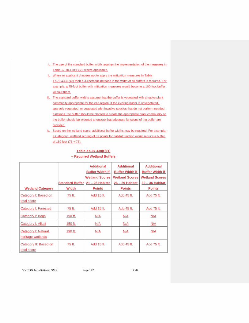
YVCOG Jurisdictional SMP Page 142 Draft
i. The use of the standard buffer width requires the implementation of the measures in
Table 17.70.430(F)(2), where applicable.
ii. When an applicant chooses not to apply the mitigation measures in Table
17.70.430(F)(2) then a 33 percent increase in the width of all buffers is required. For
example, a 75-foot buffer with mitigation measures would become a 100-foot buffer
without them.
iii. The standard buffer widths assume that the buffer is vegetated with a native plant
community appropriate for the eco-region. If the existing buffer is unvegetated,
sparsely vegetated, or vegetated with invasive species that do not perform needed
functions, the buffer should be planted to create the appropriate plant community or
the buffer should be widened to ensure that adequate functions of the buffer are
provided.
iv. Based on the wetland score, additional buffer widths may be required. For example,
a Category I wetland scoring of 32 points for habitat function would require a buffer
of 150 feet (75 + 75).
Table XX.07.430(F)(1)
– Required Wetland Buffers
Wetland Category
Standard Buffer
Width
Additional
Buffer Width if
Wetland Scores
21 – 25 Habitat
Points
Additional
Buffer Width if
Wetland Scores
26 – 29 Habitat
Points
Additional
Buffer Width if
Wetland Scores
30 – 36 Habitat
Points
Category I: Based on
total score
75 ft. Add 15 ft. Add 45 ft. Add 75 ft.
Category I: Forested 75 ft. Add 15 ft. Add 45 ft. Add 75 ft.
Category I: Bogs 190 ft. N/A N/A N/A
Category I: Alkali 150 ft. N/A N/A N/A
Category I: Natural
heritage wetlands
190 ft. N/A N/A N/A
Category II: Based on
total score
75 ft. Add 15 ft. Add 45 ft. Add 75 ft.
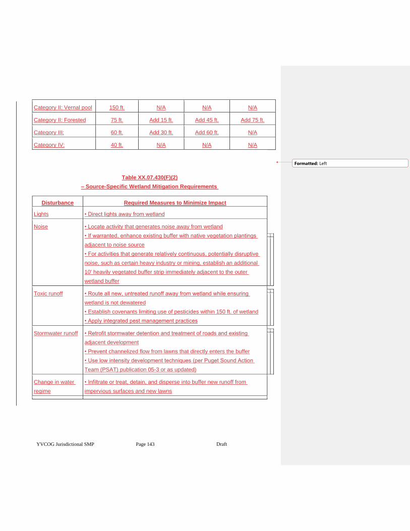
YVCOG Jurisdictional SMP Page 143 Draft
Category II: Vernal pool 150 ft. N/A N/A N/A
Category II: Forested 75 ft. Add 15 ft. Add 45 ft. Add 75 ft.
Category III: 60 ft. Add 30 ft. Add 60 ft. N/A
Category IV: 40 ft. N/A N/A N/A
Table XX.07.430(F)(2)
– Source-Specific Wetland Mitigation Requirements
Disturbance Required Measures to Minimize Impact
Lights • Direct lights away from wetland
Noise • Locate activity that generates noise away from wetland
• If warranted, enhance existing buffer with native vegetation plantings
adjacent to noise source
• For activities that generate relatively continuous, potentially disruptive
noise, such as certain heavy industry or mining, establish an additional
10' heavily vegetated buffer strip immediately adjacent to the outer
wetland buffer
Toxic runoff • Route all new, untreated runoff away from wetland while ensuring
wetland is not dewatered
• Establish covenants limiting use of pesticides within 150 ft. of wetland
• Apply integrated pest management practices
Stormwater runoff • Retrofit stormwater detention and treatment of roads and existing
adjacent development
• Prevent channelized flow from lawns that directly enters the buffer
• Use low intensity development techniques (per Puget Sound Action
Team (PSAT) publication 05-3 or as updated)
Change in water
regime
• Infiltrate or treat, detain, and disperse into buffer new runoff from
impervious surfaces and new lawns
Formatted: Left
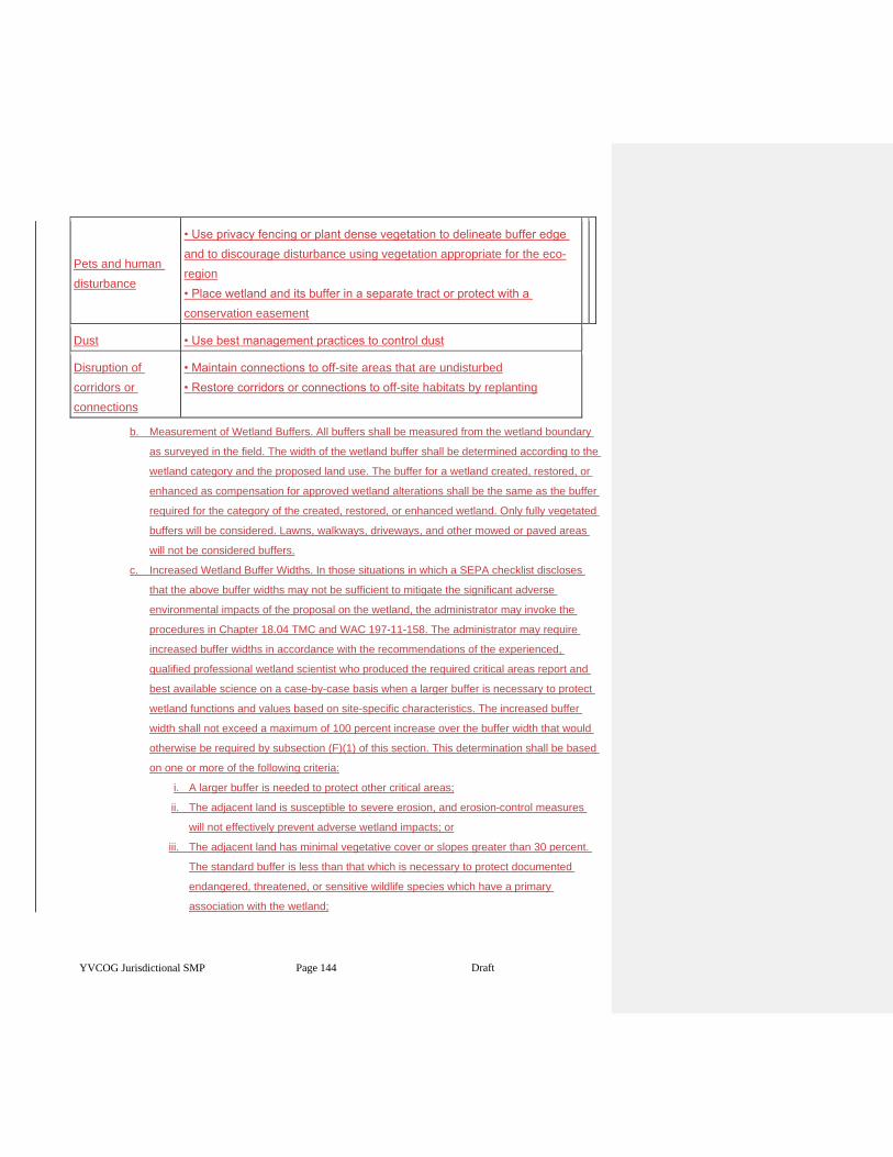
YVCOG Jurisdictional SMP Page 144 Draft
Pets and human
disturbance
• Use privacy fencing or plant dense vegetation to delineate buffer edge
and to discourage disturbance using vegetation appropriate for the eco-
region
• Place wetland and its buffer in a separate tract or protect with a
conservation easement
Dust • Use best management practices to control dust
Disruption of
corridors or
connections
• Maintain connections to off-site areas that are undisturbed
• Restore corridors or connections to off-site habitats by replanting
b. Measurement of Wetland Buffers. All buffers shall be measured from the wetland boundary
as surveyed in the field. The width of the wetland buffer shall be determined according to the
wetland category and the proposed land use. The buffer for a wetland created, restored, or
enhanced as compensation for approved wetland alterations shall be the same as the buffer
required for the category of the created, restored, or enhanced wetland. Only fully vegetated
buffers will be considered. Lawns, walkways, driveways, and other mowed or paved areas
will not be considered buffers.
c. Increased Wetland Buffer Widths. In those situations in which a SEPA checklist discloses
that the above buffer widths may not be sufficient to mitigate the significant adverse
environmental impacts of the proposal on the wetland, the administrator may invoke the
procedures in Chapter 18.04 TMC and WAC 197-11-158. The administrator may require
increased buffer widths in accordance with the recommendations of the experienced,
qualified professional wetland scientist who produced the required critical areas report and
best available science on a case-by-case basis when a larger buffer is necessary to protect
wetland functions and values based on site-specific characteristics. The increased buffer
width shall not exceed a maximum of 100 percent increase over the buffer width that would
otherwise be required by subsection (F)(1) of this section. This determination shall be based
on one or more of the following criteria:
i. A larger buffer is needed to protect other critical areas;
ii. The adjacent land is susceptible to severe erosion, and erosion-control measures
will not effectively prevent adverse wetland impacts; or
iii. The adjacent land has minimal vegetative cover or slopes greater than 30 percent.
The standard buffer is less than that which is necessary to protect documented
endangered, threatened, or sensitive wildlife species which have a primary
association with the wetland;
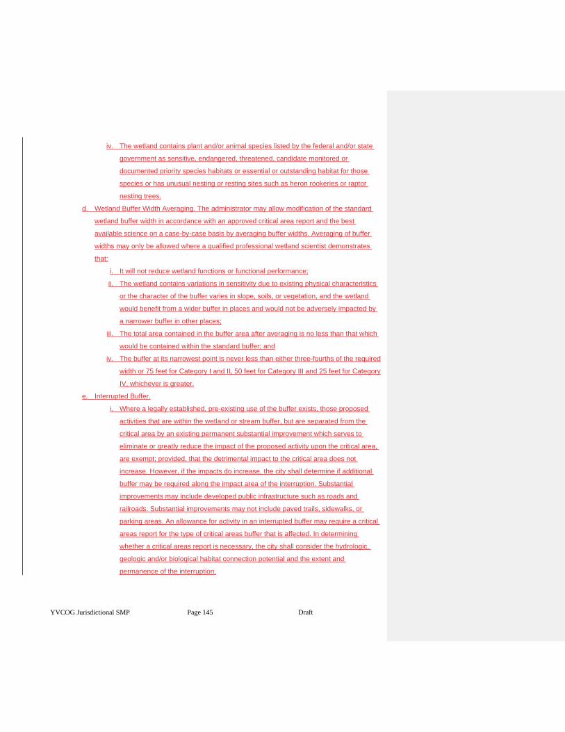
YVCOG Jurisdictional SMP Page 145 Draft
iv. The wetland contains plant and/or animal species listed by the federal and/or state
government as sensitive, endangered, threatened, candidate monitored or
documented priority species habitats or essential or outstanding habitat for those
species or has unusual nesting or resting sites such as heron rookeries or raptor
nesting trees.
d. Wetland Buffer Width Averaging. The administrator may allow modification of the standard
wetland buffer width in accordance with an approved critical area report and the best
available science on a case-by-case basis by averaging buffer widths. Averaging of buffer
widths may only be allowed where a qualified professional wetland scientist demonstrates
that:
i. It will not reduce wetland functions or functional performance;
ii. The wetland contains variations in sensitivity due to existing physical characteristics
or the character of the buffer varies in slope, soils, or vegetation, and the wetland
would benefit from a wider buffer in places and would not be adversely impacted by
a narrower buffer in other places;
iii. The total area contained in the buffer area after averaging is no less than that which
would be contained within the standard buffer; and
iv. The buffer at its narrowest point is never less than either three-fourths of the required
width or 75 feet for Category I and II, 50 feet for Category III and 25 feet for Category
IV, whichever is greater.
e. Interrupted Buffer.
i. Where a legally established, pre-existing use of the buffer exists, those proposed
activities that are within the wetland or stream buffer, but are separated from the
critical area by an existing permanent substantial improvement which serves to
eliminate or greatly reduce the impact of the proposed activity upon the critical area,
are exempt; provided, that the detrimental impact to the critical area does not
increase. However, if the impacts do increase, the city shall determine if additional
buffer may be required along the impact area of the interruption. Substantial
improvements may include developed public infrastructure such as roads and
railroads. Substantial improvements may not include paved trails, sidewalks, or
parking areas. An allowance for activity in an interrupted buffer may require a critical
areas report for the type of critical areas buffer that is affected. In determining
whether a critical areas report is necessary, the city shall consider the hydrologic,
geologic and/or biological habitat connection potential and the extent and
permanence of the interruption.
YVCOG Jurisdictional SMP Page 146 Draft
ii. Where a legally established, pre-existing structure or use is located within a
regulated wetland or stream buffer and where the regulated buffer is fully paved and
does not conform to the interrupted buffer provision above, the buffer will end at the
edge of the pavement, adjacent to the wetland or stream.
f. Buffer Consistency. All mitigation sites shall have buffers consistent with the buffer
requirements of this chapter.
g. Buffer Maintenance. Except as otherwise specified or allowed in accordance with this
chapter, wetland buffers and buffers of mitigation sites shall be retained in an undisturbed
condition, or shall be maintained as enhanced pursuant to any required permit or approval.
Removal of invasive nonnative weeds is required for the duration of the mitigation bond.
h. Buffer Uses. The following uses may be permitted within a wetland buffer in accordance with
the review procedures of this chapter, provided they are not prohibited by any other
applicable law and they are conducted in a manner so as to minimize impacts to the buffer
and adjacent wetland:
i. Conservation and Restoration Activities. Conservation or restoration activities aimed
at protecting the soil, water, vegetation, or wildlife.
ii. Passive Recreation. Passive recreation facilities designed in accordance with an
approved critical area report, including:
1. Walkways and trails; provided, that those pathways which are generally
parallel to the perimeter of the wetland shall be located in the outer 25
percent of the buffer area, and should be designed to avoid the removal of
significant trees. Trails must be constructed with a surface that does not
interfere with the permeability. Raised boardwalks utilizing nontreated pilings
may be acceptable;
2. Wildlife viewing structures; and
3. Fishing access areas down to the water’s edge that shall be no larger than
six feet.
iii. Stormwater Management Facilities. Stormwater management facilities, limited to
stormwater dispersion outfalls and bioswales, may be allowed within the outer 25
percent of the buffer of Category III or IV wetlands only; provided, that:
1. No other location is feasible; and
2. The location of such facilities will not degrade the functions or values of the
wetland. Stormwater management facilities are not allowed in buffers of
Category I or II wetlands.
i. Signs and Fencing of Wetlands.
YVCOG Jurisdictional SMP Page 147 Draft
i. Temporary Markers. The outer perimeter of the wetland and buffer and the limits of
those areas to be disturbed pursuant to an approved permit or authorization shall be
marked in the field in such a way as to ensure that no unauthorized intrusion will
occur and is subject to inspection by the administrator prior to the commencement of
permitted activities. The administrator shall have the authority to require that
temporary fencing be placed on site to mark the outer perimeter of the wetland and
its associated buffer area. This temporary marking, and any required temporary
fencing, shall be maintained throughout construction and shall not be removed until
permanent signs, if required, are in place.
j. Permanent Signs. As a condition of any permit or authorization issued pursuant to this
chapter, the administrator may require the applicant to install permanent signs along the
boundary of a wetland or buffer.
i. Permanent signs shall be made of a metal face with a green color background and
white letters; attached to a metal post, or another nontreated material of equal
durability; made with a sign face no smaller than one foot by one foot square and no
larger than two feet by two feet square; and mounted with the bottom of the sign face
no less than three feet above and no more than five feet above adjacent grade.
Signs must be posted at a minimum of one per lot of record, or on large parcels
every 300 feet, or additional signs as required by the administrator and must remain
unobstructed and be maintained by the property owner in perpetuity. The sign(s)
shall be worded as follows or with alternative language approved by the
administrator:
Protected Critical Area
Do Not Disturb
Contact the City of Toppenish
Regarding Uses and Restrictions
ii. The provisions of subsection (G)(2)(a) of this section may be modified by the
administrator as necessary to assure protection of sensitive features or wildlife.
XX.07.440 Performance standards — Compensatory mitigation requirements.
Compensatory mitigation for alterations to wetlands shall achieve equivalent or greater biologic functions.
Compensatory mitigation plans shall be consistent with the state Department of Ecology Guidelines for
Wetland Mitigation in Washington State, Parts 1 and 2, Publication Nos. 06-06-011a and 06-06-011b, March
2006.
1. Mitigation shall be required in the following order of preference:
YVCOG Jurisdictional SMP Page 148 Draft
a. Avoiding the impact altogether by not taking a certain action or parts of an action.
b. Minimizing impacts by limiting the degree or magnitude of the action and its implementation,
by using appropriate technology, or by taking affirmative steps to avoid or reduce impacts.
c. Rectifying the impact by repairing, rehabilitating, or restoring the affected environment.
d. Reducing or eliminating the impact over time by preservation and maintenance operations.
e. Compensating for the impact by replacing, enhancing, or providing substitute resources or
environments.
2. Mitigation for Affected Functions or Functions Lost as a Result of the Proposed Activity.
Compensatory mitigation actions shall address functions affected by the alteration to achieve
functional equivalency or improvement and shall provide similar wetland functions as those lost by
the proposed activity, except when:
a. The lost wetland provides minimal functions as determined by a site-specific function
assessment, and the proposed compensatory mitigation action(s) will provide equal or
greater functions or will provide functions shown to be limiting within a watershed through a
formal Washington State watershed assessment plan or protocol; or
b. Out-of-kind replacement will best meet formally identified watershed goals, such as
replacement of historically diminished wetland types.
3. Preference of Mitigation Actions. Mitigation actions that require compensation by replacing,
enhancing, or substitution shall occur in the following order of preference:
1. Restoring wetlands on upland sites that were formerly wetlands.
2. Creating wetlands on disturbed upland sites such as those with vegetative
cover consisting primarily of nonnative introduced species. This should only
be attempted when there is a consistent source of hydrology and it can be
shown that the surface and subsurface hydrologic regime is conducive for
the wetland community that is being designed.
4. Enhancing significantly degraded wetlands in combination with restoration or creation. Such
enhancement should be part of a mitigation package that includes replacing the impacted area
meeting appropriate ratio requirements.
5. Type and Location of Mitigation. Unless it is demonstrated that a higher level of ecological
functioning would result from an alternate approach, compensatory mitigation for ecological functions
shall be either in kind and on site, or in kind and within the same stream reach, subbasin, or drift cell.
Mitigation actions shall be conducted within the same subdrainage basin and on the same site as the
alteration except when all of the following apply:
a. There are no reasonable on-site or in-subdrainage basin opportunities or on-site and in-
subdrainage basin opportunities do not have a high likelihood of success, after a
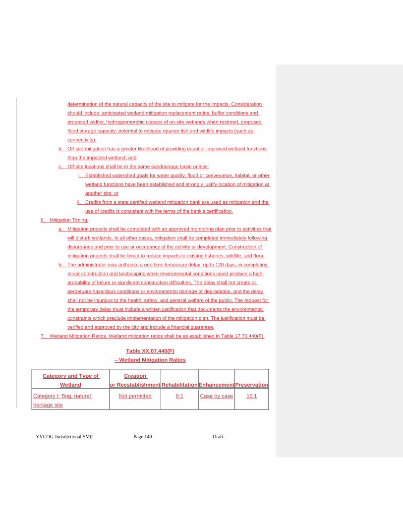
YVCOG Jurisdictional SMP Page 149 Draft
determination of the natural capacity of the site to mitigate for the impacts. Consideration
should include: anticipated wetland mitigation replacement ratios, buffer conditions and
proposed widths, hydrogeomorphic classes of on-site wetlands when restored, proposed
flood storage capacity, potential to mitigate riparian fish and wildlife impacts (such as
connectivity);
b. Off-site mitigation has a greater likelihood of providing equal or improved wetland functions
than the impacted wetland; and
c. Off-site locations shall be in the same subdrainage basin unless:
i. Established watershed goals for water quality, flood or conveyance, habitat, or other
wetland functions have been established and strongly justify location of mitigation at
another site; or
ii. Credits from a state certified wetland mitigation bank are used as mitigation and the
use of credits is consistent with the terms of the bank’s certification.
6. Mitigation Timing.
a. Mitigation projects shall be completed with an approved monitoring plan prior to activities that
will disturb wetlands. In all other cases, mitigation shall be completed immediately following
disturbance and prior to use or occupancy of the activity or development. Construction of
mitigation projects shall be timed to reduce impacts to existing fisheries, wildlife, and flora.
b. The administrator may authorize a one-time temporary delay, up to 120 days, in completing
minor construction and landscaping when environmental conditions could produce a high
probability of failure or significant construction difficulties. The delay shall not create or
perpetuate hazardous conditions or environmental damage or degradation, and the delay
shall not be injurious to the health, safety, and general welfare of the public. The request for
the temporary delay must include a written justification that documents the environmental
constraints which preclude implementation of the mitigation plan. The justification must be
verified and approved by the city and include a financial guarantee.
7. Wetland Mitigation Ratios. Wetland mitigation ratios shall be as established in Table 17.70.440(F).
Table XX.07.440(F)
– Wetland Mitigation Ratios
Category and Type of
Wetland
Creation
or Reestablishment Rehabilitation Enhancement Preservation
Category I: Bog, natural
heritage site
Not permitted 6:1 Case by case 10:1
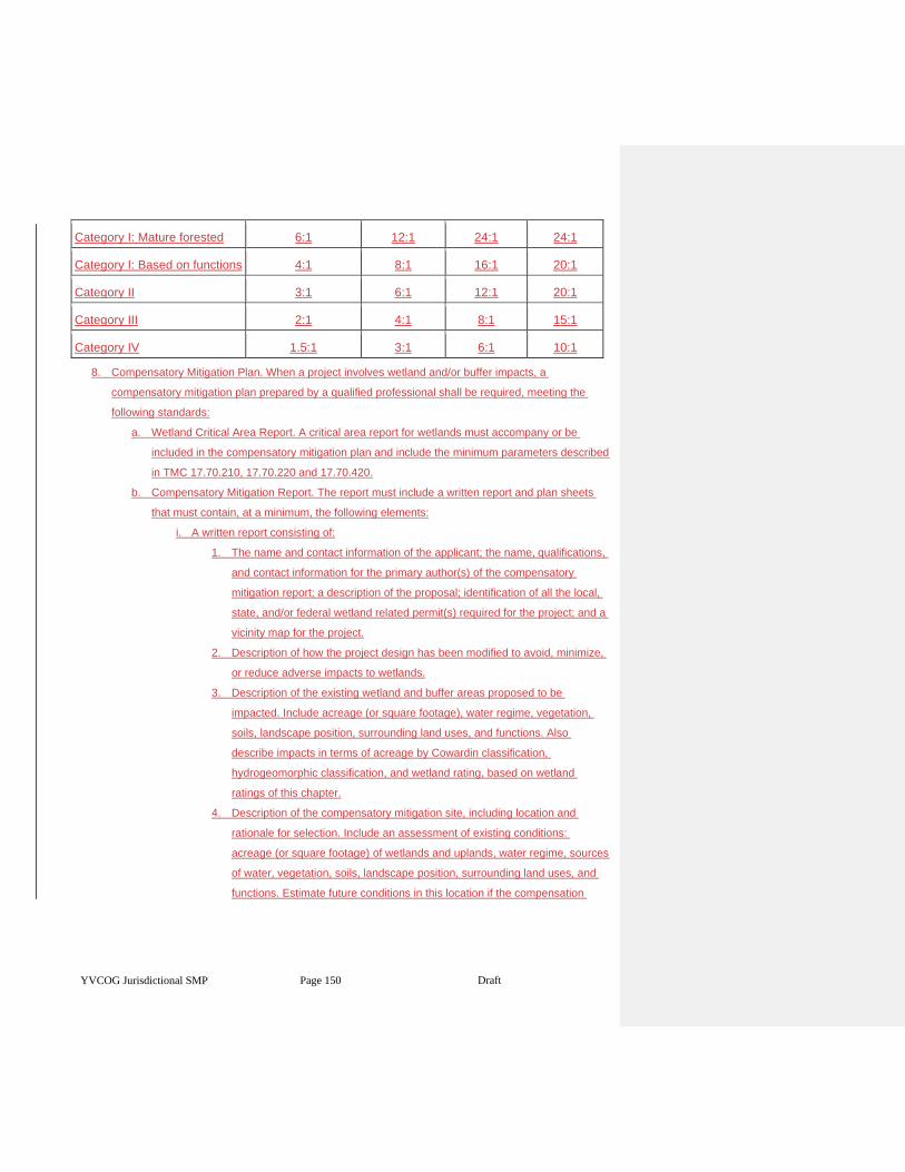
YVCOG Jurisdictional SMP Page 150 Draft
Category I: Mature forested 6:1 12:1 24:1 24:1
Category I: Based on functions 4:1 8:1 16:1 20:1
Category II 3:1 6:1 12:1 20:1
Category III 2:1 4:1 8:1 15:1
Category IV 1.5:1 3:1 6:1 10:1
8. Compensatory Mitigation Plan. When a project involves wetland and/or buffer impacts, a
compensatory mitigation plan prepared by a qualified professional shall be required, meeting the
following standards:
a. Wetland Critical Area Report. A critical area report for wetlands must accompany or be
included in the compensatory mitigation plan and include the minimum parameters described
in TMC 17.70.210, 17.70.220 and 17.70.420.
b. Compensatory Mitigation Report. The report must include a written report and plan sheets
that must contain, at a minimum, the following elements:
i. A written report consisting of:
1. The name and contact information of the applicant; the name, qualifications,
and contact information for the primary author(s) of the compensatory
mitigation report; a description of the proposal; identification of all the local,
state, and/or federal wetland related permit(s) required for the project; and a
vicinity map for the project.
2. Description of how the project design has been modified to avoid, minimize,
or reduce adverse impacts to wetlands.
3. Description of the existing wetland and buffer areas proposed to be
impacted. Include acreage (or square footage), water regime, vegetation,
soils, landscape position, surrounding land uses, and functions. Also
describe impacts in terms of acreage by Cowardin classification,
hydrogeomorphic classification, and wetland rating, based on wetland
ratings of this chapter.
4. Description of the compensatory mitigation site, including location and
rationale for selection. Include an assessment of existing conditions:
acreage (or square footage) of wetlands and uplands, water regime, sources
of water, vegetation, soils, landscape position, surrounding land uses, and
functions. Estimate future conditions in this location if the compensation
YVCOG Jurisdictional SMP Page 151 Draft
actions are not undertaken (i.e., how would the site progress through natural
succession?).
5. A description of the proposed mitigation construction activities and timing of
activities.
6. A description of the proposed actions for compensation of wetland and
upland areas affected by the project. Include overall wetland and upland
areas affected by the project. Include overall goals of the proposed
mitigation, including a description of the targeted functions,
hydrogeomorphic classification, and categories of wetlands.
7. A discussion of ongoing management practices that will protect wetlands
after the project site has been developed, including proposed monitoring and
maintenance programs for remaining wetlands and compensatory mitigation
wetlands.
8. A bond estimate for the entire compensatory mitigation project, including the
following elements: site preparation, plant materials, construction materials,
installation oversight, maintenance twice per year for up to five years, annual
monitoring field work and reporting, and contingency actions for a maximum
of the total required number of years for monitoring.
9. Proof of establishment of notice on title for the wetlands and buffers on the
project site, including the compensatory mitigation areas.
ii. Scaled plan sheets for the compensatory mitigation depicting:
1. Surveyed edges of the existing wetland and buffers, proposed areas of
wetland and/or buffer impacts, location of proposed wetland and/or buffer
compensation actions.
2. Existing topography, ground-proofed, at two-foot contour intervals in the
zone of the proposed compensation actions if any grading activity is
proposed to create the compensation area(s). Also existing cross-sections of
the on-site wetland areas that are proposed to be impacted, and cross-
section(s) (estimated one-foot intervals) for the proposed areas of wetland or
buffer compensation.
3. Surface and subsurface hydrologic conditions including an analysis of
existing and proposed hydrologic regimes for enhanced, created, or restored
compensatory mitigation areas. Also, illustrations of how data for existing
hydrologic conditions were used to determine the estimates of future
hydrologic conditions.
YVCOG Jurisdictional SMP Page 152 Draft
4. Conditions expected from the proposed actions on site including future
hydrogeomorphic types, vegetation community types by dominant species
(wetland and upland), and future water regimes.
5. Required wetland buffers for existing wetlands and proposed compensation
areas. Also, identify any zones where buffers are proposed to be reduced or
enlarged outside of the standards identified in this chapter.
6. A plant schedule for the compensation area including all species by
proposed community type and water regime, size and type of plant material
to be installed, spacing of plants, typical clustering patterns, total number of
species by community type, and the timing of installation.
7. Performance standards (measurable standards reflective of years post-
installation) for upland and wetland communities, monitoring schedule, and
maintenance schedule and actions by each biennium.
9. Wetland Mitigation Banks.
a. Credits from a wetland mitigation bank may be approved for use as compensation for
unavoidable impacts to wetlands when:
i. The bank is certified under Chapter 173-700 WAC;
ii. The administrator determines that the wetland mitigation bank provides appropriate
compensation for the authorized impacts; and
iii. The proposed use of credits is consistent with the terms and conditions of the bank’s
certification
b. Replacement ratios for projects using bank credits shall be consistent with replacement
ratios specified in the bank’s certification.
c. Credits from a certified wetland mitigation bank may be used to compensate for impacts
located within the service area specified in the bank’s certification. In some cases, bank
service areas may include portions of more than one adjacent drainage basin for specific
wetland functions.
Article IV. Frequently Flooded Areas
XX.07.500 Designation and mapping of frequently flooded areas.
All areas within the city meeting the frequently flooded designation criteria are hereby designated critical
areas and are subject to the provisions of this chapter. Frequently flooded areas have been accurately
delineated based on hydrologic and hydraulic studies completed as part of the National Flood Insurance
Program by the Federal Emergency Management Agency in the Flood Insurance Study for Yakima County,
YVCOG Jurisdictional SMP Page 153 Draft
Washington, and incorporated areas dated November 18, 2009, and any subsequent amendment. The
methodology and detail of these studies is accepted as the best available science.
XX.07.510 Classification of frequently flooded areas.
1. The flood areas in the city are classified as either one of two types:
a. Floodway. “Floodways” are defined as the channel of a stream and adjacent land areas
which are required to carry and discharge the flood water or flood flows of any river or stream
associated with a regulatory flood.
b. Flood Fringe. The “flood fringe” is defined as that land area which is outside a stream’s
floodway, but is subject to periodic inundation due to flooding, associated with a regulatory
flood.
XX.70.520 Existing regulations pertaining to frequently flooded areas.
Chapter 15.30 TMC regulates proposed activities within frequently flooded areas. If allowed, any structures
permitted in the designated flood areas are subject to flood-proofing regulations of this chapter. The existing
regulations were adopted after careful study and fulfill the requirements of the Growth Management Act for
protection of frequently flooded areas.
Article V. Fish and Wildlife Habitat Conservation Areas
XX.07.640 Designation of fish and wildlife habitat conservation areas.
1. Fish and wildlife habitat conservation areas include:
a. Areas with which state or federally designated endangered, threatened, and sensitive
species have a primary association.
i. Federally designated endangered and threatened species are those fish and wildlife
species identified by the U.S. Fish and Wildlife Service and the National Marine
Fisheries Service that are in danger of extinction or threatened to become
endangered. The U.S. Fish and Wildlife Service and the National Marine Fisheries
Service should be consulted for current listing status.
ii. State designated endangered, threatened, and sensitive species are those fish and
wildlife species native to the state of Washington and identified by the Washington
Department of Fish and Wildlife which are in danger of extinction, threatened to
become endangered, vulnerable, or declining and are likely to become endangered
or threatened in a significant portion of their range within the state without
cooperative management or removal of threats. State designated endangered,
threatened, and sensitive species are periodically recorded in WAC 232-12-
014 (state endangered species) and WAC 232-12-011 (state threatened and
YVCOG Jurisdictional SMP Page 154 Draft
sensitive species). The state Department of Fish and Wildlife maintains the most
current listing and should be consulted for current listing status.
b. Waters of the State. Waters of the state include lakes, rivers, ponds, streams, inland waters,
underground waters, salt waters, and all other surface waters and watercourses within the
jurisdiction of the state of Washington, as classified in WAC 222-16-031 (or WAC 222-16-
030 depending on classification used).
c. Lakes, ponds, streams, and rivers planted with game fish by a governmental or tribal entity.
2. Appendix “A” of chapter 17.70 identifies stream corridors subject to protection; however, all areas
within the city meeting one or more of these criteria, regardless of any formal identification, are
hereby designated critical areas and are subject to the provisions of this chapter and shall be
managed consistent with the best available science.
3. Mapping. The approximate location and extent of habitat conservation areas are shown on the critical
area maps adopted with the ordinance codified in this chapter by the city, as most recently updated.
The following maps and data are hereby adopted and are available from the city and/or the listed
governmental agency:
a. Washington Department of Fish and Wildlife Priority Habitat and Species Maps;
b. Washington State Department of Natural Resources, Official Water Type Reference Maps,
as amended; and
c. Anadromous and resident salmonid distribution maps contained in the Habitat Limiting
Factors Reports published by the Washington Conservation Commission.
The above maps are to be used as a guide for the city, project applicants, and/or property owners
and should be continuously updated as new critical areas are identified. The above maps are a
reference and do not provide a final critical area designation.
XX.07.650 Critical area report – Requirements for habitat conservation areas.
1. All critical areas located within or near the project area that have been designated by the city and are
shown on city, state, or federal government agency maps and/or reports shall be addressed in a
critical area report for habitat conservation areas.
2. Habitat Analysis. A habitat assessment to include at a minimum the following:
a. Detailed description of vegetation on the project area and its associated buffer.
b. Identification of any endangered, threatened, or candidate species that have a primary
association with habitat on the project area, and assessment of potential project impacts to
use of the buffer and critical area on the site by the species.
c. A detailed discussion of the direct and indirect potential impacts on habitat by the project.
Such discussion shall include a discussion of the ongoing management practices that will
protect habitat after the project site has been developed.
YVCOG Jurisdictional SMP Page 155 Draft
XX.07.660 Performance standards – General requirements.
1. Nonindigenous Species. No plant, wildlife, or fish species not indigenous to the region shall be
introduced into a habitat conservation area unless authorized by a state or federal permit or approval.
2. Mitigation and Contiguous Corridors. Mitigation sites shall be located to preserve or achieve
contiguous wildlife habitat corridors in accordance with a mitigation plan that is part of an approved
critical area report to minimize the isolating effects of development on habitat areas, so long as
mitigation of aquatic habitat is located within the same aquatic ecosystem as the area disturbed.
3. Approvals of Activities. The administrator shall condition approvals of activities allowed within or
adjacent to a habitat conservation area or its buffers as necessary to minimize or mitigate any
potential adverse impacts. Conditions shall be based on the best available science and may include,
but are not limited to, the following:
a. Establishment of buffer zones;
b. Preservation of critically important vegetation and/or habitat features such as snags and
downed wood;
c. Limitation of access to the habitat area, including fencing to deter unauthorized access;
d. Seasonal restriction of construction activities;
e. Establishment of a duration and timetable for periodic review of mitigation activities; and
f. Requirement of a performance bond, when necessary, to ensure completion and success of
proposed mitigation.
4. Mitigation to Equivalent Biological Functions. Mitigation of alterations to habitat conservation areas
shall achieve at least equivalent biologic and hydrologic functions and shall include mitigation for
adverse impacts upstream or downstream of the development proposal site. Mitigation shall address
each function affected by the alteration to achieve functional equivalency or improvement on a per
function basis.
5. Approvals and the Best Available Science. Any approval of alterations or impacts to a habitat
conservation area shall be supported by the best available science.
6. Buffers.
a. Establishment of Buffers. The administrator shall require the establishment of buffer areas
for activities adjacent to habitat conservation areas when needed to protect habitat
conservation areas. Buffers shall consist of an undisturbed area of native vegetation or areas
identified for restoration established to protect the integrity, functions, and values of the
affected habitat. Required buffer widths shall be designed to address the sensitivity of the
habitat and the type and intensity of human activity proposed to be conducted nearby and
shall consider the management recommendations issued by the Washington Department of
YVCOG Jurisdictional SMP Page 156 Draft
Fish and Wildlife. Habitat conservation areas and their buffers shall be preserved in
perpetuity through the use of critical area tracts in accordance with TMC 17.70.380.
b. Seasonal Restrictions. When a species is more susceptible to adverse impacts during
specific periods of the year, seasonal restrictions may apply.
7. Signs and Fencing of Habitat Conservation Areas.
a. Temporary Markers. The outer perimeter of the habitat conservation area or buffer and the
limits of those areas to be disturbed pursuant to an approved permit or authorization shall be
marked in the field in such a way as to ensure that no unauthorized intrusion will occur and
verified by the administrator prior to the commencement of permitted activities. The
administrator shall have the authority to require that temporary fencing be placed on site to
mark the outer perimeter of the habitat conservation area and its associated buffer area. This
temporary marking, and any required temporary fencing, shall be maintained throughout
construction and shall not be removed until permanent signs, if required, are in place.
b. Permanent Signs. As a condition of any permit or authorization issued pursuant to this
chapter, the administrator may require the applicant to install permanent signs along the
boundary of a habitat conservation area or buffer.
i. Permanent signs shall be made of a metal face with a green color background and
white letters; attached to a metal post or another nontreated material of equal
durability; made with a sign face no smaller than one foot by one foot and no larger
than two feet by two feet; and mounted with the bottom of the sign face no less than
three feet above and no more than five feet above adjacent grade. Signs must be
posted at a minimum of one per lot of record, or on large parcels every 300 feet, or
additional signs as required by the administrator and must remain unobstructed and
be maintained by the property owner in perpetuity. The sign(s) shall be worded as
follows or with alternative language approved by the administrator:
Protected Critical Area
Do Not Disturb
Contact the City of Toppenish
Regarding Uses and Restrictions
XX.07.670 Performance standards – Specific habitats.
1. Endangered, Threatened, and Sensitive Species.
a. No development shall be allowed within a habitat conservation area or buffer with which
state or federally endangered, threatened, or sensitive species have a primary association,
except that which is provided for by a management plan established by the Washington
YVCOG Jurisdictional SMP Page 157 Draft
Department of Fish and Wildlife, the Yakama Nation and other applicable state or federal
agencies.
2. Anadromous Fish.
i. All activities, uses, and alterations proposed to be located in water bodies used by
anadromous fish or where such fish have a primary association shall give special
consideration to the preservation of anadromous fish habitat, including, but not
limited to, adhering to the following standards:
ii. Activities shall be timed to occur only during the allowable work window as
designated by the Washington Department of Fish and Wildlife and Yakama Nation
for the applicable species;
iii. An alternative alignment or location for the activity is not feasible;
iv. The activity is designed so that it will not degrade the functions or values of the fish
habitat or other critical areas;
v. Shoreline erosion control measures shall be designed to use bioengineering
methods or soft armoring techniques, according to an approved critical area report;
and
vi. Any impacts to the functions or values of the habitat conservation area are mitigated
in accordance with an approved critical area report.
b. Structures that prevent the migration of salmonids shall not be allowed in the portion of water
bodies currently or historically used by anadromous fish. Fish bypass facilities shall be
provided that allow the upstream migration of adult fish and shall prevent fry and juveniles
migrating downstream from being trapped or harmed.
3. Wetland Habitats. All proposed activities within or adjacent to habitat conservation areas containing
wetlands shall conform to the wetland development performance standards set forth in
TMC 17.70.440, wetlands. If nonwetlands habitat and wetlands are present at the same location, the
provisions of this article or Article III of this chapter, Wetlands, whichever provides greater protection
to the habitat, apply.
4. Riparian Habitat Areas. Unless otherwise allowed in this chapter, all structures and activities shall be
located outside of the stream buffers.
a. Establishment of Stream Buffer Areas. Stream buffers shall be established for habitats that
include aquatic and terrestrial ecosystems that mutually benefit each other and that are
located adjacent to rivers, perennial or intermittent streams, seeps, and springs.
b. Stream Buffer Widths. Required stream buffer widths shown in Table 17.70.670(D)(1) have
been established in accordance with the best available science. Buffers are subject to the
following:
YVCOG Jurisdictional SMP Page 158 Draft
i. Widths shall be measured outward in each direction, on the horizontal plane from the
channel migration zone if delineated, the ordinary high water mark, or from the top of
bank if the ordinary high water mark cannot be identified.
ii. Stream buffers must be sufficiently wide to achieve the full range of riparian and
aquatic ecosystem functions, which include but are not limited to protection of in-
stream fish habitat through control of temperature and sedimentation in streams;
preservation of fish and wildlife habitat; and connection of riparian wildlife habitat to
other habitats.
iii. The buffer width may be reduced or averaged by the administrator upon
recommendation of the wetland report and consultation with affected agencies and
tribes.
iv. Increased Stream Buffer Widths. In those situations in which a SEPA checklist
discloses that the buffer widths as established in Table 17.70.670(D)(1) may not be
sufficient to mitigate the significant adverse environmental impacts of the proposal,
the administrator may invoke the procedures in Chapter 18.04 TMC and WAC 197-
11-158. The administrator may require increased buffer widths in accordance with
the recommendations of the experienced, qualified professional wetland scientist
who produced the required critical areas report and best available science on a
case-by-case basis when a larger buffer is necessary to protect stream functions and
values based on site-specific characteristics. The increased buffer width shall not
exceed a maximum of 100 percent increase over the buffer width that would
otherwise be required by subsection (D)(2) of this section. This determination shall
be based on one or more of the following criteria:
1. A larger buffer is needed to protect other critical areas;
2. The adjacent land is susceptible to severe erosion, and erosion-control
measures will not effectively prevent adverse stream impacts; or
3. The adjacent land has minimal vegetative cover or slopes greater than 30
percent. The standard buffer is less than that which is necessary to protect
documented endangered, threatened, or sensitive wildlife species which
have a primary association with the stream or its buffer;
4. The stream or its buffer contains plant and/or animal species listed by the
federal and/or state government as sensitive, endangered, threatened,
candidate monitored or documented priority species habitats or essential or
outstanding habitat for those species or has unusual nesting or resting sites
such as heron rookeries or raptor nesting trees.
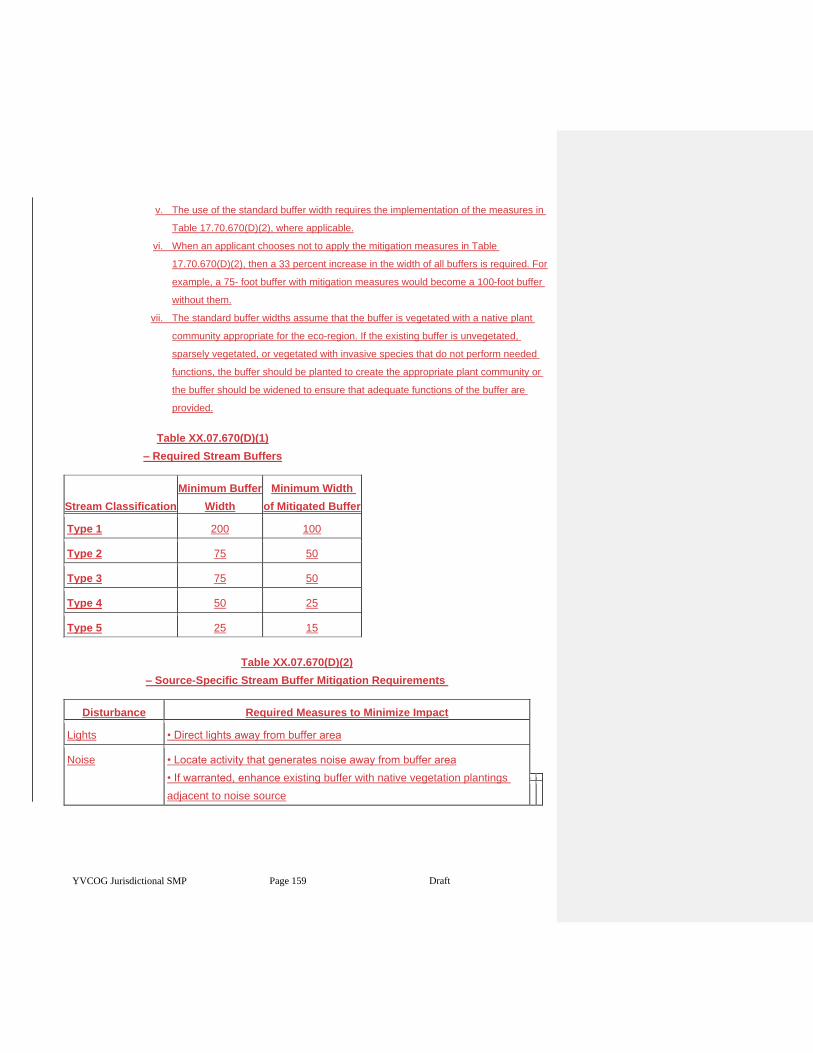
YVCOG Jurisdictional SMP Page 159 Draft
v. The use of the standard buffer width requires the implementation of the measures in
Table 17.70.670(D)(2), where applicable.
vi. When an applicant chooses not to apply the mitigation measures in Table
17.70.670(D)(2), then a 33 percent increase in the width of all buffers is required. For
example, a 75- foot buffer with mitigation measures would become a 100-foot buffer
without them.
vii. The standard buffer widths assume that the buffer is vegetated with a native plant
community appropriate for the eco-region. If the existing buffer is unvegetated,
sparsely vegetated, or vegetated with invasive species that do not perform needed
functions, the buffer should be planted to create the appropriate plant community or
the buffer should be widened to ensure that adequate functions of the buffer are
provided.
Table XX.07.670(D)(1)
– Required Stream Buffers
Stream Classification
Minimum Buffer
Width
Minimum Width
of Mitigated Buffer
Type 1 200 100
Type 2 75 50
Type 3 75 50
Type 4 50 25
Type 5 25 15
Table XX.07.670(D)(2)
– Source-Specific Stream Buffer Mitigation Requirements
Disturbance Required Measures to Minimize Impact
Lights • Direct lights away from buffer area
Noise • Locate activity that generates noise away from buffer area
• If warranted, enhance existing buffer with native vegetation plantings
adjacent to noise source
YVCOG Jurisdictional SMP Page 160 Draft
• For activities that generate relatively continuous, potentially disruptive
noise, such as certain heavy industry or mining, establish an additional
10' heavily vegetated buffer strip immediately adjacent to the outer edge
of the buffer
Toxic runoff • Route all new, untreated runoff away from the buffer while ensuring the
buffer area is not dewatered
• Establish covenants limiting use of pesticides within 150 ft. of the
ordinary high water mark of the stream
• Apply integrated pest management practices
Stormwater runoff • Retrofit stormwater detention and treatment of roads and existing
adjacent development
• Prevent channelized flow from lawns that directly enters the buffer
• Use low intensity development techniques (per Puget Sound Action
Team (PSAT) publication 05-3 or as updated)
Change in water
regime
• Infiltrate or treat, detain, and disperse into buffer new runoff from
impervious surfaces and new lawns
Pets and human
disturbance
• Use privacy fencing or plant dense vegetation to delineate buffer edge
and to discourage disturbance using vegetation appropriate for the eco-
region
• Place buffer in a separate tract or protect with a conservation easement
Dust • Use best management practices to control dust
Disruption of
corridors or
connections
• Maintain connections to off-site areas that are undisturbed
• Restore corridors or connections to off-site habitats by replanting
c. Buffer Maintenance. Except as otherwise specified or allowed in accordance with this
chapter, stream buffers shall be retained in an undisturbed condition, or shall be maintained
as enhanced pursuant to any required permit or approval. Removal of invasive nonnative
weeds is required for the duration of the mitigation bond.
d. Stream Buffer Width Averaging. The administrator may allow the recommended stream
buffer width to be reduced in accordance with a critical area report only if:
i. The width reduction will not reduce stream or habitat functions, including those of
non-fish habitat;
YVCOG Jurisdictional SMP Page 161 Draft
ii. The width reduction will not degrade the habitat, including habitat for anadromous
fish;
iii. The proposal will provide additional habitat protection;
iv. The total area contained in the riparian habitat area of each stream on the
development proposal site is not decreased;
v. The recommended stream buffer width is not reduced by more than 25 percent in
any one location;
vi. The width reduction will not be located within another critical area or associated
buffer; and
vii. The reduced stream buffer width is supported by the best available science.
e. Interrupted Buffer.
viii. Where a legally established, pre-existing use of the buffer exists, those proposed
activities that are within the wetland or stream buffer, but are separated from the
critical area by an existing permanent substantial improvement which serves to
eliminate or greatly reduce the impact of the proposed activity upon the critical area,
are exempt; provided, that the detrimental impact to the critical area does not
increase. However, if the impacts do increase, the city shall determine if additional
buffer may be required along the impact area of the interruption. Substantial
improvements may include developed public infrastructure such as roads and
railroads. Substantial improvements may not include paved trails, sidewalks, or
parking areas. An allowance for activity in an interrupted buffer may require a critical
areas report for the type of critical areas buffer that is affected. In determining
whether a critical areas report is necessary, the city shall consider the hydrologic,
geologic and/or biological habitat connection potential and the extent and
permanence of the interruption.
ix. Where a legally established, pre-existing structure or use is located within a
regulated wetland or stream buffer and where the regulated buffer is fully paved and
does not conform to the interrupted buffer provision above, the buffer will end at the
edge of the pavement, adjacent to the wetland or stream.
f. Riparian Habitat Mitigation. Mitigation of adverse impacts to stream buffers shall result in
equivalent functions and values on a per function basis, be located as near the alteration as
feasible, and be located in the same subdrainage basin as the habitat impacted.
g. Alternative Mitigation for Stream Buffers. The performance standards set forth in this
subsection may be modified at the city’s discretion if the applicant demonstrates that greater
YVCOG Jurisdictional SMP Page 162 Draft
habitat functions, on a per function basis, can be obtained in the affected subdrainage basin
as a result of alternative mitigation measures.
5. Aquatic Habitat. The following specific activities may be permitted within a stream buffer, pond, lake,
water of the state, and associated buffer when the activity complies with the provisions set forth in
the applicable shoreline management program and subject to the standards of this subsection. The
standards that provide the most protection to protected habitat and species shall apply
a. Stream Bank Stabilization. Stream bank stabilization to protect new structures from future
channel migration is not permitted except when such stabilization is achieved through
bioengineering or soft armoring techniques in accordance with an approved critical area
report.
b. Roads, Trails, Bridges, and Rights-of-Way. Construction of trails, roadways, and minor road
bridging, less than or equal to 30 feet wide, may be permitted in accordance with an
approved critical area report subject to the following standards:
i. There is no other feasible alternative route with less impact on the environment;
ii. The crossing minimizes interruption of downstream movement of wood and gravel;
iii. Roads in stream buffers shall not run parallel to the water body;
iv. Trails shall be located on the outer edge of the buffer, except for limited viewing
platforms, crossings and limited trails;
v. Crossings, where necessary, shall only occur as near to perpendicular with the water
body as possible;
vi. Mitigation for impacts is provided pursuant to a mitigation plan of an approved critical
area report;
vii. Road bridges are designed according to the Washington Department of Fish and
Wildlife Fish Passage Design at Road Culverts, 1999, and the National Marine
Fisheries Service Guidelines for Salmonid Passage at Stream Crossings, 2000; and
viii. Trails and associated viewing platforms shall not be made of continuous impervious
materials.
c. Utility Facilities. New utility lines and facilities may be permitted to cross watercourses in
accordance with an approved critical area report, if they comply with the following standards:
i. Fish and wildlife habitat areas shall be avoided to the maximum extent possible;
ii. Installation shall be accomplished by boring beneath the scour depth and hyporheic
zone of the water body and channel migration zone, where feasible;
iii. The utilities shall cross at an angle greater than 60 degrees to the centerline of the
channel in streams or perpendicular to the channel centerline whenever boring under
the channel is not feasible;
YVCOG Jurisdictional SMP Page 163 Draft
iv. Crossings shall be contained within the footprint of an existing road or utility crossing
where possible;
v. The utility route shall avoid paralleling the stream or following a down-valley course
near the channel; and
vi. The utility installation shall not increase or decrease the natural rate of shore
migration or channel migration.
d. Public Flood Protection Measures. New public flood protection measures and expansion of
existing ones may be permitted, subject to the city’s review and approval of a critical area
report and the approval of a federal biological assessment by the federal agency responsible
for reviewing actions related to a federally listed species.
e. In-Stream Structures. In-stream structures, such as, but not limited to, high flow bypasses,
sediment ponds, in-stream ponds, retention and detention facilities, dams, and weirs, shall
be allowed only as part of an approved watershed basin restoration project approved by the
agency with jurisdiction and upon acquisition of any required state or federal permits. The
structure shall be designed to avoid modifying flows and water quality in ways that may
adversely affect habitat conservation areas.
f. Stormwater Conveyance Facilities. Conveyance structures may be permitted in accordance
with an approved critical area report subject to the following standards:
i. No other feasible alternatives with less impact exist;
ii. Mitigation for impacts is provided;
iii. Stormwater conveyance facilities shall incorporate fish habitat features; and
iv. Vegetation shall be maintained and, if necessary, added adjacent to all open
channels and ponds in order to retard erosion, filter out sediments, and shade the
water.
Article VI. Critical Aquifer Recharge Areas
XX.07.700 Designation of critical aquifer recharge areas.
1. The Growth Management Act (Chapter 36.70A RCW) requires local jurisdictions to protect areas with
a critical recharging effect on aquifers used for potable water or areas where drinking aquifers are
vulnerable to contamination. These areas are referred to as critical aquifer recharge areas (CARAs)
in this section. Potable water is an essential life sustaining element. The city of Toppenish sources its
municipal water exclusively from ground water supplies. Once ground water is contaminated it can
be difficult and costly to clean. The quality of ground water in an aquifer is inextricably linked to its
recharge area.
YVCOG Jurisdictional SMP Page 164 Draft
2. Critical aquifer recharge areas (CARAs) are those areas with a critical recharging effect on aquifers
used for potable water as defined by WAC 365-190-030(2). CARAs have prevailing geologic
conditions associated with infiltration rates that create a high potential for contamination of ground
water resources or contribute significantly to the replenishment of ground water. The following areas
have been identified based on local conditions:
a. Vulnerable Ground Water Recharge Areas. Soils throughout the city of Toppenish have a
moderate to high permeability rate. In addition, the depth to ground water throughout the city
is shallow. Accordingly, contaminants released on the ground may infiltrate into and pollute
the ground water table. The entire city of Toppenish has been designated as a vulnerable
ground water recharge area.
b. Wellhead Protection Areas. Wellhead protection areas shall be defined by the boundaries of
the 10-year time of ground water travel, or boundaries established using alternate criteria
approved by the Department of Health in those settings where ground water time of travel is
not a reasonable delineation criterion, in accordance with WAC 246-290-135. The city of
Toppenish wellhead protection plan is a component of the water systems plan.
XX.07.710 Regulations pertaining to critical aquifer recharge areas.
1. The following provisions are in place to protect critical aquifer recharge areas and regulate activities
that might potentially impact these areas:
a. Eastern Washington Stormwater Design Manual as published by the State of Washington
Department of Ecology.
b. City of Toppenish wellhead protection plan.
c. State and federal regulations applicable to specific uses including but not limited to those
provided in TMC 17.70.730(G).
XX.07.720 General requirements pertaining to critical aquifer recharge areas.
1. Activities in a critical aquifer recharge area must be conducted in such a manner as to not adversely
affect the recharging of the aquifer and such that the activity will not cause contaminants to enter the
aquifer.
2. Activities within a wellhead protection area pursuant to TMC 17.70.700(B)(2) must comply with the
water source protection requirements and recommendations of the federal Environmental Protection
Agency, state Department of Health, and the city’s wellhead protection plan.
3. Developments must be designed and constructed in accordance with surface/stormwater
management requirements of the Eastern Washington Stormwater Management Manual as
published by the State of Washington Department of Ecology.
XX.07.730 Development standards for specific activities in critical aquifer recharge areas.
YVCOG Jurisdictional SMP Page 165 Draft
1. Connection to Public Sewer. Pursuant to Chapter 13.28 TMC, all new development must be
connected to public sewer.
2. Connection to Public Water. Pursuant to Chapter 13.08 TMC, all new development must source its
potable water from the city of Toppenish municipal water system.
3. Storage Tanks. All storage tanks must comply with local building code requirements and must
conform to the following requirements:
a. Underground Tanks. All new underground storage facilities proposed for use in the storage
of hazardous substances or hazardous wastes shall be designed and constructed so as to:
i. Prevent releases due to corrosion or structural failure for the operational life of the
tank;
ii. Be protected against corrosion, constructed of noncorrosive material, steel clad with
a noncorrosive material, or designed to include a secondary containment system to
prevent the release or threatened release of any stored substances; and
iii. Use materials in the construction or lining of the tank that is compatible with the
substance to be stored.
b. Aboveground Tanks. All new aboveground storage facilities proposed for use in the storage
of hazardous substances or hazardous wastes shall be designed and constructed so as to:
i. Not allow the release of a hazardous substance to the ground, ground waters, or
surface waters;
ii. Have a primary containment area enclosing or underlying the tank or part thereof;
and
iii. Have a secondary containment system either built into the tank structure or a dike
system built outside the tank for all tanks.
4. Stormwater Disposal. Systems for the disposal of stormwater from impervious surfacing of all new
development must be designed in accordance with the provisions of the Eastern Washington
stormwater design standards.
5. Vehicle Repair and Servicing. Vehicle repair and servicing must be conducted over impermeable
pads and within a covered structure capable of withstanding normally expected weather conditions.
Chemicals used in the process of vehicle repair and servicing must be stored in a manner that
protects them from weather and provides containment should leaks occur.
6. Spreading or Injection of Reclaimed Water. Water reuse projects for reclaimed water must be in
accordance with the adopted water or sewer comprehensive plans that have been approved by the
Departments of Ecology and Health including:
a. Surface spreading must meet the ground water recharge criteria given in
RCW 90.46.010(10) and 90.46.080.
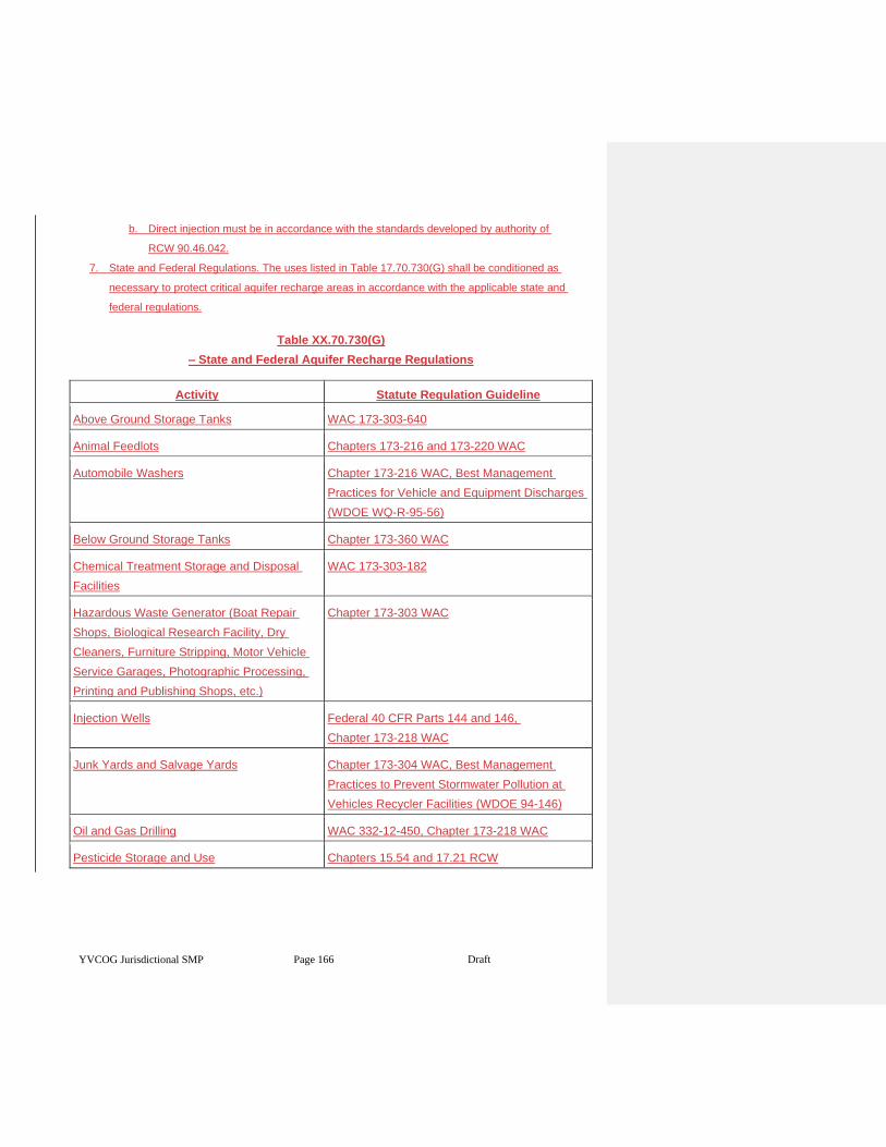
YVCOG Jurisdictional SMP Page 166 Draft
b. Direct injection must be in accordance with the standards developed by authority of
RCW 90.46.042.
7. State and Federal Regulations. The uses listed in Table 17.70.730(G) shall be conditioned as
necessary to protect critical aquifer recharge areas in accordance with the applicable state and
federal regulations.
Table XX.70.730(G)
– State and Federal Aquifer Recharge Regulations
Activity Statute Regulation Guideline
Above Ground Storage Tanks WAC 173-303-640
Animal Feedlots Chapters 173-216 and 173-220 WAC
Automobile Washers Chapter 173-216 WAC, Best Management
Practices for Vehicle and Equipment Discharges
(WDOE WQ-R-95-56)
Below Ground Storage Tanks Chapter 173-360 WAC
Chemical Treatment Storage and Disposal
Facilities
WAC 173-303-182
Hazardous Waste Generator (Boat Repair
Shops, Biological Research Facility, Dry
Cleaners, Furniture Stripping, Motor Vehicle
Service Garages, Photographic Processing,
Printing and Publishing Shops, etc.)
Chapter 173-303 WAC
Injection Wells Federal 40 CFR Parts 144 and 146,
Chapter 173-218 WAC
Junk Yards and Salvage Yards Chapter 173-304 WAC, Best Management
Practices to Prevent Stormwater Pollution at
Vehicles Recycler Facilities (WDOE 94-146)
Oil and Gas Drilling WAC 332-12-450, Chapter 173-218 WAC
Pesticide Storage and Use Chapters 15.54 and 17.21 RCW
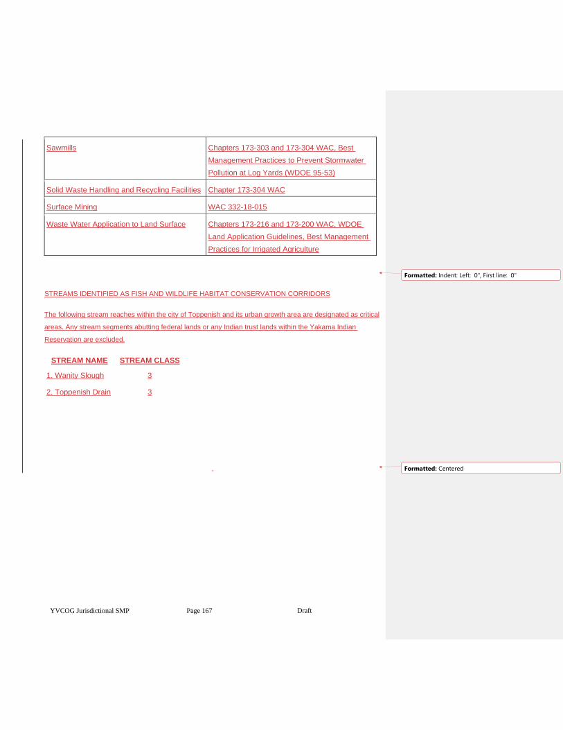
YVCOG Jurisdictional SMP Page 167 Draft
Sawmills Chapters 173-303 and 173-304 WAC, Best
Management Practices to Prevent Stormwater
Pollution at Log Yards (WDOE 95-53)
Solid Waste Handling and Recycling Facilities Chapter 173-304 WAC
Surface Mining WAC 332-18-015
Waste Water Application to Land Surface Chapters 173-216 and 173-200 WAC, WDOE
Land Application Guidelines, Best Management
Practices for Irrigated Agriculture
STREAMS IDENTIFIED AS FISH AND WILDLIFE HABITAT CONSERVATION CORRIDORS
The following stream reaches within the city of Toppenish and its urban growth area are designated as critical
areas. Any stream segments abutting federal lands or any Indian trust lands within the Yakama Indian
Reservation are excluded.
STREAM NAME STREAM CLASS
1. Wanity Slough 3
2. Toppenish Drain 3
Formatted: Indent: Left: 0", First line: 0"
Formatted: Centered
Shoreline Master Program Periodic Review Checklist 1 July 2019
SHORELINE MASTER PROGRAM PERIODIC REVIEW
Periodic Review Checklist
This document is intended for use by counties, cities and towns subject to the Shoreline
Management Act (SMA) to conduct the “periodic review” of their Shoreline Master Programs
(SMPs). This review is intended to keep SMPs current with amendments to state laws or rules,
changes to local plans and regulations, and changes to address local circumstances, new
information or improved data. The review is required under the SMA at RCW 90.58.080(4).
Ecology’s rule outlining procedures for conducting these reviews is at WAC 173‐26‐090.
This checklist summarizes amendments to state law, rules and applicable updated guidance
adopted between 2007 and 2019 that may trigger the need for local SMP amendments during
periodic reviews.
How to use this checklist
See the associated Periodic Review Checklist Guidance for a description of each item, relevant
links, review considerations, and example language.
At the beginning of the periodic review, use the review column to document review
considerations and determine if local amendments are needed to maintain compliance. See
WAC 173‐26‐090(3)(b)(i).
Ecology recommends reviewing all items on the checklist. Some items on the checklist prior to
the local SMP adoption may be relevant.
At the end of your review process, use the checklist as a final summary identifying your final
action, indicating where the SMP addresses applicable amended laws, or indicate where no
action is needed. See WAC 173‐26‐090(3)(d)(ii)(D), and WAC 173‐26‐110(9)(b).
Local governments should coordinate with their assigned Ecology regional planner for more
information on how to use this checklist and conduct the periodic review.
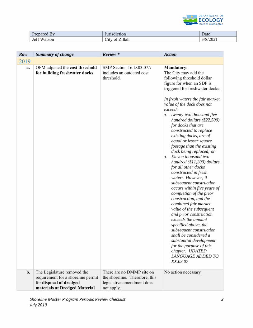
Shoreline Master Program Periodic Review Checklist 2 July 2019
Prepared By Jurisdiction DateJeff Watson City of Zillah 3/8/2021
Row Summary of change Review * Action
2019 a. OFM adjusted the cost threshold
for building freshwater docks
SMP Section 16.D.03.07.7 includes an outdated cost threshold.
Mandatory: The City may add the following threshold dollar figure for when an SDP is triggered for freshwater docks: In fresh waters the fair market value of the dock does not exceed: a. twenty-two thousand five
hundred dollars ($22,500) for docks that are constructed to replace existing docks, are of equal or lesser square footage than the existing dock being replaced; or
b. Eleven thousand two hundred ($11,200) dollars for all other docks constructed in fresh waters. However, if subsequent construction occurs within five years of completion of the prior construction, and the combined fair market value of the subsequent and prior construction exceeds the amount specified above, the subsequent construction shall be considered a substantial development for the purpose of this chapter. UDATED LANGUAGE ADDED TO XX.03.07
b. The Legislature removed the requirement for a shoreline permit for disposal of dredged materials at Dredged Material
There are no DMMP site on the shoreline. Therefore, this legislative amendment does not apply.
No action necessary
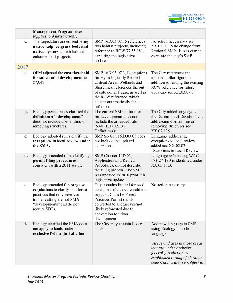
Shoreline Master Program Periodic Review Checklist 3 July 2019
Management Program sites (applies to 9 jurisdictions)
c. The Legislature added restoring native kelp, eelgrass beds and native oysters as fish habitat enhancement projects.
SMP 16D.03.07.15 references fish habitat projects, including reference to RCW 77.55.181, capturing the legislative update.
No action necessary - see XX.03.07.15 no change from Regional SMP. It was carried over into the city’s SMP
2017 a. OFM adjusted the cost threshold
for substantial development to $7,047.
SMP 16D.03.07.3, Exemptions for Hydrologically Related Critical Areas Wetlands and Shorelines, references the out of date dollar figure, as well as the RCW reference, which adjusts automatically for inflation:
The City references the updated dollar figure, in addition to leaving the existing RCW reference for future updates.- see XX.03.07.3.
b. Ecology permit rules clarified the definition of “development” does not include dismantling or removing structures.
The current SMP definition for development does not include the amended rule (SMP 16D.02.135, Definitions):
The City added language to the Definition of Development addressing dismantling or removing structures see XX.02.135.
c. Ecology adopted rules clarifying exceptions to local review under the SMA.
SMP Section 16.D.03.05 does not include the updated exceptions.
Language addressing exceptions to local review added see XX.02.03 Exceptions to Local Review.
d. Ecology amended rules clarifying permit filing procedures consistent with a 2011 statute.
SMP Chapter 16D.03, Application and Review Procedures, do not describe the filing process. The SMP was updated in 2010 prior this legislative update.
Language referencing WAC 173-27-130 is identified under XX.03.11.3.
e.
Ecology amended forestry use regulations to clarify that forest practices that only involves timber cutting are not SMA “developments” and do not require SDPs.
City contains limited forested lands, that if cleared would not trigger a Class IV Forest Practices Permit (lands converted to another use/not likely reforested due to conversion to urban development.
No action necessary
f. Ecology clarified the SMA does not apply to lands under exclusive federal jurisdiction
The City may contain Federal lands.
Add new language to SMP, using Ecology’s model language: ‘Areas and uses in those areas that are under exclusive federal jurisdiction as established through federal or state statutes are not subject to
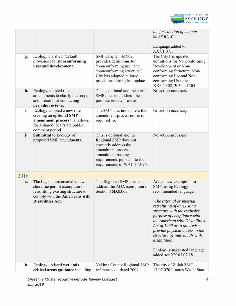
Shoreline Master Program Periodic Review Checklist 4 July 2019
the jurisdiction of chapter 90.58 RCW.’ Language added to XX.01.07.1
g.
Ecology clarified “default” provisions for nonconforming uses and development.
SMP Chapter 16D.02, provides definitions for “nonconforming use” and “nonconforming structure”. City has adopted tailored provisions during last update.
The City has updated definitions for Nonconforming Development or Non-conforming Structure, Non-conforming Lot and Non-conforming Use, see XX.02.302, 303 and 304.
h. Ecology adopted rule amendments to clarify the scope and process for conducting periodic reviews.
This is optional and the current SMP does not address the periodic review provision.
No action necessary.
i. Ecology adopted a new rule creating an optional SMP amendment process that allows for a shared local/state public comment period.
The SMP does not address the amendment process nor is it required to.
No action necessary.
j. Submittal to Ecology of proposed SMP amendments.
This is optional and the Regional SMP does not currently address the amendment process amendment routing requirements pursuant to the requirements of WAC 173-26.
No action necessary.
2016 a.
The Legislature created a new shoreline permit exemption for retrofitting existing structure to comply with the Americans with Disabilities Act.
The Regional SMP does not address the ADA exemption in Section 16D.03.07.
Added new exemption to SMP, using Ecology’s recommended language: ‘The external or internal retrofitting of an existing structure with the exclusive purpose of compliance with the American with Disabilities Act of 1990 or to otherwise provide physical access to the structure by individuals with disabilities.’ Ecology’s suggested language added see XX.03.07.18.
b. Ecology updated wetlands critical areas guidance including
Yakima County Regional SMP references outdated 2004
The city of Zillah ZMC 17.07.070.L notes Wash. State
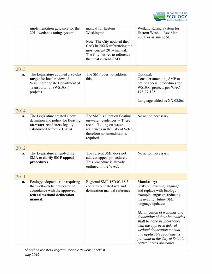
Shoreline Master Program Periodic Review Checklist 5 July 2019
implementation guidance for the 2014 wetlands rating system.
manual for Eastern Washington. Note: The City updated their CAO in 20XX referencing the most current 2014 manual. The City desires to reference the most current CAO.
Wetland Rating System for Eastern Wash. – Rev Mar. 2007, or as amended.
2015 a. The Legislature adopted a 90-day
target for local review of Washington State Department of Transportation (WSDOT) projects.
The SMP does not address this.
Optional: Consider amending SMP to define special procedures for WSDOT projects per WAC 173-27-125. Language added as XX.03.06.
2014 a. The Legislature created a new
definition and policy for floating on-water residences legally established before 7/1/2014.
The SMP is silent on floating on-water residences. – There are no floating on-water residences in the City of Selah, therefore no amendment is required.
No action necessary.
2012 a. The Legislature amended the
SMA to clarify SMP appeal procedures.
The current SMP does not address appeal procedures. This procedure is already outlined in the WAC.
No action necessary.
2011 a. Ecology adopted a rule requiring
that wetlands be delineated in accordance with the approved federal wetland delineation manual.
Regional SMP 16D.03.18.3 contains outdated wetland delineation manual reference.
Mandatory: Strikeout existing language and replace with Ecology example language, reducing the need for future SMP language updates: Identification of wetlands and delineation of their boundaries shall be done in accordance with the approved federal wetland delineation manual and applicable supplements pursuant to the City of Selah’s critical areas ordinance.
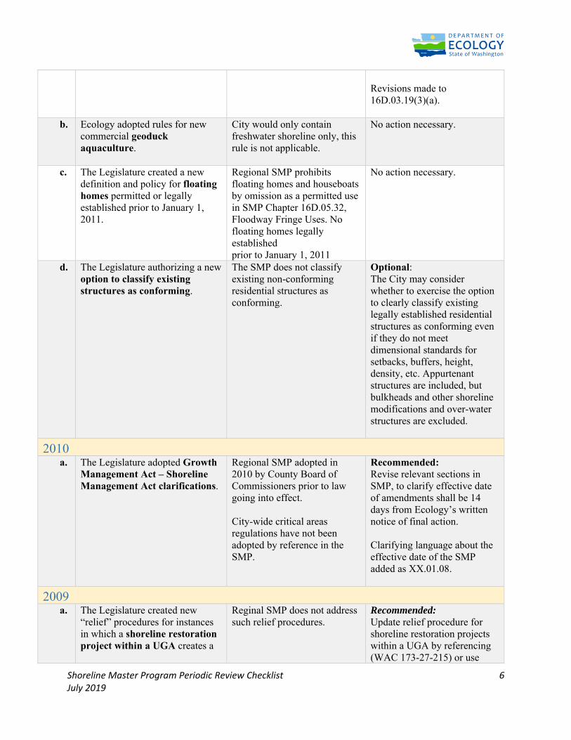
Shoreline Master Program Periodic Review Checklist 6 July 2019
Revisions made to 16D.03.19(3)(a).
b. Ecology adopted rules for new commercial geoduck aquaculture.
City would only contain freshwater shoreline only, this rule is not applicable.
No action necessary.
c. The Legislature created a new definition and policy for floating homes permitted or legally established prior to January 1, 2011.
Regional SMP prohibits floating homes and houseboats by omission as a permitted use in SMP Chapter 16D.05.32, Floodway Fringe Uses. No floating homes legally established prior to January 1, 2011
No action necessary.
d. The Legislature authorizing a new option to classify existing structures as conforming.
The SMP does not classify existing non-conforming residential structures as conforming.
Optional: The City may consider whether to exercise the option to clearly classify existing legally established residential structures as conforming even if they do not meet dimensional standards for setbacks, buffers, height, density, etc. Appurtenant structures are included, but bulkheads and other shoreline modifications and over-water structures are excluded.
2010 a. The Legislature adopted Growth
Management Act – Shoreline Management Act clarifications.
Regional SMP adopted in 2010 by County Board of Commissioners prior to law going into effect. City-wide critical areas regulations have not been adopted by reference in the SMP.
Recommended: Revise relevant sections in SMP, to clarify effective date of amendments shall be 14 days from Ecology’s written notice of final action. Clarifying language about the effective date of the SMP added as XX.01.08.
2009 a.
The Legislature created new “relief” procedures for instances in which a shoreline restoration project within a UGA creates a
Reginal SMP does not address such relief procedures.
Recommended: Update relief procedure for shoreline restoration projects within a UGA by referencing (WAC 173-27-215) or use
Shoreline Master Program Periodic Review Checklist 7 July 2019
shift in Ordinary High Water Mark.
following Ecology example language: The City may grant relief from shoreline master program development standards and use regulations resulting from shoreline restoration projects within urban growth areas consistent with criteria and procedures in WAC 173-27-215. Ecology’s suggested language added as XX.05.02.8.
b. Ecology adopted a rule for certifying wetland mitigation banks.
The SMP Section 16D.07.06 authorizes certified mitigation banks.
No action necessary.
c. The Legislature added moratoria authority and procedures to the SMA.
Yakima County Regional SMP does not address moratoria authority. This procedure is already outlined in the WAC.
No action necessary.
2007 a.
The Legislature clarified options for defining "floodway" as either the area that has been established in FEMA maps, or the floodway criteria set in the SMA.
Floodway is defined in the Regional SMP Section 16D.02.220 and does not include legislation clarifications related to the SMP and elected use of FEMA maps to define floodways in the city.
Mandatory: Remove and replace existing definition to: “Floodway” means the area that has been established in effective federal emergency management agency flood insurance rate maps or floodway maps. The floodway does not include lands that can reasonably be expected to be protected from flood waters by flood control devices maintained by or maintained under license from the federal government, the state or a political subdivision of the state. Updated definition for “Floodway” in XX.02.220 for consistency with the SMA.
Shoreline Master Program Periodic Review Checklist 8 July 2019
# Issue Relevant Location Review & Action 1 Public access to Tribal
lands Goals and Policies NS 7.36 Deleted: Provisions for access
to shorelines. Toppenish city limits is 500 feet from waters edge which is on YIN Trust land. No jurisdiction or relevance.
2 Proportion of State, federal and public lands
NS 7.36.1 Deleted: No Federal state or public lands in the area.
3 Reliance on other agencies to provide access to their lands
NS 7.36.2 Deleted: No Federal state or public lands in the area.
4 Open to unimproved access
NS 7.36.3 Deleted: No Federal state or public lands in the area.
5 Transportation corridors visual access
NS 7.36.4 Deleted: No transportation corridor limited visual access
6 Commercial water oriented activities
NS 7.36.5 Deleted: No access to actual shoreline
7 Recreational water oriented activities
NS 7.36.6 Deleted: No access to actual shoreline
8 Reliance on commercial activities for additional access
NS 7.36.7 Deleted: No access to actual shoreline
9 Development standards for public developments
NS 7.36.8 Deleted: No access to actual shoreline
b. Ecology amended rules to clarify that comprehensively updated SMPs shall include a list and map of streams and lakes that are in shoreline jurisdiction.
No new shoreline waterbodies identified since 2010 SMP update. However, SMP not explicit on shorelines located in City as City adopted Regional County SMP.
Mandatory: List Rivers of state wide significance in SMP introduction. Add map of shorelines of the state to a map with corresponding SEDs. Optional: Remove all shorelines listed in Regional SMP not in the City.
c. Ecology’s rule listing statutory exemptions from the requirement for an SDP was amended to include fish habitat enhancement projects that conform to the provisions of RCW 77.55.181.
SMP Section 16D.03.07.15.d lists a fish habitat enhancement exemption.
No action necessary.
* This column attempts to capture the primary relevant location(s) of content related to the item described in the Summary of Change column; however, due to length of the SMP and the City’s Municipal Code, all relevant locations may not be listed.
Shoreline Master Program Periodic Review Checklist 9 July 2019
10 Promote and enhance public access
NS 7.36 Deleted: No access to actual shoreline
11 Access to recreational areas
NS 7.37 Deleted: No access to actual shoreline
12 Access and water dependent use conflict
NS 7.40 Deleted: No access to actual shoreline
13 Construction of road and railroad facilities
NS 7.41 Deleted: No access to actual shoreline
14 Marina location NS 7.50 Deleted: No access to actual shoreline
15 Preservation of recreational opportunities
NS 7.55 Deleted: No access to actual shoreline
16 Public lands for recreational facilities
NS 7.57 Deleted: No access to actual shoreline
17 Location of major highways & setbacks
NS 7.60 Nominal shoreline jurisdiction
18 Location of access roads and parking
NS 7.61 Deleted: No access to actual shoreline
19 Loops or spurs of old highways retained as bike-ped routes
NS 7.63 Deleted None in the area
20 Aquaculture NS 7.66 & 7.67 Deleted: No access to actual shoreline
21 Boating Facilities and Marinas
NS 7.68 & 7.69 Deleted: No access to actual shoreline
22 Forest Practices NS 7.70 - 7.72 Deleted:No forest lands in city limits
23 In Stream Structures NS 7.86 & 7.87 Deleted: No access to actual shoreline
24 Shore Stabilization NS 7.90 - 7.92 Deleted: No access to actual shoreline
25 Dredging NS 7.96 – 7.98 Deleted: No access to actual shoreline
26 Critical Areas Goals and policies
Verbatim from city’s CAO Changes to numbering and, addition of WAC notes, and removal of county references.
Integration and Consistency of Critical Areas Ordinance
The City of Toppenish adopted a Critical Areas Ordinance (2011-6) and incorporated into Chapter TMC 17.70 in 2011. The update was approved by City Council and no updates have be adopted since that time. References from the Yakima County Critical Areas Ordinance have been removed from the updated SMP, and the regulatory elements from TMC 17.70 incorporated into the SMP to regulate critical areas within the SMP.
Shoreline Master Program Periodic Review Checklist 10 July 2019
Comprehensive Plan, Development Regulation and Code Consistency
The City of Toppenish Comprehensive Plan does not include a Shoreline Element Chapter. However, references to the SMP and the document authority are included in the Natural Systems, Land Use and Administration Elements of the Comprehensive Plan. A review of the current SMP was conducted to ensure consistency with the Comprehensive Plan updated in 2017. No changes to the SMP were identified at this time for consistency with the comprehensive plan.
The following ordinances adopted by the Toppenish City Council pertaining to Development Regulations were reviewed by Staff for conformance and consistency with the Shoreline Master Program; no conflicts or inconsistencies were found.
2008-12 Adopts shoreline master program and Title 19, shoreline master program regulations 2008-24 Amends comprehensive plan (Special) 2008-25 Amends Chs. 17.28, 17.32, 17.40, 17.44 and 17.46, zoning (17.28, 17.32, 17.40, 17.44, 17.46) 2009-5 Rezone (Special) 2009-6 Rezone (Special) 2009-7 Rezone (Special) 2009-10 Amends § 15.30.060, basis for establishing the areas of special flood hazard (15.30) 2010-8 Amends § 15.30.160(A), flood damage prevention (15.30) 2010-9 Rezone (Special) 2010-12 Amends §§ 15.01.010 and 15.01.050; repeals and replaces §§ 15.01.020 and 15.01.040; repeals§ 15.01.030, buildings and construction (Repealed by 2020-10) 2011-6 Adds Ch. 17.70, critical areas (17.70) 2011-11 Annexation (Special) 2013-18 Adopts Parks and Recreation Plan 2014-2019 (Special) 2015-18 Rezone (Special) 2016-03 Adds § 2.05.057, notice of public hearings before city council (2.05) 2016-09 Rezone (Special) 2016-10 Rezone (Special) 2017-01 Adds § 3.01.070; amends §§ 1.16.040… … 18.04) 2018-13 Adds § 2.01.005, comprehensive plan (2.01) 2019-16 Repeals and replaces Ch. 17.16, zoning conformance review (17.16) 2019-17 Repeals and replaces Ch. 17.56, special property uses (17.56) 2020-09 Amends § 13.28.050; repeals Ord. 94-28, sewer connections in floodplains (13.28) 2020-12 Amends §§ 17.28.020, 17.28.030, 17.32.020(A) and (B), 17.32.030(A) and (B) and 17.40.020(A) and (B), dwellings (17.28, 17.32, 17.40)
YVCOG Jurisdictional SMP Page 1 Draft
TOPPENISH JURISDICTIONAL SHORELINE MASTER PROGRAM Adopted by the TOPPENISH City Council
SHORELINE MASTER PROGRAM REGULATIONS
Table of Contents
Chapter XX.01 - GOALS AND POLICIES……………………………………………………………………………………………..XX
Chapter XX.02 - GENERAL PROVISIONS .............................................................................................. XX
Chapter XX.03 - DEFINITIONS ............................................................................................................. XX
Chapter XX.04 - APPLICATION AND REVIEW PROCEDURES .................................................................XX
Chapter XX.05 - ENFORCEMENT AND PENALTIES ............................................................................... XX
Chapter XX.06 - SHORELINE MANAGEMENT .......................................................................................XX
Chapter XX.07 - CRITICAL AREAS WITHIN THE SHORELINE……………………………………………………………….XX
XX.01.01 Below are the Goals and Policies for the Shoreline Master Program. These Goals and Polices were
updated in 2007 to be consistent with the SMP Guidelines (WAC 173-26).
SHORELINES
The goals and policies of the Shoreline Master Program are directed towards land and water uses and their
impact on the environment. As the population continues to increase, the pressures upon our shorelines
will also increase. The goal of the Shoreline Master Program is to protect the shorelines of the state.
.01: Implement the general policy goals of the Shoreline Management Act as listed below (WAC 173-26-
176(3)):
a. Utilize Shorelines for economically productive uses that are particularly dependent on
Shoreline location or use.
b. Utilize Shorelines and the waters they encompass for public access and recreation. c. Protect
and restore the ecological functions of Shorelines.
d. Protect the public right of navigation and corollary uses of waters of the state.
e. Protect and restore buildings and sites having historic, cultural, and educational value. f.
Plan for public facilities and uses correlated with other shoreline uses.
g. Prevent and minimize flood damages.
h. Recognize and protect private property rights.
i. Preferentially accommodate single-family uses.
j. Coordinate shoreline management with other relevant local, state, and federal programs.
.02: Protection measures for local Shorelines should use the following Shoreline Management Act
principles in order of preference as listed below (RCW 90.58.020):
1. Recognize and protect the state-wide interest over local interest;
2. Preserve the natural character of the shoreline;
3. Result in long term over short term benefit;
4. Protect the resource and ecology of the shoreline;
YVCOG Jurisdictional SMP Page 2 Draft
5. Increase public access to publicly owned areas of the shorelines;
6. Increase recreational opportunities for the public in the shoreline;
7. Provide for any other element as defined in RCW 90.58.100 deemed appropriate or necessary.
.03: Maintain, restore and where necessary improve the shoreline terrestrial and aquatic ecosystems so
that they maintain viable, reproducing populations of plants and animals while providing the
maximum public benefit of limited amounts of shoreline areas. Accomplish this through the policies in the
required shoreline elements listed below.
SHORELINE ENVIRONMENTS
.04: Shorelines areas should be classified into specific environmental designations. The designation
system should be based on the existing and future land use pattern as well as the biological and physical
character of the shoreline. These environments should include the Urban, Rural,
Conservancy, Urban Conservancy, Natural and Floodway / Channel Migration Zone (CMZ) environments.
Land uses and activities should be limited to those that are consistent with the character of the
environment designation.
Urban Environment Policies
.05 The Urban environment is to be used for the most intensely developed areas, or areas where
intensive development is desirable or tolerable. The basic principle in an Urban Environment is oriented
toward quality of development in harmony with the shoreline. The Urban Environment should ensure
optimum utilization of shorelines occurring within urbanized areas by providing for public access and by
managing development so that it enhances and maintains the shorelines for a multiplicity of uses.
.06 The following criteria should be used for the designation of Urban Environments:
1. Areas presently supporting high intensity land use including residential, commercial, industrial
and recreational uses.
2. Areas which are planned to accommodate urban expansion of residential, commercial,
industrial and recreational uses.
3. High land values.
4. Major public or private capital investments.
5. Close proximity to services and utilities.
6. Few biophysical limitations to development.
7. Potentially low flood hazard.
.07 Water-oriented commercial, industrial, and recreation uses should be given high priority in the Urban
Environment, and may be accompanied by non-water oriented uses in mixed-use developments.
Residential uses should be discouraged. Recreational uses are preferred uses within the urban
environments
Rural Environment Policies
YVCOG Jurisdictional SMP Page 3 Draft
.08 The Rural Environment should restrict intensive development along undeveloped shoreline areas that
might interfere with the normal operations or economic viability of an agricultural activity located on
adjacent associated shoreline areas. The Rural Environment maintains open spaces and provides
opportunities for recreational uses compatible with agricultural activities.
.09 The following criteria should be used for the designation of Rural Environments:
1. Intensive agricultural or recreational uses.
2. Those areas with potential for agricultural use.
3. Those undeveloped natural areas that lie between agricultural areas.
4. Low-density residential development.
5. Moderate land values.
6. Potential low demand for services.
.10 Generally, allowed uses in the Rural environment should focus on resource and recreation uses.
Commercial and industrial uses should be carefully limited. Residential uses should sustain shoreline
functions.
Conservancy Environment Policies
.11 The Conservancy Environment classification should be used for areas where maintenance of the
existing character of the area is desirable. This does not necessarily mean preservation, but rather a use
of natural resources on a sustained yield basis. Thus, the harvesting of timber as well as recreational
activities are to be the primary uses permitted Also, areas that are isolated from services, have poor
drainage, high flood danger, poor ground for septic tanks, unstable earth, or steep slopes should be
designated Conservancy.
.12 The following criteria should be used for the designation of ConservancyEnvironments:
1. Very low intensity land uses; primarily sustained-yield activities or pasture-range land.
2. Larger acreages.
3. Relatively low land values.
4. Relatively minor public or private capital investment.
5. Considerable biophysical limitations, making commercial, industrial, or medium to high-density
residential development unsuitable.
.13 Generally, commercial and industrial uses should not be allowed in the Conservancy Environment,
except when they are water oriented. Resource uses should be of low enough intensity to sustain shoreline
functions with preference for non-permanent structures. Low-density residential development should
sustain the character of the shoreline. Diffuse recreational uses are preferred use. Uses should avoid
hazardous areas.
Natural Environment Policies
.14 The Natural Environment should protect those shoreline areas which are considered unique by virtue
of their existence and valuable only to the extent that the natural integrity is preserved for the benefit of
YVCOG Jurisdictional SMP Page 4 Draft
future, as well as, present generations. Prime targets for classification into the Natural Environment will be
certain shorelands owned or controlled by the various Federal and Tribal wildlife management agencies
with limited access and certain private lands which are seen to be proper for Natural classification, and the
owner of which will be interested in the promise of very low taxation.
.15 The following criteria should be used for the designation of Natural Environments:
1. The presence of a natural, historical, cultural, scientific, or educational feature considered
valuable by virtue of its existence in a natural or original state and thereby warranting preservation
for the benefit of present and future generations.
2. Those areas generally intolerant of intensive human use.
3. Areas with severe biophysical limitations.
4. Natural areas with strong limits on access.
.16 Generally, commercial, industrial, mining, non-water oriented recreation, roads, utilities, and
parking areas should not be located in Natural Environment. Other uses, including residential, should be
carefully limited in the Natural environment. Restrict activities that may degrade the actual or potential
value of this environment, and severely restrict development in hazardous areas.
Floodway / Channel Migration Zone (CMZ) Environment Policies
.17 The Floodway/Channel Migration Zone environment should protect the water areas; islands,
associated overflow channels, and channel migration areas. This environment acknowledges the
river’s need to move within parts of its floodplain, and emphasizes the preservation of the natural
hydraulic, geologic and biological functions of the county’s shorelines that are constrained by severe
biophysical limitations.
.18 A Floodway/Channel Migration Zone designation should be assigned to shoreline areas that are
within mapped Channel Migration Zones and/or within a designated FEMA Floodway. The extent of the
Floodway/Channel Migration Zone should never extend beyond the 100-year flood plain.
.19 Generally, commercial, industrial, mining, non-water oriented recreation, roads, utilities, parking
areas, and residences should not be located in the Floodway/Channel Migration Zone Environment. Other
uses (recreation, resource uses, etc.) should be carefully limited to protect shoreline functions. Restrict
activities that may degrade the actual or potential value of this environment, and severely restrict
development in hazardous areas. Modifications that harden or fix stream banks and channels should be
discouraged.
Urban Conservancy Environment Policies
.20 The Urban Conservancy environment should protect and restore ecological functions of open space,
floodplain and other sensitive lands where they exist in urban and developed settings, while allowing a
variety of compatible uses.
.21 The following criteria should be used for the designation of Urban Conservancy
YVCOG Jurisdictional SMP Page 5 Draft
Environments;
1) areas that lie in incorporated municipalities and urban growth areas;
2) areas appropriate and planned for development that is compatible with maintaining or
restoring of the ecological functions of the area;
3)areas that are suitable for water-enjoyment uses;
4) areas that are open space or floodplain, or that retain important ecological functions that
should not be more intensively developed;
.22 Generally, allowed uses should focus on recreational uses. Commercial, industrial and residential
uses should be carefully limited, and when allowed should result in restoration of ecological functions.
Uses that preserve the natural character of the area or promote the preservation of open space,
floodplain or sensitive lands (either directly or over the long term) should be the primary allowed uses.
Public access and public recreation objectives should be implemented whenever feasible and significant
ecological impacts can be mitigated.
GENERAL SHORELINE POLICIES
Critical Areas, Restoration, and Vegetation Conservation Policies
.23 New development or new uses, including the subdivision of land, should not be established when it
would be reasonably foreseeable that the development or use would require structural flood hazard
reduction measures within the channel migration zone or floodway.
.24 Only allow new structural flood hazard reduction measures in shoreline jurisdiction when it can be
demonstrated that they are necessary to protect existing development, that nonstructural measures are
not feasible, that impacts on ecological functions and priority species and habitats can be successfully
mitigated so as to assure no net loss, and that appropriate vegetation conservation actions are undertaken.
.25 Protect all shorelines of the state so that there is no net loss of ecological functions from both
individual permitted development and individual exempt development.
.26 In development of the Shoreline Master Program, evaluate and consider cumulative impacts of
reasonably foreseeable future development on shoreline ecological functions and other shoreline
functions to ensure no net loss of ecological function. Develop a means to allocate the burden of
addressing cumulative effects.
.27 Provide, where feasible and desirable, restoration of degraded areas along the shorelines of the
City of Toppenish.
.28 Critical areas within shoreline jurisdiction should be protected with the critical area policies and
standards protecting all of the City’s critical areas, including those for CMZs and Flood Control.
.29 Protect shoreline streams, lakes, ponds, and wetlands with a vegetative buffer as described in the
Critical Areas Ordinance.
YVCOG Jurisdictional SMP Page 6 Draft
.30 For existing agriculture encourage through a variety of voluntary means the maintenance of a
permanent vegetative buffer between tilled areas and associated water bodies to reduce bank erosion,
retard surface runoff, reduce siltation, improve water quality and provide habitat for fish and wildlife. For
new agriculture, buffer requirements should be applied.
.31 Natural vegetation within shoreline jurisdiction should be retained to the greatest extent feasible.
This should be accomplished by applying the stream corridor and wetland buffer requirements. Activities
covered by the State Forest Practices Act should not be subject to vegetation conservation standards, but
should be subject to buffer requirements when under City jurisdiction. Require developers to indicate how
they plan to preserve shore vegetation and control erosion.
.32 Selective pruning of trees for safety and view protection, and the removal of noxious weeds should be
allowed.
.33 Upon completion of construction/maintenance projects on shorelines, disturbed areas should at a
minimum be restored to pre-project configuration wherever possible, replanted with native species and
provided maintenance care until the newly planted vegetation is established.
Public Access Policies – Physical and Visual
.34 Protect navigation of waters of the state, the space needed for water-dependent uses, and views of
the water through development standards.
.35 Transportation and parking plans within Shoreline jurisdiction shall include systems for public access,
including pedestrian, bicycle, and public transportation where appropriate.
.36 The city limits of Toppenish at their closest point to the Yakima river are approximately 450 feet away
from the water’s edge. While the city will encourage visual and physical public access to the river to the
extent possible under WAC 173-26-221(4) it has no direct jurisdictional control over the actual shoreline.
The shoreline property that is proximate to the small amount of shoreline jurisdiction within the City limits
of Toppenish is Yakama Nation Trust property and not subject to the SMA
.37 Development standards should be established to assure preservation of unique, fragile, and scenic
elements and to protect existing views from public property or large numbers of residences. Where
aesthetic impacts are not avoidable, provide mitigation.
.38 Wherever feasible, utility facilities should be placed underground.
Signs and Billboards
.39 Outdoor sign size, spacing and lighting should conform to the Scenic Vistas Act
(RCW 47.42) and standards in the Zoning Ordinance.
YVCOG Jurisdictional SMP Page 7 Draft
Archaeological and Historic Resources
POLICIES
.40 Encourage the protection and restoration of areas and sites in The City of Toppenish having historic,
archaeological, cultural, educational or scientific value. Wherever possible, sites should be permanently
preserved for scientific study and public observation.
.41 Development along shorelines should include consultation with professional archaeologists,
historians, and biologists to identify areas containing potentially valuable data, and to establish procedures
for salvaging the data or maintaining the area in an undisturbed condition.
.42 Shoreline permits should contain special provisions which require developers to immediately stop
work and notify local governments, the Office of Archeological and Historic Preservation, and affected
tribes, if any possible archaeological or historic resources are uncovered during excavations.
.43 Development which would destroy archaeological or historical sites or data may be delayed for a
reasonable time to allow the appropriate agency or organization to purchase the site or to recover the
data.
Water Quality, Stormwater and Pollution
POLICIES
.44 Shoreline water quality should be protected as follows:
1. Rely on a City stormwater program meeting state and federal stormwater control requirements
where possible;
2. Use Critical Aquifer Recharge Area protection measures in the Critical Areas Ordinance;
3. Control drainage and surface runoff from all non-agricultural facilities requiring large quantities
of fertilizers and pesticides (such as golf courses and play fields) to prevent contamination of water
areas;
4. All developments shall comply with County Health regulations, when applicable;
5. Handle and dispose of pesticides in accordance with provisions of the Washington
Pesticide Application Act (RCW 17.21) and the Washington Pesticide Act (RCW
14.47);
6. Proper design, location, and construction of all facilities should be exercised to prevent the
entry of pollutants or waste materials into the water body.
7. When earthen materials are moved within shoreline areas, measures to adequately protect
water quality should be provided.
8. Water quality protection measures should not impact recreation opportunities.
.45 Agricultural erosion control measures should conform to rules and standards established by the
Conservation Districts of Yakima County.
.46 Prohibit sanitary landfills along shoreline areas. Otherwise the disposal of all solid wastes should
YVCOG Jurisdictional SMP Page 8 Draft
proceed in accordance with the Yakima County Solid Waste Management Plan.
SHORELINE USE POLICIES
General Use Policies
.47 Establish a system of shoreline uses that:
1. Gives preference to uses with minimal impacts and that are dependent on the proximity to the
water;
2. Protect the public’s health, safety, and welfare; ecological functions; and property rights;
3. Establishes conditional uses to provide extra protection for the shoreline.
.48 Assure that new shoreline development in The City of Toppenish is consistent with a viable
pattern of use suitable to the character and physical limitations of the land and water.
.49 Encourage sound management of renewable and nonrenewable natural resources.
Recreation
.50 Where the uses designated for a specific recreational area are planned to satisfy a diversity of
demands, these uses must be compatible with each other and the environment of the area.
.51 Locate, design, construct and operate recreational facilities to prevent undue adverse impacts on
natural resources of an area and on adjacent or nearby private properties.
Transportation and Parking
.52 Encourage a transportation network in The City of Toppenish capable of delivering people, goods, and
services, and resulting in minimal disruption of the shorelines’ natural system.
.53 Proper design, location, and construction of road and railroad facilities should be exercised to:
1. Minimize erosion and permit the natural movement of water;
2. Use existing topography to maximum advantage and preserve natural conditions to the greatest
practical extent.
Agriculture
.54 Allow lawfully established agricultural activities occurring on agricultural lands to continue as they
historically have. New agricultural activities on land not currently used for agriculture, conversion of
agricultural lands to other uses, and other development on agricultural land that does not meet the
definition of agricultural activities (including any agricultural development not specifically exempted by the
provisions of RCW 90.58.030(3)(e)(iv)) should meet shoreline requirements.
.55 Encourage animal feedlot operations to locate away from shorelines.
YVCOG Jurisdictional SMP Page 9 Draft
Mining
.56 Remove sand, gravel, and minerals from only the least sensitive shoreline areas. Due to the risk of
avulsion and mine pit capture by the river, mining within the stream channel and channel migration zone
should not be allowed. In special cases where it is allowed, it should be a conditional use. Restoration or
enhancement of ecological function is encouraged.
.57 Require land reclamation plans of any mining venture proposed within a shoreline.
Mining reclamation shall be done in conformance with the Washington State Surface
Mining Act (RCW 78.44).
.58 Ensure that mining and associated activities are designed and conducted consistent with the
applicable environment designation and the applicable critical areas ordinance.
.59 Ensure that proposed subsequent use of mined property and the reclamation of disturbed
shoreline areas is consistent with the applicable environment designation and that appropriate ecological
functions are provided consistent with the setting.
Residential Development
.60 Design subdivisions at a density, level of site coverage, and occupancy compatible with the physical
capabilities of the shoreline and water and locate them to prevent the need for new shore stabilization or
flood hazard reduction measures.
.61 Restrict subdivisions in areas subject to flooding.
.62 Encourage cluster development wherever feasible to maximize use of the shorelines by residents,
maximize both on-site and off-site aesthetic appeal, and minimize disruption of the natural shorelines.
Commercial Development
.63 Limit commercial development to those activities that are particularly dependent upon a shoreline
location. Other commercial uses should be encouraged to locate upland. Give first preference to water-
dependent commercial uses over non-water- dependent commercial uses; and give second preference to
water-related and water- enjoyment commercial uses over non-water-oriented commercial uses. Allow
non- water-oriented commercial uses in limited situations.
Utilities
.64 New utility production and processing facilities, such as power plants and sewage treatment plants,
YVCOG Jurisdictional SMP Page 10 Draft
or parts of those facilities that are non-water-oriented should not be allowed in shoreline areas unless it
can be demonstrated that no other feasible option is available. Expansion, updating, and maintenance of
existing facilities is allowed but should be designed to minimize the impacts as much as possible.
.65 Wherever possible, transmission facilities for the conveyance of services, such as power lines, cables,
and pipelines, should be located outside of the shoreline area. If location within the shoreline cannot be
prevented, confine utilities in a single corridor or within an existing right-of-way.
.66 Locate new sewage treatment, water reclamation, and power plants where they do not interfere with
and are compatible with recreational, residential or other public uses of water and shore lands. New waste
treatment ponds for industrial waste should be located upland when feasible.
Industry
.67 Allocate sufficient quantities of suitable land for water related industry. Give preference to water-
dependent industrial uses over non-water-dependent industrial uses; and second, give preference to
water-related industrial uses over non-water- oriented industrial uses. Allow non-water-oriented industrial
development in limited situations.
.68 Discourage industries which have proven to be environmentally hazardous from locating along the
shorelines.
SHORELINE MODIFICATION POLICIES
General Shoreline Modification Policies
.69 Allow shoreline modifications only where they are shown to be necessary to support or protect an
allowed primary structure or a legally existing shoreline use that is in danger of loss or substantial damage,
or they are necessary for mitigation or enhancement work.
NS 7.70 Limit shoreline modifications to the minimum necessary to accomplish the objective, while still
protecting ecological functions. Give preference to shoreline modifications that have a lesser impact on
ecological functions.
Shore Stabilization
Landfill
NS 7.71 Allow normal and reasonable land grading and filling where necessary to develop a land area for
a permitted use. There should be no substantial changes made in the natural drainage patterns and no
reduction of flood water storage capacity that might endanger other areas. Allow fill within the ordinary
high-water mark only when necessary to support water dependent uses, public access, transportation
facilities, mitigation, restoration, enhancement, and certain special situations listed in WAC
YVCOG Jurisdictional SMP Page 11 Draft
173-26-231(3)(c).
NS 7.72 In evaluating fill projects, such factors as total water surface reduction, navigation restriction,
impediment to water flow and circulation, impediment to irrigation systems, reduction of water quality,
and destruction of fish and wildlife habitat should be examined.
NS 7.73 Locate and design shoreline fills or cuts to avoid creating a hazard to adjacent life, property, and
natural resources systems, and to provide all perimeters of fills with vegetation, retaining walls, or other
mechanisms for erosion prevention.
CRITICAL AREAS GOALS AND POLICIES IN SUPPORT OF THE SHORELINE MASTER PROGRAM - City of
Toppenish COMPREHENSIVE PLAN 2018 – Natural Settings Element
Below are the Goals and Policies for Critical Areas which are retained in support of the SMP consistent with
Policy NS 7.28. These Goals and Policies also legally reside within the City of Toppenish Comprehensive
Plan 2018
CRITICAL AREAS
Critical Areas are an important part of the natural setting in The City of Toppenish. Their protection is
required by the Growth Management Act and important to the quality of life of the residents of the city.
Critical Areas include groundwater, fish and wildlife habitat (which includes surface waters), wetlands,
frequently flooded areas, and geologic hazards. The protection of critical areas must include certain
general approaches, which are provided for in the goals and policies below.
Goal NS 1: Establish critical areas protection measures to protect environmentally sensitive areas and
protect people and property from hazards.
GENERAL POLICIES
Policy 1.1 Use the best available science in a reasonable manner to develop regulations to protect the
functions and values of critical areas (WAC 365-195-900)
Policy 1.2 Ensure proposed subdivisions, other development, and associated infrastructure are designed
at a density, level of site coverage, and occupancy to preserve the structure, values and functions of the
natural environment or to safeguard the public from hazards to health and safety WAC 365-195-825(2)(b)).
Policy 1.3 Use a preference-based system of mitigation sequencing for the County’s stream, lake, pond,
wetland, floodplain, and fish and wildlife habitat critical areas that reduces impacts using approaches
ranging from avoidance to replacement. See section 16+A.03.10 Mitigation requirements WAC 197-11-768
Policy 1.4 In order to encourage Critical Area protection and restoration, the density and lot size limits
stipulated in other policies may be adjusted or exceeded to accomplish clustering and bonus provisions
adopted under the CAO. The use of incentive-based programs is encouraged.
YVCOG Jurisdictional SMP Page 12 Draft
Groundwater and Critical Aquifer Recharge Areas (CARAs)
WATER QUALITY AND QUANTITY
Groundwater is the primary source of drinking water for most rural County residents. The City of Yakima is
the only city within Yakima County that uses surface water as a primary source (Naches River). All other
jurisdictions currently use groundwater (wells) as their primary source of water. Once groundwater is
contaminated it is difficult, costly, and often impossible to clean up. Some contaminants like microbial
organisms can cause sickness and discomfort while others like organic chemicals, inorganic metals, and
radio-nuclides can cause neurological disorders, cancer, mutations and death.
Wells provide a potential source of contamination of both the shallow and deeper aquifers. The
proliferation of individual domestic and irrigation wells increases the risk that contamination may find its
way into the groundwater. Although the quality of groundwater resources used for drinking water in
Yakima County is generally good, the potential for problems exists because many wells tap shallow aquifers
(less than 100 feet) which are extremely susceptible to surface contamination. The following goal and
policies address these concerns by encouraging the identification of aquifers and taking steps to reduce
potential contamination.
GOAL 2: Maintain and manage the quality of the groundwater resources in the City of Toppenish as near as
possible to their natural conditions and in compliance with state water quality standards.
POLICIES:
Policy 2.1 Identify and map important aquifers, critical aquifer recharge areas, and surface waters.
Policy 2.2 Develop performance standards and regulate uses for activities which adversely impact water
quantity and quality in aquifers, wetlands, watersheds and surface waters.
Policy 2.3 Evaluate the potential impact of development proposals on groundwater quality and require
alternative site designs to reduce contaminant loading where site conditions indicate that the proposed
action will measurably degrade groundwater quality.
Policy 2.4 Continue data collection and evaluation efforts to better understand the City’s groundwater
system and its vulnerability to contamination.
Policy 2.5 Encourage the retention of natural open spaces in development proposals overlying areas
highly susceptible for contaminating groundwater resources.
Policy 2.6 Conduct and support educational efforts which inform citizens of measures they can take to
reduce contaminant loading of groundwater systems.
Policy 2.7 Encourage development and expansion of community public water systems within the Urban
Growth Area to lessen the reliance on individual wells.
YVCOG Jurisdictional SMP Page 13 Draft
Policy 2.8 Ensure that abandoned wells are closed properly.
Policy 2.9 Ensure sufficient water quantity exists to support land use activities.
SURFACE WATER
The Yakima River and its many tributaries are perhaps the most dynamic and used natural features in
Yakima County. Throughout its 200-mile course, water from the Yakima is withdrawn to feed agricultural
operations that drive our economy. Irrigation and other water uses developed both inside and outside the
Yakima Irrigation Project, developed under the 1903Reclamation Act, are relatively unique in that all of the
water for irrigation is generated, stored and distributed in the Valley. The tributaries, the Naches River and
the Yakima River are used as the conduit for the water distributions system in the Valley. The Yakima River
is used as the trunk of the water distributions system, is the most important component of the Yakima
Project, and probably is the most important piece of infrastructure in the Valley. Agriculture, industry,
recreation and the Cities within the basin are dependent on this distribution system for water supply for
domestic, industrial, agricultural and residential uses. The demands of this economy are continuing to
increase, while existing operations return flows of a far lesser quality. The combined historic actions of
over-withdrawal, pollution and vegetation removal have produced a waterway that exits Yakima County
completely altered from the condition in which it begins near Snoqualmie Pass. To deal with the
situation, efforts by many parties have been made to improve stream corridors within the County,
especially in the areas of water quality and habitat. The following goals and policies address actions and
attitudes that should guide decisions related to surface water.
Goal 3: Enhance the quantity and quality of surface water.
POLICIES:
Policy 3.1 Improve water conservation through education and incentives.
Policy 3.2 Protect water quality from the adverse impacts associated with erosion and
sedimentation.
Policy 3.3 Encourage the use of drainage, erosion and sediment control practices for all construction
or development activities.
Policy 3.4: Identify future needs and promote increased water supplies through coordinated
development and conservation efforts.
Policy 3.5: Support local and regional cooperative efforts which help to accomplish this goal.
Goal 4: Restore, maintain, or enhance the quality of the Yakima River Basin’s surface water.
Policy 4.1: Maintain local control over water quality planning by: 1) providing guidance to state and
federal agencies regarding water quality issues, priorities and needs; and 2) demonstrating progress in
accomplishing the goals and objectives of locally developed water quality plans, thereby pre-empting
externally imposed solutions to water quality problems as much as possible.
YVCOG Jurisdictional SMP Page 14 Draft
Policy 4.2: Make use of local and regional data sources to assess water quality progress.
Policy 4.3 Participate in water quality improvement planning and implementation efforts by local,
regional, state, federal, and tribal agencies, as well as coalitions such as local watershed planning efforts.
STORMWATER
While stormwater management may be of less concern in Yakima County than in areas that receive more
precipitation, localized flooding does occur in certain areas. If the amount of impervious area in a
watershed increases, and provisions are not made for retaining stormwater on-site, up-watershed areas
can contribute to the flooding hazards of their down-stream neighbors, and flooding becomes more
frequent and more severe. If the natural drainage courses are obstructed with fill material, buildings, or
roads that lack adequately sized culverts, storm water can cause localized flooding, with property damage
and disruption of services.
The City of Toppenish is subject to state and federal water quality and Underground Injection Control (UIC)
regulations. Some Urban Areas within the City of Toppenish are also subject to state and federal
stormwater regulations.
Goal 5: Prevent increased flooding from stormwater runoff.
Policy 5.1 Require on-site retention of stormwater.
Policy 5.2 Preserve natural drainage courses.
Policy 5.3Minimize adverse storm water impacts generated by the removal of vegetation and alteration of
land forms.
Goal 6: Improve water quality through improved stormwater management.
POLICIES:
Policy 6.1 Review the recommendations of locally adopted stormwater management plans and
develop a realistic implementation schedule.
Policy 6.2 Control stormwater in a manner that has positive or neutral impacts on the quality of both
surface and groundwater and does not sacrifice one for the other.
FISH AND WILDLIFE HABITAT, WETLANDS, AND FREQUENTLY FLOODED AREAS
PURPOSE STATEMENT NS 15, 16, 17 and 18
The area surrounding Toppenish contains some of the most diverse and unique fish and wildlife habitat
found anywhere in the country. These environments provide places where animals can find food, water,
shelter, and security, and act as gene pools to assure continued genetic diversity. The
YVCOG Jurisdictional SMP Page 15 Draft
following goal and supporting policies encourage the protection of fish and wildlife habitat in
order to protect the environment for multiple uses. While fish and wildlife habitat includes upland
habitat, state administrative code (WAC 365-190-080(5)) focuses on habitat that is related to water
Stream corridors, lakes, ponds, wetlands, flood plains and other areas subject to flooding perform
important hydrologic functions including storing and slowly releasing flood waters, reducing floodwater
velocities, settling and filtering of sediment and nutrients, shading surface waters, and other functions.
These areas also provide natural areas for wildlife and fisheries habitat, recreation areas and rich
agricultural lands. Development in these areas diminishes their functions and values and can present a risk
to persons and property on the development site and/or downstream from the development. Building in
frequently flooded areas also results in high costs for installing flood protection measures to protect life
and property and to repair flood damages.
Wetlands are an economically, biologically, and physically valuable resource. They are the most biologically
productive ecosystems in nature, even though they constitute only a small percentage of the total
landscape. They provide important nursery and spawning areas, which in turn support a strong
commercial and recreational industry. Wetlands also play an important function in local and regional
hydrologic cycles.
The following goals and policies work toward preserving, protecting, and managing fish and wildlife
habitat and wetlands by adopting, boundaries, and a data system to track them, and establishing
development regulations for their protection. These goals and policies also seek to reduce the hazards and
impacts of development through comprehensive flood control planning, directing facility development
away from these areas, and developing site development standards.
FISH AND WILDLIFE HABITAT
Goal 7: Provide for the maintenance and protection of habitat areas for fish and wildlife.
Policy 7.1 Encourage the protection of fish and wildlife habitat from a region-wide perspective to ensure
that the best representation and distribution of habitats remains to protect the natural values and
functions of those habitats. Fish and wildlife habitat protection considerations should include:
1. The physical and hydrological connections between different habitat types to prevent isolation
of those habitats;
2. Diversity of habitat types both on a local and regional scale;
3. Large tracts of fish and wildlife habitat;
4. Areas of high species diversity;
5. Locally or regionally unique and rare habitats; and
6. Winter range and migratory bird habitat of seasonal importance.
Policy 7.2 Direct development away from areas containing significant fish and wildlife habitat areas,
especially areas which are currently undeveloped or are primarily dominated by low intensity types of land
uses such as forestry.
YVCOG Jurisdictional SMP Page 16 Draft
Policy 7.3 Encourage the retention of sustainable natural resource-based industries such as forestry and
agriculture in order to protect important fish and wildlife habitat.
Policy 7.4 Coordinate fish and wildlife protection efforts with state and federal agencies and the
Yakama Nation to:
1. Avoid duplication of effort;
2. Ensure consistency in protecting fish and wildlife habitat which crosses political boundaries;
3. Facilitate information exchanges concerning development proposals which may impact fish and
wildlife habitat; and
4. Take advantage of any available financial, technical, and project review assistance.
Policy 7.5 Protect the habitat of Washington State Listed Species of Concern and Priority
Habitats and Species in order to maintain their populations within City of Toppenish.
Policy 7.6 Work with the resource agencies to prioritize habitats and provide appropriate measures to
protect them according to their relative values.
Goal 8: Conserve, protect and enhance the functions and values of stream corridors to provide for
natural functions and protect hydrologic connections between features. (WAC
17326-221(2)(C)(iv)(b))
Policy 8.1 Development projects should not be authorized if they obstruct fish passage or result in the
unmitigated loss or damage of fish and wildlife resources.
Policy 8.2 Encourage and support the retention of natural open spaces or land uses which maintain
hydrologic functions and are at low risk to property damage from floodwaters within frequently flooded
areas.
Policy 8.3 Protect public and private properties by limiting development within hazardous areas of the
stream corridor.
Policy 8.4 Give special consideration to conservation and protection measures necessary to preserve or
enhance anadromous fisheries. (RCW 36.70A.172, WAC 365-195-925)
Policy 8.5 Establish a system of vegetative buffers landward from the ordinary high-water mark of
streams, lakes and ponds and the edge of wetlands.
FREQUENTLY FLOODED AREAS
Goal 9: Prevent the loss of life or property and minimize public and private costs associated with
repairing or preventing flood damages from development in frequently flooded areas.
Policy 9.1 Support comprehensive flood control planning.
YVCOG Jurisdictional SMP Page 17 Draft
Policy 9.2 City of Toppenish should conduct additional analysis and mapping of frequently flooded areas in
cases where the 100-year floodplain maps prepared by the Federal Emergency Management Agency do
not adequately reflect the levels of risk or the geographic extent of flooding.
Goal 9.3 Direct new critical facility development away from areas subject to catastrophic, life-
threatening flood hazards where the hazards cannot be mitigated.
Goal 9.4 Where the effects of flood hazards can be mitigated require appropriate standards for
subdivisions, parcel reconfigurations, site developments and for the design of structures. {Amended 12/98}
Policy 9.5 Plan for and facilitate returning Shoreline rivers to more natural hydrological conditions
and recognize that seasonal flooding is an essential natural process. (WAC 173-26-221(3)(b)(v))
Policy 9.6 When evaluating alternate flood control measures on Shoreline rivers:
1) consider the removal or relocation of structures in the FEMA 100-year floodplain;
2) where feasible, give preference to nonstructural flood hazard reduction measures over
structural measures;
3) structural flood hazard reductions measures should be consistent with the County’s
comprehensive flood hazard management plan.
WETLANDS
Goal 10: Provide for long-term protection and no net loss of wetland functions and values.
Policy 10.1 Preserve, protect, manage, and regulate wetlands for purposes of promoting public health,
safety and general welfare by:
1. Conserving fish, wildlife, and other natural resources of City of Toppenish;
2. Regulating property use and development to maintain the natural and economic benefits
provided by wetlands, consistent with the general welfare of the City;
3. Protecting private property rights consistent with the public interest; and
4. Require wetland buffers and building setbacks around regulated wetlands to preserve vital
wetland functions and values.
Policy 10.2 Adopt a clear definition of a regulated wetland and a method for delineating regulatory
wetland boundaries.
Policy 10.3 Classify regulated wetland areas to reflect their relative function, value and uniqueness.
Policy 10.4 Develop a wetlands database.
Policy 10.5 Manage and mitigate human activities or actions which would have probable adverse impacts
on the existing conditions of regulated wetlands or their buffers.
YVCOG Jurisdictional SMP Page 18 Draft
10.6 Require mitigation for any regulated activity which alters regulated wetlands and their buffers.
Develop ratios, performance standards, monitoring, and long-term protection. (WAC 173-26-
221(2)(c)(i)(F), Existing CAO principle)
GEOLOGIC HAZARDS
PURPOSE STATEMENT NS 19
Geologic hazards pose a threat to the health and safety of City of Toppenish citizens when incompatible
commercial, residential, or industrial development and associated infrastructure is sited in areas of
significant hazard. The following goal and policies address the risk associated with these areas by
encouraging engineering designs or modified construction practices that will mitigate problems, and
prohibiting building where problems cannot be mitigated.
Goal 11: Protect the public from personal injury, loss of life or property damage from geologic hazards.
Policy 11.1 Ensure that land use practices in geologically hazardous areas do not cause or exacerbate
natural processes which endanger lives, property, or resources.
Policy 11.2 Locate development within the most environmentally suitable and naturally stable
portions of the site.
Policy 11.3 Classify and designate areas on which development should be prohibited,
conditioned, or otherwise controlled because of danger from geological hazards.
Policy 11.4 Prevent the subdividing of known or suspected landslide hazard areas, side slopes of
stream ravines, or slopes 40 percent or greater for development purposes.
YVCOG Jurisdictional SMP Page 19 Draft
Chapter .02
GENERAL PROVISIONS Sections:
.02.01 Title and Authority
.02.02 Language Interpretation
.02.03 Purpose of Title
.02.04 Intent of Title
.02.05 Applicability
.02.06 Science and Protection of Anadromous Fish
.02.07 Applicability of Permit System to Federal Agencies
.02.08 Administrative Authority
.02.09 Severability
.02.01 Title and Authority
The Shoreline Master Program of the City of Toppenish shall, for the purposes of RCW36.70A.480 (GMA,
Shorelines of the State) be considered a supplement to the Comprehensive Plan of. The City of Toppenish.
The Shoreline Master Program Regulations shall, for the purposes of 36.70A.480 (GMA and Shorelines of
the State) be considered a set of use regulations applying only to shoreline areas as specified in RCW 90.58
(SMA) and WAC 173-26 (SMP Guidelines). These regulations are intended to be substantive legal rules and
procedures used to implement the goals and policies of the Master Program. These regulations shall be
applied and interpreted in a manner consistent with the remainder of the Master Program or the Act.
.02.02 Language Interpretation
Unless specifically defined in, words, phrases and terms in this title shall be interpreted so as to give them
the meaning they have in common usage and to give this title its most reasonable application. "Shall" is
mandatory; "may" is discretionary and does not impose a requirement; "should" is always advisory;
"include(s)" means includes but not limited to. When not inconsistent with the context, words used in the
present tense include the future; the singular includes the plural; and the plural, the singular.
.02.03 Purpose of Title
The purpose of the Shoreline Master Program is to establish a single, uniform system of procedures and
standards to be applied to development within Shoreline jurisdiction of the City of TOPPENISH.
.02.04 Intent of Title
1) The Shoreline Master Program establishes goals, policies, standards, and regulations pertaining
to projects, uses and development within Shoreline jurisdiction. Shorelines of the state shall not
be considered critical areas under this chapter except to the extent that specific areas located
within shorelines of the state qualify for critical area designation based on the definition of critical
areas provided by RCW 36.70A.030(5) and have been designated as such by a the City of Toppenish
YVCOG Jurisdictional SMP Page 20 Draft
pursuant to RCW 36.70A.060(2The policies, standards and procedures of this title are intended to:
a) Preserve development options within designated critical areas where such development
will not adversely impact critical area values and functions; and
b) Prevent further degradation of critical areas; and
c) Conserve, protect and, where feasible, restore essential or important natural resources;
and
d) Protect the public health, safety, and general welfare; and
e) Further the goals and objectives of the City of Toppenish Comprehensive Plan and all of
its elements; and
f) Implement the goals and requirements of the Washington Growth Management Act
(RCW Chapter 36.70A) as it applies to Shoreline jurisdiction, the Shoreline Management
Act (RCW Chapter 90.58), and the National Flood Insurance Program; and
g) Recognize and protect private property rights; and
h) Provide development options for landowners of all existing lots to the greatest extent
possible, through the establishment of Variance, Reasonable Use provisions and Non-
Conforming Use and Facility provisions; and
i) Manage for no net loss of ecological function within Shoreline jurisdiction to protect
against adverse effects to the public health, the land and its vegetation and wildlife, and
the waters of the state and their aquatic life; and
j) Establish a consistent foundation of regulations that apply to similar issues whether they
are inside or outside Shoreline jurisdiction. Protection measures required because of
Shoreline Master Program updates to this title are identified as applying within Shoreline
jurisdiction and are not intended to be applied outside Shoreline jurisdiction; and
k) Recognize that mining is a unique use because of its inherent linkage to geology.
Therefore, mining and related activities may be an appropriate use when conducted
consistent with the policies and provisions of WAC 173-26-241(h), within all Shoreline
Designations, except the Natural and Floodway/CMZ Environments.
2) In addition, the policies, standards, and procedures of this title:
a) Are not intended to regulate the operation and maintenance of existing, legally
established uses and structures, including but not limited to vegetative buffers on existing
uses that have been reduced in width prior to the effective dates of provisions in the
Critical Areas Ordinance (City CAO) or Shoreline Master Program.
b) Are not intended to result in an unconstitutional taking of private property.
c) Are not intended to retroactively require the restoration of degraded critical areas for
properties in a degraded condition prior to the effective dates of provisions in the Critical
Areas Ordinance or Shoreline Master Program; but rather to use compensatory mitigation
as a tool to mitigate impacts of new development.
YVCOG Jurisdictional SMP Page 21 Draft
d) Are not intended to presume that regulatory tools are the only mechanism for
protection, but rather integrated with non-regulatory tools in as balanced a manner as
possible.
e) Are not intended to prohibit the use of valid water rights.
.02.05 Applicability
1) The provisions of this title shall apply to any new development, construction or use within the
City of Toppenish Shoreline jurisdiction, designated as Shoreline jurisdiction. . Those shorelines
within the City of Toppenish and its Urban Growth Area which have been inventoried and
found to meet the criteria as a shoreline of the state are as follows:
a. The Yakima River
2) Other rules and regulations, including the City of Toppenish Subdivision Ordinance, the City of
TOPPENISH Zoning Ordinance, and the City of Toppenish Building and Construction Ordinance ,
shall remain in full force and effect as they apply to a designated Shoreline. Wherever the
requirements of the City of Toppenish
.02.06 Applicability of Permit System to Federal Agencies
The permit system shall be applied in the following manner to federal agencies on lands within
Shoreline jurisdiction:
1) Areas and uses in those areas that are under exclusive federal jurisdiction as established through
federal or state statutes are not subject to the jurisdiction of this title or chapter 90.58 RCW.
Federal agencies shall not be required to obtain permits for developments undertaken by the
federal government on lands owned in fee by the federal government, or on easements obtained
by the federal government for a specified purpose where the proposed development is consistent
with the specified purpose, unless under either circumstance the federal government grants or
reserves to the state or City of Toppenish, substantial jurisdiction over activities on those lands.
2) The permit system shall apply to all nonfederal developments and uses undertaken on federal
lands and on lands subject to nonfederal ownership, lease, or easement, even though such lands
may fall within the external boundaries of a federal ownership.
3) The permit system shall apply to developments undertaken on lands not federally owned but
under lease, easement, license, or other similar federal property rights short of fee ownership, to
the federal government.
4) The above paragraphs shall be controlling for the purposes of Shoreline permits for federal land
or federal projects; however, the following attempts to clarify these limits for practical use:
a) Federal development on federally owned land is not required to obtain a permit.
b) Federal development on a federally owned lease is not required to obtain a permit, as
long as the development is consistent with the purpose of the lease.
c) Development on federally owned land under a non-federal lease or easement must
YVCOG Jurisdictional SMP Page 22 Draft
obtain a Shoreline permit.
d) Non-federal development or use on federally owned land must obtain a Shoreline
permit.
e) Development on non-federal land must obtain a Shoreline permit, even if it is leased,
rented, etc. to the federal government, or it is within the boundaries of federal ownership.
.02.07 Administrative Authority
1) The City of Toppenish Public Works Department shall be responsible for the general
administration of this title. The Public Works Director or the Director’s designee shall serve as
the Administrative Official of this title. The Administrative Official shall establish procedures for
implementation of this title.
a) Where the provisions of these regulations may be unclear in special circumstances, or
where judgment must be made because of the nature of the language used, the
Administrative Official shall make such interpretations. Such interpretation shall specify
whether the issue is under Shoreline jurisdiction or not. A separate record of all
interpretations shall be kept. To avoid arbitrariness, any earlier interpretation that may
relate to a pending action shall be examined by the Administrative Official for its effect or
influence on the pending action.
b) A written request for interpretation of any provision of this title, or any rule or
regulation adopted pursuant to this title may be submitted to the Administrative Official.
Each request shall set forth the specific provision or provisions to be interpreted and the
facts of the specific situation giving rise to the request for an interpretation.
Interpretations shall be administered in accordance with .03.09 of this Title.
(c) The City shall consult with the Department of Ecology (Ecology) to ensure that any
formal written interpretations are consistent with the purpose and intent of the SMA (RCW
90.58), pursuant to WAC 173-26-140.
.02.08 Severability
If any provision of the ordinance codified in this title, or its application to any person or legal entity or
circumstances is held to be invalid, the remainder of said ordinance or the application of the provision to
other persons or legal entities or circumstances shall not be affected.
.02.09 Effective Date
The effective of this Shoreline Master Program, and any future amendments therein, is 14 days from
Ecology’s written notice of final action.
YVCOG Jurisdictional SMP Page 23 Draft
Chapter.03
DEFINITIONS
03.001Definitions Generally
1) Whenever the words and terms set forth in this chapter appear in this title, they shall be given the
meaning attributed to them by this chapter. References to specific provisions of the City of TOPPENISH
building code and the International Building Codes, statutes and Washington Administrative Code provide
greater detail for purposes of administering this title.
.03.005 Abutting
"Abutting" means bordering upon, to touch upon, or in physical contact with. Sites are considered abutting
even though the area of contact may be only a point.
.03.010 Adjacent
"Adjacent" means to be nearby and not necessarily abutting.
.02.012 Administrative Official
"Administrative Official" means the duly appointed Director of the Planning/Public Works Department, or
his designee, or the relevant decision maker identified in CITATION HERE; synonymous with
"administrator" or "director."
.03.015 Agricultural Activities
For purposes of administering the Shoreline Master Program "Agricultural activities" means
agricultural uses and practices including, but not limited to: Producing, breeding, or increasing agricultural
products; rotating and changing agricultural crops; allowing land used for agricultural activities to lie
fallow in which it is plowed and tilled but left unseeded; allowing land used for agricultural activities to lie
dormant as a result of adverse agricultural market conditions; allowing land used for agricultural activities
to lie dormant because the land is enrolled in a local, state, or federal conservation program, or the land is
subject to a conservation easement; conducting agricultural operations; maintaining, repairing, and
replacing agricultural equipment; maintaining, repairing, and replacing agricultural facilities, provided that
the replacement facility is no closer to the shoreline than the original facility; and maintaining agricultural
lands under production or cultivation. Agricultural activities include plowing, discing, harrowing,
compacting, planting, and harvesting, spraying, etc.
1) "Agricultural products" includes but is not limited to horticultural, viticultural,
floricultural, vegetable, fruit, berry, grain, hops, hay, straw, turf, sod, seed, and apiary products;
feed or forage for livestock; Christmas trees; hybrid cottonwood and similar hardwood trees grown
as crops and harvested within twenty years of planting; and livestock including both the animals
themselves and animal products including but not limited to meat, upland finfish, poultry and
poultry products, and dairy products;
2) "Agricultural equipment" and "agricultural facilities" includes, but is not limited to:
i) The following used in agricultural operations: Equipment; machinery; constructed
YVCOG Jurisdictional SMP Page 24 Draft
shelters, buildings, and ponds; fences; upland finfish rearing facilities; water diversion,
withdrawal, conveyance, and use equipment and facilities including but not limited to
pumps, pipes, tapes, canals, ditches, and drains; and/or
ii) corridors and facilities for transporting personnel, livestock, and equipment to, from,
and within agricultural lands; and/or
iii) farm residences and associated equipment, lands, and facilities; and/or
iv) roadside stands and on-farm markets for marketing fruit or vegetables.
3) "Agricultural land" means those specific land areas on which agriculture activities are conducted
as of the date of adoption of a local master program as evidenced by aerial photography or other
documentation. After the effective date of the master program land converted to agricultural use
is subject to compliance with the requirements of the master program.
.03.025 Alluvial fan
“Alluvial fan” is a low, outspread, relatively flat to gently sloping feature, shaped like an open fan or a
segment of a cone, deposited by a stream at the place where it issues from a valley upon a plain or broad
valley, or where a tributary stream is near or at its junction with the main stream, or wherever a
constriction in a valley abruptly ceases or the gradient of the stream suddenly decreases; it is steepest near
the mouth of the valley where its apex points upstream, and it slopes gently and convexly outward with
gradually decreasing gradient.
.03.030 Applicant
"Applicant" means a person, party, firm, corporation, or other legal entity that proposes a development,
construction or use on a site.
.03.033 Aquaculture
For purposes of administering the Shoreline Master Program "Aquaculture" means the culture
and/or farming of food fish, shellfish, and other aquatic plants and animals in fresh water. Aquaculture
practices may include but are not limited to hatching, seeding or planting, cultivating, feeding, raising,
harvesting of planted crops or of natural crops so as to maintain an optimum yield, and processing of
aquatic plants or animals.
.03.035 Aquifer
"Aquifer" means a saturated geologic formation which will yield enough water to serve as a private or
public water supply.
.03.040 Critical Aquifer Recharge Area
"Critical Aquifer Recharge Area" means an area with a critical recharging effect on aquifers used for
potable water, or areas where a drinking aquifer is vulnerable to contamination that would affect the
potability of the water.
.03.042 Bank
YVCOG Jurisdictional SMP Page 25 Draft
"Bank" means the land surface above the ordinary high-water mark that abuts a body of water and
contains it to the bankfull depth.
.03.043 Bankfull depth
"Bankfull depth" means the average vertical distance between the channel bed and the estimated water
surface elevation required to completely fill the channel to a point above which water would enter the
floodplain or intersect a terrace or hillslope. In cases where multiple channels exist, the bankfull depth is
the average depth of all channels along the cross-section.
.03.055 Bed
"Bed" means the land below the ordinary high- water lines of state waters. This definition shall not include
irrigation ditches, canals, storm water run-off devices, or other artificial watercourses except where they
exist in a natural watercourse that has been altered by man.
.03.060 Bedrock
"Bedrock" means in-place solid rock.
.03.065 Berm
"Berm" means a mound of earth material used as a protective barrier or to control the direction of
water flow.
.03.067 Best Management Practices
"Best Management Practices" or "BMPs" means schedules of activities, practices, maintenance procedures,
and structural and/or managerial practices that, when used singly or in a combination prevent or reduce
adverse impacts to the environment.
.03.070 Bioengineering
"Bioengineering" means project designs or construction methods which use live woody vegetation or a
combination of live woody vegetation and specially developed natural or synthetic materials to establish a
complex root grid within the existing bank, which is resistant to erosion, provides bank stability, and
maintains a healthy riparian environment with habitat features important to aquatic and terrestrial
wildlife. Bioengineered or biotechnical bank protection designs may incorporate limited use of armored
toes and wood structural elements.
.03.075 Breakwater
"Breakwater" means a fixed or floating offshore structure that protects the shore from wave action or
currents.
.03.080 Bulkhead
"Bulkhead" means a vertical or nearly vertical erosion protection structure placed parallel to the shore
consisting of concrete, timber, steel, rock, or other permanent material not readily subject to erosion.
.03.082 Cabin
For purposes of administering the Shoreline Master Program “Cabin” means a small single-family residence
YVCOG Jurisdictional SMP Page 26 Draft
of 800 square feet or less, without a garage or carport and without large accessory buildings. Small
accessory buildings, such as detached storage sheds or accessory structures totaling 120 square feet or
less, may be allowed. Dwellings not meeting these standards are considered standard single-family
residences.
.03.085 Channel
"Channel" means an open conduit, either naturally or artificially created, which periodically or continuously
contains moving water, or which forms a connecting link between two bodies of water.
.03.090 Channel Migration Zone
For purposes of administering the Shoreline Master program "Channel migration zone (CMZ)" means the
area along a river within which the channel(s) can be reasonably predicted to migrate over time as a result
of natural and normally occurring hydrological and related processes when considered with the
characteristics of the river and its surroundings.
.03.092 Chief Building Official
"Chief Building Official" or “building official” means the manager of the Building and Fire
Safety Division of the Department of Planning or designee.
.03.095 Classification
"Classification" means the definition of value and hazard categories to which critical areas and natural
resource lands will be assigned.
.03.100 Clearing
"Clearing" means the removal of timber, brush, grass, ground cover or other vegetative matter from a site.
.03.110 Compaction
"Compaction" means compressing soil through some mechanical means to make it denser.
.03.115 Confinement Feeding Operation
"Confinement feeding operation" means the use of structures or pens for the concentrated feeding or
holding of animals or poultry, including but not limited to horses, cattle, sheep, or swine. This definition
includes dairy confinement areas, slaughterhouses, shipping terminal holding pens, poultry and/or egg
production facilities and fur farms but does not include animal husbandry and normal farming practices.
.03.120 Construction
"Construction" means the assembly, placement, or installation of structures, roadways, transmission lines,
and other improvements within a project site.
.03.125 Designated
"Designated" means formal legislative action to identify and describe a critical area.
.03.130 Department
"Department" means the City of TOPPENISH Planning/Public Works Department.
YVCOG Jurisdictional SMP Page 27 Draft
.03.135 Development
"Development" means any use as defined under RCW 90.58.030(3)(d) (definitions), or the division of land
into lots or parcels in accordance with the City of Toppenish Subdivision Ordinance Title 16, and any
clearing, excavation, dredging, drilling, filling, dumping, removal of earth and mineral materials, or other
permanent or temporary modification of a site up to, but not including, construction as defined in this
chapter. “Development” does not include dismantling or removing structures if there is no other
associated development or re-development.
.03.140 Dike
"Dike" means an embankment to prevent flooding by a stream or other water body. A dike is also referred
to as a levee.
.03.145 Dock
“Dock" means a structure built over or floating upon the water and used as a landing place for boats and
other marine transport, fishing, swimming, and other recreational uses.
.03.150 Dredging
"Dredging" means removal of earth from the bed of a stream, lake, or pond for the purpose of
increasing the depth of surface water or obtaining minerals, construction aggregate, or landfill materials.
This definition does not include excavation for mining within a pond created by a mining operation
approved under this title or under a local zoning ordinance, or a mining operation in existence before
Zoning, Shorelines, or Critical Areas permits were required for such operations.
.03.160 Earth Material
"Earth material" means any rock, natural soil, or combination thereof.
.03.163 Ecological functions
For purposes of administering the Shoreline Master Program "Ecological functions" or "shoreline
functions" means the work performed or role played by the physical, chemical, and biological processes
that contribute to the maintenance of the aquatic and terrestrial environments that constitute the
shoreline’s natural ecosystem.
.03.166 Ecosystem-wide processes
For purposes of administering the Shoreline Master Program "Ecosystem-wide processes" means the suite
of naturally occurring physical and geologic processes of erosion, transport, and deposition; and specific
chemical processes that shape landforms within a specific shoreline ecosystem and determine both the
types of habitat and the associated ecological functions.
.03.170 Enhance
"Enhance" means to strengthen any of the basic functional properties of a riparian area that exist but do
not perform at optimum efficiency. "Optimum" refers to the most favorable or best performance of each
function achievable for a specific segment of stream corridor.
YVCOG Jurisdictional SMP Page 28 Draft
.03.175 Ephemeral Stream
“Ephemeral stream” means a stream that flows only in response to precipitation with no groundwater
association, usually less than 30 days per year. The lack of any groundwater association results in a lack of
a distinctive riparian vegetation compared to the surrounding landscape.
.03.180 Erosion
"Erosion" means the wearing away of the earth's surface because of the movement of wind, water, or ice.
.03.185 Events and Temporary Uses
For purposes of administering the Shoreline Master Program “Events and Temporary Uses” means a social
or community occasion or activity lasting for a limited time. Events and Temporary Uses within permitted
facilities or legally non-conforming facilities that are designed for such uses are not included in this
definition, as long as they do not materially interfere with the normal public use of the water or shorelines
of the state.
.03.190 Excavation
"Excavation" means the mechanical removal of earth material.
.03.195 Feasible
For purposes of administering the Shoreline Master Program "Feasible" means that an action,
such as a development project, mitigation, or preservation requirement, meets all of the following
conditions:
a) The action can be accomplished with technologies and methods that have been used in the past
in similar circumstances, or studies or tests have demonstrated in similar circumstances that such
approaches are currently available and likely to achieve the intended results;
b) The action provides a reasonable likelihood of achieving its intended purpose; and
c) The action does not physically preclude achieving the project's primary intended legal use.
.03.200 Fill
"Fill" means the addition of any material, such as (by way of illustration) earth, clay, sand, rock, gravel,
concrete rubble, wood chips, bark, or waste of any kind, which is placed, stored or dumped upon the
surface of the ground resulting in an increase in the natural surface elevation. The physical structure of a
shore stabilization structure shall not be considered fill. However, fill placed behind the structure is
considered fill. Stream bed manipulation for irrigation diversions shall not be considered fill.
.03.205 Flood
"Flood" means a general and temporary condition of partial or complete inundation of normally dry land
areas from the unusual and rapid accumulation of runoff of surface waters from any source.
.03.206 Flood Hazard Permit
"Flood hazard permit" means written approval applied for and obtained in accordance with such rules and
regulations as are established under this title.
YVCOG Jurisdictional SMP Page 29 Draft
.03.207 Flood Insurance Rate Map
"Flood insurance rate map (FIRM)" means the official map on which the Federal Emergency Management
Agency has delineated both the areas of special flood hazards and the risk premium zones applicable to the
community.
.03.208 Flood Insurance Study
"Flood insurance study" means the official report provided by the Federal Emergency Management Agency
that includes flood profiles, the flood boundary-floodway map, and the water surface elevation of the base
flood.
.03.210 Floodplain
"Floodplain" means a land area adjoining a river, stream, watercourse, or lake which has been determined
likely to flood. The extent of the floodplain may vary with the frequency of flooding being considered.
"Flood plain" is synonymous with the one-hundred-year floodplain and means that land area susceptible to
inundation with a one percent chance of being equaled or exceeded in any given year.
.03.215 Flood-prone
"Flood-prone" means a land area for which a floodway and floodplain has not been determined with
respect to any specific flood frequency, but for which the potential for flooding can be identified by
information observable in the field such as soils or geological evidence, or by materials such as flood
studies, topographic surveys, photographic evidence or other data.
.03.216 Flood-proofing
"Flood-proofing" means any combination of structural and nonstructural additions, changes, or
adjustments to structures which reduce or eliminate flood damages to lands, water and sanitary facilities,
structures, and contents of buildings.
.03.220 Floodway
"Floodway" means “Floodway” means the area that has been established in effective federal emergency
management agency flood insurance rate maps or floodway maps. The floodway does not include lands
that can reasonably be expected to be protected from flood waters by flood control devices maintained by
or maintained under license from the federal government, the state, or a political subdivision of the state.
.03.230 Forest Land
"Forest land" means land primarily devoted to forest practices activities.
.03.240 Forest Practices
"Forest practices" means activities conducted under federal forest practices approval or under a
Forest Practices permit reviewed and approved by the Washington Department of Natural Resources
pertaining to the management of forest land , including growing, managing, harvesting, and interim
storage of merchantable timber for commercial value, as well as incidental activities reviewed under
federal or state approval, such as road construction and maintenance (including bridges) and mining
YVCOG Jurisdictional SMP Page 30 Draft
activities.
.03.250 Grade
"Grade" means the vertical location of the ground surface. "Natural grade" is the grade as it exists or may
have existed in its original undisturbed condition. "Existing grade" is the current grade in either its
undisturbed, natural condition or as disturbed by some previous modification. "Rough grade" is a stage
where grade conforms approximately to an approved plan. "Finish grade" is the final grade of the site
which conforms to an approved plan.
.03.255 Grading
"Grading" means any excavation, filling, or combination thereof.
.03.260 Groundwater
"Groundwater" means water that occurs beneath the land surface, also called subsurface water or
subterranean water. Groundwater includes water in the zone of saturation of a water-bearing formation.
.03.266 Hyporheic
"Hyporheic” means a groundwater area adjacent to and below channels where water is
exchanged with channel water and water movement is mainly in the downstream direction.
.03.270 Intermittent Streams
"Intermittent stream" means a stream which flows only during certain times of the year, with inputs from
precipitation and groundwater, but usually more than 30 days per year. The groundwater association
generally produces an identifiable riparian area. This definition does not include streams that are
intermittent because of irrigation diversion or other manmade diversions of the water.
.03.275 Lake or pond
"Lake or pond" means at inland body of standing water. The term includes the reservoir or expanded part
of a river behind a dam.
.03.282 Manufactured Home
"Manufactured home" means a structure fabricated on a permanent chassis that is transportable in one or
more sections; is designed to be used with or without a permanent foundation when connected to the
required facilities; has sleeping, cooking, and plumbing facilities or any combination thereof; and is
intended for human occupancy or is being used for residential purposes. Although Washington
Administrative Code (WAC) and City of TOPPENISH Code separately define and distinguish between
"manufactured home" and "mobile home" according to federal or state construction codes for such
dwellings, the term "manufactured home" shall include "mobile home" for regulatory purposes under this
chapter. The term shall not include "recreation vehicle." "commercial coach," "camping vehicle," "travel
trailer," "park trailer," "tip-out," and any other similar vehicle which is not intended, designed, constructed
or used for residential purposes for use as a single-family dwelling and is not otherwise labeled as a
manufactured or mobile home under any federal or state law. For floodplain management purposes only
YVCOG Jurisdictional SMP Page 31 Draft
under this chapter, park trailers, camping vehicles, travel trailers, tip-outs, and other similar vehicles shall
be considered manufactured homes when placed on a site for greater than one hundred eighty days.
.03.283 Manufactured Home Park or Subdivision
"Manufactured home park or subdivision" means a parcel (or contiguous parcels) of land divided into two
or more manufactured home lots for rent or sale in accordance with Title 17 of this Code.
.03.284 Manufactured Home Park or Subdivision, Existing
"Existing manufactured home park or subdivision" means a manufactured home park or subdivision for
which the construction of facilities for servicing the lots on which the manufactured homes are to be
affixed (including, at a minimum, the installation of utilities, the construction of streets, and either final site
grading or the pouring of concrete pads) is completed before October 1, 1995, the effective date of these
floodplain management regulations.
.03.285 Minerals
"Minerals" means gravel, sand, and metallic and non-metallic substances of commercial value.
.03.290 Mining
"Mining" means the removal of naturally occurring minerals and materials from the earth for commercial
value. Mining includes processing and batching. Mining does not include large excavations for structures,
foundations, parking areas, etc. Also see Dredging and Excavation (.05.15).
.03.295 Native
"Native" means indigenous to or originating naturally within the City of TOPPENISHX.
.03.300 Natural Conditions
"Natural conditions" means those conditions which arise from or are found in nature and not modified by
human intervention; not to include artificial or manufactured conditions.
.03.302 Nonconforming Development or Nonconforming Structure
"Nonconforming structure" means an existing structure that was lawfully constructed at the time it was
built prior to, the effective date of the Shoreline Master Program but is no longer fully consistent with
present regulations such as setbacks, buffer or yards; area; bulk; height or density standards due to
subsequent changes to the master program.
.03.303 Non-conforming Lot.
“Nonconforming lot” means a lot that met dimensional requirements of the applicable master program at
the time of its establishment but now contains less than the required width, depth or area due to
subsequent changes to the master program.
.03.304 Nonconforming Use
"Nonconforming use" means an existing shoreline use which was lawfully established prior to the effective
date of provisions of the SMA or this Shoreline Master Program but which no longer conforms to the
present use regulations due to subsequent changes to the SMP.
YVCOG Jurisdictional SMP Page 32 Draft
.03.305 Ordinary High-Water Mark (OHWM)
"Ordinary High-Water Mark" means that mark on lakes and streams which will be found by examining the
bed and banks and ascertaining where the presence and action of waters are so common and usual, and so
long continued in ordinary years, as to mark upon the soil a character distinct from that of the abutting
upland.
.03.310 Perennial Stream
"Perennial stream" means a stream that flows year-round in normal water years. Groundwater is a source
of much of the water in the channel.
.03.320 Project Site
"Project site" means that portion of any lot, parcel, tract, or combination thereof which encompasses all
phases of the total project proposal.
.03.322 Recreation Vehicle
"Recreation vehicle" means a vehicle which is:
1) Built on a single chassis; and
2) Four hundred square feet or less when measured at the largest horizontal projection; and
3) Designed to be self-propelled or permanently towable by a light-duty truck; and
4) Designed primarily not for use as a permanent dwelling but as temporary living quarters for
recreational, camping, travel, or seasonal use.
.03.325 Restore
"Restore" means to re-establish the basic functional properties that have been lost or destroyed through
natural events or human activity. This may be accomplished through measures including but not limited to
re-vegetation, removal of intrusive structures and removal or treatment of toxic materials. Restoration
does not imply a requirement for returning the site to aboriginal or pre-European settlement conditions.
.03.330 Revetment
"Revetment" means a facing placed on a bank or bluff to protect a slope, embankment, or shore structure
against erosion by wave action or currents.
.03.335 Riparian Vegetation
“Riparian Vegetation” means the terrestrial vegetation that grows beside rivers, streams, and other
freshwater bodies and that depends on these water sources for soil moisture greater than would
otherwise be available from local precipitation.
.03.340 Riprap
"Riprap" means a layer, facing, or protective mound of stones randomly placed to prevent erosion, scour,
or sloughing of a structure or embankment; also, the stone used for this purpose.
YVCOG Jurisdictional SMP Page 33 Draft
.03.345 Scour
"Scour" means the removal of underwater material by waves and currents, especially at the base or toe of
a shore stabilization structure.
.03.355 Shoreline
For purposes of administering the Shoreline Master Program "Shoreline," means those water areas, the
associated features, and the land areas within the City of Toppenish that are subject to the State Shoreline
Management Act, especially as defined in RCW 90.58.030 (definitions), and as further identified in .05.02
(Shoreline Jurisdiction).
.03.360 Shore Stabilization
"Shore stabilization" means the construction or modification of bulkheads, retaining walls, dikes, levies,
riprap, breakwaters, jetties, groins, weirs, and other structures along the shore, for the purpose of
controlling stream undercutting, stream erosion or lake shore erosion.
.03.363 Single Improved Recreational Vehicle Site
For purposes of administering the Shoreline Master Program “Single Improved Recreational Vehicle Site”
means a site on which a recreational vehicle, as defined in .03.322, may be parked with minimal services
(such as electricity, well and septic system), without a garage or carport, and without large accessory
buildings (small detached storage sheds or accessory structures totaling 120 square feet or less may be
allowed). Recreational vehicle sites not meeting these criteria are considered single family residences.
.03.365 Slope
"Slope" means an inclined ground surface the inclination of which is expressed as a ratio of horizontal
distance to vertical distance.
.03.366 Solid Waste
"Solid waste" means all putrescible and non-putrescible solid and semisolid wastes including, but not
limited to, garbage, rubbish, wood waste, ashes, industrial wastes, swill, demolition and construction
wastes, abandoned vehicles or parts thereof, and discarded commodities. Solid waste shall not include
earth, clay, sand, or gravel.
.03.367 Special Flood Hazard Areas
"Special flood hazard area" means the land in the floodplain identified by the Federal Emergency
Management Agency that is subject to a one percent or greater chance of flooding in any given year;
commonly known as the 100-year floodplain.
.03.370 Stream
"Stream" means water contained within a channel, either perennial, intermittent or ephemeral. Streams
include natural watercourses modified by man, for example, by stream flow manipulation, channelization,
and relocation of the channel. They do not include irrigation ditches, wasteways, drains, outfalls,
operational spillways, canals, stormwater runoff facilities, or other artificial watercourses.
.03.390 Structure
YVCOG Jurisdictional SMP Page 34 Draft
"Structure" means anything constructed or erected which requires location on the ground or attached to
something having a location on the ground, but not including fences or walls used as fences less than six
feet in height. The term also includes gas or liquid storage tanks when located principally above ground.
.03.400 Use
"Use" means the activity to which land or a building is devoted and for which either land or a building is or
may be occupied or maintained.
.03.415 Vegetative Buffer or Buffer
"Vegetative buffer or Buffer" means an area extending landward from the ordinary high water mark of a
lake or stream and/or from the edge of a wetland which is maintained or otherwise allowed to provide,
under optimal conditions, adequate soil conditions and native vegetation for the performance of the basic
functional properties of shorelines or critical areas as set forth in Chapter CRITICAL AREAS MUNICIPAL
CODE CITATION HERE. It is understood that optimal conditions do not always exist due to degradation of
the vegetative buffer before establishment of this title, or due to colonization by non-native species. Such
conditions still provide functional properties, though at a lower level, depending on the difference from
natural conditions.
.03.425 Wetland
“Wetland" or "wetlands" means that area inundated or saturated by surface water or groundwater at a
frequency and duration sufficient to support, and under normal circumstances does support, a prevalence
of vegetation typically adapted for life in saturated soil conditions. Wetlands generally include swamps,
marshes, bogs, and similar areas. Wetlands do not include those artificial wetlands intentionally created
from non-wetland sites, including, but not limited to, irrigation and drainage ditches, grass-lined swales,
canals, detention facilities, wastewater treatment facilities, farm ponds, and landscape amenities, or those
wetlands created after July 1, 1990, that were unintentionally created as a result of the construction of a
road, street, or highway. However, wetlands may include those artificial wetlands specifically intentionally
created from non-wetland areas to mitigate conversion of wetlands.
.03.430 Wildlife
"Wildlife" means all species of the animal kingdom whose members exist in Washington in a wild state. The
term "wildlife" includes, but is not limited to, any mammal, bird, reptile, amphibian, fish, or invertebrate,
at any stage of development. The term "wildlife" does not include feral domestic mammals or the family
Muridae of the order Rodentia (old world rats and mice).
.03.435 Wildlife Habitat
"Wildlife habitat" means areas which, because of climate, soils, vegetation, relationship to water, location,
and other physical properties, have been identified as of critical importance to maintenance of wildlife
species.
.03.440 Works
"Works" means any dam, wall, wharf, embankment, levee, dike, berm, pile, bridge, improved road,
abutments, projection, excavation, channel rectification, or improvement attached to, or affixed upon, the
realty.
YVCOG Jurisdictional SMP Page 35 Draft
Chapter .04
ARTICLE I APPLICATION AND REVIEW PROCEDURES
Sections:
General Provisions
.04.01 Shoreline Development Authorization Required
ARTICLE II – ABBREVIATED REVIEW ALTERNATIVES
.04.02 Minor Activities Allowed without a Permit or Exemption
.04.03 Exceptions to Local Review
.04.04 Exemption – Procedural Requirements
.04.05 Permit Filing Procedures
.04.06 WSDOT Project Special Procedures
.04.07 Exemptions
.04.08 Mitigation Requirements
ARTICLE III REVIEW PROCESS
.04.09 Review Process
.04.10 Determination of Review Process
.04.11 Development Authorization – Review Procedure
.04.12 Authorization Decisions – Basis for Action
.04.13 Conditional Approval of Development Authorization
.04.14 Fees and Charges
ARTICLE IV PERMIT REVIEW CRITERIA
.04.15 Substantial Development Permit
.04.16 Shoreline Conditional Uses
.04.17 Variance
.04.18 Minor Revisions to Approved Uses or Developments
.04.19 Non-Conforming Uses and Facilities
YVCOG Jurisdictional SMP Page 36 Draft
GENERAL PROVISIONS
.04.01 Shoreline Development Authorization Required
1) No new development, construction or use shall occur within Shoreline jurisdiction without
obtaining a development authorization in accordance with the provisions of this title, except for
those provided for in section.04.03. Exceptions to Local Review and.04.07 (Exemptions).
Exemptions, as provided for in section.04.07, shall be considered as development authorization,
including those taking place on federal lands and requiring permits or review as provided in.01.07
(Applicability to Federal Agencies) but qualifying for other exemptions under this chapter. All
proposed uses and development occurring within Shoreline jurisdiction must conform to chapter
90.58 RCW, the Shoreline Management Act, and this master program.
2) With respect to application and review procedures, it is the intent of this title to streamline and
coordinate the authorization of critical area projects which require other local, state and/or federal
permits or authorizations. Any nonexempt development, construction or use occurring within
Shoreline jurisdiction shall be processed according to the provisions of this chapter and the Critical
Areas Ordinance (TMC 17.70).
3) Approval of a development authorization under this title shall be in addition to, and not a
substitute for, any other development permit or authorization required by the City of Toppenish.
Approval of a development authorization under this title shall not be interpreted as an approval of
any other permit or authorization required of a development, construction, or use.
4) Permits issued in accordance with this title shall run with the land.
ABBREVIATED REVIEW ALTERNATIVES
.04.02 Minor Activities Allowed without a Permit or Exemption.
1) The following activities are included under.02.05(1) Applicability) and are allowed without a
permit or exemption:
a) Maintenance of existing, lawfully established areas of crop vegetation, landscaping
(including paths and trails) or gardens within a regulated critical area or its buffer.
Examples include, harvesting or changing crops, mowing lawns, weeding, harvesting, and
replanting of garden crops, pruning, and planting of non-invasive ornamental vegetation or
indigenous native species to maintain the general condition and extent of such areas.
Cutting down trees and shrubs within a buffer is not covered under this provision.
Excavation, filling, and construction of new landscaping features, such as concrete work,
berms, and walls, are not covered in this provision and are subject to review.
b) Minor maintenance and/or repair of lawfully established structures that do not involve
additional construction, earthwork or clearing. Examples include painting, trim or facing
replacement, re-roofing, etc. Construction or replacement of structural elements is not
YVCOG Jurisdictional SMP Page 37 Draft
covered in this provision but may be covered under an exemption. Cleaning canals,
ditches, drains, wasteways etc. without expanding their original configuration is not
considered additional earthwork, as long as the cleared materials are placed outside the
stream corridor, wetlands, and buffers.
c) Low impact activities such as hiking, canoeing, viewing, nature study, photography,
hunting, fishing, education, or scientific research.
d) Creation of unimproved private trails that do not cross streams or wetlands that are
less than two (2) feet wide and do not involve placement of fill or grubbing of vegetation.
e) Planting of native vegetation,
f) Noxious weed control outside vegetative buffers identified in Chapter 16D.06.16, except
for area wide vegetation removal/grubbing,
g) Noxious weed control within vegetative buffers if the criteria listed below are met.
Control methods not meeting these criteria may still apply for a restoration exemption, or
other authorization as applicable:
i) Hand removal/spraying of individual plants only; or
ii) No area wide vegetation removal/grubbing.
.04.03 Exceptions to Local Review.
Requirements to obtain a Substantial Development Permit, Conditional Use Permit, Variance, letter of
exemption, or other review to implement the Shoreline Management Act do not apply to the following:
(1) Remedial actions. Pursuant to RCW 90.58.355, any person conducting a remedial action at a
facility pursuant to a consent decree, order, or agreed order issued pursuant to chapter 70.105D
RCW, or to the department of ecology when it conducts a remedial action under chapter 70.105D
RCW. Periodic Review Checklist Guidance 6 September 2019
(2) Boatyard improvements to meet NPDES permit requirements. Pursuant to RCW 90.58.355, any
person installing site improvements for storm water treatment in an existing boatyard facility to
meet requirements of a national pollutant discharge elimination system storm water general
permit.
(3) WSDOT facility maintenance and safety improvements. Pursuant to RCW 90.58.356,
Washington State Department of Transportation projects and activities meeting the conditions of
RCW 90.58.356 are not required to obtain a Substantial Development Permit, Conditional Use
Permit, Variance, letter of exemption, or other local review.
(4) Projects consistent with an environmental excellence program agreement pursuant to RCW
90.58.045.
(5) Projects authorized through the Energy Facility Site Evaluation Council process, pursuant to
chapter 80.50 RCW.
.04.04 Exemption–Procedural Requirements
YVCOG Jurisdictional SMP Page 38 Draft
Certain activities and uses are exempt from some permit processes and shall instead be reviewed using the
procedures below.
1) Exemptions shall be construed narrowly, and any exempted development shall be consistent
with the policies and provisions of this title.
2) Only those developments that meet the precise terms of one or more of the listed exemptions
may qualify for review under these provisions.
3) If any part of a proposed development is not eligible for exemption, then a development permit
is required for the entire proposed development project.
4) The burden of proof that a development or use is exempt from the development permit process
is on the applicant.
5) When a development or use is proposed that does not comply with the bulk, dimensional and
performance standards of this title, such development must also obtain a Variance (.04.17).
6) All activities exempt from the requirement for a substantial development permit shall use
reasonable methods to avoid impacts to critical areas within shoreline jurisdiction. To be exempt
from the requirement for a substantial development permit does not give permission to degrade a
critical area or Shoreline or ignore risk from natural hazards. Any incidental damage to, or
alteration of, a critical area that is not a necessary outcome of the exempted activity shall be
restored, rehabilitated, or replaced at the responsible party’s expense, according to section 05.18
(Reclamation).
7) The proponent of an exempt activity shall submit a written request for permit exemption to the
Administrative Official that describes the activity and states the exemption requested. The
applicant shall submit to the Administrative Official a written description of the project that
demonstrates compliance with applicable standards.
8) The Administrative Official shall review the exemption request to verify that it complies with
this title.
9) The Administrative Official shall approve or deny the exemption.
10) A formal letter of exemption shall be provided where an exempt activity is approved under this
title. A copy of the exemption shall be kept on file by the Administrative Official. If an exemption
cannot be granted, the Administrative Official shall notify the applicant in writing of the reason, at
which time the applicant may pursue other permit processes under this title.
11) Conditions may be attached to the approval of exempted developments and/or uses as
necessary to assure continued consistency of the project with this title.
12) Exempt activities are identified in the following locations. Such activities are stated as exempt
YVCOG Jurisdictional SMP Page 39 Draft
from the substantial development permit or flood hazard permits. However, this provision does
not exempt an activity from other permits or reviews that may be required under this title.
a) Those activities listed in WAC 173-27-040, and summarized in section.04.07 (are exempt
from the substantial development permit requirements
.04.05 Permit Filing Procedures.
After all local permit administrative appeals or reconsideration periods are complete and the permit
documents are amended to incorporate any resulting changes, the City will mail the permit using return
receipt requested mail to the Department of Ecology regional office and the Office of the Attorney
General. Projects that require both Conditional Use Permits and or Variances must be mailed
simultaneously with any Substantial Development Permits for the project.
(1) The permit and documentation of the final local decision will be mailed together with the
complete permit application; a findings and conclusions letter; a permit data form (cover sheet);
and applicable SEPA documents.
(2) Consistent with RCW 90.58.140(6), the state’s Shorelines Hearings Board twenty-one-day
appeal period starts with the date of filing, which is defined below:
(a) For projects that only require a Substantial Development Permit: the date that Ecology
receives the City’s decision.
(b) For a Conditional Use Permit (CUP) or Variance: the date that Ecology’s decision on the
CUP or Variance is transmitted to the applicant and the City.
(c) For SDPs simultaneously mailed with a CUP or Variance to Ecology: the date that
Ecology’s decision on the CUP or Variance is transmitted to the applicant and the City.
.04.06 WSDOT Project Special Procedures.
(1) The City will conduct permit reviews for WSDOT projects on state highways within 90 days,
pursuant to RCW 47.01.485.
(2) Pursuant to RCW 90.58.140, WSDOT projects that address significant public safety risks may
begin twenty-one days after the date of filing if all components of the project will achieve no net
loss of shoreline ecological functions.
.04.07 Exemptions
The development activities identified in WAC 173-27-040, and summarized below, are exempt from
substantial development permits that are required within Shoreline jurisdiction designated in chapter
.05.02 (Shoreline Jurisdiction):
1) Construction by an owner, lessee, or contract purchaser of a single-family residence for his own
use or the use of his family, which residence meets all requirements of the state agency or local
government having jurisdiction thereof, other than requirements imposed pursuant to this title.
"Single-family residence" means a detached dwelling designed for and occupied by one family
including those structures and developments within a contiguous ownership which are a normal
appurtenance. An "appurtenance" is necessarily connected to the use and enjoyment of a single-
family residence and is located landward of the ordinary high-water mark and the perimeter of a
YVCOG Jurisdictional SMP Page 40 Draft
wetland. Normal appurtenances include a garage; deck; driveway; utilities; fences; installation of a
septic tank and drainfield and grading which does not exceed two hundred fifty cubic yards and
which does not involve placement of fill in any wetland or waterward of the ordinary high water
mark. Construction authorized under this exemption shall be located landward of the ordinary
high-water mark.
2) Construction of the normal protective bulkhead common to single-family residences. A "normal
protective" bulkhead includes those structural and nonstructural developments installed at or
near, and parallel to, the ordinary high-water mark for the sole purpose of protecting an existing
single-family residence and appurtenant structures from loss or damage by erosion. A normal
protective bulkhead is not exempt if constructed for the purpose of creating dry land. When a
vertical or near vertical wall is being constructed or reconstructed, not more than one cubic yard of
fill per one foot of wall may be used as backfill. When an existing bulkhead is being repaired by
construction of a vertical wall fronting the existing wall, it shall be constructed no further
waterward of the existing bulkhead than is necessary for construction of new footings. When a
bulkhead has deteriorated such that an ordinary high-water mark has been established by the
presence and action of water landward of the bulkhead then the replacement bulkhead must be
located at or near the actual ordinary high water mark. Bioengineered erosion control projects may
be considered a normal protective bulkhead when any structural elements are consistent with the
above requirements and when the project has been approved by the department of fish and
wildlife.
3) Development and construction for which the total cost or fair market value, whichever is
higher, does not exceed 7,047 dollars (adjusted for inflation as determined by the Washington
Office of Financial Management using methods provided in RCW90.58.030(3)(e) and WAC 173-27-
040(2)(a), provided such development and construction does not materially interfere with the
public use of the water or shorelines of the state. The total cost or fair market value of the
development shall include the fair market value of any donated, contributed or found labor,
equipment, or materials.
4) Construction or practices normal or necessary for farming, irrigation, and ranching activities,
including agricultural service roads and utilities, construction of a barn or similar agricultural
structure, and the construction and maintenance of irrigation structures including but not limited
to head gates, pumping facilities, and irrigation channels; provided, that a feedlot of any size, all
processing plants, other activities of a commercial nature, and/or alteration of the contour of the
land by leveling or filling other than that which results from normal cultivation, shall not be
considered normal or necessary farming or ranching activities. A "feedlot" shall be an enclosure or
facility used or capable of being used for feeding livestock hay, grain, silage, or other livestock feed,
but shall not include land for growing crops or vegetation for livestock feeding and/or grazing, nor
shall it include normal livestock wintering operations.
5) Normal maintenance or repair of existing structures or developments, including damage by
accident, fire, or elements. "normal maintenance" includes those usual acts to prevent a decline,
lapse, or cessation from a lawfully established condition. "normal repair" means to restore a
YVCOG Jurisdictional SMP Page 41 Draft
development to a state comparable to its original condition, including but not limited to its size,
shape, configuration, location and external appearance, within a reasonable period after decay or
partial destruction, except where repair involves total replacement which is not common practice
or causes substantial adverse effects to the shoreline resource or environment. Replacement of a
structure or development may be authorized as repair where such replacement is the common
method of repair for the type of structure or development and the replacement structure or
development is comparable to the original structure or development including but not limited to
its size, shape, configuration, location and external appearance, and the replacement does not
cause additional substantial adverse effects to shoreline resources or environment. The need for
replacement resulting from a neglect of maintenance and repair is not considered a common
method of repair. Replacement of non-conforming uses or facilities may also be subject to
section.04.19 (Non-conforming Uses and Facilities).
6) Emergency construction necessary to protect property from damage by the elements, an
"emergency" is an unanticipated and imminent threat, which requires immediate action or
response within a time period too brief to allow full compliance with this title. The following
criteria must exist to qualify any action under an emergency provision:
a) There must be an immediate threat to life, public or private property, or an immediate
threat of serious environmental degradation arising from a natural condition or technical
incident; and
b) The emergency response must be confined to the action necessary to protect life or
property from damage; and
c) The scope of the emergency response must be limited to the work necessary to relieve
the immediate threat; and
d) The emergency response applies only to the period of time in which the actual
emergency exists; and
e) The request must be accompanied by a paid permit application or a request for a non-
emergency exemption. Submittal requirements beyond normal exemption submittal
requirements are waived until after the emergency is deemed abated. As soon as the
emergency is deemed abated by appropriate authorities, compliance with the
requirements of this title is required, and may include removal of the emergency
construction if non- structural construction measures can adequately deal with site issues.
7) Construction of a dock, including a community dock, designed for pleasure craft only, for the
private noncommercial use of the owners, lessee, or contract purchaser of a single-family and
multiple-family residence. A dock is a landing and moorage facility for watercraft and does not
include recreational decks, storage facilities or other appurtenances. This exception applies if
(a) In fresh waters the fair market value of the dock replacement does not exceed twenty-
two thousand five hundred ($22,500), and are of equal or lesser square footage than the
existing dock being replaced, or
(b) The fair market value of new docks constructed in fresh waters does not exceed eleven
thousand two hundred ($11,200) dollars
YVCOG Jurisdictional SMP Page 42 Draft
However, subsequent construction having a fair market value exceeding the amount above occurs
within five years of completion of the prior construction, the subsequent construction must be
considered a substantial development for the purpose of these regulations.
8) The operation, maintenance or construction of canals, waterways, drains, reservoirs, or other
manmade facilities that now exist or are hereinafter created or developed as a part of an irrigation
system for the primary purpose of making use of system waters, including return flow and
artificially stored ground water from the irrigation of lands;
9) Operation and maintenance of any system of dikes, ditches, drains, or other facilities existing on
September 8, 1975, which were created, developed, or utilized primarily as a part of an agricultural
drainage and diking system.
10) Construction or modification, by or under the authority of the Coast Guard or a designated port
management authority, of navigational aids such as channel markers and anchor buoys.
11) Any project with a certification from the governor pursuant to chapter 80.50 RCW (Energy
facilities - site locations).
12) Watershed restoration projects that are authorized by the sponsor of a watershed restoration
plan and that implements the plan or a part of the plan and meets the requirements of WAC 173-
27-040(6), as amended.
13) Site exploration and investigation activities that are prerequisite to preparation of an
application for development authorization under this chapter, if:
a) The activity does not interfere with the normal public use of surface waters within
Shoreline jurisdiction.
b) The activity will have no significant adverse impact on the environment including but
not limited to fish, wildlife, fish or wildlife habitat, water quality, and aesthetic values,
c) The activity does not involve the installation of any structure, and upon completion of
the activity the vegetation and land configuration of the site are restored to conditions
existing before the activity.
d) A private entity seeking development authorization within Shoreline jurisdiction must
first posts a performance bond or provides other evidence of financial responsibility to the
local jurisdiction to ensure that the site is restored to preexisting conditions.
14) The process of removing or controlling aquatic noxious weeds, as defined in RCW 17.26.020
(control of spartina and purple loosestrife), through the use of an herbicide or other treatment
methods applicable to weed control that are recommended by a final environmental impact
statement published by the Department of Agriculture or the Department of Ecology jointly with
other state agencies under chapter 43.21C RCW (SEPA);
YVCOG Jurisdictional SMP Page 43 Draft
15) A public or private project, the primary purpose of which is to improve fish or wildlife habitat
or fish passage that meets the requirements of WAC 173-27-040(p) as amended.
a) The project has been approved in writing by the Department of Fish and Wildlife as
necessary for the improvement of the habitat or passage and appropriately designed and
sited to accomplish the intended purpose; and
b) The project has received hydraulic project approval, when required, by the department
of fish and wildlife pursuant to chapter 75.20 RCW (Hydraulics Code); and
c) The Administrative Official has determined that the project is consistent with this title;
and
d) Fish habitat enhancement projects that conform to the provisions of RCW 77.55.181
(Fish Habitat Enhancement Projects) are deemed to be consistent with this title.
16) Hazardous substance remedial actions, which a consent decree, order or agreed order has
been issued pursuant to chapter 70.105D RCW (Model Toxics Control Act) or when the Department
of Ecology conducts a remedial action under chapter 70.105D RCW (Model Toxics Control Act). The
Department of Ecology shall assure that such projects comply with the substantive requirements of
chapter 90.58 RCW (SMA), chapter 173-26 WAC (SMA Guidelines) and the Shoreline Master
Program, when applicable.
17) The removal of trees that are hazardous, posing a threat to public safety, or posing an
imminent risk of damage to private property, from critical areas and buffers, provided that:
a) A dead tree within a buffer may be shortened to the point that the tree will not strike a
structure or defined vehicle parking area. The remainder shall be maintained to provide
wildlife habitat, nesting locations and perch sites. A remainder less than ten (10) feet tall
may be removed completely.
b) A diseased or damaged tree may be removed as determined by the Administrative
Official.
c) The removed portion of trees should be placed within the vegetative buffer area as
wildlife habitat, unless it will interfere with a maintained vegetation area identified in
section.04.02(a) (Minor Activities), or as determined otherwise by the Administrative
Official. Portions of trees to be removed from the buffer area should be felled to the outer
edge of a vegetative buffer and dragged out. Heavy equipment is not allowed within the
buffer, except within areas identified in.04.02(a) (Minor Activities). Damaged riparian
vegetation must be repaired.
d) Each tree that is felled or topped shall be replaced in a manner acceptable to the
Administrative Official.
(18) The external or internal retrofitting of an existing structure with exclusive purpose of
compliance with the Americans with Disabilities Act (ADA) of 1990 or to otherwise provide physical
access to the structure by individuals with disabilities.
YVCOG Jurisdictional SMP Page 44 Draft
.04.08 Mitigation requirements
1) All developments shall demonstrate that all reasonable efforts have been examined with the
intent to avoid and minimize impacts to critical areas. When an alteration to a critical area is
proposed, such alteration shall be avoided, minimized, or compensated for in the following order
of preference:
a) Avoiding the impact altogether by not taking a certain action or parts of an action.
b) Minimizing impacts by limiting the degree or magnitude of the action and its
implementation, by using appropriate technology, or by taking affirmative steps, such as
project redesign, relocation, or timing, to avoid or reduce impacts.
c) Rectifying the impact by repairing, rehabilitating, or restoring the affected environment.
d) Reducing or eliminating the impact over time by preservation and maintenance
operations during the life of the action.
e) Compensating for the impact by replacing, enhancing, or providing substitute resources
or environments.
f) Monitoring the impact and taking appropriate corrective measures.
2) Mitigation for individual actions may include a combination of the above measures.
3) Unless otherwise provided in this title, if alteration to the critical area is unavoidable, all
adverse impacts to or from critical areas and buffers resulting from a development proposal or
alteration shall be mitigated in accordance with an approved Mitigation Plan and best available
science in accordance with an approved critical areas report and SEPA documents. Mitigation shall
not be implemented until after approval of the Mitigation Plan.
3) Mitigation shall be in-kind and on-site, when possible, and sufficient to maintain the functions
and values of the critical area, and to prevent risk from a hazard posed by a critical area. When
necessary, mitigation may be provided that is out-of-kind and/or off-site so as to result in no
net loss of critical areas functions and values.
4) Mitigation shall not be implemented until after the administrator’s approval of a critical area
report that includes a mitigation plan, and mitigation shall be in accordance with the provisions
of the approved critical area report.
5) Mitigation sequencing. Applicants shall demonstrate that all reasonable efforts have been
examined with the intent to avoid and minimize impacts to critical areas in the following order.
When an alteration to a critical area is proposed, such alteration shall be avoided, minimized, or
compensated for in the following sequential order of preference:
a. Avoiding the impact altogether by not taking a certain action or parts of an action;
b. Minimizing impacts by limiting the degree or magnitude of the action and its
implementation, by using appropriate technology, or by taking affirmative steps, such as
project redesign, relocation, or timing, to avoid or reduce impacts;
YVCOG Jurisdictional SMP Page 45 Draft
c. Rectifying the impact to wetlands, critical aquifer recharge areas, frequently flooded
areas, and habitat conservation areas by repairing, rehabilitating, or restoring the
affected environment to the conditions existing at the time of the initiation of the project
d. Compensating for the impact to wetlands, critical aquifer recharge areas, frequently
flooded areas, and habitat conservation areas by replacing, enhancing, or providing
substitute resources or environments; and
e. Mitigation for individual actions may include a combination of the above measures.
(Ord. 2011-6 § 2 (Exh. A), 2011).
6) Mitigation plan requirements. When mitigation is required, the applicant shall submit for approval
by the city a mitigation plan as part of the critical area report. The mitigation plan shall include:
a. Environmental Goals and Objectives. The mitigation plan shall include a written report
identifying environmental goals and objectives of the compensation proposed and
including:
i. A description of the anticipated impacts to the critical areas and the mitigating
actions proposed and the purposes of the compensation measures, including
the site selection criteria; identification of compensation goals; identification of
resource functions; and dates for beginning and completion of site
compensation construction activities. The goals and objectives shall be related
to the functions and values of the impacted critical area;
ii. A description of the report author’s experience to date in restoring or creating
the type of critical area proposed
iii. A review of the best available science supporting the proposed mitigation; and
iv. An analysis of the likelihood of success of the compensation project.
b. Performance Standards. The mitigation plan shall include measurable specific criteria
for evaluating whether or not the goals and objectives of the mitigation project have
been successfully attained and whether or not the requirements of this chapter have
been met.
c. Detailed Construction Plans. The mitigation plan shall include written specifications and
descriptions of the mitigation proposed, such as:
i. The proposed construction sequence, timing, and duration;
ii. Grading and excavation details;
iii. Erosion and sediment control features;
iv. A planting plan specifying plant species, quantities, locations, size, spacing, and
density; and
v. Measures to protect and maintain plants until established.
d. These written specifications shall be accompanied by detailed site diagrams, scaled
cross-sectional drawings and topographic maps showing slope percentage and final
YVCOG Jurisdictional SMP Page 46 Draft
grade elevations, and any other drawings appropriate to show construction techniques
or anticipated final outcome.
e. Monitoring Program. The mitigation plan shall include a program for monitoring
construction of the compensation project and for assessing a completed project. A
protocol shall be included outlining the schedule for site monitoring (for example,
monitoring shall occur in years one, three, five, and seven after site construction), and
how the monitoring data will be evaluated to determine if the performance standards are
being met. A monitoring report shall be submitted as needed to document milestones,
successes, problems, and contingency actions of the compensation project. The
compensation project shall be monitored for a period necessary to establish that
performance standards have been met, but not for a period less than five years, but
monitoring of sensitive target communities such as forested and scrub-shrub
communities may be required for 10 years or more.
f. Contingency Plan. The mitigation plan shall include identification of potential courses of
action, and any corrective measures to be taken if monitoring or evaluation indicates
project performance standards are not being met.
g. Estimates of Cost. The mitigation plan shall include an estimate of the costs to
implement the required activities under the proposed plan to include both labor and
materials. Any required financial guarantees shall be posted in accordance with
TMC 17.70.390, Bonds to ensure mitigation, maintenance, and monitoring. (Ord. 2011-6
§ 2 (Exh. A), 2011).
7) Innovative mitigation.
a. The city should encourage, facilitate, and approve innovative mitigation projects that are
based on the best available science. Advance mitigation and mitigation banking are
examples of alternative mitigation projects allowed under the provisions of this section
wherein one or more applicants, or an organization with demonstrated capability, may
undertake a mitigation project together if it is demonstrated that all of the following
circumstances exist:
i. Creation or enhancement of a larger system of critical areas and open space is
preferable to the preservation of many individual habitat areas;
ii. The applicant(s) demonstrates the organizational and fiscal capability to act
cooperatively;
iii. The applicant(s) demonstrates that long-term management of the habitat area
will be provided; and
iv. There is a clear potential for success of the proposed mitigation at the identified
mitigation site.
YVCOG Jurisdictional SMP Page 47 Draft
b. Conducting mitigation as part of a cooperative process does not reduce or eliminate the
required replacement ratios.
8) Determination. The administrator shall make a determination as to whether the proposed activity
and mitigation, if any, are consistent with the provisions of this chapter. The administrator’s
determination shall be based on the criteria of TMC 17.70.280, Review criteria.
9) Review criteria.
a. The review of any alteration to a critical area, unless otherwise provided for in this
chapter, shall be based on the following criteria.
i. The proposal minimizes the impact on critical areas in accordance with
TMC 17.70.240, Mitigation sequencing.
ii. The proposal does not pose an unreasonable threat to the public health, safety,
or welfare on or off the development proposal site;
iii. The proposal is consistent with the general purposes of this chapter and the
public interest.
iv. Any alterations permitted to the critical area are mitigated in accordance with
TMC 17.70.230, Mitigation requirements.
v. The proposal protects the critical area functions and values consistent with the
best available science and results in no net loss of critical area functions and
values; and
vi. The proposal is consistent with other applicable regulations and standards.
b. The city may approve a project application and attach such conditions necessary to
mitigate impacts to critical areas in order to conform to the standards required by this
chapter.
c. Except as provided for by this chapter a project shall be denied if impacts to critical
areas cannot be adequately mitigated in the sequencing order of preferences of
TMC 17.70.240.
10) Report acceptance. If the administrator determines that the report together with proposed
mitigation meets the criteria in TMC 17.70.280 (Review criteria) and complies with the
applicable provisions of this chapter, the administrator shall prepare a written notice of
determination and identify any required conditions of approval. Any conditions of approval
included in a notice of determination shall be attached to the underlying permit or approval. Any
subsequent changes to the conditions of approval shall void the previous determination pending
re-review of the proposal and conditions of approval by the administrator. A favorable
determination should not be construed as endorsement or approval of any underlying permit or
approval. (Ord. 2011-6 § 2 (Exh. A), 2011).
11) Report rejection.
YVCOG Jurisdictional SMP Page 48 Draft
a. If the administrator determines that the report and/or proposed mitigation does not
adequately mitigate impacts of the proposed project in accordance with the criteria set
forth in TMC 17.70.280 (Review criteria) and the provisions of this chapter, the
administrator shall prepare written notice of the determination that includes findings of
noncompliance. No proposed activity or permit shall be approved or issued if it is
determined that the proposed activity does not adequately mitigate its impacts on the
critical areas and/or does not comply with the provisions of this chapter.
b. Following notice of determination that the proposed activity does not meet the review
criteria and/or does not comply with the applicable provisions of this chapter, the
applicant may request consideration of a revised critical area report. If the revision is
found to be substantial and relevant to the critical area review, the administrator may
reopen the critical area review and make a new determination based on the revised
report. (Ord. 2011-6 § 2 (Exh. A), 2011).
12) Completion of the critical area review. The city’s determination regarding critical areas pursuant
to this chapter shall be final concurrent with the final decision to approve, condition, or deny the
development proposal or other activity involved.
REVIEW PROCESS
.04.09 Application Submittal
1) Application for a development authorization under this title shall be made on forms provided by
the department. The application submittal shall include a site plan consisting of maps and
elevation drawings, drawn to an appropriate scale to depict clearly all required information,
photographs and text which shall include:
(a) The boundary of the parcel(s) of land upon which the development is proposed.
(b) The ordinary high-water mark of all water bodies located adjacent to or within the
boundary of the project. This may be an approximate location provided, that for any
development where a determination of consistency with the applicable regulations
requires a precise location of the ordinary high water mark the mark shall be located
precisely and the biological and hydrological basis for the location as indicated on the plans
shall be included in the development plan. Where the ordinary high-water mark is neither
adjacent to or within the boundary of the project, the plan shall indicate the distance and
direction to the nearest ordinary high-water mark of a shoreline.
(c) Existing and proposed land contours. The contours shall be at intervals sufficient to
accurately determine the existing character of the property and the extent of proposed
change to the land that is necessary for the development. Areas within the boundary that
will not be altered by the development may be indicated as such and contours
approximated for that area.
(d) A delineation of all wetland areas that will be altered or used as a part of the
development.
(e) A general indication of the character of vegetation found on the site.
YVCOG Jurisdictional SMP Page 49 Draft
(f) The dimensions and locations of all existing and proposed structures and improvements
including but not limited to; buildings, paved or graveled areas, roads, utilities, septic tanks
and drainfields, material stockpiles or surcharge, and stormwater management facilities.
(g) Where applicable, a landscaping plan for the project.
(h) Where applicable, plans for development of areas on or off the site as mitigation for
impacts associated with the proposed project shall be included and contain information
consistent with the requirements of this section.
(i) Quantity, source and composition of any fill material that is placed on the site whether
temporary or permanent.
(j) Quantity, composition and destination of any excavated or dredged material.
(k) A vicinity map showing the relationship of the property and proposed development or
use to roads, utilities, existing developments and uses on adjacent properties.
(l) Where applicable, a depiction of the impacts to views from existing residential uses and
public areas.
(m) On all variance applications the plans shall clearly indicate where development could
occur without approval of a variance, the physical features and circumstances on the
property that provide a basis for the request, and the location of adjacent structures and
uses. (WAC 197-27-180)
2) The site plan should also show the location of all critical areas, such as those identified in
CITATION TO CAO include all required critical areas reports prepared in conformance CITATION TO
CAO
3) To be accepted as complete, a critical area development authorization application must include
all maps, drawings and other information or data specified by this title.
.04.10 Determination of Review Process
1) The Administrative Official shall determine from the application submittal, and other available
information what type of permit or review is required under this title. The Administrative Official
shall make such determination as early in the application process as is possible and shall inform the
project applicant in writing of any application needs.
2)Specific information on when a permit or review is required, its review process type and review
criteria are found in the section for each permit or review. However, a brief description of each
type of permit or review is provided in Table 3-1 below. Some permits or reviews are general, and
all projects will have a general review. Some permits are more specialized and apply only in
specific cases or situations. More than one (1) permit or review may be needed for a project.
Table 3-1
General Permits or Reviews
Substantial Development. Shoreline Substantial development projects include any development subject to RCW Chapter 90.58, the Shoreline Management Act.
Exemptions. Exemptions are generally minor activities that do not need to go through the permit process.
Specific Permits
Conditional Use Permit. Shoreline Conditional Uses are those uses within Shoreline jurisdiction that are
YVCOG Jurisdictional SMP Page 50 Draft
identified in Table.05.1 as conditional uses, and that are usually seen as uses that either do not need a Shoreline location, are considered not to be suitable for siting in shoreline locations, or have impacts that need closer scrutiny
Variance. A Shoreline Variance may be used within Shoreline jurisdiction to grant relief from specific performance standards where there are extraordinary circumstances that will impose unnecessary hardships
Non-conforming Use or Facility Alteration. Non-conforming Use or Facility Alterations are necessary when an existing legal use that currently does not conform to this title is to be altered.
Minor revisions to an Existing Permit. Minor Revisions to an Existing Permit allow simplified review of certain changes to a project that has previously received a permit
.04.11 Development Authorization – Review Procedure
Upon submittal and acceptance of a completed development authorization application, the Administrative
Official shall process and review the application as follows,
1) Development authorizations shall be processed consistent with review procedures provided in
CITATION TO PERMIT REVIEW PROCESS CODE and with any specific processes’ requirements
provided in.04.15 through.04.19 (specific permit descriptions), including but not limited to:
a) Submittals
b) Completeness Review
c) Notices
d) Reviewing Official’s Decision
e) Hearings
f) Decision
g) Decision Appeals.
2) Decisions on a development authorization shall be consistent with section.04.12 (Authorization
Decisions – Basis for Action), 16D.04.13 (Conditional Approval of Development Authorization) and
with any specific decision criteria provided under the sections for each relevant permit type, as
provided in.04.15 through.04.19 (specific permit descriptions).
3) In addition to the review procedures of ADMINISTRATIVE CODE CITATION, the following
procedures shall apply to development authorizations within Shoreline jurisdiction:
a) The public comment period for Shoreline permits shall conform to WAC 173-27-110 (30
days), except that the public comment period for limited utility extensions and shoreline
stabilization measures for bulkheads to protect a single-family residence and its
appurtenant structures shall conform to WAC 173-27-120 (20 days);
b) For limited utility extensions and bulkheads for a single-family residence, the time for
the City to issue a decision shall conform to WAC 173-27-120 (21 days from the last day of
the comment period);
c) The effective date of a Shoreline permit shall conform to WAC 173-27-90 (the later of
the permit date, or the date of final action on subsequent appeals of the Shoreline permit,
unless the applicant notifies the Department of delays in other necessary construction
permits);
YVCOG Jurisdictional SMP Page 51 Draft
d) The expiration dates for a shoreline permit regarding start of construction and
completion, and the extension of deadlines for those dates shall conform with WAC 173-
27-090 (start construction within 2 years, complete construction within 5 years, 1 year
extensions of those dates, and allowance for the administrative official to set alternative
permit expiration dates with a showing of good cause).
e) For limited utility extensions and bulkheads for single family residences, the time for
the City to complete any local appeal shall conform to WAC 173-27-120 (30 days).
f) The Department shall send its decision and the application materials to the Department
of Ecology after the local decision and any local appeal procedures have been completed in
conformance with WAC 173-27-130.
g) For Substantial Development permits, the Department of Ecology will file the permit
without additional action according to WAC 173-27-130.
h) For Conditional Use and Variance permits, the Department of Ecology will follow WAC
173-27-130 and WAC 173-27-200 (issue a decision within 30 days of the date of filing);
i) The appeal period of a Department of Ecology action to the Shoreline Hearings Board
will follow WAC 173-27-190 (21 days from the date of filing for a Substantial Development
permit or issuing a decision on a Conditional Use or Variance permit).
j) The Shorelines Hearings Board will follow the rules governing that body (RCW 90.58).
.04.12 Authorization Decisions – Basis for Action
The action on any development authorization under this title shall be based upon the following criteria:
1) Danger to life and property that would likely occur as a result of the project; and
2) Compatibility of the project with the critical area features on, adjacent to, or near the
property; and
3) Shoreline values and ecological functions; and public access and navigation; and
4) Conformance with the applicable development standards in this title; and
5) Requirements of other applicable local, state, or federal permits or authorizations, including
compliance with damage preventions requirements of Chapters FLOOD DAMGE CITATION; and
6) Adequacy of the information provided by the applicant or available to the department; and
7) Ability of the project to satisfy the purpose and intent of this title; and
8) Based upon the project evaluation, the decision maker shall take one of the following actions:
a) Grant the development authorization; or
b) Grant the development authorization with conditions, as provided in.04.13 (Conditional
YVCOG Jurisdictional SMP Page 52 Draft
Approval), to mitigate impacts to the critical area feature(s) present on or adjacent to the
project site; or
c) Deny the development authorization.
9) The decision by the Administrative Official on the development authorization shall include
written findings and conclusions stating the reasons upon which the decision is based.
.04.13 Conditional Approval of Development
In granting any development authorization, the decision maker may impose conditions to:
1) Accomplish the purpose and intent of this title; and/or
2) Eliminate or mitigate any identified specific or general negative impacts of the project on the
critical area, and on Shoreline ecological functions; and/or
3) Restore important resource features that have been degraded or lost because of past or
present activities on the project site; and/or
4) Protect designated critical areas and Shoreline jurisdiction, from damaging and incompatible
development; and/or
5) Ensure compliance with specific development standards in this title.
.04.14 Fees and Charges
The City Council establishes the schedule of fees and charges listed in City of Toppenish, Title 2.85 Fee
Schedule), for development authorizations, variances, appeals and other matters pertaining to this title.
PERMIT REVIEW CRITERIA
.04.15 Substantial Development Permit
1) Classification criteria - Substantial Development permits include any development subject to
RCW Chapter 90.58 (Shoreline Management Act).
2) Process - Substantial Development permits shall be processed as an Administrative Class 1 non-
exempt permit in accordance with TMC 14.08.010(B).
3) Decision Criteria – Decisions on Substantial Development permits shall be based on the general
decision criteria found in section.04.12 (Authorization Decisions – Basis for Action).
.04.16 Shoreline Conditional Uses
1) Classification Criteria - Shoreline Conditional Uses are those uses within Shoreline jurisdiction
that are identified in section .05.1 (Shoreline Land Use table) as Conditional Uses, and that are
usually seen as uses that either do not need a shoreline location are considered not to be suitable
for siting in shoreline locations or have impacts that need closer scrutiny. Unclassified Conditional
YVCOG Jurisdictional SMP Page 53 Draft
projects, uses and development are uses which may be proposed in the future but were not
considered during development of the SMP. It is understood, however, that there may be special
circumstances or a special type or style of conditional use that would make shoreline siting of
special cases acceptable to the goals, policies, and intentions of the Master Program. The purpose
of a conditional use permit is to provide a system which allows flexibility in the application of use
regulations in a manner consistent with the policies of RCW 90.58.020 (Legislative findings). In
authorizing a conditional use, special conditions may be attached to the permit by the City of
TOPPENISH or the Department of Ecology to prevent undesirable effects of the proposed use
and/or to assure consistency of the project with the act and the master program.
2) Process – All applications for a conditional use shall be processed as a Class 2 permit in
accordance with the procedures described in TMC 14.08.020.
3) Decision Criteria - The decision on a conditional use shall be based upon the criteria established
in Section.04.12 (Authorization Decisions – Basis for Action) together with the criteria established
below. The burden of proving that the project is consistent with the applicable criteria shall be
upon the applicant, who must supply evidence or information demonstrating to the satisfaction of
the Administrative Official that all of the following criteria will be met.
a) Failure to satisfy any one of the criteria below shall result in denial of the conditional
use.
i) The proposed use will be consistent with the policies of RCW
90.58.020(Legislative findings); and
ii) The proposed use will not interfere with the normal public use of public
shorelines; and
iii) The proposed use of the site and design of the project will be compatible with
other permitted uses within the area; and
iv) The proposed use will cause no significant adverse effects to the shoreline
environment designation in which it is located; and
v) That the public interest suffers no substantial detrimental effect.
b) Consideration shall be given to the cumulative impact of additional requests for like
actions in the area. For example, if conditional use permits were granted for other
developments in the area where similar circumstances exist, the total of the conditional
uses shall also remain consistent with the policies of RCW 90.58.020 (Legislative findings)
and shall not produce substantial adverse effects to the shoreline environment.
.04.17 Variance
1) Classification Criteria - A Variance may be used within Shoreline jurisdiction to grant relief from
specific bulk, dimensional or performance standards where there are extraordinary
circumstances relating to the physical character or configuration of property such that the strict
implementation of the standards will impose unnecessary hardships on the applicant or thwart the
policies set forth in RCW 90.58.020 (Legislative findings). Shoreline variances from the use
YVCOG Jurisdictional SMP Page 54 Draft
regulations of the master program are prohibited.
2) Process – Requests for a Variance permit shall be processed as a Class 2 permit in accordance
with the procedures described in TMC 14.08.020 Each request for a Variance shall be considered
separately and prior to any decision on an application for development authorization. Any
decision to approve or conditionally approve the development authorization will include and
specifically cite only those variances approved for inclusion with the project.
3) Decision Criteria - The decision on a Variance shall be based upon the criteria established in
WAC 173-27-170 together with the criteria established below. Variance requests shall cite the
specific standard or condition from which relief is requested and be accompanied by the evidence
necessary to demonstrate the variance is in conformance with all of the criteria below. Failure to
satisfy any one of the criteria shall result in denial of the variance.
a) Special Conditions. There is a hardship identified in (b) below, that is specifically related
to a unique natural or physical condition associated with the project site, such as irregular
lot shape, size, or natural features, which is not the result of a deed restriction, a lack of
knowledge of requirements involved when the property was acquired, or other actions
resulting from the proponent's own actions; and
b) Unnecessary Hardship. The strict application of a standard would deprive the
proponent of a reasonable use of the land or rights commonly enjoyed by other properties
in the same area. That greater profit would result if a variance were granted is not
evidence of a hardship; and
c) General Compatibility. The project is generally compatible with other permitted or
authorized uses in the immediate project area and with uses planned for the area under
the comprehensive plan and/or the Shoreline Master Program and granting the variance
will not cause adverse effects to abutting and adjacent properties or the critical area; and
d) Special Privilege. The requested variance would not constitute a grant of special
privilege not enjoyed by other abutting and adjacent properties and the variance is the
minimum necessary to afford the requested relief; and
e) Public Interest. The requested variance will not endanger the public safety or health
and that the public interest will not be compromised; and
f) Cumulative Impact. In the granting of any variance, consideration shall be given to the
cumulative impact of additional requests for like actions in the area. For example, if other
variances were to be granted in the area where similar circumstances exist, the total
cumulative effect of the variances shall also remain consistent with the policies of this
chapter and shall not produce substantial adverse impacts to the designated critical area;
and
g) That the public rights of navigation and use of the shorelines will not be adversely
affected.
.04.18 Minor Revisions to Approved Uses or Developments
YVCOG Jurisdictional SMP Page 55 Draft
1) Classification Criteria – Minor revisions to a project that has been approved under a permit are
allowed in certain circumstances.
a) Changes that are not substantive are not required to obtain a revision and may be
allowed as activities to implement the original permit. Examples of such include minor
changes in facility orientation or location, minor changes in structural design that does not
change the height or increase ground floor area and minor accessory structures (such as
equipment covers or small sheds near the main structure, etc.).
b) Substantive changes are those that materially alter the project in a manner that relates
to its conformance with the permit requirements, or with the Shoreline Master Program.
Such changes may be approved as a minor revision, if the Administrative Official
determines that the proposed revision and all previous revisions are within the scope and
intent of the original permit, and meet the criteria listed below. Changes not able to meet
the criteria must obtain a new permit.
c) No additional over water construction will be involved, except that pier, dock, or float
construction may be increased by five hundred square feet or ten percent from the
provisions of the original permit, whichever is less.
YVCOG Jurisdictional SMP Page 56 Draft
d) Lot coverage and height may be increased a maximum of ten percent from the provisions of
the original permit: PROVIDED, that revisions involving new structures not shown on the
original site plan shall require a new permit, and: PROVIDED FURTHER, that any revisions
authorized under this subsection shall not exceed height, lot coverage, setback or any other
requirements of these regulations.
e) Landscaping may be added to a project without necessitating an application for a new
permit: PROVIDED, that the landscaping is consistent with conditions (if any) attached to the
original permit and is consistent with this title for the area in which the project is located.
f) The use authorized pursuant to the original permit is not changed.
g) No additional significant adverse environmental impact will be caused by the project
revision.
2) Process – Minor revisions to existing permits shall be processed as a Class 1 Exempt Permit, as
provided under TMC 14.08.010(A). Parties of record to the original permit shall be notified of the
revision, though a comment period is not required. A revision for a project within Shoreline
jurisdiction shall follow state filing, appeal and approval standards as provided in WAC 173-27-100
(Revisions to Permits).
3) Decision Criteria - Decisions on permit revisions shall be based on the general decision criteria
found in section.04.12 (Authorization Decisions – Basis for Action).
.04.19 Non-Conforming Uses and Facilities
Non-conforming uses and facilities are classified as either conforming uses with non-conforming structures or
areas, or as non-conforming uses, as described in subsection 1 below. Both types have different review
processes and decision criteria, as provided below in subsections 2 and 3.
1) Classification Criteria – There may be situations that do not conform to the standards or regulations
of this title. These situations are characterized as:
a) Non-conforming uses. Uses of a structure or land that were lawfully established at the time
of their initiation but are currently prohibited by this title are non-conforming uses and may
utilize structures or land areas that are also non-conforming. A non-conforming use that is
discontinued for any reason for more than one year shall have a presumption of intent to
abandon, shall not be re-established, and shall lose its non-conforming status, unless a
Variance is obtained to extend the length of time, based on documentation showing that an
intent to abandon did not exist during the period of discontinuance. Such a Variance request
may be submitted after the deadline has passed. In the case of destruction or damage where
reconstruction costs exceed 50% of the assessed value, the structure shall not be rebuilt.
b) Conforming Uses with Non-conforming Structures or Areas are structures or areas for
conforming uses that were lawfully established at the time of their initiation, but currently do
not conform to the bulk, dimensional or other development standards of this title. Structures
or areas in locations approved under a permit shall not be considered non- conforming. Non-
conforming outdoor areas that have not been used or maintained for 5 consecutive years shall
lose their non-conforming status and may not be reestablished.
YVCOG Jurisdictional SMP Page 57 Draft
c) Any non-conforming structure, area, or use may be maintained with ordinary care according
to the provisions in.01.05 (Applicability) and .04.04 (Exemptions – Procedural Requirements),
and do not require additional review under these Non-Conforming provisions.
2) Process
a) Alterations to conforming uses with non-conforming structures or areas shall be allowed
under the following process requirements with the understanding that other permits or
reviews may also be required under this title:
i) Those that do not increase the existing non-conformity and otherwise conform to all
other provisions of this title are allowed without additional review under these non-
conforming provisions.
ii) Those that increase the non-conformity, including establishing additional square
footage within a buffer, are allowed without additional review under these non-
conforming provisions; however, a Variance must be obtained for the increased non-
conformity.
iii) Reconstruction or repair of a structure damaged less than 75% of the assessed
value shall be processed as provided in subsections i) and ii) above.
iv) A nonconforming structure which is moved any distance shall be processed as
provided in subsections 1 and 2 above.
v) Reconstruction or repair of structures destroyed or damaged 75% or more of the
assessed value of the structure (not the whole property), including that resulting from
neglect of maintenance or repair, shall be processed under these non-conforming
provisions as a Class 1 non-exempt permit as provisioned in TMC 14.08.010(B)
b) Alterations to Non-Conforming Uses
i) Those involving expansion or alteration within an existing structure, but do not
include alterations to outdoor areas, or expansions of the building’s height or square
footage are allowed without additional review under these non-conforming provisions.
ii) Alterations to non-conforming uses, including their non-conforming structures or
areas that do not qualify under paragraph i) above, shall be processed under these
non-conforming provisions as a Class 1 Exempt Permit, as provided under TMC
14.08.010(A).
iii) Within Shoreline jurisdiction, and only within the Urban and Rural Shoreline
Environments, a non-conforming use as listed in section..05.1 (Shoreline Land Use
Table) may convert to another non-conforming use; although, a non-conforming use
shall not change to any use prohibited in section.05.05 (Prohibited Uses). Conversion
from one non-conforming use to another within the Urban and Rural Shoreline
environments shall be processed under these non-conforming provisions as a Class 1
non-exempt permit as provisioned in TMC 14.08.010(B)
YVCOG Jurisdictional SMP Page 58 Draft
3) Decision Criteria
a) Decisions on projects that require review under the non-conforming provisions, as identified
under subsection (2) above shall be based on the general decision criteria found in
section.04.12 (Authorization Decisions – Basis for Action) together with the criteria below.
b) Applications for conforming uses with non-conforming structures or areas that are subject
to subsection 2(a)(v) above, shall not be approved unless a finding is made that the project
meets all of the following criteria:
i) Using the original location will not place the structure or people in danger of a
hazard; and
ii) The previous structure and any structural shore modification used to protect the
structure did not increase hazards or damage to other properties; and
iii) The previous structure and any shore modification used to protect the structure did
not cause significant impacts to the functions and values of the critical area.
c) Decisions on non-conforming uses:
i) A non-conforming use may not be altered or expanded in any manner that would
bring that use into greater non-conformity; and
ii) Within Shoreline jurisdiction, non-conforming uses shall meet the decision criteria
for Conditional Use permits in section.04.16(3) (Shoreline Conditional Uses); and
iii) Within Shoreline jurisdiction, and only within the Urban and Rural Shoreline
Environments, conversion from one non-conforming use to another may be approved
if the replacement use is more conforming with the intent of the applicable Shoreline
Environment Policies of the Comprehensive Plan, and if the impacts to the shoreline
environment from the existing use are reduced by changing the use.
YVCOG Jurisdictional SMP Page 59 Draft
Chapter.05
ENFORCEMENT AND PENALTIES
Sections:
.05.01 Enforcement Responsibilities Generally
.05.02 Penalties
.05.01 Enforcement Responsibilities Generally
It shall be the duty of the Administrative Official or their designee to enforce the provisions of the Shoreline
Master Program pertaining to all development within the jurisdiction of this title, Whenever any development
is found to be in violation of this title or a development authorization issued pursuant to this title, the
administrative official or their designee may order any work on such development stopped by serving written
notice on any person engaged in the wrongdoing or causing such development to be done. The notice shall
state the nature of the violation and order all violation activities to stop. The order shall state the corrective
actions necessary to fulfill authorization conditions and/or terms of this title and the time within which such
corrections shall occur. The order shall identify the parties responsible to take the corrective actions mandated
in order. No further development shall be authorized unless and until compliance with the development
authorization conditions and/or terms of this title has been achieved to the satisfaction of the administrative
official. Violations of this chapter constitute a public nuisance and the City of XXXXX may take such actions as
are authorized in the City of TOPPENISH municipal code and State statute to abate such nuisances.
.05.02 Penalties
1) Any person, firm, or corporation violating any of the provisions of this Title, or failing to comply
therewith, or violating or failing to comply with any order issued or made pursuant to its provisions
shall severally and for each and every violation and non-compliance respectively, be guilty of a
misdemeanor or shall be subject to a civil infraction as provided for by Chapter 7.80 RCW or any other
remedy provided by law. Any person who violates or fails to comply with any of its requirements shall,
upon conviction of a misdemeanor in a court of competent jurisdiction, be fined not more than one
thousand dollars or be imprisoned for not more than ninety days, or both, and in addition shall pay all
costs and expenses involved in the case. A person found to have committed a civil infraction shall be
assessed a monetary penalty. All violations of this chapter shall be denominated Class I civil infractions.
The maximum penalty and default amount for a Class I civil infraction shall be two hundred fifty
dollars, not including statutory assessments. Each day such violation continues shall be considered a
separate offense; however, no additional action will be initiated pending the disposition of any
previous suit or complaint.
2) It shall be the affirmative duty of the City prosecutor’s office to seek relief under this section for
violations of this title.
3) Nothing herein shall prevent the City prosecutor’s office from taking such other lawful action, legal
and/or equitable, as is necessary to prevent or remedy any violation.
4) In addition to any criminal proceedings brought to enforce this title and in addition to any fine or
YVCOG Jurisdictional SMP Page 60 Draft
imprisonment provided for therein, continuing violations of this title may be enjoined or ordered
abated in a civil proceeding for injunction or for abatement. For purposes of abatement actions, such
violations are declared to be public nuisances. Any person, firm, or corporation violating the provisions
of this title shall be liable for all costs of such proceedings, including reasonable attorney’s fees and
expenses of abatement. The provisions of this subsection are in addition to any other remedies
available at law or equity.
5) Nothing in this Chapter shall be constructed as requiring the City to enforce the prohibitions in this Chapter against all or any properties which may violate the Ordinance. The City has the discretion to enforce and prosecute violations of this ordinance as the City’s resources permit. Exercise of such discretion may result in the enforcement and prosecution of a limited number of violations at any given time. Nothing in this Section or the absence of any similar provision from any other City law shall be constructed to impose a duty upon the City to enforce such other provision of law.
YVCOG Jurisdictional SMP Page 61 Draft
Chapter .06 Shoreline Management
Article I - Introduction
Sections:
.06.01 Intent and Purpose
.06.02 Shoreline Jurisdiction
.06.03 Shoreline Environments
Article II General Development Standards
.06.04 Shoreline Land Use Table
.06.05 Prohibited Uses
.06.06 General Policies and Standards
Article III - Water Dependency Development Standards and Buffer Requirements
.06.07 Use Classifications
.06.08 Water Dependent Uses
.06.09 Water Related Uses
.06.10 Water Enjoyment and Non-Water Uses
.06.11 Vegetive Buffers
Article IV – Shoreline Modification Development Standards
.06.12 Roads, Railroads, and Parking
.06 13 Utility Transmission Lines and Facilities
.06.14 Shore Stabilization
.06.15 Dredging and Excavation
.06.16 Filling
.06.17 Commercial Mining of Gravels
.06.18 Reclamation
Article V – Shoreline Use Development Standards
.06.19 Forest Practices
.06.20 Commercial and Community Services
.06.21 Industrial Activities
.06.22 Residential
.06.23 Recreation
.06.24 Agriculture
.06.25 Aquaculture
.06.26 Piers and Docks
YVCOG Jurisdictional SMP Page 62 Draft
Article I - Introduction
.06.01 Purpose and Intent
The SMP regulations are intended to carry out the responsibilities imposed on the City of TOPPENISH by the
Shoreline Management Act (RCW 90.58) and its Administrative Rules (WAC 173-18, WAC 173- 20, WAC 173-
22, WAC 173- 26 and WAC 173- 27) insofar as regulations can, and the adoption of these regulations does not
remove other responsibilities imposed by the Act. The purpose of the Shoreline Master Program Regulations
are to:
1) Promote reasonable and appropriate use of the shorelines that will protect the public and private interest;
and
2) Protect against adverse effects to the public health, the land, its vegetation and wildlife and the waters and
their aquatic life within City of TOPPENISH; and
3) Protect public rights of navigation; and
4) Recognize and protect private property rights consistent with public interest; and
5) Maintain or re-create a high quality of environment along the shorelines; and
6) Preserve and protect fragile natural resources and culturally significant features; and
7) Increase public access to publicly owned areas of the shorelines where increased use levels are desirable;
and
8) Protect public and private properties from adverse effects of improper development in hazardous
shorelines areas; and
9) Recognize and protect statewide interest; and
10) Give preference to uses that result in long-term over short-term benefits; and
11) Provide for no net loss of ecological functions from both individual permitted development and individual
exempt development.
.06.02 Shoreline Jurisdiction
Pursuant to the authority of RCW 90.58.030(2)(f) and WAC 173-22-040(2-3), the jurisdictional limits of the
Shoreline Master program within the City of TOPPENISH for areas that are subject to these regulations, are
listed below. The City of TOPPENISH has developed maps to generally depict the extent of Shoreline
jurisdictional boundaries for all Shorelines within the City. These maps are for informational and illustrative
YVCOG Jurisdictional SMP Page 63 Draft
purposes only and are not regulatory in nature. Where such maps are not available or do not correspond with
physical features on the ground, jurisdictional boundaries shall be controlled by the criteria listed below, WAC
l73-22, and the Act itself. It is understood when the maps and the actual physical features do not correspond,
the physical features will dictate the extent of the jurisdictional boundaries. It is understood that the actual
physical features may change. The physical features will dictate the extent of the Shoreline jurisdictional
boundaries. Shoreline jurisdictional area shall include:
1) Those Shoreline lakes, ponds and stream lengths identified in Appendix B and C of this title.
2) Subject to Subsection 7 below, wherever the "floodway" has been established by a flood insurance
study prepared by the Federal Emergency Management Agency (FEMA), shorelines jurisdiction shall be
the floodway plus 200 feet, measured on a horizontal plane, or the l00-year floodplain, whichever is
lesser.
3) Subject to Subsection 7 below, whenever the l00-year floodplain has been identified by a flood
insurance study prepared by the Federal Emergency Management Agency but where no "floodway"
has been identified, shorelines jurisdiction shall be the l00-year floodplain boundary or 200 feet,
measured in a horizontal plane, from the ordinary high-water mark, whichever is greater.
4) Whenever there are no detailed floodplain or floodway studies, shoreline jurisdiction shall be
200 feet, measured on a horizontal plane, from the ordinary high-water mark.
5) Where a Channel Migration Zone (CMZ) has been identified and extends beyond the jurisdiction
established by sub-section (2) above, jurisdiction shall extend to the extent of the CMZ, but not beyond
the limits of sub-section (3).
6) Those wetlands and river deltas which are in proximity to and either influence or are influenced by
the Shorelines. This influence includes, but is not limited to, one or more of the following: periodic
inundation, location within a floodplain, or hydraulic continuity.
7) Under no circumstances shall shoreline jurisdiction be less than 200 feet, measured on a horizontal
plane, from the ordinary high-water mark of the Shoreline water body.
(8) The City may grant relief from shoreline master program development standards and use
regulations resulting from shoreline restoration projects within urban growth areas consistent with
criteria and procedures in WAC 173-27-215.
.06.03 Shoreline Environments
The following Shoreline Environments listed below are used as a system of categorizing shoreline areas
according to management objectives and the character of the shoreline. The Shoreline Environments are
based on the goals and policies found in the comprehensive plan Six (6) environments are hereby established,
as listed below. It is understood that the actual physical features may change. The physical features shall
YVCOG Jurisdictional SMP Page 64 Draft
dictate the extent of the environmental boundaries. These changes are hereby incorporated by reference into
this document so that the Environments will shift with river changes. Shoreline Environments are shown on
the map entitled "Shoreline Environment Map of City of TOPPENISH". This map is for informational and
illustrative purposes only and is not regulatory in nature.
1) Urban Environment: This environment is characterized by high intensity land uses, high land values,
major public and private capital investments, and/or few biophysical development limitations where
intensive development is desirable or tolerable. The management objective is one of optimum future
utilization of land and public investment. In view of the intensity of present and future development
and consequent population densities, there is a correspondingly high requirement for open space and
access to the water in this environment. The basic principle in an Urban Environment is oriented
toward quality of development in harmony with the shoreline. The Urban Environment should ensure
optimum utilization of shorelines occurring within urbanized areas by providing for public access, and
by managing development so that it enhances and maintains the shorelines for a multiplicity of uses.
2) Rural Environment: This environment is characterized by agricultural and recreational uses,
moderate land values, moderate public and private capital investment (roads, utilities, etc.), and/or
some biophysical development limitations. The management objectives are to protect agricultural
land, maintain open space, and provide for recreational uses compatible with agricultural production.
3) Conservancy Environment: This environment is characterized by very low intensity land uses
primarily related to natural resources use and diffuse recreational development, relatively low land
values, relatively minor public and private capital investment, and/or relatively major biophysical
development limitations. Management objectives are oriented toward establishing a balance between
sustained-yield natural resource utilization and low-density recreational uses in this environment, with
restriction of development in hazardous areas.
4) Natural Environment: This environment is characterized by severe biophysical limitations, presence
of some unique natural, historic, or archeologic features intolerant of intensive human use, and/or its
value is retained only in its natural condition. Management objectives are oriented toward preserving
unique features, restricting activities that may degrade the actual or potential value of this
environment, and severely restricting development in hazardous areas.
5) Urban Conservancy Environment: This environment is characterized by low intensity land uses
primarily related to public access, diffuse recreational development, and relatively major biophysical
development limitations. This environment should protect and restore ecological functions of open
space, floodplain, and other sensitive lands where they exist in urban and developed settings, while
allowing a variety of compatible uses. The Urban Conservancy environment designation should be
assigned to shoreline areas appropriate and planned for development that is compatible with
maintaining or restoring the ecological functions of the area and that lie in incorporated municipalities,
urban growth areas, or commercial or industrial rural areas of more intense development.
6) Floodway/Channel Migration Zone Environment: This environment is characterized by deep/fast
YVCOG Jurisdictional SMP Page 65 Draft
floodwaters and a shifting channel and is the most hazardous Shoreline area. The Floodway/Channel
Migration Zone environment should protect the water areas, islands and associated overflow channels
found within designated floodways, and mapped channel migration areas. This environment
acknowledges the river’s need to move within parts of its floodplain, and emphasizes the preservation
of the natural hydraulic, geologic, and biological functions of the City’s shorelines that are constrained
by severe biophysical limitations.
Article II – General Development Standards
.06.04 Shoreline Land Use Table
Table.06.1 lists the uses and activities for each Shoreline Environmental designation that are allowed by
Substantial Development Permit and/or Conditional Use Permit or are prohibited. Such uses shall be processed
in accordance with chapter.03 (Application and Review Procedures). This table does not change those
situations of when this title does not apply to a development (.01.05 Applicability), or when a use or activity
listed as needing a Substantial Development permit may qualify for an exemption instead (.03.07 Exemptions).
Definitions for some uses are provided in chapter.02. The provisions in Table.06.1 apply to specific common
uses and types of development only to the extent they occur within shoreline jurisdiction. Symbols in the table
have the following meanings:
• (S) means a Substantial Development Permit is required.
• (C) means a Conditional Use Permit is required.
• (X) means the use is prohibited.
• (N/A) means the entry is not applicable and the entry in the Activity column provides information to
redirect the reader to another Activity.
Table 06.1
Activity Environments
S = Substantial Development
C = Conditional Use
X = Prohibited
N/A = Not Applicable
Review section.01.05 (Applicability) to see
if this Title applies to the project. Review
section
.03.07 (Exemptions) to see if the project
qualifies for an exemption from a
Substantial Development permit. For
existing uses that are
prohibited, see section.03.19 Non-
Conforming Uses and Facilities.
Urban
Rural
Conservancy
Natural
Floodway
/ CMZ
Urban
Conserv.
GENERAL
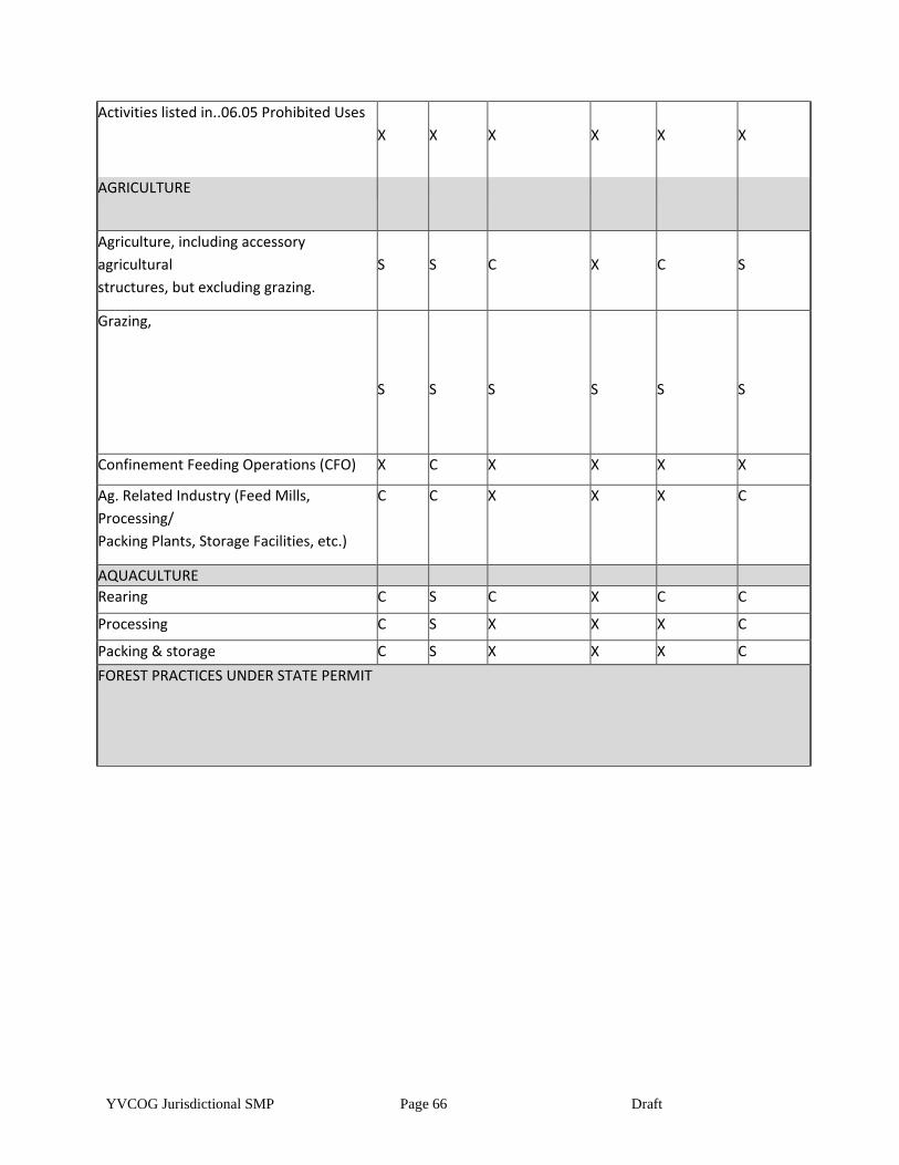
YVCOG Jurisdictional SMP Page 66 Draft
Activities listed in..06.05 Prohibited Uses
X
X
X
X
X
X
AGRICULTURE
Agriculture, including accessory
agricultural
structures, but excluding grazing.
S
S
C
X
C
S
Grazing,
S
S
S
S
S
S
Confinement Feeding Operations (CFO) X C X X X X
Ag. Related Industry (Feed Mills,
Processing/
Packing Plants, Storage Facilities, etc.)
C C X X X C
AQUACULTURE
Rearing
Rearing
C S C X C C
Processing
Processing
C S X X X C
Packing & storage C S X X X C
FOREST PRACTICES UNDER STATE PERMIT
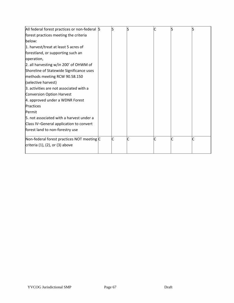
YVCOG Jurisdictional SMP Page 67 Draft
All federal forest practices or non-federal
forest practices meeting the criteria
below:
1. harvest/treat at least 5 acres of
forestland, or supporting such an
operation,
2. all harvesting w/in 200’ of OHWM of
Shoreline of Statewide Significance uses
methods meeting RCW 90.58.150
(selective harvest)
3. activities are not associated with a
Conversion Option Harvest
4. approved under a WDNR Forest
Practices
Permit
5. not associated with a harvest under a
Class IV–General application to convert
forest land to non-forestry use
S S S C S S
Non-federal forest practices NOT meeting
criteria (1), (2), or (3) above
C C C C C C
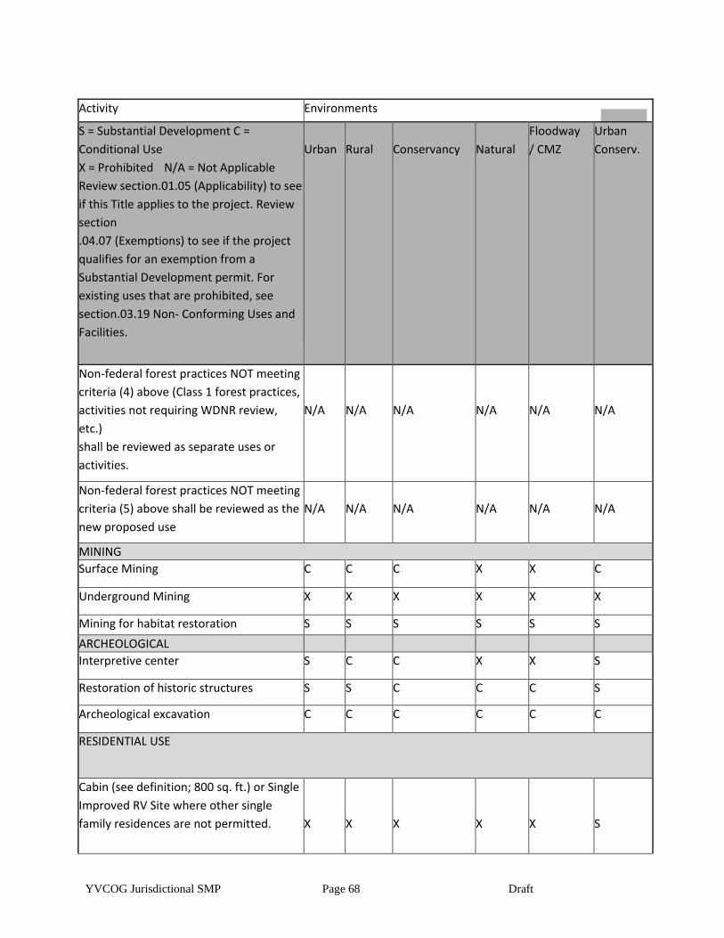
YVCOG Jurisdictional SMP Page 68 Draft
Activity Environments
S = Substantial Development C =
Conditional Use
X = Prohibited N/A = Not Applicable
Review section.01.05 (Applicability) to see
if this Title applies to the project. Review
section
.04.07 (Exemptions) to see if the project
qualifies for an exemption from a
Substantial Development permit. For
existing uses that are prohibited, see
section.03.19 Non- Conforming Uses and
Facilities.
Urban
Rural
Conservancy
Natural
Floodway
/ CMZ
Urban
Conserv.
Non-federal forest practices NOT meeting
criteria (4) above (Class 1 forest practices,
activities not requiring WDNR review,
etc.)
shall be reviewed as separate uses or
activities.
N/A
N/A
N/A
N/A
N/A
N/A
Non-federal forest practices NOT meeting
criteria (5) above shall be reviewed as the
new proposed use
N/A
N/A
N/A
N/A
N/A
N/A
MINING
Surface Mining C C C X X C
Underground Mining X X X X X X
Mining for habitat restoration S S S S S S
ARCHEOLOGICAL
Interpretive center S C C X X S
Restoration of historic structures S S C C C S
Archeological excavation C C C C C C
RESIDENTIAL USE
Cabin (see definition; 800 sq. ft.) or Single
Improved RV Site where other single
family residences are not permitted.
X
X
X
X
X
S
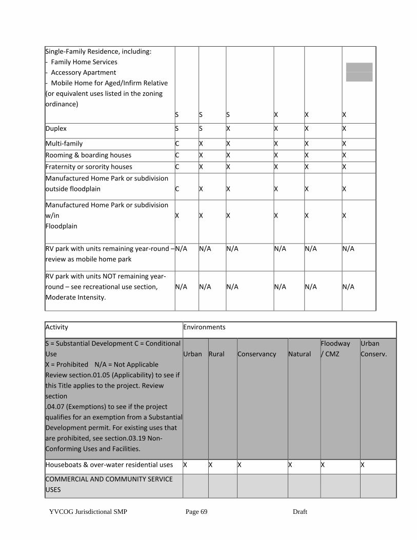
YVCOG Jurisdictional SMP Page 69 Draft
Single-Family Residence, including:
- Family Home Services
- Accessory Apartment
- Mobile Home for Aged/Infirm Relative
(or equivalent uses listed in the zoning
ordinance)
S
S
S
X
X
X
Duplex S S X X X X
Multi-family C X X X X X
Rooming & boarding houses C X X X X X
Fraternity or sorority houses C X X X X X
Manufactured Home Park or subdivision
outside floodplain
C
X
X
X
X
X
Manufactured Home Park or subdivision
w/in
Floodplain
X
X
X
X
X
X
RV park with units remaining year-round –
review as mobile home park
N/A N/A N/A N/A N/A N/A
RV park with units NOT remaining year-
round – see recreational use section,
Moderate Intensity.
N/A
N/A
N/A
N/A
N/A
N/A
Activity Environments
S = Substantial Development C = Conditional
Use
X = Prohibited N/A = Not Applicable
Review section.01.05 (Applicability) to see if
this Title applies to the project. Review
section
.04.07 (Exemptions) to see if the project
qualifies for an exemption from a Substantial
Development permit. For existing uses that
are prohibited, see section.03.19 Non-
Conforming Uses and Facilities.
Urban
Rural
Conservancy
Natural
Floodway
/ CMZ
Urban
Conserv.
Houseboats & over-water residential uses X X X X X X
COMMERCIAL AND COMMUNITY SERVICE
USES
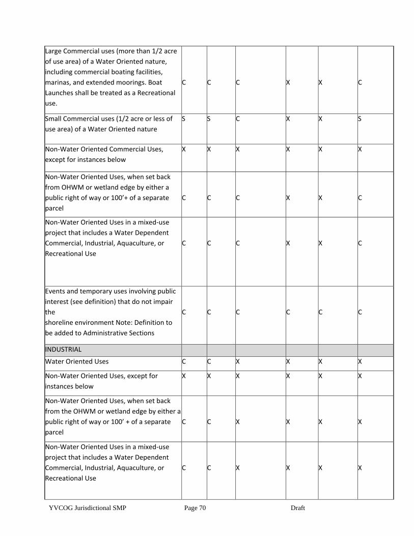
YVCOG Jurisdictional SMP Page 70 Draft
Large Commercial uses (more than 1/2 acre
of use area) of a Water Oriented nature,
including commercial boating facilities,
marinas, and extended moorings. Boat
Launches shall be treated as a Recreational
use.
C
C
C
X
X
C
Small Commercial uses (1/2 acre or less of
use area) of a Water Oriented nature
S S C X X S
Non-Water Oriented Commercial Uses,
except for instances below
X X X X X X
Non-Water Oriented Uses, when set back
from OHWM or wetland edge by either a
public right of way or 100’+ of a separate
parcel
C
C
C
X
X
C
Non-Water Oriented Uses in a mixed-use
project that includes a Water Dependent
Commercial, Industrial, Aquaculture, or
Recreational Use
C
C
C
X
X
C
Events and temporary uses involving public
interest (see definition) that do not impair
the
shoreline environment Note: Definition to
be added to Administrative Sections
C
C
C
C
C
C
INDUSTRIAL
Water Oriented Uses C C X X X X
Non-Water Oriented Uses, except for
instances below
X X X X X X
Non-Water Oriented Uses, when set back
from the OHWM or wetland edge by either a
public right of way or 100’ + of a separate
parcel
C
C
X
X
X
X
Non-Water Oriented Uses in a mixed-use
project that includes a Water Dependent
Commercial, Industrial, Aquaculture, or
Recreational Use
C
C
X
X
X
X
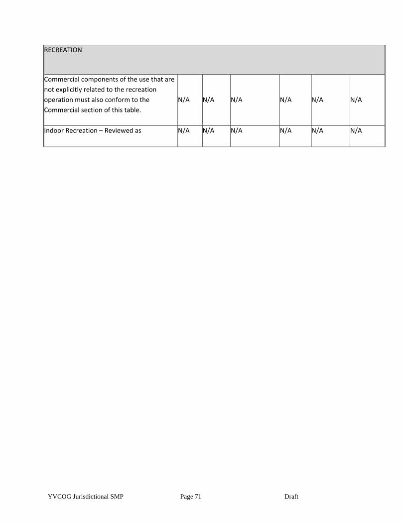
YVCOG Jurisdictional SMP Page 71 Draft
RECREATION
Commercial components of the use that are
not explicitly related to the recreation
operation must also conform to the
Commercial section of this table.
N/A
N/A
N/A
N/A
N/A
N/A
Indoor Recreation – Reviewed as N/A N/A N/A N/A N/A N/A
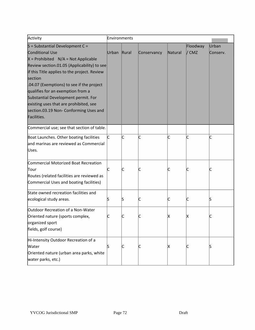
YVCOG Jurisdictional SMP Page 72 Draft
Activity Environments
S = Substantial Development C =
Conditional Use
X = Prohibited N/A = Not Applicable
Review section.01.05 (Applicability) to see
if this Title applies to the project. Review
section
.04.07 (Exemptions) to see if the project
qualifies for an exemption from a
Substantial Development permit. For
existing uses that are prohibited, see
section.03.19 Non- Conforming Uses and
Facilities.
Urban
Rural
Conservancy
Natural
Floodway
/ CMZ
Urban
Conserv.
Commercial use; see that section of table.
Boat Launches. Other boating facilities
and marinas are reviewed as Commercial
Uses.
C C C C C C
Commercial Motorized Boat Recreation
Tour
Routes (related facilities are reviewed as
Commercial Uses and boating facilities)
C
C
C
C
C
C
State owned recreation facilities and
ecological study areas.
S
S
C
C
C
S
Outdoor Recreation of a Non-Water
Oriented nature (sports complex,
organized sport
fields, golf course)
C
C
C
X
X
C
Hi-Intensity Outdoor Recreation of a
Water
Oriented nature (urban area parks, white
water parks, etc.)
S
C
C
X
C
S
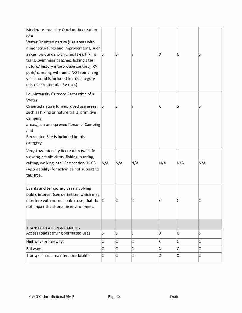
YVCOG Jurisdictional SMP Page 73 Draft
Moderate-Intensity Outdoor Recreation
of a
Water Oriented nature (use areas with
minor structures and improvements, such
as campgrounds, picnic facilities, hiking
trails, swimming beaches, fishing sites,
nature/ history interpretive centers); RV
park/ camping with units NOT remaining
year- round is included in this category
(also see residential RV uses)
S
S
S
X
C
S
Low-Intensity Outdoor Recreation of a
Water
Oriented nature (unimproved use areas,
such as hiking or nature trails, primitive
camping
areas,); an unimproved Personal Camping
and
Recreation Site is included in this
category.
S
S
S
C
S
S
Very-Low-Intensity Recreation (wildlife
viewing, scenic vistas, fishing, hunting,
rafting, walking, etc.) See section.01.05
(Applicability) for activities not subject to
this title.
N/A
N/A
N/A
N/A
N/A
N/A
Events and temporary uses involving
public interest (see definition) which may
interfere with normal public use, that do
not impair the shoreline environment.
C
C
C
C
C
C
TRANSPORTATION & PARKING
Access roads serving permitted uses S S S X C S
Highways & freeways C C C C C C
Railways C C C X C C
Transportation maintenance facilities C C C X X C
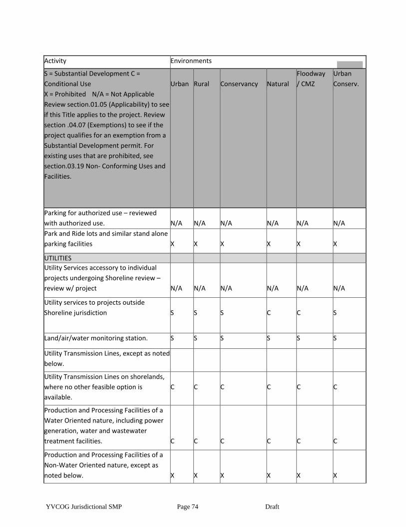
YVCOG Jurisdictional SMP Page 74 Draft
Activity Environments
S = Substantial Development C =
Conditional Use
X = Prohibited N/A = Not Applicable
Review section.01.05 (Applicability) to see
if this Title applies to the project. Review
section .04.07 (Exemptions) to see if the
project qualifies for an exemption from a
Substantial Development permit. For
existing uses that are prohibited, see
section.03.19 Non- Conforming Uses and
Facilities.
Urban
Rural
Conservancy
Natural
Floodway
/ CMZ
Urban
Conserv.
Parking for authorized use – reviewed
with authorized use.
N/A
N/A
N/A
N/A
N/A
N/A
Park and Ride lots and similar stand alone
parking facilities
X
X
X
X
X
X
UTILITIES
Utility Services accessory to individual
projects undergoing Shoreline review –
review w/ project
N/A
N/A
N/A
N/A
N/A
N/A
Utility services to projects outside
Shoreline jurisdiction
S
S
S
C
C
S
Land/air/water monitoring station. S S S S S S
Utility Transmission Lines, except as noted
below.
X
X
X
X
X
X Utility Transmission Lines on shorelands,
where no other feasible option is
available.
C
C
C
C
C
C
Production and Processing Facilities of a
Water Oriented nature, including power
generation, water and wastewater
treatment facilities.
C
C
C
C
C
C
Production and Processing Facilities of a
Non-Water Oriented nature, except as
noted below.
X
X
X
X
X
X
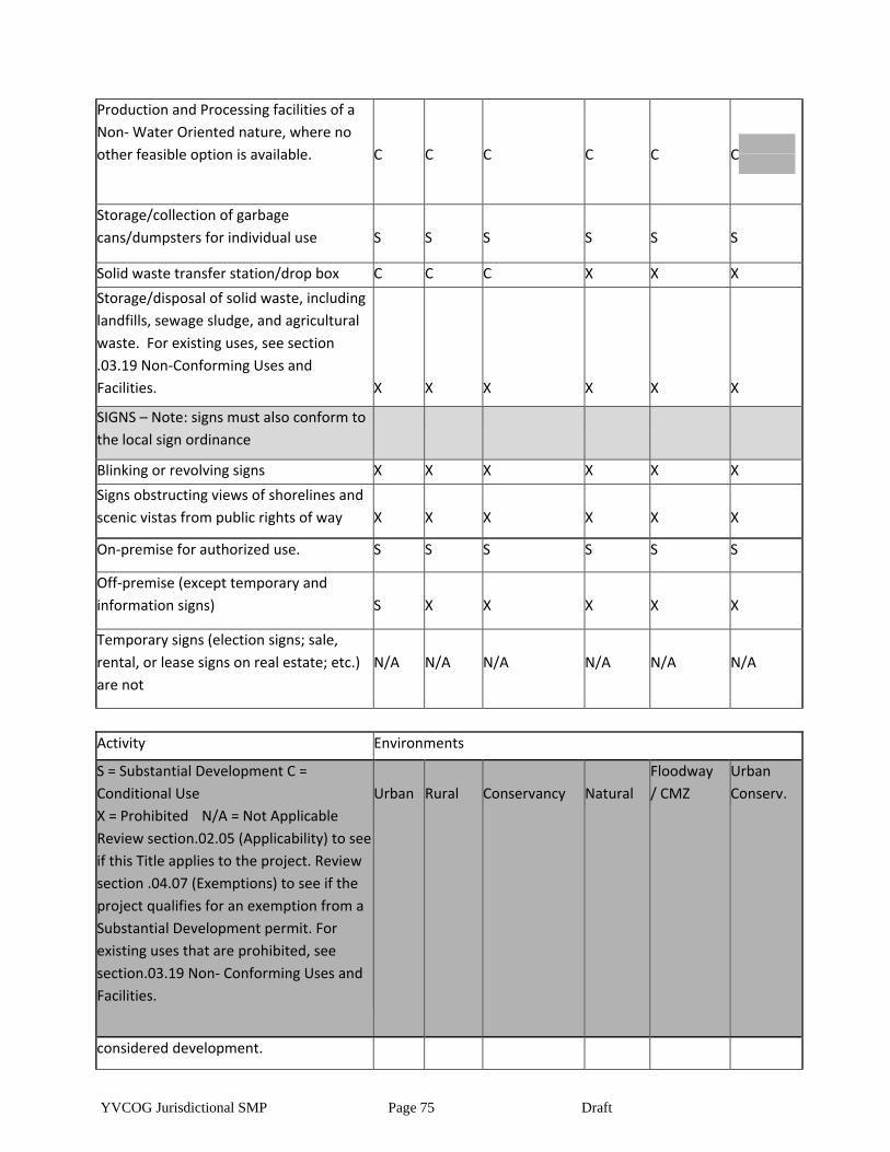
YVCOG Jurisdictional SMP Page 75 Draft
Production and Processing facilities of a
Non- Water Oriented nature, where no
other feasible option is available.
C
C
C
C
C
C
Storage/collection of garbage
cans/dumpsters for individual use
S
S
S
S
S
S
Solid waste transfer station/drop box C C C X X X
Storage/disposal of solid waste, including
landfills, sewage sludge, and agricultural
waste. For existing uses, see section
.03.19 Non-Conforming Uses and
Facilities.
X
X
X
X
X
X
SIGNS – Note: signs must also conform to
the local sign ordinance
Blinking or revolving signs X X X X X X
Signs obstructing views of shorelines and
scenic vistas from public rights of way
X
X
X
X
X
X
On-premise for authorized use. S S S S S S
Off-premise (except temporary and
information signs)
S
X
X
X
X
X
Temporary signs (election signs; sale,
rental, or lease signs on real estate; etc.)
are not
N/A
N/A
N/A
N/A
N/A
N/A
Activity Environments
S = Substantial Development C =
Conditional Use
X = Prohibited N/A = Not Applicable
Review section.02.05 (Applicability) to see
if this Title applies to the project. Review
section .04.07 (Exemptions) to see if the
project qualifies for an exemption from a
Substantial Development permit. For
existing uses that are prohibited, see
section.03.19 Non- Conforming Uses and
Facilities.
Urban
Rural
Conservancy
Natural
Floodway
/ CMZ
Urban
Conserv.
considered development.
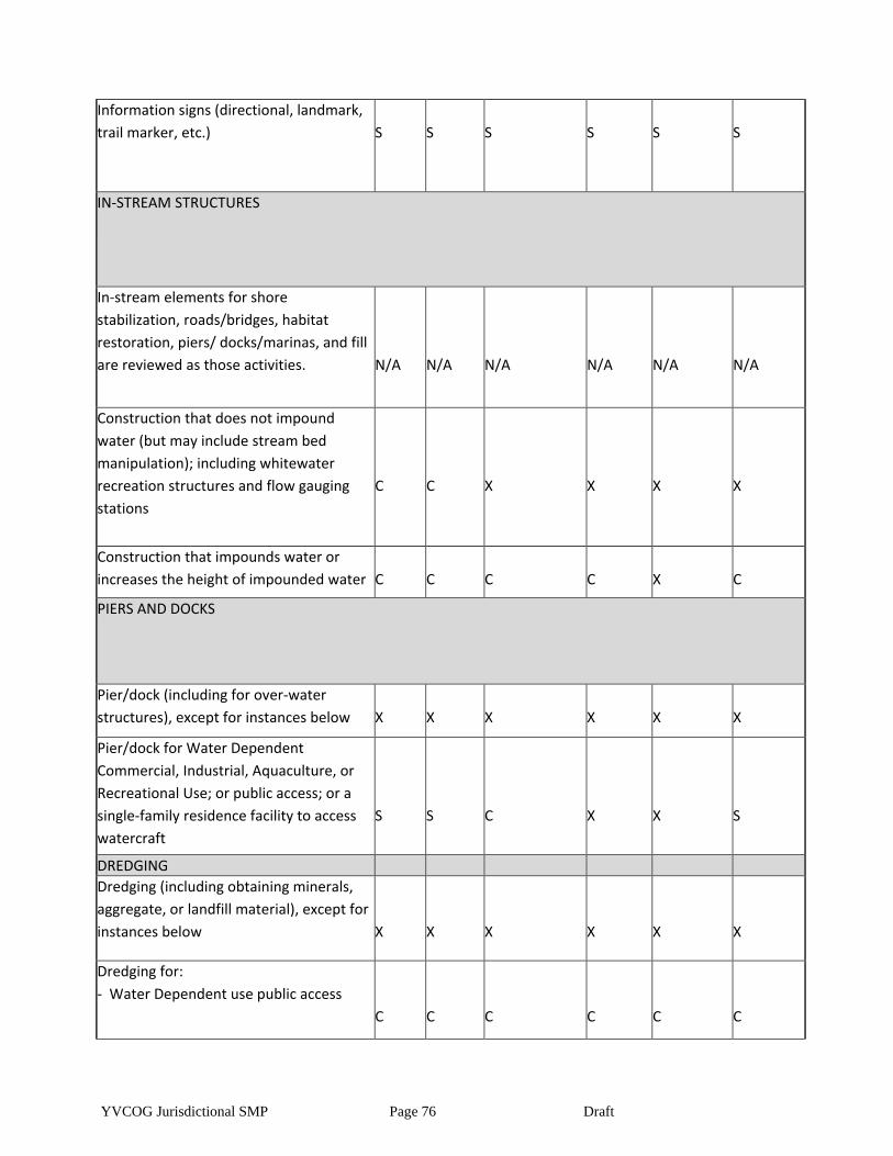
YVCOG Jurisdictional SMP Page 76 Draft
Information signs (directional, landmark,
trail marker, etc.)
S
S
S
S
S
S
IN-STREAM STRUCTURES
In-stream elements for shore
stabilization, roads/bridges, habitat
restoration, piers/ docks/marinas, and fill
are reviewed as those activities.
N/A
N/A
N/A
N/A
N/A
N/A
Construction that does not impound
water (but may include stream bed
manipulation); including whitewater
recreation structures and flow gauging
stations
C
C
X
X
X
X
Construction that impounds water or
increases the height of impounded water
C
C
C
C
X
C
PIERS AND DOCKS
Pier/dock (including for over-water
structures), except for instances below
X
X
X
X
X
X
Pier/dock for Water Dependent
Commercial, Industrial, Aquaculture, or
Recreational Use; or public access; or a
single-family residence facility to access
watercraft
S
S
C
X
X
S
DREDGING
Dredging (including obtaining minerals,
aggregate, or landfill material), except for
instances below
X
X
X
X
X
X
Dredging for:
- Water Dependent use public access
C
C
C
C
C
C

YVCOG Jurisdictional SMP Page 77 Draft
Dredging to modify channels or basins
(excluding maintenance) for existing
navigation uses
S
S
S
X
X
S
Dredging for habitat restoration S S S S S S
FILLING & DREDGE MATERIAL DISPOSAL
Fill within the OHWM, except for
instances below
X
X
X
X
X
X
Fill within the OHWM for:
- Water Dependent use
- public access
- expansion of existing transportation
system of state-wide significance
C
C
C
X
X
C
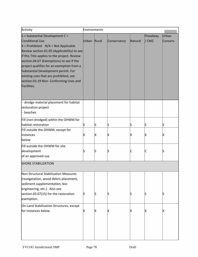
YVCOG Jurisdictional SMP Page 78 Draft
Activity Environments
S = Substantial Development C =
Conditional Use
X = Prohibited N/A = Not Applicable
Review section.01.05 (Applicability) to see
if this Title applies to the project. Review
section.04.07 (Exemptions) to see if the
project qualifies for an exemption from a
Substantial Development permit. For
existing uses that are prohibited, see
section.03.19 Non- Conforming Uses and
Facilities.
Urban
Rural
Conservancy
Natural
Floodway
/ CMZ
Urban
Conserv.
- dredge material placement for habitat
restoration project
- beaches
Fill (non-dredged) within the OHWM for
habitat restoration
S
S
S
S
S
S
Fill outside the OHWM, except for
instances
below
X
X
X
X
X
X
Fill outside the OHWM for site
development
of an approved use
S
S
S
C
C
S
SHORE STABILIZATION
Non-Structural Stabilization Measures
(revegetation, wood debris placement,
sediment supplementation, bio-
engineering, etc.). Also see
section.03.07(15) for the restoration
exemption.
S
S
S
S
S
S
On-Land Stabilization Structures, except
for instances below
X
X
X
X
X
X
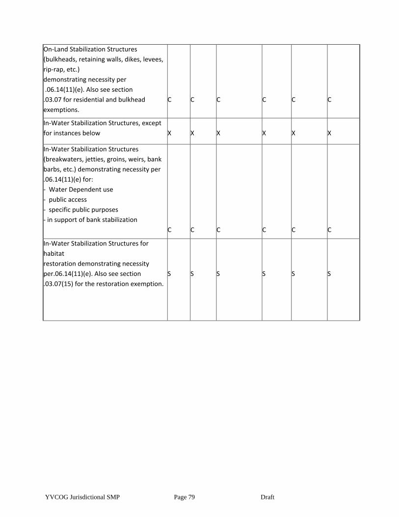
YVCOG Jurisdictional SMP Page 79 Draft
On-Land Stabilization Structures
(bulkheads, retaining walls, dikes, levees,
rip-rap, etc.)
demonstrating necessity per
.06.14(11)(e). Also see section
.03.07 for residential and bulkhead
exemptions.
C
C
C
C
C
C
In-Water Stabilization Structures, except
for instances below
X
X
X
X
X
X
In-Water Stabilization Structures
(breakwaters, jetties, groins, weirs, bank
barbs, etc.) demonstrating necessity per
.06.14(11)(e) for:
- Water Dependent use
- public access
- specific public purposes
- in support of bank stabilization
C
C
C
C
C
C
In-Water Stabilization Structures for
habitat
restoration demonstrating necessity
per.06.14(11)(e). Also see section
.03.07(15) for the restoration exemption.
S
S
S
S
S
S
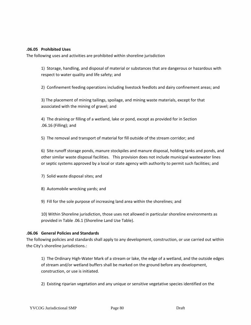
YVCOG Jurisdictional SMP Page 80 Draft
.06.05 Prohibited Uses
The following uses and activities are prohibited within shoreline jurisdiction
1) Storage, handling, and disposal of material or substances that are dangerous or hazardous with
respect to water quality and life safety; and
2) Confinement feeding operations including livestock feedlots and dairy confinement areas; and
3) The placement of mining tailings, spoilage, and mining waste materials, except for that
associated with the mining of gravel; and
4) The draining or filling of a wetland, lake or pond, except as provided for in Section
.06.16 (Filling); and
5) The removal and transport of material for fill outside of the stream corridor; and
6) Site runoff storage ponds, manure stockpiles and manure disposal, holding tanks and ponds, and
other similar waste disposal facilities. This provision does not include municipal wastewater lines
or septic systems approved by a local or state agency with authority to permit such facilities; and
7) Solid waste disposal sites; and
8) Automobile wrecking yards; and
9) Fill for the sole purpose of increasing land area within the shorelines; and
10) Within Shoreline jurisdiction, those uses not allowed in particular shoreline environments as
provided in Table .06.1 (Shoreline Land Use Table).
.06.06 General Policies and Standards
The following policies and standards shall apply to any development, construction, or use carried out within
the City’s shoreline jurisdictions.:
1) The Ordinary High-Water Mark of a stream or lake, the edge of a wetland, and the outside edges
of stream and/or wetland buffers shall be marked on the ground before any development,
construction, or use is initiated.
2) Existing riparian vegetation and any unique or sensitive vegetative species identified on the
YVCOG Jurisdictional SMP Page 81 Draft
project site within the Shoreline designation shall be disturbed to the minimum extent possible.
3) Nesting areas and other sensitive wildlife habitat identified within a stream corridor shall be
disturbed to the minimum extent possible.
4) Projects within the Shoreline designation shall be scheduled to occur at times and during
seasons having the least impact to spawning, nesting, or other sensitive wildlife activities.
Scheduling recommendations from the appropriate State and/or Federal agency may be
considered.
5) Stormwater and Erosion Control. Developments that obtain a stormwater permit approved by a
local, state, or federal agency, and transportation projects using stormwater manuals that are
deemed equivalent to the Eastern Washington Stormwater Manual are exempt from the
requirements below.
a) Excavation, grading, cut/fills, compaction, and other modifications which contribute to
erosion of upland soils shall be confined to the minimum necessary to complete the
authorized work and avoid increased sediment load.
b) The removal of ground-cover vegetation, excavation, and grading shall be scheduled for
periods when soils are the least vulnerable to erosion, compaction, and movement unless
suitable protective measures are used to prevent erosion.
c) The removal of ground-cover vegetation, excavation, and grading shall be scheduled to
ensure the minimal duration of exposed, unprotected soils.
d) Increases in impervious surface area, compaction of soil, changes in topography, and
other modifications of land within a stream corridor which are determined will permanently
increase stormwater and meltwater runoff into stream channels, drainage ways, and
conduits, shall provide on-site or off-site facilities for the detention, control, and filtration of
such increases.
e) The discharge point for controlled stormwater and meltwater runoff and other outfall
shall be designed and constructed to avoid causing erosion through the use of native
riparian vegetation where possible or by reducing velocity, use of rock spillways, riprap,
splash plates, or other demonstrably effective means.
f) Matting or approved temporary ground cover shall be used to control erosion until
natural vegetative ground cover is successfully established.
6) Development, construction, and uses shall not directly or indirectly degrade surface water and
groundwater through the introduction of nutrients, fecal coliform, toxins, and other biochemical
substances.
YVCOG Jurisdictional SMP Page 82 Draft
7) Prior to the approval of development, construction, or uses within a designated stream corridor,
any existing source of biochemical or thermal degradation identified as originating on the project
property or on contiguous properties of the same ownership shall be corrected.
8) Facilities which use fertilizers, pesticides or herbicides shall use landscaping, low-risk products,
application schedules, and other protective methodology to minimize the surface and subsurface
transfer of biochemical materials into the stream corridor.
9) Modifications to natural channel gradient, channel morphology, drainage patterns, and other
stream features shall not permanently alter or obstruct the natural volume or flow of surface
waters.
10) Development, construction, or uses within the stream corridor shall not alter or divert flood
flows causing channel shift or erosion, increase or accelerate the flooding of upstream or
downstream flood hazard areas, or otherwise threaten public or private properties.
11) Wells located within a stream corridor shall be protectively lined and installed in a deep aquifer
with an acceptable minimum hydraulic continuity with either surface waters or a shallow aquifer.
12) Structures placed in close proximity to the outer edge of bends in stream channels identified as
having a high potential to meander shall be located to minimize the hazard from stream
undercutting and stream bank erosion stemming from potential future stream migration.
13) Adjacent communities and the Department of Ecology shall be notified prior to any alteration or
relocation of a watercourse and evidence of such notification shall be submitted to the Federal
Emergency Management Agency.
14) Require that maintenance is provided within the altered or relocated portion of said
watercourse so that the flood-carrying capacity is not diminished.
15) Development, construction, or uses within the hydrologically related critical area that would
contribute to the degradation of the functions and values shall be avoided or mitigated using
mitigation sequencing as outlined in section.03.10 (Mitigation Requirements).
16) Development shall not obstruct, cut off, or isolate stream corridor features.
17) Nothing in these regulations shall constitute authority of any person to trespass or in any way
infringe upon the rights of private ownership.
18) If archaeological resources are uncovered during excavation, developers and property owners
shall immediately stop work and notify the City of TOPPENISH, the Washington State Office of
YVCOG Jurisdictional SMP Page 83 Draft
Archaeology and Historic Preservation and any affected Indian Tribes. Archaeological sites are
subject to RCW 27.44 (Indian graves and records) and RCW 27.53 (Archaeological sites and records),
and development or uses that may impact such sites shall comply with WAC 25-48 (Archaeological
Excavation and Removal Permit).
19) The provisions of CITATION (Flood Damage Prevention) and CITATION (Frequently Flooded
Areas) shall also apply to the development of lots and the placement, construction, or installation of
structures in floodways and floodplains.
20) Any portion of the vegetative buffer temporarily damaged or disturbed because of construction
activities (excluding approved permanent use areas) shall be repaired at the completion of
construction using reclamation standards in section05.18 (Reclamation).
21) Changing from an existing use or development which does not meet the provisions of this
chapter to a new use shall be reviewed to ensure that the conversion will demonstrably reduce
impacts to stream corridor and other hydrologically related critical area features
22) Individual projects or actions that, if continued as a pattern, would accumulatively result in the
degradation or impairment of the Shoreline environment, shall be avoided.
23) Individual projects or actions shall provide for no net loss of Shoreline ecological functions.
24) Shoreline development shall not interfere with public access and enjoyment of any nearby
publicly owned land areas.
25) Outdoor advertising signs must conform to size, spacing and lighting provisions of the
Washington State Scenic Vistas Act of 1971, where applicable.
26) There shall be a thirty-five (35) foot maximum building height for all structures, except that
utility towers and poles, dams, concrete and asphalt batching plants, water treatment towers,
wastewater treatment facilities and bridges are not required to meet this standard, and specific
height limitations for residential structures are as follows:
i) 25 feet above average grade level in the conservancy environment.
ii) 20 feet above average grade level in the natural environment.
iii) 25 feet above average grade level in the urban conservancy environment.
iv) 20 feet above average grade level in the floodway/channel migration zone.
27) New development within Shoreline jurisdiction shall be located and designed to:
i) avoid the need for future shore stabilization, to the extent feasible.
ii) avoid or, if that is not possible, to minimize the need for new and maintenance dredging.
YVCOG Jurisdictional SMP Page 84 Draft
iii) assure that subdivision lots created will not require shore stabilization in order for
reasonable development to occur. The standards should be accomplished using
geotechnical analysis of the site and shoreline characteristics, as provided in
section.06.14(11) (Additional Shoreline Standards for Shore Stabilization);
iv) setback new development on steep slopes or bluffs sufficiently to ensure that shore
stabilization is unlikely to be necessary during the life of the structure, as demonstrated by
a geotechnical analysis, as provided in section .06.14(11) (Additional Shoreline Standards
for Shore Stabilization).
v) New development that would require shore stabilization which causes significant impacts
to adjacent or down-current properties and shoreline areas shall not be allowed.
Article III - WATER DEPENDENCY DEVELOPMENT STANDARDS AND BUFFER REQUIREMENTS
.06.07 Use Classifications
For purposes of this chapter, the components of any development, construction, or use requiring a critical
area development authorization shall be classified as provided below and shall conform with the
development standards applicable to the classification provided in .06.08 through 05.10 except for those
listed in Section.03.02 (Minor Activities Allowed without a Permit or Exemption):
1) Water Oriented Uses are one of the following three (3) categories of uses:
a) Water-dependent uses include dams, water diversion facilities, marinas, boat launching
facilities, water intakes and outfalls, aquaculture, log booming, stream and wetland
crossings for roads and railroads, stream and wetland crossings for utilities, swimming
beaches, fishing sites, in-water or on-land shore stabilization structures, livestock
watering sites, and other uses that cannot exist in any other location and are dependent on
the water by reason of the intrinsic nature of their operations. This provision applies only to
the specific portion of a project that is demonstrably dependent upon the water or shore.
b) A Water-related use is one not intrinsically dependent on a waterfront location but
whose economic viability is enhanced by a waterfront location either because it requires
large quantities of water, or because it provides services for water dependent uses and the
proximity to its customers makes such services less expensive and/or more convenient.
Examples would include thermal power plants, wastewater treatment plants, water
processing and treatment plants, support services for fish hatcheries or aquaculture, fly
shops and boat rental shops.
c) A Water enjoyment use is a recreational or other use that facilitates public access within
Shoreline jurisdiction as a primary characteristic of the use or provides for recreational use
or aesthetic enjoyment of the shoreline for a substantial number of people as a general
characteristic of the use; and which through location, design, and operation ensures the
public's ability to enjoy the physical and aesthetic qualities of the shoreline. Within
Shoreline jurisdiction the use must be open to the general public and the shoreline-oriented
YVCOG Jurisdictional SMP Page 85 Draft
space within the project must be devoted to the specific aspects of the use that fosters
shoreline enjoyment in order to qualify as a water-enjoyment use within Shoreline
jurisdiction. Examples include recreational uses orientated to the Shorelines water features,
and restaurants with water viewing.
2) Non-water-oriented uses include any use not qualifying as uses in subsection (1) above.
.06.08 Water-dependent Uses
The following provisions shall apply to water-dependent uses:
1) Structures shall be clustered at locations on the water's edge having the least impact to the
surface water and shore.
2) Use areas and structures which require direct shore locations shall be located and constructed to
minimize impacts to the shore area and the vegetative buffer specified in Section
.06.11 (Vegetative Buffers).
3) Use areas and structures requiring direct shore locations shall minimize any obstruction or
impairment of normal public navigation of the surface water.
.06.09 Water-related Uses
The following provisions shall apply to the water-related uses:
1) Structures and use areas shall be located as far landward from the ordinary high-water mark or
wetland edge as is possible and still preserve the essential or necessary relationship with the
surface water.
2) Structures and use areas shall not be located within the vegetative buffer specified in Section
.06.11 (Vegetative Buffers) except where existing development or the requirements associated with
the use make such a location unavoidable.
.06.10 Water-enjoyment and Non-water Oriented Uses
The following provisions shall apply to water enjoyment and non-water-oriented uses:
1) Structures and use areas shall be set back so as not to be located within the vegetative buffer
specified in Section .06.11 (Vegetative Buffers).
2) Construction abutting the vegetative buffer specified in Section .06.11 (Vegetative Buffers) shall
be designed and scheduled to ensure there will not be permanent damage or loss of the vegetative
buffer.
.06.11 Vegetative Buffers
Establishment. There is hereby established a system of vegetative buffers that are necessary to protect the
ecological functions and values of shorelines. The vegetative buffer for shoreline streams and lakes shall be
YVCOG Jurisdictional SMP Page 86 Draft
100 feet. For wetlands, based on a review of the best available science, buffers are listed in table 6-1.
1) Vegetative buffers shall be measured from the Ordinary High-Water Mark (OHWM) for streams,
lakes, and ponds.
2) Buffer width may be reduced through the Variance permit process.
3) The adequacy of these standard buffer widths presumes the existence of a relatively intact
native vegetation community in the buffer zone adequate to protect the stream functions and
values at the time of the proposed activity. If the vegetation is degraded, then no adjustment to
the buffer width should be granted and re-vegetation should be considered. Where the use is being
intensified, a degraded buffer should be re-vegetated to maintain the standard width.
Article IV Shoreline Modification Standards
.06.12 Roads, Railroads, and Parking
The following provisions shall apply to the location and construction of roads, railroads, and parking within
shorelines.
1) Roads and railroads shall not be located within a designated stream corridor except where it is
necessary to cross the corridor, or where existing development, topography, and other conditions
preclude locations outside the stream corridor.
a) Construction of roadways across stream corridors shall be by the most direct route
possible having the least impact to the stream corridor.
b) Roadways that must run parallel to stream or wetland edges shall be along routes having
the greatest possible distance from stream or wetland and the least impact to the corridor.
c) Roadways within the stream corridor shall not hydrologically obstruct, cut-off or isolate
stream corridor features.
2) Material excavated from the roadway area to achieve the design grade shall be used as fill where
necessary to maintain grade or shall be transported outside the corridor.
3) Necessary fill to elevate roadways shall not impede the normal flow of floodwaters or cause
displacement that would increase the elevation of flood waters such that it would cause properties
not in the floodplain to be flood prone.
4) Spoil, construction waste, and other debris shall not be used as road fill or buried within the
stream corridor.
5) Bridges and water-crossing structures shall not constrict the stream channel or impede the flow
of the ordinary high water, sediment, and woody debris.
YVCOG Jurisdictional SMP Page 87 Draft
6) Natural stream channels and drainage ways shall be preserved through the use of bridges for
crossings, unless the use of culverts is demonstrated to be the only technically feasible means for
crossing. The use of bridges shall be the preferred means to preserve natural streams and
drainageways. Where bridges are not feasible, large, natural bottom culverts, multi-plate pipes
and bottomless arches shall be used.
7) The alignment and slope of culverts shall parallel and match the natural flow of streams or
drainage ways, unless doing so conflicts with subsection (1) and (2), and shall be sized to
accommodate ordinary high water, and shall terminate on stable, erosion-resistant materials.
8) Where fish, amphibian or other wildlife passage is present, culverts shall be designed and
constructed to specifications provided through the Washington State Aquatic Habitat Guidelines or
a comparable source of expertise.
9) At least one end of a wood stringer bridge shall be anchored to prevent it from being washed
away during high water.
10) Roads must be designed and constructed using established flood resistant and design and
construction methods when they may be subject to damage by flood waters.11) Roads and bridges
within floodways must meet the requirements of the City of TOPPENISH XMC FLOOD HAZARD
MITIGATION CODE HERE.
11) Parking areas shall be located upland of the areas they serve.
12) Owners of two or more adjoining uses, structures or parcels of land may utilize jointly the same
parking area when the hours of operation do not overlap.
13) A Conditional Use Permit for roads, railroads or parking areas must demonstrate through and
engineering studies that a shoreline location is the most feasible of the available options.
.06.13 Utility Transmission Lines and Facilities
The following provisions shall apply to the location, construction, or installation of utility transmission lines
and facilities (such as those for wastewater, water, communication, natural gas, etc.) within a designated
hydrologically related critical area:
1) Utility transmission lines and facilities shall be permitted within the stream corridor only where it
is necessary to cross the corridor or where existing development, topography, and other conditions
preclude locations outside the stream corridor. Utility transmission lines and facilities across
stream corridors shall be by the most direct route possible having the least impact to the stream
corridor.
YVCOG Jurisdictional SMP Page 88 Draft
2) Utility lines under streams and wetlands shall be placed in a sleeve casing to allow easy
replacement or repair with minimal disturbance to the stream corridor.
3) Buried utility transmission lines crossing a stream corridor shall be buried a minimum of four feet
below the maximum scour or 1/3 of the bankfull depth of the waterway, whichever is greater, and
for a similar depth below any associated floodway and floodplain to the maximum extent of
potential channel migration as determined by hydrologic analysis.
4) Wherever possible, new aboveground installations shall use available, existing bridge and utility
locations and stream corridor crossings as opposed to creating new locations and stream corridor
crossings.
5) Aboveground electrical support towers and other similar transmission structures shall be located
as far upland as is practical.
6) Transmission support structures shall be located clear of high flood velocities, located in areas of
minimum flood depth which require the least floodproofing, and shall be adequately floodproofed.
7) Underground utility transmission lines shall be constructed so they do not alter, intercept, or
dewater groundwater patterns that support streams, wetlands and hyporheic flow.
8) All new and replacement water supply systems and wastewater systems within a special flood
hazard area must meet the requirements of FLOOD HAZARD CITATION HERE.
9) Utility transmission lines within the Floodway and the Floodway Fringe shall meet the standards
of Flood Hazard Citation of City Code
10)
The requirements below shall apply to all utility transmission lines and facilities within Shoreline
jurisdiction. Utility services to individual projects undergoing Shoreline review, including those
where the primary use may be in a different Shoreline environment than the utility service shall not
require separate Substantial Development Permits for utility service installations, but are subject to
all of the provisions in .06.13, except those listed below. Utility service to projects outside Shoreline
jurisdiction are subject to normal Shoreline permitting and are subject to all of the provisions in
.06.13 (Utility Transmission Lines and Facilities), except those listed below.
a) Where feasible utilities shall be placed underground unless such undergrounding would
be economically or technically prohibitive.
b) New utility facilities shall be designed and located to preserve the natural landscape and
minimize conflicts with present and planned land and shoreline uses, especially recreation,
residential and public access.
YVCOG Jurisdictional SMP Page 89 Draft
c) Expansion, updating, and maintenance of existing facilities is allowed but shall be
designed to be located to avoid adverse impacts to shoreline resources as much as possible.
d) Permit applications shall meet the following submittal review standards:
e) Applications shall submit studies (social, economic, environmental, engineering, etc.) to
demonstrate that a shoreline location is the most feasible of the available options.
f) Applications to locate transmission lines shall submit a location plan that shows existing
utility routes in the vicinity of the proposed transmission line. Failure of utility lines to
follow existing routes, where feasible, shall cause denial of the application.
g) Applications shall include a reclamation plan that provides for re-vegetation and
protection of shoreline areas from erosion and siltation. A re-vegetation or erosion
protection plan judged by the Administrative Official to be insufficient for the protection or
restoration of the Shoreline environment shall cause denial of the application.
.06.14 Shore Stabilization
The following provisions shall apply to shore stabilization projects:
1) Shore stabilization projects shall be allowed only where there is evidence of erosion which
clearly represents a threat to existing property, structures, or facilities, and which stabilization will
not jeopardize other upstream or downstream properties.
2) Stabilization projects shall be developed under the supervision of, or in consultation with,
agencies or professionals with appropriate expertise.
3) Stabilization projects shall be confined to the minimum protective measures necessary to
protect the threatened property.
4) The use of fill to restore lost land may accompany stabilization work, provided the resultant shore does
not extend beyond the new ordinary high-water mark, finished grades are consistent with abutting
properties, a restoration plan is approved for the area, and the fill material is in compliance with
Section .06.16 (Filling).
5) Stabilization projects shall use design, material, and construction alternatives that do not require
high or continuous maintenance, and which prevent or minimize the need for subsequent
stabilization to other segments of the shore. Junk car bodies and other unsuitable debris are not to
be used in shore stabilization projects.
6) Stream bank and lakeshore protection shall be accomplished using bioengineered (biotechnical)
designs employing living plant materials as primary structural components of resistance to erosion
and mass wasting, unless a report prepared by a qualified engineer experienced in soil
YVCOG Jurisdictional SMP Page 90 Draft
bioengineering (biotechnical) and shoreline protection demonstrates that conventional structural
armoring is the only feasible means of stabilizing the subject stream bank or lakeshore.
7) Applications to construct or enlarge dikes or levees shall meet the requirements of
TMC 15.30
8) Revetments and bulkheads shall be no higher than necessary to protect and stabilize the shore.
9) Breakwaters shall be constructed of floating or open pile designs rather than fill, riprap, or other
solid construction methods.
10) All new flood control projects shall define maintenance responsibilities and a funding source for
operations, maintenance, and repairs for the life of the project.
11) Where feasible, dikes and levees shall be located outside of the floodway or channel migration
zone of the river or stream in order to minimize any attendant increase in water stage and stream
flow velocity over existing conditions.
12) Rip-rapping and other shore stabilization measures shall be designed, located, and constructed
in such a manner as to minimize the disruption of natural channel characteristics.
13) Demonstration of necessity. New structural shore stabilization measures shall not be allowed
except when necessity is demonstrated in the following manner:
i) New or enlarged structural stabilization measures for an existing primary
structure, including residences, shall not be allowed unless there is conclusive
evidence, documented by a geotechnical analysis that the structure is in danger
from shoreline erosion caused by currents or waves. Normal sloughing, erosion of
steep bluffs, or demonstration of need. The geotechnical analysis should evaluate
on-site drainage issues and address drainage problems away from the shoreline
edge before considering structural shore stabilization.
ii) Erosion control structures in support of new non-water-dependent
development, including single-family residences, when all of the conditions below
apply:
(1) The erosion is not being caused by upland conditions, such as the loss of
vegetation and drainage; and
(2) Nonstructural measures, such as placing the development further from
the shoreline, planting vegetation, or installing on-site drainage
improvements, are not feasible or not sufficient; and
(3) The need to protect primary structures from damage due to erosion is
demonstrated through a geotechnical report. The damage must be caused
YVCOG Jurisdictional SMP Page 91 Draft
by natural processes, such as tidal action, currents, and waives.
iii) Erosion control structures in support of water-dependent development when all
of the conditions below apply:
(1) The erosion is not being caused by upland conditions, such as the loss of
vegetation and drainage; and
(2) Nonstructural measures, planting vegetation, or installing on-site
drainage improvements, are not feasible or not sufficient; and
(3) The need to protect primary structures from damage due to erosion is
demonstrated through a geotechnical report.
14) Erosion control structures to protect projects for the restoration of ecological functions or
hazardous substance remediation projects pursuant to the Model Toxics Control Act (70.105D RCW)
shall not be allowed unless there is conclusive evidence, documented by a geotechnical analysis
that demonstrates that nonstructural measures such as planting vegetation, or installing on-site
drainage improvements, is not feasible or not sufficient.
15) An existing shore stabilization structure may be replaced with a similar structure if there is a
demonstrated need to protect principal uses or structures from erosion. For purposes of this
section standards on shore stabilization measures, "replacement" means the construction of a new
structure to perform a shore stabilization function of an existing structure which can no longer
adequately serve its purpose. Additions to or increases in size of existing shore stabilization
measures shall be considered new structures under paragraph (g) above.
i) Replacement walls or bulkheads shall not encroach waterward of the ordinary
high- water mark or existing structure unless the residence was occupied prior to
January 1, 1992, and there are overriding safety or environmental concerns. In such
cases, the replacement structure shall abut the existing shore stabilization
structure.
ii) Soft shore stabilization measures that provide restoration of shoreline ecological
functions may be permitted waterward of the ordinary high-water mark.
.06.15 Dredging and Excavation
The following provisions shall apply to dredging and excavation within a designated hydrologically related
critical area:
1) Dredging in surface waters shall be allowed only where necessary because of existing navigation
needs, habitat restoration or improvement maintenance or construction of water- dependent uses.
2) (2) Dredging and excavation shall be confined to the minimum area necessary to accomplish the
intended purpose or use.
3) Hydraulic dredging or other techniques that minimize the dispersal and broadcast of bottom
YVCOG Jurisdictional SMP Page 92 Draft
materials shall be preferred over agitation forms of dredging.
4) Curtains and other appropriate mechanisms shall be used to minimize widespread dispersal of
sediments and other dredge materials.
5) Entries across shore and wetland edges to accomplish dredging or excavation shall be confined to
the minimum area necessary to gain entry and shall be confined to locations with the least potential for
site disturbance and damage.
6) Dredging and excavation shall be scheduled at times having the least impact to fish spawning,
nesting patterns, and other identified natural processes.
7) Dredge spoils are also considered fill and shall not be deposited within the stream except where such
deposit is in accordance with approved procedures intended to preserve or enhance wildlife habitat,
natural drainage, or other naturally occurring conditions.
8) All applications for Substantial Development Permits that include dredging shall supply a dredging
plan that includes the following information:
i) The quantity of material to be removed.
ii) The method of removal.
iii) Location of spoil disposal sites and measures that will be taken to protect the
environment around them.
iv) Plans for the protection and restoration of the shoreline environment during and after
dredging operations.
9) A dredging operation judged by the Administrator to be insufficient for protection or restoration
of the shoreline environment shall cause denial of a Substantial Development permit.
.06.16 Filling
The following provisions shall apply to filling activities within shorelines:
1) Fill within surface waters or wetlands shall be allowed only where necessary in conjunction with
water-dependent uses, or an approved reclamation plan under Section.06.18 (Reclamation)
2) Fill for the purpose of increasing elevation may be permitted if such can be accomplished in a
manner consistent with the policies of this chapter.
3) Fill shall be the minimum necessary to accomplish the use or purpose and shall be confined to
areas having the least impact to the stream corridor. Other alternatives should be preferred over fill
to elevate new homes in the floodplain, such as increasing foundation height or zero- rise methods
YVCOG Jurisdictional SMP Page 93 Draft
such as piers, posts, columns, or other methods.
4) Fill in floodplains shall meet the requirements of chapter Flood Hazard Plan Code Citation).
5) Pile or pier supports shall be preferred over fill for water-dependent uses and facilities.
6) Unless site characteristics dictate otherwise, fill material within surface waters or wetlands shall
be sand, gravel, rock, or other clean material, with a minimum potential to degrade water quality.
7) Fill placement shall be scheduled at times having the least impact to fish spawning, nesting
patterns, and other identified natural processes.
8) Fill shall be stabilized with native vegetation where appropriate to prevent erosion, migration of
sediments and other material from the fill area to surrounding water, shore, and wetlands, unless
technical consultation with other regulating agencies indicates alternative means are required.
9) Projects that propose fill shall make every effort to acquire fill onsite (also known as
compensatory storage) where appropriate.
10) Fill should not obstruct, cut off, or isolate stream corridor features.
11 Fill projects shall be evaluated for effects on total water surface reduction, navigation
restriction, impediment to water flow and circulation, impediment to irrigation systems, reduction
of water quality, and destruction of fish and wildlife habitat.
12 Applications shall include a reclamation plan that provides for re-vegetation and protection of
shoreline areas from erosion and siltation. A re-vegetation or erosion protection plan judged by
the Administrative Official to be insufficient for the protection or restoration of the Shoreline
environment shall cause denial of a Substantial Development Permit.
.06.17 Commercial Mining of Gravels
The following provisions shall apply to the commercial mining of gravels within shorelines:
1) Prior to the authorization of a commercial gravel mining operation, the project proponent shall
provide maps to scale which illustrate the following:
2)
a) The extent to which gravel excavation and processing will affect or modify existing
stream corridor features, including existing riparian vegetation; ; and
b) The location, extent and size in acreage of any pond, lake, or feature that will be created
as a result of mining excavation; ; and
YVCOG Jurisdictional SMP Page 94 Draft
c) The description, location, and extent of any proposed subsequent use that would be
different than existing uses.
2) The operations and any subsequent use or uses shall not cause permanent impairment or loss of
floodwater storage, wetland, or other stream corridor features. Mitigation shall provide for the
feature's replacement at equal value.
3) Any surface mining allowed within the floodway shall meet the standards FLOTMC 15.30
4) Except where authorized by the City of Toppenish in consultation with the State Department of
Fish and Wildlife and Department of Ecology, the following shall apply:
a) The excavation zone for the removal of gravels shall be located a minimum of one
hundred feet upland from the ordinary high-water mark (OHWM) of the stream channel.
b) Equipment shall not be operated, stored, refueled, or provided maintenance within one
hundred feet of the OHWM.
c) Gravel washing, rock-crushing, screening, or stockpiling of gravels shall not occur within
one hundred feet of the OHWM.
5) Mining proposals shall be consistent with the Washington Department of Natural Resources
Surface Mine Reclamation standards (WAC 332-18, RCW 78.44).
6) Applicants shall submit a mining and reclamation plan to the Administrator describing the
proposed site, quantity of material to be removed, method of removal, and measures that will be
taken to protect lakes and streams from siltation and sedimentation. A surface mining plan or a
reclamation plan judged by the Administrative Official to be insufficient for protection or
restoration of the shoreline environment shall cause denial of a Substantial Development Permit.
7) Mining processing activities and stockpiles shall be sited in such a manner so as to avoid damage
or loss resulting from flooding.
8) Mining processing activities shall utilize existing and/or new vegetation where necessary to
minimize visual and noise impacts.
9) New mining and associated activities shall assure that proposed subsequent use of the mined
property is consistent with the provisions of the environment designation and that reclamation of
disturbed shoreline areas provides appropriate ecological functions consistent with the setting.
.06.18 Reclamation
The following guidelines shall apply to the reclamation of disturbed sites resulting from development
activities within a designated hydrologically related critical area:
YVCOG Jurisdictional SMP Page 95 Draft
1) Development, construction, or uses shall include the timely restoration of disturbed features to
a natural condition or to a stabilized condition that prevents degradation within the stream
corridor.
2) Large-scale projects or projects extending over several months shall be phased to allow
reclamation of areas where work or operations have been completed.
3) Reclamation shall be scheduled to address precipitation, meltwater runoff, growing season, and
other seasonal variables that influence restoration and recovery.
4) Topography shall be finished to grades, elevations, and contours consistent with natural
conditions in adjacent and surrounding areas.
5) Where existing development and construction prevent the return of a site to its natural
condition, sites may be finished to conditions comparable to surrounding properties provided
suitable protective measures are used to prevent stream corridor degradation.
6) Cut-and-fill slopes shall be stabilized at, or at less than the normal angle of repose for the
materials involved.
7) The replacement or enhancement of vegetation within wetlands and required vegetative buffers
shall use naturally occurring, native plant species. In other parts of the stream corridor, naturally
occurring, native plant species shall be used, unless a showing of good cause acceptable to the
Administrative Official is provided, in which case self-maintaining or low-maintenance plant species
compatible with native vegetation shall be preferred over non- native and high-maintenance
species.
Article V SHORELINE USE DEVELOPMENT STANDARDS
.06.19 Forest Practices - The following provisions shall apply to Forest Practices, as defined, within
Shoreline jurisdiction.
1) All federal forest practices or non-federal forest practices meeting the criteria below shall qualify
for the exemption from development standards provided in 16D.03.13(2)(a). All forest practices
qualifying for this provision shall demonstrate compliance by providing a copy of the federal
approval or state Forest Practices Permit. Other forest practices must conform to all applicable
development standards.
a) harvest/treat at least 5 acres of forestland, or supporting such an operation; ; and
b) all harvesting w/in 200’ of OHWM of Shoreline of Statewide Significance uses methods
meeting RCW 90.58.150 (selective harvest), as amended; ; and
c) activities are not associated with a Conversion Option Harvest; ; and
YVCOG Jurisdictional SMP Page 96 Draft
d) approved under a forest practices permit; ; and
e) not associated with a harvest under a Class IV–General application to convert forest land
to non-forestry use.
2) Non-federal forest practices NOT meeting criteria (a), (b), or (c) above are designated as a
Conditional Use.
3) Non-federal forest practices NOT meeting criteria (d) above (Class 1 forest practices, activities
not requiring DNR review, etc.) shall be reviewed as separate uses or activities.
4) Non-federal forest practices NOT meeting criteria (e) above shall be reviewed as a new proposed
use.
.06.20 Commercial and Community Services – The following provisions apply to any development,
construction, or use of land for commercial and commercial service purposes within Shoreline jurisdiction.
1) Developers shall insure that utility lines including electricity and communications will be
underground, except where presence of bedrock or other obstructions make undergrounding
impractical. Above ground lines in existence at the time of adoption of the Master Program shall be
undergrounded during normal replacement processes.
2) Water oriented commercial and community services uses shall be designed to facilitate public
access to and enjoyment of nearby shoreline areas.
3) Application for new commercial or community services shall demonstrate either:
a) How the use qualifies as a water-oriented use and how facilities function as such, or;
b) That a non-water oriented use is part of a mixed use development that includes a water
dependent use, and that it will provide a significant public benefit towards meeting SMA
objectives, such as providing public access and ecological restoration, or;
c) That a non-water-oriented use is setback from the OHWM or wetland edge by either a
public right-of-way or by 100 feet or more of a separate parcel.
4) Boating facilities, marinas and extended mooring sites shall:
a) comply with the health, safety and welfare standards of State and local agencies for such
facilities; and
b) be so located and designed as not to obstruct or cause danger to normal public
navigation of water bodies; ; and
YVCOG Jurisdictional SMP Page 97 Draft
c) be restricted to suitable locations; and
d) avoid or mitigate for aesthetic impacts; and
e) mitigate special impacts of live-aboard vessels; and
f) mitigate impacts to existing public access and navigation; and
g) provide documentation of ownership or authorization to use associated water areas;
and
h) demonstrate that state and local regulations will be met. Agencies responsible for such
regulations shall be consulted as to the viability of the proposed design; and
i) submit an operations and site plan demonstrating:
i) location and design of fuel handling and storage facilities to minimize accidental
spillage and protect water quality; and
ii) proper water depth and flushing action for any area considered for overnight or
long-term moorage facilities; and
iii) adequate facilities to properly handle wastes from holding tanks; and
iv) that boating facilities are located only at sites with suitable environmental
conditions, shoreline configuration, and access; and
v) adequate access, parking, and restroom facilities for the public. Such facilities
should be located away from the immediate water's edge.
.06.21 Industrial Activities The following provisions apply to any development, construction, or use of
land for industrial purposes within Shoreline jurisdiction:
1) Facilities and structures shall be designed and screened with vegetation to minimize degradation
of shoreline aesthetic qualities.
2) Industries which have proven to be environmentally hazardous shall be discouraged from
locating along the shorelines.
3) Industrial uses and redevelopment of industrial uses shall provide for environmental cleanup
and restoration in degraded or contaminated locations.
4) Application for new industrial activities shall demonstrate either:
a) How the use qualifies as a water-oriented use and how facilities function as such; or
b) That a non-water oriented use is part of a mixed use development that includes a water
dependent use, and that it will provide a significant public benefit towards meeting SMA
YVCOG Jurisdictional SMP Page 98 Draft
objectives, such as providing public access and ecological restoration, or;
c) That a non-water-oriented use is setback from the OHWM or wetland edge by either a
public right-of-way or by 100 feet or more of a separate parcel.
.06.22 Residential - The following provisions apply to any development, construction, or use of land for
residential purposes within Shoreline jurisdiction.
1) Developers in the Urban, Natural and Urban Conservancy environments shall ensure that utility
lines including electricity and communications will be underground, except where the presence of
bedrock or other obstructions makes undergrounding impractical. Above ground lines in existence
at the time of adoption of the Master Program shall be undergrounded during normal replacement
processes.
2) Plats of subdivisions containing land adjacent to publicly owned or controlled bodies of water
shall allow for pedestrian access to such water bodies for residents of upland lots within the
subdivision.
3) Residential development and preliminary plats shall contain plans indicating how shore
vegetation will be preserved and erosion controlled. A vegetation protection and/or erosion
control plan judged by the Administrator to be insufficient for protection of the shoreline
environment shall cause denial of an application.
4) Subdivisions within the jurisdiction of the Master Program shall maintain an overall project
density of one dwelling unit per one-half acre. Subsequent re-subdivision of any portion of the
property contained in the original plat in order to increase density above that specified herein is
prohibited.
.06.23 Recreation - The following provisions apply to any development, construction, or use of land for
recreational purposes within Shoreline jurisdiction.
1) Recreational activities in the Urban and Rural Environment must be compatible with existing or
proposed uses in the area and must not create a noise, traffic, visual or similar problem.
2) No permanent structures are allowed in the natural environment.
3) The location, design, and operation of recreational facilities shall be consistent with the purpose
of the environmental designation.
4) Access to recreational areas should emphasize both areal and linear access. Linkage of shoreline
parks and public access points by means of linear access should be encouraged.
YVCOG Jurisdictional SMP Page 99 Draft
5) Different uses within a specific recreational facility must be compatible with each other.
6) Commercial components of the use that are not explicitly related to the recreational operation
must also conform to the Commercial use standards of section .06.20 (Commercial and Commercial
Services).
.06.24 Agriculture - For Shoreline purposes, WAC 173-26-020 (Definitions) and WAC173-26-241(3)(a)
(Agriculture) shall determine the need for shoreline review for agricultural activities. To summarize,
existing agricultural activities, including maintenance, repair, and replacement of existing facilities, may
continue as they historically have and may include changes in crops. New agricultural activities on land not
currently in agricultural use are subject to shoreline review. New facilities (roads, buildings, etc.) are
subject to shoreline review, or exemption when applicable. The following provisions apply to any
development, construction, or use of land for agricultural purposes.
1) Confinement feeding operations shall meet the following standards:
a) Applicants shall submit a proposed site plan that indicates:
i) Maximum number and type of livestock to be kept on the site; ; and
ii) Existing and proposed contour of the land and topographic features; ; and
iii) Groundwater profiles, streams and drainage ways; ; and
iv) Soil types; ; and
v) Existing and proposed building locations; ; and
vi) Waste disposal facilities including: Site runoff storage ponds, location of manure
stockpiles, holding tanks and ponds, ultimate manure disposal sites; ; and
vii) Other use areas such as feed storage, animal movement routes and animal
pens.
b) A site plan judged by the Administrative Official to be insufficient for the protection of
the shoreline environment shall cause denial of the application.
2) New agricultural activities and facilities shall utilize best management practices established by
the USDA Natural Resources Conservation Service or other similar agency.
.06.25 Aquaculture - The following provisions apply to any development, construction, or use of land
for aquacultural purposes within Shoreline jurisdiction.
1) All structures located within water bodies shall not preclude navigability of those waters at any
YVCOG Jurisdictional SMP Page 100 Draft
time and shall be clearly marked so as to provide no hazard to navigation on those waters.
2) Aquaculture facilities shall avoid significant conflict with water-dependent uses, the spreading of
disease, introduction of non-native species, or impacts to shoreline aesthetic qualities.
.06.26 Piers and Docks - The following provisions apply to any development, construction, or use of land
for piers and docks within Shoreline jurisdiction.
1) Pier and dock construction shall be the minimum size necessary to meet the needs of the use.
2) New pier or dock construction, excluding docks accessory to single-family residences must
demonstrate that a specific need exists to support the intended water-dependent or public access
use.
3) New residential development of two or more dwellings must provide joint use or community
dock facilities, when feasible, rather than allow individual docks for each residence.
4) Docks, piers, and any other over-water structures for similar purpose, are prohibited in free-
flowing streams and rivers in Yakima County. Bridge and trestle piers, flow measuring gauges, and
existing irrigation diversion facilities are excluded from the prohibition in this section.
Chapter XX.07 Critical Areas within Shorelines
XX.07.010 Applicability.
1. This section establishes standards and regulations pertaining to development within designated
critical areas associated with shorelines regulated under the provisions of this chapter. Streams,
stream corridors, and rivers, frequently flooded areas, wetlands, critical aquifer recharge areas,
geologically hazardous areas and fish and wildlife habitat areas constitute the City of Toppenish’s
critical areas. These areas are of special concern to the people of Toppenish and the State of
Washington because they are environmentally sensitive lands, or hazardous areas, which comprise
an important part of the city’s natural resource base. The policies, standards and procedures of this
title are intended to:
a. Preserve development options within designated critical areas where such development
will not adversely impact critical area values and functions; and
b. Prevent further degradation of critical areas; and
c. Conserve, protect and, where feasible, restore essential or important natural resources;
and
d. Protect the public health, safety, and general welfare; and
e. Further the goals and objectives of the City of TOPPENISH Comprehensive Plan and all of its
elements; and
f. Implement the goals and requirements of the Washington Growth Management Act (RCW
YVCOG Jurisdictional SMP Page 101 Draft
Chapter 36.70A) as it applies to Shoreline jurisdiction, the Shoreline Management Act (RCW
Chapter 90.58), and the National Flood Insurance Program; and
g. Recognize and protect private property rights; and
h. Provide development options for landowners of all existing lots to the greatest extent
possible, through the establishment of Variance, Reasonable Use provisions and Non-
Conforming Use and Facility provisions; and
i. Manage for no net loss of ecological function within Shoreline jurisdiction to protect against
adverse effects to the public health, the land and its vegetation and wildlife, and the waters
of the state and their aquatic life; and
j. Establish a consistent foundation of regulations that apply to similar issues whether they
are inside or outside Shoreline jurisdiction. Additional protection measures required
because of Shoreline Master Program updates to this title are identified as applying within
Shoreline jurisdiction and are not intended to be applied outside Shoreline jurisdiction; and
k. Recognize that mining is a unique use because of its inherent linkage to geology. Therefore,
mining and related activities may be an appropriate use when conducted consistent with
the policies and provisions of WAC 173-26-241(h), within all Shoreline Designations, except
the Natural and Floodway/CMZ Environments.
2. In addition, the policies, standards and procedures of this title are not intended to:
a. Are not intended to regulate the operation and maintenance of existing, legally established
uses and structures, including but not limited to vegetative buffers on existing uses that
have been reduced in width prior to the effective dates of provisions in the Critical Areas
Ordinance (YCC Title 16C) or Shoreline Master Program (YCC Title 16D);
b. Are not intended to result in an unconstitutional taking of private property;
c. Are not intended to retroactively require the restoration of degraded critical areas for
properties in a degraded condition prior to the effective dates of provisions in the Critical
Areas Ordinance (YCC Title or of the Shoreline Master Program (YCC Title 16D); but rather
to use compensatory mitigation as a tool to mitigate impacts of new development;
d. Are not intended to presume that regulatory tools are the only mechanism for protection,
but rather integrated with nonregulatory tools in as balanced a manner as possible;
e. Are not intended to prohibit the use of valid water rights
XX.07.030 Relationship to other regulations.
1. Any individual critical area adjoined by another type of critical area shall have the buffer and meet the
requirements that provide the most protection to the critical areas involved. When any provision of
this chapter or any existing regulation, easement, covenant, or deed restriction conflicts with this
chapter, that which provides more protection to the critical areas shall apply.
2. These critical areas regulations shall apply concurrently with review conducted under the State
Environmental Policy Act (SEPA), as locally adopted. Any conditions required pursuant to this
chapter shall be included in the SEPA review and threshold determination.
XX.07.090 Jurisdiction – Critical areas.
YVCOG Jurisdictional SMP Page 102 Draft
1. The city shall regulate all uses, activities, and developments within, adjacent to, or likely to affect one
or more critical areas, consistent with the best available science and the provisions herein.
2. Critical areas regulated by this chapter include:
a. Wetlands;
b. Frequently flooded areas;
c. Critical aquifer recharge areas;
d. Fish and wildlife habitat conservation areas;
e. Habitats and species of local importance as established in TMC 17.70.095.
3. All areas within the city meeting the definition of one or more critical areas, regardless of any formal
identification, are hereby designated critical areas and are subject to the provisions of this chapter.
XX.07.100 Protection of critical areas.
1. Any action taken pursuant to this chapter shall result in at least equivalent functions and values of the
critical areas associated with the proposed action, as determined by the best available science. All
actions and developments shall be designed and constructed in accordance with TMC 17.70.240,
Mitigation sequencing. Applicants must first demonstrate an inability to avoid impacts before
restoration and compensation of impacts will be allowed. No activity or use shall be allowed that
results in a net loss of the functions or values of critical areas.
2. This chapter shall be interpreted to ensure, among other things, that no harm shall occur in critical
areas as a result of activities and developments, but it shall not require enhancement of critical areas
where such critical areas were degraded prior to the proposed land use activity or development, or
where previously existing critical areas no longer exist.
XX.07.110 Best available science.
1. Protect Functions and Values of Critical Areas with Special Consideration to Anadromous Fish.
Critical area reports and decisions to alter critical areas shall rely on the best available science to
protect the functions and values of critical areas and must give special consideration to conservation
or protection measures necessary to preserve or enhance anadromous fish, such as salmon and bull
trout, and their habitat.
2. Best Available Science to Be Consistent with Criteria in WACs. The best available science is that
scientific information applicable to the critical area prepared by local, state, or federal natural
resource agencies, a qualified scientific professional, or team of qualified scientific professionals, that
is consistent with criteria established in WAC 365-195-900 through 365-195-925.
a. Characteristics of a Valid Scientific Process. In the context of critical areas protection, a valid
scientific process is one that produces reliable information useful in understanding the
consequences of a local government’s regulatory decisions, and in developing critical areas
policies and development regulations that will be effective in protecting the functions and
YVCOG Jurisdictional SMP Page 103 Draft
values of critical areas. To determine whether information received during the permit review
process is reliable scientific information, the director shall determine whether the source of
the information displays the characteristics of a valid scientific process. Such characteristics
are as follows:
3. Peer Review. The information has been critically reviewed by other persons who are qualified
scientific experts in that scientific discipline. The proponents of the information have addressed the
criticism of the peer reviewers. Publication in a refereed scientific journal usually indicates that the
information has been appropriately peer-reviewed;
4. Methods. The methods used to obtain the information are clearly stated and reproducible. The
methods are standardized in the pertinent scientific discipline or, if not, the methods have been
appropriately peer-reviewed to ensure their reliability and validity;
5. Logical Conclusions and Reasonable Inferences. The conclusions presented are based on
reasonable assumptions supported by other studies and consistent with the general theory
underlying the assumptions. The conclusions are logically and reasonably derived from the
assumptions and supported by the data presented. Any gaps in information and inconsistencies with
other pertinent scientific information are adequately explained;
6. Quantitative Analysis. The data have been analyzed using appropriate statistical or quantitative
methods;
7. Context. The information is placed in proper context. The assumptions, analytical techniques, data,
and conclusions are appropriately framed with respect to the prevailing body of pertinent scientific
knowledge; and
8. References. The assumptions, analytical techniques, and conclusions are well referenced with
citations to relevant, credible literature and other pertinent existing information.
a. Nonscientific Information. Nonscientific information may supplement scientific information,
but it is not an adequate substitute for valid and available scientific information. Common
sources of nonscientific information include the following:
9. Anecdotal Information. One or more observations that are not part of an organized scientific effort
(for example, “I saw a grizzly bear in that area while I was hiking”);
10. Nonexpert Opinion. Opinion of a person who is not a qualified scientific expert in a pertinent scientific
discipline (for example, “I do not believe there are grizzly bears in that area”); and
11. Hearsay. Information repeated from communication with others (for example, “At a lecture last week,
Dr. Smith said there were no grizzly bears in that area”).
a. Absence of Valid Scientific Information. Where there is an absence of valid scientific
information or incomplete scientific information relating to a critical area leading to
YVCOG Jurisdictional SMP Page 104 Draft
uncertainty about the risk to critical area function of permitting an alteration of or impact to
the critical area, the director shall:
12. Take a precautionary or a no-risk approach that strictly limits development and land use activities
until the uncertainty is sufficiently resolved; and
13. Require application of an effective adaptive management program that relies on scientific methods to
evaluate how well regulatory and nonregulatory actions protect the critical area. An adaptive
management program is a formal and deliberate scientific approach to taking action and obtaining
information in the face of uncertainty. An adaptive management program shall:
a. Address funding for the research component of the adaptive management program;
b. Change course based on the results and interpretation of new information that resolves
uncertainties; and
c. Commit to the appropriate timeframe and scale necessary to reliably evaluate regulatory and
nonregulatory actions affecting protection of critical areas and anadromous fisheries.
Article II. Applicability, Exemptions, Exceptions and General Standards
XX.07.170 General requirements.
1. As part of this review, the city shall:
a. Verify the information submitted by the applicant;
b. Evaluate the project area and vicinity for critical areas;
c. Determine whether the proposed project is likely to impact the functions or values of critical
areas; and
d. Determine if the proposed project adequately addresses the impacts and avoids impacts to
the critical area associated with the project.
2. If the proposed project is within or is likely to impact a critical area, the city shall:
a. Require a critical area report from the applicant that has been prepared by a qualified
professional;
b. Review and evaluate the critical area report;
c. Determine whether the development proposal conforms to the purposes and performance
standards of this chapter, including the criteria in TMC 17.70.280, Review criteria;
d. Assess the potential impacts to the critical area and determine if they can be avoided or
minimized;
YVCOG Jurisdictional SMP Page 105 Draft
e. Determine if mitigation proposed by the applicant is sufficient to protect the functions and
values of the critical area and public health, safety and welfare concerns consistent with the
goals, purposes, objectives, and requirements of this chapter; and
f. Assess all residential and commercial redevelopment according to the following criteria and
requirements. Standard buffer widths on legal lots or parcels recorded prior to the effective
date of the ordinance codified in this chapter may be reduced by the administrator upon the
receipt and consideration of a critical area report as required under
TMC 17.70.210 and 17.70.220. In addition to the requirements of such critical area report,
the report shall include recommendations for the buffer width and mitigation from the
experienced, qualified professional who produced the critical area report, provided the
applicant for a development permit or other city approval demonstrates:
i. The lot was improved with a legally constructed structure prior to the effective date of
the ordinance codified in this chapter. Current or continued occupancy is not
required to meet this standard.
ii. The legally constructed structure is currently present on the lot or was removed
pursuant to a demolition permit approved by the city prior to the effective date of the
ordinance codified in this chapter.
iii. The existing buffer or critical area has been degraded by past legal land uses and is
currently in a degraded state.
iv. The applicant mitigates for the proposed buffer to result in no net loss of buffer
functions per best available science.
v. The applicant provides in the critical areas report a discussion comparing the
functions provided by the existing buffer and the functions provided by the proposed
buffer with mitigation demonstrating no net loss of function.
vi. The applicant provides for the protection of the reestablished buffer and critical area
in perpetuity through one or more of the following measures:
1. Subdivisions, commercial developments, and multifamily residential
developments completed under this section shall dedicate all buffers and
critical areas as a critical area tract recorded prior to the issuance of an
occupancy permit or other final city approval.
2. Single-family development and boundary line adjustments shall record a
notice of the title of affected properties identifying the presence and location
of buffer widths and adjoining critical areas. Recording the notice on title
shall occur prior to occupancy permits or other final city approvals and follow
the procedure and requirements contained in TMC 17.70.360.
YVCOG Jurisdictional SMP Page 106 Draft
XX.07.180 Critical area pre-application consultation.
Any person preparing to submit an application for development or use of land that may be regulated by the
provisions of this chapter may request a consultation meeting with the administrator prior to submitting an
application for development or other approval. At this meeting, the administrator shall discuss the
requirements of this chapter; provide critical area maps, scientific information, and other source materials;
outline the review process; and work with the activity proponent to identify any potential concerns that might
arise during the review process, in addition to discussing other permit procedures and requirements.
XX.07.190 Critical area information form.
1. Submittal. Prior to the city’s consideration of any proposed activity not found to be exempt under
TMC 17.70.130, Exemptions, or allowed pursuant to TMC 17.70.160, Allowed activities, the applicant
shall submit to the department complete information regarding the critical area on the application for
the underlying development, on forms provided by the city.
2. Site Inspection. Upon receipt of a project application and the necessary information regarding the
critical area, the administrator shall conduct a site inspection to review critical area conditions on site.
The administrator shall notify the property owner of the inspection prior to the site visit. Reasonable
access to the site shall be provided by the property owner for the purpose of inspections during any
proposal review, restoration, emergency action, or monitoring period.
3. Critical Area Information Review Process. The administrator and/or his/her designee shall review the
critical area information form, conduct a site inspection, and review other information available
pertaining to the site and the proposal and make a determination as to whether any critical areas
may be affected by the proposal and if a more detailed critical area report shall be submitted.
a. Decision Indicators. The administrator may use the following indicators to assist in
determining the need for a critical area report:
i. Indication of a critical area on the city critical areas maps that may be impacted by
the proposed activity;
ii. Information and scientific opinions from appropriate agencies, including but not
limited to the Washington State Department of Fish and Wildlife and the Yakama
Nation;
iii. Documentation, from a scientific or other reasonable source, of the possible
presence of a critical area;
iv. A finding by a qualified professional, or a reasonable belief by the administrator, that
a critical area may exist on or adjacent to the site of the proposed activity.
4. Decision on Critical Area.
YVCOG Jurisdictional SMP Page 107 Draft
a. No Critical Areas Present. If after a site visit the administrator’s analysis indicates that the
project area is not within or adjacent to a critical area or buffer and that the proposed activity
is unlikely to degrade the functions or values of a critical area, then the administrator shall
rule that the critical area review is complete and note on the underlying application the
reasons that no further review is required. A summary of this information shall be included in
any staff report or decision on the underlying permit.
b. Critical Areas Present, But No Impact – Waiver. If the administrator determines there are
critical areas within or adjacent to the project area, but that the best available science shows
that the proposed activity is unlikely to degrade the functions or values of the critical area,
the administrator may waive the requirement for a critical area report. A waiver may be
granted if there is substantial evidence that all of the following requirements will be met:
i. There will be no alteration of the critical area or buffer;
ii. The development proposal will not impact the critical area in a manner contrary to
the purpose, intent, and requirements of this chapter; and
iii. The proposal is consistent with other applicable regulations and standards. A
summary of this analysis and the findings shall be included in any staff report or
decision on the underlying permit.
c. Critical Areas May Be Affected by Proposal. If the administrator determines that a critical
area or areas may be affected by the proposal, then the administrator shall notify the
applicant that a critical area report must be submitted prior to further review of the project,
and indicate each of the critical area types that should be addressed in the report.
5. Effect of Administrator’s Determination. A determination regarding the apparent absence of one or
more critical areas by the administrator is not an expert certification regarding the presence of critical
areas and the determination is subject to possible reconsideration and reopening if new information
is received. If the applicant wants greater assurance of the accuracy of the critical area review
determination, the applicant may choose to hire a qualified professional to provide such assurances.
XX.07.210 Critical area report – Requirements.
1. Preparation by Qualified Professional. If required by the administrator in accordance with
TMC 17.70.190(D)(3), the applicant shall submit a critical area report prepared by a qualified
professional as defined herein.
2. Incorporation of Best Available Science. The critical area report shall use scientifically valid methods
and studies in the analysis of critical area data and field reconnaissance and reference the source of
science used. The critical area report shall evaluate the proposal and all probable impacts to critical
areas in accordance with the provisions of this chapter.
3. Minimum Report Contents. At a minimum, the report shall contain the following:
YVCOG Jurisdictional SMP Page 108 Draft
a. The name and contact information of the applicant, a description of the proposal, and
identification of the permit requested;
i. A copy of the site plan for the development proposal including:
ii. A map to scale depicting critical areas, buffers, the development proposal, and any
areas to be cleared; and
b. A description of the proposed stormwater management plan for the development and
consideration of impacts to drainage alterations;
c. The dates, names, and qualifications of the persons preparing the report and documentation
of any fieldwork performed on the site;
d. Identification and characterization of all critical areas, water bodies, and buffers adjacent to
the proposed project area;
e. Identification of the channel migration zone if applicable;
f. A statement specifying the accuracy of the report, and all assumptions made and relied
upon;
g. An assessment of the probable cumulative impacts to critical areas resulting from
development of the site and the proposed development;
h. A description of reasonable efforts made to apply mitigation sequencing pursuant to
TMC 17.70.240, Mitigation sequencing, to avoid, minimize, and mitigate impacts to critical
areas;
i. Plans for adequate mitigation, as needed, to offset any impacts, in accordance with
TMC 17.70.250, Mitigation plan requirements, including, but not limited to:
i. The impacts of any proposed development within or adjacent to a critical area or
buffer on the critical area; and
ii. The impacts of any proposed alteration of a critical area or buffer on the
development proposal, other properties and the environment;
j. A discussion of the performance standards applicable to the critical area and proposed
activity;
k. Financial guarantees to ensure compliance; and
l. Any additional information required for the critical area as specified in the corresponding
chapter.
4. Unless otherwise provided, a critical area report may be supplemented by or composed, in whole or
in part, of any reports or studies required by other laws and regulations or previously prepared for
and applicable to the development proposal site, as approved by the administrator.
XX.07.220 Critical area report – Modifications to requirements.
YVCOG Jurisdictional SMP Page 109 Draft
1. Limitations to Study Area. The administrator may limit the required geographic area of the critical
area report as appropriate if:
a. The applicant, with assistance from the city, cannot obtain permission to access properties
adjacent to the project area; or
b. The proposed activity will affect only a limited part of the subject site.
2. Modifications to Required Contents. The applicant may consult with the administrator prior to or
during preparation of the critical area report to obtain city approval of modifications to the required
contents of the report where, in the judgment of a qualified professional, more or less information is
required to adequately address the potential critical area impacts and required mitigation.
3. Additional Information Requirements. The administrator may require additional information to be
included in the critical area report when determined to be necessary to the review of the proposed
activity in accordance with this chapter. Additional information that may be required includes, but is
not limited to:
a. Historical data, including original and subsequent mapping, aerial photographs, data
compilations and summaries, and available reports and records relating to the site or past
operations at the site;
b. Grading and drainage plans; and
c. Information specific to the type, location, and nature of the critical area.
XX.07.350 Critical area markers and signs.
1. The boundary at the outer edge of critical area tracts and easements shall be delineated with
permanent survey stakes, using iron or concrete markers as established by local survey standards.
2. The boundary at the outer edge of the critical area or buffer shall be identified with temporary signs
prior to any site alteration. Such temporary signs shall be replaced with permanent signs prior to
occupancy or use of the site.
3. These provisions may be modified by the administrator as necessary to ensure protection of
sensitive features or wildlife needs.
XX.07.360 Notice on title.
1. In order to inform subsequent purchasers of real property of the existence of critical areas, the owner
of any property containing a critical area or buffer on which a development proposal is submitted
shall record a notice with the county auditor. The notice shall state the presence of the critical area or
buffer on the property, the application of this chapter to the property, and the fact that limitations on
actions in or affecting the critical area or buffer may exist. The notice shall “run with the land.”
2. The applicant shall submit proof that the notice has been filed for public record before the city
approves any site development or construction for the property or, in the case of subdivisions, short
subdivisions, planned unit developments, and binding site plans, at or before recording.
YVCOG Jurisdictional SMP Page 110 Draft
XX.07.370 Subdivisions.
1. The subdivision of land within wetlands, wetland buffers and fish and wildlife habitat conservation
areas shall be subject to the following:
a. Each proposed lot must have sufficient area outside of the critical area and associated buffer
to accommodate all development outside of the critical area and buffer.
XX.07.390 Bonds to ensure mitigation, maintenance, and monitoring.
1. When mitigation required pursuant to a development proposal is not completed prior to the city final
permit approval, such as final plat approval or final building inspection, the city shall require the
applicant to post a performance bond or other security in a form and amount deemed acceptable by
the city. If the development proposal is subject to mitigation, the applicant shall post a mitigation
bond or other security in a form and amount deemed acceptable by the city to ensure mitigation is
fully functional.
2. The bond shall be in the amount of 125 percent of the estimated cost of the uncompleted actions or
the estimated cost of restoring the functions and values of the critical area that are at risk, whichever
is greater.
3. The bond shall be in the form of a surety bond, performance bond, assignment of savings account, or
an irrevocable letter of credit guaranteed by an acceptable financial institution, with terms and
conditions acceptable to the city attorney and with a company authorized to do business in the state
of Washington.
4. Bonds or other security authorized by this section shall remain in effect until the city determines, in
writing, that the standards bonded for have been met. Bonds or other security shall be held by the
city for a minimum of five years to ensure that the required mitigation has been fully implemented and
demonstrated to function, and may be held for longer periods when necessary.
5. Depletion, failure, or collection of bond funds shall not discharge the obligation of an applicant or
violator to complete required mitigation, maintenance, monitoring, or restoration.
6. Public development proposals shall be relieved from having to comply with the bonding requirements
of this section if public funds have previously been committed for mitigation, maintenance,
monitoring, or restoration.
7. Any failure to satisfy critical area requirements established by law or condition including, but not
limited to, the failure to provide a monitoring report within 30 days after it is due or comply with other
provisions of an approved mitigation plan shall constitute a default, and the city may demand
payment of any financial guarantees or require other action authorized by the city code or any other
law.
8. Any funds recovered pursuant to this section shall be used to complete the required mitigation and
reimburse the city for its costs relating to the enforcement action.
YVCOG Jurisdictional SMP Page 111 Draft
Article III. Wetlands
XX.07.410 Designation, rating, and mapping wetlands.
1. Designating Wetlands. Wetlands are those areas meeting the definition of “wetland” in accordance
with TMC 17.70.035. All areas within the city meeting the definition of wetland are hereby designated
as critical areas and are subject to the provisions of this article.
2. Wetland Ratings. Wetlands shall be rated according to the Washington State Department of Ecology
Wetland Rating System found in the Washington State Wetland Rating System documents
Washington State Wetland Rating System for Eastern Washington – Revised (Publication No. 04-06-
015, Hruby, T., 2004) or as revised. These documents contain the definitions and methods for
determining if the criteria below are met.
a. Category I.
i. Characteristics of Category I wetlands are as follows:
1. Represent a unique or rare wetland type; or
2. Are more sensitive to disturbance than most wetlands; or
3. Are relatively undisturbed and contain ecological attributes that are
impossible to replace within a human lifetime; and
4. Provide a high level of function.
ii. Category I wetlands are:
1. Alkali wetlands; or
2. Wetlands that are identified by scientists of the Washington Natural Heritage
Program/DNS as high quality wetlands; or
3. Bogs; or
4. Mature and old-growth forested wetlands over one-fourth acre with slow-
growing trees; or
5. Forests with stands of aspen; and
6. Wetlands that perform many functions very well (scores of 70 points or
more).
b. Category II.
i. Characteristics. These wetlands are difficult, though not impossible, to replace, and
provide high levels of some functions.
ii. Category II wetlands are:
1. Forested wetlands in the floodplains of rivers; or
2. Mature and old-growth forested wetlands over one-fourth acre with fast-
growing trees; or
YVCOG Jurisdictional SMP Page 112 Draft
3. Vernal pools; and
4. Wetlands that perform functions well (scores between 51 and 69 points).
c. Category III.
i. Characteristics. Wetlands having a moderate level of function which do not satisfy
Category I, II, or IV criteria.
ii. Category III wetlands are:
1. Vernal pools that are isolated; and
2. Wetlands with a moderate level of functions (scores between 30 and 50
points).
d. Category IV.
i. Characteristics. These are wetlands with the lowest level of function but still provide
functions that warrant protection. Often the low function is because they have been
heavily disturbed. Replacement of these wetlands can sometimes provide improved
function.
ii. Category IV wetlands have a function score of less than 30.
e. Date of Wetland Rating. Wetland rating categories shall be applied as the wetland exists on
the date of adoption of the rating system by the local government, as the wetland naturally
changes thereafter, or as the wetland changes in accordance with permitted activities.
Wetland rating categories shall not change due to illegal modifications.
3. Mapping. The approximate location and extent of potential wetlands are shown on the critical area
maps adopted with this chapter and listed below. Other maps may also be used as they are
developed and subsequently adopted by the city. Soil maps produced by the U.S. Department of
Agriculture National Resources Conservation Service may be useful in helping to identify potential
wetland areas. These maps are to be used as a guide for the city, project applicants, and/or property
owners, and may be continuously updated as new critical areas are identified. They are a reference
and do not provide a final critical area designation:
a. City of Toppenish Wetlands and Water Bodies Inventory Map – Figure 1.5 of the Toppenish
comprehensive plan.
b. The exact location of a wetland’s boundary shall be determined in accordance with the
procedure outlined in WAC 173-22-035 through the performance of a field investigation by a
qualified professional wetland scientist applying the Washington State Wetlands
Identification and Delineation Manual as required by RCW 36.70A.175 (Ecology Publication
No. 96-94, 1997).
XX.07.420 Critical area report – Requirements for wetlands.
YVCOG Jurisdictional SMP Page 113 Draft
1. All critical areas located within or near the project area that have been designated by the city and are
shown on city, state, or federal government agency maps and/or reports shall be addressed in a
critical area report for wetlands.
2. Wetland Analysis. A written assessment of the wetland, the appropriate wetland type, and required
buffer under the provisions of this chapter.
3. As provided for under TMC 17.70.220, the administrator may require additional information to be
included in the critical area report when determined to be necessary for the review of the proposed
activity. Additional information for wetlands that may be required includes, but is not limited to, the
following:
a. Vegetative, faunal, and hydrologic characteristics;
b. Soil and substrate characteristics;
c. Topographic elevations;
d. A discussion of water sources supplying the wetland and documentation of the hydrologic
regime. Such discussion shall include an analysis of existing and future hydrologic regimes
and proposed hydrologic regime for enhanced, created, or restored mitigation areas, if
provided for in the project.
XX.07.430 Performance standards – General requirements.
1. Activities may only be permitted in a wetland or wetland buffer if the applicant can show that the
proposed activity will not degrade the functions and functional performance of the wetland and other
critical areas. Full compensation for the acreage and loss functions will be provided under the terms
established under TMC 17.70.440(F) and (G).
2. Activities and uses shall be prohibited in wetlands and wetland buffers, except as provided for in this
chapter.
3. Category I Wetlands. Activities and uses shall be prohibited from Category I, except as provided for
in the public agency and utility exception, reasonable use exception, and variance sections of this
chapter.
4. Category II and III Wetlands. With respect to activities proposed in Category II and III wetlands, the
following standards shall apply:
a. Water-dependent activities, as defined by the city’s shoreline in this chapter, may be allowed
where there are no practicable alternatives that would have a less adverse impact on the
wetland, its buffers and other critical areas.
b. Where non-water-dependent activities are proposed, it shall be presumed that alternative
locations are available, and activities and uses shall be prohibited, unless the applicant
demonstrates that:
YVCOG Jurisdictional SMP Page 114 Draft
i. The basic project purpose cannot reasonably be accomplished and successfully
avoid, or result in less adverse impact on, a wetland on another site or sites in the
general region; and
ii. All alternative designs of the project as proposed, that would avoid or result in less of
an adverse impact on a wetland or its buffer, such as a reduction in the size, scope,
configuration, or density of the project, are not feasible.
5. Category IV Wetlands. Activities and uses that result in unavoidable and necessary impact may be
permitted in Category IV wetlands and associated buffers in accordance with an approved critical
area report and mitigation plan, but only if the proposed activity is the only reasonable alternative that
will accomplish the applicant’s objectives.
6. Wetland Buffers.
a. Buffer Requirements. The standard buffer widths in Table 17.70.430(F)(1) have been
established in accordance with the best available science. They are based on the category of
wetland and the habitat score as determined by a qualified wetland professional using the
Washington State Wetland Rating System for Eastern Washington.
i. The use of the standard buffer width requires the implementation of the measures in
Table 17.70.430(F)(2), where applicable.
ii. When an applicant chooses not to apply the mitigation measures in Table
17.70.430(F)(2) then a 33 percent increase in the width of all buffers is required. For
example, a 75-foot buffer with mitigation measures would become a 100-foot buffer
without them.
iii. The standard buffer widths assume that the buffer is vegetated with a native plant
community appropriate for the eco-region. If the existing buffer is unvegetated,
sparsely vegetated, or vegetated with invasive species that do not perform needed
functions, the buffer should be planted to create the appropriate plant community or
the buffer should be widened to ensure that adequate functions of the buffer are
provided.
iv. Based on the wetland score, additional buffer widths may be required. For example,
a Category I wetland scoring of 32 points for habitat function would require a buffer
of 150 feet (75 + 75).
Table XX.07.430(F)(1)
– Required Wetland Buffers
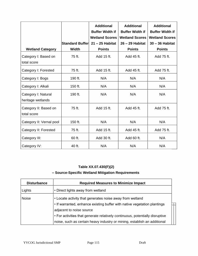
YVCOG Jurisdictional SMP Page 115 Draft
Wetland Category
Standard Buffer
Width
Additional
Buffer Width if
Wetland Scores
21 – 25 Habitat
Points
Additional
Buffer Width if
Wetland Scores
26 – 29 Habitat
Points
Additional
Buffer Width if
Wetland Scores
30 – 36 Habitat
Points
Category I: Based on
total score
75 ft. Add 15 ft. Add 45 ft. Add 75 ft.
Category I: Forested 75 ft. Add 15 ft. Add 45 ft. Add 75 ft.
Category I: Bogs 190 ft. N/A N/A N/A
Category I: Alkali 150 ft. N/A N/A N/A
Category I: Natural
heritage wetlands
190 ft. N/A N/A N/A
Category II: Based on
total score
75 ft. Add 15 ft. Add 45 ft. Add 75 ft.
Category II: Vernal pool 150 ft. N/A N/A N/A
Category II: Forested 75 ft. Add 15 ft. Add 45 ft. Add 75 ft.
Category III: 60 ft. Add 30 ft. Add 60 ft. N/A
Category IV: 40 ft. N/A N/A N/A
Table XX.07.430(F)(2)
– Source-Specific Wetland Mitigation Requirements
Disturbance Required Measures to Minimize Impact
Lights • Direct lights away from wetland
Noise • Locate activity that generates noise away from wetland
• If warranted, enhance existing buffer with native vegetation plantings
adjacent to noise source
• For activities that generate relatively continuous, potentially disruptive
noise, such as certain heavy industry or mining, establish an additional
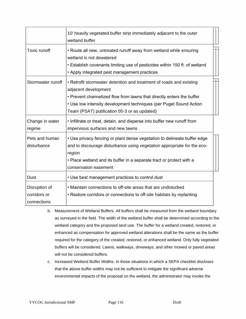
YVCOG Jurisdictional SMP Page 116 Draft
10' heavily vegetated buffer strip immediately adjacent to the outer
wetland buffer
Toxic runoff • Route all new, untreated runoff away from wetland while ensuring
wetland is not dewatered
• Establish covenants limiting use of pesticides within 150 ft. of wetland
• Apply integrated pest management practices
Stormwater runoff • Retrofit stormwater detention and treatment of roads and existing
adjacent development
• Prevent channelized flow from lawns that directly enters the buffer
• Use low intensity development techniques (per Puget Sound Action
Team (PSAT) publication 05-3 or as updated)
Change in water
regime
• Infiltrate or treat, detain, and disperse into buffer new runoff from
impervious surfaces and new lawns
Pets and human
disturbance
• Use privacy fencing or plant dense vegetation to delineate buffer edge
and to discourage disturbance using vegetation appropriate for the eco-
region
• Place wetland and its buffer in a separate tract or protect with a
conservation easement
Dust • Use best management practices to control dust
Disruption of
corridors or
connections
• Maintain connections to off-site areas that are undisturbed
• Restore corridors or connections to off-site habitats by replanting
b. Measurement of Wetland Buffers. All buffers shall be measured from the wetland boundary
as surveyed in the field. The width of the wetland buffer shall be determined according to the
wetland category and the proposed land use. The buffer for a wetland created, restored, or
enhanced as compensation for approved wetland alterations shall be the same as the buffer
required for the category of the created, restored, or enhanced wetland. Only fully vegetated
buffers will be considered. Lawns, walkways, driveways, and other mowed or paved areas
will not be considered buffers.
c. Increased Wetland Buffer Widths. In those situations in which a SEPA checklist discloses
that the above buffer widths may not be sufficient to mitigate the significant adverse
environmental impacts of the proposal on the wetland, the administrator may invoke the

YVCOG Jurisdictional SMP Page 117 Draft
procedures in Chapter 18.04 TMC and WAC 197-11-158. The administrator may require
increased buffer widths in accordance with the recommendations of the experienced,
qualified professional wetland scientist who produced the required critical areas report and
best available science on a case-by-case basis when a larger buffer is necessary to protect
wetland functions and values based on site-specific characteristics. The increased buffer
width shall not exceed a maximum of 100 percent increase over the buffer width that would
otherwise be required by subsection (F)(1) of this section. This determination shall be based
on one or more of the following criteria:
i. A larger buffer is needed to protect other critical areas;
ii. The adjacent land is susceptible to severe erosion, and erosion-control measures
will not effectively prevent adverse wetland impacts; or
iii. The adjacent land has minimal vegetative cover or slopes greater than 30 percent.
The standard buffer is less than that which is necessary to protect documented
endangered, threatened, or sensitive wildlife species which have a primary
association with the wetland;
iv. The wetland contains plant and/or animal species listed by the federal and/or state
government as sensitive, endangered, threatened, candidate monitored or
documented priority species habitats or essential or outstanding habitat for those
species or has unusual nesting or resting sites such as heron rookeries or raptor
nesting trees.
d. Wetland Buffer Width Averaging. The administrator may allow modification of the standard
wetland buffer width in accordance with an approved critical area report and the best
available science on a case-by-case basis by averaging buffer widths. Averaging of buffer
widths may only be allowed where a qualified professional wetland scientist demonstrates
that:
i. It will not reduce wetland functions or functional performance;
ii. The wetland contains variations in sensitivity due to existing physical characteristics
or the character of the buffer varies in slope, soils, or vegetation, and the wetland
would benefit from a wider buffer in places and would not be adversely impacted by
a narrower buffer in other places;
iii. The total area contained in the buffer area after averaging is no less than that which
would be contained within the standard buffer; and
iv. The buffer at its narrowest point is never less than either three-fourths of the required
width or 75 feet for Category I and II, 50 feet for Category III and 25 feet for Category
IV, whichever is greater.
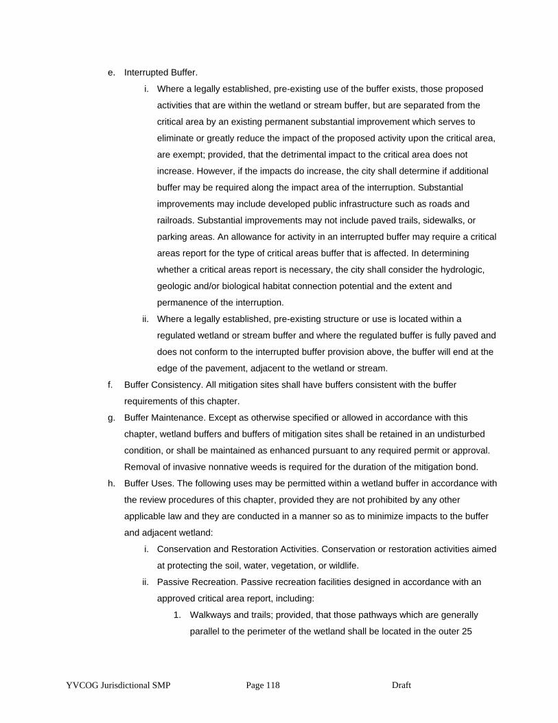
YVCOG Jurisdictional SMP Page 118 Draft
e. Interrupted Buffer.
i. Where a legally established, pre-existing use of the buffer exists, those proposed
activities that are within the wetland or stream buffer, but are separated from the
critical area by an existing permanent substantial improvement which serves to
eliminate or greatly reduce the impact of the proposed activity upon the critical area,
are exempt; provided, that the detrimental impact to the critical area does not
increase. However, if the impacts do increase, the city shall determine if additional
buffer may be required along the impact area of the interruption. Substantial
improvements may include developed public infrastructure such as roads and
railroads. Substantial improvements may not include paved trails, sidewalks, or
parking areas. An allowance for activity in an interrupted buffer may require a critical
areas report for the type of critical areas buffer that is affected. In determining
whether a critical areas report is necessary, the city shall consider the hydrologic,
geologic and/or biological habitat connection potential and the extent and
permanence of the interruption.
ii. Where a legally established, pre-existing structure or use is located within a
regulated wetland or stream buffer and where the regulated buffer is fully paved and
does not conform to the interrupted buffer provision above, the buffer will end at the
edge of the pavement, adjacent to the wetland or stream.
f. Buffer Consistency. All mitigation sites shall have buffers consistent with the buffer
requirements of this chapter.
g. Buffer Maintenance. Except as otherwise specified or allowed in accordance with this
chapter, wetland buffers and buffers of mitigation sites shall be retained in an undisturbed
condition, or shall be maintained as enhanced pursuant to any required permit or approval.
Removal of invasive nonnative weeds is required for the duration of the mitigation bond.
h. Buffer Uses. The following uses may be permitted within a wetland buffer in accordance with
the review procedures of this chapter, provided they are not prohibited by any other
applicable law and they are conducted in a manner so as to minimize impacts to the buffer
and adjacent wetland:
i. Conservation and Restoration Activities. Conservation or restoration activities aimed
at protecting the soil, water, vegetation, or wildlife.
ii. Passive Recreation. Passive recreation facilities designed in accordance with an
approved critical area report, including:
1. Walkways and trails; provided, that those pathways which are generally
parallel to the perimeter of the wetland shall be located in the outer 25
YVCOG Jurisdictional SMP Page 119 Draft
percent of the buffer area, and should be designed to avoid the removal of
significant trees. Trails must be constructed with a surface that does not
interfere with the permeability. Raised boardwalks utilizing nontreated pilings
may be acceptable;
2. Wildlife viewing structures; and
3. Fishing access areas down to the water’s edge that shall be no larger than
six feet.
iii. Stormwater Management Facilities. Stormwater management facilities, limited to
stormwater dispersion outfalls and bioswales, may be allowed within the outer 25
percent of the buffer of Category III or IV wetlands only; provided, that:
1. No other location is feasible; and
2. The location of such facilities will not degrade the functions or values of the
wetland. Stormwater management facilities are not allowed in buffers of
Category I or II wetlands.
i. Signs and Fencing of Wetlands.
i. Temporary Markers. The outer perimeter of the wetland and buffer and the limits of
those areas to be disturbed pursuant to an approved permit or authorization shall be
marked in the field in such a way as to ensure that no unauthorized intrusion will
occur and is subject to inspection by the administrator prior to the commencement of
permitted activities. The administrator shall have the authority to require that
temporary fencing be placed on site to mark the outer perimeter of the wetland and
its associated buffer area. This temporary marking, and any required temporary
fencing, shall be maintained throughout construction and shall not be removed until
permanent signs, if required, are in place.
j. Permanent Signs. As a condition of any permit or authorization issued pursuant to this
chapter, the administrator may require the applicant to install permanent signs along the
boundary of a wetland or buffer.
i. Permanent signs shall be made of a metal face with a green color background and
white letters; attached to a metal post, or another nontreated material of equal
durability; made with a sign face no smaller than one foot by one foot square and no
larger than two feet by two feet square; and mounted with the bottom of the sign face
no less than three feet above and no more than five feet above adjacent grade.
Signs must be posted at a minimum of one per lot of record, or on large parcels
every 300 feet, or additional signs as required by the administrator and must remain
unobstructed and be maintained by the property owner in perpetuity. The sign(s)
YVCOG Jurisdictional SMP Page 120 Draft
shall be worded as follows or with alternative language approved by the
administrator:
Protected Critical Area
Do Not Disturb
Contact the City of Toppenish
Regarding Uses and Restrictions
ii. The provisions of subsection (G)(2)(a) of this section may be modified by the
administrator as necessary to assure protection of sensitive features or wildlife.
XX.07.440 Performance standards — Compensatory mitigation requirements.
Compensatory mitigation for alterations to wetlands shall achieve equivalent or greater biologic functions.
Compensatory mitigation plans shall be consistent with the state Department of Ecology Guidelines for
Wetland Mitigation in Washington State, Parts 1 and 2, Publication Nos. 06-06-011a and 06-06-011b, March
2006.
1. Mitigation shall be required in the following order of preference:
a. Avoiding the impact altogether by not taking a certain action or parts of an action.
b. Minimizing impacts by limiting the degree or magnitude of the action and its implementation,
by using appropriate technology, or by taking affirmative steps to avoid or reduce impacts.
c. Rectifying the impact by repairing, rehabilitating, or restoring the affected environment.
d. Reducing or eliminating the impact over time by preservation and maintenance operations.
e. Compensating for the impact by replacing, enhancing, or providing substitute resources or
environments.
2. Mitigation for Affected Functions or Functions Lost as a Result of the Proposed Activity.
Compensatory mitigation actions shall address functions affected by the alteration to achieve
functional equivalency or improvement and shall provide similar wetland functions as those lost by
the proposed activity, except when:
a. The lost wetland provides minimal functions as determined by a site-specific function
assessment, and the proposed compensatory mitigation action(s) will provide equal or
greater functions or will provide functions shown to be limiting within a watershed through a
formal Washington State watershed assessment plan or protocol; or
b. Out-of-kind replacement will best meet formally identified watershed goals, such as
replacement of historically diminished wetland types.
3. Preference of Mitigation Actions. Mitigation actions that require compensation by replacing,
enhancing, or substitution shall occur in the following order of preference:
YVCOG Jurisdictional SMP Page 121 Draft
1. Restoring wetlands on upland sites that were formerly wetlands.
2. Creating wetlands on disturbed upland sites such as those with vegetative
cover consisting primarily of nonnative introduced species. This should only
be attempted when there is a consistent source of hydrology and it can be
shown that the surface and subsurface hydrologic regime is conducive for
the wetland community that is being designed.
4. Enhancing significantly degraded wetlands in combination with restoration or creation. Such
enhancement should be part of a mitigation package that includes replacing the impacted area
meeting appropriate ratio requirements.
5. Type and Location of Mitigation. Unless it is demonstrated that a higher level of ecological
functioning would result from an alternate approach, compensatory mitigation for ecological functions
shall be either in kind and on site, or in kind and within the same stream reach, subbasin, or drift cell.
Mitigation actions shall be conducted within the same subdrainage basin and on the same site as the
alteration except when all of the following apply:
a. There are no reasonable on-site or in-subdrainage basin opportunities or on-site and in-
subdrainage basin opportunities do not have a high likelihood of success, after a
determination of the natural capacity of the site to mitigate for the impacts. Consideration
should include: anticipated wetland mitigation replacement ratios, buffer conditions and
proposed widths, hydrogeomorphic classes of on-site wetlands when restored, proposed
flood storage capacity, potential to mitigate riparian fish and wildlife impacts (such as
connectivity);
b. Off-site mitigation has a greater likelihood of providing equal or improved wetland functions
than the impacted wetland; and
c. Off-site locations shall be in the same subdrainage basin unless:
i. Established watershed goals for water quality, flood or conveyance, habitat, or other
wetland functions have been established and strongly justify location of mitigation at
another site; or
ii. Credits from a state certified wetland mitigation bank are used as mitigation and the
use of credits is consistent with the terms of the bank’s certification.
6. Mitigation Timing.
a. Mitigation projects shall be completed with an approved monitoring plan prior to activities that
will disturb wetlands. In all other cases, mitigation shall be completed immediately following
disturbance and prior to use or occupancy of the activity or development. Construction of
mitigation projects shall be timed to reduce impacts to existing fisheries, wildlife, and flora.
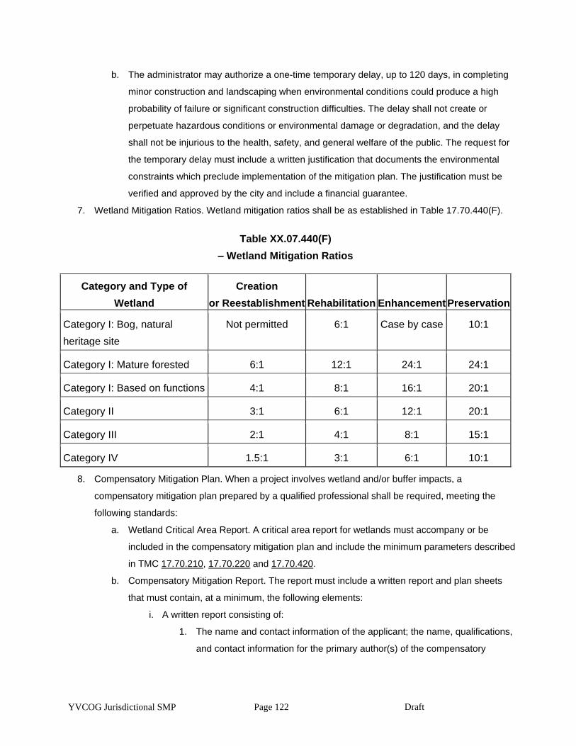
YVCOG Jurisdictional SMP Page 122 Draft
b. The administrator may authorize a one-time temporary delay, up to 120 days, in completing
minor construction and landscaping when environmental conditions could produce a high
probability of failure or significant construction difficulties. The delay shall not create or
perpetuate hazardous conditions or environmental damage or degradation, and the delay
shall not be injurious to the health, safety, and general welfare of the public. The request for
the temporary delay must include a written justification that documents the environmental
constraints which preclude implementation of the mitigation plan. The justification must be
verified and approved by the city and include a financial guarantee.
7. Wetland Mitigation Ratios. Wetland mitigation ratios shall be as established in Table 17.70.440(F).
Table XX.07.440(F)
– Wetland Mitigation Ratios
Category and Type of
Wetland
Creation
or Reestablishment Rehabilitation Enhancement Preservation
Category I: Bog, natural
heritage site
Not permitted 6:1 Case by case 10:1
Category I: Mature forested 6:1 12:1 24:1 24:1
Category I: Based on functions 4:1 8:1 16:1 20:1
Category II 3:1 6:1 12:1 20:1
Category III 2:1 4:1 8:1 15:1
Category IV 1.5:1 3:1 6:1 10:1
8. Compensatory Mitigation Plan. When a project involves wetland and/or buffer impacts, a
compensatory mitigation plan prepared by a qualified professional shall be required, meeting the
following standards:
a. Wetland Critical Area Report. A critical area report for wetlands must accompany or be
included in the compensatory mitigation plan and include the minimum parameters described
in TMC 17.70.210, 17.70.220 and 17.70.420.
b. Compensatory Mitigation Report. The report must include a written report and plan sheets
that must contain, at a minimum, the following elements:
i. A written report consisting of:
1. The name and contact information of the applicant; the name, qualifications,
and contact information for the primary author(s) of the compensatory
YVCOG Jurisdictional SMP Page 123 Draft
mitigation report; a description of the proposal; identification of all the local,
state, and/or federal wetland related permit(s) required for the project; and a
vicinity map for the project.
2. Description of how the project design has been modified to avoid, minimize,
or reduce adverse impacts to wetlands.
3. Description of the existing wetland and buffer areas proposed to be
impacted. Include acreage (or square footage), water regime, vegetation,
soils, landscape position, surrounding land uses, and functions. Also
describe impacts in terms of acreage by Cowardin classification,
hydrogeomorphic classification, and wetland rating, based on wetland
ratings of this chapter.
4. Description of the compensatory mitigation site, including location and
rationale for selection. Include an assessment of existing conditions:
acreage (or square footage) of wetlands and uplands, water regime, sources
of water, vegetation, soils, landscape position, surrounding land uses, and
functions. Estimate future conditions in this location if the compensation
actions are not undertaken (i.e., how would the site progress through natural
succession?).
5. A description of the proposed mitigation construction activities and timing of
activities.
6. A description of the proposed actions for compensation of wetland and
upland areas affected by the project. Include overall wetland and upland
areas affected by the project. Include overall goals of the proposed
mitigation, including a description of the targeted functions,
hydrogeomorphic classification, and categories of wetlands.
7. A discussion of ongoing management practices that will protect wetlands
after the project site has been developed, including proposed monitoring and
maintenance programs for remaining wetlands and compensatory mitigation
wetlands.
8. A bond estimate for the entire compensatory mitigation project, including the
following elements: site preparation, plant materials, construction materials,
installation oversight, maintenance twice per year for up to five years, annual
monitoring field work and reporting, and contingency actions for a maximum
of the total required number of years for monitoring.
YVCOG Jurisdictional SMP Page 124 Draft
9. Proof of establishment of notice on title for the wetlands and buffers on the
project site, including the compensatory mitigation areas.
ii. Scaled plan sheets for the compensatory mitigation depicting:
1. Surveyed edges of the existing wetland and buffers, proposed areas of
wetland and/or buffer impacts, location of proposed wetland and/or buffer
compensation actions.
2. Existing topography, ground-proofed, at two-foot contour intervals in the
zone of the proposed compensation actions if any grading activity is
proposed to create the compensation area(s). Also existing cross-sections of
the on-site wetland areas that are proposed to be impacted, and cross-
section(s) (estimated one-foot intervals) for the proposed areas of wetland or
buffer compensation.
3. Surface and subsurface hydrologic conditions including an analysis of
existing and proposed hydrologic regimes for enhanced, created, or restored
compensatory mitigation areas. Also, illustrations of how data for existing
hydrologic conditions were used to determine the estimates of future
hydrologic conditions.
4. Conditions expected from the proposed actions on site including future
hydrogeomorphic types, vegetation community types by dominant species
(wetland and upland), and future water regimes.
5. Required wetland buffers for existing wetlands and proposed compensation
areas. Also, identify any zones where buffers are proposed to be reduced or
enlarged outside of the standards identified in this chapter.
6. A plant schedule for the compensation area including all species by
proposed community type and water regime, size and type of plant material
to be installed, spacing of plants, typical clustering patterns, total number of
species by community type, and the timing of installation.
7. Performance standards (measurable standards reflective of years post-
installation) for upland and wetland communities, monitoring schedule, and
maintenance schedule and actions by each biennium.
9. Wetland Mitigation Banks.
a. Credits from a wetland mitigation bank may be approved for use as compensation for
unavoidable impacts to wetlands when:
i. The bank is certified under Chapter 173-700 WAC;
YVCOG Jurisdictional SMP Page 125 Draft
ii. The administrator determines that the wetland mitigation bank provides appropriate
compensation for the authorized impacts; and
iii. The proposed use of credits is consistent with the terms and conditions of the bank’s
certification
b. Replacement ratios for projects using bank credits shall be consistent with replacement
ratios specified in the bank’s certification.
c. Credits from a certified wetland mitigation bank may be used to compensate for impacts
located within the service area specified in the bank’s certification. In some cases, bank
service areas may include portions of more than one adjacent drainage basin for specific
wetland functions.
Article IV. Frequently Flooded Areas
XX.07.500 Designation and mapping of frequently flooded areas.
All areas within the city meeting the frequently flooded designation criteria are hereby designated critical
areas and are subject to the provisions of this chapter. Frequently flooded areas have been accurately
delineated based on hydrologic and hydraulic studies completed as part of the National Flood Insurance
Program by the Federal Emergency Management Agency in the Flood Insurance Study for Yakima County,
Washington, and incorporated areas dated November 18, 2009, and any subsequent amendment. The
methodology and detail of these studies is accepted as the best available science.
XX.07.510 Classification of frequently flooded areas.
1. The flood areas in the city are classified as either one of two types:
a. Floodway. “Floodways” are defined as the channel of a stream and adjacent land areas
which are required to carry and discharge the flood water or flood flows of any river or stream
associated with a regulatory flood.
b. Flood Fringe. The “flood fringe” is defined as that land area which is outside a stream’s
floodway, but is subject to periodic inundation due to flooding, associated with a regulatory
flood.
XX.70.520 Existing regulations pertaining to frequently flooded areas.
Chapter 15.30 TMC regulates proposed activities within frequently flooded areas. If allowed, any structures
permitted in the designated flood areas are subject to flood-proofing regulations of this chapter. The existing
regulations were adopted after careful study and fulfill the requirements of the Growth Management Act for
protection of frequently flooded areas.
Article V. Fish and Wildlife Habitat Conservation Areas
YVCOG Jurisdictional SMP Page 126 Draft
XX.07.640 Designation of fish and wildlife habitat conservation areas.
1. Fish and wildlife habitat conservation areas include:
a. Areas with which state or federally designated endangered, threatened, and sensitive
species have a primary association.
i. Federally designated endangered and threatened species are those fish and wildlife
species identified by the U.S. Fish and Wildlife Service and the National Marine
Fisheries Service that are in danger of extinction or threatened to become
endangered. The U.S. Fish and Wildlife Service and the National Marine Fisheries
Service should be consulted for current listing status.
ii. State designated endangered, threatened, and sensitive species are those fish and
wildlife species native to the state of Washington and identified by the Washington
Department of Fish and Wildlife which are in danger of extinction, threatened to
become endangered, vulnerable, or declining and are likely to become endangered
or threatened in a significant portion of their range within the state without
cooperative management or removal of threats. State designated endangered,
threatened, and sensitive species are periodically recorded in WAC 232-12-
014 (state endangered species) and WAC 232-12-011 (state threatened and
sensitive species). The state Department of Fish and Wildlife maintains the most
current listing and should be consulted for current listing status.
b. Waters of the State. Waters of the state include lakes, rivers, ponds, streams, inland waters,
underground waters, salt waters, and all other surface waters and watercourses within the
jurisdiction of the state of Washington, as classified in WAC 222-16-031 (or WAC 222-16-
030 depending on classification used).
c. Lakes, ponds, streams, and rivers planted with game fish by a governmental or tribal entity.
2. Appendix “A” of chapter 17.70 identifies stream corridors subject to protection; however, all areas
within the city meeting one or more of these criteria, regardless of any formal identification, are
hereby designated critical areas and are subject to the provisions of this chapter and shall be
managed consistent with the best available science.
3. Mapping. The approximate location and extent of habitat conservation areas are shown on the critical
area maps adopted with the ordinance codified in this chapter by the city, as most recently updated.
The following maps and data are hereby adopted and are available from the city and/or the listed
governmental agency:
a. Washington Department of Fish and Wildlife Priority Habitat and Species Maps;
b. Washington State Department of Natural Resources, Official Water Type Reference Maps,
as amended; and
YVCOG Jurisdictional SMP Page 127 Draft
c. Anadromous and resident salmonid distribution maps contained in the Habitat Limiting
Factors Reports published by the Washington Conservation Commission.
The above maps are to be used as a guide for the city, project applicants, and/or property owners
and should be continuously updated as new critical areas are identified. The above maps are a
reference and do not provide a final critical area designation.
XX.07.650 Critical area report – Requirements for habitat conservation areas.
1. All critical areas located within or near the project area that have been designated by the city and are
shown on city, state, or federal government agency maps and/or reports shall be addressed in a
critical area report for habitat conservation areas.
2. Habitat Analysis. A habitat assessment to include at a minimum the following:
a. Detailed description of vegetation on the project area and its associated buffer.
b. Identification of any endangered, threatened, or candidate species that have a primary
association with habitat on the project area, and assessment of potential project impacts to
use of the buffer and critical area on the site by the species.
c. A detailed discussion of the direct and indirect potential impacts on habitat by the project.
Such discussion shall include a discussion of the ongoing management practices that will
protect habitat after the project site has been developed.
XX.07.660 Performance standards – General requirements.
1. Nonindigenous Species. No plant, wildlife, or fish species not indigenous to the region shall be
introduced into a habitat conservation area unless authorized by a state or federal permit or approval.
2. Mitigation and Contiguous Corridors. Mitigation sites shall be located to preserve or achieve
contiguous wildlife habitat corridors in accordance with a mitigation plan that is part of an approved
critical area report to minimize the isolating effects of development on habitat areas, so long as
mitigation of aquatic habitat is located within the same aquatic ecosystem as the area disturbed.
3. Approvals of Activities. The administrator shall condition approvals of activities allowed within or
adjacent to a habitat conservation area or its buffers as necessary to minimize or mitigate any
potential adverse impacts. Conditions shall be based on the best available science and may include,
but are not limited to, the following:
a. Establishment of buffer zones;
b. Preservation of critically important vegetation and/or habitat features such as snags and
downed wood;
c. Limitation of access to the habitat area, including fencing to deter unauthorized access;
d. Seasonal restriction of construction activities;
e. Establishment of a duration and timetable for periodic review of mitigation activities; and
YVCOG Jurisdictional SMP Page 128 Draft
f. Requirement of a performance bond, when necessary, to ensure completion and success of
proposed mitigation.
4. Mitigation to Equivalent Biological Functions. Mitigation of alterations to habitat conservation areas
shall achieve at least equivalent biologic and hydrologic functions and shall include mitigation for
adverse impacts upstream or downstream of the development proposal site. Mitigation shall address
each function affected by the alteration to achieve functional equivalency or improvement on a per
function basis.
5. Approvals and the Best Available Science. Any approval of alterations or impacts to a habitat
conservation area shall be supported by the best available science.
6. Buffers.
a. Establishment of Buffers. The administrator shall require the establishment of buffer areas
for activities adjacent to habitat conservation areas when needed to protect habitat
conservation areas. Buffers shall consist of an undisturbed area of native vegetation or areas
identified for restoration established to protect the integrity, functions, and values of the
affected habitat. Required buffer widths shall be designed to address the sensitivity of the
habitat and the type and intensity of human activity proposed to be conducted nearby and
shall consider the management recommendations issued by the Washington Department of
Fish and Wildlife. Habitat conservation areas and their buffers shall be preserved in
perpetuity through the use of critical area tracts in accordance with TMC 17.70.380.
b. Seasonal Restrictions. When a species is more susceptible to adverse impacts during
specific periods of the year, seasonal restrictions may apply.
7. Signs and Fencing of Habitat Conservation Areas.
a. Temporary Markers. The outer perimeter of the habitat conservation area or buffer and the
limits of those areas to be disturbed pursuant to an approved permit or authorization shall be
marked in the field in such a way as to ensure that no unauthorized intrusion will occur and
verified by the administrator prior to the commencement of permitted activities. The
administrator shall have the authority to require that temporary fencing be placed on site to
mark the outer perimeter of the habitat conservation area and its associated buffer area. This
temporary marking, and any required temporary fencing, shall be maintained throughout
construction and shall not be removed until permanent signs, if required, are in place.
b. Permanent Signs. As a condition of any permit or authorization issued pursuant to this
chapter, the administrator may require the applicant to install permanent signs along the
boundary of a habitat conservation area or buffer.
i. Permanent signs shall be made of a metal face with a green color background and
white letters; attached to a metal post or another nontreated material of equal
YVCOG Jurisdictional SMP Page 129 Draft
durability; made with a sign face no smaller than one foot by one foot and no larger
than two feet by two feet; and mounted with the bottom of the sign face no less than
three feet above and no more than five feet above adjacent grade. Signs must be
posted at a minimum of one per lot of record, or on large parcels every 300 feet, or
additional signs as required by the administrator and must remain unobstructed and
be maintained by the property owner in perpetuity. The sign(s) shall be worded as
follows or with alternative language approved by the administrator:
Protected Critical Area
Do Not Disturb
Contact the City of Toppenish
Regarding Uses and Restrictions
XX.07.670 Performance standards – Specific habitats.
1. Endangered, Threatened, and Sensitive Species.
a. No development shall be allowed within a habitat conservation area or buffer with which
state or federally endangered, threatened, or sensitive species have a primary association,
except that which is provided for by a management plan established by the Washington
Department of Fish and Wildlife, the Yakama Nation and other applicable state or federal
agencies.
2. Anadromous Fish.
i. All activities, uses, and alterations proposed to be located in water bodies used by
anadromous fish or where such fish have a primary association shall give special
consideration to the preservation of anadromous fish habitat, including, but not
limited to, adhering to the following standards:
ii. Activities shall be timed to occur only during the allowable work window as
designated by the Washington Department of Fish and Wildlife and Yakama Nation
for the applicable species;
iii. An alternative alignment or location for the activity is not feasible;
iv. The activity is designed so that it will not degrade the functions or values of the fish
habitat or other critical areas;
v. Shoreline erosion control measures shall be designed to use bioengineering
methods or soft armoring techniques, according to an approved critical area report;
and
vi. Any impacts to the functions or values of the habitat conservation area are mitigated
in accordance with an approved critical area report.
YVCOG Jurisdictional SMP Page 130 Draft
b. Structures that prevent the migration of salmonids shall not be allowed in the portion of water
bodies currently or historically used by anadromous fish. Fish bypass facilities shall be
provided that allow the upstream migration of adult fish and shall prevent fry and juveniles
migrating downstream from being trapped or harmed.
3. Wetland Habitats. All proposed activities within or adjacent to habitat conservation areas containing
wetlands shall conform to the wetland development performance standards set forth in
TMC 17.70.440, wetlands. If non-wetlands habitat and wetlands are present at the same location, the
provisions of this article or Article III of this chapter, Wetlands, whichever provides greater protection
to the habitat, apply.
4. Riparian Habitat Areas. Unless otherwise allowed in this chapter, all structures and activities shall be
located outside of the stream buffers.
a. Establishment of Stream Buffer Areas. Stream buffers shall be established for habitats that
include aquatic and terrestrial ecosystems that mutually benefit each other and that are
located adjacent to rivers, perennial or intermittent streams, seeps, and springs.
b. Stream Buffer Widths. Required stream buffer widths shown in Table 17.70.670(D)(1) have
been established in accordance with the best available science. Buffers are subject to the
following:
i. Widths shall be measured outward in each direction, on the horizontal plane from the
channel migration zone if delineated, the ordinary high water mark, or from the top of
bank if the ordinary high water mark cannot be identified.
ii. Stream buffers must be sufficiently wide to achieve the full range of riparian and
aquatic ecosystem functions, which include but are not limited to protection of in-
stream fish habitat through control of temperature and sedimentation in streams;
preservation of fish and wildlife habitat; and connection of riparian wildlife habitat to
other habitats.
iii. The buffer width may be reduced or averaged by the administrator upon
recommendation of the wetland report and consultation with affected agencies and
tribes.
iv. Increased Stream Buffer Widths. In those situations in which a SEPA checklist
discloses that the buffer widths as established in Table 17.70.670(D)(1) may not be
sufficient to mitigate the significant adverse environmental impacts of the proposal,
the administrator may invoke the procedures in Chapter 18.04 TMC and WAC 197-
11-158. The administrator may require increased buffer widths in accordance with
the recommendations of the experienced, qualified professional wetland scientist
who produced the required critical areas report and best available science on a
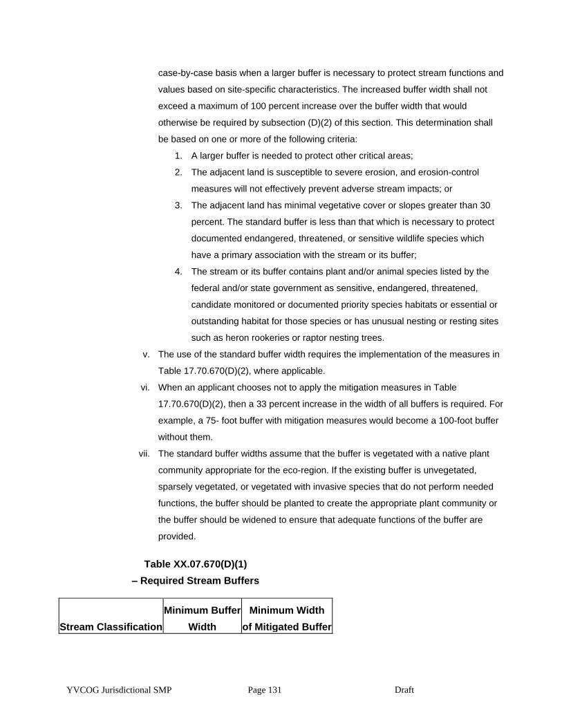
YVCOG Jurisdictional SMP Page 131 Draft
case-by-case basis when a larger buffer is necessary to protect stream functions and
values based on site-specific characteristics. The increased buffer width shall not
exceed a maximum of 100 percent increase over the buffer width that would
otherwise be required by subsection (D)(2) of this section. This determination shall
be based on one or more of the following criteria:
1. A larger buffer is needed to protect other critical areas;
2. The adjacent land is susceptible to severe erosion, and erosion-control
measures will not effectively prevent adverse stream impacts; or
3. The adjacent land has minimal vegetative cover or slopes greater than 30
percent. The standard buffer is less than that which is necessary to protect
documented endangered, threatened, or sensitive wildlife species which
have a primary association with the stream or its buffer;
4. The stream or its buffer contains plant and/or animal species listed by the
federal and/or state government as sensitive, endangered, threatened,
candidate monitored or documented priority species habitats or essential or
outstanding habitat for those species or has unusual nesting or resting sites
such as heron rookeries or raptor nesting trees.
v. The use of the standard buffer width requires the implementation of the measures in
Table 17.70.670(D)(2), where applicable.
vi. When an applicant chooses not to apply the mitigation measures in Table
17.70.670(D)(2), then a 33 percent increase in the width of all buffers is required. For
example, a 75- foot buffer with mitigation measures would become a 100-foot buffer
without them.
vii. The standard buffer widths assume that the buffer is vegetated with a native plant
community appropriate for the eco-region. If the existing buffer is unvegetated,
sparsely vegetated, or vegetated with invasive species that do not perform needed
functions, the buffer should be planted to create the appropriate plant community or
the buffer should be widened to ensure that adequate functions of the buffer are
provided.
Table XX.07.670(D)(1)
– Required Stream Buffers
Stream Classification
Minimum Buffer
Width
Minimum Width
of Mitigated Buffer
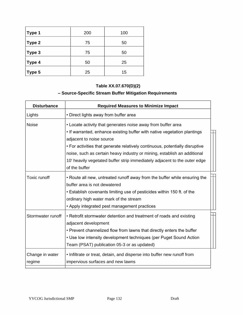
YVCOG Jurisdictional SMP Page 132 Draft
Type 1 200 100
Type 2 75 50
Type 3 75 50
Type 4 50 25
Type 5 25 15
Table XX.07.670(D)(2)
– Source-Specific Stream Buffer Mitigation Requirements
Disturbance Required Measures to Minimize Impact
Lights • Direct lights away from buffer area
Noise • Locate activity that generates noise away from buffer area
• If warranted, enhance existing buffer with native vegetation plantings
adjacent to noise source
• For activities that generate relatively continuous, potentially disruptive
noise, such as certain heavy industry or mining, establish an additional
10' heavily vegetated buffer strip immediately adjacent to the outer edge
of the buffer
Toxic runoff • Route all new, untreated runoff away from the buffer while ensuring the
buffer area is not dewatered
• Establish covenants limiting use of pesticides within 150 ft. of the
ordinary high water mark of the stream
• Apply integrated pest management practices
Stormwater runoff • Retrofit stormwater detention and treatment of roads and existing
adjacent development
• Prevent channelized flow from lawns that directly enters the buffer
• Use low intensity development techniques (per Puget Sound Action
Team (PSAT) publication 05-3 or as updated)
Change in water
regime
• Infiltrate or treat, detain, and disperse into buffer new runoff from
impervious surfaces and new lawns
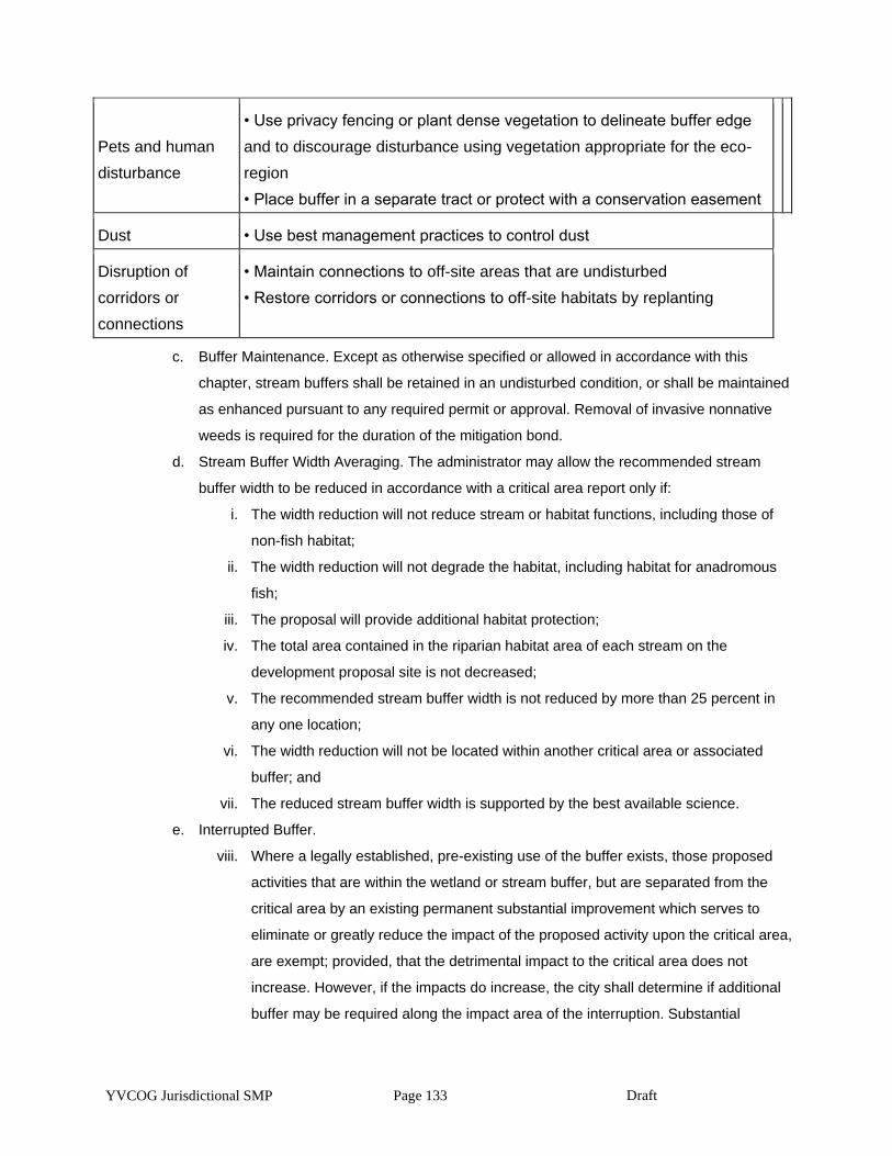
YVCOG Jurisdictional SMP Page 133 Draft
Pets and human
disturbance
• Use privacy fencing or plant dense vegetation to delineate buffer edge
and to discourage disturbance using vegetation appropriate for the eco-
region
• Place buffer in a separate tract or protect with a conservation easement
Dust • Use best management practices to control dust
Disruption of
corridors or
connections
• Maintain connections to off-site areas that are undisturbed
• Restore corridors or connections to off-site habitats by replanting
c. Buffer Maintenance. Except as otherwise specified or allowed in accordance with this
chapter, stream buffers shall be retained in an undisturbed condition, or shall be maintained
as enhanced pursuant to any required permit or approval. Removal of invasive nonnative
weeds is required for the duration of the mitigation bond.
d. Stream Buffer Width Averaging. The administrator may allow the recommended stream
buffer width to be reduced in accordance with a critical area report only if:
i. The width reduction will not reduce stream or habitat functions, including those of
non-fish habitat;
ii. The width reduction will not degrade the habitat, including habitat for anadromous
fish;
iii. The proposal will provide additional habitat protection;
iv. The total area contained in the riparian habitat area of each stream on the
development proposal site is not decreased;
v. The recommended stream buffer width is not reduced by more than 25 percent in
any one location;
vi. The width reduction will not be located within another critical area or associated
buffer; and
vii. The reduced stream buffer width is supported by the best available science.
e. Interrupted Buffer.
viii. Where a legally established, pre-existing use of the buffer exists, those proposed
activities that are within the wetland or stream buffer, but are separated from the
critical area by an existing permanent substantial improvement which serves to
eliminate or greatly reduce the impact of the proposed activity upon the critical area,
are exempt; provided, that the detrimental impact to the critical area does not
increase. However, if the impacts do increase, the city shall determine if additional
buffer may be required along the impact area of the interruption. Substantial
YVCOG Jurisdictional SMP Page 134 Draft
improvements may include developed public infrastructure such as roads and
railroads. Substantial improvements may not include paved trails, sidewalks, or
parking areas. An allowance for activity in an interrupted buffer may require a critical
areas report for the type of critical areas buffer that is affected. In determining
whether a critical areas report is necessary, the city shall consider the hydrologic,
geologic and/or biological habitat connection potential and the extent and
permanence of the interruption.
ix. Where a legally established, pre-existing structure or use is located within a
regulated wetland or stream buffer and where the regulated buffer is fully paved and
does not conform to the interrupted buffer provision above, the buffer will end at the
edge of the pavement, adjacent to the wetland or stream.
f. Riparian Habitat Mitigation. Mitigation of adverse impacts to stream buffers shall result in
equivalent functions and values on a per function basis, be located as near the alteration as
feasible, and be located in the same subdrainage basin as the habitat impacted.
g. Alternative Mitigation for Stream Buffers. The performance standards set forth in this
subsection may be modified at the city’s discretion if the applicant demonstrates that greater
habitat functions, on a per function basis, can be obtained in the affected subdrainage basin
as a result of alternative mitigation measures.
5. Aquatic Habitat. The following specific activities may be permitted within a stream buffer, pond, lake,
water of the state, and associated buffer when the activity complies with the provisions set forth in
the applicable shoreline management program and subject to the standards of this subsection. The
standards that provide the most protection to protected habitat and species shall apply
a. Stream Bank Stabilization. Stream bank stabilization to protect new structures from future
channel migration is not permitted except when such stabilization is achieved through
bioengineering or soft armoring techniques in accordance with an approved critical area
report.
b. Roads, Trails, Bridges, and Rights-of-Way. Construction of trails, roadways, and minor road
bridging, less than or equal to 30 feet wide, may be permitted in accordance with an
approved critical area report subject to the following standards:
i. There is no other feasible alternative route with less impact on the environment;
ii. The crossing minimizes interruption of downstream movement of wood and gravel;
iii. Roads in stream buffers shall not run parallel to the water body;
iv. Trails shall be located on the outer edge of the buffer, except for limited viewing
platforms, crossings and limited trails;
YVCOG Jurisdictional SMP Page 135 Draft
v. Crossings, where necessary, shall only occur as near to perpendicular with the water
body as possible;
vi. Mitigation for impacts is provided pursuant to a mitigation plan of an approved critical
area report;
vii. Road bridges are designed according to the Washington Department of Fish and
Wildlife Fish Passage Design at Road Culverts, 1999, and the National Marine
Fisheries Service Guidelines for Salmonid Passage at Stream Crossings, 2000; and
viii. Trails and associated viewing platforms shall not be made of continuous impervious
materials.
c. Utility Facilities. New utility lines and facilities may be permitted to cross watercourses in
accordance with an approved critical area report, if they comply with the following standards:
i. Fish and wildlife habitat areas shall be avoided to the maximum extent possible;
ii. Installation shall be accomplished by boring beneath the scour depth and hyporheic
zone of the water body and channel migration zone, where feasible;
iii. The utilities shall cross at an angle greater than 60 degrees to the centerline of the
channel in streams or perpendicular to the channel centerline whenever boring under
the channel is not feasible;
iv. Crossings shall be contained within the footprint of an existing road or utility crossing
where possible;
v. The utility route shall avoid paralleling the stream or following a down-valley course
near the channel; and
vi. The utility installation shall not increase or decrease the natural rate of shore
migration or channel migration.
d. Public Flood Protection Measures. New public flood protection measures and expansion of
existing ones may be permitted, subject to the city’s review and approval of a critical area
report and the approval of a federal biological assessment by the federal agency responsible
for reviewing actions related to a federally listed species.
e. In-Stream Structures. In-stream structures, such as, but not limited to, high flow bypasses,
sediment ponds, in-stream ponds, retention and detention facilities, dams, and weirs, shall
be allowed only as part of an approved watershed basin restoration project approved by the
agency with jurisdiction and upon acquisition of any required state or federal permits. The
structure shall be designed to avoid modifying flows and water quality in ways that may
adversely affect habitat conservation areas.
f. Stormwater Conveyance Facilities. Conveyance structures may be permitted in accordance
with an approved critical area report subject to the following standards:
YVCOG Jurisdictional SMP Page 136 Draft
i. No other feasible alternatives with less impact exist;
ii. Mitigation for impacts is provided;
iii. Stormwater conveyance facilities shall incorporate fish habitat features; and
iv. Vegetation shall be maintained and, if necessary, added adjacent to all open
channels and ponds in order to retard erosion, filter out sediments, and shade the
water.
Article VI. Critical Aquifer Recharge Areas
XX.07.700 Designation of critical aquifer recharge areas.
1. The Growth Management Act (Chapter 36.70A RCW) requires local jurisdictions to protect areas with
a critical recharging effect on aquifers used for potable water or areas where drinking aquifers are
vulnerable to contamination. These areas are referred to as critical aquifer recharge areas (CARAs)
in this section. Potable water is an essential life sustaining element. The city of Toppenish sources its
municipal water exclusively from ground water supplies. Once ground water is contaminated it can
be difficult and costly to clean. The quality of ground water in an aquifer is inextricably linked to its
recharge area.
2. Critical aquifer recharge areas (CARAs) are those areas with a critical recharging effect on aquifers
used for potable water as defined by WAC 365-190-030(2). CARAs have prevailing geologic
conditions associated with infiltration rates that create a high potential for contamination of ground
water resources or contribute significantly to the replenishment of ground water. The following areas
have been identified based on local conditions:
a. Vulnerable Ground Water Recharge Areas. Soils throughout the city of Toppenish have a
moderate to high permeability rate. In addition, the depth to ground water throughout the city
is shallow. Accordingly, contaminants released on the ground may infiltrate into and pollute
the ground water table. The entire city of Toppenish has been designated as a vulnerable
ground water recharge area.
b. Wellhead Protection Areas. Wellhead protection areas shall be defined by the boundaries of
the 10-year time of ground water travel, or boundaries established using alternate criteria
approved by the Department of Health in those settings where ground water time of travel is
not a reasonable delineation criterion, in accordance with WAC 246-290-135. The city of
Toppenish wellhead protection plan is a component of the water systems plan.
XX.07.710 Regulations pertaining to critical aquifer recharge areas.
1. The following provisions are in place to protect critical aquifer recharge areas and regulate activities
that might potentially impact these areas:
YVCOG Jurisdictional SMP Page 137 Draft
a. Eastern Washington Stormwater Design Manual as published by the State of Washington
Department of Ecology.
b. City of Toppenish wellhead protection plan.
c. State and federal regulations applicable to specific uses including but not limited to those
provided in TMC 17.70.730(G).
XX.07.720 General requirements pertaining to critical aquifer recharge areas.
1. Activities in a critical aquifer recharge area must be conducted in such a manner as to not adversely
affect the recharging of the aquifer and such that the activity will not cause contaminants to enter the
aquifer.
2. Activities within a wellhead protection area pursuant to TMC 17.70.700(B)(2) must comply with the
water source protection requirements and recommendations of the federal Environmental Protection
Agency, state Department of Health, and the city’s wellhead protection plan.
3. Developments must be designed and constructed in accordance with surface/stormwater
management requirements of the Eastern Washington Stormwater Management Manual as
published by the State of Washington Department of Ecology.
XX.07.730 Development standards for specific activities in critical aquifer recharge areas.
1. Connection to Public Sewer. Pursuant to Chapter 13.28 TMC, all new development must be
connected to public sewer.
2. Connection to Public Water. Pursuant to Chapter 13.08 TMC, all new development must source its
potable water from the city of Toppenish municipal water system.
3. Storage Tanks. All storage tanks must comply with local building code requirements and must
conform to the following requirements:
a. Underground Tanks. All new underground storage facilities proposed for use in the storage
of hazardous substances or hazardous wastes shall be designed and constructed so as to:
i. Prevent releases due to corrosion or structural failure for the operational life of the
tank;
ii. Be protected against corrosion, constructed of noncorrosive material, steel clad with
a noncorrosive material, or designed to include a secondary containment system to
prevent the release or threatened release of any stored substances; and
iii. Use materials in the construction or lining of the tank that is compatible with the
substance to be stored.
b. Aboveground Tanks. All new aboveground storage facilities proposed for use in the storage
of hazardous substances or hazardous wastes shall be designed and constructed so as to:
i. Not allow the release of a hazardous substance to the ground, ground waters, or
surface waters;
YVCOG Jurisdictional SMP Page 138 Draft
ii. Have a primary containment area enclosing or underlying the tank or part thereof;
and
iii. Have a secondary containment system either built into the tank structure or a dike
system built outside the tank for all tanks.
4. Stormwater Disposal. Systems for the disposal of stormwater from impervious surfacing of all new
development must be designed in accordance with the provisions of the Eastern Washington
stormwater design standards.
5. Vehicle Repair and Servicing. Vehicle repair and servicing must be conducted over impermeable
pads and within a covered structure capable of withstanding normally expected weather conditions.
Chemicals used in the process of vehicle repair and servicing must be stored in a manner that
protects them from weather and provides containment should leaks occur.
6. Spreading or Injection of Reclaimed Water. Water reuse projects for reclaimed water must be in
accordance with the adopted water or sewer comprehensive plans that have been approved by the
Departments of Ecology and Health including:
a. Surface spreading must meet the ground water recharge criteria given in
RCW 90.46.010(10) and 90.46.080.
b. Direct injection must be in accordance with the standards developed by authority of
RCW 90.46.042.
7. State and Federal Regulations. The uses listed in Table 17.70.730(G) shall be conditioned as
necessary to protect critical aquifer recharge areas in accordance with the applicable state and
federal regulations.
Table XX.70.730(G)
– State and Federal Aquifer Recharge Regulations
Activity Statute Regulation Guideline
Above Ground Storage Tanks WAC 173-303-640
Animal Feedlots Chapters 173-216 and 173-220 WAC
Automobile Washers Chapter 173-216 WAC, Best Management
Practices for Vehicle and Equipment Discharges
(WDOE WQ-R-95-56)
Below Ground Storage Tanks Chapter 173-360 WAC
Chemical Treatment Storage and Disposal
Facilities
WAC 173-303-182
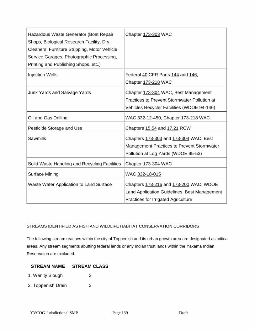
YVCOG Jurisdictional SMP Page 139 Draft
Hazardous Waste Generator (Boat Repair
Shops, Biological Research Facility, Dry
Cleaners, Furniture Stripping, Motor Vehicle
Service Garages, Photographic Processing,
Printing and Publishing Shops, etc.)
Chapter 173-303 WAC
Injection Wells Federal 40 CFR Parts 144 and 146,
Chapter 173-218 WAC
Junk Yards and Salvage Yards Chapter 173-304 WAC, Best Management
Practices to Prevent Stormwater Pollution at
Vehicles Recycler Facilities (WDOE 94-146)
Oil and Gas Drilling WAC 332-12-450, Chapter 173-218 WAC
Pesticide Storage and Use Chapters 15.54 and 17.21 RCW
Sawmills Chapters 173-303 and 173-304 WAC, Best
Management Practices to Prevent Stormwater
Pollution at Log Yards (WDOE 95-53)
Solid Waste Handling and Recycling Facilities Chapter 173-304 WAC
Surface Mining WAC 332-18-015
Waste Water Application to Land Surface Chapters 173-216 and 173-200 WAC, WDOE
Land Application Guidelines, Best Management
Practices for Irrigated Agriculture
STREAMS IDENTIFIED AS FISH AND WILDLIFE HABITAT CONSERVATION CORRIDORS
The following stream reaches within the city of Toppenish and its urban growth area are designated as critical
areas. Any stream segments abutting federal lands or any Indian trust lands within the Yakama Indian
Reservation are excluded.
STREAM NAME STREAM CLASS
1. Wanity Slough 3
2. Toppenish Drain 3

YVCOG Jurisdictional SMP Page 140 Draft