Tibor-Tamás Daróczi, Environmental Changes in the Upper and Middle Tisza/ Tisa Lowland during the...
31
Z I RI DAVA STUDIA ARCHAEOLOGICA 26/1 2012
-
Upload
museumarad -
Category
Documents
-
view
0 -
download
0
Transcript of Tibor-Tamás Daróczi, Environmental Changes in the Upper and Middle Tisza/ Tisa Lowland during the...
ZIRIDAVASTUDIA ARCHAEOLOGICA
26/12012

ZIRIDAVASTUDIA ARCHAEOLOGICA
26/12012
Editura MEGACluj-Napoca
2012
MUSEUM ARAD
MUSEUM ARAD
EDITORIAL BOARDEditor-in-chief: Peter Hügel.Editorial Assistants: Florin Mărginean, Victor Sava, George P. Hurezan.
EDITORIAL ADVISORY BOARDM. Cârciumaru (Târgoviște, Romania), S. Cociş (Cluj-Napoca, Romania), F. Gogâltan (Cluj-Napoca, Romania), S. A. Luca (Sibiu, Romania), V. Kulcsár (Szeged, Hungary), J. O'Shea (Michigan, USA), K. Z. Pinter (Sibiu, Romania), I. Stanciu (Cluj-Napoca, Romania), I. Szatmári (Békéscsaba, Hungary).
In Romania, the periodical can be obtained through subscription or exchange, sent as post shipment, from Museum Arad, Arad, Piata G. Enescu 1, 310131, Romania.Tel. 0040-257-281847.
ZIRIDAVASTUDIA ARCHAEOLOGICA
Any correspondence will be sent to the editor:Museum Arad
Piata George Enescu 1, 310131 Arad, ROe-mail: [email protected]
Th e content of the papers totally involve the responsibility of the authors.
Layout: Francisc Baja, Florin Mărginean, Victor Sava
ISSN: 1224-7316
EDITURA MEGA | www.edituramega.roe-mail: [email protected]
Contents
Peter Hügel, George Pascu Hurezan, Florin Mărginean, Victor SavaOne and a Half Century of Archaeology on the Lower Mureş 7
Tibor-Tamás DarócziEnvironmental Changes in the Upper and Middle Tisza/Tisa Lowland during the Holocene 35
Florin Gogâltan, Victor SavaWar and Warriors during the Late Bronze Age within the Lower Mureş Valley 61
Victor Sava, George Pascu Hurezan, Florin MărgineanLate Bronze Age Metal Artifacts Discovered in Şagu, Site “A1_1”, Arad – Timişoara Highway (km 0+19.900 –0+20.620) 83
Dan MateiAbandoned Forts and their Civilian Reuse in Roman Dacia 109
Silviu OţaTombs with Jewels in the Byzantine Tradition Discovered on the Present-Day Territory of Romania, North of the Danube (End of the 11th Century–the 14th Century) 123
Luminiţa AndreicaDental Indicators of Stress and Diet Habits of Individuals Discovered in the Ossuary of the Medieval Church in Tauţ (Arad County) 143
Anca Niţoi, Florin Mărginean, George P. HurezanMedieval and Early Modern Military Items Discovered in the Village of Tauţ (Arad County, Western Romania) 151
Zsuzsanna Kopeczny, Remus DincăTobacco Clay Pipes Discovered in the Historical Center of Timişoara 167
Călin Ghemiş, Constantin Iosif ZgardanThe Siege of the Fortification in Oradea (1692) reflected on Baroque Medals 191
Ana-Maria GruiaDepictions of Smokers on Stove Tiles (17th–19th centuries) 201
Adrian StoiaGraffiti Discovered in the Western Tower of the Church in Cincu 209
Abbreviations 219
Environmental Changes in the Upper and Middle Tisza/Tisa Lowland during the Holocene
Tibor-Tamás Daróczi
Abstract: Th e present study focuses on an aspect of archaeology, which to a large extent has been neglected in the archaeological research in Romania, namely that of the environmental changes with special reference to archae-ology. Th e geographical area of analysis is the Tisza/Tisa Lowland and the period is the Holocene. Changes in geomor-phology, fl ora and fauna, climate and humidity will be presented and discussed. As a fi nal step, archeco-zones will be defi ned in order to delimit regions in space and time with similar environmental traits, in the hope that discussion on mid-scale changes of the environment and their relation to archaeology will be stimulated in Romania as well.
Keywords: Upper and Middle Tisza Lowland, Holocene, environmental changes.
Th e research of the Holocene in the Eastern Carpathian Basin has a history that reaches back almost a century, through fi eld-work carried out in various marshes and bogs of Transylvania1. It should be noted that, because the border between Hungary and Romania runs through the middle of the Tisza/Tisa Lowland (also known as Tiszántúl), there are discrepancies in research methods and interests, chronology and “geographic unity”; this division only started to fade over the past couple of decades. Th e solution to this problem came with the work of Sándor Marosi and János Szilárd2, who disre-garded present-day political borders and focused on the geographic unit of the Tisza/Tisa Lowland. Research performed over the last decade concerning the Holocene geographic landscape of the region presents new data, but has been concerned with local areas, with little interest in addressing the issue at a macro-regional level.
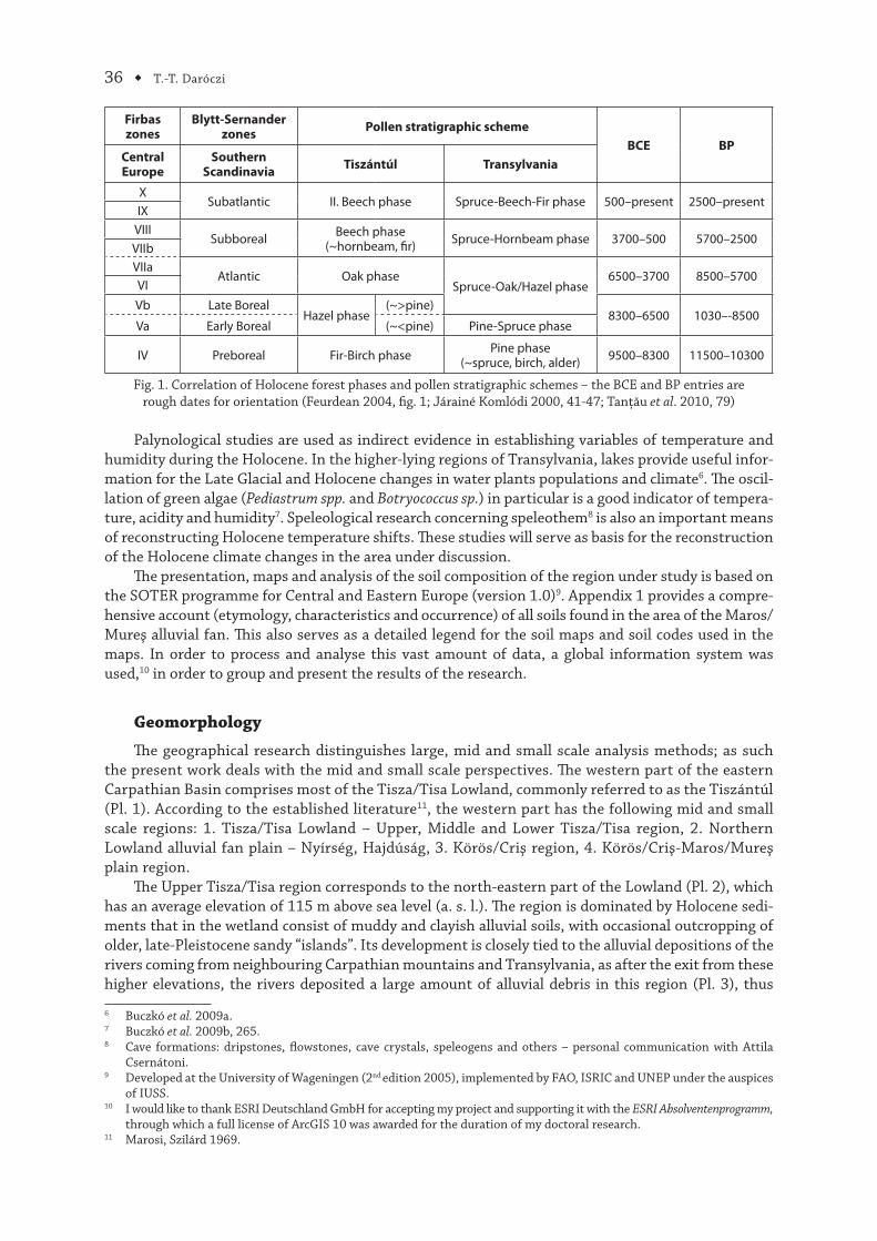
Th e Holocene has the following major phases: Preboreal, Boreal, Atlantic, Subboreal and Subatlantic (Fig. 1). Furthermore, one might stated that, from a geographic perspective, these phases do not represent a period in the Lowland’s life that had major infl uence on the geographic landscape. Due to this fact, the research of this period requires a multidisciplinary approach – as it was expressed by Gyula Gábris: “Th e research of the [Holocene] requires a more eclectic approach, than any other period in Earth’s history (…). Th us the reconstruction of Holocene history and phenomena should be based on the cooperation of geologists, geomorphologists, botanists, zoologists, pedologists, archae-ologists and historians”3. Th is also means that the large scale processes which now constitute the major traits of the Lowland took place at the closing of the previous period, Pleistocene, i.e. at the end of the last Ice Age. In contrast, the geomorphological features of Transylvania are mostly of Neogene origin and, as such, no major alteration to the geographic landscape occurred during the Holocene4.
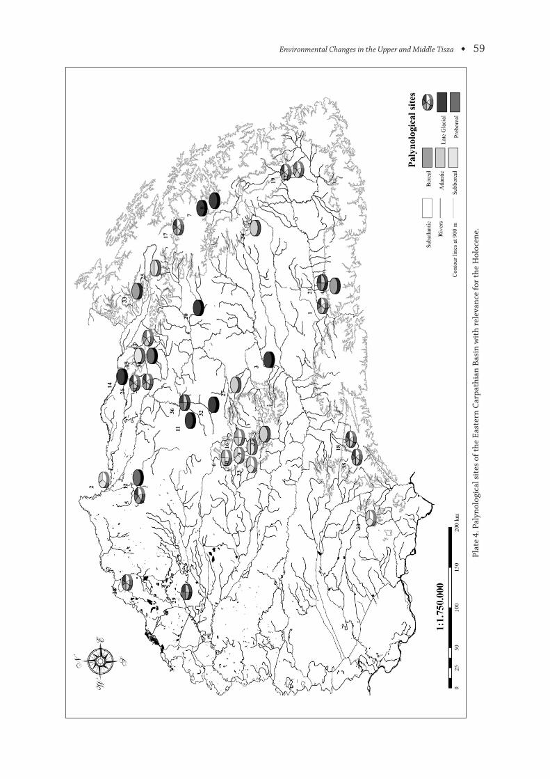
In terms of fl ora, it should be mentioned that most of the data presented, in what follows, comes from palynology and macro fossil analysis (Appendix 2 and Pl. 4) and as such it is largely dependent on environmental factors of pollen deposition. Th e pollen that reaches the deposition sites, used for later soundings to obtain pollen schemes, is dependent on several variables: pollen productivity of the plants in each area, dispersal mechanisms and the size of the basin. Some sites may contain pollen coming from an area of a few kilometres around the sites (e.g. Avrig, Steregoiu, Iezerul Călimani, Tăul Zănoguţii) to zones well over 20 km (e.g. Molhaşul Mare, Mohoş). Hence, the pollen spectrum of data may represent local or broad-regional trends of palaeofl ora5.
1 Th e present study was part of my PhD research at the universities of Sibiu and Heidelberg. I am grateful for the help provided by Attila Csernátoni, Katalin-Emilia Daróczi and Kinga Fetykó. I would further like to thank Joseph Maran and Lærke Recht for their comments on earlier drafts.
2 Marosi, Szilárd 1969. 3 Gábris 2006, CD.4 Linzer et al. 1998, 146–148, 156.5 Feurdean et al. 2010, 2199.
ZIRIDAVA STUDIA ARCHAEOLOGICA, 26/1, p. 35–60
36 ◆ T.-T. Daróczi
Firbaszones
Blytt-Sernander zones
Pollen stratigraphic scheme
BCE BPCentralEurope
SouthernScandinavia
Tiszántúl Transylvania
XSubatlantic II. Beech phase Spruce-Beech-Fir phase 500–present 2500–present
IXVIII
Subboreal Beech phase(~hornbeam, fi r) Spruce-Hornbeam phase 3700–500 5700–2500
VIIbVIIa
Atlantic Oak phaseSpruce-Oak/Hazel phase
6500–3700 8500–5700VI
Vb Late BorealHazel phase
(~>pine)8300–6500 1030–-8500
Va Early Boreal (~<pine) Pine-Spruce phase
IV Preboreal Fir-Birch phase Pine phase(~spruce, birch, alder) 9500–8300 11500–10300
Fig. 1. Correlation of Holocene forest phases and pollen stratigraphic schemes – the BCE and BP entries are rough dates for orientation (Feurdean 2004, fi g. 1; Járainé Komlódi 2000, 41-47; Tanţău et al. 2010, 79)
Palynological studies are used as indirect evidence in establishing variables of temperature and humidity during the Holocene. In the higher-lying regions of Transylvania, lakes provide useful infor-mation for the Late Glacial and Holocene changes in water plants populations and climate6. Th e oscil-lation of green algae (Pediastrum spp. and Botryococcus sp.) in particular is a good indicator of tempera-ture, acidity and humidity7. Speleological research concerning speleothem8 is also an important means of reconstructing Holocene temperature shifts. Th ese studies will serve as basis for the reconstruction of the Holocene climate changes in the area under discussion.
Th e presentation, maps and analysis of the soil composition of the region under study is based on the SOTER programme for Central and Eastern Europe (version 1.0)9. Appendix 1 provides a compre-hensive account (etymology, characteristics and occurrence) of all soils found in the area of the Maros/Mureş alluvial fan. Th is also serves as a detailed legend for the soil maps and soil codes used in the maps. In order to process and analyse this vast amount of data, a global information system was used,10 in order to group and present the results of the research.
Geomorphology
Th e geographical research distinguishes large, mid and small scale analysis methods; as such the present work deals with the mid and small scale perspectives. Th e western part of the eastern Carpathian Basin comprises most of the Tisza/Tisa Lowland, commonly referred to as the Tiszántúl (Pl. 1). According to the established literature11, the western part has the following mid and small scale regions: 1. Tisza/Tisa Lowland – Upper, Middle and Lower Tisza/Tisa region, 2. Northern Lowland alluvial fan plain – Nyírség, Hajdúság, 3. Körös/Criş region, 4. Körös/Criş-Maros/Mureş plain region.
Th e Upper Tisza/Tisa region corresponds to the north-eastern part of the Lowland (Pl. 2), which has an average elevation of 115 m above sea level (a. s. l.). Th e region is dominated by Holocene sedi-ments that in the wetland consist of muddy and clayish alluvial soils, with occasional outcropping of older, late-Pleistocene sandy “islands”. Its development is closely tied to the alluvial depositions of the rivers coming from neighbouring Carpathian mountains and Transylvania, as after the exit from these higher elevations, the rivers deposited a large amount of alluvial debris in this region (Pl. 3), thus
6 Buczkó et al. 2009a.7 Buczkó et al. 2009b, 265.8 Cave formations: dripstones, fl owstones, cave crystals, speleogens and others – personal communication with Attila
Csernátoni.9 Developed at the University of Wageningen (2nd edition 2005), implemented by FAO, ISRIC and UNEP under the auspices
of IUSS.10 I would like to thank ESRI Deutschland GmbH for accepting my project and supporting it with the ESRI Absolventenprogramm,
through which a full license of ArcGIS 10 was awarded for the duration of my doctoral research.11 Marosi, Szilárd 1969.
T.-T. Daróczi
Environmental Changes in the Upper and Middle Tisza ◆ 37
building a massive alluvial fan12. Th is later feature is important because, by this deposition, the region has reached an elevation more or less equivalent to the areas to the south (Nyírség), thus enabling other rivers, coming from the north-eastern area, to fl ow directly into the Körös/Criş river. Another important phenomenon is a result of the same depositional process: the branches of the Tisza/Tisa-Szamos/Someş river-system gradually migrated northwards, thus eventually making the rivers that were headed south their tributaries13. Th e result of this retreating erosion is that the eastern part of the Upper Tisza/Tisa region ended up having a lower a. s. l. elevation than the neighbouring areas. Hence, it can be acknowledged that in this phase, the rivers were the most important factor in land-scape shaping14.
During the entire Holocene, the Tisza/Tisa and its tributaries constantly eroded the features that were created at the end of the Pleistocene, replacing them with alluvial deposits. Th is process would imply that the region holds many dead branches of the river systems. Th e Tisza/Tisa river occupied its present river course roughly ~7500 years ago (Fig. 3), creating a monotone landscape in its upper region in the Lowland, with only occasional outcrops of older volcanic features like the Tapai (164 m a. s. l.) and Tipet (179 m a. s. l.) “mountains”15. Th e major tributary of the Tisza/Tisa in this region, i.e. the Szamos/Someş river, occupied its present river course about the same time, namely in the Oak phase of the Holocene16. Th is would mean that up until this time it had an active role in shaping the geographical landscape, thus having a major infl uence on human activity in this the area. Some of the dead branches of the river are still visible today and still hold signifi cant quantities of water. Th e Someş/Szamos plain (Pl. 1) developed further from a system of dead river branches to huge swamps due to the climate becoming wetter, thus contributing to an all-round increase of marshy areas in the region17. A good example of this process is the case of the Ecsedi/Ecedea Marshland; this area started to form during the Oak phase and reached its maximum size during the Beech phase of the Holocene18. Furthermore, it can be noted that low-lying areas were fl ooded regularly in spring. In most instances, the only areas that were safe from these fl oods were the persisting sandy outcrops of the Pleistocene. It becomes obvious that enduring human settle-ment and other human activities which were seasonal and based on yearly rotation (e.g. agriculture) could only take place on these features.
Th e lithology of the Middle Tisza/Tisa region (Pl. 2) is also varied, consisting of Pleistocene and Holocene deposits (loess mud, alluvial soils, clay and sand – Pl. 3). Due to the tectonic structural trenches, the geothermic gradient shows diff erent values throughout the region, in some cases even reaching very high values, which resulted in the appearance of geothermal springs19.
During the Hazel phase, the region witnessed the last major sand movements and land-scape reshaping phenomenon. The most significant change in this region occurred during the transition from the Pleistocene to the Holocene when the Tisza/Tisa River turned southwards and, as a result, totally reorganised the hydrographical system and the landscape features. This reshaping consisted of alluvial depositions in the lower-lying regions and the gradual erosion of extended higher-lying regions (Pl. 2). These processes increased the number of horseshoe lakes20 in the area and are also useful in the relative dating of these lakes, since younger river courses destroy older ones21.
Specifi c features of the region appeared during the Beech phase, i.e. mounds commonly referred to as kunhalom22. Th eir origin can be explained by reference to either cultural or environmental factors: guard mounds and burial places (i.e. tumuli) or alluvial accumulations due to river activities23.
12 Borsy 1968, 223–233; Nagy, Félegyházi 2001.13 Félegyházi 1998, 217–218.14 Somogyi 1987, 26–27.15 Cholnoky 1907; Gábris 1985; Gábris et al. 2001, 5–7.16 Borsy, Félegyházi 1983, 123–124; Félegyházi 1998, 210–215.17 Horváth 2002, 8.18 Drăgulescu 2005, 44; Járainé Komlódi 1987, 44.19 Gábris et al. 2001, 8–9.20 Lakes that formed by river meanders cut off from the main river course, i.e. a dead branch. Hung. morotva.21 Gábris 1970; Gábris et al. 2001, 8.22 Cuman mound.23 Borsy 1968, 148–150; Tóth 2003, 144–160.
38 ◆ T.-T. Daróczi
Th e particular micro-region of the area is the Hortobágy (Pl. 1), which is a fl at marshland consisting of loess mud and clay that to a large extent have become saline24. Th is process started in the drier Hazel phase of the Holocene and still continues today. Next to this large marshland in the fl oodplains of the Tisza/Tisa River, the massive amounts of spring water created wetlands that were no deeper than 1–2 m25.
Another geographic factor shaping the landscape in this region was the wind in the dry Hazel phase that eroded the upper and thinner loess soil and rearranged the sand dunes26.
Th e Lower Tisza/Tisa region starts from the mouth of the Körös/Criş River and runs along the western border of Bánság/Banat to the south (Pl. 1). It follows the course of the river, slightly widening in the south. Th e highest elevation of the region does not exceed 85 m a. s. l. During most of the Holocene, this region was a wetland and it is made up exclusively by deposits of this period, as this region was the lowest in the entire Tisza/Tisa Lowland and as such the alluvial deposits thicken from north to south (Pl. 3). As a result, most of the features are the creation of rivers and still waters, with only occasional evidence of features of aeolian origin. Th e region mainly consists of alluvial mud, meadow clay and loess, all alluvial deposits of the Tisza/Tisa and Maros/Mureş rivers27.
A unique area of the Lowland is Nyírség (Pl. 1). Its characteristic high elevation (20–50 m higher than the surrounding regions) includes the highest elevation of the entire Tisza/Tisa Lowland (Hoportyó peak–183 m a. s. l.). Th e most common pedological feature of the area are dunes created by sand drifts28, which cover vast areas, their average thickness ranging from a few centimetres up to half a metre. Beside the loess sand, the area has brown podzol soil (Pl. 3), the latter formed during the wetter phases of the Holocene, during its Oak and Beech phases29.
Th e Nyírség is also the result of river depositions; it is basically an alluvial fan, created by the sinking of the surrounding areas and the change in direction of the river courses. Th is is partially the result of tectonic processes sinking parts of the adjacent areas30. Th e process ended about 10,000 years ago and due to the apparent lack of rivers, this area did not suff er major changes during the Fir-Birch phase of the Holocene, but in the following dry and warm Hazel phase, changes to the geographic landscape were more substantial. Th ese changes were mostly due to aeolian factors and sandy areas that were not protected by vegetation or upper loess layers were rearranged by the climatic forces of the winds31. Th e wind dislocated huge amounts of sand, creating diff erent types of sand dunes like parabola or fringe mounds (2–18 m high). Th ese larger sandy features were segmented by smaller valleys with broad bases, where riverbeds fl owed in the early Holocene32.
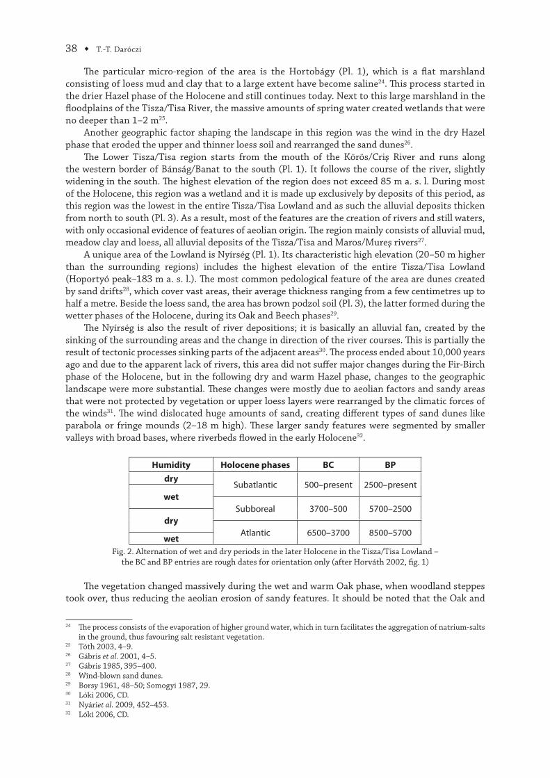
Humidity Holocene phases BC BP
drySubatlantic 500–present 2500–present
wet
Subboreal 3700–500 5700–2500dry
Atlantic 6500–3700 8500–5700wet
Fig. 2. Alternation of wet and dry periods in the later Holocene in the Tisza/Tisa Lowland –the BC and BP entries are rough dates for orientation only (after Horváth 2002, fi g. 1)
Th e vegetation changed massively during the wet and warm Oak phase, when woodland steppes took over, thus reducing the aeolian erosion of sandy features. It should be noted that the Oak and
24 Th e process consists of the evaporation of higher ground water, which in turn facilitates the aggregation of natrium-salts in the ground, thus favouring salt resistant vegetation.
25 Tóth 2003, 4–9.26 Gábris et al. 2001, 4–5.27 Gábris 1985, 395–400.28 Wind-blown sand dunes.29 Borsy 1961, 48–50; Somogyi 1987, 29.30 Lóki 2006, CD.31 Nyáriet al. 2009, 452–453.32 Lóki 2006, CD.
Environmental Changes in the Upper and Middle Tisza ◆ 39
Beech phases cannot be viewed as a continuous moist phase, but rather as alternations of wet and dry intervals (Fig. 2)33. Th e closing in of the forests in the region was only accentuated in the Beech phase; this expansion was only disturbed by human factors through deforestations and agriculture. From this time onwards, the impact of the anthropogenic factor on the environment and especially on the biosphere of the given habitat, is clearly recognisable34. One good example of aeolian and human induced erosion is the Bronze Age site of Hosszúpály which was covered by layers of windblown sand35. Th e dominant form of vegetation in the entire Tisza/Tisa Lowland is the woodland steppe, as a direct result of the intensifi cation of grazing and agriculture in the beginning of the second Beech or Subatlantic phase36.
Hajdúság (Pl. 1) is located to the southwest of Nyírség. Th is area of the Lowland is characterised by a thick 3–15 m loess table that has its highest point just above 160 m a. s. l. It might be said that, from a geomorphological perspective, it is the most stable region of the entire Lowland since it did not undergo major changes of any kind throughout the entire Holocene. Th e only processes that had a minor eff ect on the landscape of the region were those caused by erosion-derasion, such as the continuous sinking of some smaller valleys. Some of these valleys developed to lengths of up to 20 km (Vér valley, Brassó brook, Vidi brook). Th e relief of the Hajdúság is divided into two parts: the north-eastern region that is slightly higher and was described above and a lower-laying region that is almost perfectly fl at. Th e latter also has kunhalmok features, which are usually 5–10 m high and measure 50–80 m in diameter37.
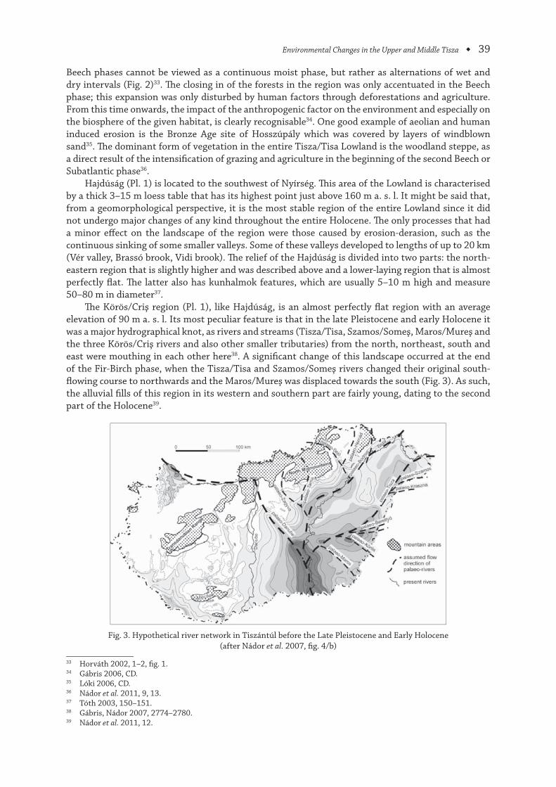
Th e Körös/Criş region (Pl. 1), like Hajdúság, is an almost perfectly fl at region with an average elevation of 90 m a. s. l. Its most peculiar feature is that in the late Pleistocene and early Holocene it was a major hydrographical knot, as rivers and streams (Tisza/Tisa, Szamos/Someş, Maros/Mureş and the three Körös/Criş rivers and also other smaller tributaries) from the north, northeast, south and east were mouthing in each other here38. A signifi cant change of this landscape occurred at the end of the Fir-Birch phase, when the Tisza/Tisa and Szamos/Someş rivers changed their original south-fl owing course to northwards and the Maros/Mureş was displaced towards the south (Fig. 3). As such, the alluvial fi lls of this region in its western and southern part are fairly young, dating to the second part of the Holocene39.
Fig. 3. Hypothetical river network in Tiszántúl before the Late Pleistocene and Early Holocene (after Nádor et al. 2007, fi g. 4/b)
33 Horváth 2002, 1–2, fi g. 1.34 Gábris 2006, CD.35 Lóki 2006, CD.36 Nádor et al. 2011, 9, 13.37 Tóth 2003, 150–151.38 Gábris, Nádor 2007, 2774–2780.39 Nádor et al. 2011, 12.
40 ◆ T.-T. Daróczi
Ever since this major change, the geographic landscape has not changed much: marshes, swamps and wetlands increased in size and dominated the area for millennia. As the wetlands were a constant presence, the slightly higher features (e.g. levče40) were the only available spots for human habitation, being the only areas that were not fl ooded. Th is view is further strengthened by the exclusive presence of the kunhalmok on these elevations41.
Th e Körös/Criş-Maros/Mureş plain (Pl. 1) is also an alluvial fan created by the processes previ-ously described. Due to this, the geomorphology of the region consists of sand, clay and loess mud and rivers and winds were the factors that shaped this landscape42. In these instances, it should be mentioned that the Maros/Mureş River infl uenced the face of this geographic landscape to a larger extent, whereas the Körös/Criş River contributed only on a smaller degree. Th e highest-lying areas are found in the south-central part and the surrounding is slightly lower and forming almost perfect plains. Cut off meanders (dead branches) are not as common as in other areas, but the presence of kunhalmok is noted here as well43.
Flora
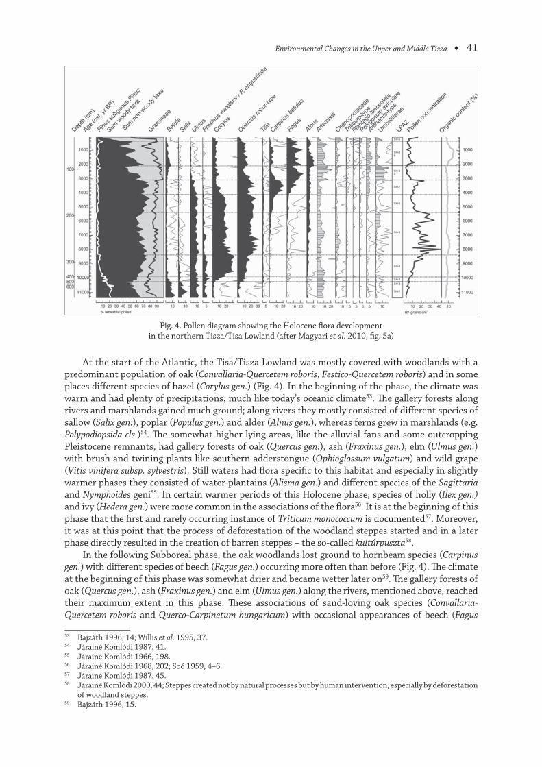
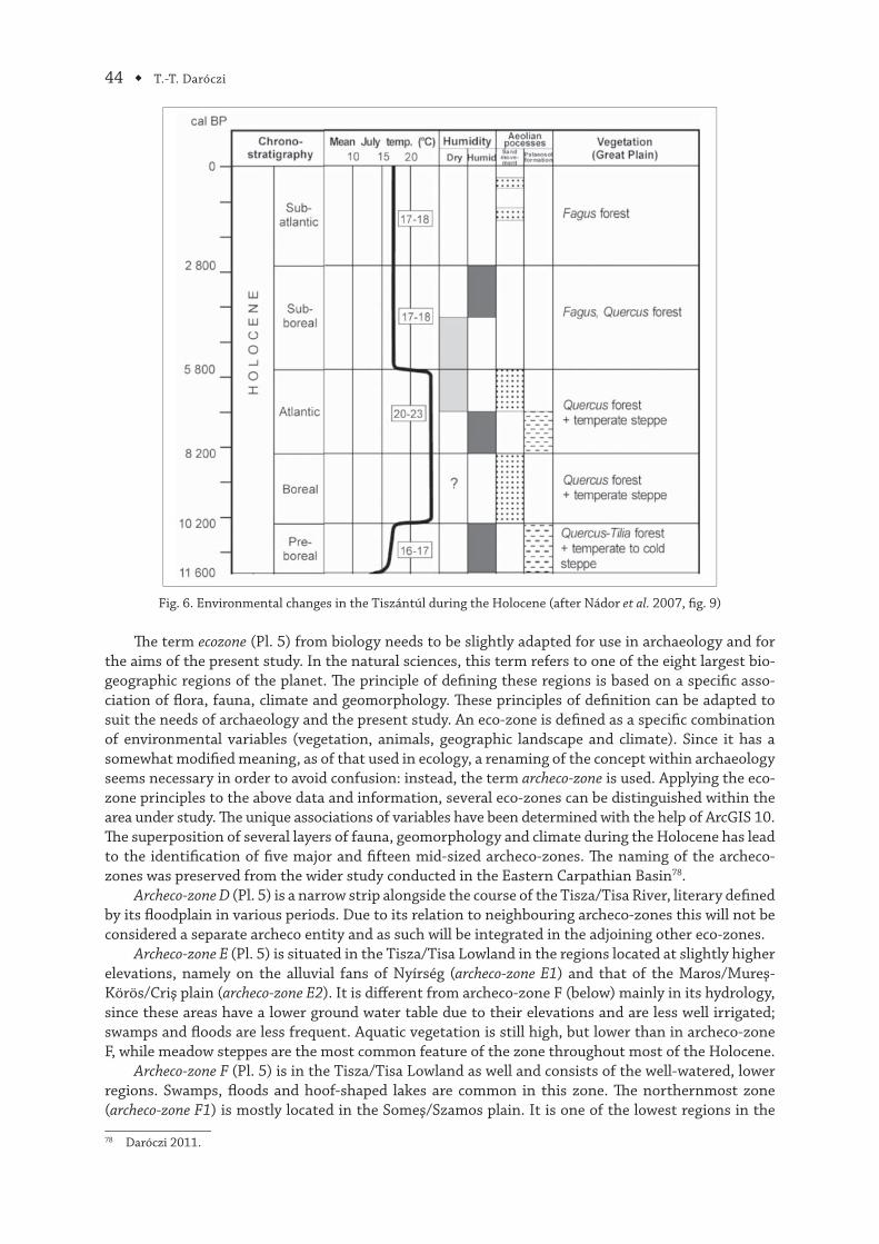
At the end of the Pleistocene and the beginning of the Holocene (especially in the Preboreal phase), oak (Quercus gen.) and hornbeam (Carpinus gen.) woods were characteristic for the higher lying regions of the Apuseni mountains, west of the Great Hungarian plain, whereas the Lowland itself had vegetation specifi c to gallery forest steppes44. Th is means that trees were usually found in areas adjacent to rivers. Th e most common species were ash (Fraxinus gen.), fi r (Abies gen.) and birch (Betula gen.) (Fig. 4), whereas the rest of the area would have had high shrubs like the somlatha (Ephedra distachya or E. vulgaris)45. Th is phase was characterised by a somewhat colder climate and also by the presence of remnant spots of large forests of pine (Pinus gen.) and birch (Betula gen.) with only the occasional occurrence of deciduous species46. Th e appearance of birch (Betula gen.) and in some cases of poplar (Populus gen.) is the starting point of a process called the primary secular succession,47 where in the barren landscape and windy envi-ronment, the fl ora gradually gains ground by plants tolerant of the harsh climate. Furthermore, it is in this early phase that the process of natural eutrophication48 begins, through the gradual increase of tangles (Laminaria gen.), green algae (Charophyta gen.), hornworts (Ceratophyllales gen.), members of the pondweed family (Potamogetonaceae fam.) and buttercups/spearworts/water crowfoots (Ranunculus gen.) populations. Th is expansion culminates in the late Holocene, as seen below in Fig. 449.
In the Boreal phase, the climate is somewhat warmer and drier and as a direct result, there is a massive increase in hazel (Corylus gen.) population in the Apuseni Mountains (Fig. 4)50. In contrast, this species is almost completely absent in the Tisza/Tisa Lowland and only smaller patches of oak (Quercus gen.), ash (Fraxinus gen.), lime (Tilia gen.), maple (Acer gen.) and sweet chestnut (Castanea sativa), with occasional pine (Pinus gen.) associations are present, due to the low precipitation levels and dry climate. Th is vegetation is preserved today in clusters of remnant plants of fl owery pampas, small pasque fl ower (Pulsatilla pratensis subsp. hungarica), Adonis X hybrida Wolf syn. A. transsylvanica, bowing sage (Salvia nutans), Sternbergia gen. and rare steppe trees e.g. Aceri tatarico – Quercetum51. Th e vegetation of the area is best described as meadow steppes52.
40 Higher-lying regions between remnant river courses.41 Tóth 2003, 150–151.42 Somogyi 1987, 31.43 Nádor et al. 2007, 186.44 Járainé Komlódi 1968, 200–201; Sümegi et al. 2008, 29–30.45 Bajzáth 1996, 10–11.46 Zólyomi 1952, 493–495.47 Th e process by which a barren and harsh landscape is fi rst “settled” by plants that are resistant to these elements and
as such facilitate the spread of other less resistant ones, which then eventually come to dominate the fl ora and start a secondary secular succession for other species and so on – personal communication with Katalin-Emilia Daróczi.
48 Th e process by which mostly still waters are overwhelmed by plants, directly resulting in the disappearance from these environments of most non-unicellular animal life – personal communication with Katalin-Emilia Daróczi.
49 Bajzáth 1996, 11–12; Járainé Komlódi 1987, 38.50 Zólyomi 1936, 515–516.51 Bajzáth 1996, 13; Endangered, remnant oak species from the Boreal steppes specially adapted for loess areas.52 Magyari et al. 2010, 925–926.
Environmental Changes in the Upper and Middle Tisza ◆ 41
Fig. 4. Pollen diagram showing the Holocene fl ora developmentin the northern Tisza/Tisa Lowland (after Magyari et al. 2010, fi g. 5a)
At the start of the Atlantic, the Tisa/Tisza Lowland was mostly covered with woodlands with a predominant population of oak (Convallaria-Quercetem roboris, Festico-Quercetem roboris) and in some places diff erent species of hazel (Corylus gen.) (Fig. 4). In the beginning of the phase, the climate was warm and had plenty of precipitations, much like today’s oceanic climate53. Th e gallery forests along rivers and marshlands gained much ground; along rivers they mostly consisted of diff erent species of sallow (Salix gen.), poplar (Populus gen.) and alder (Alnus gen.), whereas ferns grew in marshlands (e.g. Polypodiopsida cls.)54. Th e somewhat higher-lying areas, like the alluvial fans and some outcropping Pleistocene remnants, had gallery forests of oak (Quercus gen.), ash (Fraxinus gen.), elm (Ulmus gen.) with brush and twining plants like southern adderstongue (Ophioglossum vulgatum) and wild grape (Vitis vinifera subsp. sylvestris). Still waters had fl ora specifi c to this habitat and especially in slightly warmer phases they consisted of water-plantains (Alisma gen.) and diff erent species of the Sagittaria and Nymphoides geni55. In certain warmer periods of this Holocene phase, species of holly (Ilex gen.) and ivy (Hedera gen.) were more common in the associations of the fl ora56. It is at the beginning of this phase that the fi rst and rarely occurring instance of Triticum monococcum is documented57. Moreover, it was at this point that the process of deforestation of the woodland steppes started and in a later phase directly resulted in the creation of barren steppes – the so-called kultúrpuszta58.
In the following Subboreal phase, the oak woodlands lost ground to hornbeam species (Carpinus gen.) with diff erent species of beech (Fagus gen.) occurring more often than before (Fig. 4). Th e climate at the beginning of this phase was somewhat drier and became wetter later on59. Th e gallery forests of oak (Quercus gen.), ash (Fraxinus gen.) and elm (Ulmus gen.) along the rivers, mentioned above, reached their maximum extent in this phase. Th ese associations of sand-loving oak species (Convallaria-Quercetem roboris and Querco-Carpinetum hungaricum) with occasional appearances of beech (Fagus
53 Bajzáth 1996, 14; Willis et al. 1995, 37.54 Járainé Komlódi 1987, 41.55 Járainé Komlódi 1966, 198.56 Járainé Komlódi 1968, 202; Soó 1959, 4–6.57 Járainé Komlódi 1987, 45.58 Járainé Komlódi 2000, 44; Steppes created not by natural processes but by human intervention, especially by deforestation
of woodland steppes.59 Bajzáth 1996, 15.
42 ◆ T.-T. Daróczi
gen.) are very similar to the ones found today60. Some elements of human intervention are already visible from this phase onward, although not on the scale seen in the coming phase. Th ese activities favour plants used to disturbances61 such as weeds of the smartweed family (Polygonaceae fam.), docks and sorrels (Rumex gen.)62. In the pollen diagrams, the amount of Triticum monococcum only became signifi cant after the turn of the 1st millennium B.C., whereas rye (secale cereale) is documented almost a millennium earlier63.
In the fi nal phase of the Holocene, the oak (Quercus gen.) retreated mostly to the northern part of the Tisza/Tisa Lowland. Moreover, the hornbeam (Carpinus gen.) population was aff ected by human exploitation (Fig. 4) and their place was taken by diff erent graminoids and weed, most likely due to the same factors64. Water plants further increased in variety and population with the propagation of species like some carnivorous plants (Utricularia batrachium), yellow iris (Iris pseudacorus), or fl owering rush (Butomus umbellatus)65.
Fauna
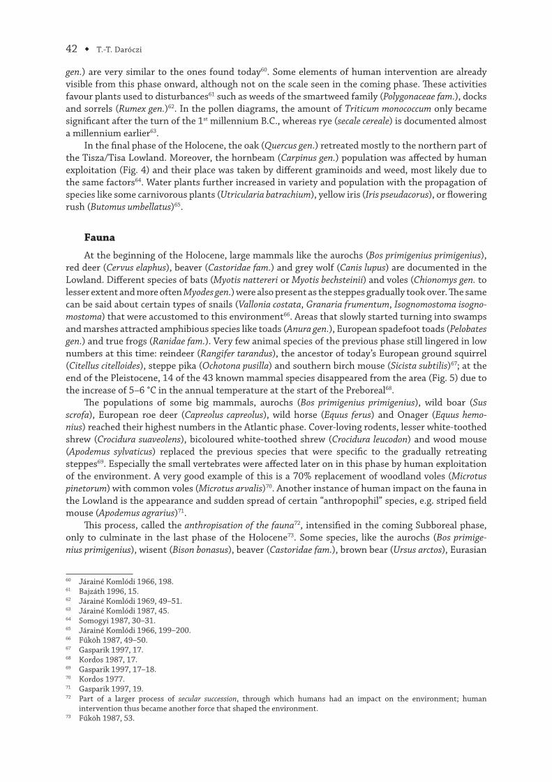
At the beginning of the Holocene, large mammals like the aurochs (Bos primigenius primigenius), red deer (Cervus elaphus), beaver (Castoridae fam.) and grey wolf (Canis lupus) are documented in the Lowland. Diff erent species of bats (Myotis nattereri or Myotis bechsteinii) and voles (Chionomys gen. to lesser extent and more often Myodes gen.) were also present as the steppes gradually took over. Th e same can be said about certain types of snails (Vallonia costata, Granaria frumentum, Isognomostoma isogno-mostoma) that were accustomed to this environment66. Areas that slowly started turning into swamps and marshes attracted amphibious species like toads (Anura gen.), European spadefoot toads (Pelobates gen.) and true frogs (Ranidae fam.). Very few animal species of the previous phase still lingered in low numbers at this time: reindeer (Rangifer tarandus), the ancestor of today’s European ground squirrel (Citellus citelloides), steppe pika (Ochotona pusilla) and southern birch mouse (Sicista subtilis)67; at the end of the Pleistocene, 14 of the 43 known mammal species disappeared from the area (Fig. 5) due to the increase of 5–6 °C in the annual temperature at the start of the Preboreal68.
Th e populations of some big mammals, aurochs (Bos primigenius primigenius), wild boar (Sus scrofa), European roe deer (Capreolus capreolus), wild horse (Equus ferus) and Onager (Equus hemo-nius) reached their highest numbers in the Atlantic phase. Cover-loving rodents, lesser white-toothed shrew (Crocidura suaveolens), bicoloured white-toothed shrew (Crocidura leucodon) and wood mouse (Apodemus sylvaticus) replaced the previous species that were specifi c to the gradually retreating steppes69. Especially the small vertebrates were aff ected later on in this phase by human exploitation of the environment. A very good example of this is a 70% replacement of woodland voles (Microtus pinetorum) with common voles (Microtus arvalis)70. Another instance of human impact on the fauna in the Lowland is the appearance and sudden spread of certain “anthropophil” species, e.g. striped fi eld mouse (Apodemus agrarius)71.
Th is process, called the anthropisation of the fauna72, intensifi ed in the coming Subboreal phase, only to culminate in the last phase of the Holocene73. Some species, like the aurochs (Bos primige-nius primigenius), wisent (Bison bonasus), beaver (Castoridae fam.), brown bear (Ursus arctos), Eurasian
60 Járainé Komlódi 1966, 198.61 Bajzáth 1996, 15.62 Járainé Komlódi 1969, 49–51.63 Járainé Komlódi 1987, 45.64 Somogyi 1987, 30–31.65 Járainé Komlódi 1966, 199–200.66 Fűköh 1987, 49–50.67 Gasparik 1997, 17.68 Kordos 1987, 17.69 Gasparik 1997, 17–18.70 Kordos 1977.71 Gasparik 1997, 19.72 Part of a larger process of secular succession, through which humans had an impact on the environment; human
intervention thus became another force that shaped the environment.73 Fűköh 1987, 53.
Environmental Changes in the Upper and Middle Tisza ◆ 43
lynx (Lynx lynx), grey wolf (Canis lupus) and golden jackal (Canis aureus) disappeared entirely from the Lowland. Th e last three species would reappear later on74.
Fig. 5. Vertebrate animals that went extinct and disappeared (dark) and appeared (light) –the BC and BP entries are rough dates for orientation only (after Kordos 1987, fi g. 5)
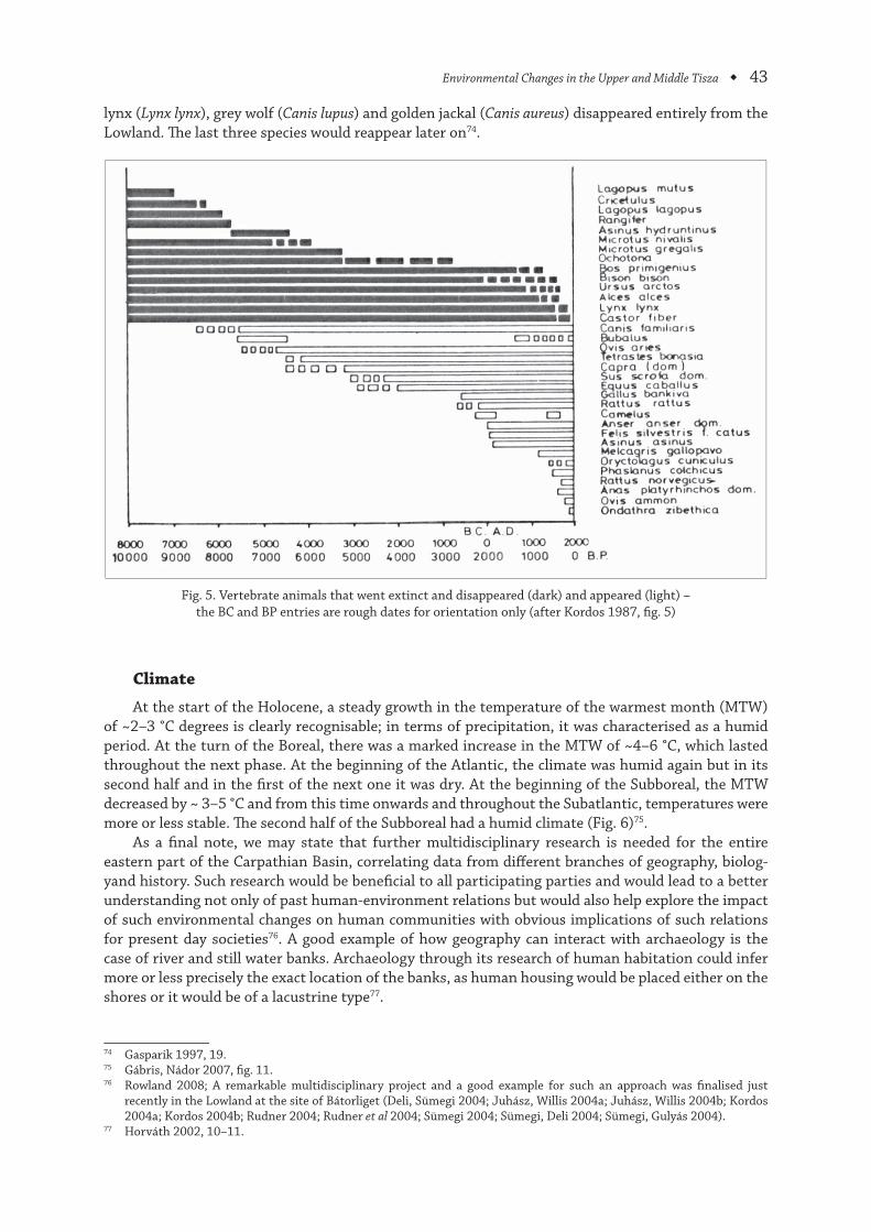
Climate
At the start of the Holocene, a steady growth in the temperature of the warmest month (MTW) of ~2–3 °C degrees is clearly recognisable; in terms of precipitation, it was characterised as a humid period. At the turn of the Boreal, there was a marked increase in the MTW of ~4–6 °C, which lasted throughout the next phase. At the beginning of the Atlantic, the climate was humid again but in its second half and in the fi rst of the next one it was dry. At the beginning of the Subboreal, the MTW decreased by ~ 3–5 °C and from this time onwards and throughout the Subatlantic, temperatures were more or less stable. Th e second half of the Subboreal had a humid climate (Fig. 6)75.
As a fi nal note, we may state that further multidisciplinary research is needed for the entire eastern part of the Carpathian Basin, correlating data from diff erent branches of geography, biolog-yand history. Such research would be benefi cial to all participating parties and would lead to a better understanding not only of past human-environment relations but would also help explore the impact of such environmental changes on human communities with obvious implications of such relations for present day societies76. A good example of how geography can interact with archaeology is the case of river and still water banks. Archaeology through its research of human habitation could infer more or less precisely the exact location of the banks, as human housing would be placed either on the shores or it would be of a lacustrine type77.
74 Gasparik 1997, 19.75 Gábris, Nádor 2007, fi g. 11.76 Rowland 2008; A remarkable multidisciplinary project and a good example for such an approach was fi nalised just
recently in the Lowland at the site of Bátorliget (Deli, Sümegi 2004; Juhász, Willis 2004a; Juhász, Willis 2004b; Kordos 2004a; Kordos 2004b; Rudner 2004; Rudner et al 2004; Sümegi 2004; Sümegi, Deli 2004; Sümegi, Gulyás 2004).
77 Horváth 2002, 10–11.
44 ◆ T.-T. Daróczi
Fig. 6. Environmental changes in the Tiszántúl during the Holocene (after Nádor et al. 2007, fi g. 9)
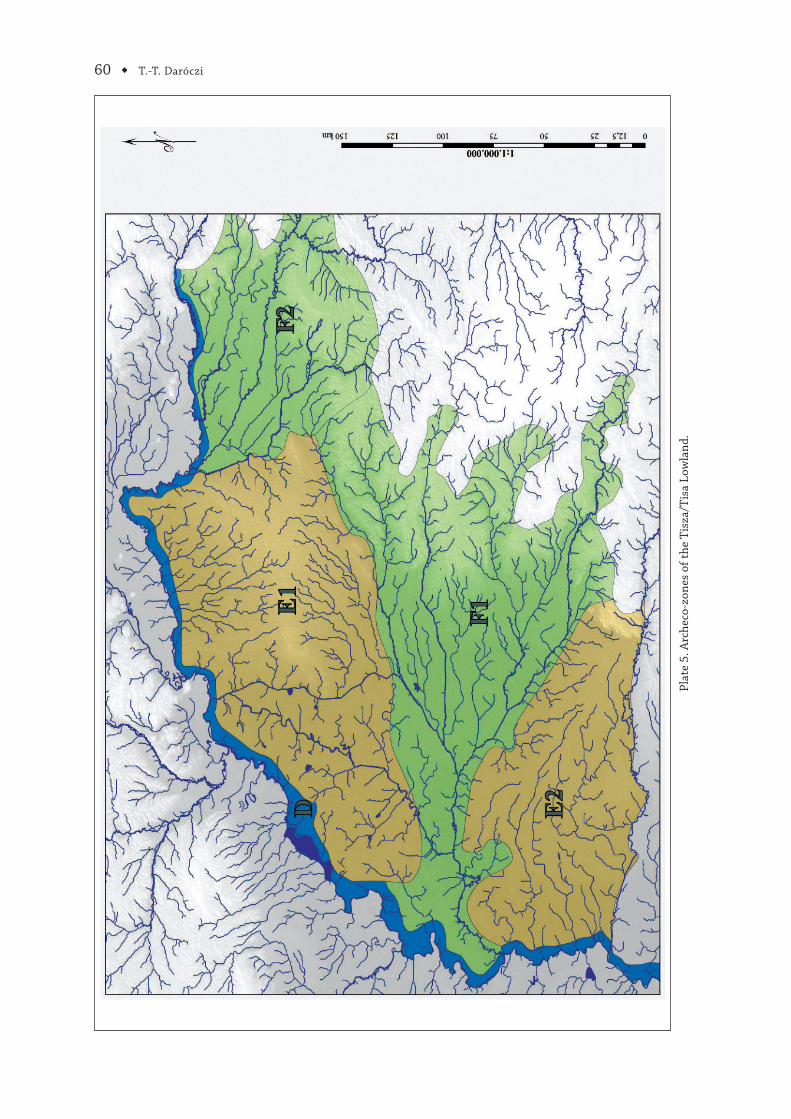
Th e term ecozone (Pl. 5) from biology needs to be slightly adapted for use in archaeology and for the aims of the present study. In the natural sciences, this term refers to one of the eight largest bio-geographic regions of the planet. Th e principle of defi ning these regions is based on a specifi c asso-ciation of fl ora, fauna, climate and geomorphology. Th ese principles of defi nition can be adapted to suit the needs of archaeology and the present study. An eco-zone is defi ned as a specifi c combination of environmental variables (vegetation, animals, geographic landscape and climate). Since it has a somewhat modifi ed meaning, as of that used in ecology, a renaming of the concept within archaeology seems necessary in order to avoid confusion: instead, the term archeco-zone is used. Applying the eco-zone principles to the above data and information, several eco-zones can be distinguished within the area under study. Th e unique associations of variables have been determined with the help of ArcGIS 10. Th e superposition of several layers of fauna, geomorphology and climate during the Holocene has lead to the identifi cation of fi ve major and fi fteen mid-sized archeco-zones. Th e naming of the archeco-zones was preserved from the wider study conducted in the Eastern Carpathian Basin78.
Archeco-zone D (Pl. 5) is a narrow strip alongside the course of the Tisza/Tisa River, literary defi ned by its fl oodplain in various periods. Due to its relation to neighbouring archeco-zones this will not be considered a separate archeco entity and as such will be integrated in the adjoining other eco-zones.
Archeco-zone E (Pl. 5) is situated in the Tisza/Tisa Lowland in the regions located at slightly higher elevations, namely on the alluvial fans of Nyírség (archeco-zone E1) and that of the Maros/Mureş-Körös/Criş plain (archeco-zone E2). It is diff erent from archeco-zone F (below) mainly in its hydrology, since these areas have a lower ground water table due to their elevations and are less well irrigated; swamps and fl oods are less frequent. Aquatic vegetation is still high, but lower than in archeco-zone F, while meadow steppes are the most common feature of the zone throughout most of the Holocene.
Archeco-zone F (Pl. 5) is in the Tisza/Tisa Lowland as well and consists of the well-watered, lower regions. Swamps, fl oods and hoof-shaped lakes are common in this zone. Th e northernmost zone (archeco-zone F1) is mostly located in the Someş/Szamos plain. It is one of the lowest regions in the
78 Daróczi 2011.
Environmental Changes in the Upper and Middle Tisza ◆ 45
area; it had a cooler climate in certain periods of the Holocene and a mixture of meadow steppes and woodlands and humidity was higher than in most regions of study area. Th e second zone (archeco-zone F2) is located in between archeco-zones E1 and E2, mainly in the Körös/Criş plain. As in the case of the previous archeco-zone, it is a well-watered region with plenty of swamps, dead river branches and seasonal fl oods. Gallery forests and steppes are the dominant vegetation feature during most of the Holocene. Th e southernmost region (archeco-zone F3) is located in the Banat Lowland and the low, eastern areas adjacent to it. It is somewhat drier and slightly warmer than other regions in any given period. Its hydrology and vegetation is similar to the other areas of this archeco-zone.
Tibor-Tamás DarócziInstitut für Ur- und Frühgeschichte und Vorderasiatische ArchäologieRuprecht-Karls-Universität HeidelbergHeidelberg, DE [email protected]
APPENDIX 1REFERENCE SOIL GROUPS
ANANDOSOL
“Andosols accommodate the soils that develop in volcanic ejecta or glasses under almost any climate (except under hyperarid climate conditions). However andosols may also develop in other sili-cate-rich materials under acid weathering in humid and perhumid climates. Many Andosols belong to: Kuroboku (Japan); Andisols (United States of America); Andosols and Vitrisols (France); and volcanic ash soils.
Connotation: Typically black soils of volcanic landscapes; from Japanese an, black and do, soil.Parent material: Volcanic glasses and ejecta (mainly ash, but also tuff , pumice, cinders and others)
or other silicate-rich material.Environment: Undulating from mountainous, humid and arctic to tropical regions with a wide
range of vegetation.Profi le development: Rapid weathering of porous volcanic ejecta or glasses results in accumula-
tion of stable organo-mineral complexes or short-range-order minerals such as allophane, imogolite and ferrihydrite. Acid weathering of other silicate-rich material in humid and perhumid climates also leads to the formation of stable organo-mineral complexes”79.
ARArensol
“Arenosols consist of sandy soils, including both soils developed in residual sands after in situ weathering of quartz-rich sediments or rock and soils developed in recently deposited sands such as dunes in deserts and beach lands. Corresponding soils in other classifi cation systems include Psamments of the US Soil Taxonomy and the sols minéraux bruts and sols peu évolués in the French classifi cation system of the CPCS (1967). Many Arenosols belong to Arenic Rudosols (Australia), Psammozems (Russian Federation) and Neossolos (Brazil).
Connotation: Sandy soils; from Latin arena, sand.Parent material: Unconsolidated, in places calcareous, translocated materials of sandy texture;
relatively small areas of Arenosols occur in extremely weathered siliceous rock.Environment: From arid to humid and perhumid and from extremely cold to extremely hot; land-
forms vary from recent dunes, beach ridges and sandy plains to very old plateaus; the vegetation ranges from desert over scattered vegetation (mostly grassy) to light forest.
Profi le development: In the dry zone, there is little or no soil development.
79 Fao 2006, 70.
46 ◆ T.-T. Daróczi
Arenosols in the perhumid tropics tend to develop thick albic eluviation horizons (with a spodic horizon below 200 m from soil surface) whereas most Arenosols of the humid temperate zone show signs of alteration or transport of humus, Fe or clay, but too weak to be diagnostic”80.
CHChernozem
“Chernozems accommodate soils with a thick black surface layer that is rich in organic matter. Th e Russian soil scientist Dokuchaev coined the name Chernozem in 1883 to denote the typical zonal soil of the tall grass steppes in continental Russia. Many Chernozems correspond to: Calcareous Black Soils and Kalktschernoseme (Germany), Chernosols (France), Eluviated Black Soils (Canada), several suborders (especially Udolls) of the Mollisols (United States of America) and Chernossolos (Brazil).
Connotation: Black soils rich in organic matter; from Russian chernij, black and zemlja, earth or land.
Parent material: Mostly aaeolian and re-washed aaeolian sediments (loess).Environment: Regions with a continental climate with cold winters and hot summers, which are
dry at least in the late summer; in fl at to undulating plains with tall-grass vegetation (forest in the northern transitional zone).
Profi le development: Dark brown to black mollic surface horizon, in many cases over a cambic or argic subsurface horizon; with secondary carbonates or a calcic horizon in the subsoil”81.
CMCambisol
“Cambisols combine soils with at least an incipient subsurface soil formation. Transformation of parent material is evident from structure formation and mostly brownish discoloration, increasing clay percentage and/or carbonate removal. Other soil classifi cation systems refer to many Cambisols as: Braunerden (Germany), Sols bruns (France), Brown soils/Brown Forest soils (older US systems), or Burozems (Russian Federation). FAO coined the name Cambisols, adopted by Brazil (Cambissolos); US Soil Taxonomy classifi es most of these soils as Inceptisols.
Connotation: Soils with at least the beginnings of horizon diff erentiation in the subsoil evident from changes in structure, colour, clay content or carbonate content; from Italian cambiare, to change.
Parent material: Medium and fi ne-textured materials derived from a wide range of rocks.Profi le development: Cambisols are characterized by slight or moderate weathering of parent
material and by absence of appreciable quantities of illuviated clay, organic matter, Al and/or Fe compounds.
Environment: Level to mountainous terrain in all climates; wide range of vegetation types”82.
FLFluvisol
“Fluvisols accommodate genetically young, azonal soils in alluvial deposits. Th e name Fluvisols may be misleading in the sense that these soils are not confi ned only to river sediments (Latin fl uvius, river); they also occur in lacustrine and marine deposits. Many Fluvisols correlate with: Alluvial soils (Russian Federation), Hydrosols (Australia), Fluvents and Fluvaquents (United States of America), Auenböden, Marschen, Strandböden, Watten and Unterwasserböden (Germany), Neossolos (Brazil) and Sols minéraux bruts d’apport alluvial ou colluvial or Sols peuévolués non climatiques d’apport alluvial ou colluvial (France).
Connotation: Soils developed in alluvial deposits; from Latin fl uvius, river.Parent material: Predominantly recent, fl uvial, lacustrine and marine deposits.Environment: Alluvial plains, river fans, valleys and tidal marshes on all continents and in all
climate zones; many Fluvisols under natural conditions are fl ooded periodically.
80 Fao 2006, 72.81 Fao 2006, 76.82 Fao 2006, 75.
Environmental Changes in the Upper and Middle Tisza ◆ 47
Profi le development: Profi les with evidence of stratifi cation; weak horizon diff erentiation but a distinct topsoil horizon may be present. Redoximorphic features are common, in particular in the lower part of the profi le”83.
HSHistosol
“Histosols are comprised of soils formed in organic material. Th ese vary from soils developed in predominantly moss peat in boreal, arctic and subarctic regions, via moss peat, reeds/sedge peat (fen) and forest peat in temperate regions to mangrove peat and swamp forest peat in the humid tropics. Histosols are found at all altitudes, but the vast majority occurs in lowlands. Common names are peat soils, muck soils, bog soils and organic soils. Many Histosols belong to: Moore, Felshumusböden and Skeletthumusböden (Germany); Organosols (Australia); Organossolos (Brazil); Organic order (Canada); and Histosols and Histels (United States of America).
Connotation: Peat and muck soils; from Greek histos, tissue.Parent material: Incompletely decomposed plant remains, with or without admixtures of sand,
silt or clay.Environment: Histosols occur extensively in boreal, arctic and subarctic regions. Elsewhere, they
are confi ned to poorly drained basins and depressions, swamp and marshlands with shallow ground-water and highland areas with a high precipitation–evapotranspiration ratio.
Profi le development: Mineralization is slow and transformation of plant remains through biochemical disintegration and formation of humic substances create a surface layer of mould with or without prolonged water saturation. Translocated organic material may accumulate in deeper tiers but is more often leached from the soil”84.
LVLuvisol
“Luvisols are soils that have a higher clay content in the subsoil than in the topsoil as a result of pedogenetic processes (especially clay migration) leading to an argic subsoil horizon. Luvisols have high-activity clays throughout the argic horizon and a high base saturation at certain depths. Many Luvisols are or were known as: Texturalmetamorphic soils (Russian Federation), sols lessivés (France), Parabraunerden (Germany), Chromosols (Australia), Luvissolos (Brazil), Grey-Brown Podzolic soils (earlier terminology of the United States of America) and Alfi sols with high-activity clays (US Soil Taxonomy).
Connotation: Soils with a pedogenetic clay diff erentiation (especially clay migration) between a topsoil with a lower and a subsoil with a higher clay content, high-activity clays and a high base satura-tion at some depth; from Latin luere, to wash.
Parent material: A wide variety of unconsolidated materials including glacial till and aaeolian, alluvial and colluvial deposits.
Environment: Most common in fl at or gently sloping land in cool temperate regions and in warm regions (e.g. Mediterranean) with distinct dry and wet seasons.
Profi le development: Pedogenetic diff erentiation of clay content with a lower content in the topsoil and a higher content in the subsoil without marked leaching of base cations or advanced weathering of high-activity clays; highly leached Luvisols might have an albic eluviation horizon between the surface horizon and an argic subsurface horizon, but lack the albeluvic tonguing of Albeluvisols.”85.
PDPodzoluvisol
“From Podzols and Luvisols”86.
83 Fao 2006, 79–80.84 Fao 2006, 82.85 Fao 2006, 86.86 Fao 1988, 17.
48 ◆ T.-T. Daróczi
PHPhaeozem
“Phaeozems accommodate soils of relatively wet grassland and forest regions in moderately continental climates. Phaeozems are much like Chernozems and Kastanozems but are leached more intensively. Consequently, they have dark, humus-rich surface horizons that, in comparison with Chernozems and Kastanozems, are less rich in bases. Phaeozems may or may not have secondary carbonates but have a high base saturation in the upper metre of the soil. Commonly used names for many Phaeozems are: Brunizems (Argentina and France), Dark grey forest soils and Leached and podzolizedchernozems (former Soviet Union), Tschernoseme (Germany), Duskyred prairie soils (older classifi cation of the United States of America), Udolls and Albolls (US Soil Taxonomy) and Phaeozems (including most of the former Greyzems) (FAO).
Connotation: Dark soils rich in organic matter; from Greek phaios, dusky and Russian zemlja, earth or land.
Parent material: Aaeolian (loess), glacial till and other unconsolidated, predominantly basic materials.
Environment: Warm to cool (e.g. tropical highlands) moderately continental regions, humid enough that there is, in most years, some percolation through the soil, but also with periods in which the soil dries out; fl at to undulating land; the natural vegetation is grassland such as tall-grass steppe and/or forest.
Profi le development: A mollic horizon (thinner and in many soils less dark than in Chernozems), mostly over a cambic or argic subsurface horizon”87.
PZPodzol
“Podzols are soils with a typically ash-grey upper subsurface horizon, bleached by loss of organic matter and iron oxides, on top of a dark accumulation horizon with brown, reddish or black illuviated humus and/or reddish Fe compounds. Podzols occur in humid areas in the boreal and temperate zones and locally also in the tropics. Th e name Podzol is used in most national soil classifi cation systems; other names for many of these soils are: Spodosols (China and United States of America), Espodossolos (Brazil) and Podosols (Australia).
Connotation: Soils with a spodic illuviation horizon under a subsurface horizon that has the appearance of ash and is covered by an organic layer; from Russian pod, underneath and zola, ash.
Parent material: Weathering materials of siliceous rock, including glacial till and alluvial and aeolian deposits of quartzite sands. Podzols in the boreal zone occur on almost any rock.
Environment: Mainly in humid temperate and boreal regions of the Northern Hemisphere, in level to hilly land under heather and/or coniferous forest; in the humid tropics under light forest.
Profi le development: Complexes of Al, Fe and organic compounds migrate from the surface soil downwards with percolating rainwater. Th e metal–humus complexes precipitate in an illuvialspodic horizon; the overlaying eluvial horizon remains bleached and is in many Podzols an albic horizon. Th is is covered by an organic layer whereas dark mineral topsoil horizons are absent in most boreal Podzols”88.
RGRegosol
“Regosols form a taxonomic remnant group containing all soils that could not be accommodated in any of the other RSGs. In practice, Regosols are very weakly developed mineral soils in uncon-solidated materials that do not have a mollic or umbric horizon, are not very shallow or very rich in gravels (Leptosols), sandy (Arenosols) or with fl uvic materials (Fluvisols). Regosols are extensive in eroding lands, particularly in arid and semi-arid areas and in mountainous terrain. Many Regosols correlate with soil taxa that are marked by incipient soil formation such as: Entisols (United States of
87 Fao 2006, 88.88 Fao 2006, 91.
Environmental Changes in the Upper and Middle Tisza ◆ 49
America), Rudosols (Australia), Regosole (Germany), Sols peu évolués régosoliques d’érosion or even Sols minéraux bruts d’apport éolien ou volcanique (France) and Neossolos (Brazil).
Connotation: Weakly developed soils in unconsolidated material; from Greek rhegos, blanket.Parent material: unconsolidated, fi nely grained material.Environment: All climate zones without permafrost and at all elevations. Regosols are particularly
common in arid areas (including the dry tropics) and in mountain regions.Profi le development: No diagnostic horizons. Profi le development is minimal as a consequence of
young age and/or slow soil formation, e.g. because of aridity”89.
SNSolonetz
“Solonetz are soils with a dense, strongly structured, clayey subsurface horizon that has a high proportion of adsorbed Na and/or Mg ions. Solonetz that contain free soda (Na2CO3) are strongly alkaline (fi eld pH > 8.5). Common international names are alkali soils and sodic soils. In national soil classifi cation systems many Solonetz correlate with: Sodosols (Australia), the Solonetzic order (Canada), various Solonetz types (Russian Federation) and to the natric Great Groups of several Orders (United States of America).
Connotation: Soils with a high content of exchangeable Na and/or Mg ions; from Russian sol, salt.Parent material: Unconsolidated materials, mostly fi ne-textured sediments.Environment: Solonetz are normally associated with fl at lands in a climate with hot, dry summers,
or with (former) coastal deposits that contain a high proportion of Na ions. Major concentrations of Solonetz are in fl at or gently sloping grasslands with loess, loam or clay in semi-arid temperate and subtropical regions.
Profi le development: A black or brown surface soil over a natric horizon with strong round-topped columnar structure elements. Well-developed Solonetz can have an albic eluviation horizon (beginning) directly over the natric horizon. A calcic or gypsic horizon may be present below the natric horizon. Many Solonetz have a fi eld pH of about 8.5, indicative of the presence of free sodium carbonate”90.
VRVertisol
“Vertisols are churning, heavy clay soils with a high proportion of swelling clays. Th ese soils form deep wide cracks from the surface downward when they dry out, which happens in most years. Th e name Vertisols (from Latin vertere, to turn) refers to the constant internal turnover of soil material. Common local names for many Vertisols are: black cotton soils, regur (India), black turf soils (South Africa), margalites (Indonesia), Vertosols (Australia), Vertissolos (Brazil) and Vertisols (United States of America).
Connotation: Churning, heavy clay soils; from Latin vertere, to turn.Parent material: Sediments that contain a high proportion of swelling clays or products of rock
weathering that have the characteristics of swelling clays.Environment: Depressions and level to undulating areas, mainly in tropical, subtropical, semi-
arid to sub-humid and humid climates with an alternation of distinct wet and dry seasons. Th e climax vegetation is savannah, natural grassland and/or woodland.
Profi le development: Alternate swelling and shrinking of expanding clays results in deep cracks in the dry season and formation of slickensides and wedge-shaped structural elements in the subsurface soil. Gilgaimicrorelief is peculiar to Vertisols although not commonly encountered”91.
*
89 Fao 2006, 92.90 Fao 2006, 94.91 Fao 2006, 97–98.
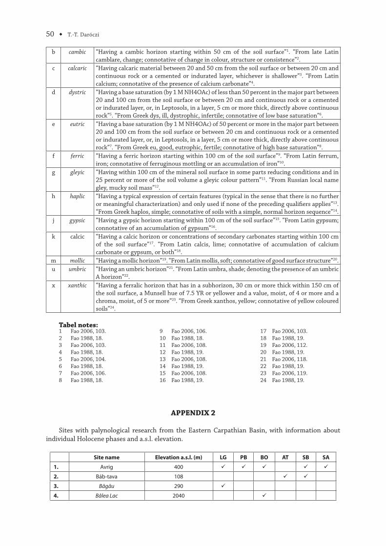
50 ◆ T.-T. Daróczi
b cambic “Having a cambic horizon starting within 50 cm of the soil surface”1. “From late Latin camblare, change; connotative of change in colour, structure or consistence”2.
c calcaric “Having calcaric material between 20 and 50 cm from the soil surface or between 20 cm and continuous rock or a cemented or indurated layer, whichever is shallower”3. “From Latin calcium; connotative of the presence of calcium carbonate”4.
d dystric “Having a base saturation (by 1 M NH4OAc) of less than 50 percent in the major part between 20 and 100 cm from the soil surface or between 20 cm and continuous rock or a cemented or indurated layer, or, in Leptosols, in a layer, 5 cm or more thick, directly above continuous rock”5. “From Greek dys, ill, dystrophic, infertile; connotative of low base saturation”6.
e eutric “Having a base saturation (by 1 M NH4OAc) of 50 percent or more in the major part between 20 and 100 cm from the soil surface or between 20 cm and continuous rock or a cemented or indurated layer, or, in Leptosols, in a layer, 5 cm or more thick, directly above continuous rock”7. “From Greek eu, good, eutrophic, fertile; connotative of high base saturation”8.
f ferric “Having a ferric horizon starting within 100 cm of the soil surface”9. “From Latin ferrum, iron; connotative of ferruginous mottling or an accumulation of iron”10.
g gleyic “Having within 100 cm of the mineral soil surface in some parts reducing conditions and in 25 percent or more of the soil volume a gleyic colour pattern”11. “From Russian local name gley, mucky soil mass”12.
h haplic “Having a typical expression of certain features (typical in the sense that there is no further or meaningful characterization) and only used if none of the preceding qualifi ers applies”13. “From Greek haplos, simple; connotative of soils with a simple, normal horizon sequence”14.
j gypsic “Having a gypsic horizon starting within 100 cm of the soil surface”15. “From Latin gypsum; connotative of an accumulation of gypsum”16.
k calcic “Having a calcic horizon or concentrations of secondary carbonates starting within 100 cm of the soil surface”17. “From Latin calcis, lime; connotative of accumulation of calcium carbonate or gypsum, or both”18.
m mollic “Having a mollic horizon”19. “From Latin mollis, soft; connotative of good surface structure”20.u umbric “Having an umbric horizon”21. “From Latin umbra, shade; denoting the presence of an umbric
A horizon”22.x xanthic “Having a ferralic horizon that has in a subhorizon, 30 cm or more thick within 150 cm of
the soil surface, a Munsell hue of 7.5 YR or yellower and a value, moist, of 4 or more and a chroma, moist, of 5 or more”23. “From Greek xanthos, yellow; connotative of yellow coloured soils”24.
Tabel notes:1 Fao 2006, 103.2 Fao 1988, 18.3 Fao 2006, 103.4 Fao 1988, 18.5 Fao 2006, 104.6 Fao 1988, 18.7 Fao 2006, 106.8 Fao 1988, 18.
9 Fao 2006, 106.10 Fao 1988, 18.11 Fao 2006, 108.12 Fao 1988, 19.13 Fao 2006, 108.14 Fao 1988, 19.15 Fao 2006, 108.16 Fao 1988, 19.
17 Fao 2006, 103.18 Fao 1988, 19.19 Fao 2006, 112.20 Fao 1988, 19.21 Fao 2006, 118.22 Fao 1988, 19.23 Fao 2006, 119.24 Fao 1988, 19.
APPENDIX 2
Sites with palynological research from the Eastern Carpathian Basin, with information about individual Holocene phases and a.s.l. elevation.
Site name Elevation a.s.l. (m) LG PB BO AT SB SA
1. Avrig 400
2. Báb-tava 108
3. Băgău 290
4. Bâlea Lac 2040
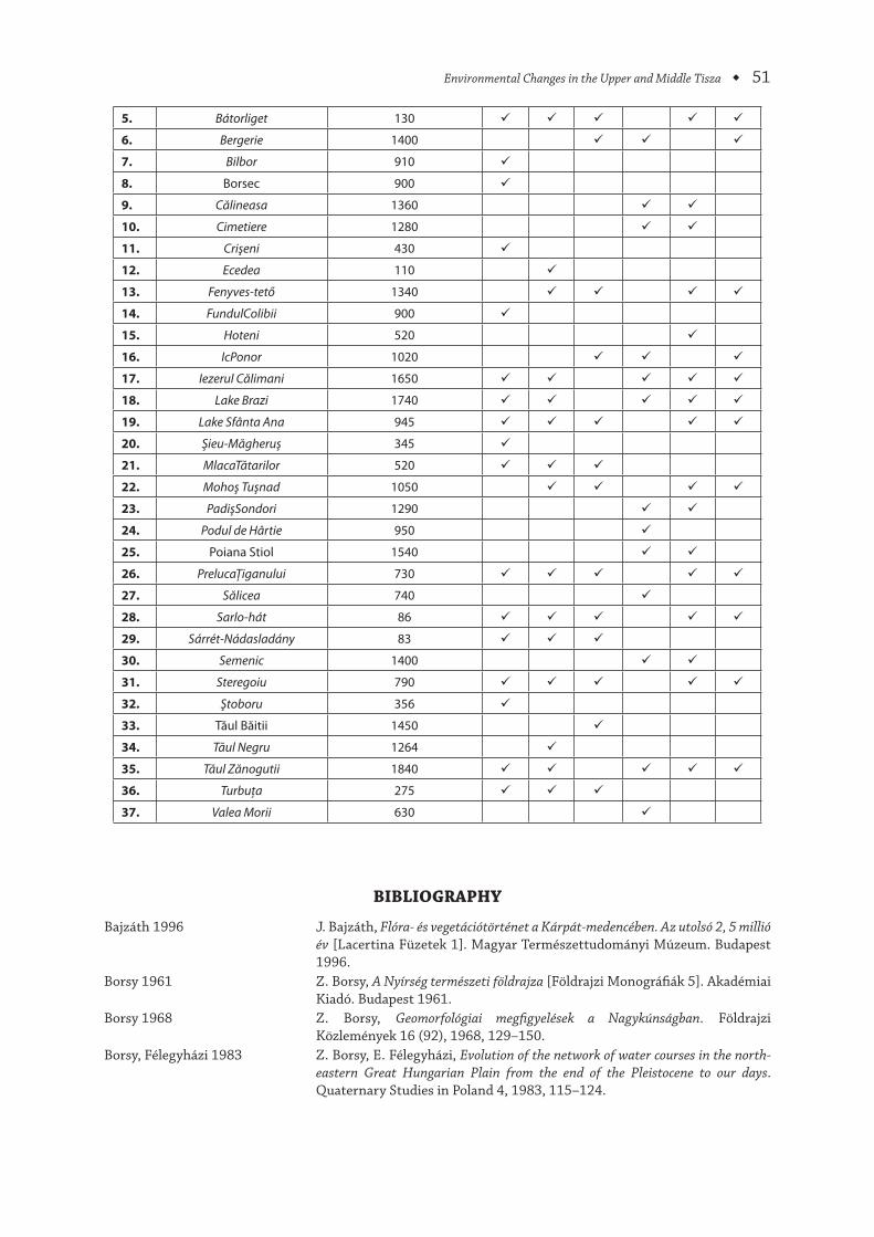
Environmental Changes in the Upper and Middle Tisza ◆ 51
5. Bátorliget 130
6. Bergerie 1400
7. Bilbor 910
8. Borsec 900
9. Călineasa 1360
10. Cimetiere 1280
11. Crişeni 430
12. Ecedea 110
13. Fenyves-tető 1340
14. FundulColibii 900
15. Hoteni 520
16. IcPonor 1020
17. Iezerul Călimani 1650
18. Lake Brazi 1740
19. Lake Sfânta Ana 945
20. Şieu-Măgheruş 345
21. MlacaTătarilor 520
22. Mohoş Tuşnad 1050
23. PadişSondori 1290
24. Podul de Hârtie 950
25. Poiana Stiol 1540
26. PrelucaŢiganului 730
27. Sălicea 740
28. Sarlo-hát 86
29. Sárrét-Nádasladány 83
30. Semenic 1400
31. Steregoiu 790
32. Ştoboru 356
33. Tăul Băitii 1450
34. Tăul Negru 1264
35. Tăul Zănogutii 1840
36. Turbuţa 275
37. Valea Morii 630
BIBLIOGRAPHY
Bajzáth 1996 J. Bajzáth, Flóra- és vegetációtörténet a Kárpát-medencében. Az utolsó 2, 5 millió év [Lacertina Füzetek 1]. Magyar Természettudományi Múzeum. Budapest 1996.
Borsy 1961 Z. Borsy, A Nyírség természeti földrajza [Földrajzi Monográfi ák 5]. Akadémiai Kiadó. Budapest 1961.
Borsy 1968 Z. Borsy, Geomorfológiai megfi gyelések a Nagykúnságban. Földrajzi Közlemények 16 (92), 1968, 129–150.
Borsy, Félegyházi 1983 Z. Borsy, E. Félegyházi, Evolution of the network of water courses in the north-eastern Great Hungarian Plain from the end of the Pleistocene to our days. Quaternary Studies in Poland 4, 1983, 115–124.
52 ◆ T.-T. Daróczi
Buczkó et al. 2009a K. Buczkó, E. K. Magyari, P. Bitušík, A. Wacnik, Review of dated Late Quaternary palaeolimnological records in the Carpathian Region, east-central Europe. Hydrobiologia 631, 2009, 3–28.
Buczkó et al. 2009b K. Buczkó, E. K. Magyari, É. Soróczki-Pintér, K. Hubay, M. Braun, M. Bálint, Diatom-based evidence for abrupt climate changes during the Late Glacial in the Southern Carpathian Mountains. Central European Geology 52, 2009, 249–268.
Cholnoky 1907 J. Cholnoky, A tiszameder helyváltoztatásai. Földrajzi Közlemények 35, 1907, 381–405, 425–445.
Daróczi 2011 T.-T. Daróczi: Th e funerary landscapes of the Eastern Carpathian Basin. PhD dissertation, Facultatea de Istorie şi Patrimoniu „Nicolae Lupu“ / Institut für Ur- und Frühgeschichte und Vorderasiatische Archäologie, Universitatea „Lucian Blaga“ / Ruprecht-Karls Universität. Sibiu/Heidelberg 2011.
Deli, Sümegi 2004 T. Deli, P. Sümegi, Late Plesitocene forest refugia in the Carpathian Basin and glacial relict elements in the gastropod fauna of the analyzed region. In: P. Sümegi, S. Gulyás (Eds.), Th e geohistory of Bátorliget marshland: an example for the reconstruction of late quaternary environmental changes and past human impact from the northeastern part of the Carpathian Basin [Archaeolingua 16], Archaeolingua. Budapest 2004, 207–212.
Drăgulescu 2005 C. Drăgulescu, Contributions to knowledge of phytodiversity of the Swamp Ecedea. Contribuţii Botanice 40, 2005, 43–53.
Fao 1988 FAO, Revised legend of the FAO – UNESCO Soil Map of the World (provisional edition of the fi nal text) [World Soil Resources Reports 60]. Roma 1988.
Fao 2006 FAO, World reference base for soil resources 2006. A framework for international classifi cation, correlation and communication [World Soil Resources Reports 103]. Roma 2006.
Félegyházi 1998 E. Félegyházi, Adalékok a Tisza és a Szamos folyóhálózatának alakulásához a felső pleniglaciális időszakban. Acta Geographica, Geologica et Meteorologica Debrecina 34, 1998, 203–218.
Feurdean 2004 A. N. Feurdean, Palaeoenvironment in north-western Romania during the last 15, 000 years. PhD dissertation, Physical Geography and Quaternary Geology, Stockholm University. Stockholm 2004 (manuscript).
Feurdean et al. 2010 A. N. Feurdean, K. J. Willis, C. L. Parr, I. Tanţău, S. Fărcaş, Post-glacial patterns in vegetation dynamics in Romania: homogenization or diff erentiation? Journal of Biogeography 37, 2010, 2197–2208.
Fűköh 1987 L. Fűköh, Evolution of the mollusca fauna of the Hungarian Uplands in the Holocene. In: M. Pécsi, L. Kordos (Eds.), Holocene environment in Hungary [Akadémiai Kiadó]. Budapest 1987, 49–56.
Gábris 1970 G. Gábris, Fiatal mederváltozások kutatásának módszerei a Sajó hordalék-kúpjának példáján. Földrajzi Közlemények 18 (94), 1970, 294–303.
Gábris 1985 G. Gábris, Az Alföld holocén paleohidrológiai vázlata. Földrajzi Értesítő 34, 1985, 391–408.
Gábris 2006 G. Gábris, Holocén. In: D. Karátson (Ed.), Pannon enciklopédia – Magyarország földje, Urbis. Budapest 2006, CD.
Gábris et al. 2001 G. Gábris, E. Félegyházi, B. Nagy, Z. Ruszkiczay, A Középső-Tisza vidékének negyedidőszak végi folyóvízi felszínfejlődése. In: G. Dormányi, F. Kovács, M. Péti, J. Rakonczai (Eds.), A földrajz eredményei az új évezred küszöbén. Magyar Földrajzi Konferencia, Szeged 2001. október 25–27, Szegedi Tudományegyetem TTK Természeti Földrajzi Tanszéke. Szeged 2001, 1–10.
Gábris, Nádor 2007 G. Gábris, A. Nádor, Long-term fl uvial archives in Hungary: response of the Danube and Tisza rivers to tectonic movements and climatic changes during the Quaternary: a review and new synthesis. Quaternary Science Reviews 26, 2007, 2758–2782.
Gasparik 1997 M. Gasparik, Az állatvilág jégkorszaki és jelenkori fejlődése Magyarotszág területén – Az utolsó 2,5 millió év [Lacertina Füzetek 6], Magyar Természettudományi Múzeum. Budapest 1997.
Environmental Changes in the Upper and Middle Tisza ◆ 53
Horváth 2002 A. Horváth, Újholocén klíma- és környezetváltozások vizsgálata hazai régészeti adatok segítségével. In: G. Gábris (Ed.), Geográfus Doktoranduszok VII. Országos Konferenciája, Budapest, ELTE TTK, 2002. október 25–26, ELTE. Budapest 2002, 1–11.
Járainé Komlódi 1966 M. Járainé Komlódi, Adatok az Alföld negyedkori klíma- és vegetáció történe-téhez. I. A vegetáció változása a Würm glaciális és a holocén folyamán, palinoló-giai vizsgálatok alapján. Botanikai Közlemények 53, 1966, 191–201.
Járainé Komlódi 1968 M. Járainé Komlódi, Th e Late Glacial and Holocene fl ora of the Hungarian Great Plain. Annales Universitatis Scientiarum Budapestinensis de Rolando Eötvös Nominatae – Sectio Biologica 9–10, 1968, 199–225.
Járainé Komlódi 1969 M. Járainé Komlódi, Adatok az Alföld negyedkori klíma- és vegetáció történe-téhez. II. A Würm glaciális és a holocén egyes szakaszainak klíma-rekonstrukciója pallinológiai vizsgálatok alapján. Botanikai Közlemények 56, 1969, 43–55.
Járainé Komlódi 1987 M. Járainé Komlódi, Postglacial climate and vegetation history in Hungary. In: M. Pécsi, L. Kordos (Eds.), Holocene environment in Hungary [Akadémiai Kiadó]. Budapest 1987, 37–47.
Járainé Komlódi 2000 M. Járainé Komlódi, A Kárpát-medence növényzetének kialakulása. In: D. Bartha (Ed.), Válogatott Tanulmányok II [Tilia 9], Nyugat-Magyarországi Egyetem Erdőmérnöki Kar Növénytani Tanszék. Sopron 2000, 5–59.
Juhász, Willis 2004a I. Juhász, K. J. Willis, Pollen and charcoal analysis. In: P. Sümegi, S. Gulyás (Eds.), Th e geohistory of Bátorliget marshland: an example for the recon-struction of late quaternary environmental changes and past human impact from the northeastern part of the Carpathian Basin [Archaeolingua 16], Archaeolingua. Budapest 2004, 60.
Juhász, Willis 2004b I. Juhász, K. J. Willis, Results of pollen analysis. In: P. Sümegi, S. Gulyás (Eds.), Th e geohistory of Bátorliget marshland: an example for the recon-struction of late quaternary environmental changes and past human impact from the northeastern part of the Carpathian Basin [Archaeolingua 16], Archaeolingua. Budapest 2004, 155–173.
Kordos 1977 L. Kordos, Holocén klímaváltozások kimutatása Magyarországon a “pocok hőmerő” segítségével. Földrajzi Közlemények 25 (101), 1977, 222–229.
Kordos 1987 L. Kordos, Climatic and ecological changes in Hungary during the last 15000 years. In: M. Pécsi, L. Kordos (Eds.), Holocene environment in Hungary [Akadémiai Kiadó]. Budapest 1987, 11–24.
Kordos 2004a L. Kordos, Th e anaylsis of vertebrate fossil remains. In: P. Sümegi, S. Gulyás (Eds.), Th e geohistory of Bátorliget marshland: an example for the recon-struction of late quaternary environmental changes and past human impact from the northeastern part of the Carpathian Basin [Archaeolingua 16], Archaeolingua. Budapest 2004, 63.
Kordos 2004b L. Kordos, Results of the analysis of vertebrate reamains from the marginal profi le. In: P. Sümegi, S. Gulyás (Eds.), Th e geohistory of Bátorliget marshland: an example for the reconstruction of late quaternary environmental changes and past human impact from the northeastern part of the Carpathian Basin [Archaeolingua 16], Archaeolingua. Budapest 2004, 212–214.
Linzer et al. 1998 H.-G. Linzer, W. Frisch, P. Zweigel, R. Girbacea, H.-P. Hann, F. Moser, Kinematic evolution of the Romanian Carpathians. Tectonophysics 297, 1998, 133–156.
Lóki 2006 J. Lóki, Holocén felszínváltozás a hazai futóhomok területeken. In: G. Gábris (Ed.), III. Magyar Földrajzi Konferencia tudományos közleményei, MTA FKI. Budapest 2006, CD.
Magyari et al. 2010 E. K. Magyari, J. C. Chapman, D. G. Passmore, J. R. M. Allen, J. P. Huntley, B. Huntley, Holocene persistence of wooded steppe in the Great Hungarian Plain. Journal of Biogeography 37, 2010, 915–935.
Marosi, Szilárd 1969 S. Marosi, J. Szilárd (Eds.), A tiszai Alföld. Magyarország tájföldrajza, 2. Budapest 1969.
54 ◆ T.-T. Daróczi
Nádor et al. 2011 A. Nádor, R. Sinha, Á. Magyari, S. K. Tandon, Z. Medzihradszky, E. Babinszki, E. Th amó-Bozsó, Z. Unger, A. Singh, Late Quaternary (Weichselian) alluvial history and neotectonic control on fl uvial landscape development in the southern Körös plain, Hungary. Palaeogeography, Palaeoclimatology, Palaeoecology 299, 2011, 1–14.
Nádor et al. 2007 A. Nádor, E. Th amó-Bozsó, Á. Magyari, E. Babinszki, Fluvial responses to tectonics and climate change during the Late Weichselian in the eastern part of the Pannonian Basin (Hungary). Sedimentary Geology 202, 2007, 174–192.
Nagy, Félegyházi 2001 B. Nagy, E. Félegyházi, A Sajó-Hernád hordalékkúp későpleisztocén mederhálóza-tának vizsgálata. Acta Geographica, Geologica et Meteorologica Debrecina 35, 2001, 221–233.
Nyári et al. 2009 D. Nyári, I. Knipl, T. Kiss, E. Wicker, Természetésembertalálkozása: futóhomo-kazelmúlt 2000 évben Apostagkörnyékén. Tisicum. A Jász-Nagykun-Szolnok Megyei Múzeumok Évkönyve 19, 2009, 447–455.
Rowland 2008 M. J. Rowland, Landscape and climate change. In: B. David, J. Th omas (Eds.), Handbook of landscape archaeology [World Archaeological Congress Research Handbooks in Archaeology 1], Left Coast Press, Walnut Creek. California 2008, 386–395.
Rudner 2004 E. Rudner, Wood anatomy. In: P. Sümegi, S. Gulyás (Eds.), Th e geohistory of Bátorliget marshland: an example for the reconstruction of late quaternary environmental changes and past human impact from the northeastern part of the Carpathian Basin [Archaeolingua 16], Archaeolingua. Budapest 2004, 60–62.
Rudner et al. 2004 E. Rudner, P. Sümegi, J. Bajzáth, A. Torma, G. Jakab, Th e results of wood anatomy, charcoal and fruit and seed analyses. In: P. Sümegi, S. Gulyás (Eds.), Th e geohistory of Bátorliget marshland: an example for the reconstruc-tion of late quaternary environmental changes and past human impact from the northeastern part of the Carpathian Basin [Archaeolingua 16], Archaeolingua. Budapest 2004, 173–183.
Somogyi 1987 S. Somogyi, Relationship between environmental changes and human impact until the 9th century. In: M. Pécsi, L. Kordos (Eds.), Holocene environment in Hungary [Akadémiai Kiadó]. Budapest 1987, 25–36.
Soó 1959 R. Soó, Az Alföld növényzetének kialakulásának megítélese és vitás kérdései. Földrajzi Értesítő 8, 1959, 1–26.
Sümegi 2004 P. Sümegi, Th e anaylsis of mollusk shell remains. In: P. Sümegi, S. Gulyás (Ed.), Th e geohistory of Bátorliget marshland: an example for the reconstruc-tion of late quaternary environmental changes and past human impact from the northeastern part of the Carpathian Basin [Archaeolingua 16], Archaeolingua. Budapest 2004, 62–63.
Sümegi, Deli 2004 P. Sümegi, T. Deli, Results of the quatermalacological analysis of the profi les from the central and marginal areas of Bátorliget marshland. In: P. Sümegi, S. Gulyás (Eds.), Th e geohistory of Bátorliget marshland: an example for the recon-struction of late quaternary environmental changes and past human impact from the northeastern part of the Carpathian Basin [Archaeolingua 16], Archaeolingua. Budapest 2004, 173–207.
Sümegi, Gulyás 2004 P. Sümegi, S. Gulyás, Th e methodology of environmental historical investiga-tions. In: P. Sümegi, S. Gulyás (Eds.), Th e geohistory of Bátorliget marshland: an example for the reconstruction of late quaternary environmental changes and past human impact from the northeastern part of the Carpathian Basin [Archaeolingua 16], Archaeolingua. Budapest 2004, 63–64.
Sümegi et al. 2008 P. Sümegi, S. Gulyás, G. Persaits, Holocene paleoclimatic and paleohydrological changes in the Sárrét basin, NW Hungary. Documenta Praehistorica 35, 2008, 25–31.
Tanţău et al. 2010 I. Tanţău, M. Reille, C. Beldean, S. Fărcaş, J.-L. d. Beaulieu, A. Geantă, Early Holocene vegetation history in the Făgăraş Depression. Contribuţii Botanice 45, 2010, 79–86.

Environmental Changes in the Upper and Middle Tisza ◆ 55
Tóth 2003 C. Tóth, A Hortobágy negyedidőszak végi felszínfejlődésének a főbb természeti és antropogén vonásai, PhD thesis, Természettudományi Kar, Debreceni Egyetem. Debrecen, 2003 (manuscript).
Willis et al. 1995 K. J. Willis, P. Sümegi, M. Braun, A. Tóth, Th e late Quaternary environmental history of Bátorliget, N.E. Hungary. Palaeogeography, Palaeoclimatology, Palaeoecology 118, 1995, 25–47.
Zólyomi 1936 B. Zólyomi, Tízezer év töténete virágporszemekben. Természettudományi Közlöny 68, 1936, 504–516.
Zólyomi 1952 B. Zólyomi, Magyarország növénytakarójának fejlődéstörténete az utolsó jégkorszaktól. Magyar Tudományos Akadémia Biológiai Tudományok Osztályának Közleménye 1, 1952, 491–544.
56 ◆ T.-T. Daróczi
Plat
e 1.
Geo
mor
phol
ogic
al re
gion
s of
the
East
ern
Carp
athi
an B
asin
.
Environmental Changes in the Upper and Middle Tisza ◆ 57
Plat
e 2.
Hyd
rolo
gy a
nd p
olit
ical
bor
ders
wit
hin
the
Tisz
a/Ti
sa L
owla
nd.
58 ◆ T.-T. Daróczi
Plat
e 3.
Sub
surf
ace
litho
logy
of t
he T
isza
/Tis
a Lo
wla
nd.L
owla
nd.
Environmental Changes in the Upper and Middle Tisza ◆ 59
Plat
e 4.
Pal
ynol
ogic
al s
ites
of t
he E
aste
rn C
arpa
thia
n Ba
sin
wit
h re
leva
nce
for
the
Hol
ocen
e.
60 ◆ T.-T. Daróczi
Plat
e 5.
Arc
heco
-zon
es o
f the
Tis
za/T
isa
Low
land
.