This sample text, which is intended to show how paragraphs should ...
122
UTM Project Centre: 479000 m Easting, 6089100 m Northing (Zone 11 NAD83) NI 43-101 TECHNICAL REPORT, INFERRED RESOURCE ESTIMATE ON LITHIUMBANK RESOURCES CORP.’S STURGEON LAKE LITHIUM-BRINE PROPERTY IN WEST-CENTRAL ALBERTA, CANADA Prepared For: LithiumBank Resources Corp. 1200 – 200 Burrard Street Vancouver, BC V7X 1T2 Canada Prepared by: APEX Geoscience Ltd. 1 110-8429 24 ST NW Edmonton AB T5M 3Y7 Canada Hydrogeological Consultants Ltd. 2 17740 - 118 Avenue NW Edmonton AB T5S 2W3 Canada Charles Edwards, P.Eng. 3 Chuck Edwards Extractive Metallurgy Consulting 136 – 320 Heritage Crescent Saskatoon, SK S7H 5P4 Canada 1 D. Roy Eccles M.Sc., P. Geol. 2 Jim Touw B.Sc. P. Geol. 3 Charles R. Edwards M.Sc. P. Eng. Effective Date: 18 May 2021 Signing Date: 17 June 2021
-
Upload
khangminh22 -
Category
Documents
-
view
1 -
download
0
Transcript of This sample text, which is intended to show how paragraphs should ...

UTM Project Centre: 479000 m Easting, 6089100 m Northing (Zone 11 NAD83)
NI 43-101 TECHNICAL REPORT,
INFERRED RESOURCE ESTIMATE ON LITHIUMBANK RESOURCES CORP.’S
STURGEON LAKE LITHIUM-BRINE PROPERTY IN WEST-CENTRAL ALBERTA, CANADA
Prepared For:
LithiumBank Resources Corp. 1200 – 200 Burrard Street Vancouver, BC V7X 1T2 Canada
Prepared by:
APEX Geoscience Ltd. 1 110-8429 24 ST NW Edmonton AB T5M 3Y7 Canada
Hydrogeological Consultants Ltd. 2 17740 - 118 Avenue NW Edmonton AB T5S 2W3 Canada Charles Edwards, P.Eng. 3 Chuck Edwards Extractive Metallurgy Consulting 136 – 320 Heritage Crescent Saskatoon, SK S7H 5P4 Canada
1 D. Roy Eccles M.Sc., P. Geol. 2 Jim Touw B.Sc. P. Geol.
3 Charles R. Edwards M.Sc. P. Eng.
Effective Date: 18 May 2021 Signing Date: 17 June 2021

Inferred Resource Estimate Technical Report: Sturgeon Lake Li-Brine Property, West-Central Alberta
18 May 2021 i
Contents
1 Summary ................................................................................................................... 1 1.1 Issuer and Purpose ............................................................................................ 1
1.2 Author and Qualified Person Site Inspection ...................................................... 2 1.3 Property Location, Description and Access ........................................................ 2 1.4 Tenure Maintenance, Permitting, and Royalties ................................................. 2 1.5 Brine Access Agreement .................................................................................... 3 1.6 Surface Rights and Access to Acquire Brine ...................................................... 3
1.7 Environmental and Property-Related Uncertainties ............................................ 3 1.8 Geology, Hydrogeology, and Mineralization ....................................................... 4 1.9 Historical Brine Geochemistry and Adequacy of Data ........................................ 5 1.10 LithiumBank’s 2021 Exploration Work ................................................................ 6 1.11 Mineral Processing ............................................................................................. 6
1.12 Reasonable Prospects ....................................................................................... 7 1.13 Resource Estimation .......................................................................................... 8
1.14 Concluding Qualified Person Statement ............................................................. 9 1.15 Recommendations ........................................................................................... 10
2 Introduction .............................................................................................................. 11 2.1 Issuer and Purpose .......................................................................................... 11 2.2 Authors and Site Inspection .............................................................................. 13
2.3 Sources of Information ..................................................................................... 14 2.4 Units of Measure .............................................................................................. 15
3 Reliance of Other Experts ........................................................................................ 15 4 Property Description and Location ........................................................................... 15
4.1 Description and Location .................................................................................. 15
4.2 Property Rights and Maintenance .................................................................... 16
4.3 Coexisting Oil & Gas, Oil Sands, Coal, and Metallic Mineral Rights ................. 16 4.4 Royalties and Agreements ............................................................................... 21 4.5 Permitting ......................................................................................................... 21
4.6 Brine Access Agreement .................................................................................. 21 4.7 Surface Rights .................................................................................................. 22 4.8 Environmental Liabilities and Significant Factors ............................................. 22
4.9 Property-Related Risks and Uncertainties and Mitigation Strategies ............... 24 5 Accessibility, Climate, Local Resources, Infrastructure and Physiography .............. 24
5.1 Accessibility ...................................................................................................... 24 5.2 Site Topography, Elevation and Vegetation ..................................................... 24 5.3 Climate ............................................................................................................. 26 5.4 Local Resources and Infrastructure .................................................................. 26
6 History ...................................................................................................................... 27 6.1 Devonian Oil and Gas Production Summary .................................................... 27 6.2 Government Lithium-Brine Studies ................................................................... 32
6.3 Historical Industry Brine Sampling Programs ................................................... 35 6.3.1 2011 LEXG Brine Sampling Program ..................................................... 35 6.3.2 2016 MGX Brine Sampling Program ....................................................... 35
6.4 Historical Mineral Processing Test Work .......................................................... 37 6.4.1 PurLucid Treatment Solutions Inc. Lithium Recovery Test Work ............ 37

Inferred Resource Estimate Technical Report: Sturgeon Lake Li-Brine Property, West-Central Alberta
18 May 2021 ii
6.4.2 Saskatchewan Research Council Lithium Recovery Test Work ............. 38
7 Geological Setting and Mineralization ...................................................................... 38
7.1 Regional Geology ............................................................................................. 38 7.2 Precambrian Geology ....................................................................................... 42 7.3 Phanerozoic Geology ....................................................................................... 42 7.4 Late Tertiary – Quaternary Geology ................................................................. 43 7.5 Structural Geology ............................................................................................ 43
7.6 Property Geology: Hydrogeological Characteristics of the Woodbend Group (Leduc Formation) Aquifer System ................................................................... 44
7.7 Mineralization ................................................................................................... 45 8 Deposit Types .......................................................................................................... 48 9 Exploration ............................................................................................................... 49
10 Drilling ...................................................................................................................... 51 10.1 Lithium Exploration Group 2011 Brine Sampling and Analytical Results .......... 51
10.2 MGX Minerals Inc. 2016 Brine Sampling and Analytical Results ...................... 54 11 Sample Preparation, Analyses and Security ............................................................ 56
11.1 Brine Sample Collection ................................................................................... 56 11.2 Chain of Custody .............................................................................................. 57
11.3 Brine Analytical Methods .................................................................................. 57 11.4 Quality Assurance – Quality Control ................................................................. 58
12 Data Verification....................................................................................................... 59
12.1 Validation of the Lithium-Brine Geochemistry ................................................... 59 12.2 Validation of the Leduc Formation Reef Aquifer Dimensions ........................... 60
12.3 Validation Limitations ....................................................................................... 60 12.4 Summary of Current Qualified Person Site Inspection ..................................... 60 12.5 Opinion of Qualified Person on the Adequacy of the Data ............................... 62
13 Mineral Processing and Metallurgical Testing .......................................................... 63
13.1 Introduction ....................................................................................................... 63 13.2 Metallurgical Tests ........................................................................................... 63
13.2.1 Sample Assay Results ......................................................................... 63
13.2.2 Initial Evaporation to Precipitate NaCl (MGX process) ......................... 64 13.2.2.1 Test 1 - One Stage Evaporation ............................................. 64
13.2.2.2 Test 2 - Two Stage Evaporation ............................................. 65 13.2.2.3 Test 3 - Five Stage Evaporation ............................................. 65
13.2.3 SRC Modified Processes ..................................................................... 66 13.2.3.1 Magnesium Removal .............................................................. 67
13.2.3.2 Primary Evaporation to Precipitate NaCl ................................ 68 13.2.3.3 Secondary Evaporation to Precipitate CaCl2 and Concentrate
Lithium ........................................................................................ 68
13.3 Mineral Processing Summary ........................................................................... 70 13.4 Mineral Processing Recommendations ............................................................ 71 13.5 Opinion of Qualified Person Including Preliminary Risks and Uncertainties ..... 71
14 Mineral Resource Estimates .................................................................................... 72
14.1 Introduction and Resource Estimation Steps .................................................... 72 14.2 Data .................................................................................................................. 73
14.2.1 Subsurface Hydrogeological and Geological Model ............................. 73
14.2.2 Lithium Analytical Data ........................................................................ 74

Inferred Resource Estimate Technical Report: Sturgeon Lake Li-Brine Property, West-Central Alberta
18 May 2021 iii
14.2.3 Data QA/QC ......................................................................................... 74
14.3 Hydrogeological Characterization of the Leduc Formation Aquifer ................... 74
14.3.1 Relationship Between the Leduc Formation and Beaverhill Lake Group Aquifers .................................................................................................. 75
14.3.2 Effective Porosity ................................................................................. 77 14.3.3 Total Porosity ....................................................................................... 77 14.3.4 Permeability ......................................................................................... 79
14.3.5 Lost Circulation .................................................................................... 80 14.3.6 Transmissivity (From Core Plug Measurements) ................................. 81 14.3.7 Transmissivity (From Drill Stem Tests) ................................................ 81 14.3.8 Transmissivity Conclusion.................................................................... 82 14.3.9 Storativity and Theoretical Long-Term Yield ........................................ 82
14.3.10 Fluid Production and Injection .............................................................. 83 14.3.11 Pressure Surveys and Fluid Levels ...................................................... 85
14.3.12 Formation Water in Pore Space ........................................................... 87 14.3.13 Summary of Hydrogeological Conditions ............................................. 87
14.4 Geometry and Volume of the Leduc Formation Aquifer Domain ...................... 88 14.4.1 Three-Dimensional Geological Model .................................................. 88
14.4.2 Leduc Formation Aquifer Domain Wireframe and Volume ................... 89 14.5 Leduc Formation Aquifer Domain Brine Volume .............................................. 92 14.6 Lithium-Brine Concentration ............................................................................. 92
14.7 Top Cuts and Capping ..................................................................................... 93 14.8 Market Conditions and Pricing .......................................................................... 95
14.9 Reasonable Prospects ..................................................................................... 96 14.10 Cutoff ............................................................................................................ 98 14.11 Mineral Resource Estimate .......................................................................... 98
14.11.1 Resource Classification ....................................................................... 98
14.11.2 Mineral Resource Reporting ................................................................ 99 23 Adjacent Properties ................................................................................................ 101 24 Other Relevant Data and Information .................................................................... 101
25 Interpretation and Conclusions .............................................................................. 103 25.1 Qualified Person Statement ............................................................................ 103
25.2 Resource Estimation Conclusions .................................................................. 104 25.3 Risks and Uncertainties .................................................................................. 104
26 Recommendations ................................................................................................. 105 26.1 Phase 1 Work Recommendations .................................................................. 107
26.2 Phase 2 Work Recommendations .................................................................. 107 27 References ............................................................................................................ 108 28 Certificate of Author ............................................................................................... 114
Tables Table 1.11 Sturgeon Lake Leduc Formation Li-brine inferred resource estimate. ........... 9 Table 1.1 Work recommendations for the Sturgeon Lake Li-brine project.. ................... 10 Table 6.1 Summary of analytical results from MGX Minerals Inc. 2016 brine sampling
program at the Sturgeon Lake field.. .............................................................. 36 Table 6.2 Example results from lithium recovery trials.. ................................................ 38

Inferred Resource Estimate Technical Report: Sturgeon Lake Li-Brine Property, West-Central Alberta
18 May 2021 iv
Table 7.1 Regional Stratigraphy of the Sturgeon Lake Property area ........................... 39
Table 7.2 Leduc brine chemistry from the Sturgeon Lake field. .................................... 47
Table 10.1 Summary of selected elements from Lithium Exploration Groups 2011 Sturgeon Lake brine geochemical sampling program. ................................... 52
Table 10.2 Well sample locations and descriptions. ..................................................... 55 Table 10.3 Individual sample descriptions. .................................................................... 55 Table 10.4 Summary of selected analytical results including duplicate samples and
control blank samples.. ................................................................................... 56 Table 11.1 Temporal comparison of Leduc Formation aquifer brine analytical results from
the same production well. ............................................................................... 59 Table 13.1 Assay Results of the as Received Primary Brine Sample ........................... 64 Table 13.2 Test 1 Results ............................................................................................. 64
Table 13.3 Test 2 Results ............................................................................................. 65 Table 13.4 Evaporation Test Results of Test 3 ............................................................. 66
Table 13.5 Magnesium Removal Results ...................................................................... 67 Table 13.6 Primary Evaporation to Precipitate NaCl Results ........................................ 68
Table 13.7 Secondary Evaporation to Precipitate CaCl2 Results .................................. 69 Table 13.8 Element Recovery (%) and Treated Brine Composition .............................. 69
Table 14.1 Summary of picks used to model the Leduc, Beaverhill Lake, and Elk Point (Watt Mountain) stratigraphic units. ................................................................ 74
Table 14.3 Summary of effective porosity as measured from Leduc Formation core plugs from the Sturgeon Lake oilfield. ...................................................................... 77
Table 14.4 A summary of the electric-log curve data for three downhole well logs. ...... 77
Table 14.5 Porosity of the Leduc Formation at the Sturgeon Lake oilfield. ................... 79 Table 14.6. Selected average permeability from Leduc Formation core plug samples. 80 Table 14.7 Calculated average transmissivity. .............................................................. 81
Table 14.8 Drill stem test transmissivity results. ............................................................ 82
Table 14.9 Pressure survey sites in the Leduc Formation. ............................................ 86 Table 14.10 Summary of industry and government lithium analyses on Leduc Formation
aquifer brine at the Sturgeon Lake oilfield. ..................................................... 94
Table 14.11 Sturgeon Lake Leduc Formation Li-brine inferred resource estimate. ..... 100 Table 26.1 Work recommendations for the Sturgeon Lake Li-brine project. ................ 106
Figures Figure 2.1. General location of LithiumBank’s Alberta Li-brine properties. .................... 12 Figure 4.1. Overview of LithiumBank’s Alberta lithium-brine properties. ....................... 17 Figure 4.2 Exploration permits at LithiumBank’s Sturgeon Lake Property. .................... 18 Figure 5.1 Access to the Sturgeon Lake Property. ........................................................ 25
Figure 6.1 Oil and gas wells in the Sturgeon Lake Property area highlighting those wells that have penetrated the Devonian petroleum system. .................................. 28
Figure 6.2 Status of oil and gas wells penetrating Devonian strata in the Sturgeon Lake Property. ......................................................................................................... 29
Figure 6.3 Oil and gas facilities and a summary of the pipeline network in the Sturgeon Lake oilfield. ................................................................................................... 30
Figure 6.4 Current summary of the petro-operators at the Sturgeon Lake Property. .... 31 Figure 6.5 Distribution of lithium in Alberta formation waters. ....................................... 33
Inferred Resource Estimate Technical Report: Sturgeon Lake Li-Brine Property, West-Central Alberta
18 May 2021 v
Figure 6.6 Summary of historical government and industry Leduc Formation aquifer brine sampling with lithium analytical results. .......................................................... 34
Figure 7.1 Inferred basement geology of the Sturgeon Lake Property area. ................. 40 Figure 7.2 Regional bedrock geology of the Sturgeon Lake Property area. .................. 41 Figure 7.3 Plot of lithium versus potassium/bromide to show the anomalous geochemical
nature of the Devonian Leduc Formation brine in comparison to pre-Devonian brine from the Sturgeon Lake field. ................................................................ 46
Figure 7.4 Leduc brine chemistry from the Sturgeon Lake field. ................................... 47 Figure 9.1 Two-dimensional seismic image of the Leduc Formation interior-back reef in
the Sturgeon Lake Property. .......................................................................... 50 Figure 10.1 Histogram of lithium geochemical results from Lithium Exploration Groups
2011 Sturgeon Lake brine geochemical sampling program. .......................... 53
Figure 11.1 Duplicate sample analytical results from the MGX Minerals Inc. 2016 brine sampling program........................................................................................... 58
Figure 12.1 Comparison of the 3-D geological outline of the Leduc Formation reef between the resource model used in this report and the Alberta Geological Survey model. ................................................................................................ 61
Figure 12.2 Schematic regulatory anatomy of inactive and suspended wells. .............. 62
Figure 14.1 Leduc Formation and Beaverhill Lake Group fluid levels based on drill stem tests results and pressure-survey results. ...................................................... 76
Figure 14.2 Formation water comparison on the tri-linear diagram ............................... 76
Figure 14.4. Total Leduc porosity using the sonic curve from well 11-10-069-22W5. ... 78 Figure 14.5. Annual fluid production and injection from the Leduc Formation at the
Sturgeon Lake oilfield. .................................................................................... 85 Figure 14.6. Leduc Formation fluid levels. ..................................................................... 86 Figure 14.7 Summary of well used to pick the formation tops of the Leduc Formation and
Beaverhill Lake Group .................................................................................... 90
Figure 14.8 Three-dimensional image of the Leduc Formation reef in relation to the Sturgeon Lake Property. ................................................................................ 91
Figure 14.9 West-east cross-section of the Leduc Formation reef at the Sturgeon Lake Property. ......................................................................................................... 92
Figure 14.10 Histogram of exploration and government brine lithium concentrations. .. 95
Figure 23.1 Adjacent properties in the Sturgeon Lake Property. ................................. 102

Inferred Resource Estimate Technical Report: Sturgeon Lake Li-Brine Property, West-Central Alberta
18 May 2021 1
1 Summary
1.1 Issuer and Purpose
This Technical Report has been prepared for the Issuer, LithiumBank Resources Corp. (LithiumBank or the Company). LithiumBank has acquired 100% minerals interest in 7 separate lithium-brine (Li-brine) properties in west-central Alberta: Sturgeon Lake, Swan Hills, Kakwa Area, Valhalla Area, Fox Creek Area, Simonette, and Nipisi Area. This Technical Report focuses on the “Sturgeon Lake” Property.
The Sturgeon Lake Property is situated in an area of west-central Alberta where
Government and industry hypersaline formation water (or brine) studies have documented anomalous values of lithium in Late Devonian (Frasnian) aquifers associated with carbonate buildups of the Woodbend Group, Leduc Formation. Access to the deep-seated confined Leduc Formation aquifer brine at the Sturgeon Lake Property is through existing oil and gas wells that have pumped the brine from depths of more than 2,350 m to the earth’s surface – essentially as wastewater associated with hydrocarbon products. Once the petroleum is extracted the brine is pumped, or injected, back down into its original Devonian aquifer. Hence, there is a coproduct opportunity to recovery lithium from the petro-operations brine circuit.
At present and as determined by the petro-operator, the Leduc wells producing from
the Sturgeon Lake reservoir are in suspended state (i.e., an oil and gas well that has not been used for production, injection, or disposal for a specified amount of time). However, LithiumBank has formed an access agreement (on May 14, 2021) with the petro-operator to reopen and obtain brine from the wells.
In addition, on February 10, 2021, LithiumBank formed a data access agreement with
MGX Minerals Ltd., who had previously explored the Sturgeon Lake Property (2016-2020) for its Li-brine potential prior to dropping the property. The technical information and data include brine geochemical assays, hydrogeological information, and mineral processing results. It is the QP’s opinion that the transfer of intellectual exploration information provides a reasonable assessment of the Leduc Formation aquifer in that the data validates the lithium content of the brine and provides initial mineral processing test work results. The data are also relevant in that LithiumBank is reliant on these data to assess the Leduc Formation Li-brine resource because the Sturgeon Lake production wells are in a suspended state.
The intent of this Technical Report, therefore, is to utilize a historical, but robust technical and analytical dataset to prepare a mineral resource in accordance with the Canadian Securities Administration’s National Instrument 43-101 Standards for Disclosure of Mineral Projects and Canadian Institute of Mining and Metallurgy guidelines and definition standards. The effective date of this report is 18 May 2021.

Inferred Resource Estimate Technical Report: Sturgeon Lake Li-Brine Property, West-Central Alberta
18 May 2021 2
1.2 Author and Qualified Person Site Inspection
A multi-disciplinary team of authors prepared this report and include Mr. Roy Eccles M.Sc. P. Geol. of APEX Geoscience Ltd., Mr. Jim Touw, B.Sc., P. Geol. of Hydrogeological Consultants Ltd., and Mr. Charles Edwards M.Sc., P. Eng. of Chuck Edwards Extractive Metallurgy Consulting. The authors are independent of LithiumBank Resources Corp., the Sturgeon Lake Property, and are Qualified Persons as defined in NI 43-101. Mr. Eccles has acted as QP of two previous materially disclosed Leduc Formation brine sampling programs at Sturgeon Lake (Lithium Exploration Group, 2011 and MGX Minerals Inc., 2016) and is also independent of these companies.
Mr. Eccles takes overall responsibility for the preparation and publication of this
Technical Report. Mr. Eccles completed a site inspection at the Sturgeon Lake Property on October 7, 2020, that included confirmation of LithiumBank’s mineral permit land holdings and observation of the petro-operators oil and gas infrastructure at the Sturgeon Lake oilfield. It was not possible to sample the Leduc Formation aquifer brine during the site inspection because the petro-operator’s wells are currently suspended. 1.3 Property Location, Description and Access
The Sturgeon Lake Property is in west-central Alberta, Canada, directly south and
west of the Town of Valleyview, approximately 85 km east of the City of Grande Prairie and 270 km northwest of the City of Edmonton.
The Sturgeon Lake Property is comprised of 28 Alberta Metallic and Industrial Mineral Permits that collectively form a contiguous package of land that totals 227,937.5 hectares. The permits were acquired directly from the Government of Alberta through the Provinces on-line mineral tenure system. LithiumBank has 100% ownership of the mineral rights at the Sturgeon Lake Property. Eighteen of the 28 mineral permits encompass the Sturgeon Lake Leduc Formation reef complex and reservoir.
The Property can be accessed by Provincial highways and secondary one- or two-
lane all-weather roads. Access within the property is further facilitated by numerous all weather and dry weather gravel roads and tracks, many of which are serviced year-round due to oil and gas exploration in the area.
1.4 Tenure Maintenance, Permitting, and Royalties
As of the Effective Date of this Technical Report, the Alberta Metallic and Industrial Mineral Permits associated with the Sturgeon Lake Property are active and in good standing. The permits grant LithiumBank the exclusive right to explore for metallic and industrial minerals for 7 consecutive 2-year terms (total of 14 years), subject to the submission of biannual assessment work to keep the permits in good standing. Work requirements for maintenance of permits in good standing are $5.00/ha for the 1st term, $10.00/ha for each of the 2nd and 3rd terms, and $15.00/ha for each the 4th, 5th, 6th, and 7th terms.

Inferred Resource Estimate Technical Report: Sturgeon Lake Li-Brine Property, West-Central Alberta
18 May 2021 3
In Alberta, rights to metallic and industrial minerals, to bitumen (oil sands), to coal and
to oil/gas are regulated under separate statutes, which collectively make it possible for several different ‘rights’ to coexist and be held by ‘different grantees’ over the same geographic location. Oil/gas leases and LithiumBank’s Alberta Metallic and Industrial Mineral Permits coexist in the Valleyview area and in the vicinity of, and under, LithiumBank’s Property.
An Exploration Licence must be obtained before a person or company can apply for
or carry out an exploration program in Alberta. The prospector or company must obtain the appropriate approvals and permits from the Government of Alberta if: 1) mechanized exploration equipment is used; and/or 2) the land surface is disturbed.
Government royalty rates associated with any Li-production in Alberta, as
administrated by the Department of Energy, would be subject to 1% gross mine-mouth revenue before payout, and after payout, the greater of 1% gross mine-mouth revenue and 12% net revenue. 1.5 Brine Access Agreement
LithiumBank formed a brine access agreement with a major petro-operator in control of the Sturgeon Lake South and Sturgeon Lake North oilfields on May 14, 2021. The agreement permits LithiumBank to obtain brine from the existing oil and gas infrastructure for the purpose of exploration work (i.e., assaying, and mineral processing test work). This agreement includes access to the now suspended wells, in which the petro-operator has agreed to reopen a select number of wells that will enable LithiumBank access to the Leduc Formation aquifer brine.
1.6 Surface Rights and Access to Acquire Brine
At the early exploration stage, LithiumBank is completely reliant on the petro-operators
permission for access to their lease(s) to acquire brine for test purposes. Any permits and licences associated with the lease have been granted exclusively to the oil and gas company. Upon approval from the petro-operator, the collection of the brine is conducted under the rules and guidance of the petro-operator lease protocols. LithiumBank’s brine sampling methodology does not require additional permits beyond the actual Alberta Metallic and Industrial Mineral Permit. 1.7 Environmental and Property-Related Uncertainties
LithiumBank is reliant on pre-existing oil and gas wells that are managed and operated by current petro-companies. Hence there is some risk associated with a dependency on the petro-operation and continued brine access. It is possible that situations could arise where the petro-companies shut down well production – for example – due to poor commodity prices, modal abundance of petroleum product reserves, and/or production well performance of the reservoir. As a mitigation strategy, LithiumBank could permit and

Inferred Resource Estimate Technical Report: Sturgeon Lake Li-Brine Property, West-Central Alberta
18 May 2021 4
drill their own wells at the Property or consider options such as purchasing the well, renting the operation of the well, etc.
LithiumBank’s mineral permits occur adjacent to 2 Sturgeon Lake First Nation
Reserves, 154 and 154A, and Young’s Point Provincial Park. Specific land use conditions within the Sturgeon Lake Property include restrictions related to 1) the Trumpeter Swan habitat, which form a buffer zone around identified lakes and water bodies and limit access development within 500 m of the high-water mark, and 2) key wildlife and biodiversity zones, which occur along the eastern margin of the Property and limit activity from January 15 to April 30 of each year.
To the best of the author’s knowledge, there are no other significant factors and risks
that may affect access, title, or the right or ability to perform work on the Property. 1.8 Geology, Hydrogeology, and Mineralization
The geological focus of this Technical Report is on the aquifer system within the Late
Devonian dolomitized reef structure of the Woodbend Group, Leduc Formation, that conformably overlies the carbonates of the Beaverhill Lake Group. The Leduc Formation is host to prolific reserves of oil and gas in Alberta. The Woodbend Group is dominated by basin siltstone, shale, and carbonate of the Majeau Lake, Duvernay and Ireton formations, which surround and cap the Leduc Formation reef complexes. The Leduc Formation reefs are characterized by multiple cycles of reef growth including backstepping reef complexes and isolated reefs.
At the Sturgeon Lake Property, the Sturgeon Lake Reef complex is a Leduc-age
buildup off the southeast flank of the Peace River Arch in west-central Alberta. The reef complex is defined by subsurface oil and gas exploration that define the true vertical depth of the Leduc Formation at depths of between -2,337.6 m and -3,050.6 m (average -2,619.9 m) below the Earth’s surface. The Leduc reef has a thickness of approximately 230 to 380 m with a maximum thickness of 408 m at the Sturgeon Lake Property.
Spatial delineation of the reef complex and formation of a three-dimensional
geological model was completed by reviewing individual well wireline logs to denote the top of individual stratigraphic horizons. The top of the Leduc Formation was defined within 814 wells in the Sturgeon Lake Property area. A total of 462 wells were used as control points to construct the base of Leduc Formation grid, which is defined as the top of the Beaverhill Lake Group directly below the Leduc Formation.
A hydrogeological assessment of the Sturgeon Lake Reef complex was investigated
using a variety of public and proprietary sources. Based on a comparison of fluid-level data and brine geochemistry, and because the Leduc Formation reservoir is the primary host for Devonian-aged hydrocarbon production in the Sturgeon Lake oilfield, the hydrogeological characterization study – and this resource estimation – placed emphasis on the Leduc Formation aquifer and brine.
Inferred Resource Estimate Technical Report: Sturgeon Lake Li-Brine Property, West-Central Alberta
18 May 2021 5
Based on analysis of effective porosity from 99 separate core plug measurements and total porosity derived from geophysical logs, a reasonable average porosity of the Leduc Formation underlying the Sturgeon Lake Property is 5.3%. The best estimate from the existing data of effective transmissivity is 1.0 m²/day with a corresponding storativity of 6.0 × 10⁻⁵. However, there is a need for rigorous data sets to validate transmissivity and storativity. The present indications are that a single water source well may be able to pump in the order of 1,100 cubic metres per day (m³/day) of Leduc Formation aquifer brine, and four water source wells may be able to provide a theoretical yield that is more than 2,000 m³/day of brine over 20 years, although the diversion from individual water source wells will largely depend on the hydraulic efficiency of the water source well(s) being pumped. Over a 3-year period from 2008 to 2011, it is estimated that the amount of brine in the Leduc Formation pore space at Sturgeon Lake is approximately 98%, which relates to the Sturgeon Lake oilfield being classified as a mature Devonian petroleum reservoir.
It is the opinion of QPs that the Leduc Formation aquifer has reservoir properties that
have displayed a long history of consistent fluid yields. The authors have shown that key hydrogeological variables within the Leduc Formation demonstrate and meet the criteria for reasonable prospects for a potential economic extraction.
With respect to mineralization, the brine is hypersaline. Reported total dissolved solids
concentrations of 77 Leduc Formation brine samples ranged between 113,117 and 265,921 milligrams per litre (mg/L). A geochemical comparison of the lithium content between brine from the Devonian Leduc Formation versus pre-Devonian brine (Mississippian to Cretaceous) illustrates the anomalous nature of the Leduc Formation brine. Pre-Devonian brine from the Sturgeon Lake field contains <42 mg/L Li. In contrast, the Devonian Leduc Formation brine has between 56 mg/L and 84 mg/L Li. As the lithium is in solution within the brine, and not physically visible, the lithium-enriched geochemical signature of the Leduc Formation aquifer brine defines the lithium mineralization potential at the Sturgeon Lake Property. 1.9 Historical Brine Geochemistry and Adequacy of Data
Historical work conducted within the current boundaries of the Sturgeon Lake Property include Leduc Formation aquifer brine assay testing. Highlights of this work include:
• Historical compilation work conducted by the Alberta Government in 2010 documented 2 brine analyses from separate wells with lithium concentrations of over 75 mg/L Li in the Leduc Formation aquifer underlying the Sturgeon Lake Property (84 and 140 mg/L Li).
• A 2011 brine sampling program conducted by Lithium Exploration Group collected 48 Devonian Leduc Formation samples that yielded between 41.3 and 83.7 mg/L Li (averaged 67.0 mg/L Li).
Inferred Resource Estimate Technical Report: Sturgeon Lake Li-Brine Property, West-Central Alberta
18 May 2021 6
• A 2016 brine sampling program conducted by MGX Mineral Ltd. collected 13 brine samples that yielded an average lithium content of 61.5 mg/L Li.
• A 2016 Government of Alberta brine sampling program collected 2 samples from
Leduc Formation brine at the Sturgeon Lake oilfield that yielded 82.7 and 75.4 mg/L Li.
These historical brine sampling programs show that the lithium content in the Leduc
Formation aquifer underlying the Sturgeon Lake oilfield and Sturgeon Lake Property is homogeneous with respect to lithium content. The homogeneity of lithium in the brine is observed both temporally and spatially. Lithium concentrations are similar from well-to-well throughout the Sturgeon Lake oilfield and in the brine that has been amalgamated from all well production at the Sturgeon Lake South Gas Plant. This is important because the Gas Plant collects brine from the various wells within the Sturgeon Lake oilfield, and therefore, contains the volumes of brine that may be necessary for any potential future pilot and/or production decisions.
The QPs conclude that the method of sample collection, preparation, security, and analytical techniques of the historical brine sampling work relates to industry standards for Li-brine exploration in deep-seated, confined aquifers. The author is not aware of any significant issues or inconsistencies that would cause one to question the validity of the historical assay data for use in resource estimates; especially in consideration that LithiumBank is currently unable to collect brine from the wells because the petro-operator has suspended the operation. 1.10 LithiumBank’s 2021 Exploration Work
During 2021, LithiumBank acquired a series of existing two-dimensional (2-D) seismic line profiles and data that encompasses their Sturgeon Lake Property. The seismic information included a total of 7 two-dimensional seismic lines totalling 67 line-kilometres. The original seismic surveys were conducted between 1982 and 1990.
Reinterpretation of seismic data was conducted to advance the spatial definition and
reservoir characteristics of the Leduc Formation reef underlying the Sturgeon Creek Property. The information resulted in a better understanding of the dimensions of the Leduc Formation reefal buildups. In addition, the seismic information advanced the Company’s understanding of the underlying structural geology that may be responsible for the location and development of the reefs and could potentially act as sources of fluid flow of hot geothermal fluids that may be enriched in lithium from the crystalline basement and/or clastic units overlying the basement (i.e., the Granite Wash). 1.11 Mineral Processing
In 2016, MGX Minerals Inc. collected a 400-litre mini-bulk Leduc Formation aquifer
brine sample from the Sturgeon Lake South Gas Plant for mineral processing work. The
Inferred Resource Estimate Technical Report: Sturgeon Lake Li-Brine Property, West-Central Alberta
18 May 2021 7
mini-bulk sample was split and sent to two separate laboratories: PurLucid Treatment Solutions, and the Saskatchewan Research Council.
One split of the brine sample analyzed by Purlucid resulted in an upgrading of brine
from 65 mg/L and 70 mg/L lithium to concentrations of 1,600 mg/L and 1,951 mg/L in the filtration and pre-treatment phase of the lithium extraction process, respectively. PurLucid’s final production step in the form of a lithium solid either as lithium chloride or lithium carbonate was also successful. The total lithium recovery was high, exceeding 95%.
A qualified person has not done sufficient work to evaluate the PurLucid processing
parameters. The qualified person and LithiumBank are not treating the historical mineral processing test work as current and the mineral processing parameters and results should not be relied upon.
The second split of the brine sample was analyzed independently by the SRC; the
technical content of which was acquired by LithiumBank in 2021 agreement with MGX. Initial bench-scale test work conducted at the Saskatchewan Research Council on representative brine from the Sturgeon Lake Leduc Formation reservoir utilized modified processes that included magnesium precipitation by lime followed by a primary evaporation to precipitate NaCl and a secondary evaporation to precipitate CaCl2 and raise the lithium concentration. The estimated water evaporated was 72% of the total feed brine mass. More than 99.99% of Mg, 99% of Na, 45% of K and 25% of Ca were precipitated from the brine. The overall recovery was 83.7% for Li and 77.2% for Sr. Lithium was concentrated to 461 ppm from 71 ppm.
Recommendations for further metallurgical work include an investigation of the ion exchange technology with Li-selective resins and solvent extraction technology with a suitable extractant such as Tributyl phosphate to directly extract lithium from the formation brine.
1.12 Reasonable Prospects
This Li-brine Technical Report has been prepared by a multi-disciplinary team that
include geologists, hydrogeologists, and chemical engineers with relevant experience in the geology of the Western Canada Sedimentary Basin, brine geology/hydrogeology, and Li-brine processing. The team has reviewed critical matters that are likely to influence the prospect of economic extraction of Li-brine from the Devonian Leduc Formation aquifer such as aquifer dimensions, brine composition, fluid flow, brine access and mining methods, recovery extraction technology, and environmental factors.
There is collective agreement that the LithiumBank lithium-brine project at the
Sturgeon Lake Property has reasonable prospects for eventual economic extraction of lithium from brine, and the senior author and QP, Mr. Eccles P. Geol. takes responsibility for this statement.

Inferred Resource Estimate Technical Report: Sturgeon Lake Li-Brine Property, West-Central Alberta
18 May 2021 8
1.13 Resource Estimation The Sturgeon Lake Leduc Formation Li-brine resource estimate is classified as an
‘Inferred Mineral Resource’ in accordance with NI 43-101 and guidelines and definition standards established by CIM (2019, 2014).
The inferred Sturgeon Lake Leduc Formation lithium-brine resource estimation is
presented as a total (or global value), and was estimated using the following relation in consideration of the Leduc Formation aquifer brine:
Lithium Resource = Total Brine Aquifer Volume X Average Porosity X Percentage of Brine in the Pore Space X Average Concentration of Lithium in the Brine.
A single 3-D wireframe of the Leduc Formation aquifer domain was created using the
grid surfaces of the top and base of the Leduc Formation within the 3-D geological model. The 2-D strings were connected to create a solid 3-D wireframe of the Leduc Formation aquifer. Only those parts of the reef that occur within the LithiumBank property were used in the resource estimate process. The 3-D closed solid polygon wireframe of the Leduc Formation aquifer domain was used to calculate the volume of rock, or the aquifer volume. The aquifer volume underlying the Sturgeon Lake Property, summarized as the total Leduc Formation domain aquifer volume, is of 321.99 km3.
The brine volume is calculated for the Leduc Formation aquifer domain, or resource
areas, by multiplying the aquifer volume (in km3) times the average porosity times the percentage of brine assumed within the pore space. Using an average porosity value of 5.3% and the average modal abundance of brine in the Leduc formation pore space percentage of 98%, the Leduc Formation aquifer domain brine volume is 16.72 km3.
An average Leduc Formation aquifer brine lithium concentration of 67.1% mg/L Li
was selected for the resource estimation calculation. This value was determined from a lithium assay database of 61 ICP-OES analyses. The quality of these analytical data was assessed using average percent relative standard deviation (RSD%), as an estimate of precision or reproducibility of the analytical results. An RSD% of 9.4% was considered a very high-level of analytical precision.
The Li-brine resource was estimated using a cut-off grade of 50 mg/L lithium. With respect to units of measurement, 1 mg/L = 1g/m3. If concentration is in mg/L and volume in m3, then the calculated resource has units of grams. (1 g/m3 x 1 m3 = 1 gram or 0.001 kg).
The Sturgeon Lake Leduc Formation Li-brine inferred resource is globally estimated
at 1,122,000 tonnes of elemental Li at an average lithium concentration of 67.1 mg/L Li in 16.7 km3 of formation brine volume (Table 1.1). The global (total) lithium carbonate equivalent (LCE) for the main resource is 5,973,000 tonnes LCE at an average grade of 67.1 mg/L Li.

Inferred Resource Estimate Technical Report: Sturgeon Lake Li-Brine Property, West-Central Alberta
18 May 2021 9
Mineral resources are not mineral reserves and do not have demonstrated economic
viability. There is no guarantee that all or any part of the mineral resource will be converted into a mineral reserve.
Table 1.11 Sturgeon Lake Leduc Formation Li-brine inferred resource estimate presented as a global (total) resource.
Note 1: Mineral resources are not mineral reserves and do not have demonstrated economic viability. There is no guarantee that all or any part of the mineral resource will be converted into a mineral reserve. The estimate of mineral resources may be materially affected by geology, environment, permitting, legal, title, taxation, socio-political, marketing, or other relevant issues.
Note 2: The weights are reported in metric tonnes (1,000 kg or 2,204.6 lbs). Note 3: Tonnage numbers are rounded to the nearest 1,000 unit. Note 4: In a ‘confined’ aquifer (as reported herein), porosity is a proxy for specific yield. Note 5: The resource estimation was completed and reported using a cutoff of 50 mg/L Li. Note 6: In order to describe the resource in terms of industry standard, a conversion factor of
5.323 is used to convert elemental Li to Li2CO3, or Lithium Carbonate Equivalent (LCE).
1.14 Concluding Qualified Person Statement
An evaluation of LithumBank’s Sturgeon Lake Property shows that the Devonian Leduc Formation aquifer underlying the Property has anomalous concentrations of lithium and reasonable prospects of potential economic extraction. The inferred resource estimation presented in this Technical Report conveys a property of merit and additional exploration work is recommended.
An identified risk and uncertainty at this stage of the project is that LithiumBank is
dependent on oilfield companies to have continued access to deep-seated, confined aquifer brine and the existing oilfield infrastructure that currently pumps the brine to surface. In addition, there is no guarantee that a company can successfully extract lithium from Alberta’s Devonian petroleum system in a commercial capacity. The extraction
Reporting parameter
Leduc Formation Reef
Domain
Aquifer volume (km3) 321.990
Brine volume (km3) 16.724
Average lithium concentration (mg/L) 67.1
Average porosity (%) 5.3
Average brine in pore space (%) 98.0
Total elemental Li resource (tonnes) 1,122,000
Total LCE (tonnes) 5,973,000

Inferred Resource Estimate Technical Report: Sturgeon Lake Li-Brine Property, West-Central Alberta
18 May 2021 10
technology is still at the developmental stage and there is a risk that the scalability of any initial mineral processing bench-scale and/or demonstration pilot test work may not translate to a full-scale commercial operation. 1.15 Recommendations
Two phases of exploration are recommended. Phase 1 work is related to a recent brine access agreement that will permit LithiumBank to corroborate with the petro-operator to re-open suspended wells, collect Leduc Formation aquifer brine samples for further assay testing and mineral processing (lithium recovery) test work. Phase 2 is dependent on the positive results of the Phase 1 work. Phase 2 is intended to advance the project toward resource reclassification and economic valuation technical reporting. Work to accomplish this will include refinement of the lithium recover process flowsheet and test work toward a demonstration pilot plant. The estimated cost of the Phase 1 and Phase 2 work is CDN$440,000 and CDN$632,500, respectively, with 10% contingencies (Table 1.1). The combined work recommendations, with a 10% contingency, cost an estimated CDN$1,072,500.
Table 1.1 Work recommendations for the Sturgeon Lake Li-brine project. Advancement to Phase 2 work recommendations is contingent on the positive results of the Phase 1 work.
Phase Description
Cost
estimate
(CDN$)
Sub-Total
(CDN$)
Re-open suspended wells and brine sample collection for assaying and
confirmation of mineralization.$240,000
Mini-bulk brine sample collection for bench-scale mineral processing.
H2S mitigated brine; approximately 1,000 litres.$100,000
Bench-scale mineral processing test work for lithium recovery. $60,000 $400,000
Refinement of lithium recovery process flowsheet toward a
demonstration pilot plant.$250,000
Community and First Nations consultation, and environmental studies. $50,000
Resource classification review and economic valuation technical
reporting.$275,000 $575,000
Sub-total $975,000
10% contingency $97,500
Total $1,072,500
Phase 2
Phase 1

Inferred Resource Estimate Technical Report: Sturgeon Lake Li-Brine Property, West-Central Alberta
18 May 2021 11
2 Introduction
2.1 Issuer and Purpose
This Technical Report has been prepared for the Issuer, LithiumBank Resources Corp. (LithiumBank or the Company). LithiumBank has acquired 100% minerals interest in 7 separate lithium-brine (Li-brine) properties in west-central Alberta: Sturgeon Lake, Swan Hills, Kakwa Area, Valhalla Area, Fox Creek Area, Simonette, and Nipisi Area. This Technical Report focuses on the “Sturgeon Lake” Property. Collectively, the properties comprise 116 Alberta Metallic and Industrial Mineral Permits that encompass 975,234.3 ha. LithiumBank acquired the properties to explore for lithium-brine (Li-brine).
This Technical Report focuses on the Sturgeon Lake Property, which is in west-central
Alberta, directly south and west of the Town of Valleyview and 270 km northwest of the City of Edmonton (Figure 2.1). LithiumBank has 100% ownership of the mineral rights at the Sturgeon Lake Property, which is comprised of 28 Alberta Metallic and Industrial Mineral Permits that collectively form a contiguous package of land that totals 227,937.5 hectares (ha).
The Sturgeon Lake Property is situated in an area where mid-1990’s to mid-2010’s
Government and industry hypersaline formation water (or brine) studies have reported anomalous values of lithium (Li) and other metals (potassium, K; boron, B; bromine, Br; magnesium, Mg; calcium, Ca; and sodium, Na) in Late Devonian (Frasnian) aquifers associated with carbonate buildups in the Leduc Formation of the Woodbend Group (e.g., Hitchon et al., 1993, 1995; Eccles and Jean, 2010; Eccles and Berhane, 2011). Access to the deep-seated confined aquifer Li-brine at the Sturgeon Lake Property is from oil and gas wells that have pumped the brine from depths of more than 2,350 m to the earth’s surface – essentially as wastewater associated with hydrocarbon products. Once the petroleum is extracted the brine is pumped, or injected, back down into its original Devonian aquifer. Hence, there is an opportunity to recovery lithium from an in-place and operational brine circuit.
At present, Leduc wells producing from the Sturgeon Lake reservoir are in suspended
state (i.e., an oil and gas well that has not been used for production, injection, or disposal for a specified amount of time). However, LithiumBank has formed an access agreement with the petro-operator to reopen and obtain brine from the wells. On February 10, 2021, LithiumBank formed a data access agreement with MGX Minerals Ltd., who had previously explored the Sturgeon Lake Property (2016-2020) for its Li-brine potential prior to dropping the property. The technical information and data include brine geochemical assays, hydrogeological information, and mineral processing results. It is the QP’s opinion that the transfer of intellectual exploration information provides a reasonable assessment of the Leduc Formation aquifer in that the data validates the lithium content of the brine and provides initial mineral processing test work results. The data are also relevant in that LithiumBank is reliant on these data to assess the Leduc Formation Li-brine resource because the Sturgeon Lake production wells are in a suspended state.

Inferred Resource Estimate Technical Report: Sturgeon Lake Li-Brine Property, West-Central Alberta
18 May 2021 12
Figure 2.1. General location of LithiumBank’s Alberta Li-brine properties. This Technical Report focuses on the Sturgeon Lake Property.

Inferred Resource Estimate Technical Report: Sturgeon Lake Li-Brine Property, West-Central Alberta
18 May 2021 13
The intent of this Technical Report is to utilize a historical, but robust technical and analytical dataset to prepare a mineral resource in accordance with the Canadian Securities Administration’s National Instrument 43-101 Standards for Disclosure of Mineral Projects and Canadian Institute of Mining and Metallurgy guidelines and definition standards. The effective date of this report is 18 May 2021.
The Technical Report was prepared in accordance with the Canadian Securities Administration’s (CSA) National Instrument 43-101 (NI 43-101). 2.2 Authors and Site Inspection
A multi-disciplinary team of authors prepared this report and include Mr. Roy Eccles
M.Sc. P. Geol. of APEX Geoscience Ltd., Mr. James (Jim) Touw, B.Sc., P. Geol. of Hydrogeological Consultants Ltd., and Mr. Charles Edwards M.Sc., P. Eng. of Chuck Edwards Extractive Metallurgy Consulting. The authors are independent of LithiumBank Resources Corp., the Sturgeon Lake Property, and are Qualified Persons as defined in NI 43-101.
Mr. Eccles P. Geol. takes overall responsibility for the preparation and publication of
this Technical Report. Mr. Eccles is a Professional Geologist with the Association of Professional Engineers and Geoscientists of Alberta (APEGA) and has worked as a geologist for more than 30 years since his graduation from university. Mr. Eccles has been involved in all aspects of mineral exploration and mineral resource estimations for metallic and industrial mineral projects and deposits in North America. Mr. Eccles technical experience with respect to Li-brine includes 1) Government of Alberta geological studies (e.g., Eccles and Jean, 2010; Eccles and Berhane, 2011) and 2) Li-brine exploration and resource estimations in the Western Canada Sedimentary Basin, southeastern and southwestern United States, and Germany.
Mr. Eccles last visited the Sturgeon Lake Property on October 7, 2020, as part of a NI
43-101 site inspection. The inspection confirmed LithiumBank’s Sturgeon Lake Property land holdings and observed the oil and gas infrastructure at the Sturgeon Lake oilfield. It was not possible to sample the Leduc Formation aquifer brine during the 2020 site inspection because the Leduc producing oil and gas wells are currently suspended by the petro-operators.
Mr. Touw P. Geol. is a Professional Geologist with the Association of Professional
Engineers and Geoscientists of Alberta (APEGA) and has worked as a geologist and hydrogeologist for more than 30 years since his graduation from university. As a Senior Hydrologist with Hydrogeological Consulting Ltd. (HCL) of Edmonton, AB, Mr. Touw has been involved in mineral exploration and hydrology in Alberta, Northwest Territories and British Columbia with technical experience that includes the collection, processing and interpretation hydrogeological data, project management of hydrogeological programs, and the preparation and review of hydrogeological reports.

Inferred Resource Estimate Technical Report: Sturgeon Lake Li-Brine Property, West-Central Alberta
18 May 2021 14
Mr. Edwards is a P. Eng. with the Association of Professional Engineers and Geoscientists of Saskatchewan (APEGS) and has worked as a Chemical Engineer for more than 30 years since his graduation from university. Mr. Edwards is Principal with Chuck Edwards Extractive Metallurgy Consulting in Saskatoon. A Professional Engineer since 1967, he has experience in R&D, operations, government service, consulting, and engineering management. Mr. Edwards has process design experience for uranium, aluminum, nickel, oilsands, silver, copper, lithium, potash, and specialty chemicals. 2.3 Sources of Information
This Report is a compilation of publicly available information. Government reports and
Journal articles include those that depict the bedrock stratigraphy of the Devonian petroleum system in northern Alberta and its associated aquifer brine (e.g., Billings et al., 1969; Green and Mellon, 1970; Kunasz, 2006; Hitchon, 1984; Cant, 1988; Kharaka et al., 1988; Bloy and Hadley, 1989; Connolly et al., 1990a,b; O’Connell et al., 1990; Ross et al., 1991; Bloch et al., 1993; Hitchon et al., 1993, 1995; Mossop et al., 1994; Underschultz et al., 1994; Bachu et al., 1995; Stoakes and Campbell, 1996; Garrett, 2004; Eccles and Jean, 2010; Eccles and Berhane, 2011; Huff et al., 2011, 2012, 2019; Huff, 2016, 2019). Selected Alberta metallic and industrial mineral Assessment Reports, which are reviewed by Government of Alberta geologists, include: Dufresne (2011); Dufresne and Eccles, 2013; Eccles and Dufresne, 2017; Dufresne and Eccles (2018); and Eccles (2018).
The author relies on a hydrogeological study of the Leduc Formation (Woodbend Group) aquifer in the Sturgeon Lake Property area (Hydrogeological Consultants Ltd., 2012). This work was completed by a Professional Geologist in collaboration with APEX in which the author oversaw data contribution to the study. The author, therefore, has deems the hydrogeological report and information is a valid contribution and takes ownership of the ideas and values as they pertain to the current Technical Report.
Brine geochemical results in this Technical Report include a brine data compilation by
hydrogeological staff at the Alberta Geological Survey, and analytical results that were conducted by exploration companies at commercial, accredited laboratories such as Bureau Veritas Laboratories (Bureau Veritas) in Edmonton, AB, AGAT Laboratories in Edmonton, AB, and the Saskatchewan Research Council (SRC) in Saskatoon, SK. Bureau Veritas and AGAT Laboratories comply with the data quality objectives of the industry, Canadian Regulators, U.S. EPA and the International Standards Organization (ISO/IEC 17025). The SRC complies with the data quality objectives of the International Standards Organization (ISO/IEC 17025:2005 CAN-P-43), General Requirements for the Competence of Mineral Testing and Calibration Laboratories, and is compliant to CAN-P-1579, Guidelines for Mineral Analysis Testing Laboratories.
The QP has reviewed all government and miscellaneous reports, and commercial
laboratory analytical data. The senior author has deemed that these reports and information, to the best of his knowledge, are valid contributions. The information was used as background information to provide a geological introduction to the Sturgeon Lake

Inferred Resource Estimate Technical Report: Sturgeon Lake Li-Brine Property, West-Central Alberta
18 May 2021 15
Property. The senior author takes ownership of the ideas and values as they pertain to the current Technical Report. 2.4 Units of Measure
With respect to units of measure, unless otherwise stated, this Technical Report uses:
• Abbreviated shorthand consistent with the International System of Units (International Bureau of Weights and Measures, 2006).
• ‘Bulk’ weight is presented in both United States short tons (tons; 2,000 lbs or 907.2 kg) and metric tonnes (tonnes; 1,000 kg or 2,204.6 lbs.).
• Geographic coordinates are projected in the Universal Transverse Mercator (UTM) system relative to Zone 11 of the North American Datum (NAD) 1983.
• Currency in Canadian dollars (CDN$), unless otherwise specified.
3 Reliance of Other Experts The author is not qualified to provide an opinion or comment on issues related to legal
agreements, mineral titles, royalties, permitting and environmental matters. Accordingly, the author disclaims portions of this Technical Report in Section 4, Property Description and Location. More specifically, the author has not attempted to verify the legal status of the Property; however, at the time of the report preparation, the author reviewed the Alberta Energy Metallic and Industrial Mineral Disposition of Mineral Rights data (https://gis.energy.gov.ab.ca/Geoview/Metallic), which showed that 50 LithiumBank mineral permits are active and in good standing as of 18 May 2021.
4 Property Description and Location LithiumBank has staked 7 separate Li-brine properties in west-central Alberta:
Sturgeon Lake, Swan Hills, Kakwa Area, Valhalla Area, Fox Creek Area, Simonette, and Nipisi Area (Figure 4.1). Collectively, these 7 properties encompass 975,234.3 ha. Because this Technical Report focuses on the “Sturgeon Lake” Property (Figure 4.2), this Property Section discusses the Sturgeon Lake Property, exclusively, in the text that follows.
4.1 Description and Location
The Sturgeon Lake Property is in west-central Alberta, directly south and west of the Town of Valleyview, approximately 85 km east of the City of Grande Prairie and 270 km northwest of the City of Edmonton (Figure 2.1). The Sturgeon Lake Property is in the Municipal District of Greenview No. 16, the third largest municipal district in Alberta covering an area of 32,984 km2. The municipal office is in Valleyview.

Inferred Resource Estimate Technical Report: Sturgeon Lake Li-Brine Property, West-Central Alberta
18 May 2021 16
The Sturgeon Lake Property is comprised of 28 Alberta Metallic and Industrial Mineral Permits that collectively form a contiguous package of land that totals 227,937.5 ha (Figure 4.2). The descriptions for the individual permits within LithiumBank’s current Alberta-based land position is presented in Table 4.1. While some permits are still ‘in application’, the main Sturgeon Lake resource area mineral permits are approved and in good standing. The permits were acquired directly from the Government of Alberta through the Provinces on-line mineral tenure system.
The Sturgeon Lake Property encircles the Sturgeon Lake 154, and 154A First Nations
Reserves and Young’s Point Provincial Park (Figure 4.2). The Sturgeon Lake Property is in 1:50 000 National Topographic System (NTS) map sheets: 83K/14, 83N/03 and 83N/04. The center of the Sturgeon Lake Property is located at approximately 479000 m Easting and 6089100 m Northing in Universal Transverse Mercator (UTM) Zone 11 using North American Datum 1983 (NAD83). 4.2 Property Rights and Maintenance
The Permits grant LithiumBank the exclusive right to explore for metallic and industrial
minerals for 7 consecutive 2-year terms (total of 14 years), subject to the submission of biannual assessment work to keep the permits in good standing. Work requirements for maintenance of permits in good standing are $5.00/ha for the 1st term, $10.00/ha for each of the 2nd and 3rd terms, and $15.00/ha for each the 4th, 5th, 6th, and 7th terms.
The statutes also provide for conversion of Permits to Leases once a mineral deposit
has been identified. A Metallic and Industrial Minerals Subsurface Reservoir Lease grants the right to conduct operations to remove a Crown mineral in the subsurface reservoir zone to create a subsurface cavern and/or to use a subsurface cavern for the purpose of storing approved substances. The term of a Subsurface Reservoir Lease is 15 years, and it may be renewed. Annual rent is payable in the amount determined under the lease.
Complete terms and conditions for mineral exploration permitting and work can be
found in the Alberta Mines and Minerals Act (Metallic and Industrial Minerals Tenure Regulation, May 13, 2020). These and other acts and regulations, with respect to mineral exploration and mining, can be found in the Laws Online section of the Government of Alberta website: https://open.alberta.ca/publications/2005_145. 4.3 Coexisting Oil & Gas, Oil Sands, Coal, and Metallic and Industrial Mineral Rights
In Alberta, rights to metallic and industrial minerals, to bitumen (oil sands), to coal and
to oil/gas are regulated under separate statutes, which collectively make it possible for several different ‘rights’ to coexist and be held by ‘different grantees’ over the same geographic location. Oil/gas leases owned by various petro-operators and LithiumBank’s Alberta Metallic and Industrial Mineral Permits coexist in the Valleyview area and in the vicinity of, and under, LithiumBank’s Property. A summary of the oil and gas wells in the Sturgeon Lake Property area is presented in Section 6, History. There are no known coal or oil sands rights in the Property area.

Inferred Resource Estimate Technical Report: Sturgeon Lake Li-Brine Property, West-Central Alberta
18 May 2021 17
Figure 4.1. Overview of LithiumBank’s Alberta lithium-brine properties. This Technical Report focuses on the Sturgeon Lake Property.

Inferred Resource Estimate Technical Report: Sturgeon Lake Li-Brine Property, West-Central Alberta
18 May 2021 18
Figure 4.2 Exploration permits at LithiumBank’s Sturgeon Lake Property. Permit agreement numbers pre-fixed with an “A” are now granted and active (see Table 4.1).

Inferred Resource Estimate Technical Report: Sturgeon Lake Li-Brine Property, West-Central Alberta
18 May 2021 19
Table 4.1 Permit descriptions and status for LithiumBank’s Alberta-based Li-brine land position. The Sturgeon Lake Property mineral permits are highlighted in grey.
Agreement
NumberStatus
Designated
Representative
Owner-
ship (%)
Size
(ha)Term date Expiry date
A) Fox Creek Area
9319060168 Active 2277445 Alberta Ltd. 100 9,263.30 2019-06-21 2033-06-21
9319060169 Active 2277445 Alberta Ltd. 100 9,251.50 2019-06-21 2033-06-21
9319060170 Active 2277445 Alberta Ltd. 100 6,575.00 2019-06-21 2033-06-21
9319060171 Active 2277445 Alberta Ltd. 100 9,297.60 2019-06-21 2033-06-21
9319060172 Active 2277445 Alberta Ltd. 100 9,309.60 2019-06-21 2033-06-21
9319060173 Active 2277445 Alberta Ltd. 100 9,308.30 2019-06-21 2033-06-21
9319060174 Active 2277445 Alberta Ltd. 100 9,298.70 2019-06-21 2033-06-21
9319060175 Active 2277445 Alberta Ltd. 100 9,230.50 2019-06-21 2033-06-21
9319060176 Active 2277445 Alberta Ltd. 100 9,235.40 2019-06-21 2033-06-21
9319060177 Active 2277445 Alberta Ltd. 100 7,667.20 2019-06-21 2033-06-21
9319060178 Active 2277445 Alberta Ltd. 100 8,725.60 2019-06-21 2033-06-21
9319060179 Active 2277445 Alberta Ltd. 100 8,766.70 2019-06-21 2033-06-21
9319060180 Active 2277445 Alberta Ltd. 100 8,176.10 2019-06-21 2033-06-21
9319060181 Active 2277445 Alberta Ltd. 100 9,165.80 2019-06-21 2033-06-21
9319060182 Active 2277445 Alberta Ltd. 100 8,700.20 2019-06-21 2033-06-21
9319060183 Active 2277445 Alberta Ltd. 100 9,269.30 2019-06-21 2033-06-21
9319060184 Active 2277445 Alberta Ltd. 100 8,071.90 2019-06-21 2033-06-21
9319060185 Active 2277445 Alberta Ltd. 100 9,308.70 2019-06-21 2033-06-21
9319060186 Active 2277445 Alberta Ltd. 100 9,307.40 2019-06-21 2033-06-21
9319060187 Active 2277445 Alberta Ltd. 100 9,306.90 2019-06-21 2033-06-21
9319060188 Active 2277445 Alberta Ltd. 100 8,784.80 2019-06-21 2033-06-21
9319060189 Active 2277445 Alberta Ltd. 100 8,566.60 2019-06-21 2033-06-21
9319060190 Active 2277445 Alberta Ltd. 100 4,603.10 2019-06-21 2033-06-21
9319060191 Active 2277445 Alberta Ltd. 100 6,893.20 2019-06-21 2033-06-21
9319060192 Active 2277445 Alberta Ltd. 100 7,878.30 2019-06-21 2033-06-21
9319060200 Active 2277445 Alberta Ltd. 100 9,321.20 2019-06-28 2033-06-28
9319060201 Active 2277445 Alberta Ltd. 100 9,292.80 2019-06-28 2033-06-28
9319060202 Active 2277445 Alberta Ltd. 100 9,272.50 2019-06-28 2033-06-28
9319060205 Active 2277445 Alberta Ltd. 100 9,267.40 2019-06-28 2033-06-28
9319060206 Active 2277445 Alberta Ltd. 100 8,993.40 2019-06-28 2033-06-28
9319060207 Active 2277445 Alberta Ltd. 100 9,046.90 2019-06-28 2033-06-28
9319060208 Active 2277445 Alberta Ltd. 100 8,952.10 2019-06-28 2033-06-28
9319060209 Active 2277445 Alberta Ltd. 100 9,271.50 2019-06-28 2033-06-28
9320010138 Active 2277445 Alberta Ltd. 100 9,250.10 2020-01-14 2034-01-14
9320010139 Active 2277445 Alberta Ltd. 100 2,812.10 2020-01-14 2034-01-14
9320020097 Active 2277445 Alberta Ltd. 100 3,063.20 2020-02-05 2034-02-05
9320070046 Active 2277445 Alberta Ltd. 100 3,617.10 2020-07-22 2034-07-22
9320080011 Active 2277445 Alberta Ltd. 100 9,246.90 2020-08-10 2034-08-10
Total permits 38 Total size 315,368.90
B) Sturgeon Lake
9320070042 Active 2277445 Alberta Ltd. 100 9,307.90 2020-07-22 2034-07-22
9320070043 Active 2277445 Alberta Ltd. 100 9,304.90 2020-07-22 2034-07-22
9320070044 Active 2277445 Alberta Ltd. 100 8,289.80 2020-07-22 2034-07-22
9320070045 Active 2277445 Alberta Ltd. 100 6,586.80 2020-07-22 2034-07-22
9320070047 Active 2277445 Alberta Ltd. 100 9,215.70 2020-07-22 2034-07-22
9320070048 Active 2277445 Alberta Ltd. 100 9,267.50 2020-07-22 2034-07-22
9320070049 Active 2277445 Alberta Ltd. 100 9,285.30 2020-07-22 2034-07-22
9320070050 Active 2277445 Alberta Ltd. 100 9,285.50 2020-07-22 2034-07-22
9320070051 Active 2277445 Alberta Ltd. 100 9,271.30 2020-07-22 2034-07-22
9320110073 Active 2277445 Alberta Ltd. 100 9,243.50 2020-11-09 2034-11-09
9320110074 Active 2277445 Alberta Ltd. 100 9,129.60 2020-11-09 2034-11-09
9320110075 Active 2277445 Alberta Ltd. 100 8,366.50 2020-11-09 2034-11-09
9321010123 Active 2277445 Alberta Ltd. 100 9,249.10 2021-01-26 2035-01-26
9321010124 Active 2277445 Alberta Ltd. 100 4,061.10 2021-01-26 2035-01-26
210014001 Active 2277445 Alberta Ltd. 100 9,283.20 2021-02-10 In application
210014002 Active 2277445 Alberta Ltd. 100 9,247.80 2021-02-10 In application
210014003 Active 2277445 Alberta Ltd. 100 8,714.00 2021-02-10 In application
210014004 Active 2277445 Alberta Ltd. 100 9,192.20 2021-02-10 In application
210014005 Active 2277445 Alberta Ltd. 100 6,149.80 2021-02-10 In application
210016701 Active 2277445 Alberta Ltd. 100 1,026.90 2021-02-18 In application
210066801 Active 2277445 Alberta Ltd. 100 8,945.10 2021-04-28 In application
210066802 Active 2277445 Alberta Ltd. 100 9,355.20 2021-04-28 In application
210066803 Active 2277445 Alberta Ltd. 100 9,285.80 2021-04-28 In application
210066804 Active 2277445 Alberta Ltd. 100 7,191.00 2021-04-28 In application
210066805 Active 2277445 Alberta Ltd. 100 8,796.20 2021-04-28 In application
210066806 Active 2277445 Alberta Ltd. 100 8,963.50 2021-04-28 In application
210066807 Active 2277445 Alberta Ltd. 100 8,131.20 2021-04-28 In application
210066903 Active 2277445 Alberta Ltd. 100 3,791.10 2021-04-28 In application
Total permits 28 Total size 227,937.50

Inferred Resource Estimate Technical Report: Sturgeon Lake Li-Brine Property, West-Central Alberta
18 May 2021 20
Table 4.1, continued.
Agreement
NumberStatus
Designated
Representative
Owner-
ship (%)
Size
(ha)Term Date Expiry date
C) Nipisi Area
9320120086 Active 2277445 Alberta Ltd. 100 7,987.20 2020-12-04 2034-12-04
9320120087 Active 2277445 Alberta Ltd. 100 9,320.70 2020-12-04 2034-12-04
9320120088 Active 2277445 Alberta Ltd. 100 9,228.80 2020-12-04 2034-12-04
9320120089 Active 2277445 Alberta Ltd. 100 9,227.50 2020-12-04 2034-12-04
9320120090 Active 2277445 Alberta Ltd. 100 6,956.90 2020-12-04 2034-12-04
9320120091 Active 2277445 Alberta Ltd. 100 9,215.50 2020-12-04 2034-12-04
9320120094 Active 2277445 Alberta Ltd. 100 8,999.10 2020-12-09 2034-12-09
9320120095 Active 2277445 Alberta Ltd. 100 7,810.10 2020-12-09 2034-12-09
9320120096 Active 2277445 Alberta Ltd. 100 6,288.10 2020-12-09 2034-12-09
9320120097 Active 2277445 Alberta Ltd. 100 8,818.70 2020-12-09 2034-12-09
9320120098 Active 2277445 Alberta Ltd. 100 8,823.80 2020-12-09 2034-12-09
9320120099 Active 2277445 Alberta Ltd. 100 9,219.20 2020-12-09 2034-12-09
9320120100 Active 2277445 Alberta Ltd. 100 9,220.80 2020-12-09 2034-12-09
9320120101 Active 2277445 Alberta Ltd. 100 9,196.20 2020-12-09 2034-12-09
9321010099 Active 2277445 Alberta Ltd. 100 9,250.40 2021-01-13 2035-01-13
Total permits 15 Total size 129,563.00
D) Swan Hills
9321010114 Active 2277445 Alberta Ltd. 100 9,235.60 2021-01-26 2035-01-26
9321010115 Active 2277445 Alberta Ltd. 100 9,239.00 2021-01-26 2035-01-26
9321010116 Active 2277445 Alberta Ltd. 100 9,233.90 2021-01-26 2035-01-26
9321010117 Active 2277445 Alberta Ltd. 100 9,229.40 2021-01-26 2035-01-26
9321010118 Active 2277445 Alberta Ltd. 100 9,215.10 2021-01-26 2035-01-26
9321010119 Active 2277445 Alberta Ltd. 100 9,186.10 2021-01-26 2035-01-26
9321010120 Active 2277445 Alberta Ltd. 100 9,223.10 2021-01-26 2035-01-26
9321010121 Active 2277445 Alberta Ltd. 100 9,257.50 2021-01-26 2035-01-26
9321010122 Active 2277445 Alberta Ltd. 100 9,270.90 2021-01-26 2035-01-26
9321010125 Active 2277445 Alberta Ltd. 100 7,938.00 2021-01-26 2035-01-26
9321010126 Active 2277445 Alberta Ltd. 100 8,273.90 2021-01-26 2035-01-26
9319060203 Active 2277445 Alberta Ltd. 100 9,258.90 2019-06-28 2033-06-28
9319060204 Active 2277445 Alberta Ltd. 100 9,277.70 2019-06-28 2033-06-28
Total permits 13 Total size 117,839.10
E) Kakwa Area
210014006 Active 2277445 Alberta Ltd. 100 8,223.70 2021-02-10 In application
210014006 Active 2277445 Alberta Ltd. 100 258.00 2021-02-10 In application
210014007 Active 2277445 Alberta Ltd. 100 9,002.10 2021-02-10 In application
210014008 Active 2277445 Alberta Ltd. 100 5,647.80 2021-02-10 In application
210014103 Active 2277445 Alberta Ltd. 100 9,188.20 2021-02-10 In application
210014104 Active 2277445 Alberta Ltd. 100 9,177.40 2021-02-10 In application
210014105 Active 2277445 Alberta Ltd. 100 9,219.30 2021-02-10 In application
210014106 Active 2277445 Alberta Ltd. 100 8,608.30 2021-02-10 In application
210014107 Active 2277445 Alberta Ltd. 100 9,229.70 2021-02-10 In application
210014108 Active 2277445 Alberta Ltd. 100 8,911.90 2021-02-10 In application
210014109 Active 2277445 Alberta Ltd. 100 9,260.30 2021-02-10 In application
210014110 Active 2277445 Alberta Ltd. 100 9,234.40 2021-02-10 In application
210014201 Active 2277445 Alberta Ltd. 100 9,249.20 2021-02-10 In application
210014202 Active 2277445 Alberta Ltd. 100 9,097.40 2021-02-10 In application
210014203 Active 2277445 Alberta Ltd. 100 9,229.70 2021-02-10 In application
210014204 Active 2277445 Alberta Ltd. 100 8,963.30 2021-02-10 In application
210014205 Active 2277445 Alberta Ltd. 100 9,228.50 2021-02-10 In application
Total permits 17 Total size 141,729.20
F) Valhalla Area
210014009 Active 2277445 Alberta Ltd. 100 9,081.30 2021-02-10 In application
210014010 Active 2277445 Alberta Ltd. 100 9,254.70 2021-02-10 In application
210014101 Active 2277445 Alberta Ltd. 100 9,223.80 2021-02-10 In application
210014102 Active 2277445 Alberta Ltd. 100 8,550.70 2021-02-10 In application
Total permits 4 Total size 36,110.50
G) Simonette
9320080012 Active 2277445 Alberta Ltd. 100 6,686.10 2034-08-10 In application
Total permits 1 Total size 6,686.10
Total number
of permits116
Total size (ha) of
all 116 permits 975,234.30
Inferred Resource Estimate Technical Report: Sturgeon Lake Li-Brine Property, West-Central Alberta
18 May 2021 21
4.4 Royalties and Agreements Government royalty rates associated with any Li-production in Alberta, as
administrated by the Department of Energy, would be subject to 1% gross mine-mouth revenue before payout, and after payout, the greater of 1% gross mine-mouth revenue and 12% net revenue.
Alberta Metallic and Industrial Mineral Permits at the Sturgeon Lake Property were acquired directly via on-line staking from the Government of Alberta. Consequently, there are no known back-in rights, payments, or other agreements and encumbrances to which the Property is subject.
LithiumBank has yet to establish an agreement(s) with current oil and gas companies
to access the brine for exploration test work and/or toward any potential future commercial extraction of lithium from the brine. 4.5 Permitting
An Exploration Licence must be obtained before a person or company can apply for or carry out an exploration program. The licence application must be accompanied by a fee of $50. The licence is valid throughout Alberta and remains in effect if the company is operating in the province.
Prospecting for Crown minerals using hand tools is permitted throughout Alberta
without a licence, permit, or regulatory approval, if there is no surface disturbance. When prospecting, the prospector can use a vehicle on existing roads, trails and cut lines. Exploration approval is not needed for aerial surveys or ground geophysical and geochemical surveys, providing they do not disturb the land or vegetation cover.
The Company must obtain the appropriate approvals and permits if: 1) mechanized
exploration equipment is used; and/or 2) the land surface is disturbed. The licence application for an Exploration Licence, Permit and/or Approval as appropriate is submitted to Environment and Parks must be accompanied by a fee of $50. Following completion of the exploration program, a final report must be submitted to Alberta Environment and Parks, Land Management within 60 days.
4.6 Brine Access Agreement
LithiumBank’s mineral of interest (lithium) within the Sturgeon Lake Property is hosted in the confined Devonian aquifer at depths of between 2,338 m and 3,051 m below the Earth’s surface. LithiumBank does not own any subsurface reservoir leases or deep subsurface well(s) and equipment that is capable of pumping brine from these depths to the surface for testing. Presently, LithiumBank has no plans to convert their mineral permit to a Metallic and Industrial Minerals Subsurface Reservoir Lease, drill their own well to >2,000 m depth, or purchase a petro-company along with the petro-companies oil and gas infrastructure, leases, permits, and licence approvals.

Inferred Resource Estimate Technical Report: Sturgeon Lake Li-Brine Property, West-Central Alberta
18 May 2021 22
LithiumBank is therefore reliant on existing petro-operators to gain access to oil and
gas leases and associated infrastructure to conduct early-stage exploration work that involves brine assay testing and/or mineral processing technological test work. Access to the lease and brine is acquired through a request to the petro-operator and/or an agreement between the Li-brine exploration company and the controlling petro-operator.
On May 14, 2021, LithiumBank completed a brine access agreement with a major
petro-operator in control of the Sturgeon Lake South and Sturgeon Lake North oilfields. The agreement permits LithiumBank to obtain brine from the existing oil and gas infrastructure for the purpose of exploration work (i.e., assaying, and mineral processing test work). This agreement includes access to the now suspended wells, in which the petro-operator has agreed to reopen a select number of wells that will enable LithiumBank access to the Leduc Formation aquifer brine. The agreement details re-accessing a set number of suspended wells that will include setting up a rig-up swab unit, P-tank, flare stack, vac and pressure trucks, pressure test to 7 MPa for 7 minutes, flowing the well to obtain a sufficient brine sample, rig out the equipment, and leave the wellsite in an AER compliant state. 4.7 Surface Rights
At the early exploration stage, LithiumBank is completely reliant on the petro-operators permission for access to their lease permits to acquire brine for test purposes. Any permits and licences associated with the lease including land use, rigs, pipelines, processing facilities, road permits, water permits, injection wells, surface rights, reservoir rights, etc., have been granted exclusively to the oil and gas company.
Upon approval from the petro-operator, the collection of the brine is conducted under
the rules and guidance of the petro-operator lease protocols. LithiumBank’s brine sampling methodology does not require additional permits, or surface and access approval beyond the actual Alberta Metallic and Industrial Mineral Permit.
If LithiumBank were to drill a deep exploration or production well, or acquire an oilfield, the Company would be required to comply with well licence application requirements as administrated by the Alberta Energy Regulator (AER) who regulates various acts and the regulations focused on energy exploration and production in Alberta. 4.8 Environmental Liabilities and Significant Factors
The author has not documented environmental liabilities as they pertain to the oil and
gas leases and licences and petroleum production, which are owned and operated by petro-operators under the conditions of their lease. Environmental aspects of oil and gas are regulated by the Alberta Energy Regulator (AER) in accordance with the Environmental Protection and Enhancement Act, Public Lands Act, and the Water Act. Alberta’s Liability Management Framework includes a series of mechanisms and requirements to improve and expedite oil and gas reclamation efforts.
Inferred Resource Estimate Technical Report: Sturgeon Lake Li-Brine Property, West-Central Alberta
18 May 2021 23
Environmental licences, factors, and issues – as they pertain to minerals exploration
– are administered by Alberta Environment and Parks (AEP). The author is familiar with minerals-related environmental guidelines and the following information is presented in consideration of AEP requirements, significant factors and risks that may affect LithiumBank’s access, title or right or ability to perform minerals exploration work at the Sturgeon Lake Property.
LithiumBank’s mineral permits occur adjacent to 2 (of 3) Sturgeon Lake First Nation
Reserves, 154 and 154A (Figure 4.2). Sturgeon Lake 154 is located on Highway 43, 3.5 km west of the Town of Valleyview. Sturgeon Lake 154A is located on the northeast corner of Sturgeon Lake. The reserves are under the administration of the Sturgeon Lake First Nation. The Sturgeon Lake Community conducts youth job training programs and community news can be accessed at: http://www.slfn.ca/.
Young’s Point Provincial Park is in the northwestern portion of the Sturgeon Lake Property area (Figure 4.2). It is located on the north shore of Sturgeon Lake, 23 km west of Valleyview. The Park was established on August 3, 1971, to protect the boreal forest ecosystem. The Park has an area of 30.5 km² and includes a campground, a boat launch facility and day use area. The Park is operational from May 1 to September 30.
Specific land use conditions for the Sturgeon Lake Property are included with the Alberta Energy Metallic and Industrial Mineral Disposition of Mineral Rights data (https://gis.energy.gov.ab.ca/Geoview/Metallic).
Environmental restrictions as they pertain to the Sturgeon Lake Property include:
• Trumpeter Swan Habitat: Buffer zone around small lakes/marshes throughout the Sturgeon Lake Property. The restriction is for all minerals from surface to basement and is designed to protect the breeding habitat, reduce industrial disturbance to, and minimize access created near Swan Lakes, to allow the continued recovery of the Trumpeter Swan. Guidelines for the disposition holder: 1) no activity from April 1 to September 30 of each year within 800 m of the high-water mark of identified lakes or water bodies; 2) no direct flights over identified lakes or water bodies from April 1 to September 30 of each year; 3) no access development within 500 m of the high-water mark on identified lakes and bodies.
• Key Wildlife and Biodiversity Zones: The far eastern edge of the Sturgeon Lake Property is designated as a restriction zone for all minerals from surface basement. The restriction is in place to protect ungulate winter habitat and habitat with higher potential for biodiversity (habitat along river valleys and south-facing slopes). Guidelines for the disposition holder: 1) to not conduct any activity from January 15 to April 30 of each year for activities north of Highway #1; 2) if necessary, temporary access should be designed to minimize disturbance to wildlife and degradation of associated habitat; and 3) all winter activities will be designed to be completed prior to timing restrictions.

Inferred Resource Estimate Technical Report: Sturgeon Lake Li-Brine Property, West-Central Alberta
18 May 2021 24
With respect to early-stage exploration for lithium, and to the best of the author’s
knowledge, there are no other significant factors and risks that may affect access, title or right or ability to perform minerals exploration work at the Sturgeon Lake Property.
4.9 Property-Related Risks and Uncertainties and Mitigation Strategies
As with any early-stage exploration project there exists potential risks and uncertainties. LithiumBank will attempt to reduce risk/uncertainty through effective project management, engaging technical experts, and developing contingency plans.
LithiumBank is reliant on pre-existing oil and gas wells that are managed and operated
by current petro-companies. Hence there is some risk associated with a dependency on the petro-operation and continued brine access. It is possible that situations could arise where the petro-companies shut down well production. As a mitigation strategy, LithiumBank could permit and drill their own wells at the Property or consider options such as purchasing the well, renting the operation of the well, or drilling their own well(s).
5 Accessibility, Climate, Local Resources, Infrastructure and Physiography
5.1 Accessibility
The Property has highway access but no rail access. The closest air access is a public airport located 3.5 km south of the Town of Valleyview. Valleyview is located at the junction of Alberta Provincial Highway 43 (Hwy 43) and Highway 49 (Figure 5.1). Hwy 43 runs north-south through the Sturgeon Lake Property. The Property can also be accessed by secondary one- or two-lane all-weather roads.
Access within the property is facilitated by numerous all weather and dry weather
gravel roads, many of which are serviced year-round due to oil and gas exploration in the area. Accommodation, food, fuel, and supplies are best obtained in the towns of Valleyview, High Prairie and Fox Creek, AB. Larger urban areas include the City of Grande Prairie, AB, and Town of Whitecourt, AB, which are located 110 km west and 170 km southeast, respectively, from Valleyview. 5.2 Site Topography, Elevation and Vegetation
The Sturgeon Lake property is situated in the foothill’s region of west-central Alberta
in an area characterized by hilly topography. Elevation in the region varies from 600 m to 1,380 m above sea level (m asl). The Little Smoky River and the Goose River are the dominant topographic features and dissect the southern and central portions of the property. Additionally, numerous creeks and wetlands occur throughout the property. Forested regions are dominated by aspen, balsam poplar, lodgepole pine and white spruce. Vegetation in the wetland areas is characterized by black spruce, tamarack and mosses.

Inferred Resource Estimate Technical Report: Sturgeon Lake Li-Brine Property, West-Central Alberta
18 May 2021 25
Figure 5.1 Access to, and within, the Sturgeon Lake Property.

Inferred Resource Estimate Technical Report: Sturgeon Lake Li-Brine Property, West-Central Alberta
18 May 2021 26
5.3 Climate Valleyview experiences a humid continental climate (Köppen climate classification
Dfb). Summers are warm with cool nights. Winters are long and can be severely cold. Annual temperatures range from -40º C in January to 30º C in July and August with average temperatures above 0º C between April and October (Environment Canada, 2011).
Yearly precipitation (as rain and snow) ranges from approximately 14 mm to greater
than 100 mm; the greatest amount of precipitation typically occurs in June and July (Environment Canada, 2011).
The oil and gas industry in the region operate year-round, and hence LithiumBank
could potentially have access to brine throughout the year. While the climate can be challenging on the coldest winter days, the oil and gas industry has decades of experience and can deal with extreme conditions and in a timely fashion. Accordingly, LithiumBank could conduct exploration activities at the Property year-round.
5.4 Local Resources and Infrastructure
LithiumBank’s Sturgeon Lake Property is positioned over the Sturgeon Lake oilfield,
which was discovered in 1952 and continues to produce hydrocarbons today. Thus, the area has experienced 60 years’ worth of infrastructure upgrades including major and secondary highways and power lines associated with the development of the Town of Valleyview and the energy resource sector. This is of great benefit to LithiumBank because the current energy resource-related infrastructure provides sufficient power and transportation connections throughout the entire Sturgeon Lake oil and gas field, which includes wells, pipelines and plant facilities that are networked throughout the Property area.
The oil and gas industry are the main economic driver in the Municipal District of Greenview, along with forestry and agriculture. In a 2016 Census of Population conducted by Statistics Canada, the Municipal District of Greenview No. 16 recorded a population of 5,583 living in 2,067 of its 2,473 total private dwellings. With a land area of 32,984.24 km2, the Municipal District has a population density of 0.2/km2. The Town of Valleyview recorded a population of 1,863 living in 747 of its 833 total private dwellings.
To conclude, as a major oil and gas district, the Sturgeon Lake Property has sufficient
surface right legislation and regulations in place to permit major energy resource operations, has ample sources of power, experienced energy resource personnel, and has the potential to expand and/or build additional processing plant sites. I.e., if the appropriate agreements were put in place between the Li-brine and oil and gas operators, any Li-brine processing plant could potentially operate in the same permitted lease space as a current oil and gas plant/facility.

Inferred Resource Estimate Technical Report: Sturgeon Lake Li-Brine Property, West-Central Alberta
18 May 2021 27
6 History Information presented in this section relates to historical exploration completed by
energy and mineral companies other than LithiumBank that has occurred within the boundaries of the Sturgeon Lake Property.
6.1 Devonian Oil and Gas Production Summary
Oil and gas well data in the Sturgeon Lake area was downloaded during the preparation of this Technical Report using AbaData, an energy industry data software program (Abacus Datagraphics). Figure 6.1 shows the distribution of oil and gas wells in the Property area (n=813 wells) and highlights those wells that were used to target the Devonian petroleum system, which include, the Leduc Formation (dominantly so), followed by the Beaverhill Lake Group and rarely the Wabamun Group. The remaining non-Devonian wells in the region target mostly Triassic and Cretaceous strata, the aquifers of which, are not known to contain elevated levels of lithium (see Section 6.2).
The Devonian petroleum system in the Property area is defined by the Sturgeon Lake
field. A total of 242 wells targeted Devonian strata at the Sturgeon Lake field within the Property. Hydrocarbon production from this field is from the Leduc D3 pool (93%) followed by significantly less production volume from the Leduc D-1, Leduc D-2, Wabamun Group and Winterburn Group pools. The true vertical depth of the Devonian wells is between 2,337.6 m and 3,050.6 m (average 2,619.9 m). The current (25 September 2020) status of these Devonian wells is presented in Figure 6.2 and summarized as follows:
• 1 well is listed as pumping oil (well 100/10-01-069-22W5/2).
• 83 wells are suspended oil and 3 wells are suspended gas (36%).
• 138 wells are abandoned (57%).
• 14 water wells suspended injection, 2 water wells are abandoned, and 1 well is for industrial waste (7%). The water pipeline infrastructure is shown in Figure 6.3.
The status of the wells within the field are subject to change as the energy companies
can turn wells on or off as mandated. The last recorded production from the Devonian wells is December 2019; this includes the one well listed as actively pumping oil.
Most of the wells in the Sturgeon Lake Property are owned by Canadian Natural
Resources Ltd. (CNRL; 82%; Figure 6.4). The second larger producer is Serinus Energy Inc (n=13 wells) that are producing from D-2 and D-3B pools. Other companies with more than one well in the Sturgeon Lake field include: Conocophillips Canada Resources Corporation (n=7), BP Canada Energy Group ULC (n=3), Repsol Oil & Gas Company Inc. (n=3), Canlin Energy Corporation (n=2), Paramount Resources Ltd. (n=2), Shell Canada Limited (n=2) and Signalta Resources Limited.

Inferred Resource Estimate Technical Report: Sturgeon Lake Li-Brine Property, West-Central Alberta
18 May 2021 28
Figure 6.1 Oil and gas wells in the Sturgeon Lake Property area highlighting those wells that have penetrated the Devonian petroleum system.

Inferred Resource Estimate Technical Report: Sturgeon Lake Li-Brine Property, West-Central Alberta
18 May 2021 29
Figure 6.2 Status of oil and gas wells penetrating Devonian strata in the Sturgeon Lake Property.

Inferred Resource Estimate Technical Report: Sturgeon Lake Li-Brine Property, West-Central Alberta
18 May 2021 30
Figure 6.3 Oil and gas facilities and a summary of the pipeline network in the Sturgeon Lake oilfield.

Inferred Resource Estimate Technical Report: Sturgeon Lake Li-Brine Property, West-Central Alberta
18 May 2021 31
Figure 6.4 Current summary of the petro-operators at the Sturgeon Lake Property.

Inferred Resource Estimate Technical Report: Sturgeon Lake Li-Brine Property, West-Central Alberta
18 May 2021 32
6.2 Government Lithium-Brine Studies The first comprehensive overview of Alberta’s mineral potential from subsurface
formation water was compiled by the Government of Alberta (Hitchon et al., 1995). These authors compiled nearly 130,000 analyses of formation water across Alberta from numerous sources including Alberta Energy Regulator submissions for drilling conducted by the petroleum industry and various Government of Alberta reports (e.g., Hitchon et al., 1971; 1989; Connolly et al., 1990a,b and unpublished detailed analyses collected by the Government of Alberta).
The method for defining geographic areas with elements of possible economic interest
in formation water was defined by Hitchon (1984) and Hitchon et al. (1995). For example, the ‘regional exploration threshold value’ for lithium was 50 mg/L and the ‘detailed exploration threshold value’ was defined as 75 mg/L.
At the provincial scale, Hitchon et al. (1995) showed that lithium was analyzed and
reported in 708 formation water analyses (out of the 130,000 total analyses examined). Of the 708 analyses:
• 96 analyses yielded Li concentrations above the ‘regional threshold value’ (greater than 50 mg/L); and
• 47 analyses had Li concentrations above the ‘detailed threshold value’ of 75 mg/L. Hitchon et al. (1995) showed the highest concentrations of Li in formation water
occurred within the Beaverhill Lake (Swan Hills) and/or Woodbend (Leduc) aquifers: 130 mg/L and 140 mg/L, respectively (Note: one mg/L is equal to one ppm). Further modelling by Underschultz et al. (1994) and Bachu et al. (1995) depicted areas of “significant lithium resources”, which correspond to areas of thickened Beaverhill Lake and/or Leduc strata in the Fox Creek region (sites S and BL in Bachu et al., 1995) and in the Sturgeon Lake Property area (site N in Bachu et al., 1995). These authors suggested that the geographic extent of Li-rich formation water in west-central Alberta could cover approximately 75 000 km2 at prospective depths of between 2,700 and 4,000 m.
In 2010, an expanded Li-brine dataset (n=1,511 analyses) was used to show that lithium is concentrated in several pockets of west-central Alberta, including at the Sturgeon Lake Property area (Figure 6.5; Eccles and Jean, 2010). This compilation indicates that several pockets of concentrated Li exist in west-central Alberta, supporting the conclusions of Hitchon et al. (1995). Of the 1,511 analyses, 19 contained >100 mg/L Li (up to a maximum of 140 mg/L). Two analytical results of >75 mg/L Li occurred in brine from 2 separate wells within the Sturgeon Lake Property (84 mg/L and 140 mg/L Li from wells 00/07-27-067-22W5 and 00/13-27-068-22W5, respectively (Figure 6.6). In 2016, 2 brine samples collected by Government geologists from the Sturgeon Lake field supported the historical compilation results; analytical results from these samples yielded 82.7 and 75.4 mg/L Li from wells 102/16-29-071-23W5/2 and 103/05-05-072-23W5/2 (Huff et al., 2019; Figure 6.6).

Inferred Resource Estimate Technical Report: Sturgeon Lake Li-Brine Property, West-Central Alberta
18 May 2021 33
Figure 6.5 Distribution of lithium in Alberta formation waters. Source: Eccles and Jean (2010).
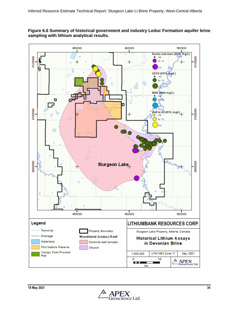
Inferred Resource Estimate Technical Report: Sturgeon Lake Li-Brine Property, West-Central Alberta
18 May 2021 34
Figure 6.6 Summary of historical government and industry Leduc Formation aquifer brine sampling with lithium analytical results.

Inferred Resource Estimate Technical Report: Sturgeon Lake Li-Brine Property, West-Central Alberta
18 May 2021 35
6.3 Historical Industry Brine Sampling Programs Historical brine sampling by companies other than LithiumBank have been conducted
by Lithium Exploration Group (LEXG) and MGX Minerals Inc. (MGX). The LEXG and MGX historical sampling programs occurred within the current boundaries of LithiumBank’s Sturgeon Lake Property and the sampling programs were supervised by the author of this Technical Report. Hence, the author can comment that the sampling methodology, security, analytical methods, and Quality Assurance – Quality Control (QA-QC) of these historical brine samples was conducted in accordance with standard industry protocol and the analytical results are relevant to the chemical composition of the Leduc Formation aquifer underlying the Sturgeon Lake Property.
6.3.1 2011 LEXG Brine Sampling Program
In 2011, LEXG sampled and analyzed brine from 60 wells within the Sturgeon Lake oilfield. The analytical work was conducted by Maxxam Environmental (now Bureau Veritas) of Edmonton, Alberta. Of the 62 brine samples collected, 47 were collected from the Leduc Formation. Other samples included brine from: Mississippian (1 sample from Banff), Triassic (11 samples from Montney, Spray River and undefined), Jurassic (1 sample from Nordegg) and Cretaceous (2 samples from Wapiabi, Gething) strata.
The analytical results showed that the Devonian Leduc Formation aquifer contains
brine that is significantly enriched in lithium in comparison to the Triassic to Cretaceous brine (Figure 6.6). LEXG reported that the Leduc Formation brine from the Sturgeon Lake oilfield contained up to 83.7 mg/L lithium (average 67 mg/L Li); 6,470 mg/L potassium (average 4,641 mg/L K); 137 mg/L boron (average 114 mg/L B); and 394 mg/L bromine (average 394 mg/L Br; Dufresne and Eccles, 2013; Eccles, 2018).
6.3.2 2016 MGX Brine Sampling Program
In 2016, a Li-brine assay program conducted by MGX collected Leduc Formation
aquifer brine samples from the Sturgeon Lake field. A total of 13 assay samples were collected from wells in the Sturgeon Lake South field, the Sturgeon Lake North field, and from the main water dispersal line at the Sturgeon Lake South Gas Plant. All samples were analyzed at Bureau Veritas in Edmonton, AB.
A summary of the analytical results of the 2016 brine assay sampling program is
presented in Table 6.1 and Figure 6.6. Except for RE16-MGX-SL004 (well 00/05-15-069-22W5), the results of the brine assays show a homogeneous concentration of lithium and confirm the presence of Li-bearing brine in the Leduc Formation aquifer at Sturgeon Lake. The average lithium value for the 2016 brine samples is 59.3 mg/L for all samples, and 61.5 mg/L when sample RE16-MGX-SL004 is omitted (Eccles, 2018). The author suggested omitting the results of brine from sample RE16-MGX-SL004 (well 00/05-15-069-22W5) because the well is adjacent to a competitor’s ‘Class 1 Disposal Well’. Hence the sample could include some amount of localized contamination from the Class 1 Disposal Well.

Inferred Resource Estimate Technical Report: Sturgeon Lake Li-Brine Property, West-Central Alberta
18 May 2021 36
Samples taken from the Sturgeon Lake Gas Plant (n=4) are highlighted in blue in
Table 6.1 and show similar lithium values in comparison to those from the individual wells on the Sturgeon Lake Property. The average lithium value for samples of individual wells is 58.7 mg/L while the average Li value for the samples taken at the Sturgeon Lake Gas Plant is 60.5 mg/L with an RSD% of 0.44% (Eccles, 2018). Note: the RSD% is a measure of the precision and reproducibility of the analytical results, values of <10% are considered to show good precision and reproducibility).
The similarity in the lithium content of brine in the individual wells versus those at the
Sturgeon Lake Gas Plant is an important observation because the Sturgeon Lake Gas Plant collects Leduc Formation brine from throughout the Property, and therefore, represents the main brine collection site on the southern portion of the Sturgeon Lake Property. I.e., If the Li-brine opportunity at the Sturgeon Lake Property ever reaches an economic feasibility stage, the Sturgeon Lake Gas Plant would represent a logical pilot testing plant site. Table 6.1 Summary of analytical results from MGX Minerals Inc. 2016 brine sampling program at the Sturgeon Lake field. Samples collected from the Sturgeon Lake South Gas Plant are highlighted. Source: Eccles (2018).
Sample ID UWI Sample type
Lithium
(mg/L)
Bromide
(mg/L)
Potassium
(mg/L)
Boron
(mg/L)
RE16-MGX-SL001 00/08-34-068-22W5 Original 60.7 330.0 4,230.0 106.0
RE16-MGX-SL002 02-02-069-22W5 Original 60.3 400.0 4,330.0 109.0
RE16-MGX-SL003 02-02-069-22W5 Dup1 60.2 380.0 4,330.0 110.0
RE16-MGX-SL004 00/05-15-069-22W5 Original 35.6 240.0 2,830.0 67.0
RE16-MGX-SL005 02/07-19-069-22W5 Original 64.3 400.0 4,670.0 113.0
RE16-MGX-SL006 02/07-19-069-22W5 Duplicate 64.7 390.0 4,690.0 113.0
RE16-MGX-SL007 Control Blank Control blank 0.0 0.0 1.1 0.0
RE16-MGX-SL008 02-02-069-22W5 Dup2 60.5 280.0 4,350.0 110.0
RE16-MGX-SL009 02/16-29-071-23W5 Original 60.5 380.0 4,600.0 109.0
RE16-MGX-SL010 02/16-29-071-23W5 Duplicate 60.9 350.0 4,640.0 109.0
RE16-MGX-SL011 02/08-06-072-23W5 Original 61.9 370.0 4,730.0 108.0
RE16-MGX-SL012 02/06-21-071-23W5 Original 61.2 310.0 4,620.0 109.0
RE16-MGX-SL013 02-02-069-22W5 Dup3 60.8 390.0 4,630.0 110.0
Min 35.6 240.0 2,830.0 67.0
Max 64.7 400.0 4,730.0 113.0
Avg 59.3 351.7 4,387.5 106.1
Avg (without 05-15 data) 61.5 361.8 4,529.1 109.6
Mini-bulk sample average 60.5 362.5 4410.0 109.8
Mini-bulk sample RSD% 0.44 15.34 3.33 0.46
SRC analytical results (2017) 71 334 4212 /
MGX Minerals Ltd. (2016 analytical results)

Inferred Resource Estimate Technical Report: Sturgeon Lake Li-Brine Property, West-Central Alberta
18 May 2021 37
6.4 Historical Mineral Processing Test Work
In addition to the 2016 assay brine test work, MGX collected a 400-litre mini-bulk brine sample from the Sturgeon Lake Gas Plant (02-02-069-22W5) for mineral processing work (see Figure 6.3). The Mineral Processing test work was conducted by PurLucid Treatment Solutions Inc. (PurLucid) of Calgary, AB, and the Saskatchewan Research Council (SRC) in Saskatoon, SK. and is summarized below. 6.4.1 PurLucid Treatment Solutions Inc. Lithium Recovery Test Work
A qualified person has not done sufficient work to evaluate the PurLucid processing
parameters. The qualified person and LithiumBank are not treating the historical mineral processing test work as current and the mineral processing parameters and results should not be relied upon.
PurLucid tested a theoretical methodology, developed by MGX, to extract lithium from
produced Sturgeon Lake Property oilfield waters using the sequential precipitation process. McEachern (2017a) reported that a new series of processes utilising PurLucid nanofiltration and ultrafiltration technologies delivered a more efficient lithium extraction. The test work methodology involves 3 main stages, pre-treatment, treatment, and production of lithium as a solid, as presented by McEachern (2017a) and summarized in the text that follows.
The pre-treatment step involves nanofiltration where highly charged nano-
environments are created to destabilise chemicals in the water and make them suitable for removal by floatation or filtration. The purpose of this step is to remove contaminant ions and requires considerably less energy than would be required by sequential precipitative processes.
The treatment stage of the processing consists of a chemical treatment followed by
ultrafiltration using the RSL Membrane™ system. The brine is subjected to a chemical manipulation that results in a high suspended solids feed to the RSL Membrane™ system. On filtration, these solids and all dissolved oil is removed resulting in a clean permeate with little to no loss of lithium. The reduction of magnesium concentrations in the permeate makes it suitable for subsequent steps in lithium concentration and recovery. A proprietary process was then used to upgrade the lithium concentration of the permeate to greater than 25 times the original concentration.
The bench top laboratory testing resulted in an upgrading of brine from 65 mg/L and 70 mg/L Li to concentrations of 1,600 mg/L and 1,951 mg/L Li in the filtration and treatment phase of the lithium extraction processes, respectively (Table 6.2; McEachern, 2017a,b).
The production of a lithium solid (lithium chloride, lithium carbonate) is the final
process step. Lithium recoveries of 95% and 86% were reportedly observed for lithium chloride and lithium carbonate, respectively. Recovery of lithium chloride resulted in a
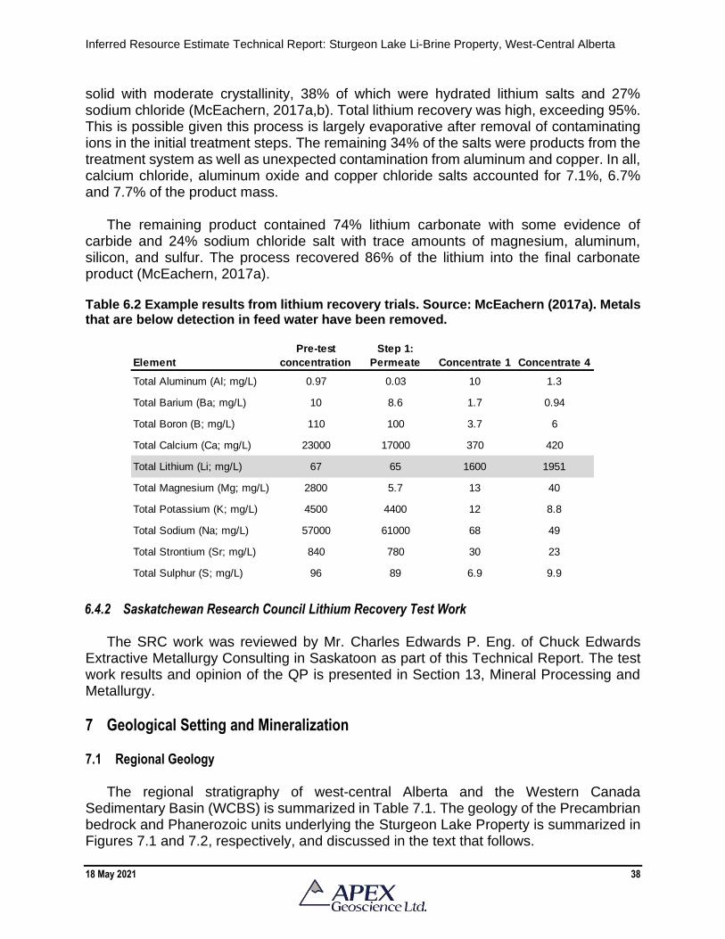
Inferred Resource Estimate Technical Report: Sturgeon Lake Li-Brine Property, West-Central Alberta
18 May 2021 38
solid with moderate crystallinity, 38% of which were hydrated lithium salts and 27% sodium chloride (McEachern, 2017a,b). Total lithium recovery was high, exceeding 95%. This is possible given this process is largely evaporative after removal of contaminating ions in the initial treatment steps. The remaining 34% of the salts were products from the treatment system as well as unexpected contamination from aluminum and copper. In all, calcium chloride, aluminum oxide and copper chloride salts accounted for 7.1%, 6.7% and 7.7% of the product mass.
The remaining product contained 74% lithium carbonate with some evidence of
carbide and 24% sodium chloride salt with trace amounts of magnesium, aluminum, silicon, and sulfur. The process recovered 86% of the lithium into the final carbonate product (McEachern, 2017a). Table 6.2 Example results from lithium recovery trials. Source: McEachern (2017a). Metals that are below detection in feed water have been removed.
6.4.2 Saskatchewan Research Council Lithium Recovery Test Work
The SRC work was reviewed by Mr. Charles Edwards P. Eng. of Chuck Edwards Extractive Metallurgy Consulting in Saskatoon as part of this Technical Report. The test work results and opinion of the QP is presented in Section 13, Mineral Processing and Metallurgy.
7 Geological Setting and Mineralization 7.1 Regional Geology
The regional stratigraphy of west-central Alberta and the Western Canada
Sedimentary Basin (WCBS) is summarized in Table 7.1. The geology of the Precambrian bedrock and Phanerozoic units underlying the Sturgeon Lake Property is summarized in Figures 7.1 and 7.2, respectively, and discussed in the text that follows.
Element
Pre-test
concentration
Step 1:
Permeate Concentrate 1 Concentrate 4
Total Aluminum (Al; mg/L) 0.97 0.03 10 1.3
Total Barium (Ba; mg/L) 10 8.6 1.7 0.94
Total Boron (B; mg/L) 110 100 3.7 6
Total Calcium (Ca; mg/L) 23000 17000 370 420
Total Lithium (Li; mg/L) 67 65 1600 1951
Total Magnesium (Mg; mg/L) 2800 5.7 13 40
Total Potassium (K; mg/L) 4500 4400 12 8.8
Total Sodium (Na; mg/L) 57000 61000 68 49
Total Strontium (Sr; mg/L) 840 780 30 23
Total Sulphur (S; mg/L) 96 89 6.9 9.9

Inferred Resource Estimate Technical Report: Sturgeon Lake Li-Brine Property, West-Central Alberta
18 May 2021 39
Table 7.1 Regional Stratigraphy of the Sturgeon Lake Property area (adapted from Hitchon et al., 1990).

Inferred Resource Estimate Technical Report: Sturgeon Lake Li-Brine Property, West-Central Alberta
18 May 2021 40
Figure 7.1 Inferred basement geology of the Sturgeon Lake Property area. Source: Ross et al. (1991).

Inferred Resource Estimate Technical Report: Sturgeon Lake Li-Brine Property, West-Central Alberta
18 May 2021 41
Figure 7.2 Regional bedrock geology of the Sturgeon Lake Property area. Source: Prior et al. (2013).

Inferred Resource Estimate Technical Report: Sturgeon Lake Li-Brine Property, West-Central Alberta
18 May 2021 42
7.2 Precambrian Geology The Sturgeon Lake Property lies near the centre of the WCSB south of the Peace
River Arch (PRA). The property lies mostly on the Chinchaga Terrane (Figure 7.1), with the northwest corner of the property on the Ksituan Magmatic Arc (Panǎ, 2003). The Chinchaga Terrane is part of the Buffalo Head craton which is thought to have accreted to the western edge of North America between 1.8 and 2.4 billion years ago (Ross et al., 1991). 7.3 Phanerozoic Geology
Overlying the basement is a thick sequence of WCSB Phanerozoic rocks comprised
mainly of Tertiary and Cretaceous sedimentary clastic rocks and Mississippian to Devonian carbonate, sandstone, and salt (e.g., Green et al., 1970; Tokarsky, 1977; Glass, 1990; Mossop and Shetson, 1994; Figure 7.2). At the base of the Beaverhill Lake Group (Table 7.1), the Elk Point Group is comprised of restricted marine carbonate and evaporite that gradationally overlie the Watt Mountain Formation (Mossop and Shetson, 1994). The Upper Elk Point, including the Ft. Vermillion, Muskeg and Watt Mountain formations are an aquitard layer (Hitchon et al., 1990). Overlying the Elk Point Group is carbonate of the Slave Point Formation, which was deposited on an open marine carbonate platform and forms the base for the reef complexes in the region including the Swan Hills Complex and the Peace River Arch Fringing Reef Complex. The Devonian Swan Hills Reef Complex underlies the Sturgeon Lake Property. It is a sequence of shallowing upward reef cycles now composed of dolomite (Mossop and Shetson, 1994). The Swan Hills Complex is hydrogeologically part of the Beaverhill Lake aquifer system, which contains elevated concentrations of Li (e.g., Hitchon et al., 1995).
The upper Devonian Woodbend Group conformably overlies the Beaverhill Lake
Group (Table 7.1). The Woodbend Group is dominated by basin siltstone, shale and carbonate of the Majeau Lake, Duvernay and Ireton formations, which surround and cap the Leduc reef complexes. The Leduc reefs are characterized by multiple cycles of reef growth including backstepping reef complexes and isolated reefs (Mossop and Shetson, 1994). At the Sturgeon Lake Property, the Leduc is composed of dolomite.
The Leduc Formation (Woodbend Group) is host to prolific reserves of oil and gas in
Alberta and contains elevated concentrations of lithium (e.g., Hitchon et al., 1995). The Duvernay Formation is composed of dark bituminous shale and limestone which contain and preserve a large accumulation of organic carbon thought to be the source for most of the conventional hydrocarbons in the upper Devonian in Alberta. The Ireton Formation caps the Leduc reefs and was formed by an extremely voluminous influx of shale into the region (Mossop and Shetson, 1994). The Ireton Formation is an aquitard that forms an impermeable cap rock over the Leduc reefs (Hitchon et al., 1995).
The Woodbend Group is conformably overlain by the Winterburn and Wabamun
Groups of upper Devonian age (Table 7.1). In the area of the property the Winterburn thickness in north-central Alberta is available from the logs of holes drilled for petroleum

Inferred Resource Estimate Technical Report: Sturgeon Lake Li-Brine Property, West-Central Alberta
18 May 2021 43
Group is composed of shale and argillaceous limestone. The Wabamun Group is composed of massive buff to brown limestone interbedded with finely crystalline dolomite at the base. These two Groups comprise the Wabamun-Winterburn Aquifer system from which a few anomalous Li analyses have been obtained (Hitchon et al., 1995). The Wabamun Group is unconformably overlain by the Lower Carboniferous Exshaw shale, an aquitard.
The Exshaw shale is overlain by the Banff Group, which is composed of a medium to
light olive grey limestone with subordinate fine-grained siliciclastic, marlstone and dolostone overlying a basal shale, siltstone, and sandstone unit (Mossop and Shetson, 1994). The Rundle Group conformably overlies the Banff Group. and is composed of cyclic dolostone and limestone with subordinate shale. Permian strata at the Property are very thin. The Permian Belloy Group unconformably overlies the Rundle Group and is unconformably overlain by the Triassic Montney Formation. It is composed of shelf sand and carbonate (Mossop and Shetson, 1994).
The overlying Mesozoic strata (mainly Cretaceous) are composed of alternating units
of marine and nonmarine sandstone, shale, siltstone, mudstone, and bentonite. The Triassic is characterized by fine-grained argillaceous siltstone and sandstone. 7.4 Late Tertiary – Quaternary Geology
During the Pleistocene, multiple southerly glacial advances of the Laurentide Ice
Sheet across the region resulted in the deposition of ground moraine and associated sediments in north-central Alberta. The glacial ice is believed to have receded from the area between 15,000 and 10,000 years ago (Dyke and Prest, 1987). The majority of the Sturgeon Lake Property is covered by drift of variable thickness, ranging from a discontinuous veneer to just over 15 m (Pawlowicz and Fenton, 1995a, b).
7.5 Structural Geology
In northern Alberta, the PRA is a region where the younger Phanerozoic and Cenozoic
rocks, which overlie the Precambrian basement, have undergone periodic vertical and, possibly, compressive deformation from the Proterozoic into Tertiary time (e.g., Cant, 1988; O’Connell et al., 1990). This pattern of long-lived, periodic uplift and subsidence has imposed a structural control on the deposition patterns of the Phanerozoic, and to a lesser extent the Cenozoic, strata in northern and north central Alberta. In addition, this periodic movement has resulted in a rectilinear pattern of faults that is responsible for the structurally controlled reefs along with oil and gas pools found throughout this area.
During the Devonian, the PRA was emergent and was a positive paleo-topographic
relief feature oriented east-northeast from the British Columbia provincial border to at least as far east as Red Earth Creek. Toward the end of the Devonian and into the Mississippian the PRA collapsed and became the Peace River embayment. The embayment filled in during the Mississippian with a thick sequence of siliciclastic rocks along with dolostone and limestone.
Inferred Resource Estimate Technical Report: Sturgeon Lake Li-Brine Property, West-Central Alberta
18 May 2021 44
Several prominent Alberta Devonian Reef complexes are underlain by and proximal to basement faults and that these reef complexes promoted growth over long periods of time at fault interfaces along the shallow water side or uplifted block edge of these faults during slow subsidence of the downside of the fault (e.g., Bloy and Hadley, 1989; Dufresne et al., 1996). At the Sturgeon Lake Reef complex, individual reef cycles reveal significant fault offset of the reservoir throughout the entire complex (Stoakes and Campbell, 1996). 7.6 Property Geology: Hydrogeological Characteristics of the Woodbend Group (Leduc Formation)
Aquifer System The geological focus of this Technical Report is on the aquifer system within the Late
Devonian (Frasnian) dolomitized reef structure of the Woodbend Group, Leduc Formation, that conformably overlies the carbonates of the Beaverhill Lake Group.
At the Sturgeon Lake Property, the top of the Beaverhill Lake Group ranges from
approximately -1,900 m above sea level (m asl) in the northeastern to -2,750 m asl in the southwestern corner of the Property. The Beaverhill Lake Group has an average dip to the southwest at approximately 0.011 (11 m/km).
The Leduc Formation is defined by subsurface oil and gas exploration (n=242 wells)
that define the true vertical depth of the Leduc Formation at depths of between -2,337.6 m and -3,050.6 m (average -2,619.9 m) below the Earth’s surface. The Leduc reef has a thickness of approximately 230 to 380 m (maximum thickness of 408 m) along a southwest to northeast cross section at the Sturgeon Lake Property (Hydrogeological Consultants Ltd., 2012).
The Beaverhill Lake Group (Swan Hills aquifer) and the Woodbend Group (Leduc aquifer) were thought to be hydraulically connected due to historical government interpretation of Hitchon et al. (1995). A hydrological assessment conducted by HCL has demonstrated the two units – at least in LithiumBank’s Sturgeon Lake Property area – are in fact not connected.
The brine is hypersaline. Reported total dissolved solids (TDS) concentrations of 77
Leduc samples ranged from 113,117 to 265,921 milligrams per litre (mg/L), with an average of 199,995 mg/L (Hydrogeological Consultants Ltd., 2012). By comparison, Hitchon et al (1995), who culled the brine geochemical dataset based on anion-cation balance, reported the results of 7 brine samples from the Leduc Formation that contained a lithium concentration of >100 mg/L; these 7 samples had an average TDS concentration of 214,611 mg/L.
A total of 73,178,693 m³ of liquid was pumped from wells tapping the Leduc aquifer in the Sturgeon Lake field from 1961 to the end of 2010, of which 72% was reported to be brine (Hydrogeological Consultants Ltd., 2012). By comparison, a total of 73,146,659 m³ of fluid was injected back into the Leduc within the study area over the same length of

Inferred Resource Estimate Technical Report: Sturgeon Lake Li-Brine Property, West-Central Alberta
18 May 2021 45
time, representing a difference of less than 1% between net total pumped and injected volumes.
The well that produced the greatest volume of brine from the Leduc aquifer is in 08-
11-069-22 W5M, which is located within LithiumBank’s Sturgeon Lake Property. This well has historically produced a total of 4,213,257 m³ of formation water from October 1995 to December 2010, at an average of 783 m³/day. The formation water diverted from the 08-11 well represents 97% of the total liquid produced from that well.
Analyses of selected well logs were conducted to determine porosity. The sonic curve
indicates an average porosity of 5.7% and the average porosity from the sonic curve and the neutron porosity curve is 5.3%. Based on analysis of the delta transit time (sonic) curves for dolomite from three selected geophysical logs and the calculated porosity of the Leduc Formation (average of 5.3% and a geomean of 5.0%; n=99), a reasonable average porosity of the Leduc Formation underlying the Sturgeon Lake Property is 5.0%.
Hydraulic parameters were used to calculate deliverability include transmissivity
(permeability x aquifer thickness) and storativity (the volume of water expelled per unit surface area as a result of a change in head). Apparent transmissivity values are based on the inflow and pressures measured during the DSTs (n=52 from 41 wells) or are calculated from permeability data determined from core analyses (n=99 cores). Fluid levels are based on formation pressures. The permeability measurements from core tests were converted to transmissivity and compared to transmissivity measurements determined from DST and from transmissivity values used in a water level model that reasonably matches the known water levels over time. Apparent transmissivities determined from core analyses and DST results from the Leduc Formation indicated an average of 0.09 m²/day and 2.2 m²/day, respectively, (Hydrogeological Consultants Ltd., 2012).
Hitchon et al. (1995) reported that the potentially productive Leduc Reef (N) zone
(equivalent to a zone underlying the Sturgeon Lake Property) is approximately 12 m thick, with an average permeability of 3.5 x 10⁻¹⁴ m². Based on these parameters, the calculated transmissivity would be 0.35 m²/day. However, because of the vuggy nature of carbonate porosity, the analyses to determine aquifer parameters on a microscale (core and DST) will vary significantly while parameters determined using a macroscale Infinite Artesian Aquifer Model (IAAM) will better reflect the effective parameters of the aquifer. Based on IAAM analysis, an effective regional transmissivity of 1.0 m²/day, and a corresponding storativity of 6.0 x 10⁻⁵ best defines the aquifer parameters for the Leduc Formation underlying the Sturgeon Lake Property (Hydrogeological Consultants Ltd., 2012). 7.7 Mineralization
Lithium mineralization within the Devonian Leduc Formation aquifer is in solution
within the brine; hence it is not observed in the physical state. Accordingly, the best way to provide discussion on mineralization is to review the geochemical nature of the brine.

Inferred Resource Estimate Technical Report: Sturgeon Lake Li-Brine Property, West-Central Alberta
18 May 2021 46
The author has compiled Government and industry brine sampling that conducted from oil and gas wells within the Sturgeon Lake field. Using the bivariate plot of Li vs K/Br in Figure 7.3, the results show the anomalous nature of the Devonian Leduc Formation brine in comparison to brine that was collected from pre-Devonian (Mississippian to Cretaceous) aquifers. The pre-Devonian brine from the Sturgeon Lake field has <42 mg/L Li and a K/Br ratio of <8.2. In contrast, the Devonian Leduc Formation brine has 56-84 mg/L Li and K/Br ratios of 9.1 to 15.6.
The elevated K/Br, in conjunction with high Li/Br and increasingly radiogenic 87Sr/86Sr
values indicate an influence of a hydrothermal fluid(s) and/or mobilization of silicate-bearing fluids from either the crystalline basement or the immature siliciclastic deposited above the basement (basal Cambrian sandstone, Granite Wash or the Gilwood Member), to the Devonian brine (Eccles and Berhane, 2011; Huff, 2019). A cluster of Leduc Formation brine analyses has low K/Br (<1.5) and its possible that the Li-enriched brine formed in another environment perhaps through dissolution of Li-bearing late-stage evaporite minerals into mid-Devonian seawater evapo-concentrated to, but not beyond, halite saturation (Huff, 2019). Figure 7.3 Plot of lithium versus potassium/bromide to show the anomalous geochemical nature of the Devonian Leduc Formation brine in comparison to pre-Devonian brine from the Sturgeon Lake field.

Inferred Resource Estimate Technical Report: Sturgeon Lake Li-Brine Property, West-Central Alberta
18 May 2021 47
Other geochemical attributes of the Leduc Formation aquifer brine are presented in Table 7.2 and Figure 7.4 and include a relative density of 1.214 g/cm3, observed pH of 7.10, measured TDS of 246,700 mg/L, conductivity of 214,000 uS/cm and total alkalinity as CaCO3 of 290 mg/L. The analytical charge imbalance is -1.52%. The calculated charge imbalance, using the brine density and TDS is -1.68%.
Table 7.2 Leduc brine chemistry from the Sturgeon Lake field (sample RE16-SL-002).
Figure 7.4 Leduc brine chemistry from the Sturgeon Lake field (sample RE16-SL-002).
Cation (meq) (mg/l) Anion (meq) (mg/l)
Li 11.5326 60.3 Cl 5713.91 152600
Na 3458.76 59900 Br 6.64577 400
K 147.001 4330 I 0.282445 27
Mg 300.313 2750 SO4 9.397 340
Ca 1616.31 24400 B - 109
Sr 32.1192 1060 Se - 0.44
Ba 0.206847 10.7 HCO3 7.61464 350
Ag 5.17E-03 0.42
Mn 9.57E-03 0.198
Fe 6.18E-03 0.13
Pb 2.56E-03 0.2

Inferred Resource Estimate Technical Report: Sturgeon Lake Li-Brine Property, West-Central Alberta
18 May 2021 48
8 Deposit Types Brine associated with some of the world’s oilfields and/or geothermal fields are known
to contain anomalous concentrations of Li and are considered potential sources for large tonnages of Li (Garrett, 2004; Tahil, 2007). The Li-brine aquifers occur at typical depths of >2,200 m beneath the Earth’s surface in deep-seated, pressurized aquifers. The aquifers are typically confined in that the aquifer is bound by aquitards, but in some instances, several aquifers can commingle within a larger confined aquifer system. The high Ca and Br content of these brines suggest they are concentrated seawater dolomitization brines with elevated concentrations of Li (typically along with K, Br, B, I and other trace elements). Because of the aquifer depth, the brine is typically accessed by existing infrastructure such as oil and gas and/or geothermal facilities. Hence the deposit type presents a unique co-product opportunity.
Lithium-enriched (>50 mg/kg) brine is present within the Late Devonian Beaverhill
Lake (Swan Hills), Winterburn (Nisku) and Woodbend (Leduc) groups (formations) of the WCSB. Early studies proposed a source related to connate water (original sea water) that was altered by diagenesis with selective membrane-filtration of lithium (Billings et al., 1969). Geochemical and isotopic data were used to suggest that any viable lithium-source models should invoke direct mobilization of silicate-bearing fluids from either the crystalline basement or the immature siliciclastic material deposited above the basement, to the Devonian Beaverhill Lake and Leduc aquifers (Eccles and Berhane, 2011).
More recently, Huff (2016, 2019) has shown that two Li-enriched brines with distinctly
different geochemical characteristics, and thus distinct evolutionary histories, exist within Late Devonian carbonate of the Alberta Basin. Li-enriched brines of the Nisku and Leduc formations were formed by preferential dissolution of Li-enriched late-stage evaporate minerals, likely from the Middle Devonian Prairie Evaporite, into evapo-concentrated Late Devonian seawater. Laramide tectonics and modern-day upward movement of water through Devonian carbonates has emplaced the diluted Li-enriched brines into the Late Devonian carbonate reef complexes or the Nisku and Leduc Formations.
In addition, isotopic and geochemical modelling has shown that Devonian brine
specific to west-central Alberta were formed through halite dissolution and mixing with Li-enriched fluids possibly expelled from Precambrian crystalline basement rocks via hydrothermal fluids (Huff, 2016, 2019), which supports the hypothesis of Eccles and Berhane (2011).
Geological concepts being applied in the investigation and/or exploration of deep-seated, confined Li-brine deposits include a compilation and review of historical oil and gas (or geothermal) geochemical fluid data (if available), and target selection of deep-seated, porous, large-scale, often reef-associated aquifers. Conventional brine assays are then accomplished from by collecting brine from produced water sample points with the existing oil and gas, or geothermal, infrastructure (e.g., wellhead, separator unit, pipelines, and reinjection points).

Inferred Resource Estimate Technical Report: Sturgeon Lake Li-Brine Property, West-Central Alberta
18 May 2021 49
Traditional recovery of Li-from-brine – as conducted in South America – utilized solar evaporation to beneficiate the brine to higher levels of lithium prior to finalizing products such as lithium chloride and lithium carbonate. Solar evaporation is not a viable option in regions such as Canada, and hence mini-bulk brine samples are collected to define mineral processing methods that are able to recover lithium from the brine using a quicker extraction technology. Brine sample quantities of 100 liters to 1,000 litres are applicable in bench-scale test work prior to expanding the operation to the pilot plant, and potential commercial application stage.
9 Exploration Brine sampling from the oil and gas wells, and the associated lithium assay
geochemical results related to the resource estimate, are discussed in Section 10. With respect to exploration, during 2021, LithiumBank acquired a series of existing two-dimensional (2-D) seismic line profiles and data that encompasses their Sturgeon Lake Property. The seismic data was purchased from Pulse Seismic Inc., a Calgary, AB public company that specializes in the acquisition, inventorying, licensing, and sale of existing 2-D and 3-D seismic data to the western Canadian energy sector.
The seismic information included a total of 7 2-D seismic lines totalling 67 line-
kilometres. The original seismic surveys were conducted between 1982 and 1990. The seismic data was supplied as: migrated stack sections as segy files downloaded to Seisware Project along with DVD containing basic, field and stack data. Four of the 7 seismic lines are orientated in a northeast direction with the remaining 3 seismic lines orientated east-west. The lines capture the eastern edge of the Leduc fringing reef, the internal structure of the reef buildup, and the western edge of the reef formation in the south Sturgeon Lake oilfield.
The seismic lines cover portions of Alberta Township land surveying system Township
68, 69 and 70, and Range 22 and 23 West of the 5th Meridian. This area effectively covers the region of the South Sturgeon Lake oilfield and the southern portion of LithiumBank’s Property (see Figure 4.2).
LithiumBank commissioned Diane Shao, a consulting Senior Geologist/Geophysicist
in Calgary, AB, to re-interpret the existing 2-D seismic data. The main objectives of the reinterpretation were to help characterize and identify 1) fault and shear zones, 2) reservoir quality, and 3) better define the Leduc Formation reef in the western part of the Property where there is little to no well control. The reinterpretation was performed using the seismic data in the format in which it was acquired, and by utilizing stratigraphic top picks as provided in GeoSCOUT, a popular petroleum industry data and software program from geoLogic Systems of Calgary, AB.
As per the acquisition agreement between LithiumBank and Pulse Seismic Inc., the
seismic line profiles are proprietary. A non-spatially orientated example of a seismic section is presented in Figure 9.1 and shows the relationship between proposed basement fault zones and the Sturgeon Lake Reef carbonate buildups.
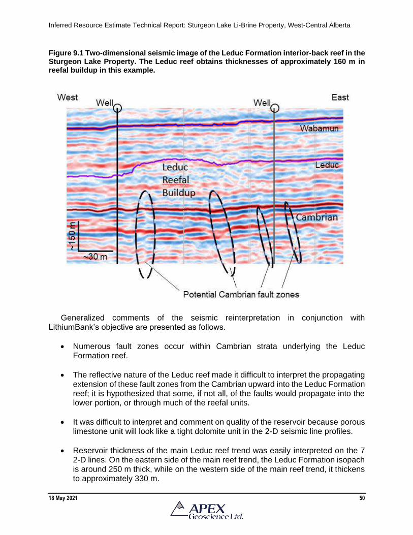
Inferred Resource Estimate Technical Report: Sturgeon Lake Li-Brine Property, West-Central Alberta
18 May 2021 50
Figure 9.1 Two-dimensional seismic image of the Leduc Formation interior-back reef in the Sturgeon Lake Property. The Leduc reef obtains thicknesses of approximately 160 m in reefal buildup in this example.
Generalized comments of the seismic reinterpretation in conjunction with
LithiumBank’s objective are presented as follows.
• Numerous fault zones occur within Cambrian strata underlying the Leduc Formation reef.
• The reflective nature of the Leduc reef made it difficult to interpret the propagating extension of these fault zones from the Cambrian upward into the Leduc Formation reef; it is hypothesized that some, if not all, of the faults would propagate into the lower portion, or through much of the reefal units.
• It was difficult to interpret and comment on quality of the reservoir because porous limestone unit will look like a tight dolomite unit in the 2-D seismic line profiles.
• Reservoir thickness of the main Leduc reef trend was easily interpreted on the 7 2-D lines. On the eastern side of the main reef trend, the Leduc Formation isopach is around 250 m thick, while on the western side of the main reef trend, it thickens to approximately 330 m.

Inferred Resource Estimate Technical Report: Sturgeon Lake Li-Brine Property, West-Central Alberta
18 May 2021 51
• With respect to the Leduc Formation thickness in the western part of the Property, a couple of 2-D lines displayed the potential that the reef extends westward for approximately 1.5 km from in comparison to publicly available reef edge estimations (e.g., Switzer et al., 1994). It is possible that acquisition of additional 3-D seismic data could provide a more accurate assessment of the western edge of the Leduc Formation in this area.
To conclude, LithiumBank’s 2021 acquisition and reinterpretation of existing seismic
data in the south Sturgeon Lake Property has enabled the Company to have a better understanding of the dimensions of the Sturgeon Lake reefs. The seismic information advanced the Company’s understanding of the underlying structural geology that may be responsible for the location and development of the reefs and could potentially act as sources of fluid flow of hot geothermal fluids that may be enriched in lithium from the crystalline basement and/or clastic units overlying the basement (i.e., the Granite Wash).
10 Drilling The Leduc petroleum production wells at Sturgeon Lake are currently suspended at
the Effective Date of this report, and LithiumBank has yet to conduct brine sampling. Hence, historical brine assays are utilized in the resource estimation, and a summary of the well descriptions and brine analytical results are presented in the text that follows.
10.1 Lithium Exploration Group 2011 Brine Sampling Program and Analytical Results
In 2011, Maxxam Environmental collected routine brine samples on behalf of Lithium
Exploration Group. The wells sampled were all within the boundaries of the current LithiumBank Sturgeon Lake Property (see Figure 6.6). A total of 62 samples were collected from 60 separate wells within the Valleyview Property. Of the 62 samples, 47 were collected from the Leduc Formation aquifer.
Other samples included formation waters from: Mississippian (1 sample from Banff),
Triassic (11 samples from Montney, Spray River and undefined), Jurassic (1 sample from Nordegg) and Cretaceous (2 samples from Wapiabi, Gething) samples. A summary of the selected geochemical elements is presented in Table 10.1 with a histogram of lithium results in Figure 10.1.
Table 10.1 shows that Li is the most significant element of economic interest in the
brine samples, although K, B, Br, Mg, Ca, and Na provide potential co-products pending extractability processes.
The bimodal lithium variation in Figure 10.1 is directly related to chemical
dissimilarities between the Leduc aquifer brine (>60 mg/L Li) versus those from the Mississippian to Cretaceous sampled formation waters (<40 mg/L Li). The histogram also illustrates the well-constrained, single population for the Leduc Formation Li-brine (n=47 analyses) with a mean lithium value of 67.5 mg/L Li.

Inferred Resource Estimate Technical Report: Sturgeon Lake Li-Brine Property, West-Central Alberta
18 May 2021 52
Table 10.1 Summary of selected elements from Lithium Exploration Groups 2011 Sturgeon Lake brine geochemical sampling program.
Lithium Potassium Boron Bromine Calcium Magnesium Sodium
(Li) (K) (B) (Br) (Ca) (Mg) (Na)
Well identifier Group/Formation (mg/L) (mg/L) (mg/L) (mg/L) (mg/L) (mg/L) (mg/L)
01-01-069-22-W5M Devonian - Leduc 71.8 5200 130 380 26300 3640 70900
01-06-069-21-W5M Devonian - Leduc 65.5 4280 109 390 23400 2390 59800
01-08-069-21-W5M Triassic - Montney 25.4 1310 20.8 190 2690 628 52000
01-31-068-21-W5M Devonian - Leduc 64.6 4420 109 400 24100 2530 65200
02-02-069-22-W5M Devonian - Leduc 69.6 4500 114 380 23400 2740 64400
02-12-069-22-W5M Devonian - Leduc 66.2 4250 114 410 22500 2510 62700
02-20-069-22-W5M Devonian - Leduc 59.3 4130 92.4 330 19800 2300 52200
03-12-069-22-W5M Devonian - Leduc 76.9 5620 137 390 27600 3860 69500
03-25-068-22-W5M Cretaceous - Gething 21.8 1320 13.1 170 2950 763 62500
04-03-069-22-W5M Devonian - Leduc 65.6 4270 105 390 22700 2540 61300
04-12-069-22-W5M Devonian - Leduc 64.8 4360 109 400 22800 2490 60300
05-05-069-21-W5M Devonian - Leduc 70.2 5090 134 390 26900 3560 69000
05-05-072-23-W5M Devonian - Leduc 57.3 4150 94.5 360 22100 2400 56100
05-09-069-21-W5M Devonian - Leduc 73.2 5060 137 390 27800 3780 67800
05-10-069-21-W5M Devonian - Leduc 74.4 4370 122 350 22000 2900 57200
05-12-069-22-W5M Devonian - Leduc 68.3 4460 115 390 22500 2670 60900
05-19-068-21-W5M Triassic - Montney 22.3 1360 12.9 170 3040 768 63800
05-32-071-23-W5M Devonian - Leduc 74 5280 122 430 26900 3460 70500
06-05-069-21-W5M Devonian - Leduc 66.2 4460 103 390 20100 2910 61100
06-06-069-21-W5M Devonian - Leduc 65.2 4370 112 370 22500 2530 61100
06-08-069-21-W5M Triassic - undefined 27 1480 24 180 3150 803 66400
06-11-069-22-W5M Devonian - Leduc 66.9 3950 116 360 23400 2720 61600
06-36-068-22-W5M Devonian - Leduc 59.9 4220 99.4 350 21300 2380 57600
07-06-069-21-W5M Devonian - Leduc 65.7 4440 111 440 23000 2530 61000
07-11-069-22-W5M Devonian - Leduc 64.2 4320 108 370 22500 2490 59500
07-12-069-22-W5M Triassic - Montney 22 1180 36.3 170 2320 560 50500
07-19-069-22-W5M Devonian - Leduc 71.4 4780 113 390 23700 2840 60200
07-21-071-23-W5M Devonian - Leduc 55.4 3980 97 400 21700 2430 52700
07-26-069-23-W5M Devonian - Leduc 72.7 5390 122 420 23900 3510 65100
08-09-069-21-W5M Devonian - Leduc 70.5 4290 115 380 23800 2580 58400
08-11-069-22-W5M Devonian - Leduc 65.6 4330 111 410 22600 2560 60000
08-34-068-22-W5M Devonian - Leduc 62.5 4200 102 370 21700 2490 59300
09-01-069-22-W5M Devonian - Leduc 64.8 4200 104 460 23000 2380 59200
10-01-069-22-W5M Devonian - Leduc 65.8 4420 113 470 22800 2550 61700
10-05-069-21-W5M Devonian - Leduc 83.7 6470 136 390 28100 4630 67900
10-06-069-21-W5M Devonian - Leduc 74.3 4920 124 450 21500 2830 58800
10-06-069-21-W5M Triassic - undefined 24.7 1250 17.9 180 2870 606 55200
10-11-069-22-W5M Devonian - Leduc 65.7 4260 111 380 22000 2580 60100
10-11-069-22-W5M Triassic - Montney 26.3 1460 20.8 180 3100 845 61500
11-04-069-21-W5M Triassic - Montney 26.1 1370 20.4 210 2770 636 53500
11-05-069-21-W5M Mississipian - Banff 17 954 18.2 140 1790 526 42500
11-06-069-21-W5M Devonian - Leduc 70.9 5170 127 390 26200 3380 67700
11-06-072-23-W5M Devonian - Leduc 71.8 5210 120 410 26100 3410 66000
11-07-069-21-W5M Triassic - Montney 25.4 1250 20.9 210 2810 614 53300
11-11-069-22-W5M Devonian - Leduc 68.7 5050 126 380 25800 3540 65300
11-12-069-22-W5M Jurassic - Nordegg 24 1250 19.7 200 2700 631 54500
11-16-071-23-W5M Devonian - Leduc 73.8 5270 125 430 26100 3520 66200
11-36-068-22-W5M Devonian - Leduc 72.5 5220 130 380 26200 3740 71400

Inferred Resource Estimate Technical Report: Sturgeon Lake Li-Brine Property, West-Central Alberta
18 May 2021 53
Table 10.1, continued.
Figure 10.1 Histogram of lithium geochemical results from Lithium Exploration Groups 2011 Sturgeon Lake brine geochemical sampling program.
Lithium Potassium Boron Bromine Calcium Magnesium Sodium
(Li) (K) (B) (Br) (Ca) (Mg) (Na)
Well identifier Group/Formation (mg/L) (mg/L) (mg/L) (mg/L) (mg/L) (mg/L) (mg/L)
12-05-069-21-W5M Devonian - Leduc 67.4 4460 110 370 21600 2600 63100
12-19-069-22-W5M Devonian - Leduc 58.1 4370 96.6 400 21700 2570 57600
13-05-069-21-W5M Triassic - Spray River 29.1 1560 29.6 220 5370 805 54700
13-06-069-21-W5M Triassic - Montney 25.7 1410 20.5 180 3050 810 62300
13-27-068-22-W5M Devonian - Leduc 61.1 4440 101 360 22200 2560 60000
13-31-068-21-W5M Devonian - Leduc 71.5 5250 128 380 26100 3600 69500
14-32-071-23-W5M Devonian - Leduc 59.6 4310 100 390 23000 2530 58600
14-34-068-22-W5M Devonian - Leduc 65.2 4390 103 370 22500 2620 62400
15-05-069-21-W5M Triassic - Montney 17.1 876 18.5 190 1680 414 37200
15-31-068-21-W5M Devonian - Leduc 66.5 4570 111 400 23400 2550 63800
16-10-069-22-W5M Devonian - Leduc 66.9 4600 108 350 21000 2560 57500
16-17-069-22-W5M Cretaceous - Wapiabi 41.3 3230 68 350 14000 1660 39600
16-29-071-23-W5M Devonian - Leduc 70.5 4970 123 500 26300 3300 65700
16-31-068-21-W5M Devonian - Leduc 65.7 4420 108 440 22400 2520 64200

Inferred Resource Estimate Technical Report: Sturgeon Lake Li-Brine Property, West-Central Alberta
18 May 2021 54
10.2 MGX Minerals Inc. 2016 Brine Sampling Program and Analytical Results In 2016, a Li-brine assay sampling program was conducted by APEX on behalf of
MGX from individual wells producing from the Leduc Formation, and at the Sturgeon Lake Gas Plant, which collects the pumped product from all wellheads in the Sturgeon Lake oilfield. The wells sampled were all within the boundaries of the current LithiumBank Sturgeon Lake Property (see Figure 6.6).
A total of 13 samples were collected including: 7 samples of individual wells (3 wells
from the Sturgeon Lake South field; 3 wells from the Sturgeon Lake North field; and an assay sample from the main water dispersal line at the Sturgeon Lake South Gas Plant); 5 duplicate samples to test analytical precision (2 from individual wells and 3 at the Sturgeon Lake Gas Plant; and 1 control sample (non-Li-bearing water to test laboratory protocol).
The well sample locations and descriptions are presented in Table 10.2. A description
of the individual brine samples is presented in Table 10.3. A summary of the selected analytical results including duplicate samples and control blank samples is presented in Table 10.4. Apart from sample RE16-MGX-SL004 (well 00/05-15-069-22W5), the brine assay results show a homogeneous concentration of lithium. The average lithium value for the 2016 brine samples is 59.3 mg/L for all samples, and 61.5 mg/L when sample RE16-MGX-SL004 is omitted. The QP suggests omitting the results of brine from sample RE16-MGX-SL004 because the well is adjacent to a competitor’s ‘Class 1 Disposal Well’. Hence the sample could include some amount of contamination within the aquifer from Class 1 miscellaneous hazardous and chemical waste.
The analytical results for other elements of interest, including bromide, potassium, and
boron, are also presented in Table 10.4. The average value for all samples including RE16-GX-SL004 is 351.7 mg/L Br, 4387.5 mg/L K and 106.1 mg/L B, while the average values all samples excluding RE16-MGX-SL004 are 361.8 mg/L Br, 4529.1 mg/L K and 109.6 mg/L B.
Samples taken from the Sturgeon Lake Gas Plant are highlighted in blue in Table
10.4 and have similar lithium values compared to those for the individual wells. The average lithium value for samples of individual wells is 58.7 mg/L while the average Li value for the samples taken at the Sturgeon Lake Gas Plant is 60.5 mg/L with an RSD% of 0.44% (note: the RSD% is a measure of the precision and reproducibility of the analytical results, values of <10% are considered to show good precision and reproducibility; 0.44% is excellent precision and reproducibility).
The similarity in the lithium content of the brine in the individual wells and those at the Sturgeon Lake Gas Plant is an important observation because the Sturgeon Lake Gas Plant collects Leduc Formation brine from throughout the Property, and therefore, represents the main brine collection site on the southern portion of the Sturgeon Lake Property. I.e., If the Li-brine opportunity ever reaches an economic feasibility stage, the Sturgeon Lake Gas Plant would represent a logical pilot testing plant site.

Inferred Resource Estimate Technical Report: Sturgeon Lake Li-Brine Property, West-Central Alberta
18 May 2021 55
Table 10.2 Well sample locations and descriptions.
Table 10.3 Individual sample descriptions.
Sample ID UWI Sample point Purging method
Sample
vessel
Fluid type
(water,
emulsion,
etc)
Water colour
(pre-
separation)
Water colour
(post
separation)
Sediment
present (modal
abundance %)
Oil present
(modal
abundance
%)
Sample
treatment
(by sampler)
Temperature
(°C) Comments
RE16-MGX-SL001 00/08-34-068-22W5 Test separator One litre in a waste can Plastic jug Water Milky clear Clear 0 <1 None n/a
RE16-MGX-SL002 02-02-069-22W5 Disposal line Not required Plastic jug Water Clear Clear 0 0 None ~60
Main diposal line sample nipple
at Gas plant
RE16-MGX-SL003 02-02-069-22W5 Disposal line Not required Plastic jug Water Clear Clear 0 0 None ~60
Main diposal line sample nipple
at Gas plant
RE16-MGX-SL004 00/05-15-069-22W5 Test separator One litre in a waste can Plastic jug Water Clear Clear 0 <1 None n/a
Note: right beside a Class A
disposal well (contamination a
sure factor)
RE16-MGX-SL005 02/07-19-069-22W5 Test separator One litre in a waste can Plastic jug Water Clear Clear 0 <1 None n/a
RE16-MGX-SL006 02/07-19-069-22W5 Test separator One litre in a waste can Plastic jug Water Clear Clear 0 <1 None n/a
RE16-MGX-SL007 Control Blank / / / / / / / / / / /
RE16-MGX-SL008 02-02-069-22W5 Disposal line Not required Plastic jug Water Clear Clear 0 0 None ~60
Main diposal line sample nipple
at Gas plant
RE16-MGX-SL009 02/16-29-071-23W5 Test separator One litre in a waste can Plastic jug Water Milky clear Clear 0 <1 None n/a
North field has slightly more oil
in samples
RE16-MGX-SL010 02/16-29-071-23W5 Test separator One litre in a waste can Plastic jug Water Milky clear Clear 0 <1 None n/a
RE16-MGX-SL011 02/08-06-072-23W5 Test separator One litre in a waste can Plastic jug Water Clear - slight oil Clear 0 1-3 None n/a
RE16-MGX-SL012 02/06-21-071-23W5 Test separator One litre in a waste can Plastic jug Water Clear - slight oil Clear 0 1-3 None n/a
RE16-MGX-SL013 02-02-069-22W5 Disposal line Not required Plastic jug Water Clear Clear 0 0 None ~60
Main diposal line sample nipple
at Gas plant

Inferred Resource Estimate Technical Report: Sturgeon Lake Li-Brine Property, West-Central Alberta
18 May 2021 56
Table 10.4 Summary of selected analytical results including duplicate samples and control blank samples. Brine samples from the Sturgeon Lake South Gas Plant are highlighted in blue.
11 Sample Preparation, Analyses and Security
11.1 Brine Sample Collection LithiumBank has yet to conduct any sampling or analytical work at their Alberta
Properties for the intent to explore for Li-brine. A brief description of the sample preparation, analyses and security of the historical brine samples is described in the text that follows.
The brine samples were collected from numerous wells producing hydrocarbon from
the Devonian Leduc Formation aquifer. The brine samples were collected at produced water sample points under supervision of the oil and gas company operators, or by field staff associated with Maxxam Analytics (now Bureau Veritas Laboratories, or Bureau Veritas) of Edmonton, AB.
Sample ID UWI Sample type
Lithium
(mg/L)
Bromide
(mg/L)
Potassium
(mg/L)
Boron
(mg/L)
RE16-MGX-SL001 00/08-34-068-22W5 Original 60.7 330.0 4,230.0 106.0
RE16-MGX-SL002 02-02-069-22W5 Original 60.3 400.0 4,330.0 109.0
RE16-MGX-SL003 02-02-069-22W5 Dup1 60.2 380.0 4,330.0 110.0
RE16-MGX-SL004 00/05-15-069-22W5 Original 35.6 240.0 2,830.0 67.0
RE16-MGX-SL005 02/07-19-069-22W5 Original 64.3 400.0 4,670.0 113.0
RE16-MGX-SL006 02/07-19-069-22W5 Duplicate 64.7 390.0 4,690.0 113.0
RE16-MGX-SL007 Control Blank Control blank 0.0 0.0 1.1 0.0
RE16-MGX-SL008 02-02-069-22W5 Dup2 60.5 280.0 4,350.0 110.0
RE16-MGX-SL009 02/16-29-071-23W5 Original 60.5 380.0 4,600.0 109.0
RE16-MGX-SL010 02/16-29-071-23W5 Duplicate 60.9 350.0 4,640.0 109.0
RE16-MGX-SL011 02/08-06-072-23W5 Original 61.9 370.0 4,730.0 108.0
RE16-MGX-SL012 02/06-21-071-23W5 Original 61.2 310.0 4,620.0 109.0
RE16-MGX-SL013 02-02-069-22W5 Dup3 60.8 390.0 4,630.0 110.0
Min 35.6 240.0 2,830.0 67.0
Max 64.7 400.0 4,730.0 113.0
Avg 59.3 351.7 4,387.5 106.1
Avg (without well 05-15) 61.5 361.8 4,529.1 109.6
Sturgeon Lake South Facility brine average 60.5 362.5 4410.0 109.8
Sturgeon Lake South Facility brine RSD% 0.44 15.34 3.33 0.46
SRC analytical results (2017) 71 334 4212 /

Inferred Resource Estimate Technical Report: Sturgeon Lake Li-Brine Property, West-Central Alberta
18 May 2021 57
The Li-brine samples were collected using two – one litre plastic jugs. The jugs were labelled and sealed using screw top caps, which were further secured with electrical tape. The sample jugs were placed into plastic bags, and finally, into cardboard boxes or plastic 20-litre pails. There were no additional additives added, or filtering conducted, during the sampling process.
No chemical stabilizers were added to the samples at the time of sampling. In
instances where the brine is collected from the test separator, the brine has already been treated with an automatically injected corrosion inhibitor; this is an industry standard, particularly with larger oil and gas corporations.
Information collected onsite includes: well ID; GPS coordinates; well information (e.g.,
production depth, oilfield, oil pool); purging methodology (to obtain petro-free brine); any additives added by the oil and gas company at the sample point; and a description of the brine fluid (e.g., colour, clarity, modal abundance of water, emulsion, oil, condensate); and any comments on the well location courtesy of the oil and gas operator (e.g., water/oil production volumes).
11.2 Chain of Custody
A complete chain of custody from the sample point to the laboratories was managed
by Bureau Veritas for the Lithium Exploration Groups samples and by APEX personnel for the MGX Minerals Inc. samples. All well sample locations were truck accessible and the samples were taken directly to the laboratories on the same day that the brine samples were collected.
All samples were analyzed at commercial and accredited Bureau Veritas and AGAT
laboratories located in Edmonton, AB. Both labs comply with the data quality objectives of the industry, Canadian Regulators, U.S. EPA, and the International Standards Organization (ISO/IEC 17025).
11.3 Brine Analytical Methods
The primary analytical technique to assay for the lithium content of the brine involved
Inductively coupled plasma atomic emission spectroscopy (ICP-OES), which is an ICP scan that includes the elemental compositions of 32 separate elements. These include the following metals: aluminum, arsenic, barium, beryllium, bismuth, boron, cadmium, calcium, chromium, cobalt, copper, iron, lead, lithium, magnesium, manganese, molybdenum, nickel, phosphorous, potassium, selenium, silicon, silver, sodium, strontium, sulphur, tellurium, tin, titanium, uranium, vanadium, and zinc.
Additional analyses could include on or both of the following analytical methods:
• Traditional water analysis that measures sodium, potassium, calcium, magnesium, barium, strontium, iron, chloride, sulphate, carbonate, bicarbonate, ph,

Inferred Resource Estimate Technical Report: Sturgeon Lake Li-Brine Property, West-Central Alberta
18 May 2021 58
conductivity/resistivity, calculated density, total alkalinity, total hardness, refractive index, total dissolved solids, and the Stiff - Davis diagram.
• Ion Chromatography to measure bromide, iodide, thiosulphate, and thiocyanate. 11.4 Quality Assurance – Quality Control
The results of the QA-QC work showed there were no issues with laboratory precision
and accuracy. The sampling protocol employed included QA-QC protocols to quantify possible sampling and analytical error. Duplicate samples were collected to test the analytical precision of the laboratories and blank samples were inserted in the sample sequence to test laboratory protocol. The duplicate sample results are presented in Figure 11.1 and show good correlation.
Figure 11.1 Duplicate sample analytical results from the MGX Minerals Inc. 2016 brine sampling program.
Common bottled water was used as the control blanks and, appropriately, did not yield
any lithium (or other elements of interest) when assayed. Leduc Formation aquifer brine was sampled from 4 separate wells during both the
2011 Lithium Exploration Group and 2016 MGX Minerals Inc. brine sampling programs. The results of these analyses are presented in Table 10.5 and show there is very little variation; 10% which is within a reasonable range of variance. This comparison shows there is temporal homogeneity in the Leduc Formation aquifer brine underlying the Sturgeon Lake Property.

Inferred Resource Estimate Technical Report: Sturgeon Lake Li-Brine Property, West-Central Alberta
18 May 2021 59
Table 11.1 Temporal comparison of Leduc Formation aquifer brine analytical results from the same production well.
11.5 Adequacy of Sample Collection, Preparation, Security and Analytical
Procedures The QP has reviewed the sample preparation, security, analytical methods and found
no significant issues or inconsistencies that would cause one to question the validity of the exploration data and information and is satisfied with the adequacy of the procedures. The method of sample collection, preparation, security, and analytical techniques relate to industry standards for Li-brine exploration in deep-seated, confined aquifers. The QP is not aware of any significant issues or inconsistencies that would cause one to question the validity of the historical data for use in this mineral resource estimate.
12 Data Verification
12.1 Validation of the Lithium-Brine Geochemistry The fluid geochemical data presented in Section 6.2, Government Lithium-Brine
Studies, are from publicly available well fluid data that was analyzed by the original oil and gas companies; the data were submitted to, and is managed by, the Alberta Energy Regulator. These data have been compiled and reported in various Government reports (e.g., Hitchon et al., 1995; Eccles and Jean, 2010; Eccles and Berhane, 2011; Huff et al., 2019). These data were evaluated for robustness and charge imbalances using SOLMINEQ.88 (Kharaka et al., 1988). Any assays with a charge imbalance of >15% were rejected; of the analysis retained, approximately 66% and 23% had a charge imbalance of <5% and 5-10%, respectively. In reviewing the historical Alberta oilfield brine data, the Government authors have published on only the culled data using the charge balanced approach. For further review on the data culling, the full details of the manipulations carried out on these historical data can be reviewed in Hitchon (1993).
In addition, the historical data in Section 6.2 includes some recent brine geochemical
analyses that were conducted in central Alberta by Huff et al. (2019). The independent
UWI
MGX Minerals
Inc. (2016)
Li (mg/L)
Lithium
Exploration
Group (2011)
Li (mg/L)
Per cent
variation
00/08-34-068-22W5 60.7 62.5 3%
00/02-02-069-22W5 60.3 69.6 13%
02/07-19-069-22W5 64.3 71.4 10%
02/16-29-071-23W5 60.5 70.5 14%
Min 60.3 62.5 3%
Max 64.3 71.4 14%
Avg 61.5 68.5 10%
Inferred Resource Estimate Technical Report: Sturgeon Lake Li-Brine Property, West-Central Alberta
18 May 2021 60
Government analyses supports the lithium values of the larger historical fluid geochemical dataset.
With respect to the industry-collected historical data (Section 6.3), the senior author
and QP can verify the water sampling protocol and analytical methods used to collect and analyze these brine samples are reasonable and standard practice for Li-brine exploration in deep-seated, confined aquifers. In addition, the senior author and QP has been involved with independent validation of the Li-brine data at the Sturgeon Lake Property since 2010 as an employee of the Alberta Geological Survey and as an independent QP and consultant. 12.2 Validation of the Leduc Formation Reef Aquifer Dimensions
With respect to the construction of the 3-D geological model of the Leduc Formation
aquifer, the authors did not verify all horizon picks associated with the 814 and 462 wells used to grid the top and base of the Leduc Formation. The authors did conduct approximately 30 spot checks to compare the horizon picks obtained in Accumap or GeoVista against the picks make on the geophysical e-logs. A very high percentage of the Leduc Formation picks were reasonably accurate. Our investigation included checks on anomalous outlier picks, and if the reason for the anomaly could not be resolved using available data, the pick was removed from the database.
The 3-D geological model of the Leduc Formation reef created as part of the resource estimation process was compared to the Leduc reef outline as published in the Alberta Geological Surveys 3D provincial geological framework model of Alberta (Alberta Geological Survey, 2019). The comparison, which is presented in Figure 12.1, shows the 2 models are similar and support the 3-D model used in the resource estimate presented in this Technical Report. 12.3 Validation Limitations
Key assumptions and parameters to determine this historical mineral processing and lithium recovery values should not be relied upon. A qualified person has not done sufficient work to fully evaluate the historical mineral processing parameters. The qualified person and LithiumBank are not treating the historical mineral processing test work outlined in the following text as current and the processing parameters and results should not be relied upon. More work is required by LithiumBank to verify and upgrade the historical mineral processing test work. 12.4 Summary of Current Qualified Person Site Inspection
The QP conducted a site inspection of the Sturgeon Lake Property on October 7th,
2020. It was observed that Devonian Leduc Formation oil production at the Sturgeon Lake is currently in a suspended state. That is, oil and gas infrastructure owned by the fields predominant petro-operator has been shut-in and the well status is currently listed as “suspended” (Figure 12.2).

Inferred Resource Estimate Technical Report: Sturgeon Lake Li-Brine Property, West-Central Alberta
18 May 2021 61
Figure 12.1 Comparison of the 3-D geological outline of the Leduc Formation reef between the resource model used in this report and the Alberta Geological Survey model. Vertical exaggeration is 15x.
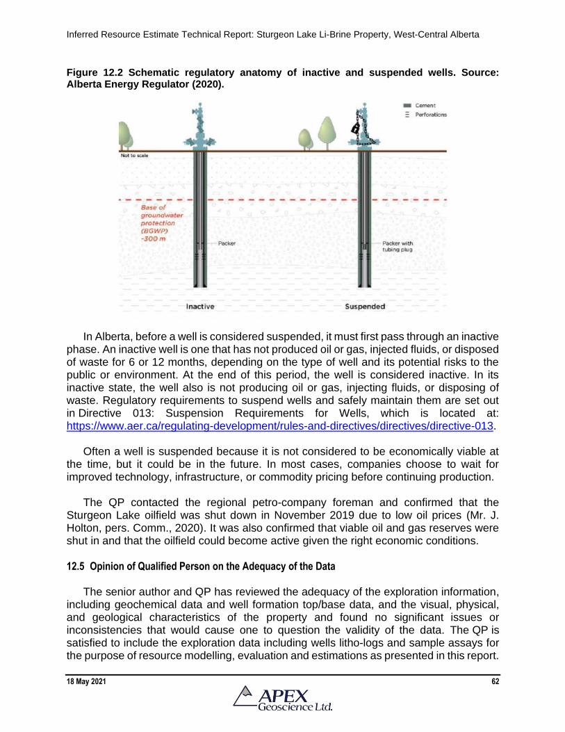
Inferred Resource Estimate Technical Report: Sturgeon Lake Li-Brine Property, West-Central Alberta
18 May 2021 62
Figure 12.2 Schematic regulatory anatomy of inactive and suspended wells. Source: Alberta Energy Regulator (2020).
In Alberta, before a well is considered suspended, it must first pass through an inactive
phase. An inactive well is one that has not produced oil or gas, injected fluids, or disposed of waste for 6 or 12 months, depending on the type of well and its potential risks to the public or environment. At the end of this period, the well is considered inactive. In its inactive state, the well also is not producing oil or gas, injecting fluids, or disposing of waste. Regulatory requirements to suspend wells and safely maintain them are set out in Directive 013: Suspension Requirements for Wells, which is located at: https://www.aer.ca/regulating-development/rules-and-directives/directives/directive-013.
Often a well is suspended because it is not considered to be economically viable at
the time, but it could be in the future. In most cases, companies choose to wait for improved technology, infrastructure, or commodity pricing before continuing production.
The QP contacted the regional petro-company foreman and confirmed that the
Sturgeon Lake oilfield was shut down in November 2019 due to low oil prices (Mr. J. Holton, pers. Comm., 2020). It was also confirmed that viable oil and gas reserves were shut in and that the oilfield could become active given the right economic conditions.
12.5 Opinion of Qualified Person on the Adequacy of the Data
The senior author and QP has reviewed the adequacy of the exploration information, including geochemical data and well formation top/base data, and the visual, physical, and geological characteristics of the property and found no significant issues or inconsistencies that would cause one to question the validity of the data. The QP is satisfied to include the exploration data including wells litho-logs and sample assays for the purpose of resource modelling, evaluation and estimations as presented in this report.

Inferred Resource Estimate Technical Report: Sturgeon Lake Li-Brine Property, West-Central Alberta
18 May 2021 63
13 Mineral Processing and Metallurgical Testing
13.1 Introduction The Saskatchewan Research Council (SRC) completed preliminary tests of lithium
recovery from Leduc Formation aquifer brine collected at the Sturgeon Lake oilfield. The test work follows the process methodology provided by MGX Minerals. In addition, modified processes provided by the SRC were also investigated.
The MGX process includes the following steps:
• Evaporate water from the primary brine to evaporate 90% of the water in the primary brine to produce a secondary brine.
• Separate and store NaCl precipitate
• Add lime (Ca(OH)2) to the secondary brine to precipitate magnesium, sulphate, and other contaminants.
• Separate precipitates for disposal
• Evaporate water from the secondary brine to further concentrate CaCl2 and lithium. Evaporate 80% of the water in the secondary brine to produce a tertiary brine.
• Produce CaCl2 flake – dry and store.
• Separate precipitates for disposal
• Treat the tertiary brine with soda ash (Na2CO3) to precipitate lithium carbonate (Li2CO3)
• Separate Li2CO3 for analysis
• The treated tertiary liquor, containing significant lithium, will be recycled. 13.2 Metallurgical Tests
13.2.1 Sample Assay Results
The assay results of the as received Leduc Formation brine sample (approximately
200 L) are shown in Table 13.1.

Inferred Resource Estimate Technical Report: Sturgeon Lake Li-Brine Property, West-Central Alberta
18 May 2021 64
Table 13.1 Assay Results of the as Received Primary Brine Sample
13.2.2 Initial Evaporation to Precipitate NaCl (MGX process)
Test 1 evaporated 90% of the water from the primary brine. Totally seven (7)
evaporation tests were completed following the MGX process. The processes covered one-stage, two-stage, and five-stage evaporation. Precipitates formed during this initial evaporation were filtered from the hot residual brine. The filtrate turned to gel after cooling to room temperature.
13.2.2.1 Test 1 - One Stage Evaporation
Test Conditions:
1. Heat 5 L brine with agitation to evaporate water ,
2. The precipitates were filtered from the residual brine. The results are shown in Table 13.2.
Table 13.2 Test 1 Results
Element K Mg Na Cl Ca SO42- Sr Br Li
Assay
(ppm)4,212 2,903 60,747 116,632 24,753 186 1,080 334 71
Sample
Feed
brine Filtrate Solid
Recovery
(%)
Weight (g) 5,800 1,097 825 18.9
Li (ppm) 71 346 58 92.2
Mg (ppm) 2,918 12,832 2,623 83.2
Na (ppm) 60,741 8,085 359,427 2.5
K (ppm) 4,212 20,112 4,317 90.3
Ca (ppm) 24,767 96,416 223,699 73.6
Sr (ppm) 1,080 4,609 857 80.7
SO42- (ppm) 186 1,728 1,821 176.1
Evaporated Water (g) 3,650 / / 63.0

Inferred Resource Estimate Technical Report: Sturgeon Lake Li-Brine Property, West-Central Alberta
18 May 2021 65
13.2.2.2 Test 2 - Two Stage Evaporation Test Conditions:
1. Heat 5 L brine to 95-96 °C with agitation to evaporate water in 2 stages.
2. Precipitates formed during evaporation stage 1 were filtered from the hot residual
brine.
3. At the end of stage 2, no precipitates were observed in the hot residual brine. Precipitates formed during cooling the residual brine down room temperature. The precipitated solids were filtered from the cooled brine. The precipitates from the two stages of evaporation were combined.
The results are shown in Table 13.3.
Table 13.3 Test 2 Results
13.2.2.3 Test 3 - Five Stage Evaporation Test Conditions: 1. Heat 5 L brine with agitation to evaporate water in 5 stages.
2. The precipitate was filtered from the hot brine at the end of each of the first 4
stages. 3. In stage 5, the filtrate from stage 4 was heated to reduce the weight by 50%. The
filtration could not be done as the brine solution turned to a gel-like material.
Sample
Feed
brine Filtrate Solid-1 Solid-2
Recovery
(%)
Weight (g) 5,850 1,071 761 28 18.3
Li (ppm) 71 293 63 29 75.6
Mg (ppm) 2,918 11,348 2,834 1,327 71.2
Na (ppm) 60,741 8,744 390,214 3,891,015 2.6
K (ppm) 4,212 17,055 664 3,487 74.1
Ca (ppm) 24,767 88,171 24,943 14,437 65.2
Sr (ppm) 1,080 4,060 933 525 68.8
SO42- (ppm) 186 1,375 1,678 7,714 135.6
Evaporated Water (g) 3,890 / / / 66.0

Inferred Resource Estimate Technical Report: Sturgeon Lake Li-Brine Property, West-Central Alberta
18 May 2021 66
The results are shown in Table 13.4. Table 13.4 Evaporation Test Results of Test 3
As seen in Table 13.2 to Table 13.4, the maximum water evaporation was 66% of the
feed brine mass before gel formation. Approximately 97% of Na, 26% of K, 35% of Ca and 29% of Mg were precipitated. The recovery of Li and Sr was 75.6% and 68.8%, respectively.
It was not a workable process to remove 90% of the water from the initial brine
because the formation of the gel-like material made filtration of the final “brine” impossible. The gel-like material might be formed by crystallization of MgCl2•6H2O and CaCl2•xH2O. It is known that these chlorides tend to form a gel-like substance due to melting or the formation of a solution when they are used as thermochemical storage materials.
In consideration of the primary evaporation test results, and because magnesium
removal by addition of lime before evaporation to precipitate NaCl would be easier to handle than after evaporation, modified processes to first remove magnesium followed by evaporation processes were investigated. These processes would potentially increase lithium recovery.
13.2.3 SRC Modified Processes
The modified processes implemented by the SRC include the following steps:
• Add lime (Ca(OH)2) to the formation brine to precipitate magnesium, sulphate, and other contaminants prior to evaporation.
• Primary evaporation to remove water from the initial brine to precipitate NaCl.
Sample
Feed
brine Filtrate Solid-1 Solid-2 Solid-3 Solid-4
Recovery
(%)
Weight (g) 5,850 1,104 87 357 159 119 18.9
Li (ppm) 71 305 11 17 30 44 81.1
Mg (ppm) 2,918 11,749 603 844 1,447 2,081 76.0
Na (ppm) 60,741 10,436 390,214 389,472 383,538 377,974 3.2
K (ppm) 4,212 18,384 83 1,245 1,328 1,370 82.4
Ca (ppm) 24,767 92,169 4,574 6,861 13,007 18,117 70.3
Sr (ppm) 1,080 4,142 170 254 475 670 72.4
SO42- (ppm) 186 1,327 150 425 3,924 3,026 134.9
Evaporated Water (g) 3,658 / / / / / 63.0

Inferred Resource Estimate Technical Report: Sturgeon Lake Li-Brine Property, West-Central Alberta
18 May 2021 67
• Secondary evaporation from the secondary brine to precipitate CaCl2 and concentrate lithium.
There were four tests completed. The results of the typical tests are presented below.
13.2.3.1 Magnesium Removal Test Conditions:
1. 149.7 g of 95% Ca(OH)2 (in 20% slurry) were slowly added into 10 L stainless steel
beaker containing 10 kg of Formation brine during about 2 hrs with agitation at 560 rpm.
2. The precipitates were filtered out. The results are shown in Table 13.5.
Table 13.5 Magnesium Removal Results
The lime addition dose was determined in a small-scale test which indicated that the dose needs be 59.8% excess of the stoichiometric amount. The pH rose from 6.76 to 11.14 after addition of the lime. The Mg removal was very effective and more than 99.99% of Mg was removed. The residue Mg in the brine was less than 0.1 ppm. The lithium recovery was 84.1% and the Sr recovery was 80.1%.
Sample
Feed
brine Filtrate Solid
Recovery
(%)
Balance
(%)
Weight (g) 10,000 9,950 216 99.5 /
pH 7 11 / / /
Li (ppm) 71 60 135 84.1 88.2
Mg (ppm) 2,918 <0.1 139,311 0.0 103.3
Na (ppm) 60,741 52,422 89,764 85.9 89.1
K (ppm) 4,212 3,712 5,811 87.7 90.7
Ca (ppm) 24,767 25,134 230,131 101.0 121.1
Sr (ppm) 1,080 869 1,750 80.1 83.6
SO42- (ppm) 186 602 4,883 322.6 379.4

Inferred Resource Estimate Technical Report: Sturgeon Lake Li-Brine Property, West-Central Alberta
18 May 2021 68
13.2.3.2 Primary Evaporation to Precipitate NaCl Test Conditions:
1. The brine (the filtrate from the Mg removal test) was first heated for 2.5 hrs, first
filtered while hot, then filter again after cooling room temperature.
2. The combined filtrates were heated again for 2 hrs, the dual filtration process in step 1 immediately above was performed, and all solids were combined.
The results are shown in Table 13.6.
Table 13.6 Primary Evaporation to Precipitate NaCl Results
As can be seen in Table 13.6, after water evaporation totalling 67% of the feed brine
mass, more than 96% of Na was removed as NaCl. There were relatively slight Li or Sr loss in this process. Li was concentrated from 60 ppm to 321 ppm.
13.2.3.3 Secondary Evaporation to Precipitate CaCl2 and Concentrate Lithium
Test Conditions:
1. The brine (the filtrate from primary evaporation test) was heated and filtered while
hot, filtered again after cooling to room temperature. All solids were combined.
2. When 60 g of the filtrate were heated again to evaporate water to reduce the brine mass to 46.3 g, the brine sample turned to a gel-like material.
Sample
Feed
brine Filtrate Solid
Recovery
(%)
Balance
(%)
Weight (g) 5,000 989 620 19.8 /
pH 11 9 / / /
Li (ppm) 60 321 31 105.8 112.3
Mg (ppm) <0.1 1 <MLD n/a n/a
Na (ppm) 52,422 10,219 384,650 3.9 94.9
K (ppm) 3,712 18,749 2,823 99.9 109.3
Ca (ppm) 25,134 107,674 16,867 84.8 93.1
Sr (ppm) 869 4,477 498 101.9 109.0
SO42- (ppm) 602 1,770 1,669 58.2 92.5
Evaporated Water (g) 3,334 / / 67.0 /
MLD - Minimum limit of detection

Inferred Resource Estimate Technical Report: Sturgeon Lake Li-Brine Property, West-Central Alberta
18 May 2021 69
The results are shown in Table 13.7.
Table 13.7 Secondary Evaporation to Precipitate CaCl2 Results
The test results show that only 26% of the initial brine mass was evaporated in this
process. 12% of Ca was removed in this process. The lithium recovery was 94.1% and the Sr recovery was 94.6%. The brine turned to a gel after further evaporation (60 g to 46.3g) to remove 40% of the brine mass as water.
The results of the whole process are summarized in Table 13.8.
Table 13.8 Element Recovery (%) and Treated Brine Composition
Sample
Feed
brine Filtrate Solid
Recovery
(%)
Balance
(%)
Weight (g) 102 67 3 65.5 /
Li (ppm) 321 461 53 94.1 94.5
Mg (ppm) 1 <MLD <MLD n/a n/a
Na (ppm) 10,219 2,080 256,681 13.3 81.2
K (ppm) 18,749 17,944 149,427 62.7 84.2
Ca (ppm) 107,674 144,812 63,286 88.1 89.7
Sr (ppm) 4,477 6,462 932 94.6 95.1
SO42- (ppm) 1,770 2,438 1,078 90.2 34.8
Evaporated Water (g) 26 / / 26.0 /
Operation
Mg
Removal
NaCl
Precipitation
CaCl2
Precipitation Total
Treated
Brine
(ppm)
Water Evaporated (%) n/a 67 26 72.0
Li 84 106 94 83.7 461
Mg 0 n/a n/a n/a 128
Na 86 4 13 0.4 2,080
K 88 100 63 54.9 17,944
Ca 101 85 88 75.4 144,812
Sr 80 102 95 77.2 6,462
SO42- 323 58 90 169.3 2,438

Inferred Resource Estimate Technical Report: Sturgeon Lake Li-Brine Property, West-Central Alberta
18 May 2021 70
As shown in Table 13.8, the estimated water evaporated during the processes was 72% of the total feed brine mass. More than 99.99% of Mg, 99% of Na, 45% of K and 25% of Ca were precipitated from the brine after the treatments. The overall recovery was 83.7% for Li and 77.2% for Sr.
Lithium was concentrated to 461 ppm from 71 ppm. However, the impurity level,
especially Ca, was still very high and is not suitable for ion exchange (IX) treatment to remove the reside impurities. One of the possible process to remove the high residue Ca is to precipitate Ca as Ca carbonate using sodium carbonate. However, it is not a cost-effective method because of the high Ca concentration.
13.3 Mineral Processing Summary
1. It was not practicable to remove 90% of the water in the primary evaporation of the formation brine because the formation of a gel-like material made filtration impossible. The maximum water evaporation was 66% of the feed brine mass before the gel formation. Approximately 97% of Na, 26% of K, 35% of Ca and 29% of Mg were precipitated. The recovery of Li and Sr was 75.6% and 68.8%, respectively.
1. The modified processes include magnesium precipitation by lime followed by a primary evaporation to precipitate NaCl and a secondary evaporation to precipitate CaCl2 and raise the lithium concentration.
2. The Mg removal was very effective, more than 99.99% of Mg was removed. The residue Mg in the brine was less than 0.1 ppm. The lithium recovery was 84.1% and the Sr recovery was 80.1%.
3. In the primary evaporation process, 67% of the feed brine mass was evaporated
as water and more than 96% of Na was removed as NaCl. There were slight Li or Sr losses in this process. Li was concentrated from 60 ppm to 321 ppm.
4. In the secondary evaporation process, 26% of the feed brine mass was evaporated
as water and 12% of Ca was removed as CaCl2. The lithium recovery was 94.1% and the Sr recovery was 94.6%. The sample turned to a gel after further evaporation intended to remove 40% of the brine mass as water.
5. In the whole process, the estimated water evaporated was 72% of the total feed
brine mass. More than 99.99% of Mg, 99% of Na, 45% of K and 25% of Ca were precipitated from the brine. The overall recovery was 83.7% for Li and 77.2% for Sr. Lithium was concentrated to 461 ppm from 71 ppm. However, the impurity concentrations, especially of Ca, were still too high to allow IX treatment to remove the reside impurities.

Inferred Resource Estimate Technical Report: Sturgeon Lake Li-Brine Property, West-Central Alberta
18 May 2021 71
13.4 Mineral Processing Recommendations
Based on the testing results, as well as the relatively low lithium concentration and the relatively high concentration of impurities in the formation brine, the following tests are recommended.
1. Investigate ion exchange (IX) technology with Li-selective resins to directly recover
lithium from the formation brine.
2. Investigate solvent extraction (SX) technology with a suitable extractant such as Tributyl phosphate (TBP) to directly extract lithium from the formation brine.
13.5 Opinion of Qualified Person Including Preliminary Risks and Uncertainties
The QP has reviewed the SRC methodologies and data results presented in Section 13 as an independent reviewer. The methods and procedures used are reasonable and include standard applications and practices that are currently being applied in the Li-brine mineral processing industry.
The senior author, Roy Eccles P. Geol. collected the Leduc Formation brine sample
that was evaluated by the SRC and has provided additional geochemical information that shows the brine tested and reported on in Section 13 is representative of the high-TDS Leduc Formation aquifer brine underlying LithiumBank’s Sturgeon Lake Property.
It should be noted that MGX Minerals contracted the SRC to beneficiate the Leduc
Formation brine to higher levels of lithium content. This mineral processing should, therefore, not be misconstrued with extraction of the lithium from the brine. Additional processing steps such as solvent extraction and/or ion absorption are required to remove lithium from the brine.
The QP is aware that advanced benchtop lithium processing test work has been
performed by the SRC on Alberta Devonian Beaverhill Lake Group brine, which has similar chemical properties as the Leduc Formation brine being tested by LithiumBank. In this study, the selective extraction technique was applied with a minimum of 90.4% lithium recovered from the loaded ionic sieve (Eccles and Dufresne, 2018). This suggests the potential exists to produce high purity lithium products following current industrial lithium precipitation processes.
The Li-concentration processes tested by SRC, entailing thermal evaporation of water
and precipitation followed by filtration of some impurities, would appear to be relatively high cost (because of the heat required for the evaporation steps) and show a substantial Li loss with Li recovery from 92.2% to 75.8%.
It is recommended that membrane filtration be tested as an alternative method for
increasing the concentration of Li in the brine to a level suitable for further processing by ion exchange or solvent extraction.
Inferred Resource Estimate Technical Report: Sturgeon Lake Li-Brine Property, West-Central Alberta
18 May 2021 72
14 Mineral Resource Estimates
14.1 Introduction and Resource Estimation Steps
LithiumBank’s Sturgeon Lake Li-Brine Project is an early-stage exploration project. Stratigraphically, the resource area is confined to the subsurface, confined Devonian Leduc Formation aquifer underlying the Property.
Statistical analysis, three-dimensional (3-D) modelling and resource estimation was prepared by Mr. Black, M.Sc. P. Geo. of APEX. The modelling and estimation work were performed in direct collaboration and supervision of Mr. Eccles, M.Sc. P. Geol. who takes responsibility for the resource estimation presented in this Technical Report. The workflow implemented for the calculation of the Sturgeon Lake lithium-brine resource estimation was completed using: the commercial mine planning software MicroMine (v 20.5). Critical steps in the determination of the LithiumBank lithium-brine resource estimation include:
• Hydrogeological characterization and a historical compilation and assessment of mean porosity within the Devonian Leduc Formation reef.
• Definition of the geology, geometry, and pore space volume of the subsurface Leduc Formation domain aquifer brine underlying Sturgeon Lake Property.
• Determination of the lithium-in-brine concentration in the Devonian Leduc Formation domain aquifer.
• Demonstration of reasonable prospects of eventual economic extraction.
• Estimate of the in-situ lithium resources of Leduc Formation aquifer brine underlying the Sturgeon Lake Property using the relation:
Lithium Resource = Total Volume of the Brine-Bearing Aquifer X Average Effective Porosity X Percentage of Brine in Pore Space x Average Concentration of Lithium in the Brine.
The Sturgeon Lake Li-Brine Resource Estimate is reported in accordance with NI 43-
101 and has been estimated using the CIM “Estimation of Mineral Resources and Mineral Reserves Best Practice Guidelines” dated November 29th, 2019, and CIM “Definition Standards for Mineral Resources and Mineral Reserves” amended and adopted May 10th, 2014. Mineral resources are not mineral reserves and do not have demonstrated economic viability. There is no guarantee that all or any part of the mineral resource will be converted into a mineral reserve.
The Li-brine resource is also reported in compliance with the CIM Best Practice
Guidelines for Resource and Reserve Estimation for Lithium Brine (1 November 2012). This guideline provides specific criteria for Li-brine modelling and estimation that include

Inferred Resource Estimate Technical Report: Sturgeon Lake Li-Brine Property, West-Central Alberta
18 May 2021 73
definition of the aquifer boundaries; brine chemistry; and depiction of the hydrology of the brine aquifer. These guidelines are somewhat dated in that the focus is on ‘unconfined’ continental brine deposits (i.e., salars). Accordingly, the authors have considered all criteria of the CIM Best Practice for Resource and Reserve Estimation for Lithium Brine and used professional judgement in applying them to a ‘confined’ subsurface aquifer.
The Effective Date of the Sturgeon Lake Li-brine resource estimate is 18 May 2021.
14.2 Data
14.2.1 Subsurface Hydrogeological and Geological Model
Hydrogeological characterization of the Leduc Formation aquifer at LithiumBank’s Sturgeon Lake Property, and Sturgeon Lake oilfield reservoir, has been acquired from a variety of public and proprietary sources that include:
• Government reports and information from the Alberta Energy Regulator (AER) databases, Alberta Geological Survey reports, and the Alberta Environment and Parks (AEP) water well information database.
• Third-party oil and gas well databases such as GeoSCOUT, GeoVista, and Accumap.
• Proprietary databases maintained by HCL that includes regional stratigraphic information of the subsurface geology of Alberta (i.e., stratigraphic top picks).
The stratigraphic formation picks database was used to create a 3-D geological model
and define the boundaries of the Leduc Formation aquifer (see Section 14.4). The database includes 4,130 total records that is divided into 2,322 records from the AEP Groundwater Centre Database and 1,808 petroleum well records from the AER database. This information was used to model the subsurface underlying the Sturgeon Lake Property with emphasis on the Devonian Leduc, Beaverhill Lake, and Elk Point (Watt Mountain) stratigraphic units. Table 14.1 summarizes the number of picks, and their data source, that were used to determine the tops of the stratigraphic formations.
Calculations of fluid yields from Leduc Formation relied on 3 main components: 1) a
determination of aquifer parameters that include, for example, aquifer thickness, porosity, permeability, apparent transmissivity, and storativity; 2) the review and analysis of historic fluid production and injection reported by oil and gas companies to the AER; and 3) the effect that fluid production has had on fluid levels in the Leduc Formation. Apparent transmissivity values are based on the inflow and pressures measured during the DST’s or are calculated from permeability data determined from core plug measurements. Fluid levels are based on formation pressures.

Inferred Resource Estimate Technical Report: Sturgeon Lake Li-Brine Property, West-Central Alberta
18 May 2021 74
With respect to the percentage of brine within the Leduc Formation pore space, the most recent 3 years of fluid production data was evaluated (n=157 records). In this case, the most recent available data was from 2008 to 2011.
Table 14.1 Summary of picks used to model the Leduc, Beaverhill Lake, and Elk Point (Watt Mountain) stratigraphic units.
14.2.2 Lithium Analytical Data Li-brine assay data pertinent to calculating an average lithium value for resource
information is culled from historical Government of Alberta reports (Eccles and Jean, 2010; Eccles and Berhane, 2011; Huff, 2016, 2019; Huff et al., 2011, 20212, 2019) and exploration industry company reports (Lithium Exploration Group, 2016; MGX Minerals Ltd., 2016). 14.2.3 Data QA/QC
The site inspection allowed the senior author and QP to confirm the geological interpretations made in support of mineral resource estimation. The verification of the drill databases conducted by APEX in preparation of the mineral resource estimates presented in Chapter 14 have shown the data to be reliable and accurate. Further, results of the independent analytical test work conducted by APEX demonstrate that the LithiumBank assay dataset is valid and appropriate to be used in resource estimation without any limitations. The qualified person therefore considers that the data is adequate for the estimation of mineral resources in accordance with NI 43-101 and CIM definitions and guidelines (2014, 2019). 14.3 Hydrogeological Characterization of the Leduc Formation Aquifer
This sub-section has been prepared by Hydrogeological Consultants Ltd. (HCL) of
Edmonton, AB. HCL is independent of LithiumBank, specializes in groundwater and surface water consulting services, and has been commissioned by two previous Li-brine
Source Total No. of Picks No. Removed
GeoVista 318 8
Accumap 502 12
GeoVista 159 12
Accumap 214 16
HCL 105 10
GeoVista 12 2
Accumap 119 2
HCL 11 2
Leduc
Beaverhill Lake
Elk Point

Inferred Resource Estimate Technical Report: Sturgeon Lake Li-Brine Property, West-Central Alberta
18 May 2021 75
exploration companies that have shown interest in lithium-enriched Devonian aquifer brine underlying the Sturgeon Lake Property.
HCL conducted a hydrogeological characterization study of the Upper Devonian
Woodbend Group Leduc Formation using data derived largely from petroleum exploration and production at the Sturgeon Lake oilfield.
As per CIM Best Practice Guidelines for Li-Brine Resources (1 November 2012), the
intent of this subsection is to provide an understanding of the hydrology of the brine, and the water balance of the aquifer and the brine itself, for the proper evaluation of a Li-brine resource. It is important that hydrostratigraphic characteristics of a confined aquifer such as porosity, permeability, fluid production and injection, apparent transmissivity, storativity, long-term yield, and formation water modelling be discussed to enable the preparation of brine resource estimates.
14.3.1 Relationship Between the Leduc Formation and Beaverhill Lake Group Aquifers
Hitchon, et al. (1995) considered the Leduc Formation to be hydraulically connected
to the Beaverhill Lake Group in west-central Alberta. The validity of hydraulic connection between the Leduc and Beaverhill Lake aquifers at Sturgeon Lake can be determined by a review of the 1) similarity in hydrostatic pressure as determined from drill stem test (DST) data, and 2) analogous formation-water chemistry of brine from the two aquifers.
The Leduc Formation fluid-level data indicate an original fluid-level elevation in the
late 1950s of approximately 800 m asl, with a downward trend to a maximum low elevation of approximately 300 m asl by 1990 (Figure 14.2).
In contrast and apart from a limited segment of pressure-survey data between 1988
and 1993, the Beaverhill Lake Group has a distinctly different pressure survey profile in comparison to the profile of the Leduc Formation. The Beaverhill Lake Group fluid levels from the mid-1960s to the mid-1980s are at least 200 m higher in elevation than the Leduc fluid levels, with a projection to a pre-development fluid-level elevation in the late 1950s of approximately 1,000 m asl.
With respect to geochemical comparisons, the Piper tri-linear diagram in Figure 14.2
compares the chemical quality of 77 Leduc Formation fluid samples against 21 Beaverhill Lake Group fluid samples. These historical analyses were all derived from the Sturgeon Lake oilfield. The diagram shows the chemical quality of the brine from the Leduc Formation can be classified as a sodium-calcium-chloride-type water. In comparison, the brine from the Beaverhill Lake Group can be classified as a sodium-chloride-type water. Hence, the Leduc Formation aquifer has a slightly higher calcium to sodium ratio in formation water in comparison to formation water in comparison to brine from the Beaverhill Lake Group.

Inferred Resource Estimate Technical Report: Sturgeon Lake Li-Brine Property, West-Central Alberta
18 May 2021 76
Figure 14.1 Leduc Formation and Beaverhill Lake Group fluid levels based on drill stem tests results and pressure-survey results.
Figure 14.2 Formation water comparison on the tri-linear diagram of Piper (1944).
80
60
40
20 2
0
40
60
80
20
40
60
80 80
60
40
20
20
40
60
80
20
40
60
80
Ca Na+K HCO3 Cl
Mg SO4
C C
C
AA
A
AA
A
AA
A
AA
A
AA
A
A
A
A
AA
A
A
A
A
AA
A
AA
A
AA
A
AA
A
AA
A
A
A
A
A
A
A
A
A
A
AA
A
AA
A
AA
A
AA
A
AA
A
AA
A
A
A
A
C
C
C
C C
C
C C
C
C C
C
AA
A
A
A
A
AA
A
AA
A
A
A
A
C C
C
CC
C
A
A
A
AA
A
AA
A
AA
A
CC
C
CC
C
AA
A
AA
A
AA
A
AA
A
A
A
A
AA
A
AA
A
AA
A
AA
A
AA
A
AA
A
CC
C
AA
A
AA
A
CC
C
A
A
A
C C
C
AA
A
AA
A
AA
A
AA
A
AA
A
AA
A
AA
A
AA
A
AA
A
AA
A
AA
A
A
A
A
A
A
A
CC
C
A
A
A
CC
C
AA
A
A
A
A
A
A
A
AA
A
AA
A
AA
A
AA
A
AA
A
AA
A
AA
A
A
A
A
A
A
A
CC
C
CC
C
C C
C
A
A
A
CC
C
CC
C
CC
C
LegendLegend
A Leduc Geounit
C BHL Geounit

Inferred Resource Estimate Technical Report: Sturgeon Lake Li-Brine Property, West-Central Alberta
18 May 2021 77
Although there is a similarity in the chemical quality of the Leduc Formation and Beaverhill Lake Group brine, the apparent difference in elevation of approximately 200 m in the pre-1960 fluid levels of the Leduc Formation and Beaverhill Lake Group and the more calcium-rich Leduc brine suggests the two units are hydraulically separate within the Sturgeon Lake reservoir.
Because the Leduc Formation reservoir is the primary host for Devonian-aged
hydrocarbon production in the Sturgeon Lake oilfield (and associated brine for potential lithium extraction), and because of the paucity of reliable data for the Beaverhill Lake Group, the following hydrogeological discussion places emphasis on the Leduc Formation aquifer and brine. 14.3.2 Effective Porosity
Effective porosity values are determined by measuring porosity on individual core
plug samples. Hitchon et al. (1995) documented the Leduc North zone, which is equivalent to the Sturgeon Lake Leduc Formation reservoir, to be approximately 12 m thick with an average porosity of 6%.
Historical core plug porosity measurements are available at the AER. A total of 99
effective porosity core plug measurements were reviewed from the Leduc Formation within the Sturgeon Lake Property. The summarized porosities for the Leduc Formation have an average effective porosity of 5.3% with a geomean of 5.0% (Table 14.3).
Table 14.3 Summary of effective porosity as measured from Leduc Formation core plugs from the Sturgeon Lake oilfield.
14.3.3 Total Porosity Three downhole well logs were selected within the Sturgeon Lake Property as a
means of comparing the effective porosity with calculated total porosity acquired from a variety of petrophysical wireline curves (e-logs; Table 14.4). The well logs were also used to assess porosity at vertical levels within the Leduc Formation stratigraphy.
Table 14.4 A summary of the electric-log curve data for three downhole well logs.
No. of
Geounit Average Geomean Cores
Leduc 5.3% 5.0% 99
BHL 4.7% 3.6% 30
Calculated Porosity (%)
Well Deep Induction Delta Transit
Location (W5M) Resistivity Time (Sonic)
11-10-069-22 x x
13-03-069-21 x x x x
07-33-068-21 x x x
E-Log Curve
Dual Induction
Gamma Ray
Neutron Porosity -
Sandstone and Limestone
Spontaneous
PotentialNeutron

Inferred Resource Estimate Technical Report: Sturgeon Lake Li-Brine Property, West-Central Alberta
18 May 2021 78
An analysis of selected well e-logs was conducted to determine porosity. Calculations of porosity from the delta transit time (sonic) curve were based on the Wyllie et al. (1956) time-average equation:
)(
)(
maf
ma
tt
tt
−
−=
Where:
= porosity
t = transit time from sonic log
tf = 620 µsec/metre for fresh mud
tma = 155.8 µsec/metre for limestone, 142.7 µsec/metre for dolomite and 182.1 µsec/metre for quartz.
The calculated total porosity of an interval of Leduc Formation between -2,603 and -
2,785 m below the Kelly Bushing (kb) from well 11-10-069-22 W5M is presented in Figure 14.4. Based on analysis of the delta transit time (sonic) curve for dolomite, the sonic curve indicates an average porosity of 5.7%.
Figure 14.4. Total Leduc porosity using the sonic curve from well 00/11-10-069-22W5.
2550
2560
2570
2580
2590
2600
2610
2620
2630
2640
2650
2660
2670
2680
2690
2700
2710
2720
2730
2740
2750
2760
2770
2780
2790
2800
2810
2820
2830
2840
-5% 0% 5% 10% 15% 20%
De
pth
in M
etre
s K
b
Porosity
- Dolomite
Sonic
Leduc
BHL

Inferred Resource Estimate Technical Report: Sturgeon Lake Li-Brine Property, West-Central Alberta
18 May 2021 79
Table 14.5 summarizes the average calculated total porosity of the Leduc Formation from the 3 wells selected for analysis; the average porosity from the sonic and neutron porosity curves is 5.1%.
The petrophysical trace for the 07-33 well showed a divergence below a depth of
approximately -2,808 m Kb, which indicates the dolomite unit identified in the upper part of the Leduc Formation terminates at this depth. If the porosity values deeper than -2,808 m Kb in the Leduc Formation are excluded, the average porosity from the sonic curve and the neutron porosity curve is 5.3%. A similar divergence occurs with the curves from the 13-03 well.
The average total porosity for the upper part of the Leduc Formation was calculated
from 2 of the 3 wells (Table 14.5). The upper part of the Leduc Formation was not calculated for the 11-10 well because the neutron porosity curve was unavailable. Consequently, the review of average total porosity from the e-logs showed the upper portion of the Leduc Formation has higher average total porosity (5.6%) in comparison to the overall Leduc strata (4.7%; Table 14.5; Figure 14.4).
Table 14.5 Porosity of the Leduc Formation at the Sturgeon Lake oilfield.
14.3.4 Permeability
There are no known conclusive values for permeability of the Leduc Formation in the
Sturgeon Lake reservoir. Hitchon, et al. (1995) reported that the Leduc Reef North Zone, which correlates spatially and stratigraphically with the Sturgeon Lake Leduc reefal zone, is approximately 12 m thick, has an average porosity of 6%, and an average permeability of 3.5 × 10⁻¹⁴ m² (35 md).
An average permeability at Sturgeon Lake was determined from GeoVista, which
includes 3 permeability measurements labelled Kmax, K90, and Kvert. Kmax is the maximum measured permeability in the core perpendicular to the core axis. This direction is determined by measuring the pressure drop across the core and then rotating the core horizontally along its axis until the minimum pressure drop is achieved. K90 is measured after rotating the core 90 degrees horizontally from the direction of Kmax; K90 must be less than or equal to Kmax. Kvert is measured by flowing fluid through the vertical direction of the core. Kvert is often less than Kmax in sandstone and shaly sandstone;
11-10-069-22 5.7 - Sonic
5.6 6.7 Sonic
3.0 5.2 Neutron Porosity
5.0 5.3 Sonic
4.0 5.3 Neutron Porosity
Average: 4.7 5.6
*Corrected for dolomite
E-Log Curve*
07-33-068-21
13-03-069-21
Average Calculated Porosity (%)
Upper Part of Leduc Geounit
Average Calculated Porosity (%)
Leduc Geounit
Well Location
(W5M)

Inferred Resource Estimate Technical Report: Sturgeon Lake Li-Brine Property, West-Central Alberta
18 May 2021 80
however, Kvert may be greater than Kmax if vertical fractures exist, as they do in many carbonate reservoirs.
Examples of average Kmax and K90 permeability from the Leduc Formation at the
Sturgeon Lake Property is presented in Table 14.6. Of the 99 separate core measurements obtained from GeoVista, the Kmax permeabilities ranged from 0.84 to 3,669 md, with an average of 603 md and a geomean of 214 md. The K90 values ranged from 0.18 to 2,742 md, with an average of 199 md and a geomean of 39 md.
The average permeability value of 199 md is significantly higher than the average
permeability of 35 md reported by Hitchon, et al. (1995) and Bachu et al. (1995). It should be noted, therefore, that there is extreme heterogeneity in rock properties on the core scale and as a result, the information provided by the core results should not be considered representative of the entire Leduc Formation.
Table 14.6. Selected average permeability from Leduc Formation core plug samples.
14.3.5 Lost Circulation
Losing circulation while drilling through a formation can be an indication of high local
permeability. The GeoVista database was used to identify wells within the Sturgeon Lake area where lost circulation occurred while drilling through the Leduc Formation.
Within the Sturgeon Lake oilfield, the GeoVista database includes 63 lost-circulation
occurrences while drilling through the Leduc Formation. Of the 63 lost-circulation events in the Leduc Formation, 28 had a reported lost-circulation volume ranging from 4.3 to 288 m3, and the other 35 events had no reported volumes. All 63 lost-circulation events had a reported severity code of 0.
Severity codes have been assigned by GeoVista. A severity code of zero means
there was no lost-circulation volume reported. A severity code of 1 is minor, with less than 100 m3 of lost-circulation volume reported. A severity code of 2 is severe, with more than 100 m3 of lost-circulation volume reported.
Transmissivity
Keyvalue Kmax K90 Top Bottom (m²/day)
00/13-27-068-22W5 1,477 868 -1,943.9 -1,929.1 0.32
00/09-08-069-22W5 3,669 2,742 -1,940.1 -1,937.7 0.33
00/01-31-068-21W5 1,567 543 -1,934.5 -1,866.5 0.38
00/02-29-071-23W5 1,790 1,511 -1,917.1 -1,913.1 0.38
00/09-18-070-23W5 3,024 4 -1,938.9 -1,936.6 0.66
00/05-24-068-22W5 2,846 2,571 -1,950.4 -1,941.9 0.77
Average: 0.5
Elevation of Cored
Interval (m AMSL)
Average Permeabilities
(md)

Inferred Resource Estimate Technical Report: Sturgeon Lake Li-Brine Property, West-Central Alberta
18 May 2021 81
14.3.6 Transmissivity (From Core Plug Measurements) Transmissivity values were calculated from the 99 Leduc Formation core sample
measurements from wells within the Sturgeon Lake oilfield by 1) averaging the Kmax and K90 permeabilities (in md), 2) converting the permeability to hydraulic conductivity (in m/day using a coefficient of 0.00083; Table 5.2 of the Hydrology Handbook, American Society of Civil Engineers, 1996), and 3) converting hydraulic conductivity to transmissivity by multiplying the value by the core length.
The calculated transmissivity is averaged for the entire cored interval through the
Leduc Formation with average and geomean transmissivity values of 0.091 m²/day and 0.031 m²/day (Table 14.7). Table 14.7 Calculated average transmissivity.
The results in Table 14.7 are lower than the average transmissivity of 0.35 m²/day
documented by Hitchon, et al. (1995) based on a reef thickness of approximately 12 m thick, an average porosity of 6%, and a permeability of 3.5 × 10⁻¹⁴ m² (35 md)
It is important to note that oil, gas, and water have different viscosities, which will
affect calculations of permeability and transmissivity values. For the present review, the authors assume the viscosity of saline water is the same as non-saline water.
14.3.7 Transmissivity (From Drill Stem Tests)
Transmissivity values for a confined aquifer are calculated from aquifer test data from
pumped water well(s) using the Cooper-Jacob approximation of the Theis non-equilibrium equation. Transmissivity values from observation water well data are determined using type-curve matching to solve the Theis non-equilibrium equation.
For the Leduc Formation, there are 52 DSTs from 41 wells that contain sufficient
information to calculate an apparent yield. Of these 52 DSTs, the average apparent transmissivity ranged from 1 × 10⁻⁶ m²/day to 76 m²/day. When the apparent transmissivities of two outliers (24 m²/day and 76 m²/day) are removed from the dataset, 50 of the 52 DSTs indicate an average apparent transmissivity of 2.2 m²/day.
The 50 Leduc Formation DSTs associated with an apparent transmissivity of between
zero and 3.0 m²/day indicate theoretical long-term water source well yields of less than 1 m²/day to 3,929 m³/day (Table 14.8).
No. of
Geounit Average Geomean Cores
Leduc 0.091 0.031 99
BHL 0.027 0.002 30
Calculated Transmissvity (m²/day)

Inferred Resource Estimate Technical Report: Sturgeon Lake Li-Brine Property, West-Central Alberta
18 May 2021 82
Table 14.8 Drill stem test transmissivity results.
The two DSTs with apparent transmissivities of 24 m²/day and 76 m²/day indicate
anomalously high theoretical long-term water source yields of 26,300 and 90,000 m³/day. A water source well associated with the theoretical yield of 26,300 m³/day had a second DST result from a similar depth interval indicating a yield of 0.0 m³/day. The wells associated with the two anomalously high theoretical yields are located within the LithiumBank permit area, in wells 01-08-069-22 W5M and 06-02-072-24 W5M.
14.3.8 Transmissivity Conclusion
Definitive estimates of the transmissivity of the Leduc Formation aquifer system in
the Sturgeon Lake Property are largely uncertain and have been obtained from various methods. HCL recommends the best estimate from the existing data of the effective transmissivity is 1.0 m2/day. This is based on:
1. A government calculated transmissivity estimate of 0.35 m²/day Hitchon, et al.
(1995).
2. Core-analytical results yield average apparent transmissivities of 0.09 m²/day.
3. DST results indicated average apparent transmissivities of 2.2 m²/day.
14.3.9 Storativity and Theoretical Long-Term Yield The storage coefficient for a confined aquifer represents formation water derived
relative to 1) the expansion of brine as the aquifer is depressurized; and 2) compression of the aquifer. Storativity is calculated from the analysis of drawdown measured in a suitable observation water well using the Cooper-Jacob approximation of the Theis non-equilibrium equation. In the absence of observation water well data, the storativity is estimated based on the lithology of the aquifer. A storativity of 6.0 × 10⁻⁵ has been estimated for the Leduc Formation aquifer in the Sturgeon Lake reservoir.
The theoretical long-term yield is calculated using the Modified Moell method
(Government of Alberta, 2011) and is based on the fluid level in the pumped well being lowered by 70% of the available drawdown after 20 years of fluid diversion. The Infinite Artesian Aquifer Model (IAAM) developed by HCL calculates drawdown values at a given point at a given time by solving the well function equation for non-leaky artesian aquifers.
No. of
Geounit From To From To Tests
0.0 0.3 0.0 321 38
0.3 3.0 385 3,929 12
3.0 76 26,300 90,000 2
0.0 0.3 0.00 246 18
0.3 3.0 409 3,750 4
3.0 293 198,000 458,000 2
BHL
Leduc
Calculated Transmissivity (m²/day) Theoretical WSW Yield (m³/day)

Inferred Resource Estimate Technical Report: Sturgeon Lake Li-Brine Property, West-Central Alberta
18 May 2021 83
The information provided by the IAAM modelling indicates that a potential long-term yield of more than 2,000 m³/day would be sustainable from wells completed in the Leduc Formation within the Sturgeon Lake reservoir. The number of wells required to divert this volume of formation water would depend on the hydraulic efficiency of individual wells.
In a theoretical exercise, HCL investigated the long-term yield of a single well. The
test is based on an aquifer that is homogeneous and isotropic, with no recharge. Based on the following conditions, the projected theoretical long-term yield for a Leduc Formation well is in the order of 1,100 m³/day, with the following parameters:
• Available drawdown: 2,900 m
• Effective transmissivity: 1.0 m²/day The available drawdown of 2,900 m is based on the calculated fluid level in the Leduc
Formation at Sturgeon Lake in 2010. It should be noted that the long-term yield calculation does not include interference from existing pumping wells. However, there has been a net injection of liquid into the Leduc Formation since 1991. Therefore, interference effects are negligible.
In a second theoretical exercise, HCL investigate the long-term yield of 4 proposed
source wells: 02/06-36-068-22W5, 00/16-31-068-21W5, 00/06-12-069-22W5, and 00/06-19-069-22W5. Aquifer parameters used in the IAAM modelling include an effective transmissivity 1.0 m²/day, and a corresponding storativity of 6.0 × 10⁻⁵. The calculations assume that there is no net injection or diversion of liquid into or out of the Leduc Formation apart from the 2,000 m³/day represented by the four proposed water source wells. The aquifer parameters used in the drawdown calculations reflect the boundary conditions caused by an aquifer of limited areal extent.
The modelling results imply that a long-term yield of more than 2,000 m³/day over a
20-year interval might be sustainable from water source wells completed in the Leduc Formation within the Sturgeon Lake reservoir. The number of wells required to divert this volume of formation water would depend on the hydraulic efficiency of individual water source well(s) being pumped.
14.3.10 Fluid Production and Injection
Reported fluid diversion from the Leduc Formation began in 1961, with an
anomalously high 2,383,527 m3 reported in that year (an average of 6,530 m³/day; Figure 14.5). The actual diversion began several years earlier, with the sum for the earlier years likely amalgamated into 1961. The average fluid diversion from the Leduc Formation has generally increased every decade from the 1960s to 2000. Since 2000, the annual diversion has been in the order of 3 million m3 per year. A review of the reported completion intervals shows that the Leduc Formation is the source of fluid production in the Sturgeon Lake oilfield.
Inferred Resource Estimate Technical Report: Sturgeon Lake Li-Brine Property, West-Central Alberta
18 May 2021 84
Senior author notes: Petro-operations producing from the Leduc Formation reservoir at the Sturgeon Lake oilfield are now in suspended mode as per Section 6.1.
The reported injection has followed a similar trend to the reported production (Figure
14.5), although the annual injection has increased at a faster rate than the pumping rate, resulting in a situation in which the total injection into the Leduc Formation has been greater than the total diversion out of the Leduc Formation, beginning in 1991. From 2000 through 2010, the average annual injection into the Leduc Formation has been 3,894,523 m3 (10,670 m³/day), which is nearly 20% more than the liquid volume removed during the same interval.
A total of 73,178,693 m3 of liquid was pumped from Leduc Formation wells at the
Sturgeon Lake oilfield from 1961 to the end of 2010, of which 72% was reported to be formation water. By comparison, a total of 73,146,659 m3 of fluid was injected into the Leduc Formation within the Sturgeon Lake oilfield over the same length of time, representing a difference of less than 1% between net total injected and total pumped volumes.
Within the Sturgeon Lake oilfield, and circa 2012 when the oilfield was in full
production, a total of 146 wells were assessed for their diversion of brine from the Leduc Formation reef. Of these 146 wells,
• 86 wells pumped less than 100,000 m3; these 86 wells produced an average daily formation water diversion of approximately 8 m3.
• 46 wells pumped between 100,000 and 1,000,000 m3; these 46 wells produced an average daily formation water diversion of 46 m3.
• 14 wells pumped more than 1,000,000 m3; these 14 wells produced an average daily formation water diversion of 184 m3 per well.
• 4 wells diverted liquid that had formation water representing more than 95% of the liquid being pumped (00/08-11-069-22W5, 00/10-11-069-22W5, 03/12-11-069-22W5, and 00/06-12-069-22W5). These wells above diverted an average of 652 m³/day per well.
• The well that produced the greatest volume of formation water from the Leduc Formation is in well 08-11-069-22 W5M, which is within the LithiumBank Property. This well produced a total of 4,368,835 m3 of formation water from October 1995 to present with average production rates of 783 m³/day between 1995 and December 2010, and 53 m3/day between December 2010 and present. The formation water diverted from the well 08-11 represents 97% of the total liquid produced from that well.

Inferred Resource Estimate Technical Report: Sturgeon Lake Li-Brine Property, West-Central Alberta
18 May 2021 85
Figure 14.5. Annual fluid production and injection from the Leduc Formation at the Sturgeon Lake oilfield.
14.3.11 Pressure Surveys and Fluid Levels
The pressure-survey sites available for the Leduc Formation is presented in Table
14.9. Four of the 10 Leduc pressure-survey sites had reported production or injection. Of the 4 wells, 2 wells reported a pressure survey in the same year in which production or injection took place.
The changes in fluid level with time in the Leduc Formation is the result of the
production of fluids from the reservoir and injection of fluids into the reservoir. Figure 14.6 shows the fluid levels in the Leduc Formation based on the conversion of borehole pressures from DST data and pressure-survey data within the Sturgeon Lake oilfield. The graph shows the elevation of the original fluid level in the Leduc Formation prior to 1960 was in the order of 700 to 800 m asl, and that the fluid level declined by an average of approximately 18 m per year until 1990; after 1990, the fluid levels have shown a rise of approximately 50 m.
The DST values below an elevation of zero are not considered to be representative
of the fluid level in the Leduc Formation. In the case of the Leduc Formation, the production exceeded injection until 1990, after which the injection exceeded production and coincides with the 50-m water-level rise.

Inferred Resource Estimate Technical Report: Sturgeon Lake Li-Brine Property, West-Central Alberta
18 May 2021 86
Table 14.9 Pressure survey sites in the Leduc Formation.
Figure 14.6. Leduc Formation fluid levels.
Keyvalue Date
Fluid Level
Elevation
(m AMSL)
Years Produced or
Injected
00/05-30-068-21W5 1977-07-19 538 -
00/07-16-071-23W5 1990-05-29 331 -
00/07-20-071-23W5 1993-02-04 299 1993 - 1999
00/07-25-068-22W5 1988-06-04 252 1961 - 1977, 1986 - 2010
1983-05-19 287 -
1990-08-15 133 -
00/11-16-071-23W5 1999-08-11 289
1986-03-18 380
1990-05-29 320
00/13-01-069-22W5 1984-05-31 288 -
00/15-30-068-21W5 1986-01-17 243 1961 - 1977
00/16-30-071-23W5 2011-01-07 287 -
00/11-01-069-22W5
00/11-32-071-23W5
Leduc Geounit Pressure-Survey Sites
1961 - 1978

Inferred Resource Estimate Technical Report: Sturgeon Lake Li-Brine Property, West-Central Alberta
18 May 2021 87
14.3.12 Formation Water in Pore Space Of the liquid pumped from Leduc Formation wells in the Sturgeon Lake reservoir
between 1961 and 2010, 72% was reported to be formation water, or brine. For a 3-year period from 2008-2011, it is estimated that the amount of total fluid (oil, gas converted to reservoir pressure, and brine) and brine produced annually is approximately 11,280,000 m3 and 11,070,000 m3, respectively, Hence the percentage of brine within the Leduc Formation pore space at Sturgeon Lake had increased to approximately 98%.
14.3.13 Summary of Hydrogeological Conditions
Petro-operations producing hydrocarbons from the Leduc Formation reservoir at the
Sturgeon Lake oilfield are currently suspended. In Alberta, petro-companies regularly stop using certain wells, pipelines, or facilities for a short period of time to perform routine maintenance. The infrastructure is considered “shut in” when it is in this state. However, if a well, pipeline, or facility is shut in for longer than 6 or 12 months (depending on the type of site and its potential risks to the public or environment), and is not being used, it is considered inactive. Hence, this summary of hydrogeological conditions associated with the Leduc Formation brine potential is based on AER’s data from the 1960’s to 2010.
A comparison of Devonian Woodbend Group Leduc Formation, and Beaverhill Lake
Group fluid-level data and brine geochemistry shows that an apparent difference in the fluid elevation of approximately 200 m and the more calcium-rich Leduc brine suggests the two units are hydraulically separate within the Sturgeon Lake oilfield. Because the Leduc Formation reservoir is the primary host for Devonian-aged hydrocarbon production in the Sturgeon Lake oilfield, the hydrogeological characterization study placed emphasis on the Leduc Formation aquifer and brine.
Because of the vuggy nature of reef carbonate porosity, analyses to determine aquifer
parameters on a microscale (core and DST) will vary significantly. Based on the effective porosity results from historical government assessments (6.0% porosity), publicly available core plug measurements (n=99 samples; 5.3% effective porosity), and the calculated total porosity from petrophysical logs (n=3; 5.1% total porosity), a reasonable average porosity for the Leduc Formation reef at Sturgeon Lake is 5.3% based on the number of effective porosity measurements.
There are no conclusive values for permeability or transmissivity of the Leduc
Formation. This is because there is extreme heterogeneity in rock properties associated with an isolated reefal formation of this magnitude. Of the 99 separate core measurements, Kmax permeabilities ranged from 0.84 to 3,669 md (average 603 md) and K90 values range from 0.18 to 2,742 md (average of 199 md). Historical government permeability values are reported at 35 md.
Estimates of the transmissivity of the aquifer system have been obtained from various
methods including historical government assessment (0.35 m²/day), calculated transmissivities from core plug permeability measurements (0.09 m²/day), and DST

Inferred Resource Estimate Technical Report: Sturgeon Lake Li-Brine Property, West-Central Alberta
18 May 2021 88
apparent transmissivities (2.2 m²/day). The best estimate from the existing data of effective transmissivity is 1.0 m²/day with a corresponding storativity of 6.0 × 10⁻⁵. However, there is a need for rigorous data sets to validate these values.
The best estimate is that the non-pumping fluid level in the Leduc Formation hydraulic
unit was at an elevation of 700 to 800 m asl in 1955, before significant fluid diversion caused a fluid level decline of approximately 18 m per year between 1960 and 1990; after 1990, the fluid levels have shown a rise of approximately 50 m to approximately 300 to 400 m asl. Because of the decline in the reservoir pressure due of hydrocarbon production, a hydraulic gradient within the hydraulic units could not be established.
The present indications are that a single water source well may be able to pump in
the order of 1,100 cubic metres per day (m³/day) of formation water, and four water source wells may be able to provide a theoretical yield that is more than 2,000 m³/day of formation water over 20 years, although the diversion from individual water source wells will largely depend on the hydraulic efficiency of the water source well(s) being pumped.
Of the liquid pumped from Leduc Formation wells between 1961 and 2010, 72% was
reported to be formation water, or brine. As the oilfield matured, the pore space contained higher modal abundances of brine as the petroleum product becomes further depleted. Over a 3-year period from 2008 to 2011, it is estimated that the amount of brine in the Leduc Formation pore space at Sturgeon Lake is approximately 98%.
For the present hydrogeological review, the analysis has been based on calculations
of the transmissivity, porosity and storativity of the porous media containing the formation water. This approach is to provide the basis for a professional opinion regarding the resource in place (formation water) and the recoverable resource, based on the data that are publicly available. The values for resource in place and recoverable resource are considered reasonable estimates on a regional scale based on the data available; additional data are required to provide more definitive answers.
It is the opinion of HCL that the Leduc Formation aquifer in the Sturgeon Lake oilfield
underlying LithiumBank’s Sturgeon Lake Property has reservoir properties that have displayed a long history of consistent fluid yields. The authors have shown that key hydrogeological variables within the Leduc Formation demonstrate and meet the criteria for reasonable prospects for a potential economic extraction. 14.4 Geometry and Volume of the Sturgeon Lake Leduc Formation Aquifer Domain
14.4.1 Three-Dimensional Geological Model
The digital elevation model for the Sturgeon Lake Property surface area was derived from publicly available Shuttle Radar Topography Mission (SRTM) 1-Arc Second data. The 1-Arc Second dataset has a grid size of 30 m. The surface data was captured between February 11 and 22, 2000 by the Space Shuttle Endeavour.

Inferred Resource Estimate Technical Report: Sturgeon Lake Li-Brine Property, West-Central Alberta
18 May 2021 89
The top of the Leduc Formation was defined within 814 wells in the Sturgeon Lake Property area (Figure 14.7). This included 499 Leduc wells identified using Accumap, and 315 Leduc wells identified using GeoVista (Figure 14.7a). In most cases, both data sources picked the top of the Leduc Formation within the same wells. In some cases, the reported spatial coordinates for the well differed by a few metres. In addition, the to of the Leduc formation may have differed by a few metres. For example, well 100/05-05-071-24W5/0 defined the top of the Leduc Formation at -2,161.5 m and -2,157.5 m below sea level in GeoVista and Accumap, respectively. In most cases where there were discrepancies in the top Leduc horizon picks, the authors averaged the top value to minimize the error.
The top of the Beaverhill Lake Group, which directly underlies the Leduc Formation,
was used to represent the base of the Leduc Formation. A total of 462 wells were used as control points to construct the base of Leduc Formation grid (Figure 14.7b). The data were acquired from Accumap, which identified 202 Beaverhill Lake Group tops, Geovista, which yielded 156 Beaverhill Lake Group tops, and an internal formation pick database used by HCL that identified 104 Beaverhill Lake Group tops. Again, there is a lot of overlap between the 3 data sources, with minor differences in the spatial well coordinates.
A 3-D image of the Leduc Formation reef is presented in Figure 14.8. It is the senior
author’s opinion that the results of the formation top and base picks are reasonable and do not over- or under-estimate the regional Leduc Formation model in the Sturgeon Lake Property area. The grid files, and subsequent Leduc aquifer volume, is therefore suitable for resource estimations as reported in this Technical Report. 14.4.2 Leduc Formation Aquifer Domain Wireframe and Volume Calculations
A single 3-D wireframe of the Leduc Formation aquifer domain was created using the
grid surfaces of the top and base of the Leduc Formation within the 3-D geological model. The 2-D strings were connected to create a solid 3-D wireframe of the Leduc Formation aquifer (Figure 14.9).
The wireframe of Leduc Formation aquifer domain was originally extended beyond the
property boundary to ensure continuity and then the wireframe was clipped to the extents of the permits for the resource estimation. This step ensures that we restrict the resulting wireframe volumes within each licences area.
Only those parts of the reef that occur within the LithiumBank property were used in
the resource estimate process. I.e., The large polygon of non-permittable area in the north-central portion of the Property was not included in the resource estimation.
The 3-D closed solid polygon wireframe of the Leduc Formation aquifer domain was
used to calculate the volume of rock, or the aquifer volume. The aquifer volume underlying the Sturgeon Lake Property, summarized as the total Leduc Formation domain aquifer volume, is of 321.99 km3.

Inferred Resource Estimate Technical Report: Sturgeon Lake Li-Brine Property, West-Central Alberta
18 May 2021 90
Figure 14.7 Summary of well used to pick the formation tops of the Leduc Formation and Beaverhill Lake Group (equivalent to the base of the Leduc Formation).

Inferred Resource Estimate Technical Report: Sturgeon Lake Li-Brine Property, West-Central Alberta
18 May 2021 91
Figure 14.8 Three-dimensional image of the Leduc Formation reef in relation to the Sturgeon Lake Property.

Inferred Resource Estimate Technical Report: Sturgeon Lake Li-Brine Property, West-Central Alberta
18 May 2021 92
Figure 14.9 West-east cross-section of the Leduc Formation reef at the Sturgeon Lake Property.
14.5 Leduc Formation Aquifer Domain Brine Volume
The brine volume is calculated for the Leduc Formation aquifer domain, or resource areas, by multiplying the aquifer volume (in km3) times the average porosity times the percentage of brine assumed within the pore space. Using an average porosity value of 5.3% (see Section 14.3.2, 14.3.3 and 14.3.13) and the average modal abundance of brine in the Leduc formation pore space percentage of 98% (see Section 14.2.12), the Leduc Formation aquifer domain brine volume is 16.72 km3.
14.6 Lithium-Brine Concentration
LithiumBank is presently not able to access Leduc Formation aquifer brine because
the petro-operator has suspended the Sturgeon Lake Leduc wells. Petro-operators Companies regularly stop using certain wells, pipelines, or facilities, for a short period of time to perform routine maintenance or due to current commodity pricing demands before continuing production. To suspend a well, the petro-company plugs the wellbore below the Earth’s surface and locks up the well so that it cannot be turned on without the company’s permission.
Consequently, LithiumBank is reliant on historical government- and industry-
documented brine assays to determine an average Li-brine concentration for use in the resource estimation calculation. The senior author of this Technical Report was involved in both the government and industry sampling programs and analytical direction, and therefore, it is the opinion of the QP that the lithium geochemical data yield reasonable

Inferred Resource Estimate Technical Report: Sturgeon Lake Li-Brine Property, West-Central Alberta
18 May 2021 93
and representative lithium values of the Leduc Formation brine underlying the Sturgeon Lake Property. This conclusion is supported in the review of the data that follows.
A total of 63 brine analysis from exploration and government of Alberta surveys has
been considered in assessing the lithium concentration value used in this resource estimation (Table 14.10). All 63 analyses are from brine samples collected within the Leduc Formation aquifer underlying LithiumBank’s Property from wells that are situated within the Property’s boundary.
The quality of these analytical data is assessed using average percent relative
standard deviation (also known as the % coefficient of variation), or average RSD%, as an estimate of precision or reproducibility of the analytical results. In the following discussion, average RSD% values below 10% are considered to indicate excellent data quality; between 10% and 30%, good quality, between 30% and 50%, moderate quality and over 50%, poor quality. The higher an average RSD% value is, the less likely it is to be able distinguish a real pattern from noise.
A histogram of the lithium concentration distribution is presented in Figure 14.10, and
shows 1) homogeneous Li-brine concentration between the histogram bins 56-60 mg/L Li and 71-75 mg/L Li, and 2) 2 outlier analysis of 35.6 mg/L Li and 140 mg/L Li.
When all data (n=63) are averaged, the concentration is 67.7 mg/L Li. These data yield an RSD% of 17.4% indicative of good data quality (Table 14.10c). To improve the reproducibility of the analytical results, the 2 outlier values were removed from the assay data; the resulting concentration of 61 analyses is 67.1% mg/L Li (Tables 14.10d). The RSD% subsequently improved to 9.4%, which is considered a very high-level of analytical precision.
Consequently, the average Leduc Formation aquifer brine lithium concentration of
67.1% mg/L Li was selected for the resource estimation calculation.
14.7 Top Cuts and Capping No top cuts or capping upper limits have been applied to the lithium assay values or
are deemed to be necessary. Confined Li-brine deposits typically do not exhibit the same extreme values as precious metal deposits. It is the opinion of the QP that this statement is applicable to the Leduc Formation aquifer Li-brine data and capping is not required.
However, and to improve the reproducibility of the analytical results, 2 outlier values
of 35.6 mg/L Li and 140 mg/L Li were removed from the assay data (see Section 14.6). The histogram of assay results presented in Figure 14.10 shows that these 2 samples are not part of the same population. It is the opinion of the QP that removing these 2 assays is acceptable and that the erroneous data are not representative of the Leduc Formation aquifer Li-brine within the Sturgeon Lake reservoir.

Inferred Resource Estimate Technical Report: Sturgeon Lake Li-Brine Property, West-Central Alberta
18 May 2021 94
Table 14.10 Summary of industry and government lithium analyses on Leduc Formation aquifer brine at the Sturgeon Lake oilfield.
A) Exploration lithium assays. Abbreviations: LEXG - Lithium Exploration Group; MGX - MGX Minerals Inc.
LEXG
Li (mg/L)
Sturgeon Lake
LEXG
Li (mg/L)
North
Sturgeon Lake
LEXG
Li (mg/L)
South
Sturgeon Lake
MGX
Li (mg/L)
Sturgeon Lake
MGX
Li (mg/L)
North
Sturgeon Lake
MGX
Li (mg/L)
South
Sturgeon Lake
Count 47 7 40.0 12 4 8
Minimum 55.4 55.4 58.1 35.6 60.5 35.6
Maximum 83.7 74.0 83.7 64.7 61.9 64.7
Median 66.5 70.5 66.4 60.8 61.1 60.6
Mean 67.5 66.1 67.8 59.3 61.1 58.4
Std. Dev. 5.5 8.2 5.0 7.6 0.6 9.4
RSD% 8.1 12.5 7.3 12.8 1.0 16.1
B) Government lithium assays
Eccles (2011)
and Huff (2019)
Li (mg/L)
Sturgeon Lake
Huff (2019)
Li (mg/L)
North
Sturgeon Lake
Eccles (2011)
Li (mg/L)
South
Sturgeon Lake
Count 4 2 2
Minimum 75.3 75.3 84.0
Maximum 140.0 82.6 140.0
Median 83.3 79.0 112.0
Mean 95.5 79.0 112.0
Std. Dev. 29.9 5.2 39.6
RSD% 31.3 6.5 35.4
C) All lithium assays
All data
Li (mg/L)
Sturgeon Lake
All data
Li (mg/L)
North
Sturgeon Lake
All data
Li (mg/L)
South
Sturgeon Lake
Count 63 13 50
Minimum 35.6 55.4 35.6
Maximum 140.0 82.6 140.0
Median 65.7 61.9 65.8
Mean 67.7 66.5 68.0
Std. Dev. 11.8 8.5 12.6
RSD% 17.4 12.7 18.5
D) All lithium assays (minus outlier values of 35.6 and 140.0 mg/l Li).
All data
Li (mg/L)
Sturgeon Lake
Count 61
Minimum 55.4
Maximum 84.0
Median 65.7
Mean 67.1
Std. Dev. 6.3
RSD% 9.4

Inferred Resource Estimate Technical Report: Sturgeon Lake Li-Brine Property, West-Central Alberta
18 May 2021 95
Figure 14.10 Histogram of exploration and government brine lithium concentrations.
14.8 Market Conditions and Pricing Historical (pre-2000s) uses for lithium include glass and ceramics, grease, air
conditioning; pharmaceuticals to treat bi-polar disorder; and specialised aluminum-lithium alloys. Growth in the lithium industry post-2000 resulted from the rapidly increased adoption of rechargeable lithium-ion batteries in personal electronics (e.g., cell phones, laptops, etc.). Currently, growth forecasts for lithium usage over the coming 15 to 30 years relate to the increasing use of lithium-ion batteries (and future derivations therefrom) in transportation (e.g., fully electric, or plug-in hybrid cars, bikes, commercial trucks, busses etc.) and in stationary storage applications. The requirement for stationary storage relates to the increasing penetration of intermittent renewable energy sources into many regulated electric grids, and the desire to store excess electric generation, for use later in the day to balance generation and demand.
The pricing of lithium chemicals is somewhat opaque, as lithium is not a tradeable commodity, and there is no current trading reference price that is publicly available. Lithium chemicals are typically sold in private supply contracts between producer and industrial user, and these contracts are for a specific chemical composition, and are set for a period that may vary between weeks to several years (though generally for between 3 months to 1 year). The most traded lithium chemicals are spodumene concentrate (the low-value intermediate mineral concentrate that is typically produced by hard rock miners), lithium carbonate and lithium hydroxide monohydrate; the latter two often quoted as ‘Technical’ or ‘Battery’ grade.

Inferred Resource Estimate Technical Report: Sturgeon Lake Li-Brine Property, West-Central Alberta
18 May 2021 96
Historically, lithium carbonate pricing has:
• Increased from 2009 (US$6,000 to US$8,000 per tonne) through to 2017-2018 reaching global pricing highs of US$16,000 to US$20,000 per tonne (Benchmark Mineral Intelligence, 2017, 2018a,b).
• During 2019-2020, lithium carbonate prices dipped to between US$5,000 to US$8,000 per tonne.
• The metal has rebounded in 2021 with average pricing for EXW China technical and battery grade lithium carbonate at US$11,700 and US$12,600 per tonne, respectively with lithium hydroxide at US$9,600 per tonne (Mining Journal, 2021).
Longer term, further additions to lithium production capacity for mined and refined
lithium products will be required to keep pace with demand growth, led by battery applications (Roskill, 2020). Future pricing predictions suggest that battery-grade lithium materials will remain a leading input of raw material in battery producing regions. In 2021, Benchmark Mineral Intelligence and Roskill are forecasting that total lithium demand for all applications will increase accounting to the gradual emergence from the COVID-19 pandemic and demand generally remains strong for both battery-grade carbonate and hydroxide (Barrera, 2021). 14.9 Reasonable Prospects
Critical matters likely to influence the prospect of economic extraction of Li-brine from the Devonian Leduc Formation aquifer include aquifer dimensions, brine composition, fluid flow, brine access and mining methods, recovery extraction technology and environmental factors. These issues are discussed in point form below and summarized at the end of the discussion by a concluding opinion of the senior author and QP.
• Aquifer dimensions: The top and base of the Leduc Formation aquifer was defined using stratigraphic horizon picks from 814 wells and 462 wells within the Sturgeon Lake Property. It is the senior author’s opinion that the results of the formation top and base picks are reasonable and do not over- or under-estimate the regional Leduc Formation model in the Sturgeon Lake Property area. The grid files, and subsequent Leduc aquifer volume, is therefore suitable for resource estimations as reported in this Technical Report.
• Brine lithium composition: LithiumBank is presently not able to access Leduc Formation aquifer brine because the petro-operator has suspended the Sturgeon Lake Leduc wells. Consequently, LithiumBank is reliant on historical government- and industry-documented brine assays to determine an average Li-brine concentration (67.1 mg/L Li) for use in the resource estimation calculation. The senior author of this Technical Report was involved in both the government and industry sampling/analytical programs, and therefore, it is the opinion of the

Inferred Resource Estimate Technical Report: Sturgeon Lake Li-Brine Property, West-Central Alberta
18 May 2021 97
QP that the lithium geochemical data yield reasonable and representative lithium values of the Leduc Formation brine underlying the Sturgeon Lake Property.
• Hydrogeological characterization and fluid flow: Petro-operations producing hydrocarbons from the Leduc Formation reservoir at the Sturgeon Lake oilfield are currently suspended. Nevertheless, the Sturgeon Lake oilfield underlying LithiumBank’s Sturgeon Lake Property has reservoir properties that have displayed a long history of consistent fluid yield. The authors have shown that key hydrogeological variables within the Leduc Formation demonstrate and meet the criteria for reasonable prospects for a potential economic extraction. A reasonable average porosity for the Leduc Formation reef at Sturgeon Lake is 5.3% based on the number of effective (n=99) and total (n=3) porosity measurements. Over a 3-year period from 2008 to 2011, it is estimated that the amount of brine in the Leduc Formation pore space at Sturgeon Lake is approximately 98%.
• Brine access: LithiumBank has formed a brine access agreement with the principal petro-operator to access brine for the initial exploration stage test work (i.e., assay testing and mineral processing).
• Recovery extraction technology: Initial bench-scale test work conducted at the SRC on representative brine from the Sturgeon Lake Leduc Formation reservoir utilized modified processes that included magnesium precipitation by lime followed by a primary evaporation to precipitate NaCl and a secondary evaporation to precipitate CaCl2 and raise the lithium concentration. The estimated water evaporated was 72% of the total feed brine mass. More than 99.99% of Mg, 99% of Na, 45% of K and 25% of Ca were precipitated from the brine. The overall recovery was 83.7% for Li and 77.2% for Sr. Lithium was concentrated to 461 ppm from 71 ppm.
• Environmental factors or assumptions: With respect to early-stage exploration for lithium, and to the best of the author’s knowledge, there are no other significant factors and risks that may affect access, title or right or ability to perform minerals exploration work at the Sturgeon Lake Property. It is not expected that the brine access agreement would put LithiumBank in a position where the Company is environmentally responsible for any liabilities or damage inflicted because of, or associated with, the production of petroleum products or the oil and gas lease(s).
To conclude, this Li-brine Technical Report has been prepared by a multi-disciplinary
team that include geologists, hydrogeologists, and chemical engineers with relevant experience in the geology of the Western Canada Sedimentary Basin, brine geology/hydrogeology, and Li-brine processing.
There is collective agreement that the LithiumBank lithium-brine project at the
Sturgeon Lake Property has reasonable prospects for eventual economic extraction of

Inferred Resource Estimate Technical Report: Sturgeon Lake Li-Brine Property, West-Central Alberta
18 May 2021 98
lithium from brine, and the author, Mr. Eccles P. Geol. takes responsibility for this statement. 14.10 Cutoff
In establishing a cutoff grade, the QP must realistically reflect on the location, deposit
scale, continuity of mineralization, assumed mining method, metallurgical processes, costs, and reasonable long-term metal prices appropriate for any deposit. The cutoff value must be relevant to the grade distribution modelled for the mineral resource, and represent the lowest grade, or quality, of mineralized material that qualifies as being economically mineable.
The lithium content of the Leduc Formation brine at the Sturgeon Lake Property forms
a tight cluster of homogeneous lithium values of between 56-60 mg/L Li and 71-75 mg/L Li (average of 67.1 mg/L Li).
A growing number of laboratories (commercial, academia, independent) are attempting to develop modern technology that will beneficiate and recover lithium from unconfined aquifer deposits in real time (as solar evaporation is typically not a beneficiation option). The developers are aware that the technology must incorporate lower source concentrations of lithium and are therefore testing at low lithium concentrations. Accordingly, there are several laboratories that are experimenting with rapid lithium extraction techniques and/or conduct test work on low lithium source brine, including starting source levels of approximately 50 mg/L lithium (e.g., approximately70 mg/L Li, McEachern, 2017a,b; ≤60 mg/L Li, Xu et al., 2017; 50 mg/L Li, Snydacker, 2018).
It is the opinion of the author that a lower cutoff of 50 mg/L lithium is acceptable as
this cutoff, or lower values, have been used to define other confined aquifer brine deposit (e.g., Dworzanowski et al., 2019), which traditionally have lower concentrations of lithium in comparison to salar and hard rock lithium deposits.
Lastly, the author recommends that the cutoff value continues to be evaluated as
LithiumBank advances their Li-brine Project and the lithium recovery from brine process. It is possible that this lower cutoff will be adjusted in future Technical Reports with higher levels of resource/reserve classification.
14.11 Mineral Resource Estimate
14.11.1 Resource Classification
The Sturgeon Lake Leduc Formation Li-brine resource estimate is classified as an ‘Inferred Mineral Resource’ in accordance with guidelines established by the CIM “Estimation of Mineral Resources and Mineral Reserves Best Practice Guidelines” dated November 29th, 2019, and the CIM “Definition Standards for Mineral Resources and Mineral Reserves” amended and adopted May 10th, 2014.

Inferred Resource Estimate Technical Report: Sturgeon Lake Li-Brine Property, West-Central Alberta
18 May 2021 99
By definition,
“An Inferred Mineral Resource is that part of a Mineral Resource for which quantity and grade or quality are estimated on the basis of limited geological evidence and sampling. Geological evidence is sufficient to imply but not verify geological and grade or quality continuity”.
It is the opinion of the senior author and QP that the project requires further detail to
elevate the resource to a higher classification level. This work includes additional brine sampling and ongoing brine processing test work toward the development of a modern lithium extraction technology. 14.11.2 Mineral Resource Reporting
The Effective Date of the Sturgeon Lake Leduc Formation Li-brine resource estimate
is 18 May 2021.
The resource estimations are based on the classical lithium-brine equation, Lithium Resource = A × T × P × C, where A = area of aquifer; T = thickness of aquifer; P = porosity of aquifer; and C = concentration of lithium in brine (e.g., Collins, 1976; Gruber et al., 2011). Where possible, due diligent effort was considered to obtain the best-use values for these parameters.
The inferred Sturgeon Lake Leduc Formation lithium-brine resource estimation is
presented as a total (or global value), was estimated using the following relation in consideration of the Leduc Formation aquifer brine:
Lithium Resource = Total Brine Aquifer Volume X Average Porosity X Percentage of Brine in the Pore Space X Average Concentration of Lithium in the Brine.
A 3-D closed solid polygon wireframe of the Leduc Formation aquifer domain was
used to calculate a volume of rock, aquifer volume, of 321.99 km3. Using an average porosity value of 5.3% and the average modal abundance of brine in the Leduc formation pore space percentage of 98%, the Leduc Formation aquifer domain brine volume is 16.72 km3. An average Leduc Formation aquifer brine lithium concentration of 67.1% mg/L Li was selected for the resource estimation calculation.
The Li-brine resource was estimated using a cut-off grade of 50 mg/L lithium. With respect to units of measurement, 1 mg/L = 1g/m3. If concentration is in mg/L and volume in m3, then the calculated resource has units of grams. (1 g/m3 x 1 m3 = 1 gram or 0.001 kg).
The Sturgeon Lake Leduc Formation Li-brine inferred resource is globally estimated
at 1,122,000 tonnes of elemental Li at an average lithium concentration of 67.1 mg/L Li in 16.7 km3 of formation brine volume (Table 14.11). The global (total) lithium carbonate

Inferred Resource Estimate Technical Report: Sturgeon Lake Li-Brine Property, West-Central Alberta
18 May 2021 100
equivalent (LCE) for the main resource is 5,973,000 tonnes LCE at an average grade of 67.1 mg/L Li.
Mineral resources are not mineral reserves and do not have demonstrated economic
viability. There is no guarantee that all or any part of the mineral resource will be converted into a mineral reserve.
Table 14.11 Sturgeon Lake Leduc Formation Li-brine inferred resource estimate presented as a global (total) resource.
Note 1: Mineral resources are not mineral reserves and do not have demonstrated economic viability. There is no guarantee that all or any part of the mineral resource will be converted into a mineral reserve. The estimate of mineral resources may be materially affected by geology, environment, permitting, legal, title, taxation, socio-political, marketing, or other relevant issues.
Note 2: The weights are reported in metric tonnes (1,000 kg or 2,204.6 lbs). Note 3: Tonnage numbers are rounded to the nearest 1,000 unit. Note 4: In a ‘confined’ aquifer (as reported herein), porosity is a proxy for specific yield. Note 5: The resource estimation was completed and reported using a cutoff of 50 mg/L Li. Note 6: To describe the resource in terms of the industry standard, a conversion factor of 5.323
is used to convert elemental Li to Li2CO3, or Lithium Carbonate Equivalent (LCE).
Reporting parameter
Leduc Formation Reef
Domain
Aquifer volume (km3) 321.990
Brine volume (km3) 16.724
Average lithium concentration (mg/L) 67.1
Average porosity (%) 5.3
Average brine in pore space (%) 98.0
Total elemental Li resource (tonnes) 1,122,000
Total LCE (tonnes) 5,973,000

Inferred Resource Estimate Technical Report: Sturgeon Lake Li-Brine Property, West-Central Alberta
18 May 2021 101
*** Items 15 to 22 of NI 43-101 have been omitted in this Technical Report: The Sturgeon Lake Property is not an advanced stage exploration project ***
23 Adjacent Properties This section discusses mineral properties that occur outside of the Sturgeon Lake
Property. The QP has been unable to verify the information and that the information is necessarily indicative to the mineralization on the Property that is the subject of the Technical Report.
Adjacent Alberta Metallic and Industrial Mineral Permits in the vicinity of the Sturgeon
Lake Property are presented in Figure 23.1. As of the Effective Date of this Technical Report, there are no adjoining (or contiguous with LithiumBank’s Property) Alberta Metallic and Industrial Mineral permits held by other exploration companies.
A cluster of mineral permits occur approximately 20 km west of the Sturgeon Lake Property. These permits are held by the numbered company, 2098849 Alberta Ltd. A search of mineral assessment reports at Alberta Energy does not provide any exploration information related to these claims and the author is not aware of the potential commodity being explored for.
Groupings of in-application mineral permits occur approximately 10 km northwest and
18 km southeast of the Property. The designated representative of these permits is Highwood Oil Company Ltd. and as the permits were recently acquired, there is no indication of the mineral interest or work completed.
Other mineral permits in the region – particular to southwest and northwest of
Sturgeon Lake in the Fox Creek and Peace River Arch regions – belong to various mineral companies including Prism Diversified Ltd., Dominica Energy Minerals Inc., Lithium Power Corp., Alberta Lithium Corp., and Empire Metals Corp. The websites of these companies indicate Li-brine interest along with a variety of metallic mineral interests (e.g., iron, vanadium, gold, and diamonds).
To the best of the author’s knowledge there are no known advanced metallic minerals
projects in the vicinity of LithiumBank’s Sturgeon Lake Property. Aggregate quarries are scattered throughout northern Alberta with their activity level dependent on proximal roadbuilding and/or municipal and energy industry infrastructure projects. In contrast to mineral projects, the area is dominated by the oil and gas sector with operations that include active (pumping oil and flowing gas), suspended, abandoned wells.
24 Other Relevant Data and Information There is no other relevant data and information to report currently.

Inferred Resource Estimate Technical Report: Sturgeon Lake Li-Brine Property, West-Central Alberta
18 May 2021 102
Figure 23.1 Adjacent properties in the Sturgeon Lake Property.

Inferred Resource Estimate Technical Report: Sturgeon Lake Li-Brine Property, West-Central Alberta
18 May 2021 103
25 Interpretation and Conclusions
25.1 Qualified Person Statement
LithiumBank has formed a data access agreement with MGX Minerals Ltd., who had previously explored the Sturgeon Lake Property (2016-2020) for its Li-brine potential prior to dropping the property. The technical information and data include brine geochemical assays, hydrogeological information, and mineral processing results. The data are relevant in that LithiumBank is reliant on this information to assess the Leduc Formation Li-brine resource because the petro-operators associated with Sturgeon Lake Leduc production currently have suspended the operation of the wells.
It is the QP’s opinion that the transfer of intellectual exploration information provides a
reasonable assessment of the Leduc Formation aquifer in that the data validates the lithium content of the brine and provides initial mineral processing test work results. The hydrogeological and mineral processing results, opinions, and recommendations are validated by QPs from Hydrogeological Consultants Ltd. and Chuck Edwards Extractive Metallurgy Consulting. The geochemical data are validated by means of a positive correlation between Government of Alberta 2010-2019) data and 2011 and 2016 industry brine analytical results, all of which are representative of Devonian Leduc Formation aquifer brine underlying LithiumBank’s Property.
The senior author and QP has reviewed the adequacy of the geochemical,
stratigraphic, hydrogeological, and mineral processing information and found no significant issues or inconsistencies that would cause one to question the validity of the data. The QP is satisfied to include the exploration data including wells litho-logs, sample assays, effective porosity (equivalent to specific yield within a subsurface, confined aquifer), and the modal abundance of brine within the Sturgeon Lake Reef for the purpose of resource modelling, evaluation and estimations as presented in this report.
LithiumBank acquired 67 line-kilometres of existing 2-D seismic data for
reinterpretation, and it is the opinion of the QP that information resulted in a better understanding of the dimensions of the Leduc Formation reefal buildups. In addition, the seismic information advanced the understanding of the underlying structural geology that may be responsible for the location and development of the reefs and could potentially act as sources of increased fluid flow of hot geothermal fluids that may be enriched in lithium from the crystalline basement and/or clastic units overlying the basement.
Finally, there is collective agreement from a multi-disciplinary team that include
geologists, hydrogeologists, and chemical engineers with relevant experience in the geology of the Western Canada Sedimentary Basin, brine geology/hydrogeology, and Li-brine processing that the LithiumBank lithium-brine project at the Sturgeon Lake Property has reasonable prospects for eventual economic extraction of lithium from brine, and the senior author and QP, Mr. Eccles, takes responsibility for this statement.
Inferred Resource Estimate Technical Report: Sturgeon Lake Li-Brine Property, West-Central Alberta
18 May 2021 104
25.2 Resource Estimation Conclusions
The Sturgeon Lake Leduc Formation Li-brine resource estimate is classified as an ‘Inferred Mineral Resource’ in accordance with NI 43-101 and guidelines and definition standards established by CIM (2019, 2014). The resource estimation is presented as a total (or global value), and was estimated using the following relation in consideration of the Leduc Formation aquifer brine:
Lithium Resource = Total Brine Aquifer Volume X Average Porosity X Percentage of
Brine in the Pore Space X Average Concentration of Lithium in the Brine. A single 3-D wireframe of the Leduc Formation aquifer domain was created using the
grid surfaces of the top and base of the Leduc Formation within the 3-D geological model. The 2-D strings were connected to create a solid 3-D wireframe of the Leduc Formation aquifer. Only those parts of the reef that occur within the LithiumBank property were used in the resource estimate process. The 3-D closed solid polygon wireframe of the Leduc Formation aquifer domain was used to calculate the volume of rock, or the aquifer volume. The aquifer volume underlying the Sturgeon Lake Property, summarized as the total Leduc Formation domain aquifer volume, is of 321.99 km3.
The brine volume is calculated for the Leduc Formation aquifer domain, or resource
areas, by multiplying the aquifer volume (in km3) times the average porosity times the percentage of brine assumed within the pore space. Using an average porosity value of 5.3% and the average modal abundance of brine in the Leduc formation pore space percentage of 98%, the Leduc Formation aquifer domain brine volume is 16.72 km3.
An average Leduc Formation aquifer brine lithium concentration of 67.1% mg/L Li was
selected for the resource estimation calculation. This value was determined from a lithium assay database of 61 ICP-OES analyses. The Li-brine resource was estimated using a cut-off grade of 50 mg/L lithium.
Mineral resources are not mineral reserves and do not have demonstrated economic
viability. There is no guarantee that all or any part of the mineral resource will be converted into a mineral reserve. The Sturgeon Lake Leduc Formation Li-brine inferred resource is globally estimated at 1,122,000 tonnes of elemental Li at an average lithium concentration of 67.1 mg/L Li in 16.7 km3 of formation brine volume (Table 14.11). The global (total) lithium carbonate equivalent (LCE) for the main resource is 5,973,000 tonnes LCE at an average grade of 67.1 mg/L Li. 25.3 Risks and Uncertainties
The ability to perform exploration work at the Sturgeon Lake Property is dependent on
LithiumBank having continued access to existing oilfield infrastructure in which the Leduc Formation aquifer brine is pumped upward from depths of >2,340 m upward to the Earth’s surface for assay sampling, mineral processing test work, and for consideration of any future commercial Li-brine extraction facility.

Inferred Resource Estimate Technical Report: Sturgeon Lake Li-Brine Property, West-Central Alberta
18 May 2021 105
The most likely venture is for LithiumBank to form an agreement with current oil and
gas producers at the Sturgeon Lake Property to access the brine for exploration and metal extraction test work. On May 14, 2021, LithiumBank finalized a brine access agreement with the major petro-operator in the Sturgeon Lake oilfield. The agreement stipulates that the petro-operator will re-open suspended well such that LithiumBank can access the brine for exploratory assay and metallurgical purposes. The agreement will permit LithiumBank to reopen and access Devonian brine from the suspended oil and gas infrastructure and conduct exploration tasks that can advance the property such as additional assaying and more importantly mineral processing test work toward recovery of lithium.
With respect to long-term access to the brine, the main petro-operator at the Sturgeon
Lake oilfield has suspended their wells due to any number of reasons. The fact that the wells are suspended should, in no way, undermine the fact that the Leduc Formation aquifer brine does contain elevated quantities of lithium and/or the Li-brine prospect. The fact the wells are suspended does not mean the oilfield will never go into production again. The petro-operator could choose to wait for improved technology, infrastructure, or commodity pricing before continuing production. However, this is a good example of the uncertainty of Li-brine companies being reliant on ongoing oil and gas production.
As a mitigation strategy, LithiumBank could either drill their own deep well or acquire
an existing oil or gas well along with its associated infrastructure and oil/gas rights. Another idea may be to work with the Government of Alberta’s orphan well program, in which abandoned Devonian petroleum system wells that are no longer able to produce economic quantities of petroleum, be re-fitted for continued produced water/brine extraction toward renewable energy development; this analogy is currently being considered for geothermal energy (e.g., Medhi and Das, 2018). Either way, LithiumBank will need to secure access to a continuous source of brine at the Sturgeon Lake Property.
An additional long-term risk is that there is no guarantee that a Li-brine company can successfully extract lithium from Alberta’s Devonian petroleum system in a commercial capacity. The extraction technology is still at the developmental stage. While bench-scale, and demonstration pilot plants operated by companies other than LithiumBank are reportedly having success in the recovery of high purity battery-grade lithium from subsurface confined aquifers, there is still a risk that the scalability of any initial mineral processing bench-scale and/or demonstration pilot test work may not translate to a full-scale commercial operation.
26 Recommendations LithumBank’s Sturgeon Lake Property is an early-stage exploration project. Historical
work has shown that the Devonian Leduc Formation aquifer underlying the Property has anomalous concentrations of lithium, and therefore, LithumBank’s Sturgeon Lake Property is a property of merit and additional exploration work is recommended.

Inferred Resource Estimate Technical Report: Sturgeon Lake Li-Brine Property, West-Central Alberta
18 May 2021 106
Two phases of exploration are recommended that include:
• Phase 1 work is related to a recent brine access agreement that will permit LithiumBank to corroborate with the petro-operator to re-open suspended wells, collect Leduc Formation aquifer brine samples for further assay testing and mineral processing (lithium recovery) test work.
• Phase 2 is dependent on the positive results of the Phase 1 work. Phase 2 is intended to advance the project toward resource reclassification and economic valuation technical reporting. Work to accomplish this will include refinement of the lithium recover process flowsheet and test work toward a demonstration pilot plant.
The estimated cost of the Phase 1 and Phase 2 work is CDN$440,000 and
CDN$632,500, respectively, with 10% contingencies (Table 1.1). The combined work recommendations, with a 10% contingency, cost an estimated CDN$1,072,500. The work recommendations and their individual cost estimations are described in more detail in the text that follows.
Table 26.1 Work recommendations for the Sturgeon Lake Li-brine project. Advancement to Phase 2 work recommendations is contingent on the positive results of the Phase 1 work.
Phase Description
Cost
estimate
(CDN$)
Sub-Total
(CDN$)
Re-open suspended wells and brine sample collection for assaying and
confirmation of mineralization.$240,000
Mini-bulk brine sample collection for bench-scale mineral processing.
H2S mitigated brine; approximately 1,000 litres.$100,000
Bench-scale mineral processing test work for lithium recovery. $60,000 $400,000
Refinement of lithium recovery process flowsheet toward a
demonstration pilot plant.$250,000
Community and First Nations consultation, and environmental studies. $50,000
Resource classification review and economic valuation technical
reporting.$275,000 $575,000
Sub-total $975,000
10% contingency $97,500
Total $1,072,500
Phase 2
Phase 1

Inferred Resource Estimate Technical Report: Sturgeon Lake Li-Brine Property, West-Central Alberta
18 May 2021 107
26.1 Phase 1 Work Recommendations
It is recommended that LithiumBank coordinate with the petro-operator, the re-opening of a minimum of 5 wells to collect brine samples. The assay sample collection, preparation, security, analytical procedures, and QA-QC procedures of any LithiumBank-led exploration program should be conducted in consideration of current CIM standards and guidelines and robust enough to develop confidence for any future mineral resource/reserve modelling and estimations.
It is recommended that the assay samples be collected in 1-litre plastic jugs and that
sample duplicates, sample blanks, and references samples be inserted randomly into the sample stream. It is also recommended that a primary and check lab are used for the analytical work.
In addition to assay sampling, the author recommends LithiumBank collect a mini-bulk
sample from one of the wells for bench-scale mineral processing test work. Approximately 1,000 litres of brine should be collected for distribution to two commercial laboratories for the test work. Due to the elevated H2S content of the Leduc Formation aquifer brine, H2S mitigation is recommended during the sample collection. This can be done using zinc acetate and will ensure safety precautions are in place prior to shipping the samples and for the safety of the laboratory technicians.
Recommendations for further metallurgical work include an investigation of the ion exchange (IX) technology with Li-selective resins and solvent extraction (SX) technology with a suitable extractant such as tributyl phosphate (TBP) to directly extract lithium from the Leduc Formation brine. 26.2 Phase 2 Work Recommendations
Advancement to the Phase 2 work recommendations is contingent on the positive
results of the Phase 1 work. It is recommended that LithiumBank conduct ongoing refinement of processes that will allow for more efficient Li extraction from Devonian Leduc Formation brine on larger scales. To facilitate this test work, it is recommended that LithiumBank obtain a sizeable sample (e.g., tanker truck-sized) of brine from their Sturgeon Lake Property. Technological recovery activities should consider the brine handling and extraction sequence, improvements to the process flowsheets, analysis of product(s), and capital and operating cost estimates. Discussion should include scalability of the bench scale test results toward development of a demonstration pilot plant. The cost estimate for the test work is estimated at CDN$250,000.
Environmental and social programs are warranted and could include terrestrial
studies, waste characterization, social baseline studies, stakeholder, and Indigenous consultation. The cost of this work at this stage of the project is estimated at CDN$50,000.
Lastly, Phase 2 includes an estimated cost of $275,000 to prepare technical reports
in accordance with NI 43-101 to document exploration activities and results, to potentially reclassify the resource/reserve estimations, and prepare preliminary economic studies.

Inferred Resource Estimate Technical Report: Sturgeon Lake Li-Brine Property, West-Central Alberta
18 May 2021 108
27 References Alberta Geological Survey (2019): 3D Provincial Geological Framework Model of Alberta, version
2; Alberta Energy Regulator / Alberta Geological Survey, AER/AGS Model 2018-02. Bachu, S., Yuan, L.P. and Brulotte, M. (1995): Resource estimates of industrial minerals in Alberta
formation waters; Alberta Research Council, Alberta Geological Survey, Open File Report 1995-01, 59 p.
Barrera, P. (2021): Lithium Outlook 2021: Analysts positive on pricing, more balanced market
ahead; Investing News, January 7th, 2021; < Available on 8 April 2021 at: https://investingnews.com/daily/resource-investing/battery-metals-investing/lithium-investing/lithium-outlook/ >.
Benchmark Mineral Intelligence (2017): Into the Light: Lithium ion battery supply chain in 2018;
Benchmark Mineral Intelligence, 17 Bank of America Merrill Lynch, 17 January 2018, New York, 34 p.
Benchmark Mineral Intelligence (2018a): Lithium Price Assessment, March 2018 Review;
Benchmark Mineral Intelligence, 7 p. Benchmark Mineral Intelligence (2018b): Benchmark Mineral Price Assessment – Subscription
Guide: Lithium; Benchmark Mineral Intelligence, H1 2018, 7 p. Billings, G.K., Hitchon, B. and Shaw, D.R. (1969): Geochemistry and origin of formation waters in
the Western Canada Sedimentary Basin, 2, Alkali metals; Chemical Geology, v. 4, p. 211-223.
Bloch, J., Schroder-Adams, C., Leckie, D.A., McIntyre, D.J., Craig, J. and Staniland, M. (1993):
Revised stratigraphy of the Lower Colorado Group (Albian to Turonian), Western Canada; Bulletin of Canadian Petroleum Geology, vol. 41, no. 3, p. 325-348.
Bloy, G.R. and Hadley, M.G. (1989): The development of porosity in carbonate reservoirs;
Canadian Society of Petroleum Geologists, Continuing education Short Course. Cant, D.J. (1988): Regional structure and development of the Peace River Arch, Alberta: A
Paleozoic failed-rift system? Bulletin of Canadian Petroleum Geology, 36:284-295. Collins, A. G. (1976): Lithium abundance in oilfield waters; Lithium Resources and Requirements
by the Year 2000, U.S. Geol. Survey Prof. Paper 1005, p. 116–123. Connolly, C.A., Walter, L.M., Baadsgaard, H. and Longstaff, F.J. (1990a): Origin and evolution of
formation waters, Alberta Basin, Western Canada Sedimentary Basin. I. Chemistry; Applied Geochemistry, v.5, n.4, p. 375-395.
Connolly, C.A., Walter, L.M., Baadsgaard, H. and Longstaff, F.J. (1990b): Origin and evolution of
formation waters, Alberta Basin, Western Canada Sedimentary Basin. II. Isotope systematics and water mixing; Applied Geochemistry, v.5, n.4, p. 397-413.

Inferred Resource Estimate Technical Report: Sturgeon Lake Li-Brine Property, West-Central Alberta
18 May 2021 109
Dufresne, M.B. (2011): Assessment Report for Lithium Exploration on the Valleyview Property, Swan Hills Area, West-Central Alberta: Metallic and Industrial Mineral Permits 9308120658 to 9308120666; Prepared for First Lithium Resources Inc., 64 p.
Dufresne, M.B. and Eccles, D.R. (2013): Assessment Report for Lithium Exploration Group Inc.’s
Valleyview Property, Swan Hills Area, West-Central Alberta Metallic and Industrial Mineral Permits: 9311120585 - 9311120608, 9308120658-9308120660 and 9308120663 – 9308120664; Prepared for Lithium Exploration Group Inc., 241 p.
Dufresne, M.B. and Eccles, D.R. (2018): A report on Diamonds, Gold and Lithium exploration on
the Fox Creek property near Fox Creek; Mineral Assessment Report prepared by APEX Geoscience Ltd. for Empire Metals Inc., Alberta Department of Energy, Mineral Assessment Report 20180016, 671 p.
Dworzanowski, M., Eccles, D.R., Kotowski, S. and Molnar, R. (2019): NI 43-101 Technical Report,
Preliminary Economic Assessment of LANXESS Smackover Project; Technical Report prepared for Standard Lithium Ltd., 230 p. < Available on 14 October 2019 at: www.sedar.com >.
Dyke, A.S. and Prest, V.K. (1987): Late Wisconsinan and Holocene History of the Laurentide Ice
Sheet; Géographie Physique et Quaternaire, v. 41 (2), p. 237–263. Eccles, D.R. and Jean, G.M. (2010): Lithium Groundwater and Formation-Water Geochemical
Data; Alberta Geological Survey, Digital Data DIG 2010-0001. Eccles, D.R. and Berhane, H. (2011): Geological introduction to lithium-rich formation water with
emphasis on the Fox Creek area of west-central Alberta (NTS 83F and 83K): Energy Resources Conservation Board, ERCB/AGS Open File Report 2011-10, 22 p.
Eccles, D.R. and Dufresne, M.B. (2017): A report on Lithium exploration on the Fox Creek
property near Fox Creek; Mineral Assessment Report prepared by APEX Geoscience Ltd. for MGX Minerals Inc., Alberta Department of Energy, Mineral Assessment Report 20170006, 108 p.
Eccles, D.R. and Dufresne, M.B. (2018): Assessment Report for 2016-2018 exploration at the
Fox Creek Lithium Brine Project, west-central, Alberta; Alberta Mineral Assessment Report prepared by APEX Geoscience Ltd. and behalf of Dominica Energy Minerals Inc. and Lithium Power Corp., Alberta Energy Assessment Report 201800016, Appendix 9, 671 p., < Available on 8 April 2021 at: https://content.energy.alberta.ca/xdata/MARS/MAR_20180016.pdf#search=20180016 >.
Eccles, D.R. (2018): A report on Boron, Bromine, Lithium and Potassium exploration on the
Sturgeon Lake property near Sturgeon Lake; Mineral Assessment Report prepared by APEX Geoscience Ltd. for MGX Minerals Inc., Alberta Department of Energy, Mineral Assessment Report 20180001, 186 p.
Environment Canada (2011): Canadian Climate Normals 1981-2010 Station Data - Valleyview
RS; Environment Canada. Government of Canada, < Available on 25 September 2020 at: https://climate.weather.gc.ca/climate_normals/index_e.html >.

Inferred Resource Estimate Technical Report: Sturgeon Lake Li-Brine Property, West-Central Alberta
18 May 2021 110
Garrett, D.E., (2004) Handbook of Lithium and Natural Calcium Chloride: Their Deposits, Processing Uses and Properties. Elsevier Academic Press. 488p. Glass, D.J. (1990): Lexicon of Canadian Stratigraphy, v. 4, Western Canada, including Eastern British Columbia, Alberta, Saskatchewan and Southern Manitoba; Canadian Society of Petroleum Geologists.
Glass, D.J. (1990): Lexicon of Canadian Stratigraphy, Volume 4; Western Canada, including
Eastern British Columbia, Alberta, Saskatchewan and Southern Manitoba; Canadian Society of Petroleum Geologists.
Green, R., Mellon, G.B. and Carrigy, M.A. (1970): Bedrock Geology of Northern Alberta. Alberta
Research Council, Unnumbered Map (scale 1:500,000). Gruber, P.W. Medina, P.A., Keoleian, G.A., Kesler, S.E., Everson, M.P. and Wallington, T.J.
(2011): Global Lithium Availability: A constraint for Electric Vehicles?; Journal of Industrial Ecology, v. 15, no. 5, p. 760-775.
Hitchon, B. (1984): Formation waters as a source of industrial mineral in Alberta; In: The Geology
of Industrial Mineral in Canada, Canadian Institute of Mining and Metallurgy, Special Volume 29. P. 247-249.
Hitchon, B. (1990): Hydrochemistry of the Peace River Arch area, Alberta and British Columbia.
Alberta Research Council Open File report 1990-18. Hitchon, B., Billings, G.K. and Klovan, J.E. (1971): Geochemistry and origin of formation waters
in the Western Canadian sedimentary basin – III. Factors controlling chemical composition: Geochimica et Cosmochimica Acta, v. 35, p. 567-598.
Hitchon, B., Sauveplane, C.M. and Bachu, S. (1989): Hydrogeology of the Swan Hills area,
Alberta: Evaluation for deep waste injection; Bulletin 58; Edmonton, Alberta Research Council.
Hitchon, B., Bachu, S., and Underschultz, J.R (1990): Regional subsurface hydrogeology, Peace
River Arch area, Alberta and British Columbia. Bulletin of Canadian Petroleum Geology, Vol 38A, p. 196-217.
Hitchon, B., Underschultz, J.R. and Bachu, S. (1993): Industrial mineral potential of Alberta
formation waters; Alberta Research Council, Alberta Geological Survey, Open File Report 1993-15, 85 p.
Hitchon, B., Bachu, S., Underschultz, J.R. and Yuan, L.P. (1995): Industrial Mineral Potential of
Alberta Formation Waters. Bulletin 62, Alberta Geological Survey, 64 p. Huff, G.F. (2016): Evolution of Li-enriched oilfield brines in Devonian carbonates of the south-
central Alberta Basin, Canada. Bulletin of Canadian Petroleum Geology, v. 64, no. 3 p. 438-448.
Huff, G.F. (2019): Origin and Li-enrichment of selected oilfield brines in the Alberta Basin,
Canada; Alberta Geological Survey / Alberta Energy Regulator, AER/AGS Open File Report 2019-01, 29 p.

Inferred Resource Estimate Technical Report: Sturgeon Lake Li-Brine Property, West-Central Alberta
18 May 2021 111
Huff, G.F.; Stewart, S.A.; Riddell, J.T.F.; Chisholm, S. (2011): Water Geochemical Data, Saline Aquifer Project (tabular data, tab delimited format); Alberta Geological Survey, DIG 2011-0007, digital data.
Huff, G.F.; Bechtel, D.J.; Stewart, S.A.; Brock, E.; Heikkinen, C. (2012): Water Geochemical Data,
Saline Aquifer Project (tabular data, tab delimited format); Alberta Geological Survey, DIG 2012-0001, digital data.
Huff, G.F., Lopez, G.P. and Weiss, J.A. (2019): Water geochemistry of selected formation brines
in the Alberta Basin, Canada; Alberta Geological Survey, DIG 2019-0002, digital data. Hydrogeological Consultants Ltd. (HCL) (2012): Hydrogeological Characterization – Valleyview
Area, Township 066 to 072, Range 20 to 26, W5M. Prepared for APEX on behalf of Lithium Exploration Group Inc., January 2012.
Kharaka, Y.K., Gunter, W.D., Aggarwal, P.K., Perkins, E.H. and DeBraal, J.D. (1988):
SOLMINEQ.88: a computer program for geochemical modelling of water-rock interactions, United States Geological Survey Water Resources Investment Report 88-4227, 420 p.
Kunasz, I. (2006): Lithium Resources; In: J.E. Kogel, N.C. Trivedi, J.M. Barker and S.T. Kurkowski
(Eds)., Industrial Minerals and Rocks, 7th Edition Society of Mining, Metallurgy and Exploration Inc., Little Colorado, U.S., p. 599-613.
Lyons, E. (2018): NI 43-101 Technical Report on the lithium brines of the Clear Hills Property,
Alberta, Canada; National Instrument 43-101 technical report prepared for Prism Diversified Ltd. by Tekhne Research Inc., 36 p.
McEachern, P. (2017a): Amended and Restated Study on Lithium Recovery from Oilfield
Produced Water Brine & Wastewater Treatment; Report Prepared for MGX Minerals Inc. by Dr. Preston McEachern, < Available on 25 September 2020 at: www.sedar.com >.
McEachern, P. (2017b): Lithium recovery from oilfield produced water brine and wastewater
treatment; Report prepared for MGX Minerals Inc., 21 p. < available on 2 August 2018 at: https://rockstone-research.com/images/pdfs/MGX_TechnicalReportRapidLithiumExtractionProcess.pdf >.
Medhi, N. and Das, M. (2018): A study on abandoned oil/gas wells as sustainable sources of
geothermal energy; International Conference on Renewable & Alternate Energy (ICRAE-2018) Organized by Assam Science and Technology University (ASTU), Guwahati, Assam, India December 04-06, 2018, 10 p.
MGX Minerals Inc. (2017): MGX Minerals receives independent confirmation of rapid lithium
extraction process; MGX Minerals Inc. News Release, 20 April 2017, < Available on 25 September 2020 at: https://energynow.ca/2017/04/mgx-minerals-receives-independent-confirmation-of-rapid-lithium-extraction-process/ >.
Mining Journal (2021): Lithium carbonate prices have nearly doubled in 2021: Benchmark, 16
March 2021, < Available on 31 March 2021 at: https://www.mining-journal.com/energy-minerals-news/news/1406529/lithium-carbonate-prices-have-nearly-doubled-in-2021-benchmark >.

Inferred Resource Estimate Technical Report: Sturgeon Lake Li-Brine Property, West-Central Alberta
18 May 2021 112
Mossop, G. and Shetsen, I. (eds.) (1994): Geological Atlas of the Western Canada Sedimentary Basin. Calgary, Canadian Society of Petroleum Geologists and Alberta Research Council, 510 p.
O’Connell, S.C., Dix, G.R. and Barclay, J.E. (1990): The origin, history and regional structural
development of the Peace River Arch, Western Canada; Bulletin of Canadian Petroleum Geology, 38A:4-24.
Pawlowicz, J.J. and Fenton, M.M. (1995a): Bedrock topography of Alberta. Alberta Geological
Survey, Energy and Utilities Board, Map 226, scale 1:2,000,000. Pawlowicz, J.J. and Fenton, M.M. (1995b): Drift thickness of Alberta. Alberta Geological Survey,
Energy and Utilities Board, Map 227, scale 1:2,000,000. Piper, A.M. (1944): A graphic procedure in the geochemical interpretation of water-analyses. Eos,
Transactions American Geophysical Union, 25(6), p.914–928. Prior, G.J., Hathway, B., Glombick, P.M., Pana, D.I., Banks, C.J., Hay, D.C., Schneider, C.L.,
Grobe, M., Elgr, R. and Weiss, J.A. (2013): Bedrock geology of Alberta; Alberta Energy Regulator, AER/AGS Map 600.
Roskill (2020): Lithium: Outlook to 2030, 17th Edition, Published August 7, 2020, Available on 8
April 2021 at : https://roskill.com/market-report/lithium/ >. Ross, G.M., Parrish, R.R., Villeneuve, M.E. and Bowring, S.A. (1991): Geophysics and
geochronology of the crystalline basement of the Alberta Basin, western Canada; Canadian Journal of Earth Sciences, vol. 28, p. 512-522.
Snydacker, D. (2018): Industry Presentation by Lilac Solutions: Lithium Mineral Exploration in
Alberta, Government/Industry Workshop, March 28, 2018, Calgary, Alberta. Stoakes, F.A. and Campbell, C. (1996): Detailed Reservoir Geology of the Leduc Reef at
Sturgeon Lake: Role of Faulting in Reservoir Compartmentalization; CSPG Special Publications, Oil and Gas Pools of the Western Canada Sedimentary Basin: Program and Abstracts, 1996, p 68-69.
Switzer, S.B., Holland, W.G., Christie, D.S., Graf, G.C., Hedinger, A.S., McAuley, R.J., Wierzbicki,
R.A. and Packard, J.J. (1994): Chapter 12 - Devonian Woodbend-Winterburn Strata of the Western Canada Sedimentary Basin; In: Mossop, G. and Shetsen, I. (eds.), Geological Atlas of the Western Canada Sedimentary Basin. Calgary, Canadian Society of Petroleum Geologists and Alberta Research Council, p. 165-203.
Tokarsky, O. (1977): Hydrogeology of the Iosegun Lake Area, Alberta; Research Council of
Alberta, Report 76-2. HCL, (2011): Saline Formation Water Availability - Fox Creek Lithium/Potash Project, Unpublished Report prepared for Channel Resources, 46 p. (plus electronic maps)
Underschultz, J.R., Yuan, L.P., Bachu, S., Cotterill, D.K. and Hitchon, B. (1994): Industrial mineral
resources in Alberta formation waters; Alberta Research Council, Alberta Geological Survey, Open File Report 1994-13, 71 p.
Inferred Resource Estimate Technical Report: Sturgeon Lake Li-Brine Property, West-Central Alberta
18 May 2021 113
Xu, X., Zhou, Y., Fan, M., Lv, Z., Tang, Y., Sun, Y., Chen, Y. and Wan, P. (2017): Lithium adsorption performance of a three-dimensional porous H2TiO3-type lithium ion-sieve in strong alkaline Bayer liquor; RSC Advances, v. 7, p. 18883--18891.

Inferred Resource Estimate Technical Report: Sturgeon Lake Li-Brine Property, West-Central Alberta
18 May 2021 114
28 Certificate of Author I, D. Roy Eccles, P. Geol., do hereby certify that:
1. I am a Senior Consulting Geologist and Chief Operations Officer of APEX Geoscience Ltd., #100
11450-160 Street, Edmonton, Alberta T5M 3Y7. 2. I graduated with a B.Sc. in Geology from the University of Manitoba in Winnipeg, Manitoba in 1986
and with a M.Sc. in Geology from the University of Alberta in Edmonton, Alberta in 2004. 3. I am and have been registered as a Professional Geologist with the Association of Professional
Engineers and Geoscientists of Alberta (APEGA) since 2003, and Newfoundland and Labrador Professional Engineers and Geoscientists (PEGNL) since 2015.
4. I have worked as a geologist for more than 30 years since my graduation from university and have been involved in all aspects of mineral exploration, mineral research, and mineral resource estimations for metallic, industrial, specialty and rare-earth element mineral projects and deposits.
5. I have read the definition of “Qualified Person”, as set out in National Instrument 43-101 Standards of Disclosure for Mineral Projects (NI 43‐101). By reason of my education, affiliation with a professional association and past relevant work experience, I fulfill the requirements to be a “Qualified Person” for the purposes of NI 43‐101. My technical experience includes exploration and preparation of mineral resource estimates for lithium-brine projects in western Canada, southeastern and southwestern United States, and central Europe.
6. I prepared sections 1-12, 14, and 23-27, and accept responsibility, for all items in “NI 43-101 Technical Report, Inferred Resource Estimate for LithiumBank Resources Corp.’s Sturgeon Lake Lithium-Brine Property in west-central Alberta, Canada, with an effective date of 18 May 2021 (the “Technical Report). I performed a site inspection at the Sturgeon Lake Lithium-Brine Property on 7 October 2020 verifying LithiumBank’s land position, current oilfield infrastructure and observation that oil and gas production within the oilfield is current suspended (at least with the main petro-operator in the oilfield).
7. To the best of my knowledge, information and belief, the Technical Report contains all relevant scientific and technical information that is required to be disclosed, to make the Technical Report not misleading.
8. I have read NI 43-101 and Form 43-101F1, and the Technical Report has been prepared in compliance with that instrument and form.
9. I am independent of LithiumBank Resources Corp. and the Sturgeon Lake Lithium-Brine Property, applying all the tests in section 1.5 of NI 43-101 and Companion Policy 43-101CP.
10. My prior involvement with the Sturgeon Lake Lithium-Brine Property that is the subject of the Technical Report includes the preparation of previous reports for companies other than LithiumBank Resources Corp. (Lithium Exploration Group and MGX Minerals Inc.), which were also prepared in my capacity as an independent geological consultant and Qualified Person. I have no other prior involvement with the Property that is the subject of this Technical Report.
11. I consent to the filing of the Technical Report with any stock exchange and other regulatory authority and any publication by them for regulatory purposes, including electronic publication in the public company files or their websites.
Effective Date: 18 May 2021 Signing Date: 17 June 2021 Edmonton, Alberta, Canada D. Roy Eccles, M.Sc., P. Geol. P. Geo.

Inferred Resource Estimate Technical Report: Sturgeon Lake Li-Brine Property, West-Central Alberta
18 May 2021 115
I, James (Jim) Touw, P. Geol., do hereby certify that:
1. I am a Senior Hydrologist with Hydrogeological Consulting Ltd., #17740 - 118 Avenue NW, Edmonton, Alberta, T5S 2W3.
2. I graduated with a B.Sc. in Geology from the University of Alberta in 1983. 3. I am and have been registered as a Professional Geologist with the Association of Professional
Engineers and Geoscientists of Alberta (APEGA) since 1992 and with the Engineers & Geoscientists of British Columbia since 2016.
4. I have worked as a geologist and hydrogeologist for more than 30 years since my graduation from university and have been involved in mineral exploration and hydrology in Alberta, Northwest Territories and British Columbia.
5. I have read the definition of “Qualified Person”, as set out in National Instrument 43-101 Standards of Disclosure for Mineral Projects (NI 43‐101). By reason of my education, affiliation with a professional association and past relevant work experience, I fulfill the requirements to be a “Qualified Person” for the purposes of NI 43‐101. My technical experience includes the collection, processing and interpretation hydrogeological data, project management of hydrogeological programs, and the preparation and review of hydrogeological reports.
6. I prepared, and accept responsibility, for Section 14.3 Hydrogeological Characterization of the Leduc Formation Aquifer, in “NI 43-101 Technical Report, Inferred Resource Estimate for LithiumBank Resources Corp.’s Sturgeon Lake Lithium-Brine Property in west-central Alberta, Canada, with an effective date of 18 May 2021 (the “Technical Report). I have not performed a site inspection at the Sturgeon Lake Lithium-Brine Property.
7. To the best of my knowledge, information and belief, the Technical Report contains all relevant scientific and technical information that is required to be disclosed, to make the Technical Report not misleading.
8. I have read NI 43-101 and Form 43-101F1, and the Technical Report has been prepared in compliance with that instrument and form.
9. I am independent of LithiumBank Resources Corp. and the Sturgeon Lake Lithium-Brine Property, applying all the tests in section 1.5 of NI 43-101 and Companion Policy 43-101CP.
10. I have not had any other prior involvement with the Property that is the subject of this Technical Report.
11. I consent to the filing of the Technical Report with any stock exchange and other regulatory authority and any publication by them for regulatory purposes, including electronic publication in the public company files or their websites.
Effective Date: 18 May 2021 Signing Date: 17 June 2021 Edmonton, Alberta, Canada
Jim Touw, B.Sc., P. Geol.

Inferred Resource Estimate Technical Report: Sturgeon Lake Li-Brine Property, West-Central Alberta
18 May 2021 116
I, Charles R. Edwards, P. Eng., do hereby certify that: 1. I am Principal of Chuck Edwards Extractive Metallurgy Consulting, 136 – 320 Heritage Crescent,
Saskatoon, Saskatchewan, S7H 5P4. 2. I graduated with a B.Sc. in Engineering Chemistry and a M.Sc. in Chemical Engineering from
Queen’s University in Kingston, Ontario in 1965 and 1969, respectively. 3. I am and have been registered as a Professional Engineer with the Association of Professional
Engineers and Geoscientists of Saskatchewan (APEGS) since 1967. 4. I have worked as a geologist for more than 50 years since my graduation from university and have
been involved in consulting to global clients on process development and design for extractive metallurgy plants.
5. I have read the definition of “Qualified Person”, as set out in National Instrument 43-101 Standards of Disclosure for Mineral Projects (NI 43‐101). By reason of my education, affiliation with a professional association and past relevant work experience, I fulfill the requirements to be a “Qualified Person” for the purposes of NI 43‐101. My technical experience includes experience in R&D, operations, government service, consulting, and engineering management. Mr. Edwards has process design experience for uranium, aluminum, nickel, oilsands, silver, copper, lithium, potash, and specialty chemicals.
6. I prepared, and accept responsibility, for Section 13 Mineral Processing and Metallurgy, in “NI 43-101 Technical Report, Inferred Resource Estimate for LithiumBank Resources Corp.’s Sturgeon Lake Lithium-Brine Property in west-central Alberta, Canada, with an effective date of 18 May 2021 (the “Technical Report). I have not performed a site inspection at the Sturgeon Lake Lithium-Brine Property.
7. To the best of my knowledge, information and belief, the Technical Report contains all relevant scientific and technical information that is required to be disclosed, to make the Technical Report not misleading.
8. I have read NI 43-101 and Form 43-101F1, and the Technical Report has been prepared in compliance with that instrument and form.
9. I am independent of LithiumBank Resources Corp. and the Sturgeon Lake Lithium-Brine Property, applying all the tests in section 1.5 of NI 43-101 and Companion Policy 43-101CP.
10. I have not had any other prior involvement with the Property that is the subject of this Technical Report.
11. I consent to the filing of the Technical Report with any stock exchange and other regulatory authority and any publication by them for regulatory purposes, including electronic publication in the public company files or their websites.
Effective Date: 18 May 2021 Signing Date: 17 June 2021 Edmonton, Alberta, Canada
Charles R. Edwards, M.Sc., P. Eng. FCIM