
UFC-Preferred-ValueCare-Network-2015-Resource.pdf - Utah ...
i
2014 Utah Geological Association Publication 43
GEOLOGY OF UTAH’S FAR SOUTHedited by
John S. MacLean, Robert F. Biek, and Jacqueline E. Huntoon
Publication/DVD design and layout by Sharon Hamre
DVD replication: CDI Media, Salt Lake City, UT
ISBN 978-0-9800-489-7-1
Copyright© 2014 by the Utah Geological Association; all rights reserved. This DVD or any part thereof maynot be reproduced in any form without permission from the Utah Geological Association.
Published byUtah Geological Association
P.O. Box 520100Salt Lake City, UT 84152-0100
www.utahgeology.org
INTRODUCTION
Harshbarger and others (1957) working in the area of the Navajo Indian Reservation of north-central Arizona defined the term Moenave Formation for a mappable se-quence of red-colored, river-deposited sandstones at the top of the Chinle Formation that were well exposed near the Paiute village of Moenave, west of Tuba City, Arizona (figure 1). They included the formation in the lower part of the Glen Canyon Group and recognized it as overlying the sand-dune deposits of the Wingate Sandstone. Subsequent researchers have recognized that at least part of the Win-gate is a lateral equivalent of the Moenave Formation and replaces it to the northeast (e.g., Blakey, 1994).
Harshbarger and others (1957) divided the Moenave Formation into two members on the Navajo reservation in north-central Arizona. A basal fine-grained, orange-red sandstone interval was named the Dinosaur Canyon Mem-ber for an area about 16 kilometers (10 mi) east of Cam-eron, Arizona, on Ward Terrace. They also recognized that the conglomeratic Springdale Sandstone Member of Gre-gory (1950) could be traced southeast from Zion Canyon along the Utah-Arizona border into the Navajo country, along the Echo Cliffs, where it overlies the Dinosaur Can-yon Member as a capping member of the Moenave For-mation prior to it pinching out north of Moenave, Arizona (figure 1). Subsequently, it was recognized that an uncon-
formity at the base of the Kayenta Formation also separat-ed the Springdale Sandstone Member from the underlying strata in the Moenave Formation, and the Springdale was reassigned to the base of the overlying Kayenta Formation (Marzolf, 1993, 1994; Lucas and Heckert, 2001; Lucas and Tanner, 2006).
In 1967, Wilson recognized a series of thin-bedded shales, limestones, and sandstones that separated the Dino-saur Canyon Member from the overlying Springdale Sand-stone Member along the Arizona Strip in northwestern Ari-zona and in southwestern Utah west of Kanab, Utah. He named these strata the Whitmore Point Member for Whit-more Point on the southern end of Moccasin Mountain in the Vermillion Cliffs of northwestern Arizona (figure 1). Wilson (1967) also defined the contact between the Dino-saur Canyon and Whitmore Point members in the area near Leeds, Utah, at a limestone bed partially replaced by red chert. This bed has been used to define the contact between these members over much of southwestern Utah (Biek, 2003a, 2003b, 2007). Unfortunately, the type section high on Whitmore Point (Wilson, 1967) is difficult to access on the western side the Kaibab Paiute Indian Reservation. The Whitmore Point Member was deposited in and along the margins of an extensive lake referred to in the St. George area as Lake Dixie (Kirkland and others, 2002; Kirkland and Milner, 2006; Milner and Spears, 2007; Milner and others, 2012).
THE WHITMORE POINT MEMBER OF THE MOENAVEFORMATION IN ITS TYPE AREA IN NORTHERN ARIZONAAND ITS AGE AND CORRELATION WITH THE SECTION
IN ST. GEORGE, UTAH: EVIDENCE FOR TWO MAJORLACUSTRINE SEQUENCES
ABSTRACT
The Lower Jurassic Whitmore Point Member is a widespread lacustrine unit at the top of the Moenave For-mation that can be traced across southwestern Utah and northeastern Arizona. The shoreline to the northeast of the outcrop belt trends northwest to southeast, and the central part of the lake is interpreted to be southwest of the out-crop belt. The detailed description of two of the most southwestern (offshore) sections at the St. George Dinosaur Discovery Site at Johnson Farm in southwestern Utah and a reference section at Potter Canyon near the type section in north-central Arizona reveals that two major lake cycles are recorded by these strata. Available paleomagnetic and biostratigraphic data support an earliest Jurassic (Hettangian) age for the upper portion of the strata and possibly the entire Moenave Formation.
byJames I. Kirkland1, Andrew R.C. Milner2, Paul E. Olsen3, and Jennifer E. Hargrave4
1Utah Geological Survey, Salt Lake City, UT; [email protected]. George Dinosaur Discovery Site at Johnson Farm, St. George, UT;[email protected] Doherty Earth Observatory, New York, NY; [email protected] of Physical Science, Southern Utah University, Cedar City, UT;[email protected]
Kirkland, J.I., Milner, A.R.C., Olsen, P.E., and Hargrave, J.E., 2014, The Whitmore Point Member of the Moenave Formation in its type area in northern Arizona and its age and correlation with the section in St. George, Utah—evidence for two major lacustrine sequences, in MacLean, J.S., Biek, R.F., and Huntoon, J.E., editors, Geology of Utah’s Far South: Utah Geological Association Publica-tion 43, p. 321–356.
TH
E W
HIT
MO
RE
PO
INT
ME
MB
ER
OF
TH
E M
OE
NA
VE
FO
RM
AT
ION
IN
IT
S T
YPE
AR
EA
IN
NO
RT
HE
RN
AR
IZO
NA
AN
D I
TS
AG
E A
ND
CO
RR
EL
AT
ION
WIT
H T
HE
SE
CT
ION
IN
ST. G
EO
RG
E, U
TAH
: EV
IDE
NC
E F
OR
TW
O M
AJO
R L
AC
UST
RIN
E S
EQ
UE
NC
ES
– K
irkl
and,
J.I.
, Miln
er, A
.R.C
., O
lsen
, P.E
., an
d H
argr
ave,
J.E
.
UGA Publication 43 (2014)—Geology of Utah's Far South322
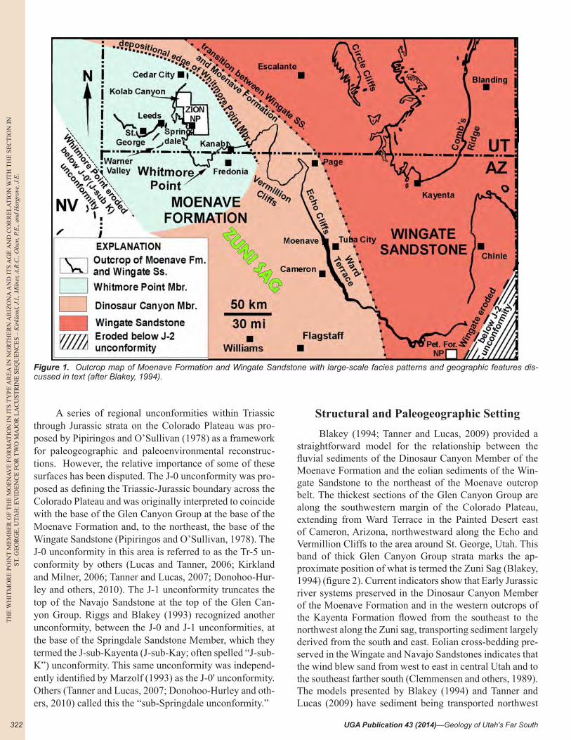
A series of regional unconformities within Triassic through Jurassic strata on the Colorado Plateau was pro-posed by Pipiringos and O’Sullivan (1978) as a framework for paleogeographic and paleoenvironmental reconstruc-tions. However, the relative importance of some of these surfaces has been disputed. The J-0 unconformity was pro-posed as defining the Triassic-Jurassic boundary across the Colorado Plateau and was originally interpreted to coincide with the base of the Glen Canyon Group at the base of the Moenave Formation and, to the northeast, the base of the Wingate Sandstone (Pipiringos and O’Sullivan, 1978). The J-0 unconformity in this area is referred to as the Tr-5 un-conformity by others (Lucas and Tanner, 2006; Kirkland and Milner, 2006; Tanner and Lucas, 2007; Donohoo-Hur-ley and others, 2010). The J-1 unconformity truncates the top of the Navajo Sandstone at the top of the Glen Can-yon Group. Riggs and Blakey (1993) recognized another unconformity, between the J-0 and J-1 unconformities, at the base of the Springdale Sandstone Member, which they termed the J-sub-Kayenta (J-sub-Kay; often spelled “J-sub-K”) unconformity. This same unconformity was independ-ently identified by Marzolf (1993) as the J-0' unconformity. Others (Tanner and Lucas, 2007; Donohoo-Hurley and oth-ers, 2010) called this the “sub-Springdale unconformity.”
Structural and Paleogeographic Setting
Blakey (1994; Tanner and Lucas, 2009) provided a straightforward model for the relationship between the fluvial sediments of the Dinosaur Canyon Member of the Moenave Formation and the eolian sediments of the Win-gate Sandstone to the northeast of the Moenave outcrop belt. The thickest sections of the Glen Canyon Group are along the southwestern margin of the Colorado Plateau, extending from Ward Terrace in the Painted Desert east of Cameron, Arizona, northwestward along the Echo and Vermillion Cliffs to the area around St. George, Utah. This band of thick Glen Canyon Group strata marks the ap-proximate position of what is termed the Zuni Sag (Blakey, 1994) (figure 2). Current indicators show that Early Jurassic river systems preserved in the Dinosaur Canyon Member of the Moenave Formation and in the western outcrops of the Kayenta Formation flowed from the southeast to the northwest along the Zuni sag, transporting sediment largely derived from the south and east. Eolian cross-bedding pre-served in the Wingate and Navajo Sandstones indicates that the wind blew sand from west to east in central Utah and to the southeast farther south (Clemmensen and others, 1989). The models presented by Blakey (1994) and Tanner and Lucas (2009) have sediment being transported northwest
Figure 1. Outcrop map of Moenave Formation and Wingate Sandstone with large-scale facies patterns and geographic features dis-cussed in text (after Blakey, 1994).
MacLean, J.S., Biek, R.F., and Huntoon, J.E., editors
TH
E W
HIT
MO
RE
POIN
T M
EM
BE
R O
F TH
E M
OE
NA
VE
FOR
MA
TIO
N IN
ITS T
YPE
AR
EA
IN N
OR
TH
ER
N A
RIZ
ON
A A
ND
ITS A
GE
AN
D C
OR
RE
LA
TIO
N W
ITH
TH
E SE
CT
ION
INST. G
EO
RG
E, U
TAH
: EV
IDE
NC
E FO
R T
WO
MA
JOR
LA
CU
STR
INE
SEQ
UE
NC
ES – K
irkland, J.I., Milner, A
.R.C
., Olsen, P.E
., and Hargrave, J.E
. s
323
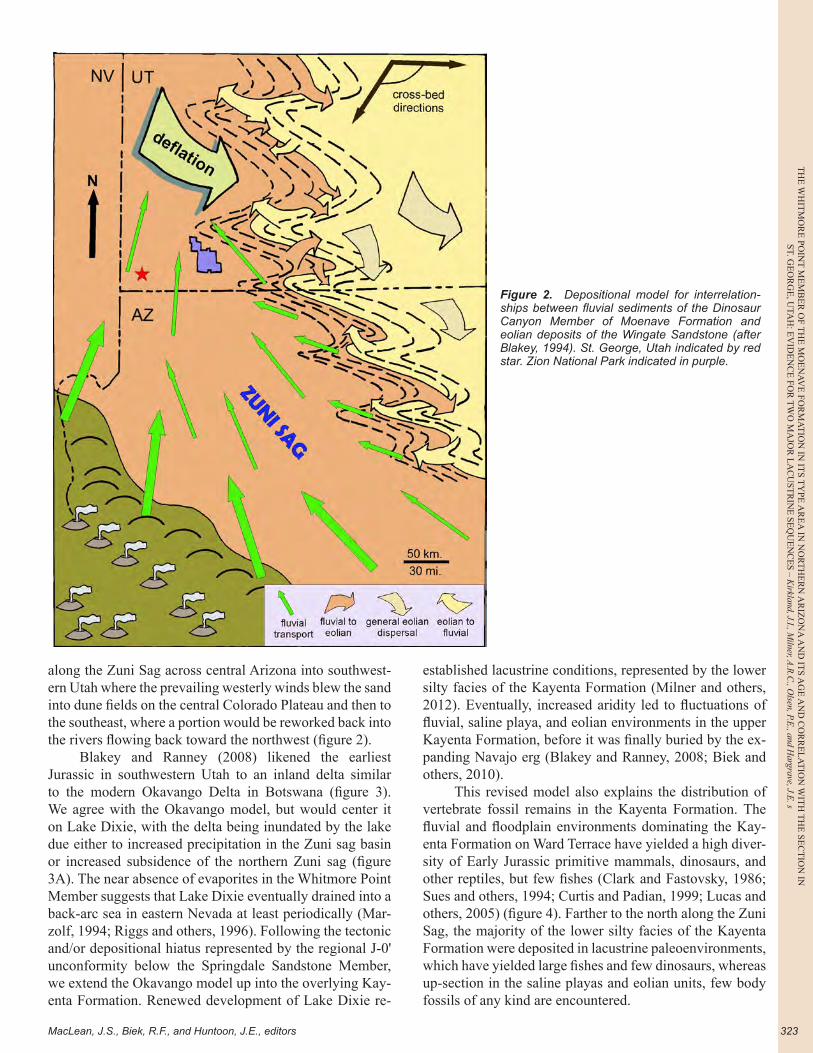
along the Zuni Sag across central Arizona into southwest-ern Utah where the prevailing westerly winds blew the sand into dune fields on the central Colorado Plateau and then to the southeast, where a portion would be reworked back into the rivers flowing back toward the northwest (figure 2).
Blakey and Ranney (2008) likened the earliest Jurassic in southwestern Utah to an inland delta similar to the modern Okavango Delta in Botswana (figure 3). We agree with the Okavango model, but would center it on Lake Dixie, with the delta being inundated by the lake due either to increased precipitation in the Zuni sag basin or increased subsidence of the northern Zuni sag (figure 3A). The near absence of evaporites in the Whitmore Point Member suggests that Lake Dixie eventually drained into a back-arc sea in eastern Nevada at least periodically (Mar-zolf, 1994; Riggs and others, 1996). Following the tectonic and/or depositional hiatus represented by the regional J-0' unconformity below the Springdale Sandstone Member, we extend the Okavango model up into the overlying Kay-enta Formation. Renewed development of Lake Dixie re-
established lacustrine conditions, represented by the lower silty facies of the Kayenta Formation (Milner and others, 2012). Eventually, increased aridity led to fluctuations of fluvial, saline playa, and eolian environments in the upper Kayenta Formation, before it was finally buried by the ex-panding Navajo erg (Blakey and Ranney, 2008; Biek and others, 2010).
This revised model also explains the distribution of vertebrate fossil remains in the Kayenta Formation. The fluvial and floodplain environments dominating the Kay-enta Formation on Ward Terrace have yielded a high diver-sity of Early Jurassic primitive mammals, dinosaurs, and other reptiles, but few fishes (Clark and Fastovsky, 1986; Sues and others, 1994; Curtis and Padian, 1999; Lucas and others, 2005) (figure 4). Farther to the north along the Zuni Sag, the majority of the lower silty facies of the Kayenta Formation were deposited in lacustrine paleoenvironments, which have yielded large fishes and few dinosaurs, whereas up-section in the saline playas and eolian units, few body fossils of any kind are encountered.
Figure 2. Depositional model for interrelation-ships between fluvial sediments of the Dinosaur Canyon Member of Moenave Formation and eolian deposits of the Wingate Sandstone (after Blakey, 1994). St. George, Utah indicated by red star. Zion National Park indicated in purple.
TH
E W
HIT
MO
RE
PO
INT
ME
MB
ER
OF
TH
E M
OE
NA
VE
FO
RM
AT
ION
IN
IT
S T
YPE
AR
EA
IN
NO
RT
HE
RN
AR
IZO
NA
AN
D I
TS
AG
E A
ND
CO
RR
EL
AT
ION
WIT
H T
HE
SE
CT
ION
IN
ST. G
EO
RG
E, U
TAH
: EV
IDE
NC
E F
OR
TW
O M
AJO
R L
AC
UST
RIN
E S
EQ
UE
NC
ES
– K
irkl
and,
J.I.
, Miln
er, A
.R.C
., O
lsen
, P.E
., an
d H
argr
ave,
J.E
.
UGA Publication 43 (2014)—Geology of Utah's Far South324
We earlier proposed that the Whitmore Point Mem-ber documents two lake megacycles in its southernmost exposures toward the center of the proposed Lake Dixie system and reasoned that the deepest parts of the lake were most likely situated to the south-southwest of the present
erosional limits of these strata (Kirkland and Milner, 2006; Lucas and others, 2011; Milner and others, 2012). Alterna-tively, it was also proposed that the Whitmore Point Mem-ber was deposited by a series of small lakes or ponds that cannot be correlated from one outcrop to the next (Tanner and Lucas, 2009, 2010; Donohoo-Hurley, 2010). We inter-pret the Lake Dixie lacustrine system to be laterally ex-tensive (Kirkland and Milner, 2006; Milner and Kirkland, 2006; Milner and others, 2012) based on the lateral corre-lation of these lacustrine facies, the development of wave-emplaced coastal bars and beaches, and the abundance of large fishes a meter or more in length. However, the abun-dant mud-cracked intervals, ripple cross-bedded sandstone, and laterally extensive stromatolitic horizons indicate that the lake was never very deep along the outcrop belt and that its water levels fluctuated considerably (Kirkland and Milner, 2006; Tanner and Lucas, 2007, 2009, 2010).
Relative to the proposed northwesterly shoreline trend paralleling the border of the Zuni Sag indicated in our exten-sion of the Blakey model (figures 1, 2), both the section at the St. George Dinosaur Site at Johnson Farm (SGDS) and our Potter Canyon reference section in the Whitmore Point area are about 100 kilometers (~60 mi) from the shoreward Whitmore Point pinch-out to the north-northeast. These ar-eas represent the most offshore Whitmore Point sections along the outcrop belt closest to the axis of the Zuni Sag (figure 1). Although there is nearly continuous exposure of the Whitmore Point Member between these two sections, the outcrop belt flexes to the northeast toward the proposed shore of Lake Dixie. Thus, at about the midpoint between these two locations along outcrops east of Warner Valley the distance to shore is approximately halved (figure 1). Likewise, the outcrop belt to the east of Whitmore Point extends to its interfingering pinch-out east of Kanab, Utah, and the easternmost recognized extent of Lake Dixie.
As a first step in framing a detailed examination of the Lake Dixie lacustrine system, stratigraphic sections at these two distal sites were measured to provide a basis for track-ing the lacustrine environments into the more complicated marginal environments, allowing us to test our hypothesis that two major cycles of lake expansion are recorded by the Whitmore Point Member of the Moenave Formation.
STRATIGRAPHIC SECTIONS OF THE MOENAVE FORMATION
Stratigraphy of the Moenave Formation at St. George, Utah
Although Higgins and Willis (1995) published a de-scription of the Moenave Formation in the area of SGDS, a very detailed stratigraphic section was measured in 2002 by the first author, taking advantage of freshly exposed strata revealed through active development in the area (figure 5). This detailed section provided the opportunity to place
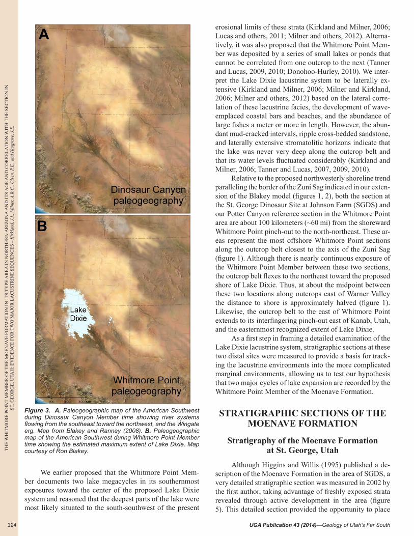
Figure 3. A. Paleogeographic map of the American Southwest during Dinosaur Canyon Member time showing river systems flowing from the southeast toward the northwest, and the Wingate erg. Map from Blakey and Ranney (2008). B. Paleogeographic map of the American Southwest during Whitmore Point Member time showing the estimated maximum extent of Lake Dixie. Map courtesy of Ron Blakey.

MacLean, J.S., Biek, R.F., and Huntoon, J.E., editors
TH
E W
HIT
MO
RE
POIN
T M
EM
BE
R O
F TH
E M
OE
NA
VE
FOR
MA
TIO
N IN
ITS T
YPE
AR
EA
IN N
OR
TH
ER
N A
RIZ
ON
A A
ND
ITS A
GE
AN
D C
OR
RE
LA
TIO
N W
ITH
TH
E SE
CT
ION
INST. G
EO
RG
E, U
TAH
: EV
IDE
NC
E FO
R T
WO
MA
JOR
LA
CU
STR
INE
SEQ
UE
NC
ES – K
irkland, J.I., Milner, A
.R.C
., Olsen, P.E
., and Hargrave, J.E
. s
325
Figure 4. Dinosaur assemblages in the Glen Canyon Group. A. Theropod dinosaurs swimming and fishing in Lake Dixie. B. Vertebrates found along the margin of the Kayenta floodplain and Navajo erg on Ward Terrace. Drawings courtesy of Russell Hawley.
TH
E W
HIT
MO
RE
PO
INT
ME
MB
ER
OF
TH
E M
OE
NA
VE
FO
RM
AT
ION
IN
IT
S T
YPE
AR
EA
IN
NO
RT
HE
RN
AR
IZO
NA
AN
D I
TS
AG
E A
ND
CO
RR
EL
AT
ION
WIT
H T
HE
SE
CT
ION
IN
ST. G
EO
RG
E, U
TAH
: EV
IDE
NC
E F
OR
TW
O M
AJO
R L
AC
UST
RIN
E S
EQ
UE
NC
ES
– K
irkl
and,
J.I.
, Miln
er, A
.R.C
., O
lsen
, P.E
., an
d H
argr
ave,
J.E
.
UGA Publication 43 (2014)—Geology of Utah's Far South326
many newly discovered fossil localities into stratigraphic context (Kirkland and Milner, 2006). In discussing the SGDS section, Kirkland and Milner (2006) described the major features of the Moenave Formation and presented a detailed plotted section but provided no formal written de-scription of the section. This description is published here for the first time here (appendix A) in order to facilitate current and future research on these strata, as specific unit numbers may now be referred to in describing stratigraphic features and in denoting the distribution of specific fossil occurrences (figure 6). The following discussion is largely taken from Kirkland and Milner (2006) with modifications to take into account new observations and reference to the specific units in appendix A.
Dinosaur Canyon Member, Moenave Formation (Unit 1-33)
The basal conglomerate (units 1 and 2): The Dinosaur Canyon Member unconformably overlies the Chinle For-mation, which is mapped in the region as Petrified Forest Member (Higgins and Willis, 1995; Biek, 2003a, 2003b; Biek and others, 2009). About 100 meters (330 ft) south of the base SGDS section on the south side of East Riverside Drive (figure 5), Spencer Lucas (New Mexico Museum of Natural History and Science, personal communication, 2005) pointed out to the authors, among others, a sharp contact between medium-gray mudstones without carbon-ate nodules overlying pale-reddish-purple mudstones with carbonate nodules, which he identified as the contact of the Petrified Forest Member with the overlying Owl Rock Member of the Chinle Formation in this area. Lucas and his colleagues thus identified the Owl Rock Member as the top of the Chinle Formation in this region (Heckert and others, 2006; Lucas and Tanner, 2007; Tanner and Lucas, 2009, 2010; Lucas and others, 2011). Anhydrite nodules become more common up-section, as do meter to multim-eter, high-angle fractures filled with selenite. Anhydrite- and selenite-filled fractures are dominant features of these rocks in the upper 10 meters (33 ft) of the Chinle Formation (figure 6).
The basal Moenave Formation is marked by a con-glomeratic interval in southwestern Utah and northeastern Arizona (Wilson, 1967; Kirkland and Milner, 2006; Mil-ner and others, 2012). At the base of the SGDS section, a 20-centimeter-thick (8 in) conglomerate rests on an erosion surface with 10-20 centimeters (4-8 in) of relief and con-tains chert and anhydrite pebbles ranging from 1-3 centim-eters (0.4-1.2 in) in diameter concentrated in the deepest scours. About 80 centimeters (2.5 ft) of mottled green and red sandy mudstone with additional lenses of conglomer-ate overlie the basal conglomerate layer. Both the anhydrite pebbles and the chert pebbles are thought to have origi-nated by erosion of the upper Chinle Formation. As these rocks are very poorly indurated, they were only recognized because the base of the section was trenched to fresh rock. Near the mouth of Zion Canyon, the basal conglomerate is represented only by a few scattered chert pebbles in a prominent anhydrite bed formed along the contact. The base of this conglomerate represents the J-0 unconformity of Pipiringos and O’Sullivan (1978) in this area.
Warner Valley, east of St. George (Milner and others, 2012), is the only site where the basal conglomerate is well cemented and well exposed in Washington County (figure 7C). Large veins of gypsum that preserve chert pebbles within them extend down from the contact into the underly-ing Chinle Formation. This indicates that there were large fractures in the Chinle erosion surface prior to renewed sedimentation and deposition of the overlying conglomer-atic unit. Additionally, Wilson (1967) described a 122-cen-
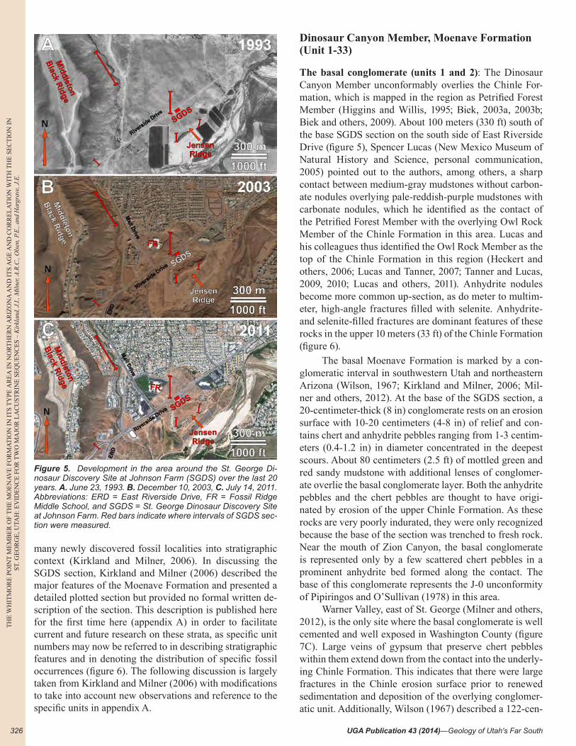
Figure 5. Development in the area around the St. George Di-nosaur Discovery Site at Johnson Farm (SGDS) over the last 20 years. A. June 23, 1993. B. December 10, 2003, C. July 14, 2011. Abbreviations: ERD = East Riverside Drive, FR = Fossil Ridge Middle School, and SGDS = St. George Dinosaur Discovery Site at Johnson Farm. Red bars indicate where intervals of SGDS sec-tion were measured.

MacLean, J.S., Biek, R.F., and Huntoon, J.E., editors
TH
E W
HIT
MO
RE
POIN
T M
EM
BE
R O
F TH
E M
OE
NA
VE
FOR
MA
TIO
N IN
ITS T
YPE
AR
EA
IN N
OR
TH
ER
N A
RIZ
ON
A A
ND
ITS A
GE
AN
D C
OR
RE
LA
TIO
N W
ITH
TH
E SE
CT
ION
INST. G
EO
RG
E, U
TAH
: EV
IDE
NC
E FO
R T
WO
MA
JOR
LA
CU
STR
INE
SEQ
UE
NC
ES – K
irkland, J.I., Milner, A
.R.C
., Olsen, P.E
., and Hargrave, J.E
. s
327
Figure 6. Stratigraphic section as measured at SGDS. J-0 and J-0' are positions of regional unconformities. Unit numbers as in ap-pendix A.
TH
E W
HIT
MO
RE
PO
INT
ME
MB
ER
OF
TH
E M
OE
NA
VE
FO
RM
AT
ION
IN
IT
S T
YPE
AR
EA
IN
NO
RT
HE
RN
AR
IZO
NA
AN
D I
TS
AG
E A
ND
CO
RR
EL
AT
ION
WIT
H T
HE
SE
CT
ION
IN
ST. G
EO
RG
E, U
TAH
: EV
IDE
NC
E F
OR
TW
O M
AJO
R L
AC
UST
RIN
E S
EQ
UE
NC
ES
– K
irkl
and,
J.I.
, Miln
er, A
.R.C
., O
lsen
, P.E
., an
d H
argr
ave,
J.E
.
UGA Publication 43 (2014)—Geology of Utah's Far South328
timeter-thick (4 ft) “gypsiferous” conglomerate unit at the base of his Moenave section at Whitmore Point, Arizona.
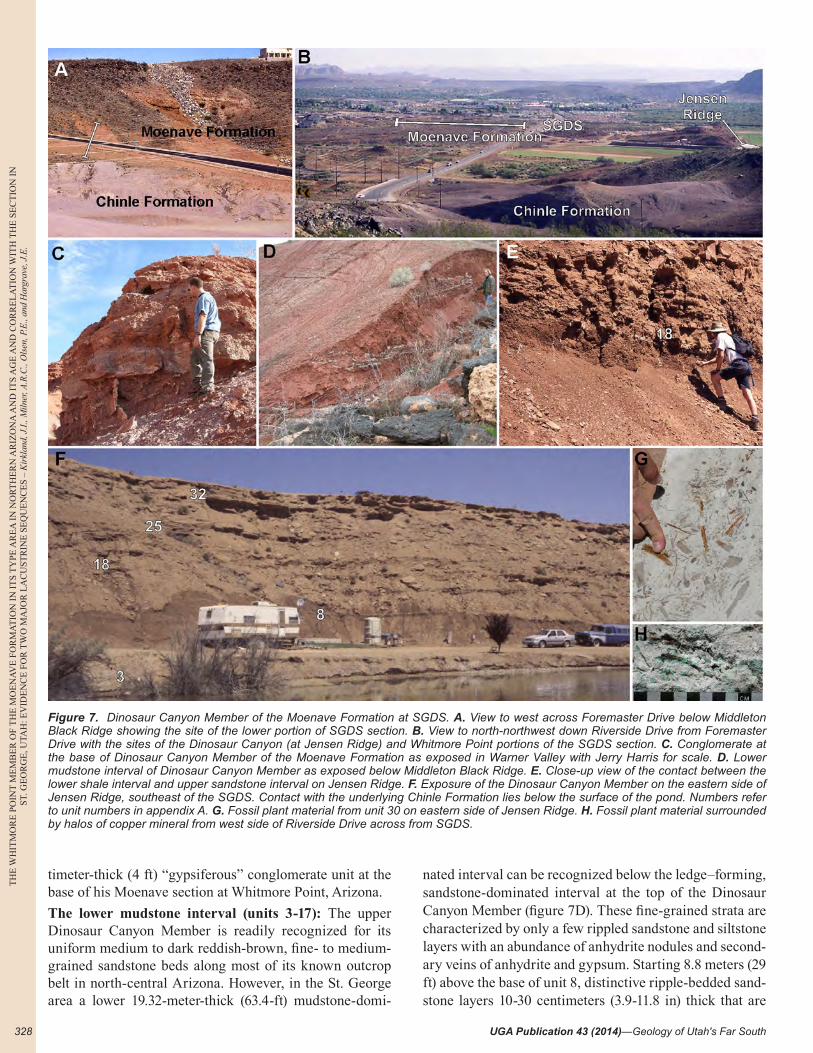
The lower mudstone interval (units 3-17): The upper Dinosaur Canyon Member is readily recognized for its uniform medium to dark reddish-brown, fine- to medium-grained sandstone beds along most of its known outcrop belt in north-central Arizona. However, in the St. George area a lower 19.32-meter-thick (63.4-ft) mudstone-domi-
nated interval can be recognized below the ledge–forming, sandstone-dominated interval at the top of the Dinosaur Canyon Member (figure 7D). These fine-grained strata are characterized by only a few rippled sandstone and siltstone layers with an abundance of anhydrite nodules and second-ary veins of anhydrite and gypsum. Starting 8.8 meters (29 ft) above the base of unit 8, distinctive ripple-bedded sand-stone layers 10-30 centimeters (3.9-11.8 in) thick that are
Figure 7. Dinosaur Canyon Member of the Moenave Formation at SGDS. A. View to west across Foremaster Drive below Middleton Black Ridge showing the site of the lower portion of SGDS section. B. View to north-northwest down Riverside Drive from Foremaster Drive with the sites of the Dinosaur Canyon (at Jensen Ridge) and Whitmore Point portions of the SGDS section. C. Conglomerate at the base of Dinosaur Canyon Member of the Moenave Formation as exposed in Warner Valley with Jerry Harris for scale. D. Lower mudstone interval of Dinosaur Canyon Member as exposed below Middleton Black Ridge. E. Close-up view of the contact between the lower shale interval and upper sandstone interval on Jensen Ridge. F. Exposure of the Dinosaur Canyon Member on the eastern side of Jensen Ridge, southeast of the SGDS. Contact with the underlying Chinle Formation lies below the surface of the pond. Numbers refer to unit numbers in appendix A. G. Fossil plant material from unit 30 on eastern side of Jensen Ridge. H. Fossil plant material surrounded by halos of copper mineral from west side of Riverside Drive across from SGDS.
MacLean, J.S., Biek, R.F., and Huntoon, J.E., editors
TH
E W
HIT
MO
RE
POIN
T M
EM
BE
R O
F TH
E M
OE
NA
VE
FOR
MA
TIO
N IN
ITS T
YPE
AR
EA
IN N
OR
TH
ER
N A
RIZ
ON
A A
ND
ITS A
GE
AN
D C
OR
RE
LA
TIO
N W
ITH
TH
E SE
CT
ION
INST. G
EO
RG
E, U
TAH
: EV
IDE
NC
E FO
R T
WO
MA
JOR
LA
CU
STR
INE
SEQ
UE
NC
ES – K
irkland, J.I., Milner, A
.R.C
., Olsen, P.E
., and Hargrave, J.E
. s
329
often associated with small mudcracks are characteristic. The top of the lower mudstone is a sharp contact pene-trated by sandstone-filled mudcracks more than 50 centim-eters (1.6 ft) deep, extending down from unit 18 (figure 6).
Kirkland and Milner (2006) interpreted the lower mudstone interval to represent distal floodplain environ-ments at some distance into the inland delta postulated by Blakey and Ranney (2008). However, the abundance of anhydrite nodules suggests sabkha environments may have been dominant. No fossils of any kind are recognized from this interval in the St. George area. Downs (2009) described and illustrated a palynomorph assemblage from a carbonaceous unit in this interval, sampled just east of Kanab, Utah.
The upper sandstone interval (units 18-33): The cliff- and ledge-forming upper sandstone interval was measured at 20.46 meters (67 ft) thick. These strata are more simi-lar to the Dinosaur Canyon Member in its type area on the Ward Terrace of Arizona (figure 1) than is the under-lying mudstone interval. The upper sandstone-dominated interval is characterized by pale reddish-brown sandstone beds averaging 0.5-1.5 meters (1.6-4.9 ft) thick, separated by thinner beds of sandy mudstone (figure 7E, 7F). The sandstone beds tend to be less laterally continuous with medium-scale trough cross-beds in the lower half of the interval, and much more tabular with a dominance of rip-ple drift laminae in the upper half.
Five meters (16 ft) from the top of the upper sand-stone interval, a laterally extensive sandstone layer with claystone pebbles preserves abundant plant debris (unit 30). Plant material includes conifer branches and cones, includ-ing the types Araucarites stockeyi, Saintgeorgia jensenii, and Milnerites planus, with fragments of ferns and horse-tails (Tidwell and Ash, 2006). Greenish claystone partings characterize this unit at some exposures in the area. Many of the fossil fragments are stained green by copper minerals (figure 7G, 7H). Fossil plants occur at this level near Leeds, Utah, and in the Kolob Canyon area of Zion National Park (Zion locality 15802) to the north (DeBlieux and others, 2006). Unfortunately, the exact stratigraphic level from which Litwin (1986) reported Early Jurassic pollen from the Dinosaur Canyon Member to the north near Leeds is unknown (Cornet and Waanders, 2006).
Track surfaces are recognized in the upper sandstone interval above the plant layer on partings between major sandstone beds. The dominance of ripple-laminated sand-stone is interpreted to represent deposition by longshore currents along the wave-dominated shore of a large la-custrine system, as with similar sedimentary features pre-served in sands along the margin of Great Salt Lake (Ovi-att and others, 2005). The three-toed tracks Grallator and Eubrontes, with rare examples of the protosuchian croco-dylomorph track Batrachopus, are recognized from these surfaces (Kirkland and Milner, 2006).
The uppermost meter (3.5 ft) of this interval (unit 33)
consists of reddish mudstone with thin ripple-bedded sand-stone layers in the roadcut on the northwestern side of Riv-erside Drive across from SGDS (figures 5, 8B). These beds were initially considered to be the basal lithologic units in the Whitmore Point Member. However, most of this inter-val was found to be much more sand-dominated across the road at the SGDS (muddy sandstone).
As the distance to shore expanded and contracted with fluctuating rainfall in the region, coastal energy lev-els (wave/storm energy) followed suit with changing water depth and wave fetch. Sand transported into the basin and deposited subaerially during low stands was reworked by wave-induced longshore currents during high stands in lake level. In these more marginal lacustrine settings, only sand deposited in equilibrium with these higher energy levels would be preserved as beach ridges and bars (Oviatt, 1987). The finer-grained strata at the top of the Dinosaur Canyon Member may represent sheltered environments protected by coastal sand bars, or simply the increasing dominance of lacustrine versus marginal lacustrine environments during the final stages of Dinosaur Canyon deposition.
The upper contact of the Dinosaur Canyon Member is placed at the base of a thin nodular limestone interval with red chert (unit 38), following Wilson (1967) and Kirkland and Milner (2006) and current Utah Geological Survey (UGS) mapping (e.g., Biek, 2003b) as discussed below. However, continued excavation as the SGDS build-ing’s footers were being established revealed that several thin sandstone units described on the northwestern side of Riverside Drive (figure 5) were replaced by sandy stroma-tolitic limestone beds on the southeastern side of the road. Additionally, a nodular carbonate cored by red chert simi-lar to that in unit 38 was identified encompassing all of the mudstone making up unit 35 (figure 8A, 8B). Therefore, when using one of these nodular, algal limestone units as a marker bed for the base of the Whitmore Point Member, one needs to keep in mind that they are only approxima-tions that work well for mapping purposes but not neces-sarily for high-resolution stratigraphic analysis.
We interpret the upper sandstone interval of the Di-nosaur Canyon Member to represent aggradational river channel deposits increasingly influenced up section by shallow wave-dominated lacustrine shoreline environ-ments. Longshore currents and waves redistributed these sands and emplaced them as sand bars and beaches toward the top of this interval through unit 36. This is the same interpretation that has been applied to the more rigorously studied Johnson Farm Sandstone Bed (Kirkland and Mil-ner, 2006; Milner and others, 2006b, 2012) in the lower Whitmore Point Member.
Whitmore Point Member, Moenave Formation (Units 34-83)
Higgins and Willis (1995) measured the thickness of the Whitmore Point Member in the drainage below the
TH
E W
HIT
MO
RE
PO
INT
ME
MB
ER
OF
TH
E M
OE
NA
VE
FO
RM
AT
ION
IN
IT
S T
YPE
AR
EA
IN
NO
RT
HE
RN
AR
IZO
NA
AN
D I
TS
AG
E A
ND
CO
RR
EL
AT
ION
WIT
H T
HE
SE
CT
ION
IN
ST. G
EO
RG
E, U
TAH
: EV
IDE
NC
E F
OR
TW
O M
AJO
R L
AC
UST
RIN
E S
EQ
UE
NC
ES
– K
irkl
and,
J.I.
, Miln
er, A
.R.C
., O
lsen
, P.E
., an
d H
argr
ave,
J.E
.
UGA Publication 43 (2014)—Geology of Utah's Far South330
north side of Middleton Black Ridge, on the south side of Mall Drive (figure 5), at 17 meters (55.7 ft), and it is 19.37 meters (63.4 ft) thick at SGDS. Placement of the basal con-tact of the Whitmore Point Member at the SGDS has been a matter of debate. Bob Biek (Utah Geological Survey, per-sonal commun., 2000) placed the basal contact below the sandstone preserving the main track-bearing horizon (i.e., below the base of the Johnson Farm Sandstone Bed) based on his experience mapping the contact to the north in the area of Leeds, Utah (Biek, 2003a, 2003b), using Wilson’s (1967) definition of the contact between the Dinosaur Can-yon and Whitmore Point in that area. Higgins and Willis (1995) placed the contact at the top of a red sandstone in-terval significantly higher in the section at SGDS, in the middle sandstone interval of the Whitmore Point as used here. This placement was accepted by Tanner and Lucas during their initial research at the site in 2004 (Spencer Lucas, New Mexico Museum of Natural History and Sci-ence, personal commun., 2005). To resolve this conflict in boundary placement, the UGS sponsored a field review of these rock units in August of 2005. It was found that Wil-son’s (1967) limestone bed with red chert could be recog-nized throughout much of Washington County, so the UGS decided to use this bed to define the base of the Whitmore Point Member for future mapping in southwestern Utah (Grant Willis, Utah Geological Survey, personal commun., 2006). However, as discussed above and reiterated below, there may be several such beds toward the base of the fine-grained lacustrine sequence. Herein, we have used the low-est recognized cherty carbonate (unit 34) to define the base of the Whitmore Point Member.
For the purposes of the following discussion, the Whitmore Point Member was divided into three inter-vals: (1) a lower shale and sandstone interval, (2) a mid-dle sandstone-dominated interval, and (3) an upper shale-dominated interval (figure 6). It is important to note that as described below, these intervals are not defined exactly as they were by Kirkland and Milner (2006). We refer to distal and proximal lacustrine settings rather than deep and shallow lacustrine environments, given the pervasive data indicating lacustrine environments were shallow and aerial exposure occurred repeatedly across the outcrop belt.
Lower shale and sandstone interval (units 34-47): The lower 5.08 meters (15.6 ft) of the Whitmore Point Member are particularly complex in the vertical and horizontal dis-tribution of rock types, sedimentary features, and fossils. Kirkland and Milner (2006) referred to these rocks as the basal complex interval. The base of the section is placed at the base of unit 34, a sandstone that laterally transitions into a stromatolitic limestone, with the algal laminae par-tially replaced by red chert (figure 8A, 8B). The overly-ing mudstone (unit 35) is laterally replaced by a nodular carbonate that preserves red chert superficially resem-bling petrified wood, often with hollow centers. These red cherts have been interpreted as both rhizoconcretions and
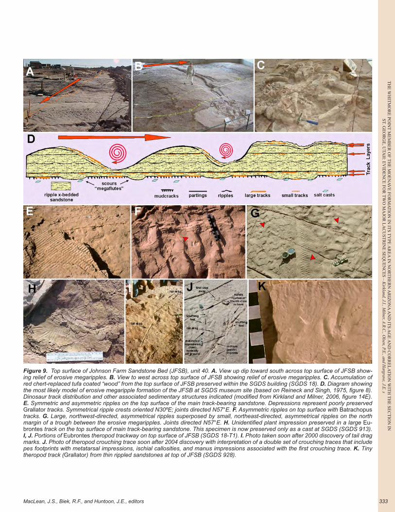
pieces of driftwood coated by tufa, where the woody mate-rial has been secondarily replaced by red chert. The drift-wood hypothesis was favored by us (Kirkland and Milner, 2006) with the discovery of an accumulation (“log jam”) of similar red-chert-cored carbonate nodules on the top of the main track-bearing sandstone referred to as the John-son Farm Sandstone Bed (JFSB) (Milner and others, 2012)(figure 9B, 9C). Wood drifting along the shoreline would become coated with calcium carbonate (most likely aided by algae and/or cyanobacteria), and eventually the wood would rot away leaving a tube of banded carbonate that may be replaced by red chert. Similar tufa structures were observed by Kirkland in association with Pleistocene-age Lake Bonneville shoreline sediments on the western side of Cache Valley in northern Utah near Wellsville. Addi-tionally, Triassic, Jurassic, and Eocene examples (among others) have been described by Whiteside (2004).
The JFSB is underlain by a dark red claystone 10-20 centimeters (3.9-7.9 in) thick (unit 39) into which dinosaur tracks were impressed. The dinosaur tracks and other sedi-mentary features in this claystone unit are not preserved long after exposure, as the claystone dries, cracks, and crumbles as soon as it is exposed. A thin algal limestone (figure 8A-8C) is locally present about 5 centimeters (2 in.) from the top of the unit.
The JFSB is vertically and horizontally complex. At the initial discovery site on the southeastern side of Riv-erside Drive, the base of the main track surface is covered by deeply impressed large dinosaur tracks (mostly Eubron-tes) and mudcracks (figure 8D). This surface was further scoured by large flute-casts tens of centimeters to more than 1 meter across with current flow predominantly di-rected toward the southeast (figure 8E, 8F). This scoured surface preserves additional (often smaller) dinosaur tracks and roughly diamond-shaped (triclinic) salt casts (figure 8G) that may represent borate salts such as trona or a soluble sulfate salt (Kirkland and Milner, 2006; Mil-ner and others, 2006b, 2012; Milner and Kirkland, 2007). Thus, at least two episodes of dinosaur track formation are preserved on the basal surface of the main track-bearing sandstone (figure 8E, 8F). One of us (ARCM) has noted that smaller tracks assigned to Grallator only occur with-in the scours cutting down below mudcracked surfaces or within the large tracks assigned to Eubrontes, indicat-ing that the smaller theropod dinosaurs were too light to impress their tracks into the dried mudcracked surface of unit. Across Riverside Drive to the northwest, the base of the JFSB preserves more evidence of scouring and fewer mudcracks, suggesting this might represent the offshore direction. Invertebrate burrowing and crawling traces are common here as are dinosaur swim tracks (figure 8H, 8I) and fish swim traces (Milner and others, 2006a; Milner and Kirkland, 2007).
At the initial SGDS discovery site on the southeastern side of Riverside Drive, a parting is developed about 20

MacLean, J.S., Biek, R.F., and Huntoon, J.E., editors
TH
E W
HIT
MO
RE
POIN
T M
EM
BE
R O
F TH
E M
OE
NA
VE
FOR
MA
TIO
N IN
ITS T
YPE
AR
EA
IN N
OR
TH
ER
N A
RIZ
ON
A A
ND
ITS A
GE
AN
D C
OR
RE
LA
TIO
N W
ITH
TH
E SE
CT
ION
INST. G
EO
RG
E, U
TAH
: EV
IDE
NC
E FO
R T
WO
MA
JOR
LA
CU
STR
INE
SEQ
UE
NC
ES – K
irkland, J.I., Milner, A
.R.C
., Olsen, P.E
., and Hargrave, J.E
. s
331
Figure 8. Johnson Farm Sandstone Bed (JFSB), unit 40. A. Cross-sectional exposure of JFSB and underlying units now below east side of SGDS building. B. Cross-sectional exposure of JFSB and underlying units in road cut to west of SGDS building along Riverside Drive. C. Cross-section of Eubrontes at base of JFSB in roadcut to west of SGDS building. Underlying algal limestone layer in the upper part of unit 39 is visible. D. Sheldon Johnson with block preserving natural casts of mudcracks and Eubrontes from the main track layer (un-derside of JFSB). The upper right corner of the block has broken away to reveal the split layer (SGDS 9). E. Scour cutting down through mudcracked surface of the main track layer and Eubrontes on underside of JFSB exposing salt casts with subsequent Grallator in oblique view to show depth of scour (SGDS 25). Arrow indicates side of scour and direction of water flow. F. Same block as in (E) in tangential view. G. Triclinic salt casts on scour surface at base of JFSB (SGDS 40). H. Elongate, up-current swim tracks (SGDS 167). I. Block show-ing high density of parallel swim tracks. J. Grallator tracks and tool marks preserved on the split layer (SGDS 197 B). K. Climbing ripples preserved in JFSB (SGDS 842). L. Interference ripples preserved on split surface near center of JFSB from below northwestern corner of SGDS building. Numbers refer to unit numbers in appendix A.
TH
E W
HIT
MO
RE
PO
INT
ME
MB
ER
OF
TH
E M
OE
NA
VE
FO
RM
AT
ION
IN
IT
S T
YPE
AR
EA
IN
NO
RT
HE
RN
AR
IZO
NA
AN
D I
TS
AG
E A
ND
CO
RR
EL
AT
ION
WIT
H T
HE
SE
CT
ION
IN
ST. G
EO
RG
E, U
TAH
: EV
IDE
NC
E F
OR
TW
O M
AJO
R L
AC
UST
RIN
E S
EQ
UE
NC
ES
– K
irkl
and,
J.I.
, Miln
er, A
.R.C
., O
lsen
, P.E
., an
d H
argr
ave,
J.E
.
UGA Publication 43 (2014)—Geology of Utah's Far South332
centimeters (8 in) above the base of JFSB that preserves abundant small dinosaur tracks (Grallator) and less com-mon Eubrontes, invertebrate traces, and raindrop impres-sions (figure 8D, 8J) preserved by an algal film binding this surface (Kirkland and Milner, 2006; Milner and others, 2006b). Internally, the main track-bearing sandstone pre-serves climbing ripple cross-bedding indicating deposition under flowing water conditions (figure 8K). Where part-ings occur, undulatory ripples are preserved (figure 8L). The main track-bearing sandstone typically varies from 10 centimeters (3.9 in) to nearly 1 meter (3.3 ft) thick. Locally over short distances, the JFSB may be absent because of the scouring of the top surface by large waves.
As preserved within the SGDS building, a series of long ridges with as much as 0.5 meter (1.6 ft) of relief that trend north 70 degrees west can be recognized at the top of JFSB (figure 9A, 9B). The relationship of the ridges and troughs to parting surfaces within the sandstone indicates these are erosive megaripples formed by currents crossing the site from the southwest causing sand to be eroded from the megaripple troughs, following the model presented by Reineck and Singh (1975, figure 8). The entire unit has been removed in a portion of one of these troughs. Thin ripple-marked sandstone beds 1 to a few centimeters (0.5–2 in) thick are present mostly to the northeast of these meg-aripple crests (figure 9B, 9D). These thin sandstone beds are dominated by undulatory ripples showing a southeast current direction, with fewer surfaces with undulatory rip-ples indicating a northwest current direction or symmetri-cal wave ripples (figure 9E, 9G). The northwest-southeast current directions indicated by the ripple-marks nearly par-allel the crests of the erosive megaripples (Kirkland and Milner, 2006) indicating that the smaller waves producing these sedimentary features were directed along the troughs of the megaripples with the water draining back down the center of the troughs (figure 9G). Additionally, these thin ripple-marked sandstones preserve abundant dinosaur and crocodylomorph tracks (figure 9E, 9F, 9I-K) together with relatively rare plant impressions (figure 9H). Rill marks are also present indicating water draining off this surface to the west. The upper surface of the main track-bearing sand-stone is interpreted as representing a beach or bar along the shore of a large lake that was being modified by waves impinging on it.
One meter (3 ft) of reddish-purple shale (figure 10A-10C) overlies the JFSB. These shales also preserve part-ings that are covered with ostracods (Schudack, 2006). Two highly micaceous zones (units 42, 44) a couple of centim-eters thick in these shales were sampled for radiometric dating by laser ablation of zircons. The zircon ages were all Triassic and older, indicating they were derived from the underlying Chinle Formation (O’Sullivan, Apatite to Zir-con, Inc., personal commun., 2005). The shales are in turn overlain by 70 centimeters (2.3 ft) of reddish-brown mud-stone (figure 10B, 10C) preserving disseminated ostracods,
conchostracans, and isolated fish bones and scales. These fine-grained sediments represent offshore lake environ-ments and are penetrated from the top by sandstone-filled mudcracks up to 40 centimeters (1.3 ft) deep.
Where measured to the north on the northwest side of Riverside Drive, unit 46 is a reddish-orange sandstone complex 65 centimeters (2.1 ft) thick that overlies the fos-siliferous shales and cuts out part of unit 41, pinching out to the south across Riverside Drive west of SGDS. Unit 46 consists of four sandstone beds 10-25 centimeters (3.9-9.8 in) thick separated by mudstone partings. The sandstone beds preserve mudcracks and root casts with moderately well preserved dinosaur tracks (Grallator, Eubrontes, Kay-entapus, and Anomoepus) on their upper surfaces (figure 10D-H). We interpret the sandstones as representing sand deposited near the lake margin, much in a manner like that interpreted for JFSB. The track-bearing sandstones are in turn overlain by 1.25 meters (4.1 ft) of reddish-brown mud-stone (unit 47) with scattered thin layers of fine sandstone.
Middle sandstone-dominated interval (units 48- 55): The next 7.81 meters (25.6 ft) are characterized by interbedded reddish-brown sandstone and sandy mudstone (figure 11A). The sandstone is much like that in the upper part of the Dinosaur Canyon Member as it preserves mudcracks and dinosaur tracks and is internally ripple cross-bedded. How-ever, this unit also preserves fossil fishes, both as isolated scales and bones and as complete fish, whereas no fish fos-sils are yet known from the upper Dinosaur Canyon Mem-ber (figure 6). Similar to the track-bearing beds of the Di-nosaur Canyon Member, these sandstones are interpreted to represent lake-margin sand deposits emplaced by long-shore currents. Other outcrops of this interval examined in the St. George area preserve less sandstone than at SGDS, suggesting that these sandstones may represent a spit or shoal that was only developed in the immediate vicinity of the SGDS. The fining in the upper portion of this interval suggests deepening of the lacustrine system.
At 45 centimeters (1.5 ft) above the base of unit 54, a laterally extensive dinosaur track horizon is present on top of a hill just to east of Fossil Ridge Intermediate School. The excavated portion is named the LDS Tracksite (figure 11B) and is dominated by Grallator with rare Eubrontes and Batrachopus (Williams and others, 2006). To the south on the northern side of Mall Drive (figure 5) was the Mall Drive Tracksite with abundant Grallator tracks now de-stroyed by construction (Williams and others, 2006). Sil-icified red ostracods were very common at the Mall Drive Tracksite, and coprolites, fish debris, and even articulated fishes are found on and just below tracks at the LDS Track-site. It is hoped that the LDS Tracksite may be developed into an interpretive site under a shelter.
Upper shale-dominated interval (units 56-83): The up-per 7.58 meters (24.9 ft) of the Whitmore Point Member consist of thin-bedded lacustrine sediments. Prior to exca-vations for the construction of the Fossil Ridge Intermedi-
MacLean, J.S., Biek, R.F., and Huntoon, J.E., editors
TH
E W
HIT
MO
RE
POIN
T M
EM
BE
R O
F TH
E M
OE
NA
VE
FOR
MA
TIO
N IN
ITS T
YPE
AR
EA
IN N
OR
TH
ER
N A
RIZ
ON
A A
ND
ITS A
GE
AN
D C
OR
RE
LA
TIO
N W
ITH
TH
E SE
CT
ION
INST. G
EO
RG
E, U
TAH
: EV
IDE
NC
E FO
R T
WO
MA
JOR
LA
CU
STR
INE
SEQ
UE
NC
ES – K
irkland, J.I., Milner, A
.R.C
., Olsen, P.E
., and Hargrave, J.E
. s
333
Figure 9. Top surface of Johnson Farm Sandstone Bed (JFSB), unit 40. A. View up dip toward south across top surface of JFSB show-ing relief of erosive megaripples. B. View to west across top surface of JFSB showing relief of erosive megaripples. C. Accumulation of red chert-replaced tufa coated “wood” from the top surface of JFSB preserved within the SGDS building (SGDS 18). D. Diagram showing the most likely model of erosive megaripple formation of the JFSB at SGDS museum site (based on Reineck and Singh, 1975, figure 8). Dinosaur track distribution and other associated sedimentary structures indicated (modified from Kirkland and Milner, 2006, figure 14E). E. Symmetric and asymmetric ripples on the top surface of the main track-bearing sandstone. Depressions represent poorly preserved Grallator tracks. Symmetrical ripple crests oriented N30ºE; joints directed N57°E. F. Asymmetric ripples on top surface with Batrachopus tracks. G. Large, northwest-directed, asymmetrical ripples superposed by small, northeast-directed, asymmetrical ripples on the north margin of a trough between the erosive megaripples. Joints directed N57°E. H. Unidentified plant impression preserved in a large Eu-brontes track on the top surface of main track-bearing sandstone. This specimen is now preserved only as a cast at SGDS (SGDS 913). I, J. Portions of Eubrontes theropod trackway on top surface of JFSB (SGDS 18-T1). I. Photo taken soon after 2000 discovery of tail drag marks. J. Photo of theropod crouching trace soon after 2004 discovery with interpretation of a double set of crouching traces that include pes footprints with metatarsal impressions, ischial callosities, and manus impressions associated with the first crouching trace. K. Tiny theropod track (Grallator) from thin rippled sandstones at top of JFSB (SGDS 928).
TH
E W
HIT
MO
RE
PO
INT
ME
MB
ER
OF
TH
E M
OE
NA
VE
FO
RM
AT
ION
IN
IT
S T
YPE
AR
EA
IN
NO
RT
HE
RN
AR
IZO
NA
AN
D I
TS
AG
E A
ND
CO
RR
EL
AT
ION
WIT
H T
HE
SE
CT
ION
IN
ST. G
EO
RG
E, U
TAH
: EV
IDE
NC
E F
OR
TW
O M
AJO
R L
AC
UST
RIN
E S
EQ
UE
NC
ES
– K
irkl
and,
J.I.
, Miln
er, A
.R.C
., O
lsen
, P.E
., an
d H
argr
ave,
J.E
.
UGA Publication 43 (2014)—Geology of Utah's Far South334
Figure 10. Lower shale beds overlying the JFSB. A. Units 36-47 as exposed in road cut on northwest side of Riverside Drive. Rock hammer for scale. B. Close-up of sediments overlying JFSB on the northwest side of Riverside Drive. The top surface of JFSB is ap-proximately at bottom of photograph. C. Small hill behind road cut in A prior to excavation. Note large-scale cross-bedding in unit 46 at this location. D. Looking south across upper track surface of unit 46; Stewart-Walker Tracksite. E. Mudcracks on upper surface. F. Large rhizolith (SGDS 915). G. Anomoepus trackway exposed on surface of unit 46 by excavation. H. David Slauf with natural cast slab of large Eubrontes track associated with many smaller Grallator and Anomoepus salvaged from unit 46 (SGDS 443). Numbers refer to unit numbers in appendix A.
MacLean, J.S., Biek, R.F., and Huntoon, J.E., editors
TH
E W
HIT
MO
RE
POIN
T M
EM
BE
R O
F TH
E M
OE
NA
VE
FOR
MA
TIO
N IN
ITS T
YPE
AR
EA
IN N
OR
TH
ER
N A
RIZ
ON
A A
ND
ITS A
GE
AN
D C
OR
RE
LA
TIO
N W
ITH
TH
E SE
CT
ION
INST. G
EO
RG
E, U
TAH
: EV
IDE
NC
E FO
R T
WO
MA
JOR
LA
CU
STR
INE
SEQ
UE
NC
ES – K
irkland, J.I., Milner, A
.R.C
., Olsen, P.E
., and Hargrave, J.E
. s
335
ate School, the Whitmore Point Member exposures to the west of Riverside Drive across from SGDS consisted of low, sparsely vegetated hills (figure 12A). Removing these hills resulted in the systematic exposure of bedding planes in the upper shale interval that permitted documentation of these fine-grained strata not possible anywhere else (figure 12D-12H). Additionally, gullying along Mall Drive to the south provided another extensive, temporary exposure of these strata (figure 12I-K). This sequence consists mostly of coarsening-upward cycles ~20-50 centimeters (~8-20 in) thick, characterized by hard platy shale and siltstone at the base with fossil fishes, ostracods, and conchostra-cans capped by fine-grained sandstone at the top preserv-ing algal laminae, stromatolites, mudcracks, rare isolated tetrapod teeth and bones, and occasional dinosaur tracks (figure 12C). This bedding pattern may represent climatic cycles. Biek and others (2009, 2010) noted that these hard platy beds are dolomitic. Other less common features such as sandstone dikes and soft sediment deformation features also occur (figure 12K).
Red, iron-enhanced carbonate concretions are charac-teristic of this interval. They range from small, flat disks about 1 centimeter across, formed around isolated ganoid fish scales, small bones, bone fragments, teeth, or copro-lites, to large plates tens of centimeters across, surround-ing concentrations of isolated scales and bone (figure 12B,
12C, G) and, in some cases, large, articulated fishes. Some of these accumulations in unit 68 are unusual in being cir-cular in cross section and more than a meter long (>3.3 ft) (figure 12H); they frequently contain concentrations of fish fossils and are thus referred to as “fish sticks” (Chin and others, 2003; Milner and others, 2005). The “fish sticks” are superficially similar to the chert-replaced tufa preserved at the base of the Whitmore Point Member and are cur-rently under study by Dr. Karen Chin and her students at the University of Colorado at Boulder.
Of particular interest is a sandstone bed (unit 77) near the top of the interval that preserves large bones, including hybodont shark fin spines and many skull elements from large coelacanths (Milner and Kirkland, 2006). Addition-ally the first record of isolated bones and teeth from thero-pod dinosaurs in the Whitmore Point Member are from this bed (Milner and Kirkland, 2007; Milner and others, 2012). The site preserving the dinosaur fossils has been set aside on the grounds of the Fossil Ridge Intermediate School by the Washington County School District for further research (figure 5).
These beds are highly distinctive with pale-reddish and purplish-red colors. When well-exposed below cliffs formed by the Springdale Sandstone Member, these dis-tinctively “mauve” colored platy beds are readily recog-nized in all exposures in southern Washington County.
Figure 11. Middle sandstone interval of Whitmore Point. A. Escarpment formed by leveling property to the south exposing the middle sandstone interval between Fossil Ridge Intermediate School and Riverside Drive. Arrow indicates location of LDS Tracksite. Numbers refer to unit numbers in appendix A. B. LDS Tracksite near the top of unit 54. C. Skolithos sp. burrows from the “Slauf Burrow Bed” (SGDS 505). D. Palaeophycus tubularis burrows preserved in convex epi-relief from the base of the “Green Burrow Bed” (SGDS 191).
TH
E W
HIT
MO
RE
PO
INT
ME
MB
ER
OF
TH
E M
OE
NA
VE
FO
RM
AT
ION
IN
IT
S T
YPE
AR
EA
IN
NO
RT
HE
RN
AR
IZO
NA
AN
D I
TS
AG
E A
ND
CO
RR
EL
AT
ION
WIT
H T
HE
SE
CT
ION
IN
ST. G
EO
RG
E, U
TAH
: EV
IDE
NC
E F
OR
TW
O M
AJO
R L
AC
UST
RIN
E S
EQ
UE
NC
ES
– K
irkl
and,
J.I.
, Miln
er, A
.R.C
., O
lsen
, P.E
., an
d H
argr
ave,
J.E
.
UGA Publication 43 (2014)—Geology of Utah's Far South336
Figure 12. A. Natural exposure of upper Whitmore Point Member on northwestern side of Riverside Drive in 2000 prior to construction of Fossil Ridge Intermediate School. B. Typical concretions from the upper shale interval. Dark lumps are built up around ganoid scales and fish bones. C. Detail of vertical exposure of upper shale interval on west side of Bluff Street (figure 12 A). Arrow heads point to fossil fish and coprolite in concretions. D. View to north of exposed bedding surfaces in upper Whitmore Point made available for research during construction of Fossil Ridge Intermediate School. E. Same exposures looking up dip to southwest. F. Cross-section of “fish-stick” interval (unit 68) immediately above sandstone preserving abundant anhydrite nodules. G. Mapping of distribution of fish-bearing nodules in unit 68. H. Typical exposure of an isolated “fish-stick” in unit 68. I. Cross-section of a “fish-stick” (SGDS 1564). (I) Exposure of upper shale interval on the northeast side of Mall Drive. J. Convolute bedding in units below unit 65 on northeast side of Mall Drive. K. Stromatolite layer previously exposed along Mall Drive (SGDS 669). Numbers refer to unit numbers in appendix A.
MacLean, J.S., Biek, R.F., and Huntoon, J.E., editors
TH
E W
HIT
MO
RE
POIN
T M
EM
BE
R O
F TH
E M
OE
NA
VE
FOR
MA
TIO
N IN
ITS T
YPE
AR
EA
IN N
OR
TH
ER
N A
RIZ
ON
A A
ND
ITS A
GE
AN
D C
OR
RE
LA
TIO
N W
ITH
TH
E SE
CT
ION
INST. G
EO
RG
E, U
TAH
: EV
IDE
NC
E FO
R T
WO
MA
JOR
LA
CU
STR
INE
SEQ
UE
NC
ES – K
irkland, J.I., Milner, A
.R.C
., Olsen, P.E
., and Hargrave, J.E
. s
337
At SGDS, the Springdale Sandstone Member uncon-formably overlies fine-grained lacustrine sediments of the Whitmore Point Member. Elsewhere, such as in downtown St. George and at Zion National Park, fine-grained sand-stone beds are present below this unconformity and may represent sand accumulating along the margin of a wan-ing Lake Dixie (figure 13A, 13B). Although mapped with the Springdale Sandstone Member of the Kayenta Forma-tion, these sandstones are intrinsically part of the Whitmore Point Member of the Moenave Formation (Lucas and Tan-ner, 2006; Kirkland and Milner, 2006). Lucas and Tanner (2011, figure 4) designated these beds as Dinosaur Can-yon(?). We prefer to consider these beds as an upper sand-stone-dominated interval of the Whitmore Point Member.
Springdale Sandstone Member, Kayenta Formation
At SGDS, the overlying Springdale Sandstone Mem-ber lies on an erosional surface with up to a meter or more of relief representing the J-0' or J-sub-K unconformity of previous authors. Locally, large clasts (10 centimeters [4 in]
and more in diameter) of Whitmore Point lacustrine sedi-ments are present in the basal Springdale Sandstone above this unconformity.
The Springdale Sandstone (figure 13C-E) is mostly pale yellowish-brown and stands out in contrast to the dom-inantly red- to mauve-colored sediments above and below it. The Springdale Sandstone is a medium- to coarse-grained, 0.5- to 1-meter-scale (1.6-3.3 ft) planar and trough-cross-bedded fluvial sandstone with minor discontinuous mud-stone partings. Chert pebbles are locally concentrated at the base of some of the larger cross-bed sets. Small amounts of petrified wood are also present in this member.
The lower unnamed member of the Kayenta For-mation, sometimes referred to as the “silty facies” in the thicker sections along the Zuni Sag, conformably overlies the Springdale Sandstone and appears to be largely a lacus-trine unit at its base where the contact represents the fluvial Springdale reworked into lake margin deposits. Dinosaur tracks are abundant along this contact in the St. George and Zion National Park areas (Miller and others, 1989; Smith and others, 2002; DeBlieux and others, 2004, 2006; Hamblin, 2006; Hamblin and others, 2006; Milner and others, 2012).
Figure 13. Springdale Sandstone Member of Kayenta Formation. A. Exposure of the upper Whitmore Point Member and basal Springdale Sandstone on the western side of Bluff Street below Airport Road. B. Exposure of the upper Whitmore Point Member and basal Springdale Sandstone on the northern side of Zion Canyon in Zion National Park. C. Springdale Sandstone Member of the Kayenta Formation below (east of) Middleton Black Ridge. D. View of Springdale Sandstone farther west along line of section below (east of) Middleton Black Ridge. E. Contact between coarse trough cross-bedded sandstones of the Springdale Sandstone and finer, more flat bedded units of the main body of the Kayenta Formation. Base Springdale Sandstone indicated by arrows. Numbers refer to unit numbers in appendix A.

TH
E W
HIT
MO
RE
PO
INT
ME
MB
ER
OF
TH
E M
OE
NA
VE
FO
RM
AT
ION
IN
IT
S T
YPE
AR
EA
IN
NO
RT
HE
RN
AR
IZO
NA
AN
D I
TS
AG
E A
ND
CO
RR
EL
AT
ION
WIT
H T
HE
SE
CT
ION
IN
ST. G
EO
RG
E, U
TAH
: EV
IDE
NC
E F
OR
TW
O M
AJO
R L
AC
UST
RIN
E S
EQ
UE
NC
ES
– K
irkl
and,
J.I.
, Miln
er, A
.R.C
., O
lsen
, P.E
., an
d H
argr
ave,
J.E
.
UGA Publication 43 (2014)—Geology of Utah's Far South338
Potter Canyon Reference Section for the Whitmore Point Member
Wilson’s (1967) type section of the Whitmore Point Member was measured as part of an overall Moenave For-mation section in section 15, T. 40 N., R. 5 W. at Whitmore Point on the western side of the Kanab Paiute Indian Reser-vation about 8 kilometers (5 mi) northeast of Pipe Springs National Monument, Mohave County, Arizona (figures 1, 14). He described the Whitmore Point Member as a single 21-meter-thick (69 ft) unit:
“Siltstone to claystone, medium-gray (N5), pale brown (5YR5/2), grayish red (10R4/2), and greenish gray (5GY6/1), grades from fine siltstone to claystone in alternating sets from 6 in to 1 foot thick; firmly cemented, calcareous to non-calcareous; horizontally laminated to very thin bedded; weathers to form grayish-colored slope. Unit contains a 12 foot thick lenticular set of grayish orange pink (5YR7/2) very fine grained sandy siltstone 5 ft above base. Unit contains scattered small iron oxide concretions containing fish scales and bones.”
Research by the UGS in southwestern Utah and at the SGDS necessitated developing a better understanding of the Whitmore Point Member, so the type area was visited by UGS staff (Grant Willis, Bob Biek, and Jim Kirkland) and Spencer Lucas of the New Mexico Museum of Natu-ral History and Science in August 2005. Subsequently, this visit has resulted in a number of published reports as dis-cussed below, but no detailed description of the section has been published. This reference section (figure 15) at Potter Canyon (appendix B) was established at the site visited in 2005, as it was the nearest, readily accessible, well-exposed Whitmore Point outcrop to Wilson’s (1967) type section (approximately 2.1 kilometers [1.3 mi] northwest) on pub-lic lands administered by the Bureau of Land Management (figure 14). Based on bore holes for paleomagnetic sam-pling, the section was identified by us as the same section as that measured by Donohoo-Hurley and others (2010). However, Lucas and Tanner’s (2011) Potter Canyon Sec-tion was 2.2 kilometers (1.38 mi) west of this section based on the published coordinates.
Tanner and Lucas (2010) marked the base of their Whitmore Point Member at a distinct color change from a medium brownish-red, typical of the overall Dinosaur Can-yon Member color, to a pale red, which we found coincides with a disconformable surface that separates more thinly-bedded muddy sandstones and sandy mudstones above, from well-sorted sandstones below. However, Wilson (1967) noted a 3.6-meter-thick (12 ft) grayish-orange-pink lenticular sandy siltstone 1.5 meters (5 ft) above the base of his Whitmore Point Member. This unit may represent our unit 30 and the deformed sandstone lenses described
by Tanner and Lucas (2010), suggesting that perhaps his contact correlates with the base of our unit 18 (figure 15). Initially, we picked unit 18 as the basal unit of the Whit-more Point when we measured our stratigraphic section, and given the variable amount of down-cutting observed in unit 30, we believe that Wilson (1967) also picked the base of unit 18 as his lower contact of the type Whitmore Point Member. Future researchers should seek permission from the Paiute Indian Tribe to re-examine Wilson’s (1967) Moenave section to confirm which contact is more consist-ent with Wilson’s (1967) initial intent.
Dinosaur Canyon Member, Moenave Formation (units 0-17)
Only the upper few meters of the Dinosaur Canyon Member are exposed below the Whitmore Point reference section (figure 16C-E). The basal 5.4 meters (17.7 ft) arise from the vegetated alluvium at the base of the exposure and are composed of medium- to fine-grained, reddish-brown, medium-scaled trough to ripple cross-bedded sandstone that forms rounded benches. The upper 86 centimeters (2.8 ft) consist of pale red to grayish-red interbedded silty shales and very fine grained sandstone beds that may be cut out laterally by the disconformable contact at the base of Tan-ner and Lucas’s (2010) Whitmore Point Member overlying these sandstones.
Tanner and Lucas’s sandstone interval (units 5-17): Tan-ner and Lucas (2010) placed their contact between the Di-nosaur Canyon and Whitmore Point Members at a discon-formity that is typically bleached to yellowish-gray a short distance above where the color of the rocks changes from medium reddish brown to pale red and bedding becomes thinner (figure 16E). Bedding ranges from moderately well-laminated to wavy-bedded to ripple cross-bedded, with some rooting and small vertical burrows. This discon-formity, when traced laterally, cuts down onto this color change at the top of unit 2 (figure 15). Up-section at unit 14, the rocks, while not changing character appreciably, are colored a dusky yellow. This interval has a total thickness of 4.07 meters (13.3 ft). This interval marks the end of flu-vial deposition and the beginning of lacustrine influence in this area.
Whitmore Point Member, Moenave Formation (units 18-81)
Lower shale interval (units 18-29): A sharp break sepa-rates the muddy sandstone from shale at the base of the lower shale interval. Well-laminated, poorly to, at best, moderately indurated shale dominates the next 3.27 meters (10.7 ft) of the section. In the lower portion, this shale is dark gray with organic carbon and is calcareous. It is highly fossiliferous as well, with abundant, well-preserved ostra-cods and conchostracans with minor amounts of compres-sional plant fragments and fish debris. Both units 23 and 27

MacLean, J.S., Biek, R.F., and Huntoon, J.E., editors
TH
E W
HIT
MO
RE
POIN
T M
EM
BE
R O
F TH
E M
OE
NA
VE
FOR
MA
TIO
N IN
ITS T
YPE
AR
EA
IN N
OR
TH
ER
N A
RIZ
ON
A A
ND
ITS A
GE
AN
D C
OR
RE
LA
TIO
N W
ITH
TH
E SE
CT
ION
INST. G
EO
RG
E, U
TAH
: EV
IDE
NC
E FO
R T
WO
MA
JOR
LA
CU
STR
INE
SEQ
UE
NC
ES – K
irkland, J.I., Milner, A
.R.C
., Olsen, P.E
., and Hargrave, J.E
. s
339
Figure 14. Whitmore Point, Arizona. A. Google Earth views of the type area of the Whitmore Point Member of the Moenave Formation. Blue arrow indicates site of Wilson’s (1967) type section description. Red arrow is site of Donohoo-Hurley and other’s (2010) section and that described herein (appendix B); Green arrow is section of Tanner and Lucas (2010). Red line is the western boundary of the Kaibab-Paiute Indian Reservation. B. View to south-southeast from Potter Canyon section to Whitmore Point. Thin red arrows indicate the upper and lower contacts of the Whitmore Point Member of the Moenave Formation. Pink arrow points to the approximate site of Wilson’s type Whitmore Point section on the Kanab Indian Reservation (Wilson, 1967).
THE WHITMORE POINT MEMBER OF THE MOENAVE FORMATION IN ITS TYPE AREA IN NORTHERN ARIZONA AND ITS AGE AND CORRELATION WITH THE SECTION INST. GEORGE, UTAH: EVIDENCE FOR TWO MAJOR LACUSTRINE SEQUENCES – Kirkland, J.I., Milner, A.R.C., Olsen, P.E., and Hargrave, J.E.
UG
A P
ub
lication
43 (2014)—G
eology of Utah's F
ar South
340
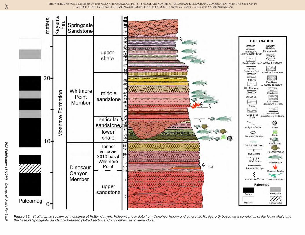
Figure 15. Stratigraphic section as measured at Potter Canyon. Paleomagnetic data from Donohoo-Hurley and others (2010; figure 9) based on a correlation of the lower shale and the base of Springdale Sandstone between plotted sections. Unit numbers as in appendix B.
MacLean, J.S., Biek, R.F., and Huntoon, J.E., editors
TH
E W
HIT
MO
RE
POIN
T M
EM
BE
R O
F TH
E M
OE
NA
VE
FOR
MA
TIO
N IN
ITS T
YPE
AR
EA
IN N
OR
TH
ER
N A
RIZ
ON
A A
ND
ITS A
GE
AN
D C
OR
RE
LA
TIO
N W
ITH
TH
E SE
CT
ION
INST. G
EO
RG
E, U
TAH
: EV
IDE
NC
E FO
R T
WO
MA
JOR
LA
CU
STR
INE
SEQ
UE
NC
ES – K
irkland, J.I., Milner, A
.R.C
., Olsen, P.E
., and Hargrave, J.E
. s
341
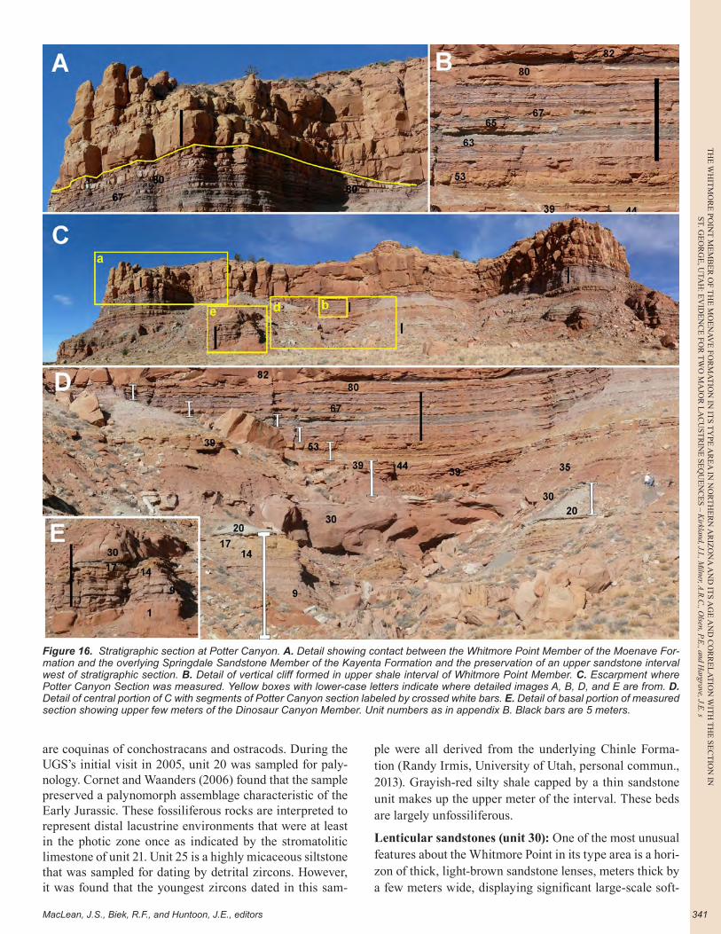
are coquinas of conchostracans and ostracods. During the UGS’s initial visit in 2005, unit 20 was sampled for paly-nology. Cornet and Waanders (2006) found that the sample preserved a palynomorph assemblage characteristic of the Early Jurassic. These fossiliferous rocks are interpreted to represent distal lacustrine environments that were at least in the photic zone once as indicated by the stromatolitic limestone of unit 21. Unit 25 is a highly micaceous siltstone that was sampled for dating by detrital zircons. However, it was found that the youngest zircons dated in this sam-
ple were all derived from the underlying Chinle Forma-tion (Randy Irmis, University of Utah, personal commun., 2013). Grayish-red silty shale capped by a thin sandstone unit makes up the upper meter of the interval. These beds are largely unfossiliferous.
Lenticular sandstones (unit 30): One of the most unusual features about the Whitmore Point in its type area is a hori-zon of thick, light-brown sandstone lenses, meters thick by a few meters wide, displaying significant large-scale soft-
Figure 16. Stratigraphic section at Potter Canyon. A. Detail showing contact between the Whitmore Point Member of the Moenave For-mation and the overlying Springdale Sandstone Member of the Kayenta Formation and the preservation of an upper sandstone interval west of stratigraphic section. B. Detail of vertical cliff formed in upper shale interval of Whitmore Point Member. C. Escarpment where Potter Canyon Section was measured. Yellow boxes with lower-case letters indicate where detailed images A, B, D, and E are from. D. Detail of central portion of C with segments of Potter Canyon section labeled by crossed white bars. E. Detail of basal portion of measured section showing upper few meters of the Dinosaur Canyon Member. Unit numbers as in appendix B. Black bars are 5 meters.

TH
E W
HIT
MO
RE
PO
INT
ME
MB
ER
OF
TH
E M
OE
NA
VE
FO
RM
AT
ION
IN
IT
S T
YPE
AR
EA
IN
NO
RT
HE
RN
AR
IZO
NA
AN
D I
TS
AG
E A
ND
CO
RR
EL
AT
ION
WIT
H T
HE
SE
CT
ION
IN
ST. G
EO
RG
E, U
TAH
: EV
IDE
NC
E F
OR
TW
O M
AJO
R L
AC
UST
RIN
E S
EQ
UE
NC
ES
– K
irkl
and,
J.I.
, Miln
er, A
.R.C
., O
lsen
, P.E
., an
d H
argr
ave,
J.E
.
UGA Publication 43 (2014)—Geology of Utah's Far South342
sediment deformation features. The flat upper surfaces of the beds are sharp and commonly bleached to a grayish orange-pink color. The unusual aspects of these beds were first noted during the 2005 UGS visit to the area and were subsequently described in considerable detail by Tanner and Lucas (2010). They recognized 11 of these sandstones lenses in a distance of about half of a kilometer (0.3 mi) to the west of the mouth of Potter Canyon, and we inter-pret that Wilson (1967) identified another one to the east at Whitmore Point. Tanner and Lucas (2010) reported that these sandstone lenses were 2-6.2 meters (6.6-20.3 ft) thick and 4.4-30 meters (14.4-98.4 ft) wide on the outcrop, with the long axis of the bodies varying from N15˚W to N40˚E. The sandstone lenses were laminar to trough-cross-bedded where undeformed. Deformation features consisted of over-steepened rotated bedding, minor folding, and wa-ter escape structures. These sandstones were observed to completely cut out the lower shale unit, such that these la-custrine beds are only recognized between the sandstone lenses of unit 30.
Tanner and Lucas (2010) interpreted these sandstones as being deposited in channels on an alluvial plain during an interval of reduced depositional base level. Rapid depo-sition of the sands resulted in destabilization and syndepo-sitional subsidence of the channel sands accompanied by longitudinal rotation caused by over-steepening and/or duc-tile deformation of the sand bodies. Adjacent fine-grained lacustrine beds of the lower shale interval are undisturbed; this is unexpected considering the extensive soft sediment deformation features within the sandstones they host.
Middle sandy interval (units 31-53): The next 7.75 meters (25.4 ft) are dominated by friable sandy mudstone inter-spersed with ripple cross-bedded, fine- to medium-grained sandstone beds with mudcracks. These beds preserve fish material and ostracods in units 31 and 40. The lower 2.2-me-ter-interval (7.2-ft) (units 31-38) is pale to moderate reddish-brown overall, as with the underlying Dinosaur Canyon Member. Unit 39 is a fine- to medium-grained, ledge-form-ing marker bed that is formed of distinct sandstone units as much as 20 centimeters (7.9 in) thick that thicken, thin, pinch out, and/or are replaced by adjoining beds over distances of about 100 meters (330 ft), as noted in Tanner and Lu-cas (2010). The individual sandstone beds are ripple cross-bedded and are characterized by mudcracks, burrows, and dinosaur tracks including Grallator and Anomoepus (figure 17A, 17B, respectively). This sandstone bed is comparable to the Johnson Farm Sandstone Bed and is also interpreted as representing a migrating sandbar or spit.
The upper 5.12 meters (16.8 ft) of sandstone and sandy mudstone overlying unit 39 are distinctively yellow-ish-brown overall, ranging from dominantly light brown in the lower half and yellowish orange in the upper half. Near the middle of this interval, 1.3 meters (4.3 ft) of thick, fine-grained sandstone (unit 44) are expressed prominently on the cliff face.
The upper shale interval (units 54-81): The upper shale interval is 5.47 meters (17.9 ft) thick. As at the SGDS, the colorfully interbedded pale-red, reddish-purple, and pale-green shales, siltstones and fine-grained sandstones of this interval give it an overall mauve coloration from a distance, or on weathered slopes, that is distinctive in outcrop. The individual platy beds are well-indurated and are almost certainly dolomitic, as described by Biek and others (2009, 2010) for these beds in the area of Zion National Park, al-though dolomite was not tested for in the sections.
We described the upper shale strata from a nearly vertical cliff (figures 16B, 17C), so that, although fish-bearing, red iron-stained carbonate nodules were observed in the exposures, much more of this fossiliferous material was observed as fragments on the lower slopes, which had weathered out from these rocks. Additionally, while these strata appear much the same as those exposed in the St. George area, limited opportunities to prospect these strata and an absence of bedding plane exposures precluded iden-tifying subtle mudcrack layers, dinosaur tracks, and other trace fossils that have been observed in freshly excavated areas around SGDS. Thin 0.5-1.0 centimeter (0.2–0.4 inch) stromatolitic carbonate layers cap units 70 and 71.
The type locality (New Mexico Museum of Natural History and Science locality 7735) of the putative Early Jurassic conchostracan Bulbilimnadia killianorum (Kozur and Weems, 2010; Lucas and others, 2011) is in a 0.5-meter-thick (20 in) bed of purple mudstone in the Whitmore Point Member situated 3.5 meters (11.5 ft) below the base of the Springdale Sandstone Member almost 500 meters (0.3 mi) west of this section, between sandstones at the top of the Whitmore Point Member (Lucas, New Mexico Museum of Natural History and Science, personal commun., 2014). However, even after a careful search, no conchostracans were found in the upper part of our Potter Canyon section, and we interpret this as being due to the J-0' unconformity at the base of the Springdale Sandstone cutting out the cor-relative uppermost Whitmore Point Member in our section.
Where our section was described, the conglomeratic basal Springdale Sandstone Member of the Kayenta For-mation makes a sharp erosional contact with as much as 1 meter (3.3 ft) of relief on the upper shale interval (16A, 17D, 17F). In the cliff to the east and to the west along this outcrop, the contact rises in the section, and a number of sandstone beds that appear to be genetically part of the Whitmore Point Member are present below the basal con-glomerate at the base of the Springdale Sandstone (figures 16A, 17F). Tanner and Lucas (2010) recognized that the Springdale Sandstone cut down through the underlying sandstone beds at the top of the Whitmore Point locally to the west as well.
Springdale Sandstone Member of the Kayenta Formation
The Springdale Sandstone was not measured at this
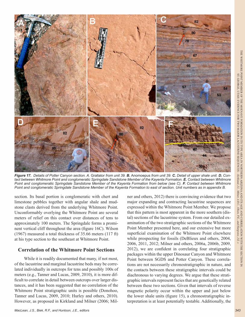
MacLean, J.S., Biek, R.F., and Huntoon, J.E., editors
TH
E W
HIT
MO
RE
POIN
T M
EM
BE
R O
F TH
E M
OE
NA
VE
FOR
MA
TIO
N IN
ITS T
YPE
AR
EA
IN N
OR
TH
ER
N A
RIZ
ON
A A
ND
ITS A
GE
AN
D C
OR
RE
LA
TIO
N W
ITH
TH
E SE
CT
ION
INST. G
EO
RG
E, U
TAH
: EV
IDE
NC
E FO
R T
WO
MA
JOR
LA
CU
STR
INE
SEQ
UE
NC
ES – K
irkland, J.I., Milner, A
.R.C
., Olsen, P.E
., and Hargrave, J.E
. s
343
section. Its basal portion is conglomeratic with chert and limestone pebbles together with angular shale and mud-stone clasts derived from the underlying Whitmore Point. Unconformably overlying the Whitmore Point are several meters of relief on this contact over distances of tens to approximately 100 meters. The Springdale forms a promi-nent vertical cliff throughout the area (figure 16C). Wilson (1967) measured a total thickness of 35.66 meters (117 ft) at his type section to the southeast at Whitmore Point.
Correlation of the Whitmore Point Sections
While it is readily documented that many, if not most, of the lacustrine and marginal lacustrine beds may be corre-lated individually in outcrops for tens and possibly 100s of meters (e.g., Tanner and Lucas, 2009, 2010), it is more dif-ficult to correlate in detail between outcrops over larger dis-tances, and it has been suggested that no correlation of the Whitmore Point stratigraphic units is possible (Donohoo, Tanner and Lucas, 2009, 2010; Hurley and others, 2010). However, as proposed in Kirkland and Milner (2006; Mil-
ner and others, 2012) there is convincing evidence that two major expanding and contracting lacustrine sequences are expressed within the Whitmore Point Member. We propose that this pattern is most apparent in the more southern (dis-tal) sections of the lacustrine system. From our detailed ex-amination of the two stratigraphic sections of the Whitmore Point Member presented here, and our extensive but more superficial examination of the Whitmore Point elsewhere while prospecting for fossils (DeBlieux and others, 2004, 2006, 2011, 2012; Milner and others, 2006a, 2006b, 2009, 2012), we are confident in correlating four stratigraphic packages within the upper Dinosaur Canyon and Whitmore Point between SGDS and Potter Canyon. These correla-tions are not necessarily chronostratigraphic in nature, and the contacts between these stratigraphic intervals could be diachronous to varying degrees. We argue that these strati-graphic intervals represent facies that are genetically related between these two sections. Given that intervals of reverse magnetic polarity occur within the upper and just below the lower shale units (figure 15), a chronostratigraphic in-terpretation is at least potentially testable. Additionally, the
Figure 17. Details of Potter Canyon section. A. Grallator from unit 39. B. Anomoepus from unit 39. C. Detail of upper shale unit. D. Con-tact between Whitmore Point and conglomeratic Springdale Sandstone Member of the Kayenta Formation. E. Contact between Whitmore Point and conglomeratic Springdale Sandstone Member of the Kayenta Formation from below (see C). F. Contact between Whitmore Point and conglomeratic Springdale Sandstone Member of the Kayenta Formation to east of section. Unit numbers as in appendix B.
TH
E W
HIT
MO
RE
PO
INT
ME
MB
ER
OF
TH
E M
OE
NA
VE
FO
RM
AT
ION
IN
IT
S T
YPE
AR
EA
IN
NO
RT
HE
RN
AR
IZO
NA
AN
D I
TS
AG
E A
ND
CO
RR
EL
AT
ION
WIT
H T
HE
SE
CT
ION
IN
ST. G
EO
RG
E, U
TAH
: EV
IDE
NC
E F
OR
TW
O M
AJO
R L
AC
UST
RIN
E S
EQ
UE
NC
ES
– K
irkl
and,
J.I.
, Miln
er, A
.R.C
., O
lsen
, P.E
., an
d H
argr
ave,
J.E
.
UGA Publication 43 (2014)—Geology of Utah's Far South344
finer grained sandstones preserved locally at the top of the Whitmore Point below the unconformity at the base of the Springdale Sandstone represents a fifth stratigraphic pack-age not present in our specific sections. These correlations would be difficult or nearly impossible to recognize in the most northern and eastern exposures of the Whitmore Point where sandstone dominates the entire sequence.
For the purposes of this discussion these intervals are referred to as the: 1) lower proximal sandstone unit; 2) lower lacustrine shale unit; 3) middle proximal sandstone unit; 4) upper lacustrine shale unit; and 5) upper proximal sandstone unit (figure 18).
Lower Proximal Sandstone Unit
Based on the different definitions of the Whitmore Point Member in its type area and its definition in Washing-ton County in southwestern Utah, these rocks may be in-cluded in the Whitmore Point Member of northern Arizona and in the upper Dinosaur Canyon Member in southwest-ern Utah. However, given our definition of the basal con-tact of the Whitmore Point Member, the lower sandstone unit forms the uppermost several meters of the Dinosaur Canyon Member, where the preserved depositional struc-tures are compatible with nearshore lacustrine conditions. The erosional contact below the Tanner and Lucas (2010) sandstone interval at Potter Canyon may be correlated to the widespread plant debris bed at SGDS as both would represent intervals of higher energy and sediment bypass. The overlying sandstone interval has a marked increase in clay content and preserves mostly ripple cross-bedding. Unfortunately, this interval was described from a near ver-tical outcrop at Potter Canyon, and it has not been deter-mined if the abundance of dinosaur tracks and mudcracks at the base of sandstone beds and at partings recognized at SGDS is also a characteristic of this interval at Potter Canyon as well.
Although the basal correlation of these beds may be uncertain, the authors are confident that the upper part of the Dinosaur Canyon Member at SGDS correlates with Tanner and Lucas’ (2010) sandstone interval at the base of their Whitmore Point at Potter Canyon. These strata are in-terpreted to represent sand-dominated sediment reworked by coastal processes during highstands of the initial ex-pansion of Lake Dixie into the southwestern margin of the Moenave outcrop belt.
Lower Lacustrine Shale Unit
The base of the lower shale interval, from the base of unit 37 near the top of the Dinosaur Canyon Member at SGDS, correlates with the base of Whitmore Point Member (unit 18) at Potter Canyon. We did not document a cherty carbonate bed at Potter Canyon that would represent the cherty stromatolitic limestone and nodule bed present in the basal part of the lower shale at SGDS and at many other lo-cations in Washington County, Utah. Our correlation of the
first shales below the Johnson Farm Sandstone Bed with the base of the Whitmore Point Member at Potter Canyon would seem to be consistent Wilson’s (1967) concept of the beginning of Whitmore Point deposition. As has been discussed above (Kirkland and Milner, 2006; Milner and Kirkland, 2006, 2007), the sedimentary features preserved in association with the Johnson Farm Sandstone Bed sup-port its deposition in water depths of approximately 1 meter or more.
The upper contact for this unit is placed at the top of the higher slope-forming mudstone unit, below where sandstone begins to dominate the middle of the member at SGDS, and is correlated to the base of the erosional surface formed at the base of the lenticular sandstone horizon (unit 30) at Potter Canyon. The channelization of this surface is interpreted to represent the lowest depositional base level recorded within the Whitmore Point. The rooting features preserved in the upper part of unit 46 at SGDS are thought to represent colonization of plants on a coastal bar and not the colonization of plants on an exposed floodplain. Basi-cally, this is a correlation of the uppermost shales at the top of the Dinosaur Canyon Member and the lower shale and sandstone interval at SGDS with the lower shale interval at Potter Canyon.
The lower shale unit is significant in preserving the stratigraphically lowest fossil fishes in the Moenave For-mation. Additionally, these shales (units 41-45 at SGDS and units 20-28 at Potter Canyon) preserve the densest con-centrations of ostracods and conchostracans recorded in the Whitmore Point Member and include thin (< 5 cm), highly micaceous sandstone beds that were sampled for (unin-formative) radiometric dates at both sites.
Middle Proximal Sandstone Unit
The middle sandstone interval at SGDS is correlated with the lenticular sandstone unit and overlying middle sandstone at Potter Canyon. There is no evidence of an ero-sional surface at the base of the middle sandstone unit at SGDS; instead, at this locality the lacustrine system is in-terpreted to have become more restricted before an overall expansion of the lake. Dinosaur tracks are associated with some of these sandstones at both sections. The abundance of fossil fishes present in this unit is unique when compared with any other sandstone interval in the Moenave Formation.
Upper Lacustrine Shale Unit
The upper shale unit is the most widespread and distinctive facies in the Whitmore Point Member. As de-scribed above, a purplish-pink or mauve dolomitic shale and siltstone interval is visible at a distance below the cliffs formed by the Springdale Sandstone Member of the Kayenta Formation across all of southwestern Utah and northeastern Arizona. Even where sandstone beds come to dominate this unit on the northwestern and eastern margins of the Whitmore Point outcrop belt, bright red iron-oxide-
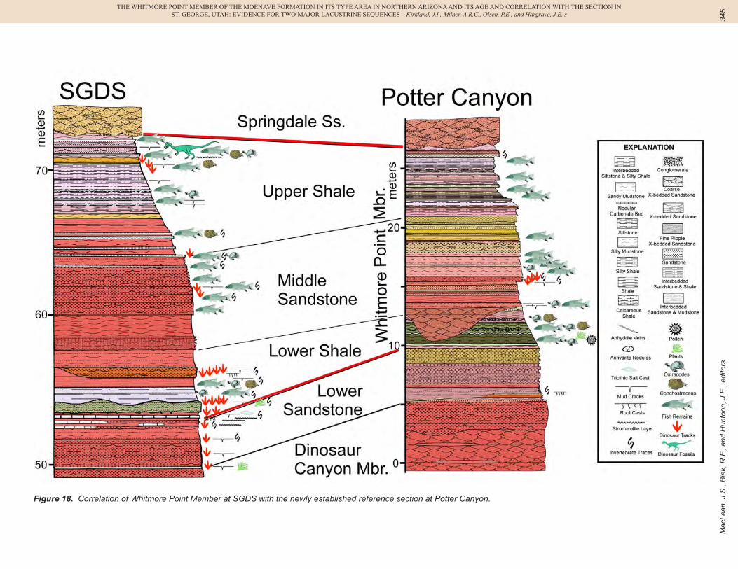
Mac
Lean
, J.S
., B
iek,
R.F
., an
d H
unto
on, J
.E.,
edito
rs
THE WHITMORE POINT MEMBER OF THE MOENAVE FORMATION IN ITS TYPE AREA IN NORTHERN ARIZONA AND ITS AGE AND CORRELATION WITH THE SECTION INST. GEORGE, UTAH: EVIDENCE FOR TWO MAJOR LACUSTRINE SEQUENCES – Kirkland, J.I., Milner, A.R.C., Olsen, P.E., and Hargrave, J.E. s
345
Figure 18. Correlation of Whitmore Point Member at SGDS with the newly established reference section at Potter Canyon.
TH
E W
HIT
MO
RE
PO
INT
ME
MB
ER
OF
TH
E M
OE
NA
VE
FO
RM
AT
ION
IN
IT
S T
YPE
AR
EA
IN
NO
RT
HE
RN
AR
IZO
NA
AN
D I
TS
AG
E A
ND
CO
RR
EL
AT
ION
WIT
H T
HE
SE
CT
ION
IN
ST. G
EO
RG
E, U
TAH
: EV
IDE
NC
E F
OR
TW
O M
AJO
R L
AC
UST
RIN
E S
EQ
UE
NC
ES
– K
irkl
and,
J.I.
, Miln
er, A
.R.C
., O
lsen
, P.E
., an
d H
argr
ave,
J.E
.
UGA Publication 43 (2014)—Geology of Utah's Far South346
stained, carbonate-coated fish remains reflect this interval of lacustrine deposition. The evidence that this interval rep-resents fluctuating lake environments that were regularly subaerially exposed has been well documented (Kirkland and Milner, 2006; Lucas and Tanner, 2007; Tanner and Lu-cas, 2010).
Upper Proximal Sandstone Unit
Although the upper sandstone unit is not present where either section was measured, its presence in both ar-eas is well-documented (figures 13A, 13B, 16A, 17F). Its discontinuous presence below the J-0’ unconformity docu-ments that a regressive lacustrine shoreline and perhaps floodplain facies developed prior to continued lowering of depositional base level and erosion forming the regional J-0' unconformity below the Kayenta Formation.
Age of the Moenave Formation
The Whitmore Point Member preserves thick-scaled semionotid fish (Hesse, 1935; Schaeffer and Dunkle, 1950; Milner and others, 2005a; Milner and Kirkland, 2006) that previously had been used to date these beds variably as Ear-ly Jurassic or Late Triassic (Harshbarger and others, 1957). An Early Jurassic age for the Whitmore Point Member had been accepted based on comparisons of these fossil fishes with those preserved in the Newark Supergroup of eastern North America (Olsen and others, 1982; Lucas and Tanner, 2007). However, Semionotus kanabensis (Schaeffer and Dunkle, 1950) from the Whitmore Point Member has now been assigned to Lophionotus (Gibson, 2013b), with two species of this genus (L. sanjuanensis and L. chinleana) also being described from the Late Triassic age Church Rock Member of the Chinle Formation of Utah (Gibson, 2013a, 2013b). However, the Early Jurassic age for the Moenave Formation was also supported by palynostratig-raphy (Olsen and Galton, 1977; Litwin, 1986; Cornet and Waanders, 2006), crocodyliforms (Clark and Fastovsky, 1986), dinosaurs (Lucas and Heckert, 2001; Lucas, 2009), and fossil tracks (Olsen and Galton, 1977; Olsen and Pa-dian, 1986; Lucas and Heckert, 2001; Lucas, 2007).
In the last two decades, fossils generally associated with the Late Triassic have been found in the lower Win-gate Sandstone of the basal Glen Canyon Group (Lockley and others, 1992, 2004; Morales and Ash, 1993; Lucas and others, 1997; Gaston and others, 2003; Odier and others, 2004; Martz and others, this volume). On the assumption that the lower Wingate intertongues laterally with the Moe-nave Formation, these fossils have been used to argue that the Triassic-Jurassic boundary lies somewhere within the Dinosaur Canyon Member of the Moenave Formation and within the intertonguing Wingate Sandstone Formation to the northeast. However, this assumption is far from cer-tain, and given the current debate about the position of the Triassic-Jurassic boundary, the age of the Moenave and
the stratigraphic level of the end-Triassic extinction (ETE) deserve discussion. The following is abstracted from the detailed review of this debate in Milner and others (2012).
It has been argued that correlation of the Triassic-Jurassic boundary from marine strata to continental strata could be based on a recognition of the level at which “diag-nostic” Triassic taxa (palynomorphs, tetrapods, freshwater arthropods) disappeared, and less common “diagnostic” Jurassic taxa appear. A few fossils are present in both ma-rine and terrestrial facies (e.g., palynomorphs), while oth-ers are generally not (e.g., the terrestrial tetrapods and am-monites). The previous consensus was that the appearance of Jurassic-type ammonites corresponded closely to the extinction of many Triassic taxa, both marine invertebrates and terrestrial palynomorphs, and therefore the Triassic-Jurassic boundary could be located in continental deposits based on shared terrestrial palynomorphs. With the Trias-sic-Jurassic biotic transition as a catastrophic mass extinc-tion being debated, a great deal of attention has recently been focused on the details of this transition (e.g., Ward and others, 2001, 2004, 2007; Olsen and others, 2002; Hesselbo and others, 2002; Guex and others, 2004; Hounslow and others, 2004; Marzoli and others, 2004; Tanner and others, 2004).
The International Stratigraphic Boundary Commis-sion chose a Global Boundary Stratotype Section and Point (GSSP), a formal definition of the Triassic-Jurassic bound-ary (i.e., basal Hettangian), that is not at the interval of the alleged mass extinctions (Hillebrandt and others, 2007; Morton and Hesselbo, 2008; Morton, 2012). The GSSP for the basal Hettangian is set at the first appearance of the am-monite Psiloceras spelae tirolicum (a European subspecies: Hillebrandt and Krystyn, 2009) at the Kuhjoch section, Karwendel Mountains, Tyrol, Austria. This level is signifi-cantly above the level of the last occurrence of typically Triassic ammonites, Triassic bivalves, and conodonts. It is also above the terrestrial palynomorph turnover that occurs in these same sections. Thus it becomes critical not to con-fuse the Triassic-Jurassic boundary with the ETE interval. In addition, while the ETE could be globally isochronous, the first occurrence of a specific type of organism is at some scale not only diachronous but based on a marine taxon not at all useful in terrestrial strata. Indeed, the subspecies is not as yet known outside the local area of the GSSP.
These issues need to be kept in mind when discuss-ing the age of the Moenave Formation. For example, bar-ring evidence to the contrary, it is entirely possible that the Triassic-Jurassic boundary could be within the Moenave, while the extinction interval could be represented by the Moenave-Chinle unconformity, or that the Triassic-Jurassic boundary could be within the Whitmore Point Member of the Moenave Formation, while the extinction interval could be in the lower Moenave. If the continental extinction in-terval correlates to the marine extinction then it must be of Triassic age. The currently accepted Triassic-Jurassic
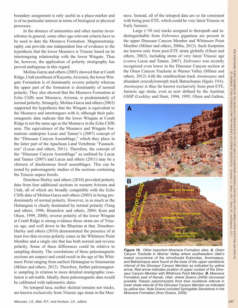
MacLean, J.S., Biek, R.F., and Huntoon, J.E., editors
TH
E W
HIT
MO
RE
POIN
T M
EM
BE
R O
F TH
E M
OE
NA
VE
FOR
MA
TIO
N IN
ITS T
YPE
AR
EA
IN N
OR
TH
ER
N A
RIZ
ON
A A
ND
ITS A
GE
AN
D C
OR
RE
LA
TIO
N W
ITH
TH
E SE
CT
ION
INST. G
EO
RG
E, U
TAH
: EV
IDE
NC
E FO
R T
WO
MA
JOR
LA
CU
STR
INE
SEQ
UE
NC
ES – K
irkland, J.I., Milner, A
.R.C
., Olsen, P.E
., and Hargrave, J.E
. s
347
boundary assignment is only useful as a place-marker and is of no particular interest in terms of biological or physical processes.
In the absence of ammonites and other marine inver-tebrates in general, some other age-relevant criteria have to be used to date the Moenave Formation. Magnetostratig-raphy can provide one independent line of evidence to the hypothesis that the lower Moenave is Triassic based on its intertonguing relationship with the lower Wingate. Thus far, however, the application of polarity stratigraphy has proved ambiguous in this regard.
Molina-Garza and others (2003) showed that at Comb Ridge, Utah (northeast of Kayenta, Arizona), the lower Win-gate Formation is of dominantly reverse polarity whereas the upper part of the formation is dominantly of normal polarity. They also showed that the Moenave Formation at Echo Cliffs near Moenave, Arizona, is predominately of normal polarity. Strangely, Molina-Garza and others (2003) supported the hypothesis that the Wingate is equivalent to the Moenave and intertongues with it, although their pale-omagnetic data indicate that the lower Wingate at Comb Ridge is not the same age as the Moenave in the Echo Cliffs area. The equivalence of the Moenave and Wingate For-mations underpins Lucas and Tanner’s (2007) concept of the “Dinosaur Canyon Assemblage,” which they place in the latter part of the Apachean Land Vertebrate “Faunach-ron” (Lucas and others, 2011). Therefore, the concept of the “Dinosaur Canyon Assemblage” as outlined by Lucas and Tanner (2007) and Lucas and others (2011) may be a chimera of diachronous fossil assemblages. This can be tested by paleomagnetic studies of the sections containing the Triassic-aspect fossils.
Donohoo-Hurley and others (2010) provided polarity data from four additional sections in western Arizona and Utah, all of which are broadly compatible with the Echo Cliffs data of Molina-Garza and others (2003) in being pre-dominately of normal polarity. However, in as much as the Hettangian is clearly dominated by normal polarity (Yang and others, 1996; Hounslow and others, 2004; Kent and Olsen, 1999, 2008), reverse polarity of the lower Wingate at Comb Ridge is strong evidence those strata are of Trias-sic age, and well down in the Rhaetian at that. Donohoo-Hurley and others (2010) demonstrated the presence of at least two thin reverse polarity zones in the Whitmore Point Member and a single site that has both normal and reverse polarity. Some of these differences could be relative to sampling density. The correlations of these paleomagnetic sections are suspect and could result in the age of the Whit-more Point ranging from earliest Hettangian to Sinemurian (Milner and others, 2012). Therefore, further paleomagnet-ic sampling in relation to more detailed stratigraphic reso-lution is advisable. Ideally, these paleomagnetic data would be calibrated with radiometric dates.
No tetrapod taxa, neither skeletal remains nor tracks, are known exclusively from Triassic-age strata in the Moe-
nave. Instead, all of the tetrapod data are so far consistent with being post-ETE, which could be very latest Triassic or Early Jurassic.
Large (>30 cm) tracks assigned to theropods and in-distinguishable from Eubrontes giganteus are present in the upper Dinosaur Canyon Member and Whitmore Point Member (Milner and others, 2006a, 2012). Such footprints are known only from post-ETE strata globally (Olsen and others, 2002), including strata of very latest Triassic age (contra Lucas and Tanner, 2007). Eubrontes was recently recognized even lower in the Dinosaur Canyon section at the Olsen Canyon Tracksite in Warner Valley (Milner and others, 2012) with the ornithischian track Anomoepus and abundant crocodylomorph track Batrachopus (figure 19A). Anomoepus is thus far known exclusively from post-ETE, Jurassic age strata, even as now defined by the Austrian GSSP (Lockley and Hunt, 1994, 1995; Olsen and Galton,
Figure 19. Other important Moenave Formation sites. A. Olsen Canyon Tracksite in Warner Valley where southwestern Utah’s lowest occurrence of the ichnofossils Eubrontes, Anomoepus, and Batrachopus were found at the base of the upper sandstone interval of the Dinosaur Canyon Member as indicated by yellow arrow. Red arrow indicates position of upper contact of the Dino-saur Canyon Member with Whitmore Point Member. B. Moenave Formation east of Kanab, Utah, where Downs (2009) recovered possible Triassic palynomorphs from blue mudstone interval in lower shale interval of the Dinosaur Canyon Member as indicated by yellow box. Note Downs included Springdale Sandstone in the Moenave Formation (from Downs, 2009).

TH
E W
HIT
MO
RE
PO
INT
ME
MB
ER
OF
TH
E M
OE
NA
VE
FO
RM
AT
ION
IN
IT
S T
YPE
AR
EA
IN
NO
RT
HE
RN
AR
IZO
NA
AN
D I
TS
AG
E A
ND
CO
RR
EL
AT
ION
WIT
H T
HE
SE
CT
ION
IN
ST. G
EO
RG
E, U
TAH
: EV
IDE
NC
E F
OR
TW
O M
AJO
R L
AC
UST
RIN
E S
EQ
UE
NC
ES
– K
irkl
and,
J.I.
, Miln
er, A
.R.C
., O
lsen
, P.E
., an
d H
argr
ave,
J.E
.
UGA Publication 43 (2014)—Geology of Utah's Far South348
1984; Olsen and Rainforth, 2003; Lucas and Tanner, 2007; Lucas 2007, 2009). Additionally, Batrachopus had also been considered to be an index trace fossil for the basal Jurassic (Olsen and Padian, 1986), although subsequently the genus has been found in pre-ETE strata in eastern North America (Olsen and others, 2002). Thus, three ichnotaxa restricted to the post-ETE are present in the middle of the Dinosaur Canyon Member (Olsen and others, 2002).
It has been generally accepted that the basal croco-dylomorph Protosuchus richardsoni (Colbert and Mook, 1951) from the Dinosaur Canyon Member of north-central Arizona is earliest Hettangian in age (Clark and Fastovsky, 1986; Shubin and others, 1994; Sues and others, 1994; Gow, 2000; Lucas and Heckert, 2001; Lucas, 2009; Lu-cas and others, 2011). However, protosuchids are known from presumptive Triassic strata elsewhere (Bonaparte, 1969; Olsen and others, 2002; Arcucci and others, 2004; Santi Malnis and others, 2011). Finally, based on the cor-relation in Whiteside and others (2007, 2010), the strata producing Protosuchus micmac (Sues and others, 1996) in Nova Scotia are post-initial-ETE, but still latest Triassic in age. Thus, the presence of Protosuchus is uninformative other than indicating a Late Triassic to Early Jurassic age. This also means that the end of the Apachean land verte-brate “faunachron” and the beginning of the Wasonian land vertebrate “faunachron,” defined by the first appearance of Protosuchus (Lucas and Tanner, 2007), is probably lat-est Triassic in age rather than approximating the Triassic-Jurassic boundary (contra Lucas and Tanner, 2007).
The distribution of conchostracans (Lucas and Mil-ner, 2006; Kozur and Weems, 2010; Lucas and others, 2011) has been interpreted to show that the lower part of the Whitmore Point Member is Rhaetian rather than ear-ly Hettangian in age, based on the exclusive presence of Euestheria brodieana. Kozur and Weems (2010) reported that the turnover in conchostracan faunas through the Rha-etian-Hettangian boundary is gradual, where the monospe-cific fauna of Euestheria brodieana (Jones) in the latest, post-ETE Rhaetian is followed by a basal Hettangian fauna still dominated by E. brodieana, but including Bulbilim-nadia killianorum Kozur (Weems and Lucas, 2010, in Ko-zur and Weems, 2010). This proposed Hettangian pairing of conchostracans was reported from near the top of the Whitmore Point Member (Lucas and others, 2011), both at SGDS and in the Whitmore Point area. Therefore, were these interpretations correct, the Triassic-Jurassic boundary would be in the Whitmore Point Member and would not change the interpretation that most, if not all, of the Moe-nave Formation postdates the ETE.
It has long been recognized that the palynomorphs of the Moenave are overwhelmingly dominated by Classopol-lis spp., and the apparent absence of taxa restricted to the Late Triassic led to the conclusion that the Moenave is Ear-ly Jurassic in age (Olsen and Galton, 1977; Litwin, 1986), with more recent suggestions, however, that the Triassic-
Jurassic boundary lies within the formation (Cornet and Waanders, 2006; Kürschner and Batenburg in Lucas and others, 2011). Again, where the currently accepted Triassic-Jurassic boundary lies has little bearing on the great extinc-tion event preceding it, which was previously the relevant, and still is the more interesting datum.
Recently, Downs (2009) described palynomorph as-semblages from the lower Dinosaur Canyon Member of the Moenave Formation on the east side of Kanab, Utah, (figure 19B) and concluded that there were examples of the otherwise pre-ETE Patinasporites and Vallasporites from the lower half of the Dinosaur Canyon Member. However, based on the photographs, the purported, extremely rare Patinasporites are poorly preserved and are suspect (as interpreted by Olsen, in Milner and others, 2012). Unfor-tunately, Vallasporites was not illustrated. This very impor-tant occurrence needs further investigation. While Cornet and Waander’s (2006) palynomorph samples were from the lower Whitmore Point, Litwin’s (1986) palynomorph sample was from an unspecified stratigraphic position in the Dinosaur Canyon near Leeds, Utah. If not reworked, Downs’ (2009) identifications would suggest that the ETE lies within the Dinosaur Canyon Member. Additional paly-nological research on these strata is certainly called for.
Within this context, the specific views of some re-searchers, based on magnetostratigraphy, biostratigraphy, and palynology, that the entire Dinosaur Canyon Member and lower portion of the Whitmore Point Member of the Moenave Formation are Late Triassic in age, rather than Early Jurassic age, can be examined (Donohoo-Hurley and others, 2010; Kozur and Weems, 2010; Lucas and others, 2011). Donohoo-Hurley and others (2010) placed the Triassic-Jurassic boundary based on their magneto-stratigraphic interpretations approximately 3 to 13 meters (9.8–42.6 ft) above the Dinosaur Canyon-Whitmore Point contact within the Whitmore Point Member. However, the biostratigraphic and magnetostratigraphic levels in eastern North America and England to which they refer lie within the latest Rhaetian.
The complete absence of characteristic Late Triassic tracks, such as Brachychirotherium, Apatopus, Atreipus, Evozoum, and Gwyneddichnium, anywhere in the Moenave Formation, so common in the Rhaetian Church Rock-Rock Point Members of the Chinle Formation and lower Wingate Sandstone (e.g., Lockley and Hunt, 1995; Gaston and oth-ers, 2003; Hunt and Lucas 2007; Milner and others, 2012), argues that the ETE is not represented in the fossiliferous portions of Moenave Formation. The same is true for the absence of body fossils of non-crocodylomorph crurotar-sans such as phytosaurs, aetosaurs, and "rauisuchians" in the Dinosaur Canyon and lower part of the Whitmore Point Members. If the ETE is preserved within the Moenave, it should be in the lower shaly part of the Dinosaur Canyon Member, an interval that thus far has produced no verte-brate fossils of any sort (figure 20).
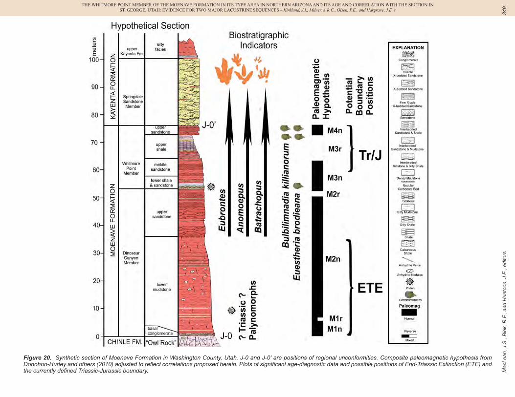
Mac
Lean
, J.S
., B
iek,
R.F
., an
d H
unto
on, J
.E.,
edito
rs
THE WHITMORE POINT MEMBER OF THE MOENAVE FORMATION IN ITS TYPE AREA IN NORTHERN ARIZONA AND ITS AGE AND CORRELATION WITH THE SECTION INST. GEORGE, UTAH: EVIDENCE FOR TWO MAJOR LACUSTRINE SEQUENCES – Kirkland, J.I., Milner, A.R.C., Olsen, P.E., and Hargrave, J.E. s
349
Figure 20. Synthetic section of Moenave Formation in Washington County, Utah. J-0 and J-0' are positions of regional unconformities. Composite paleomagnetic hypothesis from Donohoo-Hurley and others (2010) adjusted to reflect correlations proposed herein. Plots of significant age-diagnostic data and possible positions of End-Triassic Extinction (ETE) and the currently defined Triassic-Jurassic boundary.
TH
E W
HIT
MO
RE
PO
INT
ME
MB
ER
OF
TH
E M
OE
NA
VE
FO
RM
AT
ION
IN
IT
S T
YPE
AR
EA
IN
NO
RT
HE
RN
AR
IZO
NA
AN
D I
TS
AG
E A
ND
CO
RR
EL
AT
ION
WIT
H T
HE
SE
CT
ION
IN
ST. G
EO
RG
E, U
TAH
: EV
IDE
NC
E F
OR
TW
O M
AJO
R L
AC
UST
RIN
E S
EQ
UE
NC
ES
– K
irkl
and,
J.I.
, Miln
er, A
.R.C
., O
lsen
, P.E
., an
d H
argr
ave,
J.E
.
UGA Publication 43 (2014)—Geology of Utah's Far South350
The position of the Triassic-Jurassic boundary is dis-tinct from and far less interesting than the ETE paleobio-logical event. Available evidence suggests that the GSSP boundary could lie within the Moenave Formation, some-where between the upper Dinosaur Canyon Member and the upper Whitmore Point Member, whereas the ETE probably does not occur higher than the lower part of the Dinosaur Canyon Member. Clearly this matter is far from resolved, but we believe that northwestern Arizona and southwestern Utah are slowly yielding evidence as to where the Triassic-Jurassic boundary and the ETE should be recognized, and that continued research in the region shall provide impor-tant data pertaining to this interesting time interval.
CONCLUSIONS
Correlation of the upper Dinosaur Canyon Member and Whitmore Point Member of the Moenave Formation between the St. George, Utah, area and Potter Canyon in the Vermillion Cliffs of northern Arizona indicates that two major lake cycles are preserved in the upper half of the Moenave Formation on the western side of the Colorado Plateau. The lower lake cycle is defined as including the upper portion of the Dinosaur Canyon Member as a unit of shallow marginal ripple cross-bedded and ripple-laminated sandstones emplaced by a wave-dominated coastal envi-ronment. These sandstones and associated rocks are over-lain by shales and more offshore sandstone beds preserving an abundance of ostracods, conchostracans, and the first common fish remains. Thin micaceous sandstone beds and laminae are also characteristic.
An interval of down-cutting and channelization re-flects the boundary between the lower and upper lake inter-vals at Potter Canyon. However, an increase in the amount of sandstone reworked by wave-dominated coastal proc-esses indicates a greater restriction of dimensions of Lake Dixie without convincing evidence of sediment bypass. The middle sandstone unit reflects the expansion of these environments well out across the basin, while preserving an abundance of fossil fishes recruited from nearby areas during periodic lake highstands. The greatest lateral ex-tent of lacustrine interval is preserved by the pale-red and purplish-red, platy, dolomitic shales of the upper shale in-terval. The relatively resistant nature of the beds and the red-colored concretion coating fossil fish material make this interval a hallmark for identifying the Whitmore Point Member even where poorly exposed below the Springdale Sandstone Member. These lacustrine units may be overlain by fine- to medium-grained, ripple-bedded sandstones de-posited as Lake Dixie contracted, or may be directly over-lain by conglomeratic trough-cross-bedded sandstones of the Springdale Sandstone Member of the Kayenta Forma-tion, depending on the amount of down-cutting along the J-0' unconformity.
Although it might be tempting to describe these cy-
cles formally, as has been done for other formations having major lake cycles such as the Bonneville basin of western Utah (Morrison, 1991; Oviatt and others, 2011), more re-search must be undertaken to identify potential bound-ing disconformities regionally. While the two cycles are bounded by distinct disconformities at Potter Canyon, in contrast to SGDS, a clear disconformity separating these cycles has not been identified. A sequence-stratigraphic ap-proach to the correlation of the rocks from offshore sites to the coastline of Lake Dixie would facilitate developing a stronger framework for discussing the depositional history of the northeastern margin of Lake Dixie. The development of high-resolution stratigraphic data for the offshore facies of Lake Dixie will provide a framework for correlation of these strata into the coastal and floodplain facies bet-ter preserved progressively to the northeast, much in the same way that the detailed framework developed within the central Western Interior Cretaceous Seaway (Cobban and Scott, 1972; Hattin, 1975; Elder and Kirkland, 1985) provided the framework for extending our understanding of these cyclic marine strata into progressively more shal-low marine strata to the west (Kirkland, 1991; Leithold, 1994; Leckie and others, 1997) and eventually onshore into the fully terrestrial facies of southwestern Utah (Elder and others, 1994; Eaton and others, 1997; Ulicny, 1999; Laurin and Sageman, 2001; Tibert and others, 2003).
Whereas the Triassic-Jurassic stage boundary may be preserved within the Whitmore Point Member, the ETE event may be not be preserved in the Moenave Formation at all. However, based on palynological data alone, the prospect that the ETE may be preserved in the lower part of the Dinosaur Canyon Member cannot be discounted. Fur-ther research on the lower shale interval at the base of the Moenave Formation is required to resolve this debate.
It is hoped that the stratigraphic data presented here provide a basis for more detailed study of the Moenave Formation along the western Utah-Arizona borderland and direct further attention to the interesting lacustrine units of the Whitmore Point Member that define Lake Dixie.
ACKNOWLEDGMENTS
We thank the Bureau of Land Management, Zion Na-tional Park, School and Institutional Trust Lands Admin-istration, Utah Department of Transportation, Washington County, and the City of St. George for granting us permis-sion to conduct research on their lands. Dave Sharrow is thanked for figure 13B. Ron Blakey is thanked for develop-ing figure 3A for our use.
We thank the DinosaurAh!Torium Foundation and the staff (especially Director, Rusty Salmon) and the many vol-unteers at the St. George Dinosaur Discovery Site at John-son Farm for assistance with many aspects of this project, not only at the SGDS, but at other localities in Washington County.

MacLean, J.S., Biek, R.F., and Huntoon, J.E., editors
TH
E W
HIT
MO
RE
POIN
T M
EM
BE
R O
F TH
E M
OE
NA
VE
FOR
MA
TIO
N IN
ITS T
YPE
AR
EA
IN N
OR
TH
ER
N A
RIZ
ON
A A
ND
ITS A
GE
AN
D C
OR
RE
LA
TIO
N W
ITH
TH
E SE
CT
ION
INST. G
EO
RG
E, U
TAH
: EV
IDE
NC
E FO
R T
WO
MA
JOR
LA
CU
STR
INE
SEQ
UE
NC
ES – K
irkland, J.I., Milner, A
.R.C
., Olsen, P.E
., and Hargrave, J.E
. s
351
Utah Friends of Paleontology are thanked for their help on so many of the projects discussed within this pub-lication.
Thank you to Dr. Jeffery Martz, Robert Gay, Martha Hayden, and Robert Ressetar for reviewing this paper.
REFERENCES
Arcucci, A.B., Marsicano, C.A., and Caselli A.T., 2004, Tetra-pod association and palaeoenvironment of the Los Colo-rados Formation (Argentina)—a significant sample from Western Gondwana at the end of the Triassic: Geobios, v. 37, p. 557–568.
Biek, R.F., 2003a, Geologic map of the Hurricane quadrangle, Washington County, Utah: Utah, Geological Survey Map 187, 61 p., scale 1:24,000.
Biek, R.F., 2003b, Geologic map of the Harrisburg Junction quadrangle, Washington County, Utah: Utah Geological Survey Map 191, 44 p., scale 1:24,000.
Biek, R.F., 2007, Geologic map of the Kolob Arch quadrangle, Washington and Iron Counties, Utah: Utah Geological Sur-vey Map 225, 3 plates, scale 1:24,000.
Biek, R.F., Rowley, P.D., Hayden, J.M., Hacker, D.B., Willis, G.C., Hintze, L.F., Anderson, R.E., and Brown, K.D., 2009, Geologic map of the St. George and east part of the Clo-ver Mountains 30' x 60' quadrangles, Washington and Iron Counties, Utah: Utah Geological Survey Map 242, 101 p., 2 plates, scale 1:100,000.
Biek, R.F., G.C. Willis, M.D. Hylland, and H.H. Doelling, 2010, Geology of Zion National Park, Utah, in Sprinkel, D.A., Chidsey, T.C., Jr., and Anderson, P.B., editors, Geology of Utah’s parks and monuments (3rd edition): Utah Geological Association and Bryce Canyon Natural History Associa-tion Publication 28, p. 107-137.
Blakey, R.C., 1994, Paleogeographic and tectonic controls on some Lower and Middle Jurassic erg deposits, Colorado Plateau, in Caputo, M.V., Peterson, J.A., and Franczyk, K.J., editors, Mesozoic systems of the Rocky Mountain re-gion, USA: Denver, Colorado, Rocky Mountain Section of the Society for Sedimentary Geology, p. 273-298.
Blakey, R., and Ranney, W., 2008, Ancient landscapes of the Colorado Plateau: Grand Canyon, Arizona, Grand Canyon Association, 156 p.
Bonaparte, J.F., 1969, Dos nuevas faunas de reptiles triásicos de Argentina: Gondwana Stratigraphy, I.U.G.S., Coloquio Mar del Plata, Mar del Plata 1967, p. 283–302.
Chin, K., Kirkland, J.I., Milner, A.R.C., and Mickelson, D.L., 2003, Distinctive accumulations of fossil fish debris in the Moenave Formation tell a story of life and death in a bioti-cally productive, Early Jurassic lake near St. George, Utah: Journal of Vertebrate Paleontology, v. 23, p. 40A.
Clark, J.M., and Fastovsky, D.E., 1986, Vertebrate biostratig-raphy of the Glen Canyon Group in northern Arizona, in Padian, K., editor, The beginning of the age of dinosaurs—faunal change across the Triassic-Jurassic boundary: Cam-bridge, Cambridge University Press, p. 285-301.
Clemmensen, L.B., Olsen, H., and Blakey, R.C., 1989, Erg mar-
gin deposits in the Lower Jurassic Moenave Formation and Wingate Sandstone, southern Utah: Geological Society of America Bulletin, v. 101, p. 759-773.
Colbert, E.H., and Mook, C.C., 1951, The ancestral crocodilian Protosuchus: Bulletin of the American Museum of Natural History, v. 97, p.143-182.
Cobban, W.A., and Scott, G.R., 1972, Stratigraphy and ammo-nite fauna of the Graneros Shale and Greenhorn Limestone near Pueblo, Colorado: U.S. Geological Survey Profession-al Paper 645, 108 p.
Cornet, B,. and Waanders G., 2006, Palynomorphs indicate Het-tangian (Early Jurassic) age for the middle Whitmore Point Member of the Moenave Formation, Utah and Arizona, in Harris, J.D., Lucas, S.G., Spielmann, J.A., Lockley, M.G., Milner, A.R.C., and Kirkland, J.I., editors, The Triassic-Jurassic terrestrial transition: New Mexico Museum of Natural History and Science Bulletin 37, p. 390-406.
Curtis, K., and Padian, K., 1999, An Early Jurassic microverte-brate fauna from the Kayenta Formation of northeastern Arizona—microfaunal change across the Triassic-Jurassic boundary: PaleoBios, v. 19, no. 2, p. 19-37.
DeBlieux, D.D., Hunt, J.G., Kirkland, J.I., Madsen, S.K., Ink-enbrandt, P., Ferris-Rowley, D., and Milner, A.R.C., 2011, A paleontological resource inventory of Bureau of Land Management wilderness lands in Washington County, Utah: Brigham University Geological Studies 49, p. 8.
DeBlieux, D.D., Hunt, J.G., Kirkland, J.I., and Madsen, S.K., 2012, Washington County BLM wilderness areas paleon-tological survey: unpublished report to Bureau of Land Management, 44 p.
DeBlieux, D.D., Kirkland, J.I., Smith, J.A., McGuire, J., and Santucci, V.L., 2006, An overview of the paleontology of Upper Triassic and Lower Jurassic rocks in Zion National Park, Utah, in Harris, J.D., Lucas, S.G., Spielmann, J.A., Lockley, M.G., Milner, A.R.C., and Kirkland, J.I., editors, The Triassic-Jurassic terrestrial transition: New Mexico Museum of Natural History and Science Bulletin 37, p. 490-501.
DeBlieux, D.D., Smith, J.A., McGuire, J.L., Kirkland, J.I., and Santucci, V.L., 2004, Zion National Park paleontological survey, Salt Lake City: unpublished report to National Park Service, 89 p.
Donohoo-Hurley, L.L., Geissman J.W., and Lucas, S.G., 2010, Magnetostratigraphy of the uppermost Triassic and low-ermost Jurassic Moenave Formation, western United States—correlation with strata in the United Kingdom, Morocco, Turkey, Italy, and eastern United States: Geologi-cal Society of America Bulletin 122, p. 1936-1950.
Downs, D.T., 2009, In search of the Triassic-Jurassic bounda-ry—palynostratigraphy and carbon-isotope stratigraphy of the lower Dinosaur Canyon Member on the Colorado Pla-teau (Kanab, Utah): Carbondale, Illinois, Southern Illinois University, M.S. thesis, 116 p.
Eaton, J.G., Kirkland, J.I., Hutchison, J.H., Denton, R., O'Neill, R.C., and Parrish, J.M., 1997, Nonmarine extinction across the Cenomanian-Turonian (C-T) boundary, southwestern Utah, with a comparison to the Cretaceous-Tertiary (K-T) extinction event: Geological Society of America Bulletin, v. 109, p. 560-567.
TH
E W
HIT
MO
RE
PO
INT
ME
MB
ER
OF
TH
E M
OE
NA
VE
FO
RM
AT
ION
IN
IT
S T
YPE
AR
EA
IN
NO
RT
HE
RN
AR
IZO
NA
AN
D I
TS
AG
E A
ND
CO
RR
EL
AT
ION
WIT
H T
HE
SE
CT
ION
IN
ST. G
EO
RG
E, U
TAH
: EV
IDE
NC
E F
OR
TW
O M
AJO
R L
AC
UST
RIN
E S
EQ
UE
NC
ES
– K
irkl
and,
J.I.
, Miln
er, A
.R.C
., O
lsen
, P.E
., an
d H
argr
ave,
J.E
.
UGA Publication 43 (2014)—Geology of Utah's Far South352
Elder, W.P., Gustason, E.R., and Sageman, B.B., 1994, Correla-tion of basinal carbonate cycles to nearshore parasequences in the Late Cretaceous Greenhorn Seaway, Western Interi-or U.S.A.: Geological Society of America Bulletin, v. 106, p. 892-902.
Elder, W. P., and Kirkland, J.I., 1985, Stratigraphy and deposi-tional environments of the Bridge Creek Limestone Mem-ber of the Greenhorn Limestone at Rock Canyon anticline near Pueblo, Colorado, in Pratt, L.M., Kauffman, E.G., and Zelt, F.B., editors, Fine grained deposits and biofacies of the Cretaceous Western Interior Seaway—evidence of cy-clic sedimentary processes: Society of Economic Paleon-tologists and Mineralogists field trip guidebook no. 4, 1985 midyear meeting, Golden, Colorado, p. 122 134.
Gaston, R., Lockley, M., Lucas, S., and Hunt, A., 2003, Gralla-tor-dominated fossil footprint assemblages and associated enigmatic footprints from the Chinle Group (Upper Trias-sic), Gateway area, Colorado: Ichnos, v. 10, p. 153-163.
Gibson, S.Z. 2013a. A new hump-backed ginglymodian fish (Neopterygii: Semionotiformes) from the Upper Triassic Chinle Formation of southeastern Utah: Journal of Verte-brate Paleontology, v. 33, p. 1037–1050.
Gibson, S.Z., 2013b, Biodiversity and evolutionary history of Lophionotus (Neopterygii: Semionotiformes) from the western United States: Copeia 2013, no. 4, p. 582-603.
Gow, C.E., 2000, The skull of Protosuchus haughtoni, an Early Jurassic crocodyliform from southern Africa: Journal of Vertebrate Paleontology, v. 20, p. 49-56.
Gregory, H.E., 1950, Geology and geography of the Zion Park region, Utah and Arizona: U.S. Geological Survey Profes-sional Paper 220, 200 p.
Guex, J., Bartolini, A., Atudorei, V., and Taylor, D., 2004, High-resolution ammonite and carbon isotope stratigraphy across the Triassic-Jurassic boundary at New York Canyon, Ne-vada: Earth and Planetary Science Letters, v. 225, p. 29-41.
Hamblin, A.H., 2006, Spectrum tracksite – also known as the Grapevine Pass Wash tracksite, in Reynolds, R.E., editor, Making tracks across the Southwest: Zzyzx, California State University Desert Studies Consortium and LSA As-sociates, Inc., p. 29-34.
Hamblin, A.H., Lockley, M.G., and Milner, A.R.C., 2006, More reports of theropod dinosaur tracksites from the Kayenta Formation (Lower Jurassic), Washington County, Utah—implications for describing the Springdale megatracksite, in Harris, J.D., Lucas, S.G., Spielmann, J.A., Lockley, M.G., Milner, A.R.C., and Kirkland, J.I., editors, The Tri-assic-Jurassic terrestrial transition: New Mexico Museum of Natural History and Science Bulletin 37, p. 276-281.
Harshbarger, J.W., Repenning, C.A., and Irwin, J.H., 1957, Stratigraphy of the uppermost Triassic and the Jurassic rocks of the Navajo Country: U.S. Geological Survey Pro-fessional Paper 291, p. 1-74.
Hattin, D.E., 1975, Stratigraphy and depositional environments of the Greenhorn Limestone (Upper Cretaceous) of Kan-sas: Kansas Geological Survey Bulletin 225, 128 p.
Heckert, A.B., Lucas, S.G., DeBlieux, D.D., and Kirkland, J.I., 2006, A revueltosaur-like tooth from the Perified Forest Formation (Upper Triassic—Revueltian), Zion National
Park, in Harris, J. D., Lucas, S.G., Spielmann, J.A., Lock-ley, M.G., Milner, A.R.C., and Kirkland, J.I., editors, The Triassic-Jurassic Terrestrial Transition, New Mexico Mu-seum of Natural History and Science Bulletin 37, p. 588-591.
Hesse, C.J., 1935, Semionotus cf. gigas from the Triassic of Zion Park, Utah: American Journal of Science, 5th series, v. 29, p. 526-531.
Hesselbo, S.P., Robinson S.A., Surlyk, F., and Piasecki, S., 2002, Terrestrial and marine extinction at the Triassic–Jurassic boundary synchronized with major carbon-cycle perturba-tion—a link to initiation of massive volcanism?: Geology, v. 30, p. 251-254.
Higgins, J.M., and Willis, G.C., 1995, Interim geologic map of the St. George quadrangle, Washington County, Utah: Utah Geological Survey Open-File Report 323, 114 p., scale 1:24,000.
Hillebrandt, A.V., and Krystyn, L., 2009, On the oldest Jurassic ammonites of Europe (northern Calcareous Alps, Austria) and their global significance: Neues Jahrbuch für Geologie und Paläontologie, Abhandlungen, v. 253, p. 163–195.
Hillebrandt, A.V., Krystyn, L., and Kuerchner, W.M., 2007, A candidate GSSP for the base of the Jurassic in the northern Calcareous Alps (Kuhjoch section, Karwendel Mountains, Tyrol, Austria): International Subcommission on Jurassic Stratigraphy, Newsletter v. 34, p. 2-20.
Hounslow, M.W., Posen, P.E., and Warrington, G., 2004 , Magnetostratigraphy and biostratigraphy of the Upper Tri-assic and lowermost Jurassic succession, St. Audrie’s Bay, UK: Palaeogeography, Palaeoclimatology, Palaeoecology, v. 213, p. 331-58.
Hunt, A.P., and Lucas S.G., 2007, Late Triassic tetrapod tracks of western North America, in Lucas, S.G., and Spielmann, J.A., editors, Triassic of the American West: New Mexico Museum of Natural History and Science Bulletin 40, p. 215-230.
Kent, D.V., and Olsen, P.E., 1999, Astronomically tuned geo-magnetic polarity time scale for the Late Triassic: Journal of Geophysical Research, v. 104, p. 12,831-12,841.
Kent, D.V., and Olsen, P.E., 2008, Early Jurassic magnetostratig-raphy and paleolatitudes from the Hartford continental rift basin (eastern North America)—testing for polarity bias and abrupt polar wander in association with the central Atlantic magmatic province: Journal of Geophysical Re-search, v. 113:B06105, doi:10.1029/2007JB005407.
Kirkland, J.I., 1991, Lithostratigraphic and biostratigraphic framework for the Mancos Shale (Late Cenomanian to Middle Turonian) at Black Mesa, northeastern Arizona, in Nations, J.D., and Eaton, J.G., editors, Stratigraphy, depo-sitional environments, and sedimentary tectonics of the southwestern margin Cretaceous Western Interior Seaway: Geological Society of America, Special Paper 260, p. 85 111.
Kirkland, J.I., Lockley, M.G., and Milner, A.R., 2002, The St. George dinosaur tracksite: Utah Geological Survey, Survey Notes, v. 34, no. 3, p. 4-5, 12.
Kirkland, J.I., and Milner, A.R.C., 2006, The Moenave Forma-tion at the St. George Dinosaur Discovery Site at Johnson
MacLean, J.S., Biek, R.F., and Huntoon, J.E., editors
TH
E W
HIT
MO
RE
POIN
T M
EM
BE
R O
F TH
E M
OE
NA
VE
FOR
MA
TIO
N IN
ITS T
YPE
AR
EA
IN N
OR
TH
ER
N A
RIZ
ON
A A
ND
ITS A
GE
AN
D C
OR
RE
LA
TIO
N W
ITH
TH
E SE
CT
ION
INST. G
EO
RG
E, U
TAH
: EV
IDE
NC
E FO
R T
WO
MA
JOR
LA
CU
STR
INE
SEQ
UE
NC
ES – K
irkland, J.I., Milner, A
.R.C
., Olsen, P.E
., and Hargrave, J.E
. s
353
Farm, in Harris, J.D., Lucas, S.G., Spielmann, J.A., Lock-ley, M.G., Milner, A.R.C., and Kirkland, J.I., editors, The Triassic-Jurassic terrestrial transition: New Mexico Muse-um of Natural History and Science Bulletin 37, p. 289-309.
Kozur, H.W., and Weems, R.E., 2010, The biostratigraphic im-portance of conchostracans in the continental Triassic of the northern hemisphere, in S.G. Lucas, editor, The Trias-sic Timescale: Geological Society Special Publication 334, p. 315-417.
Laurin, J., and Sageman, B.B., 2001, Tectono-sedimentary evo-lution of the western margin of the Colorado Plateau dur-ing the latest Cenomanian and Early Turonian, in Erskine, M.C., Faulds, J.E., Bartley, J.M., and Rowley, P.D., editors, The geologic transition, High Plateaus to Great Basin—a symposium and field guide: Utah Geological Association and Pacific Section American Association of Petroleum Geologists, Utah Geological Association Publication 30, p. 57-74.
Leckie, R.M., Kirkland, J.I., and Elder, W.P., 1997, Stratigraphic framework and correlation of a principal reference sec-tion of the Mancos Shale (Upper Cretaceous), Mesa Verde, Colorado, in Anderson, O.J., Kues, B.S., and Lucas, S.G., editors, Mesozoic geology and paleontology of the four corners region: New Mexico Geological Society, 48th an-nual field conference, p. 163-216.
Leithold, E.L., 1994, Stratigraphical architecture at the muddy margin of the Cretaceous Western Interior Seaway, south-ern Utah: Sedimentology, v. 41, p. 521-542.
Litwin, R.J., 1986, The palynostratigraphy and age of the Chinle and Moenave Formations, southwestern U.S.A.: State Col-lege, Pennsylvania State University, Ph.D. dissertation, 266 p.
Lockley, M.G., Conrad, K., Paquette, M., and Farlow, J.O., 1992, Distribution and significance of Mesozoic vertebrate trace fossils in Dinosaur National Monument: University of Wy-oming, National Park Service Report 16, p. 64-85.
Lockley, M.G., and Hunt, A.P., 1994, A review of vertebrate ichnofaunas of the Western Interior United States—evi-dence and implications, in Caputo, M.V., Peterson, J.A., and Franczyk, K.J., editors, Mesozoic systems of the Rocky Mountain region, United States: Denver, Colorado, Rocky Mountain Section of the Society for Sedimentary Geology, p. 95-108.
Lockley, M.G., and Hunt, A.P., 1995, Dinosaur tracks and other fossil footprints of the western United States: New York, Columbia University Press, 338 p.
Lockley, M.G., Lucas, S.G., Hunt, A.P., and Gaston, R., 2004, Ichnofaunas from the Triassic-Jurassic boundary sequenc-es of the Gateway area, western Colorado—implications for faunal composition and correlation with other areas: Ichnos, v. 11, p. 89-102.
Lucas, S.G., 1993, The Chinle Group—revised stratigraphy and biochronology of Upper Triassic nonmarine strata in the western United States, in Morales, M., editor, Aspects of Mesozoic geology and paleontology of the Colorado Pla-teau: Museum of Northern Arizona Bulletin 59, p. 27-50.
Lucas, S.G., 2007, Tetrapod footprint biostratigraphy and bio-chronology: Ichnos, v. 14, p. 5-38.
Lucas, S.G., 2009, Global Jurassic tetrapod biochronology: Vo-
lumina Jurassica, v. 6, p. 99–108.
Lucas, S.G., and Heckert, A.B., 2001, Theropod dinosaurs and the Early Jurassic age of the Moenave Formation, Arizona-Utah, USA: Neues Jahrbuch für Geologie und Paläontolo-gie, v. 2001, p. 435-448.
Lucas, S.G., Heckert, A.B., Anderson, O.J., and Estep, J.W., 1997, Phytosaur from the Wingate Sandstone in southeast-ern Utah and the Triassic-Jurassic boundary on the Colo-rado Plateau, in Anderson, B., Boaz, D., and McCord, R.D., editors, Southwest Paleontological Symposium proceed-ings, volume 1: Mesa Southwest Museum and Southwest Paleontological Society, p. 49-59.
Lucas, S.G., and Milner, A.R.C., 2006, Conchostraca from the Lower Jurassic Whitmore Point Member of the Moenave Formation, Johnson Farm, southwestern Utah, in Harris, J.D., Lucas, S.G., Spielmann, J.A., Lockley, M.G., Milner, A.R.C., and Kirkland, J.I., editors, The Triassic-Jurassic terrestrial transition: New Mexico Museum of Natural History and Science Bulletin 37, p. 421-423.
Lucas, S.G., and Tanner, L.H., 2006, The Springdale Sandstone of the Kayenta Formation, Lower Jurassic of Utah-Arizo-na, in Harris, J.D., Lucas, S.G., Spielmann, J.A., Lockley, M.G., Milner, A.R.C., and Kirkland, J.I., editors, The Tri-assic-Jurassic terrestrial transition: New Mexico Museum of Natural History and Science Bulletin 37, p. 71-76.
Lucas, S.G., and Tanner, L.H., 2007, Tetrapod biostratigraphy and biochronology of the Triassic-Jurassic transition on the southern Colorado Plateau, USA: Palaeogeography, Pal-aeoclimatology, Palaeoecology, v. 244, p. 242-256.
Lucas, S.G., Tanner, L.H., and Heckert, A.B., 2005, Tetrapod biostratigraphy and biochronology across the Triassic-Jurassic boundary in northeastern Arizona, in Heckert, A.B., and Lucas, S.G., editors, Vertebrate paleontology in Arizona: New Mexico Museum of Natural History and Sci-ence Bulletin 29, p. 84-94.
Lucas, S.G., Tanner, L.H, Donohoo-Hurley, L.L., Geissman, J.W., Kozur, H.W., Heckert, A.B., and Weems, R.E, 2011, Position of the Triassic-Jurassic boundary and timing of the end-Triassic extinctions on land—data from the Moenave Formation on the southern Colorado Plateau, USA: Palaeo-geography, Palaeoclimatology, Palaeoecology, v. 302, p. 194-205.
Marzolf, J.E., 1993, Palinspastic reconstruction of Early Meso-zoic sedimentary basins near the latitude of Las Vegas—implications for the Early Mesozoic Cordilleran cratonic margin, in Dunne, G.C., and McDougall, K.A., editors, Mesozoic paleogeography of the western United States II: Los Angeles, Pacific Section of the SEPM, p. 433-462.
Marzolf, J.E., 1994, Reconstruction of the early Mesozoic Cor-dilleran cratonal margin adjacent to the Colorado Plateau, in Caputo, M.V., Peterson, J.A. and Franczyk, K.J., editors, Mesozoic systems of the Rocky Mountain region, USA: Denver, Rocky Mountain Section of the SEPM, p. 181-216.
Marzoli, A., Bertrand, H., Knight, K.B., Cirilli, S., Buratti, N., Vérati, C., Nomade, S., Renne, P.R., Youbi, N., Martini, P., Allenbach, K., Neuwerth, R., Rapaille C., Zaninetti, L., and Bellieni, G., 2004, Synchrony of the central Atlantic magmatic province and the Triassic–Jurassic boundary cli-matic and biotic crisis: Geology, v. 32, p. 973-976.
TH
E W
HIT
MO
RE
PO
INT
ME
MB
ER
OF
TH
E M
OE
NA
VE
FO
RM
AT
ION
IN
IT
S T
YPE
AR
EA
IN
NO
RT
HE
RN
AR
IZO
NA
AN
D I
TS
AG
E A
ND
CO
RR
EL
AT
ION
WIT
H T
HE
SE
CT
ION
IN
ST. G
EO
RG
E, U
TAH
: EV
IDE
NC
E F
OR
TW
O M
AJO
R L
AC
UST
RIN
E S
EQ
UE
NC
ES
– K
irkl
and,
J.I.
, Miln
er, A
.R.C
., O
lsen
, P.E
., an
d H
argr
ave,
J.E
.
UGA Publication 43 (2014)—Geology of Utah's Far South354
Miller, W.E., Britt B.B., and Stadtman, K., 1989, Tridactyl tracks from the Moenave Formation of southwestern Utah, in Gil-lette, D.D., and Lockley, M.G., editors, Dinosaur tracks and traces: Cambridge, Cambridge University Press, p. 209-215.
Milner, A.R.C., and Kirkland, J.I., 2006, Preliminary review of the Early Jurassic (Hettangian) freshwater Lake Dixie fish fauna in the Whitmore Point Member, Moenave Formation in southwest Utah, in Harris, J.D., Lucas, S.G., Spielmann, J.A., Lockley, M.G., Milner, A.R.C., and Kirkland, J.I., editors, Tracking dinosaur origins—the Triassic/Jurassic terrestrial transition: New Mexico Museum of Natural His-tory and Science Bulletin 37, p. 510-521.
Milner, A.R.C., and Kirkland, J.I., 2007, The case for fishing dinosaurs at the St. George Dinosaur Discovery Site at Johnson Farm: Utah Geological Survey, Survey Notes, v. 39, no. 3, p. 1-3.
Milner, A.R.C., and Spears, S.Z., 2007, Mesozoic and Cenozoic ichnology of southwestern Utah, in Lund.,W.R., editor, Field guide to geologic excursions in southern Utah: Utah Geological Association Publication 35, 1-85 p.
Milner, A.R.C., Birthisel, T., Kirkland, J.I., Breithaupt, B., Mathews, N., Lockley, M.G., Santucci, V.L., Gibson, S.Z., DeBlieux, D., Hurlbut, M., Harris, J.D., and Olsen, P.E. 2012.,Tracking Early Cretaceous dinosaurs in southwest-ern Utah and the Triassic-Jurassic transition: Nevada State Museum, Paleontological Papers 1:1-107.
Milner, A.R.C., Harris, J.D., Lockley, M.G., Kirkland, J.I., and Matthews, N.A., 2009, Bird-like anatomy, posture, and behavior revealed by an Early Jurassic theropod dinosaur resting trace: PLoS ONE, 4(3):e4591.
Milner, A.R.C., Kirkland, J.I., Chin, K., and Mickelson, D.L., 2005, Late Triassic-Early Jurassic freshwater fish faunas of the southwestern United States with emphasis on the Lake Dixie portion of the Moenave Formation, southwest Utah: The Triassic/Jurassic terrestrial transition, abstracts volume, p. 17.
Milner, A.R.C., Lockley, M.G., and Kirkland, J.I., 2006a, A large collection of well preserved theropod dinosaur swim tracks from the Lower Jurassic Moenave Formation, St. George, Utah, in Harris, J.D., Lucas, S.G., Spielmann, J.A., Lockley, M.G., Milner, A.R.C., and Kirkland, J.I., editors, Tracking dinosaur origins—the Triassic/Jurassic terrestri-al transition: New Mexico Museum of Natural History and Science Bulletin 37, p. 315-328.
Milner, A.R.C., Lockley, M.G., and Johnson, S.B., 2006b, The story of the St. George Dinosaur Discovery Site at John-son Farm—an important Lower Jurassic dinosaur track-site from the Moenave Formation of southwestern Utah, in Harris, J.D., Lucas, S.G., Spielmann, J.A., Lockley, M.G., Milner, A.R.C., and Kirkland, J.I., editors, Tracking dino-saur origins—the Triassic/Jurassic terrestrial transition: New Mexico Museum of Natural History and Science Bul-letin 37, p. 329-345.
Martz, J.W., Irmis, R.B., and Milner, R.C., 2014, Lithostratig-raphy and biostratigraphy of the Chinle Formation (upper Triassic) in southern Lisbon Valley, southeastern Utah, in MacLean, J.S., Biek, R.F., and Huntoon, J.E., editors, Geol-ogy of Utah’s Far South: Utah Geological Association Pub-lication 43, p. 397–448.
Molina-Garza, R.S., Geissman, J.W., and Lucas, S.G., 2003, Paleomagnetism and magnetostratigraphy of the lower Glen Canyon and upper Chinle Groups, Jurassic-Tri-assic of northern Arizona and northeast Utah: Journal of Geophysical Research, v. 108, no. B4, p. 1-24, doi: 10.1029/2002JB001909.
Morales, M., and Ash, S.R., 1993, The last phytosaur?, in Lucas, S.G., and Morales, M., editors, The nonmarine Triassic: New Mexico Museum of Natural History and Science Bul-letin 3, p. 357-358.
Morrison, R.B., 1991, Quaternary stratigraphic, hydrologic, and climatic history of the Great Basin, with emphasis on Lakes Lahontan, Bonneville, and Tecopa, in Morrison, R.B. editor, Quaternary nonglacial geology, contermin-ous U.S.: Geological Society of America, The Geology of North America, v. K-2, p. 283-320.
Morton, N., and Hesselbo, S., editors, 2008, International Com-mission on Jurassic Stratigraphy Newsletter, v. 35, no. 1, 74 p.
Morton, N., 2012, Inauguration of the GSSP for the Jurassic Sys-tem: Episodes v. 35, p. 328-322.
Odier, G., Lockley, M., and Lucas, S., 2004, Vertebrate ichnolo-gy at the Triassic-Jurassic boundary in eastern Utah—new evidence from the Wingate Formation: Journal of Verte-brate Paleontology, v. 24, p. 99A.
Olsen, P.E., and Galton, P.M., 1977, Triassic Jurassic tetrapod extinctions—are they real?: Science, v. 197, p. 983-986.
Olsen, P.E., and Galton, P.M., 1984, A review of the reptile and amphibian assemblages from the Stormberg of southern Africa, with special emphasis on the footprints and the age of the Stormberg: Palaeontologia Africana, v. 25, p. 87–110.
Olsen, P.E., Kent, D.V., Sues, H.-D., Koeberl, C., Huber, H., Montanari, A., Rainforth, E.C., Fowell, S.J., Szajna, M.J., and Hartline, B.W., 2002, Ascent of dinosaurs linked to an iridium anomaly at the Triassic-Jurassic boundary: Sci-ence, v. 296, p. 1305-1307.
Olsen, P.E., McCune, A.R., and Thomson, K.S., 1982, Correla-tion of the early Mesozoic Newark Supergroup by verte-brates, principally fishes: American Journal of Science, v. 282, p. 1-44.
Olsen, P.E., and Padian, K., 1986, Earliest records of Batracho-pus from the southwestern United States, and a revision of some Early Mesozoic crocodylomorph ichnogenera, in Padian, K., editor, The beginning of the age of dinosaurs—faunal changes across the Triassic-Jurassic boundary: Cambridge University Press, p. 260-273.
Olsen, P.E., and Rainforth, E.C., 2003, The Early Jurassic or-nithischian dinosaurian ichnogenus Anomoepus, in Le-Tourneau, P.M. and Olsen, P.E., editors, The great rift valleys of Pangea in eastern North America, Volume 2—sedimentology, stratigraphy, and paleontology: New York, Columbia University Press, p. 314-367.
Oviatt, C.G., 1987, Late Pleistocene and Holocene lake fluctua-tions in the Sevier Basin, Utah, USA: Journal of Paleolim-nology, v. 1, p.9-21.
Oviatt, C.G., McCoy, W.D., and Nash, W.P., 2011, Sequence stratigraphy of lacustrine deposits—a Quaternary exam-ple from the Bonneville basin, Utah: Geological Society of America Bulletin, v. 106, p. 133-144.
MacLean, J.S., Biek, R.F., and Huntoon, J.E., editors
TH
E W
HIT
MO
RE
POIN
T M
EM
BE
R O
F TH
E M
OE
NA
VE
FOR
MA
TIO
N IN
ITS T
YPE
AR
EA
IN N
OR
TH
ER
N A
RIZ
ON
A A
ND
ITS A
GE
AN
D C
OR
RE
LA
TIO
N W
ITH
TH
E SE
CT
ION
INST. G
EO
RG
E, U
TAH
: EV
IDE
NC
E FO
R T
WO
MA
JOR
LA
CU
STR
INE
SEQ
UE
NC
ES – K
irkland, J.I., Milner, A
.R.C
., Olsen, P.E
., and Hargrave, J.E
. s
355
Oviatt, C.G., Miller, D.M., McGeehin, J.P., Cecile, Z., and Ma-han, S., 2005. The Younger Dryas phase of Great Salt Lake, Utah, USA: Palaeogeography, Palaeoclimatology, Palae-oecology, v. 219, p. 263-284.
Pipiringos, G.N., and O’Sullivan, R.B., 1978, Principal uncon-formities in Triassic and Jurassic rocks, western Interior United States—a preliminary survey: U.S. Geological Sur-vey Professional Paper 1035-A, 29 p.
Reineck, H.E., and Singh, I.B., 1975, Depositional sedimentary environments, with reference to terrigenous clastics: New York, Springer Verlag, 439 p.
Riggs, N.R., and Blakey, R.C., 1993, Early and Middle Jurassic paleogeography and volcanology of Arizona and adjacent areas, in Dunne, G.C., and McDougall, K.A., editors, Mes-ozoic paleogeography of the western United States II: Los Angeles, Pacific Section of the SEPM, p. 347-373.
Riggs, N.R., Lehman, T.M., Gehrels, G.E., and Dickinson, W.R., 1996, Detrital zircon link between the headwaters and ter-minus of the Chinle-Dockum paleoriver system: Science, v. 273, p. 97-100.
Santi-Malnis, P., Kent, D.V., Colombi, C.E., and Geuna, S.E., 2011, Quebrada de la Sal magnetoestratigraphic section, Los Colorados Formación, Upper Triassic Ischigualasto-Villa Unión basin, Argentina: Latinmag Letters, v. 1, Spe-cial Issue B15, p. 1–7.
Schaeffer, B., and Dunkle, D.H., 1950, A semionotid fish from the Chinle Formation, with consideration of its relation-ships: American Museum Novitates, no. 1457, p. 1-29.
Schudack, M.E., 2006, Basal Jurassic nonmarine ostracods from the Moenave Formation of St. George, Utah, in Har-ris, J.D., Lucas, S.G., Spielmann, J.A., Lockley, M.G., Mil-ner, A.R.C., and Kirkland, J.I., editors, Tracking dinosaur origins—the Triassic/Jurassic terrestrial transition: New Mexico Museum of Natural History and Science Bulletin 37, p. 427-431.
Shubin, N.H., Olsen, P.E., and Sues, H.-D., 1994, Early Jurassic small tetrapods from the McCoy Brook Formation of Nova Scotia, Canada, in Fraser, N.C., and Sues, H.-D., editors, In the shadow of the dinosaurs—early Mesozoic tetrapods: Cambridge, Cambridge University Press, p. 242–250.
Smith, J.A., Sampson, S., Loewen, M., and Santucci, V., 2002, Trackway evidence of possible gregarious behavior in large theropods from the Lower Jurassic Moenave Formation of Zion National Park: Journal of Vertebrate Paleontology, v. 22 (suppl. to no. 3), p.108A.
Sues, H.-D., Clark, J., and Jenkins, F., Jr., 1994, A review of the Early Jurassic tetrapods from the Glen Canyon Group of the American Southwest, in Fraser, N.C., and Sues, H.-D., editors, In the shadow of the dinosaurs—early Mesozoic tetrapods: Cambridge, Cambridge University Press, p. 284-294.
Sues, H.-D., Shubin, N.H., Olsen, P.E., and Amaral, W.W., 1996, On the cranial structure of a new protosuchid (Archosau-ria, Crocodyliformes) from the McCoy Brook Formation (Lower Jurassic) of Nova Scotia, Canada: Journal of Verte-brate Paleontology, v. 16, p. 34-41.
Tanner, L.H., and Lucas, S.G., 2007, The Moenave Formation sedimentologic and stratigraphic context of the Triassic-
Jurassic boundary in the Four Corners area, southwestern U.S.A: Palaeogeography, Palaeoclimatology, Palaeoecol-ogy, v. 244, p. 111–125.
Tanner, L.H., and Lucas, S.G., 2009, The Whitmore Point Mem-ber of the Moenave Formation: Early Jurassic dryland lakes on the Colorado Plateau, southwestern USA: Volu-mina Jurassica, v. 6, p. 11-21.
Tanner, L.H., and Lucas, S.G., 2010, Deposition and deforma-tion of fluvial-lacustrine sediments of the Upper Triassic-Lower Jurassic Whitmore Point Member, Moenave Forma-tion, northern Arizona: Sedimentary Geology, v. 223, p. 180–191.
Tanner, L.H., Lucas, S.G., and Chapman, M.G., 2004, Assessing the record and causes of Late Triassic extinctions: Earth-Science Reviews, v. 65, p. 103-139.
Tibert, N.E., Leckie, R.M., Eaton, J.G., Kirkland, J.I., Colin, J.-P., Leithold, E.L., and McCormick, M., 2003, Recognition of relative sea level change in upper Cretaceous coal-bear-ing strata—a paleoecological approach using agglutinated foraminifera and ostracodes to detect key stratigraphic sur-faces, in Olson, H., and Leckie, R. M. editors, Microfossils as proxies for sea level change and stratigraphic disconti-nuities: SEPM Special Publication 75, p. 263-299.
Tidwell, W.D., and Ash, S.R., 2006, Preliminary report on the Early Jurassic flora from the St. George Dinosaur Discov-ery Site, Utah, in Harris, J.D., Lucas, S.G., Spielmann, J.A., Lockley, M.G., Milner, A.R.C., and Kirkland, J.I., editors, The Triassic-Jurassic terrestrial transition: New Mexico Museum of Natural History and Science Bulletin 37, p. 414-420.
Ulicny, D., 1999, Sequence stratigraphy of the Dakota Forma-tion (Cenomanian), southern Utah—interplay of eustasy and tectonics in a foreland basin: Sedimentology v. 46, p. 807-836.
Ward, P.D., Garrison, G.H., Haggart, J.W., Kring, D.A., and Beattie, M.J., 2004, Isotopic evidence bearing on Late Tri-assic extinction events, Queen Charlotte Islands, British Columbia, and implications for the duration and the cause of the Triassic/Jurassic mass extinction: Earth and Plan-etary Science Letters, v. 224, p. 589-600.
Ward, P.D., Garrison, G.H., Williford, K.H., Kring, D.A., Good-win, D., Beattie, M.J., and McRoberts, C.A., 2007, The or-ganic carbon isotopic and paleontological record across the Triassic-Jurassic boundary at Ferguson Hill, Muller Can-yon, Nevada, USA: Palaeogeography, Palaeoclimatology, Palaeoecology, v. 244, p. 281-289.
Ward, P.D., Haggart, J.W., Carter, E.S., Wilbur, D., Tipper, H.W., and Evans, T., 2001, Sudden productivity collapse associ-ated with the Triassic-Jurassic boundary mass extinction: Science, v. 292, p. 1148-1151.
Whiteside, J.H., 2004, Arboreal stromatolites—a 210 million year record, in Lowman, M. D., and Rinker, H. B., edi-tors, Forest Canopies, 2nd edition: Amsterdam, Elsevier, p. 147-149.
Whiteside, J.H., Olsen, P.E., Kent, D.V., Fowell, S.J., and Et-Touhami, M., 2007, Synchrony between the CAMP and the Triassic-Jurassic mass-extinction event?: Palaeogeography, Palaeoclimatology, and Palaeoecology, v. 244, p. 345-367.
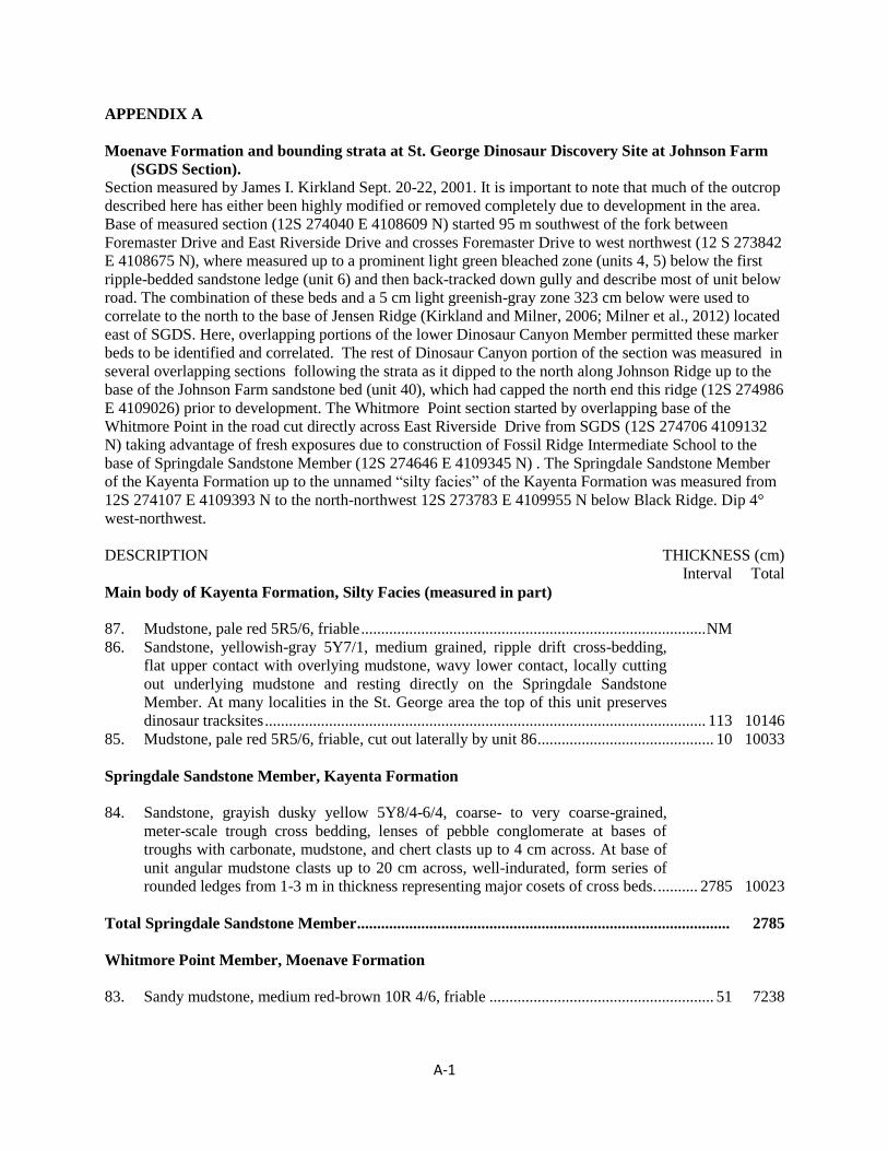
A-1
APPENDIX A
Moenave Formation and bounding strata at St. George Dinosaur Discovery Site at Johnson Farm
(SGDS Section).
Section measured by James I. Kirkland Sept. 20-22, 2001. It is important to note that much of the outcrop
described here has either been highly modified or removed completely due to development in the area.
Base of measured section (12S 274040 E 4108609 N) started 95 m southwest of the fork between
Foremaster Drive and East Riverside Drive and crosses Foremaster Drive to west northwest (12 S 273842
E 4108675 N), where measured up to a prominent light green bleached zone (units 4, 5) below the first
ripple-bedded sandstone ledge (unit 6) and then back-tracked down gully and describe most of unit below
road. The combination of these beds and a 5 cm light greenish-gray zone 323 cm below were used to
correlate to the north to the base of Jensen Ridge (Kirkland and Milner, 2006; Milner et al., 2012) located
east of SGDS. Here, overlapping portions of the lower Dinosaur Canyon Member permitted these marker
beds to be identified and correlated. The rest of Dinosaur Canyon portion of the section was measured in
several overlapping sections following the strata as it dipped to the north along Johnson Ridge up to the
base of the Johnson Farm sandstone bed (unit 40), which had capped the north end this ridge (12S 274986
E 4109026) prior to development. The Whitmore Point section started by overlapping base of the
Whitmore Point in the road cut directly across East Riverside Drive from SGDS (12S 274706 4109132
N) taking advantage of fresh exposures due to construction of Fossil Ridge Intermediate School to the
base of Springdale Sandstone Member (12S 274646 E 4109345 N) . The Springdale Sandstone Member
of the Kayenta Formation up to the unnamed “silty facies” of the Kayenta Formation was measured from
12S 274107 E 4109393 N to the north-northwest 12S 273783 E 4109955 N below Black Ridge. Dip 4°
west-northwest.
DESCRIPTION THICKNESS (cm)
Interval Total
Main body of Kayenta Formation, Silty Facies (measured in part)
87. Mudstone, pale red 5R5/6, friable ...................................................................................... NM
86. Sandstone, yellowish-gray 5Y7/1, medium grained, ripple drift cross-bedding,
flat upper contact with overlying mudstone, wavy lower contact, locally cutting
out underlying mudstone and resting directly on the Springdale Sandstone
Member. At many localities in the St. George area the top of this unit preserves
dinosaur tracksites .............................................................................................................. 113 10146
85. Mudstone, pale red 5R5/6, friable, cut out laterally by unit 86 ............................................ 10 10033
Springdale Sandstone Member, Kayenta Formation
84. Sandstone, grayish dusky yellow 5Y8/4-6/4, coarse- to very coarse-grained,
meter-scale trough cross bedding, lenses of pebble conglomerate at bases of
troughs with carbonate, mudstone, and chert clasts up to 4 cm across. At base of
unit angular mudstone clasts up to 20 cm across, well-indurated, form series of
rounded ledges from 1-3 m in thickness representing major cosets of cross beds. .......... 2785 10023
Total Springdale Sandstone Member ............................................................................................. 2785
Whitmore Point Member, Moenave Formation
83. Sandy mudstone, medium red-brown 10R 4/6, friable ........................................................ 51 7238
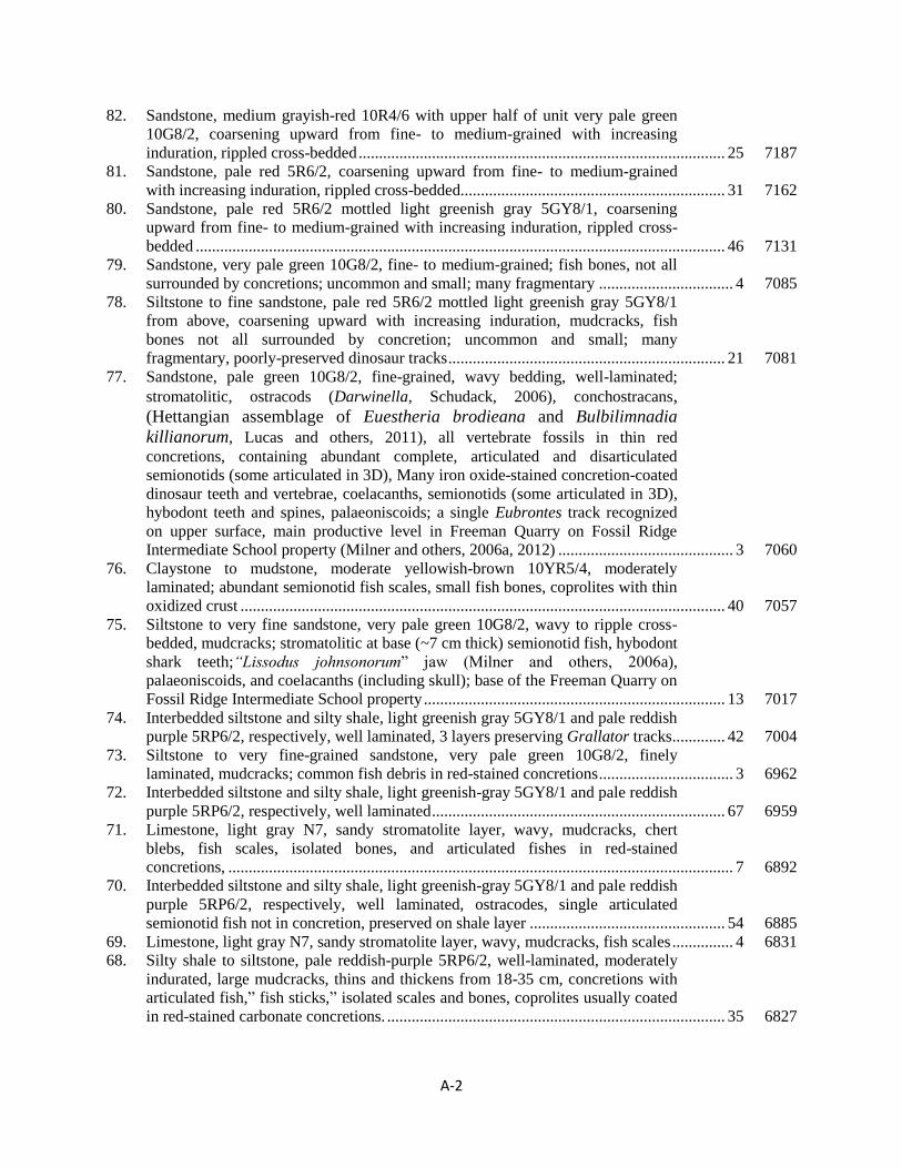
A-2
82. Sandstone, medium grayish-red 10R4/6 with upper half of unit very pale green
10G8/2, coarsening upward from fine- to medium-grained with increasing
induration, rippled cross-bedded .......................................................................................... 25 7187
81. Sandstone, pale red 5R6/2, coarsening upward from fine- to medium-grained
with increasing induration, rippled cross-bedded................................................................. 31 7162
80. Sandstone, pale red 5R6/2 mottled light greenish gray 5GY8/1, coarsening
upward from fine- to medium-grained with increasing induration, rippled cross-
bedded .................................................................................................................................. 46 7131
79. Sandstone, very pale green 10G8/2, fine- to medium-grained; fish bones, not all
surrounded by concretions; uncommon and small; many fragmentary ................................. 4 7085
78. Siltstone to fine sandstone, pale red 5R6/2 mottled light greenish gray 5GY8/1
from above, coarsening upward with increasing induration, mudcracks, fish
bones not all surrounded by concretion; uncommon and small; many
fragmentary, poorly-preserved dinosaur tracks .................................................................... 21 7081
77. Sandstone, pale green 10G8/2, fine-grained, wavy bedding, well-laminated;
stromatolitic, ostracods (Darwinella, Schudack, 2006), conchostracans,
(Hettangian assemblage of Euestheria brodieana and Bulbilimnadia
killianorum, Lucas and others, 2011), all vertebrate fossils in thin red
concretions, containing abundant complete, articulated and disarticulated
semionotids (some articulated in 3D), Many iron oxide-stained concretion-coated
dinosaur teeth and vertebrae, coelacanths, semionotids (some articulated in 3D),
hybodont teeth and spines, palaeoniscoids; a single Eubrontes track recognized
on upper surface, main productive level in Freeman Quarry on Fossil Ridge
Intermediate School property (Milner and others, 2006a, 2012) ........................................... 3 7060
76. Claystone to mudstone, moderate yellowish-brown 10YR5/4, moderately
laminated; abundant semionotid fish scales, small fish bones, coprolites with thin
oxidized crust ....................................................................................................................... 40 7057
75. Siltstone to very fine sandstone, very pale green 10G8/2, wavy to ripple cross-
bedded, mudcracks; stromatolitic at base (~7 cm thick) semionotid fish, hybodont
shark teeth;“Lissodus johnsonorum” jaw (Milner and others, 2006a),
palaeoniscoids, and coelacanths (including skull); base of the Freeman Quarry on
Fossil Ridge Intermediate School property .......................................................................... 13 7017
74. Interbedded siltstone and silty shale, light greenish gray 5GY8/1 and pale reddish
purple 5RP6/2, respectively, well laminated, 3 layers preserving Grallator tracks ............. 42 7004
73. Siltstone to very fine-grained sandstone, very pale green 10G8/2, finely
laminated, mudcracks; common fish debris in red-stained concretions ................................. 3 6962
72. Interbedded siltstone and silty shale, light greenish-gray 5GY8/1 and pale reddish
purple 5RP6/2, respectively, well laminated ........................................................................ 67 6959
71. Limestone, light gray N7, sandy stromatolite layer, wavy, mudcracks, chert
blebs, fish scales, isolated bones, and articulated fishes in red-stained
concretions, ............................................................................................................................ 7 6892
70. Interbedded siltstone and silty shale, light greenish-gray 5GY8/1 and pale reddish
purple 5RP6/2, respectively, well laminated, ostracodes, single articulated
semionotid fish not in concretion, preserved on shale layer ................................................ 54 6885
69. Limestone, light gray N7, sandy stromatolite layer, wavy, mudcracks, fish scales ............... 4 6831
68. Silty shale to siltstone, pale reddish-purple 5RP6/2, well-laminated, moderately
indurated, large mudcracks, thins and thickens from 18-35 cm, concretions with
articulated fish,” fish sticks,” isolated scales and bones, coprolites usually coated
in red-stained carbonate concretions. ................................................................................... 35 6827
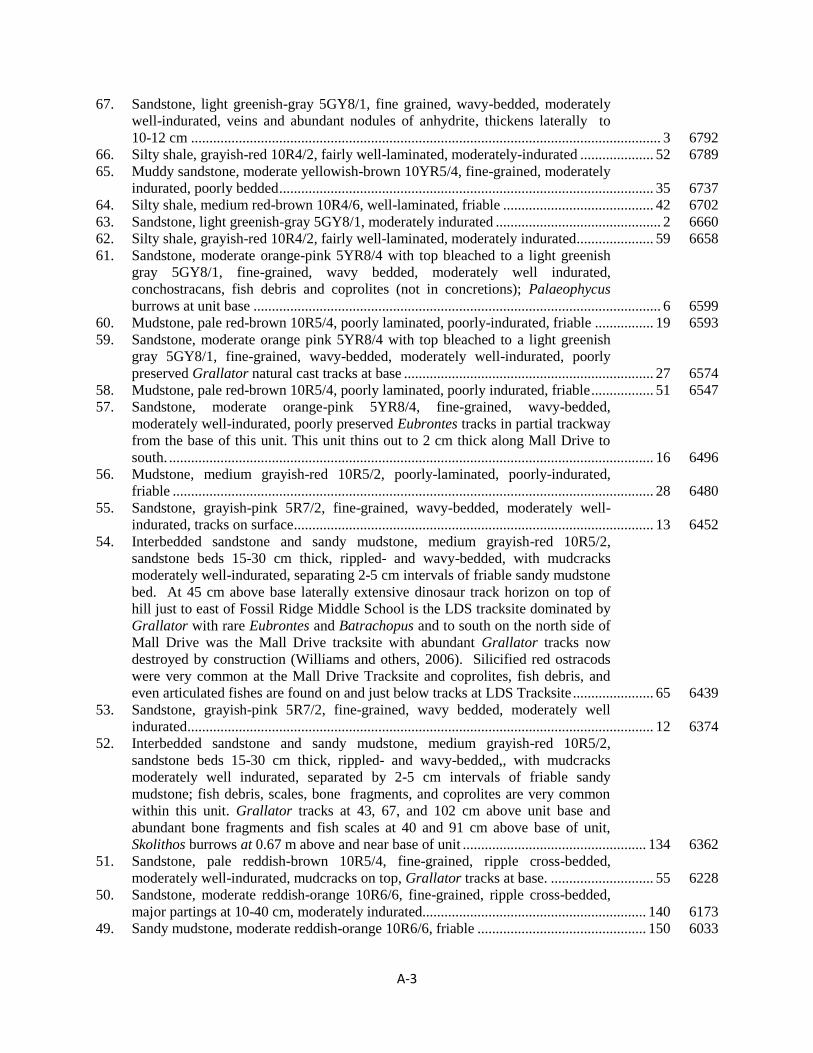
A-3
67. Sandstone, light greenish-gray 5GY8/1, fine grained, wavy-bedded, moderately
well-indurated, veins and abundant nodules of anhydrite, thickens laterally to
10-12 cm ................................................................................................................................ 3 6792
66. Silty shale, grayish-red 10R4/2, fairly well-laminated, moderately-indurated .................... 52 6789
65. Muddy sandstone, moderate yellowish-brown 10YR5/4, fine-grained, moderately
indurated, poorly bedded ...................................................................................................... 35 6737
64. Silty shale, medium red-brown 10R4/6, well-laminated, friable ......................................... 42 6702
63. Sandstone, light greenish-gray 5GY8/1, moderately indurated ............................................. 2 6660
62. Silty shale, grayish-red 10R4/2, fairly well-laminated, moderately indurated ..................... 59 6658
61. Sandstone, moderate orange-pink 5YR8/4 with top bleached to a light greenish
gray 5GY8/1, fine-grained, wavy bedded, moderately well indurated,
conchostracans, fish debris and coprolites (not in concretions); Palaeophycus
burrows at unit base ............................................................................................................... 6 6599
60. Mudstone, pale red-brown 10R5/4, poorly laminated, poorly-indurated, friable ................ 19 6593
59. Sandstone, moderate orange pink 5YR8/4 with top bleached to a light greenish
gray 5GY8/1, fine-grained, wavy-bedded, moderately well-indurated, poorly
preserved Grallator natural cast tracks at base .................................................................... 27 6574
58. Mudstone, pale red-brown 10R5/4, poorly laminated, poorly indurated, friable ................. 51 6547
57. Sandstone, moderate orange-pink 5YR8/4, fine-grained, wavy-bedded,
moderately well-indurated, poorly preserved Eubrontes tracks in partial trackway
from the base of this unit. This unit thins out to 2 cm thick along Mall Drive to
south. .................................................................................................................................... 16 6496
56. Mudstone, medium grayish-red 10R5/2, poorly-laminated, poorly-indurated,
friable ................................................................................................................................... 28 6480
55. Sandstone, grayish-pink 5R7/2, fine-grained, wavy-bedded, moderately well-
indurated, tracks on surface .................................................................................................. 13 6452
54. Interbedded sandstone and sandy mudstone, medium grayish-red 10R5/2,
sandstone beds 15-30 cm thick, rippled- and wavy-bedded, with mudcracks
moderately well-indurated, separating 2-5 cm intervals of friable sandy mudstone
bed. At 45 cm above base laterally extensive dinosaur track horizon on top of
hill just to east of Fossil Ridge Middle School is the LDS tracksite dominated by
Grallator with rare Eubrontes and Batrachopus and to south on the north side of
Mall Drive was the Mall Drive tracksite with abundant Grallator tracks now
destroyed by construction (Williams and others, 2006). Silicified red ostracods
were very common at the Mall Drive Tracksite and coprolites, fish debris, and
even articulated fishes are found on and just below tracks at LDS Tracksite ...................... 65 6439
53. Sandstone, grayish-pink 5R7/2, fine-grained, wavy bedded, moderately well
indurated ............................................................................................................................... 12 6374
52. Interbedded sandstone and sandy mudstone, medium grayish-red 10R5/2,
sandstone beds 15-30 cm thick, rippled- and wavy-bedded,, with mudcracks
moderately well indurated, separated by 2-5 cm intervals of friable sandy
mudstone; fish debris, scales, bone fragments, and coprolites are very common
within this unit. Grallator tracks at 43, 67, and 102 cm above unit base and
abundant bone fragments and fish scales at 40 and 91 cm above base of unit,
Skolithos burrows at 0.67 m above and near base of unit .................................................. 134 6362
51. Sandstone, pale reddish-brown 10R5/4, fine-grained, ripple cross-bedded,
moderately well-indurated, mudcracks on top, Grallator tracks at base. ............................ 55 6228
50. Sandstone, moderate reddish-orange 10R6/6, fine-grained, ripple cross-bedded,
major partings at 10-40 cm, moderately indurated............................................................. 140 6173
49. Sandy mudstone, moderate reddish-orange 10R6/6, friable .............................................. 150 6033

A-4
48. Sandstone, moderate reddish-orange 10R6/6, fine-grained, ripple cross-bedding,
divided into layers 10-25 cm thick by mudstone partings, well indurated, tool
marks and flutes on soles of beds ......................................................................................... 84 5883
47. Shaly mudstone, moderate reddish-brown 10R4/6, moderately-laminated, friable
few scattered 2-3 cm beds of finely-laminated sandstone .................................................. 125 5799
46. Sandstone, medium reddish brown 10R6/4, medium- to coarse-grained, ripple
cross-bedding, divided into four well-indurated, principle sandstone layers
separated by mudstone partings, mudcracks and dinosaur tracks on all 4 major
surfaces (Stewart-Walker Tracksites 1-4), mostly Eubrontes, Kayentapus, with
Anoemepus and Grallator with rare Exocampe, Batrachopus, and Undichna (fish
swim trails), rooting, mudcracks about 40 cm deep extend down into underlying
unit 44. Exposures of this same interval exposed 50 m to south exhibit cut and
fill relationships between sandstone layers. Traced in outcrop for more than 200
m, the entire unit pinches out to the south ............................................................................ 65 5674
45. Shaly mudstone, moderate reddish-brown 10R4/2, moderately-laminated, friable,
ostracods, conchostracans, fish debris .................................................................................. 70 5609
44. Sandstone, light greenish-gray 5GY8/1, very fine grained, mica flakes ................................ 2 5539
43. Shale, medium reddish-purple 5RP5/2, with few thin siltstone laminae, well-
laminated, sandy at base with abundant mica flakes, ostracods, fish debris ........................ 45 5537
42. Sandstone, light greenish-gray 5GY8/1, very fine grained, highly micaceous ...................... 3 5492
41. Shale, pale reddish-purple 5RP6/2, with few thin siltstone layers, well-laminated,
sandy at base with abundant mica flakes, ostracods, fish debris .......................................... 52 5489
40. Sandstone, pale pink 5RP8/2 stained moderate red 5R4/6, fine-grained, internally
climbing ripple cross-bedding, base of unit (“main track layer”) with prominent
flutes exposing triclinic salt casts and preserving Eubrontes, Grallator, and rare
Anomoepus tracks, locally abundant theropod swim tracks, cutting out deep
mudcracks and Eubrontes tracks, parting at 20 cm above base (“split layer”)
preserves abundant Grallator tracks with rarer Eubrontes, and abundant tool
marks, upper parting formed of erosive megaripples locally cutting out entire unit
overlain by 20 cm of thin rippled sandstone layers 2-4 cm thick preserving a
variety of other sedimentary structures and four dinosaur horizons with
Grallator, Eubrontes, Anomoepus and crocodylomorph (Batrachopus) tracks
(“top surface tracksite”). The top surface tracksite also preserves rill marks, load
casts, plant impressions (Pagiophyllum and Equisetum), symmetrical ripple
marks, current ripples, invertebrate trackways, red chert concretions, rare fish
scales (oldest vertebrate body fossils at SGDS), rain drop impressions, microbial
mats. This is the main track-bearing unit (Johnson Farm Sandstone bed; Milner
and Spears, 2007; Milner and others 2012) preserved in situ within the SGDS
exhibits facility (Milner and others, 2006a, b; Kirkland and Milner, 2006) ........................ 70 5437
39. Claystone, moderate red-brown 10R4/6, laminated, friable, stromatolitic layer 1-
3 cm thick at about 5 cm below top in some exposures. ..................................................... 15 5367
38. Sandstone and mudstone, moderate red-brown 10R5/6, fine grained, calcareous,
carbonate nodules up to 25 cm across cored by red chert, laterally bed may take
form of stromatolites partially replaced by layers of red chert ............................................ 14 5352
37. Mudstone, moderate red-brown 10R4/6, laminated, friable ................................................ 13 5338
36. Sandstone, pale red-brown 10R5/4, fine-grained, climbing ripple cross-bedding,
well-indurated, thickens to 30 cm in places, flutes and poorly preserved
Eubrontes tracks at base. Laterally exposures indicate that this bed replaced by
sandy limestone, light gray N7, stromatolite layer, wavy bedding ...................................... 12 5325

A-5
35. Mudstone with thin siltstone and shale layers, moderate red-brown 10R4/6,
laminated, friable, carbonate nodules extend up to 1 m laterally cored by red
chert. ..................................................................................................................................... 13 5313
34. Sandstone, pale red brown 10R5/4, medium-grained, climbing ripple cross-
bedding, well-indurated. Laterally exposures indicate that this bed replaced by
sandy limestone, light gray N7, stromatolite layer, wavy bedding ........................................ 9 5300
Total Whitmore Point Member ...................................................................................................... 1937
Dinosaur Canyon Member of Moenave Formation
33. Mudstone with thin siltstone and shale layers, moderate red-brown 10R4/6, ripple
cross-bedded and laminated, friable; this interval is a better indurated muddy
sandstone bed on the southeast side of road at the SGDS facility. .................................... 106 5291
32. Sandstone, pale red-brown 10R5/4, medium-grained, well-indurated, climbing
ripple cross-bedding, also includes laterally thinning and thickening tough cross-
bedded units particularly toward the top, angular mudstone clasts at partings
every 20-80 cm, thickest toward middle, ledge former. Excavation at Walt’s
Quarry #1 across Riverside Drive to west of SGDS facility exposed two dinosaur
track horizons; one at 102 cm below the top, of the unit and another better
horizon at 175 cm below the top which yielded the single 26.5 ton block (SGDS
568) exhibited in the SGDS facility. Farther to the southwest at 67 cm below the
top of the unit, a track matching that of SGDS 568 was excavated at Walt’s
Quarry #2 in several sections and reassembled on the south wall of the SGDS
facility (SGDS 567). These extraordinary monolith surfaces are dominated by
Grallator with rare Eubrontes, Batrachopus, and Undichna (fish swim trails).
They also preserve current ripples, small mudcracks, local rain drop impressions,
invertebrate burrows, and grazing trails. ............................................................................ 259 5185
31. Interbedded fine-grained sandstone, siltstone, and silty shale, moderate red-
brown 10R3/6, ripple cross-bedded, friable ....................................................................... 102 4926
30. Sandstone, dark yellowish-orange 10YR 6/6, coarse-grained, abundant clay
clasts, mica flakes, and plant fragments, some plant fragments replaced by
malachite. Saintgeorgia jensenii, Milnerites planus, Clathropteris sp., Equisetum
sp., Araucarites stockeyi, Podozamites sp. were described from this bed by
Tidwell and Ash (2006) in their paper on the first recorded flora in the Moenave
Formation ............................................................................................................................. 18 4824
29. Sandstone, pale red brown 10R5/4, medium-grained, climbing ripple cross-
bedding, and some trough cross-bedding, well-indurated, angular mudstone clasts
at parting dividing the unit and at base .............................................................................. 185 4806
28. Sandy mudstone, moderate red-brown 10R4/6, friable ........................................................ 25 4621
27. Sandstone, pale red-brown 10R5/4, fine- to medium-grained, trough cross-
bedded, well-indurated, forms lens 10 m across .................................................................. 30 4596
26. Sandy mudstone, moderate red-brown 10R6/4, friable ........................................................ 71 4566
25. Sandstone, pale red-brown 10R5/4, fine- to medium-grained, climbing ripple
cross-bedding, and some trough cross-bedding in lower part representing
megaripples, well-indurated, angular mudstone clasts at base, cliff formerly
capping much of Jensen Ridge, mudstone partings divides cosets at scales of
meters at base, thinning to 50-20 cm at top of unit ............................................................ 425 4495
24. Sandy mudstone, moderate red-brown 10R6/4, friable ........................................................ 68 4070
23. Sandstone, pale red-brown 10R5/4, fine-grained, ripple cross-bedded, well
indurated ............................................................................................................................... 21 4002
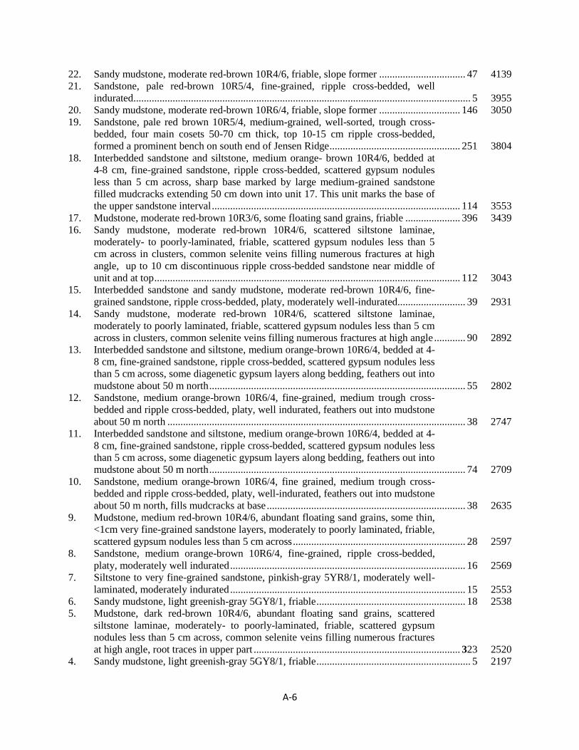
A-6
22. Sandy mudstone, moderate red-brown 10R4/6, friable, slope former ................................. 47 4139
21. Sandstone, pale red-brown 10R5/4, fine-grained, ripple cross-bedded, well
indurated ................................................................................................................................. 5 3955
20. Sandy mudstone, moderate red-brown 10R6/4, friable, slope former ............................... 146 3050
19. Sandstone, pale red brown 10R5/4, medium-grained, well-sorted, trough cross-
bedded, four main cosets 50-70 cm thick, top 10-15 cm ripple cross-bedded,
formed a prominent bench on south end of Jensen Ridge .................................................. 251 3804
18. Interbedded sandstone and siltstone, medium orange- brown 10R4/6, bedded at
4-8 cm, fine-grained sandstone, ripple cross-bedded, scattered gypsum nodules
less than 5 cm across, sharp base marked by large medium-grained sandstone
filled mudcracks extending 50 cm down into unit 17. This unit marks the base of
the upper sandstone interval ............................................................................................... 114 3553
17. Mudstone, moderate red-brown 10R3/6, some floating sand grains, friable ..................... 396 3439
16. Sandy mudstone, moderate red-brown 10R4/6, scattered siltstone laminae,
moderately- to poorly-laminated, friable, scattered gypsum nodules less than 5
cm across in clusters, common selenite veins filling numerous fractures at high
angle, up to 10 cm discontinuous ripple cross-bedded sandstone near middle of
unit and at top ..................................................................................................................... 112 3043
15. Interbedded sandstone and sandy mudstone, moderate red-brown 10R4/6, fine-
grained sandstone, ripple cross-bedded, platy, moderately well-indurated .......................... 39 2931
14. Sandy mudstone, moderate red-brown 10R4/6, scattered siltstone laminae,
moderately to poorly laminated, friable, scattered gypsum nodules less than 5 cm
across in clusters, common selenite veins filling numerous fractures at high angle ............ 90 2892
13. Interbedded sandstone and siltstone, medium orange-brown 10R6/4, bedded at 4-
8 cm, fine-grained sandstone, ripple cross-bedded, scattered gypsum nodules less
than 5 cm across, some diagenetic gypsum layers along bedding, feathers out into
mudstone about 50 m north .................................................................................................. 55 2802
12. Sandstone, medium orange-brown 10R6/4, fine-grained, medium trough cross-
bedded and ripple cross-bedded, platy, well indurated, feathers out into mudstone
about 50 m north .................................................................................................................. 38 2747
11. Interbedded sandstone and siltstone, medium orange-brown 10R6/4, bedded at 4-
8 cm, fine-grained sandstone, ripple cross-bedded, scattered gypsum nodules less
than 5 cm across, some diagenetic gypsum layers along bedding, feathers out into
mudstone about 50 m north .................................................................................................. 74 2709
10. Sandstone, medium orange-brown 10R6/4, fine grained, medium trough cross-
bedded and ripple cross-bedded, platy, well-indurated, feathers out into mudstone
about 50 m north, fills mudcracks at base ............................................................................ 38 2635
9. Mudstone, medium red-brown 10R4/6, abundant floating sand grains, some thin,
<1cm very fine-grained sandstone layers, moderately to poorly laminated, friable,
scattered gypsum nodules less than 5 cm across .................................................................. 28 2597
8. Sandstone, medium orange-brown 10R6/4, fine-grained, ripple cross-bedded,
platy, moderately well indurated .......................................................................................... 16 2569
7. Siltstone to very fine-grained sandstone, pinkish-gray 5YR8/1, moderately well-
laminated, moderately indurated .......................................................................................... 15 2553
6. Sandy mudstone, light greenish-gray 5GY8/1, friable ......................................................... 18 2538
5. Mudstone, dark red-brown 10R4/6, abundant floating sand grains, scattered
siltstone laminae, moderately- to poorly-laminated, friable, scattered gypsum
nodules less than 5 cm across, common selenite veins filling numerous fractures
at high angle, root traces in upper part ............................................................................... 323 2520
4. Sandy mudstone, light greenish-gray 5GY8/1, friable ........................................................... 5 2197
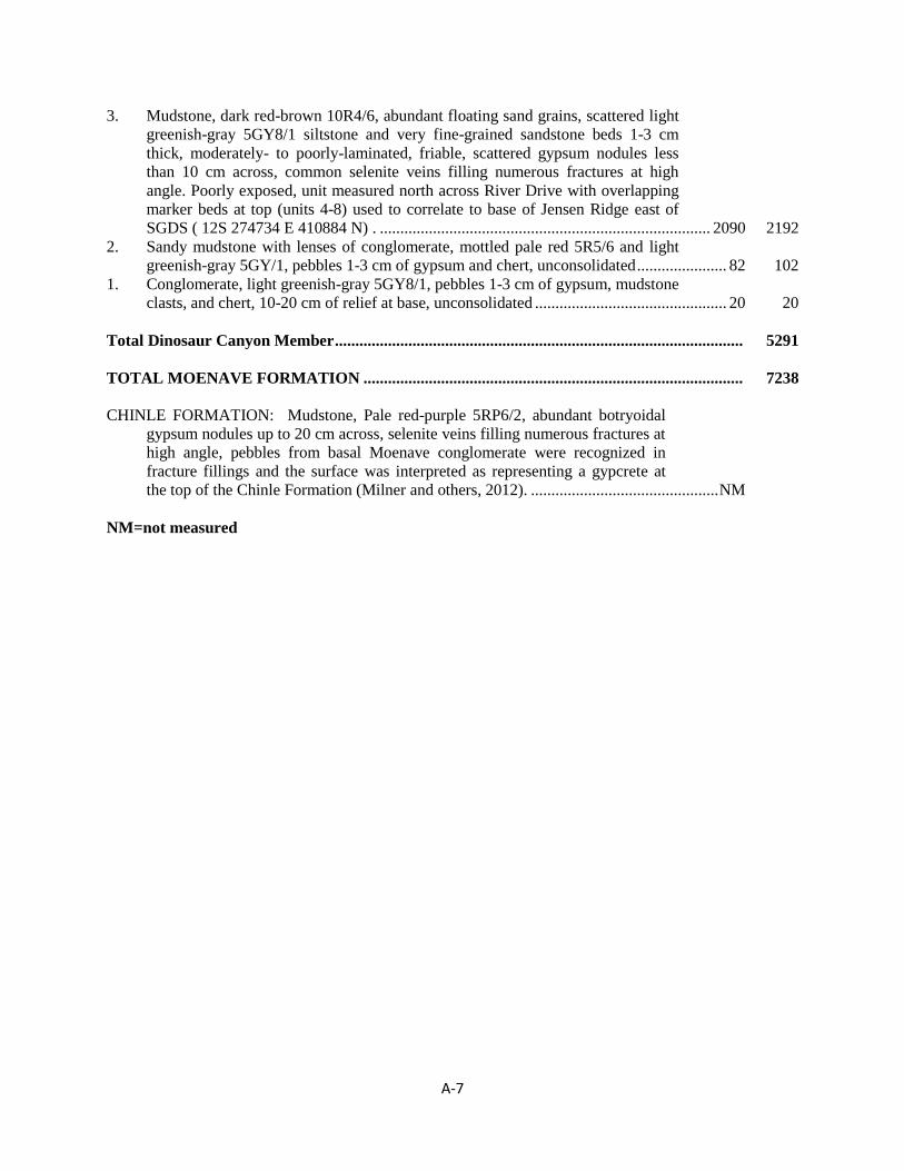
A-7
3. Mudstone, dark red-brown 10R4/6, abundant floating sand grains, scattered light
greenish-gray 5GY8/1 siltstone and very fine-grained sandstone beds 1-3 cm
thick, moderately- to poorly-laminated, friable, scattered gypsum nodules less
than 10 cm across, common selenite veins filling numerous fractures at high
angle. Poorly exposed, unit measured north across River Drive with overlapping
marker beds at top (units 4-8) used to correlate to base of Jensen Ridge east of
SGDS ( 12S 274734 E 410884 N) . ................................................................................. 2090 2192
2. Sandy mudstone with lenses of conglomerate, mottled pale red 5R5/6 and light
greenish-gray 5GY/1, pebbles 1-3 cm of gypsum and chert, unconsolidated ...................... 82 102
1. Conglomerate, light greenish-gray 5GY8/1, pebbles 1-3 cm of gypsum, mudstone
clasts, and chert, 10-20 cm of relief at base, unconsolidated ............................................... 20 20
Total Dinosaur Canyon Member .................................................................................................... 5291
TOTAL MOENAVE FORMATION ............................................................................................. 7238
CHINLE FORMATION: Mudstone, Pale red-purple 5RP6/2, abundant botryoidal
gypsum nodules up to 20 cm across, selenite veins filling numerous fractures at
high angle, pebbles from basal Moenave conglomerate were recognized in
fracture fillings and the surface was interpreted as representing a gypcrete at
the top of the Chinle Formation (Milner and others, 2012). .............................................. NM
NM=not measured
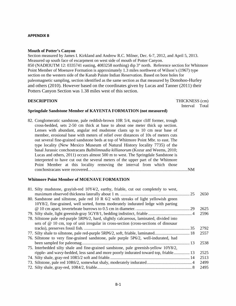
B-1
APPENDIX B Mouth of Potter’s Canyon Section measured by James I. Kirkland and Andrew R.C. Milner, Dec. 6-7, 2012, and April 5, 2013. Measured up south face of escarpment on west side of mouth of Potter Canyon. 850 (NAD83UTM 12: 0335741 easting, 4083258 northing) dip 3° north. Reference section for Whitmore Point Member of Moenave Formation is approximately 1.3 miles northwest of Wilson’s (1967) type section on the western side of the Kanab Paiute Indian Reservation. Based on bore holes for paleomagnetic sampling, section identified as the same section as that measured by Donohoo-Hurley and others (2010). However based on the coordinates given by Lucas and Tanner (2011) their Potters Canyon Section was 1.38 miles west of this section. DESCRIPTION THICKNESS (cm) Interval Total Springdale Sandstone Member of KAYENTA FORMATION (not measured) 82. Conglomeratic sandstone, pale reddish-brown 10R 5/4, major cliff former, trough
cross-bedded, sets 2-50 cm thick at base to about one meter thick up section. Lenses with abundant, angular red mudstone clasts up to 10 cm near base of member, erosional base with meters of relief over distances of 10s of meters cuts out several fine-grained sandstone beds at top of Whitmore Point Mbr. to east. The type locality (New Mexico Museum of Natural History locality 7735) of the basal Jurassic conchostracans Bulbilimnadia killianorum (Kozur and Weems, 2010; Lucas and others, 2011) occurs almost 500 m to west. The Springdale Sandstone is interpreted to have cut out the several meters of the upper part of the Whitmore Point Member at this locality removing the interval from which those conchostracans were recovered... .......................................................................................... NM
Whitmore Point Member of MOENAVE FORMATION 81. Silty mudstone, grayish-red 10Y4/2, earthy, friable, cut out completely to west,
maximum observed thickness laterally about 1 m. ................................................................. 25 2650 80. Sandstone and siltstone, pale red 10 R 6/2 with streaks of light yellowish green
10Y8/2, fine-grained, well sorted, forms moderately indurated ledge with parting @ 10 cm apart, invertebrate burrows to 0.5 cm in diameter. .................................................. 29 2625
79. Silty shale, light greenish-gray 5GY8/1, bedding indistinct, friable ......................................... 4 2596 78. Siltstone pale red-purple 5RP6/2, hard, slightly calcareous, laminated, divided into
sets of @ 10 cm, top of unit irregular in cross-section (cross-sections of dinosaur tracks), preserves fossil fish. ................................................................................................... 35 2792
77. Silty shale to siltstone, pale red-purple 5RP6/2, soft, friable, laminated ................................. 18 2557 76. Siltstone to very fine-grained sandstone, pale purple 5P6/2, well-indurated, had
been sampled for paleomag ..................................................................................................... 13 2538 75. Interbedded silty shale and fine-grained sandstone, pale greenish-yellow 10Y8/2,
ripple- and wavy-bedded, less sand and more poorly indurated toward top, friable ............... 13 2525 74. Silty shale, gray-red 10R5/2 soft and friable. .......................................................................... 14 2513 73. Siltstone, pale red 10R6/2, somewhat shaly, moderately indurated .......................................... 4 2499 72. Silty shale, gray-red, 10R4/2, friable ......................................................................................... 8 2495
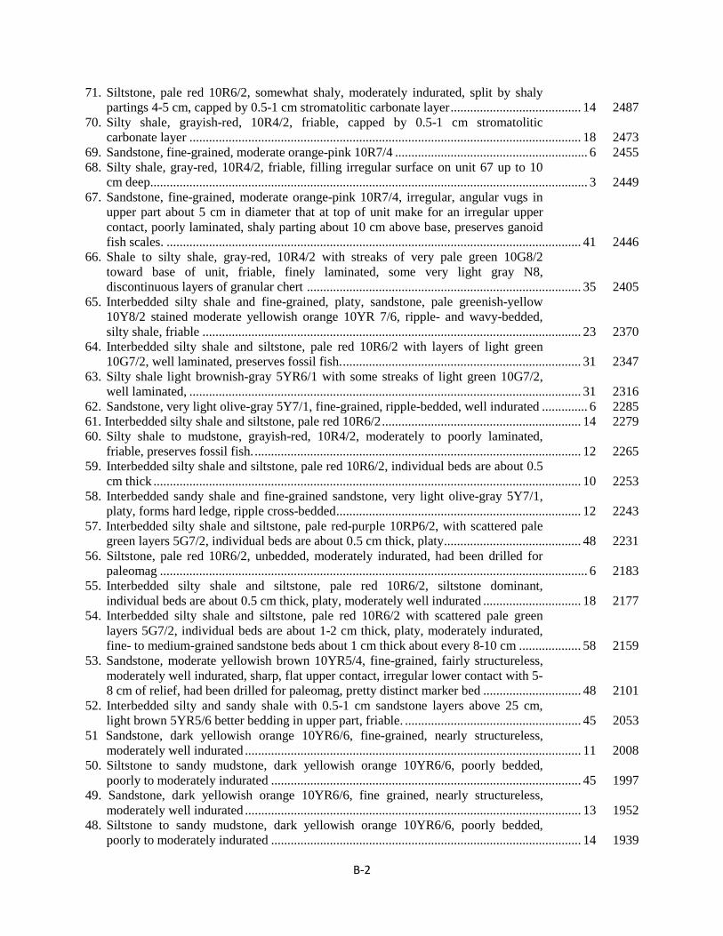
B-2
71. Siltstone, pale red 10R6/2, somewhat shaly, moderately indurated, split by shaly partings 4-5 cm, capped by 0.5-1 cm stromatolitic carbonate layer ........................................ 14 2487
70. Silty shale, grayish-red, 10R4/2, friable, capped by 0.5-1 cm stromatolitic carbonate layer ........................................................................................................................ 18 2473
69. Sandstone, fine-grained, moderate orange-pink 10R7/4 ........................................................... 6 2455 68. Silty shale, gray-red, 10R4/2, friable, filling irregular surface on unit 67 up to 10
cm deep...................................................................................................................................... 3 2449 67. Sandstone, fine-grained, moderate orange-pink 10R7/4, irregular, angular vugs in
upper part about 5 cm in diameter that at top of unit make for an irregular upper contact, poorly laminated, shaly parting about 10 cm above base, preserves ganoid fish scales. ............................................................................................................................... 41 2446
66. Shale to silty shale, gray-red, 10R4/2 with streaks of very pale green 10G8/2 toward base of unit, friable, finely laminated, some very light gray N8, discontinuous layers of granular chert .................................................................................... 35 2405
65. Interbedded silty shale and fine-grained, platy, sandstone, pale greenish-yellow 10Y8/2 stained moderate yellowish orange 10YR 7/6, ripple- and wavy-bedded, silty shale, friable .................................................................................................................... 23 2370
64. Interbedded silty shale and siltstone, pale red 10R6/2 with layers of light green 10G7/2, well laminated, preserves fossil fish. ......................................................................... 31 2347
63. Silty shale light brownish-gray 5YR6/1 with some streaks of light green 10G7/2, well laminated, ........................................................................................................................ 31 2316
62. Sandstone, very light olive-gray 5Y7/1, fine-grained, ripple-bedded, well indurated .............. 6 2285 61. Interbedded silty shale and siltstone, pale red 10R6/2 ............................................................. 14 2279 60. Silty shale to mudstone, grayish-red, 10R4/2, moderately to poorly laminated,
friable, preserves fossil fish. .................................................................................................... 12 2265 59. Interbedded silty shale and siltstone, pale red 10R6/2, individual beds are about 0.5
cm thick ................................................................................................................................... 10 2253 58. Interbedded sandy shale and fine-grained sandstone, very light olive-gray 5Y7/1,
platy, forms hard ledge, ripple cross-bedded ........................................................................... 12 2243 57. Interbedded silty shale and siltstone, pale red-purple 10RP6/2, with scattered pale
green layers 5G7/2, individual beds are about 0.5 cm thick, platy .......................................... 48 2231 56. Siltstone, pale red 10R6/2, unbedded, moderately indurated, had been drilled for
paleomag ................................................................................................................................... 6 2183 55. Interbedded silty shale and siltstone, pale red 10R6/2, siltstone dominant,
individual beds are about 0.5 cm thick, platy, moderately well indurated .............................. 18 2177 54. Interbedded silty shale and siltstone, pale red 10R6/2 with scattered pale green
layers 5G7/2, individual beds are about 1-2 cm thick, platy, moderately indurated, fine- to medium-grained sandstone beds about 1 cm thick about every 8-10 cm ................... 58 2159
53. Sandstone, moderate yellowish brown 10YR5/4, fine-grained, fairly structureless, moderately well indurated, sharp, flat upper contact, irregular lower contact with 5-8 cm of relief, had been drilled for paleomag, pretty distinct marker bed .............................. 48 2101
52. Interbedded silty and sandy shale with 0.5-1 cm sandstone layers above 25 cm, light brown 5YR5/6 better bedding in upper part, friable. ...................................................... 45 2053
51 Sandstone, dark yellowish orange 10YR6/6, fine-grained, nearly structureless, moderately well indurated ....................................................................................................... 11 2008
50. Siltstone to sandy mudstone, dark yellowish orange 10YR6/6, poorly bedded, poorly to moderately indurated ............................................................................................... 45 1997
49. Sandstone, dark yellowish orange 10YR6/6, fine grained, nearly structureless, moderately well indurated ....................................................................................................... 13 1952
48. Siltstone to sandy mudstone, dark yellowish orange 10YR6/6, poorly bedded, poorly to moderately indurated ............................................................................................... 14 1939
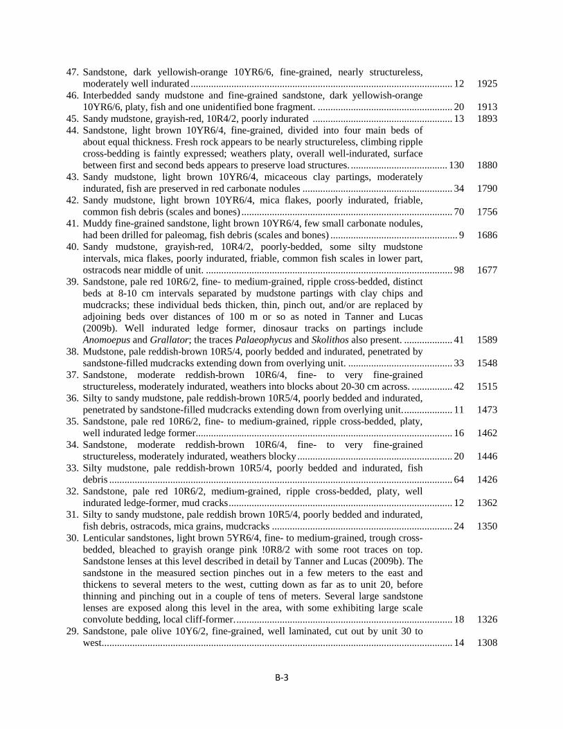
B-3
47. Sandstone, dark yellowish-orange 10YR6/6, fine-grained, nearly structureless, moderately well indurated ....................................................................................................... 12 1925
46. Interbedded sandy mudstone and fine-grained sandstone, dark yellowish-orange 10YR6/6, platy, fish and one unidentified bone fragment. ..................................................... 20 1913
45. Sandy mudstone, grayish-red, 10R4/2, poorly indurated ....................................................... 13 1893 44. Sandstone, light brown 10YR6/4, fine-grained, divided into four main beds of
about equal thickness. Fresh rock appears to be nearly structureless, climbing ripple cross-bedding is faintly expressed; weathers platy, overall well-indurated, surface between first and second beds appears to preserve load structures. ...................................... 130 1880
43. Sandy mudstone, light brown 10YR6/4, micaceous clay partings, moderately indurated, fish are preserved in red carbonate nodules ........................................................... 34 1790
42. Sandy mudstone, light brown 10YR6/4, mica flakes, poorly indurated, friable, common fish debris (scales and bones) ................................................................................... 70 1756
41. Muddy fine-grained sandstone, light brown 10YR6/4, few small carbonate nodules, had been drilled for paleomag, fish debris (scales and bones) .................................................. 9 1686
40. Sandy mudstone, grayish-red, 10R4/2, poorly-bedded, some silty mudstone intervals, mica flakes, poorly indurated, friable, common fish scales in lower part, ostracods near middle of unit. ................................................................................................. 98 1677
39. Sandstone, pale red 10R6/2, fine- to medium-grained, ripple cross-bedded, distinct beds at 8-10 cm intervals separated by mudstone partings with clay chips and mudcracks; these individual beds thicken, thin, pinch out, and/or are replaced by adjoining beds over distances of 100 m or so as noted in Tanner and Lucas (2009b). Well indurated ledge former, dinosaur tracks on partings include Anomoepus and Grallator; the traces Palaeophycus and Skolithos also present. ................... 41 1589
38. Mudstone, pale reddish-brown 10R5/4, poorly bedded and indurated, penetrated by sandstone-filled mudcracks extending down from overlying unit. ......................................... 33 1548
37. Sandstone, moderate reddish-brown 10R6/4, fine- to very fine-grained structureless, moderately indurated, weathers into blocks about 20-30 cm across. ................ 42 1515
36. Silty to sandy mudstone, pale reddish-brown 10R5/4, poorly bedded and indurated, penetrated by sandstone-filled mudcracks extending down from overlying unit. ................... 11 1473
35. Sandstone, pale red 10R6/2, fine- to medium-grained, ripple cross-bedded, platy, well indurated ledge former..................................................................................................... 16 1462
34. Sandstone, moderate reddish-brown 10R6/4, fine- to very fine-grained structureless, moderately indurated, weathers blocky ............................................................. 20 1446
33. Silty mudstone, pale reddish-brown 10R5/4, poorly bedded and indurated, fish debris ....................................................................................................................................... 64 1426
32. Sandstone, pale red 10R6/2, medium-grained, ripple cross-bedded, platy, well indurated ledge-former, mud cracks ........................................................................................ 12 1362
31. Silty to sandy mudstone, pale reddish brown 10R5/4, poorly bedded and indurated, fish debris, ostracods, mica grains, mudcracks ....................................................................... 24 1350
30. Lenticular sandstones, light brown 5YR6/4, fine- to medium-grained, trough cross-bedded, bleached to grayish orange pink !0R8/2 with some root traces on top. Sandstone lenses at this level described in detail by Tanner and Lucas (2009b). The sandstone in the measured section pinches out in a few meters to the east and thickens to several meters to the west, cutting down as far as to unit 20, before thinning and pinching out in a couple of tens of meters. Several large sandstone lenses are exposed along this level in the area, with some exhibiting large scale convolute bedding, local cliff-former. ..................................................................................... 18 1326
29. Sandstone, pale olive 10Y6/2, fine-grained, well laminated, cut out by unit 30 to west. ......................................................................................................................................... 14 1308
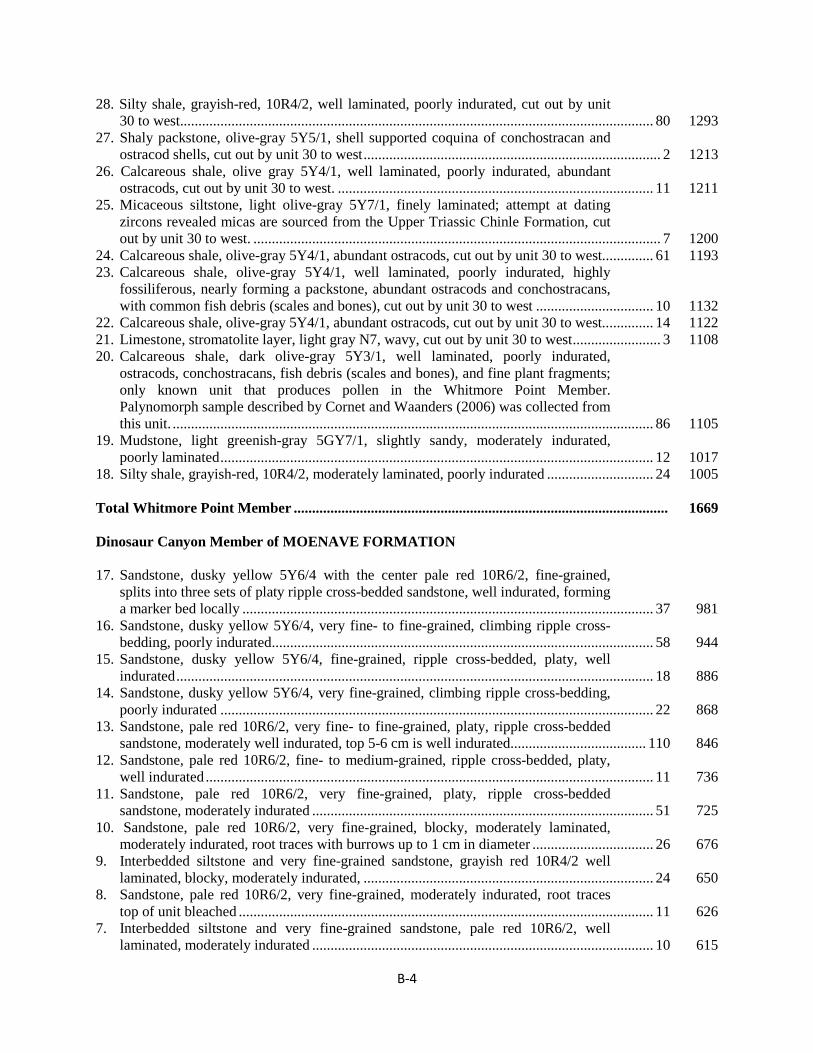
B-4
28. Silty shale, grayish-red, 10R4/2, well laminated, poorly indurated, cut out by unit 30 to west................................................................................................................................. 80 1293
27. Shaly packstone, olive-gray 5Y5/1, shell supported coquina of conchostracan and ostracod shells, cut out by unit 30 to west ................................................................................. 2 1213
26. Calcareous shale, olive gray 5Y4/1, well laminated, poorly indurated, abundant ostracods, cut out by unit 30 to west. ...................................................................................... 11 1211
25. Micaceous siltstone, light olive-gray 5Y7/1, finely laminated; attempt at dating zircons revealed micas are sourced from the Upper Triassic Chinle Formation, cut out by unit 30 to west. ............................................................................................................... 7 1200
24. Calcareous shale, olive-gray 5Y4/1, abundant ostracods, cut out by unit 30 to west. ............. 61 1193 23. Calcareous shale, olive-gray 5Y4/1, well laminated, poorly indurated, highly
fossiliferous, nearly forming a packstone, abundant ostracods and conchostracans, with common fish debris (scales and bones), cut out by unit 30 to west ................................ 10 1132
22. Calcareous shale, olive-gray 5Y4/1, abundant ostracods, cut out by unit 30 to west.. ............ 14 1122 21. Limestone, stromatolite layer, light gray N7, wavy, cut out by unit 30 to west ........................ 3 1108 20. Calcareous shale, dark olive-gray 5Y3/1, well laminated, poorly indurated,
ostracods, conchostracans, fish debris (scales and bones), and fine plant fragments; only known unit that produces pollen in the Whitmore Point Member. Palynomorph sample described by Cornet and Waanders (2006) was collected from this unit. ................................................................................................................................... 86 1105
19. Mudstone, light greenish-gray 5GY7/1, slightly sandy, moderately indurated, poorly laminated ...................................................................................................................... 12 1017
18. Silty shale, grayish-red, 10R4/2, moderately laminated, poorly indurated ............................. 24 1005 Total Whitmore Point Member ...................................................................................................... 1669 Dinosaur Canyon Member of MOENAVE FORMATION 17. Sandstone, dusky yellow 5Y6/4 with the center pale red 10R6/2, fine-grained,
splits into three sets of platy ripple cross-bedded sandstone, well indurated, forming a marker bed locally ................................................................................................................ 37 981
16. Sandstone, dusky yellow 5Y6/4, very fine- to fine-grained, climbing ripple cross-bedding, poorly indurated ........................................................................................................ 58 944
15. Sandstone, dusky yellow 5Y6/4, fine-grained, ripple cross-bedded, platy, well indurated .................................................................................................................................. 18 886
14. Sandstone, dusky yellow 5Y6/4, very fine-grained, climbing ripple cross-bedding, poorly indurated ...................................................................................................................... 22 868
13. Sandstone, pale red 10R6/2, very fine- to fine-grained, platy, ripple cross-bedded sandstone, moderately well indurated, top 5-6 cm is well indurated ..................................... 110 846
12. Sandstone, pale red 10R6/2, fine- to medium-grained, ripple cross-bedded, platy, well indurated .......................................................................................................................... 11 736
11. Sandstone, pale red 10R6/2, very fine-grained, platy, ripple cross-bedded sandstone, moderately indurated ............................................................................................. 51 725
10. Sandstone, pale red 10R6/2, very fine-grained, blocky, moderately laminated, moderately indurated, root traces with burrows up to 1 cm in diameter ................................. 26 676
9. Interbedded siltstone and very fine-grained sandstone, grayish red 10R4/2 well laminated, blocky, moderately indurated, ............................................................................... 24 650
8. Sandstone, pale red 10R6/2, very fine-grained, moderately indurated, root traces top of unit bleached ................................................................................................................. 11 626
7. Interbedded siltstone and very fine-grained sandstone, pale red 10R6/2, well laminated, moderately indurated ............................................................................................. 10 615
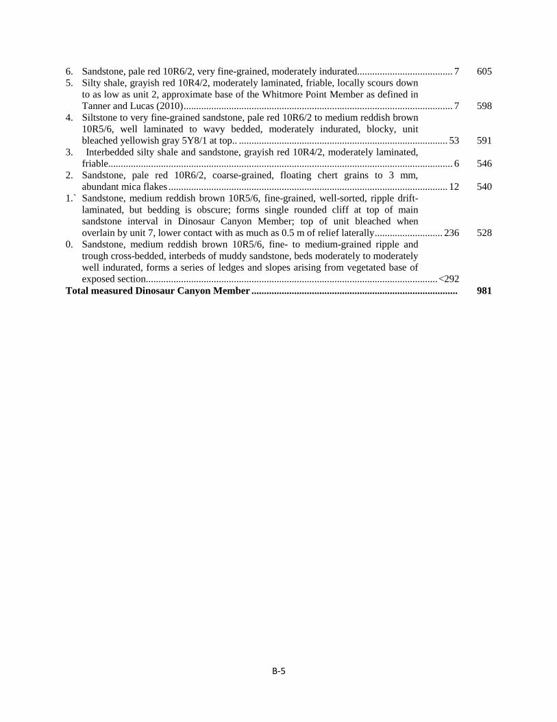
B-5
6. Sandstone, pale red 10R6/2, very fine-grained, moderately indurated ...................................... 7 605 5. Silty shale, grayish red 10R4/2, moderately laminated, friable, locally scours down
to as low as unit 2, approximate base of the Whitmore Point Member as defined in Tanner and Lucas (2010) ........................................................................................................... 7 598
4. Siltstone to very fine-grained sandstone, pale red 10R6/2 to medium reddish brown 10R5/6, well laminated to wavy bedded, moderately indurated, blocky, unit bleached yellowish gray 5Y8/1 at top.. ................................................................................... 53 591
3. Interbedded silty shale and sandstone, grayish red 10R4/2, moderately laminated, friable......................................................................................................................................... 6 546
2. Sandstone, pale red 10R6/2, coarse-grained, floating chert grains to 3 mm, abundant mica flakes ............................................................................................................... 12 540
1.` Sandstone, medium reddish brown 10R5/6, fine-grained, well-sorted, ripple drift-laminated, but bedding is obscure; forms single rounded cliff at top of main sandstone interval in Dinosaur Canyon Member; top of unit bleached when overlain by unit 7, lower contact with as much as 0.5 m of relief laterally ........................... 236 528
0. Sandstone, medium reddish brown 10R5/6, fine- to medium-grained ripple and trough cross-bedded, interbeds of muddy sandstone, beds moderately to moderately well indurated, forms a series of ledges and slopes arising from vegetated base of exposed section .................................................................................................................... <292
Total measured Dinosaur Canyon Member .................................................................................. 981
Copyright © 2022 FDOKUMEN