The Steppe: Human Occupation and Potentiality. The example of Northern Syria’s Arid Margins
16
Syria 88 (2011), p. 7 à 22 THE STEPPE: HUMAN OCCUPATION AND POTENTIALITY THE EXAMPLE OF NORTHERN SYRIA’S ARID MARGINS Bernard GEYER 1 Résumé – Les territoires steppiques offrent, au-delà de leur apparente uniformité, une grande variété de milieux, souvent imbriqués les uns dans les autres, qui proposent une mosaïque de terroirs. À l’image stéréotypée de territoires où s’affrontent cultivateurs et éleveurs, nomades et sédentaires, s’oppose une réalité beaucoup plus complexe, fondée sur une grande diversité de potentiels de mise en valeur. La région de Marges arides située au sud-est d’Alep (Syrie) en propose un exemple qui permet d’avancer une hypothèse de prise en compte de cette diversité dès l’âge du Bronze ancien. Abstract – Beyond their apparent uniformity, steppe areas provide a mosaic of overlapping environmental contexts. In contrast to the stereotypical image of such areas, comprising farmers, nomads and sedentary populations, is a complex reality based on a great diversity of potential development. Arid margins of the region located southeast of Aleppo (Syria) constitute an example to help to understand this diversity from the Early Bronze Age onwards. .áµHÉ°ûàe ¿ƒµJ Ée ÉÑdÉZ áØ∏àh IOó©àe •É°ShCG øe πµ°ûàJ ≥WÉæŸG øe AÉ°ùØ«°ùa ,ôgɶdG É¡°ùfÉŒ ºZQ ,á«Ñ¡°ùdG »°VGQC’G Ωó≤J – ﺧﻼﺻﺔ´ƒæJ ≈∏Y »æÑe ,Gó«≤©J ÌcCG ™bGh ¢VQÉ©àj ,øjô≤à°ùŸG ¿Éµ°ùdG h πMôdG ,IÉYôdGh ¿ƒYQGõŸG É¡«a ¬LGƒàj »àdG »°VGQCÓd á≤Ñ°ùŸG IôµØdG πHÉ≤eh Ú©H òNCÓd á«°Vôa Ëó≤àH íª°ùj ’Éãe (ÉjQƒ°S) Ö∏M ¥ô°T ܃æL á©bGƒdG á∏MÉ≤dG ±GôWC’G á≤£æe Èà©J h .π«gCÉàdGh ᫪æàdG äÉ«fɵeE’ ÒÑc .Ëó≤dG …õfhÈdG ô°ü©dG òæe ´ƒæàdG Gòg QÉÑàY’G DEFINITION Etymologically, “steppe” takes its name from a plant formation comprising alfa (Stipa tenacissima H.). Biogeographically, the term designates a mosaic of open, low plant formations composed of xerophile, herbaceous and ligneous plants, often in scattered clumps 2 . The term is also used to designate regions 3 in which these formations develop, where the most critical periods for the vegetation are summer because of drought, and winter because of low temperatures. Steppe regions are undeniably of natural origin —they are not the result of degradation linked to human activities— and they continue into the hinterlands as closed Mediterranean formations. With increasing aridity, the vegetation becomes sparser and the number of plant and animal species decreases. But whether the region is semi-arid or arid, edaphic factors play an increasingly important role as aridity 1. Geyer Bernard. Université Lumière-Lyon 2, UMR 5133 Archéorient, Maison de l’Orient et de la Méditerranée, bernard. [email protected]. Je remercie vivement F. Braemer et N. Marriner qui ont bien voulu corriger la version anglaise de ce texte. 2. GEORGE 1993, p. 393. 3. Region: an area defined by its physical characteristics, its historical past, its economic capacities and the will of the state (GEORGE 1993).
-
Upload
univ-lyon2 -
Category
Documents
-
view
0 -
download
0
Transcript of The Steppe: Human Occupation and Potentiality. The example of Northern Syria’s Arid Margins

Syria 88 (2011), p. 7 à 22
THE STEPPE: HUMAN OCCUPATION AND POTENTIALITYTHE EXAMPLE OF NORTHERN SYRIA’S ARID MARGINS
Bernard GEYER 1
Résumé – Les territoires steppiques offrent, au-delà de leur apparente uniformité, une grande variété de milieux, souvent imbriqués les uns dans les autres, qui proposent une mosaïque de terroirs. À l’image stéréotypée de territoires où s’affrontent cultivateurs et éleveurs, nomades et sédentaires, s’oppose une réalité beaucoup plus complexe, fondée sur une grande diversité de potentiels de mise en valeur. La région de Marges arides située au sud-est d’Alep (Syrie) en propose un exemple qui permet d’avancer une hypothèse de prise en compte de cette diversité dès l’âge du Bronze ancien.
Abstract – Beyond their apparent uniformity, steppe areas provide a mosaic of overlapping environmental contexts. In contrast to the stereotypical image of such areas, comprising farmers, nomads and sedentary populations, is a complex reality based on a great diversity of potential development. Arid margins of the region located southeast of Aleppo (Syria) constitute an example to help to understand this diversity from the Early Bronze Age onwards.
.áµHÉ°ûàe ¿ƒµJ Ée ÉÑdÉZ áØ∏àh IOó©àe •É°ShCG øe πµ°ûàJ ≥WÉæŸG øe AÉ°ùØ«°ùa ,ôgɶdG É¡°ùfÉŒ ºZQ ,á«Ñ¡°ùdG »°VGQC’G Ωó≤J – خالصة
´ƒæJ ≈∏Y »æÑe ,Gó«≤©J ÌcCG ™bGh ¢VQÉ©àj ,øjô≤à°ùŸG ¿Éµ°ùdG h πMôdG ,IÉYôdGh ¿ƒYQGõŸG É¡«a ¬LGƒàj »àdG »°VGQCÓd á≤Ñ°ùŸG IôµØdG πHÉ≤eh
Ú©H òNCÓd á«°Vôa Ëó≤àH íª°ùj ’Éãe (ÉjQƒ°S) Ö∏M ¥ô°T ܃æL á©bGƒdG á∏MÉ≤dG ±GôWC’G á≤£æe Èà©J h .π«gCÉàdGh ᫪æàdG äÉ«fɵeE’ ÒÑc
.Ëó≤dG …õfhÈdG ô°ü©dG òæe ´ƒæàdG Gòg QÉÑàY’G
DEFINITION
Etymologically, “steppe” takes its name from a plant formation comprising alfa (Stipa tenacissima H.). Biogeographically, the term designates a mosaic of open, low plant formations composed of xerophile, herbaceous and ligneous plants, often in scattered clumps 2. The term is also used to designate regions 3 in which these formations develop, where the most critical periods for the vegetation are summer because of drought, and winter because of low temperatures.
Steppe regions are undeniably of natural origin —they are not the result of degradation linked to human activities— and they continue into the hinterlands as closed Mediterranean formations. With increasing aridity, the vegetation becomes sparser and the number of plant and animal species decreases. But whether the region is semi-arid or arid, edaphic factors play an increasingly important role as aridity
1. Geyer Bernard. Université Lumière-Lyon 2, UMR 5133 Archéorient, Maison de l’Orient et de la Méditerranée, [email protected]. Je remercie vivement F. Braemer et N. Marriner qui ont bien voulu corriger la version anglaise de ce texte.
2. GEORGE 1993, p. 393.3. Region: an area defined by its physical characteristics, its historical past, its economic capacities and the will of the state
(GEORGE 1993).

Syria 88 (2011)B. GEYER8
increases. The latter can even outweigh climatic factors, which they can aggravate or limit. Determining edaphic factors include the nature of the substratum and the soil’s water retention capacity, as well as soil depth, slope angle, etc.
Although the notion of “arid margins” is based on a bioclimatic definition, it also evokes a humandimension. These are regions where food security is no longer ensured because of increasing aridity, between areas where rainfall is generally sufficient to ensure rain-fed agriculture and the desert, whereit is never sufficient.
The “steppe”, and in particular “arid margins”, are complex natural environments. Moreover, their borders are not fixed because of annual variations in rainfall receipt. Contrary to what is widely believed,the steppe is neither uniform nor homogeneous. Environmentally it is very diverse, from relatively fertile soils with sub-Mediterranean affinities, to almost abiotic geotopes 4. Human societies have always had to deal with this reality, to adapt and extract benefit from this aridity. Despite a mere 150 mm of rainfallper year, cereals, including wheat, can be cultivated (200 to 250 mm are usually necessary) without artificial irrigation because of the favourable edaphic conditions, including wadi beds, faydas 5, and qaas 6 in southern Syria.
In order to define the biogeography of the steppe, past or present, this heterogeneity must beunderstood. To do this, we will focus on two different scales: (i) geosystems and (ii) geofacies. To understand the evolution of the north Syrian steppe, we have used a method combining two cartographic representations: (i) geosystems and classes of attractiveness (environmental potentiality, established according to exploitation potential); and (ii) geofacies and the identification of micro-locations. Thisinformation is then combined with land settlement maps according to period. This dual approach is an efficient means (but not necessarily the only one) to analyze the complexity of human occupation andexploitation in a region with a long history.
THE ARID MARGINS OF NORTHERN SYRIA
The study area is situated south-east of Aleppo (fig. 1), in a zone straddling the Fertile Crescent 7 and the arid steppe.
Surveys carried out between 1995 and 2002 (13 field campaigns) as part of a research project entitled“Arid margins of northern Syria” enabled us to determine the forms of land occupation, population settlement and economic exploitation in time and space (from the Neolithic period through to present day).
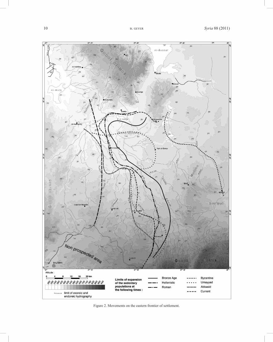
This allowed us to reconstruct changes in occupation for different periods (fig. 2 and below). Certain periods were characterized by significant population expansion (e.g. the Byzantine period), whereas othersshow decline (e.g. the Iron Age and Hellenistic periods) or even a total abandonment of the region as, for instance, during the Chalcolithic and the late Bronze Age. During these different periods, exploitation of the land was quite different: pastoralism, farming, arboriculture, irrigation, herding, etc. 8
4. BESANÇON & GEYER 2006, p. 12.5. Fayda (local terminology) are valley floors’ with soil deposits, deep and well irrigated from run-off water, located either
at wadi confluences, on structural ledges or around endoreic depressions.6. Qaas are silt-laden depressions (salt or evaporates), which temporarily concentrate rainwater and run-off water and
whose soils are favourable to agriculture.7. Fertile Crescent: notion created by the American orientalist Breasted. It is defined as a crescent-formed bioclimatic area
which extends from Palestine to the foothills of the Zagros, passing through the Jezirah. In the Levant, it covers the transition between the Mediterranean zone, which is more or less mountainous, and the Arabian desert. Originally poor in trees (pistachio, almond, etc.) it was covered by herbaceous formations including various grasses (among them wild cereals) and legumes and favoured the advent of agriculture during the Neolithic. Both plants (barley, wheat, peas, etc.) and certain social mammals (bovids, ovicaprids) were domesticated. As today, the potential for exploitation varied, and still varies, according to rainfall and to soil fertility.
8. GEYER, BESANÇON & ROUSSET 2006, p. 55-69.

Syria 88 (2011) THE STEPPE: HUMAN OCCUPATION AND POTENTIALITY 9
There are various explanations for these differences, including climatic, economic, cultural, technical, etc. However, the natural environment has always imposed constraints and opportunities on the land use history of this highly arid region.
To study the evolution of the natural environment, we associated archaeological surveys with the ethno-archaeological study of past and present sites, eco-geography and palaeo-environmental reconstructions.
The region
The topography (fig. 3)
The region is in contact with calcareous zones that extend well beyond the study area. In the north, it overlaps with the pediment of al-Bāb, a fragment of the Taurus foothills that advances as far as Aleppo. In the south, sloping in the opposite direction, the pediment of the northern Palmyran foothills meets the steep slope of the Ğabal al-Bal‘as. Seasonally flooded lake basins known as sebkhas are located at their point of intersection. This system is flanked by the basalt ridge of Ğabal al-‘Alā in the west, and by thearid Rasafa plateau in the east.
The major part of this area is characterized by an internal drainage system from which nothing escapes, except the basin of Salamya in the south-west (drains towards the Orontes and the Mediterranean) and the area of Maskana in the northeast (drains towards the Euphrates and the Arabo-Persian Gulf).
In proximity to the sebkhas lie more or less tabular hills which are protected by a basalt flow: theĞabal(s) al-Ḥaṣ, Šbayt, ‘Ubaysān and Hummat al-Ḫayl.
Figure 1. Location map.
Syria 88 (2011)B. GEYER10
Figure 2. Movements on the eastern frontier of settlement.

Syria 88 (2011) THE STEPPE: HUMAN OCCUPATION AND POTENTIALITY 11
Figure 3. Organization of the topography (© D. Andrieu).
Syria 88 (2011)B. GEYER12
The climatic regime
Although not far from the Mediterranean coast (100 to 200 km), the region is subject to increasing aridity from west to east and south-east. This results from strong evapo-transpiration and the length of the rainless summer season. Precipitation receipts fall from more than 300 mm to less than 150 mm, with wide variations in the averages.
The topography is too modest to modify this rainfall pattern, except for the Palmyran range. 9 The central basin and the eastern ridge are most susceptible to drought, even though they benefit from artesiansprings and wadi flooding. Evaporitic sediments among the outcropping rocks induce edaphic aridity,which is accentuated by silts brought by the westerly winds (dunes and gypso-saline crusts).
Oro-hydrography
The factors of aridity are combined with the effects of topography and run-off.
The topography
Often located on the periphery, the high regions with steep slopes favor rainwater run-off and the concentration of water flow. Relatively dense hydrographic networks cover the entire region. These wadis,which function several times a year and have played a key role in land occupation, are characterized by brief but violent flash floods.
– The Ğabal al-Bal‘as: situated in the south, it does not rise above 1,100 m. This limestone fold, cut by two lines of poljes, absorbs part of the rainfall and feeds many large North-South wadis: the Wādī(s) al-Qasṭal, al-‘Amūr, al-Zārūb, al-‘Azīb.
– In the foothills of Ğabal al-Bal‘as are two small ranges: the hills of ‘Aqīrbāt (about 700 m) to the west where the Wādī(s) al-Muwayliḥ and ’Umm Miyāl begin, and the promontory of ‘Iṯriyā (500-550 m) to the east, where Wādī(s) Ṯriyān, ‘Iṯriyā and al-Ṣālḥiyya draws its source.
– The ridge of Ğabal al-‘Alā (600 to 250 m) runs along the western edge and its eastern slope is incised by the long, wide valleys of Wādī(s) al-Horta, al-Ġadīr, and Ma‘aqar, oriented to the north-east (Ğabal(s) Mawā, ‘Aīza, Ḫuwaysa).
– On the eastern ridge (about 400 m) extend the hills of Madaba, the al-‘Alanda plateau where the tapering corridor of Wādī Ṯriyān runs, and to the north Wādī Abū al-Ġur, the edge of the Rasafa plateau scattered with gravel from the Taurus. The aridity is especially severe because these lower areas are characterized by gypso-saline soils and scattered dunes.
– The central mesas are lower and less extensive. The Ğabal Šbayṭ (450 m) is perfectly flat, unlikeĞabal al-Ḥaṣ (more than 580 m). Both are incised by short, deep valleys. On the interfluves there is anuneven cover of calcareous loess, protected by a thick slab. These sectors are fertile, as opposed to the bare basaltic outcrops along the borders of the valleys and at the periphery.
The pediments and terminal basins
At the foot of the main areas of relief, the pediments are planation surfaces, with gentle slopes. Often terraced, their downhill parts receive water from wadi floods. The spreading of the flow slows itspropagation towards the closed basins that line the foot of the mesas.
– The endoreic basins. They are located mainly above the central junction. Sculpted by wind erosion, they evolve independently. To the west, on the border of the al-Baṭrāna pediment, the al-Maṭḫ basin is
9. LABORDE & TRABOULSI 2002.

Syria 88 (2011) THE STEPPE: HUMAN OCCUPATION AND POTENTIALITY 13
the deepest (242 m) and still receives sediments from the Nahr al-Qūayq. It is a regularly dried-out swamp whose fine sediments are only slightly brackish.
In the middle, the Sabḫat(s) al-Ḥarāyik (less then 260 m) and al-‘Aḏāmī (id. at 270 m) are true sebkhas, as is Sabḫat Mrāġā (330 m) situated at the foot of Ğabal Šbayṭ. They act as depocentres for the great southern wadis and are surrounded by a narrow border of shotts and dunes.
– The local pediments. The pediment areas surrounding the two mesas are relatively short and truncate the chalky Tertiary limestones. Those of Safīra, the most extensive, and of al-Bāb are terraced pediments covered with a well-rubefied soil. The pediment of al-Baṭrāna is also farmed but is not as flatas Ramla to the south, and Zabad to the north of Ğabal Šbayṭ. The latter overhangs the rocky cone of al-Hammām and a short eastern pediment, both of which are very arid.
– The gypseous platforms. Situated on the downhill side of the rocky cone of al-Hammām, these low plateaus have been built up by oversaturated sulfurous springs (‘Ayn al-Zarqa, Al-Šahātiyya…), fed by artesian ground water. At the springs, strata have accumulated in the form of mounds up to 20 m in height. The deposits of gypsum are dominant, associated with calcareous travertines. The soils are not very fertile.
– The vast southern pediment. Shaped by areal erosion due to the great southern wadis, the main pediment is covered by a thick calcareous conglomerate and extends northwards with a considerable slope. It has been incised by steep-sided meanders, small faydas or large alluvial gullies. In the north, it gives way to a sub-horizontal coalescence plain, covered by calcareous silts. This great central fayda, around al-Andarīn, is favourable to irrigated cereal crops. Deep wells mean that summer crops can be grown.
This rapid review of the region’s different environments demonstrates the complexity of the geosystems 10. This complexity is accentuated by other environmental factors (edaphic substrata, fluvialnetworks, plant cover, water resources, etc.) 11, whose consequences will be described below.
Phases of population settlement and eco-geographic areas Surveys have identified and characterized around 1,000 archaeological sites and their environmental
contexts. This information helps to understand population movements and settlement changes in the eastern border area. Important variations took place over time in the areas occupied by sedentary populations, especially in this marginal region. The density of sites and their location developed considerably according to the period.
Patterns of population settlement
Taking as a reference point the expansion of contemporary population during the 20th century 12, we notice periods of marked decrease in sedentary groups (e.g. during the Hellenistic period and the late Bronze Age). During other periods, there was an occupation expansion. For example, during the early Bronze Age IV, and especially the Byzantine period, all of the surveyed region was settled 13. The borders of expansion at the beginning of the Islamic period (Umayyad period) correspond to the periphery of present populated areas, including the zone around the great central fayda, which was not exploited during the Abbasid period at a time of slight population decrease 14.
10. Geosystem: a unit of landscape smaller then the region, characterized by its geomorphological and bioclimatic homogeneity and by its anthropogenic or natural dynamics. A geosystem is subdivided into geofacies of average hectometric size and homogeneity (GEORGE 1993).
11. For more details on these different components, see BESANÇON & GEYER 2006, p. 16-42.12. AL-DBIYAT & JAUBERT 2006, p. 71-79.13. GEYER & ROUSSET 2001, p. 111-121.14. GEYER & ROUSSET, in press.

Syria 88 (2011)B. GEYER14
Geosystems and human occupation
In order to understand these fluctuations in occupation and exploitation, we studied topographicand geomorphological features, fluvial networks, surface formations, soils and the water resourcesetc. of the whole region (around 10,000 km2). These different components of the natural environment, analyzed at the geosystem scale, have enabled various eco-geographic areas to be defined, subdividedinto ten classes (12 counting the sub-classes), where the productivity of land decreases from one to ten. The first three classes were most favourable and correspond to the geosystems that benefit from eithera moderately arid climate (P > 300 mm) or, directly or indirectly (soil deposits), from the beneficialeffects of basaltic alterites with a strong potential for water retention. Although marginal, these areas still lie within the Fertile Crescent and its cultural and arboricultural potentialities. Classes 4, 5 and 6 correspond to the large North-South valleys and the more hostile zones where problems of water access have always prevented long-term settlement; these are the zones of cereal openfield, interrupted only bypossibly irrigated areas on wadi or fayda floors, especially the great central fayda. Classes 7 onwards constitute herding land, punctuated with micro-environments favorable to agriculture, and which are exploited from time to time. Class 10 corresponds to areas without human settlement, either permanent or temporary, including closed depressions and small ergs 15. A comparison of this map of eco-geographic areas with sedentary population expansion by period (fig. 4), although there is some consistency (e.g. for the Hellenistic and Abbassid periods), does not provide sufficiently convincing results to directly andexclusively link the natural environment to land occupation.
Obviously, other criteria have a role to play. Our reasoning is not only in terms of “natural environments”, but is integrated with an understanding of the effects of human impacts on these geosystems. The development of population settlement and land occupation depends on (i) climatic aridity, especially a decrease in rainfall; (ii) the different surface conditions (superficial formations,edaphic factors, composition and density of plant cover, erosion…); (iii) the availability and occurrence of water; (iv) hydraulic and hydro-agricultural structures; and (v) the adaptability of populations. These are all factors that have a role to play, at least temporarily and locally, if not over the long term 16.
If these different criteria are taken into account, including climatic aridity, edaphic factors and water availability, the region can be divided into territorial units that are potentially attractive in different degrees to sedentary farmers.
The combination of this map of attractiveness (fig. 5) and that of the boundaries of sedentary expansion by period provides interesting results, because the edges of several zones correspond to the limits of occupation expansion. This is notably the case for contemporary expansion and, with minor variations, for those of the Umayyad and Abbasid periods, which correspond to an “average” occupation and which includes almost all the areas of strong and very strong attractiveness. The case of the great central fayda is particular because, although its attractiveness is considered strong, it can only be farmed by irrigation. Equally, during the early Bronze IV period, almost all the areas of very strong, strong and average attractiveness were occupied. Finally, in the Byzantine period, all areas of very strong, strong and average attractiveness were occupied, including a large part of the areas of low attractiveness, except for the limestone plateau of al-‘Alanda in the east, which is very dry. For the Byzantine period, we were able to determine a regional zoning of exploitation, an example of adaptation based on both knowledge of the characteristics of each natural environment in the mosaic of the regional landscapes and on the necessary farming-herding association. Without going into the details of this subdivision in five zones 17, there is good agreement between the edges of exploited zones and attractiveness (fig. 6). Indeed, zone I, (which corresponds to the easternmost part of the Fertile Crescent) includes all the areas of very strong attractiveness related to the presence of basaltic mesas and their associated valleys and thus benefits
15. BESANÇON & GEYER 2006, p. 43-51. 16. GEYER 2009; GEYER, BESANÇON & ROUSSET 2006, p. 60-69.17. For more details, see GEYER & ROUSSET 2001, p. 115-120.

Syria 88 (2011) THE STEPPE: HUMAN OCCUPATION AND POTENTIALITY 15
Figure 4. Distribution of eco-geographic areas and settlement boundaries (© D. A.).

Syria 88 (2011)B. GEYER16
Figure 5. Zones of attractiveness and settlement boundaries (© O. Barge).

Syria 88 (2011) THE STEPPE: HUMAN OCCUPATION AND POTENTIALITY 17
Figure 6. Zones of attractiveness and exploitation during the Byzantine period (© O. B.).

Syria 88 (2011)B. GEYER18
from fertile soils containing basaltic alterites. Zone II (containing large hydro-agricultural structures known as qanats) covers the large valleys classed as being very attractive as well as the great central fayda, highly attractive because of the irrigation possibilities afforded by the qanats. Zone III (that of herding practiced by the sedentary populations) includes all the highly attractive areas situated to the east of the large North-South valleys and the central fayda, as well as the areas of medium attractiveness, with the exception of the ‘Iṯriyā range. The latter lies at the heart of zone IV (that of frontier farms) that covers most of the zones of weak activity, excluding the al-‘Alanda plateau (zone V) and which, even during the Byzantine period, was not part of the settled areas.
Geofacies and land occupation
Although the map of eco-geographical areas and that of attractiveness confirm the importance ofgeosystems in understanding sedentary occupation during different periods, they do not explain the variety of the landscapes encountered and the great diversity in the modes of settlement and exploitation 18. In order to understand these, it is necessary to change scale and no longer analyze the geosystems, which are too large, but the more homogenous geofacies that make them up, the agricultural bases on which almost all exploitation was founded.
For instance, one of the most common ecosystems in the study region, that of the bare pediments which extend to the northern foothills of the northern Palmyran range, can be subdivided into different geofacies (fig. 7 and 8) including: (i) pediment surface with outcropping or semi-outcropping limestone slab; (ii) covered wadi beds between the steep sides of the pediments; (iii) various types of fayda; and (iv) slopes on weathered chalk, etc.
– Pediment surfaces with outcropping or semi-outcropping limestone slabs (fig. 9): the soils were probably mostly eroded even before the Neolithic (PPNB). These high surfaces are effectively drained by the wadis. The hard limestone slab allows only a thin vegetation cover of annuals to develop interspersed with rare perennials. These surfaces are devoted almost exclusively to pasture, especially in the spring; a few rare barley crops (wheat is impossible because of strong edaphic drought) are possible in the zones where little soil is found.
– Wadi beds and their alluvial terraces (fig. 10): these are well covered with soil, deriving mainly from the surfaces of steep-sided pediments. Well-fed by groundwater, they are favourable for agriculture (all cereals), possibly irrigated, and offer rich pastures for most of the year when not cultivated, and even all year round under optimal conditions. This is equally valid for the small interfluve valleys,although they are obviously less conducive to cereals than the major wadis. Both large and small valleys, therefore present a rich potential for agricultural exploitation between the pediments used mainly for pasture. These fertile geofacies are even present in areas with less than 150 mm of annual rainfall; an example is the tapering valley floor of Wādī Ṯriyān, at the end of Ğabal ‘Iṯriyā, where wheat may be cultivated (fig. 11). However, when they are very narrow, these valley beds can be subject to devastating flash floods, which present a major hazard. Moreover, the alluvial terraces, when they are stronglyincised, drain naturally and lose their fertility, unless they receive deposits from lateral wadis.
– Faydas of all types (confluence, gangliar, intercalary, etc.) (fig. 12) receive alluvium transported by wadis as well as colluvium brought down from pediments. They benefit from deep soil deposits thatare well-irrigated by run-off water. They offer large areas for year-round farming and pasture. Cereal crops (wheat and barley), gardening and fruit-tree agriculture 19 are feasible with less than 200 mm of annual rainfall, even though the intercalary faydas, more directly dependent on local rainfall, are less fertile than those developed on the large North-South wadis with vast drainage areas.
18. For more details on this diversity, see GEYER et al., 2004-2005.19. In the fayda of al-Rawḍa, for example, crops of barley, wheat, watermelons, melons, grapes, olives, pomegranates, figs,
apricots and apples were cultivated at the end of the 1990s.

Syria 88 (2011) THE STEPPE: HUMAN OCCUPATION AND POTENTIALITY 19
Figure 7. Landscape of bare pediments at the level of the fayda of al-Rawḍa (© J. Besançon).
Figure 8. Landscape at Ḥusū al-‘Albawī. The bare pediment is depicted in the foreground and background. The connecting slopes leading to the wadi floor are represented
in the centre (© Aga Khan Foundation/J.-L. Ray).
Figure 9. Pediment with outcropping limestone slab (© J. B.).

Syria 88 (2011)B. GEYER20
Figure 10. Cultivated wadi floor, within a steep-sided bare pediment (© B. Geyer).
Figure 11. “Revival” of wheat on the floor of Wādī Ṯriyān (© B. G.).
Figure 12. Fayda of al-Rawḍa (© B. G.).

Syria 88 (2011) THE STEPPE: HUMAN OCCUPATION AND POTENTIALITY 21
– Connecting slopes (cf. fig. 8): most often on weathered chalk constitute the most fragile environments, and therefore the most susceptible to erosion because of exploitation. They can at best be used for barley cultivation and for pasture, especially in the spring. Edaphically dry, they are moreover more directly dependent on local rainfall.
It is this suite of geofacies, closely overlapping within the geosystems, which enables us to understand the physical parameters that have allowed these modes of exploitation, particularly in the area of bare pediments at the foot of the northern Palmyrenides.
The example of the region of Ḫirbat al-Ğuwī‘d, situated to the northeast of al-Šayḫ Hlāl and which presently receives less then 200 mm in average annual rainfall, is very instructive from this point of view. Aerial photograph no. 1935, March 27, 1961 (fig. 13) enables us, because of the overall view that it offers, to understand the following facts:
– The relative narrowness of the cultivable land, especially considering the low surface areas of the faydas in this zone, the low fertility of the intercalary faydas and the rare alluvial terraces. The only areas with good potential for cultivation are the faydas, whether on the confluences (the case of the Ḫirbat al-Ğuwī‘d fayda) or on the courses of principal wadis (as at Rasm Ğnayna 1), and the beds of these wadis,
Figure 13. Aerial photograph (photo 1935, 27/03/1961) from the region of Ḫirbat al-Ğuwī‘d (Illustration G. Devilder)

Syria 88 (2011)B. GEYER22
as long as they are not too narrow, therefore exposing them to flash floods. It is plausible that irrigationcould have been practiced on limited surfaces of the alluvial terraces;
– The low development of the connecting slopes between the surface of the pediments and the wadi beds and faydas, usually too steep here to be exploited, are easily eroded and moreover rarely visible in aerial photographs;
– The large surface areas of the bare pediments, which provide only very limited and very local areas for cereals, but which offer vast pasture areas.
In this seemingly inhospitable region, humans nevertheless settled, especially during the Byzantine period 20. Some fifteen sites have been discovered in the zone covered by aerial photography, incontrast to just one modern village. Although they are all located near wadis and their water resources (groundwater), they do not all benefit from the farming possibilities offered by the faydas, which are moreover very narrow (the largest only covers 135 hectares). At least twelve of these fifteen sites wereprobably inhabited by sedentary populations based on settlement layouts, the presence of churches and important buildings and the discovery of mosaic tessera, etc.
From these elements, corroborated by our field observations, it follows that: because of the relativesize of the different geofacies which make up the geosystem of bare pediments present in the northern foothills of the Palmyrenides, the potential of the zones where cereal cultivation could be practiced does not explain the interest that these zones attracted, being mainly devoted to herding during the Byzantine period. Moreover, the farmable areas (that appear in white or light grey on the aerial photograph) closely overlap with pasture zones (which appear in dark grey). These two activities cannot be disassociated, and the Byzantine settlements discovered must also have practiced herding. The deduction is that these settlements depended on an agro-pastoral economy, in which the role of farming was that of subsistence while herding was practiced for export markets.
CONCLUSION
Spatial scales, and the different analyses which result from the different scales considered, are essential to understand the exploitation and occupation of the arid margins of northern Syria. What about elsewhere? The geosystems of arid regions, with development and evolution governed by a dynamic specific to this type of environment 21, do not differ significantly from one area to another. Three factorsdominate: the topography, the pediments of foothills and the frequently endoreic base level. Small variations of secondary importance may occur. These can be locally important (for example, the basalt flows in southern Syria). But geofacies are directly dependent on local conditions and microenvironmentswhich provide the conditions for exploitation, and they express the eminently variable synthesis of the different components, dynamic and static, of these microenvironments. There is no rule or “model” possible; each example must be analyzed individually.
20. These dates were established by M.-O. Rousset (UMR 8167 – Orient et Méditerranée).21. TRICART 1969.