The Staten Island Bluebelt : A case study in urban stormwater ...
8
SESSION 1.1 NOVATECH 2007 19 The Staten Island Bluebelt : A case study in urban stormwater management La ceinture bleue de Staten Island : Une étude de cas de gestion des eaux pluviales urbaines Dana Gumb*, James Rossi*, Sandeep Mehrotra**, Deeya Deb**, Brian Henn** *New York City Department of Environmental Protection 59-17 Junction Boulevard Flushing, NY 11373 **Hazen and Sawyer, P.C. 498 Seventh Avenue New York, NY 10018 RÉSUMÉ La ceinture bleue de Staten Island est une solution unique et innovante aux problèmes de gestion des eaux pluviales et de préservation des zones humides dans un environnement urbain. Elle intègre l’infrastructure d’assainissement traditionnelle, les canaux et les zones humides naturels par le biais des meilleures pratiques de gestion qui sont des installations conçues pour réduire les risques d’inondation et améliorer la qualité de l’eau. Le processus de conception multidisciplinaire de la ceinture bleue a été mis en œuvre par des écologistes, des hydrologues, des ingénieurs et des scientifiques spécialistes des zones humides, avec une large participation des populations. De plus, le processus de planification a utilisé une approche de gestion de bassin versant pour fournir une infrastructure d’assainissement et un contrôle des inondations très utiles ainsi que pour restaurer et préserver les ressources naturelles dégradées. ABSTRACT The Staten Island Bluebelt is an innovative and unique solution to the problems of stormwater management and wetland preservation in an urbanized setting. The Bluebelt integrates traditional drainage infrastructure with natural channels and wetlands through Best Management Practices (BMPs), which are engineered facilities that serve both to reduce flood risk and improve water quality. The Bluebelt’s multidisciplinary design process involved ecologists, hydrologists, engineers, and wetland scientists, and included extensive community participation. Additionally, the planning process used a watershed management approach to provide valuable drainage infrastructure and flood control as well as to restore and preserve degraded natural resources. KEYWORDS Best Management Practices, Urban Watershed Planning
-
Upload
khangminh22 -
Category
Documents
-
view
1 -
download
0
Transcript of The Staten Island Bluebelt : A case study in urban stormwater ...

SESSION 1.1
NOVATECH 2007 19
The Staten Island Bluebelt : A case study in urban stormwater management La ceinture bleue de Staten Island : Une étude de cas de gestion des eaux pluviales urbaines
Dana Gumb*, James Rossi*, Sandeep Mehrotra**, Deeya Deb**, Brian Henn** *New York City Department of Environmental Protection 59-17 Junction Boulevard Flushing, NY 11373 **Hazen and Sawyer, P.C. 498 Seventh Avenue New York, NY 10018
RÉSUMÉ La ceinture bleue de Staten Island est une solution unique et innovante aux problèmes de gestion des eaux pluviales et de préservation des zones humides dans un environnement urbain. Elle intègre l’infrastructure d’assainissement traditionnelle, les canaux et les zones humides naturels par le biais des meilleures pratiques de gestion qui sont des installations conçues pour réduire les risques d’inondation et améliorer la qualité de l’eau. Le processus de conception multidisciplinaire de la ceinture bleue a été mis en œuvre par des écologistes, des hydrologues, des ingénieurs et des scientifiques spécialistes des zones humides, avec une large participation des populations. De plus, le processus de planification a utilisé une approche de gestion de bassin versant pour fournir une infrastructure d’assainissement et un contrôle des inondations très utiles ainsi que pour restaurer et préserver les ressources naturelles dégradées.
ABSTRACT The Staten Island Bluebelt is an innovative and unique solution to the problems of stormwater management and wetland preservation in an urbanized setting. The Bluebelt integrates traditional drainage infrastructure with natural channels and wetlands through Best Management Practices (BMPs), which are engineered facilities that serve both to reduce flood risk and improve water quality. The Bluebelt’s multidisciplinary design process involved ecologists, hydrologists, engineers, and wetland scientists, and included extensive community participation. Additionally, the planning process used a watershed management approach to provide valuable drainage infrastructure and flood control as well as to restore and preserve degraded natural resources.
KEYWORDS Best Management Practices, Urban Watershed Planning
SESSION 1.1
20 NOVATECH 2007
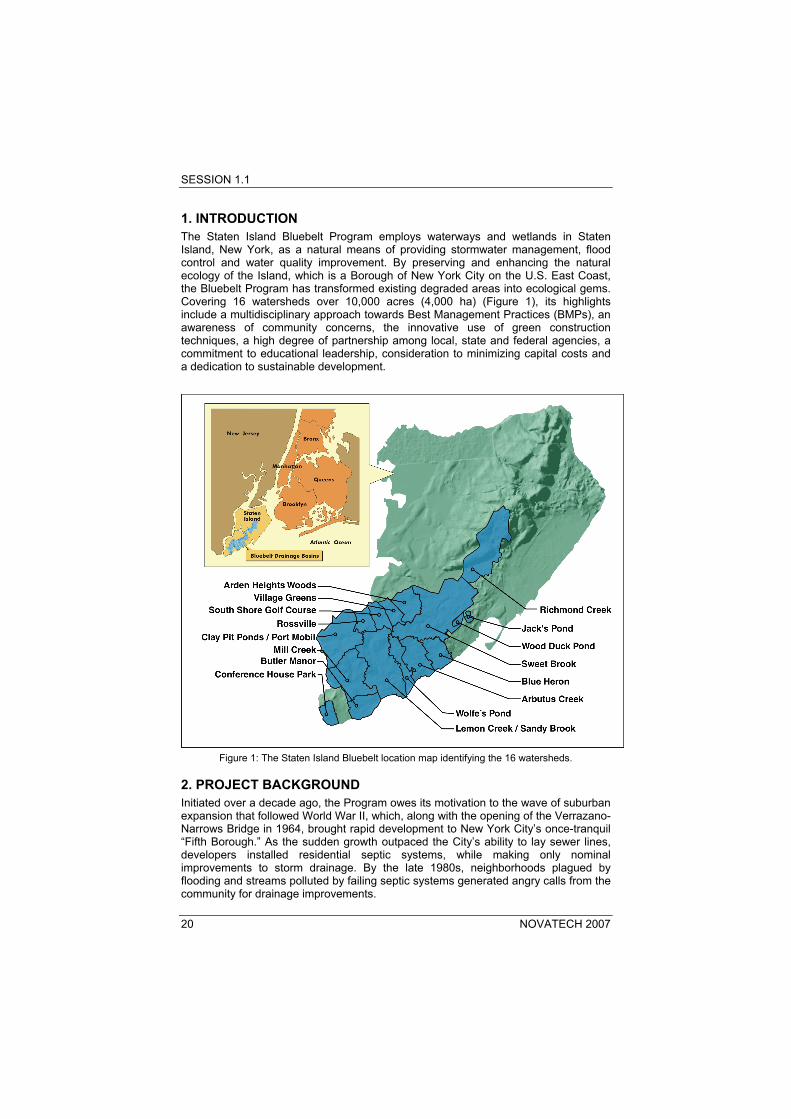
1. INTRODUCTION The Staten Island Bluebelt Program employs waterways and wetlands in Staten Island, New York, as a natural means of providing stormwater management, flood control and water quality improvement. By preserving and enhancing the natural ecology of the Island, which is a Borough of New York City on the U.S. East Coast, the Bluebelt Program has transformed existing degraded areas into ecological gems. Covering 16 watersheds over 10,000 acres (4,000 ha) (Figure 1), its highlights include a multidisciplinary approach towards Best Management Practices (BMPs), an awareness of community concerns, the innovative use of green construction techniques, a high degree of partnership among local, state and federal agencies, a commitment to educational leadership, consideration to minimizing capital costs and a dedication to sustainable development.
Figure 1: The Staten Island Bluebelt location map identifying the 16 watersheds.
2. PROJECT BACKGROUND Initiated over a decade ago, the Program owes its motivation to the wave of suburban expansion that followed World War II, which, along with the opening of the Verrazano-Narrows Bridge in 1964, brought rapid development to New York City’s once-tranquil “Fifth Borough.” As the sudden growth outpaced the City’s ability to lay sewer lines, developers installed residential septic systems, while making only nominal improvements to storm drainage. By the late 1980s, neighborhoods plagued by flooding and streams polluted by failing septic systems generated angry calls from the community for drainage improvements.
SESSION 1.1
NOVATECH 2007 21
Residential and street flooding was commonplace in the watersheds targeted by the Bluebelt Program. Inadequately-sized culverts and poor street drainage infrastructure were generally the cause. Water quality in streams was also impaired. The Lemon Creek watershed in the Island’s South Richmond region, for instance, suffered severely degraded water quality from bacterial contamination – primarily due to the lack of adequate sanitary and storm sewers. There were numerous reports of failing septic systems saturating residential yards, and gray water contamination of street gutters and tributary surface water bodies. Conventional solutions to rectify drainage problems could not be implemented in this part of Staten Island because it also is home to New York City’s last large stand of freshwater wetlands, which are regulated by New York State Department of Environmental Conservation (NYSDEC). A conventional piped sewer system would have obliterated the wetlands by permanently draining or filling them. To address this conundrum, the New York City Department of Environmental Protection (NYCDEP) decided on an innovative and multidisciplinary approach using Staten Island’s natural waterways to perform their natural functions of conveyance, storage and filtration and integrating it with a conventional urban drainage collection system. In 1991, NYCDEP began a series of land acquisitions along the drainage corridors, forming a contiguous system of wetlands that came to be known as “the Bluebelt,” and readying itself to undertake a new approach to stormwater management. In doing so, NYCDEP undertook the first attempt to use natural waterways in this way in an urbanized setting.
3. PLAN DEVELOPMENT To plan, develop and implement a new and innovative drainage plan for Staten Island, NYCDEP selected a multidisciplinary team of engineers and scientists, led by Hazen and Sawyer, P.C. Utilizing extensive hydrologic, hydraulic and water quality modeling, as well as a comprehensive geographic information system (GIS) database for the study area, the project team redesigned the old drainage plans to incorporate the Bluebelt waterways into the overall stormwater network. The new drainage system collects the stormwater runoff and conveys it through engineered structures and facilities to the existing streams, with the goal of peak flood attenuation, improved water quality through stormwater detention, and reduction of stream channel velocities to prevent channel erosion. In designing a successful Bluebelt system, an effective modeling regime was needed to simulate the conveyance and response of the natural streams, as well as the interface between the “hard” engineered system of sewers and culverts and the “soft” natural environment of channels and wetlands. The team utilized a number of hydrologic and hydraulic modeling programs, including HEC-1, HEC-2, HEC-RAS and InfoWorks RS. The modeling took into account design flows that would occur during “full build-out conditions” in accordance with current zoning regulations. In general, channels and hydraulic structures were sized to convey the flow from the five-year storm, the event with a 20 percent chance of exceedence in any given year. While the Bluebelt Program included the installation of traditional sanitary and storm sewers in urbanized areas that lacked them, its unique cornerstone is the extensive use of BMPs, which are engineered facilities that provide flood control, water quality improvement and habitat preservation. Falling into three main categories – constructed wetlands, meandering streams and outlet stilling basins – BMPs are designed to improve water quality, attenuate flow and provide flood control, while preserving natural riparian areas and enhancing existing ecosystems. Each BMP is individually designed, with special attention paid to vegetative function, maintenance concerns and stone-faced structures that highlight the region’s agrarian past (Figure 2).

SESSION 1.1
22 NOVATECH 2007
To date, over 40 BMPs have been constructed, with designs for almost 50 more underway to complete the 16-watershed system.
Figure 2: Native fieldstone was incorporated into headwall facing.
The Blue Heron watershed is a typical example of this innovative system. The watershed, which is one of 16 in the Bluebelt, comprises Blue Heron Park (a city-owned area) and the residential neighborhoods surrounding it. Prior to the Program, street and residential flooding were common due to dilapidated or undersized hydraulic structures and the lack of storm sewers. The BMPs built within the watershed included three extended detention ponds, two outlet stilling basins and a section of realigned and restored stream channel. The extended detention ponds (Figure 3) are located in upstream areas where larger storm flows enter the park from an expanded network of storm sewers. Their large capacity can provide flood attenuation through storage and mitigate the adverse impacts of peak discharges. Extended detention ponds are designed to be large enough to temporarily store runoff – and thus provide water quality benefits – from 90 percent of all storm events. Hydraulic structures within the ponds are designed to convey the 5-year storm flow without flooding adjacent areas and convey the 100-year flow without exceeding the pre-existing 100-year floodplain. Up to 50 percent of the pond’s volume is stored as a permanent pool, while the other half is in extended detention, with an outlet structure designed to release the storage volume over a period of 24 hours. This provides water quality benefits through settling of sediments, bacterial decay and uptake of nutrients and organic pollutants by plants.

SESSION 1.1
NOVATECH 2007 23
Figure 3 : Blue Heron BMP BH-2, an extended detention pond with native wetlands plantings, is
sized to retain runoff from 90 percent of all storm events.
To that end, the ponds are extensively planted with native wetlands and uplands vegetation to provide pollutant removal, promote biodiversity in degraded areas and improve the aesthetics. In order to create a thriving wetland habitat, it is important to keep the water elevations appropriately shallow for wetlands flora. In addition the bank slopes are kept relatively gentle, and the outlet structures allow for flexibility in maintaining the water level of the extended detention basins. A smaller footprint BMP, the outlet stilling basin, is designed to control flow velocities where new storm sewers discharge into the natural channel. These basins are armored with riprap to absorb the energy of the pipe’s full-flow discharge and reduce its erosive potential. The third type of BMP in the Blue Heron watershed is a stream realignment project. The reach in question was heavily scoured due to high stream velocities. The realignment increased the channel’s sinuosity to reduce velocities to the 3-5 ft/s (0.9-1.5 m/s) threshold for channel erosion and established a bankfull capacity approximately equal to the one-year flow. In addition to the BMPs, NYCDEP also constructed 5.5 miles (8.9km) of new storm sewer and 10 miles (16km) of sanitary sewer in the Blue Heron watershed, in order to provide adequate street drainage and eliminate dependence on septic systems and package treatment plants. During the planning phase of the project, the team performed a detailed cost/benefit analysis, which included costs for land acquisition, wetland mitigation, environmental review and permitting, preliminary and final design, construction management services and construction itself. The analysis showed that the Bluebelt approach would cost about half that of traditional trunk sewer engineering based on reductions in lengths and diameters of required pipes. To date, the entire Bluebelt Program has saved the City of New York over $80 million in capital program costs.
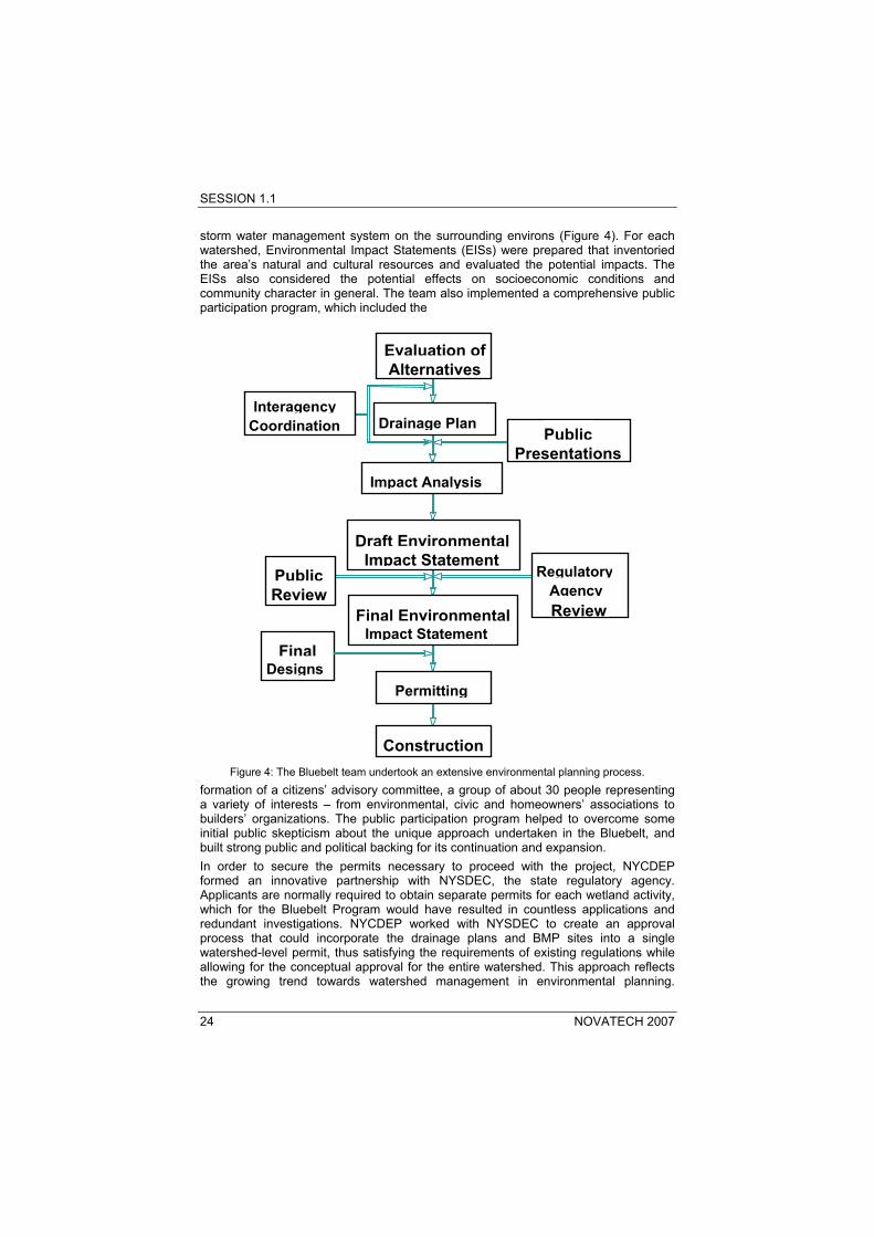
4. ENVIRONMENTAL REVIEW AND PERMITTING As the drainage plans were being developed, the team conducted an extensive environmental review process to determine the effect of implementing a Bluebelt
SESSION 1.1
24 NOVATECH 2007
storm water management system on the surrounding environs (Figure 4). For each watershed, Environmental Impact Statements (EISs) were prepared that inventoried the area’s natural and cultural resources and evaluated the potential impacts. The EISs also considered the potential effects on socioeconomic conditions and community character in general. The team also implemented a comprehensive public participation program, which included the
Figure 4: The Bluebelt team undertook an extensive environmental planning process.
formation of a citizens’ advisory committee, a group of about 30 people representing a variety of interests – from environmental, civic and homeowners’ associations to builders’ organizations. The public participation program helped to overcome some initial public skepticism about the unique approach undertaken in the Bluebelt, and built strong public and political backing for its continuation and expansion. In order to secure the permits necessary to proceed with the project, NYCDEP formed an innovative partnership with NYSDEC, the state regulatory agency. Applicants are normally required to obtain separate permits for each wetland activity, which for the Bluebelt Program would have resulted in countless applications and redundant investigations. NYCDEP worked with NYSDEC to create an approval process that could incorporate the drainage plans and BMP sites into a single watershed-level permit, thus satisfying the requirements of existing regulations while allowing for the conceptual approval for the entire watershed. This approach reflects the growing trend towards watershed management in environmental planning.
Evaluation ofAlternatives
Drainage Plan
Impact Analysis
Interagency Coordination Public
Presentations
Public Review
Draft EnvironmentalImpact Statement
Final EnvironmentalImpact Statement
Permitting
Construction
Final Designs
RegulatoryAgencyReview

SESSION 1.1
NOVATECH 2007 25
NYCDEP also formed a working relationship with the U.S. Army Corps of Engineers, the federal agency responsible for regulating wetlands activities.
5. WATER QUALITY BENEFITS Achieving significant pollutant removal efficiencies are among some of the project’s most noteworthy benefits. Despite the multitude of federal and state literature on stormwater BMPs, there are currently no regulations on water quality improvements that must be achieved in the U.S. Taking a proactive approach, NYCDEP initiated a water quality monitoring program across the Bluebelt. The results far exceed projections contained in environmental impact statements for similar facilities elsewhere in the country. For example, at the Blue Heron extended detention pond BMP BH-2, the nitrogen load in the water leaving the pond was 88 percent lower than what entered during dry weather, and 40 percent lower during storm events. Overall, sampling at the inlets and outlets of constructed wetlands revealed dry-weather removal efficiencies as high as 90 percent for fecal coliform and 66 percent for total phosphates. In addition, wet-weather removal efficiencies as high as 38 percent for total organic carbon and 40 percent for nitrates were achieved. The removal of nutrients primarily occurs through microbiological and vegetative uptake, while the longer detention times in the extended detention ponds promotes bacterial die-off. Reduction in fecal coliform is especially important in Bluebelt water bodies that remain impacted by septic runoff.
6. CONCLUSION Perhaps the best testament to the success of the Bluebelt has been its stellar performance during major storms and hurricanes. Hurricane Ivan, which dropped 2.3 inches (5.8cm) of rainfall over a 24-hour period, passed quietly through the region on September 17-18, 2004. Tropical Storm Tammy and Subtropical Depression 22, which combined to produce 6.4 inches (16cm) of rainfall over a 24-hour period, went by unnoticed on October 8-9, 2005. Areas that were once flooded even by minor precipitation events handled these major storms without issue (Figure 5).

SESSION 1.1
26 NOVATECH 2007
Figure 5: A South Richmond intersection during a storm event prior to the establishment of the
Bluebelt (above) and after (below).
With the lessons learned from developing the Bluebelt in South Richmond, NYCDEP has looked to create a Mid-Island Bluebelt comprising several additional watersheds. These watersheds are more substantially urbanized and present different challenges from South Richmond, but initial studies indicate that a Mid-Island Bluebelt would offer some of the same flood protection, ecosystem restoration and fiscal benefits. Indeed, the Bluebelt model generally applies to urbanized regions that retain at least some of their surface waterways. In 2005, the New York City Department of Design and Construction listed the Bluebelt in its “High Performance Infrastructure Guidelines” for design. The Bluebelt program reflects what is fast becoming a new trend in environmentalism. Rather than protect natural features at all costs, the Bluebelt Program seeks to actively restore and enhance them, even working within designated but degraded wetlands with the ultimate goal of achieving stronger ecosystems that serve both nature and people. Balancing human needs with those of our natural environment will be one of the biggest challenges our society will face as it continues to grow.
REFERENCES Eisenman, T. (2005) A Watershed Moment in Green Infrastructure. Landscape Architecture, Nov.
2005, 56-63. New York City Department of Design and Construction and the Design Trust for Public Space.
(2005) High Performance Infrastructure Guidelines New York City Department of Environmental Protection. (1998) Blue Heron, Arbutus Creek, and
Lemon Creek/Sandy Brook Watershed Drainage Plans: Final Environmental Impact Statement.
Vokral, J., Gumb, D., Cavallaro, A.D., Mehrotra, S., and Rosenberg, E. (2003) Wetlands at Work. Civil Engineering, Vol. 73, No. 2, 56-63.