The Stage 2 Archaeological Assessment - the Town of Oakville
44
License Report on the 2007 Stage 1-3 Archaeological Assessment of the Shieldbay Developments Inc. Property, Part of Lot 11, Concession 1 NDS, Geographic Township of Trafalgar, Town of Oakville, Halton Regional Municipality, Ontario Submitted to Trinison Management Corp. 8600 Dufferin Street, Vaughan, Ontario L4K 5P5 Telephone - 416/798-1127 Facsimile - 416/798-2159 and The Ontario Ministry of Tourism, Culture and Sport Prepared by D.R. Poulton & Associates Inc. 69 Langarth Street West, London, Ontario, N6J 1P5 Office – 519 434-0319 Facsimile - 519/434-0517 E-mail - [email protected] Corporate Project #05-54 PIF #P116-115-2007 March 2009, revised June 13, 2013
-
Upload
khangminh22 -
Category
Documents
-
view
4 -
download
0
Transcript of The Stage 2 Archaeological Assessment - the Town of Oakville

License Report on the 2007
Stage 1-3 Archaeological Assessment of the
Shieldbay Developments Inc. Property,
Part of Lot 11, Concession 1 NDS,
Geographic Township of Trafalgar,
Town of Oakville,
Halton Regional Municipality,
Ontario
Submitted to
Trinison Management Corp. 8600 Dufferin Street,
Vaughan, Ontario L4K 5P5
Telephone - 416/798-1127 Facsimile - 416/798-2159
and
The Ontario Ministry of Tourism, Culture and Sport
Prepared by
D.R. Poulton & Associates Inc.
69 Langarth Street West, London, Ontario, N6J 1P5 Office – 519 434-0319 Facsimile - 519/434-0517
E-mail - [email protected]
Corporate Project #05-54
PIF #P116-115-2007
March 2009, revised June 13, 2013

Licence Report on the 2007 Stage 1-3 Archaeological Assessment of the Shieldbay Developments Inc. Property, Town of Oakville, Regional Municipality of Halton, Ontario Page ii
D. R. Poulton & Associates Inc.
TABLE OF CONTENTS Project Personnel v Acknowledgments v
Executive Summary vi
1.0 INTRODUCTION 1 2.0 LOCATION AND DESCRIPTION 3 3.0 STAGE 1: BACKGROUND RESEARCH 4
3.1 Methods 4 3.2 Results 5
4.0 STAGE 2: ARCHAEOLOGICAL SURVEY 11
4.1 Methods 11 4.2 Results 12
5.0 STAGE 2 SITE DESCRIPTIONS 13 6.0 THE SHIELDBAY 1 SITE (AiGw-522) 16 6.1 Location and Description 16 6.2 Artifact Analysis 16 6.3 Interpretations 16 7.0 THE SHIELDBAY 2 SITE (AiGw-523) 17 7.1 Location and Description 17 7.2 Artifact Analysis 17 7.3 Interpretations 20

Licence Report on the 2007 Stage 1-3 Archaeological Assessment of the Shieldbay Developments Inc. Property, Town of Oakville, Regional Municipality of Halton, Ontario Page iii
D. R. Poulton & Associates Inc.
8.0 RECOMMENDATIONS 21 9.0 REFERENCES CITED 24 List of Tables
Table 1 Cultural Chronology of South-Central Ontario 5 Table 2 Registered Archaeological Sites in the Study Area 7 Table 3 Summary Data on Registered Archaeological Sites in the Study Area 8 Table 4 Summary Data on Archaeological Sites in the Shieldbay Property 12 Table 5 Frequency of Cultural Remains from the Shieldbay 2 Site 18 Table 6 Summary Data on Utilized Flakes from the Shieldbay 2 Site 19 List of Figures
Figure 1 Location of the Shieldbay Property 21 Figure 2 Facsimile of the 1877 Illustrated Historical Atlas of Trafalgar Township 22
Figure 3 Archaeological Survey Coverage and Site Locations 23 Figure 4 Stage 3 Controlled Surface Collection of the Shieldbay 2 Site 24 List of Plates
Plate 1 Field 1 (North Field) of the Shieldbay Property, View East 26 Plate 2 Field 2 (Middle Field) of the Shieldbay Property, View East 26 Plate 3 Field 3 with the Shieldbay 2 Site in the Background, View North 26
Plate 4 Field 6 of the Shieldbay Property, View Northeast 26

Licence Report on the 2007 Stage 1-3 Archaeological Assessment of the Shieldbay Developments Inc. Property, Town of Oakville, Regional Municipality of Halton, Ontario Page iv
D. R. Poulton & Associates Inc.
List of Plates (continued)
Plate 5 Field 7 of the Shieldbay Property, View North 26 Plate 6 Field 8 of the Shieldbay Property, View North-Northeast 26 Plate 7 Select Artifacts from the 2007 Survey of the Shieldbay Property 27
APPENDIX
2007 Artifact Catalogue for Sites in the Shieldbay Property

Licence Report on the 2007 Stage 1-3 Archaeological Assessment of the Shieldbay Developments Inc. Property, Town of Oakville, Regional Municipality of Halton, Ontario Page v
D. R. Poulton & Associates Inc.
Project Personnel
Project Manager Dana R. Poulton Report Preparation Dana R. Poulton James T. Sherratt Lorelyn Giese Sherri Pearce Field Director Chris Neill Field Assistants Ariella Rea-Cunningham Miranda Brunton Nadia Densmore Katherine Cook Krystal Cameron Photography Chris Neill Lorelyn Giese Draughting Christine F. Dodd Artifact Analysis James T. Sherratt
Acknowledgments This assessment was facilitated by the following individuals and their agencies:
Michael Telawski, Development Manager, Trinison Management Corporation;
Melissa Salviato, Development Coordinator, Trinison Management Corporation; and
Robert von Bitter, Archaeological Data Coordinator, Heritage and
Libraries Branch, Heritage Operations Unit, Ministry of Tourism, Culture and Sport.

Licence Report on the 2007 Stage 1-3 Archaeological Assessment of the Shieldbay Developments Inc. Property, Town of Oakville, Regional Municipality of Halton, Ontario Page vi
D. R. Poulton & Associates Inc.
EXECUTIVE SUMMARY
This report details the rationale, methods and results of the archaeological assessment of the Shieldbay Developments Incorporated property, Town of Oakville. The property is identified as part of Lot 11, Concession 1 NDS, Geographic Township of Trafalgar in Halton County. Figure 1 shows the location of the proposed development. The assessment of the property was undertaken by D. R. Poulton & Associates Inc. (DPA) and was carried out on behalf of Trinison Management Corporation. The purpose of the archaeological assessment was to obtain information on known and potential archaeological resources within the property. More specifically, the assessment was intended to identify the presence or absence of archaeological resources that could represent possible constraints for the future residential development of the property. The archaeological assessment involved three sequential stages as defined in the technical guidelines formulated by the Ministry of Culture, Tourism, and Recreation (now Ministry of Tourism, Culture and Sport) (MCTR 1993). The first consisted of Stage 1 background research. The second consisted of a partial Stage 2 survey of the property. The third consisted of a Stage 3 controlled surface collection of one of the pre-contact First Nations sites that was discovered during the course of the survey. As detailed in Section 3.0 of this report, the Stage 1 background study determined that no archaeological sites had been documented within the Shieldbay property prior to the present assessment. In consequence, possible archaeological planning concerns for the proposed development were limited to the potential for as-yet undiscovered sites. The subsequent 2007 survey was limited to the arable portions of the property. It covered lands with a surface area of 34.3 hectares, representing 72% of the total 45-hectare surface area of the property. The partial survey documented the presence of 11 archaeological sites. As stated above, the lands surveyed to date were limited to arable portions of the property. There are a number of discrete areas of uncultivated land within the property that were not included in the 2007 survey. The most extensive is a woodlot in the northeast corner of the property. It is designated Natural Heritage System lands. Those lands are likely poorly-drained, but a visual examination would be necessary to determine if they contain any discrete areas that have a potential for archaeological remains and would warrant archaeological survey. Other non-arable lands are located along the northwest edge of the property and in the southern third of the property. The latter include a relatively large area in the south-central portion of the property that almost certainly includes the site of a 19th century Euro-Canadian farmstead (see Section 3.2). Further to the above, the uncultivated portions of the Shieldbay property that will be subject to impact from the future residential development of the property are scheduled to be covered by a systematic shovel test pit survey in 2009. A visual examination of the Natural Heritage System lands will be conducted at the same time. If it should determine that any discrete areas in the Natural Heritage System have a potential for archaeological remains, Trinison Management Corp. will have two options to consider. One option would be to conduct an archaeological
Licence Report on the 2007 Stage 1-3 Archaeological Assessment of the Shieldbay Developments Inc. Property, Town of Oakville, Regional Municipality of Halton, Ontario Page vii
D. R. Poulton & Associates Inc.
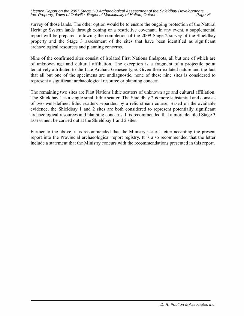
survey of those lands. The other option would be to ensure the ongoing protection of the Natural Heritage System lands through zoning or a restrictive covenant. In any event, a supplemental report will be prepared following the completion of the 2009 Stage 2 survey of the Shieldbay property and the Stage 3 assessment of the sites that have been identified as significant archaeological resources and planning concerns. Nine of the confirmed sites consist of isolated First Nations findspots, all but one of which are of unknown age and cultural affiliation. The exception is a fragment of a projectile point tentatively attributed to the Late Archaic Genesee type. Given their isolated nature and the fact that all but one of the specimens are undiagnostic, none of these nine sites is considered to represent a significant archaeological resource or planning concern. The remaining two sites are First Nations lithic scatters of unknown age and cultural affiliation. The Shieldbay 1 is a single small lithic scatter. The Shieldbay 2 is more substantial and consists of two well-defined lithic scatters separated by a relic stream course. Based on the available evidence, the Shieldbay 1 and 2 sites are both considered to represent potentially significant archaeological resources and planning concerns. It is recommended that a more detailed Stage 3 assessment be carried out at the Shieldbay 1 and 2 sites. Further to the above, it is recommended that the Ministry issue a letter accepting the present report into the Provincial archaeological report registry. It is also recommended that the letter include a statement that the Ministry concurs with the recommendations presented in this report.

Licence Report on the 2007 Stage 1-3 Archaeological Assessment of the Shieldbay Developments Inc. Property, Town of Oakville, Regional Municipality of Halton, Ontario Page 1
D. R. Poulton & Associates Inc.
1.0 INTRODUCTION
This report details the results of the archaeological assessment of the proposed development of the Shieldbay Developments Incorporated property, Town of Oakville, Ontario. The assessment is being conducted by D.R. Poulton & Associates Inc. (DPA). It is being carried out on behalf of Trinison Management Corp. Figure 1 shows the location of the proposed development. The archaeological assessment involved three sequential stages as defined in the technical guidelines formulated by the Ministry of Culture, Tourism, and Recreation (now Ministry of Tourism, Culture and Sport) (MCTR 1993). The first consisted of Stage 1 background research. The second consisted of a partial Stage 2 survey of the property. The third consisted of a Stage 3 controlled surface collection of one of the pre-contact First Nations sites that was discovered during the course of the survey. As detailed in Section 3.0 of this report, the Stage 1 background study determined that no archaeological sites had been documented within the Shieldbay property prior to the present assessment. In consequence, possible archaeological planning concerns for the proposed development were limited to the potential for as-yet undiscovered sites. The subsequent 2007 survey was limited to the arable portions of the property. The partial survey documented the presence of 11 archaeological sites. Two of those sites have been determined to represent potentially significant archaeological resources and planning concerns. As stated above, the lands surveyed to date were limited to arable portions of the property. There are a number of discrete areas of non-arable land within the property that were not included in the 2007 survey. The most extensive is a woodlot in the northeast corner of the property. It is designated Natural Heritage System lands. Those lands are likely poorly-drained, but a visual examination would be necessary to determine if they contain any discrete areas that have a potential for archaeological remains and would warrant archaeological survey. Other discrete areas of non-arable lands that remain to be surveyed are located along the northwest edge of the property and in the southern third of the property. The latter include an area in the south-central portion of the property that almost certainly includes the site of a 19th century Euro-Canadian farmstead (see Section 3.2). Further to the above, the uncultivated portions of the Shieldbay property that will be subject to impact from the future residential development of the property are scheduled to be covered by a systematic shovel test pit survey in 2009. A visual examination of the Natural Heritage System lands will be conducted at the same time. If it should determine that any discrete areas in the Natural Heritage System have a potential for archaeological remains, Trinison Management Corp. will have two options to consider. One option would be to conduct an archaeological survey of those lands. The other option would be to ensure the ongoing protection of the Natural Heritage System lands through zoning or a restrictive covenant. The Ontario Ministry of Tourism, Culture and Sport designated the Shieldbay assessment as PIF #116-115-2007. The assessment was conducted under Archaeological Consulting Licence P116, issued by the Province of Ontario to Dana R. Poulton of D. R. Poulton & Associates. It was carried out in accordance with the provisions of the Ontario Heritage Act (Government of Ontario 1990) and with the technical guidelines for archaeological assessment formulated by the

Licence Report on the 2007 Stage 1-3 Archaeological Assessment of the Shieldbay Developments Inc. Property, Town of Oakville, Regional Municipality of Halton, Ontario Page 2
D. R. Poulton & Associates Inc.
Ontario Ministry of Culture, Tourism and Recreation (now Ministry of Tourism, Culture and Sport) (MCTR 1993). Permission for access to the property for purposes of the survey and to remove and curate artifacts was granted by the landowner. The artifacts and records pertaining to this project are currently housed in the corporate offices of D.R. Poulton & Associates Inc. If the opportunity permits, however, they will be transferred to a suitable long-term repository. The present report is being submitted to fulfill the requirements of Archaeological Consulting Licence P116, under which the 2007 fieldwork was conducted. In due course, a supplementary report will be prepared. It will document the outcome of the 2009 Stage 2 survey of the non-arable portions of the property and the Stage 3 assessment of the sites that have been identified as potentially significant archaeological resources and planning concerns.

Licence Report on the 2007 Stage 1-3 Archaeological Assessment of the Shieldbay Developments Inc. Property, Town of Oakville, Regional Municipality of Halton, Ontario Page 3
D. R. Poulton & Associates Inc.
2.0 LOCATION AND DESCRIPTION The proposed Shieldbay Developments Inc. development is located in the northwest portion of the Town of Oakville (Figure 1). The property consists of the south half of Lot 11, Concession 1 NDS, Geographic Township of Trafalgar, Halton Regional Municipality, Ontario. It has a total surface area of 45.0 hectares. The vast majority of the subject lands consists of eight connected agricultural fields. The main exception is a woodlot in the northeast corner of the property. A narrower band of wooded lands also extends along the northwest edge of the property. These wooded lands both abut the adjacent Tribaden property to the north. Small ponds and associated wetlands and minor stream courses are located in the southern portion of the property. Figure 3 illustrates existing conditions within the subject property as well as the extent of the 2007 archaeological survey coverage. The majority of the property is arable; the arable lands have a combined surface area of 34.3 hectares and represent 76% of the total surface area of the property. The balance of the property consists of non-arable lands. The latter include low and wet stream courses or swales in the south-central portion of the property with a surface area of 0.5 hectares, a 0.2 hectare pond in the southeast portion of the property, and forested or other non-arable lands with a combined surface area of 10.0 hectares. Part of the latter consists of Natural Heritage System lands in the northeast part of the property. The Shieldbay Developments Inc. property is located in the South Slope Physiographic Region. The South Slope is situated between Lake Ontario and the Oak Ridges Moraine. The region between Lake Ontario and the Oak Ridges is divided into three regions: Trafalgar Moraine, Peel Plain and the South Slope. The South Slope is the southern slope of the Oak Ridges Moraine and as a result rises in elevation to 250 to 300 metres a.s.l. at the line of contact with the Oak Ridges (Chapman and Putnam 1984: 172). The southern portion of the Shieldbay property is transected by a contour line with an elevation of 170 metres a.s.l. In addition to the physiographic regions, it is also instructive to describe the subject lands in relation to major and minor waterways. The lands involved in the proposed development are level to gently rolling. The immediate area of the property is drained by East Morrison Creek, which is situated to the west of the subject lands and Joshua’s Creek. The latter is located east of the property.

Licence Report on the 2007 Stage 1-3 Archaeological Assessment of the Shieldbay Developments Inc. Property, Town of Oakville, Regional Municipality of Halton, Ontario Page 4
D. R. Poulton & Associates Inc.
3.0 STAGE 1: BACKGROUND RESEARCH 3.1 Methods
The initial element of an archaeological assessment of a proposed development undertaking consists of background research. This is defined as a Stage 1 level of assessment in the archaeological guidelines formulated by the Province of Ontario (MCTR 1993). Background research is carried out in order to:
amass all of the readily available information on previous archaeological surveys in the area;
determine the location of any registered and unregistered sites
within and adjacent to the property;
identify areas of archaeological potential which represent concerns for Stage 2 field survey; and
develop an historical framework for assigning levels of potential
significance to any new sites discovered during fieldwork. The framework for assigning levels of potential archaeological significance is drawn from provincial environmental assessment guidelines (Weiler 1980). The information includes the identification and evaluation of any feature that has one or more of the following attributes:
... it has the potential through archaeological exploration, survey or fieldwork to provide answers to substantive questions (i.e. relate to particular times and places) about events and processes that occurred in the past and therefore add to our knowledge and appreciation of history;
it has the potential through archaeological exploration, survey and fieldwork to contribute to testing the validity of general anthropological principles, cultural change and ecological adaptation, and therefore to the understanding and appreciation of our man-made heritage; or
it is probable that various technical, methodological, and theoretical advances are likely to occur during archaeological investigation of a feature, alone or in association with other features, and therefore contribute to the development of better scientific means of understanding and appreciating our man-made heritage (Weiler 1980:8).
For purposes of context, the Stage 1 background study examined data for a one-kilometre study area surrounding the proposed development. Two collective sources were examined in Stage 1. One was the Archaeological Sites Database of the Ministry of Tourism, Culture and Sport. It houses site record forms for registered sites as well as published and unpublished reports on past surveys, assessments and excavations.

Licence Report on the 2007 Stage 1-3 Archaeological Assessment of the Shieldbay Developments Inc. Property, Town of Oakville, Regional Municipality of Halton, Ontario Page 5
D. R. Poulton & Associates Inc.
The second collective source for the Stage 1 research was the library/archives of D.R. Poulton & Associates Inc. It includes an extensive inventory of published and unpublished reports, as well as inventories of both registered and unregistered archaeological sites in the area. 3.2 Results The background research obtained information of relevance to the potential for historic and prehistoric sites within the proposed development. For reference purposes, a cultural chronology of the region is presented in Table 1.
Table 1 Cultural Chronology for South-Central Ontario
PERIOD GROUP TIME RANGE COMMENT
PALEO-INDIAN
Fluted Point 9500 - 8500 B.C. Big game hunters; small nomadic groups Hi-Lo 8300 - 7900 B.C.
ARCHAIC
Early Nettling 7700 - 6900 B.C. Nomadic hunters and gatherers. Bifurcate Based 6800 - 6000 B.C. Middle Laurentian 3500 - 2500 B.C. Transition to territorial settlements.
Late
Lamoka 2500 - 1800 B.C. Polished/ground stone tools Broad Point 1800 - 1400 B.C.
Crawford Knoll 1500 - 500 B.C. Glacial Kame ca. 1000 B.C. Burial ceremonialism
WOODLAND
Early Meadowood 1000 - 400 B.C.
Introduction of pottery Red Ochre 1000 - 5000 B.C.
Middle Point Peninsula 300 B.C. - 500 A.D. Long distance trade networks.
Incipient horticulture Princess Point 500 - 800 A.D.
Late
Pickering 800 - 1280 A.D. Transition to village life and agriculture
Uren 1280 - 1330 A.D. Large village sites Middleport 1330 - 1400 A.D. Widespread stylistic horizon
Huron 1400 - 1650 A.D. Tribal differentiation and warfare HISTORIC
Early Odawa, Ojibwa, Mississauga 1700 - 1875 A.D. Social displacement
Late Euro-Canadian 1800 A.D. - present European settlement The results of the Stage 1 study may be divided into three separate but related categories: information on past archaeological investigations and known sites within and adjacent to the proposed development; information on the history of land use in the area; and data on the

Licence Report on the 2007 Stage 1-3 Archaeological Assessment of the Shieldbay Developments Inc. Property, Town of Oakville, Regional Municipality of Halton, Ontario Page 6
D. R. Poulton & Associates Inc.
potential for as-yet undiscovered archaeological sites within the proposed development lands. These will be considered in turn. Past Archaeological Investigations and Known Sites
The background research confirmed that no archaeological sites had been registered within the subject property prior to this assessment. The Stage 1 background study did indicate that several archaeological studies have been conducted within the study area surrounding the Shieldbay Developments Inc. development. None affected any archaeological survey coverage of the lands involved in the present study. However, the past projects do provide some archaeological context for the proposed undertaking. The Stage 1 background study determined that 29 archaeological sites have been registered within a one-kilometre radius of the proposed development. Summary data on the individual sites in the inventory are presented in Table 2. Two of the sites include two discrete cultural occupations. Accordingly, the inventory is represented by 31 discrete cultural components. Summary data on the registered archaeological inventory of the study area are presented in Table 3. As indicated, the inventory demonstrates that the study area containing the proposed Shieldbay development has been occupied at least intermittently for almost 9,000 years. Fourteen of the sites consist of prehistoric components of unknown age and cultural affiliation: they comprise ten findspots and four prehistoric lithic scatters or camps. The remaining prehistoric sites have produced artifacts diagnostic of particular cultures or time periods. The earliest prehistoric occupation is represented by nine sites that date to the Archaic Period. They pertain to nomadic pre-agricultural peoples who utilized a wide range of cultural resources (Ellis, Kenyon and Spence 1990:65). The nine sites consist of eight isolated findspots and a single lithic scatter or camp. Two findspots date to the Early Archaic Bifurcate Base period, ca. 6800-6000 B.C. The Middle Archaic is represented by the largest number of isolated finds (n=4), while the Late Archaic is also represented by two isolated finds. Only the lithic scatter could not be assigned to a particular time frame during the Archaic period, since it lacked diagnostic artifacts that could be more precisely dated. Four of the sites in the study area date to the Woodland period, which is marked in Ontario by the use of ceramics. All of these sites are isolated finds. The inventory includes two finds dating to the Middle Woodland, one from the Early Woodland period, and a single Late Woodland component. The four remaining sites in the archaeological inventory of the study area all date to the Euro-Canadian settlement of the region. They consist of three homesteads and a refuse scatter. Two of these later occupations also contain minor amount of prehistoric chipped lithics; they have been included with the listing of sites identified as indeterminate prehistoric.

Licence Report on the 2007 Stage 1-3 Archaeological Assessment of the Shieldbay Developments Inc. Property, Town of Oakville, Regional Municipality of Halton, Ontario Page 7
D. R. Poulton & Associates Inc.
Table 2 Registered Archaeological Sites in the Study Area
Site Name Borden # Site Type Artifact Cultural Affiliation
AiGw-180 Findspot scraper Indeterminate Pre-contact First Nations Landing AiGw-427 Campsite Archaic
AiGw-431 Findspot point Middle Woodland, Snyder type point AiGw-432 Findspot point Late Archaic, Crawford Knoll AiGw-433 Findspot point Indeterminate Pre-contact First Nations
AiGw-434 Findspot point, flake Indeterminate Pre-contact First Nations
Phoenix AjGw-305 Homestead mid to late 19th century Euro-Canadian AjGw-426 Findspot point Indeterminate Pre-contact First Nations AjGw-428 Findspot Indeterminate Pre-contact First Nations
AiGw-181 Findspot biface, flakes Indeterminate Pre-contact First Nations
AiGw-182 Lithic scatter Indeterminate Pre-contact First Nations
Abigail AiGw-227 Homestead 19th century Euro-Canadian Findspot point Indeterminate Pre-contact First Nations
Uptown Core Land 2 AiGw-228
Refuse Scatter 19th century Euro-Canadian Lithic scatter flakes Indeterminate Pre-contact First Nations
Pen Equity 2 AiGw-235 Findspot point Middle Archaic, Brewerton Point Pen Equity 3 AiGw-236 Lithic scatter flakes Indeterminate Pre-contact First Nations Pen Equity 4 AiGw-237 Findspot point Middle Woodland, Saugeen Point Pen Equity 6 AiGw-239 Lithic scatter flakes Indeterminate Pre-contact First Nations Pen Equity 8 AiGw-240 Findspot point Early Woodland, Meadowood Pen Equity 9 AiGw-241 Findspot point Late Archaic, Genesee Point Pen Equity 10 AiGw-242 Findspot point Middle Archaic, Brewerton Point Pen Equity 11 AiGw-243 Findspot point Early Archaic, Bifurcate Base Point Macoakville AiGw-261 Findspot point Late Woodland, Dewaele
Iroquois Ridge 1 AiGw-334 Findspot flakes Indeterminate Pre-contact First Nations Iroquois Ridge 2 AiGw-335 Findspot point Middle Archaic, Brewerton Point Iroquois Ridge 3 AiGw-336 Findspot point Middle Archaic, Brewerton Point Iroquois Ridge 4 AiGw-337 Findspot point Early Archaic, Bifurcate Base Point The Lane Site AiGw-376 Homestead Early to mid 19th century Euro-Canadian
AiGw-413 Findspot biface Indeterminate Pre-contact First Nations AiGw-416 Findspot Indeterminate Pre-contact First Nations
Four of the isolated finds produced projectile points of an indeterminate age. Another three of the isolated finds are undiagnostic formal tools (two bifaces and one scraper). The remaining isolated finds include a small amount of chipping detritus and two locations where the recovered artifact was not identified. None of the lithic scatters were associated with diagnostic artifacts although one projectile point and one biface also had a minor amount of associated chipping detritus.

Licence Report on the 2007 Stage 1-3 Archaeological Assessment of the Shieldbay Developments Inc. Property, Town of Oakville, Regional Municipality of Halton, Ontario Page 8
D. R. Poulton & Associates Inc.
The earliest prehistoric periods of occupation relate to material dated to the Archaic Period. Two of the sites have been identified as Early Archaic. Both are isolated finds of bifurcate base projectile points. Another four sites have been dated to the Middle Archaic period. All are isolated finds of Brewerton projectile points. The Late Archaic is also represented by two isolated finds. One is identified as a Crawford Knoll projectile point while the other isolated find is a Genesee projectile point. Bifurcate base points are generally associated with the Bifurcate Horizon and date between 8900 and 8000 B. P. (Ellis, Kenyon and Spence 1990:72). Brewerton corner notched points have a long history but are most common between 2500 and 3500 B.C (KEWA 81-8). Genesee points are indicative of the Broad Point Tradition and generally date between 1900 and 1400 B.C. in Ontario (KEWA 81-7). Crawford Knoll projectile points date to the later half of the Late Archaic Period and are indicative a time range of ca. 1500 to 500 B. C. (KEWA 80-3). The four Woodland period sites are all identified by isolated finds of a single projectile point each. The Early Woodland is represented by a Meadowood point. The Middle Woodland period is identified by a Saugeen point and a Snyder point. Finally, the Late Woodland period is represented by a Dewaele projectile point.
Table 3 Summary Data on Registered Archaeological Sites in the Study Area
Age & Culture Site Type Total
ARCHAIC
Early Bifurcate Base Findspot 2 Middle Brewerton Findspot 4
Late Genesee Findspot 1
Crawford Knoll Findspot 1 Indeterminate Lithic scatter 1
Subtotal – Archaic Period 9
WOODLAND
Early Findspot 1 Middle Findspot 2
Late / Iroquoian Dewaele Findspot 1 Subtotal – Woodland Period 4
PREHISTORIC Indeterminate
Findspot 10 Lithic scatter 4
Subtotal - Indeterminate Prehistoric Period 14
EURO-CANADIAN 19th Century
Homestead 3 Refuse scatter 1
Subtotal - Euro-Canadian Period 4 Total 31
Meadowood points are finely made and readily recognized bifaces that identify the Early Woodland Period in Southwestern Ontario and are widely distributed throughout the region (KEWA 80-5). Snyder projectile points will occur during the first half of the Middle Woodland period in Ontario and are associated with the early to mid Hopewell period. Commonly found on Illinois sites between 200 B.C. and 50 A.D., they are indicative of the extensive trade

Licence Report on the 2007 Stage 1-3 Archaeological Assessment of the Shieldbay Developments Inc. Property, Town of Oakville, Regional Municipality of Halton, Ontario Page 9
D. R. Poulton & Associates Inc.
networks established by First Nations cultures during this time period (Murphy 1988). Saugeen projectile points are indicative of the Saugeen cultural horizon of the Middle Woodland Period and are common in the Lake Huron drainage system from circa 500 B.C. to 500 A.D. (KEWA 79-9); the presence of one in the Halton region is somewhat unusual. The final projectile point is of the Dewaele type; it pertains to what has been called the Early Iroquoian Glen Meyer Branch of the Late Woodland Period. This uncommon point type occurs on sites dating from 850 to 1250 A.D. (KEWA 82-2). The remaining sites identified in the 1-km study area are represented by larger concentrations of artifacts. One is a campsite that has been dated to the Archaic Period. The other four lithic scatters could not be assigned to a particular time frame and are merely identified as indeterminate prehistoric. The last four sites all date to the period of Euro-Canadian settlement in the area. Three have been identified as homesteads while the fourth site is a more ephemeral refuse scatter. The Euro-Canadian homesteads reflect the ongoing period of settlement and land use during the early to late 19th century. History of Land Use in the Vicinity of the Subject Property
Figure 2 illustrates the location of the property relative to the map of Trafalgar Township in the 1877 Historic Atlas (Walker and Miles 1877). Reference to the map indicates that agricultural settlement in the area was complete by the third quarter of the 19th century and that as of 1877 the subject property was owned by George Ryan. A structure with an associated orchard is depicted as being located in what is now the south-central portion of the Shieldbay property; it is clearly oriented to Dundas Street West. This depiction of a structure with an associated orchard is the Historic Atlas convention for a farmstead. Dundas Street itself is a very early settlement road. It was surveyed by Augustus Jones and was constructed in the 1790s by the Queens Rangers at the direction of the first Lieutenant Governor of Upper Canada, John Graves Simcoe. The closest named community in the late 19th century is Trafalgar. It is located directly west of the subject property, at the intersection of Dundas Street and Trafalgar Road. The Historic Atlas indicates considerable habitation concentrated along the west side of Trafalgar Road at this intersection. The community was also known as Postville, since this was the first post office established in Trafalgar Township. Opened in 1820, the Historical Atlas indicates that this was the only post office between the communities of Toronto and Dundas in the 1820s. Archaeological Potential of Subject Property The potential for prehistoric and historic archaeological resources within a proposed development is generally evaluated on the basis of both known sites in proximity to the property and the intrinsic nature of the property itself, including factors such as topography and drainage. Yet another factor is the extent to which past impacts may have decreased or altogether eradicated the extant potential of a property to contain archaeological remains. In the case of the Shieldbay property, however, that is not a factor. The known prehistoric archaeological sites identified within the study area indicate that the vicinity of the property was used at least on an intermittent basis as part of the hunting and

Licence Report on the 2007 Stage 1-3 Archaeological Assessment of the Shieldbay Developments Inc. Property, Town of Oakville, Regional Municipality of Halton, Ontario Page 10
D. R. Poulton & Associates Inc.
gathering territories of a succession of prehistoric peoples over a period of some 9,000 years. Given this and the large number of sites found within the study area, the lands contained within the subject property are considered to have at the very least a moderate potential for prehistoric archaeological resources. The past investigations further demonstrated that the area contains an unusual concentration of small prehistoric camps and isolated findspots, and that it has a potential for many more such sites. That in turn suggested that the proposed development had a potential for other as-yet undiscovered sites, especially smaller camps and isolated finds. The presence of and potential for sites of this type presumably derives from the fact that the area mainly consists of well-drained tablelands suitable for habitation, and that it contains tributaries of East Morrison Creek and Joshua’s Creek, which would have provided reliable sources of drinking water. The potential for 19th century Euro-Canadian historic archaeological planning concerns may be defined with reference to documented features in the 19th century landscape. As summarized above, and illustrated in Figures 1 and 2, the south edge of the subject property fronts on Dundas Street West; it is the oldest road in this area, and many early Euro-Canadian sites were oriented to it. Historic research summarized above further demonstrates that the land that forms the Shieldbay property contained the farmstead of George Ryan in the third quarter of the 19th century. Based on comparisons between Figure 2 and 3, the site of the Ryan farmstead is almost certainly located in the south-central portion of the Shieldbay property, in an uncultivated area that has not yet been surveyed. In any event, the available data indicate that the subject property has a high potential for extant historic Euro-Canadian archaeological resources.

Licence Report on the 2007 Stage 1-3 Archaeological Assessment of the Shieldbay Developments Inc. Property, Town of Oakville, Regional Municipality of Halton, Ontario Page 11
D. R. Poulton & Associates Inc.
4.0 STAGE 2: ARCHAEOLOGICAL SURVEY
4.1 Methods
Following the 1993 technical guidelines for archaeological assessment, two survey methods were used in the Stage 2 assessment of the subject property. They involved a pedestrian transect survey of all lands under cultivation and a shovel test pit survey of woodlots or areas of scrubland that could not be ploughed. Figure 3 illustrates the survey coverage and the results. The pedestrian transect survey of the ploughed portions of the subject property was conducted on July 11 and 12, 2007 under the direction of Chris Neill with a crew of five. The weather on that date was sunny and mild and lighting conditions were good. The lands had been ploughed the previous month (June 6-7, 2007) and were well weathered. The pedestrian transect survey was conducted by systematic surface examination at an interval of five metres. When an artifact was found, the location was marked with a survey flag and an intensive surface examination was then conducted at a one-metre interval in order to better define the nature and extent of the occurrence. The intensive surface examination was carried out for a distance of 20 metres beyond the original discovery or, in the case of multiple finds, beyond the outermost find. The majority of the property could be surface surveyed. This amounts to 34.3 hectares. As the entire property has a surface area of 45.0 hectares, the lands covered by surface examination represent 76% of the total surface area of the property. Conditions for the observation of cultural remains within the fields covered by surface examination varied from good to excellent. The weather on July 11, 2007 was hot and breezy (30 degrees C) but sunny with a few clouds. July 12, 2007 was slightly cooler (27 degrees C) but was also sunny with light clouds. The favourable weather conditions and the process of the Stage 2 2007 field survey is illustrated in Plates 1 to 6. Plate 1 is a view east of Field 1 (also identified as the North Field), a large cultivated field that occupies the width of the northern extent of the property. Plate 2 is a view east of Field 2 (also identified as the Middle Field), a large field that spans the north-central portion of the subject property. Both Field 1 and Field 2 are normally cultivated for a grain crop. In 2007 they were planted in corn. The remaining portions of the Shieldbay property consisted of a series of smaller pasture fields that required ploughing and weathering before they could be surveyed. Plate 3 is a view north of Field 3 (also identified as the North West Quarter). The flagged artifact locations visible in the distance in this view are the Shieldbay 2 site (AiGw-523). Plate 4 is a view northeast of Field 6 (also identified as the southern portion of the North East Quarter), with several members of the field crew proceeding with the Stage 2 survey. This field also contains a substantial pond and smaller areas of low and wet topography, although they are not visible in this photograph. Plate 5 is a view north of Field 7 (also identified as the South South-West portion of the South Field). Areas that still require assessment are visible on the right side in the distance in this photograph. Plate 6 is a view north by northeast of Field 8 (also identified as the South South-East portion of the South Field). An area of uncultivated land is shown in the centre of the photograph; it is a relic stream course.

Licence Report on the 2007 Stage 1-3 Archaeological Assessment of the Shieldbay Developments Inc. Property, Town of Oakville, Regional Municipality of Halton, Ontario Page 12
D. R. Poulton & Associates Inc.
4.2 Results
The archaeological survey of the Shieldbay property resulted in the discovery of 11 previously unknown archaeological sites. Summary data are presented in Table 4. The inventory includes two lithic scatters and nine isolated finds. Only one of the sites could be assigned to a specific time period. Site 11 consists of a mid section of a large projectile point, possibly of the Genesee type. Projectile points of that type are characteristic of the Broad Point Horizon of the Late Archaic period. Select artifacts are illustrated in Plate 7. The isolated findspots are described in Section 5.0. The lithic scatters are described in Sections 6.0 and 7.0.
Table 4 Summary Data on Archaeological Sites in the Shieldbay Property
Site Location Site Type Artifact Type
Cultural
Affiliation Significance
Shieldbay 1 (AGw-522) Field 4 Scatter Flakes Indeterminate
First Nations Yes
Shieldbay 2 (AiGw-523) Field 3 Scatter Cores, Flakes Indeterminate
First Nations Yes
Shieldbay 3 Field 4 Findspot Flake Indeterminate First Nations No
Shieldbay 4 Field 5 Findspot Flake Indeterminate First Nations No
Shieldbay 5 Field 5 Findspot Flake Indeterminate First Nations No
Shieldbay 6 Field 5 Findspot Flake Indeterminate First Nations No
Shieldbay 7 Field 2 Findspot Flake Indeterminate First Nations No
Shieldbay 8 Field 2 Findspot Core Fragment Indeterminate First Nations No
Shieldbay 9 Field 2 Findspot Biface Indeterminate First Nations No
Shieldbay 10 Field 1 Findspot Flake Indeterminate First Nations No
Shieldbay 11 Field 1 Findspot Point (partial) Late Archaic – Genesee Point No

Licence Report on the 2007 Stage 1-3 Archaeological Assessment of the Shieldbay Developments Inc. Property, Town of Oakville, Regional Municipality of Halton, Ontario Page 13
D. R. Poulton & Associates Inc.
5.0 STAGE 2 SITE DESCRIPTIONS The nine isolated findspots are described in this section of the report. Given their isolated nature and the fact that all of the specimens but one are undiagnostic, none of these nine sites is considered to represent a significant archaeological resource or a planning concern. Shieldbay 3
Shieldbay 3 was discovered during the course of the Stage 2 pedestrian survey of Field 4 of the Shieldbay property. The site is located in Lot 11, Concession 1 NDS. As shown in Figure 3, the find is located 10 metres north of a line of mature trees that defines the southern limits of the field and close to the western edge of the field. Specifically, the site is located 401 metres north of Dundas Street and 604 metres east of Trafalgar Road. The site consists of a single artifact. It is a piece of chipping detritus identified as a tertiary flake of Onondaga chert. This small flake has a length of 9.3 mm, a width of 11.9 mm and a thickness of 4.3 mm. Shieldbay 4
Shieldbay 4 was discovered during the course of the Stage 2 pedestrian survey of Field 5 of the Shieldbay property. As shown in Figure 3, the find is situated in the northeast corner of a small field. There are two other isolated finds in this field. The Shieldbay 4 site is located in Lot 11, Concession 1 NDS. Specifically, it is located 316 metres north of Dundas Street and 578 metres east of Trafalgar Road. This site consists of a single artifact. It is a piece of chipping detritus identified as a flake fragment of Onondaga chert. It has a maximum measured length of 18.1 mm, a width of 9.0 mm and a thickness of 1.9 mm. Shieldbay 5
Shieldbay 5 was discovered during the course of the Stage 2 pedestrian survey of Field 5 of the Shieldbay property. As shown in Figure 3, the find is situated a short distance southeast of a small pond in the central portion of a small field. There are two other isolated finds in this field. The site is located in Lot 11, Concession 1 NDS. Specifically, it is located 253 metres north of Dundas Street and 555 metres east of Trafalgar Road. This site consists of a single artifact. It is a piece of chipping detritus that has been identified as biface thinning flake made of high quality Onondaga chert (Plate 7j). This incomplete flake has a measured length of 20.4 mm, a width of 15.3 mm and a thickness of 2.1 mm with a platform thickness of 4.0 mm.

Licence Report on the 2007 Stage 1-3 Archaeological Assessment of the Shieldbay Developments Inc. Property, Town of Oakville, Regional Municipality of Halton, Ontario Page 14
D. R. Poulton & Associates Inc.
Shieldbay 6
Shieldbay 6 was discovered during the course of the Stage 2 pedestrian survey of Field 5 within the Shieldbay property. As shown in Figure 3, the find is situated near the southern edge of a small field in the southern portion of the subject property. There are two other isolated finds in this field. Generally, the site is located in Lot 11, Concession 1 NDS. Specifically, the site is located 170 metres north of Dundas Street and 435 metres east of Trafalgar Road. The site consists of a single artifact. This artifact is a piece of chipping detritus identified as a flake fragment made of Onondaga chert. This small flake fragment has a measured length of 14.5 mm, a width of 7.7 mm and a thickness of 2.1 mm. Shieldbay 7
Shieldbay 7 was discovered during the course of the Stage 2 pedestrian survey of Field 2 within the Shieldbay property. As shown in Figure 3, the find is situated in the northwest corner of a large field that spans the north-central portion of the subject property. Generally, the site is located in Lot 11, Concession 1 NDS. Specifically, the site is located 822 metres north of Dundas Street and 492 metres east of Trafalgar Road. The site consists of a single artifact. This artifact is a piece of chipping detritus identified as a flake fragment made of Onondaga chert. This flake fragment has a measured length of 19.7 mm, a width of 18.0 mm and a thickness of 2.85 mm. Shieldbay 8
Shieldbay 8 was discovered during the course of the Stage 2 pedestrian survey of Field 5 within the Shieldbay property. As shown in Figure 3, the find is situated in the northwest portion of a large field that spans the north-central portion of the subject property. The site is located in Lot 11, Concession 1 NDS. Specifically, it is located 771 metres north of Dundas Street and 529 metres east of Trafalgar Road. This site consists of a single artifact. It is a core fragment made of good quality Onondaga chert. This core fragment is difficult to orient but has a maximum measured length of 41.0 mm, a width of 25.6 mm and a thickness of 15.4 mm. Shieldbay 9
Shieldbay 9 was discovered during the course of the Stage 2 pedestrian survey of Field 2 of the Shieldbay property. As shown in Figure 3, the find is situated in the northeast corner of a large field that spans the north-central portion of the subject property. The site is located in Lot 11, Concession 1 NDS. Specifically, it is located 789 metres north of Dundas Street and 743 metres east of Trafalgar Road.

Licence Report on the 2007 Stage 1-3 Archaeological Assessment of the Shieldbay Developments Inc. Property, Town of Oakville, Regional Municipality of Halton, Ontario Page 15
D. R. Poulton & Associates Inc.
Shieldbay 9 consists of a single artifact. It is a large ovate biface made of an unidentified glossy dark grey chert with abundant micro-inclusions (Plate 7a). This complete but unfinished artifact has a maximum length of 72.0 mm, a width of 48.4 mm and a midsection thickness of 11.5 mm although the base portion is slightly thicker. The biface is classed as indeterminate; although, it does show evidence of lateral flaking, a technique that tends to be diagnostic of the Paleo-Indian time period. Shieldbay 10
Shieldbay 10 was discovered during the course of the Stage 2 pedestrian survey of Field 1 within the Shieldbay property. As shown in Figure 3, the find is situated in the northeast corner of a large field that spans the northern limits of the subject property. Generally, the site is located in Lot 11, Concession 1 NDS. Specifically, the site is located 969 metres north of Dundas Street and 748 metres east of Trafalgar Road. The site consists of a single artifact. This artifact is a piece of chipping detritus identified as a flake fragment made of good quality dark Onondaga chert. Measuring 20.4 mm in length, 29.0 mm in width and 2.5 mm thick, this is a medium sized flake. There is significant edge damage on the dorsal-lateral surface but this is not considered to indicate utilization. Shieldbay 11
Shieldbay 11 was discovered during the course of the Stage 2 pedestrian survey of Field 5 within the Shieldbay property. As shown in Figure 3, the find is situated in the western portion of a large field that spans the northern end of the subject property. Generally, the site is located in Lot 11, Concession 1 NDS. Specifically, the site is located 923 metres north of Dundas Street and 543 metres east of Trafalgar Road. The site consists of a single artifact. The artifact is a mid-section of a projectile point made of Onondaga chert (Plate 7d). This incomplete artifact has a maximum length of 38.3 mm, a width of 47.9 mm and a thickness of 8.3 mm. It is tentatively identified as a blade fragment of a projectile point of the Genesee type. If that interpretation is correct, this specimen would date to the Broad Point Horizon of the Late Archaic Period, ca. 4500-3500 B. P. (Ellis, Kenyon and Spence 1990:99).

Licence Report on the 2007 Stage 1-3 Archaeological Assessment of the Shieldbay Developments Inc. Property, Town of Oakville, Regional Municipality of Halton, Ontario Page 16
D. R. Poulton & Associates Inc.
6.0 THE SHIELDBAY 1 SITE (AiGw-522) 6.1 Location and Description
The Shieldbay 1 site was found on July 11, 2007 during the pedestrian survey of Field 4. The survey was conducted by Chris Neill and a crew of five. As shown in Figure 3, the Shieldbay 1 site is located near the eastern edge of a moderately sized field in the eastern half of the subject property. Field measurements place this site 35 metres west of the fence line that marks the eastern boundary of the subject property and 60 metres north of a line of trees that transect the southern third of the field. The site is located in Lot 11, Concession 1 NDS. Specifically, the site is located 417 metres north of Dundas Street and 750 metres east of Trafalgar Road. 6.2 Artifact Analysis
The small artifact sample from the site is composed entirely of chipping detritus. A total of ten pieces of chipping detritus were recovered. The sample includes three flake fragments, three tertiary or early stage reduction flakes and four biface thinning flakes. All of the flakes are made of Onondaga chert. The smallest flake measures 4.5 mm in length and 14.0 mm in width while the largest flake measures 23.4 mm in length, 28.0 mm in width and 6.1 mm in thickness. This larger flake has a very small area of utilization on the dorsal/lateral surface. The use wear is straight and has a length of 4.6 mm and a height of 1.2 mm. The largest flake is shown in Plate 7h; one of the smaller flakes is shown in Plate 7i. 6.3 Interpretations
Although this site is small, the cluster of artifacts has been registered under the Borden system as AiGw-522. Pending the discovery of any culturally diagnostic artifacts, this site can only be classified as a First Nations lithic scatter of unknown age and cultural affiliation.

Licence Report on the 2007 Stage 1-3 Archaeological Assessment of the Shieldbay Developments Inc. Property, Town of Oakville, Regional Municipality of Halton, Ontario Page 17
D. R. Poulton & Associates Inc.
7.0 THE SHIELDBAY 2 SITE (AiGw-523) 7.1 Location and Description
The Shieldbay 2 site was discovered during the course of the Stage 2 pedestrian survey of Field 3 of the Shieldbay property. The survey was conducted by Chris Neill and a crew of five on July 11, 2007. As shown in Figure 3, the site is located in the central portion of a moderately sized field on the western half of the subject property. It is located in Lot 11, Concession 1 NDS. Specifically, the site is located 397 metres north of Dundas Street and 472 metres east of Trafalgar Road. The site consists of two discrete and well-defined lithic clusters separated by a relic stream course. A map of the artifact distribution is illustrated as Figure 4. A controlled surface collection of the Shieldbay 2 site was conducted on July 12, 2007. In the process, 106 stations were recorded and 114 artifacts were collected. The western cluster is 13.1 metres north-south by 21.5 metres east-west while the eastern cluster is 15.4 metres north-south by 12.6 metres east-west. The two clusters are connected by a more diffuse scatter of seven artifact stations that are located just south of the relic stream course, and it may be that they represent a third cluster. Table 5 summarizes the cultural remains recovered. A representative sample of the artifacts is illustrated in Plate 7. 7.2 Artifact Analysis
The sample of artifacts recovered during the controlled surface collection of the greater Shieldbay 2 site is composed entirely of chipped lithic material (n=114). The artifact assemblage is presented in Table 5. As shown, the sample is dominated by chipping detritus (n=105, 92.1%) although a small amount of informal tools (n=6, 5.4%) and cores (n=3, 2.6%) were also recovered. The informal tools consist of utilized flakes (n=4, 3.5%) and gravers (n=2, 1.8%). All of the artifact groupings will be discussed more fully in the following section. The majority of lithic artifacts in the sample consist of waste from the production of stone tools or chipping detritus. The sample of chipping detritus (n=105) is divided into several major groupings intended to reflect the stages of manufacture between raw material and a finished biface. The type of platform and the shape of the flake are used to determine these stages. The majority of the chipping detritus consists of incomplete or partial flakes lacking the diagnostic platform. They are identified as flake fragments (n=67). While most of the flake fragments are of Onondaga chert (n=61), some are of Haldimand chert (n=4) while a small amount could not be identified to raw material (n=2). Equally undiagnostic is the single piece of shatter (n=1). A small number of flakes were produced during the initial stage of reduction and are identified as tertiary flakes (n=9). One of the tertiary flakes is of Haldimand chert while the rest are of Onondaga chert (n=8). The largest group of diagnostic chipping detritus relates to the process of biface manufacture and shaping (n=28). This includes biface thinning flakes (n=15), biface retouch flakes (n=7) and biface finishing flakes (n=5). The sample also includes a single example of a biface reduction error (n=1). Most of the sample is of Onondaga chert (n=18) although Haldimand chert (n=2)

Licence Report on the 2007 Stage 1-3 Archaeological Assessment of the Shieldbay Developments Inc. Property, Town of Oakville, Regional Municipality of Halton, Ontario Page 18
D. R. Poulton & Associates Inc.
and an unidentified chert (n=2) were also present. The Haldimand chert only occurs on biface thinning flakes (n=2) while the unidentified chert is represented on both biface thinning flakes (n=1) and biface finishing flakes (n=1). Two of the Haldimand flakes (CSC 10 and CSC 66) have a somewhat more waxy appearance that may suggest that they came from the Colborne formation instead, while several of the unidentified flakes of chert (CSC 36 and CSC 104) may actually be of Haldimand chert.
Table 5 Frequency of Cultural Remains from the Shieldbay 2 Site
ARTIFACT CHERT TYPE
TOTAL Onondaga Haldimand Unid
CLASS TYPE Freq Burnt Freq Burnt Freq Freq %
CHIPPING DETRITUS
Tertiary 8 1 1 9 7.9
Biface
Thinning 12 1 2 1 15 13.2 Finishing 4 1 5 4.4 Retouch 7 7 6.1 Reduction Error 1 1 0.9
Flake Fragment 61 12 4 1 2 67 58.8 Shatter 1 1 0.9 Sub-total 94 14 8 1 3 105 92.1
INFORMAL TOOLS
Utilized Flake
Flake fragment 2 2 1.8 Tertiary 2 2 1.8
Graver 2 2 1.8 Sub-total – Informal Tools 6 6 5.4
OTHER Core Random (Fragment) 3 1 3 2.6
TOTAL 103 15 8 1 3 114 100.0
A small amount of the chipping detritus has also been thermally altered, either intentionally to improve the working properties or unintentionally as waste material was discarded into a camp fire or cooking fire. Most of the thermal alteration or burning is present on the flake fragments (n=15) although a tertiary flake (n=1) and a biface thinning flake (n=1) were also affected. As expected, given the dominance of Onondaga chert in the sample, most of the burnt chipping detritus is of Onondaga chert (n=14), although a single flake fragment of Haldimand chert is also affected. Three pieces of chipping detritus from Shieldbay 2 are shown in Plate 7, they include two of the Haldimand chert pieces (CSC 10 and CSC 92-2) and one of the larger Onondaga chert flakes (CSC 48). The grouping of informal tools is composed of utilized flakes and gravers. They result from the expedient use of a suitable piece of chipping detritus to fulfill a practical need rather than the deliberate manufacture of a specific tool form. The final grouping is represented by cores.

Licence Report on the 2007 Stage 1-3 Archaeological Assessment of the Shieldbay Developments Inc. Property, Town of Oakville, Regional Municipality of Halton, Ontario Page 19
D. R. Poulton & Associates Inc.
Although cores may be shaped so that a specific form of lithic flake can be produced, they are often just a by-product and merely indicate that some form of lithic manufacture has occurred before they are abandoned. All of the utilized flakes were made of Onondaga chert. Two of the four are made on flake fragments (CSC 5, 25) while the other two are made on tertiary flakes (CSC 46, 55). The location of utilization, the length of utilization and the shape of the utilized edge vary. Table 6 provides summary data on the utilized flakes. As shown in Table 6, one of the utilized flakes has two separate areas of utilization (CSC 5). Both are quite small but distinct and since the utilization on the ventral/lateral surface is incomplete, the flake may have broken while in use. The largest flake (CSC 55) has a slightly irregular but convex area of utilization that, if maintained in the toolkit, would have become retouched and eventually worked into an end scraper. Two of the utilized flakes (CSC 55 and CSC 25) are illustrated in Plate 7e-f.
Table 6 Summary Data on Utilized Flakes from the Shieldbay 2 Site
ARTIFACT Dimensions (mm) Utilized Edge
Length Width Thick Location Shape Length Height
CSC 5 29.2 11.2+ 3.0 VL Straight 10.0+ 1.5 DD Straight 12.2 1.2
CSC 25 22.0+ 11.6 2.3 VL Concave 13.9 0.6 CSC 46 18.5+ 23.9+ 5.0 DL Straight 8.2+ 1.0 CSC 55 25.3 36.2 11.5 DD Convex 31.5 1.0
*DL=Dorsal/Lateral, DD=Dorsal/Distal, DP=Dorsal/Proximal, VL=Ventral/Lateral, VD=Ventral/Distal One of the two gravers recovered is complete. The complete specimen (CSC 98) has three wide shallow spurs and is made of Onondaga chert; it is shown in Plate 7g. This specimen has a length, width and thickness of 32.1 mm, 18.9 mm and 5.1 mm respectively. The other graver (CSC 23) is a small flake fragment with a length of 17.9 mm, a width of 11.3 mm and a thickness of 3.9 mm. A single spur was noted and the piece was also made of Onondaga chert. All of the cores were made of Onondaga chert. The first specimen is a random core (CSC 1) with tabular cortex. This specimen has a complete length of 27.3 mm, width of 19.7 mm and thickness of 9.5 mm and exhibits battering on one edge. The second core (CSC 12) is incomplete but is identified as a fragment of a random core. It has incomplete measurements of 41.0 mm in length, 12.0 mm in width and 11.0 mm in thickness. The final core (CSC 21) was initially identified as a biface in the field. However, this artifact is actually a random core with extensive thermal alteration. The appearance of a biface was produced by removing flakes from two adjacent striking platforms, resulting in a uniform and flattened core. The specimen has a length, width and thickness of 42.3 mm, 28.2 mm and 11.7 mm respectively with the length truncated due to a thermal fracture. This core (CSC 21) is illustrated in Plate 7b. Primary sources of Onondaga chert crop out in the Fort Erie area and along the northeast shore of Lake Erie, about 85 kilometres southeast of the site. Secondary deposits of Onondaga chert

Licence Report on the 2007 Stage 1-3 Archaeological Assessment of the Shieldbay Developments Inc. Property, Town of Oakville, Regional Municipality of Halton, Ontario Page 20
D. R. Poulton & Associates Inc.
are present in the form of cobbles in the bluffs along the north-central Lake Erie shore, about 140 km south of the site. The former represents the most likely source of the Onondaga chert present at the Shieldbay 2 site. Both Colborne and Haldimand chert occurs further west. Haldimand chert crops out further inland, closer to the Haggersville area, about 70 km southwest of the Shieldbay property. Colborne chert is sourced from the Niagara Peninsula and would require a detour on land around the western edge of Lake Ontario, a distance of 120 km; as the crow flies (or the canoe paddles) across Lake Ontario, the distance would be much shorter, in the range of 80 km. 7.3 Interpretations
The artifact sample recovered by the controlled surface collection of the Shieldbay 2 site indicates that mid stage roughing out and manufacture of bifaces was occurring at both loci. This indicates the production and maintenance of a tool kit. The small sample of utilized flakes and gravers in addition to the lack of scrapers and formal tools effectively limits further speculation. All of the recovered Haldimand chert specimens occur as flakes pertaining to the early to late stages of manufacture (i.e. tertiary flakes, biface thinning and finishing flakes). Although the sample is extremely small, this may indicate that they were retooling or manufacturing new tools on Haldimand chert rather than maintaining an existing tool kit composed of Haldimand material. The possible inclusion of Colborne chert could indicate a more extensive route to access raw materials for tool manufacture. The retouch flake of Onondaga chert indicates the sharpening or refurbishing of an existing tool. The available evidence suggests that the two loci of this site probably represent short term occupations, possibly as hunting camps. At present, the two loci of the Shieldbay 2 site can only be can only be classified as First Nations lithic scatters of unknown age and cultural affiliation. It remains to be determined whether the two loci were contemporaneous or were even occupied by peoples of the same age and cultural affiliation.

Licence Report on the 2007 Stage 1-3 Archaeological Assessment of the Shieldbay Developments Inc. Property, Town of Oakville, Regional Municipality of Halton, Ontario Page 21
D. R. Poulton & Associates Inc.
8.0 RECOMMENDATIONS As detailed in the preceding section of this report, the Stage 1 archaeological assessment determined that no archaeological sites had been recorded within the Shieldbay property but that the property had at least a moderate potential for as-yet undiscovered archaeological remains. In consequence, possible archaeological planning concerns for the proposed residential development were limited to the potential for as-yet undiscovered sites. The subsequent 2007 survey covered the arable portions of the Shieldbay property; they include lands with a combined surface area of 34.3 hectares, representing 76% of the total 45-hectare surface area of the property. As stated in Section 1.0 of this report, however, the 2007 survey did not include the uncultivated portions of the Shieldbay property that will be subject to impact from the future residential development of the property. Nor did it include the Natural Heritage System lands. The uncultivated portions of the Shieldbay property that will be subject to impact from the future development are scheduled to be covered by a systematic shovel test pit survey during the 2009 field season. Whether additional First Nations sites will be discovered remains to be determined. As noted in Section 3.2 of this report, however, the site of the 19th century George Ryan farmstead is almost certainly located in the south-central portion of the Shieldbay property, in one of the uncultivated areas that has not yet been surveyed. If that site is confirmed, the 2009 fieldwork will confirm whether it is old enough to constitute a significant archaeological resource and planning concern. A visual examination of the Natural Heritage System lands will be conducted at the same time as the test pit survey. If it should determine that any discrete areas in the Natural Heritage System lands have a potential for archaeological remains, Trinison Management Corp. will have two options to consider. One option would be to conduct an archaeological survey of those lands. The other option would be to ensure the ongoing protection of the Natural Heritage System lands through zoning or a restrictive covenant. In any event, a supplemental report will be prepared following the completion of the Stage 2 survey of the Shieldbay property. As described in Section 4.2 of this report, the 2007 survey of the arable portions of the Shieldbay property resulted in the discovery of 11 archaeological sites. They are of variable significance as archaeological resources and planning concerns. A discussion of their relative significance is presented below. Nine of the sites consist of isolated First Nations findspots, all but one of which are of unknown age and cultural affiliation. The exception is a fragment of a projectile point tentatively attributed to the Late Archaic Genesee type. Given their isolated nature and the fact that all but one of the specimens are undiagnostic, none of these nine sites is considered to represent a significant archaeological resource or planning concern. The remaining two sites are First Nations lithic scatters of unknown age and cultural affiliation. The Shieldbay 1 is a single small lithic scatter. The Shieldbay 2 is more substantial and consists of two well-defined lithic scatters separated by a relic stream course. Based on the available

Licence Report on the 2007 Stage 1-3 Archaeological Assessment of the Shieldbay Developments Inc. Property, Town of Oakville, Regional Municipality of Halton, Ontario Page 22
D. R. Poulton & Associates Inc.
evidence, the Shieldbay 1 site and the Shieldbay 2 site are both considered to represent potentially significant archaeological resources and planning concerns. It is recommended that a more detailed Stage 3 assessment be carried out at the Shieldbay 1 and 2 sites. More specifically, it is recommended that a controlled surface collection be carried out at the Shieldbay 1 site and that a second controlled surface collection be carried out at both loci of the Shieldbay 2 site. As artifacts are observed they initially will be marked by coloured survey flags and left in-situ. These individual artifact locations are termed artifact stations. Once the Stage 3 intensive surface survey has been completed, all artifacts observed will be recorded with a transit and tape. As the location of each artifact station is recorded, the artifacts will be bagged, tagged and collected. The controlled surface collections will serve to better determine the effective limits of the Shieldbay 1 site and the two loci of the Shieldbay 2 site. They will also serve to determine the locations of any apparent artifact concentrations that might warrant more intensive testing (see below). Further to the above, it is recommended that Stage 3 test excavations be carried out at the two sites following the completion of the controlled surface collections. The test excavations will consist of the systematic excavation of a checkerboard pattern of one-metre test squares at a five-metre interval. A continuous line of additional test units on a north-south and/or east-west may also be excavated in order to better define the nature of any apparent artifact concentrations within each site. All test squares will be excavated to subsoil and all excavated soils will be screened through 6 mm mesh in order to maximize artifact recoveries. The quantity of cultural remains in the ploughzone is a key determinant of the significance of a prehistoric site such as a lithic scatter. The standard approach of the Ministry of Tourism, Culture and Sport in these matters is that any prehistoric site or portion thereof that has artifact-bearing topsoil deposits of 10 or more pieces per one-metre square represents a significant archaeological resource and planning concern. Sites with lower quantities of artifacts may also be deemed significant if they contain a high proportion of diagnostic artifacts such as formal tools, or if they include burnt chert indicating the possible presence of subsurface cultural features such as hearths. The test excavations will have a number of objectives. One will be to increase the available artifact sample. A second objective will be to recover diagnostic artifacts that will enable us to determine the age and cultural affiliations of the sites. A third objective will be to confirm the relative productivity of the sites. The ultimate objective will be to confirm if the sites do indeed represent significant archaeological resources and planning concerns. If one or both sites are confirmed to be significant, there will be two basic options to mitigate them in advance of the proposed residential development. One will be preservation by avoidance. The other will be mitigation by the implementation of Stage 4 salvage excavations. Beginning in the 1980s, it was standard practice for what is now named the Ontario Ministry of Tourism, Culture and Sport to review archaeological assessment reports and then to issue letters of clearance for proposed developments. That system has changed and the Ministry no longer issues letters of clearance. Rather, Archaeological Review Officers of the Ministry now review reports to ensure that the assessment and the report satisfy consulting licence requirements

Licence Report on the 2007 Stage 1-3 Archaeological Assessment of the Shieldbay Developments Inc. Property, Town of Oakville, Regional Municipality of Halton, Ontario Page 23
D. R. Poulton & Associates Inc.
under the Ontario Heritage Act (R.S.O. 1990) and other legislation, and that they conform to existing standards and guidelines. If the report and the assessment do so conform, the pertinent Archaeological Review Officer then issues a letter confirming that, and accepting the report into the Provincial registry of archaeological reports. Further to the above, it is recommended that the Ministry issue a letter accepting the present report into the Provincial archaeological report registry. It is also recommended that the letter include a statement that the Ministry concurs with the recommendations presented in this report. The above conclude the property-specific recommendations of this report. Nevertheless, it should be emphasized that no archaeological assessment can be considered to totally negate the potential for deeply buried cultural remains, including human burials. In recognition of that fact, the archaeological assessment technical guidelines formulated by the Province of Ontario require that all reports on archaeological assessments include recommendations to address the possibility that deeply buried remains may be encountered during topsoil stripping and construction (MCTR 1993:12). In accordance with the above, it is recommended that archaeological staff of the Ontario Ministry of Tourism, Culture and Sport be notified immediately if any deeply buried archaeological remains should be discovered during future earthmoving or construction within the study corridor. In the event that human remains should be encountered, it is similarly recommended that the proponent immediately contact Katherine Cappella, Archaeological Review Officer with the Toronto office of the Ontario Ministry of Tourism, Culture and Sport (telephone 314 675-7143, e-mail address [email protected]) and Michael D’Mello, the Registrar of the Cemeteries Regulation Unit of the Ontario Ministry of Small Business and Consumer Services (telephone 416 326-8404, e-mail address Michael.D’[email protected]).

Licence Report on the 2007 Stage 1-3 Archaeological Assessment of the Shieldbay Developments Inc. Property, Town of Oakville, Regional Municipality of Halton, Ontario Page 24
D. R. Poulton & Associates Inc.
9.0 REFERENCES CITED Chapman, L.J. and D.F. and Putnam 1984 The Physiography of Southern Ontario. 3rd Edition, Ministry of Natural Resources,
Toronto. Ellis, Chris J., Ian T. Kenyon and Michael W. Spence 1990 The Archaic in The Archaeology of Southern Ontario to A. D. 1650. Pages 65-124.
Occasional Publication of the London Chapter, OAS Number 5, London, Canada Government of Ontario 1990 The Heritage Act RSO 1980. Queen's Printer, Toronto. KEWA 1979 Saugeen Points KEWA 1979-9. 1980 Crawford Knoll Points KEWA 1980-3. 1980 Meadowood Points KEWA 1980-5. 1981 Genesee Points KEWA 1981-7. 1981 Brewerton Corner-Notched Points KEWA 1981-8. 1982 Dewaele Points KEWA 1982-3. Murphy, Carl 1988 Snyders Points KEWA 1988-3. Ontario Ministry of Culture, Tourism and Recreation (MCTR) 1993 Archaeological Assessment Technical Guidelines (Stages 1-3 and Reporting
Format). Ministry of Culture, Tourism and Recreation, Cultural Programs Branch, Archaeology and Heritage Planning Unit.
Walker & Miles 1877 Historical Atlas of Halton County, Ontario. Toronto. Weiler, John 1980 Guidelines on the Man-Made Heritage Component of Environmental Assessments.
Historical Planning and Research Branch, Ministry of Culture, Tourism and Recreation, Toronto.

FIGURES

D. R. Poulton & Associates Inc.
Page 21
Figure 1 Location of the Shieldbay Property
Licence Report on the 2007 Stage 1-3 Archaeological Assessment of the Shieldbay DevelopmentsInc. Property, Town of Oakville, Regional Municipality of Halton, Ontario

D. R. Poulton & Associates Inc.
Page 22
Figure 2 Facsimile of the 1877 Illustrated Historical Atlas of Trafalgar Township
Licence Report on the 2007 Stage 1-3 Archaeological Assessment of the Shieldbay DevelopmentsInc. Property, Town of Oakville, Regional Municipality of Halton, Ontario

TR
AFA
LG
AR
RO
AD
DUNDAS STREET
Surface Survey
To Be Assessed
Pond 0 100m
N
Low and Wet
SITE 1SITE 3
SITE 2
SITE 10SITE 11
SITE 9
SITE 7
SITE 8
SITE 4
SITE 5
SITE 6
D. R. Poulton & Associates Inc.
Page 23
Figure 3 Archaeological Survey Coverage and Site Locations
Licence Report on the 2007 Stage 1-3 Archaeological Assessment of the Shieldbay DevelopmentsInc. Property, Town of Oakville, Regional Municipality of Halton, Ontario

D. R. Poulton & Associates Inc.
Page 24
Figure 4 Stage 3 Controlled Surface Collection of the Shieldbay 2 Site
Licence Report on the 2007 Stage 1-3 Archaeological Assessment of the Shieldbay DevelopmentsInc. Property, Town of Oakville, Regional Municipality of Halton, Ontario

PLATES
The

D. R. Poulton & Associates Inc.
Page 26
Plate 5 Field 7 of the Shieldbay Property, View North Plate 6 Field 8 of the Shieldbay Property, View North-Northeast
Plate 3 Background, View North
Field 3 with the Shieldbay 2 Site in the Plate 4 Field 6 of the Shieldbay Property, View Northeast
Plate 1 Field 1 (North Field) of the Shieldbay Property, View East
Plate 2 View East
Field 2 (Middle Field) of the Shieldbay Property,
Licence Report on the 2007 Stage 1-3 Archaeological Assessment of the Shieldbay DevelopmentsInc. Property, Town of Oakville, Regional Municipality of Halton, Ontario

a b c
d
e f g
h i j k l
Plate 7 Select Artifacts from the 2007 Survey of the Shieldbay Property
a Site 9: Bifaceb Site 2 (AiGw-523): Corec Site 2 (AiGw-523): Chipping Detritusd Site 11: Biface mid-sectione Site 2 (AiGw-523): Utilized flakef Site 2 (AiGw-523): Utilized flake
g Site 2 (AiGw-253) Graverh Site 1 (AiGw-522): Chipping Detritusi Site 1 (AiGw-522): Chipping Detritusj Site 5: Chipping Detritusk Site 2 (AiGw-523): Chipping Detritusl Site 2 (AiGw-523): Chipping Detritus
D. R. Poulton & Associates Inc.
Page 27Licence Report on the 2007 Stage 1-3 Archaeological Assessment of the Shieldbay DevelopmentsInc. Property, Town of Oakville, Regional Municipality of Halton, Ontario

APPENDIX A A A A
A A
The
Owner
Typewritten Text
Owner
Typewritten Text
Shieldbay Property Survey - 2007 - Catalogue of all Sites
fburntfMaterialDescriptionTypeClassCategoryCat#LevelLocationSite
1OnondagatertiaryChipping DetritusLithic1SurfaceGeneralShieldbay 31OnondagafragmentChipping DetritusLithic1SurfaceGeneralShieldbay 41Onondagathinning flakebifaceChipping DetritusLithic1SurfaceGeneralShieldbay 51OnondagafragmentChipping DetritusLithic1SurfaceGeneralShieldbay 61OnondagafragmentChipping DetritusLithic1SurfaceGeneralShieldbay 71OnondagarandomfragmentChipping DetritusLithic1SurfaceGeneralShieldbay 81UnidentifiedovateunfinishedBifaceLithic1SurfaceGeneralShieldbay 91OnondagafragmentChipping DetritusLithic1SurfaceGeneralShieldbay 101Onondagamid-sectionindeterminatProjectile PointLithic1SurfaceGeneralShieldbay 11
3OnondagafragmentChipping DetritusLithic1SurfaceGeneralShieldbay 13OnondagatertiaryChipping DetritusLithic2SurfaceGeneralShieldbay 14Onondagathinning flakebifaceChipping DetritusLithic3SurfaceGeneralShieldbay 1
1OnondagarandomfragmentCoreLithic1SurfaceCSC 001Shieldbay 21OnondagafragmentChipping DetritusLithic2SurfaceCSC 002Shieldbay 21OnondagatertiaryChipping DetritusLithic3SurfaceCSC 003Shieldbay 21OnondagatertiaryChipping DetritusLithic4SurfaceCSC 004Shieldbay 21OnondagafragmentflakeUtilized FlakeLithic5SurfaceCSC 005Shieldbay 2
11OnondagafragmentChipping DetritusLithic6SurfaceCSC 006Shieldbay 21Onondagathinning flakebifaceChipping DetritusLithic7SurfaceCSC 007Shieldbay 21OnondagafragmentChipping DetritusLithic8SurfaceCSC 008Shieldbay 2
11OnondagafragmentChipping DetritusLithic9SurfaceCSC 009Shieldbay 21Haldimandthinning flakebifaceChipping DetritusLithic10SurfaceCSC 010Shieldbay 2
11OnondagafragmentChipping DetritusLithic11SurfaceCSC 011Shieldbay 21OnondagarandomfragmentCoreLithic12SurfaceCSC 012Shieldbay 21Onondagathinning flakebifaceChipping DetritusLithic13SurfaceCSC 013Shieldbay 21Onondagafinishing flakebifaceChipping DetritusLithic14SurfaceCSC 014Shieldbay 21OnondagafragmentChipping DetritusLithic15SurfaceCSC 015Shieldbay 21OnondagafragmentChipping DetritusLithic16SurfaceCSC 016Shieldbay 21Onondagathinning flakebifaceChipping DetritusLithic17SurfaceCSC 017Shieldbay 21OnondagafragmentChipping DetritusLithic18SurfaceCSC 018Shieldbay 21OnondagafragmentChipping DetritusLithic19SurfaceCSC 019Shieldbay 21OnondagafragmentChipping DetritusLithic20SurfaceCSC 020Shieldbay 2
11OnondagarandomCoreLithic21SurfaceCSC 021Shieldbay 21OnondagafragmentChipping DetritusLithic22SurfaceCSC 022Shieldbay 21OnondagafragmentflakeGraverLithic23SurfaceCSC 023Shieldbay 2

Shieldbay Property Survey - 2007 - Catalogue of all Sites
fburntfMaterialDescriptionTypeClassCategoryCat#LevelLocationSite
1OnondagafragmentChipping DetritusLithic24SurfaceCSC 024Shieldbay 21OnondagafragmentflakeUtilized FlakeLithic25SurfaceCSC 025Shieldbay 21OnondagafragmentChipping DetritusLithic26SurfaceCSC 026Shieldbay 20artifact missingunknown27SurfaceCSC 027Shieldbay 21OnondagatertiaryChipping DetritusLithic28SurfaceCSC 028Shieldbay 21OnondagafragmentChipping DetritusLithic29SurfaceCSC 029Shieldbay 21HaldimandfragmentChipping DetritusLithic30SurfaceCSC 030Shieldbay 21HaldimandtertiaryChipping DetritusLithic31SurfaceCSC 031Shieldbay 21OnondagafragmentChipping DetritusLithic32SurfaceCSC 032Shieldbay 2
11OnondagafragmentChipping DetritusLithic33SurfaceCSC 033Shieldbay 211OnondagafragmentChipping DetritusLithic34SurfaceCSC 034Shieldbay 2
1Onondagafinishing flakebifaceChipping DetritusLithic35SurfaceCSC 035Shieldbay 211HaldimandfragmentChipping DetritusLithic36SurfaceCSC 036Shieldbay 211Onondagathinning flakebifaceChipping DetritusLithic37SurfaceCSC 037Shieldbay 2
1OnondagafragmentChipping DetritusLithic38SurfaceCSC 038Shieldbay 211OnondagafragmentChipping DetritusLithic39SurfaceCSC 039Shieldbay 2
1OnondagafragmentChipping DetritusLithic40SurfaceCSC 040Shieldbay 211OnondagafragmentChipping DetritusLithic41SurfaceCSC 041Shieldbay 2
1OnondagafragmentChipping DetritusLithic42SurfaceCSC 042Shieldbay 21unidentifiedfragmentChipping DetritusLithic43SurfaceCSC 043Shieldbay 21Onondagaretouch flakebifaceChipping DetritusLithic44SurfaceCSC 044Shieldbay 21Onondagathinning flakebifaceChipping DetritusLithic45SurfaceCSC 045Shieldbay 21Onondagatertiary flakeflakeUtilized FlakeLithic46SurfaceCSC 046Shieldbay 21OnondagafragmentChipping DetritusLithic47SurfaceCSC 047Shieldbay 21OnondagafragmentChipping DetritusLithic48SurfaceCSC 048Shieldbay 21OnondagafragmentChipping DetritusLithic49SurfaceCSC 049Shieldbay 21OnondagafragmentChipping DetritusLithic50SurfaceCSC 050Shieldbay 21OnondagafragmentChipping DetritusLithic51SurfaceCSC 051Shieldbay 2
12OnondagafragmentChipping DetritusLithic52SurfaceCSC 052Shieldbay 211OnondagafragmentChipping DetritusLithic53SurfaceCSC 053Shieldbay 2
1OnondagafragmentChipping DetritusLithic54SurfaceCSC 054Shieldbay 21Onondagatertiary flakeflakeUtilized FlakeLithic55 (1)SurfaceCSC 055Shieldbay 21OnondagafragmentChipping DetritusLithic55 (2)SurfaceCSC 055Shieldbay 21Onondagathinning flakebifaceChipping DetritusLithic56SurfaceCSC 056Shieldbay 2
11OnondagafragmentChipping DetritusLithic57SurfaceCSC 057Shieldbay 21OnondagafragmentChipping DetritusLithic58SurfaceCSC 058Shieldbay 2

Shieldbay Property Survey - 2007 - Catalogue of all Sites
fburntfMaterialDescriptionTypeClassCategoryCat#LevelLocationSite
1Onondagathinning flakebifaceChipping DetritusLithic59SurfaceCSC 059Shieldbay 21OnondagatertiaryChipping DetritusLithic60SurfaceCSC 060Shieldbay 22OnondagafragmentChipping DetritusLithic61SurfaceCSC 061Shieldbay 21Onondagathinning flakebifaceChipping DetritusLithic62SurfaceCSC 062Shieldbay 21OnondagafragmentChipping DetritusLithic63SurfaceCSC 063Shieldbay 21OnondagafragmentChipping DetritusLithic64SurfaceCSC 064Shieldbay 21Onondagaretouch flakebifaceChipping DetritusLithic65SurfaceCSC 065Shieldbay 21Haldimand ?fragmentChipping DetritusLithic66SurfaceCSC 066Shieldbay 21Onondagaretouch flakebifaceChipping DetritusLithic67SurfaceCSC 067Shieldbay 21Onondagathinning flakebifaceChipping DetritusLithic68SurfaceCSC 068Shieldbay 21OnondagafragmentChipping DetritusLithic69SurfaceCSC 069Shieldbay 21OnondagashatterChipping DetritusLithic70SurfaceCSC 070Shieldbay 21Onondagaretouch flakebifaceChipping DetritusLithic71SurfaceCSC 071Shieldbay 21OnondagafragmentChipping DetritusLithic72SurfaceCSC 072Shieldbay 21OnondagatertiaryChipping DetritusLithic73SurfaceCSC 073Shieldbay 21OnondagafragmentChipping DetritusLithic74SurfaceCSC 074Shieldbay 21OnondagatertiaryChipping DetritusLithic75SurfaceCSC 075Shieldbay 2
11OnondagafragmentChipping DetritusLithic76 (1)SurfaceCSC 076Shieldbay 21OnondagafragmentChipping DetritusLithic76 (2)SurfaceCSC 076Shieldbay 2
11OnondagafragmentChipping DetritusLithic77SurfaceCSC 077Shieldbay 21Onondagaretouch flakebifaceChipping DetritusLithic78SurfaceCSC 078Shieldbay 21OnondagafragmentChipping DetritusLithic79SurfaceCSC 079Shieldbay 21OnondagafragmentChipping DetritusLithic80SurfaceCSC 080Shieldbay 21OnondagafragmentChipping DetritusLithic81SurfaceCSC 081Shieldbay 21OnondagafragmentChipping DetritusLithic82SurfaceCSC 082Shieldbay 21Onondagafinishing flakebifaceChipping DetritusLithic83 ( 1)SurfaceCSC 083Shieldbay 21Onondagaretouch flakebifaceChipping DetritusLithic83 (2)SurfaceCSC 083Shieldbay 21OnondagafragmentChipping DetritusLithic83 (3)SurfaceCSC 083Shieldbay 21Onondagafinishing flakebifaceChipping DetritusLithic84SurfaceCSC 084Shieldbay 21Onondagathinning flakebifaceChipping DetritusLithic85SurfaceCSC 085Shieldbay 21OnondagafragmentChipping DetritusLithic86SurfaceCSC 086Shieldbay 21OnondagatertiaryChipping DetritusLithic87SurfaceCSC 087Shieldbay 21OnondagafragmentChipping DetritusLithic88SurfaceCSC 088Shieldbay 21HaldimandfragmentChipping DetritusLithic89SurfaceCSC 089Shieldbay 21Onondagareduction errorbifaceChipping DetritusLithic90SurfaceCSC 090Shieldbay 21Onondagaretouch flakebifaceChipping DetritusLithic91 (1)SurfaceCSC 091Shieldbay 2

Shieldbay Property Survey - 2007 - Catalogue of all Sites
fburntfMaterialDescriptionTypeClassCategoryCat#LevelLocationSite
1OnondagafragmentChipping DetritusLithic91 (2)SurfaceCSC 091Shieldbay 21OnondagafragmentChipping DetritusLithic92 (1)SurfaceCSC 092Shieldbay 21Haldimand ?thinning flakebifaceChipping DetritusLithic92 (2)SurfaceCSC 092Shieldbay 21unidentifiedthinning flakebifaceChipping DetritusLithic93SurfaceCSC 093Shieldbay 21OnondagafragmentChipping DetritusLithic94SurfaceCSC 094Shieldbay 20artifact missingunknown95SurfaceCSC 095Shieldbay 21OnondagafragmentChipping DetritusLithic96SurfaceCSC 096Shieldbay 20artifact missingunknown97SurfaceCSC 097Shieldbay 21OnondagabrokenflakeGraverLithic98SurfaceCSC 098Shieldbay 21OnondagafragmentChipping DetritusLithic99SurfaceCSC 099Shieldbay 21OnondagafragmentChipping DetritusLithic100SurfaceCSC 100Shieldbay 21OnondagafragmentChipping DetritusLithic101SurfaceCSC 101Shieldbay 21Onondagathinning flakebifaceChipping DetritusLithic102SurfaceCSC 102Shieldbay 21OnondagafragmentChipping DetritusLithic103SurfaceCSC 103Shieldbay 21Haldimand ?finishing flakebifaceChipping DetritusLithic104SurfaceCSC 104Shieldbay 21OnondagatertiaryChipping DetritusLithic105SurfaceCSC 105Shieldbay 21OnondagafragmentChipping DetritusLithic106SurfaceCSC 106Shieldbay 21unidentifiedfragmentChipping DetritusLithicaSurfaceGeneralShieldbay 21Onondagathinning flakebifaceChipping DetritusLithicbSurfaceGeneralShieldbay 21OnondagafragmentChipping DetritusLithiccSurfaceGeneralShieldbay 2