Neues zur Urbanistik der Zivilstädte von Aquincum-Budapest und Carnuntum-Petronell

varia arCHaEoLogiCa HungariCa
XXvi
redigitCsanád báLint
Publicationes instituti archaeologici academiae scientiarum Hungaricae
budapestini
Ten ThousanD Years along The MiDDle Danube
Life and Early Communities from Prehistory to History
Edited byGYÖNGYI KOVÁCS and GABRIELLA KULCSÁR
budapest 2011

ConTenTs
LISt Of CONtRIBUtORS 6
fOREwORd (Csanád Bálint) 7
Pál Sümegi: a link between regions – the role of the danube in the life of European communities 9
PARt i
Ivan Kuzma: archäologische untersuchungen und grabungen entlang der donau in der slowakei 45
Ivan Kuzma: Luftbildprospektion an der donau (slowakei) 51
Ivan Kuzma: Zur Besiedlung der Mikroregion Mužla 61
Ivan Kuzma: Multikulturelle Siedlung in Mužla–Čenkov 71
Ivan Cheben: neolithische und mittelalterliche siedlung in Patince 91
Ivan Cheben: Multikulturelle siedlung in Patince 99
Milan Hanuliak: Chľaba, Dunaj–Kilometerstein 1711 107
Milan Hanuliak: Šamorín, Mliečno–Šamot 115
Klára Kuzmová: Das römische Auxiliarlager in Iža 119
Vladimír Varsik: Die kaiserzeitliche Siedlung von Veľký Meder 131
PARt II
István Zalai-Gaál: interaction and separation along the danube during the neolithic and Copper age of the Carpathian basin 143
Tibor Marton: Chipped stone arrowheads in the neolithic and the Copper age in the Carpathian basin 165
Gabriella Kulcsár: untangling the Early bronze age in the Middle danube valley 179
Viktória Kiss: the role of the danube in the Early and Middle bronze age of the Carpathian basin 211
Paula Zsidi: the role of the danube in the topography of aquincum 241
Béla Miklós Szőke: die donau und die letzten tage des awarischen Khaganats 265
Miklós Takács: die rolle der donau im Leben der südlichen region des Karpatenbeckens im Mittelalter 295
Zsuzsa Miklós – Márta Vizi: die verbindungsstiftende Funktion der donau im Mittelalter 327
ABBREVIAtIONS 347
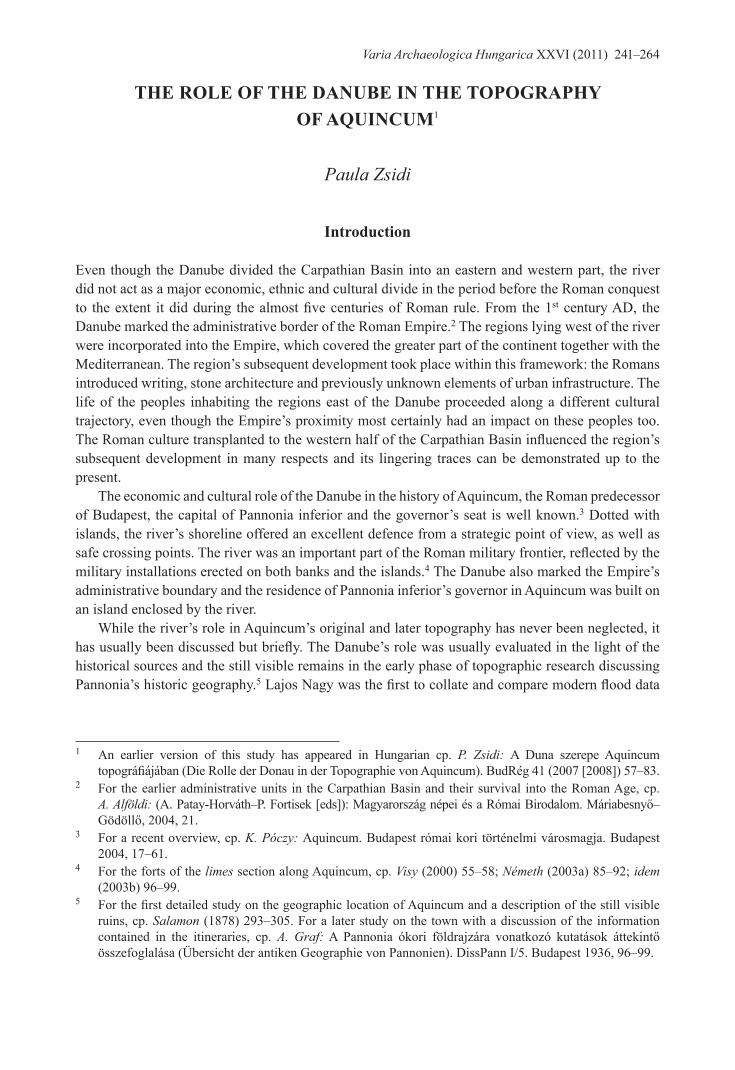
The role oF The Danube in The TopographY oF aquinCuM1
Paula Zsidi
introduction
Even though the danube divided the Carpathian basin into an eastern and western part, the river did not act as a major economic, ethnic and cultural divide in the period before the roman conquest to the extent it did during the almost five centuries of Roman rule. From the 1st century ad, the danube marked the administrative border of the roman Empire.2 the regions lying west of the river were incorporated into the Empire, which covered the greater part of the continent together with the Mediterranean. the region’s subsequent development took place within this framework: the romans introduced writing, stone architecture and previously unknown elements of urban infrastructure. the life of the peoples inhabiting the regions east of the danube proceeded along a different cultural trajectory, even though the Empire’s proximity most certainly had an impact on these peoples too. The Roman culture transplanted to the western half of the Carpathian Basin influenced the region’s subsequent development in many respects and its lingering traces can be demonstrated up to the present.
the economic and cultural role of the danube in the history of aquincum, the roman predecessor of budapest, the capital of Pannonia inferior and the governor’s seat is well known.3 dotted with islands, the river’s shoreline offered an excellent defence from a strategic point of view, as well as safe crossing points. The river was an important part of the Roman military frontier, reflected by the military installations erected on both banks and the islands.4 the danube also marked the Empire’s administrative boundary and the residence of Pannonia inferior’s governor in aquincum was built on an island enclosed by the river.
While the river’s role in aquincum’s original and later topography has never been neglected, it has usually been discussed but briefly. The Danube’s role was usually evaluated in the light of the historical sources and the still visible remains in the early phase of topographic research discussing Pannonia’s historic geography.5 Lajos Nagy was the first to collate and compare modern flood data
1 an earlier version of this study has appeared in Hungarian cp. P. Zsidi: a duna szerepe aquincum topográfiájában (Die Rolle der Donau in der Topographie von Aquincum). BudRég 41 (2007 [2008]) 57–83.
2 For the earlier administrative units in the Carpathian basin and their survival into the roman age, cp. A. Alföldi: (A. Patay-Horváth–P. Fortisek [eds]): Magyarország népei és a Római Birodalom. Máriabesnyő–Gödöllő, 2004, 21.
3 For a recent overview, cp. K. Póczy: aquincum. budapest római kori történelmi városmagja. budapest 2004, 17–61.
4 For the forts of the limes section along aquincum, cp. Visy (2000) 55–58; Németh (2003a) 85–92; idem (2003b) 96–99.
5 For the first detailed study on the geographic location of Aquincum and a description of the still visible ruins, cp. Salamon (1878) 293–305. For a later study on the town with a discussion of the information contained in the itineraries, cp. A. Graf: A Pannonia ókori földrajzára vonatkozó kutatások áttekintő összefoglalása (Übersicht der antiken geographie von Pannonien). dissPann i/5. budapest 1936, 96–99.
Varia Archaeologica Hungarica XXvi (2011) 241–264

242
Paula Zsidi
with the growing body of evidence on aquincum’s topography in an unpublished study.6 He raised several issues concerning the Roman town’s flood control, which were eventually clarified by the findings of later research (such as the flood control of the civil town), and he made several acute observations, which were confirmed by later archaeological research (the siting of watch-towers and forts, the formation of Kis island at Óbuda, on which the governor’s palace was erected). drawing from the then known archaeological record, he argued that Aquincum’s layout reflects a consideration of the river’s water regime. a few decades later, tibor nagy devoted several studies to the town’s one-time environment; his map of sites showed the danube bed of the roman age as reconstructed from the hydrological data.7 in a paper discussing the early history of the civil town, he reviewed the hydrological data on the area, and his conclusions on the town’s topography and history were in part based on this body of evidence.8 More recent studies on the topography of aquincum include a description of the town’s one-time environment, which can be reconstructed with increasing accuracy in the light of the growing corpus of archaeological data and the systematic geomorphologic and geologic studies.9 in view of the interdisciplinary nature of these inquiries, a research project was launched for the study of aquincum’s environmental history and geomorphology, whose results will be published in a separate volume.10 important new data will doubtless be contributed by the underwater archaeological exploration of the danube.11
the studying town’s topography is not easy despite the fact that a part of the roman architectural heritage of budapest lies along the danube, quite near the river or in its bed. the investigation of these relics is rather difficult and quite costly in view of their nature (wooden structures for the protection of the riverbank, embankment roads, bridge pillars, bridgeheads, ports) and their excavation is often not possible using traditional excavation techniques. the various installations directly on the river bank or in the river bed are usually more vulnerable and endangered than inland remains, in part owing to the river’s continuous erosion and depositional activity along its channel, and in part owing to human activity and construction projects aimed at modern flood control and shipping.
The Danube in the historical sources
the name of the danube (Danuvius) is the single surviving roman toponym in the aquincum area and the broader environment of budapest. the river’s name is known from several early historical
6 L. Nagy: A dunai árvizek és árterületek Budapest környékén az őskortól a magyar honfoglalás idejéig. Manuscript. btM archaeological archives, inv. no. 206–79.
7 Nagy (1973) 41.8 Idem (1971) 68–70.9 Zsidi (2002) 21–22; idem: Die Geographie Aquincums. In: P. Zsidi [ed.]: Forschungen in Aquincum.
budapest 2003, 43–46; idem (2004) 168–171; A. Mindszenty–Z. Horváth: geo-archaeopedologia a környezeti rekonstrukció szolgálatában (geoarchaeology in the service of environmental reconstruction). aqFüz 9 (2003) 16–32.
10 the joint research project, “geomorphorphological study of roman settlements by the danube between Római fürdő and Zsigmond Square”, conducted by the Geographic Institute of the Hungarian Academy of sciences and the aquincum Museum of the budapest Historical Museum (otKa Project grant no. T 032263), co-ordinated by Katalin H. Kérdő and Ferenc Schweitzer.
11 regular underwater archaeological surveys have been performed as part of the construction projects affecting the danube bed. these surveys were conducted by János attila tóth. J. A. Tóth: budapest, iii. ker., dunameder, aquincumi híd. aqFüz 12 (2006) 212–214; idem: budapest, iii. ker., Zsigmond tér, dunameder. aqFüz 13 (2007) 264–265.
243
The role of the Danube in the topography of Aquincum
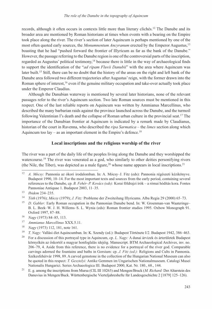
records, although it often occurs in contexts little more than literary clichés.12 the danube and its broader area are mentioned by roman historians at times when events with a bearing on the Empire took place along the river. the river’s section of later aquincum is perhaps mentioned by one of the most often quoted early sources, the Monumnentum Ancyranum erected by the Emperor augustus,13 boasting that he had “pushed forward the frontier of Illyricum as far as the bank of the Danube.” However, the passage referring to the danube region is one of the controversial parts of the inscription, regarded as augustus’ political testimony,14 because there is little in the way of archaeological finds to support the identification of the “ad ripam Fluvii Danubii” with the area where Aquincum was later built.15 still, there can be no doubt that the history of the areas on the right and left bank of the danube area followed two different trajectories after augustus’ reign, with the former drawn into the roman sphere of interest,16 even if the genuine military occupation and take-over actually took place under the Emperor Claudius.
although the danubian waterway is mentioned by several later historians, none of the relevant passages refer to the river’s aquincum section. two late roman sources must be mentioned in this respect. one of the last reliable reports on aquincum was written by ammianus Marcellinus, who described the many barbarian raids against the province launched across the danube, and the turmoil following valentinian i’s death and the collapse of roman urban culture in the provincial seat.17 the importance of the danubian frontier at aquincum is indicated by a remark made by Claudianus, historian of the court in ravenna, who described the ripa Sarmatica – the limes section along which aquincum too lay – as an important element in the Empire’s defence.18
local inscriptions and the religious worship of the river
the river was a part of the daily life of the peoples living along the danube and they worshipped the watercourse.19 the river was venerated as a god, who similarly to other deities personifying rivers (the Nile, the Tiber), was depicted as a male figure,20 whose name appears in local inscriptions.21
12 A. Mócsy: Pannonia az ókori irodalomban. in: a. Mócsy–J. Fitz (eds): Pannonia régészeti kézikönyve. budapest 1990, 10–14. For the most important texts and sources from the early period, containing several references to the danube, cp. B. Fehér–P. Kovács (eds): Korai földrajzi írók – a római hódítás kora. Fontes Pannoniae antiquae 1. budapest 2003, 11–35.
13 Ibidem 234–235.14 Tóth (1976); Mócsy (1979); J. Fitz: Probleme der Zweiteilung illyricums. alba regia 29 (2000) 65–73.15 D. Gabler: Early roman occupation in the Pannonian danube bend. in: W. groenman-van Waateringe–
b. L. beek–W. J. H. Willems–s. L. Wynia (eds): roman frontier studies 1995. oxbow Monograph 91. oxford 1997, 87–88.
16 Nagy (1973) 84–85, 113.17 Ammianus Marcellinus XXX.5.11.18 Nagy (1973) 112, 181, note 161.19 T. Nagy: vallási élet aquincumban. in: K. szendy (ed.): budapest története i/2. budapest 1942, 386–463.20 For a discussion of this portrayal type in aquincum, cp. L. Nagy: a dunai árvizek és árterületek budapest
környékén az őskortól a magyar honfoglalás idejéig. Manuscript. BTM Archaeological Archives, inv. no. 206–79, 4. aside from this reference, there is no evidence for a portrayal of the river god. Comparable carvings adorned the fountains and baths in gorsium: cp. J. Fitz (ed.): religions and Cults in Pannonia. székesfehérvár 1998, 89. a carved gemstone in the collection of the Hungarian national Museum can also be quoted in this respect: T. Gesztelyi: antike gemmen im ungarischen nationalmuseum. Catalogi Musei nationalis Hungarici. series archaeologica iii. budapest 2000, Kat. nr. 180., 68., 144.
21 E. g. among the inscriptions from Mursa (CiL iii 10263) and Mengen/bruck (M. Richard: der altarstein des Danuvius in Mengen/Buck. Württenbergische Vierteljahreshefte für Landesgeschichte 2 [1879] 125–126).

244
Paula Zsidi
the altars dedicated to danuvius and neptunus, who symbolised the frontier river in aquincum,22 indicate that the river was vested with divine power and worshipped. in the 150s and 160s, various officials, governors and legionary commander revered Danuvius as part of the official state cult.23 There are only a handful of finds indicating the practice of the cult among persons of a lower social standing.24 The altar dedicated to the “flowing” Danube (Danuvio defluenti; Fig. 1), erected by titus aterius Callinicus, a freedman of the governor titus Haterius saturninus recovered from the river at Hajógyár Island can be regarded as imitating the official cult of the high-ranking state officials.25 another altarstone dedicated to Danuvio sacrum came to light in 1873 in the Fürdősziget area, which has since been dredged (Fig. 2).26 tibor nagy assumed a sanctuary in both locations, as well as on the danube bank in the civil town.27 after the Marcommannic wars, the worship of the danube merged with the cult of the local guardian spirits (Genius loci or Dis er genio provinciae Pannoniae), which also incorporated the river.28
22 Alföldy (1961) 105.23 governor C. iulius geminus Capellianus (CiL iii 3486) and legionary commander ti. Haterius saturninus
(CiL iii 3473): Alföldy (1961) 7, note 9.24 a member of the collegium negotiantium (CiL iii 10430): Alföldy (1961) note 14.25 Ibidem 107; CiL iii 3416 =10379; Németh (1999) 20, no. 33. tibor nagy suggested that the altarstone
came from the danuvius–neptunus sanctuary of the wooden bridge connecting Hajógyár island with the Pest side. T. Nagy: L. attius Macro pannóniai helytartósága (the Pannonian governorship of L. attius Macro). budrég 19 (1965) 31, note 34.
26 P. Kovács–Á. Szabó (eds): tituli aquincenses. budapest 2009–2010, 46, nr. 45.27 Cp. note 19.28 Alföldy (1961) 111.
Fig. 1. the altarstone dedicated to danuvius by titus aterius Callinicus (H. 81 cm, W. 47 cm; aquincum
Museum)
Fig. 2. the altarstone dedicated to danuvius from Fürdősziget (H. 107 cm, W. 56 cm; Hungarian
national Museum)
245
The role of the Danube in the topography of Aquincum
The roman age bed of the Danube according to ancient geographers
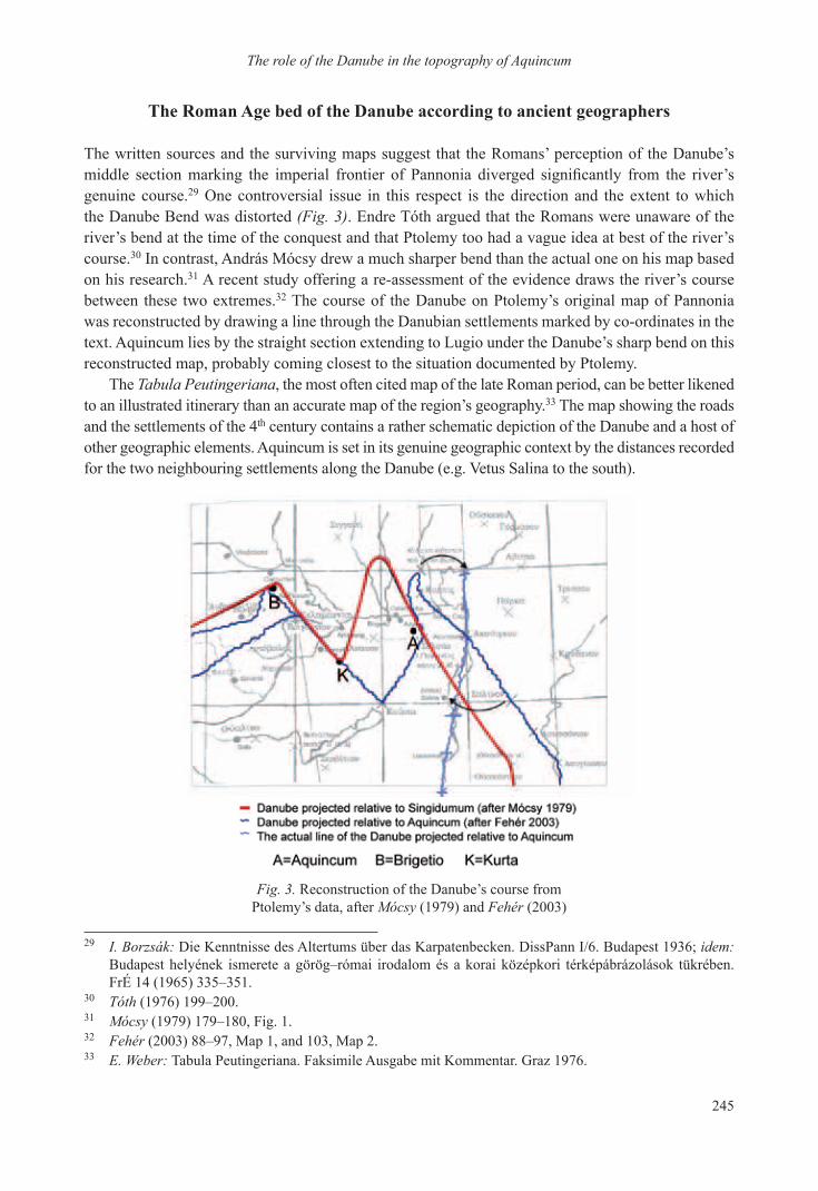
the written sources and the surviving maps suggest that the romans’ perception of the danube’s middle section marking the imperial frontier of Pannonia diverged significantly from the river’s genuine course.29 one controversial issue in this respect is the direction and the extent to which the danube bend was distorted (Fig. 3). Endre tóth argued that the romans were unaware of the river’s bend at the time of the conquest and that Ptolemy too had a vague idea at best of the river’s course.30 in contrast, andrás Mócsy drew a much sharper bend than the actual one on his map based on his research.31 a recent study offering a re-assessment of the evidence draws the river’s course between these two extremes.32 the course of the danube on Ptolemy’s original map of Pannonia was reconstructed by drawing a line through the danubian settlements marked by co-ordinates in the text. aquincum lies by the straight section extending to Lugio under the danube’s sharp bend on this reconstructed map, probably coming closest to the situation documented by Ptolemy.
the Tabula Peutingeriana, the most often cited map of the late roman period, can be better likened to an illustrated itinerary than an accurate map of the region’s geography.33 the map showing the roads and the settlements of the 4th century contains a rather schematic depiction of the danube and a host of other geographic elements. aquincum is set in its genuine geographic context by the distances recorded for the two neighbouring settlements along the danube (e.g. vetus salina to the south).
29 I. Borzsák: die Kenntnisse des altertums über das Karpatenbecken. dissPann i/6. budapest 1936; idem: budapest helyének ismerete a görög–római irodalom és a korai középkori térképábrázolások tükrében. FrÉ 14 (1965) 335–351.
30 Tóth (1976) 199–200.31 Mócsy (1979) 179–180, Fig. 1.32 Fehér (2003) 88–97, Map 1, and 103, Map 2.33 E. Weber: tabula Peutingeriana. Faksimile ausgabe mit Kommentar. graz 1976.
Fig. 3. reconstruction of the danube’s course from Ptolemy’s data, after Mócsy (1979) and Fehér (2003)

246
Paula Zsidi
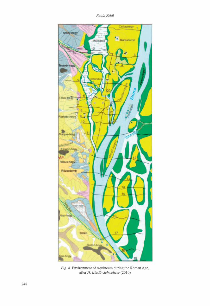
The Danube bed in the aquincum area during the roman age
the geomorphologic studies and the archaeological record both suggest that the danube’s bed and hydrography during the roman age differed substantially from the modern one.34 the maps showing the river’s 19th century, pre-regulation course and the descriptions of the ruins along the danube provide rough guidelines for reconstructing the river’s one-time course for they offer a far more reliable outline of the one-time channel, the shoreline and the islets than the present situation.35
the reconstructions of the danube bed in the roman age based on hydrologic studies (presented also in various archaeological papers) suggest that the bed was wider than the present one, its shoreline more dissected and the river itself had more islands (Figs 4–6).36 Various streams flowed into the river from the hills flanking the right bank. There were countless springs in the Buda hills and along the river, whose water was carried into the river by smaller streams. the remnants of larger channels could still be made out: two or three on the right bank, and a much higher number on the left. one of the earliest works on aquincum’s topography notes that the river bed had originally been shallower, and that the river eroded its right bank and deposited its load on the left one.37
34 H. Kérdő–Schweitzer (2010).35 various 19th century maps were published by Holló (1994); for a description of the submerged wall remains
in the danube and the ruins still visible on the riverbank, cp. Salamon (1878) 297–299.36 Nagy (1971) 68, Abb. 5. Tibor Nagy and Ernő Nagy based their map of the archaeological sites of Budapest
on this study. Nagy (1973) colour map supplement.37 Salamon (1878) 297.
Fig. 4. Hydrological map of aquincum, after Nagy (1971)

247
The role of the Danube in the topography of Aquincum
the reconstructions show that the currently known danubian islands were made up of several parts: in addition to Margit [Margaret] and Óbuda (Hajógyári) Island, the river bed enclosed several other smaller ones too.38 Ferenc salamon, author of an early study on aquincum’s topography, mentions the wall remains beside Hajógyári Island and between Margit Island and Fürdő Island, which became visible during times of low water, suggesting that Margit Island and the small islets to its north, Fürdő island and Óbuda (Hajógyári) island, had originally been part of the right bank.39 the currently available evidence indicates that the so-called small island (Kis-sziget) of Óbuda (Hajógyári) island, on which the governor’s palace was built, had been part of the right bank, but had become detached naturally or through artificial means during the Roman Age.40 owing to repeated dredging operations
38 For an overview of the archaeological relics from the islands along the river’s aquincum section, cp. Németh (2000).
39 Salamon (1878) 297–298. For an illustration of the wall remains reported from the western shore of small island (Kis-sziget) of Óbuda (Hajógyári) island, cp. J. Szilágyi: aquincum. rE suppl. iX. stuttgart 1968, Plan I; for a discussion of their depictions and topographical identification, cp. Németh (2000) 174, abb. 1. 6.
40 Lajos nagy argued that Óbuda island had been part of the shoreline: L. Nagy: a dunai árvizek és árterületek Budapest környékén az őskortól a magyar honfoglalás idejéig. Manuscript. BTM Archaeological Archives, inv. no. 206–79, 6. For a discussion of this issue in the light of recent research, cp. H. Kérdő–Schweitzer (2010) 102–105.
Fig. 5. Historical hydrography of budapest, after Nagy (1973)
248
Paula Zsidi
Fig. 6. Environment of aquincum during the roman age, after H. Kérdő–Schweitzer (2010)

249
The role of the Danube in the topography of Aquincum
and the construction of embankments in association with the danube’s regulation in the 19th century, the reconstruction of the one-time river bed runs into difficulties. The brief underwater investigation of the danube bed by Hajógyári island could only document the line of the repeatedly dredged riverbed.41 As regards the smaller islets, Fürdő Island is noteworthy in several respects. The piles of the bridge connecting the legionary fort at aquincum and the fort by the mouth of the rákos stream (transaquincum) were found in this area, and the hot springs on the island apparently fed a bath judging from the remains found in the area.42 since the island was dredged away in 1875–76, our knowledge of these remains comes from the survey conducted earlier by gusztáv Zsigmondy and other contemporary descriptions.43 the islands played a vital role both as crossing points over the danube and in the province’s defence. one chain of forts, arranged linearly, probably extended across these islands.44
Many recent investigations have enabled a more precise reconstruction of the river’s shoreline. in addition to the excavations on Hajógyár island,45 the exact line of the danube bank in the roman age could be documented through the research conducted in the area of the gas Factory in Óbuda
41 the underwater survey was conducted by the divers of the dunaferr diving club in august 1990, with professional assistance from Margit Németh and Katalin Kérdő. The report on the survey can be found in the archives of the budapest Historical Museum (inv. no. 2199–205).
42 Salamon (1878) 297–298; L. Nagy: A dunai árvizek és árterületek Budapest környékén az őskortól a magyar honfoglalás idejéig. Manuscript. btM archaeological archives, inv. no. 206–79, 9; Németh (2000) 177–178.
43 This is the reason that the function of the buildings on Fürdő Island, which have been variously interpreted as a medicinal bath and a baptisterium, cannot be determined from the archaeological record. D. Gáspár: Christianity in Roman Pannonia. An evaluation of early Christian finds and sites from Hungary. BAR-IS 1010. oxford 2002, 17.
44 Cp. Nagy (1973) colour map supplement; Németh (2000) 179. For a different interpretation of the watchtowers of the aquincum limes section, cp. G. Varga: Budapesti őrtornyok – mítosz és valóság. archÉrt 136 (2011) in press.
45 For an overview of the investigations conducted in order to determine the one-time northern and southern ends of small island (Kis-sziget), cp. H. Kérdő–Schweitzer (2010) 104–105.
Fig. 7. the layers sloping toward the danube mark the line of the one-time high buff in the area of the gas Factory in Óbuda,
Paula Zsidi’s excavation, 2001
250
Paula Zsidi
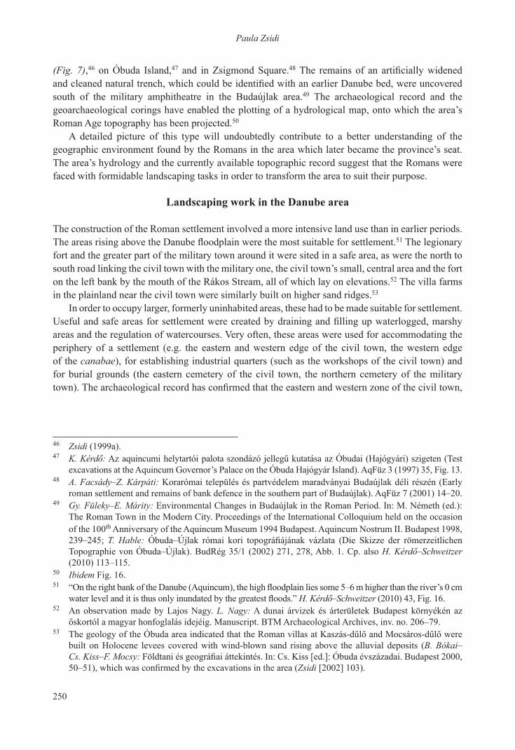
(Fig. 7),46 on Óbuda island,47 and in Zsigmond square.48 The remains of an artificially widened and cleaned natural trench, which could be identified with an earlier Danube bed, were uncovered south of the military amphitheatre in the budaújlak area.49 the archaeological record and the geoarchaeological corings have enabled the plotting of a hydrological map, onto which the area’s roman age topography has been projected.50
a detailed picture of this type will undoubtedly contribute to a better understanding of the geographic environment found by the romans in the area which later became the province’s seat. the area’s hydrology and the currently available topographic record suggest that the romans were faced with formidable landscaping tasks in order to transform the area to suit their purpose.
landscaping work in the Danube area
the construction of the roman settlement involved a more intensive land use than in earlier periods. The areas rising above the Danube floodplain were the most suitable for settlement.51 the legionary fort and the greater part of the military town around it were sited in a safe area, as were the north to south road linking the civil town with the military one, the civil town’s small, central area and the fort on the left bank by the mouth of the rákos stream, all of which lay on elevations.52 the villa farms in the plainland near the civil town were similarly built on higher sand ridges.53
in order to occupy larger, formerly uninhabited areas, these had to be made suitable for settlement. Useful and safe areas for settlement were created by draining and filling up waterlogged, marshy areas and the regulation of watercourses. very often, these areas were used for accommodating the periphery of a settlement (e.g. the eastern and western edge of the civil town, the western edge of the canabae), for establishing industrial quarters (such as the workshops of the civil town) and for burial grounds (the eastern cemetery of the civil town, the northern cemetery of the military town). The archaeological record has confirmed that the eastern and western zone of the civil town,
46 Zsidi (1999a).47 K. Kérdő: Az aquincumi helytartói palota szondázó jellegű kutatása az Óbudai (Hajógyári) szigeten (Test
excavations at the aquincum governor’s Palace on the Óbuda Hajógyár island). aqFüz 3 (1997) 35, Fig. 13.48 A. Facsády–Z. Kárpáti: Korarómai település és partvédelem maradványai budaújlak déli részén (Early
roman settlement and remains of bank defence in the southern part of budaújlak). aqFüz 7 (2001) 14–20.49 Gy. Füleky–E. Márity: Environmental Changes in budaújlak in the roman Period. in: M. németh (ed.):
the roman town in the Modern City. Proceedings of the international Colloquium held on the occasion of the 100th anniversary of the aquincum Museum 1994 budapest. aquincum nostrum ii. budapest 1998, 239–245; T. Hable: Óbuda–Újlak római kori topográfiájának vázlata (Die Skizze der römerzeitlichen topographie von Óbuda–Újlak). budrég 35/1 (2002) 271, 278, abb. 1. Cp. also H. Kérdő–Schweitzer (2010) 113–115.
50 Ibidem Fig. 16.51 “On the right bank of the Danube (Aquincum), the high floodplain lies some 5–6 m higher than the river’s 0 cm
water level and it is thus only inundated by the greatest floods.” H. Kérdő–Schweitzer (2010) 43, Fig. 16.52 an observation made by Lajos nagy. L. Nagy: a dunai árvizek és árterületek budapest környékén az
őskortól a magyar honfoglalás idejéig. Manuscript. BTM Archaeological Archives, inv. no. 206–79.53 The geology of the Óbuda area indicated that the Roman villas at Kaszás-dűlő and Mocsáros-dűlő were
built on Holocene levees covered with wind-blown sand rising above the alluvial deposits (B. Bókai–Cs. Kiss–F. Mocsy: Földtani és geográfiai áttekintés. In: Cs. Kiss [ed.]: Óbuda évszázadai. Budapest 2000, 50–51), which was confirmed by the excavations in the area (Zsidi [2002] 103).
251
The role of the Danube in the topography of Aquincum
which lay beside the one-time Danube bed, were filled up before construction work was begun.54 the streams and the natural trenches (aranyhegyi stream, solymárvölgy trench, rádl trench) in the area between the civil and the military town, most of which appear on modern maps too, probably posed difficulties in the creation of various urban quarters and cemeteries. Ditches for draining excess water linked to landscaping activities have been identified in several locations.55 the section of a carefully maintained ditch of this type (a former danube bed), which probably also drained the water of the springs from the nearby hills, has been uncovered at budaújlak, by the south-eastern corner of the canabae.56
the landscaping activities also included the capping of springs and the utilisation of their water, the regulation of the waters flowing into various streams. There is abundant archaeological evidence for the roman age utilisation of various springs (some of which are still active today). the investigation of the springs which fed the aquincum aquaeductus revealed the use of fourteen springs during the roman age.57 the water from springs at Csillaghegy,58 the foot of Mt. Hármashatár,59 and in the viziváros to the south60 was similarly exploited, as were the hot springs on the danube’s islands, mentioned above in connection with Fürdő Island.
the romans’ transformation of the environment was not restricted to water. the exploitation of the quarries at budakalász and Mt. Ezüst, as well as the ones on Mt. gellért in the south,61 and of the clay mines along present-day bécsi road, wood-felling for construction and heating all had a lasting
54 A roughly 10 m wide north to south “empty zone” was found within the town walls during the excavation of the civil town’s western part, probably an earlier, natural trench which had been filled up (most likely the one-time bed of the aranyhegyi stream). Cp. P. Zsidi: 49/2. budapest, iii. aquincum polgárváros. régFüz I/45 (1991 [1993]) 33. In 2004, Orsolya T. Láng identified a former waterlogged depression or ditch under the so-called Peristyle House in the north-eastern part of the civil town: O. T. Láng: A „Peristyl-ház”: hitelesítő feltárás az aquincumi polgárváros északkeleti részén (The “Peristyle House”: authenticating excavation in the northeast part of the aquincum Civil town). aqFüz 11 (2005) 75.
55 E.g. on the western edge of the canabae (O. Madarassy: római kori beépítettség kutatása az aquincumi katonaváros északnyugati határán [Investigations concerning Roman Period settlement density along the northwestern border of the Aquincum military town]. AqFüz 1 [1995] 35–37), in the northern cemetery of the military town (P. Zsidi: untersuchungen des nordgräberfeldes der Militärstadt von aquincum. in: M. Kandler–H. Vetters [Hrsg.]: Akten des 14. Internationalen Limeskongresses 1986 Carnuntum. RLÖ 36/2, Wien 1990, 724), and on the territory of the villa farms (P. Zsidi: római kori villagazdaság részlete az aquincumi katonaváros és polgárváros között [Details of a Roman Period villa farm situated between the Aquincum Military and Civil Towns]. AqFüz 5 [1999] 102).
56 this trench was cut through at several points by Erzsébet Máritty and tibor Hable. Cp. note 49.57 K. Póczy: Aquincum első aquaeductusa (Le premier aquaeduc d’Aquincum). ArchÉrt 99 (1972) 15–32.58 M. Pető: római kori sírépítmény és szentély darabjai Csillaghegyen (Fragments of a roman funerary
monument and shrine at Csillaghegy). budrég 24 (1976) 215–224.59 I. Wellner: az aquincumi katonaváros nyugat–kelet irányú vízvezetékrendszere (das Wo-orientierte
Wasserleitungssystem der aquincumer Militärstadt). budrég 23 (1973) 179–186.60 M. Kaba: Római kori épületmaradványok a Királyfürdőnél (Römerzeitliche Gebäudereste beim
Király-bad). budrég 19 (1963) 157–163; K. Kérdő–A. Végh: Újabb régészeti kutatások a vízivárosban (recent excavations in the víziváros). aqFüz 8 (2002) 78.
61 M. Pető: A gellérthegyi kőbánya (The Gellért Hill Quarry). BudRég 32 (1998) 123–133; I. Torma: római kori kőbánya Budakalász határában (Roman Quarry near the village Budakalász). In: J. Gömöri (ed.): iparrégészet/industrial archaeology 2. veszprém 1984, 39–49.

252
Paula Zsidi
impact on the environment. the transformation of the natural environment accelerated the erosion of the hillsides, leading to the filling up of the area between the hilly region and the Danube.62
The river’s role in settlement planning and siting
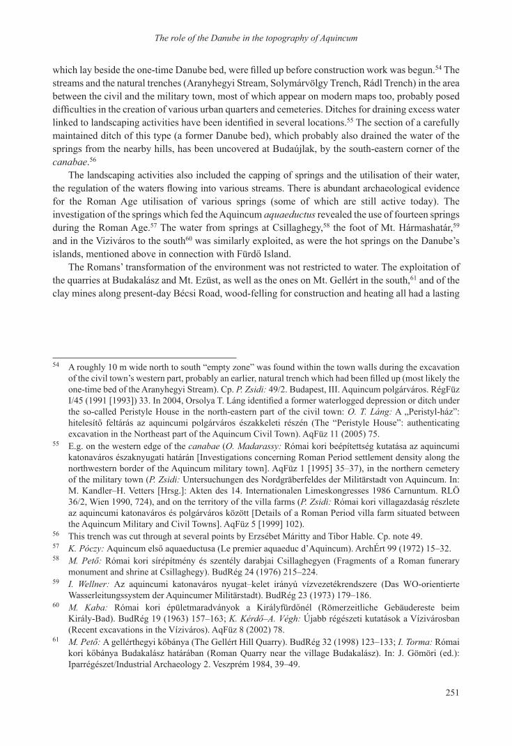
The landscaping activities, especially draining, filling up and canalisation were undoubtedly part of a conscious urban planning project.63 the surveyal and the division of the associated land (limitatio and centuriatio) determining the general topography of aquincum for many centuries may have taken place at the time the permanent legionary fort was established at the earliest, although a more likely date would be when the town was promoted to the province’s seat under trajan.64 being a town by the danube, the romans were aware of aquincum’s precise geographic location from the descriptions contained in the works of geographers, and especially of Ptolemy,65 who drew from several sources when writing his Geography in the later 2nd century. In addition to earlier specifications of the town’s location based on astronomical calculations and the distances recorded in the itineraries,66 Ptolemy also used the surveying maps of the province (forma provinciae): both the earlier survey, made when the province was still undivided, and the new forma made after the province’s division.67 the latter included also the siting of the limes section at aquincum.
our knowledge of aquincum’s topography has been enriched by recent excavations and it is now become possible to reconstruct the orientation and the system of the romans’ survey.68 the zero point, the origo was probably the groma of the legionary fort (Fig. 8).69 the extended line of the two main roads, the via principalis and the via decumana starting from this point, acted as the system’s two axes perpendicular to each other. the investigation of the military town has revealed that the
62 J. Balogh–Á. Juhász–F. Schweitzer: geomorfológiai eredmények. in: római kori települések vizsgálata környezetmorfológiai szempontból a Duna partján, a Római fürdő és a Zsigmond tér közötti szakaszon. Manuscript. Evaluation report, otKa. budapest 2004, 12.
63 in addition to the features of the terrain and strategic considerations, roman engineers had to take into account several other factors too: Vitruvius i. 4, 5, 6. Vitruvius: Tíz könyv az építészetről (De Architectura Libri decem). budapest 1988, 38–50.
64 P. Zsidi: Aquincum all’epoca dell’imperatore Traiano. In: G. Popescu (ed.): Traiano ai Confini dell’ Impero. Milano 1998, 91; idem (2004) 206.
65 Ferenc salamon noted the accuracy of Ptolemy’s data: Salamon (1878) 209–210. it is noteworthy that the divergences are minimal in the case of Ptolemy’s data (Fehér [2003] 84) as regards the determination of the latitude, which is 47° 30’ for aquincum, a point lying slightly south of aquincum, which in the light of the area’s roman age topography lay on the territory of the fort established under Claudius in the viziváros area (K. Kérdő: Das Alenlager und Vicus der Viziváros. In: P. Zsidi [ed.]: Forschungen in aquincum. budapest 2003, 81). this again suggests that Ptolemy drew from the earlier, uniform forma provinciae (Fehér [2003] 96), meaning that the survey and the layout of Aquincum prepared under Traian was based on the earlier system.
66 Mócsy (1979) 179.67 Fehér (2003) 90–91. in his view, Ptolemy used the survey made at the time when the province was still
undivided for his mapping of Pannonia inferior: ibidem 96.68 Zsidi (2004) 206, 116. abb. 20.69 Even though the exact location of the headquarters building (and thus the location of the groma point) in
the 2nd–3rd century legionary fort could be determined during the excavation (Németh [2003a] 89), the final word can only be issued once all the vital points of the excavation’s geodesic survey are digitised and plotted on a uniform map. at present, the margin of error for the currently available map made using manual data processing is ca. 1 m according to györgy busi and tibor Kovács, who conducted the geodesic survey. i would here like to thank both of them for their conscientious work.
253
The role of the Danube in the topography of Aquincum
street network of the town around the legionary fort was laid out together with the fort,70 and that the cardo of the civil town’s rectangular street network and assumed insula system, established before the settlement was promoted to municipal rank, was the north to south main road which connected the legionary fort with the civil town.71 the legionary fort, the military and the civil town, i.e. the provincial seat in the strict sense, was part of a uniform system. if the north to south axis is projected onto the map showing the area’s roman age hydrological conditions, it is quite obvious that the axis was laid out with a view to the terrain, seeing that it runs across the higher area between the two earlier danube beds.72
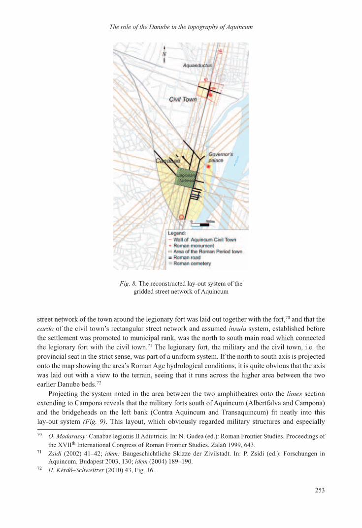
Projecting the system noted in the area between the two amphitheatres onto the limes section extending to Campona reveals that the military forts south of aquincum (albertfalva and Campona) and the bridgeheads on the left bank (Contra Aquincum and Transaquincum) fit neatly into this lay-out system (Fig. 9). this layout, which obviously regarded military structures and especially
70 O. Madarassy: Canabae legionis ii adiutricis. in: n. gudea (ed.): roman Frontier studies. Proceedings of the Xviith International Congress of Roman Frontier Studies. Zalaŭ 1999, 643.
71 Zsidi (2002) 41–42; idem: baugeschichtliche skizze der Zivilstadt. in: P. Zsidi (ed.): Forschungen in aquincum. budapest 2003, 130; idem (2004) 189–190.
72 H. Kérdő–Schweitzer (2010) 43, Fig. 16.
Fig. 8. the reconstructed lay-out system of the gridded street network of aquincum
254
Paula Zsidi
Fig. 9. the reconstructed lay-out system of the aquincum limes section
military forts as being of prime importance, probably served as the basis of the division of the land. the latter is suggested by the location of the villa farms in the reconstructed system. However, the known buildings of these villa farms were not erected along the system’s lines, as in the case of military installations, but in the area enclosed by the lines. the reconstruction clearly shows that the overall layout fitted the settlements and the lands of diverse nature and legal status into a uniform geometric system together with the irregular danube bed and the river’s left bank through the alignment to a single, well defined axis. The layout system of Roman settlements was inscribed onto a non-perishable, a marble or bronze plaque (forma). the land division of orange and its broader area could be reconstructed from the marble fragments recording the survey system. the system reconstructed for a roughly 45 km long section along the rhône had similarly extended to the river’s other bank and its long axis conformed to the river’s main flow direction disregarding the meanders.73
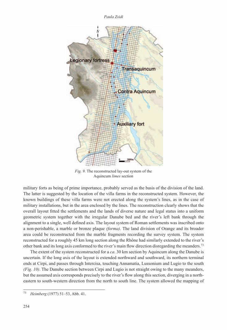
the extent of the system reconstructed for a ca. 30 km section by aquincum along the danube is uncertain. if the long axis of the layout is extended northward and southward, its northern terminal ends at Cirpi, and passes through intercisa, touching annamatia, Lussonium and Lugio to the south (Fig. 10). the danube section between Cirpi and Lugio is not straight owing to the many meanders, but the assumed axis corresponds precisely to the river’s flow along this section, diverging in a north-eastern to south-western direction from the north to south line. the system allowed the mapping of
73 Heimberg (1977) 51–53, abb. 41.

255
The role of the Danube in the topography of Aquincum
Fig. 10. the theoretical extension of the long axis of aquincum’s lay-out system along the limes section between Cirpi and Lugio
the river’s irregular course, dissected by meanders and islands. although this study does not intend to present yet another map variant reconstructed from Ptolemy’s work, a few points must certainly be noted. there is a remarkable correspondence between the axis along the danube as reconstructed from aquincum’s topography and the settlements along the line from aquincum to Lugio on the recent map reconstruction based on Ptolemy’s data.74 if the strong west to east distortion of the line based on Ptolemy’s geographic information is eliminated by turning,75 the two hypothetical lines (one based on Ptolemy’s information, the other reconstructed from the topographical record) and the settlements along them practically coincide, suggesting that Ptolemy’s data, at least as regards this danube section, was not based on a particular route76 or the river’s course, but on the settlements along the layout’s axis along the danube.77 this would also explain why the itinerary mentions certain forts of this danubian limes section and omits others. We know that one of Ptolemy’s sources
74 Fehér (2003) 105, Map 4. 75 Cp. Mócsy (1979) 179, note 21.76 Cp. the line of the limes road along this section. Visy (2000) Maps 14–27.77 andrea vaday based her reconstruction of the sarmatian towns mentioned by Ptolemy on the straight section
between these two settlements: A. Vaday: a szarmata barbarikum központjai a Kr. u. 2. században (Centres of the sarmatian barbaricum in the 2nd century). barbarikumi szemle i. szeged 2003, 15–16, Fig. 3.

256
Paula Zsidi
was the forma provinciae,78 which recorded the layout system, and it is therefore quite likely that the passages of the geographic description based on the forma reflects the information contained in it. the passages describing Pannonia inferior’s danubian frontier between Cirpi and Lugio, along which aquincum also lay, were probably drawn from the forma.
the layout system of a particular area and the line of the roads passing through it did not necessarily coincide. the layout system was based on theoretical cadastral lines, while the construction of roads took into account the natural environment and the geographic conditions. in the case of aquincum, the road network based on a regular layout system only made sense in the flat, flood-free areas. The course of the limes road was laid out as close to the river as possible, but along a line most suitable for transportation.79 the riverbank and the actual landscape of mountains and hills overruled all theoretical schemes. The need for adjusting the plans to fit the actual terrain is usually cited for explaining the presence of another (diagonal) street system in aquincum,80 diverging from the north to south axis by some 60 degrees in the west, in the northern and western region of the canabae,81 and the territorium falling beyond the boundaries of the military town.82 the rectangular street system too reflects a regular layout,83 sharing a number of common points with the other system (such as the western gate of the legionary fort). However, the adjustment to the terrain would not in itself have warranted a new layout – it seems more likely that similarly to the limes road, the main consideration in this case was the need for mapping the aquincum–brigetio road which played a vital role in the border defence, whose irregular line skirted the mountains and passed through the valleys.84 the existence of another system is reflected by the urban street network adjusted to the second system. there is no evidence that the two systems were laid out at the same time; however, the north-west to south-east oriented system too started from the legionary fort and we know that the second system did not extend over the entire area of the provincial seat, but only affected a smaller zone. it would appear that the basis of the land survey was the more extensive north to south system.85
the settlement system laid out under traian determined the framework of the town’s topography for many centuries. the original framework survived until the major transformations under Constantine the great in the early 4th century,86 although vestiges of larger urban planning projects are reflected in the reconstructions and renewals both in the military and in the civil town. Some of 78 Fehér (2003) 96.79 a similar consideration can be noted in the line of the limes road running south of aquincum, featuring the
alternation of straight sections with sections adjusted to the terrain. Visy (2000) 120.80 O. Madarassy: Canabae legionis ii adiutricis. in: a. gaál (ed.): Pannoniai kutatások. a soproni sándor
emlékkonferencia előadásai. Bölcske 1998. október 7. Szekszárd 1999, 71; idem (2003) 105.81 Póczy (1983) 254, Fig. 2, 270.82 orsolya Láng excavated several sections of this street system: O. Láng: római kori útrészletek az
aquincumi polgárváros municipális territoriumán (az úgynevezett testvérhegyi villa környezete) (roman period road segments in the municipal territory of the aquincum Civil town (the excavations of the so-called testvérhegy villa). aqFüz 9 (2003) 95–110.
83 the joint use of two separate layout systems is not a unique practice. a division based on several axes has been demonstrated in the area between orange and avignon. Heimberg (1977) 55, abb. 43.
84 the importance of this route was similar to that of the limes road: Visy (2000) 121.85 gábor Lassányi recently excavated a section of the road laid out according to the north-west to south-east
system; the triple ditch lying a few meters farther away, which probably functioned as a boundary mark, was laid out according to the north to south system: G. Lassányi: A helyi lakosság temetőjének részlete aquincum polgárváros territoriumán (native burials on the territory of aquincum). budrég 39 (2005) 117, Fig. 2.
86 The late Roman fort built over the earlier legionary fort was similarly fitted into the original system since it conformed to the earlier buildings: Németh (2003a) 90–91.
257
The role of the Danube in the topography of Aquincum
these suggest that the overall system was laid out again, reflected by the differing orientation of some buildings, although the overall framework remained unaltered.87 the topographical elements least likely to change (lying beside the main roads) were the ones connected to the water supply and the draining system. it would appear that the line of the several kilometres long aqueduct constructed under traian remained unchanged during the roman rule, even if the aqueduct itself was repaired and reinforced later.88 the aqueduct supplying the legionary camp and the military settlement conformed to the later, diagonal road network.89 the sewage system90 leading waste water and excess rainwater directly into the Danube or a natural watercourse flowing into the river, another important urban amenity ensuring the town’s hygiene, too remained a constant element of the town’s roman topography in each and every settlement part.91
Crossing points in the aquincum area
the danubian crossing points were similarly permanent elements of the roman topography. the ancient east to west trade routes along the limes passing through aquincum, Pannonia inferior’s seat, and the river with its islands offered favourable locations for establishing the necessary, well defendable crossing points. the creation of crossing points served both strategic and economic purposes. temporary crossing points and ferries over the danube were probably established during the initial phase of the military occupation.92 It seems likely that the first permanent crossing points were built in the early 2nd century under trajan’s reign.93 the research of crossing points in the Aquincum area runs into several difficulties. The river regulation and the embankment construction projects in the 19th century destroyed most of the roman age structures along the shoreline and the few surviving elements, most often of perishable materials, lie submerged in the riverbed. this corpus of architectural relics has not been systematically investigated yet and thus, with a few exceptions, there is only indirect evidence of structures spanning the river. a glance at the known and assumed roman age crossing points reveals that most of the city’s modern bridges had their antecedents in the roman age.94
Proceeding northward along the aquincum limes section, the first suitable crossing point to Csepel island lay by the military forts at Campona and albertfalva. the scattered timber post remains 87 For the changes in the street network of the military town after the Marcomannic Wars, cp. Madarassy
(2003) 108; for the changes in the civil town, cp. Zsidi (2002) 49–52.88 For an overview based on recent investigations, cp. Z. Havas: Feltárás a szentendrei úti aquaeductus
nyomvonalán (Excavation along the aquaeduct on szentendrei road). aqFüz 10 (2004) 61–65.89 For recent investigations of the aqueduct, cp. A. Kirchhof: Új feltárási eredmények a katonaváros
északnyugati régiójából i (new excavation results from the northwestern region of the Military down i). aqFüz 13 (2007) 40–56.
90 the several kilometres long sewage system of the civil town followed the original line from the period preceding the municipium. K. Póczy: Wasserver- und entsorgung, gebäude des stadtzentrums. in: P. Zsidi (ed.): Forschungen in aquincum. budapest 2003, 145–146.
91 H. Kérdő–Schweitzer (2010) 37.92 the aquincum area acted as the military base of several campaigns against the barbaricum, which called
for the creation of crossing points. Nagy (1973) 87.93 Permanent trade contacts were established with the barbaricum during the 2nd century following the
conquest of dacia; the aquincum–Porolissum road along which trade was conducted too called for a permanent crossing place. D. Gabler–A. Vaday: terra sigillata im barbaricum zwischen Pannonien und dazien. FontarchHung. budapest 1984, 45–47.
94 Cp. J. Fitz (Hrsg.): der römische Limes in ungarn. székesfehérvár 1976, 86. it is instructive to compare the location of the modern bridges with the sitting of the military forts and watch-towers on the map.
258
Paula Zsidi
brought to light on the riverbank near the two forts suggest the existence of wooden bridges.95 the plans for the construction of a modern bridge at albertfalva indicate that it would lie in the northern part of the one-time roman military camp.
a permanent, traditional crossing point which had functioned during earlier periods too and was apparently used by the romans from the late 2nd century,96 lay by the foot of Mt. gellért. this crossing point ensured the defence of the Contra aquincum fort uncovered on Március 15 square. the river narrowed at this point, forming a junction with the road leading from Mt. gellért to the province’s interior. the roman crossing point probably lay somewhere near bridge Elisabeth.
Less known is the assumed structure facing the roman military fort in the modern viziváros area. the architectural remains uncovered during the construction of the Parliament building suggest that a link in the chain of forts on the danube’s left bank had once stood there.97 Traffic and communication between the two forts had to be ensured and it seems likely that this crossing point can be regarded as the roman predecessor of Chain bridge.
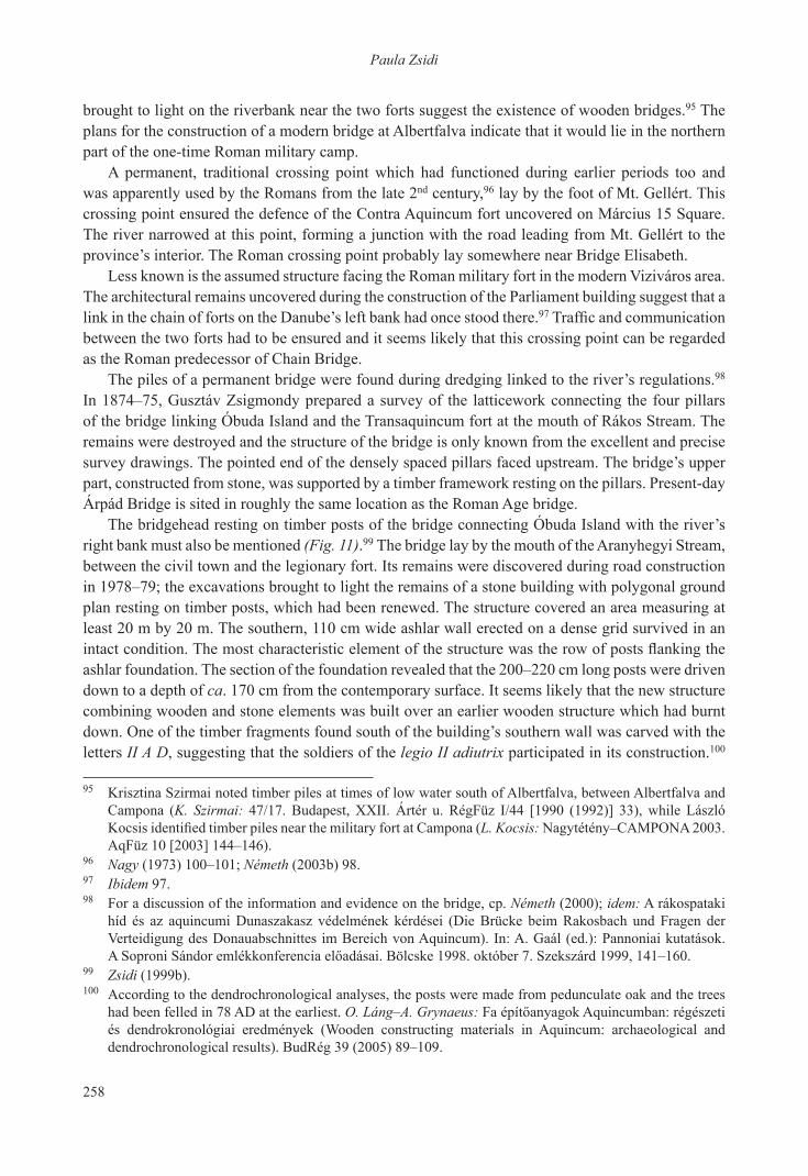
the piles of a permanent bridge were found during dredging linked to the river’s regulations.98 in 1874–75, gusztáv Zsigmondy prepared a survey of the latticework connecting the four pillars of the bridge linking Óbuda island and the transaquincum fort at the mouth of rákos stream. the remains were destroyed and the structure of the bridge is only known from the excellent and precise survey drawings. the pointed end of the densely spaced pillars faced upstream. the bridge’s upper part, constructed from stone, was supported by a timber framework resting on the pillars. Present-day árpád bridge is sited in roughly the same location as the roman age bridge.
the bridgehead resting on timber posts of the bridge connecting Óbuda island with the river’s right bank must also be mentioned (Fig. 11).99 the bridge lay by the mouth of the aranyhegyi stream, between the civil town and the legionary fort. its remains were discovered during road construction in 1978–79; the excavations brought to light the remains of a stone building with polygonal ground plan resting on timber posts, which had been renewed. the structure covered an area measuring at least 20 m by 20 m. the southern, 110 cm wide ashlar wall erected on a dense grid survived in an intact condition. The most characteristic element of the structure was the row of posts flanking the ashlar foundation. the section of the foundation revealed that the 200–220 cm long posts were driven down to a depth of ca. 170 cm from the contemporary surface. it seems likely that the new structure combining wooden and stone elements was built over an earlier wooden structure which had burnt down. one of the timber fragments found south of the building’s southern wall was carved with the letters II A D, suggesting that the soldiers of the legio II adiutrix participated in its construction.100
95 Krisztina szirmai noted timber piles at times of low water south of albertfalva, between albertfalva and Campona (K. Szirmai: 47/17. Budapest, XXII. Ártér u. RégFüz I/44 [1990 (1992)] 33), while László Kocsis identified timber piles near the military fort at Campona (L. Kocsis: nagytétény–CaMPona 2003. AqFüz 10 [2003] 144–146).
96 Nagy (1973) 100–101; Németh (2003b) 98.97 Ibidem 97.98 For a discussion of the information and evidence on the bridge, cp. Németh (2000); idem: a rákospataki
híd és az aquincumi dunaszakasz védelmének kérdései (die brücke beim rakosbach und Fragen der verteidigung des donauabschnittes im bereich von aquincum). in: a. gaál (ed.): Pannoniai kutatások. A Soproni Sándor emlékkonferencia előadásai. Bölcske 1998. október 7. Szekszárd 1999, 141–160.
99 Zsidi (1999b).100 according to the dendrochronological analyses, the posts were made from pedunculate oak and the trees
had been felled in 78 ad at the earliest. O. Láng–A. Grynaeus: Fa építőanyagok Aquincumban: régészeti és dendrokronológiai eredmények (Wooden constructing materials in aquincum: archaeological and dendrochronological results). budrég 39 (2005) 89–109.
259
The role of the Danube in the topography of Aquincum
the bridgehead was probably rebuilt several times and in addition to its strategic importance, it undoubtedly played a role in the east to west crossing to the governor’s palace. the structure’s eastern part has not survived owing to the danube’s erosion of its right bank, while the northern and western parts cannot be investigated owing to the modern terrain conditions. the corner of another building measuring 5 m by 9.5 m, which had adjoined the bridgehead, was identified during the underwater investigation mentioned in the above.101 the modern counterpart of the roman bridge (known as bridge K) is the railway bridge at Mozaik street slightly to the north.
it seems likely that there was a crossing point between the civil town and the northern tip of Óbuda island, following roughly the same line as the Újpest railway bridge. the crossing point was protected by a watch-tower during the late roman period; there is no archaeological evidence for an earlier building in this location.102 the planned road bridge beside the railway bridge was named aquincum bridge.
Flood defences
The exposure of Aquincum to heavy damages by the Danube’s floods was noted quite early by scholars who studied the problem of the Romans’ flood defences in the light of the then available evidence. Ferenc salamon argued that the town was protected with embankments and quays,103 while Lajos Nagy believed that the municipal areas were kept free of floods by a sophisticated drainage
101 Cp. note 41.102 Cp. Zsidi (1999b) 257; H. Kérdő–Schweitzer (2010) 57, 97–99.103 Salamon (1878) 326–327.
Fig. 11. the timber posts of the bridge to Óbuda island,Paula Zsidi’s excavation, 1978
260
Paula Zsidi
system and the regulation of streams.104 there are many modern descriptions of the devastation wreaked by the floods in Óbuda.105 if the settlement layout of post-medieval and modern Óbuda is compared to the extent of the Roman settlement, we find that the civil town and its broader area was uninhabited in the Middle ages and the post-medieval period. on some 19th century maps, the area extending to the line of modern Filatori Dam is marked as a floodplain utilised as a hayfield.106 Following the roman age, this area was only re-occupied after the construction of the stone quay in the 1840s and 1870s. The area’s modern urbanisation following the measures taken to ensure flood protection suggests that the seat of the roman province was protected by a well constructed and efficient embankment and flood protection system during the centuries of Roman rule, despite the fact that the climate was much drier during the roman age than is subsequent periods.107 in addition to exploiting the natural environment (ditches and the river branches between the islands),108 it seems likely that man-made installations were also employed. research during the past decades has brought to light the remains of this system.
That the Danube floods posed a genuine threat to the Roman settlement is confirmed by traces of floods noted in several settlements parts, such as the Aquincum legionary fort.109 The floods and the constant high water of the danube motivated the abandonment of the governor’s palace on Óbuda island in the last third of the 3rd century.110 Interestingly enough, no traces of floods have been observed in the civil town, the northern part of the Roman settlement most exposed to floods,111 suggesting that the endangered area was probably better protected – the archaeological record indicates that this protection was highly efficient.
Discussing the flood protection of the civil town, Lajos Nagy noted that the diversion of the springs of the Római fürdő area with the construction of the aqueduct and the role of Aranyhegyi stream in draining excess waters probably contributed to the protection of the civil town.112 Two other points must be noted in this respect. The first concerns the northern town wall, whose eastern section, perpendicular to the danube, was unusually long and a function associated with
104 L. Nagy: A dunai árvizek és árterületek Budapest környékén az őskortól a magyar honfoglalás idejéig. Manuscript. btM archaeological archives, inv. no. 206–79, 7–8.
105 É. Gál: Óbuda 1541–1848. In: K. Rádi (ed.): Tanulmányok Óbuda történetéből. Budapest 1990, 52; M. Létay: Árvíz Óbudán. In: K. Rádi (ed.): Tanulmányok Óbuda történetéből. Budapest 1990, 95–101.
106 Cp. Holló (1994) 32.107 H. Kérdő–Schweitzer (2010) 30, 53.108 Ibidem 33.109 L. Kocsis: Zur Periodisierung des Hauses des tribunus laticlavius im Legionslager von aquincum. in:
M. Kandler–H. Vetters (Hrsg.): Akten des 14. Internationalen Limeskongresses 1986 in Carnuntum. RLÖ 36, Wien 1990, 711.
110 K. Kérdő: die neuen Forschungen im gebiet des statthalterpalastes von aquincum. in: n. gudea (ed.): roman Frontier studies. Proceedings of the Xviith international Congress of roman Frontier studies. Zalaŭ 1999, 652.
111 L. Nagy: A dunai árvizek és árterületek Budapest környékén az őskortól a magyar honfoglalás idejéig. Manuscript. btM archaeological archives, inv. no. 206–79, 7–8. but after the results of the new excavations floods may haved demaged the norteastern part of the civil town: O. Láng: „átriumos hosszúház-lakótraktus”: hitelesítő feltárás az aquincumi polgárváros északkeleti részén II („Strip house with an atrium - residence wing“: authentication excavation in the northeastern part of the aquincum Civil town ii). aqFüz 13 (2007) 128.
112 Ibidem 9.

261
The role of the Danube in the topography of Aquincum
the town’s military defence seems unlikely.113 the other protective element was a structure resting on timber piles, whose remains were discovered on the river bank by the civil town, some 50–80 m west of the current danube bank.114 the features indicating the one-time presence of this structure, constructed of timber posts and beams, were found along an 80 m long area below the roman occupation level. the alternating row of deep pits and shallow bedding trenches outlined the remains of a repeatedly renewed wooden construction which had in part been demolished and in part destroyed by natural causes, probably floods. The geophysical survey115 conducted as part of the archaeological investigation registered the faint traces of a regular structure, whose extent and orientation corresponded to the remains brought to light during the excavations. the proximity of the civil town, the location of the structure and the contemporary analogies suggest that we had found a section of the roman age embankment.
the area between the civil and military town, which although unoccupied still had an important function,116 was protected with an embankment. the 30 m long section of a roman causeway was uncovered south of the civil town; the road itself remained in use until the river regulation in the 19th century (Fig. 12).117 it is also possible that the piles perpendicular to the danube found near the near the bridgehead investigated at Filatori Dam can likewise be associated with flood protection.118
113 P. Zsidi: Aquincum polgárvárosának városfala és védművei az újabb kutatások tükrében (Stadtmauer und verteidigungssystem der Zivilstadt von aquincum im spiegel der neuesten Forschungsergebnisse). CommarchHung 1990, 163.
114 Zsidi (1999a).115 the geophysical survey was conducted by sándor Puszta.116 P. Zsidi: die Frage des „militärischen territoriums“. in: P. Zsidi (ed.): Forschungen in aquincum. budapest
2003, 168–170.117 P. Zsidi–L. Reményi: Duna-parti út részlete és őskori maradványok a polgárvárostól délre (Detail from the
road on the danube bank and prehistoric remains south of the Civil town). aqFüz 9 (2002) 86–89.118 P. Zsidi: Kutatások az aquincumi katonaváros északkeleti peremén (research at the northeastern edge of
the aquincum Military town). aqFüz 1 (1995) 41–43.
Fig. 12. the causeway along the danube bank by the civil town, used up to the 19th century, Paula Zsidi’s excavation, 1999
262
Paula Zsidi
No other structures which could be interpreted as a defensive structure against floods have been found south of this point in line with the military town and the legionary fort. it is possible that the flood protection of the latter was incorporated into the defence system protecting the governor’s palace, and thus its remains lie on Óbuda island.119
The Danube as a waterway: harbours
it seems likely that there were ports for the military and merchant ships along the danube’s Aquincum section. There is no direct archaeological evidence for where the Danubian military fleet was stationed at aquincum and in the town’s broader area, although it has been suggested that one of the harbours of the Danubian fleet (classis Flaviae) probably lay in the Békásmegyer–Pünkösdfürdő area under the iulius–Claudius dynasty.120 it seems likely that in later times, there was a harbour for the Danubian fleet near the legionary fort of Aquincum. Two early gravestones raised in memory of soldiers serving in the fleet are known from the Aquincum area. Both come from the early municipal cemetery at Csillaghegy. one was erected in honour of Eburo, son of Milio, who came from a local Eraviscan family and who, according to the inscription, served as a fleet soldier, although we do not know where he was stationed.121 the other gravestone is broken and although the name of the deceased is illegible, the surviving fragments of the inscription indicate that this soldier, also of Eraviscan stock, served in the Misenum fleet for eight years.122
The use of the Danube as a commercial waterway is reflected by the various commodities shipped to the province. the delicate, fragile wares from the western provinces (glass, pottery, and the like) arrived by way of the danube and they were often transported to other provinces or to markets beyond the empire from the depots in aquincum.123 Merchants had their own associations in aquincum. one member of the collegium negotiantium, who erected an inscription in honour of danuvius–neptunus,124 had perhaps been engaged in river borne trade.
there is only indirect evidence for the existence of harbours at aquincum since no archaeological remains of these harbours have yet been found. there was probably a port by the danubian end of the east–west road crossing the civil town, easing the export of the ceramic wares produced in Pacatus’ pottery workshop established on the danube bank, the largest of its kind in the town.125 We know that the governor’s palace had its own harbour protected by two walls extending from the palace’s main building, on the eastern shore of small island (Kis-sziget) of Óbuda island. a structure of wood and stone was identified through traditional and underwater archaeological investigations, which had been part of the harbour or of a neighbouring structure.126 Earlier observations and the layout of the military
119 The submerged wall remains identified in the riverbed must be quoted in this respect (Németh [2000] 179) together with the observations made by Lajos nagy (L. Nagy: Aquincum topográfiája. In: K. Szendy [ed.]: budapest története i/2. budapest 1942, 358). Little research has been done on Óbuda island, especially on big island (nagy-sziget), and thus this issue remains unresolved for the time being.
120 Nagy (1973) 86–87.121 Németh (1999) 13, no. 13, with further literature.122 Ibidem 13, no. 14, with further literature.123 D. Gabler: Kereskedők és kereskedelmi tevékenység. In: A. Mócsy–J. Fitz (eds): Pannonia régészeti
kézikönyve. budapest 1990, 210.124 Alföldy (1961) 105, note 14.125 B. Kuzsinszky: a gázgyári római fazekastelep aquincumban (das grosse römische töpferviertel in
aquincum). budrég 11 (1932).126 K. H. Kérdő–J. A. Tóth: római kori rakpart maradványai a Hajógyári öbölben (the roman quay in the
Hajógyár bay). régészeti értékeink. budapest 2003.

263
The role of the Danube in the topography of Aquincum
town suggest that the commercial harbour of the military town probably lay south of the legionary fort.127
the control of major roads and trade routes, as well as of the main danubian crossing points and ferries retained its strategic importance after the decline of roman rule, during the ensuing Migration period too. it is therefore not mere chance that the archaeological heritage of the peoples of the Migration period has been uncovered near the major crossing points, ferries and larger road junctions at aquincum.128
references
Alföldy (1961) G. Alföldy: geschichte des religiösen Lebens in aquincum. actaarchHung 13 (1961) 103–124.
Fehér (2003) B. Fehér: Ptolemaios és forrásai. in: b. Fehér–P. Kovács (eds): Korai földrajzi írók – a római hódítás kora. Fontes Pannoniae antiquae 1. budapest 2003, 88–97.
Heimberg (1977) U. Heimberg: römische Landvermessung. Kleine schriften zur Kenntniss der römischen besetzungsgeschichte südwest-deutschlands nr. 17. stuttgart 1977.
Holló (1994) Sz. A. Holló: budapest régi térképeken 1686–1896. budapest 1994.H. Kérdő–Schweitzer (2010) K. H. Kérdő–F. Schweitzer (eds): aquincum. Ókori táj – ókori
város. budapest 2010.Madarassy (2003) O. Madarassy: die canabae legionis. in: P. Zsidi (ed.): Forschungen
in aquincum. budapest 2003, 101–111.Mócsy (1979) A. Mócsy: Illyricum északi határa Claudius előtt (Die Nordgrenze
illyricums vor Claudius). archÉrt 106 (1979) 177–186.Nagy (1971) T. Nagy: der vicus und das Municipium von aquincum.
actaarchHung 23 (1971) 59–81.Nagy (1973) T. Nagy: Budapest története az őskortól a honfoglalásig. II. Római
kor. in: L. gerevich (ed.): budapest története i. budapest 1973, 83–184.
Németh (1999) M. Németh: Vezető az Aquincumi Múzeum kőtárában. Budapest 1999.
Németh (2000) M. Németh: geschichte und archäologie der aquincum vorgelagerten inseln. in: W. schmid–H. beer–b. sommer (Hrsg.): inseln in der archäologie. vorgeschichte–Klassische antike–Mittelalter/neuzeit. internationaler Kongress 10.–12. Juli 1998, starnberg. archäologie unter Wasser 3. München 2000, 173–182.
Németh (2003a) M. Németh: die Militäranlagen von Óbuda. in: P. Zsidi (ed.): Forschungen in aquincum. budapest 2003, 85–92.
Németh (2003b) M. Németh: Wachtürme und Festungen am linken donauufer. in: P. Zsidi (ed.): Forschungen in aquincum. budapest 2003, 96–99.
127 Póczy (1983) 262–263.128 P. Zsidi: the question of continuity in aquincum, the capital of Pannonia inferior. antaeus 24 (1997–1998
[1999]) 589–591.

264
Paula Zsidi
Póczy (1983) K. Póczy: az aquincumi katonaváros utcahálózata és fontosabb épületei a ii. és a iii. században (das strassennetz und die wichtigeren gebäude der Militärstadt von aquincum im 2. und 3. Jahrhundert). archÉrt 110 (1983) 252–273.
Salamon (1878) F. Salamon: buda-Pest története. i. buda-Pest az ó-korban. budapest 1878.
Tóth (1976) E. Tóth: Pannonia provincia kialakulásához (Zur Entstehung der Provinz Pannonien). archÉrt 103 (1976) 197–201.
Visy (2000) Zs. Visy: a ripa Pannonica Magyarországon. budapest 2000.Zsidi (1999a) P. Zsidi: a római kori partépítés nyomai a duna polgárvárosi
szakaszán (research along the danube bank near the aquincum civil town). aqFüz 5 (1999) 84–94.
Zsidi (1999b) P. Zsidi: Hídfőállás az aquincumi polgárváros és a katonaváros között (Ein brückenkopf zwischen der Zivilstadt und den Canabae von aquincum). in: a. gaál (ed.): Pannoniai kutatások. a soproni Sándor emlékkonferencia előadásai. Bölcske 1998. október 7. szekszárd 1999, 257–274.
Zsidi (2002) P. Zsidi: aquincum polgárvárosa az antoninusok és a severusok korában. budapest 2002.
Zsidi (2004) P. Zsidi: Aquincum topográfiája. Specimina Nova 18 (2004) 167–226.
347
AbbreviAtions1
AAC Acta Archaeologica Carpathica (Kraków)AASzeg Acta Antiqua et Archaeologica (Szeged)AcAr Acta Archaeologica (København)ActaArchHung Acta Archaeologica Academiae Scientiarum Hungaricae (Budapest)ActaMN Acta Musei Napocensis (Cluj)ActaMuseiPapensis ActaMuseiPapensis/PápaiMúzeumiÉrtesítő(Pápa)AH Archaeologia Historica (Brno)AHSzeg Acta Universitatis Szegediensis de Attila József Nominatae. Acta Historica
(Szeged)AnhM Annalen des Naturhistorischen Museums in Wien (Wien)AI Archaeologia Iugoslavica (Beograd)AInA Acta Interdisciplinaria Archaeologica (Nitra)AInt Archaeologia Interregionalis (Kraków–Warszawa)AISC Anuarul Institutului de Studii Clasice (Cluj)AKorr Archäologisches Korrespondenzblatt (Mainz)AnthrK Anthropológiai Közlemények Budapest)AqFüz Aquincumi Füzetek (Budapest)ArchA Archaeologica Austriaca (Wien)ArchÉrt ArchaeologiaiÉrtesítő(Budapest)ArchHung Archaeologia Hungarica (Budapest)ArchKözl Archaeologiai Közlemények (Budapest)ArsHung ArsHungarica.AMagyarTudományosAkadémiaMűvészettörténetiKutató
Csoportjának Közleményei (Budapest)AP Arheološki Pregled (Beograd)APA Acta Praehistorica et Archaeologica (Berlin)APolski ArcheologiaPolski(Wrocław)AR Archeologické Rozhledy (Praha)ASF Archaeologica Slovaca Fontes (Bratislava)AUBSH Annales Universitatis Budapestinensis de Rolando Eötvös nominatae. Sectio
HistoricaAUC Acta Universitatis Carolinae (Praha)AV Arheološki Vestnik (Ljubljana)AVANS Archeologické Výskumy a Nálezy na Slovensku (Nitra)BÁMÉ A Béri Balogh Ádám Múzeum Évkönyve (Szekszárd)BAR-IS British Archaeological Reports–International Series (Supplementary) (Oxford)BHBl Burgenländische Heimatblätter (Eisenstadt)BJ-Bh Beihefte der Bonner Jahrbücher (Köln)BiMÉ A Bihari Múzeum Évkönyve (Berettyóújfalu)BMMK A Békés Megyei Múzeumok Közleményei (Békéscsaba)1 Cp. M. Tulok: Abbreviations of periodicals and series of archaeology and auxiliary sciences. ActaArchHung 36
(1984) 333–384.

348
BRGK Bericht des Römisch-Germanischen Kommission (Berlin)BudRég Budapest Régiségei (Budapest)Byz-Bulg Byzantino-Bulgarica(Sofia)CarnuntumJb Carnuntum Jahrbuch (Graz)CommArchHung Communicationes Archaeologicae Hungariae (Budapest)DissArch Dissertationes archaeologicae ex Instituto Archaeologico Universitatis de
Rolando Eötvös nominatae (Budapest)DissPann Dissertationes Pannonicae (Budapest)DMÉ A Debreceni Déri Múzeum Évkönyve (Debrecen)Dolg Dolgozatok a Szegedi Tudományegyetem Régiségtudományi Intézetéből
(Szeged)DuDolg Dunántúli Dolgozatok (Pécs)DuSz Dunántúli Szemle (Szombathely)FAM Fontes Archaeologiae Moravicae (Brno)FolArch Folia Archaeologica (Budapest)FontArchHung Fontes Archaeologici Hungariae (Budapest)FAPr Fontes Archaeologici Pragenses (Praha)FMS Frühmittelalterliche Studien. Jahrbuch des Instituts für Frühmittelalterforschung
der Universität Münster (Berlin)FÖ Fundberichte aus Österreich (Wien)Francia Francia. Forschungen zur westeuropäischen Geschichte (München)FrÉ FöldrajziÉrtesítő(Budapest)FrK Földrajzi Közlemények (Budapest)FtK Földtani Közlöny (Budapest)FUFG Forschungsberichte zur Ur- und Frühgeschichte (Wien)Fundamenta-A Fundamenta. Monographien zur Urgeschichte. Reihe A: Archäologische
Beiträge (Wien–Köln)GCBI Godišnjak Centra za Balkanološka Ispitivanja Akademije Nauka i Umjetnosti
Bosne i Hercegovine (Sarajevo)Glasnik SAD Glasnik Srpskog Arheološkog Društva (Beograd)GMDS Glasnik Muzejskega Društva za Slovenijo (Ljubljana)GMGB Godišnjak Muzeja Grada Beograda (Beograd)GZM Glasnik Zemaljskog Muzeja u Sarajevu (Sarajevo)HCK Historica Carpatica (Košice)HOMÉ A Herman Ottó Múzeum Évkönyve (Miskolc)IBAI IzvestijanaBulgarskijaArheologičeskiInstitut(Sofija)IPH Inventaria praehistorica Hungariae (Budapest)JAA Journal of Anthropological Archaeology (New York)JAMÉ A Nyíregyházi Jósa András Múzeum Évkönyve (Nyíregyháza)JAS Journal of Archaeological Science (London)JIES The Journal Indo-European Studies (Hattiesburg, Miss.)JMV Jahresschrift für Mitteldeutsche Vorgeschichte, Halle/SaaleJOÖMV Jahrbuch des Oberösterreichischen Musealvereines (Linz)JPMÉ A Janus Pannonius Múzeum Évkönyve (Pécs)KMK A Komárommegyei Múzeumok Közleményei, today: Komárom–Esztergom
Megyei Múzeumok Közleményei (Tata)
349
MAG Mitteilungen der Anthropologischen Gesellschaft (Wien)MBAEU Mitteilungen der Berliner Gesellschaft für Anthropologie, Ethnologie und
Urgeschichte (Berlin)MCA MaterialeşiCercetăriArheologice(Bucureşti)MFMÉ A Móra Ferenc Múzeum Évkönyve (Szeged)MGH Monumenta Germaniae Historica (Hannover–Berlin)MGSL Mitteilungen der Gesellschaft für Salzburger Landeskunde (Salzburg)MIA Materialy i Isseledovanija po Archeologii SSSR (Moskva)MittArchInst Mitteilungen des Archäologischen Instituts der Ungarischen Akademie der
Wissenschaften (Budapest)MittArchInst-Bh Mitteilungen des Archäologischen Instituts der Ungarischen Akademie der
Wissenschaften. Beiheft (Budapest)MIÖG Mitteilungen des Instituts für Österreichische Geschichtsforschung (Innsbruck,
Graz)MKBKM Múzeumi Kutatások Bács-Kiskun megyében (Kecskemét)MKCsM Múzeumi Kutatások Csongrád megyében (Szeged)MNy Magyar Nyelv (Budapest)MPK Mitteilungen der Prähistorischen Kommission der Österreichischen Akademie
der Wissenschaften (Wien)MTAK (II) A Magyar Tudományos Akadémia Társadalmi-Történeti Osztályának
Közleményei (Budapest)MUAG Mitteilungen der Österreichischen Arbeitsgemeinschaft für Ur- und
Frühgeschichte (Wien)NÉrt NéprajziÉrtesítő(Budapest)NMMÉ A Nógrád Megyei Múzeumok Évkönyve (Balassagyarmat)NytudÉrt Nyelvtudományi Értekezések (Budapest)OA Opuscula Archaeologica (Zagreb)OJA Oxford Journal of Archaeology (Oxford)OP Obzor Prehistorický (Praha)PA Památky Archeologické (Praha)PAS Prähistorische Archäologie in Südosteuropa (Berlin)PBF Prähistorische Bronzefunde (München)PHPraha Praehistorica. Acta Instituti Praehistorici Universitatis Carolinae (Praha)Poročilo Poročilo o Raziskovanju Paleolitika, Neolitika in Eneolitika v Sloveniji
(Ljubljana)PMÉ Pécssz.kir.VárosMajorossyImreMúzeumánakÉrtesítője(Pécs)PMMAE Prace i Materialy Muzeum Archeologicznego i Etnograficznego. Seria
Archeologiczna(Łódź)PPS Proceedings of the Prehistoric Society (Cambridge)PreAlp Preistoria Alpina (Trento)Pulpudeva-Supp PulpudevaSupplementum(Sofia)PV PřehledVýzkumů(Brno)PZ Prähistorische Zeitschrift (Berlin)PZb Podravski Zbornik (Koprivnica)RCRF Rei Cretariae Romanae Fautorum Acta (Tongres–München)RE Paulys Realencyklopädie der klassischen Altertumswissenschaft (Stuttgart)
350
RégFüz Régészeti Füzetek (Budapest)RégTan Régészeti Tanulmányok (Budapest)RGF Römisch-Germanische Forschungen (Berlin)RKM Régészeti Kutatások Magyarországon–Archaeological Investigations in
Hungary (Budapest)RLÖ Der Römische Limes in Österreich (Wien)RVM RadVojvođanskihMuzeja(NoviSad)SAB StudieArcheologickéhoÚstavuČeskoslovenskéAkadémieVĕdvBrnĕ(Brno)SatuMare SatuMare.StudiişiComunicări(SatuMare)SCIVA StudiişiCercetărideIstorieVecheşiArheologie(Bucureşti)SF Südostforschungen (München)SlA Slovenská Archeológia (Bratislava)SlovNum Slovenská Numizmatika (Bratislava)SMK Somogyi Múzeumok Közleményei (Kaposvár)SMMS SborníkMuzeálnejSlovenskejSpoločnosti(Martin)SPFFBU SborníkPracíFilosofickéFakultyBrnĕnskéUniversity,Radaarcheologicko-
klasická (Brno)SSz Soproni Szemle (Sopron)Sudeta Sudeta. Zeitschrift für Vor- und Frühgeschichte (Leipzig)StudArch Studia Archaeologica (Budapest)StComit Studia Comitatensia (Cegléd)StSl Studia Slavica Academiae Scientiarum Hungaricae (Budapest)SzMMÉ A Szolnok Megyei Múzeumok Évkönyve (Szolnok)ŠtZ Študijné Zvesti Archeologického Ústavu SAV (Nitra)Tisicum Tisicum. A Szolnok Megyei Múzeumok Évkönyve (Szolnok)UPA Universitätsforschungen zur prähistorischen Archäologie (Bonn)VAH Varia Archaeologica Hungarica (Budapest)VAMZ Vjesnik Arheološkog Muzeja u Zagrebu (Zagreb)VF Vorgeschichtliche Forschungen (Berlin, Rahden)VHAD Vjesnik Hrvatskog Arheološkog Društva (Zagreb)VLVH Veröffentlichungen des Landesmuseums für Vorgeschichte im Halle (Halle)VMMK A Veszprém Megyei Múzeumok Közleményei (Veszprém)VSz Vasi Szemle (Szombathely)WA World Archaeology (London)WBUH Wissenschaftliche Beiträge der Martin-Luther-Universität Halle/Wittenberg.
Reihe L: Vor- und Frühgeschichte (Berlin)WMBH Wissenschaftliche Mitteilungen des Bosnisch–Herzegovinischen
Landesmuseums. A. Archäologie (Sarajewo)WMMÉ A Wosinsky Mór Múzeum Évkönyve (Szekszárd)WPZ Wiener Prähistorische Zeitschrift (Wien)ZbSNM Zbornik Slovenského Národného Muzea. História (Bratislava)ZGy Zalaigyűjtemény(Zalaegerszeg)
Copyright © 2022 FDOKUMEN