The Remote Sensing Facilities at Cheju National University: Rationale and Development
21
The Remote Sensing Facilities at Cheju National University Rationale and Development DavM Nemeth 20 ÿ NÿmJ 1985. 6.
Transcript of The Remote Sensing Facilities at Cheju National University: Rationale and Development
The Remote Sensing Facilities at Cheju NationalUniversity Rationale and Development
DavM Nemeth
20 ÿ NÿmJ
1985. 6.
The Remote SensingUniversity"
FacilitiesRationale and
at Cheju NationalDevelopment
Davtd Nemeth
Contents
I. Introduction
H. Regional Cooperation and Remote Sensing
IH. Aerial Photography Some General Considera-
tions
IV The Joseph E Spencer Aerial PhotographCollection and Remote Sensing Laboratory at
Cheju National Umversity Central Library
1 Grade to the Orgamzahon and Use of the
Spencer Collechon
2 Suggestions on How to View the Photo-
graphs
V Career Opportunities m Imagery Analysis
Our world from the ar xs a kalmdoscoplc jumble of natural and man-made features... This
veneer, spread by a &vine demgner over the earth and inlaid with an infinite variety of shapes,
materials and colors, reflects the finest osc,llatlons of man's asplrahons and achievements, of his
fadures and frustrations, and of his understanding but also of his ruthless disregard for nature 1)
-E A Gutkmd
I. Introduchon
Pamflc Island Stu&es wall become an Important new research field in the 1990's 2) This is an
mewtable response to the rapxd emergence of the Pacffm nm and basra regmn as an economm
1) Gutkmd, E A "Our World From the Air Confhct and Adaptatmn", in Wdham L Thomas, Jr
(editor) Man's Role m Changing the Face of the Ea*th, Volume 1, pp 1-44 Chicago The Universi-ty of Chmago Press, 1956
2) The enhancement of umversity-level regional stud,es concerning Pacific questions was the
topm of a recent interview with a leading Cal,fornia umveraty admlmstrator See "Cross-
Ocean Tleup Among Higher Learmng Institutmns Necessary, Kopea Trows, March 12, 1985, p5
-- 197 --
colossus During the past century of rapid space/time convergence, the geopolitical pivot of
history hrst shifted dramatmally from the Eurasian heartland to the "Midland Ocean" of the
North Atlantic, and has since leaped to the vast Ameraslan Pacific lake and its shores of
vigorous lndusmal and financial activities Indeed, the present age is now called the "PaelhC
Era" by many foreign policy experts and journalists Korea and Cheju Island are well-positioned
to advantage many aspects of future growth trends m the region 3)
Within the entire Pacific Ocean arena of roughly 25,000 islands, of various soverlgn nations,
and oI tremendous natural and human resources, the Asian Paclhc, and particularly the north-
western Paclhc area centering geographically on Korea, is now experiencing a most dynamic
growth It is therefore qmte approprate 1) that there be an interdlscipllnary Island Studies
curriculum developed in the northwest Asian Paclhc region, and 2) that this new intellectual
nexus be mstltUtlonahzed and located deep within the growth vortex of the regmn, perhaps
founded on Korea's centrally-positioned Cheju Island, at Cheju National Umverslty
Cheju National University (CNU) is Korea's only island university, and, with its new sclentihc
and study facilities, classrooms, and potenhal for research, is a most obvious candidate as an
academm center for a Paclhc Island Studies Center Since Cheju Island is also an lnternahonal
tourist destination with the most modern transportahon and commumcation faclhhes, research
scholars and students from major surrounding nahons--Chlna, Japan and Tmwan--wlll find
their commuting convenient, and their destination pleasant and respiring Symbolically, Cheju
Island represents the dual sprats of the Pacihc nm and basra m transition, striking an appropri-
ate balance betwen the Asian Pacific regmn's sense of myshcal neo-Confuclamsm and its
asplrahons for pragmatic Western-style modermzahon and development
This techmcal report strongly advocates CNU's potential as a northwestern Paclhc Island
Studies Center by introducing the centripetal attractmn of the Joseph E Spencer Aerial Photo-
graph Collectmn and Remote Sensing Laboratory at the CNU Central Library as an existing and
rich primary resource ready to sere the scholars and students of the surrounding region, and
will 1) review some of the various and important uses of aerial photography and remote sensing,
2) describe the importance of the Spencer Collection as a medmm with whmh to teach a synopm
wew of the northwestern Pacihc Island region, 3) relate the scope and history of the Spencer
Collection, 4) illustrate procedures by which the Collechon has been orgamzed and outhne how
It can be easily accessed and uhlized, and, 5) introduce some interesting career opportumties
which are becoming in,'teasingly available to those college students who are interested in the
techniques and applications of mr photo interpretation and remote sensing
3) At present, Japan has taken the mlhatlve m orgamzmg a new economic order m the eastern
Paclhc Korea and the Umted States have major stakes m the future of Pacific economic develop-
ment Un,ted States Trade Representative Wllham E Brock recently reformed the American
Stock Exchange that U S trade was shlfhng dramahcally from Europe to the Paclhc In wew of
this trend, Premdent Ronald Reagan has said "Today the nations of the Pacific Rim-- the vast
stretch of nation-states rimming the eastern and western boundaries of the great ocean--com-
prise one of the most dynamm regmns of the globe", and, Umverslty of Cahforma Premdent
Dawd P Gardner has termed the phenomenon "our Pacffm Century" (U C Chp Sheet, Volume 13,
January 8, 1985)U S Secretary ot State George Shultz observes "We may well be at the threshold of a new era in
mternatmnal relatmns m the Pamhc Basra" (Korea Herald, October 21, 1984, p 1 )
-- 198 --
The Remote Sensing Facllmes at Cheju National Umvermty Rataonate and Development 3
nvot of
of theores of
Padlficltloned
II. Regional Cooperation and Remote Sensing
atlons,
north-
rnamlc
itudies
lectual
rhaps
[n
p-
Ln
)ftt-
t
Ilandloto-
and
and
ing,
)plc
lcer
lOW
Iles
the
ntlflC
as an
llonal
earch
find;heluopri-
:t its
The Republic of Korea is at the forefront of those many Pacific nations presently seeking
meehamsms for regional cooperation Why is regional cooperation important) Most Pacific
nations, despite their diverse cultures and histories, and despite mutual anlmosmes of the past,
are anxious to become members, if not leaders, of a single great economic community As
cultural and intellectual exchanges proceed from economic partnerships, Pacific community na-
tions wxll hereafter be experiencing their increasing needs to learn more about one another, and
about the hohstlc nature of the Pacific rim and basin region
Such hohstic thinking, however tradmonal in the Intellectual history of the Far East, is alien
to the geographmally expansxve arena of internatmnal politics Therefore, modern leaders m the
Pacific region must gradually overcome their isolationist and anti-foreign tendencies in order to
transcend short-term natmnahstic eonsideratmns and achieve a tradmonally appropriate metaph-
ysical attitude about the eollectave destroy of the entire Pacffm nm and basra commumty during
this unprecedented era of modernizatmn Whether south Koreans are to eventually become mas-
ters of humane technological progress m the vast Pacffm regmn depends much on the quahty of
their present and future intellectual attitudes toward themselves in relation to their various
sovereign neighbors 4)
Proper management and use" of Pacific rim and basin aerial photography and other forms of
remotely-sensed imagery of the Pacific island world is an excellent way to provide the compre-
hensive view that is necessary to enhance regional understanding in the 1990's
Although the mrplane first gave the synoptm, or comprehensive, view of the earth surface on a
regmnal scale, the present era of earth-orbmng satelhtes has enlarged the concept of a regmn to
global proportions Moreover, there is now a vast array of earth surface imagery m addmon to
aerxal photographs that can help combine with high altitude fhght and mass media to convey a
synoptm view of the earth and its contents to the general pubhc With the global perspective
comes the hope of world peace
In the meantime, aerial photography and other forms of remote sensing are providing for a
wide range of special scholarly, scmntlfxc and--regretably, but of necessity, --military uses
Let us now briefly consider the scope of the study called remote sensing, and the place of aerial
photography wxthln that subject field
Ill. Aerial Photography. Some General Considerahons
Aerial photographs are a special kind of image of the earth surface taken from high above the
ground, usually from a posmon where high altitude mrcraft and their cameras are remote from
4) Korea officially exhibits ambivalence regarding the Pacific area cooperatmn Issue Ahn Seung-
ehul, President of the Korea Development Institute, expresses a parochial attxtude m this recent
press release "The thorniest lssure, perhaps, is the membership of a Pacific cooperatmn group In
geographmal terms, the Pacific Basra is such a vast area that it would not be meaningful or
feamble to admit all the Pamfie Baron countries to a regional mstitutmn" (Korea Ttmes, January 1,
1985, p 17)
-- 199 --
i their subject matter at the earth surface A camera appended to an aircraft or satelhte is actually
a remote sensing instrument that produces ;magery--the visible representattons of energy re-
ceived by the camera and stored on film pending their processing into prints, which then are
analyzed
Black and white (panchromahc) aerial photography was the first remote sensing techmque to
produce imagery of the earth surface However, the black and white photographm image, which
uses the energy reflected by vlmble light falling on the earth surface, captures only that very
narrow range of the electromagnetm spectrum whmh our eyes can see This is called visible
radmnt energy, and it was the first part of the spectrum to be used dunng the rapid development
of many remote sensing techmques.
In addlhon to visible hght, other forms of electromagnetm energy can now be remotely sensed
and their imagery analyzed These include heat and radio waves 5) Thus, aerial photography is
only one of several remote sensing systems that have been developed during the 20th century
Although the ability to comprehend the basic features of electromagnetm radlahon are prere-
qulmte to the general discussion of imagery analysis, this present article restricts its discussion
to those non-techmcal aspects of aerial photography relevant to Introducing the development
and uses of the imagery collechon and analyms program at Cheju National University
IV. The Joseph E. Spencer Aerial Photograph Collection and Remote Sensing Labora-tory at Chelu Nahonal Umversity Central Library
In the early 1960's the eminent geographer Professor Joseph E Spencer acquired many Paci
tic island aerial photographs from the Office of Naval Research for his Department of Geography
at the Umverslty of California, Los Angeles (UCLA) The photographs pertained mainly to
Western Pamflc islands and also included several parts of the mainland, including parts of the
Korean peninsula In 1983 the UCLA Department of Geography offered the Navy photograph
eollectmn to two umvermtms located in and near the areas photographed Cheju National Uni-
versity, and the Umvermty of Hawan at Manoa These two island umversltles each received a
portion of the UCLA U S Navy photograph colleetmn
Premdent ttyun Pyung-hyo of Cheju Natmnal Umverslty has provtded his umverslty's off>
real support to acqmre, maintain and develop the mr photographs and Imagery-related research
at CNU The CNU Central Llbary staff has accordingly lmtiated a special program for the
careful maintenance and proper use of the U S Navy collectmn, whmh has been renamed"The
Joseph E Spencer Aerial Photograph Collection" This Collechon will be housed beginmng
August, 1985, m a separate Remote Sensing Laboratory famhty m the newly constructed Central
Library
The Spencer Collection now centers on tens of thousands of declassified Umted States Navy
high and low altitude photographs taken between 1942 and 1949 In general, islands of real or
potentml interest to mdltary strategists revolved m the Pacdm theater of World War II were
totally or pamally photographed The coasts and beaches of Pamftc island battlefields were
5) Sablns, Floyd D Jr, Remote Senstng Prmczples and hlterpretatwn San Francisco W H Freemanand Company, 1978.
-- 200 --
The Remote Sensing Facihtles at Cheju National Umverslty Rationale and Development 5
captured for etermty m these striking and informative aerial photos Plot maps and related
briefing materials are also included in the Spencer Collection In addition, maps, atlases and
gazetteers are being gathered to support the Collection, many of these items are being donated to
CNU by the Unlverity of Hawaii, whmh is closely cooperating with CNU in the orgamzation of
its aerial photograph collection and remote sensing laboatory UCLA is also maintaining its
interest m the development of the Spencer Collection at CNU
The face of the land in the Western Pacific has changed dramatmally m some places, while in
other places there has been little visible change during the past 40 years 6) It is mainly due to
the histormal nature of these photographs that the potential uses of the Spencer Collection at
CNU appear hmltless The Collection is a unique primary resource for Pacific Island Studies
Geographers, engineers, agricultural and forestry experts, coastal geomorphologlsts, anthropolog-
ists and archeologists, environmental and urban planners, sociologists, historians, plant and
animal ecologists, meteorologists, oceanographers, hydrologists, and others, should benefit from
consulting the Spencer Collection7)
Air photo analysts may focus on a variety of surface features according to their interests
Generally speaking, coastlines and beaches are the major features consistently photographed for
all islands in the Spencer Collection harbors, ports and port facilities are ubiquitous features
Inland, human constructions like airfields, bridges, roads, railways and dikes were frequently
photographed Coastal cities occasionally appear In the photographs, and port towns more so, as
well as numerous rural villages However, umnhabited areas dominate many of the areas
photographed Reefs, rocks, sands and soils, bays and other bodms of water, seemingly endless
coastlines, jungles, grasslands and croplands are all well represented Many photographs were
taken under hazardous wartime conditions and during air attacks, and the devastation of aerial
attack is captured on many photographs in the Spencer Collection This should be of great
interest to the military historian
Comparative systematm studies of Far Western Pacific Islands are especially encouraged by
the contents of the Collection, whmh covers a wide range of latitude between HokkaIdo, Japan,
in the north, to the Coral Sea in the south, and from the Vmtnamese and Chinese coasts in the
west, to the New Hebrides group in the east In general, the real strength of the Spencer
Collection holdings is in the area most proximate to Cheju Island itself, that is, in the long
island arc between Talwan and Hokaldo, and from Inchon, Korea, eastward to the Boron Islands
Mare Japanese islands, especially Kyushu, are very well represented m the Collection
The Spencer Collection is still being catalogued, and will grow larger with each passing year
as more aerial photographs and sophisticated satellite imagery become added to the files Mean-
while, the CNU Central Library is doing everything possible within the hmlts of its resources to
md and assist potential users cf the Spencer Collection The hbrary Director, Boo Jang Cheol
and section Chiefs Kim Keon-ll, Yang Sang-Suk and Him Sung-Hwan welcome the attention
and the enqmries of foreign scholars and scientists
6) Two classic introductions to the Pacific basin region are Otis W Freeman (editor), Geoglaphy of
the Pacific New York J Wiley, 1951, Andrew P Vayda (ed,tor), Peoples and Culttoes of the PaczflcNew York The Natural History Press, 1968
7) For a more detailed explanatmn of the value of aerial photography to scholars and scientists, see
J K S St Joseph, The Uses of Aerial Photography Nature and Man tn a New Pelspectlve LondonJohn Baker Pubhshers, Ltd, 1966
-- 201 --
,/
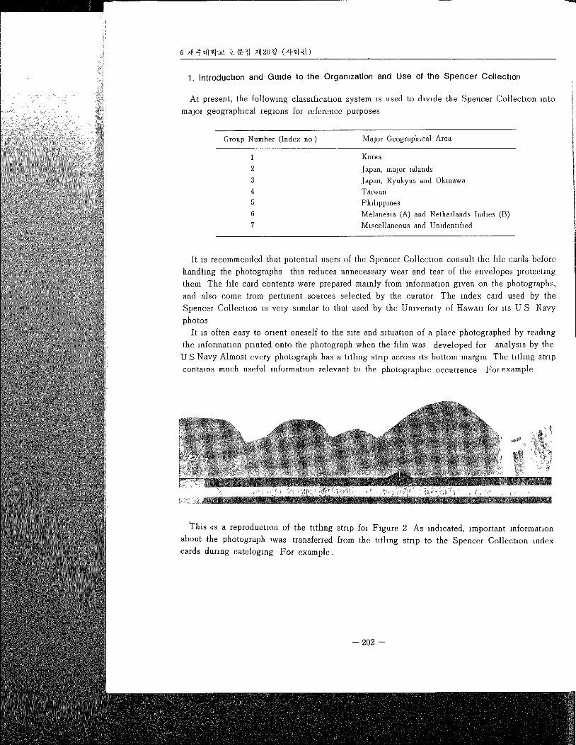
1. Introduchon and Grade to the Organ,zation and Use of the Spencer Collect,on
At present, the following classification system is used to divide the Spencer Collechon into
major geographical regions for reference purposes
Group Number (Index no ) Major Geographical Area
1234567
Korea
Japan, major islands
Japan, Ryukyus and Okmawa
Waiwan
PhdlppmesMelanesia (A) and Netherlands Indies (B)Miscellaneous and Unidentified
It is recommended that potential users of the Spencer Collection consult the file cards before
handling the photographs this reduces unnecessary wear and tear of the envelopes protecting
them The file card contents were prepared mainly from information given on the photographs,
and also come trom pertinent sources selected by the curator The index card used by the
Spencer Collection is very similar to that used by the University of Hawan for its U S Navy
photos
It is often easy to orient oneself to the site and situation of a place photographed by reading
the mformatmn printed onto the photograph when the film was developed for analysis by the
U S Navy Almost every photograph has a titling strip across its bottom margin The titling strip
contains much useful reformation relevant to the photographic occurrence For example
This ,is a reproduction of the hthng strip for Figure 2 As mdmated, important mformatmn
about the photograph ÿwas transferred from the hthng strip to the Spencer Collection index
cards dunng cateloglng For example.
-- 202 --
The Remote Sensing Famhtms at Cheju Nahonal Umverslty Rationale and Development 7
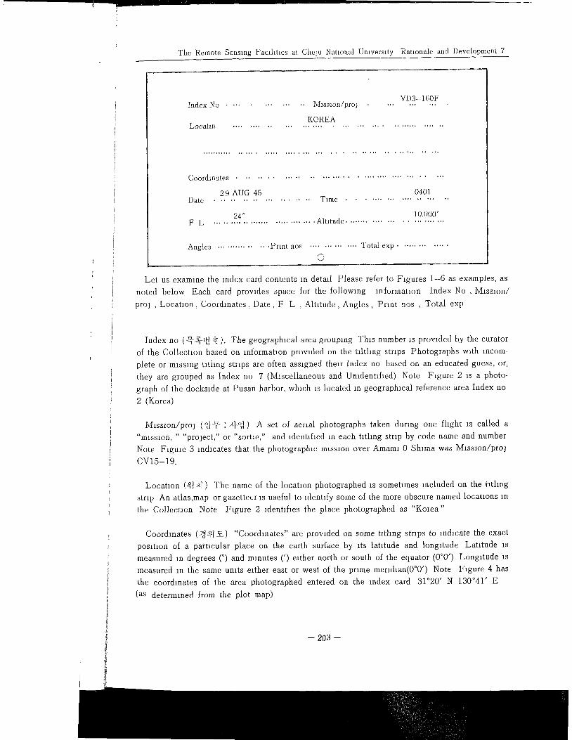
Index No ............. Mlsslon/pro3VD3-160F
LocatmKOREA
Coordinates ...........................................
29 AUG 45 0401Date ................... Time .....................
24" 10,000'F L ............................... Altitude ...........................
Angles ............... Print nos .............. Total exp ..............
o
Let us examine the index card contents in detail Please refer to Figures 1-6 as examples, as
noted below Each card provides space for the following lnformahon Index No, Mission/
proj , Location, Coordinates, Date, F L , Alhtude, Angles, Print nos , Total exp
Index no (_ÿ-_ÿv_Oÿ.). The geographical area grouping This number is provided by the curator
of the Collection based on information provided on the tdthng strips Photographs with incom-
plete or missing tithng strips are often assigned their Index no based on an educated guess, or,
they are grouped as Index no 7 (Miscellaneous and Unidentified) Note Figure 2 is a photo-
graph of the dockmde at Pusan harbor, which is located in geographical reference area Index no
2 (Korea)
Mlssion/proj (N@ '.a}-N} A set of aerial photographs taken during one flight is called a
"mission, " "project," or "sortm," and tdentlhed in each titling strip by code name and number
Note Figure 3 indmates that the photographic mission over Amaml 0 Shlma was Misslon/proj
CV15-19.
Location (°]ÿl) The name of the location photographed is sometimes included on the tithng
strip An atlas,map or gazetteer is useful to identify some of the more obscure named locations in
the Collecaon Note Figure 2 ldenhfles the place photographed as "Korea"
Coordmates (2ÿ4] ÿ-ÿ-) "Coordinates" are provlded on some tlthng strips to ln&cate the exact
posmon of a partmular place on the earth surface by its latitude and longitude Latitude is
measured m degrees (°) and minutes (') either north or south of the equator (0°0") Longitude is
measured in the same units rather east or west of the prime meridian(0°0') Note Figure 4 has
the coordinates of the area photographed entered on the index card 31°20, N 130041' E
(as determined from the plot map)
-- 203 --
Date (ÿ.ÿ]-) The day, month and year of the photographm occurrence appears on many tatllng
strips In some cases the day and month were mÿstakenly transposed by U S Navy personnel,
creating some uncertainties Note Figure 6 mdmates that Espmto Santo Island was photo-
graphed on 10 June 43, (June 10, 1943)
Time (.a/u&) The exact time the photographing portion of the mlSsloncommenced may also
appear on the tlthng strip The 24-hour clock is used Note Figure 6 also lndmates the time
that Espmtu Santo Island was photographed 0857
Focal length (F L) (ÿ-N 7171) The camera focal length appears on most tlthng strips be-
cause thas information is necesary to estabhsh scale, whmh aids m identifying various features
on the earth surface Scale is focal length dlwded by the hmght of the camera above the ground
surface (whzch ÿs not the same as altaude above sea level) Focal length appears on the tlthng strips
either as mllhmeters or as inches To convert 152 4mm is 6" Note Figure 1 mdmates that the
camera focal length on this mission over Kyushu was 24"
Altitude (_V.ÿ.ÿ.) The height of the camera above sea level appears on most hthng strips along
with focal length an order to faclhtate the ealculatmn of scale Note Figure 1 also mdmates the
altitude at whmh the photograph was taken 10,000'
Angles (ÿ-=.ÿ) Indmatmns may appear on the tlthng strip as to whether the photographs are
Vemcals (V), Right 0bhques (OR), or Left Obhques(0L) Note Figure 4 indicates a verticalphotograph of the Kagoshlma Iandseape, whale Figure 3 shows Amain1 0 Shlma as photographed
from an obhque angle
Print nos (x]-ÿlOÿ_) Each photograph is uniquely numbered, usually near the beginning of
the tlthng strip, and thin number is part o{ a sequence of photographs taken during a "run" or"pass" over the target landscape A mission may include several runs 0ccaslonally there are
missing photographs in a numbered sequence, or, entire runs may be missing from the Spencer
Collectmn A new sequence of pnnt nos is usually given for each angle photographed Note
Figure 1 is a vemcal photograph that was one of a total of nine sequentially numbered photo-
graphs
Total exp (ÿ-x]-ÿ-ÿ-:z}) The actual or estimated number of photographs for this mlssmn/proj
has been provMed by the curator during cataloging Note Figure 1 ÿs one of nine photographs
of Kyushu taken during the CV9 3933 mission that the Spencer Collectmn owns
There are several other 1terns of mformatmn on the index cards provided by the curator during
cataloging
Plot map(s) (7.I_ÿ_) Plot maps may accompany aerial photographs These graphmally m&cate
the exact progress of the photo "runs" during the mlssmn The existence of such maps are
mdmated on the lower left-hand corner of the index card Note Figure 4 lndmates that there
are plot maps accompanying this photograph
-- 204 --
The Remote Sensing Facdlhes at Chelu National Umvermty Rationale and Development 9
ling
nel,
to-
Print size (x/-ÿ--71) Most of the U S Navy air photographs in the Spencer Collection are
prints measuring 9"X9" (23cmX23cm) There are also many excellent 9"X18" (23cmX46cm)
prints,and a very few 4"X5" (10cm X [2 5cm) photographs
tlsoIime
)ng
the
are
called
Iofor
are
er
feIo-
I
i
l, be-
ires
jnd
lps
the
REST JICPOA (71 ÿ1 ÿ_ÿ_) "REST" on the titling strip indicates "RESTricted" for war-
time security reasons All Spencer Collection photographs have since been declassified The
JICPOA number is a useful way to determine the exact sequence of photographic missions in
heu of other means JICPOA numbers accrued during the course of the war in a chronological
sequence This number usually can be found printed last on the tlthng strip, and is entered on
the back of most cardsTo summarize Locating the places photographed by the U S Navy in the Western Pacific is
generally made easy by consuhmg useful Information entered on the titling strips of the prints
However, not every photograph contains adequate information to ensure place identification
Fortunately, many prints are accompanied by pÿt maps and other supporting materials, includ-
ing ground-level historical photographs culled by the Navy from mlssmnary and travel records
The curator has noted the nature of some of this suppomng data, as well as indicated some of
the potential uses of certain sets of photographs for specific research purposes When using the
Spencer Collection, be sure to check for handwritten notes on the back of the index cards
2. How to View the Photographs
The air photo should always be examined with the shadows of &stmctive objects (trees,
chimneys, chffs, etc) falhng toward the viewer Since most photos in the Collectmn were taken
on bright mornings or afternoons, shadows are profuse, and these may he compared to give some
indication of the relative height of the surface features casting the shadows
Those photos which were taken vertically rather than obhquly make special demands on the
viewer, since the vertical view of an object prowdes a less familiar perspective than a side view
This makes the object harder to identify The angle of the side, or oblique view may be high or
low, with the low oblique photographs taken at mimmal elevatmns creating the most familiar
perspective for the average viewer The Spencer Collection in fact contmns some excellent low
oblique photographs of Seoul, Inch'on and Kunsan, in Korea Most photographs in the Collec-
Uon, however, were taken from high oblique and vertical angles Fortunately, many places
represented m the Collectmn were photographed from vertmal and high obhque simultaneously
by using a synchromzed mutlple-lense camera Such tnmetrogon photography offers the analyst
a continuous wew of the area by scanning from left horizon to right horizon directly below the
mrcraft The viewer should be aware that in most cases the camera-carrying aircraft has per-
formed its photographm mÿssion while advancing over the terrain m a very systematic fashion
The normal system of aerial photography is one in which the airplane flys back and forth m
parallel runs over the terrain The result is a considerable amount of overlap and duphcatmn m
subsequent and adjoining photographs, but contalmng no ommlsmns This total coverage m
vertical and obhque views enables the photo analyst to consult several different photographs, if
necessary, m order to make a better determmahon about any surface features in questmn
The systematic aerial photography of Pamfic islands represented in the Spencer Collectmn
enables a stereoscope to be used to enhance photo lnterpretatmn capablhtles The stereoscope is
a small instrument commonly used by air photo analysts to create clear three dimensional
tmpresmons of areas photographed Without the stereoscope, quick and accurate determlna
of alhtude, ruggedness and slope of terrain m some areas may be severely handicapped
remote sensing laboratory at CNU Central Library has stereoscopes available for the con
ence of visitors using the Spencer Collection 8)
V. Exciting Career Opportumties in Imagery Analysis
It is a great pleasure to conclude this report by drawing the reader's attention to the fact
many government and private organizations in the Pacific rim and basin region have dem
trated their increasing need during the 1980's to hire air photo interpreters and remote sen
imagery analysts In parhcular, intelhgence- and defense-minded governments insist that r,
and more economists, engineers and military personnel receive some special training in ima!
analysts Such professmnals study remotely-sensed imagery in order to determine agncult
and industrial production capacities worldwide (e g "Will the Soviet Union have another
grain harvest this yearP", "How soon wall the new mlflelds m Indonesia be operationalÿ")to k
abreast of the changing deployment of mlhtary forces (e g "How many enemy combat dlvisl
can be quartered in new constructions photographed near the DMZÿ"), and to follow the devel
ment, testing and production of new weapons systems (e g "Have the Chinese made any n
breakthroughs m their nuclear development program?")
The intelligence value of imagery provides increasing numbers of college graduates with
opportunity to enter a challenging career as imagery analysts Their special training beg
with an appreciation of air photo interpretahon, and then progresses to satellite lmagÿ
analysis 9) College students who are pohhcal, social, physical and earth science majors all ha
appropriate backgrounds to eventually become skilled in the intelhgenee apphcatlons of image
analyms
Government and private organizations in the intelhgence field will usually prowde on-the
job training, and provide opportunities for their trainees to visit foreign institutes and facllih,
m order to meet other interesting people in the intelligence community Employers will ah
normally pay for addltmnal job related training, and even send their employees to national aÿ
international professional meetings and workshops There is, therefore, excellent career opportÿ
reties for both men and women college students who are interested in aerial photo lnterpretatm
and remote sensing techniques
8) A good Enghsh-language mtroductmn to the procedures used m aÿr photo analyms ÿs prowded by
G C Dlckenson m Maps and Air Photographs London Edward Arnold (Publishers), Ltd, 1970(Available m the CNU Central Library)
9) The awesome perspechve of the earth surface now available from satelhte imagery is persented m
Charles Shefheld's Earth Watch New York MacMdlan Pubhshmg Company, Inc, 1981 (Avad-able in the CNU Central Lÿbrary)
-- 206 --
The Remote Sensing Famhtles at Cheju Nahonal Umversny Rahonale and Development 11
ons
Fheenl-
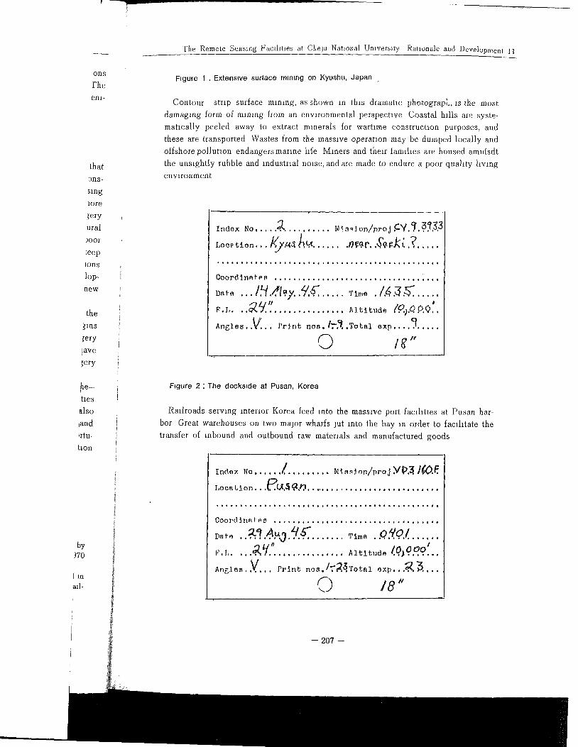
Figure 1 . Extensive surtace mmmg on Kyushu, Japan
thatons-
sing
lore
ery
ural
)oor
:eep
Ions
lop-
new
thegins
ery
}ave
ery
by)70
[ inall-
he-
ties
also
land
Irtu-
hon
Contour strip surface mining, as shown in th,s dramahc photograpl., ls the most
damaging form of mlmng from an environmental perspective Coastal hills are syste-
matically peeled away to extract minerals for warhme construchon purposes, and
these are transported Wastes from the massive operation may be dumped locally and
offshore pollution endangers marIne life Miners and their famlhes are housed amldsdt
the unsightly rubble and industrial noise, and are made to endure a poor quality living
environment
Locÿ,t, ion... Ky.t4ÿ .J'). ,!4t ....... 0ÿ-0. p..#ÿt gJ(l'..? .....
Coordinates ................ . ................. .
,ÿ, .., !.q.ÿ. lÿ. y /'/.ÿ. , ..... ÿt,,o ./.4 ,ÿ.ÿ. .....
25/." ÿ.ÿ .................... AlUt,,d, 1.0....o.¢ÿ.
A,O,,..V... p,ÿ,t ÿo,. Ir.ÿ..Tot,1 o,p .... ? .....
O Ig"
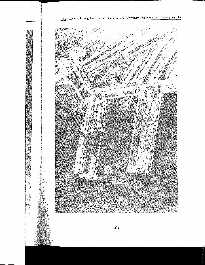
Ffgure 2"The dockside at Pusan, Korea
Railroads serwng interior Korea feed into the massive port facllitms at Pusan har-
bor Great warehouses on two major wharfs jut into the bay In order to facilitate the
transfer of rebound and outbound raw materials and manufactured goods
Index NO ...... l ......... blts,ÿJon/proj Yÿ).ÿ ]ÿ)ff.
Location...ÿ.(ÿ.ÿ .ÿ.0 .............................
OooI'dÿ_nnfos ..,..,.....,..,........,..°,,...,,o
.ÿo g!AÿOeo'7 ....... ÿ,..° o,fo/ ......
0 O0/g.I ..... ,°ÿ 5/.t .............. Altitude /.% .......
Aÿ,s..V.... pÿiÿt no,,./ra.ÿ.Toÿ,l oÿp....a3....
0 18"
-- 207 --
Ir
208
The Remote Sensing Faclht:es at Cheju Nat:onal Un:vers:ty Rat:onale and Development 13
%
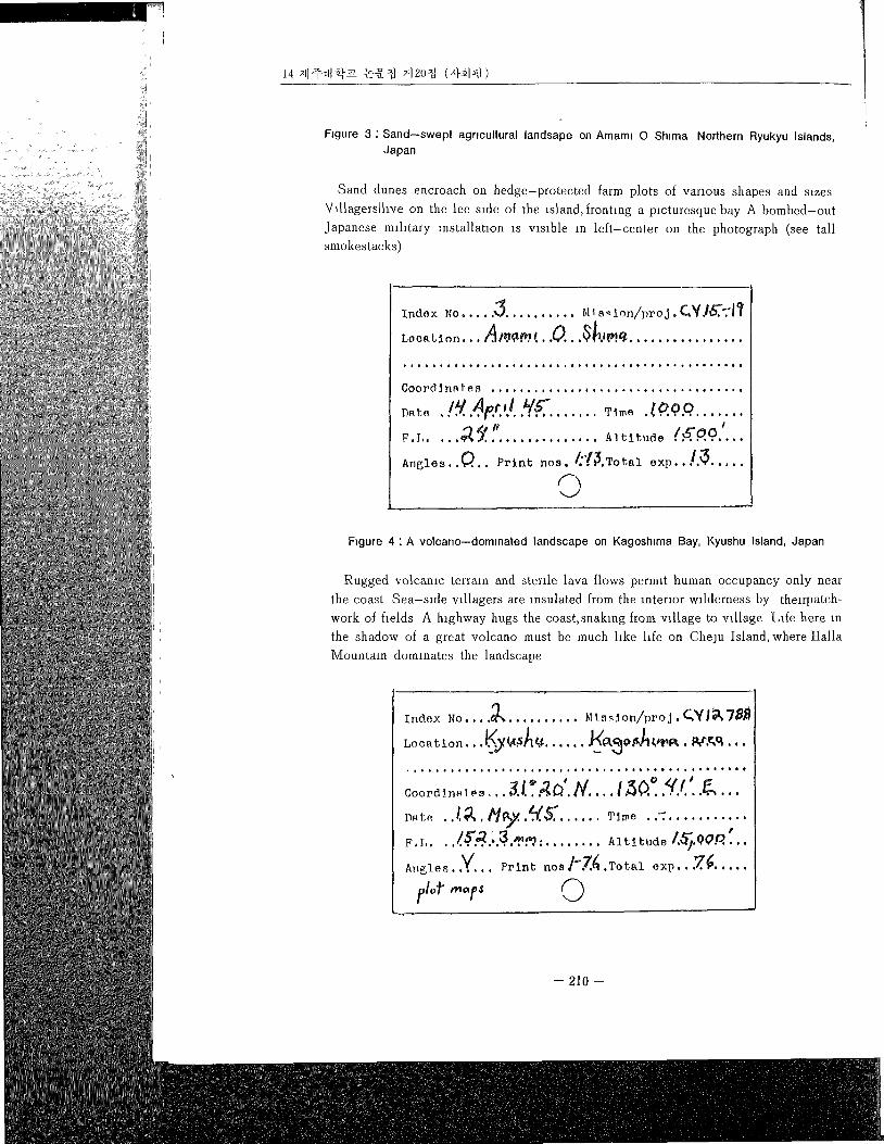
Figure 3" Sand--swept agricultural landsape on Amaml O Shlma Northern Ryukyu Islands,Japan
Sand dunes encroach on hedge-protected farm plots of various shapes and razes
Vlllagerslhve on the lee rode of the island, fronhng a picturesque bay A bombed-out
Japanese mdltary mstallahon is vlmble in left-center on the photograph (see tall
smokestacks)
Ind.ÿ No ..... ,5 .......... m sqon/proJ. C,¥Jÿ.':I?
Loc.tÿon... ÿ'ÿ'...O...ÿ.'ÿ.'ÿ ................
Coordÿna[es ...................................
D°ÿ .!ÿ.4ÿ.,!..Y.ÿ. ....... Tÿo .ÿ.o.ÿ.o. .......
1 Y."F.I ................ Altitude /ÿ'OOI
Angles..ÿ.. Print sos, /.ÿ.ÿ.Total exp..].ÿ .....
©FNure 4' A volcano--dominated landscape on KagosNma Bay, Kyushu Island, Japan
Rugged volcanm terrain and sterile lava flows permit human occupancy only near
the coast Sea-side wllagers are insulated from the interior wdderness by theÿrpatch-
work of helds A highway hugs the coast, snaking'from vdlage to wllage Life here m
the shadow of a great volcano must be much hke hfe on Cheju Island, where I-Ialla
Mountain dominates the landscape
Index No .... ÿ .......... ÿ1ÿq on/proJ. Qÿllÿ,78ÿ
Lo e a t io n... Lÿ,y Id-,,S]q t¢ ...... ÿ(A3@ .ÿ,ÿ11,ÿPIÿ...ÿ.ÿ,q,...
................................... , °i ii!iiii:
Coord !na! es ...........
.ÿ,...ÿ.;ÿ. tqÿ ..q.K. ...... Tÿe . .= ...........
tF.L..........15"2.3.,-,ÿ ÿ... ........ Altitude /.ÿ.ÿ0.0....
Angles. V Prlnÿ nos]-7.4 Total exp .ÿ.¢.
f,ÿoÿ" ..°/,, @
-- 210 --
The Remote Sens:ng Fac:ht:es at Cheju Nat:onal Umversaty Rat:onale and Development 15
t1
-- 211 --
>
t L
o
-- 212 --
The Remote Sensing Famhtles at Cheju National University Ratlonale and Development 17
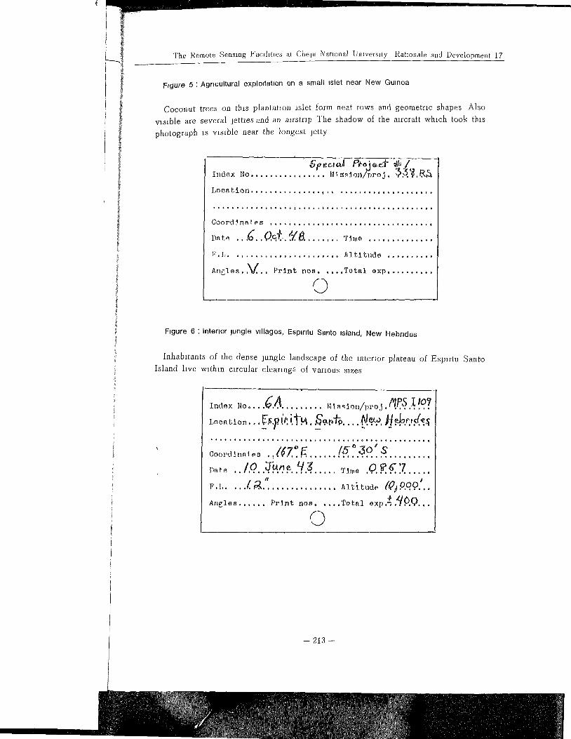
Ftgure 5 : Agrmultural exploitation on a small inlet near New Guinea
Coconut trees on this plantation islet form neat rows and geometric shapes Also
visible are several jetties and an airstrip The shadow of the aircraft which took this
photograph is visible near the longest jetty
Location ............. ..ÿ,ÿ ....................
• .,.,,.o..*,,.. 0, f ÿ,,,,4o,o.,. 0,ot,ÿ.,, o,6o,,o,
Coordinates ........... ,., .................... ,
>ÿ,ÿ, . . .6. , 0.¢,,. .z./. 0. ....... ÿm° ..............
P.I ........................ Altltude ..........
Angles..V.. Print nos ..... Total exp ..........
©
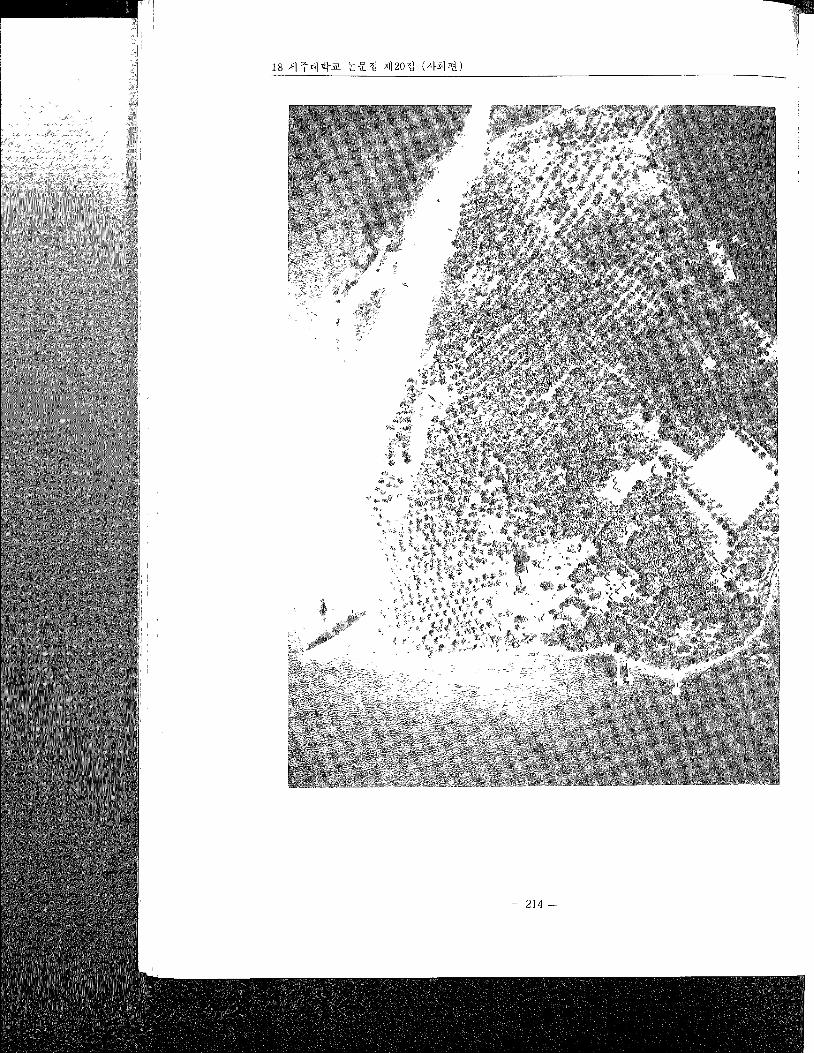
Fÿgure 6 ' Intermr lungle vdlages, Espmtu Santo roland, New Hebrides
Inhabitants of the dense jungle landscape of the interior plateau of Esplrtu Santo
Island live within circular clearings of various sizes
,.ÿ,ox .o .... gA ......... ,,,so,o./ÿ.oa.0rs..{{°?
oooÿo,n. ÿs /'(7 E [5 43o S
.ÿo .. l,q, .ÿ..ÿ.ÿ. .q. .ÿ. ..... Tÿo .o.. ÿ < 2 .....
.ÿ ..... / a..". .............. Altitÿaÿ d2j.o.qo.'..
* 5.0.0.Angles ...... Print noa ..... Total exp,'ÿ .,
©
-- 213 --
-- 214 --
The Remote Sensing Facdlhes at Cheju Nahonal Umvers:ty Rahonale and Development 19
s
-- 215 --
20 ÿ41 -ÿ=fl ÿ ÿ ÿN ÿ12o>ÿ
\
-- 216 --