The Regional Earth System Model (RegESM ... - ICTP – SAIFR
21
The Regional Earth System Model (RegESM) using RegCM4 coupled with the MITgcm ocean model Joint ICTP-Trieste/ICTP-SAIFR Advanced School on Regional Climate Modeling over South America February 15-19, 2016 | São Paulo, Brazil Laura Mariotti 1 email: [email protected] U. U. Turunçoğlu 2,1 , R. Farneti 1 , G. Sannino 3 , A. Carillo 3 , R. Franco Fuentes 1 , F. Di Sante 1 1. the Abdus Salam International Centre for Theoretical Physics 2. Informatics Institute, Istanbul Technical University, Istanbul, Turkey 3. SSPT -MET- CLIM Laboratory - ENEA Centro di ricerche , Roma, Italy
-
Upload
khangminh22 -
Category
Documents
-
view
8 -
download
0
Transcript of The Regional Earth System Model (RegESM ... - ICTP – SAIFR

The Regional Earth System Model (RegESM) using RegCM4 coupled with the
MITgcm ocean model
Joint ICTP-Trieste/ICTP-SAIFR Advanced School on Regional Climate Modeling over South America
February 15-19, 2016 | São Paulo, Brazil
Laura Mariotti1 email: [email protected]
U. U. Turunçoğlu2,1 , R. Farneti1, G. Sannino3, A. Carillo3, R. Franco Fuentes1, F. Di Sante1
1. the Abdus Salam International Centre for Theoretical Physics 2. Informatics Institute, Istanbul Technical University, Istanbul, Turkey 3. SSPT-MET-CLIM Laboratory - ENEA Centro di ricerche, Roma, Italy

USRA, Earth System Science Education strategy, 2008
Earth System

• Components: ATM:ICTP’s RegCM (4.4.5.8)OCN:Rutgers Univ. ROMS (r737)�MIT, MITgcm (c63s)RTM:Max Planck’s HD (mod. 1.0.2)
before…
Ufuk U. Turunçoğlu [email protected]
different earth system models

• Components: ATM:ICTP’s RegCM (4.4.5.8)OCN:Rutgers Univ. ROMS (r737)�MIT, MITgcm (c63s)RTM:Max Planck’s HD (mod. 1.0.2)WAV:ECMWF’s WAM (4.5.3 MPI)DRV:RegESM (7.0.0b38)
atmosphere(RegCM)
land(BATS)
ocean(ROMS / MITgcm)
sea iceunnamed
driver
land(CLM)
river routing
(HD)
initial and boundaryconditions
anthropogenicemissions
naturalemissions
full gaschemistry
aerosol
wave(WAM)
initial conditions
initial conditions
ESMF+NUOPC
in progress ready and tested
atmospheric�chemistry
Two differentland surface �
model
Two differentoceanmodel
now…Regional Earth System Model is coupled modeling system that allows using variety of different earth system models (RegESM)

• Exchange fields between model components are defined by extra configuration file (exfield.tbl)
• The user can choose �the exchange fields from �the field pool
Managing Exchange Fields
MITgcm
HD-model
RegCM4
Discharge
at the mouth
Runoff
SST

• RegESM also supports two different approach to run the model components.– Sequential: model components are run in order– Concurrent: all models are active at same time (it does not allow
overlapping of the used cores / CPUs)i.e. three component case (ATM+OCN+RTM)
Sequential vs. Concurrent Execution

• The RegESM uses explicit coupling schemes along with the support of fast and slow time steps.– Fast interaction among ATM and OCN (i.e. 1 or 3 hours)– Slow interaction between ATM and RTM, RTM-OCN (i.e. 1 day)
i.e. three component case (ATM+OCN+RTM) + explicit coupling
Special thanks to ESMF Group (especially to Gerhard Theurich) for their support and help
Run Sequence in RegESM
Surface temperature
Figure:(Surface(temperature(over(the(Indian(Ocean(Region(for(the(RegCM4;(MITgcm(coupled(model.(The(solid(red(box(indicates(full(atmospheric(model(domain((RegCM4).(The(blue(solid(box(shows(ocean(
model(domain((MITgcm)(!
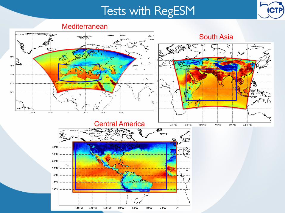
Tests with RegESMMediterranean
South Asia
Central America

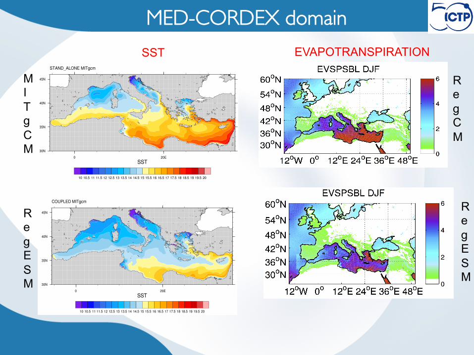
MED-CORDEX domain
Figure 1. The domain map for the RegESM simulation with topography of atmosphere model (RegCM4) and bathymetry of ocean component (MITgcm). The solid red box indicates full atmospheric model domain, relaxation zone is indicated between solid and dashed red box. The blue solid box shows ocean model domain.
MITgcm configuration: 1/12° horizontal resolution, 75 vertical levels. Sea Surface Salinity with time relaxation constants of 2 days and 1.8 days respectively. The benchmark simulation is a stand-alone run forced by the air-sea fluxes from ALADIN dynamical downscaling of ERA-interim (12 km horizontal resolution), and with relaxation terms on Sea Surface Temperature
RegCM4 configuration: MED-CORDEX experiment from 1979 up to 2013. Model version: RegCM4.5 Horizontal Resolution: 20 km Boundary conditions: ERA-Interim Reanalysis 0.75° In our experiments we use the convection scheme of Grell over land and MIT-Emanuel scheme over ocean. The land‐atmosphere interactions are parameterized using the biosphere‐atmosphere transfer scheme (BATS) and the Zeng scheme is used to represent fluxes from water surfaces.

MED-CORDEX domain
a. RegESM b. UDEL c. GPCP
d. RegESM-UDEL e. RegESM-GPCP
Precipitation maps for the season DJF from 1979 up to 2013 (mm/day)
MED-CORDEX domain
RegESM
MI TgCM
RegCM
RegESM
SST EVAPOTRANSPIRATION

Central America domainby Ramon Fuentes Franco Test from 1989 up to 1992 RegCM4 driven by EIN 0.75 at 50km Mitgcm at 25km

Central America domain

Central America domain
Cyclones during 1990
Biases
maps detected cyclones

Central America domain
Regcm
coupled

South Asia domainSurface temperature
Figure:(Surface(temperature(over(the(Indian(Ocean(Region(for(the(RegCM4;(MITgcm(coupled(model.(The(solid(red(box(indicates(full(atmospheric(model(domain((RegCM4).(The(blue(solid(box(shows(ocean(
model(domain((MITgcm)(!
• 5 Years simulated (1988 – 1993) • Last 3 years used for validation
purpose • Coupled and Uncoupled runs
by Fabio Di Sante
Experiments
Ocean • SST on JJAS season
Atmosphere • Precipitation bias on JJAS season • Annual cycle for precipitation
Validation

South Asia – Ocean ValidationSST JJAS
Bias SST JJAS
OBS

Precipitation JJAS
Drier over Bay of Bengal respect to the
standalone Wetter over Bangladesh and Central Northeast
Indian region respect to the
standalone
South Asia – Atmosphere Validation

NW
CNE NE
WC
PS
Northwest (NW) Central Northeast (CNE) Northeast (NE) West Central (WC) Peninsular (PS)
CNE
NE
WC PS
ALL
NW
Annual Cycle South Asia – Atmosphere Validation

• Components: ATM:ICTP’s RegCM (4.4.5.8)OCN:Rutgers Univ. ROMS (r737)�MIT, MITgcm (c63s)RTM:Max Planck’s HD (mod. 1.0.2)CHyMWAV:ECMWF’s WAM (4.5.3 MPI)DRV:RegESM (7.0.0b38)
atmosphere(RegCM)
land(BATS)
ocean(ROMS / MITgcm)
sea iceunnamed
driver
land(CLM)
river routing
(HD)
initial and boundaryconditions
anthropogenicemissions
naturalemissions
full gaschemistry
aerosol
wave(WAM)
initial conditions
initial conditions
ESMF+NUOPC
in progress ready and tested
atmospheric�chemistry
Two differentland surface �
model
Two differentoceanmodel
ConclusionsRegional Earth System Model is coupled modeling system that allows
using variety of different earth system models (RegESM)

Obrigada