Discussing Earth - cloudfront.net
359
i Discussing Earth Michael M. Kimberley Dept. of Marine, Earth & Atmospheric Sciences North Carolina State University Raleigh NC 27695 Table of Contents 1 .. Dinosaurs and Extinctions .. p.5 2 .. A Geologic View of World History .. p.27 3 .. Our Dwindling Geologic Resources .. p.59 4 .. Our Downtrodden Soils .. p.87 5 .. Earthquakes .. p.103 6 .. Geologic Hazards .. p.157 7 .. Conservation and Recycling .. p.189 8 .. Appendices .. p.221
-
Upload
khangminh22 -
Category
Documents
-
view
3 -
download
0
Transcript of Discussing Earth - cloudfront.net

i
Discussing Earth
Michael M. Kimberley Dept. of Marine, Earth & Atmospheric Sciences
North Carolina State University Raleigh NC 27695
Table of Contents 1 .. Dinosaurs and Extinctions .. p.5
2 .. A Geologic View of World History .. p.27 3 .. Our Dwindling Geologic Resources .. p.59
4 .. Our Downtrodden Soils .. p.87 5 .. Earthquakes .. p.103
6 .. Geologic Hazards .. p.157 7 .. Conservation and Recycling .. p.189
8 .. Appendices .. p.221

ii
This custom textbook includes materials submitted by the Author for publication by John Wiley & Sons, Inc. The material has not been edited by Wiley and the Author is solely responsible for its content. Copyright © 2008 by Michael M. Kimberley All rights reserved. No part of this publication may be reproduced, stored in a retrieval system or transmitted in any form or by any means, electronic, mechanical, photocopying, recording, scanning or otherwise, except as permitted under Sections 107 or 108 of the 1976 United States Copyright Act, without either the prior written permission of the Publisher, or authorization through payment of the appropriate per-copy fee to the Copyright Clearance Center, 222 Rosewood Drive, Danvers, MA 01923, (978) 750-8400, fax (978) 646-8600. Requests to the Publisher for permission should be addressed to the Permissions Department, John Wiley & Sons, Inc., 111 River Street, Hoboken, NJ 07030, (201) 748-0611, fax (201) 748-6008. To order books or for customer service, please call 1(800)-CALL-WILEY (225-5945). Printed in the United States of America ISBN 9780-470-185018 10 9 8 7 6 5 4 3 2 1

- 1 -
Discussing Earth
by Michael Kimberley Dept. of Marine, Earth & Atmospheric Sciences
Box 8208, N.C. State University Raleigh NC 27695 { [email protected] }
Accompanying DVD was filmed and edited by Mark Lee.
Actors: Kyle Chernoff (Marcus), Emily Holland (Elizabeth), Adam Hooker (John), and Michael Kimberley (the moderator)
Dr. Rex: The style of communication employed here has not been used much in science
since 1500 A.D. when Agricola, the Father of Mineralogy, explained mining methods through a dialog between an expert miner and a pair of philosophers. Here we have a moderator and four students, with each of the students representing one of the “four corners” of the student body, in accordance with the famous quotation from Revelations, “After this I saw four angels standing at the four corners of the Earth, holding the four winds of the Earth, that no wind should blow on the Earth.” Let us meet our four students. Welcome John, Elizabeth, Marcus, and Ashlynn to our first Earth Science discussion. Do any of you guys already know each other?
Ashlynn: Everybody from my High School knows Marcus. He was the President of our Student Body and he played on our football team. I wonder if he remembers me.
Marcus: You think that we football players do not keep our eyes on the cheerleaders like everyone else? Besides, your dad is a vice-principal and former US Marine captain, so everybody was watching out for you.
Dr. Rex: Do either of you guys know John or Elizabeth? Marcus: John looks like some trial lawyer whose picture I see in the paper whenever
something nasty happens. John: Yes, that would be my dad, and I hope that it will be my picture that you will be
seeing there in ten years when I take over his lucrative business. Dr. Rex: John, do you know Elizabeth?

Discussing Earth: Introduction
- 2 -
Elizabeth: If that is a biblical question, the answer is “No” but we did date for a couple of weeks last year.
John: It was more like twelve days. Elizabeth: And two hours. John: And twenty minutes. Marcus: Oh-oh. Ashlynn: I bet he made a good first impression driving his Dad’s …… Elizabeth: Mercedes, but I preferred his mother’s Aston Martin on the next date. I am
confident that John will generate business for me when I take over my parents’ bookstore. His ex-wives will buy novels from me when they try to find a lasting romance.
Dr. Rex: I think that I should have added a few more questions to the application for a spot on this panel. Before we become another episode of Survivor, let us begin with you guys explaining your interest in Earth Science. I see that none of you plan to become a professional geologist.
Ashlynn: That may be true but all of us have dreams of vacationing in places with beautiful landscapes and we realize that learning a little geology would help us appreciate those landscapes.
Marcus: Moreover, we all understand that we should learn how to face natural hazards such as hurricanes, earthquakes, and landslides.
John: All four of us are avid supporters of the discussion-style homework because we realize that advancement in virtually any job requires verbal skills and this format allows us to express our opinions before a critical audience that will never interfere with future job-hunting.
Dr. Rex: From your applications, I see that each of you plans to follow the career path of your respective parent. John is the son of a prominent trial lawyer and he hopes to use the discussion format to defend some radical concepts, given that he expects to eventually defend some unpopular cases in court. Elizabeth’s parents own and operate a bookstore which she expects to inherit. Like her parents, she loves books and enjoys defending every detail of the assigned textbook tenaciously.
Marcus is the son of a mid-level manager at the State Department of Transportation (DOT). He has often heard his dad discuss the difficulty of putting a new road through a swampy or mountainous area so he appreciates the geologic studies that have helped his dad at the DOT. Marcus has learned that many of those geologic problems required his dad to go beyond standard DOT procedures so Marcus is ready to think “outside the box”.
Ashlynn is a Marine Corps brat who has grown up on military bases around the world. Her dad is now a vice-principal at her former high school. She would like to become a high school teacher there herself, perhaps teaching Earth/Environmental Science some semesters.
During a regular semester, we hold our discussions in a 470-seat lecture hall. There, each of our four students has a different circle of friends. Their surrounding friends encourage them audibly whenever they make a dramatic point, even if their friends do not all understand what that point is.
John, in particular, has learned how to get a reaction from his supporters by raising and lowering his voice, using body language, inserting jokes, and interrupting other speakers. He knows that the discussions are being videotaped and he wants to be the star of the show. John’s group includes not just Political Science majors like himself but also many business

Discussing Earth: Introduction
- 3 -
majors. To them, the discussion is a bruising football game and John seems like the best quarterback on the field.
Elizabeth is majoring in English but her group includes most of the scientists and engineers as well as other language-art students. The engineers sit near Elizabeth because she has pretty language-art friends, not because they agree with her comments. The scientists, in contrast, consider Elizabeth to be the most articulate defender of politically-correct views and they expect that those views will earn them higher grades than John’s radically aggressive views.
Marcus is surrounded by the football and basketball team members and their girlfriends. As a group, they seem to understand the concept of free-flowing discussion much better than our other three groups and they are the quickest at articulating flaws in opposing arguments. They overtly enjoy the discussion format whereas our other three groups are constantly perplexed by the rapidly-changing points of view. The moderator soon learns that Marcus can provide the most memorable “sound bites” so he typically selects Marcus ahead of others who have simultaneously raised their hands.
Ashlynn is surrounded by other majors in Education as well as most of the sociologists, psychologists, and communications majors. They collectively appreciate society’s ongoing electronic transformation and how this changes everything, including Earth Science instruction, so they are not concerned with minutia in the textbook. To them, “the medium is the message”. They often watch talk shows on TV and are eager to participate in a discussion that resembles such a show. They also want to know how a given teaching format, e.g., a discussion, compares with alternative formats, independent of the material being discussed. Ashlynn’s friends are the only students who remain after a discussion and make suggestions to the organizers about new topics, new moderators, and new procedures.
The philosophy behind our discussions is that each participant brings a personal view of the Earth to the classroom and that our course material may modify that view but is unlikely to change it fundamentally.
Ashlynn: I believe that each person’s knowledge of the Earth affects their perception of humanity’s role here. Where did we come from? What will happen to our children and their children? Is there life elsewhere in the Universe? Most instructors tolerate diverse answers to these questions but are conditioned to be less tolerant about other Earth-science issues. One goal of this discussion is to show that there are many additional questions for which personal answers should be accepted.
John: Textbook views of geology have changed dramatically through the past century and are likely to change even more dramatically through the coming century. Consequently, these discussions are designed to help students explore concepts on their own rather than strive for orthodoxy. We students will eventually have to deal with uncertainty in any case because newspapers and popular magazines will trumpet the new geologic concepts in the decades to come and those new concepts will supplant the old concepts of our then-obsolete textbook.
Dr. Rex: The order of topics in this set of discussions is arbitrary. The actual order in any semester depends upon the schedules of invited moderators. At N.C. State University, optional discussions are held for an hour on Sunday afternoons in the campus cinema. An expert introduces the topic for about fifteen-to-twenty minutes, using the cinema’s audio-visual facility, and then moderates the ensuing discussion. Each student comes with a brief written answer to a given controversial geologic question. Any student may be randomly

Discussing Earth: Introduction
- 4 -
called upon to read their statement. Other students are then invited to comment on that statement.
John: Typically, this procedure initiates debate and the discussion becomes self-sustaining for a while, with the moderator keeping order. If it slows down, the moderator may briefly summarize the progress and then randomly chose another student to read their statement, encouraging the free-flowing discussion to continue. Occasionally, a student asks the moderator for some facts or an opinion. Otherwise, the moderator generally volunteers a correction only if some comment is particularly off-base. Each discussion is filmed and a DVD is mailed the next day to distance-education students.
Elizabeth: Following each discussion, the students leave their written statement with the moderator and later submit an essay that summarizes their experience. This counts as homework. Students may avoid the discussions altogether by choosing an alternative type of homework, one involving multiple-choice questions that are unrelated to the discussion topics. Both the essays and multiple-choice answers are submitted through a Vista/Blackboard system. Students are welcome to submit both types of homework (essay and multiple-choice) because the higher of the two potential grades will be recorded.
Dr. Rex: Through the past couple of centuries, scores of introductory geology textbooks have been written with the presumption that that particular text provides a view of Earth processes which will remain valid for the lifetime of the reader. However, every few years, a new edition or a new author changes the story.
John: Until recently, we students have steadfastly clung to the notion of immutable truth because we have wanted to know the “right answer” to each potential exam question. Most faculty remain rooted in that concept whereas we students have matured in a new world of multitasking, special effects, and a seamless blend of truth and fiction in all the popular media that surround us. We have little interest in memorizing answers anymore because we can google just about anything. What we and our future employers seek is a skill set that allows us to navigate through oceans of information without becoming lost at sea.
Ashlynn: On a personal level, we students want a coherent set of views that will complement our individual lifestyle. Just as someone learns how to play basketball through competition, we know that we can refine our views of Earth by interacting with other students in a discussion. We all appreciate a skillful moderator who can enhance that experience.
Dr. Rex: Having averaged over a thousand students a year throughout my 34 years of teaching introductory geology, I can assure you that multiple-choice questions have been a necessity even though multiple-choice is the worst possible testing tool, given that students become inundated with wrong answers. In a discussion format, students do get to hear a few incorrect student statements, some of which a wise moderator may choose to overlook. Moderators are encouraged to be tolerant because these few incorrect statements do little harm compared to the horrible effect of the multiple-choice questions that are found on every term test and final exam.
With this brief introduction, let us begin our first discussion, Dinosaurs and Extinctions.

- 5 -
Topic 1: Dinosaurs and Extinctions
Moderated by Dr. T. Rex
Dr. Rex: You have all heard the age-old question of which came first, the chicken or the egg. How does this question pertain to dinosaurs?
Ashlynn: The dinosaurs settled this question long ago, in favor of the egg. Each new life-form starts with a baby before there can be an adult. A mutated egg becomes that new life-form.
Dr. Rex: Good, but the eggs of dinosaurs are not their only link with birds. What else have we learned recently?
Elizabeth: The Chinese have found feathers on some dinosaur fossils. Modern birds therefore are close relatives of dinosaurs and they remind us of an animal kingdom very different from our mammalian world, a kingdom of bird brains. John: Although dinosaurs had small brains that controlled large bodies, dinosaurs lasted for more than 160 million years whereas we humans have not yet lasted 160 thousand years.
Marcus: Dinosaurs endured little climatic change through their long reign on Earth whereas ancestral humans have faced enormous climatic change, mostly glacial conditions. Dr. Rex: A prime objective in introductory geology is to help students become better tourists. In this discussion, we will tour the world of dinosaurs, a world that existed from

Discussing Earth 1: Dinosaurs and Extinctions
- 6 -
about 220 million years ago to 66 million years ago. We will see the animals that dominated that world, just as we humans dominate the modern world. The plants as well as the animals were different at that time but we will focus on the animals. Why do we focus on the animals?
Ashlynn: Well, if a large dinosaur were coming your way, you would certainly focus on him. You would not stop to smell the roses or any other plants.
Marcus: The dinosaurs that you have seen in museums were some of the largest animals
that ever lived, dwarfing elephants and rivaling the largest whales. The huge Diplodocus shown below is one of the most-commonly-studied dinosaurs from the mid-western USA. This vegetarian could easily defend itself against carnivores by whipping its tail. It weighed between 10 and 16 tons. However, the average of all dinosaurs was less than a ton.
Elizabeth: Indeed, the average dinosaur had roughly the mass of a modern grizzly bear.
However, that still makes them large compared to mammals. The average mammal weighs only about a kilogram (2 pounds).

Discussing Earth 1: Dinosaurs and Extinctions
- 7 -
Ashlynn: Here is a very small dinosaur, an Eoraptor, an animal that you might confuse with a wild turkey from a distance.
John: Unfortunately, mistaking a feathered dinosaur for a wild turkey could be a fatal
mistake because the dinosaurs had deadlier claws than turkeys. Even the little guys were obviously built to do a lot of damage.
Dr. Rex: What kind of scientist has searched for these great beasts? Elizabeth: Nearly all dinosaur localities have been found by amateurs, people without
any formal training whatsoever. Nonetheless, it is the professionals who direct the pains-taking work of extracting bones while preserving the context of each fragment. The museum fossils and textbook images that we enjoy today have resulted from millions of man-hours of paleontological investigation.

Discussing Earth 1: Dinosaurs and Extinctions
- 8 -
Marcus: Here we see my all-time hero, Roy Chapman Andrews, the real-life model for the movie character, Indiana Jones. Andrews traveled to Outer Mongolia in the 1920's where he was constantly armed and had to fight bandits to reach the best dinosaur fossils. He was the first paleontologist to find a nest of dinosaur eggs.
Elizabeth: Andrews represented the American Museum of Natural History in New York. He was a Wisconsin boy who took a job as a janitor at the American Museum because he had a dream of becoming the greatest dinosaur hunter of the twentieth century, a dream that he eventually achieved. Unlike Indiana Jones who only looked after himself, Andrews had to be a general who organized a small army of 75 camels marching into the Mongolian desert. His discovery of dinosaur nests was not fully appreciated until paleontologists turned their attention to the lifestyle of dinosaurs instead of simple taxonomy.
John: Before Andrews, there was the dueling duo of Cope and Marsh. In the 1870's at Como Bluff, Wyoming, the gun battles were not between an American and Mongolian bandits but between rival American parties funded by E.D. Cope of Philadelphia (shown here on the left) and O.C. Marsh of Yale (on the right). While other adventurers searched for gold in the Wild West of the 1870’s, these two paleontologists foresaw the day when the Field Museum of Natural History in Chicago would pay 8.36 million dollars for a Tyrannosaurus rex fossil. That day was Oct. 4, 1997.
Cope and Marsh, the Arch-Rivals of Dinosaur Hunting
Dr. Rex: Textbook interpretations of dinosaurs have changed radically through the past century. Dinosaurs were originally sketched waddling awkwardly like a crocodile. Moreover, as shown below, the large plant-eating dinosaurs were consistently sketched wading through lakes because they were considered to be too massive to radiate their body heat without being immersed, given that modern reptiles rely upon the enclosing environment to control their body temperature. In contrast, modern sketches of large plant-eating dinosaurs show them walking upright on dry land.
Ashlynn: Instead of acquiring their body temperature from their surrounding environment, some carnivorous dinosaurs apparently were warm-blooded and therefore able to chase their prey like modern mammals. Warm-blooded dinosaurs could have run longer than cold-blooded dinosaurs because cold-blooded dinosaurs would have lacked an efficient mechanism for getting rid of the heat that comes from strenuous exercise.

Discussing Earth 1: Dinosaurs and Extinctions
- 9 -
An Old-Fashioned View of a Dinosaur Regulating Its Body Temperature
A Modern View of Vigorous Dinosaur Activity on Land
Dr. Rex: This is probably a good point in our discussion to remind ourselves that we are not going to approach dinosaurs or any other topic in this series the way a textbook typically approaches it. We are not going to pretend that science will stop with today’s interpretations. History tells us that it would be foolish to believe that the current view of dinosaurs will prevail forever. One reason for expecting impending change is that dinosaur fossils are so scarce that new discoveries could overwhelm existing collections. Even though museums proudly display complete skeletons, most of those bones are artificial because paleontologists almost never find all or even most of an individual’s bones. Although the total number of preserved dinosaurs is small, the imagination of some paleontologists is large.

Discussing Earth 1: Dinosaurs and Extinctions
- 10 -
Elizabeth: In the literature, I find that feuds like that of Cope-v-Marsh continue today, given the leeway for interpreting scarce data, but at least modern paleontological assistants fire emails at each other rather than six-shooters.
John: Of course, it would be better for the legal profession if they were firing six-shooters. Libel suits do not usually pay as well as murder cases.
Dr. Rex: The name, dinosaur, comes from the Greek for “terrible lizard”. If you had confronted a live dinosaur, your fate most likely would have been terrible. Beside a towering dinosaur skeleton, museums commonly have wall-mounted skeletons of contemporaneous marine reptiles. Nearly every visitor assumes that those marine reptiles also were dinosaurs, given names that sound like dinosaur names. However, no dinosaurs lived in the sea. Dinosaur fossils have been found in many US States, including North Carolina. Let us assume that a North Carolinian wants to become an amateur dinosaur hunter to augment their income. What should they do?
Ashlynn: Anyone contemplating this occupation would know that dinosaur fossils sell readily because people are fascinated by the large exhibits in museums. The museums are willing to pay a small fortune to acquire the best skeletons. Everyone who confronts one of those towering fossils feels a sense of dread because they know that they would have been killed if they had been that close to a living dinosaur, even if it had been a herbivore, a plant-eater.
John: Even though our would-be adventurer might call himself a “dinosaur hunter”, he would surely also be looking for contemporaneous reptiles that are not classified as dinosaurs because they also fetch a small fortune from museums. Although searching for all types of large reptile fossils, he would want to know the formal distinction between dinosaurs and other reptiles because that would earn him more respect and correspondingly more money.
Dr. Rex: Good. Let us review the two basic types of dinosaurs, the lizard-hipped versus the bird-hipped dinosaurs, as illustrated here.
Lizard-Hipped Dinosaurs (on the left) and Bird-Hipped Dinosaurs (on the right)

Discussing Earth 1: Dinosaurs and Extinctions
- 11 -
Elizabeth: The “lizard-hipped dinosaurs” included both herbivores and carnivores like
Tyrannosaurus rex whereas the “bird-hipped dinosaurs” were all herbivores. The pubis bone extended forward in the lizard-type and backward in the bird-type. The bird-hipped herbivores employed various defenses against the carnivores. Some herbivores were bipedal and this ability to run on two legs helped them outrun the carnivorous lizard-hipped dinosaurs over short distances.
Marcus: The bird-hipped quadrupeds depended upon bony armor, horns, or tails with either spikes or clubs. Like modern herbivorous mammals, some herbivorous dinosaurs apparently roamed in herds for extra protection.
John: Sheer ugliness was probably their primary defense mechanism. Dr. Rex: Modern paleontologists pay special attention to eggs and feathers as they
debate the association of dinosaurs with modern birds. All dinosaurs laid eggs and some of these eggs are particularly interesting to researchers because they may contain embryos that preserve features such as feathers. Feathers are not generally preserved in adult fossils. Let us review the range of Earth history through which we find dinosaur fossils. When is this?

Discussing Earth 1: Dinosaurs and Extinctions
- 12 -
Elizabeth: Dinosaurs lived through a portion of Earth history when reptiles were so prevalent that this time span is commonly called the “Age of the Reptiles”. As shown here, the formal name for this time is the Mesozoic, a Greek term meaning “middle life”. The preceding Paleozoic (old life) saw the introduction of mobile animals to Earth and the subsequent Cenozoic (young life) has been dominated by us mammals.
Dr. Rex: I have heard of dinosaur fossils being found in marine sedimentary rocks even though the paleontologists agree that dinosaurs only lived on land.
Elizabeth: It is possible for terrestrial bones to be washed out to sea. However, terrestrial reptile fossils like dinosaurs are virtually restricted to terrestrial sedimentary rocks, rocks that contain other terrestrial fossils such as wood. In contrast, marine reptiles are only found in marine sedimentary rocks, rocks that contain other marine fossils such as coral.
John: If I were a self-declared dinosaur hunter, I would want to restrict my search to nonmarine rocks. To locate those rocks, I would study a geologic map. Given that I live in North Carolina, I would use the following generalized map to indicate the areas for which I would seek a detailed geologic map.
Marine and Nonmarine Rocks of North Carolina
Ashlynn: In the foregoing map, I can see that only a tiny proportion of North Carolina’s rocks are worth exploring for Mesozoic reptile fossils. If a dinosaur hunter did not

Discussing Earth 1: Dinosaurs and Extinctions
- 13 -
concentrate on that tiny proportion, they would be wasting their time, so they should first pay careful attention to detailed geologic maps like the one shown below.
Marcus: The underlying map shows that Durham is underlain by Triassic-age rocks. The Triassic Period is when dinosaurs first appeared on Earth. A quarry of Triassic-age rocks in Durham has already exposed dinosaur bones so that quarry would be a good place to start exploring.
John: The southeastern corner of the underlying map shows Cretaceous-age rock, the period when Tyrannosaurus rex lived. However, almost all that rock is hidden by soil, so fossils would be difficult to find. Indeed, no T. rex fossils have yet been found in North Carolina.
Geologic Map of the Area around Raleigh, NC
Dr. Rex: So far, I am the only T. Rex known to be in North Carolina. Before a novice dinosaur hunter invests a lot of time looking for fossil reptile bones, he had better be sure that he knows how to recognize one. Bone is porous because it must transmit body fluid that nourishes the bone. There is a well-defined pattern to the porosity to enhance fluid transport. Here is a slice through an 80 million-year-old (80 Ma) dinosaur bone, showing the characteristic texture, magnified in the second image.

Discussing Earth 1: Dinosaurs and Extinctions
- 14 -
An 80 Ma Dinosaur Bone from Alberta, Canada
Magnified View of Haversian Canals

Discussing Earth 1: Dinosaurs and Extinctions
- 15 -
Elizabeth: Blood vessels and connective tissue form a network of tiny canals that run through bone. These are called haversian canals. Shown above is a magnified view of haversian canals, revealing the laminated structure around each opening. This lamination is distinct from the structure around holes in petrified wood, a type of fossil that is sometimes confused with dinosaur bone.
Dr. Rex: Porosity may be produced by inanimate processes. The most common of these is entrapment of gas in lava. Gas rises to the top of a lava flow and may become trapped there, forming a porous (vesicular) rock. However, the mineralogy of this sample readily identifies it as being volcanic rather than a fossil.
Vesicular Basalt
Dinosaur Bone Replaced by Agate

Discussing Earth 1: Dinosaurs and Extinctions
- 16 -
Ashlynn: Although all dinosaur bone was initially porous, preservation of that porosity has been rare. As shown above, the original outlines of the pores typically remain obvious despite replacement. This bone has been replaced by agate (microcrystalline quartz).
Dr. Rex: To find Mesozoic reptile fossils in rock exposures, you definitely have to “walk the walk” because you have to explore vast areas. To fetch a good price for those fossils, you have to “talk the talk”. Unfortunately, the talk is partly in Greek. It is almost impossible to remember the names of Mesozoic reptiles without knowing some of the original Greek meanings for word fragments that comprise those names so a table translating common Greek prefixes is provided in the Appendix. In the heyday of dinosaur hunting a century ago, virtually every European university graduate was expected to know both Greek and Latin. Let us practice “talking the talk” by looking at some examples of Mesozoic reptiles. We will convert their Greek names into English and then guess why they received these names. The person who named each of these fossils has died so we may be imaginative without fear of reprimand. Here we see a nothosaur, Greek for “spurious lizard”. Why do you think the discoverer chose the name, “spurious lizard”?
Elizabeth: The nothosaurs lived like modern seals, spending most of their time swimming to catch fish, so they were not dinosaurs. Dinosaurs were nonmarine. Spurious means “not authentic”. The nothosaurs were not authentic dinosaurs.
A Nothosaur
Dr. Rex: Very good. Nothosaurs appeared near the beginning of the Age of Reptiles, in the early Triassic Period and they gave way to plesiosaurs at the end of the Triassic Period. Shown below is a plesiosaur, Greek for “nearly a lizard”. The plesiosaur was a cross between a turtle that lacked a shell and a sea snake. It swam like a turtle or a penguin. The plesiosaur was not a dinosaur but it coexisted with dinosaurs from the Late Triassic until all the dinosaurs died at 66 Ma. Some plesiosaurs had a long neck like the guy in the upper sketch, making it easy to be a bottom feeder, whereas others had a shorter neck, as in the second sketch.
A Long-necked Plesiosaur

Discussing Earth 1: Dinosaurs and Extinctions
- 17 -
A Short-necked Plesiosaur
Elizabeth: I have heard some lawyers being described as being bottom feeders. Following a minor car accident, my neighbor received forty letters from lawyers trying to get her to sue for damages.
Dr. Rex: The Japanese claim a modern sighting of a plesiosaur off New Zealand, as shown below. Do you believe that the Japanese fishermen actually caught a plesiosaur?
A Possible Plesiosaur Caught by Japanese Fishermen in 1977

Discussing Earth 1: Dinosaurs and Extinctions
- 18 -
Ashlynn: I am not sure. I heard that the Japanese did not keep the carcass so I guess that we will never know. Some biologists claim that it was really a basking shark. Somebody should post a reward to make it worth a fisherman’s time to bring such a beast home, even though it may be worthless as food.
John: That is a great idea. An award of just a few thousand dollars could make the existing paleontology textbooks obsolete. The publishing companies would probably put up the money because they could then justify new textbook editions and avoid losing money on used-book sales.
Dr. Rex: The name, placodont, refers to plate-like or flat teeth. Placodonts like the one shown here were unable to swim quickly so they could not catch fish. Nonetheless, they still had the teeth of a carnivore. What do you think they ate?
Ashlynn: They could have eaten clams and other shellfish. Clams can burrow but they surely cannot run very fast. To a clam, this placodont must have seemed like a heavy-handed monster.
A Placodont with Armor Plating
Dr. Rex: Fast-food restaurants love to hand out plastic replicas of dinosaurs. Other than
the proverbial Tyrannosaurus rex, what else can you expect to receive with your “Happy Meal”?
Marcus: I always liked getting a stegosaur, the squat-looking guy with triangular armor all over him. He was so compact and sturdy that I would always win the dinosaur wars with other kids at my table.
Ashlynn: The stegosaur was indeed a well-protected herbivore that could use its powerful tail to defend itself from any carnivore. Moreover, it was covered in effective body armor. Stegosaurs thrived in the middle Mesozoic, a time made famous by the movie which incorporates the name of that time, i.e., Jurassic Park. Would you expect to find stegosaur fossils in North Carolina?
John: You just showed us maps of North Carolina that had the early and late periods of the Mesozoic, the Triassic, and Cretaceous Periods, but there were no exposed rocks deposited in North Carolina during the Jurassic, so we could not dig up any rocks with stegosaur fossils.

Discussing Earth 1: Dinosaurs and Extinctions
- 19 -
Stegosaur Dinosaur
Dr. Rex: We have already seen a sketch of a diplodocus with a person for scale. Diplodocus grew to be longer than 30 m (30 yards) long. It was monsters like this that made American museums become huge halls rather than the dainty rooms that had previously characterized museums. Diplodocus means “double beamed”. What is the origin of this name?
Ashlynn: This name refers to the long, double-beamed skeleton within the tail of Diplodocus. However, this name could have another implication with regard to the architectural support needed for the roof over a display hall spacious enough to house this huge animal.
Diplodocus Dinosaur
Dr. Rex: The first Diplodocus was found by one of the “dueling duo” of dinosaur hunters in the 1870’s, O.C. Marsh. Diplodocus, like other dinosaurs, had a prominent tail. What was the purpose for such a long tail?
Marcus: I think that Diplodocus needed a tail for defense against nasty guys like T. rex. Elizabeth: As for the prime purpose, it would have to be balance. Diplodocus would
have immediately fallen on his face if he did not have a tail that weighed about as much as his long neck. He certainly could have used the tail occasionally in defense but that would be an incidental use.

Discussing Earth 1: Dinosaurs and Extinctions
- 20 -
Dr. Rex: You guys can thrash that one out later. Before Marsh and his arch-rival, Cope,
there was Cuvier. Dinosaur fossils convinced Georges Cuvier, the father of paleontology, that many former life-forms are now extinct. When Cuvier lived two centuries ago, biologists generally assumed that most of the life-forms which were known only from European fossils were yet to be found living in poorly-charted regions of the globe. However, Cuvier correctly deduced that large living dinosaurs would have been found if they existed anywhere on Earth.
Marcus: Cuvier was perceptive. Somebody would have noticed Tyrannosaurus neighbors. Cuvier understood that if dinosaurs were extinct, then a vast number of other animals with no known living representatives were also extinct.
John: Being the most talented bone anatomist of his era, Cuvier was convincing. In reaching this conclusion, Cuvier separated paleontology from anatomy. He is the father of paleontology because he was the first to demonstrate that fossils do not have to have living counterparts and therefore should be studied for their own sake, separate from the study of modern anatomy.
Georges Cuvier
Elizabeth: Before he introduced the world to the concept of animal extinctions, Cuvier had to work hard to avoid his own extinction. He was the only Frenchman to be successful under all the governments of his tumultuous era, from the French monarchy through the Revolution, the Napoleonic Era, and finally the restoration of the Bourbons. His lifelong devotion to the Protestant faith in Catholic France made his success all the more remarkable. As the leading bone anatomist of his day, Cuvier discovered extinct mastodons, giant sloths, and a wide range of other extinct animals in addition to dinosaurs. He was the first to show that an entire skeleton may be deduced from a single bone because all the bones have to work in unison. This principle has become widely employed in dinosaur reconstruction.
Ashlynn: Cuvier championed the concept of global catastrophes, a concept that lay dormant in paleontology until the extinction of dinosaurs became attributed to an asteroid impact 150 years after Cuvier died of cholera in 1832. Who will be the next Cuvier?
Marcus: Not me. I think that we need to worry about becoming extinct ourselves. I have read that animals on the verge of extinction sometimes increase in numbers and diversity, as humans have recently. We have politicians talking about sustainable development but that is physically impossible. We cannot sustain the global population

Discussing Earth 1: Dinosaurs and Extinctions
- 21 -
growth that we have seen in the past century, ever since we introduced mechanized agriculture. We do not know much about the extinction of ancient animals but we know a lot about microbial population explosion and collapse in a Petri dish. I suspect that we are headed for that type of crash.
Ashlynn: Wow! I thought that large menacing dinosaurs were all dead. In the 1950’s all big cities had homeless men walking the downtown sidewalks with signs that foretold the imminent end of the world. Several religious leaders have even specified dates and have collected their followers for the event as if it were a Superbowl party. It took an asteroid to eliminate the dinosaurs, after 160 million years of dominating the Earth, and I am willing to wait 160 million more years for the end of mankind.
John: Dinosaurs are not extinct. In fact, they are far more plentiful than people. We no longer have huge dinosaurs but we have plenty of small ones that we call birds. Birds have descended from the same hole-in-the-hip ancestor as did the classical dinosaurs. There was an enormous variety of classical dinosaurs, including some “turkeys”, so we have to call birds dinosaurs. There was no overall extinction. Various types of dinosaurs appeared and became extinct throughout the Age of Reptiles, so why make such a big deal about Dr. Rex’s namesake disappearing at 66.4 million years?
Elizabeth: It was not just the classical dinosaurs that disappeared at 66.4 Ma. It was about 45% of all the known species. In fact, dinosaurs represented an insignificant volume of all animals that disappeared simultaneously. We focus on the dinosaurs because they jump out at us from textbook sketches. However, it is the small animals, the meek, who had inherited the Earth and it was nearly half of them who left with T. rex.
Marcus: Right. So, we had an extinction and whatever knocked off all those life-forms could show up tomorrow and give a whole new meaning to having a “bad hair day”. Am I the only person who thinks that that would be a bad thing?
John: If that happens, we would not have to worry about our next homework assignment.
Ashlynn: You guys are way too morbid. Think of the odds. How many days were there in the 160-million-year lifespan of dinosaurs, about 40 billion days? What are the odds that you will die in a traffic accident following this discussion, perhaps just crossing the road? Those odds have to be much greater than one in 40 billion, so why worry about whatever eliminated the classical dinosaurs.
John: The dinosaur disaster has been attributed to an asteroid impact. Those odds are low but NASA has calculated that your chance of being killed by an asteroid is the same as your chance of being killed in a commercial airline crash. We average a few hundred deaths per year in commercial airline crashes worldwide. However, an asteroid could take out everybody, so the greater mortality compensates for the trivial frequency.
Elizabeth: You guys are definitely demonstrating diversity but you are getting away from an important issue, “Why are studies of extinct organisms important in the evaluation of biodiversity?” In our rush to maximize agricultural and livestock efficiency, we are eliminating unwanted life-forms at an astounding rate all around the world. Biodiversity is unquestionably declining.
Ashlynn: My view is that extinctions open ecological niches for new life-forms. We mammals coexisted with the dinosaurs throughout nearly all of their long reign but we were literally kept underfoot until all the classical dinosaurs disappeared. Then mammals quickly
Discussing Earth 1: Dinosaurs and Extinctions
- 22 -
grew to become massive whales and we later got elephants. If the dinosaurs try to come back to harass us, as in Jurassic Park, we would subdue them a lot faster than we did in that movie.
John: I am not so sure that biodiversity is declining rapidly. Extinctions are probably overrated. Take the dinosaurs, for example. They are not really extinct. They have left a remnant in one of the dinosaurian environments, the atmosphere. That remnant is birds. Whenever some environmental stress eliminates most of a given life-form, there is a good chance that some obscure member of that group will continue living in a setting that is not sufficiently attractive to the competition that they bother to eliminate the remaining member.
Marcus: One of my professors is Canadian so he related a Canadian example for this concept. Consider the evolution of trees. When dinosaurs first appeared on Earth, there were no flowering trees, just evergreens. Today we have a more diverse world because the flowering trees have taken over the good land while the evergreens still exist, having been relegated to places like Canada. By the way, that maple leaf on the Canadian flag misrepresents their characteristic tree. It really should be a spruce tree.
John: Either that or the flag should show nine beavers standing around a frog. Ashlynn: Closer to home, what about the supposed extinction of Neanderthals thirty
thousand years ago? Did Homo sapiens neatly replace them or was it more like the European conquest of the Americas? Few European women made that perilous journey in the first century of conquest but there were plenty of Pocahontas-Smith matchups. There are few purebred Indians left in the US, but some sociologist has estimated that Indians represent at least 8% of the gene pool.
John: I bet that we have at least 1% Neanderthal genes in Homo sapiens. Why else would we have so many crib courses on campus?
Elizabeth: Although Neanderthals were not into art or refined tool-making, they did have bigger brains than we do, so there is no simple correlation between brain size and intelligence. Of course, that should also be obvious from gender differences in our brain sizes and corresponding intellect.
Marcus: The standard story of us completely eliminating Neanderthals in a series of battles makes no sense. Did we fight them to collect a few more clay pots? I doubt it. Men kill other men to gain dominance over some territory. That includes the women of the territory.
Elizabeth: Let’s get back to dinosaurs. We are supposed to decide if they and other extinct animals are worth studying.
Marcus: I would rather study prettier animals. Were those dinosaurs ever ugly !! Ashlynn: Maybe they became extinct because even other dinosaurs found them
unattractive. John: My theory is that they took up smoking. Marcus: Our textbook tells us that an asteroid knocked off the dinosaurs. In that sense, I
suppose that they got “smoked”. Elizabeth: The impact crater for the dinosaur-killing asteroid has been drilled in the
Yucatan Peninsula of Mexico, as shown on the underlying map. Tiny glass beads ejected from the impact are found all over the region, especially in Haiti.
John: Is that the origin of reggae beads? Elizabeth: The shock wave and fireball would have directly killed most of the dinosaurs
in North and South America whereas the rest of Earth’s dinosaurs would have died from the subsequent blockage of sunlight by atmospheric dust. Sunlight is needed for both warmth

Discussing Earth 1: Dinosaurs and Extinctions
- 23 -
and photosynthesis. The Age of Reptiles was uniformly warm so the dinosaurs were not prepared to deal with being cold and hungry.
Marcus: We mammals could do something to survive a downturn in sunlight that the dinosaurs could not. We could do nothing. We could hibernate.
Ashlynn: You bet. I have an uncle on the north slope of Alaska who lives like the local bears. Each October, he basically retires with his friend, Jack Daniels, and goes back to work in April.
John: It is the Arctic ground squirrels that are the real experts at hibernating. They burrow down just above the permafrost and live off their body fat for seven months. They can reduce their body temperature to -2 oC, given that mammalian blood has the salinity of seawater so it will not freeze until it gets colder than -2 oC. Meanwhile, their heartbeat drops from two hundred beats per minute down to just two. Through the winter, they are more dead than alive.
Elizabeth: Those Arctic ground squirrels are truly exceptional animals but hibernation is commonplace for plants. In fact, plants generally have a big advantage over animals when it comes to surviving bad times. Although the germination rate decreases with time, some seeds can endure for several hundred years, waiting for better growing conditions. Plants produce phenomenal numbers of seeds and only one has to survive to reproduce successfully.
Marcus: Thanks, but I will take my chances as a mobile mammal. However, I must admit that hibernation is the best way to survive some lectures.
John: Going back to dinosaurs, I think that paleontologists have spent far too much time working on classification schemes and too little time on deducing former lifestyles. Admittedly, if a paleontologist has been able to convince others that he has found a new species, then he has acquired “naming rights” and has thereby achieved lasting fame.
Ashlynn: For classification purposes, each paleontologist has sought some trait that brings together otherwise diverse animals. For dinosaurs, it is a hole in the hip. However, does a hole in the hip really make an enormous herbivorous dinosaur closely related to some

Discussing Earth 1: Dinosaurs and Extinctions
- 24 -
rabbit-size carnivorous dinosaur? Is this not the ultimate in stereotyping? Would we tolerate that type of classification scheme for humans? This would be like dividing the population into those who have naturally straight teeth versus those who do not, or straight hair versus curly hair, or left-handed versus right-handed people.
Elizabeth: The existing classification scheme has served us well for nearly two hundred years. We should not abandon it for something chaotic.
John: You seem to think that classification schemes should exist for their own sake whereas they really should have some purpose. The prime purpose so far has been to compare specimens collected around the world, to make sure that each specimen gets a name that everyone understands. Admittedly, the existing scheme has been good for that purpose but that does not mean that that scheme is the best when we try to compare how various ancient animals lived. Why not have multiple classification schemes for different purposes?
Marcus: I agree. For example, there are many classification schemes for Americans such as their gender, their year of birth, their tax bracket, their ethnicity, and the State or other political entity where they reside.
Ashlynn: So, are you going to invent more imaginary groupings such as Caucasian versus non-Caucasian people? Are you going to rival the German, Blumenbach, who convinced everyone a couple of centuries ago that the people living in the Caucasus Mountains east of the Black Sea represent some kind of super-race? Ever since then, natives of Europe, North Africa, northern India, and western Asia have been classified as Caucasian. I wonder what the Caucasians paid Blumenbach for naming rights.
Marcus: Whatever they paid, they got more for their money than did RBC Centura
when they handed over forty million dollars to put their name on Raleigh’s Entertainment and Sports Arena. How many people know that RBC stands for the Royal Bank of Canada? How many so-called Caucasians know that the Caucasus lie in a country called Georgia? How many Americans even know that there is a country named Georgia? If we invent more

Discussing Earth 1: Dinosaurs and Extinctions
- 25 -
classification schemes for dinosaurs, we will probably just end up with more useless names that undergrads have to memorize.
John: The Germans were not the only ones who went in for racial classification. The first guy to recognize ancient glaciations in America, Louis Agassiz of Harvard, taught that stuff, as did the founder of the geology department at Princeton, Arnold Guyot. Both those guys came to America because they ended up on the losing side of Switzerland’s civil war in 1847. Of course, most émigrés from Europe left because of some kind of persecution.
Ashlynn: By the 1880’s, twice as many Germans and Swiss had settled in America as English and much of the Midwest was speaking German.
Marcus: However, the First World War changed all that and the modern ethnic diversity of America, the greatest of any large country, has helped make us the only remaining Superpower.
Elizabeth: We should get back to biodiversity. Biodiversity definitely is an advantage but dinosaurs became extinct despite having the most diverse range in adult body size among all known animals. Perhaps they became extinct because they did not diversify into hibernation like us mammals.
Marcus: Let us consider a specific example of biodiversity, Darwin’s finches on the Galapagos. The maximum dimension of any island in the Galapagos is only 100 km (60 miles). How many types of finch do you think populate this small area?
Ashlynn: I know. I had to study that just last week. There are thirteen or fourteen
finches on the Galapagos Islands. Why the Galapagos need so many finches is beyond me.

Discussing Earth 1: Dinosaurs and Extinctions
- 26 -
Elizabeth: As you can see, the size of the beak varies among the finches, corresponding
to their variable diets. This diversity is a great asset to the finches, making it difficult for them to become extinct. If a blight were to eliminate one type of vegetation on the islands, then the type of finch which depends upon that plant may well disappear. However, that would probably have minimal effect on the total population of finches. Given this diversity, extinction of the finches is unlikely.
Dr. Rex: Our time for discussing extinctions has itself become extinct and we should practice hibernation until the next discussion. We have certainly heard some diverse comments today and I would like to thank our participants for a lively review of dead animals. Our next discussion will be even more ambitious, a quick run through all of human history from the perspective of an Earth scientist.

- 27 -
Topic 2: A Geologic View of World History
Moderated by Dr. Canute Gettare
Dr. Gettare: You have all heard the expression, “You cannot get there from here”. Although this is supposed to be a joke, it has been all too true for most aspiring tribes and civilizations throughout world history. In many cases, the saying has been literally true because some geologic boundary such as a water body, desert, or mountain range separated that group of people from resources that lay beyond their grasp. In other cases, the barrier has been psychological in that their social taboos restricted their thought process.
John: I guess you mean that they could not think outside the box. Dr. Gettare: Indeed. Few people give much thought to what might lie beyond their group’s
grasp. Most people react strongly to today’s news and give little thought to what next year might bring. One friend tells me that his long-term goals and short-term goals coincide at 5 p.m. each Friday.
Let us take a different approach and review world history from the perspective of a geologist. University libraries are full of historical books that focus on psychological analysis of historical figures. However, a geologist would claim that those books are largely irrelevant. For example, the fact that Hitler was a vegetarian had no apparent impact on the Second World War. On the other hand, the fact that Hitler’s Germany had little access to petroleum doomed blitzkrieg from the beginning. Before we begin a systematic review of world history, can you think of another geologic barrier to expansion?
Marcus: With a given name like Canute, Dr. Gettare, you must be related to Canute the Great, the ruler of Denmark, England, and Norway around 1000 A.D. After reaching North America, I cannot understand why your Viking descendants did not stick around and teach everyone their sing-song style of speaking. They surely did not lack the brawn and brains.
Dr. Gettare: For the Vikings, there was a monumental problem of “cannot get there”. To reach America, the Vikings had to battle contrary winds in the cold North Atlantic, using open boats. In contrast, Trade Winds readily carried Columbus across the tropical Atlantic. Columbus could have made it by stringing up bedsheets.
Marcus: Your Viking ancestors had to island-hop from Iceland to Greenland and they depended upon the crops grown at a small settlement in southern Greenland. When the whole world turned cold around 1250 A.D., the crops in Greenland failed and the settlers there starved, breaking the link to America. Otherwise, Canute would be a much more common name here.
Dr. Gettare: Let us reserve the Viking story for its proper place in history. Rather than island-hop our way through world events, let us follow the systematic summary in Appendix 2 and start with the very beginning. Who wants to review the origin of planet Earth?
John: Order throughout the Universe is largely maintained by balance between gravity and the centripetal effect. Everything is spinning about some center and is therefore trying to fly away from that center, along a path that is tangential to its orbit. However, gravity counteracts that tendency and keeps everything in their orbit. If the spinning slows down, gravity takes over and can pull nearly everything into the center.
Marcus: That is what happened to the whirling cloud of dust and gas that comprised our proto-Solar System. Nearly everything collapsed into our Sun, giving it 99.8% of the total mass. A ring of debris, much like Saturn’s concentric rings, was left over and particles in that ring ran into each other until we ended up with the few planets that we can see with an inexpensive six-

Discussing Earth 2: Geologic View of World History
- 28 -
inch telescope. Earth agglomerated about 4.55 billion years ago. Saturn’s rings are presently suffering the same fate as the Solar System’s early rings.
Ashlynn: I suppose that the asteroid belt between Mars and Jupiter represents left-over debris that has not successfully agglomerated.
Dr. Gettare: Yes. Does this pattern of accumulation explain why the planets close to the Sun are generally smaller than those farther away?
Marcus: I suppose. The area of an 18” pizza is four times bigger than that of a 9” pizza. The rings that lay farther from the Sun had more area and apparently more debris that could aggregate into a planet.
Dr. Gettare: OK. Could the early Earth have had any life on it? Elizabeth: No. Many geologists attribute the demise of the dinosaurs to a ten-kilometer-
wide asteroid hitting the Earth. A typical impact velocity of an asteroid hitting Earth is 17 kilometers per second (10 miles per second). That is a whopping 61 thousand kilometers per hour or 37 thousand miles per hour.
Marcus: When Earth stops that incoming object, all the kinetic energy gets converted to heat energy and there is an enormous explosion. Explosion after explosion would have made the early Earth far too hot for life. Earth’s surface would have been entirely molten. It would have been a long time before it was cool enough for water to condense into the liquid form.
Elizabeth: Liquid water is crucial to life as we know it. However, this is all speculation because there is no preserved remnant of Earth’s initial crust. We have to look at the moon to see an initial crust, specifically the white feldspar-rich rock that covers about half of the moon’s surface. The first rock that Neil Armstrong picked up on the moon is older than any rock that any geologist has found on Earth.
Ashlynn: When did life first appear? Have we found any rocks that predate life? Dr. Gettare: The oldest preserved rock on Earth is about 3.9 billion years old and it already
contains evidence of seawater and life. Admittedly, the rock does not contain fossils but it does contain two types of carbon like the modern world, specifically oxidized and chemically reduced carbon. Virtually all the chemically reduced carbon on Earth’s present-day surface has been through living organisms and those organisms selectively enrich the lighter carbon isotope, called carbon-twelve. This is carbon that contains six neutrons in addition to the six protons that all carbon atoms contain. The heavier carbon isotope contains seven neutrons, making that type of atom, carbon-thirteen, substantially heavier. Of course, the modern world also has some radioactive carbon, carbon-fourteen, but those atoms decay away within a hundred thousand years so they are not even found in relatively young rocks, let alone ancient rocks.
Elizabeth: Living organisms prefer the lighter carbon, apparently because it is easier to move, so black organic matter consistently contains a higher proportion of that isotope than does the oxidized carbon in limestone. In Earth’s oldest rocks, we already find a modern type of distinction between isotopically-light organic remains and limestone that is isotopically heavy.
Ashlynn: What do you think that early life looked like? How did it survive? Dr. Gettare: Much of life is essentially catalytic, even us. Catalysis consists of controlling
an environment to enhance the rate of some chemical reaction, sometimes by providing a surface on which different molecules can meet and join, rather like a dating service. Within our digestive systems, we speed up a process of food decay that would otherwise happen without our intervention, but much more slowly. By speeding the process, we derive energy that is locked into the bonds of that food.

Discussing Earth 2: Geologic View of World History
- 29 -
Ashlynn: Ancient life also may have been catalytic but it is unclear what process it was speeding. In 1953, a graduate student at the University of Chicago announced that he had produced amino acids by repeatedly sparking a mixture of methane, ammonia, hydrogen, and water vapor, all common inorganic ingredients on Earth.
John: An undergraduate at that seminar, Carl Sagan, went on to become the world’s most famous protagonist for geologic discussions like this one. If artificial lightning could make amino acids, the building blocks of protein, then why should not some primitive organism use sunlight to make protein?
Marcus: There was plenty of energy to drive chemical reactions on the early Earth’s surface. That surface must have been an extremely violent place four billion years ago, with frequent impacts and widespread volcanism. The volcanism would have been driven by a higher proportion of radioactive elements than within the modern world. Every day, Earth has less uranium and other radioactive atoms than it had the previous day.
Ashlynn: You have given us all the essential forces and chemicals but there must have been some initial location, some Garden of Eden for the world’s first microbes. Where do you think that life started?
Dr. Gettare: I must confess that I once wrote a paper that supported Charles Darwin’s vision of life starting in a warm little pond. However, a better guess is that life started on the deep seafloor around vents of hot metal-rich solutions. After basaltic magma pours out onto the seafloor, seawater will convect through it, picking up metal solutes from the basalt before shooting back up into the ocean through vents.
John: I have seen documentaries where these vents are teaming with life on the modern seafloor even though they lie in total darkness, under kilometers (miles) of seawater. The primitive life-forms catalyze the precipitation of metal sulfides such as fool’s gold, iron sulfide. Other precipitates include gold, silver, copper sulfide, zinc sulfide, and lead sulfide, so finding one of these vents on the modern seafloor is every submariner’s dream.
Elizabeth: Modern vents are surrounded by not just the primitive metal-precipitating bacteria but also worms and other higher life-forms that feed on the bacteria. On the ancient

Discussing Earth 2: Geologic View of World History
- 30 -
Earth, the vents probably just had bacteria. When one vent stopped erupting, ocean currents presumably carried the bacteria to another vent.
Marcus: We know that such vents were more abundant on the ancient seafloor than they are today because the resulting sulfide ore deposits are most abundant in the world’s oldest rocks. It is possible that shallow-water life was repeatedly destroyed by impacts throughout early Earth history and had to be regenerated from these deep-sea vents.
Ashlynn: Without light, these deep-vent bacteria cannot photosynthesize. What is the oldest evidence of photosynthesis?
Dr. Gettare: Photosynthesizing bacteria appeared by 3.5 billion years ago and remain with us today. They produce a sedimentary structure called a stromatolite, as shown in the overlying photo. Each light-colored layer is about a centimeter thick and represents sediment trapped by a dark bacterial layer. Modern stromatolites are extremely rare because fish graze on them.
Ashlynn: All plants photosynthesize. When did the first animals appear? Dr. Gettare: The first animals appeared about 800 million years ago but if you had seen
them on the seafloor, you would have thought that they were plants. In fact, there are several colonial animals in modern reefs that look more like plants than animals. In their adult phase, they are permanently rooted to the seafloor.
Elizabeth: The early Earth had no mobile animals to eat the primitive stationary animals so those stationary animals did not need any armor. In fact, they had no hard parts of any kind so their fossil record is extremely meager. We barely know that they existed. That scenario changed dramatically 545 million years ago when adult animals suddenly became mobile and many of them developed hard parts to assist in that mobility.
John: Are hard parts really essential for mobility? What about jellyfish? Dr. Gettare: It is true that jellyfish can move without hard parts but they do not move very
quickly and have much less control over the direction of their movement than does a fish with vertebrae in its tail.
Marcus: I spent a whole semester studying the detailed evolution of animals from 545 million years ago until today but when the semester finally ended, it seemed to me that the world of 545 million years ago was not all that different from the modern world. There were no animals on land at that time but the oceans obviously were full of mobile animals that live much as we do, with the same basic organs.
Dr. Gettare: I agree. Most paleontologists focus on minor morphological changes that have occurred among mobile animals with similar lifestyles. However, it is the biochemical changes prior to 545 million years ago, the ones that have left us no known geologic record, that we need to understand to appreciate our own development on this planet.
Ashlynn: The jump from photosynthesizing bacteria to an animal with complex organs is a huge jump, one that we should try to understand as we continue our search for life-forms beyond our Solar System. The majority of geologists believe that there is life on planets outside our Solar System because there must be a vast number of “blue planets” in other Solar Systems, planets that receive just enough sunlight to have liquid water and which are big enough to keep that water from escaping the planet’s gravitational field. Just how complex that life may be depends on how difficult it is to jump from the bacterial stage to the animal stage.
John: If 545 million years has not changed the basic equation of complex life, then I vote that we not spend time discussing the thousands of names of extinct clams, corals, and fish. Our first discussion had us cavorting with the only group of animals in this long time span that has

Discussing Earth 2: Geologic View of World History
- 31 -
captured public imagination, the dinosaurs, so we can safely jump from 545 million years ago right to ourselves and our ancestors, the hominids.
Dr. Gettare: OK. Let us talk about hominids. A hominid is any of the modern or extinct bipedal primates of the family Hominidae, including all species of the genera Homo and Australopithecus. In other words, a hominid is any primate like us, walking upright, but different from chimpanzees and apes.
Ashlynn: Every time I hear a new story about hominids, they claim to have found some bones that are older than any other fossil hominid. The latest find goes back nearly seven million years, as I recall.
Dr. Gettare: Yes. Although this earliest-known hominid had facial features that resemble our own, there is no evidence that he lived any differently than did contemporaneous apes, swinging from the tree limbs.
Marcus: I still get scolded for the time my mother ran into the kitchen to find her darling two-year-old perched on top of the refrigerator. I was a pretty good climber in my day.
Dr. Gettare: The oldest hominid locality is in Chad, far west of the previous hominid discoveries in Africa. It is generally agreed that we originated in Africa. Besides the bones, what other evidence is there for this consensus?
Ashlynn: The most famous family of anthropologists, the Leakey family, has found lots of footprints as well as bones, in both Ethiopia and Tanzania. Like forensic scientists with the State Bureau of Investigation, they can tell a lot from footprints.
Elizabeth: Another indication that humans come from Africa is that the genetic diversity among humans is greatest in Africa. Genetic diversity generally characterizes the source area of any organism. For example, many varieties of potato are found in the potato’s source area of southern Peru but only a few of these have ever become planted outside of Peru.
Dr. Gettare: How would you characterize the rise of Homo sapiens? Did the first guy show up on a white stallion and tell all the more primitive hominids to scram?
Marcus: Our football team effectively did that when we had to play a hick team that we knew we could crush. They accepted our terms. We would all go easy on the tackling if they would not try to win with Hail Mary passes.
John: At least we can be sure of one thing, that the first human was male. In fact, I think that I can feel a rib missing.
Elizabeth: I have no doubt that you are missing some human features but a rib is not one of them. Moreover, the first Homo sapiens must have been female because all Homo sapiens contain a genetic marker that is only passed from mother to child. According to the theory of natural selection, some random mutation in a previous hominid provided her with a competitive edge that she passed on to her children.
John: Is that why some ladies are so edgy? Dr. Gettare: Our ancestors mostly came from Europe. How did they first get to Europe? Ashlynn: Wave after wave of hominids invaded Europe from the south. This alternated
with wave after wave of glacial ice invading from the north. In the end, Homo sapiens overlapped with one of the earlier hominids, Neanderthals, and there is some debate whether we neatly replaced them or we had some intermarriage.
Marcus: If the Spanish conquest of Latin America provides any clues, there was plenty of intermarriage. The Neanderthals were using tools and building fires by 70,000 years ago. By 35,000 years ago, they had become replaced by a type of Homo sapiens called Cro-Magnon.

Discussing Earth 2: Geologic View of World History
- 32 -
John: At that time, northern Europe was covered by glacial ice and remained that way until shortly before mankind adopted a new lifestyle. Up to this point in history, primates have been primarily hunter-gatherers. Now they make the mistake of starting to settle down.
Elizabeth: Fortunately, we have some examples of nomadic lifestyles still with us, to help us research primitive behavior.
Dr. Gettare: When did Homo sapiens first make it to America? Ashlynn: By the peak of the last glaciation, about 17,000 years ago, a group of Homo
sapiens has braved the Bering Straits to enter Alaska and has begun the colonization of the Americas. However, this group from Mongolia does not develop as quickly as do those who remain closer to the source area of Africa, in the Middle East, so the Native Americans are still in the Stone Age when Columbus shows up thousands of years later.
Dr. Gettare: The Middle East does indeed prove to be a crucial region for human development. Not too far from northeastern Africa, a new lifestyle for Homo sapiens involved domestication of wheat and cattle in Iraq, about twelve thousand years ago. Wheat is a type of grass that provides abundant protein and cattle provide labor, meat, and milk.
Marcus: Unlike the cattle of ancient Iraq, none of the African animals have ever been successfully domesticated. Given wheat and cattle, the ancient Middle Eastern people were no longer forced to keep roaming for food. They soon learned the advantage of collective labor to provide irrigation for their fields and defense against predators.
Ashlynn: I know that this area was not called Iraq in ancient times. The Arabs coined that name around the sixth century A.D. What did the ancient people call the Iraqi region?
Elizabeth: The Greek and Roman name for this area was Mesopotamia, meaning “between the rivers” and that is the usual label in history books. The two rivers in question are the Tigris and the Euphrates, as seen here. The complete shaded area is called the Fertile Crescent. Besides Mesopotamia, the area includes modern-day Lebanon, Israel, and northern Egypt. This was the cradle of civilization.

Discussing Earth 2: Geologic View of World History
- 33 -
John: Domestication of the horse began in the Ukraine six thousand years ago, northeast of the Fertile Crescent. This gave man wide-ranging mobility in addition to the agricultural innovations of Mesopotamia.
Dr. Gettare: Why did these crucial developments not occur to the south where man originated, in sub-Saharan Africa?
Marcus: Having been to the Middle East, I can tell you that it offers beautiful grassland landscapes that extend unbroken for great distances because of its semi-arid, Mediterranean climate. This is an ideal climate for raising wheat and feeding cattle.
Dr. Gettare: There must be a geologic reason that Africa could not compete with this. Marcus: As a potential cradle for civilization, Africa is mostly too dry and elsewhere too
wet. Waterways for easy transportation are uncommon except near the Middle East. Dr. Gettare: That is true. Like the equatorial regions of Africa, equatorial regions all
around the world tend to be wet because of daily convection. The morning sun evaporates the previous day’s rainfall and carries the water vapor high into the atmosphere with the midday hot air. By mid-afternoon, this water vapor reaches the cool upper atmosphere where it condenses and starts falling as rain, repeating the convective cycle of the previous day.
Elizabeth: Yes, but the air itself keeps moving away from the equator. The air tries to get all the way to Earth’s coldest extremities, the poles. However, it actually descends long before reaching that goal because the rotational velocity of the Earth, the so-called Coriolis effect, varies with latitude, from a maximum at the fast-spinning equator to zero lateral velocity at the poles. The air rising off the equator has a built-in eastward velocity.
Dr. Gettare: The eastward velocity at the equator, due to planetary rotation, is the greatest eastward velocity on Earth. How fast is that built-in velocity?
John: The lateral velocity must be a little more than a thousand miles an hour, given a circumference of about 25,000 miles (40,000 km) on a planet that rotates once every 24 hours.
Dr. Gettare: Very good. Away from the equator, the poleward-bound air encounters slower-moving air that impedes its progress and the air descends far short of its polar goal, just 20 to 30 latitudinal degrees away from the equator. As it descends, the air warms and that greatly increases its capacity to hold moisture. Descending over the Sahara, the air tries to evaporate any moisture that it can find, producing a great desert.
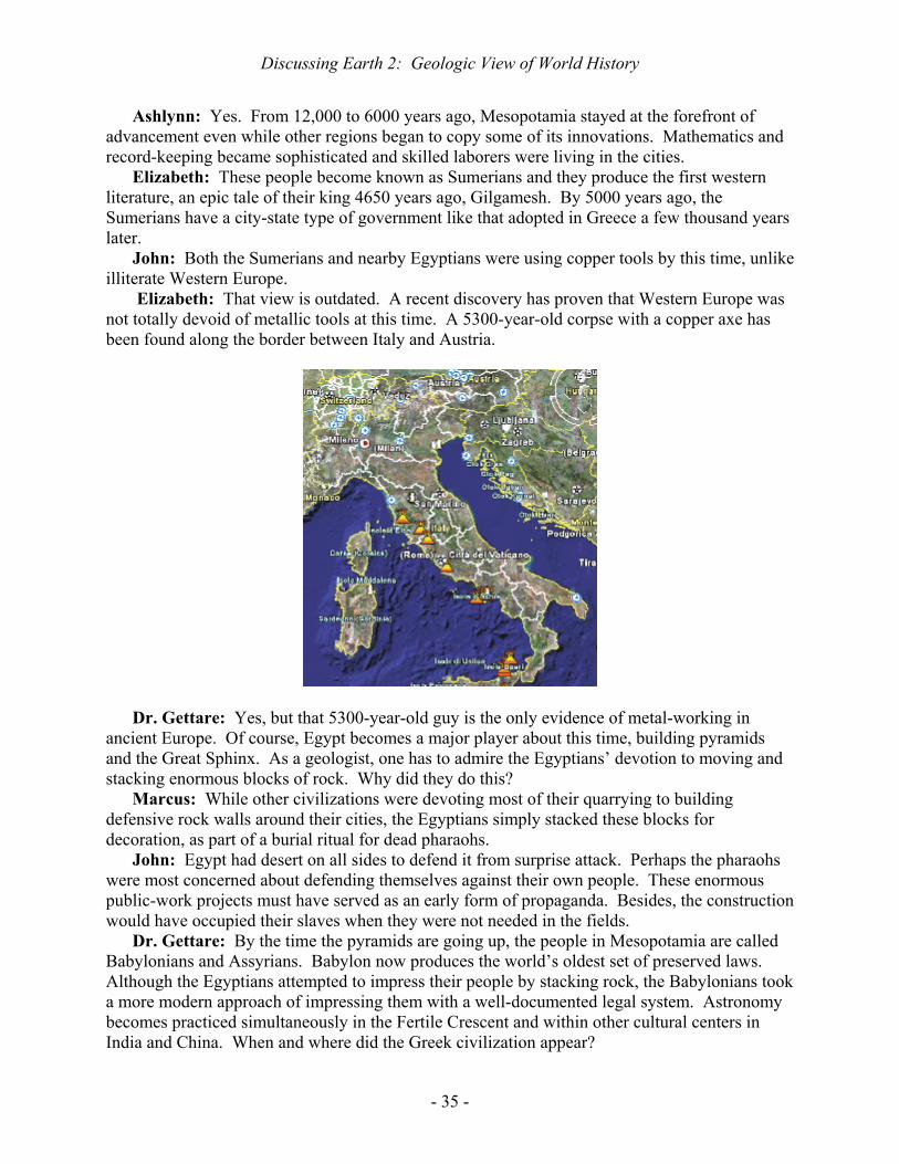
Marcus: The Fertile Crescent lies just north of this extensive desert region but it too includes some regional deserts that separated the early civilizations. For example, the desert of the Sinai Peninsula separated the Mesopotamians from the Egyptians.
John: Shown below is a view of the Sinai Desert from a satellite. The distance between the Nile delta on the left and Israel on the right is roughly 160 km (100 miles). Near the southern tip of the peninsula lies Mount Sinai, the famous landing site for Noah’s Arc when the biblical flood receded. At the foot of Mount Sinai stands the oldest monastery in continuous use, completed in 565 A.D. As can be seen in the photo, this has survived because of an impregnable defense and because the countryside is too dry to be valuable.

Discussing Earth 2: Geologic View of World History
- 34 -
Dr. Gettare: The Sinai seen here certainly looks like a barrier that could protect Mesopotamia from constant attack. Did Mesopotamia keep its early advantage for a long time?
Discussing Earth 2: Geologic View of World History
- 35 -
Ashlynn: Yes. From 12,000 to 6000 years ago, Mesopotamia stayed at the forefront of advancement even while other regions began to copy some of its innovations. Mathematics and record-keeping became sophisticated and skilled laborers were living in the cities.
Elizabeth: These people become known as Sumerians and they produce the first western literature, an epic tale of their king 4650 years ago, Gilgamesh. By 5000 years ago, the Sumerians have a city-state type of government like that adopted in Greece a few thousand years later.
John: Both the Sumerians and nearby Egyptians were using copper tools by this time, unlike illiterate Western Europe.
Elizabeth: That view is outdated. A recent discovery has proven that Western Europe was not totally devoid of metallic tools at this time. A 5300-year-old corpse with a copper axe has been found along the border between Italy and Austria.
Dr. Gettare: Yes, but that 5300-year-old guy is the only evidence of metal-working in
ancient Europe. Of course, Egypt becomes a major player about this time, building pyramids and the Great Sphinx. As a geologist, one has to admire the Egyptians’ devotion to moving and stacking enormous blocks of rock. Why did they do this?
Marcus: While other civilizations were devoting most of their quarrying to building defensive rock walls around their cities, the Egyptians simply stacked these blocks for decoration, as part of a burial ritual for dead pharaohs.
John: Egypt had desert on all sides to defend it from surprise attack. Perhaps the pharaohs were most concerned about defending themselves against their own people. These enormous public-work projects must have served as an early form of propaganda. Besides, the construction would have occupied their slaves when they were not needed in the fields.
Dr. Gettare: By the time the pyramids are going up, the people in Mesopotamia are called Babylonians and Assyrians. Babylon now produces the world’s oldest set of preserved laws. Although the Egyptians attempted to impress their people by stacking rock, the Babylonians took a more modern approach of impressing them with a well-documented legal system. Astronomy becomes practiced simultaneously in the Fertile Crescent and within other cultural centers in India and China. When and where did the Greek civilization appear?

Discussing Earth 2: Geologic View of World History
- 36 -
Elizabeth: That is a trick question because the oldest written record of the Greek language is actually on the island of Crete. Crete appears at the center of the underlying map, half-way between Athens and Africa.
Dr. Gettare: I must admit that you caught me. The Minoan civilization on Crete was
famous all over the eastern Mediterranean because the Minoans were ideally located for trade. John: The Greeks on Crete suppressed the native population and gave them a derogatory
name that has become used worldwide, cretini. Elizabeth: Although geology made Crete great, it also destroyed Crete because the adjacent
volcanic island of Thera exploded 3600 years ago with the greatest volume of volcanic ash that the world has seen throughout the past several thousand years, the equivalent of 60 cubic kilometers of rock.
Dr. Gettare: What would be the global consequences of such a voluminous eruption and how would anyone be able to estimate its volume?
John: Geologists could estimate the volume by measuring the thickness of the ash layer throughout the eastern Mediterranean, both on land and as seafloor sediment. They could tell which sediment came from that particular eruption because it would have a distinctive chemical composition, having become mixed in the atmosphere during the violent eruption.

Discussing Earth 2: Geologic View of World History
- 37 -
Ashlynn: Many Minoans must have died under a blanket of hot ash whereas the temperature effect farther away would have been the opposite, given that the ash and sulfur droplets from the eruption would have blocked sunlight and decreased temperatures globally. The ash must have settled within a few months but the effect of sulfur droplets would have lasted for several years, resulting in global cooling.
Elizabeth: The ash also nicely preserved Minoan artifacts by burying them. About 3300 years ago, the massive pyramids failed to do what they were intended to do, to preserve the pharaoh’s mummy and his personal artifacts from grave robbers. The only successful burial was in an obscure cave carved into a hillside. In 1922, a British archeologist opened that ancient tomb and, since then, Tutankhamen’s burial objects have toured the world, fascinating millions of museum visitors.
Dr. Gettare: Have any of you guys seen King Tut on National Geographic’s traveling exhibit? Philadelphia and London are the host cities this year.
Ashlynn: When the museums sell out at $30 a ticket, I can see why archeologists invest so much to find these treasures. Nonetheless, the exhibit was worthwhile because it gave me a direct link to the birth of our Western civilization, untarnished by the cartoon image that television tends to paint over everything. Here is Tutankhamen’s death mask.
Elizabeth: I am impressed that art and ritual were so important to the early cultures. The
ancients clearly sought to give everyone a well-defined place in society. Skilled artists had the same job for life, unlike the revolving door that results from modern mergers and acquisitions. I think that I would have been happier in King Tut’s day.
Marcus: You might have been happier, but one of those well-defined places in Egyptian society was slavery, as the Jews discovered around the time of King Tut, so you might not have been all that contented. Did the Egyptians not experiment with a monotheistic religion like that of the Jews at this time?

Discussing Earth 2: Geologic View of World History
- 38 -
Dr. Gettare: Yes. In fact, King Tut began his reign as a monotheistic ruler but started the movement back to the previous multi-theistic religion. Western civilizations have subsequently become monotheistic but the global debate of one god versus many gods is far from resolved, given that most people in Earth’s two most populous countries, China and India, still favor multiple gods if they are religious at all. Some of their gods are friendly and others are nasty.
Ashlynn: I suppose that the monotheistic debate has some effect on studying geology because multi-theistic religions tend to attribute geologic catastrophes to the actions of whatever nasty god happens to manage that aspect of nature whereas monotheistic religions try harder to find a natural cause for geologic catastrophes, given that a single god cannot simultaneously be helpful and nasty.
Dr. Gettare: Speaking of the Chinese, what were they up to 3000 years ago? Elizabeth: By 3000 years ago, the Chinese had already developed the pictograph language
that they still use. Moreover, they were producing a lot of bronze tools, so they must have been mining both copper and tin ore, given that those two elements are alloyed to make bronze.
Marcus: It turns out that bronze artifacts have survived the millennia much better than subsequent iron artifacts because iron typically rusts away completely whereas bronze develops a thin coating that protects the rest of the object from further oxidation, as on this weapon that was originally mounted on long pole.
Ashlynn: In the millennium before Christ, the Greeks, Persians, and Phoenicians were all
active in the eastern Mediterranean. The Phoenicians, in particular, developed a merchant marine fleet.
Dr. Gettare: Yes. The Phoenicians, living in the area of modern Lebanon, became the world’s first great sailors, to be followed by the Portuguese and the British thousands of years later. After all, Earth is the blue planet, largely covered by seawater, so having a powerful fleet is a huge advantage on this planet.
Elizabeth: I have a postage stamp that shows the great extent of the British Empire in 1898, serviced by the British Navy.
Dr. Gettare: I have the same stamp. One summer, I attended a boarding school that was later attended by one of Queen Elizabeth’s sons. The school’s most popular lyrics were, “ Rule,

Discussing Earth 2: Geologic View of World History
- 39 -
Britannia! Britannia, rule the waves! Britons never, never, never will be slaves! ” Given its navy, Britain has been the only European country to thwart invasion for the past millennium, ever since 1066 A.D. Here we see the original Phoenician base around Beirut.
Elizabeth: All sciences depend upon mathematics, even geology, so it was the
mathematician-geographers of ancient Greece who greatly expanded man’s ability to appreciate natural order. Fortunately, the Romans preserved the publications by Euclid, Archimedes, and Ptolemy and some of them remain in the Vatican.
John: Even though the Greeks are famous for having been theoreticians, were not the Chinese the best early inventors?
Dr. Gettare: Indeed they were. While the Greeks were famously hypothesizing, Chinese engineers were producing high-quality steel in a blast furnace. It took us Westerners another twelve hundred years to figure out that one needs to blast air into a furnace to make it glow hot enough to make high-quality steel. In Egypt, only the pharaoh’s chariot had an iron axle because the Egyptians relied upon meteorites for their iron.
Ashlynn: I suppose that it was a mixed blessing that the meteorite supply was very limited. More meteorite impacts would have killed more Egyptians.

Discussing Earth 2: Geologic View of World History
- 40 -
John: Steel must have offered a huge military advantage to the Chinese. Given that the Chinese already had a large population to send into battle, the only physical impediment to their conquest of the world was the barrier of a wide ocean to the east and a broad desert to the west.
Elizabeth: Like most societies, the Chinese had the psychological impediment of not wishing to take the risks that far-flung aggression inherently bring. In fact, they took a defensive stance by building the Great Wall a couple hundred years before the birth of Christ.
Marcus: It seems that every time the Chinese sneezed, another group of Mongols would attack them from the north.
Ashlynn: I cannot figure out how one-fifth of the Earth’s present population reads and
speaks Chinese. I took a semester of Chinese and nearly failed it. Lots of Chinese come to our University and learn to communicate quite well but I would surely be illiterate if the Chinese had taken over the world two thousand years ago, back when it would have been easy for them to accomplish that.
Marcus: The Chinese did not have a waterway like the Mediterranean to make distant colonization easy. Given the Mediterranean, Phoenician sailors established Carthage where the modern city of Tunis sits, 2300 km (1440 miles) away from Beirut.
Dr. Gettare: Carthage inevitably got in the way of the expanding Roman Empire. Rome became the undisputed ruler of the Mediterranean by killing most of the half-million inhabitants of Phoenician Carthage in 146 A.D. Meanwhile, the Chinese had moved on to less threatening inventions such as a device to measure earthquake intensity, a seismograph.
John: After annihilating Carthage, I have heard that Rome went on to become the most efficient mineral-exploration group in all of history. Whenever the Romans conquered new territory, they would imprison families that included hardy young men. The men would be shown samples of ore that the Romans suspected might occur in that area and the men would be given a few months to come back with directions to new deposits or every member of their family would be executed. Using this oppressive technique, the Romans found every ore deposit that is visible at the Earth’s surface throughout their area of conquest.

Discussing Earth 2: Geologic View of World History
- 41 -
Elizabeth: That is truly gruesome. Ashlynn: Perhaps I should make another attempt at learning Chinese. Buddhism must be
kinder and gentler. Marcus: The Romans finished their 50,000-seat Colosseum in 80 A.D. and staged
gladiatorial fights there. Those fights must have inspired the Survivor series on modern TV.
Dr. Gettare: The Colosseum certainly demonstrated the Romans’ ability to move massive
blocks of rock, as did the temples built by the Mayans a couple of centuries later in the Yucatan Peninsula of Mexico.
Elizabeth: Although the Romans are famous for their huge amphitheaters and extensive aquaducts, their lasting legacy is set more in documents than in stone, especially Christian

Discussing Earth 2: Geologic View of World History
- 42 -
documents. One of the great turning-points of history has to be the legalization of Christianity by the Roman Emperor, Constantine.
Ashlynn: At age 80, Constantine’s mother traveled from Rome to Jerusalem to collect the wood and nails from the Crucifixion, thereby becoming one of the world’s most famous archeologists. In fact, she was the first one to advocate building the monastery that we just saw, at the foot of Mount Sinai.
Dr. Gettare: By the time of Emperor Constantine, the Mesopotamian innovations of wheat farming, cattle, and horses have become widespread in northern Europe and a series of tribes from eastern Germany begins to threaten Rome, specifically the Goths, Visigoths, and finally the Vandals. You can guess where the derogatory word, vandal, originated.
Marcus: Rising temperatures in northern Europe probably aided population increases there, supplying the early Germans with lots of soldiers.
John: Although rising temperatures in a place like northern Europe will increase crop yields, there also is an increased threat of infectious disease because the rat population increases alongside the human population. Consequently, Europe became impacted by its first known plague from 542 to 594 A.D., killing half of the population. The number of casualties may have rivaled that of all the battles among the ancient warring factions.
Marcus: My dad always tells me to watch out for the sneaky little guys, the rats. Elizabeth: When the Germanic population began to rebuild from the plague, they celebrated
by starting to invade England. At that time, the inhabitants of England were Celtic, like the modern-day populations of Wales, Ireland, and Scotland.
Ashlynn: I guess that that is why I found it easy to learn German after I abandoned my attempt to learn Chinese. My professor kept telling me that English is just a dialect of German.
Marcus: My paleontology professor claims that the Anglo-Saxon invasion of England resembled the introduction of flowering trees to a world that had only known evergreens, back in

Discussing Earth 2: Geologic View of World History
- 43 -
the time of the dinosaurs. The similarity in invasion strategy is that in both cases, the previous population was pushed into undesirable land rather than become completely eliminated.
John: Evergreens certainly are not extinct but they only cover the landscape in cold or nutrient-poor places. The maple leaf on the Canadian flag is misleading because the standard tree in Canada is a spruce tree, not a maple. Maples are only common along the southern borderland with the US whereas evergreens dominate more northerly forests. In the same way, the original Celts of England have been pushed into cold Scotland or into areas with poor soil like Wales and Ireland.
Dr. Gettare: Spruce trees !! I would like to have a dime for every spruce that I walked past while a young geologist in Canada. The deciduous-tree invasion has been going on for a hundred million years. In contrast, the Arabs conquered much of the Mediterranean world in less than a century. In that brief interval, the Arabs went from nowhere to dominating a vast empire. The first year in the Muslin calendar is 622 A.D. and by 716 A.D., the Arab empire stretched from Lisbon, Portugal to China. How did they manage this so quickly?
Elizabeth: There must have been widespread discontent with the existing leadership all around the Mediterranean. The remnant Roman bureaucracy was imposing heavy taxes on a working class that felt disenfranchised, so the general populace would not fight to defend those bureaucrats. The Arabs offered streamlined government and a new religion that incorporated well-known aspects of Christianity and Judaism.
John: Besides, the new guys could ride like the wind, moving faster than the Germans with their blitzkrieg. If the Arabs had not been stopped in France in 732 A.D., we would all be reading from the Koran now, in Arabic.
Dr. Gettare: While the Arabs were consolidating their vast empire, global warming came to the aid of Scandinavians and they started expanding into Britain and Ireland, reaching Iceland in 861 A.D. and establishing a colony in Greenland a century later.
Marcus: The Vikings were really tough guys. Only a Viking would attempt to cross the North Atlantic in an open vessel when the Gulf Stream is going in the opposite direction. At that time, their settlement on Greenland could grow enough crops to support expeditions southward into North America.
Dr. Gettare: Indeed, so why are we not speaking Scandinavian here in North America? Ashlynn: Given that the Scandinavian language is a dialect of German, as is English, it
would surely be easier to learn than Arabic. However, the erratic climatic changes that have characterized Earth for the past two million years doomed Greenland to become Whiteland.
John: The name, Greenland, had been chosen by politicians who sought willing colonists. Continued use of that name is a tribute to false advertising. As the world turned colder, the colonists’ crops failed and the Greenland settlement began to starve. They wrote frantic pleas to be allowed to return to Europe but the Danish government just told them to tough it out, much like Hitler’s message to his troops in Stalingrad a millennium later.
Marcus: With the elimination of their expeditionary force, the Danes did not obtain American resources just as the Germans subsequently did not obtain Russian resources. The Danes did manage to conquer England in 1013 A.D. but a group of Vikings living in northern France took it from them just fifty-three years later. The so-called Normans eventually became assimilated into England rather than defeated on the battlefield. The Chinese have handled all their conquerors the same way.

Discussing Earth 2: Geologic View of World History
- 44 -
Elizabeth: One historical advantage of the Norman Conquest of England is that the Norman
conquerors demanded a list of everything in the country, for taxation purposes. The resulting Domesday book gives us our most comprehensive view of medieval society anywhere on Earth.
John: As books go, this has got to be the most boring one ever written. Dr. Gettare: In 1096 A.D., Europeans started sending crusades to capture Jerusalem. The
first crusade managed to do just that, killing nearly all of the city’s inhabitants. Nonetheless, Europe kept sending more crusades over the next couple of centuries. What was the European motivation if they had already achieved their objective?
John: The Arabs and Christians had been staring at each other for four hundred years following the rapid Arab conquest, waiting for someone to blink. The blink came from the Byzantine Catholic Church in Turkey because it felt threatened by the military advances of the Turkish Arabs. The Eastern Orthodox Catholic pope asked the Roman Catholic pope for troops.
Ashlynn: Like the original Celts of England who hired Anglo-Saxon mercenaries for their defense against Scandinavian marauders, this ultimately proved to be a mistake because the cure proved to be worse than the disease. The Fourth Crusade sacked Constantinople, now called Istanbul, and killed thousands of Eastern Orthodox Christians.

Discussing Earth 2: Geologic View of World History
- 45 -
Elizabeth: The Crusades were led by bored noblemen who apparently enjoyed hacking up
anyone who seemed a bit different from themselves. As they marched through European towns, they would slaughter any Jews that they could find, along with any Muslims. In the feudal medieval society of Europe, the eldest son inherited everything and younger sons had nothing better to do than become Crusaders. The Normans who conquered England in 1066 had first advertised for such ruffians across northern Europe. The Crusaders wore a cross sewn into their clothing and vowed to do something special upon reaching Jerusalem.
Ashlynn: The Crusaders’ wives seemed quite happy to live on the home estates while their husbands were off marauding in distant lands. Given their husbands’atrocities, one can imagine that the wives did not miss them all that much. In fact, the memory of the Crusades remains popular in places like France, perhaps because the French were then able to send their trouble-makers far from home.
Marcus: The Crusaders established small towns in the Middle East but most of the Crusaders would return to Europe after destroying as much as they could. Muslims would reenter the destroyed lands and reestablish communities, giving the next generation of Crusaders the excuse to return.
John: After Europe became bored with Crusades in the 1300’s, the Muslims retook every Crusader outpost except for Malta. In 1565, a large Muslim force tried hard to oust the few Crusaders who continued to live on Malta but the geology of the rocky island made it easy to defend so they survived until Napoleon appeared several hundred years later.
Dr. Gettare: As you can see here, Malta lies between Sicily and Africa. In World War II, the Germans tried even harder than the Arabs to destroy Malta because Malta provided an entry

Discussing Earth 2: Geologic View of World History
- 46 -
into Europe for the Americans in North Africa. More bombs were dropped on Malta than on any other place in all of history, including the London Blitz, but geology rescued the Maltese once again because the limestone island has lots of caverns in which to hide. The irregular topography above cavernous limestone is called karst topography.
John: The Germans should have learned from the failure of the Arabs. Karst in Yugoslavia similarly thwarted German plans. Karst delayed the German entry into Russia by six weeks and that forced them to fight the Russian winter, a fight that Napoleon also lost.
Dr. Gettare: The introduction of bombs certainly changed history. The first military use of
gunpowder for firing a mortar occurred in China in 1132 A.D. Marcus: I know that the Arabs learned about military gunpowder from the Chinese and that
the other western civilizations quickly learned that you either explode or implode. What geologic material is in gunpowder?
Ashlynn: The explosion in gunpowder comes from quickly turning a solid into a gas. Every time you burn wood or coal, you turn a solid into a gas but the process is too slow to propel anything, so you need a more efficient oxidant than the oxygen of air.
John: The essential ingredient of ancient gunpowder is a nitrate of either sodium or potassium. Either type of nitrate is called saltpeter. This oxidizing agent is mixed in varying proportions with combustible reactants such as charcoal and sulfur. Gunpowder typically has potassium nitrate, charcoal, and sulfur in the proportions of 15 to 3 to 2.
Dr. Gettare: As you can see, gunpowder is mostly composed of an oxidant rather than the material that combusts. Potassium nitrate is found in some caves and can be precipitated from water that drains from dung-heaps, or from urine. In modern times, sodium nitrate has mostly been obtained by mining dried-up desert lakes in Chile.
John: Here is a map showing where gunpowder was first used to propel a mortar, in the Chinese province opposite Taiwan.

Discussing Earth 2: Geologic View of World History
- 47 -
Ashlynn Gunpowder has allowed for easy subjugation of large populations by force, as in the Spanish conquest of Latin America, but a small group of conquerors must quickly introduce law and religion to cement that conquest or else the subjugated people will become disorganized, nonproductive, and rebellious.
Elizabeth: Literature is essential to nationalism. The Tale of Gilgamesh started that trend with the Sumerians 4600 years ago and the ancient Greeks created icons that were so popular that they became incorporated into the Catholic Church.
Marcus: The Romans controlled a vast empire with just a small number of representatives because they knew how to make their representatives unequivocally identifiable. Forging of resumes was a problem then as now, so the Romans identified their people with a peculiar type of purple rock that they discovered in the eastern desert of Egypt.
John: The purple rock found by the Romans in 18 A.D. differs in appearance from any other known rock and it occurs in one of the most remote corners of the ancient world, so it was easy to control its distribution. The locality is so remote that Napoleon’s army could not find it after conquering Egypt.
Marcus: Napoleon wanted the Roman rock to decorate his coronation as Emperor of France. To imitate the coronation ceremony of Charlemagne in 800 A.D., Napoleon needed a dozen virginal maids carrying candles. However, he joked that fifteen years of social revolution in France had made it difficult to find that many maidens.
Dr. Gettare: The Roman rock is 600 million years old and is volcanic, consisting of white feldspar crystals in a fine-grained, brownish-purple groundmass. The contrast in grain size between scattered large crystals sitting in a sea of tiny crystals makes this a porphyry. The composition is andesitic, half-way between basaltic and granitic-rhyolitic composition.
John: The white feldspar crystals must have formed slowly within a deep magma chamber. Presumably, they were carried upward to the Earth’s surface where the enclosing magma cooled quickly, making the fine-grained groundmass with the rich reddish-purple color. A reddish-

Discussing Earth 2: Geologic View of World History
- 48 -
purple color in rock usually comes from an abundance of manganese. Once discovered, all the subsequent Roman emperors and their wives wanted to be buried in a rock casket, a sarcophagus, made of this porphyry.
Elizabeth: In 330 A.D., Emperor Constantine celebrated the founding of his new capital,
now called Istanbul, with the erection of a porphyry tower that still stands a hundred feet tall (30 m tall). Constantine and his wife were each buried in sarcophagi of purple porphyry and hers remains preserved in the Vatican, as shown here. Even Westminster Cathedral in London incorporated this rock, the world’s most famous decorative stone.
Dr. Gettare: In Greek, “porphyry” means purple but a volcanic rock of any color has come to be called porphyry as long as it exhibits well-formed crystals in a fine-grained groundmass, like the underlying sample from California. Let us get back to our time track at the beginning of the second millennium, shortly after 1000 A.D.

Discussing Earth 2: Geologic View of World History
- 49 -
Elizabeth: There are far more bookstores than rock stores around the world and we should
honor the world’s first novelist, Murasaki Shikibu, the lady who wrote The Tale of Genji in 1008 A.D. while serving in the Japanese Court. This book has become a rite of passage for the Japanese in that modern high-school students still read original excerpts.
Ashlynn: The first western novel, Don Quixote de la Mancha, was written six hundred years later and has become a rite of passage for Spanish high schoolers. The Canterbury Tales of 1387 A.D. is the oldest English literature found in most school curricula.
Marcus: Besides the Bible, the most-read document in Western history has probably been the memoirs of Julius Caesar. Each of these famous documents has contributed to a sense of nationalism.
John: Yes, and that sense has contributed to the wars that have defined national borders along geologic boundaries such as water bodies, deserts, and mountain ranges.
Dr. Gettare: If nations have become defined by their early literature, what literature defines France, Germany, and the US?
John: Ernest Hemingway thought that Mark Twain wrote the first American novel, so I would vote for Samuel Clements, better known by his pseudonym, Mark Twain. Besides, Clements wrote with the same sense of ironic humor that made Don Quixote de la Mancha and The Canterbury Tales perpetual favorites. Maybe we should introduce some ironic humor in the last discussion of our series here. What about French irony?
Ashlynn: The French probably have more famous authors than any other nation. In the early 1600’s, Shakespeare of England, Cervantes of Spain, and Balzac of France were writing entertaining literature in their native languages while Germans like Kepler were still writing in Latin.
Dr. Gettare: Kepler was maintaining Germany’s Latin tradition, the tradition of Luther’s Theses against the Church in 1517 and Agricola’s De Re Metallica about mining in 1556. Even the Dutch humorist, Erasmus, wrote in Latin. How funny can a Dutchman be in Latin?
Elizabeth: For a seminal German-language masterpiece, one may consider Emmanuel Kant’s Kritik der reinen Vernunft (Critique of Pure Reason) published in 1781. However, this makes Milton’s Paradise Lost from 1667, another rite of passage, seem like easy reading.
John: Amidst all the medieval trials such as trial by fire and trial by water, Kant qualifies as a trial by words. The Germans were lucky that Hitler lost the war or else his badly written Mein Kampf could have become their standard bearer.
Dr. Gettare: I must confess that I read Paradise Lost while in the seventh grade just to gain bragging rights. However, this is enough about philosophical literature. Let us return to geography. The world suddenly became smaller in 1295 A.D. with the publication of Marco Polo’s memoirs. Polo had visited Kublai Khan, the great Mongol emperor, and brought back knowledge of many Oriental inventions, allowing the Western World to surpass the Orient technologically for the first time in a millennium.
Marcus: Yes, and the impact of my namesake, Marco Polo, was not subsequently rivaled until Richard Nixon visited China in 1972. However, Nixon’s visit has had the reverse effect and China has been rapidly incorporating Western technology since then.
Dr. Gettare: Going back to the thirteenth century, the English make a big deal about King John’s Magna Carta and the subsequent establishment of a parliament in the same year that Marco Polo published his memoirs. Did the first English parliament really change history?

Discussing Earth 2: Geologic View of World History
- 50 -
John: Ever since Julius Caesar snubbed the Roman senate, the world’s nations had mostly known one-man rule. One man can only know so much, so that type of rule inherently lacks creativity. The English were basically returning to the senatorial style of government that had made Rome strong in the first place.
Ashlynn: Of course, modern leadership mostly involves communication and the leaders barely have enough time to read into a camera whatever their speechwriters have prepared for them, let alone conduct any independent research.
John: I bet that some of the speechwriters are anonymous, even to the politicians who read their text. I know that if I ever were to become truly powerful, the first thing that I would acquire with that power would be anonymity.
Elizabeth: The odds are pretty good that you will get your wish of anonymity, but not because you have acquired any power.
Dr. Gettare: It is time to discuss somebody who really did “get there”, Columbus. Getting to America was not all that difficult or else there would not have been the flood of trans-Atlantic voyagers that immediately followed Columbus. What may have delayed that flood prior to Columbus?
Ashlynn: Everyone in Europe knew about Asia and its great wealth, especially silk, and everyone wanted an easier way to get there than the tortuous overland route toward the east. However, all the royal geographers knew that the westward distance was even greater. The circumference of the globe had been known by the best geographers since it was correctly estimated by the Greek, Eratosthenes, in 240 B.C. The best scholars knew that nobody could carry enough provisions to get that far by heading westward.
Elizabeth: Columbus toured the crowned heads of Western Europe with his calculation of just 3700 km (2300 miles) from the Canary Islands to Japan, but each set of scholars knew that he was wrong. He was very wrong. The true distance from the Canary Islands to Japan is close to half-way around the world (12,000 miles or 20,000 km). Even Queen Isabella of Spain turned him down, based on the scientific evidence, but her husband, Ferdinand, argued on instinct that they should fund him, so they did. This was one of the rare instances in history when regal instinct proved to be better than collective scientific wisdom.
John: Of course, the scientists were correct, but nobody knew that there was land between Europe and Japan. Columbus died believing his faulty calculation that had lured him westward. Nonetheless, Columbus did prove that persistence and daring can achieve great things, even if one lacks mathematical genius. Columbus remains one of the most influential men in all of history.
Marcus: Columbus was Italian and his fellow Italians put up half the money for his first voyage. I must say that more Italians have changed the direction of western history, for good or bad, than any other ethnic group, ranging from Julius Caesar undercutting senatorial power to Da Vinci inaugurating the Renaissance, Volta inventing the battery, Marconi inventing the radio, and Mussolini instituting fascism.
Ashlynn: What about Madonna Ciccone, the world’s most successful female recording artist?
John: Believe it or not, I am more impressed by Columbus. I have read all these accounts of Columbus sailing over to America on his four voyages but nobody writes much about him getting back to Spain. Given sailing ships like his, getting to America from the Canary Islands must have been easy because the persistent Northeast Trade Winds took him right over there

Discussing Earth 2: Geologic View of World History
- 51 -
(labeled NET on the underlying diagram). Whenever I vacation in the southern Caribbean, the wind is always blowing strongly from the east-northeast.
Marcus: If it was that easy for Columbus to get the Caribbean, it seems unlikely that he was the first to make it. I bet that he had some predecessors but they were smart enough not to brag too much about their spoils. Otherwise, they would have had to pay taxes and they would have faced competition, just like the competition that the Spanish faced as soon as other countries heard about their exploits.
John: Yes. Columbus found the world’s best pearls at Cubagua Island, between Margarita Island and mainland Venezuela, and the Spanish monarchy foolishly passed those around Europe, just whetting the appetite of other monarchs to launch their own expeditions.
Dr. Gettare: Let us take a geologic view of the Trade Winds. Everyone who has experienced the Caribbean Trade Winds says that they come from the east-northeast. However, they do not realize that they themselves are traveling very rapidly toward the east, given that they have a long way to go each day. Eratosthenes correctly calculated that the Earth’s circumference is 40,000 km (25,000 miles).
Ashlynn: Consequently, a person standing on the equator travels that far around the Earth in 24 hours, so they are traveling about 1700 kilometers per hour, a thousand miles an hour. The

Discussing Earth 2: Geologic View of World History
- 52 -
atmosphere is not perfectly bolted to the solid Earth so it lags a little, giving the Trade Winds a velocity of about twenty kilometers per hour (12 miles per hour). From a geological perspective, it is you who are traveling into the atmosphere rather than the air hitting you.
John: This still does not explain how Columbus ever got back to Spain in a sailing ship. To bring back the loot, Columbus had to “get there” in both directions. Ships like the Santa Maria, shown here, needed a tail wind.
Dr. Gettare: Fortunately for Columbus, the Trade Winds do not extend very far north. The
Trade Winds are a product of the global atmospheric circulation, as previously discussed. Every day, hot air rises off the equator and tries to distribute that heat to cooler portions of the globe in a great convection cell like the one you see when cooking soup on your stovetop.
John: However, differences in the apparent rate of Earth’s spinning, ranging from a thousand miles an hour at the equator to zero at the poles, interrupts the convection and most of the air falls back to the Earth’s surface between 20 and 30 latitudinal degrees from the equator.
Ashlynn: The descending air hits the Earth’s surface and half of it flows northward while the other half flows southward. Both of the resulting currents of air are affected by the Earth’s spinning, an effect that makes everything veer toward the right in the northern hemisphere.
Dr. Gettare: Let us review why it is that everything veers to the right in the northern hemisphere. If I am standing at the equator, I have the maximum amount of eastward velocity due to the Earth’s rotation. If I jump due northward off the equator, I jump into territory that is not heading eastward as fast as I am because I retain the equatorial velocity as I jump. That means that the place where I land will not catch up to me and I will not land due north as I had planned. I will land east of north. In other words, I will land to the right of where I intended to land. Using the same type of “mind experiment”, one may discover that you will veer to the right whether heading northward or southward in the northern hemisphere and will consistently veer to the left in the southern hemisphere.
Ashlynn: Getting back to air masses, the air that has descended and is flowing southward toward the equator becomes the Northeast Trade Wind. When it veers toward the right, that apparent deflection converts it into the east-northeast wind that we experience. If it did not veer to the right due to the Coriolis effect, that air would be a north wind, one that flows due south.

Discussing Earth 2: Geologic View of World History
- 53 -
Marcus: One thing I like about meteorologists is that they are consistent in their naming of wind. A north wind is always a wind from the north, never a wind heading north.
John: Columbus got home by going north along the western edge of the Atlantic Ocean until he reached the zone of descending air. To the north, Columbus picked up the Westerlies. These are the winds that flow northward from the zone of descending air and they too veer to the right. In this case, veering to the right means flowing from the southwest back toward Europe. Consequently, Columbus got a free ride in both directions.
Ashlynn: However, his flagship, the Santa Maria shown above, did not make it back. It ran aground on a reef off Hispaniola, the island that now includes Haiti and the Dominican Republic.
Elizabeth: Unfortunately for Columbus, his boys were partying with the natives while the ship slipped anchor through the night, hitting the reef.
John: Reefs have been withstanding hurricanes for five hundred million years so this reef was not about to give way to a wooden boat. Columbus left forty men, including his brother, in Hispaniola because the other two ships could not carry them all back to Spain. However, the natives killed everyone except for that brother before Columbus returned a year later.
Dr. Gettare: From that first encounter, inter-racial conflict became the order of the day. Within the next forty years, virtually all of the million natives of Hispaniola were to die, except for those taken as wives by the Spanish. Pure-bred Caribbean natives essentially became extinct in a process reminiscent of the many extinctions that have characterized all of Earth history.
John: Meanwhile, the other European powers must have grown envious of the Spanish loot. Ashlynn: Even before Columbus set sail, Henry VII of England had sent an offer to finance
him, but that offer arrived after Columbus had already committed himself to the Spanish. Elizabeth: The French soon got into the act, financing Verazanno to discover New York and
New England in 1524. Marcus: The most historic event in all those early years of conquest must be the day in 1532
when Pizarro defeated the Incas of Peru. Pizarro led 168 men a couple thousand kilometers from Panama to attack an Incan force of 80,000. His strategy of capturing the Incan leader arose from the success by Cortes who had captured the Aztec leader, Moctezuma, thirteen years earlier in Mexico City. However, Cortes would have failed without reinforcements from Cuba whereas Pizarro had no hope of reinforcements. He succeeded by sheer audacity.

Discussing Earth 2: Geologic View of World History
- 54 -
Ashlynn: Amidst all this blood and gore, there must have been some scientific advancement around this time. What about Galileo and Kepler?
John: Kepler was the first one to deduce that planetary orbits are elliptical rather than circular. This observation provided proof for Newton’s Law of Gravity.
Dr. Gettare: Galileo used a new Dutch invention, the telescope, to discover mountains and craters on our Moon, phases on Venus comparable to our Moon’s full-moon to new-moon phases, several moons orbiting Jupiter, rings around Saturn, and even the stars of the Milky Way. Why did the Dutch not keep their polished optical glass and do all this themselves?
Elizabeth: I have visited enough art galleries to know that the skies over Holland are typically overcast whereas Italian paintings usually show clear-to-partly-cloudy skies. The Dutch could not see the stars most evenings.
Dr. Gettare: Geology definitely favored Galileo over the Dutch who patiently polished the eyepieces that would make him famous. Let us shift our attention to the dreary skies of London. London suffered two great calamities in 1665 and 1666, the first being a plague that killed tens of thousands and the second being a city-wide fire. In the twelve hundred years since the Romans had left, London had become overcrowded and disorganized. The Romans were the last to have a fire department.
Marcus: In the mid 1600’s, Europeans still did not know that bubonic plague was carried by rat fleas so the Londoners listened to a misleading rumor when the plague broke out and foolishly killed every dog and cat in the city, eliminating all the natural enemies of the rats. The rat population rose and the human population correspondingly fell. Ultimately, it took a city-wide fire to vaporize the remaining fleas in 1666.
Dr. Gettare: I can still hear those fleas sizzling. How did London’s house construction contribute to the fire?
Elizabeth: Unlike the Italians and Spanish, Londoners did not use much geologic material in construction, preferring wooden walls and thatch roofs. Under the Norman kings from France, Londoners were told that after dark they should cover their fires (couvre-feu in French). This was to prevent fire, hence the word “curfew”. However, it only took one baker to forget to close his oven door on a single night in 1666 to render 80% of the city to ashes within five days.
Marcus: Londoners should have used geologic building materials like much of mainland Europe, specifically rock exterior walls, gypsum plaster interior walls, and tile roofs.
Dr. Gettare: It is obvious that rock and tile will not burn but what advantage does gypsum offer?
John: Gypsum in the form of either plaster or drywall has been used since the days of ancient Greece, if not before. Gypsum is the second-most abundant salt that one gets from evaporated seawater, after table salt, so there is plenty of it available. Gypsum is calcium sulfate that has water molecules built right into the structure. Ancient civilizations, starting at least 2500 years ago, would burn a little water out of gypsum and then add that water back to the powder just before plastering it up on walls. Within about twenty minutes, gypsum rehydrates and one has a plaster wall. Nowadays, we add the water just as we are extruding the mixture between sheets of cardboard, allowing it to react, harden, and dry while bonding to the enclosing paper.
Dr. Gettare: Very good. Gypsum is an excellent fire retardant because it gives up its water molecules again, when heated, and those water molecules help extinguish any fire. The years, 1665 and 1666, certainly were a couple of bad years for London, first becoming evacuated because of plague and then evacuated because of fire. Are any of these evacuees heading to America?

Discussing Earth 2: Geologic View of World History
- 55 -
Ashlynn: In 1681, the King of England granted Pennsylvania to William Penn. Penn was a Quaker pacifist who opened Pennsylvania to independently-minded people of all persuasions. He sold tracts of land to fellow Quakers from all over Europe, to Mennonites and Amish from Germany, to Huguenot Protestants from France, and to Jews.
Marcus: Perhaps the King of England thought that these people would become scattered throughout the vastness of North America. However, a geologic feature called the Appalachian Mountains delayed their westward trek so they clustered in communities like Philadelphia. By concentrating his dissidents in Pennsylvania, the king had doomed his regal successor to the events of May 10, 1775 when the Continental Congress in Philadelphia declared itself to be the government of the United States.
John: That declaration eventually resulted in the United States conquering Western Europe in World War II.
Dr. Gettare: A geologic event in Portugal twenty years before the Declaration of Independence shook up Europe in a different way. What was that event?
Elizabeth: That was the 1755 earthquake in Lisbon, Portugal. It killed 60,000 and had a profound psychological effect on the remaining Catholic-dominated areas of Europe, primarily the areas where romance languages like French and Italian were spoken. A French satirist, Voltaire, cited the earthquake as evidence against the existence of a caring God. His work prepared the French for their anti-clerical social revolution that brought Napoleon to power.
John: I suppose that that was the social revolution which made it difficult for Napoleon to imitate Charlemagne with his dozen candle-bearing maidens.
Marcus: We would all be speaking French by now if not for another geologic agent, the Russian winter. In 1812, Napoleon marched a couple hundred thousand troops into the jaws of a geologic force that proved to be capable of defeating him handily. One of the most famous sketches of all time shows the dwindling numbers of Napoleon’s forces as the temperature drops.

Discussing Earth 2: Geologic View of World History
- 56 -
John: Nonetheless, Napoleon left more of a legacy than any western ruler since Caesar. He standardized law with the Napoleonic Code, instituted surnames, and standardized science with the metric system. If he had been a better Earth scientist, he would have understood Russian climatology and held onto Europe. In that case, he would have also standardized global communication with the French language.
Elizabeth: In a sense, he did succeed there too. Napoleon’s linguistic influence lasted for nearly two centuries because French became the official language of worldwide diplomacy, until just recently. For the two millennia prior to Napoleon, the western diplomatic language had been Latin but he successfully changed that to French.
John: We should declare Babel to be the current diplomatic language because I can stick almost any text into a translating Web site and get any other language as output. We no longer need to declare any particular language to be official for the purpose of routine diplomatic exchanges.
Elizabeth: That would not work when it comes to details of treaties. There we would need the clarity of a single official language.
Dr. Gettare: You have all heard the expression that the world keeps getting smaller. What inventions compressed our globe through the 1800’s ?
Ashlynn: England had a passenger railroad in 1825 and Morse patented the telegraph in 1844. In 1876, Bell patented the telephone. The diesel engine was introduced in 1892. By the end of the century, Morse and Bell could get your message there instantly and the diesel locomotive was eventually going to get you there physically.
Marcus: The introduction of pneumatic tires in 1888 made the automobile practical. In 1895, Marconi patented wireless communication and then the world’s navies could be coordinated from their home ports. The world had not seen such dramatic changes since the introduction of gunpowder.
Dr. Gettare: Communication and travel by land and sea certainly improved dramatically following the inventions of the 1800’s. What was to come in the 1900’s? Did the world continue becoming smaller?
Marcus: In the 1900’s, the inventors turned their attention from the land and the sea to the atmosphere and outer space, first with the airplane and then with spacecraft. Now our government can photograph much of the globe every day to a resolution better than the width of a dime.
John: Given that level of surveillance, a clandestine attack on the United States like the Japanese attack on Pearl Harbor is no longer possible. Geologic boundaries presently have little bearing on military maneuvers.
Dr. Gettare: This may be true now but it was not true in the First World War. How did geology affect World War I?
John: The Germans easily defeated the French in 1871 and fully expected the same result in 1914. However, the French used their geologic setting to great advantage. As seen here, Paris sits at the center of a plain that is surrounded by a ring of hills. In three dimensions, Paris sits at the center of a stack of mixing bowls, with each bowl sitting inside another bowl. The bowls are composed of sandstone that resists erosion and forms ridges that face outward away from Paris. Between each bowl is soft shale that erodes easily and forms a depression between the ridges, much like a dry moat around an ancient castle.
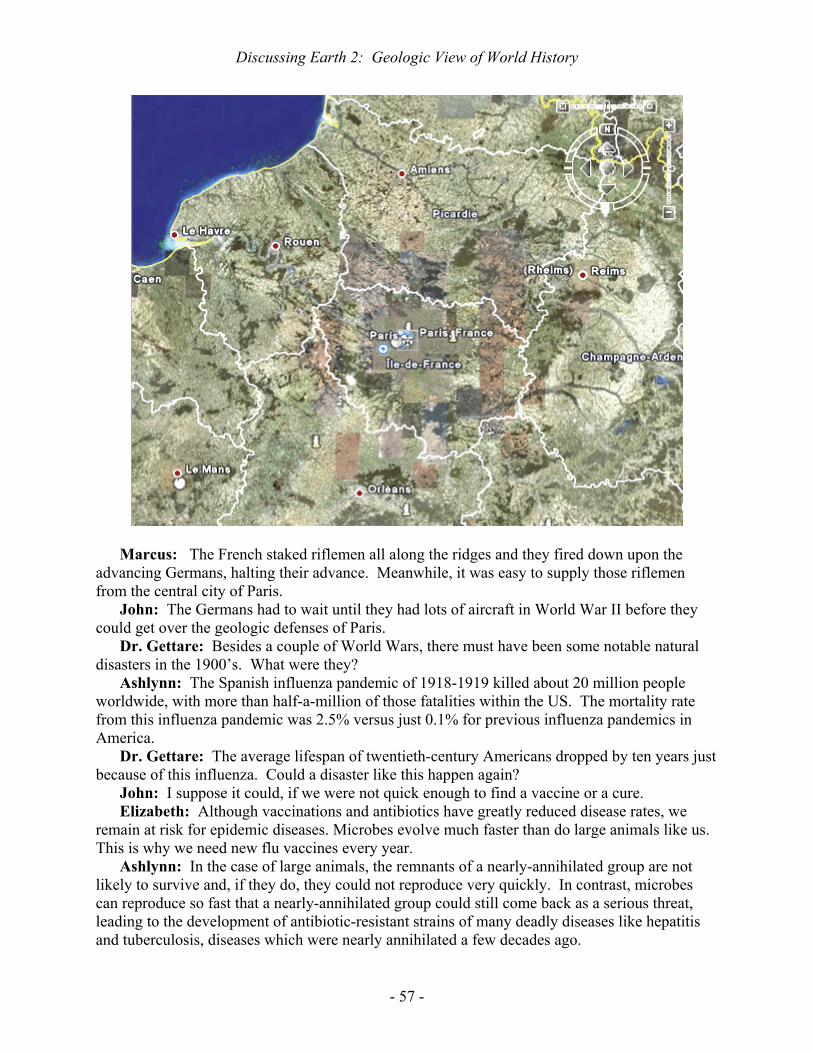
Discussing Earth 2: Geologic View of World History
- 57 -
Marcus: The French staked riflemen all along the ridges and they fired down upon the advancing Germans, halting their advance. Meanwhile, it was easy to supply those riflemen from the central city of Paris.
John: The Germans had to wait until they had lots of aircraft in World War II before they could get over the geologic defenses of Paris.
Dr. Gettare: Besides a couple of World Wars, there must have been some notable natural disasters in the 1900’s. What were they?
Ashlynn: The Spanish influenza pandemic of 1918-1919 killed about 20 million people worldwide, with more than half-a-million of those fatalities within the US. The mortality rate from this influenza pandemic was 2.5% versus just 0.1% for previous influenza pandemics in America.
Dr. Gettare: The average lifespan of twentieth-century Americans dropped by ten years just because of this influenza. Could a disaster like this happen again?
John: I suppose it could, if we were not quick enough to find a vaccine or a cure. Elizabeth: Although vaccinations and antibiotics have greatly reduced disease rates, we
remain at risk for epidemic diseases. Microbes evolve much faster than do large animals like us. This is why we need new flu vaccines every year.
Ashlynn: In the case of large animals, the remnants of a nearly-annihilated group are not likely to survive and, if they do, they could not reproduce very quickly. In contrast, microbes can reproduce so fast that a nearly-annihilated group could still come back as a serious threat, leading to the development of antibiotic-resistant strains of many deadly diseases like hepatitis and tuberculosis, diseases which were nearly annihilated a few decades ago.

Discussing Earth 2: Geologic View of World History
- 58 -
Dr. Gettare: What about earthquakes and volcanoes through the past century? John: In 1902, a glowing volcanic cloud killed about 30,000 on the Caribbean island of
Martinique. As shown here, Martinique lies in the middle of the magmatic arc. A northern island, Montserrat (with Plymouth as capital), has been volcanically active through the past decade.
Marcus: Two earthquakes each killed about a quarter-million people recently, one in China in 1976 and the other around the Indian Ocean in 2004. In the latter case, it was a three-meter-high (ten-foot-high) earthquake-generated tsunami that killed most of the people. These two earthquakes have killed nearly an order-of-magnitude more people than the deadliest volcanoes over the past century or so.
John: In 1985, a volcano in Colombia melted enough ice to produce a mudflow that engulfed about 25,000 people.
Dr. Gettare: That completes our geologic tour of history so we will start on resources.

- 59 -
Topic 3: Our Dwindling Geologic Resources
Moderated by Dr. Les Drop
Dr. Drop: Both the petroleum companies and government agencies project that your
grandchildren will run out of easily-extracted oil if global petroleum consumption continues to follow the trend of the past century. Do you think that the gasoline engine is doomed and that we should start building more bicycle factories?
John: The estimates of petroleum reserves have remained essentially unchanged since the 1920’s. The official estimates have stayed steady at a forty-year supply. Forty years!! They started making that estimate nearly a century ago.
Elizabeth: Both the rate of consumption and the rate of petroleum discovery have risen sharply through that time. Although the official estimates have proven to be inaccurate, eventually there will come a day when the oil wells run dry and we have to turn to other sources of petroleum to sustain our way of life. Fortunately, alternatives do exist. We can extract petroleum from both oil shale and tar sand. We can even make petroleum out of coal as the Germans did during World War Two.
Ashlynn: None of those alternative sources represent “easily-extracted oil” because both oil shale and tar sand involve a tarry substance like asphalt rather than liquid petroleum. The sedimentary rock has to be quarried and heated to release petroleum from the quartz grains and clay particles that hold the asphalt. Canadians have been doing this for more than three decades but it is an expensive proposition. If you drive through Canada, you will discover just how expensive it is.
John: Of course, Americans also experienced a doubling of gasoline prices following Katrina’s destruction of New Orleans and that price increase had little effect on consumption, so the tripling of price that would come from mining tarry rocks might also have minimal effect. We mostly drive to work and have little choice about that until mass transit expands. Nonetheless, “road rage” might take on a whole new meaning.
Marcus: We are already importing nearly two-thirds of our oil. Perhaps domestic oil-producing regions will run dry before foreign oil fields do. When we start looking at our last

Discussing Earth 3: Geologic Resources
- 60 -
drop, you can bet that we will not sit idly by while some third-world producers squander their oil on drag racing. I would invest in foreign bicycle plants before I would invest in American bicycle plants.
John: The world’s political organization is a product of World War Two. We had it easy because we were pumping 200 million gallons of American oil per day by the end of that war. The desperate German Army had to manufacture gasoline from coal. Germany has lots of coal but virtually no petroleum. The Japanese do not even have much coal. The German-Japanese lack of petroleum in the new age of fast-moving mechanized warfare, blitzkrieg, affected every move they made.
Marcus: Legally, we declared war on Japan six months before Pearl Harbor because our navy imposed an oil blockade on that island nation. The Japanese did not bother to finish off Pearl Harbor because there was nothing that they wanted in Hawaii anyway. They immediately sailed to Indonesia to take over the prolific oil fields there. The Germans did not take Moscow or Leningrad because those Russian cities had few useful war supplies. They focused on Russia’s southern oil fields but were not as successful as the Japanese in acquiring productive fields.
John: As for bicycles, the Japanese captured Indonesia within a few weeks of Pearl Harbor by safely landing far from the coastal defenses and riding into the cities on bicycles. Bicycles got oil for the Japanese whereas most of the Chinese are still riding along in the “Bicycle Age”.
Ashlynn: World War Two is ancient history but I am concerned about my grandchildren facing the last drop from oil wells. I am even concerned about coal, our prime source of electricity. I hear that US imports of coal tripled between 2000 and 2006. Are we running out of both oil and coal?
Dr. Drop: Resource consumption over time traditionally follows a symmetrical curve as do lots of natural phenomena. For example, here we see the observed daily variation in temperature in New York’s Central Park. The temperature continuously falls in the Fall just as it rose in the previous Spring.
Elizabeth: In the history of geologic resources, humans have discovered how to use
some previously-ignored resource like petroleum and have increasingly exploited it, moving up the curve of production. However, geologists eventually begin to find it difficult to meet the increasing demand and the curve flattens out at some point, just as the temperature reaches a plateau in the summertime. Going past that plateau, geologists cannot discover new resources at a rate that equals consumption so the resources become depleted to the point of exhaustion.

Discussing Earth 3: Geologic Resources
- 61 -
John: In 1956, an American geologist named Hubbert sketched the following curve for global petroleum. The volume units are barrels where one barrel equals 42 gallons. He later estimated that petroleum reserves would peak in 1995 and head into decline thereafter. If this Hubbert curve proves to be even vaguely accurate, the lead-up to Y2K will be remembered for more than the global computer scare. As you can see from this curve, we may now be in a “summertime” plateau during which petroleum production exhibits no obvious decline. However, the prediction is that your grandchildren will face shortages.
Dr. Drop: Has the early estimate of Hubbert stood the test of time? Shown below is the
2004 US Government estimate of global production.

Discussing Earth 3: Geologic Resources
- 62 -
Ashlynn: Hubbert’s estimate of a peak at 1995 conforms to the overlying curve even though the absolute amount of oil recovered has been nearly three times greater than his 1956 estimate, partly because of improved methods for increasing the proportion of total buried petroleum that is recoverable. Of course, global consumption has also been higher than was estimated half-a-century ago.
Elizabeth: In the theoretical Hubbert curve, the amount of recoverable oil at any given time, t, is Q(t) in the following equation. Qmax is the total amount of recoverable petroleum. The term, e, is the base of natural logarithms. Its approximate value is 2.718. The terms, a and b, are constants that must be determined by curve-fitting to actual data. According to the latest US government data, Hubbert’s determinations of a and b have proven to be remarkably good.
His constants, a and b, are related to the year of maximum production, tmax, according to the following derivative of the foregoing equation:
John: I think that it is too early to give Hubbert a posthumous prize. The downturn in
the production figures through the past few years could be just a minor retreat in a curve that will rise even higher. Given that nearly everybody on Earth now moves with petroleum, from cars to buses and diesel trains, I bet that we would have heard about worldwide protests if people really were getting stranded. The world is full of protests about this-and-that but I have not heard of any protests focused on petroleum supply.
Ashlynn: Petroleum occurs deep in the Earth where it is difficult to find, let alone estimate its recoverable volume. In contrast, recoverable coal occurs nearer the Earth’s surface so the global reserves should be easier to estimate.
Dr. Drop: Before leaving petroleum, we should note that one of the great peculiarities of modern science is that the chemical nature of petroleum remains partly unresolved, despite the fact that our modern world runs on it. A series of laboratories have been analyzing petroleum for scores of years but they report that many compounds remain unknown. The bright side of this issue is that future organic chemists will have lots to do.
Elizabeth: Hydrocarbons are the best-known compounds in petroleum and they follow a simple series, i.e., CnH2n+2 where n is an integer. If one substitutes one for n, the result is CH4 which is methane. Natural gas is largely composed of methane. Unfortunately, methane is both odorless and toxic so the gas companies add aromatic compounds to let you smell a leak. Several other members of the hydrocarbon series are well-known to you. These include number three, propane, which is C3H8. Some camp stoves run on butane which is number four, C4H10. Most famous is octane, number eight, C8H18, because all car engines are designed to run on octane.
Ashlynn: Although car engines are designed for octane, they can run on gasohol, a mixture of gasoline and ethanol, usually 10% ethanol. Ethanol is the type of alcohol in beverages so you might think that it is expensive but the high price of alcoholic beverages mostly comes from taxes. Ethanol actually can be made cheaply from waste corn.

Discussing Earth 3: Geologic Resources
- 63 -
Marcus: Not surprisingly, gasohol continues to be popular in corn-producing States like Illinois, Indiana, Ohio, and Nebraska (home of the Cornhuskers football team). Gasohol has been temporarily mandated in several other States, including North Carolina back in 1985, but gasohol burns hotter than gasoline so some engines have their valves overheat when burning gasohol. Gasohol will surely come back everywhere as we run out of gasoline so you should check with a mechanic about the potential valve problem before selecting a new car.
Dr. Drop: Let us consider coal. The USA is certainly blessed with coal, given that we have as much coal as the sum of the next-higher pair of coal-rich countries, China and Russia. Hubbert estimated that the peak global production for coal would not occur until 2150.
Ashlynn: If accurate, that would get us to our sixth-generation descendants, our great-great-great-great-grandchildren. Most of us do not know the names of our great-great-great-great-grandparents so we tend not to worry about anybody who may live that far into the future.
Marcus: Was that “great-great-great-great-great” or just “great-great-great-great”? Personally, my long-term and short-term goals coincide with the day when I will be a graduate who is making decent money. However, I suppose that I do not want my grandchildren to be stuck with a coal-burning steam engine that belches thick black smoke. What about electric cars?
Dr. Drop: We certainly could generate electricity from coal and use that to power cars. However, the process is very inefficient and I doubt if the existing prototypes of purely electric cars will ever become mass-marketed. Ethanol from agriculture is already widely used and I expect that post-gasoline cars will run on ethanol.
Ashlynn: By that time, there will probably be few cars of any kind compared to mass transit. Our society continues to become more urban and the major cities will probably ban private automobiles in favor of biofuel-powered taxis and enhanced mass transit.
Elizabeth: Are we not overlooking nuclear power? Dr. Drop: Nuclear fission presently generates about 16% of the world’s electricity.
After a hiatus in nuclear-plant construction through the past two decades, this proportion is likely to grow through the next couple of decades or more. Beyond that, the biggest unknown in the energy equation is nuclear fusion.
Elizabeth: The world’s first attempt at constructing a nuclear-fusion facility with net output of power is scheduled to be operational in southern France by the end of 2016. This will be the International Thermonuclear Experimental Reactor, ITER for short. The first fusion plant that produces some commercial power will follow thereafter, the so-called Demonstration Power Plant, or DEMO for short.
Marcus: If DEMO is successful, geologic resources will no longer be a prime issue in the generation of electricity because the fusion fuel is just hydrogen and we have plenty of H2O. After all, we are the blue planet because Earth is mostly covered with water.
John: Nuclear fission, on the other hand, requires uranium ore and uranium resources follow the same type of Hubbert curve as do petroleum and coal. We may well run out of uranium ore about the same time as we run out of petroleum. If so, our grandchildren will certainly be hoping that DEMO demonstrates the feasibility of nuclear fusion.
Dr. Drop: Uranium for fission plants is extracted from a mineral called uraninite. It is a simple cubic oxide with the same crystal structure as table salt. Uraninite is one of hundreds

Discussing Earth 3: Geologic Resources
- 64 -
of minerals that we mine every day to keep our complicated industrial society working. We need more than thirty minerals just to build a cell phone. If we run out of any of those minerals, we may have to change our lifestyle so let us turn our attention to minerals that are not fuels. These minerals provide us with metals, construction materials, fertilizer, and even the soil that supports agriculture. Fortunately, minerals are easy to study. To open our discussion of minerals, I suppose that I should pose the most-commonly-asked question in introductory geology, “What is a mineral?”
John: That is a trick question because most geologists have defined minerals in such a way that they can avoid the myriad of solid organic compounds that comprise coal and asphalt. However, other geologists simply say that a mineral is any solid, naturally-occurring, homogeneous, crystalline substance. That simple definition has to include the compounds in coal and tar.
Marcus: If one avoids solid organic compounds, there are roughly 3500 minerals. However, if one includes them, the number rises toward a million and mineralogy becomes a vastly more complicated subject. Personally, I vote for the slack geologists who try to avoid organic compounds. If every geology student had to take organic chemistry, they would be competing with pre-med students and few geologists would ever graduate. Then nobody would be looking for the geologic resources that we need to maintain our industrial society.
Elizabeth: If virtually every kind of mineral has proven to be useful, then I suppose that we need an overview of mineralogy before we can appreciate why it is that each type of mineral possesses unique properties which make it useful in its own way.
Dr. Drop: Minerals are so basic to everyone’s life that they deserve a fairly thorough review. Most minerals are called silicate minerals because the two most abundant chemical elements in them are oxygen and silicon. The silicon and oxygen are arranged in a pyramidal form called a tetrahedron, shown here. The pyramid consists of three sides and a base, making a total of four isosceles triangles. The Greek word for four is tetra, hence the name, tetrahedron.
John: Silicon lies at the center of the pyramid, roughly where the pharaohs were buried within their pyramids, and oxygen occupies each of the four corners. Some tetrahedra have aluminum instead of silicon at the center, making aluminum the third-most-abundant element in the Earth’s crust.
A Silicon-Oxygen Tetrahedron
Dr. Drop: The two most abundant minerals in Earth’s continental crust, i.e., feldspar
and quartz, are characterized by tetrahedra that share all of their oxygen atoms with adjacent tetrahedra. This is like row housing where adjacent houses share walls. As you might imagine, this three-dimensional framework makes feldspar and quartz hard minerals. Diamond, the hardest of all minerals, has the same framework structure but it has carbon atoms both at the center and at the corners of all tetrahedra. Diamond has the same chemical formula as graphite, the mineral in pencils. However, diamond is extremely scarce compared to graphite. Why is diamond so scarce?

Discussing Earth 3: Geologic Resources
- 65 -
Elizabeth: Natural crystallization of diamond requires extremely high pressure, equivalent to about 150 km (90 miles) of overlying rock. Consequently, diamonds can only crystallize far beneath the crust, within the Earth’s mantle. To find diamonds at the Earth’s surface, those diamonds must have been blasted upward along with some gas that was escaping from the mantle.
Marcus: Fortunately, this is a rare event or else our cities would be blasted by escaping gas. In contrast, graphite can form from organic matter that becomes metamorphosed at much shallower depths, under just a few kilometers of burial. Ordinary mountain-building processes commonly lift rock from that depth to the Earth’s surface, as has happened around Raleigh, North Carolina. Graphite is particularly common in western Raleigh where it underlies most of the elongated ponds, given that graphite is easily eroded.
Ashlynn: Of course, we can now make flawless diamonds in the laboratory and we have a bizarre pricing system where the value of a diamond increases as the flaws decrease but then the value plummets for a flawless diamond because it is presumed to be artificial.
Dr. Drop: I should have known that Elizabeth and Ashlynn would be experts on diamonds. I hope that Marcus and John, on the other hand, will consider moissanite when the big day comes. Moissanite is composed of alternating carbon and silicon atoms rather than pure carbon. Moissanite shares most of the famous physical properties of diamond except the high price, given that it is manufactured here in the Research Triangle Park. In the periodic table, we can see that silicon occurs right below carbon, making silicon the element that most resembles carbon.
Uppermost Chemical Elements in the Periodic Table
H He
Li Be B C N O F Ne
Na Mg Al Si P S Cl Ar
Marcus: I have heard that some suitors choose to spend a lot of money on a diamond
rather than a down payment on a house, but my Spanish friends have better priorities. The Spanish verb for getting married is literally “becoming housed”. I suppose that the ultimate folly would be spending so much money on a diamond that you have to live with the in-laws for a while after you get married. That would literally be a “diamond in the rough”.
Dr. Drop: Yes, and if the in-laws ruined the marriage then the couple would find that there is virtually no market for used diamonds. Let us return to the common minerals that have the three-dimensional structure of a diamond. These are the framework silicates like feldspar and quartz. Quartz is well-known to everyone because it accumulates on beaches. However, the continental crust actually contains about four times more feldspar than quartz. Why have most people never heard of feldspar but everyone has heard of quartz?
Ashlynn: Loose crystals of feldspar are rare because feldspar readily weathers to become soil minerals. In contrast, quartz does not change within a soil profile so it survives to be moved by rivers down to a beach.

Discussing Earth 3: Geologic Resources
- 66 -
Dr. Drop: Very good. The centers of the tetrahedra in quartz are occupied exclusively by silicon. In contrast, feldspar always contains some aluminum-bearing tetrahedra in addition to silicon-bearing tetrahedra. Aluminum has a smaller electric charge on it than does silicon. No matter what the individual atomic charges may be, every mineral has an overall neutral charge. You already know that because you have never received an electric shock by picking up a mineral.
Elizabeth: In minerals, the positively-charged ions like aluminum are always balanced by negatively-charged ions such as oxygen. Given the smaller electric charge on aluminum, feldspar must incorporate additional positively-charged ions to balance the negative charge of the oxygen atoms. The additional positively-charged ions are all soluble elements, specifically potassium, sodium, and/or calcium. When these elements become dissolved during weathering, the entire feldspar structure breaks down and a clay mineral is the usual product. Although few people know about feldspars, everyone knows the clays which they become.
Marcus: When I look at my mother’s granite countertop, I see that most of it is composed of pastel-colored crystals with parallel lines running across them. Are these crystals feldspar? What are the lines? The clear quartz in the rock does not display those lines.
Dr. Drop: Feldspar crystals do indeed exhibit parallel lines because they have inherent planes of weakness called cleavage. Moreover, the feldspars flip back-and-forth in their crystal orientation as they grow, producing twinning. In contrast, quartz has no apparent cleavage and generally does not twin as it grows.
Ashlynn: Marcus had a party at his house last week and his mother’s countertop has differently-colored feldspar than that of my mother. In fact, only the quartz looked the same in the two types of granite. What causes the color differences?
Dr. Drop: Many silicate minerals would be pure white if they had the chemical formula that you find in a textbook. However, tiny amounts of impurities give them some other color. For example, corundum is a white mineral with the formula of Al2O3, aluminum oxide. If you buy sandpaper with that formula printed on the back, then the sand-sized mineral glued to your sandpaper is corundum. You do not pay much for sandpaper so you must know that white corundum has little value. However, when a little chromium replaces some of the aluminum in corundum, the mineral takes on a deep red color and we call it ruby. Rumor has it that ruby crystals are worth more than white sandpaper crystals, even though they all have the same physical properties. When a little iron and titanium replace some of the aluminum, the mineral takes on a deep blue color and we call it sapphire.
Marcus: Could you make ruby and sapphire by growing aluminum-oxide crystals with the right impurities?
Dr. Drop: Of course you could. The American chemical industry is the best in the world. You can get anything you want at Alice’s restaurant, including artificial ruby and sapphire.
Ashlynn: If you do not like investing in diamonds, rubies, and sapphires, then what would you buy as a hedge against inflation? I know that one’s house is supposed to increase in value with inflation but lots of people live in apartments instead of houses.
Dr. Drop: Throughout history, the favorite investment has been gold and gold remains a popular investment today because it rarely loses any value and can readily be sold. Moreover, gold is easily transported. Despite the best efforts of alchemists, nobody has

Discussing Earth 3: Geologic Resources
- 67 -
made gold from something else using chemical reactions so it does not suffer the shortcomings of gems like ruby, sapphire, and diamond. On the other hand, nuclear reactors like the one on the NC State campus destroy a little gold every day by bombarding it with neutrons and turning it into mercury.
Ashlynn: I know that there are more ways of arranging silicon-oxygen pyramids than sharing all the corner oxygens. What about long chains of pyramids?
Dr. Drop: There are two types of chains, one like a single-lane road and the other like a two-lane highway. Here is the single-lane chain, called a pyroxene because this mineral group does not melt in a typical fire, given that “pyro” means fire in Greek.
A Single Chain of Linked Tetrahedra: The Pyroxene Structure
John: The chains of tetrahedra are formed by the sharing of two of the four oxygen
atoms in each tetrahedron. For simplicity, oxygen atoms are not illustrated at the tetrahedral corners in the overyling sketch but you should imagine them to be there. The shading indicates that the tetrahedra are pointed upward toward you.
Elizabeth: If you count the number of oxygens and silicons in this geometric form, you will find that there are three times as many oxygens as silicons. The electric charge on each oxygen is always -2 and that on silicon is always +4. Consequently, each tetrahedron has a net negative charge of -2 and this negative charge must be balanced by something other than the silicon which resides within each tetrahedron. Outside of the tetrahedra, pyroxenes have positively-charged calcium, magnesium, iron, and other elements to balance the charge. The mixture of those elements determines the color of the pyroxene crystal as well as its other physical properties.
Ashlynn: What about the two-lane chains? I believe that they are called amphiboles.
A Double Chain of Linked Tetrahedra: The Amphibole Structure
Dr. Drop: Yes. The double-chain silicates are called amphiboles because “amphi”
means “both” in Greek. This structure is just a cross-linked pair of pyroxene chains.

Discussing Earth 3: Geologic Resources
- 68 -
However, one should pay attention to the arrows in the foregoing sketch because this structure may continue sideways for millions of units. Each of these is called a unit cell.
Ashlynn: Do organic compounds also have unit cells? Dr. Drop: Yes. However, organic compounds have much larger and more complicated
unit cells than do silicate minerals. In contrast, silicate minerals are incredibly simple and repetitive. Let us consider a yard-long crystal of mica that you could purchase in a rock shop. This crystal will resemble a huge sheet of paper because of its cleavage. The fact that you could pick apart this large crystal using your fingernail reflects a repetitive arrangement of just a few atoms. To help you visualize the number of unit cells in a yard, I would note that there could be a million unit cells stretched across the period at the end of this sentence.
Elizabeth: Let us attempt a more precise calculation for a small crystal of mica. Almost everyone has seen mica because it occurs in most igneous and metamorphic rock. Certainly, everyone in central and western North Carolina has seen flakes of mica shining brightly in the soil because they act like tiny mirrors. How many tetrahedra would stretch across the edge of a mica flake that is just one centimeter (1/3 inch) wide? Let us assume that each tetrahedron in mica has the width of a tetrahedron in quartz, namely, about 0.5 nanometers. You may recall that a nanometer is 10 to the minus nine meters (10-9 m). How many tetrahedra would there be?
John: First, we may note that 0.5 nanometers equals 0.5 times ten to the minus seven centimeters (0.5 x 10⁻⁷ cm), given that a meter consists of a hundred centimeters. I do not even need my hand calculator to divide one centimeter by 0.5 times ten to the minus seven centimeters. The result is twenty million, so there would be twenty million tetrahedra along the edge of a centimeter-wide flake of mica.
Sheet Silicate Structure (A Sheet of Tetrahedra)
Dr. Drop: Very good. There are two common types of mica. There is the black mica,
the one that is rich in iron and magnesium. It is called biotite whereas the common white mica is called muscovite. Muscovite is richer in aluminum. From this, you may see that the color of a mineral typically depends upon its elemental composition.
Ashlynn: Like most minerals that form deep within the Earth, the black mica (biotite) contains iron in the ferrous state (Fe2+ state) versus the ferric state (Fe3+ state). Minerals like biotite oxidize (rust) upon exposure to Earth’s atmosphere, thereby changing color from black to orange.
John: The mineral that is most commonly confused with gold in North Carolina is weathered biotite rather than fool’s gold. Fool’s gold is an iron sulfide called pyrite. The shiny golden mineral sitting at the bottom of a shallow stream is just too hard to resist. Weathered biotite is shiny because it consists of flat flakes that reflect sunlight like little

Discussing Earth 3: Geologic Resources
- 69 -
mirrors. In fact, gold-colored biotite can be shinier than gold itself since gold never occurs as mirror-shaped flakes.
Marcus: The first Europeans who roamed around the Americas were looking for gold. Pizarro picked up twenty tons of gold and silver by knocking off millions of Incas with just 168 men, fifty years after Columbus had landed. Here is a painting of Pizarro who “nosed his way” into South America. Despite being illiterate, Pizarro did understand basic mineralogy. Did any of those early explorers bring the wrong stuff back to Europe?
Dr. Drop: Yes, a few of the conquistadors regretted not having taken introductory
geology before investing all that effort in seamanship and military maneuvers. The most famous example was Jacques Cartier, the Frenchman who claimed mainland Canada in 1542, ten years after Pizarro had claimed Peru. Cartier returned to France with a ship full of fool’s gold (pyrite) that he mistook for real gold and quartz that he mistook for diamonds.
Marcus: Cartier’s ignorance of mineralogy not only cost him his royal commission but established a proverb that continues today in the French language. When they spot a fake, the French say that it is as false as Canadian diamonds.
John: After a half-millennium of unchecked popularity, this proverb persists today even though the Canadians finally did manage to open a diamond mine, their first, in 1998. Jacques Cartier did not get within 3200 km (2000 miles) of those diamonds but he did claim

Discussing Earth 3: Geologic Resources
- 70 -
Canada for the French and about one-quarter of Canadian citizens continue to speak French, except for reciting the proverb about diamonds.
Dr. Drop: What should Cartier have been looking for in the specimens that he collected, to help with mineral identification?
Elizabeth: Minerals are identifiable from their physical properties such as density, hardness and luster. Being homogeneous, those properties remain constant throughout all portions of a mineral specimen.
Dr. Drop: Let us start with the property of density. Density is a property that you can determine with equipment found in a typical home. When I was working in Colombia in 1970, I was offered some large gold bracelets at a low price. I wanted to determine if they were entirely composed of native gold, a mineral with a density of 19 grams per cubic centimeter (19 g/cm3), or were filled with lead beneath a gold coating, a common practice in Colombia.
Marcus: At nineteen times the density of water, gold is the densest substance that you commonly encounter. A movie scene with a robber picking up a gold brick with one hand is nonsense unless he is a prize fighter. The density of lead is a little over half the density of gold (11 g/cm3).
Dr. Drop: Being uncertain about the purity of the gold bracelets, what do you think that I did?

Discussing Earth 3: Geologic Resources
- 71 -
John: I bet that you asked for some graduated measuring cups and either a kitchen weigh-scale or a postage meter. Given the weight of the bracelets and the volume of water that they displaced in a measuring cup, you could readily calculate the density.
Dr. Drop: Yes, that is exactly what I did, and I found that the bracelets were authentic.
Pizarro extracted twenty tons of gold and silver from the Incas in 1532 but he apparently left a little for subsequent invaders of South America.
Elizabeth: Let us consider other mineral properties. Each mineral has a distinctive chemical composition. The following abbreviation of the periodic table highlights the most common chemical elements. This truncated table consists of just 36 of the 88 naturally-occurring elements but that includes most of the mass of the crust, specifically the top thirteen elements and twenty of the top twenty-four.
Dr. Drop: OK. Why are light-weight elements generally more abundant than heavier elements?
Order of Abundance of Chemical Elements in Earth’s Crust (Ordered by Mass) H 10
He
Li Be B C 17
N O #1
F 13
Ne
Na#6
Mg #8
Al #3
Si #2
P 11
S 16
Cl 20
Ar
K #7
Ca #5
Sc Ti #9
V 19
Cr 21
Mn 12
Fe #4
Co Ni 23
Cu Zn 24
Ga Ge As Se Br Kr
John: Most elements are made within stars. Helium is made by nuclear fusion of
hydrogen. Similarly, nuclear fusion of carbon produces magnesium, sodium, neon, and oxygen. However, production of dense elements requires the gravitational attraction of a very large star. For example, our star cannot make uranium. Moreover, all the uranium ever made in large stars is unstable and will eventually decay to lead. With the notable exception of iron, dense elements tend to be rare. Iron has the most stable combination of protons and neutrons, with its 26 protons and 30 neutrons.
Dr. Drop: Very good. Now, how would you use the foregoing periodic table to estimate the relative densities of minerals for which you know the chemical composition? For example, let us consider three types of salt, lithium chloride, sodium chloride, and potassium chloride. Which do you think would be the densest?

Discussing Earth 3: Geologic Resources
- 72 -
Elizabeth: Atomic weight generally increases through the periodic table so one may rank-order a mineral’s elements in terms of mass. Of course, density does not necessarily increase with an increase in mass because the volume might increase even more than the mass. However, ionic radii do not usually increase proportionately with an increase in atomic number so heavy elements usually make a mineral dense. In fact, a mineral with heavy elements may actually have the same molar volume as one with a similar number of light-weight elements, making the mineral with heavy elements correspondingly denser.
Ashlynn: Each chemical formula indicates the proportions of chemical elements in the respective mineral. The mineral with the highest proportion of heavy elements may therefore be predicted to be the densest.
John: In the example of lithium chloride, sodium chloride, and potassium chloride, the alkali elements have a simple progression through the periodic table, with lithium being the lightest and potassium being the heaviest. Of course, chlorine is the same in all three salts, so I would predict that lithium chloride would be the least dense and potassium chloride would be the most dense.
Dr. Drop: You are partially correct. Your first hint that you might not be totally correct is that you have probably seen Morton Lite Salt® for sale in a grocery store. This is a mixture of potassium chloride with regular table salt, sodium chloride. If you lose a lot of body salt with summertime sweat, it is better for you to replace your electrolytes with a mixture of potassium-sodium chloride rather than pure table salt.
Marcus: According to the periodic table, potassium has nearly double the atomic weight of sodium, 39 grams versus 23 grams. However, solid sodium is actually denser than solid potassium, 0.97 grams per cubic centimeter versus 0.89 grams per cubic centimeter because the ionic radius of potassium is so big.
John: The inclusion of the word, Lite, in Morton Lite Salt® is a good hint that potassium chloride is an exception to the rule of increasing mineral density. Potassium chloride has a density of 1.99 grams per cubic centimeter whereas sodium chloride is denser, at 2.16 grams per cubic centimeter. A mixture with potassium chloride really is lighter than pure table salt. However, the difference in density probably could not be detected without having a weigh scale.
Dr. Drop: I have never carried a weigh scale on a geologic expedition but I always carry a magnifying glass to examine crystals. My magnifier is not the cumbersome device carried by Sherlock Holmes, to be held at arm’s length, but something the size of a quarter that I hold close to my eye, so that I can maximize my field of view. Here is a typical hand lens. No geologist leaves home without one.

Discussing Earth 3: Geologic Resources
- 73 -
Ashlynn: What do you look for with your hand lens? Dr. Drop: First, I look for crystals because crystal shape can be diagnostic of a mineral.
Unfortunately however, most mineral grains do not exhibit an obvious crystal shape. Most minerals grow into other crystals that are simultaneously growing, so none of those mineral grains have the space needed to develop the crystal outlines that they would like to display. Nonetheless, you have surely seen some well-formed crystals displayed as decorations.
Ashlynn: Let us each share our most vivid memory of some mantle-piece crystal. I saw my most memorable crystal in Germany. Somebody was selling spectacular amethyst crystals in an open market for next to nothing. I looked at the large specimen for a long time before realizing that I had better things to do on my vacation than carry several pounds of quartz all over Europe.
Marcus: I have never been to Europe but my cousin imports huge amethyst-filled geodes from Brazil for sale at jewelry stores and flea markets. He makes at least 100% profit on each sale. That beats earning a few percent of annual interest on a bank deposit.
Elizabeth: My mom bought one of those amethyst geodes and it sits on our coffee table. She gets me to dust it every week.
John: You guys do seem to like purple but amethyst is just purple quartz. My favorite purple crystals are fluorite, calcium fluoride. Purple cubes of fluorite line Tennessee geodes along with white dolomite crystals. The crystals in the underlying photo have a dusting of shiny sulfides.
Marcus: I like those Tennessee specimens too but my most memorable crystal must be the Hope diamond in the Smithsonian of DC because my school group had to line up for half-an-hour just to glance at it. Could somebody cut a big crystal of quartz to make it look like that diamond?
Dr. Drop: Given the thick glass that separated you from the Hope diamond, the Smithsonian could mount cut glass in that exhibit without anybody knowing any better. In

Discussing Earth 3: Geologic Resources
- 74 -
fact, the comparable museum in Canada did just that and foiled a sophisticated gang of thieves. Outdoing Robert Redford in “The Hot Rock” movie, this gang removed Canada’s hot rock from the Royal Ontario Museum without leaving a trace. About ten days later, the museum received a foul-worded letter that complained about the so-called diamond being a fake, which it was. The thieves were probably too rushed to examine the stone once they had it in hand but if they had, they could have used a simple hand lens to tell if it were cut glass.
Elizabeth: A standard hand lens provides ten-times magnification and that is enough to see if an edge has been cut artificially, as in glass or quartz, or if it represents the intersection of two planes of weakness in the mineral, as in diamond. If two planes of inherent weakness, two cleavage planes, intersect then the resulting ridge is very sharp whereas the intersection of two saw cuts produces a jagged edge.
Ashlynn: I think that I had better borrow your hand lens and check out my mother’s diamond. If I see a jagged edge, I will be sure to talk to my father before saying anything to my mother. You are making me a little nervous here because I know that my father took introductory geology from you a couple of decades ago, and he has mentioned that you recommended against buying a real diamond.
Dr. Drop: Whatever you discover about your mother’s ring, I am sure that your father considers you to be his real diamond. Let us return to quartz crystals because they are the ones most commonly displayed as a decoration in a department store. When purple, a mass of quartz crystals is indeed called amethyst but the crystal shape does not change with the color.
John: Here we can see that each crystal has grown from the wall of the amethyst-lined geode into the open space and only in the cavity could it produce a nicely-terminated end. If the termination does not match the photographed form, then the crystal is not quartz.

Discussing Earth 3: Geologic Resources
- 75 -
John: I believe that there can be an exception to that rule because a crystal could be replaced by a different mineral while buried in the ground with the replacement retaining the crystal shape of the original mineral.
Dr. Drop: That is correct. However, it is rare for quartz crystals to be replaced, given the low solubility of quartz. It is more common that quartz has replaced another mineral and has acquired the crystal shape of that mineral. This is similar to quartz slowly replacing buried wood and acquiring the cell structure of the original wood, producing a petrified forest. I would love to have a coffee table made of petrified wood, like the one shown here in both a side view and top view.

Discussing Earth 3: Geologic Resources
- 76 -
Dr. Drop: Have any of you found petrified wood while visiting the Southwestern States?
Ashlynn: My parents took me backpacking all over the Southwestern States and we found petrified wood in lots of places, especially in sedimentary rocks that were deposited when the dinosaurs lived. A park ranger told me that the ancient forests became covered in occasional blankets of volcanic ash and that weathering of the ash released silica into the groundwater, replacing the wood with microcrystalline quartz.
Dr. Drop: Yes. Let us look more closely at the symmetry of quartz crystals. The shape of any crystal is a reflection of the mineral’s internal symmetry, that is, the geometric arrangement of its atoms. For quartz, that internal symmetry involves repeating the same crystal face three times around the crystal, as can best be seen when looking down onto the top of the crystal.
Quartz Crystal, Viewed from Top
Quartz Crystal, Viewed from Side
Elizabeth: This is called three-fold or trigonal symmetry. Quartz crystals have six sides
but they do not have six-fold symmetry because they actually have two sets of three faces that go around the crystal. Given just three-fold symmetry, quartz crystals have a fairly low degree of symmetry. The highest degree of symmetry is a cube. However, a crystal with cubic symmetry need not always express that symmetry as a cube.
Marcus: In the underlying sketch, the crystal shape on the right is called a dodecahedron. It looks like a basketball that has been shaved into a dozen flat surfaces, all of them identical in outline.
Ashlynn: I know that pyrite, fool’s gold, commonly occurs as perfect cubes. Are there other common minerals which have cubic symmetry but do not usually occur as cubic crystals?
Dr. Drop: Certainly. In fact, if you are a rockhound in a place like North Carolina, you will find more crystals of red or orange garnet than brass-colored pyrite. Both garnet and pyrite have cubic symmetry but garnet expresses that symmetry with the dodecahedron shape shown below, on the right.

Discussing Earth 3: Geologic Resources
- 77 -
John: Even if you do not spend your weekends looking at rocks outdoors, you may still
encounter lots of garnet because the orange specks on softwood sandpaper are natural garnet. Dr. Drop: Why do you think the shape of garnet crystals is called a dodecahedron?
Elizabeth: That name sounds like tetrahedron and tetrahedron means “four sides” in
Greek so I suppose that the name dodecahedron refers to a crystal with “dodeca” sides, whatever number “dodeca” is in Greek.

Discussing Earth 3: Geologic Resources
- 78 -
Ashlynn: Given that a decade is ten years, “deca” must mean ten. All the major European languages use a word like “do” for two, so dodeca must either mean ten plus two or two tens.
Dr. Drop: Very good. “Dodeca” means “ten plus two”, twelve, so a dodecahedron is a crystal with twelve sides. In an area with lots of metamorphic rock, like central and western North Carolina, one can expect to find lots of perfect dodecahedral crystals of red garnet. They typically occur in metamorphosed shale, in rocks such as schist and gneiss. What is schist?
John: Schist is a metamorphic rock that is mostly composed of wavy flakes of mica. These mica flakes are so weak that they bend as the garnet is growing, allowing the garnet to achieve perfect 12-sided crystals, just as if they had grown into a cavity, like quartz crystals growing into geode.
Elizabeth: One should note that some of these crystals are so small that you will need a ten-power hand lens to see the crystal faces.
Ashlynn: Perfect crystals of red garnet are more common than those of clear quartz in North Carolina but the garnet crystals generally occur as individuals rather than in clusters, so garnet is less commonly found adorning a coffee table than is quartz. Moreover, quartz commonly grows bigger crystals.
Dr. Drop: Let us go back to twelve-sided cubic crystals. Although pyrite usually forms cubes, it also has a twelve-sided crystal form, and that form differs from the one adopted by garnet, so we have to give it a different name. We call it a pyritohedron, shown here on the left. Note the five-sided faces on the pyritohedron instead of the four-sided, diamond-shaped faces of garnet.
Marcus: On the right side, there is a photo of some pyrite cubes that look as if they have grown through each other. How does that happen?
Dr. Drop: When pyrite occurs as a cube, it may display twins. In this case, various cubes have indeed grown through each other. At some point during crystal growth, the crystal orientation became reoriented and the crystal started growing in a different direction.

Discussing Earth 3: Geologic Resources
- 79 -
Marcus: Although crystal faces normally are smooth on mineral specimens, I have
noticed tiny ridges or striations on the crystal faces of some pyrite, as shown below. Is that a widespread phenomenon?
Dr. Drop: Yes. That is a peculiarity of pyrite and helps one identify pyrite. Whether
pyrite occurs as a cube or a pyritohedron, its crystal faces typically exhibit striations, tiny parallel ridges, as seen here. However, striations are not always present and, when they occur on tiny crystals, you may have to rotate the sample in a strong light to see them with a ten-power hand lens.
Elizabeth: The arrangement of the striations is controlled by the atomic symmetry of the iron and sulfur that constitute pyrite, so you should find the same arrangement on all pyrite crystals. In particular, you should note that the striations are not parallel on intersecting crystal faces.
Dr. Drop: If you find either striations or twinned cubes, it would be a good idea to make a special note of these features when describing any specimen.
John: We have spent a lot of time here talking about pyrite but pyrite is worthless fool’s gold and we are supposed to be talking about geologic resources. Why should we care about pyrite?
Dr. Drop: It is true that nobody intentionally mines pyrite but, despite that, more pyrite is mined every year than any other sulfide mineral. Nearly all of our copper, lead, and zinc come from sulfide minerals and those minerals are typically intergrown with pyrite. In most cases, pyrite is more abundant than the sum of all the valuable sulfide minerals. Pyrite therefore is a prime exploration target. If one finds lots of pyrite, then there is a good chance that valuable sulfide minerals will be nearby.
Marcus: I suppose that geologists love the saying, “All that glistens is not gold” because geologists hope that the general public will ignore glistening pyrite and leave it for the geologists to find and examine for intergrown valuable sulfides.

Discussing Earth 3: Geologic Resources
- 80 -
Ashlynn: Can pyrite be found with a magnetometer, like some other iron minerals? How does a magnetometer work?
Dr. Drop: If you visit a beach, you are likely to see a magnetometer being used to explore for lost wedding rings, as shown here. The base of this metal detector is a coil of copper wire that is swept over the beach sand. A battery generates an electric current in the coil. Introductory physics should have taught you that every electric current generates a magnetic field and vice-versa. In this case, the magnetic field extends into the beach sand and may generate a weak electric current in some buried metal, especially if the metal has the shape of a ring. The weak electric current generates its own magnetic field and that secondary magnetic field will interfere with the primary field. The interference is recorded as sound in the operator’s headset.
John: I bet that the magnetometer used by an exploration geophysicist may cost thousands of dollars whereas a beachcomber invests just a couple hundred dollars. A geophysicist’s magnetometer may be towed behind either an airplane or a boat.
Dr. Drop: Although a magnetometer can find virtually any manmade metallic object, it cannot find pyrite, so some big ore deposits have been overlooked by geologists who relied upon a magnetometer survey.
John: There is another iron-sulfide mineral that is magnetic, however, and this iron sulfide, pyrrhotite, occurs in the world’s richest nickel deposits. Shortly after World War I,

Discussing Earth 3: Geologic Resources
- 81 -
Thomas Edison made the first use of a magnetometer to find nickel ore, working at Sudbury Canada.
Elizabeth: Of course, Edison is better remembered for inventing the light bulb. In 1879, he correctly predicted "We will make electricity so cheap that only the rich will burn candles.” Nobody believed him in 1879 but Edison went on to help find the metal ore that made electric wires cheap. Thomas Edison remains one of the greatest of American geniuses, but perhaps not the beachcomer in the overlying photo.
Dr. Drop: If you drag a hand magnet through beach sand, there is only one common mineral that will cling to that magnet. What is that mineral?
John: The only common mineral that is sufficiently magnetic to respond to a simple hand magnet is magnetite. It has a simple chemical formula with three iron atoms for every four oxygens (Fe3O4). Fortunately, magnetite commonly exhibits good crystal outlines which, along with its jet black color, allow one to confirm that a given magnetic specimen is magnetite. Like pyrite and garnet, magnetite has cubic symmetry but frequently expresses that symmetry with yet another form, different from a cube, pyritohedron, or dodecahedron. Magnetite’s favorite crystal form is an octahedron, an eight-sided crystal shape.
An Octahedron
Ashlynn: Crystal shape and magnetic properties are just two of many physical properties
for minerals. What other properties are useful for identifying a mineral specimen? Dr. Drop: Although color is commonly unreliable, transparency can be useful. Most
minerals are either translucent, allowing some light to pass, or opaque, blocking all light. Metallic minerals like pyrite and pyrrhotite are typically opaque whereas most minerals that contain abundant silicon and oxygen, the silicate minerals, are translucent. If you were asked to determine the transparency of a sample, what would you do?
John: I would hold it up to a light source and see if I could see anything through it. Then I would look down onto the specimen with the light source coming over my shoulder, to see how deeply into the specimen I could see. When I tried this with pyrite, I could tell that no light was penetrating the mineral at all.
Dr. Drop: I am sure that no light penetrated even a fraction of a millimeter into pyrite. What about luster?

Discussing Earth 3: Geologic Resources
- 82 -
Elizabeth: I know all about luster. Luster is the reflectivity of a sample. Metallic minerals such as pyrite and gold tend to shine brightly, exhibiting metallic luster. Quartz, the most common mineral on American beaches, looks like broken bottle glass, so it is said to exhibit glassy luster. Diamond is so lustrous that it is assigned the ultimate category, which is adamantine luster. At the other end of the spectrum are the dull ones like coal. Coal is said to have a resinous luster.
Dr. Drop: Very good. Are you also an expert on cleavage? Elizabeth: Indeed, I am. Cleavage represents a plane of weakness in a mineral, a plane
along which the mineral breaks easily. Most minerals exhibit such planes of weakness. By definition, every mineral has atoms that are regularly aligned. In many cases, that alignment results in planes of weakness along which the mineral will tend to break.
John: However, the most common mineral on US beaches, quartz, does not appear to have any cleavage planes. Broken quartz exhibits a series of curved surfaces when examined with a magnifying glass. Geologists call this “conchoidal fracture”.
Marcus: If you dig around central or western North Carolina while the Sun is shining brightly, you will notice lots of flakes of tiny minerals shining back at you. Some of these shiny surfaces are crystal surfaces on feldspars but most of them are mica flakes. The mica flakes shine like little mirrors because mica has strong luster and because the flakes are flat cleavage planes. Given hundreds of little flakes scattered throughout the soil, some of them will be oriented to reflect sunlight into your eyes.
Ashlynn: Cleavage is particularly useful when distinguishing between two common types of minerals that are otherwise very similar. These two are the pyroxenes, the single-chain silicates, and the amphiboles, the double-chain silicates. Both mineral groups are typically black or nearly black (very dark green). The density, hardness, and luster are similar for this pair. However, their cleavage differs because their atomic arrangements differ. In pyroxenes, the cleavage planes intersect at nearly right angles (90o) whereas in amphiboles, cleavage planes intersect at 120 o and 60 o.
Dr. Drop: You guys indeed are experts on cleavage. Does anyone know about hardness?
Marcus: My dad sometimes travels to distant road-building projects so then I get the honors of applying baby powder to junior. On the label, I see that the talcum powder is really a mineral called talc. Talc feels as soft as soap and I know that the Eskimos in northern Alaska carve large masses of this mineral into statues because it is easy to carve with a simple pocketknife.
Ashlynn: I have seen those soapstone statues for sale at airport concessions all over the country. I bet that every businessman traveling to Alaska gets a request for one of those statues from somebody in his family and he ends up buying it at his home airport when he lands and realizes that he has forgotten to buy the soapstone in Alaska.
Elizabeth: Talc is the softest mineral in a scale of mineral hardness that was established by a geologist named Mohs. The Mohs Hardness Scale, shown here below, is popular worldwide because the items in the scale are generally available. To use the scale with some unknown specimen, one determines which minerals in the list are scratched by the unknown and which minerals will scratch the unknown.
John: Unfortunately, the scale is not linear, so the increase in hardness from one Mohs number to another varies quite a lot through the scale. Nonetheless, the scale is so useful that most geologists attempt to memorize the sequence of ten minerals.

Discussing Earth 3: Geologic Resources
- 83 -
Mohs Hardness Scale for Minerals
Hardness Mineral Name and Formula Commercial Use 10 diamond (C) jewelry and abrasives 9 corundum (Al2O3) abrasives [ruby when red;
sapphire when blue] 8 topaz (Al2SiO4[O,H,F]2) jewelry 7 quartz (SiO2) glass 6 orthoclase (K Al Si3 O8) ceramics 5 apatite
(Ca5 [PO4]3 [F,OH]) fertilizer
4 fluorite (CaF2) statues and vases, source of fluorine
3 calcite (CaCO3) cement 2 gypsum (CaSO4.2H2O) sheetrock (also called gyprock
or wallboard) 1 talc (Mg3 Si4O10 [OH]2) talcum powder
Marcus: I had to memorize that list for my mineralogy class, like everyone else, so I
invented a mnemonic. I routinely invent mnemonics whenever I have to memorize a list, usually by inventing a weird sentence in which the first letter of each word matches the first letter of the corresponding item in the sequence. The weirder the sentence is, the easier it is to remember. Of course, you may not want to repeat your weirdest mnemonics out loud but my mnemonic for the mineral-hardness sequence can be rendered tame enough for disclosure. The original Mohs sequence is talc – gypsum – calcite – fluorite – apatite – orthoclase – quartz – topaz – corundum – diamond. For this, my mnemonic is “ Tarheel guys can flirt and other quintessential things can do.”
John: Great !! How could a Wolfpack fan at NC State ever forget that mnemonic? Dr. Drop: Very good. The first letter of each word in your mnemonic does indeed
match the first letter of each mineral in Mohs’ list. I see several minerals in that list which have been carved into statues throughout human history. Which has been the most popular mineral among sculptors?
Marcus: Although the Eskimos have preferred talc, very few statues in museums are made of soapstone. They are mostly made of marble and the dominant mineral in marble is calcite. I see that calcite is number three in the Mohs scale.
Elizabeth: I visited Italy and Greece on a school trip and I found that the Roman statues were all white marble but that some of the ancient Greek vases were carved from a mineral that had color bands in it, usually alternating purple-white bands but sometimes yellow-white bands. The museum officials in Athens said that this mineral is apatite. On the Mohs scale, I see that apatite is a little harder than calcite so I suppose that that additional hardness has helped these ancient artifacts last more than two thousand years.
John: I am sure that hardness helps with preservation. Sylvester Stallone has survived Rocky V and Rambo III.

Discussing Earth 3: Geologic Resources
- 84 -
Elizabeth: Yes, but some people survive through deceit rather than stength. The mineral name, apatite, comes from the Greek word for deceit because the mineral is difficult to identify, so it kept deceiving the ancient Greeks.
Ashlynn: Like everyone else, the Greeks mostly used marble. When the Romans defeated them in 168 B.C., they hauled massive marble statues back to Rome where they remain in the Vatican Museum. Here is the Greek God of Healing, viewed from different angles.

Discussing Earth 3: Geologic Resources
- 85 -
John: Look at that snake wrapping around his staff. I always wondered where the medical doctors got the symbolism for their emblem, shown below:
Elizabeth: Perhaps you presumed that it came from the practice of healing with snake
bites in your Appalachian homestead. Dr. Drop: Let us review how we use the Mohs scale for mineral identification. You
may determine relative hardness among minerals by determining which mineral scratches the other. The harder mineral always scratches the softer mineral and never the reverse.
Marcus: I remember that because it is the opposite of the slogan among politicians, “You scratch my back and I’ll scratch yours”. Among minerals, there should never be this type of reciprocal relationship.
Dr. Drop: In addition to using one mineral to scratch another, we may use any biologic or manmade object of known hardness. For example, we commonly use a fingernail because it has a hardness of 2.5 on Mohs scale, or a copper penny because it has a hardness of 3. A glass plate has a hardness of 5.5 and a steel knife has a hardness around 5, depending on the type of steel.
Ashlynn: The first thing that anyone notices about a mineral is its color. I know that you have warned us that color can be unreliable but color must be diagnostic for some minerals.
Dr. Drop: Color is indeed diagnostic for some minerals. As I have previously noted, many minerals would be pure white if they were pure compositionally but tiny amounts of impurities give them some color other than white. We have already hinted at that problem when discussing ancient Greek apatite that may be either purple-white or yellow-white. Ideally, the Greek carvings should be entirely white but minor impurities induce interesting colors in the apatite.
Elizabeth: Although the color of a solid “hand specimen” is commonly unreliable, the color of a finely pulverized specimen may be more reliable. Instead of pulverizing an entire sample, we usually scrape it over a piece of white porcelain to get some powder onto the porcelain. The color of this powder is called the streak. Only minerals that are softer than porcelain will produce a streak. Fortunately, most metallic-sulfide minerals are soft and produce diagnostic streaks.

Discussing Earth 3: Geologic Resources
- 86 -
Dr. Drop: Let us suppose that a rich relative has willed his mineral collection to you but that his list of mineral names has gotten lost when they cleaned out his house. As you attempt to identify the minerals, which physical property should you test first?
John: For minerals with metallic luster, I would first test the streak color. If I did not have a streak plate handy, I would buy a small piece of tile at any hardware store. To determine streak, I would scrape each metallic sample across the back of the tile, the unglazed side. I would record the color of the powder.
Dr. Drop: What if the powder, the streak color, is white? John: If the powder is white, I would be suspicious that the mineral was harder than the
porcelain and was pulverizing the porcelain. Dr. Drop: Good. What terminology would be best for recording the color? John: I suppose that I could compare the color to that of the closest Crayola® colored
pencil. Elizabeth: That would be an out-dated approach, to say the least. Geologists certainly
compared colors that way a century ago, given that Crayola® has been making colored pencils since 1903. However, modern geologists compare color to the closest color in the Munsell chart.
Ashlynn: Yes, and you may find the Munsell color chart posted on the Web. Marcus: Unfortunately, that is not a perfectly reliable source since the appearance of
the color depends upon the settings on your monitor. A more reliable source would be Webster’s Unabridged Dictionary which includes a sheet with the basic Munsell colors.
Dr. Drop: Very good. What would be your first test for a nonmetallic mineral? John: For a mineral with nonmetallic luster, darkness and hardness would be the first
properties that I would check. Dr. Drop: Indeed. This preference forms the basis of a mineral-identification chart that
is included here in Appendix 2. John: I see that dark versus light color is the prime criterion for nonmetallic minerals in
that chart, followed by hardness. Dr. Drop: I think that we are now ready to tackle mineral identification and have a basic
idea about geologic resources in general. Elizabeth: What is our next topic of discussion? Dr. Drop: Next time, we will get “down and dirty” in soil. Soil is mostly composed of
minerals, so your new-found knowledge of minerals should be useful.

- 87 -
Topic 4: Our Downtrodden Soils
by Dr. Dirk Digger
Dr. Digger: Inside the Statue of Liberty, it reads, “Give me your tired, your poor,
your huddled masses yearning to breathe free.” Some of our immigrants definitely have been downtrodden and ignored but there is nothing on this planet that has been more downtrodden and ignored than soil. Of the six billion people who trudge over soil every day, only a handful give it any respect, largely the few remaining farmers on Earth.
Elizabeth: Nonetheless, that few percent feeds us all and we all live in buildings with foundations that extend through soil. The properties of that soil will have an impact on the durability of our buildings.
Dr. Digger: Indeed, so what properties of soil could affect buildings? John: Any movement in the soil could affect foundations. Movement could occur for many
reasons such as shrinking and swelling if rainfall is seasonal, progressive compaction under the weight of a heavy building, and a loss of cohesion during an earthquake.
Dr. Digger: Very good. Soil movement became a multi-million-dollar issue near us here at North Carolina State University when the building boom started in Research Triangle Park during the mid-seventies. The first inkling of trouble for the pharmaceutical giant, Burroughs Wellcome, occurred when the front wall of their headquarters collapsed.
Marcus: I hear that several companies had 5000-square-foot concrete slabs for their warehouses. Shrinking and swelling of underlying soil cracked some of these slabs so badly that fork lifts could not operate on the uneven surfaces.
Dr. Digger: Some companies had to completely remove the top meter of soil and build on the subsoil. Millions of dollars were spent on soil removal after millions already had been lost by ignoring soil properties. Not wanting to repeat that disaster, let us learn how to find and interpret soil data.
Marcus: Interpretation of soil data sounds as boring as dirt. How about a scenario in which we all work as a team of environmental geologists, a team that is trying to get hired by North Carolina State University to select the best site for a new multi-story dormitory.
John: Sounds good. We would all be graduates of NC State so the University officials could play a game with us during the interview, asking each of us to describe the soil under one of the places where we lived while undergraduates.
Elizabeth: That does not sound like a reasonable scenario since the Soil Science Department at NC State is one of the most renowned in the country. Surely, the University would either go directly to the Soil Science faculty or expect us to cooperate closely with them.
Ashlynn: If I were a Soil Science professor, I would be insulted that some outsider had been chosen to work on this project and I would not be particularly helpful. Do Universities generally ignore their own faculty when contracting for this type of study?
Dr. Digger: Strangely enough, Universities commonly do ignore their own faculty. For example, the biggest design project in the history of NC State was Centennial Campus but none of the Design school faculty were asked to become involved, except for the dean who oversaw the project but did not contribute design elements. New Jersey is one of the most polluted States in the US but State Government there has systematically avoided giving major research contracts

Discussing Earth 4: Our Downtrodden Soils
- 88 -
to the most eminent hydrogeologists in the State, those at Princeton University. Can you guess why Universities commonly ignore their own expert faculty?
John: My guess is that faculty talk too much. I hear that talking too much in New Jersey can get you a one-way trip to the Pine Barrens. My dad is constantly complaining about his clients talking too much when he is trying to defend them in court.
Marcus: For faculty, the motto is “publish or perish” whereas private companies are more like “perish if published”. For the right price, our hypothetical group of consultants could become very quiet, so I will repeat my challenge of identifying the type of soil where we live. Where should we start our study?
John: Every kind of study these days seems to start with the Internet. I bet that there is some magic URL that could get our team started.
Dr. Digger: Indeed there is. The magic URL provides detailed soil data for most of the USA { http://websoilsurvey.nrcs.usda.gov/app/WebSoilSurvey.aspx }. At this URL, one may click on the “Address” tab and enter a street address. An aerial photograph should appear with superimposed areas of named soils.
John: I guess that any student could use this URL to determine the type of soil where they live but most students who live on campus do not know the street address for their dorm. How could they get around this problem?
Ashlynn: They could enter the address of the closest retail outlet and get close enough. I live in Bragaw Dorm so I am going to pull up that map. It should be easy to spot Bragaw because “X marks the spot”, given that Bragaw looks like an X from the air. Here is the soil map that I find at the foregoing Web site.

Discussing Earth 4: Our Downtrodden Soils
- 89 -
Elizabeth: This is not very clear here in black-and-white because the boundaries of the soil units are thin yellow lines on the Internet and the aerial photograph has so much detail that the thin boundary lines are rather obscure. I see that a stream, Rocky Branch, appears in blue.
Ashlynn: The illustrated area extends for 1 km (0.6 miles) and has about a dozen different mapped soils, each represented by a cryptic symbol like ApB2 in the upper left corner. In a table, I see that this stands for Appling sandy loam.
Dr. Digger: The black-and-white text of this book does not do justice to the soil maps but this entire book is reproduced in color on the enclosed DVD, so the reader should read at least this chapter on the DVD rather than continue reading this black-and-white printed version. Appendix 4 on the DVD has six maps from the NC State campus but we will only reproduce the one for the Bragaw area here. In Appendix Table 4-B, we see all the mapped soil units for Wake County. Can you guess how many there are in that table?
John: Wake County extends for about 70 km (45 miles) east-west. That is seventy times more than the campus area shown here, with its dozen-or-so soil units. Seventy times twelve equals 840. However, there must be a lot of repetition across the county so the real number would be just a fraction of that. I would guess somewhere around 150 soil types.
Dr. Digger: Very good. The number of soil map units listed in Appendix Table 4-B is 149. Besides the soil symbols, the table includes a symbol for water (W), quarry pits (Q), and other pits (P). However, most of the 149 soil symbols represent just minor variants of named soil series. In Appendix Table 4-B, there are thirteen variations of the Appling soil series and eleven of the Cecil soil series. Does anyone know which soil series has been named the State Soil by the North Carolina Legislature?
Marcus: Does anyone care? John: Not me. What difference could it make? Elizabeth: I believe that the State Soil is one of the soils that was just mentioned, the Cecil.
Apparently, each named soil series has a type locality. North Carolina hosts the type localities for several soils but among those soils, Cecil is the most extensive in the State.
Ashlynn: I took introductory Soil Science and they showed the distribution of Cecil soils on a map of the Southeast. There seemed to be more Cecil soil in both South Carolina and Georgia than in North Carolina.
Dr. Digger: Yes. The Cecil is a classic red soil of the Southern States. Let us go back to the Web site where we can find soil maps covering most of America: {http://websoilsurvey.nrcs.usda.gov/app/WebSoilSurvey.aspx}. Who do you think would produce this enormous data set?
Elizabeth: Only the federal government would and could do that. Dr. Digger: OK. Which branch of the federal government? John: NC State is one of the original land-grant institutions established by the US Congress
in the late 1890’s to support engineering and agriculture. One of my dad’s friends is an NC State researcher who has been here for more than a decade but who is paid by the US Department of Agriculture rather than NC State. He even gets to drive his own USDA van, as do several other staff like him at NC State. It must be the USDA that maintains the Web site with national soil data. In fact, I can see the letters, “usda.gov”, in the URL itself.
Marcus: When the four of us form our own environmental firm for real, then we can each purchase our own company vehicle from our vast corporate profits.
Dr. Digger: If you become environmental professionals, you will have to learn how to become proficient at extracting data from the USDA Web site. Let us go to the foregoing site

Discussing Earth 4: Our Downtrodden Soils
- 90 -
and enter the address for the Department of Marine, Earth, and Atmospheric Sciences at NC State. Here is the address of the department’s building, Jordan Hall, entered into this USDA program.
Marcus: When I enter this address and select “View”, the underlying aerial photograph
appears. Unfortunately, Jordan Hall is obscured by the label for Wake County at the center of this image. To locate myself, I can see Western Boulevard running parallel to Faucette Drive. Jordan Hall sits between Morrill and Dan Allen Drives, near some open playing fields.

Discussing Earth 4: Our Downtrodden Soils
- 91 -
John: On the USDA Web site, just above the aerial photograph, I see some tools for magnifying or moving the overlying image. I also see a tiny box that is labeled AOI for Area of Interest, as reproduced below.
Ashlynn: If I click on the rectangular AOI box, then I can draw a rectangle on the overlying aerial photo and get that area to fill the screen, magnifying the view. Then I can click on the “Soil Map” icon at the very top of the screen and call for the local soil map to become overlain on this aerial photograph, as shown below. Unfortunately, at this scale, the designators for soil types are not legible. However, one can now see six-story Jordan Hall with its highly-reflective roof, casting a long shadow, just west of the Faucette Drive label.
Elizabeth: This photo is out-of-date because Jordan Hall has a new addition which resembles the structure shown here, sitting within the parking lot that borders Faucette Drive along its northern side.
John: I bet that the faculty were thrilled about losing their parking lot.
Marcus: Whenever the USDA program supplies you with a soil map, I see that it
simultaneously supplies you with a tabular explanation for the map symbols. That certainly is convenient. Here is the table that accompanies the overlying map.

Discussing Earth 4: Our Downtrodden Soils
- 92 -
John: I guess that I have to take back my comment about Cecil. Cecil is the type of soil that I walk on when strolling around Jordan Hall.
Ashlynn: As for Pacolet, I would have guessed that that was a relative of Paco, my friend from Mexico.
Marcus: Udorthents? Udor is the brand name on the pump at my favorite car wash. Dr. Digger: The challenge is for each of you to describe the soil under your residence. If
your residence has been built within the past decade, it might not appear on an old aerial photo, but its location should be obvious.
Ashlynn: The soil map for the central campus is reproduced on the next page. Let me see if I recall how to produce this map using the USDA Web site. After entering any street address within the map area, I would crop the field of view and then scroll upward to click on “Soil Map” at the top of the screen. When the corresponding “Map Unit Legend Summary” appears, like the one shown above, I would write down the brief designator that describes the soil on

Discussing Earth 4: Our Downtrodden Soils
- 93 -
which I live, e.g., “CeB2” for Cecil sandy loam on gentle slopes (2% to 6% slopes). Then I would write down the designators for some adjacent soil types.
Elizabeth: Table 4-C in the Appendix is a detailed description of each soil series found in
Wake County. Anyone living in the county could learn a lot about their soil by consulting this extensive table.
Dr. Digger: Let us look at some of the major soil series in the table, starting with the Appling Series. This soil is described as being “deep to saprolite” and developed on felsic igneous and metamorphic rocks. What does that mean?
Elizabeth: Saprolite is weathered rock that still retains the appearance of the original rock. Throughout the Southeast, saprolite commonly lies between overlying soil and underlying hard rock. However, saprolite is rare elsewhere in the USA.
Ashlynn: As for development on a felsic rock, a felsic rock is one which has a roughly granitic composition. The “fel” in felsic stands for feldspar, especially potassium feldspar, and the “sic” stands for silica, the SiO2 component in the rock’s chemical composition. The rock may or may not look like a granite, but its chemical composition will be close to that of a granite.
Dr. Digger: Very good. Where would you go to find a felsic saprolite in central North Carolina?
John: I would go to an abandoned granite quarry. Elizabeth: Why would you choose an abandoned quarry? Do you specialize in
abandonment? John: An active quarry also would be fine but quarrymen generally do not allow anyone to
roam around or else they will lose their liability insurance. In either type of quarry, one should be able to see saprolite lying between overlying soil and underlying fresh granite. Here is a photo from an old quarry on the NC State campus, between Weisiger-Brown and Pullen Park.

Discussing Earth 4: Our Downtrodden Soils
- 94 -
Two corestones of fairly fresh granite are surrounded by saprolite. The speckled appearance of the fresh granite is still apparent in the saprolite.
Dr. Digger: When describing the adjective, felsic, we noted that the chemical composition
is more-or-less granitic but the rock need not be a granite. Can you name a rock that does not look like a granite but may have the chemical composition of granite?
Elizabeth: Gneiss is a metamorphic rock that consists of alternating black and white bands. The black bands are rich in black and white mica, biotite and muscovite mica, whereas the white bands consist of intergrown feldspar and quartz. These four minerals are the dominant minerals in most granite. In gneiss, these minerals occur in roughly the same proportions as in granite, but granite does not exhibit alternating bands, so nobody would confuse granite with gneiss.
Ashlynn: Gneiss is a common rock type in western Wake County whereas granite is a common rock type in eastern Wake County.
John: And Rolling Rock is common in central Wake County, around the NC State Campus. Dr. Digger: Continuing with the description of the Appling soil in Appendix 4-C, its
taxonomic class is said to be fine, thermic, and kaolinitic. What does this mean? Ashlynn: My teaching assistant in soil science would start her 8 a.m. labs by humming,
“Nothing could be finer than a soil in Carolina in the mor-or-or-ning”. However, the adjective “fine” means something different in this context. Here it refers to a small average grain size.

Discussing Earth 4: Our Downtrodden Soils
- 95 -
Elizabeth: The adjective, thermic, means that the mean annual soil temperature ranges from 15°C (60°F) to 22°C (72°F) and there is at least a 5°C (9°F) difference between the mean summer and mean winter soil temperatures at 50 cm (20”) below the surface.
Dr. Digger: You must be a morning person to remember all that. The third adjective for an Appling soil is “kaolinitic”. Does anyone remember kaolinite from our discussion of geologic resources?
John: Kaolinite is a clay mineral. Like other clay minerals and like the micas, it consists of sheets of tetrahedra, stacked like pages in a book. In fact, kaolinite occurs as a coating on nearly all the paper that you buy, typically making up one-third of the paper’s weight.
Marcus: Kaolinite forms from feldspar where the weathering is sufficiently intense to remove all the potassium and sodium from the original feldspar. Kaolinite forms all over the Southeastern US, but less commonly in the Northern US.
Dr. Digger: You guys certainly remember kaolinite. Here is a photo of it.
John: Kaolin mining is a billion-dollar-a-year industry in Georgia and my dad represented a
company there a couple of years ago, so we got a complete tour of their operations. Besides coating paper, kaolin is used in plastic, rubber, paint, and porcelain.
Marcus: A billion dollars a year? If we have all this kaolinite here in Wake County, why do we not mine it and forget about trying to get some environmental contract with NC State?
John: The Georgia kaolinite is pure white, the best in America, whereas our North Carolina kaolinite is intermixed with red iron oxides and other minerals. Unfortunately, we will never be

Discussing Earth 4: Our Downtrodden Soils
- 96 -
able to compete with Georgia, so we should continue to learn a little more about soils in the hope that we can win the NC State contract.
Marcus: OK. So, continuing with our attempt to read the description of Appling soil, what is the meaning of “Typic Kanhapludults” in the taxonomic class?
Dr. Digger: Trust me. You do not want to know. Marcus: I am sorry I asked. However, I am probably expected to know the meaning of
“pedon” and the listed headings underneath that, such as, Ap, E, BE, Bt, BC, and C. Ashlynn: My teaching assistant said that a pedon is a three-dimensional body of soil with
enough exposure to reveal the shapes of soil horizons and the relationships among horizons. Typically, she got us to shave off an area of roughly a square meter (square yard).
Elizabeth: Each soil horizon is identified by the first letter in each of the headings that you have listed, A, E, B, and C. This is the standard sequence but this alphabetic sequence is missing the topmost horizon, the O horizon. That horizon is mostly composed of organic matter.
Ashlynn: The underlying A horizon has been bleached by organic acids draining from the O horizon. The A horizon has completely lost the texture of the rock from which it formed and commonly exhibits disturbance by human activities. The E horizon has lost most of its clay minerals and is largely composed of silt-sized quartz.
John: The B horizon has received the clays that washed down from the E horizon. It has also accumulated iron oxides so it is red or reddish brown. Much of the calcite has been dissolved and the soil is relatively brittle. The B horizon occurs as cohesive fragments called peds. Peds tend to be separated from each other by films of clay. The B horizon has low agricultural value.
Marcus: The underlying C horizon can be dug by hand but may otherwise look like rock. Dr. Digger: You guys really were wide awake in your Soil Science lab. In addition to the
main horizon names, O, A, E, B, and C, the Appling description that we are following in Appendix 4-C had transitional horizons such as BE where the soil properties are intermediate between the overlying E and underlying B horizons. BC is similarly transitional downward to the C horizon.
Elizabeth: Besides these transitional types, the description includes subscripts such as p and t in Ap and Bt. The “p” subscript refers to disturbance by plowing and the “t” subscript refers to an anomalously high concentration of clays, whether formed in place or transported downward into the horizon by rainwater. The full set of these subscripts is explained in Appendix Table 4-D.
Dr. Digger: Near the beginning of each horizon’s description, there is some type of code, such as 10YR 5/3 or 10YR 6/4. What is that code?
John: Just before the code, there always is some named color. For example, 10YR 5/3 is preceded by “brown” and 10YR 6/4 is preceded by “light yellowish brown”. Apparently, the code is a more precise way of specifying the color.
Ashlynn: Yes. The code comes from the Munsell Color Chart. The first part refers to the hue, the basic color. For example, 10YR is yellow. The last part of the code shows the value over the chroma. The value is the darkness and the chroma is the intensity. An intense color, one with high chroma, would jump out at you.
Dr. Digger: As you can see in Appendix 4-C, soil scientists spend a lot of time describing the range of Munsell color in each horizon. Just below that, they specify the type location for the soil series.

Discussing Earth 4: Our Downtrodden Soils
- 97 -
Marcus: I see that the type location for Appling Soil is Union County, North Carolina. I wonder if my uncle in Union County is living on Appling Soil.
Elizabeth: There would be an easy way to determine that. Just enter his address into the USDA Web site and see what the soil map tells you.
Marcus: It would probably tell me that there are twenty different soil units under his ten-acre homestead.
Ashylnn: Yes, but half of those twenty might be variations of Appling soil, as we have found here in Wake County.
Dr. Digger: What do you think they mean by “Competing Series”? I know that NC State students routinely compete in soil-judging competitions with other universities all over the US. Is that it?
Ashlynn: No. They are simply listing all the other named soil series that possibly could be confused with the Appling series. They list 23 competitors so it must be difficult to keep all these similar soil series distinct in one’s mind. As if the list of 23 is not enough, they list another eleven that occur in similar geographic areas.
Elizabeth: I can see that the paragraph on “Use and Vegetation” would be handy. If one finds that Appling soil predominates on one’s farmland, that paragraph would indicate what other people have managed to do with similar land.
John: Under “Distribution and Extent”, it says that the Appling series is found from Alabama and Georgia through Virginia. If somebody robs a country bank, they probably want the dirt parking lot to be Appling because then the dirt in their tires would not link them to any specific location.
Marcus: You should get your dad to start a subsidiary business sprinkling easily-traceable material over bank parking lots, or does he already have enough money?
John: He would stop working tomorrow if my mom did not have that high-society philosophy that a woman can never be too thin or too rich.
Dr. Digger: The last part of the series description is perhaps the most crucial for those who compete in soil-judging contests. Here one finds the key criteria for classifying this particular series. Let us consider one more soil series to make sure that we can interpret this type of documentation. Does anyone have a favorite?
Elizabeth: Everyone here resides in North Carolina so we had better choose our State soil, Cecil.
Ashlynn: Cecil? I doubt if I would date anyone named Cecil. Lloyd sounds better to me. John: Yes. You would like my cousin, Lloyd. Going out with him earns you respect. Ashlynn: Is it because he shares your sense of modesty? John: Not exactly. It’s because he drives a full-size Hummer. Marcus: I vote for the Wehadkee Series. The US population is about 8% Native American
by interbreeding, so we should respect our heritage. Besides, the name reminds me of the line that my brother and I would tell our parents when they had to get up to let us in after we forgot to take our house key to a party, Wehadkee.
Dr. Digger: Cecil does not sound that bad. I have a second cousin named Cecil so we can honor him, if not the decision by our State legislators. Let us take a quick look at the Cecil description in the appendix to see if it is very interesting. Like the Appling, Cecil is a thick soil that forms on felsic igneous and metamorphic rocks. That alone tells us that it is not going be sufficiently different from the Appling to warrant our attention. How about Lloyd? Is it a hummer or a bummer?

Discussing Earth 4: Our Downtrodden Soils
- 98 -
Elizabeth: OK. I will switch my vote to Lloyd. At least the Lloyd soil occasionally has some hue other than the monotonous YR of most other soils in Wake County. Admittedly, Lloyd does not stray far from YR, making it only to the R hue. We have found that Appling and Cecil form on felsic rocks but Lloyd forms on the opposite type of rock, a mafic rock. The name, mafic, comes from a combination of “magnesium” and the chemical symbol for iron, Fe, so this rock is rich in both magnesium and iron, making it extremely dark green to black. The soil is not that dark but generally darker than other Wake County soils. Moreover, it tends to be mottled with darker and lighter-colored patches, especially in the B horizon.
Dr. Digger: What do you think controls the mottling? Elizabeth: Given that the parent rock of Lloyd soil is usually fairly homogeneous, the
mottling must be related to unequal weathering intensity rather than original differences in the rock. Unequal oxidation of iron and manganese minerals would have the biggest effect on color. If plant roots die and leave empty tubes running downward through the soil, those tubes will tend to introduce more rainwater locally and that would cause more oxidation, making brighter red patches. If more clay washes downward in some spot, that would impede groundwater flow through that spot and that patch would tend to become chemically reduced, hence darker in color.
Ashlynn: Although Lloyd differs from felsic soils in color, I see that Lloyd has lots of kaolinite clay just like the soils that develop on felsic rocks.
Dr. Digger: Both felsic and mafic rocks are largely composed of feldspar but the characteristic feldspar differs between the two rock types, with the feldspar being richer in potassium in the felsic case whereas the mafic feldspar, called plagioclase feldspar, is richer in sodium and calcium. It turns out that it does not matter which type of feldspar you start with in a subtropical place like North Carolina because potassium, sodium, and calcium are all going to become dissolved and leave you with a clay mineral like kaolinite, a mineral that is completely lacking in soluble elements. Not all Lloyd soils form on mafic rocks. Some of the parent rocks are intermediate between end-member mafic and end-member felsic rocks.
Ashlynn: I see that mica flakes may occur in the uppermost A horizon. Dr. Digger: Yes, but those micas would mostly differ from the micas that you would see in
felsic soils. In the felsic Appling and Cecil soils, you would mostly see the white mica, muscovite, whereas mafic rocks mostly have the black mica, biotite.
Ashlynn: Does that mean that I would see black flakes shining in the Lloyd soil? Dr. Digger: No. The iron that makes biotite black oxidizes and the mineral becomes golden
in color. In fact, most amateur sightings of gold in North Carolina stream sediment actually involve weathered biotite. Under direct sunlight, the golden weathered biotite shines brilliantly at the bottom of a shallow stream. Every month, we have somebody bring us a bag full of that golden stream sediment, figuring it’s a fortune.
John: I see that Lloyd has concretions in its B horizon. I have found concretions for sale at some jewelry and rock shops. Would it be worth anyone’s time to collect these concretions for sale?
Dr. Digger: No. The concretions in Lloyd have formed because this mafic rock has so much iron that the iron cannot become dispersed throughout the soil so some of the iron precipitates locally into concretions. Many of the concretions will form around roots but roots are not very interesting. The concretions that sell for a big price are those which form around animal fossils such as fish within marine sediment, not the concretions within soil.

Discussing Earth 4: Our Downtrodden Soils
- 99 -
Marcus: I see the term, loam, repeated as some type of grain-size indicator throughout the description of Lloyd’s horizons. I do not recall that term when we talked about grain sizes in our geology classes.
Dr. Digger: Geologists generally do not use the term, loam, because it refers to a mixture of grain sizes and we prefer to describe everything in terms of end-members. To a soil scientist, loam is soil material that contains 7 to 27% clay, 28 to 50% silt, and less than 52% sand. Soils almost always consist of complex mixtures of grain sizes so soil scientists feel more comfortable than geologists when dealing with complicated terms like loam. A full listing of the nomenclature for soil texture is provided in Table 4-E. You will need to refer to that if you want to decipher detailed soil descriptions.
Marcus: I see that Lloyd only has two competing soils and one of those is called Agricola. What a coincidence ! Agricola’s name appears in the very first sentence of this book.
Dr. Digger: Yes. Agricola was a German physician who wrote the world’s first textbook on mining and ore deposits, De Re Metallica, in 1556 A.D. His very first book, in 1530, used the same style as this book, Discussing Earth. It was presented as a discussion between an experienced miner and two philosophers. However, few textbooks in the intervening half-millennium have employed this method of presenting science. Here is a sketch of Agricola.
Elizabeth: A couple of my favorite Americans, Herbert Hoover and his wife, spent five
years translating De Re Metallica into English. Hoover was as mining engineer. John: Nobody else in America considers Hoover to be a favorite. As our thirty-first
President, Hoover is best remembered for presiding over the Stock Market Crash of 1929. The US has never again elected a mining engineer to high office.
Dr. Digger: Among the soils which are geographically associated with the Lloyd soil, I see some classic names from North Carolina: Mecklenburg, Davidson, and Enon. A higher proportion of Lloyd seems to be productive agriculturally than of the felsic soils. Why is that?
John: The mafic rock that weathers to become Lloyd soil contains little quartz compared to the felsic rock that becomes soils like Appling or Cecil. Quartz offers little nutritional value and it may accumulate in the uppermost soil, limiting the access of plants to useful clay minerals.
Dr. Digger: Very good. You certainly could not grow much on beach sand, given that it contains more than 95% quartz. I think that you now know how to read the descriptions of specific soil series and we should adjourn our discussion to gain some practical experience. I suppose that we could try some discrete digging to see if we can match the published descriptions with what we actually see. Where could we find a good place to dig?

Discussing Earth 4: Our Downtrodden Soils
- 100 -
Ashlynn: I have a bumper sticker that says, “Not in my backyard”. I am sure that that is the philosophy for the NC State campus, given all the buried wires and pipes.
John: My dad belongs to a shooting club that has a lot of land along the Neuse River. I am sure that they would let us pretend that we are on a chain gang down there, digging away at the weeds. I will download the USDA maps for the area and we can all meet at the club tomorrow.
Dr. Digger: OK. In the meantime, we should think more about our hypothetical interview with campus officials who are selecting an environmental consultant for their new dormitory. Other than acquiring some practical knowledge of soils, what should we do?
John: We should become familiar with the tools of the trade. There has to be more to Soil Science than a shovel and an auger.
Dr. Digger: Indeed there is. How do you think that a soil scientist determines the ranges of grain size that are listed in Appendix 4-C?
Ashlynn: There was a stack of sieves at the back of our Soil Science lab and we got to play with them during one lab exercise. I had to pretend that I was dancing salsa to get the soil grains to drop through the successive sieves while holding them.
John: I presume that soil scientists have a machine to shake those sieves. Marcus: I would rather see them dancing salsa but I know that a machine like this one is
used to shake sieves for research projects.
Dr. Digger: Research scientists also have a device that determines the amount of moisture
that is required for a soil to change from the plastic state to the liquid state. Marcus: I wish that I had had that device the last time I visited my uncle in Union County.
It started to rain and I got stuck on the dirt road leaving his little farmstead. With a machine like that, I could have tested the roadway and stayed inside helping him “clean” his Mason jars, if I had only known that his soil would lose its cohesion when wet.
John: Cleaning Mason jars can make you lose your own cohesion. How do soil scientists measure the moisture content of soil?

Discussing Earth 4: Our Downtrodden Soils
- 101 -
Dr. Digger: There is an amazing variety of moisture-measuring techniques. The simplest and most commonly used is a physical probe which penetrates farther into wet soil than dry soil under the same pressure.
Elizabeth: Perhaps the most reliable method depends upon the electrical conductivity of water versus the lack of electrical conductivity in dry soil. The difference is a factor of about twenty in electrical conductivity between saturated and dry soil. Anything in between those extreme values would indicate partial wetness.
Dr. Digger: I would recommend that you review the tools of the trade before interviewing for the NC State contract. If you fail to win that contract, you might try for another one that State government is offering. That study involves our next pair of topics, first earthquakes and then other geologic hazards.

Discussing Earth 4: Our Downtrodden Soils
- 102 -

- 103 -
Topic 5: Earthquakes
by Dr. Andy Mergenci Dr. Mergenci: At the end of our discussion about world history, back in chapter 2, we
summarized the natural disasters of the past century. In that summary, we found that the two deadliest earthquakes have killed an order of magnitude more people than the two deadliest volcanic eruptions. Earlier in that review, we found that the Lisbon earthquake of 1755 had been cited by influential writers like Voltaire to support their anti-clerical political views, views that eventually ushered in the French Revolution. In the present discussion, we will take another stroll through world history but this time earthquakes will be the center of our attention instead of just a sidelight. Before focusing on the history of earthquakes, we need to review what an earthquake focus is, along with other fundamentals. All types of energy move as waves. Earthquakes generate vibrations and any vibration is a type of wave. How do we represent waves mathematically?
Elizabeth: Waves typically are represented by some type of sinusoidal curve. Shown below is a sine wave.
A sinusoidal wave like the one shown above can be produced by spinning something
around in a circle and relating the height above or below the center of the circle to the increasing angle as you spin the object. Here we are spinning counter-clockwise:
If the center of the circle is the origin (0,0) and the y-axis is oriented vertically, then the y
values will alternate from positive to negative as the object spins around the center, as shown in the overlying sine curve. The value of the angle, θ (pronounced “theta” in Greek), keeps increasing as you keep spinning the object. The equation for this relationship is y = sin θ. For this reason, a sinusoidal curve is a type of circular function. Another way to visualize this is to watch a rolling car tire, continuously noting the position of the valve stem in that tire, as shown below:

Chapter 5: Earthquakes
- 104 -
John: The lateral distance from crest-to-crest of this wave is the wavelength, λ
(pronounced “lambda” in Greek). The vertical distance from crest to trough is twice the amplitude, A. During an earthquake, this wave would be moving through the ground. The time for one wavelength to pass a given point is called the period, T (pronounced “tau” in Greek). The frequency of the wave, labeled ν (pronounced “nu” in Greek), is the inverse of the period, i.e., 1/T.
Dr. Mergenci: Very good. Although geologists measure dip angles in units of degrees, they use a different unit for angles when discussing earthquake waves. That unit is radians. Radians are defined so that 2π radians equals 360 degrees, i.e., a complete rotation around a circle. Given that π approximates 3.1416, one radian is roughly 57.3 degrees. The circular velocity of the valve stem, as it completes one circular rotation, would be 2π/T where T is the period, as previously noted. We label the circular velocity as ω, “omega”. One may count the waves passing a given point and assign a wave number, κ, “kappa” which equals 2 π / λ.
In the foregoing sketches, the wave is propagating in the x direction. Given the variables defined here, one may calculate the y position for the wave at any given x, having reached that position in time t. The relationship is … y = A sin (ω t – κ x). With this relationship, we may calculate any property of a wave, provided that we know all the others within the foregoing equation. How about big A, wave amplitude? How big can it be in an earthquake?
Marcus: The amplitude, A, may exceed a meter near the epicenter of a major earthquake, readily toppling buildings. However, a powerful West Coast earthquake typically produces a wave amplitude on the order of just half-a-millimeter along the Eastern Seaboard of the US, 4000 km (2400 miles) away. This is just half the thickness of a dime but can be detected by a sensitive seismograph. If you were feeling a meter-high wave at the epicenter, you might wonder about the source of all this evil, all this “heave-ho”.
Elizabeth: Earthquake waves are generated within the Earth in a region called the focus. The focus is considered to be shallow if less than 60 km (36 miles) deep. It is intermediate if 60 to 150 km (90 miles) beneath the Earth’s surface, and is considered to be deep if below that depth. Earthquakes have not been detected below 700 km (420 miles). Consequently, they are restricted to the upper 11% of the Earth’s radius. Few earthquake foci are deeper than 150 km and that is not very far down into the Earth, just 2.3% of Earth’s radius.
Ashlynn: To demonstrate the source of an earthquake, the teaching assistant in my lab section pushed one block of wood firmly along the surface of another block and showed that he could make them stick temporarily and then jump.
Dr. Mergenci: I suspect that that demonstration occurs in virtually every introductory geology lab around the world but the rubbing of dry wooden blocks is not an appropriate analogy for earthquakes. The worldwide repetition reminds me of the geology demonstration that was performed in virtually every eighth-grade American classroom back in the 1950’s. The standard curriculum encouraged the teacher to bring an orange to class and let it desiccate over a couple of weeks, producing wrinkles as it lost its moisture. The teacher then explained that the Earth had aged like an orange and that the mountain ranges

Chapter 5: Earthquakes
- 105 -
were the wrinkles that naturally come with aging. My eighth-grade teacher was rather wrinkly herself so she made a convincing argument, even though there is no scientific basis for her argument.
Virtually every introductory textbook presently attributes earthquakes to the process of elastic rebound, a springing back of dry bent rocks, as demonstrated by your teaching assistant. However, East Coast geologists experience so few earthquakes that we do not care much if we have the theory just right. On the other hand, the Berkeley earthquake experts know that a tremor could kill them at any instant because they can see San Francisco Bay from their offices. When they wrote a famous introductory textbook in 1970, they pointed out that wooden-block experiments in a teaching lab generally do not mimic the great pressure and corresponding friction of the deep Earth, whether one uses simple blocks of wood or one applies a classical triaxial test, the test that engineers routinely use to quantify the rupturing of concrete. Let me get someone to read from page 534 of the book cited here: ( Verhoogen, J., et al., 1970, The Earth, an Introduction to Physical Geology: Holt, Rinehart and Winston, NY, 748 p. )
Elizabeth: “Compelling evidence suggests that sudden faulting, as observed in the laboratory in conventional short-term triaxial tests, is impossible throughout almost all of this range of depths. Even faulting of a transitional or ductile kind seems unlikely, because frictional forces on the fault must be overcome before the fault can slip, even locally. … Thus it would appear that the rocks would deform by cohesive flow and not by slip on a fault surface. Several ways out of this difficulty have been suggested. The first obvious conclusion to draw is that the focal mechanism for deep earthquakes is not faulting, but sudden yield of a different kind. The most commonly cited mechanism of this kind is of a “plastic” nature and involves a sudden change of solid-state phase in a crystalline material. This change could be the transition to a denser phase with associated finite dilation; or it could be shear displacement of the diffusionless coherent type ... The most attractive theory for earthquakes at most depths so far proposed is that the focal mechanism is, in fact faulting, made possible at depths by the presence of a high-pressure pore fluid. ... the presence of such a fluid reduces normal stresses and thus frictional resistance to slip while leaving shearing stresses unaffected.”
Marcus: Is there any direct evidence of fluids being involved in earthquakes? Dr. Mergenci: One of the most successful earthquake-prediction methods in California
involves monitoring groundwater levels, either directly through monitoring the water table in wells or indirectly by monitoring electrical conductivity through great distances in the ground. Water is vastly more conductive than dry rock so changes in water content can be seen in the electrical conductivity.
Ashlynn: The only fluid I have heard to be associated with an earthquake is the water in a tsunami.
Dr. Mergenci: Tsunamis are indeed relevant to the possible role of fluids in facilitating earthquakes. Most of this discussion is going to take us through the history of earthquakes and when we finally get to modern-day quakes, we will recall that the world’s most deadly tsunami occurred on Dec. 26, 2004 due to an Indonesian earthquake of magnitude 9.1. It drowned more than 230,000 people. Just three months later, a magnitude 8.7 earthquake occurred in virtually the same location, as shown below, without drowning anyone in a tsunami. This difference is difficult to explain without invoking a difference in fluid release.

Chapter 5: Earthquakes
- 106 -
Elizabeth: Our textbook attributes tsunamis to shaking of the ocean by an oscillating seafloor.
Dr. Mergenci: Tsunami are indeed generally attributed to shaking of the sea by the seafloor but it is difficult to transfer energy from a shaking seafloor very far into the overlying seawater because that seawater has no strength. An alternative explanation for tsunami involves the sudden release of gaseous fluids that have been trapped under high pressure deep within the Earth. Rupturing during an earthquake allows this buoyant fluid to escape and rise through the ocean, creating a rising bubble which immediately collapses upon the expulsion of the gases into the atmosphere. In this case, a tsunami is attributed to the standing waves that would be created by the collapse of the bubble. Some observations support this alternative. For example, the release of gases is directly observed in earthquake-prone coastal Venezuela where the released methane may burn for a few days continuously.
Dr. Mergenci: As shown in the overlying sketch, two earthquakes of similar magnitude
in close proximity may produce vastly different tsunami effects. According to the fluid-release theory, the generation of tsunami would depend more upon the volume of gas released than the magnitude of the earthquake. Given a pair of earthquakes like the aforementioned pair in coastal Indonesia, one would expect the first one to generate a tsunami because it would allow most of the trapped gases to escape, as was actually

Chapter 5: Earthquakes
- 107 -
observed. Few seismographs are maintained in tranquil North Carolina but let us imagine that you were to start teaching geology in California. What would you do to satisfy your students’ curiosity and concern about earthquakes?
John: The movement of earthquake waves through the Earth may readily be observed by anyone who can afford a seismograph. Ward’s Scientific, the prime geological supply house, sells a seismograph for $3000. Most major geology departments in earthquake-prone regions probably have one of these devices. I wonder what types of waves one can detect with a seismograph.
Elizabeth: Whatever the origin of earthquake waves may be at the focus, these waves radiate in all directions. Collectively, the waves are called seismic waves, following their original Greek name. Two types of seismic waves radiate through the body of the Earth. These are P waves (primary waves) and S waves (secondary waves). As implied by their names, the P waves travel through the crust faster than the S waves, about 6 km/s versus 3.5 km/s. That is an impressive 3.6 miles per second versus 2.1 miles per second.
Marcus: This all sounds academic. Do we encounter P waves or S waves on a daily basis?
Ashlynn: Yes. A P wave is what you use to talk to your friends. You alternately compress and expand air molecules with your vocal chords and that compression-rarefaction wave travels to your friend’s ear. The wave travels at the speed of sound. This is much slower than a P wave traveling through rock because the molecules in air are much farther apart than the molecules in rock. The speed of sound is just 0.34 km/s. That is two-tenths of a mile per second, about 10% of the speed of an S wave.
John: In a P wave, the particles are moving back-and-forth in the direction that the energy is moving. In an S wave, the particles are moving at right angles to the direction that the energy is moving. The sine wave illustrated at the top of this section represents an S wave. This type of motion is called shear, hence the name of the S wave. To visualize a P wave, you may think of a loose coil of wire. If the coil is long enough, you may tap on one end of the coil and watch a wave migrate down the length of the coil, as the wire alternately comes together and then expands. Given this push-pull motion, I find it easy to remember the name of a P wave.
Dr. Mergenci: What happens when these seismic waves reach the Earth’s surface? Elizabeth: The point on the Earth’s surface that lies directly above a focus is called the
epicenter. When the P and S waves arrive at the epicenter, they generate surface waves, specifically Rayleigh and Love waves. The Rayleigh wave resembles a water wave in that it has a vertical, rolling component and its energy decreases exponentially downward. However, a Rayleigh travels much faster than a wind-driven water wave, at roughly nine-tenths the velocity of an S wave. Moreover, the rolling motion occurs in the opposite direction from what you would expect, having watched ripples extend outward from a stone tossed into the sea. The energy travels outward from the epicenter, of course, but each wave curls back inward toward the epicenter whereas the waves always roll outward in a water wave. A Love wave moves like a snake, sideways with respect to the direction of motion. Here is a sketch showing how the body waves, the P and S waves, generate the surface waves, the Rayleigh and Love waves, at the epicenter.

Chapter 5: Earthquakes
- 108 -
Dr. Mergenci: All these waves are shown to be moving straight but they do not really
move straight. Why not? John: Any wave will change direction upon entering a medium with a different density,
given that the velocity of any wave depends upon the density of the medium through which it is moving. The denser the material, the closer together lie the atoms, and the shorter is the distance for transmission of energy from one atom to the next. Consequently, seismic-wave velocity increases with the density of the medium for all types of seismic waves. Waves that enter a denser medium bend into that medium. This change in direction is called refraction.
Ashlynn: Is a refracted Love wave something like unrequited love? Dr. Mergenci: You will have to save that question for a different class. Can anyone
think of a simple way to demonstrate refraction?

Chapter 5: Earthquakes
- 109 -
Marcus: Having been a competitive swimmer, I have spent a lot of time with my feet
dangling into a pool. I know that when I am sitting on the edge of a swimming pool, my legs do not appear to be where I know they really are. I can duplicate that experience by placing a pencil in a glass of water. As shown above, the pencil will appear to be bent because of the refraction of light rays.
Dr. Mergenci: Good. Have you ever seen refraction of waves at the beach?

Chapter 5: Earthquakes
- 110 -
John: Whenever I visit a rocky coast like New England or the Pacific Coast, I see refraction all the time, like that shown here. Refraction occurs because the waves travel as a series of wave fronts. This is most readily seen in the case of ocean waves that refract around a headland. As part of a wave front reaches shallow water, the energy of the wave is slowed by interaction with the shallow seafloor, slowing that part of the wave front. The portion of the wave front that has not yet hit the bottom continues traveling at the original speed and that causes the wave front to bend around the headland, as shown in the overlying sketch and photo. In the photo, refraction is so severe that if you were standing on the beach behind the headland, you would see a wave front hitting shore at an angle that has become refracted by nearly a full circle from the open-ocean wave front.
Dr. Mergenci: Let us examine refraction mathematically. The density of Earth continuously increases downward so the seismic waves bend back toward the Earth’s surface as they encounter each new layer of higher density, as shown in the underlying sketch. In this sketch, we may label the upper medium 1 and the lower medium 2. In each of the media, let us consider the angle between the wave path and a vertical line. According to Snell’s Law, the ratio of the sine of each of these two angles equals the ratio of the velocities, v , in the respective media, hence sin θ1/ sin θ2 = v1 / v2. How will this bending affect the observation of major earthquakes at seismographs that lie on the other side of the Earth from the epicenter?

Chapter 5: Earthquakes
- 111 -
John: As shown here, the continuous bending of P waves back toward the Earth’s surface produces a shadow zone on the far side of the world. The shadow zone is even bigger for S waves than P waves because S waves cannot make it though the molten outer core. The condensation-rarefaction motion of a P wave can travel through a liquid but the transverse motion of a shear wave (S wave) cannot. This is because the medium must have some strength to transmit the energy in one direction while the particles are moving perpendicular to that direction. Liquids have no strength.
Dr. Mergenci: Good. Let us move on to locating an epicenter. How do we do that? Elizabeth: As previously noted, P waves travel about 6 km/s through the Earth’s crust
and S waves travel about 3.5 km/s. This difference allows any observer to tell how far they are from the epicenter from which these seismic waves are radiating. The longer the time interval between the initial P and initial S wave, the farther the observer is from the epicenter. The observer may draw a circle on a map surrounding their location and know that the epicenter lies on that circle. By comparing the circle around their seismograph location to that of a couple other circles drawn by other observers, they may locate the epicenter, as shown in the following sketch.
Dr. Mergenci: Besides reporting the location of the epicenter, published earthquake accounts always provide an estimate of magnitude. They use a scale developed by Dr. Richter of Caltech. He measured the maximum ground vibration (in units of micrometers) at a distance of 100 km (60 miles) from the epicenter, for waves with a period of about 0.8 seconds. He chose a base-ten logarithmic scale, thereby increasing one magnitude unit for each ten-fold increase in ground vibration.

Chapter 5: Earthquakes
- 112 -
Dr. Mergenci: Very good. Having completed this brief review of earthquake theory, let
us look at the history of earthquakes, following the table compiled by the US Geological Survey (Appendix Table 5-A). The oldest earthquake in that list occurred in 856 A.D. in Damghan, Iran. The USGS lists 200,000 casualties but the Geological Survey of Iran claims less than a quarter of that number, slightly more than 45,000 casualties. Do you think that we are going to find similar discrepancies as we review the records of more recent earthquakes?
John: I suppose that reports of casualties can themselves be casualties of local politics. Some governments will inflate casualty numbers to elicit more foreign aid. Other governments will downplay their catastrophes because that would discourage foreign investment. Even the US government now admits that the casualty toll in the 1906 San Francisco earthquake was about ten times greater than the official government estimate shortly after the earthquake.
Ashlynn: If local government reports are suspect, how are we going to make any sense of the historical record of earthquakes?
Marcus: If we have to look for discrepancies in the reports, rather than simply take them at face value, then our task of reviewing the historical accounts is going to be a lot more interesting. This will be like a detective trying to find the truth among carefully fabricated alibis. One way to estimate casualties is to check the ways that people were harmed, given that some earthquake-induced hazards are inherently more deadly than others.
Dr. Mergenci: OK. What did the Damghan earthquake do? Elizabeth: The Iranians report that the cities of Damghan and Kimis were almost totally
destroyed. Another city, Bistram, suffered considerable damage. Apparently, there were lots of landslides throughout the area.
Ashlynn: I just checked on the modern-day population of Damghan and it approximates 50,000, so a loss of 200,000 in ancient times seems high. Worldwide, there are few old cities with a smaller number of inhabitants today than they had twelve hundred years ago. Besides,

Chapter 5: Earthquakes
- 113 -
ancient people did not live in the multi-storied concrete deathtraps that characterize modern cities. I am inclined to go with the Iranian estimate of casualties.
Marcus: I agree. Damghan boasts having the oldest mosque in Iran that still retains its original shape, the Tarikhaneh Mosque, built a century before the 856 A.D. earthquake. If Damghan had been wiped off the map of the Earth by that earthquake, this mosque would have become just a pile of rubble, breeding mosquitos.
Dr. Mergenci: What about the Ardabil earthquake in Iran, 37 years later? The USGS lists 150,000 casualties for this one.
John: The Ardabil metropolitan area presently has 650,000 inhabitants so that is consistent with the estimate of 150,000 casualties. However, the Geological Survey of Iran does not even mention this 893 A.D. earthquake, so I think that the “jury is out” regarding this one. Anything that happened more than a thousand years ago cannot be a hot political topic, so there cannot be any political reason for ignoring such a disaster. If the Geological Survey of Iran omits it, then it cannot be an earthquake of historical importance.
Dr. Mergenci: OK. Let us move up the time scale to 1138 A.D. in Aleppo, Syria. John: I find it even more difficult to get the Internet to provide independent information
about Syria than about Iran. Aleppo has been Syria’s second-biggest city since ancient times but the population was only 50,000 when it joined the Ottoman Empire in 1517, so the estimate of 230,000 casualties in 1138 seems too high. Moreover, Syria conquered Eqypt just 31 year after the date given for this earthquake, an unlikely feat if Syria had recently lost Aleppo to what the USGS describes as being the fourth-most-destructive earthquake of all time. I do not doubt that an earthquake occurred on August 9, 1138, but I find it hard to believe that it killed 230,000 people.
Marcus: Maybe the Syrians found it easier to take over all those houses in Egypt than rebuild Aleppo.
Dr. Mergenci: Despite being the birthplace of Western Civilization, the Middle East has been unstable for a long time. Let us move to a different part of the world and try to read Chinese instead of Arabic. What about China’s Chihli earthquake of 1290 A.D.?
Elizabeth: What used to be called the Gulf of Chihli is now called the Bohai Sea. This is Beijing’s closest access to the sea, so the population density has probably been high throughout the past millennium. A reported death toll around a hundred thousand is consistent with such a high population.
Dr. Mergenci: Indeed, it is. Of course, China also had the world’s worst earthquake, on January 24, 1556. Why was this the world’s most deadly earthquake?
Marcus: Dozens of earthquake lists in various languages cite Shaanxi province in China as having had the world’s deadliest earthquake, back in 1556. The Chinese have always been the world’s best historians, so this account must be credible. Most Shaanxi deaths are attributed to a combination of cave collapse and the damming of a river, resulting in diversion of the river through populated areas. The death toll was 830,000. To put this number in perspective, Shaanxi province presently rivals California in population with about 30 million people. The collapsed caves had been dug by hand into hillsides and some rural Chinese continue to live in such caves. I wonder why people would choose to live in a cave.
Dr. Mergenci: Except for the risk of collapse, these caves are actually good houses because the enclosing material offers an even temperature year-round. The material is voluminous wind-blown dust that has come from the western deserts of China. The resulting deposits, called loess, are composed of angular interlocking silt that holds up well as cave

Chapter 5: Earthquakes
- 114 -
walls but still can be carved easily. Unfortunately, hundreds of thousands of people did become buried alive in these loess homes during the tremor.
Elizabeth: Shaanxi has a famous burial history that predates the great earthquake. Has anyone heard of Emperor Qin Shihuang and his buried terra-cotta army?
Marcus: Yes. Just thirty years ago, they discovered his 2200-year-old mausoleum with 8000 life-sized soldiers, 600 horses, and 100 chariots. He was obviously preparing himself for a different type of afterlife than the Egyptian pharaohs envisioned. The Egyptians only took bribes for the gods and some food, including beer. In contrast, this Chinese guy was ready to fight his way into the best spot in the afterworld.
Dr. Mergenci: About a century after the Shaanxi catastrophe, the Caucasus suffered an earthquake that killed 80,000 people in a city of the former Soviet Union that the Russians call Шемахы (Shamakhy). There are only 20,000 residents there now. Do you think that 80,000 really died in 1667?
John: Probably. There is lots of evidence that Shamakhy got smacked in 1667.
Shamakhy was a more important city before one-third of all the buildings collapsed during that earthquake. The earthquake devastation was documented by Persian traders who lost goods that they had warehoused in the city. Persia is now called Iran and lies directly south of Shamakhy, as shown here. Despite the destruction, Shamakhy remained a government center until another big earthquake in 1859 convinced the bureaucrats to move to Baku on the nearby Caspian coast. Metropolitan Baku now boasts three million residents.

Chapter 5: Earthquakes
- 115 -
Ashlynn: This area lies at the eastern end of the Caucasus Mountains and the ethnic classification, Caucasian, has been popular through the past couple of centuries for everyone whose ethnic roots lie anywhere between Baku and Ireland, 5000 km away. Although the vast majority of Americans are classified as being Caucasian, I bet that less than 5% of Americans could locate the Caucasus Mountains on a world map, despite the fact that the Caucasus extend for 1200 km, from Baku westward along the northern rim of the Black Sea.
Marcus: Given that the Caucasus Mountains are so prone to violent earthquakes, perhaps the sociologists who perpetuate that Caucasian classification are trying to tell us something about ourselves.
Dr. Mergenci: I suppose that we had better advance to history’s next significant earthquake before the world produces another one that we have to consider. The next big earthquake occurred in 1693 in Sicily, killing 60,000. Sicily is famous for being the home of the mafia. Do you think that there is an association between fostering the mafia and living in an earthquake-prone location?
Ashlynn: In either case, a violent death may come without warning. However, I would
think that Sicily’s geographic location between Europe and North Africa is more relevant to explaining the mafia. Sicily has been the roadway for every invasion in both directions. The most recent invasion involved US forces attacking from northern Africa with the biggest amphibious operation of World War II. It took five weeks in the summer of 1943 to subdue Sicily and move northward into Italy. If I lived in a place like Sicily that keeps getting overrun, I would trust only a few friends and would hide most of my assets and weapons, just as the mafia does in America.

Chapter 5: Earthquakes
- 116 -
Dr. Mergenci: Nobody could hide from the earthquake of 1693. The devastation was particularly widespread, with even more people dying in Naples, 300 km (180 miles) to the north. Besides having buildings fall on them, how else do you think that people died from this extensive earthquake.
Marcus: Most people in this area live in a coastal community, so I would guess that a tsunami killed many of them.
Dr. Mergenci: Indeed, there was a lethal tsunami. As with most tsunamis, the sea markedly retreated for a few minutes before the deadly wave crashed on the inhabitants. This is typical of most tsunamis and this behavior is consistent with the tsunami model that calls for a large bubble rising through the sea from trapped gas that escapes during the earthquake. In that model, the tsunami is initiated when the gas escapes into the atmosphere and seawater collapses into the former bubble, creating standing waves that radiate outward from the location of the bubble. The first stage of the tsunami occurs as seawater collapses into the former bubble, pulling in surrounding water, and giving coastal residents due warning.
John: If the sea first retreats in a typical tsunami, then coastal dwellers should have several minutes to retreat from the beach, from five to seven minutes.
Ashlynn: One may presume that perceptive and swift people usually save themselves in a tsunami. The others become either collateral damage or “Darwinian damage”.
Dr. Mergenci: Before we invent additional new jargon, let us move up the time scale to
1729 when another earthquake strikes the Caucasus Mountains, not far from Shamakhy in nearby Tabriz, Iran. Tabriz loses 77,000 residents in 1729 and another hundred thousand in

Chapter 5: Earthquakes
- 117 -
1800. Nonetheless, the survivors must have liked living near Tabriz’s hot springs because the population has subsequently grown to exceed 1.2 million.
John: I have found a study about the fault that is generating Tabriz’s earthquakes, conveniently written in English by the Geological Survey of Iran: { http://manuelberberian.com/Berberian%20&%20Arshadi%201976%20-%20Tabriz.pdf }. The rock exposure in this semi-arid region is excellent and they show photos of the vertical fault plane, traceable for a hundred kilometers (60 miles). It must feel strange straddling that fault and realizing that it could kill you and everybody around you at any instant.
Dr. Mergenci: We can skip the 1755 earthquake that killed 70,000 in Lisbon because we covered that one in our discussion of world history. Like the Sicily-Naples earthquake of 1693, many of the Lisbon deaths resulted from a tsunami. Which quake comes next?
Elizabeth: In 1783, southern Italy gets hit again with a series of five earthquakes over the space of six weeks, collectively killing 50,000. The fault which ruptured in 1783 around Calabria extends southward to Messina, Sicily where another 70,000 were to die in 1908 and nine-tenths of the buildings were to be destroyed.
Ashlynn: By 1908, most urban Europeans were reading a daily newspaper so the Messina earthquake must have become well-known to millions of readers. I bet that dozens of international newspapers sent reporters to take photographs and acquire poignant stories of horror and heroism. I found the following sketch in a book by Paolo Giudici, “Storia d’Italia”, published by Nerbini Editions in Florence a year after the earthquake.

Chapter 5: Earthquakes
- 118 -
Dr. Mergenci: That brings us to the New Madrid earthquakes, another series that extended over six weeks, culminating in the most powerful earthquake known to affect the conterminous USA, on February 7, 1812. The location was southeastern Missouri, on the Mississippi River. As you can see, there were no multi-story buildings to fall on people.

Chapter 5: Earthquakes
- 119 -
Ashlynn: Whenever I think of Missouri, I think of Huckleberry Finn gliding down the Mississippi. Mark Twain was raised on the river in Missouri and he always described it as a powerful old friend. It is hard to imagine his Old Man River suddenly turning ugly and jumping out of its banks to drown people. However, I know that the US Geological Survey is concerned that a major earthquake along the Mississippi could do that. The problem is that an earthquake may lift up land that then dams the river and forces it to head through towns and cities. Depending on where that happens, over a million people could drown that way.
Dr. Mergenci: In 1838 and 1857, there were two other American earthquakes that produced almost no casualties but which heralded the potential for future disasters. In 1838, a quake ruptured the San Andreas fault from Santa Clara to San Francisco, a distance of about 60 km (36 miles). The same stretch of the San Andreas fault was to be reactivated in 1906. What was the 1857 earthquake?
John: The 1857 quake hit southern California. The magnitude of this Fort Tejon quake was comparable to that of the biggest New Madrid quake and it ruptured a fault line from Parkdale, California through a distance of 360 km (225 miles) southeastward to the hills east of Los Angeles. As with the New Madrid quakes, the only reason that this powerful earthquake and its many aftershocks did not do more damage is that there was not much to damage at the time. However, southern California now has more residents than do most countries on Earth and many of those people either live or work in multi-story buildings.
Dr. Mergenci: Given the foregoing history, what do you estimate the time interval to be for major earthquakes around California’s two biggest cities?

Chapter 5: Earthquakes
- 120 -
Elizabeth: It seems that the time interval is one-to-two centuries. Marcus: We could make a better estimate if the Native Americans had kept written
records. I suppose that if anybody knew how to survive a powerful earthquake, it was the Native Americans. Having a teepee fall on one’s head would not usually be fatal.
Elizabeth: I found the following sketch of the earthquake zone on a Caltech Web site. According to Caltech, the earthquake is misnamed because the epicenter really was Parkdale. Fort Tejon just happens to lie about half-way along the line of rupture.
John: I doubt if many people were clocking the advance of the rupture zone back in 1857. Given that Fort Tejon lies at the center of the damage zone, it probably seemed like it should have been the epicenter. Who would think that the damage would only spread in one direction from the true epicenter? Was there much damage in the area occupied by modern Los Angeles?
Dr. Mergenci: No. However, despite the fact that the Los Angeles area suffered little
damage from short-wavelength seismic waves in 1857, it did experience strong long-wavelength ground motion and it is that type of ground motion which is particularly dangerous for tall buildings. I would not like to live or work in a skyscraper in Los Angeles if there is a recurrence of a 7.9-magnitude earthquake like the one in 1857.
Ashlynn: My biggest complaint with Los Angeles is not the remote possibility of a catastrophic earthquake but the recurrence of air pollution on those days when the polluted air is denser than the overlying atmosphere, so the polluted air stays down at ground level. Before the days of walking straight into the terminal from an airplane, the LAX airport air commonly made you gag as soon as you stepped off the plane onto the tarmac.

Chapter 5: Earthquakes
- 121 -
Marcus: Californians are not lax about air pollution these days, having the nation’s strictest standards, but atmospheric inversions remain a problem. Maybe the air around a CEO’s office in the penthouse would not be so bad on atmospheric-inversion days, when the most polluted air is kept down at ground level.
Dr. Mergenci: Most Californians dream of vacationing in Hawaii but Hawaii also suffers from earthquakes. Only five days separated a pair of magnitude seven-to-eight earthquakes in 1868, in the southernmost peninsula of the big island of Hawaii.
John: Magnitude seven-to-eight is big for Hawaii. I thought that Hawaii was supposed to get just small earthquakes related to magma moving upward. I suppose that the collapse of rock into a magma chamber along a fault could produce the scale of earthquake observed in 1868. I would love to visit that peninsula and check on the local setting.
Elizabeth: If you were to travel to that southernmost peninsula of Hawaii, I bet that you would be standing in the most southerly point in the whole USA.
Marcus: Unfortunately, nobody could have remained standing during that severe
earthquake. The poles that supported the native’s straw houses sheared the straw to bits and all the Caucasians’ stone buildings collapsed. Riverbed sediment became so agitated that all the rivers became muddy. Dozens of people became buried under a landslide that extended laterally for 3 km (2 miles) and reached a thickness of 9 m (9 yards). The land subsided by 2 m (2 yards) over a broad area, consistent with an earthquake source due to collapse into a magma chamber. A 5-km-long fissure opened and discharged magma four days after the earthquake.

Chapter 5: Earthquakes
- 122 -
Ashlynn: Like Hawaii’s diverse mixture of Caucasians, Japanese, and natives, the 1868 earthquake produced so many diverse effects that it could be labeled multicultural.
Dr. Mergenci: Let us travel outside the US again. In the same year as the biggest New Madrid earthquake,1812, there was a major earthquake in Caracas, Venezuela, killing 20,000. This occurred during their War of Independence from Spain, a war that eliminated about a quarter of the country’s population. Consequently, the loss of 20,000 to an earthquake was not their biggest problem at the time. Nonetheless, the size of this earthquake deserves attention. One eyewitness claimed that virtually nothing was left standing taller than a man. Over 60% of the buildings were destroyed. The magnitude is estimated to have been 9.6 whereas the biggest New Madrid earthquake, occurring in the same year, was on the order of 8.0. That would make the Caracas quake nearly fifty times more powerful that the most powerful earthquake known to have affected the conterminous USA.
John: In 1812, Caracas had only 5000 buildings. Now more than three million people live there, many of whom would die in a replay of the 1812 quake. The potential effects of a modern-day Caracas earthquake have been studied by a joint Japanese-Venezuelan team { http://www.saber.ula.ve/db/ssaber/Edocs/pubelectronicas/revistageografica/numespecial/articulo10.pdf }.
Marcus: The Venezuelans invited my dad last year to consult on road-building in the
mountains so he took me with him. We flew into Maiquetia which lies on the Caribbean coast and serves as the international airport for Caracas. We had to head southward through

Chapter 5: Earthquakes
- 123 -
a mountain range to rich Caracas, as shown here. I was impressed that Caracas is ringed by mountains. I have never seen a big city in the US that is surrounded by mountains on all sides. I would think that an earthquake could initiate mass-wasting on those hillsides and kill lots of people. I have found a study about that type of potential disaster in Caracas: { http://www.proventionconsortium.org/themes/default/pdfs/CRA/Venezuela_GN.pdf }.
Dr. Mergenci: Having flow into Maiquetia fifty times, I too have marveled at all those people living on steep slopes that must be unstable. Heading back to unstable California, we find that big earthquakes occurred in Owens Valley in 1872 and near the border with Oregon in 1873. Owens Valley is almost due north of Los Angeles, not far from the Nevada border. This earthquake was comparable in size to the more-famous 1906 and 1857 Californian earthquakes, with lateral fault displacement like that of the 1906 San Francisco quake, i.e., 7 m (7 yards). However, population density is very low in this remote location, shown below. The epicenter in 1872 was at Lone Pine. Let us move on to the most famous earthquake to hit America’s eastern seaboard. When and where was that?
Elizabeth: That was 1886 in Charleston, South Carolina. Ground motion was felt from
Boston to Cuba and sixty people died in Charleston’s collapsing buildings. Ashlynn: I love walking around Charleston and seeing all the old houses that literally
became flop houses during the earthquake, when their side walls flopped open at the top. Rather than tear down those houses, the residents stuck long bolts through them, just below the roof line, and slowly screwed them back together. You can still see the nuts and bolts. Charleston’s original houses had been built very narrow to maximize the number of house lots on each street. The narrowness of the houses facilitated running a bolt from one side to the other.

Chapter 5: Earthquakes
- 124 -
John: As you can see here, it was the custom back then to use heavier walls than we use in modern construction. This falling rubble made big dents in little heads.
Marcus: During the next major earthquake in Charleston, it will be interesting to compare the durability of these old bolted houses to newer houses. I hear that Charleston gets lots of small earthquakes every month, mostly detected by sensitive seismographs rather than by people.
Dr. Mergenci: Whereas most major earthquakes have produced fissures and land subsidence, the Charleston region exploded in 1886 rather than imploded, shooting sand up into the sky as high as 6 m (6 yards). Several acres of land became covered with the erupted sand. What do you think drove these explosions?

Chapter 5: Earthquakes
- 125 -
John: Given that the sand was not reported to be either consistently wet or particularly warm, the propellant probably was natural gas, methane. If the explosions had happened offshore, a methane bubble could have produced a tsunami and added to the mayhem.
Marcus: I wonder if explosions like these could have produced the Carolina Bays that dot the eastern seaboard of the USA from northern Florida to southern New Jersey. There are half-a-million elliptical lakes that somehow got the misnomer of Carolina Bays when they are generally not bays and mostly occur outside of the Carolinas: { http://abob.libs.uga.edu/bobk/cbayint.html }
Dr. Mergenci: I once heard a groundwater expert try to explain the Carolina Bays as a product of rising groundwater. However, it is difficult to imagine groundwater rising so forcefully that it could explode enough surface material to produce a depression that becomes a lake. In contrast, a release of deep gas by an earthquake could produce what we see.
Elizabeth: I have read that much of the eastern seaboard has methyl hydrate, a type of water-methane ice, within the pores of deep-water sediment, and that slight warming of that sediment may release the methane. Could this have been a source of natural gas to produce the Carolina Bays?
Dr. Mergenci: Although the concept of methyl hydrate is presently very popular, I have not seen any evidence for methyl hydrate where I have worked in coastal Venezuela, so I suspect that the popularity of this relatively new concept will wane as we acquire more independent data. Moreover, as you note, methyl hydrate is claimed only for marine sediment, not for the coastal-plain sediment, so methyl hydrate could not explain the explosions that have produced the half-million Carolina Bays in the coastal plain of America’s Eastern Seaboard.
John: If you are right, then perhaps the coming century will bring another methane explosion that produces a new Carolina Bay. Then we can determine if the volume of exhaled methane is greater than what can be accommodated by any of the theoretical methyl-hydrate models.
Marcus: If the eastern coastal plain does exhale methane, we could be in for some fireworks because that methane should burn. The rubbing of sand grains in the violent explosion would ignite it. Given the rate at which retirement communities are being built along the Eastern Seaboard, people could literally be caught up in the fireworks.
John: If an earthquake releases burning methane, would the newspaper headline read, “Shake ‘n Bake”?
Dr. Mergenci: Probably. Let us briefly get back to western American earthquakes. The 1899 earthquake around Yakutat Bay, Alaska, raised the beach by 1 m (1 yard). This event is cited in several geology textbooks because most American beaches are subsiding year-by-year, threatening encroachment of the sea into homes and hotels. The rest of America looks wistfully at Alaska where the beaches are actually getting higher and wider. Of course, we do not look too wistfully at those beaches, given the temperature of the water. This brings us to a new century and the fateful year of 1906. The location is …
Elizabeth: San Francisco. Most Americans look at San Francisco with the combined sentiments of pride and concern, pride in having such a beautiful place in their country and concern that the geologic forces which have made this place so beautiful might come back to destroy it. In the underlying photo, the residents are watching helplessly as fire ravages their city. They had no way to fight the fire because their water supply from San Andreas Lake had been ruptured by the earthquake.

Chapter 5: Earthquakes
- 126 -
Ashlynn: Most of homes in San Francisco were destroyed and the place became a
preview of what the German cities would look like after the intensive Allied bombing raids of World War II.
John: As in the Charleston earthquake, railroad tracks around San Francisco became bent and trains toppled. I find it amazing that only the dog in this photo thinks that a toppled train is interesting. I wonder what other calamity has caught the attention of the little girl and her father.

Chapter 5: Earthquakes
- 127 -
Dr. Mergenci: In 1906, sand gushed out of the ground as at Charleston but the propellant at San Francisco was consistently reported to be water. Moreover, groundwater flow fluctuated erratically throughout the region, either increasing or decreasing, depending upon whether subsurface cracks were opening or closing locally. The earthquake was felt throughout all of California and destruction extended for 600 km (360 miles).
Ashlynn: I guess that folks in San Francisco are not as nostalgic as they are elsewhere, dreaming of a return to the good old days, like the days of 1906. My uncle in Waynesville, North Carolina is definitely nostalgic. He keeps telling me about his grandfather who served in World War I and experienced North Carolina’s biggest earthquake just before he enlisted in 1916.
Dr. Mergenci: North Carolina’s biggest recorded earthquake was not that big, given a magnitude of just 5.2. Waynesville lies in the Appalachian Mountains, the mountains that form the North Carolina –Tennessee borderland.

Chapter 5: Earthquakes
- 128 -
John: Waynesville? Is that where Wayne broadcasts Wayne’s World from his basement every Friday evening at 10: 30? "I am your excellent host, Wayne Campbell, and with me, as always, is Garth."
Ashlynn: Garth’s frenetic drumming must be the origin of the Appalachian earthquakes. Elizabeth: The February 1916 earthquake heralded a bad year for southwestern North
Carolina. In our discussion of landslides in a subsequent chapter, we will learn that a couple of hurricanes passed through here five months later, killing people with landslides and flooding. Adjacent Tennessee does not fare any better for small earthquakes, as seen in this map from the North Carolina Geological Survey. The Blue Ridge gets some bigger ones.
Dr. Mergenci: In the same year as the Waynesville tremor, 1916, Alabama experienced
its largest recorded earthquake, almost exactly the same magnitude as the Waynesville quake. The Alabama quake occurred 400 km (240 miles) to the southwest, along the strike of the Appalachian Mountains. Mountainous areas do seem to get more earthquakes than do flatlands. Why do you think that is true?
John: I think that this is like the proverbial question, “Which came first, the chicken or the egg?” In this case, I vote for the earthquake coming first. Earthquake-associated faulting would elevate the mountains. Boring flatland is not going to experience the excitement of earthquakes or else it would not stay flat very long.
Dr. Mergenci: Very good. In 1922, there was a magnitude 8 earthquake along the Andes Mountains in the borderland of Chile and Argentina. Despite having its epicenter near the height of land between these two countries, many of the fatalities occurred in the coastal Chilean city of Coquimbo. Why do you think that most of the fatalities occurred there?
Elizabeth: I have found a map of the area and the height of land is not very far from the Chilean coast, making Chile the most disproportionately shaped major country on Earth. Although the entire width of Chile lies along the very edge of the map here, we only see about half the width of Argentina. Few people live in the high Andes whereas coastal Coquimbo presently has a population in excess of 150,000. The 1922 earthquake spawned a tsunami that hit this coastal city. The epicenter of that powerful earthquake lay north-north-east of Coquimbo.

Chapter 5: Earthquakes
- 129 -
Marcus: I think that you guys are paying too much attention to mountainous areas as earthquake epicenters. New Madrid on the Mississippi River certainly is not mountainous. In fact, the most powerful earthquakes seem to be associated with down-dropped blocks of rock, so-called rift valleys. The New Madrid quakes have been attributed to movement along faults that bound a down-dropped block. Here is what I mean by a down-dropped block.
Marcus: The rift valley in which the Mississippi lies is oriented roughly north-south, up to the Canadian border. The eastern border between Canada and the USA is largely defined
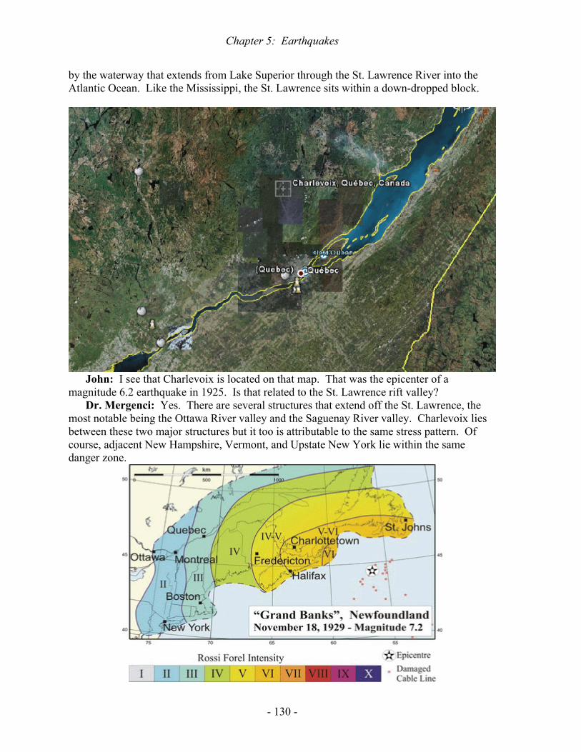
Chapter 5: Earthquakes
- 130 -
by the waterway that extends from Lake Superior through the St. Lawrence River into the Atlantic Ocean. Like the Mississippi, the St. Lawrence sits within a down-dropped block.
John: I see that Charlevoix is located on that map. That was the epicenter of a
magnitude 6.2 earthquake in 1925. Is that related to the St. Lawrence rift valley? Dr. Mergenci: Yes. There are several structures that extend off the St. Lawrence, the
most notable being the Ottawa River valley and the Saguenay River valley. Charlevoix lies between these two major structures but it too is attributable to the same stress pattern. Of course, adjacent New Hampshire, Vermont, and Upstate New York lie within the same danger zone.

Chapter 5: Earthquakes
- 131 -
Dr. Mergenci: While visiting Canada, we should examine the 1929 earthquake that is
nicknamed the “Grand Banks” quake because it occurred in one of the world’s best fishing grounds, the Grand Banks off Newfoundland, Canada. What happened here?
Ashlynn: About 2.5 hours after the 7.2-magnitude earthquake, a tsunami struck the
Burin Peninsula, the peninsula which is oriented toward the southwest in this map. Along the peninsula’s shoreline, the water rose from 2 to 7 m (2 to 7 yards). However, at the heads of some bays, it rose as much as 27 m (27 yards), drowning nearly everyone.
Dr. Mergenci: What sort of bay would have that extreme flooding from the tsunami?

Chapter 5: Earthquakes
- 132 -
John: To maximize the height of the tsunami, the bay would have to be oriented toward
the direction of the incoming bore and it would have to narrow gradually, thereby concentrating the tsunami’s energy into a small volume of water. Even today, I doubt if there are many buildings in Newfoundland that are taller than 27 meters (90 feet). Coastal houses typically collapsed when hit by the tsunami, like the one shown above, but the lower photo shows a guy who was lucky because his basement was full of buoyant lumber that lifted his house as efficiently as the schooner floating beside him.
Dr. Mergenci: Back in the US of A, we get to California’s Long Beach earthquake in 1933. Although not a particularly powerful earthquake at magnitude 6.4, it killed 115 people and caused extensive property damage. Why was this earthquake so devastating?
Ashlynn: Long Beach is a suburb of Los Angles so there were lots of people and lots of collapsible buildings.
Dr. Mergenci: True, but there was a peculiarity about the foundations of those damaged buildings.
Elizabeth: The buildings which were most affected by the earthquake had been built on landfill. Landfill is inherently unconsolidated, given that it is just heaps of trash. The Long Beach disaster became the modern-day equivalent of the biblical parable about choosing a place to build your house. I believe that the original passage in the seventh chapter of Matthew goes like this, “Everyone then who hears these words of mine and acts on them will be like a wise man who built his house on rock. The rain fell, the floods came, and the winds blew and beat on that house, but it did not fall, because it had been founded on rock. And everyone who hears these words of mine and does not act on them will be like a foolish man who built his house on sand. The rain fell, and the floods came, and the winds blew and beat against that house, and it fell—and great was its fall!”
Dr. Mergenci: That seems apt. Of course, during the Long Beach earthquake, it was not the rain that fell but the bricks of the buildings that fell. Virtually every structure collapsed within a three-block area where the landfill was least consolidated.
John: I bet that most of the people who died in 1933 did not even know that their house was built on landfill. I wonder how many Americans are living today on landfill without

Chapter 5: Earthquakes
- 133 -
knowing it. I have an offer of an internship with Cherokee Investment Partners. They have raised a few billion dollars to clean up contaminated properties around the US, including a leaking gas-station tank beneath Raleigh’s North Hills. Cherokee manages a 1300-acre project in northern New Jersey where they are initially spending $100 million to revitalize a former landfill for 3500 homes and two golf courses. The first-time buyers may learn about the landfill but you can be sure that that history will become conveniently forgotten when those people sell.
Marcus: Even Manhattan Island in New York has buildings sitting on landfill. The most recent big reclamation project was Battery Park City, nearly a hundred acres (0.4 km2) at the southwestern tip of the island. By 1976, they had piled about a million cubic meters (106 yards3) of rock and soil that had partly come from digging foundations for the World Trade Center. Landfills have been expanding the area of Manhattan and adjacent islands ever since the place was called New Amsterdam instead of New York. However, the largest recorded earthquake to hit the city was only magnitude 5.2, back in 1884, and most of the landfilling has occurred since then. Consequently, we do not know how well the buildings on New York’s landfills will fare during an earthquake.
John: Like the famous quote of Yogi Berra, the old Yankee catcher, it's like déjà vu all over again.
Ashlynn: I know that Easterners would rather talk about New York than Los Angeles but it was metro LA where the landfills proved to be deadly during the 1933 earthquake, killing 120 people. Did that displacement occur along the San Andreas Fault?
Dr. Mergenci: No. In 1933, it was the Newport-Inglewood Fault that slipped. This fault extends for about 120 km (78 miles) through coastal Los Angeles southeastward into

Chapter 5: Earthquakes
- 134 -
the Pacific Ocean, as shown on the overlying map. Note that the map has been rotated. The San Andreas is also shown on this figure, extending northwest-southeastward across the entire area, through the tall hills that rim Los Angeles. In contrast, the trace of the small Newport-Inglewood Fault is marked by small hills near the coast. The slip rate along this fault is estimated to be 0.6 mm per year, about half the thickness of a dime.
Elizabeth: I found this photo of Jefferson Junior High School in Long Beach. If the quake had not hit around 6 p.m., the school kids would have been pummeled. After looking at this damage and thinking about the kids, the California State Legislature passed the Field Act, the legislation that has come to regulate all construction in earthquake-prone California.
Dr. Mergenci: The Long Beach quake certainly demonstrated the danger of collapsing buildings. Let us now look at the danger of collapsing hillsides. Some of the world’s tallest hillsides line the Himalayan Front of northern India.
Dr. Mergenci: In 1950, an 8.6-magnitude earthquake struck northeastern India, causing voluminous landslides that clogged mountain streams such as the Lohit River that feeds the Brahmaputra River. What would be the most dangerous consequence of such earthquake-induced landslides?
John: The odds of somebody being in the river when the landslide filled it would be close to nil, so the real danger must come from the damming of the river by the landslide debris. Given very narrow and deep valleys in the mountains, it would be easy to dam such a river. A landslide dam would cause the river water to rise until it started flowing over the top of the dam and thereby eroded it. At that point, the dam would soon fail catastrophically, sending a torrent of water downstream.
Dr. Mergenci: Very good. A dam on a tributary of the Brahmaputra, the Subansiri River, lasted eight days and when it broke, the resulting wave measured 7 m (7 yards) high. It inundated several villages and killed 532 people. Here is a map of the Brahmaputra River and the Himalayan Front in northeastern India.

Chapter 5: Earthquakes
- 135 -
John: I found the underlying photo of the Lohit tributary of the Brahmaputra, showing the landslide debris that fell during the great 1950 earthquake in northeastern India.

Chapter 5: Earthquakes
- 136 -
Dr. Mergenci: I had some firsthand experience with this type of potential disaster while
doing field work for my doctorate in Colombia, South America. I was in an iron-mining town in the mountains that border Venezuela. Some astute townsfolk noticed that the flow of the river through town had suddenly diminished one day and they deduced that there must have been a landslide up-river. Being a mining town, there was plenty of dynamite available, so some of the miners loaded a couple of pick-ups and headed up-river until they found the landslide and blasted away the dam it had made across the river. Just before they blasted it, one pick-up returned to town to get everyone away from the river. That kind of story never makes it into the history books. The historical accounts tell about the people who died because they did not anticipate the danger posed by a landslide dam.
Dr. Mergenci: Most modern earthquakes do their greatest damage by collapsing buildings on people so let us return to that type of earthquake, specifically an earthquake in Agadir, Morocco in 1960. The magnitude of this earthquake was only 5.7 and the shaking only lasted fifteen seconds but about 12,000 people died and a similar number were injured.
Ashlynn: Was there something peculiar about the buildings that made them so lethal? Elizabeth: Yes. I have a good idea what Moroccan buildings look like because I have
seen lots of movies that were set in Morocco. One of the great classics of all time, Lawrence of Arabia, was partly filmed in Morocco, with Moroccan soldiers playing the part of Turkish soldiers. A current movie called Babel was also filmed there. Of course, the most famous movie with a Moroccan name is Casablanca, starring Humphrey Bogart and Ingrid Bergman, but that movie was actually filmed in California.
Ashlynn: In scenes of real Moroccan cities, one sees virtually no wood because there are few trees in this desert land. The buildings are largely concrete, adobe, or stucco-covered brick. All of those materials are brittle and the concrete-adobe structures are heavy. Most of the casualties in 1960 came from entrapment rather than instantaneous death. The Moroccans did not have enough heavy equipment to free the trapped people and it took too long for that equipment to arrive from other countries. Here we see stuccoed brick that is waiting to fall in Agadir’s next big earthquake. The rock exposed beside this building is badly contorted, consistent with the record of powerful earthquakes.

Chapter 5: Earthquakes
- 137 -
Dr. Mergenci: Most places with big earthquakes also experience frequent small
earthquakes but Agadir can go for long periods of time without anybody feeling anything. Nonetheless, there were several small tremors in the week before the 1960 earthquake killed more than one-third of the city’s population, with the strongest foreshock occurring just twelve hours before the main event.
Marcus: If Agadir experiences another week of increasing tremors, I am sure that experienced residents will decide to go visit Aunt Fatema in another city.
Dr. Mergenci: Indeed. They probably will get out of town. Even a camping trip would be good. Who cares if your tent collapses on you? Now we get to “numero uno”, the largest earthquake ever known to have occurred anywhere. When and where did this occur?
John: This 9.5-magnitude monster occurred in 1960 just south of the city of Concepcion, Chile, leaving two million people homeless. However, the death toll was just 0.1% of the homeless figure because this area was not densely populated. Few people were living in multi-story buildings. Nonetheless, the earthquake generated tsunami deaths all over the Pacific. In Japan, at a distance of 17,000 km (11,000 miles), 138 people drowned. That distance is nearly half-way around the world. Hawaii is about half-way across the Pacific and there 61 people drowned, despite activation of the tsunami-alarm system by the government.

Chapter 5: Earthquakes
- 138 -
Elizabeth: As at Agadir, the prime Chilean earthquake was preceded by a strong
foreshock. In this case, the people had a full day of warning. Perhaps that is why the fatality rate was low compared to the homeless rate in Chile. Prudent people would have stayed outdoors after feeling the strong foreshock. Aftershocks continued for several months. The epicenters of these earthquakes stretched along a north-northeast-to-south-southwest line that extends for 1300 km (800 miles).
Ashlynn: Chile is a mountainous country with lots of volcanoes. Landslides were widespread and they added to an existing natural dam at the end of Lake Riñihue, raising the lake level by nearly 27 m (27 yards). That flooded land all around the lake. About a hundred million cubic meters (cubic yards) of rock debris fell onto the end of Lake Riñihue. However, within a few weeks, the Chileans had tunneled through the debris to allow the excess water to escape and drain the surrounding lakeshore. Now there are fancy resorts on that drained land. Around these resorts, one can identify plenty of older landslide deposits so I would be inclined to pick an alternative vacation destination, somewhere flatter.
Marcus: If you are that wimpy, you should vacation in the Bahamas where the maximum elevation is only 63 m (63 yards) on Cat Island. Of course, you might find that you are allergic to cats. Did you know that black cats are invisible in Bahaman photos?
Dr. Mergenci: Well, they look like indistinct black blobs in the bright Bahaman sunshine. Let us return to Chile. Being the world’s biggest known earthquake, the Chilean quake may have done more than the usual house-shaking and tsunami generation. Did it?
John: Indeed it did. About 47 hours after the main earthquake shock, a Chilean volcano, Puyehue erupted near the lake that was being elevated due to landslides, Lake Riñihue.
Dr. Mergenci: Although all other earthquakes have been outdone by the Chilean event in 1960, the US could boast a contender with the 1964 earthquake near Anchorage, Alaska. What were the main effects of this 9.2-magnitude tremor?

Chapter 5: Earthquakes
- 139 -
Elizabeth: We certainly did not get two million homeless people in Alaska back in 1964, given that the total population of this extensive State is presently well under 700,000.
Marcus: Even if you add all the brown bears, moose, caribou, and mountain goats, you probably could not get up to two million. The death toll in 1964 was only 125 and 110 of those were tsunami drownings. When a one-story house collapses as shown above, the occupants rarely get killed. However, anybody who was driving along the street shown below probably thought that they were auditioning for the Dukes of Hazard or for one of those San Francisco movies where the cars go airborne.
John: The American cars in the underlying photo certainly look like early 1960’s models with their double headlights. They are obviously different from the smaller American cars that both preceded and followed this era of road hogs. In contrast, the Volvo in the foreground is the PV544 model and this has the same chassis styling here in the early 60’s that Volvos had been using for almost thirty years, starting back in 1936 with their PV51 model.

Chapter 5: Earthquakes
- 140 -
Marcus: The Volvo continuity is like that of the Volkswagen Beetle, using the same styling that it had when Hitler first asked Dr. Porsche to build it back in 1933.
Ashlynn: Although Hitler asked for the Volkswagen in 1933, the Germans characteristically went through such a rigorous testing regime that the final design was not ready until five years later, just before the start of World War II. Part of the delay was due to Porsche’s dislike of Hitler. Of course, a few more people came to dislike Hitler once he started the war by invading Poland.
John: Nonetheless, the Beetle did become Hitler’s longest-lasting legacy. It became the most successful car design since the Model T.
Dr. Mergenci: I drove a Volkswagen Beetle for five years in the early 70’s. That car was essentially identical to the one that senior Nazis got to drive. However, it was so light-weight that you would think an earthquake had hit you every time you passed a big truck on a windy highway. The truck would block the wind until you passed it or, more likely, it passed you. One of my friends got into a wreck that way. Nonetheless, we all loved our Beetles. Like live beetles, they were virtually indestructible, and almost as numerous as the beetles around my house in Venezuela. Let us shift gears and consider the 1967 earthquake near Venezuela’s capital, Caracas.
Ashlynn: We all know why you are concerned about earthquakes in coastal Venezuela, given your house on Venezuela’s Margarita Island. Looking at the underlying photo of your house is like playing the game, “How many things are wrong with this?”
Elizabeth: Why any American would own anything in a country run by a goof-ball like Hugo Chavez is beyond me. He claims to be Fidel Castro’s best friend.
Marcus: How can you complain about house construction in Morocco when your own house does not appear to be structurally sound? Even a minor earthquake would knock out the three thin posts that are supporting the upper level at the front of the house. Moreover,

Chapter 5: Earthquakes
- 141 -
the construction style is stucco covering flimsy tile brick. That would be too rigid and too weak to survive even a moderate earthquake.
Ashlynn: There is no glass in any of the windows, just steel bars. The upper windows have shutters but just about anything could crawl into the lower windows. The roof appears to be so thin that you can see light through it. What kind of roof is this?
Dr. Mergenci: Just to be sure that this house is not politically correct, the roof is made of asbestos tile. So, do you still want to come and visit? The geologic scenery is as spectacular as anywhere on Earth and the weather is perfect year-round. However the region does suffer from earthquakes. Tell me about 1967.
John: The magnitude of the 1967 quake was 6.5 whereas the 1812 earthquake that hit
Caracas is estimated to have had a magnitude of 9.6. Given that the power of an earthquake increases by a factor of 29 for each unit on the magnitude scale, the 1812 earthquake was about 25,000 times more powerful than the 1967 quake. Nonetheless, the 1967 quake killed 240 people. If a new earthquake were to kill 25,000 times more people than the 1967 quake, the number of fatalities would be slightly greater than the 4.7 million population of greater Caracas.
Ashlynn: I doubt if you would rattle off those statistics quite so dryly if you were visiting Venezuela when such an earthquake hit the country. Like any city with several million people, high-rise apartments are standard accommodation in Caracas and those apartments could become twisted piles of concrete jungle.
Dr. Mergenci: As much as I hate leaving the southern Caribbean, let us consider a more powerful earthquake that occurred a couple years later, in 1969 off the coast of Portugal. This 7.8-magnitude earthquake is most notable for its effect on an oil tanker called the Esso Newcastle. The captain reported, “ .. a feeling as if the ship was lifting out of the water.” Can anyone guess the size of this ship?
John: I would guess a couple of football fields long. Dr. Mergenci: Not bad. The length of the tanker was 226 m (743 feet). What could
possibly lift anything as massive as this? Marcus: I suppose that you are implying that there was another seafloor gas release that
accompanied this earthquake.

Chapter 5: Earthquakes
- 142 -
Dr. Mergenci: It is difficult to think of anything else that is going to lift such an enormous vessel in a water depth of 3700 m (yards). Tsunamis are only a meter (yard) high in such deep water. Let us go back to a part of the world that has had more than its fair share of earthquake tragedies, the mountain range that stretches from Turkey to Afghanistan. Gediz, shown here in west-central Turkey, suffered a magnitude 6.9 quake that killed a thousand people because the houses are made of brittle mortar and adobe. Nearby Iran had lost 11,000 for similar reasons a couple years before this. Why would these people use such deadly building materials, given their long history of losing ancestors to the collapse of heavy brittle buildings?
Elizabeth: The high plateau of central Turkey, called the Anatolian Plateau, is semi-arid, with an average of just 40 cm (15 inches) of annual precipitation. In contrast, that amount is just one-third of the annual precipitation in Raleigh, North Carolina, and Raleigh is one of the driest cities in the State. Despite lying between the Black and Mediterranean Seas, the Anatolian Plateau suffers a continental climate. In other words, it alternates between hot summers and cold winters, from +30o to -30o Celsius. That is equivalent to 85 oF in the summer down to -22 oF in the winter. This climate will not support much forestry so the people have to turn to rock and soil to construct their mortar and adobe homes.
Ashlynn: The recurrent personal tragedy of the Anatolian earthquakes must have a profound emotional effect on the Turks. The underlying photo shows a Muslim father carrying a child that has been killed by the Gediz earthquake.
Dr. Mergenci: The year of the Gediz earthquake also was devastating on the opposite side of the world, in Peru. One million of Peru’s 13 million citizens became homeless because of a magnitude 7.9 earthquake. Like adjacent Chile which suffered greatly in 1960,

Chapter 5: Earthquakes
- 143 -
Peru is mountainous and it was the landslides that killed many of the people. Peru’s Minister of Health has estimated 70,000 dead and missing. Has anywhere north of South America suffered such loses in a single earthquake?
Marcus: No. The worst loss of life north of South America occurred a couple of years
after the Peruvian disaster, in Nicaragua, when 3000 to 7000 died in 1972. A similar earthquake had hit the city in 1931 and the survivors of that disaster thought that it was déjà vu in 1972.
John: The only competition for the 1972 destruction of Nicaragua was the 1692 disaster in Port Royal, Jamaica, a place made famous by Henry Morgan, here shown on his rum label.
Ashlynn: Through the late 1600’s, Jamaica’s Port Royal was the most notorious place
on Earth because the British provided safe haven there for buccaneers who attacked both Spanish and French ships. Port Royal was widely known as the "richest and wickedest city

Chapter 5: Earthquakes
- 144 -
in the world", with a port as busy as Boston in the 1670’s. Port Royal boasted a tavern for every ten residents.
John: The lieutenant-governor of Port Royal, Henry Morgan, was the most successful buccaneer of all time. Besides capturing ships, he looted several Spanish cities in Panama, Venezuela, and Cuba. His men specialized in torturing the Spanish until they would reveal where they had hidden their gold. Even the English became embarrassed and were relieved when the earthquake of 1692 brought down two-thirds of Port Royal’s buildings and permanently submerged them under 8 m of seawater. The earthquake liquefied the beach sand under the buildings and that sand flowed out into Kingston harbor.
Elizabeth: Religious leaders worldwide cited the submergence of Port Royal as an example of “divine justice”. By suddenly sinking, Port Royal has become the Western Hemisphere’s best underwater archeological site, preserving a bustling city as it was on June 7, 1692. However, the human price tag for creating this archeological marvel was high. Between 1000 and 3000 died in the earthquake and tsunami and another 2000 died from disease shortly thereafter.
John: The total death toll in Port Royal rivals that of Managua, Nicaragua in 1972. The Managua earthquake was not that powerful at magnitude 6.2 but it had a shallow focus beneath this capital city. Here we see the leveled buildings in an aerial photograph. Managua had suffered a similar fate in 1931, just 41 years before 1972. As we approach the forty-first anniversary of the 1972 earthquake, I would think that residents of Managua might be feeling a little nervous.
Marcus: I bet that the old folks are indeed becoming nervous. My grandmother used to
keep saying that trouble always comes in threes. Maybe the third earthquake to hit Managua will outdo the other two. Even Port Royal was hit by a subsequent devastating earthquake,

Chapter 5: Earthquakes
- 145 -
but after a much longer interval, a 215-year interval. That was 1907 when another earthquake liquefied more of the sand bar and brought down the overlying buildings.
Elizabeth: I think that the Jamaicans should take more seriously the Biblical passage in the Gospel of Matthew about building one’s house on sand.
Dr. Mergenci: As much as I love the Caribbean, let us reconsider a different vacation spot, Hawaii. We have previously looked at the 1868 earthquakes that struck the southwestern peninsula of the big island. In 1975, a 7.2-magnitude earthquake hit the eastern peninsula, centered on Kalapana. This was Hawaii’s biggest earthquake since 1868. The coast subsided by as much as 3.5 m (yards) and a tsunami reached a height of 8 m (yards). However, only a couple of people died. In contrast, an earthquake of similar magnitude a year later killed 23,000 in Guatemala. Why did so many people die in Guatemala?
John: The high death toll in that quake can be attributed to the collapse of adobe houses,
much like the high death toll in the Moroccan and Turkish earthquakes. However, it is unclear why the Guatemalans build with adobe. Unlike the Anatolian Plateau of Turkey, Guatemala has a great climate for both people and forests. There is plenty of rainfall from May to October and the temperature ranges from a perfect 20oC (68oF) to 37oC (99oF). The underlying maps shows both Guatemala and Nicaragua, the site of the devastating earthquake just a few years earlier, in 1972.
Ashlynn: If you want a one-word answer to your question about wood versus adobe, it would be “termites”. Even though the Guatemalans can grow trees that other adobe-loving cultures cannot grow, they dare not use wood for structural support the way we do in the US.

Chapter 5: Earthquakes
- 146 -
In fact, if you visit southernmost Texas you can see plenty of evidence that American-style house construction with two-by-four lumber is inferior to Mexican-Guatemalan-style adobe construction because there are too many creepy-crawly bugs in that climate just waiting to chomp away at wood. The bugs do not eat much adobe.
Dr. Mergenci: That brings us to 1976 and the horrific earthquake that killed at least 240,000 people around Tangshan, southeast of Beijing by 140 km (85 miles). This 7.8-magnitude earthquake was followed by a 7.1 aftershock fifteen hours later. Natural gas was observed shooting out of water wells in a nearby village during the preceding week. In another adjacent village, the level of water in the wells oscillated up-and-down three times on the day before the main event. In Tangshan itself, one could see iridescent colors in the night sky shortly before the earthquake, similar to the aurora borealis that one sees in the Alaskan night sky during the wintertime. What do you think that the Tangshan animals were doing?
Ashlynn: The Tangshan animals behaved strangely during the hours before the fifteen-second-long earthquake killed a quarter of Tangshan’s million inhabitants. The chickens stopped eating and the geese started nibbling on each other. Dogs howled continuously and goldfish jumped out of their bowls.
John: These animals must have been sensing either traces of toxic gas or minor vibrations of the Earth, or both. Minor vibrations would tend to increase the amount of suspended sediment in the streams and groundwater. A community adjacent to Tangshan had noticed that their water was becoming muddier so they initiated earthquake drills. As a result, they had no direct casualties. However, the fatality rate was high among those living in concrete structures like the collapsed one shown here in Tangshan.

Chapter 5: Earthquakes
- 147 -
Dr. Mergenci: Closer to home, we have the 1985 earthquake in southwestern Mexico.
The epicenter was at the southwestern coast but the densely populated capital suffered the most from this tremor, despite being distant from the epicenter.
John: Pancaked buildings were a common sight several months after the quake.

Chapter 5: Earthquakes
- 148 -
Marcus: I see that one-third of the cars in this photo from the mid-80’s are Volkswagen Beetles. When I was a turista in Mexico, I asked them why there were so many Beetles and they responded that they had been assembling them in Mexico since 1964. I heard all about the 1985 quake while touring Mexico City. I am just glad that it did not happen while I was there.
Dr. Mergenci: Unfortunately, it did happen while two of my brothers were there, right in the middle of the hardest-hit area. They live a thousand miles north of me so I do not keep close track on their travels. I was surprised when a sister-in-law called me to say that they were supposed to have arrived in Mexico City shortly before the earthquake. She had no idea where they intended to stay and suggested that I go to find them, given that I speak Spanish. There are twenty million people living in metropolitan Mexico City so it seemed futile to me to wander through that size of crowd calling my brothers’ names.
It turned out that just a few hours before the earthquake, they had gotten a room in the center of the city, in Zona Rosa. Unfortunately, this became the hardest-hit area because Mexico City is like a bowl of soft-sediment jelly surrounded by hard volcanoes. The seismic waves hammered the edge of that bowl, producing standing waves at the center where my brothers were staying. Their Zona Rosa became the Zona Rojiza (reddish zone), colored by the blood of the 9500 to 35,000 victims.
When the earthquake struck in the early morning, one brother (a businessman) was still in bed whereas the other brother (a medical doctor) was trying to read a Spanish newspaper in the lobby. The hotel leaned onto an adjacent building and was to collapse a couple days later during a minor aftershock. Fearing an immediate collapse, the brother in the lobby tried to run out of the building but was tackled in the doorway by the concierge. In halting English,

Chapter 5: Earthquakes
- 149 -
the concierge explained that running into the street would be suicide because all the glass was falling from all the high buildings. Indeed, nearly everyone in the street there died.
Although neither brother had ever taken either a geology or spanish course, both of them responded from that point onward with good survival instincts. The businessman in the penthouse jumped into the bathroom doorway just as the roof was collapsing on his bed. He wisely kept the bathroom door open to avoid it becoming permanently jarred shut. Eventually, he made his way down twelve flights of a crowded, jet-black stairway to rejoin the other brother outside the hotel. Their few hours in Mexico City seemed sufficient for a lifetime and they wanted out of town immediately. Of course, twenty million other people shared their sentiment so the Mexican government posted troops all over the city, prohibiting movement.
Did they get out? Oddly enough, while millions of Mexicans were being restrained, this pair of anglophones managed to reach the airport faster than one normally can get there from the center of the city. The airport is up on the hard rim of the “jelly bowl” and was unscathed. Their scheme for reaching the airport exemplified the imaginative response that can save one’s life when any society comes undone, as during a major earthquake. They sought out the group of readily-accessible people who are the best in any city at providing something for a fee, the taxi drivers. It did not take long to find their man, a taxi driver who had enough paraphernalia stashed in his trunk to give his taxi the appearance of being an ambulance.
John: I guess that is why your brothers make a much higher annual salary than that of a professor.
Dr. Mergenci: Indeed they do. The next noteworthy tremor was the 1989 Loma Prieta earthquake in the San Francisco area. Despite being just 6.9 in magnitude, this became a world-famous earthquake. Why did it become so famous?
John: Nobody gets away with anything in California because somebody is going to catch it on video. Loma Prieta became the world’s first earthquake to be caught on live television, given that it occurred during a World Series baseball game that featured two local teams, the Oakland Athletics and San Francisco Giants. Besides the usual images of collapsed buildings, the world got to see collapsed multi-tiered highways, as shown here.
Elizabeth: I think that the highway deaths struck people more than the collapsed-building deaths because people realized that anybody could have been on that highway whereas only the occupants of the collapsed buildings were likely to have been caught there. Virtually the entire population of Oakland and San Francisco would have traveled over the collapsed highway at some time, so virtually everyone would feel personal involvement in that disaster.

Chapter 5: Earthquakes
- 150 -
Ashlynn: The Kobe, Japan earthquake of 1995 was no more powerful than the Loma Prieta earthquake but it managed to kill more than 5500 people whereas Loma Prieta killed only 63.
Dr. Mergenci: I toured the Kobe area a few months before the earthquake and was struck by the popularity of heavy tile roofs. When that type of roof falls on your head, it is time to say “sayonara”. By the way, I learned that that word should be pronounced “sayonara” instead of the usual “sayonara”. There are lots of myths about Japan that can only be dispelled by visiting the place. Here is a tile-roofed structure that did not quite collapse.
Ashlynn: Have you talked to anyone who survived the Kobe disaster? Dr. Mergenci: Yes. I talked to an American survivor of Kobe who said that foreigners
had a choice of walking out of town or starving because Kobe was cut off from the rest of world for nearly two weeks and the local residents would not provide anything to foreigners. Of course, Americans did fire-bomb all the major Japanese cities during World War II, so one should not expect a lot of good-will. The American survivor had to walk 15 km (10 miles) to reach help. He noted that some foreigners did not make it because they had been in bed when the earthquake struck in the early morning and their bedroom floor became covered in broken glass. As soon as the shaking stopped, they foolishly hopped out of bed and tried to run across the broken glass in the pitch darkness. After that, they could not walk. What lessons should we take from that tragedy for future visitors to a place like Japan?
Marcus: I certainly would be careful getting out of bed after an earthquake. I would keep some bottled water and snacks in my room and I would drain the vending machines as soon as I could get out of my room. I understand that the Japanese even sell beer in street-corner vending machines.
John: If possible, I would stay in my room rather than try to walk out of town because the Japanese have a history of becoming lawless after major earthquakes. Immediately following the 1923 earthquake in Tokyo-Yokohama, they beat up their Korean population quite badly, despite the fact that Koreans and Japanese are ethnically similar. I cannot imagine what the native sentiment would be toward Americans in the chaos following a major earthquake. I really would not like to find out, either. I am sure that none of the local population starved in the aftermath of the Kobe tremor. Why did so many die?

Chapter 5: Earthquakes
- 151 -
Ashlynn: Many of them experienced premature cremation. Although it was fire that was so deadly for San Francisco in 1906, fire was not a big factor following Loma Prieta in 1989 whereas fire killed many people in Kobe, as seen here.
Dr. Mergenci: We Caucasians are as violent as any ethnic group the world has ever
seen. Of course, the region around the Caucasus Mountains experiences so many deadly earthquakes that it must affect the psyche of the inhabitants. For example, a 7.3-magnitude earthquake killed 1600 people in northern Iran in 1997.
John: Let me guess. This earthquake occurred near Shamakhy, the place that got smacked in 1667.
Dr. Mergenci: Well yes, as a matter of fact. Let us flip back to the Orient for a 1998 earthquake-generated tsunami that drowned over 2000 people along the northern coast of New Guinea. The wave height reached 15 m (yards) and eliminated entire coastal villages. The next year, Turkey was hit by a 7.6-magnitude earthquake that killed more than 17,000 people. The Turkish quake occurred along the fault that follows the southern shore of the Black Sea, the North Anatolian Fault. Right-lateral offset was observed for 120 km (75 miles), with the maximum offset being 5 m (yards). Strong shaking lasted 37 seconds and produced a maximum acceleration that was 40% of the acceleration due to gravity.
Elizabeth: Although we have been consistently citing the magnitudes of earthquakes in this discussion, I know that the insurance companies pay more attention to the potential for ground acceleration when evaluating the risk for large buildings. If the bottom floor of a tall building accelerates fast enough, the top floor will not catch up to it and will be left hanging out without support, allowing it to fall.
Dr. Mergenci: You are right. The insurance companies do indeed pay more attention to acceleration than magnitude. Nonetheless, we will return to our magnitude scale. We have already talked about an 8.6-magnitude tremor that caused landslides and upper-atmospheric explosions in northeastern India in 1950. In 2001, a 7.7-magnitude earthquake killed another twenty thousand people in northwestern India and adjacent Pakistan. A similar earthquake had killed two thousand in that area back in 1819. The focus for the 2001 earthquake was fairly shallow at 16 km (10 miles) deep, a typical depth for a highly destructive earthquake.
Elizabeth: With the currently-increasing populations of both India and China, I expect that there will be other ten-fold increases in earthquake casualties when a similarly-sized

Chapter 5: Earthquakes
- 152 -
earthquake returns to these countries after a two-hundred-year interval. The increase in mortality will probably outstrip the population increase because the additional people are being housed in multi-story apartment buildings that could kill all their residents in a collapse. Here we see the Ahmadabad region of India, the region that suffered the most casualties. We also see Karachi in adjacent Pakistan. Karachi is Pakistan’s most populous city, with more than twenty million people.
Dr. Mergenci: In 2002, Alaska experienced an earthquake that closely resembled the 1906 San Francisco earthquake in both its magnitude, 7.9, and its lateral shifting of the land by several meters along an extensive fault trace. Like the San Andreas of California, Alaska has the extensive Denali-Totschunda Fault. As along the San Andreas, the motion along this fault is right-lateral.
Marcus: The physical attributes of the 2002 and 1906 earthquakes may have been similar but I presume that there was a big difference in the casualty list. Did anyone get hurt?
John: Probably not, unless some igloos collapsed. Dr. Mergenci: Even the Denali area is not cold enough for igloos but it is too cold for
my liking, so let us return to Mexico. A slightly less powerful earthquake, magnitude 7.6, hit the western coast of Mexico in 2003, just north of the 1985 epicenter. With a focal depth of 24 km (14 miles), this tremor affected a broad area, leaving 10,000 people homeless. High-rise buildings started to sway as far away as Houston, a distance of 1400 km (890 miles). Water wells became turbid in even more distant Louisiana and Lake Pontchartrain of New Orleans developed standing waves.
Elizabeth: In the same year, northern Algeria was hit by an even-shallower-focus earthquake, just 10 km (6 miles) deep. Over 2200 people were killed. In 1980, another earthquake had killed 5000 Algerians and yet another thousand had died from a quake in 1954.
John: It seems that 2003 was a bad year in lots of places. The biggest earthquake that year, with a magnitude of 8.3, occurred under the sea about 60 km (36 miles) off the northernmost island of Japan, the island of Hokkaido. This quake produced a tsunami that

Chapter 5: Earthquakes
- 153 -
was 3 m (10 feet) high but only thirty people died. The most notable effect was the interruption of beer production in Sapporo.
Ashlynn: Although Hokkaido had the biggest earthquake in 2003, southeastern Iran earned the distinction of having the most people killed, 30,000 of them. The epicenter was an ancient city with a 2000-year-old citadel made of adobe. The city was appropriately named Bam. Although Iran is one of the most earthquake-prone countries on Earth, the intact adobe citadel was evidence that Bam itself had been spared until 2003.
Elizabeth: The ancient city of Bam is made entirely of mud bricks, clay, straw, and the trunks of palm trees. From 224 to 637 A.D., Bam was a destination for pilgrims who adhered to the Zoroastrian religion because it housed a shrine.
John: Zoroastrians have not done well since Alexander the Great burned their prime library in 330 B.C. After that, there were unending battles between the priests and secular leaders, rather like the battles in Europe during the Protestant Reformation. However, Zoroastrianism virtually disappeared with the onslaught of the Muslims in 637 A.D. Prior to that, Zoroaster had been the main prophet for their god. Does anyone know the god’s name?
Marcus: I do. The god’s name has become a household word, even though hardly anybody knows the history behind that name. The god is invoked in the chant of the Zoroasters, “Mazda is the beginning and the end, the creator of everything which can and cannot be seen, the Eternal, the Pure and the only Truth.”
John: Is that why they can offer a sixty-thousand-mile warranty? Here is the famous citadel of Bam, the protector of the world’s first believers in Mazda.
Dr. Mergenci: Unfortunately, things went from bad to worse when we passed from 2003 to 2004. Like Iran, Indonesia has always been notorious for earthquakes, but in 2004, Indonesia exported its misery far and wide. In late December, a magnitude 9.1 quake produced a tsunami that came ashore all around the Indian Ocean as a wave that was 3 m (10 feet) high. Like all tsunamis, this had a roughly fifteen-minute periodicity, enough time to drown the couple hundred thousand people that it found near the shore.
Marcus: No official warning was issued in any of the affected areas. I do not understand this. Seismographs must have been going off-scale within minutes and the tsunami took hours to cross the Indian Ocean. What were those hundreds of seismograph operators doing? They could not all have been taking a snack break.

Chapter 5: Earthquakes
- 154 -
John: Public warnings are tightly controlled by all governments, for obvious reasons. Consequently, the seismograph operators would have had to report to government officials, typically with little scientific background. The first thing that such a government official would ask would be the probability of a deadly tsunami from such a tremor. Any scientist would have to respond that there is no simple correlation between the size of an earthquake and production of a tsunami. At that point, a typical government official would lose interest in issuing a warning. According to bureaucratic reasoning, a tsunami would be an “act of God” for which a bureaucrat could not be blamed. However, an order for evacuation would be their personal act and they would surely be blamed if it turned out to be unnecessary.
Marcus: Indeed. Besides, just three months later, there was another earthquake in nearly the same place with nearly the same magnitude and virtually no tsunami was generated.
Dr. Mergenci: For me, one of the more interesting aspects of the initial quake in late December is that mud volcanism started two days later. Mud volcanism is driven by rising fluids, water and carbonaceous fluids like methane gas, lifting mud as the fluids rise. Mud volcanism is common in Indonesia, in the southern Ukraine (Crimea), Venezuela, and Trinidad, all places with vast oil reserves. At the start of this discussion about earthquakes, we noted that Berkeley geologists have deduced that fluid is needed for production of an earthquake, to reduce the friction and permit sudden slipping along a fault plane. The mud volcanism in Indonesia may well record the fluid that allowed this disaster to occur. Here is a photo of some burning gas lifting mud the day after Indonesia’s big quake.
Ashlynn: I certainly hope that 2005 was not as bad as 2004.

Chapter 5: Earthquakes
- 155 -
Elizabeth: The Pakistanis thought that it was even worse. They lost 86,000 people to a magnitude 7.6 quake near their northern border with Kashmir. Landslides blocked relief convoys from reaching devastated villages. Rising fluids liquefied the sandy soil and locally blew it into the sky. Standing waves were observed on lakes all across the Himalayan Front.
Ashlynn: What about 2006? Elizabeth: Indonesia got back into the news with a shallow-focus earthquake that
coincided with eruption of a stratovolcano named Merapi. Nearly 6000 died. Dr. Mergenci: That is surely enough good news for one discussion. How many people
have we lost altogether from earthquakes, ever since Homo sapiens displaced the Neanderthals? It must be several tens of millions. However, the world population is presently increasing by roughly that amount every year so earthquakes are unlikely to limit world population. Let us move on to other types of geologic hazards.

Chapter 5: Earthquakes
- 156 -

- 157 -
Topic 6: Geologic Hazards By Dr. Bill Dittelsware
Dr. Dittelsware: Most college graduates eventually buy property and their private
residence becomes their most valuable single investment. Selection of property commonly becomes one’s most significant investment decision. This chapter deals with a wide range of geologic hazards that may diminish or eliminate one’s equity in property. Unfortunately, it is rare for property buyers to give much thought to potential geologic hazards and the consequences of this neglect may be bankruptcy or health problems. Can you guys name some geologic hazards for houses? Can you list some reasons why the homeowners should have built it elsewhere? Let us focus on North Carolina and subdivide our list into coastal areas, low-relief inland areas, and mountainous regions.
Ashlynn: I love the coast and hope to live there some day so I had better focus on coastal hazards. The North Carolina coast faces hurricanes that can destroy virtually any structure so that must be my top-ranked hazard. Tornadoes also can occur there. Day-by-day erosion does not kill anyone but may make one’s property worthless so this erosion qualifies as number three. Over 80% of the US coast is undergoing submergence and there usually is longshore drift that may be unrelated to submergence but which augments the inundation of the coast. Pollution ranks as fourth, including the droppings of pets belonging to tourists. A tsunami ranks fifth but would quickly rise in rank if tsunamis start to become more common around the Atlantic, the ocean I expect to see from my future beachfront property. The last hazard would be a substrate, either soil or sediment, that would not remain stable over a time span of decades, causing my home to settle unevenly and develop cracks. The soil also could be a breeding ground for termites or fire ants that would diminish my property value.
Elizabeth: I expect to take over my parents’ bookstore and live in the State Capital, Raleigh, where the relief is subdued, albeit much greater than in the coastal plain. Low-lying areas such as Crabtree Creek collect water during hurricanes and the floodplain can suffer millions of dollars in damage, so a hurricane is my top-ranked hazard. As at the coast, tornadoes come in second because of the smaller area affected.
Number three is termites. Number four is radon, a radioactive gas, especially in eastern Wake County and adjacent counties where the exposed rock is granite. Granite generally contains more uranium than other common rock types and this uranium goes through successive decay steps, including a step that produces the radioactive gas, radon. Radon is a dense gas that will accumulate within any confined space, such as a basement, when it seeps out of the soil. Like radon, another natural pollutant is arsenic but arsenic is generally not concentrated in radon-rich areas. Groundwater around old gold mines may contain substantial arsenic.
Number five is shrink-swell soil if one lives in western Wake County where the red shale contains shrink-swell clay. Otherwise, number five is pollution from prior land use such as undocumented refuse dumps. Related to “prior use” is the issue that some unscrupulous builders have not paid for removal of tree stumps under houses and simply covered those stumps with dirt, setting the house foundations into that dirt. When the buried stumps eventually rot away, the overlying houses partially collapse into the resulting holes.
Marcus: I expect to live in Western North Carolina where I can go snow-skiing while you guys are suffering cold rain in the East. I realize that the beautiful view from my house

Chapter 6: Geologic Hazards
- 158 -
will come with a price. That price is the potential for mass-wasting. It is more difficult to rank-order geologic hazards in the mountains because they tend to be interrelated. For example, hurricanes induce much of the mass-wasting as well as the flooding. Tornadoes are uncommon, fortunately, and tend not to travel very far because of the high relief. The mountains of North Carolina have been economically depressed until the past three decades and some mountain ridges were not even claimed fifty years ago because it was not worth paying taxes on that land. Given the excellent view from a ridge, that land has now become some of the most valuable in western North Carolina for housing projects. However, land that previously belonged to nobody has, in the past, been popular for activities that nobody would admit to doing, so some of those new houses are built upon clandestine old distilleries that used lead pipes. Moreover, undocumented small mines dot the landscape of western North Carolina. Houses that are unknowingly built above these underground excavations suffer the potential of collapsing into them.
Dr. Dittelsware: Those are all good reasons why some homeowners should built it elsewhere. Hurricanes seem to top the list of geologic hazards so let us start there. A major hurricane represents an enormous amount of energy. What is the source of all that energy?
Elizabeth: I have found a nice summary of hurricanes by an expert at MIT, Kerry Emanuel. Dr. Emanuel likens hurricanes to a Carnot Cycle. Being a cycle, one may arbitrarily start anywhere because the cycle returns to any starting point. We start with some air at the Earth’s surface (point A in the sketch) and suck that air toward the low-pressure core of a hurricane while providing the air with enough heat uptake from the ocean that it does not cool, despite its expansion while moving into a low-pressure region. Technically, this first step is called isothermal expansion because the temperature does not change.

Chapter 6: Geologic Hazards
- 159 -
John: This fluid expansion sounds vaguely like a refrigerator but a refrigerator
obviously is not isothermal. When the refrigerator’s fluid expands, it cools the interior of the refrigerator.
Ashlynn: The fluid in a refrigerator’s coils is compressed away from the food-storage area and then allowed to expand, hence cool, near the food-storage region. Cooling will always accompany fluid expansion if there is no heat flow. To maximize cooling, the expansion must happen fast enough to minimize heat flow. I believe that that is called adiabatic expansion.
Elizabeth: Yes. Adiabatic expansion is the second of the four steps in a Carnot Cycle that explains hurricanes. This second step resembles the cooling process in a refrigerator. In a hurricane, this step is represented by the air rising from point B in the overlying sketch. The air rises so quickly that there is little heat transfer, so the air cools as it expands. Upon cooling, water vapor in the air condenses because the capacity of air to hold water vapor decreases sharply as the temperature drops.
Marcus: I have certainly heard the rumor that hurricanes dump a lot of rain. I suppose that it is the air rising adiabatically that is causing that rainfall. Publication of this Carnot Cycle back in 1824 must have made its author very famous because Broughton Hall on the N.C. State Campus has Carnot’s name engraved along the top.
John: I am more impressed that Animal Husbandry got engraved onto nearby Polk Hall. Marcus: If the students were better rock-climbers, there might be even more creative
engravings in the limestone facings on our older buildings. Elizabeth: Let us cool it and go back to refrigerators. A refrigerator has a closed loop
that recycles the fluid. In contrast, a hurricane normally does not recycle the air that rises along the wall of its core. Some other air drops from the upper atmosphere to the Earth’s surface to restart the first step in the cycle. However, let us pretend that recycling occurs. If it did, the air that has risen, cooled, and dropped its moisture then enters the third step, in which it compresses so slowly that it is isothermal, maintaining the cold temperature of the upper atmosphere. Finally, the air compresses rapidly and adiabatically as it plunges to the Earth’s surface to restart the four-step Carnot Cycle.
John: I am sure that the engineering faculty in Broughton Hall would be glad to hear that you honor their illustrious mentor. However, are you sure that understanding the Carnot Cycle is going to help people prepare for the onslaught of a hurricane?
Ashlynn: If I were doing field work for the U.S. Geological Survey in central Alaska where grizzly bears roam, I would want to know everything that I could about grizzly bears. I would prefer to learn it from a book before landing there, rather than have the bears teach me as they ripped my tent and raided my supplies.
Elizabeth: I must admit that some of the heat-transfer steps in the hurricane cycle remain a little vague. The Earth uses hurricanes to get rid of excess heat energy so we should examine how atmospheric gases contribute to that excess heat energy in the first place.
Dr. Dittelsware: When listening to some global-warming activists, I get the impression that carbon dioxide is the gas that dominates atmospheric heating but carbon dioxide is actually not very significant when compared to water vapor. One should be able to guess this immediately from the trivial amount of carbon dioxide in air. In ten thousand parts of the atmosphere, carbon dioxide is only 3.5 of those parts whereas water vapor may range up to 400 parts, 4%. In Physics Today, Dr. Kerry Emanuel has pointed out that the Earth’s surface

Chapter 6: Geologic Hazards
- 160 -
receives less heat from direct sunlight than by radiation back from our atmosphere, including reflection from clouds. Although water vapor is the prime blanket for Earth, carbon dioxide also contributes to global warming.
Marcus: Yes. Emanuel notes that without an atmosphere, Earth’s surface would be colder by 35 Celsius degrees, 63 Fahrenheit degrees. That would make us an icy white planet instead of the blue planet. Earth would be a frozen wasteland like Mars.
Dr. Dittelsware: I guess that I should keep driving my former campus-cop car with its 5.7 liter engine that generates lots of carbon dioxide to help our atmosphere warm the Earth.
Elizabeth: Earth has difficulty getting rid of its excess surface heat and relies upon both friction and the mixing of moist air with dry air to get rid of that heat energy. Without moisture in the atmosphere, the transport of energy back to Outer Space would have to rely entirely upon friction and that would make the atmosphere too violent for travel in airplanes. Every day would seem like a hurricane to anyone trying to fly a plane. One reason that hurricanes are so violent is that they are so big that they have trouble exchanging moist air for dry air, an exchange that easily happens within a towering cumulonimbus cloud.
Ashlynn: What ever happened to the notion of a “tropical paradise”? Except when there is a hurricane, the tropics have the steadiest climate on Earth. There is little variation in temperature, wind direction, or wind velocity. My parents sneak off to the Caribbean every chance that they get. On their first trip to Trinidad in mid-winter, they asked a Trinidadian if they would need a sweater for the evenings. The response was, “What’s a sweater, maaan?”
Elizabeth: All that wonderful warmth in the tropics does evaporate a lot of seawater and produce voluminous water vapor which becomes a prime source of energy for a hurricane. Basically, most of the solar energy that was required to evaporate that water returns in the portion of the Carnot Cycle where the air is rising abruptly off the ocean and cooling during adiabatic expansion. The capacity of air to hold water vapor decreases exponentially with falling temperature, so the moisture falls precipitously as the air cools.
John: To put this power source in perspective, one could imagine the amount of energy that is needed to heat a drop of water from the freezing point, zero degrees Celsius, to the boiling point, a hundred degrees Celsius. At the boiling point, it takes additional energy to convert liquid water into water vapor. That additional energy is more than five times greater than the energy that was required to raise the water drop’s temperature from zero to a hundred degrees. It is the blazing summer Sun, day-after-day in the tropics, that produces all the water vapor that is waiting to cause trouble in the Fall. The water vapor has plenty of stored energy.
Dr. Dittelsware: Shown below is a satellite’s view of a typical hurricane. As you can see, it is spinning counter-clockwise. Why do all the hurricanes in the northern hemisphere spin counter-clockwise whereas all those in the southern hemisphere spin clockwise?
John: That rule applies to all storms, not just hurricanes. It has to do with Earth’s rotation toward the east. Rotational velocity is greatest for someone standing on the equator. Without knowing that they are moving, they are actually heading eastward quite quickly, covering the entire circumference of the Earth within 24 hours.
Elizabeth: In fact, the French defined the meter based on the Earth’s circumference, making that circumference 40,000 m. Consequently, a person at the equator is traveling about 1670 km per hour, roughly a thousand miles an hour. People at all other latitudes are traveling eastward less rapidly, ranging down to zero velocity at the poles.

Chapter 6: Geologic Hazards
- 161 -
John: As a result, anyone who travels northward from the equator has a built-in
eastward velocity that makes them veer to the right, as we noted in our discussion of Columbus reaching America. Anyone who travels southward from the equator veers to the left for the same reason. This tendency to veer right or left is the only way that the atmosphere can maintain pressure gradients on the scale of a hurricane. The faster the motion, the stronger the push, and the greater is the pressure on the right-hand side in the northern hemisphere. By swirling counter-clockwise, our northern storms are constantly pushing outward and thereby maintaining a low pressure inside. If a hurricane lacked low pressure at the center, it could not pull air inward. Moreover, it could not lift up the air that must reach the upper atmosphere to cool, make rain, and provide energy to drive the system.
Dr. Dittelsware: In the overlying photo, one can sense that the air rotates faster around the eye as it comes inward and approaches the eye. Why does this happen?
Ashlynn: Having lived on military bases around the world when my dad was in the service, I have gotten to try both warm-climate and cold-climate sports, including figure skating. I found that I could make my figure-skating twirls go faster by simply bringing my arms in close to my body. The angular momentum that I had while my arms were fully extended at the start of my spin made me spin faster when my arms came inward. I would think that a similar conservation of angular momentum makes the air spin faster when it gets closer to the center of a hurricane.
Dr. Dittelware: We have heard that the rotational velocity of the Earth varies with latitude and this must affect hurricanes as they move up the Eastern Seaboard of the US, crossing lines of latitude. Hurricanes are so big that different parts of them must always be in zones of different rotational velocity. Why does this difference not tear them apart?
John: The pinwheel-shaped spin of every hurricane gives it some stability. This is like a top or a gyroscope that remains remarkably stable as long as it is spinning.
Dr. Dittelsware: Good. Let us now pretend that we are listening to a hurricane report on television. It seems to me that every television announcer reiterates five times per hour

Chapter 6: Geologic Hazards
- 162 -
that the warmth of tropical water feeds the hurricane system. However, we have learned here that that influence is mostly indirect through evaporation over a time scale that is vastly longer than that of the hurricane’s passage. Is there anything else important about tropical latitudes other than warm water? The announcers never seem to mention anything else.
Elizabeth: As we have noted, the tropics have the highest rotational velocity from Earth’s spinning, about 1670 km per hour (1000 mph) and the air right at the Earth’s surface is dragged along at almost the same velocity. However, at great height in the atmosphere, there will be no location anywhere above the Earth that is strongly influenced by Earth’s rotation. At the poles, there is virtually no influence from Earth’s rotation at any height in the atmosphere, from the ground upward. In contrast, the vertical difference in atmospheric rotation is greatest in the tropics and this makes the low-elevation air mass, the one generating a hurricane, more distinct from the upper air mass.
Dr. Dittelsware: What can kill a good hurricane? Ashlynn: A good hurricane? Given my plan to retire some day at the beach, I do not
believe that there could be such a thing as a good hurricane. Marcus: My uncle is a contractor who thinks that hurricanes are not only good but great.
He makes twice as much money in the six months following a good hurricane than he makes during any other year.
John: The surest way to kill a hurricane is to starve it to death. That means robbing it of water vapor. The usual way for this to happen is to have the hurricane run over land. While traveling over a warm ocean, there is typically lots of water vapor in the lower atmosphere, ready to be elevated along the wall of the hurricane’s eye and condense as rainfall, giving back all the energy that was absorbed during evaporation. As humid as it may seem here in the South, the amount of water vapor available over land usually is much less than is available over the ocean, so the hurricane typically starves to death after traveling a few hundred kilometers (miles) inland.
Ashlynn: What about cold water? Why do the television announcers keep talking about cold versus hot seawater? I think that most people end up with the dumb idea that it is the vibration of hot surface water that provides the energy to drive hurricanes.
John: Cold water is usually overlain by cold air and cold air cannot hold much water vapor, so hurricanes will indeed die if they travel over cold water. The power of a hurricane may create high waves far from the center and this churning of the ocean tends to bring colder water to the surface, hence contributing to the demise of the hurricane.
Dr. Dittelsware: I probably should not confess to being old enough to remember hurricane Hazel when she defied all predictions in 1954 and continued across the Appalachian Mountains to wreck havoc on Toronto, Canada after first destroying the Outer Banks of North Carolina. I was living near Toronto then and lost my tree house to the storm. Lots of people in Toronto lost their roofs. The meteorologists kept saying that the storm had to die soon, at each step of its long journey from coastal North Carolina to Toronto, because of the dry-air argument. However, Hazel kept finding moisture and kept churning.
John: By 1954, the radio announcers had had lots of practice speaking dramatically, given fifteen years of virtually continuous war and fear-mongering since 1939. With this evolving story of an incoming hurricane, they managed to imitate Orson Welles in his War of the Worlds presentation, reporting on an invasion by Martians a year before World War II got started. The announcers in 1954 cleverly used the failed predictions of the meteorologists to make Hazel seem like some type of monster that had supernatural power, a real-life Godzilla.

Chapter 6: Geologic Hazards
- 163 -
Marcus: The movie, Godzilla, appeared in 1954 and coincided with Hazel. I love that movie. The crude production in post-war Japan made it all the more scary. Godzilla would have been a great name for this hurricane instead of Hazel. Here is Godzilla, a monster of mass destruction. Blast !! There goes another house !! There is nothing that you can do to stop me from coming to destroy your city.
Ashlynn: I have a great-aunt named Hazel and she claims that the popularity of her
name died on that October morning when Hazel killed 19 people here in North Carolina after killing a thousand in Haiti.

Chapter 6: Geologic Hazards
- 164 -
Dr. Dittelsware: When I was a child, my grandmother put witch-hazel on my insect bites. Witch-hazel is a plant extract that is still widely used in shaving lotions. Maybe mothers have wanted to avoid having their daughters taunted for being “Witch Hazel”.
John: To put 1954 in context, this was the height of the Cold War, with Senator Joe McCarthy making everyone fear their neighbor, let alone fear a horrific storm that could blow away their house.
Marcus: Hazel caused lots of trouble between North Carolina and Toronto. Even though the core of Hazel did not get within 320 km (200 miles) of New York City, it produced the greatest wind gust ever recorded in the city’s history, 180 kilometers per hour (113 mph). Hazel raced northward along the Eastern Seaboard at more than twice the speed of a typical hurricane, clocking 48 kph (30 mph).
Ashlynn: Not surprisingly, Hazel ran into cold air when it reached Toronto and it responded by dumping 21 cm (8.5 inches) of rainfall on the city, including those houses that had their roofs removed by high wind. In Toronto, the gusts reached 150 kph (90 mph).
John: The loss of water vapor by cooling over Toronto finally brought this storm below hurricane status but it continued northward as a major storm, crossing the Arctic Circle and finally ending up in Scandinavia. I guess that it just kept veering to the right once it started moving northward from the tropics.
Dr. Dittelsware: If you remember your mother trying to sort out some squabble with your brother or cousin, she would usually try to determine how the fight got started. So, where in the tropical latitudes do hurricanes really start?
Ashlynn: The core of a hurricane is hot, low-pressure air. The air that is spiraling into this low-pressure center rises around the eye, carrying up the water vapor that energizes this energetic bunny. However, it is the attraction of the low-pressure eye that makes it all happen.
Marcus: We make hot-air balloons by heating air. Where better to heat a lot of air than the Sahara Desert? Like hot soup on your stovetop, this air may become organized into a convective cell.
Elizabeth: Given that the Earth keeps spinning eastward underneath the Saharan atmosphere, these convective cells keep finding themselves dumped onto the Atlantic Ocean. The desert keeps disappearing over the eastern horizon. When a Saharan convective cell attains a diameter of about a hundred kilometers (60 miles), it becomes a candidate for becoming a hurricane, once it finds enough water vapor over the ocean. The television announcer keeps saying that the hurricanes head toward the Caribbean each Fall but it is really the Caribbean islands that head toward the hurricanes, as Earth rotates eastward.
Dr. Dittlesware: Let us look at the classification of hurricanes. Ashlynn: Arbitrarily, we set the minimum wind speed for a hurricane at 32 m/s (yards
per second). This is roughly 120 km per hour or 74 mph. John: Hurricanes are typically classified by the Saffir-Simpson scale. A category 1
hurricane usually just damages unanchored mobile homes whereas a category 2 will damage many mobile homes and will rip off a few roofs on regular homes.
Marcus: Category 3 topples large trees, damages a lot of roofs, and blows away most mobile homes and utility sheds.
John: Category 4 destroys the roofs on small buildings and knocks down some walls. Marcus: Category 5, the highest category, blows out glass windows, extensively
damages roofs, and rips apart some stick-built buildings.

Chapter 6: Geologic Hazards
- 165 -
Elizabeth: I presume that a stick-built building is one constructed with standard two-by-four lumber, as opposed to a mobile home where the thickest piece of wood is only half-an-inch and those flimsy pieces are just stapled together.
John: Yes. These five categories have specific minimum wind speeds. Category 2 has a minimum of 119 kilometers per hour (96 miles per hour). Category 3 has 178 kph (111 mph). Category 4 has 210 kph (131 mph) and category 5 has 250 kph (155 mph).
Elizabeth: The scale was devised by a couple of Floridians, Saffir and Simpson, and is usually expressed in American units of miles per hour. However, the originators were scientists who worked in units of kilometers per hour in their own research or else the highest two categories would not have simple numbers like 210 and 250 in the scale’s metric version.
Dr. Dittelsware: What are our take-home lessons here, other than living in a stick-built house instead of a mobile home?
Marcus: Everybody knows that you should not run outside when a hurricane’s wind suddenly dies because it might be the eye passing overhead, to be followed in a few minutes by the trailing edge of the violent eye wall.
John: Yes, but not everybody knows that more hurricane damage typically occurs in the northeastern quadrant and less damage in the southwestern quadrant. This is because the hurricane is veering to the right, like everything else that moves in the northern hemisphere, no matter which direction it happens to be heading.
Ashlynn: The tendency to veer to the right is called the Coriolis effect. For a fast-moving hurricane like Hazel, that tendency would make quite a difference in the northeastern quadrant.
Dr. Dittelsware: As you know, I own a two-story house in the Caribbean. Should I have built it elsewhere?
Ashlynn: I have checked on the latitude of Margarita Island where you have your home. At 11o N, you are too close to the equator to be affected by many hurricanes.
Dr. Dittelsware: Yes. Latitude is important because hurricanes cannot cross the equator or even get near the equator. We have reviewed the tendency for everything to veer to the right in the northern hemisphere and to the left in the southern hemisphere. The veering tendency allows hurricanes to maintain a low-pressure core by constantly pushing toward the outside of that core. Hurricanes must spin counter-clockwise in the northern hemisphere and clockwise in the southern hemisphere. They would disintegrate if they tried to approach the equator because of the opposite sense of veering. This makes it unlikely for a hurricane to hit Margarita, but not impossible. Has anyone checked the record?
Elizabeth: Margarita has only been hit by one hurricane in the past three decades and that was a bizarre instance where the hurricane passed the island to the north, as usual, and went far to the west, toward Panama, but then it curled back and hit Margarita coming from the west.
Dr. Dittelsware: Good research. That hurricane did manage to sink a small research vessel that I had been using. The political environment in Margarita has itself been stormy lately, given that it belongs to Venezuela, so I have begun to travel to Puerto Rico. Does Puerto Rico have a similarly benign hurricane history?
Marcus: At 18o N, Puerto Rico lies in the very worst zone for hurricanes, getting hit every other year. Here is a Wikipedia report on the devastating hurricane of 1899, the year after the US captured Puerto Rico from the Spanish.

Chapter 6: Geologic Hazards
- 166 -
“August 8, 1899 - an intense, devastating cyclone with sustained winds between 110-125
mph cuts directly across Puerto Rico in a SE to NW direction. The storm was known as Hurricane San Ciriaco in Latin America and the "Great Puerto Rican Hurricane of 1899" in Anglo America. … The loss of life and property damage were immense. Over 3,400 people died in the floods and thousands were left without shelter, food, or work. The aftermath of this hurricane had tremendous repercussions for Puerto Rico as the United States saw this opportunity to buy the devastated farmlands at embarrassingly-low prices. This hurricane triggered a re-gentrification of the native populations to plantations in Hawaii and sweatshops in New York. Disease and poverty became rampant. Puerto Ricans, who once owned 93% of all arable land, now lost it to the absentee-owned sugar corporations who would hire the same destitute Puerto Ricans to work for very low wages on lands that once belonged to them. This was a major shifting political event in the U.S. takeover of the once-Spanish colonial island.”
Marcus: So, instead of a fire sale, they had a water sale. Elizabeth: This story must be exaggerated. For starters, Puerto Rico is mountainous so
only 5.6% of Puerto Rico is presently used for growing crops and the maximum that ever has been used is 10%. Sugar plantations have never exceeded about 5% of the island and it was probably a similar percentage of the population that was involved in the post-hurricane buy-out of plantation land. Selling to a big corporation is not much different from buying flood insurance. The corporation assumes all the risk from future hurricanes and guarantees you your wages whatever happens. If you got pummeled with hurricanes every other year, this type of insurance could be attractive.
Ashlynn: The Wikipedia article makes it sound horrible that some Puerto Ricans moved to Hawaii after the 1899 hurricane. I wish that I could be so unlucky myself as to move to Hawaii. The Puerto Ricans moving there probably checked on two things, climate and hurricane history. Hawaii is just a couple of latitudinal degrees north of Puerto Rico, so the climate is almost identical, and devastating hurricanes are very rare. The worst in Hawaii was Iniki in 1992. Iniki knocked off six people, a small toll compared to the 3400 killed in Puerto Rico in 1899.
John: I agree. The families that moved to Hawaii landed in a gold mine. Modern real-estate values in Hawaii are about ten times higher than in Puerto Rico so those families who chose to move to Hawaii have got to be a lot richer than their relatives who stayed behind.

Chapter 6: Geologic Hazards
- 167 -
Marcus: I suppose that this Wikipedia article is more like “wicked feed for ya”. Dr. Dittelsware: If you drive around Puerto Rico, it is abundantly clear that Americans
have not been the wicked managers that this article implies. We have not displaced people the way a conquering nation normally does. Everyone still speaks Spanish and enjoys the Latin lifestyle. In fact, driving around Puerto Rico is much like driving around a Caribbean island like Margarita which has never become an American protectorate.
Elizabeth: The sweatshops in New York have been a recurring literary image that consistently evokes sympathy and even guilt but it has been 150 years since anybody has been forced to work in unsavory conditions in America. The fact that a million Puerto Ricans freely came to New York by 1960 clearly records opportunity rather than oppression. The million migrants left only 2.3 million people behind in Puerto Rico.
Marcus: Many of the Puerto Rican migrants rose to high-paying jobs and retired as millionaires to Puerto Rico. The returnees augmented the island’s population and the ones that never left had bigger families than the ones that did leave, so the island’s population presently exceeds four million.
Ashlynn: The population density is fairly high because Puerto Rico is only 180 km (110 miles) east-west by 65 km (40 miles) north-south. People live all over the island so any hurricane that hits any part of Puerto Rico is going to hit a lot of people.
Dr. Dittelsware: Despite that danger, Puerto Rico is probably going to become increasingly popular as a retirement location for a wide range of Americans. I have met several non-Hispanic retirees there and their claim is that a combination of US Social Security plus an additional income of just a thousand dollars a month allows a retiree to live like a king, given that there is no property tax. Let us move a little to the west of Puerto Rico, to Hispaniola, and see if that island has had a similar history of hurricane devastation.
John: Hispaniola is peculiar in that a single island is occupied by two countries, Hispanic Dominican Republic in the east and French-African Haiti in the west.
Dr. Dittelsware: I have flown over Haiti a couple dozen times on my way to South America and the contrast between arid Haiti and humid Dominican Republic strikes me every time. This climatic difference must have been less stark in the 1700’s when Haiti was

Chapter 6: Geologic Hazards
- 168 -
the jewel of the Caribbean for the French who operated extensive sugar plantations there. Nowadays, it is too dry for sugar plantations.
Ashlynn: A French sugar plantation on another Caribbean Island, Martinique, produced the most famous woman to come from the Caribbean, Empress Josephine of France. Her family’s plantation was destroyed by a hurricane in 1766 and she was forced to marry a nobleman back in France to restore her family’s wealth. The marriage was arranged by Josephine’s aunt who had been a mistress for the father of the groom.
Elizabeth: This certainly sounds like the French. Josephine produced two children but her husband lost his head to a revolutionary guillotine. That left Josephine to become a mistress herself but she became so expensive that her patron convinced a young general named Napoleon to take her off his hands. Napoleon was the youngest general in the French Army and tried to hide that fact by marrying Josephine, six years his senior.
Ashlynn: With Napoleon conveniently out-of-town most of the time, conquering this-or-that country, Josephine had no trouble keeping herself and several gentlemen friends amused. She lived like the 1766 hurricane that had made her leave her sugar plantation in the Caribbean. Like Napoleon, her legacy has lasted far beyond her lifetime. Her grandson became Emperor Napoleon III of France and she is an ancestor for the reigning monarchs of Belgium, Denmark, Norway, and Sweden. Napoleon III ruled France for 18 years, a little longer than his famous uncle, Napoleon I.
Dr. Dittelsware: All this came from a hurricane-drenched sugar plantation. However, the long-term failure of the sugar plantations in Haiti has come from drought rather than flood. Why does Haiti presently suffer drought?
John: Like all the major Caribbean islands, Hispaniola is buffeted by the Northeast Trade Winds. The winds first hit the northeastern corner of each island and flow diagonally across the island until they leave from the southwestern corner. All of the major islands have hills running east-west down their middle and these hills force the air to rise. As it rises, the air cools and dumps rain on the hills. As the air continues toward the southwest, it descends and warms. As it warms, its capacity to hold moisture increases so it tries to evaporate rather than precipitate.
Marcus: Given that the Dominican Republic receives the Northeast Trade Winds before they reach Haiti, it is the Dominican Republic that benefits from being the place where the air rises and dumps its rainfall whereas Haiti is on the down-draft side that fails to receive

Chapter 6: Geologic Hazards
- 169 -
much rainfall except during an occasional hurricane. Admittedly, this does not explain why Haiti was wet enough to support luxuriant sugar plantations in the past.
Dr. Dittelsware: Although every textbook emphasizes the latitudinal control on precipitation, producing the great deserts between 20o and 30o away from the equator, there actually is a lot of longitudinal variation as well. For example, there is a progressive decrease in annual precipitation westward through a thousand kilometers (600 miles) from Trinidad and Tobago to Margarita Island of Venezuela and the ABC Islands (Aruba, Bonaire, and Curaçao, all former Dutch colonies). This probably represents regional variation in the tendency for upper-atmosphere air to descend, warm, and thereby cause aridity. Although that process normally occurs between 20o and 30o away from the equator, the aridity of the ABC islands indicates that it can occur closer to the equator. The cactus-strewn ABC islands lie at just 12oN. In contrast, lush rainforests characterize Tobago, at 11oN.
John: I presume that this type of longitudinal variation may shift with time as global convection changes. When I watch convection cells within heated soup on a stovetop, I see that they can suddenly reorganize themselves without any change in the temperature of the stove. Convection cells within Earth’s atmosphere may well exhibit the same type of instability, converting a lush Haiti of Josephine’s day into the modern arid Haiti.
Dr. Dittelsware: Now that you are all convinced that Margarita was the right geologic choice for my home, albeit a horrible political choice, let us move on to a closely-related geologic hazard, tornadoes. Hurricanes can spawn tornadoes but most tornadoes start without any help from a hurricane.
Marcus: Tornadoes have got to be the ultimate “fickle finger of fate”. Tornadoes range greatly in size, strength, and duration but a typical tornado has a width of about 150 m (yards) and travels for about 10 km (6 miles) with wind speeds on the order of 150 kilometers per hour (90 mph). If something the width of a football field picks out your house on its way across town, then you know that there is something wrong with your horoscope for that day.
John: I hear that we have more severe tornadoes here in the US than any other country on Earth, with the possible exception of Bangladesh. How did we get to be so lucky? The underlying map shows that Europe has widespread tornadoes but they are generally of the wimpy kind. Only we and Bangladesh tend to get the mega-killer variety. Why us?

Chapter 6: Geologic Hazards
- 170 -
Dr. Dittelsware: It is true that the Netherlands experiences more tornadoes than any
other comparably-sized place but they never amount to much. Tornadoes are spawned by big storms and the biggest storms occur where a large mass of warm air collides with a large mass of cold air. Given flat land all the way from the Gulf of Mexico to central Canada, we have nothing to block that collision so it can be extremely violent.
John: That sounds like the Battle of Borodino where Napoleon charged into the Russian army near Moscow and the two sides managed to lose more men than in any other single day in history.
Ashlynn: I am sure that anyone caught in a tornado thinks that they are in no-man’s land, being shot from all sides. From a distance, everyone says that a tornado sounds like the dull roar of a freight train but the few people who have survived a close encounter report two types of sounds, one like a high-pitched airplane engine and the other like a waterfalls.
Marcus: If you get to hear those sounds, then you really must wish that you had built it elsewhere. On the overlying global map, only Nevada, Arizona, and Alaska have a clean record. However, some of the other US States are much worse than others.
Elizabeth: Yes. The infamous Tornado Alley runs up the interior plains of the US, mostly from northern Texas up to Illinois.
Marcus: There are several million retired Americans who roam around the country in motor homes. For them, the issue is not to build it elsewhere but to park it elsewhere. Given the seasonal pattern of tornadoes, they would be dumb to park anywhere in Tornado Alley in either the fall or the spring.
Ashlynn: Even crossing Tornado Alley can be dangerous at any time of year because there are few trees to block the wind. House trailers are always unstable because they are built to be light enough to haul down the road without spending a fortune on gasoline. However, they are particularly unstable while being pulled rather than parked because vehicular speed may augment wind speed. While driving on I-40 through Oklahoma, I once saw gusty wind make a house trailer start to sway until the trailer rolled over and also flipped

Chapter 6: Geologic Hazards
- 171 -
the heavy-duty pickup that was hauling it. Those poor folks had all their possessions scattered across the high plains of Oklahoma.
John: The spring and fall certainly tend to be the most dangerous times for tornadoes because the north-central US has a classically continental climate. A continental climate is characterized by a brief spring and fall, each separating a bitterly cold winter from a blazing hot summer. In a continental climate, there is a War of the Worlds between winter and summer and those worlds collide in a few days each spring and fall when deadly tornadoes become generated.
Elizabeth: I am impressed. That was almost poetic for a political-science major. John: Political-science majors are also artistic. They sketch the pattern that you see
engraved on the twenty-dollar bills that we leave as tips. Marcus: Oops. I think that I see a dark cloud approaching. Is that a funnel descending
from the dark cloud? Do I hear a train? Anyway, an inter-personal dispute cannot be worse than the great tornado of 1925. The worst tornado in US history ran for fifty times farther than a typical tornado, starting in southeastern Missouri and crossing Illinois before dying in southwestern Indiana. The tornado killed about 700 people in the farming communities that lay along its path. A similar tornado today would kill many times more people because of the increase in population density since 1925.
Ashlynn: Southernmost Illinois and Indiana, just north of the Ohio River, is a place where many tornado-weary residents wish that they had built elsewhere.

Chapter 6: Geologic Hazards
- 172 -
Marcus: In an 18-hour span in early April of 1974, 148 tornadoes touched down from central Alabama to Detroit. Six of those tornadoes were at the maximum classified strength and over 300 people died. You can see that these tornadoes like to travel toward the northeast, so knowing that pattern could help people decide how seriously they should take the threat.
John: The maximum wind speed ever measured near the Earth’s surface was in an Oklahoma tornado that hit 480 kilometers per hour (300 mph) at a height of about 30 m (yards). Tornadoes can beat hurricanes for wind speed because they have higher pressure gradients across thinner walls. The pressure gradient is maintained by the wind moving tangentially, hence pushing toward the outside, holding the high-pressure air out of the core. The higher the velocity, the more effective is the outward push.
Marcus: Unlike hurricanes, tornadoes have tremendous lifting power, with updrafts as strong as 240 kilometers per hour (150 mph). A Kansas tornado carried a sack of flour about 180 km (110 miles) and a cancelled check was carried nearly twice that far by the same tornado.

Chapter 6: Geologic Hazards
- 173 -
Dr. Dittelsware: Let us say that you have lost some relatives to tornadoes and want to take every possible precaution yourself. What would you do?
Ashlynn: I think that Auntie Em and Uncle Henry knew just what to do in the Wizard of Oz. You should dig a shelter in your back yard and make sure that it has a secure roof on it, one that you can bolt from the inside. Otherwise, the wicked witch might snatch you away like a sack of flour and dump you in the next county.
Elizabeth: As bad as we have it in the US, we are only second-fiddle to Bangladesh.
They lost 1300 people to a late-April tornado in 1989. The tornado was 1.6 km (1 mile) wide and traveled for 16 km (10 miles), destroying 80,000 homes. Like most tornadoes, it was a late-afternoon phenomenon. Here is Bangladesh, between India and China.

Chapter 6: Geologic Hazards
- 174 -
Dr. Dittlesware: After spending some time on the origin of a hurricane, we probably should consider the origin of the kid brother, a tornado. What are the prime physical differences between a hurricane and a tornado?
Elizabeth: A tornado is so small that the Coriolis effect from Earth’s rotation cannot be very influential, just as the Coriolis effect does not noticeably influence the motion of a cruise ship. Most tornadoes are less wide than a cruise ship is long.
Dr. Dittlesware: One indeed may calculate that the Earth-rotation (Coriolis) effect should be trivial for something with the diameter of a tornado. Nonetheless, over 99% of all tornadoes rotate in the same way that the hurricanes rotate in that region. In other words, nearly all tornadoes rotate counter-clockwise in the northern hemisphere and clockwise in the southern hemisphere. What are we missing here?
Elizabeth: To redeem myself, I should note that tornadoes usually descend from a large rotating air mass that is two-to-ten kilometers (one-to-six miles) across. That air mass is big enough to be affected by Coriolis and the rotation of that large air mass typically gets imparted to the tornado that descends from it. The rotating air mass rides a few kilometers (miles) above the ground.
John: We have already noted that a tornado can reach a higher wind speed than any hurricane, given that a tornado can have a steeper gradient in pressure. The gradient extends outward from a small core to the outside air. In the case of a tornado, the high velocity may be attributed to the variation in pressure along the flow path rather than the Coriolis effect.
Ashlynn: Allow me to suggest an analogy. Suppose that you are washing your car with a hose that is attached to a brush and you have a cut-off valve on the brush. Typically, you would have the water pressure set to the maximum for best cleaning. Now suppose that the hose develops a small leak, spraying water everywhere. The velocity of that spray will exceed the velocity that you get when you open the cut-off valve because the pressure gradient is greater in the short distance across the thickness of the hose wall. In general, a fluid that flows along a streamline like a hose will accelerate into a region of low pressure. Tornado air accelerates toward the low-pressure core.
Elizabeth: For those who spend more time studying physics than washing their car, this is called Bernoulli’s principle.
Marcus: I suspect that more people wash their car than study Bernoulli’s principle. John: The typical death knell for a tornado comes when the flow of warm moist air
toward the low-pressure core becomes blocked. Dr. Dittelsware: Just as we traced Atlantic hurricanes back to the Sahara, we should ask
what initiates a tornado. John: As everyone knows, tornadoes do not initially arrive laterally like a hurricane but
downward. They are the ultimate “fickle finger of fate”, much like the lightning that often accompanies them. To see anything inside a tornado’s core, there must be lightning because a tornado’s wall is dark with water droplets and with debris that it has lifted off the ground.
Elizabeth: Tornadoes typically accompany heavy rain events. Condensation to form water droplets and/or hail may make a so-called condensation funnel heavy enough to descend from the base of a slowly-rotating cloud. This may drag with it a mass of air known as a rear flank downdraft. Like nearly anything dropping to the ground, this air mass accelerates as it falls. The rapid compression warms the moist air and its acceleration may generate a tornado within a few minutes. Here are some classic scenes from Wikipedia.

Chapter 6: Geologic Hazards
- 175 -

Chapter 6: Geologic Hazards
- 176 -
John: The lower scene shows a dying tornado that is no longer being supplied with warm moist air and is becoming so wimpy that it is being knocked around by the wind gusts of the storm that has generated it. In general, a tornado will only last a few minutes unless the rear flank downdraft continues to feed it. Even with additional feeding, a lifespan greater than an hour is very rare.
Dr. Dittlesware: If you were driving across the mid-continental US and saw the tornado scene portrayed here, what should be your first thought?
Marcus: I would ask myself if the tornado were southwest of me. That would make it more likely to come my way.
Ashlynn: Personally, I would not take the time to study geography. I would get as far off the road as I could get, knowing that the storm could soon obscure visibility and that there always are a few idiots who will try to keep driving, even if they cannot see the road. I would pull down both visors so that they could partially catch an imploding windshield. Keeping my seatbelt on, I would buckle the other seatbelt and then lie down, locking my right arm through the passenger-side seatbelt. I would bury my face into the passenger seat to protect my eyes. Then I would count sheep, preferably not sheep landing on my car.
Elizabeth: I have heard that you should get out of your car and lie in a ditch. However, I would only be inclined to do that if I could not get my car very far off the road and I was afraid that a transport truck would come barreling into me, once the visibility became poor. If I did head off looking for a ditch, it would not be the ditch beside the road but some depression as far from the road as I could get. If I had a pillow in the car, I would take it to cover my head. I would take off my sunglasses and lie on top of my purse.
John: You certainly would not want to be seen flying through the sky with that purse flapping around. You would look like Mary Poppins and her umbrella.
Dr. Dittelsware: I fear that we are making it seem like tornadoes suddenly appear out of nowhere whereas they are preceded by many hours of growing forces that meteorologists routinely track. What are those forces?
John: In the Midwest, cold dry air from Canada moves southward over warm moist air that has come northward from the Gulf of Mexico. The surface between these two air masses typically lies at an elevation of about three kilometers (two miles). The Sun continues to warm the underlying air, making it more buoyant, and it begins to rotate as it pushes against the overlying cold air. Finally, it twists its way upward and the cold air falls. The rising warm column may swirl as fast as 160 kilometers per hour (100 mph) and may reach an elevation of 16 km (10 miles) or more.
Dr. Dittelsware: Yes. These rising clouds are identifiable from the ground and may reach 16 km (10 miles) in diameter as well as 16 km (10 miles) in height. If the system persists for several hours, it becomes known as a supercell. Supercells may form all along the front between warm and cold air, stretching 160 km (100 miles). Such a line of supercells is known as a mesocyclone, and a mesocyclone may produce a tornado.
Ashlynn: I can see why severe-weather meteorologists sound like they have trained themselves by listening to Orson Welles’ War of the Worlds. “Oh my gosh, something has landed from Outer Space !!”
Marcus: Well, it is true that tornado landings have caused the world a lot more trouble so far than have Martian landings.
John: NASA has announced that it plans to land Americans on Mars in 2028 so the reverse of War of the Worlds is now scheduled. Mars has lots of dust devils, micro

Chapter 6: Geologic Hazards
- 177 -
tornadoes, but I doubt if they would interfere with a NASA landing because the Martian atmosphere is so thin, less than 1% of our atmosphere’s density. Although the Martian wind may be traveling fast, there is not much in it to pack a punch.
Dr. Dittelsware: It is time to leave these airy-fairy hazards behind us and get back to the solid Earth. Actually, instead of us getting to the Earth, we are going to consider what happens when the Earth gets to us in the form of a landslide. The landslide process is called mass-wasting. There are many types of mass-wasting, nicely illustrated here by Natural Resources Canada.
Elizabeth: If you have a country as vast as Canada, you have to expect that every kind of mass-wasting will occur somewhere. Collectively, these events may all be called landslides so the term, landslide, is so vague as to be almost meaningless.
Dr. Dittlesware: Let us examine the overlying sketch, starting at the top with a rockslide. In a rockslide, a somewhat-coherent slab of rock slides downhill. By the time it stops, it has usually become an incoherent pile of rubble. In the same region of barren cliffs, one may find a rockfall, shown on the right side of the overlying sketch. A rockfall involves roughly equidimensional blocks of falling rock, characteristically smaller than the slab that slides in a rockslide.
John: Every rockslide that I have ever seen in the field is partly a rockfall so I am not convinced that this rockslide-rockfall distinction is valid.
Dr. Dittlesware: Admittedly, your observation is valid. This is not like biology where a person is either male or female. In mass-wasting, there is every imaginable variation among

Chapter 6: Geologic Hazards
- 178 -
the end-members that we find in textbooks. Nonetheless, it is worthwhile to consider the end-members and then characterize actual landslides as “a bit of this and a bit of that”. Let us consider an actual rockslide. Any candidates?
Elizabeth: In the upper member of the foregoing pair of images, we see a US Geological
Survey photo of rockslides that slid onto a glacier in 1964, making the rockslides quite

Chapter 6: Geologic Hazards
- 179 -
apparent against the white background. The most powerful earthquake ever recorded in North America surely was a good candidate for creating rockslides, given that the earthquake occurred in the coastal mountains of Alaska.
Marcus: The lower photo shows the Pigeon River gorge rockslide that had my dad working day-and-night for three weeks in 1997. The rockslide occurred in westernmost North Carolina, where I-40 heads into Tennessee. I know that the Department of Transportation is not famous for having work-a-holics but all the guys in my dad’s unit became work-a-holics for those three weeks, given that North Carolina was losing about three million dollars a day due to closure of I-40.
John: Your dad told me that the bedrock was to blame. The bedrock has a lot of slippery mica and the layering of the rock is roughly parallel to the hillside, making it easy for a slab to slide down, like a playing card sliding off a tipped deck.
Ashlynn: I have seen a cute demonstration of sliding that involves a couple of empty soda cans. You put one can in an insulated lunch box that contains a freezer pack. You take some rigid surface like a clipboard and prop up one end with a stack of paper, making a slope. You use the can at room temperature to experiment until you determine the maximum slope where the can will stay without sliding. As you start your lecture, you replace the room-temperature can with the cold can and advise your audience that they may observe an imitation rockslide that might occur without warning. As you continue to talk, the air in the can will warm and expand, lifting the can slightly and allowing it to slide down the incline.

Chapter 6: Geologic Hazards
- 180 -
Dr. Dittlesware: That really is an appropriate demonstration because there is a relevant process that lifts near-surface layers of rock in the mountains of North Carolina. Can anyone guess what that process is?
Marcus: My dad told me that the rock-lifting process involves the expansion of water upon freezing. Western North Carolina has one of the greatest number of freeze-thaw cycles of any place on Earth. The mountains get plenty cold enough to freeze on winter nights but the Sun usually comes out the next day, melting that ice and allowing it to trickle down into the cracks that were wedged open by the previous night’s expansion. Repeated lifting of the rock by ice expansion makes it vulnerable to rocksliding.
Dr. Dittlesware: Rockslides have been known to kill a few motorists, including North Carolinians, but debris flows are more commonly deadly. A few years ago, Hurricane Ivan triggered a debris flow along Peeks Creek in southwestern North Carolina, killing five people. Here is a North Carolina Survey geologist sizing up a sixteen-ton boulder that flowed along like a tiny sand grain.
Marcus: Another photo from the North Carolina Survey shows the debris that
accumulated along the edge of the flow. With all this power, it is not surprising that people got killed. The homeowners in the background were lucky that it stopped just short of them.

Chapter 6: Geologic Hazards
- 181 -
John: This power came from gravity. A Survey photo of the steep source area on Fishhawk Mountain supports my contention that we cannot neatly classify some of these mass-wasting events. In the close-up insert, we can see that this disaster started as a rockslide. Only after it started picking up trees and houses did it become a debris flow.
Dr. Dittelsware: Yes. It probably was a rockslide for a few tens of seconds. However,
that is only of academic interest. Of practical interest is the issue of where to build your mountain home to minimize the risk of a sixteen-ton boulder crashing into your bedroom.
Marcus: Although this debris flow eventually followed Peeks Creek and killed people living in the creek’s floodplain, the overlying photo reveals that the flow did not start in the creekbed. The flow moved a long way downhill before it found the creekbed and continued along that depression. It is not obvious why the flow started where it did.
John: We should recall that this tragedy occurred during a hurricane, Hurricane Ivan in 2004. One of the features of a hurricane is the potential for phenomenal rainfall rates, on the order of 15 cm (six inches) per hour. Even a steep slope like that of Fishhawk Mountain would have trouble getting rid of that much precipitation, given all the underbrush that would tend to dam it. The downed trees would begin to float and act as rams, knocking against the upright trees. The roots of these trees would eventually give way, hauling up the boulders in which they were embedded.
Elizabeth: Do you know any other epic poetry? How about Beowulf? That story is just pure speculation.

Chapter 6: Geologic Hazards
- 182 -
Dr. Dittelsware: Perhaps John has seen the live footage of a similar debris flow in Japan. It is easy to find the video. Just google “Japan landslide live”. Japan suffers a lot from debris flows since it has a dangerous combination of mountainous countryside and high population density. Where else is mass-wasting notoriously dangerous?
Ashylnn: When we talked about Caribbean hurricanes, we should have mentioned that many of the casualties are due to mass-wasting. In 1985, tropical storm Isabel dumped over half a meter (22”) of rainfall on Ponce, Puerto Rico within 24 hours, causing the rockslide and debris flow shown here. Although some residents blamed the government for not having fixed a leaky water-supply pipe along the crest of the slide, Isabel clearly overwhelmed any minor influx of fluids due to human neglect.
Marcus: Somewhere between 130 and 300 people died in this disaster, making it the deadliest mass-wasting event in any US territory.
Dr. Dittelsware: I visited Ponce a couple of months ago, a dozen years after the disaster.
I was amazed at how rapidly the scars of mass-wasting can become hidden by overgrowth in this humid tropical setting. For the residents of the remaining houses that we see clustered along the edge of the slide zone, the clear message is, “Build it elsewhere.” Of course, in Ponce that would be, “Hay que construir su casa en otro lugar.”
John: Besides all the spectacular scenes of massive destruction, there is the day-to-day cracking of mountain highways. I get to see a lot of this cracking because I love to go skiing. If the cracking starts progressing noticeably, I stop to see if there is an obvious reason for this because I may want to try a different ski lodge if there is. In the scene shown below, the culprit was a leaking water pipe. The pipe has become severed by the collapse of the road.

Chapter 6: Geologic Hazards
- 183 -
Ashlynn: I too love to ski, so I get to see a lot of cracked roads. Here is a collapse just
south of Aspen, Colorado. I am glad that I was not in that car that fell nearly 30 feet (10 m).

Chapter 6: Geologic Hazards
- 184 -
Dr. Dittelsware: When we talked about stratovolcanoes, we mentioned that the volcanic slopes of Indonesia fail so often that an Indonesian word, lahar, has come to be used all over the world for that type of mass-wasting. A lahar may occur either during a volcanic eruption or when the volcano is quiet. Mt. St. Helens produced a lahar during its 1980 eruption, as shown by the dark material in this photo from the U.S. Geological Survey.
Marcus: The April eruption of Mt. St. Helens meant that the slopes were covered with ice and snow. The lahar melted everything along its path and thereby picked up enough water to become a mudflow in its lower reaches, as shown by the underlying USGS photo.

Chapter 6: Geologic Hazards
- 185 -
Ashlynn: What about California? I hear more mass-wasting stories from California than from anywhere else.
Marcus: With about 37 million residents, California provides more stories of all kinds than does anywhere else.
Elizabeth: We have already talked about the seasonality of mass-wasting in California, given its seasonality of rainfall. Most rain comes down in the cooler months, December through March, and that is when the hillsides come down too. Here is a dramatic scene along Highway 101 south of Santa Barbara, provided by the U.S. Geological Survey.
John: Like most other mass-wasting products, this one does not neatly fit a particular classified type. It looks like a slump in the upper portion and a debris flow in the lower portion. However, for those who were living in its shadow, I doubt if the technicalities mattered.

Chapter 6: Geologic Hazards
- 186 -
Dr. Dittelsware: I am sure that they did not sit around debating classification schemes. Miraculously, nobody was killed in this Californian event but twenty thousand people died in a Peruvian debris flow in 1970. Let us see what a real monster looks like. It started with an earthquake that separated a huge block of ice and rock near the top. The block was about 1 km by 1 km by 2 km. (half-a-mile by half-a-mile by one mile). This huge mass took about five minutes to come crashing down the 17 km (11 miles) that separated the source from the town of Yungay, burying everyone in the town.
Elizabeth: As a sidenote regarding the peak from which this originated, Huascarán, I see that it is the farthest point from the center of the Earth, despite the fact that its elevation is 2100 m (1.3 miles) less than that of Mount Everest.
Dr. Dittlesware: Yes. That is because the Earth is bulged around the middle due to its spin, just as a spherical ball of dough would bulge if you were to spin it quickly. Huascarán

Chapter 6: Geologic Hazards
- 187 -
lies close to the equatorial bulge at 9oN whereas Everest lies farther away from the bulge at 28oN. Let us close our discussion of mass-wasting with my favorite type, solifluction.
Marcus: I suppose that solifluction is your favorite type because you can blame it for getting stuck when visiting Alaska in the late spring.
Ashlynn: Some servicemen who have retired in the Alaskan interior say that the roads become impassible when the snow melts and the runoff cannot penetrate the permafrost. The permafrost lies about 60 cm (2 feet) beneath the land surface and everything above the permafrost becomes like porridge. The surface layer slowly slides downhill, producing an effect that resembles a crumpled carpet.
Elizabeth: In Alaska, that type of solifluction is called gelifluction. In the tropics, one gets solifluction for quite a different reason. The tropical cause of solifluction is saturation of the land by torrential downpours like the one that caused the rockslide at Ponce, Puerto Rico. Here is a photo of Alaskan gelifluction, provided by the National Oceanographic and Atmospheric Administration (NOAA). This really does look like a crumpled carpet.

Chapter 6: Geologic Hazards
- 188 -
John: I can only guess what all those ex-servicemen do in central Alaska for the couple
of weeks each spring when they are immobilized by impassible roads. I hear that their best friend is Jack Daniels. Is that why they call it mass-wasting?
Dr. Dittlesware: Now that we have covered my favorite type of mass-wasting, this is a good point to end our discussion of geologic hazards. I am sure that all you guys are looking forward to graduation. It has been fun discussing the Earth with you and I hope that you will stay in touch as you enter the working world.

- 189 -
Topic 7: Conservation and Recycling
with Dr. Boon Dongle
John: It has been a year since we had our last discussion. All of us students have graduated and Ashlynn is doing just what she expected, teaching at her old high school, but the rest of us are floundering. The University has aimed its phasers at Dr. Boon Dongle, pushing him into Phased Retirement. Elizabeth’s parents are not yet ready to retire and they tell her that the bookstore is not making enough money to add her as a permanent employee. My mom claims that I spent too much time in the Study Abroad Office because my grades were not high enough to get into a Law School. My dad is working on getting me in somewhere by endowing a professorship. He will probably succeed, but not before the next school year.
The research division of DOT is presently restricted to hiring from within State government so Marcus has asked my dad to contact his political friends to find him a government job, any kind of government job. You know my dad. He does not just land a job for Marcus. He gets his political friends to create a new unit of State Government for all four of us, Marcus, me, Elizabeth, and Dr. Dongle, to be headed by Dr. Dongle. We do not even have a title or mission statement yet.
Dr. Dongle: I must say that I was impressed by getting my own unit. What was that line from our mineralogy discussion about scratching backs? The best aspect of our new governmental unit is that we are supposed to decide on our own duties. Consequently, I propose that our first mission is to visit adjacent States to see if they have any governmental units that we do not have. If they do, we can copy their name onto our letterhead and make ourselves official. I would suggest that we focus on their conservation and recycling units because conservation and recycling would allow us to conduct endless research without actually doing anything. We should let Elizabeth be the first to choose a State to visit.

Chapter 7: Conservation and Recycling
- 190 -
Elizabeth: I will go to South Carolina because my parents live near the South Carolina border and that way I can stay with them and pocket my per-diem expenses.
John: My dad has a bunch of Marine Corps buddies living near Richmond, Virginia so I will go there for the same reason.
Marcus: Cute !! I get shafted again !! Richmond is only 135 miles away and Columbia is not much farther at 180 miles. In contrast, I am left with choosing between either Atlanta which is 356 miles away or Nashville which is 456 miles away. If I choose one of these two capitals, will the head of our new unit travel to the other one?
Dr. Dongle: Surely you jest. Now that I have become an administrator, I must follow the first rule of administration. Do nothing, to be sure that you do nothing wrong.
Marcus: Sounds familiar. I guess that I will go to Atlanta, or should I say “et-lanna”? I know that there is no point in asking for airfare but what about using a State car? Will the State pay for my gas?
Dr. Dongle: That depends. Do you have a dongle? Marcus: Do I have a dongle? What kind of question is that? Dr. Dongle: A dongle is like a key that you insert into a State gas pump to activate it. It
may take quite a while to requisition one so this could correspondingly delay us from finding a mission for our unit.
Marcus: No problem. My dad knows some guys who are retiring from DOT and the
State never remembers to get their keys back, so I will pick up their dongles. In the meantime, we should try to see about getting a State car. Let us have Elizabeth call Motor Fleet Management for us.
Elizabeth: That will not work because the receptionist is another lady. We need to have John make that call.
John: OK. Here goes. Hello, Motor Fleet Management? I would like to have a car to travel to Richmond, leaving a couple of days from now. Where am I going in Richmond? I will be visiting buildings around the State Capital. Yes, I do realize that North Carolina’s State Capital is in Raleigh, but I am going to Richmond. No, I do not think that Richmond is just a Hamlet. Hamlet? That’s a town in Richmond County, North Carolina. I am planning to travel to Richmond, Virginia. Yes, Richmond, Virginia. Indeed, I do realize that that would mean crossing the State line. I am sorry. I was unaware that that could be a misdemeanor for a State employee. … Dr. Dongle, she hung up on me.
Elizabeth: What did you expect? You were talking to Miss Daisy Meenor, a twenty-year veteran who is very sensitive to jokes about her name, Miss D. Meenor.

Chapter 7: Conservation and Recycling
- 191 -
Marcus: Let me show you how to deal with Miss Meenor. I will call her right away. Daisy? This is Marcus. We had coffee together last week. Yes; I am the one who spilled his coffee on your manager but you did say afterwards that for once you enjoyed seeing him physically browned off instead of being just figuratively browned off.
Well, yes, this is not simply a social call. I am looking for a car from Motor Fleet Management. You do not have any? No! No? I thought that I saw lots of cars when I drove by there this morning. Oh, you really do have some but you are instructed to say that you do not. When might you be instructed to admit that you have some cars available? When hell freezes …. No; you do not need to give me the number for the executive mansion. What would happen if I were to drive out to Motor Fleet Management and find some available cars on your lot? I see. I would be told that they had just arrived and were about to be taken by someone who had a reservation. OK. Then I would like to make a reservation. Why can I not make a reservation? What do you mean when you claim that there is no reservation system? You just said ….
Dr. Dongle: Good going, Marcus. So she hung up on you too. Just as the prime rule for administrators like me is to do nothing, the prime rule for service providers like Miss Meenor is to terminate any conversation that is not going well. Caller ID allows them to be away from their desk while still at their desk.
John: This is getting to be tougher than robbing all the gold in Fort Knox. Let us go back to getting gas from a State pump. Where can I find one?
Dr. Dongle: Although most of the State vehicles are downtown, the only State pump is 10 miles out of town, near the fairgrounds.
Elizabeth: Do you mean that most of the State vehicles have to drive an extra 20 miles just to get gas?
Dr. Dongle: Yes. Historically, most government agencies get an A for attitude but an F for efficiency.
Elizabeth: Maybe State government really does need us to do research because somebody needs to point out how wasteful that out-of-town pump placement is. For the sake of argument, let us assume that every week 3,000 State-owned vehicles each drive an extra 20 miles to reach that State-operated pump. One may assume that those vehicles average 20 miles to the gallon, so that would amount to 3,000 wasted gallons. At three dollars per gallon, the State must be losing $9,000 each week or about half-a-million dollars per year.

Chapter 7: Conservation and Recycling
- 192 -
Our collective salaries, benefits, and expenses are less than half of that amount, so we would easily pay for ourselves if we could help them reduce that waste. All we have to do is rent a couple pumps at a downtown service station and equip them to accept dongles.
John: Given the Scottish-Irish ancestry of our State’s leaders, they would surely say that dongles are a boon to the State. What do you call the keyhole on the pump that accepts dongles? Is that something like a dinglehoofer?
Marcus: Could we really become a State service unit that pays for itself? That would make us extremely unpopular with all the inefficient governmental units, so we should pick a name for our group that has nothing to do with our mission. Then it will take forever for our inefficient enemies to find us.
John: State government gets completely reorganized every four years anyway, so we only have to hide for four years before we will automatically get a new name, probably within a different department.
Marcus: I think that we should hide within the Department of Revenue. I notice that even powerful politicians cross the road to avoid getting near that building. When the tax men published President Nixon’s tax return while he was still president, showing that he was not paying any taxes while getting others to fund the Vietnam War, all the politicians learned that they should stay away from the Department of Revenue. All we need is a mailbox in the Revenue building to establish residency. We can actually work somewhere else.
NC Department of Revenue
John: Marcus, you need to go spill more coffee on Miss Meenor’s boss so that she gives you a couple of cars while the rest of us search for some real office space and establish an agenda. The one thing that the people of this State seem willing to finance is recycling to limit pollution, so the Department of Revenue has got to like us. We can bring them gain without pain.
Marcus: Good idea. You guys could hang out in their cafeteria until you get to know some Revenue men who will support us.
Dr. Dongle: I am too old to convince anybody to do anything other than take geriatric medicine so I will work in the government libraries to find relevant studies. Let us get back together in a couple of days and swap notes.
Two days later…

Chapter 7: Conservation and Recycling
- 193 -
Marcus: Daisy told me that State government budgeted for two-dollar-a-gallon gasoline and cannot afford the more expensive gasoline that is hurting everyone’s budget. Of course, State government feels that it cannot simply say that because people would then realize that the government cannot successfully predict the future. They fear that their mystique would vanish and all confidence in government would end.
John: So, instead of telling State officials to use the phone instead of the Ford, they still pretend that we can get a car to do government business. Meanwhile, they instruct Daisy to keep everyone busy chasing circular reasoning, inventing more Catch-22’s. I bet that the favored few know some magic phrase that gets Daisy to release a car to them.
Marcus: My dad tells me that State government is having difficulty budgeting gas for the Highway Patrol, so we should forget about our boondoggle of visiting adjacent State capitols. Besides, Elizabeth has shown that we can collectively conceive of conservation schemes without consulting others. Did you guys manage to rev the engines of any Revenue men while crashing their cafeteria?
Elizabeth: Yes. We found an interesting pattern. This department is really close-knit because the general public harasses them all day long, complaining about their taxes. The cabinet secretary himself makes a point of touring the cafeteria every day, just to say hello to his employees, most of whom he knows by name. Some of his assistant secretaries do the same, but never in his company. None of those guys actually eat in the cafeteria, but you can sense that the highlight of some lowly tax clerk’s day is when the cabinet secretary addresses her personally. You have to admit that some people have extra-special inter-personal skills. The Revenue secretary obviously is gifted that way. I am sure that those tax clerks would keep working for that man even if Sherman’s army were seen marching back into town.
John: In our two days of hanging out there, we were the only non-Revenue people to use the cafeteria. We took some paperwork with us and pretended to be studying a conservation-and-recycling project. We occasionally asked other patrons to help with some question about government hierarchy, just to get to know them. They were all experts on “who’s who”. Finally, we met a senior tax accountant. Fortunately, it turns out that he often has lunch with my dad at the Cardinal Club so he agreed to help us. He has to spend the next year in D.C. learning some new federal accounting procedure so he is willing to share his big office with us in the Revenue Building, partly to ensure that they do not give that office to anyone else in his absence.
Elizabeth: The three of us have all done quite well. I wonder what Dr. Dongle learned in the government libraries.
Marcus: As our exalted leader, is it not your job to sneak into the State piggy bank and snatch some bills? Nowadays, the largest US denomination is only a hundred-dollar bill so we are going to want you to grab a lot of them. I bet that raiding the State piggy bank was more efficient when we had the thousand-dollar bill sporting President Cleveland, like the one shown here.
John: Not only has President Cleveland’s bank note slipped but, in roughly the same span of time, Cleveland Ohio has slipped from being the fifth-biggest city in America to the thirty-third biggest city. I wonder if Dr. Dongle found any old bank notes used as book marks. I bet that one-tenth of the books in government libraries have never been opened by anybody.

Chapter 7: Conservation and Recycling
- 194 -
Dr. Dongle: You may not believe this but two days is plenty of time to unravel the
secret of funding in State government. The library system documents all the proposals that have sought government funding and their fate. There are two cardinal rules. The first is that almost nobody gets funding if they propose to do something. You only get funding if you propose to study how to do something. Actually doing something new would inconvenience somebody else who thinks that they might want to do that new activity themselves, to enhance their own power base, so they will veto it. The second cardinal rule is that you can safely plagiarize all previous proposals because nobody who evaluates proposals ever visits the library. I found lots of funded proposals which had essentially the same content as previously funded proposals, with just the title changed and the budget augmented for inflation. It seems like the people who review proposals move out of that job within four years so there is no cumulative memory. Just for fun, I asked a few people for directions to the closest departmental library and the response rate was generally inversely proportional to their apparent rank in that department.
Elizabeth: I keep telling you guys that the libraries are our friends. Dr. Dongle: Although our best bet is to plagiarize our proposal like everyone else, we
will be expected to present our work both within State government and also for the general public. Everybody wants a good show these days so we need to put a lot of effort into making presentations. Let us divide the conservation-and-recycling world among the four of us and have each of us make a presentation to the others, starting next Monday morning.
Marcus: What about Friday? Dr. Dongle: You had better check with your dad to see if Fridays are really part of the
work week in State government. Who is going to give the first presentation next Monday? No volunteers? You guys are learning only too quickly how to be civil servants. Let us go with the order of the grades that you made in my introductory geology course. That will be Elizabeth first, followed by Marcus, and then John. I will go last.
John: I got the lowest of the three grades? It’s no wonder that I was rejected by all the Law Schools.
Dr. Dongle: Not to worry. Few schools will turn down the offer of an endowed chair. Elizabeth: I presume that each of us should either post our presentation on the Web or
email it as an attachment to everyone else. I would prefer to receive your presentations at least a day ahead of time so that I can jot down relevant questions.

Chapter 7: Conservation and Recycling
- 195 -
Marcus: I know that it would take a House Bill to get a new government-sponsored Web site for our group. However, for just three dollars and fifty cents a month, we can get all the Web space we need, five gigabytes, from GoDaddy.com. I propose that we jointly open an account so that we may individually post to that Web site. It would cost each of us about three cents a day.
Elizabeth: I agree. That would give us the advantage of having material always ready on the Web in case we suddenly get called upon to make a presentation. What topic should I prepare for next Monday’s meeting?
John: You look great in green so how about “Building Green”? Elizabeth: OK. You keep pretending to be a hard man so you should try metal
recycling. As for you Marcus, will it be paper or plastic? Marcus: I always tell the cashier that I want both, just to confuse her, so I will do both. Dr. Dongle: I will get my feet wet with water conservation. I look forward to an
interesting week with Elizabeth as the first one up to bat. The following Monday morning…. Elizabeth: Fortunately, I have an uncle who is an architect, so I was able to get lots of
information from him about building green. Building green mostly involves minimizing the fuel cost for heating or air conditioning. The post-Katrina rise in fuel cost has made this into a hot topic among architects. Building practices that were deemed to be too expensive when fuel was cheap are now considered to be economically feasible. Architects like my uncle who established a track record of building green when it was a marginal proposition are finding themselves flooded with offers of work now.
Dr. Dongle: I suppose that your uncle has the advantage of providing a tour of existing
structures that he has designed and having access to the fuel bills for those buildings. It should be straightforward to compare the fuel bills for one of his green buildings to the bills for an ordinary building with the same floor space. Moreover, the additional cost of building green could be found in the actual expenses rather than some hypothetical budget. It is a shame that he is so busy being successful that we could not afford to pay his per-diem to

Chapter 7: Conservation and Recycling
- 196 -
bring him to the State capital to address the legislators. What are some of his building techniques?
Elizabeth: In house construction, he said that the most important modification involved using two-by-six studs instead of the usual two-by-four’s. A two-by-four is only three-and-a-half inches wide whereas a two-by-six is five-and-a-half inches wide. The 50% increase in width allows you to insert 50% more insulation in all exterior walls. He also noted that installation of the insulation was crucial because some builders do not bother to tack the rolls to the studs so the rolls collapse, leaving the upper portion of the wall without any insulation.
Contrast between 2x6 Studs on Side Walls versus 2x4 Studs on Back Wall
Fire-stopped Walls Note that the cross-pieces (fire-stop pieces) help support unsecured insulation.

Chapter 7: Conservation and Recycling
- 197 -
John: My dad tried to sue a builder for that kind of neglect but the builder successfully defended himself by getting a governmental building inspector to admit in court that they do not enforce securing the insulation to the studs. They only demand that the length of the cut roll approximate the length of the wall opening into which the insulation is inserted.
Marcus: If the insulation is not tacked to the studs or supported by wire braces, then it eventually collapses at least a little, producing a gap at the top. That pattern of neglect by builders must be true for the vast majority of houses in the State. Of all the changes we could recommend for building green, tacking up insulation in new houses would have to give us the most “bang for our buck”. With an automatic staple gun, it would not take much time to secure the insulation. Of course, some builders use a type of insulation with no paper backing so they have nothing that will hold a staple in any case, so we also have to specify that the insulation needs backing. What else does your uncle recommend?
Elizabeth: Along with the thicker walls, he recommends nine-inch joists instead of the usual five-to-seven-inch joists in the ceilings below roofs. As with the thicker studs in exterior walls, this allows for a lot more insulation. Apparently, most of the heat loss from a house occurs through the ceiling, so insulation between joists is even more important than between studs. A lot of builders blow in loose insulation above the ceilings but these clumps of fiberglass move around with time, given that one must maintain ventilation in the attic to avoid wood rot. Eventually, bare spots develop and these spots radiate heat quickly. For this reason, my uncle always lays batts of fiberglass between the joists.
John: Is there not a State rule about having a vapor barrier in every house? I suppose that that is an example of green legislation.
A Clear Plastic Vapor Barrier Wrapping the Walls and Ceiling

Chapter 7: Conservation and Recycling
- 198 -
Dr. Dongle: Vapor barriers work well in the semi-arid Southwestern States. Consequently, the State of North Carolina did pass such legislation and made every effort to enforce it for a couple of years. However, the builders found that air conditioning causes incoming air to precipitate its water vapor here in the humid South. This is just like humid air rising over a cold mountain and dumping rainfall on that mountain. Every house has to exchange air with the outside or else we would eventually consume all the oxygen and die of carbon dioxide poisoning. Inevitably, that means condensation of water in the summer months. The houses that had an exceptionally efficient vapor barrier retained so much water that the wood began to rot. Legislation that was intended to be green soon became blue. However, there had been so much fanfare associated with its enactment that State government dealt with the problem by slackening enforcement rather than rewriting the rules.
Marcus: This reminds me of all those funding bills in the US Congress that get approved but nothing ever happens because they are only approved in theory. Nobody ever moves money into a budget line that would support them. The Congressmen can safely campaign on their record of having supported some popular project, to the point of getting it through Congress, but never have to worry about finding money for it.
Elizabeth: My uncle has spent a lot of time studying options for crawl spaces and basements because this tends to be a tough problem in the South. Northerners all have fully enclosed basements to keep their water pipes from freezing. We do not have a serious problem with pipes in the South but some green builders advocate enclosed basements anyway, given the efficiency of utilizing the natural heating and cooling that comes from the ground. Virtually anywhere on Earth, one may find the annual average temperature by digging down just two feet. The ground therefore can act as a great heat pump, taking in summer heat and giving up winter heat. In the semi-arid Southwest, they commonly pour a concrete slab directly onto the ground and build up from there.
John: That would be unwise in the South because that would bring untreated lumber
close to the ground where we have lots of hungry termites. Elizabeth: My uncle respects the termites and follows the North Carolina Building
Code which establishes a minimum distance of 18 inches for wood above the ground. In fact, his personal standard is at least two feet because crawling around in just 18 inches of crawl space would make someone think that they were trying to break out of a prisoner-of-war camp. The additional space also allows for better circulation under a house. The area

Chapter 7: Conservation and Recycling
- 199 -
underneath homes in the humid South needs to breathe for the same reason that our attics need to breathe, to allow for evaporation of the moisture that would otherwise rot our wood. My uncle has developed elaborate humidity and temperature sensors that control shutters which seal the crawl spaces whenever the weather conditions are appropriate.
John: There are days when I think that you must be testing some of those sensors for your uncle.
Elizabeth: As I have pointed out, Southerners have no serious concerns about their supply lines freezing.
Marcus: Those lines have long been plastic for runs from the street to a house and we even had a few million new houses use plastic internally in the mid 90’s. The government provided so many hidden incentives that the plumbing supplies cost only half as much if the builder selected polyvinyl chloride, PVC, instead of copper. What does your uncle think of PVC?
Elizabeth: He has never used PVC for interior water supply, even when it was popular in the mid 90’s. One reason involves health risks. He was concerned about the health risks because the vinyl chloride that is released from polyvinyl chloride is a known carcinogen, particularly inducing liver cancer. Another reason involves durability. The right-angled joints that one has throughout a house are less reliable with PVC because the glue that binds PVC is inherently less secure than the welded connection that one has between copper pipes. Glue may crack with aging but a welded connection will not age any more than the copper pipe itself. In contrast, my uncle does not mind using black ABS pipe for drainage because that is never under high pressure and nobody ever drinks water that has contacted that pipe. I once asked him what ABS stands for but he just gave me his mnemonic which was an off-color joke, so I looked it up to make sure that he never caught me that way again. It stands for acrylonitrile-butadiene-styrene. That makes polyvinyl chloride seem downright simple.
John: I will have to ask your uncle for his mnemonic. I am relieved that at least one
person in your family has an off-color sense of humor. He sure was smart about avoiding PVC for supply-line plumbing. The building of houses with PVC water pipes came to a screeching halt in this State around the start of the new millennium when leaks started developing behind drywall, transforming it into a soaking wet wall. The lady of the house

Chapter 7: Conservation and Recycling
- 200 -
tends to become upset when plumbers start smashing into her walls, exposing all the ugliness of collapsed insulation that is drenched in spraying water.
Elizabeth: Is that more poetry? John: Of course. You must have activated your sensors. Elizabeth: I did not need to. Some people naturally have more sense than others. John: Ah .. Do I detect dry humor, or are you about to comment on drywall? Elizabeth: Drywall is great stuff. It constitutes nearly all the walls that separate me
from otherwise intrusive people. Drywall is alternatively called gyprock, sheetrock, or wallboard. It comes in two common thicknesses for domestic construction, half-inch and five-eighths inch. For those clients who want to “build green”, my uncle recommends five-eighths-inch drywall because that increased thickness retards fire more effectively. It also dampens noise better. As we noted in our mineralogy discussion, each unit cell of gypsum contains a couple of water molecules built into it. These water molecules become released in a fire, helping to quench the fire. In a bathroom, the ideal drywall is literally green because the drywall companies add a green stain to drywall that is intended to survive in high-humidity environments.
Marcus: What does your uncle think of solar panels? Elizabeth: When President Carter provided big tax incentives for installing solar panels,
my uncle built a lot of houses with those panels and even retrofitted several existing houses, including his own. However, he has often complained to my parents about maintaining his solar system because the solar panels apparently work only too well.
Marcus: I expected that response because my parents have the same problem. The panels become so hot in the mid-day sun that they cause some of the circulating fluid, ethylene glycol, to vaporize and escape from the pressure valve that sits above all the panels. Every system has to have a pressure valve to avoid exploding. After so much ethylene glycol has escaped, my dad has to climb up on the roof and replace it by pouring in some more.

Chapter 7: Conservation and Recycling
- 201 -
Elizabeth: As a professional architect, my uncle spends enough time on roofs with his job and does not need that extra work while trying to relax at home. Moreover, none of his three daughters are interested in becoming upwardly mobile that way.
Dr. Dongle: I celebrated the birth of my second daughter by buying a four-panel solar
set with a 250-gallon tank. I am happy to report that my daughter turned out to require less maintenance than did the solar panels. I am sure that tax incentives for solar panels will return to federal politics some day. Everything in politics seems to be cyclical. I only hope that the next generation of solar panels will have improved as much as automobiles have improved over the past quarter-century. Back in the Carter presidency, I spent a lot more time under the hood of my car than I spend these days.
John: The literature on “building green” devotes a lot of print space to the concept of “carbon-neutral design”. Buildings are reported to contribute 30% of all the carbon dioxide that is added to the atmosphere. Is “carbon-neutral design” a feasible objective?
Dr. Dongle: In a word, no, not unless you care to live without heating and air-conditioning. Admittedly, I have neither heating nor air-conditioning in my home in the southern Caribbean, on Margarita Island, but that is because the temperature is always pleasant on the breezy hillside where I built my house. Before building my house on Margarita, I lived in two big cities in Colombia, South America, Bogota and Medellin, where virtually none of the millions of inhabitants are generating any carbon dioxide in their homes except by breathing. Mother Nature allows high-elevation tropical communities like these to have a carbon-neutral design but none of the big cities in the US or Canada are this fortunate.
John: I suppose that there is one exception to this rule of generating carbon dioxide. Here in central North Carolina, we have nuclear power. Someone could use electric heat pumps as their sole source of heating and air-conditioning, thereby avoiding the addition of carbon dioxide to the atmosphere.
Elizabeth: I could just see you trying to convince advocates of “building green” to support the construction of more nuclear power plants. I would love to see the audience reaction to that speech. If you say, “Go nuclear” then you could watch them all go nuclear.

Chapter 7: Conservation and Recycling
- 202 -
Marcus: I suppose that the phrase, “carbon-neutral design” is up there with “sustainable development”. It must be the physical impossibility of these goals that adds to their allure. We all become like “The Little Engine that Could”. We are conditioned to believe that we can accomplish impossible tasks if we just keep repeating, “I think I can. I think I can.” In that hypnotic world, Newton is just a newt. His physical laws are only for fish. We people have super powers that outclass Newton’s laws.
Dr. Dongle: Building green. Before we all turn green, let us hear from John and his research on recycling metals.
John: Before we leave the “carbon-neutral issue”, I think that we should agree to be more optimistic in our public presentations about this and all the other topics that we have been discussing among ourselves. People virtually never get to see legitimate scientists openly debating topics of public concern. Their experience is largely limited to politicians, including geo-politicians, and those guys are either fear-mongering or optimistic. In a former life, the optimistic ones were the band members who continued playing their music enthusiastically even while the Titanic was sinking. Having never seen a real debate, people would feel uncomfortable and probably would hate us. That could bring a quick end to our boondoggle, so we should learn to play whatever music inspired the Titanic’s musicians, and play it with gusto. Let us start with a sure winner. Can you guys guess what metal has most successfully been recycled?
Elizabeth: Everybody knows that that metal is aluminum. Although each aluminum can is worth only a penny, the recycling of aluminum has grown to be big business because the average American worker now drains two-and-a-half cans a day. Unlike other types of packaging, the aluminum can is entirely recyclable and it is less expensive to have an elaborate collection-and-processing system than to extract more aluminum from aluminum ore. The aluminum manufacturing industry pays more than a billion dollars a year to buy aluminum from recyclers.

Chapter 7: Conservation and Recycling
- 203 -
Marcus: I have heard that countries like Japan and Brazil recycle over 90% of their aluminum cans but that we barely exceed 50%. It seems to me that there is plenty of room for improvement if we can think of either better incentives or improved collection systems.
John: Some old-fashioned advertising might work. We could compose some sweet syrupy sound-bite instead of the usual menacing threat of a horrendous fine if your basketball game is so bad that you miss the recycling bin and land your can in the regular garbage. We could take to heart the advice of Winnie the Pooh, “You can catch more flies with honey than you can with vinegar.”
Elizabeth: Even at your most syrupy sweet, flies are all that you are likely to catch. Marcus: We could initiate a State-wide service for recycling romances. It would be
more energy efficient to skip all that “getting to know you” bit. How many days of US gasoline consumption could be saved by avoiding all the mandatory trips to introduce your new flame to your parents?
John: I have been introduced to so many parents that I have had to enter their names and addresses into a spreadsheet so that I avoid mistakenly showing up again with a younger sister. As for saving gas by recycling aluminum, our current national recycling effort saves us one day’s worth of gasoline, not a trivial quantity.
Marcus: When we reviewed world history, we passed from the Copper Age to the Bronze Age and then the Iron Age. When did people start using aluminum? Are there old dumps that we could recycle?
Dr. Dongle: Unfortunately, there are no old aluminum dumps. About two-thirds of all the aluminum that has ever been in use is still in use. The problem is that aluminum is so tightly bonded to oxygen in all common minerals that it takes an enormous amount of energy to break that bond. We first had to generate substantial electric energy before we could break that bond efficiently and produce large quantities of elemental aluminum. Who were the first people to produce aluminum commercially? What were they trying to do with it?
John: War has always been the prime motivation for innovation. Modern military forces primarily use aluminum in aircraft because it is a lightweight metal. If you have seen Aviator, the movie about Howard Hughes, you will remember that he was forced to build his Spruce Goose out of spruce because the government would not share any precious aluminum with him during wartime. However, once the war ended, Hughes built, flew, and crashed his aluminum-based XF-11, the most advanced spy plane of its day. Remember his hat?

Chapter 7: Conservation and Recycling
- 204 -
Elizabeth: Long before military men were building airplanes, they were concerned about packaging food for distant campaigns. In 1795, Napoleon offered a small fortune to anyone who could invent packaging that would preserve food for long periods of time. It took fourteen years for someone to come up with the equivalent of a Mason jar and win the prize.
John: Half-a-century later, aluminum was still so difficult to extract that Napoleon III served his most honored guests with aluminum cutlery whereas the remaining guests had to make do with mere gold. You can be sure that aluminum recycling in those days exceeded the current Japanese and Brazilian standards of 90%. In 1885, thirty years after Napoleon III was making aluminum knives and forks, the Washington Monument was capped with aluminum because the metal was still highly valuable, as precious as silver.
Elizabeth: Up to this time, the prime source of aluminum was the exceedingly rare
mineral, cryolite, mined at a remote locality in Greenland. This is sodium hexafluoroaluminate (Na3AlF6). Its melting point is roughly 900 oC (1600 oF) whereas the common aluminum oxides that one finds in tropical soil will not melt until heated above 2000 oC (3600 oF).
Marcus: It must be difficult to reach that temperature and equally difficult to line the furnace walls with something that will not melt along with the aluminum oxides.
John: Yes; that has been a challenge. However, the mineral that is number four in Mohs hardness scale has come to the rescue. That is fluorite, calcium fluoride. Chemists now make a synthetic sodium aluminum fluoride from fluorite, mimicking the properties of cryolite. They dissolve the aluminum oxides from soil in a flux of imitation cryolite, and pass electricity through the flux, thereby creating an electrolytic cell. With time, pure aluminum settles to the bottom of the electrolytic cell.

Chapter 7: Conservation and Recycling
- 205 -
Dr. Dongle: Very good. The French developed the electrolytic process the year after we spent a small fortune to cap the Washington Monument with aluminum. The French used a particular type of tropical soil for their starting material because this type of tropical soil has had most elements other than aluminum leached away. This type of soil has acquired the name, bauxite, after a locality in southern France that has this type of aluminum-rich soil.
Marcus: In 1938, the Germans became the world leaders in aluminum production as they built warplanes. However, America surpassed them by 1942 because we constructed the Grand Coulee Dam in Washington State and we used much of its electricity to produce aluminum. Our aluminum products bombed their production plants off the map.
Elizabeth: In addition to expanding our production capacity for aluminum, we also got better at designing objects so that they require less aluminum. For example, in 1972 we could make only 22 soda cans per pound (half-kilogram) of aluminum. Nowadays, we get 34 cans from the same amount of aluminum. That improvement in design has decreased our aluminum requirements per can by more than 50%.
Marcus: When did we start making aluminum cans for soda pop? John: The first aluminum can hit the grocery shelves in 1963. By 1968, California had
instituted recycling but the total amount of aluminum recovered that year amounted to just four hours of current national recycling. The first all-aluminum can did not appear until 1959 but tin cans predated those cans by nearly two centuries. King George III of England granted the first patent on tinplated steel cans, better known as tin cans, in 1810. This was just one year after Napoleon had to pay off his reward for inventing the Mason jar. The tin can made it to America in 1818 and a separate patent was issued here in 1825. By 1830, biscuits and cakes were being sold in tin cans. In 1849, the new pendulum press produced fifty to sixty tin cans per hour whereas the previous output had been just five-to-six per hour.
Elizabeth: It was Gail Borden who gained a patent on canned condensed milk in 1856. Gail was actually a guy, a guy who failed at several inventions and political positions all over the US before hitting on something that soon became popular in the Civil War. Among modern field geologists, canned condensed milk remains extremely popular.
Dr. Dongle: When I was working around the Arctic Circle, food drops were rare and we took turns trying to make something new out of our stockpile of condensed milk. That stuff is amazingly versatile. We learned how to turn this imperishable product into a wide variety of delicious deserts. We would end each meal with “Hail Gail”. Gail Borden only had one-and-a-half years of education, like my grandfather who overlapped his lifespan. However, both Borden and my grandfather lived at a time of great opportunity in North America and both of them kept moving until they found their ticket to financial success. For my grandfather, it was the first automobile built in Canada. Recycling of automobiles is probably the most widespread type of recycling on Earth, even though few people think of a junk yard as a recycling plant. Which of you guys knows about junk yards?
Elizabeth: The junk yard in my hometown is easy to spot from the road and also easy to spot in the telephone directory because they chose the name, Aace Auto Salvage, thereby claiming the very first listing in the book.
Marcus: To offset the tedium of his job with the DOT, my dad has been driving a Saab for the past decade. The name, Saab, comes from the Swedish Aircraft Company and he brags about the aerodynamic lines and cockpit-like control in his Saab 9000. Despite having only a two-liter engine, he jumps up to 60 miles an hour (100 kph) in just 6.6 seconds, one of the fastest accelerations for any sedan. His Saab calculates arrival times for him on long trips

Chapter 7: Conservation and Recycling
- 206 -
and how far he can get on his remaining gasoline. There is an indicator for any burned-out external light bulb and a warning if the weather conditions are likely to produce black ice. This is all great but the car is ten years old and he needs to let it go.
John: Instead of letting the Saab go, I bet that he lets you go all over the State trying to
find parts for him. Marcus: You bet he does. Salvage shops that collect Saab parts have gotten to know me
well. Whenever I tell them the make of the car, they point to the poster behind them and laugh. It is always the same poster, showing a lame car with the caption, “Just another Saab story”. They laugh so loudly that their half-dozen German shepherds wake up and start wandering around.
Elizabeth: I have always thought that the Saab was too sleek for a Swedish car. From Sweden, I expect the boxy shape of the old Volvo that we saw in photos of the Anchorage earthquake of 1964.
Marcus: Your intuition serves you well. The Saab 9000 was not designed by a Swede but an Italian, Giugiaro. To improve his profit margin, he sold the same design to two other companies. The sister models are the Alfa Romeo 164 and the Lancia Thema. Ironically, this has proven to be an advantage because several of the body parts are interchangeable. The Alfa Romeo windshield fits perfectly and the doors also fit well, but the Italian doors lack the structural supports that make all Swedish cars famously safer in an accident.
Dr. Dongle: I have always thought that auto salvage yards have something in common with quarries. Neither one of them provides a pretty landscape and your clothes may not be pretty at the end of the day. However, I suspect that both types of business make more money, on average, than the majority of white-collar businesses.
John: Besides, you get to tell redneck jokes all day long. Elizabeth: All your jokes have been recycled more times than the aluminum in a gutter. Dr. Dongle: Gold has always been valuable and has been recycled more efficiently than
any other metal throughout history. What chemical processes have been used to recycle gold?

Chapter 7: Conservation and Recycling
- 207 -
Elizabeth: Gold is commonly mixed with other metals in industrial uses, e.g., gold-tipped steel connections in computers. Consequently, separation of gold from the low-value metals is essential for recycling. Ever since electricity became readily available in the late 1800’s, gold has been separated from other metals by dissolving the metal mixture in a chloride solution and then passing an electric current through the electrolytic cell. Gold then plates onto the cathode with phenomenal purity, producing gold with 99.999% purity. A simpler process involves passing chlorine gas through a molten mixture of metals. Virtually all metals other than gold preferentially form chloride precipitates. These solids may be physically separated from the residual molten mass, leaving gold with a purity of 99.95%.
John: I could probably bring myself to accept the lower purity of 99.95%. I know of a
guy who made a fortune on gold recycling during the transition from mainframe computers to personal computers in the early 1980’s. A mining company here in town foolishly ordered an IBM mainframe just as the mainframes were becoming extinct dinosaurs. In the two weeks between when they paid for the mainframe and when it arrived, the value of that mainframe dropped from 1.2 million dollars to just a couple hundred thousand dollars. The mining company soon scrapped the mainframe anyway, losing over a million dollars. The recycling guy that I know bought several unwanted mainframes like this one for little money and built an airtight room to house them. These mainframes had thousands of gold-plated connections. He knew that gold dissolves in deadly cyanide so he soaked that room in cyanide and collected the gold in a special drain.
Dr. Dongle: Now that we have considered building green and recycling of metals, let us consider our third topic. Will that be paper or plastic?
Marcus: My choice is still both. I am starting to collect photos of the cashiers’ stares using the camera on my cell phone. I actually had a cashier explain to me that she was not paid enough to deal with smart remarks like that.

Chapter 7: Conservation and Recycling
- 208 -
Elizabeth: I think that I would have been more explicit than a silent stare. Will you guys never grow up? If I were that cashier, I would go and get you the store’s biggest-selling item that is made from a combination of paper and plastic, disposable diapers.
Dr. Dongle: We must be conserving too many verbal jabs, with each participant recycling the inter-personal interactions that have evolved through our time together. Before we age into needing an old-timers version of diapers, let us focus on paper because paper predated plastic and paper remains the bulk of modern trash, whether or not it gets recycled.
John: Like so many other inventions that we have discussed, the invention of chemically-processed paper occurred in China, in the sixth century. As with the earlier papyrus paper, the production of chemically-processed paper involves separating durable cellulose from other plant molecules, especially the lignin that holds the cellulose fibers together. However, the Chinese outdid everyone else by finding that this separation could be accomplished in a chemical bath rather than rely on an army of workers. To make papyrus, the Egyptian workers had to separate cellulose fibers manually and then pound the daylights out of them.
Dr. Dongle: Very good. By 748 A.D., Beijing had a newspaper called the Court Gazette. Given that it lacked advertising, its format and purpose were much like modern governmental Web sites. However, the secret of paper-making was acquired by the Arabs just three years after the first newspaper appeared. In 751, the Arabs captured a couple of Chinese papermakers in Samarkand, half-way between the Arab homeland of the Middle East and distant Beijing. I bet that the Chinese regretted letting these guys tour the Silk Road. I have some military friends who are not allowed to take holidays in most countries on Earth because the military is afraid that they would be kidnapped and interrogated.
The Arabs got their captured papermakers to build and operate a paper mill in Samarkand. That design was transported to Baghdad where a mill was started in 793. The Arabs set up another mill in Spain in 1150 and adjacent France imitated this in 1198, about six centuries after the Chinese had invented chemically-processed paper.

Chapter 7: Conservation and Recycling
- 209 -
Elizabeth: There is nothing wrong with the quality of the world’s original paper, the
papyrus of the Egyptians. It was just labor-intensive to make and it came from a single plant with a limited geographic distribution. The Egyptians were using papyrus paper by the time of their first dynasty, five thousand years ago. The papyrus plant was a wetland sedge in the Nile delta, growing up to two-to-three meters (five-to-nine feet). The Egyptians separated the long inner fibers from the stalk and laid them parallel to each other on a hard surface. This layer was covered by a second layer of fibers laid at right angles to the first. Then they pounded the two layers together until they merged into a single sheet of thick paper. The paper was dried under pressure and then polished. The product was almost entirely composed of rot-resistant cellulose and has survived thousands of years in Egypt.
John: The only Egyptian papyrus that has survived is the papyrus that was not found by our conquering European ancestors who looted the place repeatedly. All the ancient papyrus rolls that the conquering French and English could find were hauled back to Europe. The maximum lifespan for papyrus in the damp European climate has been less than 200 years.
Elizabeth: Fortunately, those men missed a few ancient caves that are now providing us with papyrus text that is thousands of years old.
Marcus: The papyrus plant was not available to the Europeans so their first attempt at producing writing material involved splitting hides of sheep and goats to produce vellum. This was even more expensive and time-consuming than the production of papyrus paper in Egypt. Once the Europeans caught up to the Chinese and switched to plant fiber, they developed a preference for cotton and linen whereas the Chinese have always preferred rice plants. The cotton content of paper is still listed on the packaging as “rag content”.
John: By 1200, Europe knew how to make abundant paper but did not yet know how to print messages on that paper efficiently. Europeans were still stuck with the woodblock method that the Chinese had used to print their first newspaper in 748. Somebody had to carve the message into a block of wood and use that to imprint the paper. In 1040, the Chinese invented moveable block letters, made of ceramics, but the method did not become popular because there are thousands of Chinese characters, so it was too cumbersome to find the one that you wanted. The small number of characters in Western languages allowed us a huge advantage when it finally occurred to Gutenberg of Germany that we should use moveable type for printing.

Chapter 7: Conservation and Recycling
- 210 -
Marcus: In the days of Gutenberg, people did not have a family name. Having a family
name is yet another legacy of Napoleon. People were previously named for where they lived. Gutenberg got his name from “Judenberg”, Jewish Hill. A pogram in 1282 had forced the Jewish families who were living there to leave town. A direct ancestor of Gutenberg acquired his house following the pogram. Gutenberg himself was eventually forced to leave town when his main financial backer drove him into bankruptcy so that he could take over the lucrative printing press. Gutenberg’s life also was complicated by his archbishop going to war with a neighboring archbishop. Life was strange around 1455, to put it mildly.
Elizabeth: Nonetheless, Gutenberg produced about 180 copies of the bible that was to make him perpetually famous. Time Magazine has picked his invention of moveable metallic type as the single most important of the second millennium. His choice of a lead-tin-antimony alloy for his type has remained everyone’s choice. Gutenberg sold his bibles for the equivalent of a three-year salary earned by a contemporaneous junior office worker.
John: Those office workers could not possibly have made a better long-term investment.
Just the Old Testament from Gutenberg’s bible has sold for 5.4 million dollars, so that must make people think twice about recycling some of their old books.
Dr. Dongle: The essence of Gutenberg’s contribution was recycling because the moveable type letters could be reused indefinitely. With the alternative system of woodcut printing, yesterday’s printing press became today’s kindling.
Marcus: The new printing press greatly increased the demand for paper and the paper mills expanded correspondingly. Unfortunately, the papermakers routinely dumped waste chemicals into the closest stream. This must have made living near the early paper mills as popular as living near the modern ones. The volume of chemicals going through a voluminous modern paper plant is huge. How do the modern papermakers recycle enough of those chemicals to avoid contaminating everything around them?
Dr. Dongle: Let us start with newsprint. That is the only paper that is made by grinding an entire log down into pulp. This is a mechanical process. As you know, newsprint is weak and becomes both yellow and brittle with age. However, its production does not require

Chapter 7: Conservation and Recycling
- 211 -
caustic chemicals, so a future world of just newspapers and laptop computers will be a world without such an intense odor around paper-making plants.
Elizabeth: If my future income depends upon selling books, I certainly hope that we will continue to make strong, white, long-lasting paper. As practiced by the ancient Egyptians, this means separating cellulose from other plant molecules such as lignin. In papyrus, this separation could be done physically but in other plants, including trees, it has to be done chemically. The normally insoluble lignin must be converted into something soluble. This may be accomplished with either a strong base or a strong acid. The cellulose remains insoluble during this treatment so it may be concentrated by filtration.
John: Your suggestion of a strong acid is only theoretical because everybody actually uses a strong base with their pulp, specifically sodium hydroxide, better known as lye.
Marcus: You lie. John: Fortunately, my dad will soon get me into law school and that is no lie.
Otherwise, I might be tempted to demonstrate a different type of pulping process. In 1884, it took some crafty German Dahl to figure out how to make modern paper.
Elizabeth: Very funny. That was Carl Dahl and he named his process after the German word, kraft, meaning strong, as in kraft paper. In the kraft process, about 20% of the pulp is a mixture of lye and sodium sulfide whereas the rest is wood. The pulp is cooked for three hours at 170oC (340oF). Unwanted chemicals are then washed away but the pulp remains dark after washing. As a result, the paper that is made directly from this pulp is dark brown. That product is well-known to everyone as corrugated paper and brown paper bags. If the pulp is not bleached, you get brown kraft paper, a strong but coarse-grained paper.
Dr. Dongle: To make white paper, the kraft pulp must be bleached. In our mineralogy
discussion, we learned that the whitening of bond paper is aided by a coating of the white clay mineral, kaolinite. Kaolinite makes up about one-third of the weight of white paper.
John: Yes, so all those tree-huggers who think that they are touching tree products are actually touching white mud each time they pick up white paper. Moreover, production of their precious white paper requires the use of horrendous chemicals.
Marcus: A mixture of lye, sodium sulfide, and dissolved lignin is certainly not anyone’s idea of a good additive to stream water out the back of a paper plant so modern plants go through a sophisticated recycling process. The recycling starts with the addition of sodium sulfate. This reacts with the carbon of the lignin to produce sodium sulfide. In that process, the carbon of the lignin combines with the oxygen in the sulfate, reducing the sulfate to

Chapter 7: Conservation and Recycling
- 212 -
sulfide while the carbon simultaneously oxidizes to become carbon dioxide. This carbon dioxide then reacts with the lye. Lye is sodium hydroxide and the sodium in this compound has an affinity for carbon dioxide so it reacts with that gas to become sodium carbonate.
John: However, the recycling kiln still has lots of sodium sulfide from the chemical reduction of sodium sulfate. This sodium sulfide is one of the two essential starting materials for the dissolution of lignin. The other essential starting material, lye, is missing at this point because the mixture contains sodium carbonate instead of sodium hydroxide, lye. How is the lye regenerated?
Dr. Dongle: One of the prime advantages of a pulp-and-paper plant is that it receives so much combustible material with all those trainloads of trees that the resulting steam generation can usually produce more energy than is needed for the paper-making process itself. Just burning the bark off the trees produces lots of steam and that steam may run turbines that generate electricity. Typically, a paper-making plant contributes excess electricity to the regional electric grid. There is plenty of energy available for the first step to regenerate lye. What is that first step?
Elizabeth: The first step involves heating limestone, calcium carbonate, to such a high temperature that it releases its carbon dioxide and becomes calcium oxide, better known as lime. When that calcium oxide is exposed to water, it becomes calcium hydroxide. The calcium hydroxide is mixed with sodium carbonate and these two compounds exchange their anions, given that calcium would rather be a carbonate compound and sodium would rather be a hydroxide compound. The result is sodium hydroxide, lye. This completes the recycling process. The byproduct calcium carbonate is itself recycled because it goes back into a kiln to become cooked until it loses its carbon dioxide.
John: I may not remember all this chemistry but I will never forget the times that I have driven past a pulp-and-paper plant and breathed some of its output. What is that smelly stuff?
Marcus: As we have just noted, sulfur compounds are essential to modern paper-making. Unfortunately for the paper industry, our noses are extremely sensitive to sulfur compounds. For example, most people can detect just five parts-per-billion of hydrogen sulfide, H2S. That is better known as rotten-egg odor. Another sulfur compound that is emanated by pulp-and-paper plants is methyl mercaptan, CH3SH. This has an even lower detection limit, just two parts-per-billion. Methyl mercaptan is the dominant odor in flatulence. However, instead of naming it the way you all are thinking, it goes by the wimpier name of rotten-cabbage odor. Methyl mercaptan is added to propane and natural gas so that people can detect leaks of these otherwise odorless but toxic gases.
Dr. Dongle: You have certainly taught us something about paper but I thought that you were the guy who wanted both paper and plastic. What can you tell us about plastic?
Marcus: Perhaps you guys have forgotten to do your homework. I sent each of you an email attachment with the seven symbols that are stamped on all plastic food containers, identifying the type of plastic in the container. You were supposed to find at least two different types of plastic in your kitchen and describe the corresponding container.
The type of plastic is abbreviated on each stamp. Number one is polyethylene terephthalate. Number two is high-density polyethylene. Number three is polyvinyl chloride. Number four is low-density polyethylene. Number five is polypropylene. Number six is polystyrene and number seven is “mystery meat”, something other than the standard six.

Chapter 7: Conservation and Recycling
- 213 -
Dr. Dongle: I worked hard to get my doctorate so that I would never have to do homework again. Nonetheless, I did this homework and I found that my gallon jug of milk (3.8 liter jug) is made of number two, high-density polyethylene, and that my three-quart jug of juice (2.9 liter jug) is made of number 1, polyethylene terephthalate.
John: I discovered that all of my Kraft® squeeze bottles of salad dressing are made of number 1, polyethylene terephthalate, and that my sandwich box is made of number 5, polypropylene.
Elizabeth: I found this exercise to be fun so, rather than do the minimum, I roamed all over my kitchen and found several types of stamped plastics. Beyond the food containers already mentioned, I found that a fifteen-ounce margarine tub (425-g tub) is made of number 5, polypropylene, as is a two-pound (900-g) container of yogurt. I found that number 6, polystyrene, is used for packaging dried cranberries. Lemon juice must be too acidic for regular plastics because its squeezable container is stamped with number 7, meaning that it is unspecified. I also notice that that container is opaque to avoid sunlight degrading the reactive juice. I have a refillable water dispenser and it is made of number 2, high-density polyethylene. I even found stamps on containers that do not contain food, such as Lestoil® grease and stain remover. It is made from number one, polyethylene terephthalate.
Dr. Dongle: Did you start to guess the type of plastic from the feel of the container, even before you turned it upside down to look for the stamp?
Elizabeth: Yes. Most containers made from number 1, polyethylene terephthalate, feel somewhat brittle, such as the big juice containers and the Lestoil® bottle. They make a cracking sound when I squeeze them. However, this is not consistently true because the shape of a Kraft® salad-dressing container minimizes the cracking sound.
Dr. Dongle: The world of plastics has become crowded with long names. Nonetheless, we should try to relate these named plastics to the products that are typically manufactured from them. Each type of plastic has distinct physical properties and some knowledge of those properties would help us predict how the corresponding plastic object will behave. All of these plastics are made from petroleum so their cost depends upon the fluctuating price of crude oil. As petroleum becomes more expensive, we want to ensure that we are using oil wisely to make the ideal plastic for a given function. Plastics show up in many places these days, not just within kitchens. Let us start with polyethylene, the leader in the foregoing list of plastic stamps. Polyethylene is cheap to make, so we find it everywhere, in supermarket bags and plastic bottles. Where do we find the terephthalate version of polyethylene?
Marcus: Polyethylene terephthalate particularly likes to hang out in the kitchen, in carbonated drink bottles, jars, plastic film, and microwavable packaging.

Chapter 7: Conservation and Recycling
- 214 -
Elizabeth: We have already discussed polyvinyl chloride, PVC, in house construction as well as ABS pipes. Moving on to clothing, we have a wide variety of plastic fibers, ranging from polyester to polyamides. Polyester shows up on clothing labels but you have probably never heard of polyamide. Instead of naming it by its chemical name, polyamide is typically referred to by its patented trade name, nylon. Besides its use in clothing, we find nylon in a wide range of other applications, from toothbrush bristles to fishing line and carpet.
Marcus: I rarely go fishing but I constantly use ABS for something you have not mentioned. That is the plastic in my computer monitor, keyboard, and printer case.
John: One of these days you should use some of your old desktops for a boat anchor and try fishing for a change.
Elizabeth: If he does not want to do that, he could try renting a copy of the classic movie, The Graduate, with Dustin Hoffman, and watch for its most famous line, “Plastics !!” This was the recommended career for a young graduate back in 1967.
Dr. Dongle: Indeed it was. Ironically, the profits earned by plastic companies soared upon release of that movie. Plastics remain a challenging career. One of my uncles, a chemical engineer, became a top executive in Celanese, the company that originated commercial production of cellulose acetate. You have undoubtedly seen cellulose acetate used in a wide range of textiles, from dresses to draperies. In my uncle’s honor, I am going to mention a couple more famous plastics. The first is polycarbonate. This stuff is tough. We use it in eyeglasses, CD’s, and riot shields. A blend of polycarbonate with ABS is used in both the interiors and exteriors of automobiles. However, the most-commonly-used plastic in cars is polyurethane. That stuff also is tough.
Elizabeth: Along with all this tough-guy stuff, we should not forget Saran Wrap®. It is made of polyvinylidene chloride. It may feel wimpy but it saves you from the microbes that have killed far more people than all the collective wars and natural disasters.
Dr. Dongle: As we have reviewed here, we live in a plastic bubble. We are creating plastic trash at an astounding rate. Where does all this plastic waste go?
Marcus: It goes out of sight and out of mind. John: The most recent data from the US Environmental Protection Agency shows that
most plastic is going into municipal landfills. Of course, a lot of other stuff is also going into landfills. About one-quarter is yard trimmings and waste food. Of the remaining three-quarters, the biggest single item, at 35%, is paper. Plastics come in second at 11%. Beyond that, metals amount to 8%. Wood is 6% and glass is 5%.
Elizabeth: Unfortunately, we have designed plastics to maximize their stability and this means that they do not degrade in landfills the way paper does. The day will arrive when we will have to become more serious about separating and burning our waste plastic to deal with the conflicting trends of bigger landfills and bigger housing developments. We are running out of space. Mark Twain’s most famous line was, “Buy land. They are not making it any more.”
Dr. Dongle: I preferred his line, “Get your facts first. Then you can distort them as you please.” One reason for going though this review of plastics has been to show the great variety that characterizes the plastic trash in any kitchen’s weekly recycling bin. Until we standardize kitchen plastic or get people to use the stamps to separate their types of plastic, this material will continue going into landfills rather than become recycled into new plastic containers.

Chapter 7: Conservation and Recycling
- 215 -
As we proceed down this checkout aisle, we have managed to get both paper and plastic into our cart, so it is time to move on to the last topic that we have agreed to consider, water. What do you think about water conservation?
John: Some of our ancestors managed to live well without either paper or plastic. Their idea of building green consisted of planting a few more shrubs around their Mediterranean villa. However, the one thing that all of life has always needed is water. If we somehow manage to mess up Earth’s water supply, then it really will be time for us to volunteer for NASA’s upcoming trip to Mars. What are we doing that may endanger our supply of drinking water?
Marcus: We have mentioned landfills. I know that we tend to line landfills with clay and I have heard some politicians say that those clay liners will stop anything toxic from percolating out of the landfill. However, that story did not jive with what I was learning in soil science so I asked my teaching assistant about that, once I got her to stop humming her favorite tune. She replied that a clay liner would probably slow down percolation but it certainly would not stop it. That seems consistent with all the other engineering solutions that we have been discussing. Engineers can modify Mother Nature’s timing but not her intent. She has more patience than we do, so she eventually wins.
Elizabeth: How bad is the problem of contaminated water? Dr. Dongle: I have heard that every major groundwater aquifer in America now contains
measurable amounts of contaminants. Of course, that partly reflects our ability to detect extremely low concentrations of those contaminants. Nonetheless, groundwater remains consistently much cleaner than river water. Groundwater squeezes between sediment grains and those grains act like natural filters. They also absorb pollutants onto their surfaces. In contrast, the rapid increase in global population has left all of Earth’s rivers increasingly polluted, and that pollution is becoming worse.
John: I think that the whole world is involved in a massive biological experiment. We keep making and distributing new chemicals even though we have little idea what the long-term health risks may be for these chemicals, especially when they become mixed with other new chemicals. We dump all this stuff into our landfills and let this witches’ brew bubble away, aided by who-knows-what bacteria. Meanwhile, cancer is our second-biggest cause of death, barely beaten by heart disease, and more lethal than all the other maladies put together.
Marcus: I agree. Several of our new-found chemicals are known carcinogens so we are effectively running a global experiment that eliminates the portion of the population which is susceptible to chemically-induced cancer. However, Darwin’s fans probably discredit this experiment because its natural selection mostly occurs after the susceptible people have had children. Their children then get to rerun the experiment, unhappily.
Elizabeth: Both of you guys have spent too much time playing morbid video games. The global supply of drinking water is now less contaminated than at any time in all of history. It could be a long time before the increasing pollution of rivers will impact drinking water.
John: Besides, the great bulk of water usage worldwide has nothing to do with drinking water or any other domestic use. Nowadays, the law mandates that we have to use a toilet which flushes less than two gallons, typically just 1.6 gallons (6 liters). For some toilets, that means you need to keep a plunger handy even though plungers are both ugly and annoying. When we were kids, all the toilets flushed enough water that plungers were rarely needed. The toilet-reduction law was passed with a lot of fanfare about saving our dwindling water

Chapter 7: Conservation and Recycling
- 216 -
supply but the use of water to flush toilets is completely trivial compared to the use of water for crop irrigation. In fact, domestic water use is collectively trivial compared to irrigation.
Marcus: Farmers may be few in number these days but they are politically powerful so we would be dumb to fight them. I propose that we approach them to support advertising for a new campaign that gives them an even higher proportion of the available water. We could try to force everyone to have their car washed in a commercial car wash where they recirculate the water. Of course, we could simultaneously hit up the car wash owners.
Elizabeth: Where would this money go? I hope that you are not suggesting some kind of slush fund.
John: Slush fund? Have you ever heard a politician admit that he has a slush fund? Have you ever heard of a politician who does not have a slush fund? What shall we call this fund?
Marcus: I believe that the usual names are contingency fund, emergency fund, or rainy-day fund. It is surely going to rain some day, so I agree that we should create such a fund. Let us get your dad to establish a trust fund for us. That way, both State government and the media will have trouble linking it back to us.
John: I am sure that he would be happy to do that. He is always willing to be accommodating, for a fee. Once he creates that “rainy-day fund”, we could invent other schemes for accumulating some dough. Machiavelli’s premise was that a wise ruler should try harder to instill fear than admiration. What can we get people to fear without inviting a lawsuit from somebody who loses business because of our fear-mongering?
Elizabeth: Have you ever heard of dihydrogen monoxide? John: Not me. That must be an entry in one of those obscure books that you read. Marcus: Zero for two. However, the chemical name seems simple enough that I should
have heard of it in my environmental chemistry class. Elizabeth: If I can get dihydrogen monoxide past you college grads, then I am finally
convinced that the general public is so gullible that I might as well make some money bilking them like everybody else. I am sure that dihydrogen monoxide, DHMO, can be a money-maker for us. I am going to go off and write a book, the Dangers of DHMO. I am also going to prepare a television commercial to advertise my book. In the meantime, John should get his dad to set up our trust fund. I am sure that he will waive his usual fee when we cut him in on our scheme. John can prepare a different television commercial in which he invites people to use his dad’s firm to sue the distributors of DHMO for damages. We should get Marcus to register the name of our group with Wake County for tax purposes. Otherwise, the Revenue men will surely kick us out of their building.
Marcus: I can do that. I have just the right name for our group, the DHMO Hazard Mitigation Organization. That makes our acronym DHMO. The first test on any civil service exam involves creating acronyms. I remember some dimwit in the Groundwater Division who was put in charge of leaking tanks at gas stations and named his project “Leaking Underground Storage Tanks”. The LUST jokes went around State government for a decade. It takes about a decade for a government official to realize that they have made a mistake and change their project’s name.
Dr. Dongle: Following Elizabeth’s suggestion, I suppose that our rainy-day fund should be administered by John’s dad. Given that you are John Dewey Jr., I presume that the name Dewey appears somewhere in the law firm’s name.

Chapter 7: Conservation and Recycling
- 217 -
John: Absolutely, and right at the beginning. His senior partners are Charles Cheatham and Thurston Howe.
Elizabeth: How appropriate ! Dewey, Cheatham, and Howe. John: It really is a shame that your parents cannot afford to hire their own daughter in
their measly bookstore. I bet that they do not even make enough money to have a bank account. The few dollars that they earn are probably hidden between the pages of obscure books scattered around their bookstore.
Elizabeth: Wrong story, but they did tell me about a lawyer who was using the bookstore as a drop point for his cocaine habit. His dealer would insert the cocaine between the pages of an obscure book and then the lawyer would show up to buy the book. His dealer got caught doing something else and squealed on him so a plainclothes cop waited until the lawyer appeared to buy the next book.
John: I know all about that tale. My dad defended the accused lawyer and he got off scot-free. Hey, he was just buying a book.
Elizabeth: It is time for us to split until we have completed our tasks. Perhaps Dr. Dongle and Marcus can help me with the research on my book, The Dangers of DHMO.
Some time later… Elizabeth: According to the email traffic, everyone has completed their assignments.
Are there any comments or concerns? Dr. Dongle: When I worked for the University, I spent every day running around like a
madman but only had to write one paragraph at the end of the year, summarizing all that work. Here in State government I do nothing but have to write a summary paragraph every day. How will I justify all the time that I am going to spend augmenting our rainy-day fund?
John: No problem. You can call it recycling of specialty paper, the green stuff with sketches of famous Americans. Wait until you hear my sound bite for my dad’s firm.

Chapter 7: Conservation and Recycling
- 218 -
John: I am John Dewey Jr. and I represent one of the most prestigious law firms in our State, Dewey, Cheatham, and Howe. I am here to advise you that you may have been the victim of distributors of dihydrogen monoxide, also known as DHMO. DHMO is a potentially lethal substance. For example, DHMO occurs within all cancerous tumors. It killed a quarter-million people in just one day, December 26 of 2004. Symptoms of exposure to excessive DHMO include night sweats, salivation, drooling, and a bloated feeling. If you experience any of these symptoms, you should call the special hot-line that has been established by our law firm, 919-555-DHMO. That is 919-555-3466. You may be entitled to substantial compensation. For our Hispanic listeners, tengo que avisarles que hay una amenaza que se llama DHMO. Para recibir más informaciόn, hay que llamarnos a 919-555-3466. Thank you for allowing me to visit with you in your home and explain the dangers of this substance.
Elizabeth: Your Spanish is so bad that your Hispanic listeners must think that you are offering tango lessons. Tango que ….
John: Hey, bright eyes, how about your sound bite for your book?
Elizabeth: I am Elizabeth W. Adder, the author of a new book, The Dangers of DHMO.
My book is based on the research of Dr. Boon Dongle, a professor with 34 years of experience, and Marcus Neiman, an environmental chemist. My book opens with the identifying characteristics of DHMO. There is no question but that people have died from ingesting too much DHMO and that sad fact is not surprising, given how innocuous it seems to be. DHMO is tasteless, colorless, and odorless. Unfortunately, it is extremely stable in the liquid state, the state that causes nearly all the fatalities. DHMO has one of the greatest temperature ranges in the liquid state among all known chemical compounds.
Dr. Dongle: Another dangerous feature is that DHMO conducts electricity, unlike the vast majority of chemical compounds. Hundreds of people die every year because of that peculiarity. Of vastly greater danger is that all the world’s deadly bacteria and viruses

Chapter 7: Conservation and Recycling
- 219 -
depend upon DHMO. Just think !! Without DHMO, there would be no diseases of any kind on Earth.
Marcus: Perhaps you have a relative who is forced to work with DHMO every day. You should consider buying a copy of Elizabeth’s book to make that loved one aware of the hazards that they face. I know that I am going to buy a copy for my father because he works with the DOT. He has to make sure that all his DHMO tankers carry appropriate labels that warn people about the contents.
Elizabeth: The physical damage done by DHMO to our country averages more than 25 million dollars a year. Places like New Orleans are particularly prone to DHMO damage. You may read the details about this threat in my 410-page, fully-illustrated book for just $50. This book may be ordered on-line at “www.mop-it-up.info”.
At that Web site, you will learn that you could become a named benefactor for the DHMO Hazard Mitigation Organization, and have your name printed in the next edition of my book for just an additional $50. For $100, I could print a testimonial and supply you with a brightly colored DHMO mitigator. These mitigators are better known by their colloquial name of DHMO sucker.
John: That was great !! Why did we ever break up anyway? You would make a much better lawyer than I ever would. I dread the prospect of all that work in law school. Maybe I could get my dad to endow a chair in your name, get you to become a lawyer, and then we could ….
Elizabeth: …spend the rest of lives fighting each other? I suppose that that would be good practice for courtroom histrionics, but no. The first twelve days of our romance were OK but those last two hours and twenty minutes were enough for a lifetime. In fact, I think that my internal clock is ticking down again. TICK … Tick … tick …
John: She’s gone again. Marcus: I’m gone too. Dr. Dongle: I would be nothing without you guys, so I had better beat a hasty retreat. I
hope that there is nobody that we have offended. Marcus: Are you kidding? Is there anyone that we have not offended?

Chapter 7: Conservation and Recycling
- 220 -
Dr. Dongle: On behalf of my co-conspirators, Elizabeth, John, and Marcus, I hope that you do get to enjoy Mother Earth. The more you get to know her, the more you will learn that her sense of humor can be even more twisted than ours. A silent participant in this production has been Mark Lee, our cameraman and editor. The five of us would like to acknowledge our 500-year-old mentor, Agricola, who is probably rolling in his grave as he listens to our corny comments.
Standing: Adam Hooker (playing the role of John) and Mark Lee (photographer and editor) Sitting: Kyle Chernoff (playing the role of Marcus), Michael Kimberley (the moderator),
and Emily Holland (playing the role of Elizabeth)

- 221 -
Appendices
Table of Contents
Table 1-A: Greek Glossary for Mesozoic Reptile Names .. p. 225
Table 2-A: World History to 2000 A.D. .. p. 227
Table 3-A: Mineral Identification .. p. 235
Appendix 4: Figs. 4 A,B,C .. Soils of NCSU Campus .. p. 239
Table 4-A: Soil Terminology .. p. 242
Table 4-B. Soil Map Unit Symbols Used in Wake County, NC .. p. 244
Table 4-C. Soil Series Found in Wake County, NC .. p. 248
Table 4-D. Subscripts on the A, E, B, C Soil Horizons .. p. 340
Table 4-E. Soil Texture .. p. 342
Table 5-A. History of Earthquakes .. p. 345

- 222 -

- 223 -
Appendix 1: Dinosaurs and Extinctions
Table 1-A. Greek Glossary for Mesozoic Reptile Names
a,ab = away from a, an = not, without acanth = thorn actin = a ray ampho=both,double ana=up,upon,through apsid=an arch, loop ap,apo = away from arch=beginning,first arthr = joint bas = base, bottom bi = life blast = bud, sprout brachi = arm brachy = short branchi = fin cal = beautiful cephal = head cer, cerae = horn cerc = tail chir, cheir = hand choan = funnel,tube chord = guts, string chorio=skin,membrane chrom = color coel = hollow cran = skull cten = comb cyn = dog dactyl = finger derm = skin di = two, double di,dia=through,across din=terrible,powerful ect=outside eid=form,appearance end = within enter = intestine ep = on, upon erythr = red eu, ev = good, true eury = broad gaster = the belly gloss = the tongue gnath = the jaw gymn = naked gyr = round, a circle haem = blood hal = the sea hemi = half hepat = the liver herp = to creep hetero=other,different hipp = a horse hist = a web, tissue hol = whole, entire homo = alike hyp = under,beneath hyper=above,beyond hyps=high,height ichthy = a fish is, iso = simlar,equal kin = movement lecith = yolk liss = smooth loph =crest, ridge macr= long,large mast = a breast mela = black mer = a part mes = middle meta, met = next to micr = small mon = single morph = shape nect = swimming neo = new, recent not = the back odont, don = tooth opisth = behind ops = appearance ornith = bird orth = straight oste = bone paleo,palaeo=ancient par,para = beside peri= around, near phag = to eat phil = loving,friend phor = to bear phyl=tribe,race platy = broad pleur= a rib, the side pod = a foot poly = many pro=before,in front of prot= first, primary pseud = false pter,pteron= wing pyg = rump rhin = a nose rhynch = beak, snout sarc = flesh saur = a lizard scler = hard som = the body sphen = a wedge splanchn=viscera spondyl = vertebra steg = a roof sten=narrow,straight stom = mouth styl = a pillar syn,sym = together tele = perfect, entire tethy = sea goddess tetr = four thec = a case theri = wild animal therm = heat tom = cut, slice top = a place trem = a hole tri = three trich = a hair trop = a turn, change troph=one who feeds zyg = coupling,linkage

Appendix 1: Dinosaurs and Extinctions
- 224 -

Appendix 2: Geography and Civilizations
- 225 -
Appendix 2: Geography and Civilizations
Table 2-A: World History to 2000 A.D.
4.55 billion years ago: Earth forms from debris that is left-over from formation of the Sun. The Sun itself has formed from the gravitational collapse of a whirling cloud of dust and gas. The Sun ends up with 99.8% of the mass of the Solar System and the trivial remaining mass becomes a series of rings like the rings of Saturn. Particles in these rings start to collide with each other, forming the planets. We have no remnant of the original rock on Earth but meteorites of this early age occasionally land on Earth.
3.9 billion years ago: The oldest preserved rock accumulated on Earth. This rock contains evidence of primitive life and the presence of liquid water on the planet.
0.8 billion years ago.: The oldest preserved animals lived at this time but they looked more like plants than animals in that they were rooted on the seafloor once they became adults and they sat there, filtering primitive life from the water for food. They had no hard parts so very few of these early animals became preserved.
0.545 billion years ago: The first mobile adult animals appeared. These animals had hard parts like a backbone that helped with locomotion. These hard parts became a common type of sediment all over the world and have remained a common component of sediment ever since then.
almost 7 million years ago: The first known hominid, a primate that could walk on two legs like us, was living in Chad (the Sahel region south of the Sahara desert). He has been given the name, Sahelanthropus tchadensis, which loosely means “Sahel hominid from Chad”. He had a face that was remarkably like our face but probably lived like the great apes around him, spending a lot of time up in a tree.
3.2 million years ago: Our most famous upright-walking ancestor is an adult lady who lived in Ethiopia. “Lucy” is classified as Australopithecus afarenis.
2.5 million years ago: Homo habilis is our first ancestor who is believed to have used tools. His name means “skillful man” and his brain was larger than that of previous primates.
1.8 million years ago: Homo erectus had a brain that was twice the size of the Australopithecus hominids like Lucy.
1.7 million years ago: Homo erectus starts to migrate out of Africa. 100,000 years ago: The oldest Homo sapiens lived in South Africa. Based on genetic
arguments, biologists estimate that the initial Homo sapiens appeared about 160,000 years ago. Moreover, we are all attributed to a single mother since we all contain a genetic marker that is uniquely transferred from a mother to her children.
70,000 years ago: Neanderthal men inhabit Europe, using fire and tools. 35,000 years ago: Neanderthals are replaced by a type of Homo sapiens in Europe, specifically
by Cro-Magnon man. 20,000 years ago: The Cro-Magnon culture becomes replaced by more advanced cultures. 17,000 years ago: Migration of Mongols across the Bering Strait initiates human population in
the Americas. 12,000 years ago: Long-term farming begins in Mesopotamia, the region between and around
the Tigris and Euphrates Rivers (modern Iraq). Wheat and cattle become domesticated. 12,000 to 6000 years ago: Mesopotamia starts using wheels and advanced agriculture. These
innovations begin to appear elsewhere. By 6000 years ago, Mesopotamia has cities with a

Appendix 2: Geography and Civilizations
- 226 -
skilled labor force. Mathematics and record-keeping have become sophisticated. The earliest recorded date in Egyptian records is 4241 B.C.
6000 to 4700 years ago: Mesopotamia continues to have the most sophisticated culture, known as the Sumerian culture. By 5000 years ago, they have a city-state style of government that will come to characterize the Greek empire much later. The Sumerians write the world’s oldest epic tale, that of Gilgamesh. Both the Sumerians and the Egyptians have widespread use of copper tools whereas illiterate Western Europe has only a single known instance of contemporaneous metal tools, i.e., the 5300-year-old mummy (nicknamed Ötzi) who was found with a copper axe in the high borderland (Tyrol) between Italy and Austria.
4700 to 4000 years ago: Egypt comes under the rule of pharaohs. In the fourth dynasty (2700–2675 B.C), King Khufu (Cheops) completes construction of the Great Pyramid at Giza. Similarly-shaped natural hills exist in Jordan and may have inspired this construction. In 2540 B.C., the Great Sphinx of Giza is built by King Khafre. Writing is done on papyrus and the dead are mummified. Egypt, Mesopotamia, India, and China all practice systematic astronomy. The Indus Valley (now Pakistan) is home to the oldest civilization in the subcontinent. In Britain, work is started on Stonehenge, apparently following some obscure astronomical plan.
4000 to 3500 years ago: Egypt battles with the Mesopotamians, now called Assyrians and Babylonians. Egypt develops a 24-charater alphabet to replace their previous pictograph language, something that the Chinese have resisted even until modern times. A king of Babylon, Hammurabi, established the world’s oldest preserved set of laws. The oldest Greek document is produced on the island of Crete, at the peak of the Minoan civilization.
3500 to 3000 years ago: Egypt briefly has a monotheistic religion around 1375 B.C. but Tutankhamen brings back the old gods. His tomb is the world’s most famous. The Greeks sacked Troy in 1193 B.C. while the Shang Dynasty while developing China. Mexico produced some pictographs on stone monuments.
3000 to 2900 years ago: King Solomon succeeds David and builds a temple in Jerusalem. The earliest books of the Old Testament are written. Phoenicians from the area of modern Lebanon colonize Cadiz, Spain.
2800 to 2900 years ago: Homer’s Iliad and Odyssey become classical Greek literature. The Phoenicians establish Carthage, now called Tunis. This is 600 km south of the future site of Rome. Carthage commands the central Mediterranean until Rome eventually destroys it, sowing the land with salt.
2700 to 2800 years ago: The first Olympic Games occur in 776 B.C. and we get the earliest documented music. By legend, Romulus founds Rome in 753 B.C. The Egyptians start using chariots in warfare.
2600 to 2700 years ago: The Greeks found an empire centered on Turkey (the Byzantine empire) in 660 B.C. and the Greek culture remains dominant there for the next 2100 years even though the area eventually comes under Roman rule. The acropolis is built in Athens. The founder of Taoist philosophy in China is born in 604 B.C.
2500 to 2600 years ago: The Babylonian King Nebuchadnezzar destroys Jerusalem in 586 B.C. and starts enslaving the Jews in 587 B.C. Bablyon gets its beautiful Hanging Gardens. Cyrus of Persia conquers Babylon in 539 B.C. and frees the Jews. Democracy develops in Athens. Pythagoras deduces his theorem. Buddha establishes Buddhism in India. Confucius develops social philosophy in China.

Appendix 2: Geography and Civilizations
- 227 -
2400 to 2500 years ago: The Greeks defeat 25,000 Persians at Marathon in 490 B.C. A messenger running about 25 miles from Marathon to Athens saves the city, a feat repeated in modern-day marathons. Unlike the original runner, his modern-day counterparts do not usually die of exhaustion at the finish line. Hippocrates, the Greek “Father of Medicine” is born in 460 B.C. The Parthenon is built in Athens as a temple for the goddess Athena (432 B.C.). Sophocles is a Greek dramatist, dying in 406 B.C.
2300 to 2400 years ago: The first five books of the Old Testament reach their modern form. Alexander the Great conquers the Middle East and India, dying in 323 B.C. This is the height of Greek culture with philosophers Socrates, Plato, and Aristotle, the mathematician Euclid, the orator Demosthenes, and the sculptor Praxiteles.
2300 to 2200 years ago: Archimedes deduces buoyancy in Greece. Rome defeats Carthage and dominates the Mediterranean. Rome conducts its first gladiatorial games. The Mayans of the Yucatan invent a fairly accurate calendar. The Great Wall of China is built (215 B.C.).
2100 to 2200 years ago: Rome destroys Carthage again, this time killing 450,000 and enslaving the remaining 50,000. The Roman empire expands from southern France to Turkey. Cicero becomes a famous Roman orator.
2000 to 2100 years ago: Julius Caesar defeats France and invades England. A slave revolt by Spartacus in Italy is crushed. The Roman general, Pompey, conquers Jerusalem. Caesar is murdered and his nephew, Octavian, defeats Cleopatra and Mark Antony to become emperor. Virgil, Horace, and Ovid are Roman poets. Jesus Christ is born during the reign of King Herod, who died in 4 B.C., so the Western calendar must be off by a few years from its intended starting date. The Chinese develop better paper than papyrus.
1 to 100 A.D. The gospels of Matthew, Mark, and John are written in Greek. Romans persecute Christians and sack Jerusalem. The Colosseum of Rome is built.
100 to 200 A.D. Rome establishes a postal system and codifies its laws. A wall is built to keep the Scots out of England. The first Mayan temples are built in the Yucatan, Mexico.
200 to 300 A.D. The Goths, a tribe from eastern Germany, attack the fringes of the Roman empire and the Persians also attack the empire. The Mayans develop a hieroglyphic language in Mexico. Buddhism spreads in China.
300 to 400 A.D. Constantine reunites the Roman empire and establishes a new capital in Constantinople (Istanbul). He legalizes Christianity in 313 A.D. and convenes the Council of Nicaea which publishes the Nicene Creed in 325 A.D. This document becomes central to the Christian faith and Emperor Constantine thereby becomes one of the most influential men in history. His mother travels to the Holy Land and returns with Christian artifacts that are still revered by the Catholic Church. The Mongols (Huns) invade Europe around 360 A.D. and the Roman Empire becomes permanently split into an eastern (Byzantine) empire based in Turkey and a western empire based in Rome.
400 to 500 A.D. The Visigoths (eastern Germans) sack Rome in 410 A.D. and the combined Visigoth-Roman army is attacked in France by the Huns, another eastern European tribe that is led by Attila. Yet another Germanic tribe, the Vandals, sacks Rome in 455 A.D. By destroying icons of Western culture, their name has become incorporated into most Western languages.
500 to 600 A.D. The Byzantine Empire expands through North Africa and Italy into Spain. A plague starts in 542 A.D. and kills about half of all Europeans before subsiding in 594 A.D. The original Celtic population of England becomes replaced by Germanic invaders, pushing

Appendix 2: Geography and Civilizations
- 228 -
the remaining Celts into Wales and Scotland. Buddhism reaches Japan about 560 A.D., enhancing their written language with Chinese characters.
600 to 700 A.D. Islam is started by Mohammed in Arabia and the first year in the Muslim calendar becomes 622 A.D. The Arabs take Jerusalem in 637 A.D. and defeat the Persians in 641 A.D. The Arabs destroy Carthage in 697 A.D.
700 to 800 A.D. By 716 A.D., the Arab Empire extends from China to Lisbon (Portugal) but the Arabs are stopped in central France in 732 A.D. Charlemagne becomes king of France and western Germany in 771 A.D. The vast Arab Empire develops a sophisticated culture that honors science and mathematics. The Vikings from Scandinavia attack Britain and Ireland. The city of Machu Picchu rises in the mountains of Peru.
800 to 900 A.D. In Rome, Charlemagne is crowned the first Holy Roman Emperor (800 A.D.). The Scandinavians discover Iceland (861 A.D.) and King Alfred of England repels Danish invaders. Scandinavians establish the Russian nation with a capital at Novgorod (between modern Moscow and St. Petersburg).
900 to 1000 A.D. The Scandinavians discover Greenland in 900 A.D. and establish a colony there in 982 A.D. Spain becomes a major cultural center for the Arabs. Music becomes written systematically.
1000 to 1100 A.D. The world’s first novel is completed by a Japanese lady, Murasaki Shikibu, in 1008 A.D. and most modern-day Japanese high-schools student still read portions of that early work (The Tale of Genji). The Scandinavians discover North America and the Danes conquer England (1013 A.D.), followed by the Normans of northern France (1066 A.D.). The First Crusade is launched in 1096 A.D., with a mission to take Jerusalem from the Muslims.
1100 to 1200 A.D. The Second and Third Crusades are launched. Oxford University (England) and the University of Paris are both founded. A strong papacy competes with kings all over Europe. The Archbishop of Canterbury, Beckett, is murdered by the English King’s personal guard. In Cambodia, the Angkor Wat temple, is constructed. The Chinese invent the cannon and use gunpowder in 1132 A.D. to launch arrows against a city in the coastal province of Fujian, opposite Taiwan.
1200 to 1300 A.D. Crusades number four through eight are launched. A Mongol emperor, Genghis Khan, captures Beijing in 1214 A.D and Persia in 1218 A.D. King John of England signs the Magna Carta, dispersing power to the barons. Moors, Jews, and any other non-Catholics face the Inquisition in Spain. The Mongols defeat the Germans and invade Burma. In defense against the Mongols, the Song Dynasty of China (1268-1279) uses bronze mortars. The Moors of Spain use gunpowder in cannons in 1248 A.D. In 1295, King Edward I of England creates Parliament. In the same year, Marco Polo of Venice publishes his memoirs from his visit with the Mongol, Kublai Khan, in Xanadu, Mongolia.
1300 to 1400 A.D. Renaissance begins in Italy with the writer, Dante, and the painter, Giotto. The Hundred Years’ War erupts in 1337 A.D. between England and France. From 1347 to 1351 A.D., over 25 million people die in Europe’s worst plague since 542 A.D. This is the bubonic plague and is caused by a bacterium, Yersinia pestis, that is carried by fleas. Wycliffe translates the Latin Bible into English. Chaucer writes his Canterbury Tales (1387 A.D.). The Mongol emperor, Tamerlane (Timur the lame), sacks Delhi in India.
1400 to 1500 A.D. Portugal navigates around much of the Atlantic. Joan of Arc, leading the French against the English, is captured and burned at the stake. The Incas rule in Peru. Florence becomes a Renaissance center under the Medici family. The Turks end the

Appendix 2: Geography and Civilizations
- 229 -
Byzantine Empire by capturing Constantinople in 1453 A.D. and initiate the Ottoman Empire. Gutenburg invents movable type in Germany and prints his famous bible. However, the oldest preserved book is much older (868 A.D.). It is Buddhist scripture carved by the Chinese into wooden blocks that were pressed against paper. In 1462, Ivan the Great becomes czar of Russia and stops tribute payments to the Mongols. The Moors are ejected from Spain and Columbus becomes the first European to land in the Caribbean. On his second voyage, he discovers Jamaica and Puerto Rico (1493 – 1496 A.D.).
1500 to 1600 A.D. On his third voyage, Columbus discovers Hispaniola (Dominican Republic), Margarita (Venezuela), and Trinidad. On his fourth voyage (1502-1504 A.D.), he sails along the coast of Central America from Honduras to Panama and learns that he can cross Panama to see the Pacific but is too ill with malaria to make the trek. In 1501, the first African slaves are brought to the New World. In 1503, Da Vinci paints the Mona Lisa. In 1504, Michelangelo sculpts David and in 1509 he paints the ceiling of the Sistine Chapel. In 1517, Martin Luther posts his complaint against the Church collecting excessive money for Vatican art, thereby beginning the Protestant Reformation. In 1519, Magellan of Portugal starts his voyage to circumnavigate the globe. Suleiman of Turkey expands the Ottoman Empire into Hungary and Libya. In 1524, Verrazano sails a French ship into New York harbor and along the New England coast. In 1532, Pizarro defeats the Incas with just 168 men and claims all of South America for Spain. In 1535, Henry VIII declares himself to be the head of the Church of England after being excommunicated by the pope. In 1543, the Polish astronomer, Copernicus, demonstrates that the Earth revolves around the Sun despite the Church’s claim of the opposite relationship. Ivan the Terrible expands Russian control along the Volga River, beating back the Ottomans. Akbar the Great, the Mongol ruler of India, conquers Afghanistan. In 1558, Queen Elizabeth I becomes England’s monarch and revives the Church of England. Shakespeare is her poet and playwright. Francis Drake circumnavigates the globe and brings Spanish treasure back to England. The Turkish fleet is defeated by a combined Spanish-Italian fleet and Turkey signs a lasting peace treaty with Europe. The Spanish Armada fails to land in England (1588), saving Elizabeth I and the Church of England. The Catholic Church fares better in France, following the massacre of Parisian Protestants in 1572. In 1598, Tycho Brahe of Denmark publishes data to prove that Copernicus-Kepler concept of a Sun-centered Solar System is correct instead of the Earth-centered concept of the ancient Greeks (Ptolemy and Aristotle). At that time, the Catholic Church was proclaiming that Aristotle had correctly resolved all scientific issues.
1600 to 1700 A.D. In 1605, Cervantes writes Don Quixote de la Mancha, the first European novel. In 1607, the first permanent English settlement in America is erected at Jamestown, Virginia. In 1609, Champlain establishes the first French settlement in Canada. The first European newspaper, The Relation, simultaneously begins in Germany and an English newspaper begins a few years later. However, this is eight centuries after the initial Chinese newspaper (748 A.D.). In 1610, Galileo uses a telescope to see the moons of Jupiter, thereby debunking the Church-supported concept that all objects in our Solar System revolve around the Earth. In 1614, Napier invents logarithms and in 1618 Kepler publishes the last of his laws of planetary motion. In 1619, the Dutch start supplying African slaves to British North America. In 1620, the Pilgrims land at Plymouth Rock, MA. Civil War erupts in England and Charles I is beheaded. In 1648, the Taj Mahal is completed in northern India to hold the remains of an Islamic ruler’s favorite wife. In 1664, Newton experiments with gravity and the British capture New York from the Dutch. In 1665, a plague kills a hundred thousand in

Appendix 2: Geography and Civilizations
- 230 -
London and the next year the city suffers its greatest fire. In 1666, Molière of France writes the world’s most famous comedy of manners, Le Misanthrope. The next year, Milton of England publishes the most renowned Protestant epic poem, Paradise Lost, which is about as far from comedy as one can get. In 1681, William Penn founds Pennsylvania. In 1684, Leibniz invents calculus independently of Newton.
1700 to 1800 A.D. In 1704, Bach composes his first cantata. In 1740, Captain Bering claims Alaska for Russia but Russians do not settle in the Aleutians until 1785. In 1746, the last battle on British soil sees the defeat of the Scots at Culloden. In 1751, France starts publishing an Encyclopedia. Samual Johnson’s English dictionary appears in 1755. In the same, year the US postal service starts and 60,000 die in an earthquake in Lisbon, Portugal. In 1757, the British conquest of India begins with a victory north of Calcutta. In 1763, the Seven Years’ War ends with Britain and Prussia defeating the combined forces of France, Spain, Austria and Russia. Britain’s reward is North America. In 1765, James Watt invents the steam engine and four years later, Arkwright patents the spinning machine. The American Revolution begins in 1775 with the battles of Lexington and Concord. In the same year, Priestley discovers sulfuric and hydrochloric acids, having previously discovered nitrogen. In 1778, Captain Cook discovers Hawaii. In 1783, the Treaty of Paris frees the United States and Beethoven publishes his first works. In 1787, Lavoisier standardizes chemical nomenclature and Mozart composes Don Giovanni. The next year, Laplace publishes his Laws of the Planetary System and the French Revolution begins. By 1790, The US reaches about 4 million in population, of which roughly 18% are slaves. The invention of the cotton gin (short for engine) in 1793 allows for easy separation between cotton fiber and cotton seeds, strengthening the cotton industry and its use of slave labor. In 1799, Napoleon gains power through a coup and French troops discover the Rosetta Stone in Egpyt. This stone dates from 196 B.C. and displays its text in both Greek and hieroglyphics, allowing for the deciphering of hieroglyphics.
1800 to 1900 A.D. In 1800, Volta invents the electric battery. The fundamental unit of electric potential, the volt, is later named for him. In 1803, the US doubles its area with the Louisiana Purchase. In 1804, Haiti becomes the first African-populated country to gain independence from a European power. In the same year, the Napoleonic code becomes the law throughout the territory conquered by Napoleon and remains his most enduring legacy. In 1805, Napoleon defeats the combined Austrian-Russian forces at Austerlitz (in the Czech Republic) but the combined French-Spanish navy loses to the British Admiral, Lord Nelson, in the same year off Cape Trafalgar, Spain. In 1812, Napoleon invades Russia with a couple hundred thousand troops but most of them succumb to the Russian winter. In 1815, Napoleon is defeated at Waterloo, Belgium. In 1823, US President Monroe warns the European powers to stay out of Latin American politics and by 1824, nearly all of Latin America has become independent of Spain. The first railroad passenger in England goes for a ride in 1825. The first photograph is taken in 1826. In 1833, slavery is abolished throughout the British Empire. The next year, a crude mechanical computer is invented by Babbage. In 1836, the Boers (of Dutch extract) start migrating northward from South Africa to colonize more of the continent. In the same year, Texas becomes independent of Mexico, following the Battle of San Jacinto. In 1839, the British take Hong Kong from the Chinese and wage a war to force the Chinese government to allow the sale of British opium in China. In 1842, the first anesthetic (ether) is used in surgery. Two years later, Morse patents the telegraph. In 1846, the US declares war on Mexico and forces it to cede its claims to

Appendix 2: Geography and Civilizations
- 231 -
Arizona, California, Nevada, New Mexico, Texas, and Utah. Karl Marx writes the Communist Manifesto in 1848, a year of social unrest all across Europe. The California gold rush begins in 1849. In 1853-54, US Commodore Perry forces the Japanese to receive him and sign an agreement of trade. In 1860, Lenoir patents the first internal combustion engine, in Paris. The US Civil War starts, ending five years later. In the meantime, Spain annexes the Dominican Republic in 1861 and France attacks Mexico in 1862. Both of these moves fail when the US becomes less embroiled in its Civil War. In 1866, Nobel invents dynamite. In 1867, Canada unites as it faces a large US Army that has defeated the South. The US buys Alaska from Russia for $7.2M. Japan ends 675 years of rule by shoguns and rapidly modernizes. In 1869, the Suez Canal opens and a Russian, Mendeleyev, publishes the periodic table of the chemical elements. In 1871, the French lose the Franco-Prussian war. In 1876, Bell patents the telephone. The next year, Edison patents the phonograph and two years later he invents the electric light bulb. The Europeans carve up Africa in a Berlin conference that ends in 1885. The Kodak camera and pneumatic tires are introduced in 1888. The Eiffel Tower rises in Paris. The diesel engine is patented in 1892. Roentgen discovers X-rays in 1895 and Lumière shows the first motion picture in a Parisian café. The next year, Marconi gains the first wireless patent in Britain. In 1898, the US takes both Cuba and the Philippines from Spain. In 1899, the Boer War starts in South Africa between the Dutch settlers and British troops who want access to the rich gold and diamond mines there.
1900 to 2000 A.D. The US has its worst natural disaster in 1900 when a hurricane pushes a storm surge over a barrier island and kills 6000 to 8000 in Galveston TX. Two years later, the Nile becomes dammed at Aswan to control flooding down-river. However, the dam height has to be increased three times over the next half-century as the Nile proves to be more powerful than first thought. In 1903, the Wright brothers fly the first powered, heavier-than-air, controlled airplane and a subway opens the next year in New York City. The San Francisco earthquake of 1906 kills at least 3000 and leaves most of the city’s 410,000 inhabitants homeless. In the same year, Amundsen finds the North Magnetic Pole. In 1908, an earthquake in southern Italy and Sicily kills 150,000. In the same year, Henry Ford introduces the Model T. The next year, the geographic North Pole is reached by Lieutenant Peary of the US Navy. In 1911, the Manchu dynasty that has governed China since 1644 becomes replaced by a chaotic republic. In the same year, Rutherford determines atomic structure. The Titanic sinks in 1912, drowning more than 1500. The next year, Henry Ford introduces the moving assembly line. World War I begins in 1914 and ultimately claims about 20 million casualties, half of them military and the other half civilian. World War II will claim 72 million lives, of which 26 million will be military. A global influenza kills nearly 20 million between 1918 and 1920, half a million in the US. In 1922, Mussolini marches on Rome and, two years later, Hitler is imprisoned for advocating fascism in Germany. In 1925, Scopes is convicted of teaching evolution in Tennessee. Television is invented in the same year. Lindbergh flies solo to Paris in 1927. The next year, Fleming discovers penicillin. The US Stock Market crashes in 1929. Pluto is discovered in 1930. Japan starts to occupy Manchuria in 1931 and famine comes to Russia in 1932. In 1935, Mussolini invades Ethiopia and the next year Germany militarizes a formerly neutral zone along the Rhine. The Spanish Civil War begins in 1936, as does war between Japan and China. Orson Welles broadcasts his War of the Worlds in 1938. Germany invades Poland in 1939, initiating World War II. The Japanese attack on Pearl Harbor brings the US into World War II in 1941. Germany is defeated in 1944 and Japan in 1945. Churchill initiates

Appendix 2: Geography and Civilizations
- 232 -
the Cold War with Russia with a speech in 1946. The next year, India and Pakistan become independent of Britain. Racial segregation in the US military ends in 1948. China becomes Communist in 1949 and the Korean War begins in 1950. Color television comes to the US in 1951. The first hydrogen bomb is exploded in 1952 by the US and a year later by the Russians. Mount Everest is ascended in 1953. The first atomic submarine is launched in 1954. Universal polio vaccination begins the same year. France loses a major battle in Vietnam and faces strife in Algeria. In 1955, Martin Luther King begins the civil-rights movement. The Russians launch the first successful satellite, Sputnik 1, in 1957. Castro takes over Cuba in 1959. The Berlin Wall rises in 1961. In 1962, John Glenn becomes the first American to orbit Earth. The first artificial heart is implanted in 1963. President Kennedy is assassinated. The Beatles have their first appearance on the Ed Sullivan show in 1964. Eight US States and the two largest Canadian provinces suffer a power blackout in 1965. Israel engages Arab forces in the Six-Day War in 1967. Racial rioting rocks the US. In 1968, US troop strength surpasses half-a-million in Vietnam. The greatest-ever rock concert, Woodstock, marks 1969. The next year, the US invades Cambodia. Nixon visits China in 1972 and starts normalizing relations between the two countries. Egypt and Syria go to war with Israel in 1973. A previously unknown bacterium, Legionaire’s disease, strikes people down in 1976 and 1977. In 1978, a thousand American followers of Jim Jones commit mass suicide in Guyana. The same year, a nuclear power-plant accident at Three Mile Island, PA releases radiation. In 1979, the Russians invade Afghanistan. An eight-year-long war between Iran and Iraq begins in 1980. In 1982, Britain defeats Argentina in the Falklands war. The US invades Grenada in 1983. A thousand Sikhs are killed during riots in India after Sikh bodyguards assassinate President Indira Gandhi in 1984. Later that year, India suffers the world’s worst industrial accident when a US-operated chemical plant leaks toxins into the city of Bhopal, killing 2000 and injuring 150,000. In 1986, the Challenger Space Shuttle explodes shortly after launch. The Chernobyl nuclear accident occurs the same year in the Ukraine. In 1989, an Exxon tanker spills 11 million gallons of crude oil into an Alaskan sound. The Berlin Wall comes down in the same year. In 1991, South Africa repeals apartheid laws. Pinatubo Volcano erupts voluminously that year in the Philippines and the US closes its large military bases there the next year. In 1993, the North American Free Trade Agreement augments US-Mexican trade. An earthquake in Kobe, Japan kills over 5000 in 1995. In 1999, widespread ethnic strife grips the former Yugoslav confederation.

- 233 -
Appendix 3: Geologic Resources
Table 3-A. Mineral Identification
Metallic Luster |
yellow streak brown to red-brown streak very dark green to black streak goethite { FeOOH } if metallic, crystals black; hardness of 5, density of 4
hematite { Fe2O3 } if metallic luster, crystals black; hardness of 5-6, density of 5
chalcopyrite, galena, graphite, magnetite or pyrite (see below)
Minerals with Metallic Luster and Dark Green to Black Streak
chalcopyrite {CuFeS2} golden but may tarnish purple; streak green; hard=4; density=4.3 galena {PbS} silver gray; bright luster but may tarnish black; hard=2.5 density=7.6 graphite {C} steel gray; dull luster; hard=1 so smudges fingers; density=2 magnetite {Fe3O4} black; magnetic; octahedral crystals; hardness=6; density=5.2 pyrite {FeS2} brass yellow; cubic crystals with striated faces; hard=6; density=5
Nonmetallic Luster
| light color; hard>glass light color; hard<glass dark color; hard>glass dark color; hard<glass potassium feldspar, plagioclase feldspar, quartz
calcite, dolomite, fluorite, gypsum, halite, kaolinite, muscovite, talc
amphibole, garnet, olivine, pyroxene
biotite, chlorite, goethite, hematite, sphalerite
Minerals with Nonmetallic Luster, Light Color, and Hardness Greater than Glass potassium feldspar {KAlSi3O8} white to dark pink; pearly to vitreous luster; good
cleavage in two directions (at right angles); hardness = 6.5; density = 2.5; found with quartz
plagioclase feldspar {NaCaAl2Si6O16} white to gray; good cleavage in two directions (at right angles); striations on some cleavage planes; hardness = 6; density = 2.6; found with dark silicates
quartz {SiO2} usually colorless but may be any color (amethyst purple, citrine yellow, flint gray, rose, smoky, etc.); vitreous luster; six-sided crystals terminate in triangular faces; hardness = 7; density = 2.65

Appendix 3: Geologic Resources
- 234 -
Minerals with Nonmetallic Luster, Light Color, and Hardness Less than Glass
calcite {CaCO3} usually white, rarely gray, yellow, or pale blue; perfect
cleavage in three directions, forming rhombs; effervesces in HCl; hardness=3 and density=2.7
dolomite {CaMg(CO3)2} like calcite but only effervesces if powdered and is slightly harder (3.5 to 4) and denser (2.8); may be pink
fluorite {CaF2} colorless, yellow, blue, green, or violet; cubic crystals; good cleavage in four directions; hard=4; density=3
gypsum {CaSO4.2H2O} white; called selenite if transparent, satin spar if fibrous, and alabaster if an aggregate of tiny crystals; perfect cleavage in one direction; hardness=2; density=2.3
halite {NaCl} colorless to white; perfect cubic cleavage; soluble in water; hardness=2 to 2.5; density=2
kaolinite {Al2Si2O5[OH]4} white, but tiny impurities of iron oxides may color it red; crystals usually too tiny to see perfect cleavage of a sheet silicate; very soft (hardness=1.2); feels like putty when wet; gives off an earthy odor
muscovite {KAl2Si3AlO10[OH]2} white mica; perfect cleavage produces thin flexible sheets; common in metamorphic and igneous rocks; hardness = 2.5 to 3; density = 2.8
talc {Mg3Si4O10[OH]2} green to white; feels like soap; pearly luster; perfect cleavage in one direction but the cleavage flakes are usually bent, making a mass that resembles writhing bait worms; very soft (hardness=1); density=2.8
Minerals with Nonmetallic Luster, Dark Color, and Hardness Greater than Glass pyroxene {X Y Si2O6} where X = Ca,Na Y = Mg,Fe2+ Note: Combination of ionic charges must add up to zero electric charge.
dark green to black; good cleavage intersecting at right angles; short, pencil-shaped 8-sided crystals; hardness=6; density=3.5
amphibole {W2 X5 Y8 O22 [OH]2 } where W = Na,K,Ca X= Ca,Mg,Fe2+,Al Y = Si,Al
dark green to black or brown; good cleavage intersecting at 60o and 120o; long, pencil-shaped6-sided crystals; hardness =6; density=3.3
olivine {[Fe,Mg]2 SiO4} green to yellowish-green; usually mass of glassy green beads; hardness =6.5- 7; density=3.2- 4.4
garnet {X3 Y2 [SiO4]3} where X = ion with 2+ charge, e.g., Ca,Mg,Fe2+ and Y = ion with 3+ charge, e.g., Al, Fe3+.
Usually red but wide variety of colors; commonly forms 12-sided crystals surrounded by mica in metamorphic rock; hardness = 7; density = 3.6 to 4.3 grams per cubic centimeter

Appendix 3: Geologic Resources
- 235 -
Minerals with Nonmetallic Luster, Dark Color, and Hardness Less than Glass biotite {K [Mg,Fe]3 Al Si3 O10 [OH]2} black mica; perfect cleavage produces thin flexible sheets
common in metamorphic and igneous rocks; hardness = 2.5 to 3; density = 2.7 to 3.3
chlorite {[Mg,Fe]6 [Si,Al]4 O10 [OH]8} dark green; perfect cleavage produces thin but inflexible sheets; common in dark, scaly metamorphic rocks; hardness = 2 to 2.5; density = 2.5 to 3.5
sphalerite {ZnS} yellow-brown; streak is yellow-brown to white; resinous luster; cleavage in 6 directions; hardness = 3.5 to 4; density = 4
fluorite {CaF2} purple, green, or yellow; transparent to translucent; perfect cleavage in four directions; hard=4; density=3
goethite {FeOOH} (microcrystalline) yellow-brown; yellow-brown streak; earthy; hard=1.5 Note that goethite may have metallic luster.
hematite {Fe2O3} (microcrystalline) red; red streak; earthy; hardness = 1.5 Note that hematite may have metallic luster.

Appendix 3: Geologic Resources
- 236 -

Appendix 4: Soils
- 237 -
Appendix Table 4-A: Soils Fig. 4-A: Soils of northern NCSU (top) and southern NCSU

Appendix 4: Soils
- 238 -
Fig. 4-B. NCSU Soils around Bragaw Dorm (top) and Pullen Road (bottom)

Appendix 4: Soils
- 239 -
Fig. 4-C. NCSU Soils around Fraternity Court (top) and Crest Road (bottom)

Appendix 4: Soils
- 240 -
Table 4-A: Soil Terminology
Map symbol and soil name: The map symbol is an abbreviation that appears on soil maps.
Depth: Depth range beneath the Earth's surface, in units of inches. To convert to centimeters, multiply by 2.54. The US Department of Agriculture typically stops recording soil properties below 80 inches because only the top 80 inches affects agricultural output.
Sand, Silt: These columns are blank for Wake County soils because of a lack of measurements. Soil scientists place the lower grain-size limit for sand a one-twentieth of a millimeter whereas geologists place it at one-sixteenth mm. Soil scientists place the lower grain-size limit for silt at two-thousandths of a millimeter whereas geologists place it at four-thousandths mm.
Clay: The percentage of clay-size grains (typically clay minerals) typically peaks within the profile rather than the top or bottom. Clays are washed downward from the uppermost soil and weathering of clay-forming minerals like feldspar may not be complete in the lowermost profile. A high percentage of clay may impede water flow through the soil.
Moist Bulk Density: Note that this is presented in metric units (g/cc) whereas depth is presented in inches. Given that the density of water is 1 g/cc (by definition) and the density of the dominant soil minerals (quartz and kaolinite) is about 2.65 g/cc, this "moist bulk density" is directly comparable to a mixture of water and mineral grains, typically closer to the water end-member because of porosity in the soil. The soil volume is measured under the moisture conditions of the field but the mass is measured after drying to 105oC.
Saturated Hydraulic Conductivity: This is a measure of the ability of the soil to transmit water in a water-saturated state. The units here are micrometers (10-6 m) per second. A micrometer is one-thousandths of a millimeter and a millimeter is roughly the thickness of a dime, so this is a very tiny distance.
Available Water Capacity: This is the range of available water that can be stored in soil and be available for growing crops. Available water capacity is the difference between the "field capacity" and the "permanent wilting point". In turn, the "field capacity" is defined as the amount of water held in soil after excess water has drained away and the rate of downward movement has materially decreased, which usually takes place within 2 - 3 days after a rain or irrigation in pervious soils of uniform structure and texture. The "permanent wilting point" is the percentage water content of a soil when the plants growing in that soil are first reduced to a wilted condition from which they cannot recover in approximately saturated atmosphere without the addition of water to the soil.
Linear Extensibility: This is the ratio of the difference between the moist and dry lengths of a clod to its dry length. The measurement correlates with the volume change of a soil upon wetting and drying.
Organic Matter: This refers to any material that is capable of decay or of being decomposed or is the product of decomposition, and is usually the remains of a recently living organism, and

Appendix 4: Soils
- 241 -
may also include still-living organisms. Polymers and plastics, although they may be organic compounds, are usually not considered to be organic material, due to their poor ability to decompose.
Erosion Factors: Erosion factors Kw and Kf combine to indicate the susceptibility of a soil to sheet and rill erosion by water. Erosion factor Kw indicates the erodibility of the whole soil. This estimate is affected by the presence of rock fragments. Erosion factor Kf indicates the erodibility of just the sand-silt-clay fraction, i.e., the grains that are less than 2 millimeters in diameter.
Wind erodibility groups of soils have similar susceptibilities to wind erosion in cultivated areas. Soils assigned to group 1 are the most susceptible to wind erosion whereas those assigned to group 8 are the least susceptible. The groups are as follows: 1. Coarse sands, sands, fine sands, and very fine sands. 2. Loamy coarse sands, loamy sands, loamy fine sands, loamy very fine sands, ash material, and sapric soil material. Note that sapric material is organic soil material that contains less than 1/6 recognizable fibers (after rubbing) of undecomposed plant remains. Bulk density is usually very low, and water holding capacity very high. 3. Coarse sandy loams, sandy loams, fine sandy loams, and very fine sandy loams. 4L. Calcareous loams, silt loams, clay loams, and silty clay loams. 4. Clays, silty clays, noncalcareous clay loams, and silty clay loams that are more than 35 percent clay. 5. Noncalcareous loams and silt loams that are less than 20 percent clay and sandy clay loams, sandy clays, and hemic soil material. Note that hemic material is organic soil material at an intermediate degree of decomposition that contains 1/6 to 3/4 recognizable fibers (after rubbing) of undecomposed plant remains. Bulk density is usually very low, and water holding capacity very high. 6. Noncalcareous loams and silt loams that are more than 20 percent clay and noncalcareous clay loams that are less than 35 percent clay. 7. Silts, noncalcareous silty clay loams that are less than 35 percent clay, and fibric soil material. Note that fibric material is organic soil material that contains ¾ or more recognizable fibers (after rubbing between fingers) of undecomposed plant remains. Bulk density is usually very low and water holding capacity very high. 8. Soils that are not subject to wind erosion because of coarse fragments on the surface or because of surface wetness.
Wind erodibility index is a numerical value indicating the susceptibility of soil to wind erosion, or the tons per acre per year that can be expected to be lost to wind erosion. There is a close correlation between wind erosion and the texture of the surface layer, the size and durability of surface clods, rock fragments, organic matter, and a calcareous reaction. Soil moisture and frozen soil layers also influence wind erosion.
Note: Additional information is available at { http://www.udel.edu/FREC/spatlab/oldpix/nrcssoilde/Descriptions/phypropb.htm }

Appendix 4: Soils
- 242 -
Table 4-B. Soil Map Unit Symbols Used in Wake County, North Carolina
Map Unit Symbol Map Unit Name
Percentage of Area of Interest
AfB Altavista fine sandy loam, 0 to 6 percent slopes, rarely flooded 0.7 AgB Appling gravelly sandy loam, 2 to 6 percent slopes 0.6 AgB2 Appling gravelly sandy loam, 2 to 6 percent slopes, moderately eroded 1.2 AgC Appling gravelly sandy loam, 6 to 10 percent slopes 0.8 AgC2 Appling gravelly sandy loam, 6 to 10 percent slopes, moderately eroded 1.4 ApB Appling sandy loam, 2 to 6 percent slopes 2.9 ApB2 Appling sandy loam, 2 to 6 percent slopes, moderately eroded 7.2 ApC Appling sandy loam, 6 to 10 percent slopes 1.5 ApC2 Appling sandy loam, 6 to 10 percent slopes, moderately eroded 4.6 ApD Appling sandy loam, 10 to 15 percent slopes 1.9 AsB Appling fine sandy loam, 2 to 6 percent slopes 0.2 AsB2 Appling fine sandy loam, 2 to 6 percent slopes, moderately eroded 0.4 AsC Appling fine sandy loam, 6 to 10 percent slopes 0.2 AsC2 Appling fine sandy loam, 6 to 10 percent slopes, moderately eroded 0.3 AuA Augusta fine sandy loam, 0 to 2 percent slopes, occasionally flooded 0.7 BuB Buncombe loamy sand, 0 to 5 percent slopes, frequently flooded 0.1 CaB Carbonton-Brickhaven complex, 2 to 6 percent slopes 0.3 CaC Carbonton-Brickhaven complex, 6 to 10 percent slopes 0.4 CaD Carbonton-Brickhaven complex, 10 to 15 percent slopes 0.3 CeB Cecil sandy loam, 2 to 6 percent slopes 0.2 CeB2 Cecil sandy loam, 2 to 6 percent slopes, moderately eroded 3.4 CeC Cecil sandy loam, 6 to 10 percent slopes 0.4 CeC2 Cecil sandy loam, 6 to 10 percent slopes, moderately eroded 3.3 CeD Cecil sandy loam, 10 to 15 percent slopes 2.7 CgB Cecil gravelly sandy loam, 2 to 6 percent slopes 0.3 CgB2 Cecil gravelly sandy loam, 2 to 6 percent slopes, moderately eroded 2.2 CgC Cecil gravelly sandy loam, 6 to 10 percent slopes 0.5 CgC2 Cecil gravelly sandy loam, 6 to 10 percent slopes, moderately eroded 2.9 ClB3 Cecil clay loam, 2 to 6 percent slopes, severely eroded 0.3 ClC3 Cecil clay loam, 6 to 10 percent slopes, severely eroded 0.4 CmA Chewacla sandy loam, 0 to 2 percent slopes, frequently flooded 3.0 CnA Colfax sandy loam, 0 to 3 percent slopes 1.5 CoA Congaree fine sandy loam, 0 to 2 percent slopes, frequently flooded 0.4 CpA Congaree silt loam, 0 to 2 percent slopes, frequently flooded 0.4 CrB Creedmoor sandy loam, 2 to 6 percent slopes 0.4 CrB2 Creedmoor sandy loam, 2 to 6 percent slopes, moderately eroded 2.0 CrC Creedmoor sandy loam, 6 to 10 percent slopes 0.6 CrC2 Creedmoor sandy loam, 6 to 10 percent slopes, moderately eroded 2.4 CrE Creedmoor sandy loam, 10 to 20 percent slopes 1.0 CtB Creedmoor silt loam, 2 to 6 percent slopes 0.2

Appendix 4: Soils
- 243 -
Table 4-B. Soil Map Unit Symbols Used in Wake County, North Carolina
Map Unit Symbol Map Unit Name
Percentage of Area of Interest
CtC Creedmoor silt loam, 6 to 10 percent slopes 0.2 DuB Durham loamy sand, 2 to 6 percent slopes 2.3 DuB2 Durham loamy sand, 2 to 6 percent slopes, moderately eroded 0.1 DuC Durham loamy sand, 6 to 10 percent slopes 0.4 DuC2 Durham loamy sand, 6 to 10 percent slopes, moderately eroded 0.1 EnB Enon fine sandy loam, 2 to 6 percent slopes 0.0 EnB2 Enon fine sandy loam, 2 to 6 percent slopes, moderately eroded 0.2 EnC Enon fine sandy loam, 6 to 10 percent slopes 0.1 EnC2 Enon fine sandy loam, 6 to 10 percent slopes, moderately eroded 0.2 EnD2 Enon fine sandy loam, 10 to 15 percent slopes, moderately eroded 0.1 FaB Faceville sandy loam, 2 to 6 percent slopes 0.1 FaB2 Faceville sandy loam, 2 to 6 percent slopes, moderately eroded 0.2 FaC2 Faceville sandy loam, 6 to 10 percent slopes, moderately eroded 0.0 GeB Georgeville silt loam, 2 to 6 percent slopes 0.1 GeB2 Georgeville silt loam, 2 to 6 percent slopes, moderately eroded 0.3 GeC Georgeville silt loam, 6 to 10 percent slopes 0.1 GeC2 Georgeville silt loam, 6 to 10 percent slopes, moderately eroded 0.3 GeD2 Georgeville silt loam, 10 to 15 percent slopes, moderately eroded 0.2 GoA Goldsboro sandy loam, 0 to 2 percent slopes 0.1 GrB Granville sandy loam, 2 to 6 percent slopes 0.2 GrB2 Granville sandy loam, 2 to 6 percent slopes, moderately eroded 0.0 GrC Granville sandy loam, 6 to 10 percent slopes 0.2 GrC2 Granville sandy loam, 6 to 10 percent slopes, moderately eroded 0.1 GrD Granville sandy loam, 10 to 15 percent slopes 0.0 HeB Helena sandy loam, 2 to 6 percent slopes 0.0 HeB2 Helena sandy loam, 2 to 6 percent slopes, moderately eroded 0.1 HeC Helena sandy loam, 6 to 10 percent slopes 0.0 HeC2 Helena sandy loam, 6 to 10 percent slopes, moderately eroded 0.1 HeD Helena sandy loam, 10 to 15 percent slopes 0.0 HrB Herndon silt loam, 2 to 6 percent slopes 0.1 HrB2 Herndon silt loam, 2 to 6 percent slopes, moderately eroded 0.2 HrC Herndon silt loam, 6 to 10 percent slopes 0.2 HrC2 Herndon silt loam, 6 to 10 percent slopes, moderately eroded 0.3 HrD2 Herndon silt loam, 10 to 15 percent slopes, moderately eroded 0.2 LdB2 Lloyd loam, 2 to 6 percent slopes, moderately eroded 0.1 LdC2 Lloyd loam, 6 to 10 percent slopes, moderately eroded 0.1 LdD2 Lloyd loam, 10 to 15 percent slopes, moderately eroded 0.1 LoB Louisburg loamy sand, 2 to 6 percent slopes 0.5 LoC Louisburg loamy sand, 6 to 10 percent slopes 1.3 LoD Louisburg loamy sand, 10 to 15 percent slopes 1.1 LwB Louisburg-Wedowee complex, 2 to 6 percent slopes 0.3 LwB2 Louisburg-Wedowee complex, 2 to 6 percent slopes, moderately eroded 0.1 LwC Louisburg-Wedowee complex, 6 to 10 percent slopes 0.6

Appendix 4: Soils
- 244 -
Table 4-B. Soil Map Unit Symbols Used in Wake County, North Carolina
Map Unit Symbol Map Unit Name
Percentage of Area of Interest
LwC2 Louisburg-Wedowee complex, 6 to 10 percent slopes, moderately eroded 0.2 LyA Lynchburg sandy loam, 0 to 2 percent slopes 0.1 MdB2 Madison sandy loam, 2 to 6 percent slopes, moderately eroded 0.1 MdC2 Madison sandy loam, 6 to 10 percent slopes, moderately eroded 0.2 MdD2 Madison sandy loam, 10 to 15 percent slopes, moderately eroded 0.2 MdE2 Madison sandy loam, 15 to 25 percent slopes, moderately eroded 0.2 MeA Mantachie sandy loam, 0 to 2 percent slopes, rarely flooded 1.2 MfB Mayodan sandy loam, 2 to 6 percent slopes 0.1 MfB2 Mayodan sandy loam, 2 to 6 percent slopes, moderately eroded 0.2 MfC Mayodan sandy loam, 6 to 10 percent slopes 0.2 MfC2 Mayodan sandy loam, 6 to 10 percent slopes, moderately eroded 0.4 MfD2 Mayodan sandy loam, 10 to 15 percent slopes, moderately eroded 0.4 MfE Mayodan sandy loam, 15 to 25 percent slopes 0.1 MgB Mayodan gravelly sandy loam, 2 to 6 percent slopes 0.1 MgB2 Mayodan gravelly sandy loam, 2 to 6 percent slopes, moderately eroded 0.2 MgC Mayodan gravelly sandy loam, 6 to 10 percent slopes 0.1 MgC2 Mayodan gravelly sandy loam, 6 to 10 percent slopes, moderately eroded 0.2 NaE Nanford silt loam, 15 to 25 percent slopes 0.2 NoA Norfolk loamy sand, 0 to 2 percent slopes 0.2 NoB Norfolk loamy sand, 2 to 6 percent slopes 1.4 NoB2 Norfolk loamy sand, 2 to 6 percent slopes, moderately eroded 0.4 NoC Norfolk loamy sand, 6 to 10 percent slopes 0.2 NoC2 Norfolk loamy sand, 6 to 10 percent slopes, moderately eroded 0.2 OrB Orangeburg loamy sand, 2 to 6 percent slopes 0.1 OrB2 Orangeburg loamy sand, 2 to 6 percent slopes, moderately eroded 0.1 OrC2 Orangeburg loamy sand, 6 to 10 percent slopes, moderately eroded 0.1 PaF Pacolet sandy loam, 15 to 45 percent slopes 2.0 PcE3 Pacolet clay loam, 10 to 20 percent slopes, severely eroded 0.2 PgF Pacolet-Gullied land complex, 4 to 25 percent slopes 0.2 PkC Pinkston sandy loam, 0 to 10 percent slopes 0.1 PkF Pinkston sandy loam, 10 to 45 percent slopes 0.5 PsA Plummer and Osier soils, 0 to 2 percent slopes 0.1 Pt Pits 0.0 PtD3 Polkton-White Store complex, 2 to 15 percent slopes, severely eroded 0.1 Qu Quarry 0.0 RaA Rains fine sandy loam, 0 to 2 percent slopes 0.2 RoA Roanoke loam, 0 to 2 percent slopes, occasionally flooded 0.3 UdD Udorthents loamy, 0 to 15 percent slopes 0.7 VaB Vance sandy loam, 2 to 6 percent slopes 0.1 VaB2 Vance sandy loam, 2 to 6 percent slopes, moderately eroded 0.4 VaC2 Vance sandy loam, 6 to 10 percent slopes, moderately eroded 0.2 W Water 1.2 WaA Wagram loamy sand, 0 to 2 percent slopes 0.2

Appendix 4: Soils
- 245 -
Table 4-B. Soil Map Unit Symbols Used in Wake County, North Carolina
Map Unit Symbol Map Unit Name
Percentage of Area of Interest
WaB Wagram loamy sand, 2 to 6 percent slopes 1.7 WaC Wagram loamy sand, 6 to 10 percent slopes 0.8 WgA Wagram-Troup sands, 0 to 4 percent slopes 0.8 WhA Warne fine sandy loam, 0 to 2 percent slopes, occasionally flooded 0.2 WkC Wake-Saw-Wedowee complex, 2 to 10 percent slopes, rocky 0.2 WkE Wake-Wateree complex, 10 to 25 percent slopes, very rocky 1.3 WmB Wedowee sandy loam, 2 to 6 percent slopes 0.3 WmB2 Wedowee sandy loam, 2 to 6 percent slopes, moderately eroded 0.8 WmC Wedowee sandy loam, 6 to 10 percent slopes 0.2 WmC2 Wedowee sandy loam, 6 to 10 percent slopes, moderately eroded 0.8 WmD2 Wedowee sandy loam, 10 to 15 percent slopes, moderately eroded 0.3 WmE Wedowee sandy loam, 15 to 25 percent slopes 1.0 WnA Wehadkee silt loam, 0 to 2 percent slopes, frequently flooded 1.4 WoA Wehadkee and Bibb soils, 0 to 2 percent slopes, frequently flooded 3.9 WpA Wehadkee loam, 0 to 2 percent slopes, ponded 0.0 WsB White Store sandy loam, 2 to 6 percent slopes 0.1 WsB2 White Store sandy loam, 2 to 6 percent slopes, moderately eroded 0.9 WsC White Store sandy loam, 6 to 10 percent slopes 0.1 WsC2 White Store sandy loam, 6 to 10 percent slopes, moderately eroded 1.3 WsE White Store sandy loam, 10 to 20 percent slopes 1.0 WtB White Store silt loam, 2 to 6 percent slopes 0.1 WwC Wilkes loam, 2 to 10 percent slopes 0.1 WwE Wilkes loam, 10 to 20 percent slopes 0.2 WwF Wilkes loam, 20 to 45 percent slopes 0.8 WxE Wilkes cobbly loam, 15 to 25 percent slopes, very stony 0.0 WyA Worsham sandy loam, 0 to 3 percent slopes 2.5

Appendix 4: Soils
- 246 -
Table 4-C. Soil Series Found in Wake County, NC
APPLING SERIES
From: { http://www2.ftw.nrcs.usda.gov/osd/dat/A/APPLING.html }
The Appling series consists of very deep, well drained, moderately permeable soils on ridges and side slopes of the Piedmont uplands. They are deep to saprolite and very deep to bedrock. They formed in residuum weathered from felsic igneous and metamorphic rocks of the Piedmont uplands. Slopes range from 0 to 25 percent. Near the type location, mean annual precipitation is 45 inches and mean annual temperature is 60 degrees F.
TAXONOMIC CLASS: Fine, kaolinitic, thermic Typic Kanhapludults
TYPICAL PEDON: Appling sandy loam, in a cultivated field. (Colors are for moist soil unless otherwise stated.)
Ap--0 to 6 inches; brown (10YR 5/3) sandy loam; weak medium granular structure; very friable; common medium pores: common fine roots; about 10 percent angular quartz gravel; slightly acid; clear smooth boundary. (5 to 12 inches thick)
E--6 to 9 inches: light yellowish brown (10YR 6/4) sandy loam; weak medium granular structure; very friable; common medium pores; common fine roots; about 5 percent angular quartz gravel; slightly acid; clear smooth boundary. (0 to 5 inches thick)

Appendix 4: Soils
- 247 -
BE--9 to 12 inches; yellowish brown (10YR 5/6) sandy clay loam; weak medium subangular blocky structure; friable; few fine roots; few fine flakes of mica; strongly acid; gradual smooth boundary. (0 to 7 inches thick)
Bt--12 to 48 inches; strong brown (7.5YR 5/6) clay; common medium distinct yellowish brown (10YR 5/6) and prominent red (2.5YR 4/8) mottles; moderate medium subangular blocky structure; firm; sticky and plastic; few fine and medium roots; few distinct clay films on faces of peds; few fine flakes of mica; strongly acid; gradual wavy boundary. (Combined thickness of the Bt horizon is 24 to 50 inches)
BC--48 to 53 inches; mottled red (2.5YR 4/8) and brownish yellow (10YR 6/8) sandy clay loam; weak medium subangular blocky structure; friable; slightly sticky and slightly plastic; few fine and medium roots; few bodies of saprolite; common fine flakes of mica; strongly acid; gradual wavy boundary. (0 to 30 inches)
C--53 to 80 inches; reddish yellow (7.5YR 7/6), red (2.5YR 4/8), and yellow (10YR 8/6) sandy clay loam that weathered from saprolite; massive; friable; common fine flakes of mica; very strongly acid.
TYPE LOCATION: Union County, North Carolina; about 1.8 miles west of Wesley Chapel on North Carolina Highway 84, about 2.2 miles north on Secondary Road 1338 to its intersection with Secondary Road 1358, about 250 feet northwest of the intersection, in a cultivated field; USGS Matthews topographic quadrangle; lat. 35 degrees 03 minutes 18 seconds N. and long. 80 degrees 43 minutes 25 seconds W..
RANGE IN CHARACTERISTICS: The Bt horizon is at least 24 to 50 inches thick and extends to 40 inches or more. Depth to bedrock ranges from 6 to 10 feet or more. The soil is very strongly acid or strongly acid throughout, unless limed. Limed soils typically are moderately acid or slightly acid in the upper part. Content of coarse fragments ranges from 0 to 35 percent by volume in the A and E horizons and 0 to 10 percent by volume in the Bt horizon. Fragments are dominantly gravel in size. Most pedons have few to common flakes of mica in the A and Bt horizons and few to many flakes of mica in the BC and C horizons.
The A or Ap horizon has hue of 5YR to 2.5Y, value of 3 to 6, and chroma of 2 to 6. The A horizon is sandy loam, fine sandy loam, coarse sandy loam, loamy sand, loamy coarse sand, in the fine earth fraction. Eroded phases are sandy clay loam or clay loam in the fine earth fraction.
The E horizon has hue of 5YR to 2.5Y, value of 4 to 6, and chroma of 4 to 6. It is sandy loam, fine sandy loam, coarse sandy loam, loamy sand, or loamy coarse sand in the fine earth fraction.
The BA or BE horizon has hue of 5YR to 10YR, value of 5 or 6, and chroma of 3 to 8. It is sandy clay loam or sandy loam.
The Bt horizon contains 35 to 60 percent clay and extends to depths of 30 to 60 inches. It has hue of 5YR to 2.5Y, value of 4 to 6, and chroma of 4 to 8. Pedons of 5YR hue have evident patterns of mottling in a subhorizon of the Bt horizon. Mottles in shades of red, yellow, and brown range

Appendix 4: Soils
- 248 -
from few to many throughout most pedons. The Bt horizon is sandy clay, clay loam, or clay with thin layers of sandy clay loam and contains less than 30 percent silt.
The BC horizon has hue of 5YR to 2.5Y, value of the 4 to 7 and chroma of 4 to 8, or is mottled in these colors. BC horizons that have hue of 5YR have evident patterns of mottling. The BC horizon is clay loam, sandy clay loam, or sandy clay.
The C horizon is similar in color to the BC horizon or is multicolored. It is saprolite weathered from felsic high-grade metamorphic or igneous rock that typically has a loamy texture.
COMPETING SERIES: These are the Bethlehem, Cecil, Georgeville, Herndon, Madison, Nanford, Nankin, Pacolet, Saw, Tarrus, and Wedowee series in the same family. Those in closely related families are the Cataula, Chestatee, Cullen, Durham, Grover, Hard Labor, Helena, Hulett, Lloyd, Mayodan, Rion, and Vance series. Bethlehem soils have soft bedrock at depths of 20 to 40 inches and sola less than 40 inches thick. Cataula soils have a perched water table at 2 to 4 feet. Cecil soils have dominant hue of 5YR or redder; where hue is 5YR, evident patterns of mottling are absent in the Bt and BC horizon. Chestatee soils contain more than 15 percent, by volume, coarse fragments throughout. Cullen soils have more clay in the Bt horizon. Helena, Mayodan and Vance soils have mixed mineralogy, and in addition Helena soils have a perched water table at 1.5 to 2.5 feet and Mayodan soils formed in Triassic age sediments. Durham, Grover and Rion soils are fine-loamy. Georgeville, Herndon, Nanford, and Tarrus soils formed in Carolina slate and contain more than 30 percent silt. Hard Labor soils have a perched water table at 2.5 to 5 feet. Hulett, Madison, Pacolet and Wedowee soils have thinner Bt horizons, and, in addition Hulett and Madison soils contain more mica. Nankin soils formed from marine sedinments. Lloyd soils have at least one subhorizon in the Bt horizon that has moist value of 3. Saw soils have hard bedrock at depths of 20 to 40 inches.
GEOGRAPHIC SETTING: Appling soils are on broad nearly level to gently sloping ridges and on sloping to moderately steep sides of ridges between intermittent and permanent streams in the southern Piedmont. Slopes are mostly from 2 to 10 percent but range from 0 to 15 percent. Appling soils formed in residuum weathered from felsic igneous and high-grade metamorphic rock. Near the type location, the mean annual precipitation is 45 inches and the mean annual air temperature is 60 degrees F.
GEOGRAPHICALLY ASSOCIATED SOILS: In addition to the competing Cecil, Durham, Hard Labor, Helena, Pacolet, Rion, Vance and Wedowee series, these are Colfax, Louisburg, and Worsham series. Colfax soils are somewhat poorly drained to moderately well drained and have a fragipan. Louisburg soils contain less than 18 percent clay in the Bt horizon. Worsham soils are poorly drained and are around the heads of drains.
DRAINAGE AND PERMEABILITY: Well drained; medium to rapid runoff; moderate permeability.
USE AND VEGETATION: Most of the acreage is in cultivation or pasture and the remainder is in forests of mixed hardwoods and pine. Common crops are corn, tobacco, soybeans, cotton, and small grains.

Appendix 4: Soils
- 249 -
DISTRIBUTION AND EXTENT: The Piedmont of Alabama, Georgia, North Carolina, South Carolina, and Virginia. The series is of large extent.
MLRA OFFICE RESPONSIBLE: Raleigh, North Carolina
SERIES ESTABLISHED: Columbia County, Georgia; 1911.
REMARKS: The June 1988 revision recognized low activity clay properties of this soil as defined in the Low Activity Clay Amendment to Soil Taxonomy, August, 1986 and changed the classification from Typic Hapludults to Typic Kanhapludults. The December 2005 revision changed the type location from a mesic region (Rockingham County, North Carolina) to a thermic region.
Diagnostic horizons and features recognized in this pedon are:
Ochric epipedon - the zone from the surface of the soil to a depth of 12 inches (Ap, E, and BE horizons)
Kandic horizon - the zone between 12 and 48 inches has low activity clay in more than 50 percent of the horizon (Bt horizon)
Argillic horizon - the zone between 12 and 48 inches (Bt horizon)
BIBB SERIES
From: { http://ortho.ftw.nrcs.usda.gov/osd/dat/B/BIBB.html }
The Bibb series consists of very deep, poorly drained, moderately permeable soils that formed in stratified loamy and sandy alluvium. These soils are on flood plains of streams in the Coastal Plain. They are commonly flooded and water runs off the surface very slowly. Slopes range from 0 to 2 percent. Near the type location, the average annual air temperature is about 65 degrees F. and the average annual precipitation is about 54 inches.
TAXONOMIC CLASS: Coarse-loamy, siliceous, active, acid, thermic Typic Fluvaquents
TYPICAL PEDON: Bibb sandy loam--forested. (Colors are for moist soils.)
A--0 to 4 inches; brown (10YR 4/3) sandy loam; weak fine granular structure; friable; common fine roots and pores; strongly acid; abrupt wavy boundary. (2 to 6 inches thick)
Ag--4 to 12 inches; mottled dark gray (N 4/ ) and dark grayish brown (10YR 4/2) sandy loam; weak fine granular structure; friable; few fine roots and pores; common fine strong brown (7.5YR 5/6) stains around old roots; strongly acid; clear wavy boundary. (0 to 19 inches thick)
Cg1--12 to 37 inches; gray (5Y 5/1) sandy loam; massive; friable; few fine roots and pores; common medium strong brown (7.5YR 5/6) stains around old roots; common thin strata of silt

Appendix 4: Soils
- 250 -
loam to loamy sand; some strata have bits of partially decomposed organic materials; very strongly acid; clear wavy boundary. (10 to 40 inches thick)
Cg2--37 to 60 inches; gray (N 5/ ) silt loam; massive; slightly sticky; common strata of sandy loam and loamy sand; common thin strata with partially decomposed organic materials; strongly acid.
TYPE LOCATION: Autauga County, Alabama; 300 yards north of where Martin Boulevard crosses Pine Creek in Prattville, in the SE1/4, SW1/4, SW1/4 of Sec. 26, T. 13 N., R. 16 E.
RANGE IN CHARACTERISTICS: Reaction ranges from extremely acid to strongly acid throughout. Content of mica flakes ranges from none to common. Content of rounded gravel typically ranges from 0 to 10 percent throughout, but may range to 35 percent in thin strata below a depth of 40 inches. Buried soil horizons, present in many pedons, have the same range in color and texture as the Ag horizon.
The A or Ap horizon has hue of 7.5YR or 10YR, value of 2 to 5, and chroma of 1 to 3. It is sand, loamy sand, loamy fine sand, fine sandy loam, sandy loam, loam, or silt loam.
The Ag horizon, present in most pedons, has hue of 10YR or 2.5Y, value of 3 to 7, and chroma of 2 or less; or it is neutral with value of 3 to 7. Combined thickness of the A and Ag horizons with value of 3 or less is less than 6 inches. Mottles in shades of brown and yellow range from none to common. Texture is sand, loamy sand, loamy fine sand, fine sandy loam, sandy loam, loam, or silt loam.
The Cg horizon has hue of 10YR through 5BG, value of 3 to 7, and chroma of 2 or less; or it is neutral with value of 3 to 7. Mottles in shades of red, yellow, and brown range from few to many. The upper part of the Cg horizon is sandy loam, fine sandy loam, loam, or silt loam; or is stratified with these textures. Thin strata of finer or coarser textured material are in most pedons. Texture of the lower part of the Cg horizon includes sand, loamy sand, and loamy fine sand in addition to those of the upper part.
COMPETING SERIES: There are no known series in the same family. Competing series in closely similar families are the Keechi, Kinston, Muckalee, and Osier series. Keechi and Kinston soils are fine-loamy. Muckalee soils are nonacid. Osier soils are sandy throughout.
GEOGRAPHIC SETTING: Bibb soils are on flood plains of streams in the Coastal Plain. Slopes are generally less than 2 percent. The soil formed in loamy and sandy alluvium. They flood frequently unless protected, and are subject to scouring and uneven deposition of overwash. The climate is warm and humid. The average annual air temperature ranges from 59 to 72 degrees F., and the average annual precipitation ranges from 40 to 60 inches.
GEOGRAPHICALLY ASSOCIATED SOILS: In addition to the competing Kinston and Osier soils on similar landforms; these are the Iuka, Mantachie, Myatt, and Ochlockonee soils. These soils are on slightly higher landforms. Iuka soils have subhorizons with chroma 3 or more.

Appendix 4: Soils
- 251 -
Mantachie soils are fine-loamy and have subhorizons with chroma 3 or more. Myatt soils have fine-loamy argillic horizons. Ochlockonee soils are well drained.
DRAINAGE AND PERMEABILITY: Poorly drained; very slow runoff; moderate permeability. The water table is within 8 inches of the surface from 6 to 11 months each year.
USE AND VEGETATION: Dominantly native woodland of sweetgum, loblolly pine, red maple, water oak, willow oak, green ash, baldcypress, swamp tupelo, and black willow. A few areas have been cleared, drained, and used for pasture.
DISTRIBUTION AND EXTENT: Coastal Plain of Alabama, Arkansas, Delaware, Florida, Georgia, Kentucky, Louisiana, Maryland, Mississippi, North Carolina, New Jersey, Oklahoma, South Carolina, Tennessee, Texas, and Virginia. The series is of large extent.
MLRA OFFICE RESPONSIBLE: Auburn, Alabama
SERIES ESTABLISHED: Pike County, Mississippi; 1910.
REMARKS: Diagnostic horizons and features recognized in this pedon are:
Ochric epipedon: 0 - 12 inches (A, Ag)
Fluvaquentic features: low chroma colors in matrix, irregular decrease in organic carbon, and presence of thin strata of contrasting texture
BRICKHAVEN SERIES
From: { http://www2.ftw.nrcs.usda.gov/osd/dat/B/BRICKHAVEN.html }
The Brickhaven series consists of deep, moderately well drained soils with slow permeability. They formed in residuum from Triassic siltstone, mudstone, conglomerate, and shale. These soils are on uplands of the Triassic Basin in the Southern Piedmont. Slope ranges from 2 to 25 percent. Mean annual precipitation is about 47 inches and mean annual air temperature is about 60 degrees F. near the type location.
TAXONOMIC CLASS: Fine, mixed, semiactive, thermic Oxyaquic Hapludalfs
TYPICAL PEDON: Brickhaven silt loam--on a 2 percent slope in a mixed hardwood and pine forest. (Colors are for moist soil unless otherwise stated.)
A--0 to 4 inches; brown (10YR 5/3) silt loam; weak fine granular structure; friable; many very fine and fine and common medium roots; 3 percent fine and medium siltstone pebbles; extremely acid; abrupt smooth boundary. (2 to 8 inches thick)

Appendix 4: Soils
- 252 -
E--4 to 7 inches; light yellowish brown (10YR 6/4) silt loam; weak fine granular structure; friable, slightly sticky, non plastic; common fine and medium roots; extremely acid; clear smooth boundary. (0 to 8 inches thick)
Bt1--7 to 12 inches; yellowish red (5YR 5/6) silty clay loam; weak fine subangular blocky structure; friable, slightly sticky, slightly plastic; common fine roots; common prominent clay films on faces of peds; extremely acid; clear smooth boundary.
Bt2--12 to 37 inches; reddish brown (5YR 4/4) silty clay; moderate fine subangular structure; firm, moderately sticky, slightly plastic; common fine roots; common prominent clay films on faces of peds; very strongly acid; gradual wavy boundary. (Combined thickness of the Bt horizons is 10 to 50 inches)
BCt--37 to 51 inches; reddish brown (2.5YR 4/4) silty clay loam; weak medium subangular blocky structure; friable, slightly sticky, slightly plastic; few fine roots; few faint clay films on faces of peds; very strongly acid; gradual wavy boundary. (0 to 10 inches thick)
Cr--51 to 62 inches; reddish brown (2.5YR 5/4) weathered moderately fractured Triassic siltstone.
TYPE LOCATION: Chatham County, North Carolina; about 2.8 miles east and southeast of Goldston on Secondary Road 2135 and 120 feet east of Secondary Road 2135, in woods; Goldston, North Carolina USGS topographic quadrangle; lat. 35 degrees 34 minutes 37 seconds N. and 79 degrees 17 minutes 14 seconds W.
RANGE IN CHARACTERISTICS: Solum thickness ranges from 25 to 55 inches. Depth to paralithic contact with weathered bedrock (Cr) ranges from 40 to 60 inches. Depth to a lithic contact with unweathered bedrock (R) is greater than 60 inches. Rock fragments are less than 35 percent by volume in the A or Ap horizon, less than 15 percent by volume in the E, Bt, and BCt horizons, and less than 35 percent by volume in the C horizon. Exchangeable aluminum is high (greater than 10 meq/100g). Reaction ranges from extremely acid to strongly acid except where surface layers have been limed.
The A or Ap horizon has hue of 7.5YR to 10YR, value of 4 to 6, and chroma of 2 to 6. It is silt loam, loam, fine sandy loam, or very fine sandy loam in the fine-earth fraction.
The E horizon, where present, has hue of 7.5YR to 10YR, value of 5 to 7, and chroma of 3 to 6. It is silt loam, loam, fine sandy loam, or very fine sandy loam.
The Bt horizon has hue of 2.5YR to 10YR, value of 4 to 7, and chroma of 4 to 8. Iron accumulations in shades of red, yellow, or brown and iron depletions in shades of gray, yellow, or brown may occur in the lower part of the Bt horizon of some pedons. Texture is silty clay loam, silty clay, clay, or clay loam. In some pedons, the upper Bt horizon may be loam or silt loam. The particle size control section averages more than 30 percent silt or more than 40 percent silt plus very fine sand.

Appendix 4: Soils
- 253 -
The BCt horizon has hue of 2.5YR to 10YR, value of 3 to 7, and chroma of 4 to 6. Iron accumulations in shades of red, yellow, or brown and iron depletions in shades of gray, yellow, or brown may occur in some pedons. Texture is silty clay loam, clay loam, loam, or silt loam.
The C horizon, where present, has hue of 2.5YR to 10YR, value of 3 to 7, and chroma of 3 to 8. Some pedons may contain mottles in shades of yellow or brown. Texture is silt loam, loam, silty clay loam, or clay loam saprolite in the fine-earth fraction.
The Cr horizon is multicolored, weathered Triassic siltstone, mudstone, conglomerate, or shale.
COMPETING SERIES: These are the Capshaw and Carbonton (T) series in the same family. Capshaw soils have a solum thickness of 40 to 60 inches, a depth to limestone bedrock of 40 to 80 inches, and lack the high aluminum concentrations. Carbonton (T) soils have Cr horizons within 20 to 40 inches of the surface.
GEOGRAPHIC SETTING: Brickhaven soils are gently sloping to moderately steep and are on ridges and hill slopes in the Triassic Basins of the Southern Piedmont. Slopes range from 2 to 25 percent. These soils formed in residuum weathered from Triassic siltstone, mudstone, conglomerate, or shale. Mean annual air temperature ranges from 57 to 65 degrees F., and mean annual precipitation ranges from 41 to 53 inches.
GEOGRAPHICALLY ASSOCIATED SOILS: These are the competing Carbonton (T) series in the same family and the Creedmoor, Green Level (T), Hallison, Mooshaunee, Pinoka, Polkton, and White Store series. The well drained to moderately well drained Hallison soils are fine-silty and are in slight depressions, adjacent to drainageways, or at the heads of drains. The moderately well drained Mooshaunee soils are fine-silty, moderately deep to Cr, and are in slight depressions, adjacent to drainageways, or at the heads of drains. Pinoka soils are fine-loamy, moderately deep to R, and are on ridges and shoulder slopes. Mayodan and Creedmoor soils do not have a Cr horizon within 60 inches and are on ridges and hill slopes. The moderately well drained Polkton and White Store soils and the somewhat poorly drained Green Level soils have very high shrink-swell potential and are on ridges and hill slopes. In addition, Polkton soils are moderately deep to a Cr horizon.
DRAINAGE AND PERMEABILITY: Moderately well drained; medium to very rapid runoff; slow permeability.
USE AND VEGETATION: Most of this soil is in woodland with some small areas in pasture. Forested areas are loblolly pine, shortleaf pine, southern red oak, white oak, and hickory. Understory species are dominantly red maple, sweet gum, eastern red cedar, flowering dogwood, and sourwood.
DISTRIBUTION AND EXTENT: Triassic Basins of the Southern Piedmont of North Carolina and possibly South Carolina and Virginia. The series has small extent.
MLRA OFFICE RESPONSIBLE: Raleigh, North Carolina

Appendix 4: Soils
- 254 -
SERIES ESTABLISHED: Chatham County, North Carolina; 2005. The name is from the community of Brickhaven in Chatham County.
REMARKS: This series was formerly included with the Mayodan series. Mayodan soils are very deep to bedrock. This soil is seldom used as cropland due to high aluminum concentrations and very low natural fertility.
Diagnostic features and soil characteristics recognized in this pedon are:
Ochric epipedon - the zone from the surface to a depth of 7 inches (A and E horizons).
Argillic horizon - the zone from 7 to 51 inches below the surface (Bt1, Bt2, and BCt horizons).
Paralithic contact - the occurrence of weathered bedrock at a depth of 51 inches (upper boundary of the Cr horizon).
CARBONTON SERIES
From { http://www2.ftw.nrcs.usda.gov/osd/dat/C/CARBONTON.html }
The Carbonton series consists of moderately deep, somewhat poorly drained soils with slow permeability. They formed in residuum from Triassic siltstone, mudstone, conglomerate, and shale. These soils are on uplands of the Triassic Basin in the Southern Piedmont. Slope ranges from 2 to 40 percent. Mean annual precipitation is about 47 inches and mean annual air temperature is about 60 degrees F. near the type location.
TAXONOMIC CLASS: Fine, mixed, semiactive, thermic Oxyaquic Hapludalfs
TYPICAL PEDON: Carbonton silt loam--on a 2 percent slope in a mixed hardwood and pine forest. (Colors are for moist soil unless otherwise stated.)
A--0 to 8 inches; brown (7.5YR 5/4) silt loam; moderate medium granular structure; friable; many very fine and fine roots; 5 percent fine and medium siltstone pebbles; very strongly acid; abrupt smooth boundary. (2 to 8 inches thick)
BE--8 to 12 inches; strong brown (7.5YR 5/6) silt loam; moderate medium granular structure; friable, slightly sticky, non plastic; common fine roots; extremely acid; clear smooth boundary. (0 to 10 inches thick)
Bt--12 to 28 inches; reddish brown (5YR 4/4) silty clay; moderate medium subangular blocky structure; firm, moderately sticky, slightly plastic; common fine roots; common prominent clay films on faces of peds; extremely acid; gradual smooth boundary. (8 to 30 inches thick)
BCt--28 to 34 inches; reddish brown (2.5YR 4/4) silty clay loam; weak medium subangular blocky; friable, slightly sticky, slightly plastic; few fine roots; 10 percent medium and coarse

Appendix 4: Soils
- 255 -
siltstone pebbles; few faint clay films on faces of peds; extremely acid; clear wavy boundary. (0 to 10 inches thick)
Cr--34 to 62 inches; weathered reddish brown (2.5YR 5/4) moderately fractured Triassic siltstone.
TYPE LOCATION: Chatham County, North Carolina; about 2.8 miles east and southeast of Goldston on Secondary Road 2135 and 50 feet east of Secondary Road 2135, in woods; Goldston, North Carolina USGS topographic quadrangle; lat. 35 degrees 34 minutes 37 seconds N. and 79 degrees 17 minutes 16 seconds W.
RANGE IN CHARACTERISTICS: Solum thickness ranges from 20 to 40 inches. Depth to paralithic contact with weathered bedrock (Cr) ranges from 20 to 40 inches. Depth to a lithic contact with unweathered bedrock (R) is 40 to more than 60 inches. Rock fragments are less than 35 percent by volume in the A or Ap horizon, less than 15 percent by volume in the E, BE, Bt, and BCt horizons, and less than 35 percent by volume in the C horizon. Exchangeable aluminum is high (greater than 10 meq/100g). Reaction ranges from extremely acid to strongly acid except where surface layers have been limed.
The A or Ap horizon has hue of 7.5YR to 10YR, value of 4 to 6, and chroma of 2 to 6. It is silt loam, loam, fine sandy loam, or very fine sandy loam in the fine-earth fraction.
The E horizon, where present, has hue of 7.5YR to 10YR, value of 5 to 7, and chroma of 3 to 6. It is silt loam, loam, fine sandy loam, or very fine sandy loam.
The BE horizon, where present, has hue of 7.5YR to 10YR, value of 4 to 7, and chroma of 3 to 8. It is silt loam, loam, fine sandy loam, or very fine sandy loam.
The Bt horizon has hue of 2.5YR to 10YR, value of 4 to 7, and chroma of 4 to 8. Some subhorisons may have a value of 3. Iron accumulations in shades of red, yellow, or brown and iron depletions in shades of gray, yellow, or brown may occur in the lower part of the Bt horizon of some pedons. Texture is silty clay loam, silty clay, clay, or clay loam. The particle size control section averages more than 30 percent silt or more than 40 percent silt plus very fine sand.
The BCt horizon, where present, has hue of 2.5YR to 10YR, value of 3 to 7, and chroma of 3 to 8. Iron accumulations in shades of red, yellow, or brown and iron depletions in shades of gray, yellow, or brown may occur in some pedons. Texture is silty clay loam, clay loam, loam, or silt loam.
The C horizon, where present, has hue of 2.5YR to 10YR, value of 3 to 7, and chroma of 3 to 8. Some pedons may contain mottles in shades of yellow or brown. Texture is silt loam, loam, silty clay loam, or clay loam saprolite in the fine-earth fraction.
The Cr horizon is weathered, highly fractured, Triassic siltstone, mudstone, conglomerate, or shale.

Appendix 4: Soils
- 256 -
The R horizon, where present, is unweathered Triassic siltstone, mudstone, conglomerate, or shale.
COMPETING SERIES: These are the Brickhaven (T) and Capshaw series in the same family. Brickhaven (T) soils have Cr horizons within 40 to 60 inches of the surface. Capshaw soils have a solum thickness ranging from 40 to 60 inches, formed in old clayey alluvium and lack the high aluminum concentrations.
GEOGRAPHIC SETTING: Carbonton soils are gently sloping to moderately steep and are on ridges and hill slopes in the Triassic Basins of the thermic Southern Piedmont. Slopes range from 2 to 40 percent. These soils formed in residuum weathered from Triassic siltstone, mudstone, conglomerate, or shale. Mean annual air temperature ranges from 57 to 65 degrees F., and mean annual precipitation ranges from 41 to 53 inches.
GEOGRAPHICALLY ASSOCIATED SOILS: These are the competing Brickhaven (T) series in the same family and the Creedmoor, Green Level (T), Hallison, Mayodan, Mooshaunee, Peakin (T), Pinoka, Polkton, and White Store series. The well drained to moderately well drained Hallison soils are fine-silty, deep to Cr, and are in slight depressions, adjacent to drainageways, or at the heads of drains. The moderately well drained Mooshaunee soils are fine-silty and are in slight depressions, adjacent to drainageways, or at the heads of drains. The well drained Peakin soils are very deep and are on ridges and sideslopes. The well drained Pinoka soils are fine-loamy and are on ridges and shoulder slopes. The well drained Mayodan and moderately well and somewhat poorly drained Creedmoor soils do not have a Cr horizon within 60 inches and are on ridges and hill slopes. The moderately well drained Polkton and White Store soils and the somewhat poorly drained Green Level soils have a very high shrink-swell potential and are on ridges and hill slopes. In addition, White Store soils are deep to a Cr horizon and Green Level soils are very deep.
DRAINAGE AND PERMEABILITY: Somewhat poorly drained; medium to rapid runoff; slow permeability.
USE AND VEGETATION: Most of this soil is in woodland with some small areas in pasture. Forested areas are loblolly pine, shortleaf pine, southern red oak, white oak, and hickory. Understory species are dominantly red maple, sweet gum, eastern red cedar, flowering dogwood, and sourwood.
DISTRIBUTION AND EXTENT: Triassic Basins of the thermic Southern Piedmont of North Carolina and possibly South Carolina and Virginia. The series has small extent.
MLRA OFFICE RESPONSIBLE: Raleigh, North Carolina
SERIES ESTABLISHED: Anson County, North Carolina; 1999. The name is from the community of Carbonton in Chatham County.

Appendix 4: Soils
- 257 -
REMARKS: This series was formerly included with the Pinoka series. Pinoka soils are fine-loamy. This soil is seldom used as cropland due to high aluminum concentrations and very low natural fertility.
Diagnostic horizons and soil characteristics recognized in this pedon are:
Ochric epipedon - the zone from the surface to a depth of 12 inches (A and EB horizons).
Argillic horizon - the zone from 12 to 34 inches below the surface (Bt and BCt horizons).
Paralithic contact - the occurrence of weathered bedrock at a depth of 34 inches (upper boundary of the Cr horizon).
CECIL SERIES
From: { http://ortho.ftw.nrcs.usda.gov/osd/dat/C/CECIL.html }
The Cecil series consists of very deep, well drained moderately permeable soils on ridges and side slopes of the Piedmont uplands. They are deep to saprolite and very deep to bedrock. They formed in residuum weathered from felsic, igneous and high-grade metamorphic rocks of the Piedmont uplands. Slopes range from 0 to 25 percent. Mean annual precipitation is 48 inches and mean annual temperature is 59 degrees F. near the type location.
TAXONOMIC CLASS: Fine, kaolinitic, thermic Typic Kanhapludults

Appendix 4: Soils
- 258 -
TYPICAL PEDON: Cecil sandy loam--forested. (Colors are for moist soil unless otherwise stated.)
Ap--0 to 8 inches; dark yellowish brown (10YR 4/4) sandy loam; weak medium granular structure; very friable; slightly acid; abrupt smooth boundary. (2 to 8 inches thick)
Bt1--8 to 26 inches; red (10R 4/8) clay; moderate medium subangular blocky structure; firm; sticky, plastic; common clay films on faces of peds; few fine flakes of mica; strongly acid; gradual wavy boundary.
Bt2--26 to 42 inches; red (10R 4/8) clay; few fine prominent yellowish red (5YR 5/8) mottles; moderate medium subangular blocky structure; firm; sticky, plastic; common clay films on faces of peds; few fine flakes of mica; very strongly acid; gradual wavy boundary. (Combined thickness of the Bt horizon is 24 to 50 inches)
BC--42 to 50 inches; red (2.5YR 4/8) clay loam; few distinct yellowish red (5YR 5/8) mottles; weak medium subangular blocky structure; friable; few fine flakes of mica; very strongly acid; gradual wavy boundary. (0 to 10 inches thick)
C--50 to 80 inches; red (2.5YR 4/8) loam saprolite; common medium distinct pale yellow (2.5Y 7/4) and common distinct brown (7.5YR 5/4) mottles; massive; very friable; few fine flakes of mica; very strongly acid.
TYPE LOCATION: Franklin County, North Carolina; about 9.7 miles west of Louisburg on North Carolina Highway 56 to Franklinton, about 4.4 miles south on U.S. Highway 1, about 0.4 mile east on North Carolina Highway 96, about 500 feet north of the road, in a field; Franklinton USGS topographic quadrangle; lat. 36 degrees 02 minutes 24 seconds N. and long. 78 degrees 29 minutes 27 seconds W.
RANGE IN CHARACTERISTICS: The Bt horizon is at least 24 to 50 inches thick and extends to 40 inches or more. Depth to bedrock ranges from 6 to 10 feet or more. The soil ranges from very strongly acid to moderately acid in the A horizons and is strongly acid or very strongly acid in the B and C horizons. Limed soils are typically moderately acid or slightly acid in the upper part. Content of coarse fragments range from 0 to 35 percent by volume in the A horizon and 0 to 10 percent by volume in the Bt horizon. Fragments are dominantly gravel or cobble in size. Most pedons have few to common flakes of mica in the Bt horizon and few to many flakes of mica in the BC and C horizons.
The A or Ap horizon has hue of 2.5YR to 10YR, value of 3 to 5, and chroma of 2 to 8. A horizons with value of 3 are less than 6 inches thick. The texture is sandy loam, fine sandy loam, or loam in the fine earth fraction. Eroded phases are sandy clay loam, or clay loam in the fine earth fraction.
The E horizon, where present, has hue of 7.5YR or 10YR, value of 4 to 6, and chroma of 3 to 8. It is sandy loam, fine sandy loam, or loam in the fine-earth fraction.

Appendix 4: Soils
- 259 -
The BA or BE horizon, where present, has hue of 2.5YR to 10YR, value of 4 to 6, and chroma of 3 to 8. It is sandy clay loam, loam, or clay loam.
The Bt horizon averages 35 to 60 percent clay in the control section but may range to 70 percent in some subhorizons. It has hue of 10R or 2.5YR, value of 4 or 5, and chroma of 6 or 8. Hue also ranges to 5YR if evident patterns of mottling are lacking in the Bt and BC horizons. Mottles that are few and random are included. The Bt horizon is clay loam, clay, or sandy clay and contains less than 30 percent silt.
The BC horizon has hue of 10R to 5YR, value of 4 or 6, and chroma of 4 to 8. Mottles in shades of yellow or brown are few to common in some pedons. The texture is sandy clay loam, clay loam, or loam.
The C horizon is similar in color to the BC horizon or it is multicolored. It is loamy saprolite weathered from felsic, igneous and high-grade metamorphic rocks.
COMPETING SERIES: These are the Appling, Bethlehem, Georgeville, Herndon, Madison, Nanford, Nankin, Pacolet, Saw, Tarrus, and Wedowee series in the same family. Those in closely related families are the Cataula, Chestatee, Cullen, Hulett, Lloyd, Mayodan, and Mecklenburg series. Appling soils have dominant hue of 7.5YR or yellower or where hue is 5YR it has evident patterns of mottling in a subhorizon of the Bt or BC horizon. Bethlehem soils have soft bedrock at depths of 20 to 40 inches. Cataula soils have a perched water table at 2 to 4 feet, Chestatee soils contain more than 15 percent, by volume, coarse fragments throughout. Cullen soils have more clay in the Bt horizon. Mayodan and Mecklenburg soils have mixed mineralogy and in addition, Mayodan soils formed in Triassic age sediments and Mecklenburg soils formed from basic diabase parent material. Georgeville, Herndon, Nanford, and Tarrus soils formed in Carolina slate and contain more than 30 percent silt. Hulett, Nankin, and Wedowee soils have a Bt horizon with hue of 5YR or yellower. In addition, Nankin soils formed from marine sediments. Lloyd soils have rhodic colors to depths of 40 inches or more. Madison, Pacolet, and Wedowee soils have thinner argillic horizons. Saw soils have hard bedrock at depths of 20 to 40 inches.
GEOGRAPHIC SETTING: Cecil soils are on nearly level to steep Piedmont uplands. Slope gradients are 0 to 25 percent, most commonly between 2 and 15 percent. These soils have developed in weathered felsic igneous and high-grade metamorphic rocks. Average annual precipitation is about 48 inches. Mean annual soil temperature is about 59 degrees F.
GEOGRAPHICALLY ASSOCIATED SOILS: In addition to the competing Appling, Bethlehem, Cataula, Chestatee, Cullen, Lloyd, Madison, Mecklenburg, Pacolet, Saw, and Wedowee series these are the Durham, Louisburg, Rion, and Worsham series. Durham, Louisburg, and Rion soils have less clay in the Bt horizon. Worsham soils are poorly drained and are around the heads of drains.
DRAINAGE AND PERMEABILITY: Well drained; medium to rapid runoff; moderate permeability.

Appendix 4: Soils
- 260 -
USE AND VEGETATION: About half of the total acreage is in cultivation, with the remainder in pasture and forest. Common crops are small grains, corn, cotton, and tobacco.
DISTRIBUTION AND EXTENT: The Piedmont of Alabama, Georgia, North Carolina, South Carolina, and Virginia. The series is of large extent, with an area of more than 10,000,000 acres.
MLRA OFFICE RESPONSIBLE: Raleigh, North Carolina
SERIES ESTABLISHED: Cecil County, Maryland; 1899.
REMARKS: The June 1988 revision changed the classification to Typic Kanhapludults and recognized the low activity clay properties of this soil as defined in the Low Activity Clay Amendment to Soil Taxonomy, August 1986. The December 2005 revision changed the type location from Catawba County, North Carolina to a more representative location. The May 2006 revision changed language in competing series for Wedowee. Diagnostic horizons and features recognized in this pedon are: Ochric epipedon - the zone from the surface of the soil to a depth of 8 inches (Ap horizon) Kandic horizon - the zone between 8 and 42 inches meets the low activity clay requirement in more than 50 percent of the horizon (Bt1 and Bt2 horizons) Argillic horizon - the zone between 8 and 42 inches (Bt1 and Bt2 horizons)
Cecil soil defined by Wikipedia: { http://en.wikipedia.org/wiki/Cecil_(soil) }
The Cecil soil series is an Ultisol which is extensive in the Piedmont region of the southeastern United States. It extends from Virginia through North Carolina (where it is the state soil), South Carolina, Georgia and Alabama. It has developed over igneous rock such as granite, and metamorphic rock which is chemically similar to granite. Virgin Cecil soils support forests dominated by pine, oak and hickory, and have a topsoil of brown sandy loam. The subsoil is a red clay which is dominated by kaolinite and has considerable mica.
Few Cecil soils are in their virgin state, for most have been cultivated at one time or another. Indifferent land management has allowed many areas of Cecil soils to lose their topsoils through soil erosion, exposing the red clay subsoil. This clay is amenable to cultivation, responds well to careful management, and supports good growth of pine where allowed to revert to forest. Like other well-drained Ultisols, it is ideal for urban development. Total potassium in the Cecil is higher than typical for Ultisols due to the presence of mica.
COLFAX SERIES
From { http://ortho.ftw.nrcs.usda.gov/osd/dat/C/COLFAX.html }
Soils of the Colfax series are very deep and somewhat poorly drained. They are on uplands and formed in materials weathered from granitic rocks. Permeability is moderate in the upper part of

Appendix 4: Soils
- 261 -
the solum and slow in the fragipan. Slopes range from 0 to 15 percent. Mean annual temperature is above 59 degrees F and the mean annual precipitation is about 43 inches.
TAXONOMIC CLASS: Fine-loamy, mixed, subactive, thermic Aquic Fragiudults
TYPICAL PEDON: Colfax sandy loam-forested (Colors are for moist soil.)
0i--1 inch to 0; pine needles and twigs.
A--0 to 1 inch; dark grayish brown (10YR 4/1) sandy loam; moderate fine granular structure; very friable; many fine and medium roots; 1 percent angular quartz gravel 1/4 to 1 inch in diameter; strongly acid; clear smooth boundary. (0 to 6 inches thick)
E--1 inch to 7 inches; pale brown (10YR 6/3) sandy loam; moderate fine granular structure; very friable; many fine and medium roots; 1 percent angular quartz gravel 1/4 to 1 inch in diameter; strongly acid; clear smooth boundary. (0 to 14 inches thick)
BE--7 to 10 inches; light yellowish brown (10YR 6/4) sandy clay loam; moderate fine subangular blocky structure; friable, slightly sticky and slightly plastic; many fine and medium roots; 3 percent angular quartz gravel 1/4 to 1 inch in diameter; very strongly acid; clear smooth boundary. (0 to 10 inches thick)
Bt--10 to 18 inches; brownish yellow (10YR 6/6) sandy clay loam; common fine and medium distinct pale brown (10YR 6/3) and light brownish gray (10YR 6/2) mottles; moderate fine subangular blocky structure; friable, slightly sticky and slightly plastic; common fine roots; few faint clay films on faces of peds; few fine flakes of mica; 7 percent angular quartz gravel 1/4 inch to 2 inches in diameter; very strongly acid; clear smooth boundary. (8 to 20 inches thick)
Btx--18 to 25 inches; light yellowish brown (2.5Y 6/4) sandy clay loam; many medium distinct light brownish gray (2.5Y 6/2) and light gray (10YR 6/1) mottles; moderate very coarse prismatic structure parting to moderate thick platy; firm, slightly sticky and slightly plastic; brittle and compact in place; common thin clay films on faces of peds; 10 percent angular quartz gravel 1/4 inch to 2 inches in diameter; few fine roots on structure surfaces; very strongly acid; clear smooth boundary. (5 to 36 inches thick)
B't1--25 to 37 inches; light brownish gray (2.5Y 6/2) clay loam; common medium distinct light gray (10YR 7/1) and yellowish brown (10YR 5/6) mottles; moderate medium subangular blocky structure; firm, sticky and plastic; common fine roots; many medium clay films on faces of peds; 2 percent angular quartz gravel 1/4 inch to 2 inches in diameter; very strongly acid; gradual smooth boundary.
B't2--37 to 43 inches; yellowish brown (10YR 5/8) sandy clay loam; many medium distinct light brownish gray (2.5Y 6/2) and gray (N 6/0 mottles; moderate coarse subangular blocky structure; firm, slightly sticky and slightly plastic; many medium clay films on faces of peds; common fine flakes of mica; 4 percent angular quartz gravel 1/4 inch to 2 inches in diameter; very strongly acid; gradual smooth boundary.

Appendix 4: Soils
- 262 -
C--43 to 67 inches; light brownish gray (2.5YR 6/2), brownish yellow (10YR 6/6), white (10YR 8/2), and gray (10YR 6/1) sandy loam from strongly weathered granite gneiss; massive; friable; few thin clay flows in seams; common flakes of mica; very strongly acid.
TYPE LOCATION: Spotsylvania County, Virginia; 4 miles northwest of Spotsylvania, about .75 mile south of Route 613 at the south end of Route 697.
RANGE IN CHARACTERISTICS: Solum thickness ranges from 30 to 60 inches or more. Depth to the fragipan is 16 to 36 inches. Depth to hard rock is more than 60 inches. Pedons may contain 0 to 15 percent gravel throughout the solum. Gravel is commonly quartz, granite, granite gneiss, or mica schist. Reaction ranges from extremely acid through strongly acid, unless limed.
The A horizon has hue of 10YR, 5Y, or neutral, value of 4 through 6, and chroma of 0 through 4. In cultivated areas, the Ap horizon has a hue of 10YR through 5Y, value of 4 through 7, and chroma of 1 through 4. A and Ap horizons are sandy loam, fine sandy loam, loam, or silt loam.
E horizons, where present, have hue of 10YR through 5Y, value of 5 through 7, and chroma of 2 through 4. They are sandy loam, fine sandy loam, loam, or silt loam.
BE horizons, where present, have hue of 7.5YR through 2.5Y, value of 5 or 6, and chroma of 4 through 8. High chroma mottles are present in some pedons. They are sandy clay loam, clay loam, or loam.
Bt and B't horizons have hue of 7.5YR through 2.5Y, value of 5 or 6, and chroma of 4 through 8. They contain mottles with chroma of 2 or less along with mottles of higher chroma. They are sandy clay loam, clay loam or loam.
The Bx or Btx horizon has hue of 7.5YR through 2.5Y, value of 5 or 6, and chroma of 4 through 8. They contain mottles with a hue of 7.5YR through 5Y, value of 5 through 8, and chroma of 1 through 8. They are fine sandy loam, sandy loam, sandy clay loam, clay loam, or loam.
The BC horizon, where present, has hue of 7.5YR through 2.5Y, value of 4 through 7, and chroma of 2 through 6. It is fine sandy loam, sandy loam, sandy clay loam, clay loam, or loam.
The C horizon, where present, has hue of 2.5YR through 5Y, value of 2 through 8, and chroma of 1 through 8. It is typically sandy loam or sandy clay loam with a large proportion of highly weathered, soft fragments of rock. The Cr horizon, where present, has hue of 2.5YR through 5Y, value of 2 through 8, and chroma of 1 through 8. It is highly weathered saprolite that crushes to sandy loam or sandy clay loam.
COMPETING SERIES: There are no other established series in this family. Belvoir, Bourne, Buchanan, Calverton, Cookport, Ernest, Glenvilla, Kedron, Raritan, and York series are in closely related families. Bourne and York soils lack mottles with chroma of 2 or less in the upper 10 inches of the argillic horizon. Belvoir, Buchanan, Calverton, Cookport, Ernest, Glenvilla, Kedron, and Raritan have mean annual soil temperatures less than 59 degrees F.

Appendix 4: Soils
- 263 -
GEOGRAPHIC SETTING: Colfax soils are on divides at the base of hills and sideslopes of Piedmont uplands. Slopes are slightly convex or concave. Gradients are typically between 0 and 4 percent but the range is from 0 to 15 percent. These soils developed in material weathered from light colored granite or granite gneiss and similar materials. The mean annual precipitation ranges from about 40 to 46 inches and the mean annual temperature ranges from about 59 to 66 degrees F.
GEOGRAPHICALLY ASSOCIATED SOILS: These are the Appling, Cecil, Durham, Vance, and Worsham soils. These soils do not have a fragipan.
DRAINAGE AND PERMEABILITY: Somewhat poorly drained; medium to slow runoff; permeability is moderate in the upper part of the solum and slow in the fragipan.
USE AND VEGETATION: Used chiefly for pasture and forest. A small acreage is used for crops. Native vegetation includes maple, oak, hickory, dogwood, sweet gum, yellow poplar, shortleaf, loblolly, and Virginia pine, and an understory of greenbriars, huckleberry, grasses, and reeds.
DISTRIBUTION AND EXTENT: Piedmont Province of Alabama, Georgia, North Carolina, South Carolina, and Virginia. The series is of moderate extent.
MLRA OFFICE RESPONSIBLE: Raleigh, North Carolina
SERIES ESTABLISHED: Pittsylvania County, Virginia (SCS Sandy River Project), 1936.
REMARKS: Diagnostic horizons and features recognized in this pedon are: a. Ochric epipedon - the zone between 0 and 7 inches (the A and E horizons). b. Argillic horizon - the zones between 10 and 18 inches and 25 and 43 inches (the Bt horizons). c. Fragipan - the zone between 18 and 25 inches (the Btx horizon). d. Aquic feature - low chroma mottles in the upper 10 inches of the Bt horizon. e. Fine-loamy - 18 to 35 percent clay in the textural control section.
CREEDMOOR SERIES
From: { http://www2.ftw.nrcs.usda.gov/osd/dat/C/CREEDMOOR.html }The Creedmoor soils are very deep, moderately well drained and somewhat poorly drained, very slowly permeable soils that have formed in residuum weathered from Triassic material of the Piedmont uplands. Slopes range from 0 to 15 percent. Average annual precipitation is about 46 inches and mean annual temperature about 61 degrees F., near the type location.
TAXONOMIC CLASS: Fine, mixed, semiactive, thermic Aquic Hapludults
TYPICAL PEDON: Creedmoor sandy loam--forested. (Colors are for moist soil unless otherwise stated.)
Oe--1 to 0 inch; partially decomposed pine needles and forest litter.

Appendix 4: Soils
- 264 -
A--0 to 2 inches; dark gray (10YR 4/1) sandy loam; weak coarse granular structure; very friable, many fine and medium woody roots; very strongly acid; abrupt smooth boundary. (1 to 9 inches thick)
E--2 to 8 inches; pale brown (10YR 6/3) sandy loam; weak medium granular structure; very friable; few fine and medium woody roots; very strongly acid; clear smooth boundary. (0 to 12 inches thick)
Bt1--8 to 15 inches; pale brown (10YR 6/3) sandy clay loam; weak medium subangular blocky structure; friable, slightly sticky, slightly plastic; few fine woody roots; many fine and medium pores; many coarse faint light yellowish brown (10YR 6/4) masses of iron accumulations; very strongly acid; clear wavy boundary.
Bt2--15 to 19 inches; brownish yellow (10YR 6/6) sandy clay loam; moderate medium subangular blocky structure; friable, slightly sticky, slightly plastic; few fine and medium woody roots; many fine pores; few faint clay films on faces of peds; few medium prominent reddish yellow (5YR 7/8) masses of iron accumulations; very strongly acid; clear smooth boundary.
Bt3--19 to 29 inches; light yellowish brown (10YR 6/4) clay; moderate medium prismatic structure which parts to moderate medium angular blocky structure; firm; very sticky, very plastic; few fine woody roots; common distinct clay films on faces of peds; common medium prominent red (2.5YR 5/8) masses of iron accumulations and gray (10YR 6/1) iron depletions; very strongly acid; clear wavy boundary. (Combined thickness of the Bt horizon is 15 to 50 inches.)
Btg1--29 to 40 inches; light gray (10YR 7/1) clay; moderate medium angular blocky structure; very firm, very sticky, very plastic; common distinct clay films on faces of peds; many coarse prominent brownish yellow (10YR 6/6) and few fine prominent reddish brown (2.5YR 5/3) masses of iron ccumulations; extremely acid; clear wavy boundary.
Btg2--40 to 46 inches; light gray (10YR 7/1) clay; weak, coarse angular blocky stucture; very firm, very sticky, very plastic; many medium prominent red (2.5YR 5/8) and few fine prominent yellow (10YR 7/6) masses of iron accumulations; extremely acid; clear wavy boundary. (Combined thickness of the Btg horizon is 0 to 24 inches)
BCg--46 to 56 inches; light gray (10YR 7/1) silty clay; many coarse prominent dusky red (2.5YR 3/2) mottles; weak coarse angular blocky stucture; very firm, sticky, plastic; extremely acid; clear smooth boundary. (0 to 24 inches thick)
Cg--56 to 68 inches; light gray (10YR 7/1) fine sandy loam saprolite; many coarse prominent dusky red (2.5YR 3/2) mottles; massive; firm; common medium distinct yellow (10YR 7/6) masses of iron accumulations; very strongly acid; clear smooth boundary.
TYPE LOCATION: Durham County, North Carolina; 1.5 miles from Nelson on SR 1973; northwest 1/2 mile on farm road, 50 feet south of road.

Appendix 4: Soils
- 265 -
RANGE IN CHARACTERISTICS: Solum thickness ranges from 25 to 60 inches. Depth to bedrock is more than 60 inches. Soil reaction ranges from strongly acid to extremely acid throughout, except where surface layers have been limed. Rock fragment content ranges from 0 to 5 percent by volume in the A and B horizons.
The A or Ap horizon has hue of 7.5YR to 2.5Y, value of 3 to 6, and chroma of 1 to 6. Texture is dominantly sandy loam but includes loamy sand, coarse sandy loam, loam, fine sandy loam, or silt loam. Where the soil is eroded, the Ap horizon is commonly sandy clay loam or clay loam.
The E horizon has hue of 7.5YR to 2.5Y, value of 5 to 7, and chroma of 2 to 4. Texture is dominantly sandy loam but includes loamy sand, coarse sandy loam, loam, fine sandy loam, or silt loam.
The BE horizon, where present, has hue of 10YR or 2.5Y, value of 5 to 7, and chroma of 4 to 6. Texture is sandy loam, sandy clay loam, loam, silt loam, or silty clay loam.
The Bt horizon has hue of 7.5YR to 2.5Y, value of 5 to 7, and chroma of 3 to 8. Some pedons have iron masses in shades of red, yellow, or brown and iron depletions in shades of yellow, brown, and gray. Texture is sandy clay loam, silty clay loam, clay loam, sandy clay, clay, or silty clay. The upper Bt horizon is distinctly coarser in texture and less firm in consistence than the lower Bt or Btg horizon.
The Btg horizon, where present, has hue of 7.5YR to 2.5Y, values of 5 to 7 and chroma of 0 to 2. Iron masses in shades of red, yellow, or brown are present. It is sandy clay loam, silty clay loam, clay loam, sandy clay, clay, or silty clay.
The BC horizon, where present, has hue of 2.5YR to 2.5Y, value of 4 to 8, and chroma of 3 to 8 or is mottled in shades of these colors. Some pedons have redoximorphic features in shades of red, yellow, brown, and gray. Texture is silty clay loam, sandy clay loam, clay loam, sandy clay, or silty clay.
The BCg horizon has hue of 2.5YR to 2.5Y, value of 4 to 8, and chroma of 0 to 2, or is neutral with value of 4 to 8. Some pedons are mottled in shades of these colors. Redoximorphic features in shades of red, yellow, brown, and gray are common. Texture is silty clay loam, sandy clay loam, sandy clay, clay loam or silty clay.
The C horizon, where present, has hue of 10R to 2.5Y, value of 3 to 8, and chroma of 3 to 8, or is multicolored or mottled in shades of yellow, red, white, gray, and brown. It is saprolite weathered from Triassic rocks such as fine grained sandstone, mudstone, siltstone, or shale. Texture is silt loam, loam, sandy loam, fine sandy loam, sandy clay loam, clay loam, silty clay loam, silty clay, or sandy clay.
The Cg horizon has hue of 10R to 2.5Y, value of 3 to 8, and chroma of 0 to 2, or is neutral with value of 3 to 8, and may be mottled in shades of yellow, red, white, gray, and brown. It is saprolite weathered from Triassic rocks such as fine grained sandstone, mudstone, siltstone, or

Appendix 4: Soils
- 266 -
shale. Texture is silt loam, loam, sandy loam, fine sandy loam, sandy clay loam, clay loam, silty clay loam, silty clay, or sandy clay.
COMPETING SERIES: Soils in the same family are Annemaine, Beason, Cid, Craven, Dogue, Eulonia, Gritney, Helena, Lignum, Nemours, Nevarc, Newco, Peawick, Rosenwall, Sacul, Stapp, Vinita, and Wolftever. Soils in closely related families are Altavista, Brickhaven, Carbonton, Conasauga, Granville, Green Level, Polkton, and White Store series. Altavista soils have less than 35 percent clay in the argillic horizon. Annemaine, Conasauga, Sacul, Polkton, and White Store soils contain higher clay content in the upper Bt horizon. Beason and Eulonia soils have low shrink-swell potential. Brickhaven Carbonton soils contain less clay and more silt in the subsoil, In addition, Brickhaven soils have depth to paralithic contact at 40 to 60 inches and Carbonton soils have depth to paralithic contact at 20 to 40 inches. Cid soils have moderate shrink-swell potential and a paralithic contact at depths between 20 and 40 inches. Craven, Dogue, Gritney, Lignum, Nemours, and Wolftever soils have moderate shrink-swell potential. Also, Beason, Craven, and Wolftever soils commonly have less fine or coarser sand in upper Bt horizon. Granville soils lack low chroma iron depletions within the upper 24 inches of the argillic horizon and have less than 35 percent clay in the argillic horizon. Helena soils formed from residuum of felsic to mafic, crystalline, igneous and high-grade metamorphic rocks. Nevarc soils have slow permeability in the lower half of the Bt horizon. Newco and Stapp soils have colors in shades of red in the upper Bt horizon. Peawick soils formed in alluvium and are not underlain by saprolite. Green Level, Polkton and White Store soils have very firm and very plastic Bt horizons with slickensides. In addition, Polkton soils have paralithic contact at 20 to 40 inches. Rosenwall and Vinita soils have a paralithic contact at a depth of less than 40 inches.
GEOGRAPHIC SETTING: Creedmoor soils are on nearly level to moderately steep slopes in the Triassic Basins. Rocks are of Triassic age. Slopes range from 0 to 15 percent. The soils have formed in materials weathered from fine sandstone, mudstone, siltstone, shale, and conglomerate. Average annual precipitation ranges from about 45 to 55 inches, and mean annual air temperature ranges from 59 to 65 degrees F.
GEOGRAPHICALLY ASSOCIATED SOILS: In addition to the competing Granville, Green Level, Polkton, and White Store series, these are the Mayodan, Peakin, Pinoka, and Wadesboro series. Mayodan, Pinoka and Wadesboro soils do not have a seasonal high water table within 6 feet. Peakin soils have a perched water table at 3 to 6 feet. In addition, Wadesboro soils have dark red Bt horizons.
DRAINAGE AND PERMEABILITY: Moderately well drained and somewhat poorly drained. Runoff is moderate; internal drainage is slow. Permeability is very slow in the lower part of the Bt horizon.
USE AND VEGETATION: About one-third of the soil is under cultivation or in pasture, and the remainder in forest of shortleaf and loblolly pine, oaks, hickory, and gum. Common crops are tobacco, small grains, corn, cotton, and truck crops.
DISTRIBUTION AND EXTENT: The Piedmont of Virginia, North Carolina, and possibly South Carolina. The series is extensive; the area is more than 100,000 acres.

Appendix 4: Soils
- 267 -
DURHAM SERIES
From: { http://www2.ftw.nrcs.usda.gov/osd/dat/D/DURHAM.html }
The Durham series consists of deep, well drained moderately permeable soils formed in loamy residuum from acid crystalline rock. They are nearly level to sloping soils on broad ridges of the Piedmont.
TAXONOMIC CLASS: Fine-loamy, siliceous, semiactive, thermic Typic Hapludults
TYPICAL PEDON: Durham loamy sand--cultivated. (Colors are for moist soil unless otherwise stated.)
Ap--0 to 8 inches; light brownish gray (10YR 6/2) loamy sand; weak coarse granular structure; very friable; medium acid; clear smooth boundary. (6 to 10 inches thick)
BA1--8 to 13 inches; pale brown (10YR 6/3) loamy sand; weak coarse granular structure; very friable; strongly acid; clear smooth boundary. (4 to 10 inches thick)
BA2--13 to 16 inches; pale brown (10YR 6/3) sandy loam; weak medium granular structure; friable, slightly brittle; strongly acid; clear smooth boundary. (0 to 4 inches thick)
Bt1--16 to 25 inches; brownish yellow (10YR 6/6) sandy clay loam; moderate medium subangular blocky structure; friable, slightly sticky, slightly plastic; thin continuous clay films; strongly acid; clear smooth boundary. (8 to 10 inches thick)
Bt2--25 to 36 inches; yellowish brown (10YR 5/8) heavy sandy clay loam, few fine and medium distinct (7.5YR 5/6) strong brown and yellowish red (5YR 4/6) mottles; moderate medium subangular blocky structure; friable, slightly sticky, slightly plastic; thin continuous clay films; strongly acid; gradual smooth boundary. (10 to 14 inches thick)
Bt3--36 to 42 inches; mottled yellowish brown (10YR 5/8), strong brown (7.6YR 5/8), and yellowish red (5YR 5/8) sandy clay loam; weak medium subangular blocky structure; friable, slightly sticky, slightly plastic; thin patchy clay films on vertical faces of peds; few fine flakes of mica; strongly acid; gradual wavy boundary. (0 to 8 inches thick)
BC--42 to 48 inches; mottled yellowish brown (10YR 5/4), strong brown (7.5YR 5/6), and yellowish red (5YR 5/8) sandy clay loam; weak medium

Appendix 4: Soils
- 268 -
subangular blocky structure; friable; few fine flakes of mica; few bodies of sandy loam; strongly acid; gradual wavy boundary. (5 to 12 inches thick)
C--48 to 60 inches; mottled yellow, yellowish red, and pale brown saprolite that crushes to sandy loam; rock structure; friable; strongly acid.
TYPE LOCATION: Wake County, North Carolina; five miles south of Rolesville, North Carolina, on county road 2227, 1/4 mile east of Bethany Baptist Church at junction of county road 1003; 50 feet north of road in cultivated field.
RANGE IN CHARACTERISTICS: The thickness of the loamy horizons over saprolite range from 40 to more than 60 inches below the surface. Depth to bedrock is more than 5 feet. Coarse fragments range from 0 to 5 percent throughout. The soil is strongly acid or very strongly acid except where the surface has been limed.
The A or Ap horizons have hues of 7.5YR, 10YR, and 2.5Y, value of 4 to 6, and chroma of 1 to 3.
The BA horizon as hue of 10YR and 2.5Y, value of 6 to 8, chroma of 1 to 4. The A horizon is loamy coarse sand, loamy sand, sandy loam, or fine sandy loam.
Where present, BA and BE horizons of sandy loam are pale brown, brownish yellow, brown, or light yellowish brown.
The Bt horizon has hue of 7.5YR, 10YR, or 2.5Y, value of 5 to 8, and chroma of 4 to 8. It has few to common reddish, brownish, or yellowish mottles. Mottles in chroma of 2 or less are below the upper 20 inches of the Bt horizon. It is sandy clay loam or clay loam. Some pedons have lower Bt horizon of sandy clay, but the textural control section averages less than 35 percent clay.
The BC horizon is similar in color to the Bt horizon except where the mottles are more contrasting. It is sandy loam, sandy clay loam, or clay loam. The B3 horizon contains weatherable minerals such as mica and feldspar.
The C horizon is mottled or varicolored saprolite of acid crystalline rock. It is sandy loam or loamy sand.
COMPETING SERIES: These are the Apison, Cahaba, Cowarts, Emporia, Euharlee, Granville, Hartsells, Kempsville, Linker, Marvyn, Nauvoo, Nectar, Pirum, Spadra, and Suffolk series. Apison, Hartsells, Linker, and Pirum soils have bedrock at depths less than 40 inches. Cahaba, Nauvoo, and Nectar soils have redder hue. Cowarts, Emporia,

Appendix 4: Soils
- 269 -
Kempsville, Marvyn, Spadra, and Suffolk soils lack weatherable minerals in the lower solum and have C horizons of Coastal Plain or old alluvial sediments. Euharlee soils contain more silt. Granville soils are higher in exchangeable aluminum.
GEOGRAPHIC SETTING: Durham soils are on nearly level to sloping Piedmont uplands. Slopes are commonly 2 to 5 percent and range from 0 to 10 percent. Durham soils formed in residuum weathered from acid crystalline rocks, chiefly granite and gneiss. Mean annual precipitation is about 47 inches and the mean annual temperature is about 60 degrees F. near the type location.
GEOGRAPHICALLY ASSOCIATED SOILS: These are the Appling, Cecil, Helena, Louisburg, Pacolet, Vance, Wedowee, and Worsham series. Appling, Cecil, Helena, Pacolet, Vance, Wedowee, and Worsham soils contain more clay and Louisburg soils contain less clay. Helena and Worsham soils have mottles with chroma 2 or less in the upper 20 inches of the control section and occupy lower positions on the landscape.
DRAINAGE AND PERMEABILITY: Well drained; medium runoff; moderate permeability in upper subsoil and moderately slow permeability in lower subsoil.
USE AND VEGETATION: About two thirds of the total acreage is in cultivation or pasture. The remainder is in mixed hardwood and pine. Common crops grown are corn, soybeans, tobaco, cotton, small grain, and vegetables. Native tree species include loblolly pine, short leaf pine, Viginia pine, sweetgum, whiteoak, red oak, post oak, hickory, and yellow-poplar. Understory species include flowering dogwood, persimmon, sourwood, red maple, eastern redbud, eastern redcedar, and common sassafras
DISTRIBUTION AND EXTENT: Piedmont of North Carolina, Alabama, Georgia, South Carolina, and Virginia. The series is of moderate extent.
MLRA OFFICE RESPONSIBLE: Raleigh, North Carolina
SERIES ESTABLISHED: Raleigh to New Bern Area, North Carolina, 1900.
REMARKS: Durham soils were formerly placed in the Red-Yellow Podzolic great soil group. They ranged in texture of the B horizon from moderately-fine to fine, and in drainage from well drained to moderately well drained. This revision restricts the texture of the argillic horizon to fine-loamy and the drainage class to well drained.

Appendix 4: Soils
- 270 -
ENON SERIES
From: { http://ortho.ftw.nrcs.usda.gov/osd/dat/E/ENON.html }
The Enon series consists of very deep, well drained, slowly permeable soils on ridgetops and side slopes in the Piedmont. They have formed in residuum weathered from mafic or intermediate igneous and high-grade metamorphic rocks such as diorite, gabbro, diabase, or hornblende gneiss or schist. Slope ranges from 2 to 45 percent. Mean annual precipitation is 45 inches and mean annual temperature is 60 degrees F. near the type location.
TAXONOMIC CLASS: Fine, mixed, active, thermic Ultic Hapludalfs
TYPICAL PEDON: Enon fine sandy loam--forested. (Colors are for moist soil unless otherwise stated.)
A--0 to 3 inches; dark grayish brown (10YR 4/2) fine sandy loam; weak medium granular structure; very friable; many fine and medium roots; few medium fragments of quartz and black concretions; strongly acid; clear smooth boundary. (2 to 9 inches thick)
E--3 to 8 inches; yellowish brown (10YR 5/4) fine sandy loam; weak medium granular structure; very friable; many fine and medium roots and root channels; few medium black concretions; moderately acid; clear wavy boundary. (0 to 7 inches thick)
BE--8 to 11 inches; light olive brown (2.5Y 5/4) sandy clay loam; weak medium subangular blocky structure; friable, slightly sticky, slightly plastic; few distinct clay films on faces of peds; few fine roots and root channels; slightly acid; gradual wavy boundary. (0 to 5 inches thick)
Bt1--11 to 21 inches; yellowish brown (10YR 5/8) clay; moderate, medium, prismatic structure that parts to moderate medium angular blocky structure; firm, sticky, plastic; many distinct clay films on faces of peds; few fine and medium roots between peds; few fine pores and root channels; common fine and medium black concretions; slightly acid; gradual wavy boundary.
Bt2--21 to 33 inches; yellowish brown (10YR 5/8) clay; moderate medium angular blocky structure; firm, very sticky, plastic; few fine roots and pores; many distinct clay films on faces of peds; many medium black concretions; few medium gravel; neutral; gradual wavy boundary. (Combined thickness of the Bt ranges from 10 to 45 inches.)
C--33 to 75 inches; mottled brownish yellow (10YR 6/8), black 10YR 2/1), and dark greenish gray (5GY 4/1) loam saprolite; massive; friable; neutral.
TYPE LOCATION: Guilford County, North Carolina, one mile southwest of Greensboro, North Carolina, 25 feet north of State Road 1662 and 450 feet east of State Road 1387.
RANGE IN CHARACTERISTICS: The solum thickness ranges from 20 to 50 inches. Depth to bedrock is more than 60 inches. Reaction is strongly acid through slightly acid in the upper horizons and strongly acid to moderately alkaline in the lower horizons. Black manganese

Appendix 4: Soils
- 271 -
concretions range from few to common in some horizons of most pedons. COLE ranges from .04 to .09. Rock fragment content ranges from 0 to 60 percent by volume in the A, Ap, and E horizons, and from 0 to 15 percent in the lower horizons. Fragments range from gravel to stones.
The A or Ap horizon has hue of 7.5YR to 2.5Y, value of 3 to 5, and chroma of 2 to 4. Texture is sandy loam, fine sandy loam, loam, or silt loam in the fine-earth fraction. In eroded phases the Ap horizon is clay loam or sandy clay loam in the fine-earth fraction.
The E horizon, where present, has hue of 10YR or 2.5Y, value of 4 to 6, and chroma of 2 to 4. It is sandy loam, fine sandy loam, or loam in the fine-earth fraction.
The BA or BE horizon, where present, has hue of 7.5YR to 2.5Y, value of 4 to 6 and chroma of 3 to 8. Texture is loam, clay loam, or sandy clay loam.
The Bt horizon has hue of 7.5YR to 2.5Y, value of 4 to 6, and chroma of 4 to 8. Mottles of high and/or low chroma are in lower Bt horizons of some pedons. It is clay or clay loam.
The BC or CB horizon, where present has hue of 7.5YR to 5Y, value of 4 to 6, and chroma of 3 to 8, and typically has few to many mottles in shades of brown or yellow. In some pedons, this horizon lacks a dominant color and is mottled in shades of brown or yellow. Texture is sandy clay loam, clay loam, or loam.
The C horizon has the same colors and the BC and CB horizons or is mottled or multicolored loamy saprolite weathered from mafic or intermediate, igneous or high-grade metamorphic rocks.
COMPETING SERIES: These are Brantley, Canton Bend, Capshaw, Cowton, Gundy, Hampshire, Maben, Magnet, Mecklenburg, Meth, Skyuka, Spray, Sugartown, Wynott, and Zuber series. Brantley, Meth and Zuber soils, on Coastal Plain uplands, have thicker sola. In addition Brantley and Meth soils have hue that ranges to 2.5YR, and Zuber soils have sandy A and AB horizons. Canton Bend, Cowton, Gundy, Magnet, and Mecklenburg soils have hues redder than 7.5YR. In addition, Canton Bend, on stream terraces, have mica in the upper sola and more than 30 percent silt in the control section. Cowton soils have Cr horizons at 20 to 40 inches. Gundy soils are underlain by Carolina slates and fine grained schist rock at 40 to 72 inches. Capshaw and Hampshire soils are underlain by hard limestone at depths less than 60 inches. Maben soils have micaceous sands and shale at depths less than 60 inches. Skyuka soils have C horizons of alluvium, moderate shrink-swell potential in the Bt horizon, and range to 5YR hue in the Bt horizon. Spray soils have sola less than 20 inches thick. Sugartown soils have sola more than 60 inches thick. Wynott soils have a depth to soft bedrock of 20 to 40 inches.
GEOGRAPHIC SETTING: Enon soils are gently sloping on ridgetops and sloping to steep on the side slopes in the Southern Piedmont uplands. Slopes are generally between 4 and 10 percent but range from 2 to 45 percent. The soil formed in clayey residuum weathered from mafic or intermediate, igneous or high-grade metamorphic rocks such as diorite, diabase, gabbro, or hornblende gneiss or schist. Mean annual precipitation is 45 inches and the mean annual temperature is 60 degrees F., near the type location.

Appendix 4: Soils
- 272 -
GEOGRAPHICALLY ASSOCIATED SOILS: In addition to the competing Mecklenburg and Wynott series, these are the Armenia, Coronaca, Cullen, Davidson, Gaston, Iredell, Lloyd, Mecklenburg, Poindexter, Sedgefield, Virgilina, Wilkes, and Winnsboro series. Armenia,Iredell, and Virgilina soils are not well drained and Armenia and Virgilina soils have smectitic mineralogy. Coronaca, Davidson, Gaston and Lloyd soils have Bt horizons with rhodic colors at least in the upper part. Also, Cullen, Davidson, Gaston and Lloyd soils are Ultisols. Cullen soils have red Bt horizons. Poindexter soils have weathered bedrock at depths of 20 to 40 inches and are fine-loamy. Sedgefield soils are moderately well drained. Wilkes soils have weathered bedrock within 20 inches of the surface. Winnsboro soils have a depth to soft bedrock of 40 to 60 inches. All these soils except for Armenia, Iredell and Sedgefield are well drained and are on similar landscape positions as Enon soils. Armenia soils are in heads of drains, drainageways, and depressions. Iredell, Sedgefield, and Virgilina soils are in upland flats, depressions, heads of drains, and toeslopes.
DRAINAGE AND PERMEABILITY: Well drained; medium to rapid runoff; slow internal drainage; slow permeability.
USE AND VEGETATION: Cleared areas are used primarily for growing pasture, hay, corn, soybeans, and small grain. Forested areas have varying association of shortleaf, loblolly, and Virginia pine, eastern redcedar, white oak, northern and southern red oak, hickory, yellow-poplar, sweetgum, blackgum, dogwood, and holly.
DISTRIBUTION AND EXTENT: Georgia, North Carolina, South Carolina, and Virginia. The series is of moderate extent.
MLRA OFFICE RESPONSIBLE: Raleigh, North Carolina
SERIES ESTABLISHED: Green County, Georgia; 1939.
REMARKS: 2006 revision to clean up text only. No major revisions. Diagnostic horizons and features in this pedon are: Ochric epipedon - the zone from the surface of the soil to a depth of 8 inches (A and E horizons) Argillic horizon - the zone between depths of 8 and 33 inches (Bt1 and Bt2 horizons) Ultic feature - the base saturation of 35 to 60 percent at a depth 1.25 m below the top of the argillic horizon.
FACEVILLE SERIES
From: { http://ortho.ftw.nrcs.usda.gov/osd/dat/F/FACEVILLE.html }
The Faceville series consists of very deep, well drained, moderately permeable soils that formed in red clayey Coastal Plain sediments. These soils are on Coastal Plain uplands and have slopes ranging from 0 to 15 percent. Near the type location the mean annual temperature is 65 degrees F. and mean annual precipitation is 48 inches.

Appendix 4: Soils
- 273 -
TAXONOMIC CLASS: Fine, kaolinitic, thermic Typic Kandiudults
TYPICAL PEDON: Faceville fine sandy loam--southeast facing convex 1 percent slope. (Colors are for moist soil unless otherwise stated.)
Ap--0 to 5 inches; brown (10YR 4/3) fine sandy loam; weak fine granular structure; very friable; common fine and very fine roots; strongly acid; abrupt smooth boundary. (4 to 10 inches thick)
BA--5 to 11 inches; yellowish red (5YR 5/6) sandy clay loam; weak fine subangular blocky structure; friable; common fine roots; few faint clay films on faces of peds; strongly acid; gradual wavy boundary. (0 to 12 inches thick)
Bt1--11 to 28 inches; yellowish red (5YR 5/6) sandy clay; moderate medium subangular blocky structure; friable; few fine roots; common distinct clay films on faces of peds; strongly acid; gradual wavy boundary.
Bt2--28 to 34 inches; red (2.5YR 4/6) sandy clay; moderate medium subangular blocky structure; friable; common distinct clay films on faces of peds; strongly acid; gradual irregular boundary.
Bt3--34 to 60 inches; red (2.5YR 4/6) sandy clay; few fine prominent strong brown (7.5YR 5/6) and yellowish brown (10YR 5/6) mottles; moderate medium subangular blocky structure; friable; common distinct and prominent clay films on faces of peds; strongly acid; diffuse irregular boundary.
Bt4--60 to 72 inches; coarsely mottled dark red (10R 3/6), yellowish brown (10YR 5/6) and very pale brown (10YR 7/3) sandy clay; strong medium subangular blocky structure; friable; few distinct and prominent clay films on faces of peds; strongly acid. (Combined thickness of the Bt horizons is 43 to 61 inches or more)
TYPE LOCATION: Peach County, Georgia; 2.2 miles north on U. S. Highway 41 from intersection with Georgia Highway 96; 0.3 mile west on Lakeview road; north side of road. (Warner Robins SW GA. (1973) USGS Quadrangle, lat. 32 degrees, 34 minutes, 41 seconds N., and long. 83 degrees, 43 minutes, 28 seconds W.)
RANGE IN CHARACTERISTICS: The solum thickness is 65 inches or more. Reaction is very strongly acid or strongly acid except in surface horizons that have been limed and rarely moderately acid in the BA horizon and upper Bt horizon.
The A horizon has a hue of 10YR, 7.5YR, or 5YR, value of 4 or 5 and chroma of 2 through 8. It is loamy sand, loamy fine sand, sandy loam, or fine sandy loam. Eroded phases have hue as red as 2.5YR and texture of sandy clay loam. Ironstone nodules in the A horizon range from none to about 11 percent and 3 to 20 mm in size.

Appendix 4: Soils
- 274 -
The E horizon, where present, has hue of 10YR, 7.5YR, or 5YR, value of 5 through 7 and chroma of 3 or 4. It is loamy sand, loamy fine sand, sandy loam, or fine sandy loam. Ironstone nodules range from none to about 11 percent and are 3 to 20 mm in size.
The BA horizon, where present, has hue of 7.5YR, 5YR, or 2.5YR, value of 4 or 5 and chroma of 6 or 8. It is sandy clay loam or clay loam. Ironstone nodules range from 0 to 3 percent and are 3 to 20 mm in diameter.
The Bt horizons have hue of 5YR, 2.5YR, or 10R, value of 4 or 5 and chroma of 4 through 8. Brownish and yellowish mottles, where present, are in or below the Bt2 horizon. Texture is sandy clay, clay loam or clay. In some pedons the Bt4 horizon is mottled in shades of red, brown and yellow. Some pedons have gray mottles below 60 inches. The clay content of the control section ranges from 36 to 55 percent with less than 30 percent silt. Plinthite ranges from 0 to 4 percent below 40 inches.
The BC horizon, where present, is below 60 inches and has the same color as the lower Bt horizons with brownish and yellowish mottles or it is mottled in shades of red, brown and yellow. In some pedons this horizon has gray mottles. It is sandy clay or sandy clay loam.
COMPETING SERIES: This includes the Esto series of the same family and the Dewey, Fullerton, Henderson, Marlboro, Summerton, and Waynesboro series of closely related families. All are well drained. Esto soils have gray mottles in the upper Bt horizon that are inherited from the parent material. None of the series in related families recognize a kandic horizon. In addition, Dewey soils have 30 percent or more silt in the Bt horizon; Fullerton and Henderson soils have 15 to 35 percent chert fragments throughout their sola; Marlboro soils have Bt horizons of 10YR and 7.5YR hue; Summerton soils are mottled in shades of yellow or brown in the upper part of the Bt horizon; and Waynesboro soils are dark red in the lower part of the Bt horizon.
GEOGRAPHIC SETTING: Faceville soils are on level to rolling uplands of the Coastal Plain. Dominant slopes range from 0 to 12 percent, but some slopes range to about 15 percent. Elevation is 200 to 450 feet. Average annual precipitation is 45 to 50 inches and the average annual temperature is 60 to 70 degrees F.
GEOGRAPHICALLY ASSOCIATED SOILS: In addition to the competing Esto, Henderson and Summerton series are the Clarendon, Dothan, Grady, Greenville, Irvington, Lucy, Malbis, Noboco, Norfolk, Orangeburg, Red Bay, and Tifton series. Clarendon, Dothan and Tifton soils have more than 5 percent plinthite in the B horizon above 60 inches. Grady soils are poorly drained and are in shallow depressions. Greenville and Red Bay soils have dark red B horizons. Irvington and Malbis soils are moderately well drained and have more than 5 percent plinthite in the B horizon above 60 inches. Lucy soils have a sandy surface horizon 20 to 40 inches thick. Noboco, Norfolk and Orangeburg soils have less than 35 percent clay in the control section.
DRAINAGE AND PERMEABILITY: Well drained; medium runoff; moderate permeability.
USE AND VEGETATION: Most of the acreage has been cleared and is used for growing cotton, corn, peanuts, soybeans, wheat, hay, vegetables, small grains, and tobacco. In recent

Appendix 4: Soils
- 275 -
years, some areas have been converted to pasture or reforested. Forests are loblolly, shortleaf, and slash pine and a mixture of upland oaks, hickory, and dogwood.
DISTRIBUTION AND EXTENT: Alabama, Georgia, Florida, Maryland, North Carolina, South Carolina, and Virginia. The series is extensive.
MLRA OFFICE RESPONSIBLE: Auburn, Alabama
SERIES ESTABLISHED: Decatur County, Georgia; 1933.
REMARKS: Diagnostic horizons and features recognized in this pedon are:
Ochric epipedon - the zone from the surface to approximately 5 inches (Ap horizon)
Argillic horizon - the zone from approximately 11 to 72 inches (Bt1, Bt2, Bt3, and Bt4 horizons)
Kandic horizon - the zone from approximately 11 to 72 inches with low activity clay in most of the upper 40 inches (Bt1, Bt2, Bt3, and Bt4 horizons).
GEORGEVILLE SERIES
From: { http://ortho.ftw.nrcs.usda.gov/osd/dat/G/GEORGEVILLE.html }
The Georgeville series consists of very deep, well drained, moderately permeable soils that formed in material mostly weathered from fine-grained metavolcanic rocks of the Carolina Slate Belt. Slopes are 2 to 50 percent.
TAXONOMIC CLASS: Fine, kaolinitic, thermic Typic Kanhapludults
TYPICAL PEDON: Georgeville silt loam - forested. (Colors are for moist soil.)
0e--1 to 0 inches; decayed leaves and live roots.
A--0 to 4 inches; dark yellowish brown (10YR 4/4) silt loam; weak medium subangular blocky structure; friable; many fine and common medium roots; strongly acid; abrupt smooth boundary. (2 to 9 inches thick)
E--4 to 6 inches; yellowish brown (10YR 5/4) silt loam; weak medium subangular blocky structure; friable; many fine and medium roots; strongly acid; abrupt broken boundary. (0 to 5 inches thick)
Bt1--6 to 10 inches; yellowish red (5YR 5/6) silt clay loam; weak fine subangular blocky structure; friable; common fine and few medium roots; few distinct clay films on faces of peds; common fine pores; strongly acid; clear smooth boundary.

Appendix 4: Soils
- 276 -
Bt2--10 to 28 inches; red (2.5YR 4/8) clay; moderate fine subangular blocky structure; friable; few fine and medium roots; common distinct clay films on faces of peds; common fine pores; strongly acid; clear smooth boundary.
Bt3--28 to 41 inches; red (2.5YR 4/6) clay with few fine prominent strong brown (7.5YR 5/8) mottles; moderate fine and medium subangular blocky structure; friable; common distinct clay films on faces of peds; few fine pores; strongly acid; gradual smooth boundary.
Bt4--41 to 53 inches; red (2.5YR 4/6) silty clay loam with few fine prominent yellowish brown (10YR 5/6) and brownish yellow (10YR 6/8) mottles; moderate coarse subangular blocky structure; friable; few fine roots; common distinct clay films on faces of peds; few fine pores; few fine flakes of mica; strongly acid; gradual smooth boundary. (Combined thickness of the Bt horizon ranges from 24 to 48 inches or more)
BC--53 to 63 inches; red (2.5YR 4/6) silty clay loam with common fine and medium prominent reddish yellow (7.5YR 6/8) and few fine distinct dark yellowish brown (10YR 4/6) mottles; weak coarse and very coarse subangular blocky structure; friable; few fine roots; few faint clay films on faces of peds; few fine flakes of mica; strongly acid. (5 to 25 inches thick)
TYPE LOCATION: Lancaster County, South Carolina; 6 miles northeast of Lancaster, South Carolina; 1.3 miles east of junction of State Highway 28 and 82; 60 feet south of State Highway 28; and 235 feet southeast of power pole no. COA31.
RANGE IN CHARACTERISTICS: Thickness of the clayey part of the Bt horizon ranges from 24 to 48 inches. Depth to the bottom of the clayey Bt horizon exceeds 30 inches. Depth to a lithic contact is more than 60 inches. The soil is very strongly acid to neutral in the A horizon and very strongly acid or strongly acid throughout the rest of the profile. Content of rock fragments ranges 0 to 20 percent in the A and E horizons, and 0 to 10 percent in the Bt, BC and C horizons. Few fine flakes of mica are in the lower part of the solum of some pedons, and some pedons may have few fine manganese concretions in the surface and upper subsoil horizons.
The A horizon has hue of 5YR to 2.5Y, value of 4 or 5 and chroma of 0 to 8. It is silt loam, loam, sandy loam, fine sandy loam, very fine sandy loam in the fine-earth fraction. Where eroded, the A horizon has hue of 2.5YR to 7.5YR, value of 4 or 5, and chroma of 4 to 8. It is clay loam or silty clay loam.
The E horizon, where present, has hue of 5YR to 2.5Y, value of 4 or 5, and chroma of 3 to 8. It is silt loam, loam, sandy loam, fine sandy loam, very fine sandy loam in the fine-earth fraction.
The upper part of the Bt horizon of many pedons has hue of 2.5YR or 5YR, value of 4 or 5 and chroma of 6 to 8. The middle part of the Bt horizon, and in many pedons the upper part of the Bt horizon, has hue of 10R or 2.5YR, value of 4 or 5 and chroma of 6 to 8. The lower part of the Bt horizon has hue of 10R or 2.5YR, value of 4 or 5 and chroma of 6 to 8, commonly with mottles in shades of red, yellow, or brown. The Bt horizon is clay loam, silty clay loam, silty clay or clay. The particle-size control section averages more than 30 percent silt or more than 40 percent silt plus very fine sand, or less than 15 percent sand coarser than very fine sand..

Appendix 4: Soils
- 277 -
The BC horizon has hue of 10R to 5YR, value of 4 to 6, and chroma of 6 to 8, commonly with mottles in shades of yellow or brown. It is silt loam, loam, silty clay loam, or clay loam.
The C horizon has hue of 10R to 10YR, value of 4 to 6, and chroma of 3 to 8, commonly with mottles in shades of brown, yellow, white, gray, or red. In some pedons, the C horizon is coarsely mottled in shades of red, brown, yellow or gray. The C horizon is silt loam, loam, very fine sandy loam, fine sandy loam, sandy loam, or silty clay loam saprolite of fine-grained metavolcanic rock.
COMPETING SERIES: These are the Appling, Aragon, Cataula, Cecil, Chestatee, Darley, Herndon, Hulett, Kolomaki, Mahan, Nanford, Nectar, Neeses, Pacolet, Spotsylvania, Tarrus, and Wedowee series. Appling, Cecil, Hulett, Pacolet, and Wedowee soils have less than 30 percent silt in the control section. Aragon soils have Bt horizons that are mottled in the upper part. Aragon and Nectar soils formed in weathered limestone, sandstone, shale, or siltstone. Chestatee soils have more than 15 percent by volume of coarse fragments throughout. Darley soils contain layers of fractured ironstone in the B horizon. Herndon soils have Bt horizons with hue of 5YR or yellower. Nanford and Tarrus soils have a depth to weathered bedrock of 40 to 60 inches. Spotsylvania soils have a lithologic discontinuity. Mahan soils formed in coastal plain sediments and have coarse fragments of ironstone.
GEOGRAPHIC SETTING: Georgeville soils are on gently sloping to moderately steep Piedmont uplands. Slopes are generally 6 to 15 percent but range from 2 to 50 percent. The soil formed in residuum weathered from fine-grained metavolcanic rocks. Mean annual precipitation ranges from 37 to 60 inches, mean annual temperature ranges from 59 to 66 degrees F, and the frost-free season ranges from 190 to 240 days.
GEOGRAPHICALLY ASSOCIATED SOILS: In addition to the competing Herndon, Nanford, and Tarrus series, these are the Alamance, Badin, Goldston, Gundy, Kirksey, Nason, Tatum, and Uwharrie series. Alamance and Kirksey soils are fine-silty. Goldston soils are loamy-skeletal. Badin, Gundy, Nason, Tatum, and Uwharrie soils have mixed mineralogy.
DRAINAGE AND PERMEABILITY: Well drained; medium runoff; moderate permeability.
USE AND VEGETATION: Cleared areas are used for cotton, small grains, tobacco, corn, hay, and pasture. Forested areas are in mixed hardwood and pines.
DISTRIBUTION AND EXTENT: Piedmont of Alabama, Georgia, North Carolina, South Carolina, and Virginia. The series is extensive.
MLRA OFFICE RESPONSIBLE: Raleigh, North Carolina
SERIES ESTABLISHED: Cabarrus County, North Carolina, 1910.
REMARKS: Diagnostic horizons and features recognized in this pedon are: Ochric epipedon - the zone from the surface of the soil to 6 inches (A and E horizons) Argillic horizon - the zone from 6 to 53 inches (Bt1, Bt2, Bt3, and Bt4 horizons)

Appendix 4: Soils
- 278 -
GRANVILLE SERIES
From: { http://ortho.ftw.nrcs.usda.gov/osd/dat/G/GRANVILLE.html }
The Granville series consists of very deep, well drained, moderately permeable soils on Piedmont uplands. They formed in residuum weathered from Triassic sandstone and shale. Slope ranges from 0 to 10 percent. Mean annual precipitation is 45 inches and mean annual temperature is 60 degrees F. near the type location.
TAXONOMIC CLASS: Fine-loamy, siliceous, semiactive, thermic Typic Hapludults
TYPICAL PEDON: Granville sandy loam on a SW slope of 2 percent under mixed hardwoods at 325 feet elevation. (Colors are for moist soil unless otherwise stated.)
Oe--1 to 0 inches; very dark brown layer of partially decomposed hardwood leaves and mold mixed with small amounts of mineral soil.
A--0 to 3 inches; grayish brown (2.5Y 5/2) sandy loam; weak fine granular structure; very friable; many medium and large roots; strongly acid; abrupt smooth boundary. (1 to 8 inches thick)
E--3 to 16 inches; light yellowish brown (2.5Y 6/4) sandy loam; weak fine granular structure; very friable; many fine and medium roots; strongly acid; clear smooth boundary. (0 to 15 inches thick)
Bt1--16 to 22 inches; olive yellow (2.5Y 6/6) sandy clay loam; weak medium subangular blocky structure; friable, slightly sticky, slightly plastic; common fine and medium roots; many fine pores; few faint clay films on faces of peds; strongly acid; clear smooth boundary.
Bt2--22 to 27 inches; brownish yellow (10YR 6/6) sandy clay loam; moderate medium subangular blocky structure; friable, sticky; slightly plastic; common fine and medium roots; common fine pores; few faint clay films on faces of peds; strongly acid; gradual smooth boundary.
Bt3--27 to 37 inches; brownish yellow (10YR 6/6) sandy clay loam; common medium faint pale brown (10YR 6/3) and common medium distinct yellowish red (5YR 5/8) mottles; moderate medium subangular blocky structure; friable, sticky, slightly plastic; common fine pores; few faint clay films on faces of peds; few medium quartz pebbles; strongly acid; gradual smooth boundary.
Bt4--37 to 45 inches; brownish yellow (10YR 6/6) sandy clay loam; common medium faint pale brown (10YR 6/3) and common medium prominent yellowish red (5YR 5/8) mottles; weak medium subangular blocky structure; friable; sticky; slightly plastic; few medium quartz pebbles; few distinct clay films on faces of peds; strongly acid; gradual smooth boundary. (Combined thickness of subhorizons of the Bt is 24 to 40 inches.)

Appendix 4: Soils
- 279 -
C--45 to 60 inches; brownish yellow (10YR 6/6) sandy clay loam saprolite; common coarse faint pale brown (10YR 6/3), common medium prominent yellowish red (5YR 5/8) and red (2.5YR 4/8) mottles; massive; friable; sticky; slightly plastic; few medium quartz gravel; strongly acid.
TYPE LOCATION: Durham County, North Carolina; 1.4 miles northeast of Little River, 110 feet east of old North Carolina highway.
RANGE IN CHARACTERISTICS: Solum thickness ranges from 40 to more than 60 inches. Depth to bedrock is more than 5 feet. These soils are strongly acid or very strongly acid throughout, except when the surface is limed. Exchangeable aluminum ranges from 6 to 13 meq/100g in the control section.
The A or Ap horizon has hue of 10YR or 2.5Y, value of 3 to 6, and chroma of 1 to 4. Pedons in which value is darker than 3.5 when moist and 5.5 when dry, are less than 6 inches thick. Rock fragment content ranges from 0 to 35 percent. Textures are sandy loam, fine sandy loam, coarse sandy loam, or loamy sand in the fine-earth fraction. The eroded phase is typically sandy clay loam.
The E horizon has hue of 10YR or 2.5Y, value of 5 to 8, and chroma of 2 to 8. Rock fragment content ranges from 0 to 35 percent. It is sandy loam, fine sandy loam, coarse sandy loam, or loamy sand in the fine- earth fraction.
The BE or BA horizons, where present, have hue of 7.5YR to 2.5Y, value of 5 to 7, and chroma of 3 to 8. They are sandy loam, fine sandy loam, or sandy clay loam.
The Bt horizon has hue of 7.5YR to 2.5Y, value of 5 to 7, and chroma of 4 to 8. Mottles in shades of red, yellow, or brown range from none to common. It is commonly sandy clay loam or clay loam, but can include thin layers of loam. Silt content averages less than 30 percent in the upper 20 inches of this horizon.
The BC or CB horizons, where present, have hue of 7.5YR to 2.5Y, value of 5 to 7, and chroma of 3 to 8. They are sandy loam, loam, sandy clay loam or clay loam.
The C horizon may be multicolored or mottled or have similar base colors as the Bt horizon with mottles in shades of yellow, brown, or red. Rock fragment content ranges from 0 to 35 percent. It is saprolite weathered from Triassic sandstone and shale. Typically, it has sandy loam, loam, clay loam, or sandy clay loam texture.
COMPETING SERIES: Soil series in the same family are Apison, Cahaba, Durham, Emporia, Euharlee, Hartsells, Kempsville, Linker, Nauvoo, Oktaha, Olla, Pirum, Sipsey, Smithdale, Spadra, Stringtown, and Suffolk. Apison, Hartsells, Linker, and Sipsey soils have bedrock within 20 to 40 inches of the soil surface. Cahaba, Nauvoo, Smithdale, and Spadra have 5YR or redder hue in the Bt horizon. In addition, Nauvoo soils have a paralithic contact within depths of 40 to 60 inches. Durham and Emporia soils have moderately slow or slow permeability in the lower part of the subsoil. In addition, Emporia soils have low chroma mottles indicative of wetness below about 36 inches. Euharlee soils have more than 30 percent silt in the particle size control

Appendix 4: Soils
- 280 -
section. Kempsville and Suffolk soils have less than 6 meq/100 grams of exchangeable aluminum. Olla soils formed in marine sediments and are stratified, and in addition commonly contain ironstone or concentrations of iron in thin horizontal lenses. Pirum soils have bedrock within 22 to 50 inches of the surface. Stringtown soils have 1 to 4 percent by volume plinthite in the lower Bt horizon.
GEOGRAPHIC SETTING: Granville soils are on nearly level to strongly sloping ridges in the Piedmont uplands. Slopes commonly are 2 to 6 percent and range from 0 to 10 percent. This soil formed in material weathered from Triassic sandstone and shale. Mean annual temperature near the type location is 60 degrees F., and mean annual precipitation is about 45 inches.
GEOGRAPHICALLY ASSOCIATED SOILS: These are Creedmoor, Hallison, Mayodan, Mooshaunee, Pinkston, and White Store series. All of these soils have formed in residuum weathered from Triassic sandstone and shale. Creedmoor, Mayodan, and White Store soils have clayey Bt horizons. In addition, Creedmoor and White Store soils have very slow permeability in the subsoil and moderate or high shrink-swell potential. Hallison and Mooshaunee soils are in a fine silty family and have soft bedrock at depths of 40 to 60 inches, and 20 to 40 inches respectively. Pinkston soils are in a coarse-loamy family and have hard bedrock within 20 to 40 inches of the surface.
DRAINAGE AND PERMEABILITY: Well drained; slow to medium runoff; moderate permeability.
USE AND VEGETATION: About 2/3 of the acreage of Granville soils is cultivated or used for pasture. Principal crops are tobacco, corn, cotton, soybeans, small grains, and truck crops. Common trees are white, red, black, and post oaks; hickory, sweetgum, red maple, sourwood, and dogwood. Shortleaf, Virginia, and loblolly pines are common in places, especially old fields.
DISTRIBUTION AND EXTENT: The Triassic basins of the Southern and Northern Piedmont in North and South Carolina and Virginia. The series is of moderate extent.
MLRA OFFICE RESPONSIBLE: Raleigh, North Carolina
SERIES ESTABLISHED: Granville County, North Carolina; 1910.
REMARKS: The date of this revision is May, 1988.
Diagnostic horizons recognized in the pedon are:
Ochric epipedon - The zone from the surface of the mineral soil to a depth of 16 inches (A and E horizons).
Argillic horizon - The zone from 16 inches to a depth of 45 inches.

Appendix 4: Soils
- 281 -
HELENA SERIES
From: { http://ortho.ftw.nrcs.usda.gov/osd/dat/H/HELENA.html }
The Helena series consists of very deep, moderately well drained, slowly permeable soils that formed in residuum weathered from a mixture of felsic, intermediate, or mafic igneous or high-grade metamorphic rocks such as aplitic granite or granite gneiss that is cut by dykes of gabbro and diorite, or mixed with hornblende schist or hornblende gneiss. These soils are on broad ridges and toeslopes of the Piedmont uplands. Slope is dominantly between 2 to 10 percent but ranges from 0 to 15 percent. Mean annual precipitation is 46 inches, and mean annual temperature is 61 degrees F, near the type location.
TAXONOMIC CLASS: Fine, mixed, semiactive, thermic Aquic Hapludults
TYPICAL PEDON: Helena sandy loam - in a cultivated field on a 4 percent slope. (Colors are for moist soil unless otherwise stated.)
Ap--0 to 8 inches; grayish brown (10YR 5/2) sandy loam; weak, medium, and coarse granular structure; very friable; many fine roots; moderately acid; abrupt smooth boundary. (4 to 10 inches thick)
E--8 to 12 inches; light yellowish brown (10YR 6/4) sandy loam; weak medium granular structure; very friable; few fine roots; few fine black concretions; strongly acid; clear wavy boundary. (0 to 10 inches thick)

Appendix 4: Soils
- 282 -
BE--12 to 19 inches; brownish yellow (10YR 6/6) sandy clay loam; moderate medium prismatic structure that parts to moderate medium angular blocky; friable; sticky, plastic; few fine roots; few fine pores; few faint clay films on faces of peds; few medium quartz gravel; common fine faint pale brown (10YR 6/3) iron depletions; very strongly acid; clear wavy boundary. (0 to 7 inches thick)
Bt1--19 to 24 inches; yellowish brown (10YR 5/8) clay; weak coarse angular blocky structure; firm; sticky, plastic; few fine roots; few fine pores; few faint clay films on faces of peds; few fine prominent light brownish gray (10YR 6/2) iron depletions; very strongly acid; clear wavy boundary.
Bt2--24 to 39 inches; yellowish brown (10YR 5/8) clay; weak coarse subangular blocky and angular blocky structure; very firm, sticky, very plastic; few fine roots; few fine pores; common distinct clay films on faces of peds; many medium prominent gray (10YR 6/1) iron depletions; very strongly acid; clear wavy boundary.
Bt3--39 to 43 inches; light yellowish brown (10YR 6/4) clay loam; weak medium subangular blocky structure; extremely firm, sticky, very plastic; common distinct clay films on faces of peds; few brown concretions; common medium distinct light gray (10YR 7/1) iron depletions; very strongly acid; clear wavy boundary. (Combined thickness of the Bt horizon is 17 to 42 inches.)
BCg--43 to 46 inches; light gray (10YR 7/1) clay loam; weak coarse subangular blocky structure; friable, sticky, plastic; many coarse prominent strong brown (7.5YR 5/6) soft masses of iron accumulation; very strongly acid; clear wavy boundary. (0 to 14 inches thick)
C--46 to 60 inches; strong brown (7.5YR 5/8) sandy loam saprolite; many coarse prominent light gray (10YR 7/1) streaks; massive; friable; few coarse veins of gray clay; common fragments of granitic rock; very strongly acid.
TYPE LOCATION: Durham County, North Carolina; 0.4 mile west of Mangum Store on SR 1603; 400 feet north on a farm road and 400 feet east in a cultivated field.
RANGE IN CHARACTERISTICS: Solum thickness ranges from 40 to more than 60 inches. Depth to bedrock is greater than 5 feet. The soil is extremely acid to strongly acid except where the surface has been limed. Limed soils are typically moderately acid or slightly acid in the upper part. Gravel fragments range from 0 to 35 percent, by volume, throughout the profile. Some pedons may have few to common dark concretions in the upper part of the profile.
The A or Ap horizon has hue of 10YR or 2.5Y, value of 3 to 6, and chroma of 1 to 4. It is loamy sand, loamy coarse sand, coarse sandy loam, fine sandy loam, sandy loam, or loam in the fine-earth fraction. In eroded phases the Ap horizon is clay loam or sandy clay loam in the fine-earth fraction.

Appendix 4: Soils
- 283 -
The E horizon, where present, has hue of 10YR to 5Y, value of 5 to 8, and chroma of 2 to 4. Texture is loamy sand, loamy coarse sand, coarse sandy loam, fine sandy loam, sandy loam, or loam in the fine-earth fraction.
The BE or BA horizon, where present, has hue of 7.5YR to 5Y, value of 5 to 8, and chroma of 3 to 8. It is sandy clay loam or clay loam in the fine-earth fraction.
The Bt horizon has hue of 7.5YR to 5Y, value of 5 to 8, and chroma of 3 to 8. In some pedons, the lower Bt horizon has 5YR hues or is multicolored in shades of yellow, brown, gray, or red. Iron depletions with chroma of 2 or less occur within 24 inches of the upper boundary of the Bt horizon. Soft masses of iron accumulation in shades of yellow, brown, or red may also be present. Texture is dominantly clay loam, sandy clay, or clay in the fine-earth fraction, but some pedons have thin subhorizons of sandy clay loam.
The Btg horizon, where present, has hue of 10YR or 2.5Y, value of 4 to 7, and chroma of 1 or 2. Soft masses of iron accumulation in shades of yellow, brown, or red commonly are present. Texture is clay loam, sandy clay, or clay in the fine-earth fraction. Some pedons have thin subhorizons of sandy clay loam.
The BC and BCg horizons, where present, have colors similar to the Bt horizon or the Btg horizon, respectively. Texture is clay loam, sandy clay loam, loam, fine sandy loam, or sandy loam in the fine-earth fraction.
The C horizon has hue of 5YR to 5Y, value of 5 to 8, and chroma of 3 to 8, or is multicolored in shades of gray, yellow, brown, red or white. The Cg horizon, where present, has hue of 10YR to 5Y, value of 5 to 7, and chroma of 1 or 2 and is typically multicolored in shades of yellow or brown. The C and Cg horizons are saprolite that has a texture of sandy loam, fine sandy loam, sandy clay loam, or loam in the fine-earth fraction. Bodies or seams of clay loam or clay are in some pedons.
COMPETING SERIES: These are the Annemaine, Beason, Cid, Craven, Creedmoor, Dogue, Eulonia, Gritney, Lignum, Maubila, Nemours, Nevarc, Peawick, Sacul, and Telfair series. Annemaine, Benson, Craven, Dogue, Eulonia, Gritney, Maubila, Nemours, Nevarc, Peawick, Sacul, and Wolftever soils lack a C horizon of saprolite. In addition, Annemaine, Eulonia, Nemours, Newco, and Sacul soils have redder hue, and Beason, Craven and Dogue soils contain more silt. Also, Peawick soils commonly have aluminum saturation greater than 50 percent. Cid soils have a lithic contact between depths of 20 and 40 inches. Creedmoor soils have a higher coefficient of linear extensibility, more exchangeable aluminum than Helena, and the C horizon is weathered Triassic saprolite. Lignum and Prosperity soils have paralithic contact within 40 to 60 inches.
GEOGRAPHIC SETTING: The Helena soils are on broad ridges, toe slopes and heads of drains in the Piedmont uplands. Slopes are mostly between 2 and 10 percent and range from 0 to 15 percent. The soil formed in residuum weathered from a mixture of felsic, intermediate, or mafic igneous or high-grade metamorphic rocks such as aplitic granite or granite gneiss that is cut by dykes of gabbro and diorite, or mixed with hornblende schist or hornblende gneiss. Mean

Appendix 4: Soils
- 284 -
annual precipitation ranges from 37 to 69 inches, and mean annual temperature ranges from 58 to 65 degrees F.
GEOGRAPHICALLY ASSOCIATED SOILS: These are Appling, Cecil, Cullen, Durham, Enon, Hard Labor, Iredell, Louisburg, Mecklenburg, Pacolet, Prosperity, Rion, Santuc, Sedgefield, Vance, Wedowee, Wilkes, and Worsham series. Appling, Cecil, Hard Labor, Pacolet, and Wedowee soils have kaolinitic mineralogy. Cullen and Vance soils are well drained. Durham and Rion soils have less than 35 percent clay in the Bt horizon. Enon, Iredell, Mecklenburg, Sedgefield, and Wilkes soils have base saturation of more than 35 percent. In addition, Wilkes soils are loamy and shallow. All of these except for Iredell, Sedgefield, and Worsham soils are on landscape positions that have better surface drainage. Iredell, Prosperity, Santuc, and Sedgefield soils are in similar landscape positions to Helena. Worsham soils are in heads of drains and upland drainageways. Santuc soils have a fine-loamy particle size class
DRAINAGE AND PERMEABILITY: Moderately well drained; medium to rapid runoff; slow permeability. There is a perched water table in late winter and early spring.
USE AND VEGETATION: About two-thirds of this soil is used for crops and pasture. Common crops are tobacco, corn, soybeans, small grain, and vegetables. Less common are cotton and hay. The remaining acreage is in forests of mixed hardwood and pine. Native species include loblolly pine, shortleaf pine, Virginia pine, sweetgum, willow oak, red oak, white oak, yellow-poplar, and American elm. Understory species include sourwood, flowering dogwood, winged elm, eastern cedar, hophornbean, eastern redbud, and sassafras.
DISTRIBUTION AND EXTENT: Piedmont of Alabama, Georgia, North Carolina, South Carolina, and Virginia. The series is of large extent; the area is more than 300,000 acres.
MLRA OFFICE RESPONSIBLE: Raleigh, North Carolina
SERIES ESTABLISHED: Person County, North Carolina, 1928.
REMARKS: The August 1991 revision changed depth to bedrock from "more than 48 inches to more than 60 inches" to be consistent with one depth to bedrock class as shown on the Soil Interpretation Records for Helena.
Diagnostic horizons and features recognized in this pedon are: Ochric epipedon - the zone from the surface of the soil to 12 inches (Ap and E horizons) Argillic horizon - the zone between depths of 12 and 46 inches below the surface (BE, Bt1, Bt2, Bt3 and BCg horizons) Aquic conditions - periodic episaturation and redox depletions within 24 inches of the upper boundary of the argillic horizon (beginning in the Bt1 horizon)
HERNDON SERIES
From: { http://ortho.ftw.nrcs.usda.gov/osd/dat/H/HERNDON.html }

Appendix 4: Soils
- 285 -
The Herndon series consists of very deep, well drained, moderately permeable soils that formed in material mostly weathered from fine-grained metavolcanic rock of the Carolina Slate Belt. Slopes are 2 to 25 percent.
TAXONOMIC CLASS: Fine, kaolinitic, thermic Typic Kanhapludults
TYPICAL PEDON: Herndon silt loam--forested. (Colors are for moist soil.)
A--0 to 3 inches; very dark grayish brown (2.5Y 3/2) silt loam; weak fine granular structure; friable; many fine roots, few medium and coarse roots; 2 percent quartz gravel; very strongly acid; clear smooth boundary. (0 to 9 inches thick)
E--3 to 9 inches; pale olive (5Y 6/4) silt loam; weak fine granular structure; friable; many fine roots, few medium and coarse roots; 2 percent quartz gravel; few fine brown concretions; strongly acid; clear smooth boundary. (0 to 9 inches thick)
BE--9 to 14 inches; pale yellow (2.5Y 7/4) silty clay loam; moderate fine and medium subangular blocky structure; friable; few fine, medium and coarse roots; 1 percent quartz gravel; strongly acid; clear smooth boundary. (0 to 6 inches thick)
Bt1--14 to 25 inches; yellowish brown (10YR 5/8) silty clay; few fine and medium distinct olive yellow (2.5Y 6/8) mottles, moderate medium subangular blocky structure; friable; few medium and coarse roots; few faint clay films on faces of peds; very strongly acid; clear smooth boundary. (8 to 30 inches thick)
Bt2--25 to 39 inches; strong brown (7.5YR 5/6) clay; few fine prominent reddish yellow (5YR 6/8) and few fine distinct brownish yellow (10YR 6/6) mottles; firm, hard; few medium and coarse roots; few dark brown concretions; few faint clay films on faces of peds; 1 percent fragments of partially weathered rock; very strongly acid; clear wavy boundary. (12 to 20 inches thick)
Bt3--39 to 48 inches; reddish yellow (7.5YR 7/8) silty clay loam; few fine prominent very pale brown (10YR 7/3), yellowish red (5YR 5/8), and olive yellow (5Y 6/8), and few fine faint strong brown (7.5YR 5/8) mottles; moderate fine and medium subangular blocky structure; few faint clay films mostly on vertical faces of peds; 1 percent quartz gravel; very strongly acid; clear wavy boundary. (4 to 24 inches thick)
C--48 to 68 inches; strong brown (7.5YR 5/8), yellowish red (5YR 5/8), red (2.5YR 4/6), very pale brown (10YR 7/4), and very pale brown (10YR 8/2) silt loam; 80 percent saprolite that crushes easily; 10 percent slate channers; very strongly acid.
TYPE LOCATION: Saluda County, South Carolina; 8 miles north of Saluda; 1/4 mile south of Coleman's crossroad on west side of South Carolina Secondary Highway 78.
RANGE IN CHARACTERISTICS: Thickness of the clayey part of the Bt horizon ranges from 24 to 48 inches. Depth to the bottom of the clayey Bt horizon exceeds 30 inches. Depth to

Appendix 4: Soils
- 286 -
bedrock (R horizon) is more than 60 inches. The soil is very strongly acid to slightly acid in the A and E horizons and extremely acid to strongly acid in the B and C horizons. Content of rock fragments range from 0 to 35 percent in the A and E horizons, and 0 to 10 percent in the Bt and C horizons.
The A or Ap horizon has hue of 7.5YR to 5Y, value of 3 to 6, and chroma of 2 to 8. Horizons with value of 3 are less than 6 inches thick. The A horizon commonly is silt loam, loam, or very fine sandy loam in the fine-earth fraction. In some pedons, the A horizon is silty clay loam.
The E horizon has hue of 7.5YR to 5Y, value of 4 to 6, and chroma of 3 to 6. It is silt loam, loam, or very fine sandy loam in the fine-earth fraction.
The BE horizon has hue of
The Bt horizon has hue of 5YR to 10YR, value of 4 to 7, and chroma of 4 to 8. Mottles in shades of brown, yellow, or red are in most pedons. The Bt horizon typically is silty clay loam, silty clay, or clay. The lower part of the Bt horizon ranges to silt loam, loam, silty clay loam, or clay loam. The particle-size control section averages more than 30 percent silt, or more than 40 percent silt plus very fine sand, or less than 15 percent sand coarser than very fine sand.
The BC horizon, where present, has hue of 5YR to 10 YR, value of 4 to 7, and chroma of 4 to 8. Mottles in shades of brown, yellow, red, or white may occur. It is silt loam, loam, silty clay loam, or clay loam.
The C horizon has hue of 2.5YR to 10YR, value of 4 to 7, and chroma of 3 to 8, or is mottled in shades of white, brown, yellow, or red. It is silt loam, loam, very fine sandy loam, silty clay loam saprolite.
COMPETING SERIES: These are the Appling, Aragon, Cataula, Cecil, Chestatee, Darley, Georgeville, Hulett, Kolomaki, Mahan, Nanford, Nectar, Neeses, Pacolet, Spotsylvania, Tarrus, and Wedowee series. Appling, Cecil, Hulett, Pacolet, and Wedowee soils have less than 30 percent silt in the control section. Aragon and Nectar soils formed in weathered limestone, sandstone, shale, or siltstone; also, Aragon soils have a Bt horizon that is mottled in the upper part. Cataula and Neeses soils have a layer that is partially dense and brittle. Chestatee soils have more than 15 percent by volume of coarse fragments throughout. Darley soils contain layers of fractured ironstone in the B horizon. Georgeville and Kolomaki soils have a Bt horizon with hue redder than 5YR; also, Kolomaki soils are on terraces on the southern Coastal Plain. Mahan soils formed in coastal plain sediments and have coarse fragments of ironstone. Spotsylvania soils have a lithologic discontinuity.
GEOGRAPHIC SETTING: Herndon soils are on gently sloping to moderately steep Piedmont Uplands. Slope gradients generally are 2 to 15 percent but range to 25 percent. The soil formed in residuum weathered from fine-grained metavolcanic rocks of the Carolina Slate Belt. The mean annual temperature ranges from 59 to 66 degrees F., the annual precipitation ranges from 37 to 60 inches, and the frost-free season ranges from 190 to 225 days.

Appendix 4: Soils
- 287 -
GEOGRAPHICALLY ASSOCIATED SOILS: In addition to the competing Georgeville series, these are Alamance, Badin, Goldston, Gundy, Kirksey, Nanford, and Tarrus series. Alamance and Kirksey soils have a fine-silty particle size control section. Goldston soils are loamy-skeletal. Badin and Gundy soils have mixed mineralogy. Nanford and Tarrus soils have a depth to weathered bedrock of 40 to 60 inches.
DRAINAGE AND PERMEABILITY: Well drained; medium runoff; moderate permeability.
USE AND VEGETATION: Cleared areas are used primarily for cotton, small grains, corn, tobacco, hay, and pasture. Forested areas are dominantly in loblolly or shortleaf pine with some mixed hardwood.
DISTRIBUTION AND EXTENT: Alabama, Georgia, North Carolina, South Carolina, and Virginia. The series is extensive.
MLRA OFFICE RESPONSIBLE: Raleigh, North Carolina
SERIES ESTABLISHED: Statesville Area, North Carolina; 1901
REMARKS: The 1979 revision used the linear relationship between the thickness of the clayey Bt horizon and depth to the bottom of the clayey Bt horizon as series criteria instead of solum thickness. Diagnostic horizons and features recognized in this pedon are:
Ochric epipedon - the zone from the surface of the soil to 14 inches (A, E, and BE horizons)
Argillic horizon - the zone from 14 to 48 inches (Bt1, Bt2, and Bt3 horizons)
LLOYD SERIES
From: { http://ortho.ftw.nrcs.usda.gov/osd/dat/L/LLOYD.html }
The Lloyd series consists of very deep, well drained, moderately permeable soils on uplands in the Southern Piedmont. The soils formed in residuum derived from intermediate and mafic, igneous and high-grade metamorphic rocks. Slopes are commonly 2 to 10 percent but range to 50 percent. Near the type location, mean annual temperature is about 61 degrees F., and mean annual precipitation is about 45 inches.
TAXONOMIC CLASS: Fine, kaolinitic, thermic Rhodic Kanhapludults
TYPICAL PEDON: Lloyd loam -- on a 3 percent slope in a pecan grove. (Colors are for moist soil unless otherwise stated.)
Ap--0 to 9 inches; dark reddish brown (2.5YR 3/3) loam; moderate fine granular structure; very friable; many fine and common medium roots; few fine flakes of mica: moderately acid; clear smooth boundary.

Appendix 4: Soils
- 288 -
Bt1--9 to 17 inches; dark red (2.5YR 3/6) clay loam; weak medium subangular blocky structure; firm; few fine roots; few distinct clay films on face of peds; few fine soft black concretions; moderately acid; gradual wavy boundary.
Bt2--17 to 33 inches; dark red (2.5YR 3/6) clay; moderate medium subangular blocky structure; firm; few medium roots; common distinct clay films on faces of peds; few fine soft black concretions; few fine flakes of mica; strongly acid; clear wavy boundary.
Bt3--33 to 46 inches; red (2.5YR 4/6) clay; moderate medium subangular blocky structure; firm; few distinct clay films on faces of peds; few fine flakes of mica; strongly acid; gradual wavy boundary.
BC--46 to 56 inches; red (2.5YR 4/8) clay loam; weak medium subangular blocky structure; friable; common fine flakes of mica; strongly acid; gradual wavy boundary.
C--56 to 72 inches; red (2.5YR 4/8) saprolite that crushes to loam; massive; friable; many fine flakes of mica; strongly acid.
TYPE LOCATION: Jasper County, Georgia; 1.7 miles south of Monticello on Georgia Highway 11; 4.6 miles south on county road; 100 feet northeast of road. (USGS Quadrangle, Stanfordville, GA (1977), Latitude 33 degrees 13 minutes 52 seconds N., Longitude 83 degrees 36 minutes 54 seconds W.)

Appendix 4: Soils
- 289 -
RANGE IN CHARACTERISTICS: Solum thickness ranges from 40 to more than 60 inches. Rock fragments of gravel and cobbles of quartz and crystalline rock range from 0 to 15 percent in the solum and from 0 to 35 percent in the substratum. Dark concretions of iron and manganese range from none to common. Flakes of mica are few to common in most pedons, but range to many in the C horizon of some pedons. Few to common amounts of yellow kaolinitic flakes are in the lower part of the B horizon and in the C horizon of many pedons, and range to many in the C horizon of some pedons. The soil is slightly acid through very strongly acid except where the surface has been limed.
The A or Ap horizon has hue of 10R to 5YR, value of 2 to 4, and chroma of 2 to 6. It is loam, silt loam, fine sandy loam, sandy loam, clay loam, or sandy clay loam in the fine earth fraction. The upper part of the Bt horizon has hue of 10R or 2.5YR, value of 2 or 3, and chroma of 4 to 8. The lower part of the
Bt horizon has hue of 10R or 2.5YR, value of 3 or 4, and chroma of 4 to 8. The Bt horizon in each pedon must have at least one subhorizon with moist value of 3 or less and at least one subhorizon with moist value of 4. Typically, the upper Bt horizon is moist value 3, the middle part is moist value 3 or 4, and the lower part is moist value 4. Few to common mottles in shades of red, yellow, or brown may occur in the lower Bt horizon. Texture is clay, sandy clay, clay loam, or silty clay in the fine earth fraction.
The BC horizon, where present, has hue of 10R or 2.5YR, value of 4 or 5, and chroma of 4 to 8. Texture is clay loam, silty clay loam, or sandy clay loam in the fine earth fraction. The C horizon has hue of 10R to 10YR, value of 3 to 5, and chroma of 4 to 8 or is mottled or streaked with these colors. It is saprolite that is clay loam, loam, sandy clay loam, silt loam, or sandy loam in the fine earth fraction.
COMPETING SERIES: These are the Agricola and Gwinnett series. Gwinnett soils have weathered bedrock at a depth of 40 to 60 inches. Agricola soils have weathered bedrock at a depth of 20 to 40 inches.
GEOGRAPHIC SETTING: Lloyd soils are gently sloping to steep and are on uplands in the Southern Piedmont. Slopes range between 2 and 50 percent and are generally between 2 and 10 percent. The soil formed in residuum derived from intermediate and mafic, igneous and high-grade metamorphic rocks. Near the type location, mean annual temperature is about 61 degrees F., and mean annual precipitation is approximately 45 inches.
GEOGRAPHICALLY ASSOCIATED SOILS: In addition to the competing Gwinnett, these include the Cecil, Davidson, Enon, Madison, Mecklenburg, Musella and Pacolet series. Cecil and Pacolet soils are on nearby uplands, and the soils formed in residuum from the underlying felsic igneous and high-grade metamorphic rock. Madison soils are on nearby uplands, and the soils formed in the underlying felsic high-grade metamorphic residuum that is high in mica content. The other associated soils formed in residuum of similar kind to which Lloyd soils formed. These soils also occur in the same kind of upland landscape positions as Lloyd. None of the associated soils except for Cecil, Davidson, Gwinnett, Madison and Pacolet have a kandic horizon.

Appendix 4: Soils
- 290 -
DRAINAGE AND PERMEABILITY: Well drained, medium to rapid surface runoff; moderate permeability. USE AND VEGETATION: Most areas are cleared and used for cultivated crops or pasture. Principal crops are corn, small grain, hay and pasture grasses. Common trees in forested areas are loblolly pine, shortleaf pine, Virginia pine, northern red oak, southern red oak, white oak, post oak, hickory, and red maple. Understory plants include dogwood, winged elm, eastern hophornbeam, eastern redbud, eastern red cedar, and sassafras.
DISTRIBUTION AND EXTENT: Southern Piedmont MLRA 136 in North Carolina, South Carolina and Georgia, and possibly Alabama, and Virginia. The series is of large extent.
MLRA OFFICE RESPONSIBLE: Raleigh, North Carolina
SERIES ESTABLISHED: Newton County, Georgia; 1938.
REMARKS: These soils were combined with Hiwassee in 1969. Hiwassee series was originally established on high stream terraces. This revision separates the soils formed in residuum as Lloyd on the basis of parent material and depth of Rhodic colors. Terrace Hiwassee soils are dominantly value 3 or less throughout. A proposal to amend the 1996 Keys to Soil Taxonomy involves changing the thickness of the part of the kandic horizon with value of 3 or less to include more soils in the Rhodic subgroup. 2006 revision was made to add Agricola as a competing series.
LOUISBURG SERIES
From: { http://ortho.ftw.nrcs.usda.gov/osd/dat/L/LOUISBURG.html }
The Louisburg Series consists of very deep, well drained, rapidly permeable soils that formed in material weathered from felsic igneous and metamorphic rock, primarily granite and granite gneiss. The Louisburg soils are on summits and side slopes of the Piedmont uplands. Slope ranges from 6 to 45 percent. Near the type location, the mean annual temperature is 60 degrees F, and the mean annual precipitation is 45 inches.
TAXONOMIC CLASS: Coarse-loamy, mixed, semiactive, thermic Typic Hapludults
TYPICAL PEDON: Louisburg gravelly sandy loam in an area of Rawlings-Louisburg-Buckhead complex, 15 to 45 percent slopes, very stony--forested. (Colors are for moist soil unless otherwise stated.)
A--0 to 4 inches; dark brown (10YR 3/3) gravelly sandy loam; moderate medium granular structure; very friable; many very fine, fine, and medium and common coarse roots; few fine flakes of mica; 12 percent gravel, 5 percent cobbles, and 3 percent stones; moderately acid; abrupt smooth boundary. (2 to 9 inches thick)

Appendix 4: Soils
- 291 -
E--4 to 7 inches; light yellowish brown (10YR 6/4) gravelly sandy loam; weak fine subangular blocky structure; very friable; common very fine, fine, and medium and few coarse roots; few fine flakes of mica; 12 percent gravel and 5 percent cobbles; moderately acid; clear smooth boundary. (0 to 8 inches thick)
Bt1--7 to 14 inches; brown (7.5YR 5/4) sandy loam; weak medium subangular blocky structure; friable, common very fine, fine, and medium and few coarse roots; few faint brown (7.5YR 4/3) clay films on faces of peds; few fine flakes of mica; 10 percent gravel and 2 percent cobbles; moderately acid; clear wavy boundary.
Bt2--14 to 26 inches; brown (7.5YR 4/4) loam; weak medium subangular blocky structure; friable; common very fine, fine, and medium, and few coarse roots; few distinct brown (7.5YR 4/3) clay films on faces of peds; few fine flakes of mica; 8 percent gravel, 2 percent cobbles; moderately acid; clear wavy boundary. (Combined thickness of the Bt horizon is 15 to 30 inches)
BC--26 to 36 inches; strong brown (7.5YR 4/6) sandy loam; weak medium subangular blocky structure; friable; few very fine, fine, medium, and coarse roots; common fine flakes of mica; 10 percent gravel, 2 percent cobbles; moderately acid; clear irregular boundary. (0 to 20 inches thick)
C--36 to 60 inches; 50 percent light brown (7.5YR 6/4), 40 percent red (2.5YR 4/6), and 10 percent very pale brown (10YR 8/3) saprolite that crushes to gravelly sandy loam; massive; friable; few very fine, fine, medium, and coarse roots in fractures; common fine flakes of mica; 10 percent gravel, 5 percent cobbles, and 2 percent highly weathered stones; strongly acid.
TYPE LOCATION: Morgan County, Georgia; 800 feet east of Rutledge Road and 4,600 feet north of the Fambaugh Bridge Road bridge over Hard Labor Creek; (USGS Quadrangle, Rutledge North, GA (1971), lat. 33 degrees 38 minutes 59 seconds N., long. 83 degrees 34 minutes 37 seconds W.):
RANGE IN CHARACTERISTICS: Solum thickness ranges from 20 to 40 inches. The solum is underlain by saprolite. Depth to bedrock, both hard and weathered, is more than 5 feet. Content of rock fragments ranges from 0 to 35 percent throughout, but individual subhorizons range up to 60 percent. Rock fragments consist of gravel, cobbles, stones and boulders. Reaction ranges from very strongly acid to moderately acid. Flakes of mica range from none to common in all horizons.
The A horizon is has hue of 7.5YR to 2.5Y, value of 3 to 6, and chroma of 2 to 4. It is fine sandy loam, sandy loam, loamy sand, or loamy coarse sand in the fine-earth fraction.

Appendix 4: Soils
- 292 -
The E horizon, where present, has hue of 7.5YR to 2.5Y, value of 3 to 6, and chroma of 2 to 4. It is fine sandy loam, sandy loam, loamy sand, or loamy coarse sand in the fine-earth fraction.
The Bt horizon has hue of 2.5YR to 10YR, value of 4 to 7, and chroma of 4 to 8. Mottles range from none to common and are in shades of red, brown, and yellow. Texture is dominantly sandy loam, coarse sandy loam, or loam in the fine-earth fraction. Some pedons may have thin subhorizons of sandy clay loam.
The C horizon is highly weathered saprolite from felsic igneous and metamorphic rock, primarily granite and granite gneiss.
The Cr horizon, where present, is weathered felsic igneous and metamorphic rock, primarily granite and granite gneiss.
The R horizon, where present, is hard felsic igneous and metamorphic rock, primarily granite and granite gneiss.
COMPETING SERIES: The Bojac series is the only competitor. Bojac soils formed in loamy and sandy stratified fluvial sediments and are flood plains and stream terraces.
GEOGRAPHIC SETTING: Louisburg soils are on sloping ridgetops and sideslopes of the Piedmont uplands. Slopes range from 6 to about 45 percent. The soil formed in material weathered from felsic igneous and metamorphic rock, primarily granite and granite gneiss. The mean annual temperature ranges from 59 to 65 degrees F, and the mean annual precipitation ranges from 45 to 52 inches.
GEOGRAPHICALLY ASSOCIATED SOILS: These include the Appling, Ashlar, Buckhead, Cecil, Hard Labor, Madison, Pacolet, Rawlings, Rion, Saw, Wateree, Wedowee, and Wilkes series. Appling, Cecil, Hard Labor, Madison, Pacolet, Saw and Wedowee soils are in a fine family. In addition, Saw soils have bedrock at a depth of 20 to 40 inches. Buckhead, Rawlings and Rion soils are in a fine-loamy family. In addition, Rawlings soils have bedrock at a depth of 20 to 40 inches. Ashlar and Wateree soils have bedrock at a depth of 20 to 40 inches. Wilkes soils are in a shallow family.
DRAINAGE AND PERMEABILITY: Well drained to excessively drained; runoff is medium to rapid; permeability is moderately rapid.
USE AND VEGETATION: Mostly forested with post oak, white oak, and red oaks but there are some hickories, dogwoods, and shortleaf and loblolly pines. Cultivated areas are used for corn, oats, vegetables, and pasture.

Appendix 4: Soils
- 293 -
DISTRIBUTION AND EXTENT: The Southern Piedmont MLRA 136 of Georgia, Alabama, South Carolina, North Carolina, and Virginia. The series is not extensive.
MLRA OFFICE RESPONSIBLE: Raleigh, North Carolina
SERIES ESTABLISHED: DeKalb County, Georgia; 1938.
REMARKS: Louisburg soils were formerly classified in the Lithosol great soil group. The July 1975 revision changed the series from a moderately deep Typic Dystrochrept to a very deep Ruptic Ultic Dystrochrept with variable depth to lithic or paralithic contact. The purpose was to describe a complex of Dytrochrepts and Hapludults. The series was little used after the 1975 revision as the Ashlar, Wateree and Rion soils were used for these complexes. This revision restores part of the concept of the Louisburg series for the very deep component that occurs in many or most of these map units.
Diagnostic horizons and features recognized in this pedon are:
Ochric epipedon - the zone from the surface of the soil to a depth of 4 inches (A and E horizons)
Argillic horizon - the zone from 7 to 26 inches below the surface (Bt1 and Bt2 horizons).
MADISON SERIES
From: { http://ortho.ftw.nrcs.usda.gov/osd/dat/M/MADISON.html }
The Madison series consists of well drained, moderately permeable soils that formed in residuum weathered from felsic or intermediate, high-grade metamorphic or igneous rocks high in mica content. They are very deep to bedrock and moderately deep to saprolite. They are on gently sloping to steep uplands in the Piedmont. Slopes are mostly between 4 and 15 percent, but range from 2 to 60 percent. Near the type location, mean annual temperature is 59 degrees F., and mean annual precipitation is 60 inches.
TAXONOMIC CLASS: Fine, kaolinitic, thermic Typic Kanhapludults
TYPICAL PEDON: Madison gravelly sandy loam. (Colors are for moist soil unless otherwise stated.)
Ap--0 to 6 inches; yellowish brown (10YR 5/4) gravelly sandy loam; moderate, medium and coarse, granular structure; very friable; many fine and medium roots; few fine flakes of mica; fragments of quartz and schist about l inch in size, make up about 20 percent of horizon; strongly acid; clear smooth boundary. (2 to 9 inches thick)

Appendix 4: Soils
- 294 -
BE--6 to 9 inches; strong brown (7.5YR 5/6) sandy clay loam; weak, medium, subangular blocky structure; friable; many fine and medium roots; few faint clay films on faces of peds; common medium flakes of mica; common fragments of quartz and schist; strongly acid; clear wavy boundary. (0 to 5 inches thick)
Bt--9 to 30 inches; red (2.5YR 4/8) clay; moderate, fine subangular blocky structure; friable; sticky; slightly plastic; few fine and medium roots; common fine pores; common distinct clay films on faces of peds; many fine flakes of mica; common fragments of quartz and schist; strongly acid; gradual wavy boundary. (12 to 30 inches thick)
BC--30 to 35 inches; yellowish red (5YR 5/8) sandy clay loam; weak, fine and medium subangular blocky structure; friable; common distinct clay films on faces of peds; many fine flakes of mica; common fragments of quartz and schist; strongly acid; gradual irregular boundary. (0 to 14 inches thick)
C--35 to 66 inches; yellowish red (5YR 5/8) saprolite of mica schist that is sandy loam; common, medium, distinct red (2.5YR 5/8) mottles; massive; friable; strongly acid.
TYPE LOCATION: Catawba County, North Carolina; 5 1/4 miles southeast of Newton on N.C. Highway 16, one-eighth mile south on SR 1810, 2 1/8 miles southeast on SR 1858, 2 miles west on SR 1874 and 500 feet north of road.

Appendix 4: Soils
- 295 -
RANGE IN CHARACTERISTICS: Solum thickness ranges from 20 to 50 inches. Depth to bedrock is more than 6 feet. Content of coarse fragments, mainly gravel, ranges from 0 to 25 percent in the A and E horizons and is 0 to 15 percent in the lower horizons. Content of mica ranges from few to many in the A, E, BE, and BA horizons; common or many in the Bt horizon; and many in the BC and C horizons. The soil is moderately acid to very strongly acid throughout, except where the surface has been limed. Limed soils are moderately acid or slightly acid in the upper part.
The A or Ap horizon has hue of 2.5YR to 10YR, value of 3 to 5, and chroma of 3 to 8. It is loam, fine sandy loam, or sandy loam, in the fine-earth fraction. Eroded pedons are sandy clay loam or clay loam in the fine-earth fraction.
The E horizon, where present, has hue of 7.5YR to 10YR, value of 3 or 5 and chroma of 3 to 6. It is fine sandy loam or sandy loam in the fine-earth fraction.
The BA or BE horizons, where present, have hue of 10R to 7.5YR, value of 4 to 6, and chroma of 3 to 8. They are sandy loam, loam or sandy clay loam.
The Bt horizon commonly has hue of 10R to 5YR, value of 4 to 6, and chroma of 3 to 8. Some pedons have thin subhorizons of the Bt horizon that range to 5YR and do not have mottles. Texture is clay, sandy clay or clay loam.
The BC horizon, where present, has hue of 10R to 5YR, value of 4 to 6 and chroma of 3 to 8. In some pedons it is mottled in shades of red, yellow, or brown. It is sandy loam, loam, sandy clay loam or clay loam.
The C horizon has hue of 10R to 5YR, values of 4 to 6, and chroma of 2 to 8 or is mottled with these colors. In some pedons it is mottled in shades of red, yellow, or brown. It is saprolite of mica schist, mica gneiss, or other high-grade metamorphic or igneous rocks that are high in mica content. Textures are sandy loam, loam, or sandy clay loam. Locally, streaks or veins of soft quartz mica schist may be near the surface giving an irregular lower boundary to the Bt horizon.
COMPETING SERIES: Soils in the same family are Appling, Bethlehem, Cecil, Nankin, Pacolet, Saw, Tumbleton, and Wedowee. Appling, Cecil, Nankin, Pacolet, Tumbleton and Wedowee soils lack the many flakes of mica that produce a characteristic slick feel to Madison soil material. Bethlehem and Saw soils are moderately deep to bedrock. Nankin and Tumbleton soils are underlain by stratified Coastal Plain marine sediments.
GEOGRAPHIC SETTING: Madison soils are on gently sloping to steep Piedmont uplands. Slopes range from 2 to 60 percent, but are mostly between 4 and 15 percent. The soils formed in residuum weathered from felsic or intermediate, high-grade metamorphic or igneous rocks high in content of mica. The mean annual air temperature ranges from 58 to 65 degrees F., and the mean annual precipitation ranges from about 40 to 65 inches.
GEOGRAPHICALLY ASSOCIATED SOILS: These are the competing Appling, Bethlehem, Cecil, Pacolet, Saw, and Wedowee soils; and the Grover, Helena and Hulett series. Appling,

Appendix 4: Soils
- 296 -
Bethlehem, Cecil, Pacolet, Saw, and Wedowee soils are on similar landscape positions underlain by felsic, metamorphic or igneous rocks that are lower in mica content than the rocks from which Madison forms. The moderately well drained Helena soils have mixed mineralogy and are on toe slopes, at the heads of drains, and along small drainageways. Grover soils are fine-loamy and are typically on side slopes. Hulett soils have Bt horizons with hue of 5YR and yellower, and are on similar landscape positions as Madison.
DRAINAGE AND PERMEABILITY: Well drained; runoff is medium to rapid; permeability is moderate.
USE AND VEGETATION: About half the total acreage is cultivated or used for pasture. Principal crops grown are cotton, corn, wheat, oats, soybeans, peaches, apples, and vegetables. Original forest species include white, black, post, and red oaks; hickories; dogwood, sourwood; maple and elm. Shortleaf and loblolly pine were present in places and are now common, along with Virginia pine, in abandoned fields.
DISTRIBUTION AND EXTENT: The Piedmont of Alabama, Georgia, North Carolina, South Carolina, and Virginia. The series is extensive.
MLRA OFFICE RESPONSIBLE: Raleigh, North Carolina
SERIES ESTABLISHED: Madison County, Georgia; 1918.
REMARKS: The June 1988 revision changed the classification to Typic Kanhapludults according to criteria in the Low Activity Clay Amendment to Soil Taxonomy, August 1986.
Diagnostic horizons and features recognized in this pedon are: Ochric epipedon - the zone from the surface of the soil to a depth of 6 inches. Kandic horizon - the zone from 9 to 35 inches: it meets the low activity clay requirement for Kandic in more than 50 percent of the horizon. Argillic horizon - the zone from 9 to 35 inches.
MAYODAN SERIES
From: { http://ortho.ftw.nrcs.usda.gov/osd/dat/M/MADISON.html }
The Mayodan series consists of very deep, well drained, moderately permeable soils that formed in residuum weathered from Triassic materials of the Piedmont uplands. Slopes range from 1 to 50 percent. Mean annual precipitation is 45 inches and mean annual temperature is 60 degrees near the type location.
TAXONOMIC CLASS: Fine, mixed, semiactive, thermic Typic Hapludults
TYPICAL PEDON: Mayodan sandy loam--forested. (Colors are for moist soil.)

Appendix 4: Soils
- 297 -
A--0 to 3 inches; grayish brown (10YR 5/2) sandy loam; weak fine granular structure; very friable; many medium and coarse roots; strongly acid; clear smooth boundary. (2 to 12 inches thick)
E--3 to 12 inches; light yellowish brown (10YR 6/4) sandy loam; weak fine granular structure; very friable; many medium and coarse roots; strongly acid; clear smooth boundary. (0 to 12 inches thick)
BE--12 to 18 inches; strong brown (7.5YR 5/8) sandy clay loam; weak medium subangular blocky structure; friable; slightly sticky; slightly plastic; common fine and medium roots; few fine pores; few, faint clay films on faces of peds; strongly acid; clear smooth boundary. (0 to 8 inches thick)
Bt1--18 to 36 inches; yellowish red (5YR 4/6) sandy clay; moderate medium subangular blocky structure; firm; sticky; slightly plastic; few fine and medium roots; common fine and medium pores; common, distinct clay films on faces of peds; few fine flakes of mica; strongly acid; gradual smooth boundary.
Bt2--36 to 47 inches; yellowish red (5YR 4/6) sandy clay; many coarse distinct red (2.5YR 4/8) mottles; moderate medium subangular blocky structure; friable; sticky; plastic; few fine roots and pores; common, distinct clay films on faces of peds; few fine flakes of mica; few pockets of weathered fine-grained sandstone that crushes to clay loam; strongly acid; gradual smooth boundary. (Combined thickness of Bt horizon is 15 to 45 inches)
C--47 to 60 inches; dark red (2.5YR 3/6) and very pale brown (10YR 8/3) clay loam saprolite from fine-grained sandstone; massive; friable; strongly acid.
TYPE LOCATION: Durham County, North Carolina; 0.8 mile northwest of Durham-Wake County line, 75 feet south of SR 1973 (Raleigh-Durham Airport Road) in wooded area.
RANGE IN CHARACTERISTICS: Solum thickness ranges from 30 to 60 inches. Depth to bedrock is greater than 60 inches. The soil is very strongly acid to moderately acid in the A horizon and upper B horizon unless limed. It is very strongly acid or strongly acid in the lower horizons. Content of rock fragments of gravel size range from 0 to 35 percent by volume in the A and E horizons and 0 to 5 percent by volume in the Bt horizon. Some pedons have as much as 45 percent cobbles and stones in the A and E horizons. Most pedons have few to common flakes of mica in the Bt horizon.
The A or Ap horizon has hue of 5YR to 2.5Y, value of 2 to 6, and chroma of 2 to 8. The A horizon is sandy loam, fine sandy loam, silt loam, loam, or loamy sand in the fine-earth fraction. Eroded phases are sandy clay loam, silty clay loam, or clay loam in the fine-earth fraction.
The E horizon, where present, has hue of 5YR to 2.5Y, value of 5 to 7, and chroma of 3 or 6. The E horizon is sandy loam, fine sandy loam, silt loam, loam, or loamy sand in the fine-earth fraction.

Appendix 4: Soils
- 298 -
The BE or BA horizon, where present, has hue of 5YR to 10YR, value of 3 to 6, and chroma of 2 to 8. It is fine sandy loam, sandy loam, loam, sandy clay loam, clay loam, or silty clay loam.
The Bt horizon has hue of 2.5YR to 7.5YR, value of 4 to 6, and chroma of 3 to 8. Mottles in shades of red, yellow, and brown range from none to many. Texture is sandy clay, clay loam, silty clay loam, silty clay, or clay.
The BC horizon, where present, has hue of 2.5YR to 10YR, value of 3 to 6, and chroma of 2 to 8 or is mottled in shades of these colors. Weathered Triassic C material is evident in this horizon. It is sandy clay loam, loam, clay loam, sandy clay, silty clay, silty clay loam or clay.
The C horizon, where present, is multicolored or similar in color to the BC horizon. It is saprolite weathered from Triassic sandstone, mudstone, shale, and siltstone. Texture is variable but is typically loamy.
COMPETING SERIES: Series in the same family are Albertville, Badin, Brockroad, Catharpin, Coghill, Corryton, Luverne, Masada, McQueen, Nason, Peakin(T), Sweatman, Tatum, Townley, and Vance series. Albertville soils have soft bedrock within a depth of 40 to 60 inches and formed in residuum from shale. Badin and Townley soils have soft bedrock within 20 to 40 inches. Brockroad and Catharpin soils have lithologic discontinuity within the series control section. Coghill and Corryton soils formed in residuum from quartzose limestone and interbedded calcereous sandstone and shale. Luverne soils formed in stratified marine sediments. Masada and McQueen soils developed on alluvial terraces. Nason and Tatum soils formed in residuum from schist and have a depth to soft bedrock or 40 to 60 inches. Peakin(T) soils have a seasonal high water table at a depth of 3.0 to 6.0 feet. Sweatman soils formed in marine sediments consisting of thinly bedded clayey shales and sandy and loamy materials and have sola thickness (rock controlled structure) at less than 40 inches. Vance soils have very firm and plastic Bt horizons.
GEOGRAPHIC SETTING: Mayodan soils are on gently sloping ridges and strongly sloping to steep side slopes in the Triassic areas of the southern and northern piedmont. Slopes are commonly 3 to 12 percent and range from 1 to 50 percent. The soils developed in residuum weathered from Triassic materials consisting of shales, sandstones, mudstones, and siltstone. Mean annual temperature near the type location is 60 degrees F., with mean annual precipitation of 45 inches.
GEOGRAPHICALLY ASSOCIATED SOILS: These are Brickhaven(T), Carbonton(T), Creedmoor, Granville, Green Level(T), Hallison, Mooshaunee, Pinoka(T), Polkton, Wadesboro, and White Store series. Brickhaven(T) soils have a paralithic contact at 40 to 60 inches and a seasonal high water table at a depth of 1.5 to 3.0 feet. Carbonton(T) soils have a paralithic contact at 20 to 40inches and a seasonal high water table at a depth of 1.0 to 2.0 feet. Creedmoor soils have a depth to a seaonal high water table of 1.0 to 2.0 feet and commonly are on lower lying landscapes. Granville soils are fine-loamy. Green Level soils have a very high shrink swell potential and a depth to water table of 1.0 to 2.5 feet. Hallison and Mooshaunee soils are fine-silty, and depth to soft bedrock is 40 to 60 inches and 20 to 40 inches respectively. Pinoka(T) soils are fine-loamy and are generally on steeper side slopes. Polkton soils have a high shrink

Appendix 4: Soils
- 299 -
swell potential, have a depth to soft bedrock of 20 to 40 inches, and have a depth to a seasonal high water table of 1.5 to 2.5 feet. Wadesboro soils have rhodic colors and soft bedrock at 40 to 60 inches. White Store soils have a very high shrink swell potential, have a depth to soft bedrock of 40 to 60 inches, and have a depth to a seasonal high water table of 1.0 to 1.5 feet.
DRAINAGE AND PERMEABILITY: Well drained; medium to rapid runoff; moderate permeability.
USE AND VEGETATION: About 65 percent of the acreage of Mayodan soils is cultivated or used for pasture. Principal crops are corn, tobacco, cotton, soybeans, small grains, and truck crops. Original forest included white, red, black, and post oak; hickory, yellow poplar, sweetgum, red maple; sourwood, and flowering dogwood. Shortleaf pine, loblolly pine, and Virginia pine are now common in old fields.
DISTRIBUTION AND EXTENT: The Triassic basins of the Piedmont in North and South Carolina and Virginia. The series is of moderate extent.
MLRA OFFICE RESPONSIBLE: Raleigh, North Carolina
SERIES ESTABLISHED: Tri Creek SCD, Yadkin County, North Carolina; 1942.
REMARKS: Diagnostic horizons recognized in this pedon are:
Ochric epipedon - The zone between 0 and 12 inches (A and E horizons).
Argillic horizon - The zone between 12 and 47 inches (BE, Bt1, and Bt2 horizons).
NORFOLK SERIES
From: { http://ortho.ftw.nrcs.usda.gov/osd/dat/N/NORFOLK.html } MLRA(s): 133A-Southern Coastal Plain, 153A-Atlantic Coast Flatwoods, 153B-Tidewater Area MLRA Office Responsible: Raleigh, North Carolina Depth Class: Very deep Drainage Class (Agricultural): Well drained Internal Free Water Occurrence: Deep, transitory or very deep Index Surface Runoff: Negligible to medium Permeability: Moderate (Saturated Hydraulic Conductivity: Moderately high) Landscape: Lower, middle, or upper coastal plain Landform: Uplands or marine terraces Geomorphic Component: Interfluve, side slopes Hillslope Profile Position: Summits, shoulders, backslopes Parent Material: Marine deposits or fluviomarine deposits Slope: 0 to 10 percent Elevation (type location): Unknown Mean Annual Air Temperature (type location): 62 degrees F. Mean Annual Precipitation (type location): 49 inches

Appendix 4: Soils
- 300 -
TAXONOMIC CLASS: Fine-loamy, kaolinitic, thermic Typic Kandiudults
TYPICAL PEDON: Norfolk loamy sand--cultivated. (Colors are for moist soil unless otherwise indicated.)
Ap--0 to 9 inches; grayish brown (10YR 5/2) loamy sand; weak fine and medium granular structure; very friable; nonsticky, nonplastic; few fine and medium roots; darker-colored material in old root channels; strongly acid; clear smooth boundary. (3 to 10 inches thick)
E--9 to 14 inches; light yellowish brown (10YR 6/4) loamy sand; weak medium granular structure; very friable; nonsticky, nonplastic; few fine and medium roots; darker-colored material in old root channels; strongly acid; clear smooth boundary. (0 to 10 inches thick)
Bt1--14 to 17 inches; yellowish brown (10YR 5/6) sandy loam; weak medium subangular blocky structure; friable; slightly sticky, slightly plastic; few fine and medium roots; few faint clay films on faces of peds; strongly acid; clear wavy boundary.
Bt2--17 to 38 inches; yellowish brown (10YR 5/6) sandy clay loam; weak medium subangular blocky structure; friable; slightly sticky, slightly plastic; many fine and medium pores; few faint clay films on faces of peds; strongly acid; gradual wavy boundary.
Bt3--38 to 58 inches; yellowish brown (10YR 5/6) sandy clay loam; weak medium subangular blocky structure; friable; slightly sticky, slightly plastic; few faint clay films on faces of peds; few fine faint strong brown (7.5YR 4/6) and few prominent yellowish red (5YR 5/8) masses of oxidized iron and few fine distinct pale brown (10YR 6/3) iron depletions; strongly acid; gradual wavy boundary.
Bt4--58 to 70 inches; yellowish brown (10YR 5/6) sandy clay loam; weak medium subangular blocky structure; friable; slightly sticky, slightly plastic; few faint clay films on faces of peds; common medium distinct yellowish red (5YR 5/8) masses of oxidized iron and pale brown (10YR 6/3) and light brownish gray (10YR 6/2) iron depletions; 1 percent, firm yellowish red plinthite nodules; strongly acid; gradual wavy boundary. (Combined thickness of Bt horizon is 40 to more than 60 inches.)
BC--70 to 82 inches; variegated brownish yellow (10YR 6/6), strong brown (7.5YR 5/6), and yellowish red (5YR 5/6) sandy clay loam; weak medium subangular blocky structure; friable; slightly sticky, slightly plastic; 5 percent firm, brittle plinthite nodules; strongly acid; gradual wavy boundary. (0 to more than 15 inches thick)
C--82 to 100 inches; variegated red (2.5YR 4/8), strong brown (7.5YR 5/8), brownish yellow (10YR 6/8) and gray (10YR 5/1) sandy clay loam; massive; friable; slightly sticky, slightly plastic; strongly acid.
TYPE LOCATION: Robeson County, North Carolina; 1.25 miles south of Parkton; 300 feet west of State Road 1724 and 60 feet south of farm road.

Appendix 4: Soils
- 301 -
RANGE IN CHARACTERISTICS: Thickness of the sandy surface and subsurface layers: 3 to 19 inches Depth to top of the Argillic horizon: 3 to 19 inches Depth to the base of the Argillic horizon: 60 to more than 80 inches Depth to top of the Kandic horizon: 3 to 19 inches Depth to bedrock: Greater than 80 inches Depth to Seasonal High Water Table: 40 to 72 inches, January to March Soil Reaction: Extremely acid to strongly acid, throughout except where limed Rock Fragment Content: 0 to 5 percent, by volume throughout; mostly quartz pebbles or ironstone nodules Plinthite Content: 0 to 4 percent to a depth of 60 inches and 0 to 10 percent or more below 60 inches
RANGE OF INDIVIDUAL HORIZONS: Ap horizon or A horizon (where present): Color--hue of 10YR or 2.5Y, value of 4 to 7, chroma of 1 to 4 Texture--loamy sand, sandy loam, fine sandy loam, or loamy fine sand. Some pedons are fine sand or sand.
E horizon: Color--hue of 10YR or 2.5Y, value of 4 to 7, chroma of 2 to 6 Texture--loamy sand, sandy loam, fine sandy loam, or loamy fine sand. Some pedons are fine sand or sand.
BE horizon (where present): Color--hue of 10YR or 2.5Y, value of 4 to 6, chroma of 3 to 8 Texture--sandy loam or fine sandy loam
Bt horizon (upper): Color--hue of 7.5YR to 2.5Y, value of 5 to 8, chroma of 3 to 8 Texture--sandy loam, fine sandy loam, sandy clay loam, or clay loam Redoximorphic features (where present)--masses of oxidized iron in shades of red, yellow, or brown and iron depletions in shades of brown, yellow, or olive
Bt horizon (lower): Color--hue of 7.5YR to 2.5Y, value of 5 to 8, chroma of 3 to 8 Texture--sandy loam, fine sandy loam, sandy clay loam, clay loam, sandy clay, or clay Redoximorphic features--masses of oxidized iron in shades of red, yellow, or brown and iron depletions in shades of brown, yellow, olive, or gray
BC horizon or BCt horizon (where present): Color--hue of 5YR to 2.5Y, value of 4 to 7, chroma of 3 to 8, or variegated in shades of these colors Texture--sandy loam, fine sandy loam, sandy clay loam, clay loam, sandy clay, or clay Redoximorphic features--masses of oxidized iron in shades of red, yellow, or brown and iron depletions in shades of brown, yellow, olive, or gray

Appendix 4: Soils
- 302 -
C horizon: Color--hue of 2.5YR to 5Y, value of 4 to 8, chroma of 3 to 8, or is variegated in shades of these colors Texture--loamy coarse sand, loamy sand, loamy fine sand, coarse sandy loam, sandy loam, fine sandy loam, sandy clay loam, clay loam, or sandy clay. Some pedons have layers of coarser or finer textured materials. Redoximorphic features--masses of oxidized in shades of red, yellow, or brown and iron depletions in shades of brown, yellow, olive, or gray
COMPETING SERIES: Orangeburg soils--have hue of 5YR or redder throughout the Bt horizon Thursa soils--have hue of 5YR or redder below the upper 10 inches of the Bt horizon
GEOGRAPHIC SETTING: Landscape: Lower, middle, or upper coastal plain Landform: Uplands or marine terraces Geomorphic Component: Interfluve, side slopes Hillslope Profile Position: Summits, shoulders, backslopes Parent Material: Marine deposits or fluviomarine deposits Elevation: 30 to 450 feet Mean Annual Air Temperature: 57 to 70 degrees F. Mean Annual Precipitation: 35 to 55 inches Frost Free Period: 190 to 245 days
GEOGRAPHICALLY ASSOCIATED SOILS: Aycock soils--are in a fine-silty family Bonneau soils--have an arenic soil surface Butters soils--are in a coarse-loamy family Caroline soils--are in a fine family Craven soils--are in a fine family Duplin soils--are in a fine family Exum soils--are in a fine-silty family Faceville soils--are in a fine family Foreston soils--are in a coarse-loamy family Goldsboro soils--are moderately well drained Marlboro soils--are in a fine family Noboco soils--have siliceous mineralogy Lakeland soils--are sandy throughout Lynchburg soils--are somewhat poorly drained Rains soils--are poorly drained soils Orangeburg soils--have hue of 5YR or redder throughout the Bt horizon Pantego soils--are very poorly drained soils Thursa soils--have hue of 5YR or redder below the upper 10 inches of the Bt horizon Wagram soils--have an arenic soil surface

Appendix 4: Soils
- 303 -
DRAINAGE AND PERMEABILITY: Depth Class: Very deep Drainage Class (Agricultural): Well drained Internal Free Water Occurrence: Deep, transitory or very deep Index Surface Runoff: Negligible to medium Permeability: Moderate (Saturated Hydraulic Conductivity: Moderately high)
USE AND VEGETATION: Major Uses: Mostly cleared and used for general farm crops. Dominant Vegetation: Where cultivated--corn, cotton, peanuts, tobacco, and soybeans. Where wooded--pines and mixed hardwoods.
DISTRIBUTION AND EXTENT: Distribution: Alabama, Arkansas, Florida, Georgia, North Carolina, South Carolina, and Virginia Extent: Large
MLRA OFFICE RESPONSIBLE: Raleigh, North Carolina
SERIES ESTABLISHED: Cecil County, Maryland; 1900.
REMARKS: The June, 1988 revision recognized the low activity clay properties of this soil as defined in the low activity clay amendment of Soil Taxonomy, August 1986. 10/2004, changed water table from 4.0-6.0 ft to 3.3-6.0 ft to cover depth that would be included in the typic subgroup versus associated soils in the Oxyaquic subgroup. Diagnostic horizons and features recognized in this pedon are: Ochric epipedon--the zone from the surface to a depth of 14 inches (A and E horizons) Kandic horizon--the zone between 14 and 70 inches (Bt horizon) Argillic horizon--the zone between depths of 14 and 70 inches (Bt horizon)
ORANGEBURG SERIES
From: { http://ortho.ftw.nrcs.usda.gov/osd/dat/O/ORANGEBURG.html }
The Orangeburg series consists of very deep, well drained, moderately permeable soils that formed in loamy and clayey sediments of the Coastal Plain. Slopes range from 0 to 25 percent.
TAXONOMIC CLASS: Fine-loamy, kaolinitic, thermic Typic Kandiudults
TYPICAL PEDON: Orangeburg loamy sand--cultivated. (Colors are for moist soil unless otherwise stated.)
Ap--0 to 7 inches; dark grayish brown (10YR 4/2) loamy sand; weak fine granular structure; very friable; many fine and medium roots; strongly acid; clear smooth boundary. (3 to 10 inches thick)

Appendix 4: Soils
- 304 -
BA--7 to 12 inches; strong brown (7.5YR 5/6) sandy loam; weak fine subangular blocky structure; very friable; many fine roots; sand grains bridged and coated with clay; very strongly acid; clear smooth boundary. (0 to 12 inches thick)
Bt1--12 to 54 inches; yellowish red (5YR 4/6) sandy clay loam; moderate medium subangular blocky structure; friable; many fine roots; many fine pores; common distinct clay films on faces of peds; very strongly acid; gradual smooth boundary.
Bt2--54 to 72 inches; yellowish red (5YR 5/8) sandy clay loam; moderate medium subangular blocky structure; friable; few fine roots; few faint clay films on faces of peds; few fine distinct yellowish brown (10YR 5/6) masses of relic iron accumulation; very strongly acid. (Combined thickness of the Bt horizons is 52 to 70 inches or more)
TYPE LOCATION: Dougherty County, Georgia; 0.6 mile west on Antioch Road from intersection with Gravel Hill Road; 660 yards north in cultivated field. (USGS Quadrangle, Putney, GA. (1974); lat. 31 degrees 29 minutes 07 seconds N., long. 84 degrees 04 minutes 20 seconds W.)
RANGE IN CHARACTERISTICS: Solum thickness typically is 72 to 96 inches and ranges from 70 to 120 inches. Ironstone nodules range from 0 to 10 percent throughout the solum. Reaction of the A and Bt1 horizons is very strongly acid to moderately acid, and the Bt2 and underlying horizons are very strongly acid or strongly acid.

Appendix 4: Soils
- 305 -
The A or Ap horizon has hue of 5YR, 7.5YR, or 10YR, value of 3 through 5, and chroma of 2 through 6. Texture is sand, loamy sand, loamy fine sand, sandy loam, fine sandy loam, or sandy clay loam.
The E horizon, where present, has hue of 7.5YR or 10YR, value of 5 or 6, and chroma of 3 through 6. It is loamy sand or sand.
The BA or BE horizon, where present, has hue of 2.5YR, 5YR, 7.5YR, or 10YR, value of 4 through 6 and chroma of 4 through 8. Texture is sandy loam or fine sandy loam.
The Bt horizon has hue of 5YR or 2.5YR, value of 4 or 5, and chroma of 6 or 8, however, hues of 7.5YR are allowed within the upper 10 inches, and 10R hues are allowed in the lower Bt. The upper part of the Bt horizon is sandy clay loam and the lower part is sandy clay loam or sandy clay with less than 45 percent clay. The lower Bt horizon has none to common brownish masses of iron accumulation which are relic redoximorphic features. Clay content of the upper 20 inches of the Bt horizon ranges from 20 to 35 percent and silt content is less than 20 percent.
The BC horizon, where present, has hue of 2.5YR, 5YR or 7.5YR, value of 4 or 5, and chroma of 6 or 8. In some pedons, there are few to many mottles are in shades of brown. It is sandy loam, sandy clay loam, or sandy clay.
COMPETING SERIES: This is the Norfolk series of the same family and the Addielou, Allen, Avilla, Bama, Etowah, Holston, Leesburg, Minvale, Nella, Noboco, Octavia, Pikeville, Ruston, and Warnock series of closely related families. Norfolk soils have Bt horizons dominantly in hue of 7.5YR or yellower. None of the other competing series have a kandic horizon. In addition, Addielou soils have about 10 to 15 percent of pockets and seams of sand and silt in the lower Bt horizon; Allen, Bama, Etowah, Pikeville, and Ruston soils have more than 20 percent silt in the B horizon; Avilla, Leesburg, Minvale, Nella and Octavia soils have coarse fragments throughout the solum; Holston and Noboco have Bt horizons dominantly in hue of 7.5YR or yellower; and Warnock soils have a Bx horizon.
GEOGRAPHIC SETTING: Orangeburg soils are on nearly level to strongly sloping uplands of the Coastal Plain. Slopes range from 0 to 25 percent. Mean annual temperature varies from 63 to 68 degrees F., the frost-free days ranges from 215 to 270, and the mean annual precipitation varies from 42 to 53 inches. Elevation ranges from 170 to 500 feet.
GEOGRAPHICALLY ASSOCIATED SOILS: These are the competing Norfolk series and the Americus, Dothan, Eustis, Faceville, Fuquay, Grady, Greenville, Lucy, Red Bay, Tifton, Vaucluse, and Wagram series. All of these series, except Grady and Vaucluse occur on similar landscape positions. Americus and Eustis soils are sandy and somewhat excessively well drained. In addition, Americus soils have dark red Bt horizons. Dothan, Fuquay, and Tifton soils have horizons containing 5 percent or more plinthite in the subsoil. Faceville and Greenville soils are clayey. Grady soils are clayey, poorly drained, and in depressions on uplands or along shallow drainageways. Lucy and Wagram soils have a 20 to 40 inch thick sandy surface layer. Red Bay soils have dark red colors in all subhorizons of the Bt horizon. Vaucluse soils are on

Appendix 4: Soils
- 306 -
upland slope breaks and have the upper boundary of a brittle layer within 36 inches of the soil surface.
DRAINAGE AND PERMEABILITY: Well drained; medium runoff, slow runoff in level areas with sandy surface layer; moderate permeability.
USE AND VEGETATION: Mostly used for growing cotton, corn, tobacco, and peanuts. Some areas are in pasture and forest. Forest species are longleaf pine, shortleaf pine, loblolly pine, and some oaks, hickory, and dogwood.
DISTRIBUTION AND EXTENT: Alabama, Arkansas, Florida, Georgia, Louisiana, North Carolina, South Carolina and Virginia. The series is of large extent.
MLRA OFFICE RESPONSIBLE: Auburn, Alabama
SERIES ESTABLISHED: Darlington Area, South Carolina; 1902.
REMARKS: Diagnostic horizons and features recognized in this pedon are: Ochric epipedon - the zone from the surface to approximately 7 inches (Ap horizon).
Argillic horizon - the zone from approximately 7 to 72 inches (BA, Bt1 and Bt2 horizons)
Kandic horizon - the zone from approximately 7 to 72 inches with low activity clay in most of the upper 40 horizon (BA, Bt1 and Bt2 horizons)
PACOLET SERIES
From: { http://ortho.ftw.nrcs.usda.gov/osd/dat/P/PACOLET.html }
The Pacolet series consists of very deep, well drained, moderately permeable soils that formed in residuum weathered mostly from felsic igneous and metamorphic rocks of the Piedmont uplands. Slopes commonly are 15 to 25 percent but range from 2 to 60 percent.
TAXONOMIC CLASS: Fine, kaolinitic, thermic Typic Kanhapludults
TYPICAL PEDON: Pacolet sandy loam - forested. (Colors are for moist soil.)
A--0 to 3 inches; brown (7.5YR 5/4) sandy loam; few fine distinct yellowish red (5YR 5/8) mottles; moderate medium granular structure; friable; many fine and medium roots; strongly acid; clear wavy boundary. (1 to 12 inches thick)
Bt1--3 to 23 inches; red (2.5YR 4/6) clay; moderate medium subangular blocky structure; firm, slightly sticky; common distinct clay films on faces of peds; common fine and medium roots; common very fine pores; moderately acid; gradual wavy boundary.

Appendix 4: Soils
- 307 -
Bt2--23 to 29 inches; red (2.5YR 4/6) clay; common fine prominent reddish yellow (7.5YR 7/8) mottles; moderate medium subangular blocky structure; firm, slightly sticky; common distinct clay films on faces of peds; common very fine pores; few fine flakes of mica; moderately acid; gradual wavy boundary. (Combined thickness of the Bt horizon is 12 to 26 inches)
BC--29 to 37 inches; red (2.5YR 4/6) clay loam; many medium prominent reddish yellow (7.5YR 7/8) mottles; weak medium subangular blocky structure; friable; few fine flakes of mica; strongly acid; gradual wavy boundary. (3 to 15 inches thick)
C1--37 to 52 inches; mottled red (2.5YR 4/6) and reddish yellow (7.5YR 7/8) saprolite that has a clay loam texture; massive; friable; thin discontinuous distinct clay seams in cracks; few fine flakes of mica; strongly acid; gradual wavy boundary. (10 to 20 inches thick)
C2--52 to 80 inches; light yellowish brown (10YR 6/4) loam saprolite; common medium prominent red (2.5YR 4/6) and strong brown (7.5YR 5/8) mottles; massive; friable; strongly acid.
TYPE LOCATION: Chester County, South Carolina; 3.4 miles south of Chester in Chester County; 1.3 miles south of junction of State Highways 16 and 350; 3,700 feet northeast of junction of State Highways 16 and 171; 0.9 mile northeast of junction of unpaved State Highway 394 and unmarked county road and unpaved private road leading north; 35 feet northeast of unpaved private road.

Appendix 4: Soils
- 308 -
RANGE IN CHARACTERISTICS: The Bt horizon is at least 10 to 24 inches thick and extends to a depth of 18 to 30 inches. Depth to a lithic contact is more than 60 inches. The soil is very strongly acid to slightly acid in the A horizon, and very strongly acid to moderately acid throughout the rest of the profile. Content of rock fragments, dominantly gravel, ranges from 0 to 35 percent in the A and E horizons, and 0 to 15 percent in the Bt horizon. Most pedons have few to common flakes of mica in the solum, and few to many in the C horizon.
The A horizon has hue of 5YR to 10YR, value of 3 to 5, and chroma of 1 to 6. In eroded areas, hue ranges to 2.5YR and chroma ranges to 8. The A horizon commonly is sandy loam, but ranges to loamy coarse sand, loamy sand, fine sandy loam or loam in the fine-earth fraction. In eroded areas, it is clay loam or sandy clay loam in the fine-earth fraction.
The E horizon, where present, has hue of 5YR to 10YR, value of 4 to 6, and chroma of 3 to 8. It commonly is sandy loam, but ranges to loamy coarse sand, loamy sand, fine sandy loam, loam in the fine-earth fraction.
The BA or BE horizon, where present, and the upper part of the Bt in most pedons, has hue of 2.5YR to 10YR, value of 4 to 6, and chroma of 3 to 8. It is clay loam, sandy clay loam, or loam.
The Bt horizon has hue of 10R or 2.5YR, value of 4 or 5, and chroma of 6 or 8. Mottles in shades of red, yellow, or brown are in the upper part of the Bt horizon in some pedons and in the lower part of the Bt horizon in most pedons. The Bt horizon is clay, sandy clay, or clay loam.
The BC horizon has hue of 10R to 5YR, value of 4 or 5, and chroma of 6 or 8 commonly with mottles in shades of red, yellow, or brown. The BC horizon of some pedons is mottled in shades of red, yellow, or brown. It is clay loam, sandy clay loam, loam, or sandy loam.
The C horizon has hue of 10R to 10YR, value of 4 or 5, and chroma of 6 or 8 commonly with mottles in shades of red, yellow, or brown or is multicolored Texture is loamy saprolite weathered from felsic crystalline rock.
COMPETING SERIES: These are the Appling, Bethlehem, Cecil, Georgeville, Herndon, Lloyd, Madison, Nanford, Nankin, Saw, Tarrus, and Wedowee series. Appling and Cecil soils have a thicker clayey Bt horizon. Bethlehem soils have a paralithic contact within 20 to 40 inches of the surface. Georgeville, Herndon, Nanford, and Tarrus soils formed from Carolina slate and have more than 30 percent silt. Lloyd soils have value of 3 in at least part of the Bt horizon. Madison soils contain more mica. Nankin soils formed from marine sediments. Saw soils have a lithic contact within 20 to 40 inches of the surface. Wedowee soils have Bt horizons with hue of 5YR or yellower.
GEOGRAPHIC SETTING: Pacolet soils are on gently sloping to very steep Piedmont uplands. Slopes commonly are 15 to 25 percent but range from 2 to 60 percent. The soils formed in material weathered mostly from felsic igneous and metamorphic rocks. The mean annual temperature ranges from 59 to 66 degrees F, the frost-free season ranges from 190 to 240 days, and the mean annual precipitation ranges from 37 to 60 inches.

Appendix 4: Soils
- 309 -
GEOGRAPHICALLY ASSOCIATED SOILS: In addition to the competing Appling, Bethlehem, Cecil, Lloyd, Madison, Saw, and Wedowee series, these are the Cataula, Lockhart, Louisburg, Rion, and Wateree series. Cataula soils have a perched water table at 2 to 4 feet. Lockhart soils have more than 35 percent rock fragments in the particle-size control section. Louisburg, Rion, and Wateree soils have less than 35 percent clay in the particle-size control section.
DRAINAGE AND PERMEABILITY: Well drained; runoff is medium to rapid; permeability is moderate.
USE AND VEGETATION: Most areas are in forests of pine and mixed hardwoods. Cleared areas are used for small grain, hay, and pasture.
DISTRIBUTION AND EXTENT: The Piedmont of Alabama, Georgia, North Carolina, South Carolina, and Virginia. The series is of large extent
MLRA OFFICE RESPONSIBLE: Raleigh, North Carolina
SERIES ESTABLISHED: Catawba County, North Carolina, 1969.
REMARKS: The December 1987 revision recognized the low activity clay property of this soil and reclassification to Kanhapludults. Pacolet soils were formerly mapped as a thin solum phase of the Cecil series. Diagnostic horizons and features recognized in this pedon are: Ochric epipedon - the zone from the surface of the soil to a depth of 3 inches (A horizon). Argillic and Kandic horizon - the zone from 3 to 29 inches below the surface (Bt1 and Bt2 horizons).
RAINS SERIES
From: { http://ortho.ftw.nrcs.usda.gov/osd/dat/R/RAINS.html }
MLRA(s): 133A-Southern Coastal Plain, 153A-Atlantic Coast Flatwoods, 137-Carolina and Georgia Sand Hills MLRA Office Responsible: Raleigh, North Carolina Depth Class: Very deep Drainage Class (Agricultural): Poorly drained Internal Free Water Occurrence: Very shallow, persistent Flooding Frequency and Duration: None, very rare, rare, occasional, frequent for brief to Ponding Frequency and Duration: None Index Surface Runoff: Negligible Permeability: Moderate (Saturated Hydraulic Conductivity: Moderately high Shrink-Swell Potential: Low Landscape: Lower, middle, upper coastal plain Landform: Flats, depressions, Carolina bays

Appendix 4: Soils
- 310 -
Geomorphic Component: Talfs, dips Parent Material: Marine deposits, fluviomarine deposits Slope: 0 to 2 percent Elevation (type location): Unknown Mean Annual Air Temperature (type location): 62 degrees F. Mean Annual Precipitation (type location): 45 inches
TAXONOMIC CLASS: Fine-loamy, siliceous, semiactive, thermic Typic Paleaquults
TYPICAL PEDON: Rains loamy sand--forested. (Colors are for moist soil, unless otherwise indicated.)
A--0 to 7 inches; very dark gray (10YR 3/1) sandy loam, dark gray (10YR 4/1) dry; weak fine granular structure; very friable; many fine and medium roots; very strongly acid; clear smooth boundary. (4 to 10 inches thick)
Eg--7 to 12 inches; light brownish gray (10YR 6/2) sandy loam; weak fine granular structure; very friable; many fine and few medium roots; many fine pores; few fingers of A horizon in upper part; very strongly acid; clear wavy boundary. (0 to 11 inches thick)
Btg1--12 to 20 inches; gray (10YR 6/1) sandy loam; weak coarse subangular blocky structure; friable; few fine and medium roots; many fine pores; many clay bridging between sand grains; few medium prominent yellowish brown (10YR 5/6) masses of oxidized iron in lower half; very strongly acid; gradual wavy boundary.
Btg2--20 to 40 inches; gray (10YR 6/1) sandy clay loam; weak medium subangular blocky structure; friable; few fine and medium roots; many fine pores; few faint clay films on faces of peds; few coarse pockets of gray sandy loam; common medium prominent yellowish brown (10YR 5/6) masses of oxidized iron; few fine prominent red (2.5YR 4/6) masses of oxidized iron; very strongly acid; gradual wavy boundary.
Btg3--40 to 52 inches; gray (10YR 6/1) sandy clay loam; weak medium subangular blocky structure; firm; few fine pores; few faint clay films on faces of peds; few fine and medium prominent red (2.5YR 4/6) and yellowish brown (10YR 5/6) masses of oxidized iron; very strongly acid; gradual wavy boundary.
Btg4--52 to 62 inches; gray (10YR 6/1) sandy clay loam; weak medium subangular blocky structure; friable; few faint clay films on faces of peds; few medium prominent brownish yellow (10YR 6/6) masses of oxidized iron; very strongly acid; gradual wavy boundary. (Combined thickness of the Btg horizon is more than 40 inches.)
BCg--62 to 79 inches; gray (10YR 6/1) sandy clay loam; weak coarse subangular blocky structure; friable; few fine distinct brownish yellow (10YR 6/6) masses of oxidized iron; very strongly acid; gradual wavy boundary. (0 to 20 inches thick)
2Cg--79 to 85 inches; light gray (10YR 7/1) sand; single grain; loose; very strongly acid.

Appendix 4: Soils
- 311 -
TYPE LOCATION: Florence County, South Carolina; about 2.0 miles southeast of Timmonsville; 1.1 miles south of intersection of State Highway 45 and U.S. Highway 76; 150 feet west of State Highway 45.
RANGE IN CHARACTERISTICS: Thickness of the surface and subsurface layers: 4 to 19 inches Depth to top of the argillic horizon: 4 to 19 inches Depth to the base of the argillic horizon: 60 to more than 80 inches Depth to bedrock: Greater than 80 inches Depth to seasonal high water table: 0 to 12 inches, December to April Rock fragment content: 0 to 5 percent throughout Soil reaction: Extremely acid to strongly throughout, unless limed Depth to lithologic discontinuity (abrupt textural change): Greater than 40 inches Other soil features--The upper 20 inches of the argillic horizon has less than 30 percent silt.
RANGE OF INDIVIDUAL HORIZONS: A horizon or Ap horizon (where present): Color--hue of 10YR or 2.5Y, value of 2 to 5, chroma of 1 to 2, or is neutral with value of 2 to 5 Texture--sand, loamy coarse sand, loamy sand, loamy fine sand, coarse sandy loam, sandy loam, fine sandy loam, very fine sandy loam, or loam
Eg horizon: Color--hue of 10YR to 5Y, value of 4 to 7, chroma of 0 to 2, or is neutral with value of 4 to 7 Texture--sand, loamy coarse sand, loamy sand, loamy fine sand, coarse sandy loam, sandy loam, fine sandy loam, very fine sandy loam, or loam Redoximorphic features (where present)--iron depletions in shades of brown, yellow, olive, or gray and masses of oxidized iron or iron-manganese masses in shades of red, yellow, or brown
Btg horizon: Color--hue of 10YR to 5Y, value of 4 to 7, chroma of 1 to 2, or is neutral with value of 4 to 7 Texture--typically, sandy clay loam or clay loam and includes sandy loam, fine sandy loam, or loam in the upper part and sandy clay in the lower part. Redoximorphic features--iron depletions in shades of brown, yellow, olive, or gray and masses of oxidized iron or iron-manganese masses in shades of red, yellow, or brown
BCg horizon or BCtg horizon (where present): Color--hue of 10YR to 5Y, value of 4 to 7, chroma of 1 to 2, or is neutral with value of 4 to 7 Texture--sandy loam, fine sandy loam, sandy clay loam, or sandy clay Redoximorphic features--iron depletions in shades of brown, yellow, olive, or gray and masses of oxidized iron or iron-manganese masses in shades of red, yellow, or brown
Cg horizon (where present): Color--hue of 10YR to 5Y, value of 4 to 7, chroma of 1 or 2, or is neutral with value of 4 to 7 Texture--coarse sandy loam, sandy loam, fine sandy loam, loam, sandy clay loam, or clay loam, and may be stratified with finer or coarser-textured materials

Appendix 4: Soils
- 312 -
Redoximorphic features--iron depletions in shades of brown, yellow, olive, or gray and masses of oxidized iron or iron-manganese masses in shades of red, yellow, or brown
2Cg horizon: Color--hue of 10YR to 5Y, value of 4 to 7, chroma of 1 or 2, or is neutral with value of 4 to 7 Texture--coarse sand, sand, fine sand, loamy coarse sand, or loamy sand and may be stratified with finer-textured material
COMPETING SERIES: None
GEOGRAPHIC SETTING: Landscape: Lower, middle, upper coastal plain Landform: Flats, depressions, Carolina bays Geomorphic Component: Talfs, dips Parent Material: Marine deposits, fluviomarine deposits Elevation: 40 to 450 feet Mean Annual Air Temperature: 57 to 70 degrees F. Mean Annual Precipitation: 35 to 55 inches Frost Free Period: 190 to 245 days
GEOGRAPHICALLY ASSOCIATED SOILS: Chipley soils--do not have an argillic horizon Coxville soils---have more than 35 percent clay in the top 20 inches of the Bt horizon Dunbar soils--have more than 35 percent clay in the top 20 inches of the Bt horizon Goldsboro soils--have dominant chroma of 3 or more between the base of the A or Ap horizons and depths of 30 inches Lynchburg soils--have higher chroma between the base of the A or Ap horizon and a depth of 30 inches Noboco soils--are better drained and have a seasonal high water table at 30 to 40 inches below the soil surface Norfolk soils--are better drained and have a seasonal high water table at more than 40 inches below the soil surface Ocilla soils--have sandy A and E horizons more than 20 inches thick Pantego soils--have an umbric epipedon Paxville soils--have an umbric epipedon Pelham soils--have sandy A and E horizons more than 20 inches thick Scranton soils--do not have an argillic horizon Stallings soils--have less than 18 percent clay in the top 20 inches of the Bt horizon Woodington soils--have less than 18 percent clay in the top 20 inches of the Bt horizon
DRAINAGE AND PERMEABILITY: Depth Class: Very deep Drainage Class (Agricultural): Poorly drained Internal Free Water Occurrence: Very shallow, persistent Flooding Frequency and Duration: None, very rare, rare, occasional, frequent for brief to Ponding Frequency and Duration: None

Appendix 4: Soils
- 313 -
Index Surface Runoff: Negligible Permeability: Moderate (Saturated Hydraulic Conductivity: Moderately high Shrink-Swell Potential: Low
USE AND VEGETATION: Major Uses: Forest, cropland Dominant Vegetation: Where cultivated--corn, soybeans, and small grains. Where wooded--pond pine, loblolly pine, and hardwoods.
DISTRIBUTION AND EXTENT: Distribution: Alabama, Florida, Georgia, North Carolina, South Carolina, and Virginia Extent: Large
MLRA OFFICE RESPONSIBLE: Raleigh, North Carolina
SERIES ESTABLISHED: Berkeley County, South Carolina, 1948
REMARKS: The central concept for the Rains series does not include a flooding hazard. However, the series has been correlated in flood plain positions. Additional research is needed to determine if areas of Rains soils that are subject to flooding have haplic or pale clay distribution.
Diagnostic horizons, soil characteristics, and special features recognized in this pedon: Ochric epipedon--the zone from the surface of the soil to 12 inches (A, E horizons) Argillic horizon--the zone from 12 to 62 inches (Btg1, Btg2, Btg3, and Btg4 horizons) Aquults feature--dominant chroma of 1 in the matrix of the argillic horizon, with masses of oxidized iron Aquic conditions--periodic saturation and reduction in a zone from 0 to 80 inches of the soil surface at some time during the year (endosaturation) Lithologic discontinuity--abrupt textural change starting at a depth of 79 inches (2Cg horizon)
ROANOKE SERIES
From: { http://ortho.ftw.nrcs.usda.gov/osd/dat/R/ROANOKE.html }
RMLRA(s): 136, 133A, 153A MLRA Office Responsible: Raleigh, North Carolina Depth Class: Very Deep Drainage Class: Poorly drained Permeability: Slow to very slow Surface Runoff: Slow to very slow Parent Material: Formed in clayey fluvial sediments Slope: 0 to 2 percent Mean Annual Air Temperature (type location): 58 degrees F. Mean Annual Precipitation (type location): 46 inches
TAXONOMIC CLASS: Fine, mixed, semiactive, thermic Typic Endoaquults

Appendix 4: Soils
- 314 -
TYPICAL PEDON: Roanoke silt loam - on a 1 percent slope in a pasture. (Colors are for moist soil.)
Ap--0 to 7 inches; dark grayish brown (10YR 4/2) silt loam; weak fine granular structure; friable, slightly sticky, slightly plastic; many fine roots; strongly acid; abrupt smooth boundary. (5 to 9 inches thick)
Btg1--7 to 12 inches; gray (10YR 5/1) silty clay loam; moderate fine subangular blocky structure; friable, slightly sticky, slightly plastic; many fine and medium roots; few faint clay films on faces of peds; few medium prominent yellowish brown (10YR 5/8) irregularly shaped masses of iron accumulation; few fine flakes of mica; very strongly acid; clear smooth boundary.
Btg2--12 to 20 inches; gray (10YR 5/1) clay; moderate medium and coarse angular blocky structure; firm, moderately sticky, moderately plastic; few medium and large roots; few faint clay films on faces of peds; few medium prominent brownish yellow (10YR 6/8) irregularly shaped masses of iron accumulation; few fine flakes of mica; very strongly acid; gradual smooth boundary.
Btg3--20 to 40 inches; gray (N 6/0) clay; moderate coarse prismatic structure parting to weak medium subangular blocky; firm, moderately sticky, moderately plastic; few medium and large roots; common medium prominent yellowish brown (10YR 5/4) irregularly shaped masses of iron accumulation; common faint clay films on faces of peds; 2 percent quartz gravel; few fine flakes of mica; very strongly acid; gradual smooth boundary. (Combined thickness of the Btg horizon is 25 to 50 inches.)
BCg--40 to 50 inches; light brownish gray (2.5Y 6/2) silty clay loam with a few pockets of sand; weak fine subangular and angular blocky structure; firm, slightly sticky, slightly plastic; many medium distinct pale yellow (2.5Y 7/4) and many medium prominent yellowish brown (10YR 5/6) irregularly shaped masses of iron accumulation; 2 percent quartz gravel; common fine flakes of mica; very strongly acid; gradual smooth boundary. (0 to 20 inches thick)
2Cg--50 to 72 inches; gray (5Y 6/1) strata ranging from sand to clay; massive; many gray and green iron depletions and yellow irregularly shaped masses of iron accumulation; some strata contain up to 40 percent quartz gravel; few fine flakes of mica; very strongly acid.
TYPE LOCATION: Halifax County, Virginia; 2 miles north of Clover, 100 yards from the Southern Railroad on east side of highway VA-600.
RANGE IN CHARACTERISTICS: Solum Thickness: 40 to 60 inches Depth to Bedrock: Greater than 60 inches Depth to Seasonal High Water Table: 0 to 12, November to May Soil Reaction: Extremely acid to strongly acid in the solum unless limed, and extremely acid to slightly acid in the Cg or 2Cg horizon Other Features: Particle-size control section has more than 30 percent silt; flakes of mica range

Appendix 4: Soils
- 315 -
from few to common in most pedons; quartz gravels make up 0 to 10 percent of the solum and 0 to 50 percent of the C horizon
A or Ap horizon: Color--hue of 10YR to 5Y, value of 2 to 6, and chroma of 0 to 2; where value is 2 or 3 it is less than 6 inches thick Texture--fine sandy loam, loam, silt loam, clay loam, or silty clay loam
Eg horizon (if it occurs): Color--hue of 10YR to 5Y or is neutral, value of 4 to 7, and chroma of 0 to 2 Texture--fine sandy loam, loam, silt loam, clay loam, or silty clay loam
BA or BE horizon (if it occurs): Color--hue of 10YR to 5Y or is neutral, value of 4 to 7, and chroma of 0 to 2 Texture--loam, silt loam, clay loam, or silty clay loam Redoximorphic features (if they occur)--iron masses in shades of brown, yellow, or red and iron depletions in shades of olive or gray
Btg horizon: Color--hue of 10YR to 5Y or is neutral, value of 4 to 7, and chroma of 0 to 2 Texture--clay loam, silty clay loam, silty clay, or clay. Redoximorphic features--iron masses in shades of brown, yellow, or red and iron depletions in shades of olive or gray
BCg horizon (if it occurs): Color--has hue of 10YR to 5Y or is neutral, value of 4 to 7, and chroma of 0 to 2 Texture--clay loam, silty clay loam, sandy clay loam, sandy clay, or clay; some pedons have pockets or strata of coarser textures Redoximorphic features (if they occur)--iron masses in shades of brown, yellow, or red and iron depletions in shades of olive or gray
Cg or 2Cg horizon: Color--hue of 10YR to 5Y or is neutral, value of 4 to 7, and chroma of 0 to 2 Texture--commonly stratified ranging from sand to clay in the fine-earth fraction
COMPETING SERIES: In same family; Chickahominy soils--have a solum thickness of more than 60 inches Gertie soils--occur on terraces and low lying flats of the lower coastal plain Pooler soils-- have a solum thickness of more than 60 inches In the similar active family; Worsham soils--occur on piedmont uplands along drainageways, heads of drains, and depressions
GEOGRAPHIC SETTING: Landscape: Piedmont

Appendix 4: Soils
- 316 -
Landform: Terraces and drainageways of the piedmont and the upper and middle coastal plain Elevation: 25 to 750 feet above mean sea level Parent Material: formed in clayey fluvial sediments Mean Annual Air Temperature: 56 to 62 degrees Mean Annual Precipitation: 42 to 48 inches Frost Free Period: 175 to 260 days
GEOGRAPHICALLY ASSOCIATED SOILS: Altavista soils--moderately well drained soils (seasonal high water table 18 to 30 inches) in fine-loamy family on higher landscapes Augusta soils--somewhat poorly drained soils (seasonal high water table 12 to 18 inches) in fine-loamy family on higher landscapes Chewacla soils--somewhat poorly drained soils (seasonal high water table 6 to 24 inches) in fine-loamy family on flood plains Congaree soils--well to moderately well drained soils (seasonal high water table 30 to 48 inches) that lack argillic horizons and are on floodplains and at the base of slopes State soils--well drained soils (seasonal high water table 48 to 72 inches) in fine-loamy family on higher landscapes Wehadkee soils--poorly drained soils (seasonal high water table 0 to 12 inches) in fine-loamy family on flood plains
DRAINAGE AND PERMEABILITY: Agricultural Drainage Class: Poorly drained Permeability: Slow to very slow
USE AND VEGETATION: Major Uses: Mostly in woodland Dominant Vegetation: Where wooded--red maple, sweetgum, black gum, sycamore, willow oak, white oak, river birch, yellow-poplar, bald cypress, water tupelo and scattered loblolly pine. Where cultivated--corn, soybeans, small grain, and pasture.
DISTRIBUTION AND EXTENT: Distribution: Southern piedmont and the upper and middle coastal plain in Virginia, Alabama, Georgia, North Carolina, and South Carolina Extent: Moderate
MLRA OFFICE RESPONSIBLE: Raleigh, North Carolina
SERIES ESTABLISHED: Halifax County, North Carolina, 1916.
REMARKS: The Gertie series has been established by correlation in City of Chesapeake, Virginia 2004 to represent these soils in the lower Coastal Plain. Roanoke soils are restricted to stream terraces of the Piedmont and upper and middle Coastal Plain.

Appendix 4: Soils
- 317 -
Diagnostic horizons and features recognized in this pedon are: a. Ochric epipedon - the zone from 0 to 7 inches (Ap horizon). b. Argillic horizon - the zone from 7 to 40 inches (Btg horizon).
VANCE SERIES From: { http://ortho.ftw.nrcs.usda.gov/osd/dat/V/VANCE.html }
The Vance series consists of well drained, slowly permeable soils that formed in residuum weathered from acid crystalline rocks in the Piedmont. They are moderately deep to saprolite and very deep to bedrock. The soils are on ridges and side slopes. Slopes range from 2 to 25 percent. Mean annual precipitation is 44 inches and mean annual temperature is 61 degrees F. near the type location.
TAXONOMIC CLASS: Fine, mixed, semiactive, thermic Typic Hapludults
TYPICAL PEDON: Vance sandy loam--in a cultivated field. (Colors are for moist soil unless otherwise stated.)
Ap--0 to 5 inches; grayish brown (l0YR 5/2) sandy loam; weak medium and coarse granular structure; very friable; many fine roots; moderately acid; abrupt smooth boundary. (4 to 9 inches thick)
Bt1--5 to l4 inches; yellowish brown (l0YR 5/8) clay; few fine prominent red mottles; weak coarse prismatic primary structure that parts to moderate coarse angular blocky; very firm, sticky, plastic; common fine roots between peds; common fine pores; many prominent clay films on faces of peds; strongly acid; clear smooth boundary.
Bt2--l4 to 23 inches; strong brown (7.5YR 5/6) clay; common medium prominent red (2.5YR 5/8) mottles; moderate medium angular blocky structure; very firm, sticky, plastic; few fine roots between peds; few fine pores; many prominent clay films on faces of peds; strongly acid; clear wavy boundary.
Bt3--23 to 29 inches; yellowish brown (l0YR 5/8) clay loam; many medium prominent red (2.5YR 5/6) mottles; weak fine angular blocky structure; firm, sticky, plastic; few fine roots between peds; many fine pores; few faint clay films on faces of peds; common pockets of saprolite; strongly acid; gradual irregular boundary. (Combined thickness of the Bt subhorizons is 18 to 30 inches)
C--29 to 72 inches; multicolored saprolite that has a loam texture; massive; friable; strongly acid.
TYPE LOCATION: Wake County, North Carolina; 3.5 miles west of Wakefield Baptist Church, 600 feet northeast on farm road.
RANGE IN CHARACTERISTICS: Solum thickness is 24 to 40 inches over saprolite. Depth to hard bedrock ranges from 6 to l0 feet or more. The soil is moderately acid to very strongly acid in the A horizon, unless limed. The B and C horizons are strongly or very strongly acid.

Appendix 4: Soils
- 318 -
Content of coarse fragments ranges from 0 to about 35 percent by volume in the A and E horizons and 0 to l0 percent by volume in the B horizon.
The A or Ap horizon has hue of 10YR to 2.5Y, value of 3 to 6, and chroma of 2 to 6. It is fine sandy loam, sandy loam, or coarse sandy loam or their gravelly analogues. Eroded phases are sandy clay loam or clay loam and chroma can range to 8.
The E horizon, where present, has hue of 7.5YR to 2.5Y, value of 5 to 7, and chroma of 3 to 6. It is fine sandy loam, sandy loam, or coarse sandy loam or their gravelly analogues.
The BA or BE horizon, where present, has hue of 5YR to 2.5Y, value of 4 to 6, and chroma of 4 to 8. Mottles in shades of red, brown, and yellow are present in most pedons. Texture is clay loam or sandy clay loam.
The Bt horizon has hue of 5YR to 2.5Y, value of 4 to 6, and chroma of 4 to 8. Mottles in shades of red, brown, and yellow are present in most pedons. The lower part may contain some low chroma mottles. Texture is clay, clay loam, or sandy clay with less than 30 percent silt. Consistence is very firm and plastic.
The BC horizon, where present, has hue of 5YR to 2.5Y, value of 4 to 6, and chroma of 4 to 8. Mottles in shades of red, brown, and yellow are present in most pedons. The lower part may contain some low chroma mottles. Texture is clay loam, sandy clay loam, clay, sandy clay, or loam.
The C horizon is multicolored loamy saprolite weathered from felsic crystalline rock. Texture is variable and but commonly is clay loam, sandy clay loam, loam, or sandy loam.
COMPETING SERIES: Series in the same family are Albertville, Badin, Bengal, Bonwier, Brockroad, Carnasaw, Catharpin, Cullen, Cunningham, Cuthbert, Enders, Endsaw, Fluvanna, Galilee, Gritney, Kirvin, Luverne, Masada, Mattaponi, Mayodan, McQueen, Nason, Remlap, Sweatman, Tatum, Totier, Townley, Urland, Uwharrie, and Williamsville soils. Albertville, Badin, Carnasaw, Cunningham, Enders, Endsaw, Nason, Sweatman, and Townley soils contain sandstone, shale, or other fine-grained coarse fragments. In addition, Badin, Bengal, and Townley soils have bedrock within 20 to 40 inches. Bonwier and Urland soils have less total moisture during the growing season. Brockroad and Catharpin soils have lithologic discontinuity within the series control section. Cullen, Tatum, Totier, and Uwharrie soils have hue of 5YR or redder. Cuthbert, Kirvin, and Williamsville soils contain ironstone coarse fragments. Fluvanna soils lack mica flakes in the control section. Galilee, Gritney, Luverne, Masada, Mattaponi, and Mayodan soils lack the very firm consistence. In addition, Gritney, Luverne, and Mattaponi soils have formed in marine sediments and Masada soils have formed in old alluvium. McQueen soils contain many mica flakes in the lower Bt horizon and substratum. Remlap soils have thick sola and clay content in the series control section that ranges from 60 to 75 percent.
GEOGRAPHIC SETTING: Vance soils are on gently sloping narrow and broad ridges and sloping to moderately steep side slopes in the Piedmont. Slopes range from 2 to 25 percent. These soils formed in residuum weathered from felsic crystalline rock, primarily aplitic granite.

Appendix 4: Soils
- 319 -
Mean annual precipitation is about 44 inches and mean annual air temperature is about 6l degrees F. near the type location.
GEOGRAPHICALLY ASSOCIATED SOILS: These are Appling, Cecil, Helena, Louisburg, Pacolet, Rion and Wedowee soils. All these soils, except Helena, lack the very firm consistence of the Bt horizon. Appling, Cecil, Pacolet, and Wedowee soils have kaolinitic mineralogy. Helena soils are in small depressions, head of drainageways, and along intermittent drainageways. Louisburg, Rion, and Wilkes soils have mixed mineralogy and less than 35 percent clay. In addition, Louisburg soils have a discontinuous Bt horizon.
DRAINAGE AND PERMEABILITY: Vance soils are well drained. Runoff is medium to rapid, and permeability is slow. A perched water table may occur above the Bt horizon for a few days following periods of high rainfall.
USE AND VEGETATION: The principal use is for cultivated crops and pasture. The remainder is in a mixed hardwood and pine forest. Dominant tree species are white oak, southern red oak, mockernut hickory, loblolly pine, shortleaf pine, and Virginia pine. Common understory plants are American holly, flowering dogwood, sassafras, sourwood, and hophornbeam.
DISTRIBUTION AND EXTENT: Piedmont of Virginia, North Carolina, South Carolina, Georgia, and Alabama. The series is of moderate extent.
MLRA OFFICE RESPONSIBLE: Raleigh, North Carolina
SERIES ESTABLISHED: Franklin County, North Carolina; l938.
REMARKS: This description restricts the series to soils with very firm, plastic Bt horizons which lack, in the control section, low chroma mottles that are associated with wetness. Some low chroma particles and streaks in the lower Bt horizons of some pedons are incompletely weathered parent materials and not mottles indicative of wetness.
Diagnostic horizons recognized in this pedon are:
Ochric epipedon - the zone from the surface to a depth of 5 inches (Ap horizon).
Argillic horizon - the zone from 5 to 29 inches below the surface (Bt1, Bt2, and Bt3 horizons).
WAGRAM SERIES From: { http://ortho.ftw.nrcs.usda.gov/osd/dat/W/WAGRAM.html }
MLRA(s): 133A-Southern Coastal Plain MLRA Office Responsible: Raleigh, North Carolina Depth Class: Very deep Drainage Class (Agricultural): Well drained Internal Free Water Occurrence: Very deep Index Surface Runoff: Negligible to medium

Appendix 4: Soils
- 320 -
Permeability: Moderate Landscape: Upper and middle coastal plain Landform: Uplands Geomorphic Component: Interfluves, side slopes Hillslope Profile Position: Summit, shoulder, backslope Parent Material: Fluviomarine deposits and marine deposits Slope: 0 to 15 percent Elevation (type location): Unknown Mean Annual Air Temperature (type location): 62 degrees F. Mean Annual Precipitation (type location): 49 inches
TAXONOMIC CLASS: Loamy, kaolinitic, thermic Arenic Kandiudults
TYPICAL PEDON: Wagram loamy sand--in a cultivated field. (Colors are for moist soils, unless otherwise stated.)
Ap--0 to 8 inches; grayish brown (10YR 5/2) loamy sand, light brownish gray (10YR 6/2) dry; single grain; loose, nonsticky, nonplastic; moderately acid; abrupt smooth boundary. (1 to 10 inches thick)
E--8 to 24 inches; pale brown (10YR 6/3) loamy sand; single grain; loose, nonsticky, nonplastic; few lenses of sandy loam; strongly acid; gradual wavy boundary. (10 to 35 inches thick)
Bt1--24 to 27 inches; yellowish brown (10YR 5/6) sandy loam; few fine distinct grayish brown (10YR 5/2) mottles; weak medium subangular blocky structure; friable, nonsticky, nonplastic; few penetrations of loamy sand E material in old root channels; few areas are brittle; strongly acid; clear wavy boundary. (0 to 6 inches thick)
Bt2--27 to 38 inches; yellowish brown (10YR 5/8) sandy clay loam; weak medium subangular blocky structure; friable, slightly sticky, slightly plastic; few faint clay films in pores and on faces of peds; strongly acid; gradual wavy boundary.
Bt3--38 to 52 inches; yellowish brown (10YR 5/8) sandy clay loam; common medium distinct yellowish red (5YR 5/8) mottles; weak medium and coarse subangular blocky structure; friable, slightly sticky, slightly plastic; few faint clay films on faces of peds; common clean grains of coarse sand; strongly acid; gradual wavy boundary.
Bt4--52 to 75 inches; yellowish brown (10YR 5/6) sandy clay loam; few medium distinct yellowish red (5YR 5/8) mottles and few medium faint pale brown (10YR 6/3) mottles; weak medium and coarse subangular blocky structure; friable slightly sticky, slightly plastic; strongly acid; gradual irregular boundary. (Combined thickness of the Bt horizon is 21 to 60 inches or more.)
BC--75 to 82 inches; yellowish brown (10YR 5/6) sandy loam; massive; friable, nonsticky, nonplastic; few lenses or pockets of sandy clay loam; many medium and coarse prominent gray (10YR 6/1) iron depletions; some gray areas contain very coarse sand grains; very strongly acid.

Appendix 4: Soils
- 321 -
TYPE LOCATION: Scotland County, North Carolina; 4.2 miles north of Laurinburg on U.S. 501, 0.2 mile north of Five-Points and 75 feet west of highway.
RANGE IN CHARACTERISTICS: Depth to bedrock: Greater than 80 inches Thickness of the sandy surface and subsurface layers: 20 to 39 inches Depth to top of the argillic horizon: 20 to 39 inches Depth to the base of the Argillic horizon: 60 to 80 inches Depth to top of the Kandic horizon: 20 to 39 inches Depth to seasonal high water table: Greater than 72 inches Rock Fragment content: 0 to 5 percent, by volume; mostly quartz pebbles or ironstone fragments Other features--0 to 5 percent plinthite, by volume, in the lower part of the Bt horizon, and below 60 inches 0 to 15 percent Soil Reaction: Extremely acid to strongly acid, unless limed
RANGE OF INDIVIDUAL HORIZONS: Ap or A horizon (where present): Color--hue of 10YR or 2.5Y, value of 3 to 6, chroma of 1 to 4, or is neutral with value of 3 to 6 Texture--sand, fine sand, loamy sand, or loamy fine sand
E horizon: Color--hue of 10YR or 2.5Y, value of 5 to 7, chroma of 2 to 4, or is neutral with value of 4 to 8 Texture--sand, fine sand, loamy sand, or loamy fine sand
Bt horizon: Color--hue of 7.5YR to 2.5Y, value of 5 or 6, chroma of 4 to 8 Texture--sandy loam or sandy clay loam Mottles (where present)--shades of red, brown, or yellow Redoximorphic features (where present)--iron depletions in shades of brown, yellow, olive, or gray and masses of oxidized iron in shades of red, brown, or yellow below 72 inches
BC horizon or BCt horizon (where present): Color--hue of 7.5YR to 2.5Y, value of 5 to 7, chroma of 3 to 8, or is variegated in shades of these colors Texture--sandy loam, loam, sandy clay loam, or clay loam Redoximorphic features (where present)--iron depletions in shades of brown, yellow, olive, or gray and masses of oxidized iron in shades of red, brown, or yellow
COMPETING SERIES: Lucy soils--have Bt horizons with hue of 5YR or redder
GEOGRAPHIC SETTING: Landscape: Upper and middle coastal plain Landform: Uplands Geomorphic Component: Interfluves, side slopes Hillslope Profile Position: Summit, shoulder, backslope

Appendix 4: Soils
- 322 -
Parent Material: Fluviomarine deposits and marine deposits Slope: 0 to 15 percent Elevation: 30 to 300 feet Mean Annual Air Temperature: 57 to 70 degrees Mean Annual Precipitation: 35 to 55 inches Frost Free Period: 195 to 245 days
GEOGRAPHICALLY ASSOCIATED SOILS: Blanton soils--have sandy A horizons more than 40 inches thick Goldsboro soils--have thinner A horizons and are more poorly drained Lucy soils--have Bt horizons with hue of 5YR or redder Lynchburg soils--have thinner A horizons and are more poorly drained Norfolk soils--have sandy surface layers less than 20 inches thick Ocilla soils--are somewhat poorly drained Pocalla soils--have a bisequal profile Rains soils--have thinner A horizons and are more poorly drained Troup soils--have sandy A horizons more than 40 inches thick
DRAINAGE AND PERMEABILITY: Depth Class: Very deep Drainage Class (Agricultural): Well drained Internal Free Water Occurrence: Very deep Index Surface Runoff: Negligible to medium Permeability: Moderate
USE AND VEGETATION: Major Uses: Cropland Dominant Vegetation: Where cultivated--tobacco, cotton, corn, and small grains. Where wooded--loblolly and longleaf pine, white oak, red oak, turkey oak, and post oak; hickory, holly, and dogwood.
DISTRIBUTION AND EXTENT: Distribution: North Carolina, South Carolina, Georgia, Florida, Alabama Extent: Large
MLRA OFFICE RESPONSIBLE: Raleigh, North Carolina
SERIES ESTABLISHED: Scotland County, North Carolina; 1965
REMARKS: This revision recognizes the low activity clay properties of this soil as defined in the Low Activity Clay Amendment to Soil Taxonomy, August 1986. This series includes soils previously classified as thick surface phases of the Norfolk series and some previously classified as moderately shallow phases of the Lakeland series. Diagnostic horizons and soil characteristics recognized in this pedon: Ochric epipedon--the zone from the surface to a depth of 24 inches (A, E horizons) Arenic features--the zone from the surface to a depth of 24 inches (A, E horizons)

Appendix 4: Soils
- 323 -
Argillic horizon--the zone between 24 and 75 inches (Bt horizons) Kandic horizon--the zone between 24 and 75 inches has low activity clay in more than 50 percent of the upper 40 inches of the horizon (Bt horizon)
WEDOWEE SERIES
From: { http://ortho.ftw.nrcs.usda.gov/osd/dat/W/WEDOWEE.html }
The Wedowee series consists of very deep, well drained, moderately permeable soils that formed in residuum weathered from felsic igneous and metamorphic rocks of the Piedmont uplands. These soils are on narrow ridges and on side slopes of uplands. Slope is dominantly between 6 and 25 percent but ranges from 0 to 60 percent. Near the type location, the average annual temperature is about 63 degrees F. and average annual precipitation is about 53 inches.
TAXONOMIC CLASS: Fine, kaolinitic, thermic Typic Kanhapludults
TYPICAL PEDON: Wedowee sandy loam, in a field. (Colors are for moist soil.)
A--0 to 4 inches; dark grayish brown (10YR 4/2) sandy loam; moderate fine granular structure; very friable; strongly acid; abrupt smooth boundary. (1 to 8 inches thick)
E--4 to 7 inches; brownish yellow (10YR 6/6) coarse sandy loam; weak fine granular structure; very friable; very strongly acid; clear smooth boundary. (0 to 6 inches thick)

Appendix 4: Soils
- 324 -
Bt--7 to 23 inches; strong brown (7.5YR 5/6) clay; few fine distinct brownish yellow (10YR 6/6) and red (2.5YR 4/6) mottles; moderate medium subangular blocky structure; firm; slightly sticky, slightly plastic; few faint clay films on faces of peds; very strongly acid; gradual wavy boundary. (10 to 24 inches thick)
BC--23 to 35 inches; strong brown (7.5YR 5/6) clay loam; many fine distinct red (2.5YR 4/6) and common fine distinct brownish yellow (10YR 6/6) mottles; weak medium subangular blocky structure; friable; slightly sticky, nonplastic; very strongly acid; gradual wavy boundary. (0 to 12 inches thick)
C--35 to 80 inches; mottled strong brown (7.5YR 5/6), brownish yellow (10YR 6/6), yellowish red (5YR 5/8), and white (10YR 8/1) sandy clay loam saprolite; massive; very friable; very strongly acid.
TYPE LOCATION: Granville County, North Carolina; about 2.5 miles east of Wilton on North Carolina Highway 56, about 1.5 miles northeast on Secondary Road 1625, about 1,000 feet north of the intersection with Secondary Road 1628, in a field; Wilton USGS topographic quadrangle; lat. 36 degrees 08 minutes 33 seconds N. and long. 78 degrees 31 minutes 18 secinds W.
RANGE IN CHARACTERISTICS: The Bt horixon is at least 10 to 24 inches thick and extends to a depth of 18 to 30 inches. Depth to rock is more than 60 inches. Reaction ranges from extremely acid to moderately acid throughout except where lime has been added. Flakes of mica range from none to few in the A horizon and the upper part of the B horizon and from none to common in the lower part of the B and C horizon.
The A horizon has hue of 7.5YR to 2.5Y, value of 3 to 6 and chroma of 2 to 8. It is coarse loamy sand, coarse sandy loam, sandy loam, fine sandy loam, loam or their gravelly analogues. In eroded areas, the A horizon is sandy clay loam or clay loam ,or their gravelly analogues. Content of coarse fragments, dominantly gravel size, range from 0 to 60 percent by volume.
The E horizon has hue of 7.5YR to 2.5Y, value of 4 to 7, and chroma of 3 to 8. It is coarse loamy sand, coarse sandy loam, sandy loam, fine sandy loam, loam; or their gravelly analogues.
The BE horizon, where present, has hue of 5YR to 10YR, value of 4 to 7 and chroma of 3 to 8. It is loam, fine sandy loam, sandy loam, sandy clay loam or clay loam.
The Bt horizon has hue of 5YR or 10YR, value of 4 to 6 and chroma of 6 to 8. Mottles in shades of brown, yellow, and red may be in some pedons. Texture of the Bt horizon is sandy clay loam, clay loam, sandy clay, or clay. Clay content of the particle-size control section averages 35 to 60 percent.
The BC horizon has hue of 2.5YR to 10YR, value of 5 to 7 and chroma of 4 to 8. Mottles in shades of red, brown, and yellow range from none to common. It is sandy clay loam, clay loam, loam, or fine sandy loam.
The C horizon is multicolored loamy saprolite.

Appendix 4: Soils
- 325 -
COMPETING SERIES: These include the Appling, Bethlehem, Cecil, Georgeville, Herndon, Madison, Nanford, Nankin, Pacolet, Saw, and Tarrus series in the same family. Appling and Cecil soils have thicker Bt horizons. Additionally, Cecil soils have dominant hue of 5YR or redder throughout the Bt horizon. Bethlehem soils have a paralithic contact within 20 to 40 inches of the surface. Georgeville, Herndon, Nanford, and Tarrus soils formed from Carolina slate and have more than 30 percent silt. Madison soils have dominant hue of 5YR or redder in the Bt horizon and contain more mica. Nankin soils formed from marine sediments. Pacolet soils have Bt horizons with hue of 2.5YR or redder. Saw soils have a lithic contact within 20 to 40 inches of the surface.
GEOGRAPHIC SETTING: Wedowee soils are on sloping to steep uplands of the Southern Piedmont MLRA. Slopes are mainly 6 to 25 percent, but range from 2 to 60 percent. The soils have formed in residuum from weathered felsic igneous and metamorphic rocks. Near the type location, the mean annual precipitation ranges from 42 to 56 inches and the mean annual temperature ranges from 58 to 65 degrees F.
GEOGRAPHICALLY ASSOCIATED SOILS: In addition to the competing Appling, Bethlehem, Cecil, Madison, Pacolet, and Saw series, these are the Ashlar, Durham, Hard Labor, Helena, Lockhart, Louisburg, Rion, Rolesville, Vance, Wake, Wateree, and Worsham series. Ashlar soils are coarse-loamy and have a lithic contact within 20 to 40 inches. Durham soils are fine-loamy. Hard Labor soils have a perched water table at 2.5 to 5 feet. Helena and Vance soils have a mixed mineralogy and, in addition, Helena soils have a perched water table 1.5 to 2.5 feet. Lockhart soils have more than 35 percent rock fragments in the particle-size control section. Louisburg soils are coarse-loamy. Rion soils are fine-loamy. Rolesville soils are sandy throughout and have a lithic contact within 20 to 40 inches. Wake soils are sandy throughout and have a lithic contact within 20 inches. Wateree soils are coarse-loamy and have a paralthic contact within 20 to 40 inches. Worsham soils are poorly drained and are around the heads of drains.
DRAINAGE AND PERMEABILITY: Well drained. Runoff is medium to rapid and internal drainage is medium. Permeability is moderate.
USE AND VEGETATION: Most areas are wooded. Common trees include loblolly pine, Virginia pine, red oak, white oak, post oak, hickory, blackgum, maple, and dogwood. Cleared areas are used for cotton, corn, tobacco, small grain, hay, and pasture.
DISTRIBUTION AND EXTENT: The Piedmont of Alabama, Georgia, North Carolina, South Carolina and Virginia. The series is of moderate extent.
MLRA OFFICE RESPONSIBLE: Raleigh, North Carolina
SERIES ESTABLISHED: Randolph County, Alabama; 1969.
REMARKS: Wedowee soils were formerly mapped as thin solum phases of the Appling series. The 5/90 revision changed the classification to Typic Kanhapludults in recognition of the low activity clay

Appendix 4: Soils
- 326 -
content of the argillic horizon. The December 2005 revision moved the type location from Randolph County, Alabama to a more representative site. The 2006 revision was to clean up text. Revised: RLV 11/24/97; DTA 12/30/2005; RHB 05/12/2006 Diagnostic horizons and features recognized in this pedon are: Ochric epipedon - the zone from the surface of the soil to a depth of 7 inches (A and E horizons) Argillic and kandic horizon - the zone from 7 to 23 inches (Bt horizon)
WEHADKEE SERIES
From: { http://ortho.ftw.nrcs.usda.gov/osd/dat/W/WEHADKEE.html }
The Wehadkee series consists of very deep, poorly drained and very poorly drained soils on flood plains along streams that drain from the mountains and piedmont. They are formed in loamy sediments. Slopes range from 0 to 2 percent. Near the type location, mean annual precipitation is about 48 inches, and mean annual temperature is about 60 degrees F.
TAXONOMIC CLASS: Fine-loamy, mixed, active, nonacid, thermic Fluvaquentic Endoaquepts
TYPICAL PEDON: Wehadkee fine sandy loam -- cultivated (Colors are for moist soil unless otherwise stated.)
Ap--0 to 8 inches; grayish brown (10YR 5/2) fine sandy loam; weak medium granular structure; very friable; few flakes of mica; moderately acid; abrupt smooth boundary. (6 to 14 inches thick)
Bg1--8 to 17 inches; dark gray (10YR 4/1) loam; common medium prominent strong brown (7.5YR 5/6) soft masses of iron accumulation; weak fine and medium subangular blocky structure; friable; few flakes of mica; moderately acid; clear smooth boundary. (8 to 20 inches thick)
Bg2--17 to 40 inches; gray (10YR 6/1) sandy clay loam; common medium prominent strong brown (7.5YR 5/6) soft masses of iron accumulation; weak medium subangular blocky structure; friable; common flakes of mica; moderately acid; clear smooth boundary. ( 0 to 30 inches thick)
Cg--40 to 50 inches; gray (10YR 6/1) sandy loam; common medium faint grayish brown (10YR 5/2) iron depletions and prominent strong brown (7.5YR 5/6) soft masses of iron accumulation; massive; friable; common flakes of mica; moderately acid.
TYPE LOCATION: Catawba County, North Carolina; 1/2 mile south of Witherspoon Crossroads on SR 1801, 3/4 mile east on SR 1807, and 650 feet north of bridge on Hogan Creek.
RANGE IN CHARACTERISTICS: Solum thickness ranges from about 20 to more than 60 inches. The content of mica flakes ranges from few to many. The soil ranges from very strongly acid through neutral, but some part of the 10 to 40 inch control section is moderately acid

Appendix 4: Soils
- 327 -
through neutral. Content of rock fragments ranges from 0 to 5 percent by volume in the A and B horizons, and from 0 to 20 percent by volume in the C horizons. Fragments are dominantly pebbles in size.
The Ap or A horizon has hue of 10YR or 2.5Y or is neutral, value of 3 to 6, and chroma of 0 to 4. Some pedons have soft masses of iron accumulation in shades of brown or red. Texture is fine sandy loam, very fine sandy loam, loam, silty clay loam, sandy loam, or silt loam. Some pedons have recent layers of overwash as much as 20 inches thick that are loamy and variable in color. Many pedons have an Ab horizon that has the same color and texture range as the A horizon.
The Bg horizon has hue of 10YR to 5Y or is neutral, value of 4 to 6, and chroma of 0 to 2. Soft masses of iron accumulation are in shades of red, yellow, and brown. Texture is sandy clay loam, silt loam, loam, clay loam, or silty clay loam.
The Cg horizon has hue of 10YR to 5Y or is neutral, value of 4 to 7, and chroma of 0 to 2. Soft masses of iron accumulation are in shades of brown, red, and yellow. Texture is commonly sandy loam, loam, or silt loam, but in some pedons the Cg horizon contains stratified layers of sandy clay loam, clay loam, silty clay loam, loamy sand, sand, and gravel. Sandy textures are restricted to depths below 40 inches.
COMPETING SERIES: There are no other known series in this family. Series in closely related families are Bibb, Chastain, Chewacla, Chowan, Englehard, Hatboro, Kinston, Lee, Mantachie, Mhoon, Muckalee, Rosebloom, and Una series. Bibb and Muckalee soils are coarse-loamy with siliceous mineralogy. Bibb soils have reaction of strongly acid or more acid throughout the control section. Chastain and Una soils are clayey and reaction is strongly acid or more acid throughout the control section. Chewacla soils have dominant chroma of more than 2 in the upper 20 inches of the soil. Chewacla soils are Fluvaquentic Dystrochrepts. Chowan, Mhoon, and Rosebloom soils are fine-silty. The subgroup for Chowan is Thapto-Histic. Englehard soils are coarse-silty and their subgroup is Humaqueptic. Hatboro soils are mesic. Kinston and Lee soils have siliceous mineralogy and reaction is strongly acid or more acid throughout the control section. Mantachie soils have siliceous mineralogy and reaction is strongly acid or more acid throughout the control section.
GEOGRAPHIC SETTING: Wehadkee soils occur on flood plains, along streams that drain from the mountains and piedmont. Slopes are generally less than 2 percent. Wehadkee soils formed in loamy sediments washed from soils that formed from schist, gneiss, granite, phyllite, and other metamorphic and igneous rocks. Mean annual precipitation is about 48 inches near the type location and mean annual temperature is about 60 degrees F. Mean annual precipitation ranges from 37 to 69 inches, and mean annual air temperature ranges from 58 to 68 degrees F.
GEOGRAPHICALLY ASSOCIATED SOILS: These are the competing Chewacla series and Altavista, Augusta, Buncombe, Congaree, Riverview, Roanoke, State, and Wickham series. Altavista, Augusta, Roanoke, State, and Wickham soils are on terraces and have argillic horizons. Buncombe soils are on flood plains typically beside stream channels and are sandy and excessively drained. Chewacla soils are on flood plain positions that are higher or nearer to

Appendix 4: Soils
- 328 -
stream channels and are somewhat poorly drained. Congaree and Riverview soils are on flood plains adjacent or near stream channels and are better drained.
DRAINAGE AND PERMEABILITY: Poorly drained and very poorly drained. Runoff is very slow and internal drainage is very slow. Permeability is moderate. Most areas are frequently flooded.
USE AND VEGETATION: Most of the area is in forest; chiefly water tolerant hardwoods such as sweetgum, blackgum, water oak, willow, oak, poplar, hickories, beech, and elm. Drained areas are used for pasture, corn, and hay.
DISTRIBUTION AND EXTENT: Alabama, Arkansas, Florida, Georgia, Mississippi, North Carolina, South Carolina, Tennessee, and Virginia. The soil is of moderate extent.
MLRA OFFICE RESPONSIBLE: Raleigh, North Carolina
SERIES ESTABLISHED: Johnston County, North Carolina; 1911.
REMARKS: Diagnostic horizons and features recognized in this pedon are:
Ochric epipedon - The zone from 0 to 8 inches (Ap horizon)
Irregular decrease in organic carbon with depth
Aquic conditions - redoximorphic features associated with wetness in the zone from 8 to 50 inches (Bg1, Bg2, and Cg horizons)
WHITE STORE SERIES
From: { http://ortho.ftw.nrcs.usda.gov/osd/dat/W/WHITE_STORE.html }
The White Store series consists of deep, moderately well drained soils on Piedmont uplands. They formed in residuum weathered from Triassic materials. Slopes range from 2 to 25 percent. Mean annual precipitation is 42 inches and mean annual temperature is 60 degrees F. near the type location.
TAXONOMIC CLASS: Fine, mixed, active, thermic Oxyaquic Vertic Hapludalfs
TYPICAL PEDON: White Store fine sandy loam--cultivated field. (Colors are for moist soil unless otherwise stated.)
Ap--0 to 6 inches; brown (10YR 5/3) fine sandy loam; weak medium granular structure; very friable; common fine roots; few quartz pebbles; moderately acid; clear smooth boundary. (5 to 10 inches thick)

Appendix 4: Soils
- 329 -
Bt--6 to 10 inches; strong brown (7.5YR 5/6) clay loam; weak medium subangular blocky structure; firm, plastic, sticky; few fine roots; few faint clay films; few quartz pebbles; strongly acid; clear wavy boundary.
Btss1--10 to 22 inches; yellowish red (5YR 5/6) clay; weak coarse prismatic structure parting to moderate fine and medium angular blocky; very firm, very plastic, very sticky; few fine roots, few slickensides; common distinct clay films on faces of peds; common medium distinct reddish brown (2.5YR 4/4) and yellowish brown (10YR 5/6) masses of iron accumulations; very strongly acid; gradual wavy boundary.
Btss2--22 to 28 inches; yellowish red (5YR 4/6) clay; weak coarse prismatic structure parting to moderate medium angular blocky structure; very firm, very plastic, very sticky; common slickensides; few thin discontinuous clay films on faces of peds; many medium distinct reddish brown (2.5YR 4/4) masses of iron accumulations and light brownish gray (10YR 6/2) iron depletions; very strongly acid; gradual wavy boundary.
Btss3--28 to 35 inches; yellowish red (5YR 5/6) clay; weak coarse prismatic structure parting to moderate medium subangular blocky structure; very firm, plastic, sticky; common slickensides; few faint clay films on faces of peds; few flakes of mica; 5 percent by volume soft mudstone fragments; many coarse distinct streaks of reddish brown (2.5YR 4/4) masses of iron accumulations and gray (10YR 5/1) iron depletions; very strongly acid; gradual wavy boundary. (Combined thickness of the Bt horizons is 15 to 45 inches.)
BC--35 to 42 inches; yellowish red (5YR 5/6) clay loam; weak medium subangular blocky structure; very firm, plastic, sticky; few flakes of mica; 10 percent by volume soft mudstone fragments; many coarse distinct streaks of reddish brown (2.5YR 4/4) masses of iron accumulations and gray (10YR 5/1) iron depletions; very strongly acid; gradual wavy boundary. (0 to 10 inches thick)
C--42 to 53 inches; dark reddish brown (2.5YR 3/4) loamy saprolite with pockets of clay; massive with relic rock structure; friable; few flakes of mica; 10 percent by volume soft sandstone and mudstone fragments; yellowish brown (10YR 5/4) masses of iron accumulations and many coarse prominent gray (10YR 6/1) iron depletions; very strongly acid; clear boundary. (3 to 18 inches thick)
Cr--53 to 60 inches; weathered moderately fractured fine-grained sandstone and mudstone.
TYPE LOCATION: Durham County, North Carolina; 1.0 mile north of Nelson, 75 feet west of Secondary Road 1959 at the intersection with Secondary Road 1969.
RANGE IN CHARACTERISTICS: Solum thickness ranges from 20 to 50 inches. Depth to soft bedrock ranges from 40 to 60 inches. Depth to hard bedrock is more than 72 inches. Thickness of the clayey Bt horizons having COLE of 0.09 or more ranges from 20 to 50 inches. Content of rock fragments, mostly fine-grained sandstone and mudstone, range from none to 15 percent by volume throughout the soil. Flakes of mica range from none to common in the lower Bt horizon. Soil reaction ranges from strongly acid to very strongly acid throughout the soil,
Appendix 4: Soils
- 330 -
except where surface layers have been limed. Extractable aluminum is high (10 to 25 me/100g) in the Bt horizon.
The A or Ap horizon has hue of 7.5YR to 2.5Y, value of 4 to 6, and chroma of 2 to 4. It is sandy loam, fine sandy loam, loam, or silt loam. Eroded phases are clay loam, sandy clay loam, silty clay loam, or clay.
The E horizon, where present, has hue of 7.5YR to 2.5Y, value of 4 to 6, and chroma of 3 to 6. It is sandy loam, fine sandy loam, loam, or silt loam.
The BA or BE horizon, where present, has hue of 2.5YR to 10YR, value of 3 to 6, and chroma of 3 to 8. Redoximorphic depletions with chroma of 2 or less are below the upper 10 inches of the Bt horizon. Texture is clay loam, sandy clay loam, silty clay, or silty clay loam.
The Bt horizon has hue of 2.5YR to 10YR, value of 3 to 6, and chroma of 3 to 8. Redoximorphic depletions and concentrations in shades of red, brown, yellow, or gray may be present. Redoximorphic depletions with chroma of 2 or less are below the upper 10 inches of the Bt horizon. Texture commonly is clay, but thin layers of clay loam, sandy clay loam, sandy clay, silty clay, or silty clay loam are permitted in the upper and lower Bt horizons.
The Btss horizon has hue of 2.5YR to 10YR, value of 3 to 6, and chroma of 3 to 8 Redoximorphic depletions and concentrations in shades of red, brown, yellow, or gray may be present. Redoximorphic depletions with chroma of 2 or less are below the upper 10 inches of the Bt horizon. Texture is clay.
The BC horizon has hue of 2.5YR to 2.5Y, value of 3 to 6, and chroma of 3 to 8 Redoximorphic depletions and concentrations in shades of red, brown, yellow, or gray may be present. Texture is sandy loam, loam, sandy clay loam, clay loam, silt loam, silty clay loam, or clay.
The C horizon has hue of 2.5YR to 2.5Y, value of 3 to 6, and chroma of 3 to 8. Pedons may be mottled in shades of these colors or contain mottles in shades of red, brown, yellow, or gray. Texture is variable and ranges from loamy sand to clay saprolite.
The Cg horizon, where present, has hue of 2.5YR to 2.5Y, value of 3 to 6, and chroma of 1 or 2, or it is neutral with value of 3 to 8. Pedons may be mottled in shades of these colors or contain mottles in shades of red, brown, yellow, or gray. Texture is variable and ranges from loamy sand to clay saprolite.
The Cr horizon is weathered Triassic fine-grained sandstone, mudstone, siltstone, or shale.
COMPETING SERIES: These are the Iredell and Polkton series in the same family. Iredell soils formed in material weathered from diabase, diorite, gabbro, and other rocks high in ferro-magnesium minerals. Polkton soils have a depth to paralithic contact at 20 to 40 inches. Soils in closely related or similar families are the Creedmoor, Enon, Green Level, Helena, Iredell, Pittsboro, and Vance series. Creedmoor soils are very deep, have less than 35 percent base saturation, and have redoximorphic depletions within the upper 24 inches of the argillic horizon.

Appendix 4: Soils
- 331 -
Enon soils are very deep and well drained. Helena and Vance soils have less than 35 percent base saturation and are very deep. Green Level has less than 35 percent base saturation and has redoximorphic depletions in the upper 24 inches of the argillic. Pittsboro soils have a paralithic contact at 20 to 40 inches.
GEOGRAPHIC SETTING: White Store soils are on nearly level to moderately steep Piedmont uplands. Slope gradients are commonly 2 to 15 percent, but range from 2 to 25 percent. The soils formed in residuum weathered from Triassic shale, mudstone, siltstone, and sandstone. The mean annual temperature is 59 to 65 degrees F. and the mean annual precipitation is about 40 to 50 inches.
GEOGRAPHICALLY ASSOCIATED SOILS: These are the competing Creedmoor, Enon, Green Level, Iredell, Orange, Pittsboro, and Polkton soils and the Granville, Mayodan, Peakin, and Pinoka soils. Granville soils are fine-loamy and well drained. Mayodan and Peakin soils are well drained and lack Btss horizons. Pinoka soils are well drained and fine-loamy.
DRAINAGE AND PERMEABILITY: Moderately well drained. Permeability is very slow. Runoff is rapid, and internal water movement is very slow. This soil has a perched water table at a depth of 1.0 to 1.5 feet during the winter and spring
USE AND VEGETATION: About two-thirds of the total area is in forest of loblolly and shortleaf pines, oaks, hickories, and gums. The remainder is in cultivation and pasture. Large areas of this soil have been taken out of row crop production because of erosion. Common crops grown are small grains, corn, cotton, and tobacco.
DISTRIBUTION AND EXTENT: North Carolina, Virginia, and possibly South Carolina. The series is extensive; the area is more than 100,000 acres.
MLRA OFFICE RESPONSIBLE: Raleigh, North Carolina
SERIES ESTABLISHED: Anson County, North Carolina; 1915.
REMARKS: The type location description was modified based on field examination and transect data collected 5/91.
Diagnostic horizons and features of this pedon are:
Ochric epipedon: the zone from the soil surface to 6 inches (Ap horizon). Argillic horizon: the zone from 6 to 35 inches (Bt and Btss horizons). Slickensides-presence of slickensides in the zone from 10 to 35 inches (Btss1, Btss2, and Btss3 horizons) Vertic feature: cracks within 50 inches of the soil surface that are 5 mm or more wide through a thickness of 12 inches or more for some time in normal years, and slickensides or wedge-shaped aggregates in a layer 6 inches or more thick that has its upper boundary within 50 inches of the soil surface; or a linear extensibility of 2.5 inches or more between the surface and either a depth of 40 inches or a paralithic contact, whichever is shallower

Appendix 4: Soils
- 332 -
Oxyaquic feature: Saturation with water in one or more layers within 40 inches of the surface in normal years for either or both 20 or more consecutive days or 30 or more cumulative days.
WILKES SERIES
From: { http://ortho.ftw.nrcs.usda.gov/osd/dat/W/WILKES.html }
The Wilkes series consists of shallow, well drained soils with moderately slow to slow permeability. They formed in residuum weathered from intermediate and mafic crystalline rocks on uplands in the Piedmont. Near the type location, mean annual air temperature is 59 degrees F., and mean annual precipitation is 45 inches. Slopes range from 4 to 60 percent.
TAXONOMIC CLASS: Loamy, mixed, active, thermic, shallow Typic Hapludalfs
TYPICAL PEDON: Wilkes sandy loam--wooded. (Colors are for moist soil unless otherwise stated.)
Oi--3 to 1 inch; undecomposed mixed hardwood and pine forest litter.
Oe--1 to 0 inch; partially decomposed forest litter.
A--0 to 3 inches; grayish brown (2.5Y 5/2) sandy loam; moderate medium granular structure; very friable; common fine and medium roots; common fine and medium quartz pebbles; strongly acid; abrupt smooth boundary. (2 to 6 inches thick)
E--3 to 6 inches; light brownish gray (2.5Y 6/2) sandy loam; moderate medium and coarse granular structure; very friable; common fine and medium roots; common fine strong brown

Appendix 4: Soils
- 333 -
fragments of weathered rocks; common fine and medium pebbles; strongly acid; abrupt smooth boundary. (0 to 5 inches thick)
Bt--6 to 10 inches; yellowish brown (10YR 5/6) clay; common fine prominent black, green, and faint strong brown bodies, all of which are assumed to be partially weathered primary minerals; weak coarse angular blocky structure; firm, sticky, plastic; few fine roots; few fine pores; common faint clay films on faces of peds; few medium pebbles; A horizon material in old root channels; slightly acid; clear wavy boundary. (3 to 8 inches thick)
Bt/C--10 to 13 inches; yellowish brown (10YR 5/6) clay loam (Bt); weak coarse subangular blocky structure; firm, sticky, plastic; common faint clay films on faces of peds; common fine prominent black and few fine distinct gray bodies, and common thin green bands of partially weathered primary minerals (C); platy structure; common hard schist fragments; slightly acid; abrupt wavy boundary. (0 to 6 inches thick.)
Cr--13 to 48 inches; yellowish brown, green, black, and gray saprolite which crushes to loam; platy rock structure; friable; few fine roots in upper part; few large roots in rock fractures; few distinct clay films line vertical cracks; common fine and medium hard schist fragments; neutral; abrupt wavy boundary. (24 to 42 inches thick)
R--48 inches; bedrock.
TYPE LOCATION: Durham County, North Carolina; from Durham-Wake County line, 1/2 mile west on N.C. 98, 3.9 miles southeast on SR 1805 and 1901, 100 feet west of road in wooded area.
RANGE IN CHARACTERISTICS: Solum thickness and depth to weathered bedrock ranges from 10 to 20 inches. Depth to hard rock is 40 to more than 60 inches. Rock fragments of gravel, cobble, and stone size range from 0 to 50 percent in the A horizons and 0 to 35 percent in the B horizon. Dark concretions range from none to common. Soil reaction ranges from strongly acid through slightly acid in the upper horizons and from moderately acid through mildly alkaline in the lower horizon. Clay content averages 18 to 35 percent for the combined A, Bt, and C horizons.
The A or Ap horizon has hue of 7.5YR to 2.5Y, value of 3 to 5, and chroma of 2 to 6. The E horizon, where present, has hue of 10YR to 2.5Y, value of 4 to 6, and chroma of 2 to 8. The A and E horizons are sandy loam, fine sandy loam, or loam in the fine earth fraction. The A horizon in eroded phases is sandy clay loam or clay loam.
The Bt horizon has hue of 5YR to 2.5Y, value of 4 to 6, and chroma of 4 to 8. Mottles, bodies, or streaks of black, greenish, grayish, or whitish saprolite or primary minerals are few to common in most pedons. Texture is loam, sandy clay loam, clay loam, or clay in the fine earth fraction. Thin transitional horizons are present in most pedons.
The C horizon, where present, is loamy saprolite of intermediate or mafic crystalline rock. It is black, greenish, brownish, or grayish in color.

Appendix 4: Soils
- 334 -
The Cr horizon is weathered intermediate or mafic crystalline rock that can be dug with difficulty with a spade.
COMPETING SERIES: There are no other series in this family. Soils in related families include the Goldston, Louisa, Louisburg, Montevallo, and Poindexter series. Goldston and Montevallo soils have more than 35 percent rock fragments in the control section. Louisa soils have cyclic pedons and contain more mica throughout the sola. Louisburg soils lack continuous Bt horizons. Poindexter soils have a paralithic contact at depths of more than 20 inches.
GEOGRAPHIC SETTING: Wilkes soils are on gently sloping narrow ridgetops and sloping to steep side of ridges between intermittent and permanent streams in the southern Piedmont. Slopes are generally between 10 and 25 percent and range from 4 to 60 percent. The soil formed in residuum weathered from diorite, hornblende, schist, and related rocks that are moderately high in ferromagnesian minerals or from a mixture of felsic and mafic rocks. Mean annual precipitation ranges from 37 to 60 inches, and mean annual air temperature ranges from 58 to 65 degrees F.
GEOGRAPHICALLY ASSOCIATED SOILS: These are the Coronaca, Crawfordville (T), Cullen, Enon, Gaston, Iredell, Mecklenburg, Mocksville, Pittsboro, Poindexter, Sedgefield, Virgilina, Winnsboro, and Wynott series. These soils are all deeper to bedrock than Wilkes soils. Coronaca, Cullen, Enon, Gaston, Mecklenburg, Mocksville, Poindexter, and Wynott soils are well drained and in similar landscape positions Crawfordville(T), Iredell, Pittsboro, Sedgefield, and Virgilina soils have redoximorophic features due to wetness, are moderately well to somewhat poorly drained, and are in flats, depressions, and foot slopes.
DRAINAGE AND PERMEABILITY: Well drained; rapid runoff; moderately slow to slow permeability.
USE AND VEGETATION: About 80 percent of the soil is in trees and pasture. The dominant trees are shortleaf, loblolly, and Virginia pines, eastern red cedar, blackjack oak, and post oak. About 20 percent is cultivated to crops such as small grain, lespedeza, corn, and tobacco.
DISTRIBUTION AND EXTENT: Alabama, North Carolina, Georgia, South Carolina, and Virginia. The series is of moderate extent.
MLRA OFFICE RESPONSIBLE: Raleigh, North Carolina
SERIES ESTABLISHED: Jasper County, Georgia; 1916.
REMARKS: Diagnostic horizons and features recognized in the typical pedon are: Ochric epipedon - the zone from the surface to a depth of 6 inches (A and E horizons) Argillic horizon - the zone between depths of 6 and 10 inches (Bt horizon) Paralithic contact - the upper boundary of the Cr horizon at a depth of 13 inches

Appendix 4: Soils
- 335 -
WORSHAM SERIES
From: { http://ortho.ftw.nrcs.usda.gov/osd/dat/W/WORSHAM.html }
Soils of the Worsham series are very deep and poorly drained. They formed in local alluvium at the heads of drainageways in the Piedmont uplands. Slopes range from 0 to 8 percent. Mean annual precipitation is about 40 inches and mean annual temperature is about 58 degrees F.
TAXONOMIC CLASS: Fine, mixed, active, thermic Typic Endoaquults
TYPICAL PEDON: Worsham fine sandy loam-mixed hardwood and pine. (Colors are for moist soil.)
01--2 to 0 inches; partially decomposed organic material.
A--0 to 3 inches; very dark gray (10YR 3/1) fine sandy loam; weak fine granular structure; very friable; many medium and fine roots; many fine pores; strongly acid; abrupt smooth boundary. (0 to 9 inches thick)
Eg--3 to 8 inches; gray (10YR 5/1) fine sandy loam; weak fine granular structure; very friable; common fine roots; many fine and medium pores; common fine distinct yellowish brown (10YR 5/8) masses of iron accumulations; very strongly acid; clear smooth boundary. (0 to 9 inches thick)
BEg--8 to 12 inches; gray (10YR 6/1) sandy clay loam; weak fine and medium subangular blocky structure; friable, slightly plastic, slightly sticky; common fine and medium roots; few fine flakes of mica; common fine and medium distinct yellowish brown (10YR 5/6) and faint grayish brown (10YR 5/2) masses of iron accumulations; very strongly acid; clear smooth boundary. (4 to 10 inches thick)
Btg1--12 to 21 inches; gray (10YR 5/1) sandy clay; moderate fine and medium subangular blocky structure; firm, slightly plastic, slightly sticky; few medium roots; thin nearly continuous clay films; few fine flakes of mica; common medium distinct yellowish brown (10YR 5/6) masses of iron accumulations; very strongly acid; gradual smooth boundary.
Btg2--21 to 33 inches; gray (N 6/0) sandy clay; weak coarse subangular blocky structure; very firm, sticky, very plastic; 5 percent quartz pebbles; thin clay films on faces of peds and along cracks; few fine flakes of mica; many coarse distinct light olive brown (2.5Y 5/4) and yellowish brown (10YR 5/6) masses of iron accumulations; very strongly acid; gradual smooth boundary. (Combined thickness of the Btg horizons is 15 to 30 inches.)
BCg--33 to 50 inches; gray (N 6/0) sandy clay loam; weak medium angular blocky structure; firm, slightly plastic; 5 percent quartz pebbles; few fine flakes of mica; many coarse distinct olive (5Y 5/4) masses of iron accumulations; very strongly acid; gradual smooth boundary.

Appendix 4: Soils
- 336 -
2Cg--50 to 70 inches; light gray (10YR 7/1) sandy loam; massive; firm in place; 10 percent coarse fragments of quartz and granite; few medium faint light brownish gray (2.5Y 6/2) masses of iron accumulations; very strongly acid.
TYPE LOCATION: Brunswick County, Virginia, about 7 miles North Northeast of Lawrenceville, Virginia on north side of Highway 635, 0.3 mile east of Highway 630 in mixed hardwood and pine woodland.
RANGE IN CHARACTERISTICS: Solum thickness is 40 to 80 inches and depth to hard bedrock is more than 60 inches. Coarse fragments range from 0 to 10 percent in the soil. Clay ranges from 35 to 55 percent in the particle-size control section. Few to common flakes of mica are in the B and C horizons. The soil is strongly acid or very strongly acid except where limed.
The A horizon has a hue of 10YR through 5Y, value of 2 through 6 and chroma of 0 through 3. It is sandy loam, fine sandy loam, loam or silt loam.
The Eg horizon has a hue of 10YR through 5Y, value of 4 through 6 and chroma of 0 through 3. It is sandy loam, fine sandy loam, loam or silt loam.
The BEg or EBg horizon has a hue of 10YR through 5Y, value of 5 or 6, and chroma of 0 through 2. It may have mottles. It is sandy clay loam or clay loam. The B2 horizon is sandy clay, clay loam, or clay.
The Btg horizon has a hue of 10YR through 5Y, value of 5 or 6, and chroma of 0 through 2. It may have mottles. It is sandy clay, clay loam, or clay.
The BCg horizon has hue of 10YR or 2.5Y, value of 4 through 7, and chroma of 0 through 2. It commonly is mottled. It is sandy clay loam or clay loam.
The 2Cg or Cg horizon color has a hue of 10YR to 5Y, value of 4 through 7, and chroma of 0 through 2. It is sandy loam, sandy clay loam or clay loam.
COMPETING SERIES: These are the Pooler and Roanoke series in the same family. Albano, Argent, Armagh, Baile, Bladen, Coweeman, Coxville, Elbert, Elkton, Goreen, Grady, Kinkora, Leaf, Minter, Moncure, Myatt, Narlon, Ogeechee, Pandora, Pouncey, Purdy, and Watchung are similar soils in related families. Pooler soils lack mica flakes. Roanoke and Moncure soils occur on stream terraces and formed in alluvial sediments. In addition, Moncure soils are fine-silty. Albano, Argent, Minter, Pandora, and Watchung soils have more than 35 percent base saturation. Armagh, Baile, Coweeman, Elbert, Goreen, Leaf, Narlon, and Pouncey soils have an abrupt textural change (clay increase) at the top of the argillic horizon. Grady and Coxville soils have kaolinitic mineralogy. Ogeechee and Myatt soils have siliceous mineralogy.
GEOGRAPHIC SETTING: Worsham soils are in depressions, at the heads of drains, at the base of slopes, and on upland flats in the Piedmont Plateau. The slopes are generally concave or slightly convex. Slope is dominately between 1 and 4 percent, but ranges from 0 to 8 percent. Worsham soils formed in local alluvium derived from granite, gneiss or schist. Annual

Appendix 4: Soils
- 337 -
precipitation ranges from 35 to 45 inches. Mean annual temperature ranges from 37 degrees F to 59 degrees F. The growing season is 180 to 210 days.
GEOGRAPHICALLY ASSOCIATED SOILS: These are the Appling, Colfax, Hard Labor, Helena, Vance, and York series. Appling and Vance soils are well drained. Colfax and York soils have fragipans. Helena soils moderately well drained or somewhat poorly drained. Hard Labor soils have a water table between 2.5 and 5 feet.
DRAINAGE AND PERMEABILITY: Poorly drained, runoff is slow, internal drainage is very slow. Permeability is slow to very slow.
USE AND VEGETATION: Most of the Worsham soils are in woodland or pasture, and only a very small amount is in crops. Crops are corn, soybeans, sorghum, and mixed hay. Native vegetation is sweetgum, blackgum, willow oak, pin oak, alder, elm, willow and other species or water-tolerant plants and some pine.
DISTRIBUTION AND EXTENT: In the southern part of the Piedmont Plateau in Virginia, North Carolina, South Carolina, Georgia, and Alabama. The series is of small extent.
MLRA OFFICE RESPONSIBLE: Raleigh, North Carolina
SERIES ESTABLISHED: Prince Edward County, Virginia, 1901.
REMARKS: The 2001 revision removes the less than 30 percent silt requirement from the particle size control section. That requirement was previously added to differentiate Worsham and Roanoke soils.

Appendix 4: Soils
- 338 -
Table 4-D. Subscripts on the A, E, B, C Soil Horizons
a Highly decomposed organic material. The rubbed fiber content averages <1/6 of the volume.
b Identifiable buried genetic horizons in a mineral soil. In other words, this soil is largely composed of silicate minerals rather than dark organic matter, and it exhibits evidence of some former soil development under different conditions, e.g., different climatic conditions. Note that a paleosol is an ancient soil that has become buried and is not affected by modern weathering.
c Concretions or nodules with iron, aluminum, manganese or titanium minerals as cement. Normally, these are hydroxides of the metallic elements, e.g., goethite which is FeOOH.
d Physical root restriction, either natural or manmade, such as dense basal till, plow pans, and mechanically compacted zones. There is no till in the Southeast because till is sediment plastered underneath glaciers. Glaciers did not extend south of Long Island, NY. Some glaciers were a few kilometers thick and that great weight produced very dense till.
e Organic material of intermediate decomposition in which rubbed fiber content is 1/6 to 2/5 of the volume. Intermediate decomposition would imply that most of the leaves have decomposed but that woody material is still visible.
f Frozen soil in which the horizon or layer contains permanent ice. Of course, this pertains to Alaska.
g Strong gleying in which iron has been reduced and removed during soil formation or in which iron has been preserved in a reduced state because of saturation with stagnant water. “Gleying” refers to chemical reducing conditions (an abundance of free electrons available for chemical reactions). Iron is much more soluble under those conditions.
h Illuvial accumulation of organic matter in the form of amorphous, dispersible complexes which contain both organic matter and sesquioxides. A sesquioxide is a hydroxide of aluminum (Al3+ ) or of an oxidized form of iron (Fe3+ ). Goethite (FeOOH) is the most common sesquioxide.
i Slightly decomposed organic material in which rubbed fiber content is more than about 2/5 of the volume.
j k Accumulation of pedogenic carbonates, commonly calcium carbonate. By
“pedogenic” we mean that the calcium carbonate has precipitated in place, from groundwater. The alternative would be a soil developed on limestone and some of the original limestone now occurs as undissolved blocks within the soil profile.
l m Continuous or nearly continuous cementation or induration of the soil matrix by
carbonates (km), silica (qm), iron (sm), gypsum (ym), carbonates and silica (kqm), or salts more soluble than gypsum (zm). Near the coast, the most common salt that is more soluble than gypsum is table salt (NaCl) called halite. However, halite is scarce in desert basins and other sodium salts such as sodium carbonate and sodium sulfate are more common.

Appendix 4: Soils
- 339 -
n Accumulation of sodium on the exchange complex sufficient to yield a morphological appearance of a natric horizon.
o Residual accumulation of sesquioxides. Typical sesquioxides are FeOOH and AlOOH.
p Plowing or other disturbance of the surface layer by cultivation, pasturing or similar uses.
q Accumulation of secondary silica. This silica is a natural form of glass. r Weathered or soft bedrock including saprolite; partly consolidated soft sandstone,
siltstone or shale; or dense till that roots penetrate only along joint planes and are sufficiently incoherent to permit hand digging with a spade.
s Illuvial accumulation of sesquioxides and organic matter in the form of illuvial, amorphous, dispersible organic matter-sesquioxide complexes if both organic matter and sesquioxide components are significant and the value and chroma of the horizon are >3. The terms, value and chroma, refer to the Munsell classification of color. Chroma refers to the intensity of a color and value refers to its darkness. Note: ss – indicates the presence of slickensides (formed by fault motion).
t Accumulation of silicate clay that either has formed in the horizon and is subsequently translocated or has been moved into it by illuviation. Illuviation is the washing downward of clay through sandy soil, by rainwater.
u v Plinthite which is composed of iron-rich, humus-poor, reddish material that is firm or
very firm when moist and that hardens irreversibly when exposed to the atmosphere under repeated wetting and drying.
w Development of color or structure in a horizon but with little or no apparent illuvial accumulation of materials.
x Fragic or fragipan characteristics that result in genetically developed firmness, brittleness, or high bulk density. The development of a well-indurated pan generally involves precipitation of iron oxides that firmly hold the grains together. Precipitation of calcite can produce a weaker pan.
y Accumulation of gypsum.z Accumulation of salts more soluble than gypsum. Near the coast, the most common
salt that is more soluble than gypsum is table salt (NaCl) called halite. However, halite is scarce in desert basins and other sodium salts such as sodium carbonate (NaCO3) and sodium sulfate (NaSO4) are more common.

Appendix 4: Soils
- 340 -
Table 4-E. Soil Texture
From the Soil Science Society of America: { https://www.soils.org/sssagloss/index.php }
Soil texture refers to the relative proportions of the various soil separates in a soil as described by the classes of soil texture shown here. The textural classes may be modified by the addition of suitable adjectives when rock fragments are present in substantial amounts; for example, "stony silt loam." The sand, loamy sand, and sandy loam are further subdivided on the basis of the proportions of the various sand separates present. The limits of the various classes and subclasses are as follows:
• clay - Soil material that contains 40% or more clay, <45% sand, and <40% silt. • clay loam - Soil material that contains 27 to 40% clay and 20 to 45% sand. • loam - Soil material that contains 7 to 27% clay, 28 to 50% silt, and <52% sand. • loamy sand - Soil material that contains between 70 and 91% sand and the percentage of
silt plus 1.5 times the percentage of clay is 15 or more; and the percentage of silt plus twice the percentage of clay is less than 30.
o loamy coarse sand - Soil material that contains 25% or more very coarse and coarse sand, and <50% any other one grade of sand.
o loamy sand - Soil material that contains 25% or more very coarse, coarse, and medium sand, <25% very coarse and coarse sand, and <50% fine or very fine sand.
o loamy fine sand - Soil material that contains 50% or more fine sand (or) <25% very coarse, coarse, and medium sand and <50% very fine sand.
o loamy very fine sand - Soil material that contains 50% or more very fine sand. • sand - Soil material that contains 85% or more of sand; percentage of silt, plus 1.5 times
the percentage of clay, shall not exceed 15. o coarse sand - Soil material that contains 25% or more very coarse and coarse
sand, and <50% any other one grade of sand. o sand - Soil material that contains 25% or more very coarse, coarse, and medium
sand, <25% very coarse and coarse sand, and <50% fine or very fine sand. o fine sand - Soil material that contains 50% or more fine sand (or) <25% very
coarse, coarse, and medium sand and <50% very fine sand. o very fine sand - Soil material that contains 50% or more very fine sand.
• sandy clay - Soil material that contains 35% or more clay and 45% or more sand. • sandy clay loam - Soil material that contains 20 to 35% clay, <28% silt, and >45% sand. • sandy loam - Soil material that contains 7 to 20% clay, more than 52% sand, and the
percentage of silt plus twice the percentage of clay is 30 or more; or less than 7% clay, less than 50% silt, and more than 43% sand.
o coarse sandy 1oam - Soil material that contains 25% or more very coarse and coarse sand and <50% any other one grade of sand.
o sandy loam - Soil material that contains 30% or more very coarse, coarse, and medium sand, but <25% very coarse and coarse sand, and <30% very fine or fine sand, or <15% very coarse, coarse, and medium sand and <30% either fine sand or very fine sand and 40% or less fine plus very fine sand.

Appendix 4: Soils
- 341 -
o fine sandy loam - Soil material that contains 30% or more fine sand and <30% very fine sand (or) between 15 and 30% very coarse, coarse, and medium sand, or >40% fine and very fine sand, at least half of which is fine sand, and <15% very coarse, coarse, and medium sand.
o very fine sandy loam - Soil material that contains 30% or more very fine sand and <15% very coarse, coarse, and medium sand (or) >40% fine and very fine sand, more than half of which is very fine sand and <15% very coarse, coarse, and medium sand.
• silt - Soil material that contains 80% or more silt and <12% clay. • silty clay - Soil material that contains 40% or more clay and 40% or more silt. • silty clay loam - Soil material that contains 27 to 40% clay and <20% sand. • silt loam - Soil material that contains 50% or more silt and 12 to 27% clay (or) 50 to 80%
silt and <12% clay.

Appendix 4: Soils
- 342 -

Appendix 5: Earthquakes
- 343 -
Appendix 5. History of Earthquakes
Table 5-A modified from: { http://earthquake.usgs.gov/regional/world/historical.php }
[Year] Month Day – Location – Magnitude - Damage [2007] 04 01 - Solomon Islands - M 8.1 Fatalities 35 [2007] 03 25 - Near the West Coast of Honshu,Japan - M 6.7 Fatalities 1 [2007] 03 25 - Vanuatu - M 7.1 [2007] 03 06 - Southern Sumatra, Indonesia - M 6.4 Fatalities 70 [2007] 01 31 - Kermadec Islands, New Zealand - M 6.5 [2007] 01 30 - West of Macquarie Island - M 6.8 [2007] 01 21 - Molucca Sea - M 7.5 Fatalities 4 [2007] 01 13 - East of the Kuril Islands - M 8.1 [2006] 12 26 - Taiwan - M 6.9 [2006] 12 26 - Taiwan Region - M 7.1 Fatalities 2 [2006] 11 15 - Kuril Islands - M 8.3 [2006] 11 13 - Santiago del Estero, Argentina - M 6.8 [2006] 10 20 - Northern California - M 4.5 [2006] 10 20 - Near the Coast of Central Peru - M 6.7 [2006] 10 17 - New Britain region, Papua New Guinea - M 6.7 [2006] 10 15 - Hawaii region, Hawaii - M 6.7 [2006] 10 02 - Maine - M 3.8 [2006] 09 28 - Samoa Islands Region - M 6.9 [2006] 09 10 - Gulf of Mexico - M 5.8 [2006] 09 01 - Bougainville Region, Papua New Guinea - M 6.8 [2006] 08 20 - Scotia Sea - M 7.0 [2006] 08 11 - Michoacan, Mexico - M 5.9 [2006] 07 27 - Southern Alaska - M 4.8 [2006] 07 17 - South of Java, Indonesia - M 7.7 Fatalities 730 [2006] 06 11 - Kyushu, Japan - M 6.3 [2006] 05 26 - Java, Indonesia - M 6.3 Fatalities 5,749 [2006] 05 16 - Nias Region, Indonesia - M 6.8 [2006] 05 16 - Kermadec Islands Region - M 7.4 [2006] 05 03 - Tonga - M 8.0 [2006] 04 20 - Koryakia, Russia - M 7.6 [2006] 03 31 - Western Iran - M 6.1 Fatalities 70 [2006] 03 22 - Western Montana - M 4.2 [2006] 03 14 - Seram, Indonesia - M 6.7 Fatalities 4 [2006] 02 26 - South of the Fiji Islands - M 6.4 [2006] 02 22 - Mozambique - M 7.0 Fatalities 4 [2006] 02 10 - Colorado - M 3.8 [2006] 01 27 - Banda Sea - M 7.6 [2006] 01 08 - Southern Greece - M 6.8 [2006] 01 04 - Gulf of California - M 6.6 [2006] 01 02 - Illinois - M 3.6

Appendix 5: Earthquakes
- 344 -
[2006] 01 02 - East of South Sandwich Islands - M 7.4 [2005] 12 19 - New Mexico - M 4.1 [2005] 12 12 - Hindu Kush Region, Afghanistan - M 6.5 Fatalities 5 [2005] 12 11 - New Britain region, Papua New Guinea - M 6.6 [2005] 12 05 - Lake Tanganyika Region, Congo-Tanzania - M 6.8 Fatalities 6 [2005] 12 02 - Near the East Coast of Honshu, Japan - M 6.5 [2005] 11 27 - Southern Iran - M 6.0 Fatalities 13 [2005] 11 19 - Simeulue, Indonesia - M 6.5 [2005] 11 17 - Potosi, Bolivia - M 6.9 [2005] 11 14 - Off the East Coast of Honshu, Japan - M 7.0 [2005] 10 31 - Western Montana - M 4.5 [2005] 10 19 - Near the East Coast of Honshu, Japan - M 6.3 [2005] 10 08 - Pakistan - M 7.6 Fatalities 80,361 [2005] 09 29 - New Britain region, Papua New Guinea - M 6.6 [2005] 09 26 - Northern Peru - M 7.5 Fatalities 5 [2005] 09 22 - Central California - M 4.7 [2005] 09 09 - New Ireland Region, Papua New Guinea - M 7.6 [2005] 09 02 - Brawley Seismic Zone Swarm, Southern California - Aug 31-Sep 2 [2005] 08 16 - Near the East Coast of Honshu, Japan - M 7.2 [2005] 08 10 - New Mexico - M 5.0 [2005] 07 26 - Western Montana - M 5.6 [2005] 07 24 - Nicobar Islands, India Region - M 7.2 [2005] 07 23 - Near the South Coast of Honshu, Japan - M 5.9 [2005] 07 17 - Hawaii region, Hawaii - M 5.1 [2005] 07 15 - Hawaii region, Hawaii - M 5.3 [2005] 07 05 - Nias Region, Indonesia - M 6.7 [2005] 07 02 - Near the Coast of Nicaragua - M 6.6 [2005] 06 17 - Off the Coast of Northern California - M 6.6 [2005] 06 16 - Greater Los Angeles Area, California - M 4.9 [2005] 06 15 - Off the Coast of Northern California - M 7.2 [2005] 06 14 - Rat Islands, Aleutian Islands, Alaska - M 6.8 [2005] 06 13 - Tarapaca, Chile - M 7.8 Fatalities 11 [2005] 06 12 - Southern California - M 5.2 [2005] 05 19 - Nias Region, Indonesia - M 6.9 [2005] 05 14 - Nias Region, Indonesia - M 6.7 [2005] 05 06 - Central California - M 4.1 [2005] 05 01 - Arkansas - M 4.2 [2005] 04 11 - Southeast of the Loyalty Islands - M 6.7 [2005] 04 10 - Kepulauan Mentawai Region, Indonesia - M 6.7 [2005] 03 28 - Northern Sumatra, Indonesia - M 8.6 Fatalities 1,313 [2005] 03 20 - Kyushu, Japan - M 6.6 Fatalities 1 [2005] 03 06 - St. Lawrence Valley Reg., Quebec, Canada - M 4.9 [2005] 03 02 - Banda Sea - M 7.1 [2005] 02 26 - Simeulue, Indonesia - M 6.8 [2005] 02 22 - Central Iran - M 6.4 Fatalities 612 [2005] 02 19 - Sulawesi, Indonesia - M 6.5

Appendix 5: Earthquakes
- 345 -
[2005] 02 10 - Arkansas - M 4.1 [2005] 02 08 - Vanuatu - M 6.7 [2005] 02 05 - Celebes Sea - M 7.1 Fatalities 2 [2005] 01 16 - State of Yap, Fed. States of Micronesia - M 6.6 [2005] 01 01 - Off the West Coast of Northern Sumatra - M 6.7 [2004] 12 26 - Sumatra-Andaman Islands - M 9.1 Fatalities 283,106 [2004] 12 23 - North of Macquarie Island - M 8.1 [2004] 12 14 - Cayman Islands Region - M 6.8 [2004] 12 06 - Hokkaido, Japan Region - M 6.8 [2004] 11 28 - Hokkaido, Japan Region - M 7.0 [2004] 11 26 - Papua, Indonesia - M 7.1 Fatalities 32 [2004] 11 22 - Off West Coast of South Island, N.Z. - M 7.1 [2004] 11 21 - Leeward Islands - M 6.3 Fatalities 1 [2004] 11 20 - Costa Rica - M 6.4 Fatalities 8 [2004] 11 15 - Near the West Coast of Colombia - M 7.2 [2004] 11 11 - Kepulauan Alor, Indonesia - M 7.5 Fatalities 34 [2004] 11 11 - Solomon Islands - M 6.7 [2004] 11 09 - Solomon Islands - M 6.9 [2004] 11 08 - Taiwan Region - M 6.3 [2004] 11 02 - Vancouver Island, Canada Region - M 6.7 [2004] 10 27 - Romania - M 5.9 [2004] 10 23 - Near the West Coast of Honshu, Japan - M 6.6 Fatalities 40 [2004] 10 15 - Taiwan Region - M 6.7 [2004] 10 09 - Near the Coast of Nicaragua - M 7.0 [2004] 10 08 - Mindoro, Philippines - M 6.5 [2004] 10 08 - Solomon Islands - M 6.8 [2004] 09 28 - Central California - M 6.0 [2004] 09 17 - Eastern Kentucky - M 3.7 [2004] 09 06 - Near the South Coast of Honshu, Japan - M 6.6 [2004] 09 05 - Near the South Coast of Honshu, Japan - M 7.4 [2004] 09 05 - Near the South Coast of Western Honshu, Japan - M 7.2 [2004] 08 29 - Wyoming - M 3.8 [2004] 08 24 - Greece - M 4.3 [2004] 08 19 - Alabama - M 3.6 [2004] 07 25 - Southern Sumatra, Indonesia - M 7.3 [2004] 07 12 - Offshore Oregon - M 4.9 [2004] 07 01 - Eastern Turkey - M 5.1 Fatalities 18 [2004] 06 28 - Southeastern Alaska - M 6.8 [2004] 06 28 - Illinois - M 4.2 [2004] 06 15 - Offshore Baja California, Mexico - M 5.1 [2004] 06 10 - Kamchatka Peninsula, Russia - M 6.9 [2004] 05 30 - Pine Mountain Club, California - M 3.0 [2004] 05 29 - Off the East Coast of Honshu, Japan - M 6.5 [2004] 05 28 - Northern Iran - M 6.3 Fatalities 35 [2004] 05 03 - Bio-Bio, Chile - M 6.6 [2004] 04 07 - Wyoming - M 4.0

Appendix 5: Earthquakes
- 346 -
[2004] 04 05 - Hindu Kush Region, Afghanistan - M 6.6 Fatalities 3 [2004] 02 24 - Strait of Gibraltar - M 6.4 Fatalities 631 [2004] 02 11 - Dead Sea Region - M 5.3 [2004] 02 07 - Irian Jaya, Indonesia - M 7.3 [2004] 02 05 - Irian Jaya, Indonesia - M 7.0 Fatalities 37 [2004] 01 28 - Seram, Indonesia - M 6.7 [2004] 01 07 - Wyoming - M 5.0 [2003] 12 27 - Southeast of the Loyalty Islands - M 7.3 [2003] 12 26 - Southeastern Iran - M 6.6 Fatalities 31,000 [2003] 12 22 - San Simeon, California - M 6.6 Fatalities 2 [2003] 12 10 - Taiwan - M 6.8 [2003] 12 09 - Virginia - M 4.5 [2003] 12 05 - Komandorskiye Ostrova, Russia Region - M 6.7 [2003] 11 18 - Samar, Philippines - M 6.5 Fatalities 1 [2003] 11 17 - Rat Islands, Aleutian Islands, Alaska - M 7.8 [2003] 11 06 - Vanuatu Islands - M 6.6 [2003] 10 31 - Off the East Coast of Honshu, Japan - M 7.0 [2003] 10 19 - near Orinda, California - M 3.5 [2003] 10 08 - Hokkaido, Japan Region - M 6.7 [2003] 10 07 - near Imperial Beach, California - M 3.6 [2003] 10 01 - Southwestern Siberia, Russia - M 6.7 [2003] 09 27 - Southwestern Siberia, Russia - M 7.3 Fatalities 3 [2003] 09 25 - Hokkaido, Japan Region - M 8.3 [2003] 09 22 - Rathdrum, Idaho - M 3.3 [2003] 09 22 - Dominican Republic Region - M 6.4 Fatalities 3 [2003] 09 21 - Myanmar - M 6.6 [2003] 09 13 - near Simi Valley, California - M 3.4 [2003] 09 11 - near Mexicali, Baja California, Mexico - M 3.7 [2003] 09 05 - near Piedmont, California - M 4.0 [2003] 08 27 - Volcano, Hawaii - M 4.7 [2003] 08 27 - Val Verde, California - M 3.9 [2003] 08 26 - New Jersey - M 3.8 [2003] 08 21 - South Island of New Zealand - M 7.2 [2003] 08 21 - Wyoming - M 4.5 [2003] 08 21 - Southeastern Iran - M 5.9 [2003] 08 15 - Humboldt Hill, California - M 5.3 [2003] 08 14 - Greece - M 6.3 [2003] 08 04 - Scotia Sea - M 7.6 [2003] 07 27 - Primor'ye, Russia - M 6.8 [2003] 07 22 - Near the coast of Massachusetts - M 3.6 [2003] 07 21 - Yunnan, China - M 6.0 Fatalities 16 [2003] 07 15 - Carlsberg Ridge - M 7.6 [2003] 06 23 - Rat Islands, Aleutian Islands - M 6.9 [2003] 06 20 - Near the Coast of Central Chile - M 6.8 [2003] 06 20 - Amazonas, Brazil - M 7.1 [2003] 06 20 - Carnation, Washington - M 3.6

Appendix 5: Earthquakes
- 347 -
[2003] 06 07 - New Britain region, Papua New Guinea - M 6.6 [2003] 06 06 - Western Kentucky - M 4.0 [2003] 05 30 - Port Orchard, Washington - M 3.7 [2003] 05 27 - Northern Algeria - M 5.8 Fatalities 9 [2003] 05 26 - Muir Beach, California - M 3.4 [2003] 05 26 - Halmahera, Indonesia - M 7.0 Fatalities 1 [2003] 05 26 - Seven Trees, California - M 3.8 [2003] 05 26 - Near the East Coast of Honshu, Japan - M 7.0 [2003] 05 25 - South Dakota - M 4.0 [2003] 05 25 - Santa Rosa, California - M 4.2 [2003] 05 24 - Brawley, California - M 4.0 [2003] 05 21 - Northern Algeria - M 6.8 Fatalities 2,266 [2003] 05 05 - Virginia - M 3.9 [2003] 05 04 - Kermadec islands, New Zealand - M 6.7 [2003] 05 01 - Eastern Turkey - M 6.4 Fatalities 177 [2003] 04 30 - Blytheville, Arkansas - M 4.0 [2003] 04 29 - Alabama - M 4.6 [2003] 03 17 - Rat Islands, Aleutian Islands, Alaska - M 7.1 [2003] 03 11 - Twentynine Palms Base, California - M 4.6 [2003] 03 11 - New Ireland Region, Papua New Guinea - M 6.8 [2003] 02 24 - Southern Xinjiang, China - M 6.3 Fatalities 261 [2003] 02 22 - Big Bear City, California - M 5.2 [2003] 02 19 - Unimak Island Region, Alaska - M 6.6 [2003] 02 02 - Dublin, CA, Swarm - M 4.1 [2003] 01 27 - Turkey - M 6.1 [2003] 01 25 - Keene, California - M 4.7 [2003] 01 22 - Offshore Colima, Mexico - M 7.6 Fatalities 29 [2003] 01 20 - Solomon Islands - M 7.3 [2003] 01 16 - Blanco Fracture Zone - Offshore Oregon, - M 6.3 [2003] 01 10 - New Ireland, Papua New Guinea, region - M 6.7 [2002] 12 25 - Redford, New York - M 3.3 [2002] 12 25 - Kyrgyzstan-Xinjiang border region - M 5.7 [2002] 12 24 - Pacifica, California - M 3.6 [2002] 12 10 - Mexicali, Baja California, Mexico - M 4.8 [2002] 11 24 - Swarm near San Ramon, California - M 3.9 [2002] 11 20 - Northwestern Kashmir - M 6.3 Fatalities 19 [2002] 11 17 - Kuril Islands, Russia - M 7.3 [2002] 11 11 - Seabrook Island, South Carolina - M 4.4 [2002] 11 03 - Denali Fault, Alaska - M 7.9 [2002] 11 02 - Northern Sumatera, Indonesia - M 7.4 Fatalities 3 [2002] 11 01 - Southern Italy - M 5.8 [2002] 10 31 - Southern Italy - M 5.9 Fatalities 29 [2002] 10 24 - Lake Tanganyika region - M 6.2 [2002] 10 23 - Denali, Alaska - M 6.7 [2002] 10 22 - Alpine Northeast, Wyoming - M 4.2 [2002] 10 12 - Peru-Brazil border region - M 6.9

Appendix 5: Earthquakes
- 348 -
[2002] 10 10 - Irian Jaya, Indonesia - M 7.6 Fatalities 8 [2002] 09 22 - United Kingdom - M 5.0 [2002] 09 21 - Friday Harbor, Washington - M 4.1 [2002] 09 08 - New Guinea, Papua New Guinea - M 7.6 Fatalities 4 [2002] 09 06 - Southern Italy - M 6.0 Fatalities 2 [2002] 09 03 - Yorba Linda, California - M 4.8 [2002] 08 19 - Fiji Islands - M 7.7 [2002] 08 19 - Fiji Islands - M 7.7 [2002] 06 29 - near Mt. Hood Volcano, Oregon - M 4.5 [2002] 06 28 - Priamurye-Northeastern China border region - M 7.3 [2002] 06 22 - Western Iran - M 6.5 Fatalities 261 [2002] 06 18 - Darmstadt, Indiana - M 4.6 [2002] 06 18 - Chile-Argentina Border Region - M 6.6 [2002] 06 17 - Bayview, California - M 5.3 [2002] 06 16 - Kitsap Peninsula, Washington - M 3.7 [2002] 05 24 - Plattsburgh Aftershock - M 3.6 [2002] 05 15 - Taiwan - M 6.2 Fatalities 1 [2002] 05 14 - Gilroy, California - M 4.9 [2002] 04 26 - Mariana Islands - M 7.1 [2002] 04 20 - Au Sable Forks, New York - M 5.1 [2002] 03 31 - Taiwan region - M 7.1 Fatalities 5 [2002] 03 25 - Hindu Kush Region, Afghanistan - M 6.1 Fatalities 1,000 [2002] 03 16 - near Channel Islands Beach, California - M 4.6 [2002] 03 05 - Mindanao, Philippines - M 7.5 Fatalities 15 [2002] 03 03 - Hindu Kush Region, Afghanistan - M 7.4 Fatalities 166 [2002] 02 22 - near Mexicali, Mexico - M 5.7 [2002] 02 06 - near Knik, Alaska - M 5.3 [2002] 02 03 - Turkey - M 6.5 Fatalities 44 [2002] 01 02 - Vanuatu Islands - M 7.2 [2001] 07 07 - Near the Coast of Peru - M 7.6 Fatalities 1 [2001] 06 23 - Near the Coast of Peru - M 8.4 Fatalities 138 [2001] 02 28 - Nisqually, Washington - M 6.8 [2001] 02 13 - El Salvador - M 6.6 Fatalities 315 [2001] 01 26 - Gujarat, India - M 7.6 Fatalities 20,023 [2001] 01 13 - El Salvador - M 7.7 Fatalities 852 [2001] 01 01 - Mindanao, Philippines - M 7.5 [2000] 11 17 - New Britain region, Papua New Guinea - M 7.6 [2000] 11 16 - New Ireland Region, Papua New Guinea - M 7.8 [2000] 11 16 - New Ireland Region, Papua New Guinea - M 8.0 Fatalities 2 [2000] 10 06 - Western Honshu, Japan - M 6.7 [2000] 06 18 - South Indian Ocean - M 7.9 [2000] 06 04 - Southern Sumatera, Indonesia - M 7.9 Fatalities 103 [1999] 11 12 - Duzce, Turkey - M 7.2 Fatalities 894 [1999] 10 16 - Hector Mine, California - M 7.1 [1999] 09 30 - Oaxaca, Mexico - M 7.5 [1999] 09 20 - Taiwan - M 7.6 Fatalities 2,400

Appendix 5: Earthquakes
- 349 -
[1999] 09 07 - Greece - M 6.0 [1999] 08 20 - Costa Rica - M 6.9 [1999] 08 17 - Izmit, Turkey - M 7.6 Fatalities 17,118 [1999] 07 11 - Honduras - M 6.7 [1999] 06 15 - Central Mexico - M 7.0 [1999] 05 16 - New Britain region, Papua New Guinea - M 7.1 [1999] 05 10 - New Britain region, Papua New Guinea - M 7.1 [1999] 02 06 - Santa Cruz Islands - M 7.3 [1999] 01 25 - Colombia - M 6.1 Fatalities 1,185 [1998] 09 25 - Pennsylvania - M 5.2 [1998] 08 04 - Near Coast of Ecuador - M 7.2 [1998] 07 17 - Near North Coast of Papua New Guinea - M 7.0 Fatalities 2,183 [1998] 05 30 - Afghanistan-Tajikistan Border Region - M 6.6 Fatalities 4,000 [1998] 05 03 - Southeast of Taiwan - M 7.5 [1998] 03 25 - Balleny Islands Region - M 8.1 [1998] 03 14 - Northern Iran - M 6.6 [1998] 02 04 - Afghanistan-Tajikistan Border Region - M 5.9 Fatalities 2,323 [1998] 01 30 - Near Coast of Northern Chile - M 7.1 [1998] 01 04 - Loyalty Islands Region - M 7.5 [1997] 12 05 - Near East Coast of Kamchatka - M 7.8 [1997] 10 14 - South of Fiji Islands - M 7.8 [1997] 09 26 - Central Italy - M 6.4 Fatalities 11 [1997] 07 09 - Near Coast of Venezuela - M 7.0 [1997] 05 21 - Jabalpur, India - M 5.8 Fatalities 38 [1997] 05 10 - Northern Iran - M 7.3 Fatalities 1,560 [1996] 06 10 - Andreanof Islands, Alaska - M 7.9 [1995] 05 27 - Sakhalin Island - M 7.5 Fatalities 1,989 [1995] 02 03 - Wyoming - M 5.3 Fatalities 1 [1995] 01 16 - Kobe, Japan - M 6.9 Fatalities 5,502 [1994] 06 09 - Bolivia - M 8.2 Fatalities 5 [1994] 01 17 - Northridge, California - M 6.7 Fatalities 60 [1993] 09 29 - Latur-Killari, India - M 6.2 Fatalities 9,748 [1993] 09 21 - Oregon - M 6.0 Fatalities 2 [1993] 08 08 - South of the Mariana Islands - M 7.8 [1992] 12 12 - Flores Region, Indonesia - M 7.5 Fatalities 2,500 [1992] 09 02 - Nicaragua - M 7.6 Fatalities 116 [1992] 06 28 - Landers, California - M 7.3 Fatalities 3 [1992] 04 25 - Cape Mendocino, California - M 7.2 [1991] 10 19 - Northern India - M 7.0 Fatalities 2,000 [1991] 06 28 - Southern California - M 5.6 Fatalities 2 [1990] 07 16 - Luzon, Philippine Islands - M 7.8 Fatalities 1,621 [1990] 06 20 - Western Iran - M 7.7 Fatalities 50,000 [1990] 01 13 - Maryland - M 2.5 [1989] 10 18 - Loma Prieta, California - M 6.9 Fatalities 63 [1989] 08 08 - Santa Cruz County, California - M 5.4 Fatalities 1 [1988] 12 07 - Spitak, Armenia - M 6.8 Fatalities 25,000

Appendix 5: Earthquakes
- 350 -
[1988] 11 25 - Saguenay, Quebec, Canada - M 5.9 [1988] 08 20 - Nepal-India border region - M 6.8 Fatalities 1,450 [1988] 03 06 - Gulf of Alaska - M 7.7 [1987] 11 30 - Gulf of Alaska - M 7.8 [1987] 11 24 - Superstition Hills, California - M 6.7 [1987] 11 24 - Superstition Hills, California - M 6.5 Fatalities 2 [1987] 10 04 - Whittier Narrows, California - M 5.6 Fatalities 1 [1987] 10 01 - Whittier Narrows, California - M 5.9 Fatalities 8 [1987] 06 10 - Near Olney, Illinois - M 5.1 [1987] 03 06 - Colombia-Ecuador - M 7.0 Fatalities 1,000 [1986] 10 10 - El Salvador - M 5.5 Fatalities 1,000 [1986] 07 08 - North Palm Springs, California - M 6.1 [1986] 05 07 - Andreanof Islands, Alaska - M 7.9 [1986] 01 31 - Northeast Ohio - M 5.0 [1985] 12 23 - Nahanni region, Northwest Territories, Canada - M 6.8 [1985] 09 19 - Michoacan, Mexico - M 8.0 Fatalities 9,500 [1985] 01 26 - Mendoza, Argentina - M 6.0 [1984] 04 24 - Morgan Hill, California - M 6.2 [1983] 11 16 - Kaoiki, Hawaii - M 6.7 [1983] 10 30 - Turkey - M 6.9 Fatalities 1,342 [1983] 10 28 - Borah Peak, Idaho - M 6.9 Fatalities 2 [1983] 10 07 - Blue Mountain Lake, New York - M 5.3 [1983] 05 02 - Coalinga, California - M 6.4 [1982] 12 13 - Yemen - M 6.0 Fatalities 2,800 [1981] 07 28 - southern Iran - M 7.3 Fatalities 1,500 [1981] 06 11 - southern Iran - M 6.9 Fatalities 3,000 [1980] 11 23 - Southern Italy - M 6.5 Fatalities 3,000 [1980] 11 08 - Humboldt County, California - M 7.2 [1980] 10 10 - El Asnam (formerly Orleansville), Algeria - M 7.7 Fatalities 3,500 [1980] 07 27 - Northeast Kentucky - M 5.1 [1980] 05 18 - Mount St. Helens, Washington - M 5.0 [1980] 01 27 - Livermore, California - M 5.8 [1980] 01 24 - Livermore Valley, California - M 5.8 [1979] 12 26 - Carlisle, Northern England - M 4.5 [1979] 10 15 - Imperial Valley, Mexico - California Border - M 6.4 [1979] 02 28 - Mt. St. Elias, Alaska - M 7.5 [1978] 09 16 - Iran - M 7.8 Fatalities 15,000 [1977] 11 23 - San Juan, Argentina - M 7.4 [1977] 03 04 - Romania - M 7.2 Fatalities 1,500 [1976] 11 24 - Turkey-Iran border region - M 7.3 Fatalities 5,000 [1976] 08 16 - Mindanao, Philippines - M 7.9 Fatalities 8,000 [1976] 07 27 - Tangshan, China - M 7.5 Fatalities 255,000 [1976] 06 25 - Papua, Indonesia - M 7.1 Fatalities 5,000 [1976] 05 06 - Northeastern Italy - M 6.5 Fatalities 1,000 [1976] 03 11 - Newport, Rhode Island - M 3.5 [1976] 02 04 - Guatemala - M 7.5 Fatalities 23,000

Appendix 5: Earthquakes
- 351 -
[1975] 11 29 - Kalapana, Hawaii - M 7.2 Fatalities 2 [1975] 09 06 - Turkey - M 6.7 Fatalities 2,300 [1975] 07 09 - Western Minnesota - M 5.0 [1975] 06 30 - Yellowstone National Park, Wyoming - M 6.1 [1975] 03 02 - Eastern Idaho - M 6.2 [1975] 02 04 - China - M 7.0 Fatalities 10,000 [1975] 02 02 - Near Islands, Alaska - M 7.6 [1974] 12 28 - Northern Pakistan - M 6.2 Fatalities 5,300 [1974] 10 03 - Near the Coast of Central Peru - M 7.6 [1974] 05 10 - China - M 6.8 Fatalities 20,000 [1973] 04 26 - Island of Hawaii, Hawaii - M 6.2 [1972] 12 23 - Nicaragua - M 6.2 Fatalities 5,000 [1972] 07 30 - Sitka, Alaska - M 7.6 [1972] 04 10 - southern Iran - M 7.1 Fatalities 5,054 [1971] 05 22 - Eastern Turkey - M 6.9 Fatalities 1,000 [1971] 05 12 - Western Turkey - M 6.3 [1971] 02 09 - San Fernando, California - M 6.6 Fatalities 65 [1970] 07 31 - Colombia - M 8.0 [1970] 06 24 - South of Queen Charlotte Islands, British Columbia, Canada - M 7.0 [1970] 05 31 - Peru - M 7.9 Fatalities 66,000 [1970] 03 28 - Gediz, Turkey - M 6.9 Fatalities 1,100 [1970] 01 04 - Yunnan Province, China - M 7.5 Fatalities 10,000 [1969] 11 20 - Southern West Virginia - M 4.5 [1969] 10 02 - Santa Rosa, California - M 5.7 Fatalities 1 [1969] 07 25 - Eastern China - M 5.9 Fatalities 3,000 [1969] 02 28 - Portugal-Morocco area - M 7.8 Fatalities 13 [1968] 11 09 - Southern Illinois - M 5.3 [1968] 08 31 - Iran - M 7.3 Fatalities 12,000 [1967] 12 10 - Koyna, India - M 6.3 [1967] 08 09 - Denver, Colorado - M 5.3 [1967] 07 29 - Near the Coast of Venezuela - M 6.5 [1966] 10 17 - Near the Coast of Peru - M 8.1 [1966] 08 19 - Varto, Turkey - M 7.1 Fatalities 2,520 [1966] 08 07 - Rat Islands, Alaska - M 7.0 [1966] 01 23 - Dulce, New Mexico - M 5.1 [1965] 04 29 - Puget Sound, Washington - M 6.5 Fatalities 7 [1965] 03 30 - Rat Islands, Alaska - M 7.3 [1965] 02 04 - Rat Islands, Alaska - M 8.7 [1964] 06 16 - Niigata, Japan - M 7.5 Fatalities 26 [1964] 03 28 - Merriman, Nebraska - M 5.1 [1964] 03 28 - Prince William Sound, Alaska - M 9.2 Fatalities 125 [1963] 10 13 - Kuril Islands - M 8.5 [1963] 07 26 - Skopje, Yugoslavia - M 6.0 Fatalities 1,100 [1962] 09 01 - Qazvin, Iran - M 7.3 Fatalities 12,230 [1962] 04 10 - Vermont - M 4.2 [1960] 05 22 - Chile - M 9.5 Fatalities 5,700

Appendix 5: Earthquakes
- 352 -
[1960] 02 29 - Agadir, Morocco - M 5.7 Fatalities 10,000 [1959] 08 18 - Wyoming - M 6.5 [1959] 08 18 - Hebgen Lake, Montana - M 7.3 Fatalities 28 [1959] 07 21 - Arizona - Utah Border - M 5.6 [1958] 11 06 - Kuril Islands - M 8.3 [1958] 07 10 - Lituya Bay, Alaska - M 7.7 Fatalities 5 [1958] 04 07 - Huslia, Alaska - M 7.3 [1957] 12 13 - Iran - M 7.3 Fatalities 1,130 [1957] 12 04 - Gobi-Altai, Mongolia - M 8.1 Fatalities 30 [1957] 07 02 - Iran - M 7.4 Fatalities 1,200 [1957] 06 27 - USSR Fatalities 1,200 [1957] 03 22 - Daly City, California - M 5.3 Fatalities 1 [1957] 03 16 - Andreanof Islands, Alaska - M 7.0 [1957] 03 14 - Andreanof Islands, Alaska - M 7.1 [1957] 03 12 - Andreanof Islands, Alaska - M 7.0 [1957] 03 09 - Fox Islands, Alaska - M 7.1 [1957] 03 09 - Andreanof Islands, Alaska - M 8.6 [1955] 10 24 - Concord, California - M 5.4 Fatalities 1 [1954] 12 21 - Eureka, California - M 6.5 Fatalities 1 [1954] 12 16 - Dixie Valley, Nevada - M 6.8 [1954] 12 16 - Fairview Peak, Nevada - M 7.1 [1954] 09 09 - Orleansville, Algeria - M 6.8 Fatalities 1,250 [1954] 07 06 - Fallon-Stillwater area, Nevada - M 6.6 [1954] 03 29 - Spain - M 7.9 [1953] 03 18 - Western Turkey - M 7.3 Fatalities 1,103 [1953] 01 05 - Near Islands, Alaska - M 7.1 [1952] 11 04 - Kamchatka - M 9.0 [1952] 08 22 - Kern County, California - M 5.8 Fatalities 2 [1952] 07 21 - Kern County, California - M 7.3 Fatalities 12 [1952] 04 09 - El Reno, Oklahoma - M 5.5 [1951] 08 21 - Kona, Hawaii - M 6.9 [1950] 08 15 - Assam - Tibet - M 8.6 Fatalities 1,526 [1949] 08 22 - Queen Charlotte Islands, British Columbia, Canada - M 8.1 [1949] 08 05 - Ambato, Ecuador - M 6.8 Fatalities 6,000 [1949] 07 10 - Khait, Tajikistan - M 7.5 Fatalities 12,000 [1949] 04 13 - Puget Sound, Washington - M 7.1 Fatalities 8 [1948] 10 05 - Ashgabat, Turkmenistan - M 7.3 Fatalities 110,000 [1948] 06 28 - Fukui, Japan - M 7.3 Fatalities 5,390 [1947] 11 23 - Southwest Montana - M 6.3 [1947] 10 16 - Wood River, Alaska - M 7.2 [1947] 08 10 - Southern Michigan - M 4.6 [1947] 05 06 - Wisconsin [1946] 12 20 - Nankaido, Japan - M 8.1 Fatalities 1,330 [1946] 11 10 - Ancash, Peru - M 7.3 Fatalities 1,400 [1946] 08 04 - Dominican Republic - M 8.0 Fatalities 100 [1946] 06 23 - Vancouver Island, British Columbia, Canada - M 7.3

Appendix 5: Earthquakes
- 353 -
[1946] 05 31 - Turkey - M 6.0 Fatalities 1,300 [1946] 04 01 - Unimak Island, Alaska - M 8.1 Fatalities 165 [1945] 11 27 - Off the coast of Pakistan - M 8.0 Fatalities 4,000 [1945] 01 12 - Mikawa, Japan - M 7.1 Fatalities 1,900 [1944] 12 07 - Tonankai, Japan - M 8.1 Fatalities 1,223 [1944] 09 05 - Between Massena, New York and Cornwall, Ontario, Canada - M 5.8 [1944] 07 12 - Sheep Mountain, Idaho - M 6.1 [1944] 02 01 - Turkey - M 7.4 Fatalities 2,800 [1944] 01 15 - San Juan, Argentina - M 7.8 Fatalities 5,000 [1943] 11 26 - Turkey - M 7.6 Fatalities 4,000 [1943] 11 03 - Skwenta, Alaska - M 7.4 [1943] 09 10 - Tottori, Japan - M 7.4 Fatalities 1,190 [1942] 12 20 - Erbaa, Turkey - M 7.3 Fatalities 3,000 [1942] 11 26 - Turkey - M 7.6 Fatalities 4,000 [1940] 12 24 - Ossipee Lake, New Hampshire - M 5.5 [1940] 12 20 - Ossipee Lake, New Hampshire - M 5.5 [1940] 11 10 - Romania - M 7.3 Fatalities 1,000 [1940] 05 19 - Imperial Valley, California - M 7.1 Fatalities 9 [1939] 12 26 - Erzincan, Turkey - M 7.8 Fatalities 32,700 [1939] 01 25 - Chillan, Chile - M 7.8 Fatalities 28,000 [1938] 11 10 - Shumagin Islands, Alaska - M 8.2 [1938] 02 01 - Banda Sea, Indonesia - M 8.5 [1938] 01 23 - Maui, Hawaii - M 6.8 [1937] 07 22 - Central Alaska - M 7.3 [1937] 03 09 - Western Ohio - M 5.4 [1935] 11 01 - Timiskaming, Quebec, Canada - M 6.2 [1935] 10 31 - Helena, Montana - M 6.0 Fatalities 2 [1935] 10 19 - Helena, Montana - M 6.3 Fatalities 2 [1935] 10 12 - Helena, Montana - M 5.9 [1935] 07 16 - Taiwan - M 6.5 Fatalities 2,700 [1935] 05 30 - Quetta, Pakistan - M 7.5 Fatalities 60,000 [1935] 04 20 - Formosa - M 7.1 Fatalities 3,280 [1934] 05 04 - Chugach Mountains, Alaska - M 7.1 [1934] 03 12 - Kosmo, Utah - M 6.5 [1934] 01 30 - Excelsior Mountains, Nevada - M 6.5 [1934] 01 15 - Bihar, India - M 8.1 Fatalities 10,700 [1933] 11 20 - Baffin Bay, Canada - M 7.4 [1933] 08 25 - China - M 7.4 Fatalities 10,000 [1933] 03 11 - Long Beach, California - M 6.4 Fatalities 115 [1933] 03 02 - Sanriku, Japan - M 8.4 Fatalities 2,990 [1932] 12 25 - Gansu, China - M 7.6 Fatalities 70,000 [1932] 12 21 - Cedar Mountain, Nevada - M 7.2 [1932] 06 06 - Eureka, California - M 6.4 Fatalities 1 [1931] 12 17 - Charleston, Mississippi - M 4.6 [1931] 08 16 - Valentine, Texas - M 5.8 [1931] 03 31 - Nicaragua - M 5.6 Fatalities 2,400

Appendix 5: Earthquakes
- 354 -
[1931] 02 02 - Hawke's Bay, New Zealand - M 7.9 Fatalities 256 [1930] 10 19 - Napoleonville, Louisiana - M 4.2 [1930] 07 23 - Italy - M 6.5 Fatalities 1,430 [1930] 05 06 - Iran - M 7.2 Fatalities 2,500 [1929] 11 18 - Grand Banks, Nova Scotia, Canada - M 7.3 [1929] 10 06 – Hualalai volcano, Hawaii - M 6.5 [1929] 05 26 - South of Queen Charlotte Islands, British Columbia, Canada - M 7.0 [1929] 05 01 - Iran - M 7.4 Fatalities 3,300 [1929] 03 07 - Fox Islands, Aleutian Islands, Alaska - M 7.8 [1928] 11 03 - Eastern Tennessee - M 4.5 [1927] 11 04 - Lompoc, California - M 7.1 [1927] 10 24 - Southeast Alaska - M 7.1 [1927] 05 22 - Tsinghai, China - M 7.9 Fatalities 200,000 [1927] 03 07 - Tango, Japan - M 7.6 Fatalities 3,020 [1926] 06 29 - Santa Barbara, California Fatalities 1 [1925] 06 29 - Santa Barbara, California - M 6.8 Fatalities 13 [1925] 06 28 - Clarkston Valley, Montana - M 6.6 [1925] 03 16 - Yunnan, China - M 7.1 Fatalities 5,000 [1925] 03 01 - Charlevoix, Quebec, Canada - M 6.3 [1923] 09 01 - Kanto (Kwanto), Japan - M 7.9 Fatalities 143,000 [1923] 05 25 - Iran - M 5.7 Fatalities 2,200 [1923] 03 24 - China - M 7.3 Fatalities 5,000 [1923] 02 03 - Kamchatka - M 8.5 [1923] 01 22 - Humbolt County, California - M 7.2 [1922] 11 11 - Chile-Argentina Border - M 8.0 [1922] 01 31 - Eureka, California - M 7.3 [1920] 12 16 - Gansu, China - M 7.8 Fatalities 200,000 [1919] 12 06 - Vancouver Island, British Columbia, Canada - M 7.0 [1919] 10 11 - Mona Passage - M 7.5 Fatalities 116 [1919] 04 21 - San Jacinto, California - M 6.8 Fatalities 1 [1919] 02 13 - Kwangtung (Guangdong), China - M 7.3 Fatalities 10,000 [1917] 07 30 - China - M 6.5 Fatalities 1,800 [1917] 01 21 - Bali, Indonesia Fatalities 15,000 [1916] 10 18 - Irondale, Alabama - M 5.1 [1916] 02 21 - Waynesville, North Carolina - M 5.2 [1915] 10 03 - Pleasant Valley, Nevada - M 7.1 [1915] 06 23 - Imperial Valley, California - M 6.3 Fatalities 6 [1915] 01 13 - Avezzano, Italy - M 7.0 Fatalities 30,000 [1914] 03 05 - Georgia - M 4.5 [1912] 08 09 - Marmara Sea - M 7.8 Fatalities 1,950 [1912] 07 07 - Paxson, Alaska - M 7.2 [1911] 06 02 - South Dakota - M 4.5 [1910] 09 09 - Rat Islands, Aleutian Islands, Alaska - M 7.0 [1910] 08 05 - Oregon - M 6.8 [1909] 09 27 - Wabash River Valley, Indiana - M 5.1 [1909] 05 26 - Aurora, Illinois - M 5.1

Appendix 5: Earthquakes
- 355 -
[1909] 05 16 - North Dakota - M 5.5 [1909] 01 23 - Iran - M 7.3 Fatalities 5,500 [1908] 12 28 - Messina, Itlay - M 7.2 Fatalities 70,000 [1908] 05 15 - Gulf of Alaska - M 7.0 [1907] 10 21 - Tajikistan - M 8.0 Fatalities 12,000 [1907] 01 14 - Kingston, Jamaica - M 6.5 Fatalities 1,600 [1906] 11 15 - Socorro area, New Mexico - Intensity VII [1906] 08 17 - Valparaiso, Chile - M 8.2 Fatalities 20,000 [1906] 07 12 - Socorro area, New Mexico - Intensity VII [1906] 04 18 - San Francisco, California - M 7.8 Fatalities 3000 [1906] 03 16 - Kagi, Formosa - M 7.1 Fatalities 1,300 [1906] 01 31 - Off the Coast of Ecuador - M 8.8 Fatalities 1,000 [1905] 09 08 - Calabria, Italy - M 7.9 Fatalities 2,500 [1905] 07 09 - Mongolia - M 8.4 [1905] 04 13 - Iowa [1905] 04 04 - Kangra, India - M 7.5 Fatalities 19,000 [1904] 08 27 - Fairbanks, Alaska - M 7.3 [1904] 03 21 - Southeast Maine - M 5.1 [1903] 04 28 - Turkey - M 6.3 Fatalities 2,200 [1903] 04 19 - Turkey Fatalities 1,700 [1902] 12 16 - eastern Uzbekistan (Turkestan) - M 6.4 Fatalities 4,500 [1902] 04 19 - Guatemala - M 7.5 Fatalities 2,000 [1901] 12 31 - Cook Inlet, Alaska - M 7.1 [1901] 05 17 - Near Portsmouth, Ohio - M 4.2 [1900] 10 09 - Kodiak Island, Alaska - M 7.7 [1899] 12 25 - San Jacinto, California - M 6.7 Fatalities 6 [1899] 09 23 - Copper River delta, Alaska - M 7.0 [1899] 09 10 - Yakutat Bay, Alaska - M 8.0 [1899] 09 04 - Cape Yakataga, Alaska - M 7.9 [1899] 04 16 - Eureka, California - M 7.0 [1897] 06 12 - Assam, India - M 8.3 Fatalities 1,500 [1897] 05 31 - Giles County, Virginia - M 5.9 [1896] 06 15 - Sanriku, Japan - M 8.5 [1895] 10 31 - Charleston, Missouri - M 6.6 [1892] 04 19 - Vacaville, California - M 6.4 Fatalities 1 [1892] 02 24 - Imperial Valley, California - M 7.8 [1891] 10 27 - Mino-Owari, Japan - M 8.0 Fatalities 7,273 [1887] 05 03 - Northern Sonora, Mexico - M 7.4 Fatalities 51 [1886] 09 01 - Charleston, South Carolina - M 7.3 Fatalities 60 [1884] 09 19 - Near Lima, Ohio - M 4.8 [1884] 08 10 - New York City, New York - M 5.5 [1882] 11 08 - Denver, Colorado - M 6.2 [1879] 01 13 - St. Augustine, Florida [1877] 11 15 - Eastern Nebraska - M 5.1 [1877] 05 10 - Offshore Tarapaca, Chile - M 8.3 Fatalities 34 [1873] 11 23 - California - Oregon Coast - M 7.3

Appendix 5: Earthquakes
- 356 -
[1872] 12 15 - Lake Chelan, Washington - M 6.3 [1872] 03 26 - Owens Valley, California - M 7.4 Fatalities 27 [1871] 10 09 - New Jersey - Delaware border [1871] 10 09 - New Jersey - Delaware border [1871] 02 20 - Lanai, Hawaii - M 6.8 [1868] 10 21 - Hayward, California - M 6.8 Fatalities 30 [1868] 04 03 - Ka'u District, Island of Hawaii - M 7.9 Fatalities 77 [1868] 03 29 - Ka'u District, Island of Hawaii - M 7.0 [1867] 11 18 - Puerto Rico Region [1867] 04 24 - Manhattan, Kansas - M 5.1 [1865] 10 08 - Santa Cruz Mountains, California - M 6.5 [1865] 08 17 - Memphis, Tennessee - M 5.0 [1857] 12 16 - Naples, Italy - M 6.9 Fatalities 11,000 [1857] 01 09 - Fort Tejon, California - M 7.9 Fatalities 1 [1855] 01 23 - Wellington, New Zealand - M 8.0 Fatalities 4 [1843] 01 05 - Northeast Arkansas - M 6.3 [1838] 06 - San Francisco area, California - M 6.8 [1823] 06 02 - South flank of Kilauea, Hawaii - M 7.0 [1812] 12 21 - West of Ventura, California - M 7.1 Fatalities 1 [1812] 12 08 - Southwest of San Bernadino County, California - M 6.9 Fatalities 40 [1812] 03 26 - Caracas, Venezuela Fatalities 20,000 [1812] 02 07 - New Madrid Region - M 8.0 [1812] 01 23 - New Madrid Region - M 7.8 [1811] 12 16 - New Madrid Region [1811] 12 16 - New Madrid Region - M 8.1 Fatalities Several [1791] 05 16 - Moodus, Connecticut [1783] 11 30 - New Jersey - M 5.3 [1783] 02 04 - Calabria, Italy Fatalities 50,000 [1780] 02 06 - Northwest Florida [1755] 11 18 - Cape Ann, Massachusetts [1755] 11 01 - Lisbon, Portugal - M 8.7 Fatalities 70,000 [1727] 11 18 - Tabriz, Iran Fatalities 77,000 [1727] 11 10 - Northern Cape Ann region, Massachusetts [1700] 01 26 - Cascadia Subduction Zone - M 9.0 [1693] 01 11 - Sicily, Italy - M 7.5 Fatalities 60,000 [1692] 06 07 - Jamaica Fatalities 2,000 [1668] 08 17 - Anatolia, Turkey - M 8.0 Fatalities 8,000 [1667] 11 - Shemakha, Caucasia Fatalities 80,000 [1663] 02 05 - Charlevoix, Quebec, Canada - M 7.0 [1556] 01 23 - Shensi, China - M 8.0 Fatalities 830,000 [1290] 09 27 - Chihli, China Fatalities 100,000 [1268] date unknown - Silicia, Asia Minor Fatalities 60,000 [1138] 08 09 - Aleppo, Syria Fatalities 230,000 [893] 03 23 - Ardabil, Iran Fatalities 150,000 [856] 12 22 - Damghan, Iran Fatalities 200,000

- 357 -