The Original Placement of the Hereford Map
24
This article was downloaded by: [Illinois Wesleyan University], [Dan Terkla] On: 30 December 2014, At: 09:36 Publisher: Routledge Informa Ltd Registered in England and Wales Registered Number: 1072954 Registered office: Mortimer House, 37-41 Mortimer Street, London W1T 3JH, UK Imago Mundi: The International Journal for the History of Cartography Publication details, including instructions for authors and subscription information: http://www.tandfonline.com/loi/rimu20 The Original Placement of the Hereford Mappa Mundi Dan Terkla Associate Professor of English a Illinois Wesleyan University , Bloomington, U.S.A. Published online: 17 May 2010. To cite this article: Dan Terkla Associate Professor of English (2004) The Original Placement of the Hereford Mappa Mundi , Imago Mundi: The International Journal for the History of Cartography, 56:2, 131-151, DOI: 10.1080/0308569042000238064 To link to this article: http://dx.doi.org/10.1080/0308569042000238064 PLEASE SCROLL DOWN FOR ARTICLE Taylor & Francis makes every effort to ensure the accuracy of all the information (the “Content”) contained in the publications on our platform. However, Taylor & Francis, our agents, and our licensors make no representations or warranties whatsoever as to the accuracy, completeness, or suitability for any purpose of the Content. Any opinions and views expressed in this publication are the opinions and views of the authors, and are not the views of or endorsed by Taylor & Francis. The accuracy of the Content should not be relied upon and should be independently verified with primary sources of information. Taylor and Francis shall not be liable for any losses, actions, claims, proceedings, demands, costs, expenses, damages, and other liabilities whatsoever or howsoever caused arising directly or indirectly in connection with, in relation to or arising out of the use of the Content. This article may be used for research, teaching, and private study purposes. Any substantial or systematic reproduction, redistribution, reselling, loan, sub-licensing, systematic supply, or distribution in any form to anyone is expressly forbidden. Terms & Conditions of access and use can be found at http:// www.tandfonline.com/page/terms-and-conditions
Transcript of The Original Placement of the Hereford Map

This article was downloaded by: [Illinois Wesleyan University], [Dan Terkla]On: 30 December 2014, At: 09:36Publisher: RoutledgeInforma Ltd Registered in England and Wales Registered Number: 1072954 Registered office: MortimerHouse, 37-41 Mortimer Street, London W1T 3JH, UK
Imago Mundi: The International Journal for theHistory of CartographyPublication details, including instructions for authors and subscription information:http://www.tandfonline.com/loi/rimu20
The Original Placement of the Hereford Mappa MundiDan Terkla Associate Professor of Englisha Illinois Wesleyan University , Bloomington, U.S.A.Published online: 17 May 2010.
To cite this article: Dan Terkla Associate Professor of English (2004) The Original Placement of the HerefordMappa Mundi , Imago Mundi: The International Journal for the History of Cartography, 56:2, 131-151, DOI:10.1080/0308569042000238064
To link to this article: http://dx.doi.org/10.1080/0308569042000238064
PLEASE SCROLL DOWN FOR ARTICLE
Taylor & Francis makes every effort to ensure the accuracy of all the information (the “Content”) containedin the publications on our platform. However, Taylor & Francis, our agents, and our licensors make norepresentations or warranties whatsoever as to the accuracy, completeness, or suitability for any purpose ofthe Content. Any opinions and views expressed in this publication are the opinions and views of the authors,and are not the views of or endorsed by Taylor & Francis. The accuracy of the Content should not be reliedupon and should be independently verified with primary sources of information. Taylor and Francis shallnot be liable for any losses, actions, claims, proceedings, demands, costs, expenses, damages, and otherliabilities whatsoever or howsoever caused arising directly or indirectly in connection with, in relation to orarising out of the use of the Content.
This article may be used for research, teaching, and private study purposes. Any substantial or systematicreproduction, redistribution, reselling, loan, sub-licensing, systematic supply, or distribution in anyform to anyone is expressly forbidden. Terms & Conditions of access and use can be found at http://www.tandfonline.com/page/terms-and-conditions

Imago Mundi Vol. 56, Part 2: 131–151
© 2004 Imago Mundi Ltd ISSN 0308-5694 print/1479-7801 online
DOI: 10.1080/0308569042000238064
i Dan Terkla is an associate professor of English at Illinois Wesleyan University, Bloomington, U.S.A. Cor-
respondence to: Dr. Dan Terkla, English House, Illinois Wesleyan University, Bloomington, Illinois, U.S.A. Tel: (1)
309-556-3649. Fax: (1) 309-556-3545. E-mail: <[email protected]>.
Thanks to antiquarians, historians of cartography
and, more recently, scholars working in what the
late J. Brian Harley might have called the inter-
arts disciplines, we know an enormous amount
about the Hereford mappa mundi, which has been
displayed in Hereford Cathedral since its creation
in the late thirteenth century (Plate 1).1 However,
in part because of the dearth of archaeological,
dendrochronological and documentary evidence,
we have had no firmly grounded theories about
the map’s original placement or its function as the
centrepiece of an elaborate triptych. The assess-
ment of new as well as old evidence offered here
is intended as a contribution toward a solution to
this problem.
Four different types of evidence allow me to
contend that the map was originally displayed in
the Cathedral’s north transept next to the shrine
of Thomas Cantilupe, Bishop of Hereford (1275–
1282), and that there it was part of what I call the
Cantilupe pilgrimage complex: (1) dendrochrono-
logical dating of the map’s original oak backboard
by Dr Ian Tyers of the University of Sheffield
in January 2004; (2) the records of ecclesiastical
preferments that benefited Hereford churchmen
Richard Swinfield and Richard de Bello; (3)
palaeographical work done on the map by
Malcolm Parkes and Nigel Morgan; and, no less
important, (4) masonry evidence that I noted in
Hereford Cathedral’s north transept during the
The Original Placement of the Hereford Mappa Mundi
DAN TERKLA
ABSTRACT: Although antiquarians, historians of cartography, palaeographers and art historians have
written about the Hereford mappa mundi for more than three hundred years, we know little about its origi-
nal placement or use. This paper relies on new masonry and dendrochronological evidence and the system
of medieval ecclesiastical preferments to argue that this monumental world map was originally exhibited in
1287 next to the first shrine of St Thomas Cantilupe in Hereford Cathedral’s north transept. It did not
function as an altarpiece, therefore, but as part of what I call the Cantilupe pilgrimage complex, a conglom-
eration of items and images which was for a time one of England’s most popular pilgrimage destinations.
In this location, the map would have added to the complex’s attractive power and served as a multi-media
pedagogical tool.
KEYWORDS: England, Hereford Cathedral, Lincoln Cathedral, Bishop Richard Swinfield, Richard de Bello,
Richard of Haldingham and Lafford, St Thomas Cantilupe, altarpiece, Cantilupe pilgrimage complex,
mappamundi (mappa mundi), pedagogy, pilgrimage, shrine, tomb, triptych.
Dow
nloa
ded
by [
Illin
ois
Wes
leya
n U
nive
rsity
], [
Dan
Ter
kla]
at 0
9:36
30
Dec
embe
r 20
14

132 D. Terkla
‘Hereford and Other Mappamundi’ conference,
held at Hereford Cathedral in 1999.2 Taken
together, these different categories of evidence
support parallel if inchoate placement theories
advanced by Marcia Kupfer, Valerie I. J. Flint and
Naomi Reed Kline and incorporate work done
by Martin Bailey and Scott Westrem.3 I hope my
theory will also generate a fresh discussion about
the map’s use in situ, lead to a reconsideration
of the power of the places in which it has been
displayed and put an end to the long-standing
argument that the map, as the central element of a
triptych, functioned as an altarpiece in Hereford
Cathedral.
This essay has six sections, with the first four
providing the contextual foundation for the fifth
and sixth. Section one, The Triptych, primarily
presents empirical data about the Hereford mappa
mundi and its wooden casing, although documen-
tary evidence and informed speculation play their
parts.4 Section two, The Cantilupe Pilgrimage
Complex, outlines my theoretical reconstruction
of the Cathedral’s north transept and relies in
almost equal parts on empirical data, documentary
evidence and informed speculation. Section three,
Convergent Chronologies, presents biographical
information about the four men likely to have
been involved in the map’s creation and traces
lines of patronage to support my contentions about
the map’s placement and sets my argument’s
temporal parameters. Section four, Triptych
Support, introduces masonry evidence to situate
the triptych case in its original location and thus
leads into section five, Placement and Purpose,
which argues against the myth of the map in its
triptych as an altarpiece. Section six, A Likely Story,
pulls together the various threads of evidence to
offer an alternative to that myth.
The Triptych
The Hereford mappa mundi, now on permanent
display in the Cathedral’s New Library Building, ‘is
a sophisticated textual and pictorial representation
of the world, combining nearly 1,100 inscriptions,
most of them in Latin, taken from various Classical
and medieval texts with nearly as many painted
scenes and symbolic decorations’ (Plate 1).5 The
map, which ‘was drawn on the carefully prepared
hide of a hefty calf’, measures roughly 163 cm
by 137 cm.6 It presents the viewer with a wealth
of ‘cosmographical, ethnographical, geographical,
historical, theological, and zoological information
about the inhabited parts of the earth as it was
conceived in Europe during the Middle Ages’.7
This, the largest extant thirteenth-century mappa
mundi, was originally fixed with a copper strip and
nails to the central panel of an oak triptych case,of which only the central panel survives (Plate 2).
The dimensions of this panel allow us to deter-
mine the size of the triptych’s missing wings, ordoors, and Ian Tyers’s dendrochronological study
allows accurate dating of the central panel’s
component parts: the six oak planks, the timberframing pieces and the oak-leaf mouldings
currently attached to the panel’s apex. 8
As is well known, the earliest recorded sightingof the map in its triptych dates from c.1682, when
Thomas Dingley reported seeing it in the Cathe-
dral Library.9 During its first major restoration atthe British Museum in 1855, crucial elements of
the panel’s decoration were removed, as the diary
of Sir Frederic Madden, Keeper of the Manuscriptsat the Museum, reveals. There was
a scroll ornament or border . . . introduced on eachside the dragon-shaped animal that so often appearsin MSS executed about 1300. This ornament at oncefixed the date of the frame itself, and it was thereforenot without extreme surprise and regret that I foundthe whole of the whitewash had been removed (andwith it the ornamental border), so as to show thewood beneath.10
We also know from Richard Gough’s eighteenth-
century report that the triptych’s original doorshad the Annunciation painted on their inside
surfaces.11 The doors were removed, in all likeli-
hood, ‘between 1780 and 1800’.12 There are noaccounts, to my knowledge, of what might have
been painted on the outside of each door.
In 1948, the central panel was done away with,perhaps on the advice of the president of the
Royal Geographical Society, and the map was
mounted on wood from London churches bombedduring the Second World War.13 In a letter dated
10 October 1947, regarding ‘worm activity in the
form of new fresh worm holes through the surfaceof the skin’, the president recommended to the
Very Reverend Dean of Hereford, Dr. Burrows,
that ‘the whole frame should be dealt with atonce, preferably destroyed; it has no artistic merit
whatsoever: moreover the finials, crochets and
Victorian gothic embellishments are broken andshabby’.14 Although, thankfully, the president’s
advice was ignored, the central panel was rele-
gated to the Cathedral’s former stable, whereMartin Bailey and Raymond Kingsley-Taylor,
chapter clerk, found it in 1989. Until December
Dow
nloa
ded
by [
Illin
ois
Wes
leya
n U
nive
rsity
], [
Dan
Ter
kla]
at 0
9:36
30
Dec
embe
r 20
14

The Hereford Mappa Mundi 133
2003, the panel was on display in the Cathedral’s
former cloister.The panel was taken off display in December
2003, in preparation for Ian Tyers’s dendrochrono-
logical dating. Tyers’s work confirms that the sixplanks of unequal width which form the central
panel were taken from straight-growing oaks ‘in
or near Herefordshire’, felled as early as 1265 oras late as 1311.15 In addition, ‘[I]f we assume the
panel is constructed from fresh or relatively unsea-
soned material (the clean and long toolmarks andthe extent of the thinning carried out on the outer
two boards [of the central panel] suggest that this
is a reasonable conjecture) then the usage-dateprobably lies within the same period’.16 Tyers also
confirms that the plain moulding that frames the
ancient oak planks is from the nineteenth century.In order to accommodate the map’s pentagonal
shape—the result of its being painted on a single
hide, with the neck portion forming its roundedapex—the panel rises to a point, a gable, in true
Gothic style and is currently surmounted by two
large oak-leaf mouldings. These mouldings lackedsufficient rings for Tyers to date them, although
they have been carbon-dated to between 1040
and 1280.17 Tyers’s examination found them tobe ‘contemporaneous, or broadly so, with the six
dendrochronologically dated boards’.18 With the
exception, then, of the Victorian framing pieces,we can confidently state that the triptych’s wood
dates from the same time as the creation of the
map itself, which, as I argue below, occurredaround 1283.19
The centre of the panel measures 175 cm from
base to apex and is roughly 147 cm wide, although‘the bottom edge of the vertical boards is probably
not the original extent of the panel since this edge
is neither well finished nor is it square to thepanel, to the extent that the right hand side of the
panel is c. 25 mm shorter than the left edge
(viewed from the front)’.20 Extrapolating from thewidth of the central panel, we get a rough size for
each of the triptych’s wings, or doors, of 73.5 cms.
Therefore, with the doors open the triptych wouldhave been about 294 cms wide, not including the
room taken up by the hinges. The heavy oak-leaf
moulding pieces surmounting the panel’s gablewere incorrectly remounted in the nineteenth
century. This mistake left the gap that we now see
between these pieces at the peak of the gable, agap that we know was filled by a Victorian finial,
missing since the 1940s (see Plate 2).21 If the
Victorian framing pieces were removed and the
oak-leaf mouldings were refitted to the central
panel in what seem to be their original places, wewould see that they fit nicely together atop the
central panel and that the gap between them
disappears.A hole near the centre of the panel has been
left by the foot of the compass used to draw the
circles that constitute the ‘O’ of this modified T-Omap and that form Jerusalem’s walls (Fig. 1).22
The two rows of holes that rim the panel show us
where the metal strips were nailed to fix the mapto its backing (Fig. 2). There are ‘at least eight
holes’ on the map left by these nails, four of which
have been patched, perhaps during its 1855 resto-ration.23 At some point in its history the map was
trimmed, as the 16-cm height differential between
its height (163 cms) and that of the central panel(175 cms) indicates.24 The compass-foot hole in
the panel implies that the hide was attached to the
panel before being drawn, and the nail holessuggest that this fixing occurred with the panel in
a vertical position, as Scott Westrem and Ian Tyers
have put forward.25 There are also two large holesin the panel, near its apex, which look as if they
were made to accommodate hardware used to
attach the triptych to a wall. In sum, then, themarkings on the central Hereford oak panel, along
with carbon and dendrochronological dating,
suggest that the Hereford mappa mundi was drawnin Hereford, not in Lincoln, as many have argued,
and that its triptych case was also made in
Hereford.26 As Tyers notes, ‘[t]his is an unexpectedoutcome, since the Hereford Mappa Mundi has
Fig. 1. Hereford Cathedral. Detail of the central panel ofthe Hereford mappa mundi triptych without the map,showing the conical hole left by the compass foot usedto draw the three circles that frame the map and thewalls of Jerusalem. (Author’s photograph, reproducedwith permission from the Dean and Chapter, Hereford
Cathedral.)
Dow
nloa
ded
by [
Illin
ois
Wes
leya
n U
nive
rsity
], [
Dan
Ter
kla]
at 0
9:36
30
Dec
embe
r 20
14

134 D. Terkla
hitherto been thought on documentary and
pictorial evidence to have been made in Lincoln
and subsequently moved to Hereford’.27
The Cantilupe Pilgrimage Complex
Both the original location of the map in its trip-
tych case and its purpose have been debated for
many years. I contend that the map was a central
element of the pilgrimage complex devoted to
St Thomas Cantilupe, when it was located in
the Cathedral’s north transept. Thomas Cantilupe,
Bishop of Hereford, died in 1282 while returning
from a papal audience in Italy. His bones were
brought back to Hereford, where they were
initially interred in the Cathedral’s Lady Chapel
(east of the main altar) in 1282. His successor,
Bishop Richard Swinfield, then had a grand shrine
built in the Cathedral’s north transept to which
Cantilupe’s remains were translated in 1287.
Owing largely to Swinfield’s efforts, Cantilupe was
canonized in 1320, three years after Swinfield
died.
Although we have a good deal of information
about the lives of the primary participants in the
initial period in the map’s history, the paucity of
thirteenth-century Cathedral records leaves us
with virtually no knowledge of what pilgrims to
Cantilupe’s shrine would have seen in the north
transept or what constituted the collection of
items in the Cantilupe pilgrimage complex. The
renovations overseen by the nineteenth-century
architects Lewis Nockalls Cottingham, whose
‘sensitivity to the ancient fabric left something
to be desired’, and Sir George Gilbert Scott, who
favoured interior walls free of clutter, have
exacerbated the problem.28 As Julia Barrow wrote,
‘Surviving sources for Hereford are few at the
outset of the period [1056–1268] but plentiful
by the end’. However, for the years of interest
here (roughly 1270 to 1320), Robert Swanson
and David Lepine inform us that the ‘seeming
wealth of evidence is deceptive: while plentiful,
the records are often frustrating. The accounts
are particularly problematic. Their number, the
Fig. 2. Hereford Cathedral. Detail of the central panel of the Hereford mappa mundi triptych without the map, showing therows of nail holes used to fix the map to the panel. The fact that there are two rows of holes suggests that the map wasmounted once, partly removed and then remounted—that is, renailed—to the central panel. The two larger holes nearthe apex of the panel may have been made for hardware used to fix the panel to the wall. (Author’s photograph,
reproduced with permission from the Dean and Chapter, Hereford Cathedral.)
Dow
nloa
ded
by [
Illin
ois
Wes
leya
n U
nive
rsity
], [
Dan
Ter
kla]
at 0
9:36
30
Dec
embe
r 20
14

The Hereford Mappa Mundi 135
infuriating gaps, and the sheer complexity of the
Hereford accounting system, often combine todefy analysis’.29
A paucity of information does not mean a total
lack of information, though, and we do know thatCantilupe’s relics made Hereford Cathedral an
immensely popular destination for thirteenth- and
fourteenth-century pilgrims. The Acta Sanctorum, amulti-volume compendium of primary documents
and commentaries related to the lives of saints,
provides us with accounts of the miracles workedby the Cantilupe shrine and so gives us an idea of
its popularity.30 R. C. Finucane’s work bears this
out: ‘Although nearly 500 miracles were recordedby the tomb-custodians between 1287 and 1312,
the peak occurred when enthusiasm was at its
height at the start of the cult during April 1287,when some seventy-one miracles were listed’.31
The Register of Thomas de Cantilupe provides more
evidence of his shrine’s attractive power. As theReverend W. W. Capes wrote in his introduction:
‘[T]he royal family and great nobles visited the
[1287] tomb, and the excitement spread foreighteen years with unabated force’. He also tells
us that ‘[p]ilgrims with their offerings were then
thronging around the tomb, making it impossiblefor building operations to be carried on’.32 That is,
the shrine’s popularity seems to have interfered
with the enlargement of the north nave aisle,which Bishop Swinfield commenced during his
episcopacy (1282–1317), to allow pilgrims easy
access to the north transept and the Cantilupecomplex.33 In addition to ‘producing a modern
setting for the pilgrim route’, the renovations
were undertaken ‘with the aims of . . . promotingthe status of the bishopric, and creating an eye-
catching skyline of towers to help proclaim these
functions’ to visitors approaching the building.34
Pilgrims arrived at the shrine by passing
through the cemetery on the Cathedral’s north
side—a fitting reminder of their mortality—beforeentering the building via the north door (Fig. 3),
which was dedicated to their use. They then
moved eastward along the north side of the nave(Fig. 4). As they approached the north transept,
which Bishop Peter Aigueblanche had rebuilt in
the 1250s in the French style, the pilgrims wouldhave experienced what R. K. Morris calls the‘finest set-piece in the cathedral’, and GeorgeGilbert Scott proclaimed ‘the Magna Carta ofGothic architecture’ (Fig. 5).35 This ‘set-piece’ com-prised the whole of the north transept, includingalong its eastern wall the Cantilupe pilgrimage
complex. The first of the elements that pilgrims
would have seen in the transept, I suggest, would
have been the mappa mundi in its triptych on the
east wall between Cantilupe’s shrine and the parti-
tion separating the north transept from the choir
aisle. This placement would have centred the map
in its triptych under Aigueblanche’s immense
tripartite stained-glass windows in the upper half
of that wall (Plate 3). The moment the pilgrims
sighted the left door/wing, on which was painted
the angel Gabriel, they also would have seen the
corner of the saint’s shrine.
Moving on into the transept, the pilgrims would
have approached the canopied shrine which had a
full-body mural of Cantilupe on the wall above
and to the left of his shrine.36 Offerings to and
mementoes of the saint we can assume to have
been placed in the vicinity. Once the pilgrims had
reached the shrine itself, they would have knelt in
prayer and deposited their gifts as near as possible
to the saint’s remains, perhaps placing them on
Fig. 3. Hereford Cathedral. The Booth Porch, named afterBishop Charles Booth in 1518; this entrance was used bymedieval pilgrims to gain access to the Cathedral, thenceto the north aisle of the nave, and ultimately to the northtransept and Cantilupe’s tomb..... (Author’s photograph,reproduced with permission from the Dean and Chapter,
Hereford Cathedral.)
Dow
nloa
ded
by [
Illin
ois
Wes
leya
n U
nive
rsity
], [
Dan
Ter
kla]
at 0
9:36
30
Dec
embe
r 20
14

136 D. Terkla
the lid of the tomb after slipping them through
the arches of the canopy.37 Infirm pilgrims would
have thrust their diseased and damaged limbs
through these arches to touch the shrine itself,
hoping that the emanations from Thomas’s divine
bones would relieve their suffering.38
Although this image of the complex depends
mainly on informed speculation, it is based on
antiquarian accounts of the shrine, on the evi-
dence of the masonry close by, and on sight lines
from the north nave aisle into the north tran-
sept—that is, on what a thirteenth-century viewer
would have seen when approaching the complex
from the north nave aisle. William Stukeley’s
mid-eighteenth century account provides us with
a tantalizing description of the transept’s clutter,
the east wall and Cantilupe’s shrine:
[H]is picture is painted on the wall. [A]ll aroundare the marks of hooks where the banners, lamps,reliques, and the like presents were hung up inhis honor, and no doubt vast were the riches and
splendor which fill’d this place, and ‘tis well guardedand barricado’d to prevent thieves from making freewith his superfluitys. [T]he shrine is of stone, carv’dround with knights in armor, for what reason I knownot, unless they were his life-guard. I saw a bookprinted at St. Omars, of no little bulk, which contain’dan account of his miracles.39
Since in the nineteenth century the east wall was
cleared of articles that would have provided us
with vital clues as to the original appearance of the
Cantilupe complex, it bears no marks that we
can match to those left by the ‘hooks’ Stukeley
saw. Similarly (and sadly), we do not know what
the ‘banners’ and ‘like presents’ were, nor can we
say where the ‘book printed at St Omars’ was
positioned.
The tomb Stukeley saw was all that remained
of the shrine that Swinfield had constructed for
Cantilupe’s translation to the north transept
from the Lady Chapel in 1287.40 This tomb, the
same structure that today’s visitors to Hereford
Cathedral see, is comprised of just the base and
Fig. 4. Hereford Cathedral. The route followed by medieval pilgrims through the Cathedral would have led them from thenorth nave aisle to the Cantilupe complex. At this point, they would have seen, looking east towards the crossing andnorth transept, the mappa mundi (here represented by the paper mock-up), and Cantilupe’s tomb. (Author’s photograph,
reproduced with permission from the Dean and Chapter, Hereford Cathedral.)
Dow
nloa
ded
by [
Illin
ois
Wes
leya
n U
nive
rsity
], [
Dan
Ter
kla]
at 0
9:36
30
Dec
embe
r 20
14

The Hereford Mappa Mundi 137
canopy of the original shrine. As Penelope Morgan
suggests, Cantilupe’s shrine would have been
more elaborate:
Originally intended as an altar tomb it was convertedwithin a few years, as stories of Cantilupe’s sanctityspread, into a shrine with a super-structure to holda feretrum [a metal reliquary]. The beautiful base,carved with knights and naturalistic foliage, and onesmall brass representing St Ethelbert, once part of alarge brass memorial on the tomb, remain.41
Currently, this ‘beautiful base’ and the attached
‘super-structure’ that Stukeley saw, stand away
from the east wall (Fig. 6).42 An examination of
the stonework, however, indicates that the origi-
nal 1287 shrine had been set against the wall, just
below the capital of the central engaged column—
the half-round pillar from which the rib vaulting
springs. This conclusion is further supported by
the unfinished state of the tomb’s eastern end and
the fact that the capital seems to have been either
chiselled or broken off from the engaged column.
Were the tomb pushed back against the east wall,
into what was clearly its original position, the top
Fig. 5. Hereford Cathedral. The north transept as it is today. Looking east with Cantilupe’s tomb on the left. The tombnow stands away from the east wall, which it originally abutted. The row of eight stone inserts (arrowed) is discerniblebelow the window, which now contains the Victorian glass that replaced Bishop Peter Aigueblanche’s medieval glass.
(Author’s photograph, reproduced with permission from the Dean and Chapter, Hereford Cathedral.)
Dow
nloa
ded
by [
Illin
ois
Wes
leya
n U
nive
rsity
], [
Dan
Ter
kla]
at 0
9:36
30
Dec
embe
r 20
14

138 D. Terkla
of its superstructure would fit just under the
engaged column’s capital, as a drawing from 1831
shows (Fig. 7).
As we know, the mappa mundi in its triptych
was flanked by scenes of the Annunciation: on its
left door/wing was the angel Gabriel and on the
right the Virgin, ‘both dressed in red and blue
undertunics’.43 The map’s designer also awarded
the Virgin pride of place by crowning, as it were,
the map with an image of her in her role as the
Maria Lactans. At the map’s eastern extremity (its
apex) the Virgin bares her breasts before her son,
in recognition of their biological affiliation, and
pleads, in her other role as mater mediatrix or
advocate for the faithful, with her Son and Judge
for the souls of humanity.44 We may speculate
that having the Annunciation depicted on the
inner doors of the triptych—and having the trip-
tych near the tomb in the pilgrimage complex—
would have been immensely pleasing to
Cantilupe. As Butler’s Lives of the Saints reminds us,
Thomas had taken to ‘fasting on the vigils of [the
Virgin’s] feast-days and [chose] . . . the feast of
her Nativity as his consecration day’.45 It also
seems that Cantilupe would have appreciated the
orientation of his mortal remains in the north
Fig. 6. Hereford Cathedral. The north transept today, showing the gap between the unfinished east end of Cantilupe’stomb and the east wall. The remnant of an engaged column above the level of the tomb, marks where the shrineoriginally abutted the column. (Author’s photograph, reproduced with permission from the Dean and Chapter, Hereford
Cathedral.)
Dow
nloa
ded
by [
Illin
ois
Wes
leya
n U
nive
rsity
], [
Dan
Ter
kla]
at 0
9:36
30
Dec
embe
r 20
14
The Hereford Mappa Mundi 139
transept. When pilgrims stood next to the saint’s
shrine and gazed eastward with him, as it were,
they would have found themselves facing the
image of the Crucifixion at the centre of the mappa
mundi and might have recognized the imperative
‘Ecce Testimonium [me]um’ (Behold my witness)
that scrolls across the map’s eastern edge.46 Dis-
played in the north transept next to Cantilupe’s
shrine, the Hereford mappa mundi would have
appeared literally monumental and so would have
been monumentally impressive. The triptych, with
this encyclopedic mappa mundi in its centre panel,
would have commanded respect and admiration
for Cantilupe and awe of both the church that
housed it and the Church whose theology and
world view informed its design.
Convergent Chronologies
Any theory about the placement of the Hereford
map depends on the dates of the central panel
and the map itself, of course, but such a theory
must also examine the interwoven chronologies
of four men likely to have been involved in the
map’s creation and original placement: Richard
of Haldingham and Lafford, Richard de Bello,
Richard Swinfield and Thomas Cantilupe.
Although the full and complex histories that tie
these men together fall beyond the scope of this
study, central details in their lives establish a chain
of patronage and indebtedness that can explain,
first, how a mappamundi ended up in Hereford;
second, why that mappamundi has to be associated
with Thomas Cantilupe; and, third, where the map
would have been situated within the Cathedral.47
Before examining the biographies and chrono-
logies of the four men, we must first have in
hand the basics of the map’s chronology. The map
itself gives us a reasonably solid terminus a quo of
late1283 for its production, since it shows Edward
I’s castles at Conwy and Caernarfon, where con-
struction began in 1277 and 1283, respectively.48
The castle pictographs therefore suggest that the
map was in production during or after the summer
of 1283. Palaeographical studies conducted by
Malcolm B. Parkes and Nigel Morgan, and sum-
marized by Westrem, support this conclusion, in
so far as they suggest that the map was produced
between c.1285 and c.1300.49 Moreover, as noted
above, the oak planks of the central panel have
been dendrochronologically dated to c.1265 and
Fig. 7. Hereford Cathedral. North transept. Cantilupe’s tomb viewed from the east, in 1831. Note how at that time the tomb was positioned right against the Cathedral’s east wall. (Reproduced with permission from Ron Shoesmith.)
Dow
nloa
ded
by [
Illin
ois
Wes
leya
n U
nive
rsity
], [
Dan
Ter
kla]
at 0
9:36
30
Dec
embe
r 20
14

140 D. Terkla
its gable mouldings carbon-dated to between 1040
and 1280. Thus the map and its oak triptych date
from the period during which the men whom
I contend were involved in the production, place-
ment and display of the Hereford map were active,
we might even say interactive. The relationships
between and among them form a chain of
patronage, in which the map becomes a means
of courting preferment and a token of gratitude
for benefits conferred.
The first link in that chain is the relationship
between Richard of Haldingham (d. 1278) and
Richard de Bello (d. 1326). Richard of Haldingham
and Lafford’s name appears on the map as the one
who ‘made and laid it out’ (Ki lat fet e compasse).
Haldingham held a prebend at Lafford by 12 Janu-
ary 1265 and was treasurer of Lincoln Cathedral
by 22 October 1270. He is thought to have died
on 4 November 1278, well before the map was
completed. Richard de Bello seems to have been
a younger relation of the Lincoln treasurer, who
took holy orders at Lincoln in 1294. These dates
and family ties, along with the map’s inscription
calling for prayers for Richard of Haldingham and
Lafford, allow me to postulate that the younger
Richard took the idea of a mappamundi with him
from Lincoln to Hereford, where what we now see
in the Cathedral—the Hereford mappa mundi—was
outlined on calf skin affixed to the central panel of
the triptych, completed and displayed.50
Swinfield’s administrative career buttressed the
connection between Hereford and Lincoln. As
Flint informs us,
There was certainly an upheaval in the chancery ofLincoln in the year 1278. The chancellor, John leRomeyn, moved from the chancellorship to theprecentorship in September of that year, and he wasnot replaced formally until Bishop Oliver Sutton . . .appointed Simon de Baumberg to the position in1281. In the meantime, from at least June 1278 . . .until the summer of 1280, Richard Swinfield, . . .friend of Richard de Bello by 1289 at the latest,administered the Lincoln cathedral chancery.51
While at Lincoln, Swinfield began to forge the
second link in the chain of patronage by taking de
Bello under his wing. After sorting out Lincoln’s
financial problems, Swinfield ‘may have brought
the surviving Richard [de Bello] . . . back to Here-
ford’.52 Certainly de Bello was benefiting from
the generosity of Bishop Richard Swinfield by
1289—in that year he received ‘a gift of meat
from Bishop Swinfield’s Bosbury estate’—and in
1305 he received the prebendary of Norton from
Swinfield.53 By 12 May 1313, de Bello was close
enough to Swinfield to represent the bishop as a
proctor at a synod held at St Paul’s, London.54
The third link in our chain is the relationship
between Swinfield and his mentor, Thomas
Cantilupe, who was Bishop of Hereford from
1275 until his death in 1282. During this period,
Swinfield, held the chancellorship of Lincoln
Cathedral, prebends at Hereford Cathedral (1277
and 1279), ‘together with a fistful of other
benefices there and in other dioceses’.55 Valerie
Flint writes that `Swinfield had been Thomas
Cantilupe’s chaplain at Oxford, became
Cantilupe’s secretary when the latter was elected
bishop of Hereford in 1275, and remained
Cantilupe’s devoted friend for the rest of his life’.56
Indeed, Swinfield was close enough to Cantilupe
so that when John Pecham, Archbishop of
Canterbury, excommunicated the bishop (along
with ‘disturbers of the rights and privileges of his
church of Canterbury’), on 26 January 1282, he
travelled with his mentor/patron to Rome to plead
Cantilupe’s case before Pope Martin IV. While
returning from Rome, Cantilupe died at Férento,
just north of Montefiascone on 25 August 1282.57
In that same year Cantilupe’s bones were interred
in Hereford’s Lady Chapel, while his heart went to
the monastery of the Order of the Bonhommes in
Ashridge, close by Berkhamstead. On 1 December
1282, Swinfield succeeded Cantilupe as Bishop of
Hereford.58
And so it seems that the man whom the
Hereford map records as its maker, Richard of
Haldingham, moved in the same ecclesiastical
circles as Richard de Bello and Richard Swinfield.
Swinfield was indebted to Cantilupe, and de Bello
was indebted to Swinfield, Cantilupe’s secretary
and later the driving force behind his canoniza-
tion. The pulling together of the map’s history and
the biographies of these men reveals that the map
was in production during or after 1283 and could
have been completed before Swinfield translated
Cantilupe’s remains to the north transept in 1287.
The dates of the map’s production—from design
through execution—overlap the dates of these
men. The close relationships and the system of
preferences from which de Bello and Swinfield
benefited set the stage for the map to become a
vital part of the Cantilupe pilgrimage complex, a
fitting tribute from de Bello to Swinfield and from
Swinfield to his mentor Thomas.
Dow
nloa
ded
by [
Illin
ois
Wes
leya
n U
nive
rsity
], [
Dan
Ter
kla]
at 0
9:36
30
Dec
embe
r 20
14
The Hereford Mappa Mundi 141
Triptych Support
At this point we have a scientifically dated backing
panel and reliable dimensions for the triptych—
that is, for the extant central panel and its two
missing wings—along with a reconstruction of the
pilgrimage complex that included the map in its
triptych case and the interwoven personal histor-
ies of the men who might have been involved
in placing the map in the north transept. In this
section I pull together two forms of empirical
data to situate the map in its triptych next to
Cantilupe’s 1287 shrine.
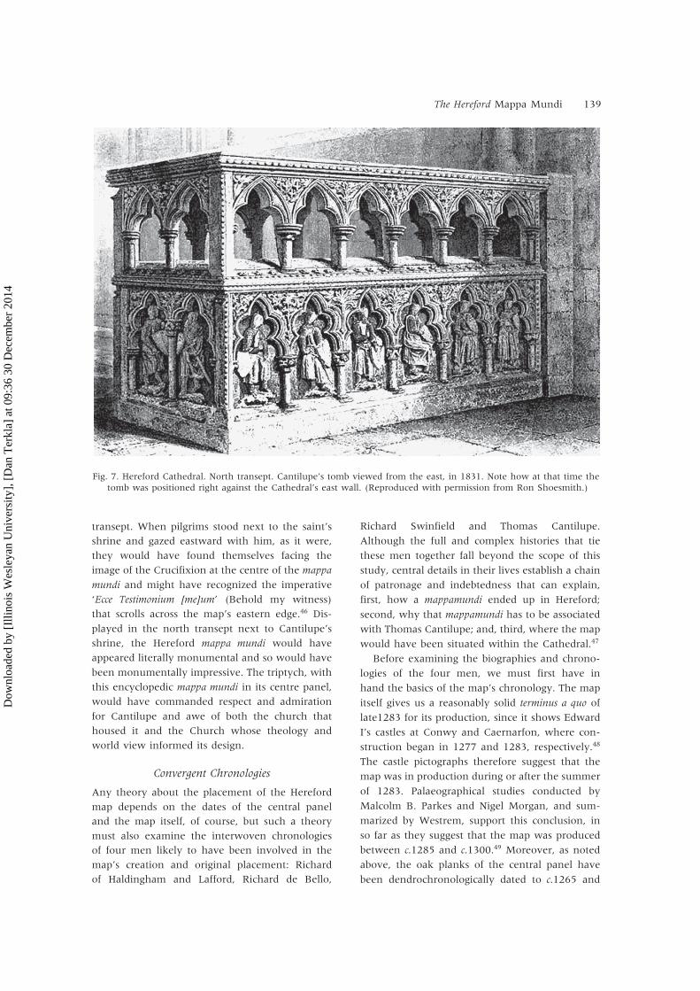
This physical evidence came to my notice in the
course of a visit to Hereford Cathedral during the
Mappa Mundi conference in 1999. While examin-
ing Cantilupe’s tomb, I saw anomalies in the fabric
of the north transept’s east wall. Just to the right
of the tomb and set into the east wall runs a
row of eight roughly uniform square stone inserts
(Fig. 8). Measuring the east wall from the side
of Cantilupe’s tomb nearest the first insert to the
end of that wall gives a width of 508 cm. The row
of inserts is nearly centred on this space. These
measurements revealed that the common central
axis of the map and triptych would have lined up
with the central axis of Bishop Aigueblanche’s
great window above, that is, with the central
axis of a tripartite arrangement of stained glass
windows (see Fig. 5).
Here I must pause to acknowledge the unsatis-
factory nature of the term ‘inserts’; it is difficult to
tell whether these stones were shaped and then
inserted to fill holes left by wooden supports that
had been removed or whether what we see are
just the ends of stone supports that had been
fitted into the holes and were later dressed off
flush with the wall.59 Neither the stones nor their
mortar have been dated as yet, and until we have
this dating information, we cannot pronounce
definitively on this matter. In some ways, ‘corbel’
seems a more appropriate label, since I argue
below that the stones—or the wood they
replaced—supported the triptych case. ‘Corbel’ is
the name conventionally given to wood or stone
projections from which rib vaults spring or to pro-
jections that support the bases of wall-mounted
items, such as the myriad memorial plaques that
cover the walls of Hereford Cathedral’s former
cloister. However, the fact that the Hereford
anomalies are flush with the wall makes calling
them corbels problematic. Therefore, since it
seems clear that the holes for either wooden or
stone supports were cut after the wall was built,
‘insert’ seems the more accurate term and is the
one I shall use in what follows. Regardless of
label, the anomalous appearance of the stones is
striking; after a first sighting, they stand out quite
dramatically and, figuratively speaking, call out for
an explanation of their purpose.
Fig. 8. Hereford Cathedral. The north transept, showing the lower section of the east wall with the row of eight stoneinserts that seem to have been either cut off flush with the wall or inserted to plug holes made by wooden supports.
(Author’s photograph, reproduced with permission from the Dean and Chapter, Hereford Cathedral.)
Dow
nloa
ded
by [
Illin
ois
Wes
leya
n U
nive
rsity
], [
Dan
Ter
kla]
at 0
9:36
30
Dec
embe
r 20
14
142 D. Terkla
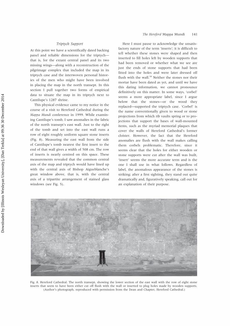
Each stone insert measures 9 cm in height by
8 cm in width, and the spacing between them
is about 24 cm (Fig. 9).60 The upper edge of each
insert is 63 cm above the floor and 177 cm below
the lip of the cornice that runs around the transept
and divides the lower section of the wall from the
stained glass windows above.61 Since the triptych
is 175 cm tall at its gable point, it would have just
fitted under the cornice that runs below the
stained glass windows (Plate 3). The full row of
eight inserts is 240 cm in length.
As noted above, the triptych’s central panel is
147 cm wide. Thus each of the missing doors/
wings would have been 73.5 cm, and the complete
triptych would have measured 175 cm by 294 cm,
not counting the room taken up by its door
hinges. This means that the triptych was a little
more than 54 cm wider than the row of inserts,
which would not have been a problem, particu-
larly since it seems that the two large holes near
the top of the central panel were made to accom-
modate hardware used to secure it in place (see
Fig. 2). The central panel of the triptych would
have rested on the middle four inserts, and the
doors/wings on the outer two on each side, which
they would have overhung by a little more than
27 cm (see Plate 3). Such an overhang would not
have been a problem, as the wall-mounted trip-
tych of the Adoration (Swabian School, c.1530),
now on display in the Cathedral’s south transept
illustrates (Fig. 10). Further analogical evidence
comes from the myriad stone memorials mounted
in the Cathedral’s former cloister, which currently
houses the tea shop and the mappa mundi exhi-
bition. The majority of these memorials rest on
projecting stone supports—closer to corbels than
to the north transept’s inserts—and their tops are
fixed to the stone walls, often by what appears to
be horizontal L-shaped metal nails.
Placement and Purpose
Where the Hereford mappa mundi was originally
positioned in the cathedral and the manner in
which it was originally used are matters ‘of crucial
importance to art historians’, as Westrem asserts
and as historians of cartography surely agree.62
Knowing where the map was originally displayed
would allow us to speculate more confidently
on how it was used and would get us closer to
dispensing with the theory that the map in its
triptych functioned as an altarpiece. As this
section demonstrates, purpose helps determine
placement, and placement enables purpose.
Not surprisingly, we have no recorded medieval
sightings of the map or accounts of its use. The
earliest recorded sighting of the map dates from
c.1682, when Thomas Dingley saw a ‘curiosity in
[the Cathedral’s Chained] Library, [a] Map of ye
World drawn on Vellum by a monk kept in a
frame wth two doors—wth guilded and painted
Letters and figures’, but this does not help us to
determine how the map was used.63 Nearly a
hundred years later such information began to
appear during that period in English history when
‘educated opinion . . . was becoming increasingly
self-conscious about the nation’s “ancient edi-
fices”’, and when antiquarians were crisscrossing
England, capturing its built heritage on paper.64
The tradition—or perhaps myth is a better word—
that the Hereford mappa mundi was used as an
altarpiece can be traced back to Richard Gough’s
first visit to Hereford Cathedral in 1770. In his
notebook, he wrote that he had seen the map
‘fastened on [a] board . . . enclosed by wooden
doors on which are painted the V. M. and Angel’,
and, confusingly, he adds that it ‘served as an
Fig. 9. Hereford Cathedral. North transept. Detail of theeast wall, showing one of the stone inserts, which isapproximately 9 cm in height by 8 cm in width. Notethe tool marks, suggesting that the inserts originallyprotruded but were subsequently cut back flush to thewall. (Author’s photograph, reproduced with permission
from the Dean and Chapter, Hereford Cathedral.)
Dow
nloa
ded
by [
Illin
ois
Wes
leya
n U
nive
rsity
], [
Dan
Ter
kla]
at 0
9:36
30
Dec
embe
r 20
14

The Hereford Mappa Mundi 143
altarpiece to the high altar’. Bailey cites pencil
annotations from Gough’s notebook, in which the
antiquary dropped the indefinite article (an) and
so seems less equivocal: ‘This was the altarpiece
till 1686 when the new altar and organ were put
up’.65 In his often cited British Topography (1780),
Gough again equivocated. There he recorded
seeing the map ‘inclosed in a case with folding
doors, on which are painted the Virgin and the
Angel’, and declared that ‘it served antiently for an
altarpiece in this church’.66 And so Gough informs
us that the map-in-triptych functioned as an altar-
piece and as the altarpiece. Although he probably
was referring to the main altar in each case, his
use of both indefinite and definite articles means
that we cannot place the map on that—or any
other—altar during his time with any certainty.
A sketch by Gough’s contemporary, the archi-
tect John Carter, shows the outline of what looks
like the Hereford map in its triptych case.67 This
image from about 1770 includes the map’s dimen-
sions and records it as being ‘enclos’d in a frame
with folding doors to cover it on which a[re]
painted two figures’—presumably the angel
Gabriel and the Virgin.68 In 1780, Carter published
his Specimens of the Ancient Sculpture and Painting.
There he describes the composite image he drew
for his title page,
[which] is comprised of various subjects descriptive ofthis work from different cathedrals, &c. The design atone view, is an ancient altar-piece the architecture ofwhich is from Bishop Audley’s Chapel, in SalisburyCathedral. On the space where the title is wrote [sic] isto be perceived a defaced crucifix. The part belowthe title where the altar-table was originally placed,and the holy water stoup is part of the altar of St.Cuthbert: the large pedestal and canopy part of thehigh altar, Both these altars from the Abbey Churchof St. Albans. The statues on each side [of] the sup-posed crucifix are painted on an oak case, containinga large ancient map of the world . . .69
Carter gives us the source of the final sentence’s
images: ‘All these from Hereford Cathedral’.70
Sadly, he superimposed part of his title on his
drawing of the triptych’s central panel and did not
reproduce the ‘defaced crucifix’.71 This superimpo-
sition means that we do not have Carter’s drawing
of the map’s interior, only its circular outline. We
are left to perceive, to imagine, the crucifix and
the map in its triptych as an altarpiece. Even
though Carter’s image is a composite, Paul Harvey
is surely right in stating that Carter’s drawing ‘is
our best evidence for the original appearance of
the triptych that then contained the map’.72 Still,
Fig. 10. Hereford Cathedral. South transept, west wall. Note how the doors of the triptych of the Adoration (SwabianSchool, c.1530) overhang the two corbels. (Author’s photograph, reproduced with permission from the Dean and
Chapter, Hereford Cathedral.)
Dow
nloa
ded
by [
Illin
ois
Wes
leya
n U
nive
rsity
], [
Dan
Ter
kla]
at 0
9:36
30
Dec
embe
r 20
14

144 D. Terkla
this is not proof that the triptych was an altarpiece
in Hereford Cathedral, only that Carter envisioned
it functioning as such in an imaginary cathedral.
Such antiquarian accounts misled the Victorian
churchmen Francis Havergal and William Bevan
to acknowledge sceptically that the map adorned
an altar. Their ‘Subscription Pamphlet,’ advertising
the sale of copies of the map in the 1870s,
explained that it was intended for an altarpiece
and meant for one of the Cathedral’s chapels.
Havergal and Bevan seem to have been influenced
by Gough’s inconsistent use of articles to imagine
the map in ‘one of the chapels’, none of which
either was or is large enough to accommodate
the triptych.73 Their suggestion that the map in
its triptych was originally in a side chapel rather
than positioned prominently on the high altar
also implies that they found such a placement
inappropriate.
Modern scholarly opinion has wavered on this
issue. For example, Norman Thrower perpetuated
the altarpiece argument and implied that using
monumental mappaemundi as altarpieces was
customary, although like Gough he equivocated.74
Martin Bailey has taken up the map-as-altarpiece
torch, although he himself finds such a function
‘surprising’ and so falls victim to the same impre-
cise use of the indefinite article, arguing that ‘the
map . . . once served as an altarpiece’.75 In 1989
Peter Barber wrote that if the central panel were
‘contemporary’ with the map, then ‘within a few
years of its creation, the map was being used as an
altar piece’.76 Barber, however, now believes that
the map was not used as an altarpiece but was
intended as an impressive display piece, as a back-
drop, much like the mappamundi that travelled
with Henry VIII.77 This display theory makes good
sense and ties in with the work of Marcia Kupfer,
who asserted in 1994 that the map was ‘certainly
not on any altar’.78 Indeed, Bailey now tends
toward this opinion: ‘If the Hereford triptych was
not an altarpiece then it still must have been an
object of religious instruction and edification’.79
From measurements taken at all recorded (and
accessible) exhibition locations in the Cathedral,
we know that the map has always been positioned
between 54 cms and 74 cms above the ground, an
ideal height for ‘instruction and edification’, to
reiterate Bailey’s terms. At 63 cm, the map’s origi-
nal position atop its stone supports in the north
transept would have fallen nearly equidistant
between these two bracketing numbers. All of
these positions are too close to the ground for
an altarpiece but are ideal for a close inspection of
the map’s images, especially its central image of
Jerusalem and over-arching Last Judgement (129
and 215 cms above ground level, respectively).
Medieval pilgrims would have found the latter
image encouraging, since it shows the Virgin
pleading for the souls of humanity on Judgement
Day and her son inviting the souls of the elect into
heaven. They would also have found instructive,
and deeply worrying, the souls of the damned
being led hellward by a winged demon.
Not surprisingly, arguments for the triptych and
the Hereford mappa mundi having been displayed
on any altar, let alone Hereford’s high altar, have
failed to gain universal acceptance. In the first
place, the triptych’s size militates against its having
been used as an altarpiece in the Cathedral’s side
chapels, all of which are too small. In the second
place, the high altar is unlikely to have been a
viable location. How would visitors to the Cathe-
dral have studied it—and its word-and-image
world does beg to be studied closely—if it were on
the main altar? In the third place, measurements
made at known exhibition locations suggest that
the map is best viewed when positioned at
roughly 63 cms up from ground level. We know
that mappaemundi were used in other venues as
visual aids to teaching, perhaps even to preaching,
as Patrick Gautier Dalché, Marcia Kupfer and
others have written.80 Neither of these activities
would have occurred in Hereford’s choir.
At Dominic Harbour’s invitation, I visited the
Cathedral in December 2003, when he had taken
the triptych’s central panel out of the Mappa Mundi
exhibition in preparation for Ian Tyers’s dendro-
chronological dating. We wanted to produce a
mock-up of the map which could be temporarily
fixed to the north transept’s east wall, atop the
eight inserts, so that we could check sight lines to
that location from the north nave aisle, the spot
from which medieval pilgrims would have first
seen the map in its triptych and Cantilupe’s
shrine. We also wanted to see if rubbing the paper
with heavy black crayons—used for brass rubbing
in the Cathedral—would reveal anything about
the wooden panel that was not immediately
apparent to the eye. We were especially anxious
to check the placement of the two large holes near
the top of the panel that seem to have accommo-
dated the hardware used to fix the triptych to the
north transept’s east wall (see Fig. 2). Although
Dow
nloa
ded
by [
Illin
ois
Wes
leya
n U
nive
rsity
], [
Dan
Ter
kla]
at 0
9:36
30
Dec
embe
r 20
14
The Hereford Mappa Mundi 145
we were unable to match these large holes with
marks on the transept’s east wall—that wall
having been tidied up in the nineteenth century,
as I have indicated—seeing the mock map in
situ provided dramatic confirmation of two vital
components of my theory. First, the map’s triptych
case seems to have been tailor-made for this
spot next to Cantilupe’s shrine, since it fits nicely
between the inserts and the cornice running
below the windows in the upper section of the
east wall. In this position, the map’s Jerusalem
axis lines up with the axis of the central window
above it. Second, in this location medieval pilgrims
would have viewed the map’s primary salvific
images at optimal heights: the City of God
on earth, Jerusalem, would have been 129 cm
above the floor and the Last Judgement scene
at an ideal—and suitably anagogical—elevation of
215 cm.81
When we moved back to the spot on the west
side of the transept (the Cathedral’s crossing)
from which pilgrims would have approached the
Cantilupe complex, we saw that the apex of the
triptych—and thus of the map’s Last Judgement
image—aligns wonderfully well with the central
light of Aigueblanche’s tripartite window in the
upper half of the transept’s east wall. We also saw,
as I had anticipated earlier, that in this location
the map in its triptych would have been the first
element of the complex that pilgrims would have
seen as they moved eastward along the north
aisle of the nave (see Fig. 4). More precisely, they
would have seen the entire map in its case, the
lower parts of the stained glass windows and
the corner of Cantilupe’s shrine. These sitings and
sightings led to the theoretical reconstitution of
the map-in-triptych, which has appeared through-
out as Plate 3. This situated reconstitution shows
that, with the oak-leaf mouldings lowered to their
original places, the entire structure would have fit
under the lip of the window cornice and forcefully
demonstrates the power of the object in this sacred
place.
It seems clear that the Hereford mappa mundi
was designed to be visible from a distance. Indeed,
some of the map’s inscriptions seem to have been
inked with long-distance viewing in mind. Follow-
ing the work of Parkes and Morgan, Westrem
differentiates the ‘display script’, which ‘a profes-
sional limner’ used for ‘the illuminated upper-case
letters . . . found along the Map’s edge and in
identifications of the four cardinal directions and
the earth’s principal land areas’, from the hand
used for the map’s legends. Westrem and Barber
have independently surmised that the Lombardic
hand and the ink used for these larger inscriptions
on the map were specially chosen for their visibil-
ity, since the key inscriptions on the map were
intended to be seen from afar.82 In this way, the
lettering on the map could have acted as a kind
of medieval neon, drawing the attention of visitors
toward the Cantilupe complex from the north
aisle.
A Likely Story
To conclude, I offer the following scenario, in
which the masonry and dendrochronological
evidence shed new light on the original setting of
the Hereford mappa mundi and make clear that
theories of the map’s function should be sought in
the context of medieval pilgrimage.
I suggest the following narrative. Richard of
Haldingham, the man to whom its dedicatory
inscription refers, began laying out the map before
1278, when he was Lincoln Cathedral’s treasurer.
Upon his death in 1278, the draft map passed
to his younger relative, Richard de Bello, who
had benefited greatly from his relationship with
Richard Swinfield and who might even have been
brought to Hereford from Lincoln by Swinfield.
De Bello saw Swinfield’s imminent translation of
Cantilupe’s remains to the north transept in 1287
as an opportunity to accomplish two things: first,
to memorialize his relative via the map’s inscrip-
tion, and, second, to repay Swinfield for his gener-
osity.83 This gesture of quid pro quo, then, provided
Swinfield with the opportunity to install the map
in its triptych next to the shrine he had built as a
memorial to his patron, Cantilupe, and no doubt
helped further de Bello’s career.
Because we know that the shrine was finished
by 1287, that palaeographical evidence suggests an
early limit of 1285 for the map’s production, and
that dendrochonology dates the triptych’s oak
to this time and locates Hereford as the wood’s
source, I am confident in arguing that the map
was completed in Hereford between Caernarfon’s
inception in 1283 and Thomas’s transferral in
1287.84 Upon the map’s completion—and certainly
by the time of the dedication of the shrine—it
became part of a Cantilupe pilgrimage complex,
which would have comprised Swinfield’s rebuilt
north nave aisle leading to Bishop Aigueblanche’s
‘stunningly modern and French’ north transept,
Dow
nloa
ded
by [
Illin
ois
Wes
leya
n U
nive
rsity
], [
Dan
Ter
kla]
at 0
9:36
30
Dec
embe
r 20
14

146 D. Terkla
finished by 1268; Bishop Swinfield’s new
Cantilupe shrine; the mural portrait of the saint
which Thomas Dingley and William Stukeley
reported seeing; and the mappa mundi in its
triptych, with its doors painted to show the
Annunciation.
Swinfield probably regarded the 1287 tomb
we see today as a temporary resting place for his
mentor’s remains. We know that he left 100
marks in his will toward the completion of the
grander shrine in the Lady Chapel.85 His desires
seem to have been carried out, for, as John Leland
reported between 1536 and 1539, ‘S. Thomas de
Cantolupo Episcopus Herefor. lieth at this tyme in
the chyrch rychely shrined’.86 It seems logical that
the map and Cantilupe’s remains, having existed
in close proximity to one another for sixty-two
years in Aigueblanche’s north transept, were both
returned to the Lady Chapel by Bishop John
Trillek in 1349.87 There, map and tomb with its
‘new reliquary’—which together comprised the
Cantilupe shrine—would have been near what is
now the oldest window in the Cathedral. Appro-
priately enough, this thirteenth-century window
shows Christ in majesty holding a T-O orb.88
There in the Lady Chapel (the Cathedral
Library from 1590 onwards), the map and shrine
continued to serve as a monument to St Thomas,
and to a lesser extent to Richard of Haldingham,
until the Dissolution, when Cantilupe’s 1349
shrine was destroyed. We know from Dingley’s
report that the map was still in the library in 1682,
and that some hundred years later Gough and
Carter reported seeing it there. The map remained
in the Chapel until the nineteenth century, since
‘in 1813 a visitor calling himself Camden’ saw it
there, but it was removed to the vestry in 1820,
where it became part of a cabinet of curiosities.
Since then it has been in myriad locations in the
Cathedral.90 In 1996 the map was installed in its
purpose-built case in the New Library Building,
close to the reassembled Chained Library.
Since the Cathedral literally contains the map,
which pictorially represents the Cathedral, the
Cantilupe complex would not have been the
final destination for visitors. Pilgrims to the shrine
could have extended their literal journeys to the
building by experiencing the mappa mundi as a
portal to myriad figurative journeys through
pagan, mythological, legendary, political and
biblical history. Just as the pilgrims would have
benefited from being directed through the
building’s various layers of decorative and liturgi-
cal figuration, they would have profited from
having the devotion and curiosity that brought
them to the Cathedral channelled in useful ways
by an attendant churchman, a custos. With the
map displayed near the tomb, such an attendant—
possibly a Dominican or Franciscan—could get his
constellation of visitors to locate the Biblical land-
marks that the map represents as pictographs and
verbal legends.90 From these signs the Cathedral
custos could easily have drawn parallels between
the pilgrims’ life journeys and the exemplary ones
of Christ and St Thomas, as well as between their
travels to Hereford and through its Cathedral, all
the while guiding their ocular journeys over the
map.
Looking at the map would have given the
pilgrim visitors a new sense of their place in the
world. They could have found—or more likely
would have been shown—England on the map,
even Hereford. At the same time, on a more
profound level they would have been orientated
metaphysically; for the role of this and all
Christian mappaemundi was to point the way from
the terrestrial City of God to the celestial City of
God, which the map’s Last Judgement shows its
viewers.
Acknowledgements: I should like to thank Peter Barber,Catherine Delano-Smith, P. D. A. Harvey and PatriziaLicini for their support and suggestions; Stacey Shimizufor her unflagging support and keen eye; Spencer Sauterfor his longstanding enthusiasm and PhotoShopwizardry; Joan Williams and Rosalind Caird of HerefordCathedral’s Library, who have been ever helpful andsupportive, and, especially, Hereford Cathedral’s DominicHarbour for his willingness to share information new andold and for his inspirational enthusiasm and useful setof keys. This essay is part of a longer study, The HerefordMappa mundi: Placement, Reception, and Perception,currently in preparation.
Paper presented at the 20th International Conference on theHistory of Cartography (Harvard University, Cambridge, MA,and the University of Southern Maine, Portland, ME), June2003. Revised text received October 2003.
NOTES AND REFERENCES
1. On mappaemundi in general, see David Woodward,‘Medieval mappaemundi’, in The History of Cartography:Cartography in Prehistoric, Ancient, and Medieval Europe andthe Mediterranean, vol. 1, ed. J. Brian Harley and DavidWoodward (Chicago, University of Chicago Press, 1987),286–370; P. D. A. Harvey, Medieval Maps (London, TheBritish Library, 1991); and Evelyn Edson, Mapping Timeand Space: How Medieval Mapmakers Viewed Their World
Dow
nloa
ded
by [
Illin
ois
Wes
leya
n U
nive
rsity
], [
Dan
Ter
kla]
at 0
9:36
30
Dec
embe
r 20
14

The Hereford Mappa Mundi 147
(London, The British Library, 1997). On the Herefordmap in particular, see W. L. Bevan and H. W. Phillott,Medieval Geography: An Essay in Illustration of the HerefordMappa Mundi (London, E. Stanford, and Hereford, E. K.Jakeman, 1873); Gerald R. Crone: The Hereford World Map(London, Royal Geographical Society, 1948); The WorldMap by Richard of Haldingham in Hereford Cathedral, circaA.D. 1285, Reproductions of Early Manuscript Maps 3(London, Royal Geographical Society, 1954); idem, ‘Newlight on the Hereford map’, Geographical Journal 131(1965): 447–62; A. L. Moir, The World Map in HerefordCathedral, 1955, 8th rev. ed. (Hereford, Friends of Here-ford Cathedral, 1977); and Scott Westrem, The HerefordMap: A Transcription and Translation of the Legends withCommentary (Turnhout, Brepols, 2001). Westrem pro-vides full-colour reproductions of the map in toto and insections.2. Hereford Cathedral’s basic floor plan is cruciform and
conventionally orientated eastward. It thus has a crossing(a transept) that separates the main body of the building(the nave) from the sancta sanctorum, which contains thechoir and main altar. The two ‘arms’ of the transeptproject northward and southward. Thomas’s 1287 shrinewas situated in the north transept.3. See Marcia Kupfer, ‘Medieval world maps: Embed-
ded images, interpretive frames’, Word & Image 10:3(1994): 262–88; Valerie I. J. Flint, ‘The Hereford map: Itsauthor(s), two scenes and a border’, Transactions of theRoyal Society, Sixth Series 8 (Cambridge, CambridgeUniversity Press, 1998), 19–44; Naomi Reed Kline, Mapsof Medieval Thought: The Hereford Paradigm (Woodbridge,Suffolk, The Boydell Press, 2001); Martin Bailey, ‘TheMappa mundi triptych: The full story of the HerefordCathedral panels’, Apollo 137 (1993): 374–78; andWestrem, The Hereford Map (see note 1).4. Unless otherwise stated, all descriptions of the
triptych panel and mappa mundi assume that the vieweris facing them. I use ‘triptych’ to refer to the tripartitestructure that included the extant central panel andits two missing doors. I use ‘central panel’ and, lessfrequently, ‘panel’ to refer only to that extant centralsection. I follow the convention of referring to Hereford’smap as the ‘mappa mundi’ and use ‘mappamundi’ (and itsplural, ‘mappaemundi’) as the generic term for a medievalworld map. Although perhaps inelegant, I use ‘map-in-triptych’ to refer to the triptych with the Herefordmap mounted on its central panel.5. Westrem, The Hereford Map (see note 1). xv.6. The map’s dimensions and all those of its central
triptych panel—both as discrete elements and as acomplete unit—are from the January 2004 dendro-chronolgical dating work undertaken by Ian Tyers.See his ‘Project report 782a: Tree-ring analysis of theHereford mappa mundi panel’, unpublished descriptioncommissioned by the Dean and Chapter of Hereford. Iam most grateful to Dominic Harbour for sending me acopy of Tyers’s report via e-mail on 18 February 2004.7. See Westrem, The Hereford Map (see note 1), xv.8. I am not the first to offer a reconstruction of the
map’s triptych. There are antiquarian drawings of it aswe shall see, and Hargrave Hands has recently offeredan elaborate re-imagining of the map in its triptych. Mydescription owes something to Bailey’s important synthe-sis of antiquarian sightings of the triptych but littleto Hands, whose work is more Neo-Gothic than Gothic.Bailey reproduces Hands’s image as a kind of pictorial
epigraph for his study. For a reproduction of Hands’simage and the reference to ‘copper strip’, see Bailey, ‘TheMappa mundi triptych’ (note 3), 374–78. For Hands’soriginal, see The Observer, 20 May 1990. P. D. A. Harveywrites that the map was fixed to its central panel with‘brass strips and nails’ and suggests that the ‘strips andnails’, now missing, disappeared in 1948, when themap was restored (Mappa Mundi: The Hereford World Map(London: Hereford Cathedral and The British Library,1996) 14).9. Thomas Dingley, History from Marble Compiled in the
Reign of Charles II by Thomas Dingley, Gent., introductionand descriptive table of contents by John Gough Nichols,2 vols. (Westminster, The Camden Society, 1867–1868),1: 12. The Chained Library was moved to the LadyChapel in 1590; hence Dingley and other antiquariansrefer to the extreme east end of the Cathedral as theLibrary. Hereford Cathedral has always been a secularhouse and so never had resident ‘monks’; therefore,‘cleric’ would have been a more accurate term forDingley to have used, particularly if the map was drawnand painted in Hereford, as the dendrochronologicalevidence suggests.10. Bailey, ‘The Mappa mundi triptych’ (see note 3),
375.11. Richard Gough, British Topography, or, An Historical
Account of What Has Been Done for Illustrating theTopographical Antiquities of Great Britain and Ireland, 2 vols.(London, T. Payne and Son, and J. Nichols, 1780), 1: 71.12. Harvey, Mappa Mundi (see note 8), 12. Harvey
(ibid., 12–14) also provides a lucid account of thedisappearance of the rest of the triptych’s accoutrements.13. See Harvey, Mappa Mundi (note 8), 11–18.14. Bailey, ‘The Mappa mundi triptych’ (see note 3),
377. For the president of the Royal GeographicalSociety’s comments, see his letter inserted into theHereford Cathedral copy of Francis Tebbs Havergal, FastiHerefordenses and other Antiquarian Memorials of Hereford,illustrated by G. C. Haddon (Edinburgh, R. Clark, 1869),n.p.15. Tyers, ‘Project report’ (see note 6), 7.16. Ibid., 6.17. Ibid., 4. The carbon dating was undertaken by
Oxford’s Research Laboratory for Archaeology and theHistory of Art ‘at the expense of The Observer newspaper’(Harvey, Mappa Mundi (see note 8), 14). See also Bailey,‘The Mappa mundi triptych’ (note 3), 374–76. For moreon the carbon dating of the central panel, see Westrem,The Hereford Map (note 1), xix.18. Tyers, ‘Project report’ (see note 6), 7.19. Westrem states that ‘[e]verything about the
physical object of the Map itself bespeaks its exacting,expensive production, a process that may well havetaken over a year’(The Hereford Map (see note 1), xix).20. Tyers, ‘Project report’ (see note 6), 3.21. Westrem, The Hereford Map (see note 1), xix.22. For more on the use of the compass, see Harvey,
Mappa Mundi (note 8), 10.23. Westrem, The Hereford Map (see note 1), xx and
xxvi.24. Westrem (ibid., xv) notes that the map’s width
varies: ‘it is at the base of the triangular head . . . 1,292millimeters, across the middle 1,325 millimeters (as aresult of some trimming on the sides, this is in effectthe depicted earth’s diameter), and across the bottom1,335 millimeters. . . . The actual skin size was probably
Dow
nloa
ded
by [
Illin
ois
Wes
leya
n U
nive
rsity
], [
Dan
Ter
kla]
at 0
9:36
30
Dec
embe
r 20
14

148 D. Terkla
some 50 millimeters . . . wider before it was reduced to[what conservator Christopher Clarkson has called] “acontinuous edge”’.25. Westrem, The Hereford Map (see note 1), xx; and
Tyers, ‘Project report’ (see note 6), 4.26. Westrem (The Hereford Map, xxiii–xxiv) provides a
careful, succinct summary of this tradition and notes that‘[t]he Map’s manufacture is not, in fact, known withcertainty to have taken place in Lincoln’.27. Tyers, ‘Project report’ (see note 6), 6.28. David Whitehead informs us that Cottingham,
whose contract began in 1843, and John Merewether,Dean of the Cathedral (1832–1850), found much of theexisting stone detail work ‘too imperfect’, and so had itremoved. They were after ‘a grand and beautiful design’that was compromised by what they saw as medieval‘deformities’ (‘The architectural history of the Cathedralsince the Reformation’, in Hereford Cathedral: A History,ed. Gerald Aylmer and John Tiller (London and RioGrande, Ohio, Hambledown Press, 2000), 271 and 276).Cottingham also had the fourteenth-century pulpitum—the stone divider between transept and choir—removed,thereby making reconstructions of medieval pilgrims’patterns of ingress and egress difficult. Scott was moresensitive to the original Cathedral fabric than his prede-cessor Cottingham. Arthur T. Bannister, Canon Residen-tiary (1909–1916), felt that ‘what was done under Scottwas for the most part done well and carefully, in thespirit not of innovation but of conservative restoration’(ibid., 280).29. Julia Barrow, ‘Athelstan to Aigueblanche, 1056–
1268’, 21, and Robert Swanson and David Lepine, ‘Thelater middle ages, 1268–1535’, 50, both in Aylmer andTiller, Hereford Cathedral (see note 28).30. See the entry ‘De S. Thoma de Cantilupe episcopo
herefordiensi in Anglia. Apud montem flasconis inhertruria pontifica’, in Acta Sanctorum: quotquot totoorbe coluntur. . . , ed. Joanne Carnandet; 67 vols. (Paris, V.Palmé, 1863–1919), 13: 539–704.31. R. C. Finucane, ‘Cantilupe as thaumaturge: Pilgrims
and their miracles’, in St. Thomas Cantilupe, Bishop ofHereford: Essays in His Honour, ed. Meryl Jancey (Hereford,The Friends of Hereford Cathedral, 1982), 138.32. The Register of Thomas de Cantilupe, Bishop of Hereford
(A.D. 1275–1282), transcribed by the Rev. R. G. Griffiths,introduction by the Rev. W. W. Capes (Hereford, TheCantilupe Society, 1906), liii and lvi.33. Swinfield enlarged both north and south nave aisles.
Perhaps the southern enlargement was undertaken toallow pilgrims easy egress.34. R. K. Morris, ‘The Architectural history of the
medieval cathedral church’, in Aylmer and Tiller,Hereford Cathedral (see note 28), 218.35. Ibid., 214. For Scott, see Whitehead, ‘The architec-
tural history of the Cathedral’ (note 28), 277.36. Thomas Dingley reported having seen ‘the remains
of his Image painted in fresquo with another Image on ye
other side [of] the window, after the same manner—supposed to be designed for Bishop Ethelreda . . .’ (Historyfrom Marble (see note 9), clxxix.37. Morris, ‘The Architectural history of the medieval
cathedral church’ (see note 34), 214. Morris has cor-rected some of George Marshall’s misapprehensions andprovides a current account of Bishop Aigueblanche’sbuilding campaign. See George Marshall, ‘The shrineof St. Thomas de Cantilupe in Hereford Cathedral’, TheTransactions of the Woolhope Naturalists’ Field Club 34(1930): 34–50.
38. The imaginative reconstruction of Thomas’s firstshrine by the illustrator Brian Byron, made in 1998,comes quite close to my conception of the Cantilupecomplex. For Byron’s image, which does not includethe map-in-triptych, see the Reverend Canon JamesButterworth, Hereford Cathedral: The Church, MappaMundi, Chained Library (Norwich, Hereford Cathedraland Jarrold Publishing, 1998), 19. I am grateful toDominic Harbour for showing me this guidebook, which,of course, is in the Cathedral shop.
39. William Stukeley, Itinerarium Curiosum, Or, anAccount of the Antiquitys and remarkable Curiositys in Natureor Art, observ’d in Travels thro’ Great Britain, 2 vols., illus-trated with copperplate prints (London, Printed for theAuthor, 1724), 67. Except for the tomb itself, none of theitems Stukeley mentions is in place today.
40. Medieval shrines were not the same as tombs:‘Shrines differed from tombs primarily in the elevationof the coffin, and indeed translations could be describedas movement to “higher” positions. . . . The bulk of atomb monument was therefore a superstructure, whilea shrine monument was the base for a reliquarychest’ (Ben Nilson, Cathedral Shrines of Medieval England(Woodbridge, England, The Boydell Press, 1998,reprinted 2001), 18).
41. Penelope E. Morgan, ‘The Pilgrim cult and HerefordCathedral’, in Jancey , St. Thomas Cantilupe (see note 31),146.
42. Havergal in 1869 thought that this placement wasoriginal and thus correct: ‘During the former part of thiscentury it was placed against the eastern wall of thisaisle. In 1859 it was taken down with great care, andreconstructed in the centre, which is admitted by allauthorities to be its original position’ (Havergal, FastiHerefordenses (see note 14), 175).
43. Harvey, Mappa mundi (see note 8), 12.44. Flint (‘The Hereford map’ (see note 3), 42, n. 93),
characterizes this standard depiction as ‘the curiousimage . . . of the bare-breasted Virgin’. In fact, it wasquite common. For more on this popular trope andimage as well as those of the related Mater Dolorosaand Planctus Mariae, see Dan Terkla, ‘A Basochienproto-drama and its mariological context: L’AdvocacieNostre-Dame’, Medieval Perspectives 6 (1991): 87–100. Foran architectural analogy, see Ellen M. Ross, The Grief ofGod: Images of the Suffering Jesus in Late Medieval England(New York, Oxford University Press, 1997), 55.
45. See Butler’s Lives of the Saints, New Full Edition,12 vols., ed. Rev. Peter Doyle (Collegeville, Minnesota,The Liturgical Press, 1996), vol. 10, October, 13–14.While suggesting that the map ‘was perhaps in the LadyChapel’ in 1283, Flint points out that the Chapel waswhere ‘newly delivered mothers were accustomed to be“churched”’ (‘The Hereford map’ (note 3), 42, n. 93).
46. This inscription is not visible in the current exhibi-tion case. See Westrem, The Hereford Map (see note 1), 4and 5.
47. For more on the life of Thomas, see Richard Strange,comp., The Life and Gests of S. THOMAS CANTILVPE, Bishopof Hereford, and some time before L. Chancellor of England,collected by R.S.S.I. at Gant [Ghent] (printed by RobertWalker, at the signe of the Annunciation of our B. Lady[,]1674), 192–227 et passim; The Hereford Breviary, ed. WalterHoward Frere and Langton E. G. Brown, from the RouenEdition of 1505 with Collation of the Manuscripts, vol. 3(London, Henry Bradshaw Society, 1904), 252 and 260;Rev. W. W. Capes, Introduction, in The Register of Thomasde Cantilupe (note 32), i–lxviii; Jancey, St Thomas Cantilupe
Dow
nloa
ded
by [
Illin
ois
Wes
leya
n U
nive
rsity
], [
Dan
Ter
kla]
at 0
9:36
30
Dec
embe
r 20
14

The Hereford Mappa Mundi 149
(note 31). For a full account of Cantilupe’s canonization,based in part upon the unedited MS. Vatican Cod.Lat. 4015, see R. C. Finucane, ‘The Cantilupe-Pechamcontroversy’, in Jancey, St. Thomas Cantilupe (note 31),103–23. See also John le Neve Fasti Ecclesiae Anglicanae1066–1300, Lincoln, vol. 3, compiled by Diana EleanorGreenway (London, University of London, 1977), 20, 73;John le Neve Fasti Ecclesiae Anglicanae 1066–1300, Salisbury,vol. 4, compiled by Diana Eleanor Greenway (London,University of London, 1991), 49, 64, 70; John le Neve FastiEcclesiae Anglicanae 1066–1300, Salisbury Diocese, vol. 3,compiled by Joyce M. Horn (London, University ofLondon, 1962), 9, 45, 58.48. Daniel Mersey, ‘Caernarvon Castle—Fit for a
Prince’, Castles of Wales, <http://www.castlewales.com/caernarf/html>, 14 June 2002.49. See Westrem, The Hereford Map (see note 1), xviii–
xix, and Malcolm B. Parkes and Nigel Morgan, ‘TheMappa mundi at Hereford: Report on the handwritingand copying of the text’, typescript of a lecture deliveredat the Hereford Mappa mundi Conference, 27 June–1 July1999, which will be published in The HerefordMappa Mundi: Proceedings of the Mappa Mundi Conference,1999, ed. P. D. A. Harvey (London, British Library,forthcoming).50. Richard of Haldingham’s authorship is by no means
accepted by all historians of cartography. For othertheories about why and for whom the Hereford map wascreated, see Flint, ‘The Hereford map’ (note 3), 19–44;Harvey, Mappa mundi (note 8), 7–14; P. D. A. Harvey,‘Mappa Mundi’, in Aylmer and Tiller, Hereford Cathedral(note 28), 559–61; Kline, Maps of Medieval Thought(note 3); and Westrem, The Hereford Map (note 1), xxiii.Curiously, in volume 3 of John le Neve Fasti (1977;note 47), Diana Greenway records that Richard ofHaldingham occurs ‘as magister twice . . .’, while involume 4 (1991), she writes the following: ‘No evidencefor identification with Richard de Haldingham or Lafford[as magister], of Hereford “Mappa mundi”, and not to beconfused with man of same name (who does not occ. asMaster), who was preb. Lafford and treas. Lincoln, whod. perhaps 4 Nov. 1278’ (my emphasis). For more on thelife of Bishop Swinfield, see Flint, ‘The Hereford map’(note 3), 19–44; Havergal, Fasti Herefordenses (note 14),19–20 et passim.51. Flint, ‘The Hereford map’ (note 3), 30; and
Westrem, The Hereford Map (note 1), xxiii.52. Westrem, The Hereford Map (note 1), xxiii.53. See Flint, ‘The Hereford map’ (note 3), 26–29, on
this ‘gift of meat’ and for more on the relationshipbetween de Bello and Swinfield.54. On de Bello’s role as proctor, see Registrum Ricardi
de Swinfield, episcopi Herefordensis, 1283–1317, transcribedand edited by William W. Capes (London: Canterburyand York Society 6, 1909), 491. Along with Swinfield’spatronage, de Bello enjoyed the favours of three otherbishops: Hereford’s Thomas Cantilupe, Lincoln’s OliverSutton (1280–1299), and Salisbury’s Simon of Ghent(1297–before 1315). For this and more on de Bello’spreferments, see Flint, ‘The Hereford map’ (see note 3),29.55. Flint, ‘The Hereford map’ (see note 3), 31.56. Ibid.57. In e-mail communications, Patrizia Licini has told
me that she has observed links between these place-names and the Hereford map which look promising interms of pulling Thomas’s shrine and the map a bitcloser.
58. The Register of Thomas de Cantilupe (see note 32), lii.59. On 18 July 2002, Ron Shoesmith conveyed the
following to me via e-mail: ‘I would favour the idea thattimbers were removed and the stones inserted to tidy upthe wall’.60. I have converted the measurements in this section
from inches and feet to centimetres and have roundedthem off. The figures for the inserts, like those for thetriptych, are therefore approximate.61. I am unsure if this cornice is original or a nine-
teenth-century restoration/re-creation of Sir GeorgeGilbert Scott. Cathedral masons Simon Hudson andMartin Lewis told me in May 2002 that they think thecornice is not original, but they had no dating informa-tion. Even if it is a re-creation, it seems to be in theoriginal location, although this needs confirmation.62. Westrem, The Hereford Map (see note 1), xxi, n.17.63. Dingley, History from Marble (see note 9), 1: 12.64. Whitehead, ‘The Architectural history of the
cathedral’ (see note 28), 260.65. Richard Gough’s notebook, Oxford’s Bodleian
Library MS Top.Gen.e.19, fol. 88r; all quoted in Bailey‘The Mappa mundi triptych’ (see note 3), 376, myemphases.66. Gough, British Topography (see note 11), 1: 71, my
emphasis.67. BL Add. MS 29942, fol. 148; and Bailey, ‘The
Mappa mundi triptych’ (see note 3), 375.68. Quoted by Bailey in ‘The Mappa mundi triptych’ (see
note 3), 376–77.69. John Carter, Specimens of the Ancient Sculpture and
Painting, now remaining in this Kingdom, from the earliestperiod to the reign of Henry ye VIII, consisting of Statues,Bassorelievos, Brasses &c. Paintings on Glass and on Walls, &c.A Description of each Subject, some of which by Gentlemen ofLeterary [sic] Abilities, and well versed in the Antiquaries(London[,] Published as the act directs by John Carter[,]Wood St. Westminster[.] November ye 1.st 1780), iii. Formore accessible reproductions of Carter’s title page, seeBailey, ‘The Mappa mundi triptych’ (note 3), 375–76; andHarvey, Mappa Mundi (note 8), 12.70. Carter, Specimens of the Ancient Sculpture and Painting
(see note 69), 40.71. The Crucifixion appears just above—that is, just
east—of Jerusalem at the map’s centre and has beenheavily worn, it seems, by the fingers of countlessviewers.72. See Harvey, Mappa mundi (note 8), 15.73. Havergal, Fasti Herefordenses (see note 14), 2–3.
Havergal’s Fasti, under the year 1869, refers to Dingley’sHistory from Marble (see note 9), and provides the follow-ing under ‘On Walls and Groining’: ‘The following fineexamples [of “distinct traces of colour”], as described bylocal authors, have long since been destroyed:—1. Doorsand canopy of the map. 2. Mural effigies near CantilupeShrine. 3. Mural decoration in the Chapter-house’ (156).74. Norman J. W. Thrower, Maps & Man: An Examina-
tion of Cartography in Relation to Culture and Civilization(Englewood Cliffs, New Jersey, Prentice-Hall, 1972), 42,my emphasis.75. Bailey, ‘The Mappa mundi triptych’ (see note 3),
374, my emphasis. Unfortunately, Gabriel Alington’sguide—currently on sale in the busy Cathedral shop andso widely dispersed among visitors—follows on fromGough and Dingley to perpetuate the altarpiece theory(The Hereford Mappa Mundi: A Medieval View of the World,illustrated by Dominic Harbour (Leominster, England,Gracewing, 1996), 20). Bailey uses Hargrave Hands’s
Dow
nloa
ded
by [
Illin
ois
Wes
leya
n U
nive
rsity
], [
Dan
Ter
kla]
at 0
9:36
30
Dec
embe
r 20
14

150 D. Terkla
reconstruction of the triptych as an image-epigraph onthe first page of his Apollo article (see note 3). AlthoughHands’s vision is more Victorian than medieval, it doesintimate the sense of majesty that the original mighthave inspired in its viewers (see note 8). Nicely framedversions of the Hands reconstruction are on sale in theCathedral shop, where they continue to blur the tempo-ral line between medieval and Neo-Gothic art and somisinform visitors about the triptych’s original appear-ance. I have overheard people in the shop commentingon Hands’s ‘original’, which they see as a ‘reproduction’of the medieval triptych.76. Peter Barber, ‘Visual encyclopaedias: The Hereford
and other mappae mundi’, The Map Collector 48 (1989):3–7, reference on 7.77. This is from my conversations with Barber at the
British Library in the autumn of 2003.78. Kupfer, ‘Medieval world maps’ (see note 3), 276.79. Bailey, ‘The Mappa mundi triptych’ (see note 3),
376, my emphases.80. On medieval monastic education and mappaemundi,
see Hugh of St-Victor’s dialogue with a student in OperaOmnia (1854), ed. J. P. Migne, Patrologia Latina, 176.24C.See also Patrick Gautier Dalché, ed., La ‘Descriptio Mappamundi’ de Hugues de Saint-Victor, texte inédit avec intro-duction et commentaire (Paris, Etudes Augustiniennes,1988); Kupfer, ‘Medieval world maps’ (see note 3), 276;and Dan Terkla, ‘Impassioned failure: Memory, meta-phor, and the drive toward intellection’, in ImaginingHeaven in the Middle Ages: A Book of Essays, ed. HughFeiss and Jan Emerson (New York, Garland Press, 2000),260–62, 289.81. This means that the current height at which the
map is exhibited is much too high, as anyone who hastried to see its Last Judgement or details in its depictionof Asia knows. In May 2003, Dominic Harbour informedme that the Cathedral has undertaken fund raising tofinance the redesign of the mappa mundi’s display. Part ofthat redesign will include situating the map at a heightmore in line with these figures.82. Westrem, The Hereford Map (see note 1), xviii. Peter
Barber conveyed this information to me during aconversation at the British Library in the autumn of2003.83. Westrem notes that, ‘while the legend does not
explicitly invite prayers for the soul of Richard [ofHaldingham], an invocation of this kind was more com-monly made for the deceased, often sponsored by familymembers’ (The Hereford Map (see note 1), xxii, n.21). Thefact that the legend is written in the third-person alsosuggests that Richard of Haldingham was not its author.84. In this context dates will be fluid, but Nigel
Morgan’s earliest palaeographical date of 1285 (Parkesand Morgan ‘The Mappa mundi at Hereford’ (see note49)), and Westrem’s tenable assumption that the maptook at least one year to complete (The Hereford Map (seenote 1), 11), make Flint’s favouring of ‘a date close to theconquest of Wales, 1282–3, for the completion of thewhole and, perhaps, for its display’ a problem. She arguesthat ‘the whole was completed after Cantilupe’s death, inessence by 1283, for the embellishment of Cantilupe’s firstresting place in Hereford Cathedral’ (‘The Hereford map’(see note 3), 23 and 42, my emphases). I am leery ofspeculating to this extent, however. No written sourcerecords of the map’s location before Dingley’s 1682sighting, nor is there any architectural or decorational
evidence to support a pre-1283 display date in the LadyChapel; for the eastern end of the Cathedral has beenheavily rebuilt since the thirteenth century. For solidrecent accounts of this rebuilding, see the relevantchapters in Aylmer and Tiller, Hereford Cathedral (note28); also the older but still helpful Marshall, ‘The shrineof St. Thomas de Cantilupe’ (note 37), 34–50, and SirGeorge Gilbert Scott, Personal and Professional Recollections,revised, with introduction by Gavin Stamp (Stamford,Paul Watkins, 1879, reprinted 1995).
85. Capes, Registrum Ricardi de Swinfield (see note 54),220–21.
86. John Leland, The Itinerary of John Leland in or aboutthe Years 1535–1543, ed. Lucy Toulmin Smith, 5 vols.(London, George Bell and Sons, 1907), 3: 48.
87. Ian Tyers’s date of one of the central panel’sbattens—that is, one of the two horizontal supportiveplanks running across the back of the panel—mightbuttress this contention. The tree that produced theupper batten, according to Tyers, ‘cannot have beenfelled before c. 1289’. The map would have had to beremoved before this new batten was attached, perhaps toprevent the central panel ‘twisting’ any further; thiswould account for the second set of nail holes near thepanel’s apex (Fig. 2). In discussing this issue, DominicHarbour and I wonder if this minor refurbishmentoccurred in preparation for the removal of the triptychfrom the north transept to its next location in the LadyChapel. As Tyers writes, ‘[t]he implications of this arefar reaching . . . and necessitate both a discussion of thefeasibility of withdrawing nails from oak boards, and anappreciation of the likely damage to the Mappa in tryingto get it off the board’ (‘Project report’ (see note 6), 6–7).
88. On the ‘new reliquary’ and a brief history ofthe movements of Cantilupe’s remains, see NicolaColdstream, ‘The Medieval tombs and the shrine of SaintThomas Cantilupe’, in Aylmer and Tiller, HerefordCathedral (note 28), 330 et passim. On the translation tothe Lady Chapel, see The Register of John de Trillek Bishopof Hereford, A.D. 1344–1361, ed. J. H. Parry (Hereford,Hereford Cathedral, 1910), 147–48.
89. On Camden, see Havergal, Fasti Herefordenses (note14), 162. For the period 1855–1863 the map was ondisplay with the Chained Library then in a room abovethe north transept, and in 1863 it was in the south choiraisle. The map was moved to the Audley Chapel forcopying in 1869, and in 1910 or 1912 it was placed onthe east wall of the south transept. From 1948 to 1988, itwas in the north choir aisle in a new case designed by theRoyal Geographical Society. From 1990 to 1996 it waslocated in the crypt, again with the Cathedral treasuresand curiosities. I am indebted to Cathedral ArchivistRosalind Caird, for some of this information. For a fullerhistory of the map’s movements (in and out of theCathedral), and copying, see Harvey, Mappa mundi(note 8), 15–18.
90. Thomas Tanner, Bishop of St Asaph, wrote of these‘friers Preachers’, who ‘came hither first in the time of St.Thomas Cantilupe bishop of Hereford’ (Notitia Monastica;or an Account of all the Abbies, Priories, and Houses of Friers,Formerly in England and Wales and also of all the Colleges andHospitals Founded Before A.D. MDXL, 2nd ed. (Cambridge,Cambridge University Press, 1787), 126r). See alsoLeland, The Itinerary of John Leland (note 86), 1: 160–61,2: 67, 3: 48; and Swanson and Lepine, ‘The later middleages’ (note 29), 80.
Dow
nloa
ded
by [
Illin
ois
Wes
leya
n U
nive
rsity
], [
Dan
Ter
kla]
at 0
9:36
30
Dec
embe
r 20
14

The Hereford Mappa Mundi 151
L’emplacement originel de la mappemonde de Hereford
Bien que les amateurs d’antiquités, les historiens de la cartographie, les paléographes et les historiens de
l’art aient écrit depuis plus de trois cents ans sur la mappemonde de Hereford, on connaît peu de choses à
propos de son emplacement primitif ou de son utilisation. Cet article s’appuie sur des preuves tirées de la
nouvelle maçonnerie et de la dendrochronologie pour affirmer que cette monumentale carte du monde
était présentée à l’origine près du premier tombeau de Saint Thomas Cantilupe, dans le transept nord de la
cathédrale de Hereford. Elle n’était donc pas utilisée comme un retable, mais comme un élément de ce que
j’appelle le ‘système du pèlerinage de Cantilupe’, un ensemble d’objets et d’images qui constitua un temps
l’une des destinations de pèlerinage parmi les plus populaires d’Angleterre. A son emplacement, la carte
aurait ajouté au pouvoir d’attraction du système et servi d’outil pédagogique multimédia.
Der ursprüngliche Aufstellungsort der Mappa Mundi von Hereford
Obwohl Historiker, Kartographiehistoriker, Palaeographen und Kunsthistoriker seit über dreihundert
Jahren über die Mappa Mundi von Hereford geschrieben haben, wissen wir wenig über ihren originalen
Aufstellungsort und ihre Verwendung. Die Argumentation in diesem Beitrag basiert auf neuen
Untersuchungen der Steinmetzarbeiten, der Dendrochronologie und des Systems der Beförderung in der
mittelalterlichen Kirchenhierarchie, die nahelegen, dass diese monumentale Weltkarte 1287 ihren ersten
Aufstellungsplatz neben dem ersten Schrein des Heiligen Thomas Cantilupe im nördlichen Querschiff der
Kathedrale von Hereford erhielt. Sie diente dementsprechend nicht als Altarbild, sondern bildete einen Teil
dessen, was der Autor den ‘Cantilupe pilgrimage complex’ nennt. Dabei handelt es sich um eine Gruppe
von Bildern und Gegenständen, die für einige Zeit zum populärsten Pilgerziel Englands avancierten. An
diesem Platz hätte die Karte die Attraktivität dieses Komplexes gesteigert und als ein multimediales
pädagogisches Instrument gedient.
El emplazamiento original del mappa mundi de Hereford
Aunque anticuarios, historiadores de la cartografía, paleógrafos e historiadores del arte han escrito sobre el
mappa mundi de Hereford durante más de 300 años, conocemos poco acerca de su emplazamiento original
o uso. Este artículo trata de la obra de la nueva sillería de la catedral, de evidencias dendrocronológicas y
del sistema de preeminencias eclesiásticas medievales, para argumentar que este monumental mapa del
mundo fue originalmente exhibido en 1287 cerca del primer sepulcro de Santo Thomas Cantilupe, en el
crucero norte de la catedral de Hereford, y que no funcionó como retablo, sino como parte de lo que el
autor denomina ‘el complejo de peregrinaciones Cantilupe’, un conglomerado de aditamentos e imágenes
que fue en aquel tiempo uno de los mas populares destinos de peregrinación en Inglaterra. En este
emplazamiento, el mapa podría haber añadido atractivo al complejo y servido como un instrumento de
pedagogía multimedia.
Dow
nloa
ded
by [
Illin
ois
Wes
leya
n U
nive
rsity
], [
Dan
Ter
kla]
at 0
9:36
30
Dec
embe
r 20
14

Pla
te
1.
Her
eford
C
ath
edra
l,
New
Lib
rary
B
uildin
g.
Th
e H
eref
ord
m
appa
mu
ndi
(c.1
283).
Dra
wn
on
cal
f sk
in,
appro
xim
atel
y 163
cm t
all
×137
cm w
ide,
sh
ow
n h
ere
fixed
to i
ts c
urr
ent
mou
nti
ng
mad
e fr
om
wood t
aken
fro
m C
ity
of
Lon
don
ch
urc
hes
bom
bed
du
rin
g th
e Sec
on
d
Worl
d
War
. Th
e pen
tago
nal
m
ap
pre
sen
ts
a la
ter
med
ieva
l en
cycl
oped
ic v
isio
n o
f th
e in
hab
ited
reg
ion
s of
the
worl
d.
(Rep
rodu
ced
wit
h p
erm
issi
on
fro
m t
he
Dea
n a
nd C
hap
ter,
Her
eford
Cat
hed
ral.)
See
p.
132.
Pla
te
2.
Her
eford
C
ath
edra
l.
Th
e ce
ntr
al
pan
el
of
the
Her
eford
m
appa
mu
ndi
trip
tych
, sh
ow
ing
pla
nks
cut
from
oak
s gr
ow
n n
ear
Her
eford
an
d f
elle
d c
.12
65
acco
rdin
g to
den
dro
chro
nolo
gica
l te
stin
g. T
he
oak
-lea
f ga
ble
mou
ldin
g is
car
bon
-dat
ed t
o c
.1040–1
280.
Note
th
e ga
p b
etw
een
mou
ldin
g pie
ces
crea
ted b
y in
corr
ect
rem
ou
nti
ng.
Th
e fr
amin
g w
ood i
s a
nin
etee
nth
-cen
tury
addit
ion
. 175
×147
cm.
Th
e ph
oto
grap
h w
as t
aken
wh
en t
he
cen
tral
pan
el w
as s
till i
n i
ts c
ust
om
ary
loca
-ti
on
in
th
e fo
rmer
clo
iste
r of
the
Cat
hed
ral
and b
efore
its
rem
ova
l in
Dec
embe
r2003
for
den
dro
chro
nolo
gica
l dat
ing.
(A
uth
or’
s ph
oto
grap
h,
repro
du
ced
wit
hper
mis
sion
fro
m t
he
Dea
n a
nd C
hap
ter,
Her
eford
Cat
hed
ral.)
See
p.
132.
Dow
nloa
ded
by [
Illin
ois
Wes
leya
n U
nive
rsity
], [
Dan
Ter
kla]
at 0
9:36
30
Dec
embe
r 20
14

Plate 3. Montage showing the Hereford mappa mundi in what is suggested was its original position. The triptych contain-ing the map would have rested on eight stones inserted into the wall, below the Bishop Aigueblanche’s tripartite windowand next to St Thomas Cantilupe’s tomb (left). The stones, now cut back flush with the wall, are discernible immediatelybelow the triptych. The dimensions and angles of the doors of the triptych are exactly half those of the central panel.The triptych was created in Photoshop® from scanned slides of the map and the central panel without the map to showthe missing doors or wings. (Author’s photograph, map and central panel slides, as in Plate 1 and 2, are reproducedwith permission from the Dean and Chapter, Hereford Cathedral. Photoshop® reconstitution by SpencerSauter of
spenmedia.com.) See p. 142.
Dow
nloa
ded
by [
Illin
ois
Wes
leya
n U
nive
rsity
], [
Dan
Ter
kla]
at 0
9:36
30
Dec
embe
r 20
14