The Origin and Tectonic Significance of the Basin and Range ...
8
The Origin and Tectonic Significance of the Basin and Range–Rio Grande Rift Boundary in Southern New Mexico, USA 2021 Annual Program Report VOL. 31, NO. 10 | OCTOBER 2021
-
Upload
khangminh22 -
Category
Documents
-
view
1 -
download
0
Transcript of The Origin and Tectonic Significance of the Basin and Range ...

The Origin and Tectonic Significance of the Basin and Range–Rio Grande
Rift Boundary in Southern New Mexico, USA
2021 Annual Program Report
VOL. 31, NO. 10 | OCTOBER 2021
Jason W. Ricketts, Dept. of Earth, Environmental and Resource Sciences, The University of Texas at El Paso, 500 West University Ave., El Paso, Texas 79968, USA, [email protected]; Jeffrey M. Amato, and Michelle M. Gavel, Dept. of Geological Sciences, New Mexico State University, Las Cruces, New Mexico 88003, USA
ABSTRACTCenozoic extension in the western United
States occurred within two iconic domains: the Basin and Range and Rio Grande rift. These provinces merge in southern New Mexico to form an interconnected zone of extension, although the existence, location, and nature of the boundary between the two provinces are uncertain. In southern New Mexico, existing thermochronologic, geo-logic, and geophysical data sets, combined with thermal modeling of zircon (U-Th)/He (ZHe) data, define a subvertical, 30–40-km-wide boundary that extends through the lithosphere to depths of at least 100 km. Thermal modeling indicates Proterozoic basement in the upper crust of the south-eastern Basin and Range exceeded 225 °C during Oligocene magmatism, resetting ZHe dates and creating a thermal boundary that coincides with independent geologic and geophysical data sets. Although many aspects of this boundary are transient, oth-ers may become permanent features to define a lithospheric-scale boundary prone to reactivation during future tectonism. This assessment of the boundary supports models in which the southern Rio Grande rift is a separate structural entity from the adjacent Basin and Range, and this region provides an exceptional case study for understanding how extensional lithospheric-scale boundaries evolve to become stable features of continents.
INTRODUCTIONThe Rio Grande rift and Basin and Range
Province are two of the most iconic exten-sional domains on Earth; the Basin and Range Province is the archetypal example of a wide rift, and the neighboring Rio Grande rift is one of the classic modern examples of a narrow continental rift (e.g., Buck, 1991). For most of its length, the Rio Grande rift is
separated from the Basin and Range Province by the Colorado Plateau, and they exist as distinct structural entities, but in southern New Mexico, they merge to form an inter-connected zone of extension that continues south into Mexico (Fig. 1). The existence of a discrete boundary between the two domains and the nature of this transition in southern New Mexico remain unclear, although understanding the transition is crucial for assessing how these two extensional prov-inces evolved through time. The physio-graphic expression of extension in southern New Mexico suggests an indistinct or nonex-istent boundary, favoring models where the Rio Grande rift is the easternmost segment of the Basin and Range Province (Eaton, 1982). This view is contentious, however, because thermochronologic (Gavel, 2019) and geophysical (e.g., Keller et al., 1990; Averill and Miller, 2013; Feucht et al., 2019) data sets highlight important differences between the two provinces, supporting mod-els where they exist as two separate, albeit contiguous entities. This nontrivial distinc-tion has implications for the relative role of plate-boundary versus mantle processes driving extension in western North America (Dickinson, 2002).
A more complete understanding of the boundary requires diverse data sets at dif-ferent scales to constrain its current charac-teristics and evolutionary history. Here we use thermochronologic data, including apa-tite fission-track (AFT), apatite (U-Th)/He (AHe), and zircon (U-Th)/He (ZHe), together with a synthesis of geologic and geophysi-cal data from southwestern New Mexico to investigate the nature of the transition at a lithospheric scale. We then document a pro-nounced thermal boundary across the tran-sition preserved in ZHe data sets. When viewed collectively, these independent data sets reveal a complex and dynamic tectono-
thermal boundary and reinforce the idea that the southern Rio Grande rift is a separate structural entity from the adjacent Basin and Range Province.
THE RIO GRANDE RIFT–BASIN AND RANGE BOUNDARY IN SOUTHERN NEW MEXICO
There are three models for how to assess the Rio Grande rift–Basin and Range Province boundary (Fig. 1): (1) The northern Rio Grande rift is a separate entity from the Basin and Range Province, and is distin-guished by its narrow width (dark orange in Fig. 1); (2) the entire Rio Grande rift exists as a separate entity along its entire length (light and dark orange in Fig. 1); and (3) the two provinces are contiguous and coeval and thus the Rio Grande rift is just a localized term for the Basin and Range Province on its eastern margin adjacent to the Colorado Plateau (thick dark green line in Fig. 1). We investigate the nature of a possible boundary in southern New Mexico, and use “transition zone” to refer to a 40-km-wide zone that includes major differences in the crust and lithosphere. Physiographic maps, which are based on modern topography and drainage basins, lump the southern Rio Grande rift with the Basin and Range Province (Hammond, 1970). Most workers place the boundary at the eastern edge of the transition zone (e.g., Mack, 2004; van Wijk et al., 2018), which coincides with the western edge of the rift farther north, but it has not yet been clearly documented as to why this is a mean-ingful or geologically relevant location in southern New Mexico.
GEOLOGIC AND GEOPHYSICAL MANIFESTATIONS OF A BOUNDARY
In southern New Mexico, independent data sets highlight a subvertical boundary 30–40 km wide that extends to depths of at
The Origin and Tectonic Significance of the Basin and Range–Rio Grande Rift Boundary in Southern New Mexico, USA
GSA Today, v. 31, https://doi.org/10.1130/GSATG509A.1. CC-BY-NC.
4 GSA Today | October 2021
31°N
32°N
33°N
109°W 108°W 107°W 106°W 105°W
ArizonaArizona
TexasTexas
ChihuahuaChihuahua
35
30
28
28
35
30
105105
125
105105
105105
858540
30
New MexicoNew Mexico
?
?
Basin andRange
Rio Granderift
Great Plains
Mogollon Datilvolcanic field
transitionzone
Boot Heelvolcanic field
???
????????????
1125
125
125
125255
siitioonnanssinssitrraraaneezoonz n
Cenozoic volcanic rocks
Proterozoic rocks
Miocene - Quaternary basin fill
Paleozoic - Mesozoic rocks
Quaternary fault
0 30 60 90 12015km
Magnetotelluric station
0 500 1000 1500 2000Bulk crustal conductance (seimens)
Reflection/refraction lineQuaternary basalt flow
N
1 mm/yr; 90%confidence ellipse
Thermochronology sample(AHe, ZHe, and/or AFT)
37-23 Ma calderas
GPS profilein Fig. 2
BR
BR
CP
RM
GPRGR
Figure 1
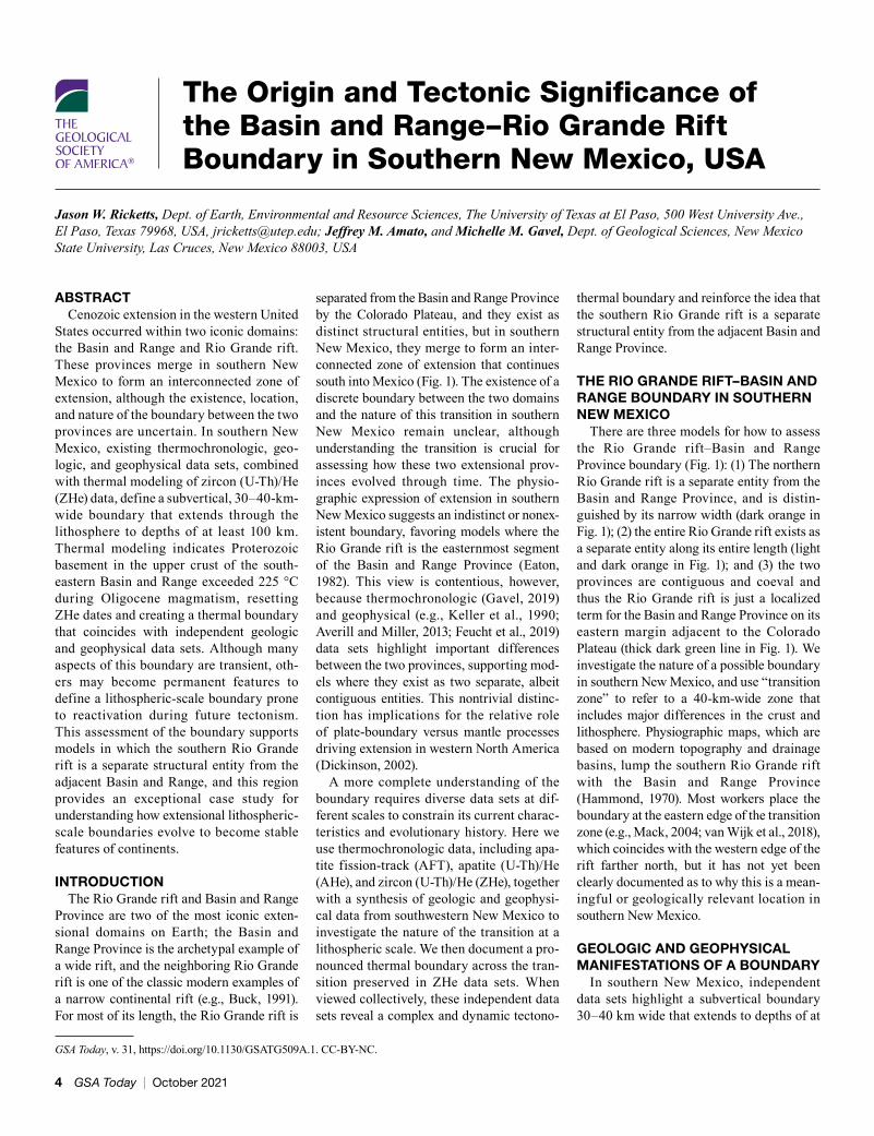
least 100 km (Figs. 1 and 2). Global posi-tioning system (GPS) data show variable strain rates between the Great Plains and the Basin and Range Province (Fig. 2A; Murray et al., 2019). The Great Plains has low strain rates of 0.68 ± 0.17 nanostrains/year (nstr/yr), but strain rates are an order of magnitude higher in the Basin and Range Province and southern Rio Grande rift. Notably, there is a sharp transition from the highest strain rates of 8.54 ± 2.10 nstr/yr in the Rio Grande rift to lower rates of 1.45 ± 0.31 nstr/yr in the adjacent eastern Basin and Range Province. GPS results are con-sistent with a greater number of Quaternary faults in the southern Rio Grande rift, but these data also indicate that the rift is deforming at interseismic time scales.
AHe, AFT, and ZHe thermochronology, sensitive to temperatures of 30–90 °C,
60–120 °C, and 50–240 °C, respectively (Ketcham, 2005; Flowers et al., 2009; Guenthner et al., 2013), are compiled across the transition zone (Fig. 1; Kelley and Chapin, 1997; Ricketts et al., 2016; Biddle et al., 2018; Gavel, 2019; Reade et al., 2020). AFT and AHe dates show little variation across this region, and ages overlap with the time of Cenozoic extension. However, ZHe dates change drastically over short dis-tances (Fig. 2B). West of the transition ZHe dates are similar to AFT and AHe dates, but east of the transition ZHe dates range from 2 to 731 Ma.
Across this region, overall crustal thick-ness gradually increases from ~28–30 km beneath the axis of the Rio Grande rift to 35 km in southwestern New Mexico (Fig. 2C; Keller et al., 1990; Averill, 2007). Basins are typically deeper in the southern rift (2–4 km)
and abruptly shallow toward the Basin and Range Province, which have typical depths of less than 1 km (Averill, 2007). Additional shallow expressions of this boundary include more voluminous Quaternary volcanism, active faulting (Seager and Morgan, 1979; Keller et al., 1990), and higher heat f low (Keller et al., 1990) in the southern Rio Grande rift (Fig. 1).
Gravity models are consistent with a welt of high-density material beneath the axis of the southern Rio Grande rift at depths of ~12–21 km (Fig. 2C; Averill, 2007). This welt thins to the west and becomes absent in the transition zone. Velocity and gravity models highlight decreased densities and upper mantle velocities within the southern Rio Grande rift (Averill, 2007), which is associated with higher Moho temperatures of 900–1000 °C (Hamblock et al., 2007).
Figure 1. Geologic map of the southern Rio Grande rift (RGR)–Basin and Range Province transition. Map includes thermochronology data (Kelley and Chapin, 1997; Ricketts et al., 2016; Biddle et al., 2018; Gavel, 2019; Reade et al., 2020), global positioning system (GPS) data (Murray et al., 2019), reflection/refraction line (Averill, 2007; Averill and Miller, 2013), and magnetotelluric data recording bulk crustal conductance (Feucht et al., 2019). Thick dashed black line is the boundary of Mack (2004). Cross-hatched areas show deep basins of the RGR (Seager and Morgan, 1979). Blue lines show crustal thickness (km), and white lines show heat flow (mWm–2) (Keller et al., 1990). AFT—apatite fission-track; AHe—apatite (U-Th)/He; ZHe—zircon (U-Th)/He. Inset shows metamorphic core com-plexes in blue and different models for the RGR–Basin and Range Province boundary, as discussed in the text. BR—Basin and Range; CP—Colorado Plateau; GP—Great Plains; RM—Rocky Mountains.
www.geosociety.org/gsatoday 5
log10 (resistivity (Ωm)partial melt
Anisotropic electrical resistivitymodel oriented perpendicular tothe rift axis (Feucht et al., 2019)
velocity (km/s) Tomographic velocity model(Averill and Miller, 2013)2 3 4 5 6 7
Velocity and gravitymodels (Averill, 2007)
velocity(km/s)
velocity(km/s)
6 7 8
basin boundary
moho
0 1 2 3
ZHe Date (n = 118)AHe Date (n = 129)AFT Date (n = 65)
15.2 ± 8.7 Ma20.5 ± 7.2 Ma
26.8 ± 5.7 Ma22.2 ± 17.5 Ma
25.4 ± 5.9 Ma
150 ± 174 Ma
Ther
moc
hron
olog
ic D
ate
(Ma)
0
20
40
60
80
10
642
8
203040
Longitude105°W106°W107°W108°W109°W
Dep
th (k
m)
200
150
100
503250 kg/m33280 kg/m3
2880 kg/m3
2740 kg/m3 2880 kg/m3 2700 kg/m3
Basin and Range Rio Grande rift
Pro
file
para
llel
rate
(mm
/yr)
8.54 ± 2.10 nstr/yr1.45 ± 0.31 nstr/yr 0.68 ± 0.17 nstr/yr
100200300400500600700800
Rio Grande rift Great PlainsA
B
C
Mogollon Datil volcanic fieldand Basin and Range
trans
ition
zone
-2
-1
0
1
Longitude105°W106°W107°W108°W109°W
Magnetotelluric data collected along an E-W transect through southern New Mexico show that the upper mantle is moderately resistive (30–100 Ωm; Feucht et al., 2019). The one exception is a zone age conductive material centered on 107.5°W at the eastern margin of the transition zone that is excep-tionally pronounced at depths of 50–100 km and that may also extend to depths >200 km (Fig. 2C). This feature is interpreted to be a zone of lithospheric decompression melting (Feucht et al., 2019). Interestingly, this region of decompression melting is slightly asym-metric beneath the southern Rio Grande rift and skewed to the west, as opposed to more symmetric lithospheric thinning and mantle upwelling in central New Mexico (Wilson et al., 2005).
THE THERMAL IMPRINT OF A BOUNDARY
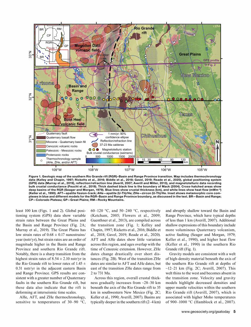
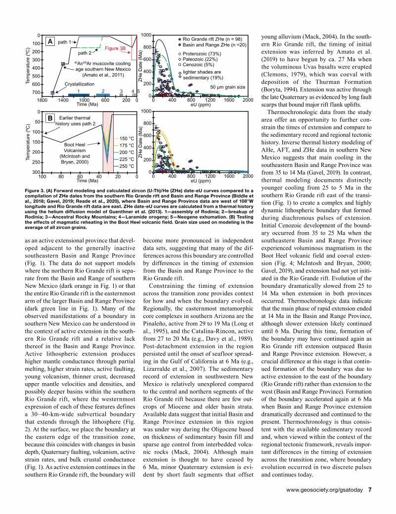
ZHe dates from the Basin and Range Province (Fig. 2B) largely overlap with ages of volcanic rocks in southwestern New Mexico, suggesting they were likely reset by magmatism (Gavel, 2019), and we use these data to model the heating effects of Oligocene magmatism in this region. Individual zircon grains from a single sample have variable clo-sure temperatures due to accumulation of varying amounts of radiation damage that is proportional to eU (eU = U + 0.235Th), where low eU, high He retentivity grains typically correspond to oldest ZHe dates and high eU, low retentivity grains yield youngest ZHe dates (Guenthner et al., 2013). These proper-ties allow for thermal modeling of ZHe data
from 240 to 50 °C (Guenthner et al., 2013). Compiled ZHe dates (Biddle et al., 2018; Gavel, 2019; Reade et al., 2020) show dra-matic differences across the transition zone with relation to eU (Fig. 3). In the Basin and Range Province, ZHe dates are consistent for all eU values. In contrast, east of and includ-ing the transition zone, ZHe dates have a wide range, where oldest ZHe dates are correlated with lowest eU and youngest ZHe dates have highest eU values. This observation suggests that radiation damage in zircon is a primary control on ZHe dates in this region.
Forward modeling allows for the calcula-tion of ZHe date-eU curves from an input thermal history, and here it provides a means of testing the potential effects of reheating during magmatism (see supplemental mate-rial for complete modeling details1). We use a general thermal history of southern New Mexico that includes crystallization at 1.6 Ga and cooling to 350 °C at 1.45 Ga, based on 40Ar/39Ar muscovite data (Amato et al., 2011), 15 °C at 500 Ma based on the age of the over-lying Bliss Formation, and maximum reheat-ing to 150 °C at 80 Ma from accumulation of Paleozoic and Mesozoic sediment (Fig. 3A). We include two endmember Proterozoic cool-ing histories: multiple cooling pulses during assembly of Rodinia (path 1; Ricketts et al., 2021), and multiple pulses of cooling that coincide with assembly and then breakup of Rodinia (path 2; DeLucia et al., 2017). Resulting ZHe date-eU curves are roughly similar to observed ZHe dates for the southern Rio Grande rift regardless of the Proterozoic cooling history. Boot Heel volca-nic field magmatism in southwestern New Mexico occurred from 37 to 26 Ma based on 40Ar/39Ar sanidine geochronology (McIntosh and Bryan, 2000), and we test the effects of this event on ZHe dates (Fig. 3B). Calculated ZHe date-eU curves only match the observed data for reheating temperatures of >225 °C and indicate that this thermal event did not affect ZHe dates in the southern Rio Grande rift. These results suggest that late Oligocene magmatism imprinted a major thermal boundary that coincides with independent geologic and geophysical data sets.
DISCUSSION
Age and Evolution of the BoundaryThe collective data sets suggest that the
southern Rio Grande rift is best explained
Figure 2. E-W cross section across the transition. (A) Global positioning system velocities across the profile line shown in Figure 1 (Murray et al., 2019). (B) Thermochronologic dates for all samples shown in Figure 1. Average dates are calculated for each data set in the Basin and Range Province and Rio Grande rift (±1 standard deviation). (C) Stacked geophysical models for the crust and upper mantle. Note changes in scale with depth. AFT—apatite fission-track; AHe—apatite (U-Th)/He; ZHe—zircon (U-Th)/He; nstr/yr—nanostrain/year.
1Supplemental Material. Full description of zircon (U-Th)/He modeling, inputs, and assumptions. Go to https://doi.org/10.1130/GSAT.S.14794197 to access the supple-mental material; contact [email protected] with any questions.
6 GSA Today | October 2021
eU (ppm)2000
200
400
600
1000
ZHe
Dat
e (M
a)
0160012008004000
Tem
pera
ture
(ºC
)
700
400
300
200
100
0
500
600
1800 1000 600 200 0Time (Ma)
1400
Tem
pera
ture
(ºC
)
300
150
100
50
0
200
250
100 60 40 20 0Time (Ma)
80
800
eU (ppm)2000
200
400
600
1000
ZHe
Dat
e (M
a)
0160012008004000
800
1 2 3 4 5Crystallization
40Ar/39Ar muscovite cooling age southern New Mexico
(Amato et al., 2011)
50 μm grain size
B
A Rio Grande rift ZHe (n = 98)Basin and Range ZHe (n =20)
150 °C175 °C200 °C225 °C250 °C
Boot HeelVolcanism
(McIntosh andBryan, 2000)
Figure 3Bpath 1
path 2
Earlier thermal history uses path 2
Cenozoic (5%)Paleozoic (22%)
lighter shades aresedimentary (19%)
Proterozoic (73%)
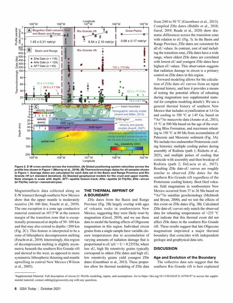
as an active extensional province that devel-oped adjacent to the generally inactive southeastern Basin and Range Province (Fig. 1). The data do not support models where the northern Rio Grande rift is sepa-rate from the Basin and Range of southern New Mexico (dark orange in Fig. 1) or that the entire Rio Grande rift is the easternmost arm of the larger Basin and Range Province (dark green line in Fig. 1). Many of the observed manifestations of a boundary in southern New Mexico can be understood in the context of active extension in the south-ern Rio Grande rift and a relative lack thereof in the Basin and Range Province. Active lithospheric extension produces higher mantle conductance through partial melting, higher strain rates, active faulting, young volcanism, thinner crust, decreased upper mantle velocities and densities, and possibly deeper basins within the southern Rio Grande rift, where the westernmost expression of each of these features defines a 30–40-km-wide subvertical boundary that extends through the lithosphere (Fig. 2). At the surface, we place the boundary at the eastern edge of the transition zone, because this coincides with changes in basin depth, Quaternary faulting, volcanism, active strain rates, and bulk crustal conductance (Fig. 1). As active extension continues in the southern Rio Grande rift, the boundary will
become more pronounced in independent data sets, suggesting that many of the dif-ferences across this boundary are controlled by differences in the timing of extension from the Basin and Range Province to the Rio Grande rift.
Constraining the timing of extension across the transition zone provides context for how and when the boundary evolved. Regionally, the easternmost metamorphic core complexes in southern Arizona are the Pinaleño, active from 29 to 19 Ma (Long et al., 1995), and the Catalina-Rincon, active from 27 to 20 Ma (e.g., Davy et al., 1989). Post-detachment extension in the region persisted until the onset of seafloor spread-ing in the Gulf of California at 6 Ma (e.g., Lizarralde et al., 2007). The sedimentary record of extension in southwestern New Mexico is relatively unexplored compared to the central and northern segments of the Rio Grande rift because there are few out-crops of Miocene and older basin strata. Available data suggest that initial Basin and Range Province extension in this region was under way during the Oligocene based on thickness of sedimentary basin fill and sparse age control from interbedded volca-nic rocks (Mack, 2004). Although main extension is thought to have ceased by 6 Ma, minor Quaternary extension is evi-dent by short fault segments that offset
young alluvium (Mack, 2004). In the south-ern Rio Grande rift, the timing of initial extension was inferred by Amato et al. (2019) to have begun by ca. 27 Ma when the voluminous Uvas basalts were erupted (Clemons, 1979), which was coeval with deposition of the Thurman Formation (Boryta, 1994). Extension was active through the late Quaternary as evidenced by long fault scarps that bound major rift flank uplifts.
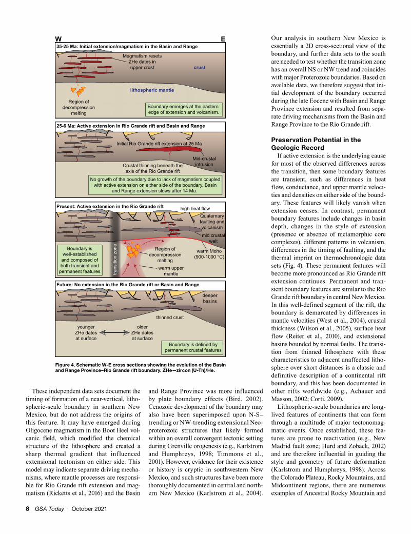
Thermochronologic data from the study area offer an opportunity to further con-strain the times of extension and compare to the sedimentary record and regional tectonic history. Inverse thermal history modeling of AHe, AFT, and ZHe data in southern New Mexico suggests that main cooling in the southeastern Basin and Range Province was from 35 to 14 Ma (Gavel, 2019). In contrast, thermal modeling documents distinctly younger cooling from 25 to 5 Ma in the southern Rio Grande rift east of the transi-tion (Fig. 1) to create a complex and highly dynamic lithospheric boundary that formed during diachronous pulses of extension. Initial Cenozoic development of the bound-ary occurred from 35 to 25 Ma when the southeastern Basin and Range Province experienced voluminous magmatism in the Boot Heel volcanic field and coeval exten-sion (Fig. 4; McIntosh and Bryan, 2000; Gavel, 2019), and extension had not yet initi-ated in the Rio Grande rift. Evolution of the boundary dramatically slowed from 25 to 14 Ma when extension in both provinces occurred. Thermochronologic data indicate that the main phase of rapid extension ended at 14 Ma in the Basin and Range Province, although slower extension likely continued until 6 Ma. During this time, formation of the boundary may have continued again as Rio Grande rift extension outpaced Basin and Range Province extension. However, a crucial difference at this stage is that contin-ued formation of the boundary was due to active extension to the east of the boundary (Rio Grande rift) rather than extension to the west (Basin and Range Province). Formation of the boundary accelerated again at 6 Ma when Basin and Range Province extension dramatically decreased and continued to the present. Thermochronology is thus consis-tent with the available sedimentary record and, when viewed within the context of the regional tectonic framework, reveals impor-tant differences in the timing of extension across the transition zone, where boundary evolution occurred in two discrete pulses and continues today.
Figure 3. (A) Forward modeling and calculated zircon (U-Th)/He (ZHe) date-eU curves compared to a compilation of ZHe dates from the southern Rio Grande rift and Basin and Range Province (Biddle et al., 2018; Gavel, 2019; Reade et al., 2020), where Basin and Range Province data are west of 108°W longitude and Rio Grande rift data are east. ZHe date-eU curves are calculated from a thermal history using the helium diffusion model of Guenthner et al. (2013). 1—assembly of Rodinia; 2—breakup of Rodinia; 3—Ancestral Rocky Mountains; 4—Laramide orogeny; 5—Neogene exhumation. (B) Testing the effects of magmatic reheating in the Boot Heel volcanic field. Grain size used on modeling is the average of all zircon grains.
www.geosociety.org/gsatoday 7
warm uppermantle
crust
lithospheric mantle
Magmatism resetsZHe dates inupper crust
warm Moho(900-1000 °C)
Initial Rio Grande rift extension at 25 Ma
Crustal thinning beneath theaxis of the Rio Grande rift
35-25 Ma: Initial extension/magmatism in the Basin and Range
Present: Active extension in the Rio Grande rift
Future: No extension in the Rio Grande rift or Basin and Range
Region ofdecompression
melting
mid crustalwelt
high heat flowQuaternaryfaulting andvolcanism
Mid-crustalintrusion
Region ofdecompression
melting
thinned crust
deeperbasins
25-6 Ma: Active extension in Rio Grande rift and Basin and Range
Boundary emerges at the eastern edge of extension and volcanism.
No growth of the boundary due to lack of magmatism coupledwith active extension on either side of the boundary. Basin
and Range extension slows after 14 Ma.
W E
Boundary iswell-established
and composed ofboth transient and
permanent features
Boundary is defined bypermanent crustal features
trans
ition
zon
e
olderZHe datesat surface
youngerZHe datesat surface
These independent data sets document the timing of formation of a near-vertical, litho-spheric-scale boundary in southern New Mexico, but do not address the origins of this feature. It may have emerged during Oligocene magmatism in the Boot Heel vol-canic field, which modified the chemical structure of the lithosphere and created a sharp thermal gradient that influenced extensional tectonism on either side. This model may indicate separate driving mecha-nisms, where mantle processes are responsi-ble for Rio Grande rift extension and mag-matism (Ricketts et al., 2016) and the Basin
and Range Province was more influenced by plate boundary effects (Bird, 2002). Cenozoic development of the boundary may also have been superimposed upon N-S–trending or NW-trending extensional Neo- proterozoic structures that likely formed within an overall convergent tectonic setting during Grenville orogenesis (e.g., Karlstrom and Humphreys, 1998; Timmons et al., 2001). However, evidence for their existence or history is cryptic in southwestern New Mexico, and such structures have been more thoroughly documented in central and north-ern New Mexico (Karlstrom et al., 2004).
Our analysis in southern New Mexico is essentially a 2D cross-sectional view of the boundary, and further data sets to the south are needed to test whether the transition zone has an overall NS or NW trend and coincides with major Proterozoic boundaries. Based on available data, we therefore suggest that ini-tial development of the boundary occurred during the late Eocene with Basin and Range Province extension and resulted from sepa-rate driving mechanisms from the Basin and Range Province to the Rio Grande rift.
Preservation Potential in the Geologic Record
If active extension is the underlying cause for most of the observed differences across the transition, then some boundary features are transient, such as differences in heat flow, conductance, and upper mantle veloci-ties and densities on either side of the bound-ary. These features will likely vanish when extension ceases. In contrast, permanent boundary features include changes in basin depth, changes in the style of extension (presence or absence of metamorphic core complexes), different patterns in volcanism, differences in the timing of faulting, and the thermal imprint on thermochronologic data sets (Fig. 4). These permanent features will become more pronounced as Rio Grande rift extension continues. Permanent and tran-sient boundary features are similar to the Rio Grande rift boundary in central New Mexico. In this well-defined segment of the rift, the boundary is demarcated by differences in mantle velocities (West et al., 2004), crustal thickness (Wilson et al., 2005), surface heat flow (Reiter et al., 2010), and extensional basins bounded by normal faults. The transi-tion from thinned lithosphere with these characteristics to adjacent unaffected litho-sphere over short distances is a classic and definitive description of a continental rift boundary, and this has been documented in other rifts worldwide (e.g., Achauer and Masson, 2002; Corti, 2009).
Lithospheric-scale boundaries are long-lived features of continents that can form through a multitude of major tectonomag-matic events. Once established, these fea-tures are prone to reactivation (e.g., New Madrid fault zone; Hurd and Zoback, 2012) and are therefore influential in guiding the style and geometry of future deformation (Karlstrom and Humphreys, 1998). Across the Colorado Plateau, Rocky Mountains, and Midcontinent regions, there are numerous examples of Ancestral Rocky Mountain and
Figure 4. Schematic W-E cross sections showing the evolution of the Basin and Range Province–Rio Grande rift boundary. ZHe—zircon (U-Th)/He.
8 GSA Today | October 2021

Laramide basement uplifts that reactivated inherited structures (Soreghan et al., 2012; Bader, 2019), including Proterozoic exten-sional fault systems (Marshak et al., 2000; Timmons et al., 2001). These events attest to the longevity of extensional structures in continental lithosphere and their susceptibil-ity for reactivation. We propose that after extension in the Basin and Range Province and Rio Grande rift ceases, this boundary will persist as a stable feature of North American lithosphere, possibly guiding future tectonic structures through reactiva-tion of normal faults.
ACKNOWLEDGMENTSWe thank John Singleton, an anonymous review-
er, and science editor Mihai Ducea for comments that helped strengthen the arguments made in this paper. Becky Flowers and Jim Metcalf at the University of Colorado TRaIL lab in Boulder, Colorado, USA, helped acquire (U-Th)/He data. This work is sup-ported by NSF grants EAR-1624538 to Ricketts and EAR-1624575 to Amato.
REFERENCES CITEDAchauer, U., and Masson, F., 2002, Seismic
tomography of continental rifts revisited: From relative to absolute heterogeneities: Tectono-physics, v. 358, p. 17–37, https://doi.org/10.1016/S0040-1951 (02)00415 -8.
Amato, J.M., Heizler, M.T., Boullion, A.O., Sanders, A.E., Toro, J., McLemore, V.T., and Andronicos, C.L., 2011, Syntectonic 1.46 Ga magmatism and rapid cooling of a gneiss dome in the southern Mazatzal Province: Burro Mountains, New Mex-ico: Geological Society of America Bulletin, v. 123, p. 1720–1744, https://doi.org/10.1130/B30337.1.
Amato, J.M., Richard, N., and Johnson, E.R., 2019, Late Miocene basalts of the Robledo Mountains, New Mexico, in context of the history of mafic magmatism in the Rio Grande rift: Geological So-ciety of America Abstracts with Programs, v. 51, no. 5, https://doi.org/10.1130/abs/2019AM-336785.
Averill, M.G., 2007, A Lithospheric Investigation of the Southern Rio Grande Rift [Ph.D. thesis]: El Paso, Texas, The University of Texas at El Paso, 213 p.
Averill, M.G., and Miller, K.C., 2013, Upper crustal structure of the southern Rio Grande rift: A composite record of rift and pre-rift tectonics, in Hudson, M.R., and Grauch, V.J.S., eds., New Perspectives on Rio Grande Rift Basins: From Tectonics to Groundwater: Geological Society of America Special Paper 494, p. 463–474, https://doi.org/10.1130/2013.2494(17).
Bader, J.W., 2019, Structural inheritance and the role of basement anisotropies in the Laramide structur-al and tectonic evolution of the North American Cordilleran foreland, Wyoming: Lithosphere, v. 11, p. 129–148, https://doi.org/ 10.1130/ L1022.1.
Biddle, J., Ricketts, J.W., and Amato, J.M., 2018, Constraining timing of extension in the southern Rio Grande rift and Basin and Range using apa-tite and zircon (U-Th)/He thermochronology, in Mack, G.H., Hampton, B.A., Ramos, F.C.,
Witcher, J.C., and Ulmer-Scholle, D.S., eds., Las Cruces Country III: New Mexico Geological Society Guidebook, v. 69, p. 127–135.
Bird, P., 2002, Stress direction history of the western United States and Mexico since 85 Ma: Tectonics, v. 21, https://doi.org/10.1029/2001TC001319.
Boryta, J.D., 1994, Single-crystal 40Ar/39Ar prove-nance ages and polarity stratigraphy of rhyolitic tuffaceous sandstones of the Thurman Formation (late Oligocene), Rio Grande rift, New Mexico [M.S. thesis]: Socorro, New Mexico, New Mexico Institute of Mining and Technology, 82 p.
Buck, W.R., 1991, Modes of continental lithospher-ic extension: Journal of Geophysical Research. Solid Earth, v. 96, p. 20,161–20,178, https://doi .org/10.1029/91JB01485.
Clemons, R.E., 1979, Geology of Good Sight Mountains and Uvas Valley, southwest New Mexico: New Mexico Bureau of Mines and Min-eral Resources Circular, v. 169, 32 p.
Corti, G., 2009, Continental rift evolution: From initiation to incipient break-up in the Main Ethiopian Rift, East Africa: Earth-Science Reviews, v. 96, p. 1–53, https://doi.org/10.1016/ j.earscirev.2009.06.005.
Davy, P., Guérin, G., and Brun, J.-P., 1989, Thermal constraints on the tectonic evolution of a meta-morphic core complex (Santa Catalina Moun-tains, Arizona): Earth and Planetary Science Letters, v. 94, p. 425–440, https://doi.org/ 10.1016/0012-821X(89)90159-3.
DeLucia, M.S., Guenthner, W.R., Marshak, S., Thompson, S.N., and Ault, A.K., 2017, Thermo-chronology links denudation of the Great Un-conformity surface to the supercontinent cycle and snowball Earth: Geology, v. 46, p. 167–170, https://doi.org/10.1130/G39525.1.
Dickinson, W.R., 2002, The Basin and Range Province as a composite extensional domain: International Geology Review, v. 44, p. 1–38, https://doi.org/10.2747/0020-6814.44.1.1.
Eaton, G.P., 1982, The Basin and Range Province: Origin and tectonic significance: Annual Review of Earth and Planetary Sciences, v. 10, p. 409–440, https://doi.org/10.1146/annurev.ea.10 .050182 .002205.
Feucht, D.W., Bedrosian, P.A., and Sheehan, A.F., 2019, Lithospheric signature of late Cenozoic ex-tension in electrical resistivity structure of the Rio Grande rift, New Mexico, USA: Journal of Geo-physical Research. Solid Earth, v. 124, p. 2331–2351, https://doi.org/10.1029/2018JB016242.
Flowers, R.M., Ketcham, R.A., Shuster, D.L., and Farley, K.A., 2009, Apatite (U-Th)/He thermo-chronometry using a radiation damage accumu-lation and annealing model: Geochimica et Cos-mochimica Acta, v. 73, p. 2347–2365, https://doi .org/10.1016/j.gca.2009.01.015.
Gavel, M.M., 2019, Low-temperature thermochro-nological constraints on Neogene extension in the Rio Grande rift and Basin and Range of southern New Mexico [M.S. thesis]: Las Cruces, New Mexico, New Mexico State University, 144 p.
Guenthner, W.R., Reiners, P.W., Ketcham, R.A., Nas-dala, L., and Giester, G., 2013, Helium diffusion in natural zircon: Radiation damage, anisotropy, and the interpretation of zircon (U-Th)/He thermochro-nology: American Journal of Science, v. 313, p. 145–198, https://doi.org/10.2475/03.2013.01.
Hamblock, J.H., Andronicos, C.L., Miller, K.C., Barnes, C.G., Ren, M., Averill, M.G., and Antho-
ny, E.Y., 2007, A composite geologic and seismic profile beneath the southern Rio Grande rift, New Mexico, based on xenolith mineralogy, tempera-ture, and pressure: Tectonophysics, v. 442, p. 14–48, https://doi.org/10.1016/j.tecto.2007.04.006.
Hammond, E.H., 1970, Classes of land surface form (map), in The National Atlas of the United States of America: U.S. Geological Survey, scale 1:7,500,000, p. 62–63.
Hurd, O., and Zoback, M.D., 2012, Regional stress orientations and slip compatibility of earthquake focal planes in the New Madrid Seismic Zone: Seismological Research Letters, v. 83, p. 672–679, https://doi.org/10.1785/0220110122.
Karlstrom, K.E., and Humphreys, E.D., 1998, Per-sistent influence of Proterozoic accretionary boundaries in the tectonic evolution of south-western North America: Interaction of cratonic grain and mantle modification events: Rocky Mountain Geology, v. 33, p. 161–179, https://doi .org/10.2113/33.2.161.
Karlstrom, K.E., Amato, J.M., Williams, M.L., Heizler, M., Shaw, C.A., Read, A.S., and Bauer, P., 2004, Proterozoic tectonic evolution of the New Mexico region: A synthesis, in Mack, G.H., and Giles, K.A., eds., The Geology of New Mex-ico: A Geologic History: New Mexico Geologic Society, Special Publication 11, p. 1–34.
Keller, G.R., Morgan, P., and Seager, W.R., 1990, Crustal structure, gravity anomalies and heat flow in the southern Rio Grande rift and their re-lationship to extensional tectonics: Tectonophys-ics, v. 174, p. 21–37, https://doi.org/10.1016/0040 -1951(90)90382-I.
Kelley, S.A., and Chapin, C.E., 1997, Cooling histo-ries of mountain ranges in the southern Rio Grande rift based on apatite fission-track analy-sis—A reconnaissance survey: New Mexico Geology, v. 9, p. 1–14.
Ketcham, R.A., 2005, Forward and inverse modeling of low-temperature thermochronometry data, in Reiners, P.W., and Ehlers, T.A., eds., Low-Tem-perature Thermochronology: Techniques, Inter-pretations, and Applications: Reviews in Mineral-ogy and Geochemistry, v. 58, p. 275–314, https://doi.org/10.1515/9781501509575-013.
Lizarralde, D., Axen, G.J., Brown, H.E., Fletcher, J.M., Gonzalez-Fernandez, A., Harding, A.J., Holbrook, W.S., Kent, G.M., Paramo, P., Suther-land, F., and Umhoefer, P.J., 2007, Variation in styles of rifting in the Gulf of California: Nature, v. 448, p. 466–469, https://doi.org/10.1038/ nature06035.
Long, K.B., Baldwin, S.L., and Gehrels, G.E., 1995, Tectonothermal evolution of the Pinaleño–Jack-son Mountain core complex, southeast Arizona: Geological Society of America Bulletin, v. 107, p. 1231–1240, https://doi.org/10.1130/0016-7606 (1995)107<1231:TEOTPO>2.3.CO;2.
Mack, G.H., 2004, Middle and late Cenozoic crust-al extension, sedimentation, and volcanism in the southern Rio Grande rift, Basin and Range, and southern Transition Zone of southwestern New Mexico, in Mack, G.H., and Giles, K.A., eds., The Geology of New Mexico: A Geologic History: New Mexico Geologic Society, Special Publication 11, p. 389–406.
Marshak, S., Karlstrom, K.E., and Timmons, J.M., 2000, Inversion of Proterozoic extensional faults: An explanation for the pattern of Laramide and Ancestral Rockies intracratonic deformation,
www.geosociety.org/gsatoday 9
United States: Geology, v. 28, p. 735–738, https://doi .org/10.1130/0091-7613(2000)28 <735 :IOPEFA> 2.0.CO;2.
McIntosh, W.C., and Bryan, C., 2000, Chronology and geochemistry of the Boot Heel volcanic field, New Mexico, in Lawton, T.F., McMillan, N.J., and McLemore, V.T., eds., Southwest Pas-sage—A Trip through the Phanerozoic: New Mexico Geological Society Field Conference Guidebook, v. 51, p. 157–174.
Murray, K.D., Murray, M.H., and Sheehan, A.F., 2019, Active deformation near the Rio Grande rift and Colorado Plateau as inferred from con-tinuous global positioning system measure-ments: Journal of Geophysical Research. Solid Earth, v. 124, p. 2166–2183, https://doi.org/ 10.1029/ 2018JB016626.
Reade, N.Z., Biddle, J.M., Ricketts, J.W., and Amato, J.M., 2020, Zircon (U-Th)/He thermochronologic constraints on the long-term thermal evolution of southern New Mexico and western Texas: Lithosphere, v. 2020, 8881315, https://doi.org/ 10.2113/2020/8881315.
Reiter, M.R., Chamberlain, R.M., and Love, D.L., 2010, New data reflect on the thermal antiquity of the Socorro magma body locale, Rio Grande rift, New Mexico: Lithosphere, v. 2, no. 6, p. 447–453, https://doi.org/10.1130/L115.1.
Ricketts, J.W., Kelley, S.A., Karlstrom, K.E., Schmandt, B., Donahue, M.S., and van Wijk, J.,
2016, Synchronous opening of the Rio Grande rift along its entire length at 25–10 Ma supported by apatite (U-Th)/He and fission-track thermo-chronology, and evaluation of possible driving mechanisms: Geological Society of America Bulletin, v. 128, p. 397–424, https://doi.org/ 10.1130/ B31223.1.
Ricketts, J.W., Roiz, J., Karlstrom, K.E., Heizler, M.T., Guenthner, W.R., and Timmons, M.J., 2021, Tectonic controls on basement exhumation in the southern Rocky Mountains: The power of combined zircon (U-Th)/He and K-feldspar 40Ar/39Ar thermochronology: Geology, https://doi.org/10.1130/G49141.1.
Seager, W.R., and Morgan, P., 1979, Rio Grande rift in southern New Mexico, west Texas, and north-ern Chihuahua, in Rieker, R.E., ed., Rio Grande Rift: Tectonics and Magmatism: Washington, D.C., American Geophysical Union, p. 87–106, https://doi.org/10.1029/SP014p0087.
Soreghan, G.S., Keller, G.R., Gilbert, M.C., Chase, C.G., and Sweet, D.E., 2012, Load-induced sub-sidence of the Ancestral Rocky Mountains re-corded by preservation of Permian landscapes: Geosphere, v. 8, p. 654–668, https://doi.org/ 10.1130/ GES00681.1.
Timmons, J.M., Karlstrom, K.E., Dehler, C.M., Geissman, J.W., and Heizler, M.T., 2001, Pro-terozoic multistage (ca. 1.1 and 0.8 Ga) extension recorded in the Grand Canyon Supergroup and
establishment of northwest- and north-trending tectonic grains in the southwestern United States: Geological Society of America Bulletin, v. 113, p. 163–181, https://doi.org/10.1130/0016 -7606 (2001)113<0163:PMCAGE>2.0.CO;2.
van Wijk, J., Koning, D., Axen, G., Coblenz, D., Gragg, E., and Sion, B., 2018, Tectonic subsi-dence, geoid analysis, and the Miocene-Pliocene unconformity in the Rio Grande rift, southwest-ern United States: Implications for mantle up-welling as a driving force for rift opening: Geo-sphere, v. 14, p. 684–709, https://doi.org/10.1130/GES01522.1.
West, M., Ni, J., Baldridge, W.S., Wilson, D., Aster, R., Gao, W., and Grand, S., 2004, Crust and upper mantle shear wave structure of the southwest United States: Implications for rifting and sup-port for high elevation: Journal of Geophysical Research, v. 109, B03309, https://doi.org/10.1029/ 2003JB002575.
Wilson, D., Aster, R., West, M., Ni, J., Grand, S., Gao, W., Baldridge, W.S., Semken, S., and Patel, P., 2005, Lithospheric structure of the Rio Grande rift: Nature, v. 433, p. 851–855, https://doi.org/10.1038/nature03297.
Manuscript received 20 Mar. 2021 Revised manuscript received 1 June 2021 Manuscript accepted 11 June 2021
10 GSA Today | October 2021