The Old Town of Taranto: From the Architectural reading of historic urban form to the correct...
17
Proceedings of the 2 nd ICAUD International Conference in Architecture and Urban Design Epoka University, Tirana, Albania, 08-10 May 2014 Paper No. 362 362-1 The Old Town of Taranto: Architectural Reading of the Historic Urban Form for the Correct Methodology for Restoration Project the Built Heritage in the Island. Ubaldo Occhinegro Polytecnic School of Bari Via Orabona 4, Bari, Italy [email protected] ABSTRACT The contribution is based on an architecture analysis , which took place through a series of campaigns of relief carried out during 2013 throughout the urban fabric of the old city of Taranto. This analysis interest morphological and typological aspects of some important buildings located along the principal axis of the ancient Taranto, highlighting and updating each case , the structural and technological problems of each building . In recent times, the critical situation of total decay of the old city of Taranto, caused the collapse of an entire complex of buildings, especially in the lower part of the urban area, and whole sections of the ancient city are closed through infill walls along the principal roads. The analysis of the typological systems, of the urban form and technological systems of the island's buildings, would fill a scientific gap caused by the lack of a systematic study on the urban fabric of the old city and its architectural potential It is necessary and urgent to focus on the strengths and weaknesses of the old town of Taranto, in order to provide a methodological and updated tool, aligned with the most modern techniques of diagnosis and relief on buildings, which could direct future interventions of urban regeneration and of enhancement of historic / architectural centre. KEYWORDS: Taranto, Urban Development, Urban Form, Restoration in historical Mediterranean centre, Architectural heritage. 1 INTRODUCTION The architectural restoration of the Old city of Taranto turns out to be , now more than ever, a central theme to re-think economic development and a sustainable growing of the urban territory of the whole Ionic Arc: the only alternative vision to the heavily industrial character that has characterized the town since the early years of the nineteenth century and which has irremediably compromised the original facies of the city and the surrounding area. The city of Taranto, since its founding, was designed to have an extraordinary relationship with the natural surroundings, and every study on the “urban form” and about architectural character of the historical buildings must consider the complexity of the surrounding environmental morphology: the first Greek foundation core was enclosed in an isthmus that juts out longitudinally in East-West direction. The urban fabric is developed, over the millennia, on a 15 meters high rock, bathed by the sea on three main fronts. The peninsula became a real island in the Aragonese period , after the "cutting" of the peninsula during the construction of the mighty moat of the castle. The city is known as "Città dei due mari " , is in fact surrounded by Mar Grande along the external coast of
Transcript of The Old Town of Taranto: From the Architectural reading of historic urban form to the correct...

Proceedings of the 2nd ICAUD International Conference in Architecture and Urban Design
Epoka University, Tirana, Albania, 08-10 May 2014
Paper No. 362
362-1
The Old Town of Taranto: Architectural Reading of the Historic Urban
Form for the Correct Methodology for Restoration Project the Built Heritage in the Island.
Ubaldo Occhinegro
Polytecnic School of Bari
Via Orabona 4, Bari, Italy
ABSTRACT
The contribution is based on an architecture analysis , which took place through a series of
campaigns of relief carried out during 2013 throughout the urban fabric of the old city of Taranto. This
analysis interest morphological and typological aspects of some important buildings located along the
principal axis of the ancient Taranto, highlighting and updating each case , the structural and
technological problems of each building . In recent times, the critical situation of total decay of the old
city of Taranto, caused the collapse of an entire complex of buildings, especially in the lower part of the
urban area, and whole sections of the ancient city are closed through infill walls along the principal roads.
The analysis of the typological systems, of the urban form and technological systems of the island's
buildings, would fill a scientific gap caused by the lack of a systematic study on the urban fabric of the
old city and its architectural potential It is necessary and urgent to focus on the strengths and weaknesses
of the old town of Taranto, in order to provide a methodological and updated tool, aligned with the most
modern techniques of diagnosis and relief on buildings, which could direct future interventions of urban
regeneration and of enhancement of historic / architectural centre.
KEYWORDS: Taranto, Urban Development, Urban Form, Restoration in historical Mediterranean
centre, Architectural heritage.
1 INTRODUCTION
The architectural restoration of the Old city of Taranto turns out to be , now more than ever, a
central theme to re-think economic development and a sustainable growing of the urban territory of the
whole Ionic Arc: the only alternative vision to the heavily industrial character that has characterized the
town since the early years of the nineteenth century and which has irremediably compromised the original
facies of the city and the surrounding area. The city of Taranto, since its founding, was designed to have
an extraordinary relationship with the natural surroundings, and every study on the “urban form” and
about architectural character of the historical buildings must consider the complexity of the surrounding
environmental morphology: the first Greek foundation core was enclosed in an isthmus that juts out
longitudinally in East-West direction. The urban fabric is developed, over the millennia, on a 15 meters
high rock, bathed by the sea on three main fronts. The peninsula became a real island in the Aragonese
period , after the "cutting" of the peninsula during the construction of the mighty moat of the castle. The
city is known as "Città dei due mari " , is in fact surrounded by Mar Grande along the external coast of

362-2
semicircular bay form, bounded on the North West from Punta Rondinella and on south from Capo San
Vito. The above wide bay is characterized by the presence of two islands: St. Peter and St. Paul
(respectively far from Taranto 6.3 and 6.1 Km), which constitute a small archipelago , the Cheradi ( in
greek Choiràdes Χοιράδες ), which closed the south- west front of Mar Grande basin. In past there was
also another small island of San Nicolicchio, now disappeared due to construction of industrial area and
to the enlargement of the trading port.
The current configuration of the old city is a result of continuous and disorder overlap of
interventions and alterations made, often, with the re-use of the old architectural remains. It is enclosed
entirely within the fortified perimeter of the island and present many interesting features for various
reasons: it is escaped from real estate speculation and is still substantially intact in its urban historical
layout, and therefore retains a wealth of different architectural styles that can underline the development
and the transformation through the centuries of urban pattern. The layout of the old city probably retrace
ancient MagnoGreek Acropoli and then the Roman/Byzantine grid, growing and progressively occluding
spaces around Via Duomo. This street presumably is the old route of the ancient Via Appia1, which
crossed the island from East to West, dividing it into two parts: the upper part (on average 15 meters
above sea level), facing to Mar Grande, characterized by valuable palaces and important monumental and
ecclesiastical complexes, including the Cathedral of St. Cataldo, convent of San Francesco, the complex
of St. Dominic and St. Clare, all built from the Middle Ages until 1700. The lower part, overlooking the
old harbor (Mar Piccolo) is mainly composed of popular neighborhoods with residential tipology of row-
houses, pseudo/row-houses or tower-houses, with narrow and elongated floor plans and preeminent
developing in height (also 3-4 levels). Archaeological findings seem to avail the hypothesis of the
founding of Taranto at the end of the eighth century BC, according to Eusebius of Caesarea, who say that
in 706 B.C. Spartan colonists settled on the island. In this area, the defense was secured to the north and
south by high cliffs and on the east by a fortification wall preceded by a moat. Archaeological excavations
carried out in 1931 in via Duomo confirm the presence of a street that crosses the Acropolis in the
longitudinal direction. In these excavations have unearthed two slisce of road superimposed, one of the
Byzantine age and one of the Roman age. Archaeological findings also confirm the hypothesis of the
religious rule of the site: the ruins of the Doric columns embedded in the Trinità Church, remains of
stereobate under the church of San Domenico; remains suggesting the presence of a sacred area and a
temple under the Church of St. Augustine. The island was then destined to the Acropolis: this area was
the more representative of the city and has the oldest sacred buildings and a huge quantity of monuments.
The limit of the Greek and Roman city was supposed to be just on the natural difference in height visible
today along Via di Mezzo. In fifth century Taranto was engaged in continuous conflict with Iapigi and
Messapians: a tough defeat in the 473. C. determines the urban transformation as well as political, with
the construction of a real Neapolis in the area occupied by the cemetery. In the first half of the fifth
century BC, the city underwent a profound transformation planning. In fact, was built a new defensive
wall and was extended the monumental area, which reached its importance with the construction of an
imposing Doric temple on the Acropolis2. During this period, the city had about three 300.000
inhabitants. The historical events of the third and second century. B.C. see the Greek city of Taras turn
slowly in the Roman Tarentum. As a result of the war of 272-282, Taranto is submissive and waiver to
1 Cfr.: Maria Grazia Rocco, Survey and comparison of plans in the urban plan of Taranto and in the territory
of the upper Jonio, in Journal of the Islamic Environmental Design Research Centre XX year, Corcelli editrice, Bari
1984 2 For the configuration and construction of roads in the acropolis magnogreca see F. G. Lo Porto, Topografia
antica di Taranto, in Taranto nella civiltà della Magna Grecia, Atti del X Convegno di studi sulla Magna Grecia
(Taranto 4-11 Ottobre 1907), Napoli 1971, pp. 343-383.
362-3
the leadership of the Magna-Greece. The situation is aggravated by the Second Punic War (209-123
BC.):the city progressively lose their political identity and their ethnic consciousness throughout the
Roman period, with a substantial decline in rich and population. At this stage the limits of the Acropolis
had to settle on 'current path of Via di Mezzo, which coincide with the jump of the natural rock. The walls
of the ancient city walked from east to west on the actual ridge of the rock, and this is confirmed by the
findings of isodomic blocks in accordance with the textures of the first settlements, but also by significant
re-use of Greek architectural elements in this area in medieval period3. As underlined by the report
Spilotro, the level of the sea, two thousand years ago, was two meters above the current level and
therefore the bay on Mar Piccolo consisted, at that time, in a narrow beach near the top of the cliff. The
same rock has, in that period, an high average of eight meters and therefore there was a small harbor for
boats with possibility of shelter very close to the natural ridge. On this natural limit, exploited with the
walls of the Acropolis, began to born many residential areas in connection to the port and to the related
activities. These agglomerations, progressively, displace the original limits of the ancient city: in fact,
were built a series of guard positions in defense of the new gates next to the port of the city, created in
correspondence of the terminal part of the parallel ascent streets (Postierle) that cut the new districts,
connecting the low with the high part. The connections between the various Postierle, led to the birth of a
new street identified in the current Via di Mezzo. (Figure 3). The first development outside the original
Greek walls, almost exclusively interested the saturation of the empty areas, defining new edge of the city
made of an unified front-curtain of the buildings, creating a spontaneous and uneven defensive walls, that
makes the all city moved in this direction. The urbanistic reconstruction of the medieval city is very
difficult, due to the lack of archaeological and historical evidence. Anonymous sources, documenting a
city sometimes alive and commercially active, sometimes resized in its importance and its demographic
consistency. At the beginning of the greek-gothic war in sixth century, the acropolis at the top is re-
fortified dwellings that surround closely, while the east of the isthmus became a rural area. The passage
the Byzantines and the Long bards today leaves no visible architectonic traces, except for any traces of
walls and foundations, never documented, visible below some of the palaces of Via Duomo, and no
monuments or evidence of early Christian places were found during any archaeological excavation. Even
the Saracen domination, which lasted from 840-880, leaves no urban and architectural evidence. The
particular shape of the minute urban fabric layout, with the presence of narrow alleys, and cul de sac at
the end of some private street, is associated more with Byzantine castra rather than with Muslim
settlements, although we can found unequivocal signs of Islamic influences in the introverted design of
the urban pattern and in the hierarchical structure of the network of street and in the progressive
privatization of the urban context:
1)The main arteries (Via Duomo, Via Di Mezzo, and now Via Garibaldi), with predominantly public -
commercial, with wider road section for the transition wagons and goods, the almost straight course and
overlooking the main floor and craft shops.
2) The cross-streets or Postierle, placed in perpendicular way respect to the first, with a semi-public
character, characterized by a narrow section of road, paths, sometimes steep slope and non rectilinear
(passable only on foot) and representing the streets of connection between the lower part of the island
(harbor) and high (shopping and sacred area).
3) finally we have a great number of small streets purely for private use, which flow in small plazas or cul
de sac.
3 Cfr.: Luigi Oliva, I quartieri dei vicoli sulla Marina di Mar Piccolo nella Città Vecchia di Taranto. Genesi
e configurazioni del tessuto edilizio storico. Risanamento e valorizzazione in Kronos n.7, 2004 Lecce

362-4
The conquest of the city by Basil I the Macedonian, take the first clear signs in the urbanism of the city.
Between the 880 and the 927 is built the Byzantine "Rock" in the place where now stands the Castello
Aragonese. This defensive structure will not save her from total destruction Taranto on August 15, 927
caused by the Muslims troops of the Slavic Sabir . The city remained in ruins until 967, when the
Byzantine Emperor Nicephorus II Phocas , yielding to the repeated pressure of the survivors, decided to
rebuild the city4. According to tradition, an engineer, also called Nicephorus, destroyed what remained of
the acropolis, re- perimeter the area with a high wall, interspersed with towers to the east and reinforced
with a fortress, rebuilt all the buildings destroyed, built on a canal bridge of 7 arches connected to via
Appia and did fill the coastline along Mar Piccolo advancing 40 meters around the perimeter of the
coastal to facilitate the return of many fishermen migrated in the decades of previous wars and destruction
: In this period born, therefore, the public square, the current configuration of via di Mezzo , the Via
Marina, and the postierle that connect the lower city with the upper city.
Figure 1: Postierla Via Nuova: Section A-A’ with the map of degradation of the facades and planimetric
section (Arch. Fragasso G., 2009)
This area is still perfectly recognizable by the presence of long, narrow blocks , separated by alleys
perpendicular to the sea . Via di Mezzo will become an important urban axis of division between the
neighborhoods of the high part of the city ( and Pittaggio Baglio and Pittaggio San Pietro), and those of
the lower part of the most recent formation ( Pittaggio Torrepenna and Pittaggio Ponte ). We ascribed to
this period, the construction of the churches of Saints Cosmas and Damian, the church of St. Nicola sotto
la Cava and those of San Marco e Lo Spirito Santo , with Byzantine influence , all attested on Via di
Mezzo. They were attractive poles around which are formed corresponding urban block, by the
progressive occluding of empty spaces in the urban tissue around the church. Over the following
centuries, will be the gradual urbanization of the entire area of the fledgling navy on Mar Piccolo, and the
end of formation of the curtain of continuous urban residential facade ( the typical residential building is
the palazziata or domus palatiata and can be even 3-4 levels ) interspersed with narrow street, sometimes
not more than 70 cm wide. Urban design of this blocks are similar to a 'comb ' : the sea fronts are never
more than 15 meters ( the space between two Postierle) and the block has longitudinally a length of
approximately 40 meters . As we say, the paradigmatic typology of building that characterizing the entire
lower part of the island, is the Tower-houses or Palazziata houses (Domus Palatiata ) articulated in the
ground, first and second floors (each developed a minimum of one room up to three), connected by a
4 Cfr. N. Oikonomides, Les listes de prèséance byzantine des IX et X siècles, Paris 1972, p. 327, e V. Von
Falkenhausen, La dominazione bizantina nell'Italia meridionale dal IX all'XI secolo, Bari 1978, p.132.

362-5
single ramp with a steep slope in the longitudinal wall or in L shape. The ground floor was intended
primarily to shop, warehouse, but often is dwelling minimum-residential space well- known as “basso”.
The topographic reconstruction of Norman- Swabian Taranto can only be assumed, since the urban
construction of this period has almost completely disappeared or was incorporated in the building of the
seventeenth and eighteenth centuries . The morphology of the city is changed significantly in the early
eleventh century , mainly due to a policy that allows the coexistence of Greek institutions , Jewish and
Latin. These populations strengthened their presence in the city through the construction of churches and
monasteries, of which the most important example is represented by the Cathedral of San Cataldo. How is
confirmed by the geographer Idrisi5 , the Normans had already found prosperous city and commercially
active port , built on the ancient acropolis and still littered with large buildings and palaces. The Norman
and Swabian morphology, not much different from the current one, will remain unchanged over the
centuries. It was characterized for the division of the island into four pittaggi , both organized into four
vicinii, according to the two main roads corresponding to the Via di Mezzo and the postierla via Nuova :
pittaggio St. Pietro , characterized by a valuable housing , and pittaggio Baglio , near the castle , are both
on the Mar Grande side, the pittaggio Ponte, near the bridge , and the pittaggio Turripenne , characterized
by the Jewish ghetto, looking Mar Piccolo. Archaeological discoveries may confirm the hypothesis of the
construction of a domus for the Emperor Frederick II , near the church of San Domenico Maggiore. In
Angevin period, Raimondello Orsini Del Balzo , son of Niccolo Orsini, builds the " Citadel " or Tower of
Raimondello ( 1404 ) : a massive square tower and fortified watched the entrance to the city from the
bridge of Porta Napoli ( PHOTOS ). The Franciscans and Dominicans mendicant orders erected in this
period two impressive buildings in the upper part of the island : the convent of St. Francis of Assisi and
the convent of San Domenico , which dominate the urban space at the ends of the axis of the main road,
influencing, with their Gothic loggias , balconies and the battlements, of the surrounding buildings.
Giovanni Antonio Orsini Del Balzo, reordered pittaggi Baglio and Turripenne, expanded the public
square with the demolition of many buildings. During the Aragónese - Spanish domination we have
significant changes, both in civil and in ecclesiastical buildings, in addition to the fortification of the city:
it starts from the demolition of the Byzantine "Rock", to obtain the necessary space for the new castle
designed by the architect Francesco di Giorgio Martini, and proceed at once to the excavation of a trench
in the position of the ship canal , following which the peninsula becomes an island. The City instead
takes charge of the construction of a fortified wall and reinforced with towers along the perimeter of the
city. On the western side of the island instead , the Tower of Raimondello is reinforced with two smaller
towers and expanded with a courtyard in direction of the city. The significant transformation of the city,
however, are attributable in particular of ecclesiastical building, whose religious structures serve as a
gathering place. The ancient report about the visit to the institutions carried out by the Archbishop
Monsignor Lelio Brancaccio between 1576 and 1578 , bear witness to the urban location and the
architectural features of many religious structures that currently do not exist anymore . In 1600-1700 there
was a massive restructuring of the existing religious structures and the construction of new monasteries.
Was restructures the convent of San Domenico and San Francesco d' Assisi , major changes was make to
the Cathedral of San Cataldo, was built the Sanctuary of Monte Oliveto, and was reconstructing the
convent of the Jesuits , the convent of St. Paschal Baylon , the monastery of Clarisse nuns, was builds the
staircase of San Domenico Maggiore, and was extended many smaller churches. Even in civil
construction, there were many transformation and great palaces were built along the main axis of Via
Duomo, which still characterize the upper part of the ancient town. The construction of the great palaces
often occurs through the incorporation of pre- existing smaller buildings, and a few times involves the
complete demolition of the previous building. Between ‘600 and ‘800, in pittaggi Baglio San Pietro , were
5 Cfr. M. Amari e C. Schiaparelli (1883) L'Italia descritta Nel "Libro del re Ruggero" da Edrisi. Testo arabo
pub. con versione e note

362-6
built some of the most valuable buildings like Pantaleo Palace, Amati Palace, Galeota Palace, Ciura
Palace, d' Ayala Valva Palace, Carducci Artenisio Palace , Troylo Palace, Ulmo Palace, Gallo Palace
(Figure). These buildings were erected on the tracks of existing structures and often were located over
vast areas hypogean result of excavation, took place in Greek, Roman and Byzantine periods throughout
the rock of the Acropolis: to raise the building material, was excavated the limestone (175,000 years of
geological dating ) and were realized large underground rooms used in various ways over the centuries
Figure 2: Front, section and picture of the courtyard of Carducci Palace (Arch. Occhinegro U.)
Figure 3: Front of Zigrino Palace (Arch. Occhinegro U.)
One of the most famous is the complex of underground rooms site under Palzzo Beaumont Bonelli
Bellacicco. These significant transformations of urban space, determine the demolition of entire
neighborhoods and the subsequent expulsion of the inhabitants, who were constricted to overpopulate the
362-7
few spaces still remaining in the lower part of the island, operating divisions and indiscriminate elevations
on the pre existent buildings. This overpopulation had seriously affect the living conditions and hygienic
and health. The topographic reconstruction of Taranto in nineteenth century is in relation with the
improvement of the strategic role of the port and with the dismission of military fortification that, for
centuries, prevented the urban development outside the city walls. When nel1865 the city was declared
open and free from military servitude by a royal decree of King Vittorio Emanuele II di Savoia, it was
decided to destroy all the walls and fortifications, including the same " Citadel " . In recent years, the Old
City has very marginal role in the urban development of the city, which expands wildly in the Borgo
Nuovo over the moat, transformed into a waterway crossed by the new swing bridge. At the beginning of
the twentieth century, living and sanitary conditions became much worse, because of the elevations and
the divisions made indiscriminately by the poorest people. The rehabilitation began in the twenties with
the demolition of some religious structures : the church of St. John the Baptist in front of the church of
San Domenico Maggiore, and the Celestine convent in Piazza Castello. In 1931 Mussolini pursues a
reorganization plan under which intend to reclaim areas hygienically dangerous demolishing everything
that was not a church or a significant testimony of the past. Thus, between 1934 and 1940, while in Borgo
Nuovo will inaugurate the Government Palace and the Palazzo delle Poste, in the lower part of the island
were built new blocks in series instead of the old districts. The imminence of the Second World War,
however, stop the demolition work . After the war , a new general plan sees in the building and
demographic thinning the only solution to environmental degradation of the ancient town. The realization
in the sixties of " IV Metals Italsider Center " and the gradual population growth overall , has caused the
displacement of many families to new homes in the Borgo Nuovo, resulting in the fast depopulation of
the island. In 1969, the City relies Arch. Franco Blandino the task of drawing up the plan of restoration is
still in implementation , with which it is proposed for the first time the entire preservation of the
architectural heritage, intervening only with partial thinning and with the restoration and recovery.
Excluding some special plans for recovery and restoration of the property (the restoration of Via Cava ,
Piano Vicoli 1 and Vicoli 2 lanes and some restoration of historic buildings and churches that were too
mild and sporadic and isolated , the recovery of the historic fabric of Taranto operation is still far from
over. The discussion over the methodology of intervention in the old town had moments of great
controversy between the proponents of the bulldozers, that considered worthy of being preserved
only single monumental emergencies, and those who fought for its total preservation. The
demolition of the Bellando-Randone palace next to the railing on Mar Grande represented the
highest point of this confrontation. In response, on 22 November of '69 was organized a
conference titled "A monument in Italy on save Old Taranto" and attended by the intellectual
elite of the time, who sided unanimously for the its preservation. The art historian Giulio Carlo
Argan, invited to speak, will say on that occasion: "The question of the historical center of
Taranto is a matter of national importance and not just local. Retain It is a monumental complex
that affects the entire country and to the conservation of which the whole country has to
contribute." Approved by the Region in '73, Blandino’s plan for the restoration of the old town
was awarded in '75 in Amsterdam on the occasion of the European Year of the architectural
heritage, but only in '77 start the first intervention in Via Garibaldi, which was followed by
others in later years. Of particular importance is the work carried out by the CIPE program in the
eighties, thanks to which it was possible to restore a large area. The years after 2000 saw a
revival of interest , even private , for the extraordinary architectural heritage of the island.
However, as in fact already happened several times in the past decades , several buildings that
have been restored thanks to funding from the floor of the Community Initiative URBAN II, still
waiting for a coherent intended use, despite the passage of several years.

362-8
Today we have to put a strong dual theme of the conservation and protection of the entire
housing stock of the island, and the design of spaces which must be comfortable and attractive
for a new type of people, very different, for the uses and way of life, from the original residents.
The condition of the buildings is today in total abandonment: over 70% of the buildings has been
gradually confiscated and acquired by the Municipality for static reasons and to secure the
inhabitants. Since 2010, the collapses of buildings has multiplied, caused by the subsidence of
the wooden horizontal elements and the continuous infiltration of moisture that cause the
deterioration of the wall surfaces. Currently living on the island only a thousand of people,
humble class, socially marginalized situation from the rest of the city. Is therefore necessary, in
order not to lose irretrievably the traces of a remarkable past, a total rethinking of urban vision in
Taranto, that put the center of economic interests, production, tourism and housing in the old
town and that allows, through a serious methodology of public intervention, the re-appropriation
and restoration, by private citizen, of the buildings, according to a standard and codified
methodological approach.
Figure 4: Photos on the lower part of the island. From the upper to the bottom of the page : the curtain of
buildings - wall of Via di Mezzo; buildings in front of Mar Piccolo’s port, interrupted by several
postierle; Situation of decay of the pittaggio Turripenne; a wiew of a Postierla. (photos by S. Sgura)

362-9
REFERENCES
Amari, M., Schiaparelli C., 1883. L'Italia descritta nel "Libro del re Ruggero" di Edrisi.
Lo Porto, F. G., 1971, Topografia antica di Taranto, in “Taranto nella civiltà della Magna Grecia, Atti del
X Convegno di studi sulla Magna Grecia” (Taranto 4-11 Ottobre 1907), Napoli, pp. 343-383
Oikonomides, N. , 1972. Les listes de prèséance byzantine des IX et X siècles, Paris, pp. 327
Falkenhausen, V. Von. 1978. La dominazione bizantina nell'Italia meridionale dal IX all'XI secolo, Bari,
pp.132
Rocco, M. G.,1984, Survey and comparison of plans in the urban plan of Taranto and in the territory of
the upper Jonio, in “Journal of the Islamic Environmental Design Research Centre, XX year”,
Corcelli editrice, Bari 1984
Galasso, A.,1984, Morphological reading and notes on Taranto’s landscape of the Jonic bow, in “Journal
of the Islamic Environmental Design Research Centre, XX year”, Corcelli editrice, Bari 1984
Melucci, T., 1989. La città antica di Taranto. Sue trasformazioni in rapporto alle vicende storiche e suo
restauro, Mandese Editore ,Taranto
Peluso,G., 1991. Storia di Taranto,Scorpione Editrice , Taranto
Caputo, N., 2001. Taranto com'era, Edizioni Cressati, Taranto
De Luca, P. 2004. Il Centro Storico di Taranto: l'Isola, Scorpione Editrice, Taranto
Massafra, P., Carrino, F., 2004. Il Centro Storico di Taranto: il Borgo, Scorpione Editrice ,Taranto
Oliva, L.,2004. I quartieri dei vicoli sulla Marina di Mar Piccolo nella Città Vecchia di Taranto. Genesi e
configurazioni del tessuto edilizio storico. Risanamento e valorizzazione in “Kronos n.7”, Lecce
Cippone, N. 2006. Taranto, il Borgo prima del Borgo - Edizioni Archita , Taranto.

Proceedings of the 2nd ICAUD International Conference in Architecture and Urban Design
Epoka University, Tirana, Albania, 08-10 May 2014
Paper No. 363
363-1
Palaces of the Nobility between 1600-1800 in the old city of Taranto: Architectural Survey for Urban Fabric Restoration
Ubaldo Occhinegro
Polytechnical University of Bari
Via Orabona 4, Bari, Italy
ABSTRACT
The contribution is based on the study of noble palaces in the historic centre of Taranto, built
between 1600 and 1700. These large buildings often impose their profile on already occupied terrain,
incorporating existing houses in a new, unique palace. The survey and the comparative study of the
architectural features has highlighted the characteristic any foundational elements of the architectural
composition of these buildings. The palace projects had often a series of invariants related to the presence
of paradigmatic elements such as, for example, a particular care in the design and setting of monumental
portals , the constant presence of a courtyard or distributional atrium, experimentation in the design of
staircase module. The analysis took place through a series of campaigns of relief carried out during 2013
throughout the urban fabric of the old city of Taranto. This analysis interest morphological and
typological aspects of 20 important noble palaces located along the principal axis of the ancient Taranto,
highlighting and updating each case, the structural and technological problems of each building.
Case of study of this paper is Taranto, more precisely, the historical center of the city , enclosed
within the perimeter of the peninsula (now island) where was built the Spartan Acropolis of Taras, and
where, in Roman period, a new Tarentum reborn around the route of the new Appian Way, after the total
destruction of the Greek Polis. Today this part of the city appears like a dead city : in complete state of
disrepair, the island is lived only along the outer perimeter, where there are still a few shops related to the
port on Mar Piccolo and a few families of residents (about 1,000 people on a potential 35000-40000
inhabitants). Although locate in geographically central position, today seems to be totally isolated from
the urban context for both natural caesura represented by the Navigable ditch and the ditch Porta Napoli,
and , simultaneously, to the artificial boundary represented by the large perimetral freeway , built during
the fascist age , which made the whole island like a huge roundabout for all those who need to enter or
leave the city.
The abnormal developing of Taranto in XX sec. lead the growing of a vast urban area on the two
opposite part of land facing the island ( 200,000 person in 2001 ), in consequence of the barbaric heavy
industrialization which has been targeted by the city of Taranto from strategic developing plan for
Meridional cities in the ‘60s and ‘70s. The old town, overcrowding and unhealthy, has suffered almost
total depopulation over the last 50 years that has caused the total abandonment of the entire historical
contents inside. Urban fabric, the design of the streets and the masses of the buildings , the shape of solids
and voids, the extraordinary building stratification (today completely intact and readable), the
architectural and artistic witness of his many religious and civic monuments which are the hallmark of the
succession of the different cultures that have built the identity of the city, are now at risk of being lost
forever due to neglect and abandonment. Beginning the study of the ancient center starting with the
enumeration of the most important palaces, is therefore necessary because there is no comprehensive
study on this subject , and because such buildings, often abandoned , are now at high risk of collapse
resulting in irretrievable loss of the architectural object . During the course of 2013 have been carried out
a series of studies that provide architectural direct relief and photo – rectification and catching of a

363-2
selected number of historic buildings in order to reconstruct, even with virtual three dimensional models,
the original facies and history of each artifact1. It has been outlined a path parallel study on the history of
each buildings, the constructive techniques , materials, workers, forming a essential frame of reference
for in a field apparently restricted. Despite the frequent difficulty to found a certain date of construction
for many of those historical buildings in Taranto, the period of interest begins with the objective
consistency : the upper part of the Old Town , overlooking the side of Mar Grande, where are located
most of the palaces case of study , has undergone several changes in his urban fabric, but it is always
structured along Via Duomo (founding street of the historical city that takes the same route of the Via
Appia ) . It develops, in the present configuration, can be date between 1600 and 1700, when begins to
impose a new social noble and aristocratic class made of rich landowner and traders , even coming from
Naples and Lecce , which begins to made an impressive urban transformation along Via Duomo and Via
Paisiello, building new large palaces with cultural and artistic feature taken from Naples.
Figure 1: Localization of the historical Palaces studied during the Redrawing Taranto Workshop
These large buildings often impose their profile on already occupied terrain , incorporating existing
houses in a new, unique palace. The survey and the comparative study of the architectural features has
highlighted the characteristic any foundational elements of the architectural composition of these
buildings. The projects had often a series of invariants related to the presence of paradigmatic elements
such as, for example, a particular care in the design and setting of monumental portals , the constant
presence of a courtyard or distributional atrium, experimentation in the design of staircase module.
1 MONUMENTAL STONE PORTALS
The monumental portal is always imposed on the principal road as main attractor for shape, size ,
material, decoration, inheriting from antiquity a strong symbolic meaning , which refers to the Roman Arc
de Triomphe 2. In Taranto historic palaces, the portal is the first element in a continuous spatial sequence
1 The studies and the relief on the palaces are included in the REdrawing Taranto, Workshop made for A,A
2013/2014 with the students of the Course of Drawing of Architecture. Teacher Arch. Ubaldo Occhinegro.
363-3
marking the transition from a public space (the street) to an increasingly private context (the house). It is
an element that, with its size , shape, material and decorations, invades the street taking the attention of
the passerby. From the constructive point of view , portals are grouped into two main structural systems:
the trilithic system architrave and archivoulted system , which is divided in various forms and types
according to the profile of the arc. In the context of Taranto portals have different curvilinear profiles, as
often said, of clear Neapolitan influence: mainly, low arches , round arches, arch three-centered arches or
polycentric “anse de panier” or mixtilinear arches . Next to the building system , the formal declinations
of the portals are enriched with a great numbers of architectural variations related to the order and the
decorative architectural plastic and formal type, with endless combinations and experiments in the
entablature, in the pediment , in the brackets, in the pilasters side etc. Generally, the portal is framed by
one or more concentric moulding surrounding the opening, often treated with complex curvilinear design,
and decorated with elements borrowed ( and reinterpreted ) by the classical Ordine Architettonico (
Palazzo Gallo ), or with decorative slotted , with floral or geometric patterns in high relief or low relief
(Palazzo Galeota ), or even with a rusticated treatment (Palazzo De Bellis), of various kinds and forms .
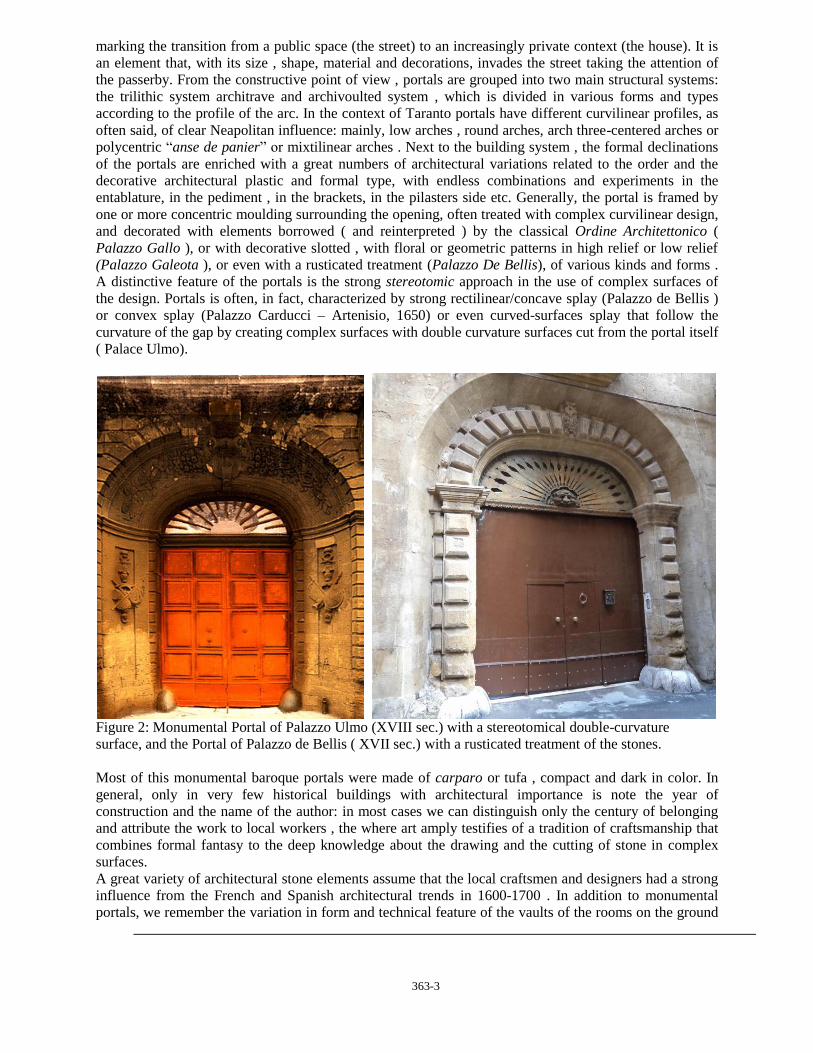
A distinctive feature of the portals is the strong stereotomic approach in the use of complex surfaces of
the design. Portals is often, in fact, characterized by strong rectilinear/concave splay (Palazzo de Bellis )
or convex splay (Palazzo Carducci – Artenisio, 1650) or even curved-surfaces splay that follow the
curvature of the gap by creating complex surfaces with double curvature surfaces cut from the portal itself
( Palace Ulmo).
Figure 2: Monumental Portal of Palazzo Ulmo (XVIII sec.) with a stereotomical double-curvature
surface, and the Portal of Palazzo de Bellis ( XVII sec.) with a rusticated treatment of the stones.
Most of this monumental baroque portals were made of carparo or tufa , compact and dark in color. In
general, only in very few historical buildings with architectural importance is note the year of
construction and the name of the author: in most cases we can distinguish only the century of belonging
and attribute the work to local workers , the where art amply testifies of a tradition of craftsmanship that
combines formal fantasy to the deep knowledge about the drawing and the cutting of stone in complex
surfaces.
A great variety of architectural stone elements assume that the local craftsmen and designers had a strong
influence from the French and Spanish architectural trends in 1600-1700 . In addition to monumental
portals, we remember the variation in form and technical feature of the vaults of the rooms on the ground

363-4
floor of the palaces, variously realized like Leccese star vault, pavillon vaults, nails vaults, and, in the the
staircase rooms, we can find several original spatial solution alternating oblique-arches vaults and
rampant-arches vaults.
The stereotomy3 is a complex science, which includes deep knowledge of mathematics and geometry (the
theory of surfaces and their intersections), materials and their static behavior and structural engineering
practice and building management. The first spread publications is in the sixteenth century, when the
scientific culture when geometric design in orthogonal projection becomes an important and scientific
instrument to control the entire design process from idea to realization on site. It becomes really a science
based on projective geometry and construction sciences, focusing on cutting blocks for the realization of
complex surfaces, thanks to the publication , in 1567, of the Traité d'Architecture by Philibert de l'Orme4
which marks the end court of this fundamental shift, followed during the seventeenth and eighteenth
centuries by a remarkable amount of other treatises on the same subject (especially French and Spanish).
Figure 3: Relief of Palazzo de Bellis with detail of the Portal ( XVII sec.). Arch. U. Occhinegro.
2 THE ENTRANCE HALL, THE COURT AND THE SCALE
The scenic conception is typical of Italian Baroque, and also the planned alternation of light and
darkness seems to play an important role in the design of these noble palaces: in close connection with the
road, the portal and the sequence of light-twilight-light (series of road-hall-yard) attract the eye of the
passer-by who, having passed the entrance hall, runs in an intimate space, the indoor hall (sometimes
small courtyard), a reservoir in the open space where, in the most of Taranto’s building, is located the
open staircase, often placed in frontal position eye-connected to access in order to visually seduce the
passer. The alternance of rampant stairs and a variety of vaulted structures, creates different and variously
articulated typologies of staircases, that create a strong spatial dynamism. In some cases , the facade of
the stairs follows the open space , and the atrium is then transformed into a multidimensional perceptual
context which begin with the portal, example of which is the staircase of Troylo Palace or Palazzo
Pantaleo . Derivation of the Neapolitan’s fifteenth century Palaces , the open stairs of the eighteenth
century organisms and are characterized by an unique architectural and spatial volume with a complex
architectural structure that manifests itself through the dynamic alternation of vault-covered ramps and a
continuous changing perception of views. The lights and shadows created by the perforated walls,
3 For an exaustive history of the Stereotomy cfr. Amédée-François Frézier, La théorie et la pratique de la
coupe des pierres et des bois pour la construction des voûtes et autres parties, ou traité de stéréotomie à l'usage de
l'architecture, Parigi-Strasbourgo, 1737-1739, 3 vol. J.M. Perouse de Monclos, L'architecture à la francaise, 1982.
See also Jean-Baptiste Rondelet,Traité theorique et pratique de l'Art de Bâtir ,1802-1817 4 Cfr.: De L’Orme P., 1567, Le Premier Tome de l'Architecture, Paris

363-5
Figure 4: Courtyard and Entry-Hall of Palazzo Carducci-Artenisio, Palazzo Pantaleo, Palazzo Galeota
constitute a plus - value for the project to trigger a spatial continuity between the courtyard, where is a
scale (internal) and the road from where the staircase is detected via the fornix of the hall (outside).

363-6
In this sense , the open staircase in Neapolitan style is a architectural reality that has the function of
vertical connection but, at the same time , it is a space in which there is a synthesis of several factors
that are realized in. Among the Neapolitan models of open staircase in eighteenth century the ones
that stand out are the work of Ferdinando Sanfelice (or its affiliate): in Sanfelice the model of open
stairs is an invention able to rewrite the elements language and the structure using an ingenious
invention capable to interpret the wall of the courtyard (opposite the street and hiding the body scale )
as a sudden dramatic front and which combine to pierce through a system of ramps and vaults with a
clever use of materials and colors. The inner courtyard, as well as giving light to the main rooms of
the palace, has an important functional distribution: in fact, many palaces of Taranto are based on the
outdoor balcony typology, opened onto the inner courtyard which is the only horizontal distribution
element for the upper floors . Documentate and communicate all the complex aspects discussed here,
according to the methods of the inquiry, means integrating methods, techniques and tools of
architectural significance and methods of graphic representation with digital photography, info-
graphics and modeling. In this experience of these analysis, an experiment was conducted on the
methodologies of the architecture, albeit still in progress and the results are not yet conclusive: the
recourse to the use of new programs for digital photography (Autodesk 123Catch ) have made
possible , through the union many pictures of the object , to obtain a detailed three-dimensional model
( mesh surfaces ) of each building studied , thus managing to represent the complexity of the spatial
complex, but at the same time also the state of conservation of the single artefact .
Figure 5 - 6: Palazzo Troylo (XVII) Scenographic staircase. Barbato (?) Palace (XVIII ?) Scenographic
staircase.

363-7
Figure 4: Palazzo Fornaro (XVIII sec.) Axonometric section. Front.
REFERENCES
De L’Orrme, P. 1561, Les Nouvelles Inventions pour bien bastir et a petits frais, Paris.
De L’Orme P., 1567, Le Premier Tome de l'Architecture, Paris.
Amari, M., Schiaparelli C., 1883. L'Italia descritta nel "Libro del re Ruggero" di Edrisi.
Lo Porto, F. G., 1971, Topografia antica di Taranto, in “Taranto nella civiltà della Magna Grecia, Atti del
X Convegno di studi sulla Magna Grecia” (Taranto 4-11 Ottobre 1907), Napoli, pp. 343-383
Oikonomides, N. , 1972. Les listes de prèséance byzantine des IX et X siècles, Paris, p. 327
Falkenhausen, V. Von, 1978 La dominazione bizantina nell'Italia meridionale dal IX all'XI secolo, Bari,
p.132
Rocco, M. G.,1984, Survey and comparison of plans in the urban plan of Taranto and in the territory of
the upper Jonio, in “Journal of the Islamic Environmental Design Research Centre, XX year”, Corcelli
editrice, Bari 1984
Galasso, A.,1984, Morphological reading and notes on Taranto’s landscape of the Jonic bow, in “Journal
of the Islamic Environmental Design Research Centre, XX year”, Corcelli editrice, Bari 1984

363-8
Melucci, T., 1989. La città antica di Taranto. Sue trasformazioni in rapporto alle vicende storiche e suo
restauro, Mandese Editore ,Taranto
Peluso,G., 1991. Storia di Taranto,Scorpione Editrice , Taranto
ZERLENGA, O., 1997. I portali in piperno dei palazzi storici napoletani in Gambardella, La cavità
antropica di Pianura, Naples.
Caputo, N., 2001. Taranto com'era, Edizioni Cressati, Taranto
De Luca, P. 2004. Il Centro Storico di Taranto: l'Isola, Scorpione Editrice, Taranto
Massafra, P., Carrino, F., 2004. Il Centro Storico di Taranto: il Borgo, Scorpione Editrice ,Taranto
Oliva, L.,2004, I quartieri dei vicoli sulla Marina di Mar Piccolo nella Città Vecchia di Taranto. Genesi e
configurazioni del tessuto edilizio storico. Risanamento e valorizzazione in “Kronos n.7”, Lecce
Cippone, N. 2006 Taranto, il Borgo prima del Borgo - Edizioni Archita , Taranto.