
The Occasional Papers - Library of Congress
58
The Occasional Papers From L’Enfant to the Senate Park Commission: Mapping the Nation’s Capital from 1791 to 1902 A Philip Lee Phillips Map Society Publication Series No. 6 Richard W. Stephenson
-
Upload
khangminh22 -
Category
Documents
-
view
1 -
download
0
Transcript of The Occasional Papers - Library of Congress

The Occasional Papers
From L’Enfant to the Senate Park Commission:
Mapping the Nation’s Capital from 1791 to 1902
A Philip Lee Phillips Map Society Publication Series No. 6
Richard W. Stephenson
The Occasional Papers
A Philip Lee Phillips Map Society Publication
Editorial Staff:
Ralph E. Ehrenberg
Managing Editor
Ryan Moore
Chief Editor, Design and Layout
Michael Klein
Editor
Anthony Mullan
Editor
Geography & Map Division
Library of Congress
Washington, D.C.
Winter 2014

From L’Enfant to the Senate Park Commission:
Mapping the Nation’s Capital from 1791 to 1902
Richard W. Stephenson

Foreward
The Philip Lee Phillips Map Society of the Library of Congress is a national support
group that has been established to stimulate interest in the Library’s Geography and Map Divi-
sion’s cartographic and geographic holdings, and to further develop its collections through fi-
nancial donations, gifts, and bequests. Members of the Phillips Society are kept informed of Di-
vision activities through its quarterly newsletter. The Society also funds the publication of this
scholarly series of occasional papers that focus on the history of cartography.
The Phillips Society is named in honor of the first and longest tenured chief of the Ge-
ography and Map Division. From 1897 to 1924, Phillips developed the practices and procedures
for acquiring, arranging, and cataloging the Library’s cartographic materials that provided the
basis for policies that are still followed by the Division.
A native-born Washingtonian, Phillips initiated the Division’s strong interest in collect-
ing and researching maps of the City of Washington. To celebrate the centennial of the City in
1900, the Senate issued the first published work related to this topic, which was compiled by
Phillips. The 77-page booklet, titled Maps and Views of Washington and the District of Colum-
bia, laid the foundation for all subsequent research on the mapping of the national Capital. Phil-
lips later privately published a limited edition of halftone reproductions of rare images titled
The Beginnings of Washington as Described in Books, Maps, and Views. An unpublished type-
script, annotated volume listing maps and atlases of Washington, D. C. is housed in the Divi-
sion’s vault, a lasting testament to Phillip’s long standing interest in the city of his birth.
Richard W. Stephenson continued this tradition. Another native Washingtonian, Dick
was raised eight blocks from the Library of Congress where his father was chief of the Congres-
sional Section of the Library of Congress’ Loan Division and custodian of its station in the

Capitol building for many years. Dick was associated with the Library of Congress for some 45
years, the last five as the Geography and Map Division’s first Specialist in Cartographic
History.
Dick’s strong interest in the city’s historical cartography began with his 1961 seminal
cartobibliography, Civil War Maps; an Annotated List of Maps and Atlases in Map Collections
of the Library of Congress, which included an extensive list of Washington, D. C. maps that
was expanded in a second edition in 1989.
In 1979, Dick’s interest turned to Charles Pierre L’Enfant’s grand plan of the City of
Washington that has been housed in the Geography and Map Division since 1918, and is now
considered one of the Library’s top treasures. He and Associate Editor James Hardin of The
Quarterly Journal of the Library of Congress developed a symposium in print devoted to the
topic of the early mapping of the City in the 1979 Summer issue, which opened with Dick’s
piece on “The Delineation of a Grand Plan.” This was followed in 1981 by The Cartography of
Northern Virginia: Facsimile Reproductions of Maps Dating from 1608 to 1915, which focuses
on that part of northern Virginia that was originally part of the District of Columbia until 1846.
With the approach of the National Capital Bicentennial in 1991, the National Geographic Socie-
ty provided the Geography and Map Division with a $348,250 grant to make the Library’s
Washington, D. C. map and atlas collection more accessible to researchers and at the same time
preserve it for future generations. During this four-year grant, the map and atlas collection of
Washington, D. C. was classified, cataloged, preserved, and microfilmed. The grant also spon-
sored a major Library exhibition. “City of Magnificent Distances,” which was curated by Dick
and Andrew J. Cosentino. Their published exhibit catalog lists more than 400 maps, atlases, and
views.

During this period, Dick continued his efforts to bring L’Enfant and his work to the at-
tention of the general public. Under his direction a computer-assisted reproduction of L’En-
fant’s 1791 manuscript plan for the city of Washington was produced by the U.S. Geological
Survey for the Library of Congress and published by the Library in 1991 with support from the
National Geographic Society, the U.S. Geological Survey, and the National Park Service. His
classic book, “A Plan Whol[l]y New” Pierre Charles L’Enfant’s Plan of the City of Washing-
ton (Library of Congress, 1993), was written to accompany this facsimile.
Dick continued to write and lecture on the mapping of Washington, D. C. until his pass-
ing in 2013. “L’Enfant’s Washington – Two Centuries of Change,” appeared in The Capital
Region: Day Trips in Maryland, Virginia, Pennsylvania, and Washington, D.C., edited by An-
thony R. De Souza (Rutgers University Press, 1992). "A City in Transition: Mapping the Na-
tion's Capital from Civil War to the Creation of a Comprehensive Plan, 1861 -1902," was pub-
lished in The Portolan: Journal of the Washington Map Society (Fall 2008). The essay present-
ed here was Dick’s keynote address at the 2012 Phillips Society’s Annual Spring Conference,
“Visualizing the Nation’s Capital: Two Centuries of Mapping Washington, D C.” His last arti-
cle, “Where Oh Where Should the Capital Be? The Seat of Government in an Expanding Na-
tion,” was published in White House History, Journal of the White House Historical Associa-
tion (Fall 2013).
I am grateful for the editorial contributions of Michael Klein, Anthony P. Mullan, and
Ryan Moore, and for the layout and design by Mr. Moore.
Ralph E. Ehrenberg
Chief, Geography and Map Division


Preface
In this overview employing maps, birds-eye views, and photographs, we will examine
the initial plan of the nation's new capital and the first topographic map of the entire federal dis-
trict, both drawn in the last decade of the eighteenth century; the haphazard growth and devel-
opment of the city in the nineteenth; and finally, the introduction of a new plan of the city for
the twentieth century.
This paper describes several maps not illustrated therein. Part of this paper is based on
my article entitled “A City in Transition: Mapping the Nation’s Capital from Civil War to the
Creation of a Comprehensive Plan, 1861 – 1902,” The Portolan, issue 72, fall 2008, 9-24, as
well as on previous lectures. For additional information about the August 1791 L’Enfant plan,
see my article entitled “The Delineation of a Grand Plan,” The Quarterly Journal of the Library
of Congress 36, no. 3, 1979, 207-224; and “A Plan Whol[l]y New:” Pierre Charles L’Enfant’s
Plan of the City of Washington (Washington, Library of Congress, 1993), 85.
Richard W. Stephenson
Library of Congress
May 2012


1
L'Enfant's Grand Plan
It is easy for us to forget that in the final decade of the eighteenth century that the site on
which the future capital of the new nation would occupy was by no means pre-ordained. In
fact, it was a very divisive issue in Congress with much political and economic power riding on
the outcome. It is little wonder then that it evoked strong state, regional, local, and personal
jealousies. More than thirty places were put forth and debated in the First Congress and its pre-
decessor body, the Continental Congress.
After years of debate, however, Congress resolved in 1790 to locate the capital along an
eighty-mile stretch of the Potomac River, leaving the choice of the site to President George
Washington. The site chosen by the President on January 24, 1791 was situated at the head of
navigation on the Potomac River, 96 miles from its confluence with the Chesapeake Bay.
[Figure 1] The area is displayed in a detail from the principal map of the period: Joshua Fry
and Peter Jefferson’s map of Virgin-
ia and Maryland published in 1755.
Further navigation upstream on the
Potomac by large vessels was
barred due to the descent of the riv-
er from the Piedmont to the Atlantic
coastal plain at Great and Little
Falls.
Only a few miles upstream
from Mount Vernon, was a long and
well-settled area consisting of farms,
[Figure 1] Portion of Fry and Jefferson’s map of Mary-
land and Virginia, 1790, depicting the site where Con-
gress chose to locate the capital.

2
woodland, and two undeveloped or “paper” towns. One of the towns, Hamburg, was founded in
1768 by Jacob Funk at the mouth of Rock Creek, while the other, Carrollsburg, was established
in 1770 by Charles Carroll of Duddington on the Potomac's Eastern Branch, today known as the
Anacostia River. More important economically, however, were the thriving river ports of
Georgetown, Maryland, authorized by the Maryland Assembly in 1751, and Alexandria, Virgin-
ia, chartered by the Virginia Assembly in 1748. Both Georgetown and Alexandria were major
tobacco ports for their respective states.
The site within the federal territory chosen for laying out the city was a broad, triangular
-shaped 6,111-acre parcel of farmland on the Maryland side of the Potomac River, rising from
sea level in a series of four step-like terraces. The land was divided into nineteen parcels indi-
vidually owned by local proprietors as shown on an 1893 map, drawn by the early Washington
historian Dr. Joseph Toner.
Tobias Lear, the President’s secretary, observed that “The ground, on an average, is
about forty feet above water on the river. Although the whole, when taken together, appears to
be nearly a level spot, yet it is found to consist of what may be called wavy land, and is suffi-
ciently uneven to give many very extensive and beautiful views from various parts of it, as well
as to effectually [i.e., effectively] answer every purpose of cleansing and draining the city.” 1
The President chose Andrew Ellicott, one of the country’s leading surveyors and astron-
omers, to survey the federal territory, and Washington turned to Pierre Charles L’Enfant, a for-
mer comrade in arms and then a practicing New York City architect, to prepare the plan of the
city. Nearly a year and a half earlier, L’Enfant offered to design a plan for a new capital, sug-
gesting “that the plan should be drawn on such a scale as to leave room for that aggrandizement
& embellishment which the increase of the wealth of the Nation will permit it to pursue at any

3
period however remote.” 2 Washington accepted L’Enfant’s idea for a grand plan and never wa-
vered from this concept. Ellicott and his assistant, the African-American astronomer Benjamin
Banneker, arrived in Georgetown in February, 1791. As quickly as possible, they moved to
Jones Point on the southern edge of Alexandria and began the survey of the boundaries of the
one-hundred-square-mile federal district.
[Figure 2] Ellicott finished his survey in late 1792 and submitted it to Washington for
review on January 1, 1793 and again on February 11. Washington returned the manuscript on
both occasions to Ellicott with his suggestions for improvement. He thought, for example, that
“it would be better that the outlines at least of the city and perhaps of Georgetown should be
laid down in the plat of the territory.” 3 This and other suggestions made by the President were
incorporated by Ellicott into his manuscript. The surveyor made a new map of the “Territory of
Columbia,” and along with his old
manuscript, submitted them to To-
bias Lear on June 25, 1793.
Ellicott’s map, published
early in 1794, followed Jefferson’s
advice, given more than two years
earlier, that it be placed “on a
square sheet to hang corner up-
wards…[so that] the meridian will
be vertical as [it] ought to be; the
streets of the city will be horizontal
and vertical, and near the center, the
[Figure 2] From Ellicott’s manuscript map of the
Territory of Columbia, 1793.

4
Potomac and Eastern branch will be nearly so….” 4
[Figure 3] A large part of the significance of El-
licott’s topographic plan rests its influence, because
“for almost seventy years it remained the only offi-
cial printed map of the entire district, and all subse-
quent topographic maps were based on it.” 5
L’Enfant arrived in Georgetown in March,
1791, to examine the terrain and draw his plan for
the future city. After an initial ride through the area,
the enthusiastic planner informed Secretary of State Jefferson on March 11 that “I passed on
many spots which appeared to me raly [sic] beautiful and which seem to dispute with each other
who command[s].” 6
[Figure 4] Five months later, L’Enfant
traveled to Philadelphia and submitted a detailed
report and a plan of the city to the President. The
plan remained in Washington’s possession until
he transferred it to the City Commissioners in
1796 with a cover letter, which reads “This plan
you shall receive by the first safe hand who may
be going to the Federal City – By it you may dis-
cover (tho’ almost obliterated) the directions
given to the Engraver, by Mr. Jefferson, with a
pencil, what parts to omit.”7 This much worn
[Figure 4] L’Enfant’s manuscript plan of
Washington, 1791.
[Figure 3] Ellicott’s map of the Territory
of Columbia, 1794.

5
and faded plan, drawn on paper turned dark from having been varnished sometime in the distant
past, was transferred to the Library of Congress in 1918 by the Office of Public Buildings and
Grounds. It is the cornerstone of the Library’s superb Washington, D.C., map collection.
[Figure 5] Dissatisfied with L’Enfant’s terminology describing the building to be oc-
cupied by Congress, Jefferson crossed out “Congress house” and added the word “Capitol,”
which today is used to identify the structure, as well as the city housing the Nation’s legislative
seat. Though not indicated on the map, Jefferson also recommended that the Eastern Branch of
the Potomac be renamed the Anacostia, in accordance with its original Native American appel-
lation.
Washington, pleased with the manuscript,
directed L’Enfant to complete his plan and prepare
it for publication. The President was anxious to
have the map circulated before the first sale of lots
in the new city was held on October 17, 1791. He
was keenly disappointed, therefore, when he
learned that L’Enfant had failed to have the map
ready for display at the sale. Washington noted that without a map “none who knew what they
were about would be induced to buy, to borrow an old adage, `A Pig in a Poke’.” 8 When it be-
came likely that L’Enfant was not going to promptly finish the plan as directed, the President
turned to Andrew Ellicott to complete the undertaking. Ellicott, with the assistance of his broth-
er, Benjamin, who had worked closely with L’Enfant, completed the redrawing that incorpo-
rated the editorial corrections suggested by Jefferson. The finished drawing was then placed in
the hands of James Thackara and John Vallance to engrave and print it. Before commencing on
[Figure 5] One of Jefferson’s pencil cor-
rections of L’Enfant’s plan.
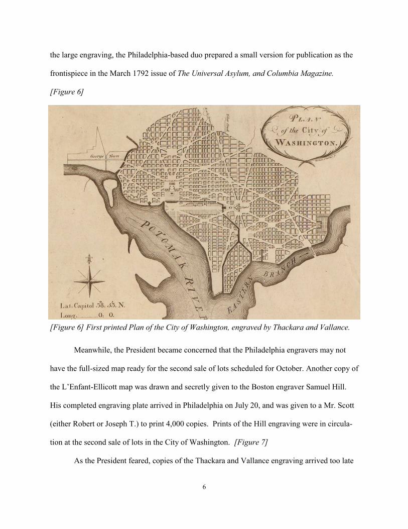
6
the large engraving, the Philadelphia-based duo prepared a small version for publication as the
frontispiece in the March 1792 issue of The Universal Asylum, and Columbia Magazine.
[Figure 6]
Meanwhile, the President became concerned that the Philadelphia engravers may not
have the full-sized map ready for the second sale of lots scheduled for October. Another copy of
the L’Enfant-Ellicott map was drawn and secretly given to the Boston engraver Samuel Hill.
His completed engraving plate arrived in Philadelphia on July 20, and was given to a Mr. Scott
(either Robert or Joseph T.) to print 4,000 copies. Prints of the Hill engraving were in circula-
tion at the second sale of lots in the City of Washington. [Figure 7]
As the President feared, copies of the Thackara and Vallance engraving arrived too late
[Figure 6] First printed Plan of the City of Washington, engraved by Thackara and Vallance.

7
for use in the second sale. It was considered by many, however, to be more elegant in appear-
ance and soon was accepted as the “official” published version of the plan. Not only was the
Philadelphia plate better engraved, it had been produced on a larger sheet of copper compared
with the Boston plate. More significantly, it included the depths of water in the shipping chan-
nel and along the shore lines of the Potomac River and Eastern Branch, information viewed as
especially important by Washington, Jefferson, and other boosters for attracting merchant in-
vestors to the new city. The hydrographic data had been received too late for inclusion in the
Boston plate. [Figure 8]
The first published map actually based on field surveys was Robert King’s A Map of the
City of Washington in the District of Columbia… [Figure 9] Drawn by King, the former sur-
veyor of the city, it was engraved locally by Conrad Schwartz and distributed by William
Cooper, who announced it for sale “at his music and book store [on] Pennsylvania Avenue.” 9
Ralph Ehrenberg, Chief of the Library of Congress Geography and Map Division, noted in his
1979 article in the Library’s Quarterly Journal that “it is one of the earliest maps engraved in
the city of Washington, it represents the most accurate map of the city for this period, and it is
associated with a landmark copyright decision concerning maps.” 10 The latter refers to King’s
lawsuit against the map and book collector Peter Force who copied and published King’s map
in 1820 without permission. Although King had copyrighted the map on January 1, 1818, he
failed to note this on the published map, thereby leading to the court’s dismissal of the suit.

8
[Fig
ure
7]
Sam
uel
Hil
l en
-
gra
vin
g o
f th
e E
llic
ott
-
L’E
nfa
nt
pla
n, 1792.
[Fig
ure
8]
Thack
ara
and V
all
ance
dra
win
g o
f W
ash
-
ingto
n, D
.C.
[Fig
ure
9]
Rober
t K
ing’s
Map o
f
the
city
of
Wash
ingto
n i
n t
he
Dis
tric
t of
Colu
mbia
, publi
shed
in
1818.

9
[Figure 10] On the occasion of the two hundredth anniversary of L’Enfant’s plan in 1991, the
national treasure was stabilized and mended by library conservators, photographed and digit-
ized by United States Geological Survey specialists, and then it was sealed in a specially-
constructed case containing argon gas. In addition, full-size colored and black-and-white re-
productions were published and sold by the Library of Congress. The black-and-white repro-
duction are ideal for studying the plan as conceived by L’Enfant, as well as the editorial cor-
rections suggested by Jefferson. See [Figure 4].
10
[Fig
ure
11]
Bohn a
nd S
ach
se’s
Dis
tric
t of
Colu
mbia
and t
he
seat
of
war
on t
he
Poto
mac
, 1861.

11
The Capital at War
The Civil War commenced with the bombardment of Fort Sumter, South Carolina on
April 12 and 13, 1861, followed by its surrender to Confederate forces the next day. The out-
break of fighting found the city of Washington in a precarious position. Its geographical posi-
tion on the banks of the Potomac originally thought by its boosters to be ideal for its centrality
of location now placed the city in jeopardy. Not only was the city virtually undefended by
troops or defensive positions, but also its buildings were within easy shelling distance from Vir-
ginia's Arlington Heights. Therefore, on the evening of May 23, as soon as sufficient troops had
arrived to defend the city, Union regiments crossed the Potomac and occupied the strategic ap-
proaches to the city, including Arlington Heights and the important river port of Alexandria.
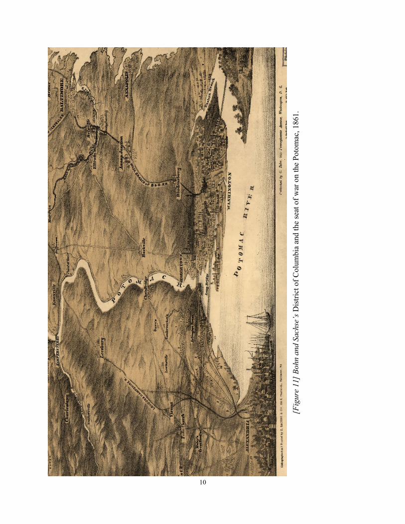
Fifteen army campsites are indicated on Casimir Bohn and Edward Sachse’s contempo-
rary birds-eye view, which depicts Alexandria, northern Virginia, Maryland, and Washington,
D. C., looking northwestward from the Potomac River. [Figure 11]
As the war began, Albert Boschke, a former employee of the United States Coast Sur-
vey, completed for publication his Topographical Map of the District of Columbia. Compiled
from field surveys conducted by Boschke from 1856 to 1859, this landmark map is the first to
show houses and public buildings throughout the entire District of Columbia. In the rural areas,
land north of present-day Florida Avenue, he also delineated property lines, names of residents,
and relief by contour lines.
Unfortunately for Boschke, just as the map was coming off the press, federal authorities
swooped down and seized all proofs and copies that had been printed as well as the copper
plates. The desperate need for an accurate topographic map of the District of Columbia and the
fear of it falling into the hands of the enemy led to the Union Army's swift action in confiscat-

12
ing it for their own use. It would be years before Boschke and his publishing partners were
compensated for their loss.
The appropriated map was quickly put to use by General John Barnard of the Corps of
Engineers. He set about designing and constructing an impregnable interlocking series of forts
and entrenchments to defend the city. By the beginning of 1862, some 48 earthworks of varying
sizes, still largely isolated from one another, had been constructed around the perimeter of the
city. 11 Later the defenses that encircled the city were enlarged to include 68 enclosed forts and
batteries linked together by 32 miles of military roads supplemented by existing roads and
streets. 12
Using Boschke’s map as a base, Barnard's team of mapmakers added, by hand, cultural
data pertaining to northern Virginia, a new map title, forts, batteries, and rifle pits, as well as the
military roads built to link them. Barnard's large wall map was made for official use, and as
such, was never published. Much of the information, however, was incorporated into a smaller,
more manageable map issued in 1865 by the Engineer Bureau, War Department. [Figure 12]

13
[Figure 12] Portion of Barnard’s map of the defenses of Washington, 1865. A system of forts is
illustrated in red.

15
Disease and Unsanitary Conditions
The city’s infrastructure was severely taxed during the war by the influx of people, both
civilian and military. From a modest town of about 60,000, Washington grew to a population of
more than 200,000. The city’s already poor sanitation system became an abysmal failure. Espe-
cially dangerous were conditions in the low-lying area between Capitol Hill and the White
House — the governmental and commercial center of the city. Crossing the area was the Wash-
ington Canal, long supported by the city's founders for its potential beauty and commercial val-
ue, but now little more than an open sewer filled with animal and human waste. The situation
was further aggravated at the western end of the Mall by the Army's erection of cattle pens and
a slaughterhouse near the unfinished Washington Monument and corrals for some 30,000 mules
and horses in nearby Foggy Bottom west of the White House. 13
The deplorable conditions caused an outcry. Fifty-five businesses and citizens of the
City, including 13 medical doctors, petitioned the United States Senate on March 23, 1864, for
funds for dredging the Washington canal "so much needed as a sanitary measure" and suggest-
ing that the sediment removed from the canal be used to create "new land on the swamp or
marsh in the rear of the President's mansion." 14 The petitioners expressed their confidence that
"The filling up of what is now a dangerous miasmatic swamp, which in its present condition, is
bare two-thirds of the time, and the noxious exhalations from which, during the summer and
early autumn months, has made the presidential mansion so notoriously unhealthy as a place of
residence, and which to a very great extent, will remedy this evil." 15
By war's end, sanitary conditions had not improved in the environs of the canal, result-
ing in a growing concern for the health of the President and his family. This, coupled with be-
lief that the aging White House was "unfit for occupation," led to some support in Congress for
16
building a new presidential mansion on a more salubrious site. In July 1866, therefore, the Sen-
ate Committee on Public Buildings and Grounds requested the Secretary of War to investigate
several tracts of land for a "suitable site for a public park and presidential mansion." 16 The ac-
complished army engineer, Brigadier General Nathaniel Michler, was detailed to carry out the
directions of the Committee.
In conducting his survey, Michler became enthralled by the still largely unspoiled, rug-
ged topography of Rock Creek and its environs. In his report to the Senate Committee, he rec-
ommended "the construction of the national park as soon as practicable," noting that "It is a
grand and beautiful undertaking, and should be prosecuted with the greatest energy." 17 Michler
accompanied his report to the Committee with two preliminary maps, which, he noted, "will
show more plainly than words can express the required information and the respective ad-
vantages of the different sections." 18
Michler’s first map, oriented with north toward the upper left and covering portions of
N. E. and N. W. Washington, depicts three of the four potential sites for a new presidential
mansion. [Figure 13] One of the estates under consideration was “Harewood,” the country
home of philanthropist and southern sympathizer William Corcoran. Later the estate was pur-
chased and used to expand the grounds of the Soldiers’ Home. His second map is the first de-
tailed topographic survey of the Rock Creek valley. "Michler said, "[It]] will show the topo-
graphical features of the country, and its accessibility to both Washington and
Georgetown.” [Figure 14]
Delighted with Michler’s work, Senator Benjamin Brown, Chairman of the Senate
Committee on Public Buildings and Grounds, sponsored a bill to establish a park encompassing
Rock Creek. 19 Two decades were to pass, however, before Congress acted.

17
[Figure 13] Sheet 1 of Michler’s topographical sketch of Washington, D.C.
and in the lower corner
[Figure 14] Sheet 2 of Michler’s sketch.

18
Land Reclamation
[Fig
ure
15]
Tw
inin
g’s
Rec
lam
ati
on P
lan, 1879.

19
Congressional interest in selecting a site and building a new presidential mansion also
waned as the necessity for relocating the structure abated in the 1870s due to significant im-
provements in the city's sewer system. The low, marshy land west and south of the Washington
Monument had been considered for many years a significant health hazard, eyesore and an im-
pediment to river navigation. Known as the Potomac Flats, it consisted of sediments washed
down from upstream, run-off deposits from Washington streets and building sites, and raw sew-
erage flowing into the Potomac from the B Street sewer that had replaced the old Washington
Canal. The Board of Survey reported that “The reclamation of this flat is an absolute necessity
for the preservation of the health of the city, and must be included in any plan … for the im-
provement of the water-front of Washington." 20
Various plans to deepen the Potomac channel, improve the Washington Harbor, and re-
claim the Potomac Flats were put forth by Army engineers. One example is Major William J.
Twining’s reclamation plan designed to illustrate proposals put forth in the 1879 Annual Report
of the Commissioners of the District of Columbia. Despite the Commissioners urging, Congress
did not act until a natural disaster caught their attention. [Figure 15] In 1881, a serious flood
that inundated much of the low-lying portions of the city including the Mall and parts of Penn-
sylvania Avenue struck the city. The following year, Congress appropriated $400,000 to begin
the reclamation project, a project that was to consume most of the final two decades of the nine-
teenth century and create over 600 acres of new land.

20
[Figure 16] Olmsted’s “General Plan for the Improvement of the U.S. Capitol Grounds.”
Courtesy of the Architect of the Capitol.

21
Improving the Capitol Grounds
With the completion of the dome of the Capitol building during the Civil War, attention
in the next decade focused on the improvement of the surrounding grounds that in the past had
been designed by several important architects, such as Robert Mills, who was famous for the
Washington Monument and Thomas Ustick Walter, the fourth Architect of the Capitol. To
begin, Congress expanded the grounds to 51-1/2 acres with the purchase in 1872-1873 of
squares 687 on the north and 688 on the south. A detailed map of Washington by Bastert and
Enthoffer, which they published in 1872, shows the layout of the Capitol Grounds just before
they were redesigned. The expansion was followed in 1874, with the commissioning of Ameri-
ca's leading landscape architect, Frederick Law Olmsted, Sr., to prepare a comprehensive plan
for improving the grounds. 21 [Figure 16]
Olmsted's "naturalistic" design, featuring tree-lined, curving walks and lanes along with his
proposal for a western terrace, are depicted in his pen-and-ink and lightly colored drawing of
the Capitol Grounds. His plan is reminiscent of Andrew Jackson Downing's romantic design for
the Mall and adjacent public land made two decades earlier. Although Downing's design was
never fully implemented and nothing is visible today on the ground except for a hint of it at the
Ellipse south of the White House, Olmsted's plan was carried out and still may be appreciated
today on the west side of the building. To the east, however, the grounds have been changed
recently with the construction of the Capitol Visitor’s Center.
Olmsted also skillfully designed the West Terrace to provide an architectural base that
would visually balance the greatly expanded Capitol building." In addition, he correctly envi-
sioned the terrace would serve as an esplanade from which to view the city to the West that un-
fortunately due to security considerations is no longer available to the public.

22
[Figure 17] Sache’s lithograph of the capital and below [Figure 18] From Hopkins’ survey of
Washington, D.C.

23
Problems Persist
The city as it appeared in the 1880’s was portrayed in a colored lithograph “Sketched
from nature” by the Baltimore lithographer Adolph Sachse in 1883-1884. [Figure 17] John
Reps notes in his Washington in View that this “immense… view reveals many details that no
other provides, and allows one to examine the newly built up, fashionable neighborhoods along
and beyond Massachusetts Avenue where construction was finally catching up with L’Enfant’s
vision of nearly a century earlier.” 22
Public buildings, commercial structures, private dwellings, streets, and parks in Wash-
ington and Georgetown are shown as if viewed from a position high above the Potomac River.
Sachse’s perspective map depicts the western portion of the Mall as redesigned by Andrew
Jackson Downing, although the Washington Monument still lacks its capstone that was not put
into place until December 6, 1884, and water still appears to the north and west of the Monu-
ment.
In 1887, Griffith Hopkins of Philadelphia, one of the nineteenth century's most prolific
publishers of county and city atlases, issued a landmark atlas or plat book of the City of Wash-
ington. It is the first published cadastral atlas that not only indicates property lines but also all
commercial and public buildings and private dwellings within the city limits. Not only is the
shape of each building indicated, but also color tints denote what the structure is made of. Pink,
for example, signifies brick, yellow is wood, and brown is stone.
Typical of the plates in this atlas is one showing the environs of the Capitol building.
The grounds display the "naturalistic" pattern as proposed by Olmsted in 1874. [Figure 18]
To the west of the Capitol is the Botanic Gardens, which was initially built to house the exotic
plants brought back from the Pacific Basin in 1842 by the United States Exploring Expedition

24
under command of Lieutenant Charles Wilkes.
In 1888, one year after the publication of Hopkins' plat book, the Sanborn Map Compa-
ny of New York City (later Pelham, N. Y.) issued the first of several editions of its Insurance
Maps of Washington, D. C. 23 Plate 14 of 84 shows part of the city's principal commercial dis-
trict from Fifth to Tenth streets, N. W. and from B to E streets, N. W. The Center Market situat-
ed on public reservation no. 7, shown at the bottom of the map, was the largest building in the
area. [Figure 19] The first market on this site opened to the public in 1801, replacing a small
market that had existed on President's Square near 17th and Pennsylvania Avenue, N. W. Cen-
ter Market was situated south of Pennsylvania Avenue on low, marshy ground adjacent to Tiber
Creek. 24 The creek became Washington Canal and then B Street by the time the Sanborn Com-
pany made its map. B Street is now named Constitution Avenue. Center Market’s location led
many to refer to it as "Marsh Market” or the contraction, "Mash Market." 25
Center Market's ramshackle wooden buildings were destroyed by fire in 1870 and re-
placed in 1872 by this imposing neo-gothic-style brick structure designed by architect Adolph
Cluss. The massive building contained spaces for 1,000 retail dealers. Located in the center of
town and flanked on the east by Seventh Street, N. W., a major road that connected the farms
north of the city with the city's wharves, it remained Washington's principal meat and produce
market until it was removed in 1931 to build the National Archives. It is interesting to note that
during construction of the Archives “more than 8,500 concrete piles were driven into the unsta-
ble soil to support the building’s weight. Large pumps” are still required to “keep the founda-
tions from flooding with” water from Tiber Creek. 26
The social and physical decline of the city following the Civil War was widely dis-
cussed by concerned citizens, city government officials, the press, and in the halls of Congress.

25
Poverty and prostitution had grown considerably. Clean, safe drinking water was not available
in large parts of the city. The sewer system was grossly inadequate. Unsanitary conditions
abounded in every quarter of the capital. Movement within the city was severely hampered by
streets and avenues that were largely unpaved.
[Figure 19] Sanborn insurance map, 1888.

26
[Fig
ure
20]
Map s
how
ing i
mpro
vem
ents
mad
e to
str
eet
pave
men
ts f
rom
1872
-73.

27
Improvements in the Northwest
With creation of a territorial government in 1871, major changes began to occur in the
city’s infrastructure. Governor of the city during these brief and turbulent years was local bank-
er Henry D. Cooke, the brother of the Civil War financier Jay Cooke. Power, however, actually
rested in the hands of Alexander “Boss” Shepherd, the dynamic head of the Board of Public
Works. In three years, Shepherd produced vast improvements in the physical structure of the
city, but at a huge expense and "with a ruthless hand," as Charles Moore, Clerk of the Senate
Committee on the District of Columbia wrote in 1902. "Grades were changed, streets cut down
and hastily paved with wood; Congress was outwitted and defied; judges were lured on excur-
sions from the city in order to prevent them from restraining the demolition of unsightly struc-
tures; money was poured out like a Potomac flood; taxes were doubled, and an enormous debt
was piled up: but," Moore concluded, "after all has been said, the fact remains that the result
was amply worth the cost." 27 Because of the enormous expense incurred by the Board of Pub-
lic Works, the city, by 1874, was bankrupt and the territorial government collapsed. Boss Shep-
herd’s prestige and personal fortune now gone, he left the city for Mexico never to return.
A series of maps were issued in 1873 to illustrate the accomplishments of the Board of
Public Works. 28 These included maps of improvements made to water mains, pavements,
sewers, and gas mains. The map showing "Pavements" depicts those surfaced with wood in
yellow, with concrete in red, and with stone in blue. [Figure 20] Clearly the map reveals that
the Board of Public Works had focused its attention on paving the more affluent Northwest at
the expense of the three remaining quadrants. With the exception of the principal thoroughfares,
even Capitol Hill had been virtually ignored by the Board in its race to surface the streets of af-
fluent Northwest Washington.


29
The District Expands
With the growth of the city and the springing-up of new subdivisions outside the
planned city, officials became alarmed that unless action was taken quickly it would be impos-
sible to extend L'Enfant's streets and avenues beyond Boundary Street (i.e., Florida Avenue to-
day) into Washington County. To do this, an accurate map of the District of Columbia was ur-
gently needed. Congress acquiesced and appropriated $5,000 in 1881 "for surveys of the Dis-
trict of Columbia, with reference to the future extension of various avenues to the District line."
29
The newly funded survey was undertaken for the District Commissioners by the United
States Coast and Geodetic Survey. With appropriations eventually totaling $65,600, topogra-
phers labored from 1881 to 1891 to complete the field surveys needed for the new map. The
survey data was incorporated into 58 engraved sheets covering the 48 square miles of the Dis-
trict of Columbia beyond the cities of Washington and Georgetown.
[Figure 21] Sheet 49
of the District survey covered
the town of Anacostia, the
first suburb built outside of the
limits of the capital. It was
designed primarily for work-
ers at the Navy Yard who
could commute by way of the
Eleventh Street Bridge labeled
"Anacostia Bridge."
[Figure 21] U.S. Geodetic Survey of the town of Anacostia.

30
The United States Geological Survey, created by Act of Congress on March 3, 1879 to
identify and classify the nation's natural resources, also contributed to the mapping of the region
by the publication in June 1891, of the Washington Sheet. The newly completed topographic
map was immediately employed as the base for producing the first geological map of the capital
region. The publication of the "Preliminary Edition" was timed to coincide with the Fifth Inter-
national Congress of Geologists, which met at Columbian University (now George Washington
University) from August 26 to September 4, 1891. The new map served to demonstrate the pat-
terns and tints then being developed at the Survey for depicting geologic information.
An interesting proposal for both permanent and temporary use of the land reclaimed
from the Potomac is depicted in this Birdseye View of the National Capital…. [Figure 22] It
was produced in 1888 by local boosters in an unsuccessful attempt to have the capital city cho-
sen as the site for the exposition to be held on the 400th anniversary of the discovery of Ameri-
ca by Christopher Columbus. A perspective drawing, it presents the city as if viewed from a
point above the Potomac River looking toward the Northeast. The recently completed Wash-
ington Monument is in the center of the view, with the White House to the left and the Capitol
to the right.
Dominating the scene in the foreground is the newly reclaimed land from the Potomac
with the footprints of the proposed exposition buildings. Nothing, however, was to come of this
plan. Congress chose Chicago as the site of the Columbian Exposition. The immense success of
the Columbian Exhibition and its “White City” led to the “City Beautiful” movement that sub-
sequently swept the country, including the nation’s capital.

31
[Figure 22] Johnson’s depiction of the Capital, 1888.
32
[Fig
ure
23]
Tro
ut’
s vi
ew o
f t
he
capit
al,
1901.

33
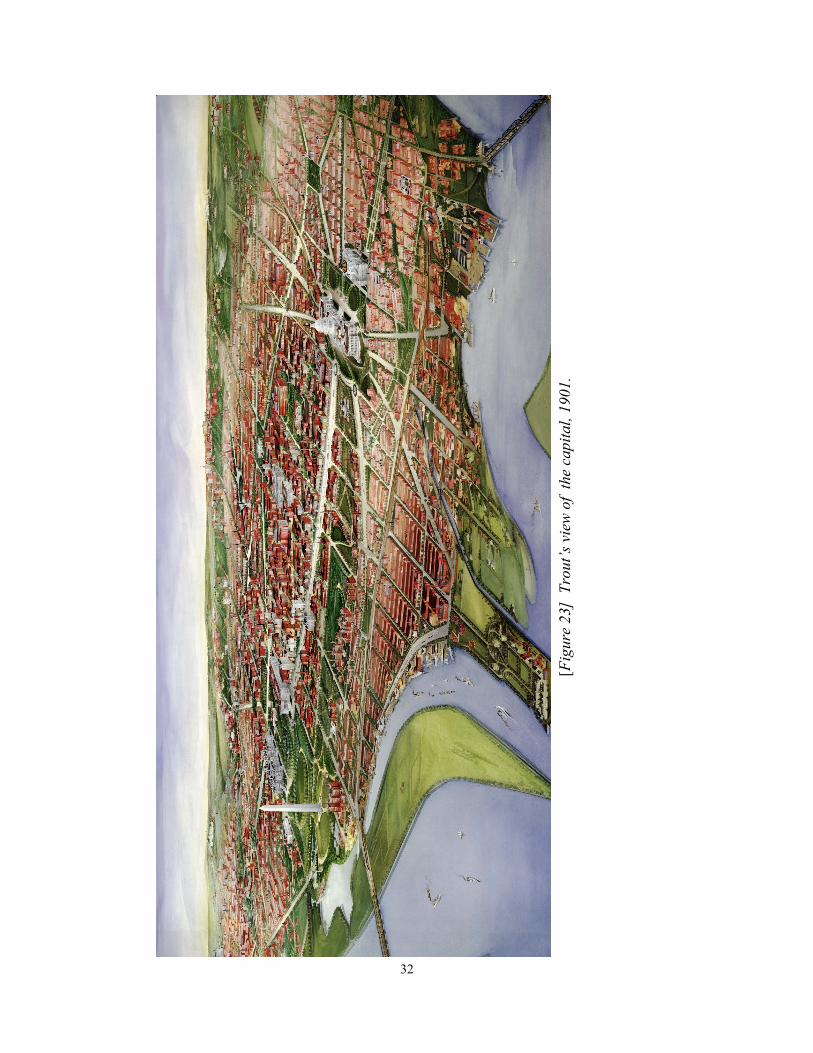
The McMillan Plan of 1901
The impending celebration in December, 1900 honoring the 100th anniversary of the
move of the federal government from Philadelphia to Washington, D.C. focused public atten-
tion on improving the long neglected Mall and the recently reclaimed land lying to its west and
south. To visualize the nation’s capital as it existed at the turn of the century, one may turn to
an extraordinary bird’s-eye view that was painted in 1901 by the artist, engraver, and lithogra-
pher John L. Trout. [Figure 23] Beautifully executed in opaque watercolors, the unique paint-
ing shows the city in minute detail. 30 Especially notable are the newly created Washington
Channel adjacent to Fort McNair; the Tidal Basin, and some of the reclaimed lands of Potomac
Park; the western Mall featuring Andrew Jackson Downing's 1851 romantic landscape design,
as well as the eastern Mall severed at Sixth Street by the Baltimore and Potomac Railroad Sta-
tion, its train shed and tracks; and Capitol Hill, showing the Library of Congress completed in
1897.
City’s centennial celebrations aroused interest among citizens, public officials, profes-
sional architects, and the news media on ways and means to improve the beauty of the city’s
architecture and open spaces. Although several plans were put forth to improve the sad appear-
ance of the Mall and to develop the newly created lands adjacent to the Washington Monument,
none were considered acceptable by Congress or the public at large. Congressional displeasure
with these piecemeal plans led the Senate Committee of the District of Columbia, under the
leadership of Senator James McMillan, to establish a commission on March 19, 1901 to prepare
"a comprehensive plan for the development of the entire park system" of the nation's capital. 31
The committee report explained that "questions have arisen as to the location of public build-
ings, of preserving spaces for parks in the portions of the District beyond the limits of the city
34
of Washington, of connecting and developing existing parks by attractive drives, and of provid-
ing for the recreation and health of a constantly growing population; and, in the absence of a
well-considered plan, the solution of these grave problems has either been postponed or else has
resulted in compromises that have marred the beauty and dignity of the national capital." 32
After conferring with the American Institute of Architects, Senator McMillan appointed
to the commission four leading American experts: architect Daniel H. Burnham (commission
chairman); architect Charles F. McKim; sculptor Augustus Saint-Gaudens; and landscape archi-
tect Frederick Law Olmsted, Jr. Burnham, McKim, Saint-Gaudens, and Olmsted, Sr., had
worked together in 1892-93 to create Chicago's widely acclaimed Columbian Exposition. The
senior Olmsted, now too ill to serve, was succeeded by his son who had made a name for him-
self for his work on the Metropolitan Park System in Boston.
Working in close harmony, this distinguished group of experts produced in nine months
a plan that would profoundly influence and reshape the development of the city for years to
come. Furthermore, "The plan’s bold scale and the public idealism it embodied," urban histori-
an Jon A. Peterson noted, "inspired people in other cities to undertake similar actions. Within
less than a decade an entirely novel field of public endeavor known as city planning had taken
root." 33
The commissioners were aware that both Congressional and local officials were paying
little attention to the L'Enfant plan that more or less had guided the city for a hundred years.
They harshly criticized, for example, the placement of the new Library of Congress building
opened only four years earlier, noting that its location "partly in Pennsylvania avenue is a per-
petual mutilation of L'Enfant's plan, and inflicts incalculable injury to the Capitol, which the
Library in part conceals." 34 They also pointed out that the "carefully planned vistas of the

35
White House" had been destroyed by construction of the State, War, and Navy building and the
extension of the Treasury building. 35 "Indeed the more the Commission studied the first plans
of the Federal City," they remarked, "the more they became convinced that the greatest service
they could perform would be done by carrying to a legitimate conclusion the comprehensive,
intelligent, and yet simple and -straightforward scheme devised by L'Enfant under the direction
of Washington and Jefferson." 36 As the commission's plans unfolded, however, they did not
slavishly follow that of L'Enfant but rather reinterpreted and revised his plan based on present
realities, needs, and opportunities. "Had L'Enfant seen and read the plan," observed urban histo-
rian Frederick Gutheim, "he would hardly have recognized his own contributions." 37
The commission’s plan impacted especially the central core of the city. [Figure 24]
The Supreme Court building was constructed to the east of the Capitol. 38 The Senate and
House office buildings were built to the north and south of the Capitol grounds. 39 Union
Square was erected at the foot of Capitol Hill, containing a memorial to President Ulysses S.
Grant. 40 Pennsylvania Railroad Station was removed from the Mall and was replaced by Union
Station that was situated “north of Massachusetts avenue, the center of the building being on the
axis of Delaware avenue, about a quarter of a mile from the Capitol.” 41 The axis of the Capitol
and Washington Monument was defined "by an expanse of undulating green a mile and a half
long and three hundred feet broad, walled on either side by elms, planted in formal procession
four abreast. Bordering this green carpet, roads, park-like in character, stretch between Capitol
and Monument...." 42 A memorial such as a Pantheon where the axis of the White House inter-
sects Maryland Avenue (today, the site of the Jefferson Memorial) was constructed. 43 A long
canal or reflecting pool extending westward from the Washington Monument was created and
"bordered by stretches of green walled with trees." 44 At the western terminus of the canal, a
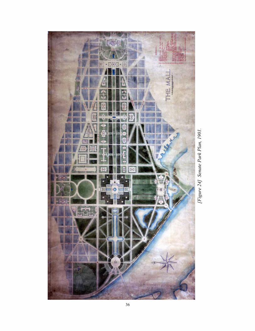
36
[Fig
ure
24]
Sen
ate
Park
Pla
n, 1901.

37
rond point or circle that "becomes a gate of approach to the park system of the District of Co-
lumbia….[and] Crowning the rond point...should stand a memorial erected to the memory of
that one man in our history as a nation who is worthy to be honored with George Washington -
Abraham Lincoln." 45 And, finally, municipal and semi-municipal buildings were placed in the
area between Pennsylvania Avenue and the Mall (today this is the Federal Triangle).46
The Senate Park Commission's plans were introduced on January 15, 1902, with an
elaborate display of 179 drawings, models, and photographs. 47 Designed with great care by
Charles McKim, the exhibition, the first in America on city planning, was held at the new Cor-
coran Gallery of Art. 48 The exhibition was a great success, receiving wide acclamation in the
newspapers and journals of the day and drawing large crowds, including President Theodore
Roosevelt and his cabinet, government officials, senators, congressmen, city officials and curi-
ous citizens. At its official closing on February 25, the entire exhibition was moved to the Li-
brary of Congress for further public display.
Among the items displayed in this extraordinary exhibition was Francis L.V. Hoppin’s
superb rendering of the “future” city as proposed by the Senate Park Commission. 49
[Figure 25] Hoppin’s view, executed in opaque water colors, depicts the redesign of the cen-
tral core of the city viewed from a point 4,000 feet above Arlington, Virginia. Hoppin’s paint-
ing, for which he received $250, shows the Commission’s proposed treatments for the Mall,
Capitol Hill, Union Station, Lafayette Park, and the reclaimed land beyond the Washington
Monument. Nothing arguably shows the scope of the Commission’s plan more effectively and
attractively than Francis Hoppin’s magnificent painting.

38
[Fig
ure
25]
Hoppin
’s w
ate
rcolo
r p
ain
ting o
f th
e M
all
, 1902. C
ourt
esy
of
the
U.S
. C
om
mis
sion o
n F
ine
Art
s.

39
Conclusion
The centennial celebrations in Washington aroused interest among a wide audience on
ways and means to improve the beauty of the city's architecture and open spaces. The success
of the Columbian Exposition held in Chicago in 1893 had enthralled the minds of many as to
what was possible when monumental architecture was employed in a landscaped, urban setting.
The resulting widely acclaimed plan took root and subsequently led Congress to put city plan-
ning on a permanent footing by establishing the Commission of Fine Arts in 1910 and the Na-
tional Capital Park Commission in 1924. The latter commission was succeeded two years later
by the broader based National Capital Park and Planning Commission. 50 At last, the capital had
a new plan to follow in the twentieth century, one grounded on Pierre L’Enfant’s century old
plan but significantly modified to reflect growth and new ideas in urban planning.

40
Endnotes
1. Tobias Lear, Observations on the River Potomack, the country adjacent, and the city of
Washington (New York: Printed by Samuel Loudon and Son . . . , 1793).
2. L’Enfant to Washington, 11 September 1789, Washington Papers, series 7, reel 120, Library
of Congress.
3. Jefferson to Commissioners, Jan. 15, 1793, Saul K. Padover, ed., Thomas Jefferson and the
National Capital (Washington, 1946), 170.
4. Jefferson to L’Enfant, August 18, 1791; Padover, 63-64.
5. Ralph E. Ehrenberg, “Mapping the Nation’s Capital; The Surveyor’s Office, 1791-1818.”
The Quarterly Journal of the Library of Congress 36, no. 3, 1979. 284.
6. L’Enfant to Jefferson, 11 March, 1791. Digges-L’Enfant-Morgan Papers, box 1; The Papers
of Thomas Jefferson, 20:77, Library of Congress.
7. Washington to Commissioners, 1 December 1796, Washington Papers, series 4, reel 110;
Writings of George Washington, 35:305.
8. Washington to David Stuart, 20 November 1791, Washington Papers, series 4, reel 110;
Writings of George Washington, 31:421.
9. Daily National Intelligencer, February 27, 1818; Ehrenberg, “Mapping the Nation’s Capital,”
313.
10. Ibid.
11. John G. Barnard, A Report on the Defenses of Washington. (Washington, 1871), 15-16.
12. Barnard, A Report on the Defenses of Washington, 87. For a detailed description of the forti-
fications, accompanied by many maps and illustrations, see Benjamin Franklin Cooling, III, and
Walton H. Owen, II, Mr. Lincoln's Forts: A Guide to the Civil War Defenses of Washington
(Shippensburg, Pa., 1988), 256.
13. Constance M. Green, Washington: A History of the Capital, 1800-1950 (Princeton, 1962),
1:262.
14. “Petition of Citizens of Washington City, D.C., Praying An Appropriation for Cleansing
and Improving the Washington Canal,” 38th Cong., 1st sess., 1863-1864, S. Misc. Docs. 84,
serial 1177, 2.
15. Ibid.

41
16. Nathaniel Michler, Report of Brevet Brigadier General N. Michler, Major of Engineers,
United States Army, in Charge of Public Buildings, Grounds, Works, &c. 40th Cong., 2d
sess., 1867-1868, H. Ex. Docs. 1, serial 1325, 519.
17. Ibid., 537.
18. Ibid., 532.
19. Benjamin Gratz Brown, A Public Park for the Capital, 40th Cong., 2d sess., 1867-1868, H.
Ex. Docs. 1, serial 1325, 543.
20. Annual Report of the Commissioners of the District of Columbia for the Year Ending June
30, 1879. (Washington, 1879). 46th Cong., 2d. sess., 1879-1880, H. Ex. Docs. 1, part 6, se-
rial 1913, 8.
21. See De Benneville Randolph Keim, Keim's Illustrated Hand-Book. Washington and Its En-
virons. 13th ed. (Washington, D.C., 1879), 58-62; David C. Streatfield, "The Olmsteds and
the Landscape of the Mall," in Richard Longstreth, ed., The Mall in Washington, 1791-
1991. (Hanover, N.H., 1991), 116-141, see especially 116-120; and, Pamela Scott, “Capitol
Square, 1791-1873,” Capitol Square Cultural Landscape Report, Vol.1 (Washington, D.C.:
Architect of the Capitol and Vitetta, 2012).
22. John W. Reps, Washington on View (Chapel Hill and London, 1991), 212.
23. The history of fire insurance maps in general and the Sanborn Map Company in particular
are described in Walter W. Ristow, "United States Fire Insurance and Underwriters Maps,
1852-1968," Quarterly Journal of the Library of Congress 25 (1968): 194-218; reprinted in
Surveying and Mapping 30 (1970): 19-41. Also see Ristow's introduction to U.S. Library of
Congress. Geography and Map Division. Reference and Bibliography Section, Fire Insur-
ance Maps in the Library of Congress: Plans of North American Cities and Towns Pro-
duced by the Sanborn Map Company (Washington, 1981), 1-9.
24. Washington Topham, "Centre Market and Vicinity," Records of the Columbia Historical
Society, Washington, D.C. 26 (1924):7-11.
25. Ibid., 11.
26. “John Kelly’s Washington; Answer Man recounts putrid story lurking under D.C.” Wash-
ington Post, Oct. 25, 2009.
27. Charles Moore, "The Improvement of Washington City. First Paper." Reprinted in Wash-
ington, D.C.: A Turn-of-the-Century Treasury. Frank Oppel and Tony Meisel, eds.
(Secaucus, N.J.,1987), 207.

42
28. The source for this bibliographical citation is John W. Reps, Washington on View, 188-191.
The maps showing "Pavements" and "Sewers" are reproduced in Washington on View on p.
189 and "Water Mains" and "Gas Mains" on p. 191. The folded maps are not included in the
Library of Congress copy of the Report of the Board of Public Works of the District of Co-
lumbia for the Year 1873. (Washington, 1873). 43rd Cong. 1st sess., 1873-1874, H. Ex.
Doc. 1, part 6, serial 1603.
29. Marcus Baker, "Surveys and Maps of the District of Columbia,” National Geographic Mag-
azine 6 (Nov. 1, 1894),158.
30. An examination of the view by the Conservation Office, Library of Congress in 1990, sug-
gested that a lithographic image is printed under the paint layer. The printed image seems to
be more of an outline, without shading, and is evident throughout the artifact.
31. “Report of the Senate Committee on the District of Columbia on the Improvement of the
Park System of the District of Columbia,” in Charles Moore, ed. The Improvement of the
Park System of the District of Columbia (Washington, Government Printing Office, 1902),
7. For a full discussion of the Senate Park Commission and its plan see Reps, Monumental
Washington, 92-154; Also see Thomas S. Hines, "The Imperial Mall: The City Beautiful
Movement and the Washington Plan of 1901-1902," Jon A. Peterson, "The Mall, the
McMillan Plan, and the Origins of American City Planning," and David C. Streatfield, "The
Olmsteds and the Landscape of the Mall," in Longstreth, ed., The Mall in Washington, 1791
-1991, 79-141.
32. Moore, ed. The Improvement of the Park System, 7.
33. Jon A. Peterson, "The Mall, the McMillan Plan, and the Origins of American City Plan-
ning," in Longstreth, ed., The Mall in Washington, 1791-1991, 103.
34. Moore, ed., The Improvement of the Park System, 39.
35. Ibid.
36. Ibid, 25.
37. Frederick Gutheim and Wilcomb E. Washburn, The Federal City: Plans & Realities
(Washington, D.C., Smithsonian Institution Press, 1976). 33.
38. Moore, ed., The Improvement of the Park System. 38
39. Ibid.
40. Ibid., 41-42.
41. Ibid., 29.

43
42. Ibid., 44-45.
43. Ibid., 50.
44. Ibid., 51.
45. Ibid., 51-52.
46. Ibid., 69-71.
47. Ibid. see Appendix F, pp. 147-154 for a complete list of the items exhibited.
48. Reps, Washington on View, 141.
49. The original painting is in the Fine Arts Commission, Washington, D.C. Frequently repro-
duced, it first appeared in print as the foldout frontispiece to Charles Moore, ed., The Im-
provement of the Park System of the District of Columbia (Washington: Government Print-
ing Office, 1902), 57th Cong., 1st sess., 1901-1902, S. Rept. 166, serial 4258.
50. Gutheim and Washburn, The Federal City, 38, 40, and 41.

44
Map Figures
Figure 1. Joshua Fry, A map of the most inhabited part of Virginia containing the whole prov-
ince of Maryland with part of Pensilvania, New Jersey and North Carolina, (London:
Thos. Jefferys, [1755]), a detail depicting the site Congress chose to locate the Capi-
tal in 1790.
Figure 2. Andrew Ellicott, [Territory of Columbia], (1793), the original boundary survey of the
District of Columbia prepared by Ellicott and submitted to George Washington in
February, 1793.
Figure 3. Andrew Ellicott, Territory of Columbia, (Philadelphia: 1794), the published version
of the boundary survey rotated to match the center meridian in response to Jeffer-
son’s directions.
Figure 4. Pierre Charles L’Enfant, Computer-assisted reproduction of Pierre Charles L'En-
fant's 1791 manuscript plan for the city of Washington, (Washington, D.C. : Library
of Congress, 1991).
Figure 5. Details of the 1991 L’Enfant facsimile showing Jefferson’s manuscript corrections.
Figure 6. Pierre Charles L’Enfant, Plan of the City of Washington, (Philadelphia :1792), en-
graved by Thackara and Vallance for the March 1792 issue of The Universal Asylum,
and Columbia Magazine.
Figure 7. Pierre Charles L’Enfant, Plan of the city of Washington / [engraved by] Samuel. Hill,
(Boston: Isaiah Thomas and Ebenezer T. Andrew, 1792).
Figure 8. The finely drawn Thackara and Vallance Plan of the City of Washington in the Terri-
tory of Columbia, which, upon Jefferson’s insistence, included the soundings in the
Potomac and Eastern Branch (now the Anacostia River) to make the land more valua-
ble to merchants and potential buyers of lots along their shore lines.
Figure 9. Robert King, A map of the city of Washington in the District of Columbia : estab-
lished as the permanent seat of the government of the United States of America,
(Washington: W. Cooper, 1818), the first printed map based upon actual field sur-
veys, which remained the most comprehensive illustration of the city until the Civil
War.
Figure 10. Computer-assisted reproduction of L’Enfant’s manuscript plan produced by the
United States Geological Survey for the Library of Congress in 1991 for the bicen-
tennial of the original.

45
Figure 11. Casimir Bohn, District of Columbia and the seat of war on the Potomac, (Baltimore:
E. Sachse & Co., ca. 1861), identifying fifteen Federal army units camped in the vi-
cinity of Washington, D.C.
Figure 12. J. G. Barnard, Map of the environs of Washington : compiled from Boschkes' map of
the District of Columbia and from surveys of the U.S. Coast Survey showing the line
of the defences of Washington as constructed during the war from 1861 to 1865 in-
clusive ..., (1865), which was based heavily on Albert Boschke’s earlier topograph-
ical map of the District that was confiscated and suppressed early during the Civil
War by federal authorities.
Figure. 13. Nathaniel Michler, Topographical Sketch o of the environs of Washington, D.C.,
(1901), Sheet No.1, which depicts several sites for a new presidential mansion.
Figure 14. Sheet no. 2 of Brevet Brigadier General Nathaniel Michler’s Topographical Sketch
of the environs of Washington, D.C., which illustrates the topography of Rock Creek
Valley.
Figure 15. William J. Twinings, Map of the city of Washington showing the plan for the recla-
mation of the marshes on the Potomac River water front, (1882), prompted by flood-
ing in much of the city, including the Mall. The original manuscript resides in the
National Archives in College Park, Maryland.
Figure 16. Frederick Law Olmsted, General Plan for the Improvement of the U.S. Capitol
Grounds, (1874). Courtesy of the Architect of the Capitol.
Figure 17. Adolph Sachse’s lithograph perspective, The national capital, Washington, D.C.,
1884, a panoramic view of the city of Washington .
Figure 18. Griffith Morgan Hopkins, A complete set of surveys and plats of properties in the
city of Washington, District of Columbia, (Philadelphia,: G.M. Hopkins, c1887),
plate 27 illustrating Olmsted’s “naturalistic” landscaping of the Capitol grounds.
Figure 19. Sanborn Fire Insurance Maps of Washington, D.C., 1881, volume 1, page 14, prom-
inently depicts the old Center Market on reservation 7, the current site of the Nation-
al Archives building.
Figure 20. Exhibit chart showing streets & avenues of the cities of Washington and
Georgetown, improved under the Board of Public Works, D.C. : Nov. 1st 1873 :
sewers, (Washington : J.F. Gedney), 1873), an example of a series of special purpose
maps produced by the Board since the Territory’s creation in 1871.
Figure 21. U.S. Coast and Geodetic Survey, Survey of the District of Columbia, (Washington:
Coast and Geodetic Survey, 1892-1894), sheet 49 showing the town of Anacostia
and the Anacostia Bridge.

46
Figure 22. E. Kurtz Johnson, Birdseye View of the National Capital Including the Site Pro-
posed [for] World’s Exposition of 1892 and Permanent Exposition of the Three
Americas, (Washington, D.C.: E. K. Johnson, c1888 ).
Figure 23. John L. Trout, View Looking North from the Anacostia , (1901), a birds-eye view of
Washington executed in opaque watercolors showing the city in minute detail.
Figure 24. The Mall, 1901. This photocopy of a manuscript plan in the National Archives and
Records Administration shows both existing and planned grounds and government
buildings.
Figure 25. Francis L.V. Hoppin, Senate Park Commission rendering of the plan from a point
4,000 feet above Arlington, (Washington: Senate Park Commission, 1902), Report
No. 20. Courtesy of the Commission of Fine Arts.

The Philip Lee Phillips Map Society of the Library of Congress is named in honor of
Philip Lee Phillips (1857-1924), the first Superintendent of Maps at the Library of Congress when
the Hall of Maps and Charts was established in 1897.
The group is a non-profit, voluntary association whose objective is to develop, enhance,
and promote the work of the Geography and Map Division by advancing its publication, educa-
tion, exhibition, preservation and acquisition programs.